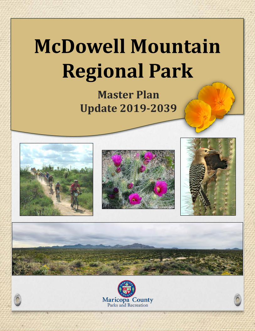
McDowell Mountain Regional Park
278
Master Plan Update 2019-2039 McDowell Mountain Regional Park
-
Upload
khangminh22 -
Category
Documents
-
view
1 -
download
0
Transcript of McDowell Mountain Regional Park
Master Plan Update 2019-2039
McDowell Mountain Regional Park

McDowell Mountain Regional Park Master Plan Update (2019-2039)
Recommended by:
MARICOPA COUNTY PARKS AND RECREATION DEPARTMENT
_______________________________________________________
R.J. Cardin Date
Director, Maricopa County Parks and Recreation Department
_______________________________________________________
Thomas Rhoades Date
Chairman, Maricopa County Parks and Recreation Commission
Approved by:
MARICOPA COUNTY BOARD OF SUPERVISORS
________________________________________________________
Bill Gates, Chairman Date
Attest
________________________________________________________
Fran McCarroll, Clerk of the Board Date
Approved as to Form:
________________________________________________________
Betsy Pregulman, Deputy Maricopa County Attorney Date

Acknowledgements
This master plan update was a collaborative process that involved the guidance and expertise of many. The Maricopa County Parks and Recreation Department would like to thank the Planning Team who committed their time to meetings and document review; likewise to the Stakeholder Advisory Group
(Detailed in Appendix A) who took time out of their schedules to provide their invaluable input.
Planning Team R.J. Cardin, Director
Jennifer Waller, Operations Manager Teresa Retterbush, East Side Superintendent
Shayla Gunn, Park Supervisor Ken Vonderscher, Planning and Development Manager
Allen Ockenfels, Trail Development Manager Emily Miller, Contract Administrator
Juanita Armstrong, Natural Resource Specialist Lauren Bromley, Park Planner
This Master Plan update was made possible by the contributions and guidance of the following:
Maricopa County Board of Supervisors Maricopa County Parks and Recreation Commission Bill Gates, Chairman, District 3 Thomas Rhoades, District 2, Chair
Jack Sellers, District 1 Dr. Robert Branch, District 4, Vice Chair Steve Chucri, District 2 Denise Merdon, District 1
Clint L. Hickman, District 4 Eric Mears, District 3 Steve Gallardo, District 5 Isabel Chavez, District 5
Megha Budruk, Member At Large Jack Stapley, Member At Large
The Department would also like to thank its agency partners at the Maricopa County Department of Transportation, Maricopa County Sheriff’s Office, Arizona Game and Fish Department, Bureau of Land Management – Lower Sonoran Field Office, City of Scottsdale, and the Town of Fountain Hills for their
input and guidance.
The Maricopa County Parks and Recreation Department would also like to thank the tireless efforts of the park staff and volunteers, without whom the park could not operate. Additional gratitude is
extended to all the youth group participants and public meeting attendees who offered their valuable comments and suggestions.

{This page intentionally left blank.}

__________________________________________________________ Table of Contents Table of Contents Chapter 1 - Introduction 1.1 Project Background .............................................................................................................................. 1-1 1.2 Vision, Mission, and Theme ................................................................................................................. 1-2 Chapter 2 - Master Plan Process 2.1 Purpose of the Master Plan ................................................................................................................. 2-1 2.2 Previous Planning Efforts ..................................................................................................................... 2-1 2.3 Plan Amendments or Updates ............................................................................................................. 2-2 2.4 Agency Participation Program ............................................................................................................. 2-3 2.5 Public Participation Program ............................................................................................................... 2-4 2.6 Planning Constraints ............................................................................................................................ 2-8 Chapter 3 - Resource Analysis 3.1 General Project Setting ........................................................................................................................ 3-1 3.2 History of Area ..................................................................................................................................... 3-2 3.3 Cultural Resources ............................................................................................................................... 3-7 3.4 Native Americal Consultation .............................................................................................................. 3-8 3.5 Natural Resources ................................................................................................................................ 3-9 3.6 Physiography and Climate .................................................................................................................. 3-11 3.7 Water Resources ................................................................................................................................ 3-12 3.8 Earth Resources ................................................................................................................................ 3-16 3.9 Biological Resources ........................................................................................................................... 3-19 3.10 Visual Resources .............................................................................................................................. 3-33 3.11 Recreation Resources ..................................................................................................................... 3-33 3.12 Land Use ......................................................................................................................................... 3-36 3.13 Facilities and Infrastructure ............................................................................................................. 3-41 3.14 Socioeconomics ................................................................................................................................ 3-47 3.15 Visitation and Tourism Trends ......................................................................................................... 3-50 3.16 Park Use and Visitor Preferences ..................................................................................................... 3-53 3.17 Local Recreation, Needs, and Opportunities Public Safety ............................................................. 3-55 3.18 Park Administration and Special Functions ..................................................................................... 3-56 3.19 Public Safety ..................................................................................................................................... 3-59 3.20 Park Finances ................................................................................................................................... 3-60 Chapter 4 - Roads and Access 4.1 Existing Roads, Access, and Parking ..................................................................................................... 4-1 4.2 Proposed or Planned Roads, Access, and Parking ............................................................................... 4-5

__________________________________________________________ Table of Contents Chapter 5 - Trails 5.1 Existing Trails ........................................................................................................................................ 5-2 5.2 Proposed Community Trails/Trailheads ............................................................................................... 5-6 5.3 Trail Use ............................................................................................................................................... 5-6 5.4 Trail Rating ........................................................................................................................................... 5-7 Chapter 6 - Management Zoning 6.1 Methodology for Determining Management Zones ............................................................................ 6-1 6.2 Description of Management Zones ...................................................................................................... 6-2 6.3 Area Descriptions that Influence Park Zoning ..................................................................................... 6-3 Chapter 7 - Park Improvement Projects 7.1 Issues and Constraints Analysis ........................................................................................................... 7-1 7.2 Recommended Park Improvements .................................................................................................... 7-2 List of Tables Table 1-1: Themes and Mandates ............................................................................................................. 1-3 Table 2-1: Delivery and View Rates of GovDelivery system ...................................................................... 2-8 Table 3-1: Stream Flow Monitoring ......................................................................................................... 3-15 Table 3-2: Federal Register Listed Species .............................................................................................. 3-22 Table 3-3: Special Status Species ............................................................................................................. 3-24 Table 3-4: Species of Greatest Conservation Need ................................................................................. 3-25 Table 3-5: Invasive Plant Species ............................................................................................................. 3-29 Table 3-6: Plant Species Listed (Federal/State) ....................................................................................... 3-32 Table 3-7: Species of Economic and Recreation Importance .................................................................. 3-35 Table 3-8: Distribution of Land Ownership .............................................................................................. 3-36 Table 3-9: Jurisdictions ............................................................................................................................. 3-37 Table 3-10: Covered Picnic Ramadas ....................................................................................................... 3-43 Table 3-11: Population and Park Visitor Characteristics .......................................................................... 3-47 Table 3-12: Total Resident Population ..................................................................................................... 3-49 Table 3-13: Employment and Education .................................................................................................. 3-49 Table 3-14: Economic Impact Based on Visitor Spending and Operating Expenses ................................ 3-55 Table 3-15: Local Recreation Opportunities ............................................................................................ 3-55 Table 3-16: Volunteer Value by Fiscal Year .............................................................................................. 3-58 Table 3-17: Partnerships .......................................................................................................................... 3-59 Table 3-18: MCSO Statistics ..................................................................................................................... 3-60 Table 3-19: Summary of Annual Expenditures ........................................................................................ 3-64 Table 3-20: Donations .............................................................................................................................. 3-65 Table 4-1: Roadway Jurisdiction and Functional Class ............................................................................... 4-1 Table 4-2: Park Roads and Parking ............................................................................................................. 4-2 Table 4-3: Park Roadway Classifications .................................................................................................... 4-2 Table 4-4: Park Roadway Design Matrix .................................................................................................... 4-3 Table 4-5: Existing Park Roadway Maintenance Status ............................................................................. 4-4 Table 4-6: Drive Time/Acres Analysis for MMRP ....................................................................................... 4-5 Table 5-1: Designated Trails ....................................................................................................................... 5-3 Table 5-2: Competitive Track Events and Participants .............................................................................. 5-5

__________________________________________________________ Table of Contents Table 5-3: Trail Uses ................................................................................................................................... 5-7 Table 5-4: Trail Rating Guide ...................................................................................................................... 5-7 Table 6-1: Management Zone and Acreage ............................................................................................... 6-1 Table 6-2: Park Management Zones .......................................................................................................... 6-2 Table 7-1: Issues, Constraints, and Analysis .............................................................................................. 7-2 Table 7-2: Existing Features and Recommended Improvements .............................................................. 7-6 List of Figures Figure 2-1: News Release February 5, 2018 ............................................................................................... 2-7 Figure 2-2: Facebook post February 5, 2018 ............................................................................................. 2-7 Figure 2-3: Facebook post October 10, 2018 ............................................................................................. 2-8 Figure 3-1: Park and Metro-area................................................................................................................ 3-2 Figure 3-2: Fort McDowell in Frontier Days, Arizona ................................................................................. 3-3 Figure 3-3: General George Stoneman ...................................................................................................... 3-4 Figure 3-4: Stoneman Road........................................................................................................................ 3-5 Figure 3-5: Pemberton (P-Bar) Ranch ........................................................................................................ 3-5 Figure 3-6: Dixie Mine ................................................................................................................................ 3-6 Figure 3-7: Historical Sites ......................................................................................................................... 3-6 Figure 3-8: Petroglyphs in McDowell ......................................................................................................... 3-8 Figure 3-9: Average Annual Temperature and Precipitation ................................................................... 3-12 Figure 3-10: Major washes (Section 404) ................................................................................................ 3-14 Figure 3-11: Floodway and Floodplain ..................................................................................................... 3-15 Figure 3-12: Geology ................................................................................................................................ 3-17 Figure 3-13: Marcus Landslide ................................................................................................................. 3-18 Figure 3-14: Soils ...................................................................................................................................... 3-19 Figure 3-15: 1995 Rio Fire Damage inside McDowell HabiMap™ ............................................................ 3-20 Figure 3-16: Environmental Hazards ........................................................................................................ 3-20 Figure 3-17: Biotic Communities .............................................................................................................. 3-21 Figure 3-18: Wildlife Linkages .................................................................................................................. 3-27 Figure 3-19: Land Ownership ................................................................................................................... 3-37 Figure 3-20: Existing Land Use ................................................................................................................. 3-39 Figure 3-21: Existing Park Facilities .......................................................................................................... 3-41 Figure 3-22: RV Back-in space .................................................................................................................. 3-39 Figure 3-23: Dispersed Camping .............................................................................................................. 3-44 Figure 3-24: Four Peaks Staging Area ...................................................................................................... 3-44 Figure 3-25: Campground Playground Equipment .................................................................................. 3-45 Figure 3-26: Populations Growth Via Census Tract ................................................................................. 3-48 Figure 3-27: Visitor Residency .................................................................................................................. 3-51 Figure 3-28: Visitation By Fiscal Year ....................................................................................................... 3-51 Figure 3-29: Visitation Per Fiscal Month Within Fiscal Year .................................................................... 3-52 Figure 3-30: Actual And Forecasted Visitation Per Fiscal Year ................................................................ 3-52 Figure 3-31: Recreation Opportunities .................................................................................................... 3-56 Figure 3-32: Revenue Per Fiscal Year ....................................................................................................... 3-61 Figure 3-33: Revenue By Month In FY18 .................................................................................................. 3-62 Figure 3-34: Annual Camping Revenue .................................................................................................... 3-62 Figure 3-35: Facility Rentals ..................................................................................................................... 3-63 Figure 3-36: Annual Pass Revenue ........................................................................................................... 3-63 Figure 3-37: Daily Pass Entries ................................................................................................................. 3-64

__________________________________________________________ Table of Contents
Figure 4-1: Drive Time Analysis .................................................................................................................. 4-5 Figure 4-2: Existing and Planned Future Access Points .............................................................................. 4-7 Figure 5-1: Trails Crew Hard At Work ........................................................................................................ 5-1 Figure 5-2: Identified Trails From Plan Updates ........................................................................................ 5-2 Figure 5-3: Future Trails Identified ............................................................................................................ 5-3 Figure 5-4: McDowell Competitive Track ................................................................................................... 5-5 Figure 6-1: Development Zones ................................................................................................................. 6-3 Figure 7-1: Recommended Park Improvements (North Area Close-Up) ................................................... 7-4 Figure 7-2: Recommended Park Improvements (Campground And Nature Center) ................................ 7-4 Figure 7-3: Recommended Park Improvements (Competitive Track and Four Peaks Staging Area)......... 7-5 List of Appendices Appendix A Public Participation Appendix B Water Resources Appendix C Earth Resources Appendix D Biological Resources Appendix E Cultural Resources Appendix F Land Use Appendix G Facilities and Infrastructure Appendix H Roads Appendix I Trails

Glossary of Terms and Abbreviations Term Definition ADA American’s with Disabilities Act ADOT Arizona Department of Transportation ADWR Arizona Department of Water Resources AMA Active Management Area APS Arizona Public Service Company ASU Arizona State University ARS Arizona Revised Statutes AST Aboveground Storage Tank AZGFD Arizona Game and Fish Department AZGS Arizona Geological Survey ASLD Arizona State Land Department BOS Board of Supervisors BLM Bureau of Land Management CIP Capital Improvement Plan CO Carbon monoxide County Maricopa County EPA Environmental Protection Agency ESA Endangered Species Act °F Degrees Fahrenheit FCD Flood Control District of Maricopa County FEMA Federal Emergency Management Agency FTE Fulltime Equivalent (employee) FY Fiscal Year GIS Geographic Information System GPS Geographic Positioning System HDMS Heritage Data Management System HUC Hydraulic Unit Code HURF Highway User Revenue Fund I- Interstate (number) IBA Important Bird Area IGA Intergovernmental Agreement MAG Maricopa Association of Governments MCDOT Maricopa County Department of Transportation MCPRD (or Department) Maricopa County Parks and Recreation Department MCSO Maricopa County Sherriff’s Office MOU Memorandum of Understanding MPA Municipal Planning Area NOx Nitrogen Oxide OHV Off-Highway Vehicle PM Particulate Matter R&PP Recreation and Public Purposes Act RU- Rural Residential RTP Regional Transportation Plan
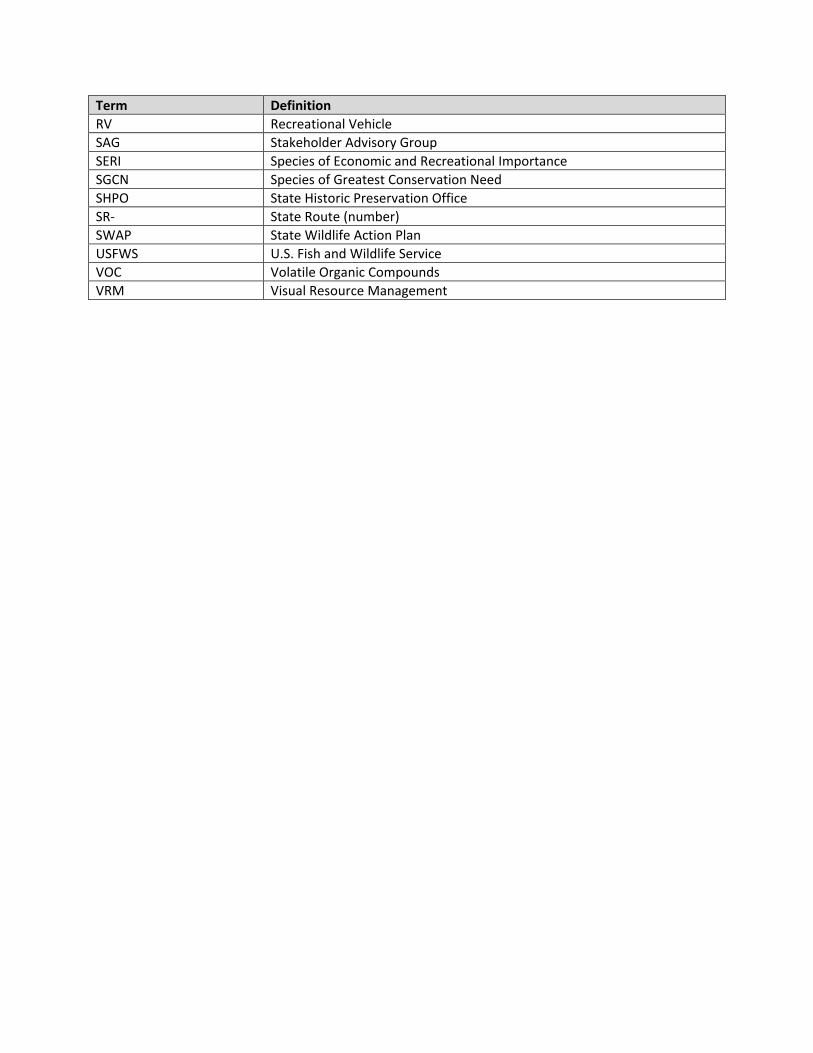
Term Definition RV Recreational Vehicle SAG Stakeholder Advisory Group SERI Species of Economic and Recreational Importance SGCN Species of Greatest Conservation Need SHPO State Historic Preservation Office SR- State Route (number) SWAP State Wildlife Action Plan USFWS U.S. Fish and Wildlife Service VOC Volatile Organic Compounds VRM Visual Resource Management

___________________________________________________________________ Introduction
1-1
Chapter 1 – Introduction This chapter introduces the concept of a regional park, general overview of the project, vision, mission, and the park theme(s). The regional park fills a void between city, state, and national parks. Regional parks are located outside the metropolitan area (although with rapid development, this is becoming less and less the case), but within a reasonable driving distance to the population for which it was planned and attempts to maintain a buffer from urban encroachment. A regional park is defined as a natural, unspoiled area providing its visitors an escape from city trappings, with enough space and facilities for day and overnight use. A regional park provides opportunities for passive and active recreational activities (e.g. hiking, mountain bike riding, walking, horseback riding, picnicking, camping, nature study and sightseeing) that allow its visitors to unwind and immerse themselves in nature. A regional park may have unique topography, ecosystem features, scenery, and hold special historical or archaeological interest. A regional park may also provide a blend of unspoiled nature, wilderness preserve and refuge, and open space, offering its visitor(s) a sense of remoteness. Its development, phased in over time, is geared toward facilities that encourage enjoyment of the natural environment while still providing some comforts. All development is carefully patterned and designed to conform to the landscape, avoiding a crowded feeling, and typically includes a nature center, picnic tables and ramadas, campsites, a trail system, and adequate support facilities (parking, restrooms, concessions, etc.). Therefore, the regional park system serves to preserve the mountains, canyons, washes and rivers, native vegetation and wildlife in their natural state while also encouraging the enjoyment of these natural resources by providing well planned and appropriate facilities. McDowell Mountain Regional Park (MMRP or P), one of twelve Maricopa County regional parks or conservation areas, offers the opportunity to hike, bike, horseback ride, and explore; allowing us to reconnect with nature and restoring our sense of well-being. 1.1 Project Background In 1958, approximately 18,273 acres of public land was leased by the Bureau of Land Management (BLM) to Maricopa County (County) via the Recreation & Public Purposes Act

___________________________________________________________________ Introduction
1-2
(R&PP). The County received the first land patent for MMRP in 1963, and subsequently, through further land acquisition between 1964 and 1987, the Park grew to encompass nearly 21,099 acres. On May 25, 1967, the Parks and Recreation Advisory Commission (Commission) unanimously recommended the Master Development Plan (MDP) for MMRP. This will be the first update to the MDP since its adoption in 1967. Many components of the MDP have never come into fruition, while at the same time, public use and changing demand have often dictated when and where development occurs. This update to the MDP is to bring those disparities back into alignment, and to steer future development of the Park. This plan is based on a 20-year outlook, and should be referred to on a regular basis and updated as needed. This plan is meant to be flexible, while also providing long-term direction in order to protect the Park’s resources. MMRP is a component of the Maricopa County regional park system, and is to date the third largest park at 21,099 acres. The Park features rugged mountain terrain and gently sloping foothills extending east to the Verde River. The County’s regional park system includes twelve parks, two of which are conservation areas, and is comprised of more than 120,000 acres encircling the Phoenix metropolitan area. The regional park system provides recreational and educational opportunities for residents and visitors alike.
1.2 Vision, Mission, and Theme This plan is meant to align with the vision and mission of the Maricopa County Parks and Recreation Department (MCPRD or Department). The Park’s unique combination of backcountry and historic/cultural interests automatically provides a basic direction for the Park’s planning and development, and is subsequently reflected in the Park’s operational and marketing themes. 1.2.1 Vision and Mission This plan aligns with the vision and mission set forth by the Department and are as follows:
“Our vision is to connect people with nature through regional parks, trails and programs, inspire an appreciation for the Sonoran Desert and natural open spaces, and create life-long positive memories.” “Our mission, through responsible stewardship, is to provide the highest quality parks, trails, programs, services and experiences that energize visitors and create life-long users and advocates.”
1.2.2 Themes The 1967 MDP for MMRP noted that the Park possesses a unique historical past with the settlement of Fort McDowell in 1865 situated directly southeast of where the Park sits today. The area has a rich history of Native-American settlement, fur trapping along the Verde River, mining near the hills, and cattle ranching throughout the area. The 1967 MDP called for the least amount of development that could provide the fullest amount of
___________________________________________________________________ Introduction
1-3
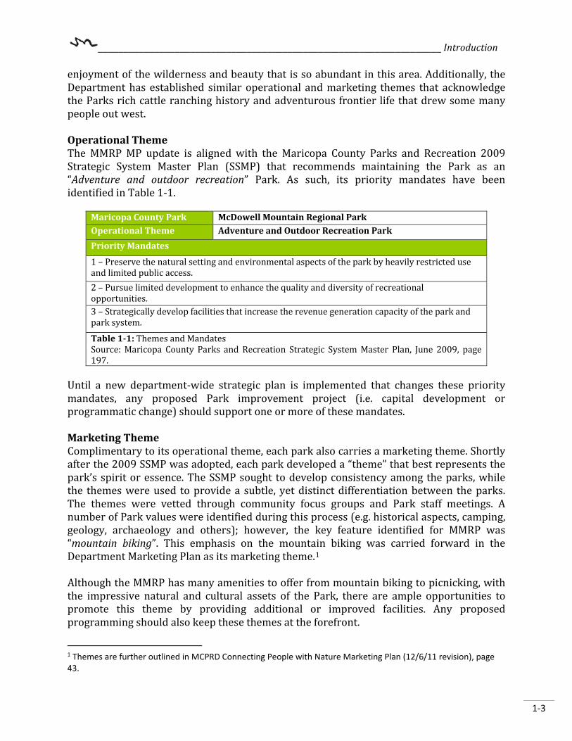
enjoyment of the wilderness and beauty that is so abundant in this area. Additionally, the Department has established similar operational and marketing themes that acknowledge the Parks rich cattle ranching history and adventurous frontier life that drew some many people out west. Operational Theme The MMRP MP update is aligned with the Maricopa County Parks and Recreation 2009 Strategic System Master Plan (SSMP) that recommends maintaining the Park as an “Adventure and outdoor recreation” Park. As such, its priority mandates have been identified in Table 1-1.
Maricopa County Park McDowell Mountain Regional Park Operational Theme Adventure and Outdoor Recreation Park Priority Mandates
1 – Preserve the natural setting and environmental aspects of the park by heavily restricted use and limited public access. 2 – Pursue limited development to enhance the quality and diversity of recreational opportunities. 3 – Strategically develop facilities that increase the revenue generation capacity of the park and park system.
Table 1-1: Themes and Mandates Source: Maricopa County Parks and Recreation Strategic System Master Plan, June 2009, page 197.
Until a new department-wide strategic plan is implemented that changes these priority mandates, any proposed Park improvement project (i.e. capital development or programmatic change) should support one or more of these mandates. Marketing Theme Complimentary to its operational theme, each park also carries a marketing theme. Shortly after the 2009 SSMP was adopted, each park developed a “theme” that best represents the park’s spirit or essence. The SSMP sought to develop consistency among the parks, while the themes were used to provide a subtle, yet distinct differentiation between the parks. The themes were vetted through community focus groups and Park staff meetings. A number of Park values were identified during this process (e.g. historical aspects, camping, geology, archaeology and others); however, the key feature identified for MMRP was “mountain biking”. This emphasis on the mountain biking was carried forward in the Department Marketing Plan as its marketing theme.1 Although the MMRP has many amenities to offer from mountain biking to picnicking, with the impressive natural and cultural assets of the Park, there are ample opportunities to promote this theme by providing additional or improved facilities. Any proposed programming should also keep these themes at the forefront.
1 Themes are further outlined in MCPRD Connecting People with Nature Marketing Plan (12/6/11 revision), page 43.

___________________________________________________________________ Introduction
1-4
{This page intentionally left blank.}
__________________________________________________________________________________ Master Plan Process
2-1
Chapter 2 – Master Plan Process This chapter provides the purpose and reviews the MP update process, including public participation, planning issues, and a recreation activity evaluation conducted during the project. This is the third MP update the Department has undertaken in recent years, and utilizes the Estrella Mountain Regional Park Master Plan Update (2016-2036) as its template. The planning process involved numerous tasks, and relied on input from the planning team, key Department staff members, partner’s advisory group, stakeholder advisory group, PRAC, and the general public over the course of a year and a half. Some tasks were completed simultaneously but entailed gathering or analyzing different sets of information. Each task was tracked on a timeline to provide direction to the planning team,
2.1 Purpose of the Master Plan The purpose of this planning effort is to update the 1967 Master Development Plan to reflect the current use, identify and address community needs and concerns, characterize and evaluate environmental resource information, and identify other potential recreational opportunities suitable for inclusion in the Park. The ultimate purpose of developing a MP is to outline the long-range vision for the Park and guide development priorities that will provide for both the public’s enjoyment and the protection of the Park’s resources. The MP provides a conceptual planning framework for establishing those priorities. It will also assist the Park with upholding the standards for a “Quality County Park System” per the 2014 update of the SSMP.
2.2 Previous Planning Efforts Several existing plans played an important role in shaping this MP. Specifically, the Departments Strategic System Plan guides the decision-making for future development and management of the park system; it also provides recommendations on how the Park system might improve itself. The Connecting People with Nature Marketing Plan took additional steps to identify the predominate feature(s) of each park and promote a “theme” for each as well as a timeline for implementation. The annual business plans outline short-term projects and goals to further enhance or maintain Park resources.
__________________________________________________________________________________ Master Plan Process
2-2
This plan consulted the following list of County plans and other documents:
• McDowell Mountain Regional Park Master Development Plan (1967) • Maricopa County Regional Trail System Plan (2004) • McDowell Trail Amendment (2008) • Parks and Recreation Strategic System Master Plan (2009)(and 2014 update) • 2012-2013 Visitor Study Final Report (by ASU) (and previous versions) • Cultural resource surveys (various) • Moving Forward in a Time of Change, Maricopa County Strategic Plan (2011-2015) • Maricopa County Vision 2030 Comprehensive Plan (draft) • City of Scottsdale General Plan 2035 • Rio Verde Foothills Area Plan • Scottsdale Trails System Master Plan • McDowell Sonoran Preserve – Cultural Resource Master Plan • Town of Fountain Hills General Plan 2020 and Land Use Analysis and Statistical
Report.
2.3 Plan Amendments or Updates This plan should be reviewed annually by Park staff to insure their knowledge of and adherence to this plan and to evaluate implementation progress. At a minimum, this plan should be revised and updated every 20 years to take the changing needs of the County and the community into consideration. If any major and/or sudden changes take place prior to the 20-year mark, an update or amendment may be needed. Major amendments to this plan may require public notification, and all potential changes should be reported to senior management and planning staff for consideration. Major amendments may include changes to the Management Zone; adjacent land use changes or development that impacts the Park; acts of nature that dramatically alter the Park; any other action that would permanently affect the land; and/or a proposed action that is not within the scope of the MP. Minor amendments should be posted for a 30-day comment period on the Parks webpage as well as other social media outlets. Examples of minor amendments include but are not limited to; updating demographic and other statistical information; updates to appendices such as insertion or removal of annual reports (such as business and marketing plans, etc.); new or updated resource information; and/or to correct grammatical or formatting issues. The addition of non permanent site amenities such as picnic tables, grills, posts, trash receptacles, etc. Minor amendments or updates should be reported to senior management and planning staff for consideration.

__________________________________________________________________________________ Master Plan Process
2-3
2.4 Agency Participation Program Department Participation The MP update was developed internally by Department planning staff, Park staff, and senior level management. Department staff worked individually and met as a group throughout the planning process in order to define the scope of the MP, review project information, consult partners, stakeholders and the public, develop and analyze draft Park improvement projects, and to finalize the MP update. Parks and Recreation Advisory Commission (Commission) Department planning staff provided periodic updates or presentations to the Commission and invited them to provide feedback. These meetings were open for the public to attend and make comments; however, no members of the public provided feedback during these meetings. Presentations or updates were given on the following dates:
• November 14, 2017 • March 20, 2018 • September 18, 2018 • November 13, 2018 • January 15, 2019 (Park tour) • March 19, 2019
The Commission provided their approval and recommendations during the March 19, 2019, meeting to the Maricopa County Board of Supervisors.
Maricopa County Board of Supervisors (BOS) This plan was presented to the BOS for their approval. BOS meetings are also open to the public. The BOS approved this plan as acknowledged on the signature page in the front of this document.
Partners Participation The planning team identified several agencies or other parties that the Park has either contractual obligations with, or engaged in serious discussions with as interested partners in the planning process. These interests and obligations were identified and disclosed at public and stakeholder meetings the start of the planning process.
Small group meetings were held with partners such as: the City of Scottsdale (Scottsdale); the Town of Fountain Hills (Town) ; Arizona Game and Fish Department (AZGFD); Maricopa County Sherriff’s Office (MCSO); Maricopa County Flood Control District (FCD); Maricopa County Department of Transportation (MCDOT); and Southwest Wildlife Conservation Center (SWCC). Additionally, halfway through the planning process SWCC started meeting monthly with the Department to discuss the inclusion of a new wildlife facility/visitor center into the Park. The Department also invited the partners, as well as other agencies, to attend group stakeholder meetings and public open house meetings to provide additional comments. Partner meetings were held at the following locations:

__________________________________________________________________________________ Master Plan Process
2-4
• McDowell Mountain Regional Park – Nature Center • January 4, 2018
• Cave Creek Regional Park – Visitor Center Classroom • April 4, 2018 • July 11, 2018
The majority of Park land was acquired by Maricopa County via the R&PP and must remain consistent with R&PP requirements and land patents. As a result, the Department consulted with the BLM and received their written approval which is found in the front of the MP. Planning staff sought input from the Arizona State Land Department (ASLD) by inviting the agency to stakeholder meetings and including them on emails and other notifications. Their comments on the MP update were taken into consideration, to the extent feasible. Planning staff also sought input from directly adjacent and potentially interested Native American communities regarding this MP update. Email invitations for stakeholder meetings and public meetings were sent to the Fort McDowell Yavapai Nation.
2.5 Public Participation Program A public participation program was designed by planning staff in order to inform the public of the planning process, identify recreational needs and resource concerns, and solicit as much public and stakeholder feedback as possible. The various components are included and detailed in Appendix A.
Arizona State University (ASU) Park Visitor Study ASU periodically performs visitor use surveys on behalf of the Department. Visitors are asked questions by interviewers conducting in-park surveys. Visitors are also asked if they would like to participate in a longer take-home survey and provide more detailed responses to questions. This allows the Department to identify and track trends over time. Survey responses for the year 2012-2013 were taken into consideration when developing the MP.
Stakeholders Another component of the public participation program was establishing a comprehensive list of stakeholders or special interest groups. The stakeholders group is meant to reach out to a broader audience than just the partners, and includes neighboring jurisdictions and other interested parties. The stakeholders met two times between January 2018 and May 2018 at Rio Verde Community Center; a list of participants invited to the meetings is included in Appendix A.
o January 23, 2018 (10:30am-12:30pm) o May 24, 2018 (1pm-3pm)

__________________________________________________________________________________ Master Plan Process
2-5
The group’s comments and concerns were integrated into the planning process and assisted in the development of the recommended Park improvements. Comments received during the meetings reflected a general concern regarding a larger updated visitor center, the inclusion of SWCC, potential upgrades infrastructure, and revenue generation. Briefly, those comments included:
• Develop an additional campground loop and primitive camping areas. • Event area upgrades including competitive track expansion. • Develop a bike skills park. • Add a cabin rental option to capture “glamping” trends and create
additional revenue streams.
Public Open House Meetings The public was notified of the planning process and their feedback was sought through three public meetings. Additional comments were captured through surveys or comment cards, the Park website, letters or emails, verbal discussions with citizens, and through social media platforms. Surveys and/or feedback forms were provided at each public meeting to gather the public’s opinions. Each meeting was followed by a thirty calendar day open comment period to collect the desires and preferences. Also, during the thirty day periods, poster boards were left on display in the Park’s nature center with comment forms available for Park visitors and community members to provide additional feedback. Public Meeting One MMRP resides in between two communities. In an effort to capture feedback from both communities, public meetings were hosted on the north and south side of the Park to reduce the attendee’s drive time. Presentations, information and resources distributed at both meetings were identical. The first of these two meetings was held on February 20, 2018 (5:30pm-7:30pm) at the Town of Fountain Hills Community Center where ten (10) people signed in. eight (8) flip pad comments and twelve (12) sticky notes were collected. The second of the two meetings was held on February 22, 2018 (5:30pm-7:30pm) at the Tonto Verde Community Center where five (5) people signed in. three (3) flip pad comments and three (3) sticky notes were collected. Eighty-eight (88) individual responses were received during the open comment period of February 20 to March 22, 2018 via Survey Monkey, an online survey service, direct emails, and all social media comments. Comments received indicate strong support for the proposed partnership with a SWCC as part of the visitor center, and strong support for additional recreation and camping opportunities, including rustic style cabins. Other respondents expressed their desire for upgraded trail/trailhead signage showing trail mileage, walking trails that are separate from biking trails including American’s with

__________________________________________________________________________________ Master Plan Process
2-6
Disabilities Act (ADA) paved paths, additional educational programing, a nature play area, and a bike “flow” trail. Public Meeting Two The second public meeting was held November 5, 2018 (5pm-7pm) the Town Community Center where nineteen (19) people signed in and; twelve (12) comment cards were received during the meeting are summarized below. Planning and Park staff presented the draft proposed Park improvements and answered questions throughout the presentation and afterward. Topics that were raised during verbal conversations and map mark-ups with the public included additional competitive track loops, a bike skills park and flow trail, additional multi-use trails, and implementation of “Dark Sky” lighting principles for the Park. One hundred sixty-six (166) individual responses were received during the open comment period of November 6 through December 6, 2018 via Survey Monkey, direct emails, and all social media comments. The public was asked what they liked most and what they would change from their chosen alternative. Trails, again, were the subject of most comments – including a general desire for additional trail options, trail maintenance and trailhead improvements. Mountain bike trails were commonly mentioned (i.e. to install water stations throughout the Park, build a skills park, flow trail and expand the two event staging areas). Briefly, other comments received included: additional shower facilities in the tent campground area, added shade structures or ramadas to the picnic tables, updated interpretive panels on the North Trail, Restoration of Pemberton Pond and Ranch house area, park wide hunting ban, and additional RV camping sites
Project Website Information was posted on the Park’s “Projects” webpage to keep the public and other interested parties apprised of the planning process.
• https://www.maricopacountyparks.net/park-locator/mcdowell-mountain-regional-park/park-information/park-projects/
Media and Social Media Coverage A general press release was issued to announce public meeting dates at least thirty calendar days prior to each meeting and was made available on the County and Department websites and to media outlets via Twitter. These news outlets published (or posted online) the press releases:
__________________________________________________________________________________ Master Plan Process
2-7
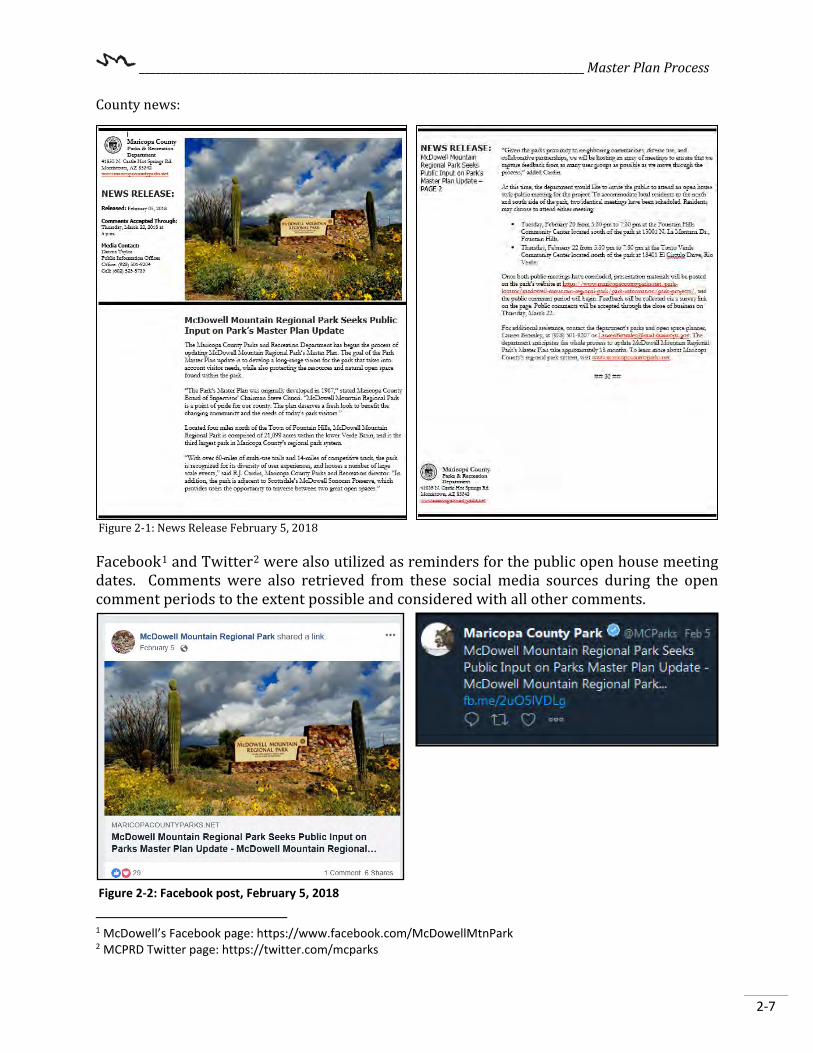
County news:
Figure 2-1: News Release February 5, 2018 Facebook1 and Twitter2 were also utilized as reminders for the public open house meeting dates. Comments were also retrieved from these social media sources during the open comment periods to the extent possible and considered with all other comments.
1 McDowell’s Facebook page: https://www.facebook.com/McDowellMtnPark 2 MCPRD Twitter page: https://twitter.com/mcparks
Figure 2-2: Facebook post, February 5, 2018

__________________________________________________________________________________ Master Plan Process
2-8
The County newsletter delivery system, GovDelivery or GovDocs, was also used to distribute newsletters/bulletins and updates to its email-based subscribers. Interested parties were encouraged to register for the subscription service in order to receive updates or other notifications related to the Park. The GovDelivery system offers analytics that can be used to test the system’s effectiveness, whereas other platforms may not.
Figure 2-3: Facebook post, October 10, 2018
Table 2-1: Delivery and View Rates of GovDelivery system Date Sent Recipients Delivery Rate Total Opens February 12, 2018 1,472 98.8% 252 October 15, 2018 5,029 99% 954
2.6 Planning Constraints Factors that affected the planning process included existing conditions, trends and other issues both inside and outside of the Park. The Park is facing a variety of challenges from aged facilities and infrastructure, visitation, changing demographics, and changing recreational use activities and patterns (for example, the shift away from picnicking towards increased trail uses as the primary activity). MMRP also faces pressures from adjacent land use and development; this includes newer residential developers that are required by the Town of Fountain Hills planning code or ordinance to include neighborhood parks, trails, and/or open space into their development. The inclusion of outdoor recreational spaces in neighborhoods provides its residents with new options for how they recreate that were not available to them previously. These topics are presented in Chapter 3. The diverse planning issues identified during scoping for the project were discussed by the planning team and can be grouped into five major categories: develop new facilities;

__________________________________________________________________________________ Master Plan Process
2-9
maintain/rehabilitate existing facilities; education/interpretation; administrative; and resource protection. Additionally, tight budgets and staffing are the typical constraints when addressing planned improvements. Balancing improvement priorities and desires for immediate improvements need to be balanced with “fiscal responsibility.” Budgets and staffing will impact all areas of the Park and are always of concern. The budget will dictate the number of staff employed at the Park and the number of Park improvement projects that can be successfully completed. The Park improvement recommendations, as detailed in Chapter 7, will address these concerns while supporting the Park’s priority mandates and themes.

__________________________________________________________________________________ Master Plan Process
2-10
{This page intentionally left blank.}

________________________________________________________________ Resource Analysis
3-1
Chapter 3 – Resource Analysis The resource analysis for the MP includes natural, historical, and cultural resources that could be affected by any additional development and operation of the Park. Limited inventory of Park resources occurred from March 2018 through October 2018. Data collection included reviewing previous reports and documents pertaining to the Park and resources in the area, aerial photo interpretation, GIS analysis, agency contacts, and field investigations. The Park consists of 21,099 acres, of which approximately 293 acres are developed. This amounts to less than 1.4% of the total acreage that is developed. The 2009 Strategic System Plan1 provides a guideline for keeping developed areas to 10% or less of the total land area.
3.1 General Project Setting At just over 21,000 acres, McDowell Mountain Regional Park is the third largest regional Park in Maricopa County to date, and is located within Sections 1 - 36 of Township 04 North, Range 06 East; The Park is located northeast of the Phoenix metropolitan area, falling within the planning boundaries of both the City of Scottsdale and the Town of Fountain Hills as shown on Figure 3-1. The Park’s mailing address is 16300 McDowell Mountain Park Drive, MMRP, AZ 85268. The Park may be contacted by telephone (602) 506-2930 or via email at [email protected]. Although subject to change, the current Park operating hours2 are:
Park Hours Nature Center Hours Sun-Thu: 6:00am – 8:00pm Summer (May 7th –October 8th)
Fri-Sat: 6:00am – 10:00pm 365 days a year
Mon-Sat: 8:00am – 3:00pm Sundays: Closed Winter (October 9th - May 6th) Sunday thru Saturday: 8am – 4pm
1 Maricopa County Parks and Recreation, 2009 Strategic System Master Plan, p112. 2 Source: Park website as of January 28, 2019. Check website for the most current information.

________________________________________________________________ Resource Analysis
3-2
3.2 History of Area3 Up to 1821, when Mexico broke from Spain, the native people occasionally encountered Roman Catholic missionaries who attempted to convert the indigenous people and introduced new crops and technologies but were largely left alone. The Treaty of Guadalupe Hidalgo was signed in 1848, ending the war with Mexico. With this treaty, all lands north of the Gila River were part of the United States territory and all lands south of the Gila River remained with Mexico. Later, through the Gadsden Purchase (1853-1854), the border between the United States and Mexico was moved south to its present day location, placing the land that is now MMRP within the New Mexico territory of the United States. In 1861, as the nation was embroiled in the Civil War, Colonel John R. Baylor of Texas took official possession of the “Territory of Arizona” for the Confederacy – an area that included all of present day Arizona south of the 34th parallel. This action put the Park under the Confederate flag by signature of then Confederate President Jefferson Davis in 1862. In 3 A Historical Survey of McDowell Mountain Regional Park, 1963, Fireman, Bert.
Figure 3-1: McDowell Mountain Regional Park

________________________________________________________________ Resource Analysis
3-3
1863, President Abraham Lincoln signed a bill creating the new Territory of Arizona; the legislation remained law at the end of the war and effectively divided the New Mexico and Arizona territories at their current boundaries. Fort McDowell and the surrounding area was indirectly established by a series of events, which occurred around 1863. A citizen army led by King S. Woolsey was established in order to chase down and punish a band of Tonto Apaches who had stolen cattle and horses south of Prescott, Arizona. Woolsey and his men marched south down the Hassayampa River and east past the Agua Fria River, continuing on towards the Verde Valley. This citizen army crossed what is now MMRP and made a temporary camp at the site that would become Camp McDowell eighteen (18) months later. The trail these men blazed would eventually become a secondary supply route known as Stoneman Trail connecting Camp McDowell with Fort Whipple near Prescott. Camp McDowell (later changed to Fort McDowell) (Figure 3-2) was established in 1865 in order to provide military protection to miners and homesteaders from raiding tribes in the region. It was about this same time that the United States government created the reservation system for American Indians. By the late 1880s, the Tonto Apache raids had ceased. As the outpost was no longer needed for settler protection, troops withdrew from Fort McDowell and the outpost was abandoned by 1890. The area that previously was occupied by the Fort McDowell, as well as additional acreage to the south, was designated as reservation lands for the Fort McDowell Yavapai Nation in 1903.
Homesteading, Ranching and Herding Cattle roamed the lands in and around MMRP as early as the 1870s. It wasn’t until after the establishment of Fort McDowell, that stock raising gained a foothold in the region. With the continual presence of the military and a steady demand for beef, stock raising became a viable source of income for the area. A few homesteads were located within proximity of the perimeter of the Park. The most notable homesteaders included Clayton Whitehead, Glenn Moor, and Henry Pemberton. The earliest documented reference to any type of permanent residence in the area was a quit-claim deed dated 1917 for a water source known as Cottonwood Springs. It is thought that this is likely when Henry Pemberton homesteaded his ranch (Pemberton Ranch) on land that is now incorporated into the Park. Several years later, Pemberton Ranch was renamed P-Bar Ranch and in 1935 it was purchased by Lee Barkdoll and Delsie Journigan. From 1935 to the 1950s, the P-Bar Ranch was a viable ranch consisting of over 25,000
Figure 3-2: Fort McDowell in Frontier Days, Arizona

________________________________________________________________ Resource Analysis
3-4
acres, 165 cattle, and nearly a dozen mining claims in the Dixie Mining District. By the early 1950s beef prices started to fall. In 1954, Delsie decided to sell P-Bar ranch, which had several other owners before eventually being incorporated into MMRP.
Mining Claims and Mineral Rights The McDowell Mountain Range lured prospectors in search of mineral wealth, but did not produce anything of significance. The 1963 Fireman Survey of McDowell as well as the original 1967 MP states that no historical records were found for the Dixie Mine in the archives for the Arizona Mining Districts by the United States Bureau of Mines (abolished in 1996 and absorbed into the BLM). Several older reports state that geologists give no credence to mineral wealth in this area and, likewise, archaeologist testimony does not support metalworking by native peoples living nearby.
3.2.1 Historical Resources The Park has a long and rich history of human exploration with cultural and historical remnants found throughout the Park in the form of petroglyphs, artifacts, cattle tanks and range features, as well as the Dixie Mine. Stoneman Road A trail now known as Stoneman Road was utilized as a military shipping and supply route extending through the Park from Fort Whipple in Prescott, Arizona to Fort McDowell near present-day Fountain Hills between 1870 and 1890. The Stoneman Road bisects the MMRP from northwest to the southeast and has been recognized by SHPO as the ‘Historic Stoneman Trail’ (I-2733.SHPO). The National Society - Daughters of the American Revolution (DAR) (Grand Canyon Chapter) first commemorated the Stoneman Trail Military Route (Stoneman Road) on October 25, 1997. The route, which is considered a ‘Ghost Trail’ due to the minimal traces left. Stoneman Road was named after General George Stoneman (Figure 3-3), who on October 1, 1870, took a small band of military troops to scout a route that would be suitable as a wagon bearing military road connecting Camp McDowell north to Cave Creek, Black Canyon, and Fort Whipple in Prescott, Arizona. The road that General Stoneman created later became an important supply and courier route between Camp McDowell and Fort Whipple in Prescott. (Figure 3.4). By April 1890, Fort McDowell was vacated by the U.S. Military. The U.S. Government established Fort McDowell Indian Reservation by 1903, now known as Fort McDowell Yavapai Nation4.
4 Exploring the Stoneman Road, October 1870 – October 2010. Civil War Roundtable – Scottsdale Chapter, Daughters of the American Revolution, MMRP, Sonoran Conservancy, Scottsdale Historic Preservation Commission, and the Scottsdale Historical Society.
Figure 3-3: General George Stoneman
________________________________________________________________ Resource Analysis
3-5
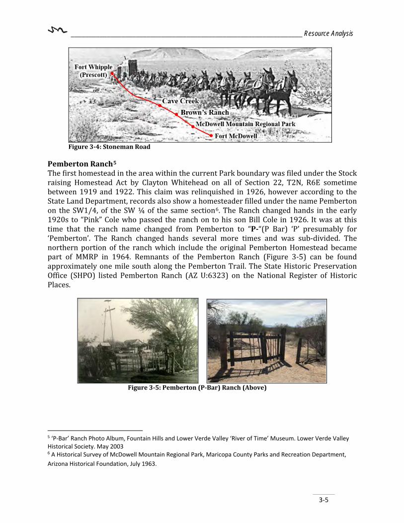
Figure 3-4: Stoneman Road
Pemberton Ranch5 The first homestead in the area within the current Park boundary was filed under the Stock raising Homestead Act by Clayton Whitehead on all of Section 22, T2N, R6E sometime between 1919 and 1922. This claim was relinquished in 1926, however according to the State Land Department, records also show a homesteader filled under the name Pemberton on the SW1/4, of the SW ¼ of the same section6. The Ranch changed hands in the early 1920s to “Pink” Cole who passed the ranch on to his son Bill Cole in 1926. It was at this time that the ranch name changed from Pemberton to “P-“(P Bar) ‘P’ presumably for ‘Pemberton’. The Ranch changed hands several more times and was sub-divided. The northern portion of the ranch which include the original Pemberton Homestead became part of MMRP in 1964. Remnants of the Pemberton Ranch (Figure 3-5) can be found approximately one mile south along the Pemberton Trail. The State Historic Preservation Office (SHPO) listed Pemberton Ranch (AZ U:6323) on the National Register of Historic Places.
Figure 3-5: Pemberton (P-Bar) Ranch (Above)
5 ‘P-Bar’ Ranch Photo Album, Fountain Hills and Lower Verde Valley ‘River of Time’ Museum. Lower Verde Valley Historical Society. May 2003 6 A Historical Survey of McDowell Mountain Regional Park, Maricopa County Parks and Recreation Department, Arizona Historical Foundation, July 1963.

________________________________________________________________ Resource Analysis
3-6
Dixie Mine (Figure 3-6) Originally known as the Red Mountain Mine, the Dixie Mining had a small start located near the southwest corner of MMRP. The mine never grew large enough to warrant recording on a list of Arizona Mining districts by the U.S. Bureau of Mines. MMRP has a long history of use by both Native American and Euromerican peoples. Figure 3-7 depicts some of the known historical features of the park.
Figure 3-6: Dixie Mine
Figure 3-7: Historical Sites
________________________________________________________________ Resource Analysis
3-7
3.3 Cultural Resources This section offers a brief history of the Park and surrounding area, but by all means, is not a complete historical record. The historical names and/or events mentioned in this section may bring context to Park-related naming conventions. While a comprehensive archeological inventory has not been completed on the entire Park, project or site specific surveys have been completed and a number of records are available. These inventories are kept on file at the Park or Department offices. However, due to the sensitive nature of archaeological sites and the need to protect these cultural assets, these reports are not available to the general public. Historical information contained in this section came from various cultural resource survey’s performed in the Park as well as the 1963 Archaeological Resource report for five (5) regional Parks (including MMRP).
3.3.1 Pre-History of Area7 Cultural remains may be encountered throughout the Park that may represent the remnants of the prehistoric archaeological culture called Hohokam. However, because of the complex geomorphological conditions in the Park, it is possible for discoveries dating to the earlier Paleoindian and Archaic cultures. Further, the Park is adjacent to the Fort McDowell - Yavapai Nation, consequently evidence of the Apache and Yavapai use of the area may also be present. Water was a critical element to those who lived in this desert region. Unsurprisingly, the Hohokam relied heavily on irrigation for its agriculture in order to produce food and trade goods. Traces of irrigation canals have been found along the Rio Verde River. For unknown reasons, the Hohokam society declined rapidly in the early fifteenth century (1450 A.D.) leaving many of the agricultural centers abandoned. The Park contains a number of recorded archeological sites predominantly found along major arroyos within the Park Boundaries. Among them, one (AZ: U: 5:10) is thought to be a former Hohokam village with three (3) or four (4) rooms. Additional sites within the Park include prehistoric Hohokam agricultural sites, geometric and zoomorphic petroglyphs throughout the Park (Figure 3-8). Archaeological sites within the boundaries of the Park include both sherd and small villages. Remnants of pottery sherds possibly represent temporary camps of people participating in hunting and gathering activities, while the villages indicate at least seasonal use of the area for wild plant crop harvesting. 7 McDowell Master Development Plan, 1963, Scott, William T.
________________________________________________________________ Resource Analysis
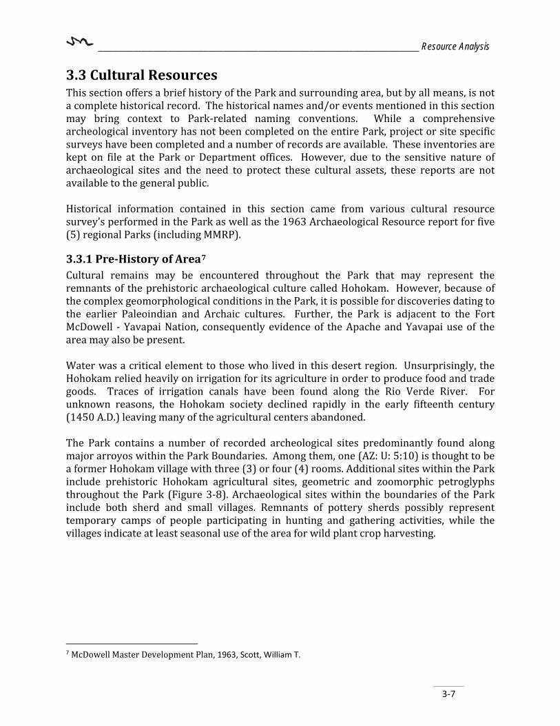
3-8
Petroglyphs are found in many places throughout the Park. Petroglyphs are renderings left behind on rock by ancient peoples. The rocks are covered by a paper-thin coating of dark “desert varnish” or patina8 on exposed rocks and boulders. This varnish is what allowed native peoples to leave their etching messages behind. The Park’s Interpretive Ranger occasionally leads educational hikes to some petroglyphs located closer to the MMRP Nature Center and front-country areas. Staff and the Arizona Site Steward’s monitor cultural sensitive sites.
3.4 Native American Consultations Planning staff sought input from potentially interested American Indian communities regarding this MP update. The Fort McDowell Yavapai Nation shares a boundary with the Park and was invited to participate as a stakeholder in the planning process. Invitations to public meetings were also sent out to all of the partners and stakeholders associated with the planning effort. Several representatives from the Fort McDowell Yavapai Nation were present at the stakeholder meetings that were held in January and May of 2018. Additionally, in order to assist in assessing the cultural significance of or actions needed to protect any significant resources, future master plan updates and efforts should go through consultation with representatives of American Indian Communities claiming cultural affiliation to the area.
3.4.1 Findings A cultural resource records review was initiated to document the extent of previous archaeological survey within the Park and the number of previously recorded archaeological and historical sites that have been identified by those surveys. These studies were undertaken in support of a variety of projects such as hiking trail 8 Desert Soils, Joseph R. McAuliffe, http://www.desertmuseum.org/books/nhsd_desert_soils.php as accessed April 18, 2012.
Figure 3-8: Petroglyphs in McDowell

________________________________________________________________ Resource Analysis
3-9
construction, campgrounds, and roadwork near the Park. No new field surveys were undertaken for this plan update. One (1) site within the Park has been listed as National Register of Historic Places and is identified as Pemberton Ranch (AZ U: 6323). Though unmarked, the Stoneman Trail used by the military between 1870 and 1890 has been recognized by SHPO as the Historic Stoneman Trail (I-2733. SHPO). Research identified a number of recorded archeological sites. Among them, one (AZ: U:5:10) is thought to be a former Hohokam village with three (3) or four (4) rooms. Additional sites within the Park include prehistoric Hohokam agricultural sites, geometric and zoomorphic petroglyphs and the Dixie Mine. A cultural resource management program should be established to track and monitor known sites. A full cultural resource survey or investigation and SHPO consultation is recommended prior to any new construction or trail project on previously undisturbed ground.
3.5 Natural Resources Hunting As per the AZGFD regulations, the Park is currently open for archery- only and some small game (shotgun with birdshot only) during specified hunting seasons. The AZGFD’s commission rule states, it is not permitted to hunt within a quarter-mile of any: developed picnic area and campground; shooting range; occupied building; boat ramp; golf course; recreational areas developed for public use; and to shoot from, on, or across a roadway or to trespass on private property9. Individuals hunting must declare their intent. A trail is not considered a developed area. Hunting is discussed further in 3.9.3 Hunting. Some hunting occurs in the Gila River corridor.
Non-Attainment or Maintenance Areas10 Maricopa County’s Air Quality Department (MCAQD) is tasked with protecting the public from airborne particulate matter and with complying with federal, state, and local air quality regulations. Nearly the entire Phoenix metropolitan area falls within the non-attainment area. The following designations remain in effect until the United States Environmental Protection Agency (EPA) determines otherwise:
Particulate Matter Inhalable coarse particulate matter11 is sized at either 2.5 (PM2.5) or 10 (PM10) micrometers in diameter as defined by the Environmental Protection Agency (EPA). The Park is entirely within the PM10 Non-attainment Area, and subject to dust-control measures. PM10 includes dust,
9 https://s3.amazonaws.com/azgfd-portal-wordpress/azgfd.wp/wp-content/uploads/2018/04/24093438/2018-19-AZ-Hunt-Regulations_WEB.pdf 10 Maricopa County Air Quality Department, Planning Area Maps, https://www.maricopa.gov/2686/Planning-Area-Maps as accessed on October 3, 2018. 11 EPA, Particulate Matter (PM 10) Information, https://www.epa.gov/green-book as accessed September 13, 2018.

________________________________________________________________ Resource Analysis
3-10
soot, and other tiny bits of solid materials that are released into and move around in the air (either from natural or anthropogenic sources). County inspection reports are kept on file in the Park office.
Ozone The Park is included within the 8-hour Ozone Nonattainment Area boundaries. At ground level, ozone aids in creating smog and is formed by the reaction of VOCs12 (for example, photochemical smog) and NOx13 (a reaction of nitrogen and oxygen gases in the air, particularly from motor vehicles) in the presence of heat and sunlight. Carbon Monoxide Maintenance Area The Park is located entirely within the Carbon Monoxide (CO) Maintenance Area. The Maricopa County Air Quality Department (MCAQD) explains that the area previously designated by the EPA has exceeded acceptable national standards for CO pollution levels. The EPA re-designated this area in attainment of the national CO standards in 2005, thus declaring the area a maintenance area as opposed to a nonattainment area. CO is an odorless, colorless gas that forms when the carbon in fuels does not completely burn. Vehicle exhaust contributes to roughly 60 percent (60%) of all CO emissions nationwide, and up to 95 percent (95%) in cities8. Other sources include fuel combustion in industrial processes and natural sources such as wildfires.
Fire Bans At times it is necessary to implement a ban on all fires (such as campfires, fire pits, and charcoal grills) throughout the entire Park in order to ensure public safety and protect resources during dry periods or windy days. A typical fire ban may be in effect from May 1 through September 30 each year. A violation of Park Rule R-11314 may result in a citation and Park eviction. Gas and propane use is usually acceptable in designated areas, except during extreme fire bans. Lifting the fire ban is dependent on regional temperatures and the amount of seasonal monsoon rainfall the Park receives and is announced by the Department. A burn permit is not needed from MCAQD for the following activities:15
12 Volatile organic compounds (VOCs) are organic chemicals that have a high vapor pressure at ordinary, room-temperature conditions. Their high vapor pressure results from a low boiling point, which causes large numbers of molecules to evaporate or sublimate from the liquid or solid form of the compound and enter the surrounding air. 13 NOx is a generic term for mono-nitrogen oxides NO and NO2 (nitric oxide and nitrogen dioxide). They are produced from the reaction of nitrogen and oxygen gases in the air during combustion, especially at high temperatures. In areas of high motor vehicle traffic, such as in large cities, the amount of nitrogen oxides emitted into the atmosphere as air pollution can be significant. 14 Maricopa County Parks and Recreation, Park Rules, Adopted August 13, 2003 by Maricopa County Board of Supervisors. https://www.maricopacountyParks.net/Park-locator/mcdowell-mountain-regional-Park/Park-information/Park-rules-and-hours-of-operation/ as accessed September 4, 2018. 15 Maricopa County Air Quality Department, Regulation III - Control of Air Contaminants, Rule 314 Open Outdoor Fires and Indoor Fireplaces at Commercial and Institutional Establishments. https://www.maricopa.gov/DocumentCenter/View/5200/Rule-314---Open-Outdoor-Fires-and-Indoor-Fireplaces-at-Commercial-and-Institutional-Establishments?bidId= as accessed October 3, 2018.

________________________________________________________________ Resource Analysis
3-11
• Cooking for immediate human consumption (Regulation III, Rule 314, Section 303.1.a)
• Warmth for human beings (Regulation III, Rule 314, 303.3a, unless under a fire ban) • Recreational purposes where the burning material is clean, dry wood or charcoal
(Regulation III, Rule 314, 303.3b, unless under a fire ban) However, it should be noted that while a permit may not be needed for these activities, they may be prohibited while under a fire ban.
3.6 Physiography and Climate This section reviews the physiographic properties of the Park and describes typical climatic conditions and other natural surroundings. 3.6.1 Physiography MMRP is within the northern edge of the Arizona section of the Cenozoic Basin and Range province of the Southwest United States. An abrupt change in elevation, alternating between narrow faulted mountain chains and flat arid valleys or basins, is typical here. The development of the province is the result of crustal extension that began in the Early Miocene era. As these geologic blocks tilted, sediments from erosion filled the valleys between them, creating the basins. The Park itself is situated in the lower Verde River basin. As a free-standing mountain range, the McDowell Mountain range extends approximately ten (10) miles in a northwest to southeast direction and is about five (5) miles wide. The Park is protected by approximately 17,000 acres of the City of Scottsdale’s McDowell Sonoran Preserve to the west and the Fort McDowell - Yavapai Nation to the east. The mountain range features a handful of peaks over 3,000 feet. The two most notable peaks near the center of the range: McDowell Peak and Thompson Peak, both exceeding 3,900 feet in elevation. Additionally, a highly recognizable feature of the McDowell Mountain Range is Tom’s Thumb. This prominent topographic feature located towards the north end of the range is a Mesoproterozoic granite body jutting out of the ridgeline at an elevation of over 3,500 feet. The Park is within the Sonoran Desert is one of four deserts in North America and is the dominate feature of Basin and Range Province. The Sonoran Desert covers about 100,000 square miles of the Southwest United States, extending into Mexico. This desert region is one of the hottest desert in the United States although winter temperatures can sometimes reach freezing. Winter and summer monsoon storms provide much needed water to the rich and diverse desert life. The winter storms, when they produce enough precipitation, result in an abundant spring flowering season.
________________________________________________________________ Resource Analysis
3-12
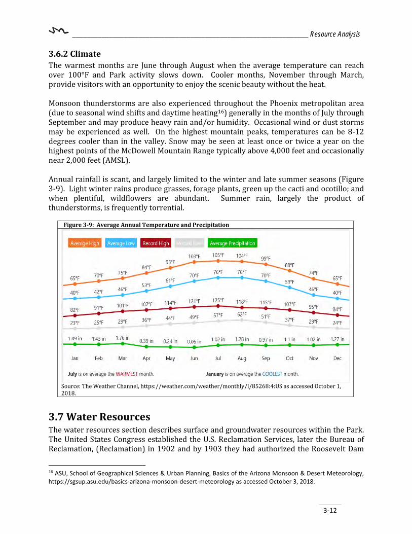
3.6.2 Climate The warmest months are June through August when the average temperature can reach over 100°F and Park activity slows down. Cooler months, November through March, provide visitors with an opportunity to enjoy the scenic beauty without the heat. Monsoon thunderstorms are also experienced throughout the Phoenix metropolitan area (due to seasonal wind shifts and daytime heating16) generally in the months of July through September and may produce heavy rain and/or humidity. Occasional wind or dust storms may be experienced as well. On the highest mountain peaks, temperatures can be 8-12 degrees cooler than in the valley. Snow may be seen at least once or twice a year on the highest points of the McDowell Mountain Range typically above 4,000 feet and occasionally near 2,000 feet (AMSL). Annual rainfall is scant, and largely limited to the winter and late summer seasons (Figure 3-9). Light winter rains produce grasses, forage plants, green up the cacti and ocotillo; and when plentiful, wildflowers are abundant. Summer rain, largely the product of thunderstorms, is frequently torrential.
Figure 3-9: Average Annual Temperature and Precipitation
Source: The Weather Channel, https://weather.com/weather/monthly/l/85268:4:US as accessed October 1, 2018.
3.7 Water Resources The water resources section describes surface and groundwater resources within the Park. The United States Congress established the U.S. Reclamation Services, later the Bureau of Reclamation, (Reclamation) in 1902 and by 1903 they had authorized the Roosevelt Dam
16 ASU, School of Geographical Sciences & Urban Planning, Basics of the Arizona Monsoon & Desert Meteorology, https://sgsup.asu.edu/basics-arizona-monsoon-desert-meteorology as accessed October 3, 2018.

________________________________________________________________ Resource Analysis
3-13
project on the Salt River. This accelerated growth of the south-central Arizona desert region. Construction of the Roosevelt Dam was completed in 1911, with the construction of several more dams completed by 1920. Near the beginning of 1922, the Phoenix Metropolitan area began withdrawing higher quality groundwater from the Lower Verde River Valley to supplement the supply from the Salt River. Since the initial withdraws in 1922, water resources from the underground aquifer have been continually withdrawn from the Rio Verde floodplain aquifer. However, the majority of the water losses from the basin are due to agricultural diversions via the Fort McDowell - Yavapai Nation and nearby groundwater withdrawals. It wasn’t until the completion of Bartlett Dam in 1939 that additional surface water resources were utilized in conjunction with stored underground water sources. The completion of Bartlett Dam and Horseshoe Dam to the north, allowed for the storage of flood-waters and controlled releases of water for irrigation.17
3.7.1 Surface Water Hydrology Principle perennial streams within the Phoenix Active Management Area (AMA) include the Rio Verde River, Gila River, and the Salt River. However, the Verde River is the only perennial stream throughout the AMA18. The Rio Verde River flows north to south and is located approximately 1.5 miles east of MMRP. The Park itself is situated within the Lower Verde River Valley basin. While the Park does not have perennial or intermittent streams, it does have a number of natural, ephemeral and mostly unnamed washes and five (5) major watersheds that distribute storm water runoff throughout the Park. These major washes fall under the United States Environmental Protection Agency’s 1986/1988 Regulatory definition of “Waters of the United States” Section 404 Clean Water Act and are identified in (Figure 3-10).
17 Subsurface Geologic Investigation of Fountain Hills and the Lower Verde River Valley, Maricopa County, Arizona. http://repository.azgs.az.gov/sites/default/files/dlio/files/2010/u15/CR-03-B.pdf as accessed October 8, 2018. 18 Arizona Department of Water Resources, http://www.azwater.gov/ as accessed October 8, 2018.
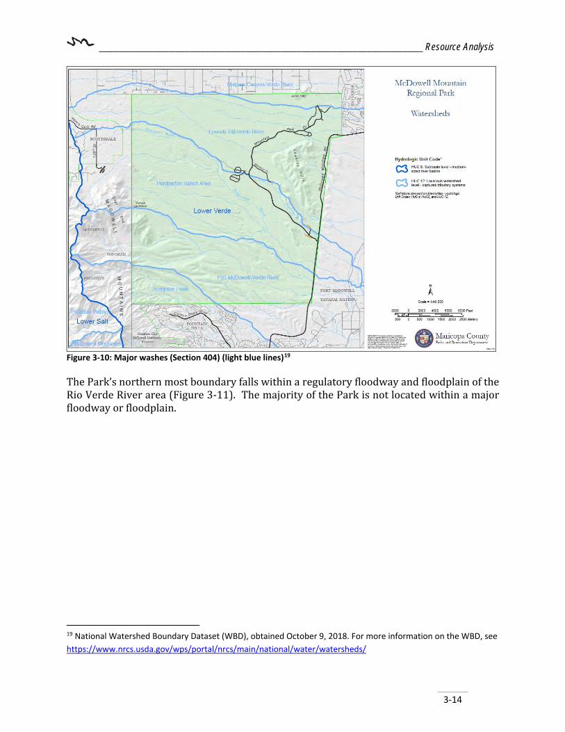
________________________________________________________________ Resource Analysis
3-14
Figure 3-10: Major washes (Section 404) (light blue lines)19 The Park’s northern most boundary falls within a regulatory floodway and floodplain of the Rio Verde River area (Figure 3-11). The majority of the Park is not located within a major floodway or floodplain.
19 National Watershed Boundary Dataset (WBD), obtained October 9, 2018. For more information on the WBD, see https://www.nrcs.usda.gov/wps/portal/nrcs/main/national/water/watersheds/

________________________________________________________________ Resource Analysis
3-15
Figure 3-11: Floodway and Floodplain The Maricopa County Flood Control Department (FCD) monitors precipitation and provides flood alerts through the following monitoring stations (Table 3-1):
Table 3-1: Stream Flow Monitoring Station ID
Station Name Station Type
Install Date
9510000 Rio Verde River below Bartlett Dam
Stream Flow 10/1944
9511300 Rio Verde River near Scottsdale
Stream Flow 3/1961
Flood Alert System 5900 Asher Hills Precipitation 8/2/1990 5915 McDowell Mountain
Park Precipitation 8/6/1990
5920 McDowell Mountain Road
Precip/Stage 5/18/204
5978 Golden Eagle Blvd Precipitation 2/12/1997 5990 Hesperus Dam Precip/Stage 12/18/1996 5995 Hesperus Wash Precipitation 3/10/997 Source: Arizona Water Atlas Volume 8 Phoenix Active Management Area (AMA)

________________________________________________________________ Resource Analysis
3-16
3.7.2 Groundwater Resources MMRP resides in the AMA20 groundwater basin; these are areas that rely heavily on mined groundwater and require additional withdrawal rate management. According to ADWR there are currently three (3) registered wells (55-614022, 55-623551, and 55-623552) at the Park; however, none of these wells are currently active.
3.8 Earth Resources The Park is located within the Basin and Range Province of the Desert Southwest, as is much of Arizona. Basin and Range is a result of tectonic forces and volcanism over millions of years.21 The McDowell Mountain Range trend in a northeast near the central area and to north-northeast at the northern end of the range. Comparatively, the McDowell’s are a relatively low elevation desert mountain rage rising abruptly from the surround desert floor form approximately 2,000 feet (AMSL) to a maximum elevation of 4,116 feet (AMSL) Elevations within the range vary widely, with relatively flat areas in the central part of the range to prominent cliffs near the northern part of the range.
3.8.1 Geology The rock types found are mostly conglomerate and gravel with some areas of sand, granite, and phyllite (Figure 3-12). Conglomerate is a coarse-grained sedimentary rock composed of rounded fragments less than 2mm within a matrix of finer grained material, gravel is a loose aggregation of small water-worn or pounded stones. Sandstone is sedimentary rock composed of mainly sand sized (0.625 to 2 mm) grains of mineral particles or rock fragments. Granite is igneous rock that is coarse-grained in texture with some quartz and feldspar and Phyllite differs in that it is foliated metamorphic rock composed mainly of flake-shaped mica minerals that are strongly parallel allowing the rock to be split into sheets (usually gray black or greenish For a full list of types and detailed description of locations of occurrence, as compiled by Arizona Geological Survey22 (AZGS) Map Services, see Appendix D.
20 Arizona Department of Water Resources, http://www.azwater.gov/ as accessed October 3, 2018. 21 Structural Evolution of the McDowell Mountains, Brad Vance https://repository.asu.edu/attachments/97688/content//tmp/package-8bTpta/Vance_asu_0010N_12324.pdf as accessed September 14, 2018. 22 The Arizona Geological Survey, AZGS Map Services Geologic Map of Arizona, http://www.azgs.az.gov/services_azgeomap.shtml as accessed August 10, 2018.

________________________________________________________________ Resource Analysis
3-17
Figure 3-12: Geology 3.8.2 Land Subsidence and Earth Fissures In addition to water rights, ADWR is also the state agency responsible for identifying and monitoring active land subsidence areas. There are no known land subsidence areas in or near the Park.23 Effective September 21, 2006, Arizona Revised Statute (A.R.S.) § 27-152.01(3) requires the AZGS to complete comprehensive mapping of earth fissures throughout Arizona and providing earth fissure map data to the ASLD to be made available online with other Geographic Information System (GIS) map layers for the public to use in building their own customized maps. Parts of Maricopa County were mapped24 and no fissures are currently known within the Park itself. In 2002, ASU researchers discovered the second largest known landslide in Arizona (Marcus Landslide) located on the northeast side of the McDowell Mountain Range. At the time of the Marcus Landslide, approximately 500,000 years ago, a huge avalanche caused
23 Arizona Department of Water Resources, Hydrology Division, Arizona Land Subsidence Areas and Interactive Map, http://www.azwater.gov/AzDWR/Hydrology/Geophysics/LandSubsidenceInArizona.htm as accessed October 9, 2018. 24 The Arizona Geological Survey, Arizona’s Earth Fissure Center, http://www.azgs.az.gov as accessed October 9, 2018.

________________________________________________________________ Resource Analysis
3-18
loose granite bedrock to slide at an estimated 44 miles per hour from atop the mountain range. The debris field extends nearly a mile east-northeast and created between 5.5 and 7 million cubic meters of debris (Figure 3-13).
Figure 3-13: Marcus Landslide
3.8.3 Soils25 and Erosion Potential The major soil types found in the Park are primarily gravelly loam and Pinaleno-Tres Hermanos Complex in the development management zones, and Wickenburg complex including rock outcrop in the primitive management zone areas (Figure 3-14). The soils immediately surrounding the McDowell Mountains have a low to moderate shrink/swell potential.26 See Appendix D for the soils map and definitions. Due to the steep and rugged slope (20-25% or greater) of the mountains, erosion potential is high in these areas, resulting in talus and alluvium deposits below (and is what slowly fills the “basins” within a Basin and Range system). During an extreme flash flood event, these materials can be transported to lower lying areas below.
25 USDA Natural Resources Conservation Service, Soils website, https://websoilsurvey.sc.egov.usda.gov/App/WebSoilSurvey.aspx as accessed October 9, 2018. 26 USDA, Natural Resources Conservation Service, Soil Properties Shrink/Swell Potential, https://www.nrcs.usda.gov/Internet/FSE_DOCUMENTS/nrcs144p2_064581.pdf as accessed October 10, 2018.
N
N

________________________________________________________________ Resource Analysis
3-19
Figure 3-14: Soils
3.9 Biological Resources The State of Arizona has over 900 animal species and a diversity of landscapes. Maricopa County is located in the central portion of the Sonoran Desert and is home to a variety of plants and animals. The wildlife and vegetation commonly seen in the Park is typical of a Sonoran Desertscrub environment. Fire is not historically common to an Arizona Upland Subdivision Sonoran Desert scrub environment, although with intrusion of human influence and adjacent development, it is more of a risk today. Historic cattle activity brought more grasses into the area (as did homes) and these grasses can also serve as fuel to fires. On July 7, 1995, the Rio Fire burned nearly two-thirds of the Park’s total acreage (approximately 14,000 acres in all). The Rio Fire, which was caused by a lightning bolt from a summer storm combined with 30 mile per hour winds and aggressively-growing non-native grasses lead to the wide spread fire damage which is still visible today (Figure 3-15). Native vegetation is starting to poke back up from the desert floor but it will be at least another six (6) decades before the native saguaro forest returns. Due to the majority of these grasses having been burned away, the Park is rated relatively low for potential fire hazards (Figure 3-16).

________________________________________________________________ Resource Analysis
3-20
Figure 3-15: 1995 Rio Fire Damage inside McDowell Mountain Regional Park Boundary
Figure 3-16: Environmental Hazards (Source: http://data.azgs.az.gov/hazard-viewer)
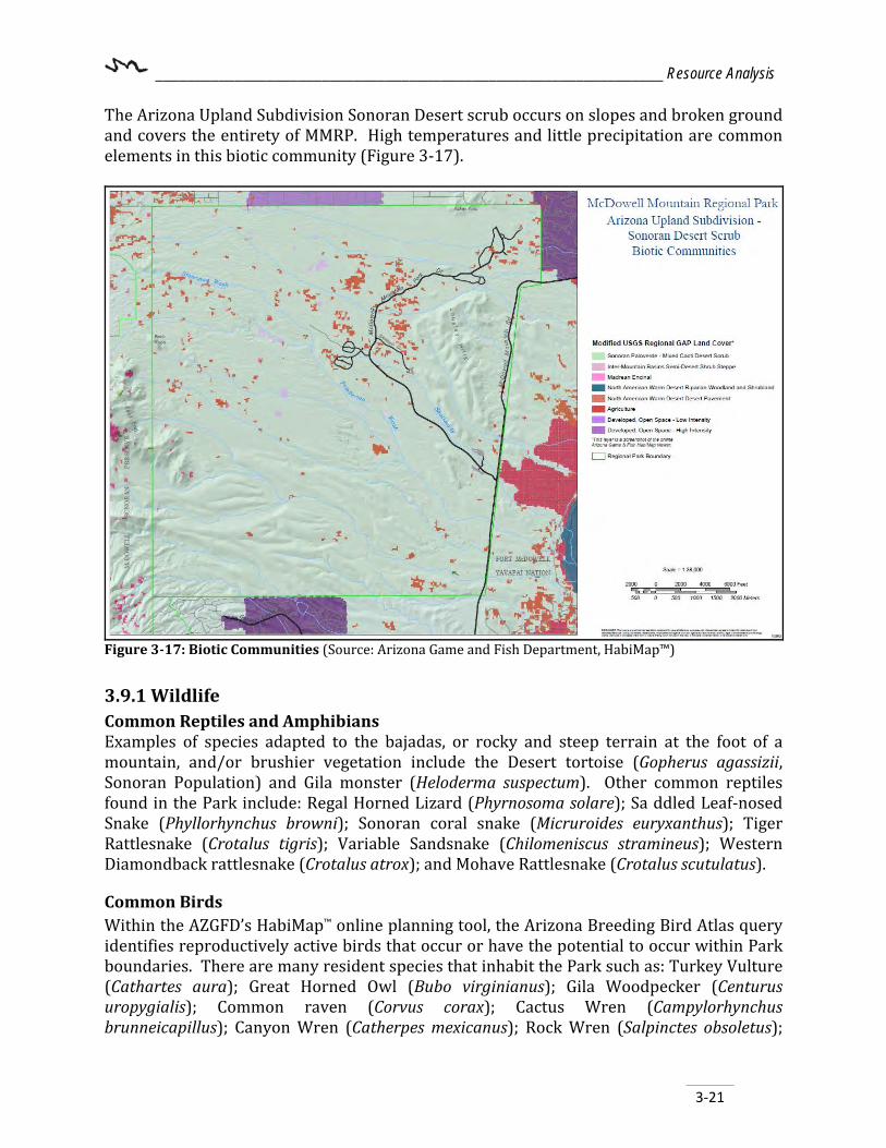
________________________________________________________________ Resource Analysis
3-21
The Arizona Upland Subdivision Sonoran Desert scrub occurs on slopes and broken ground and covers the entirety of MMRP. High temperatures and little precipitation are common elements in this biotic community (Figure 3-17).
Figure 3-17: Biotic Communities (Source: Arizona Game and Fish Department, HabiMap™) 3.9.1 Wildlife Common Reptiles and Amphibians Examples of species adapted to the bajadas, or rocky and steep terrain at the foot of a mountain, and/or brushier vegetation include the Desert tortoise (Gopherus agassizii, Sonoran Population) and Gila monster (Heloderma suspectum). Other common reptiles found in the Park include: Regal Horned Lizard (Phyrnosoma solare); Sa ddled Leaf-nosed Snake (Phyllorhynchus browni); Sonoran coral snake (Micruroides euryxanthus); Tiger Rattlesnake (Crotalus tigris); Variable Sandsnake (Chilomeniscus stramineus); Western Diamondback rattlesnake (Crotalus atrox); and Mohave Rattlesnake (Crotalus scutulatus).
Common Birds Within the AZGFD’s HabiMap™ online planning tool, the Arizona Breeding Bird Atlas query identifies reproductively active birds that occur or have the potential to occur within Park boundaries. There are many resident species that inhabit the Park such as: Turkey Vulture (Cathartes aura); Great Horned Owl (Bubo virginianus); Gila Woodpecker (Centurus uropygialis); Common raven (Corvus corax); Cactus Wren (Campylorhynchus brunneicapillus); Canyon Wren (Catherpes mexicanus); Rock Wren (Salpinctes obsoletus);
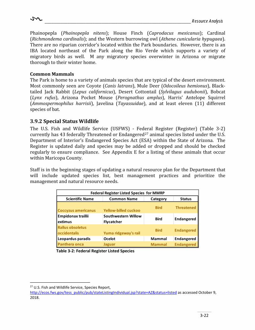
________________________________________________________________ Resource Analysis
3-22
Phainopepla (Phainopepla nitens); House Finch (Caprodacus mexicanus); Cardinal (Richmondema cardinalis); and the Western burrowing owl (Athene cunicularia hypugaea). There are no riparian corridor’s located within the Park boundaries. However, there is an IBA located northeast of the Park along the Rio Verde which supports a variety of migratory birds as well. M any migratory species overwinter in Arizona or migrate thorough to their winter home. Common Mammals The Park is home to a variety of animals species that are typical of the desert environment. Most commonly seen are Coyote (Canis latrans), Mule Deer (Odocoileus hemionus), Black-tailed Jack Rabbit (Lepus californicus), Desert Cottontail (Sylvilagus audubonii), Bobcat (Lynx rufus), Arizona Pocket Mouse (Perognathus amplus), Harris’ Antelope Squirrel (Ammospermophilus harrisii), Javelina (Tayassuidae), and at least eleven (11) different species of bat. 3.9.2 Special Status Wildlife The U.S. Fish and Wildlife Service (USFWS) - Federal Register (Register) (Table 3-2) currently has 43 federally Threatened or Endangered27 animal species listed under the U.S. Department of Interior’s Endangered Species Act (ESA) within the State of Arizona. The Register is updated daily and species may be added or dropped and should be checked regularly to ensure compliance. See Appendix E for a listing of these animals that occur within Maricopa County. Staff is in the beginning stages of updating a natural resource plan for the Department that will include updated species list, best management practices and prioritize the management and natural resource needs.
Scientific Name Common Name Category Status
Coccyzus americanus Yellow-billed cuckooBird Threatened
Empidonax traillii extimus
Southwestern Willow Flycatcher
Bird Endangered
Rallus obsoletus occidentalis Yuma ridgeway's rail
Bird Endangered
Leopardus paradis Ocelot Mammal Endangered Panthera onca Jaguar Mammal Endangered
Federal Register Listed Species for MMRP
Table 3-2: Federal Register Listed Species
27 U.S. Fish and Wildlife Service, Species Report, http://ecos.fws.gov/tess_public/pub/stateListingIndividual.jsp?state=AZ&status=listed as accessed October 9, 2018.

________________________________________________________________ Resource Analysis
3-23
3.9.3 Natural Heritage Program – Heritage Data Management System (HDMS) Additionally, AZGFD tracks animals of state concern through its HDMS.28 Of those listed, the following may be found in the Park or habitat that supports the species may be present in the Park with a total of sixteen (16) species including two (2) plants, five (5) mammals, four (4) birds, four (4) reptiles and one (1) mollusk (Table 3-3). Listing Status Definitions: Federal U.S. - Fish and Wildlife (FWS) Status:
BGA - Bald and Golden Eagle Protection Act: Prohibits take of bald and golden eagles without prior FWS permit. SC – Species of Concern
Endangered Species Act (ESA): (FWS) LE - Listed Endangered LT - Listed Threatened PS - Partial Status; Listed Endangered or Threatened, but not in entire range XN - Experimental nonessential population PDL - Proposed for delisting SAT - Listed Threatened, due to similarity of appearance PE - Proposed Endangered PT - Proposed Threatened
FWS Candidate for Conservation CCA - Candidate for Conservation
FWS Critical Habitat
Y - Yes Critical Habitat P - Proposed Critical Habitat DPS - Distinct Population Segment
USFS US Forest Service-Animal Status
S - Sensitive BLM US Bureau of Land Management
S - Sensitive P - Population (Only those populations of Banded Gila Monster that occur north and west of the Colorado River are sensitive.
NPL Native Plant Law (also refer to Vegetation Chapter 3.6.8 for more plant species information)
HS - Highly Safeguarded- no collection SR - Salvage Restricted- permit collection only
28 Arizona Game and Fish Department, Natural Heritage Program, https://azhgis2.esri.com/ and HabiMap™ HDMS query http://habimap.org/habimap/ as accessed October 9, 2018.

________________________________________________________________ Resource Analysis
3-24
ER - Export Salvage-Transport out of state prohibited SA - Salvage Assessed- Permits required to move live trees HR - Harvest Restricted-permits required to remove plant by-products
Scientific Name Common Name FWS USFS BLM NPLAgave murpheyi Hohokam Agave SC S S HSCorynorhinus townsendii pallescens Pale Townsend's Big-eared Bat SC S SEricameria brachylepis Rayless Turpentine BushFalco peregrinus anatum American Peregrine Falcon SC S SGopherus morafkai Sonoran Desert Tortoise CCA S SHaliaeetus leucocephalus (wintering pop.) Bald Eagle - Winter Population SC, BGA S SHaliaeetus leucocephalus pop. 3 Bald Eagle - Sonoran Desert Population SC, BGA S SHeloderma suspectum cinctum Banded Gila Monster SCHeloderma suspectum suspectum Reticulate Gila MonsterLeptonycteris yerbabuenae Lesser Long-nosed Bat SCLithobates yavapaiensis Lowland Leopard Frog SC S SMacrotus californicus California Leaf-nosed Bat SC SMaricopella allynsmithi Squaw Peak Talussnail SCMyotis velifer Cave Myotis SC S
PCH for Coccyzus americanusYellow-billed Cuckoo (Proposed Critical Habitat)
Rallus obsoletus yumanensis Yuma Ridgway's Rail LE
Special Status Species
Table 3-3: Special Status Species
MMRP (+2mile proximity) also had a Bat Colony listed and both the Fort McDowell Yavapai Nation and Salt Verde Riparian Ecosystem as IBAs. In the special species status list, all of which are found within the two (2) mile proximity area. There were also three (3) aquatic species listed: however, they require a permanent water body and therefore were found within the two (2) mile proximity area around the Park and included Desert pupfish (Cyprinodon macularis-LE), Roundtail Chub (Gila robusta-CCA, S, S), and Gila topminnow (Poeciliopsis occidentalis occ.- LE), however they require permanent water, which MMRP does not have and therefore these species are found just outside the Park. 3.9.4 Species of Greatest Conservation Need (SGCN)29 The State of Arizona has identified certain species with the greatest need for conservation actions in its State Wildlife Action Plan (SWAP)30 and those are indicative of the diversity and health of the State’s wildlife. The list includes species that are currently listed as threatened or endangered under the ESA as well as many others with significant vulnerability such as low and declining populations. Overall, it is AZGFD’s intent to 29 Arizona Game and Fish Department, HabiMap™ SGCN query, http://habimap.org/habimap/ as accessed October 9, 2018. 23
30 Arizona Game and Fish Department, State Wildlife Action Plan, 2012 – 2022. https://www.azgfd.com/PortalImages/files/wildlife/2012-2022_Arizona_State_Wildlife_Action_Plan.pdf
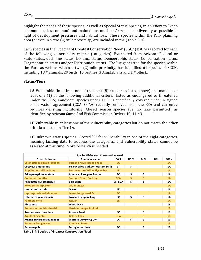
________________________________________________________________ Resource Analysis
3-25
highlight the needs of these species, as well as Special Status Species, in an effort to "keep common species common" and maintain as much of Arizona's biodiversity as possible in light of development pressures and habitat loss. These species within the Park planning area (or within a two (2) mile proximity) are included in the (Table 3-4). Each species in the ‘Species of Greatest Conservation Need’ (SGCN) list, was scored for each of the following vulnerability criteria (categories): Extirpated from Arizona, Federal or State status, declining status, Disjunct status, Demographic status, Concentration status, Fragmentation status and/or Distribution status. The list generated for the species within the Park as well as within a two (2) mile proximity, has identified 61 species of SGCN, including 18 Mammals, 29 birds, 10 reptiles, 3 Amphibians and 1 Mollusk. Status-Tiers
1A Vulnerable (in at least one of the eight (8) categories listed above) and matches at least one (1) of the following additional criteria: listed as endangered or threatened under the ESA; Candidate species under ESA; is specifically covered under a signed conservation agreement (CCA, CCAA; recently removed from the ESA and currently requires delisting monitoring; Closed season species (i.e. no take permitted) as identified by Arizona Game And Fish Commission Orders 40, 41-43. 1B Vulnerable in at least one of the vulnerability categories but do not match the other criteria as listed in Tier 1A. 1C Unknown status species. Scored “0” for vulnerability in one of the eight categories, meaning lacking data to address the categories, and vulnerability status cannot be assessed at this time. More research is needed.
Scientific Name Common Name FWS USFS BLM NPL SGCNChionactis occipitalis klauberi Tucson Shovel-nosed Snake SC 1ACoccyzus americanus Yellow-billed Cuckoo (Western DPS) LT S 1AEmpidonax traillii extimus Southwestern Willow Flycatcher LE 1AFalco peregrinus anatum American Peregrine Falcon SC S S 1AGopherus morafkai Sonoran Desert Tortoise CCA S S 1AHaliaeetus leucocephalus Bald Eagle SC, BGA S S 1AHeloderma suspectum Gila Monster 1ALeopardus pardalis Ocelot LE 1ALeptonycteris yerbabuenae Lesser Long-nosed Bat SC 1ALithobates yavapaiensis Lowland Leopard Frog SC S S 1APanthera onca Jaguar LE 1AAix sponsa Wood Duck 1BAmmospermophilus harrisii Harris' Antelope Squirrel 1BAnaxyrus microscaphus Arizona Toad SC S 1BAquila chrysaetos Golden Eagle BGA S 1BAthene cunicularia hypugaea Western Burrowing Owl SC S S 1BBotaurus lentiginosus American Bittern 1BButeo regalis Ferruginous Hawk SC S 1B
Species Of Greatest Conservation Need
Table 3-4: Species of Greatest Conservation Need

________________________________________________________________ Resource Analysis
3-26
Castor canadensis American Beaver 1BChilomeniscus stramineus Variable Sandsnake 1BColaptes chrysoides Gilded Flicker S 1BColuber bilineatus Sonoran Whipsnake 1BCorynorhinus townsendii pallescens Pale Townsend's Big-eared Bat SC S S 1BCrotalus tigris Tiger Rattlesnake 1BEuderma maculatum Spotted Bat SC S S 1BEumops perotis californicus Greater Western Bonneted Bat SC S 1BIncilius alvarius Sonoran Desert Toad 1BKinosternon sonoriense sonoriense Desert Mud Turtle S 1BLasiurus blossevillii Western Red Bat S 1BLasiurus xanthinus Western Yellow Bat S 1BMacrotus californicus California Leaf-nosed Bat SC S 1BMaricopella allynsmithi Squaw Peak Talussnail SC 1BMelanerpes uropygialis Gila Woodpecker 1BMelospiza lincolnii Lincoln's Sparrow 1BMelozone aberti Abert's Towhee S 1BMicrotus mexicanus Mexican Vole 1BMicruroides euryxanthus Sonoran Coralsnake 1BMyotis occultus Arizona Myotis SC S 1BMyotis velifer Cave Myotis SC S 1BMyotis yumanensis Yuma Myotis SC 1BNyctinomops femorosaccus Pocketed Free-tailed Bat 1BPasserculus sandwichensis Savannah Sparrow 1BPhrynosoma solare Regal Horned Lizard 1BPhyllorhynchus browni Saddled Leaf-nosed Snake 1BSetophaga petechia Yellow Warbler 1BTadarida brasiliensis Brazilian Free-tailed Bat 1BToxostoma lecontei LeConte's Thrasher S 1BTroglodytes pacificus Pacific Wren 1BVireo bellii arizonae Arizona Bell's Vireo 1BVulpes macrotis Kit Fox No Status 1BCalypte costae Costa's Hummingbird 1CCistothorus palustris Marsh Wren 1CEmpidonax wrightii Gray Flycatcher 1CMicrathene whitneyi Elf Owl 1CMyiarchus tyrannulus Brown-crested Flycatcher 1COreoscoptes montanus Sage Thrasher 1COreothlypis luciae Lucy's Warbler 1CSphyrapicus nuchalis Red-naped Sapsucker 1CSpizella atrogularis Black-chinned Sparrow 1CSpizella breweri Brewer's Sparrow 1CVireo vicinior Gray Vireo S 1C
Table 3-4: Species of Greatest Conservation Need (continued)
While six aquatic species were identified on the list, the Park does not have a permanent body of water large enough to sustain fish populations. The species that were identified in the list were found to be located within the two (2) mile proximity area and include Longfin Dace, Desert Sucker, Sonora Sucker, Gila Topminnow (LE), Roundtail Chub and Speckled Dace.
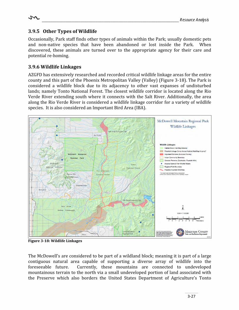
________________________________________________________________ Resource Analysis
3-27
3.9.5 Other Types of Wildlife Occasionally, Park staff finds other types of animals within the Park; usually domestic pets and non-native species that have been abandoned or lost inside the Park. When discovered, these animals are turned over to the appropriate agency for their care and potential re-homing. 3.9.6 Wildlife Linkages AZGFD has extensively researched and recorded critical wildlife linkage areas for the entire county and this part of the Phoenix Metropolitan Valley (Valley) (Figure 3-18). The Park is considered a wildlife block due to its adjacency to other vast expanses of undisturbed lands; namely Tonto National Forest. The closest wildlife corridor is located along the Rio Verde River extending south where it connects with the Salt River. Additionally, the area along the Rio Verde River is considered a wildlife linkage corridor for a variety of wildlife species. It is also considered an Important Bird Area (IBA).
Figure 3-18: Wildlife Linkages
The McDowell’s are considered to be part of a wildland block; meaning it is part of a large contiguous natural area capable of supporting a diverse array of wildlife into the foreseeable future. Currently, these mountains are connected to undeveloped mountainous terrain to the north via a small undeveloped portion of land associated with the Preserve which also borders the United States Department of Agriculture’s Tonto

________________________________________________________________ Resource Analysis
3-28
National Forest to the north and east. With Dynamite Road and McDowell Mountain Road becoming infinitely busier with the increase of housing developments, these two roads are becoming significant barriers to the movement of wildlife through this area. Currently, there are no designated critical wildlife linkage zones (or corridors) within Park boundaries however, the Park provides an important refuge for wildlife. Working with the Park’s surrounding neighbors to find additional wildlife linkages would be beneficial to animals and humans alike. Likewise, the riparian corridor along the Rio Verde River is considered a potential linkage zone across habitat as well as an IBA. The City of Scottsdale draft General Plan 2035 (page 115) outlines six main goals for protecting and managing Sonoran Desert biodiversity and native ecosystems, which include maintaining natural washes as wildlife movement corridors and avoid disturbances to preserve habitat linkages. Additionally, the Town of Fountain Hills (Town) General Plan 2002 (page 59-63) recognizes the importance of undeveloped washes as wildlife linkages between the two (2) preserves, the Town, and the Park and designates these areas for open space preservation. 3.9.7 Vegetation A flora inventory completed in 198131 showed 289 species and variations occurring within the Park; the inventory and a searchable database are available on the Southwest Environmental Information Network website32. The following native plants are commonly seen in the Park: California sage (Salvia columbariae), Ocotillo (Fouquieria splendens), Saguaro cactus (Carnegiea gigantean), Creosote bush (Larrea tridentate), Showy Desert-Marigold (Baileya multiradiata), Buckhorn cholla (Cylindropuntia acanthocarpa), California poppy (Eschscholzia californica), Thornber’s buckhorn (Cylindropuntia acanthocarpa), Teddy-bear cholla (Cylindropuntia bigelovii), soaptree yucca (Yucca elata), as well as desert trees such as ironwood (Olneya tesota), Palo Verde (Parkinsonia microphylla/florida), and Velvet mesquite (Prosopia velutina). Much of the flora in McDowell was burned in the 1995 Rio Verde Fire. It would be beneficial to updated flora inventory prior to the 2039 Master Plan Update. There are currently twenty-four (24) species of plants listed on the Noxious Weeds list (Table 3-5) for the State of Arizona; only one is known to occur at MMRP. Bufflegrass (Pennisetum ciliare), which is both a Regulated Pest and Prohibited Noxious Weed. It is found widespread in disturbed habitats, spreads very quickly on abandoned land below 3,000ft (914 m); introduced throughout the warmer, drier regions of the world including the SW US from California to Texas. Invasive Species get a foot hold in disturbed areas within the Park, especially near campsites, Parking lots, washes and along trails are ripe ground for noxious weeds and invasive species. The most common invasive species within 31 Lane, Meredith A. 1981. Vegetation and flora of McDowell Mountain Regional Park, Maricopa County, Arizona. Journal of the Arizona-Nevada Academy of Science, https://www.jstor.org/stable/40025615?origin=JSTOR-pdf 32SEINet Arizona – New Mexico Chapter – Arizona Flora – McDowell Mountain Regional Park http://swbiodiversity.org/seinet/checklists/checklist.php?clid=4&pid=1 SEINet, accessed October 10, 2018

________________________________________________________________ Resource Analysis
3-29
the Park include bufflegrass (Pennisetum ciliare), fountain grass (Penisetum setaceum), red brome (Bromus rubens), Tamarisk (Tamarix chinensis), Bermuda grass (Cynodon dactylon) and perennial starthistles. Many native desert scrub plant species have a zone of degradation, surrounding area with no vegetation surrounding each plant, this area has “no” fuel load and will help slow and stop the fire progression from moving into the desert scrub habitats. Invasive Species, especially bufflegrass were introduced to repair the landscape from over-grazing, increased the fuel load across the Sonoran desert, making damaging fires more likely by providing vertical and horizontal contiguous fuel load. Saguaro cactus and many other desert scrub plant species do not have adaptations to recurrent fires.
ScientificName Common Name Noxious WeedNatureServe
Arizona Conservation Status
Global NatureServe
Status Nativity A/B/P Lifeform
Bromus rubens Red Brome SNA/EXOTICGNR
INVASIVE Annual Graminoid
Centaurea melitensis Maltese Star-Thislte SNA/EXOTICGNR
INVASIVE Annual Forb
Cynodon dactylon Bermuda Grass SNA/EXOTICGNR
INVASIVE Perenial Graminoid
Pennisetum ciliare BufflegrassPNW & RNW
SNA/EXOTICGNR
INVASIVE Perenial Graminoid
Pennisetum setaceum Fountin Grass SNA/EXOTICGNR
INVASIVE Perenial Graminoid
Schismus arabicus Arabian Mediterranean Grass SNA/EXOTICGNR
INVASIVE Annual Graminoid
Sonchus asper Spiny-leaf Sow-thistle SNA/EXOTICGNR
INVASIVE Annual Forb
Sonchus oleraceus Common Sow-thistle SNA/EXOTICGNR
INVASIVE Annual Forb
Tamarix chinensis Chinese Tamarisk SNA/EXOTICGNR
INVASIVE Perenial Tree
Invasive Plant Species
Table 3-5: Invasive Plant Species Noxious Weed Status and Code: PNW – Prohibited noxious weed, RGNW – Regulated noxious weed, RNW – Restricted noxious weed
The MCPRD is in the beginning stages of writing a Natural Resource Plan for all of the regional Parks within the county Park system and will include updated species list, best management practices, management priorities and natural resource needs. Please refer to the Management Plan for updated species lists and management objectives and actions. 3.9.8 Special Status Vegetation The USFWS - Register currently has 21 federally threatened or endangered33 plant species listed under the ESA within the State of Arizona (Table 3-6). The Register is updated daily 25 U.S. Fish and Wildlife Service, Species Report, https://azhgis2.esri.com/project/mcdowell-mountain-regional-Park-master-plan-update-29041 as accessed October 9, 2018.

________________________________________________________________ Resource Analysis
3-30
and species may be added or dropped. Currently, there are no known federally threatened or endangered plant species within the Park. Regular review of this list should occur periodically for new species that may be found inside the Park. The State of Arizona’s ‘Native Plant Law’ provides a list of State protected species which are considered to be the most vulnerable. Of the 289 plant species found in the Park, twenty (20) plant species are protected; sixteen (16) plant species are protected as Salvage Restricted (SR), two (2) plant species are Harvest Safeguarded (HS), three (3) plant species are Salvage Assessed (SA) and three (3) plant species are Salvage Restricted (SR). Of the twenty (20) species; four (4) are listed under more than one of protected categories including Desert Agave (Agave deserti), Giant saguaro (Carnegiea gigantea), desert ironwood (Olneya tesota), velvet mesquite (Prosopis velutina) and Banana Yucca (Yucca baccata). Table 3-6 includes all twenty (20) species. NatureServe® is an excellent resource that provides information about species status locally, nationally and globally. Information at their website is updated regularly. They provide detailed information on the status of most plant species. NPL Native Plant Law
HS - Highly Safeguarded- no collection SR - Salvage Restricted- permit collection only ER - Export Salvage-Transport out of state prohibited SA - Salvage Assessed- Permits required to move live trees
HR - Harvest Restricted-permits required to remove plant by-products NatureServe State Conservation Status SH – Possibly Extirpated S1 – Critically Imperiled S2 – Imperiled S3 – Vulnerable S4 – Apparently Secure S5 – Secure SNR/ SU – Not raked or Under Review SNA Exotic or Hybrid without conservation value. NatureServe Global Conservation Status Rank GX – Presumed Extinct or Eliminated GH – Possibly Extinct or Presumed Eliminated G1 – Critically Imperiled G2 – Imperiled G3 – Vulnerable G4 – Apparently Secure G5 – Secure NatureServe Variable Ranks
G#C# - Range Rank GU – Un-rankable

________________________________________________________________ Resource Analysis
3-31
GNR – Unranked GNA – Not Applicable ? – Inexact Numeric Rank Denotes Inexact number (i.e. G2?) Q – Questionable Taxonomy C – Captive or Cultivated Only T#- Intraspecific Taxon (Trinomial)
Additionally, AZGFD tracks over 130 plants of state concern through its Natural Heritage Program.34 See Appendix E for a listing of these plants that occur within Maricopa County and how other agencies rank them. Of those listed, the following may be found within the Park or conditions exist that may support:
• Hohokam Agave (Agave murpheyi)
34 Arizona Game and Fish Department, Natural Heritage Program, https://azhgis2.esri.com/project/mcdowell-3-29065. HabiMap™ HDMS query http://habimap.org/habimap/ as accessed October 10, 2018.

________________________________________________________________ Resource Analysis
ScientificName Common NameNational Plant
Law StatusNatureServe State
Conservation Status NatureServe Global
Status Nativity A/B/P Lifeform
Agave deserti Desert Agave SR SNR G4 NATIVE Perennial Succulent
Agave murpheyi Hohokam Agave HS S2 G2? Native Perennial Succulent
Carnegiea gigantea Saguaro SR, HS SNR G5 NATIVE Perennial Tree
Cylindropuntia acanthocarpa var. major Buckhorn Cholla SR NATIVE Perennial Tree/Shrub
Cylindropuntia acanthocarpa var. thornberi Staghorn Cholla SR SNR G4 NATIVE Perennial Tree/Shrub
Cylindropuntia bigelovii Teddy-Bear Cholla SR SNR G3? NATIVE Perennial Tree/Shrub
Cylindropuntia fulgida var. fulgida Jumping Cholla SR SNR G4/G5 NATIVE Perennial Tree/Shrub
Cylindropuntia leptocaulis Desert Christmas Cholla SR SNR G4? NATIVE Perennial Shrub
Cylindropuntia x tetracantha Tucson Prickly-Pear SR SNA GNA HYBRID Perennial Shrub
Ferocactus cylindraceus var. lecontei California Barrel Cactus SR SNR G5T4?Q NATIVE Perennial Shrub
Fouquieria splendens Ocotillo SR SNR G5 NATIVE Perennial Shrub
Mammillaria grahamii Graham's Niple Cactus SR S3 G4 NATIVE Perennial Shrub
Olneya tesota Desert Ironwood SA, HR S4 G4/G5 NATIVE Perennial Tree
Opuntia engelmannii Cactus Apple SR S3 G5 NATIVE Perennial Shrub/Tree
Parkinsonia florida Blue Palo-verde SR SNR G5 NATIVE Perennial Tree
Parkinsonia microphylla Little Leaf or Foothill Paloverde SA SNR G5 NATIVE Perennial Tree
Peniocereus greggii var. transmontanus Desert Night-blooming Cereus SR S3 G3G4T3T4 NATIVE Perennial Shrub
Prosopis velutina Velvet Mesquite SA, HR S5 G5 NATIVE Perennial Tree
Yucca baccata Bannana Yucca SR, HR SNR G5 NATIVE Perennial Succulent
Yucca elata var. elata Soaptree Yucca SR SNR G5TNR NATIVE Perennial Succulent
Variety is not recognized; same as Staghorn Cholla
p ( / )
Table 3-6: Plant Species Listed (Federal/State) For definitions on the Native Plant Law categories.https://agriculture.az.gov/sites/default/files/Native%20Plant%20Rules%20-%20AZ%20Dept%20of%20Ag.pdf Global and National Definitions can be found at this website: http://explorer.natureserve.org/granks.htm State definitions are provided based on each species and is located through this website, after you enter the genus species at http://www.natureserve.org/.

________________________________________________________________ Resource Analysis
3-33
3.10 Visual Resources Important views for public enjoyment, trail development and vegetation management are identified in this section. Management actions to classify and retain selected views from key observation viewpoints should be taken into consideration with any new development within the Park. Park General guidance is provided by the Department’s mission statement, and management zoning definitions to protect its scenic views. 3.10.1 Sensitive Views Residential Views The Park shares its boundary with a number of residential homes on the north, east and south boundaries Park. Planned communities are expected to occur at a future date near the southeast boundary of the Park.
Recreation Views The Park’s trail system includes several prominent spots where visitors are likely to stop and admire the view. Providing unobstructed natural views are important to the recreational experience. These include:
• Scenic Trail (accessed via the staging area at the end of Shallmo Drive) • North Trail (Interpretive loop, with excellent views pristine desert and the natural
saguaro forest that once covered the majority of the Park prior to the Rio Fire. • Lousley Hill Trail which can be accessed from Lousley Way and provides
unobstructed views of several prominent peaks located within the Tonto National Forest to the east.
Transportation Views The McDowell Mountain Park Drive provides travelers with excellent views of the McDowell Mountains and open space to the west. Lousley Way (access via Lousley Loop), offers clear views of the Four Peaks in the Mazatzal Mountains to the east.
3.11 Recreation Resources A unique feature found in the Park is the competitive track and event area(s). MMRP is considered a premier event Park for mountain bikers and cross country runners alike. Several events hosted at the Park throughout the year have as many as 3,000 people over multiple days. The competitive track offers mountain bikers, hikers, and equestrians an array of technical loops designed to test their skill and endurance. Further, as a result of the abundant natural and cultural resources, the Park offers visitors a number of more passive recreational and educational opportunities:
• Picnicking • Trails (hiking, equestrian, mountain bike) • Playgrounds • Wildlife viewing • Nature photography

________________________________________________________________ Resource Analysis
3-34
• Camping • Interpretive displays and Educational programs
3.11.1 Off-Highway Vehicles (OHV) OHV use is not an approved recreational activity within the Park boundaries or on its trails and therefore is not detailed further in this MP. As of the date of publication of this plan, OHV use within Park boundaries may violate Park Rule R-107 regarding motor vehicle and bicycle use. However, OHV use may be permitted by Department staff for Park maintenance or by authorized first responders for emergency search and rescue purposes or fire mitigation and suppression. 3.11.2 Interpretation and Environmental Education Interpretive ranger(s) at the Park lead visitors on a variety of educational hikes and programs throughout the year and incorporate the local history and nature components to tell the story of the Park. The Park provides other events and programs such as:
• Guided nature hikes • Guided fitness walks • Youth-oriented events, and • Stargazing • Moonlight group bike rides
3.11.3 Hunting The AZGFD allows archery hunting of mule deer, javelina, and rabbit, dove and quail hunting with shotgun using birdshot during specified hunting seasons and as regulated by AZGFD according to A.R.S.. The Park currently falls within Region 6, Game Unit 25M on the AZGFD Game Management Unit Map. A valid hunting license is required and each hunter should state his/her intention to hunt at the Park entrance station or with the Park supervisor (or his/her designee) and pay any applicable Park fees. All hunters must comply with the most current version of ARS, AZFG Commission rules and regulations, and Park rules. It is illegal and a revocable offense to shoot a firearm or bow and arrow within a quarter of a mile of any developed picnic area, developed campground, shooting range, occupied building or other recreational area developed for public use; or to shoot from, on, or across a roadway; or to trespass on private property. A trail is not considered a developed area, according to Game and Fish regulations.
Participation Hunting is not a large recreational component of the Park. The 2012-2013 ASU Park Visitor Study (as well as some of the previous studies) reported no visitors engaged in hunting during the survey period. In the 2005-2006 survey year, only 0.4% of visitors responded that they hunted in the Park. The most recent (2012-2013) Visitor Study did not record any

________________________________________________________________ Resource Analysis
3-35
Table 3-7: Species of Economic and Recreation Importance
hunters during this time, although Park staff are aware of occasional visitors lawfully hunting in the Park. When surveyed during the 2007-2008 Visitor Study, approximately twenty-two percent of McDowell’s respondents agreed that hunting was an appropriate activity with the county’s Park system. This question was not asked in the 2012-2013 visitor study.
Species of Economic and Recreational Importance (SERI) This category, developed by AZGFD, represents the economic and recreational importance of 13 Arizona’s game/hunting species. The distribution of these species influences important aspects of wildlife-related recreation and the distribution of consumer spending across the state. Together, the economic and recreational importance of game species to hunters, the community, and to AZGFD provide a realistic view of the importance of game habitat for conservation At MMRP there is six known game species as listed in table below. However there is currently a societal shift in the way people value and interact with wildlife; with more people wanting to view wildlife and hike among the wildlife; hunting and fishing is still a valuable resource for the AZGFD. But hunting/fishing, wildlife viewing, hiking and other recreational activities bring revenue into the local economy. Table 3-7 includes species that are found in MMRP (within 2 mile proximity) that are of economic and recreation Importance. https://www.azgfd.com/wildlife/planning/wildlifeguidelines/statusdefinitions/
Statewide, anglers and hunters spend $958 million, creating an economic impact of $1.34 billion to the state of Arizona. This spending supports over 17,000 jobs, provides residents with $314 million in salary and wages and generates more than $58
million in state tax revenue.35
Since the 2012 statewide survey, Arizona Governor Doug Ducey proclaimed that September 24, 2016 be recognized as Hunting and Fishing Day for the State of Arizona. This proclamation boasted economic impact statistics to be closure to $1.2 billion. Additionally, this spending supports over 18,220 local jobs and provides approximately $132 million in state tax revenue.36 According to AZGFD, fishing and hunting within Maricopa County accounts for $409.1 million (or 43% of the statewide total) in expenditures (or $515 million using an economic
35 Arizona Game and Fish Department, Economic Impact, https://s3.amazonaws.com/azgfd-portal-wordpress/PortalImages/files/wildlife/FISHING_HUNTING%20Report.pdf as accessed November 26, 2018. 36 State of Arizona Proclamation, https://azgovernor.gov/sites/default/files/proc_huntingandfishingday2016 as accessed November 26, 2018.
Scientific Name Common Name CategoryCallipepla gambelii Gambel's Quail BirdOdocoileus hemionus Mule Deer MammalPecari tajacu Javelina MammalPuma concolor Mountain Lion MammalZenaida asiatica White-winged Dove BirdZenaida macroura Mourning Dove Bird
Species of Economic and Recreation Importance
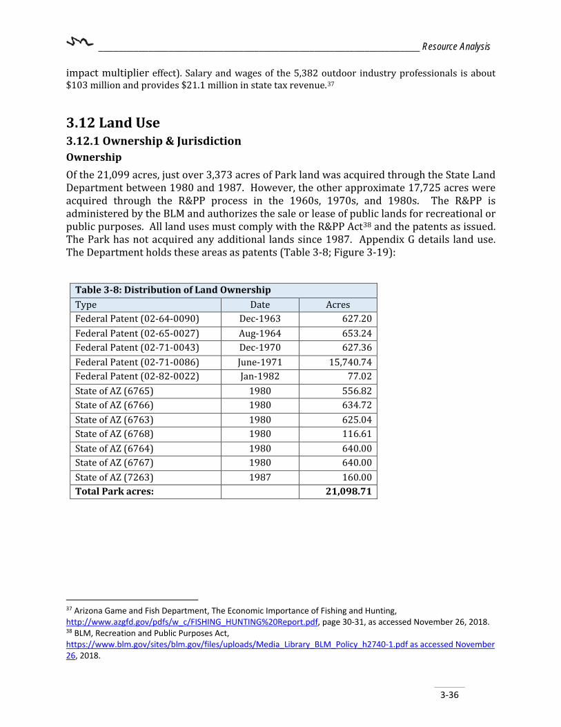
________________________________________________________________ Resource Analysis
3-36
impact multiplier effect). Salary and wages of the 5,382 outdoor industry professionals is about $103 million and provides $21.1 million in state tax revenue.37
3.12 Land Use 3.12.1 Ownership & Jurisdiction Ownership Of the 21,099 acres, just over 3,373 acres of Park land was acquired through the State Land Department between 1980 and 1987. However, the other approximate 17,725 acres were acquired through the R&PP process in the 1960s, 1970s, and 1980s. The R&PP is administered by the BLM and authorizes the sale or lease of public lands for recreational or public purposes. All land uses must comply with the R&PP Act38 and the patents as issued. The Park has not acquired any additional lands since 1987. Appendix G details land use. The Department holds these areas as patents (Table 3-8; Figure 3-19):
Table 3-8: Distribution of Land Ownership Type Date Acres Federal Patent (02-64-0090) Dec-1963 627.20 Federal Patent (02-65-0027) Aug-1964 653.24 Federal Patent (02-71-0043) Dec-1970 627.36 Federal Patent (02-71-0086) June-1971 15,740.74 Federal Patent (02-82-0022) Jan-1982 77.02 State of AZ (6765) 1980 556.82 State of AZ (6766) 1980 634.72 State of AZ (6763) 1980 625.04 State of AZ (6768) 1980 116.61 State of AZ (6764) 1980 640.00 State of AZ (6767) 1980 640.00 State of AZ (7263) 1987 160.00 Total Park acres: 21,098.71
37 Arizona Game and Fish Department, The Economic Importance of Fishing and Hunting, http://www.azgfd.gov/pdfs/w_c/FISHING_HUNTING%20Report.pdf, page 30-31, as accessed November 26, 2018. 38 BLM, Recreation and Public Purposes Act, https://www.blm.gov/sites/blm.gov/files/uploads/Media_Library_BLM_Policy_h2740-1.pdf as accessed November 26, 2018.
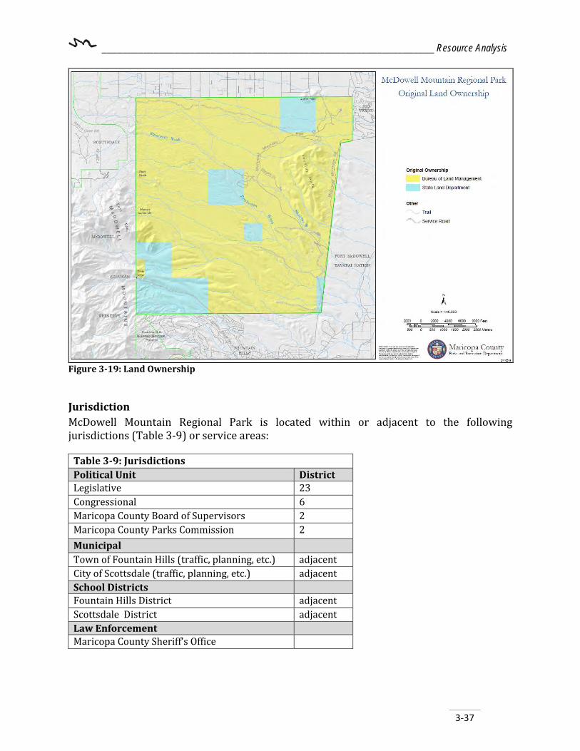
________________________________________________________________ Resource Analysis
3-37
Figure 3-19: Land Ownership
Jurisdiction McDowell Mountain Regional Park is located within or adjacent to the following jurisdictions (Table 3-9) or service areas:
Table 3-9: Jurisdictions Political Unit District Legislative 23 Congressional 6 Maricopa County Board of Supervisors 2 Maricopa County Parks Commission 2 Municipal Town of Fountain Hills (traffic, planning, etc.) adjacent City of Scottsdale (traffic, planning, etc.) adjacent School Districts Fountain Hills District adjacent Scottsdale District adjacent Law Enforcement Maricopa County Sheriff’s Office

________________________________________________________________ Resource Analysis
3-38
3.12.2 Existing Land Use and Zoning Existing Land Use Much of the lands adjacent or near the Park’s northern, east, and south boundaries are either residential or undeveloped and largely under private ownership (Figure 3-20). The land north and northeast of the Park utilized for residential developments is located within an unincorporated area of Maricopa County. Lands to the east and southeast belonging to the Fort McDowell Yavapai Nation which today stands at about 24,680 acres or 39 square miles. The State of Arizona owns two adjacent parcels totaling approximately 1,232 acres of undeveloped land (zoned R-190 for rural zoning district – 190,000 square feet per dwelling unit)39 located near the southeast corner of the Park. R-190 is typically utilized for larger scale development such as hotels, community centers, nature reserves, Parks, or schools. The land within these two large parcels are subject to disposal by the ASLD; however, no information is currently available regarding interested parties. In the past, the two parcels were purchased and proposed to be developed as a resort which later reverted back to the ASLD and currently remains undeveloped. The Town’s planning boundary covers the area of land south of the Park. The Town’s General Plan 201040 and the Land Use Analysis and Statistical Report (2017)41 identifies these lands as a mix of open space areas, commercial, lodging, and the majority as residential lots including: low, medium, and high density plots. West of these residential zoning areas near the northwest corner of the Park is approximately 740 acres of land associated with the Fountain Hills‘ McDowell Mountain Preserve. The Tow Fountain Hills McDowell Mountain Preserve connects directly with both MMRP to the north and the McDowell Sonoran Preserve to the northwest. A large portion of the McDowell’s lay within the 30,580 acre in the McDowell Sonoran Preserve directly West and adjacent to the Park. This preserve is owned by the City of Scottsdale and managed cooperatively with the McDowell Sonoran Conservancy. The conservancy’s mission is to be a leader in urban preserve management through excellent stewardship of the lands.
39 Maricopa County Assessor’s Office https://maps.mcassessor.maricopa.gov/ as viewed on 12/10/2018. 40 Fountain Hills General Plan 2010, Adopted January 7, 2010. https://www.fh.az.gov/224/Fountain-Hills-General-Plan 41 Town of Fountain Hills – Land Use Analysis & Statistical Report, 2017. https://www.fh.az.gov/DocumentCenter/View/3844/2017-Land-Use-Analysis-PDF

________________________________________________________________ Resource Analysis
3-39
Figure 3-20: Existing Land Use Zoning The area within Park boundaries is zoned R-190 by Maricopa County. The unincorporated parcels immediately outside of Park boundaries are zoned RU-43 or RU-190 on which some properties have mining exemptions.
• RU-43 (Rural Residential): one dwelling unit42 per 43,000 square feet - protects farm and agricultural uses and permits recreational and institutional uses.
• RU-190 (Rural Residential): one dwelling unit43 per 190,000 square feet - protects farm and agricultural uses and permits recreational and institutional uses.
Land use surrounding the Park is a mix of residential, preserve land, Fort McDowell – Yavapai Nation lands, and undeveloped state trust land, but, much of the area is currently vacant regardless of its current zoning category.44 The Preserve west of the Park falls
42 Maricopa County Zoning Ordinance, Chapter 5 Rural Zoning Districts, Pages 13-15 of 15. https://www.maricopa.gov/DocumentCenter/View/4785/Maricopa-County-Zoning-Ordinance-PDF?bidId= as accessed December 22, 2018. 43 Maricopa County Zoning Ordinance, Chapter 5 Rural Zoning Districts, Pages 1-11 of 15. https://www.maricopa.gov/DocumentCenter/View/4785/Maricopa-County-Zoning-Ordinance-PDF?bidId= as accessed December 22, 2018. 44 Fountain Hills General Plan 2010, Adopted January 7, 2010. https://www.fh.az.gov/224/Fountain-Hills-General-Plan

________________________________________________________________ Resource Analysis
3-40
within the Scottsdale’s planning area. The area north and northwest while unincorporated, fall under the Rio Verde Community planning area. The Town planning area abuts the southern boundary and southeast corner of the Park. 3.12.3 Future Land Use The entire western Park boundary is shared with the Preserve and the majority of the land adjacent to the east boundary is owned by the Fort McDowell Yavapai Nation. Much of the land bordering the north and south Park boundaries is privately owned and zoned for residential development. Two quarter sections of land located near the southeast corner of the Park is held in trust by ASLD and could be sold or leased at market value for development purposes. Other jurisdictions have planning documents in place to facilitate development surrounding the Park. Land use maps are not zoning maps; they merely reflect the general desired use of the area rather than specific zoning/development standards at a specific site.
Maricopa County (unincorporated areas) and Private Property Privately owned parcel(s) just outside of the Parks north boundary and within unincorporated Maricopa County and are currently zoned RU-43 and RU-190 which limits housing density to protect the agricultural or rural character of the area. This is subject to change pending any new zoning or variance applications.
City of Scottsdale The City of Scottsdale General Plan 2001 was ratified in March 2002 by City voters and will remain in effect until a new general plan is approved by voters. Page 73 of Scottsdale’s plan outlines the preferred land use specifically as it relates to preserve lands on the west boundary and the rural residential /tourism resort designated lands near the northwest corner of the Park. Additionally, a full chapter on Open Space and Recreation (page 109) outlines goals and approaches for those areas.
Town of Fountain Hills The Town of Fountain Hills General Plan 2010 (adopted January 2010) outlines the Towns desire to see the two quarter section parcels of undeveloped land located near the southeast corner of the developed for both residential and resort/ tourism uses. The Town’s plan also identifies the need for open space, recreation, and connectivity including designated a large portion of the natural washes to remain open for those opportunities.
Arizona State Land Department (ASLD) As stated above, the lands just southeast of the Park boundary are owned by the ASLD and are currently vacant but subject to purchase and future development. These two areas fall within the Town’s planning boundary. The visions, goals and objectives discussed in Chapter 6 - Open Space Element, outlines the Town’s desire to establish recreation and open space needs as they pertain to these two (2) undeveloped sections of land.

________________________________________________________________ Resource Analysis
3-41
Additionally, the Department and the Town are interested in creating recreational connectivity from the Park to the future community in this area via a public trailhead.
3.13 Facilities and Infrastructure Most of the Park’s existing development occurs within three (3) main areas (located in the yellow boxes in Figure 3-21) of the Park. Figure 3-21 outlines the major facilities and infrastructure found in this portion of the Park and is further discussed within this section.
Figure 3-21: Existing Park Facilities
3.13.1 Entrance Station The main entrance and contact station is located off of McDowell Mountain Park Drive on the southeast side of the Park and is the Park’s primary entrance.
3.13.2 Nature Center The Nature Center a recycled converted mobile office building, opened in 2005, and provides a space to purchase retail items and Park souvenirs. Interpretive displays offer Park guests a chance to view some of the local native wildlife. South of the building is an outdoor patio space with a mountain view. This space is often used for educational purposes by the Park interpretive ranger.

________________________________________________________________ Resource Analysis
3-42
3.13.3 Maintenance Compound Once inside the Park, Thomas Thumb Drive provides access to the maintenance compound. A fueling station, vehicle storage area, tools, and other equipment is housed within the maintenance compound. The asphalt paved compound is surrounded by a chain link fence and drains from west to east. One (1) 6,000-gallon double wall unleaded gasoline tank is located on site. The tank is equipped with a secondary containment sensor, access port, vent, and emergency warning light in case of a leak. A construction wash drain slab and drainage sump is located near the southeast corner of the compound. This area may be utilized as a wash rack for vehicles however the discharge permit will need to be renewed every five (5) years though the ADEQ. A 1,250-gallon septic tank and clean out is located near the northeast corner of the compound outside the fence opposite of the host sites. The septic tank releases into a leach field directly northwest of the tank location. All stormwater runoff from the site leaves the site one of two ways: runoff sheet flow which flows east from the site or into the wash rack and spill control drains and thereby into the underground rock pit located southeast of the outside of the compound. For maintenance, inspection, and spill control measures for this area, refer to the onsite Safety Data Sheets (SDS) sheets and the spill containment kit. A 100,000 gallon steel plate ring wall water reservoir is located at the southwest corner of the compound which receives its water from Rio Verde Utilities Inc., supplied by the pump station located near the northeast corner of the Park.
3.13.4 Picnic Areas MMRP currently offers three reserve-able picnic ramadas with a total of 15 picnic tables within those areas. Ramadas may be reserved for a fee. If not marked as reserved, all picnic ramadas are available on a first-come, first-served basis. All picnic sites are considered day-use only; all have restrooms nearby. Additionally, there are over 100 picnic tables throughout the developed areas of the Park that may be utilized on first come first serve basis. Table 3-10 describes each picnic ramada.

________________________________________________________________ Resource Analysis
3-43
Table 3-10: Covered Picnic Ramadas Ramada Description 1 & 2 On the north side of the staging area, this area has two ramadas each has 4 picnic tables and
1 large grill and share a large fire ring. For a total of 8 tables, this area can seat about 48-64.
Small On the east side of the staging area, has 1 picnic table, one large grill and a fire ring. This area can seat about 6-8.
Group On the north side of the Thom’s Thumb Drive, has 6 picnic tables and can seat about 36-48, and 2 large grills and a fire ring. This ramada is closest to the Playground located between the two campground loops.
3.13.5 Campgrounds The 1967 MP designated approximately 1,097 acres for camping which included tent, trailer attached, and trailer detached sites. Individual campsites would include a cleared area for a tent or trailer, picnic table, fireplace grill, and are located not more than 300 feet from running water and a comfort station. Within those designated 1,097 acres, nearly 6,582 individual camping sites would have been incorporated; the majority of those sites utilized for tent camping. The 1967 <MP acknowledges the importance of providing camper’s access to a range of camping types from basic tent to developed Recreational Vehicle (RV) camping as well as the prime landscape to offer this type of recreation. Today MMRP is one of the most sought after RV camping Parks out of all of the regional Parks and offers 80 RV camp sites, as well as group camp, youth camp, semi-developed and primitive campsites. Campground amenities access to a dump station along with the following as per the Department’s Camping Policy:
• Developed: includes electricity, water, and is in close proximity to restrooms with or without showers, picnic table, grill/pit.
• Semi-Developed: may have shade, plumbed restrooms with or without showers within close proximity, picnic table, grill/pit.
• Primitive: may include picnic tables, and grill/pit. These campsites are generally in areas with no utilities or plumbed restrooms.
• RV Host Site: Includes shade, electrical/water/sewer hookups, picnic tables, and grills. These sites are reserved for camp hosts, but may occasionally be available to rent.
Campsites are still not considered exclusive to one type of camping; the various campgrounds provide various amenities to accommodate differing camping types. RV camp sites can be reserved either online or by phone. Reservations for tent camp sites are taken by phone. All campground (with the exception of the youth and group camp areas) restrooms offer flush toilets and showers. Youth Camp Area (Developed in the early 1970s) – This area is used for scout groups and other youth groups under the age of 18 years (up to 100 people). Groups must be adult-supervised. The Youth Camp Area offers 1.5 acres. Site amenities include: two (2) grills, a large fire ring, two (2) shade structures, flagpole, four (4) picnic tables and three

________________________________________________________________ Resource Analysis
3-44
(3) Port-A-Johns. Running water is not available however potable water can be obtain via a water spicket located near the center of the camp. Additionally, the day use trailheads and hiking trails located on Asher View Drive are equipped with restrooms (shower facilities are not available yet). North Loop Campground (Developed in 1985) – The North Loop Campground (Figure 3-22) has 38 campsites and two (2) host sites all with water and electrical hookups, picnic table and barbeque grill at each site, close proximity to the playground, as well as access to the dump station. This campground is considered "developed" camping. Two (2) free standing restroom/shower houses are located at either end of the loop along Thom’s Thumb Drive. South Loop Campground (Developed in 1991) – The South Loop Campground has 36 campsites and two (2) host all with water and electrical hookups, picnic table and barbeque grill at each site, close proximity to the playground, as well as access to the dump station. This campground is considered "developed" camping. Two (2) free standing restroom/shower houses are located at both ends of Whitehead Way and two (2) along the outside loop roods. Group Campground (Developed in 1958) – The three-acre Group Campground Parking area can accommodate 30 RV units for day use or overnight camping. Restroom with flush toilets, a covered ramada with six (6) picnic tables, a large barbecue grill, and a large fire ring for campfires. This are also serves as an overflow camping area during the busy season. Tent Camping at Asher Circle and Palo Verde (Developed in 2010 - originally developed for day use in the early 1970s) – The Tent Camping Area provides thirteen (13) individual tent pads, picnic table, fire pit, and grill. Restrooms with flush toilets are typically located within 500 feet of every site (Figure 3-23). Four Peaks Staging Area (Developed in 1997) – The Four Peaks Staging Area is considered an event staging area that allows for primitive camping. Many of the multi-day event participants set up camp at this location (Figure 3-24).
Figure 3-22: RV Back-in space
Figure 3-24: Four Peaks Staging Area Figure 3-23: Dispersed Camping

________________________________________________________________ Resource Analysis
3-45
Other camping areas –, When necessary, the Trailhead Staging Area, are utilized for overflow camping space. Both group camp sites can be rented out as well. Minks Camp which is approximately 0.30 acres in size and includes two (2) shade structures, picnic table, grill, ring fire pit, and a single Port-A-John. The second of the smaller group camps is Eagle Camp, which sits at about 0.10 acres in size and includes a shade structure, picnic table, grill, ring fire pit and a single Port-A-John. Park Hosts are provided sites that can accommodate up to a 45' RV and are considered "Developed Sites" with water, septic and an electrical hookup, as well as a picnic table and a barbecue fire ring. Backcountry Camping Overnight backpacking, with a permit, is allowed. This is for “low impact” camping, i.e. no fires and pack out what is packed in.
3.13.6 Playground The Park renovated an old playground with a new nature themed playscape equipment in 2013 (Figure 3-25). The Park has one playground (currently located between the north and south campground loops). With the construction of a new nature center, it is expected that the playground will be relocated to that site. Improvements to the equipment are also expected to occur during the construction of the new nature center and will complete the playscape experience with additional pieces, shade, and seating.
Figure 3-25: Campground Playground Equipment
Playgrounds are inspected regularly by Park staff for obvious signs of disrepair. A certified playground inspector from the Park Department inspects the playground annually, Park to ensure each playground is safe and compliant. Park staff also inspect daily for minor repairs such as raking fibers. Inspection reports are kept on file at MMRP’s administrative office. 3.13.7 Staging and Event Areas MMRP is considered a destination and events Park due to the many events that are held each year. The Park has three (3) main areas utilized for events: the Four Peaks staging area; the Trailhead staging area; and the Competitive Track staging area. In FY18, between
________________________________________________________________ Resource Analysis
3-46
September 2017 and May 2018, the Park issued 32 Special Use Permits (SUPs) with a total of nearly 10,000 participates registered. Of those 32 planned events, 19 were considered multi-day events and included over-night camping. All three (3) staging areas have access to shade, restrooms with flush toilets, potable water. Electricity is anticipated to be brought into this area by 2020. 3.13.8 Potable Water The Park receives its potable water from Rio Verde Utilities Inc., via a six-inch diameter connection to a six-inch diameter water main pipeline. The pipeline enters the Park near the northeast corner just west of the Rio Verde Community, feeding into a pump station. Two (2) vertical turbine pumps add pressure to the water and send it through a 6”x4” eccentric reducer, past a pressure gage. The water is then pushed through a six-inch water main to a 100,000 gallon steel walled water reservoir located at the maintenance compound. The main pipeline traverses east thru the Campground where it eventually connects with McDowell Mountain Park Road and continues north and south along that road throughout the Park. As-built drawings show that several two-inch diameter feeds have been installed in various locations and connect to the six-inch waterline.45 3.13.9 Electrical MMRP receives its electricity from Salt River Project (SRP). Telecom is provided by Century Link. Both electrical and telecom enter the Park from the Main entry located at the intersection of McDowell Mountain Park Road and McDowell Mountain Road. 3.13.10 Asset Inventory MMRP was the fourth regional county Park established, and as such, many Park facilities were built in the 1960s through 1980s and are showing their age, however, a number of facilities have been renovated in the last five years. By assigning each building type an estimated lifespan, Park management can better plan budgets for the years when major repairs or replacements are estimated to occur. As a building(s) expected usefulness, or lifecycle terms, management will have to decide whether to renovate or replace the existing infrastructure; this appendix section is to be updated and replaced as needed. For example, the most visible Park assets are the monument sign and the entrance station which were both rebuilt in 2010/2011. With a 50-year useful lifespan for these two structures, it can be estimated that both will need replacement or extensive renovation by 2060. Another highly visible asset to the Park is the nature center (purchased/placed from another County Department in 2005). This building consists of a triple wide mobile unit which was previously owned and operated out of. MMRP is the only county Park that does not have a newly built LEED Certified Nature Center. Note: This is outside of annual maintenance and general upkeep measures. (Appendix H contains a full asset inventory for MMRP)
45 McDowell Mountain Park Improvements Phase 9, Utility Infrastructure Report, February 1985.
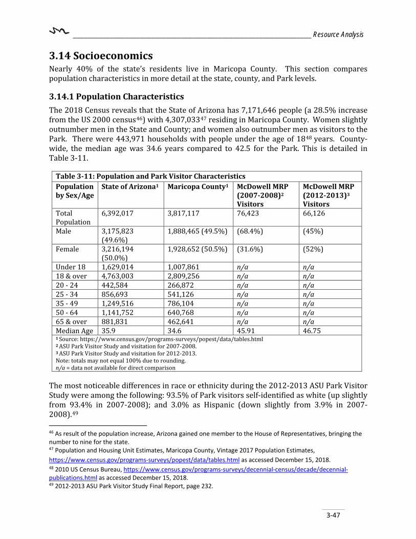
________________________________________________________________ Resource Analysis
3-47
3.14 Socioeconomics Nearly 40% of the state’s residents live in Maricopa County. This section compares population characteristics in more detail at the state, county, and Park levels.
3.14.1 Population Characteristics The 2018 Census reveals that the State of Arizona has 7,171,646 people (a 28.5% increase from the US 2000 census46) with 4,307,03347 residing in Maricopa County. Women slightly outnumber men in the State and County; and women also outnumber men as visitors to the Park. There were 443,971 households with people under the age of 1848 years. County-wide, the median age was 34.6 years compared to 42.5 for the Park. This is detailed in Table 3-11.
Table 3-11: Population and Park Visitor Characteristics Population by Sex/Age
State of Arizona1 Maricopa County1 McDowell MRP (2007-2008)2 Visitors
McDowell MRP (2012-2013)3 Visitors
Total Population
6,392,017 3,817,117 76,423 66,126
Male 3,175,823 (49.6%)
1,888,465 (49.5%) (68.4%) (45%)
Female 3,216,194 (50.0%)
1,928,652 (50.5%) (31.6%) (52%)
Under 18 1,629,014 1,007,861 n/a n/a 18 & over 4,763,003 2,809,256 n/a n/a 20 - 24 442,584 266,872 n/a n/a 25 - 34 856,693 541,126 n/a n/a 35 - 49 1,249,516 786,104 n/a n/a 50 - 64 1,141,752 640,768 n/a n/a 65 & over 881,831 462,641 n/a n/a Median Age 35.9 34.6 45.91 46.75 1 Source: https://www.census.gov/programs-surveys/popest/data/tables.html 2 ASU Park Visitor Study and visitation for 2007-2008. 3 ASU Park Visitor Study and visitation for 2012-2013. Note: totals may not equal 100% due to rounding. n/a = data not available for direct comparison
The most noticeable differences in race or ethnicity during the 2012-2013 ASU Park Visitor Study were among the following: 93.5% of Park visitors self-identified as white (up slightly from 93.4% in 2007-2008); and 3.0% as Hispanic (down slightly from 3.9% in 2007-2008).49
46 As result of the population increase, Arizona gained one member to the House of Representatives, bringing the number to nine for the state. 47 Population and Housing Unit Estimates, Maricopa County, Vintage 2017 Population Estimates, https://www.census.gov/programs-surveys/popest/data/tables.html as accessed December 15, 2018. 48 2010 US Census Bureau, https://www.census.gov/programs-surveys/decennial-census/decade/decennial-publications.html as accessed December 15, 2018. 49 2012-2013 ASU Park Visitor Study Final Report, page 232.

________________________________________________________________ Resource Analysis
3-48
3.14.2 Census Tracts The Maricopa County census tracts that include or are adjacent to the Park (tracts 101.01, 9807, 2168.43, 2168.51, 2168.49, 2168.19, 2168.20, and 9412) have a total population estimate of over 30, 300 people.50 (Figure 3-26)
3.14.3 Population Forecast In the Maricopa Association of Governments (MAG) document called Socioeconomic Projections, Population, Housing, and Employment By Municipal Planning Area and Regional Analysis Zone (June 2016)51, it is forecasted that by 2050 Maricopa County will increase by roughly 25% over the 2015 base population. This means that the region will experience a growth of just under one million people during each decade.
The Scottsdale Municipal Planning Area (MPA) alone is projected to grow by nearly 100,000 people, requiring the Park to pay close attention to growth in the eastern part of the metro-area. Those MPA’s closest to the Park are shown in Table 3-12.
50 U.S. Census https://factfinder.census.gov/faces/tableservices/jsf/pages/productview.xhtml?src=bkmk as accessed December 15, 2018. 51 Socioeconomic Projections. June 2016. http://www.azmag.gov/Portals/0/Documents/2016-06-23_2016-MAG-Socioeconomic-Projections_June-2016_FINAL.pdf
Figure 3-26: Population Growth via Census Tract
BromleyL
Text Box
Total Growth for Census Tracts Surrounding MMRP

________________________________________________________________ Resource Analysis
3-49
Table 3-12: Total Resident Population (July 1, 2010 and Projections July 1, 2020 to July 1, 2050)
2010 2020 2030 2040 2050 Fountain Hills
23,300 26,000 28,300 30,400 32,600
Scottsdale 231,300 255,000 290,800 308,700 312,000
Fort McDowell – Yavapai Nation
1000 1000 1000 1100 1100
County Total 3,823,900 4,507,200 5,359,300 6,175,000 7,410,800
Source: MAG, Socioeconomic Projections, June 2016. http://azmag.gov/Portals/0/Documents/2016-06-23_2016-MAG-Socioeconomic-Projections_June-2016_FINAL.pdf as accessed January 7, 2019.
3.14.4 Employment, Income, and Educational Attainment The State of Arizona had an unemployment rate of 4.7% in November 2018 according to the Bureau of Labor and Statistics.52 U.S. Census data also shows that 31.4% of Maricopa County residents have attained a bachelor’s degree or higher; over 2% higher than the state. Likewise, the median household income was $58,580 which is over $5,070 above the statewide median (Table 3-13).
Table 3-13: Employment and Education
Population State of Arizona1
Maricopa County1
McDowell MRP (2007-2008)2
McDowell MRP (2012-2013)3
Employed 1,374,222 889,499 49.3% 59.9% Median household income
53,510 58,580 25% (More than $120,000)
31.4% (More than $120,000)
College coursework
1,143,553 666,344 63.8% Bachelors 45.9% Bachelors
Bachelor’s degree or higher (graduate school)
1,284,657 858,772 24.7% Graduate School
48.7 Graduate School
1 US Census Bureau, State and County Quick Facts, http://quickfacts.census.gov/qfd/states/04/04013.html as accessed June 18, 2015. 2 ASU Park Visitor Study, 2007-2008, page 143. 3 ASU Park Visitor Study, 2012-2023, page 205.
52 U.S. Bureau of Labor Statistics. http://www.bls.gov/eag/eag.az.htm as accessed January 7, 2019.

________________________________________________________________ Resource Analysis
3-50
3.14.5 Obesity The Centers for Disease Control and Prevention reports that 63.2% of adults in Arizona were either overweight (34.2%) or obese (29%) in the year 2016.53 The Maricopa County Department of Public Health reports that 62.9% of adults in Maricopa County were either overweight (40.0%) or obese (22.9%) between 2006 and 201054.
3.15 Visitation and Tourism Trends The State of Arizona attracted 43.97 million domestic and international overnight visitors or equal to roughly 120,465 visitors per day in 2017.55 Of those, 87% of overnight visitors were domestic travelers and 13% were international travelers.56 Domestic visitors were about 43.6 years old, stayed in Arizona for 3.5 nights, spending $645 per visit.57 3.15.1 Residency58 During fiscal year (FY) 2012-2013, 13.9% of the Park’s visitors were from out of state and 2.5% from out of the country59 (Figure 3-27). Most Park visitors are residents of Arizona (77%) with most coming from the metropolitan area and driving an average of 81.38 miles60 to arrive at the Park. The top five metro-area locations include:
• Scottsdale 21.2% • Phoenix 18.7% • Fountain Hills 10.3% • Gilbert 5.4% • Mesa 5.4%
53 Nutrition, Physical Activity and Obesity Data, Trends and Maps web site. U.S. Department of Health and Human Services, Centers for Disease Control and Prevention (CDC), National Center for Chronic Disease Prevention and Health Promotion, Division of Nutrition, Physical Activity and Obesity. Available at https://nccd.cdc.gov/dnpao_dtm/rdPage.aspx?rdReport=DNPAO_DTM.ExploreByLocation&rdRequestForwarding=Form 54 Maricopa County Community Health Assessment 2012, Page 10. https://www.maricopa.gov/DocumentCenter/View/40794/Recommendations_for_Maricopa_County_Health_Assessment_Abt_Associates_2012 as accessed December 14, 2018. 55 Arizona Office of Tourism, https://tourism.az.gov/research-statistics/economic-impact as accessed December 12, 2018. 56 Arizona Office of Tourism, https://tourism.az.gov/sites/default/files/AOT%20Quarterly%20visitor%20tracking%202017Q4.pdf, as accessed December 12, 2018. 57 Arizona Office of Tourism, https://tourism.az.gov/sites/default/files/Arizona%20Visitor%20Profile%202017%20v.%202016.pdf, as accessed December 12, 2018. 58 2012-2013 ASU Park Visitor Study Final Report, page 32, table 1.18. 59 2012-2013 ASU Park Visitor Study Final Report, page 32, table 1.18. 60 2012-2013 ASU Park Visitor Study Final Report, Question 5, page 234.

________________________________________________________________ Resource Analysis
3-51
Figure 3-27: Visitor Residency 3.15.2 Park Visitation During FY 2012-2013 the Park welcomed 59,089 visitors to the Park, the lowest within the last 10 fiscal years (Figure 3-28). Park visitation has fluctuated greatly over the previous 10 fiscal years with 101,101 visitors as the average for the most recent FY period.
Figure 3-28: Visitation by Fiscal Year

________________________________________________________________ Resource Analysis
3-52
Visitation can fluctuate for a variety of reasons and in the case of MMRP, cooler temperatures usually result in November through March being the busiest months with the exception of December when a good portion of the seasonal visitors leaving for the holidays and returning after the New Year. Nearly all of the events the Park host during the year are held between October and March. The months with the lowest visitation are July and August when temperatures soar (Figure 3-29).
Figure 3-29: Visitation per fiscal month within fiscal year Forecasting future visitation carries with it its own uncertainties; preliminary trend analysis indicates a positive trend line to future visitation (as shown by the exponential trend line applied in Figure 3-30). This estimate of future visitation does not take into account any Park improvement proposals mentioned later in this master plan and is based solely on past visitation data and standard spreadsheet trend line functions.
Figure 3-30: Actual and forecasted (exponential trend line) visitation per fiscal year

________________________________________________________________ Resource Analysis
3-53
3.16 Park Use and Visitor Preferences This section describes Park visitor attitudes, preferences, or use patterns as gathered by ASU and as reported in the 2012-2013 Park Visitor Study Final Report. 3.16.1 Day and Overnight Use61, 62 About 93% of visitors were in the Park for a “day use” activity, spending an average of 2.97 hours. This is up from 2.66 hours reported in the 2007-2008 visitor use survey. Of the 7% of visitors that camped, on average they stayed for 2.97 nights (up from 2.66 nights in 2007-2008). According to the Department’s Point of Sale (POS) system, the FY18 analytics obtained for day users verse overnight use indicates that about 65% of all visitors were in the Park as day users leading to a 28% increase of over night campers compared to the 2012-2013 survey years. 3.16.2 Primary Activity63 Park visitors engage in a range of activities during their visit (trail hiking, picnicking, photography, mountain biking, nature study, and more); one activity is usually considered the primary activity, or what the visitor specifically came to the Park to do. The top five primary activities in 2012-2013 were:
• Mountain biking (58.9%) • Trail hiking (29.2%) • Special Event (9.6%) • Horseback riding (7.2%) • Photography (6.7%)
3.16.3 Return Visits Seventy-eight percent (78%) of those surveyed were return visitors, visiting the Park nearly 21.4 times on average in the previous twelve months64. When asked what prompts visitors to return to the Park, trail-related responses were most common; other written responses included the Park being close to home, the competitive track and its wildlife viewing opportunities.65 Return visits based on activity, revealed that runners/joggers made 41 visits and mountain bikers returned twenty-seven (27) times within the last twelve (12) months (both by far the highest mean averages in the system). Hikers made over 13 return visits in the
61 2012-2013 ASU Park Visitor Study Final Report, Question 4, page 232 62 2012-2013 ASU Park Visitor Study Final Report, Question 4, page 232. 63 2012-2013 ASU Park Visitor Study Final Report, Question 6, page 232. 64 2012-2013 ASU Park Visitor Study Final Report, Question 1, page 232. 65 2012-2013 ASU Park Visitor Study Final Report, Question 7b, page 247.

________________________________________________________________ Resource Analysis
3-54
previous twelve (12) months and horseback riders averaged about seven (7) return visits.66 3.16.4 Reasons for Use67 Visitors come to the Park for a variety of reasons, the top reasons identified include:
• Enjoy physical exercise • Observe the scenic beauty • Improve my physical health • Enjoy the sounds and smells of nature • To experience the open space. • To experience or do something new
3.16.5 Satisfaction When asked about their level of satisfaction with the Park, 73% of those surveyed were extremely satisfied and 27% were very satisfied with the Park; no responses were identified in the lower three categories.68 3.16.6 Attachment to Park Park visitors often form strong attachments to their favorite Park or locations within a Park and about 75.6% of the Parks visitors agreed that they are, indeed, very attached to this Park. Nearly 68% agreed that the Park means a lot to them; 70% agreed that this Park offers the best settings and facilities for the activities that they enjoy most.69 Favorite parts of the Park included many trail-related responses, specifically mentioning Pemberton Trail and the Park’s views. 3.16.7 Visitor Spending and Economic Impact The 2012-2013 ASU Visitor Use Survey shows that visitors reported spending $309.38 per group for their visit to the Park (down significantly from $397.50 in 2007-2008). Despite the drop over the year, MMRP is significantly higher than the system-wide average of $157.63 per visit. 70 In 2014, the Department asked ASU to study the economic impacts71 of the County Park system. Impacts were estimated by inputting operating expenses, visitor spending, and other data into IMPLAN© software to determine multiple types of impacts. The MMRP
66 2012-2013 ASU Park Visitor Study Final Report, Table 3.4 page 88. 67 2012-2013 ASU Park Visitor Study Final Report, Question 6, page 235 Responses of Important and Extremely Important. 68 2012-2013 ASU Park Visitor Study Final Report, Question 1, page 234. 69 2012-2013 ASU Park Visitor Study Final Report, Question 7, page 236. 70 2012-2013 ASU Park Visitor Study Final Report, Question 8, page 237 and Table 2.9, page 59. 71 2014 MARICOPA COUNTY PARKS AND RECREATION DEPARTMENT STUDY REPORT Economic Impact of the Maricopa County Parks and Recreation System, Chhabra, et al.

________________________________________________________________ Resource Analysis
3-55
ranked third highest out of all of the Maricopa County Regional Parks in visitor spending related impacts and in operating expenses (Table 3-14).
Table 3-14: Economic Impact Based on Visitor Spending and Operating Expenses Park level Visitor Spending Operating Expenses Full-time jobs created 16.0 12.4 Total economic impact $1,374,465.10 $1,430,856.01 System-wide Full-time jobs created 138.9 116.4 Total economic impact $11,310,284 $12,864,318
3.16.8 Importance and Use of Park Facilities Park visitors were surveyed about which facilities are most important to them. In the 2012-2013 survey, restrooms, parking availability, trail mileage signs, multi-use trails, and informational displays or kiosks were the most important features at the Park. The least important facilities were: playground, showers, equestrian facilities, Park camp sites72 When visitors were surveyed about what facilities they would be likely to use, if provided, outdoor education seminars (in-depth), Park programs, special interest programming (i.e. stargazing, yoga, etc.), special events, and guided tours/programs, rounded out the top five responses. The facilities that they would not use or don’t know if they would use were: mountain bike rentals, horses for rent/stables, WiFi connection/hotspots, and mobile apps. 73
3.17 Local Recreation, Needs, and Opportunities MMRP has a unique opportunity to offer visitors camping, competitive tracks, multi-use trails, wildlife viewing, picnicking, hunting, and other opportunities as approved Park activities. The Park also offers educational and interpretive events on a regular basis. Many of these activities cannot be found elsewhere in the community. Other recreational opportunities near MMRP include (Table 3-15 and Figure 3-31):
Table 3-15: Local Recreational Opportunities Facility Distance
from Park Acres / Miles of trails
Recreational Opportunities
McDowell Mountain Ranch Park
~5 miles n/a Aquatics, sports fields or turf areas, splash pad, Skateboard Park, fitness center, and more.
72 2012-2013 ASU Park Visitor Study Final Report, Question 4, page 252. 73 2012-2013 ASU Park Visitor Study Final Report, Question 10, page 256.

________________________________________________________________ Resource Analysis
3-56
City of Scottsdale – Sonoran Preserve
Adjacent (west)
30,580 acres Mountain biking, hiking, horseback riding, archery hunting
George Cavalliere Park ~3.77 miles 34 acres/1mile loop
Basketball, hiking, and playground
Pinnacle Peak Park ~5 miles 150 acres/1.75 miles
Hiking
Town of Fountain Hills – Open Space, Botanical Garden, and four local Parks
~2 miles 100 + acres Nature Trails, open turf, hiking, walking paths, playgrounds, tennis and basketball quarts, Dog Park, and more
Town of Fountain Hills – McDowell Mountain Preserve
Adjacent (south)
16,000 acres/11.5 miles
Mountain biking and hiking
Tonto National Forest ~2 miles 3 million acres Mountain biking, hiking, horseback riding, camping, nature watching, cultural sites. Needle Rock Recreation Area, Horseshoe Dam Campground, Bartlett Lake Recreation Area, Sutton Recreation Area, etc.
Additional recreational opportunities: Undeveloped Camping: Camping is allowed on National Forest lands throughout the area. Camping on in these areas requires a permit from the Forest Service.
Figure 3-31: Recreation Opportunities

________________________________________________________________ Resource Analysis
3-57
3.18 Park Administration and Special Functions This section provides a brief overview of Park staffing. Additional detail may be found within the Park’s annual business plan.
3.18.1 Staffing Currently, the Park is staffed by five (5) full-time employees. This includes the Park supervisor, one (1) administrative assistant, one (1) interpretive ranger, and two (2) Park maintenance workers. The Park currently has one (1) part-time employee. A Park supervisor plans, organizes, coordinates and is responsible for all operations of the Park while protecting Park resources. This position supervises all aspects of work and performance of subordinates to facilitate productivity and efficiency. The Park supervisor coordinates activities for maximum revenue and most efficient utilization of facilities including outdoor education and wellness programs for Park users. This position is also responsible for marketing efforts to promote the Park, operating within the budget and providing detail for formulation of budget as related to grants, capital improvement projects and Park projects. An administrative assistant performs clerical duties in support of Park operations to include but not limited to: proper cash handling during fee collection, preparing daily deposits, reconciliation, revenue recording and reporting, administrative reporting and support, processing camping and ramada reservations, souvenir program oversight, and customer service via the phone, mail and email. An interpretive ranger plans, organizes, promotes, conducts, and evaluates outdoor recreation and environmental educational programs to include maintaining and demonstrations of live animal and plant displays. This position provides customer service by assisting and providing information and Park interpretation to Park visitors, the general public, County departments, other agencies, volunteers, and community groups. Responsibilities also include accurate reporting of program attendance, fee collection and reconciliation, and occasional response to emergency situations. A Park maintenance worker performs general facilities management to include, but not limited to: cleaning and maintaining restrooms, trash collection, painting interiors and external structures, graffiti removal, minor plumbing and electrical repairs, fence repair, trail maintenance and signage, desert landscaping maintenance, and customer service to Park visitors. 3.18.2 Volunteers The volunteers in FY15-18 provided over 20,907 hours of service in roles such as Park hosts, entrance station attendants, nature center hosts, among other roles (Table 3-16). The Independent Sector estimates that the value of volunteer time was worth $24.51 per

________________________________________________________________ Resource Analysis
3-58
hour for the state of Arizona in 2018.74 This translates to volunteers providing $512,406.06 worth of services or the equivalent of almost nine (9) full-time75 employees, providing an enormous economic value to the Park each year.
Fiscal Year Hours Dollar Value2* FTE3*
2014-2015 2,796 $68,529.96 1.34
2015-2016 5,165 $126,569.64 2.48
2016-2017 7,267 $178,114.17 3.18
2017-20181* 5,679 $139,192.29 2.73
1* Through 2.12.18 2* Hourly Wage of $ $24.51 based on Independent Sector’s value of volunteer time for the state of Arizona (2017) 3* Total Hours / 2080 = Full-time Equivalent (FTE)
Core Volunteers assist the Park supervisor and serve as ambassadors to Park visitors by providing information and promoting resource protection and recreational opportunities through visitor education. Duties may include fee collection, light maintenance work, clerical tasks, trail maintenance, and special projects. In return for 40 hours of service, the Core Volunteer(s) is allowed to utilize camping sites and use Park facilities while they are serving as hosts. Service volunteers may provide administrative, trails, education, special event, or maintenance assistance. Service volunteers give their time for a special project, rather than volunteering on an on-going basis. See the Volunteer Manual, Making a Difference and webpage76 for more details on volunteer roles and responsibilities. Episodic volunteers may assist in short-term, special projects. For example, Gravity Riders Organization of Arizona volunteers designed and constructed the pump track located at the competitive track staging area. This recreation activity is very popular amount the biking community and is one of only three like pump tracks/ bike Parks in the County. 3.18.3 Partnerships MMRP has identified several partners or other organizations with a mutual interest in the Park’s operation and success. Table 3-17 specifies existing and potential partners and their roles in the operation and improvement of the Park.
74 Independent Sector, dollar value by state for year 2017, https://independentsector.org/wp-content/uploads/2016/05/Value-of-Volunteer-Time-by-State-2001-2017-1.pdf as accessed February, 2018. 75 FTE = total volunteer hours divided by 2,080 hours (2,080 = 40 hours week * 52 weeks). 76 Website and Volunteer Manual available here: http://www.maricopa.gov/Parks/volunteer.aspx
Table 3-16: Volunteer value by fiscal year

________________________________________________________________ Resource Analysis
3-59
Table 3-17: Partnerships Partner Potential or existing role Maricopa County Agencies MCPRD Advisory Commission: Advisory role, recommends broad policies
in all planning, development, maintenance and management matters. Flood Control District (FCD): wash corridor and dam related issues. Sheriff’s Office (MCSO): Regularly patrols Park, trails, and boundaries. Department of Transportation (MCDOT): Road construction and maintenance.
State Agencies Arizona Office of Tourism: Cooperative work on attracting tourism, especially “Watchable Wildlife” tourists. Arizona Game and Fish Department: Variety of wildlife issues, advice and enforcement. Arizona State Parks: Site Steward Program (and SHPO) Volunteers regularly patrol and check on archaeological sites in Park.
Federal Agencies BLM: Land exchange/purchase, R&PP consultation. Local cities/towns City of Scottsdale: Trail connections, public safety, and other partnerships.
Town of Fountain Hills: Trail connections, public safety, and other partnerships.
McDowell Mountain Friends Group
A voice and advocate for the Park.
Equestrian, RV, Mountain Bike, Special Interests
Work with individual groups on special interest desires when possible.
3.19 Public Safety The Park relies on the Maricopa County Sherriff’s Office (MCSO) for law enforcement and public safety. MCSO keeps track of all incident reports and calls to the Park(s) (Table 3-18). Note that inconsistencies with the data may exist based upon where the call was located; i.e. if it was actually outside the Park boundary but responding units did not correct that location with dispatch. The following statistics within Table 3-18 were provided by MCSO on February 5, 2019. The Town contracts with Rural Metro to provide additional public safety and rescue support. Park staff and its volunteers also provide Park visitors with safety messages and summon assistance when needed. Park visitors are expected to know and comply with all Park rules.
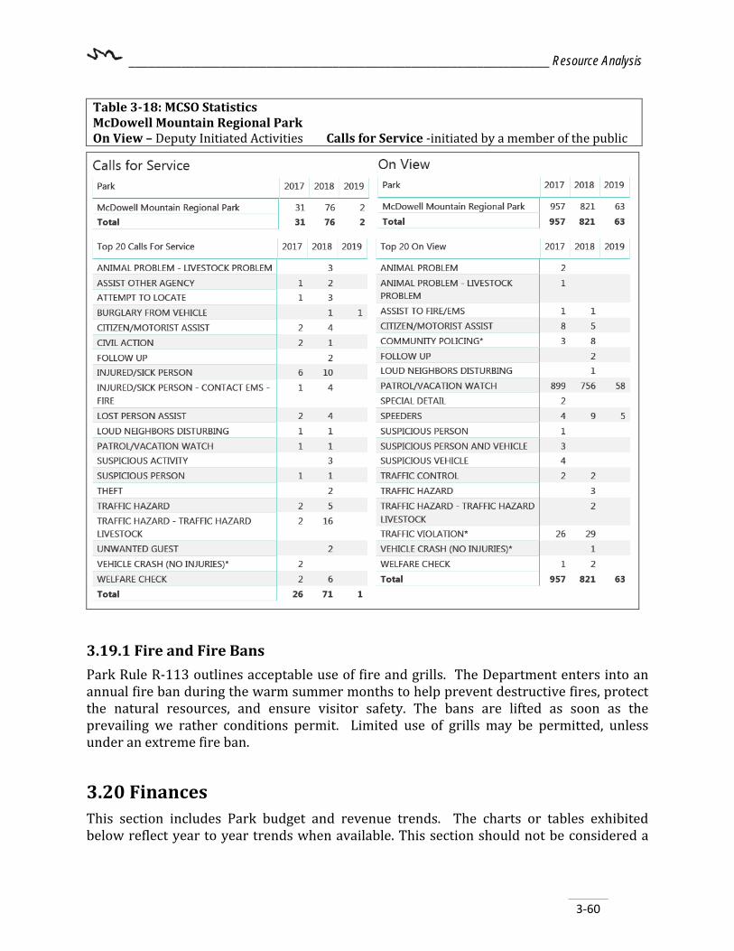
________________________________________________________________ Resource Analysis
3-60
3.19.1 Fire and Fire Bans Park Rule R-113 outlines acceptable use of fire and grills. The Department enters into an annual fire ban during the warm summer months to help prevent destructive fires, protect the natural resources, and ensure visitor safety. The bans are lifted as soon as the prevailing we rather conditions permit. Limited use of grills may be permitted, unless under an extreme fire ban.
3.20 Finances This section includes Park budget and revenue trends. The charts or tables exhibited below reflect year to year trends when available. This section should not be considered a
Table 3-18: MCSO Statistics McDowell Mountain Regional Park On View – Deputy Initiated Activities Calls for Service -initiated by a member of the public

________________________________________________________________ Resource Analysis
3-61
complete audit-level look into Park finances, but rather a generalized view of some specific categories and a general trend analysis. From the data presented here, the reader may ascertain the more recent revenue intake is less than the Park expenditures. For example, in FY 2018, the Park’s revenue was $675,910.00, but its expenses were $395,448. This means the Park was at 100% self-sufficiency level for FY 2018. 3.20.1 Park Budget The Park budget consists of components shown below such as Park revenue, Park expenditures, and Park donations. Park staff is responsible for revenue generation and staying within the budget formulated by the Department’s finance team. 3.20.2 Park Revenue Park revenue comes from many sources but primarily from visitor entrance fees, camping, and souvenir sales, etc. Special use permits for events also generate revenue for the Park along with concessionaire agreements. Other funding sources may come from grants or other partnerships, but those funds are generally earmarked for specific projects or purposes. Revenue is generally increasing each year and nearly doubled from FY2012 to FY2018 (Figure 3-32) due to improved or additional facilities as well as from improved marketing and fee increases.
Figure 3-32: Revenue per Fiscal Year
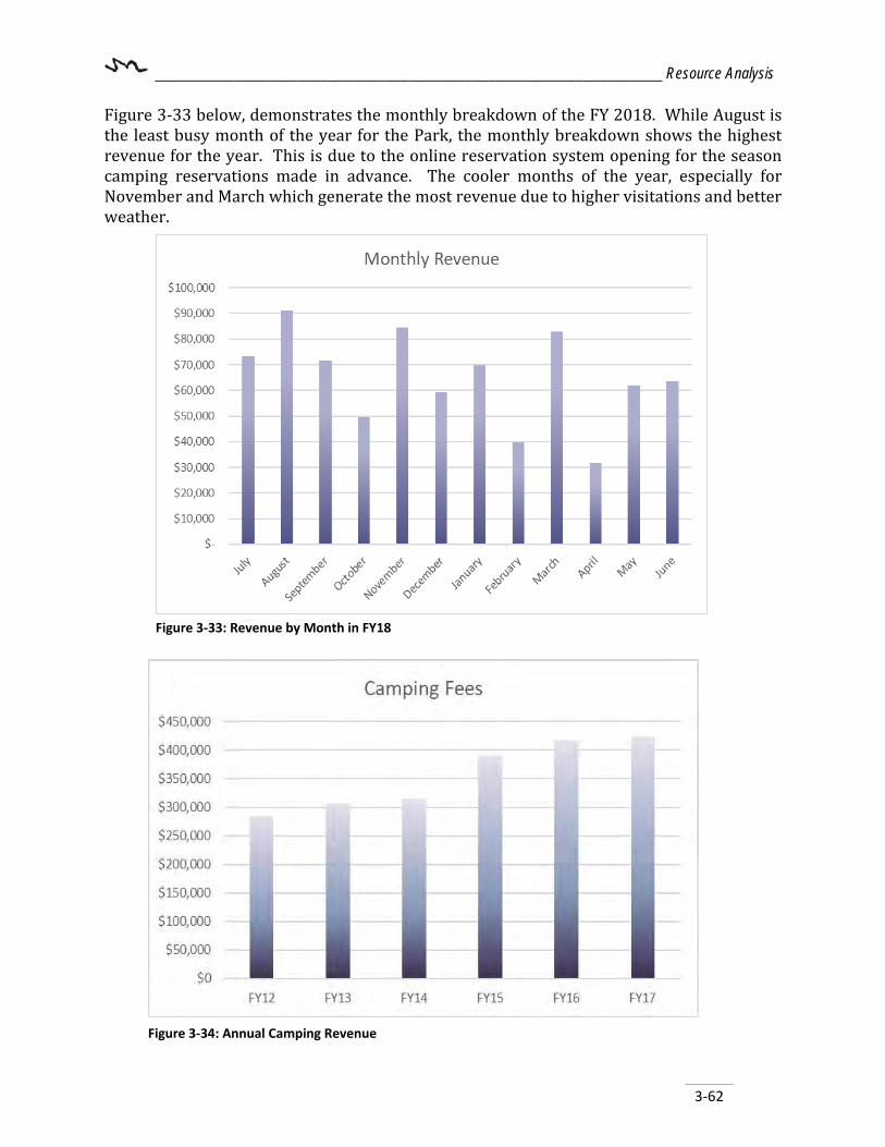
________________________________________________________________ Resource Analysis
3-62
Figure 3-33 below, demonstrates the monthly breakdown of the FY 2018. While August is the least busy month of the year for the Park, the monthly breakdown shows the highest revenue for the year. This is due to the online reservation system opening for the season camping reservations made in advance. The cooler months of the year, especially for November and March which generate the most revenue due to higher visitations and better weather.
Figure 3-33: Revenue by Month in FY18
Figure 3-34: Annual Camping Revenue

________________________________________________________________ Resource Analysis
3-63
Figure 3-36: Annual Pass Revenue
Facility rentals are consistently dropping over time which may correlate with the how the Park patrons prefer to use the Park. (Figure 3-35). Rentals areas include Ramadas #1, #2, and the Group Ramada.
Annual pass sales show an overall upward trend from year to year (Figure 3-36) and is expected to increase. Park visitors have expressed their satisfaction with the annual pass program.
Figure 3-35: Facility Rentals

________________________________________________________________ Resource Analysis
3-64
Daily entry pass levels fluctuate with overall visitation (Figure 3-37).
3.20.3 Expenditures Park expenditures cover everything from Park staff wages and benefits, maintenance, as well as general office supplies, vehicle maintenance and fueling (Table 3-19). Although facility needs have increased, staff levels have remained the same for several years. The Park covers extra staffing needs with volunteers.
Table 3-19: Summary of Annual Expenditures Expense type FY 2017 FY 2018 Personal Services (wages and benefits)
$263,578.10 $327,187.31
General Supplies $21,403.93 $21,950.28 Fuel $4,047.46 $5,321.76 Utilities – electricity/water $62,947.96 $63,276.32 General Services $33,720.14 $38,310.43 Repairs and Maintenance* $9,261.65 $8,595.06 Other $33,490.60 $26,552.72 TOTAL EXPENSES (all types) $428,449.84 491,193.88 *includes expense categories 8203 and 8250
3.20.4 Donations Donations to the Park are accepted pursuant to ARS §11-941, Paragraph A and are used for designated items such as memorial benches, ramadas, brochures, critter care, or general use. Donations (Table 3-20) to the Park represent a small, but important, percentage of income to the Park.
Figure 3-37: Daily Pass Entries

________________________________________________________________ Resource Analysis
3-65
Table 3-20: Donations FY 2016 FY 2017 Amount $1,564.00 $2,560.18

________________________________________________________________ Resource Analysis
3-66
{This page intentionally left blank.}

__________________________________________________________________________Roads
4-1
Chapter 4 – Roads and Access
4.1 Existing Roads, Access, and Parking 4.1.1 External Roads and Access McDowell Mountain Park Drive serves as the main access road through the park. The paved roadway enters the park from its intersection with North McDowell Mountain Road near the southeast corner of the park and meanders northward through the park for approximate 6.27 miles. The intersection of McDowell Mountain Park Drive and McDowell Mountain Road is currently the only vehicular access point into the park. The park has two other vehicular access points, one of which is an unpaved extension of McDowell Mountain Park Drive which extends past the north boundary and becomes the 176th Street alignment, connecting with East Rio Verde Drive approximately one (1) mile to the north. The other unpaved entrance is known as Old Jeep Trail and is located on the southern boundary near Hesperus Wash Dam. These entry points are generally gated and locked and most often go unused by the general public. Although old dirt roads or paths may exist into the park, the main park entry identified as McDowell Mountain Park Road (Table 4.1) provides the only authorized vehicle access points into the park. Additionally, the park maintains several trail entry points on the west and northern borders for non-motorized and pedestrian entry. Currently, the Rio Verde Trailhead located near the northeast corner of the park is maintained by the community of Rio Verde. A second trailhead, Eagles Nest is located in and maintained by the Eagles Nest private community near the southwest corner of the park.
Table 4.1: Roadway Jurisdiction and Functional Class Road Jurisdiction Functional Class McDowell Mountain Park Road MCDOT Class 1 - Primary Access Road East McDowell Mountain Road MCDOT Arterial Notes* MCDOT assigns a roadway function class to every road based on roadway engineering standards.
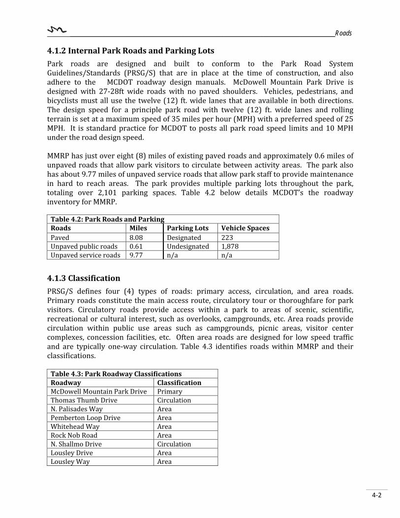
__________________________________________________________________________Roads
4-2
4.1.2 Internal Park Roads and Parking Lots Park roads are designed and built to conform to the Park Road System Guidelines/Standards (PRSG/S) that are in place at the time of construction, and also adhere to the MCDOT roadway design manuals. McDowell Mountain Park Drive is designed with 27-28ft wide roads with no paved shoulders. Vehicles, pedestrians, and bicyclists must all use the twelve (12) ft. wide lanes that are available in both directions. The design speed for a principle park road with twelve (12) ft. wide lanes and rolling terrain is set at a maximum speed of 35 miles per hour (MPH) with a preferred speed of 25 MPH. It is standard practice for MCDOT to posts all park road speed limits and 10 MPH under the road design speed. MMRP has just over eight (8) miles of existing paved roads and approximately 0.6 miles of unpaved roads that allow park visitors to circulate between activity areas. The park also has about 9.77 miles of unpaved service roads that allow park staff to provide maintenance in hard to reach areas. The park provides multiple parking lots throughout the park, totaling over 2,101 parking spaces. Table 4.2 below details MCDOT’s the roadway inventory for MMRP.
Table 4.2: Park Roads and Parking Roads Miles Parking Lots Vehicle Spaces Paved 8.08 Designated 223 Unpaved public roads 0.61 Undesignated 1,878 Unpaved service roads 9.77 n/a n/a
4.1.3 Classification PRSG/S defines four (4) types of roads: primary access, circulation, and area roads. Primary roads constitute the main access route, circulatory tour or thoroughfare for park visitors. Circulatory roads provide access within a park to areas of scenic, scientific, recreational or cultural interest, such as overlooks, campgrounds, etc. Area roads provide circulation within public use areas such as campgrounds, picnic areas, visitor center complexes, concession facilities, etc. Often area roads are designed for low speed traffic and are typically one-way circulation. Table 4.3 identifies roads within MMRP and their classifications.
Table 4.3: Park Roadway Classifications Roadway Classification McDowell Mountain Park Drive Primary Thomas Thumb Drive Circulation N. Palisades Way Area Pemberton Loop Drive Area Whitehead Way Area Rock Nob Road Area N. Shallmo Drive Circulation Lousley Drive Area Lousley Way Area
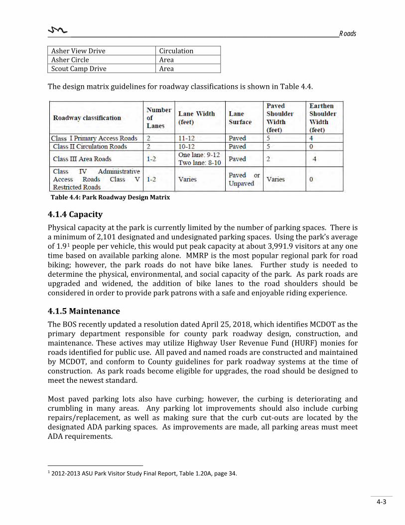
__________________________________________________________________________Roads
4-3
Asher View Drive Circulation Asher Circle Area Scout Camp Drive Area
The design matrix guidelines for roadway classifications is shown in Table 4.4.
Table 4.4: Park Roadway Design Matrix
4.1.4 Capacity Physical capacity at the park is currently limited by the number of parking spaces. There is a minimum of 2,101 designated and undesignated parking spaces. Using the park’s average of 1.91 people per vehicle, this would put peak capacity at about 3,991.9 visitors at any one time based on available parking alone. MMRP is the most popular regional park for road biking; however, the park roads do not have bike lanes. Further study is needed to determine the physical, environmental, and social capacity of the park. As park roads are upgraded and widened, the addition of bike lanes to the road shoulders should be considered in order to provide park patrons with a safe and enjoyable riding experience. 4.1.5 Maintenance The BOS recently updated a resolution dated April 25, 2018, which identifies MCDOT as the primary department responsible for county park roadway design, construction, and maintenance. These actives may utilize Highway User Revenue Fund (HURF) monies for roads identified for public use. All paved and named roads are constructed and maintained by MCDOT, and conform to County guidelines for park roadway systems at the time of construction. As park roads become eligible for upgrades, the road should be designed to meet the newest standard. Most paved parking lots also have curbing; however, the curbing is deteriorating and crumbling in many areas. Any parking lot improvements should also include curbing repairs/replacement, as well as making sure that the curb cut-outs are located by the designated ADA parking spaces. As improvements are made, all parking areas must meet ADA requirements.
1 2012-2013 ASU Park Visitor Study Final Report, Table 1.20A, page 34.
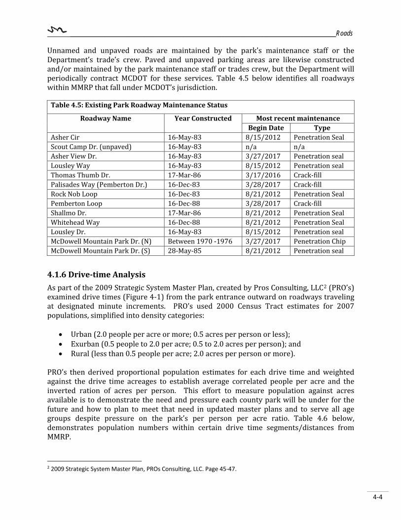
__________________________________________________________________________Roads
4-4
Unnamed and unpaved roads are maintained by the park’s maintenance staff or the Department’s trade’s crew. Paved and unpaved parking areas are likewise constructed and/or maintained by the park maintenance staff or trades crew, but the Department will periodically contract MCDOT for these services. Table 4.5 below identifies all roadways within MMRP that fall under MCDOT’s jurisdiction.
Table 4.5: Existing Park Roadway Maintenance Status
Roadway Name Year Constructed Most recent maintenance Begin Date Type
Asher Cir 16-May-83 8/15/2012 Penetration Seal Scout Camp Dr. (unpaved) 16-May-83 n/a n/a Asher View Dr. 16-May-83 3/27/2017 Penetration seal Lousley Way 16-May-83 8/15/2012 Penetration seal Thomas Thumb Dr. 17-Mar-86 3/17/2016 Crack-fill Palisades Way (Pemberton Dr.) 16-Dec-83 3/28/2017 Crack-fill Rock Nob Loop 16-Dec-83 8/21/2012 Penetration Seal Pemberton Loop 16-Dec-88 3/28/2017 Crack-fill Shallmo Dr. 17-Mar-86 8/21/2012 Penetration Seal Whitehead Way 16-Dec-88 8/21/2012 Penetration Seal Lousley Dr. 16-May-83 8/15/2012 Penetration seal McDowell Mountain Park Dr. (N) Between 1970 -1976 3/27/2017 Penetration Chip McDowell Mountain Park Dr. (S) 28-May-85 8/21/2012 Penetration seal
4.1.6 Drive-time Analysis As part of the 2009 Strategic System Master Plan, created by Pros Consulting, LLC2 (PRO’s) examined drive times (Figure 4-1) from the park entrance outward on roadways traveling at designated minute increments. PRO’s used 2000 Census Tract estimates for 2007 populations, simplified into density categories:
• Urban (2.0 people per acre or more; 0.5 acres per person or less); • Exurban (0.5 people to 2.0 per acre; 0.5 to 2.0 acres per person); and • Rural (less than 0.5 people per acre; 2.0 acres per person or more).
PRO’s then derived proportional population estimates for each drive time and weighted against the drive time acreages to establish average correlated people per acre and the inverted ration of acres per person. This effort to measure population against acres available is to demonstrate the need and pressure each county park will be under for the future and how to plan to meet that need in updated master plans and to serve all age groups despite pressure on the park’s per person per acre ratio. Table 4.6 below, demonstrates population numbers within certain drive time segments/distances from MMRP.
2 2009 Strategic System Master Plan, PROs Consulting, LLC. Page 45-47.

__________________________________________________________________________Roads
4-5
Table 4.6: Drive Time/Acres Analysis for McDowell Mountain Regional Park Total Population by Time Segment (minutes)
Year 15 30 45 2007* 5,673 62,841 651,733 2017 7,305 81,303 913,941 Source: 2009 Strategic System Master Plan, PRO’s Consulting, page 46, 48, 52. *2000 Census Tract estimates for year 2007.
Figure 4-1: Drive time analysis (Source: 2009 Strategic System Master Plan, PROs Consulting, page 60)
4.2 Proposed or Planned Roads, Access, and Parking Current land use designations adjacent to the park are mostly preserve and residential. With any level of development, roadways are required to serve the residents and businesses. With the predicted level of development located near the southeast corner of the park, the Department should remain aware and involved with each appropriate jurisdiction to influence or guide roadway development, to the extent possible. Roads that run parallel to park boundaries are not preferred as they tend to provide nearly unlimited and uncontrolled park access and increase the opportunities for illegal park access. Parallel roads also serve as a barrier to wildlife and other biological movement patterns.

__________________________________________________________________________Roads
4-6
4.2.1 Proposed or Planned Roads MCDOT
In 2017, MCDOT updated the Countywide Transportation System Plan which outlines the vision for the planning and construction of transportation facilities through the year 2035. One of the main goals of this plan is to provide transportation connections that improve Maricopa County resident’s lives. Town of Fountain Hills Currently, the Town is operating under the 2010 General Plan which outlines the need to widen and possibly relocate portions of McDowell Mountain Road once the former State Trust Land located on Section 2 and 3 of Township 3 North, Range 6 East, is developed. Once developed, this land will generate additional traffic which will funnel to a proposed minor arterial road extending north from Fountain Hills Boulevard and connecting with McDowell Mountain Road near the northeast corner of Section 2. 4.2.2 Future Access Points The 1967 Master Plan identified north and south boundary access routes. From the early 1970s to the mid-1980s, the only access point into the park was via the unpaved 176th street near the northeast corner of the park. In 1985, roadways within MMPR were being designed and constructed by MCDOT in order to create a more accessible regional park. As part of the new roadway design and the increasingly growing community to the south, the main entry to the park shifted to the southeast corner of the park with the main park entrance connecting with McDowell Mountain Road. By 1989, the Town of Fountain Hills had grown large enough to incorporate and became the gateway to the park. The unpaved road extending from Rio Verde and 176th into the park was gated and no longer utilized as the main park entrance. Data collected from the ASU Park Visitor Surveys between 1999 and 2013 indicated the majority of local park patrons live in the residential neighborhoods north of the park. As part of this planning process, both the public and the department concluded that the north entrance should remain in the Master Plan and be developed as future growth and need dictates. Additional access points proposed are identified in Figure 4-2 below.
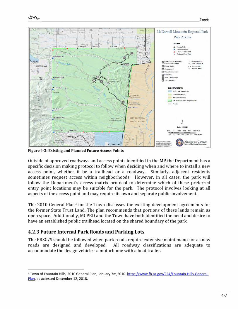
__________________________________________________________________________Roads
4-7
Figure 4-2: Existing and Planned Future Access Points Outside of approved roadways and access points identified in the MP the Department has a specific decision making protocol to follow when deciding when and where to install a new access point, whether it be a trailhead or a roadway. Similarly, adjacent residents sometimes request access within neighborhoods. However, in all cases, the park will follow the Department’s access matrix protocol to determine which of these preferred entry point locations may be suitable for the park. The protocol involves looking at all aspects of the access point and may require its own and separate public involvement. The 2010 General Plan3 for the Town discusses the existing development agreements for the former State Trust Land. The plan recommends that portions of these lands remain as open space. Additionally, MCPRD and the Town have both identified the need and desire to have an established public trailhead located on the shared boundary of the park. 4.2.3 Future Internal Park Roads and Parking Lots The PRSG/S should be followed when park roads require extensive maintenance or as new roads are designed and developed. All roadway classifications are adequate to accommodate the design vehicle - a motorhome with a boat trailer.
3 Town of Fountain Hills, 2010 General Plan, January 7m,2010. https://www.fh.az.gov/224/Fountain-Hills-General-Plan, as accessed December 12, 2018.
__________________________________________________________________________Roads
4-8
Improvements are recommended to unpaved portion of North McDowell Mountain Park Road aligning with 176th Street north of the boundary. Once plans to develop the north park entrance are underway, this road should be fully paved. As new amenities are added to the park, adequate parking and biking lanes should also be incorporated into its site design. Some existing parking lots can be expanded or realigned to accommodate future parking needs. As trail use continues to increase in popularity with park visitors, trailhead parking must also be evaluated. Some trailheads may require additional parking.

__________________________________________________________________________Roads
4-9
{This page intentionally left blank.}

__________________________________________________________________________ Trails
5-1
Figure 5-1: Trails Crew hard at work.
Chapter 5 – Trails The trails chapter details the existing trails within the park, as well as proposes additional trails based on current requests and needs identified in the MP update process. The trail system is a vital component of the park and provides park visitors with diverse recreational experiences from educational interpretive trails to rugged mountain hikes. Trails serve multiple purposes including exercising, walking, jogging, hiking, bicycling, bird-watching, equestrian, and Off Highway Vehicle (OHV) use. They can also provide safe alternative transportation routes as well as create connectivity from one facility or municipality to another. Connecting people and places enhances the user experience and promotes long term stewardship of the trail systems, parks, and the Sonoran Desert as a whole. (Figure 5-1). The McDowell Regional Park Trail System Plan (Trail System Plan) (Appendix J) was adopted in 1999, amended in 2008, and updated in 2011. The Trail System Plan and amendments describe the desired future condition of the trail system, including trail access points, service road access, and prescribes actions to achieve the planned condition. The Master Plan update provides conceptual trail recommendations based on public feedback received during the open public comment phases. The feedback received will help to guide trail alignment planning for the trail development manager. Trail alignments will be periodically updated in this chapter of the MP as an Amendment. Additional trails or deletions to the trail system may require an Amendment to the Trail System Plan listed in Appendix J. The Park Planner and Trail Manager are tasked with providing recommendations and guidance to the Park Supervisor and Planning and Engineering Manager, and are also responsible for implementing the changes that may be required.
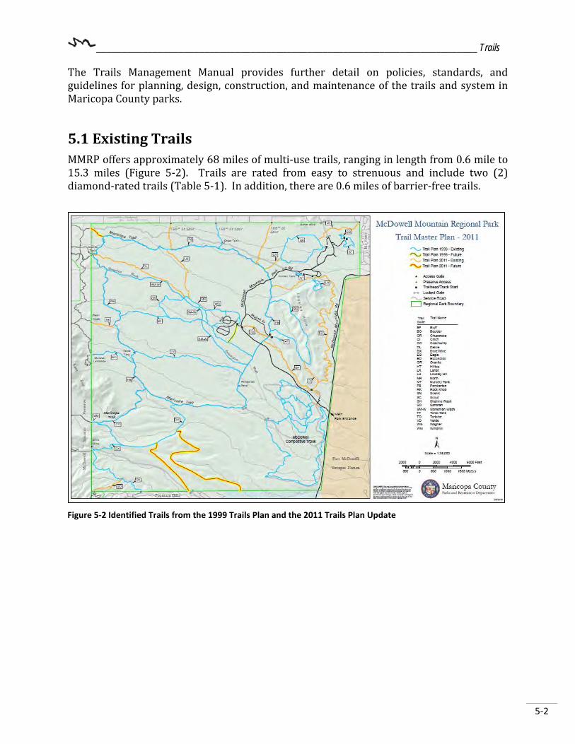
__________________________________________________________________________ Trails
5-2
The Trails Management Manual provides further detail on policies, standards, and guidelines for planning, design, construction, and maintenance of the trails and system in Maricopa County parks.
5.1 Existing Trails MMRP offers approximately 68 miles of multi-use trails, ranging in length from 0.6 mile to 15.3 miles (Figure 5-2). Trails are rated from easy to strenuous and include two (2) diamond-rated trails (Table 5-1). In addition, there are 0.6 miles of barrier-free trails.
Figure 5-2 Identified Trails from the 1999 Trails Plan and the 2011 Trails Plan Update

__________________________________________________________________________ Trails
5-3
Table 5-1: Designated Trails Name Miles1 Kilometers1 Notes Rating2 Management
Classification Bluff 2.2 3.5 Shared use Primary
Boulder 1.1 1.8 Shared use Primary
Chuparosa 0.5 0.8 Hike/Bike Only
Primary
Cinch 0.6 1.0 Shared use Secondary
Coachwhip 2.6 4.2 Shared use Primary
Delsie 2.5 4.0 Shared use Primary
Dixie Mine 5.6 9.0 Shared use Primary
Eagle 0.4 0.6 Hike (Youth Only)
Secondary
Escondido 6.2 10.0 Shared use Primary
Granite 3.5 5.6 Shared use Primary
Hilltop 0.5 0.7 Hike Secondary
Figure 5-3: Future Trails identified as part of the Park Master Planning Process
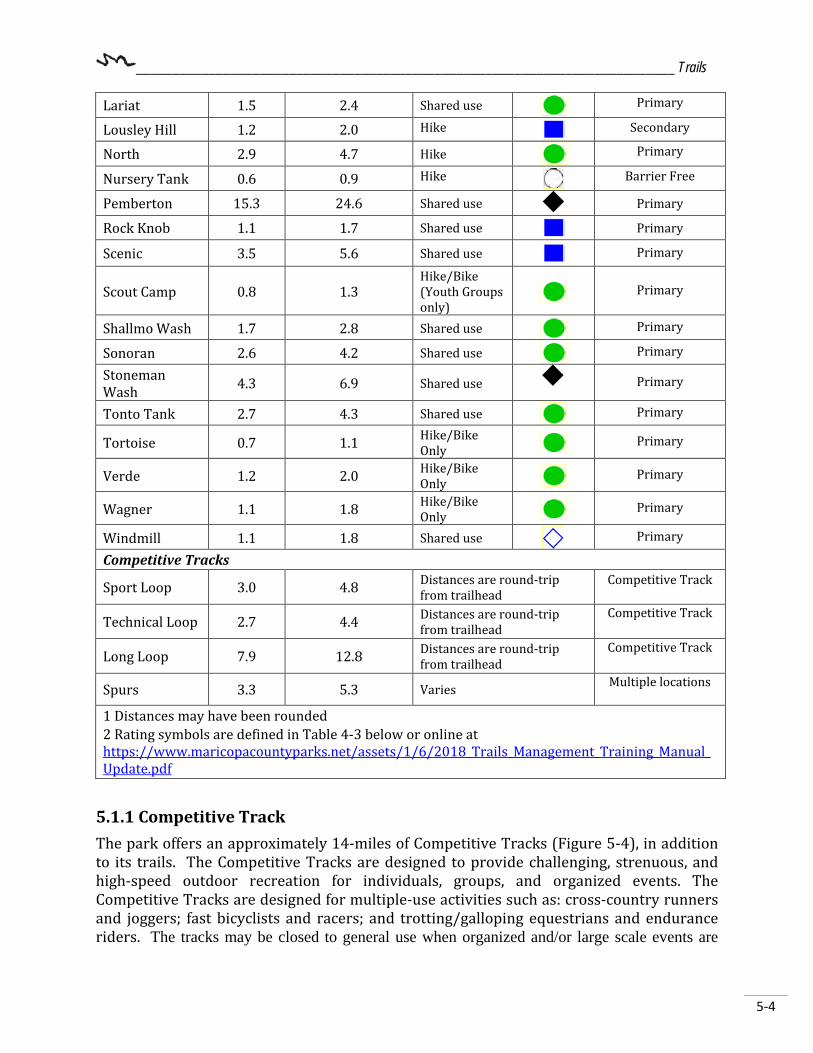
__________________________________________________________________________ Trails
5-4
Lariat 1.5 2.4 Shared use Primary
Lousley Hill 1.2 2.0 Hike Secondary
North 2.9 4.7 Hike Primary
Nursery Tank 0.6 0.9 Hike Barrier Free
Pemberton 15.3 24.6 Shared use Primary
Rock Knob 1.1 1.7 Shared use Primary
Scenic 3.5 5.6 Shared use Primary
Scout Camp 0.8 1.3 Hike/Bike (Youth Groups only)
Primary
Shallmo Wash 1.7 2.8 Shared use Primary
Sonoran 2.6 4.2 Shared use Primary
Stoneman Wash 4.3 6.9 Shared use
Primary
Tonto Tank 2.7 4.3 Shared use Primary
Tortoise 0.7 1.1 Hike/Bike Only Primary
Verde 1.2 2.0 Hike/Bike Only Primary
Wagner 1.1 1.8 Hike/Bike Only Primary
Windmill 1.1 1.8 Shared use Primary
Competitive Tracks
Sport Loop 3.0 4.8 Distances are round-trip from trailhead
Competitive Track
Technical Loop 2.7 4.4 Distances are round-trip from trailhead
Competitive Track
Long Loop 7.9 12.8 Distances are round-trip from trailhead
Competitive Track
Spurs 3.3 5.3 Varies Multiple locations
1 Distances may have been rounded 2 Rating symbols are defined in Table 4-3 below or online at https://www.maricopacountyparks.net/assets/1/6/2018_Trails_Management_Training_Manual_Update.pdf
5.1.1 Competitive Track The park offers an approximately 14-miles of Competitive Tracks (Figure 5-4), in addition to its trails. The Competitive Tracks are designed to provide challenging, strenuous, and high-speed outdoor recreation for individuals, groups, and organized events. The Competitive Tracks are designed for multiple-use activities such as: cross-country runners and joggers; fast bicyclists and racers; and trotting/galloping equestrians and endurance riders. The tracks may be closed to general use when organized and/or large scale events are

__________________________________________________________________________ Trails
5-5
taking place (i.e., Ragnar Trail Relay, Javelina Jundred, XTerra, Hike for the Homeless, etc.). (Table 5-2).
Table 5-2: Competitive Track Events and Participants Fiscal Year Number of Events Attendance 2015-2016 38 9795 2016-2017 37 9312 2017-2018 36 9103 Attendance is for events with pre registration requirements and does not include numbers for events open to the public.
Figure 5-4: McDowell Competitive Track

__________________________________________________________________________ Trails
5-6
5.1.2 Maricopa Trail The Maricopa Trail has two (2) connections (or trail spurs) into the park which align with Windmill/Coachwhip Trail near the southwest boundary, and the second with Delsie Trail near the northwest boundary of the park. Once on the trail spurs, a trail user can circumnavigate the interior of the park via the Pemberton Trail. The Maricopa Trail is part of a regional trail plan that links all of Maricopa County regional parks and provides connections to metropolitan areas, municipal trails, communities, and neighborhoods with regional non-motorized multi-modal corridors. It also provides an outlet for competitive hikers, mountain bikers, and equestrians who are seeking long distance routes.
5.2 Proposed Community Trails/Trailheads Scottsdale’s General Plan 20351, outlines its desired future trails, trailheads, and access points to the Preserve which borders the park to the west. Any future updates to the Trail System Plan should take these desired locations into consideration and utilize the access matrix procedure to determine the precise location, suitability, and public benefit of adding an access point. The Town’s General Plan 20102, outlines the Town’s desire to protect the natural wash corridors and encourage the use of major and contiguous open space with pathways outside of the wash corridors. In regards to the former ASLD located adjacent to and south of MMRP, the Town recommends preserving some of the land for open space while also recommending that the Town continue to encourage the development of trail systems that link Fountain Hills with MMRP.
As the former ASLD lands become available for development, MCPRD will work with the Town to request a formal public trailhead be incorporated into the community development plans for these two parcels of land.
5.3 Trail Use All trails are shared-use, unless otherwise designated. All trail users are encouraged to practice proper trail etiquette. Park Rule R-118 requires hikers, equestrians, and bicycle riders to remain on designated trails, and shortcutting by any type of trail user is prohibited. Trail education and law enforcement will be used to attain compliance, when necessary. Signs will be posted and barriers constructed at obliterated paths, roads, and undesignated washes if use is continued after closure. 1 City of Scottsdale General Plan 2035 (November 2014), http://www.scottsdaleaz.gov/Assets/ScottsdaleAZ/General+Plan/_SGP2035_TFLegEdit.pdf as accessed November 21, 2018. 2 Town of Fountain Hills General Plan 2010

__________________________________________________________________________ Trails
5-7
The 2012-2013 ASU Park Visitor Study shows that park visitors use trails for an average of 11.36 miles3. When singled out by the visitors’ primary activity, other trail uses include (Table 5-3):
Table 5-3: Trail Uses Primary Activity Percent of Visitors1 Miles of Trail Used2 Trail hiking 22.6 5.59 Mountain biking 56.7 19.31 Picnicking 0.5 N/A Running/jogging 1.9 13.75 Horseback riding 7.2 6.77 Walking for pleasure 00 N/A 1. 2012-2013 ASU Park Visitor Study Final Report, Table 1.9A, page 23. 2. 2012-2013 ASU Park Visitor Study Final Report, Table 1.10, page 26.
5.4 Trail Rating In 2012, a partnership of metro-area park agencies developed a trail rating guide to assist trail users in assessing what trails are best suited for their abilities (Table 5-4). During the hotter months when the temperatures and/or humidity are high, trails are rated at least one level higher.
Table 5-4: Trail Rating Guide Rating Symbol
Brief Definition Surface Grade Obstacles/Steps
Easiest
Paved Accessible Trail Paved or hard and smooth
None
Easy
Mostly smooth and wide
Dirt with occasional unevenness
2" or less, rocks and ruts
Moderate
Mostly smooth, variable width
Dirt with occasional unevenness
<8" rocks and ruts, loose material
Moderate difficult
Mostly uneven surfaces Dirt and rock
<12" rocks and ruts, loose material
Difficult
Long rocky segments with possible drops and exposure
Dirt and loose rock with continual unevenness
12" or taller, loose rocks, exposure to drops
Extremely
difficult
Long rocky segments with possible drops and exposure
Dirt and loose rock with continual unevenness
12" or taller, loose rocks, exposure to drops and excessive heat >90F
3 2012-2013 ASU Park Visitor Study Final Report, Table 1.10, page 26.

__________________________________________________________________________ Trails
5-8
{This page intentionally left blank.}

_______________________________________________________________ Management Zoning
6-1
Chapter 6 – Management Zoning The foundation for the management zones is found in the 2009 Strategic System Master Plan, June 2009 (page 105-116), and is presented again here (Table 6-1). It should also be noted that the 2009 Strategic System Master Plan also recommends that the size of all developed areas should be limited to 10% of the overall park size; however, smaller parks that are adjacent to other protected open space areas may exceed the 10% recommendation. As of 2009, the park had about 1.4% of its total acres developed; that is expected to increase slightly as new projects or trails are constructed.
Table 6-1: Management Zone and Acreage Zone Percent of Total Park Acres
Development 1.4% (292.46 acres) Trail 2.2% (472.20 acres) Semi-Primitive 49.4% (10,413.71 acres) Primitive 41.2% (8,700.22 acres) Perimeter Buffer 5.3% (1,110.73 acres) Non-Management Zone 0.5% (104.69acres) Source: 2009 Strategic System Master Plan, page 118.
6.1 Methodology for Determining Management Zones The current management zoning descriptions and maps used for MMRP are taken directly from the 2009 Strategic System Master Plan (pages 105-116. The zones were determined based on existing use and location of developed features. The management zones are meant to provide some flexibility. If/when development occurs on the north, south, or west side of the park, the development zone(s) impacted will need to be reviewed, and modifications to the management zone(s) may be necessary. The park was zoned according to existing use which may or may not be its preferred future use; as such, future revisions of these zones should include descriptions of the desired visitor experience and level of intended management. For example, one zone may provide the visitor with a sense of wilderness and remoteness, challenging their outdoor skills. This zone would thus require a low level of management and a high level of resource protection and may be labeled as “primitive” and should reflect the desired future conditions of the park rather than existing use or conditions.
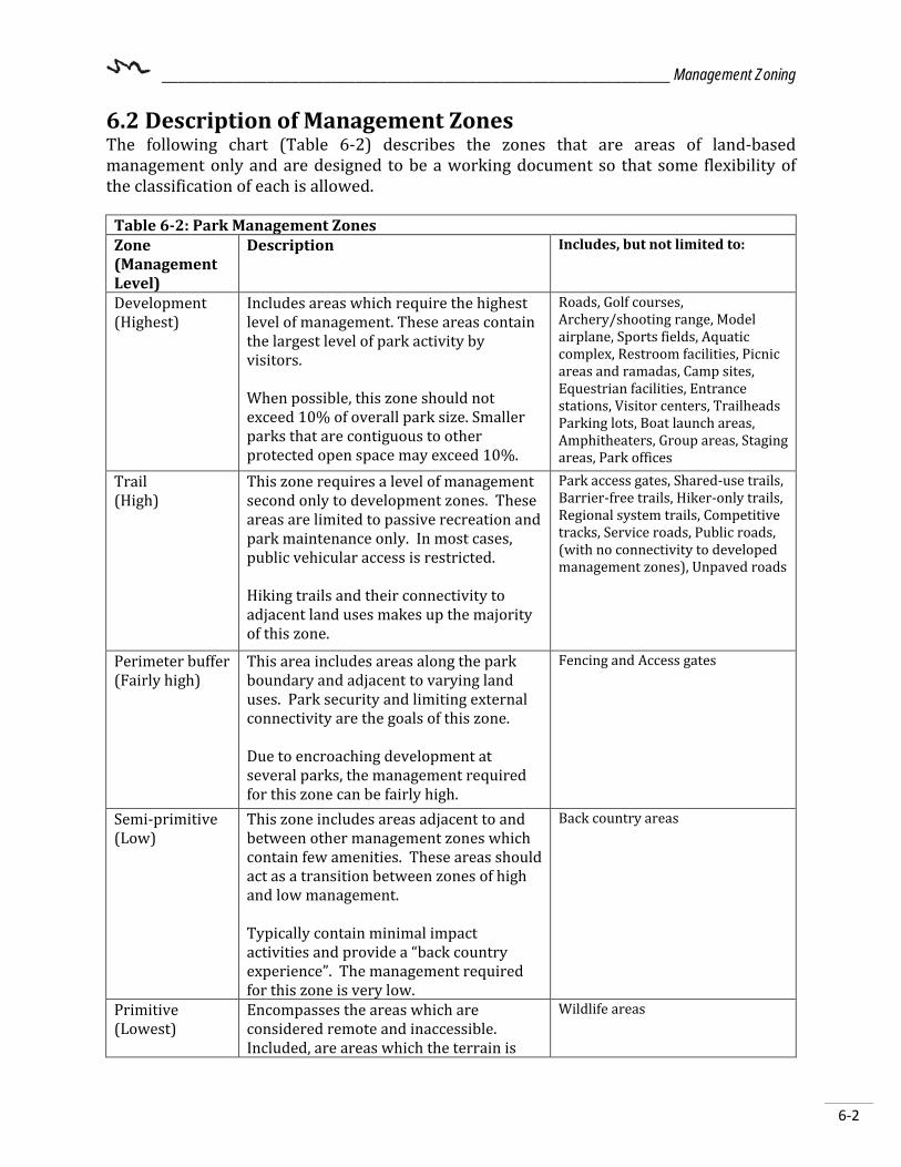
_______________________________________________________________ Management Zoning
6-2
6.2 Description of Management Zones The following chart (Table 6-2) describes the zones that are areas of land-based management only and are designed to be a working document so that some flexibility of the classification of each is allowed.
Table 6-2: Park Management Zones Zone (Management Level)
Description Includes, but not limited to:
Development (Highest)
Includes areas which require the highest level of management. These areas contain the largest level of park activity by visitors. When possible, this zone should not exceed 10% of overall park size. Smaller parks that are contiguous to other protected open space may exceed 10%.
Roads, Golf courses, Archery/shooting range, Model airplane, Sports fields, Aquatic complex, Restroom facilities, Picnic areas and ramadas, Camp sites, Equestrian facilities, Entrance stations, Visitor centers, Trailheads Parking lots, Boat launch areas, Amphitheaters, Group areas, Staging areas, Park offices
Trail (High)
This zone requires a level of management second only to development zones. These areas are limited to passive recreation and park maintenance only. In most cases, public vehicular access is restricted. Hiking trails and their connectivity to adjacent land uses makes up the majority of this zone.
Park access gates, Shared-use trails, Barrier-free trails, Hiker-only trails, Regional system trails, Competitive tracks, Service roads, Public roads, (with no connectivity to developed management zones), Unpaved roads
Perimeter buffer (Fairly high)
This area includes areas along the park boundary and adjacent to varying land uses. Park security and limiting external connectivity are the goals of this zone. Due to encroaching development at several parks, the management required for this zone can be fairly high.
Fencing and Access gates
Semi-primitive (Low)
This zone includes areas adjacent to and between other management zones which contain few amenities. These areas should act as a transition between zones of high and low management. Typically contain minimal impact activities and provide a “back country experience”. The management required for this zone is very low.
Back country areas
Primitive (Lowest)
Encompasses the areas which are considered remote and inaccessible. Included, are areas which the terrain is
Wildlife areas

_______________________________________________________________ Management Zoning
6-3
too rugged for vehicular or pedestrian traffic as well as areas that are a great distance from any other “developed” zone without a point of access. The key element of this zone should be wildlife conservation and preservation. Access to this zone is available only by special permit (i.e. wildlife study) and therefore requires the least amount of management.
6.3 Area Descriptions that Influence Park Zoning Topography or natural and cultural resources may determine the areas that are considered semi-primitive and primitive. Many areas are too rugged for any type of development and therefore semi-primitive or primitive are inherently appropriate in a large portion of the park. The 2009 Strategic System Plan (page 112) notes that current management zones reflect existing land uses within the park (Figure 6-1). As future connectivity and access needs change, these zones will require an update.
Figure 6-1: Development Zones (Source: MCPRD 2009 Strategic System Master Plan, Figure 43, p 112)

_______________________________________________________________ Management Zoning
6-4
{This page intentionally left blank.}

__________________________________________________________ Park Improvement Projects
7-1
Chapter 7 – Park Improvement Projects This chapter identifies new park improvement projects that have been determined through the planning process. This process includes the analysis of existing conditions, trends, public input, and consultation with neighboring agencies, Commission and Department staff expertise as described in previous chapters. Staff, stakeholders, and the public were asked to review the project maps, submit their requests for future park improvements, and comment on department proposed park improvements. The MP update incorporates some of the original 1967 M P concepts; however, most of the old plan had been revised to reflect current park use and needs. Objectives that are outlined by the current plan update include: Supporting existing features and amenities: This update recommends supporting the addition of amenities to existing areas, and promotes educational components of the park, such as:
• Upgrades and repairs to existing facilities (e.g. trails, campground infrastructure, expansion of the event staging areas, and restrooms);
• Expansion of active recreation areas such as a bike park, new mulita-use trails, and additional amenities in high use areas of the park, i.e. campground and event staging areas;
• Improved signage and maps; and • Inclusion of the Southwest Wildlife Conservation Center into the New Nature Center
Development Limiting other features: The update streamlines the quantity of built facilities to protect the parks natural and cultural resources. Other developed features outlined in the original 1967 MP that are not currently in place or recommended within this update are no longer applicable facilities for the park.
7.1 Issues and Constraint Analysis The planning team met early in the planning process to discuss issues that may place constraints on the park. The MP update addresses those items discussed within its Issues, Constraints, and Analysis Section (Table 7-1):

__________________________________________________________ Park Improvement Projects
7-2
Table 7-1: Issues Constraints and Analysis Issue/Constraint Analysis Management Zones Management Zones represent existing land use.
Additional development actions must complement its zone or modify the zone. The Management Zone should reflect the desired use and visitor expectation for that zone. Some proposed projects may require a zone change.
Access Adjacent private land owners north and south of the park are creating private access points into the park. Protection of the park boundaries needs to be established and new entry points considered as growth occurs in adjacent areas.
Wildlife corridors/linkages Future development will be sited in locations that will accommodate linkages between the Preserve to the west, the Tonto National Forest to the north, and the Fort McDowell Yavapai Nation lands to the east.
Hunting Designated areas of the park can fill this niche other areas cannot; as regulated through AZGFD. Currently, there are two designated hunting areas within the Park however, these areas may need to undergo review once the additional park amenities are developed.
Compliment established themes All efforts have been made to compliment park’s theme of Adventure and outdoor recreation.
Neighboring city/town development patterns
The Park Supervisor and/or Park Planner routinely participate with neighboring agencies regarding development patterns.
Maintain development to under 10% of land acres
Currently, 1.4% of land acres are considered developed; park is well within the 10% limit. Future development actions will need to take this guideline into account and repurpose previously disturbed ground to the extent feasible.
Operations The park has had a steady visitor increase as well as revenue increases over the past several years. Facility improvements are needed to continue to provide a positive user experience, increase park revenue, and diversify what amenities the park offers. Facilities renovation and development planning should also include an analysis of operating impacts and opportunities for efficiency.
7.2 Recommended Park Improvements Park Improvements and enhancements recommended in the MP adhere to the MCPRD vision and mission. These enhancements also address the park’s priority mandates outlined in the 2009 Strategic System Master Plan and promote the park’s theme. The park improvements and features detailed in this section were based on public input, stakeholder

__________________________________________________________ Park Improvement Projects
7-3
advisory group suggestions, park staff recommendations, and guidance from other planning documents (Figures 7-1 through 7-2, and Table 7-2). A timeline for completion was not assigned to any one project as projects may be completed as funding and opportunities become available. Projects will be scheduled through the Department’s Capital Improvement Plan (CIP) and potential costs and funding sources will be identified through the Implementation Plan (IP). However, a priority level was assigned to show which project(s) may be of greater need:
• High Priority: projects that are in progress; public health or safety issues; resource protection.
• Medium Priority: important, but not a matter of public health or safety; to indicate a desired level of service across a range of recreation opportunities.
• Low Priority: desired features; or dependent on long-term partnerships or other considerations.
A majority of these projects will be phased in individually over multiple years to maximize budgetary resources, build partnerships with other agencies, and to minimize impacts to park operations and resources. Site specific plans (including any applicable natural or cultural resource inventories and clearances), and engineering plans may be required for new construction. The IP and an annual Business Plan will help identify which projects will be funded. Improvement projects are contingent upon having adequate funding and staffing resources to implement. For the purposes of this MP update, the mapped location of any new facilities herein is conceptual only; the precise location may change due to engineering feasibility and resource management issues. Additional public meetings regarding individual projects may be required and the results of which may shape the final outcome of the project and subsequent future projects. Additionally, any new trail or road alignments shown as park improvements are also considered conceptual only. The locations are general corridors and are not intended to be precise. New trails or roads will be located according to the Department’s trail standards outline in the 2018 Trails Management Manual, MCDOT standards and guidelines, and appropriate project design and engineering. Alignments are not open to travel until they have been properly constructed, posted, and designated by the Department. Traveling on undesignated routes causes damage to the land, may be hazardous, and is in violation of Park Rules. As a result of public input, agency partner input, and staff expertise, the MP update recommends the following park improvement projects:
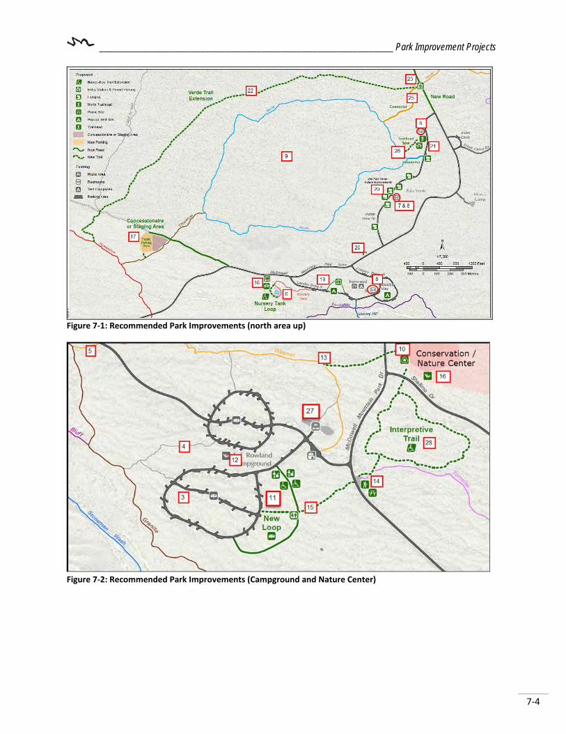
__________________________________________________________ Park Improvement Projects
7-4
Figure 7-1: Recommended Park Improvements (north area up)
Figure 7-2: Recommended Park Improvements (Campground and Nature Center)
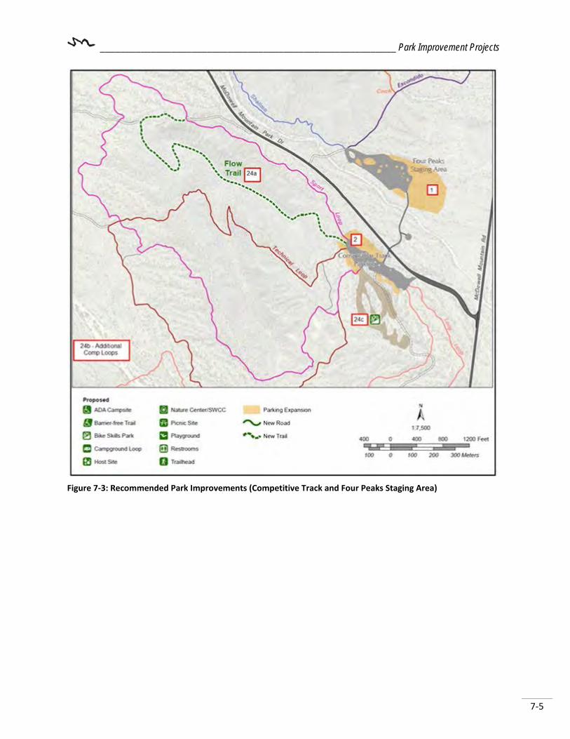
__________________________________________________________ Park Improvement Projects
7-5
Figure 7-3: Recommended Park Improvements (Competitive Track and Four Peaks Staging Area)

__________________________________________________________ Park Improvement Projects
7-6
Table 7-2: Existing Features and Recommended Improvements Existing park features including:
- Nature Center - Maintenance Compound - Host Sites - RV camping sites - Tent sites - Playground
- Ramadas and picnic tables - Restrooms - Trails / Trailheads - Competitive Track - Event Staging areas
Recommended Improvements ID# Location Description Priority
LevelRenovation of Existing Facilities1 Four Peaks This area may be expanded upon in order meet the parks
needs for event staging. High
2 Competitive Track
An addition of approximately 4.5 acres of unpaved parking area is needed in order to continue to serve the events.
High
3 Campground Additional RV camp sites are needed. The existing south loop can accommodate up to 15 additional RV sites.
Medium
4 Campground Electrical upgrades associated with the Service Entrance Section (SES) cabinets and RV site pedestals.
High
5 Maintenance Campground
Telecommunications infrastructure needed. Medium
6 Nursery Tank Trail improvements include; an extension of the trail to create a full barrier free loop, rehabilitate the wildlife water tank, hand rail and interpretive panel improvements.
Medium
7 Asher View Renovate Restroom #2 to incorporate shower facilities for the camping cabins.
Medium
8 North park Restrooms - Update fixtures in RR #1, 2, and 3 (north). High
Park-wide Update trail signage. Park-wide
Park-wide Roadway widening and maintenance. Pave north entrance road and 176th street alignment.
Low
9 North Trail North Trail is designated as an interpretive trail for single use by hikers. Improvements include additional signage as well as updated interpretive signs.
Medium
Develop New Facilities 10 Shallmo and
McDowell -New Nature Center
Location of proposed New nature and wildlife conservation center with interpretive displays, classrooms, gift shop, and park admin offices. Additional facilities associated with wildlife conservation to be phased in. New center location may be dependent on a successful partnership with Southwest Wildlife Conservation or similar organization.
High

__________________________________________________________ Park Improvement Projects
7-7
11 Campground loop
Constructed an additional loop to connect with Pemberton Loop Drive and N. Palisades Way to accommodate up to 25 additional RV sites. The new loop will include at least two (2) ADA RV sites and two (2) host sites.
Medium
12 Campground loop
Amphitheater – refurbish the existing playground area as an amphitheater for interpretive programs for campers. Existing playground equipment to be reused at the new nature center location.
Low
13 Wagner Trail Connection from Wagner to the new nature center. Low 14 Existing
Nature Center pending SWCC
Refurbish existing nature center area as a trailhead with parking, picnic tables and shade (natural or structures).
Low
15 Trail New connection trail from RV campground to the proposed new trailhead located at the current Nature Center location.
Low
16 Shallmo and McDowell
Larger nature based playground to be located near the new nature center. This will also include a sound garden with nature themed instruments.
High
17 Concessionaire and Staging area
A new unpaved public parking area and concessionaire staging area will be located west of Chuparosa Trail. The existing unpaved service road should be improved to incorporate an approximate 3.5 acre area. A County approved concession operation that will include the development, operation and maintenance of facility(s) to provide recreation opportunities not otherwise provided by the Department, i.e. equestrian operations providing guided tours.
Medium
18 Nursery Tank Development of a new restroom facility and associated parking a south of McDowell Mountain Park Road. The trail will be extended to create a full barrier-free loop which will connect with the parking area and restroom northwest of Nursery Tank. A larger shade structure outfitted with an ADA accessible picnic table should also be included.
Low
19 Lousley Loop Add a restroom/shower house, additional tent and pop-up tent sites.
Medium
20 Asher View Two areas listed as potential site locations for cabins. Additional cabins may built with demand increases. Medium
21 North Trailhead Upgrade picnic tables, add individual shade structures. Low
22 Verde Trail Verde Trail extension to extend west and connect directly with Pemberton in order to keep North trail compliant with County Park Trail Standards.
High
23 North Entry Park Access - Develop a north entry station which will include a paved road connection to Dynamite Road (north of the park).
Low
24a Competitive Track
Addition of a flow trail (a). See maps on the previous page. Low
24b Competitive Three (3) new competitive loops (b). See maps on the
previous page. Medium

__________________________________________________________ Park Improvement Projects
7-8
Track
24c Competitive Track
Up to a 20 acre bike park(c). See maps on the previous page. High
25 Trail Trail spur from recommended north entry station to North Trail. Medium
26 Trail New trail spur from North Trail to the existing trailhead. Located on Asher View Drive. High
27 Group Camp This area may be converted in the future in a way that best serves the park’s RV camping needs, i.e. additional overflow parking, additional RV loop, etc.
Low
Resource Protection North and South park boundaries
Boundary protection where possible and necessary; may include pipe rail fencing, wire or range fencing, gates, and signage.
High
Education/Interpretation 28 Trail New one (1) mile barrier free interpretive loop trail between
proposed and existing nature center location. Medium
Nature Center Create new interpretive displays to highlight the historical backdrop of the area.
Medium
Park-wide Encourage educational components related to water resources, habitat or other natural systems, and cultural and historic resources into park programs, interpretive signage, or other displays.
Park-wide
Park-wide Update all interpretive panels. Park-wide

__________________________________________________________ Park Improvement Projects
7-9
{This page intentionally left blank.}

Appendix A
Public Participation
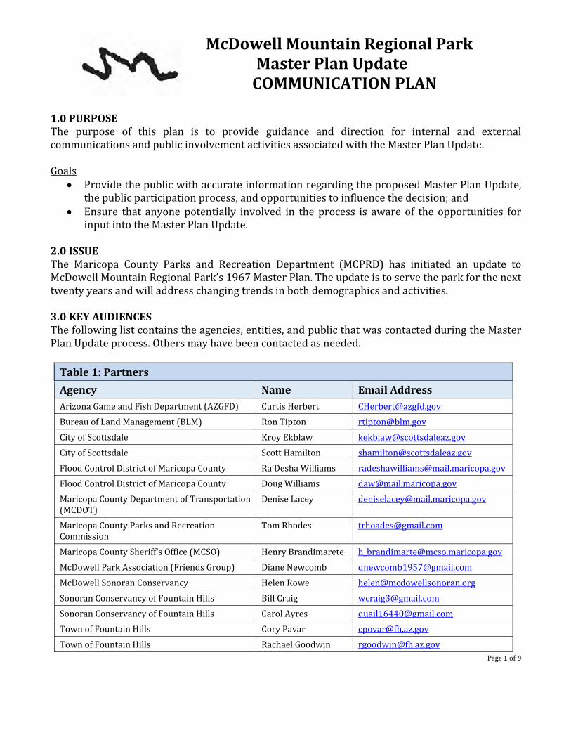
McDowell Mountain Regional Park Master Plan Update
COMMUNICATION PLAN
Page 1 of 9
1.0 PURPOSEThe purpose of this plan is to provide guidance and direction for internal and external communications and public involvement activities associated with the Master Plan Update.
Goals • Provide the public with accurate information regarding the proposed Master Plan Update,
the public participation process, and opportunities to influence the decision; and• Ensure that anyone potentially involved in the process is aware of the opportunities for
input into the Master Plan Update.
2.0 ISSUE The Maricopa County Parks and Recreation Department (MCPRD) has initiated an update to McDowell Mountain Regional Park’s 1967 Master Plan. The update is to serve the park for the next twenty years and will address changing trends in both demographics and activities.
3.0 KEY AUDIENCES The following list contains the agencies, entities, and public that was contacted during the Master Plan Update process. Others may have been contacted as needed.
Table 1: Partners Agency Name Email Address Arizona Game and Fish Department (AZGFD) Curtis Herbert [email protected] Bureau of Land Management (BLM) Ron Tipton [email protected] City of Scottsdale Kroy Ekblaw [email protected] City of Scottsdale Scott Hamilton [email protected] Flood Control District of Maricopa County Ra’Desha Williams [email protected] Flood Control District of Maricopa County Doug Williams [email protected] Maricopa County Department of Transportation (MCDOT)
Denise Lacey [email protected]
Maricopa County Parks and Recreation Commission
Tom Rhodes [email protected]
Maricopa County Sheriff’s Office (MCSO) Henry Brandimarete [email protected] McDowell Park Association (Friends Group) Diane Newcomb [email protected] McDowell Sonoran Conservancy Helen Rowe [email protected] Sonoran Conservancy of Fountain Hills Bill Craig [email protected] Sonoran Conservancy of Fountain Hills Carol Ayres [email protected] Town of Fountain Hills Cory Pavar [email protected] Town of Fountain Hills Rachael Goodwin [email protected]

Page 2 of 9
Maricopa County Board of Supervisors Steve Chucri [email protected] Maricopa County Board of Supervisors (Assistant)
Nicole Bendle [email protected]
Maricopa County Sheriff’s Office (MCSO) Rich Johnson [email protected] Maricopa County Sheriff’s Office (MCSO) Mark Fisher [email protected] Southwest Wildlife Conservation Center Nikki Julien [email protected]
The following list of stakeholders may have a special interest in the park due to their preferred outdoor recreation activity or another area of interest. Those noted on this list, and others as needed, were also contacted during the Master Plan Update process.
Table 2:Stakeholders
Organization Name Email Address Ragnar Events Alex Docta [email protected]
Arizona Mountain Biking Amy Regan [email protected] Tonto Verde Community Andy Andrews [email protected] Western Spirit Cycling Anne Clare Erickson [email protected] Sonoran Conservancy of Fountain Hills Bill Craig [email protected] Mountain to Fountain Bob Schafer [email protected] Desert Classic Duathlon Brett Stewart [email protected] Trail Run(s) Brian Wieck [email protected] Fort McDowell Yavapai Indian Community
Calvin "Roddy" Pilcher [email protected]
Maricopa County Planning & Development
Daren Gerard [email protected]
Ragnar Events Dave BeBoer [email protected] Rio Verde Community Dorris Findling [email protected] AZ Quarter Hourse Association Doug Huls [email protected] Fountain Hills Bike Shop Doug Carlson [email protected] Scott Sports Garth Spencer [email protected] Fountain Hills Tourism Department Grace Rodman-Guetter [email protected] McDowell Sonoran Conservancy Helen Rowe [email protected] Aravaipa Running Jamil Coury [email protected] Maricopa Trail Foundation Jan Hancock [email protected] Recreational Equipment, Inc. aka REI Phoenix Market
Jay Parks [email protected]
Cactus Adventures Jennifer Morlock [email protected] 12 Hours of Fury Jeremy Graham [email protected] Arizona Outdoor Specialist (Arizona Outdoor Adventures)
Jon Colby [email protected]
Gravity Riders Organization of Arizona Ken Bennett [email protected]

Page 3 of 9
Tonto National Forest Kenna Belsky [email protected] Lee Likes Bikes Kevin Stiffler [email protected] Rim Bike Tours Kirstin Peterson [email protected] McDowell Criterium Larry McCormick [email protected] Wild Bunch Desert Guides, LLC Laurel Darren [email protected] Four Peaks Elementary School Linda McKeever
Fountain Hills Middle School Maricopa County Department of Public Health
Liza Golden [email protected]
Sonoran Outdoor Adventures (Fat Bike LLC)
Marek Kulesza [email protected]
McDowell Mountain Cycles Marty Coplea [email protected] Equine Trail Sports Mary Sutherland [email protected] Arizona State Land Dept. (ASLD) Micha Horowitz [email protected] Niner Bikes Michael Hutchison [email protected] Arizona Interscholastic Cycling League Mike Perry [email protected] Cactus Cup Mike and Sage Melley [email protected] Giant Bicycles Pat Collier [email protected] Black Mountain Adventures, LLC Patrick Riley [email protected] Hike for the Homeless Rae Herrera [email protected] Arizona Outdoor Specialist (Arizona Outdoor Adventures)
Rick Hill [email protected]
Fort McDowell Yavapai Indian Community
Roann Camelo [email protected]
Bike MS Sarah Grogger [email protected] Bike Paradise / Pedal Therapy Scott Givens [email protected] Dawn to Dusk Seth Bush [email protected] Xterra Shannon Lindner [email protected] Audubon Arizona Sonia Perillo [email protected] Lead, Follow or Get Out of My Way Stephanie Palmer-
Duross [email protected]
Ragnar Events Steven Aderholt [email protected] Rio Verde Horseman's Association Terry Stecyk [email protected] MBAA Tim Racette [email protected] Pivot Cycles Tristan Brandt [email protected] McDowell Mountain Elementary School Valerie Dehombreux [email protected] Arizona Horse Council Walter "Chip" Wilson [email protected] Central Arizona Mountain Bike Patrol -- [email protected]. Arizona State Parks SHPO Consultation Mary-Ellen Walsh [email protected]
Tribes Angela Garcia-Lewis [email protected]

Page 4 of 9
SRP Alexander Reid [email protected] Arizona Horse Council Jean Anderson [email protected]
4.0 CONSULTATION Bureau of Land Management Department staff has invited the Bureau of Land Management (BLM) to all stakeholder and public meetings. Department staff also met with the BLM in February 2019 to discuss the master plan and to get their approval and an approval letter to be included in the final master plan. State Historic Preservation Office The State Historic Preservation Office (SHPO) has not been consulted to date; however, SHPO will be notified before the final Master Plan is released. After the final Master Plan is approved, cultural resource survey(s) will be performed on any new ground disturbing projects and the Department will follow any recommendations received from SHPO.
Native American Tribes The Department will engage in a government-to-government consultation with one federally recognized tribe that may have interest in the Master Plan Update. The Fort McDowell Yavapai Nation was identified as a Stakeholder in the planning process and as such was extended an invite to each Stakeholder meeting. A representative for the Fort McDowell Yavapai Nation was notified by email of the Master Plan Update stakeholder meeting. 5.0 OUTREACH AND MEETINGS The Department engages various opportunities to consult and interact with stakeholders and the public. As noted in Table 3, stakeholder meetings, public meetings and public announcements have been held throughout the planning process.
Table 3: List of Meetings, Meeting Topics, and Meeting Attendees Date Type Description Audience 9/12/17 Planning Team
Meeting #1 Kick-off the project, introduce project and timeline, review planning process for park master plans
MCPRD staff
11/7/17 Planning Team Meeting #2
Intro to the work plan, review timeline and scope, review existing plans and land use.
MCPRD staff
11/14/17 Public Meeting Park Commission Notification and introduction to the planning process and McDowell Mountain Regional Park
Members of the Public, MCPRD staff
12/19/17 Planning Team Meeting #3
Demographics and park use presentation, issues and constraints analysis, identify long term needs of the public and improvement opportunities.
MCPRD staff
1/4/18 Partner Meeting #1
Introduction to the planning process, existing park features and uses, participation and communication
Partners, MCPRD staff
1/10/18 Park Staff and Volunteer Meeting
Introduction to the planning process, existing park features and uses, participation and communication
MCPRD staff and park volunteers
1/23/18 Stakeholder Meeting #1
Introduction to the planning process, existing park features and uses, participation and communication
Stakeholders, MCPRD staff
Page 5 of 9
2/15/18 Planning Team Meeting #4
Review comments from Stakeholders, Partners, and the public, additional discussion on demographics, planning for the open house.
MCPRD staff
2/20/18 Public Open House
Open house #1 location/night 1 Members of the Public, MCPRD staff
2/22/18 Public Open House
Open house #1 location/night 2 Members of the Public, MCPRD staff
3/6/18 ‘Friends’ Meeting Evening presentation to Friends of McDowell group at Rio Verde Community Center
Friends of McDowell, MCPRD planner
3/7/18 Planning Team Meeting #5
Site visit to McDowell to view existing conditions and infrastructure.
MCPRD staff
3/20/18 Public Meeting Park Commission Project Update Members of the Public, MCPRD staff
4/4/18 Partner Meeting #2
Recap of Public Open House meetings, PowerPoint on park use statistics, discussion on park improvements
Partners, MCPRD staff
4/10/18 Planning Team Meeting #6
Updates on public meetings, review of comments, review of planning process and master plan deliverables.
MCPRD staff
4/11/18 Park Staff and Volunteer Meeting
Recap of Public Open House meetings, PowerPoint on park use statistics, discussion on park improvements
MCPRD staff and park volunteers
5/9/18 Planning Team Meeting #7
Site visit and feasibility analysis of new nature center location
MCPRD staff, SWCC, Blackrock studios
5/24/18 Stakeholder Meeting #2
Recap of Public Open House meetings, PowerPoint on park use statistics, discussion on park improvements and priorities
Stakeholders, MCPRD staff
6/14/18 Planning Team Meeting #8
Prioritizing public requests and further discussion regarding offering cabins or yurts camping options at the park.
MCPRD staff
7/11/18 SWCC Discussion on CoOp for the nature center wildlife sanctuary facility, and funding update
MCPRD and SWCC staff
7/11/18 Park Staff and Volunteer Meeting
Recap of Public Open House meetings, PowerPoint on park use statistics, discussion on park improvements and priorities
MCPRD staff and park volunteers
7/11/18 Partner Meeting #3
Recap of stakeholder meeting, progress with SWCC, PowerPoint on park improvement opportunities
Partners, MCPRD staff
7/19/18 Planning Team Meeting #9
Discussion of potential park improvements including interpretive programs, roadways and parking, and primitive pop-up ten camping.
MCPRD staff
8/20/18 SWCC Discussion on CoOp for the nature center wildlife sanctuary facility, and funding update
MCPRD and SWCC staff
8/2/18 Planning Team Meeting #10
Site Visit for new nature center and wildlife sanctuary MCPRD staff, SWCC staff
9/4/18 Planning Team Meeting #11
Recap of site visit with SWCC, discussion on cabins and site location, access points and trailheads, to do list items
MCPRD staff
9/18/18 Public Meeting Park Commission Project Update Members of the Public, MCPRD staff

Page 6 of 9
9/27/18 SWCC Nature center design charrette @ DOC MCPRD and SWCC staff
10/4/18 Planning Team Meeting #12
Partner agreement recaps, UMAs, SWCC, RV campground loop feasibility study, Hesperus wash dam
MCPRD staff
10/5/18 Public Open House
Partners, Stakeholders, and members of the public were invited to a public open house to review the condensed version of all requested improvements to the park and its master planning document.
Members of the Public, MCPRD staff, Partners, and Stakeholders
10/30/18 Town of Fountain Hills
Hesperus Wash Dam#36 MCPRD Staff and Town of Fountain Hills Planning staff
11/13/18 Public Meeting Park Commission Project Update Members of the Public, MCPRD staff
11/29/18 SWCC Team meeting with SWCC and Black Rock Studios to discuss land use and future nature center needs.
MCPRD, SWCC, and BRS
12/6/18 Planning Team Meeting #13
Review all information received MCPRD staff
1/15/19 Public Meeting Park Commission Project Update Members of the Public, MCPRD staff
Surveys Additional information was gathered from the public via surveys. Arizona State University (ASU) performs visitor use surveys on a fairly regular basis. This information assists the Department with programing and other decisions as well as provides the survey respondents an open ended question to report back their thoughts.
• ASU Visitor Use Survey Media/Social Media Press releases are issued at least two weeks prior to any public open house meeting. Occasionally, a news outlet or social media source will repost the press release on their respective platforms. The Department will post or re-post its own press releases on the social media or web platforms that are available to the County. A sample press release is shown in Exhibit A. Public Meetings The staff will also schedule public information meetings in an Open House format on at least two different dates. The logistics of the public meetings will be announced at least two weeks in advance via a news release; postings on the Web; and emails and/or mailings to interested parties. During the public meetings, a formal PowerPoint presentation may be provided to ensure that all audiences/participants receive consistent base data. The audiences/participants will be encouraged to view specific depictions that will be displayed on large posters around the room. MCPRD staff will be available to facilitate face-to-face communications aimed at fostering discussions and authentic opportunities for participation. MCPRD staff will provide for the Administrative Record a summary of issues/concerns raised; however, the audiences/participants will be encouraged to write comments in their own words on provided comment cards and/or via the email provided. The planning process also allows for a 30-day public comment period after each public meeting.

Page 7 of 9
Public meetings were held at the following locations: • Fountain Hills Community Center located south of the park at 13001 N. La Montana Dr.,
Fountain Hills. • Tonto Verde Community Center located north of the park at 18401 El Circulo Drive, Rio
Verde. At all times, project information is available and will be updated at this Web site: https://www.maricopacountyparks.net/park-locator/mcdowell-mountain-regional-park/park-information/park-projects/ The first public meeting was held in two different location on two separate days due to the distance of the various communities surrounding the park. The first of these two meetings was held on February 20, 2017 (5:30pm-7:30pm) at the Town of Fountain Hills Community Center where 10 people signed in and 8 flip pad comments and 12 sticky notes were collected. The second of the two meetings was held on February 22, 2017 (5:30pm-7:30pm) at the Tonto Verde Community Center where 5 people signed in and 3 flip pad comments and 3 sticky notes were collected. Twenty-one (21) additional responses were received during the open comment period of February 20 to March 22, 2018 via Survey Monkey, an online survey service, direct emails, and all social media comments. Comments received indicate strong support for the proposed partnership with a conservation center as part of the visitor center and strong support for additional recreation and camping opportunities; other respondents expressed their desire for upgraded trial/trailhead signage showing trail mileage, walking trails that are separate from biking trails including ADA paved paths, additional educational programing, a nature play area, and a bike “Flow” trail. McDowell Park Association (Friends Group) The park’s “Friends” group, called McDowell Park Association, is a local non-profit group to advocate on the park’s behalf. Additionally, Department staff reached presented the Master Plan Project to the Friends group on March 6th 2018 during their annual meeting. The Friends group was considered a Partner in the planning process and as such, Partner meeting invitations were sent out for each additional meeting. 6.0 CONTACTS The following staff members were chosen in order to streamline the points of contact during the Master Plan Update process.
Table 4: Contact information Master Plan Process Lauren Bromley, MCPRD, Park and Open Space Planner 602-506-9507 [email protected]
News Media Inquiries Dawna Taylor, MCPRD, Public Information Officer 602-506-9504 [email protected]

Page 8 of 9
Sample Press Release: Exhibit A
McDowell Mountain Regional Park Seeks Public Input on Park’s Master Plan Update The Maricopa County Parks and Recreation Department has begun the process of updating McDowell Mountain Regional Park’s Master Plan. The goal of the Park Master Plan update is to develop a long-range vision for the park that takes into account visitor needs, while also protecting the resources and natural open space found within the park. “The Park’s Master Plan was originally developed in 1967,” stated Maricopa County Board of Supervisor’ Chairman Steve Chucri. “McDowell Mountain Regional Park is a point of pride for our county. The plan deserves a fresh look to benefit the changing community and the needs of today’s park visitors.” Located four miles north of the Town of Fountain Hills, McDowell Mountain Regional Park is comprised of 21,099 acres within the lower Verde Basin, and is the third largest park in Maricopa County’s regional park system. “With over 60-miles of multi-use trails and 14-miles of competitive track, the park is recognized for its diversity of user experiences, and houses a number of large scale events,” said R.J. Cardin, Maricopa County Parks and Recreation director. “In

Page 9 of 9
addition, the park is adjacent to Scottsdale’s McDowell Sonoran Preserve, which provides users the opportunity to traverse between two great open spaces.” “Given the parks proximity to neighboring communities, diverse use, and collaborative partnerships, we will be hosting an array of meetings to ensure that we capture feedback from as many user groups as possible as we move through the process,” added Cardin. At this time, the department would like to invite the public to attend an open house style public meeting for the project. To accommodate local residents to the north and south side of the park, two identical meetings have been scheduled. Residents may choose to attend either meeting:
• Tuesday, February 20 from 5:30 pm to 7:30 pm at the Fountain Hills Community Center located south of the park at 13001 N. La Montana Dr., Fountain Hills.
• Thursday, February 22 from 5:30 pm to 7:30 pm at the Tonto Verde Community Center located north of the park at 18401 El Circulo Drive, Rio Verde.
Once both public meetings have concluded, presentation materials will be posted on the park’s website at https://www.maricopacountyparks.net/park-locator/mcdowell-mountain-regional-park/park-information/park-projects/, and the public comment period will begin. Feedback will be collected via a survey link on the page. Public comments will be accepted through the close of business on Thursday, March 22. For additional assistance, contact the department’s parks and open space planner, Lauren Bromley, at (928) 501-9207 or [email protected]. The department anticipates the whole process to update McDowell Mountain Regional Park’s Master Plan take approximately 18 months. To learn more about Maricopa County’s regional park system, visit www.maricopacountyparks.net.
## 30 ##
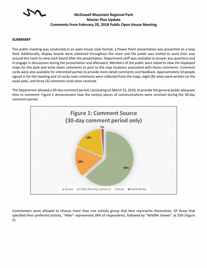
McDowell Mountain Regional Park Master Plan Update
Comments from February 20, 2018 Public Open House Meeting
SUMMARY This public meeting was conducted in an open house style format; a Power Point presentation was presented on a loop feed. Additionally, display boards were stationed throughout the room and the public was invited to work their way around the room to view each board after the presentation. Department staff was available to answer any questions and to engage in discussions during the presentation and afterward. Members of the public were asked to view the displayed maps for the park and write down comments to post to the map locations associated with those comments. Comment cards were also available for interested parties to provide more detail comments and feedback. Approximately 10 people signed in for the meeting and 14 sticky note comments were collected from the maps, eight (8) notes were written on the easel pads, and three (3) comment cards were received. The Department allowed a 30-day comment period, concluding on March 22, 2018, to provide the general public adequate time to comment. Figure 1 demonstrates how the various pieces of communications were received during the 30-day comment period.
Commenters were allowed to choose more than one activity group that best represents themselves. Of those that specified their preferred activity, “Hiker” represented 38% of respondents, followed by “Wildlife Viewer” at 33% (Figure 2).

McDowell Mountain Regional Park Master Plan Update
Comments from February 20, 2018 Public Open House Meeting
Department planning staff reviewed the 21 surveys received. Out of those 21 surveys, the Department planning staff recognized 94 unique comments. Further, out of the 94 unique comments, 22 (or about 23 percent) were considered to the out of the scope of the Master Plan Update. Out of scope means that the comment or suggestion is already covered by another planning document; it may also mean that the comment pertains to an operational matter; or it may mean that the comment does not otherwise fall under the purview of a master plan. Other comments deemed out of scope may also be too generalized or vague to work with. In any case, all comments were forwarded to park management for their reference.
Table 1: Unique and Out of Scope Comments Unique Comments:* 94 Out of Scope Comments: 22 Percent out of scope 23%
*One comment card may have contained more than one type of comment. Total will exceed number of respondents.
A master plan does not dictate hours of operation, staffing, programing or other day-to-day activities. A master plan also does not dictate activities that occur outside of park boundaries. As noted at the public meeting, the purpose of a master plan is to outline the long-range vision for the park as well as development priorities that will provide for both the public’s enjoyment and the protection of the park’s resources. A master plan also:
• Serves as a guide and policy document for current and future park staff, partnering agencies, elected officials, and interested members of the public.
• Guides management of natural, cultural, and recreational resources. • Considers a range of issues such as staffing, funding, encroachment, wildlife corridors, public needs, and more.
• Considers staff, stakeholder, and public recommendations.
9%
38%
33%
5%
10%5%
Figure 2: Survey Monkey Prefered activity by survey taker Respondants
(30-day comment period)
Mountain Biker/Biker Hiker Wildlife Viewing Runner Camper Equestrian

McDowell Mountain Regional Park Master Plan Update
Comments from February 20, 2018 Public Open House Meeting
• Identifies park enhancement opportunities including possible upgrades to park facilities, recreation infrastructure, restoration opportunities, etc.
The remaining substantive comments will be further evaluated and potentially carried forward into the recommended park improvements for the master plan. Table 3 details each unique comment received.
Public Meeting #1
30-Day Public Comment Period
Method Comment Out of Scope
Comment Card Add 25 plus RV sites
Comment Card Add a nature play area
Comment Card Partner with SWCC for a wildlife rehabilitation and education center
Map Sticky note Keep the open spaces as much as possible, preserve the natural space and beauty x
Map Sticky note More educational programing i.e. geology x
Map Sticky note Add a flow trail that is one direction
Map Sticky note Add campsites to camp ground
Map Sticky note Add a trail extending north to south through the center of the park connecting or crossing east to west trails
Map Sticky note Add trails to the competitive track area
Map Sticky note Obtain state land near the southeast corner of the park x
Map Sticky note Add access point northeast of the southeast boundary corner
Map Sticky note Add access point from state land area
Map Sticky note Add more trails on Lousley Hill
Map Sticky note Add a shade structure to CO right at map label
Map Sticky note Add a bike lane along the road throughout the park
Map Sticky note Add hike/bike in camping near the northwest corner of the park
Map Sticky note Make use of the mountains encompassed by the sport loop at the comp track
Map Sticky note Add campsites to camp ground
Easel pads Walking trails separate from biking trails Easel pads Demo gardens of native plant life Easel pads Signage to provide mileage x
Easel pads Consistent signage going to the Tonto National Forest x
McDowell Mountain Regional Park Master Plan Update
Comments from February 20, 2018 Public Open House Meeting
Easel pads Web events notice 1 month out x
Easel pads ADA Trails (paved)
Easel pads Add campsites to campground
Easel pads More garbage disposal at competitive track x
Survey Monkey - Question #3: After reviewing the original 1967 Master Plan map, is there anything you would like to see kept in the updated plan? Survey Monkey No. It was horrible! x
Survey Monkey Western Historical History Interpretation and Displays
Survey Monkey additional access points like the north gate
Survey Monkey A ridgetop hiking trail on Lousley Hills
Survey Monkey I would love to see something like Southwest Wildlife there.
Survey Monkey The camping area and youth areas.
Survey Monkey ALL x
Survey Monkey hiking, wildlife viewing
Survey Monkey Wildlife preservation x
Survey Monkey Educational facilities from Southwest Wildlife. They do great work.
Survey Monkey Hiking Trails
Survey Monkey More wildlife. x
Survey Monkey The desert cattle ranching is no longer a viable activity. The update should include all previous endeavors to keep the area "natural". x
Survey Monkey Keep everything the same as it is but add Another loop for rv camping and bring in more revenue. The natural beauty and remoteness is what makes this park so unique.
Survey Monkey Youth camps
Survey Monkey no x
Survey Monkey a second entrance
Survey Monkey Less camping
Survey Monkey Interpretive exhibits
Survey Monkey No. It was horrible! x
Survey Monkey Question #4: After reviewing the current park map, what do you like about the park?

McDowell Mountain Regional Park Master Plan Update
Comments from February 20, 2018 Public Open House Meeting
Survey Monkey Extensive trail system.
Survey Monkey I like the Nursery Tank barrier free trail but it needs updating and I would like to see a full loop trail there with interpretive displays and covered picnic area that is ADA as well.
Survey Monkey I like the camping near the north east corner of the park but I wish there was an area for pop up trail camping that was better suited to that style of camping. Maybe a gravel area with parking, picnic tables and fire pits similar to the tent area but less expensive than the traditional RV slots.
Survey Monkey I think Southwest Wildlife would be an excellent addition and draw to the park.
Survey Monkey The hiking trails
Survey Monkey Well marked hiking trails
Survey Monkey open natural desert
Survey Monkey The size.
Survey Monkey The trail maps provided and convenient parking.
Survey Monkey Real Arizona not an amusement park
Survey Monkey Nice hiking biking trails
Survey Monkey Location and opportunities for outdoor activities
Survey Monkey Easy to camp and hike
Survey Monkey I love the trails, the opportunity to be outside in such a great area. We see wildlife regularly. its great.
Survey Monkey I love the natural state of the environment, the ability of wildlife to survive unchallenged by development.
Survey Monkey The variety of trails and uses is perfect. Again, keeping the acreage natural cannot be more alluring. It should not be developed to be just another “arcade tombstone”. Possibly a Native American interactive lead talk to reveal how a people could live here for so many years but keep and respect the land.
Survey Monkey Multi-use trails
Survey Monkey Great trail system and links to other parks
Survey Monkey Lots of hiking trails, limited number of people, no or less horses on trails, lots of natural desert area
Survey Monkey lots of trails!
Survey Monkey More trails x

McDowell Mountain Regional Park Master Plan Update
Comments from February 20, 2018 Public Open House Meeting
Survey Monkey I like the Nature Center.
Survey Monkey Question #5: Of the existing amenities and services, what would you like to see more of in the future? Survey Monkey Interpretive trails that focus on inclusivity such as ADA and sensory displays, i.e. sound
garden. More historical programing.
Survey Monkey More walking trails and opportunities to see local wildlife
Survey Monkey More paved trails for the elderly. I myself like more challenging hikes however my dad who is 77 is still a hiker and now shuffles when he walks and can easily be disoriented by things such as bikers on trails. He still loves to get out there and hike and I believe that this park is perfect to create more trails the elderly can go on that are paved and easy to walk. Also add in more informational signs along the way discussing the terrain and animals to further educate both the old and the young about the beautiful dessert we live in.
Survey Monkey I would like to allow the SWCC (SOUTHWEST WILDLIFE CONSERVATION CENTER) to relocate on public land. It is a fantastic facility and should NOT be in a residential area.
Survey Monkey organized educational hikes, wildlife viewing x
Survey Monkey Green space and wildlife viewing.
Survey Monkey Restroom facilities at locations that do not offer them presently.
Survey Monkey They are minimal and should be kept that way. x
Survey Monkey There are a lot of amenities but would like to see animal education programs x
Survey Monkey Wildlife education x
Survey Monkey More wildlife x
Survey Monkey trails - but there are already lots.
Survey Monkey More information and history about the area would be most welcome. x
Survey Monkey An additional campers loop
Survey Monkey Wildlife Viewing areas
Survey Monkey Trails, expanded comp loops
Survey Monkey I think it is just right as it is now. x
Survey Monkey more wildlife viewing opportunities
Survey Monkey more trails just for hikers
Survey Monkey Trailheads on the north side of the park
Survey Monkey Nature center.

McDowell Mountain Regional Park Master Plan Update
Comments from February 20, 2018 Public Open House Meeting
Survey Monkey Question #6: What amenities and services would you like to see added to the park in the future?
Survey Monkey Trail connecting Nature Center (Tortoise Trail) with Wagner Trail. A new Nature Center.
Survey Monkey Horse rentals and a rope course.
Survey Monkey Southwest Wildlife
Survey Monkey An entrance similar to the McDowell Sonoran Conservancy (Lost Dog Wash Trailhead & Gateway Trailhead) would be great! It is very inviting, bathrooms are right at the start of the main trailheads and on weekends when I have gone I have seen people there promoting the parks and trails along with the fact that there are large trail map signs and handouts available.
Survey Monkey wildlife viewing areas
Survey Monkey A wildlife sanctuary and education about native wildlife.
Survey Monkey More to promote Arizona wildlife x
Survey Monkey Animal Education programs like Southwest Wildlife
Survey Monkey Southwest Wildlife Conservation education center and future expansion
Survey Monkey More camping and hiking. View wildlife.
Survey Monkey If Southwest Wildlife wanted to add an education center or expand their facilities into the park, I would be all for that.
Survey Monkey Southwest Wildlife is nearby but, if relocated to the park, could offer a golden opportunity to view wildlife in captivity.....an additional draw to the park for the general public and an added attraction to entertain and educate.
Survey Monkey Wildlife Sanctuary, more information about native wildlife
Survey Monkey Better restrooms and showers
Survey Monkey Hiking trails if anything.
Survey Monkey Southwest Wildlife Conservation Center!
Survey Monkey Expanded nature center.
Survey Monkey : Additional Comments Survey Monkey Best location for SWCC is near Nature Center because the area already has a lot of
development; don't place it in less-developed areas to the north. Dust mitigation at Four Peaks Staging Area ahead of Ragnar during dry years.
Survey Monkey Expand the areas for special events and add more restrooms

McDowell Mountain Regional Park Master Plan Update
Comments from February 20, 2018 Public Open House Meeting
Survey Monkey I believe that the trails such as the Sonoran Trail should be listed on maps as the entire trail length not just the portion on the McDowell Mountain Regional Park side alone. It would help bring more people into this park to hike trails that are more challenging
x
Survey Monkey The gated neighborhood where the Dixie Mine Trail & the Sonoran Trail can be accessed in Fountain Hills really don't make us hikers feel welcome by deciding to be closed on certain holidays and having the gateman remind you as you walk in when the community gates are closed to the public. If this trailhead could be moved to a location where we feel invited that would be awesome. I love our parks for the beauty of nature and the challenges of hiking them and would love to help where I can.
Survey Monkey none
Survey Monkey it would be a great area for wildlife from SWCC to be available for public viewing at the park
Survey Monkey The preserve offers beautiful scenery and wildlife viewing as well as educational opportunities. Continuation of these opportunities is appreciated. x
Survey Monkey Keep it as natural Arizona as possible x
Survey Monkey Keep up the good work. x
Survey Monkey Addition of Southwest Wildlife Conservation Center would be perfect for the park!
Survey Monkey Love the attention to our desert in one of its purest forms. x
Survey Monkey The current layout is extremely unique and should not be altered just for more revenue x
Survey Monkey Space and accommodations for Southwest Wildlife Conservation Center
Survey Monkey Would like to see better connections from comp loop to the rest of the trail system
Comments submitted via email and Facebook Email Consider a coin-operated laundry facilities for the RV campground. The closest
laundromat is the Eagle View RV Resort at Fort McDowell.
Email I think it is a good idea to move the North trail head to the restroom.
Email The North Trail needs to be updated. Some of the points of interest markers are in poor condition and some of the indicated plants no longer exist. x
Email If the Verde Trail reroute to the Pemberton Trail is built it may be wise to close the North Trail to bikes. The North Trail is popular with the elderly snowbirds and kind of tight for shared traffic.
x
Email A shower facility in the tent camping area would be appreciated.
Email The picnic area needs a few small shade Ramada’s.
McDowell Mountain Regional Park Master Plan Update
Comments from February 20, 2018 Public Open House Meeting
Email If glamping cabins or safari platform tent are trialed then shower and bathroom facilities need to be close by.
Email Consider an astronomy area in the area of the proposed nature area. Some circular pads for setting up telescopes close to a parking area. The area needs to be away from street lights and auto headlights. Perhaps screened from the parking lot. Other suitable areas would be the picnic area or Minks Camp. Good astronomy viewing sites are starting to become travel destinations.
Email Dixie Mine Area: A trail heading North or North East from the Dixie Mine trail head that connects to the Dixie Mine trail to create a five mile loop.
Email Scenic Trail: Create a link trail near the North end that heads Northeast to the Lousley Hill trail.
Email Granite Trail: Run a trail from the rock piles near the West region of the Granite Trail near the old concrete tank West to the Pemberton Trail. There are a number of interesting rock formations in this area.
Email Old Minks Camp trail: Restore the Minks Camp (MC) trail and extend it from Minks Camp site past the Youth Group Area and connect it to the Verde trail.
Email The Clay Pit SW of the Pemberton Pond that is eroding away the Pemberton Trail. Use a crawler dozer and push the clay spoil piles back into the pit to prevent erosion of the pit walls next to the Pemberton Trail.
x
Email Four Peaks Staging Area needs a restroom facility or portable restrooms. Also the lot needs grading more frequently. Some sizable ruts form that are a bit much for sedans.
Email The Pemberton Pond and ranch house site area needs some maintenance. It is starting to look kind of ragged.
x
Email More signage about keeping dogs on a leash (retractable leashes are a hazard) at all times in all areas of the park. We've encountered dogs off leash both on the trails and in the campground (our dog was actually attacked in the campground by a dog that got past its owner).
x
Email Even with the poop bags supplied throughout the park, it's amazing the amount that is not picked up by dog owners on the trails (there's coyote poop too, but you can tell the difference, and there's a lot more dog poop). Maybe more visible signage about cleaning up after pets.
x
Email Covers on all volunteer sites.
Email With the addition of the restroom at Four Peaks Staging Area, probably 2 or 3 volunteer sites so there is someone keeping an eye on things down there since it's so far removed from the campground. You would probably need at least 2, if not 3, because it would probably be overwhelming for 1 host to be there alone. We noticed many people would wait until they knew the entry station was closed to come into the park. We've also encountered vagrants in the park.
x
Email Camp host site at tent area. The current camp host has to travel miles to check on the tent camping area. And, as mentioned above, many people come in after the entry station is closed and leave before volunteers/employees are have a chance to make their rounds.
Email We've seen many people cutting through the desert part (center of the loops) of the campground to go visit friends on the other side or to go to the restroom. We saw that

McDowell Mountain Regional Park Master Plan Update
Comments from February 20, 2018 Public Open House Meeting
Usery has some designated paths so that people aren't blazing their own trails. Maybe not a bad idea for MMRP?
Email Wi-Fi in the Visitor Center for volunteers or in the campground. Many campers upon checking in at the entry station would ask if the campground had wi-fi. I guess there are many State Parks (not sure which States) that have wi-fi available in the campground. The cell phone coverage at MMRP is very sketchy, so this would really help if not for all campers, at least for the volunteers.
Email At the last meeting there was talk about another campground loop for short term
camping. We could definitely use more campsites. x
Email Any additional activities (additional playground, zip line, etc.) would probably be best somewhere near the Competitive Track. The campground is nice and peaceful (except the playground at times can be loud), I think that is one if the things that draws people to camp here. It's not like a commercial campground. Like you said at the meeting, there's such thing as loving the park to death. When there are big events near the Competitive Track, you couldn't even tell anything was going on from the campground, which was nice.
Email It was mentioned at the last meeting about having a different way for the police to access the compound. I know it's bc they might not drive 15mph through the campground, but I think that police presence is always a good thing. It's better to have people see them driving through than not see them, to deter unlawful activity. If they had a different access to the compound, they might never drive through. (Also, I think the park is thinking about installing speed bumps throughout the campground. We would strongly encourage this. It would slow everyone down without the added inconvenience/expense of putting in a new road).
Email Any new volunteer sites (if possible) would be best if they faced north. Most of them
face south and if they have a Class A Motorhome, the windshield gets the afternoon sun and it's harder to keep cool.
Facebook Response
Create a new RV camping loop
Facebook Response
Add laundry facilities to the camping area

McDowell Mountain Regional Park Master Plan Update
Comments from November 5, 2018 Public Open House Meeting
SUMMARY
This public meeting was conducted in a presentation style format; a Power Point presentation was given along with questions and answers throughout the presentation. Additionally, display boards were stationed throughout the room and the public was invited to work their way around the room to view each board after the presentation. Department staff was available to answer any questions and to engage in discussions during the presentation and afterward. Comment cards were available for interested parties to provide their comments and feedback. Approximately 21 people signed in for the meeting and twelve (12) comment cards were received by the end of the open house. The Department allowed a 30-day comment period, concluding on December 5, 2018, to provide the general public adequate time to comment. Figure 1 demonstrates how the various pieces of communications were received during the 30-day comment period.
Commenters were allowed to choose more than one activity group that best represents themselves. Of those that specified their preferred activity, “Bicyclists / Mountain Bikers” represented 96% of respondents, followed by “Hiker/Runner” at 4% (Figure 2).
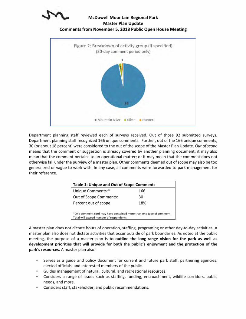
McDowell Mountain Regional Park Master Plan Update
Comments from November 5, 2018 Public Open House Meeting
Department planning staff reviewed each of surveys received. Out of those 92 submitted surveys, Department planning staff recognized 166 unique comments. Further, out of the 166 unique comments, 30 (or about 18 percent) were considered to the out of the scope of the Master Plan Update. Out of scope means that the comment or suggestion is already covered by another planning document; it may also mean that the comment pertains to an operational matter; or it may mean that the comment does not otherwise fall under the purview of a master plan. Other comments deemed out of scope may also be too generalized or vague to work with. In any case, all comments were forwarded to park management for their reference.
Table 1: Unique and Out of Scope Comments Unique Comments:* 166 Out of Scope Comments: 30 Percent out of scope 18% *One comment card may have contained more than one type of comment. Total will exceed number of respondents.
A master plan does not dictate hours of operation, staffing, programing or other day-to-day activities. A master plan also does not dictate activities that occur outside of park boundaries. As noted at the public meeting, the purpose of a master plan is to outline the long-range vision for the park as well as development priorities that will provide for both the public’s enjoyment and the protection of the park’s resources. A master plan also:
• Serves as a guide and policy document for current and future park staff, partnering agencies, elected officials, and interested members of the public.
• Guides management of natural, cultural, and recreational resources. • Considers a range of issues such as staffing, funding, encroachment, wildlife corridors, public
needs, and more. • Considers staff, stakeholder, and public recommendations.

McDowell Mountain Regional Park Master Plan Update
Comments from November 5, 2018 Public Open House Meeting
• Identifies park enhancement opportunities including possible upgrades to park facilities, recreation infrastructure, restoration opportunities, etc.
The remaining substantive comments will be further evaluated and potentially carried forward into the recommended or preferred alternative for the master plan. Many of the trail related comments will be deferred until the next Trail System Plan update and/or Trail Maintenance Manual update as many of the trail related comments would require a change in established trail use guidelines or perhaps park policy and that is beyond the scope of this Master Plan Update. Table 2 details each unique comment received.
Table 2 - Public Meeting #2 30-Day Public Comment Period
Method Comment Out of Scope
Comment Card Consider adding another trail that would connect the Cedar Tank area to the Campground area. Currently the only option from the norther side of Pemberton is via Lariat and the Pemberton to PBTH to the Visitor Center but you have to use the road to get to parking by the RV dump station. A nice flowing trail similar to the Lariat or Delsie would be great and provide an alternative for mountain bikers/hikers, other than PB.
Comment Card Add additional loops to the competitive track.
Comment Card Design and build a skills park
Comment Card Consider using the old alignment of the Pemberton Trail as the west boundary.
Comment Card Consider making the flow trail go from the Scenic High Point to the Escondido
Comment Card Ensure that all lighting outside (path lights, playground lights, etc) are IDA approved and intelligently designed to avoid any light pollution or "Uplight." Also buildings where interior lights may be on at night should have blackout shades installed.
x
Comment Card The term "Concessionaire" concerns me. I would not want a food service concession or any type of entertainment venue in this park.
Comment Card Add new trails from Fountain Hills east of Dixie Mine connecting to Dixie Mine Trail.
Comment Card I hope the park can leverage its existing dark skies and follow the lead of the National Parks to become a "dark Sky park." This will increase the parks off-hour visitation and tie in well with Fountain Hills recent IDA Dark Sky Community designation.
x
Comment Card Extend Hilltop Trail along the ridge and connect to Scenic Trail. If implemented, it would be okay to close a portion of the Scenic Trail that is bypassed if desired.
Comment Card Make McDowell a Dark Sky Park x Comment Card Please consider the Scenic Trail as a hikers only Trail
Survey Monkey - Question #3: After reviewing the proposed park amenities, which would you like to see developed first?
Survey Monkey I would like to see the bike skills park. Survey Monkey Trails, flow and additional comp loops Survey Monkey MTB park Survey Monkey An additional mountain bike trails

McDowell Mountain Regional Park Master Plan Update
Comments from November 5, 2018 Public Open House Meeting
Survey Monkey new loops and flow trail Survey Monkey Skills park & trails Survey Monkey Mountain bike skills park. Survey Monkey Bike skills park Survey Monkey Bike skills and flow trails and flow tracks. Survey Monkey Mountain Bike Skills Park Survey Monkey The Flow trail and the Skills park. Survey Monkey flow trail and a skills bike park! Survey Monkey Competitive loop trails added to, add flow trail and skills park Survey Monkey Mountain biking skill course Survey Monkey As a runner first and a mountain biker second, it would be great to see additional trails
and trailheads built in the park. I think additions to the competitive loop and a bike park would reduce congestion on the main trails as well between runners, hikers, bikers, and equestrians.
Survey Monkey Bike trails and skills park Survey Monkey Bike park Survey Monkey For track. Survey Monkey Skills Bike Park Survey Monkey Flow Trail Survey Monkey Mountain bike skills trails and park Survey Monkey More jump lines Survey Monkey Expand the bike park and flow trails. Look at what Flagstaff did at Fort Tuthill as an
example
Survey Monkey The flow trail Survey Monkey Bike park Survey Monkey Bike skills park Survey Monkey Bike skills park and flow trails Survey Monkey Bike park Survey Monkey competitive Track Extension Survey Monkey Interpreter trail/skill trail would be a great addition to the already great flow trails
existing.
Survey Monkey Bike/Skills park Survey Monkey Bike park/flow trail Survey Monkey Four peaks skill park Survey Monkey Any amenities that pertain to the trails. Particularly MTB. x Survey Monkey Mountain bike skills park, flow track, pump tracks. Survey Monkey Mtb skills park. We have NOTHING like this in the Valley. And for this being a destination
for bikers and a city of this size?
Survey Monkey Bike skills park Survey Monkey Mountain bike park Survey Monkey flow track for mountain bikes... especial an advanced trail Survey Monkey Flow trail/bike skills area Survey Monkey The proposed mountain bike trails would definitely draw me back to McDowell
Mountain Regional Park, and make a yearly pass worth it.

McDowell Mountain Regional Park Master Plan Update
Comments from November 5, 2018 Public Open House Meeting
Survey Monkey Expansion of the competitive loops and bike skills park Survey Monkey Skill park Survey Monkey Bike park and new trails to the Competitive Track area. Survey Monkey Mountain bike trails Survey Monkey Skills park Survey Monkey Flow trail Survey Monkey Bike skills/drills course for improving riding abilities Survey Monkey Skills park, flow trail. Survey Monkey Bike parks and skills trails Survey Monkey A Bike park with jump lines, skill areas, etc. Survey Monkey I'd love to have a proper mountain bike skills/flow course. People currently ride some
questionable DIY tracks out in the desert to get this experience, so having something that is groomed and maintained would bring them in and keep them safer.
Survey Monkey Mountain biking skills area. Survey Monkey Bike skills park. We’re sorely lacking a skills progression park in the Valley. Flagstaff and
Sedona have done some amazing things lately with theirs.
Survey Monkey Mountain Bike Skills Park and New trails Survey Monkey Flow trail Survey Monkey Bike skills park and flow trail. Survey Monkey Flow/jump lines Survey Monkey Skills area Survey Monkey The addition of a mountain bike skills park and flow trails would be amazing. Survey Monkey Competitive Track Extensions Survey Monkey Skills bike park Survey Monkey skills park Survey Monkey Extensions to the comp loops and bike park Survey Monkey The bike skills park Survey Monkey Flow trail. Survey Monkey The flow trail and mountain bike skills area! Survey Monkey Flow trail/skills park Survey Monkey The mountain bike skills park and flow trail would be phenomenal!! Survey Monkey Bike/Skills Park and Flow Trail please! Survey Monkey Skills bike park. Survey Monkey Bike flow trail, bike skills park, etc. Survey Monkey Personally I like the expansion of multi use ( hikers, bikes and horses) trails. Bike parks
are becoming more and more popular across the US. If done properly this could have a strong economic impact for the area.
Survey Monkey Bike skills park

McDowell Mountain Regional Park Master Plan Update
Comments from November 5, 2018 Public Open House Meeting
Survey Monkey The mph train bike areas look fantastic. I’ve been mountain biking in McDowell Mtn Park since 1989 and would love to see even more expansion.
x
Survey Monkey Do not build the cabins! Leave that area pristine. Use the money for more environmentally friendly projects.
Survey Monkey Flow trail / Bike skills park, I like the idea of a paved ADA path Survey Monkey Bike Skills Park Survey Monkey Mtb park Survey Monkey Mountain bike park Survey Monkey PLEASE develop mountain bike flow trail and skills park as soon as possible. It will greatly
enhance McDowell Mountain Park as a premier mountain biking destination!!
Survey Monkey I’d really like to see the bike skills park. I’m always amazed how younger riders, including my children, enjoy them.
Survey Monkey More MTB trails and skills park. Survey Monkey Updating the mountain biking trails and adding the skills park and flow trail. Survey Monkey Bike skills area Survey Monkey Mountain Bike Skills park / flow trails / etc. Survey Monkey flow trail Survey Monkey Four peaks skill park Survey Monkey A mountain bike skills and bike park. There is nothing like that anywhere in the valley
and this will attract East valley riders. There are no trails in the valley that offer purpose built jump lines that beginners and advanced riders can enjoy.
Survey Monkey Restrooms with showers for tent camping (so they don’t have to use the main loop showers).
Survey Monkey Campground extension to generate revenue. Verde Trail Extension and Flow Trail. Survey Monkey New Trails & MTB Skills Park Survey Monkey Question #4 - Of the proposed park amenities identified, are there any others you would like to see incorporated into the updated master plan? Survey Monkey Cheap tent camping Survey Monkey I would like to see additional youth primitive group camping sites Survey Monkey Restricted snow bird camping. It's too hard to get a spot in the winter since they bounce
every 14 days to another spot. x
Survey Monkey Downhill trail/ track that has varying difficulty Survey Monkey Water Points on the trails Survey Monkey Maintenance of existing trails to keep us all safe. Banked corners. Removal of wooden
"bridge" on Pemberton that are about to fall apart, could cause injury to biker or hiker x
Survey Monkey Flow track Survey Monkey Bike park for jump progression, drops, etc. Survey Monkey Flow and pump tracks Survey Monkey Skills Park Survey Monkey wooden drops in skills area
McDowell Mountain Regional Park Master Plan Update
Comments from November 5, 2018 Public Open House Meeting
Survey Monkey Bike park Survey Monkey More mountain bike trails Survey Monkey Bike park Survey Monkey No at this time. This 2 new additions are a great idea x Survey Monkey Bike repair station Survey Monkey Pump track Survey Monkey This is an awesome park. Continue past practice. Thank You. x Survey Monkey Additional MTB or multi use trails. Survey Monkey ADA amenities (trail, camping) Survey Monkey More trails Survey Monkey Food and drinks with in the park always come handy even if it is food truck at least
during the week ends x
Survey Monkey A separate lane at the entry station for yearly pass holders. Could also be used as a bypass for regular park users during events.
Survey Monkey Mountain bike trails Survey Monkey Flow trails Survey Monkey Additional dedicated trails for mountain biking around competitive loops. Survey Monkey The flow trail in between cinch and Shallomo Survey Monkey Mountain bike flow/jump line. Survey Monkey Mountain Bike Skills Park Survey Monkey More trail markers Survey Monkey Any additions to the competitive loops would be beneficial. Survey Monkey No, proposed plan looks great x Survey Monkey I really want the skills park. Survey Monkey Pump track Survey Monkey As many new mountain bike trails as possible with jumps! Survey Monkey More competitive track trails or trails with a relative high amount of elevation change Survey Monkey More technical trails. Survey Monkey Do not build the cabins! Leave that area as pristine open space. Survey Monkey Mountain bike flow trail and skills park Survey Monkey Showers at the primitive camping Survey Monkey More MTB trails and skills park. Survey Monkey “Fix it” stations for bikes located at the comp loops and at the new trail heads Survey Monkey Any additional mountain bike trails would be great x Survey Monkey Expand the bike park to include modern flow trails. Mountain biking has evolved and the
valley hasn't done anything to stay up to date on riding.
Survey Monkey Add a trail extending north to south through the middle of the park, connecting the major East to West trails.
Survey Monkey Consider coin-operated laundry facilities for the RV campground.

McDowell Mountain Regional Park Master Plan Update
Comments from November 5, 2018 Public Open House Meeting
Survey Monkey A shower facility in the tent camping area would be appreciated.
Survey Monkey Consider an astronomy area in the area of the proposed nature area. Some circular pads for setting up telescopes close to a parking area. The area needs to be away from street lights and auto headlights. Perhaps screened from the parking lot. Other suitable areas would be the picnic area or Minks Camp. Good astronomy viewing sites are starting to become travel destinations.
Survey Monkey - Additional Comments Survey Monkey Love this park and this will make it even better x Survey Monkey Sedona did a skills, please move quickly to improve the park. x Survey Monkey I like the idea of keeping our land and parks natural. No more concrete needed. x Survey Monkey With the exception of a bike park and potentially additional showers, please keep
everything else as close to natural as possible. The park is beautiful and much of the joy of recreation in the park comes from its natural setting.
x
Survey Monkey Pump Track Survey Monkey Great Trails! x Survey Monkey More bike park and fun trails please! 😁😁 Survey Monkey Thank you for your support to this outdoor community. x Survey Monkey All for this park renovation!! Hope it gets the attention it deserves x Survey Monkey A park of the caliber that is in the master plan would be an amazing addition to the
Valley! x
Survey Monkey MMRP is the best asset in greater Phoenix. Have loved it since 2001. x Survey Monkey Excited for what is to come! x Survey Monkey Thanks and looking Fw for the new developments x Survey Monkey All events should have a cap on total registrants. Some of the current events (RAGNAR)
are too big for this park and should not be allowed. There should also be a refundable deposit for all events. If the park is returned to as good as or better shape after the conclusion of the event the deposit is returned. If not, the deposit is used for clean-up (horse shit) and/or repairs.
x
Survey Monkey I'm just excited to see improvements coming. Mountain biking seems to growing at a rapid pace.
x
Survey Monkey I'm excited to see the updates to the park, it's one of my favorite places to ride. x Survey Monkey Please build a skills park. Survey Monkey Thank you for listening to the mountain bikers. x Survey Monkey The plan looks great. Build it and they will come. x Survey Monkey Thank you! x Survey Monkey Do not build the cabins! Leave the area pristine. Survey Monkey Bike skills park would be a great addition. Survey Monkey Any additional trails would be wonderful! x Survey Monkey This will attract more riders than ever before. x Survey Monkey We love McDowell. We camp here several times per year and bike here at least once per
month. x

McDowell Mountain Regional Park Master Plan Update
Comments from November 5, 2018 Public Open House Meeting
Survey Monkey I'm a day user only, but since the majority of the revenue comes from camping fees, it makes sense to add amenities for campers.
x
Comments Submitted via email
Email Consider a coin-operated laundry facilities for the RV campground. The closest laundromat is the Eagle View RV Resort at Fort McDowell.
Email We would like to see hunting banned at McDowell Pk or limited to an extremely small area. We have had several unfortunate encounters with hunters, & feel that with the expanded staging & camping areas, the potential for park patrons to be injured by a stray bullet will be even further increased.
We have on multiple occasions had shots fired very close to us while walking down to the pond, & had to yell at the hunter to stop. We have encountered a hunter literally sitting in a lawn chair in camo clothing with what looked like a rifle right next to the pond. We have also heard shots in other areas, but not as close.
Hunters don't stay on the trails (damaging the desert plants) & there is no way to enforce the distance they are supposed to stay away from trails. We have talked to several park employees about this, & they all said that they would like to see hunting banned at the park, & that they have expressed that opinion multiple times.
It is very disconcerting to feel that we are putting our lives at risk by simply walking down to the pond. With so many activities going on at the park, having hunters randomly shooting all over the place is an accident waiting to happen. Eventually someone will be shot & injured or killed.
x
Email Surveys Many of the comments at the public open houses and follow up were about hiking trails. Mountain bikers are 58.9% of the users and surprisingly few comments about mountain biking. Wondering if the mountain bikers are coming from a larger area than Rio Verde and Fountain Hills.
x
Email Fountain Hills Resident - I am concerned about having cabins in the park. I can’t bike on trails due to knee surgery so I use the roads and I don’t want to see more traffic in this area or cabins. I think this area is beautiful and I don’t want to see it ruined just for the placement of a few cabins.
x
Email Future Revenue Raise the fee for the day users and the annual passes. As a purchaser of an annual pass, I would be happy to pay more for the annual pass or an additional fee to keep the Park as it is. You will immediately start putting money into the parks fund with no debt or maintenance costs.
x
Email Proposed Park Amenity Request What are the costs of the proposed projects? Costs should include planning costs including staff time, engineering and architectural costs, infrastructure, operation and
x

McDowell Mountain Regional Park Master Plan Update
Comments from November 5, 2018 Public Open House Meeting
maintenance costs, and cost of capital. Also, there is the additional cost of destruction of acres of Upper Sonoran Desert.

Appendix B Water Resources

Asher Hills
FORT McDOWELL
YAVAPAI NATIONWash
Shallmo Dr
SONORAN
Shallmo W
128th
St
MO
UN
TA
INS
Mc D
OW
EL L
En d
E as t
Stoneman Wash
McD
owell
Mou
ntain
Rd
MarcusLandslide
PRESERVE
McDOWELL
Fountain HillsMcDowell Mountain
Preserve
Mountain
DrGate Rd
Pemberton
RanchPark
L o u s l e yH
i l l s
Gold en Eag le Blvd
RIO
VERD
E
FOUNTAINHILLS
SCOTTSDALELousely Hill-Verde River
Pemberton Ranch Area
Fort McDowell-Verde River
Thompson Peak
Malpais Canyon-Verde River
Paradise Valley
McDowell Mountains
Lower Verde
Lower Salt
Hydrologic Unit Code*
*Definitions derived from EnviroAtlas - HydrologicUnit Codes: HUC 4, HUC8, and HUC 12.
HUC 12: Local sub-watershedlevel - captures tributary systems
HUC 8: Subbasin level - medium-sized river basins
McDowell MountainRegional ParkWatersheds
DISCLAIMER: This map is a graphical representationdesigned for general reference purposes only. Viewer/Useragrees to indemnify, defend and hold harmless MaricopaCounty, its officers, departments, employees and agentsfrom and against any and all suits, actions, legal oradministrative proceedings, claims, demands or damages ofany kind or nature arising out of the use of this map, or thedata contained herein, in its actual or altered form.
2/8/2019
Maricopa CountyParks and Recreation Department
Scale = 1:48,000
2000 0 2000 4000 6000 8000 Feet
500 0 500 1000 1500 2000 2500 Meters

Wash
Shallmo Dr
RIOVERDE
Shallmo W
128th
St
Stoneman Wash
McD
owell
Mou
ntain
Rd
McD
owell
Mountain
Dr
SCOTTSDALE
Gate Rd
Pemberton
RanchPark
Golden Eagle Blvd
FORT McDOWELL
YAVAPAI NATION
FOUNTAINHILLS
RockKnob
MarcusLandslide
EastEnd
Mc D
OW
EL L
MO
UN
TA
INS
Asher Hills
SONORAN
McDOWELL
PRESERVE
Fountain HillsMcDowell Mountain
Preserve
L o u s l e yH
i l l s
McDOWELL MOUNTAIN
REGIONALL PARK
McDowell Mountain Regional ParkFlood Zone
A: Areas subject to inundation by the 1-percent-annual-chance flood event generally determined using approximatemethodologies. Because detailed hydraulic analyses havenot been performed, no Base Flood Elevations (BFEs) orflood depths are shown. Mandatory flood insurance purchaserequirements and floodplain management standards apply.
AE. Areas subject to inundation by the 1-percent-annual-chance flood event determined by detailed methods. BaseFlood Elevations (BFEs) are shown. Mandatory floodinsurance purchase requirements and floodplainmanagement standards apply.
AE (Floodway): The floodway is the channel of a stream plusany adjacent floodplain areas that must be kept free ofencroachment so that the 100-year flood can be carriedwithout substantial increases in flood heights.
D: Areas in which flood hazards are undetermined, butpossible.
X: Areas of 0.2% annual chance flood; areas of 1% annualchance flood with average depths of less than 1 foot or withdrainage areas less than 1 square mile; and areas protectedby levees from 1% annual chance flood.
Flood Zone (FEMA Effective)Baseline (FEMA Effective)
A
AE
AE (Floodway)
D
X
Scale = 1:48,000
2000 0 2000 4000 6000 8000 Feet
500 0 500 1000 1500 2000 2500 Meters
DISCLAIMER: This map is a graphical representationdesigned for general reference purposes only. Viewer/Useragrees to indemnify, defend and hold harmless MaricopaCounty, its officers, departments, employees and agentsfrom and against any and all suits, actions, legal oradministrative proceedings, claims, demands or damages ofany kind or nature arising out of the use of this map, or thedata contained herein, in its actual or altered form.
2/8/2019
Maricopa CountyParks and Recreation Department


Appendix C Earth Resources
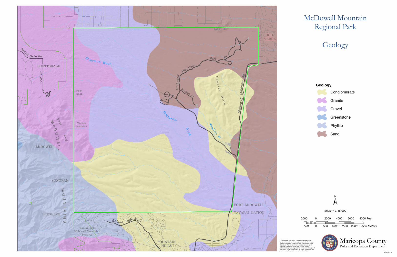
Wash
Sha llmo Dr
RIOVERDE
FOUNTAINHILLS
Shallmo W
128th
St
Stoneman Wash
McD
owell
Mou
ntain
Rd
McD
owell
Mountain
Dr
SCOTTSDALE
Gate Rd
Pemberton
RanchPark
Golden Eagle Blvd
SCOTTSDALE
RockKnob
MarcusLandslide
EastEnd
Mc D
OW
EL L
MO
UN
TA
INS
Asher Hills
SONORAN
McDOWELL
PRESERVE
Fountain HillsMcDowell Mountain
Preserve
L o u s l e yH
i l l s
FOUNTAINHILLS
FORT McDOWELL
YAVAPAI NATION
McDowell MountainRegional Park
Geology
GeologyConglomerate
Granite
Gravel
Greenstone
Phyllite
Sand
DISCLAIMER: This map is a graphical representationdesigned for general reference purposes only. Viewer/Useragrees to indemnify, defend and hold harmless MaricopaCounty, its officers, departments, employees and agentsfrom and against any and all suits, actions, legal oradministrative proceedings, claims, demands or damages ofany kind or nature arising out of the use of this map, or thedata contained herein, in its actual or altered form.
2/8/2019
Maricopa CountyParks and Recreation Department
Scale = 1:48,000
2000 0 2000 4000 6000 8000 Feet
500 0 500 1000 1500 2000 2500 Meters
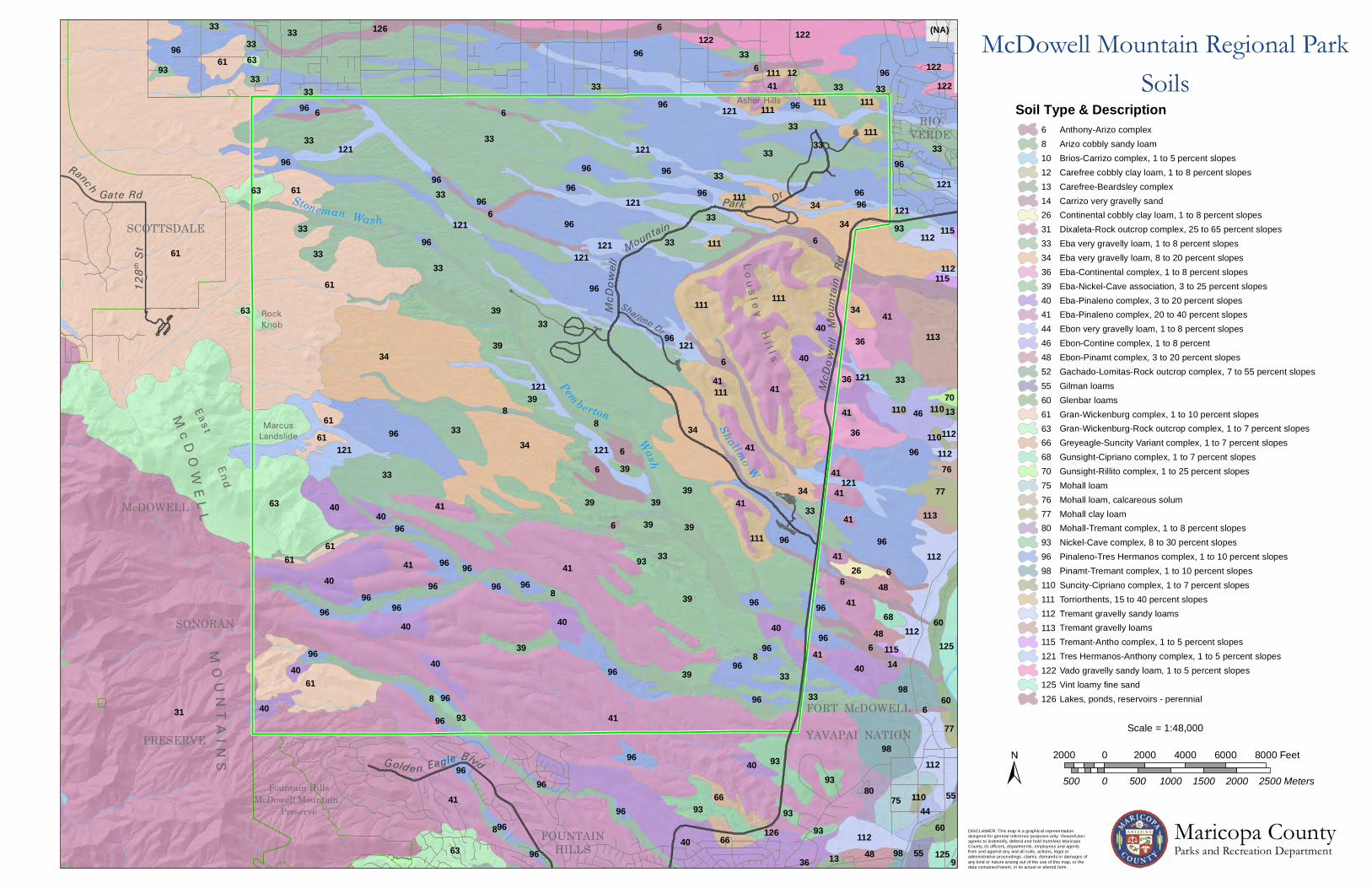
Ranch Gate Rd Park
Pemberton
Dr
Mountain
McD
owell
McD
owe ll
Mou
ntain
Rd
Stoneman Wash
128th
St
Shallmo W
RIOVERDE
Shal lmo Dr
Wash
Golden Eagle Blvd
SCOTTSDALE
FORT McDOWELL
YAVAPAI NATION
FOUNTAINHILLS
RockKnob
MarcusLandslide
EastEnd
Mc D
OW
EL L
MO
UN
TA
INS
Asher Hills
SONORAN
McDOWELL
PRESERVE
Fountain HillsMcDowell Mountain
Preserve
L o u s l e yH
i l l s
31
61
41
33
63
8
33
8
96
41
111
41
34
40
6
39
96
39
41
34
34
96
6
8
96
33
96
96
33
61
39
122
33
96
96
34
96
98
33
40
111
41
63
96
33
36
40
41
96
39113
46
33
6
121
121
96
6
33121
6
33
40
33
75
96
40
93
96
93
111112
98
112
61
41
36
40
33
121
41
33
33
6
77
41
112
39
61
80
33
60
63
40
96
33
33
41
40
60
34
96
112
96
48
48
66
125
41
3339
66
40
96
44
40
33
112121
34
3941
40
96 96
41
111
55
96
48
93
26
61
33
93
39
68
40
61
125
96
60
96
113
111
96
76
111
33
36
121111
96 96
96
70
96
122
33
98
93
6
8
6
8
6
121121
6
6
34
39
96
121
33
121
121
8
121
96
6
93
96
33
63
6
33
122
40
61
77
41
93
33
9396
13
96
93
111
39
40
96
39
33
121
121
96
96
111
41
96
110
96
96
122
96
96
115
112
96
12
96
33
96
63
1341
111
96
33
112
6
96
33
110
14
4139
115
61
121
110
41
112
96
96
110
96
55
115
126
126
36 9
111
(NA)
61
McDowell Mountain Regional ParkSoils
10
110111112113115
12
121122125
131426313334363940414446485255606163666870757677
8
80939698
6
126
Anthony-Arizo complexArizo cobbly sandy loamBrios-Carrizo complex, 1 to 5 percent slopesCarefree cobbly clay loam, 1 to 8 percent slopesCarefree-Beardsley complexCarrizo very gravelly sandContinental cobbly clay loam, 1 to 8 percent slopesDixaleta-Rock outcrop complex, 25 to 65 percent slopesEba very gravelly loam, 1 to 8 percent slopesEba very gravelly loam, 8 to 20 percent slopesEba-Continental complex, 1 to 8 percent slopesEba-Nickel-Cave association, 3 to 25 percent slopes
Eba-Pinaleno complex, 20 to 40 percent slopesEba-Pinaleno complex, 3 to 20 percent slopes
Ebon very gravelly loam, 1 to 8 percent slopesEbon-Contine complex, 1 to 8 percentEbon-Pinamt complex, 3 to 20 percent slopesGachado-Lomitas-Rock outcrop complex, 7 to 55 percent slopesGilman loamsGlenbar loamsGran-Wickenburg complex, 1 to 10 percent slopesGran-Wickenburg-Rock outcrop complex, 1 to 7 percent slopesGreyeagle-Suncity Variant complex, 1 to 7 percent slopesGunsight-Cipriano complex, 1 to 7 percent slopesGunsight-Rillito complex, 1 to 25 percent slopes
Lakes, ponds, reservoirs - perennial
Mohall clay loam
Mohall loamMohall loam, calcareous solum
Mohall-Tremant complex, 1 to 8 percent slopesNickel-Cave complex, 8 to 30 percent slopesPinaleno-Tres Hermanos complex, 1 to 10 percent slopesPinamt-Tremant complex, 1 to 10 percent slopesSuncity-Cipriano complex, 1 to 7 percent slopesTorriorthents, 15 to 40 percent slopes
Tremant gravelly loamsTremant gravelly sandy loams
Tremant-Antho complex, 1 to 5 percent slopesTres Hermanos-Anthony complex, 1 to 5 percent slopesVado gravelly sandy loam, 1 to 5 percent slopesVint loamy fine sand
Soil Type & Description
Scale = 1:48,000
2000 0 2000 4000 6000 8000 Feet
500 0 500 1000 1500 2000 2500 Meters
DISCLAIMER: This map is a graphical representationdesigned for general reference purposes only. Viewer/Useragrees to indemnify, defend and hold harmless MaricopaCounty, its officers, departments, employees and agentsfrom and against any and all suits, actions, legal oradministrative proceedings, claims, demands or damages ofany kind or nature arising out of the use of this map, or thedata contained herein, in its actual or altered form.
Maricopa CountyParks and Recreation Department

Soil Map—Aguila-Carefree Area, Arizona, Parts of Maricopa and Pinal Counties(McDowell Mt.Regional Park)
Natural ResourcesConservation Service
Web Soil SurveyNational Cooperative Soil Survey
12/21/2017Page 1 of 3
3722
000
3723
000
3724
000
3725
000
3726
000
3727
000
3728
000
3729
000
3730
000
3731
000
3732
000
3733
000
3722
000
3723
000
3724
000
3725
000
3726
000
3727
000
3728
000
3729
000
3730
000
3731
000
3732
000
3733
000423000 424000 425000 426000 427000 428000 429000 430000 431000 432000 433000 434000 435000 436000 437000 438000 439000 440000
423000 424000 425000 426000 427000 428000 429000 430000 431000 432000 433000 434000 435000 436000 437000 438000 439000 440000
33° 44' 7'' N11
1° 4
9' 5
5'' W
33° 44' 7'' N
111°
38'
24'' W
33° 37' 52'' N
111°
49'
55'' W
33° 37' 52'' N
111°
38'
24'' W
N
Map projection: Web Mercator Corner coordinates: WGS84 Edge tics: UTM Zone 12N WGS840 3500 7000 14000 21000
Feet0 1000 2000 4000 6000
MetersMap Scale: 1:81,500 if printed on A landscape (11" x 8.5") sheet.


MAP LEGEND MAP INFORMATION
Area of Interest (AOI)Area of Interest (AOI)
SoilsSoil Map Unit Polygons
Soil Map Unit Lines
Soil Map Unit Points
Special Point FeaturesBlowout
Borrow Pit
Clay Spot
Closed Depression
Gravel Pit
Gravelly Spot
Landfill
Lava Flow
Marsh or swamp
Mine or Quarry
Miscellaneous Water
Perennial Water
Rock Outcrop
Saline Spot
Sandy Spot
Severely Eroded Spot
Sinkhole
Slide or Slip
Sodic Spot
Spoil Area
Stony Spot
Very Stony Spot
Wet Spot
Other
Special Line Features
Water FeaturesStreams and Canals
TransportationRails
Interstate Highways
US Routes
Major Roads
Local Roads
BackgroundAerial Photography
The soil surveys that comprise your AOI were mapped at 1:24,000.
Please rely on the bar scale on each map sheet for map measurements.
Source of Map: Natural Resources Conservation ServiceWeb Soil Survey URL: Coordinate System: Web Mercator (EPSG:3857)
Maps from the Web Soil Survey are based on the Web Mercator projection, which preserves direction and shape but distorts distance and area. A projection that preserves area, such as the Albers equal-area conic projection, should be used if more accurate calculations of distance or area are required.
This product is generated from the USDA-NRCS certified data as of the version date(s) listed below.
Soil Survey Area: Aguila-Carefree Area, Arizona, Parts of Maricopa and Pinal CountiesSurvey Area Data: Version 11, Sep 11, 2017
Soil map units are labeled (as space allows) for map scales 1:50,000 or larger.
Date(s) aerial images were photographed: Apr 5, 2015—Mar 10, 2017
The orthophoto or other base map on which the soil lines were compiled and digitized probably differs from the background imagery displayed on these maps. As a result, some minor shifting of map unit boundaries may be evident.
Soil Map—Aguila-Carefree Area, Arizona, Parts of Maricopa and Pinal Counties(McDowell Mt.Regional Park)
Natural ResourcesConservation Service
Web Soil SurveyNational Cooperative Soil Survey
12/21/2017Page 2 of 3
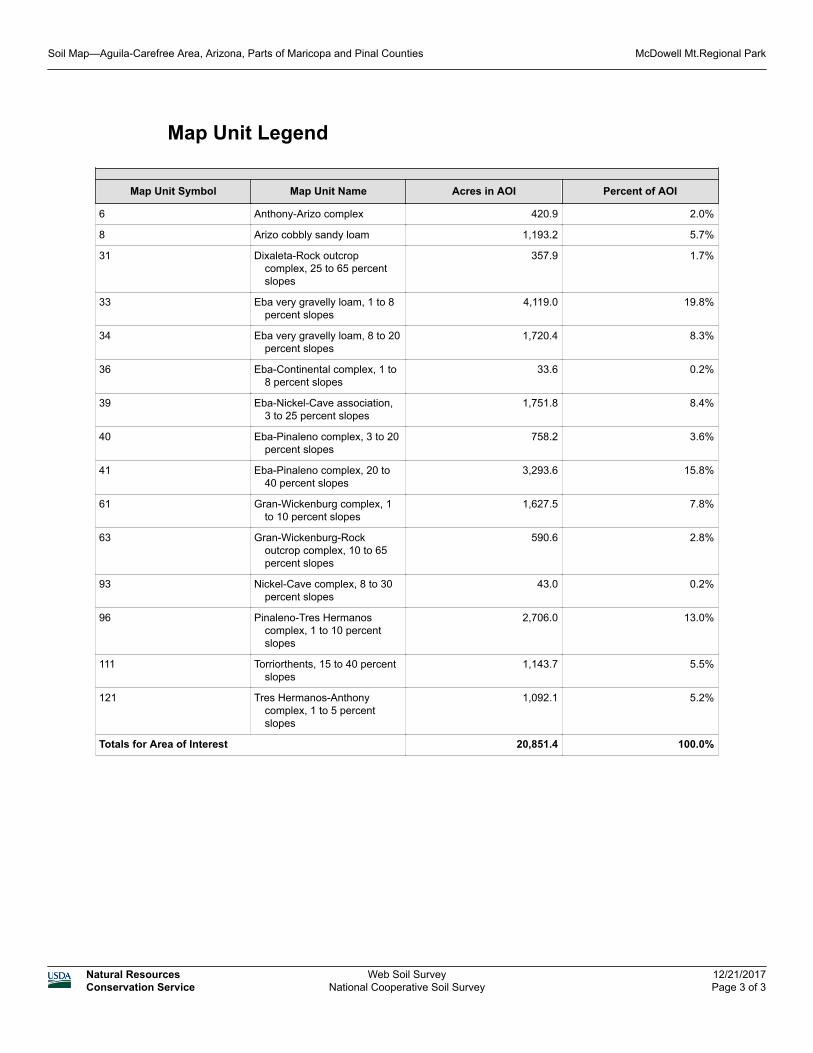
Map Unit Legend
Map Unit Symbol Map Unit Name Acres in AOI Percent of AOI
6 Anthony-Arizo complex 420.9 2.0%
8 Arizo cobbly sandy loam 1,193.2 5.7%
31 Dixaleta-Rock outcrop complex, 25 to 65 percent slopes
357.9 1.7%
33 Eba very gravelly loam, 1 to 8 percent slopes
4,119.0 19.8%
34 Eba very gravelly loam, 8 to 20 percent slopes
1,720.4 8.3%
36 Eba-Continental complex, 1 to 8 percent slopes
33.6 0.2%
39 Eba-Nickel-Cave association, 3 to 25 percent slopes
1,751.8 8.4%
40 Eba-Pinaleno complex, 3 to 20 percent slopes
758.2 3.6%
41 Eba-Pinaleno complex, 20 to 40 percent slopes
3,293.6 15.8%
61 Gran-Wickenburg complex, 1 to 10 percent slopes
1,627.5 7.8%
63 Gran-Wickenburg-Rock outcrop complex, 10 to 65 percent slopes
590.6 2.8%
93 Nickel-Cave complex, 8 to 30 percent slopes
43.0 0.2%
96 Pinaleno-Tres Hermanos complex, 1 to 10 percent slopes
2,706.0 13.0%
111 Torriorthents, 15 to 40 percent slopes
1,143.7 5.5%
121 Tres Hermanos-Anthony complex, 1 to 5 percent slopes
1,092.1 5.2%
Totals for Area of Interest 20,851.4 100.0%
Soil Map—Aguila-Carefree Area, Arizona, Parts of Maricopa and Pinal Counties McDowell Mt.Regional Park
Natural ResourcesConservation Service
Web Soil SurveyNational Cooperative Soil Survey
12/21/2017Page 3 of 3

Map Unit Description
The map units delineated on the detailed soil maps in a soil survey represent the soils or miscellaneous areas in the survey area. The map unit descriptions in this report, along with the maps, can be used to determine the composition and properties of a unit.
A map unit delineation on a soil map represents an area dominated by one or more major kinds of soil or miscellaneous areas. A map unit is identified and named according to the taxonomic classification of the dominant soils. Within a taxonomic class there are precisely defined limits for the properties of the soils. On the landscape, however, the soils are natural phenomena, and they have the characteristic variability of all natural phenomena. Thus, the range of some observed properties may extend beyond the limits defined for a taxonomic class. Areas of soils of a single taxonomic class rarely, if ever, can be mapped without including areas of other taxonomic classes. Consequently, every map unit is made up of the soils or miscellaneous areas for which it is named, soils that are similar to the named components, and some minor components that differ in use and management from the major soils.
Most of the soils similar to the major components have properties similar to those of the dominant soil or soils in the map unit, and thus they do not affect use and management. These are called noncontrasting, or similar, components. They may or may not be mentioned in a particular map unit description. Some minor components, however, have properties and behavior characteristics divergent enough to affect use or to require different management. These are called contrasting, or dissimilar, components. They generally are in small areas and could not be mapped separately because of the scale used. Some small areas of strongly contrasting soils or miscellaneous areas are identified by a special symbol on the maps. If included in the database for a given area, the contrasting minor components are identified in the map unit descriptions along with some characteristics of each. A few areas of minor components may not have been observed, and consequently they are not mentioned in the descriptions, especially where the pattern was so complex that it was impractical to make enough observations to identify all the soils and miscellaneous areas on the landscape.
The presence of minor components in a map unit in no way diminishes the usefulness or accuracy of the data. The objective of mapping is not to delineate pure taxonomic classes but rather to separate the landscape into landforms or landform segments that have similar use and management requirements. The delineation of such segments on the map provides sufficient information for the development of resource plans. If intensive use of small areas is planned, however, onsite investigation is needed to define and locate the soils and miscellaneous areas.
An identifying symbol precedes the map unit name in the map unit descriptions. Each description includes general facts about the unit and gives important soil properties and qualities.
Map Unit Description: Tres Hermanos-Anthony complex, 1 to 5 percent slopes---Aguila-Carefree Area, Arizona, Parts of Maricopa and Pinal Counties
Nursery Tank
Natural ResourcesConservation Service
Web Soil SurveyNational Cooperative Soil Survey
9/21/2018Page 1 of 4

Soils that have profiles that are almost alike make up a soil series. All the soils of a series have major horizons that are similar in composition, thickness, and arrangement. Soils of a given series can differ in texture of the surface layer, slope, stoniness, salinity, degree of erosion, and other characteristics that affect their use. On the basis of such differences, a soil series is divided into soil phases. Most of the areas shown on the detailed soil maps are phases of soil series. The name of a soil phase commonly indicates a feature that affects use or management. For example, Alpha silt loam, 0 to 2 percent slopes, is a phase of the Alpha series.
Some map units are made up of two or more major soils or miscellaneous areas. These map units are complexes, associations, or undifferentiated groups.
A complex consists of two or more soils or miscellaneous areas in such an intricate pattern or in such small areas that they cannot be shown separately on the maps. The pattern and proportion of the soils or miscellaneous areas are somewhat similar in all areas. Alpha-Beta complex, 0 to 6 percent slopes, is an example.
An association is made up of two or more geographically associated soils or miscellaneous areas that are shown as one unit on the maps. Because of present or anticipated uses of the map units in the survey area, it was not considered practical or necessary to map the soils or miscellaneous areas separately. The pattern and relative proportion of the soils or miscellaneous areas are somewhat similar. Alpha-Beta association, 0 to 2 percent slopes, is an example.
An undifferentiated group is made up of two or more soils or miscellaneous areas that could be mapped individually but are mapped as one unit because similar interpretations can be made for use and management. The pattern and proportion of the soils or miscellaneous areas in a mapped area are not uniform. An area can be made up of only one of the major soils or miscellaneous areas, or it can be made up of all of them. Alpha and Beta soils, 0 to 2 percent slopes, is an example.
Some surveys include miscellaneous areas. Such areas have little or no soil material and support little or no vegetation. Rock outcrop is an example.
Additional information about the map units described in this report is available in other soil reports, which give properties of the soils and the limitations, capabilities, and potentials for many uses. Also, the narratives that accompany the soil reports define some of the properties included in the map unit descriptions.
Aguila-Carefree Area, Arizona, Parts of Maricopa and Pinal Counties
121—Tres Hermanos-Anthony complex, 1 to 5 percent slopes
Map Unit SettingNational map unit symbol: 1s45Elevation: 1,800 to 3,000 feet
Map Unit Description: Tres Hermanos-Anthony complex, 1 to 5 percent slopes---Aguila-Carefree Area, Arizona, Parts of Maricopa and Pinal Counties
Nursery Tank
Natural ResourcesConservation Service
Web Soil SurveyNational Cooperative Soil Survey
9/21/2018Page 2 of 4

Mean annual precipitation: 10 to 12 inchesMean annual air temperature: 66 to 70 degrees FFrost-free period: 220 to 270 daysFarmland classification: Not prime farmland
Map Unit CompositionTres hermanos and similar soils: 50 percentAnthony and similar soils: 35 percentEstimates are based on observations, descriptions, and transects of
the mapunit.
Description of Tres Hermanos
SettingLandform: Fan terraces, stream terracesLandform position (two-dimensional): SummitLandform position (three-dimensional): TreadDown-slope shape: LinearAcross-slope shape: LinearParent material: Mixed alluvium
Typical profileA - 0 to 2 inches: gravelly loamBtk - 2 to 22 inches: gravelly clay loam2Bk - 22 to 60 inches: very gravelly loam
Properties and qualitiesSlope: 1 to 5 percentDepth to restrictive feature: More than 80 inchesNatural drainage class: Well drainedCapacity of the most limiting layer to transmit water (Ksat):
Moderately high (0.20 to 0.57 in/hr)Depth to water table: More than 80 inchesFrequency of flooding: NoneFrequency of ponding: NoneCalcium carbonate, maximum in profile: 30 percentSalinity, maximum in profile: Very slightly saline to slightly saline
(2.0 to 4.0 mmhos/cm)Available water storage in profile: Low (about 5.7 inches)
Interpretive groupsLand capability classification (irrigated): 3sLand capability classification (nonirrigated): 7cHydrologic Soil Group: CEcological site: Loamy Upland 10-13" p.z. (R040XA114AZ)Hydric soil rating: No
Description of Anthony
SettingLandform: Flood plainsLandform position (two-dimensional): SummitLandform position (three-dimensional): DipDown-slope shape: Linear
Map Unit Description: Tres Hermanos-Anthony complex, 1 to 5 percent slopes---Aguila-Carefree Area, Arizona, Parts of Maricopa and Pinal Counties
Nursery Tank
Natural ResourcesConservation Service
Web Soil SurveyNational Cooperative Soil Survey
9/21/2018Page 3 of 4

Across-slope shape: LinearParent material: Mixed alluvium
Typical profileA - 0 to 2 inches: sandy loamC - 2 to 40 inches: gravelly sandy loam2Btkb - 40 to 60 inches: loam
Properties and qualitiesSlope: 1 to 5 percentDepth to restrictive feature: More than 80 inchesNatural drainage class: Well drainedCapacity of the most limiting layer to transmit water (Ksat):
Moderately high to high (0.57 to 1.98 in/hr)Depth to water table: More than 80 inchesFrequency of flooding: NoneFrequency of ponding: NoneCalcium carbonate, maximum in profile: 15 percentSalinity, maximum in profile: Nonsaline to slightly saline (0.0 to 4.0
mmhos/cm)Available water storage in profile: Moderate (about 6.3 inches)
Interpretive groupsLand capability classification (irrigated): 2eLand capability classification (nonirrigated): 7sHydrologic Soil Group: AEcological site: Sandy Wash 10-13" p.z. (R040XA115AZ)Hydric soil rating: No
Data Source Information
Soil Survey Area: Aguila-Carefree Area, Arizona, Parts of Maricopa and Pinal CountiesSurvey Area Data: Version 11, Sep 11, 2017
Map Unit Description: Tres Hermanos-Anthony complex, 1 to 5 percent slopes---Aguila-Carefree Area, Arizona, Parts of Maricopa and Pinal Counties
Nursery Tank
Natural ResourcesConservation Service
Web Soil SurveyNational Cooperative Soil Survey
9/21/2018Page 4 of 4

Aguila-Carefree Area, Arizona, Parts of Maricopa and Pinal Counties
6—Anthony-Arizo complex
Map Unit SettingNational map unit symbol: 1s81Elevation: 1,800 to 3,000 feetMean annual precipitation: 10 to 12 inchesMean annual air temperature: 66 to 88 degrees FFrost-free period: 220 to 270 daysFarmland classification: Not prime farmland
Map Unit CompositionAnthony and similar soils: 40 percentArizo and similar soils: 40 percentEstimates are based on observations, descriptions, and transects of
the mapunit.
Description of Anthony
SettingLandform: Flood plainsLandform position (two-dimensional): SummitLandform position (three-dimensional): DipDown-slope shape: LinearAcross-slope shape: LinearParent material: Mixed alluvium
Typical profileA - 0 to 2 inches: sandy loamC - 2 to 40 inches: gravelly sandy loam2Btkb - 40 to 60 inches: loam
Properties and qualitiesSlope: 0 to 3 percentDepth to restrictive feature: More than 80 inchesNatural drainage class: Well drainedCapacity of the most limiting layer to transmit water (Ksat):
Moderately high to high (0.57 to 1.98 in/hr)Depth to water table: More than 80 inchesFrequency of flooding: NoneFrequency of ponding: NoneCalcium carbonate, maximum in profile: 15 percentSalinity, maximum in profile: Nonsaline to slightly saline (0.0 to 4.0
mmhos/cm)Available water storage in profile: Low (about 5.9 inches)
Interpretive groupsLand capability classification (irrigated): 2sLand capability classification (nonirrigated): 7sHydrologic Soil Group: A
Map Unit Description: Anthony-Arizo complex---Aguila-Carefree Area, Arizona, Parts of Maricopa and Pinal Counties
McDowell Mt.Regional Park
Natural ResourcesConservation Service
Web Soil SurveyNational Cooperative Soil Survey
12/21/2017Page 1 of 2

Ecological site: Sandy Loam Upland 10-13" p.z. Deep (R040XA117AZ)
Hydric soil rating: No
Description of Arizo
SettingLandform: DrainagewaysLandform position (two-dimensional): SummitLandform position (three-dimensional): DipDown-slope shape: LinearAcross-slope shape: LinearParent material: Mixed alluvium
Typical profileA - 0 to 1 inches: gravelly sandy loamC1 - 1 to 8 inches: very gravelly sandy loamC2 - 8 to 60 inches: very gravelly loamy sand
Properties and qualitiesSlope: 0 to 3 percentDepth to restrictive feature: More than 80 inchesNatural drainage class: Excessively drainedCapacity of the most limiting layer to transmit water (Ksat): High
(1.98 to 5.95 in/hr)Depth to water table: More than 80 inchesFrequency of flooding: OccasionalFrequency of ponding: NoneCalcium carbonate, maximum in profile: 15 percentSalinity, maximum in profile: Nonsaline to slightly saline (0.0 to 4.0
mmhos/cm)Available water storage in profile: Low (about 5.3 inches)
Interpretive groupsLand capability classification (irrigated): None specifiedLand capability classification (nonirrigated): 7wHydrologic Soil Group: AEcological site: Sandy Wash 10-13" p.z. (R040XA115AZ)Hydric soil rating: No
Data Source Information
Soil Survey Area: Aguila-Carefree Area, Arizona, Parts of Maricopa and Pinal CountiesSurvey Area Data: Version 11, Sep 11, 2017
Map Unit Description: Anthony-Arizo complex---Aguila-Carefree Area, Arizona, Parts of Maricopa and Pinal Counties
McDowell Mt.Regional Park
Natural ResourcesConservation Service
Web Soil SurveyNational Cooperative Soil Survey
12/21/2017Page 2 of 2
Aguila-Carefree Area, Arizona, Parts of Maricopa and Pinal Counties
8—Arizo cobbly sandy loam
Map Unit SettingNational map unit symbol: 1s92Elevation: 1,800 to 3,000 feetMean annual precipitation: 10 to 12 inchesMean annual air temperature: 66 to 70 degrees FFrost-free period: 220 to 270 daysFarmland classification: Not prime farmland
Map Unit CompositionArizo and similar soils: 100 percentEstimates are based on observations, descriptions, and transects of
the mapunit.
Description of Arizo
SettingLandform: Flood plainsLandform position (two-dimensional): SummitLandform position (three-dimensional): DipDown-slope shape: LinearAcross-slope shape: LinearParent material: Mixed alluvium
Typical profileA - 0 to 1 inches: cobbly sandy loamC1 - 1 to 8 inches: very cobbly sandy loamC2 - 8 to 60 inches: very cobbly loamy sand
Properties and qualitiesSlope: 0 to 3 percentDepth to restrictive feature: More than 80 inchesNatural drainage class: Excessively drainedCapacity of the most limiting layer to transmit water (Ksat):
Moderately high to high (0.57 to 1.98 in/hr)Depth to water table: More than 80 inchesFrequency of flooding: OccasionalFrequency of ponding: NoneCalcium carbonate, maximum in profile: 15 percentSalinity, maximum in profile: Nonsaline to slightly saline (0.0 to 4.0
mmhos/cm)Available water storage in profile: High (about 9.4 inches)
Interpretive groupsLand capability classification (irrigated): None specifiedLand capability classification (nonirrigated): 7wHydrologic Soil Group: B
Map Unit Description: Arizo cobbly sandy loam---Aguila-Carefree Area, Arizona, Parts of Maricopa and Pinal Counties
McDowell Mt.Regional Park
Natural ResourcesConservation Service
Web Soil SurveyNational Cooperative Soil Survey
12/21/2017Page 1 of 2

Ecological site: Populus fremontii-Salix gooddingii/Paspalum distichum (F040XC331AZ)
Hydric soil rating: No
Data Source Information
Soil Survey Area: Aguila-Carefree Area, Arizona, Parts of Maricopa and Pinal CountiesSurvey Area Data: Version 11, Sep 11, 2017
Map Unit Description: Arizo cobbly sandy loam---Aguila-Carefree Area, Arizona, Parts of Maricopa and Pinal Counties
McDowell Mt.Regional Park
Natural ResourcesConservation Service
Web Soil SurveyNational Cooperative Soil Survey
12/21/2017Page 2 of 2

Aguila-Carefree Area, Arizona, Parts of Maricopa and Pinal Counties
31—Dixaleta-Rock outcrop complex, 25 to 65 percent slopes
Map Unit SettingNational map unit symbol: 1s6bElevation: 1,800 to 3,000 feetMean annual precipitation: 10 to 12 inchesMean annual air temperature: 66 to 70 degrees FFrost-free period: 220 to 270 daysFarmland classification: Not prime farmland
Map Unit CompositionDixaleta and similar soils: 55 percentRock outcrop: 35 percentEstimates are based on observations, descriptions, and transects of
the mapunit.
Description of Dixaleta
SettingLandform: Hills, mountainsLandform position (two-dimensional): SummitLandform position (three-dimensional): Mountainflank, side slopeDown-slope shape: ConvexAcross-slope shape: ConvexParent material: Alluvium derived from schist and/or colluvium
derived from schist
Typical profileA - 0 to 1 inches: extremely channery sandy loamB - 1 to 8 inches: extremely channery sandy loam2Crk - 8 to 27 inches: bedrock2R - 27 to 60 inches: bedrock
Properties and qualitiesSlope: 25 to 65 percentDepth to restrictive feature: 3 to 11 inches to paralithic bedrock; 20
to 60 inches to lithic bedrockNatural drainage class: Well drainedCapacity of the most limiting layer to transmit water (Ksat): Very
low to low (0.00 to 0.01 in/hr)Depth to water table: More than 80 inchesFrequency of flooding: NoneFrequency of ponding: NoneCalcium carbonate, maximum in profile: 10 percentSalinity, maximum in profile: Nonsaline to very slightly saline (0.0
to 2.0 mmhos/cm)Available water storage in profile: Very low (about 0.5 inches)
Map Unit Description: Dixaleta-Rock outcrop complex, 25 to 65 percent slopes---Aguila-Carefree Area, Arizona, Parts of Maricopa and Pinal Counties
McDowell Mt.Regional Park
Natural ResourcesConservation Service
Web Soil SurveyNational Cooperative Soil Survey
12/21/2017Page 1 of 2

Interpretive groupsLand capability classification (irrigated): None specifiedLand capability classification (nonirrigated): 7eHydrologic Soil Group: DEcological site: Schist Hills 10-13" p.z. (R040XA119AZ)Hydric soil rating: No
Data Source Information
Soil Survey Area: Aguila-Carefree Area, Arizona, Parts of Maricopa and Pinal CountiesSurvey Area Data: Version 11, Sep 11, 2017
Map Unit Description: Dixaleta-Rock outcrop complex, 25 to 65 percent slopes---Aguila-Carefree Area, Arizona, Parts of Maricopa and Pinal Counties
McDowell Mt.Regional Park
Natural ResourcesConservation Service
Web Soil SurveyNational Cooperative Soil Survey
12/21/2017Page 2 of 2

Aguila-Carefree Area, Arizona, Parts of Maricopa and Pinal Counties
33—Eba very gravelly loam, 1 to 8 percent slopes
Map Unit SettingNational map unit symbol: 1s6gElevation: 2,000 to 3,000 feetMean annual precipitation: 10 to 12 inchesMean annual air temperature: 66 to 70 degrees FFrost-free period: 220 to 270 daysFarmland classification: Not prime farmland
Map Unit CompositionEba and similar soils: 100 percentEstimates are based on observations, descriptions, and transects of
the mapunit.
Description of Eba
SettingLandform: Fan terracesLandform position (two-dimensional): SummitLandform position (three-dimensional): TreadDown-slope shape: ConvexAcross-slope shape: ConvexParent material: Mixed alluvium
Typical profileA - 0 to 3 inches: very gravelly loamBtk - 3 to 36 inches: very gravelly clay2Bk - 36 to 60 inches: extremely gravelly sandy loam
Properties and qualitiesSlope: 1 to 8 percentDepth to restrictive feature: More than 80 inchesNatural drainage class: Well drainedCapacity of the most limiting layer to transmit water (Ksat):
Moderately low to moderately high (0.06 to 0.20 in/hr)Depth to water table: More than 80 inchesFrequency of flooding: NoneFrequency of ponding: NoneCalcium carbonate, maximum in profile: 30 percentSalinity, maximum in profile: Nonsaline to very slightly saline (0.0
to 2.0 mmhos/cm)Available water storage in profile: Low (about 4.0 inches)
Interpretive groupsLand capability classification (irrigated): None specifiedLand capability classification (nonirrigated): 7sHydrologic Soil Group: CEcological site: Clay Loam Upland 10-13" p.z. (R040XA120AZ)
Map Unit Description: Eba very gravelly loam, 1 to 8 percent slopes---Aguila-Carefree Area, Arizona, Parts of Maricopa and Pinal Counties
McDowell Mt.Regional Park
Natural ResourcesConservation Service
Web Soil SurveyNational Cooperative Soil Survey
12/21/2017Page 1 of 2

Hydric soil rating: No
Data Source Information
Soil Survey Area: Aguila-Carefree Area, Arizona, Parts of Maricopa and Pinal CountiesSurvey Area Data: Version 11, Sep 11, 2017
Map Unit Description: Eba very gravelly loam, 1 to 8 percent slopes---Aguila-Carefree Area, Arizona, Parts of Maricopa and Pinal Counties
McDowell Mt.Regional Park
Natural ResourcesConservation Service
Web Soil SurveyNational Cooperative Soil Survey
12/21/2017Page 2 of 2

Aguila-Carefree Area, Arizona, Parts of Maricopa and Pinal Counties
34—Eba very gravelly loam, 8 to 20 percent slopes
Map Unit SettingNational map unit symbol: 1s6jElevation: 2,000 to 3,000 feetMean annual precipitation: 10 to 12 inchesMean annual air temperature: 66 to 70 degrees FFrost-free period: 220 to 270 daysFarmland classification: Not prime farmland
Map Unit CompositionEba and similar soils: 100 percentEstimates are based on observations, descriptions, and transects of
the mapunit.
Description of Eba
SettingLandform: Fan terracesLandform position (two-dimensional): SummitLandform position (three-dimensional): TreadDown-slope shape: ConvexAcross-slope shape: ConvexParent material: Mixed alluvium
Typical profileA - 0 to 3 inches: very gravelly loamBtk - 3 to 36 inches: very gravelly clay2Bk - 36 to 60 inches: extremely gravelly sandy loam
Properties and qualitiesSlope: 8 to 20 percentDepth to restrictive feature: More than 80 inchesNatural drainage class: Well drainedCapacity of the most limiting layer to transmit water (Ksat):
Moderately low to moderately high (0.06 to 0.20 in/hr)Depth to water table: More than 80 inchesFrequency of flooding: NoneFrequency of ponding: NoneCalcium carbonate, maximum in profile: 30 percentSalinity, maximum in profile: Nonsaline to very slightly saline (0.0
to 2.0 mmhos/cm)Available water storage in profile: Low (about 4.0 inches)
Interpretive groupsLand capability classification (irrigated): None specifiedLand capability classification (nonirrigated): 7sHydrologic Soil Group: CEcological site: Clay Loam Upland 10-13" p.z. (R040XA120AZ)
Map Unit Description: Eba very gravelly loam, 8 to 20 percent slopes---Aguila-Carefree Area, Arizona, Parts of Maricopa and Pinal Counties
McDowell Mt.Regional Park
Natural ResourcesConservation Service
Web Soil SurveyNational Cooperative Soil Survey
12/21/2017Page 1 of 2
Hydric soil rating: No
Data Source Information
Soil Survey Area: Aguila-Carefree Area, Arizona, Parts of Maricopa and Pinal CountiesSurvey Area Data: Version 11, Sep 11, 2017
Map Unit Description: Eba very gravelly loam, 8 to 20 percent slopes---Aguila-Carefree Area, Arizona, Parts of Maricopa and Pinal Counties
McDowell Mt.Regional Park
Natural ResourcesConservation Service
Web Soil SurveyNational Cooperative Soil Survey
12/21/2017Page 2 of 2

Aguila-Carefree Area, Arizona, Parts of Maricopa and Pinal Counties
36—Eba-Continental complex, 1 to 8 percent slopes
Map Unit SettingNational map unit symbol: 1s6pElevation: 1,800 to 2,500 feetMean annual precipitation: 8 to 10 inchesMean annual air temperature: 66 to 70 degrees FFrost-free period: 180 to 270 daysFarmland classification: Not prime farmland
Map Unit CompositionEba and similar soils: 45 percentContinental and similar soils: 35 percentEstimates are based on observations, descriptions, and transects of
the mapunit.
Description of Eba
SettingLandform: Fan terracesLandform position (two-dimensional): SummitLandform position (three-dimensional): TreadDown-slope shape: ConvexAcross-slope shape: ConvexParent material: Mixed alluvium
Typical profileA - 0 to 3 inches: very gravelly loamBtk - 3 to 36 inches: very gravelly clay2Bk - 36 to 60 inches: extremely gravelly sandy loam
Properties and qualitiesSlope: 1 to 8 percentDepth to restrictive feature: More than 80 inchesNatural drainage class: Well drainedCapacity of the most limiting layer to transmit water (Ksat):
Moderately low to moderately high (0.06 to 0.20 in/hr)Depth to water table: More than 80 inchesFrequency of flooding: NoneFrequency of ponding: NoneCalcium carbonate, maximum in profile: 30 percentSalinity, maximum in profile: Nonsaline to very slightly saline (0.0
to 2.0 mmhos/cm)Available water storage in profile: Low (about 4.0 inches)
Interpretive groupsLand capability classification (irrigated): None specifiedLand capability classification (nonirrigated): 7sHydrologic Soil Group: C
Map Unit Description: Eba-Continental complex, 1 to 8 percent slopes---Aguila-Carefree Area, Arizona, Parts of Maricopa and Pinal Counties
McDowell Mt.Regional Park
Natural ResourcesConservation Service
Web Soil SurveyNational Cooperative Soil Survey
12/21/2017Page 1 of 2

Ecological site: Loamy Upland 7-10" p.z. (R040XB213AZ)Hydric soil rating: No
Description of Continental
SettingLandform: Fan terracesLandform position (two-dimensional): SummitLandform position (three-dimensional): TreadDown-slope shape: ConvexAcross-slope shape: ConvexParent material: Mixed alluvium
Typical profileA - 0 to 1 inches: clay loamBtk - 1 to 60 inches: clay
Properties and qualitiesSlope: 1 to 8 percentDepth to restrictive feature: More than 80 inchesNatural drainage class: Well drainedCapacity of the most limiting layer to transmit water (Ksat):
Moderately low to moderately high (0.06 to 0.20 in/hr)Depth to water table: More than 80 inchesFrequency of flooding: NoneFrequency of ponding: NoneCalcium carbonate, maximum in profile: 25 percentSalinity, maximum in profile: Nonsaline to very slightly saline (0.0
to 2.0 mmhos/cm)Available water storage in profile: Moderate (about 9.0 inches)
Interpretive groupsLand capability classification (irrigated): None specifiedLand capability classification (nonirrigated): 7sHydrologic Soil Group: CEcological site: Clayey Upland 7-10" p.z. (R040XB204AZ)Hydric soil rating: No
Data Source Information
Soil Survey Area: Aguila-Carefree Area, Arizona, Parts of Maricopa and Pinal CountiesSurvey Area Data: Version 11, Sep 11, 2017
Map Unit Description: Eba-Continental complex, 1 to 8 percent slopes---Aguila-Carefree Area, Arizona, Parts of Maricopa and Pinal Counties
McDowell Mt.Regional Park
Natural ResourcesConservation Service
Web Soil SurveyNational Cooperative Soil Survey
12/21/2017Page 2 of 2

Aguila-Carefree Area, Arizona, Parts of Maricopa and Pinal Counties
39—Eba-Nickel-Cave association, 3 to 25 percent slopes
Map Unit SettingNational map unit symbol: 1s6wElevation: 1,800 to 3,000 feetMean annual precipitation: 8 to 10 inchesMean annual air temperature: 66 to 70 degrees FFrost-free period: 220 to 270 daysFarmland classification: Not prime farmland
Map Unit CompositionEba and similar soils: 30 percentNickel and similar soils: 25 percentCave and similar soils: 25 percentEstimates are based on observations, descriptions, and transects of
the mapunit.
Description of Eba
SettingLandform: Fan terracesLandform position (two-dimensional): SummitLandform position (three-dimensional): TreadDown-slope shape: ConvexAcross-slope shape: ConvexParent material: Mixed alluvium
Typical profileA - 0 to 3 inches: very gravelly loamBtk - 3 to 36 inches: very gravelly clay2Bk - 36 to 60 inches: extremely gravelly sandy loam
Properties and qualitiesSlope: 3 to 8 percentDepth to restrictive feature: More than 80 inchesNatural drainage class: Well drainedCapacity of the most limiting layer to transmit water (Ksat):
Moderately low to moderately high (0.06 to 0.20 in/hr)Depth to water table: More than 80 inchesFrequency of flooding: NoneFrequency of ponding: NoneCalcium carbonate, maximum in profile: 30 percentSalinity, maximum in profile: Nonsaline to very slightly saline (0.0
to 2.0 mmhos/cm)Available water storage in profile: Low (about 4.0 inches)
Interpretive groupsLand capability classification (irrigated): None specifiedLand capability classification (nonirrigated): 7s
Map Unit Description: Eba-Nickel-Cave association, 3 to 25 percent slopes---Aguila-Carefree Area, Arizona, Parts of Maricopa and Pinal Counties
McDowell Mt.Regional Park
Natural ResourcesConservation Service
Web Soil SurveyNational Cooperative Soil Survey
12/21/2017Page 1 of 3
Hydrologic Soil Group: CEcological site: Clay Loam Upland 7-10" p.z. (R040XB205AZ)Hydric soil rating: No
Description of Nickel
SettingLandform: Fan terracesLandform position (two-dimensional): SummitLandform position (three-dimensional): TreadDown-slope shape: ConvexAcross-slope shape: ConvexParent material: Mixed alluvium
Typical profileA - 0 to 1 inches: gravelly sandy loamBk1 - 1 to 10 inches: gravelly loamBk2 - 10 to 50 inches: very gravelly sandy loamBk3 - 50 to 60 inches: very gravelly loamy sand
Properties and qualitiesSlope: 3 to 25 percentDepth to restrictive feature: More than 80 inchesNatural drainage class: Well drainedCapacity of the most limiting layer to transmit water (Ksat):
Moderately high to high (0.57 to 1.98 in/hr)Depth to water table: More than 80 inchesFrequency of flooding: NoneFrequency of ponding: NoneCalcium carbonate, maximum in profile: 35 percentGypsum, maximum in profile: 5 percentSalinity, maximum in profile: Nonsaline to very slightly saline (0.0
to 2.0 mmhos/cm)Sodium adsorption ratio, maximum in profile: 13.0Available water storage in profile: Low (about 4.4 inches)
Interpretive groupsLand capability classification (irrigated): None specifiedLand capability classification (nonirrigated): 7sHydrologic Soil Group: BEcological site: Limy Slopes 7-10" p.z. (R040XB209AZ)Hydric soil rating: No
Description of Cave
SettingLandform: Fan terracesLandform position (two-dimensional): SummitLandform position (three-dimensional): TreadDown-slope shape: ConvexAcross-slope shape: ConvexParent material: Mixed alluvium
Map Unit Description: Eba-Nickel-Cave association, 3 to 25 percent slopes---Aguila-Carefree Area, Arizona, Parts of Maricopa and Pinal Counties
McDowell Mt.Regional Park
Natural ResourcesConservation Service
Web Soil SurveyNational Cooperative Soil Survey
12/21/2017Page 2 of 3

Typical profileA - 0 to 1 inches: gravelly loamBk - 1 to 14 inches: loamBkm - 14 to 20 inches: cemented materialCk - 20 to 60 inches: very gravelly sandy loam
Properties and qualitiesSlope: 3 to 25 percentDepth to restrictive feature: 8 to 19 inches to petrocalcicNatural drainage class: Well drainedCapacity of the most limiting layer to transmit water (Ksat): Very
low to moderately low (0.00 to 0.06 in/hr)Depth to water table: More than 80 inchesFrequency of flooding: NoneFrequency of ponding: NoneCalcium carbonate, maximum in profile: 30 percentSalinity, maximum in profile: Very slightly saline to slightly saline
(2.0 to 4.0 mmhos/cm)Available water storage in profile: Very low (about 2.1 inches)
Interpretive groupsLand capability classification (irrigated): None specifiedLand capability classification (nonirrigated): 7sHydrologic Soil Group: DEcological site: Limy Upland 7-10" p.z. (R040XB210AZ)Hydric soil rating: No
Data Source Information
Soil Survey Area: Aguila-Carefree Area, Arizona, Parts of Maricopa and Pinal CountiesSurvey Area Data: Version 11, Sep 11, 2017
Map Unit Description: Eba-Nickel-Cave association, 3 to 25 percent slopes---Aguila-Carefree Area, Arizona, Parts of Maricopa and Pinal Counties
McDowell Mt.Regional Park
Natural ResourcesConservation Service
Web Soil SurveyNational Cooperative Soil Survey
12/21/2017Page 3 of 3
Aguila-Carefree Area, Arizona, Parts of Maricopa and Pinal Counties
40—Eba-Pinaleno complex, 3 to 20 percent slopes
Map Unit SettingNational map unit symbol: 1s6zElevation: 1,800 to 3,000 feetMean annual precipitation: 10 to 12 inchesMean annual air temperature: 66 to 70 degrees FFrost-free period: 220 to 270 daysFarmland classification: Not prime farmland
Map Unit CompositionEba and similar soils: 45 percentPinaleno and similar soils: 35 percentEstimates are based on observations, descriptions, and transects of
the mapunit.
Description of Eba
SettingLandform: Fan terracesLandform position (two-dimensional): SummitLandform position (three-dimensional): TreadDown-slope shape: ConvexAcross-slope shape: ConvexParent material: Mixed alluvium
Typical profileA - 0 to 3 inches: very gravelly loamBtk - 3 to 36 inches: very gravelly clay2Bk - 36 to 60 inches: extremely gravelly sandy loam
Properties and qualitiesSlope: 3 to 20 percentDepth to restrictive feature: More than 80 inchesNatural drainage class: Well drainedCapacity of the most limiting layer to transmit water (Ksat):
Moderately low to moderately high (0.06 to 0.20 in/hr)Depth to water table: More than 80 inchesFrequency of flooding: NoneFrequency of ponding: NoneCalcium carbonate, maximum in profile: 30 percentSalinity, maximum in profile: Nonsaline to very slightly saline (0.0
to 2.0 mmhos/cm)Available water storage in profile: Low (about 4.0 inches)
Interpretive groupsLand capability classification (irrigated): None specifiedLand capability classification (nonirrigated): 7sHydrologic Soil Group: C
Map Unit Description: Eba-Pinaleno complex, 3 to 20 percent slopes---Aguila-Carefree Area, Arizona, Parts of Maricopa and Pinal Counties
McDowell
Natural ResourcesConservation Service
Web Soil SurveyNational Cooperative Soil Survey
12/21/2017Page 1 of 2
Ecological site: Clay Loam Upland 10-13" p.z. (R040XA120AZ)Hydric soil rating: No
Description of Pinaleno
SettingLandform: Fan terracesLandform position (two-dimensional): SummitLandform position (three-dimensional): TreadDown-slope shape: ConvexAcross-slope shape: ConvexParent material: Mixed alluvium
Typical profileA - 0 to 1 inches: very gravelly clay loamBt - 1 to 12 inches: very gravelly clay loamBtk - 12 to 60 inches: loam
Properties and qualitiesSlope: 3 to 20 percentDepth to restrictive feature: More than 80 inchesNatural drainage class: Well drainedCapacity of the most limiting layer to transmit water (Ksat):
Moderately high (0.20 to 0.57 in/hr)Depth to water table: More than 80 inchesFrequency of flooding: NoneFrequency of ponding: NoneCalcium carbonate, maximum in profile: 35 percentSalinity, maximum in profile: Nonsaline to very slightly saline (0.0
to 2.0 mmhos/cm)Available water storage in profile: Moderate (about 8.8 inches)
Interpretive groupsLand capability classification (irrigated): None specifiedLand capability classification (nonirrigated): 7sHydrologic Soil Group: CEcological site: Clay Loam Upland 10-13" p.z. (R040XA120AZ)Hydric soil rating: No
Data Source Information
Soil Survey Area: Aguila-Carefree Area, Arizona, Parts of Maricopa and Pinal CountiesSurvey Area Data: Version 11, Sep 11, 2017
Map Unit Description: Eba-Pinaleno complex, 3 to 20 percent slopes---Aguila-Carefree Area, Arizona, Parts of Maricopa and Pinal Counties
McDowell
Natural ResourcesConservation Service
Web Soil SurveyNational Cooperative Soil Survey
12/21/2017Page 2 of 2

Aguila-Carefree Area, Arizona, Parts of Maricopa and Pinal Counties
41—Eba-Pinaleno complex, 20 to 40 percent slopes
Map Unit SettingNational map unit symbol: 1s71Elevation: 1,800 to 3,000 feetMean annual precipitation: 10 to 12 inchesMean annual air temperature: 66 to 70 degrees FFrost-free period: 220 to 270 daysFarmland classification: Not prime farmland
Map Unit CompositionEba and similar soils: 45 percentPinaleno and similar soils: 35 percentEstimates are based on observations, descriptions, and transects of
the mapunit.
Description of Eba
SettingLandform: Fan terracesLandform position (two-dimensional): SummitLandform position (three-dimensional): TreadDown-slope shape: ConvexAcross-slope shape: ConvexParent material: Mixed alluvium
Typical profileA - 0 to 3 inches: very gravelly loamBtk - 3 to 36 inches: very gravelly clay2Bk - 36 to 60 inches: extremely gravelly sandy loam
Properties and qualitiesSlope: 20 to 40 percentDepth to restrictive feature: More than 80 inchesNatural drainage class: Well drainedCapacity of the most limiting layer to transmit water (Ksat):
Moderately low to moderately high (0.06 to 0.20 in/hr)Depth to water table: More than 80 inchesFrequency of flooding: NoneFrequency of ponding: NoneCalcium carbonate, maximum in profile: 30 percentSalinity, maximum in profile: Nonsaline to very slightly saline (0.0
to 2.0 mmhos/cm)Available water storage in profile: Low (about 4.0 inches)
Interpretive groupsLand capability classification (irrigated): None specifiedLand capability classification (nonirrigated): 7sHydrologic Soil Group: C
Map Unit Description: Eba-Pinaleno complex, 20 to 40 percent slopes---Aguila-Carefree Area, Arizona, Parts of Maricopa and Pinal Counties
McDowell
Natural ResourcesConservation Service
Web Soil SurveyNational Cooperative Soil Survey
12/21/2017Page 1 of 2

Ecological site: Loamy Slopes 10-13" p.z. (R040XA113AZ)Hydric soil rating: No
Description of Pinaleno
SettingLandform: Fan terracesLandform position (two-dimensional): SummitLandform position (three-dimensional): TreadDown-slope shape: ConvexAcross-slope shape: ConvexParent material: Mixed alluvium
Typical profileA - 0 to 1 inches: very gravelly clay loamBt - 1 to 12 inches: very gravelly clay loamBtk - 12 to 60 inches: loam
Properties and qualitiesSlope: 20 to 40 percentDepth to restrictive feature: More than 80 inchesNatural drainage class: Well drainedCapacity of the most limiting layer to transmit water (Ksat):
Moderately high (0.20 to 0.57 in/hr)Depth to water table: More than 80 inchesFrequency of flooding: NoneFrequency of ponding: NoneCalcium carbonate, maximum in profile: 35 percentSalinity, maximum in profile: Nonsaline to very slightly saline (0.0
to 2.0 mmhos/cm)Available water storage in profile: Moderate (about 8.8 inches)
Interpretive groupsLand capability classification (irrigated): None specifiedLand capability classification (nonirrigated): 7eHydrologic Soil Group: CEcological site: Loamy Slopes 10-13" p.z. (R040XA113AZ)Hydric soil rating: No
Data Source Information
Soil Survey Area: Aguila-Carefree Area, Arizona, Parts of Maricopa and Pinal CountiesSurvey Area Data: Version 11, Sep 11, 2017
Map Unit Description: Eba-Pinaleno complex, 20 to 40 percent slopes---Aguila-Carefree Area, Arizona, Parts of Maricopa and Pinal Counties
McDowell
Natural ResourcesConservation Service
Web Soil SurveyNational Cooperative Soil Survey
12/21/2017Page 2 of 2
Aguila-Carefree Area, Arizona, Parts of Maricopa and Pinal Counties
61—Gran-Wickenburg complex, 1 to 10 percent slopes
Map Unit SettingNational map unit symbol: 1s85Elevation: 1,800 to 4,000 feetMean annual precipitation: 10 to 12 inchesMean annual air temperature: 66 to 70 degrees FFrost-free period: 220 to 270 daysFarmland classification: Not prime farmland
Map Unit CompositionGran and similar soils: 40 percentWickenburg and similar soils: 35 percentEstimates are based on observations, descriptions, and transects of
the mapunit.
Description of Gran
SettingLandform: Pediments, hillslopesLandform position (two-dimensional): SummitLandform position (three-dimensional): Side slopeDown-slope shape: ConvexAcross-slope shape: ConvexParent material: Alluvium derived from granite and gneiss and/or
colluvium derived from granite and gneiss
Typical profileA - 0 to 1 inches: very gravelly sandy loamBt - 1 to 12 inches: extremely gravelly sandy clayCr - 12 to 36 inches: bedrockR - 36 to 60 inches: bedrock
Properties and qualitiesSlope: 1 to 10 percentDepth to restrictive feature: 3 to 20 inches to paralithic bedrock; 20
to 40 inches to lithic bedrockNatural drainage class: Well drainedCapacity of the most limiting layer to transmit water (Ksat): Very
low to low (0.00 to 0.01 in/hr)Depth to water table: More than 80 inchesFrequency of flooding: NoneFrequency of ponding: NoneAvailable water storage in profile: Very low (about 1.0 inches)
Interpretive groupsLand capability classification (irrigated): None specifiedLand capability classification (nonirrigated): 7sHydrologic Soil Group: D
Map Unit Description: Gran-Wickenburg complex, 1 to 10 percent slopes---Aguila-Carefree Area, Arizona, Parts of Maricopa and Pinal Counties
McDowell
Natural ResourcesConservation Service
Web Soil SurveyNational Cooperative Soil Survey
12/21/2017Page 1 of 2
Ecological site: Granitic Upland 10-13" p.z. (R040XA121AZ)Hydric soil rating: No
Description of Wickenburg
SettingLandform: Pediments, hillslopesLandform position (two-dimensional): SummitLandform position (three-dimensional): Side slopeDown-slope shape: ConvexAcross-slope shape: ConvexParent material: Alluvium derived from granite and gneiss and/or
colluvium derived from granite and gneiss
Typical profileA - 0 to 1 inches: gravelly sandy loamBw - 1 to 12 inches: very gravelly sandy loamCr - 12 to 60 inches: bedrock
Properties and qualitiesSlope: 1 to 10 percentDepth to restrictive feature: 8 to 20 inches to paralithic bedrockNatural drainage class: Well drainedCapacity of the most limiting layer to transmit water (Ksat): Very
low to low (0.00 to 0.01 in/hr)Depth to water table: More than 80 inchesFrequency of flooding: NoneFrequency of ponding: NoneCalcium carbonate, maximum in profile: 5 percentSalinity, maximum in profile: Nonsaline to very slightly saline (0.0
to 2.0 mmhos/cm)Available water storage in profile: Very low (about 1.1 inches)
Interpretive groupsLand capability classification (irrigated): None specifiedLand capability classification (nonirrigated): 7sHydrologic Soil Group: DEcological site: Granitic Upland 10-13" p.z. (R040XA121AZ)Hydric soil rating: No
Data Source Information
Soil Survey Area: Aguila-Carefree Area, Arizona, Parts of Maricopa and Pinal CountiesSurvey Area Data: Version 11, Sep 11, 2017
Map Unit Description: Gran-Wickenburg complex, 1 to 10 percent slopes---Aguila-Carefree Area, Arizona, Parts of Maricopa and Pinal Counties
McDowell
Natural ResourcesConservation Service
Web Soil SurveyNational Cooperative Soil Survey
12/21/2017Page 2 of 2

Aguila-Carefree Area, Arizona, Parts of Maricopa and Pinal Counties
63—Gran-Wickenburg-Rock outcrop complex, 10 to 65 percent slopes
Map Unit SettingNational map unit symbol: 1s88Elevation: 1,800 to 4,000 feetMean annual precipitation: 10 to 12 inchesMean annual air temperature: 66 to 70 degrees FFrost-free period: 220 to 270 daysFarmland classification: Not prime farmland
Map Unit CompositionGran and similar soils: 30 percentWickenburg and similar soils: 25 percentRock outcrop: 25 percentEstimates are based on observations, descriptions, and transects of
the mapunit.
Description of Gran
SettingLandform: Pediments, mountain slopes, hillslopesLandform position (two-dimensional): SummitLandform position (three-dimensional): Mountainflank, side slopeDown-slope shape: ConvexAcross-slope shape: ConvexParent material: Alluvium derived from granite and gneiss and/or
colluvium derived from granite and gneiss
Typical profileA - 0 to 1 inches: very gravelly sandy loamBt - 1 to 12 inches: extremely gravelly sandy clayCr - 12 to 36 inches: bedrockR - 36 to 60 inches: bedrock
Properties and qualitiesSlope: 10 to 65 percentDepth to restrictive feature: 3 to 20 inches to paralithic bedrock; 20
to 40 inches to lithic bedrockNatural drainage class: Well drainedCapacity of the most limiting layer to transmit water (Ksat): Very
low to low (0.00 to 0.01 in/hr)Depth to water table: More than 80 inchesFrequency of flooding: NoneFrequency of ponding: NoneAvailable water storage in profile: Very low (about 1.0 inches)
Interpretive groupsLand capability classification (irrigated): None specified
Map Unit Description: Gran-Wickenburg-Rock outcrop complex, 10 to 65 percent slopes---Aguila-Carefree Area, Arizona, Parts of Maricopa and Pinal Counties
McDowell
Natural ResourcesConservation Service
Web Soil SurveyNational Cooperative Soil Survey
12/21/2017Page 1 of 2
Land capability classification (nonirrigated): 7eHydrologic Soil Group: DEcological site: Shallow Hills 10-13" p.z. (R040XA105AZ)Hydric soil rating: No
Description of Wickenburg
SettingLandform: Pediments, mountain slopes, hillslopesLandform position (two-dimensional): SummitLandform position (three-dimensional): Mountainflank, side slopeDown-slope shape: ConvexAcross-slope shape: ConvexParent material: Alluvium derived from granite and gneiss and/or
colluvium derived from granite and gneiss
Typical profileA - 0 to 1 inches: gravelly sandy loamBw - 1 to 12 inches: very gravelly sandy loamCr - 12 to 60 inches: bedrock
Properties and qualitiesSlope: 10 to 65 percentDepth to restrictive feature: 3 to 20 inches to paralithic bedrockNatural drainage class: Well drainedCapacity of the most limiting layer to transmit water (Ksat): Very
low to low (0.00 to 0.01 in/hr)Depth to water table: More than 80 inchesFrequency of flooding: NoneFrequency of ponding: NoneCalcium carbonate, maximum in profile: 5 percentSalinity, maximum in profile: Nonsaline to very slightly saline (0.0
to 2.0 mmhos/cm)Available water storage in profile: Very low (about 1.1 inches)
Interpretive groupsLand capability classification (irrigated): None specifiedLand capability classification (nonirrigated): 7eHydrologic Soil Group: DEcological site: Shallow Hills 10-13" p.z. (R040XA105AZ)Hydric soil rating: No
Data Source Information
Soil Survey Area: Aguila-Carefree Area, Arizona, Parts of Maricopa and Pinal CountiesSurvey Area Data: Version 11, Sep 11, 2017
Map Unit Description: Gran-Wickenburg-Rock outcrop complex, 10 to 65 percent slopes---Aguila-Carefree Area, Arizona, Parts of Maricopa and Pinal Counties
McDowell
Natural ResourcesConservation Service
Web Soil SurveyNational Cooperative Soil Survey
12/21/2017Page 2 of 2
Aguila-Carefree Area, Arizona, Parts of Maricopa and Pinal Counties
93—Nickel-Cave complex, 8 to 30 percent slopes
Map Unit SettingNational map unit symbol: 1sbbElevation: 1,800 to 3,000 feetMean annual precipitation: 10 to 12 inchesMean annual air temperature: 66 to 70 degrees FFrost-free period: 220 to 270 daysFarmland classification: Not prime farmland
Map Unit CompositionNickel and similar soils: 50 percentCave and similar soils: 35 percentEstimates are based on observations, descriptions, and transects of
the mapunit.
Description of Nickel
SettingLandform: Fan terracesLandform position (two-dimensional): SummitLandform position (three-dimensional): TreadDown-slope shape: ConvexAcross-slope shape: ConvexParent material: Mixed alluvium
Typical profileA - 0 to 1 inches: gravelly sandy loamBk1 - 1 to 10 inches: gravelly loamBk2 - 10 to 60 inches: very gravelly sandy loam
Properties and qualitiesSlope: 8 to 30 percentDepth to restrictive feature: More than 80 inchesNatural drainage class: Well drainedCapacity of the most limiting layer to transmit water (Ksat):
Moderately high to high (0.57 to 1.98 in/hr)Depth to water table: More than 80 inchesFrequency of flooding: NoneFrequency of ponding: NoneCalcium carbonate, maximum in profile: 35 percentGypsum, maximum in profile: 5 percentSalinity, maximum in profile: Nonsaline to very slightly saline (0.0
to 2.0 mmhos/cm)Sodium adsorption ratio, maximum in profile: 13.0Available water storage in profile: Low (about 4.0 inches)
Interpretive groupsLand capability classification (irrigated): None specified
Map Unit Description: Nickel-Cave complex, 8 to 30 percent slopes---Aguila-Carefree Area, Arizona, Parts of Maricopa and Pinal Counties
McDowell
Natural ResourcesConservation Service
Web Soil SurveyNational Cooperative Soil Survey
12/21/2017Page 1 of 2

Land capability classification (nonirrigated): 7sHydrologic Soil Group: BEcological site: Limy Slopes 10-13" p.z. (R040XA110AZ)Hydric soil rating: No
Description of Cave
SettingLandform: Fan terracesLandform position (two-dimensional): SummitLandform position (three-dimensional): TreadDown-slope shape: ConvexAcross-slope shape: ConvexParent material: Mixed alluvium
Typical profileA - 0 to 1 inches: gravelly loamBk - 1 to 14 inches: loamBkm - 14 to 20 inches: cemented materialCk - 20 to 60 inches: very gravelly sandy loam
Properties and qualitiesSlope: 8 to 30 percentDepth to restrictive feature: 8 to 19 inches to petrocalcicNatural drainage class: Well drainedCapacity of the most limiting layer to transmit water (Ksat): Very
low to moderately low (0.00 to 0.06 in/hr)Depth to water table: More than 80 inchesFrequency of flooding: NoneFrequency of ponding: NoneCalcium carbonate, maximum in profile: 30 percentSalinity, maximum in profile: Very slightly saline to slightly saline
(2.0 to 4.0 mmhos/cm)Available water storage in profile: Very low (about 2.1 inches)
Interpretive groupsLand capability classification (irrigated): None specifiedLand capability classification (nonirrigated): 7sHydrologic Soil Group: DEcological site: Limy Upland 10-13" p.z. (R040XA111AZ)Hydric soil rating: No
Data Source Information
Soil Survey Area: Aguila-Carefree Area, Arizona, Parts of Maricopa and Pinal CountiesSurvey Area Data: Version 11, Sep 11, 2017
Map Unit Description: Nickel-Cave complex, 8 to 30 percent slopes---Aguila-Carefree Area, Arizona, Parts of Maricopa and Pinal Counties
McDowell
Natural ResourcesConservation Service
Web Soil SurveyNational Cooperative Soil Survey
12/21/2017Page 2 of 2

Aguila-Carefree Area, Arizona, Parts of Maricopa and Pinal Counties
96—Pinaleno-Tres Hermanos complex, 1 to 10 percent slopes
Map Unit SettingNational map unit symbol: 1sbnElevation: 2,000 to 2,500 feetMean annual precipitation: 10 to 12 inchesMean annual air temperature: 66 to 70 degrees FFrost-free period: 220 to 270 daysFarmland classification: Not prime farmland
Map Unit CompositionPinaleno and similar soils: 45 percentTres hermanos and similar soils: 40 percentEstimates are based on observations, descriptions, and transects of
the mapunit.
Description of Pinaleno
SettingLandform: Fan terracesLandform position (two-dimensional): SummitLandform position (three-dimensional): TreadDown-slope shape: ConvexAcross-slope shape: ConvexParent material: Mixed alluvium
Typical profileA - 0 to 1 inches: very gravelly clay loamBt - 1 to 12 inches: very gravelly clay loamBtk - 12 to 60 inches: loam
Properties and qualitiesSlope: 1 to 10 percentDepth to restrictive feature: More than 80 inchesNatural drainage class: Well drainedCapacity of the most limiting layer to transmit water (Ksat):
Moderately high (0.20 to 0.57 in/hr)Depth to water table: More than 80 inchesFrequency of flooding: NoneFrequency of ponding: NoneCalcium carbonate, maximum in profile: 35 percentSalinity, maximum in profile: Nonsaline to very slightly saline (0.0
to 2.0 mmhos/cm)Available water storage in profile: Moderate (about 8.8 inches)
Interpretive groupsLand capability classification (irrigated): None specifiedLand capability classification (nonirrigated): 7s
Map Unit Description: Pinaleno-Tres Hermanos complex, 1 to 10 percent slopes---Aguila-Carefree Area, Arizona, Parts of Maricopa and Pinal Counties
McDowell
Natural ResourcesConservation Service
Web Soil SurveyNational Cooperative Soil Survey
12/21/2017Page 1 of 2

Hydrologic Soil Group: CEcological site: Clay Loam Upland 10-13" p.z. (R040XA120AZ)Hydric soil rating: No
Description of Tres Hermanos
SettingLandform: Fan terracesLandform position (two-dimensional): SummitLandform position (three-dimensional): TreadDown-slope shape: ConvexAcross-slope shape: ConvexParent material: Mixed alluvium
Typical profileA - 0 to 2 inches: gravelly loamBtk - 2 to 22 inches: gravelly clay loam2Bk - 22 to 60 inches: very gravelly loam
Properties and qualitiesSlope: 1 to 10 percentDepth to restrictive feature: More than 80 inchesNatural drainage class: Well drainedCapacity of the most limiting layer to transmit water (Ksat):
Moderately high (0.20 to 0.57 in/hr)Depth to water table: More than 80 inchesFrequency of flooding: NoneFrequency of ponding: NoneCalcium carbonate, maximum in profile: 30 percentSalinity, maximum in profile: Very slightly saline to slightly saline
(2.0 to 4.0 mmhos/cm)Available water storage in profile: Low (about 5.7 inches)
Interpretive groupsLand capability classification (irrigated): None specifiedLand capability classification (nonirrigated): 7cHydrologic Soil Group: CEcological site: Loamy Upland 10-13" p.z. (R040XA114AZ)Hydric soil rating: No
Data Source Information
Soil Survey Area: Aguila-Carefree Area, Arizona, Parts of Maricopa and Pinal CountiesSurvey Area Data: Version 11, Sep 11, 2017
Map Unit Description: Pinaleno-Tres Hermanos complex, 1 to 10 percent slopes---Aguila-Carefree Area, Arizona, Parts of Maricopa and Pinal Counties
McDowell
Natural ResourcesConservation Service
Web Soil SurveyNational Cooperative Soil Survey
12/21/2017Page 2 of 2
Aguila-Carefree Area, Arizona, Parts of Maricopa and Pinal Counties
111—Torriorthents, 15 to 40 percent slopes
Map Unit SettingNational map unit symbol: 1s3sElevation: 1,800 to 2,500 feetMean annual precipitation: 10 to 12 inchesMean annual air temperature: 66 to 70 degrees FFrost-free period: 220 to 270 daysFarmland classification: Not prime farmland
Map Unit CompositionTorriorthents and similar soils: 100 percentEstimates are based on observations, descriptions, and transects of
the mapunit.
Description of Torriorthents
SettingLandform: Stream terraces, fan terracesLandform position (two-dimensional): SummitLandform position (three-dimensional): TreadDown-slope shape: ConvexAcross-slope shape: ConvexParent material: Mixed lacustrine and volcanic ash alluvium
Typical profileA - 0 to 6 inches: gravelly loam2C1 - 6 to 28 inches: silty clay3C2 - 28 to 60 inches: clay
Properties and qualitiesSlope: 15 to 40 percentDepth to restrictive feature: More than 80 inchesNatural drainage class: Well drainedRunoff class: HighCapacity of the most limiting layer to transmit water (Ksat):
Moderately low to moderately high (0.06 to 0.20 in/hr)Depth to water table: More than 80 inchesFrequency of flooding: NoneFrequency of ponding: NoneCalcium carbonate, maximum in profile: 5 percentSalinity, maximum in profile: Nonsaline to very slightly saline (0.0
to 2.0 mmhos/cm)Available water storage in profile: High (about 10.0 inches)
Interpretive groupsLand capability classification (irrigated): None specifiedLand capability classification (nonirrigated): 7sHydrologic Soil Group: C
Map Unit Description: Torriorthents, 15 to 40 percent slopes---Aguila-Carefree Area, Arizona, Parts of Maricopa and Pinal Counties
McDowell
Natural ResourcesConservation Service
Web Soil SurveyNational Cooperative Soil Survey
12/21/2017Page 1 of 2

Ecological site: Loamy Hills 10-13" p.z. (R040XA109AZ)Hydric soil rating: No
Data Source Information
Soil Survey Area: Aguila-Carefree Area, Arizona, Parts of Maricopa and Pinal CountiesSurvey Area Data: Version 11, Sep 11, 2017
Map Unit Description: Torriorthents, 15 to 40 percent slopes---Aguila-Carefree Area, Arizona, Parts of Maricopa and Pinal Counties
McDowell
Natural ResourcesConservation Service
Web Soil SurveyNational Cooperative Soil Survey
12/21/2017Page 2 of 2
Aguila-Carefree Area, Arizona, Parts of Maricopa and Pinal Counties
121—Tres Hermanos-Anthony complex, 1 to 5 percent slopes
Map Unit SettingNational map unit symbol: 1s45Elevation: 1,800 to 3,000 feetMean annual precipitation: 10 to 12 inchesMean annual air temperature: 66 to 70 degrees FFrost-free period: 220 to 270 daysFarmland classification: Not prime farmland
Map Unit CompositionTres hermanos and similar soils: 50 percentAnthony and similar soils: 35 percentEstimates are based on observations, descriptions, and transects of
the mapunit.
Description of Tres Hermanos
SettingLandform: Fan terraces, stream terracesLandform position (two-dimensional): SummitLandform position (three-dimensional): TreadDown-slope shape: LinearAcross-slope shape: LinearParent material: Mixed alluvium
Typical profileA - 0 to 2 inches: gravelly loamBtk - 2 to 22 inches: gravelly clay loam2Bk - 22 to 60 inches: very gravelly loam
Properties and qualitiesSlope: 1 to 5 percentDepth to restrictive feature: More than 80 inchesNatural drainage class: Well drainedCapacity of the most limiting layer to transmit water (Ksat):
Moderately high (0.20 to 0.57 in/hr)Depth to water table: More than 80 inchesFrequency of flooding: NoneFrequency of ponding: NoneCalcium carbonate, maximum in profile: 30 percentSalinity, maximum in profile: Very slightly saline to slightly saline
(2.0 to 4.0 mmhos/cm)Available water storage in profile: Low (about 5.7 inches)
Interpretive groupsLand capability classification (irrigated): 3sLand capability classification (nonirrigated): 7c
Map Unit Description: Tres Hermanos-Anthony complex, 1 to 5 percent slopes---Aguila-Carefree Area, Arizona, Parts of Maricopa and Pinal Counties
McDowell
Natural ResourcesConservation Service
Web Soil SurveyNational Cooperative Soil Survey
12/21/2017Page 1 of 2

Hydrologic Soil Group: CEcological site: Loamy Upland 10-13" p.z. (R040XA114AZ)Hydric soil rating: No
Description of Anthony
SettingLandform: Flood plainsLandform position (two-dimensional): SummitLandform position (three-dimensional): DipDown-slope shape: LinearAcross-slope shape: LinearParent material: Mixed alluvium
Typical profileA - 0 to 2 inches: sandy loamC - 2 to 40 inches: gravelly sandy loam2Btkb - 40 to 60 inches: loam
Properties and qualitiesSlope: 1 to 5 percentDepth to restrictive feature: More than 80 inchesNatural drainage class: Well drainedCapacity of the most limiting layer to transmit water (Ksat):
Moderately high to high (0.57 to 1.98 in/hr)Depth to water table: More than 80 inchesFrequency of flooding: NoneFrequency of ponding: NoneCalcium carbonate, maximum in profile: 15 percentSalinity, maximum in profile: Nonsaline to slightly saline (0.0 to 4.0
mmhos/cm)Available water storage in profile: Moderate (about 6.3 inches)
Interpretive groupsLand capability classification (irrigated): 2eLand capability classification (nonirrigated): 7sHydrologic Soil Group: AEcological site: Sandy Wash 10-13" p.z. (R040XA115AZ)Hydric soil rating: No
Data Source Information
Soil Survey Area: Aguila-Carefree Area, Arizona, Parts of Maricopa and Pinal CountiesSurvey Area Data: Version 11, Sep 11, 2017
Map Unit Description: Tres Hermanos-Anthony complex, 1 to 5 percent slopes---Aguila-Carefree Area, Arizona, Parts of Maricopa and Pinal Counties
McDowell
Natural ResourcesConservation Service
Web Soil SurveyNational Cooperative Soil Survey
12/21/2017Page 2 of 2

Appendix D Biological Resources
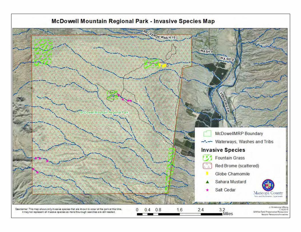

McDowell
Sonoran PreserveTonto
National ForestFort McDowell
Yavapai Nation
McDowell Mountain
Regional Park
Salt River
Indian Community
Fountain Hills
Scottsdale
Usery MountainRegional Park
87
101
Rio Verde
Mesa
SaltRiver
Saguaro Lake
Verde Riv e
rSalt-Verde Ecosystem IBA
Salt-Verde Ecosystem IBA
Fountain Hills
McDowell Preserve
202
McDowell Mountain Regional ParkWildlife Linkages
Scale = 1:130,000
1 0 1 2 3 4 5 Miles
1 0 1 2 3 4 5 6 7 Kilometers
Wildlife LinkagesHabitat Block (HabiMap Arizona)
Potential Linkage Zones Across Habitat (HabiMap Arizona)*
Possible Important Bird Area
*This layer was recreated from a screenshotof the online Arizona Game & Fish HabiMap viewer.
Arizona Game & Fish Wildlife Waters
Regional Park Boundary
Indian Community Boundary
Sonoran Preserve (Scottsdale, Fountain Hills)
Important Bird Area (Audubon Society)
2/8/2019
DISCLAIMER: This map is a graphical representationdesigned for general reference purposes only. Viewer/Useragrees to indemnify, defend and hold harmless MaricopaCounty, its officers, departments, employees and agentsfrom and against any and all suits, actions, legal oradministrative proceedings, claims, demands or damages ofany kind or nature arising out of the use of this map, or thedata contained herein, in its actual or altered form.
Maricopa CountyParks and Recreation Department
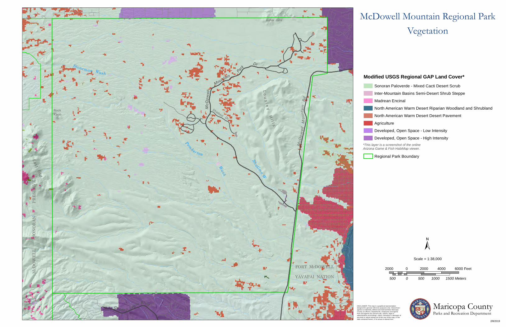
Asher Hills
FORT McDOWELL
YAVAPAI NATION
Shallmo Dr
EndEast
McDO
WEL
L
SO
NORA
N
P
RESE
RVE
McD
owell
Mountain
Park
McD
owell
Mou
ntain
Rd
L o us l e yH
i l l s
Dr
RockKnob
Gol d en Eagle Blvd
Stoneman Wash
Pemberton
Wash
Shallmo W
McDowell Mountain Regional ParkVegetation
Modified USGS Regional GAP Land Cover*
*This layer is a screenshot of the online Arizona Game & Fish HabiMap viewer.
Madrean Encinal
Sonoran Paloverde - Mixed Cacti Desert Scrub
Inter-Mountain Basins Semi-Desert Shrub Steppe
Regional Park Boundary
Developed, Open Space - High Intensity
Agriculture
Developed, Open Space - Low Intensity
North American Warm Desert Desert Pavement
North American Warm Desert Riparian Woodland and Shrubland
2/8/2019
DISCLAIMER: This map is a graphical representationdesigned for general reference purposes only. Viewer/Useragrees to indemnify, defend and hold harmless MaricopaCounty, its officers, departments, employees and agentsfrom and against any and all suits, actions, legal oradministrative proceedings, claims, demands or damages ofany kind or nature arising out of the use of this map, or thedata contained herein, in its actual or altered form.
Maricopa CountyParks and Recreation Department
Scale = 1:38,000
2000 0 2000 4000 6000 Feet
500 0 500 1000 1500 Meters
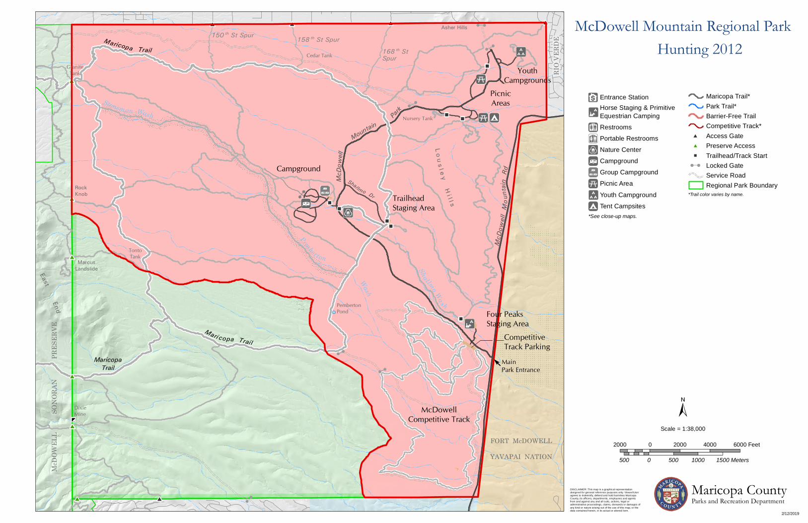
GraniteTank
Cedar Tank
RockKnob
Asher Hills
FORT McDOWELL
YAVAPAI NATIONWash
TontoTank
TrailheadStaging Area
Shal lmo Dr
Four PeaksStaging Area
CompetitiveTrack Parking
MainPark Entrance
RIO
VERD
E
PembertonPond
McDowellCompetitive Track
Mc D
OW
EL L
End
East
Stoneman Wash
MarcusLandslide
McDO
WEL
L
SO
NORA
N
P
RESE
RVE
McD
owell
Mountain
Mari copa Trai l
Pembert on
Par
k
Shallmo Wash
Golden E agle Blvd
McD
owell
Mou
ntain
Rd
DixieMine
L o u s l e yH
i l l s
150 th St Spur 158 th St Spur168 th StSpur
Campground
PicnicAreasFV
V
Y
YouthCampgrounds
Nursery Tank
Maricopa Trail
MaricopaTrail
Scale = 1:38,000
2000 0 2000 4000 6000 Feet
500 0 500 1000 1500 Meters
Tent Campsites
Picnic Area
Youth Campground
F
V
Nature Center
Entrance StationHorse Staging & Primitive Equestrian Camping
Restrooms
Portable Restrooms
Campground
Group Campground
Z
Y
z
*See close-up maps.
*Trail color varies by name.
Barrier-Free TrailCompetitive Track*
Maricopa Trail*Park Trail*
Access GatePreserve Access
Service RoadLocked Gate
Regional Park Boundary
Trailhead/Track Start
McDowell Mountain Regional ParkHunting 2012
DISCLAIMER: This map is a graphical representationdesigned for general reference purposes only. Viewer/Useragrees to indemnify, defend and hold harmless MaricopaCounty, its officers, departments, employees and agentsfrom and against any and all suits, actions, legal oradministrative proceedings, claims, demands or damages ofany kind or nature arising out of the use of this map, or thedata contained herein, in its actual or altered form.
2/12/2019
Maricopa CountyParks and Recreation Department

Arizona Environmental Online Review Tool Report
Arizona Game and Fish Department MissionTo conserve Arizona's diverse wildlife resources and manage for safe, compatible outdoor recreation
opportunities for current and future generations.
Project Name:
McDowell Mountain Park
User Project Number:
Maricopa County Parks and Recreation
Project Description:
Learning the flora and fauna of each park
Project Type:
Education/Information
Contact Person:
Juanita Armstrong-Ullberg
Organization:
Maricopa County Parks and Recreation
On Behalf Of:
MARICOPA
Project ID:
HGIS-08348
Please review the entire report for project type and/or species recommendations for the locationinformation entered. Please retain a copy for future reference.
Page 1 of 10

Arizona Game and Fish Department project_report_mcdowell_mountain_park_29494_30372.pdfProject ID: HGIS-08348 Review Date: 11/26/2018 11:07:36 AM
Disclaimer:
1. This Environmental Review is based on the project study area that was entered. The report must beupdated if the project study area, location, or the type of project changes.
2. This is a preliminary environmental screening tool. It is not a substitute for the potential knowledgegained by having a biologist conduct a field survey of the project area. This review is also not intended toreplace environmental consultation (including federal consultation under the Endangered Species Act),land use permitting, or the Departments review of site-specific projects.
3. The Departments Heritage Data Management System (HDMS) data is not intended to include potentialdistribution of special status species. Arizona is large and diverse with plants, animals, andenvironmental conditions that are ever changing. Consequently, many areas may contain species thatbiologists do not know about or species previously noted in a particular area may no longer occur there.HDMS data contains information about species occurrences that have actually been reported to theDepartment. Not all of Arizona has been surveyed for special status species, and surveys that have beenconducted have varied greatly in scope and intensity. Such surveys may reveal previouslyundocumented population of species of special concern.
4. HabiMap Arizona data, specifically Species of Greatest Conservation Need (SGCN) under our StateWildlife Action Plan (SWAP) and Species of Economic and Recreational Importance (SERI), representpotential species distribution models for the State of Arizona which are subject to ongoing change,modification and refinement. The status of a wildlife resource can change quickly, and the availability ofnew data will necessitate a refined assessment.
Locations Accuracy Disclaimer:Project locations are assumed to be both precise and accurate for the purposes of environmental review. Thecreator/owner of the Project Review Report is solely responsible for the project location and thus the correctnessof the Project Review Report content.
Page 2 of 10

Arizona Game and Fish Department project_report_mcdowell_mountain_park_29494_30372.pdfProject ID: HGIS-08348 Review Date: 11/26/2018 11:07:36 AM
Recommendations Disclaimer:
1. The Department is interested in the conservation of all fish and wildlife resources, including thosespecies listed in this report and those that may have not been documented within the project vicinity aswell as other game and nongame wildlife.
2. Recommendations have been made by the Department, under authority of Arizona Revised StatutesTitle 5 (Amusements and Sports), 17 (Game and Fish), and 28 (Transportation).
3. Potential impacts to fish and wildlife resources may be minimized or avoided by the recommendationsgenerated from information submitted for your proposed project. These recommendations are preliminaryin scope, designed to provide early considerations on all species of wildlife.
4. Making this information directly available does not substitute for the Department's review of projectproposals, and should not decrease our opportunity to review and evaluate additional project informationand/or new project proposals.
5. Further coordination with the Department requires the submittal of this Environmental Review Report witha cover letter and project plans or documentation that includes project narrative, acreage to be impacted,how construction or project activity(s) are to be accomplished, and project locality information (includingsite map). Once AGFD had received the information, please allow 30 days for completion of projectreviews. Send requests to:Project Evaluation Program, Habitat BranchArizona Game and Fish Department5000 West Carefree HighwayPhoenix, Arizona 85086-5000Phone Number: (623) 236-7600Fax Number: (623) [email protected]
6. Coordination may also be necessary under the National Environmental Policy Act (NEPA) and/orEndangered Species Act (ESA). Site specific recommendations may be proposed during furtherNEPA/ESA analysis or through coordination with affected agencies
Page 3 of 10

Arizona Game and Fish Department project_report_mcdowell_mountain_park_29494_30372.pdfProject ID: HGIS-08348 Review Date: 11/26/2018 11:07:36 AM
Page 4 of 10
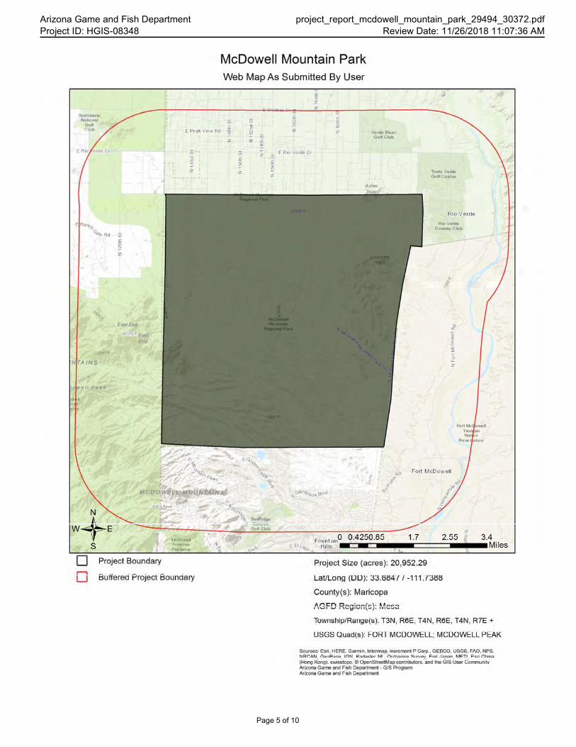
Arizona Game and Fish Department project_report_mcdowell_mountain_park_29494_30372.pdfProject ID: HGIS-08348 Review Date: 11/26/2018 11:07:36 AM
Page 5 of 10

Arizona Game and Fish Department project_report_mcdowell_mountain_park_29494_30372.pdfProject ID: HGIS-08348 Review Date: 11/26/2018 11:07:36 AM
Page 6 of 10

Arizona Game and Fish Department project_report_mcdowell_mountain_park_29494_30372.pdfProject ID: HGIS-08348 Review Date: 11/26/2018 11:07:36 AM
Special Status Species and Special Areas Documented within 2 Miles of Project Vicinity
Scientific Name Common Name FWS USFS BLM NPL SGCN
Agave murpheyi Hohokam Agave SC S S HS
Bat Colony
Corynorhinus townsendii pallescens Pale Townsend's Big-eared Bat SC S S 1B
Cyprinodon macularius Desert Pupfish LE 1A
Ericameria brachylepis Rayless Turpentine Bush
Falco peregrinus anatum American Peregrine Falcon SC S S 1A
Fort McDowell Indian Reservation Fort McDowell Indian Reservation
Gila robusta Roundtail Chub CCA S S 1A
Gopherus morafkai Sonoran Desert Tortoise CCA S S 1A
Haliaeetus leucocephalus (winteringpop.)
Bald Eagle - Winter Population SC,BGA
S S 1A
Haliaeetus leucocephalus pop. 3 Bald Eagle - Sonoran DesertPopulation
SC,BGA
S S 1A
Heloderma suspectum cinctum Banded Gila Monster SC 1A
Heloderma suspectum suspectum Reticulate Gila Monster 1A
Leptonycteris yerbabuenae Lesser Long-nosed Bat SC 1A
Lithobates yavapaiensis Lowland Leopard Frog SC S S 1A
Macrotus californicus California Leaf-nosed Bat SC S 1B
Maricopella allynsmithi Squaw Peak Talussnail SC 1B
Myotis velifer Cave Myotis SC S 1B
PCH for Coccyzus americanus Yellow-billed Cuckoo ProposedCritical Habitat
Poeciliopsis occidentalisoccidentalis
Gila Topminnow LE 1A
Rallus obsoletus yumanensis Yuma Ridgway's Rail LE 1A
Salt and Verde Riparian EcosystemIBA
Note: Status code definitions can be found at https://www.azgfd.com/wildlife/planning/wildlifeguidelines/statusdefinitions/.
Species of Greatest Conservation NeedPredicted within 2 Miles of Project Vicinity based on Predicted Range Models
Scientific Name Common Name FWS USFS BLM NPL SGCN
Agosia chrysogaster Longfin Dace SC S 1B
Aix sponsa Wood Duck 1B
Ammospermophilus harrisii Harris' Antelope Squirrel 1B
Anaxyrus microscaphus Arizona Toad SC S 1B
Aquila chrysaetos Golden Eagle BGA S 1B
Athene cunicularia hypugaea Western Burrowing Owl SC S S 1B
Botaurus lentiginosus American Bittern 1B
Page 7 of 10
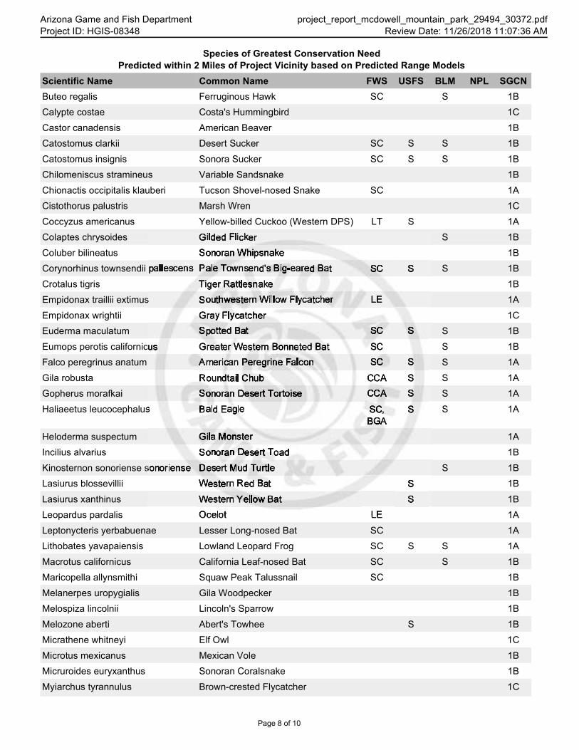
Arizona Game and Fish Department project_report_mcdowell_mountain_park_29494_30372.pdfProject ID: HGIS-08348 Review Date: 11/26/2018 11:07:36 AM
Species of Greatest Conservation NeedPredicted within 2 Miles of Project Vicinity based on Predicted Range Models
Scientific Name Common Name FWS USFS BLM NPL SGCN
Buteo regalis Ferruginous Hawk SC S 1B
Calypte costae Costa's Hummingbird 1C
Castor canadensis American Beaver 1B
Catostomus clarkii Desert Sucker SC S S 1B
Catostomus insignis Sonora Sucker SC S S 1B
Chilomeniscus stramineus Variable Sandsnake 1B
Chionactis occipitalis klauberi Tucson Shovel-nosed Snake SC 1A
Cistothorus palustris Marsh Wren 1C
Coccyzus americanus Yellow-billed Cuckoo (Western DPS) LT S 1A
Colaptes chrysoides Gilded Flicker S 1B
Coluber bilineatus Sonoran Whipsnake 1B
Corynorhinus townsendii pallescens Pale Townsend's Big-eared Bat SC S S 1B
Crotalus tigris Tiger Rattlesnake 1B
Empidonax traillii extimus Southwestern Willow Flycatcher LE 1A
Empidonax wrightii Gray Flycatcher 1C
Euderma maculatum Spotted Bat SC S S 1B
Eumops perotis californicus Greater Western Bonneted Bat SC S 1B
Falco peregrinus anatum American Peregrine Falcon SC S S 1A
Gila robusta Roundtail Chub CCA S S 1A
Gopherus morafkai Sonoran Desert Tortoise CCA S S 1A
Haliaeetus leucocephalus Bald Eagle SC,BGA
S S 1A
Heloderma suspectum Gila Monster 1A
Incilius alvarius Sonoran Desert Toad 1B
Kinosternon sonoriense sonoriense Desert Mud Turtle S 1B
Lasiurus blossevillii Western Red Bat S 1B
Lasiurus xanthinus Western Yellow Bat S 1B
Leopardus pardalis Ocelot LE 1A
Leptonycteris yerbabuenae Lesser Long-nosed Bat SC 1A
Lithobates yavapaiensis Lowland Leopard Frog SC S S 1A
Macrotus californicus California Leaf-nosed Bat SC S 1B
Maricopella allynsmithi Squaw Peak Talussnail SC 1B
Melanerpes uropygialis Gila Woodpecker 1B
Melospiza lincolnii Lincoln's Sparrow 1B
Melozone aberti Abert's Towhee S 1B
Micrathene whitneyi Elf Owl 1C
Microtus mexicanus Mexican Vole 1B
Micruroides euryxanthus Sonoran Coralsnake 1B
Myiarchus tyrannulus Brown-crested Flycatcher 1C
Page 8 of 10

Arizona Game and Fish Department project_report_mcdowell_mountain_park_29494_30372.pdfProject ID: HGIS-08348 Review Date: 11/26/2018 11:07:36 AM
Species of Greatest Conservation NeedPredicted within 2 Miles of Project Vicinity based on Predicted Range Models
Scientific Name Common Name FWS USFS BLM NPL SGCN
Myotis occultus Arizona Myotis SC S 1B
Myotis velifer Cave Myotis SC S 1B
Myotis yumanensis Yuma Myotis SC 1B
Nyctinomops femorosaccus Pocketed Free-tailed Bat 1B
Oreoscoptes montanus Sage Thrasher 1C
Oreothlypis luciae Lucy's Warbler 1C
Panthera onca Jaguar LE 1A
Passerculus sandwichensis Savannah Sparrow 1B
Phrynosoma solare Regal Horned Lizard 1B
Phyllorhynchus browni Saddled Leaf-nosed Snake 1B
Poeciliopsis occidentalisoccidentalis
Gila Topminnow LE 1A
Rhinichthys osculus Speckled Dace SC S 1B
Setophaga petechia Yellow Warbler 1B
Sphyrapicus nuchalis Red-naped Sapsucker 1C
Spizella atrogularis Black-chinned Sparrow 1C
Spizella breweri Brewer's Sparrow 1C
Tadarida brasiliensis Brazilian Free-tailed Bat 1B
Toxostoma lecontei LeConte's Thrasher S 1B
Troglodytes pacificus Pacific Wren 1B
Vireo bellii arizonae Arizona Bell's Vireo 1B
Vireo vicinior Gray Vireo S 1C
Vulpes macrotis Kit Fox NoStatus
1B
Species of Economic and Recreation Importance Predicted within 2 Miles of Project Vicinity
Scientific Name Common Name FWS USFS BLM NPL SGCN
Callipepla gambelii Gambel's Quail
Odocoileus hemionus Mule Deer
Pecari tajacu Javelina
Puma concolor Mountain Lion
Zenaida asiatica White-winged Dove
Zenaida macroura Mourning Dove
Project Type: Education/Information
Project Type Recommendations:Based on the project type entered (information/education), no impacts to land or water resources are anticipated andtherefore no project type recommendations or mitigation measures are provided. If you entered this project type bymistake, please contact the PEP program to change the project type for you.
Page 9 of 10

Arizona Game and Fish Department project_report_mcdowell_mountain_park_29494_30372.pdfProject ID: HGIS-08348 Review Date: 11/26/2018 11:07:36 AM
Project Location and/or Species Recommendations:HDMS records indicate that one or more native plants listed on the Arizona Native Plant Law and Antiquities Act havebeen documented within the vicinity of your project area. Please contact:Arizona Department of Agriculture1688 W Adams St.Phoenix, AZ 85007Phone: 602.542.4373https://agriculture.az.gov/environmental-services/np1
HDMS records indicate that one or more listed, proposed, or candidate species or Critical Habitat (Designated orProposed) have been documented in the vicinity of your project. The Endangered Species Act (ESA) gives the US Fishand Wildlife Service (USFWS) regulatory authority over all federally listed species. Please contact USFWS EcologicalServices Offices at http://www.fws.gov/southwest/es/arizona/ or: Phoenix Main Office Tucson Sub-Office Flagstaff Sub-Office
2321 W. Royal Palm Rd, Suite 103 201 N. Bonita Suite 141 SW Forest Science Complex
Phoenix, AZ 85021 Tucson, AZ 85745 2500 S. Pine Knoll Dr.
Phone: 602-242-0210 Phone: 520-670-6144 Flagstaff, AZ 86001
Fax: 602-242-2513 Fax: 520-670-6155 Phone: 928-556-2157
Fax: 928-556-2121
HDMS records indicate that Sonoran Desert Tortoise have been documented within the vicinity of your project area.Please review the Tortoise Handling Guidelines found at: https://www.azgfd.com/wildlife/nongamemanagement/tortoise/
HDMS records indicate that Lesser Long-nosed Bats have been documented within the vicinity of your project area.Please review the Lesser Long-nosed Bat Management Guidelinesat: https://www.azgfd.com/PortalImages/files/wildlife/planningFor/wildlifeFriendlyGuidelines/FINALlecuyeHabitatGdln.pdf
The analysis has detected one or more Important Bird Areas within your project vicinity. Please see http://aziba.org/?page_id=38 for details about the Important Bird Area(s) identified in the report.
Tribal Lands are within the vicinity of your project area and may require further coordination. Please contact:Fort McDowell Yavapai NationPO Box 17779Fountain Hills, AZ 85269(480) 837-5121(480) 837-1630 (fax)
Page 10 of 10

ECOS / Species Reports / Species occurrence by state/ Listed species believed to or known to occur in Arizona
Listed species believed to or known to occur in Arizona Notes:
• As of 02/13/2015 the data in this report has been updated to use a different set of information. Results are based on where the species is believed to or known to occur. The FWS feels utilizing this data set is a better representation of species occurrence. Note: there may be other federally listed species that are not currently known or expected to occur in this state but are covered by the ESA wherever they are found; Thus if new surveys detected them in this state they are still covered by the ESA. The FWS is using the best information available on this date to generate this list.
• This report shows listed species or populations believed to or known to occur in Arizona • This list does not include experimental populations and similarity of appearance listings.• This list includes species or populations under the sole jurisdiction of the National Marine
Fisheries Service.• Click on the highlighted scientific names below to view a Species Profile for each listing.
Listed species -- 64 listingsAnimals -- 43 listings
Status Species/Listing Name
E Ambersnail, Kanab Wherever found (Oxyloma haydeni kanabensis)
E Bobwhite, masked (quail) Wherever found (Colinus virginianus ridgwayi)
T Catfish, Yaqui Wherever found (Ictalurus pricei)
E Chub, bonytail Wherever found (Gila elegans)
E Chub, Gila Wherever found (Gila intermedia)
E Chub, humpback Wherever found (Gila cypha)
ECOS Environmental Conservation Online SystemConserving the Nature of America
U.S. Fish & Wildlife Service Search ECOS

Status Species/Listing Name
T Chub, Sonora Wherever found (Gila ditaenia)
E Chub, Virgin River Wherever found (Gila seminuda (=robusta))
E Chub, Yaqui Wherever found (Gila purpurea)
E Condor, California U.S.A. only, except where listed as an experimental population (Gymnogyps californianus)
T Cuckoo, yellow-billed Western U.S. DPS (Coccyzus americanus)
E Ferret, black-footed Wherever found, except where listed as an experimental population (Mustela nigripes)
E Flycatcher, southwestern willow Wherever found (Empidonax traillii extimus)
T Frog, Chiricahua leopard Wherever found (Rana chiricahuensis)
T gartersnake, narrow-headed Wherever found (Thamnophis rufipunctatus)
T gartersnake, northern Mexican Wherever found (Thamnophis eques megalops)
E Jaguar Wherever found (Panthera onca)
E Minnow, loach Wherever found (Tiaroga cobitis)
E Mouse, New Mexico meadow jumping Wherever found (Zapus hudsonius luteus)
E Ocelot wherever found (Leopardus (=Felis) pardalis)
T Owl, Mexican spotted Wherever found (Strix occidentalis lucida)
E Pikeminnow (=squawfish), Colorado Wherever found, except where listed as an experimental population (Ptychocheilus lucius)
E Pronghorn, Sonoran Wherever found, except where listed as an experimental population (Antilocapra americana sonoriensis)
E Pupfish, desert Wherever found (Cyprinodon macularius)
E Rail, Yuma clapper Wherever found (Rallus longirostris yumanensis)
T Rattlesnake, New Mexican ridge-nosed Wherever found (Crotalus willardi obscurus)
E Salamander, Sonora tiger Wherever found (Ambystoma tigrinum stebbinsi)
T Shiner, beautiful Wherever found (Cyprinella formosa)
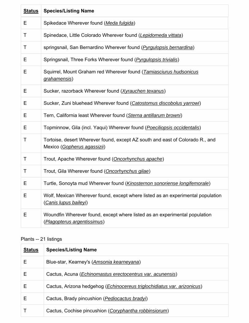
Status Species/Listing Name
E Spikedace Wherever found (Meda fulgida)
T Spinedace, Little Colorado Wherever found (Lepidomeda vittata)
T springsnail, San Bernardino Wherever found (Pyrgulopsis bernardina)
E Springsnail, Three Forks Wherever found (Pyrgulopsis trivialis)
E Squirrel, Mount Graham red Wherever found (Tamiasciurus hudsonicus grahamensis)
E Sucker, razorback Wherever found (Xyrauchen texanus)
E Sucker, Zuni bluehead Wherever found (Catostomus discobolus yarrowi)
E Tern, California least Wherever found (Sterna antillarum browni)
E Topminnow, Gila (incl. Yaqui) Wherever found (Poeciliopsis occidentalis)
T Tortoise, desert Wherever found, except AZ south and east of Colorado R., and Mexico (Gopherus agassizii)
T Trout, Apache Wherever found (Oncorhynchus apache)
T Trout, Gila Wherever found (Oncorhynchus gilae)
E Turtle, Sonoyta mud Wherever found (Kinosternon sonoriense longifemorale)
E Wolf, Mexican Wherever found, except where listed as an experimental population (Canis lupus baileyi)
E Woundfin Wherever found, except where listed as an experimental population (Plagopterus argentissimus)
Plants -- 21 listings
Status Species/Listing Name
E Blue-star, Kearney's (Amsonia kearneyana)
E Cactus, Acuna (Echinomastus erectocentrus var. acunensis)
E Cactus, Arizona hedgehog (Echinocereus triglochidiatus var. arizonicus)
E Cactus, Brady pincushion (Pediocactus bradyi)
T Cactus, Cochise pincushion (Coryphantha robbinsiorum)

Status Species/Listing Name
E Cactus, Fickeisen plains (Pediocactus peeblesianus fickeiseniae)
E Cactus, Nichol's Turk's head (Echinocactus horizonthalonius var. nicholii)
E Cactus, Peebles Navajo (Pediocactus peeblesianus var. peeblesianus)
E Cactus, Pima pineapple (Coryphantha scheeri var. robustispina)
T Cactus, Siler pincushion (Pediocactus (=Echinocactus,=Utahia) sileri)
E Cliffrose, Arizona (Purshia (=Cowania) subintegra)
T Cycladenia, Jones (Cycladenia humilis var. jonesii)
T Fleabane, Zuni (Erigeron rhizomatus)
E ladies-tresses, Canelo Hills (Spiranthes delitescens)
E mallow, Gierisch (Sphaeralcea gierischii)
E Milk-vetch, Holmgren (Astragalus holmgreniorum)
E Milk-vetch, Sentry (Astragalus cremnophylax var. cremnophylax)
T Milkweed, Welsh's (Asclepias welshii)
T Ragwort, San Francisco Peaks (Packera franciscana)
T Sedge, Navajo (Carex specuicola)
E Water-umbel, Huachuca (Lilaeopsis schaffneriana var. recurva)

McDowell Mountain Regional Park
Abutilon abutiloidesShrubby Indian-
Mallow
Abutilon incanumPelotazo
Acacia constrictaMescat False Acacia
Acacia greggiiLong-Flower
Catclaw
Acamptopappus sphaerocephalus
var. sphaerocephalus
rayless goldenhead
Acourtia nanaDwarf Desert-Peony
Acourtia wrightiiBrownfoot
Adenophyllum porophylloides
San Felipe Dogweed
Agave desertiDesert Century-
Plant
Allionia incarnatatrailing windmills
Aloysia wrightiiWright's Beebrush
Amaranthus blitoides
Mat Amaranth
Ambrosia ambrosioides
Ambrosia-Leaf Burr-Ragweed
Ambrosia confertiflora
Weak-Leaf Burr-Ragweed
Ambrosia deltoideaTriangle Burr-
Ragweed
Ambrosia dumosaWhite Burrobush
Ambrosia monogyraNeedle-Leaf Burrobush
Ambrosia salsolaWhite Ragweed
Amsinckia intermedia
Common Fiddleneck
Amsinckia tessellataDevil's-Lettuce
Anemone tuberosaDesert Thimbleweed
Arabis perennansPerennial Rockcress
Aristida adscensionis
Six-Weeks Three-Awn
Aristida purpurea var. nealleyi
blue threeawn
Aristida purpurea var. parishii
Parish's threeawn
Aristolochia watsoniiWatson's
Dutchman's-Pipe
Artemisia ludoviciana subsp.
sulcatawhite sagebrush
Asclepias nyctaginifolia
Mojave Milkweed
Asclepias subulataRush Milkweed
Astragalus allochrous var.
playanushalfmoon milkvetch
Authors: Meredith A. Lane Citation: Lane, M. A. 1981. Vegetation and flora of the McDowell Mountain Regional Park, Maricopa County, Arizona. Journal of the Arizona-Nevada Academy of Science 16: 29-38.Locality: (33.683900, -111.722400)
Families: 60 Genera: 205 Species: 289 (species rank) Total Taxa: 293 (including subsp. and var.)

Astragalus didymocarpus var.
dispermusdwarf white milkvetch
Astragalus nuttallianus var.
imperfectusturkeypeas
Astrolepis cochisensis subsp.
cochisensisCochise scaly
cloakfern
Astrolepis sinuataWavy Scaly Cloak
Fern
Atriplex canescens var. canescens
fourwing saltbush
Atriplex eleganswheelscale saltbush
Baccharis salicifoliaDouglas' False
Willow
Baccharis sarothroidesRosinbush
Bahiopsis parishiiParish's Scrub-Aster
Baileya multiradiataShowy Desert-
Marigold
Boerhavia coccineaScarlet Spiderling
Boerhavia wrightiiLarge-Bract Spiderling
Bothriochloa barbinodis
Cane Beard Grass
Bowlesia incanaHoary Bowlesia
Brandegea bigeloviidesert starvine
Brickellia coulteriCoulter's
Brickellbush
Bromus arizonicusArizona Brome
Bromus berterianusChilean Brome
Bromus carinatusCalifornia Brome
Bromus marginatusmountain brome
Bromus rubensRed Brome
Calandrinia ciliatafringed redmaids
Calliandra eriophyllaFairy-Duster
Calochortus kennedyi
Red Mariposa-Lily
Calycoseris wrightiiWhite Tackstem
Camissonia californica
California suncup
Camissonia chamaenerioides
Long-Capsule Mooncup
Camissonia micrantha
miniature suncup
Canotia holacanthaCrucifixion-Thorn
Carnegiea giganteaSaguaro
Castilleja exserta subsp. exserta
exserted Indian paintbrush
Caulanthus lasiophyllus
Coast Range Wild Cabbage
Celtis pallidaSpiny Hackberry
Centaurea melitensis
Maltese Star-Thistle
Cercocarpus montanusAlder-Leaf
Mountain-Mahogany
Chaenactis carphoclinia
Pebble Pincushion

Chaenactis stevioides
Broad-Flower Pincushion
Cheilanthes covilleiCoville's Lip Fern
Cheilanthes parryiParry's Lip Fern
Chenopodium berlandieri
Pit-Seed Goosefoot
Chenopodium fremontii
Fremont's Goosefoot
Chenopodium murale
Nettle-Leaf Mock Goosefoot
Chorizanthe brevicornu
Brittle Spineflower
Chorizanthe rigidaDevil's Spineflower
Cirsium neomexicanum
New Mexico Thistle
Claytonia perfoliataMiner's-Lettuce
Clematis drummondii
Texas Virgin's-Bower
Conyza canadensis var. glabrata
Canadian horseweed
Cottsia gracilisSlender Janusia
Crassula connataSand Pygmyweed
Crossosoma bigelovii
Ragged Rockflower
Cryptantha barbigera
Bearded Cat's-Eye
Cryptantha decipiens
Gravel-Bar Cat's-Eye
Cryptantha maritima var. pilosaGuadalupe cryptantha
Cryptantha nevadensis var.
rigidaNevada cryptantha
Cryptantha pterocarya var.
cyclopterawingnut cryptantha
Cucurbita digitataFinger-Leaf Gourd
Cuscuta indecoraLarge-Seed Dodder
Cylindropuntia acanthocarpa var.
majorbuckhorn cholla
Cylindropuntia acanthocarpa var.
thornberiThornber's buckhorn
cholla
Cylindropuntia bigelovii
Teddy-Bear Cholla
Cylindropuntia fulgida var. fulgida
jumping cholla
Cylindropuntia leptocaulis
Christmas Cholla
Cylindropuntia x tetracantha
Tucson pricklypear
Cynanchum arizonicum
Arizona swallow-wort
Cynodon dactylonBermuda Grass
Dasyochloa pulchella
False Fluff Grass
Daucus pusillusAmerican Wild
Carrot
Delphinium parishii subsp. parishii
Parish's larkspur
Descurainia pinnataWestern Tansy-
Mustard
Dichelostemma capitatum subsp.
pauciflorumbluedicks
Dimorphotheca aurantiaca
African daisy

Ditaxis lanceolatanarrowleaf silverbush
Ditaxis neomexicanaNew Mexico silverbush
Dodonaea viscosaFlorida Hopbush
Draba cuneifolia var. integrifolia
wedgeleaf draba
Echinocereus engelmannii subsp.
engelmannii
Echinochloa colonaJungle-Rice
Emmenanthe penduliflora
Yellow Whispering-Bells
Encelia farinosa var. farinosa
goldenhills
Encelia virginensis var. virginensis
Virgin River brittlebush
Ephedra asperaRough Joint-Fir
Eragrostis mexicanaMexican Love Grass
Eriastrum diffusumMiniature Woolstar
Eriastrum eremicumDesert Woolstar
Ericameria laricifoliaTurpentine-Bush
Erigeron accedens Erigeron oxyphyllusWand Fleabane
Eriogonum deflexum var. deflexum
flatcrown buckwheat
Eriogonum fasciculatum var.
polifoliumEastern Mojave
buckwheat
Eriogonum inflatum var. inflatum
desert trumpet
Eriogonum palmerianumPalmer's Wild
Buckwheat
Eriogonum trichopesLittle Desert
Trumpet
Eriogonum wrightii var. wrightiibastardsage
Eriophyllum lanosum
White Woolly-Sunflower
Eriophyllum pringleiPringle's Woolly-
Sunflower
Erodium cicutariumRed-Stem Stork's-
Bill
Erodium texanumTexas Stork's-Bill
Erythranthe guttataseep monkeyflower
Eschscholzia californica subsp.
mexicanaCalifornia poppy
Eucrypta chrysanthemifoliaSpotted Hideseed
Eucrypta chrysanthemifolia var. bipinnatifidaspotted hideseed
Euphorbia abramsiana
Abrams' Sandmat
Euphorbia albomarginataWhite-Margin
Sandmat
Euphorbia capitellata
Head Sandmat
Euphorbia melanadenia
Squaw Sandmat
Euphorbia polycarpaSmall-Seed Sandmat
Euphorbia setilobaYuma Sandmat
Evax multicaulis Filago arizonica Filago californica Galium aparine

Spring Pygmy-Cudweed
Ferocactus cylindraceus var.
leconteicurly-spine barrel
cactus
Arizona False Cotton-Rose
California cottonrose Fouquieria splendens
Ocotillo
Sticky-Willy
Galium stellatum subsp. eremicumstarry bedstraw
Gilia flavocincta subsp. flavocincta
lesser yellowthroat gilia
Gilia stellataStar Gily-Flower
Glandularia bipinnatifidaDakota Mock
Vervain
Glinus radiatusSpreading Sweetjuice
Gnaphalium palustreWestern Marsh
Cudweed
Gutierrezia sarothrae
Kindlingweed
Harpagonella palmeri
Palmer's Grappling-Hook
Hedeoma nanaDwarf False Pennyroyal
Helianthus annuusCommon Sunflower
Heliotropium curassavicum
Seaside Heliotrope
Herissantia crispaBladder-Mallow
Herniaria hirsutaHairy Rupturewort
Heterotheca subaxillaris
Camphorweed
Hordeum murinum subsp. leporinumleporinum barley
Hordeum pusillumLittle Barley
Hyptis emoryidesert lavender
Isocoma acradeniaAlkali Jimmyweed
Juniperus coahuilensis
Red-Berry Juniper
Justicia californicabeloperone
Keckiella antirrhinoides
subsp. microphyllasnapdragon penstemon
Krameria bicolorWhite Ratany
Krameria erectaSmall-Flower Ratany
Lactuca serriolaPrickly Lettuce
Laennecia coulteriCoulter's Woolwort
Larrea tridentataCreosote-Bush
Lasthenia californicaCalifornia Goldfields
Layia glandulosaWhite Tidytips
Lepidium lasiocarpum var.
lasiocarpumshaggyfruit pepperweed
Lepidium virginicumPoorman's-Pepperwort
Lepidium virginicum var. mediumpeppergrass
Leptochloa viscidaSonoran Viper Grass
Leptosiphon aureusGolden Perennial
Gily-Flower
Linanthus bigeloviiBigelow's Desert-
Trumpets
Lomatium nevadense var.
parishiiParish's biscuitroot
Lotus humistratusFoothill Deerweed

Lotus rigidusBroom Deerweed
Lotus salsuginosus var. brevivexilluscoastal bird's-foot
trefoil
Lotus strigosus var. tomentellus
Strigose Deerweed
Lupinus concinnus subsp. orcuttiiOrcutt's lupine
Lupinus sparsiflorus subsp. mohavensis
Mojave lupine
Lycium berlandieri var. longistylum
Berlandier's wolfberry
Lycium exsertumArizona Desert-
Thorn
Lycium fremontii var. fremontii
Malva parvifloraSmall-Whorl Mallow
Mammillaria grahamii
Graham's Nipple Cactus
Marah gilensisGila Manroot
Marina parryiParry's False Prairie-Clover
Marrubium vulgareWhite Horehound
Matricaria discoideaPineapple-Weed
Melampodium leucanthum
Plains Blackfoot
Melilotus indicusannual yellow sweetclover
Menodora scabraRough Menodora
Mentzelia affinisYellow-Comet
Mentzelia multifloraAdonis Blazingstar
Minuartia douglasiiDouglas' stitchwort
Mirabilis laevis var. villosa
wishbone-bush
Monoptilon bellioides
Mojave Desertstar
Muhlenbergia microsperma
Little-Seed Muhly
Nama hispidum var. mentzeliiSandbells
Nicotiana obtusifoliaDesert Tobacco
Notholaena californica
California Cloak Fern
Notholaena standleyi
Star Cloak Fern
Oenothera curtifloraVelvetweed
Oenothera primiveris subsp.
primiverisdesert evening-
primrose
Olneya tesotaDesert-Ironwood
Opuntia engelmanniiCactus-Apple
Orobanche cooperidesert broomrape
Parietaria hespera var. hespera
rillita pellitory
Parkinsonia floridaBlue Palo-Verde
Parkinsonia microphylla
Yellow Palo-Verde
Pectis papposa var. papposa
manybristle cinchweed
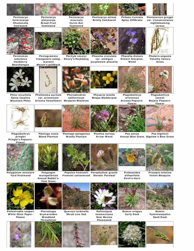
Pectocarya heterocarpaChuckwalla Combseed
Pectocarya platycarpaBroad-Fruit Combseed
Pectocarya recurvataCurve-Nut Combseed
Pectocarya setosaBristly Combseed
Pellaea truncataSpiny Cliffbrake
Peniocereus greggii var. transmontanus
nightblooming cereus
Penstemon subulatusHackberry
Beardtongue
Pentagramma triangularis subsp.
maxoniiMaxon's goldback
fern
Perityle emoryiEmory's Rockdaisy
Phacelia crenulata var. ambigua
purplestem phacelia
Phacelia distansDistant Scorpion-
Weed
Phalaris angustaTimothy Canary
Grass
Phlox tenuifoliaSanta Catalina Mountain Phlox
Pholistoma auritum var. arizonicum
Arizona fiestaflower
Phoradendron californicum
Mesquite Mistletoe
Physaria tenellaMoapa Bladderpod
Plagiobothrys arizonicus
Arizona Popcorn-Flower
Plagiobothrys jonesii
Mojave Popcorn-Flower
Plagiobothrys pringlei
Pringle's Popcorn-Flower
Plantago ovataBlond Plantain
Plantago patagonicaWoolly Plantain
Pluchea sericeaArrow-Weed
Poa annuaAnnual Blue Grass
Poa bigeloviiBigelow's Blue Grass
Polygonum aviculareYard Knotweed
Polypogon monspeliensis
Annual Rabbit's-Foot Grass
Populus fremontiiFremont cottonwood
Porophyllum gracileSlender Poreleaf
Proboscidea althaeifoliaDevil's-Horn
Prosopis velutinaVelvet Mesquite
Psilostrophe cooperiWhite-Stem Paper-
Flower
Pterostegia drymarioides
Woodland Threadstem
Quercus turbinellaShrub Live Oak
Rafinesquia neomexicanaNew Mexico Plumeseed
Rumex crispusCurly Dock
Rumex hymenosepalus
Sand Dock

Sairocarpus pusillusLesser Toad's-Mouth
Salix gooddingiiGoodding's Black
Willow
Salsola tragusPrickly Russian-
Thistle
Salvia columbariaeCalifornia Sage
Sarcostemma cynanchoides subsp.
hartwegiiclimbing milkweed
Schismus arabicusArabian
Mediterranean Grass
Schismus barbatusCommon
Mediterranean Grass
Selaginella arizonicaArizona Spike-Moss
Senecio flaccidus var. monoensis
sand wash groundsel
Senecio lemmoniiLemmon's Ragwort
Senna covesiiHairy Wild
Sensitive-Plant
Setaria macrostachya
Large-Spike Bristle Grass
Silene antirrhinaSleepy Catchfly
Simmondsia chinensis
Jojoba
Sisymbrium irioLondon Rocket
Solanum douglasiiGreen-Spot Nightshade
Sonchus asperSpiny-Leaf Sow-
Thistle
Sonchus oleraceusCommon Sow-
Thistle
Sphaeralcea ambigua subsp.
ambiguaapricot globemallow
Sphaeralcea coulteriCoulter's Globe-
Mallow
Sphaeralcea emoryiEmory's Globe-
Mallow
Stephanomeria pauciflora
Brown-Plume Wire-Lettuce
Stuckenia pectinataSago False Pondweed
Stylocline micropoidesWoolly-Head
Neststraw
Tamarix chinensisFive-Stamen
Tamarisk
Thysanocarpus curvipes
Sand Fringepod
Trifolium wormskioldiiCow Clover
Trisetum interruptum
prairie false oat
Trixis californicaAmerican Threefold
Typha domingensisSouthern Cat-Tail
Uropappus lindleyiLindley's False
Silverpuffs
Verbena bracteataCarpet Vervain
Veronica peregrina subsp. xalapensis
hairy purslane speedwell
Vulpia microstachys var. ciliata
Eastwood fescue
Vulpia microstachys var. paucifloraPacific fescue
Vulpia octofloraEight-Flower Six-
Weeks Grass
Vulpia octoflora var. hirtella
sixweeks fescue
Vulpia octoflora var. octoflora
Xanthisma spinulosum
Lacy Sleepy Daisy
Xanthium strumarium
Rough Cockleburr
Yucca baccataBanana Yucca
Yucca elata var. elata
soaptree yucca

Eight-Flower Six-Weeks Grass
Zannichellia palustris
Horned-Pondweed
Ziziphus obtusifolia var. canescens
lotebush

Appendix E
Cultural Resources

Site #1 Arizona U:5:5Site #2 Arizona U:5:6Site #3 Arizona U:5:7Site #4 Arizona U:5:10 (ASM) * Additional Survey's: Northland 2005 Site #5 Arizona U:6:6Site #6 Arizona U:6:7
Site #4 Arizona U:5:10 (ASM) * Origonal Survey by Johnson 1963
Site #7 Arizona U:6:323 (ASM)
Site #8 Arizona U:5:345 (ASM)
Site #9 Arizona U:5:342 (ASM)Site #10 Arizona U:5:343(ASM) and U:5:344 (ASM)Site #11 Arizona U:6:339 (ASM)
Site #12 Arizona U:6:346(ASM)
Johnson 1963An Appraisal of the Archaeological Resources of Fie Regional parks in Maricopa County, ArizonaBased on a survey made for the Maricopa County Parks and Recreation DepartmentBy: The Arizona State Museume and the University of Arizona, Tucson, Arizona
McDowell Mountain Regional Park Cultural Resource
Archeological Site Inventory
Northland 2005A Cultural Reources Survy of Proposed Trail Alignments Totaling 5.45 Linear Miles Within McDowell Mountain Regional Park, Maricopa County, AZ
Northland 2006A Cultural resource survey of 1.7 Acres in the McDowell Moutnain Regional Park, Maricopa County, AZSite listed on the National Register of Historic Places (NRHP)
ACS 2009Cultural Resources Surevey for the proposed promenade hiking trail within the MDowell
Northland 2009A Cultural Resources Survey of Proposed Trail Alignments Totaling 3.03 Linear Miles within McDowell Mountain Regional Park, Maricopa County, AZ
ACS 2010Cultural Resource Survey forTwo Proposed Trial Connectors within the McDowell Mountain Regional Park Near Fountain Hills, Maricopa County, AZ
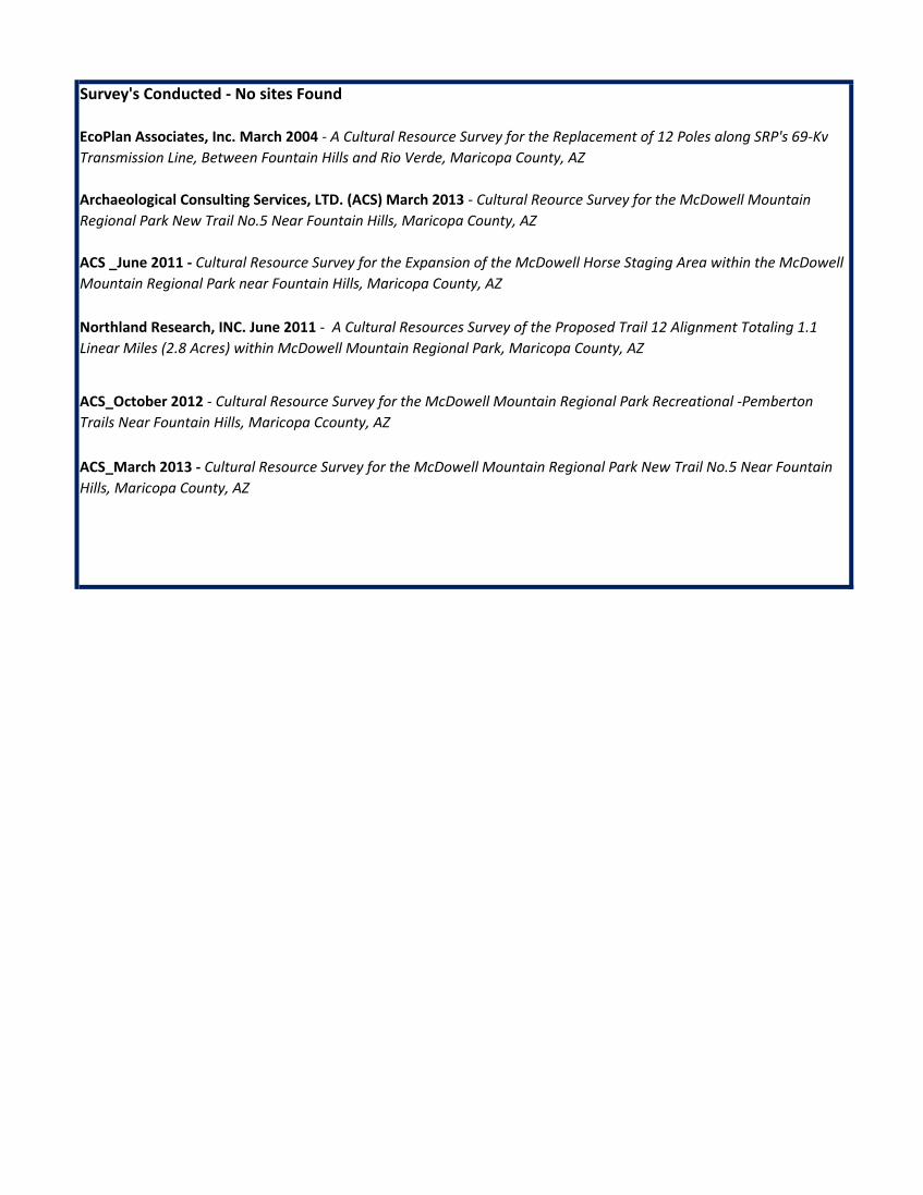
Survey's Conducted - No sites Found
ACS_March 2013 - Cultural Resource Survey for the McDowell Mountain Regional Park New Trail No.5 Near Fountain Hills, Maricopa County, AZ
ACS _June 2011 - Cultural Resource Survey for the Expansion of the McDowell Horse Staging Area within the McDowell Mountain Regional Park near Fountain Hills, Maricopa County, AZ
ACS_October 2012 - Cultural Resource Survey for the McDowell Mountain Regional Park Recreational -Pemberton Trails Near Fountain Hills, Maricopa Ccounty, AZ
EcoPlan Associates, Inc. March 2004 - A Cultural Resource Survey for the Replacement of 12 Poles along SRP's 69-Kv Transmission Line, Between Fountain Hills and Rio Verde, Maricopa County, AZ
Archaeological Consulting Services, LTD. (ACS) March 2013 - Cultural Reource Survey for the McDowell Mountain Regional Park New Trail No.5 Near Fountain Hills, Maricopa County, AZ
Northland Research, INC. June 2011 - A Cultural Resources Survey of the Proposed Trail 12 Alignment Totaling 1.1 Linear Miles (2.8 Acres) within McDowell Mountain Regional Park, Maricopa County, AZ

Site #1 Arizona U:5:5Description This site is a sherd area, situated on the edge of a terrace near an arroy. Sherds were found scattered ober
an area of about one-half acre, but there was no indication of any depth of deposit.Location T4N, R6E, Sec. 23, SW 1/4, NW 1/4
Cultural Affiliation HohokamPottery PlainwareDates Unknown
Site #2 Arizona U:5:6Description This site is a small village, covering a maximum of ten acres along a wash. Cultural material is present to a
depth of about 25 cm. Quantities of gray quartzite occure in gravel deposits on surrounding hills, and there is abundant evidence, in the form of chipping detritus, that this was utilized for the manufacture of stone
Location T4N, R6E, Sec. 30, NW 1/4,NW 1/4
Cultural Affiliation Hohokam
Pottery PlainwareDates Unknown
Site #3 Arizona U:5:7Description This is the site of a village situated in an area which slopes gradually from the surrounding hills to a nearby
wash. Sherds were found scattered over some ten acres, and cultural material is probably present to a depth of about 25 cm.
Location T4N, R6E, Sec. 30, NW 1/4, NW 1/4Cultural Affiliation HohokamPottery Plainware, redwareDates A.D. 1100-1450?
Site #4 Arizona U:5:10 (ASM) * Additional Survey's: Northland 2005 Description Small Hohokam village consisting of three or four rooms straddling a high ridge above a wash.Location T4N, R6E, Sec. 20, SW 1/4, SW 1/4Cultural Affiliation HohokamPottery CeramicDates AD 200-1500
Site #5 Arizona U:6:6Description Location of a sherd area along a steep hillside. Quantities of broken chert and quartzite cobbles were found,
Location T4N, R6E, Sec. 26, NW 1/4, NE 1/4Cultural Affiliation HohokamPottery PlainwareDates Unknown
Site #6 Arizona U:6:7Description Village site covering some five acres at the northwest corner of McDowell Mountain Regional Park. The site
Logation T4N, R6E, Sec. 1, SE 1/4, SE 1/4Cultural Affiliation HohokamPottery PlainwareDates Unknown
Johnson 1963An Appraisal of the Archaeological Resources of Fie Regional parks in Maricopa County, ArizonaBased on a survey made for the Maricopa County Parks and Recreation DepartmentBy: The Arizona State Museume and the University of Arizona, Tucson, Arizona
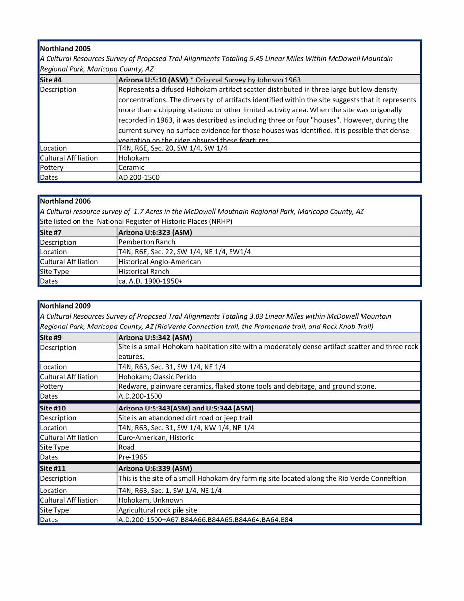
Site #4 Arizona U:5:10 (ASM) * Origonal Survey by Johnson 1963Description Represents a difused Hohokam artifact scatter distributed in three large but low density
concentrations. The dirversity of artifacts identified within the site suggests that it represents more than a chipping stationo or other limited activity area. When the site was origonally recorded in 1963, it was described as including three or four "houses". However, during the current survey no surface evidence for those houses was identified. It is possible that dense vegitation on the ridge obsured these feartures.
Location T4N, R6E, Sec. 20, SW 1/4, SW 1/4Cultural Affiliation HohokamPottery CeramicDates AD 200-1500
Site #7 Arizona U:6:323 (ASM)Description Pemberton Ranch Location T4N, R6E, Sec. 22, SW 1/4, NE 1/4, SW1/4Cultural Affiliation Historical Anglo-AmericanSite Type Historical RanchDates ca. A.D. 1900-1950+
Site #9 Arizona U:5:342 (ASM)Description Site is a small Hohokam habitation site with a moderately dense artifact scatter and three rock
eatures.Location T4N, R63, Sec. 31, SW 1/4, NE 1/4Cultural Affiliation Hohokam; Classic PeridoPottery Redware, plainware ceramics, flaked stone tools and debitage, and ground stone.Dates A.D.200-1500Site #10 Arizona U:5:343(ASM) and U:5:344 (ASM)Description Site is an abandoned dirt road or jeep trailLocation T4N, R63, Sec. 31, SW 1/4, NW 1/4, NE 1/4Cultural Affiliation Euro-American, HistoricSite Type RoadDates Pre-1965Site #11 Arizona U:6:339 (ASM)Description This is the site of a small Hohokam dry farming site located along the Rio Verde Conneftion Location T4N, R63, Sec. 1, SW 1/4, NE 1/4Cultural Affiliation Hohokam, UnknownSite Type Agricultural rock pile siteDates A.D.200-1500+A67:B84A66:B84A65:B84A64:BA64:B84
Northland 2006A Cultural resource survey of 1.7 Acres in the McDowell Moutnain Regional Park, Maricopa County, AZSite listed on the National Register of Historic Places (NRHP)
Northland 2009A Cultural Resources Survey of Proposed Trail Alignments Totaling 3.03 Linear Miles within McDowell Mountain Regional Park, Maricopa County, AZ (RioVerde Connection trail, the Promenade trail, and Rock Knob Trail)
Northland 2005A Cultural Resources Survey of Proposed Trail Alignments Totaling 5.45 Linear Miles Within McDowell Mountain Regional Park, Maricopa County, AZ

Site #8 Arizona U:5:345 (ASM)Description Northwest-southeast trending two track road segment possibly assoiciated with the
Historic Dixie MineLocation T4N, R6E, Sec. 31, South 1/2Cultural Affiliation Euro-AmericanSite Type Historic RoadDates Late Historic (1920s-1960) to present
Site #12 Arizona U:6:346(ASM)Description The road follows along a small crest of a low hill and has a small berm on either side. A
large quarry is located on the south side of the road. The quarry is oblong and a tailgins pile is located at the soutwest end.
Location T4N, R63, Sec. 15 East 1/2Cultural Affiliation Euro-AmericanSite Type Historic Road and quarryDates Late Historic (ca. 1930s-1930s)
ACS 2009Cultural Resources Surevey for the proposed promenade hiking trail within the MDowell
ACS 2010Cultural Resource Survey forTwo Proposed Trial Connectors within the McDowell Mountain Regional Park Near Fountain Hills, Maricopa County, AZ

Appendix F
Land Use
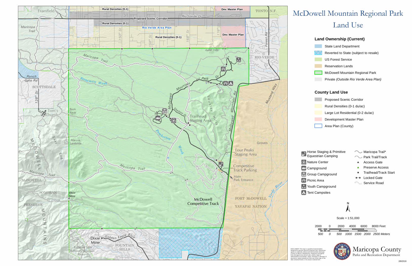
DixieMine
RockKnob
Asher Hills
FORT McDOWELL
YAVAPAI NATION
TrailheadStaging Area
Sha llmo Dr
Four PeaksStaging Area
CompetitiveTrack ParkingMainPark Entrance
V
Y
VF
SONORANMcDowell
Competitive Track
128th
St
MO
UN
TA
INS
Mc D
OW
EL L
End
E ast
Stoneman Wash
McD
owell
Moun
tain
Rd
PRESERVE
McDOWELL
Fountain HillsMcDowell Mountain
Preserve
McD
owel l
MountainDrRanch
Maricopa Trail
Ma ricopa Trail
Pemberton
Park
L o u s l e yH
i l l s
RIO VERDE
FOUNTAINHILLS
SCOTTSDALE
MarcusLandslide
TONTO N.F.
Groves
Fraesfield
Tom'sThumb
Verd
e River
Wash
Mustan
g Way
Fore
st Rd
Golden Eagle Blvd
Rio Verde Dr
150th
St
168th
St
158th
St
MaricopaTrail
Maricopa Trail
Gate Rd
DixieMine
176th
St
Rural Densities (0-1)
Rural Densities (0-1)Proposed Scenic Corridor
Rural Densities (0-1)
Dev. Master Plan
Dev. Master Plan
Rio Verde Area Plan
McDowell Mountain Regional ParkLand Use
Scale = 1:51,000
Proposed Scenic Corridor
Rural Densities (0-1 du/ac)
Large Lot Residential (0-2 du/ac)
Development Master Plan
Area Plan (County)
County Land Use
Land Ownership (Current)
Reverted to State (subject to resale)
State Land Department
US Forest Service
Reservation Lands
McDowell Mountain Regional Park
Private (Outside Rio Verde Area Plan)
Access GatePreserve Access
Service RoadLocked GateTrailhead/Track Start
Maricopa Trail*Park Trail/Track
Tent Campsites
Picnic Area
Youth Campground
F
V
Nature Center
Horse Staging & Primitive Equestrian Camping
Campground
Group CampgroundY
2000 0 2000 4000 6000 8000 Feet
500 0 500 1000 1500 2000 2500 Meters
DISCLAIMER: This map is a graphical representationdesigned for general reference purposes only. Viewer/Useragrees to indemnify, defend and hold harmless MaricopaCounty, its officers, departments, employees and agentsfrom and against any and all suits, actions, legal oradministrative proceedings, claims, demands or damages ofany kind or nature arising out of the use of this map, or thedata contained herein, in its actual or altered form.
2/8/2019
Maricopa CountyParks and Recreation Department

Ranch Gate Rd
L o u s l e yH
i l l s
Park
Pemberton
SCOTTSDALE
Dr
Mountain
McD
owel l
Fountain HillsMcDowell Mountain
Preserve
McDOWELL
PRESERVE
MarcusLandslide
McD
owell
Mou
ntain
Rd
Stoneman Wash
Eas tEnd
Mc D
OW
EL L
MO
UN
TA
INS
128th
St
Shallmo WSONORAN
FOUNTAINHILLS
RIOVERDE
Shal lmo Dr
Wash
FORT McDOWELL
YAVAPAI NATION
Asher Hills
RockKnob
DixieMine
Golden E agle Blvd
Original Land Ownership
OtherTrail
Service Road
Original Ownership
State Land Department
Bureau of Land Management
DISCLAIMER: This map is a graphical representationdesigned for general reference purposes only. Viewer/Useragrees to indemnify, defend and hold harmless MaricopaCounty, its officers, departments, employees and agentsfrom and against any and all suits, actions, legal oradministrative proceedings, claims, demands or damages ofany kind or nature arising out of the use of this map, or thedata contained herein, in its actual or altered form.
2/11/2019
Maricopa CountyParks and Recreation Department
McDowell Mountain Regional Park
Scale = 1:48,000
2000 0 2000 4000 6000 8000 Feet
500 0 500 1000 1500 2000 2500 Meters

Appendix G
Facilities

2 exit lanes, 1 entry lane, 1 pull through entry/parking lane, 1 restrtoom 180 sq.ft.Rock, stucco, concrete block 1
Decomposed granite surface 7.73 acresShade structure fabric shade sails and steel poles 3Trailhead (1) Access to Trails: Escondio, Shallmo Wash , Cintch, and Scenic 1
Decomposed granite surface 4.85 acresShade structure fabric shade sails and steel poles 3Comfort Station #12 Built 2007 - 2 ADA showers, 2 standard showeres, 2 ADA water closet, 1 standards water closet, 1
urinal854 sq.ft.
3 trailheads Sport loop, Technical loop, Long Loop ~9.1 milespump track dirt mound, 1 wood ramp 1
Tripplewide (purchased 11/10/2004 second hand), HVAC, 1000gal Septic 2,632 sq.ft.Kitchen Microwave, refridgerator, ice machine, toaster, coffee maker, etc. 1Restroom(s) 2 ADA stalls, 2 standard, 2 sinks 6Parking lot 1 ADA parking space, decomposed granite surface 11,856 sq.ft.Tortois Enclousure Rock gabian wall 3,471 sq.ft.Wildlife pond Water Pump and fountain 150 sq.ftOutdoor education area Decomposed Granite surface, 3 cactus rip shade structures, decorative rock water fountain 2,446 sq.ft.
Decomposed granit surface, RV overflow 2.88 acresCovered RV Host site (1) steel canopy, concrete pad, power and water 900 sq.ft Ramada #1 Concrete shade structure, concrete pad, 4 picnic tables, 1 grill, shared firepit 1,197 sq.ftRamada #2 Concrete shade structure, concrete pad, 4 picnic tables, 1 grill, shared firepit 1,197 sq.ftComfort Station #7 Built 2007 - 2 ADA showers, 2 standard showeres, 2 ADA water closet, 1 standards water closet, 1
urinal854 sq.ft.
Small Ramada Concrete shade structure, 1 picnic table, 1 grill,firepit 351 sq.ft.Bike Self-Service station Aluminum canopy, concrete pad, power and water- Tools include; allen keys, wrenches, wire
cutter, screwdrivers, air pump, and honor system flat tire tubes (taken to Fountain Hills Bikes)1
Tralheads (2) Trail acces to: Pemberton, Hilltop, Scenic, Tortois, and Shallmo Wash 2
North Loop (Rock Knob) Rentable RV sites, power and water hook ups 38Covered RV Host Sites (2) steel canopy, concrete pad, power and water 900 sq.ft Comfort Station # 5 Built 2007 - 2 ADA showers, 2 standard showeres, 2 ADA water closet, 1 standards water closet, 1
urinal854 sq.ft.
Comfort Station # 6 Built 2007 - 2 ADA showers, 2 standard showeres, 2 ADA water closet, 1 standards water closet, 1 urinal
854 sq.ft.
South Loop (Palasades) Rentable RV sites, power and water hook ups 38Covered RV Host sites (2) steel canopy, concrete pad, power and water 900 sq.ft Comfort Station # 8 Built 2007 - 2 ADA showers, 2 standard showeres, 2 ADA water closet, 1 standards water closet, 1
urinal854 sq.ft.
Comfort Station # 9 Built in 1987-1 urinal, 2 laveatories, 4 water closets, 2 ada water closets, 2 showers ~500sq.ft
Comfort Station # 10 Built in 1987-1 urinal, 2 laveatories, 4 water closets, 2 ada water closets, 2 showers ~500sq.ft
Comfort Station # 11 Built in 1987-1 urinal, 2 laveatories, 4 water closets, 2 ada water closets, 2 showers ~500sq.ft
Over Flow/Group Camp Area Decomposed granit surface and access to Wagner Trail 0.68 acresComfort Station #4 Built in 1987- 2 laveatories, 2 standared water closets, 2 ADA water closets, 2 showers 289 sq.ft.Group Ramada Concrete ramada, 6 tables, 2 grills, 1 fire pit 1,600 sq.ft.
Chain link fence, 100,000 gal steel water reservoir, 6,000 gal double walled fuel AST, supply shed, asphalt base
0.5 acres
Building structure Doublewide, 3 AC wall units, 1 restroom 1,752 sq.ft.2 RV Host sites steel canopy, concrete pad, power and water (900 sq.ft ea)
Includes areas on , Lousley Drive S/N, Lousley Way, Asher View Drive, Asher View Circle, and Scout Camp Drive
Comfort Stations # 1 and #2 Buildt 1983 - 2 ADA water closets, 2 standard water closets, 2 lavetories (for each) 300 sq.ft (ea)Paved Parking 7 paved pull-out parking areas including comfort station locations ~62 spots
Tent Camping Each ten site includes a grill, picnic table, and fire pit 13 sitesPaved Parking 10 paved pull-out parking areas including comfort station locations ~106 spotsComfort Station #3 Buildt 1983 - 2 ADA water closets, 2 standard water closets, 2 lavetories (for each) 300 sq.ft (ea)
Facility Item/Type
Four Peaks Staging Area
Lousley Loop Primative Camping
Palo Verde Picnic Loop
Entry StationMonument Sign
Name/Location/ additional Units/ Sq.ft/ Acres
Trailhead Staging Area
North Park
RV Campground - A total of 80 RV Campsites
Maintenance Compound
McDowell Mountain Regional Park Existing Facility Inventory
Nature Center
Competative Track Staging Area

Minks Camp Decomposed grantie surface, 1 port-o-jon, fire pit, two natural material shade structures, 1 grill, access to Escondido Trail
~0.3 acres
Eagle Camp Decomposed grantie surface, 1 port-o-jon, fire pit, one natural material shade structure, 1 grill ~ 0.1 acresScout Camp Decomposed grantie surface, 3 port-o-jon's, fire pit, two natural material shade structures, 2 grills,
access to Eagle Trail and Scout Trail~1.6 acres
Trails 27 trails, 3 competative tracks, multiple spur trails and trailheads, 7 self-pay iron rangers ~ 80.6 milesMemorial Bench(S) Throughout the park 23RV dump station Two pull-through clean-outs 2000 gal septic tank 7,409 sq.ft.Wagner Trailhead Asphalt paved parking ~17 spaces lcoated adjacent to RV dump station 4,900 sq.ft.Wildlife water catchments Pemberton Pond and Nursery Tank are kept full, others are seasonal 6Additional Bike Service Stations Granit Tank and Coachwhip/Pemberton - Tools include; allen keys, wrenches, wire cutter,
screwdrivers, air pump, and honor system flat tire tubes (taken to Fountain Hills Bikes) 2
Playground Updated with Nature Based play equipment in 2014 - Ceader woodchip base, Concrete/fiberglass playscape - structures include: Rattle snake slide, spiderweb climber, Cactus climber, water fountain, 3 fabric shade sails
2,845 sq.ft
Booster Pump Located near east boundary southeast of Scout Camp- unpaved access road from Scout Camp Drive.2,071 sq.ft.
Youth/Group Camp Areas
Additional Assessts/Facilities

Appendix H
Roads

Maricopa County Department Of Transportation - Roadway Inforamtion Mapperhttps://gisportal.maricopa.gov/roadinformation/

OBJECTIDMaintenance District Name
Maintained Side Route
From Reference Description
To Reference Description Development/ Maintenance description Begin Date
Segment Length (ft)
3765920 Northeast B Asher Cir McDowell Mountain Park Dr Scout Camp Dr Constructed 16-May-83 505.47 3765999 Northeast B Scout Camp Dr McDowell Mountain Park Dr Asher Cir Constructed 16-May-83 244.78 3766000 Northeast B Scout Camp Dr Asher Cir Asher Cir 1-Jan-00 1,645.02 3766255 Northeast B Asher View Dr McDowell Mountain Park Dr McDowell Mountain Park Dr Constructed 16-May-83 3,900.89 3766257 Northeast B Lousley Wy Lousley Dr S Lousley Dr N Constructed 16-May-83 488.09 3769147 Northeast B 176th St Rio Verde Dr 1-Jan-00 5,557.40 3769552 Northeast B Thoms Thumb Dr Rock Nob Lp NW Rock Nob Lp NE Constructed 17-Mar-86 972.40 3769553 Northeast B Thoms Thumb Dr Rock Nob Lp NW Rock Nob Lp NW Constructed 17-Mar-86 3,114.72 3769554 Northeast B Thoms Thumb Dr Rock Nob Lp NE McDowell Mountain Park Dr Constructed 17-Mar-86 1,452.95 3769555 Northeast B Pemberton Dr Thoms Thumb Dr McDowell Mountain Park Dr Constructed 16-Dec-83 203.01 3769556 Northeast B Pemberton Dr Pemberton Lp NE Thoms Thumb Dr Constructed 16-Dec-88 949.75 3769557 Northeast B Rock Nob Lp NW Rock Nob Lp SW Rock Nob Lp NE Constructed 16-Dec-83 755.89 3769558 Northeast B Rock Nob Lp NE Rock Nob Lp NW Rock Nob Lp SE Constructed 16-Dec-83 706.92 3769559 Northeast B Rock Nob Lp SW Thoms Thumb Dr Rock Nob Lp SE Constructed 16-Dec-83 680.03 3769560 Northeast B Rock Nob Lp SE Rock Nob Lp SW Rock Nob Lp NE Constructed 16-Dec-83 746.34 3769561 Northeast B Pemberton Lp NW Whitehead Wy Pemberton Dr Constructed 16-Dec-88 1,331.61 3769562 Northeast B Pemberton Lp SW Whitehead Wy Pemberton Lp SE Constructed 16-Dec-88 1,105.50 3769563 Northeast B Pemberton Lp SE Pemberton Lp SW Whitehead Wy Constructed 16-Dec-88 1,016.96 3769564 Northeast B Pemberton Lp NE Whitehead Wy Pemberton Dr Constructed 16-Dec-88 662.20 3770311 Northeast B Shallmo Dr McDowell Mountain Park Dr Target Rd Constructed 17-Mar-86 4,049.27 3770330 Northeast B Whitehead Wy Pemberton Lp NW Pemberton Lp NE Constructed 16-Dec-88 1,395.20 3772819 Northeast B Lousley Dr N McDowell Mountain Park Dr Lousley Wy Constructed 16-May-83 805.34 3773022 Northeast B Lousley Dr S McDowell Mountain Park Dr Lousley Dr N Constructed 16-May-83 3,562.13 3773026 Northeast B McDowell Mountain Park Dr Thoms Thumb Dr Lousley Dr S Constructed 28-May-85 10,487.45 3773027 Northeast B McDowell Mountain Park Dr Lousley Dr S Asher View Dr Constructed 28-May-85 2,483.59 3773028 Northeast B McDowell Mountain Park Dr Scout Camp Dr Asher View Dr Constructed 28-May-85 1,003.90 3773029 Northeast B McDowell Mountain Park Dr Asher View Dr Scout Camp Dr Constructed 28-May-85 3,477.53 3773030 Northeast B McDowell Mountain Park Dr McDowell Mountain Rd McDowell Mountain Park Dr Constructed 28-May-85 5,280.00 3773031 Northeast B McDowell Mountain Park Dr McDowell Mountain Rd Thoms Thumb Dr Constructed 28-May-85 9,705.76 3773032 Northeast B McDowell Mountain Park Dr Thoms Thumb Dr Thoms Thumb Dr Constructed 28-May-85 687.00 3773033 Northeast B McDowell Mountain Park Dr Asher View Dr 176th St 1-Jan-00 2,025.24 3774228 Northeast B McDowell Mountain Rd Fountain Hills Blvd Fountain Hills Blvd 31-Oct-18 546.00 3774229 Northeast B McDowell Mountain Rd Fountain Hills Blvd Fountain Hills Blvd 31-Oct-18 1,373.00 3774230 Northeast B McDowell Mountain Rd Fountain Hills Blvd McDowell Mountain Park Dr 31-Oct-18 7,544.15 3774239 Northeast B McDowell Mountain Rd McDowell Mountain Park Dr McDowell Mountain Park Dr 31-Oct-18 2,007.00 3774240 Northeast B McDowell Mountain Rd McDowell Mountain Park Dr McDowell Mountain Park Dr 31-Oct-18 5,332.00 3774241 Northeast B McDowell Mountain Rd McDowell Mountain Park Dr McDowell Mountain Park Dr 31-Oct-18 5,333.00 3774242 Northeast B McDowell Mountain Rd McDowell Mountain Park Dr McDowell Mountain Park Dr 31-Oct-18 5,122.00 3774243 Northeast B McDowell Mountain Rd McDowell Mountain Park Dr Forest Rd 31-Oct-18 5,565.11


Appendix I
Trails

3/4/2019
McDowell Mountain Regional ParkTrail Master Plan - 2011
McDowellCompetitive Track
Stoneman Wash
Pemberto n
Wash
Mari copa Trail
MaricopaTrail
Maricopa Trail
Par
k
Mountain
McD
owell
Shal lmo Dr
L o u s l e yH
i l l s
McD
owell
Mou
ntain
Rd
MainPark Entrance
DixieMine
MarcusLandslide
RockKnob
TontoTank
Cedar TankGranite
Tank
150 th St Spur 158 th St Spur 168 th StSpur
Asher Hills
Nursery Tank
End
East
McDo
well
Sono
ran
Pre
serv
e
PembertonPond
Fort McDowell
Yavapai Nation
Rio V
erde
Rd
Fountain Hills STATE
DX
CO
WMDX
ED
SH
CI
VD
NR
LH
CR
NT
SN
PB
HT
TO
WGGR
PB
LR
DL
SM-W
GR
SM-W
SM-W
TT
PB
BO
PB
RK BF
DX
SO
SC
EG
DISCLAIMER: This map is a graphical representationdesigned for general reference purposes only. Viewer/Useragrees to indemnify, defend and hold harmless MaricopaCounty, its officers, departments, employees and agentsfrom and against any and all suits, actions, legal oradministrative proceedings, claims, demands or damages ofany kind or nature arising out of the use of this map, or thedata contained herein, in its actual or altered form.
Maricopa CountyParks and Recreation Department
Scale = 1:38,000
2000 0 2000 4000 6000 Feet
500 0 500 1000 1500 Meters
TrailCode
Trail Name
BFBOCRCICODLDXEGEDGRHTLRLHNRNTPBRKSNSCSHSOSM-WTTTOVDWGWM Windmill
Dixie MineDelsie
Eagle
GraniteHilltop
Lousley HillNorthNursery TankPembertonRock KnobScenicScoutShallmo WashSonoranStoneman WashTonto TankTortoiseVerdeWagner
Lariat
BluffBoulderChuparosa
CoachwhipCinch
Escondido
Access GatePreserve Access
Locked GateTrailhead/Track Start
Service RoadRegional Park Boundary
Trail Plan 2011 - FutureTrail Plan 2011 - ExistingTrail Plan 1999 - Future
Trail Plan 2008 UpdateTrail Plan 1999 - Existing

DISCLAIMER: This map is a graphical representationdesigned for general reference purposes only. Viewer/Useragrees to indemnify, defend and hold harmless MaricopaCounty, its officers, departments, employees and agentsfrom and against any and all suits, actions, legal oradministrative proceedings, claims, demands or damages ofany kind or nature arising out of the use of this map, or thedata contained herein, in its actual or altered form.
3/4/2019
McDowell Mountain Regional ParkProposed Trails
McDowellCompetitive Track
Stoneman Wash
Pemberto n
Wash
Par
k
Mountain
McD
owell
Shallmo Dr
L o u s l e yH
i l l s
McD
owell
Mou
ntain
Rd
MainPark Entrance
DixieMine
MarcusLandslide
RockKnob
TontoTank
Cedar TankGranite
Tank
150 th StSpur
158 th St Spur 168 th StSpur
Asher Hills
Nursery Tank
End
East
McDo
well
Sono
ran
Pres
erve
PembertonPond
Fort McDowell
Yavapai Nation
Rio V
erde
Rd
Nature Center(Proposed)
Mink's Camp
Competitive TrackAdditions
Flow Trail
Bike Park
GR
SN
DX
CO
WMDX
ED
SH
CI
VD
NR
LH
CR
NT
SN
PB
HT
TO
WG
GR
PB
LR
DL
SM-W
GR
SM-W
SM-W
TT
PB
BO
PB
RK BF
DX
SO
EG
SC
Maricopa CountyParks and Recreation Department
Scale = 1:38,000
2000 0 2000 4000 6000 Feet
500 0 500 1000 1500 Meters
TrailCode
Trail Name
BFBOCRCICODLDXEGEDGRHTLRLHNRNTPBRKSNSCSHSOSM-WTTTOVDWGWM Windmill
Dixie MineDelsie
Eagle
GraniteHilltop
Lousley HillNorthNursery TankPembertonRock KnobScenicScoutShallmo WashSonoranStoneman WashTonto TankTortoiseVerdeWagner
Lariat
BluffBoulderChuparosa
CoachwhipCinch
Escondido
Future Trail Alignment2011 Trail Update
Existing Trail
2008 Trail UpdateFuture Trail Alignment
Existing RoadProposed Road
2019 Master Plan Update
Proposed Bike ParkProposed Trail or Track