1 CITY OF MOUNTAIN VIEW CALIFORNIA ENVIRONMENTAL ...
100
1 CITY OF MOUNTAIN VIEW CALIFORNIA ENVIRONMENTAL QUALITY ACT (CEQA) DRAFT MITIGATED NEGATIVE DECLARATION I. INTRODUCTION A. Lead Agency Name and Address: City of Mountain View Community Development Department 500 Castro Street P.O. Box 7540 Mountain View, California 94039 B. Contact Person and Phone Number: Rebecca Shapiro, Associate Planner Telephone: (650) 903-6306 C. Project Sponsor and Address: Jonathan Bergschneider Britannia Hacienda VIII, LLC 3760 Kilroy Airport Way, Suite 300 Long Beach, CA 90806 D. General Plan Designation and Zoning: General Plan: Industrial Park Zoning: P(3) (North Shoreline Boulevard Precise Plan) E. Project Description: The project site is currently developed as a private recreational facility for the use of employees of Shoreline Technology Park tenants (not publicly accessible). Brittania Hacienda VIII, LLC has submitted an application to the City of Mountain View to build a two-story, 70,000-square-foot life sciences/R&D building and associated 202-space surface parking lot. The existing baseball field and barbecue areas would be removed and graded, and the new building would be constructed in the northern portion of the site. The surface parking lot would be located on the southern portion of the project site, which also serves as a flood drainage overflow easement area, and a parking row would be constructed on the west side of the project area. Existing parking rows on the east and north would be reconfigured. The existing basketball court and sand volleyball court at the southeast corner of the project area would be retained. The following discretionary actions are requested for the proposed project:
-
Upload
khangminh22 -
Category
Documents
-
view
1 -
download
0
Transcript of 1 CITY OF MOUNTAIN VIEW CALIFORNIA ENVIRONMENTAL ...

1
CITY OF MOUNTAIN VIEW CALIFORNIA ENVIRONMENTAL QUALITY ACT (CEQA)
DRAFT MITIGATED NEGATIVE DECLARATION
I. INTRODUCTION
A. Lead Agency Name and Address:
City of Mountain View Community Development Department 500 Castro Street P.O. Box 7540 Mountain View, California 94039
B. Contact Person and Phone Number:
Rebecca Shapiro, Associate Planner Telephone: (650) 903-6306
C. Project Sponsor and Address:
Jonathan Bergschneider Britannia Hacienda VIII, LLC 3760 Kilroy Airport Way, Suite 300 Long Beach, CA 90806
D. General Plan Designation and Zoning:
General Plan: Industrial Park Zoning: P(3) (North Shoreline Boulevard Precise Plan)
E. Project Description:
The project site is currently developed as a private recreational facility for the use of employees of Shoreline Technology Park tenants (not publicly accessible). Brittania Hacienda VIII, LLC has submitted an application to the City of Mountain View to build a two-story, 70,000-square-foot life sciences/R&D building and associated 202-space surface parking lot. The existing baseball field and barbecue areas would be removed and graded, and the new building would be constructed in the northern portion of the site. The surface parking lot would be located on the southern portion of the project site, which also serves as a flood drainage overflow easement area, and a parking row would be constructed on the west side of the project area. Existing parking rows on the east and north would be reconfigured. The existing basketball court and sand volleyball court at the southeast corner of the project area would be retained. The following discretionary actions are requested for the proposed project:

2
• Amendment to the North Shoreline Boulevard Precise Plan to allow for an increase in allowable Floor Area Ratio, an increase in maximum building coverage, and a decrease in minimum required open space.
• Planned Community Permit to allow for development of the proposed project and a minor parking exception;
• Development Review Permit for site plan and architectural review and approval; and • Heritage Tree Removal Permit to allow removal of 12 heritage trees.
G. Location of Project:
The approximately 3-acre area of work is located on the south side of Stierlin Court within one of two parcels in the existing Shoreline Technology Park. The Shoreline Technology Park is in an urban area that borders North Shoreline Boulevard, which is a major north-south artery through the City of Mountain View, and the project site is approximately 500 feet east of North Shoreline Boulevard.
II. MITIGATION MEASURES
Implementation of the following mitigation measures shall reduce any potential environmental impacts to less than significant levels.
Mitigation Measure Air-1: The project sponsor shall require construction contractors to implement all the BAAQMD’s Basic Construction Mitigation Measures, listed below:
1. All exposed surfaces (e.g., parking areas, staging areas, soil piles, graded areas, and unpaved access roads) shall be watered two times per day.
2. All haul trucks transporting soil, sand, or other loose material off-site shall be covered.
3. All visible mud or dirt track-out onto adjacent public roads shall be removed using wet power vacuum street sweepers at least once per day. The use of dry power sweeping is prohibited.
4. All vehicle speeds on unpaved roads shall be limited to 15 mph.
5. All roadways, driveways, and sidewalks to be paved shall be completed as soon as possible. Building pads shall be laid as soon as possible after grading unless seeding or soil binders are used.
6. Idling times shall be minimized either by shutting equipment off when not in use or reducing the maximum idling time to 5 minutes (as required by the California airborne toxics control measure Title 13, Section 2485 of California Code of Regulations [CCR]). Clear signage shall be provided for construction workers at all access points.
7. All construction equipment shall be maintained and properly tuned in accordance with manufacturer’s specifications. All equipment shall be checked by a certified mechanic and determined to be running in proper condition prior to operation.
8. Post a publicly visible sign with the telephone number and person to contact at the Lead Agency regarding dust complaints. This person shall respond and take corrective action
3
within 48 hours. The Air District’s phone number shall also be visible to ensure compliance with applicable regulations.
Mitigation Measure Bio-1: Identification and mitigation for impacts to jurisdictional wetlands. If impacts to potentially jurisdictional features and associated riparian vegetation cannot be avoided or minimized for construction of storm drainage structures, then the project applicant will obtain a qualified biologist to complete a wetland delineation in accordance with Corps guidelines and will obtain the appropriate permits/agreements, such as a Section 401 water quality certification from the RWQCB, a Section 404 wetland permit from the Corps, and/or a Section 1602 Streambed Alteration Agreement from the CDFG. Terms and conditions of these permits will likely include recontouring and revegetating temporarily disturbed portions of the wetland, and compensation for permanent impacts onsite with the same type of feature as the feature affected.
Mitigation Measure Bio-2: Nesting Bird Avoidance. To the extent practicable, vegetation removal and construction activities shall be performed from September through February, to avoid the general nesting period for birds. If construction or vegetation removal cannot be performed during this period, pre-construction surveys shall be performed by a qualified biologist no more than 14 days prior to these activities, to locate any active nests. These surveys shall be performed in the project area and surrounding 500 feet. If active nests are observed on either the project site or the surrounding area, the project applicant shall establish buffer zones around the nests, with the size to be determined in consultation with California Department of Fish and Game (usually 100 feet for perching birds and 300 feet for raptors).
If work during the nesting season stops for 14 days or more and then resumes, then nesting bird surveys shall be repeated, to ensure that no new birds have begun nesting in the area.
Mitigation Measure Bio-3: Heritage Tree Avoidance. In order to ensure the survival of retained heritage trees, the following protection measures shall be implemented, subject to review and approval by the City as consistent with the City’s Tree Ordinance:
1. A protective fence shall be provided during the construction period to project those trees that are to be preserved. The fencing shall protect a sufficient portion of the root zone to be effective. In most cases, it would be essential to locate the fencing a minimum radius distance of 10 times the trunk diameter in all directions from the trunk. If hardscape (i.e., curing, paving, etc.) exists inside the radius, the protective fencing is usually recommended to be erected at the edge of the hardscape feature. At the discretion of City Staff, a certified arborist may be retained by the applicant to make decisions about the location(s) of protective fencing at the project site.
2. Preserved heritage trees shall be irrigated throughout the entire construction period during the dry months (any month receiving less than one inch of rainfall). Irrigate a minimum of 10 gallons for each inch of trunk diameter every two weeks. A soaker hose or a drip line is preferred for this purpose.
3. The entire area inside the driplines of preserved heritage trees shall be mulched to the extent feasible. Mulching consists of a protective material (wood chips, gravel) being spread over the root zone inside the dripline. The material shall be four inches in depth after

4
spreading, which shall be done by hand. Wood chips are preferred because they are organic and degrade naturally over time. Wood chips shall be primarily one quarter to three-quarters of an inch in diameter.
4. Trenches for any utilities (gas, electricity, water, phone TV cable, etc.) shall be located outside the driplines of preserved heritage trees, unless approved by a certified arborist.
5. Sidewalks or other hardscape inside the driplines of preserved heritage trees shall be constructed completely on top of the existing soil grade without excavation. Fill soil may be added to the edge of finished hardscape for a maximum distance of approximately 2 feet from the edges to integrate the new hardscape to the natural grade.
6. If any old irrigation lines, drain lines, sewer lines, or any other underground features exist inside the driplines of preserved heritage trees and would not be used, they shall be cut off approximately at soil grade and left in the ground.
7. Material shall not be stored, stockpiled, dumped, or buried inside the driplines of preserved heritage trees.
8. Excavated soil shall not be piled or dumped, even temporarily, inside the driplines of preserved heritage trees.
9. Any pruning of preserved heritage trees shall be done by an arborist certified by the ISA (International Society of Arboriculture) and according to ISA, Western Chapter Standards 1998.
10. Landscape irrigation trenches shall be a minimum distance of 10 times the trunk diameter from the trunks of preserved heritage trees
11. The sprinkler irrigation shall not be designed to strike the trunks of preserved heritage trees.
12. Landscape materials (cobbles, decorative bark, stones, fencing, etc.) shall not be installed directly in contact with the bark of trees because of the risk of serious disease infection.
If any of the above 12 procedures cannot be achieved adequately, a certified arborist shall be consulted to recommend possible alternative solutions, if any. Any further recommendations and protection measures identified by the arborist shall be followed to reduce project-related impacts to heritage trees to a less-than-significant level.
Mitigation Measure Cul-1: Inadvertent Discovery of Archaeological Resources. If prehistoric or historic-period cultural materials are unearthed during ground-disturbing activities, it is recommended that all work within 100 feet of the find halt until a qualified archaeologist and Native American representative can assess the significance of the find. Prehistoric materials might include obsidian and chert flaked-stone tools (e.g., projectile points, knives, scrapers) or toolmaking debris; culturally darkened soil (“midden”) containing heat-affected rocks and artifacts; stone milling equipment (e.g., mortars, pestles, handstones, or milling slabs); and battered-stone tools, such as hammerstones and pitted stones. Historic-period materials might include stone, concrete, or adobe footings and walls; filled wells or privies; and deposits of metal, glass, and/or ceramic refuse. If the find is determined to be potentially significant, the

5
archaeologist, in consultation with the Native American representative, will develop a treatment plan that could include site avoidance, capping, or data recovery.
Mitigation Measure Cul-2: Inadvertent Discovery of Human Remains. If human remains are encountered during ground disturbing activities, State Health and Safety Code Section 7050.5 requires that no further disturbance will occur until the County Coroner has made the necessary findings as to origin and disposition pursuant to PRC Section 5097.98. If the remains are determined to be of Native American descent, the coroner has 24 hours to notify the Native American Heritage Commission. The Native American Heritage Commission will then identify the person(s) thought to be the Most Likely Descendent of the deceased Native American, who will make recommendations for the treatment of any human remains.
Mitigation Measure Geo-1: Design-Level Geotechnical Investigation. The City of Mountain View shall require that the design level geotechnical investigation include recommendations to mitigate the potential for liquefaction in accordance with the specifications of CGS Special Publication 117A, Guidelines for Evaluating and Mitigating Seismic Hazards, and the requirements of the Seismic Hazards Mapping Act. Recommendations made in the geotechnical report shall be implemented as part of the project.
Mitigation Measure Hyd-1: Stormwater Flow Projection Study. The applicant shall prepare a design level stormwater flow projection study and a hydraulic capacity study, to be submitted to the City of Mountain View Public Works Department for review and verification that the existing stormwater infrastructure is properly sized. The studies shall show the new connecting points to the existing storm drain and model the estimated flows and peaking factors, as they relate to the changes in land use on the project site. The studies shall show that the reconfigured drainage pattern would not result in increased on or off-site erosion, siltation, or flooding. The applicant shall be responsible for constructing and financing new or upgraded infrastructure that is required to serve the proposed project.
Mitigation Measure Noise-1: Construction Noise. The project sponsor shall require construction contractors to implement the following mitigation measures:
• All construction vehicles and equipment, fixed and mobile, shall utilize the best available noise control techniques (e.g., improved mufflers, equipment redesign, use of intake silencers, ducts, engine enclosures and acoustically-attenuating shields or shrouds, wherever feasible).
• Consistent with Section 8.23 of the City Code, all noise generating construction activities shall be limited to the hours of 7 a.m. to 6 p.m., Monday through Friday. No noise producing construction activities shall be performed on Saturdays, Sundays and holidays without prior written approval from the City.
• Construction staging areas shall be located as far as practicable from existing recreational uses so as to cause minimal disruption to these activities.
• Signs shall be posted at the construction site that include permitted construction days and hours, and the name and contact number for an appointed disturbance coordinator for the job site in the event of problems.

6
III. DETERMINATION
In accordance with local procedures regarding the California Environmental Quality Act (CEQA), the Community Development Director has conducted an Initial Study to determine whether the proposed project may have a significant adverse effect on the environment, and on the basis of that study recommends the following determination:
The proposed project will not have a significant effect on the environment based on the implementation of the required mitigation measures, and therefore, an Environmental Impact Report (EIR) is not required.
The Initial Study incorporates all relevant information regarding potential environmental effects of the project and confirms the determination that an EIR is not required.
IV. FINDINGS
Based on the findings of the Initial Study, the proposed project will not have a significant effect on the environment for the following reasons:
A. As discussed in the preceding sections, the proposed project does not have the potential to significant degrade the quality of the environment, including effects on animals or plants, or to eliminate historic or prehistoric sites.
B. As discussed in the preceding sections, both short-term and long-term environmental effects associated with the proposed project would be less than significant.
C. When impacts associated with adoption of the proposed project are considered alone or in combination with other impacts, the project-related impacts are insignificant.
D. The above discussions do not identify any substantial adverse impacts to people as a result of the proposed project.
E. This determination reflects the independent judgment of the City.
____________________________________________ _____________________ Rebecca Shapiro, Associate Planner Date

SHORELINE TECHNOLOGY PARK – BUILDING 13 Initial Study
Prepared for March 2011 City of Mountain View
225 Bush Street Suite 1700 San Francisco, CA 94104 415.896.5900 www.esassoc.com
Los Angeles
Oakland
Olympia
Petaluma
Portland
Sacramento
San Diego
Seattle
Tampa
Woodland Hills
210191

OUR COMMITMENT TO SUSTAINABILITY | ESA helps a variety of public and private sector clients plan and prepare for climate change and emerging regulations that limit GHG emissions. ESA is a registered assessor with the California Climate Action Registry, a Climate Leader, and founding reporter for the Climate Registry. ESA is also a corporate member of the U.S. Green Building Council and the Business Council on Climate Change (BC3). Internally, ESA has adopted a Sustainability Vision and Policy Statement and a plan to reduce waste and energy within our operations. This document was produced using recycled paper.

Shoreline Technology Park – Building 13 i ESA / 207562 Initial Study March 2011
Table of Contents 1 Introduction ................................................................................................................................................. 1 2 Project Description ...................................................................................................................................... 2 3 Environmental Checklist and Evaluation of Environmental Impacts .......................................................... 7
1. Aesthetics ...................................................................................................................................... 7 2. Agricultural and Forest Resources .............................................................................................. 10 3. Air Quality ................................................................................................................................... 12 4. Biological Resources ................................................................................................................... 16 5. Cultural Resources ...................................................................................................................... 23 6. Geology, Soils, and Seismicity .................................................................................................... 27 7. Greenhouse Gas Emissions ......................................................................................................... 32 8. Hazards and Hazardous Materials ............................................................................................... 34 9. Hydrology and Water Quality ..................................................................................................... 38 10. Land Use and Planning ................................................................................................................ 44 11. Mineral Resources ....................................................................................................................... 48 12. Noise ............................................................................................................................................ 49 13. Population and Housing .............................................................................................................. 54 14. Public Services ............................................................................................................................ 56 15. Recreation .................................................................................................................................... 60 16. Transportation and Traffic ........................................................................................................... 62 17. Utilities and Service Systems ...................................................................................................... 74
4 Mandatory Findings .................................................................................................................................. 79 5 Determination ............................................................................................................................................ 83 Appendix A: Greenhouse Gas Emission Data ...................................................................................................... A-1 Appendix B: Transportation Analysis Data .......................................................................................................... B-1

Shoreline Technology Park – Building 13 ii ESA / 207562 Initial Study March 2011
LIST OF TABLES AND FIGURES Table 1: Special Status Species for the Mountain View USGS Quadrangle ........................................................... 18 Table 2: Existing North Shoreline Boulevard Precise Plan Height and Bulk Provisions ........................................ 46 Table 3: Existing Peak-Hour Intersection Levels of Service ................................................................................... 66 Table 4: Trip Generation Estimate .......................................................................................................................... 67 Table 5: Existing Plus Project Peak-Hour Intersection Levels of Service .............................................................. 69 Table 6: Cumulative Peak-Hour Intersection Levels of Service ............................................................................. 70 Table 7: Cumulative Plus Project Peak-Hour Intersection Levels of Service ......................................................... 70 Table 8: Summary of Mitigation Measures ............................................................................................................. 80 Figure 1: Project Location ......................................................................................................................................... 3 Figure 2: Site Plan ..................................................................................................................................................... 4 Figure 3: Illustrative Elevations ................................................................................................................................ 5 Figure 4: Existing Roadways ................................................................................................................................... 64 Figure 5: Trip Distribution ...................................................................................................................................... 68
Shoreline Technology Park – Building 13 1 ESA / 207562 Initial Study March 2011
____________________________________________________________________________________________
CITY OF MOUNTAIN VIEW CALIFORNIA ENVIRONMENTAL QUALITY ACT (CEQA)
INITIAL STUDY 1. Introduction This Initial Study evaluates the potential environmental effects of construction of a life sciences research and development building and associated parking on a site located on the southern side of Stierlin Court within the existing Shoreline Technology Park. A more detailed description of the proposed project is provided in Project Description, below.
A. Project Address and Title:
Address: Stierlin Court, Mountain View, CA Title: Shoreline Technology Park – Building 13
B. Lead Agency Name and Address:
City of Mountain View Community Development Department 500 Castro Street P.O. Box 7540 Mountain View, California 94039
C. Contact Person and Phone Number:
Rebecca Shapiro, Associate Planner Telephone: (650) 903-6306
D. Project Sponsor’s Names and Addresses:
Jonathan Bergschneider Britannia Hacienda VIII, LLC 3760 Kilroy Airport Way, Suite 300 Long Beach, CA 90806
E. General Plan Designation and Zoning: General Plan: Industrial Park Zoning: P(3) (North Shoreline Boulevard Precise Plan) F. Project Description: See below. G. Location of Project: See below.
Project Description
Shoreline Technology Park – Building 13 2 ESA / 207562 Initial Study March 2011
2. Project Description Proposed Project Brittania Hacienda VIII, LLC (applicant) has submitted an application to the City of Mountain View to build a two-story, 70,000-square-foot life sciences building and associated surface parking lot on an approximately 3-acre area of work located on the south side of Stierlin Court within one of two parcels in the existing Shoreline Technology Park. The project site is currently developed as a private recreational facility for the use of employees of Shoreline Technology Park tenants (not publicly accessible). The project would require an amendment to the North Shoreline Boulevard Precise Plan to allow for an increase in allowable Floor Area Ratio (FAR), as well as increase in maximum building coverage and decrease in minimum required open space. Figure 1 identifies the project location, and Figure 2 provides the proposed site plan. Figure 3 shows elevations of the proposed building.
The existing baseball field and barbecue areas would be removed and graded, and the new building would be constructed in the northern portion of the site. To allow for construction of the project, 12 heritage trees would be removed (of 99 total existing trees to be removed on or around the project site), and 65 trees would remain, including 13 heritage trees.
The building would be an irregular rectangle and oriented parallel to Stierlin Court. The primary entrance would be located at the northwest corner of the building, and it would be fronted by an entry plaza. The building would be surrounded on four sides by sidewalks. Bike lockers would be incorporated into the landscaping on the north side, and bike racks and a handicapped-accessible raised outdoor dining area and entry patio would be incorporated on the south side. A service yard, loading dock, and mechanical equipment would be located at the southwest corner.
The surface parking lot would be located on the southern portion of the project site, and a parking row would be constructed on the west side of the project area. Existing parking rows on the east and north would be reconfigured. The project would create approximately 202 new parking spaces, including seven handicapped-accessible spaces. Bioswales with native grasses and vegetation would be incorporated into the parking lot landscaping. The existing basketball court and sand volleyball court at the southeast corner of the project area would be retained. The existing multi-use path, directly south of the site, would not be altered by the proposed project.
Site access would remain open. As under existing conditions, vehicular access to and from the project area would be provided via curb cuts at 2023 and 2025 Stierlin Court, respectively directly west and east of the project site. Also, the sidewalk along the western edge of the property line would continue to connect to the existing multi-use path directly south of the project site. Exterior lighting would be provided along pedestrian paths, in the parking lot, and under the canopy at the entrance. Accent lights would also be installed on the east side of the building. The site would be landscaped with Western Hackberry, Crape Myrtles, London Plane Trees, and Flowering Plums.
The applicant expects to begin construction of the project in fall 2011, and it would be completed in 2013.

Route 101
Moffe
tt Blvd
Charleston RdSt
even
s Crk
Reng
storff
Ave
Central Expy
Middlefield Rd
N Sh
oreli
ne B
lvd
Stierlin CtAmphitheatre Pkwy
Shoreline Technology Park - Building 13 . ESA #207562Figure 1
Project LocationSOURCE:U.S. Census Bureau
0 2,200
Feet
Project Site

Sho
relin
e T
echn
olog
y P
ark
- B
uild
ing
13 .
ES
A#
2075
62
Fig
ure
2S
ite P
lan
SO
UR
CE
: H
CP
, 201
1

Shor
elin
e Te
chno
logy
Par
k - B
uild
ing
13 .
ESA#
207
562
Figu
re 3
Illust
rativ
e El
evat
ions
SOU
RC
E: H
CP,
201
0

Project Description
Shoreline Technology Park – Building 13 6 ESA / 207562 Initial Study March 2011
Project Site and Vicinity Project Site The project site is located in the South Bay Area, in northeastern Mountain View. The irregular-shaped site area (see Figures 1 and 2) is located on the south side of Stierlin Court, between North Shoreline Boulevard and Stevens Creek. It is within an area known as Shoreline Technology Park.
The project site composes a portion of APN 116-11-036, which is one of two parcels that compose the Shoreline Technology Park campus (Stone, 2010). Currently, the project site is occupied by a private recreational facility comprising a tennis court, barbecue area, baseball field, a full basketball court, and sand court used for volleyball. Access to the site is not controlled, but security throughout the outdoor areas of the campus is provided by on-site roaming guards. Both campus parcels, including the project area, are owned by the applicant.
Site Vicinity Shoreline Technology Park is characterized by two-story buildings housing commercial, research and development offices and support services. Buildings are surrounded by landscaped surface parking lots. Directly southeast, east, north, and west of the project site are additional technology park and surface parking lot uses. To the south is a city-owned detention pond, which extends from North Shoreline Boulevard in the west to a Pacific Gas and Electric (PG&E) corridor in the east. The technology campus is bordered to the east by the PG&E electric corridor, which runs adjacent to Stevens Creek. Office park technology buildings, a public recreational area, and surface parking lots are located to the north of the campus. The Shoreline Amphitheatre, associated parking lots, and Shoreline at Mountain View recreational area (including Vista Slope) are located to the northwest. Vacant land is located directly west, and additional office park uses are located to the south.
Stierlin Court extends eastward from North Shoreline Boulevard at Amphitheatre Parkway. Amphitheatre Parkway is an east-west roadway that continues to Rengstorff Avenue, which is a major north-south roadway through Mountain View that provides access to major arterials, including U.S. Highway 101, Middlefield Road, the Central Expressway / Alma Street, and El Camino Real (State Route 82). North Shoreline Boulevard is a north-south roadway that continues to South Shoreline Boulevard. Together, these streets are a major roadway through Mountain View and provide access to major arterials. Regional access to the project site is provided by U.S. Highway 101, the West Valley Freeway (State Route 85), and the Central Expressway, which are about 0.75 miles south, 0.75 miles southeast, and 1.5 miles south of the project site, respectively.
Approval Requirements The proposed project would require approval of an amendment to the North Shoreline Boulevard Precise Plan to increase maximum allowed floor area and building coverage, as well as to decrease minimum required open space area. It would also require Planned Community, Development Review and Heritage Tree Removal Permits.

Environmental Checklist and Discussion of Environmental Effects
Shoreline Technology Park – Building 13 7 ESA / 207562 Initial Study March 2011
3. Environmental Checklist and Discussion of Environmental Effects This section includes the Environmental Checklist required by CEQA, an explanation of responses made to questions on the checklist, mitigation measures necessary to reduce impacts to less than significant levels, and a finding as to the significance of each potentially adverse impact after mitigation.
1. AESTHETICS
Will the proposed project result in the following environmental effects? No Impact
Less-Than-Significant
Impact
Less-Than-Significant
Impact with Mitigation
Potentially Significant
Impact
a. Have a substantial adverse effect on a scenic vista?
b. Substantially damage scenic resources, including, but not limited to, trees, rock outcroppings, and historic buildings within a state scenic highway?
c. Substantially degrade the existing visual character or quality of the site and its surroundings?
d. Create a new source of substantial light or glare, which would adversely affect day or nighttime views in the area?
Discussion
Comments to 1.a, 1.b, and 1.c: As shown in the photos below, the project site is currently occupied by a baseball field, barbecue area, basketball court, sand volleyball court, benches, and walking paths. Short-range publicly available views through the project site are limited by onsite structures, landscaping, and berms. Aside from the berms, the site itself is primarily flat, though there is decrease in elevation traveling southward from the barbecue area to the baseball field.
The City of Mountain View CEQA Guidelines use both visual resources and architectural character as guidelines for determining whether a project would have a substantial demonstrable negative aesthetic effect. With respect to visual character, for a project to have significant visual impacts, the project must either block views of an aesthetic resource or be located in an area that is itself considered to be an aesthetic resource. The site contains only one architectural feature, a hexagonal pavilion in the barbecue area, which is not considered to have unique aesthetic qualities.

Environmental Checklist and Discussion of Environmental Effects
Shoreline Technology Park – Building 13 8 ESA / 207562 Initial Study March 2011
View of project site looking northward from multi-use path at detention pond
View of project site looking from parking lot at Stierlin Court
The California Department of Transportation (Caltrans) administers California’s Scenic Highway Program, which was established by the California Legislature in 1963. Its purpose is to preserve and protect scenic highway corridors from changes that would diminish the aesthetic value of lands adjacent to highways. The highways nearest to the proposed project (i.e., U.S. 101 and State Route (SR) 85) are not designated by Caltrans as scenic highways. The nearest scenic highway designated by Caltrans is SR 9 in Santa Clara County from the Santa Cruz County line to the Los Gatos City limit. Both are several miles from the project site. Because the proposed project is not near a designated scenic highway, it would have no effect on views from scenic highways. In addition, as stated in Section 7, there are no known historic architectural resources on the project site or in the general vicinity. The proposed project would not affect views of such resources.
The project would be partially visible from Shoreline at Mountain View, as well as from Shoreline Vista Slope, although it would be substantially obscured by existing interceding buildings and vegetation. The site would also be visible from adjacent and nearby roads and publicly accessible parking lots. As required to the North Shoreline Boulevard Specific Plan, all parking areas would be screened by landscaping and planted within landscaped bioswales. This landscaping would be consistent with existing landscaping both on the project site and on nearby properties, as well as landscaping along Stierlin Court, and it would obscure views of the project site’s parking lot and building from surrounding areas. Mechanical equipment on the roof would be screened from view and set back from the roofline to reduce its visibility.
The proposed project would change the visual character of the site. In place of the existing uses, which present a predominantly natural landscaped character of the recreational uses, would be a two-story building and surface parking lot. The building façade would incorporate glass, aluminum mullions, concrete panels, corrugated metal panels, and cement plaster. The main entrance façade would be distinguished entirely by glass and aluminum mullions, which would allow for transparency between outdoor and indoor visual elements. The plaza fronting the main entrance would allow for a transition between the aesthetic characters of these spaces. As shown in the elevations in Figure 3, the proposed project would incorporate façade materials that

Environmental Checklist and Discussion of Environmental Effects
Shoreline Technology Park – Building 13 9 ESA / 207562 Initial Study March 2011
complement existing development, while also distinguishing itself with unique visual elements. The new building would be comparable in height and bulk to the existing development surrounding the project site.
The new spaces of the surface parking lot would be located in the southern portion of the site, thereby not directly visible from Stierlin Court or other locations to the north and northwest. Although the parking lot would present a visual change from the existing baseball field, it would be compatible with the landscaped surface parking lots adjacent to the east and west, as well as throughout the Shoreline Technology Park campus.
The City’s review process would ensure that the building architecture, site design and landscaping would result in a high-quality research and development office building and parking area that are compatible with existing development. Therefore, the project would have a less-than-significant impact on scenic views, vistas, visual quality and character.
Impact: Less than Significant. No Mitigation Measures required.
Comment to 1.d: According to the preliminary lighting and photometrics plan, exterior lighting would be provided for the parking lot, walking paths, at the main entrance beneath the canopy, and on the eastern façade at a secondary egress point. Parking lot luminaires would be cutoff and spaced a minimum of 128 feet apart to provide minimum foot-candles for safety. Project plans would be reviewed at the time development plans are submitted to the City for review. The City’s review process would ensure that the project would be reviewed for light and glare impacts to surrounding properties. Also, site landscaping along the perimeter of the property would impede potential light and glare from traveling offsite. Therefore the proposed project would not create significant light and glare. For a discussion of lighting impacts to biological resources, please see Section 4.
Cumulative Impacts: The proposed project would alter the cumulative visual quality at the site and the vicinity. The City’s review process for the project, however, would require it to complement the existing site vicinity, including both the adjacent research and development office uses and nearby regional recreational resources. Therefore, the project would have a less than cumulatively considerable contribution on the surrounding development’s visual character.
Impact: Less than Significant. No Mitigation Measures required.

Environmental Checklist and Discussion of Environmental Effects
Shoreline Technology Park – Building 13 10 ESA / 207562 Initial Study March 2011
2. AGRICULTURAL AND FOREST RESOURCES In determining whether impacts to agricultural resources are significant environmental effects, lead agencies may refer to the California Agricultural Land Evaluation and Site Assessment Model (1997) prepared by the California Department of Conservation as an optional model to use in assessing impacts on agriculture and farmland. In determining whether impacts to forest resources, including timberland, are significant environmental effects, lead agencies may refer to information compiled by the California Department of Forestry and Fire Protection regarding the state’s inventory of forest land, including the Forest and Range Assessment Project and the Forest Legacy Assessment project; and forest carbon measurement methodology provided in Forest Protocols adopted by the California Air Resources Board.
Will the proposed project result in the following environmental effects? No Impact
Less Than Significant
Impact
Less Than Significant
with Mitigation
Potentially Significant
Impact
a. Convert Prime Farmland, Unique Farmland, or Farmland of Statewide Importance (Farmland), as shown on the maps prepared pursuant to the Farmland Mapping and Monitoring Program of the California Resources Agency, to non‐agricultural use?
b. Conflict with existing zoning for agricultural use, or a Williamson Act contract?
c. Conflict with existing zoning for, or cause rezoning of, forest land (as defined in Public Resources Code section 12220(g)), timberland (as defined by Public Resources Code section 4526), or timberland zoned Timberland Production (as defined by Government Code section 51104(g))?
d. Result in the loss of forest land or conversion of forest land to non‐forest use?
e. Involve other changes in the existing environment which, due to their location or nature, could result in conversion of Farmland to non‐agricultural use or conversion of forest land to non‐forest use?
Discussion
Comment to 2.a and 2.b: The project site is not designated by either the General Plan or the Zoning Ordinance as agricultural. It is not designated as important farmland by the state (DOC,

Environmental Checklist and Discussion of Environmental Effects
Shoreline Technology Park – Building 13 11 ESA / 207562 Initial Study March 2011
2008). Thus, no significant agricultural resources or operations would be affected as a result of the proposed project.
Impact: No Impact. No Mitigation Measures required.
Comment to 2.c, 2.d, and 2.e: The project site is not zoned or designated for forestry or timberland uses. It is currently developed with outdoor recreational features. Therefore, there would be no impacts. For a discussion of impacts to heritage trees, please see Section 4 of this document.
Impact: No Impact. No Mitigation Measures required.
Cumulative Impacts: The project site is not designated as agricultural or forest land and would have no impact related to these criteria. Therefore, in combination with cumulative projects, impacts to agricultural and forest land would be less than significant.
Environmental Checklist and Discussion of Environmental Effects
Shoreline Technology Park – Building 13 12 ESA / 207562 Initial Study March 2011
3. AIR QUALITY
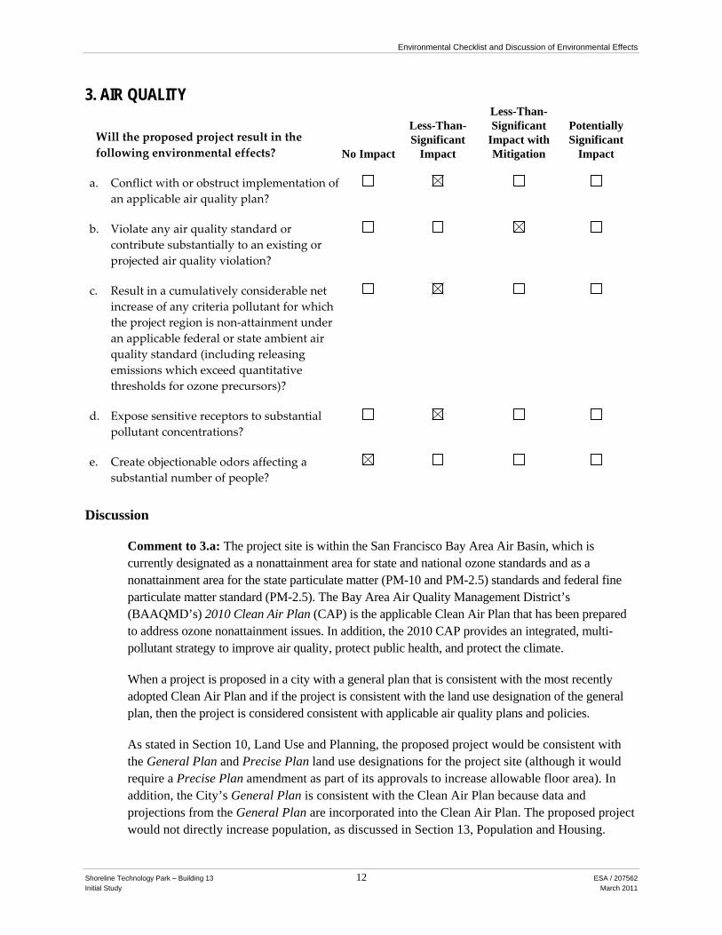
Will the proposed project result in the following environmental effects? No Impact
Less-Than-Significant
Impact
Less-Than-Significant
Impact with Mitigation
Potentially Significant
Impact
a. Conflict with or obstruct implementation of an applicable air quality plan?
b. Violate any air quality standard or contribute substantially to an existing or projected air quality violation?
c. Result in a cumulatively considerable net increase of any criteria pollutant for which the project region is non‐attainment under an applicable federal or state ambient air quality standard (including releasing emissions which exceed quantitative thresholds for ozone precursors)?
d. Expose sensitive receptors to substantial pollutant concentrations?
e. Create objectionable odors affecting a substantial number of people?
Discussion
Comment to 3.a: The project site is within the San Francisco Bay Area Air Basin, which is currently designated as a nonattainment area for state and national ozone standards and as a nonattainment area for the state particulate matter (PM-10 and PM-2.5) standards and federal fine particulate matter standard (PM-2.5). The Bay Area Air Quality Management District’s (BAAQMD’s) 2010 Clean Air Plan (CAP) is the applicable Clean Air Plan that has been prepared to address ozone nonattainment issues. In addition, the 2010 CAP provides an integrated, multi-pollutant strategy to improve air quality, protect public health, and protect the climate.
When a project is proposed in a city with a general plan that is consistent with the most recently adopted Clean Air Plan and if the project is consistent with the land use designation of the general plan, then the project is considered consistent with applicable air quality plans and policies.
As stated in Section 10, Land Use and Planning, the proposed project would be consistent with the General Plan and Precise Plan land use designations for the project site (although it would require a Precise Plan amendment as part of its approvals to increase allowable floor area). In addition, the City’s General Plan is consistent with the Clean Air Plan because data and projections from the General Plan are incorporated into the Clean Air Plan. The proposed project would not directly increase population, as discussed in Section 13, Population and Housing.
Environmental Checklist and Discussion of Environmental Effects
Shoreline Technology Park – Building 13 13 ESA / 207562 Initial Study March 2011
Development of the project would not generate a substantial increase in vehicle-miles-traveled (VMT) in the region. As discussed later in response to Comment 3.b, criteria pollutants of concern and their precursors generated by motor vehicle travel in the region would be less than BAAQMD thresholds for significance. Consequently, the project would be considered consistent with the projections used to develop the 2010 Clean Air Plan planning projections as it would neither increase the population of the area nor substantially increase VMT. Therefore, the proposed project would result in a less-than-significant impact with respect to potential substantial conflicts with the region’s air quality management plan.
Impact: Less than Significant. No Mitigation Measures required.
Comment to 3.b: The project site is located in the City of Mountain View, within the San Francisco Bay Area Air Basin (Bay Area). The Bay Area experiences occasional violations of ozone and particulate matter (PM-10 and PM-2.5) standards. The proposed construction of a 70,000 square foot life science building would result in emissions during the construction phase of the project from construction equipment, construction worker vehicle trips, vendor vehicle trips and off-gassing of construction materials such as asphalt and architectural coatings. Once constructed, the project would generate emissions primarily through worker motor vehicle trips, but also through on-site combustion of natural gas and fuels for landscape maintenance equipment.
Construction would involve use of equipment and materials that would emit ozone precursor emissions (i.e., reactive organic gases, or ROG, and nitrogen oxides, or NOx). Construction activities would also result in the emission of other criteria pollutants from equipment exhaust, construction-related vehicular activity and construction worker automobile trips. Emission levels for construction activities would vary depending on the number and type of equipment, duration of use, operation schedules, and the number of construction workers. Criteria pollutant emissions of ROG and NOx from these emission sources would incrementally add to the regional atmospheric loading of ozone precursors during project construction.
The updated BAAQMD CEQA Guidelines adopted on June 2, 2010 (the 2010 Guidelines) establish significance thresholds for criteria construction emissions. These thresholds are 54 pounds per day of ROG, oxides of nitrogen (NOx) and PM-2.5 and 82 pounds per day for PM-10. The thresholds for PM-10 and PM-2.5 are inclusive only of construction exhaust emissions. BAAQMD guidance for construction-related emission of fugitive dust identifies implementation of Best Management Practices as its threshold of significance. If Best Management Practices are not implemented, the impact is considered significant. The 2010 Guidelines describe Best Management Practices as the continuation of the approach developed in the BAAQMD’s 1999 CEQA Guidelines, and, as such, this analysis considers them to consist of BAAQMD’s list of eight Basic Construction Mitigation Measures Recommended for All Proposed Projects.
Construction-related emissions from the proposed project were calculated using the Urban Land Use Emissions Model (URBEMIS2007) assuming a 70,000 square foot light-industrial building on a 3-acre lot. Construction was assumed to begin in fall of 2011 and be completed in 2013. Construction activities were divided into four phases: grading, building construction, trenching,
Environmental Checklist and Discussion of Environmental Effects
Shoreline Technology Park – Building 13 14 ESA / 207562 Initial Study March 2011
paving and application of architectural coatings. Building construction, trenching and paving phases were assumed to occur simultaneously. The URBEMIS2007 model indicates that peak daily project-related construction emissions would be 33.3 pounds per day of ROG, 27.4 pounds per day of NOx, 1.30 pounds per day of PM-2.5 exhaust and 1.41 pounds per day of PM-10 exhaust. These values are below the BAAQMD significance thresholds of 54 pounds per day of ROG, NOx and PM2.5 and 82 pounds per day of PM-10. These estimated construction emissions are maximum daily emissions. Annual average daily emissions to which thresholds are to be compared would be even less than these values. Therefore, with the implementation of BAAQMD’s Basic Construction Mitigation Measures, construction activities would not violate any air quality standard or contribute substantially to an existing or projected air quality violation. As stated above, without implementation these measures, which comprise Best Management Practices under this analysis, this impact would be considered significant.
Operational emissions from the proposed project were also calculated using the URBEMIS2007 model and a daily vehicle trip generation estimate of 556 trips per day from Section 16, Transportation and Traffic. The URBEMIS model calculates emissions not only from vehicle trip generation but also from natural gas combustion and landscape maintenance equipment. Total project operational emissions including both mobile sources and area sources are estimated by the URBEMIS model to total 4.20 pounds per day of ROG, 4.52 pounds per day of NOx, 1.53 pounds per day of PM-2.5 and 8.04 pounds per day of PM-10. These values are below the BAAQMD significance thresholds of 54 pounds per day of ROG, NOx and PM-2.5 and 82 pounds per day of PM-10. Therefore operational emissions of the proposed project would be less than significant and would not result in a violation of an air quality standard or contribute substantially to an existing violation.
Impact: Potentially Significant (construction-related emissions).
Mitigation Measures Required by This CEQA Review:
Mitigation Measure Air-1: The project sponsor shall require construction contractors to implement all the BAAQMD’s Basic Construction Mitigation Measures, listed below:
1. All exposed surfaces (e.g., parking areas, staging areas, soil piles, graded areas, and unpaved access roads) shall be watered two times per day.
2. All haul trucks transporting soil, sand, or other loose material off-site shall be covered.
3. All visible mud or dirt track-out onto adjacent public roads shall be removed using wet power vacuum street sweepers at least once per day. The use of dry power sweeping is prohibited.
4. All vehicle speeds on unpaved roads shall be limited to 15 mph.
5. All roadways, driveways, and sidewalks to be paved shall be completed as soon as possible. Building pads shall be laid as soon as possible after grading unless seeding or soil binders are used.
6. Idling times shall be minimized either by shutting equipment off when not in use or reducing the maximum idling time to 5 minutes (as required by the California

Environmental Checklist and Discussion of Environmental Effects
Shoreline Technology Park – Building 13 15 ESA / 207562 Initial Study March 2011
airborne toxics control measure Title 13, Section 2485 of California Code of Regulations [CCR]). Clear signage shall be provided for construction workers at all access points.
7. All construction equipment shall be maintained and properly tuned in accordance with manufacturer’s specifications. All equipment shall be checked by a certified mechanic and determined to be running in proper condition prior to operation.
8. Post a publicly visible sign with the telephone number and person to contact at the Lead Agency regarding dust complaints. This person shall respond and take corrective action within 48 hours. The Air District’s phone number shall also be visible to ensure compliance with applicable regulations.
Impact with Incorporated Mitigation Measures: Less than Significant. No additional Mitigation Measures required.
Comment to 3.c: The BAAQMD significance thresholds discussed in Comment to 3.b were developed to represent “the levels at which a project’s individual emissions of criteria air pollutants or precursors would result in a cumulatively considerable contribution” to the air basin’s air quality conditions (BAAQMD, 2010). Because project-related emissions would be below these thresholds, the project would not result in a cumulatively considerable net increase of a non-attainment pollutant or precursor.
Impact: Less than Significant. No Mitigation Measures required.
Comment to 3.d: The proposed life sciences building would not be considered a sensitive receptor with respect to air quality (e.g., a residences, a school or child care facility). The proposed project would also not include a permitted stationary source of pollutant emissions, nor are there sensitive receptors located within a 1,000 foot radius of the project site. Therefore the proposed project would not expose sensitive receptors to substantial pollutant concentrations.
Impact: Less than Significant. No Mitigation Measures required.
Comment to 3.e: The types of land use development that typically pose potentially significant odor problems include wastewater treatment plants, refineries, landfills, composting facilities and transfer stations. No such uses are proposed. The proposed structure is not intended to accommodate these sorts of uses; therefore the project would not create objectionable odors that would affect a substantial number of people. Also, there are no existing odor sources in the vicinity of the project site to which future occupants of the project site would be subjected.
Impact: No impact. No Mitigation Measures required.
Cumulative Impacts: As discussed under Comment to 3.c.
Impact: Less than Significant. No Mitigation Measures required.
Environmental Checklist and Discussion of Environmental Effects
Shoreline Technology Park – Building 13 16 ESA / 207562 Initial Study March 2011
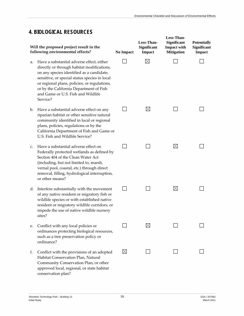
4. BIOLOGICAL RESOURCES
Will the proposed project result in the following environmental effects? No Impact
Less-Than-Significant
Impact
Less-Than-Significant
Impact with Mitigation
Potentially Significant
Impact
a. Have a substantial adverse effect, either directly or through habitat modifications, on any species identified as a candidate, sensitive, or special status species in local or regional plans, policies, or regulations, or by the California Department of Fish and Game or U.S. Fish and Wildlife Service?
b. Have a substantial adverse effect on any riparian habitat or other sensitive natural community identified in local or regional plans, policies, regulations or by the California Department of Fish and Game or U.S. Fish and Wildlife Service?
c. Have a substantial adverse effect on Federally protected wetlands as defined by Section 404 of the Clean Water Act (including, but not limited to, marsh, vernal pool, coastal, etc.) through direct removal, filling, hydrological interruption, or other means?
d. Interfere substantially with the movement of any native resident or migratory fish or wildlife species or with established native resident or migratory wildlife corridors, or impede the use of native wildlife nursery sites?
e. Conflict with any local policies or ordinances protecting biological resources, such as a tree preservation policy or ordinance?
f. Conflict with the provisions of an adopted Habitat Conservation Plan, Natural Community Conservation Plan, or other approved local, regional, or state habitat conservation plan?

Environmental Checklist and Discussion of Environmental Effects
Shoreline Technology Park – Building 13 17 ESA / 207562 Initial Study March 2011
Discussion
Existing Conditions at the Project site: The site is a private developed recreational facility with grassy open space surrounded by trees, a baseball field, barbecue area, and other active recreational facilities. The trees are a mixture of native and non-native species, of which the most numerous are ash (Fraxinus spp.), sycamore and London plane (Platinus occidentalis and acerifolia), purple plum (Prunus sp.), and Aleppo and Monterey pine (Pinus halapensis and radiata). The detention pond bounding the southern extent of the site supports a wetland of dense assemblage of riparian and aquatic vegetation dominated by cattails (Typha) and willows (Salix) and with associated atypical (non-riparian) vegetation which includes toyon (Heteromeles arbutifolia) and cypress (Cupressus). The detention pond is hydrologically connected to Stevens Creek.
The turf grasses are closely mowed and there is no sign of ground squirrel (Spermophilus beecheyi) and minimal evidence of gopher (Thomomys) activity. Birds observed were typical of landscaped environments surrounded by buildings, parking lots, and roads. Crows (Corvus corvax), mockingbirds (Mimus polyglottos) and robins (Turdus migratorius) were observed. Tree squirrels (Sciurus griseus) and their nests are present in the cluster of sycamores in the small unmowed area in the southeastern corner of the site.
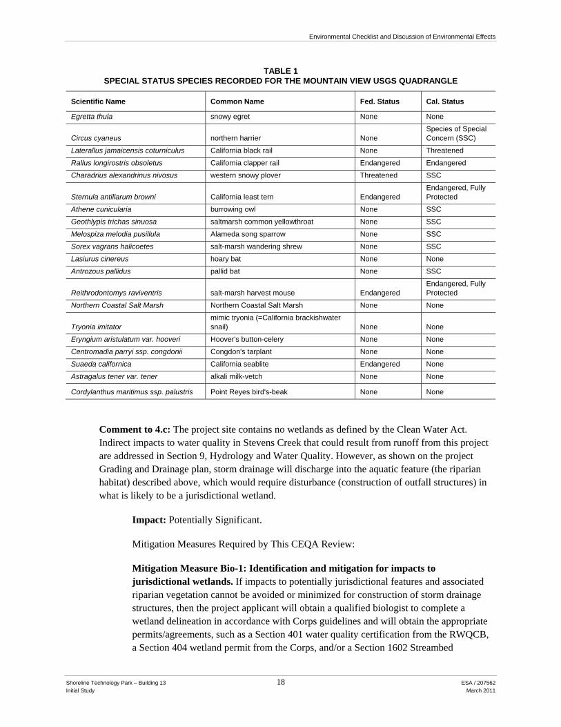
Comment to 4.a: California Department of Fish and Game’s California Natural Diversity Data Base (CNDDB) documents 20 occurrences of special-status1 species within the USGS quadrangle containing the site (Mountain View), as shown in Table 1 on the next page (CDFG, 2010).
Natural habitat for most of these species no longer exists at the project site. However, burrowing owls (Athene cunicularia) are present in the area, the nearest occupied location being a 100-acre site maintained by the City as burrowing owl habitat, about 3,000 feet to the north. Sites suitable for owl foraging and breeding are much more open (have fewer trees) than the project site, as trees are used as perches for raptors which prey on the owls. Owl habitat also needs a variety of small burrowing mammals to provide the primary excavation for owl nests; the Project site has no sign of ground squirrel activity. Given these two factors, owls are considered absent.
Impact: Less than Significant. No Mitigation Measures required.
Comment to 4.b: The project site comprises primarily managed grassland and landscape vegetation with numerous native and non-native trees. The riparian habitat immediately adjacent to the site would constitute a sensitive natural community, but it would not be affected by the project, except as noted below, and will have a 50-foot buffer (no ground disturbance) from top of bank. It is assumed that that buffer will be delineated by installing exclusionary fencing along the periphery of the construction areas closest to the wetland.
Impact: Less than Significant. No Mitigation Measures required.
1 The term “special-status” species includes those that are listed and receive specific protection defined in federal or state
endangered species legislation, as well as species not formally listed as Threatened or Endangered, but designated as “Rare” or “Sensitive” on the basis of adopted policies and expertise of state resource agencies or organizations, or policies adopted by local agencies such as counties, cities, and special districts to meet local conservation objectives.
Environmental Checklist and Discussion of Environmental Effects
Shoreline Technology Park – Building 13 18 ESA / 207562 Initial Study March 2011
TABLE 1 SPECIAL STATUS SPECIES RECORDED FOR THE MOUNTAIN VIEW USGS QUADRANGLE
Scientific Name Common Name Fed. Status Cal. Status
Egretta thula snowy egret None None
Circus cyaneus northern harrier None Species of Special Concern (SSC)
Laterallus jamaicensis coturniculus California black rail None Threatened
Rallus longirostris obsoletus California clapper rail Endangered Endangered
Charadrius alexandrinus nivosus western snowy plover Threatened SSC
Sternula antillarum browni California least tern Endangered Endangered, Fully Protected
Athene cunicularia burrowing owl None SSC
Geothlypis trichas sinuosa saltmarsh common yellowthroat None SSC
Melospiza melodia pusillula Alameda song sparrow None SSC
Sorex vagrans halicoetes salt-marsh wandering shrew None SSC
Lasiurus cinereus hoary bat None None
Antrozous pallidus pallid bat None SSC
Reithrodontomys raviventris salt-marsh harvest mouse Endangered Endangered, Fully Protected
Northern Coastal Salt Marsh Northern Coastal Salt Marsh None None
Tryonia imitator mimic tryonia (=California brackishwater snail) None None
Eryngium aristulatum var. hooveri Hoover's button-celery None None
Centromadia parryi ssp. congdonii Congdon's tarplant None None
Suaeda californica California seablite Endangered None
Astragalus tener var. tener alkali milk-vetch None None
Cordylanthus maritimus ssp. palustris Point Reyes bird's-beak None None
Comment to 4.c: The project site contains no wetlands as defined by the Clean Water Act. Indirect impacts to water quality in Stevens Creek that could result from runoff from this project are addressed in Section 9, Hydrology and Water Quality. However, as shown on the project Grading and Drainage plan, storm drainage will discharge into the aquatic feature (the riparian habitat) described above, which would require disturbance (construction of outfall structures) in what is likely to be a jurisdictional wetland.
Impact: Potentially Significant.
Mitigation Measures Required by This CEQA Review:
Mitigation Measure Bio-1: Identification and mitigation for impacts to jurisdictional wetlands. If impacts to potentially jurisdictional features and associated riparian vegetation cannot be avoided or minimized for construction of storm drainage structures, then the project applicant will obtain a qualified biologist to complete a wetland delineation in accordance with Corps guidelines and will obtain the appropriate permits/agreements, such as a Section 401 water quality certification from the RWQCB, a Section 404 wetland permit from the Corps, and/or a Section 1602 Streambed

Environmental Checklist and Discussion of Environmental Effects
Shoreline Technology Park – Building 13 19 ESA / 207562 Initial Study March 2011
Alteration Agreement from the CDFG. Terms and conditions of these permits will likely include recontouring and revegetating temporarily disturbed portions of the wetland, and compensation for permanent impacts onsite with the same type of feature as the feature affected.
Impact with Incorporated Mitigation Measures: Less than Significant. No additional Mitigation Measures required.
Comment to 4.d: Stevens Creek is likely used as a wildlife corridor, but it will not be directly impacted by the project. The project site itself is located within Shoreline Technology Park, which is characterized by two-story buildings housing commercial, research and development offices and support services. Buildings are surrounded by landscaped surface parking lots. Directly east, north, and west of the project site are additional technology park and surface parking lot uses. There are no known or expected wildlife movement corridors at the project site.
The project site and surrounding area are suitable habitat for nesting birds (i.e., the project site may be a native wildlife nursery site). Breeding birds are protected under Section 3503 of the California Fish and Game Code (the Code), and raptors are protected under Section 3503.5. In addition, both Section 3513 of the Code and the Federal Migratory Bird Treaty Act (16 USC, Sec. 703 Supp. I, 1989) prohibit the killing, possession, or trading of migratory birds. Finally, Section 3800 of the Code prohibits the taking of non-game birds, which are defined as birds occurring naturally in California that are neither game birds nor fully protected species. Nesting birds on or near the project site could be negatively impacted by increased light, perches for predatory birds, noise, or pets, discussed above in Comment 4.a. These potential impacts would be reduced to less-than-significant levels with the implementation of Mitigation Measure Bio-2.
Impact: Potentially Significant.
Mitigation Measures Required by This CEQA Review:
Mitigation Measure Bio-2: Nesting Bird Avoidance. To the extent practicable, vegetation removal and construction activities shall be performed from September through February, to avoid the general nesting period for birds. If construction or vegetation removal cannot be performed during this period, pre-construction surveys shall be performed by a qualified biologist no more than 14 days prior to these activities, to locate any active nests. These surveys shall be performed in the project area and surrounding 500 feet. If active nests are observed on either the project site or the surrounding area, the project applicant shall establish buffer zones around the nests, with the size to be determined in consultation with California Department of Fish and Game (usually 100 feet for perching birds and 300 feet for raptors).
If work during the nesting season stops for 14 days or more and then resumes, then nesting bird surveys shall be repeated, to ensure that no new birds have begun nesting in the area.
Environmental Checklist and Discussion of Environmental Effects
Shoreline Technology Park – Building 13 20 ESA / 207562 Initial Study March 2011
Impact with Incorporated Mitigation Measures: Less than Significant. No additional Mitigation Measures required.
Comment to 4.e: The City of Mountain View has adopted a Heritage Tree Ordinance (City of Mountain View City Code Chapter 32 - Trees, Shrubs, and Plants; Article II). According to the Heritage Tree Ordinance, a “heritage tree” is defined by the following criteria:
• Any tree which has a trunk with a circumference of 48-inch or measured at 54-inch above natural grade; or
• Any oak, redwood or cedar tree with a circumference of 12-inch or more measured at 54-inch above natural grade; or
• Any tree or grove of trees designated by City Council resolution to be of special historical value or significant community benefit.
To allow for project construction, 99 out of the 164 existing trees would be removed, including 12 heritage trees as defined by the tree ordinance. The City of Mountain View staff reviewed all heritage trees proposed for removal and found that they are in fair to poor condition and/or would conflict with project improvements. Pursuant to the Heritage Tree Ordinance, the project applicant shall comply with heritage tree removal permit requirements from the City of Mountain View prior to heritage tree removal. Approval of the heritage tree removal permit may require the replacement of additional trees or trees on the property or off-site to offset the loss of trees. The number, size, species and location of replacement trees would be determined through the permit review process. The applicant is proposing to plant approximately 150 new trees as part of the project.
Of the 65 existing trees to remain on site, 13 are heritage trees. Potential impacts to the remaining heritage trees on site occurring as a result of project construction would be minimized to less-than-significant levels with the implementation of Mitigation Measure Bio-3.
Impact: Potentially Significant.
Mitigation Measures Required by This CEQA Review:
Mitigation Measure Bio-3: In order to ensure the survival of retained heritage trees, the following protection measures shall be implemented, subject to review and approval by the City as consistent with the City’s Tree Ordinance:
1. A protective fence shall be provided during the construction period to project those trees that are to be preserved. The fencing shall protect a sufficient portion of the root zone to be effective. In most cases, it would be essential to locate the fencing a minimum radius distance of 10 times the trunk diameter in all directions from the trunk. If hardscape (i.e., curing, paving, etc.) exists inside the radius, the protective fencing is usually recommended to be erected at the edge of the hardscape feature. At the discretion of City Staff, a certified arborist may be retained by the applicant to make decisions about the location(s) of protective fencing at the project site.

Environmental Checklist and Discussion of Environmental Effects
Shoreline Technology Park – Building 13 21 ESA / 207562 Initial Study March 2011
2. Preserved heritage trees shall be irrigated throughout the entire construction period during the dry months (any month receiving less than one inch of rainfall). Irrigate a minimum of 10 gallons for each inch of trunk diameter every two weeks. A soaker hose or a drip line is preferred for this purpose.
3. The entire area inside the driplines of preserved heritage trees shall be mulched to the extent feasible. Mulching consists of a protective material (wood chips, gravel) being spread over the root zone inside the dripline. The material shall be four inches in depth after spreading, which shall be done by hand. Wood chips are preferred because they are organic and degrade naturally over time. Wood chips shall be primarily one quarter to three-quarters of an inch in diameter.
4. Trenches for any utilities (gas, electricity, water, phone TV cable, etc.) shall be located outside the driplines of preserved heritage trees, unless approved by a certified arborist.
5. Sidewalks or other hardscape inside the driplines of preserved heritage trees shall be constructed completely on top of the existing soil grade without excavation. Fill soil may be added to the edge of finished hardscape for a maximum distance of approximately 2 feet from the edges to integrate the new hardscape to the natural grade.
6. If any old irrigation lines, drain lines, sewer lines, or any other underground features exist inside the driplines of preserved heritage trees and would not be used, they shall be cut off approximately at soil grade and left in the ground.
7. Material shall not be stored, stockpiled, dumped, or buried inside the driplines of preserved heritage trees.
8. Excavated soil shall not be piled or dumped, even temporarily, inside the driplines of preserved heritage trees.
9. Any pruning of preserved heritage trees shall be done by an arborist certified by the ISA (International Society of Arboriculture) and according to ISA, Western Chapter Standards 1998.
10. Landscape irrigation trenches shall be a minimum distance of 10 times the trunk diameter from the trunks of preserved heritage trees
11. The sprinkler irrigation shall not be designed to strike the trunks of preserved heritage trees.
12. Landscape materials (cobbles, decorative bark, stones, fencing, etc.) shall not be installed directly in contact with the bark of trees because of the risk of serious disease infection.
If any of the above 12 procedures cannot be achieved adequately, a certified arborist shall be consulted to recommend possible alternative solutions, if any. Any further recommendations and protection measures identified by the arborist shall be followed to reduce project-related impacts to heritage trees to a less-than-significant level.
Environmental Checklist and Discussion of Environmental Effects
Shoreline Technology Park – Building 13 22 ESA / 207562 Initial Study March 2011
Impact with Incorporated Mitigation Measures: Less than Significant. No Additional Mitigation Measures required.
Comment to 4.f: The project site is not covered by a Habitat Conservation Plan or Natural Community Conservation Plan. Therefore, the proposed project would result in no impact related to this criterion.
Impact: No Impact. No Mitigation Measures required.
Cumulative Impacts: Mitigation Measures Bio-1 and Bio-2 are designed to reduce impacts to wetlands, riparian habitat and nesting birds.
Impact with Incorporated Mitigation Measures: Less than Significant. No additional Mitigation Measures required.

Environmental Checklist and Discussion of Environmental Effects
Shoreline Technology Park – Building 13 23 ESA / 207562 Initial Study March 2011
5. CULTURAL RESOURCES
Will the proposed project result in the following environmental effects? No Impact
Less-Than-Significant
Impact
Less-Than-Significant
Impact with Mitigation
Potentially Significant
Impact
a. Cause a substantial adverse change in the significance of a historical resource as defined in CEQA Section 15064.5?
b. Cause a substantial adverse change in the significance of an archaeological resource pursuant to CEQA Section 15064.5?
c. Directly or indirectly destroy a unique paleontological resource or site or unique geologic feature?
d. Disturb any human remains, including those interred outside of formal cemeteries?
Discussion
Comment to 5.a: A significant impact would occur if the project would cause a substantial adverse change to a historical resource, herein referring to historic-period architectural resources or the built environment, including buildings, structures, and objects. A substantial adverse change includes the physical demolition, destruction, relocation, or alteration of the resource.
A records search at the Northwest Information Center of the California Historical Resources Information System at Sonoma State University was completed on October 1, 2010 (File No. 10-0321). The review included the project site and a half-mile radius. Previous surveys, studies, and archaeological site records were accessed. Records were also reviewed in the Historic Property Data File for Santa Clara County that contains information on sites of recognized historical significance including those evaluated for listing in the National Register of Historic Places, the California Register of Historical Resources, the California Inventory of Historical Resources, California Historical Landmarks, and California Points of Historical Interest. The purpose of the records search was to (1) determine whether known archaeological resources have been recorded within or adjacent to the project site; (2) assess the likelihood for unrecorded cultural resources to be present based on historical references and the distribution of nearby sites; and (3) develop a context for the identification and preliminary evaluation of cultural resources. The records search at the NWIC indicated that no historic-period resources of the built environment have been recorded in the project site.
Also, the Mountain View Resister of Historic Resources was reviewed to determine whether the project site is designated as a local historic resource. Neither the project site nor adjacent properties are listed on this register.
Environmental Checklist and Discussion of Environmental Effects
Shoreline Technology Park – Building 13 24 ESA / 207562 Initial Study March 2011
Given that neither the NWIC records search nor the Mountain View Register of Historic Resources review found any historic-period resources in the project site, and because the project would not affect any buildings or structures, the project would have no impact on historical resources.
Impact: No Impact. No Mitigation Measures required.
Comment to 5.b: A significant impact would occur if the project would cause a substantial adverse change to an archaeological resource through physical demolition, destruction, relocation, or alteration of the resource.
The project site is within the traditional territory of the Costanoan or Ohlone people (Levy, 1978: 485–495). These people were collectively referred to by ethnographers as Costanoan, but were actually distinct sociopolitical groups that spoke at least eight languages of the same Penutian language group. The Ohlone occupied a large territory from San Francisco Bay in the north to the Big Sur and Salinas Rivers in the south. The primary sociopolitical unit was the tribelet, or village community, which was overseen by one or more chiefs. The project site is in the greater Ramaytush tribal area (Levy, 1978:485). The nearest ethnographic village site in the vicinity of the project site is puyšon, located northwest of the project site on San Francisquito Creek.
Economically, the Ohlone engaged in hunting and gathering. Their territory encompassed both coastal and open valley environments that contained a wide variety of resources, including grass seeds, acorns, bulbs and tubers, bear, deer, elk, antelope, a variety of bird species, and rabbit and other small mammals. The Ohlone acknowledged private ownership of goods and songs, and village ownership of rights to land and/or natural resources. They appear to have aggressively protected their village territories, requiring monetary payment for access rights in the form of clamshell beads, and even shooting trespassers if caught. After European contact, Ohlone society was severely disrupted by missionization, disease, and displacement.
The NWIC records search discussed above indicates that no cultural resources studies have been conducted within the project site and that no previously recorded cultural resources are located in the project site. One prehistoric archaeological resource has been recorded within a half-mile radius of the project site. The Crittenden Mound (CA-SCL-23) was originally recorded by N.C. Nelson during his 1909 survey of the San Francisco Bay Area. In 1912, L.L. Loud noted the mound had been plowed and that no significant resources remained. From the 1900s through the 1970s, the land was used for agriculture. “Kitchen midden” is noted on USDA Soil Conservation Service soil maps from 1956; however several archaeological surveys conducted since the 1970s have not relocated the site. A subsurface investigation, consisting of 58 backhoe test units, was completed in the vicinity of the site during April and November 1993. No prehistoric artifacts, shell fragments, or other cultural indicators were observed (Olliges, 1995). It is surmised that agricultural activities disbursed and destroyed the site.
On October 12, 2010, ESA Registered Professional Archaeologist Heidi Koenig conducted a survey of the project site. The project site is occupied by a private recreational facility comprising a tennis court, barbecue area, baseball field, a full basketball court, and sand court used for volleyball. The remainder is landscaped with grass and trees. The project site was surveyed in

Environmental Checklist and Discussion of Environmental Effects
Shoreline Technology Park – Building 13 25 ESA / 207562 Initial Study March 2011
narrow transects no greater than 20 meters. Ground visibility was poor due to landscaping and the built environment. All exposed soils along the edges of landscaping and around trees was thoroughly inspected. Soil was dark brown, sandy clay. No cultural features or artifacts were recorded within the project site.
No archaeological features or artifacts were recorded within the project site. It does not appear that the project has the potential to impact archaeological resources. However, in the event of the discovery of any cultural resources during project construction activities, work would be halted. Damage to unique archaeological resources would be a potentially significant impact. Implementation of the following mitigation measure would reduce potential impacts to a less-than-significant level.
Impact: Potentially Significant.
Mitigation Measures Required by This CEQA Review:
Mitigation Measure Cul-1: Inadvertent Discovery of Archaeological Resources. If prehistoric or historic-period cultural materials are unearthed during ground-disturbing activities, it is recommended that all work within 100 feet of the find halt until a qualified archaeologist and Native American representative can assess the significance of the find. Prehistoric materials might include obsidian and chert flaked-stone tools (e.g., projectile points, knives, scrapers) or toolmaking debris; culturally darkened soil (“midden”) containing heat-affected rocks and artifacts; stone milling equipment (e.g., mortars, pestles, handstones, or milling slabs); and battered-stone tools, such as hammerstones and pitted stones. Historic-period materials might include stone, concrete, or adobe footings and walls; filled wells or privies; and deposits of metal, glass, and/or ceramic refuse. If the find is determined to be potentially significant, the archaeologist, in consultation with the Native American representative, will develop a treatment plan that could include site avoidance, capping, or data recovery.
Impact with Incorporated Mitigation Measures: Less than Significant. No additional Mitigation Measures required.
Comment to 5.c: Paleontological resources are the fossilized evidence of past life found in the geologic record. Despite the tremendous volume of sedimentary rock deposits preserved worldwide, and the enormous number of organisms that have lived through time, preservation of plant or animal remains as fossils is an extremely rare occurrence. Because of the infrequency of fossil preservation, fossils—particularly vertebrate fossils—are considered to be nonrenewable resources. Because of their rarity, and the scientific information they can provide, fossils are highly significant records of ancient life.
Rock formations that are considered of paleontological sensitivity are those rock units that have yielded significant vertebrate or invertebrate fossil remains. This includes, but is not limited to, sedimentary rock units that contain significant paleontological resources anywhere within its geographic extent. The project site is underlain by Bay Mud, and is not likely yield significant paleontological remains because they are surface deposits that are not considered fossil-bearing

Environmental Checklist and Discussion of Environmental Effects
Shoreline Technology Park – Building 13 26 ESA / 207562 Initial Study March 2011
rock units. In addition, construction of the proposed project would not require substantial excavation to depths at which paleontological resources could be encountered.
Impact: Less than Significant. No Mitigation Measures required.
Comment to 5.d: A significant impact would occur if the project would disturb any human remains, including those interred outside of formal cemeteries. There is no indication that the project site has been used for burial purposes in the recent or distant past. It is unlikely that human remains would be encountered in the project site. However, in the event of the discovery of any human remains during project construction activities, work would be halted. Damage to human remains would be a potentially significant impact. Implementation of the following mitigation measure would reduce potential impacts to a less-than-significant level.
Impact: Potentially Significant.
Mitigation Measures Required by This CEQA Review:
Mitigation Measure Cul-2: Inadvertent Discovery of Human Remains. If human remains are encountered during ground disturbing activities, State Health and Safety Code Section 7050.5 requires that no further disturbance will occur until the County Coroner has made the necessary findings as to origin and disposition pursuant to PRC Section 5097.98. If the remains are determined to be of Native American descent, the coroner has 24 hours to notify the Native American Heritage Commission. The Native American Heritage Commission will then identify the person(s) thought to be the Most Likely Descendent of the deceased Native American, who will make recommendations for the treatment of any human remains.
Impact with Incorporated Mitigation Measures: Less than Significant. No additional Mitigation Measures required.
Cumulative Impacts: There are no known cumulative projects in the project vicinity that would meaningfully interact with the proposed project such that the project would result in a considerable contribution to any cumulative impact on cultural resources.
Impact: Less than Significant. No Mitigation Measures required.

Environmental Checklist and Discussion of Environmental Effects
Shoreline Technology Park – Building 13 27 ESA / 207562 Initial Study March 2011
6. GEOLOGY, SOILS, AND SEISMICITY
Will the proposed project result in the following environmental effects? No Impact
Less-Than-Significant
Impact
Less-Than-Significant
Impact with Mitigation
Potentially Significant
Impact
a. Expose people or structures to potential substantial adverse effects, including the risk of loss, injury, or death involving:
i) Rupture of a known earthquake fault, as delineated on the most recent Alquist‐Priolo Earthquake Fault Zoning Map issued by the State Geologist for the area or based on other substantial evidence of a known fault? Refer to Division of Mines and Geology Special Publication 42.
ii) Strong seismic ground shaking
iii) Seismic‐related ground failure, including liquefaction?
iv) Landslides
b. Result in substantial soil erosion or the loss of topsoil?
c. Be located on a geologic unit or soil that is unstable, or that would become unstable as a result of the project, and potentially result in on‐ or off‐site landslide, lateral spreading, subsidence, liquefaction or collapse?
d. Be located on expansive soil, as defined in Table 18‐1‐B of the Uniform Building Code (1994), creating substantial risks to life or property?
e. Have soils incapable of adequately supporting the use of septic tanks or alternative wastewater disposal systems where sewers are not available for the disposal of wastewater?
f. Be located in Zone D or E on the City of Mountain View Geologic Hazards Map?

Environmental Checklist and Discussion of Environmental Effects
Shoreline Technology Park – Building 13 28 ESA / 207562 Initial Study March 2011
Discussion
Comment to 6.a.i: The project site is not located in an Alquist-Priolo Earthquake Fault Zone nor is it located on or immediately adjacent to an active or potentially active fault.2 The Alquist-Priolo Earthquake Fault Zoning Act requires the delineation of zones by the California Department of Conservation, Geological Survey (CGS, formerly known as the California Division of Mines and Geology [CDMG]) along sufficiently active and well-defined faults. The purpose of the Act is to restrict construction of structures intended for human occupancy along traces of known active faults. Alquist-Priolo Zones are designated areas most likely to experience surface fault rupture, although fault rupture is not necessarily restricted to those specifically zoned areas. The active faults nearest to the project site are the San Andreas, located 7 miles southwest of the project site, and the Hayward, located 10 miles northeast. Other nearby active Bay Area faults include the San Gregorio-Hosgri fault, located 20 miles west, and the Calaveras fault, located 15 miles east of the project site. As the project site is not located in an Alquist-Priolo Earthquake Fault Zone nor is it located on or immediately adjacent to an active fault, fault rupture hazards associated with the proposed project are considered less than significant.
Impact: Less than Significant. No Mitigation Measures required.
Comments to 6.a.ii and 6.a.iii: The City of Mountain View is located in a seismically active region. Recent studies by the United States Geological Survey (USGS) indicate there is a 63 percent likelihood of a Richter magnitude 6.7 or higher earthquake occurring in the Bay Area in the next 30 years (USGS, 2008a; 2008b). The project site could experience a range of ground shaking effects during an earthquake on one of the aforementioned Bay Area faults. An earthquake on the San Andreas Fault could result in very strong (Modified Mercalli Index VIII) ground shaking intensities.3 Ground shaking of this intensity could result in moderate damage, such as collapsing chimneys and falling plaster (ABAG, 2003a). Seismic shaking of this intensity can also trigger ground failures caused by liquefaction, potentially resulting in foundation damage, disruption of utility service and roadway damage.4 The project site is underlain by materials that can cause moderately high shaking amplification (ABAG, 2003b), and is within an area designated by the CGS and Santa Clara County as a liquefaction Seismic Hazard Zone (CGS, 2006; Santa Clara County, 2002).
The Seismic Hazards Mapping Act (SHMA) was enacted in 1990 to protect the public from the effects of strong ground shaking, liquefaction, landslides, or other ground failures caused by earthquakes. SHMA requires the State Geologist to delineate various seismic hazard zones and
2 An active fault is defined by the State of California is a fault that has had surface displacement within Holocene time
(approximately the last 10,000 years). A potentially active fault is defined as a fault that has shown evidence of surface displacement during the Quaternary (last 1.6 million years), unless direct geologic evidence demonstrates inactivity for all of the Holocene or longer. This definition does not, of course, mean that faults lacking evidence of surface displacement are necessarily inactive. Sufficiently active is also used to describe a fault if there is some evidence that Holocene displacement occurred on one or more of its segments or branches (Hart, 1997).
3 Shaking intensity is a measure of ground shaking effects at a particular location, and can vary depending on the overall magnitude of the earthquake, distance to the fault, focus of earthquake energy, and type of underlying geologic material. The Modified Mercalli (MM) intensity scale is commonly used to measure earthquake effects due to ground shaking. The MM values for intensity range from I (earthquake not felt) to XII (damage nearly total).
4 Liquefaction is the process by which saturated, loose, fine-grained, granular, soil, like sand, behaves like a dense fluid when subjected to prolonged shaking during an earthquake.

Environmental Checklist and Discussion of Environmental Effects
Shoreline Technology Park – Building 13 29 ESA / 207562 Initial Study March 2011
requires cities, counties, and other local permitting agencies to regulate certain development projects within these zones. Before a development permit is granted for a site within a Seismic Hazard Zone, a geotechnical investigation must be conducted and appropriate mitigation measures incorporated into the project design. The CGS Special Publication 117, first adopted in 1997 (and updated in 2008) by the CGS in accordance with the SHMA, provides guidelines for evaluating seismic hazards other than surface faulting, and for recommending mitigation measures as required by Public Resources Code Section 2695(a).
A developer would be required to comply with all applicable City of Mountain View regulations and standards to address potential geologic impacts associated with proposed redevelopment of the project site including ground shaking and liquefaction. Geotechnical and seismic design criteria must also conform to engineering recommendations in accordance with the seismic requirements of the 2007 California Building Code (Title 24) additions. As the project site is located within a liquefaction Seismic Hazard Zone according to the CGS, a developer would be required to comply with the guidelines set by CGS Special Publication 117A.
Impact: Potentially Significant.
Mitigation Measures Required by This CEQA Review:
Mitigation Measure Geo-1: The City of Mountain View shall require that the design level geotechnical investigation include recommendations to mitigate the potential for liquefaction in accordance with the specifications of CGS Special Publication 117A, Guidelines for Evaluating and Mitigating Seismic Hazards, and the requirements of the Seismic Hazards Mapping Act. Recommendations made in the geotechnical report shall be implemented as part of the project.
Impact with Incorporated Mitigation Measures: Less than Significant. No additional Mitigation Measures required.
Comment to 6.a.iv: The project site is relatively level, and is not located on or adjacent to a hillside. Potential development resulting from the proposed project would therefore not be affected by potential impacts associated with landslides or mudslides.
Impact: No Impact. No Mitigation Measures required.
Comment to 6.b: Redevelopment of the project site could involve grading and trenching, which could expose soils to erosion. The proposed project site exceeds one acre in size, and in accordance with the State Water Resources Control Board requirements, the project would be required to comply with federal National Pollutant Discharge Elimination System (NPDES) requirements. As fully described in Hydrology and Water Quality, Section 9, a developer would be required as part of the project to develop and implement a Stormwater Pollution Prevention Plan (SWPPP) in order to minimize potential erosion and subsequent sedimentation of stormwater runoff. This SWPPP would include Best Management Practices (BMPs) to control erosion associated with grading, trenching, and other ground surface-disturbing activities. In addition, a developer would be required to submit a grading plan to the City of Mountain View

Environmental Checklist and Discussion of Environmental Effects
Shoreline Technology Park – Building 13 30 ESA / 207562 Initial Study March 2011
before permits are issued, in conformance with Santa Clara County Urban Runoff Pollution Prevention Program (SCVURPPP) erosion control measures (SCVURPPP, 2003).
Impact: Less than Significant. No Mitigation Measures required.
Comment to 6.c: The City of Mountain View has historically experienced subsidence resulting from excessive withdrawal of groundwater. In certain areas of the City up to 6 feet of subsidence has occurred. However, the stabilization of groundwater pumping rates and a groundwater re-injection program administered by the Santa Clara Valley Water District has halted subsidence in Mountain View and the surrounding area. Development of the life sciences building and parking lot would not involve the withdrawal of groundwater. However, the project site is located in Geologic Hazard Zone D, and therefore it has a high potential for liquefaction and differential settlement (City of Mountain View, 1992). Geotechnical recommendations, as is standard practice for geotechnical investigations and required by current building code standards, can be designed to mitigate for any potential subsidence or differential settlement associated with construction of the proposed structures as required by the City of Mountain View. Potential impacts related to liquefaction are discussed under Comment to 6.a.ii, above.
Impact: Less than Significant. No Mitigation Measures required.
Comment to 6.d: The completion of a site-specific geotechnical investigation and incorporation of geotechnical recommendations, as required by the City’s Building Division prior to issuance of a building permit, would ensure that site-specific information on shrink-swell capabilities of on-site soils is obtained. The site-specific geotechnical investigation would include measures to minimize hazards associated with expansive soils, if present. In addition, implementation of Mitigation Measure Geo-1, under Comments to 6.a.ii and 6.a.iii, would further reduce potential impacts.
Impact: Less than Significant. No additional Mitigation Measures required.
Comment to 6.e: The project would dispose of wastewater through the use of existing or expanded sewer systems. No septic tanks or other onsite wastewater disposal methods would be used; therefore the project would have no impact related to the support of septic systems.
Impact: No Impact. No Mitigation Measures required.
Comment to 6.f: The project site is located in Zone D of the City of Mountain View Geologic Hazards, and therefore has a high potential for liquefaction or settlement. As stated in Comment to 6.c, the design-level geotechnical investigation, as required by City codes, would mitigate for effects related to settlement. In addition, adherence to Mitigation Measure Geo-1, identified under Comments to 6.a.ii and 6.a.iii, would reduce impacts associated with being located in Zone D to less-than-significant levels.
Impact: Less than Significant. No additional Mitigation Measures required.
Environmental Checklist and Discussion of Environmental Effects
Shoreline Technology Park – Building 13 31 ESA / 207562 Initial Study March 2011
Cumulative Impacts: The proposed life sciences building could expose additional people and structures to risks associated with seismic events. These impacts are mitigated on a site-by-site basis through implementation of City requirements. Cumulative soil erosion can have significant effects on regional water quality and aquatic habitat. Please see Section 9, Hydrology and Water Quality, for a more detailed discussion of potential cumulative impacts to water quality.
Impact: Less than Significant. No Mitigation Measures required.

Environmental Checklist and Discussion of Environmental Effects
Shoreline Technology Park – Building 13 32 ESA / 207562 Initial Study March 2011
7. GREENHOUSE GAS EMISSIONS
Will the proposed project result in the following environmental effects? No Impact
Less-Than-Significant
Impact
Less-Than-Significant
Impact with Mitigation
Potentially Significant
Impact
a. Generate greenhouse gas emissions, either directly or indirectly, that may have a significant impact on the environment?
b. Conflict with any applicable plan, policy, or regulation of an agency adopted for the purpose of reducing the emissions of greenhouse gases?
Discussion
Comment to 7.a: The proposed project would generate greenhouse gas (GHG) emissions primarily through an increase in daily on-road motor vehicle trip generation, but also through increased electrical and natural gas demand, increased water and wastewater treatment and conveyance demand, increased generation of solid waste and emissions from operation of landscape maintenance equipment. GHG emissions were calculated using the BGM mode of the Bay Area Air Quality Management District. GHG Emission data is included in Appendix A. Additionally, removal of 99 trees that would not be relocated on the project site would result in loss of sequestered carbon.
GHG emission increases are estimated to be 973 metric tons per year of carbon dioxide equivalents (eCO2). These emissions include both emissions of nitrous oxide and methane, in addition to carbon dioxide and are expressed in terms of eCO25 to account for the greater global warming potential of the former two molecules.
The Bay Area Air Quality Management District has adopted significance criteria for GHG emissions at the project level of 1,100 metric tons per year of eCO2. Project-related GHG emissions would be below the significance thresholds established by BAAQMD and would not generate a significant amount of direct or indirect GHG emissions.
Impact: Less than Significant. No Mitigation Measures required.
Comment to 7.b: The predominant plan implemented to reduce GHG emissions in the State of California is the Climate Change Scoping Plan adopted by the California Air Resources Board (CARB) in December of 2008. The Scoping Plan functions as a roadmap of CARB’s plans to achieve GHG reductions in California required by Assembly Bill (AB) 32 through subsequently enacted regulations (CARB, 2008).
5 Equivalent CO2 (eCO2) is the concentration of CO2 that would cause the same level of radiative forcing (broadly defined as a
transmission or reflectance of energy) as a given type and concentration of greenhouse gas. Examples of such greenhouse gases are methane, perfluorocarbons and nitrous oxide. eCO2 is expressed as parts per million by volume.

Environmental Checklist and Discussion of Environmental Effects
Shoreline Technology Park – Building 13 33 ESA / 207562 Initial Study March 2011
The BAAQMD-derived gap-based threshold that was applied in response to Comment 7.a is intended to attribute an appropriate share of GHG emission reductions necessary to reach AB 32 goals (BAAQMD, 2010). Therefore, these quantitative thresholds also may be used to assess whether or not the proposed project would conflict with AB 32. Because the proposed project would emit GHG emissions less than the gap-based efficiency thresholds of the BAAQMD which were derived based on AB 32 attainment goals, this project would also not conflict with AB 32 and its associated planning efforts.
Impact: Less than Significant. No Mitigation Measures required.
Cumulative Impacts: According to Office of Planning and Research (OPR), lead agencies should determine whether GHGs may be generated by a project, and if so, quantify or estimate the GHG emissions by type and source. The lead agency must assess whether those emissions are individually and/or cumulatively significant. Both BAAQMD and the California Air Pollution Control Officers Association (CAPCOA) consider GHG impacts to be exclusively cumulative impacts and, as such, assessment of significance is based on a determination of whether the GHG emissions from a project represent a cumulatively considerable contribution to the global atmosphere (CAPCOA, 2008). As discussed in response to Comment 7.a, the proposed project would not directly or indirectly generate a significant amount of GHG emissions. Therefore, the project would have a less-than-significant contribution to a cumulative GHG impact.
Impact: Less than Significant. No Mitigation Measures required.

Environmental Checklist and Discussion of Environmental Effects
Shoreline Technology Park – Building 13 34 ESA / 207562 Initial Study March 2011
8. HAZARDS AND HAZARDOUS MATERIALS
Will the proposed project result in the following environmental effects?
No Impact
Less-Than-Significant
Impact
Less-Than-Significant
Impact with Mitigation
Potentially Significant
Impact
a. Create a significant hazard to the public or the environment through the routine transport, use, or disposal of hazardous materials?
b. Create a significant hazard to the public or the environment through reasonably foreseeable upset and accident conditions involving the release of hazardous materials into the environment?
c. Emit hazardous emissions or handle hazardous or acutely hazardous materials, substances, or waste within one‐quarter mile of an existing or proposed school?
d. Be located on a site which is included on a list of hazardous materials sites compiled pursuant to Government Code Section 65962.5 and, as a result, would it create a significant hazard to the public or the environment?
e. For a project located within an airport land use plan or, where such a plan has not been adopted, within two miles of a public airport or public use airport, would the project result in a safety hazard for people residing or working in the project site?
f. For a project within the vicinity of a private airstrip, would the project result in a safety hazard for people residing or working in the project site?
g. Impair implementation of or physically interfere with an adopted emergency response plan or emergency evacuation plan?

Environmental Checklist and Discussion of Environmental Effects
Shoreline Technology Park – Building 13 35 ESA / 207562 Initial Study March 2011
Will the proposed project result in the following environmental effects?
No Impact
Less-Than-Significant
Impact
Less-Than-Significant
Impact with Mitigation
Potentially Significant
Impact
h. Expose people or structures to a significant risk of loss, injury or death involving wildland fires, including where wildlands are adjacent to urbanized areas or where residences are intermixed with wildlands?
Discussion
Comments to 8.a and 8.d: The construction of the proposed project would require grading and other ground-disturbing activities. These construction activities could potentially disturb hazardous materials in the subsurface soils, if present. The current uses of the project site include a baseball field, a barbeque area and a tennis court and do not indicate any past uses where significant quantities of hazardous materials would have been used. However, neighboring sites may have released hazardous materials that have migrated onto the project site.
A Phase I environmental site assessment was conducted for the project site that also included adjacent parcels (2011, 2021, 2023, 2025, 2027, 2029, 2061, 2071, 2081, 2086, and 2091) in 2005. The findings of the investigation identified four existing above ground storage tanks located adjacent to adjacent buildings but conclude that they did not represent a potential source of contamination (URS, 2005).
A review of available environmental databases for sites with known releases of hazardous materials was conducted for this analysis (DTSC, 2010). The search found seven sites located within approximately a quarter mile of the project site. Several of the sites (City of Mountain View 1301 Crittenden Lane, Pac Bell 1380 Shorebird Way, Buffalow’s Inc. 1245 Space Parkway, and IMCS 1300 Space Parkway) have been closed indicating that no further threat to the environment or to human health remained at the site from the documented release. The remaining sites (Charleston Business Park UST 2400 Charleston Road, Goodsell and Vocke 1401 Stierlin Court, and TCI 1245 1675 Space Parkway) were all listed as open cases although the current status was “inactive” (DTSC, 2010). Sites that are listed as inactive have no regulatory oversight activities being conducted by the Lead Agency. The closest site to the proposed project site, Goodsell and Vocke at 1401 Stierlin Court, was listed due to a reported release of solvents, mineral spirits, and distillates that had affected subsurface soil (groundwater was not listed among affected media) (DTSC, 2010).
In addition, the Phase I investigation identified four sites on the National Priorities List, maintained by the U.S. Environmental Protection Agency that are located up or cross-gradient from the project site. These sites (Printex Corporation, Telcom [aka Teledyne] Semiconducters, Spectra Physics, Incorporated, and Moffa Naval Air Station) all have groundwater contamination issues that could have impaired the water quality of the project site (URS, 2005).

Environmental Checklist and Discussion of Environmental Effects
Shoreline Technology Park – Building 13 36 ESA / 207562 Initial Study March 2011
Therefore, there is a possibility that hazardous material use at these neighboring sites, particularly where solvents have been used, may be present in groundwater or subsurface soils at the project site. Solvents in particular are generally very soluble in water and can easily migrate off properties through the groundwater. Stained or otherwise obvious contaminated soils discovered during grading or excavation activities associated with proposed construction at the project site would be segregated, sampled, analyzed, and disposed of under the direction of the overseeing agency, either the Department of Toxic Substance Control (DTSC) or the Santa Clara County Health Department, and in accordance with state and federal laws regulating the disposal of contaminated soil.
According to the Phase I Environmental Site Assessment (URS, 2005), groundwater is about 10 feet below grade at this location. Therefore, it is unlikely that dewatering would be required for project construction. In addition, the Phase I judged that the groundwater contamination from nearby sites has a low potential to affect the project site, and any contamination would be at low concentrations. Nonetheless, if any dewatering is required, all discharged water would be required to be sampled and analyzed prior to discharge in accordance with the requirements of the overseeing agency, either the Regional Water Quality Control Board or the City of Mountain View. Requirements include appropriate handling, analytical testing of water quality and treatment, if necessary, prior to discharge.
Once operational, the proposed project would likely not store, handle, or dispose of any significant quantities of hazardous materials beyond what might be necessary for ordinary maintenance purposes. In the event that any hazardous materials are used for research purposes, they would be stored, handled, and disposed of in accordance with a Hazardous Materials Management Plan and/or Hazardous Materials Inventory Statement as required by the City of Mountain View.
Therefore, the potential for the construction or operation to cause any potential impacts related to encountering hazardous materials or exposure to hazardous materials would be less than significant.
Impact: Less than Significant. No Mitigation Measures required.
Comment to 8.b: Construction at the site could involve minor quantities of paints, solvents, oil and grease, and petroleum hydrocarbons as also discussed in Section 9, Hydrology and Water Quality. Compliance with hazardous materials BMPs, as identified in the required SWPPP, would reduce potential impacts from spills or leaks associated with construction hazardous materials to a less-than-significant level. Following construction, hazardous materials storage, use, and disposal at the project site would be limited to minor quantities of pesticides and herbicides associated with landscape maintenance, and petroleum hydrocarbons, solvents or other minor quantities of hazardous materials associated with building maintenance. Potential explosion or hazardous substance releases during or after project construction would not be considered likely and therefore less than significant.
Impact: Less than Significant. No Mitigation Measures required.
Environmental Checklist and Discussion of Environmental Effects
Shoreline Technology Park – Building 13 37 ESA / 207562 Initial Study March 2011
Comment to 8.c: The closest schools to the project site are Crittendon Middle School, which is about 1 mile away, and Theuerkauf Elementary School, which is approximately 1.4 miles away. In addition, as discussed above in Comments to I.1 and I.4, the proposed project would not handle or dispose of significant hazardous materials that would be a potential threat to the public, including any schools in the area.
Impact: Less than Significant. No Mitigation Measures required.
Comments to 8.e and 8.f: The project site is located within approximately half a mile of the Moffett Federal Airfield, which is operated by the NASA Ames Research Center. Five to ten flights per day take off or land at this field. The project site is located within the airport land use plan for Moffett Federal Airfield, and would be required to adhere to the planning requirements contained within the plan including a building height maximum of 182 feet above sea level. As stated in Comment to 10.a, below, the proposed building height, at 37.5 feet to the top of the parapet, would be below this maximum allowable height. With adherence to the land use plan, the project site’s proximity to the airfield would not result in a safety hazard for people residing or working in the project site.
Impact: No Impact. No Mitigation Measures required.
Comment to 8.g: The project site is currently developed with commercial businesses. The proposed development at the site would be designed in accordance with City of Mountain View design requirements to ensure adequate police, ambulance, and fire personnel access to the proposed structure, as noted in Section 14, Public Services, of this document. Future development would not involve the temporary or permanent closure of roads, and would therefore not interfere with emergency response or evacuation plans.
Impact: Less than Significant. No Mitigation Measures required.
Comment to 8.h: The project site is located in an urban setting with primarily landscaped and maintained vegetation. The project site is not located in a designated wildland area that would contain substantial forest fire risks or hazards. The risk of increased fire hazards from future redevelopment at the project site would be considered less than significant.
Impact: Less than Significant. No Mitigation Measures required.
Cumulative Impacts: The proposed change in use of the site from recreation/open space to life sciences building would not considerably add any cumulative impacts associated with hazardous materials. The potential recognized environmental conditions that could be potentially disturbed through demolition and construction would be mitigated through implementation of regulatory requirements as well as standard measures already required by the City of Mountain View.
Impact: Less than Significant. No Mitigation Measures required.

Environmental Checklist and Discussion of Environmental Effects
Shoreline Technology Park – Building 13 38 ESA / 207562 Initial Study March 2011
9. HYDROLOGY AND WATER QUALITY
Will the proposed project result in the following environmental effects? No Impact
Less-Than-Significant
Impact
Less-Than-Significant
Impact with Mitigation
Potentially Significant
Impact
a. Violate any water quality standards or waste discharge requirements?
b. Substantially deplete groundwater supplies or interfere substantially with groundwater recharge such that there would be a net deficit in aquifer volume or a lowering of the local groundwater table level (e.g., the production rate of pre‐existing nearby wells would drop to a level which would not support existing land uses or planned uses for which permits have been granted)?
c. Substantially alter the existing drainage pattern of the site or area, including through the alteration of the course of a stream or river, in a manner which would result in substantial erosion or siltation on‐or off‐site?
d. Substantially alter the existing drainage pattern of the site or area, including through the alteration of the course of a stream or river, or substantially increase the rate or amount of surface runoff in a manner which would result in flooding on‐or off‐site?
e. Create or contribute runoff water which would exceed the capacity of existing or planned stormwater drainage systems or provide substantial additional sources of polluted runoff?
f. Otherwise substantially degrade water quality?
g. Place housing within a 100‐year flood hazard area as mapped on a federal Flood Hazard Boundary or Flood Insurance Rate Map or other flood hazard delineation map?
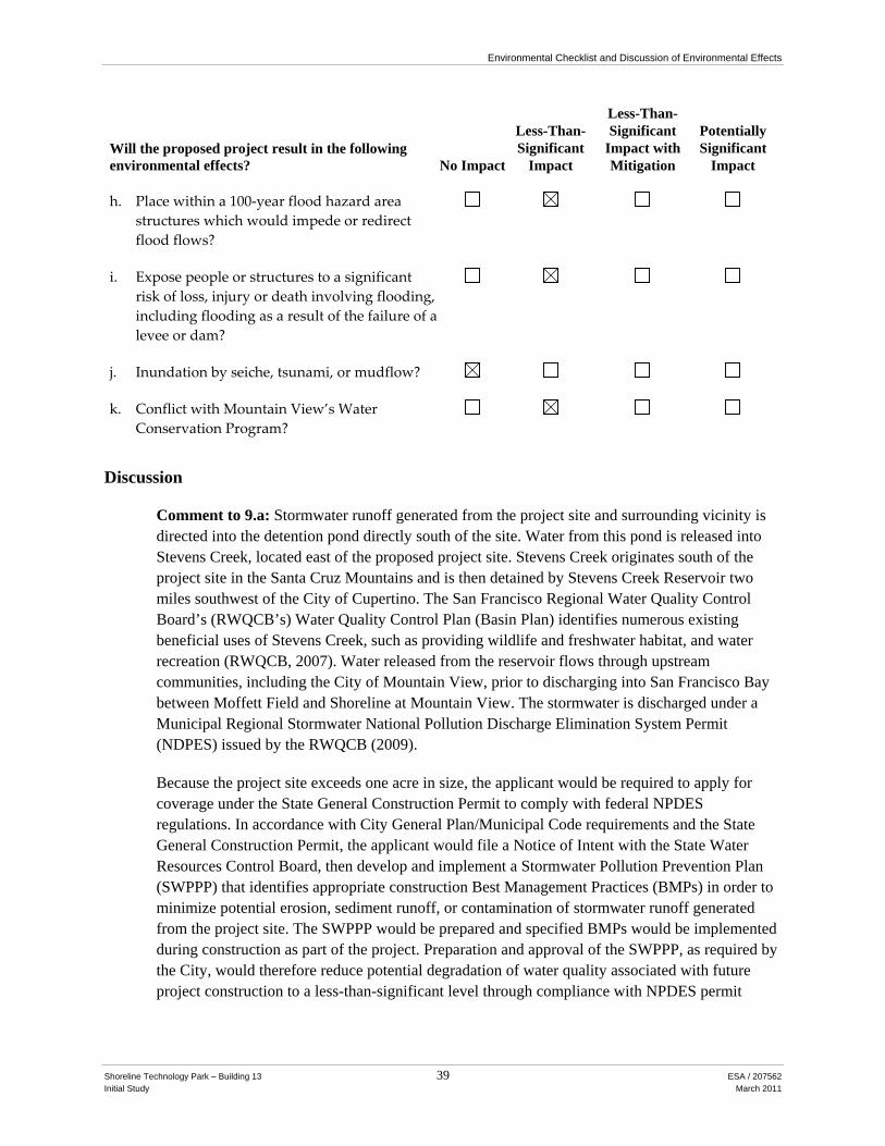
Environmental Checklist and Discussion of Environmental Effects
Shoreline Technology Park – Building 13 39 ESA / 207562 Initial Study March 2011
Will the proposed project result in the following environmental effects? No Impact
Less-Than-Significant
Impact
Less-Than-Significant
Impact with Mitigation
Potentially Significant
Impact
h. Place within a 100‐year flood hazard area structures which would impede or redirect flood flows?
i. Expose people or structures to a significant risk of loss, injury or death involving flooding, including flooding as a result of the failure of a levee or dam?
j. Inundation by seiche, tsunami, or mudflow?
k. Conflict with Mountain View’s Water Conservation Program?
Discussion
Comment to 9.a: Stormwater runoff generated from the project site and surrounding vicinity is directed into the detention pond directly south of the site. Water from this pond is released into Stevens Creek, located east of the proposed project site. Stevens Creek originates south of the project site in the Santa Cruz Mountains and is then detained by Stevens Creek Reservoir two miles southwest of the City of Cupertino. The San Francisco Regional Water Quality Control Board’s (RWQCB’s) Water Quality Control Plan (Basin Plan) identifies numerous existing beneficial uses of Stevens Creek, such as providing wildlife and freshwater habitat, and water recreation (RWQCB, 2007). Water released from the reservoir flows through upstream communities, including the City of Mountain View, prior to discharging into San Francisco Bay between Moffett Field and Shoreline at Mountain View. The stormwater is discharged under a Municipal Regional Stormwater National Pollution Discharge Elimination System Permit (NDPES) issued by the RWQCB (2009).
Because the project site exceeds one acre in size, the applicant would be required to apply for coverage under the State General Construction Permit to comply with federal NPDES regulations. In accordance with City General Plan/Municipal Code requirements and the State General Construction Permit, the applicant would file a Notice of Intent with the State Water Resources Control Board, then develop and implement a Stormwater Pollution Prevention Plan (SWPPP) that identifies appropriate construction Best Management Practices (BMPs) in order to minimize potential erosion, sediment runoff, or contamination of stormwater runoff generated from the project site. The SWPPP would be prepared and specified BMPs would be implemented during construction as part of the project. Preparation and approval of the SWPPP, as required by the City, would therefore reduce potential degradation of water quality associated with future project construction to a less-than-significant level through compliance with NPDES permit
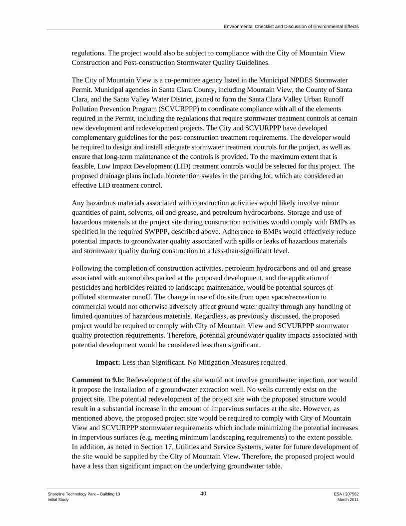
Environmental Checklist and Discussion of Environmental Effects
Shoreline Technology Park – Building 13 40 ESA / 207562 Initial Study March 2011
regulations. The project would also be subject to compliance with the City of Mountain View Construction and Post-construction Stormwater Quality Guidelines.
The City of Mountain View is a co-permittee agency listed in the Municipal NPDES Stormwater Permit. Municipal agencies in Santa Clara County, including Mountain View, the County of Santa Clara, and the Santa Valley Water District, joined to form the Santa Clara Valley Urban Runoff Pollution Prevention Program (SCVURPPP) to coordinate compliance with all of the elements required in the Permit, including the regulations that require stormwater treatment controls at certain new development and redevelopment projects. The City and SCVURPPP have developed complementary guidelines for the post-construction treatment requirements. The developer would be required to design and install adequate stormwater treatment controls for the project, as well as ensure that long-term maintenance of the controls is provided. To the maximum extent that is feasible, Low Impact Development (LID) treatment controls would be selected for this project. The proposed drainage plans include bioretention swales in the parking lot, which are considered an effective LID treatment control.
Any hazardous materials associated with construction activities would likely involve minor quantities of paint, solvents, oil and grease, and petroleum hydrocarbons. Storage and use of hazardous materials at the project site during construction activities would comply with BMPs as specified in the required SWPPP, described above. Adherence to BMPs would effectively reduce potential impacts to groundwater quality associated with spills or leaks of hazardous materials and stormwater quality during construction to a less-than-significant level.
Following the completion of construction activities, petroleum hydrocarbons and oil and grease associated with automobiles parked at the proposed development, and the application of pesticides and herbicides related to landscape maintenance, would be potential sources of polluted stormwater runoff. The change in use of the site from open space/recreation to commercial would not otherwise adversely affect ground water quality through any handling of limited quantities of hazardous materials. Regardless, as previously discussed, the proposed project would be required to comply with City of Mountain View and SCVURPPP stormwater quality protection requirements. Therefore, potential groundwater quality impacts associated with potential development would be considered less than significant.
Impact: Less than Significant. No Mitigation Measures required.
Comment to 9.b: Redevelopment of the site would not involve groundwater injection, nor would it propose the installation of a groundwater extraction well. No wells currently exist on the project site. The potential redevelopment of the project site with the proposed structure would result in a substantial increase in the amount of impervious surfaces at the site. However, as mentioned above, the proposed project site would be required to comply with City of Mountain View and SCVURPPP stormwater requirements which include minimizing the potential increases in impervious surfaces (e.g. meeting minimum landscaping requirements) to the extent possible. In addition, as noted in Section 17, Utilities and Service Systems, water for future development of the site would be supplied by the City of Mountain View. Therefore, the proposed project would have a less than significant impact on the underlying groundwater table.

Environmental Checklist and Discussion of Environmental Effects
Shoreline Technology Park – Building 13 41 ESA / 207562 Initial Study March 2011
Impact: Less than Significant. No Mitigation Measures required.
Comments to 9.c and 9.d: There are no existing water bodies on or immediately adjacent to the project site with the exception of the detention pond south of the site.
Future development would therefore not directly impact the course or direction of any surface body. The project site is currently partially developed with a baseball field, tennis court, volleyball court, and outdoor barbeque area, and is largely covered with pervious surfaces. The potential redevelopment of the project site would alter drainage patterns through the installation of drainage improvements in accordance with City of Mountain View and SCVURPPP stormwater quality protection requirements. These regulatory requirements include protection of stormwater quality and ensuring that transport of sediments or siltation on or offsite is minimized through treatment controls. The proposed project includes bioretention swales for the collection and treatment of stormwater runoff in the proposed parking lot which are effective means of protecting water quality. In addition, these requirements also include the control of stormwater quantity typically through the use of retention basins that meet minimum capacity standards. South of the project site is the existing Charleston Detention Pond. The existing retention drainage easement on the project site would be reconfigured as part of the project to maintain or and/or expand the potential storage capacity. Stormwater from the pond is pumped into Stevens Creek during and immediately after storm events. A 1999 evaluation of the pond and pump station concluded that there was sufficient conveyance capacity within the pond (Schaaf & Wheeler, 1999). Therefore, with compliance of local regulations that minimize the potential for on or offsite siltation, erosion and flooding the proposed alterations to the current drainage patterns would result in a less than significant impact.
Impact: Less than Significant. No Mitigation Measures required.
Comment to 9.e: The proposed project would increase impervious surfaces on the site due to the creation of new impervious surfaces including the proposed building and associated parking lot. Storm drainage from the site would be handled in facilities constructed as part of the project improvements, which include bioretention swales, and reconfiguration of the existing retention drainage easement to provide additional storage capacity. As stated above, the existing pond has adequate capacity for the proposed additional flows, and the drainage easement would maintain and/or expand the potential storage capacity. The existing easement has been calculated to have a storage volume of 142,992 cubic feet, and the proposed drainage easement could increase capacity to as much as 186,900 cubic feet, based on initial draft calculations (Wilsey Ham, 2010). However, final development plans of the proposed project could require reconfiguration of the existing storm drainage infrastructure to accommodate the new flows. Implementation of the following mitigation measure would ensure that the proposed project does not exceed the capacity of the existing storm drain system.
Impact: Potentially Significant.
Mitigation Measures Required by This CEQA Review:

Environmental Checklist and Discussion of Environmental Effects
Shoreline Technology Park – Building 13 42 ESA / 207562 Initial Study March 2011
Mitigation Measure Hyd-1: The applicant shall prepare a design level stormwater flow projection study and a hydraulic capacity study, to be submitted to the City of Mountain View Public Works Department for review and verification that the existing stormwater infrastructure is properly sized. The studies shall show the new connecting points to the existing storm drain and model the estimated flows and peaking factors, as they relate to the changes in land use on the project site. The studies shall show that the reconfigured drainage pattern would not result in increased on or off-site erosion, siltation, or flooding. The applicant shall be responsible for constructing and financing new or upgraded infrastructure that is required to serve the proposed project.
Impact with Incorporated Mitigation Measures: Less than Significant. No additional Mitigation Measures required.
Comment to 9.f: Operation of the proposed project would not result in any substantial changes to onsite water quality associated with stormwater runoff. As discussed under Comment to 9.a, above, implementation of BMPs under the SWPPP and compliance with SCVURPPP requirements would reduce potential impacts to water quality to a less-than-significant level.
Impact: Less than Significant. No Mitigation Measures required.
Comments to 9.g, 9.h, and 9.i: According to maps compiled by the Association of Bay Area Governments (ABAG), the project site is not located in a dam inundation area (ABAG, 2010). However, the site is located in an area that is susceptible to flooding in the event of dike failure (City of Mountain View, 1992). In addition, according to flood maps prepared by the Federal Emergency Management Agency (FEMA), the project site is located mostly within a 100-year flood zone where the flooding elevation has been estimated at 8 feet above sea level (FEMA, 1997). The project site has elevations that are below this level, however the lower elevations are predominantly located in the proposed retention drainage easement. The proposed project does not include housing. However, there appears to be a potential for exposure to flooding.
In addition, future sea level rise could also inundate shoreline areas and expand existing flood prone areas. According to maps compiled by the San Francisco Bay Conservation and Development Commission, an estimated one meter sea level rise appears to approach the boundaries of the project site, however the scale and purpose of the mapping is not intended for site specific analysis (BCDC, 2010). The City of Mountain View includes a Drainage and Flood Control Ordinance which “requires that uses vulnerable to floods, including facilities which serve such uses, be protected against flood damage at the time of initial construction.” Therefore, with compliance of the City of Mountain View ordinance, the potential impact from flooding would be reduced to less than significant levels.
Impact: Less than Significant. No Mitigation Measures required.
Comment to 9.j: The project site is located at an elevation ranging from approximately 14 feet above mean sea level at the north side of the project site and approximately 7 feet above mean sea level at the south side. The project site is located just under a mile from Jogel Slough and the San Francisco Bay. However, due to the distance of the project site from the bay shore and the

Environmental Checklist and Discussion of Environmental Effects
Shoreline Technology Park – Building 13 43 ESA / 207562 Initial Study March 2011
distance from the Golden Gate where tsunami waves would enter the bay, the site would not likely be affected by seiches or tsunamis.
Impact: No Impact. No Mitigation Measures required.
Comment to 9.k: The project is required by Title 24 of the California Building Code, including CalGREEN requirements that went into effect in January 2011, to use interior and exterior low-flow water fixtures. Compliance with Title 24 would ensure the project did not conflict with the City’s water conservation program, and the impact would be less than significant.
Impact: Less than Significant. No Mitigation Measures required.
Cumulative Impacts: Compliance with the State General Construction Permit (NPDES), SCVURPPP and City of Mountain View requirements would reduce potential cumulative impacts associated with stormwater runoff and water quality associated with redevelopment of the project site to a less-than-significant level. In addition, any potential cumulative flooding impacts would be reduced to a less-than-significant level by existing regulations.
Impact: Less than Significant. No Mitigation Measures required.

Environmental Checklist and Discussion of Environmental Effects
Shoreline Technology Park – Building 13 44 ESA / 207562 Initial Study March 2011
10. LAND USE AND PLANNING
Will the proposed project result in the following environmental effects? No Impact
Less-Than-Significant
Impact
Less-Than-Significant
Impact with Mitigation
Potentially Significant
Impact
a. Conflict with any applicable land use plan, policy, or regulation of an agency with jurisdiction over the project (including, but not limited to the general plan, specific plan, local coastal program, or zoning ordinance) adopted for the purpose of avoiding or mitigating an environmental effect?
b. Conflict with any applicable habitat conservation plan or natural community conservation plan?
c. Physically divide an established community?
Discussion
Comment to 10.a: The proposed project would result in construction of a 70,000-square foot, two-story life sciences building and an associated surface parking lot. The project would comply with the General Plan Land Use designation of Industrial Park, which is intended for development of corporate offices, high-tech industries, scientific facilities, as well as accessory uses for employees (City of Mountain View, 2009a).
The project site is currently zoned P-3 (North Shoreline Boulevard Precise Plan) (City of Mountain View, 2009b; 2007). According to the Precise Plan, the P-3 zoning classification (1) implements the General Plan and North Bayshore Area Study, which designates the lands along the Shoreline Boulevard Corridor as a combination of low-intensity industrial and limited commercial uses; (2) addresses environmental constraints such as flooding; (3) provides logical phasing of public improvements, particularly traffic; and (4) ensures a desirable relationship of the property to the Shoreline Recreation and Wildlife Area Park, other open space and adjoining uses. The stated purpose of the special provisions and flexibility of the Planned Community (P) Zone ensure that the area is developed to enhance existing open space of Shoreline Park, designed to blend the diversity of public and private, market-supported uses.
The site is within Area 5 of the Precise Plan, which is intended for limited industrial, research and development uses. Area 5 provides for a transition from the open space area to the north to the industrial uses to the south. Developments in this area should incorporate open space areas and provide a means for blending with open space, including the detention pond area directly south of the project site.
Environmental Checklist and Discussion of Environmental Effects
Shoreline Technology Park – Building 13 45 ESA / 207562 Initial Study March 2011
The proposed life sciences building and surface parking lot on the site would be consistent with the surrounding research and development, office building, and open space areas. The proposed project would also be consistent with the Precise Plan, which allows for principally permitted uses of manufacturing facilities, wholesale businesses, warehouses, data centers, experimental or testing laboratories, and office uses appropriate to the district.
The Precise Plan standards implement General Plan Community Development Chapter policies, some of which are relevant to the proposed project. They include the following:
• Maintain and enhance the special diversity of the city’s businesses and neighborhoods by encouraging well-designed private development that is compatible with surrounding districts and neighborhoods (Goal C, Policy 5).
• Use landscaping to maintain an open character and enhance the built environment by landscaping public roadways to define the character of neighborhoods, using similar types of trees or landscaping themes within districts, and encouraging abundant, attractive, and drought-tolerant landscaping on private property (Goal E, Policy 12, Action 12.b; and Policy 14).
• Promote a wide variety of industrial districts that maintain a diversified economic base by maintaining industrial space for small start-up and incubator industries, as well as high-quality architectural and site design that creates an exceptional work environment (Goal M, Policies 35 and 36).
• Attract and retain a variety of businesses in the community by working with the business community to understand their business needs, assessing how the City's land use policies can accommodate economic growth, and ensuring that rezoning industrial and commercial sites will not significantly hurt the City's economic base (Policy 39, Actions 39.a through 39.c).
• Encourage development that preserves the beauty of the natural environment by promoting the visibility of and safe physical access to San Francisco Bay and other natural resources; orienting and designing development so that people can see and get to scenic features; ensuring compatible land uses next to natural resources; using the planning approval process to require landscape features and buffers to protect natural resources from adjacent development; and using well-designed outdoor areas that take advantage of natural features with minimal destruction of mature trees and vegetation (Goal D, Policies 8 through 11, Actions 8.a, 9.a, 10.a and Actions 11.a through 11.d).
The proposed project would conform to existing height and bulk requirements of the Precise Plan. However, as shown in Table 2, the proposed project would cause the campus to be further out of conformance with maximum floor area ratio, maximum building coverage, and minimum open space requirements of Area 5 of the Precise Plan. As part of the proposed project’s approvals, the Precise Plan provisions would be amended to accommodate the new building and associated surface parking lot.

Environmental Checklist and Discussion of Environmental Effects
Shoreline Technology Park – Building 13 46 ESA / 207562 Initial Study March 2011
TABLE 2 EXISTING NORTH SHORELINE BOULEVARD PRECISE PLAN
HEIGHT AND BULK PROVISIONS
Control Precise Plan Provisions With Proposed Project
Maximum Floor Area Ratio 0.3 0.35
Maximum Building Coverage 20 % 22.5 %
Minimum Open Space 35 % 30 % * Includes both APN 116-11-036 and -037. SOURCE: DES Architects, Engineers, September 2010.
Although the project would require an amendment to the Precise Plan, such amendment would not allow for development substantially out of character with the current built form and character of the technology park campus, as described in Section 1, Aesthetics. Moreover, the existing land use character would be substantially retained—although the technology campus would experience a net decrease in private open space, ample regional park spaces existing directly north and northwest of the campus. The project would also preserve mature landscaping and open space amenities around the site periphery in transition areas to other building and parking areas, as well as the off-site detention pond.
Regarding parking requirements, as stated in the Precise Plan, parking requirements shall follow citywide standards. In this case, such standard are 1 space for every 300 square feet of use. The Precise Plan states, however, that parking requirements may be reduced for low-intensity industrial uses, such as research and development complexes. The project would result in 202 new parking spaces, for a total of 2,568 spaces in the overall Precise Plan area, or about 1 parking space for every 304 square feet of use. This slight parking exception can be approved through a Planned Community Permit, which will be sought as part of the project’s approvals.
The project would further several General Plan goals, as listed above. As such, the project would be generally consistent with the General Plan and the North Shoreline Boulevard Precise Plan. The amendments to the Precise Plan would allow R&D/office development that is consistent with standards in other light industrial and commercial areas throughout the City, accommodate business retention and growth-in-place for existing businesses, and create tenant space that could attract new businesses to the area.
Finally, the project site falls within the Airport Influence Area of the Moffett Federal Airfield (Santa Clara County Airport Land Use Commission, 2010). The proposed project building would be about 37.5 feet tall to the top of the parapet, which would comply with the 182-foot height limit for buildings in the area.
Impact: Less than Significant. No Mitigation Measures required.
Comment to 10.b: The project would be required to comply with development standards and landscape guidelines set forth by the North Shoreline Boulevard Precise Plan. As stated in Section 4, Biological Resources, the site is not located in an area governed by any adopted environmental

Environmental Checklist and Discussion of Environmental Effects
Shoreline Technology Park – Building 13 47 ESA / 207562 Initial Study March 2011
plans or policies by agencies, outside of the City of Mountain View, with jurisdiction over the project. Therefore, the proposed project would not conflict with environmental plans or policies adopted by agencies with jurisdiction over the project.
Impact: Less than Significant. No Mitigation Measures required.
Comment to 10.c: The project site is currently a private recreational space for use by tenants of the Shoreline Technology Campus. Although site access is not controlled by a fence or gate, roaming security ensures that use is exclusive to campus tenants. Existing access to the site from the parking lots to the east and west, as well as from the multi-use path to the south, would be retained. Although the proposed project would result in the removal of a private recreational facility, such removal would not physically divide the established office park community. All roads and pathways adjacent to the site would remain open. Moreover, the proposed project would entail the construction and operation of a 70,000-square-foot life sciences building, which would attract more people to the site and to the campus as a whole than under existing conditions, including potential expansion of existing businesses located on the campus. Research and development facilities are one of the designated uses for the site in the Precise Plan and the Zoning Ordinance, and a mix of recreation and office park uses surround the site. Therefore, the proposed project would be compatible with the existing land uses in the vicinity, and it would not disrupt or divide the physical arrangement of the existing community.
Impact: Less than Significant. No Mitigation Measures required.
Cumulative Impacts: The site is currently partially developed with private recreational uses, and such uses are designated for the site in the North Shoreline Boulevard Precise Plan. The proposed project would be compatible with existing recreational and office park land uses near the site. These projects would not result in considerable cumulative land use impacts. Other physical environmental impacts that could result from the proposed project on the site (for example, impacts to biological resources or hydrology) are discussed in the other impact analyses in this Initial Study. The project would not contribute to or by itself result in any cumulative impacts to land use and planning policies.
Impact: Less than Significant. No Mitigation Measures required.
Environmental Checklist and Discussion of Environmental Effects
Shoreline Technology Park – Building 13 48 ESA / 207562 Initial Study March 2011
11. MINERAL RESOURCES
Will the proposed project result in the following environmental effects? No Impact
Less Than Significant
Impact
Less Than Significant
with Mitigation
Potentially Significant
Impact
a. Result in the loss of availability of a known mineral resource that would be of value to the region and the residents of the state?
b. Result in the loss of availability of a locally important mineral resource recovery site delineated on a local general plan, specific plan or other land use plan?
Discussion
Comment to 11.a and 11.b: The project site is not a locally-important mineral resource recovery site. The proposed project would not result in excavation of mineral resources or the loss of availability of known mineral resources. The project would therefore have no impact.
Impact: No Impact. No Mitigation Measures required.
Cumulative Impacts: The project site is not a locally-important mineral resource recovery site, and development would not result in excavation of mineral resources. In combination with cumulative projects, impacts to mineral resources would be less than significant.
Impact: Less than Significant. No Mitigation Measures required.

Environmental Checklist and Discussion of Environmental Effects
Shoreline Technology Park – Building 13 49 ESA / 207562 Initial Study March 2011
12. NOISE
Will the proposed project result in the following environmental effects? No Impact
Less-Than-Significant
Impact
Less-Than-Significant
Impact with Mitigation
Potentially Significant
Impact
a. Exposure of persons to or generation of noise levels in excess of standards established in the local general plan or noise ordinance, or applicable standards of other agencies?
b. Exposure of persons to or generation of excessive groundborne vibration or groundborne noise levels?
c. A substantial permanent increase in ambient noise levels in the project vicinity above levels existing without the project?
d. A substantial temporary or periodic increase in ambient noise levels in the project vicinity above levels existing without the project?
e. For a project located within an airport land use plan or, where such a plan has not been adopted, within two miles of a public airport or public use airport, would the project expose people residing or working in the project site to excessive noise levels?
f. For a project within the vicinity of a private airstrip, would the project expose people residing or working in the project site to excessive noise levels?
Discussion
Comment to 12.a: The City of Mountain View General Plan contains guidelines for determining the compatibility of various land uses with different noise environments (City of Mountain View, 1992). The Noise Element recognizes that some land uses are more sensitive to ambient noise levels than others, due to the amount of noise exposure (in terms of both exposure duration and insulation from noise) and the types of activities typically involved. For industrial land uses, the guidelines indicate that an outdoor noise environment of DNL 65 dBA or less is considered “normally acceptable.” A noise environment between DNL 65 and 75 dBA is considered “conditionally acceptable” for industrial and uses while an environment above 75 dBA DNL is considered “normally unacceptable.”

Environmental Checklist and Discussion of Environmental Effects
Shoreline Technology Park – Building 13 50 ESA / 207562 Initial Study March 2011
Modeling of traffic noise indicates that the roadside noise level on Stierlin Court is approximately 58.7 dBA. Short-term noise monitoring at the northwest side of the project site, approximately 200 feet south of Stierlin Court, indicated a daytime morning noise level collected near the peak traffic hour to be 50 dBA. The lower noise level 200 feet into the interior of the project site is consistent with the attenuation of noise over distance. Because roadway traffic on Stierlin Court is the predominant ongoing noise source in the area, average hourly noise level during a peak traffic hour is roughly equivalent to the DNL. As such, the existing outdoor noise levels on the project site are considered normally acceptable for industrial uses and would not expose individuals on the project site to unacceptable noise levels.
Impact: Less than Significant. No Mitigation Measures required.
Comment to 12.b:
Construction Vibration
Construction equipment would generate vibrations that could be considered an annoyance by occupants of nearby properties, but it would not reach levels that would damage the structures (FTA, 2006). Construction vibration levels would fluctuate depending on construction phase, equipment type and duration of use, distance between vibration source and receptor. For example, phasing of earth-moving and ground-impacting activities to occur at separate times would reduce overall vibration levels.
Impacts would generally be limited to the period during which new foundations and exterior structural and facade elements would be constructed. Afterwards, equipment would be limited to types that generate little or no ground vibration—such as light trucks, air compressors, hydraulic loaders.
As pile driving would not be required as part of the project, the use of vibratory rollers during grading would be expected to generate the highest vibration levels during construction. As vibration rapidly reduces in intensity with increased distance from the source of vibration, any sensitive receptors in the vicinity would not experience perceptible levels of groundborne vibration from project construction. For example, the Federal Transit Administration reports that vibration from a vibratory roller (one of the largest sources of vibration from non-pile driving construction equipment) generates a peak particle velocity of 0.21 in/sec at a distance of 25 feet, which would dissipate to 0.026 at a distance of 100 feet (FTA, 2006). This same source recommends vibration levels of 0.12 in/sec as the threshold to prevent damage to buildings extremely susceptible to vibration damage.
The nearest sensitive land uses to the project site is a mobile home park located more than 1,500 feet south. Adjacent office park uses may also experience vibration, although they are not considered sensitive uses. The vibration levels inside a building depend on the vibration energy that reaches the building foundation, the coupling of the building foundation to the soil, and the propagation of the vibration through the building. Heavier buildings typically have a lower response incident vibration energy (FTA, 2006).

Environmental Checklist and Discussion of Environmental Effects
Shoreline Technology Park – Building 13 51 ESA / 207562 Initial Study March 2011
Thus, construction related vibration impacts would be less than significant.
Operational Vibration
The project site is not located within proximity of an active rail right-of-way or other source of vibration. In addition, typical use of the site as an industrial office park would not produce groundborne vibration.
Impact: Less than Significant. No Mitigation Measures required.
Comment to 12.c: The project would increase ambient noise levels through an increase of vehicle traffic on local roadways. These increases would be most pronounced during the morning peak hour. The project would result in an increase of 84 peak hour trips during the morning peak hour on Stierlin Court and 45 peak hour trips on Shoreline Boulevard. Roadway noise increases were modeled using the TNM model of the Federal Highway Administration. The addition of these vehicle trips would result in an increase or roadside noise levels of 1.0 dBA on Stierlin Court (from 58.7 dBA to 59.7 dBA) and 0.6 dBA on Shoreline Boulevard (from 64.7 to 65.2 dBA). These noise increases are below the threshold of human perception outside of a laboratory and are considered less than significant based on the findings of the Federal Interagency Committee on Aviation Noise. These noise levels are also within the ranges of acceptable and conditionally acceptable exterior noise levels as defined in the City of Mountain View General Plan Noise Element (see Comment to 12.a, above). Other noise sources such as operational equipment of the proposed building would be restricted by the existing North Shoreline Boulevard Precise Plan which restricts exterior noise level generation over 65 dBA (10 percent exceedance). This impact would be less than significant.
Impact: Less than Significant. No Mitigation Measures required.
Comment to 12.d: Construction activities associated with the project would temporarily increase noise levels in the vicinity of the project site. Construction is expected to begin in fall 2011 and would be complete in 2013. Construction noise levels at and near locations on the project site would fluctuate depending on the particular type, number, and duration of use of various types of construction equipment. The effect of construction noise would depend upon how much noise would be generated by construction, the distance between construction activities and the nearest noise-sensitive uses, and the existing noise levels at those uses. The nearest sensitive land use would be mobile home park approximately 1,500 feet south of the project site. Noise from construction activities would primarily affect existing industrial uses adjacent to the project site. Ground clearing and excavation activities could result in noise levels of 84–89 dBA, at 50 feet. Without mitigation, this would be considered a significant impact.
Impact: Potentially Significant.
Mitigation Measures Required by This CEQA Review:
Mitigation Measure Noise-1: The project sponsor shall require construction contractors to implement the following mitigation measures:
Environmental Checklist and Discussion of Environmental Effects
Shoreline Technology Park – Building 13 52 ESA / 207562 Initial Study March 2011
• All construction vehicles and equipment, fixed and mobile, shall utilize the best available noise control techniques (e.g., improved mufflers, equipment redesign, use of intake silencers, ducts, engine enclosures and acoustically-attenuating shields or shrouds, wherever feasible).
• Consistent with Section 8.23 of the City Code, all noise generating construction activities shall be limited to the hours of 7 a.m. to 6 p.m., Monday through Friday. No noise producing construction activities shall be performed on Saturdays, Sundays and holidays without prior written approval from the City.
• Construction staging areas shall be located as far as practicable from existing recreational uses so as to cause minimal disruption to these activities.
• Signs shall be posted at the construction site that include permitted construction days and hours, and the name and contact number for an appointed disturbance coordinator for the job site in the event of problems.
Impact with Incorporated Mitigation Measures: Less than Significant. No additional Mitigation Measures required.
Comment to 12.e: The project site is located approximately 5,000 feet west of the nearest runways as Moffett Federal Airfield, also known as Moffett Field, a joint civil-military airport. Noise from aircrafts taking off and landing at Moffett Field would be a potential source of noise affecting people using the facilities of the proposed project. However, the project site is located outside the 60 dBA contour for the airfield which places is it within the normally acceptable land use category for industrial, commercial and residential land uses in the City’s General Plan Noise Element. Hence the proposed structure would be compatible for the proposed industrial use with respect to noise, and noise mitigating construction measures in excess of standard building requirements are not required. This impact would be less then significant
Impact: Less than Significant. No Mitigation Measures required.
Comment to 12.f: The project site is not located within 2 miles of any private airstrip.
Impact: Less than Significant. No Mitigation Measures required.
Cumulative Impacts: Noise impacts from the project would be primarily during the construction phase of the project. As construction would be a temporary activity, taking place over a period of 12-24 months, with the implementation of Mitigation Measure Noise-1, the project’s construction noise is not expected to contribute significantly to the cumulative ambient noise environment.
The project would result in an increase of 84 peak hour trips during the morning peak hour on Stierlin Court and 45 peak hour trips on Shoreline Boulevard. Roadway noise increases were modeled using the TNM model of the Federal Highway Administration. The addition of these vehicle trips as well as cumulative traffic would result in an increase or roadside noise levels of 1.0 dBA on Stierlin Court (from 58.7 dBA to 59.7 dBA) and 1.6 dBA on Shoreline Boulevard (from 64.7 to 66.3 dBA). Although the resulting noise level could exceed the Noise Element “acceptable” guideline of 65 DNL for industrial areas, the noise level would remain well within the
Environmental Checklist and Discussion of Environmental Effects
Shoreline Technology Park – Building 13 53 ESA / 207562 Initial Study March 2011
“conditionally acceptable” level. Moreover, the project’s contribution to the cumulative noise level increase would be below the threshold of human perception outside of a laboratory and would therefore be considered less than significant based on the findings of the Federal Interagency Committee on Aviation Noise. This cumulative noise impact would be less than significant.
Impact: Less than Significant. No Mitigation Measures required.
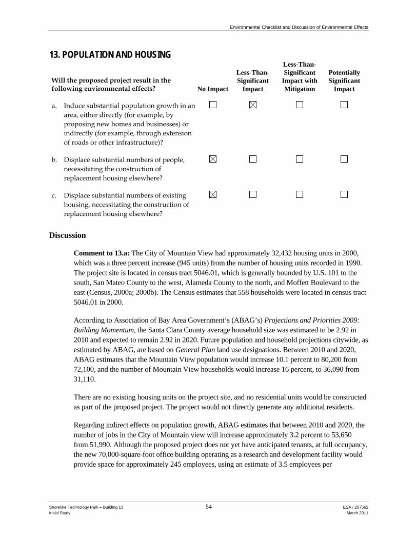
Environmental Checklist and Discussion of Environmental Effects
Shoreline Technology Park – Building 13 54 ESA / 207562 Initial Study March 2011
13. POPULATION AND HOUSING
Will the proposed project result in the following environmental effects? No Impact
Less-Than-Significant
Impact
Less-Than-Significant
Impact with Mitigation
Potentially Significant
Impact
a. Induce substantial population growth in an area, either directly (for example, by proposing new homes and businesses) or indirectly (for example, through extension of roads or other infrastructure)?
b. Displace substantial numbers of people, necessitating the construction of replacement housing elsewhere?
c. Displace substantial numbers of existing housing, necessitating the construction of replacement housing elsewhere?
Discussion
Comment to 13.a: The City of Mountain View had approximately 32,432 housing units in 2000, which was a three percent increase (945 units) from the number of housing units recorded in 1990. The project site is located in census tract 5046.01, which is generally bounded by U.S. 101 to the south, San Mateo County to the west, Alameda County to the north, and Moffett Boulevard to the east (Census, 2000a; 2000b). The Census estimates that 558 households were located in census tract 5046.01 in 2000.
According to Association of Bay Area Government’s (ABAG’s) Projections and Priorities 2009: Building Momentum, the Santa Clara County average household size was estimated to be 2.92 in 2010 and expected to remain 2.92 in 2020. Future population and household projections citywide, as estimated by ABAG, are based on General Plan land use designations. Between 2010 and 2020, ABAG estimates that the Mountain View population would increase 10.1 percent to 80,200 from 72,100, and the number of Mountain View households would increase 16 percent, to 36,090 from 31,110.
There are no existing housing units on the project site, and no residential units would be constructed as part of the proposed project. The project would not directly generate any additional residents.
Regarding indirect effects on population growth, ABAG estimates that between 2010 and 2020, the number of jobs in the City of Mountain view will increase approximately 3.2 percent to 53,650 from 51,990. Although the proposed project does not yet have anticipated tenants, at full occupancy, the new 70,000-square-foot office building operating as a research and development facility would provide space for approximately 245 employees, using an estimate of 3.5 employees per

Environmental Checklist and Discussion of Environmental Effects
Shoreline Technology Park – Building 13 55 ESA / 207562 Initial Study March 2011
1,000 square feet of office park space.6 This increase would represent approximately 15 percent of the anticipated employment growth in Mountain View over the next 10 years. Given the proposed project’s location with easy access to major arterials and regional highways, it is likely that employees would travel to work at the project site from municipalities in the surrounding region, as well as from Mountain View. The project would be expected to employ workers primarily already living in the Bay Area, although it may indirectly increase population by attracting new employees to the area.
Pursuant to Section 36.91 of the Zoning Ordnance, the project applicant would be required to pay the City of Mountain View’s Housing Impact Fee for New Nonresidential Floor Area. Fees collected would be used for housing projects and programs for low and moderate income households. Therefore, the project’s impacts to indirect population growth would be less than significant.
The proposed project is located in a developed urban area with access to required infrastructure and utility services. Therefore, it would not require the construction of new infrastructure that would indirectly allow for future population growth.
Therefore, the proposed project would have a less-than-significant impact on population growth.
Impact: Less than Significant. No Mitigation Measures required.
Comment to 13.b and 13.c: The proposed project would displace private recreational uses. It would not displace residents or housing units. Therefore, the project would have no impact related to these criteria.
Impact: No Impact. No Mitigation Measures required.
Cumulative Impacts: The proposed project would have a less-than-significant impact on population growth and would not displace housing units or residents. Therefore, there would be a less-than-significant cumulative impact on population and housing.
Impact: No Impact. No Mitigation Measures required.
6 Nelson, Arthur. Planner’s Estimating Guide. Planners Press, American Planning Association, 2004. This analysis found an
average of 540 interior square feet is used per R&D employee, and about 350 square feet of interior is used per Office Park employee. Given that tenancy has not yet been determined for the proposed project, for the purpose of conservative analysis, the lower figure is used, resulting in about 245 employees.
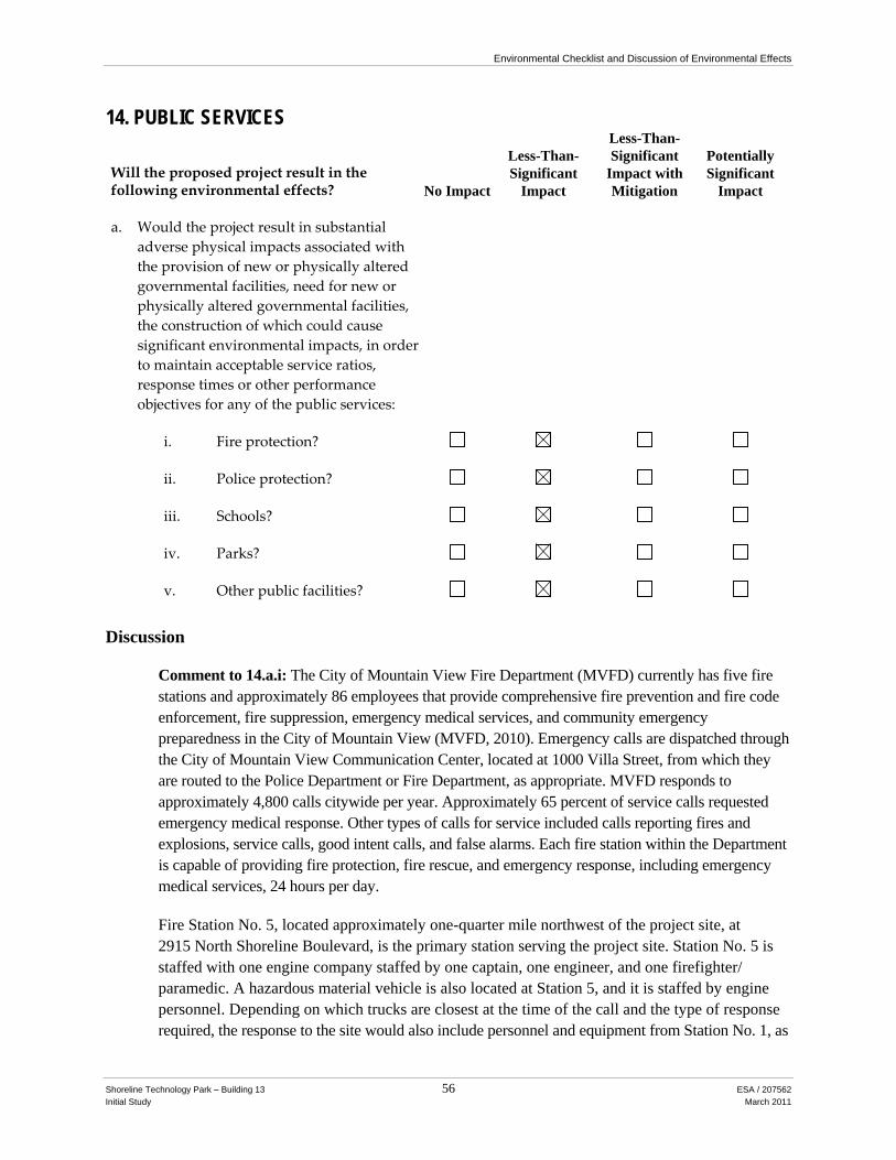
Environmental Checklist and Discussion of Environmental Effects
Shoreline Technology Park – Building 13 56 ESA / 207562 Initial Study March 2011
14. PUBLIC SERVICES
Will the proposed project result in the following environmental effects? No Impact
Less-Than-Significant
Impact
Less-Than-Significant
Impact with Mitigation
Potentially Significant
Impact
a. Would the project result in substantial adverse physical impacts associated with the provision of new or physically altered governmental facilities, need for new or physically altered governmental facilities, the construction of which could cause significant environmental impacts, in order to maintain acceptable service ratios, response times or other performance objectives for any of the public services:
i. Fire protection?
ii. Police protection?
iii. Schools?
iv. Parks?
v. Other public facilities?
Discussion
Comment to 14.a.i: The City of Mountain View Fire Department (MVFD) currently has five fire stations and approximately 86 employees that provide comprehensive fire prevention and fire code enforcement, fire suppression, emergency medical services, and community emergency preparedness in the City of Mountain View (MVFD, 2010). Emergency calls are dispatched through the City of Mountain View Communication Center, located at 1000 Villa Street, from which they are routed to the Police Department or Fire Department, as appropriate. MVFD responds to approximately 4,800 calls citywide per year. Approximately 65 percent of service calls requested emergency medical response. Other types of calls for service included calls reporting fires and explosions, service calls, good intent calls, and false alarms. Each fire station within the Department is capable of providing fire protection, fire rescue, and emergency response, including emergency medical services, 24 hours per day.
Fire Station No. 5, located approximately one-quarter mile northwest of the project site, at 2915 North Shoreline Boulevard, is the primary station serving the project site. Station No. 5 is staffed with one engine company staffed by one captain, one engineer, and one firefighter/ paramedic. A hazardous material vehicle is also located at Station 5, and it is staffed by engine personnel. Depending on which trucks are closest at the time of the call and the type of response required, the response to the site would also include personnel and equipment from Station No. 1, as

Environmental Checklist and Discussion of Environmental Effects
Shoreline Technology Park – Building 13 57 ESA / 207562 Initial Study March 2011
well as personnel and equipment from other engines closest to the site. Station No. 1, located approximately 2 miles south of the project site, at 251 South Shoreline Boulevard, is the designated second responder to an emergency at the project site. It is staffed nine firefighters. For a typical “one alarm” fire, three engine companies (each with one captain, one engineer and one firefighter/paramedic), one truck company (with one Captain, one engineer and one firefighter/paramedic), one rescue company (with two firefighters), and a battalion chief respond. The estimated response time from both stations is 5 minutes or less (Wentker, 2010).
The implementation of the proposed project would result in development of 70,000 square feet of life science / research and development uses with associated parking. The increased intensity of development and activity at the site could result in an increase in calls for emergency medical services and fire suppression. However, due to the project’s location in an urbanized area already served by emergency medical and fire suppression services, MVFD would not need additional staff or facilities to maintain current response ratios and service standards. Furthermore, Fire Department review of all project designs at the time building permits are issued would ensure that adequate fire and life safety measures are incorporated into the project in compliance with all applicable state and city fire safety requirements. The City’s Fire Protection Engineer would review the proposed site and building plans to ensure that Fire Department personnel would have adequate access to the site. The Fire Department does not anticipate any complications, additional staffing, or other requirements to serve the proposed project (Wentker, 2010).
The proposed project would not create a need for new or altered facilities to maintain adequate service ratios, response times and other objective standards, and would not, therefore, result in significant environmental impacts to fire protection and emergency medical response provisions.
Impact: Less than Significant. No Mitigation Measures required.
Comment to 14.a.ii: The City of Mountain View Police Department (MVPD) provides police protection services in the City of Mountain View. The Police Department is headquartered at 1000 Villa Street, approximately 2 miles from the project site. MVPD currently employs 98 sworn officers, and 49 non-sworn/civilian staff members (including 8 community service officers). MVPD does not calculate officer need on an officer-to-resident ratio. It adds officers on an as-needed basis subject to approval of the City Council.
MVPD currently consists of five geographical police beats, with at least one officer assigned to each beat at any given time. The project site is located within Beat 4 and Reporting District (RD) 418, which contains blocks bound approximately by Space Park Way to the south, North Shoreline Boulevard to the west, Shoreline Park at Mountain View Park to the north, and Moffett Federal Airfield to the west. Approximately 5,810 crimes citywide were reported in 2008, including both violent and property-related crimes. In 2009, approximately 13 incidents were reported in RD 418, involving commercial-space burglaries, auto burglaries, thefts, and stolen vehicles. MVPD has stated that the crime rate in the project vicinity is lower to the citywide average (Wylie, 2010).
MVPD’s performance measure for police response times sets a target of responding to and arriving at a potential crime scene for top priority calls within 4 minutes for more than 55.5 percent of the

Environmental Checklist and Discussion of Environmental Effects
Shoreline Technology Park – Building 13 58 ESA / 207562 Initial Study March 2011
time. MVPD has historically met this goal. MVPD has indicated that no additional staffing would be necessary to meet the policing needs of the proposed project.
Shoreline Technology Park staff currently monitors the campus, including the project site, and provides security. The staff would continue to provide site security with the proposed project. The proposed expansion of life science / research and development space would result in a slight increase in calls for police protection services, but it would not trigger a need for increased staff or new or expanded police facilities in order to maintain adequate service ratios, response times, and other objective standards.
Impact: Less than Significant. No Mitigation Measures required.
Comment to 14.a.iii: The Mountain View-Whisman School District and Mountain View-Los Altos Union High School District operate Mountain View’s public schools.
As stated in Section 13, Population and Housing, no residential units would be constructed as part of the proposed project. Therefore, the project would not directly generate any additional residents or school-aged children. The project could result in about 245 new jobs in the City of Mountain View, which may indirectly lead to population growth by attracting more workers to the Bay Area, as stated in Section 13, above. However, the project would not result in the construction of new roadways, extension of sewer service, or other infrastructure that would allow for future residential development. Therefore, the project would not result in a substantial increase the student population in the City of Mountain View.
The Leroy F. Greene School Facilities Act of 1998, or Senate Bill 50 (SB 50), restricts the ability of local agencies, such as the City of Mountain View, to deny land use approvals on the basis that public school facilities are inadequate. SB 50 establishes the base amount of allowable developer fees for residential construction. These fees are intended to address local school facility needs resulting from new development. Public school districts can, however, impose higher fees, or fees on development of other uses, provided they meet the conditions outlined in the act. Private schools are not eligible for fees collected pursuant to SB 50.
All new residential additions greater than 500 square feet, and all new commercial square footage in Mountain View, are subject to School Impact Fees. The payment of these fees would provide mitigation under CEQA for incremental increase in student population, and result in less-than-significant environmental impacts to public schools in the project site vicinity. Impact: Less than Significant. No Mitigation Measures required.
Comment to 14.a.iv: The discussion of project effects on parks is addressed in Section 15, Recreation.
Comment to 14.a.v: The City of Mountain View has one Municipal Operations Center, located at 231 North Whisman Road, where the city stores and repairs maintenance vehicles and equipment. Government Services provided to Mountain View residents include the management of the Mountain View Senior Center, located at 266 Escuela Avenue, as well as local pools and recreation centers.
Environmental Checklist and Discussion of Environmental Effects
Shoreline Technology Park – Building 13 59 ESA / 207562 Initial Study March 2011
The proposed project would increase daytime worker population in Mountain View, which would incrementally increase demand for government services, but not in excess of amounts expected and already provided for in the area. Thus, the proposed project would not be expected to have a measurable impact on the provision of other governmental services.
Impact: Less than Significant. No Mitigation Measures required.
Cumulative Impacts: Although public service providers indicated an ability to serve the project site in combination with other known and anticipated development projects in the City of Mountain View, future development may require additional facilities. Because future development, beyond current applications, is unknown, the City anticipates that it would not be required to build new facilities at this time. The proposed project would therefore not have a significant impact on public services.
Impact: Less than Significant. No Mitigation Measures required.

Environmental Checklist and Discussion of Environmental Effects
Shoreline Technology Park – Building 13 60 ESA / 207562 Initial Study March 2011
15. RECREATION
Will the proposed project result in the following environmental effects? No Impact
Less-Than-Significant
Impact
Less-Than-Significant
Impact with Mitigation
Potentially Significant
Impact
a. Would the project increase the use of existing neighborhood and regional parks or other recreational facilities such that substantial physical deterioration of the facility would occur or be accelerated?
b. Does the project include recreational facilities or require the construction or expansion of recreational facilities which might have an adverse physical effect on the environment?
Discussion
Comment to 15.a: The City of Mountain View encompasses almost 1,000 acres of parks and open spaces, among them approximately 12 acres of Mini-Parks, 48 acres of City-owned Neighborhood Parks, 50 acres of Community Parks, and 777 acres of Regional Parks (most of it in the area known as Shoreline at Mountain View). In addition, the City contains about 85 acres of school-district-owned parks. The City’s Recreation Division organizes various classes and other activities at the neighborhood parks and swimming pools, the Community Center, and the Senior Center (City of Mountain View, 2008b)
The City’s standard for parks, as set by its Park Land Dedication Ordinance and the Parks and Open Space Plan, is 3 acres per 1,000 residents. Based on a 2006 population of 71,955 and not including the regional parks, the City is below the 3-acre standard, at 2.61 acres per 1,000 residents. When the Shoreline regional facility west of the project site is included, the ratio rises to 13.51 acres per 1,000 residents, which is well in excess of the standard.
The North Bay Shore planning area, which includes the project site, is an irregularly-shaped area generally bounded by U.S. 101 to the south, Moffett Air Field to the east, the Bay to the north, and BayShore Parkway / Terminal Boulevard to the west. At 1,889 acres, it is the largest planning area in the City of Mountain View and is home to primarily industrial and open space uses, although it also includes commercial office spaces for technology, pharmaceutical, and financial investments firms, as well as residential development. With 1,063.14 acres of parkland per 1,000 residents, the North Bay Shore planning area is well above below the City’s standard for parks. The North Bay Shore area’s primary public park is the 753-acre Shoreline regional facility, but it is also served by the 6.48-acre Charleston neighborhood park, as well as a 0.60-acre dog park.
Public parks and recreational facilities closest to the project site include the following: Stevens Creek Trail, located 1,000 feet east of the project site; Vista Slope and Charleston Park, both located 2,000 feet west of the project site; Shoreline at Mountain View, located 2,000 feet north of the

Environmental Checklist and Discussion of Environmental Effects
Shoreline Technology Park – Building 13 61 ESA / 207562 Initial Study March 2011
project site; the Dog Park, located north of the Shoreline Park; and Charleston Park, located 750 feet east of the project site. Combined, these facilities include a golf course, aquatic center and lake, picnic areas, restrooms, trails, dog play facilities, and passive green areas. In addition, the project site currently comprises a private softball field, a basketball court, barbecue area, sand volleyball court, walking paths, and tables and benches.
Construction of the proposed project would displace the existing barbecue area, softball field, tables and benches with a life sciences building and associated surface parking lot. In addition, construction of the proposed project would replace the sand volleyball court with a new surface. Although these facilities currently serve the employee population surrounding the project site, they are private facilities not for use by the general public. It is possible that some corporate recreational events or other recreational users would seek access to other nearby public open spaces, such as Shoreline Park, Vista Slope, or the private recreational facilities of Google, Inc., located to the west and northwest. Such use would not be anticipated to result in substantial degradation of neighborhood or regional parks.
Only residential developments are required to comply with the City of Mountain View Park Land Dedication Ordinance, which requires payment of an impact fee or dedication of open space. The proposed project, which would include no residential units, would not be subject to that fee. The project, however, would result in approximately 245 new employees at the project site. As stated above, the project site is located in an area that is relatively well-served by public open spaces. The new project tenants could patronize these public facilities, but workday use of such facilities would not result in their substantial degradation. The impact would be less than significant.
Impact: Less than Significant. No Mitigation Measures required.
Comment to 15.b: The proposed project does not include the construction of substantial new recreational facilities. Although the existing sand volleyball court surface would be replaced, such construction would not result in significant environmental effects, as discussed in other sections of this Initial Study. No new parks would be required to be constructed to meet the recreational demands of the project’s future tenants. Therefore, the proposed project would have a less-than-significant impact.
Impact: Less than Significant. No Mitigation Measures required.
Cumulative Impacts: The proposed project would not substantially increase demand for recreational facilities to the point that substantial degradation of existing recreational facilities would result, and no new recreational facilities would be constructed. Cumulative developments would not be expected to add substantially to the daytime worker population to an extent that physical deterioration of parks would result. Cumulative impacts related to recreation would be less than significant.
Impact: Less than Significant. No Mitigation Measures required.
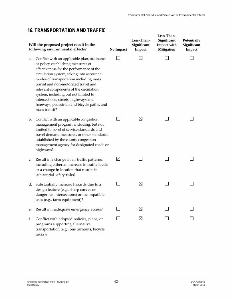
Environmental Checklist and Discussion of Environmental Effects
Shoreline Technology Park – Building 13 62 ESA / 207562 Initial Study March 2011
16. TRANSPORTATION AND TRAFFIC
Will the proposed project result in the following environmental effects? No Impact
Less-Than-Significant
Impact
Less-Than-Significant
Impact with Mitigation
Potentially Significant
Impact
a. Conflict with an applicable plan, ordinance or policy establishing measures of effectiveness for the performance of the circulation system, taking into account all modes of transportation including mass transit and non‐motorized travel and relevant components of the circulation system, including but not limited to intersections, streets, highways and freeways, pedestrian and bicycle paths, and mass transit?
b. Conflict with an applicable congestion management program, including, but not limited to, level of service standards and travel demand measures, or other standards established by the county congestion management agency for designated roads or highways?
c. Result in a change in air traffic patterns, including either an increase in traffic levels or a change in location that results in substantial safety risks?
d. Substantially increase hazards due to a design feature (e.g., sharp curves or dangerous intersections) or incompatible uses (e.g., farm equipment)?
e. Result in inadequate emergency access?
f. Conflict with adopted policies, plans, or programs supporting alternative transportation (e.g., bus turnouts, bicycle racks)?

Environmental Checklist and Discussion of Environmental Effects
Shoreline Technology Park – Building 13 63 ESA / 207562 Initial Study March 2011
Discussion
Comment to 16a and 16.b: The project site is located along Stierlin Court, east of Shoreline Boulevard in the City of Mountain View (as illustrated in Figure 1, page 3). Regional access to the project site is provided by U.S. 101 directly to the south and west of the project site, which is a generally a ten-lane freeway (five lanes in each direction) in proximity of the project site. Two full interchanges along U.S. 101 (with northbound and southbound on- and off-ramps) are located at Shoreline Boulevard and at Amphitheatre Parkway. Local access is provided by Shoreline Boulevard, a four-lane divided, north-south arterial roadway that extends from El Camino Real (State Route 82) in the south to Permanente Creek Trail to the north. Vehicular access to and from the project site is on Stierlin Court at Shoreline Boulevard or along Amphitheatre Parkway, which becomes Stierlin Court east of Shoreline Boulevard (roadways are illustrated in Figure 4).
Traffic level of service (LOS) conditions were assessed at six intersections for weekday morning (a.m.) and evening (p.m.) peak hours under existing, existing plus project, cumulative, and cumulative plus project conditions. The intersections that were evaluated are outlined below:
1. Shoreline Boulevard/Ampitheatre Parkway-Stierlin Court 2. Shoreline Boulevard/Charleston Road 3. Shoreline Boulevard/Space Park Way 4. Shoreline Boulevard/Plymouth Street 5. Shoreline Boulevard/Pear Avenue 6. Shoreline Boulevard/La Avenida Street/Northbound U.S. 101 Off-Ramp
The LOS concept is a qualitative characterization of traffic conditions associated with varying levels of traffic, based on quantitative measures of delay and congestion. Descriptions of conditions range from LOS A (free-flow condition) to LOS F (jammed/forced-flow condition), as described in the 2000 Highway Capacity Manual (HCM) (Transportation Research Board, 2000). The City of Mountain View has an adopted minimum standard of LOS D for most local intersections, and LOS E for intersections designated in the Santa Clara County Congestion Management Plan (CMP) network. None of the study intersections are CMP-designated intersections. Intersection operations at each study intersection that exceed LOS standards would be deemed unacceptable.
The City of Mountain View has adopted standards of significance from the Santa Clara Valley Transportation Authority Transportation Impact Analysis Guidelines for evaluating traffic impacts (VTA, 2009). These standards indicate a traffic impact would be classified as significant if the introduction of the proposed project would:
• Cause traffic operations at a local (City of Mountain View) signalized intersection to deteriorate below level of service (LOS) D;
• Cause traffic operations at a local (City of Mountain View) signalized intersection already operating at LOS E or F to deteriorate to the degree that the average control delay for the critical movements would increase by four seconds or more, and the volume to capacity ratio (V/C) value of the critical movements would increase by 0.01 or more;

101
AMPHITHEATRE PKWAY
OLD MIDDLEFIELD WAY
CHARLESTON RD
STIERLIN CT
SPACE PARK WAY
PEAR AVE
PLYMOUTH ST
LA AVENIDA ST
MIDDLEFIELD RD
REN
GST
OR
FF A
VE
N S
HO
RE
LIN
E B
LVD
E CHARLESTON RD
PROJECTSITE
Shoreline Technology Park - Building 13 . 207562Figure 4
Existing RoadwaysSOURCE: ESA
0 .25
Mile
GARCIA AVE

Environmental Checklist and Discussion of Environmental Effects
Shoreline Technology Park – Building 13 65 ESA / 207562 Initial Study March 2011
• Cause an increase in, or add to traffic equal to at least one percent of the freeway segment’s capacity
Currently, the City of Mountain View does not have specific written guidelines for unsignalized intersections, particularly side-street stop-controlled intersections. Side-street stop-controlled intersections function differently than signalized or all-way stop-controlled intersections, in that the primary street’s through movements are purposely prioritized due to the relative volume of traffic on the primary street versus the stop-controlled side street. As such, the project would additionally have a significant impact if it would:
• Cause traffic operations on the critical approach at a local (City of Mountain View) unsignalized intersection to deteriorate below LOS D, and the peak hour traffic signal warrants are met under project conditions;
• Cause traffic operations on the critical approach at a local (City of Mountain View) unsignalized intersection already operating at LOS E or F to deteriorate further, and the peak hour traffic signal warrants are met under project conditions;
• Create an operational safety hazard due to a design feature or incompatible uses; or
• Result in inadequate emergency access.
Existing traffic turning movement data for the morning peak period (7:00 a.m. to 9:00 a.m.) and evening peak period (4:00 p.m. to 6:00 p.m.) for the six study intersections were conducted on Wednesday, September 22, 2010. In addition to collecting turning movement data, field observations were conducted during both peak periods to observe traffic operations and patterns near the project site. In general, there were no intersections or roadway segments along Shoreline Boulevard that experienced significant queuing during both peak periods. However, the Shoreline Boulevard / La Avenida Street / Northbound U.S. 101 Off-Ramp intersection experienced heavy traffic during the AM peak hour, primarily from vehicles turning from the U.S. 101 Off-Ramp onto northbound Shoreline Boulevard. During the PM peak hour, as well, heavy traffic flowed through this intersection. Vehicle queuing was also observed along Space Park Way during both peak periods, primarily due to vehicles traveling westbound along Space Park Way attempting to turn southbound onto Shoreline Boulevard. These vehicles must yield to uncontrolled traffic along Shoreline Boulevard, as well as yield to any vehicles turning onto Space Park Way from southbound Shoreline Boulevard. In proximity to the project site, there was light demand at the Shoreline Boulevard / Amphitheatre Parkway-Stierlin Court intersection during both peak periods, with no substantial queuing on each intersection approach.
At each study intersection, peak-hour traffic conditions (for the hour of greatest traffic during the peak period) were evaluated using the 2000 HCM operations methodology. The TRAFFIX software was used as the analysis tool in this study. The operation analysis uses various intersection characteristics (e.g., traffic volumes, lane geometry, and intersection controls) to estimate the average control delay experienced by motorists traveling through an intersection; detailed LOS output sheets are located in Appendix B. Existing peak-hour level of service for each study intersection is presented in Table 3.

Environmental Checklist and Discussion of Environmental Effects
Shoreline Technology Park – Building 13 66 ESA / 207562 Initial Study March 2011
TABLE 3 EXISTING PEAK-HOUR INTERSECTION LEVELS OF SERVICE (LOS)a
Intersection
Control Typeb,c
A.M. Peak P.M. Peak Delay LOS Delay LOS
1. Shoreline Blvd/Amphitheatre Pkwy-Stierlin Court Signalized 8.3 A 9.9 A
2. Shoreline Boulevard/Charleston Road Signalized 16.1 B 41.9 D
3. Shoreline Boulevard/Space Park Way SSSC 62.7 (WB) F 41.1
(WB) E
4. Shoreline Boulevard/Plymouth Street SSSC 9 (EB) A 23 (EB) C
5. Shoreline Boulevard/Pear Avenue Signalized 17.3 B 18.5 B-
6. Shoreline Blvd/La Avenida St/NB US 101 Off-Ramp Signalized 40.3 D 32.6 C-
Abbreviations: WB indicates westbound approach; EB indicates eastbound approach. a LOS calculations performed using TRAFFIX and the 2000 Highway Capacity Manual operations analysis methodology. b Signalized = Traffic Signal Intersection; SSSC = Side-Street Stop-Controlled intersection. c The LOS and delay for signalized study intersections represent conditions for the overall intersection. For SSSC intersections,
LOS and delay represent conditions for stop-controlled movement. SOURCE: ESA (2010).
During the A.M. peak hour, five of the six study intersections operate at an acceptable LOS (LOS D or better); however, the side-street approach at Shoreline Boulevard / Space Park Way operates at LOS F. During the P.M. peak hour, five of the six study intersections operate at an acceptable LOS; the side-street approach at Shoreline Boulevard / Space Park Way operates at LOS E. A signal warrant analysis, based on the Manual on Uniform Traffic Control Devices (Caltrans, 2010) was conducted to assess the need for signalization at the Shoreline Boulevard / Space Park Way intersection. Based on the peak hour volume warrant criteria (Warrant 3), the traffic signal warrant is not currently met at the study intersection. Signal warrant sheets are located in Appendix B.
Vehicle trip generation was estimated using the Institute of Transportation Engineers (ITE) Trip Generation (ITE, 2008). This manual provides guidance on estimating traffic generation for various land uses based on observations conducted across the United States. Due to the location of the proposed project and current transportation demand management (TDM) programs that service the project area, which includes a Caltrain Shuttle Bus service route between the proposed project area and the Downtown Mountain View Caltrain Station, trip reduction factors were applied. Santa Clara Valley Transportation Authority (VTA) is the Congestion Management Agency (CMA) for Santa Clara County, and the guidance set forth in the VTA Guidelines suggests a two percent reduction in auto trips for projects that would include an effective TDM program (including a dedicated shuttle service). As a result, the proposed project would generate approximately 556 daily vehicle trips, 84 total morning (a.m.) peak-hour vehicle trips, and 73 total evening (p.m.) peak-hour vehicle trips. For analysis purposes, the number of vehicle trips that are generated by the existing private recreational site were not subtracted from existing trips from the existing peak hour intersection counts, because it was difficult to distinguish vehicle trips associated with the existing recreational site from vehicle trips associated with adjacent office uses, and
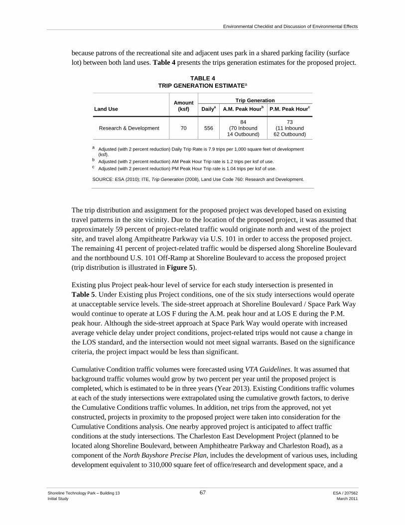
Environmental Checklist and Discussion of Environmental Effects
Shoreline Technology Park – Building 13 67 ESA / 207562 Initial Study March 2011
because patrons of the recreational site and adjacent uses park in a shared parking facility (surface lot) between both land uses. Table 4 presents the trips generation estimates for the proposed project.
TABLE 4 TRIP GENERATION ESTIMATEa
Land Use Amount
(ksf) Trip Generation
Dailya A.M. Peak Hourb P.M. Peak Hourc
Research & Development 70 556 84 73
(70 Inbound 14 Outbound)
(11 Inbound 62 Outbound)
a Adjusted (with 2 percent reduction) Daily Trip Rate is 7.9 trips per 1,000 square feet of development
(ksf). b Adjusted (with 2 percent reduction) AM Peak Hour Trip rate is 1.2 trips per ksf of use. c Adjusted (with 2 percent reduction) PM Peak Hour Trip rate is 1.04 trips per ksf of use. SOURCE: ESA (2010); ITE, Trip Generation (2008), Land Use Code 760: Research and Development.
The trip distribution and assignment for the proposed project was developed based on existing travel patterns in the site vicinity. Due to the location of the proposed project, it was assumed that approximately 59 percent of project-related traffic would originate north and west of the project site, and travel along Ampitheatre Parkway via U.S. 101 in order to access the proposed project. The remaining 41 percent of project-related traffic would be dispersed along Shoreline Boulevard and the northbound U.S. 101 Off-Ramp at Shoreline Boulevard to access the proposed project (trip distribution is illustrated in Figure 5).
Existing plus Project peak-hour level of service for each study intersection is presented in Table 5. Under Existing plus Project conditions, one of the six study intersections would operate at unacceptable service levels. The side-street approach at Shoreline Boulevard / Space Park Way would continue to operate at LOS F during the A.M. peak hour and at LOS E during the P.M. peak hour. Although the side-street approach at Space Park Way would operate with increased average vehicle delay under project conditions, project-related trips would not cause a change in the LOS standard, and the intersection would not meet signal warrants. Based on the significance criteria, the project impact would be less than significant.
Cumulative Condition traffic volumes were forecasted using VTA Guidelines. It was assumed that background traffic volumes would grow by two percent per year until the proposed project is completed, which is estimated to be in three years (Year 2013). Existing Conditions traffic volumes at each of the study intersections were extrapolated using the cumulative growth factors, to derive the Cumulative Conditions traffic volumes. In addition, net trips from the approved, not yet constructed, projects in proximity to the proposed project were taken into consideration for the Cumulative Conditions analysis. One nearby approved project is anticipated to affect traffic conditions at the study intersections. The Charleston East Development Project (planned to be located along Shoreline Boulevard, between Amphitheatre Parkway and Charleston Road), as a component of the North Bayshore Precise Plan, includes the development of various uses, including development equivalent to 310,000 square feet of office/research and development space, and a

101
AMPHITHEATRE PKWAY
OLD MIDDLEFIELD WAY
CHARLESTON RD
STIERLIN CT
SPACE PARK WAY
PEAR AVE
PLYMOUTH ST
LA AVENIDA ST
MIDDLEFIELD RD
REN
GST
OR
FF A
VE
N S
HO
RE
LIN
E B
LVD
E CHARLESTON RD
PROJECTSITE
Shoreline Technology Park - Building 13 . 207562Figure 5
Trip DistributionSOURCE: ESA
0 .25
Mile
GARCIA AVE
41%
47%
12%

Environmental Checklist and Discussion of Environmental Effects
Shoreline Technology Park – Building 13 69 ESA / 207562 Initial Study March 2011
TABLE 5 EXISTING PLUS PROJECT PEAK-HOUR INTERSECTION LEVELS OF SERVICE (LOS)a
Intersection Control Typeb,c
A.M. Peak P.M. Peak Delay LOS Delay LOS
1. Shoreline Blvd/Amphitheatre Pkwy-Stierlin Court Signalized 8.6 A 10.5 B
2. Shoreline Boulevard/Charleston Road Signalized 16.5 B 42.5 D
3. Shoreline Boulevard/Space Park Way SSSC 65.9 (WB) F 42.6
(WB) E
4. Shoreline Boulevard/Plymouth Street SSSC 9 (EB) A 23.8 (EB) C
5. Shoreline Boulevard/Pear Avenue Signalized 17.9 B 18.5 B-
6. Shoreline Blvd/La Avenida St/NB US 101 Off-Ramp Signalized 41.9 D 32.8 C- Abbreviations: WB indicates westbound approach; EB indicates eastbound approach. a LOS calculations performed using TRAFFIX and the 2000 Highway Capacity Manual operations analysis methodology. b Signalized = Traffic Signal Intersection; SSSC = Side-Street Stop-Controlled intersection. c The LOS and delay for signalized study intersections represent conditions for the overall intersection. For SSSC intersections,
LOS and delay represent conditions for stop-controlled movement. SOURCE: ESA (2010).
350-room hotel/conference center and a restaurant. The net vehicle trips associated with this approved project would result in 1,717 daily trips, 225 A.M. peak-hour trips, and 36 P.M. peak-hour trips (Fehr and Peers, 2007).
Cumulative peak-hour level of service for each study intersection is presented in Table 6. During the A.M. peak hour, four of the six study intersection would operate at an acceptable LOS (LOS D or better); however the side-street approach at the Shoreline Boulevard / Space Park Way intersection would operate at LOS F and the Shoreline Boulevard / La Avenida Street / Northbound U.S. 101 Off-Ramp intersection would operate at LOS F. During the P.M. peak hour, four of the six study intersections would operate at an acceptable LOS (LOS D or better); however the Shoreline Boulevard / Charleston Road intersection would operate at LOS E, and the side-street approach at the Shoreline Boulevard / Space Park Way intersection would continue to operate at an unacceptable LOS (at LOS F).
Cumulative plus Project level of service for each study intersection is presented in Table 7. Under Cumulative plus Project conditions, three of the six study intersections would operate at unacceptable service levels. The side-street approach at Shoreline Boulevard / Space Park Way would continue to operate at LOS F during the a.m. and p.m. peak hours. The Shoreline Boulevard / La Avenida Street / Northbound U.S. 101 Off-Ramp intersection would continue to operate at LOS F during the A.M. peak hour under this scenario. The Shoreline Boulevard / Charleston Road intersection would operate at LOS E during the P.M. peak hour.
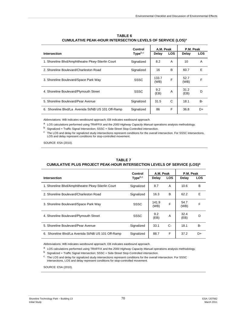
Environmental Checklist and Discussion of Environmental Effects
Shoreline Technology Park – Building 13 70 ESA / 207562 Initial Study March 2011
TABLE 6
CUMULATIVE PEAK-HOUR INTERSECTION LEVELS OF SERVICE (LOS)a
Intersection Control Typeb,c
A.M. Peak P.M. Peak Delay LOS Delay LOS
1. Shoreline Blvd/Amphitheatre Pkwy-Stierlin Court Signalized 8.2 A 10 A
2. Shoreline Boulevard/Charleston Road Signalized 16 B 60.7 E
3. Shoreline Boulevard/Space Park Way SSSC 133.7 (WB) F 52.7
(WB) F
4. Shoreline Boulevard/Plymouth Street SSSC 9.2 (EB) A 31.2
(EB) D
5. Shoreline Boulevard/Pear Avenue Signalized 31.5 C 18.1 B-
6. Shoreline Blvd/La Avenida St/NB US 101 Off-Ramp Signalized 86 F 36.8 D+
Abbreviations: WB indicates westbound approach; EB indicates eastbound approach. a LOS calculations performed using TRAFFIX and the 2000 Highway Capacity Manual operations analysis methodology. b Signalized = Traffic Signal Intersection; SSSC = Side-Street Stop-Controlled intersection. c The LOS and delay for signalized study intersections represent conditions for the overall intersection. For SSSC intersections,
LOS and delay represent conditions for stop-controlled movement. SOURCE: ESA (2010).
TABLE 7 CUMULATIVE PLUS PROJECT PEAK-HOUR INTERSECTION LEVELS OF SERVICE (LOS)a
Intersection Control Typeb,c
A.M. Peak P.M. Peak Delay LOS Delay LOS
1. Shoreline Blvd/Amphitheatre Pkwy-Stierlin Court Signalized 8.7 A 10.6 B
2. Shoreline Boulevard/Charleston Road Signalized 16.3 B 62.2 E
3. Shoreline Boulevard/Space Park Way SSSC 141.9 (WB) F 54.7
(WB) F
4. Shoreline Boulevard/Plymouth Street SSSC 9.2 (EB) A 32.4
(EB) D
5. Shoreline Boulevard/Pear Avenue Signalized 33.1 C- 18.1 B-
6. Shoreline Blvd/La Avenida St/NB US 101 Off-Ramp Signalized 88.7 F 37.2 D+
Abbreviations: WB indicates westbound approach; EB indicates eastbound approach. a LOS calculations performed using TRAFFIX and the 2000 Highway Capacity Manual operations analysis methodology. b Signalized = Traffic Signal Intersection; SSSC = Side-Street Stop-Controlled intersection. c The LOS and delay for signalized study intersections represent conditions for the overall intersection. For SSSC
intersections, LOS and delay represent conditions for stop-controlled movement. SOURCE: ESA (2010).
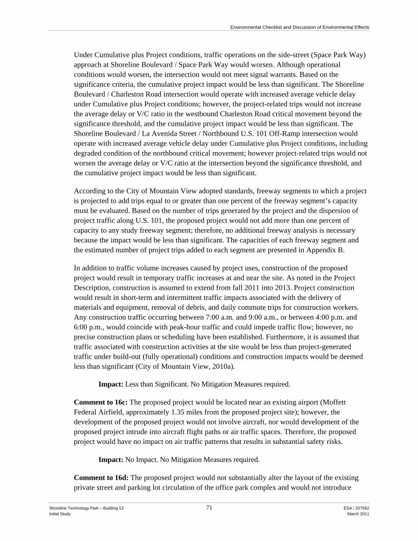
Environmental Checklist and Discussion of Environmental Effects
Shoreline Technology Park – Building 13 71 ESA / 207562 Initial Study March 2011
Under Cumulative plus Project conditions, traffic operations on the side-street (Space Park Way) approach at Shoreline Boulevard / Space Park Way would worsen. Although operational conditions would worsen, the intersection would not meet signal warrants. Based on the significance criteria, the cumulative project impact would be less than significant. The Shoreline Boulevard / Charleston Road intersection would operate with increased average vehicle delay under Cumulative plus Project conditions; however, the project-related trips would not increase the average delay or V/C ratio in the westbound Charleston Road critical movement beyond the significance threshold, and the cumulative project impact would be less than significant. The Shoreline Boulevard / La Avenida Street / Northbound U.S. 101 Off-Ramp intersection would operate with increased average vehicle delay under Cumulative plus Project conditions, including degraded condition of the northbound critical movement; however project-related trips would not worsen the average delay or V/C ratio at the intersection beyond the significance threshold, and the cumulative project impact would be less than significant.
According to the City of Mountain View adopted standards, freeway segments to which a project is projected to add trips equal to or greater than one percent of the freeway segment’s capacity must be evaluated. Based on the number of trips generated by the project and the dispersion of project traffic along U.S. 101, the proposed project would not add more than one percent of capacity to any study freeway segment; therefore, no additional freeway analysis is necessary because the impact would be less than significant. The capacities of each freeway segment and the estimated number of project trips added to each segment are presented in Appendix B.
In addition to traffic volume increases caused by project uses, construction of the proposed project would result in temporary traffic increases at and near the site. As noted in the Project Description, construction is assumed to extend from fall 2011 into 2013. Project construction would result in short-term and intermittent traffic impacts associated with the delivery of materials and equipment, removal of debris, and daily commute trips for construction workers. Any construction traffic occurring between 7:00 a.m. and 9:00 a.m., or between 4:00 p.m. and 6:00 p.m., would coincide with peak-hour traffic and could impede traffic flow; however, no precise construction plans or scheduling have been established. Furthermore, it is assumed that traffic associated with construction activities at the site would be less than project-generated traffic under build-out (fully operational) conditions and construction impacts would be deemed less than significant (City of Mountain View, 2010a).
Impact: Less than Significant. No Mitigation Measures required.
Comment to 16c: The proposed project would be located near an existing airport (Moffett Federal Airfield, approximately 1.35 miles from the proposed project site); however, the development of the proposed project would not involve aircraft, nor would development of the proposed project intrude into aircraft flight paths or air traffic spaces. Therefore, the proposed project would have no impact on air traffic patterns that results in substantial safety risks.
Impact: No Impact. No Mitigation Measures required.
Comment to 16d: The proposed project would not substantially alter the layout of the existing private street and parking lot circulation of the office park complex and would not introduce

Environmental Checklist and Discussion of Environmental Effects
Shoreline Technology Park – Building 13 72 ESA / 207562 Initial Study March 2011
unsafe design features or incompatible uses into the area. The project site plan review would be subject to final review by the City of Mountain View Public Works Department and Mountain View Fire Department to ensure proposed improvements do no include potentially hazardous design features. The physical and traffic characteristics of area roadways (e.g., traffic signal and stop-control, pedestrian crosswalks, and bicycle lanes) would safely accommodate project-generated traffic. The proposed project’s effect on traffic safety would be less than significant.
Impact: Less than Significant. No Mitigation Measures required.
Comment to 16e: There are multiple vehicular access locations at the project site that would accommodate emergency vehicle access. Several driveways along Stierlin Court provide access to the project site as well as neighboring buildings and surface parking lots. As a result, the proposed project would have adequate emergency access to and from the site and the impact would be less than significant.
Impact: Less than Significant. No Mitigation Measures required.
Comment to 16f: The City of Mountain View General Plan (City of Mountain View, 1992) establishes policies to further the effectiveness of the overall effectiveness of the transportation system, including transit, pedestrian, and bicycle networks. Applicable policies are as follows:
Policy 5: Ensure that the future development and the transportation system are in balance.
Policy 22: Provide and maintain a safe and comprehensive bicycle system that connects all parts of the city.
Policy 23: Ensure that there is secure bicycle parking at centers of public and private activity.
Policy 26: Provide a continuous system of sidewalks along streets.
Policy 27: Ensure that pedestrian paths are included within major new developments and public facilities.
Policy 28: Provide for safe walkways and pedestrian crossings of arterial streets, railroad tracks, creeks and other physical barriers.
The project site is well-served by alternative modes of transportation, including transit, bicycle, and pedestrian facility services. VTA Bus Route #40 provides regular weekday and weekend bus service in proximity of the project site. VTA Bus Route #824 provides a weekday shuttle service for Altamont Commuter Express (ACE Rail) patrons with selected bus stops along Shoreline Boulevard to the Great America ACE Rail Station. The Caltrain “Shoreline Shuttle” service provides direct connection between the Mountain View Caltrain Station and the project site.
Existing bicycle facilities in proximity of the project site include a Class II bicycle lane (a striped lane for one-way bicycle travel) along both sides of Shoreline Boulevard that becomes a Class III bicycle route (a shared-use lane for automobiles and cyclists) north of Charleston Road. Additional non-auto facilities include the Stevens Creek Trail, a Class I trail (paved pathway

Environmental Checklist and Discussion of Environmental Effects
Shoreline Technology Park – Building 13 73 ESA / 207562 Initial Study March 2011
separated from the roadway) that is located directly east of the project site with its entrance/exit point located at the terminus of Crittenden Lane. The proposed project would provide 12 bicycle parking spaces onsite for visitors and employees, which satisfies the requirement (five percent of total auto parking supply dedicated to bicycle parking) established by the City Municipal Code (City of Mountain View, 2010b).
The pedestrian network is well developed in proximity of the project site. Each roadway provides adequate sidewalks that are raised, paved, and include curb cuts at each intersection location. In addition, there are painted crosswalks, pedestrian signals, pedestrian buttons, and countdown signals located at all study intersections near the project site (along Shoreline Boulevard). Sidewalks are not present along Stierlin Court; however the roadway is equipped with stenciled crosswalks and chicanes at intersecting driveway locations along Stierlin Court that serve as traffic calming devices. The project includes connections to an informal network of pedestrian walkways that would provide connections to adjacent buildings, surface parking areas and off-site pathways.
The project would be located in a designated Precise Plan Area, which includes additional guidelines and requirements to ensure policy objectives defined in General Plan are enforced and implemented. As stated in the North Shoreline Boulevard Precise Plan, industries that currently exist in, or would be located within, the defined Precise Plan Area should encourage low traffic generation within the area, and employers should encourage employee incentives for transit and carpooling, and use of an in-house Transportation Coordinator (City of Mountain View, 2001). Although the project would not directly or indirectly eliminate alternative transportation corridors or facilities (e.g., bicycle lanes, crosswalks, etc.), nor would the project include changes in adopted policies, plans, or programs that support alternative transportation, the Project Sponsor should utilize existing transportation demand management (TDM) strategies and promote the aforementioned alternative modes of transportation near and at the project site to manage travel demand, reduce traffic generation, and promote additional safety measures for employees and visitors of the area. As a result, the project would have a less than significant impact on alternative transportation programs and policies.
Impact: Less than Significant. No Mitigation Measures required.
Cumulative Impacts: As discussed under Comment to 16.a and 16.b.
Impact: Less than Significant. No Mitigation Measures required.

Environmental Checklist and Discussion of Environmental Effects
Shoreline Technology Park – Building 13 74 ESA / 207562 Initial Study March 2011
17. UTILITIES AND SERVICE SYSTEMS
Will the proposed project result in the following environmental effects? No Impact
Less-Than-Significant
Impact
Less-Than-Significant
Impact with Mitigation
Potentially Significant
Impact
a. Exceed wastewater treatment requirements of the applicable Regional Water Quality Control Board?
b. Require or result in the construction of new water or wastewater treatment facilities or expansion of existing facilities, the construction of which could cause significant environmental effects?
c. Require or result in the construction of new stormwater drainage facilities or expansion of existing facilities, the construction of which could cause significant environmental effects?
d. Have sufficient water supplies available to serve the project from existing entitlements and resources, or are new or expanded entitlements needed?
e. Result in a determination by the wastewater treatment provider which serves or may serve the project that it has adequate capacity to serve the projects projected demand in addition to the providers existing commitments?
f. Be served by a landfill with sufficient permitted capacity to accommodate the projects solid waste disposal needs?
g. Comply with federal, state, and local statutes and regulations related to solid waste?
Discussion
Comment to 17.a, 17.b, and 17.e: The City of Mountain View is the primary provider of sanitary sewer services for the City. The City maintains its own wastewater collection system, serving approximately 74,000 people in a 12-square-mile service area (City of Mountain View, 2009c). The

Environmental Checklist and Discussion of Environmental Effects
Shoreline Technology Park – Building 13 75 ESA / 207562 Initial Study March 2011
sewer system consists of 158 miles of gravity sewers, 1 mile of 42-inch force main, and two pump stations. The sewer piping ranges in size from 4 inches to 48 inches in diameter.
The City discharges its wastewater to a regional treatment plant, the Palo Alto Regional Water Quality Control Plant (PARWQCP), located at 2501 Embarcadero Way in the City of Palo Alto. The treatment plant also receives wastewater from Palo Alto, Los Altos, East Palo Alto, Stanford University, and Los Altos Hills, and serves an estimated current population of 228,500 (RWQCB, 2009). It has total permitted capacity of 39 million gallons per day (mgd) of average dry weather flow (ADWF) and a peak wet weather capacity of 80 mgd with full secondary treatment. The PARWQCP’s National Pollution Discharge Elimination System (NPDES) permit was updated in June 2009 and is scheduled to be updated again in 2014.
According to the City’s 2005 Urban Water Management Plan (UWMP), Mountain View has the capacity rights at PARWQCP to approximately 15.1 mgd. The City’s total wastewater dry weather flow is expected to increase to 10.19 mgd in 2010, well below the City’s maximum allocation. The reduced flows are attributed to the City’s water conservation program.
According to the City of Mountain View Public Services Department, additional wastewater treatment demand can also be calculated based on water usage, and wastewater generation typically equals between 70 and 80 percent of potable water consumption (City of Mountain View, 2005). As stated in the UWMP, 15 percent of water used in the City of Mountain View is consumed for commercial purposes, while 55 percent is consumed for residential purposes and 25 percent is consumed for irrigation.
The project’s estimated 245 employees (see Section 13, Population and Housing) would increase wastewater flows from the project site. Given that commercial uses generate about 15 percent of water use (and a relatively congruent percentage of wastewater demand), the project would not substantially increase demand for wastewater services. Given that the City’s current demand is considerably less than capacity, and that the project would not substantially increase demand, the PARWQCP would continue to meet the wastewater treatment requirements of the RWQCB, and the impact would be less than significant.
Impact: Less than Significant. No Mitigation Measures required.
Comment to 17.c: The City of Mountain View Public Services Department operates and maintains the stormwater drainage system in Mountain View. Stormwater that is not absorbed or infiltrated surface flows to the storm water collection system. Storm water from this site is collected and discharged into the detention pond south of the site, which has a storage capacity of about 41.3 acre-feet and is an integral part of the drainage system in the North Bayshore area located east of Shoreline Boulevard.
The project site comprises pervious surfaces that allow for groundwater recharge and minimize runoff. Development of the proposed project’s building and surface parking would increase the total percentage of impervious surface areas compared to existing conditions and, thus, increase total stormwater runoff volumes. As stated in Section 9, Hydrology and Water Quality, stormwater runoff associated with impervious surfaces would infiltrate into bioretention swales on the site, but

Environmental Checklist and Discussion of Environmental Effects
Shoreline Technology Park – Building 13 76 ESA / 207562 Initial Study March 2011
additional runoff would also flow into the detention pond. Also, as stated in Section 9, Hydrology and Water Quality, a flood drainage overflow easement applies to the southern portion of the site, and this easement would be reconfigured as part of the project to maintain or expand overflow capacity. This easement would apply to the new impervious areas of the proposed parking lot.
As part of any future project approval process, the applicant would be required to develop and implement an SWPPP in order to minimize potential erosion and sedimentation. The SWPPP would include BMPs to control erosion associated with grading, trenching, and other ground surface-disturbing activities.
The proposed project would also be required to comply with Santa Clara Valley Urban Runoff Pollution Prevention Program (SCVURPPP) development guidelines (see Section 9, Hydrology and Water Quality), including measures intended to address Provision C.3 of the NPDES Permit, which limits increases in stormwater discharges from new developments and requires stormwater site design and control measures. The SCVURPPP development guidelines are identified in the SCVURPPP’s Urban Water Management Plan as Model Performance Standards. The proposed project would be expected to comply with the Model Performance Standards developed for the following activities:
• Storm Drain System Operation and Maintenance • New Development Planning Procedures • Construction Site Inspection • Pest Management
Compliance with the SWPPP and the SCVURPPP, as already required by the City of Mountain View (see Section 9, Hydrology and Water Quality), would result in less-than-significant impacts to the stormwater drainage system.
Impact: Less than Significant. No Mitigation Measures required.
Comment to 17.d: The City of Mountain View owns and operates its water utilities through its Public Services Division (which is part of the Public Works Department), delivering about 4 billion gallons of water per year (approximately 12.3 million gallons per day) to 16,000 customers accounts comprising residents, businesses, and institutions through more than 170 miles of pipeline (City of Mountain View, 2009a-c, 2010). The City receives about 87 percent of its water from the San Francisco Public Utilities Commission (SFPUC). This water comes primarily from the Sierra Nevada snowmelt and is delivered through the Hetch Hetchy Regional Water System. The SFPUC-provided water supply also includes treated water from its local facilities in Alameda and San Mateo Counties. The Water Supply Contract between SFPUC and wholesale customers, including the City of Mountain View, was recently renewed and expires June 30, 2034. The contract provides SFPUC’s wholesale customers 184 mgd Supply Assurance, with each customer’s share set forth in an attachment (Attachment C). Mountain View’s supply assurance is 13.6 mgd, of which it currently uses about 11.3 mgd (City of Mountain View, 2009c).
The southern portion of the City is supplied with water from the Santa Clara Valley Water District (SCVWD), which provides approximately 9 percent of Mountain View’s water. The SCVWD

Environmental Checklist and Discussion of Environmental Effects
Shoreline Technology Park – Building 13 77 ESA / 207562 Initial Study March 2011
imports water from the Sacramento/San Joaquin Delta and delivers the imported water to the service area through the South Bay Aqueduct, the Santa Clara Conduit and the Pacheco Conduit. A water sales agreement with SCVWD does not provide Mountain View with a supply assurance, but the City averages 1.2 mgd of water purchased from SCVWD’s treated water system (City of Mountain View, 2009c).
A remaining small percentage of the City’s water supply comes from seven potable water groundwater wells owned and operated by the City of Mountain View. These wells provide 125,000 gallons of water per day, though they have the ability to pump up to 6.7 mgd. This water is pumped from deep aquifers and blended with SFPUC water before delivery to water customers (City of Mountain View, 2009c). Approximately 0.5 million gallons per day of recycled water is delivered to the City of Mountain View.
The City of Mountain View’s reservoirs are Whisman Reservoir, with a capacity of 6 million gallons; Miramonte Reservoir, with 3 million gallons; and the Graham Reservoir, with 8 million gallons. The reservoirs in the City of Mountain View are used to both meet emergency storage requirements and supplement water supply during peak consumption periods.
In 2009, the City of Mountain View also began delivering recycled water to customers in the North Bayshore area from the Palo Alto Regional Water Quality Control Plan. In partnership with the City of Palo Alto, the City constructed a 4.5-mile recycled water distribution (“purple pipe”) system. Although the project site is not served by the recycled water system, the system serves as a drought-proof alternative water supply to meet the North Bayshore Area’s irrigation needs and reduce the use of the City’s limited potable water supply. The City’s near-term recycled water use is projected to be 1 million gallons of recycled water per day.
The proposed project would result in the construction of a new 70,000-square foot life science building on the project site. The approximately 245 employees at the project site would increase water demand. This demand would not constitute a substantial increase in the City’s current water demand of 4.6 billion gallons per year, and it would fall below the threshold established by Senate Bill 610 for a water assessment by the local water provider.
The 2005 Urban Water Management Plan found that under normal water year conditions, the City of Mountain View has adequate water supply to meet demand until 2030. The proposed project would not result in a substantial increase in demand, and it would result in a less-than-significant impact to water supply and treatment provisions.
Impact: Less than Significant. No Mitigation Measures required.
Comments to 17.f and 17.g: Recology Mountain View (formerly Foothill Disposal), a division of Recology (formerly Norcal Waste Systems, Inc.), is the exclusive solid waste and recycling collector for the City of Mountain View through a contract expiring in 2013. Recology transports solid waste to the Sunnyvale Materials Recovery and Transfer (SMaRT) Station, which is the located at 301 Carl Road, in Sunnyvale. The SMaRT Station is owned in partnership by the cities of Mountain View, Palo Alto, and Sunnyvale. Recycling and yard waste are processed there, and more than 72 percent of the City’s solid waste was diverted in 2004 (City of Mountain View, 2008e).

Environmental Checklist and Discussion of Environmental Effects
Shoreline Technology Park – Building 13 78 ESA / 207562 Initial Study March 2011
Most of the City’s landfilled waste (92 percent) is then taken to the Kirby Canyon Landfill (operated by Waste Management, Inc.), located at 910 Coyote Creek Golf Drive, in San Jose. The remainder is self-hauled to other landfills in the Bay Area. Kirby Canyon Landfill’s total capacity is estimated to be approximately 57 million cubic yards, although its current permitted capacity is only 36 million cubic yards. It is expected to reach permitted capacity around 2022 (CCRRR). Total waste transported from Mountain View to the Kirby landfill in 2008 was 56,645 tons.
The County of Santa Clara Health Services Department is certified by the California Integrated Waste Management Board as the Local Enforcement Agency (LEA) for solid waste in Santa Clara County. The LEA has the primary responsibility for ensuring the correct operation and closure of solid waste facilities in the state. It also has responsibility for guaranteeing the proper storage and transportation of solid wastes.
Assembly Bill 939 (AB 939), enacted in 1989, requires each city’s and county’s Source Reduction and Recycling Element to include an implementation schedule to divert 50 percent of its solid waste from landfill disposal by January 1, 2000, through source reduction, recycling, and composting activities. As of 2004, the total annual waste diversion for Mountain View was more than 72 percent.
In addition, the City of Mountain View Construction & Demolition (C & D) Debris Ordinance requires at least 50 percent of the debris from large projects be diverted through salvage and recycling as of January 1, 2009.
The proposed project’s 70,000 square feet of life sciences uses would increase generation of solid waste compared to existing conditions. In addition, construction waste could be generated during construction activities. Whenever feasible, solid waste would be recycled for reuse to help the City to comply with AB 939. At least 50 percent of construction waste would be recycled. Complying with AB 939 and the C&D Debris Ordinance would result in less-than-significant impacts to landfill capacity and compliance with solid waste regulations.
Impact: Less than Significant. No Mitigation Measures required.
Cumulative Impacts: The proposed project, along with other anticipated development, would add new uses to the City of Mountain View that would incrementally increase the demand for utilities and service systems, but the project would not considerably contribute to that increased demand. The proposed project would therefore, would have a less-than-significant impact on the provision of utility services.
Impact: Less than Significant. No Mitigation Measures required.

Findings and Mitigation Measures
Shoreline Technology Park – Building 13 79 ESA / 207562 Initial Study March 2011
4. Mandatory Findings
Will the proposed project result in the following environmental effects? No Impact
Less-Than-Significant
Impact
Less-Than-Significant
Impact with Mitigation
Potentially Significant
Impact
1. Could the project degrade the quality of theenvironment, substantially reduce habitat for fish or wildlife, cause a fish or wildlife population to drop below self sustaining levels, threaten to eliminate plant or animal communities, reduce the number or restrictthe range of a special status plant or animal, or eliminate important examples of California history or prehistory?
2. Does the project have impacts that are individually limited, but cumulatively considerable? (“Cumulatively considerable” means that the incremental effects of a project are considerable whenviewed in connection with the effects of past projects, current projects, and probable future projects.)
3. Does the project have effects that will cause substantial adverse impacts on human beings, directly or indirectly?
Discussion
Comment to 4.1: The proposed project, with the implementation of mitigation measures identified in this document, does not have the potential to significantly degrade the quality of the environment, including effects on animals or plants, or to eliminate historic or prehistoric sites. Applicable mitigation measures include:
Mitigation Measure Air-1 (BAAQMD Basic Construction Mitigation Measures)
Mitigation Measure Bio-1 (Identification and Mitigation for Impacts to Wetlands);
Mitigation Measure Bio-2 (Nesting Bird Avoidance);
Mitigation Measure Bio-3 (Heritage Tree Avoidance);
Mitigation Measure Cul-1 (Inadvertent Discovery of Archaeological Resources);
Mitigation Measure Cul-2 (Inadvertent Discovery of Human Remains);
Mitigation Measure Geo-1 (Design-Level Geotechnical Investigation);
Mitigation Measure Hyd-1 (Stormwater Flow Projection Study); and

Findings and Mitigation Measures
Shoreline Technology Park – Building 13 80 ESA / 207562 Initial Study March 2011
Mitigation Measure Noise-1 (Construction Noise).
Comment to 4.2: As discussed in the analysis sections in Chapter 3 of this Initial Study, the proposed project is not anticipated to cause any cumulative impacts to air quality, biological resources noise, transportation, and greenhouse gases. Impacts related to land use and planning, geology and soils, hazards, aesthetics, cultural resources, and mineral resources are site specific and do not cumulatively combine. Compliance with requirements for stormwater runoff is required for all new developments and is designed to prevent cumulative stormwater pollution or erosion impacts.
Comment to 4.3: The proposed project would not have the potential to cause significant adverse impacts on human beings, directly or indirectly.
Mitigation measures have been provided throughout this Initial Study, and are summarized in Table 8, below. These mitigation measures, in addition to measures already required by law, would reduce any potential indirect impacts to humans to a less-than-significant level.
TABLE 8 SUMMARY OF MITIGATION MEASURES
Impact Category Mitigation Measure
3. Air Quality
Air-1: The project sponsor shall require construction contractors to implement all the BAAQMD’s Basic Construction Mitigation Measures, listed below:
1. All exposed surfaces (e.g., parking areas, staging areas, soil piles, graded areas, and unpaved access roads) shall be watered two times per day.
2. All haul trucks transporting soil, sand, or other loose material off-site shall be covered. 3. All visible mud or dirt track-out onto adjacent public roads shall be removed using wet power
vacuum street sweepers at least once per day. The use of dry power sweeping is prohibited. 4. All vehicle speeds on unpaved roads shall be limited to 15 mph. 5. All roadways, driveways, and sidewalks to be paved shall be completed as soon as possible.
Building pads shall be laid as soon as possible after grading unless seeding or soil binders are used.
6. Idling times shall be minimized either by shutting equipment off when not in use or reducing the maximum idling time to 5 minutes (as required by the California airborne toxics control measure Title 13, Section 2485 of California Code of Regulations [CCR]). Clear signage shall be provided for construction workers at all access points.
7. All construction equipment shall be maintained and properly tuned in accordance with manufacturer’s specifications. All equipment shall be checked by a certified mechanic and determined to be running in proper condition prior to operation.
8. Post a publicly visible sign with the telephone number and person to contact at the Lead Agency regarding dust complaints. This person shall respond and take corrective action within 48 hours. The Air District’s phone number shall also be visible to ensure compliance with applicable regulations.
4. Biological Resources
Bio-1: Identification and mitigation for impacts to jurisdictional wetlands. If impacts to potentially jurisdictional features and associated riparian vegetation cannot be avoided or minimized for construction of storm drainage structures, then the project applicant will obtain a qualified biologist to complete a wetland delineation in accordance with Corps guidelines and will obtain the appropriate permits/agreements, such as a Section 401 water quality certification from the RWQCB, a Section 404 wetland permit from the Corps, and/or a Section 1602 Streambed Alteration Agreement from the CDFG. Terms and conditions of these permits will likely include recontouring and revegetating temporarily disturbed portions of the wetland, and compensation for permanent impacts onsite with the same type of feature as the feature affected. Bio-2: Nesting Bird Avoidance. To the extent practicable, vegetation removal and construction activities shall be performed from September through February, to avoid the general nesting period for birds. If construction or vegetation removal cannot be performed during this period, pre-construction surveys

Findings and Mitigation Measures
Shoreline Technology Park – Building 13 81 ESA / 207562 Initial Study March 2011
TABLE 8 (Continued) SUMMARY OF MITIGATION MEASURES
Impact Category Mitigation Measure
4. Biological Resources (cont.)
shall be performed by a qualified biologist no more than 14 days prior to these activities, to locate any active nests. These surveys shall be performed in the project area and surrounding 500 feet. If active nests are observed on either the project site or the surrounding area, the project applicant shall establish buffer zones around the nests, with the size to be determined in consultation with California Department of Fish and Game (usually 100 feet for perching birds and 300 feet for raptors). If work during the nesting season stops for 14 days or more and then resumes, then nesting bird surveys shall be repeated, to ensure that no new birds have begun nesting in the area. Bio-3: In order to ensure the survival of retained heritage trees, the following protection measures shall be implemented, subject to review and approval by the City as consistent with the City’s Tree Ordinance:
1. A protective fence shall be provided during the construction period to project those trees that are to be preserved. The fencing shall protect a sufficient portion of the root zone to be effective. In most cases, it would be essential to locate the fencing a minimum radius distance of 10 times the trunk diameter in all directions from the trunk. If hardscape (i.e., curing, paving, etc.) exists inside the radius, the protective fencing is usually recommended to be erected at the edge of the hardscape feature. At the discretion of City Staff, a certified arborist may be retained by the applicant to make decisions about the location(s) of protective fencing at the project site.
2. Preserved heritage trees shall be irrigated throughout the entire construction period during the dry months (any month receiving less than one inch of rainfall). Irrigate a minimum of 10 gallons for each inch of trunk diameter every two weeks. A soaker hose or a drip line is preferred for this purpose.
3. The entire area inside the driplines of preserved heritage trees shall be mulched to the extent feasible. Mulching consists of a protective material (wood chips, gravel) being spread over the root zone inside the dripline. The material shall be four inches in depth after spreading, which shall be done by hand. Wood chips are preferred because they are organic and degrade naturally over time. Wood chips shall be primarily one quarter to three-quarters of an inch in diameter.
4. Trenches for any utilities (gas, electricity, water, phone TV cable, etc.) shall be located outside the driplines of preserved heritage trees, unless approved by a certified arborist.
5. Sidewalks or other hardscape inside the driplines of preserved heritage trees shall be constructed completely on top of the existing soil grade without excavation. Fill soil may be added to the edge of finished hardscape for a maximum distance of approximately 2 feet from the edges to integrate the new hardscape to the natural grade.
6. If any old irrigation lines, drain lines, sewer lines, or any other underground features exist inside the driplines of preserved heritage trees and would not be used, they shall be cut off approximately at soil grade and left in the ground.
7. Material shall not be stored, stockpiled, dumped, or buried inside the driplines of preserved heritage trees.
8. Excavated soil shall not be piled or dumped, even temporarily, inside the driplines of preserved heritage trees.
9. Any pruning of preserved heritage trees shall be done by an arborist certified by the ISA (International Society of Arboriculture) and according to ISA, Western Chapter Standards 1998.
10. Landscape irrigation trenches shall be a minimum distance of 10 times the trunk diameter from the trunks of preserved heritage trees
11. The sprinkler irrigation shall not be designed to strike the trunks of preserved heritage trees. 12. Landscape materials (cobbles, decorative bark, stones, fencing, etc.) shall not be installed directly
in contact with the bark of trees because of the risk of serious disease infection.
5. Cultural Resources
Cul-1: Inadvertent Discovery of Archaeological Resources. If prehistoric or historic-period cultural materials are unearthed during ground-disturbing activities, it is recommended that all work within 100 feet of the find halt until a qualified archaeologist and Native American representative can assess the significance of the find. Prehistoric materials might include obsidian and chert flaked-stone tools (e.g., projectile points, knives, scrapers) or toolmaking debris; culturally darkened soil (“midden”) containing heat-affected rocks and artifacts; stone milling equipment (e.g., mortars, pestles, handstones, or milling slabs); and battered-stone tools, such as hammerstones and pitted stones. Historic-period materials might include stone, concrete, or adobe footings and walls; filled wells or privies; and deposits of metal, glass, and/or ceramic refuse. If the find is determined to be potentially significant, the archaeologist, in consultation with the Native American representative, will develop a treatment plan that could include site avoidance, capping, or data recovery.

Findings and Mitigation Measures
Shoreline Technology Park – Building 13 82 ESA / 207562 Initial Study March 2011
TABLE 8 (Continued) SUMMARY OF MITIGATION MEASURES
Impact Category Mitigation Measure
5. Cultural Resources (cont.)
Cul-2: Inadvertent Discovery of Human Remains. If human remains are encountered during ground disturbing activities, State Health and Safety Code Section 7050.5 requires that no further disturbance will occur until the County Coroner has made the necessary findings as to origin and disposition pursuant to PRC Section 5097.98. If the remains are determined to be of Native American descent, the coroner has 24 hours to notify the Native American Heritage Commission. The Native American Heritage Commission will then identify the person(s) thought to be the Most Likely Descendent of the deceased Native American, who will make recommendations for the treatment of any human remains.
6. Geology
Geo-1: The City of Mountain View shall require that the design level geotechnical investigation include recommendations to mitigate the potential for liquefaction in accordance with the specifications of CGS Special Publication 117A, Guidelines for Evaluating and Mitigating Seismic Hazards, and the requirements of the Seismic Hazards Mapping Act. Recommendations made in the geotechnical report shall be implemented as part of the project.
9. Hydrology and Water Quality
Hyd-1: The applicant shall prepare a design level stormwater flow projection study and a hydraulic capacity study, to be submitted to the City of Mountain View Public Works Department for review and verification that the existing stormwater infrastructure is properly sized. The studies shall show the new connecting points to the existing storm drain and model the estimated flows and peaking factors, as they relate to the changes in land use on the project site. The studies shall show that the reconfigured drainage pattern would not result in increased on or off-site erosion, siltation, or flooding. The applicant shall be responsible for constructing and financing new or upgraded infrastructure that is required to serve the proposed project.
12. Noise
Noise-1: The project sponsor shall require construction contractors to implement the following mitigation measures:
• All construction vehicles and equipment, fixed and mobile, shall utilize the best available noise control techniques (e.g., improved mufflers, equipment redesign, use of intake silencers, ducts, engine enclosures and acoustically-attenuating shields or shrouds, wherever feasible).
• Consistent with Section 8.23 of the City Code, all noise generating construction activities shall be limited to the hours of 7 a.m. to 6 p.m., Monday through Friday. No noise producing construction activities shall be performed on Saturdays, Sundays and holidays without prior written approval from the City.
• Construction staging areas shall be located as far as practicable from dwellings and existing recreational uses so as to cause minimal disruption to these activities.
• Signs shall be posted at the construction site that include permitted construction days and hours, and the name and contact number for an appointed disturbance coordinator for the job site in the event of problems.
Source: Environmental Science Associates, 2011
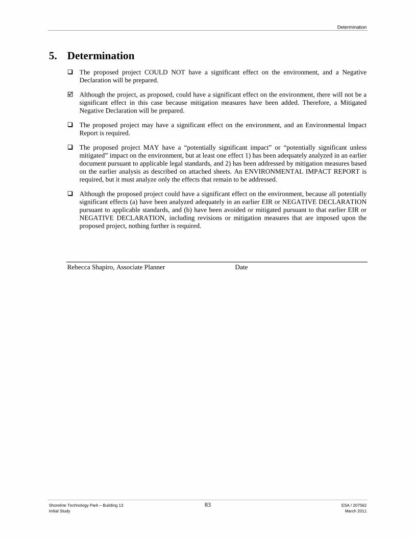
Determination
Shoreline Technology Park – Building 13 83 ESA / 207562 Initial Study March 2011
5. Determination
The proposed project COULD NOT have a significant effect on the environment, and a Negative Declaration will be prepared.
Although the project, as proposed, could have a significant effect on the environment, there will not be a
significant effect in this case because mitigation measures have been added. Therefore, a Mitigated Negative Declaration will be prepared.
The proposed project may have a significant effect on the environment, and an Environmental Impact
Report is required. The proposed project MAY have a “potentially significant impact” or “potentially significant unless
mitigated” impact on the environment, but at least one effect 1) has been adequately analyzed in an earlier document pursuant to applicable legal standards, and 2) has been addressed by mitigation measures based on the earlier analysis as described on attached sheets. An ENVIRONMENTAL IMPACT REPORT is required, but it must analyze only the effects that remain to be addressed.
Although the proposed project could have a significant effect on the environment, because all potentially
significant effects (a) have been analyzed adequately in an earlier EIR or NEGATIVE DECLARATION pursuant to applicable standards, and (b) have been avoided or mitigated pursuant to that earlier EIR or NEGATIVE DECLARATION, including revisions or mitigation measures that are imposed upon the proposed project, nothing further is required.
Rebecca Shapiro, Associate Planner Date
List of Data Sources
Shoreline Technology Park – Building 13 84 ESA / 207562 Initial Study March 2011
List of Data Sources: Project Description
1. Stone, Lawrence E, Santa Clara County, Office of County Assessor, effective Roll Year 2010–2011.
1. Aesthetics:
2. California Department of Transportation, Scenic Highway Program, http://www.dot.ca.gov/hq/LandArch/scenic_highways/scenic_hwy.htm, Accessed December 3, 2010.
3. City of Mountain View, City of Mountain View General Plan, adopted October 29, 1992.
4. City of Mountain View, North Shoreline Boulevard Precise Plan, adopted 1975, most recently amended 2001.
2. Agricultural and Forest Resources:
5. City of Mountain View City Code, Chapter 36 (Zoning Ordinance), as amended.
6. City of Mountain View, City of Mountain View General Plan, adopted October 29, 1992.
7. Department of Conservation, Important Farmland of Santa Clara County 2008 (Map), Division of Land Resource Protection. Available Online: ftp://ftp.consrv.ca.gov/pub/dlrp/FMMP/pdf/2008/scl08.pdf, 2006, accessed May 10, 2010.
3. Air Quality:
8. Bay Area Air Quality Management District (BAAQMD), 2010 Clean Air Plan, Available Online: http://www.baaqmd.gov/Divisions/Planning-and-Research/Plans/Clean-Air-Plans.aspx, 2010a.
9. BAAQMD, Bay Area 2005 Ozone Strategy.
10. BAAQMD, California Environmental Quality Act Guidelines Update: Thresholds of Significance, June 2, 2010b.
11. California Air Resources Board, 2004 State and National Area Designations Maps of California, 2004.
12. City of Mountain View, City of Mountain View General Plan, Adopted October 29, 1992.
13. California Air Resources Board (CARB), Air Quality and Land Use Handbook: A Community Health Perspective, April 2005.

List of Data Sources
Shoreline Technology Park – Building 13 85 ESA / 207562 Initial Study March 2011
4. Biological Resources:
14. California Department of Fish and Game, California Natural Diversity Database Rarefind -commercial version 3.1.0 for the Mountain View 7.5-minute topographic quadrangle, June 2010.
15. City of Mountain View, Shoreline West Precise Plan, June 1996c.
16. City of Mountain View, Memorandum regarding May 18, 2010 study session – golf course nuisance bird strategy and shoreline burrowing owl management, May 13, 2010.
17. City of Mountain View, City Code, Chapter 32: Tree Regulations of the City of Mountain View (Ordinance No. 175.659, April 1961). http://library.municode.com/index.aspx?clientId=16508&stateId=5&stateName=California, accessed November 2010.
5. Cultural Resources:
19. City of Mountain View, Resolution No. 16913, Series 2004, “A Resolution Establishing the Initial Mountain View Register of Historic Resources Property List and Rescinding All Other Historic Lists,” August 17, 2004.
20. Levy, Richard, Costanoan In California, edited by Robert F. Heizer, pp. 485–495. Handbook of North American Indians, vol. 8, William C. Sturtevant, general editor. Smithsonian Institution, Washington, D.C., 1978.
21. Olliges, Site Record for CA-SCL-23, On file, Northwest Information Center of the California Historical Resources Information System, Sonoma State University, Rohnert Park, California, 1995.
6. Geology:
22. ABAG, Modified Mercalli Intensity Scale, http://www.abag.ca.gov/bayarea/eqmaps/doc/mmi.html, 2003a, accessed December 3, 2010.
23. ABAG, Earthquake Hazard Map for Mountain View Based on Underlying Geologic Material, http://www.abag.ca.gov/cgi-bin/pickmapx.pl, 2003b, accessed December 3, 2010.
24. California Geological Survey (CGS), Seismic Hazard Zone Report for the Mountain View 7.5- Minute Quadrangle, Santa Clara, Alameda, and San Mateo Counties, California, Department of Conservation, 2006.
25. CGS, Special Publication 117A: Guidelines for Evaluating and Mitigating Seismic Hazards in California, 1997, updated in 2008.
26. City of Mountain View, City of Mountain View General Plan, adopted October 29, 1992.
27. Hart, E.W., Fault-Rupture Hazard Zones in California: Alquist-Priolo Earthquake Fault Zoning Act of 1972 with Index to Earthquake Fault Zones, California Geological Survey (formerly the California Division of Mines and Geology), Special Publication 42, 1990, Revised and Updated 1997.

List of Data Sources
Shoreline Technology Park – Building 13 86 ESA / 207562 Initial Study March 2011
28. Jennings, C.W., Fault Activity Map of California and Adjacent Areas, California Geology Survey (formerly known as California Division of Mines and Geology), Geologic Data Map No. 6, 1:750,000, 1994.
29. Santa Clara County, Geologic Hazard Zones Map, Planning Office, 2002.
30. Santa Clara County, Santa Clara Valley Urban Runoff Pollution Prevention Program (SCVURPPP), http://www.scvurppp-w2k.com/default.htm, 2003, accessed October 2010.
31. United States Geological Survey (USGS), Mountain View 7.5 Minute Quadrangle, Topographic Map, 1961 photo-revised 1968.
32. USGS, 2008 Bay Area Earthquake Probabilities. http://earthquake.usgs.gov/regional/nca/ucerf/images/2008probabilities-lrg.jpg, 2008a, accessed October 2010.
33. USGS, Uniform California Earthquake Rupture Forecast, Version 2, Working Group on California Earthquake Probabilities (WG07), Findings, http://www.conservation.ca.gov/cgs/information/publications/sr/Documents/SR_203.pdf, 2008b. accessed October 2010.
7. Greenhouse Gases:
34. BAAQMD, California Environmental Quality Act Guidelines Update: Thresholds of Significance. June 2, 2010a.
35. BAAQMD, Draft Bay Area 2010 Clean Air Plan, 2010b.
36. California Air Resources Board, 2004 State and National Area Designations Maps of California, 2004.
37. California Air Resources Board, Climate Change Scoping Plan, A Framework for Change, December 2008.
38. CAPCOA. CEQA and Climate Change, 2008.
8. Hazards and Hazardous Materials:
39. Department of Toxic Substances Control, 2010. Envirostor: http://www.envirostor.dtsc.ca.gov/public/, accessed October 13, 2010.
40. Association of Bay Area Governments (ABAG), Dam Inundation Areas, Mountain View CA, available at http://www.abag.ca.gov/cgi-bin/pickdamx.pl, accessed October 6, 2010.
41. City of Mountain View, Current Conditions Report, Administrative Draft, August 2009.
42. City of Mountain View, General Plan, Safety Element, 1992.
43. Federal Emergency Management Agency (FEMA), FIRM Map Panel 060347 0004E, June 19, 1997.
List of Data Sources
Shoreline Technology Park – Building 13 87 ESA / 207562 Initial Study March 2011
44. Schaaf & Wheeler, Evaluation of the Charleston Detention Pond and Pump Station, April 1999.
45. URS Corporation, Phase I Environmental Site Assessment, 2011, 2021, 2023, 2025, 2027, 2029, 2051, 2061, 2071, 2081, 2086, and 2091Stierlin Court, Mountain View California, April 27, 2005
9. Hydrology and Water Quality:
46. Association of Bay Area Governments (ABAG), Dam Inundation Areas, Mountain View CA, available at http://www.abag.ca.gov/cgi-bin/pickdamx.pl, accessed October 6, 2010.
47. Bay Conservation and Development Commission (BCDC), San Francisco, Inundation Map for 55 inch Sea Level Rise By End of Century, South Bay, http://www.bcdc.ca.gov/planning/climate_change/maps/55/south_bay.pdf, accessed December 3, 2010.
48. Federal Emergency Management Agency (FEMA), Flood Insurance Rate Map (FIRM): City of Mountain View, Panel Number 06034 0003 D, National Flood Insurance Program, 1997.
49. California Code of Regulations, Title 24, Part 2. (California Building Code)
50. City of Mountain View City Code, as amended.
51. City of Mountain View, City of Mountain View General Plan, Adopted October 29, 1992.
52. Regional Water Quality Control Board (RWQCB), Municipal Regional Stormwater NPDES Permit: Order R2-2009-0074, Permit No. CAS612008, October 14, 2009.
53. RWQCB, Water Quality Control Plan (Basin Plan), http://www.waterboards.ca.gov/sanfranciscobay/water_issues/programs/basin_plan/docs/basin_plan07.pdf, accessed October, 2010. 2007.
54. Schaaf & Wheeler, Evaluation of the Charleston Detention Pond and Pump Station, April 1999.
55. Santa Clara Valley Urban Runoff Pollution Prevention Program (SCVURPPP), www.scvurppp-w2k.com/Default.htm, 200, accessed December 3, 2010.
56. State Water Resources Control Board, Santa Clara Valley Nonpoint Source Pollution Prevention Program, 2010, http://www.sccvote.org/portal/site/scc/chlevel3?path=%2Fv7%2FSCC%20Public%20Portal%2FDoing%20Business%2FBusiness%20Laws%20and%20Regulations%2FNonpoint%20Source%20Pollution, accessed December 3, 2010.
57. Wilsey, Ham, Hydraulic Calculations for Stierlin Court, Mountain View, CA, April 23, 2010.
10. Land Use and Planning:
58. City of Mountain View City Code, Chapter 36 (Zoning Ordinance), as amended.
59. City of Mountain View, City of Mountain View General Plan, adopted October 29, 1992.
List of Data Sources
Shoreline Technology Park – Building 13 88 ESA / 207562 Initial Study March 2011
60. City of Mountain View, North Shoreline Boulevard Precise Plan, adopted 1975, most recently amended 2001.
61. City of Mountain View, General Plan Land Use Map. Community Development Department. March 2009a.
62. City of Mountain View, Zoning Map. Community Development Department. March 2009b.
63. Santa Clara County Airport Land Use Commission, Moffett Federal Airfield Comprehensive Land Use Plan (Draft), May 4 2010.
64. Site Visit, October 2010.
11. Mineral Resources:
65. California Geologic Survey. California Department of Conservation, http://www.conservation.ca.gov/Index/Pages/Index.aspx, accessed October 2010.
66. California Geologic Survey, Aggregate Availability in California (Map), 2006.
12. Noise:
67. Caltrans, Traffic Noise Analysis Protocol for New Highway Construction and Reconstruction Projects, October 1998.
68. City of Mountain View, City of Mountain View General Plan, adopted October 29, 1992.
69. City of Mountain View City Code, Section 21.26 (Stationary Equipment Noise)
70. California Code of Regulations, Title 24, Part 2. (California Building Code), Appendix Chapters 12 and 12A.
71. Federal Transit Administration (FTA), Transit Noise and Vibration Impact Assessment, May, 2006.
72. Santa Clara County Airport Land Use Commission, Moffett Federal Airfield Comprehensive Land Use Plan (Draft), May 4 2010.
73. Site Visit, October 2010.
74. U.S. Department of Transportation, Final Bay Area to Central Valley High Speed Train Program Environmental Impact Report / Environmental Impact Statement. Federal Railroad Administration, May 2008.
75. U.S. Department of Transportation, Transit Noise and Vibration Impact Assessment, May 2006.
76. U.S. Environmental Protection Agency, Noise from Construction Equipment and Operations, Building Equipment, and Home Appliances, December 1971.
List of Data Sources
Shoreline Technology Park – Building 13 89 ESA / 207562 Initial Study March 2011
13. Population and Housing:
77. Association of Bay Area Governments, Projections and Priorities 2009: Building Momentum.
78. U.S. Census Bureau (Census ), Census Tract Outline Map: California, Santa Clara, Sheet 1, 2000a.
79. Census, Table DP-1: Profile of General Demographic Characteristics: Mountain View City, California. http://www.census.gov/main/www/cen2000.html, 2000b, accessed October 2010.
14. Public Services:
80. City of Mountain View Fire Department, official website, www.ci.mtnview.ca.us/city_hall/fire/default.asp, accessed October 2010.
81. City of Mountain View Police Department, official website, www.ci.mtnview.ca.us/city_hall/police/default.asp, accessed October 2010.
82. Education Data Partnership, Fiscal, Demographics, and Performance Data on California’s K-12 Schools (Ed-data), www.ed-data.k12.ca.us/, accessed October 2010.
83. Wentker, Jaymae, Fire Marshal, Mountain View Fire Department, personal communication, September 29, 2010.
84. Wylie, Elizabeth. Personal Communication. Mountain View Police Department Community Relations Manger / PIO. October 6, 2010.
15. Recreation:
85. City of Mountain View, Community Services, http://www.ci.mtnview.ca.us/city_hall/comm_services/default.asp, accessed October 2010.
86. City of Mountain View, Parks and Open Space Plan, 2008a.
87. City of Mountain View, Parks and Trails website: http://www.ci.mtnview.ca.us/city_hall/comm_services/parks_and_trails/default.asp. Accessed October 2010a.
88. City of Mountain View, Parks and Trails Map, 2010b
89. City of Mountain View, Recreation Plan, 2008b.
16. Traffic and Transportation:
90. California Department of Transportation (Caltrans), California Manual on Uniform Traffic Control Devices for Streets and Highways, amended January 21, 2010.
91. City of Mountain View, City of Mountain General Plan – Circulation Chapter, adopted October 29, 1992.

List of Data Sources
Shoreline Technology Park – Building 13 90 ESA / 207562 Initial Study March 2011
92. City of Mountain View, City of Mountain North Shoreline Boulevard Precise Plan, adopted June 2001.
93. City of Mountain View, correspondence email between City of Mountain View staff and ESA staff verifying construction related activities, November 1, 2010a.
94. City of Mountain View, City of Mountain Municipal Code and Enforcement – Section A36.37.040 Number of Parking Spaces Required, enacted March 9, 2010b.
95. Fehr and Peers Consultants, Charleston East Development Final Transportation Impact Analysis, February 2007.
96. Institute of Transportation Engineers (ITE), Trip Generation, Eighth Edition. Washington, D.C., 2008.
97. Santa Clara Valley Transportation Authority (VTA), Transportation Impact Guidelines, adopted March 2009.
98. Transportation Research Board, Highway Capacity Manual, December 2000.
17. Utilities and Service Systems:
99. California Department of Resources and Recycling and Recovery (CDRRR) website: http://www.calrecycle.ca.gov/. Accessed October 2010.
100. City of Mountain View, Public Services Division. http://www.ci.mtnview.ca.us/city_hall/public_works/public_services.asp, 2009a, accessed October 2010.
101. City of Mountain View, Water Quality 2008, June 2009b.
102. City of Mountain View, General Plan 2030 Current Conditions Report. Infrastructure Chapter, 2009c.
103. City of Mountain View, 2005 Draft Urban Water Management Plan, 2005.
104. City of Mountain View, Water Quality Consumer Confidence Report, 2006.
105. City of Mountain View, Sewer System Management Plan. Department of Public Works. Available Online: http://www.ci.mtnview.ca.us/civica/filebank/blobdload.asp?BlobID=4961, 2008, accessed October 2010.
106. RWQCB, NPDES Permit No. CA0037834, 2009.
107. San Francisco Public Utilities Commission (SFPUC), Water Supply Agreement. June 2009.