Draft Environmental Assessment - Louisville District
140
Draft Environmental Assessment and Draft Finding of No Significant Impact LEWISTOWN SANITARY SEWAGE COLLECTION SYSTEM PROJECT, LOGAN COUNTY, OHIO Section 594 of the Water Resources Development Act Ohio and North Dakota Environmental Infrastructure Program January 21, 2021 United States Army Corps of Engineers Louisville District
-
Upload
khangminh22 -
Category
Documents
-
view
3 -
download
0
Transcript of Draft Environmental Assessment - Louisville District
Draft Environmental Assessment
and
Draft Finding of No Significant Impact
LEWISTOWN SANITARY SEWAGE COLLECTION SYSTEM
PROJECT, LOGAN COUNTY, OHIO
Section 594 of the Water Resources Development Act
Ohio and North Dakota
Environmental Infrastructure Program
January 21, 2021
United States Army Corps of Engineers
Louisville District

ii
DRAFT FINDING OF NO SIGNIFICANT IMPACT
Lewistown Sanitary Sewer Collection System Project, Logan County, Ohio
The U.S. Army Corps of Engineers, Louisville District (Corps) has conducted an
Environmental Assessment (EA) in accordance with the National Environmental Policy Act of
1969, as amended, for the Section 594 Lewistown Sanitary Sewer Collection System Project
(Project) planned for the unincorporated community of Lewistown, Ohio (Lewistown). The
draft EA, dated 21 January 2021, details the environmental consequences of the Project as well
the other alternatives considered.
The Draft EA, incorporated herein by reference, evaluated various alternatives that would deliver
cost-effective, environmentally-sound sanitary sewer services to residents within the Lewistown
service area. The recommended plan, which is also the Locally Preferred Plan (LPP), involves
regionalization of wastewater treatment for Lewistown, which involves connecting homes to a
regional wastewater treatment plant. This involves the construction of a wastewater collection
system that connects to an existing lift station maintained by the Logan County Water Pollution
Control District.
In addition to a “no action” plan, three alternatives were evaluated. The alternatives included: 1)
remediation, by replacing existing privately owned residential septic systems; 2) regionalization of
wastewater treatment by connecting to an existing force main and lift station (recommended plan);
and 3) centralization of wastewater treatment by building a wastewater treatment plant and sewage
collection system for Lewistown.
For all alternatives, the potential effects were evaluated, as appropriate. A summary assessment
of the potential effects of the recommended plan are listed in Table 1:
Table 1: Summary of Potential Effects of the Recommended Plan
Insignificant
effects
Insignificant
effects as a
result of mitigation*
Resource
unaffected
by action
Aesthetics ☒ ☐ ☐
Air quality ☒ ☐ ☐
Aquatic resources/wetlands ☐ ☐ ☒
Invasive species ☐ ☐ ☒
Fish and wildlife habitat ☐ ☐ ☒
Threatened/Endangered species/critical habitat ☐ ☐ ☒

iii
Insignificant
effects
Insignificant
effects as a
result of
mitigation*
Resource
unaffected
by action
Historic properties ☐ ☐ ☒
Other cultural resources ☐ ☐ ☒
Floodplains ☒ ☐ ☐
Hazardous, toxic & radioactive waste ☐ ☐ ☒
Land use ☐ ☐ ☒
Navigation ☐ ☐ ☒
Noise levels ☒ ☐ ☐
Public infrastructure ☐ ☐ ☒
Socio-economics ☐ ☐ ☒
Environmental justice ☐ ☐ ☒
Soils ☐ ☐ ☒
Tribal trust resources ☐ ☐ ☒
Water quality ☐ ☐ ☒
Climate change ☐ ☐ ☒
Prime and unique farmland ☐ ☐ ☒
Wild and Scenic Rivers ☐ ☐ ☒
Transportation and traffic ☒ ☐ ☐
All practical means to avoid or minimize adverse environmental effects were analyzed and
incorporated into the recommended plan. Best management practices, as outlined in the EA (e.g.
silt fences), would be implemented before, during, and after construction, and is expected to
minimize the potential for deleterious effects to the environment. After construction is
completed, re-seeding and re-vegetation would be performed to minimize erosion losses and
protect surface soils.
No compensatory mitigation is required as part of the recommended plan.
Public review of the draft EA and FONSI was initiated on February 16, 2021. A 30-day state and
agency review of the draft EA was initiated on February 16, 2021. All comments submitted during
the public and state and agency review periods will be responded to in the Final EA and FONSI,
and any necessary changes will be incorporated.

Environmental Assessment Lewistown Sanitary Sewage Collection System Project, Logan County, Ohio
iv
Pursuant to section 7 of the Endangered Species Act of 1973, as amended, the U.S. Army
Corps of Engineers determined that the recommended plan would have no effect on
federally listed species or their designated critical habitat.
Pursuant to section 106 of the National Historic Preservation Act of 1966, as amended, the
U.S. Army Corps of Engineers determined that historic properties will not be adversely
affected by the recommended plan. The Kentucky Heritage Council concurred with the
determination on 18 November 2020.
A water quality certification pursuant to section 401 of the Clean Water Act is not
required to implement the recommended plan, which will not result in any discharge
into waters of the United States.
All applicable environmental laws have been considered and coordination with
appropriate agencies and officials has been completed.
Technical, environmental, and economic criteria used in the formulation of alternative plans
were those specified in the Water Resources Council’s 1983 Economic and Environmental
Principles and Guidelines for Water and Related Land Resources Implementation Studies. All
applicable laws, executive orders, regulations, and local government plans were considered in
evaluation of alternatives.1 Based on this report, the reviews by other Federal, State and local
agencies, Tribes, input of the public, and the review by my staff, it is my determination that the
recommended plan would not cause significant adverse effects on the quality of the human
environment; therefore, preparation of an Environmental Impact Statement is not required.2
Date Eric D. Crispino
Colonel, U.S. Army
District Commander
1 40 CFR 1505.2(B) requires identification of relevant factors including any essential to national policy which were
balanced in the agency decision. 2 40 CFR 1508.13 stated the FONSI shall include an EA or a summary of it and shall note any other environmental
documents related to it. If an assessment is included, the FONSI need not repeat any of the discussion in the
assessment but may incorporate by reference.

Environmental Assessment Lewistown Sanitary Sewage Collection System Project, Logan County, Ohio
v

Environmental Assessment Lewistown Sanitary Sewage Collection System Project, Logan County, Ohio
vi
Table of Contents
1.0 PROJECT DESCRIPTION ..................................................................................................................... 1
1.1 Project Background and Authorization ............................................................................................... 1
1.2 Location .............................................................................................................................................. 1
1.3 Purpose and Need ............................................................................................................................... 4
2.0 RECOMMENDED PLAN AND ALTERNATIVES ............................................................................. 4
2.1 No Action Alternative ......................................................................................................................... 4
2.2 Alternatives Considered ...................................................................................................................... 4
2.2.1 On-site Remediation of Residential Septic Systems .................................................................... 4
2.2.2 Regionalization ............................................................................................................................ 5
2.2.2.1 Connection to the Honda Transmission Manufacturing Pump Station ................................. 8
2.2.2.2 Connection to the Indian Lake High School Pump Station .................................................. 8
2.2.3 Centralization ............................................................................................................................... 8
2.3 Recommended Plan ............................................................................................................................ 9
3.0 ENVIRONMENTAL SETTING AND CONSEQUENCES .................................................................. 9
3.1 Land Use ........................................................................................................................................... 10
3.1.1 Existing Condition ..................................................................................................................... 10
3.1.2 Environmental Consequences .................................................................................................... 11
3.1.2.1 No Action ............................................................................................................................ 11
3.1.2.2 Recommended Plan............................................................................................................. 11
3.2 Climate .............................................................................................................................................. 11
3.2.1 Existing Condition ..................................................................................................................... 11
3.2.2 Environmental Consequences .................................................................................................... 11
3.2.2.1 No Action ............................................................................................................................ 11
3.2.2.2 Recommended Plan............................................................................................................. 11
3.3 Terrestrial Habitat ............................................................................................................................. 11
3.3.1 Existing Condition ..................................................................................................................... 11
3.3.2 Environmental Consequences .................................................................................................... 12
3.3.2.1 No Action ............................................................................................................................ 12
3.3.2.2 Recommended Plan............................................................................................................. 12
3.4 Aquatic Habitat/Water Quality ......................................................................................................... 12
3.4.1 Existing Conditions .................................................................................................................... 12

Environmental Assessment Lewistown Sanitary Sewage Collection System Project, Logan County, Ohio
vii
3.4.2 Environmental consequences ..................................................................................................... 12
3.4.2.1 No Action ............................................................................................................................ 12
3.4.2.2 Recommended Plan............................................................................................................. 12
3.5 Floodplains ........................................................................................................................................ 13
3.5.1 Existing Condition ..................................................................................................................... 13
3.5.2 Environmental Consequences .................................................................................................... 13
3.5.2.1 No Action ............................................................................................................................ 13
3.5.2.2 Recommended Plan............................................................................................................. 13
3.6 Soils and Prime and Unique Farmland ............................................................................................. 13
3.6.1 Existing Condition ..................................................................................................................... 13
3.6.2 Environmental Consequences .................................................................................................... 14
3.6.2.1 No Action ............................................................................................................................ 14
3.6.2.2 Recommended Plan............................................................................................................. 14
3.7 Wetlands ........................................................................................................................................... 14
3.7.1 Existing Condition ..................................................................................................................... 14
3.7.2 Environmental Consequences .................................................................................................... 14
3.7.2.1 No Action ............................................................................................................................ 14
3.7.2.2 Recommended Plan............................................................................................................. 14
3.8 Wild and Scenic Rivers ..................................................................................................................... 14
3.9 Hazardous, Toxic, and Radioactive Waste (HTRW) ........................................................................ 14
3.9.1 Existing Condition ..................................................................................................................... 14
3.9.2 Environmental Consequences .................................................................................................... 15
3.9.2.1 No Action ............................................................................................................................ 15
3.9.2.2 Recommended Plan............................................................................................................. 15
3.10 Cultural Resources .......................................................................................................................... 15
3.10.1 Existing Conditions .................................................................................................................. 15
3.10.2 Environmental Consequences .................................................................................................. 15
3.10.2.1 No Action .......................................................................................................................... 15
3.10.2.2 Recommended Plan ........................................................................................................... 15
3.11 Threatened and Endangered Species ............................................................................................... 16
3.11.1 Existing Condition ................................................................................................................... 16
3.11.2 Environmental Consequences .................................................................................................. 16

Environmental Assessment Lewistown Sanitary Sewage Collection System Project, Logan County, Ohio
viii
3.11.2.1 No Action .......................................................................................................................... 16
3.11.2.2 Recommended Plan ........................................................................................................... 16
3.12 Air Quality ...................................................................................................................................... 17
3.12.1 Existing Condition ................................................................................................................... 17
3.12.2 Environmental Consequences .................................................................................................. 17
3.12.2.1 No Action .......................................................................................................................... 17
3.12.2.2 Recommended Plan ........................................................................................................... 17
3.13 Noise ............................................................................................................................................... 17
3.13.1 Existing Condition ................................................................................................................... 17
3.13.2 Environmental Consequences .................................................................................................. 18
3.13.2.1 No Action .......................................................................................................................... 18
3.13.2.2 Recommended Plan ........................................................................................................... 18
3.14 Socioeconomic Conditions ............................................................................................................. 19
3.14.1 Existing Conditions .................................................................................................................. 19
3.14.2 Environmental Consequences .................................................................................................. 19
3.14.2.1 No Action .......................................................................................................................... 19
3.14.2.2 Recommended Plan ........................................................................................................... 19
3.15 Aesthetics ........................................................................................................................................ 19
3.15.1 Existing Conditions .................................................................................................................. 19
3.15.2 Environmental Consequences .................................................................................................. 19
3.15.2.1 No Action .......................................................................................................................... 19
3.15.2.2 Recommended Plan ........................................................................................................... 20
3.16 Transportation and Traffic .............................................................................................................. 20
3.16.1 Existing Condition ................................................................................................................... 20
3.16.2 Environmental Consequences .................................................................................................. 20
3.16.2.1 No Action .......................................................................................................................... 20
3.16.2.2 Recommended Plan ........................................................................................................... 20
3.17 Health and Safety ............................................................................................................................ 20
3.17.1 Existing Condition ................................................................................................................... 20
3.17.2 Environmental Consequences .................................................................................................. 20
3.17.2.1 No Action .......................................................................................................................... 20
3.17.2.2 Recommended Plan ........................................................................................................... 20

Environmental Assessment Lewistown Sanitary Sewage Collection System Project, Logan County, Ohio
ix
4.0 STATUS OF ENVIRONMENTAL COMPLIANCE ........................................................................... 20
5.0 PUBLIC REVIEW AND COMMENTS ............................................................................................... 21
6.0 CONCLUSION ..................................................................................................................................... 23
7.0 REFERENCES ..................................................................................................................................... 25

Environmental Assessment Lewistown Sanitary Sewage Collection System Project, Logan County, Ohio
x
List of Figures
FIGURE 1. GENERAL LOCATION OF LEWISTOWN NEW SANITARY SEWAGE COLLECTION SYSTEM
PROJECT AREA .................................................................................................................................................. 2
FIGURE 2. PROPOSED LEWISTOWN FORCE-MAIN ROUTE AND LAYDOWN AREAS. SHOWN WITH
LEWISTOWN AND THE POTENTIAL FORCE-MAIN CONNECTION SITES OF INDIAN LAKE HIGH
SCHOOL AND HONDA TRANSMISSION MANUFACTURING ................................................................... 3
List of Tables
TABLE 1. PREDOMINANT SOIL TYPES WITHIN THE LEWISTOWN NEW SANITARY SEWAGE
COLLECTION SYSTEM PROJECT SITE........................................................................................................ 13
TABLE 2. NON-DEPARTMENT OF DEFENSE CONTINUOUS NOISE EXPOSURES (OSHA STANDARD). 18
TABLE 3. STATUS OF ENVIRONMENTAL COMPLIANCE WITH LEWISTOWN NEW SANITARY
SEWAGE COLLECTION SYSTEM PROJECT. .............................................................................................. 21
TABLE 4. AGENCIES, ORGANIZATIONS, PERSONS, AND TRIBES TO BE CONTACTED FOR PUBLIC
REVIEW OF THE LEWISTOWN NEW SANITARY SEWAGE COLLECTION SYSTEM PROJECT,
LOGAN COUNTY, OHIO. ................................................................................................................................ 21
List of Appendices
Appendix A – Photos from July 13, 2020 Site Visit
Appendix B – Supporting Environmental Documentation
Appendix C – Cultural Resources Documentation
Appendix D – Agency and Tribal Correspondence
Environmental Assessment Lewistown Sanitary Sewage Collection System Project, Logan County, Ohio
xi
List of Acronyms
APE – Area of Potential Effect
CEQ – Council on Environmental Quality
CERCLA – Comprehensive Environmental Response, Compensation, and Liability Act
EA – Environmental Assessment
EIS – Environmental Impact Statement
EPA – Environmental Protection Agency
HTRW – Hazardous, Toxic, and Radioactive Waste
HUC – Hydrologic Unit Code
NEPA – National Environmental Policy Act
NPDES – National Pollutant Discharge Elimination System
NAA – No Action Alternative
ODT – Ohio Department of Transportation
RCRA – Resource Conservation and Recovery Act
USACE – United States Army Corps of Engineers
USGS – United States Geological Survey
WPCD – Water Pollution Control District
WRDA – Water Resources Development Act

Environmental Assessment Lewistown Sanitary Sewage Collection System Project, Logan County, Ohio
1
1.0 PROJECT DESCRIPTION
1.1 Project Background and Authorization
The purpose of the Environmental Assessment (EA) is to analyze potential environmental
impacts that would result from the Lewistown New Sanitary Sewage Collection System Project
(Recommended Plan) and reasonable alternatives in Washington Township, Logan County,
Ohio, and determine whether the preparation of an Environmental Impact Statement (EIS) is
required.
The Recommended Plan would be carried out through a partnership agreement between the
Logan County Water Pollution Control District (WPCD) and the Louisville District United
States Army Corps of Engineers (USACE) established under the authority of Section 594 of the
Water Resources Development Act (WRDA) of 1999 (Public Law 106-53, 113 STAT 381), as
amended. Section 594 authorizes federal design and construction assistance to non-federal
interests to carry out water-related environmental infrastructure and resource protection and
development projects in Ohio and North Dakota.
This EA was prepared pursuant to the National Environmental Policy Act (NEPA), Council on
Environmental Quality (CEQ) Regulations (40 C.F.R. Parts 1500-1508), and Corps of Engineers
Regulation ER 200-2-2, Policy and Procedures for Implementing NEPA (33 C.F.R. Part 230).
This EA was prepared to describe the existing conditions in the vicinity of the Project Area and
evaluate the potential impacts associated with the recommended plan and reasonable alternatives.
1.2 Location
The project area is located in Washington Township in the west central portion of Logan County,
Ohio (Figure 1). Lewistown is 1.75 miles southeast of the intersection of State Route 235 and
State Route 274, and is approximately eight miles northwest of Bellefontaine, the principal city
of Logan County (Figure 1). The project area is within the 8-digit U.S. Geological Survey
(USGS) Hydrologic Unit Code (HUC) 05080001, which is the Upper Great Miami Watershed
(USGS 2020).

Environmental Assessment Lewistown Sanitary Sewage Collection System Project, Logan County, Ohio
2
Figure 1. General Location of Lewistown New Sanitary Sewage Collection System Project Area
The Project Area consists of a 65.5-foot wide corridor for the sewer collection lines and two
laydown yards (Figure 2). The first laydown yard is located at the intersection of OH-274 and
Township Highway C-61. The second laydown yard is located along the Unincorporated
community of Lewistown (hereafter referred to as Lewistown) street of Hartford. The Project
Area totals approximately 18.1 acres.

Environmental Assessment Lewistown Sanitary Sewage Collection System Project, Logan County, Ohio
3
Figure 2. Proposed Lewistown Force-main Route and Laydown Areas. Shown with Lewistown
and the Potential Force-main Connection Sites of Indian Lake High School and Honda
Transmission Manufacturing
Environmental Assessment Lewistown Sanitary Sewage Collection System Project, Logan County, Ohio
4
1.3 Purpose and Need
The purpose of this project is to deliver a cost-effective, environmentally-sound approach to
meet both the existing and future sanitary sewer needs for residents within the Lewistown service
area. The plan for sewage improvements will correct unsanitary conditions as identified by the
Logan County Board of Health and Washington Township Trustees. The proposed sanitary
sewage collection system would service approximately 71 residential houses in Lewistown. The
proposed system would currently have the capacity for 62,588 gallons of wastewater per day and
would to be able to accommodate future growth to the community of Lewistown.
Wastewater treatment within the service area is currently provided by individual on-lot systems
consisting of either a septic tank or an aeration unit. In most cases, these systems are
malfunctioning and discharge untreated sewage to ditches, drainage ways, or underground tile
lines with eventual discharge to Rennick Creek, which borders the southern edge of Lewistown.
This is evidenced by high organic enrichment of Rennick Creek and is discussed further in
section 4.3.
The completion of a new sewage collection system will allow for controlled and quality growth
of residential and non-residential entities within the Lewistown sanitary service area and assist in
bringing the area into compliance with federal and state water quality requirements outlined by
the Clean Water Act and Ohio’s Household Sewage Treatment Rules 3701-29. The Project will
follow the guidelines set forth under the Program Implementation Guidance for the Ohio
Environmental Improvement Program (30 July 2001).
2.0 RECOMMENDED PLAN AND ALTERNATIVES
2.1 No Action Alternative
Under the No Action Alternative (NAA), implementation of a new sewage treatment or
collection system would not occur. Malfunctions of individual soil absorption systems in
Lewistown (hereafter referred to as Lewistown) would be expected to continue and would result
in surface ponding and discharge of improperly treated septic tank effluent. High fecal coliform
levels in roadside ditches will continue to preclude compliance with Ohio’s Water Quality
Standards and present potential health risks to area residents. Although the NAA would not meet
the purpose and need of the project, CEQ regulations require analysis of the NAA to serve as a
baseline against which to measure the environmental impacts of other alternatives and to
evaluate the adequacy of the Recommended Plan in meeting the purpose and need of the action.
2.2 Alternatives Considered
2.2.1 On-site Remediation of Residential Septic Systems
On-site remediation of residential septic systems would follow the Ohio Department of Health
Household Sewage Treatment Rules 3701-29. Rule number 3701-29-07 discusses soil absorption
and area requirements. A new sewage treatment system (STS) shall only be located where there
is sufficient suitable area available to accommodate the system, including a designated area for
complete relocation and replacement of the system. Due to the soil type in the Lewistown area,
the most appropriate soil-based technology would be mounds. Section 3701-29-13.2 of the Ohio

Environmental Assessment Lewistown Sanitary Sewage Collection System Project, Logan County, Ohio
5
Department of Health Rules regulates mounds and required lot sizes. Based on these rules, a
significant number of lots within the Lewistown service area do not have sufficient area to site a
new or replacement STS. Therefore, on-site remediation would not meet the purpose and need of
the project. It was therefore determined to be infeasible and was not analyzed further in this EA.
2.2.2 Regionalization
Regionalization of the Lewistown service area will connect households in the service area to
existing wastewater treatment facilities within the Logan County Water Pollution Control
District (LCWPCD). The two facilities available for connection are located at the Indian Lake
High School (ILHS) and Honda Transmission Manufacturing (HTM) (Figure 2). Both facilities
have a lift station and force mains maintained by the LCWPCD.
Each connection point (HTM and ILHS) have available capacity for the Lewistown service area.
The HTM force main routing is 3,900 feet longer than the ILHS routing but has a much greater
average capacity. The regionalization of wastewater treatment in Lewistown would also include
the construction of a collection system. The feasible collection system options are:
(1) Conventional gravity sewer with a single pump station
Conventional gravity sewer systems are the most common means of collecting and
transporting raw sewage. The system layout would consist of:
• A 4-inch or 6-inch water-tight gravity sewer lateral and cleanout connection to each
individual house/business from the sewer main to the right-of-way line. Connections
to the building would be made by the property owner.
• The main sewer would be an 8-inch water-tight, PVC, sewer main transporting
sewage from the laterals to a central point. The mains would be laid at a minimum
grade of 0.44% to insure the transport of solid waste in the liquid stream.
• Manholes would be spaced every 400 feet and at all major intersections of pipes and
grade changes.
• The pump station would be sized for peak hour volumes and future flows. Standby
power and telemetry software would be compatible with the LCWPCD system.
• The force main would be six inches in diameter and could be directional bored to
save restoration costs.
• A pump station site is available on property that Lewistown Township owns or
property will be purchased.
Advantages:
• Minimal operation and maintenance costs, long useful life.

Environmental Assessment Lewistown Sanitary Sewage Collection System Project, Logan County, Ohio
6
• Little energy consumption.
• The collection system is more accessible for repairs or maintenance.
• Very high reliability.
• A sloped terrain improves its ability.
• Low Visibility.
Disadvantages:
• High installation costs due to damage to existing yards and landscapes due to
deep excavation, and potential deep excavations along township streets will
require asphalt repair
• Potential for significant inflow and infiltration of stormwater
• Future growth capabilities are partially limited by high installation costs
• Pump station odors
(2) Pressure sewer system with individual grinder pumps
Pressure sewer systems with grinder pumps are typically appropriate in areas where lots are
at least one-half acre. Pressure sewers are also well suited for small or widely dispersed
communities to add collection areas as sporadic growth occurs. They are similar to septic
tank effluent sewers except a grinder pump is used instead of a septic tank to prevent
clogging.
Grinder pump pressure systems produce wastewater with higher than normal organic loading
due to little or no dilution from inflow/infiltration. Operation and maintenance are higher
than other options due to power cost and pump replacement costs. Power costs will range
from $2.50 to $3.00 per pump/month for a single unit. In some cases, double units (units
serving more than one connection) will need a meter set. Meter set charges are a minimum of
$35/month from the local utility company. The system layout would consist of the following:
• A network of small diameter PVC pipes ranging in size from 1 ½- to 3-inches buried
with 4.5 feet of cover.
• A grinder pump station would be installed at each residence.
• Check valves would be installed between the pump and the force main in the street or
roadway.

Environmental Assessment Lewistown Sanitary Sewage Collection System Project, Logan County, Ohio
7
• Connections from the structure to the grinder pumps would be made by the property
owner.
• Electric service would come from the residence. No additional electric meters will be
set.
• Easements for the grinder pumps in some locations.
• Isolation and cleanout valves throughout the network.
• The grinder pump network would tie directly into the HTM or ILHS pump station.
No additional pump station would be needed.
Advantages:
• Initial costs are lower due to easier installation with the smaller diameter pipe
and shallower, narrower trenches.
• The grade of pipe installation is not critical and can vary dependent upon
topography.
• System expansion can be accomplished one house at a time without
consideration to large collector lines needed for future expansion.
• The sealed pipe system reduces inflow and infiltration and consequently
reduces treatment facility sizing.
• The need for manholes at all junctions, changes in grade and alignment, and at
regular intervals is eliminated resulting in further potential cost savings.
Disadvantages:
• Multiple pumping units increase maintenance costs due to higher number of
maintenance calls for pump failures.
• High maintenance costs due to pump and pump control replacement.
• The small decentralized nature of the grinder pumps are susceptible to power
failures, and only have minimal storage available in grinder pits.
• Damage to existing yards and landscapes to install grinder pump stations and
electric services in front yards.
• Not aesthetically pleasing (pump station lid and controls).

Environmental Assessment Lewistown Sanitary Sewage Collection System Project, Logan County, Ohio
8
2.2.2.1 Connection to the Honda Transmission Manufacturing Pump Station
The HTM pump station services only the HTM plant. At the time of construction, the pump
station was built with additional capacity for future HTM expansion and other customers. The
most current flow data available is outlined below.
• Average daily: 62,588 gallons per day (gpd).
• Peak day: 48,333 gpd.
• Pumps: 360 gallons per minute (gpm) each
• Capacity used: 12%
2.2.2.2 Connection to the Indian Lake High School Pump Station
The ILHS pump station services the Indian Lake High School and Middle School. At the time of
construction, the pump station and force main were built with additional capacity to service a
future Industrial Park at the intersection of SR 235 and SR 708. The industrial park has not been
constructed at this time. The most current flow data available for this station is outlined below.
• Average daily: 8,950 gpd.
• Peak day: 11,000 gpd.
• Two pumps: 225 gpm each
• Capacity used: 3%
2.2.3 Centralization
Centralization of the Lewistown service area involves the installation of a sanitary sewer
collection system and construction of a sewage treatment system. Treatment system options for a
service area of this size include mechanical treatment plant or lagoon treatment system. Both
options would require additional environmental assessments, land purchase, stream anti-
degradation addendum, and continuous operation and maintenance after construction. The
treatment system would also require an individual National Discharge Pollutant Elimination
System (NDPES) permit, additional staff to operate, and would result in a greater impact to the
environment.
The options for a sewage collection system, which would need to be installed for a centralization
or regionalization alternative, would be the same as if the area was regionalized (i.e.,
conventional gravity sewer with a single pump station, or a pressure sewer system with
individual grinder pumps; described above in section 2.2.2). The environmental impacts would
be therefore be the same for this aspect of a centralization alternative.
The centralization of the Lewistown service area was not considered reasonable due to the ability
for regionalization, increased short-term and long-term costs, and increased impacts to the
environment associated with the construction and operation of a sewage treatment plant. Thus
centralization was not analyzed further in this EA.

Environmental Assessment Lewistown Sanitary Sewage Collection System Project, Logan County, Ohio
9
2.3 Recommended Plan
The recommended plan is regionalization of wastewater treatment for Lewistown, with a
conventional gravity sewage collection system with a pump station located on property owned
by the Washington Township. A conventional gravity sewer was selected for its reliability, low
maintenance cost, and lack of a need to install unsightly individual pumps on residential
properties. A pressure sewer system with individual pumps would have required more
disturbance to residential property and would have the same effects to the environment as the
conventional gravity sewer system.
The new force main will connect to the HTM pump station with the route shown in Figure 2.
This option was chosen because the HTM pump station has a higher capacity than the ILHS
pump station, meaning that as the population of Lewistown grows capacity will be less of an
issue. Additionally, distance from Lewistown to the HTM or ILHS pump stations is
approximately the same and therefore environmental effects of the installation would be
approximately the same.
With the implementation of the recommended plan, individual property owners would be
responsible for the elimination, removal, or abandonment of their existing on-site septic system,
and connection to the new sewage collection system. The cost for this work is estimated to be
approximately $1,500 to $2,000 for each system.
3.0 ENVIRONMENTAL SETTING AND CONSEQUENCES
The NEPA and the CEQ’s NEPA Implementing Regulations require that an EA identify the
likely environmental effects of a proposed project and that the agency determine whether those
impacts may be significant. Impacts can be either beneficial or adverse and can be either directly
related to the action or indirectly caused by the action. Direct effects are caused by the action and
occur at the same time and place (40 C.F.R. § 1508.8[a]). Indirect effects are caused by the
action and are later in time or further removed in distance but are still reasonably foreseeable (40
C.F.R. § 1508.8[b]).
The determination of whether an impact significantly affects the quality of the human
environment must consider the context of an action and the intensity of the impacts (40 C.F.R. §
1508.27).
The term “context” refers to the affected environment in which the recommended plan would
take place and is based on the specific location of the recommended plan, considering the entire
affected region, the affected interests, and the locality. The term “intensity” refers to the
magnitude of change that would result if the recommended plan were implemented.
Determining whether an effect significantly affects the quality of the human environment also
requires an examination of the relationship between context and intensity. In general, the more
sensitive the context (i.e., the specific resource in the recommended plan’s affected area), the less
intense an impact needs to be in order for the action to be considered significant. Conversely, the
less intense of an impact, the less scrutiny even sensitive resources need because of the overt

Environmental Assessment Lewistown Sanitary Sewage Collection System Project, Logan County, Ohio
10
inability of an action to effect change to the physical environment. The consideration of context
and intensity also must account for the indirect and cumulative effects from a recommended
plan. This section describes the existing environmental conditions in the project area (affected
environment), providing a baseline for measuring expected changes that would result from
implementation of the proposed revised Master Plan.
This Section presents the adverse and beneficial environmental effects (direct and indirect) of the
recommended plan and the NAA. The section is organized by resource topic, with the effects of
alternatives discussed under each resource topic. Impacts are quantified whenever possible.
Qualitative descriptions of impacts are explained by accompanying text where used.
Qualitative definitions/descriptions of impacts as used in this section of the EA include:
Intensity:
• No Effect, or Negligible – a resource would not be affected, or the effects would be at
or below the level of detection, and changes would not be of any measurable or
perceptible consequence.
• Minor – effects on a resource would be detectable, although the effects would be
localized, small, and of little consequence to the sustainability of the resource.
Mitigation measures, if needed to offset adverse effects, would be simple and
achievable.
• Moderate – effects on a resource would be readily detectable, localized, and
measurable. Mitigation measures, if needed to offset adverse effects, would be
extensive and likely achievable.
• Significant – effects on a resource would be obvious and would have substantial
consequences. The resource would be severely impaired so that it is no longer
functional in the project area. Mitigation measures to offset the adverse effects would
be extensive, and success of the mitigation measures would not be guaranteed.
Duration:
• Short-term – temporary effects caused by the construction and/or implementation of a
selected alternative.
• Long-term – caused by an alternative after construction has been completed and/or
when it is in full and complete operation.
3.1 Land Use
3.1.1 Existing Condition
Land use for the area is mixed (Figure 2). The land use within the Project Area is almost entirely
road right-of-way, with one 0.15-acre empty lot in the community of Lewistown proposed as a
laydown area. Surrounding the Project Area is residential land use with approximately 71 homes,

Environmental Assessment Lewistown Sanitary Sewage Collection System Project, Logan County, Ohio
11
a high school, and a middle school. Some deciduous forest exists east of the Project Area area
and along Rennick Creek. Agricultural land-use is also prevalent outside of Lewistown.
3.1.2 Environmental Consequences
3.1.2.1 No Action
The NAA would have no effect on land use. Land use in Lewistown would be expected to
remain similar to the existing condition for the reasonably foreseeable future with the
implementation of no action.
3.1.2.2 Recommended Plan
The sewage collection line installed with the recommended plan would have a negligible effect
on land use. All sewage collection lines would be buried underground. Any areas of broken
pavement will be fixed and any areas of lawn that is disturbed will be seeded and are thus
temporary negligible effects. Implementation of the recommended plan would allow for
environmentally sustainable growth of the community by facilitating the proper treatment of
wastewater. Growth could be realized by an increase in residential homes or commercial
properties and would be subject to any zoning regulations deemed appropriate by the township.
3.2 Climate
3.2.1 Existing Condition
Climate data were gathered from the nearest National Oceanic and Atmospheric Administration
weather station in Bellefontaine, Ohio approximately eight miles southeast of Lewistown
(latitude 40.3533 and longitude -83.7747) at 1,185 feet above mean sea level (National Oceanic
and Atmospheric Administration 2020). This station collected temperature and precipitation data
between 1981 and 2010. The climate of the area is generally temperate with cold winters and
warm summers. The average daily temperature is 50.4°F. The average hottest month is July with
a mean daily high of 82.7°F. The coldest average month is January, with the mean daily low
being 17.3°F. The average yearly precipitation is 39.82 inches. The wettest average month is
June (4.50 inches), and the driest average month is February (2.22 inches).
3.2.2 Environmental Consequences
3.2.2.1 No Action
There would be no impacts to climate as a result of the NAA.
3.2.2.2 Recommended Plan
The recommended plan would not involve permanent activities that could significantly affect the
climate. The effects of increased local emissions caused by construction activities required by the
recommended plan would be negligible and temporary.
3.3 Terrestrial Habitat
3.3.1 Existing Condition
The project area is located in the Clayey, High Lime Till Plains level IV ecoregion, which is
within the Eastern Corn Belt Plains. The landscape is predominantly a rolling till plain, with
glacial deposits of Wisconsinan age being extensive. This area is characterized by extensive

Environmental Assessment Lewistown Sanitary Sewage Collection System Project, Logan County, Ohio
12
corn, soybean, wheat, and livestock farming. Prior to farming becoming the dominant land use,
beech forest and scattered elm-ash swamp were the predominant habitat type. Soils are described
in section 3.6.
The terrestrial habitats located in the vicinity of and within the Project Area (Figure 2) consist of
mowed grass, urban forest, deciduous forest, and agricultural land.
3.3.2 Environmental Consequences
3.3.2.1 No Action
The NAA would have no effect on terrestrial habitat.
3.3.2.2 Recommended Plan
The recommended plan would have no effect on terrestrial habitat. The sewage collection system
will be placed entirely within the maintained road right-of-way and no forest or farmland will be
disturbed. The two laydown areas would be on road right of ways and a grassy lot respectively
(Figure 2). No trees would be removed during implementation of the recommended plan. All
areas of disturbed earth will be reseeded after construction.
3.4 Aquatic Habitat/Water Quality
3.4.1 Existing Conditions
The Project Area is a part of the Rennick Creek watershed. Rennick Creek and much of the
broader watershed is considered imperiled (USEPA 2020). The reasons for impairment include
habitat alterations, organic enrichment/low dissolved oxygen, polychlorinated biphenyls in fish
tissue, and siltation (USEPA 2020). The Ohio EPA had not developed total maximum daily loads
for the watershed at the time of this EA.
The proposed force main route crosses twice under Jordan Creek, a tributary to the Great Miami
River. Jordan Creek is mostly unforested, highly incised, and runs through agricultural land,
giving the tributary an appearance like that of an agricultural ditch. A site visit to the area
revealed that drain tiles from the agricultural fields drain into Jordan Creek. Photos from the site
visit can be found in Appendix A. Streams in this area are low gradient and turbid, with no
exceptional fish communities (USGS 1998).
3.4.2 Environmental consequences
3.4.2.1 No Action
Under the NAA, there would be the continued release of untreated sewage onto the landscape
and eventually into Rennick Creek. Thereby causing continued issues with organic
enrichment/low dissolved oxygen in Rennick Creek and the Upper Great Miami River
Watershed.
3.4.2.2 Recommended Plan
The recommended plan would limit the introduction of organic material on the landscape and
thus result in long-term improved water quality for Rennick Creek and the Upper Great Miami
River Watershed. There may be temporary minor increases in turbidity during the installation of
underground sewage collection lines, however best management practices (BMP’s) including silt

Environmental Assessment Lewistown Sanitary Sewage Collection System Project, Logan County, Ohio
13
fences and reseeding disturbed ground will be utilized to reduce any impact. The sewage
collection system would be installed by directional boring underneath Jordan Creek, resulting in
no effect to aquatic habitat and water quality.
3.5 Floodplains
3.5.1 Existing Condition
Executive Order 11988 requires Federal agencies to avoid to the extent possible the long- and
short-term adverse impacts associated with the occupancy and modification of floodplains and to
avoid direct or indirect support of floodplain development wherever there is a practicable
alternative. The northern portion of the Project Area is within the 100-year flood plain of Jordan
Creek (FEMA 1985) and a map can be found in Appendix B.
3.5.2 Environmental Consequences
3.5.2.1 No Action
The NAA would have no effect on floodplains.
3.5.2.2 Recommended Plan
Consultation of Federal Emergency Management Agency (FEMA) floodplain maps indicate that
a small portion of the Project Area is located in the 100-year, or 1% annual chance flood hazard
zone, and therefore would require a floodplain construction permit (FEMA 1985).
Implementation of the recommended plan would not alter elevation of the floodplain, impact
floodplain function, or encourage development within the floodplain. Permitting and regulation
by ODNR would ensure that there are no adverse effects on the floodplain from implementation
of the recommended plan.
3.6 Soils and Prime and Unique Farmland
3.6.1 Existing Condition
Review of National Resource Conservation Service (NRCS) soil maps revealed there are 16 soil
types present in the project area. All of them are prime farmland except for one. A detailed report
and map of the soils found in the project area can be found in Appendix B. The five most
predominate soils present are shown in Table 1 and all are prime farmland.
Table 1. Predominant soil types within the Lewistown New Sanitary Sewage Collection System
Project Site.
Soil Name Prime Farmland (Yes/No)
St. Clair silt loam, 2 to 6 percent slopes Yes
Minster silty clay loam, 0 to 1 percent slopes Yes
Latty silty clay Yes
Eldean silt loam, 0 to 2 percent slopes Yes
Nappanee silt loam, 2 to 6 percent slopes Yes

Environmental Assessment Lewistown Sanitary Sewage Collection System Project, Logan County, Ohio
14
3.6.2 Environmental Consequences
3.6.2.1 No Action
The NAA would have no effect on soils or prime and unique farmland.
3.6.2.2 Recommended Plan
The recommended plan would have no effect on soils or prime and unique farmland. All
construction would occur within road rights-of-way which consist of heavily impacted soils and
preclude any farming activities. The two laydown areas would be on road right of ways and a
grassy lot respectively (Figure 2). The use of BMPs including silt fences and reseeding would
minimize any potential erosion of soils.
3.7 Wetlands
3.7.1 Existing Condition
U.S. Fish and Wildlife National Wetlands Inventory (NWI) maps were reviewed for the
proposed project area and can be found in Appendix B (USFWS 2020). The maps revealed that
there are no wetlands along the route of the proposed force main. A site visit on July 13, 2020
confirmed this finding.
3.7.2 Environmental Consequences
3.7.2.1 No Action
The NAA would have no effect on wetlands.
3.7.2.2 Recommended Plan
The recommended plan would have no effect on wetlands, as all construction activities would
take place outside of wetlands and construction BMPs would minimize potential stormwater
runoff into wetlands.
3.8 Wild and Scenic Rivers
No designated State Wild or Scenic Rivers are present within the Project Area (EPA 2020).
Therefore, no change to these resources is anticipated as part of the NAA or recommended plan.
3.9 Hazardous, Toxic, and Radioactive Waste (HTRW)
3.9.1 Existing Condition
A Phase I HTRW Environmental Site Assessment was conducted to identify environmental
conditions and to identify the potential presence of HTRW contamination located in the project's
construction work limits. This investigation included a Federal and state environmental database
search, site reconnaissance on July 13, 2020, review of historical aerial and topographic mapping
and interviews. Historic aerials revealed that the project area has had a similar land use,
including residential, urban forest, agriculture, and small patches of forest, since prior to 1938.
The investigation was performed in accordance with ASTM E-1527-13 Standards.
The U.S. Environmental Protection Agency’s (USEPA) Envirofacts Facility Database was
queried regarding the potential location of any Comprehensive Environmental Response,
Compensation, and Liability Act (CERCLA, or Superfund) or Resource Conservation and

Environmental Assessment Lewistown Sanitary Sewage Collection System Project, Logan County, Ohio
15
Recovery Act (RCRA) sites in the vicinity of the proposed project footprint. There are no
CERCLA or RCRA facilities on or within two miles of the project area (USEPA 2020).
The EPA’s Landfill Methane Outreach Program (LMOP) National Map was viewed to
investigate the proximity of landfills to the Project Area. There is one landfill, the Cherokee Run
Landfill in Bellefontaine, OH, approximately eight miles east of the project footprint.
3.9.2 Environmental Consequences
3.9.2.1 No Action
The NAA would have no effect on HTRW. However, the implementation of the NAA would
result in the continued release of untreated sewage into the environment that could pose a
potential threat to human health.
3.9.2.2 Recommended Plan
The recommended plan would have no effect on HTRW. With no HTRW sites in or near the
project area the recommended plan would not impact HTRW. Additionally, the recommended
plan would not produce HTRW.
3.10 Cultural Resources
3.10.1 Existing Conditions
Numerous steps were taken to identify any historic properties within the proposed Area of
Potential Effect (APE). A literature review conducted on July 12, 2020 and survey conducted on
July 13, 2020 revealed 88 sites, 16 state listed historic structures are within one mile (1.6 km) of
the APE and no sites or historic structures are within the APE. No structures listed on or eligible
to be listed on the National Register of Historic Places (NRHP) were located within or adjacent
to the APE. Additionally, the literature review identified four surveys conducted within one mile
(1.6 km) of the APE and two surveys within the APE.
Consultation letters were sent to the Ohio State Historic Preservation Officer (SHPO) and 52
Tribes (see section 5.0 for list of tribes contacted). The Corps received responses from the
Delaware Nation, Bad River Band of Lake Superior Chippewa, and the Ohio State Historic
Preservation Officer (SHPO). The Bad River Band of Lake Superior Chippewa requested site
information for the sites near the APE. The Corps responded to their request on October 8, 2020
and supplied the additional site information. The Delaware Nation concurred with the Corps’
determination in a letter dated November 13, 2020. The SHPO concurred with the Corps’
determination in a letter dated November 16, 2020. A detailed archeological report can be found
in Appendix C. Correspondence from the SHPO and Tribes can be found in Appendix D.
3.10.2 Environmental Consequences
3.10.2.1 No Action
The NAA would have no effect on cultural resources.
3.10.2.2 Recommended Plan
The literature review and archaeological survey yielded no evidence of cultural resources. Thus,
the Corps determined the recommended plan will have no effect to historic properties either

Environmental Assessment Lewistown Sanitary Sewage Collection System Project, Logan County, Ohio
16
listed or eligible for listing to the NRHP (36 C.F.R. §t 800.4(d)(1)). However, if any unknown
cultural resources are discovered during the process of construction then work must cease
immediately, and the Ohio State Historic Preservation Office and the Corps must be notified
within 72 hours.
3.11 Threatened and Endangered Species
3.11.1 Existing Condition
The Endangered Species Act of 1973 requires Federal agencies to consider the effects of actions
on federally listed endangered, threatened, and/or candidate species. An official threatened and
endangered species list from the USFWS (April 9, 2020) for the project area can be found in
Appendix B. Three listed species have ranges that overlap with the project area: The Indiana bat
(Myotis sodalist), northern long-eared bat (Myotis septentrionalis), and rayed bean (Villosa
fabalis). There is no critical habitat within or adjacent to the Project Area.
Indiana bat has a range that intersects with the project area. In the spring, bats emerge from
hibernation and migrate to summer roost sites. During the summer months, female Indiana bats
establish maternity colonies of up to 100 bats under the loose bark of trees and in tree cavities.
Loss and fragmentation of forest habitat are among the major threats to Indiana bat populations.
Other threats include white-nose syndrome, winter disturbance, and environmental contaminants
(USFWS, 2006).
The northern long-eared bat has a range that intersects with the project area. It was listed as
threatened in 2015 due to declines mostly associated with white-nose syndrome. The bats spend
winter hibernating in caves and mines. During the summer the bats roost singly or in colonies
underneath bark or in cavities of both snags and live trees (USFWS 2015).
The rayed bean is a small (less than 1.5 inches) freshwater mussel that can be found in smaller
headwater streams but may also be found in larger rivers or wave-washed areas of glacial lakes.
It prefers gravel or sand substrate and is often found around roots of aquatic vegetation. The
rayed bean is threatened by dams and altered flow regimes, pollution from agricultural and
private septic runoff, sedimentation, and invasive species (USFWS 2012).
There are no federally designated critical habitats found within the project area.
3.11.2 Environmental Consequences
3.11.2.1 No Action
The NAA would result in untreated sewage running off into Rennick Creek. This would continue
to have long-term negative effects on water quality in the stream and potentially impact any
possible rayed bean populations in the watershed downstream of Lewistown.
3.11.2.2 Recommended Plan
The recommended plan would have no effect on threatened or endangered species. There would
be no impact to the listed bat species in range of the project area because no trees over three
inches in DBH would be removed. There would be a positive impact to any rayed bean

Environmental Assessment Lewistown Sanitary Sewage Collection System Project, Logan County, Ohio
17
populations in the watershed, as the long-term water quality would be improved by the
recommended plan.
3.12 Air Quality
3.12.1 Existing Condition
The Clean Air Act (CAA) allows the USEPA to set air quality standards for pollutants
considered harmful to public health and welfare. The National Ambient Air Quality Standards
(NAAQS) set limits to protect public health, including the health of sensitive populations such as
asthmatics, children, and the elderly. These standards have been established for six criteria
pollutants including carbon monoxide (CO), lead (Pb), nitrogen dioxide (NO2), ozone (O3),
particulate matter (PM10 and PM2.5), and sulfur dioxide (SO2), and each state is required to
develop implementation plans for each pollutant. Areas are generally designated as being either
in “attainment” of the standards for the pollutants listed above or in “nonattainment”.
Nonattainment areas are required by the CAA to comply with the NAAQS standards through the
evaluation and development of a maintenance plan. The U.S. EPA makes a conformity
determination to assure that the actions within the maintenance plan conform to the respective
state’s implementation plan for each nonattainment pollutant.
According to the EPA Green Book, Nonattainment/Maintenance Area Status for Each County by
Year for All Criteria Pollutants. Logan County is classified as in “attainment” for criteria
pollutants as of March 31, 2020 (USEPA 2020).
3.12.2 Environmental Consequences
3.12.2.1 No Action
The NAA would have no effect on air quality.
3.12.2.2 Recommended Plan
The operation of the recommended plan would not result in appreciable impacts to air quality;
however, construction of the recommended plan would have the potential to cause minor,
localized and short-term air quality impacts. Potential sources of these impacts include emissions
from heavy equipment operation which include diesel fuel fumes and exhaust. The
recommended plan would not require around the clock construction; therefore, equipment
downtime would allow for dispersion of any fumes generated during construction. The
recommended plan is therefore exempt from the requirement to make a conformity
determination, since estimated emissions from construction equipment would be far below
minimum standards of 100 tons/year, which is the minimum threshold for which a conformity
determination must be performed.
3.13 Noise
3.13.1 Existing Condition
Noise in the vicinity of the Project Area is characterized by light traffic in town, the noise created
by farm and lawn care equipment.
Environmental Assessment Lewistown Sanitary Sewage Collection System Project, Logan County, Ohio
18
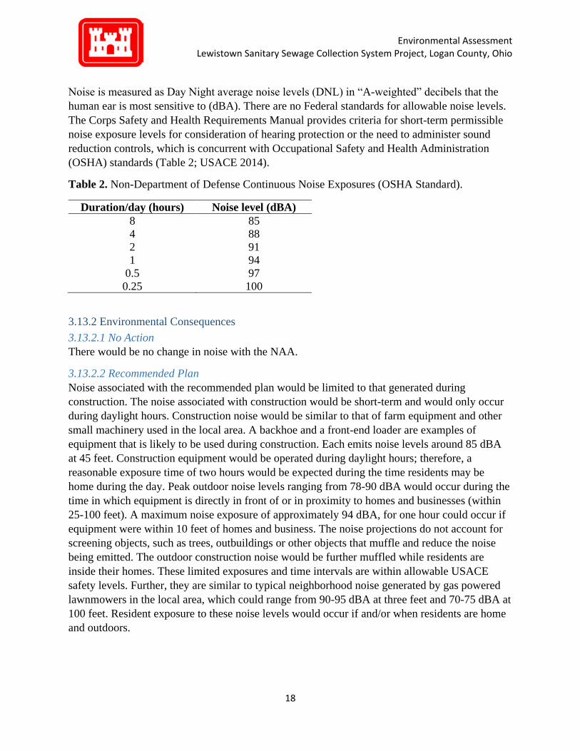
Noise is measured as Day Night average noise levels (DNL) in “A-weighted” decibels that the
human ear is most sensitive to (dBA). There are no Federal standards for allowable noise levels.
The Corps Safety and Health Requirements Manual provides criteria for short-term permissible
noise exposure levels for consideration of hearing protection or the need to administer sound
reduction controls, which is concurrent with Occupational Safety and Health Administration
(OSHA) standards (Table 2; USACE 2014).
Table 2. Non-Department of Defense Continuous Noise Exposures (OSHA Standard).
Duration/day (hours) Noise level (dBA)
8 85
4 88
2 91
1 94
0.5 97
0.25 100
3.13.2 Environmental Consequences
3.13.2.1 No Action
There would be no change in noise with the NAA.
3.13.2.2 Recommended Plan
Noise associated with the recommended plan would be limited to that generated during
construction. The noise associated with construction would be short-term and would only occur
during daylight hours. Construction noise would be similar to that of farm equipment and other
small machinery used in the local area. A backhoe and a front-end loader are examples of
equipment that is likely to be used during construction. Each emits noise levels around 85 dBA
at 45 feet. Construction equipment would be operated during daylight hours; therefore, a
reasonable exposure time of two hours would be expected during the time residents may be
home during the day. Peak outdoor noise levels ranging from 78-90 dBA would occur during the
time in which equipment is directly in front of or in proximity to homes and businesses (within
25-100 feet). A maximum noise exposure of approximately 94 dBA, for one hour could occur if
equipment were within 10 feet of homes and business. The noise projections do not account for
screening objects, such as trees, outbuildings or other objects that muffle and reduce the noise
being emitted. The outdoor construction noise would be further muffled while residents are
inside their homes. These limited exposures and time intervals are within allowable USACE
safety levels. Further, they are similar to typical neighborhood noise generated by gas powered
lawnmowers in the local area, which could range from 90-95 dBA at three feet and 70-75 dBA at
100 feet. Resident exposure to these noise levels would occur if and/or when residents are home
and outdoors.

Environmental Assessment Lewistown Sanitary Sewage Collection System Project, Logan County, Ohio
19
Due to daytime construction and the short and limited duration of elevated noise levels
associated with the recommended plan, impacts from the noise to local residents would be short-
term and minor.
3.14 Socioeconomic Conditions
3.14.1 Existing Conditions
Under Executive Order 12898 “Federal Action to Address Environmental Justice in Minority
Populations and Low-income Populations,” Federal agencies are directed to identify, address,
and avoid disproportionately high and adverse human health or environmental effects on
minority and low-income populations.
The EPA environmental justice tool (EJSCREEN) was used to analyze demographics for the
project area, and a detailed demographic report can be found in Appendix B. According to
EJSCREEN the 2017 population estimate for the project area was 182. There is no minority
population within the project area. The area is 100% Caucasian and 81% of residents are age 18
and above, and 21% are age 62 and over. The estimated median household income base for the
project area in 2017 was $31,306. The estimated low-income population is 25%, compared to the
state and national average of 33%.
3.14.2 Environmental Consequences
3.14.2.1 No Action
Under the NAA, untreated sewage will still be released into the environment from
malfunctioning septic systems, which could have potential negative impacts to human health.
However, the NAA would not be expected to disproportionately affect low-income or minority
populations.
3.14.2.2 Recommended Plan
The recommended plan would improve wastewater treatment for all residents in the project area,
which would positively impact the low-income population. The recommended plan would not be
expected to negatively impact low-income or minority populations.
3.15 Aesthetics
3.15.1 Existing Conditions
The project area landscape is dominated by a residential neighborhood, with homes and mowed
lawns. There are some views of agriculture, deciduous forest, and Rennick Creek, which may
offer opportunities to see wildlife. There are no extraordinary aesthetic resources within the
project area.
3.15.2 Environmental Consequences
3.15.2.1 No Action
Under the NAA, untreated sewage would still be released into the environment causing organic
enrichment of the surface water. This could reduce opportunities to view wildlife in the stream.

Environmental Assessment Lewistown Sanitary Sewage Collection System Project, Logan County, Ohio
20
3.15.2.2 Recommended Plan
The recommended plan would have short-term negligible effects to aesthetics. The
recommended plan would disturb asphalt and the mowed grass in the short-term, but conditions
would be returned to existing shortly after construction.
3.16 Transportation and Traffic
3.16.1 Existing Condition
The project area is located throughout the town of Lewistown. There are approximately 71
residential homes, a high school, middle school, and post office in the project area. Traffic would
be expected to be light even during peak hours. Additionally, there are other routes that could be
used to avoid the project area.
3.16.2 Environmental Consequences
3.16.2.1 No Action
The NAA would have no effect on traffic.
3.16.2.2 Recommended Plan
The recommended plan would have short-term minor effects to traffic. Construction could
involve some short-term minor delays and potential detours in the normal traffic flow.
Construction would follow Ohio Department of Transportation (ODT) guidelines. All
appropriate ODT guidelines for traffic control would be implemented and emergency access
would be maintained. There would be no new permanent traffic patterns as a result of the
recommended plan and as such, no long-term impact would occur.
3.17 Health and Safety
3.17.1 Existing Condition
Data shows that Logan County, Ohio is in relatively poor health compared to the rest of the state.
Logan County has higher obesity rates, drug overdoses, uninsured adults, and fewer health care
providers (Ohio Department of Health 2020).
3.17.2 Environmental Consequences
3.17.2.1 No Action
Under the NAA, untreated sewage would still be released into the environment which could have
potential negative health and safety impacts.
3.17.2.2 Recommended Plan
The recommended plan would improve wastewater treatment for the population, which would
eliminate any possible negative health effects caused by untreated sewage on the landscape.
Therefore, the recommended plan would have a long-term positive impact on health and safety.
4.0 STATUS OF ENVIRONMENTAL COMPLIANCE
The recommended plan is in full compliance with all local, State, and Federal statutes as well as
Executive Orders. Compliance is documented below in Table 3.

Environmental Assessment Lewistown Sanitary Sewage Collection System Project, Logan County, Ohio
21
Table 3. Status of Environmental Compliance with Lewistown New Sanitary Sewage Collection
System Project.
Statute/Executive Order Full In
Progress
National Environmental Policy Act X
Fish and Wildlife Coordination Act X
Endangered Species Act X
Clean Water Act X
Wild and Scenic Rivers Act X
Clean Air Act X
National Historic Preservation Act X
Archeological Resources Protection Act X
Comprehensive, Environmental Response, Compensation and Liability Act X
Resource Conservation and Recovery Act X
Toxic Substances Control Act X
Quiet Communities Act X
Farmland Protection Act X
Executive Order 11988 Floodplain Management X
Executive Order 11990 Protection of Wetlands X
Executive Order 12898 Environmental Justice in Minority Populations and
Low-Income Populations X
5.0 PUBLIC REVIEW AND COMMENTS
This draft EA and unsigned FONSI will made available for public review for a period of 30 days
beginning on February 16, 2021, as required by CEQ regulations. The draft EA will be posted
on the Louisville District webpage and Notice of Availability letters were sent to the local
community and local, state and Federal government agencies for a 30-day review/comment
period. A list of persons, agencies, and organizations that will be notified for public review can
be found in Table 4. All agency and tribal correspondence can be found in Appendix D.
Table 4. Agencies, Organizations, Persons, and Tribes to be contacted for public review of the
Lewistown New Sanitary Sewage Collection System Project, Logan County, Ohio.
Stakeholder Type Agency/Organization/Person/Tribe
Tribes Absentee-Shawnee Tribe of Indians
Eastern Shawnee Tribe of Oklahoma
Shawnee Tribe of Oklahoma
Saginaw Chippewa Indian Tribe of Michigan
Quapaw Tribe
Miami Tribe of Oklahoma
Peoria Tribe of Oklahoma
Osage Nation of Oklahoma

Environmental Assessment Lewistown Sanitary Sewage Collection System Project, Logan County, Ohio
22
Wyandotte Nation of Oklahoma
Tuscarora Nation of New York
Tonawanda Seneca Nation
St. Regis Mohawk Tribe
Seneca Nation of Indians of New York
Onondaga Nation of New York
Oneida Nation of Wisconsin
Oneida Nation of New York
Delaware Nation of Oklahoma
Cayuga Nation of New York
Bad River Band of Lake Superior Chippewa
Citizen Potawatomi Nation
Prairie Band of Potawatomi
Gun Lake Tribe
Pokagon Band of Potawatomi
Delaware Tribe of Indians Oklahoma
Nottawaseppi Huron Band of Potawatomi
Bois Forte Band of Chippewa
Fond du lac Band of Lake Superior
Forest County Potawatomi
Grand Portage Band of Lake Superior Chippewa
Grand Traverse Band of Ottawa and Chippewa
Seneca-Cayuga of Oklahoma
Hannahville Indian Community
Keweenaw Bay Indian Community
Kickapoo Tribe of Kansas
Kickapoo Tribe of Oklahoma
Kickapoo Traditional Tribe of Texas
Lac Courte Oreilles Band of Chippewa
Lac du Flambeau Band of Lake Superior
Lac Vieux Desert Band of Lake Superior
Leech Lake Band of Ojibwe
Little River Band of Ottawa
Little Traverse Bay Band of Odawa
Mille Lacs Band of Ojibwe
Ottawa Tribe of Oklahoma
Red Cliff Band of Lake Superior Chippewa
Red Lake Chippewa
Sac and Fox Nation of Missouri in Kansas and Nebraska
Sac and Fox Nation of Oklahoma
Sac and Fox Tribe of Mississippi in Iowa
Sault Ste Marie Tribe of Chippewa
Sokaogon Chippewa
St. Croix Chippewa Community
Turtle Mountain Band of Chippewa

Environmental Assessment Lewistown Sanitary Sewage Collection System Project, Logan County, Ohio
23
State Agencies Ohio State Historic Preservation Officer
Ohio Department of Natural Resource
Ohio Environmental Protection Agency
Federal Agencies United States Environmental Protection Agency, Region 5 Office
National Resource Conservation Service, Ohio State Office
United States Fish and Wildlife Service
Local Agencies Washington Township Office
People United States Congressman Jim Jordan
United States Senator Rob Portman
United States Senator Sherrod Brown
Ohio State Senator Rob McColley
Ohio State Senator Matt Huffman
Ohio State Representative Jon Cross
Ohio State Representative Nino Vitale
6.0 CONCLUSION
Wastewater treatment within Lewistown is currently provided by individual on-lot systems
consisting of either a septic tank or an aeration unit. In most cases, these systems discharge
untreated sewage to ditches, drainage ways, or underground tile lines with eventual discharge to
Rennick Creek, which borders the southern edge of the Washington Township. The completion
of a new sewage collection system will allow for controlled and quality growth of residential and
non-residential entities within the Lewistown sanitary service area and bring the area into
compliance with federal and state water quality requirements. Construction would take place on
previously disturbed land within the road rights-of-way and easements held by the Lewistown
Township. Effects associated with construction would be minor and short-term and construction
BMPs would be implemented to minimize impacts to residents and the environment. No
significant adverse impacts have been identified as a result of implementation of the proposed
construction.
This EA has been prepared in accordance with the National Environmental Policy Act (NEPA);
the Council on Environmental Quality, Regulations for Implementing the Procedural Provisions
of the National Environmental Policy Act (40 C.F.R. Parts 1500-1508); and the Corps of
Engineers, Policy and Procedure for Implementing NEPA (33 C.F.R. Part 230).
This EA concludes that environmental impacts of the proposed sanitary sewage collection
system in Lewistown, Ohio is minor and local in scope; the benefits of the recommended plan
outweigh the minor impacts that would result from implementation of the recommended plan;
and the recommended plan does not constitute a major Federal action significantly affecting the
quality of the human environment.
Based on the conclusions of this Draft EA, preparation of an EIS is not required. Therefore, a
Draft Finding of No Significant Impact (FONSI) is presented at the beginning of this Draft EA.

Environmental Assessment Lewistown Sanitary Sewage Collection System Project, Logan County, Ohio
24
If the District Engineer determines that an EIS is not necessary, the Draft FONSI would be
finalized and the recommended plan implemented.

Environmental Assessment Lewistown Sanitary Sewage Collection System Project, Logan County, Ohio
25
7.0 REFERENCES
USEPA (Environmental Protection Agency) 2020. Envirofacts. Available at:
https://enviro.epa.gov/
USEPA (Environmental Protection Agency) 2020. Nonattainment Areas for Criteria
Pollutants. Available at: https://www.epa.gov/green-book
USEPA (Environmental Protection Agency) 2020. NEPAssist. Available at:
https://nepassisttool.epa.gov/nepassist/nepamap.aspx?wherestr=mount+vernon%2C+ky
FEMA (Federal Emergency Management Agency) 1985. Flood Insurance Rate Map.
Community Panel Number 3907720100C. Logan County, Ohio. Available at:
https://msc.fema.gov/portal/home
NRCS (Natural Resources Conservation Service) 2020. “Web Soil Survey.” Available at:
https://websoilsurvey.sc.egov.usda.gov/App/WebSoilSurvey.aspx
USACE (U.S. Army Corps of Engineers) 2014. Engineering Manual 385-1-1. “Safety
and Health Requirements.” Available at: https://www.usace.army.mil/Missions/Safety-and-
Occupational-Health/Safety-and-Health-Requirements-Manual/
USFWS (U.S. Fish and Wildlife Service) 2015. Northern long-eared bat: Myotis
septentrionails. Available at:
https://www.fws.gov/midwest/endangered/mammals/nleb/nlebfactsheet.html
USFWS (U.S. Fish and Wildlife Service) 2006. Indiana bat (Myotis sodalist). Available
at: https://www.fws.gov/midwest/endangered/mammals/inba/inbafctsht.html
USFWS (U.S. Fish and Wildlife Service) 2020. “IPaC: Information for Planning and
Consultation.” Listed Species Count by Year, ecos.fws.gov/ipac/location/index
USFWS (U.S. Fish and Wildlife Service) 2012. Rayed Bean (Villosa fabalis). Available
at: https://www.fws.gov/midwest/endangered/clams/rayedbean/rayedbeanfactsheet.html
USFWS (U.S. Fish and Wildlife Service) 2020. “Wetlands Mapper.” Available at:
https://www.fws.gov/wetlands/data/Mapper.html

Appendix A
Photos From July 13, 2020 Site Visit

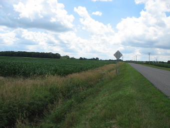


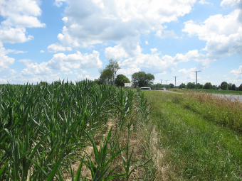


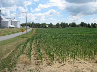


Appendix B
Supporting Environmental Documents

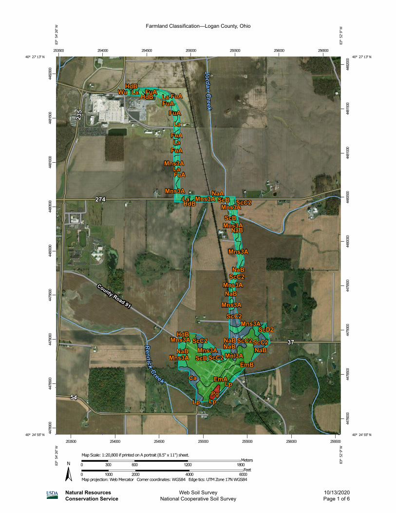
Farmland Classification—Logan County, Ohio
Natural ResourcesConservation Service
Web Soil SurveyNational Cooperative Soil Survey
10/13/2020Page 1 of 6
4478
000
4478
500
4479
000
4479
500
4480
000
4480
500
4481
000
4481
500
4482
000
4478
000
4478
500
4479
000
4479
500
4480
000
4480
500
4481
000
4481
500
4482
000
253500 254000 254500 255000 255500 256000 256500
253500 254000 254500 255000 255500 256000 256500
40° 27' 13'' N83
° 5
4' 2
6'' W
40° 27' 13'' N
83° 5
2' 9
'' W
40° 24' 55'' N
83° 5
4' 2
6'' W
40° 24' 55'' N
83° 5
2' 9
'' W
N
Map projection: Web Mercator Corner coordinates: WGS84 Edge tics: UTM Zone 17N WGS840 1000 2000 4000 6000
Feet0 300 600 1200 1800
MetersMap Scale: 1:20,800 if printed on A portrait (8.5" x 11") sheet.

MAP LEGENDArea of Interest (AOI)
Area of Interest (AOI)
SoilsSoil Rating Polygons
Not prime farmland
All areas are prime farmlandPrime farmland if drained
Prime farmland if protected from flooding or not frequently flooded during the growing seasonPrime farmland if irrigated
Prime farmland if drained and either protected from flooding or not frequently flooded during the growing seasonPrime farmland if irrigated and drainedPrime farmland if irrigated and either protected from flooding or not frequently flooded during the growing season
Prime farmland if subsoiled, completely removing the root inhibiting soil layerPrime farmland if irrigated and the product of I (soil erodibility) x C (climate factor) does not exceed 60Prime farmland if irrigated and reclaimed of excess salts and sodiumFarmland of statewide importanceFarmland of statewide importance, if drainedFarmland of statewide importance, if protected from flooding or not frequently flooded during the growing seasonFarmland of statewide importance, if irrigated
Farmland of statewide importance, if drained and either protected from flooding or not frequently flooded during the growing seasonFarmland of statewide importance, if irrigated and drainedFarmland of statewide importance, if irrigated and either protected from flooding or not frequently flooded during the growing seasonFarmland of statewide importance, if subsoiled, completely removing the root inhibiting soil layerFarmland of statewide importance, if irrigated and the product of I (soil erodibility) x C (climate factor) does not exceed 60
Farmland of statewide importance, if irrigated and reclaimed of excess salts and sodiumFarmland of statewide importance, if drained or either protected from flooding or not frequently flooded during the growing seasonFarmland of statewide importance, if warm enough, and either drained or either protected from flooding or not frequently flooded during the growing seasonFarmland of statewide importance, if warm enoughFarmland of statewide importance, if thawedFarmland of local importanceFarmland of local importance, if irrigated
Farmland of unique importanceNot rated or not available
Soil Rating LinesNot prime farmland
All areas are prime farmlandPrime farmland if drainedPrime farmland if protected from flooding or not frequently flooded during the growing seasonPrime farmland if irrigatedPrime farmland if drained and either protected from flooding or not frequently flooded during the growing seasonPrime farmland if irrigated and drainedPrime farmland if irrigated and either protected from flooding or not frequently flooded during the growing season
Farmland Classification—Logan County, Ohio
Natural ResourcesConservation Service
Web Soil SurveyNational Cooperative Soil Survey
10/13/2020Page 2 of 6

Prime farmland if subsoiled, completely removing the root inhibiting soil layerPrime farmland if irrigated and the product of I (soil erodibility) x C (climate factor) does not exceed 60Prime farmland if irrigated and reclaimed of excess salts and sodiumFarmland of statewide importanceFarmland of statewide importance, if drainedFarmland of statewide importance, if protected from flooding or not frequently flooded during the growing seasonFarmland of statewide importance, if irrigated
Farmland of statewide importance, if drained and either protected from flooding or not frequently flooded during the growing seasonFarmland of statewide importance, if irrigated and drainedFarmland of statewide importance, if irrigated and either protected from flooding or not frequently flooded during the growing seasonFarmland of statewide importance, if subsoiled, completely removing the root inhibiting soil layerFarmland of statewide importance, if irrigated and the product of I (soil erodibility) x C (climate factor) does not exceed 60
Farmland of statewide importance, if irrigated and reclaimed of excess salts and sodiumFarmland of statewide importance, if drained or either protected from flooding or not frequently flooded during the growing seasonFarmland of statewide importance, if warm enough, and either drained or either protected from flooding or not frequently flooded during the growing seasonFarmland of statewide importance, if warm enoughFarmland of statewide importance, if thawedFarmland of local importanceFarmland of local importance, if irrigated
Farmland of unique importanceNot rated or not available
Soil Rating PointsNot prime farmland
All areas are prime farmlandPrime farmland if drained
Prime farmland if protected from flooding or not frequently flooded during the growing seasonPrime farmland if irrigated
Prime farmland if drained and either protected from flooding or not frequently flooded during the growing seasonPrime farmland if irrigated and drainedPrime farmland if irrigated and either protected from flooding or not frequently flooded during the growing season
Prime farmland if subsoiled, completely removing the root inhibiting soil layerPrime farmland if irrigated and the product of I (soil erodibility) x C (climate factor) does not exceed 60Prime farmland if irrigated and reclaimed of excess salts and sodiumFarmland of statewide importanceFarmland of statewide importance, if drainedFarmland of statewide importance, if protected from flooding or not frequently flooded during the growing seasonFarmland of statewide importance, if irrigated
Farmland Classification—Logan County, Ohio
Natural ResourcesConservation Service
Web Soil SurveyNational Cooperative Soil Survey
10/13/2020Page 3 of 6

Farmland of statewide importance, if drained and either protected from flooding or not frequently flooded during the growing seasonFarmland of statewide importance, if irrigated and drainedFarmland of statewide importance, if irrigated and either protected from flooding or not frequently flooded during the growing seasonFarmland of statewide importance, if subsoiled, completely removing the root inhibiting soil layerFarmland of statewide importance, if irrigated and the product of I (soil erodibility) x C (climate factor) does not exceed 60
Farmland of statewide importance, if irrigated and reclaimed of excess salts and sodiumFarmland of statewide importance, if drained or either protected from flooding or not frequently flooded during the growing seasonFarmland of statewide importance, if warm enough, and either drained or either protected from flooding or not frequently flooded during the growing seasonFarmland of statewide importance, if warm enoughFarmland of statewide importance, if thawedFarmland of local importanceFarmland of local importance, if irrigated
Farmland of unique importanceNot rated or not available
Water FeaturesStreams and Canals
TransportationRails
Interstate Highways
US Routes
Major Roads
Local Roads
BackgroundAerial Photography
The soil surveys that comprise your AOI were mapped at 1:15,800.
Please rely on the bar scale on each map sheet for map measurements.
Source of Map: Natural Resources Conservation ServiceWeb Soil Survey URL: Coordinate System: Web Mercator (EPSG:3857)
Maps from the Web Soil Survey are based on the Web Mercator projection, which preserves direction and shape but distorts distance and area. A projection that preserves area, such as the Albers equal-area conic projection, should be used if more accurate calculations of distance or area are required.
This product is generated from the USDA-NRCS certified data as of the version date(s) listed below.
Soil Survey Area: Logan County, OhioSurvey Area Data: Version 18, Jun 11, 2020
Soil map units are labeled (as space allows) for map scales 1:50,000 or larger.
Date(s) aerial images were photographed: Aug 6, 2014—Mar 28, 2017
The orthophoto or other base map on which the soil lines were compiled and digitized probably differs from the background imagery displayed on these maps. As a result, some minor shifting of map unit boundaries may be evident.
Farmland Classification—Logan County, Ohio
Natural ResourcesConservation Service
Web Soil SurveyNational Cooperative Soil Survey
10/13/2020Page 4 of 6

Farmland Classification
Map unit symbol Map unit name Rating Acres in AOI Percent of AOI
Ca Carlisle muck, Central Ohio clayey till plain, drained, 0 to 2 percent slopes
Farmland of local importance
7.2 3.7%
EmA Eldean silt loam, 0 to 2 percent slopes
All areas are prime farmland
17.0 8.6%
EmB Eldean silt loam, 2 to 6 percent slopes
All areas are prime farmland
0.1 0.0%
FuA Fulton silt loam, 0 to 4 percent slopes
Prime farmland if drained
12.6 6.4%
HdB Haskins loam, 2 to 6 percent slopes
Prime farmland if drained
3.9 2.0%
La Latty silty clay Prime farmland if drained
17.3 8.8%
Lp Lippincott silty clay loam, 0 to 2 percent slopes
Prime farmland if drained
1.9 0.9%
Mnl3A Minster silty clay loam, till substratum, 0 to 1 percent slopes
Prime farmland if drained
4.0 2.1%
Mns3A Minster silty clay loam, 0 to 1 percent slopes
Prime farmland if drained
32.6 16.6%
NaA Nappanee silt loam, 0 to 2 percent slopes
Prime farmland if drained
0.3 0.2%
NaB Nappanee silt loam, 2 to 6 percent slopes
Prime farmland if drained
16.0 8.1%
Pg Pits, gravel Not prime farmland 2.8 1.4%
ScB St. Clair silt loam, 2 to 6 percent slopes
All areas are prime farmland
53.2 27.0%
ScC2 St. Clair silt loam, 6 to 12 percent slopes, moderately eroded
Farmland of local importance
26.4 13.4%
ScD2 St. Clair silt loam, 12 to 18 percent slopes, moderately eroded
Farmland of local importance
0.7 0.3%
Wu Westland silty clay loam, clay substratum
Prime farmland if drained
0.8 0.4%
Totals for Area of Interest 196.8 100.0%
Farmland Classification—Logan County, Ohio
Natural ResourcesConservation Service
Web Soil SurveyNational Cooperative Soil Survey
10/13/2020Page 5 of 6

Description
Farmland classification identifies map units as prime farmland, farmland of statewide importance, farmland of local importance, or unique farmland. It identifies the location and extent of the soils that are best suited to food, feed, fiber, forage, and oilseed crops. NRCS policy and procedures on prime and unique farmlands are published in the "Federal Register," Vol. 43, No. 21, January 31, 1978.
Rating Options
Aggregation Method: No Aggregation Necessary
Aggregation is the process by which a set of component attribute values is reduced to a single value that represents the map unit as a whole.
A map unit is typically composed of one or more "components". A component is either some type of soil or some nonsoil entity, e.g., rock outcrop. For the attribute being aggregated, the first step of the aggregation process is to derive one attribute value for each of a map unit's components. From this set of component attributes, the next step of the aggregation process derives a single value that represents the map unit as a whole. Once a single value for each map unit is derived, a thematic map for soil map units can be rendered. Aggregation must be done because, on any soil map, map units are delineated but components are not.
For each of a map unit's components, a corresponding percent composition is recorded. A percent composition of 60 indicates that the corresponding component typically makes up approximately 60% of the map unit. Percent composition is a critical factor in some, but not all, aggregation methods.
The majority of soil attributes are associated with a component of a map unit, and such an attribute has to be aggregated to the map unit level before a thematic map can be rendered. Map units, however, also have their own attributes. An attribute of a map unit does not have to be aggregated in order to render a corresponding thematic map. Therefore, the "aggregation method" for any attribute of a map unit is referred to as "No Aggregation Necessary".
Tie-break Rule: Lower
The tie-break rule indicates which value should be selected from a set of multiple candidate values, or which value should be selected in the event of a percent composition tie.
Farmland Classification—Logan County, Ohio
Natural ResourcesConservation Service
Web Soil SurveyNational Cooperative Soil Survey
10/13/2020Page 6 of 6
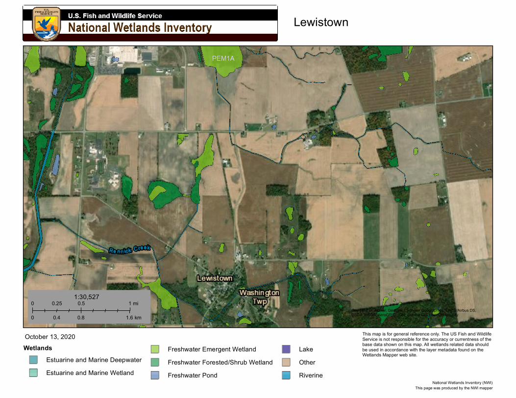
Lewistown
Source: Esri, Maxar, GeoEye, Earthstar Geographics, CNES/Airbus DS,USDA, USGS, AeroGRID, IGN, and the GIS User Community
WetlandsEstuarine and Marine DeepwaterEstuarine and Marine Wetland
Freshwater Emergent WetlandFreshwater Forested/Shrub WetlandFreshwater Pond
LakeOtherRiverine
October 13, 2020
0 0.5 10.25 mi
0 0.8 1.60.4 km
1:30,527
This page was produced by the NWI mapperNational Wetlands Inventory (NWI)
This map is for general reference only. The US Fish and Wildlife Service is not responsible for the accuracy or currentness of the base data shown on this map. All wetlands related data should be used in accordance with the layer metadata found on the Wetlands Mapper web site.

April 09, 2020
United States Department of the InteriorFISH AND WILDLIFE SERVICE
Ohio Ecological Services Field Office4625 Morse Road, Suite 104Columbus, OH 43230-8355
Phone: (614) 416-8993 Fax: (614) 416-8994
In Reply Refer To: Consultation Code: 03E15000-2020-SLI-1176 Event Code: 03E15000-2020-E-01656 Project Name: Lewistown Environmental Infrastructure Subject: List of threatened and endangered species that may occur in your proposed project
location, and/or may be affected by your proposed project
To Whom It May Concern:
The enclosed species list identifies threatened, endangered, proposed and candidate species, as well as proposed and final designated critical habitat, that may occur within the boundary of your proposed project and/or may be affected by your proposed project. The species list fulfills the requirements of the U.S. Fish and Wildlife Service (Service) under section 7(c) of the Endangered Species Act (Act) of 1973, as amended (16 U.S.C. 1531 et seq.).
New information based on updated surveys, changes in the abundance and distribution of species, changed habitat conditions, or other factors could change this list. Please feel free to contact us if you need more current information or assistance regarding the potential impacts to federally proposed, listed, and candidate species and federally designated and proposed critical habitat. Please note that under 50 CFR 402.12(e) of the regulations implementing section 7 of the Act, the accuracy of this species list should be verified after 90 days. This verification can be completed formally or informally as desired. The Service recommends that verification be completed by visiting the ECOS-IPaC website at regular intervals during project planning and implementation for updates to species lists and information. An updated list may be requested through the ECOS-IPaC system by completing the same process used to receive the enclosed list.
The purpose of the Act is to provide a means whereby threatened and endangered species and the ecosystems upon which they depend may be conserved. Under sections 7(a)(1) and 7(a)(2) of the Act and its implementing regulations (50 CFR 402 et seq.), Federal agencies are required to utilize their authorities to carry out programs for the conservation of threatened and endangered species and to determine whether projects may affect threatened and endangered species and/or designated critical habitat.

04/09/2020 Event Code: 03E15000-2020-E-01656 2
A Biological Assessment is required for construction projects (or other undertakings having similar physical impacts) that are major Federal actions significantly affecting the quality of the human environment as defined in the National Environmental Policy Act (42 U.S.C. 4332(2) (c)). For projects other than major construction activities, the Service suggests that a biological evaluation similar to a Biological Assessment be prepared to determine whether the project may affect listed or proposed species and/or designated or proposed critical habitat. Recommended contents of a Biological Assessment are described at 50 CFR 402.12.
If a Federal agency determines, based on the Biological Assessment or biological evaluation, that listed species and/or designated critical habitat may be affected by the proposed project, the agency is required to consult with the Service pursuant to 50 CFR 402. In addition, the Service recommends that candidate species, proposed species and proposed critical habitat be addressed within the consultation. More information on the regulations and procedures for section 7 consultation, including the role of permit or license applicants, can be found in the "Endangered Species Consultation Handbook" at:
http://www.fws.gov/endangered/esa-library/pdf/TOC-GLOS.PDF
Migratory Birds: In addition to responsibilities to protect threatened and endangered species under the Endangered Species Act (ESA), there are additional responsibilities under the Migratory Bird Treaty Act (MBTA) and the Bald and Golden Eagle Protection Act (BGEPA) to protect native birds from project-related impacts. Any activity, intentional or unintentional, resulting in take of migratory birds, including eagles, is prohibited unless otherwise permitted by the U.S. Fish and Wildlife Service (50 C.F.R. Sec. 10.12 and 16 U.S.C. Sec. 668(a)). For more information regarding these Acts see http://www.fws.gov/migratorybirds/ RegulationsandPolicies.html.
The MBTA has no provision for allowing take of migratory birds that may be unintentionally killed or injured by otherwise lawful activities. It is the responsibility of the project proponent to comply with these Acts by identifying potential impacts to migratory birds and eagles within applicable NEPA documents (when there is a federal nexus) or a Bird/Eagle Conservation Plan (when there is no federal nexus). Proponents should implement conservation measures to avoid or minimize the production of project-related stressors or minimize the exposure of birds and their resources to the project-related stressors. For more information on avian stressors and recommended conservation measures see http://www.fws.gov/migratorybirds/CurrentBirdIssues/ Hazards/BirdHazards.html.
In addition to MBTA and BGEPA, Executive Order 13186: Responsibilities of Federal Agencies to Protect Migratory Birds, obligates all Federal agencies that engage in or authorize activities that might affect migratory birds, to minimize those effects and encourage conservation measures that will improve bird populations. Executive Order 13186 provides for the protection of both migratory birds and migratory bird habitat. For information regarding the implementation of Executive Order 13186, please visit http://www.fws.gov/migratorybirds/AboutUS.html.

04/09/2020 Event Code: 03E15000-2020-E-01656 3
▪
We appreciate your concern for threatened and endangered species. The Service encourages Federal agencies to include conservation of threatened and endangered species into their project planning to further the purposes of the Act. Please include the Consultation Code in the header of this letter with any request for consultation or correspondence about your project that you submit to our office.
Attachment(s):
Official Species List

04/09/2020 Event Code: 03E15000-2020-E-01656 1
Official Species ListThis list is provided pursuant to Section 7 of the Endangered Species Act, and fulfills the requirement for Federal agencies to "request of the Secretary of the Interior information whether any species which is listed or proposed to be listed may be present in the area of a proposed action".
This species list is provided by:
Ohio Ecological Services Field Office4625 Morse Road, Suite 104Columbus, OH 43230-8355(614) 416-8993

04/09/2020 Event Code: 03E15000-2020-E-01656 2
Project SummaryConsultation Code: 03E15000-2020-SLI-1176
Event Code: 03E15000-2020-E-01656
Project Name: Lewistown Environmental Infrastructure
Project Type: WASTEWATER PIPELINE
Project Description: Installation of new sewage collection system in Lewistown.
Project Location:Approximate location of the project can be viewed in Google Maps: https:// www.google.com/maps/place/40.4220595477628N83.88499010657162W
Counties: Logan, OH

04/09/2020 Event Code: 03E15000-2020-E-01656 3
1.
▪
Endangered Species Act SpeciesThere is a total of 3 threatened, endangered, or candidate species on this species list.
Species on this list should be considered in an effects analysis for your project and could include species that exist in another geographic area. For example, certain fish may appear on the species list because a project could affect downstream species. Note that 1 of these species should be considered only under certain conditions.
IPaC does not display listed species or critical habitats under the sole jurisdiction of NOAA Fisheries , as USFWS does not have the authority to speak on behalf of NOAA and the Department of Commerce.
See the "Critical habitats" section below for those critical habitats that lie wholly or partially within your project area under this office's jurisdiction. Please contact the designated FWS office if you have questions.
NOAA Fisheries, also known as the National Marine Fisheries Service (NMFS), is an office of the National Oceanic and Atmospheric Administration within the Department of Commerce.
MammalsNAME STATUS
Indiana Bat Myotis sodalisThere is final critical habitat for this species. Your location is outside the critical habitat.Species profile: https://ecos.fws.gov/ecp/species/5949
Endangered
Northern Long-eared Bat Myotis septentrionalisNo critical habitat has been designated for this species.This species only needs to be considered under the following conditions:
Incidental take of the northern long-eared bat is not prohibited at this location. Federal action agencies may conclude consultation using the streamlined process described at https://www.fws.gov/midwest/endangered/mammals/nleb/s7.html
Species profile: https://ecos.fws.gov/ecp/species/9045
Threatened
ClamsNAME STATUS
Rayed Bean Villosa fabalisNo critical habitat has been designated for this species.Species profile: https://ecos.fws.gov/ecp/species/5862
Endangered
1

04/09/2020 Event Code: 03E15000-2020-E-01656 4
Critical habitatsTHERE ARE NO CRITICAL HABITATS WITHIN YOUR PROJECT AREA UNDER THIS OFFICE'S JURISDICTION.

ACS EstimatesPercent MOE (±)
Population by Race
Population Density (per sq. mile)
EJSCREEN ACS Summary Report
Summary of ACS Estimates
Population
Population Reporting One Race
Minority Population
% Minority
Households
Housing Units
Housing Units Built Before 1950
Per Capita Income
Land Area (sq. miles) (Source: SF1)
% Land Area
Water Area (sq. miles) (Source: SF1)
% Water Area
Total
White
Black
American Indian
Asian
Population by Sex
Population by Age
American Indian Alone
Asian
Pacific Islander
Some Other Race
Population Reporting Two or More Races
Total Hispanic Population
Total Non-Hispanic Population
White Alone
Black Alone
Non-Hispanic Asian Alone
Pacific Islander Alone
Other Race Alone
Two or More Races Alone
Male
Female
Age 0-4
Age 0-17
Age 18+
Age 65+
Data Note: Detail may not sum to totals due to rounding. Hispanic population can be of any race. N/A means not available. Source: U.S. Census Bureau, American Community Survey (ACS) .
1/3
Location:Ring (buffer):
Description:
User-specified polygonal location
0-miles radius
Lewistown
2013 - 2017
2013 - 2017
182
238
0
0%
50
60
23
31,306
0.77
100%
0.00
0%
182 272
182 100% 328
182 100% 2730 0% 110 0% 11
0 0% 11
0 0% 11
0 0% 110 0% 70 0% 11
182
182 100% 273
0 0% 11
0 0% 11
0 0%
0 0%
11
11
0 0% 11
100%
0 0% 7
113 62% 176
70 38% 122
6 3% 4435 19% 109
147 81% 190
38 21% 93
April 10, 2020
2013 - 2017
zhuangv
Highlight

ACS EstimatesPercent MOE (±)
Population 25+ by Educational Attainment
2+3+4Speak English "less than very well"
Non-English at Home1+2+3+4
High School Graduate
Some College, No Degree
Associate Degree
Population Age 5+ Years by Ability to Speak English Total
Speak only English
1Speak English "very well"2Speak English "well"3Speak English "not well"4Speak English "not at all"
3+4Speak English "less than well"
Bachelor's Degree or more
Total
Less than 9th Grade
9th - 12th Grade, No Diploma
Occupied Housing Units by Tenure
$50,000 - $75,000
$75,000 +
Total
Owner Occupied
Households by Household Income
Household Income Base
< $15,000
$15,000 - $25,000
$25,000 - $50,000
EJSCREEN ACS Summary Report
2/3
Linguistically Isolated Households* Total
Speak SpanishSpeak Other Indo-European LanguagesSpeak Asian-Pacific Island LanguagesSpeak Other Languages
Location:Ring (buffer):
Description:
In Labor Force Civilian Unemployed in Labor Force Not In Labor Force
Renter Occupied
Employed Population Age 16+ Years Total
Data Note: Datail may not sum to totals due to rounding. Hispanic population can be of any race.
N/A means not available. Source: U.S. Census Bureau, American Community Survey (ACS) *Households in which no one 14 and over speaks English "very well" or speaks English only.
User-specified polygonal location
0-miles radius
Lewistown
2013 - 2017
April 10, 2020
138 100% 163
3 2% 3013 10% 71
80 58% 137
29 21% 93
4 3% 31
12 9% 53
177 100% 260
177 100% 250
0 0% 11
0 0% 11
0 0% 11
0 0% 11
0 0% 11
0 0% 11
0 0% 11
0 0% 11
0 0% 110 0% 11
0 0% 11
0 0% 11
50 100% 101
6 12% 514 9% 43
11 23% 91
6 12% 4623 45% 100
50 100% 101
44 87% 110
6 13% 59
157 100% 192
101 65% 2022 2% 27
56 35% 126

ACS EstimatesPercent MOE (±)
English
Spanish
French
French Creole
Italian
Portuguese
German
Yiddish
Other West Germanic
Scandinavian
Greek
Russian
Polish
Serbo-Croatian
Other Slavic
Armenian
Persian
Gujarathi
Hindi
Urdu
Other Indic
Other Indo-European
Chinese
Japanese
Korean
Mon-Khmer, Cambodian
Hmong
Thai
Laotian
Vietnamese
Other Asian
Tagalog
Other Pacific Island
Navajo
Other Native American
Hungarian
Arabic
Hebrew
African
Other and non-specified
Total Non-English
.
Data Note: Detail may not sum to totals due to rounding. Hispanic popultion can be of any race. N/A means not available. Source: U.S. Census Bureau, American Community Survey (ACS)*Population by Language Spoken at Home is available at the census tract summary level and up.
Population by Language Spoken at Home* Total (persons age 5 and above)
EJSCREEN ACS Summary Report
3/3
Location:Ring (buffer):
Description:
User-specified polygonal location
0-miles radius
Lewistown
2013 - 2017
April 10, 2020
2013 - 2017
N/A N/A N/A
N/A N/A N/AN/A N/A N/AN/A N/A N/AN/A N/A N/AN/A N/A N/AN/A N/A N/AN/A N/A N/AN/A N/A N/AN/A N/A N/AN/A N/A N/AN/A N/A N/AN/A N/A N/AN/A N/A N/AN/A N/A N/AN/A N/A N/AN/A N/A N/AN/A N/A N/AN/A N/A N/AN/A N/A N/AN/A N/A N/AN/A N/A N/A
N/AN/AN/AN/AN/AN/AN/AN/AN/A
N/A N/A
N/A
N/A N/A
N/A
N/A N/A
N/A
N/A N/A
N/A
N/A N/A
N/A
N/A N/A
N/A
N/A N/A
N/A
N/A N/A
N/A
N/A N/A
N/A
N/A N/A
N/A
N/A N/A
N/A
N/A N/AN/A N/AN/A N/AN/A N/AN/A N/AN/A N/AN/A N/AN/A N/AN/A N/A

Appendix C
Cultural Resources Documentation
PHASE I ARCHAEOLOGICAL SURVEY OF THE LEWISTOWN
NEW SANITARY SEWAGE COLLECTION SYSTEM IN
LEWISTOWN, OHIO
August 18, 2020
Report authored by:
________________________________________________
Montana Martin
Archaeologist, MA
U.S. ARMY CORPS OF ENGINEERS
LOUISVILLE DISTRICT
ATTN: PMC-PL
P.O. BOX 59
LOUISVILLE, KENTUCKY 40201-0059
PHONE: (502) 315-7433
FAX: (502) 315- 6864
Email: [email protected]

Lewistown, Ohio Sewer Line Phase I Archaeological Survey 1
Abstract
The U.S. Army Corps of Engineers-Louisville District (USACE-Louisville District) has received
a request for financial assistance for the Lewistown New Sanitary Sewage Collection System. The
project is authorized by Section 594 of the Water Resources Development Act (WRDA) of 1999
(Public Law 106-53, 113 STAT 381), as amended. Section 594 authorizes federal design and
construction assistance to non-federal interests to carry out water-related environmental
infrastructure and resource protection and development projects in Ohio and North Dakota. The
proposed undertaking consists of the proposed sewer line project. The Area of Potential Effects
(APE) for the undertaking consists of the linear sewer line that is federally funded. The linear
sewer line that makes up the APE measures approximately 3500 meters (2.2 miles) in length. The
center of the linear sewer line was buffered by 10 meters (32.8 foot) on either side creating a 20
meter (65.6 foot) wide survey corridor and includes two laydown yards, one at the intersection of
OH-274 and Township Highway C-61 and one along the City of Lewistown Street of Hartford.
The entire survey corridor measures a total of 18.1 acres. Results of this investigation revealed no
evidence of significant prehistoric or historic cultural resources within the project area. Given
these results, the proposed undertaking is considered to have no effect to cultural resources eligible
for listing to the National Register of Historic Places (NRHP) (36CFR part 800.4 (d)(1). Therefore,
USACE has made the determination that no additional cultural resource surveys are needed for the
federally funded portion of the Lewistown New Sanitary Sewage Collection System project.
Lewistown, Ohio Sewer Line Phase I Archaeological Survey 2
Contents
Abstract ......................................................................................................................................................... 1
1. Introduction ........................................................................................................................................... 3
2. Environmental Setting........................................................................................................................... 7
3. Cultural Setting ................................................................................................................................... 11
4. Literature Review and Records Check ................................................................................................ 11
5. Field Methods ..................................................................................................................................... 14
6. Survey Results .................................................................................................................................... 14
7. Conclusions and Recommendations ................................................................................................... 14
8. References Cited ................................................................................................................................. 20
List of Figures
Figure 1: Lewistown New Sanitary Sewage General Location Map. ..................................................... 4
Figure 2: Excerpt of Bellefontaine, OH Topographic map showing proposed sewer line path to ...... 5
Figure 3: Aerial view of proposed sewer line project ending in Lewistown, Ohio. ............................... 6
Figure 4: View of proposed sewer line (in blue) along existing ROW showing utilities and ditch,
facing north.................................................................................................................................................. 8
Figure 5: View of proposed sewer line (in blue) along existing ROW showing utilities and ditch,
facing south. ................................................................................................................................................. 8
Figure 6: Left: View of proposed sewer line (in blue) as it passes the Lewistown Elevator (LOG-
210-16) on Township Highway C-61 facing south. Right: Historic 1989 Photo of Lewistown
Elevator showing the now demolished elevator........................................................................................ 9
Figure 7: Left: View of Rider Property (LOG-516-16) from the APE facing northeast. Right Top:
Barn at Rider Property. Right Bottom: Rider Property House ............................................................ 9
Figure 8: View of corn field within the APE (in blue), facing north .................................................... 10
Figure 9: Excerpt of the 1913 Bellefontaine, Ohio topographic map showing location of proposed 12
Figure 10: Excerpt of Logan County, Ohio plat map from 1875 showing location of proposed sewer
line (in blue) (Washington Township 1875). ........................................................................................... 13
Figure 11: Aerial view showing pedestrian survey areas and disturbed areas visually inspected near
the south end of the APE. ......................................................................................................................... 15
List of Appendices
A. Previously recorded sites within a 1.6km (1mile) radius of the APE. .................................................. 17
B. Recorded Structures within (1.6km (1mile) radius the APE. ............................................................... 18
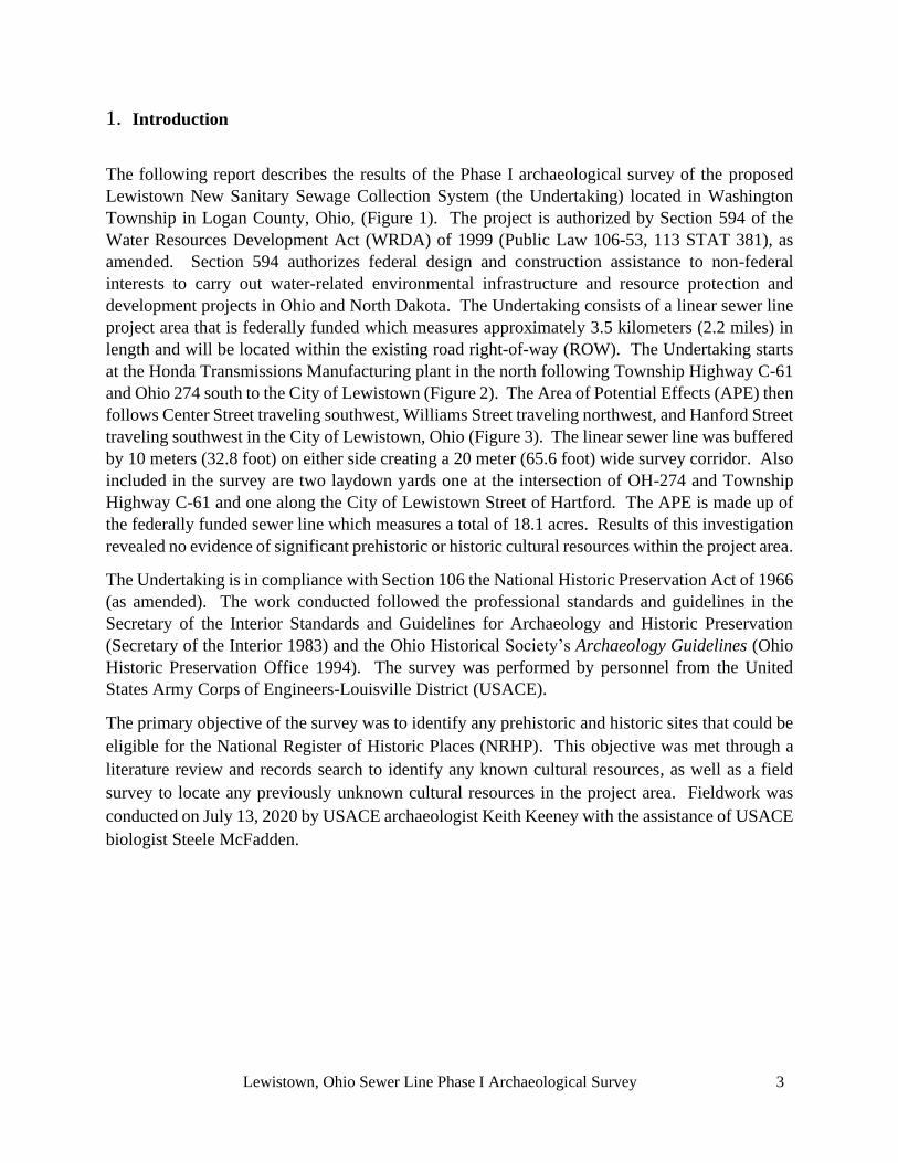
Lewistown, Ohio Sewer Line Phase I Archaeological Survey 3
1. Introduction
The following report describes the results of the Phase I archaeological survey of the proposed
Lewistown New Sanitary Sewage Collection System (the Undertaking) located in Washington
Township in Logan County, Ohio, (Figure 1). The project is authorized by Section 594 of the
Water Resources Development Act (WRDA) of 1999 (Public Law 106-53, 113 STAT 381), as
amended. Section 594 authorizes federal design and construction assistance to non-federal
interests to carry out water-related environmental infrastructure and resource protection and
development projects in Ohio and North Dakota. The Undertaking consists of a linear sewer line
project area that is federally funded which measures approximately 3.5 kilometers (2.2 miles) in
length and will be located within the existing road right-of-way (ROW). The Undertaking starts
at the Honda Transmissions Manufacturing plant in the north following Township Highway C-61
and Ohio 274 south to the City of Lewistown (Figure 2). The Area of Potential Effects (APE) then
follows Center Street traveling southwest, Williams Street traveling northwest, and Hanford Street
traveling southwest in the City of Lewistown, Ohio (Figure 3). The linear sewer line was buffered
by 10 meters (32.8 foot) on either side creating a 20 meter (65.6 foot) wide survey corridor. Also
included in the survey are two laydown yards one at the intersection of OH-274 and Township
Highway C-61 and one along the City of Lewistown Street of Hartford. The APE is made up of
the federally funded sewer line which measures a total of 18.1 acres. Results of this investigation
revealed no evidence of significant prehistoric or historic cultural resources within the project area.
The Undertaking is in compliance with Section 106 the National Historic Preservation Act of 1966
(as amended). The work conducted followed the professional standards and guidelines in the
Secretary of the Interior Standards and Guidelines for Archaeology and Historic Preservation
(Secretary of the Interior 1983) and the Ohio Historical Society’s Archaeology Guidelines (Ohio
Historic Preservation Office 1994). The survey was performed by personnel from the United
States Army Corps of Engineers-Louisville District (USACE).
The primary objective of the survey was to identify any prehistoric and historic sites that could be
eligible for the National Register of Historic Places (NRHP). This objective was met through a
literature review and records search to identify any known cultural resources, as well as a field
survey to locate any previously unknown cultural resources in the project area. Fieldwork was
conducted on July 13, 2020 by USACE archaeologist Keith Keeney with the assistance of USACE
biologist Steele McFadden.

Lewistown, Ohio Sewer Line Phase I Archaeological Survey 4
Figure 1: Lewistown New Sanitary Sewage General Location Map.

Lewistown, Ohio Sewer Line Phase I Archaeological Survey 5
Figure 2: Excerpt of Bellefontaine, OH Topographic map showing proposed sewer line path to
Lewistown, Ohio.
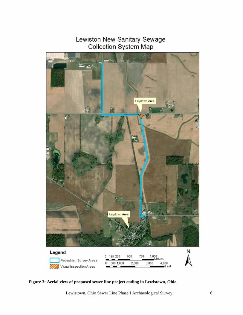
Lewistown, Ohio Sewer Line Phase I Archaeological Survey 6
Figure 3: Aerial view of proposed sewer line project ending in Lewistown, Ohio.

Lewistown, Ohio Sewer Line Phase I Archaeological Survey 7
2. Environmental Setting
2.1 General Project Area Description
Land use within the proposed sewer line consisted of existing highway ROW that shows prior
disturbance from above and below ground utility lines, residential construction projects, and
agricultural activities. General views of the project area are presented in Figures 4–8. Vegetation
within the project area consists of mowed grasses, secondary growth trees, corn, and soybeans.
The project area is in the Rennick Creek-Great Miami River watershed and is drained by Rennick
and Jordan Creeks (USGS 2020). Elevations range from between 1000 to 1020 feet Above Mean
Sea Level (AMSL).
2.2 Physiography
The project area lies within the Central Ohio Clayey Till Plain region of the Till Plains section of
the Central Lowland physiographic province. The Till Plains is characterized by areas of low relief
on broad till plains whose undulating surfaces are poorly drained (Brockman 1998). The bedrock
underlying the project area consists of Silurian shale and limestone of the Richmond and Maysville
group. Ordovician shale sand dolomite underlie the Silurian beds, and occasionally crop out
(Garner et al. 1978). The Ordovician Period began around 500 million years ago which caused
the Ohio landscape to be formed by the receding glacial formations. These sedimentary deposits
have been covered by Wisconsinan age glacial drift which includes sand and gravel, lake deposits,
and till-clay and pebble mixture.
2.3 Soils
The majority of the soils encountered within the project area consist of Minster silty clay loam 0-
1% slopes, Nappanee silt loam 2-6% slope, Latty silt clay, and Fulton silt loam 0-4% slope (USDA
WSS 2020). These soil profiles are generally characterized by silty clay loam, silt loam, and clay
horizons and range from somewhat poorly drained to very poorly drained.
2.4 Climate
The climate of Logan County is of the continental type, which can fluctuate between the seasons.
Summers are usually warm and humid, whereas winters are usually cold. The month of July is
recorded as having the highest average temperature for Logan County is 83 degrees Fahrenheit
with the low average falling in January at 33 degrees Fahrenheit. The average precipitation in the
area is 39.82 inches (US Climate Data 2020).

Lewistown, Ohio Sewer Line Phase I Archaeological Survey 8
Figure 4: View of proposed sewer line (in blue) along existing ROW showing utilities and ditch,
facing north.
Figure 5: View of proposed sewer line (in blue) along existing ROW showing utilities and ditch,
facing south.

Lewistown, Ohio Sewer Line Phase I Archaeological Survey 9
Figure 6: Left: View of proposed sewer line (in blue) as it passes the Lewistown Elevator (LOG-
210-16) on Township Highway C-61 facing south. Right: Historic 1989 Photo of Lewistown
Elevator showing the now demolished elevator.
Figure 7: Left: View of Rider Property (LOG-516-16) from the APE facing northeast. Right Top:
Barn at Rider Property. Right Bottom: Rider Property House

Lewistown, Ohio Sewer Line Phase I Archaeological Survey 10
Figure 8: View of corn field within the APE (in blue), facing north
2.5 Flora and Fauna
This information has been extracted/adapted from (Lewthwaite et al 1997), to provide a
background setting for the flora and fauna of the proposed project area.
Late Pleistocene and Holocene environmental profiles for the Ohio region are of a general nature
and apply to a large section of Eastern North America. Pollen profiles for areas in Indiana, Ohio,
Pennsylvania and New England indicate a relatively consistent climatic sequence across the
northeast (Bergman & Rue 1990). This sequence originated around 15,000 BC with a moist cool
climate. Between 9000 and 7000 BC a warming trend started, lasting until 2000 BC. This
warming trend initiated the northern advance of deciduous forests (Bergman & Rue 1990;
O’Malley 1984). Around 1000 BC the forests were dominated by the Oak-Chestnut climax forest
that are still prevalent in the eastern woodlands today (Bergman & Rue 1990).
Pleistocene fauna were significantly different from modern fauna. The project area supported
species such as ground sloths, mammoth (Mammuthus jeffersoni), mastodon (Mammut
americanus), and musk ox (Ovibos muschatos), as well as wapiti (Cervus sp.), caribou (Ragnifer
sp.), moose (Alces sp.), wolf (Canis lupus), and black bear (Ursus americanus) (Ball 1985;
Bergman & Rue 1990). With the retreat of the glaciers, the Pleistocene megafauna in the area
disappeared, with species such as the mastodon and mammoth becoming extinct, and the moose

Lewistown, Ohio Sewer Line Phase I Archaeological Survey 11
and wapiti migrating northward. Post-glacial animal species were probably similar to modern
types; the major differences being with population size and range (Ball 1985; O’Malley 1984).
3. Cultural Setting
Archaeologists have developed a general chronology for the Eastern United States that provides a
useful framework for organizing and describing archaeological data (Dragoo 1977; Griffin 1967;
Jennings 1974 and Keeney 2002). The cultural-historical sequence developed for the region is
generally divided into the following chronological periods: Paleo-Indian (12,800-8000 BC), Early
Archaic (8000-6000 BC), Middle Archaic (6000-3000 BC), Late Archaic (3000-600 BC), Early
Woodland (600-200 BC), Middle Woodland (200 BC- AD 500), Late Woodland (AD 500- 1000),
Fort Ancient (AD 1000-1750), and European contact and settlement covering more than 14,000
years of human adaptation and re-adaptation to a changing environment.
The prehistoric cultural sequence in Ohio reflects a general trend toward increasing socio-cultural
and technological complexity beginning with small mobile bands during the Palo-Indian period
that later developed into more sedentary, complex societies. The subsistence activities of the
earliest New World societies focused on hunting and gathering wild plant and animal foods. By
late prehistoric times, however, agricultural economies based on three major tropical cultigens-
corn, beans, and squash- were characteristic of many societies in the eastern United States.
Increases in the size and density of the human population and trends toward increasing sedentism
were also evident and reached their highest levels during the Fort Ancient period. In all, these
cultural trends are marked by stylistic differences in artifacts and correspond to major
technological innovations or important shifts in social, cultural, and subsistence adaptations (Ford
1977). However, there was considerable regional variation in the timing and extent to which these
trends were expressed.
4. Literature Review and Records Check
A background check utilizing multiple sources was conducted prior to initiating a field survey, the
sources consulted include: the online NRHP database, Ohio History Connection Online Mapping
System, USACE Geographic Information System (GIS), historic maps, and previous cultural
resources reports. These sources were utilized to identify NRHP-listed historic properties and
previously recorded archaeological sites and historic structures within a 1.6 kilometer (1 mile)
radius of the APE. The search of these sources showed that there were no archaeological sites or
historic structures directly within the APE. The search identified 88 archaeological sites and 16
structures recorded within the 1.6 kilometers (1 mile) buffer of the APE (Appendix A: Appendix
B). Most of the sites identified within the 1.6 kilometer (1 mile) buffer of the APE are located
near the summit of glacial moraines. There were two surveys previously completed within the
APE, Whitman et al. 1998 and Whitman et al. 1999 and an additional four archaeological surveys
were completed within the 1.6 kilometers (1 mile) of the project area (Addington 1986; Baker
1998; 2007; Sprague & Hunter 1993). A majority of the 88 sites located within the 1.6 kilometer
(1 mile) radius of the APE were recorded during a 1997-1998 archaeological survey conducted by
ASC Group, Inc. for a proposed improvement of Highway US-33 in Auglaize, Logan, and Shelby

Lewistown, Ohio Sewer Line Phase I Archaeological Survey 12
counties in Ohio (Whitman et al. 1998; 1999). The survey area from the 1997-1998 survey
included multiple proposed options for the road alignment. The 1997-1998 survey identified 438
prehistoric concentrations, 93 historic sites, and 37 multicomponent prehistoric/historic sites
(Whitman et al. 1999). The historic structures mapped within the APE on the 1913 USGS
Topographic map and the 1875 plat map appear to still be extant or have newer structures built in
the same locations (Figures 9–10). None of the historic maps show any structures within the
boundaries of the APE.
Figure 9: Excerpt of the 1913 Bellefontaine, Ohio topographic map showing location of proposed
sewer line (in blue) (USGS 2020).

Lewistown, Ohio Sewer Line Phase I Archaeological Survey 13
Figure 10: Excerpt of Logan County, Ohio plat map from 1875 showing location of proposed sewer
line (in blue) (Washington Township 1875).

Lewistown, Ohio Sewer Line Phase I Archaeological Survey 14
5. Field Methods
The goal of the Phase I archaeological survey was to identify all cultural resources within the APE
and to evaluate their potential for inclusion in the NRHP. The specific methods used to conduct
the survey are outlined below.
The survey closely followed all guidelines for Phase I archaeological investigations as defined in
the Archaeology Guidelines issued by the Ohio Historic Preservation Office (1994). The survey
of the APE included a systematic pedestrian examination of areas on both sides of the road ROW.
The pedestrian survey included areas of prior disturbance and those with exposed ground surfaces
with a visibility of at least 40 percent. Pedestrian survey transects were spaced no more than 5
meters (16.4 feet) apart. Developed or disturbed areas within the APE were visually inspected and
recorded, but not shovel tested (Figures 11–13).
6. Survey Results
The entire APE was subjected to a pedestrian survey and visual inspection. The APE consisted of
fields planted in soybeans with 40-75% visibility, corn with 80-100% visibility, and previously
disturbed areas with 0-20% visibility (Figures 11–13). The survey located no sites or artifacts
within the APE.
7. Conclusions and Recommendations
A Phase I archaeological survey of the proposed sewer line for the City of Lewistown revealed no
evidence of significant prehistoric sites. There were two historic structures mapped near the APE,
however, the visual effects of the sewer construction will be temporary. Given the negative results
of the archaeological survey and temporary visual effects, the proposed undertaking is considered
to have no effect to cultural resources eligible for listing to the NRHP (36CFR part 800.4 (d)(1)).
Therefore USACE has made the determination that no additional cultural resource surveys are
needed for the Lewistown New Sanitary Sewage Collection System project.

Lewistown, Ohio Sewer Line Phase I Archaeological Survey 15
Figure 11: Aerial view showing pedestrian survey areas and disturbed areas visually inspected near
the south end of the APE.

Lewistown, Ohio Sewer Line Phase I Archaeological Survey 16
Figure 12: Map of buried utilities at the intersection of OH-274 and Township Highway 61.

Lewistown, Ohio Sewer Line Phase I Archaeological Survey 17
Figure 13: Map of buried utilities near the south end of the APE.

Lewistown, Ohio Sewer Line Phase I Archaeological Survey 18
Appendix A: Previously recorded sites within a 1.6km (1mile) radius of the APE.
OAI NUMBER AFFILIATION SITE AREA
33LO0073 Historic 495
33LO0202 Prehistoric and
Historic
2600
33LO0273 Prehistoric 100
33LO0274 Prehistoric 3000
33LO0275 Prehistoric 7800
33LO0276 Prehistoric Isolated
33LO0277 Prehistoric 3200
33LO0278 Prehistoric 1200
33LO0279 Prehistoric Isolated
33LO0280 Prehistoric 3500
33LO0281 Prehistoric Isolated
33LO0282 Prehistoric 2500
33LO0283 Prehistoric 900
33LO0284 Prehistoric 150
33LO0285 Prehistoric 375
33LO0286 Prehistoric Isolated
33LO0287 Prehistoric 3500
33LO0288 Historic 3500
33LO0289 Prehistoric 2500
33LO0290 Prehistoric and
Historic
1200
33LO0291 Prehistoric 1600
33LO0292 Prehistoric Isolated
33LO0293 Prehistoric 1500
33LO0433 Prehistoric 100
33LO0434 Prehistoric 625
33LO0435 Prehistoric 25
33LO0436 Prehistoric and
Historic
4800
33LO0437 Prehistoric Isolated
33LO0438 Prehistoric 150
33LO0439 Prehistoric 3000
33LO0440 Prehistoric Isolated
33LO0441 Prehistoric 100
33LO0442 Prehistoric Isolated
33LO0443 Prehistoric 400
33LO0444 Prehistoric Isolated
33LO0445 Prehistoric Isolated
33LO0446 Prehistoric Isolated
33LO0447 Prehistoric Isolated
33LO0448 Prehistoric Isolated
33LO0449 Prehistoric Isolated
33LO0450 Prehistoric Isolated
33LO0451 Prehistoric 1600
33LO0452 Prehistoric Isolated
33LO0453 Prehistoric 1200
33LO0454 Prehistoric 50
33LO0455 Prehistoric 3600
33LO0456 Prehistoric 500
33LO0457 Prehistoric Isolated
33LO0458 Prehistoric 200
33LO0459 Prehistoric Isolated
33LO0460 Prehistoric 100
33LO0461 Prehistoric Isolated
33LO0462 Prehistoric Isolated
33LO0463 Prehistoric Isolated
33LO0464 Prehistoric Isolated
33LO0465 Prehistoric Isolated
33LO0466 Prehistoric Isolated
33LO0467 Prehistoric Isolated
33LO0468 Historic 1500
33LO0469 Prehistoric 2400
33LO0470 Prehistoric 625
33LO0471 Prehistoric 750
33LO0472 Prehistoric Isolated
33LO0473 Prehistoric 200
33LO0474 Prehistoric 100
33LO0475 Prehistoric Isolated
33LO0476 Prehistoric 750
33LO0477 Prehistoric Isolated
33LO0478 Prehistoric Isolated
33LO0479 Prehistoric Isolated
33LO0480 Prehistoric 600
33LO0481 Prehistoric 225
33LO0482 Prehistoric 250
33LO0483 Prehistoric Isolated
33LO0484 Prehistoric Isolated
33LO0485 Prehistoric Isolated
33LO0486 Prehistoric 800
33LO0487 Prehistoric 100
33LO0488 Prehistoric 200
33LO0490 Prehistoric Isolated
33LO0491 Historic 3500
33LO0492 Prehistoric Isolated
33LO0493 Prehistoric Isolated
33LO0494 Prehistoric and
Historic
2000
33LO0495 Prehistoric Isolated
33LO0541 Prehistoric Isolated
33LO0542 Prehistoric Isolated
33LO0589 Prehistoric Isolated
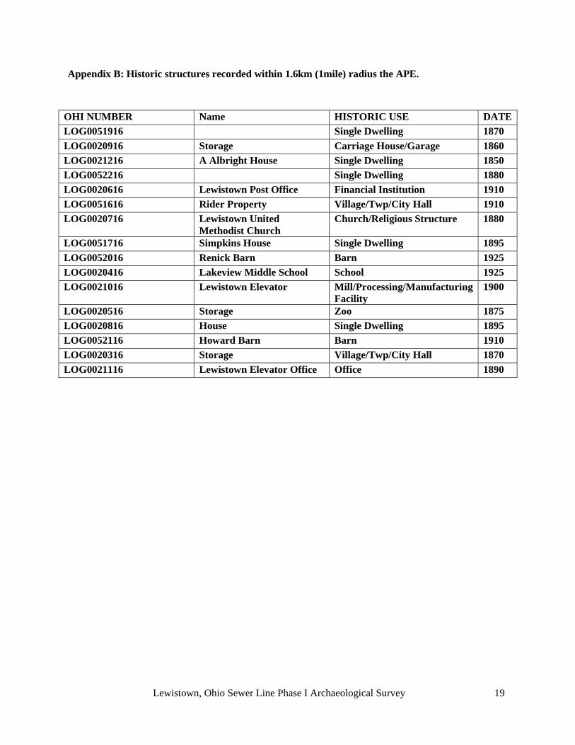
Lewistown, Ohio Sewer Line Phase I Archaeological Survey 19
Appendix B: Historic structures recorded within 1.6km (1mile) radius the APE.
OHI NUMBER Name HISTORIC USE DATE
LOG0051916
Single Dwelling 1870
LOG0020916 Storage Carriage House/Garage 1860
LOG0021216 A Albright House Single Dwelling 1850
LOG0052216
Single Dwelling 1880
LOG0020616 Lewistown Post Office Financial Institution 1910
LOG0051616 Rider Property Village/Twp/City Hall 1910
LOG0020716 Lewistown United
Methodist Church
Church/Religious Structure 1880
LOG0051716 Simpkins House Single Dwelling 1895
LOG0052016 Renick Barn Barn 1925
LOG0020416 Lakeview Middle School School 1925
LOG0021016 Lewistown Elevator Mill/Processing/Manufacturing
Facility
1900
LOG0020516 Storage Zoo 1875
LOG0020816 House Single Dwelling 1895
LOG0052116 Howard Barn Barn 1910
LOG0020316 Storage Village/Twp/City Hall 1870
LOG0021116 Lewistown Elevator Office Office 1890

Lewistown, Ohio Sewer Line Phase I Archaeological Survey 20
8. References Cited
Addington, J. E.
1986 Preliminary Archaeological Assessment of the Proposed Intersection Reconstruction and
Realignment of S.R. 708, Logan County, Ohio: Log-235/708-15.11/0.00 (P.F. 1143). Ohio
Department of Transportation, Columbus, Ohio.
Baker, S. W.
2007 Phase I Cultural Resource Investigations for the Proposed SR-708 Lakeview Outpost (PID 82604)
Project, Washington Township, Logan County, Ohio- Short Report Format. On file at the Ohio
Historical Society.
1998 Phase I Cultural Resource Investigations for the Proposed SR-708 Lakeview Outpost (PID 82604)
Project, Washington Township, Logan County, Ohio- Short Report Format. On file at the Ohio
Historical Society.
Brockman, C. S.
1998 Physiographic Regions of Ohio. Division of Geological Survey, Department of Natural Resources.
Columbus, Ohio.
Ford, R.I
1977 Evolutionary Ecology and the Evolution of Human Ecosystems: A Case Study from the
Midwestern U.S.A. In Explanation of Prehistoric Change, edited by James N. Hill, pp. 153-
184. University of New Mexico Press, Albuquerque.
Garner, D.E., A. Ritchie, and V.L. Siegenthaler
1978 Soil Survey of Greene County, Ohio. United State Department of Agriculture, Soil Conservation
Service.
Griffin, J.B.
1967 Eastern North American Archaeology: A Summary. Science 156: 175-191
Jennings, J.D.
1974 Prehistory of North America. McGraw-Hill Book Company, New York.
Keeney, K.A
2002 A Phase I Cultural Resources Survey of a Proposed Handicapped Accessible Picnic and
Recreational Area at Saddle Dam, William H. Harsha Lake, Clermont County, Ohio. Louisville
District Army Corps of Engineers, Louisville, KY.
Ohio Historic Preservation Office
1994 Archaeology Guidelines. Ohio Historic Society. Columbus, Ohio.
O’Malley, N.
1984 Cultural Resources Reconnaissance of Fort Campbell, Kentucky-Tennessee. Survey submitted to
the Fort Campbell Archaeologists.
Secretary of the Interior

Lewistown, Ohio Sewer Line Phase I Archaeological Survey 21
1983 Standards and Guidelines for Archaeological and Historic Preservation. Federal Register, Vol.
48, No. 190.
Sprague, R.N. & W.M. Hunter
1993 Literature Review and Reconnaissance Survey of Four Areas to be Impacted By Proposed Water
System Improvements in Russells Point, Washington Township, Logan County, Ohio. Report
prepared ASC Group, Inc. Columbus, Ohio.
Washington Township
1875 Combination Atlas Map of Logan County Ohio D.J. Stewart Philadelphia PA
Whitman, L.G., C. Mustain, F. Church, N. Young, J. Volsvick, D. Walter, & A. Cramb
1998 Volume 1: Phase I Literature Review, Predictive Model, and Archaeological Cultural Resource
Survey for the AUG/LOG-33-26.875/0.00; (PID 16385) Project in Multiple Townships in
Auglaize, Logan and Shelby Counties, Ohio. Report prepared ASC Group, Inc. Columbus, Ohio.
Whitman, L. G., N. Young, & D. Dobson-Brown
1999 Addendum to Phase I Literature Review, Predictive Model, Archaeological and Architectural
Cultural Resource Survey for the AUG/LOG-33-26.875/0.00; (PID 16385) Project (in Multiple
Townships) in Auglaize, Logan and Shelby Counties, Ohio. Report prepared ASC Group, Inc.
Columbus, Ohio.
US Climate Data
2020 Climate Dayton - Ohio. U.S. Climate Data Temperate – Precipitation – Sunshine – Snowfall.
Located online at: https://www.usclimatedata.com/climate/bellefontaine/ohio/united-
states/usoh0070. Site accessed August 7, 2020
United States Department of Agriculture Web Soil Survey (USDA WSS)
2020 Web Soil Survey Logan County, Ohio. Web Soil Survey Viewer. Located online at:
https://websoilsurvey.sc.egov.usda.gov/App/WebSoilSurvey.aspx. Site accessed August 7, 2020
United States Geologic Survey (USGS)
2020 The National Map. Web Map Viewer. Located online at:
https://viewer.nationalmap.gov/advanced-viewer/ Site accessed August 7, 2020

In reply, refer to
2020-LOG-50019 November 18, 2020 Montana Martin U.S. Army Corps of Engineers 600 Dr. Martin Luther King Jr. Pl Louisville, KY 40202 [email protected] RE: Lewistown New Sanitary Sewage Collection System, Lewistown, Logan County, Ohio Dear Mr. Martin: This is in response to the correspondence, received electronically on November 10, 2020, regarding the proposed Lewistown New Sanitary Sewage Collection System, Lewistown, Logan County, Ohio. We appreciate the opportunity to comment on this project. The comments of the Ohio State Historic Preservation Office (SHPO) are submitted in accordance with the provisions of Section 106 of the National Historic Preservation Act of 1966, as amended (16 U.S.C.470 [36 CFR 800]). The following comments pertain to the Phase I Archaeological Survey of the Lewistown New Sanitary Sewage Collection System in Lewistown, Ohio by Montana Martin (U.S. Army Corps of Engineers, Louisville District, 2020). A literature review, visual inspection, and surface collection was completed as part of the investigations. No previously identified archaeological sites are located within the project area, however, a number of sites are located immediately adjacent to the project area. No new archaeological sites were identified during the survey. Our office agrees no further archaeological survey is necessary. Our office would like to request, for all future survey projects completed by U.S. Army Corps of Engineers, that proper History/Architecture Survey also take place for the proposed undertaking. You can find our Guidelines for Conducting History/Architecture Surveys in Ohio on our website: https://www.ohiohistory.org/OHC/media/OHC-Media/Documents/Guidelines-for-Conducting-History_Architecture-Surveys-in-Ohio.pdf Based on the information provided, we agree that the project as proposed will have no effect on historic properties. No further coordination with this office is necessary, unless the project changes or unless new or additional historic properties are discovered during implementation of this project. In such a situation, this office should be contacted. If you have any questions, please contact me at (614) 298-2022, or by e-mail at [email protected], or Diana Welling at [email protected]. Thank you for your cooperation. Sincerely,
Krista Horrocks, Project Reviews Manager Resource Protection and Review
RPR Serial No: 1086254

Appendix D
Agency and Tribal Correspondence

The Delaware Nation Historic Preservation Department 31064 State Highway 281
Anadarko, OK 73005
Phone (405)247-2448
November 13, 2020
To Whom It May Concern:
The Delaware Nation Historic Preservation Department received correspondence regarding the
following referenced project(s).
Project(s): Lewistown New Sanitary Sewage Collection System, Lewistown, Ohio
Our office is committed to protecting tribal heritage, culture and religion with particular concern
for archaeological sites potentially containing burials and associated funerary objects.
The Lenape people occupied the area indicated in your letter prior to European contact until their
eventual removal to our present locations. According to our files, the location of the proposed
project does not endanger cultural, or religious sites of interest to the Delaware Nation. Please
continue with the project as planned keeping in mind during construction should an
archaeological site or artifacts inadvertently be uncovered, all construction and ground disturbing
activities should immediately be halted until the appropriate state agencies, as well as this office,
are notified (within 24 hours), and a proper archaeological assessment can be made.
Please note the Delaware Nation, the Delaware Tribe of Indians, and the Stockbridge Munsee
Band of Mohican Indians are the only Federally Recognized Delaware/Lenape entities in the
United States and consultation must be made only with designated staff of these three tribes. We
appreciate your cooperation in contacting the Delaware Nation Historic Preservation Office to
conduct proper Section 106 consultation. Should you have any questions, feel free to contact our
offices at 405-247-2448 ext. 1403.
Erin Paden
Director of Historic Preservation
Delaware Nation
31064 State Highway 281
Anadarko, OK 73005
Ph. 405-247-2448 ext. 1403
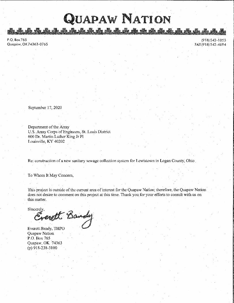

October 9, 2020 Steele McFadden USACE Louisville P.O. Box 59 Louisville, KY 40201-0059 Re: THPO Response to consultation Dear Mr. McFadden: As the Tribal Historic Preservation Officer (THPO), we have received your request for consultation regarding the proposed undertaking in Logan County, OH. At this time, we are not providing comments. We have not identified any information concerning the presence of any cultural resources significant to the Match-E-Be-Nash-She-Wish Band of Pottawatomi Indians within the Area of Potential Effect (APE). This is not to say that such a site may not exist, just that this office does not have any available information of the area(s) at this time. However, in the event that a discovery of artifacts, human remains, or funerary objects are found, we request to be notified within 10 days. At that time, the Tribe will determine if further consultation is necessary. Thank you, Lakota Pochedley THPO 2872 Mission Dr. Shelbyville, Michigan 49344 [email protected] Phone: (269) 397-1780

1
Martin, Montana LRL
From: Martin, Montana LRLSent: Thursday, October 8, 2020 1:05 PMTo: Guffey, Jennifer M CIV USARMY CELRL (USA)Subject: REview of response. Lewistown Environmental Infrastructure ProjectAttachments: Bad River N.pdf; Bad River E.pdf; Bad River S.pdf; Response Bad River Overview.pdf; Lewiston Sites.csv
Edith, Thank you for your response. Attached are an Overview Map, 3 zoomed maps, and an Excel Spreadsheet listing the archaeological sites within the 1 mile radius of the project. In the Excel spreadsheet you will find information regarding the cultural affiliation as well as further information, below I have listed the sites with known affiliations. Paleolithic‐ Lo‐ 275 Early Archaic‐ Lo‐542 Late Archaic‐ Lo‐ 277, 293, 469, & 541 Late Woodland‐ Lo‐ 459 Late Prehistoric‐ Lo‐ 282 Historic‐ Lo‐ 73, 288, 468, & 491 If you need any further information please let me know. Thanks again, Montana Martin Archaeologist Civil Works ‐ Planning, Programs, and Project Management Branch US Army Corps of Engineers Louisville District PO Box 59 Louisville, KY. 40201‐0059 Office Phone: 502‐315‐7433 ‐‐‐‐‐Original Message‐‐‐‐‐ From: Guffey, Jennifer M CIV USARMY CELRL (USA) <[email protected]> Sent: Thursday, October 8, 2020 8:42 AM To: Martin, Montana LRL <[email protected]> Subject: RE: Lewistown Environmental Infrastructure Project No they want to know about all the archaeological sites near the project. This could include burials, but other objects of antiquity that would be considered sacred to the tribes. So you need to break down what each site is, meaning what is the cultural affiliation of the site if known. Develop a table of the sites to provide to the tribes. Keep in mind the table will need to be reviewed before it is sent to the tribe. Hope this helps. Jennifer Jennifer Guffey Archaeologist & Tribal Liaison Planning Section,

2
Civil Works, Planning, Programs and Project Mgmt Branch Louisville District U.S.Army Corps of Engineers Office Phone‐ 502.315.7468 Office Fax‐ 502.315.6864 ‐‐‐‐‐Original Message‐‐‐‐‐ From: Martin, Montana LRL Sent: Thursday, October 08, 2020 8:07 AM To: Guffey, Jennifer M CIV USARMY CELRL (USA) <[email protected]> Subject: FW: Lewistown Environmental Infrastructure Project “Findings of our Ancestors”? I assume by the context this means they want to know about burials? From: Edith Leoso <THPO@badriver‐nsn.gov> Sent: Wednesday, October 7, 2020 5:43 PM To: Martin, Montana LRL <[email protected]> Subject: [Non‐DoD Source] RE: Lewistown Environmental Infrastructure Project Boozhoo (Hello), I have reviewed the information provided and would like to see a map of the 88 archeological sites determined to be within 1‐mile of the APE. Also, if you could provide, via email, some context about the nearest archeological site to the APE, including, if any of those sites resulted in findings of our Ancestors. It will be most appreciated. The reason for this is that there is a waterway in close proximity to the APE. Most ancient burials are found near waterways, which corresponds with our Traditional teachings. Miigwech (Thanks), Edith Leoso Bad River Band of Lake Superior Tribe of Chippewa Tribal Historic Preservation Officer P.O. Box 39 Odanah, WI 54861 thpo@badriver‐nsn.gov <mailto:thpo@badriver‐nsn.gov>

3
Office: (715) 682‐7123, x 1662 Remote/cell: (715) 292‐8286 From: Martin, Montana LRL <[email protected] <mailto:[email protected]> > Sent: Wednesday, October 7, 2020 10:56 AM To: Edith Leoso <THPO@badriver‐nsn.gov <mailto:THPO@badriver‐nsn.gov> > Subject: Lewistown Environmental Infrastructure Project Good afternoon, The Louisville District Corps of Engineers, Planning Branch, is coordinating the archaeological report Archaeological Records Review and Phase Ia Field Reconnaissance for the report titled “Phase I Archaeological Survey of the Lewistown New Sanitary Sewage Collection System in Lewistown, Ohio.” We are inviting you to consult under Section 106 with our finding of No Properties on or eligible for the NRHP will be effected. Therefore the Corps in accordance with 36CFR8004(d)(1) of the NHPA, has reached a determination of no effect. We are asking for your concurrence with this determination. Enclosed is the consultation letter and archaeological report for your review. Please let me know if you have any trouble opening the attachment or if you would like a paper copy. I look forward to your comments. Thank you! Montana Martin Archaeologist Civil Works ‐ Planning, Programs, and Project Management Branch US Army Corps of Engineers Louisville District PO Box 59 Louisville, KY. 40201‐0059 Office Phone: 502‐315‐7433