Draft, "Environmental Assessment Proposed Mother Lode ...
274
DRAFT ENVIRONMENTAL ASSESSMENT PROPOSED MOTHER LODE PROJECT Prepared by Bureau of Land Management Battle Mountain District Tonopah Resource Area Tonopah, Nevada With the Assistance of ENSR Consulting and Engineering Alameda, California May 1989 ENPG¶ 910()3130148 8(90531 PEIR WASTE PDR WM-:3PE 0 e0 c A etpc a @e-tPkt£, fh"Ecus Cu\ dz /0 lc5 ,163
-
Upload
khangminh22 -
Category
Documents
-
view
1 -
download
0
Transcript of Draft, "Environmental Assessment Proposed Mother Lode ...
DRAFT
ENVIRONMENTAL ASSESSMENTPROPOSED MOTHER LODE PROJECT
Prepared by
Bureau of Land ManagementBattle Mountain DistrictTonopah Resource Area
Tonopah, Nevada
With the Assistance of
ENSR Consulting and EngineeringAlameda, California
May 1989
ENPG¶910()3130148 8(90531PEIR WASTE PDRWM-:3PE 0e0 c A etpc a @e-tPkt£,
fh"Ecus Cu\ dz
/0 lc5
,163

DRAFTENVIRONMENTAL ASSESSMENT
PROPOSED MOTHER LODE PROJECT
Prepared byU.S. DEPARTMENT OF THE INTERIOR
Bureau of Land ManagementBattle Mountain DistrictTonopah Resource Area
Tonopah, Nevada
With the Assistance ofENSR Consulting and Engineering
1320 Harbor Bay ParkwayAlameda, California 94501
6bsrac: This Draft Environmental Assessment (EA) documents the environmental analysis ofthe Mother Lode Project, a precious metals extraction operation proposed by the U.S. NevadaGold Search Joint Venture (USNGS) in southern Nye County, Nevada. The project would involvethe construction, operation, and abandonment of an open-pit mine and processing facilities or
public land administered by the Bureau of Land Management (BLM). The proposed project is
described in a Plan of Operations submitted to the BLM Tonopah Resource Area, BanloMountain Districr, which Is responsible fo! reviewing the plan to determine compliance with BLM
: ioveming surface mining under the Genoral Mining Laws (43 CFR 3809) and theimplementing regulations (40 CFR 1505) of the National Envtionmental Policy Act (NEPA). Aspart of BLM's review process, this EA describes the projected Impacts of the proposed miningoperation on the natural and human environment. Based on public Input and the design of theproposed facilities, the analysis emphasizes the following affected resources: air quality;groundwater and surface water quantity and quality; soils and reclamation potential; vegetation
and wildlife; cultural resources; socioaconomics and community resources; and aesthetics. Theanalysis considers the No Action Alternative and two facility location atematives.

eublic Mget: A public meeting will be held at the Beatty Community Center in Beatty, Nevada
on Thursday, June 1, 1989 at 7:00 p.m. to allow the public to provide oral comment on the
adequacy, completeness, or accuracy of :he Draft EA.
EA -Cmcut: This Draft EA Is being circulated for public and agency review. Questions and
comments should be addressed to the contact Identified below by June 16, 1989.
Mr. Theodore AngleArea ManagerBureau of Land ManagementP.O. Box 911Building 102 Military CircleTonopah, NV 89049(702) 482-6214
II

SUMMARY
Introduction
This Environmental Assessment (EA) documents the conclusions of environmental analyses of
the proposed Mother Lode Project, a precious metals mining and processing operation near
Beatty In southern Nye County, Nevada. The proposed project would involve the construction,
operation, and abandonment of facilities for extracting and processing gold ore.
U.S. Nevada Gold Search Joint Venture (USNGS) proposes to mine approximately 600,000
tons of ore per year. At this mining rate, gold production is estimated at approximately 25.000
ounces of gold per year. The project would have an estimated 2-year life of operation, based
on current estimates of potential reserves.
Major project facilities would include an open pit: waste rock disposal area; stockpile areas for
topsoil and sulfide ore; leach pads: and ancillary support buildings (maintenance shop and
trailers, office, laboratory, and recovery building). The surface disturbance would total
approximately 75 acres of public land.
Alternatives to the proposed action are analyzed in the EA. Alternatives considered in detail in
the analysis include the No Action Alternative and two facility location alternatives. An alternative
of backfilling the open pH was initially considered but was subsequently eliminated from detailed
analysis in the EA for a combination of economic, technical, and environmental reasons (see
Section 1.5).
Public Involvement
A public scoping process was conducted prior to preparation of the EA In order to solicit public
Input on the important Issues and concems associated with the proposed project. This process
Included mailings of public scoping documents to agencies, organizations, and individuals: a
public meeting in Beatty; a 30-day written comment period; and meetings with local, state, and
federal governmental officials and representatives of community services. The scoping process
identified the following environmental resources for analysis in the EA:
III
* Water Resources* Socloeconomics* Air Quallty* Wildlife
Cultural Resources* Visual Resources
Summary of Prolect Imcacts
The Mother Lode Project would result in impacts to ecological resources in the project area,
Including wildllfe and vegetation. Impacts to human resources would Include visual impacts
and both beneficial and adverse socioeconomic impacts. The proposed development wouldoccur In a region In which mining is an Important and acceptable land use; with theimplementation of project alternatives and recommended mitigation measures, projected impacts
for the Mother Lode Project are not judged to be significant. Specific impact conclusions for
affected resources are summarized below.
The proposed project would meet the standards of BLM regulations governing surface
management of public lands under the General Mining Laws (43 CFR 3809). Implementationof the project as descnbed in USNGS Plan of Operations, including mitigation measuresidentified in the EA, would not result in the undue or unnecessary degradation of public lands.
Air Resources
The proposed project would generate air pollutant emissions and result In increased levels of
particulate and other pollutants in the atmosphere around the project. However, projected
emissions are predicted to be very small and would meet applicable State of Nevada air qualitystandards. Air pollutant emissions and control technologies are subject to review and approvalby the Nevada Division of Environmental Protection (NDEP). Permit applications have been
submitted by USNGS.
Geology and Mineral Resources
The proposed project would extract economically viable gold reserves. It would not interfere
with future resource recovery efforts except in very limited areas. Proposed designs for the
iv

mine and other facilities recognize and account for seismic and other geologic hazards in the
area.
Water Resources
No long-term adverse impacts to groundwater quantity or quality are anticipated. The proposedgroundwater monitoring program is designed to mitigate potential Impacts of groundwaterwithdrawal.
There are no perennial streams on the project site; no adverse impacts to surface water wouldoccur from the proposed project.
Soils
Construction and operation of the proposed project would disturb approximately 75 acres ofsoil resources. Loss of soil resources would result from accelerated water and wind erosionand buried suitable topsoil material. Topsoiling and revegetation would reduce the long-termimpacts associated with soil erosion by increasing revegetation potential and promoting long-term stabilization of treated areas.
Vegetation
Impacts associated with the proposed project would include vegetation removal and loss orreduction of plant productivity. Approximately 75 acres across two vegetation types would be
affected by construction activities. The project would result in the loss of approximately 2 AUMsof grazing preference. This would not represent a significant impact to livestock grazing in thisarea.
Vegetation cover and productivity would gradually be restored on disturbed areas followingreclamation and revegetation.
v

Wildlife
The proposed project would affect local populations of small mammals, songbirds, and reptiles.
No major impacts to other wildlife species or regional wildlife populations would be expected.
Approximately 75 acres of wildlife habitat would be impacted resulting in loss of prey species
which would affect local populations of area predators and raptors. Habitat would be restored
following project abandonment with revegetation of disturbed areas. Impacts of habitat loss tobig game species would be minimal. No impacts to federal or state-listed threatened or
endangered wildlife species are expected to occur. Crucial habitat for the desert tortoise does
not occur in the project region.
Potential impacts to waterfowl and other wildlife species resulting from cyanide poisoning at
the heap leach solution ponds is a concern. USNGS has committed to netting and fencing the
ponds to mitigate impacts to waterfowl and other wildlife.
Land Use and Recreation
LAnd Use. The mining and processing operation would be consistent with federal and Nye
County land use plans for the area and would be compatible with surrounding land uses.Approximately 2 AUMs of grazing would be lost. This would not be a significant amount. Post-
mining land use would return to rangeland/wildlife habi:at for the portion cf the site exc!udirg
the open pit.
The proposed project is located within the Bullfrog Herd Management Area for wild horses and
burros. Open water would attract these animals: however, fencing should eliminate potential
impacts.
Recreation. The proposed project would not significantly impact dispersed recreation on public
lands. The existing use is light, and the region has abundant acreage of public open-space
lands.
vi

Aesthetics
Visual Resources. The proposed project would introduce high levels of visual change; however,
the visual contrast would not exceed acceptable levels in an area designated for activities which
require major modification of the existing visual conditions. The visual effects of the project
would be reduced by application of mitigation measures designed to reduce the visual contrast
of the Mother Lode mine and waste disposal area.
Noise. The nearest sensitive receptor is over 4 miles from the project site. Noise from general
operation of the Mother Lode Project would rarely, if ever, be perceptible at these sensitive
receptors.
Socloeconomics
Population. The proposed project (including workers and their families) would increase area
population by approximately 93 to 128 people during peak construction activity, by 61 to 85
persons during the overall 1989 construction period, and by more than 125 during project
operations. These increases would generate the beneficial and adverse effects described below.
Economy. The proposed project would reinforce the mining industry in Nye County. The
project would increase employment in Nye County. Nye County would experience an increase
in revenues from property, net proceeds. and sales taxes directly paid by USNGS and indirectly
from mine workers who own property and spend their earnings in the local communities.
Community facilities and services could improve due to the increased population base, if new
revenues are allocated for community facilities such as parks and recreation, library, schools,
and road improvements.
Employment. Nye County mining employment would increase moderately, generating minor
secondary employment increases in other sectors of the economy. The greatest employment
increase would be a total of 89 direct and indirect employees during the peak construction
activity during the third quarter of 1989. During operations, 45 permanent workers would be
added at the project and an estimated 9 jobs would be created in other sectors.
vii

FIscal Effects. During the 2- to 3-month construction period, the project would result in short.
term, negative net fiscal effects on public service providers faced with an increased demand
for services. Over the long term (during operations) increased property tax, sales tax, and net
proceeds tax revenues would provide positive net fiscal effects for Beatty and Nye County.
Housing. The proposed project would generate an increase in demand for short-term rental
housing during construction that would exceed the available supply in the Beatty area. Over the
longer term operations period, USNGS would provide housing for their operations workfcrce.
Public FacilIties and Services. The construction and operations phases of the project would
intensity existing water supply and sewage problems in Beatty. A pipeline (which USNGS is
providing) and a transmission line are required for the water supply system. An additional rapid
infiltration bed, required to meet existing sewer system needs, is projected to begin operation
in summer 1989. The capacity of these services must be increased to serve the project-related
demand for these services.
The proposed project would increase school enrollment during operations by approximately
67 children in Beatty and exceed capacity in grades 1-8 until new classrooms become available
in fall 1989. Service agencies may face short-term increases in demand with no commensurate
increase in staff or resources. The Beatty Medical C'inic and the sherifs department would
require additional staff to serve the increased population associated with operations. The
demand on the fire department and social services may also require increased staff. USNGS
has committed to providing a helipad at the Medical Clinic and a part-time librarian to help otfset
the impacts on public facilities and services.
Community recreation facilities in Beatty, particularly the ballfields and pool, are already at
capacity; therefore, the increased population associated with the proposed project would further
affect these resources.
Transportation
Truck traffic to the project would be minimal and would not be expected to affect traffic or road
conditions to any measurable degree. The proposed project would increase traffic levels in the
site vicinity, particularsy during peak hours at shift t'ange times. The resufting traffic levels
viii

would be well below highway capacities, however, and would not signIficantly reduce current
levels of service.
Summary of Cumulative imgacts
The BLM conducted a cumulative impact assessment to determine potential impacts associated
with the Mother Lode Project aid other 'reasonably foreseeable future actions' (40 CFR 1508.7).A discussion of the analysis Is presented in Chapter 4 of this EA. The assessment Identified the
following potential cumulative impacts.
Air Resources
No significant cumulative air quality Impacts are projected to occur from the Mother Lode
Project. Particulate emissions would be highest in the immediate vicinity of each project and
would not result in cumulative air quality impacts.
Water Resources
Significant cumulative water resource impacts are not projected for the Mother Lode Projecttogether with other potentially Interrelated projects due to the presence of hydrologic boundarieswhich separate the groundwater source for the Mother Lode Project from the aquifers used to
supply water for the other projects. In addition, the estimated radius of the drawdown from
groundwater pumping of each of the interrelated projects would not Intersect one another.
Operation of the projects would not be expected to cause cumulative water resource Impactsto sensitive areas such as the Ash Meadows springs, Devils Hole, local springs In Oasis Valley,
springs near the Park Headquarters In Death Valley National Monument, or the Town of Beatly
municipal water supply.
Vegetation and Wildlife
No significant cumulative Impacts are anticipated to vegetation and wildlife. Vegetation andwildlife habitat loss would be short-term and, wtth the exception of the open pits, the habitat
would be reclaimed following completion of mining activities. Potential adverse impacts of
IX

cyanide-laden waters to waterfowi and other wildlife would be mitigated by making these areas
unavailable to wildlife, in compliance with Nevada Oepartment of Wildlife permit stipulations.
Land Use and Recreation
Impacts to land use and dispersed recreation on putlic lands would be site-specific and not
Interrelated with the Mother Lode Project. There is abundant open-space land available in the
region.
Socioeconomics
The increase in population associated with the interrelated projects would result in cumulative
socioeconomic Impacts in the Beatty area. Short-term adverse fiscal impacts are anticipated
due to the immediate need for increased public services prior to the arrival of increased tax
revenues.
Housing demand is expected to exceed the available supply of housing during both the
construction and operation phases of the interrelated projects. Bond Gold and USNGS would
both provide housing for operations employees to help offset these impacts.
Public services and facilities anticipated to be Impacted by development of the interrelated
projects include:
* Police and fire protection* Judicial system* Medical services* Schools* Water and sewer system
The financial requirements to meet these increased demands would come from
intergovernmental revenues, which would lag behind the service demands, and from voluntary
funding or advance financing by the operating companies.
x

Agency Preferred Alt' -.? Y9
The Bureau of Land Management proposes to approve the Plan of Operations for the Mother
Lode Project with the following list of mitigation measures to prevent undue or unnecessary
degradation of federal lands and to provide for reasonable reclamation:
WR-1 V.2 VR.2
WRA2 CR-1 VA.3
V.1 VR- 1 SE.1
These measures are described In Section 3.12 of this EA. Tho reclamation plan Is consideroc
an integral part of the Plan of Operations; concurrent reclama:ton is to be incorporated where
feasible.
The Agency Preferred Alternative is Alternative 2. This alternative would disturb approximately
75 acres of federal land: approximately 159 acres would be removed from use by livestock an-
wildlife within the fenced area for the project. The visual Impacts would be reduced somewhat
compared to the other alternatives by the location of the leach pads and waste dump in an area
partially screened from view by Bare Mountain.
USNGS must have all required federal and state permits approved prior to issuance of the aLM
Record of Decision.
xi

TABLE OF CONTENTS
P-ag
.. iii............................
LIST OF TABLES ........... .
LIST OF FIGURES .......................
...... * ...* ................. xv
. XVii.......................
PURPOSE AND NEED .................. xviii
1.0 PROPOSED ACTION AND ALTERNATIVES .....1.1 Introduction ......................1.2 Project Area ......................1.3 Site Geology .....................1.4 Description of Proposed Action ........
1.4.1 Mining Operation ...........1.4.2 OreProcessing .............1.4.3 Ancillary Facilities .......1.4.4 Emission and Pollution Controls1.4.5 Reclamatlon Plan ...........
1.5 Alternatives to the Proposed Action .....1.5.1 No Action Alternative ........1.5.2 Alternative Facility Locations ...
oit) l cIcc.Trc CK1YrS CST
,,,,,,,,,,,,,,,,..,.... 11
~~. . . . . . . . . . . . . . . ..... .............1-............... ................................................... 1 1. . .... . . . . . . . . . . . . . . . . . . . 1 5
................ ............... ..... 1-5........................ .......... 1-7..... .... . . . . . . . . . . . . . . . . . . . . . . 1-12
........................ 1 16
. . . . . . . . . . . . . . . . . . . . . . .1l la
. . . . . . . . . . . . . . . . . , , . . 1.24,,,,,,,,,,,,,,,,,,,, . .. . .. 1-24
&..w r, rr~..% | c %-60 vll~u b* 11..I. .,~ . .. .. .. .. .. .. .. .. .. .
2.1 Air Resources .........................2.1.1 Temperature and Precipitation ......2.1.2 Winds .......................2.1.3 Dispersion Conditions ............2.1.4 Air Ouality ....................
2.2 Geology, Mineral Resources, and Paleontology2.2.1 Geologic Setting ......... . . .2.2.2 Geologic Hazards ...............2.2.3 Mineral Resources ..............2.2.4 Paleontology ............... . ..
2.3 Water Resources ......................2.3.1 Groundwater ................2.3.2 Surface Water ................ .
2.4 Soils ...............................2.4.1 Soil Map Unit Descriptions ........2.4.2 Suitability of Soils for Topsolling ...
2.5 Vegetation ...........................2.5.1 Vegetation Communities ..........2.5.2 Threatened and Endangered Plants
2.6 Wildlife .......2.7 Land Use and Recreation ................
2.7.1 Land Use and Land Use Plans .....2.7.2 Recreation ..................
...................
...................
...................
. . . . . . . . . . . . . . . . . . ..................................
...................
...................
...... . . ... .. .. .
...................
...................
.. .. ............
...................
...................
..... .. .. .. .....
. . . .. .. .. .. .. ...
. . .. .. .. .. .. .. .. ...
. . .. .. .. .. .. .. .. ...
.......... . . . . . . . . . . . . . . . . .................. .
. . .. .. .. .. .. .. .. ...
. . .. .. .. .. .. .. .. ...
. . .. .. .. .. .. .. .. ...
2.12.12-12-32.32.62.82-82.82.9
2 102-102-102 132.132.142 182.202-202-262-262-292-292.31
xii

2.7.32.7.42.7.52.7.6
2.8 Cultural
Wildernes,GrazingWld BurrcAreas of C
Resources
a . .. .. ...
is and Hors:ritIcal EnvIr. .. .. .. .
2.8.1 Regional Overview2.8.2 Cultural Resources In
2.9 Aesthetics.2.9.1 Visual Rescurces2.9.2 Noise.
2,10 Socloeconomics ........2.10.1 Population.2.10.2 Economic Base ...
2.10.3 Employment and Incc2.10.4 Public Fiscal Conditio2.10.5 Housing ..
2.11 Transportation.
3.0 ENVIRONMENTAL CONSEQUENCES3.1 Air Resources
3.1.1 Proposed Action.3.1.2 Alternatives.
3.2 Geology and Mineral Resource!3.2.1 Proposed Action3.2.2 Alternatives
3.3 Water Resources3.3.1 Proposed Action...3.3.2 Altematives.
3.4 Soils ..................3.4.1 Proposed Action...3.4.2 Alternatives.
3.5 Vegetation.3.5.1 Proposed Action ...3.5.2 Alternatives.
3.6 Wildlife ................3.6.1 Proposed Action...3.6.2 Aftematives.
3.7 Land Use and Recreation3.7.1 Proposed Action...3.7.2 Altematives.
3.8 Cultural Resources.3.9 Aesthetics.
3.9.1 Visual Resources3.9.2 Noise ..........
3.10 Socioeconomics ..........3.10.1 Proposed Action ...3.10.2 Alternatives.
3.11 Transportation.3.11.1 Proposed Action...3.11.2 Alternatives.
.................... ...........
1|l .. .........................
onmental Concern (ACEC. )...............................
................................eventory....... ry...........................
'. .................................
................................
. . . . ... .. . . . . . . .. . . . . . . . . . .)Me . .. .. .. .. .. .. .. .. .. .. .. .. .. .Dns ..... ....... .... . .... . . .. . . ... .. .. .. .. .. .. .. .. .. .. .. .. .. .. .. .
. .. .. .. .. .. .. .. .. .. .. .. .. .. .. .. .
2.322-322-322.332-332-332-352.362-362-392.402.402.422-422-442-512-61
................................ 3-1........., , . ,.3........ . 3 1
.. . . .. ... ... ....... . 3-1
............. ....... . ... ... .. 3-6... ... .... .... .. .... .... .. ... . 36
........ ..... .. ........ 3-6''..''''.'''.'..... 3-7
3.7.. ...... .... ..... ... ... ... .. ... 3 .8
................... .... 3-10
.......... .......... . . ... .. .. . .. . 3-10
............ .................. 3-10.... ... ... ... .... .. ... .. . ... . 3-11
. ...... . . . .. . 3-113.. ... . .... .. . .. . . 3-12
............................... . 3-12
........................... . 3-13
................................ . .313
... . . ......... ......... 3.14...... ... ... .... .. , ,,, ,, ,, , ,.3. 14......................... ... .. 3 -1 4.................. ... . 3-16
..3.16................. 3-17
...... ............. .3 -1 7..................... . 3.20
.... .... ..... . ... . ... ... .. . 3-22
...... ......................... . 3-22...... . 3.45
.... ... . 3.46
..... ....... ......... . 3-46.. . . ....... 3-48
3.12 Recommended Mitigation and Monitoring Measures. 3-48
xiii

3.12.1 Air Resources .................3.12.2 Water Resources .................................3.12.3 Vegetatlon .... ................. .................3.12.4 Cultural Resources .................................3.12.5 Aesthetcs .......................................3.12.6 Socioeconomics..................................
3.13 Summary and Comparison of Alternatives ........................3.13.1 Summary of Impacts ...............................3.13.2 Comparison of Alternatives ...........................
4.0 CUMULATIVE IMPACT ASSESSMENT .......4.1 Introduction .....................4.2 Description of Interrelated Projects .....
4.2.1 Bullfrog Project Operation ....4.2.2 'Hypotheticalt Mining Project . .4.2.3 Yucca Mountain Nuclear Waste
4.3 Cumulative Impacts ...............4.3.1 Air Resources ............4.3.2 Water Resources ..........4.3.3 Vegetation and Wildlife ......4.3.4 Land Use and Recreation ....4.3.5 Socloeconomics..........
.......................
........... . . . . . .
........................
........................
R p , itory........ .. .. ....
Reposi..ry................. . . . . . . . . . . . . . . . . . . . . . . ........ .
. . . . . . . . . . . . . . . . . . . . . . ..........
3-483.483.493.493-493-503-523-523.56
4-14-14.14.24.24-44-44.44.6
4-114.124.13
5-1S.15.5
5.0 CONSULTATION AND COORDINATION ....... .......................5.1 Public Involvement ....... ................................5.2 Ust of Agencies and Organizations Consulted .....................
ACRONYMS AND A3BREVIATIONS ......................
REFERENCES .............
APPENDIX A: WATER RESOURCES TECHNICAL MEMORANDUM
APPENDIX B: SOIL PROFILE DESCRIPTIONS AND SOIL ......LABORATORY DATA
.............. .AA 1
. R-1
A.1
. B-1
xiv

UST OF TABLES
IAWA aEM
1.1 Permit Requirements tor Lhe Mother Lode Project .. ............. * 1-32 2-22-1
2-2
2-3
2-4
2-52-62-7
2-82-92-102.112-122-132-14
2.152-162-172-18
2-19
3-13-23-3
3.4
3-4A
Regiio al Temperature and Precipitation Data . .....
Beatty, Nevada Wnd Speed and Direction Joint Frequency
Distribution.
TSP Particulate Data Summary 1983-1986.
Soil Map Unit Descriptions.
Soil Series Characteristics.
Topsoil Salvage Depths.
Plant Species Observed Within the Mother Lode Project Area
Vegetation Type Data Summary for the Project Area.
Wildlife Species Observed In the Project Area and Vicinity.
Visual Resource Management Classes.
Study Area Population 1980 to 1985.
Nye County Employment by Major Industry.
Assessed Valuation by Jurisdiction ..... . ..
Beatty Town General Fund Revenues and Expenditures.
Nye County Revenue & Expenditure Analysis 19821988.
Trends In housing Units 1970 to 1985.
Existing Housing Stock in Beatty and Amargosa Valley.
Beatty School, May 1988/February 1989 Capacity and Enrollment
by Grade.
1987 Traffic Volumes in the Beatty Area
Summary of Mine Particulate Emissions ,....... . .
.. 2-4
.. 2-7
2-16
2-17
2.19
2.21
2-24
. 227
2-37
2-41
2-43
2-46
2-47
2-48
2.522-53
2-60
2-63
3-2
Summary of Estimated Air Pollution Impacts from USNGS Operations.. 35
Major Noise Sources.. 321
Impact Assessment Scenario 1 Peak Construction Phase, 1989
Proposed Project Employment, Population, Housing, and School-Age
Children Projections .. 3-23
Proposed Project Employment, Population, Housing, and School-Age
Children Projections. 3-25
3.5
3-SA
3-6
3.7
3-8
3.94-1
4.2
4.34-4
5-1
Impact Assessment Scenario I Peak Construction Phase, 1989
Proposed Project Employment, Population, Housing, and School-Age
Children Projections . 3-27
Impact Assessment Scenario 2 Peak Construction Phase, 1989
Proposed Project Employment, Population, Housing, and School-Age
Children Projections. 329
Impact Assessment Operations Phase Proposed Project Employment,
Population, Housing and School-Age Children Projections. 3.31
incremental Tax Revenues Generated Mother Lode Project. USNGS. 3-38
Peak House Traffic Effects of the Proposed Mother Lode Project. 347
Summary of Impacts of the Proposed Mother Lode Project. 3.53
Growth Projections Employment, Population, Housing, and
School-age Children Operations Phase. 4-15
Estimated CumulatIve Socioeconomic Impacts Employment, Population,
Households, and School-age Children Beatty and Amargosa Valley. 4-19
Estimated Incremental Tax Revenues Cumulative Analysis. 4-22
Local Government Per Capita Expenditures Nevada, Wyoming,
Montana, and Colorado, 198681987. 424
Ust of Preparers. 52
xv,

UST OF FIGURES
1-1
1-2
1.3
1-4
1-5
1-6
1.7
2.1
2-2
2-3
2-44-1
Project Location ................
Regional Overview ..............
Proposed Action ...............
Crushing - Agglomerating Operation
Process Flowsheet ..............
Alternative 1 ..................
Altemative 2 ...................
Annual Wind Rose Las Vegas, Nevada
Soils Map ....................
Vegetation Map ................
Visual Resources Inventory Classes
Location of Interrelated Projects.
.............................. 1-2
............... ......... 1 4
1... . . . . . . . . . . . . . . . . . . . . . . . . .
... . . . . . . . . . . . . . . . .......... 1-10
............................ 1-15
............................ 1-25
............................ 1.26
1981 ,,,, .... ,,, .. , .,,. 2.5
............................ .2-15
............................ 2.23
............................ 2-38
.............................. 4.3
xvii

PURPOSE AND NEED FOR ACTION
This Environmental Assessment (EA), prepared in compliance with the National Environmental
Policy Act (NEPA), describes the potential environmental impacts of U.S. Nevada Gold Search
Joint Venture's (USNGS') proposed development of the Mother Lode Project, a precious metals
mine and processing operation. The project is located in Nye County, Nevada, approximately
7 road miles east of Beatty. The proposed project would produce approximately 2,430 tons per
day (TPD) of ore.
An estimated 1.2 million tons of ore would be mined over the estimated 2-year operational life
of the project. Gold is a major commodity on domestic and foreign markets with extensive
industrial and commercial uses. Demand in the United States has exceeded domestic
production from new mines and scrap recovery in recent years, and the difference has been met
with imports or reduction of existing inventories. The demand for precious metals is expe.n-d
to continue, if not increase, for the remainder of the century. Additiona! domestic production,
such as the proposed project, would reduce the need to import gold and would improve tre
country's foreign trade balance.
USNGS' proposed project is described in a Plan o! Operations submitted in December 1988,
as amended January 1989, to the Bureau of Land Management (BLM), Battle Mountain District.
Tonopah Resource Area Office. Because the proposed mine and processing facilities would be
located on unpatented mining claims administered by the BLM, the operations are required to
comply with procedures and standards described in BLM regulations for surface mining of
public lands under the General Mining Laws (43 CFR 3809). These regulations recognize the
statutory right of mineral claim holders to develop federal mineral resources and encourage
such development consistent with the Mining and Mineral Policy Act of 1970 and the Federa:
Land Policy and Management Act of 1976. The regulations require BLM to review proposed
operations to ensure that: 1) adequate provisions are included to prevent undue and
unnecessary degradation of federal lands; 2) measures are Included to provide for reasonable
reclamation; and 3) the proposed operations will comply with other applicable federal, state, and
local laws and regulations.
This EA was prepared according to BL-M surface management regulations (43 CFR 3809) and
the implementing regulations (40 CFR 1505) for the National Environmental Policy Act (NEPA).
The purposes of the EA are to assess the potential environmental impacts of the proposed mine
and processing operation, to determine it an Environmental Impact Statement (EIS) is required.
and to aid the BLM Authorized Officer in reviewing USNGS' proposed Plan of Operations.

1.0 PROPOSED ACTION AND ALTERNATIVES
1.1 Introduction
The U.S. Nevada Gold Search Joint Venture proposes to construct and operate an open-pitmine and heap leach facility, hereinafter referred to as the Mother Lode Project, near Beatty,
Nevada (Figure 1-1).
The Mother Lode Project involves the operation of an open-pit mine, heap leach, and carbonadsorption recovery circuit for gold dore production. Total drill-proven reserves to date equal1.2 million tons of oxide ore that can be crushed, agglomerated, and heap leached. Mining in
the first year would supply an estimated 600,000 tons of ore material for heap leaching, whileproducing approximately 900,000 tons of waste rock (strip ratio 1.5:1). At this mining rate, gold
production Is estimated at approximately 25,000 ounces of gold per year. Reserves, as now
estimated, would be exhausted over a 2-year mining period, although potential exists foradditional reserves within the project area. Feasibility, preliminary engineering, and other miningstudies conducted by USNGS are summarized in this project description. A list of the permitsand approvals required for construction and operation is Included in Table 1-1.
1.2 Prolect Area
The Mother Lode deposit is located approximately 7 road miles east of Beatty, Nevada (Figure
1-2). It is reached from U.S. 95 by traveling east on Fluorspar Canyon Road and northeast on
Tates Wash Road. The first 4 miles are a gravel road, while the last 3 miles are an unimproved
dirt road which would require upgrading to facilitate increased travel.
The Mother Lode property encompasses 344 claims located within T12S, R48E, Sections 3, 4,
5, 6, 7, 8, 9, 10, 16, 17, 18, 19, 20, 21, and 22; and T12S, R47E, Sections 1, 12, and 13, all of
which are located in the Fluorine Mining District, Nye County, Nevada. The proven ore reserve,
the eMother Lode' deposit, is located in the eastern half of T12S, R48E, Section 7.
The project properties within the claim boundaries (Figure 1-2) comprise approximately 6,850
acres. The project area would encompass less than 250 acres within the fenced area of whichapproximately 75 acres would be disturbed.
1-1

REN ON
miles O
NEVADA
MOTHER LODE PROJECT
FIGURE 1-1 PROJECT LOCATION

TABLE 1-1
PERMIT REOUIREMENTS FOR THE MOTHER LODE PROJECTl
Agency
Bureau of Land Management (Coordinated wfthNV DMsion of Histonc Preservation &Archaeologf. consuftatson with Advisory Councilwithin Section 106 process of NHPA)
Fish and Wildlife Srvice
Required Permit or Authorization
Environmental Assessment and Approval of Planod Operations
Archaeological Clearance
Compliance with Endangered Species Act
Compliance with Eagle Protection Act
State
NV D sision of Environmental Protection
NV Department of Wildlife
NV DMsion of Historic Preservation &Archaeology (Coordinated with BLM)
NV DMsion of Water Resources
NV DMsion of Heatth
NV State Inspector of Mines
Air Ouality Registration Certficate (Permit toConstruct)
Air Ouality Permints to Operate
Zero Discharge Permit
Modification of Habitat Permit
Archaeological Oearance
Permit to Appropriate Public Waters
Sewage Disposal System Permit
Notification of Opening and Closing of Mine
1-3

I v **' A
I
3 I'
�
� .6
�
I.
k I
V
. /
'-
�
tII
I
�.* � - -. -� >*,� *9:6w '�ei''.' -' � a � -.
* .r
-- - .,I.-*. - - . - .t'* �.,,.S-...
I
S ,.. . *,"S'.%
5 � �5��r 3 . �
* . .. I. L.
*Ic�
'-I.
.5'.
JI,
'I
- - .5
j�.5... ****5
"I* � �. L1\� -
.-. *1��
�
j'.e a �'i.�- �
,� >J4.5t *�
0 � r
I
I
'I* .- ;<$.V.:* ,
II
I;, "L., f
I@ ;e *
- ''
i a
n.V ', l . * ~ <vY
,% -. . _ vL .-. ' -!
m . ' L o a n . 'CLA OCKNO M ,L
'1* .I "6 :
M STSI*RLWEP'ROJIEC
2.i
Soco s . *o. .
m
rrN'-
I
-I.,I1 .IL.
SUI Ic~o IE 12.Sto,1:. IM7a-_t'- Bm
}!SCALEMOMS
I;( t^ico 7
'-4

1.3 Shte Geology
The project shte is located at the northeastern extreme of Bare Mountain in southern Nys County.
Located within the Great Basin region of the Basin and Range Physiographic Province, the
regional setting is characterized by isolated erosional remnants of fault-block mountain ranges
separated by aggraded desert plains.
Bare Mountain is bounded by the Quaternary and upper Tertiary sediments and volcanic; of
Crater Flat to the east and southeast. To the west and north are the upper Tertiary sediments
and volcanics which form Yucca Mountain. North and northwest of Bare Mountain, intensely
deformed volcanic rocks and sediments of Tertiary age form the Bullfrog Hills, which continue
to the west of Beatty. Ouatemary alluvium fills the Amargosa Desert, bounding Bare Mountain
to the southwest.
The first mining activity on Bare Mountain is dated at 1861, with a gold discovery on the southern
tip of the mountain. Mining activity on the northern portion of the mountain began in the early
1900s. Gold, silver, mercury, fluorite, and base metals were produced in varying amounts. The
Daisy Fluorspar Mine to the west and the Sterling Gold Mine to the south are currently in
operation.
The Mother Lode oxide deposit Is hosted In anored, intensity folded and faulted Paleozoic
sediments and Tertiary intrusive rocks. The deposit occurs from the surface, under a thin veneer
of soil, to a depth of approximately 200 feet. Refractory sulfide mineralization occurs below the
oxide ore and is currently being drilled and evaluated for future reserves.
1.4 Description of Prooosed Action
The proposed mine and heap leach facilities are located within the Crater Flat watershed. The
surface mining operation would commence at an elevation of 4,160 feet with the ultimate depth
of the pht at 3,960 feet. The heap leach would be located approximately 2,000 feet northeast of
the mine site (Figure 1-3). The Proposed Action would disturb approximately 75 acres.
1-5

LEGEIW
_ A-I
9- TOPSOIL STOCKPILE, _ C - WASTE ROCK
) - SULFIDE ORE STOCKPILEf - IAMTENARCE SHOP AND TRAILERSF - CFASHER) 0 CRUSHER StOCKPUEH -LEAC PAD_I -FRESH WATER PONDi J ILREN PONDK - PREGNaNT PONDL - RECOVERY BUILDS00U-. LASN - OFfCE
v scas, '1'- tm
Sb Lcafoa: Ru4. T125. SecX 7
MOTHER LODEPROJECT
FIGURE 1-3 PROPOSED ACTION
141-

USNGS proposes to Improve 2.5 to 3 miles of the dirt access road along Tates Wash from the
Daisy Fluorspar Mine In T12S, R47E, Section 23, to the Mother Lode mine site. The road
improvement would entail grading and surfacing.
The Mother Lode oxide project is projected to have a life of 3 years, including construction,
operation, and reclamation. The project life may be extended If additional exploration drilling
proves successful. There Is a known sulfide ore reserve under the present oxide reserve that
cannot be feasibly treated by heap leaching. This sulfide reserve will continue to be evaluated
for extent of mineralization and treatment methods.
The Mother Lode Project would employ an average construction workforce of 50 with a peak
construction workforce of 75 expected in summer 1989. The operations workforce would
average 45.
1.4.1 Mining Operation
The economically minable portion of the Mother Lode deposit is presently confined to a single
location on the project she. The project layout and operation described below are based upon
a combination of technical, economic, and environmental considerations.
1.4.1.1 Open Pt The shape and configuration of the open pit are primarily defined by the
mineralization and economics that dictate the mine plan, whereas pit slopes and benches are
influenced by the geologic and geotechnical characteristics of the pit area. Initial engineering
indicates that the final ph slope would be 45 degrees with standing walls at 62 degrees. The
pit would have a maximum depth of 200 feet, and the benches would be 20 feet in height.
Haul roads would be 50 feet wide, with ramps having a maximum 10 percent grade.
Pit bench heights and widths are based on detailed exploration data. The geologic and
geotechnical characteristics of the materials exposed during ph excavation would be monitored
regularly. Modification of the planned pit slopes may be necessary In order to accommodate
actual conditions. Approximate dimensions of the final pit would be 600 feet by 600 feet for an
overall area of 8.3 acres.
1-7

Topsoil overlying the pit location would be stripped and stockpiled to the southeast of the pit
(Figure 1-3) for later use in site reclamation. Ore would be mined by typical open-pit methcds
invoving drilling, blasting, loading, and hauling. Almost all overburden and ore would requiredrillIng and blasting. Ore would be loaded by a tront-and loader and/or a hydraulic shovel andhauled to the crusher to be crushed, agglomerated, and then loaded onto the heap leach pad.
The open-pit mining schedule Involves one 10-hour shift per day, operating 5 days per week.
Mining/leaching operations would operate year around.
A maximum of 4,500 tons of ore and 6,750 tons of waste (depending on stnp ratio) would We
moved each day of operation. A total of 600,000 tons of ore and 900,000 tons of waste wouid
be removed each year; 1.2 million tons of ore and 1.8 million tons of waste would be removed
during the life of this project.
1.4.1.2 Mining Equipment. The major mining equipm ent proposed for the Mother Lode P'cecoincludes the following:
1 - hydraulic excavator (5 yd.)(Cat 245)1 - grader1 - water truck1 - powder truck7 - 50-ton haul trucks (Cat #773) includes 2 spares)2 l loaders (Cat #988B)3 - dozers (Cat D8)1 * dozer (Cat C6)2- blasthole drills (includes I spare)
10- pickup trucks
This equipment may be revised during the life of the mine to suit mining conditions.
1.4.1.3 Waste Dumps. The waste dumps would be located due east of the pit boundary
(Figure 1-3). The waste dump would be able to accommodate, at a minimum, the approximately
1.8 million tons of waste projected for the life of the project.
The waste dumps would be developed by end-dump construction techniques with the active
dump face lying at the waste rock's angle of repose. The waste rock is primarily composee
of Paleozoic sediments. Assumptions used in conceptual dump design were: a) waste rock
1.8

has a 38-degree angle of repose, and b) a swell factor (ftrorn in-situ to dumped rock) cf 3
percent.
It is anticipated that natural drainage of the dumps will take place as a result of material
segregation during dumping. No groundwater, springs. or ore has been encountered during
condemnation drilling in the area of the waste dump site.
1.4.1.4 Portable Crushing Facility. A portable diesel-electric crushing plant with a capac:tt
of 450 tons per hour would be used to crush the ore to 1.25 inches. A pug-mill agglomerator
would be used to agglomerate the ore, using cement and water. A loadout hopper would be
used to load the crushed, agglomerated ore into haul trucks for hauling to the heap lea-h.
The crushing/agglomerating facility would contain the following major equipment:
1 * 30 x 42-inch jaw crusher2 - 5 x 16-foot double-deck screen (end to end)1 4-foot standard cone1 pug-mill agglomerator1 140-ton cement hopper and feeder1* 600kw diesel-eloctric generator
A schematic facility flowsheet is shown in Figure 1-4.
1.4.1.S Mine Support Facilities. Mine site service facwties for the project would consist cf a
50- by 75-foot maintenance shop; a tool trailer; explosrves magazine; mine office trailer; three
10,000-gallon above-ground diesel fuel tanks; one SW0-gallon gasoline tank; and a lube-oil
storage trailer. Electric power would be generated on site with portable generators (see Section
1.4.3.1). Communications would be by radio. Most of the structures for the project would be
portable or easily disassembled steel buildings. These facility locations are shown in Figure
1-3.
1.4.1.6 Drilling and Blasting Procedures. A system of drilling and blasting, coupled with the
use of a loader-dozer combination, would be used to excavate both ore and waste at the mine
site. Blastholes would have a 6.5-inch diameter and be drilled with a percussion/rotary blasthole
drill. The blasthole configuration is expected to be a 12- by 12-foot pattern with a 24-foot depth.
Approximately 100 holes (maximum) would be blasted using approximately 110 pounds per hole
of ammonium nitrate fuel oil blasting agent, coupled with a non-electric (pnmer cord) blasting
1-9

T*WPftOMwoo
ciw -71??7
FpR4TENLOADIR
JAW CRUSIER
S~cp4v1MeXPc
.I -or
CLS CONE CRUSHER~
-J
CILENT SILOAR4oPfEDER
HAUL TPWCK3
AGrA.OUfEPTED OSETO HEAP LEACH
Figure 1-4Crushing - Agglomerating
Operation
1*10

system. Charge sizes would be less than 1 00 pounds per cap delay Production blastin;
would occur during the daytime shift a maximum of 5 times per week. Explosives would be
transported by truck and stored on site in approved storage facilities.Scaled distance formulas
based on Industry standards (DuPont Blasters Handbook. 16th Edition) would be used toestablish safe seismic disturbances and air blast limits. Although no problems are anticipate cdue to the blastin-. monitoring equipment would be used and mitigation procedures would bc
employed should unexpected problems occur. The closest known occupied residence is
approxwmately 6 miles from the mine site.
1.4.1.7 Haul Roads. After blasting, both the waste rock and ore would be loaded into 53*tor,
haul trucks with a front-end loader or hydraulic shovel. Waste rock would be hauled to tho
waste dump area. Ore would be transported to the crusher/agglomeraior, area and fromr there
to the heaP leach pad.
Several haul roads wouiC be construcleC to provide a::ess from the prt to the waste CumprrSsite. Haul roads. for the most part, would be 50 feet wide with maximum grades of 10 percent
The running surface would be approximately 50 feet wide with an additional 8 fect for saley
berms and internal C tches. Dust generation on the haul roads would be minimized by routinesprinkling wtth water and or use of BLM a~proved chemical binders. Haul roads of similar
construction would also be built within the pi". In-per haul roads would be of sufficient Wdth (53
feet) to allow haul vehicles to pass abreast. Daily maintenance would be performed on all hau
roads.
A pnmary haul road would be constructed for transporting ore from the open pit to the crusher.
agglomerator leach pad. initially, the main haul road to the leach pad would be approximatelo2.000 feet in length and would eventualty be shortened to approximately 1.000 feet as the paz
area grows. The same construction techniques employed for the waste dump haul roads
would be used. Maximum road grades would be maintained at IC percent or less.
Approxinately 4 miles of new road construction is anticipated for pit roads, haul roads, access
roads wfthin th stte. and water well access roads.
1-11

1.4.2 Ore Processing
USNGS proposes to utilize heap leach recovery concepts for this project Metallurgical testinghas shown that crushing to a coarse size (1 to 2 inches) would provide excellent percolationproperties at acceptable gold extraction rates. Milling of the oxide ore did not show any
advantage over heap leaching.
Ore would be mined, crushed, agglomerated, and stacked in two 20-foot lifts on an impermeableplastic liner (pad). Dilute cyanide solution would be applied over the heap with drip irrigation,leaching the gold. The ponds holding the cyanide solutions would be of double-lined plastic
construction. Carbon adsorption would be used to recover the gold from the cyanide solution.
When the project Is complete, the heaps would be water-washed to remove the residual cyanideThis wash water along with any cyanide process water would be evaporated in the ponds,
destroying the cyanide.
The proposed heap leach pads and recovery facility would be located approximately 1,000 feetnortheast of the open pit (Figure 1-3). Up to two expanding pads for leaching would be utilized,depending on variations in minable ore reserves. The leach pads and process solution pondswould ultimately cover approximately 22 acres. Sufficient impermeable plastic pad area would
be constructed to contain approximately 1.2 million tons of ore.
1.4.2.1 Process Facility Construction
Leach Pads. The leach pad sites would be dozed and/or graded to an approximate 2 to 3-percent crosspad slope toward the pipes to the pregnant pond. All trees, shrubs, and largerocks would be removed. Topsoil would be removed and stockpiled adjacent to the disturbedsites (Figure 1.3) for use in site reclamation at the end of the project life. After grading, the padsite would be rolled and compacted with a mechanical vibrating roller, using water to aidcompaction. This base would be approximately 4 to 6 inches in thickness.
A 60-mil polyethylene plastic liner would then be installed in sections over the packed base.
Then 4-inch drainpipes at 20-foot centers would be installed to aid in heap drainage. The laying
1-12

and welding of the plastic would be performed by an experienced and licensed liner installation
company. All welds would be checked and certified by that company.
Solution Ponds. The solution storage pond sites would be excavated by dozer. All trees,
shrubs, and large rocks would be removed. The excavated ponds would be rolled and
compacted with a mechanical vibrating roller, using water to aid the compaction. This packed
base would be approximately 4 to 6 inches in thickness.
A 40-mil polyethylene plastic liner would be installed over this packed base and welded on site
This would be the secondary or fugitive solution collection liner. A polyethylene drainage net
would be laid on the sides of the ponds, and pea gravel and a polyethylene drainage net would
be laid on the pond bottom. A 40-mil polyethylene plastic liner would be Installed over the
polyethylene drainage net and welded on site. This would be the primary liner to contain the
weak cyanide solutions used in heap leaching.
A monitoring and fugitive collection system would be installed on the pond bottom between
the primary and secondary liners. A 6-inch drainpipe would be installed at the lowest corner
of the pond to collect any fugitive liquors. A 6-inch PVC pipe would connect the 6-inch drainpipe
and run up the side of the pond to monitor and collect any fugitive liquors from the drainpipe.
The two ponds (pregnant and barren) would each have a capacity of more than 1.5 million
gallons for a total capacity of more than 3 million gallons. A 12-inch deep, plastic-lined overflow
trench would connect the pregnant and barren ponds at the top level of each pond to allow one
pond to overflow to the other. The ponds are designed with sufficient excess storage capacity
to handle a 24-hour, 25-year storm event with a 48-hour power loss.
The solution ponds would be covered with a plastic mesh screen which would hang above the
ponds and be attached to the sides.
Fresh Water Storage Pond. The estimated daily water requirements for the project are 100
to 250 gallons per minute (gpm). A 1.5 million gallon capacity freshwater storage pond would
be excavated by dozer, and all trees, shrubs, and large rocks would be removed. The excavated
pond would be rolled and compacted; the compacted base would be approximately 4 to 6
1-13

inches in thickness. A 40-mil polyethylene liner would be installed over this packed tase ard
welded on site.
Ancillary Process Facilitl". A 25- by 50-foot steel building would be constructed to hcuse
the equipment for carbon adsorption, carbon stripping, carbon regeneration, dore meting, and
cyanide addition. This building would have a 6-inch reinforced concrete slab with 4-incn
concrete berms to contain and drain any liquids back to the barren or pregnant pond.
A 5-strand non-antelope barbed wire fence would be installed around the perimeter of the prclect
area to isolate the facilities from intrusion from livestock or other animals.
A diese!-fired (3.5 gallons per hour) crucible furnace would be installed in the metal recoveryfacility to flux and melt the gold-coated steel wool to produce a gold dore. This melt furnace
would be hooded and vented through the roof with a 2,500-cubic-feel-per-rninute fan exhaus:ir.g
to a 12-inch stack extending 4 feet above the roof peak.
1.4.22 Processing Facility Operatior. The flowsheet for the process is shown in
Figure 1-5.
The processing facilities would operate 24 hours per day, 7 days per week. During startup, ail
impoundments and distribution lines would be tested for leak integrrty. The leach process is
started by pumping weak cyanide solution (at a concentration of about 1 pound per ton [0.05percent] with a pH of 10-11) to the drip irrigation system on top of the ore heap. The solutiornpercolates down through the heap, leaching the gold and recovering it on the leach pad liner;
the gold-bearing solution is channeled to the pregnant pond.
The pregnant solution is pumped through five columns of activated carbon which adsorb the
gold from the solution. The solution, now barren of gold, flows to the barren solution pond.
The barren solution is then brought back up to the required cyanide level and irrigated on the
ore heaps. It is anticipatad that it will reoede approximately 72 days to leach the gold from the
ore. After one section of ore is leached, that section would be shut down and the irrigationwould proceed to another section of freshly stacked ore.
1-14

5-
mom* *C. t, Urns
5-wo
bere Pead
£cltgw Clrb" Ca
I I
Ceal
- -
L&aded
KOtetl ged.4 CHe I
I Il !IAc d
0v'
*CL
A4W Sawiqm _,* S" Seowno~w n
-u1NW P rec
-
I0
km, D)vfowe,e ma?~t "
Figure 1-5Process Flowsheet
1-15

After the first carbon column is loaded with gold, the carbon is transferred to 'he Strnp Cclumn
where hot caustIccyanide Solution is crculaed through the carbon, stripping he gold. ,he
gold in the strip solion is plated on steel wool in an elecrowinrnng cog.
The stripped carbon is then washed and transferred to te acid wash column where _ilute
hydrochloric acid neutralizes and washes the calcium carbonate and other impurrties from 1~e
carbon. The neutralized hydrochloric acid is discharged to the barren pond. Af.er acid washing,
the regenerated carbon is transferred back to the end of the cartcn adsorption circuit to be used
again to adsorb the gold from the pregnant soluticn.
1.4.23 Chremical Handling. Sodium cyanide would be added periodically to the barren ponrd
and to the caustic strip circuit. Cyanide would be delivered to the snle in cyanide flo-bins
Prior to use, the intact 1o-bins would be stored adjacent to the recovery building. 'AEhen
needed. the fko-bins would be brought onto the isolated concrete pad where the cyanide would
be added to te barren pond via a mix tank, using a circulating slipstream of barren pond .water.
Other chemicals, such as lime or caustic, would be added to this mixing tank when required.
Descaiing agents (approximately 10 ppm) would be continuously added at the pump suc~icn
line of both the pregnant and barren pond pumps. The small amount of hydrochloric ac;:
would be stcred and added away from the cyanide area.
Usted below are the major chemical reagents to be used in the ore processing:
* sodium cyanide * hydrochloric acid* sodium hydroxide * descaiing agents* lime * melting fluxes
All toxic chemicals would be handled in isolated areas. It a cyanide spill should occur outside
of the isolated areas, any contaminated ground would be excavated and put on the heap leach
pads. Also, calcium hypochlortte would be kept on site for cyanide neutralization, if needed.
1.4.3 Ancillary Facilities
1.4.3.1 Power. Eectric power for the process plant, laboratory, and miscellaneous uses around
the heap leach would be provided by a 365-kilowatt (kw) diesel-powered generator with a 365
kw standby generator. The crushing plant would use a trailer-mounted 600 kw diesel-powered
1-16

generator. The equipment maintenance shop would have a 100 kw diesel-powered generator
The two water wells would each have their own 100 kw diesel-powered generators. Estimate4
power requirements tor the overall project are approximately 1,000 kw.
1.4.3.2 Water Supply. Water for th heap leach, road maintenance, mining, and crushing
operations would be provided from two wells loated northeast of the project site In the center
of T12S, R48E, Section 8. Anticipated maximum water needs are approximately 100 to 250
gpm (24-hour). The water would be pumped through a pipeline into the water storage pond,
which would have a capacity of 1.5 million gallons. From the water storage pond, a pump woul."
distribute water to the various areas of use. Drinking water would be provided by commercial
sources (bottled water) and transported to the mine site.
1.4.3.3 Drainage Control. An facilities would be protected from inundation from direct runofl
and moderate storm events by berms and diversion channeling. Use of natural drainage
courses would be maximized to reroute runoff. Surface flow in areas impacted by the dumps,
pits, and haul road would be controlled and channeled around the facilities. All diversions
would be designed in a manner to minimize potential erosional Impacts.
Lttle or no accumulation of surface water in the mine pit is anticipated. The water table is
considerably lower than the projected pi bottom, as indicated during exploratory drilling.
No major adverse sediment erosional conditions are anticipated because the project site is or.
an elevated pediment. Further, the nearest major drainage is Tates Wash, about 1,000 feetnorthwest of the open pit and leach pads.
1.4.3.4 Fuel Storage. Fuel for the diesel-powered equipment and diesel generators would be
stored In three 10,000-gallon tanks; two 1,000-gallon satellite tanks at the water wen locations;
and one 500-gallon gasoline tank for the gas-powered equipment. Tanks would be above
ground and surrounded by berms wtth sufficient freeboard to contain the tanks' contents in the
event of spillage or tank rupture.
1.4.3.5 Santtary and Solid Waste Disposal. All sanitary wastes would be treated in an on-
site, state- and county-approved septic leach field. All non-hazardous solid waste would be
1-17

handled in accordance with applicable federal, state, and county laws. Refuse would bedisposed of In an approved landfill facility on the project ste.
1.4.3.6 Housing. USNGS would provide housing in Beatty for the operations workforce andtheir families.
1.4.3.7 Public Services and Facilities. In order to help offset the Increased demand oncommunity services in Beatty, USNGS has: 1) offered to provide a part-time librarian;2) constructed a helipad at the Medical Clinic; and 3) offered to construct a I-mile water supplypipeline.
1.4.4 Emission and Pollution Controls
1.4.4.1 Fugitive Dust From Roads and Disturbed Surfaces. Roads and disturbed surfaceswithin the mining and processing areas would be watered and treated, if necessary, w..h a dustsuppression chemical to control tugitve dust. The specific control used would be determinedin consultation with the Navada Division of Environmental Protection and the BLM.
1.4.4.2 Particulate Emissions. Fugitive dust emissions from the facility will be estimated fortwo categories: uncontrolled and controlled. Uncontrolled emission estimates will be basedor data for emissions from the sources when control devices are not used. The controlledestimates will be based on conservative efficiency ratings derived from EPA calculations.
1.4.4.3 Toxic Emissions. The ore Itself and the processing operation both have the potential
to produce small amounts of toxic contaminants. These toxic substances include mercury andarsenic, which occur naturally in the ore, and cyanide in the form of either hydrogen cyanide(HCN), or sodium cyanide (NaCN), which are inherent in the processing operation.
Mercury Is a component of the ore mineralogy and is present In small amounts. Typically,negligible mercury vapor Is produced in the crushing and leaching extraction circuits. In theleaching circuit, the same leaching process which separates the gold from the ore would alsoseparate some mercury from the ore. The mercury would behave similarly to gold and would
only be in a volatile form as an off-gas emitted during the final dor6 melting operation. No
1.18

recovery of the mercury is planned because of Its small concentration; therefore, It would be
vented to the atmosphere.
Arsenic present In the ore is found to have limited solubility in the cyanide leaching solution.
Therefore, any arsenic which Is present would remain In the spent leach heaps, and arsenic
would not be carried into the downstream refining process.
The leaching agent to be used to recover the desired metals is sodium cyanide (NaCN).
Aqueous solution of this substance can produce gaseous hydrogen cyanide (HCN), dependent
upon the pH of the solution. At the expected pH of 11, very little HCN generation would occur.
Ambient air monitoring near the heaps and ponds of similar operations has shown the HCN to
be almost undetectable; therefore, no emission control is planned for HCN emissions other than
to maintain the solution pH above 10.5.
Sodium cyanide can be emitted at the project as a particulate. The sodium cyanide would be
delivered in non-dusting briquettes in flo-bins and would not be exposed to the atmosphere until
put into solution. Under these handling constraints, negligible amounts of particulate sodium
cyanide are expected.
1.4.5 Reclamation Plan
1.4.5.1 Slash Clearing and Topsoil Stripping. When encountered on the project site, slash
would be isolated, piled, and left in place for establishment of microenvironments for rodents
and small mammals. Slash clearing would be done on sites to be disturbed. As currently
planned, the pht and overburden dumps are located and have been designed to provide stable
areas and slope for reclamation.
Once the slash has been removed, topsoil stripping would begin. Where present, topsoil would
be stripped to a depth of 10 to 20 inches from the mine pit, waste dump site, and heap leach
areas. Topsoil stripping would take place in areas deemed suitable by the soil survey and
would be done using dozers, scrapers, trucks, and loaders. The topsoil would be stored in
designated areas, as shown In Figurte *-3. Where practical, stockpiles would not exceed 20
feet in height with a 10-soot height preferable to decrease potential wind erosion and compaction.
1*19

Stockpile sideslopes would not exceed 2:1 gradient to reduce water erosion potential and permitthe establishment of protective vegetation cover.
1.4.5.2 Interim Reclamation. Ongoing reclamation is Intended as the Mother Lode Projectproceeds. As soon as possible after a facility is no longer in use, recontouring, retopsoiling, andrevegetatlon would be conducted.
Exploration drill sites and roads, unless subject to mining or additional exploration work, would
be reclaimed. Seeding would be conducted during late fall to take full advantage of soringprecipitation. Topsoil stockpiles would be seeded with fast-growing species, as approved by the
BLM.
1.4.5.3 Final Reclamation
Open Pit Reclamation. The open pit would be constructed with safety benches, as necessary,to enhance slope stability. This would minimize public hazard at abandonment and would meetsafety requirements.
Although no topsoil would be applied in these areas, mine pit walls with gradient of 2:1 orgreater and the mine pit bottoms would be broadcast seeded. Natural encroachment ofsurrounding native species is expected to occur on the sites. Grasses and assorted shrubsare expected to colonize these isolated areas over time.
Waste Dump Reclamation. The waste dump crests would be partially regraded uponcompletion of mining at the site. Dump slopes would be minimized where practical, thusfacilitating access by cattle to most portions of the area. Additionally, slope contours would
be graded to blend into the surrounding topography, and proper drainage would be maintainedon either side of the area.
All flat benches of the dump would be ripped and/or scarified to produce a rough surface forthe anchoring of reapplied topsoil. Topsoil would be applied to the surface of all waste rockareas, to the extent topsoil is available. Reapplied soil would be left in a loose, cloddy condition
(no use of disc or plow is required) to aid in moisture retention and decrease wind erosionlosses. These sites would be seeded using BLM-approved seed mixtures and techniques to
1-20

enhance adequate reclamation potential. The waste rock disposal faces would be seeded one
time only.
Road Reclamation. Unless otherwise authorized by the BLM for land resources management
or recreational access, all road corridors to the mining areas would be closed and reclaimed.
Similarly, unless so authorized, other identified arterial or mine access roads would also be
closed and reclaimed following mine closure.
The reclamation methods would utilize seed mixtures and application procedures acceptable to
the BLM. After the road is abandoned, grading would reestablish natural drainage ways. All
culverts would be removed and the crossing contoured back to a condition similar to the pre-
existing drainage areas. The road would be 'outsloped' to permit natural drainage. This can
often be done by "pulling' the berm and respreading It across the road. Where available, topsoil
would also be respread. Borrow ditches would be filled in to permit outsloping and allow water
drainage off the corridor area. Intersecting dips or water bars would be Installed at locations
marked by BLM personnel.
Where practical, the compacted roadbed would be ripped to the depth of the wearing surlace
and then retopsoiled. The requirement may be waived if, in the opinion of BLM personnel, the
roadbed is compacted too densely to permit a reasonable ripping success. A disc, plow, or
similar piece of equipment would be used to break up the clods and help prepare the soil in the
roadbed for seeding.
Fencing would be left around areas which the BLM considers beneficial to exclude from grazing
allotments to allow revegetation to take hold or prevent access of livestock. The remaining
fencing would be removed to reestablish access as similar as possible to conditions prior to
mining activities.
Heap Leach and Pond Reclamation. Reclamation of the heap leach area would have the goal
of creating contoured, revegetated mounds of crushed rock which blend unobtrusively Into the
surrounding ridges and slopes of the leach she. Heap solutions would be evaporated so that
once the she is abandoned, the only runoff would be from incident precipitation.
1-21

Neutralization. Washing of the older heaps would progress on an intermittent basis until cyanide
and gold levels are sufficiently low In the off-flow soludon. Intermittent operation of the washing
cycle allows air to enter the heap and aid In the breakdown of cyanide species.
Due to the high evaporation rate expected at the Mother Lode site during the summer months,
it is likely that the washes would be conducted on the older, leached-out heaps in order to
supply makeup water to the system.
The washing of the heaps would be done In accordance with the guidelines established by the
Nevada Division of Environmental Protection. The heaps, due to agglomeration, would be
washed to a level of free cyanide In the rinsate of 1 milligram per liter for three consecutive days
and unti the total zinc and copper concentrations show less than a 50 percent increase above
their background concentrations in the source water (well water). Additionally, cross sectioned
samples of the heap would be taken for compliance with the Nevada Division of Environmental
Protection criteria of less than 10 milligrams of WAD (based on the modified ASTM Weak Acid
Qissociable Method), cyanide per kilogram of dried ore.
Recontourina the Neutralized Heaps. Following washing of the heaps, the perimeter berms of
the plastic liner would be removed to facilitate free drainage from the heaps. The heap edges
can be recontourec with a bulldozer. During recountouring, the heap material would be spread
out to cover all earthworks and liner material that are not needed for operation of the remaining
heaps. The liner and drainpipes under the heaps would remain intact.
Recontourina the Process Ponds and Associated Facilities. After the pond water Is neutralized
and evaporated, the pond liners would be folded over the evaporate and burled in place. The
ponds would then be filled with excavated material from pond construction to a level which
would prevent Ingress of water.
The recovery building and lab would be removed and the concrete slabs broken up and buried
in the ponds. Other materials such as plastic piping would also be buried in the ponds. All
building sites would be recontoured.
Revegetation. After recontouring, all areas would be covered with the topsoil that has been
stockpiled during pad and pond construction. The areas would then be revegetated with an
1-22

approved seed mixture. All reclamation and revegetation would be conducted to the satisfactionof the BLM Authorized Officer.
1.5 Alternatives to the ProooseJAcLQn
Based on the results of the public scoping process, review of the proposed Plan of Operationsfor the Mother Lode Project, and USNGS engineering studies, two types of alternatives wereselected for analysis In the EA: 1) the No Action Alternative and 2) facility location alternatives.These alternatives provide flexibility to USNGS during their final design and enable BLM tomitigate any significant site-specific impacts Identified during the environmental review process.
An additional alternative Identified during the scoping process Involved backfilling the open pitat project completion with the waste material generated during the life of the project. Thisaltemative was not carried through the detailed environmental analysis for the following reasons:1) the rehandling of the waste rock would make the project financially Infeasible for the Applicant;2) future expansion of the pi to mine additional ore would be precluded by backfllling the pitfollowing completion of the oxide project; and 3) environmental Impacts Identified In Chapter 3of this EA would be increased by additional handling of the waste rock.
Based on an estimated cost of S0.85 per ton to backfill the pit with excavated waste rock, itwould cost approximately S1.53 million to backfill the pit with 1.8 million tons of waste rock. Thisadditional cost would tender the project uneconomic. In addition, the reduction In net profits
would result In a reduction In state tax revenues. The adverse environmental Impacts Includegeneration of fugitive dust from waste transport, disturbance to wildlife, and additional energyconsumption. This alternative would provide the benefit of decreasing the acreage of permanentdisturbance and the long-term visual Impact once the waste rock were returned to the pi.However, the material would have to be temporarily stockpiled during operation, resulting Indisturbance of vegetation, wildlife and grazing habitat, and cultural resources.
As part of the engineering study, USNGS evaluated alternative measures to conserve waterduring operations. Although no specific alternative processes were identified, USNGS Plan ofOperations provides for recycling and reuse of make-up water during the heap leach and oreprocessing cycles in order to minimize the project's water consumption.
1-23

1.5.1 No Action Alternative
Under the No Action Alternative, development of the Mother Lode Project would not be allowed.
Evaluation of the No Action Altemative is required by NEPA (40 CFR 1505). It is the BLMi's
responsibility to evaluate this afternative as well as to ensure compliance with the surface mining
regulations (43 CFR 3809) of the General Mining Laws and other federal, state, and local laws
(see Table 1.1), including the Endangered Species Act and the National Historic Preservaticn
Act. In order to ensure that the mining plan would not result In undue and unnecessary
degradation of federal lands, the BLM is responsible for implementation of reasonable
reclamation and stipulation of measures to mitigate significant environmental impacs.
The General Mining Laws grant a mining claimant the legal right to extract and process the
mineral resources nt has claimed. Therefore, based on all of the applicable regulations, BLlM
could disallow the Mother Lode Project only if the proposed operation were not In compliance
with the applicable laws with the application of mitigation measures, If necessary.
1.5.2 Alternative Facility Locations
USNGS has developed two alternative site plans for location of the processing and suppcrt
facilities, In Altemative 1 (Figure 14), the waste rock disposal area, sulfide ore stockpile, and
maintenance shop would be in the same location as the Proposed Action. The crushing and
processing facilities would be located to the southeast of the pit and waste rock area. Alternative
I would encompass approximately 180 acres with disturbance of 75 acres.
In Alternative 2 (Figure 1-7), the waste rock pile and sulfide ore stockpile would be located to
the north of the pit. The crusher, crusher stockpile, leach pads, and processing plant would
be located east of the pit. This alternative would encompass approximately 159 acres with
disturbance of 75 acres.
1-24

LEGEND______
A MWUPE8 TOPSOIL STOCKPILIC - WASTE ROCKD - SULFNX ORE STOCKPILEE -MANTEMANCE SHOP AND I RLERSF - CRUSHERG - CRUSHER STOCKPILEH - LEACH PADI -FRESH WATER PONDJ - BARnEN PONDK - PREGNANT PONDL - RECOVERY BUILDOINU -LAD
N -OFFICE
Scar. '1 - SOW NORT
Sile Locah.: RWE T125. Sectio 7
MOTHER LODEPROJECT
FIGURE 1-6 ALTERNATIVE 1
1-25
a

I V
) LEGEND _
r-I -
IAsIL--A
Ii 1/
A - OMNIa TOPSOIL STOCKPILEC - WASTE ROCKD SULFIE ORf STOCKPILEE - MAII ENANCE SHOP AND IRAILERSF - CRUSHERG - CRUSHER STOCKPILEN. LEACH PADI -FRSH WATEn PONDJ -BARREN PONDK - PREGNANT PONDL - RECOVEK aMDIN.M - LASN . OFFKI
NORT1Scao: I' - SW
Sie Loc.lm- RPA. T I2S. Sctn 7.
MOTHER LODEPROJECT
FIGURE 1-7 ALTERNATIVE 2

2.0 AFFECTED ENVIRONMENT
Chapter 2 describes the environment that would be affected by development of the Mother Lode
Project. Information summarized in this chapter was obtained from published sources;
unpublished materials from interviews with local, state, and federal agencies; and
reconnaissance surveys of the project site. The study area varies with different resources. For
some resources such as vegetation and soils, the affected area was confined to the Immediate
aarea of concern' of the minesite and the ancillary facilities. For other resources, such as al'
resources and socioeconomics, a regional study area was delineated, and the afevted,
environment was considered in a regional context.
A technical memorandum was prepared to support the baseline description and impact analysis
for water resources, this report is Included as an appendix to the Environmental Assessment
(EA). In addition, a cultural resources technical report is on file for review at the Tonopah
Resource Area Office of the Bureau of Land Management (BLM).
2.1 Air Resources
Baseline meteorology, air quality. and dispersion conditions at the proposed project site were
estimated from on-site data (Beatny) and data records from the closest monitoring stations in
south-central Nevada (Tonopah and Las Vegas).
2.1.1 Temperature and Precipitation
Table 2-1 summarizes temperature and precipitation data from stations nearest the site. National
Climatic Data Center data from Tonopah (94 miles to the northwest) are listed along with loca'
observations from Beatty. The differences between temperature and precipitation measurements
at Beary and Tonopah are most likely due to elevation differences between these two locations.
Given an approximate elevation of 4,100 feet mean sea level (MSL) for the Mother Lode Project
area, actual on-site conditions probably lie somewhere between the values indicated by the
Beatty and Tonopah data.
2.1

TABLE 2-1
REGIONAL TCNtPZATURE AND PRECIPITATION DATA
leers rlederl-v-tloa e*t t
statlim feetI recerd Secesd Jan Feb Nat Rot no JUA Jul AujI Sep OctC M
Maaxisu. fll.I0M-. and Mean Tesperatagos I.O
Tonopah 5434 33 1936-1948 Ras is to 77 3) go lei I0 4 3J0 s i 71 i* 1omil -15 -7 4 9 is 40 31 31 IS -13 -ISnoea 30.1 34.7 39.# *i.7 Se. 43.3 13.9 11.5 44.3 52.9 31.1 33.5 so
3)3tt0 Ms 3 190S-1981 "as 64.4 75.3 60.6 9o 9§4. 105 1S9 le0 103.1 as 71 43.6 109Not 15.8 14 34 31 3) 40 Si 54 is 4 Is 4fl** 40 43.7 49.) 40 4S.7 14.3 go.3 *1 40.3 51.7 44 3S 50
"* mnhlyrecotpitoetoo ITtal 166bsi
tonopah S426 1916-1968 0.31 0. VI *.Ss 0.58 0.47 *.24 '4I- X° 0.41 4.4 *,}7 5.,foatty We} ) 9#5-I96) ° 54 0.57 *.81 0.2) 0.19 6.05 :.17t *-.11 0.17 .19 1.06 0.61 *.0
Date Saurces: Tolbopk data pe*v4d4d by Matiesal ClisataC Date C6nt.9, Ashbewlle, *C. SBatty data cmpiled by COSS twos ebseewatlebecollected *t atlty "N-lb School.
1Iftgemploto dela
Temperature data indicate relatively wide diurnal and seasona; variability which is typical o! z^
climates such as Nevaoa. Warmest temperatures are in July wi:h coldest temperatures betwee-
November and January. Measured extremes during the 33-year data base at Tonopah range
from 104°F in the summer to *15°F in the winter. The data base from Beatty over a 3-year
period ranges from 109°F to 4OF. The mean annual temperature torom Tonopah of 50.70 F is
cooler than the Beatty annual mean of 58.9°F.
Precipitation in the region is sparse. averaging 3 to 5 inches annually. The 33-year precipifatic-'
data base of Tonopah shows heaviest amounts failing as rain in spring and snow in winter. Tne
most rain occurs during March and April, and the most winter prec:pitation occurs in Octo:e!
and November. Data from Beatty are less complete but are comparable in trend.
2.1.2 Winds
Table 2-2 presents the digital wind speed and direction frequency distribution data for Beans
for the years 1985 to 1987. These data indicate a maximum wind direction frequency from the
north with a secondary maximum from the south. Averae wind speed is 8 3 miles por hour
(mph) with 41 percent of the observa:tons in the 6 to 10 mph range. This data summary is
based on a single reported observation per day at tne Beary High School.
Figure 2-1 illustrates a windrose for Las Vegas for calendar year 1981. The Las Vegas daa
were used as input to the air quality modeling assessment of project emissions because these
data are the nearest source of continuous wind speed and direction data. The wind data from
Las Vegas show most winds come from the south or southwest.
2.1.3 Dispersion Conditions
Dispersion conditions are aftected by two parameters: stability and mixing depth. Stabldity
defines the aoility of the atmosphere to disperse a given pollutant concentration. Unstavoeconditions represent maximum dispersion while stable conditions represent minimum dispersior.
Mixing depth de-Ines the atmospheric volume through whicgh dispersion may take place
Estimates of atmospheric stability taken from the 1981 Las Ve-as data indicate about 25 percent
of the observations are associated with unstable conditions. 40 percent with neutral, and 35
percent with stable. Averape wind speeds are highest for neutral conditions and decrease
2-3

TABLE 2-2
BrATm, NEVoA
WIND SPEE Art DIRECrICN JOINT rAEX(JCY DIS&:BtTrrCN (PERCr)
Wind Soeed (?'1H)All Mean Wind
Direction 0-5 6-10 11-15 16-20 21-25 >25 Speeds Speed (mph)
N 10.1 14.3 6.2 2.7 1.3 1.2 35.8 10.7
NE 1.1 1.9 0.9 0.2 0.0 0.0 4.1 7. 7
E 0.9 0.3 0.0 0.0 0.0 0.0 1.2 4.3
SE 2.1 3.1 1.2 0.2 0.0 0.0 6.6 7.7
S 8.7 14.2 7.9 2.1 0.7 0.1 33.7 10.0
SW 2.6 3.8 2.2 0.8 0.6 0.0 10.0 10.0
w 0.6 0.5 0.0 0.0 0.0 0.0 1.1 5.9
NW 1.8 2.9 1.5 0.9 0.1 0.1 7.3 10.&
All Dir. 27.9 41.0 19.9 6.9 2.7 1.4 99.8 8.3
Based on a single observation per day at Beatty High School.
2-4

ANNUAL WIND ROSELAS VEGAS. NEVADA
198i
N
E
WINDSPEEDIN MPS
Figure 2-1
2*5

as the stability and/or instability increases. Mixing depths are at a maximum during the
afternoon and during summer when solar insulation is strongest.
2.1.4 AIr Quallty
The area surrounding the proposed project is designated attainment, meaning that the area
complies with all state and federal ambient air quality standards. The nearest nonatnainment
area Is Las Vegas, which is well outside the impact area of the proposed project. Nye County,
in which the proposed project would be located, is designated a Class II area for Prevention of
Significant Deterioration (PSO) purposes, meaning that moderate, well controlled industrial
growth is permitted.
The PSO Class I area nearest to the proposed project is the John Muir Wilderness in California,
which Is approximately 95 miles west of the project. Death Valley National Monument, located
aproximately 12 miles southwest of the Mother Lode Project, is a Class II area.
Particulate data for Lehman Caves and Gabbs, Nevada are summarized in Table 2-3. These
sites were selected because they are the nearest sites to the project area with representative
monitoring data based on topography, land use, and exposure.
Table 2-3 summarizes particulate data collected by the Nevada Division of Environmenal
Protection (NOEP) between 1983 and 1988 for Lehman Caves; between 1983 and 1S86 fo.r
Gabbs (data subsequent to 1986 are not available for the Gabbs site); and for 1988 for the
Bullfrog Project near Beatty. Data are available for only 1 year for the Beatty area; therefore,
Gabbs and Lehman Caves data are also included. Gabbs was selected as representative
because of similarities between it and the project site In terrain, elevation, and population.
However, Gabbs Is somewhat affected by industrial operations in the vicinity, so these data
probably overstate the background particulate levels in remote areas with little or no industrial
pollution. On the other hand, Lehman Caves is in an area relatively unaffected by industrial or
urban pollution sources. The Lehman Caves data are often used to define background
particulate levels In undeveloped areas of Nevada.
The measurements summarized here are for total suspended particulate (TSP). State of Nevada
air quality standards for TSP are 75 micrograms per cubic meter and 150 micrograms per cubic
2-6

TABLE 2-3
TSP PARTICULATE DATA SLRIARY 1983-1986
Annual 24-Hour TSP Concentration
(I") P
Number of Samples
Exceedinq StandardsAnnual No.
of Samples
Geometric
Site Mean Ist High 2nd High Nevada >150 p a"'I' Federal >260 i"" ' "
-.4
Lehman Caves
198819871986198519841983
Gabbs
1986198519841983
Bullfrog Project
19882
515944605654
16.011.99.38.48.96.8
703350763667
523031343128
000000
000000
40575754
23.530.036.424.0
se101232100
4282
10095
0010
0000
53 17.4 52 49 0 0
Source: Nevada Division of Envirormental Protection
'Micrograms per cubic meter
'Data are particulate matter under 10 pm (PM-10).
Air Quality Standards (49/m') Nevada
24-hour average 150 150

meter 24-hour average. The 24-hour concentrations can be exceeded up to once per year. The
federal government has recently repealed their TSP standard in favor of a standard for
smaller respirable particles sized 10 microns in diameter or smaller, commonly referred to as
PM-10. No long-term PM-10 data have been collected near the project site.
In the 4 years of data shown, there was only one exceedance in Gabbs In 1984. A value of 232
micrograms per cubic meter was measured which exceeds the Nevada standard of 150
micrograms per cubic meter for a 2%-hour average. These high values are usually associated
with local duststorms on extremely windy days. Lehman Caves data show no exceedances in
the 4 years shown.
22 Geology. MIneral Resources. and Paleontology
2.2.1 Geologic Setting
The project site Is located on the northeastern edge of Bare Mountain In southern Nye County,
Nevada. The project site lies wtthIn the Great Basin region of the Basin and Range
Physiographic Province, which is characterized by isolated erosional remnants of fault block
mountain ranges separated by aggraded desert plains.
The site is bounded to the south-southwest by Bare Mountain, which is composed of late
Precambrian to late Paleozoic sedimentary rocks which have been subjected to repeated
episodes of folding and faulting (Cornwall and Kieinhampl 1961). Crater Flat occupies the area
east and southeast of the site; it is underlain by Quaternary and alluvial deposits.
The Bullfrog Hills to the northwest are composed of deformed Paleozoic sediments and Tertiary
volcanics. The structural fabric of the region is dominated by north and northeast-trending bas n
and range normal faults of probable late Teritiary to Recent Age, with downward movement in
the valleys (Cornwall 1972).
2.22 Geologic Hazards
Potential geologic hazards at the site were evaluated based upon literature review, aerial
photograph Interpretatlons, preliminary geotechnical investigations, and detailed geologic
2-8

mapping. Evidence of seismic activity in the project area is demonstrated by numerous norin.south trending fault structures. However, no fault scarps suggestive of recent seismic activiyhave been identified in the project area. Additionally, no historic earthquakes have beenrecorded in the region. The nearest recorded historic earthquake occurred on January 30, 1934in the Excelsior Mountains, approximately 125 miles north of the project site (von Hake 1974;,This earthquake measured 6.5 on the Richter scale. Nuclear blasts which register up to 5.0 ornthe Richter scale occur at the Nevada Test Site approximately 50 to 100 miles to the north an,"east. These blasts are not expected to adversely impact the projoct area.
Secondary seismic eflects due to liquefaCtion of saturated sandy soils are limited by the Cr-climate and deep water table. The possible occurrence of seismic liquefation appears minima.because of a lack of susceptible soils. Hydrocompaction of Mess soils does not appear to bea potential hazard in the project area, as geotechnical studies have not identified any appreciableloess soils thus far.
Testing for expansive soils or clay-rich Soils is in progress, and results are expected by ml,,March 1989. Expansive soils have no? been identified to dale; however, an unknown amountof clay-rich soils are present onsite. If suficien! clay-rich soils exist, this material may be usedas a secondary liner under the heao leach pads.
No active or potential lands'idee or rockfal' hazards were noted during surficial geologic mapir.gat the project site. The limiting factors are the dry climate and thin upland soils.
2.2.3 Mineral Resources
The project site is located in the Bare Mountain or Fiourine mining district, which has produceda variety of minerals since the discovery of gold there in 1905 (Lincoln 1923). Most of themineral production of the district has come from the northern part of Bare Mountain (Cornwall1972). Large amounts of fluorspar have been mined since 1918, and small production ofmercury, ceramic silica, volcanic cinders, and pumicite has been recorded (Cornwall and
Kleinhampl 1961). Minor showings of gold, silver, and tungsten have been found in severalprospects, but no production has been recorded. Current mineral production in the areaincludes the Sterling Gold Mine to the south and the Daisy Fluorspar Mine to the west.
2-9

The hydrothermally antered host rccks in the deposit exhibit strong argilic alteraacn (i e.. c~ay
formation) which includes pyritization. Lesser arnounts of silicificaticn are also presert :r ,-e
deposft. The deposit is localized at or near the intersection of north, northeast, and nort.-.es:-
trending fault structures. The orebocy Is concealed under 10 to 40 feet of alluvial fill, and !hc'o
is no geochemical or gecphysical expression of the mineralization. Preliminary studies to date
indicate that all gold in the deposit is micron size and is typically associated with pyrite arc cr
iron oxide staining. Minor amounts of silver, mercury aid arsenic are also present in 'he :'e
Exploration for additional reserves is cn-going, and future reserves could include erter'.crs Do
tihe identified orebodies, low-grade ore depcsited as waste rock, and other as yet jndiscc.-ac'c
orebodies in the area.
2.2.4 Paleontology
No paleontological resources or pctent:ally important geclcgical !ormaolcrs nave teen scent red
at or near the project area CNaski 1989). This information was ccrfirmed by Cr. Jarnes FrZys
Professor of Paleontology, University of Nevada, Reno (1989).
2.3 Water Resources
This section summarizes tho groundwater and surfaco water resources of the project area vcrc
detailed information is included in a Water Resources Technical Memcrandum inc'uded a.
Appendix A of this document.
2.3.1 Groundwater
2.3.1.1 Regional Groundwater Conditions. The project area is located within the Basin an.,c
Range Province as defined by Fenneman (1931). The area in general is a good example Sf
Great Basin topography (Winograd and Thordarson 1975). The southeastern portion of the Great
Basin where 'the project is located is referred to as the Carbonate Rock Province of the Great
Basin.
The region is comprised of intensely fractured Precambrian and Paleozoic carbonate and Clastic
rocks and blcck-faulted Cenozoic volcanic and sedimentary strata (Winograd and Thordarscn
2-10

1975). Five diferent major hyorogeolog:^ units occur in the vicinity of the project area tne
lower Paleozoic Clastic Aquitard; the Paleozoic Carbonate Aquifer; the volcanic unit of weldedand non-welded tufts (often called the tuft aquitard); the Paleozoic Slide Blocks; and the alluvium(see Appendix A for further details). Three types of groundwater reservoirs have been identifiedin the region including: alluvium (valley-fill); volcanic-rock; and carbonate-rock aquifers (Rush1970). The lower elastic aquitard, the lower carbonate aquifer and volcanic unit or tuff aquitardcontrol the movement of groundwater in the re-ion (Winograd and Thordarson 1975). TnePaleozoic carbonate rocks are generally more permeable than the noncarbonate rocks due to
the development of secondary permeability.
Recharge to aquifers within the Carbonate Rock Province is supplied primarily through infiltraor0-
of precipitation and melting snow in the mountains and ad;acent alluvial fans. The noncarbonawerocks generally store and transmit only small amounts of water and act as barriers tcgroundwater flow or as relatively impermeable caps on regional aquifers. Valley-fill deposits arelocated in structural depressions between the mountain ranges and consist of unconsolidatedto partly consolidated deposits derived from adjacent mountains. Valley-fill deposits that areconnected by underlying permeable carbonate rocks may form deep regional groundwatersystems that may connect several valleys. Groundwater from these large systems is dischargedas springs, evapotranspiration in low lying areas, and groundwater flow into rivers and lakes(Eakin 1966).
The project area is within the Oasis Vatley-Fortymile Canyon groundwater basin as defined byWinograd and Thordarson (1975). Water within this groundwater basin recharges in the PahuteMesa, Timber Mountain area and generally moves southwestward toward the Oasis Valley andsouthward to the Amargosa Desert via Crater Flat and Fortymile Canyon. Locally, the projectarea is within the Crater Flat flow system (Sharp 1989: see also Figure 1 of Appendix A).
Bare Mountain essentially acts as an impervious block stting in the midst of the groundwaterbasin flow paths. Water does not move through Bare Mountain (Sharp 1989). Groundwaterrecharged to the north seeking to move southward and ultimately discharge is diverted around
Bare Mountain. Bare Mountain divides the groundwater flow into three different components.First, farther to the north water moves to the southwest and west of Timber Mountain Calderaand the Pahute Mesa area, being diverted by Barn Mountain toward the Oasis Valley. Second,water flows southward into the Crater Flat flow system which continues to move southward into
2-11

the Amargosa Desert. Third, groundwater moves from the north to the southeast, thrCugh
Fortymile Wash and the Lathrop Wells area (see Figure 1 of Appendix A).
The Crater Flat flow system discharges in the Amargosa Desert west of the Ash Meadows Fault.
In the Amargosa Desert, the Crater Fiat flow system combines with the groundwater flow from
Amargosa Desert There is a major regional flow boundary between the Amargosa Desert flow
system and the Ash Meadows flow system in the southeastern part of the area (see Figure 1 cf
Appendix A); therefore, the project area is hydraulically separated from Devils Hole and the Asn
Meadows springs. Rush (1970) indicates the recharge is approximately 220-acre-feet per year
to Crater Flat, primarily from runoff, snowmeit, and rainfall from Bare Mountain, ana snowmelt
and runoff in Crater Flat.
In the Ash Meadows groundwater basin delineated by Winograd and Thordarson (1975), regional
groundwater flow is from the north and northeast to the south and southwest. The western
boundary of the now system is coincident with a normal fault that extends approximately !rcmr
Devils Hole to Lathrop Wells. North and south of the fault the western boundary of the Asn
Meadows flow system is inferred from the contact of the lower carbonate aquifer on the east and
lower clastic aquitard on the west and from topographic divides and local water levels (Sharp
1989; see also Figure 1 of Appendix A).
2.3.1.2 Local Groundwater Conditions. USNGS has conducted subsurface drilling to beder
characterize the water bearing characteristics of the rock. The northernmost site drilled (see
Figure 1 of the Water Resources Technical Memorandum in Appendix A) indicated some
permeability and that a portion of the water supply could be developed here. Farter east n
Crater Flat, alluvial material and volcanics were found at depth (approximately 1,540 feet) which
have water bearing potential. Depth to groundwater in the project area is approximately 200 feet.
Based on Czarnecki and Waddell (1984), the transmissivity of the groundwater in the area is
approximately 7,500 gallons per day per foot. and the storage coetficient is approximately o.00.48
(Sharp 1989; see also the Water Resources Technical Memorandum in Appendix A).
A water sample was obtained from the northernmost drill hole for the project (see Figure 1 of
Appendix A). Concentrations of the major cations and anions indicate the water to be of a
2-12

calcium-magnesium-sulfate type. Four constituents were found to exceed drinking wate'
standards: iron, manganese, sulfate, and total dissolved solids.
Existing water rights on file with the State Engineer for the general area are listed in Table 4 andshown in Figure 2 of the Water Resources Tecnnical Memorandum in Appendix A. There areno existing water rights in the immediate vicinity of the project shte. There are two spring permits
in the general vicinity. The springs (Specie Spring and an unnamed spring) are at a much
higher elevation than the project test hole water levels. The closest private well to the project
site (Permit 48436) is located approximately 8 miles to the southeast.
2.3.2 Surface Water
2.3.2.1 Regional Surface Water. The Great Basin Physiographic Province is characterized by
a series of north to south-trending mountain ranges that drain internally to broad intervening
alluvial valleys. There are no large perennial streams in the region. The Amargosa Rive*,
approximately 5 miles southwest of the project site, is the only stream within several miles of the
project area. The Amargosa River is considered to be intermittent near Beatty. The Amargosa
River flows south into the Amargosa Desert.
2.3.2.2 Local Surface Water. The project site is located at the headwaters of two ephemeral
drainages (Tates Wash and Joshua Hollow) which in extreme events eventually drain to the
Amargosa River over 30 miles to the southeast. The drainage areas above the facilities are
approximately 2.0 and 1.3 square miles for Tates Wash and Joshua Hollow, respectively.
Average annual precipitation at the site is approximately 4.6 inches. Runoff from the project
site is limited to short periods after high intensity storms or rapid snow melt, Runoff from tho
project shte flows north and east into Crater Flat. The estimated 100-year, 6-hour rainfall depth
is 1.8 inches, and the 100-year, 24-hour depth is 2.7 inches. Mean annual runoff for the srte is
0 inches per year. Additional surface water information is included in the Water Resources
Technical Memorandum in Appendix A.
2.4 Soil s
Detailed soil mapping and sampling were conducted by ENSR soils personnel in April 1988.
This survey area comprised approximately 1,147 acres within which the sites for the Proposed
2-13

Action and alternatives are located. The soils map of the area surveyed is presented as Figure
2-2. Table 2-4 summarizes the soil map unit characteristics; Table 2-5 provides
soilclassification, sample numbers, and other related information for the individual soils Cescrited
in the project area: Appendix B contains soil profile descriptions and soil labcratory data as wefl
as a listing of parameters and analytical procedures for topscil analysis.
2.4.1 Soil Map Unit DescrIptions
The region is characterized by broad, alluvium-filled basins bounded by steep mountain ranges.
Extrusive igneous bedrock (ash Sow welded tuffs) is dominant, with hyCrothermally altered zones
and sedimentary rocks occurring in some areas. This geologic pattern generally results in very
shallow (less than 10 inches) and shallow (10 to 20 inches) soils on steep ridge crests.
shoulders, and upper sideslopes. Progressively deeper, coarse-textured, and somewhat sonec
soil materials occur downward from the colluvial sideslopes to the alluvial fans and fan aprcns.
The soil temperature regime is thermic' (mean annual soil temperature between 150C and
22 0C), and the soil moisture regime is Typic aridic' witl less than 8 inches of annua3
precipitation.
Within the project area itself, the slopes and hills of Bare Mountain are dominated by rcck
outcrops and the Tecopa soil (Map Unit R). It is very shallow, well drained, and formed in
residuum from carbonate and quartzite rocks. Soil textures are very gravelly sandy Icams arc:
loams. A steep, north-facing, colluvial slope of Bare Mountain contains the Pineval sebl
(Map Unit E). It ranges in depth from shallow to deep with an average profile depth of 23
inches. Soil textures are very gravelly sandy loam and foam. A thin to thick duripan zone :s
present immediately above the bedrock contact.
A large alluvial fan-like surface (pediment) is present to the north of Bare Mountain. It gently
slopes to the north and northeast. At the interface of Bare Mountain and the pediment surface
there is a more recent alluvial fan which contains two soils - Cedas Variant and Zalda Variant
(Map Unit C). Both soils are moderately deep (20 to 40 inches to a duripan) and have greater
than 35 percent coarse fragments throughout the soil profiles. This material is a younger alluvial
fan deposit which overlies the hard duripan found at depth on the pediment surface to the north
and northeast. Soil textures are gravelly sandy loam. Neither soil has a zone of c!ay
accumulation.
2.14

- 0
Is
I
. . I
.1 I I -
/ I
'I I,
I.
'II
.' I',.I.
I A4J'
l I
I.
, 1 N*', ' I .!).
II .
.% I I '.,. . i
I I' '
I s.,I\ I
K r 7 II
IJ
%,
aI ) II ) If
I (
f, I
I B I- solet Ana
>3 i II *
)
J. I .. I)
:. I I .: . .1I
* Aa ) ., /
-At I I
I .,\Iffi,!V'
V pf/I .t~e
I I' I - ,
.1 ) I5 t .. )
I I I
i
.1 I* t I
I
! k ; ,. ..
I ,_-, N
r fi , .
44p , fl'
I --
* I� 'i:''C
- -.. -..5
) '1 '
f )\ � .1.1 - �E�i
�*i .,A - * '�*,, IIj- �
II
)) 1',
0,'
I !- lb ' k , t"!, *"
* / X ; \ ; *
I t'. 5' I
LEGEND A - - -pceUce V-LA qp-01y &&^di beams Ctt-S-. 2 4% uIaps* - Dedas ramsa ota"O sauldy beams Ceowbuhi. 2
6*0s .h.esC - Dedi veoow - Zatda Vutfin w 1 Sa.p kdo beams CewI..
2 4% msupesD - UZ>vaed AV96ft pd Va.*" saady beas CrIl.. 1 20% bkp*.*£ - PuW .. raw a .s dv *dae Z. 1 4 et s% .1
R - loco" Rclk OukOp CosuphS. IS Ys% idpps
. Sod Psodsh .ow c. S .. e2,* Sod PtM# oes'4rn
glft %,o . lt tk il Ita hoa chwdc 0,Iz2 n 5 No I h _ _ ,.
= M JW - i=* 1 .10
MOTHER LODEPROJECT
FIGURE 2-2 SOILS MAPit.....A *.1.
2 1s
a

TBLI 2I- 4
SOIL KK? ~MIT DESCRIPTIONS
Percent arealem fasfar otunit of mop Incluaiams Withim 2Sre Surface I
3Izuor nap Unit mam WAit map wRit Slopes and tertola Patent Material Type Water Wind
A ?Spc* - 40% Lealandic 10% Pearly level to tory etlr y Thin Booles oanb9f less noderate mlkTope Variant 35% I.M"Jls 10% ulopinq very shallow, shallow mat-rial *oer elder clay le"*swvolly s*afr lssue Arire St and moderately deep 0*011 and clay alluvium. Necd,Complex. 2-4% Slopes fdreina" channel) en an old pediment surface In'hrated *d&ripem at base
of soil
a Dados - 45% Zelda Variant 15% Some as above but dominantly 5amt as above Moderate milkZalda 40% lmod. deepl very shallow bnra sallow sells
-ravelly sandy loom-Comples. 2-6% 9oep s
C Dodas Variant - °0% alda 10% Nerly level to very qontly Alluvium from as-me rocks Ph erte NighZelda Variant 30% slopmin Moderately deep soilsvery gravelly sandy loarns em more recent alluvial tamCouplex. 2-4% slops surtacs lower an old pediment)
D tkin- md Axqlds. rtd TePee 10 Very qontly slopini to mdegetoly Alluvium nd residuum from Piderate Nighgravelly asady loan Couples. *to-p. moderately deep to deep slightly red oldet tuft aNd2-Z0% slopes slightly rod soils on bedrock quartaito
1) Finloasy. Trpic upIandaDurargid food. deep) 30%
2) fine-loeuv. TypicNoplogqid (mod. deepl 40%
3) rine. montmorillonitic.lerollic Pal*argid 20%
C Fineval gravelly O" loan, 70% 1Inov*l. shallow 15% Maderately steep to steep Celluvium and reslidum from o de0rate milk2S-4S% slopes sock Owtcrep 15% moderately deep and shallow calbonat-e. quattaite. and
(includes larqo aelis en uotth-tacinq mountain volcanic rocksboulderal *Ideslopes
a T-cops - Sol St. Thomas lot Modeoately sloping to Very steep Potaduua and colluvium from Moderate milPock Outcrop Coeples. 40% tory shallow and *hallow soils carbonate and quartaite rock15-75% slopes and rock outcrop on hills and
_ utain peaks And *idslopes
T1 erulnology from U -SCS. Juno 191.
T.gaineoloy from UJSD-SCS. June 1961.
3Erosion healad class taken floe SCS Otficial Soil Sori., Descriptions tot water erosion hazard, and national Soils Iandbook (Sc5 19631 criteria for winderosIon hatard.

TABSt 2-5
SOIL SC1LS CKADACrcfUSTICS
SmII Si lsiiainSssi gn ogaaiosoil sermsa MP unit Soil Classiiicstiom SCI 5011suates 3
Arils A - Seaed-shelstal. mixed Icalcarsomas). tkeaiLc Typic TocgiorthentI luclusaloo)
Dedas a 4.10 Loauy-slisletal. gaiRed tkeguic* shallow Typic Duararid l0-05. Ny* Co.. RV11346. T
Dodam Variant C 9.24.25 Loamy-skeletal. aised. theraic Typic bcagamid lS-65. Ny* Co.. VV1136. T
toaJjim a is loaay-skolotal. aime4. thermic. shallow Typic baorg~thid 4-01. *to Co.. Nf1314. TI I0clisiorn)
Loalandic A 12.14 Claywy-shal~tal. montmorillonitic. theruic Typic birargId 12-IS. my* Co.. NFf13. II Imclusiomw
Fin.,.! 3 J Loeiny-skeletal. mixed. osaic Dwrlmeelo11c V.Plargld g- uireka C8.. SVO75S. 3
St. ThomaGS3 - Loomy-sholotal. cagboeatic. thesixic Uthic Torilortaent 6-73. Clark CO.. Ff01546. ItI leclasionI
Tspce A 1.5.7.13, Clayey. montsooilionitic. theguic. shallow Typic Wgagai4i 12-il. * 12496. c£1716.19
Tapcs Vagiant A 22.21 fine. a" tuarilloaathc. thiersic Typic baraggid 1i-il. ____ £0249. Kg
Tacops 24.27 Loeuy-shaletal. aimed Icalcagemol.s thormic Lithac Togglorihent 7-79, I"y Co.. Ci*319. It
'Unnam4d Aiqids
oil D 3 Fise--loam. raised, thormic Typic tbauasidilD 4 rim.-loauy. mixed. theisic Typic UsplargidIi 16 Vift.. NORL8ormllonitic. tUarsac lagellic PaloarqId
said& a 6.21 loamy, mixed. thoiaic Typic bagergthid 9-SI. Wye Co.. Ff1331. a
Wads Variant C 1.11 Loamy-skeletal, raised. therutic Typic bagesttid 0-41S. Ste Co.. Ff1311. 39
sAample * umbera as pgeCde with *G' If' OCXA), e.g. G-S.
for soils sapped and classified site-spocitlially as series vts&gats oS t&&aJ)uuacts. the SCS intoouatiom is tot the official soil gorisa. sot the variant. A
variant is soil that is sufficiently ditffrent from any astablished ot tentative soil anews that it wuul4 .etrant establishment as a how soil srisoo. A new
St4 rS . IS Isoal Intarpr-tation S1coid) would be developed tog this now soil. Iowevor. hnow csa of this rw soil age >ot jge *eovoh lat labot 2,t0
Scs s* to )uStIfy *stablaslment of A new s3et10 .AS a 9eSult. this soil is called A variant of the soil it mSt closely soeblos.

The pediment surface itsedf contains two soil map units A and B. Both contain shallow and
moderately deep soils over the very hard duripan. The duripan is estimated to be one-quarter
million years old (Peterson 1988). Tapco is shallow and has a zone of clay accumulation
immediately above the duripan. Tapco Variant is similar but is moderately deep. Neither soil
has a large percentage of coarse fragments. Both soils comprise Map Unit A.
Map Unit B is composed of Dedas and Zalda soils. Both are shallow soils over the hard
dunpan. Dedas has greater than 35 percent coarse fragments, and Zalda has less than 35
percent. Both have a gravelly sandy loam texture. Soils of Map Unit B lack the slightly thick
zone of clay accumulation above the duripan that is present in the soils of Map Unit A.
A final soil map unit is composed of several soils that are developing in residuum and colluvium
from older tuft and quartzite on rolling bedrock controlled uplands (Map Unit D). These soils
are mapped on uplands on the north and northeast edges of the study area and along a small
portion of the access road. They have gravelly sandy loam textures, are slightly red in color, are
moderately deep and deep, and lack the underlying duripan which exists beneath the adjacent
pediment.
2.4.2 Suitability of Soils for Topsolling
Twenty-seven soil profiles were fully described from backhoe pits dug in all six soil map units.
Fourteen of those profiles were also sampled for laboratory characterization. Samples were
retrieved for each major soil horizon or contrasting layer. Samples were analyzed at Inter-
Mountain Laboratories (IML) in Sheridan, Wyoming for the following parameters:
* pHElectrical conductivitySaturation percent
* Soluble calcium, magnesium, and sodium* Sodium adsorption ratio* Organic matter percent* Calcium carbonate percent* Particle-size distribution, including very fine sand* Coarse fragment percent* Selenium (selected horizons)
Recommended topsoil salvage depths were generated for each map unit and are summarized
in Table 2-6.
2-18

TABLE 2-6
TOPSOIL SALVGE DETHS
Recommended TopsoilMap Unit Salvage DepthNumber Name (Inches)
A Tapco - Tapco Variant Ccmplex lo/,o,
B
C
D
£
Dedas - Zalda Ccplex
Dedas Variant - Zalda Variant SWmplex
Unnamed Argids Corplex
Pineval
Tecopa - Rock Outcrop Complex
13
24
30
23
R 0
'Map Unit A has 10 inches of suitable surface material over 10 inches ofhard clay which is underlain by the hard, cemented duripan. This claymaterial could be used as a natural clay liner on top of the duripan.Even though it is suitable material for possible salvage, it is notrecommended for salvage as topsoil.
2 19

The recommended depths are average values for all samples contained witnin each map uni.
Evaluation of the soil physical and chemical data indicated no limiting features. The soils have
moderate pH values, low electrical conductivity (EC), low sodium adsorption ratio (SAR), and
suitable soil textu,'es. The high clay zones in Map Unit A are not recommended for salvage (see
Footnote 1, Table 2-6). All other features are suitable. A few samples were analyzed for the
presence of selenium (princes plume, a selenium indicator plant species. was present in Map
Unnt A), and none was detected. The percentage of coarse fragments was. in some cases,
somewhat high (30 to 40 percent), but generally was low. Coarse fragmen.ts are not limiting (lor
reclamation plant grcwth) below 45 percent (Peterson 1988).
The critical variable for these soils is depth. All available soil material above the duripan is
suitable for salvage. This favorable suitability is due in part to a slightly higher elevation with
somewhat more precipitation and subsequent soil development. The study area also has a
general north-facing aspect. and this somewhat reduces the sun's intensity and drying eflec s
(evapotranspiration) on the soils.
2.5 Vegetation
Vegetation information presented for the pvcposed project was obta:ned from agency cor tacts
(BLM and Nevada National Heritage Program) and from field surveys conducted by ENSR (April
1988). The vegetation survey area comprised approximately 1,147 acres within which the sites
for the Proposed Action and alternatives are located. Field stud'es involved mapping vegetation
types, measuring vegetation cover and species composition, and conduCting a rare plant survey
within the study area. Table 2-7 lists the plant species observed dunng the April field studies
2.5.1 Vegetation Communities
Four vegetation communites are present within the study area which is located between the
mountain peaks of Yucca Mountain to the north and east, and Bare Mountain to the south. The
vegetation types include blackbrush. mixed desert shrub, mixed desert shrub/forb, and
sagebrush (Figure 2-3). Ouantitatlve data were collected by ENSR during the April field studies.
Table 2-8 summarizes the aerial coverage and average cover, density, and height values of
each vegetation type within the study area. Average carrying capacity for the study area vicinity
2-20

TABLE 2-7
PLANT SPECIES CBSEtVM WITHIN THE MCTHR LODE
PROECT AREA
Comvuni tyNComn Name Scientific Name B MLS MItSF S
Grasses/Forbs
BluegrassBottlebrush squirreltailDesert needlegrassFiddleneckFilareeFoxtail chessGlobemallowIndian paintbrushLupineMilkvetchPhloxPrinces plimRussian thistleTansy mustard
Poa sp.Sitanicn hvstrixStip speccsaAmsincKi~a sp.Erodium cicutariumBronms rubensEEO aamiuCastilela sp.Lupinus sp.Astragalus sp.Phlox sp.Stanleva pinataSalsoTa k-al-(roadside)Descurainia pinnata
x
x xx ax xO Bx x
x xx
x x
aKQaa
Xxxx
axX
xx
K ax x x
x x
x
xx
Shrubs
Anderson thornbushAntelope bushBeaver tail cactusBig sagebrushBlackbrushBladder sageBuckwheatBud sagebrushButterfly bushCalifornia buckwheatCheeseweedCliffroseCreosote bushFourwing saltbushGoldenheadGoldenweedHedgehog cactusJoshua treeLittleleaf horsebrushMany-headed barrel cactusMormon teaNevada ephedraRubber rabbitbrushSageSilver cholla
Lycium andersoniiPurshi qlandulosaOPuntia basilarisArtemisia tridienataCo eoie ramosissimaSa laaria mexicanaErioqonum sp.Artemisia spinescensBudlia utahensisErioqonum fasciculatumHymenoclea salsolaCowania neomexicanaLarrea tridentataAtr)pex canescensAcamptopaocus shockleyiEricamria cooperiEchinocereus sp.Yucca brevifolia
Ehnocactus p~o ciphalusEphedra viridisEphedr nevadensisCh!Xsothamnus nauseosusSalvia dornii '''On =nt 1a ecni necarp
x Bx x
xKa
xax
aax
xx
axx
KKx
xx a x
KKxa
xa
xxBKx
x
x B
K x
x xB aK x
K x
x BK x
x x
2-2t

TABLE 2-7 (CacN%:JE3)
Comuniri tylComon Name Scientific Name B MS ?rS/F S
Spiny hopsage Grayia spinosa a B xSpiny horsebrush YTeytr~a spinosa x xTerete-leaved rabbitbrush Chasotiza: us teretifolius x x x xTwinberry menodora ppinescens x x £Yellowbrush Chrysothamus viscidiflorus x e BWinterfat Ceratoides aIna7a x B
'B - Blackbrush, MS a Mixed Desert Shrub, MS/T - Mixed Desert Shrub/Forb,S - Sagebrush.
B - Dominant species within vegetation community.
2-22

I �-- -
- J 1i: Il
, I !; I 1 ,-(A,, -I I
. I
1X, \/ , r.I
- EAmfto AltoI.
I ).- 1( ) I
I, I-
LnI I
I I
I, ,, l aI
.,Ia,; - Iy ;
III
l'I ,'
)
2 .� ;.II (�' I
�. I* P *� ,j)
I* *1
'I
I. �
p ,I
IV
I
.- / ;I a
LEGEND
VFVj Guslo ty'PE
e - liactbrK TVLIS - Woso Dee.I Sfuwb
tS,# - Pmitd Decal Sowfob9 saebt.,*h
=I - Echueactw potepha b lo
Not Ih __ ^
o ka( P'.Wm0 - -
MOTHER LODEPROJECT_ _
FIGURE 2-3 VEGETATION MAP
2 .3

TABLE 2-8
VEGEr ATION' TYPE DAT StWARPY FOR THE PRJECr AREA
Average Total AverageAcres (Relative Plant Cover Shrub Density
Percent) Range (percent) (shrubs/acre)
AverageShrub HeightRange (inches)Vegetation Tlype
Blackbrush 459 (40) 24 - 46 5,313 6 - 24
Mixed Desert Shrub 535 (47) 38 - 44 S,060 12 - 30
Mixed Desert Shrub/Forb 143 (12) 30 - 34 3,373 6 - 24
Sagebrush 10 (1) 28 - 34 3,036 12 - 30
TOTAL 1,1471
'This is the total acreage of the suriey area delineated in Figure 2.5-1.
2-24

is 53 acres/animal unit month (AUM) (Oyler 1988). Each cf the vegetation types is descrlte!
below.
2.5.1.1 Blackbrush. Approximately 40 percent of the study area contains the blackbrush
vegetation type. This type primarily occupies moderately steep to steep (up to 75 percent)
slopes on low hills, mountain sideslopes, and ridge tops. The low hills of the eastern potion
of the study area are heavily dominated by blackbrush with associated species including Nevada
ephedra and foxtail chess. The blackbrush type located on the lower mountain sideslopes in
the southwest corner of the study area is dominated by these species in addition to spiny
hopsage and litteleaf horsebrush. This type also occupies the steep higher elevation ridge tops
and sideslopes commonly associated with rock outcrop. These areas typically are dominated
by blackbrush, cliffrose, butterfly bush, Mormon tea, Nevada ephedra, buckwheats, terete-leaved
rabbitbrush, and foxtail chess. A large concentration the many-headed barrel cactus was
located on the steep east and northeast-facing slope iear the Telluride Mine and Tram.
2.5.1.2 Mixed Desert Shrub. The mixed desert shrub type is the most extensive commurniy
within the study area, accounting for nearly half of the acreage. This type primarily occurs cr
the gently sloping pediment-alluvial fan located in the central and eastern portions of the study
area. It also is present along lower mountain sideslopes. This community is characterized Iy
a mixture of several shrub species, without dominance by an individual species. Commcn
species include blackbrush, Nevada ephedra, Anderson thornbush, winterfat, and goldenweed
Less common shrub species are yellowbrush, spiny hopsage, and littleleat horsebrush.
Common understory species include foxtail chess, fiddleneck, and filaree. Bladder sage,
fourwing saltbush, and big sagebrush commonly occur along the drainages of Tates Wash.
2.5.1.3 Mixed Desert Shrub/Forb. This vegetation type occurs on the level to gently sloping
pediment-alluvial fan area in the central and western portions of the study area and along Tates
Wash. Based on field observations made by the ENSR soil scientist, it appears that this area
has experienced fire. Unlike the other vegetation types present, this community is dominated
by ground cover of forb species. Dominant species include princes plume, filaree, globemallow,
milkvetch, and fiddleneck. Desert needlegrass and foxtail chess are common grasses. The
shrub component of this community includes Nevada ephedra, cheeseweed, Anderson
thornbush, and bud sagebrush.
2-25

2.5.1.4 Sagebrush. Less than 1 percent of the study area contains the sagebrush type. This
community is present along the west end of the access road where big sagebrush dominates
the drainages and low hills. Associated shrub species include blackbrush, Nevada ephedra.
goldenweed, twinberry, rubber rabbitbrush, and yellowbrush. The sparse understory contains
foxtail chess, bottlebrush squirreftail, desert needlegrass, phlox, and fiddleneck.
2.5.2 Threatened and Endangered Plants
No plants officially listed by the U.S. Fish and Wildlife Service or the State of Nevada are known
to occur within the study area and immediate vicinity based on information provided by the
Nevada Natural Heritage Program (Knight 1988) and BLM Tonopah Resource Area (Grover 1988;
Oyler 1988).
No federal candidate species are known to occur within or near the Study area based on Nevada
Natural Heritage Program data. A list of target' species considered for the field clearance
surveys was generated based on potential habitat characteristics. ENSR conducted searches
for the Funeral Mountain milkvetch (Astraolus funereus) FC2 species, Mojave sweet pea
(Lelhyrys hitchcockianus), Ripley's gilia (Qafi rli, and the Mojave fishhook cactus
(Sclerocactus polvancistrus) - FC3 candidate species in Aprii 1988. None of these species were
encountered during the April field surveys. All cacti and yucca species are protected by the
Nevada Cactus-Yucca Law. This law requires that BLM issue a permit for commercial taking in
the event that large numbers of cactus plants would be impacted. The manyheaded barrel
cactus is the most common cactus species present within the study area. The largest
concentrations are located in the blackbrush type on the steep mountain sideslopes near the
Telluride Mine and Tram. This area was plotted on topographic maps (Figure 2-3).
2.6 Wildlife
Wildlife information for the project area and vicinity was gathered from publications (Lee et al.
1983) and interviews with resource specialists of the Nevada Department of Wildlife (Las Vegas),
BLM (Tonopah), and Nevada Natural Heritage Program. A site visit was conducted in
conjunction with the vegetation field studies in April 1988 to identify habitats and observe species
present within these areas. Table 2.9 lists the wildlife species observed during the April field
studies.
2-26
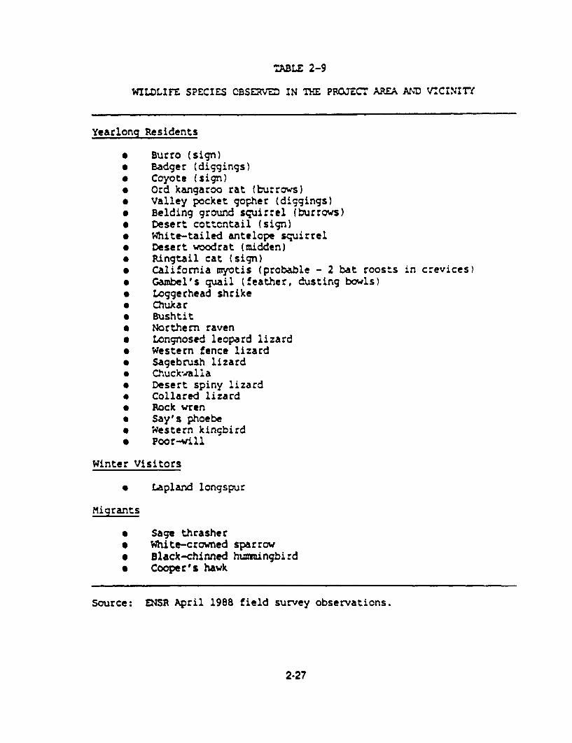
TABLE 2-9
WILDLIFE SPECIES CBSE IN TH PROJECT AVA ANMD VCINIT7
Yearlonq Residents
* Burro (sign)* Badger (diggings)* Coyote (sign)* Ord kangaroo rat (burrows)* Valley pocket gopher (diggings)* Belding ground squirrel (burrows)* Desert cottontail (sign)* White-tailed antelope squirrel* Desert woodrat (midden)* Ringtail cat (sign)* California myotis (probable - 2 bat roosts in crevices)* Gambel's quail (feather, dusting bowls)* Loggerhead shrike* Chukar* Bushtit* Northern raven* Longnosed leopard lizard* western fence lizard* Sagebrush lizard* Chuck-walla* Desert spiny lizard* Collared lizard* Rock wren* Say's phoebe* Western kingbird* Poor-will
Winter Visitors
* Lapland longspur
Migrants
* Sage thrasher* White-crowned sparrow* Black-chinned hummingbird* Cooper's hawk
Source: LNSR April 1988 field survey observations.
2-27

As described in the vegetation section, the existing environment consists of plant communities
and wildlie habitats characteristic of the Grea: Basin Desert and the northern Mojave Deser.
Wildlife habitat Includes open stand3 of low and dwarf shrubs with trees virtually absent within
the study area. Surface water Is extremely scarce and limited to Specie Spring, located
approximately 3 miles south of the proposed project, and the Amargosa River, which is
approximately 4 miles northwest of the project area. These water sources are important to the
area's wildlife diversity and crucial to the survival of some species.
Typical species of the project area and vicinity include mammals such as black-tailed jackrabbit,
coyote, badger, ringtail cat (in abandoned mines), and kit fox; raptors such as the raven, turkey
vulture, prairie falcon, golden eagle, red-tailed hawk, and kestrel; songbirds including the rock
wren, Say's phoebe, and western kingbird; gamebirds including chukar and Gambel's quai;
and reptiles such as the sagebrush lizard, leopard lizard, collared lizard, chuckwalla, and
rattlesnake. Small mammals known to occur within the project area and vicinity include Ord
kangaroo rat, desert woodrat, valley pocket gopher, Belding ground squirrel, and white-tailed
antelope squirrel.
Mule deer habitat in the Bare Mountain area is considered marginal wth low densities. An
estimated 30 to 40 deer utilize the Amargosa River area (Beatty vicinity) from spring through fall,
and they winter in the Bullfrog Hills and Bare Mountain area. In mid-1988, the BLM began a
long-term study of wintering mule deer near the project area. A 100-foot transect was
established in 1988 approximately 100 yards southeast of the access road in Section 13 (Grover
1989a). Major mule deer populations and year-long range occur approximately 50 miles north
of the project area in the Silver Peak/ Palmetto and Magruder Sylvania Mountain ranges of the
BLM Esmeralda Resource Area (Lee et al. t983).
Although desert bighorn sheep rams occasionally use the Bullfrog Hills to the west during the
winter and spring months, bighorns are not known to occur in the Bare Mountain area south of
the project area. A release of 20 to 30 bighorn sheep in the Bare Mountain area is planned by
the Nevada Department of Wildlife for 1991. Wild burro sign has also been documented in the
study area and vicinity (Grover 1988).
Both chukar and Gambel's quail occur within the project region. While Gambel's quail are fairly
common in the project area, chukar densities are low. Critical use periods within these areas
2-28

include summer and fall months. These birds typically move to the lower elevations during the
cooler months from November to April.
Although there are no historical records of raptor nests in the study area based on Nevada
Department of Wildlife's data base (Haley 1988), potential nesting habitat exists there for such
raptors as the golden eagle, red-tailed hawk, and prairie falcon (Grover 1988). No evidence ct
nesting raptors was found in the April raptor nest survey conducted by ENSR and BLM. Ravens
and a migrant Cooper's hawk were the only raptors seen during the survey.
Occasional use by waterfowl and shorebirds occurs in the Amargosa River area (north and scuth
of Beatty) since migration routes tend to follow the Amargosa River valley.
No threatened or endangered wildlife species are known from or are likely to occur in the area
potentially affected by the proposed project (Knight 1988; Grover 1988). Crucial habitat for the
desert tortoise, a FC2 candidate species, does not occur in the project region (Haley 1988). The
project area is located near the northern distribution limits and close to the elevational limits :f
this species. The Amargosa toad, a FC2 candidate species, is known to occur in springs,
canals, and other wet areas 5 miles southwest of the project area (i.e., Amargosa River valley)
2.7 Land Use and Recreation
2.7.1 Land Use and Land Use Plans
2.7.1.1 ExIstIng Land Use. Nye County encompasses 18,064 square miles (11.5 million acres)
in southcentral Nevada. It is the largest county in Nevada and the third largest county in 'he
United States (Planning Information Corporation (PIC] 1988). Almost 98 percent of this area
is administered by federal, state, and local governments and Native American tribes. A relatively
small portion of the total land area (approximately 2 percent) is privately owned. The U.S.
Department or Energy's Nevada Test Site and the Nellis Air Force Base Test Range comprise
a restricted access enclave of approximately 3 million acres. Ownership in the Beatty and
proposed project vicinity is similar to the county as a whole. With the exception of scattered
patented lands, the land around Beatty is administered by the BLM. BLM land extends 6.5 miles
west of Beatty to Death Valley National Monument and 11.5 miles east of town to Nellis Air Fcrce
Base (PIC 1988).
2-29

Land uses in Nye County include mining, livestock grazing, agriculture, wildlife habitat, recreation
in national forests and monuments, government withdrawals (Indian reservations and test sites),
and residential and commercial use in small rural communities.
Land use in the project vicinity is dominated by open space and mining. The small community
of Beatty, located approximately 7 road miles west of the project area, is largely residential in
nature with supporting public facilites. The Rhyolite area, located approximately 9 miles west
of the project area, is an historic gold mining town with a few existing scattered residences and
historic structures.
Other existing land uses in the vicinity of the proposed project area include an AT&T
communications site on Bare Mountain and several active mining operations.
Part of the access road that USNGS is proposing to use was constructed for and is used by
AT&T for access to their AT&T communications site. The AT&T access road is a 5O-foot wide
ROW (#NEV066111) located in T12S, R47E, Sections 13-17 and 24 (Ross 1989).
The Daisy Fluorspar Mine is located approximately 3 miles southwest of the proposed project.
Other mines - the Gold Ace Mine, Panaca Mine, Diamond Queen Mine, and the Telluride Mine -
- are found on the east and west sides of Bare Mountain.
2.7.1.2 Land Use Plans. A land use plan is considered the basic element of the 1970 Nye
County General Plan, which was updated in 1978 and is still in effect, even though the county
does not use II as a working document when making land use decisions (Williams 1989). A few
key elements in the 1978 Nye County Land Use Plan are:
* Current and past uses of the land resources should be a guide for the developmentof future planning elements.
* The concept of multiple use should be the overriding policy in planning for federallycontrolled lands.
* The mining and agricultural uses of lands are strongly held as a best use for muchof the land within Nye County.
2-30

Future land uses in Nye County are expected to follow current trends. Mining and military
activrties are projected to increase, while ranching and grazing uses are projected to remain
steady.
Land use control on private land is exercised by the County Commissioners and the Ccunty
Planner through enforcement of subdivision and mobile home/recreational vehicle park
regulations (Williams 1989). This control extends over the entire county including unincorporated
communities such as Beatty; only the incorporated Town of Gabbs is exempt. Nye County has
no zoning regulations at the present time and none are proposed (Williams 1989).
Given the large percentage of federal land in Nye County, Forest Service and BLM management
programs will continue to have great influence on land use in the county. The BLM's Esmeralda-
Southern Nye Resource Management Plan (Record of Decision for Planning Area A, 1986)
generally follows a philosophy of multiple use. Specific objectives pertinent to the project area
include:
* To improve opportunities for economic development by substantially increasing theamount of non-federally owned land within the planning area.
* To make available for use and encourage the development of mineral and energyresources to meet national, regional, and local needs, consistent with dec!arecnational objectives for an adequate supply of minerals at reasonable market prices.
* To ensure a system for transmission of utilities through the planning area byestablishing corridors which will meet the long-range planning needs for utdlitycompanies and avoid sensitive resource values.
2.7.2 Recreation
Outdoor recreation resources in Nye County range from historic ghost towns to hunting, fishing,
and camping opportunities. BLM-managed lands play a significant role in the recreation setting.
The major activities include hunting for big game (deer and cougar) and small game (chukar,
rabbit, quail, and dove), hiking, mountain climbing, camping, photography, sightseeing,
rockhounding, and off-road vehicle (ORY) driving.
2-31

There are no developed recreation facilities and only limited undeveloped, dispersed recreation
opportunities In the project area (Grover 1989b). Sightseeing, hunting, and ORV use represent
the largest outdoor recreation activities In the project area (Grover 1989b).
Death Vailey National Monument is located approximately 12 miles southwest of the project area.
Between 1986 and 1987, the number of vistors to Death Valley National Monument increased
approximately 13 percent to 692,964.
2.7.3 Wilderness
The closest potential wilderness area is the Grapevine Mountains Wildemess Study Area (VISA).
located approximately 20 miles northwest of Beatty, and approximately 25 miles northwest of the
project shte, along the California/Nevada border in Esmeralda and Nye Counties. This 66,800-
acre unit is generally located at the northern end of the northwest-trending Grapevine Mountains.
The preliminary decision is to recommend all 66,800 acres within the Grapevine Mountains WSA
as nonsuitable for wilderness designation (BLM Esmeralda-Southem Nye Record of Decision,
Planning Area A, 1986). A final decision will be made by the United States Congress after 1991.
All wilderness study areas will continue to be managed under the BLM's Interim Management
Policy and Guidelines for Lands Under Wilderness Review until completion of the wilderness
review process.
2.7.4 Grazing
The project area is located within the Razorback Allotment. This allotment encompasses 70,893
acres. It is an Individual allotment with a total preference of 1,344 AUMs on a yearlong lease.
The lessee has been running full active preference over the last 5 years. This allotment has
been allocated on the basis of approximately 53 acres/AUM (Oyler 1989). Grazing by cattle is
very infrequent at the site because of the long distance from water.
2.7.5 Wild Burros and Horses
The project area is located within the Bullfrog Herd Management Area. The BLM recommends
an appropriate management level in this area of 12 wild horses and 218 wild burros (Pogacnik
2-32

1989). The BLM did a complete field count on August 1, 1988. There were 256 burros and 0
horses counted. The BLM planned to do a gather of some burros to get the herd down to the
appropriate management level of 218; however, there was a challenge to that plan so the
operation is currently on hold (Pogacnik 1989). There is no herd management area plan for this
area. Wildhorse and burro use is ;nfrequent at the site because of the long distance from water.
Data on animal condition are scarce; however, visual observations and the belief that the burro
populations are increasing tend to indicate that, overall, the burros are in at least fair ccnditicr
(Pogacnik 1989). Vegetative conditions within the Bullfrog Herd Management Area vary.
Competition for forage occurs between horses and burros, and cattle, as their diets overlap
There are some areas of apparent overgrazing; however, it is difficult to distinguish between-
horses, burros, and cantle grazing patterns (Pogacnik 1989). Habitat conflicts between horses,
burros, cattle, and wildlife also occur and are generally related to the availability and distrbution
of water. Water within the Bullfrog Herd Management Area is especially limited causing
increased competition for forage and space. Water is particularly scarce east of Beatty. The
only naturally occurring water source in the proposed project area is Specie Spring, located
approximately 3 miles south of the proposed project site (Pogacnik 1989).
2.7.6 Areas of Critical Environmental Concern (ACECs)
At the present time, there are no designated ACECs within the project area (BLUI 19e6.
Pogacnik 1989).
2.8 Cultural Resources
2.8.1 Regional Overview
The earliest ethnographic data available for Southern Paiute and Shoshoni peoples who utilized
the Mojave Desert region is that gathered during interviews in 1935-1936 by Julian Stewarc
(1970). His information is the basis of ethnographic models devised to interpret settlement and
subsistence patterns of prehistoric populations.
2-33

Although major temporal units for the region's prehistory are well established, absolute dates are
not cJearly associated, especially for early intermediate periods. In addition, cultural periods
have been assigned a plethora of names in the archaeological literature of the Mojave Deseri
region, due in part to a tendency for establishing localized chronologies (Pippin 1984; Warren
and Crabtree 1986) during investigation of major sites. A bibliography of this literature has beenprepared by Pippin and Zerga (1981).
The cultural sequence described here was developed by Warren and Crabtree (1986). It derives
from a chronology published by Betinger and Taylor (1974) and modified by Warren et al.
(1980), with dating based on a range of characteristic projectile points and associated
radiocarbon dates. Further definition is organized around changes in other distinctive arlifac:
types, such as pottery, or such additions to the tool kit as groundstone. These dated periods
are not homogeneous in time or space, for variations and overlap in cultural remains occur
within sites characteristic of each period.
Lake Mojave Period (10,000 B.C. - 5,000 B.C.), the Early Man complex, is characterized by
surface sites on the shores of extinct lakes. Artifact assemblages include heavy core tools,
simple crescents, ovoid and keeled scrapers, leaf-shaped, long stemmed, shouldered sholt
stemmed, and fluted projectile points, but not grinding tools.
Pinto Period (5,000 B.C. - 2.000 B.C.) sites contain artifacts with some Lake Mojave Period
artifact characteristics, implying an ongoing tradition of tool form and manufacture. Simple flat
milling stones in these sites point to the beginning of a seed processing technology
accompanying the generalized hunting and gathering subsistence systems of a mobile people
using resources in a wider variety of ecological zones.
The Gypsum Period (2,000 B.C. - A.D. 500) is characterized by medium to large stemmed and
notched projectile points, as well as smaller point types, indicating a gradual transition from dar<
and atlatl to bow and arrow. Increasing numbers of grinding stones connote greater reliance
on seeds.
The Saratoga Springs Period (A.D. 500-A.D. 1,200) shows continuity with the Gypsum Period.
Smaller projectile points and numerous grinding stones dominate assemblages.
2-34

The Shoshonean Period dates from A.D. 1200 to the time of European contact. Diagnostic
artifacts include small Cottonwood and Desert Side-notched points and various types of
brownware pottery. According to Steward (1970:59, 94), historic Shoshone population was
centered In Oasis Valley, northwest of the project area.
Historically, Europeans appear to have entered the region in 1853, when Fremont passed
through Nevada, leaving near present-day Beatty" on his way to California (Elliot 1973). There
was little activity In the area in the late 180Os. In 1881, 3,000 acres were under cultivation in
eastern Nye County, and the nearest mining activity was located in the Gold Mountain District
in Esmeralda County, about 40 miles to the northwest. Nye County mineral production declined
from a gross yield of over S900,000 in 1878 to a low of just over S35,000 in 1900 (Couch and
Carpenter 1943). Prospectors discovered gold in the Bullfrog mining district in 1904, and activity
centered around Rhyolite, about 10 miles west of the project area. Maximum gross yield from
mineral production for Nye County was almost S10 million in 1918.
In 1905, gold was discovered in Fluorspar Canyon on the northeast slope of Bare Mountain, and
the gold camp of Telluride was started (Uncoln 1982). Gold production lasted less than a year,
and Telluride later became a mercury mining camp. Gold and silver production in the Bare
Mountain Mining District ranged between S1 to S3 million; fluorspar (fluorite), mercury, volcanic
cinders, pumicite, and uranium have also been mined in the district (Cornwall 1972).
The Beatty post office was established in 1905, and the town was important as a shipping point
for nearby mining communities. In 1906, the Las Vegas and Tonopah Railroad was constructed
to Beatty; the Tonopah and Tidewater and the Bullfrog-Goldfield Railroads also operated here
(Mordy and McCaughey 1968).
2.8.2 Cultural Resources Inventory
interrnountain Research has conducted four surveys to identity cultural resources present in the
project area; these surveys covered the entire project area. A fifth survey consisted of extensive
recordatlon of selected historic sites. A total of 37 prehistoric sites, 17 historic sites, and 1 site
with both prehistoric and historic components have been identified within the project area. A
summary of these sites is included below.
2-35

The Prehistoric sites include 1 1 toolstone quarries, 5 knapping stations, 4 temporary cramps, 4
task sites, 3 multi-purpose sites, 5 isolated artifacts, and 6 sites of undetermined type. The
historic sites consist of 7 domestic/habitation sites (including Telluride and Bond mining camps),
6 mining-related sthes, and 5 prospects. A site with both prehistoric and historic components
consists of a large prehistoric quarry with chert and quartzite flakes and a historic stone mining
cairn and two mining excavations (this site is included in the lists of both prehistoric and historic
sites above).
2.9 Aesthetics
2.9.1 Visual Resources
The BLM has implemented a visual inventory and analysis process to provide a systemati
interdisciplinary approach to the management of aesthetic values on public lands. The Visual
Resource Management system provides methodology needed to inventory existing scenic quality
and assign visual resource inventory (VRI) classes based on a combination of scenic values.
visual sensitivity, and viewing distances. Visual resource classes have been established to serve
two purposes: 1) as an inventory tool portraying relative value of existing visual resources, and
2) as a management tool portraying visual management objectives. Management objectives for
each of the four visual resource classes are listed in Table 2-10.
The study area for the proposed Mother Lode Project contains a VRI Class II area in Perlite
Canyon and a small Class IlIl area associated with 'badlands topography near and to the nor-tn
of the cistern (T12S, R4BE, Section 7). The rest of the area in the viewshed of the project is
designated VRI Class IV (Figure 2-4).
A scenic quality evaluation of the study area indicated that most of the area warranted a relative
quality rating of C (the lowest on a scale from A to C) in comparison with other landscapes in
the Basin and Range Physiographic Province (U.S.D.l. 1986). The C rating is attributable largely
to a lack of variety in visual elements and the abundance of similar visual character throughout
the province. Beatty Mountain and portions of Bare Mountain are rated B because of more
rugged, and thus more dramatic, cliffs and rock outcrops in those areas. The eroded and pock-
marked 'badlands' terrain to the north of the cistern is also rated B because of its unusual
textural character and colors that contrast sharply with most of the surrounding area. Perfite
2-36

TABLE 2-10
VISUAL RE.SCURCa MANAGEMEN CLASSES
Class I Objective:
Class 1I Objective:
Class III objective:
Class IV Objective:
Rehabilitation Areas:
The objective of this class is to preserve theexisting character of the landscape. This classprovides for natural ecological changes; however,it does not preclude very limited managementactivity. The level of change to the character-istic landscape should be very low and must- notattract attention.
The objective of this class is to retain theexisting character of the landscape. The levelof change to the characteristic landscape shouldbe low. Management activities may be seen, butshould not attract the attention of the casualobserver. Any changes must repeat the basicelements of form, line, color, and texture foundin the predominant natural features of thecharacteristic landscape.
The objective of this class is to partiallyretain the existing character of the landscape.The level of change to the characteristiclandscape should be moderate. Managementactivities may attract attention but should notdominate the view of the casual observer.Changes should repeat the basic elements found inthe predominant natural features of thecharacteristic landscape.
The objective of this class is to provide formanagement activities which require majormodification of the existing character of thelandscape. The level of change to thecharacteristic landscape can be high. Thesemanagement activities may dominate the view andbe the major focus of viewer attention. Hcwever,every attempt should be made to minimize theimpact of these activities through carefullocation, minimal disturbance, -.nd repeating thebasic elements.
Areas in need of rehabilitation from a visualstandpoint should be flagged during the inventoryprocess. The level of rehabilitation will bedetermined through the resource managementplanning (RMP) process by assigning the 'RM classapproved for that particular area.
Source: BLM Manual Handbook 8410-1.
2-37

. ,... -�
I . *1-.** .I.�.... .. 4I. * -. . .
4 I P1'I I
S. K .�;
I I '.4 S.a j
4..% 2� ,, � ti I''
<1**� I *4fi� .�( ... a'.11 I/
I I I '
I � I'1 Il, I- - � I
4 .-. ,.-----.4.. - -- *---4 I.
'4 1*'' a....
I -
'.1 ( . 44 *1' ISfAflv '?" '�I' I. a-'? *'-I:- * Nh,) '.**'��j
I � 1.
I- *
I, -'� I
� I . .I
I
.. P.-
. I A.-
.,.'' L.4,.
4 4
4 - 4. .. I
�* U
4.; . . 4 =
.J4
.
4 I
r* S
I-- .z S4 - 'I'
.1-
III . * - * . .4
*IfE Iv
PROJEC r
* 4. -
S.d. Sp.bq
SI
I . .
4I
C I C A .. .
-4 . I
4..
* 4.. 1.1
-. . I** -. -9f
.4..
- *�** -
I I
.
I: N
0 1 2
SCALE N UAIS
Site Location ABSE. TI2S. Section 7
MOTHER LODEPROJECT_
FIGUAE 2-4VISUAL RESOURCE
INVENTORY CLASSES I
I
I J2 3

Canyon is rated A for scenic quality because the drama of the unusual rock formations and the
sense of enclosure one experiences combine to provide a visual effect that is uncommon in the
area.
Visual sensitivity is rated low for most of the study area because visitor use levels are very low
(backcountry). Sensitivity is rated moderate for Perlite Canyon and the cistern badlands because
of expressed local concern for these resources. Viewing distances are ranked foreground-
middleground for the entire study area. The backcountry area surrounding the mine site islargely screened by terrain from the viewshed of travelers on U.S. 95 and residents of Beaty.Observation points were established near the cistern and on the entrance road to represent thefew users who do visit this backcountry valley. The valley would be foreground-middleground
for these viewers.
The composite result of the visual characteristics noted above is VRI Class IV rating for much
of the study area, which would accommodate activities resulting in major modifications of the
existing visual character. The small Class IlIl area would accommodate only moderate levels of
visual change. In contrast, the existing landscape character is to be maintained in the area
rated Class II with only low levels of visual change permitted.
2.9.2 Noise
A description of the environment potentially affected by noise emissions from the proposed
project includes identifying noise sensitive receptors and existing noise sources In the vicinity.characterizing terrain features that may affect noise transmission, and determining existing noise
levels.
The proposed project would be located in a small basin between Tates Wash and Joshua Hollow
about 7 road miles east of Beatty. The nearest noise receptor is over 4 miles away, near U.S.
95.
Existing noise sources include natural sounds from wind, birds, and insects; low-level equipment
sounds from project-related mining exploration activity; and occasional noise from low-level
aircraft overflights related to the nearby Nellis Air Force Base practice range.
2-39
The project site is surrounded by complex, varied terrain. The basin is effectively isolated frcm
sensitive receptors by ridges of hills and mountains that would function as noise barriers in
most cases.
Monitoring of existing noise levels was not deemed necessary because of the remote locat:cn
of the project area and the paucity of existing noise sources. Existing noise levels were instead
estimated, based on EPA literature and ENSR file data for similar sites. Existing noise levels are
estimated to fall in a range of 30 to 50 decibels, A-weighted (dBA). The midCle of the range
represents typical noise levels in small rural communities. Lower levels would be typical of the
area when human activity is not occurring and there is little or no wind. The upper end of the
range would be typical of windy periods with brief excursions above 50 dBA expected during
low-level aircraft overflights.
2.10 Socloeconomics
The primary study area for the socioeconomic assessment is Nye County in southcentral
Nevada, including the communities of Beatty and Amargosa Valley and the historic townsite of
Rhyolite. There are no incorporated towns within Nye County except Gabbs; therefore, all
administrative functions are provided by the county government in Tonopah. The primary
governing bodies are the Nye County Commissioners and the Planning Commission. Other
advisory bodies include a seven-member school board, a five-member hospital board, and other
town boards.
The County Commissioners set the annual budget for the Town of Beatty and enact ordinances
and policies on the recommendation of the five-member Beatty Town Advisory Council. The
Town of Beatty has a mill levy and generates ad valorem tax revenues for the county and schccl
district. Federal agencies such as the BLM play a major administrative role in Nye County since
nearly 98 percent of the land area of the county is under federal administration.
2.10.1 Population
The population of Nye County increased 54.6 percent between 1980 and 1967- the estimated
population in Nye County was 13,989 in 1987 (Table 2-1 1). The 1985 special census figure
2-40
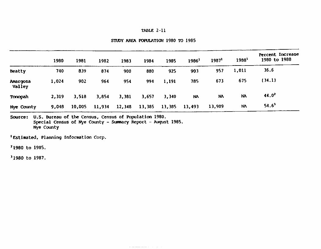
TABLE 2-11
STUDY AREA POPULATION 1980 ID 1985
Percent Increase
1980 1981 1982 1983 1984 1985 19861 1987' 1988' 1980 to 1988
Beatty 740 839 874 900 880 925 903 957 1,011 36.6
Amargosa 1,024 902 964 954 994 1,191 785 673 675 (34.1)Valley
Tonopah 2,319 3,518 3,854 3,381 3,657 3,340 NA NA NA 44.02
Nye County 9,048 10,005 11,934 12,348 13,385 13,385 13,493 13,989 NA 54.6'
Source: U.S. Bureau of the Census, CeSpecial Census of Nye CountyNye County
'Estimated, Planning Information Corp.
21980 to 1985.
'1980 to 1987.
nsus of Population 1980.- Sumary Report - August 1985.

includes 865 people associated with the U.S. Department of Energy Nevada Cperalicns C.I,,ce
residing in Nye County.
During the 7-year period from 1980 to 1987, the population of Beatty grew 29 percent, and
Amargosa Valley actually declined in population by 29 percent since fiscal year 1982-1983 (PIC
1988). Amargosa Valley has lost population due to the closing of the American Bcrate Company
(ABC) Mine. The 1988 population of the Town of Beatty was estimated at 1,0 1 (PIC August
1988). Bond Gold estimates approximately 600 workers are currently working on the Bullfrcg
Project which would increase the population to approximately 1,6CC, assuming some workers
live outside the Beatty area (Bond Gold 1989). Most of the growth in population throughout Nye
County can be v ributed to increased military and mining activity. Table 2-11 shows the
population of Bean,. Amargosa Valley, Tonopah, and Nye County.
2.10.2 Economic Base
The economy in Nye County depends largely on two basic industries: mining and military
activity including Neilis Air Force Base, the Tonopah Test Range, and the Nevada Test Site.
Other important sectors include tourism and government. Beatty is one of the three largest
Nevada entrances to Death Va'ley National Monument and provides services and overnight
accommodations for tourists traveling to the Monument as well as those traveling through
Nevada on U.S. 95. Tonopah acts as a regional center for Nye County since it is located
midway between Reno and Las Vegas. It is also the county seat of Nye County and provides
county-wide public services and facilities.
2.10.3 Employment and Income
Due to the nature of the primary industries in the area (mining and military), ii is understandable
that fluctuations in employment and income occur regularly. The frequent upswings anCd
downturns of the major economic sectors cause instability among the non-basic sectors and
result in fluctuations in unemployment rates and a general sense of economic instability. Table
2-12 shows employment by place of work from 1981 through 1987 for Nye County. Fluctuations
in the mining and construction sectors have occurred throughout the period. The services sector
represents 12.9 percent of total employment and has shown a steady increase from 1981
through 1987, except for a slight decline in 1986.
242

TABLE 2-12
NYE COUNTY EMPLOYMENT BY MAJOR I NDUSTRY (ANNUAL AVERAGE)'
1987 Percent1981 1982 1983 1984 1985 1986 1987 of Total
Total Euployment 9,236 9,893 9,857 10,390 11,117 11,252 12.031 100 %
Farn 242 229 224 213 204 213 213 1.8
Non-farm 8,994 9,664 9,633 10,177 10,913 11,039 11,818 98.2
Private 8,244 8,882 8,825 9,291 10,045 10,072 10,864 90.3
Ag., Serv., 25 26 21 21 25 26 26 0.2
Fish, For.'
Mining 1,569 1,452 1,153 1,244 893 999 1,167 9.7
Construction 445 225 177 172 338 331 503 4.2
Manufacturing 95 95 83 88 94 115 101 0.8
T.C.P.U.' 158 170 149 142 145 134 206 1.7
Trade 682 695 646 675 720 661 729 6.1
F.I.R.E.' 472 334 317 394 423 417 440 3.7
Services 4,798 5,885 6,279 6,555 7,407 7,389 7,691 63.9
Government 750 782 808 886 868 967 954 7.9
Fed, Cir. 127 136 141 132 130 163 161 1.3
Military 76 63 67 65 63 65 65 0.5
State & Local 547 583 600 689 675 739 728 6.1
'Reflects non-agricultural employment by place of work. Includes all workers in Nye County regardless of place ofresidence and includes multiple job holders.
'Agriculture Services, Fishery, Forestry.
'Transportation, Communications, Public Utilities.
'Finance, Insurance, Real Estate.

Recently, mining activity has shown a dramatic increase in ex;pIcraticn and prcduction. Neva2a
now produces over 50 percent of the gold mined in the United States and has 12 of the ratocn s
largest gold mines (Clark, Nevada Employment Security Economic Update 1988). Nevada is ¢-e
leading gold and silver producer in the Unrted States. Statewide direct employment in gold ard
silver mining operations grew from 4,499 in 1985 to 6,300 in 1986. The statewide 19e7,
estimated average employment associated with mining was 7,90C. Preliminary figures for 1I c8
show a considerable increase in mining employment state wide; over 10.400 jcts wereassociated directly with mining according to state estimates. Nye County mninlrg ernpicyrmer:
accounted for 14.7 percent of the state total in 1987. The services sector is tLe argest er-mcIcyer
in Nye County with 63.9 percent of total employment; the mining sector represented the seccronlargest employment sector in 1987 with 9.7 percent of total employment, followed by Lyle
government sector at 7.9 percent (U.S. Bureau cf Economic Ana~ys;s 1988).
The 3.4 percent unemployment rate in Nye County in December 1988 remained lower ,han >heDecember state figure of 4.5 percent, despite fIuctuat ons in employment among seclcrs(Nevada Employment Security Dept. 1989). This implies that populat... cut-migraticn has kean
pace with changing jcb oppcirunities.
Between 1984 and 1986. per capita personal irccme increased by 4.9 percent Go S1 1,946 IUJ.SBureau of Economic Analysis 1988). Nye County ranks 15th out of 17 counties in Nevada n percapita income. The state average per capita personal income was S15,380. Writh the ir'lux 0!
more mining employment in the area, the per capita personal irncorme should ccrt:nue ez
increase.
2.10.4 Public Fiscal Conditions
Financial resources of the study area refer to government revenue sources ard expenditures In
Nye County and its communities. These financial statistics are impcrtant in helping to determire
the fiscal impacts of industrial development on local govemment jurisdictions.
From 1984 to the current fiscal year 1989, assessed valuat:on throughout the area has grown
at a moderate rate. Assessed valuation in Beatty declined in 1988-1989 due to personal prcper vdepreciation and little new development. However, from 1987-1988 to 1988-81989 Nye Ccunrt
assessed valuation increased by 20.5 percent. This is considerably higher than the average
2-44

annual increase from 1984.85 and reflects a large portion (43 percent) of net mine proceeds
Table 2-13 shows assessed valuation for Beatty and Nye County.
2.10.4.1 Town of Beatty. Revenues and expenditures for the Town of Beatty have been
examined over the fiscal period 1982-1983 through 1988-1989 and are presented in Table 2-14.
All of the budget figures presented in the text and Table 2 14 are actual.
Revenues. The town receives operating revenues through four major sources: taxes [prOpe-Y
and Supplemental City/County Relief Tax (SCCRT)], local licenses, fines and forfeitures, anA
'other' revenues. Total general fund revenues increased from S36,542 in 1982 to S91,027 in
1988. Miscellaneous revenues received by the town include payments from Nye County School
District, grants from Nye County, and miscellaneous rents and sales.
Expenditures. The town's general fund expenditres are broken into three categories: general
government, public safety, and cuflure and recreation. Total operating expenditures have
increased from S35,186 in 1982 to S1 14,888 in 1988. This is due in large part to the growth in
spending in the fire department, which was associated with hiring a full-time employee. Cap:ial
spending has varied between zero in most years to S13,000 for administration in 1986-1987.
Bealy maintains a separate debt service fund, supported by a property tax. The town is paying>
off a S90,000 building bond issued in 197f; the debt will be repaid in 1991. Currently, Beatty s
debt capacity is $1.60 million, wfth S15,000 of debt outstanding, less than 1.0 percent of the legal
debt limit.
2.10.4.2 Nye County. Nye County provides many governmental services to the Beatdy area.
The most important services provided include sheriff protection, road maintenance, general
government, and judicial services. Trends in revenue and expenditures for the county generai
fund from 1982 to 1988 are shown in Table 2-15.
Revenues. The Basic City/County Relief Tax (BCCRT) and Supplemental City/County Relief Tax
(SCORT) have been the major sources of revenue for the general fund. In 1988, the BCCRT and
the SCCRT accounted for 11 percent and 34 percent, respectively of the total general fund
revenues.
2-45

TABLE 2-13
ASSESSED VALUATION BY JURISDICTIoN
Tax Rate Average
$100 Fiscal Fiscal Fiscal Fiscal Fiscal Annual
Assessed Year Year Year Year Year Increase
Valuations 1984-1985 1985-1986 1986-1987 1987-1988 1988-1989 (Percent)
1988-19 - Thousands of Dollars
Nye County .6205 280,987 310,566 328,156 347,552 418,900 10.5
Deatty .1736 4,936 5,097 5,407 6,125 5,903 4.6
Source: Nevada Department of Taxation, Local Government Finance, 1984-1989.

TABLE 2-14
BEATTY T0MN GENERAL FUND REVEN&ES AND EXPEND1TURES
1988 Percent1982 1983 1984 1985 1986 1987 1988 of Total
Revenues:
Taxes
Property Tax 4,116
(other than net proceeds)
Licenses & Peruits 6,637
Intergovernmental
SCCRT 10,849
MVPT 2,431
I Other
4,677
8,471
12,151
2,093
8,487
18,709
11,256
2,456
7,237
19,924
13,149
2,643
7,565 7,044
20,334 22,075
12,760
3,168
Charges for Services
Misc.
Fines & Forfeitures
TWrAL REVS
Expenditures:
General Government
Public Safety
Culture/Recreation
TOTAL EXPENDITURES
9,622
2,887
36,542
9,077
7,012
19,097
35,186
9,930
3,226
3,665
44,213
9,026
11,171
25,011
45,208
10,300
842
2,927
54,977
6,601
36,351
23,959
66,911
10,215
742
5,068
58,978
9,780
36,124
25,897
71,801
9,660
8,115
11,666
73,268
10,872
39,353
31,902
82,127
15,357
3,136
1,425
8,900
917
11,113
69,967
7,862
41,873
40,155
89,890
5,771
22,460
19,884
3,400
2,646
11,230
14,136
11,500
91,027
9,650
64,891
40,347
114,888
6.3
24.8
21.8
3.7
2.9
12.4
15.5
21.6
1001
8.4
56.5
35.1
1001
Source: PIC 1988

* Ba*9 U
P4v
, a
6-
0:U F,
a.
.aa6a.
apin ** a
d A
- F, -- 4s - P.
FI
*01
b...1 -
n g.a
a 0hi a-J
I M
i i
0
_
_
_,
4.,
0
f,i
F,
0
.
a
It
*Ia~a:
* ,* - ft a -
F, F, _ F, _ . _ 0Ot lot F, - -i F. F, at
* * on Pe r e* _, do : , _ _ -
* M _ , *
_ _
a0 - P- 4 -. -~I1
* _ F, _, F, e
* a W - W 49 0
a * - : a: 4: a,
._ 0::1;;*
e w M _ I
l,- a - -1 .:z _ : 0. _ s
. 0. . . .,
_ 5 , , a 1 -I _
I ~ ~ 0r": .
.F . . . a P_, F, - - F,
_ _ _ _
_ a _, , _ F, 5It _ . _i t _~ I _a , _, _ F _ e a*, _ _, _ _ F, , F,
a - ^ , _
_ _
4aa
49a.9
4 a . f, _ 45 F I * _ _It, F a , F, , : : o 4 z a a_ r. ll _~ ll l __
; _ "* _ z 0 ^ 10 " .0 ," 10 -. IM _t _ V t _. W_-
_I a
F,
0,
F,F,
a
i
'a" a : F, 40 A
F, _, a _ , _, _ _
_ , F, F, F, _ _
_, F, , ** _w ,^
-F F *
_, 4 _, , F, , , __~ : : _ _ ,"%M . .1 r. .1% . .
F, F, _ _ . ., a aF z -e _, __1 P" _ _ ft _
a4
a
ot
0%
It
s% a t a -- "I
_, _ , _ _
: .0 lp . _
V . . . .
d% 0 v- . _ o
_, * F, _ .
-_ ^ 1 _.a It .I
I - _.0 :_ w
_ _ _
aa
F,aa
_ _ 0
4. .z
P4 Is
a, F,
F 4 - a F, - , P- F_ I . I I " _ ^ t C^" _ F F, _ , F _ , _ * F
- " a - It, * M_* .9 . F , F , F , . . ., F, a, _ _ oFe o
4-.F,
F,
C0
* o C 4 a - - 0
- F_ . a a _ , F,
F , _ , * F , F , -_, 0 o Fv ft _ _
_ , _ _ _ _ _
* F, aa P la
4 ._ _ ~ lwv
_ P- me
U a
_ 0 _ 6
s * *9e 9 *
. , - a .
* * e1 - 0 o .2. ,
.. 4 0 3 , ° I
* * *0 a ; 0 . X. - 0 0 .c 6.-
9 . 4 9 - .

TABLE 2-1 (CONTINUCED
Averaqe ~nnuja1le ceat ageInctease
Percent otTotal 419,61962 1963 19a4 1Il5 1986 loll
eapenditures:
General Govern"ents
Judicial
Public Satyt7
Nealtb a Welfare
Other
Total General Fundexpendituges
2. 2 75, eas
262,04S
I ,S42,486
27, 742
_ _ . _ _
1.54.251 1.677.106 2,001.552 2.453.930
410.096 555.663 S97.61 690.494
1,75.506 1.913.093 2.2so.693 2.S02.906
66,367 10,136 104.261 125.116
3?9.820
2.622.601
792.696
2,745.645
lot. 732
2.500.628
665.3161
2.1741 * 762
122,111
6 3,349
39.'
14 .
43.4
1.9
1.1
100.0
1.6
22.5
19.1
13.0
14.7
7.44.107.559 4,176.220 4.206,20 4.954.111 5.12.336 6,334.556 6.*13.24
Source: Pic 1986.

The county's general property tax is the next single most important revenue source represertirg
nearly 14.6 percent of total revenues. In 1988-1989, the county-wide mill levy was the lcwes: it
has been for over 6 years. Actual property taxes collected have fluctuated over the pericd.
Locally generated revenues including licenses and fees, fines, and fcrfeits, and charges !or
services generated 15 percent of total revenues in 98.8. Intergovernmental revenues include
distributions of funds from federal and state sources. These sources generated 20 percent of
total revenues during 1988.
The revenue area showing the greatest growth throughout the period other than miscellaneous
and depository planning was fines and forfeitures with a 16.8 percent average annual increase.
Charges for services grew by 16.1 percent, and SCCRT revenues grew by 16.4 Percent during
the period.
A recent fiscal analysis completed by PIC shows that the Nye County general fund has been
increasingly dependent on intergovernmental revenues and service coharges. Property Fax
revenues have become increasingly volatile due to the cap imposed in 1982. In 1987, property
tax allocations to general fund activities fell drastically due to property tax prcceeds being used
for capital projects. This appears to be a short-term impact, but it has significantly a"Iected
operations of general fund activities for this year, particularty public safety.
A vote to increase the ceiling on the net proceeds of mines tax from 2 to 5 percent is scheduled
on May 2. Passage of Senate Joint Resolution 22 would increase tax revenues that accrue lo
the State of Nevada and Nye County.
Expenditures. General fund expenditures are grouped into four major categories which include:
general government, public safety, judicial, and health and welfare. General governmert
includes executive functions, finance, assessor, and building and grounds. Historically, general
government function expenditures have accounted for an average of 40 percent of the general
fund. Overall general government spending is the second largest budget category in the county
Public safety has been the largest single category, averaging 48 percent of total general fund
spending.
The judicial category includes district courts, attorneys, and the justice court system in all the
Iowns in Nye County. Total judicial spending has averaged 14 percent of Ithe general fund
2-50

spending during the study period. Expenditures for the Beatty Justice Court have shown steady
growth over the period. Beatty court has increased expenditures 22.5 percent from S262,045
in 1982 to S885,167 in 1988. All expenditure areas increased somewhat during the study period'
public safety (10.1 percent), general government (1.6 percent), and judicial (22.5 percent).
One area where expenditures have obviously lagged during the period is In the area of capital
improvements. The Nye County infrastructure is in need of upgrading. Additional space for
government services is needed throughout the county, and new purchases need to be made to
replace antiquated equipment. This process of upgrading the infrastructure is be-inning in Nye
County.
Between 1982 and 1987, Nye County has not exceeded 5 percent of the 10 percent debt limit
set by the State. The county has 99 percent of its debt capacity available at this time. As shown
in Table 2-15, operating expenditures have remained nearly constant between fiscal 1982 and
1987. Cumulative revenues have exceeded expenditures.
2.10.5 Housing
Nye County showed an increase of 2,109 year-round housing units from 1970 to 1980 (Table
2-16). The 1985 special census indicated total year-round housing units had grown by 1,766,
for a total of 5,968 dwelling units county-wide. Of the 5,968 dwelling units, 974 are located in
Beatty and Amargosa Valley. Table 2.17 shows permanent and temporary housing
accommodations in Beatty and Amargosa Valley. The survey was completed by PIC in March
1987. Since the survey, new housing has been buil and new mobile home units have been
moved into many available lots within the Beatty town boundary. Most of these have been
connected to the Beatty Water and Sanitation District lines.
The condition and type of housing varies throughout the county. The 1985 special census
showed that of the 516 housing units in Beatty, 61 percent were mobile homes and 20 percent
were wood frame houses. In Amargosa Valley, 80 percent of the 458 units were mobile homes
and 7 percent were wood frame houses. A more recent study by PIC (1988), estimates
approximately 400 housing units in Beatty (comprised of 10 percent stick-built single-family and
multi-family structures, 50 percent owner-occupied mobile homes, and 40 percent units in mobile
home parks). The discrepancy between the two numbers may be explained by the type of units
2-51

TABLE 2-16
TSPNS IN HOUSING UNIONS 1970 TO 1985
1980 to 19851970 1980 1985 Percent Charge
Nye County 2,093 4,202 5,968 42.0
Beatty NA 320 516 61.3
Amargosa Valley NA 412 458 11.2
Source: U.S. Bureau of the Census, 1980; 1985 Special Census of NyeCounty - Summary Report; Bureau of Business and EconomicResearch; UNR, 1970; Census of Populaticn and Housing MicrofilmFile A.
2*52

TABLE 2-17
EXISTING HOUSING STOCK IN
BE~kTTY AND AMIARGOSA VAd2.EYi
Beatty Amargosa Valley
Housing Units
Mobile HomeWood FrameMultipleOther
Total
Vacancy
Mobile Home Park Spacesand Rentals
3131015250
366342137
516 458
0%
135 107
Mobile Home Rental Rates8' - 1 bedroom
10' - 2-3 bedrooms12' - 2-3 bedrooms14' - 3-4 bedrooms
S175-225$225-275S275-350S300-$375
Tenrorary Housing
MotelsR.V. Spaces
195 + (60)1110
00
Sources: 1985 Special Census of Nye County Summary Report; PlanningInformation Corp., Yucca Mountain Draft Socioeconomic Studies;Lane Schultz; Planning Information Corp., CommunityDevelopment Report, 1988.
'Under Construction.
2*53

counted. The 1985 special census may have counted units not legally in the water and sewer
district. Motel units may also have been counted as households,
Beatty is largely a mobile home town, currently providing temporary housing for mining and
other non-permanent workers. Many local residents own one-half blocks, which have been
divided for mobile home spaces.
Beatty is currently faced with a severe housing deficift due to the construction phase of Bord
Gold's Bullfrog Project. Every available housing unit and recreational vehicle (RV) site is
essentially occupied (Stansbury 1989; Walker 1989). Many people looking for permanent
housing are occupying RV trailers due to the shortage of available housing. The only available
housing exists at Bond Gold's mancamp south of Beatty. An estimated 150 workers are
currently living at the mancamp (Stansbury 1989). These accommodations are suitable for sing:e
construction workers who have not brought their families with them to the jobsite.
The influx of people has not only impacted the Beatty area. but has also filled up vacant housing
throughout the Amargosa Valley. In summary, with the exception of Bond's mancamp, all
available housing is essentially filled in Beatty and Amargosa Valley at the current time
According to Marvin Walker of the Beatty Water and Sanitation District, there are few vacant
properties with water and sewer service in place; however, most of the original Beatty townsite
has mains available in the street ready for tie-ins to the property. The Beatty Water and
Sanitation District lists 23 mobile home parks serving a total of 245 mobile home units and PV
spaces. Most of these spaces are 100 percent occupied during the winter with some availability
during the summer months. At the existing mobile home parks, there are existing water and
sewer hookups to serve an additional 40 mobile homes (PIC 1988).
The Rio Rancho Mobile Home Park offers 36 RV spaces. These typically have a 75 percent
vacancy rate; they are currently 100 percent occupied. The other RV parks generally have
temporary and permanent spaces available and cater to the traveler/tourist; currently these
spaces are all close to 100 percent occupied.
Beatty has 5 motels with a total of 195 units. Owners and managers reported that they have
recently experienced full occupancy. This is due largely to the construction phase of the Bond
Gold project and other exploratory mining activity and drilling around Beatty. Prior to this influx
2.54

of people, the occupancy ranged from 40 percent to 10O percent from October through May with
the highest occupancy rates in the prime season.
In addition to the available Beatty housing, vacant housing and mobile home spaces exist in
Amargosa Valley due to the closing of the ABC Mine. However, ABC cannot legally lease the
trailer park at this time.
The Rhyolfte townsite includes both private and public lands. The largest parcel is the old depo:
and surrounding property. Land in Rhyolite could be developed for additional residents. The
BLM has designated the land outside of Beatty for disposal; therefore, individuals would have
the opportunity to purchase BLM land for private use.
A recent newspaper article in the Death Valley Gateway Gazette identified a joint venture land
development plan between a local developer and a Phoenix developer. The plan calls for an
eventual 468-acre commercial, industrial, and residential development. Recently, 30 mobile
home units in the plan were approved by state officials, with 260 units likely to receive approval
within 60 days. It this development does occur, the immediate area housing shortage should
be greatly improved.
The uncertainty of the status of military test site operations and mining activities in the area have
contributed to the tight housing market. Developers are reluctant to take substantial risks when
economic conditions are volatile; they also do not have the financial resources or commitment
to develop the number of housing units needed to fill the current demand.
2.10.6 Public Facilities and Services
Nye County and the Town of Beatty provide facilities and services to area residents including the
parks, library, fire protection and ambulance, law enforcement and court system, health services,
and schools. Existing design capacities, public building space, and staffing levels are
inadequate in the following areas: water and sewer, Beatty Court, the sheriff substation, and
town administration, fire and ambulance, and public education.
2.10.6.1 General Government. The town advisory council functions as the only local form of
general government in Beatty. The council holds town meetings and participates with other
2-55

boards and committees. The town council oversees the use of the 4,860-square-foot Beatty
Community Center, which is rented for meetings, conventions, weddings, etc. The town budget
pays salares for the part-time community center maintenance person, the librarian, assistant
librarian, and the firemen.
2.10.6.2 Ubrary. The 2,764-square-toot, 6-year old library serves the Town of Beasy,
surrounding communities, and the school district. The library is administered by the Beaty
Ubrary Board. me library contains between 10,000 to 12.000 books (Holloway 1988). One
librarian and one part-time assistant librarian are employed.
2.10.6.3 Parks and RecreatIon. The Nye County Parks and Recreation Commission assis:s
towns In the development of recreation facilities (Wellman 1988). The Parks and Recreation
Commission prefers to fund facilities rather than equipment and staff. Facilities must be publicly
owned and built on public land to be eligible for parks and recreation funds. The Commission
also prefers to use their resources to supplement financing for projects that use local funds and
other grants and donations. There is currently no formal parks and recreation master plan or
capital improvements program for the county (Hersman 1989).
Parks and recreation services in the Town of Beatty are administered by the five-member Beam~y
General Improvement District. There are two recreation complexes in the Town of Beatty. One
5-acre park includes a lighted ballfield, tennis court, restrooms, picnic area, a small playground.
and a swimming pool.
The other complex is on a 40-acre parcel of land that was obtained from the BLM. Recreation
planning for this facility was initiated in 1984. Recreation needs were determined by use cf a
community questionnaire, and the results were used in the planning process. Completed
facilities on this parcel include a softball field, a football field/running track shared with Bea-ty
schools, and restroom facilities. Panned facilities for the parcel include a group picnic area, an
outdoor amphitheater, tennis courts, and parking. The timing of construction of these facilities
is dependent on the availability of funding.
2.10.6.4 Fire Protection and Ambulance. Fire protection and ambulance services are provided
by the Beatty Volunteer Fire Department. The department's service area extends 35 miles north
of Beatty on U.S. 95, 24 miles south of Beaty, and 11 miles west to the California State line.
2-56

The 3,960-square-foot fire station contains three vehicle bays, training area, and equipment
storage. The 2,700-square-foot ambulance building contains five vehicle bays. The department
has three trucks, two ambulances, and a mobile first-aid station. The department employs one
paid firefighter, 28 volunteer firefighters, and 9 volunteer EMTs. The department is rated one of
the best in Nevada by the State Fire Marshall (Sullivan 1988).
2.10.6.5 Law Enforcement and Justice Court Law enforcement is provided by the Beatty
substation of the Nye County Sheriff's Department, which covers an area 40 miles north and east
of Beatty, 10 miles south, and 8 to 10 miles west. Staff includes 1 lieutenant, 4 deputies, and
4 dispatchers. Two Nevada Highway Patrol officers are also stationed in Beatty.
The Sheriffs Department occupies approximately 670 square feet of an 1,870-square-foot
building that the department shares with the Justice of the Peace Court. The substation has fourholding cells with an eight prisoner capacity. The department has five patrol cars and one
pickup truck. The communication dispatch is also located in the substation. The substation is
overcrowded (Sullivan 1989).
The Justice of the Peace Court's jurisdiction extends from Esmeralda County to the Clark County
line and from the California border to the Nevada Test Site. The court handles misdemeanors
and other minor offenses and hears arraignments on gross misdemeanors and felony cases.
The court employs one justice, one justice court clerk, and two clerical workers; the justice court
is overcrowded (Sullivan 1989).
2.10.6.6 Water and Sewer. The Beatty Water and Sanitation District provides water and sewer
services to the Town of Beatty. Currently, the district is plagued by two problems: the district's
supply of quality water is nearly at capacity, and the sewage system's treatment pond is at
capacity and is discharging sewage onto surface areas. As of February 1989, the sewer system
had 851 sewer units not including the Bond Gold mancamp (Walker 1989); 1 sewer unit is
equivalent to 1 residential unit.
Water is provided by four wells which produce approximately 600 gallons per minute (gpm).
Two wells (280 gpm) produce good quality water; the other two wells (320 gpm) produce water
which exceeds federal maximum fluoride content levels. The water system includes a 325,000-
2-57

gallon storage capacity. The water transmission system is relatively new with the oldest fin
installed in 1968.
Average water demand ranges from 200 gpm in the winter to an estimated 40 gpm in *,te
summer. Peak water demand can reach 500 gpm in the summer. The good quality water ar.c
poorer quality fluoride water will be mixed to meet this demand until an additional well that has
been drilled and a pump installed can be used for residential consumption. This adciticral we',
is projected to meet the water needs of .he community.
In summary, the water supply is nearly utiiized to capac;ty. With continuing growth in the t. 'e.
the good well water will be mixed with the existing supply of poor quality water to meet water
demands until the supply is expanded.
Water service fees range from S8.50 per month for 2.000 gallons for residential use to S46 Her
month for a commercial hookup. Tap fees are lower than other areas of the county at S2CC ' r
residential taps and $450 for a commercial tap. A capital improvement fee is S200 per dwe!i :r
unit for water and S200 per unit for sewer.
The sewer system serves t.he Town of Beaoty and vicinity. The sewage collection system s
relatively new (1978) and is in good condition. The sewage treatment aeration pond is curre-::y
at capacity (52,000 gallons per day) (Walker 1S88). The Beatty system is illegally dischmarg.rg
sewer water onto the surface waters of the State CNalker 1988). The State has cited tr.e Bea .;
Water and Sanitation District, and requires improvement to the sewer treatment system w!:.^r,
6 to 9 months or a $10,000 fine will be imposed. In response to these citations the district s
building a rapid infiltration bed near the Beatty Airfield using community development block grart
(CDBG) funds. The system has been reviewed by the State and should be operatiornal ty
summer 1989.
The Beatty Water and Sanitation District uses operating revenues to operate and maintain The
system. However, tap fees are not sufficient to pay for major capital facilities suc.n as the .-ew
rapid infiltration bed. These fees will have to increase in order to more adequately plan for uure
capital needs. Sewer user fees are S8 per equivalent residential unit. Hookup fees are Eased
on actual costs and average S500.
2-58

2.10.6.7 Health. Health services are provided by the Central Nevada Rural Health Consortium
and supplied at the Beatty Medical Clinic. The clinic is open 8 hours a day, 5 days a week, and
is staffed by one full-time physician's assistant (PA) and one full-time receptionist/medical
assistant. The PA Is on call during nights and weekends. A supervising physician travels to the
Beatty Clinic weekly.
The clinic contains a reception room, four examination rooms, an x-ray room, a laboratory, and
a conference room. Additions to the clinic planned for 1989 have been completed. The Beatty
Clinic is oriented toward family practice. A new concrete helipad has been installed by USNGS.
2.1 0.6.8 Electricity. Electricity is provided by Valley Electric Association. There is adequate
generating capacity to service the existing population (Hazelton 1988). Currently, transformer
capacity to Beatty Is 6 to 7 megawatts; Beatty utilizes 2.5 megawatts.
2.10.6.9 Schools. Nye County is a unified school district headquartered in Tonopah. The
Beatty School has a current enrollment of 265 (February 1989). Grades kindergarten through
12 are all housed on the same campus. The school consists of 14 classrooms, a kitchen,
lunchroom, auto mechanic's shop, gymnasium, and administrative office space. The optimum
enrollment capacity for the school is 350 plus a total of 40 kindergarten students.
There are some problems associated with the school facility. There is no general assembly hall
or playground for team sports such as softball and soccer. The campus also has drainage
problems after heavy rains.
Table 2-18 shows capacity and enrollment by grade for the Beatty School. Presently the school
is operating slightly below capacity, with 5 grades with enrollment over optimum capacity. The
current staff is 21. A new modular unit will be operational by the beginning of the 1989-1990
school year.
Amargosa Valley School is also experiencing significant growth. As of February 1989, the school
enrollment had increased by 29 students since last year. The current enrollment is 134. The
school is nearly at capacity levels with the Sth and 6th grade over capacity.
2-59

TABLE 2-18
BEATTY SCHOOL, MAY 1988/FERBAaY 1989
CAPACITY AND DMOLLMT BY GRADE
May 1988 February 1989 PercentageGrade Enrollment Enrollment of Capacity
x 18 21 105%1 21 25 1252 12 27 1353 14 16 644 12 15 60
5-6 28 16-17 1107 12 18 728 9 14 569 19 32 128
10 18 24 9611 18 21 8412 20 21 84
Total 201 265 91%
Source: Beatty School, Mrs. Vera Metior, Principal.
2-60

The assessed valuation of the Nye County School District has increased by 27 percent over the
past 2 years. These increases are primarily due to increased mining activity and prices for
mineral products, plus new businesses, home sites, and agriculture. The assessed valuation in
Nye County for fiscal year 1988-1989 was S418,737,641 which generated property tax revenues
of $3,907,241 to the school district. The county-wde school district general fund operating
budget for fiscal year 1988-1989 is S13,887,151.
It appears that the school district is in sound financial condition wfth increasing tax revenues
from increases in assessed valuation from mining activity. Problems do exist in facilitating capital
improvement projects due to bonding requirements. In order for a bond issue to pass, the
majority of Nye County must approve the bond. Because of the size of the county, areas lacking
population are unable to get a majority vote on bond issues for a capital project in their area
A S30 million bond election was held March 14, 1989 and approved. The bond proceeds w'i!
be used for classroom improvements at the Amargosa Valley School and for construction of a
new high school in Beatty.
2.11 Transportation
The transportation system in Nye County is intfuenced by the large land area of the county.
geographic and land use constra nts (e.g., the Neva-a Test Site), low population densities, an:H
the remoteness of many communities from major towns and cities. This has led to a heavy
reliance on surface transportation, particularly an extensive highway network. The network
consists of nearly 3,000 miles of federal, state, and county roads and highways, about one-thirc
of which are paved.
U.S. 95 is the major highway in southern Nye County, linking Las Vegas to the south with the
Reno-Carson City-Tahoe area via Tonopah to the north. Several state highways, including State
Route (SR) 374 at Beatty. provide connections to the west from U.S. 95 to Death Valley, the
Mojave Desert, and the Sierra Nevada Mountains. Access to the east from U.S. 95 between
Tonopah and Las Vegas is restricted by the huge Nevada Test Site reservation of the U.S.
Government. Consequently, there are no through highways connecting to the east from U.S
95 in the Beatty vicinity.
2-61

U.S. 95 In the Beatty area is a two-way, rural highway with one 14-foct wide travel lane in each
direction. It generally has narrow 4 to 6- loot wide paved shoulders flanking the travel lanes H
bladed native gravel shoulders beyond the pavement. Other state highways are generally paved,
all-weather roads with travel lanes averaging 12 feet or less. SR 374 is typical with two 12-roct
travel lanes and bladed gravel shoulders at least 6 feet wide along most of its length.
Traffic carrying capacities for U.S. 95 and SR 374 are estimated at approximately 14,000 vehicles
per day under good weather conditions, except in segrnents where hills and tight curves reduce
travel speeds and sight distances. Capacity on U.S. 95 is reduced somewhat in the Tcwn of
Beatty because of reduced speed limits and increased trafgic conflicts. Considering the 1cw
traffic volumes in the area, however, the etfects on motorists are minimal. Current traffic vclurres
are well below capacity in all cases as indicated in Table 2-19. Projected tragfic volumes for
these roadways indicate 'A' levels of service will be maintained on U.S. 95 and SR 374 in the
Beatty area for the foreseeable future.
Beatty has twice daily bus service to both Las Vegas and Reno from a stop in the center of
town; LTR, a branch of Greyhound, provides this service. No other public transportation is
available.
There is a lighted, asphalt paved airstrip approximately 5.SC0 feet long, 3 miles south-southwest
c' Beatty. It has a signal beacon but no services. The nearest commercial airport wit,
scheduled service is in Las Vegas, 120 miles away.
2-62

TABLE 2- 19
1987 TRAFFIC VOLLMES IN ME BEAMTY AREA
U.S. 95 U.S. 95 U.S. 95 U.S. 95 U.S. 9516 miles 0.7 mile 100 feet 150 feet 28 milesNorth of North of North of South of South ofBeatty SR 374 SR 374 SR 374 Beatty
Capacity' 14,000 14,000 14,000 14,000 14,000
Average AnnualDaily Traffic 2 1,285 1,670 2,655 2,570 1,680
Volume/CapacityRatio .09 .12 .19 .18 .12
Level of Service A A A A A
'Nevada Department of Transportation 1984.2Nevada Department of Transportation 1988.

3.0 ENVIRONMENTAL CONSEQUENCES
Cae'3 -,resents a dclscussor. o' th~e en.v'onr.nenl~a! consecuCnc~es tha. would_ res~,' !cr~
COS.fZ;O.o;eraticr- a,): anadcznment of the pro;)Ose: Mothler Lod~e Pro~ecl o' Inc
allemalrv'es 7.he ha::e, is z~~.zdas .oliows Se-Z1'3ns 3.4 to 3 1 Ipreseflt conc!;l5i:7s Z_4
h1'e envi m~-ena' co-se~.ue'nes ny res.3-rce tz:Sectior 3 '2 !::;s resommTendet m '~:aticr
a--z m'~C torlr'; orO~'a-s pa-z S- 3 13 a cs a s ma-7 arn c: :s of a~le'na.:,es
3.1 Air ReSoUr~es
3.1.1 Proposecl Ac:tiorn
Ioctst a- ca jaJ, frc'o- e --:ca: or' c' th~e f'~sz~ce o z'st~m -. 3
aou a-~t an% zs: er-;ssicrs "c :t'e mn-~I-g an~: ore :)ro~ess co;e~ations S~rn~e q.3s3cu-
e-n~ss~o-s a's c ne eeased '-orr tl'e o'*s;Ie dlese. gcea'.ca~-: use:. t~ ~rovioe 'Z.
ZcOVwe' 1: :,%e :~rojell A sma; a-lcu' c' gaseous a., o.zr would be em.-iet 1ro 7
or u:.a e:c2an: L stoa::e tai~:s. bt tese en-issions wOdnot be
Asummr-a- 7y o' aa~c..r e-mss:'-,s re a,,re %: The prcoose:d rnnri~'z and o'e :)roce~ss. ~o--era:;os !s Saes, i' 7ac~e 3-. 7. These em-~ss ons w e-e O:v fomsta--za-d e-iss~or a':o
1:' mm a':- rneta ~: m~ie~a~s :)rozeS:1:ng (E i~A . and are ease:d or'. tne expeDe::c:
Max;-%T, Caiij io o' 4,500' tons pe- day (:dcf ore a,)z 6.7z-" tpci of waste or:. the
,n~nz o:~eratlon, truo, haj n o! ore a,)-. waile and wind ersn are tne prima~v emrsls~cr
s:e.wnhie ore crsr;and s:,reen~ng is th~e mosl n~ emission source from', the core
process:ng cz~eraticnrs Data in 7az-e 3-1 afe a~so -iven for par~cuj:ate matte' IPY) emrissions~
sz a d a I o! be o w 13 miro ns (:11M.1 0 PMI-10 is believed, Is a"IeCi human hea!t'h becau.se
;~-i~sir' t,,~s s:Ze oae : ca- I-e in.aief ird1 n te I~lngs EPA hlas recent: re:;acc:d tne ttad
:)a!!r:_,:a:e a,, o~La':r, s~anda~d 2r s~mi.~a standardC for PM-10 TIhe ermsso-S dalla .hov.r-
hee i;; ;trate ia'c-1y a sma'' fratnon o! The partouaj'ec m~ss~ons fali irn he PM'/. tO size fraction
Pa-';:u;aie emiss-ons from th Ie mn:and Ore poocezs- ngoperations would b-'e contro;Ied- us;ng
sta-=:a em'i~sor. csnlr:oJ tec ,n-_es A:, I-le Pocessi~io plant, ernss~ons from the primary and-
seco7nd ay crujs nces arn: sc'ee's ~o 'd e ccnt',olle dw f! s-rays, which-, are slamnard
3-1
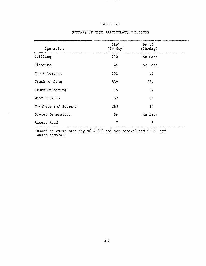
TABLE 3-1
SUtARY CS' .u:' PAR.::-7 ZUSs:Cts
TSI PS1-10Operati1n (lb/da! (lb/day)
Drilling 130 No Data
Blasi ng 45 No Data
Aruck 'adi.; 102 i
.. ck Fa iizg 539 A34
Trnuck Lh-'.Iaading 16 i
Wind Errzsn 282 31
Cvushers and Screens 383 9
Diese. Senerators ;6 No Data
Access Road ;
'3ased sn wrstl-case 2ay of 4 tpx_ ore remcva. an' 6,-650 tva s t e -ecva' .
3-2

practice for these sources and reduce emissicns by an estimated 95 percent. Crushing anc
screening emissions would comply with federal New Source Performance Standards for the
metallic minerals processing industry.
Fug;tive emissions caused by mining activities (blasting, waste rock removal, ore and waste rock
hauling, ore and rock dumping, and windi erosion) woul tie mitigated by the following methods
which are part of the project design:
* blast hole optimization,* minimizing dro- heg-nt during ore and waste rock removal and transle',. prompt reclamation an- revegea::on of ex:)se,' areas, and. watering and chemical dust suppression or haul roads.
The on-srte diesel generators would also produce some gaseous emissions, namely nitrogenoxides (N !), carbon monoxide (CO), and hydrocarbons (HO) Based on generator s;ze anr
operating time, em:ssics o' these polluta-ts trom the genera:ors were estimated usin- sla-.'arc
emission factors (EPA 14985. -he es:;rnate: Caiiy ermssions from these ssurces a e
*NO. 664 pounds per cay* CO 142 poun;^,ds Per day* HC 6C pounds pe day
The on-site fuel storage fanks would also add somewhat, to the expected HO emissions.However, due tc the relatively small tank sze. mi;nimai throughput, and low volatibity of diesel
fuel, i. is expected tha, such emissions would ne extremely small.
One final source of air emissions is potential air toxics stemming from impurities in the ore. TheMother Lode ore body contains small amounts of mercury and arsenic. Some of thesecontaminants would be released ir. particulate form through the dus' generating activities at the
mine. Also, some mercury would be dissolved into the pregnan' heap leach solution and carried
throughi the metal recovery operation to the crucible furnace, where it would be liberated andvolatilized into the atmcsphere. Based on mercury concentrations of the pregnant solution frompilo,-scale testing, mercury emissions are es'rmated at about 2.5 pounds per day at the crucib'efurnace. Since the arsenic is not dissolved by the leach solution and instead is retained in the
s-ent ore, no significant arsenic emissions are expected to occur at the crucible furnace.
3-3
The air quality impact. of emissions frcm the p-rccsed prcject wcid te regulated ty he Mieva:3
Division ci Environmental Protecl:o n (iNCE-). NCE_? wCuld review thFe prcpcsjI 'o ersue
emissionz comply with 'egulatorn limits ard T,! at irr,,pacts are withn a PIcI-Z ' air ;u;aiy
standards. Comrila.-ce with :the air c-aiy sVandarcs !s usially cneckecd _snrg an atm.cs:zeec
dis,,ersion mocel.
The air qualhty m.cdelirg ara'y-ss of p, cec*, ermss:cns vas -re-ared !ciic-wir;g ¾'- ,z,2cces
and guice;Ines. Ccncentraton es:tma'es %ere .m.aCe us.nrg the EP; C) crm,,ex I o sero
model, usirn metecrclcgzj.al data ':rm Las V<e-as The Eea.' 'iIgh Schccl Cata Cesc ned ir
Secticn 2.1 were not suled 'cr spe's.cr mc-el irput -eoaause They -c nct r.a 'e 24
osernations per day ar,c did nict irc!_ce ai 'ecured ;ararne!ers. 4However. the Las Vegas ca:a
were rcompared witri me Eeat-y data and %ere fcund to ccrrelate reascroa.-y ell. , he res_;t.
of the mcdekirg study are given :n zal;,e 3-2. At The rmna:mum irmpact pcirt. Th.e Z4*nrzu
particulate concentration ;s est:mated at 19 nmicrogarns per cutic meter with an arnual avera2e
Predictior cf 5 mocrcgrams Per Coutc meter. At Bea!y., ccncentraszn estxmates z! part;cu@ate
are I microgram per ^;tc re.er anC .1 , - ::^ar oer --_c meer 'cr :!.e max:r-m-u 4. eCard arnual averages. espe:veiy. 'r_, va:w , r, :e _ e, d :onrerIze-at:c-s ^:r- -
with tc.n the Ke.aoa total :ari.c_2ate s a^ca _.-C te 'edera! va- stnCard
Follcwing NZEP u,_es. :he m._cen;rg aayss Ces:; ed -ere -::,ces cn 1 e.s:,cs ^r-m
P rcess scurces sucn as crushers and cre harcain- a-- not 'ug;lve C.st !ram ,rn:--oceraticns. Aithcugh rct u-.:uant.tave!y -Coeed. mirir- erm ssocr.; dc acd to the astospne'.c
particulate Icadings and resu!tant air ;macts. ug ,,tive us: from mninirg ;s r-cst :rscLnced
during dry, windy cond;:tcns when -aricculate matter is Cic.-n locse arc carriec Xownvnd.
However, any part;culate That ;s er.ted from The m-ne is exwec-ed to be redepcs;ted on Th.e
ground within a short ds:arce Cdue :o grav:,aticral sen.grg and trtu!ert de-cs.::cn ThUs. a.y
impacts to air qualty from mining emiss:ons are expeoted c te tcth infreqtuent arC Nigrny
iocailzed.
The Cispers;on -moCei!rng ana:ys~s a'scz cOns:cered The ra.,-cas of aC C_, ard -,e'cur
emissions. These corncertrations a'so 'all we l uec a:Iicatie air ,ual:ty slancar's. 'n 3eatt;
ItseO, predicted impacts are fcr th.e Most part _etcw detectatle lirits. For mercury, the ^,.:.ca,
rece-ptor of concern is the lclsest Permanernt es;cerce or PIubtIC campzgrcund. which 'or t.s
stucy was sciectea to e :ri Da sy r Lcrswar VMre, atc'.,_ 3 iies Nest -f the "ot!7er Lde s.:e.
3-4

TABLE 3-2
SUJMMAPY OF ESThMA7-= AR PO 'U7TION I7?A-=S
FRCM USNGS OPERATIONS
(micrograms per cubic meter)
AveragingPer:od
usrsI M Ct
SackgroundConcer :rat;^ nr.
Total
InpactA-, r Qua::y
St an a r '
Myrrx ::,=,;za :t Po- t.
ParticulatePart i'a te
RD,CoCc
MerCury
Arlmal24-Hou:kAnua-8-Hour1-Hour8-hour
2.319.6
1.4
C .4
5101 5
230230
0
3016
0.,
, 4
75, 'Cl;C,.SIC
4 C' ,000IIC, 000
, -AA. . ^
Beatty 'ro-. Center
Pa rti cu.ate
NC.
Me "-ur-u,
kAnua.2C4-Hcsjr
24-Hour
1 -H oura-Hour
0.0'C . .
C . 1- I
C.::0.6I,< ,,.
iO
A.3
C
IC1 5
0323.I
0
75,5'SA SC, .C
4'V', orC
; .2
Flucrs:>ar Mine
8-Hour 0.04 C 0 .04 1.2
1State -S? sar da.rs,'feeraI P.-1 sIans ar4s chza:.
3-5

In summary, operation of the proposed Mcther Lode Prcject would generate air pollutant
emissions and result in increased levels of pariculate and other pollutanrs in the atmcs;phere
around the project. However, amtient concentrations of all pcilu~an:s are predicted to 'e very
small and would remain within present air quality standards. T hus, nc significant impacts are
anticipated.
3.1.2 Alternatives
No imoacts to air quality would resun frorm the No AcSJn A,:erna:\e.
For the remaining alternatives, air pollution emiss;crs and impacls owuicd rermain essentially the
same as the Proposed Action, with only very rminor Ciferences due to changes in the ore and
waste hauling aistances. However, in both Alternatives 1 and 2. the hauling distances are
relatively short, and ttese ermissions soculd be minor.
3.2 GeoloQy and Mineral Rescurces
3.2.1 Proposed Action
The geology and mineral resources Impact assessment empr.hasized three pr;.ary Iccics.
. potential geclcgic hazarCs to projec, facilit;es cr hurman ife,* potential hazar.s created ty project facilities; and* potential etfects on future extraction of economic m,.ineral resources.
Geologic hazards evaluated at 'he site include the occurrence of expansive soils and seismic
hazards. Expansive soils have been identified at t1'he subject ste; -4cwever, preliminary stulies
indicate that their extent is limited in volume, and their potential effect on the site apears
minimal at this nme (N.A. Degerstrcm 1989). Studies related to expansive Scils are expected
to be completed by 'he end of March 1989. Possible seismic hazards would inc!ude grcund
shaking and soil liquefaction. Geotechnical investigatiors currently in prcgress are uth::z ngI
specialized design measures to mitigate potential damage to facilities in the event of a malcr
earthquake (Kiohn Lecnoft :589, N.A. Ce-erslrcm 1S89).
3-6

Geologic hazards created by project activities would Include steep slopes in the mine pit and
waste piles and creation of saturated soil conditions that may give rise to hydrocompaction or
liquefaction of susceptible soils. Steep slopes in the mine pit would be comparable to rock
outcrops on nearby ridgetops. Pit design studies have not been completed; however,
preliminary data indicate that significant bedding problems from rock strata are not anticipated
(N.A. Degerstrom 1989). Moreover, 20-foct safety benches would be cut into the pit walls during
operation and abandonment of the mine, which would contribute to stability and reduce the
rockfall hazard in the pit.
The proposed project would not prevent future extraction of economic mineral resources except
in very limited areas. Condemnation drilling has been conducted by USNGS to avoid placing
waste piles, or processing facilities over mineralized zones. Sulfide ore would be stockpiled in
a segregated pile to allow for future processing i warranted by economic conditions.
The projected heap leach recovery would be approximately 80 percent gold and 10 to 20 percent
silver. This would result in beneficial economic use of the mineral resources. No paleontological
sites are known to occur in areas that would be disturbed by the mine, processing facilities, or
othier ancillary facilities.
3.2.2 Alternatives
There would be no recovery of mineral resources from the project with the No Action Alternative.
Tie impacts to geology and mineral resources from the facility location alternatives would be
similar to the Proposed Action.
3.3 Water Resources
This section summarizes the environmental consequences of the proposed project on the water
resources of the area. More detailed discussion can be found in the Water Resources Technical
Memorandum included as Appendix A of this document.
3-7

3.3.1 Proposed Action
3.3.1.1 Groundwater
Cuantiri. The mine and process facilities are expected to use about 400 acre-feet of water per
year at an average rate of approximately 250 gpm. The Mother Lode Prcject is projected tohave a 3-year life; however, USNGS has applied for 7-year water permits to include possible
development of their sulfide cepcsit. Prcect wells are currently planned to be developed in
Crater Flat to the north and east of the project (see Figure 1 of Appendix A). The shadlowalluvium in Crater Fiat appears to be unsaturated in the vicinity of the Mother Lode Prjcect.
Groundwater irrpacts would therefore be limited to confined aquifers and aCuitarcs at depth
such as welded and non-weldec tu'ffs and possibly carbonate rocks (Hydrc-Search Inc. 1989).
Current static water levels in the area are approximately 200 tee! telcw the surface (3,907 feelelevaticr.).
Pumping tests have not been performed in the Crater Fiat area to measure drawdown and to
calculate aquifer parame ers. Based on es,:mated values of transmissivity and storage cce!fic:ent
and assuming 4,0C0 feet of water-saturated thickness, a max mum rnne life (inc!uding the sulfidedeposit) of 7 years, and a continuous supply requirement of 5C0 gSm (rfice the expected use),
the drawdown at a 5-mile radius was estmr-nated to be 4.2 feet (Hydro-Search Inc. 19E9). thisis a very conservative estimate because it assumes no hydraulic barriers to the drawdown wouldbe intercepted during the 7-year period of projected crawdown. In realtty, the geologic materiaisexposed at the surface, subsurface geologic interpretations, and drilling results to-date by
USNGS all conclude 'Hat relatively imperdious barriers would be encountered to the west of theproposed wellfield (Hydro-Search Inc. 1989; Winograd and Thordarson 1975). This condition
would result in greater than projected drawdown in the vicinity of the weilfield ard a
corresponding reduction in water level drawdown to the west (Hydro-Search Inc. lSE9).
Bare Mountain acts as a hydrogeologic barrier in the local area to the south and west (seeAppendix A for further details). i here is also a hydrologic barrier to the southeast, west of Ash
Meadows and Devils Hole (Wincgrad and Thordarson 1975; Sharp 1989). Groundwater flow
direction is generally toward the south. In summary, because of existing hydraulic boundaries
and groundwater flow direc-ion, Wincgrad and Thordarson 1975; Czarnecki and Waddell 1984;
Sharp 1989; Hydro-Search Inc. 1989) the wellfield is somewhat isolated from other water usersin the region and from sensitive areas of concern such as Ash Meadows, Devils Hole, and
3-8

Death Valley National Monument (see Appendix A for further discussion). Because of these
hydraulic boundaries, groundwater impacts are also not anticipated to the residents and
agricultural uses in the Amargosa Valley.
There are no other operating wells within 8 miles of the project; therefore, impacts to individual
private water supplies are not anticipated, Because of the hydraulic boundaries present, the
groundwater flow direction (see Appendix A for further discussion), and the relatively small
amount of water withdrawal involved, no impacts are anticipated to the north, east, west, and
south of the welifield outside of the hydrologic boundary area (see Figure 1 of Appendix A).
Consequently, no impacts are anticipated to springs north and northwest of the project or to the
regional groundwater system including Death Valley National Monument, Ash Meadows, and
Devils Hole.
Quality. There are a numbe' of potential groundwater contamination sources associated with
the project. Potentia! impacts from the open pit, waste rock dumps, and leach operations are
not considered to be significant primarily because: adequate surface water diversion is provided;
a moderate degree of hydrologic isolation is provided since groundwater is at least 200 feet
below the surface in a low-permeability, fractured bedrock aquifer; and the arid climatic setting
precludes the generation of seepage. All liquid systems, including all piping and ponds, will be
tested for leaks prior to startup. This should minimize the potential for leaks from the piping and
the ponds. In addition, a monitoring and collection system will be installed in the solution
storage ponds to facilitate early leak detection and collection of liquor should any leaks occur.
No adverse impacts to groundwater quality are anticipated from any of these sources, as
discussed in detail in t!he Water Resources Technical Memorandum in Appendix A.
3.3.1.2 Surface Water. Impacts to surface water resources from the proposed project are
expected to be minimal as a result of the semi-arid climate and the absence of significant surface
water.
Pond systems are designed in excess of a 25-year rainfall event, in accordance with the
requirements of the Nevada Division of Environmental Protection. The ponds are designed to
handle a total of over 3,000,000 gallons of water. A 25-year, 24-hour -vent would produce,
including the operating inventory of water, a total of 2,300,000 gallons of water. The ponds are
not anticipated to breach as a result of expected rainfall events.
3-9

The confluence of Tates Wash with the Arr-ar-csa River is over 30 miles to the souiheas: ct fthe
project site. Flow would only reach the Arnargosa River from Tales Wash in a very extreme
generalized runoff event. Mean annual flow for the ephemeral drainage is expected to be
negligible with flow expec4ed only in response to high prec:pitation events, mainly as flash flocds.
These existing conditicrs are not expected to be altered s;r;:f;icarnty by the proposed diversions
Therefore, the propcsed development is not expected to signifcantly a!ect the surface flow
through the area. Furthermore, the risk of fa~lure ct access rcads and fIcoding of the mine s;:e
from lash flooding is low because peak discharges and vclumes should me relatively smail.
The Amargosa River shculd not be a"iected.
3.3.2 Alternatives
There would be no impact, to groundwater or surface water frcm the No Ac,.cn Alterra'ive.
Impacts to groundwater and surface water would be s:,m.lar to The Prcpcsed Aclcn for both tf
the fac:lity location alternatives. Alteriatives 1 and 2 ard the well ;ocations are Iccated withFin
the same groundwater system as the Proposed Action: therefore, tre .mr.,acts of water
withdrawal and potential groundwater cor.taminasicn would be the same. No adverse irmacts
to surface water are excected frcm the fac;liy location alternatives.
3.4 Soils
Potential impacts of the proposed project on native scil resources were evaluated to Cetermine
the extent to which project activities would result in either soil compaction or losses via burial
or accelerated erosion. Project area soils were also evaluated regarding their suitability for
salvage and subsequent topsoil use for reclamation and reve-etation. Table 2-6 summarizesrecommended topsoil salvage depths for each soil mapping unit.
3.4.1 Proposed Action
Construction and operation of the prcposed pro!ect would result n the unavoidable disturbance
of approximately 75 acres of soil resources. The locations of scils suitable for salvage
3-10

indicated in Figure 2-2. While the water supply well and pipeline would result in additional
disturbance, USNGS does not propose to salvage this topsoil.
All of the disturbance area for the Proposed Action has soils suitable for !slvage except a small
2-acre area on the souithern boundary which is par. of the Bare Mountain foothills and contains
rock outcrop unsuitable for salvage. The large alluvial fan (pediment) north of Bare Mountain
which constitutes the rest of the Proposed Action aisturbance area has 10 to 13 inches of
suitable topsoil material. Soil units A and 5 are mapped on this alluvial fan and have suitanle
soil material until a very hard duripan' is encountered. As noted in a footnote to Table 2-6,
Map Unit A has 10 inches of suitable soil over 10 inches of hard clay which in turn is underlain
by the hard, cemented Ouripan. This Clay material woul' be better used as a natural clay liner
on top of the duripan. Although it is uitable materia~l it is not recommended for salvage astopsoil. Map Unit B lacks this clay layer, and the entire Soil depth, an average of 13 inches, to
the duripan is recommended for topsoil salvage.
The Proposed Action area has a wei ,ited-avera-e recommended topsoil salvage depth of 10.2
inches. Based on an average topsoil salvage depthi c' 10.5 acres throughout the projec- area,
an average of aPproximately 107,0OC cubJic yards are available for salvage from the 75 acresof disturman-ce for the Proposed Anton or the alternatives.
3.4.2 Alternatives
The No Action Alternative would not d:sturb native soil resources. An average o 11.3 inchesof topsoil could be salvaged for Alternative 1. In Alternative 2. an average of 10.4 inches couldbe salvaged. As a result there is no significant difference among the Proposed Action and thealternatives concerning the depth of topsoil available for salvage.
3.5 Vegetation
Impacts associated with the project include vegetation removal and loss or reduction of plant
productivity.
3-11

3.5.1 Proposed Action
Approximately 75 acres would be affected by construction activities associated with the propcsed
mining operation (e.g., mine, leach areas, processing taciiities, waste rock stcrage, tcpsol
stockpile areas, miscellaneous support). The disturbance would be ,irmited to the mixed desert
shrub/forb and mixed desert shrub vegetation t.ypes. These types, in addition to the blackbrush
vegetation type, dominate the project area and vic;nity. Eased on an average carrying capacity
of the study area of 53 acres/IAUM, less than 2 AU MS/year is the estirmated produclivit/ Icssassociated with the proposed mining operation.
Impacts to federal or state !isted threatened or erdangered ,clart s,:ec;es are not expeced tooccur as a result of project constructicn and operat'cn. No feCeral candidate species are knownto occur near the study area. The study area was surveyed for spec:es pctentially presentincluding the Fur.eral Mountain milkvetch, Mojave sweet pea, Rpley's gilia, and Mcave fisnhock
cactus. None of these species were encountered within the study area. The concentraticrs ofthe many-headed barrel cactus in the tlackbrush vegetation type would nct be impacleed as they
are located south of the prcopcsed mining area wSecl;cn 2.5.2).
Air emissions were examined to assess potent;al vegetat!cn im#ac:s. Fugitrve dus 'rom .,miningoperations would occur (Sec-tcn 3.1); however, damage to ve-etaticn is not expecoed. Dustdeposition should pose only minor impacts since the effects wc' :ld be highly localized.
Vegetation removal and assoc;ated productivity losses wcuLd te cumulative over the 3-yearproject life. After operaticns cease, vegetative cover ard prcduct:vity would gracualby berestored on disturbed areas.
3.5.2 Alternatives
The vegetative loss associated wirth the proposed mining operation (approximately 75 acres)would not occur with the No Acticn A'ternative. A total of aPprcx:rrately 75 acres of vegetationwould be affected by constructicn activities in Alternatives 1 and 2. with disturbance occurring
in the mixed desert shn.r.b and mixed desert shrub/forb vegetation types. Impacts to sens;tive
plant species would be the same as discussed for the Proposed Acticn.
3-12

3.6 Wildlife
3.6.1 Proposed Action
The construction and operation activities were evaluated with respect to impacts on big game
crucial habitat; important chukar and Gambel's quail habitat; raptor nesting habitat and nest
locations; and habitat for other wildlife groups. Overall, the project would affect local populations
of small mammals, songbirds, and reptiles, but no major impats to important species or
regional wildlife populations would be expected.
Mining, with the associated waste rock disposal areas and construction and operation of the
heap leach facilities would result in the direct physical disturbance of approximately 75 acres of
vegetation and wildlife habitat (see Section 3.5, Vegetation). The types affected would be mixed
desert shrub/lorb and mixed desert shrub. These habitats and associated small mammal,
reptile, and songbird species are typical of the Great Basin Desert and northern Mojave Desert.
The loss of prey species would affect small numbers of local predators such as coyote, badger,
and kit fox, and raptors such as the golden eagle, prairie falcon, and red-tailed hawk. The area
of potential disturbance is small relative to the hunting range of these species. Habitat losses
would bc for the life of the project, a longer depending upon re clamation success. Important
big game use areas are well away from the project see.
Small numbers of mule deer are known to occur in the vicinity, but use is sporadic and impacts
of habitat loss to the species would be minimal. Similarly, the project would not directly disturb
bighorn sheep range. The project would reduce available habitat for chukar and Gambel's quail,
but significant effects to local populations are not expected. Yearlong use areas for these
gamebirds would not be affected by construction acttivities. No impacts to raptor nest sites are
expected to occur as a result of the Proposed Action.
Waterfowi are not common in the study area and vicinity due to the scarcity of surface water.
No wetlands are present within or adjacent to the study area. Occasional waterfowl use occurs
in the Amargosa River area (approximately 4 miles northwest of the project area) and at springs
located outside the study area. Waterfowl and shorebird migration routes do not cross the
project area as the migration tends to follow the Amargosa River valley. USNGS has committed
3-13

to fencing and netting the neap leach solution ponds; therefcre, the ponds would not affest
wildlife and waterfowl.
No Impacts to threatened or endangered wildlife species are expected to occur. Crucial habitat
for the desert tortoise does not occur in the project region. The Amargosa toad is known to
occur in springs, canals, and other wet areas 5 miles southwest of the project area, but no
habitat occurs in the project area.
In addition to the direct impacts of habitat loss, potential indirect wildlife impacts include the
effects of increased human activity in the area. Indirect project impacts would include increased
traffic, noise, and consumptive uses of wildlife, resulting in increases in wildlife road kills, legal
and illegal hunting and shooting, harassment, and other disturbance. For the proposed project,
workers would be expected to use existing RV sites or local lodging facuities (see Section 3.10,
Socioeconomics, for a discussion of worker numbers and associated population increases).
3.6.2 Alternatives
The No Action Alternative would have no impact on wildlife. Alternatives I and 2 wculd impact
approximately 75 acres of wildlife habitat. Impacts would be the same as described for the
Proposed Action.
3.7 Land Use and Recreation
3.7.1 Proposed Action
3.7.1.1 Land Use and Land Use Plans. The proposed project would be located on unpatented
mining claims administered by the BLM. Because unpatented ground is part of the proposed
mining operations, USNGS must comply with 43 CFR 3809, BLM regulations governing surface
mining, by submitting a detailed Plan of Operations to the BLM for review, comment, and
approval. USNGS would comply with all SLM regulations governing surface mining under these
General Mining Laws. Under the Droposed project, approximately 188 acres of unpatented land
would be affected. Most of the land proposed for the project has historically been used for
mining, dispersed recreation, open space, and cattle grazing (see Sections 3.7.1.2 and 3.7.1.4).
3-14

The proposed project would be consistent with Nye County and BLM land use plans for the area,
as both favor maintenance and encouragement of existing uses, the concept of muftiple use on
federal lands, and the development of mineral resources. There are no permits (i.e., building,
land use, etc.) required from Nye County.
The location of the proposed project facilities would have no direct land use conflicts with the
Town of Beatty. Other potential impacts to this community are discussed elsewhere in this
report (e.g., socioeconomics, visual resources, transportation, etc.). The proposed project
should have no other land use conflicts.
3.7.1.2 Recreation. Outdoor recreational resources including dispersed recreation, hunting,
fishing, camping, and off-road vehicle use would be lightly affected by the proposed mining
project because existing use is relatively light, and thL region has abundant acreage of public
open space lands available (Grover 1989b).
Based on a permanent increase in population of approximately 127 (including secondary
impacts), with the majority locating in the Beatty area, an increase in demand on local
community recreational facilities and programs is expected. Existing recreation facilities,
particularly the ballfields and community swimming pool, are currently at capacity; consequently,
the additional demand would create an adverse impact and most likely, a need for additional
facilities (Crowell 1988)(spe Section 3.12.7).
3.7.1.3 Wilderness. The closest potential wilderness area is the Grapevine Mountains WSA,
located approximately 25 miles northwest of the project area. The proposed mining project
would have no impact on the Grapevine Mountains WSA.
3.7.1.4 Grazing. The project area is located within the Razorback Allotment. The carrying
capacity is based on approximately 53 acres/AUM. The proposed project, at this capacity,
would result in the loss of forage for less than 2 AUMs. However, due to lack of water for
livestock in the area, the fact that grazing may occur following completion of the project, and the
short life span of the project, there would be no effect on livestock use. The area is infrequently
grazed by cattle I. je to the distance from water.
3-15

3.7.1.5 Wild Burros and Horses. Wild burros and hcrses tend to concentrate in areas wikh
available water supplies. Water within the Su!lfrcg Herd Management Area is especially limited
causing increased competition for forage and space. Water is particularly scarce east of Bearty.
The only naturally occurring water scurce in the proposed project area is Spec:e Spring, located
approximately 3 miles south of the prcpcsed prcject site (Pogacnr.k 1989). Any open water
within the project area would be securely fenced (see Section 3 12.4). Fences in wild burro and
horse herd management areas would be tcoated to minimize interference with the normal
distribution and movement of these animals (BLIM 1*86).
3.7.2 Alternatives
The No Action Alternative would result in no change to ex:s:irg anad use or recreation in the
project area. Alternatives 1 and 2 would result in the same mnpaos to land use and recreaton
as the Proposed Acticn.
3.8 Cultural Resources
The National Park Service's National Register C'.teria for Eia!uation (NPS 1982) assess whether
properties are significant in local, state, or naticnal history, on the basis cf their arcnitecture
archaeology, engineering or culture. To merit Nat!cnal Pec:ster ccrtsderat:on, properties must
possess integrity of Iccation, dessgn, settirg, materials, wcrkmarsho, feeling, and association,
and:
* be associated with events that have made a significant contribution to the Wrcadpatterns of history;
* be associated with the lives of persons significant in the past;
* embody the distinctive characteristics Of a tiype, period, or rrethcd of ccnstruc;cn,or that represent the work of a master, or that possess high artistic values, or thatrepresent a significant and distinguishable entity whose components may lackindividual distinction; or
* have yielded, or may be likely to yield, information irnpcrtant in prehistory or history.
In accordance with Section 106 of the National Historic Preservation Act, an archaeologcal
survey was conducted by Interrmcurtain Research. Thirty-seven prehistoric and 17 historic sites
were identified. Upon receipt of the final cultural resources report, the BLM, with the
concurrence of the State Historc Preservation Otfice, will determine National Register eligibility.
3-16

Six prehistoric lithic scatters, arthough probably not eligible for National Register of Historic
Places (NRHP) nomination on their own merit, may demonstrate eligibility potential as a district.
These sites all contain an abundance of lithic tools which may predate 2000 B.C. and imply an
unusual Early Archaic utilization of upland, streamside environments. Additional survey and
evaluation of these sites is necessary prior to a final determination of eligibility.
Severa' moderate to large prehistoric quarry sites may also be etigible for NRH? nominatlon
these sites also require additional evaluation of their significance.
Once NRHP eligibility has been determined, effects to these properties will be ascertained and
suitable mitigation options, if necessary, will be pursued. The BLM will address culturalresources impacts and associated mitigation in the Record of Decision.
3.9 Aesthetics
3.9.1 Visual Resources
3.9.1.1 Proposed Action. Visua! impacts caused by the proposed proje- were analyzed using
the procedures ojvined in the LOM Visual Resource Contrast Rating Handbook (USD1 BLM
1985). Visual impact signiftcance was determined by comparing visual contrast ratings for theproposed project facilities wfth visual resource management (VRM) class objectives for the
respective management class affected (Table 2-10).
The 253-acre project area is designated VRM, Class IV because it is visually similar to most of
the southern Nevada region and because i is situated in a small valley that receives very fewvisitors. A Class IV designation permits a high leve of change to the characteristic landscape
but re-uires that 'every attempt should be made to minimize the impact oF the project (Table
2-10).
Visual contrast analyses were conducted from three 'Key Observation Points' (KOPs): 1)
approximately 1 mile west of the proposed open pit on Tates Wash Road, representing backcountry travelers approaching from the Beatty vicinity; 2) a spot in the small 'badlands' area
adjacent to the cistern, representing back country recreationists that may be drawn to the vicinity
3-17
to see the cistern or to explore the rock formation; and 3) a point on U.S. 95 about 5 miles north
of Beatty, near Bailey's Hot Springs RV Park, representing travelers approaching the Beatty area
from the north and residents of Oasis Valley.
Dovelopment of the proposed project would introduce changes to the visual character of the
project site that would be very visible from KOPs 1 and 2. The open pit would not be particularly
obtrusive because it would be below grade, relatively small, and nestled against the base of the
north ridge of Meiklejchn Peak. However, the sizes and geometric shapes of the waste rock pile
and leach pads would represent obvious man-made changes to existing landscape character
that currently appears predominantly natural despite several roads and a few remnants cf historic
mining in the area. Most importantly, exploration cuts indicate that at least a portion of the ore
and overburden are very light to almost white in color. Waste dumps and ore piles exhibiting
this light, bright color would contrast very strongly with natural surface soil and vegetation colors
in the area which tend to be mostly muted grey greens, medium beiges, and browns.
Proposed recontcuring and revegetation of the leach pads and ponds would notably reduce the
long-term visual effects of those facilities (see Section 3.12.6.1). Proposed recOntouring would
also reduce the effects of the waste-rock pile somewhat, but the strong color contrast would
continue for mdny years because the pile faces would not be spread with topsoil and
revegetation would be very slow.
Visual effects would be strongest to viewers from KOP 2 because it is the c.csest to the project
site. KOP 2 has the broadest and only unobstructed view of the entire proposed project. It is
also the only KOP at which viewers would be likely to linger for more than a feeting view,
although only a small number of visitors are believed to use the area around KOP 2.
Visual effects observed from KOP 1 would be less intense because part of the proposed project,
including the waste-rock dump and much of the mine pit, would be screened from view by
terrain. Also, most viewers would be moving past the project site and would have only brief
views of project facilities.
Views from KOP 3 would be only minimally affected by the proposed project because all
proposed facilities would be screened from view by terrain. The only project-related activity
visible from KOP 3 is the existing network of roads cut for exploration drilling on the northwest
3-18

face of the north ridge of Meiklejohn Peak. Although visible, the road cuts do not demand the
attention of the casual viewer because the network is over 9 miles from the KOP and is a
relatively small part of a large and varied viewshed visible from KOP 3. In addition, asrevegetation of the road cuts occurs over a period of years, the current color contrast will bereduced, and the existing disturbance will become more difficult to discern from the natural
backdrop.
Although the proposed Mother Loce Project would introduce high levels of visual change.
especially from KOPs 1 and 2, the visual contrast would not exceed acceptable levels in a ClassIV area. It would be possible, however, to reduce the impacts through certain specific measuresas required by the VRIM Class IV management objective. Suggested measures are addressed
in Section 3.12.
The distance of the Mother Lode Project from Death Valley National Monument and the
intervening topography would likely preclude a visual impact on night sky views in the
Monument.
3.9.1.2 Alternatives. The Nc Action Alternative would result in no additional visual effects onviews from all three KOPs. The existing exploration drilling access road cuts on the northwest
face of the north ridge of Meiklejohn Peak are visible from all three KOPs and would remainvisible for a number of years until they revegetate.
Development of Alternative 1 would result in somewhat lower visual contrast than the ProposedAction as viewed from KOPs I and 2 because the leach pads would be largely screened from
view by the waste rock dump. Visual effects on KOP 3 would be the same as described for the
Proposed Action. Visual effects of developrng Alternative 2 would be slightly less than for either
the Proposed Action or Alternative 1 as viewed from KOPs 1 and 2. Because the waste-rock
dump would be farther to the east, it would be partially screened from view by terrain from KOP1. t would be farther from viewers at KOP 2 and therefore less visually prominent. Visual
effects of Alternative 2 on KOP 3 views would be the same as described for the Proposed Action.
3-19

3.9.2 Noise
3.92.1 Proposed Action. Sources cf noise from development of the proposed project would
include rock drilling, blasting, loading and hauling of cre and waste rock, ore crushing and
handling, and access road maintenance and repair. Table 3-3 lists a roster of major noise-
emitting equipment together with maximum ncise emissicn levels for the project. Emission
levels are considered to be conservative (worst-case) because they are based on the high end
of measured ranges for each unit of equipment (EPA 1971). Combined noise em;ssion levels
for the prciect would be approximately 1C5.7 CBA at a 50-foot reference distance assuming an
unlikely worst-case scenario with all equipment operating simultaneousiy at maximum output.
These extreme conditions would virtually never occur. They rarely would be approached, and
then only for brief periods. Consequenlty, the results of the noise analysis would be considered
extreme worst-case; typical project ncise emiss:ons would be less than the levels indicated in
the analysis.
The proposed Mother Lode Project is quite remote. The nearest sensative receptor is over 4
miles from the project site, rear U.S. 95, where ambient noise levels are higher Than in the tack
country due to highway traff-c. Also, the s;te Is a valley surrounded by Nils and mountains that
would function as barriers to noise. Calculating noise effects tf tire worst-case przjec, emiss;ons
using only attenuation (noise level reduc otn) from spreading of sound waves over distance
results in sound pressure levels sfig.-tly over 53 d3A at 4 miles from the project site. Nolse of
this level rarely would be discernible at residences in the Oas:s Valley north of Beatty. Actual
project noise emissions typically would be lower than the maximums calculated. In acditicn,
project-generated noise levels at the nearest residence would be further reduced by attenuation
from atmospheric absorption and from barrier efects of the intervening terrain. Consequently,
noise from general Operation of the Mother Lode Project would rare!y, it ever, be perceptible at
sensitive receptors.
The noise analysis does not quantitatively consider blasting noise because the short, once-per-
day blasting period would have little if any effect on quantitative noise results. Blast noise would
probably be audible at residential receptor areas but it would be at relatively low levels. The
key considerations for blasting are time of day and pctent;al for perceptible ground shaking. It
is expected that controlled blasting for the mine would not generate perceptible ground shaking
3-20

TABLE 3-3
MAJOR NOISE SORCES
Equipment Roster'Type
Hydraulic Excavator
Grader
Water Truck
Powder Truck
Haul Truck
Loader
Dozer
Dozer
Rotary Percussiorn
Size
5 yard
14 foot blade
10,000 gallon
10 ton
50 ton
Maximum NoiseEmission Level
Per Unit(cA)2 .3
93
93
85
85
93
10-12 yards
335 HP
165 HP
6.5 inch
85
93
90
98
TotalUni ts:
1
1
1
1
7(2 spare)
2
3
1
2(I spare)
10
1
1
Miscella.neous Vehicle 3/4 ton
Jaw Crusher 30" x 42"
Secondary Crusher 4' Standard Cone
Diesel-Electric Generator 600 kw
Sources: 1USN(3S 19882EPA 1971, CERL 1978, &"SR file data3Reference distance - 50'
75
100
100
85
3-21

at sensitive receptors. Blasting would be limited to the hours between 8:00 a.m. and 10:00 p.m.to minimize the potential for disrupting the sleep of area residents.
In summary, noise effects of the proposed project would not be significant at noise sensitive
receptors in the area.
3.9.2.2 Alternatives. There would be no noise effects from the No Action Alternative. Noise
effects of Alternatives 1 and 2 would be similar to effects from the Proposed Action with totalemissions essentially the same and noise levels at sensitive receptors slightly lower because the
activity center would be farther from the receptors.
3.10 Socloeconomics
3.10.1 Proposed Action
This section evaluates the beneficial and adverse effects of the proposed project within thecontext of social and economic changes in the study area. The prcject.-related impacts, bothtemporary and permanent, cannot be treated in isolation, but must be related to changes in the
overall economic picture of the area, including the uncertainty associated with future U.S. Ar
Force and Department of Energy activities and increased mining exploration and development
throughout the area. Cumulative effects may compourd or offset one another and these effectsmay vary through different phases of development. Two impact assessment scenarios for
construction are presented here based on: (1) Impact Assessment Scenario I - the most currenthousing information as of February 1989; and (2) Impact Assessment Scenario 2 - theassumption that additional housing will be in place during the entire construction period. Futurechanges in employment and phasing of other projects may result in changes to the impacts
presented.
Calculations of impacts were based on known characteristics of the study area, supported by
professional planning standards and empirical data from other mining projects in Nevada.
Tables 3-4, 3-4A, 3-5, 3-5A, and 3-6 renect the projections of impacts from project development
during peak and average construction and during operations for the two scenarios. These
projections are not meant to represent actual impacts, but to reflect a range of potential impacts
given existing and proposed conditions.
3-22

TAJL 3-4
!)QACT ASSLSSPENT SCW;APO 1'
PAE emuntRUT2OtI PH.&St. 191
nOPOSCO ?Fl CT n DPLOY r., Por-PUA:O?,
OUSSNC, An: SCOOO L-ACt CK2ILOD PpnCIONS
Averrqe Annuil Lo al2 Non-Local Total Local Por-Local total Total RawDoployment- Direct Direet Direct Indirect Indirect Indirect Employ"On!
now !Mlovment 7S 4 71 7S 10 4 14 Is
Non-Locl Non-LocelDirect Indirect Now Households
Mew Households 4
New Workets 71 4
Single5 4 314Married (1 wor er) 1 * 7Married (2 Workers) O O eTotal Now Houceholdl 3T 1 *1
SBatty Amrqoss Valley
New Household Allocation 33 6
New Population
Single Household S4 14Married Household 20 5
Total 74 19
Pew School Children
Secondary 2 °Primary 7 2
Total 9 2
Housing Preference1 0
Sinyl*-Psaly 1M15dt a -ru ly 4Mobil* Home 6Other (WV or Note.) 30
Total 41
'5baed on current (February 195t) hous-nq inforvation.
3-23

TABLE 3-4 (CNTrINUTD!
Notes:
'The average construct:on work force is 50 cver the 3-mcnth consr cticnperiod. The peak work force of 75 will occur for 2 to 3 weeks inMay 1989.
2The constructicn work force is assured to be 5 percent local, 95 percentnon-local (BLM 1980). Lccal workers will co-mzute to and frc. t;heLr placeof residence to work on a daily basis (.Mc.yler, Kaiser '.gineering 1987).
3;ndirect ccnstruction e.-plcy.ent is calculated using a c-nstruc: -nemployment multiplier of 1.2 based cn 1978 emplcyment location quotientsand basic/non-basic employment. It is assured *t.at 70 percent of theindirect labor force are second persons in the direct labor households orcurrent residents of the Beatty area (ERT 1980).
4' Te construction work force is c-rpcsed of 90 percent single workers ormarried withcut family, and 10 percent -.ar::ed workers with family(Mc!yler, Kaiser Engireering 1987).
51t is assumed that single workers will dcuble up; therefore cn'; cnehcusing unit would be required for two workers.
'Both husband and wife of S per:ent of the married workforce are assumedto work at the mine during constr-ction.
'Eighty percent of the construction workers wil reside in the Beattyarea, 20 percent in Amargosa Valley.
Population estimates are based on ' persons per household for singlehouseholds with direct workers, 2 persons per household for singlehouseholds with indirect workers, and 3.5 persons per household formarried households (BLI 1980).
'School-age children are estimated at 1.0 per married household. Eightypercent of school-age children are primary students, 20 percent secondarystudents (BL' 1980).
"0Housing preferences are shown based on the following percentagedistribution:
Eeatt' '?ercent)
Single Family (SF) 2Multi-F&Muly (M.F) 10Mobile Hcme (5H3) 1iOther 73
; otals on tables may not add up due to roundi.ng er:ors.
3-24

TASD 3-4A
DOACT AZStSSZf S WAAZ0 2
iiAr ConsTRUCTION tff.S 1939
pboPoSza P MOf W OYY POPVLAM' ON.
NCUjSZS AID SCHOO4L-A4t CHILD PbOflCTZONS
Averag Amnutl Local2 Non-Local Total Local *on-Local TotAl Total Powtopleynt Direct Direc` Diroet Zndiroet Indirect IndArect t£Ployment
Pov E31vefywnt 75 4 71 7* 10 4 14 *9
Non-Local Non-LocalDirect Indirect Now Households
Rev Nouseholds 4
Noe Workers 71 4
Single3
50 3 42Married (1 Worker) 19 1 20Married 12 War a)' 1 0 1
Total New Households 40 3 *4
Beatty A"argos Valley
ewv Household Allocation 51 13
Pow PopulationI
Single Household 42 11Married Household 60 1S
Total 102 26
Rew School Children'
Secondary 5 1Prisary 21 5
Total 26 4
Housing Preference1 0
sinql _e-rnily 1
multi-rTamly 2Mobile Home 27Other 33
Total *4
'Assumes additional housing will be in place durinq construction.
3-25

maBLe 3-4A (C~h:'VD)
Notes:
'The average construction work force is SO over the 12-mcnth construct onperiod. 'Thie peak work force of 75 will occur for 2-3 weeks in May 1989.
2The construction work forcenon-local. Local workersresidence to work on a daily
is asszmed to be 5 percent local, 95 percentwill ccnrute to and from their place ofbasis (Mcmyler, Kaiser Engineering 1987).
3 ndirect construction employment is calculated using a constructicnemployment multiplier of 1.2 based on 1978 employrent location quotientsand basic/non-basic employment. It is assumed that 70 percent of theindirect labor force are second persons in tUhe direct labor households orcurrent residents of the Beatty area (M'. 1980).
'The construction workforce is composed of 90 percent single workers ormarried without family, and 10 percent married workers with faxisy(Mcyler, Kaiser Engineering 1987).
s:t is asszw d that 20 percent of direct single workers will double up.The remaining single workers would live alone.
6Both husband and wife of 5 percent of the married workforce are assunedto work at the mine during construction.
"Eighty percent of the construction wiorkers will reside in the Bea:tyarea, 20 percent in Amargcsa Valley.
$Population estimates are based onhouseholds with, direct workers, 1households with indirect workers,maLried households (Bun 1980.
2 persons per household for singleperson per household for singeand 3.5 persons per household for
'School-age children are estimated at 1.0 perEighty percent of school-age children are primarysecondary students (BLM 1980).
°Housing preferences are shown based on thedistribution:
Beatte:
Single Family (SF)Multi-Family (OF)Mobile Home (MH)Other
married household.students, 20 percent
following percentage
'?ercent)
23
4352
"Totals cn tables may not add up due to rounding errors.
3-26

TAIUS 3-S
LOACT ASSESSM SWC 1
AVMGt COMMUCTION P1ASt. 1q91
POPOSSD PY3?CT DaLOmr.N POP'JLATION,
W C A SOCOOL-AGS O1:LDL-1 FR=CT1ONS
AvLrog A ~nual Local2 lon-Local Total Local Pon-LocAl totaI Tota; PewEmployment Direct Direct Direct Indirect Indirect Indirect taploymv.r
Pow DTvE0lovnt 50 2 43 50 3 10 1 60
Pon-Local Peon-Locrl
Direct IndArect Now Householda
4ev Nouaeholds 4
43 3
Now Workers
Single5
44 3 23
Married (I Warker 4 0 4Arrisc. (2 Workera 0 C 0
Total 4ew Moussholds 26 1 27
beatty Amargoaa Valley
Pow Mousahold Allocation 22 5
Rwv Population'
Single tousehold 36 9Married Household 13 3
Total 49 12
nov School Children
Second ry 0
Prmary I 1
Total 6 1
housing Preference10
Single-Family IMulti-Family 2MH (7t? 4Other (XV or Motel) 20
Total 27
based on current (February 1919) housing inforvAtion.
3-27

TABLE 3-S (C=1INVM)
Notes:
'The average construc.ion work force is 50 over the 12-month construct.inperiod. The peak work force of 75 will occur for 2 to 3 weeks inMay 1989.
'The construction wor, force is assu.med to be 5 percent local, 95 percentnon-local (BLM 1980). Local workers will cor.iute to and from their placeof residence to work on a 4.aily basis (Mcfyler, Kaiser Engineering 1987).
3Indirect construction employment is calculated using a constructionemployment multiplier of 1.2 based on 1978 employment location quotientsand basic/non-basic employment. It is assumed that 70 percent of theindirect labor force are second persons in the direct labor households orcurrent residents of the Beatty area (ERT 1980).
'The construction work force is composed of 90 percent single workers ormarried without family, and 10 percent married workers with family(McMyler, Kaiser Engineering 1987).
51t is assumed that single workers will double up; therefore only onehousing unit would be required for two workers.
'Both husband and wife of 5 percent of the married workforce are assumedto work at the mine during construction.
7Eighty percent of the construction workers will reside in t~he Beattyarea, 20 percent in ATargosa Valley.
School-age children are estimated at 1.0 per married household.Population estimates are based on 2 persons per household for singlehouseholds for direct workers, 2 persons per household for indirectworkers, and 3.5 persons per household for married housenolds (BL:M 1980.
9Eighty percent of school-age children are primary students, 20 pe centsecondary students (BUL 1980).
"Housing preferences are shown based on the following percentagedistribution:
Beatty (Percent)
Single Family (SF) 2Multi-Family (MF) 10Mobile Home (MH) 1;Other 73
"'Totals on tables may not add up due to rounding er-ors.
3-28

TAIU 3-5A
MAC.T ASStSsmrr SmWRIO 3
AVDAz CORSTRUCT:Ot PIASz. 1939
?NOPOSto FWzJT DVLDYMINS, poptrLAzON.
"OUS:NG, AnD SCHOCL-Azt CH:NDMSN "40-tC7lONS
2 3Av.raqe Amusl Local 2 on-Local Total Local Hon-Local Total Total New
CuplIyuent b~rot Diroet Drrect Indirect Indirect Indirect Loyleypent
NeHo zplevnt so 2 4 so 7 3 10 *0
Pon-Local fon-LocalDirect Indirect Now Nouseholds
PHev Households4
Now Workers 48 3
Sinqle5
33 2 29Married 1 borkr) 13 1 14Married f2 Wokerrs) 1 0 1Total New Households *0 41
>eatty Aaarqoo Valley
N.W Household Allocation 34 9
Now Populationa
Sinqle household 21 7Rerried Household 40 10
Total is 17
New School Children9
Secondary 3 1Primary 14 3
Total 11 4
Housing Preference10
Sim*l _-PAaI y 1Multi-?anily I
Mobile Home 12Other 29
total 43
*Aaauaeo additional houainq will be in place during construction
3-29

---
TABLE 3-5A (CALSta)
Notes:
'The average constructicn work force is 50 over the 12-mcnth constructionperiod. The peak work force of 75 will occur for 2-3 weeks in may 1989.
2The constr-.ction work fcrce is assured to be 5 percent local, 95 percentnon-local. Local workers will commute to and from their place ofresidence to work on a daily basis (Mc:.yler, Raiser Engineering 1987).
3 Indirect ccnstruction employment is calculated using a constructionemployment multiplier of 1.2 based on 1978 empl.yment location Quotientsand basic/non-basic employment. It is assured that 70 percent of theindirect labor force are second persons in the direct labor househcids(ERT 1980).
4The ccnstructicn workforce is composed cf ,0 percent single workers ormarried withcut family, and 30 percent narried workers with family(McMyler, Kaiser Engir.eering 1987).
5 It is assumed that 80 percent of the single workers -dill liveindependently.
'Both husband and wife of 5 percent of the married workforce are assuedto work at the mine during construction.
'Eighty percent of the construction workers will reside in the Beattyarea, 20 percent in Amargosa Valley.
'Population estimates are based on 1 person per household for singlehouseholds for 80 percent of direct workers, 1 person per household forindirect workers, and 3.5 persons per household for married households(BUI 1980).
9School-age children are estimated at 1.0 per married household. Eightypercent of school-age children are primary students, 20 percent secondarystudents (BLi 1980).
°'Housing preferences are shown based on the following percentagedistribution:
Beatty (Percent)
Single Family (SF) 2Multi-Family (MF) 3Mobile Home (MH) 27,Other 68
lTotals on tables may not add up due to rounding errors.
3-30

TAXU 3-4
I.MACI ASSCSSM~r
OPCWf OfS "WE
PROPOSED PCfl=T CKWLoTwcT. POPVLA:OP.
WvUSINC, AND SOLOOAGaZ O(tORt POCCIOt1fS
Average Annual Loc al "on-Local Total Local on-Local Total2 Total Povb1loment Direct Direct Direct Indirect Indirect Indirect Laplowien
nov Coplevsent 45 2 43 45 I 3
Pon-Local Won-LocalDirect Indirect Pwv Households
Nev Households 3
New Workers 43 3
Single 11 1 12Married (I Workr) 2 0 32Married (2 Workers) 0 2 1Total New Houjeeholds 43 2
Beatty rgosa Valley
Now Household Allocation 136
nwv Population
Single Household 9 2
Married Household V3 23
Total 102 25
N.' School Children7
Secondary 11 3Primary 42 11
Total 53 14
Housing Preference
Sinql_ -?asuly1tilti-r7aaly 4Mobil* Ho"e 32Other OtV or Motel) 0
Total 45
3-31

TABLE 3-6 (cztr:*SE)
Notes:
'The new operations work force is assumed to be 5 percent local and95 percent immigrants.
2:ndirect operations eaplcyment is calculated using an cperaticnsemployment multiplier of 1.2 (PIC). It is assured that 70 percent of theindirect labor force are secord perscns in the direct labor households.
'The operations workforce is ccposed of 25 percent sin'ge rcrkers ar.d75 percent married workers.
'Both husband and wife of 5 percent of the married wmorkforce are assumedto work at the mine.
5During operations. it is assumed t.hat 80 percent cf the ne-w erployeeswauld live in the Beatty area, 20 percent in Amargosa Valley.
'Population estimates are based on 1 person per hcusehold for s&nglehouseholds and 3.5 persons per household for marr:ed hcuseholds (Dob.a,Nevada Depart1ernt of Minerals, December 1987).
7School-age children are estimated at 1.2 per married household. Eightypercent of school-age children are primary stud-ents, 20 percent secondarystudents.
Housing preferences shcun are based on the fol'cwing percentagedistribution:
Beattv (?er -enrt
Single Family ISF) 20Multi-Family (r.F) A
Mobile Home (KH) 70Other 0
'Totals on tables may not add up due to rounding errors.
3-32

3.10.1.1 Population. The population in Nye County is highly dependent on three basic
industries: military activity, mining, and tourism. Fluctuations in population are likely to occur
due to the uncertainty of the status of military spending and the market for precious metals and
other commodities. Nye County has shown considerable growth since 1980 and will likely
continue to increase its population if current levels of activity continue in the major industries.
Construction for the proposed project is scheduled to begin in spring 1959 and continue for
approximately 3 months. A moderate population impact on the Beadty area would occu, during
this period.
The peak construction workforce is esvimated at 75 workers; peak construction population is
estimated at a maximum of 93 people in July 1989 (Table 3-4) for assessment scenario 1, and
128 people for assessment scenario 2 (Table 3-AA). T his population level would remain relatively
stable for a period of 2 to 3 weeks and then start to decline.
The effect of the project on the area p.culation depends largely on the number of immigrating
workers and demographic characteristics of their families,
Impact assessment Scenario 1 assumes limitations on housing availability; it is assumed tna,
few construction workers would bring their families, and single workers would double up in mote!accommodations in order to reside in Beatty. These conditions are not desirable for aconstruction workforce and would cause discontent among workers and potentially higherturnover ratio and law enforcement problems.
Impact assessment Scenario 2 assumes that adequate housing would be available through new
mobile home developments and availability at the Bond Gold mancamp. Eighty percent of the
direct single workforce would live alone. These conditions would create a more optimumworking environment in which those workers who prefer to bring their families would have that
option. A lower turnover rate and fewer law enforcement problems are likely to result with these
conditions.
As illustrated in Tables 3-5 and 3-5A, the average increase in population in the area from the
project is projected to be between 61 and 85 persons during construction in 1989. During
operations from 1990 through 1991 or beyond, the operations population is projected at 127
3-33

(Table 3-6). There would be some overlappirg impacts from construction workers and cperaticn
workers locating in the area.
This population increase represents moderate growth to the area during construction and
operations and would be significant, from a cumulative standpoint, considering the ongoing
development and operations start-up of the Bond Gold project. The average population increase
would be 6 to 8 percent of the estimated pre-Bond Gold 1988 Beafty area pcpulation during
construction. The population from operations would be 13 percent of the estimated 1988 Beaty
area population. The rate of increase for operations is higher than recent annual population
growth rates. From 1980 to 1988, the Beatty area experienced an average annual growth rate
of 4.0 percent. At present, it is difficuft to estimate the Beat.y, Rhyolite, and Amargosa Valley
population. However, it is known that approximately 630 construction workers are currently
associated with the Bond Gold Bullfrog Project. In addition, the Saga Sterling Mine employs 25-
35 people. If these people are added to the 1988 population, the current area population is
closer to 1,600 people. and 'he population impact from the operations phase of the Mother Lode
Project would be an increase of 8 percent to the Bearty area population.
Anticipated population increases resulting from development of the propcsed project for each
impact assessment scenario are summarized in Tables 3-4, 3-4A, 3-5, 3-5A and 3-6. T hese
tables represent impacts related to peak construction employment (75), average construction
employment (50), and operations employment (45), respectively, including direct and indirect
employment related effects for impact assessment Scenarios 1 and 2.
In summary, most of the population increase is expected to occur in Beatty and Amargosa
Valley. Because of the lack of facilities, services, and housing to attract people to other areas,
the remainder of this analysis ftcuses exclusively on the Beatty and Amargosa Valley area,
where during all phases o ,;velcpment, populatior1 growth would result in moderate impacts.
USNGS estimates production from the proposed project would end in 1991 with possible
extensions it additional exploration drilling proves successful. At this time, d no additional
economic activity is occurring in mining or related fields in Nye County, people directly or
indirectly employed by the project would be expected to leave the area. The loss of population
at project completion would be slightly less than the projected increases shown in Table 3-
6.
3-34

3.10.1.2 Economy. The i,.rinnioal economic effects of the proposed project would be an
increase in mining employment in Nye County and potential for an expanded retail and service
economy. Total income in the area would increase. The 45 additional permanent employees
at the mine would represent a 3.9 percent increase in the estimated 1987 mining employment
in Nye County and less trian 1 percent increase in total county employment. Most of the
economic impact would occur in the Beatty area. The influx cf new population and new
employment in the area would stimulate the local economy. A few businesses and services may
increase the number of employees. Increase of business would contribute to the local sales and
use tax base within the local economy. The nine additional indirect jobs created would represent
less than 1 percent increase in employment in the services and trade sectors in Nye County.
3.10.1.3 Employment. Employment impacts of the proposed project are also summarized on
Tables 3-4, 3-4A, 3-5, 3-5A, and 3-6. The greatest impact on Nye County employment from the
proposed project would be during the peak construction phase with an estimated total direvt
employment of 75. Total indirect employment associated with peak construction is estimated
at 14 new workers. This peak level would be sustained for only a short period during the 3rd
quarter of 1989.
Based on existing state labor force and unemployment figures for Nye County, it is estimated
that 5 percent of the average construction emnployment level of 50 workers would come from in
or near the study area. Immigrant labor would come primarily from other areas around the stale
and throughout the west, particularly Wyoming, Colorado, Idaho, California, and New Mexico
(TIC 1988). The trained Nevada labor force is presumed to be fully employed because of the
high level of activity in the mining sector in Nevada. Construction workers are migrating to
Nevada frcm states throughout the West.
Secondary employment related to the construction of the mine complex was estimated using
a construction sector multiplier of 1.2 (Isard 1976; Bureau of Economic Analysis 1980; ERT
1980). An average of 60 direct and indirect jobs would be created during the construction
phase, of which 10 are projected to be filled by local area residents.
The development related increase in permanent operations workforce is expected to total 45
workers, with little carryover from construction. The indirect employment generated in the
service sectors during operations was estimated using an employment multiplier of 1.2 (ERT
3-35

1980; PIC 1988). Two indirect multipliers were reviewed for the impact assessments. A 1.74
multiplier was developed from an economic analysis prepared by John Dobra on The Ecorcmic
Impacts of Nevada's Mineral Industry (1987).' This study suggests rural areas experience an
increase of 0.74 workers per 1 mine worker. This model aggregated rural counties tcgeh.-er
including Elko and Hurr oldt which may have a higher ratio of non-basic to basic workers than
the more rural areas. The other multiplier is a more conservative estirnate cf 0.2 indirect workers
per mine worker, which takes into effect the fact that many of the non-basic industries in rural
areas of Nevada are actually generating services for basic sectors (e.g., mctels, retail
establishments, restaurants, casinos, etc., cater to tourism which is a Basic industry). Therefcre,
the economic base methodology used for the 1.75 multiplier may be inaccurately est;mating a
higher ratio cf non-basic wcrkers to basic workers. The 1.2 multiplier was used for this
assessment. The largest total employment would be in 1989 when ccnstruction is winding down
and operations beginning. Forty-three (43) permanent employees are expected to move to the
area from other regions throughout the country. In addition to permanent direct employees,
indirect employees providing services for the newly created basic population are estimated at
9. Approximately 70 percent of the indirect labor force are estimated to be second persons in
the direct labor households or current residents of the Beatty area. The production status of
other area mining projects in the near future will determine the avalabdlity of local labor that
c-I''d be hired by UJSNGS (see Section 3.10.1.7).
If milita. expansions at the Nevada Test Site and mineral exploration in the area continue to
increase . the current rate, a higher percentage of non-local labor may be required. If the
reverse is t Ye, the overall non-local impact of the proposed project would be less. Higher direct
cumulative employment figures may increase the indirect employment multiplier. Losses in
direct and indirect employment would result upon project completion in 1992. Total employment
losses would be slightly less than the new employment estimates in Table 3-6.
3.10.1.4 Fiscal Effects. Analysis of Nye County finances shows that the county is in sound
financial condition; however, local expenditures for capital improvements and public facilities and
services are far below national san.Cards. The proposed project would contribute a net revenue
increase to Nye County during the operations lifespan of 2 years. Revenue increases would
result primarily from greater property, net proceeds, and sales tax revenues. The revenue
projections are estimates based on current tax rates and assessment practices. Actual taxes
may vary.
3-36

The principal revenue change for Nye County would resufl from an increase in assessed
valuation attributable to the open- pit mine, leach facilities, and other support facilities. First-year
property taxes for the mine are estimated in Table 3-7 based on capita! expenditures incurred
annually for project development. Real property is assessed at 35 percent of market vaiue. and
a 1.6182 mill tax rate is applied. Receipt of the revenues would lag 1 year behind installation
of improvements because of conventional assessment and oollecticn practices. In 1993, Nve
County would receive an estimated S34 ,300 in taxes on labor, material, equipment, and capita!
assets from mine construction activities occurring in 1989, In 1991. based on 1990 capital
construction expenditures at the mine, the estimated property taxes paid by USNGS would total
approximately S33,330. Combined, these represent less than 1 percent of budgeted 1989
county-wide property taxes. At preliminary 1989 tax rates, 38 percent of this total would accrue
to Nye County, 58 percent to the Nye County School District, and the remaining 4 percent to the
state. These taxes would directly benefit Bearty and Nye County and would help to offset
impacts related to the mine.
In addition to mine construton and operations, other cornmercaal and residential activity would
occur in Beam>,. Amargosa Valiey, and the surroundling areas. These developments would
contribute to the tax base and a^^ property tax and sales tax revenues to the Town of Beaty.
Amargosa Valley, and Nye County cofers. Tax revenues have not been estimated for these
developments due to their uncertainty at this time. During the period between project initiation
and receipt of tax revenues, an adverse county-wide financial impact may be experienced
because of increase in demands for services from population growth.
A net proceeds tax is collected on the production of gold and silver at property tax rates. This
tax is based on estimated mining profits, which depend on gold and silver prices in the market.
Tax revenues to Nye County are estimated at S183,000 per year during operations.
The proposed project would generate an annua! payroll of S1.4 million during opera'.0ns (1989
through 1991). Construction payroll for the -. ths of construction is estimated at $350,000.
A portion of this total income would be sper ., ¢ area and would result in increased sales tax
receipts throughout the area. Assuming 75 percent of these wages and salaries represent
disposable income and the local spending (Nye County) capture rate is 20 percent for
construction workers and 40 percent for operations employees, a total of S326,667 in new local
3-37

TABLE 3-7
INCREMNITAL TAX REVEtJES GEIEA-.M (ESTIMAATES)
MO~rER LODE PROJECT - UNGriS
(mouSANDS OF S)
Estimated Estimated1989 Lagged' 1990 Lagged2
Expenditures Tax Expenditures Tax
PRPETY TAX
Construction
Capital' $1,900 $12 $ 600 $ 4
Capital Equipment' 2,800 17 0 0
Payroll 350 2 0 0
Operations
Capital' 0 1,900 12
Capital Equipment' 0 2,800 17
Payroll 700 1,400 0
5TAL CONSTRUCTION ANDOPERATIONS EXPEDITURE 5,750 31 6,700 33
AVERAGE ANNUALNET PROCEEDS TAXI 180
SALES AND USE TAX' 30
INCREMWA PROPERTY,NET PROCES, AND SALESAND USE TAXES 246
'Improvements and equipment have not been depreciated.
2Lagged one year.
'Annual average estimates, not lagged (USNGS).
3-38

spending for goods and services would occur In 1989, and S420,000 would occur in 1990 and
1991. However, this amount of local spending would require an increase in the level of
commercial development in Beatty. In iye County, 2 cents per sales dollar goes to the state,
1.5 cents to the school district, and 0.5 cents to the county in the form of 'relief tax'. A
supplemental reserve county/city tax of 1.75 percent is distributed by the Nevada Tax
Commission to counties after individual county requests are reviewed and approved. Other
sales tax receipts include corporate sales taxes and contractor use taxes.
With the increase in population and school-age children, there would also be increases in
governt.ieit service and facility demands requiring county, town, and school district
expenditures. Typically, government entities would experience increased expenditures with little
increase in revenues during the construction phase. Increases in expenditures would occur
primarily in public safety, schools, welfare, and community support activities during the
construction phase. There would likely be somewhat of a financial shortfall for all government
entities affected during this period, primarily schools.
During operations, the largest increases in expenditure requirements would occur in schools,
public safety, road maintenance, and recreational services. The effects of the increases in
population and school-age children on public services and facilities are discussed in Section
3.10.1.6.
In summary, it is anticipated that the proposed project would result in short-term revenue
shortfalls in Nye County, but surpluses would result once revenues of the project start accruing
to the county taxing and service jurisdictions. These surpluses would result if the county
continues to provide the existing level of service.
Upon project completion, Nye County would experience significant reductions in ad valorem and
net proceeds tax revenues.
3.10.1.5 Housing. As described in Chapter 2, the existing housing market is very tight for lower
cost and temporary housing, such as rentals and mobile homes, throughout the region. Future
prospects for a change in this situation depend on development of new residential single-family,
multi-family, and mobile home rental units. Continuing uncertainty about military employment,
3-39

the nuclear waste repository, and mining activity in the region has been and will continue to be
a hindrance to private development of rental housing units.
The Mother Lode Project is expected to create a peak total of between 41 and 64 new
construction-related households by July 1989, an average of between 27 and 43 housetholds for
the duration of the construction activity, and 45 project-related households Curing cperaticrs
based on impact assessment Scenarios 1 and 2.
11 the housing stock remains at the current level (i.e., impact assessment Scenarno 1),
construction workers would be required to fird housing outs;de of the Beatty and Amar-csa
Valley area and many would have to comm-ute distances of over 180 miles a Cay. An Jolcsa
Valley, which is approximately 40 miles from 6.ea:ty, has approximately 1 10 vacant mobile horne
spaces and multi-family housing units related to the now closed American Bcrate Company
mine. Currently, the mufti-family housing is boarded up and in litigaticn. The mobile home park
is located on mill site claims and therefore, may not legally be available for lease If these units
and spaces became available to construction workers, housing impacts could be reduced in
Beatty and other areas of Amargosa Valley. Hcwever, construction workers would still We
required to commute over 90 miles per day. Currently, the primary source of housing in Beatty
is motels; neither multi-family nor mobile home rentals are available. Motels could provide
housing for most of the workforce if blocks of rooms were reserved in advance. Tourist business
would be adversely affected; however, the summer months have the lowest occupancy rates in
Beatty. These months coincide with the construction period, and motels would be able to
accommodate the peak workforce. Most construction workers prefer rental units which provide
some kitchen facilities, so motel rooms are generally less desirable than RV parks or mobile
homes.
There is an abundance of private land in the Beatty and Amargosa Valley area available for
development. There are also a number of lots within the Town of Beatty that could be
developed for mobile homes or multi-family housing, and some development of owner-occupiec
single family units is occurring. Several constraints exist for developers, however, including:
the unavailability of construction financing, land costs, a limited supply of contractors and
construction labor, the risk associated with developing in an unstable economic setting such as
Beatty and, most importantly, problems related to the quality and availability of water and
sewage treatment. Some landowners have expressed interest in developing more mobile home
3-40

sites in Beatty. One developer is pursuing development of a 463-acre commercial and
residential housing development just south of Beatty. This proposed projec. is currently in the
planning stages and hinges on financing and plan approval.
A shortage of housing creates several related problems K not resolved in a timely manner.
Overcrowding in units that are available may cause worker dissatisfaction ard high employment
turnover rates that are both expensive and potentially socially disruptive. Construction workers,
in particular, may camp randomly in the project area creating conflicts with private landowners
and occupancy trespass problems for federal land managers.
Impact assessment Scenario 2 estimates impacts based on the assumption that housing would
be available for most single workers who prefer to live alone and for married workers and their
families. The Bond Gold mancamp has a capacity of approximately 400 and currently houses
150 workers. Bond Gold is willing to rent out available rooms to other workers in the area.
Meeting the housing demand for the Mcther Lode Project workforce would require considerable
development throughout the Beatty and Amargosa Valley area in the next several months.
Because several projects are beyond the planning stages, this development could be feasible,
and housing demands could Potentially be met.
These conditions would greatly improve the current housing situation in Beatty. However,
because of the greater availability of family housing. there would be more construction workers
who may opt to bring their families, which would cause a greater increase in population in the
Beatty area during the construction phase.
The operations phase of the project would have greater impact on housing in Beatty. Although
the estimated new household demand during operations (45 units) is less than construction
demand, permanent operations personnel would desire more permanent housing including
single-family, multi-family, and large mobile homes or modular units. USNGS has committed
to provision of housing for the operations workforce and their families.
After the project is completed, vacancy rates in the area would increase unless there is an unmet
housing demand from other economic activity in the area in 1991.
3-41

3.10.1.6 Public Facilities and Services
H-ealth. The immigration of new population to the area could adversely affect already limited
availability of health care facilities. Currently, there is only one full-time physician's assostant and
two clerical/medical staff persons operating the Beatty Medical Clinic 5 days a week. A traveling
physician visits the clinic once a week. The clinic has a case load of between 17 and 20 patients
per day (Russell 1989). This is the maximum the clinic can handle per day. Clients currently
must wart for several days before they can see the physician's assistant. With the estimated
permanent population influx of 127 persons, additional full-time medical personnel, inc!udirg a
physician or another physician's assistant would be desirable. A UMll-time physician woulddecrease the number of patients traveling to Las Vegas or Toncpah for services that a
physician's assistant is not licensed to perform. The existing facility has recently added two new
exam rooms and is actively searching for a full-time physician's assistant to handle the influx cfnew populations, The nearest hospital facilities are in Las Vegas and Tcncpah. USNGS isproviding a concrete helipad at the Medical C'inic. There are approximately 9 volunteer
emergency medical technicians (EMTs) associated with the fire department's ambulance service.The Fire Chief feels additional EMlTs would be required to serve the additiona! population(Sullivan 1988).
Law Enforcement. The proposed project is expected to have moderate adverse impacts on theNye County Sheriff's Department. During the construction ptase, when people move to the area
in search of employment at the mine, some transients would be unable to 'Ind a job and would
be financially unable to leave the area or establish a residence. This situation, like that whichhas occurred with other mines in prior years, would foster increased work loads in the area ofalcohol-related problems and traffic offenses for the sheritffs department (Zane 1988). The
provision of adequate housing would be important in reducing the level of public disturbance
during construction. The department would experience increases In case loads during the peak
construction period. The Nye County Sheriffs Department may need to adjust the number of
officers and patrols in some areas to avert problems.
With the influx of a population of over 125 during the operations phase of the project, thesheriff's department feels that additional personnel would be required to serve the population at
the existing level of service (Sullivan 1988). In addition, the sheriffs office is currently inadequate
to serve the existing population. The department feels that an additional three office spaces
3-42

would be needed to provide reasonable service to the current Beatty population. When the mine
construction begins, the new personnel would require additional space (Sullivan 1988). The jail
facility in Beatty Is adequate to serve the new population.
The Justice of the Peace also experiences overcrowding in the courtroom as well as
administrative offices. With the influx in population, the court system may need to add a part-
time assistant.
Fire. As described in Chapter 2, fire protection in Nye County is provided primarily by volunteer
rural organizations. The proposed mine would have outside fire brigades and fire-fighting
equipment available at the plant.
Impacts on the fire department would depend on where the majority of the new population
locates. If the population is absorbed within Beatty, adequate coverage is currently available.
The fire chief believes that f a sizeable part of the population locates at the Post Ranch south
of Beatty, one of the existing two trucks should be housed in this location to reduce response
time. Under this circumstance, a warehouse facility to house the fire truck would be required.
A new truck may need to be added to the battalion (Sullivan 1988). Also, the increased
population would supplement the staffing levels of the volunteer fire department programs.
Additional EMTs would be required to handle the increased demand for emergency ambulance
services.
social Servi . No dramatic increases in the case loads of social service agencies are
expected to occur for the Mother Lode Project. Increased case loads likely to occur would
include transient population assistance, domestic violence, and child abuse. It the construction
workforce is not properly managed, social services issues could cause some problems within
the area.
Utilities. Utilities, including electricity and telephone service, would adequately meet existing and
projected future demand. Adequate power is available in Beatty for the existing and projected
population.
3-43

Sc"hools.School-age children migrating to the study area would nrtend the Beatty and
Amargosa Valley schocis. Enrollment would vary during peak and average construct.ion and
operations. Enrollment impacts would be greatest during the operations phase.
The Nye County School District would receive an enrollment impact, but would also benefit from
increases in the tax base. Tables 3-4, 3-4A, 3-5, 3-5A, and 3-6 show the expected number of
new project-related children by schccl level. During the peak corstruction period in '989, the
project ;s expected to result in a total student increase of between 1 1 and 82 based on impact
assessment Scenarios 1 or 2. Average construction activity would impact the school district
temporarily with between 7 and 22 new students. The existing fac:lity and vat? are not adequate
to handle the higher number of primary and secondary students during peak construction.
During peak construction for impact assessment Scenario 2, the school would be over capacity
and would require one or two modular units and additional staff. This impact could be cl a
short-term nature, but it the additional classrooms and staff are available during the peak
construction period, they would be in place during operations when the impacts of new school-
age children would occur for the duration of the mine.
During operations, approximately 45 new households are projected to locate in the Beatty and
Amargosa Valley area. The number of additional school-age children is estimated at 66, with
primary students representing the majority (53) and secondary students a much lower level (14).
The operations phase would effect the capacity of the Beatty and Amargosa Valley schools in
the primary grades 1 through 8. The school district passed a new bond issue in March 1989
which included construction of a new high school in Beatty. Construction of the facility will
require 2 years, and the new high school will be ready for occupancy by 1991.
In the interim, the principal suggests that in order to adequately serve the incremental school
enrollment once the mine starts operations, additional portable classrooms and staff would be
required for the elementary grades. The high school facility has adequate capacity to provide
education to the estimated 14 new students, but one new teacher may be required.
Water and Sewer. As described in Chapter 2, the construction and operations phases of the
project would intensify existing supply and capac:ty problems for water and sewer in Beatty.
3-44

With provision of the new water supply pipeline by USNGS, the existing water system problems
should be alleviated when the new well becomes operational.
Solid Waste Disposal. The capacity of the existing 20-acre county-operated landfill west of
Beatty is sufficient to accommodate the increased population associated with mine development;
only 5 acres have been filled to date, The remaining life of the landfill is 10 years (Yates 1988).
Expansion of the facility should not be a problem because the landfill is located on BLM land.
Library. The library plans to expand the existing facility by approximately 480 square feet. This
expansion will provide additional seating capacity and some space for book shelves. The
librarian feels the current volume of books is adequate to serve the existing and projected
populations (Holloway 1988). With the influx of school-age children, the library may need
additional space for seating and additional personnel. USNGS has agreed to provide partial
funding for additional staff.
3.10.1.7 Energy Consumption. The proposed project would primarily utilize diesel fuel. Minor
amounts of gasoline would also be consumed for vehicular use. Diesel fuel consumption is
estimated at 46 gallons per hour for the generators and 132 gallons per hour for mine and
processing equipment operation. The total consumption would rise proportionally with the
tonnage mined and with the increased depth of the pit.
3.10.1.8 Health and Safety. The use of hazardous materials for the Mother Lode Project
should not pose significant safety risks. As discussed in Section 1.4.2.3, all toxic chemicals
would be handled in isolated areas. Should a spill occur, USNGS would implement appropriate
measures for neutralization, cleanup, and disposal.
3.10.2 Alternatives
The No Action Alternative would preclude development of the Mother Lode Project. Thus, both
the beneficial and adverse environmental impacts listed in Section 3.10.1 would not occur. The
No Action Alternative would preclude the development of economically significant precious
metals reserves and associated beneficial employment and economic consequences. Similarly.
It would avoid the short-term adverse impacts associated with project construction and
operation.
345

Socioeconomic impacts associated with alternative facility locations would be the same as the
Proposed Action.
3.11 TransIortation
3.11.1 Proposed Action
Primary access to the proposed Mother Lode Project would come from U.S. 95 south of Beatty
via Fluorspar Canyon Road and Tates Wash Road. All truck traffic would fcllow this route as
would nearly all worker auto access. There is a secondary emergency access route available
via Perlite Canyon. This route has more curves, is not maintained as well as the primary route,
and is slower. Therefore, it likely would be less attractive to most workers. This difference would
be accentuated upon completion of proposed project-related improvements to Fluorspar Canyon
and Tates Wash Roads.
Estimates of traffic that would be generated by the proposed project were made based on the
employment estimates developed by USNGS (1988). The project would employ a peak of 75
construction workers and would level ott to 45 operating workers for the life of the project.
Because of the scale of proposed operating characteristics of the project, simple, worst-case
traffic impact scenarios were analyzed. The analysis addressed the peak construction and
average operating work forces on site with the following assumptions:
* All workers would work 2 ringle day shift coterminous with peak traffic hours onU.S. 95.
* Each worker would drive a private vehicle to and from the work site daily.
These assumptions are considered to be conservative. For example, workers on mining and
construction projects often average 1.5 to 2.0 or more occupants per commuter vehicle.
The results of the peak hour traffic analysis are presented in Table 3-8. The relative traffic flow
increases on U.S. 95 for construction and operations traffic would be about 19 percent and 12
percent, respectively. Levels of service would remain in the 'B range which is quite good for
peak traffic periods and is above the design standard for most rural highways.
3-46

TABLE 3-8
PEAK HOUR TRAFFIC EFFECTS OF THE
PROPOSE=) MOTHER LODE PROJECT
Existing Traffic2
Project Related Increases
7VTAL
U.S. 95 South of BeattyPeak
Construction1 Operations
385 385
75 45
460 420
Peak Hour Capacity' 1,800 1,800
Vol1xe/Capacity Ratio 0.26 0.23
Level of Service B B
12nd Quarter 1989
2Estizated at 15 percent of annual average daily traffic (AADT)
3Assumes one shift per day and one occupant per vehicle.
41985 Highway Capacity Manual (TRB 1985) methodology; assumesapproximately 1/3 heavy trucks in traffic stream.
3-47

Increased traffic would slightly increase accident risk at the intersection of Fluorspar Canycn
Road and U.S. 95, but there are unobstructed views of apprcaching traffic and lcw traffic
volumes. Consequently, the intersection is quite safe and any increase in acc:dent risk would
be very minor.Truck traffic to the project wou!d be minimal and would not be expected to affec!
traffic or road conditions to any measurable degree. In summary, project related effects on
highway transportation in the project vicinity would not be significant. There would be no notable
effect on other transportation modes in the region from development of the Mother LCde Pr.jec.
3.11.2 Alternatives
The No Action Alternative would have no effect on area transpcrtaticn. Alternatives I and 2
would have exactly the same transportation effects as the Proposed Act:cn.
3.12 Recommended Mitigation and Monitoring MAeasures
This sectic.n identifies mitigation and monitoring measures. These measures are designed to:
1) minimize significant adverse impacts identified in the environmental impact analysis, 2) provide
additional design recommendations for USNGS to consider in final engineering, and 3) meet the
anticipated requirements of state and federal permits. This list includes specific measures that
would be implemented by the BLM or other regulatory agencies and recommended measures
that may be implemented by USNGS. Mitigating measures to be included as st:pulations in the
BLIM's Record of Decision wilt be identified in the Final EA.
3.12.1 Air Resources
Measures to control air pollutant emissions are included in the project design; no additional
measures are recommended
3.12.2 Water Resources
Mitication Measure WR-1: Characterization of the waste rock and sulfide stockpile is currently
underway to determine the potential for acid runoff. If tests indicate a potential problem, then
a bed of crushed limestone would be constructed beneath the piles in compliance with Nevada
Division of Water Resources st:pulaticns.
3-48
Mritigtion Measure WP-2: Pump tests have not been conducted in the area to quantity
drawdown estimates. In order to verify the estimates and to ensure that it a change occurs it
can be identified, a groundwater monitoring system will be implemented. On-site water supply
wells will be monitored. An additional well completed by the U.S. Geological Survey in Crater
Flat will also be monitored. (e.g., Well USW-VH- or USW-VH-2 as indicated on Figure 1 of
Appendix A). The monitoring will continue through project operations.
Once the State Engineer has ruled on the water permit, BLM will review the permit stipulations
for consistency with BLM's monnoring requirements.
3.12.3 Vegetation
Mitigation Measure V-1: Establishment of noxious weeds in disturbed areas will be monitored
during construction and operation. In the event that weeds (e.g., Russian thistle) begin to
inundate the project site, BLM will be consulted to determine effective means of control, if
deemed necessary.
Mitigation Measure V-2: Final slopes on waste dumps and leach pads will be graded to a slope
of 3 horizontal to I vertical. Waste dumps will be resoijed prior to revegetation.
3.12.4 Cultural Resources
Mitigation Measure CA-1: Specific cultural resources mitigation will be recommended by the
BLM in consultation with the State Historic Preservation Office (SHPO). These measures will
become stipulations in the Record of Decision.
3.12.5 Aesthetics
3.12.5.1 Visual Resources
Measure VR-1: To the extent practicable, the shape and form of waste dumps will be designed
to repeat natural forms in the area. The project would be less visually obtrusive and would thus
generate less impact if natural, curvilinear forms are used in the waste dump by rounding off the
3-49

'shoulders' of the dump and changing the dump profile from a plateau to an irregular ridge
form.
Measure VR-2: Natural colors in the project area will be employed Jo the extent possible. T his
should include use of dull, non-reflective paint on structures in colors mimicking thcse seen
naturally in the area but in slightly darker tones.
Measure VR-3: If, as anticipated, the waste rock from the mine contrasts strcngly witn natural
surface and vegetation colors in the vicinity, the final "layer" on the face of the dump should
employ darker material approximating dcminant natural colors.
3.1 2.5.2 Noise
USNGS has committed to blasting during daylight hours, preferably between the hours of 8.00
a.m. and 8:00 p.m. No additional mitigation is required.
3.12.6 Socioeconomics
Due to the level of mining development already occurring in the Beatty area from the Bond Gold
Bullfrog Project, the development of the Mother Lodc Project will exacerbate the housing,
infrastructure, and service provision problems already existing.
Currently, there are a number of developers interested in providing additional housing for the
Bond Gold construction workforce; however, results of their efforts to-date have not dramatically
improved the existing housing problem. Housing appears to be the major impact from future
mine development facing the Beatty area.
Few changes have occurred in the provision of public services and facilities. The services
remain about the same as before Bond Gold started the construction of the Bullfrog Project
which currently has a work force of approximately 600. Services whicn were inadequate before
Bond Gold started construction, now are well below acceptable standards (see Section 4.3.5.5).
The following measures have been identified to provide a range of ava;lable options to mitigate
adverse socioeconomic impacts.
3-50

Measure SE-1: Provision of current project information to local governments is a critical
mitigating factor to enable planning agencies to respond effectively to projected changes in
demand for housing, public facilities, and services. USNGS should continue to work with Nye
County and Beatty and provide county officials with current estimates regarding employment,
project startup and completion dates, company housing policies, school-age children, and
anticipated recreational needs of the workiorce and their families.
Measure SE-2: The projected shortage of housing during the construction phase could lead to
prolonged camping or 'occupancy trespass" on public lands. USNGS should anempt to limat
this occurrence by working with federal land managers, county cffic;als, other mining cornpanics.
and housing contractors.
Measure SE-3: Before housing for increased population can be developed in Beadty, adequate
water quality and supply must be ensured. The Town of Beatty water and sanitation district
should set its rates according to actual costs of operation with a substantial reserve fund set
aside for emergency maintenance and operations problems. The district should also consider
a plant investment fee to alleviate a similar situation in the future.
Measure SE-4: In order to help counter the projected financial burden of capital expenditures
for public facilities and services in Beatty, the town and county could: 1) request supplemental
funds from the state/county/city relief tax reserve funds to cover increased expenditures for the
induced population; 2) request prepayment of taxes to reduce the lag time between construction
impacts and tax receipts; and 3) negotiate with the county to earmark new net proceeds
revenues for priority capita! projects. If these requests were granted by the state, it would
increase revenues to the Nye County budget for increased expenditures caused by the
immigrating population.
Measure SE-5: USNGS could donate recreation supplies and/or maintenance equipment to the
Beatty General Improvement District. USNGS could encourage its employees and their families
to volunteer time and assistance in the development and maintenance of recreation facilities.
3-51

3.13 Summary and Comparlson of Alternatives
3.13.1 Summary of Impacts
Table 3-9 summarizes the potential impacts associated with the proposed project. Infcrmation
in the table was derived from the analyses for specific resources in Sect.ons 3.1 through 3.11.Additionally, Table 3-9 provides perspective for balancing the various impact conclusions by
reviewing the impacts in terms of the following criteria-
Is the impact considered beneficial or adverse? The terms beneficial and adverse aresubjective, however judgments are made regarding the overall nature of the projectedchange. These judgments are made in terms of the specific affected resource only.
* Is the impact avoidable or unavoidable? An avoidable impact is one that may beminimized or prevented if the recommended mitigation measures included in Section3.12 are implemented. Certain impacts, however, would be unavoidableconsequences of the proposed mine and processing operations.
* What is the duration of the impact'? Here, short term is defined as the 3-year projectlife. Long-term impacts would last beyond the project life. These time frames areimportant in evaluating the overall trade-offs between the short-term use of the landfor mineral extraction and long-term future uses.
* Would the impact represent either an irreversible impact or an irretrievable commitmentof resources? An irreversible commitment of a rescurce is one which cannot bechanged once it occurs; an irretrievable commitment means that the resource ispermanently lost.
As shown in Table 3-9, implementation of USNGS' proposed Plan of Operations would result
in both beneficial and adverse impacts. The beneficial impacts are primarily social andeconomic, deriving from increases in employment opportunities, tax revenues, and economicactivity resulting from the proposed project. Not all of the social impacts would be beneficial,
however, as housing demand is expected to exceed supply, and Nye County and Beatty are
expected to experience added fiscal burdens to provide facilities and services for the immigrant
population. Additional adverse impacts are associated with site-specific disturbances required
to construct and operate proposed facilities.
Some of the adverse impacts summarized in Table 3-9 are unavoidable. These impacts arenecessary consequences of a mining and processing operation. For example, vegetation and
soil disturbances are required for facilities construction; particulate matter emissions cannot be
3-52

TABLE 3-9
SUMMARY OF IMPACTS OF THE PROPOSED MOTHER LODE PROJECT
Irreversible MitigationBeneficial (B) Short Long or Measures
Resource/Impact or Adverse (A) Unavoidable Term' Termz Irretrievable Identified
Air Resources
Increased particulatematter emissions
Geology and Mineral Resources
Extraction of gold
Water Resources
Potential adverse impacts ofwater withdrawal on downstreamresources
Soils
Disturbance of 75 acres ofsoil resources
Increased erosion on disturbedareas
Loss of topsoil resource onnon-salvaged areas
Vegetation
Disturbance of 75 acresof vegetation
A Yes Yes No No No,
B Yes Yes Yes Yes No
A No Yes No No Yes
A Yes
A Yes
Yes'
Yes
Yes
Yes'
No No No"
No' No"
A No Yes Yes No
A - Yes Yes' Yes' No' No$

TABLE 3-9 (CONTINUED)
Irreversible MitigationBeneficial (B) Short Long or Measures
Resource/impact or Adverse (A) Unavoidable Term' Teru2 Irretrievable Identified
Wildlife
Disturbance of 75 acres A Yes Yes' Yes' No' Nosof wildlife habitat
Increased wildlife A Yes Yes No No Nodisturbance and mortality
Land Use and Recreation
Conversion of rangeland to A Yes Yes No No Noindustrial use
Conflicts with existing and A No Yes No No Nofuture land use
Cultural Resources
Disturbance of cultural A No No' No6 No Yes'resources
Visual Resources
Increased visual contrasts A Yes Yes' Yes' Yes' Yes
Socioeconomics
Increased population BA Yes Yes No No No
Increased employment B Yes Yes No No No

TABLE 3-9 (CONTINUED)
irreversible MitigationBeneficial (B) Short Long or Measures
Resource/Impact or Adverse (A) Unavoidable Term' Term' Irretrievable Identified
Socloeconomics (continued)
Increased economic activity B Yes Yes No No No
Increased Nye County revenues B Yes Yes No No No
Increased Nye County A Yes Yes No No Yesexpenditures for services
Housing shortage A No Yes No No Yes
Shortage of public facilities A No Yes No No Yesand services
Increased school enrollment A No Yes No No Yes
Notes:
I Short term is defined as the 3-year duration of the project.
2 Long term is defined as extending beyond project abandonment.
3 Emission controls are included in the Plan of Operations; additional mitigation Is not considered necessary.
4 With the exception of the open pit, the disturbance area will be reclaimed; therefore, approximately 8 acres will besubject to long-term impacts.
5 The reclamation plan is included in the Plan of Operations and is therefore not considered mitigation.
6 Mitigation will be developed by the BLM in consultation with the SIHPO to ensure no adverse impact to significantcultural resources.

completely eliminated; and certain visual impacts associated with new facilities are unavoidable
Other impacts listed in the table con be avoided or further reduced by implementing the
mitigation and monitoring measures identified in Section 3.12.
Most of the impacts identified for the proposed project would be short-term effects that would
not extend beyond the project life. The conversion of rangeland/wildlife habitat to disturbed
surface use would be a lcng-term consequence of the mining development although the overall
duration of the effect depends on reclamation approaches. Most disturbed lands could
eventually be returned to pcst-mining uses as rangeland and wildlife habitat.
Finally, few of the impacts identified represent either irreversible impacts or irretrievable
commitments of resources. By design, the geologic formations of the open-prt mine would beirreversibly changed during mining, and the gold produced would be irretrievable once shippedto market. Such changes are the purpose of the proposed mining development. With theexception of the rangeland/wildlife habitat removed by the mire iself, other land commitments
would be reversible after mining operations cease and reclamation plans have been
implemented. Disturbance of cultural resources sites would be irreversible, although mitigation
programs are designed to recover valuable information from the sites. Soil losses on areas
where topsoil is not salvaged would be irreversible.
3.13.2 Comparison of Alternatives
Chapter 1 listed two types of alternatives to be evaluated in the EA: the No Action Alternative
and facility location alternatives. These alternatives were discussed in appropriate places in the
discussions for individual resources. The following paragraphs summarize the conclusions
reached regarding the various alternatives, highlighting the trade-offs associated with each.
No Action Alternative. The No Action Alternative is included in the EA as required by NEPA,although BLM regulations allow BLM to reject a proposed Plan of Operations only under
conditions where the proposal would violate certain federal or state laws or would retult in the
undue or unnecessary degradation of federal lands. The environmental analyses did not identify
conditions that would constitute undue or unnecessary degradation, given environmentalprotection and engineering features included in the Plan of Operations and the mitigation
3-56

recommendations incorporated into the EA. Violations of federal or state law appear unlikely,
although several agencies must still evaluate specific design proposals and permit applications.
The No Action Afternative would preclude project development. Thus, the environmental impacts
listed in Table 3-9 would not occur. The No Action Alternative would preclude the development
of economically significant precious metals reserves and associatec oeneficial employment and
economic consequences. Similarly, it would avoid the short-term adverse impacts associated
with facilities construction and operation.
Faclity Location Alternatives. The principal differences among these alternatives relate to the
physical facility locations.
The air quality impacts would be similar for all alternatives; fugitive dust emissions would not
vary significantly among the alternatives as the haul distances are very similar.
The geology and water resources impa=s would not vary appreciably among the facility location
alternatives. The facilities would be located within the same drainage basin and groundwater
system for the Proposed Action and Alternatives I and 2. Therefore, the impacts of water
withdrawal and potential cyanide contamination would be the same.
The amount of soils, vegetation, and wildlife habitat disturbance would be approximately 75
acres for all alternatives. The size of the projecl area, e.g., the area to be fenced, varies from
a maximun of 188 acres wtth the Proposed Action to a minimum of 159 acres with Alternative
2. The principal soils types and vegetation types (mixed desert shrub/forb and mixed desert
shrub) affected would be the same for all alternatives. The amount cf topsoil suitable for salvagewould vary minimally from a maximum average depth of 11.3 inches with Alternative 1 to a
minimum of 10.2 inches with the Proposed Action. Impacts to sensitive plant species andimportant wildlife habitat would be the same.
The BLM is in the process of a. sessing impacts to cultural resources identified in the projectarea. Once NRHP eligibility has been determined, potential effects to significant resources willbe ascertained and suitable mitigation will be developed.
3-57

Visual impacts would be similar for the alternatives. Alternative 1 would result in lower visual
contrast than the Proposed Action from KOPs I and 2; visual effects from KOP 3 would be the
same as the Proposed Action. In Alternative 2, the waste rock dump would be partially screened
from KOP 1; it would be less prominant from KOP 2. Visual effects of Alternative 2 would be the
same as for the Propcsed Action.
Noise effects of Alternatives 1 and 2 would be the same as for the Proposed Acticn as would
transportation effects.
3-58

4.0 CUMULATIVE IMPACT ASSESSMENT
4.1 Introduction
The Council on Environmental Ouality defines cumulative impact as 'the impact on the
environment which results frcm the incremental impact of the action when added to other past,
present, and reasonably foreseeable future actions.... Cumulative impacts can result frCm
individually minor but collectively significant actions taking place over a period of time' (43 CFR
1508.7).
This chapter of the EA analyzes potential impacts from construction or operation of projects
interrelated in one or more ways with the Mother Lode Project. The analysis considers activities
determined by the BLIM to be 'reasonably foreseeable; past and present conditions have been
considered as part of the existing environment (Chapter 2) and are reflected in the impact
analysis in Chapter 3.
In evaluating potential cumulative impacts, it is important to recognize that future actions will
be subject to site-specific environmental review by responsible agencies prior to implementation,
including recommendation and adoption of mitigation measures, if necessary.
4.2 Descriotion of Interre ated Proiects
Other projects in the area were examined to determine it their environmental impacts would be
interrelated with the impacts of the Mother Lode Project. Projects may be interrelated in various
ways. For example, projects which are constructed during the same time period may compete
for the same labor force. Additionally, socioeconomic effects on local services and infrastructure
could be increased. Simultaneous construction or operation of projects could jointly add to the
degradation of air quality. Projects could also have cumulative impacts on surface resources
such as wildlife habitat. All potentially interrelated projects were reviewed to see if their location,
time schedule, employment levels, air emissions, water demands, or surface disturbance would
contribute to cumulative impacts with the Mother Lode Project. The criteria for consideration as
an interrelated project included time schedule and location. The timeframe for the cumulative
impact assessment is mid-1989 to mid-1992, the schedule for construction and operation of the
Mother Lode Project. The geographic area extends from Sprincdale to the north, Death Valley
4-1

National Monument to the west, the Bare Mountain area to the south, and the military reservation
to the east of the Mother Lode Project.
The projects considered in the cumulative impact assessment are summarized below; the
project locations are shown in Figure 4-1.
4.2.1 Bullfrog Project Operation
Bond Gold Corporation is currently construc:.:ng the Bullfrog Project. a precious metals mining
and processing operation located approximately 3 miles west of Beatty. Bcnd began
construction in the summer of 1988 and anticipates that the Bullfrog Project will begin operations
in July 1989; the operations workforce is estimated at 328 people (Bond Gold 1989). Bond has
been granted water permits by the Nevada State Engineer for the withdrawal of up to 2.000
gpm of groundwater for project operations. Project disturbance will total approximately 2,500
acres. The project life is projected to be 10 years.
4.2.2 Hypothetical* Mining Project
The recent increase in mining activity in the Beatty area indicates the potential for cumulative
environmental impacts. This judgement is based on the fact that several mining companies are
involved in precious metals exploration, although to date no companies have announced plans
to develop their claims. An evaluation of past and present miring notices to operate and an in-
depth analysis of available geologic data has led to the conclusion that only one small location
within the project area has the potential to be developed into a mine within the foreseeable
(3-year) future. Therefore, BLM has hypothesized one mining project for the cumulative impact
analysis.
The project would be located near the historic Pioneer Mine, approximately 8 miles north of
Bond Gold's Bullfrog Project. Exploration has been ongoing in this area for a number of years,
and a mineral deposit has been identified. The project would be an open-pit mining and heap
leach operation; all mining and processing activities would be similar in type to the Mother Lode
Project. Approximately 4,500 tons per day (tpd) of ore would be mined. The project would
disturb approximately 100 acres of unpatented federal land. The project would employ
approximately 100 people during construction and 75 people during operations. Estimated water
use would be approximately 400 acre-feet of water per year at an average rate of 250 gpm.
4-2

fa--
U ~IIVP~ftIET1CAt. MINE PIIO.JECT
I .I f
I ,
.- 4 ~ ,-. J
- Beatty
. i
I . I' --
~3II . 3 I
k4 ,U ..i .
MOTHER LODEPROJECT_-
FIGURE 4 -1 LOCATION OFINTERRELATED PROJECTS
'a. .. I
. F
(. 'I i
I . - I'L
II �
�I
� *2%�
I -
i'��'"
*1 �
:�.j' s�?** -1��
I -N
*J.. I
* .-.
'I -,* 'a
I �
MOIIIER I C0(
dee M1N1 rROJICf
i a
I., -
.4 1'
/3 (f> I
* *. kii �* -'--I--,
N * I
..� 0 I 2 1 jr.1SCAIFWIM*4IS I.: �* * ':1.
�. id A t. * I'. .a � �* � ''4' d
V -.
) I *11 *
I I,�JI I �. I
* 1*3 � 'I
.ia4
* *-t- - -
- .. 3 ** I. . L
I,.I . I ' C
* . .4
�.1.
':-'� *-. E. * 5 - '' ***� '3 �I - 'a
5.-. . I � . I .. a
8LtAFROGMINEPROJ(CI,. 1 . I a
I 1 I 3%V *'1
V.-.- 4 U. � 4
4' .1/ I * S.-I .-.- J /'* *�.* .'. �r' *
- . I I
I' , , II I , ,
I ., I
II L
: , I &' .
I .
I . .I. N
.I
I t
.It.1.
. ~ .1.
Pnatarc II .,a,%I. -4*I'I
II
V X 'ICA W It WI1.' AINU p' Ia*I
4 3

4.2.3 Yucca Mountain Nuclear Waste Repository
The U.S. Departmen: of Energy is currently conducting studies to characterize the suitability of
a site near Yucca Mountain as a disposal area for high-level radioactive waste. The main
activities projected to occur at Yucca Mountain from mid-1989 though mid-1992 are associated
with collection of geotechnica!, hydrologic, and environmental data. Although an estimated 675
peo.ple are expected to be involved at the peak or these activities in Nye County. studies
conducted specifically for the proposed repository (PlC 1988) estimate that approximately 10
workers would reside in the Beatty area. The majority of the workforce currently lives in tne Las
Vegas area and is expeCted to continue to commute to Yucca Mcuntain during site
characteriZation. The Yucca Mountain sute is located, approximately 13 miles east of the Motner
Lode Project.
4.3 Cumulative Impacts
Environmental consequences of the proposed Mother Lode Project were evaluated in Chapter
3.0 for each resource topic, including air resources: geology, minera! resources. and
paleontology; water resources; soils; vegetation; wil FifeL land use and recreation; cultural
resources; aesthetics; socioeconomic; and transportation. 0f these resource categories, air,
water, vegetation, wildlife, land use and recreation, and socioeconomic are appropriate for
cumulative impact assessment in conjunction with the Mother Lode Project. Other resources,
including geology, soils, cultural resources, aesthetics, and transportation would not result in
unavoidable adverse impacts that could be cumulatively important and are not further evaluated
in this EA. Geology, soils, visual, noise, and cultural resources impacts would be specific to
each site and would not be issues of cumulative concern. The relative locations of the
interrelated projects considered in this analys:s would preclude cumulative transportation
impacts.
4.3.1 Air Resources
This section presents the results of the examination of the cumulative effec-s of the potentially
interrelated projects on air quality in the Beatty area. Impacts to air quality from the interrelated
mining projects would result primarily from particulate and dust emissions from the mining and
ore processing operations at each individual facil:ty. A small amount of gaseous air pollutants
4-4

would be emitted from mining and construction equipment, but these ernmssions are rot
significant.
The cumulative impact analysis specifically considered the proposed USNGS Mlother Lcde
Project as well as the Bullfrog Prcject and the hypothetical mine develcpment described above.
Air emissions from the proposed nuclear waste repository site at Yucca Mountain should not be
significant during the expected duration of the Mother Lode Project. At this time, Yucca
Mountain will be in the developmental stage undersping site character:zaticn. Even Thcugh tmere
will be some minor air emissicns from drilling rigs and the like, such emissions are primarily
gaseous pollutants, as cppcsed to the particulate released from mining cperatcrs. As such,
repository site characterizaticn will not add to the particulate burdens from existing and proposed
mines near Beatty.
The cumulative air quality impact analysis cf point source emmssions for the mining projects was
performed using the EPA CCMPL9E I dispersion model. The modeling analysis described here
includes only emissions from point sources such as crushers and ore handhing and not fugitiie
dust frorh mining operations. The emissions from each mine are combined and treated as a
single point source. The mode; 'was run fcr each rmine separately as well as for the three mines
combines.
Both the Cumulative and the individual analysis show tne highest air quality impacts to be in the
immediate vicinity of each mine. In all three individual analyses, tIhe predicted maximum average
annual concentration and predicted max:mum 24-hour concentration was within 1 kilometer cf
the mine.'
A comparison of the predicted maximum annual average and maximum 24-hour average for
each mine modeled separately to the cumulative results verifies the conclusion that maximum
values are not significantly affected by the cumulative impact of the three projects. The predicted
cumulative maximum annual average was 10.01 micrograms per cubic meter Cpg,/ m) at the
Bullfrog mine, while the predicted maximum annual average at the same location of the Bullfrog
mine alone was 9.99 ag/mr. This is a difference of 0.02 gg/m3, or less than 1 percent of the
standard of 50 ug/m 3 for annual average PM-10 concentrations.
4-5

Similarly, the predicted cumulative 24-hour maximum of 67.89 ig m3 was located near the
Bullfrog mine. Modeled separately, the 24-hour maximum for the Bullfrog mine was 67.83
pg/m', a difference of 0.06 pg/m3, less than 1 percent of the standard of 150 Ag/m 3 for 24-
hour maximum concentrations.
The cumulative impacts on the Town of Beatty were also analyzed with the model. Again, the
maximum impacts predicted by the cumulative analysis were very close to those predicted by
the analysis that included only the Bullfrog mine emissions, which is the closest of the three
mining operations to Beatty. The predicted cumulative annual average at the Beatty location was
0.75 Mg/mr, while the value from the Bullfrog mine alone was 0.72 pg/m3. This shows a
difference of 0.03 gg/rn3, or less than 1 percent of the standard. The predicted annual average
at the Beatty location was 0.01 pg/m 3 for both the Mother Lode mine and the hypothetical mine.
The predicted cumulative 24-hour maximum concentration at the Beatty location was 3.53
pg/m 3. The corresponding value from the Bullfrog mine analysis was 3.47, showing that the
other area mines had a contribution of only 0.06 pg/mn.
Cumulative air quality impacts were also predicted for locations at Death Valley National
Monument. As with the other locations, no significant cumulative effe.ts were predicted. Annual
mean impacts at the Monument were almost negligible, ranging between 0.05 and 0.09 pg/mr3
depending on location. Maximum 24-hour impacts were also extremely small at 1.0 pg/mr or
less. Impacts to the Monument were highest along the eastern boundary near the Bullfrog Mine,
In conclusion, the cumulative effect of the three projects on air quality in the Beatty area would
not be significant. The cumulative effect of the three mining projects on Death Valley National
Monument would not be significant for the same reasons. Air quality impacts occur only in the
immediate vicinity of area mines and are due almost entirely to the impact of the local mine. In
addition, new mines would be require'i to control emissions to ensure compliance with federal
and state standards.
4.3.2 Water Resources
This section discusses cumulative impacts to water resources from potentially interrelated
projects including the Mother Lode Project, Bullfrog Project, a hypothetical mine, and the Yucca
Mountain nuclear waste repository. Potential impacts to the municipal water supply for the Town
of Beany as a result of those operations are discussed in Section 4.3.5, Socioeconomics.
4-6

4.3.2.1 Regional Hydrogeologic Framework
The cumulative impact of existing and proposed projects on water resources is largely =cntrCiled
by the project location with respect to the hydrogeologic framework of the area. In general, basin
and range structure dcrminates the occurrence of significant water resources in the vicmnity of
Beatty. Downthrown valleys filled primarily with alluvial materials have been identified as the
most significant sources cf groundwater (Malmterg and Eak n 1962; Hydro-Search Inc. 1 9E).
These valleys include Oasis Valley, northern Amargcsa Valley, Crater F!at, and Sarcotatus Flat.
Groundwater also occurs and has been developed by wells in corsclidated volcanic and
metasedimentary rocks in the various mountain ranges surrounding Beatty. Hcwever.
development to date of this resource has been relatively mi.^nr in compariscn to the valley fill
materials, due to factors including low permeanility (and resulting wow weel yields), high cost of
drilling, depth to water, and generally poor access or reotceness frcrm place of use.
Other rocks that constitute significant sources of groundwater in the region include carbonate
sequences that, due to secondary Permeability and strat:graphic position, act as regironalaquifers Wirnograd and Thordars^n 1975). in general, these sequences where 4ater-sa%;ratedoccur to the east and southeast of the Beatty area (See Appendix A for further discussion).
4.3.2.2 Groundwater Quantity
The Bullfrog Project (currently under constructicn), located approximately 3 miles west of Beatty
and approximately 10 miles west of the Mother Lode Project, is expected to use about 2,000gallons per minute (gpm) of water over the 1 0-year life of the mine (BLM 1988). The Mother LodeProject is expected to use about 250 gpm over the 3-year life of the mine. The water permit
applications request 7-year permits with the expectation that the mine life may be exiended.
The Bullfrog Project water supply wells are producing water from alluvial material in the northern
Amargosa Desert with a static elevation of approximately 3,250 feet above sea level from
interbedded alluvial and volcanic materials in Crater Flat (Hydro-Search Inc. 1989). These watersources are distinct and separate from each other. Hydraulic barriers exist that prevent directinteraction of the water source (alluvial valley-fill material in Crater Flat) from the Mother LodeProject with the water source (alluvial material in Amargosa Desert) of the Bullfrog Project (SL~v1
4.7

1988; Hydro-Search Inc. 1989; Sharp 1989; Winograd and Thordarson 1975; Blankennagel and
Weir 1973; Malmberg and Eakin 1962). Bare Mountain Itself acts as a relatively impermeable
block (Winograd and Thordarson 1975; Blankennagel and Weir 1973; Sharp 1989) to water
movement in a southwesterly direction from the Mother Lode Project.
The Bullfrog Project wells are located in the northern portion of the Amargosa Desert
groundwater system ('Winograd and Thordarson 1975; Walker and Eakin 1963), whereas the
proposed Mother Lode Project wells are located within the Oasis Valley /Fortymile Canyon
groundwater system (Blankennage! and Weir 1973; Winograd and Thordarson 1975). The Oasis
Valley/Fortymile Canyon groundwater system is indirectly connected to the Amargosa Desert
flow system through Oasis Valley and ultimately the Amargosa Narrows near Beatty and farther
south and west through southern Crater Flat and Fortymile Canyon (Winograd and Thordarson
1975; Blankennagel and Weir 1973; Malmberg and Eakin 1962). Because of the presence of the
relatively impermeable rocks within Bare Mountain, flow is deflected around the mountain (see
Appendix A). The groundwater body potentially affected by the Mother Lode Project would be
in Crater Flat rather than Oasis Valley. No interrelation of potential groundwater resource impacts
is expected to occur between the Bullfrog and the Mother Lode Projects because of the separate
nature of the basin fill aquifers being tapped by the two well fields.
In summary, Bond Gold's Bullfrog Project and the USNGS Mother Lode Project are not expected
to generate cumulative impacts to the groundwater resources in the area since their respective
water sources are not interrelated and their respective impacts are not considered significant in
themselves (Hydro-Search Inc, 1989; Sharp 1989). There is no interrelation between the two
projects with respect to groundwater because: 1) the hydrogeologic framework of the region
results in segregation of the alluvial aquifers being developed; 2) localized groundwater now
direction precludes interrelation of the two distinct groundwater bodies; and 3) duration and
extent of their water requirements are limited.
The hypothetical mine considered in the cumulative analysis is located on the northeast flank
of the Bullfrog Hills near the historic Pioneer Mine, to the north of Beatty and the Bullfrog Project.
The hypothetical mine is located approximately 10 miles northwest of the Mother Lode Project.
The hypothetical mine is assumed to be an open-pit heap leach operation similar in type and
scale to the Mother Lode Project. Estimated water use for the project is approximately 400 acre-
feet of water per year at an average rate of 250 gprn. Several assumptions were made in order
4-8

to conduct a cumulative water resources impact assessment addressing the activities of the
hypothetical mine:
1) The construction and operation of the hypothetical mine and the Mother Lode
Project are concurrent.
2) Groundwater for the hypothetical mine is obtained from the ailuvial fill aquifer in
Sarcobatus Flat north and east of the mine site. This would appear to be the most
likely source of water in this location according to NMalmberg and Eakin (1 962) and
Blankennagel and Weir (1973).
3) The expected drawdown cone from the project, using the same conservative
approach as was used for the Mother Lode Project (e.g., no consideration of
hydraulic barriers) is negligible at a 5-mile radius from a well in T.1OS R.46E
Section 28 after 7 years. Parameters used to project drawdown include:
transmissivity a 4,000 to 10,000 gpd per foot; specific yield a 0. 10; and discharge
- 250 gpm.
The water supplies for the Mother Lode and hypothetical mine projects are located in separate
groundwater flow systems (Malrberg and Eakin 1962: Blankennagel and Weir 1973). The
Armargcsa River in Oasis Valley represents the western boundary of the Oasis Valley/ForTymile
Canyon flow system in which groundwater is generally moving from riarth to south. Grcundwater
in Sarcobatus Flat flows north and west toward Death Valley (Malmberg and Eakin 1962).
Development of groundwater resources from these two separate valley-fill aquifers would rec ilt
in separate and distinct drawdown cones. The occurrence of volcanic rocks and relatively
impermeable metasedimentary rocks in the ranges separating these two areas and direction of
groundwater gradients betveen them preclude hydraulic interrelation of the two distinct
groundwater bodies.
If the groundwater crawdown cones of the two projects were to intersect, then cumulative
impacts from both projects operating together would be expected. Even if the hydrogeologic
boundaries were ignored, the drawdown cones from the hypothetical mine project and the
Mother Lode Project would not be expected to intersect since the projects are approximately 10
4.9
miles apart. Hydrogeologic boundaries that are present, however, would prevent this scenario
from occurring.
In summary, the hypothetical mine operation in conjunction with the Mother Lode Project would
not be expected to result in cumulative impacts with respect to groundwater in the area primarily
due to the separate flow systems and hydrogeologic boundaries that exist in the area.
Furthermore, any operation to the north of the Mother Lode Project west os the Oasis Valley and
Bare Mountain would not be expected to have any cumulative impacts associated with the
Mother Lode Project because of the hydrogeologic boundaries present. This, coupled with the
relatively short duration of the amount of pumping involved with most mine projects and the long
distances to sensitive areas, would indicate that cumulative effects from currently known mining
operations and a specific hypothetical mine operation in the area are no: anticipated.
Sensitive areas of interest and concern include the Ash Meadows springs and Devils Hole. As
discussed in Section 3.3, the Ash Meadows flow system boundary occurring to the west of
Devils Hole and along the line of the Ash Meadows springs essentially prevents hydraulic
communication from areas to the northwest and west of the flow syslem boundary where the
Mother Lode and Bullfrog Projects are located. As a result, no cumulative effects would be
expected at the Ash Meadows springs or Devils Hole.
Other areas of concern, namely local springs in Oasis Valley, the Tcvn of Beatty water supply,
and low discharge/high elevation springs within the Death Valley National Monument are not
expected to be impacted due to either the relationship of tteir elevation and/or distance from
the existing and proposed alluvial valley-fill aquifers utilized by the mines. Areas such as the
Amargosa Farm area (central Amargosa Desert) and high discharge springs near Park
Headquarters in Death Valley National Monument would also not be expected to experience
efects due to the long distances and amount of pumping involved with the existing and
proposed mines.
In the future, if a number of very large, long-term mine operations were to co-exist in the area,
It is possible that cumulative impacts could occur to the groundwater in the arca. This would
depend on the location of the mines, their source of water supply, and their operation schedules.
At the time specific projects are proposed, environmental analyses of the impacts, both individual
and cumulative, would be conducted.
4-10

The Yucca Mountain prcject is expected to use about 350 acre-feet of water per year over a 60-
year period (DOE 1086). According to impact analyses conducted for the Yucca Mcuntain
project, regional effects of withdrawing groundwater are expected to be negligible (CCE 1986).
Various tests conducted indicated that large amounts of water could be withdrawn from beneath
Yucca Mountain with no appreciable effect on the water level cf the aquifer (DOE 1986). Water
for the Yucca Mountain project is being obtained from elevations of 2,4C00 2,6C0 fee: above sea
level (DOE 1986) 'rcm wells (USGS designations -12 and J-13) in Fortymile Wash approximnately
13 miles to the east. USNGS is proposing to develop a water supply for the NMcther Lode Prcject
at a higher elevation (approximately 3,250 feet) and within a separate flow path in the Oas;s
Valley/Fortymile Canyon flow system. (Hydro-Search Inc. 1989). No in:errelaticn with respect
to groundwater resources is expected to occur between the Mother Lode Project and the Yucca
Mountain repository due to the amounts of water being pumped, the time frame of the proposed
mining activity, the distance between the two prcjects, and their respective locations within the
Oasis Valley/Fortyrile Canyon flow system.
4.3.2.3 Groundwater Quality. As discussed in Section 3.3, impacts to grcurcdwater quality are
not expected to occur from the Mcther Lode Project. Cumulative irrpacts o grcundcvater Cuaity
are not anticipated from the Bullfrog Project or the hypothetical mining prolect. Cesign of mine
facilities are based on non-discharge concepts to minimize potential impact to the environment
- and conserve water and reagents use in processing cre. MoAnitcring networks and pos:-mining
* reclamation work are also requirements of the permitting and mining process. Because of these
factors, impacts to groundwater cuality would not be expected.
4.3.2.4 Surface Water. Because of the arid nature of the climate in the area, and the lack of
significant surface water resources, and assuming that drainage diversion channels, if required,
would be properly designed with erosion control measures, no cumulative effects are expected
from the potentially Interrelated mining operations to surface water resources in the area.
4.3.3 Vegetation and Wildlife
The potentially interrelated projects wculd be expected to directly impact the following number
of acres: Mother Lode Project - 75, Bullfrog Project - 2,550. and the hypothetical mining project.-
100, for a total of approximately 2,725 acres. The majority of this disturbed acreage on public
4-11

lands would be reclaimed by the operators following the completion of project operations.
Therefore, there would be little long-term disturbance to vegetation or wildlife habitat on public
lands. Although there would likely be short-term impacts to one or more of the same plant
communities during the timeframes of these projects, this is not expected to be a significant
impact. The activities at Yucca Mountain are sufficiently distant from the Mother Lode Project
to preclude cumulative vegetation or wildlife impacts.
The Nevada Department of Wildlife has stipulated that the Bullfrog and Mother Lode Projects be
constructed in a manner to mitigate potential impacts of cyanide-laden waters on waterfowl.
These same stipulations would apply to operation of new mining projects.
Impacts to threatened or endangered plant and animal species have been evaluated for the
Bullfrog Project and the Mother Lode Project; mitigation measures have been implemented to
preclude significant impacts to threatened or endangered species. Site-specific studies for new
mine developments would be conducted prior to construction to determine potential impacts to
threatened or endangered species, and mitigation measures would be required.
4.3.4 Land Use and Recreation
Impacts to land use and recreation would generally be site-specific rather than interrelated with
the Mother Lode Project. Most of the land in the area of the proposed projects has historically
been used for mining, dispersed recreation, open space, and cattle grazing. The proposed
projects would be consistent with these land uses. Approximately 2,725 acres, a majority of
which is unpatented federal land administered by the BLM, would be disturbed by the proposed
mining activities. The proposed projects would be consistent and compatible with existing land
use planning documents and regulations. The location of the proposed project facilities would
have no direct land use conf;cts with the Town of Beatty or the Rhyolite townsite.
Outdoor recreational resources including dispersed recreation opportunities such as camping,
fishing, hunting, and off-road vehicle use would not be adversely affected by the proposed
projects because the existing use in these areas is relatively light, and the region has abundant
acreage of public open space lands available.
4-12

The proposed mining projects are located in the 70,893-acre Razorback and the 538,397 acre
Montezuma Grazing Allotments. There is one lessee authcrized on each allotment. The
combined grazing preference within both allotments is 11,496 animal unit months (AU Ms)
(approximately 50 to 53 acres/AUM). Ccmbined mining activity from the Proposed projects
would result in the loss of forage for approximately 51 AUMS, less than 1 percent of the
combined grazing preference.
The proposed projects would iave no impact on the Grapevine NMcurntan;rs SOUSA and only
minimal impact on wild horses and burros.
The distance of the Yucca Mountain nuclear waste repository from the Mtcher Lce Project
would preclude cumulative land use and recreation impacts.
4.3.5 Socloeconomics
The cumulative socioeconomic impact assessment evaluates the pcen.!al impacts associated
with the operations plase of Bond Gold's Bullfrog Project. the Mc:her Lode Pcjec:, a
hypothetical mining prcject near the h:storic Pioneer Mine, and the site c.iaracterizat:cn phase
of the proposed nuclear waste repcsitor, at Yucca Mourtain. The purpose of this sec:ton is to
assess the extent to which these projects could affect: 1) pcpulation and employment growsh,
2) school enrollment, 3) housing. 4) public services and facilities, and 5) fiscal con'It;onrs in the
area. The projections associated with the socioeconomic cumulative analysis represent a
general range of potential impacts which could be experienced with development of the
interrelated projects. The figures are not intended to reflect spec;fic numeric predict:ons.
It is likely that both Bearty and Amargosa Valley would experience sutstantaal growth due to the
combined affects of mining development and the Yucca Mountain repository site characterization
studies. Therefore, it is necessary to analyze both the Beatty and Amargosa Valley areas fcr the
cumulative impact assessment. The level of growth in Amargosa Valley would depend
somewhat on the individual housing preference of the workdorce for a more rural country setting
as opposed to living in Beatty. The limited availabiiity of housing in Beatty may also cause
people to look at housing possibilities in Amargosa Valley. Arnargcsa Valley is therefore included
in the cumulative assessment. The only services provided in Amargosa Valley are s-heritf and
fire protection, a smail community center, a library, a senior center. a swimming pool and park,
4-13

and the Amargosa Valley elementary school The Amargosa Valley health cl:nic was closed in
1988 by the Central Nevada Rural Health Consortium due to light caseloads.
The Beatty and Amargosa Valley area has experienced substantial growth from the construction
phase of the Bullfrog Project. Peak direct employment during March was estimated at 686
workers for the project (Bond Gold 1989). The construction workforce is currently declining with
operations scheduled to begin in June 1989. It is assumed that the current estimated area-
wide population of approximately 2,600 and associated demands for housing, public services,
facilities, and schools represent the existing baseline condition (May 1989). However, this
condition will change as the operations phase of the Bullfrog Project begins. The primarily
single-status construction workforce will be replaced by families with children. It is anticipated
that changes in public service demands will occur as a more permanent workforce locates in the
area.
Other factors contributing to baseline growth in the Bealty and Amargosa Valley area are
associated with retirees, travel, and tourist-related activity. Death Valley National Monument and
the mild Nevada winter climate promotes visits to the area throughout the year but especially
between October and May. Baseline growth has primarily been associated with the tourist trade
and military prior to the resurgence in mining activity 4 years ago.
Table 4-1 illustrates growth projections for the Beanty and Amargosa Valley area associated with
the operations phase of the Bullfrog Project, the Mother Lode Project, a hypothetical mine, and
the Yucca Mountain nuclear waste repository site characterization studies. Average annual
employment on the table represents direct labor employment for each project. Local (resident)
and non-local (immigrant) labor are estimated for each project. In addition, secondary (indirect)
employment is estimated using a 1.2 multiplier. Secondary employment represents jobs created
due to direct labor service demands. One direct job creates 0.2 indirect jobs using the 1.2
multiplier.
Table 4-1 also estimates new households from the immigration of non-local direct and indirect
workers. During operations, a larger percentage of married households with school-age children
are anticipated to locate in the area than during the construction phase. It is assumed that single
households represent 25 percent of the workforce; married households represent 75 percent.
New population is estimated based on the number of new households in the area. Single
4-14

TAULI &.1
CaOWTr PROJUt tOSMPL.O0YENT, POPULATION, HUSING, ANO SCMCNL-AGE CNiL^PEW
OPEIATICMS PMASE
Average Arvual LocaL 4on-Local Total Local Non-Local totat 2 Total Newxtployment Direct Direct Direct Indirect Indirect Indirect Eftfolo'vnt
Mine 01 (Bord) 328 16 312 323 *3 19 62 390Mine 82 (USNCS) 50 2 48 50 7 3 10 60M'inh3 7n n 71 75o 10 41 89Yucca Mountain is 1 17 18 3 2 1 21
Man-Local 4on-LocalDirect Indirect total
New Workers
Mine 01 (lond) 312 19 331Mine 02 CUSNCS) 48 3 51Mfne n3 71 i 7rTucca mountain 17 1 is
_Cb _outc 3
0;22 $1 (92=
Parried (1 Worker)Married (2 worker)Total Now NM
int 92 (USIGS)SingleMarried (1 Worker)Married t2 worker)Tota New MN
wfmf 83 (myw'etical)SingleMarried (t Worker)Narried (2 worker)Total Now NH
YuC:. mountcinSingle
Married (1 Worker)Married (2 Worker)Total New NM
782Z.
031?
12360
530
71
130
1 7
63S5
14
10
2
1
11
3
00
U'
2375
326
1336
50
19
Si
'3o
18
4-15

TAILE 4.1 (CONTINUED)
808tty Afetros Valley Total
New 44onehold AItocatioes
Mine 01 (Ions) 293 33 326Mirn *2 (USNGS) *0 10 50Wine V3 (typothetical) 59 1S 7/.lucca "oqjtsin 8 0 18
Wew *owlsti onS
mime 0i C8o'2Single NH 67 17
arrieid MN 1k!
Total ?43 186 929
t ig 9 2 cUS"CSSingle MN 10 3Parried NH M ?
Total 1'3 29 14.2
Single MM 15 3Warrined NH L
Total 170 4.2 212
nnv Wouijtai nSingle MN 2 2
arried NM Li b
Total 23 28 51
"Ne School Chi'dfv)
Mit 61 (o2=SecoaryPrimary
Total
'n 92 n WSWGSeconaryPrimary
Total
mine #I ("notheticastScondaryr imary
Total
65
326
7L9
36 362
9 22
11 55
13 3
1766 U
4-16

TAILS 4-1 (CONlItIIUO)
Beatty Amargosa Valley Total
Yiurc *ountainSecordary 2 2Primary 1 I
Total 9 11 20
Notes:
IThe operatior. wt orce Is assumed to be 5 percent local ad "5 percent Immigrants.
2 tndfrect operations emrotiwwnt is calculated using an operations erplomnt muitiplier of 1.2 (PIC 1988). It Is assurned t1i:70 percent of the Indirect Labor force are second persons in the direct labor housefolds.
3The operrtion work force is composed of IS percent single workers and 7r percent married workers.
4It is assuwd that 90 percent of the lOrd operations workforce would lie in leatty. 10 percent in Anargoss Valley. Duringoperatiort. It is assu'wd that 80 percent of the mew USNCS and hypothetical mine e'vloyees would liv. in the acatty area, 20percent in Aamrgosa Valley. Of the Yucca Nountain workforce pro;ected to live in the Ieatsy/Amar2osa Valley area, it isassured that 45 percent of the workers wmtd live in Scatty and 55 percent in Amargosa Valley (PIC 1988).
5Population estimates are based on I person per houseold for single households and 3.5 persons per housemold for marriedhouseholds (DoOra, Nevada Department of Minerals Cecemcer 1987).
School-age chiLdren are estimated at 1.5 per married household. Eigmt percent of schooltage cc idren are primary students, 20percent secondary students.
7Totals on tables my not add u e to rounuding erors.
The estimated Iord Cold operations e rployrout figure of 328 was docueted by Jack Uingham, Marc 29, 1989.
4-17

households are assurmed to have 1 person per household; married households are assumed
to have 3.5 persons in the household.
An estimated 1.5 school-age children are projected for each new married household. Of the total
new school children, 80 percent are estimated to be primary students, 20 percent are secondary
students. The footnotes following the tables give more detail on cumulative assessment
assumptions.
Table 4-2 summarizes projected cumulative impacts for 1589 through 1992. The baseline
population includes both Beatty and Amargosa Valley. The assumptions for the growth
projections associated with the interrelated projects are clarified as footnotes to the tables.
4.3.5.1 Population. The population for the Beatty and Amargosa Valley area, including the
construction population associated with Bond Gold, is estimated at approximately 2,600 people
(May 1989). This population represents an increase of approximately 53 percent compared to
the 1988 area population prior to the Bullfrog Project. It appears that as the Bond Gold
construction phase ends and the operations phase begins, the more temporary construction
workforce, which is primarily single status individuals, will be replaced by a higher percentage
of permanent population with families. It is estimated that the population level will remain
approximately the same during Bond's operations (10 years).
According to the USNGS project schedule, the Mother Lode Project construction and operations
would be ongoing with the beginning of the Bullfrog Project operations. It is also assumed that
the hypothetical mine would follow a similar schedule to the Mother Lode Project. During project
construction, the Mother Lode Project is projected to increase the baseline population of 2,600
by 7 percent (193 people); the hypothetical mine would increase the local population by another
10 percent (258 people) during peak construction.
The operations phases of both the Mother Lode Project and the hypothetical mine are estimated
to result In slightly lower population growth than during construction. Assuming baseline
population is represented by the operations phase of the Bullfrog Project at 2,665 people area
wide, the operations phase of the Mother Lode Project would increase that level by
approximately 5 percent (142 people), and the hypothetical mine would add an additional
4-18

TAILI *X2
ISTIRATIO MMLAtVj S0Cz:GC.E=%lCC IMPAI:?SEMPLOYMENT, POULAtICN, MOUSIROL0S, ANO SCHOOL AGE CHILDREN
UIAtTY ANO ANA*CSA VALLEY1989 1992
1989 1990 1991 1992
BaselIne1
Ei'ploywnt 793 807 816 823Population 1736 1769 1791 1S07No seholds 717 728 737 717School Age Children 283 287 290 293
Bard ColdEt loywent 390 390 390 390pot a ltion 929 929 929 929Nous *holds 325 325 325 325School Age Children 362 342 362 362
lasetoin with lond Cold2
lop wlmt 11n3 1197 1206 1213Population 2665 2698 2720 2736Nouaeholds 102 1053 1062 107'?School Age Children 6L5 61.9 652 655
USINGSEmoloymmnt 60 60 60 60Pocotatlon 112 142 11.2 142Mouseftolds 50 S0 50 50School Age Children 55 SS 55 55
Baseline with USNGS2
100toyWont 121.2 1257 1266 1273Population 2807 2U9 2862 2878Noseholds 1092 1102 1112 ¶122School Age Children 701 r04 0Ca 710
ypothetical NineEaptoyment 89 89 89 89Population 212 212 212 212M"ouseoLds 74 71 74 71School Age Children 83 83 U U
*asetiln with USwjStypothotical nfrw
Eifflolo"nt 1332 1346 1355 1362poculation 3019 3052 3074 3090
Households 1166 1177 1186 1196School Age ChIldren 78 3 r9 793
Other (Yucca Mountain3Enplof nt 0 21 21 21Popltaton 0 51 Si 51Households 0 18 18 i8School Age Chidren 0 20 20 20
4-19

TABLE 4 2 (CONIwNVED)
1989 ¶990 1991 1992
Ctteltivt Al ItProijects2(aployment 1332 1367 1376 1SJPopulation 3019 3103 3125 31S1Nouseholds 1166 1194 1204 1214School Age Children 7?3 807 810 813
Notes:
I aseline Information was derived frIo Plut O ng Information Corp. (1988), socioeconWmIcprojections for Phase II. Nuclear Waste Repository Office. Sascline population sestimated to Increase ue to tourist and traveler traoe. Ninig*rkAtad increases are*ecluded from these projections. Baseline employmnnt estimates are extrapolated from1985 yw* County Special Census data; Scatty beseline wploymont represents S1 percentof total population, Amargosa Valley boseline mplooyrent represents 38 percent oftotal population.
2 These totals include existing conditions in rcatty in 19J8. anticipated growth withoutthe interpolated projects, plus direct and indirect growth associated with Sond,USMS. the hypothetical mine. and Yucec Mountain.
4-20

8 percent (212 people) to the population (Table 4-2). Therefore, during the latter half of 1989,
the estimated population in the Beatty and Amargosa Valley area would be 3,019. This is
approximately 74 percent higher than the population estimated (or early 1988 (prior to Bond's
construction phase). This increase in population would be considered a major cumulative effect.
In addition to the growth in mining in the area, the site characterization phase of the Yucca
Mountain nuclear waste repository is anticipated to begin in 1989. Although this initial phase of
the project is expected to employ a peak workiorce of 675 in Nye County, it is prcjected that
only 18 employees would likely locate in the Beatty and Amargcsa Valley area during this phase
of development (PIC 1988). Therefore, the incremental increase in population in 1990 is
estimated to be less than 1 percent.
4.3.5.2 Economy. The principal cumulative economic efects would be an increase in mining
and construction employment. Direct and indirect employment from the interrelated projects
would increase total employment in Nye County (Table 2-1 1) by approximately 5 percent and
in the Beatty and Amargosa Valley area by 71 percent (Table 4-2). The USNGS direct and
indirect impact would represent less than a 1 percent increase in overall Nye County
employment and Beatty and Amargosa Valley employment estimates prior to Bcnd's
construction phase. Most of the interrelated prcject employment increase would occur in the
mining sector (a 39 percent increase in the 1987 mining sector employment estimate of 1, 167).
The remaining 107 direct and indirect jobs would be spread throughout the other employment
sectors. Cumulative activity would affect increases in business activity, new business formation.
real estate development, and a subsequent increase in local property and sales taxes.
4.3.5.3 Fiscal Effects. The rapid growth associated with mining activities would require that
local government increase spending prior to the tax base being in place to pay for the increases
in service and facility expansions. Each of the interrelated projects described would generate
property, sales, and use taxes in the area through direct development activity as well as induced
growth in residential development and the services and trade sectors. In addition, the three
mines would generate additional net proceeds taxes which would go into the Nye County
general fund. Net proceeds would also accrue to Beatty from the Bullfrog Project since it is
within the Town of Beatty taxing district. Direct tax estimates for the mines are shown on Table
4-3.
4-21

tASLE A-3
ESTIMATED INCREMENTAL tAX REVENUES
CUOULATIVE ANALYSIS
(THOUSANOS Of *)
ESTIMATED ESTIMATED ESTIMATED1988 LAGuED 1989 LAGGED 1990 LACCEDEXPENDITURES TAX IxPEf MITLES TAX EXPENDITURES TAX
CONSTRUCT ION/OPEltAtIONS
Sond Cold t90,900 1518 s516,00 1311USNGS *5,050 *31 S600 S1Hypothetical SS.050 31 *600 14
miw
TOTALEXPENDITURE S90.900 15. S61,700 s373 *1,200 Ss
OPERATIONS
land Gold S9.000 16uSNcS 1700 13,900 132Hypothetical 13,900 132
Him_
TOTAL S90,900 S548 SU2,1.00 S373 S18,000 178EXPENDITURE
AVERACE ANNUAL
NET PROCEEDS TAX
land Cold *1,18tUSNGS 118oHypothetical MIne 1180
SALES A-C VSE TAX
Bond Cold S1,600UsuCS 130Hypothetical Hine S30
INCREWENtAL VROOENTT MET 15. 1373 S3,282PROCEECS. AND SALES ANDUSE TX
NOTE: IMPROVEMENTS AND EOUIPMENT HAVE NCT SEEN DEPRACMATED.
4-22
01 the interrelated projects, only the Bullfrog Prclect is located within the Town of Beany
boundaries. None of the developments are within the Town of Arnarg-sa Valley taxing district.
However, due to the revenue cap imposed by State legislation, Beatny dces not have a property
tax rate this year. All revenues for the Town of Beatty's operations will come frcm sales tax
proceeds distributed by the State. Expansion of town facilities and services will be dependent
on sales tax revenues and proportional contributions from intergovernmental State of Nevada
and Nye County tax proceeds. It is likely that the costs asscc;ated with service exPansion will
be higher than revenues generated through the interrelated project act.vites due to the Current
tax structure imposed by thle Nevada legislature.
The public services and facitites in Beatty and Amargosa Valley have histcrical:y been at a low
level of service delivery. In the past, services have been delivered at a level lower than the
national average, but the level has been acceptable due to the slow rate of grosth in Beatty and
the Amargosa Valley. Service provided by the Beatty town government include a town council,
community center, library, and public fire protection and ambulance. Arnargosa Valley town
government provides a town council, community center. library, fI'. crotecticn and ambulance
service, swimming pool, park, and senior center. The Nye County government provides the
following services to Beatty and Arnargosa Valley: public safety, higliway and road maintenance,
social services, judicial. health services, public works, and county general government
administration. Special districts provide Parks and recreation, water, and sewer services to
Beatty and school services to the area.
Where possible, services and fac:lities are provided by volunteers rather than paid stafl, and
most systems anticipate relatively constant or slowly increasing levels of service. As population
increases, decisions on extensicns of services and facilities tend to lag growth; as population
declines, the need for services tends tc be evaluated at lower rather than higher levels of service,
and services tend to be cut commensurately. In general, a number of Beatty and Amargosa
Valley public service systems are operating close to capacvty. Expansion c these systems oculd
require considerable capital outlays.
In comparing four states' local government expenditures, per capita expenditures in Nevada lag
behind Wyoming and Colorado and are slightly higher than Montana expenditures per capita.
Table 4-4 shows these per capita expenditures for the four states.
4-23

TABLE 4-4
LOCAL E!lMCVt Pt CAPITA E NDITURESUEVADA WVOIUG, OTAtA AND COLOADO
1966-1967
moe" womino Nontano Colorado
Total Experditures S36 5553 5328 5877
Direct expanditures 324 *10 285 604
Nighway expenditures 37 65 30 63
Police Protection 37 61 27 78
Fire Protection 41 25 la 35
General Government 12 13 6 17FIancIal Akuinistration
Source: U.S. Bureau of Census 198
4-24

It future population projections are achieved, substantial investment in the areas of lawN
enforcement, water and sewer facilities, fire and ambulance services, medical services, and
education would be required to meet increasing demands in Beaty. Arnargosa Vailey residents
use many of the public services provided in Beaty such as the ciiric, court (udicial), and high
school. However, new popuiz: n in the -nargosa Valley area would also increase public service
demands and require some additional coerating funds for capital eauipment arnd -erscrrel.
These funds will come primarily from LI valorem taxes on existinrg and new c.-rnrerc:al and
residential deve~crment, sales taxes, and other irnergovernmertal 'evenues.
The financial requirements needed to meet these demands would acme from intergcverrnmental
revenues which would lag behind demands for services, and 'rom voluntar/ furding or advancefinancing by the operating companies. The overall fiscal impacts fcr Bte Town of Beatdy and
Amargosa Valley are likely to be adverse over the life of the mines. The fiscal :rnpacts to Nye
County government and the Nye County School District from the irnterre!ated projects would
likely result in a short-term shortfall, and a (crcn-errn beneft.
4.3.5.4 Housing. During fhe mine constructicn phase of the Bullfrog Project, housing has
proven to be the major imrrac: asscca:e dwith pcpulaticn groveth in !he area. Housing demands
in the later half of 1989 woucd be even greater Cue to cumulative Project activ:./. The hcuSirg
projections for the cumulative analysis are illustra:ed :n Table 4-2 (Hcuse.olds). The cumulativeprojection for all projects indicates a total of noproximate!y 870 hcusenclds by 1992: ah:s
compares to the existing level of approximate!y 390 households.
During the construct:ion pernod of the Bullfrog Project, temporary housi g such as RV parks.
motels, and the mancamp have provided housing for a large percentahe of lthe ccnstruction
workforce. These accommodations would also be available during the construction phases of
the USNGS mine and the hypothetical mine. However, overlapping c the construction and
operations workforces would exacerbate the temporary housing problem, displacing tourists
traveling through he area, and would require additional housing to meet total housing demand.
During mine operations. the demand for housing would be greater due to the permanent nature
of the workforce and larger percentage of married households. The projection for permanent
housing in late 1989 With the three mines operating s 63 percent higher than the 1988 baseline
housing estimate prior to Bcnd Gold's cnrstruction impacts and 3 percent higher than 'he
4-25

existing housing demand with the Bond construction workforce in the area. Of this tta0, the
USNGS impact would represent a 7 percent increase in the 1988 baseline housing estimate and
a 5 percent increase over the Bond Gold baseline housing estimate. Again, housing demandswould be different during the mine operations phases; more permanent types of single-family,
apartment, and mobile homes units would required to meet the anlic:pated demand by
operations workers. Currently, this type and number of housing units is not available in the
Beatty or Amargosa Valley area
Various Beatty landowners are considering the development of addttiona! mobile home units,
however, financing and commitment to project development appear to represent major
constraints. These constraints sup-est that mine developers would need to take an active rolein assuring the provision of adequate housing for both their construct.on and operationsworkiorces. USNGS has indicated they would provide housing for their operations work-lor-c
in a trailer park in Beatty. 3nd Bond plans to provide approximately 50 housing units for theiroperation workiorce. Housing is considered a major cumulative impact
4.3.5.5 Public Services and Facilities. Only minor changes have occurred in the provision ofpublic services and facilities since Bond GoRY started constru'tion in the summer of 1985. Thechanges include: 1) Addition of tewo exam rooms and a full-time o'ice assistant at the Beantyclinic. The clinic is hoping to ,:re 1-2 full-time physician's assistants. 2) Bond has drilled onenew water well which produces approximately 200 gdpm of gooc quality water. A second wulhas been drilled, and USNGS is installing 1 mile of pipeline to operate the well. 3) Bond hasprovided two modular build;ngs to orovide four new classrooms for the Beatly school. Tne unitswill be available starting in the fall of 1989. Based on a current population of approximately2,600 in the area, population in the area has nearly doubled with no correspondingimprovements in public services. As the population continues to increase with the potentialaddition of two new mines, the service levels of most of the public services provided by the
county and town governments would fall well below minimum aczepiable service levels. Toserve an additional population of 1,049 in Beany and 285 in Amargosa Valley in 1992. thefollowing public services and facilities would be required:
4-26

1) Law Enforcement - both space and staffing levels need to be increased (G.
Sullivan 1989):
- 2 patrol officers- 2 patrol cars- Additional space preferably to utilize tho entire existing building (1.870
square feet), by relocating the justice court* 10 beds in the holding facility
I dispatcher
1Arnarocsa Val'ey Third deputy* 1 patrol car* Third dispatcher- Space is adequate at the existing facility except for the need for a
temporary holding cell.
2) Fire P'otection and Ambulance Senice
wBea-- Beatty Volunteer Fire Deparment (B. Sullivan 1989)
Fire
- if development occurs south of town, a new substation is recommendec- 1,000-gallon pumper/tanker- 10 to 15 volunteer firemen
Ambulance
- 1 ambulance- 10 EMT Volunteers- More fire hydrants in Beatty
Amarcosa Valley - Amargosa Valley Volunteer Fire Department (Bright 1989;
Copeland 1989)
Fire
- 1 quick response unit* Service tanker* 2,000 gallon pumper- 7 volunteer firemen
4-27

-
Ambulance
* Amargosa Valley Volunteer Fire Dept.* 3rd ambulance* 7 volunteer EMTs
3) Judicial System (B. Sullivan 1989)
* New facility including larger courtroom, holding cell, jury room, office for defensecouncil, office for district attorney, judges chamber, reception area, restrooms
* 1 clerk or clerical assistant
4) Medical Care (Obermiller 1989)
* One or two physicians assistants (PAs); with 2 new PAs, could re-openAmar~risa Valley Clinic
* Existing facilities at Beatty and Amargosa Valley are adequate
5) Schools
Bea (Metlor 1989a)
* 6 modular units in addition to the 2 modular units which will be added in the1989-1990 school year (16 classrooms)
* Additional playground/activity space* Sta!0 * 11 elementary school teachers
* 2 secondary teachers- I counselor* 2 special education teachers* 1 remedial teacher* I to 1.5 full-time office help* Additional lunchroom capacity
Amarcosa Valley (O'Brien 1989)
I If 2 new classrooms and other school improvements are implemented in the1989-1990 school year, Amargosa Valley would not need any new modular units.There may be some classrooms above optimum capacity
* 2 teachers* 1/2 time counselor position
4-28
6) Water and sewer system - at the present time, the new sewer infiltration system
is not yet operaticnal. The district manager anticipates that the system should be
operational by June 1989. At that time, the sewer system will adequately
accommodate the cumulative population increase.
Currently, the present water supply is adequate to meet the needs of the
population. During the winter months, the demand for water is substantially lower
than during the three summer months. Once the second well is cperaticnal,
Beatty's supply of gcod quality water will be approximately 480 gpm. The average
demand for water is estimated at approximately 0.5 gpm per househcld.
Assuming that there are an estimated 817 households in Beatty in 1992, the
average demand for water would be 4C8.5 gpm, which would be satisfied by the
current good quality water supply. However, during the summer months (Junethrough August), demand for water can run as high as 4 gpm per household. In
this case, with 817 households, peak demand wcufrd run at 3,268 gpm. Even ifthe supply of good quality water (480 gprn) and high flucride content water (320gpm) were combined, the peak demand for water would not be met. Water
conservation measures wculd have to be implemented or a new supply of waterfound to meet peak consumption demand. These estimates do not account forincreased demand from new businesses.
These public service and facility concerns are considered major impacts from a cumulative
standpoint.
4-29

5.0 CONSULTATION AND COORDINATION
This Environmental Assessment (EA) was prepared by a Bureau of Land Management (BLM)
interdisciplinary team with assistance from ENSR Consulting and Engineering (formerly ERT)
of Alameda, California. Table 5-1 provides a list of the preparers and the qualifications and
responsibilities of each in the preparation of the EA.
5.1 Public Involvement
The EA for the Mother Lode Project was prepared to ELM standards. The BLM, as the leac
agency, implemented public and interagency consultation and coordination throughout the
development of the EA.
Prior to development of the Draft EA, BLM completed a formal public scoping process. This
process included: news releasr regarding the proposed prcject and the EA process;
mailing of scoping document . agencies, organzations, and individuals; a public scoping
meeting in Beat.y; and meetings with many local, state, and federal agencies.
The public involvement process contributed significantly to the developmen' of the EA by
providing informal:on to the EA team and by focusing the analysis on specific issues of
concern to commenters. Issues raised during the scoping process are summarized below by
environmental discipline.
Water Resources
* Short- and long-term impacts of withdrawal on local and regional groundwaterand on federally protected resources.
* Effects of aquifer drawdown on Devils Hole annex of Death Valley NationalMonument and Ash Meadows National Wildlife Refuge.
* Contamination of groundwater and surface water resources from cyanide pondleakage.
* Surface water impacts from increased sediment loading.
5-1

TAKE S-I
ISI Of PRlPAiE9S
11811111 pr ie:.Responsibility
bureau of Eand Management
Theodore J. AngleArea Manager
Victor lossTechnical Specialist
Roger OylerIfthnical Specialist
tee GrovrTechnical Specialist
Margaret UaskilTechnical Special Ist
Ihbmas Pogacnictechnical Specialist
S. S. Wildl lo Management18 Years Professional Experience
S. S. (Mining Engineering)10 Tears Professional Experience
*. S. (Agricultural Fange Management)14 Years Prolessioral Experience
S. S. (Wildlife)36 Years Professoial Experience
2. A. (Anthropology)8 Tears Professional Experience
S. S. (Wildlife Management)N. S. (Range Managemfnt)I Years Professional Experience
Responsible Off fcll*, Qusalty Reviev
Project Manager for SL1t. Minerals Resources
Range n4d Vitderness
wildlife. threatened nd Endgered SpeciesaViaual esowces. Recreation
Cultural Resources
lilderness. wild Norses
INr1 Consultrinq(Mi neer gn
Valerie RandallProject Manager/tAMrnager
Howerd CebhrartDs cipline Manager
Jaes wyenhaiistechnical Specialist
S. A. (Urban Studies)11 Years Professional Experience
P. S. (Meteorology)9. S. (Professional Meteorology)11 Years Protessional Experience
M. A. (Ccrsications Theory)H. S. Candidate (Soil Science)S. A. (History. Psychology. Speech)12 Years Professional Experience
[A Manager. Agency liison. CulturalResources Coordination. Quality Review
Air Resources Discipline Manager
Soils. Reclation

tARiE 5-1 (WCNTIS.D)
Ne Ecdurt lon/Exper lence Responsibility
E uSR Consulti onEnqineeriri (contirtnud)
Philip Nackneylecnical Specialist
Bernhard StroTechnical SpeciallIst
Jemnifer KatholTechnical Specialist
Jamrs BeckMining Engirwer
Susn NO" IMorebouseTechnical Specialist
vitliew TheismnTechnical Specialist
Malcolm GanderTechnical Specialist
S. S. (lotany)10 Years Professional Experience
N.C.R.P. (City an Regional Plaming)9. S. (Urban Planning)16 Vears Professional Experience
9. S. (Natural Resoumce Econonics)11 Years Professional Enperience
S. S. (Mining Engineering)12 Years Professicrial Experience
M. S. (Mycirology/PhysIcal Geology)B. S. (Mydrology/Physical Geography)13 Tears Professional Elperience
M. S. (Recreation Resources)3. S. (Natural Resources)7 Years Professional Experience
N. S. (Geology)9. A. (Geology and Journalisa)7 Tears Professional Experience
Vegetation. Wildlife
Visual Resources. %oise. Transportation
Socloecono.Ics
Engineering Coordination
Water Resources
tand Use nd Recreation. EA Coordination
Geology cad Mineral Resources
Intermountain Research
Cheries 0. ZelerArchaeologist
P. A. (Anthropology)9. A. (Anthropology)15 Tears Professional Experience
Cultural Resources

Cultural Resources
* Disturbance of cultural resources in the project area.
* Disturbance of paleontologic resources, if present in the project area.
Air Quality
* Air quality impacts to the local area and to Death Valley National Monument.
Visual Resources
* Effect on local scenic values of public land.
* Impacts of project night lighting on night sky viewing within Death Valley NationalMonument.
Socloeconomics and Land Use
* Positive economic effects on Beatty and the State of Nevada.
* Effects on current capacity of Beattys water supply.
* Effect on community services for the Town of Beatty, including schcols. rmedicalfacilities, fire and police protection, solid waste disposal, sewage dispcsal. library,and recreat ional facilities.
* Increased demand for housing in the Beatty area during project ccns:ruCticn andoperation.
* Conflicts with existing and future land uses in the project area.
* Safety risk of accidental release of hazardous materials.
Biological Resources
* Implementation of reclamation plan in compliance with BLM standaros.
* Fencing of project site to exclude terrestrial wildlife.
* Effectiveness of proposed mitigation measures.
NEPA Process
* Thorough evaluation of alternatives.
* Cumulative impact analysis.
5-4

5.2 List of Agencies and Organizations Consulted
Various federal, state, and other agencies were consulted during preparation of the EA. The
following agencies, groups, and individuals, several of which have provided input, will receive
copies of the Draft EA.
Federal
U.S. Department of AgricultureSoil Conservation Service
U.S. Department of EnergyU.S. Department of the Interior
Bureau of Land ManagementNevada State OfficeBattle Mountain District OfficeTonopah Resource Area Office (Battle Mountain District)Stateline Resource Area Office (Las Vegas District)
Fish and Wildlife Service, RenoNational Park Service
Death Valley National MonumentMining and Minerals Branch, Denver
Pacific Southwest RegionU.S. Environmental Protection AgencyU.S. Geological SurveyU.S. House of Representatives
Barbara VucanovichJames Bilbray
U.S. SenateHarry ReidRichard Bryan
State of Nevada
Department of Conservation and Natural ResourcesDivision of Environmental ProtectionDivision of Historic Preservation and Archeology
Department of Human ResourcesDepartment of MineralsDepartment of TransportationDepartment of WildlifeGovernor Robert MillerNevada State ClearinghouseUniversity of Nevada, Reno
5-5

City and County
Nye CountyCooperative Extension ServiceAdministratorAssessorBoard of CommissionersPlanning DepartmentSchool DistrictSheriffs Departr-entPublic Works
BeattyBeatty Chamber of CommerceBeatty Town Advisory CouncilBeatty Water and Sanitation DistrictBeatty ClinicBeatty Ubrary
Private Organizations Individuals
Audubon Desert Task ForceBattle Mountain Gold Co.Bond Gold Corp.California Desert Protection LeagueCitizen AlertColbin Cattle CompanyCooperative Extension ServiceCordex ExplorationCrowell Fluorspar MineDeath Valley Gateway GazetteDesert SurvivorsEcho Bay ExplorationGEXA Gold Corp.Gold Bar MineN. A. Degerstom, Inc.Nevada Miners and Prospectors Assoc.Nevada Mining Assoc.Nevada Outdoor Recreation Assoc.Nevada Prospectors Assoc.Pahrump Valley TimesRed Rock AudubonRound Mountain Gold Corp.Saga ExplorationSierra Club, Toiyabe ChapterThe Wilderness SocietyU. S. Nevada Gold SearchU. S. Precious Metals
George BarnesDick CarverJohn and Matt ClogstcnShirley HarlanJohn HopkinsElizabeth KealDelbert and Verna LewisJohn LupacR. McCallFrank MillerGlen MillerLes MonroeRobert RevertSally SchumacherMargery SillDavid SpicerGeorge and LaRene Younghans
5-6

REFERENCES
Bettinger, R. L. and R.E. Taylor. 1974 Suggested Revisions to the Archaeological Sequencesof the Great Basin in Interior Southern California. Nevada Archaeologiza, Survey ResearcvPapers. 5:1-26. Reno.
Bond Gold Corporation. Personal communication with J. Bingham, Bond Gold and J. Kathol,ENSR. February 1989.
Blankennage!, R. K and J. E. Weir, 1973. Geohydrology of the Eastern par' o' the PaiuieMesa, Nevad-a Test Site, Nye County, Nevada, U.S. Geological Survey Professiorna! Paper 712B.
Bright, R. 1989. Fire Chief, Arrargosa Valley. Personal communication with J. Kathol, ENSR.May 1989.
Bureau of Business and Economic Research. 1985. Special Census of Nye County.
Bureau of Economic Analysis. 1980. Employment by Type and Broad Industrial Sources, U.S.Department of Commerce.
. 198e. Full and Parl-Time Employees by Major Industry, by Place of Work. U.S.Department of Commerce.
. 1988. Personal Income and Earnings -y Major Industy. U.S Oeparirment ofComrmerce.
Bureau of Land Manacement (BLM). 1983. Anaconda Nevada MolN Pro;ect. Drabt E!S.
. 1986. Esmeralda-Southern Nye Record of Decision, Planning Area A.
. 1988. Final Environmental Assessment, Proposed Bullfrog Project.
CERL. 1978. Construction Engineering Research Laboratory. Construction-Site Noise ControlCost-Benefit Estimating Procedures. Interim Report N-36.
Clark, M. 1988. Nevada Gold Mining Developments Nevada Employment Security DepartmentEconomic Update.
Copeland, B. 1989. Amargosa Valley Town Council. Personal communication wi+h J. Kathol,ENSR. May 1989.
Cornwall, H. R. 1972. Geology and Mineral Deposits of Southern Nye County, Nevada. Bulletin77, Nevada Bureau of Mines and Geology. Mackay School of Mines, University of Nevada,Reno, 49pp.
Cornwall, H. R. and F.J. Kieinhampl 1961. Geology of the Bare Mountain Quadranglc, Nevada.U.S G.S. Geological Quadrangle Map GO-157.
R-1

Couchi, B. F. and J.A. Carpenter. 1943. Nevada's Metal and Mireral Production 185-9-140,Inclusive. Geology dnd Mining Series No. 38, University of Nevada Bulletin 37(4). NevadaState Bureau of Mines, Mackay School of Mines. University cf Nevada, Reno.
Crowell, J. 1988. Chairman. Eeatty General Improvement District. Perscnal communication withB. Theisen, ENSR.
Czarnecki, J.B. and R.K Waddell. 1984. Finite-Element Simulaticn of Grcundwater Flow in theVicinity of Yucca Mountain, Nevada-Califcrnia. U.S. Geological Survey Water RescurcesInvestigation Report 84-43-9.
Oegerstrom, N. A. 1989. Personal communication with M. Garder, ENSR.
Dobra, J. 1987. The Eccncmic Impacts of Nevada's Mineral !ndustry. Nevada Zeparmert ofMinerals. Department of Economics, University of Nevada - Reno.Dobra, J. 1988. University of Nevada-Reno, Economics Department. Perscnal ccmrrnunhcat:cnwith J. Kathol, ENSR.
Dollarhide, W. E., Soil Ccnservatlon Service (SCS). April 19E8 Scil Spec:alist - Nevada. Renc,Nevada. Personal communicaticn with J. Nyenhuis, ENSR.
Eakin, T.E 1966. A Regional Interbasin Groundwaater Sysvem in the White Prver Area.Southeastern Nevada: Waler Resources Research, Vol. 2, No. 2, pp. 251-271.
Elliott, Russell R. 1973. History of Nevada. University of Netraska Press.
Environmental Protection Agency (EPA). 1971. Noise from Constructicn E-up-rrent andOperations, Buildirg Equipment, and HCme Appliances. NTID 300.1.
, 1980. COMPLEX I model. Environmental Operations Branch, Env;rcnmentalProtection Agency, Research Triangle Park, NC.
Environmental Research & Technology (ERT). 1980. Anaconda Nevada Moly FPclec.Socioeconomics Technical Report.
Fenneman, N.M. 1981. Physiography of Western United States. kicGrawvHill Book Ccrnpany,New York. pp 534.
Firby, J. 1989. Professor of Paleontology, University of Nevada, Reno. Personalcommunication with M. Gander, ENSR.
Grieden, T. 1989. Sc.ence Applications International Corporation. Personal communication withJ. Kathol, E'SR.
Grover, L 1988. Wildlife Biologist, BLM, Tonopah Resource Area. Personal communicationwith P. Hackney (March 1988) and C. Riebe (May 1988), ENSR.
. 1989a. Wildlife Biologist, BLM Tonopah Resource Area. Personal communicationWiith P.7ackney, ENSR. March 6, 1989.
R-2

. 1989b. Recreation Specialist, BLM Tonopah Resource Area. Personal cornmun~Caio:wimn a. 7heisen, ENSR. February 13, 19e9.
Haley, R. 1988. Nevada Department of Wildlife, Las Vegas, Nevada. Personal communicationwith C. Riebe. ENSR. May 1988.
Hazelton, D. 1988. Valley Electric. Personal communication with J. Kathol, ENSR.
Hersman, F. 1989. County Administrator. Nye County, Nevada. Personal communication withB. Theisen, ENSR. Februay 13, 1989.
Holloway, S. 1988. Beaty Librarian. Personal communication %;tn J. Kathol, ENSR.
Hydro-Search, Inc. 1989. Update Report for Mother Lode Project Hydrology. Unpublished.
Isard. 1976. Methods of Regional Analysis. MIT Press. Cam_ idge, Massachusetts
Kiohn Leonofi. 1989. Personal communication with M. Gander, ENSR.
Knight, T. 1988 Nevada Natural Heritage Program, Carson City. Nevada. Personalcommunication with P Hackney. ENSR. March 1988.
Lee, R., C. Padilla, and C Mortimore. 1983. Wildlife habitat plans for the future input into landmanagement agencies planning systems Esmeralda Resource Area. Nevada Department ofWildlife, Reno, Nevada.
Lincoln, F. C. 1982. Mir,.ng Districts and Mineral Resources of Nevada. Nevada Publications,Las Vegas. Originally published 1923, Nevada Newsletter Publishing Company, Reno.
Malmberg, G. T. and T. E. Eakin. 1972. Groundwater Appraisal of Sarcobatus Flat and OasisValley, Nye and Esmeralda Counties. Nevada. U.S. Geological Survey GroundwalerReconnaissance Series Report 10.
McMyler, D. 1987. Kaiser Engineering. Personal communication with J. Kathol, ENSR.
Metlor, V. 1989a. Beatty School Principal. Personal communication with J. Kathol, ENSR. May1989.
. 1989. Beatty School Principal. Personal communication with J. Kathol, ENSR.February 1989.
Mordy, B. D. and D. L. McCaughey. 1968. Nevada Historical Sites. Western Studies Center,Desert Research Institute, University of Nevada, Reno.
National Park Service (NPS). 1982. How to Apply the National Register Criteria for Evaluation.Department of the Interior, National Park Service, Washington, D.C.
Nevada Department of Conservation and Natural Resources. Division of EnvironmentalProtection. 1986. Nevada Air Ouality Annual Report. Carson City, Nevada.
R-3

Nevada Department of Taxation, Local Government Finance. 1984-1989. Ad Valorem Tax Ratesfor Nevada Local Governments.
Nevada Department of Transportation. 1984. Nye County: Travel Demand Analysls 1980 -1990.
. 1988. 1987 Annual Traffic Report. Carson City.
Nevada Employment Security Department. 1989. Employment by sectors.
Norman, N. 1989. Bechtel Ccrporation. Personal corrmunication with V. Randall, ENSR.
Obermiller, R. 1989. Physician s Assistant, Beaty Clinic. Perscral cmrnmunicat:cn with J.Kathol, ENSR. May 1989.
O'Brien, R. 1989a. Principal, Amargosa Valley Elementary School. Personal comrmrunicatlcnwith J. Kathol, ENSR. May 1989.
. 1989. Principal, Amargosa Valley Elementary School. Personal Ccmmunicaticn withJ. Kathol, ENSR. February 1989.
Oyler, P. 1988. Range/Soils Specialist, Bureau of Land Management., cncpah Resource Area.Personal communication with P. Hac'ney, ENSR. May 1988.
. 1989. Range Specialist. Bureau of Land Managemnent. Tcncoah RescurcO Area.Personal communication with B. Theisen, ENSR. February 9, 1989.
Pekurek, R. 1989. Nye County School District. Personal communicaticn with J. Kathcl, ENc7.February 1989.
Peterson, F. F. April 1988. Professor of Soil Science, Universty cf Nevada-Reno. Personalcommunication with J. Nyenhuis, ENSR.
. January 1981. Landforms of the Basin and Range Province (Defined for Soil Survey).Technical Bulletin 28. Nevada Agricultural Experment Station. University of Nevada-Reno.
Pippin, L C. (editor). 1984. Limited Test Excavations at Selected Archaeological Sites in theNNWSI Yucca Mountain Project Area, Southern Nye County, Nevada. Social Sciences TechnicalReport No. 40. Social Sciences Center. Desert Research Institute, University of Nevada, Reno.Prepared for U. S. Department of Energy, Nevada Operations Office. Las Vegas.
Pippin, LC. and D.L Zerga. 1981. An Annotated Bibliography of Cultural Resources Literaturefor the Nevada Nuclear Waste Storage Investigations. Technical Report No. 30. Social SciencesCenter, Desert Research Insttute, University of Nevada, Reno. Prepared for U. S. Depanmentof Energy, Nevada Operations Office, Las Vegas.
Planning Information Corporation (PlC). 1988. Community Development Report for the Townof Beatty, Nevada. Prepared for: Nye County Board of Commissioners. August 1988.
Pogacnik, T. 1989. Natural Resource Specialist. Bureau of Land Management. ToncpahResource Area. Personal communication with B. The!sen, ENSR. February 9, 1989.
R.4

Ross, D. 1989. Realty Specialist. Bureau of Land Management. Tonopah Resource Area.Personal communication with B. Theisen, ENSR. February 9,1989.
Rush, F. E. 1970. Regional Groundwater Systems in the Nevada Test Site Area; Nye. Lincoln,and Clark Counties, Nevada. U. S. Geological Survey Water Resources Reconna:ssance SeriesReport No, 54.
Russell, Z. 1989. Beatty Clinic. Personal communication with J. Kathol, ENSR.
Sharp, J.V.A. 1989. Testimony Presented at the Water Rights Application Hearint,, Bea'Ty, NVJanuary 10, 1989. Unoublisned.
Stansbury, 0. Bond Gold Mine Superintendent. 1909. Personal communication with J. Kathol.ENSR. February 1989.
Steward, Julian H. 1970. Basin-Plateau Aborigir al Sociopolitical Groups. Reprinted. Universiteof Utah Press, Salt Lake City. Originally published 1938, Smithsonian Institution Bureau ofAmerican Ethnology Bulletin 120. United States Government Printing Office. Washington.
Sullivan, B. 1989. Judce and Fire Chief, Town of Beatty. Personal communication withJ. Kathol, ENSR. May 1909
Sullivan, G. 1989. Nye County Sheriffs Department. Personal communication with J. Kathol,ENSR. May 1989.
. 1988. Nye County Sheriff's Department. Personal communication with J. Katho!,
TIC. 1988. C. Brown, Smoky Valley Common Operation On-site kManager. Personalcommunication with J. Kathol, ENSR.
Transportation Research Board (TRB). 1985. Highway Capacity ,'anua!: Special Report 209National Research Counci!. Washington, D.C.
University of Nevada, Reno (UNR). 1970. Census of Population and Housing. Microfilm FileA.
U.S. Bureau of Census. 1988. Government Finances in 1986-87. Document GF 87-5.
. 1983. Census of Population and Housing. Department of Ccmmerce.
U.S. Department of Energy (DOE). 1986. Environmental Assessment Yucca Mountain Site,Nevada Research and Development Area, Nevada. 3 volumes.
U.S. Department of Interior (USDI) BLM. 1986. Visual Resource Contrast Rating: BLM ManualHandbook 8431-1.
U.S. Department of Agriculture (USDA). 1983. National Soils Handbook, Titie No. 430, Parts600-606, U.S. Government Printing Office, Washington, D.C.
R-5

U.S. Department of Agriculture - Soil Conservation Service (USDA-SCS). Revised May 1982.Soil survey laboratory methods and procedures for collecting soil samples. Scoil SurveyInvestigation Report. #1. U.S. Government Printing Office, Washington, CC. 102 pp.
U.S. Department of Agriculture - Soil Conservation Service (USDA-SCS). Revised May 1982.June 1981. Soil Survey Manual 430-V, Issue 1: Chapter 4 - Examinaticn and descrnpticn of sod!sIn the field.
-. September 1980. National Soils Handbook. Notice 63. Chapter 5 - Map Units, 25pp. (revision of Chapter 5 - Map Units, Soil Survey Manual, Agricultural Handbcck 18, 1951).
1975. Soil taxonomy - A basic system of soil cass.icaticn for making and ln~crpretingsoils-urveys. USDA Handbook 436. 754 pp.
USDA-SCS-A;D (Soil Management Support Services). Second Printing, 19e5. Keys to Soiltaxonomy - Technical Monograph No. 6. 224 pp.
USNGS. 1988. Proposed Plan of Operations, Mother Lode Project, Nye County, Nevada, 1 1pp.
von Hake, C.A. 1974. Earthquake History of Nevada: Earthquake and Information Bulletin,Volume 6, Number 6, pp. 27-29.
Walker, M. Beatty Water & Sanitation Distric.. 1989. Personal cormmunicaticri with J. Kathcl,ENSR. February 19c'9.
. 1988. Personal communication with J. Kathol, ENSR.
Walker, G.E. & T.E. Eakin. 1963. Geology and Groundwater of Amaargosa Deser., Nevada-California. U.S. Geological Survey Groundwater Resources Rescnnaissance Series. Report 14.
Warren, C. N., M. Knack, and E. Von Till Warren. 1980. A Cultural Resource Overview for mneAmargosa-Mojave Basin Planning Units, ed. Eric W. Ritter, pp. 3-134. Univers;ty of Nevada.Las Vegas. Cultural Resources Publications Anthropology History Bureau of LandManagement, California. Contract No. YA-512-CT7-225.
Warren, C. N. and R. H. Crabtree. 1986. Prehistory of the Southwestern Area. In Great Basin,ed. Warren L d'Azevedo, pp. 183-193. Handbook of North American Indians, Vol 11. WilliamG. Sturtevant, general editor. Smithsonian Insvitution, Washington, D.C.
Waski, P. 1989. Archaeologist, BLM, Tonopah Resource Area. Personal communicat:cn withM. Gander, ENSR.
Wellman, J. 1988. Nye County Administrator. Nye County, Nevada. Personal communicationwith B. Theisen, ENSR.
Williams, R. 1989. Nye County Planning Department. Perscral communication with B. Theisen,ENSR. February 9, 1989.
Winograd, I.J. and W. Thordarson. 1975. Hydrogeologic and Hydrochemical Framework, SouthCentral Great Basin, Nevada-California with special reference to Nevada Test Site. U.S.Geological Survey Professional Paper 712-C, 126pp.
R-6

Yates, A. 1988. Nye County Administration. Persona' communication with J. Kathof, ENSR.
Zane, M. 1988. Nye County Sherir.s Department. Personal communication with J. Kathol.ENSR.
R-7

ACRONYMS AND ABBREVIATIONS
AADT average annual daily trafficACEC Area of Critical Environmental ConcernAMP Allotment Management PlanAUM animal unft monthBCCRT basic city/county relief taxBLM Bureau of Land ManagementCDBG Community Development Block GrantCFR Code of Federal RegulationsCO carbon monoxidedBA decibels, A-weightedEA Environmental AssessmentEC electrical conductivityEMTs emergency medical technicians
EPA Environmental Protection Agencygpm gallons per minuteHC hydrocarbonsHCN hydrogen cyanideKOPs key observation pointskw kilowattlb/day pounds per dayMH mobile homemph miles per hour
MSL mean sea levelNaCN sodium cyanideNDEP Nevada Division of Environmental ProtectionNDOW Nevada Department of WildlifeNEPA National Environmental Policy ActNHPA National Historic Preservation ActNO* nitrogen oxideNRHP National Register of Historic PlacesNV NevadaPA physician's assistantPM particulate matter
ppm parts per millionPSD Prevention of Significant DeteriorationRV recreational vehicleSAR sodium adsorption ratio
AA-1

SCCRT supplemental city/county relief taxSF single familySHPO State Historic Preservation Office
SR State RouteTSP total suspended particulatetpd tons per dayUSNGS - U.S. Nevada Gold Search Joint VentureVRI Visual Resource InventoryVRFM Visual Resource ManagementWSA Wilderness Study Area
AA-2

APPENDIX A
WAT RESOCES TECHICAL MEMORANDU

TABLE OF Ct'TMTS
Page
1.0 INTRODUCTION A-1
1.1 Background A-1
1.2 Objectives A-2
1.3 Scope of Work A-2
2.0 EXISTING CONDITIONS A-4
2.1 Physical Setting A-4
2.1.1 Physiography A-4
2.1.2 Climate A-S
2.2 Surface Water A-S
2.2.1 Regional Setting A-5
2.2.2 Surface Water Quantity A-6
2.2.3 Surface Water Quality A-7
2.2.3 Surface Water Availability A-7
2.3 Groundwater A-7
2.3.1 Hydrogeologic Setting A-7
2.3.2 Local Groundwater Quantity A-25
2.3.3 Local Groundwater Quality A-26
2.3.4 Water Rights A-26
3.0 IMPACT ASSESSME'T A-33
3.1 Surface Water Impacts A-33
3.2 Groundwater Impacts A-34
3.2.1 Drawdown A-34
3.2.2 Elevated Springs A-35
3.2.3 Springs North of the mother Lode Proejct A-35
3.2.4 Death Valley National Monument A-36
3.2.5 Ash Meadows and Devils Hole A-36
3.2.6 Groundwater Quality A-37
4.0 MITIGATION MEASURES A-39
4.1 Surface Water A-39
4.2 Groundwater A-39
5. 0 RIFMUVCES A-40

1.0 XNTRODUC'ZtON
1.1 Background
The proposed Mother Lode project is an open-pit gold mine and heap
leach operation approximately 7 miles east of Beatty, Nevada. The
property is being developed by U.S. Nevada Gold Search Joint Venture
(USNGS). The project will involve the construction, operation and
abandonment of an open-pit mine, heap leach facilities, and support
facilities for the precious metals operation.
The Mother Lode project will directly impact approximately 250 acres
within USNGS's claim block. At the -nd of the operation, the mine and
surface facility sites will be reclaimed to the standards of BJI¶'s surface
management regulations.
The project facilities will consist of an open pit, waste rock
disposal area, sulfide ore stockpile, crusher, heap leach facilities,
fresh water and process water ponds, and support facilities (maintenance
shop, office, recovery plant, and supply storage). Additional ancillary
facilities would include diesel generators, water supply systemr, access
and haul roads, sanitary and solid waste disposal facilities, and fue.
storage.
This Water Resources Technical Memorandum was prepared by d:Ss as
part of the Environmental Assessment process. The memorandum provides
information on the water resources of potentially affected areas and
discusses both surface water and groundwater quantity and quality.
Additionally, potential impacts and mitigation measures are discussed.
The technical memorandum presents a summary of studies of the affected
environment and results of impact analysis. A detailed description of the
project can be found in Chapter 1, 'Alternatives including the Proposed
Action," of the EA.
Chapter 1 of this technical memorandum discusses the ba:kground,
objectives, and scope of work of this memoranda. Chapter 2 discusses the
existing environment. Chapter 3 discusses impacts to the environment and
Chapter 4 presents mitigation necessary for the expected impacts.
A-1

1.2 Objectives
The overall objective of the water resources study was to czrmile
sufficient data and information to assess potential impacts of the project
and to develop control and mitigation plans. Specifically, the study
satisfies the following objectives:
* To quantify and describe the existing surface water andgroundwater hydrology and water quality.
* To identify impacts on surfacehydrology and water quality as aoperation, reclamation and abandcrtment
wdater and grounmdaterresult of constructicn,
activities.
* To provide documentation and technical input into the EA.
* To provide close coordination and a free exchange of informaticnbetween specialists conducting the water resources, soils, andvegetation studies.
1.3 Scope of Work
The following activities were jointly conducted for the various water
resources tasks:
* Collection and Evaluation of Existing Information. Acomprehensive literature survey of existing data and informationon the surface water and grcunddater hydrology, hydrogeology,and water quality was conducted. This information was obtainedfrom the US Geological Survey, the Bureau of Land Management,the Nevada State Engineer, various scientific publications, andother state and federal agencies. Additional data andinformation were collected from secondary sources, includingunpublished literature, interviews, hearing proceedings andfield reconnaissance.
* Identification of Aquifers and TheirIdentification of both local and regionalflow systems was performed based largelyunpublished literature and information.
Geologic Settings.aquifers and theiron published and
* Evaluation ofmethods forrecommendations
Wastewater Disposal Methods. An evaluation ofwastewater disposal was conducted and
were made regarding the most practical methods.
* Analysis of Flow Frequencies. Flood peaks and volumes werecalculated for the purpose of estimating flow information forthe planned diversion ditches and structures.
* Inventory of Water Rights Including Springs and wells. Allwater rights listed with Nevada State Engineer were evaluatedwith respect to potential impacts from the project.
A-2

* Determination of Water Quality and Potentiometric Heads.Available water quality data was used to establish existingconditions for the project area. Static water level data wasinterpreted to provide information of groundwater flowdirection.
A-3

2.0 EXISTING C=N:TIONS
2.1 Physical Setting
2.1.1 Physiography
The Mother Lode Project is located approximately 7 miles east of
Beatty, Nevada. The project area encompasses approximately 250 acres at
the northeastern extreme of Bare Mountain in Southern Nye County. Bare
Mountain separates Crater Flat from the northern Amargosa Desert. North
and east of Crater Flat is Yucca Mountain. Directly north of Bare
Mountain is Oasis Valley, from which the Amargosa River drains through the
Amargosa Narrows just south of Beatty into the northern Amargosa Desert.
Elevation ranges from approximately 3,400 feet above sea level (asl) in
Crater Flat to over 6,000 feet in Bare Mountain. The project area is at
approximately 4,100 feet asl.
Regionally, the project area is located within the Basin and Range
Physiographic Province as defined by Fenneman (1931). In general, the
overall area in which the project is situated is a fine example of Great
Basin topography (Winograd and Thordarson 1975).
Bare Mountain is surrounded to the east and southeast by the
Quaternary and upper Tertiary sediments and volcanics of Crater Flat. To
the east and north are the upper Tertiary sediments and volcanics which
form Yucca Mountain. North and northwest of Bare Mountain, intensely
deformed volcanic rocks and sediments of Tertiary age form the Bullfrog
Hills, which continue to the west of Beatty. Quaternary alluvium fills
the Amargosa Desert, bounding Bare Mountain to the southwest.
The northern edge of the Death Valley National Monument boundary is
located approximately 10 miles to the west of the project area. The park
headquarters are located approximately 30 miles to the southwest of the
project area. Devil's Hole, a detached unit of the Death Valley National
Monument, is located approximately 40 miles to the southeast. Ash Meadows
springs are also located approximately 40 miles to the southeast of the
project area. The Nevada Test Site is located approximately 6 miles to
the east of the project area.
% A

2.1.2 Climate
The project area lies within cne of the most arid regions of Nevada.
The climate of the Beatty area is characterized by lcw precipitation and
humidity, and high summer temperatures and evaporation (US Weather Bureau
1960, 1965). Thrcughout the Great Basin region, precipitation increases
with altitude, while daily and seasonal temperatures decrease (Winograd
and Thordarscn 1975).
The average annual precipitaticn ranges from 3 to 6 inches in th.e
valleys and averages approximately 10 inches on rcst cf the ridges and
mesas (Winograd and Thordarson 1975). Precipitaticn in the higWher areas
could be as much as 20 inches per year (Rush 1970). T.he average annual
rainfall at Beatty is approximately 4.6 inches, based on a 44-year average
(Winograd and Thordarson 1975). The precipitaticn is seasonally
distributed throughout the year, with a ronthly high of 0.71 inches in
January and a monthly low of 0.07 inches in June (Cornwall 1972). Because
of considerable variations in storm patterns in the scu*hwestern deserts,
annual precipitation totals vary greatly from year to year. Precipitation
records for the Beatty area indicate that a high annual total
precipitation of 11.49 inches was observed in 1983 (Wincgrad and
Thordarson 1975). The annual potential evaporation has been est*.mated to
be about 5 to 25 times the auiual precipitution (Winograd and Th.ordarson
1975). Most precipitation falls during the winter as sr.nwfall and during
the sumner as high intensity thunderstorms.
2.2 Surface water
2.2.1 Regional Setting
The Great Basin Physiographic region is characterized by a series of
north- to south-trending mountain ranges that drain internally to broad,
intervening alluvial valleys. There are no large perennial strea-.s ':und
in the region. The Amargosa River 6 miles west of the project site is the
largest stream in the area and is considered to be interrttent near
Beatty. The project area is located on the northeast flank of Bare
Mountain. Bare Mountain essentially separates the pro-ect area fr=m the
Amargcsa Desert to the south and west. The Amargcsa River flows south
A- E

through the Amargosa Narrows approximately 6 miles west of the project
area and ultimately into Death Valley.
There are a number of ephemeral drainages in the area. The project
site is located within the Tates Wash and Joshua Hollow ephemeral
drainages, which drain into Crater Flat and flow south to join the
Amargosa River approximately 35 miles south of Beatty. The largest
ephemeral stream in the area is probably Beatty Wash to the north, which
drains directly into the Amargosa River. Beatty Wash has severalJ umname'4
tributaries which approach the project site; however, the project site is
not within these watersheds.
2.2.2 Surface Water Qantity
The project area is located at the headwaters of tributary drainages
(Tates Wash and Joshua Hollow) to the Amargosa River. The drainage areas
for Tates Wash and Joshua Hollow above the facilities are approximately 2
and 1.3 square miles, respectively. Runoff from the project area flows
north and east into Crater Flat. There are no perennial or intermittent
streams within the project area.
Average annual precipitation in the area is about 4.6 inches. Runoff
from the project site is limited to short periods after high intensity
thunderstorms or rapid snow melt. This is typical of much of the area of
southwest Nevada due to the low precipitation amounts, high
evapotranspiration and infiltration rates, and extremely dry antecedent
soil moisture conditions (Riggs and Moore 1965). Since the area lies
within one of the driest regions in the nation, thunderstorm rain'all
amounts are low relative to most thunderstorm-prone areas in the nation.
The estimated 10-year, 6-hour rainfall depth is 1.8 inches, and the
100-year, 24-hour depth is 2.7 inches.
Erosion, deposition, rapid changes in stream course, and flash
flooding in drainages on young active alluvial fans are common. The
project area is located in the upper portion of the Tates Wash and Joshua
Hollow drainages where the quantity of runoff and consequently, potential
hazards from active fans, is limited.
There are no flow data available for Tates Wash or Joshua Hollow.
Flow events which pass through the project area are not expected to result
in significant downstream flows. Peak flows for various runoff events

were estimated for Tates Wash and Joshua Holicw using SCS met-hds
(Table 1). The 100-year, 6-hour peak flows are 56 cfs and 46 c's for
Tates Wash and Joshua Hollow, respectively. Cace flcws reach Crater Flat,
they are expected to attenuate rapidly in flood peak and volume due to th^e
reduction in channel slope and channel losses. Ihe energy of the 'lcod
will also decrease as a result of this attenuation. Eroded material from
either above or throughout the protect area is expected to be deposited a
short distance dcwnstream. However, due to the small area of the prs:ect
site, eroded material is expected to be minimal. Cn'y in extreme events
would runoff originating in Tates Wash and Joshua Hollow actuallFy reach.
the Amargosa River.
Mean annual ruroff from the site was evaluated using a
precipitation-elevation relationship developed by R;.;s and ,Moore 1965.
Estimated mean annual runoff for the site is 0 inches per year.
2.2.3 Surface Water Quality
There are no data available in the area for surface water qaiaty.
However, any surface water that does occur would be expected to -e of pocr
quality, unsuitable for drinking water and prsbably marginal f-r
irrigation purposes.
2.2.4 Surface Water Availability
There is no surface water available in the area. Spring dschar^e is
discussed in Section 2.3.
2.3 Groundwater
2.3.1 Hydrogeologic Setting
Geoloov. The region is confrised of intensely fractured ?reca.¶briar
and Paleozoic carbonate and clastic rocks, and block-faulted Cenozoi:
volcanic and sedimentary st:ata (Winograd and Thordarson .975). Based :n
USGS geologic mapping of the region, there are five different macr
hydrogeolcgic units that occur in the vicsnity of the rcrse:t area
(Figure ', Sharp 1989):
* -
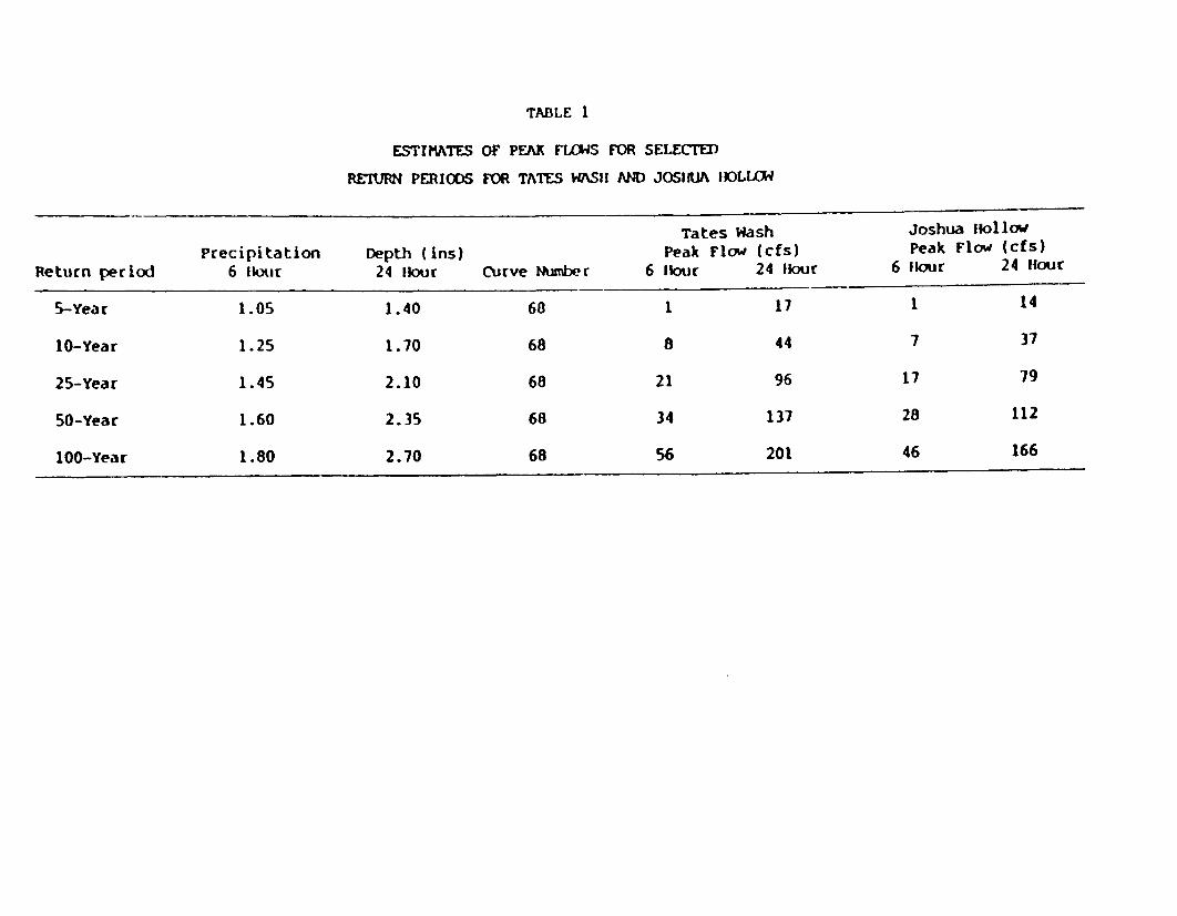
TABLE 1
ESTIMATES OF PEAK FLOWS FOR SELECTED
RETURN PERIODS FOR TATES WASH AND JOSHUA IKLLOW
Tates Wash Joshua followPrecipitation Depth (ins) Peak Flow (cfs) Peak Flow (cfs)
Return period 6 kour 24 Hour Curve Number 6 four 24 four 6 four 24 [Hour
5-Year 1.05 1.40 60 1 17 1 14
10-Year 1.25 1.70 68 8 44 7 37
25-Year 1.45 2.10 68 21 96 17 79
50-Year 1.60 2.35 68 34 137 28 112
100-Year 1.80 2.70 68 56 201 46 166

Ii
. qrv- . ..Y. %*4 dkrr C*&
Z' , - - -,le�
MOTIHtER LOOE PROJECT
,,.ft. ' -- - t. - , .__ ' .
_ /.
\4 ',
,f .!'_,, .b- -- -
I i I3 I .
_ ,, ..j, I ,,
'
co0I j',_ *
.,I
I
_7r . ,, .. _ .o
. o . . ,-_- oI .
_...
. . _
..L ,._
S . _ -a
*, *. - _ .- a
'3* i -
_ *- *-< # *
_ _ ;. ,-/
.
-. :.) -.:-. 11
": .ot
.S vI I
I'MC .,j
I
Z.
.. I
.
_,7 I.
. . * S
..
.... 1
.* ,X, .
. . %^. tj.-
. .46 '),
C......
DIVII.1
- " OLeI
A,% "S40*
"4 a,
1. �&,11
I..
.-. ._
_ . . . _
: . = 7.1 =--
,, =V _.
__I
("4 )MOTHER LODE
PROJECTAPPENOIX A * FIGUQE iI YOROGEOLOGIC MAP OF THE
- CRATER FLAT AREA AND VICINITY:- ... ~ .. , .. - . o,, ._ _ .^ j

1. The oldest and the lowest unit is known as the lower PaleozoicClastic Aquitard. This unit also includes some Precarocianrocks. The unit is generally made up of quartzite, shales,slates, and occasional interbedded limestone. The un.t haslittle or no primary pereability.
Bare Mowntain is an upthrust, upfaulted block of very an:ientrocks, primarily the Clastic Aquitard rocks. A nort west!southeast fault is present alons the west s:de of the x _.:a:nwith the southwest side down. This fault constitutes thenortheaster. bcundary of northern Arargosa Desert and it roughlyparallels Highway 95 south of Beatty. A second fault runsnorth/south on the east side of Bare Mountain which for-s thewest flank of Crater Flat. The east side is down and the westside is up. A third fault runs from approximately the area ofBeatty eastward and truncates the northern part of BareMountain. The ancient Clastic aquitard materials occur on thesouth side of *he fault (Bare Mountain) and considerably youngervolcanic materials occur on the north side of the faul-indicating another do-wnfault, Thus, Bare Mountain is a blockessentially isolated, and at high elevation that is actina as anaqu.tard. The iuvermeatle block is on the west side of CraterFlat and on the northeastern side of northern Akrargosa Desert.Groundwater does not flow through Bare Mowntain frozm Crater Flatto the Amargosa Desert.
A number of other outcrops of Clastic Aquitard rocks occur inthe area. There are several outcrops at the southern end ofCrater Flat imnediately north of Highway 95. Several outcropsocc-r at tle boundary between northern and central ArarzosaDesert. A large area of Clastic Aquitard rock outcrops extendsalong the Nevada/California state line to the northwest alongthe Funeral range. This area of izpermeable rocks essentiallyforms an impermeable barrier between northwestern or northernAmargosa Desert and areas to the south And southwest As aresu't, groundwater flows to the southeast, rather than to thewest.
2. The next youngest material is the Paleozoic Carbonate Aquifer,which is comp:ised primarily of limestones and dolomites. Theserocks are fractured and also have solution openings due tocirculating groundwater dissolving away the limestone anddolomite. This unit transmits groundwater. There are, however,some major shale zones within the Pale^zoic Carbonate aquiferwhich do not transmit water. In genera!, however, the PaleozoicCarbonate aquifer is transMissive material capable of permittingregional movement of groundwater in large quantities. CraterFlat is the only area of major size of thls ao'fifer material.There is some mater:al napped in the ncrtheast part of BareMountain. However, there is some question as to how deep theaquifer material extends In this area. Geologic cross-sectionsof the area indicate that the aquifer materials are fairlyshallcw faulted plates dip-ing to the east and underlain byaquitard materials. Groundwater may not be moving through the
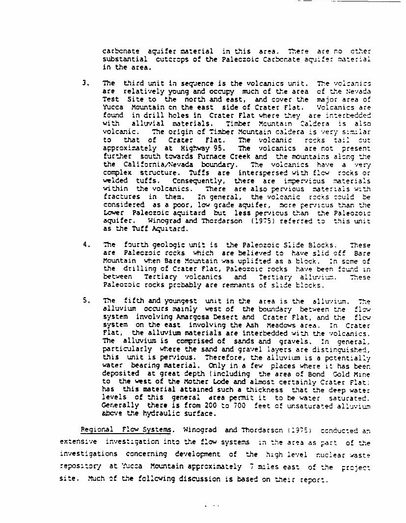
carbcnate aquifer material in this area. There are no cthersubstantial cutorops of the Palec:oic Carbcnate aq'iife mater:alin the area.
3. The third unit in sequence is the volcanics unit. The vcizanisare relatively young and occuJy much of the area cf the N.evadaTest Site to the north and east, and cover the major area ofYucca Mountain cn the east side of Crater F'at. Vclcanics arefound in drill hcles in Crater Flat where they are 4-erbeddedwith alluvial materials. Timber .cuntain :aldera is alsovolcanic. The origin cf Timber Mcuntain caldera is very sii.-.Uarto that of Crater Flat. The volcanic rocks tail Cut
approximately at Higqway 95. The volcanics are not presentfurther south tcwards Furnace Creek and the mountains alorg thethe California/Nevada boundary. The volcaniCs have a verycomplex structure. Tuffs are interspersed with flow rocks orwelded tuffs. Ccnsequently, there are iper-vicus -aterials*within the volcanics. There are also pervious nater,.ais w:th
fractures in them. In general, the volcar.ic r-cks could beconsidered as a poor, low grade aquifer, xore pervisus than theLower Paleczoic aquitard but less periicus than the Paleozoicaquifer. Winograd and Thordarson (1975) referred to this unitas the Tuff Aquitard.
4. The fourth geologic unit is the Paleozoic Slide Blocks. Theseare Paleczoic rccks which are believed to have slid off BareMountain wh.en Bare Mountain was uplifted as a block. :n scme ofthe drilling of Crater Flat, Paleozoic rocks have been fcund inbetween Tertiary volcanics and Tert ary alluri um. ThesePaleozoic rocks probably are remnants of slide bl)cks.
S. The fifth and youngest unit in the area is the alluvium. Thealluvium occurs mainly west of the boundary between the f losystem involving Amargosa Desert and Crater Flat, and the flcwsystem on the east involving the Ash Meadows area. in CraterFlat, the alluvium materials are interbedded with the volcanics.The alluvium is comprised of sands and gravels. In general,particularly where the sand and gravel layers are distinguished,this unit is perrious. Therefore, the alluvium is a pctentlal'ywater bearing material. Only in a few places where it has beendeposited at great depth (including the area of Bond Gold Mineto the west of the Mother Lode and aLmost certainly Crater Flat,has this material attained such a thickness that the deep waterlevels of this general area permit it to be water saturated.Gernerally there is from 200 to 700 feet of unsaturated alluviumabcve the hydraulic surface.
Regional Flow Systems. Winograd and Thordarscn 975,) --cnducted an
extensive inVest::;aticn into the flow systems In the area as part of the
.nvestigations concerning development of the high level nuclear waste
repos:tor- at '.ucca Mcuntain approximately , miles east of the project
site. Much of the fcllcwing discussion is based on their report.

Rush (1970) indicated there are three types of grounidwate reservc;:s
in the region: valley-fill, volcanic-rock, and carbonate-rork aquifers.
Alluvium beneath valley floors is commnly saturated only at great depth.
Water in the valley-fill reservoirs generally leaks downward to underlying
volcanic or carbonate rocks. The consolidated rocks of the area are
mostly volcanic rocks; however, some extensive areas of carbonate rocks
have been mappet (Rush 190). The transmissivitv c' vclcani:-rock
aquifers of the western part of the area averages about 10,00 callor.s per
day per foot. The trans.missivity of the carbonate-rock aquifer generall;
is mu.ch higher, resulting in low flow gradients (Push 1970).
Volcanic-rock aquifers in the eastern part cf the region .ocally
transmit water daownard to carbonate-rock aquifers. in the western part
of the area, the volcanic-rock aquifers transmit a regional flow of water,
as do the carbonate-rock aquifers of the eastern par: cf the area
(Rush 1970).
In mrst of these hydrographic areas, initial groun&water development
probably would result from the depletion of grownd*water in storace rather
than the salvage cf any appreciable amount of subsurface outflow
(Rush ;970). Rush (1970) estimated that 10 million acre feet of
groundwater is in transient storage in the uppermost 100 feet of
saturation beneath valley floors.
There are several regional flow systems in the area. These include:
Amargosa Desert system; the Death Valley National Monument system; the
Oasis Valley-Fortemile Canyon system; and the Ash Meadows and Devils Hole
System.
Amaraosa Desert. Walker and Eakin (l963) discussed the geology and
groundwater of the Amargosa Desert to the west of Bare Mountain and the
project site. The Amargosa Desert valley is surrounded by mountain ranges
corcsed of rocks of Precambrian, Paleozoic, and Tertiary age, consisting
principally of tuff and lava, dolomite, limestone, shale, siltstone,
quartzite, and slate in var-ying proportions. These mountains (including
Bare Mountain) were uplifted by faulting and tilting during the late
Tertiary and early Quaternary time. Erosion products of the surrounding
mountains have filled the basin of the valley with several hundred feet of
alluvi=., including lake and stream deposits.

Analyses of water fr=i wells and springs in the area indicate '-,a"
the water was suitable for irrigaticn but generally Is re':m-sa .i y
water or pcorer. Medium- to high-sodium water oc-rs locall'y *4.h tFhe
poorer quality water ard generally is found in the southern part of th!.e
area. Elevated boron ccncentraticns may offer a problem in the g-rw.in of
some crcps, however (Walker and Eakin 1962). Locally, fscri:de contents
may be h.gh.
About 1.4 million acre-feet of gr-un&dwater is estim.ated to be st red
in the upper 1000 feet of saturated alluvia: a deoxsi-s beneath a
four-t-wnship area roughly enclosing the area of prir.cipal concentration
of wells in the Amargosa Desert. Walker and Eakin 1_363) illustrated the
effect of over-development cn groundwater 'evels and su--ested that
pumping at the rate of 60,000 acre-feet a year would .zwer water levels .n
this area an average of 100 feet in abcut 25 years, and culd intercept
most of the recharge moving through the valley toard the area of natural
discharge.
Death ';allev National mon.ument. Death ,a!,'ae :;at:cnal Me- ls
approximately 10 miles west of t.he pro4ect site. Groundwater ^c-_rs infractures and solution openings in the Precambrian and Paleozoic age roc'ks
in the Funeral Mountains. The carbonate rocks probably are the most
perneable of the consolidated rocks in the area, and are considered by
Miller (1977) to be part of an aquifer system through which water moves
from the AMargosa Desert to discharge at several large springs near
Furnace Creek and at Keane Wonder Spring. According to Miller (1977),
interbasin underflcw from the northeast supplies much of the total flow
for springs in the valley and much of the groundwater recharge. Minor
quantities of groundwater may enter the valley from basins to the west and
northwest. Miller (1977) suggested that several large springs along t.ne
east side of Death Valley appear to be discharging fr.m a larce :ntertasi.n
flow system that extends many miles to the ncrth an.d east. Mcst of these
springs occur near the contact of alluvial depcsits and consolidated
rocks; three springs discharge along major faults.
Miller (1977) suggested that the Death Valley r-ur.dwater system as a
whole, in the area of Death Valley ';atior.al Monument, is probably in a
steady-state ccnditlon, with respect to recharge, storace, and dischar;e.

Miller (1977) also suggested that in a few small remote areas, rec!har:e
has diminished in recent decades. He attributed this to a general decline
in rainfall since 1945.
Pistrang and Kunkel (1964) suggested that adequate precipitation
falls on the tributary drainage area to supply all the recharge to Death
Valley National Monument. The springs occur in the unconsolidated and
serriconsolidated deposits. They proposed four hypotheses to explaini the
occurrence, source, and movement of the groundwater. The first assumes
that water from precipitation at higher altitudes percolates intc a
network of faults and fractures, and discharges where the faults and
fractures intersect the surface at lower altitude. The second hypothesis
is similar to the first, but assumes that, from faults in the bedrock,
water is conducted to the surface in pipes of travertine that were formed
contemporaneously with the deposition of alluvial material. The third
hypothesis assumes that water from precipitation percolates into the
alluvial deposits, replenishes the water table, and occurs as springs
where the water table intersects the surface. The fourth hypothesis
assumes some combination cf the first three.
Pistrang and Kunkel (1964) estimated that about 4,000 acre-feet of
discharge occurs in the Furnace Creek Wash to the floor of Death Valley.
Based on their discharge calculations, Rush (1970) concluded that probably
only a few hundred acre-feet of recharge could be generated in the Furnace
Creek watershed. Therefore, he concluded that much of the 4,000 acre-feet
of discharge in the Furnace Creek Wash area may be from the Amargosa
Desert. Rush (1970) also suggested that additional quantities of
groundwater may flow from the Amargosa Desert to the valley floor of Death
Valley to discharge largely by evaporation.
Winograd and Thordarson (1975) discuss a possible hydraulic
connection between central Amargosa Desert and Furnace Creek Wash-Nevares
Springs area in Death Valley via the Lower Paleozcic Aquifer.
Sharp (1989) also reported that it has been suggested that the source
of water discharged at the Nervares and Travertine Springs in Death Valley
National Monument, is probably through a connection to the lower Paleozoic
Carbonate Aquifer. Sharp (1989) pointed out that this aquifer is very
deep and that no drilling conducted to date in the vicinity of the project
area has encuntered the Lower Paleozoic Carbonate aquifer materials.
. I a

Oasis Valley - Fcrt-mile Canyon. T.h.e grour.ndater flw system to the
north, including the project area, was informally designated by Wincgr3d
and Thordarscn (1975) as the Oasis Valley-Fortymile Canyon basin. Te.e
regional groundwater system prcbably includes Oasis Valley, Aar;csa
Desert west of the Ash Meadows fault, and possibly that part of Revaille
Valley south cf the topographic divide (Winograd and Thordarscn l975;
Blanker.nagel and weir 1973). Cactus Flat may drain scut st-estward to
Sarccbatus Flat as part of the Sarcobatus Flat regicnal crsund--a:er
system. The scuthern part of Reveille Valley, ncrth cf Kawich *:a;ley, an.d
an extension of Railrcad Valley may ccntribute groundwater either
sout.hward or eastward to Railroad Valley (Winograd and Th.ordarscn 1975).
Many of the hydrographic areas considered to be part of this grcunc'dater
flow system and the Ash Meadows flow system are closed t.pographic basins.
Piezomet-ic contours indicate that the regional groundwater fw:- is
generally southwestward to the Amargosa Desert (Winograd and ThorCarsor.
1975; Blarikennael and weir 1973).
Groundwater in the system generally flcws scuthwester'y through
interconnected faults and joints toward Oasis Valley, and scuthward to th.,e
Amargosa Desert where mcst of the water is believed to be dischar-ed
(Winograd and Thordarson 1975; Blankennagel and Weir 1973). Th.e volcanic
rock aquifer is the principal medium through which the regional fw
occurs; however, the valley-fill aquifer also transmits filc teneath te
Amargcsa Desert. Part of the combined groundrater outflow ftcm tFhe As.h
Meadcws and Oasis Valley-Fortymile Canyon reg.onal systems may f'-w
southward through carbonate rocks to Death Valley (Winograd and Thordarscn
1975).
Malmberg and Eakin (1962) referred to this system as the Pahute .¶esa
System. They indicated Oasis Valley nortlhwest of the project site is a
major part of the Pahute Mesa flow system. MaImberg and Eakin (1962)
estimated the average annual recharge to and discharge from Oasis 'V'all'ey
is on the order of 2,000 acre-feet. Th.ey sugoested that at-.ut 250
acre-feet is derived from precipitation with~n tne drainage basln and
about 1,800 acre-feet is derived from underflow from Gcold Flat.
Blankennagel and Weir (1973) reported that the discharge c=uld be
considerably higher.

Discharge of groundwater in oasis Valley is affected -vevapotranspiration and underflow through the Amargosa Narrows t: the
Amargosa Desert. Malrberg and Eakin (1962) estimated the average annua:
natural discharge by evapotranspiration to be approximately 1.900
acre-feet. They estimated the average annual spring discharge and
underflow to the Amargosa Desert to be about 400 acre-feet, although this
figure may be too low (Blankennagel and weir 1973).
Groundrate: development in Oasis Valley has been limpited largely to
the development of numerous springs along the flood pain of the Amargosa
River. Six of these springs are used for the municipal water supply for
the Town of Beatty. The fluoride content of the water is significant.y
higher than drinking water standards (malmberg and Eakin 1962). Water
samples collected throughout the valley suggest that all groundwater in
Oasis Valley, except that derived from precipitation on the Bullfrog Hills
northwest cf Beatty, contains excessive concentrations of fluoride
(Malmberg and Eakin 1962). Although the estimated recharge to the
groundwater reservoir resulting from the infiltration of precipitation on
the Bullfrog Hills is less than 20 acre-feet per year, a considerable
amount of water with low fluoride content may be in storage in the
alluviumn bordering the hills, according to Malmberg an' Eaakin (1962).
Generally, the groundwater of Qasi Valley may be classified as a
sodium-bicarbonate type. This type of groundwater is comn.n1y found in
areas of Nevada underlain by Tertiary tuffaceous deposits (Mairberg and
Eakin 1962).
The principal area of discharge in Oasis Valley is along the flood
plain of the Amargosa River. Most of the discharge by evaporation and
transpiration occurs in the floodplain in Oasis Valley. Most of the
precipitation on the valley floor is discharged by evaporation. A
considerable amount Of recharge to Sarcobatus Flat and Oasis Valley may be
derived from underflow through the Tertiary or Paleozoic bedrock berieath
the topographic divide at the north and iortheast sides of the two valleys
(Ma'mberg and Eakin 1962).
Crater Flat immediately adjacent to the project area is part of the
Oasis Valley-F:rtymile Canyon Groundwater syste^. (Push 1970; Blakennagel
and Weir 1973). In Crater Flat, the m.nimun depth to water beneath the
A-16

valley floors was estimated to be 250 to 600 feet ( ush 1970). .he
approximate altitude of the water surface is 2,300-2,400 feet asI.
Winograd and Tt.ordarson (1975) estimated the annual average grcundwater
recharge for Crater Flat to be approximately 220 acre-feet.
According to Rush (1970), the average annual recharge for the Pahute
Mesa (Oasis Valley-Fortsymile Canyon) regional system is estimated to te
11,000 acre feet. The estimated average annual dischar-e fron the Pahute
Mesa grcun&t-ater system is 9,000 acre-feet (Rush 1970, Winccrad and
Thcrdarscn 975). Of this a.'ount, 2,200 acre-feet Ls discharoed in Sasls
Valley according to Malmberg and Eakin (1962); the remainder, about
7,000 acre-feet, is discharged west of the Ash meadcws fault (fincgrad and
Thordarson 1975).
Rush (1970) suggested that because the Ash Meadows and the Pahute
Mesa groundwater systems c-nverge in the Amargosa Desert, they may
actually be part of one large regional groundwater basin that could extend
southward to and include much of Death Valley.
Winograd and Thordarscn (1975) asserted, however, that there is a
north-trending boundary between the Ash Meadows and Gasis Vaalley-For^t-', e
Canyon groundwater systems. This boundary is largelly based on thie great
difference in vater levels of at least 2,000 feet near the central part of
the area. Scuthward, the disparity is less pronounced, amcunt:ng to less
than 100 feet in the Amargcsa Desert. Northward, the disparity a.so see!7-s
to decrsase, but water level data are lacking to define t.he ancnt.
Moreover, the northern extent of the boundary has nct been defined
(Winograd and Thordarson 1975).
Ash Meadows and Devils Hole. The Ash Meadcws area, at the southern
tip of the Amargosa Desert in southern Nevada, :s iccated
apprcximately 40 miles southeast of the project. The Ash Meadows area
discharges groundwater collected over several thcusand square mules of a
regional flcw system developed in Paleozoic carbcnate rocks !dley and
Larson 1976).
A small pool in Devils Hole, w.tich is a collapse depressi:n :n
Cambrian limestone, and numerous springs in t'he adjacent desert va;;ey
contain rare fish species of the genus :frrnccn, *h:^h are fauna
remnants of Pleistocene lakes. The Devils Hole pupfish, C. diabcl' s, is
A-' 7

the mast endangered of the several surviving species that have evclved
since the post-pluvial isolation of their ancestors (Dudley and Larson
1976). This population feeds and reproduces on a slightly submerged rock
ledge. Irrigation pumping in the early 1970's nearly exposed this ledge
(Dudley and Larson 1976).
According to Rush (1970), at Ash Meadows in the Amargosa Desert, one
or more faults fCr.m a ba:..er to groundwater flow, probably causing water
from the system to be discharoed as springs. However, the effect:veness
of t~he barrier to groundwater flow is not known. Leakage across the
barrier may occur (Rush 1970).
According to Winograd and Thordarson (19-5), Walker and Eakin (1963),
and Rush (1970), for the Ash Meadows ard Oasis Valley-Fortymrile Canyon
systems, the estimated average annual discharge as measured in Amargosa
desert totals at least 24,000 acre feet. The estirzated average annual
recharge to the two systems totals about 45,000 acre feet. The imbalance
between recharge and total discharge is seemingly an excess of 19,000
ac:e-feet per year. Although the excess may reflect error in the
estimates, a substantial part may be accounted for by subsurface flow to
Death Valley (Rush 1970; Winograd and Thordarson 1975).
Interbasin Movement. Three major hydrogeologic units in the region -
the lower clastic aquitard, the lower carbonate aquifer, and the tuff
aquitard, control the regional movement of groundwater (Winograd and
Thorda:son 1975). Winograd and Thordarson (1975) found that a synthesis
of hydrogeologic, hydrochemcial, and isotopic data suggests that an area
of at least 4,500 square miles (including 10 intermontane valleys) is
hydraulically integrated into one groundwater basin, the Ash, Meadows
basin, by interbasin movement of groundwater through the widespread
carbonate aquifer. The Ash Meadow groundwater basin extends to the east
of Ash Meadows and includes Mercury Valley area. Discharge from this
basin - a minifmu of about 17,000 acre-feet annually - occurs along a
fault-controlled spring line at Ash Meadows in east-central Amargosa
Desert.
Interbasin movement of water between Cenozoic aquifers and the lower
carbonate acuifer is controlled by the tuff aquitard, the basal Cenozoic

hydrogeolcgic unit (Winograd and :hordarscn 1975). Such mcvement
significantly influences the chemistry of water in the carbcr.ate aquifer.
Groundwater velocity through the lower carbonate aquifer ranges frcm an
estimated 0.02 to 200 ft/d, depending on geographic pcsition within the
flow system (Winograd and Thordarson 1975).
Regional movement of groundwater through the lcwer car-cnate aquifer
flanking and underlying the valleys is not sign.iicany'y influenced y .the
topographic bcundaries of the individual valleys. Onre ct the maor
controls of such movement is the disposition of the lcer carbcr.ate
aqu'fer and of the lower and upper clastic aquitards (Wincgrad and
Thordarson 1975). The lateral mcvet!nt of grur.nd*ter hr quh the
carbonate aquifer integrates several intermontane valleys :,nto a single
large grcundwater basin, the Ash Meadcws groundrwater basin (Winocrad and
Thordarscn 1975).
Interbasin mcvement of groundwater wit-hin the lcwer catcnate aquifer
is greatly influenced by major geologic structures, partic--larly y fol4s
that bring the 1cwer clastic aquita - close to the surface, or by faults
that juxtapose the lower or .pper orlastic aquitards and the lo er
carbonate aquifer (Winograd and Thordarson l975). The .ncst st:iki-;
examp.e of structural control of groundwater movenent w:thin the lcwer
carbonate aquifer is the spring line at Ash Meadows in east-central
Amargosa Desert.
According to Winograd and Thordarscn (1975) and BlankernaGel and Weir
(1973), groundwater beneath the Pahute-Mesa-Timber msuntain area is not
tributary to the Ash Meadows groundwater basin. This groundwater,
predominantly in Tertiary tuff and rhyolite, mcves scu.irestmard toward
discharge areas in oasis Valley and probably also Tcves southurard to-ard
the Amargosa Desert through western Jackass Flats. This area is :-nsAde:ed
part of a single grourndwater basin, informally designated the Oasis Valley-
Fortymile Canyon basin, which is tributary to the ^entral and n.crthweste:n
Amargosa Desert (see previous discussion).
Wincgrad and Thordarscn (1975) su^nma:ized hydro che=xCal e.;dence cn
regional movement of groundwater in the area:
1. Groundwater beneath the .Nevada Test Site maces tzwards the snMeadcws area.

2. Chemical quality of the water within the lower carbonate aquifermay not change markedly with depth. Potable water may bepresent to depths as great as 10,000 feet in the Ash Meadowsgroundwater basin.
3. Sulfate and sodiuzm contents in groundwater in the tuf' aquitardbeneath the Nevada Test Site increase with depth, at leastlocally.
4. Groundwater within the tuff aquitard drains int: the ineA-y:nylower carbonate aquifer beneath the Nevaia Test Site andpossibly also beneath the valleys east and northeast of theNevada Test Site.
5. Leakage of water from the tuff aquitard into the lower carbonateaquifer is probabIy less than 5 percent of the wate- dischargedat Ash Meadows.
6. Groundwater may move into Ash Meadows basin from PahranacatValley and, if so, may constit ite as much as 35 percent of thespring discharge at Ash Meadows.
7. Groundwater movement from Pahrumv or Steward Valleys into theAsh Meadows area is minor.
8. Groundwater within the central Amargosa Desert comes from theeast, the north, and the northwest.
9. Flow from the central Amargosa Desert L.., Loath Valley is themost likely source of the major string discharge in east-centralDeath Valley.
Rush (1970) recognized three regional interbasin groundwater flow
systems: the Ash Meadows system, the Pahute Mesa system (Oasis
Valley-rortymile Canyon) and the Sarcobatus Flat system (weost of the
project area and including Cactus Flat). Rush (1970; sumrmrized the
regional ground-ater movement as follows:
1. Groundwater in the Ash Meadows system flows generally southwardto Ash Meadows to discharge at springs, by evapotranspiration,and possibly by subsurface outflow across a fault barrier to thesouth end of the Pahute Mesa system in Amargosa Desert.
2. The Pahute Mesa (Oasis Valley-Fortymile Canyon) system flowsgenerally southward to discharge largely by evapotranspirationin Amargosa Desert.
3. Groundwater is believed to flow southwestward from Cactus Flatto Sarcobatus Flat where it is largely discharged byevapotranspi ration.

4. Some of the water in the first two systems may xvesouthwestward as underflcw to Death Valley through the cartcXnaterocks of the Funeral Range.
In summary, there are apparently still some uncertainties with regard
to regional groundwater movement in the area. :t appears, based on the
available informaticn, that groundwater movement occurs in 3 different
systems in the region:
1. Oasis Valley-Fortymile Canycn system. water moves from thenorth to the south, southwest and southeast a!krng Fsrty:_leCanyon and through Crater Flat.
2. Ash Meadows system. water discharged at Ash Meadc-ws is derivedto the east of the Ash Meadows Fault in the MercJry valley area.
3. Amargosa Desert. Flow in the Amargosa Desert mcves generallysouthward with contributions from Oasis Valley and Crater Flat(part of the Oasis Valley/Fortymile Canyon system). There maybe a connection between the Amargosa Desert system and DeathValley National Monument via the deep carbonate aquifer.
Local Groundwater Flow. The project area is located within the Oasis
Valley-Fortymile Canyon flow system. Groundwater is cons.dered to be
recharged in the T imber Mountain-Pahute Mesa area to the ncrtn
(Blanker.nagel and Weir 1973; Winograd and Thordarson 1975). :r. general,
water moves from the recharge area southward down through Crater Flat.
This is referred to as the Crater Flat groundwater flow system (Sharp
1989). Crater Flat water moves south and combines with the A:.argcsa
Desert groundwater system. Groundwater also moves from the north Timber
Mountain-Pahute Mesa area to the southeast, then south along Focrttule
Wash through Lathrop Wells (Blankennagel and Weir 1973; Sharp 1989).
Groundwater is also considered to move to the southwest and west of Timber
Mountain Caldera and the Pahute Mesa area towards a discharge point in the
Oasis Valley (Blankernagel and Weir 1973; Sharp 1989, Figure 1).
Bare Mountain essentially acts as an impervious block sitting in the
midst of the groundwater flow paths. Groundwater recha:ged to the north,
seeking to move southward and ultimately discharge, is diverted around
Bare Mountain. 'Water does not flow through Bare Mountain. Bare Mountain
essentially divides the grcundwater flow into three different comronents
(Sharp 1989). First, further to thF. north, water moves to the southwest
and west of Timber Mountain Cadera and the Pahute Mesa area beinq diverted
by Bare Mountain towards Oasis Valley. Second, water flws south into the
. A.

Crater Flat flow system which continues to mrove southward into the
Amargosa Desert. Third, groun.rdater moves from the north to the southeastthrough Fortymile Wash and the Lathrop Wells area (Figure 1 and Table .!.
In general, it is considered that there is regional discharge from
the Amargosa Desert flow system in the Franklin Lake playa to the south
(Winograd and Thordarson 1975, Sharp 1989). it has also been suggested
that some of the water ry flow to the northwest toards Pjrnaze 2:eeki Iz
discharge at the springs near Park Headqyarters (Sharp 1989'.
There is a major regional boundary between two flow systems in the
southeastern part of the area (Figure 1, Sharp 1989). This boundary is
between the flow systes which is moving down through Mercury and areas :n
that vicinity and discharging water in the vicinity of Ash Meadows, and is
the source of. water for Devils Hole (the Ash Meadows groundwater basl.n
delineated by Winograd and' Thorda:son 1975. The boundary is formed by a
major regional fault. The fault has juxtaposed different geoloc:
materials, which prevents the two areas frum being in hydraulic
continuity. This is suppcrted in part by *he fact that the water level cn
the east side of the fault at Dev.ls H^.Ie is 2,359 feet. Inediately to
the west cf the fault tne water leve: is 2,225 feet. That is, there is
134 feet of elevatlon differen:e in wate: 'e-:e. in less than one rie
(Sharp 1989,. Activities whi-h could im;ede or iqpact the Devils Hole and
Ash Meadows area would have to be to the north and east of the fault,
rather than to the west and nort1west (Sharp 1989). Therefore, the
project area is hydrau._'ially separated from Devils Hole (Sharp 1989;
Winograd and Thordarson 1975; Blankernagel and Weir 1973). The f-l;
system in which the project area is located (the Oasis Valley-Forrtyle
Canyon flow systemi) flows into the A.ra:gosa Desert flow system to the west
of the fault line (Sharp l9e9, Winograd and Thorc.Arson 1975).
The interpretation (Snarp :989) of groundwater flow is based on the
potentiometric surface of the groundwater (Ficure 1, Table 2. For
example, the USN5ZS exploraticn hole r.ill2ed at the north end of Crater
Flat (Fioure 1, K,4-4) encountered groundwater at 3,252 feet. Further
south at USGS holes VH-2 and VH-; (Figure :) the water level drops to
2,662 feet and 2,576 feet, espectively. Similar decreases occur in water
levels southward through the Amargosa Desert. At the south end of Crater
Flat at Highway 95, the water level elevation is 2,330 feet. The
4 --

TABLE 2
WELLS IN THE CRATE FLAT AREA AND VICNITY
MOTHER LODE PROJECT USNGS
DOCU(rATICN MR FIGURE 1
ite Site Surface Depth to DateSite Siteiber Location
1 S16 E48 lSOACDl
2 S16 E48 23AAAA.1
3 S16 E48 36AAAAl
4 S16 E48 18CDC1
5 S17 E49 O9AAAA1
6 S17 E49 20BCAC2
7 S17 E49 ISBC
8 S17 E49 28BC
9 S17 E49 hLIBCAA
10 S17 ES0 19AAB
11 S17 E50 33CAAB
12 S18 E50 13CCCD
13 S18 ES1 3ODD
14 N2616 E05 08
15 N26 E05 21C
16 N27 E04 27B
17 S18 ES0 ILAA
18 S18 E49 l1BB
19 S16 E50 07AAA
20 S16 £50 29ACQ
21 S16 E49 20AABB
22 S16 E49 368BAA
SurfaceElevation
2364
2358
2324
2360
(£t)Depth to
water (ft)
93.4
108.6
83.2
98.9
2280
2270
2257
2250
2275
2180
2165
2215
2270
2165
2188
2242
2245
2170
2478
2380
2384
2338
76.1
51.6
66.9
51.2
65.0
14.2
7.61
5.4
12.7
30.2
74.9
36.6
20.2
60
129.9
100.5
128.6
122.3
DateMeasured
01/08/87
01/10/87
01/10/87
01/10/87
01/12/87
01/11/87
03/21/86
01/15/87
01/19/84
03/17/87
03/17/87
03/17/87
01/14/87
01/13/87
01/13/87
0143/187
03/1?/87
11/30/81
03/16/8,
03/15/87
0'13/,87
01/1;/87
Owner
Spear, I.
Gillespie
Bettles
Tharp, E.
Armargosa, F.
USGS
Steelan, J.
VI.S
Bettlo. G.
Trenary, P.
Hale, D.
USGS
7
'USGS
,oor:is
Spr. Melin.
Cook, L.
Travis, M.
Mills, J.

TABLE 2 (COtN.INrD)
Si te Si te Depth toSite
Nunbe r
23
24
25
26
28
29
30
3'
SIE
S14
Si4
S14
S14
S 4
Si4
SiteLocation
; E49 05SMD1
; E£9 22AAaA
I E50 06A
I r , 3 ;BA;)1
I E46 25 AAk:
I E46 26AkI
4 E46 26BMi
4 E47 32 DA
:4 _8 32ABBBI
SurfaceElevat~cn (ft)
2430
2612
3'26
2788
2 7/ 0
2710
2720
2 25
2542
Depthr toWater (ft)
i59.0
295.6
731
281.9
304.5
303.3
282.7
271 .2
212
DateMeasured
01/127/8
01/1 '/18 1
10/47/87
O' /07/I /
0 /1 ' ,/B,
09 1/121 /187O' / 88
Owne r
Pu-lela
Shaw, J.
U.S. Ecoiogy
USGS
USGS
USGS
Rose' sStaticn
Source: H-4-0Search
t A

decreasing trend scuthward in water level elevaticn indicates that water
is flowing towards the scuth (Figure 1, Table 2, Sharp 1989, Hydrc-Search
Inc., 1989).
2.3.2 Local Groundwater Quantity
USNGS conducted subsurface drilling work to better characterize tDe
water bearing characteristics of the rock. Initially, three holes *were
drilled (Figure 1). Poo siutes, d:illed to 740 and 1,000 feet, showed l-w
primary permeability. Th.e third site, *-W3, shows some permeability and
indicates that a portion of the water supply could perhaps be developed
from the northernmost site (IHydro-Search Inc. 1989). Static water level
was found to be approximately 200 feet below the surface.
The drilling program was moved to the east into Crater Flat where
volcanic rocks and alluvial materials were thought to be present.
Subsequent drilling to approximately 1,540 Oeet has confirmed this, and
also that this material is water bearing with the potential for -water
supply develcpment (Hydro-Search Inc. 1989).
The southern two holes (*5-2 and !54-18) drilled by Hydro-Sear:h :nc.
are on the northern edge of what is mapped by the USGS as aquz:fer material
(Sharp 1989). One hole *-as drilled to 700 feet, and one was drilled to
1,000 feet; and no water was found. :t was concluded that these holes
were basically in aquitard material. This lends some support to the
concept that even though aquifer materials are mapped in this area, there
are aquitard materials at depth in this area. This would tend to extend
the area of impervious Bare Mcuntain rocks further to the north than
presently mapped (Sharp 1989).
Transmdssivitv and Storace. Czarnecki and Waddel (1984) modeled the
Oasis Valley-Fcrtymile Canyon flow system. Based on their ccrmuter
simulaticn results, Sharp (1989) calculated that the amcunt of water
moving through Crater Flat was 5,700 acre-feet per year. Similar
calculations indicate that a reascnable number for the average veloclty of
the groundwater would be approximately 160 feet per year (Sharp .989).
This would give a travel time Acwn Crater Flat of about 400 years.
Based cn Czarnecki and Waddel's (1984) findings, the tra nsmiss ivity
of the groundwater in this area is approximately 7,500 ga.lons per day per

foot (Sharp ;9895. The storage c-efficient was estcmated by Shar; ';9E8
to be 0.0048, assuming that the a:uifer materia. is about 4,000 feet
thick. Rush (1970) indicates calculated ano-unts of 220 acre-feet per year
recharge to Crater Flat. The source cf this recharqe pr ma-ly wud be
from snowmelt and rn'ff in Crater Flat, in addition to some runoff fro.
Yucca Mountain (Sharp :969).
2.3.3 Loca. Groundwater Cuality
The northe~n.-ms' site drilled fo the Mother Lcde Proeot ( !4-3K was
saXcI ed for water quality Jtydro.-Searc` Inc. 1989). The hcle was driiled
to a depth cf approxirratey 1.,O00 feet and the casing extended to about
700 feet. A puz- was se- at approx:zr.ately 500 feet. The static water
level is approximately 3,9- feet as', i.e., the water level is about 20C
feet below -he surface (Fcx 19e9; Hydro-Search Inc. .989).
The results of the ana'yses are sho-wn in Table 3. Concentrations of
the major cations acnd anions ind2cate the water to be of a
cal-ciurra nesiu.-su fa:e type. .his tyoe cf water is ccr.-ncn in vc!canic
rocks where cxidation of su;.'de runera's can produce relatively hign
concent.ratlns of su2.fate an_ ircn. Four constituents were found t_
exceed dri.kin- water standards: iron, manganese, su''ate, and tota:
dissolved solids. A-' cther constituents are withir dr-.nkinc water
standards ('ab'e 3).
Water in the vicin:ty of water perr:t site 11850C in oas:s Valley
(Figure 2) .s a sodi' xt-pr-asirum-bicarbonate type (Malrnberg and Eakin
1962). At well USW VH-' in southern Crater Flat (F:gures 1 and 2), the
water is a sodiur.-bicrabonate type (Benson, et al., 1983).
2.3.4 Water Rights
Local water P.-chts. With the ex-ept-i. of the Pr-e-:t wa:er riohts
applied for fror. the State Engineer, there are no other wate: rights in,
the iremdiate vicinity of the proposed applicant's wells. Seven water
rights applications have been filed (rios. 515-55, 5.55, 51557, and 52B47,
52648, 52849, 52850), and are intended to be in combbnation. w:th eac.
other. The rate at which wate- is being requested is a Maxirr.um cf 2;5
cu:_ feet per second (cfs). The volume over the expected 7-year prciect
life is approximately 3,200 acre-feet.

TABLE 3
WA=TF. QtISTRY DATA
MHE'R LCDE PROECT USNGS
EPA-NevadaDrinking Water
Standards' Well MW-3
12/14/88 1200 hrs.
Discharge, gpmTemperature, °C (OF)
7029 (84)
pH (field)pH (lab)
Total DissolvedSolids (evap. e 180ec)
6.5 - 8.5
SOOs (1000)
8.17.3
1315 ' '
Total DissolvedSolids (calc.)
ElectricalConductivity (lab)
1214 " '
1580
1700ElectricalConductivity (field)
Constituent
HCO3
CO]Cl
so4FBNO t(as No3 ).NaKCamgSio 2ASCuFeMnZnBaCdCr
250s (400)250s (500)1.4 - 2.4p (
45.0 p
125s (150)
0.05p1.Os0.3s (0.6)0.Os (0.10)5.0s1.0p0.OlOpo. ocp
305
76599 I I0.30.4
(0.1886
17093290.01<0.021.57 ' 3 i
0.11 '1.01
<0.4<0.01<, .0'

TABL 3 (CzMr:N'JM)
EPA-NevadaDrinkinq Water
Standardsl Well ner-3
Pb 0.05p <0.05Hg 0.002p <0.0005Se C.Olp <0.005Ag O.Q5p <0.01
P (total) <0.01CN (total) <O.OC5Hardness (mAg, equivalent Cacnj 8 0
Source: Hydro-Search Inc. 1989
Chemical concentrations are in mg/l, pH is in standard pH unrts, andelectrical conductivity is in micromhos/c, @ 25'C.
'Nevada and EPA mandatory prirary standards for public water are notedwith "p". Nevada and EPA recomrended secondary standards for publicwater systems are noted with "s". The secondary standard for magnesiuLis Nevada only. Nevada mandatory standa:ds for public water systems areshown in parentheses.
2 Dependent on annual average rmaxir= daiy air temperature.
3Exceeds a mandatory standard.

I1*
A-r*. .. - ... . **'4, . .. -.
- - .- . . , I -
a. - -
.u.j.' *-*r. . .. -- . . -.-
- - r...
jAilI,.
a . - - - -. .- -
I,
- .. - A� - -. -S.-.-. I,
/r
-� .. �- 'U
4-
* .. 4..
* ,, aV - . - .
-a* .' a,-*1
r.-S. -- � -
X l- -..- ._ : - ., rZ. A
.: i- ~- - . - - .. - a., ,j
II ., . :go I- -. 4- .. I-, .
* - . ,, -
. I I
_ . . I
_ , -- k i�,-4* -
.�4j
N * � -
5
a�. *-..
- -
* i�4 *
4.
-- a'- . *
- . *-�V 4
* . ..a--.
-C' �
- . - - . -- ..* - *-
-a
p _.- _. .I P-
J--
I I . - .J .CFPnVT
.....
S..A(. -' :-.Nf
0 _.5 ,. . -
.....
_ N
_ SA. .. *_
of '. if " -
,. .
--f 4;7iZ. A"^ . -, *.- -Tt a-.* aMA% ,SAIA S, ki'Li * f r.1 3 -, f
M 'tL 2 -E
.7
FXPLANANIG
A SUPFACE VAf'' oftk ;.n '(q O r>a -!D!Fit4fsn, 7.;OXA* 4r1?,AA a E. APO. -A* . .'
0 GRCUNO.VA-FO !"v- ' :EC" 1 ' A'F .
MOTHER LODEPROJ ECT
APr4.eDIA A r '. rE .
ATA * P ,F I , -F
@< Ot FiE P , _ (: k ;"P' #_ E -I'. A, r .4 ? I I .
22'A -28 279 &ANC 1C I

Water rights on file ti the Stt-a en-ineer for the general area are
listed in Table ' .nd shV-n n F--re Z. As prev.ously stated, there are
no water rights in the irediate vicir..ty of the prcject site.
There are two sp-:nc per,.:s :-,t-he vicinity of the project area.
These are Specie Spring anc a.. -- named spring in the Bare Mounta:n area,
approximately 2.5 Ll2.es outh cf the Us3i: applications. These sp..nzs
are at a mich hisher e-ea:^.r. a tJ- *e -ater ene -ntered at the test
wells. Specie Sprzin- is at arox4:-:e4 4,-O0 feet as!. The water ie.ve
elevation at the ar' :at:-s t.a: are -n f' e are approximwtely 3,5^^ feet
asl. That is, the spr:ings are s^..e 7l: fee: hicher thwan the pr:oect test
hole water levels.
Further south there is a '..ater; -.h near Black Cone, probatly fcr
the Sterling Mine, and also a water r:ih.t nea: Red Cone which is a DOE
perm.it. The closest we:l t: -he pr -:e:- s:te is apprrxirirately m ileswest of the p:cect F.r: g re 2.
Recioral Water PRs-.:s. ,Tere are several sens:tive areas cf concerr.
in the re-icr. c'f he r.othe: _r.e Pro-e:t. These areas include :oX.- Spring
and Crystal Spr:ng to :e north and northeast -f the rrcezet areas,
respectively; Death Gaaey Mcn ..a:ent; Ash M.ead-ws and De.l;:s Hl'e;and the Amar:gosa Far-.s :n the sAoutern-.ar-osa Dese:t.
Death Valley ita .en: has Federal Water P.-hts. These water
rights essen-tially require the State to zJarantee a continued water &u-ppy
to the Death Valley Nat~.onal. .on.=en: and to Devils Hole. Death Valley
National Monuvent, Devils H._e, and Ash Meadows hytrogeology have beer
discussed previously.
Long Spr:ng is located apro=xizate:y 9 miles north of the pro e:t
site in Oasis Valley, u x rad>ent f'r. t'e prcject activities. Crvysta
Spring is also located in Oasis :alley 8 miles to the northwest of the
project site and is also up-rad;ent -f tne pr:oect s.te.

WA-MO RIGHrTS
TflF 4
IN THE VICINITY Or TE PIMI LO0 t *CJKCT
uStlS lEAR $CAM. K AIYM
>"IICat Ioh Cneltifceto 01dn II Recogj Status
1141 420 mattin. L.Itt N Ceatitla tcJ IlJeeo . tIaIJIOd A.
03403 caltaga PF ugtlI V-Stq*- *efnt to
I 1416 I %Ol I ItS ).e I a n . c a C *g I C0gt itILatt
24 )1 lt el C 8* lai t I l And1 ICt t I t
St A 1.w- ,t TIlast Vosta.
* . w Ill l e 2 th .6las W. cocta £11
10511 / Hailon Shatley J-. C*etIt At*tlCli t ga~tb
I 160 111I t(Ien, h.,41e4 D Cestitftito
24mg 1u ;t 0 A . v 4 ith.u g E Colt Ata ^t eleolnltemnol. Aepts
134 4 1101 plt aay. hthus C Colttticate
20151 1S14 WNt%.n. Helen Ust c*rtiticate
20108 5)2 ?.*6ty Wi e1 r & c*1tg t1&c tes..nst t 6.I% D13ttlit S
il10, A 36ewet TIu. Wt, Stjon
24110 1t51 II a C t ., 0t cei Ctlel oteNev-. l4 366i t
Point ofDlvert no. Type of
UseDivel, ioeInto *C D1ty
__
Soucce
Sp I n 3
Sp$ Ing)
SpI in~
Svr inq
s i, C -nj
slv Ing
Svc I nq
lt-so Ie 9, oueid
*1.10 so.1I ouftj
Sp$ Ing
SitI Snq'
Sc 1/4 SC 1/4 loc. 6
TIlS. M41E
SW 1/4 WE 1,4 Sec. 21
T1ll, C41E
Tl 4 W I/I S.. 2 10T1,' 5-. 24
?4 1,'4 NW. 3.'t S., 21
IllS. 014)3:
SI 1,4 SW l/4 Set 5
Tl 25 i 3411
'Aw J.I St. J, l 5.~ 19
TIIS. 14481
*t. 1/4 HZ. 1/4 S*t. inTIllS. M4tt:
lot: 3'4 Ni. 1/4 S.C. to
StW 3/4 St 1/4 Set. 11rits, *1tZ
SIIS., 041a
1,t 10. Set; 1l
TIS, 441L
sW 14, SI I b Set. I
il IS, 1 414
it l ,I S5'.4 I'4 sec. S
kw I A N 1/4 S-c. 20TllS. 1S41L
It tI et ton
Igrlgtion.vuhsot Ic * sti'k
Ma fi I fl'j
1 1 6je t I .,f
& I1' s.t iC
Is f I qet Ion * N.ee S t I CS tkI ftnkc: i I,&
St..o I
It q t I C
ligs £I t ionS Dometic
Duestitc
I rljet Ion
I weastic
l36 tietIon
Mani IC111a1
1,1 atel onI obes %ql C
36 1 1 et ionI wOstic
O .0$ use 4/1 - I0Sl
notadjudkcat*4
0. 3
O 40 Use: 1/1 - 10/I
A.,,ant nlt svtC ltI- lflast use - 5 0 cts)
O OOS
0 030S
0.0315
0. 75 Ji; A ?A
1.0
0.22
I.5 1ii 5 Ay$
0.11
4.0
2.54& 459.* AFA
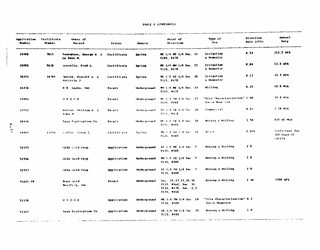
TAM.Z 4 I*t wItpFtlD\
"piicat i Omi Cetlticat.
14 46 701 S
loses 1111M
02,4 to 10%
040141
4 71 4 1
51s5
51551
S I $5 1
is)}
owes of
Oifcoved
Tourbnhrina. G.0w,. LLa Dom. M.
1 tevell. Fted L.
Unsay. Everett L.iat0cla. J .
N It toyna. Inc.
11 S D) C E.
W.hl.n w333 11aw A. I
[..s. rqr.,t 0
. rr.~ 3n:~Co.
*;tXtA t:.a*t Corp.
LtXA fgi d Corp.
'.(t ,..ld -oip
j,& Ift.'. Inc.
II S r) I) C
-
Point ot
Statul Source Dav-geion
Coistliicato Spinq me 3/4 la 1/4 Sec. J)noss. Not3
coctiticato sprini 111 1/6 NW 1/4 Sec. 3)?it5. 341K
Certitiret. Sp, I q or A St 51 /6 Sec. laTit-, I14?t
?*uiet ilndegqiomad NW 3/4 PC 1/4 See. PPTitS, PotK
Permit 1ind*9qroun.I Ft 1 4 :V 1/4 .-to 2ir733, m4is
p-|"lt in, I a r qt - tn, r s r,1 'E 1/4 5;. is
T111., 1114,1
Permit 1t4n.i. ivi,&n Pr I 4 SC 1 4 SC- 21
m1s. P44E
c-O ti 3 f I a * t I nq I06 1 V4 I -. 4 S., IT1s. P14SE
Afp ,let lon ti.seg-ound 5t 3.4 WE 1,4 58.- 7rlis. R45S
g Icet ton i~t.,qiowgt 5C1 3.4 SC /4 S~c 7
A"llcation Ur.1 q I*od SW I.' SC 1/4 Sec. 7Ills. ROSE
Apliret ton 10rUI0 {,qwow 5t 1/4 w 1/4 See 7
ri3s. Proel
Peimit Ufteiqtortmm Sac. 2A.121, 11,P5,7325. Nike. Sec 11
ill25. R4o. Sec. 2.3MIs. P461
I4Vliretton kSg qio. e-d MrE 134 St 1/4 Sc IrrPs. ttot
1p o t Dltv-ii~ t A st nu- I
Vs. Pate 3(7SI D~uty
Irrigtionl 6.S3 212.5 AVA
Iritltaton 0.04 12.5 ArP. Dnmast IC
ltriqation 0.12 14.5 ASA* Dome.tic
mtlInq O25 10.0 rA
'lit. tharartcertition' I 00 20.0 PNAY.H' . * lE~I 5 *r 0
Crsm-a l 0 0) 2 25 MIA
mit0inn * & rillini I 50 I 44 6S tP-.A
51,.0 Ot54 S.,iffh.i-nt for10() he-. -f
rat t 1
mlning L Milling
mi~injg & m~illi"
mninln * mollllns
Mininq , Mitl lIng
2 0
2.0
2.0
4 46 1200 ArA
'S-It* Ctfotetiztion' a IVuice Prtpiatn
S1341 Seqs C'plotetion Co. AM1 scat ion tI.lrqrCounJ 5s 1/4 5W 1,4 Sec . 35`125, Post
MmninI k mqilling 1.0

(.' @ ;-!^ r c
3.1 Surface Water Imrracts
The potential sur:'ae ofe.: s cf the Mother Lode project
include:
* the potential for chanzes :^ :-a~ e water quality and flow;
* the risk of faiu:e of -::ess roads and fiooding at the rrunesite; and
* the potentia' for cra. ~ le diversion and increase in soGerosion and sed:zen. ioa:- - st:ear.s.
Ipactts to the surfaze .ate resf: cs from the proposed project ara
expected to be miniral as a resu:. of the serm-arid climate and the
absence of significant s-_:fae wNe.. 'c perennial or intermru-tent
streams are located in the i-.e ar:e >ea. P.:rthermore, the confluence of
the ephemeral drainage t..ou .. i " area (Tates Wash and Joshua
Hollow) with the neares- ;-.-. stream 'the A.¶argosa P.;ver! is
approximately 35 Lrles dr.. e>- :^ the soJtheast of the MO*he- Lode
Prcject.
Mean annual flow f:' th*e e>-era drainage is expected to be
neglicible with flow expe^: e- o... ;.n response to high precipitation
events, mainly as flasI. fbo-ds. m-.ese existinc conditions are not
expected to be altered s- .i a:- -y the proposed diversions.
Therefore, the proposed deve cpre. :s not expected to signi icantly
affect the qua3ity of surface flow throuh the area. :The risk of failure
of access roads and flood:n: Of the .-ne site from flash flooding is low
because peak discharges a:-.d vo:zxes sho_0d be relatively small.
Minor bank anrd channe' eros4o-. =-i ccur in the diversion channels.
Sicnificant bank erosior. cod res: in some lateral migration of the
diversion channel a-nd s ea:.Lej szo- uinder flood flw cond.t.ons. Th.s
on-s:te imaact could be - aed r, incorp-ora::n; engneered cha.nnel
armoring in the diversion oesi.-.. A^n eroded materials from eithe: at--ve
or through the m.ine site shu.d: be c>eposited a short dlstan:e downstream.
Therefore, there should no, be anyv S _c^f :r:loadln-, impacts do nst:eam.
The Amargosa River shou.d not be affected.
A.-33

Pond systems are desi.ne-d in ex~ess of a 25-year ra'nfa:1 event. The
pcnds are designed tz handce a total of cve: 3,000,000 gallons of .- ter.
A 2"-hcur, 25-year event -uld produce, includi.ig the cperating inventory
of water, a total of 2,300,000 gallcns cf water. Th e ponds are no t
an ticipated to Ireach as a result of expected rainfall events.
Fjirthe :-7cre, all h i ui syste Ts, Includ ing all pipnrq and p-nds, wi1
tested "or leaks Pricr to startup. This shculd mini"mrie the ;.otenia'. for
leaks fcrO thee piri-c a;nd the pcnds.
3.2 ' retrndwazer :n:~:ts
Based cn drill lc-s, the sha:;-w alPw.-.vi i.n Crater Flat a-pears to
be unsaturated fHiy-ro--Sear:zh ;nc., 1989). .. erefzre, dw'un cater 1iacts
will be ed to c* ^-r,'fined a qufe:s and aquitar ds a: dept.h su ch as weIded
anr.d non-vel'ed t:-;ffs an.d possibly ca:rbonate rzcks.
3 Z -. _I a . _.a-__,
'i° r~ ? ests h;ave been pern'.ed :in -le Crater Flat area t- assess
d a'2'^ nd -al cx ate the a-,.ifer paraceters O f t r a= sS I -s I y an d
storaoe oeffi n 7e -_:cer-:acob oxifi:aticn of the 7"leis e7~ati:c
-as used t .iyd Searc. n,- (13E9) to es.t i-ate values of tar.asma s::v y
(6,;0 ; al ens rpor da ,Y per c t ) an d st:rage coe ff ien' (4 x Z-3'. 3 The
.alue for trans` sslt:y ;--as taken from Z:arnecki and Wadde.. Kie4.-as assuned th.at tre voloan; aquije- matersals have -.he character;st.cs
o' C:raer 71at and t-at tzese v.-car..: raterials extend uninterr.pted in
a'l d~rec:: v .s. : F s -. s dete .rined that after p7zrpin. for seven years at
o-, -rWi.e the ex,---ed rate of use), th.e dra-'v4c,--n at a S .mile radius
_rd be approx:zateiy 4.2 feet 'Hydrol-Sear:. :nc., 1989). h.is esti.-.ate
assunes that no hydraulic barriers to the drawdcs.wn cone w .l be
interceeted durins the -ne ;f:e (the seven yea:s of water produCti:n).
In reality, the geologic materials exposed at *.,e surface,
interpreta t ns _f the subsurface ;eol~gy, and drilllng results by tt-S,,
lead to the -onc'usion that relatively L>mperv cus barr.ers -a I
eiicounte red t the west c f the -ropcsed we'. :eld *4-d:. nl-,-I des well
.. unoers I -- , and 5284 .Ech 0 o Hyr-earch inc. 1989). -.h!s .;:
resu, z . greater than pr^ected draio-. :n t.,e .oned:ate V:n: :: of * e

l_ If e:J a:..~ ::r esr_^.j;. rewu: ~ ai.^ nwate, leve; dtawdw* t the 'e'es:
a.n ' La.-s: (Ym ) exa.7r;oned the possibility of p=r.inS t abC.2C,OCC acre-feet at the Nevaz3a Test Site approxirately 6 mrles east cf
the p:cle:t s:te a.-.. f'z-_nJ tha Vae: levels remained stable beneat-h *heNevada :es: slte. .. :s inr&dates same sta.iIIty in the lwer ca.bc-a e
.v-eX _.e.; C-f 'e a:.'fe: ;s otr.oabi on -,he Ce: of one :^
- *e _ F'- ' S 9789. Tha, S, . rta-Z take 7
'J :4 v'e_:s for the a,_e: to .e^^ve. to rept z n-. !eve-s.
S ine n.- p sz-tests h.ave ee. p-erf-mee :n the area, there are some
c~ieso -n~s re.n:^:. _s to the rea! ir~acts to the groundrat.er a: ife: f:oro
tne M:i-er LzcJe p^,:,. ;t is ze~r ended that mcnit:rinq be con`.;:ted
s .er: fy t.ne e xŽ e 'ra 47-^- rn te a-ea an-, ident. ly such rn't: s
3. ~ . _ _' f. _ - . .-
^:^- te -e-.era: area tŽ.ere are a nj..-5er of sp,::ncs '^at ,;s-.aroe
ad re::avelv '^:. ee-va_::-, e.z. , 'tere are seveera: sp:ings rn t- e Bea:r
-t-..: a: ' - 3,C^^ feet ai.z.e sea eve; and S;zerie Spring on Bare
r -.:a.. t a-r .rrNvte> ,! feet et'se sea lev.e.. The sour-e of'3te
f' .-- ee sr .-. ,z :s ver . "o al-zed rezha.-e cn the ^,untarns !5S.ar
* . .'Žse _-aer s-aroes are essent-.ally pe:rched water taes h.;g up
-r the rn.:a:.ns nzt tehteJ t the generai f'__ syste-.s. Any prL7 n-
zron the se era -:--- syste.- :t te a:ea, such as the roposed -. prn;
f-- tse ~.:ter .. e pro:eor, -_ n^t be expe oted I: have any effe:t r-,
tnese sr:T .
i.> '. ' _.:r._s :;_.-^. of t e 9:.^ier .e Pr-ject
T:e h.-.-her _,e pr:oe-: we.. are aprr:x:,.ate:' r_:r es s- of _z^,
?pi xn; anr: e: 6 r.ries soutnheast c' Crystal Sprrn;.
rSa : e.;zv;, E2.e o.z_:nta.. r.as a ma-or effect on .e f'
s;-e.. .. s a.ea. _ssen.t:a:: EBae d:una:.n iver-s cu:,^^saer f:.-
S~~. '-.d '-o -- ~a: '- svste.., are eviree.-: th;e rater r.lat f!^w syste-
a:-.2 -t.e >s.s * e.-. ' - s-.st:. 3Z*' .- , '^. e krm:_^sa tarrows.

The OCasis Valle, f"z svstem is F.>e scurce of Uhe water f'r tctŽh Lcng
Sr ina and Cystal r,.n; 5Sh ap I >89. The effet of purping t!7e Project
"eUI s ud t e n.de~e-abie ^ver Lhe peeriod of time in the a-Cunt *tat
z_ usedy' Z e pr-jec*. P rthercre, both L-cng Spring and C.yst&a
Spring a:e cradie-t f:am the -r:cect area. The springs ( Lzng Spring arnd
Cr-vssta! p rig d erive th eir wa e '-fm an en tire2.y different local
:ro C U aer fIs- s.S -- e.. Wae- deveoozed fro.m the rJer lls would not
:n.er^ewz -a:e: thar t J te f-i:se 2.zw to the spr:ncs (Sharp :e; ..erhas th !eonry ss ffect -would be a sllght tend-:n t e
szt:n cf the f- :.ies n-e st cf tie site. Th s culd b- e e;
C n t r: a ee ",e. -en or z - sprove (Sha rp '39 P.
3.' .~ £sath W'Val.ey ga2'' a. .zn'.ren
Sh-r5 ! ; , ! r-er:ed d.a '_2ere u.wde no discernn.b-le f .tect ,r.
2<e vaer ee.ves a: ze H: Hea _ja:ters :,urnace Cree!. -!e ?3rk
iea r :ers _e ;: th.e 7rysa :-ese rt t- svstem 'l,.4.i-,:ad a~nd
- _ , zr c% en.: t :o ectzon has n-t been v er:f ed.
There is, nz*-e'e:, sz. nelw e :dence f:o.n t-,e USGS t.-aI t.iere ;s a
hv-au. ._ WC_-: east ^f th.e ?: --ear:Hq';arters and west o;f . S'a.ley
^nz:^n S ?_;'. 4a:e: .djy not mcve from t.e A.arozsa Zeser:
zw-ards the ?3:i :ead-',.ar:ers. :f this is the case, rechar:e for t-.e Par^:
ea4 ar o - y e - e from the e rza .u cunta ins or
aern a:vely f':- scr e .e:-;y bsc':..e deep source that is U-n Co..ir or
_ss pes et a: *ns t:-- sha ar %1). :.n aaty event, -he park is ' :z-._:es
:r: the pr::ect area sutsjde -f th.e zone sf antic-.a:ed drawdo-n.
ks* .,:ea Jcws w 2 e :s _e
-,-a -D 3 9 : a c oH rf pro';ec: e .ls u nct hiave ar.y
e 'e^ -'.arer .es a :e.Ks Hse. Th:s is be:ause th.ere -re t*-^
A 'e-ae-. c-;_ sysnea7.s .s AS" " a e y -nd C-and eas ar.
s rac- ne ef fe --::Ut'd :-C ' a^r-_:Ss t:ae h-ydraui tx.O ;.; -. d a
-e e h.. e As,-. VOead-'s flc- s;s:e.r arn the ;as.is Val.!ev-F,.',-/u.ie Can;vor.f' - svs-_e ' ;.ar:
-x. eyv a z C ar s. s..-ooes:ed :-.a: :.e staZ' .. ::'J '.'ater levels
. e --,a~ .a:e f .2.'e ab'vez e also dtsccun:s lcng-te-m

reduz : zi.s of re:harge as a pcssible cause of the reduced' wate levels at
Ash Meadcws in the early 197/'s. 7his is further evidence that there is
probably litle connection between the Ash Meadows flow system and that of
the Nevada Test Si*e and vicin-ity, i.e., between the Oasis Valley-
Fc r t y Wae was. system. and Fhe A5sh readows system.
3.'. zn e W'
There are a r.=-:e: zf potentia gr.oud-:-ater contamination sources
asszciated wt -h e pcO jecF, NC adverse irracts to groundwater quality,
are an t: I :ee 5: &n an c'f hese so-rces, as discussed in the following
sezt.n.
D en ?:S. One opern rit ,s p.alned for the Mother Lode project. Due
t: the aar^ent a:'2. of z n t er with in the proposed pit, combined with
t-he :.r ted vatershed area andl proposed surface water diversion, the
prc- sed prc~e:: Is n-t exce:ed t: result in groundwater discharge toc the
The r:'5ity of :Cter ac-~-,.-.ati.ng within the pit is min !al.;`r-a ter s 7ia I ezt f z ;h e r-._ne p i t should be negl gible.
'as ze P.--k :'z. wase , o:k re..aining after ore separation would be
h au Ied t: a sep-arate &.=_ near the rne pit. Pctential inpacts associated
zith the -aste .rook disposal are the generation of acid mine drainage and
svb se;qsen: rezhar:-e -f suoh water to the local groundwater aquifer.
Pz ten'ti ia 3-fs caused Lj the waste rock ducos are not considered to be
s: ifi ant because: I) aderjate surface water diversion is provided fcr
the waste .^fx areas; 2, *r ndwater is at a considerable depth below the
s.r .S;tes .r. a 1ow per-met2i 'ity, fractured bedrock, acuifer; and 3 ) the
ar d Clif.ai se ttn: prehiudes the oeneration of significantf seepage
Fhrouc the waste . rie:.als.
ea:n:n.-. I c C :^ns . C_ D-aea:rnz cre would be leached on a
C. a~ne: leasn pad wth a ' :e cyanide s-'iticn. The leaching system,
;s des:zned to be sef-::n:2aied and intrins:cally tight in order to
prevent -he reiease of to-xic canine ntc the envirormnent and to obta;n
z:, avaI.ate gol frm., the leach solutions. No adverse impacts tc
. *

qro- dnrate : uality frz- t-he leaching facility are expected. In additicn,
the hyrircoeolcsic ccrnditicns af'ord a mcderate degree of hydfrologic
isolation. With Fhe in terv ern n silts and adequate depth (at least
200 feet) to qroun&~water, in addition to the attenuative capacity of the
soils, the poter.:ial for ; urrcn:'ater quality degradation is limited.
The prcrcsed harnd ing of t-he reagents used in the ore processing
shculd nc-: res-jlt in any adverse -.-,acts t^ groundwater quality. This isdue .n par: to to irhereent necessity to fully contain the s 1.ds and!su:2 slur-: es and reacents invo;ed in the ore processing.
Sanitar. Se--ae. Sarn::ary sewace frcm the mine would be disposed of
v a a sertic tar-k and leachi field systesm. The geologic materials benreaththe project area shculd prov"ie adequate renovative capacity for sanitary
waste-.aters discharzed to this system.
Solid waste S:cn-Hla:3 _s1. Solid waste generated by the mine and
facilities is to te dispczsed -f at a nearby landfill. .,o adverse ix.;ac:sto thte -. :ur'.dater are antl:ipted f:om this activity.

4.0 M.I.A7I- N KEASMES
4 .1 S''' Sace h'atc--
Some ban-u andt ch-ne' erosion may occur in high-impact flow areas in
the diversion channel. Significant erosion could result in some lateral
r;cration- cf the dive~sizn charunel and strearbed scour under flood flow
cond::ticns. This cn-s:te i7peact could be mitigated by inoorporating
eng inectel 'hannel arm:: ing in the diversion design.
?u t tests .a.'e n-t been cznducted in the area to quantify dratdotwn
es: T.tes. :n order to ve riy the estimates and to ensure that if an
impact oc:u-s it can be i 'enti fied, a groundwater monitoring system is
reco=."ende:'. : is .-ehamen'ed that at least one on-site well conptleted
:n the cre zone be Amon:to e. kdd.tiona: wells already completed by other
acencies ! e.S. Geoiz-.a: Survey) should also be monitored if
PDss:b>e. t is reommen:jed tat if available, three additional wells
shel_ be selezted: be:wer. the r:_e: site and Beatty; to the north of
the .:z-e:S s:se; arn t- the szuth of the pr-ject site in Crater Flat
(e.c., we:' VH-1¼ as :ndi:ated oni '^re I may be a possibility).
A-39

5. 0 PF.';ZS
Benson, L. V., J. H. Robinson, R. K. Blankennagel & A. E. Ogard. 1983Chemical Corposition of Ground*-ater and the Locations of Permeableo-ones in the 'fucca Mour.tain Area, ;V. U.S. Geological Survey OpenFile Report 83-854.
Blaikennaael, P-. K. and J. E. Weir. 1973. Geohydrology of the EasternPad.t of ~he Pahute Mesa, Nevada Test Site, Nye County, Nevada, U.S.G-eolocical Survey Prcfessicnal Pape- 712-B.
Brown, A. L. 1954. Geology of Bare Mountain, Nye County, Nevada (abs).Geological Society of Ame:ica Bulletin V. 65 p. 1235.
Coonan, T. 1989. Testimony presentedService at Water Rdig9Ihs hearing,Unpublished.
on behalf of the National ParkBeatty, NV, January 10, 1989.
Cornall, H. F.. 1972. Geology and Mineral Deposits of Southern NyeCounty, Nevada. Nevada Bureau of Mines and Geology Bulletin 77.
Czarnecki, J. B. and R. K. Waddell. 1984. Finite-Llement Simulation ofGroundw-ater. Flow in the vicinity of Yucca Mountain,Nevada-California. U.S. Geological Survey Water Resources'nvestigatiors Re;crt 84-4349.
DudleI,, W. h. and J. D. L.-arsc.. 1'-7. Effect of Irrigation Pumping onDese- FPpf ish Hiabitats in Ash Meadows, Nye County, Nevada.U.S. Geoo.ical Survey Professional Paper, 927.
Fox, F. 1989. Testimony presented athearing, Beatty, Nv, January 10, 1989.
the water rights applicationUnpublished.
Hydrc-Search Inc. 1989.Hyd.rclogy. Unpublished.
USINS Update Report. Mother Lode Project
IOeltz, 0. J. 1960. Source of Water Issuing from Springs in Ash MeadowsValleey, Nye Cou-aty, iNevada (abs). Geological Society of AmericeBulletin Vol 71, No. 12, pt 2, p 1917.
r~alber, G. T. and T. E. Eakin.Sarcobatus Flat and Oasis Valley,U.S. Geological Survey Groundwater
1962. Groundwater Appraisal ofNye and Esmeralda Counties, Nevada.Reconnaissance Series Report 10.
rMiller. G. A. 1977. Appraisal of the Water Resources of Death Valley,Califor-nia-Neva:-a. U.S. Geological Survey Open File Report 77-728.
Pisa:.n; -. A. and Fre d unkel. 1964. A brief Geologic and HydrologicRec^nnLa.ss&nce cf the Furnace Creek Wash Area, Death Valley Nationalmcnumeent Cal fornia. U.S. Geclogical Survey Water Supply paper17 79-y, 36 p.
A-40
RPIss, !. C. ar.d D. 0. MCCr . 19 5. A method of estimating mean runofffrcm tnLae'e; '.-s:..s in 7Crtaincus regions. U.S. Geological SurveyProfessicr'al Paper. -'S-D, pp Dl%-D202.
Robinscn, J. H., D. M. Stepherns, P. R. 1988. W4ater Levels in periodicallyMeasured wells in "he Yucca Mcuntain Area. U.S. Geological SurveyCpen File Report 88-468.
Rush, F. E. 1970. P.egional Grocun&wter systems in the Nevada Test SiteArea, NN'e, Lincoln, an.d Clark Counties, N-evada. U.S. GeologIC3lSurvey Wtate: ,esources Feccrnaiss.ince Series Report 54.
Sass, J. H. and A. R. Lachenbr ch. !982. Preliminarl Interpretation o'Thermal ata from the Ne.ada Test Site. U.S. Geological Sruvey 4oenFile Report 22-973.
Sharp, J. 'V. A. 1989. Testirmcny presented at the water rightsapplication hearing, Beatty :*, 3ar.uary 10, 1989. Unpublished.
Thcrdarscn, W. and L. Hcole Ia. 1987. Hydraulic Tests and ChemicalPcali ty Wate r at Well U5. '- i, Crater Flat, Nye County, Nevada.U.S. Oeoloqical Sur Jvey Water Resources Investigations Report86-4359, 20 P.
Waddeil, R. K. 1982. ro Dimensicnal, Steady-State model of GrcundwaterFlcw, 4evada Tes t Sie 6 Vicinity, Nevada-California. U.S.Geological Survey Water ResouJrces Investigations 82-4085, 72 p.
Walker, G. E. & EaKin, .. E. 1963. Geo1ogy and Groundwater of margosaDesert , e;ad a-Cali f oria. U.S. Geological Sur-ey Grcur. &daterResources Recrzrnaissance Series, Report 14.
Winograd, ,. J. and I. Friezn . 1972. Deuterium as a Tracer of RegionalGroupdw.ater Flow, Southern Great Basin, Nevada and California.Geological Scciety of Aimerica Bulletin, Vol 83 p 3691-3708.
Winosrad, I. 3. and W. Thordarscn. 1975. Hydrogeologic and HydrochemcialFranmewrk, Sout-h-Central Great Basin, Nevada-California with specialreference lo t he Nevada Test Site. U.S. Geological SurveyProfessior.al Paper 712-C, 126 p.
U.S. Department of _ner-j. 1986. Envirornental Assessment Yucca MountainSite, Nevada Research and Development Area, Nevada. 3 volumes.
Youn q, R. A. 1972. Wate- Supply for the Nuclear P.ccket DevelopmentStation at the US Atomic Eneroy Connissvcn. Nevada Test Site. U.S.Geo ioqiCal Survey Water Supply Paper 1938, 19 p.

kv?EIX B
soI. PROF7-_ DESC?.IPTIO;NS(In Nume.ica ' Order)
and
SOIL LAB3OATCRY DW.TA

APrrADIZX 8
SOtL FPOFIIX L SCI I PTIONS
,* Cons i t Addl t Iona Io - Coni 2 s ecy 6 Coarse 7 8 r 1 t RR
Clssitrcataon In chs. Testur. Color Dry Color olist Strrsctme DRYy plt I Wt P Dti ?riqntt t-ction Dot. aft (r-_intS
CX-I,
AC
Cl
C2
2 M~k qW
C -2.
A
tilda Variant
0 4
4-7
1-16
16-22
22 - 1 1 i
tO-- Ih-sa lt la. aixed,
Gh SL 1IYA 5/4
GP SL IOYl 6/i
Gl SL lOlRM 6/4
CI t r3t SL ICYR 6/4
uh#tt. hard durtlpan
t hoc -l c
lOYri 3)
IOYT- 4/4
tOYA 4/4
1oYr 4/4
TypIc Dirorthid
w I'Lr GA S4)
MP PL Sit
W. MASSIV. S0
w. Maisive 5O
VTr R s/SP
rp MSNp
V73 ns,14P
VFTR hS 1P
Co.., t, VF
CO M. F ,
Coo m, r, ,
Cot. M.t r,
ro. r. Vr I
plat., of
VT
6'T
VT
k-t - r
d" f ip-.
- - - -
I15 % r}1
15k r
*5t cm
451 Es
_ V.,_
Cs
CU
CW
Tapco clayey. otimRvillontic. thearmic. sZaIow
0-4 Clt 5L IOYIt 5/4 tOY% 3/3
4-S SL 7Sra 5/4 7.5Th 4/4
Typic Dugaiqid
W M CR SO VT" Mts'U row P, Vr
n " M SOX sO viM SS/Sr many F. VT.
Coo CO, tt
M A PR H PR S/F Co" M. P. vVr
raw CO
15t co
110% to
20% LO
CS
Stq *-16 Gl Clay' 7.5y1 5/6 7.STR 518
CK 16-20 WeathoeRd. brosm tutt
_ _ _ _ _ _ _ _ _ _ _ _ _ _ _ _ _ _ _ _ _ _ _ _ _ _ _ _ _ _ _ _ _ _ _ _ _ _ _ _ _ _ _ _ _ - - - - - - -

A.PPLNEJI B ICLMfrrIMAO
_ _ _ _ _ .
n I a .su o' Il K 1I)
I t,,z), sSo, I Ept.h,C I -,^S I t cA .t ion 1 n h* Trxtuxi Colo[ D"r Color hoilst
Con& I t ocy
St uCIu. U tly .1L W.t6 Coarse 7
1kaot I rf A nts I4.c t I Dr
IA. K t ion. I
a 9 FeJatuCosI bound Lly J Coft-na't
GX- 1 .
A
ArgiJ rine-loamy, *ia*J, thoguic Typic Eliarqlid
0-l SL lOr# 5/4 IOY# 44 V GM 54-)
1-15 Ch SL lOY1t 5/4 IOYlt 4/4 W N FL. Sit
W ML Gh
15- is Co won ) . Syr 5f4 1 . 5yv 4/4 rs n stilk o
Vtp
FR
f Y4
MS/NP
SS ,NP
ou F, Vf
Co. ., F. vy
101 ELO
10 co
Cs
GW
bt I sip row co, n. r, 30% LO
2- 15 Cb Wasm .5yl 5l S4 * SYR 4/4 KASs I # It' S1' row CO. M, F,
vr
301 f >
1^.,my-ukalotal mla*J, Mhersic,
0 -1 k SL I OYU 3 J
)-1 GM t Co St IOYll b/
&ha II ow
IOYt 4/1
I OYU 4,14
Typic 1A'farqij
M m PL./ Sit
n n Set
nMD n Uk f
VtR MS/NP
S/WVp
Fra r. VT
Co n. P. Vr
20 st
SX% EA
M Lit'
Cs
CV
5-11) G & CB CL t7.5Yl S/14 1.53 4/4
13+ White. hard Xi tipan
r S/P Cos M. IF. vr

SSm ! * roo . ,C5 i I Li I a OI
ClasItl--At ion
QX-5, Tbpco
A
LA
btq
ILA
Ce
ilor I tonand
[*'-[thlInc I*-
Cl ay.y.
0-3
1-8
8-20
20.
Atqirt
0-3
3-lO
I0-fl
to-1z
22-30
30-43a
Texture 2 Color Dry1 Color loist
%ontmorillonitic. the-imc, shallov
GR St. IOYP 5/4 7.5rp 4/4
CL 7 5YNt 5/4 7 5Y7t 4/4
CL 7.5fR 5/4 7.5yF 4/4
White, hard duriqtn
rino-loamy, thermic
GC L-SL .75Yt 5/4 1.5YlI 4/4
C/ Loas 7 5Y 5/4 1.5Y' 4/4
GP SICL SYR 5/6 Sli 4/'
LOOM 7.5YII 8/4 7.5Yl 7/'
Wite., rced, and yVtlow older
veath tuitt
_ _ _ _ _ _ _ _ _ _ _ _ _ _ _ _ _ _ _ - - -
APPEND1 s frcolrrlrIfrED
Cons i st*ney-
Stfuctur4 Dry moint Wet
Typic D[axrqid
W M CR S0 VITr P SS/Sp
W M SAK s51-Il FR S/P
S n FPP H- V1 r I S/p
1Lar'tve ro.
Typic leplafRttd
W A GH So VPR SS/SP
t IS EK SH rT sAT
m n PA r Ft S/Sp
W. nassive SN Yr SS/SP
W- massive
loot ,Coasts )
ftaq-nts Peactior
Co. P, VT
Con Y, VT,
rev CO, r
con r, vr
r.. co
211 EO
71 co
51 Er r.f:
"dJi t I one Ia 9 *eatkite *
n rP mids ry and (a-nnt *
nlny Y. Vr.
r-eW CO. n
mauxy F. WT.
co. P1. rev co
con co. M.
P. VP
15%
15%
' M
EO
SE
Dl
ES
CS
Cu
GW

APPLEO1DX A iCue4TlH1JLr,)
CI 4sIc I AIon IWrIV34 Teetujga Culof Dry Color Piuit Structure fit N IS W~t
GE-1) TaP'Q ClaY"Y, Nontmotillunitc theFrmiC, 1h.11.,w TYPIC DUtAg.9r
A 0-1 GM SL 7.5YR 5/4 7.5Y31 4/I w mo.r cm St. VM Ss/sp
LA 3-a CM Ca 7.SYR 5,4 75YR 41,4 U N SaxM sit 1) Ss/?
Loam
lit) 1-14 GMI L Cb 7isyk 5/4 7.3Y~ia 4,'4 M N APIK II h SV
Clay
Rout aCosi I )
Ir aqmant i
"lidt I oni Ia I Featues~
aftact Ion So~.mda ry arod co,.eants
raw r, vrT
Cos .p1, 1
vT. r.w co
Corn CO, M.
r. yr
1 LO
Ž0 % to, LI
Cs
CW
CUW
IT'hin. nout Saxoplod)
l 4 4 I.t*t. he rd rhtb Ipan
LS
LV
-Z- -
LoANY. amaad. Zhaguic
0-1 GM SI 1011) 4/4
11-11 Loam 1013 4/4
TYPIc Ciucoithid
1013 4/4 W H C
101R 4/4 M N sag
so UnM
SHA1 Fm
us/NP Few P. U?
SS/7 Cos Co. M.
F. v?
M5 St
10% Cs
Cs
Cv
ekqn 6-15f soifitehard 4jkirpan rowa co, m. r. vre
aloniq cracks stad
between plate$ of durip~n

K"PEflDIX B IC"w INVEDl
2 3 1S Maw . * lHot i ton
Soi)5-tes *nJ
71fice. 0, n tClaq (i ia t ion InC 0%
GX-1, ZaldAe Variant
A 0-4
Texture Color Oxy Color Moist
Loxmy-skeletal, mixed, th.rxic
GR SL IOYlR 5/4 IOYR 13/1
Con lsnq
Structu I O4xry MOIt Wet
Tlic Duxrorthid
w cM PY,/ SiI VTr Ss/
WH CR
MA-% e i v-/ 511 FR 55/
Nelstve/ 511 ill 5S/
W M SnK
Addit ionalCooris R a q .e tures
.r~e~t Poaction BMunda ry end Com-rits
4- I VrR SL 7.5YR 6/4 7.SYR 4/4,
4 /6
11-16 VGR SL 7.SYR 6/4 7. SR 4/1
Sr r. r, vr
SP Co. CO. M.
r, vT
5P Cor CD. M.
r, vr
201 M CS
4 "I ES CW
EVRftgq 16-)0x
GX-12. L.IeantJic
Al 0-2.5
AZ 2.5-5
RA 5-10
kMtit. herd drtiipen
Clayxy-theletal. anontmnrillonitic
CR St. 10YR 5/4 ionX )/1
lR 5L JOYR 6/4 IMY 1/)
CR Loe IOYR S/4 ILOR 4/4
-
thormic
_ - -
Typtc tOr Ar id
Stql
rtqZ
tk rq
ok q-
10-1a Ca CL 7.5Ya 5/6 7.5Yr 4/4
14-24 cR L CO CL 71SYN 5/6 ?.5Y1 4/4
W M CGR SO VTR MS;p rv r, vT z
W M PL SM YR tS/lP r-v r, vr 151
W M Sx SH fir S/Sp many n. r, Vr. 151
cow CO
K K ra FR r /a S, any M. 7. VW. 20%
Co. CO
M 4 PR If ry S/ coo . r, vr. 45%
r.o co
Kassive n Yr S/ r-e M. r, vr 40%
Pussive/ r.U F. vr bot Ion
Piety plates in durapan-__ _ _ _ _ _ _ _ _ _ _ _ _ _ _ _ _ _ _ _ _ _ _ _ _ _ _ _
tO
EO)
to
co
W
Cs
CS
aW
GE
co
ES24-27
27-31
cR SCL 7. 5Y 7. 5Yl 4/6
White. induratoed (tilripan
-_ - _ _ _ _ _- _ _- _ _- _ _- _ _- _ _-

)J'PtLN)IX B ICONTIlMAfb
SW "O. W, Hog rZf S oso D~res nd -Consistenj1i,.jzl. I. Sol DLhl I 1 4Clsa iaio I k.s Texture Color Dry Color ,k~ist 5ttuct.1.14 Dry ?)i-st wet 11oot,
" -I ), Taj~cu Clayey. mmontmorillonitic, thareaac, shallow TY13hC DdEaiqid
A 0-4 QGR LGAM 1OYlt 5/4 l0Yi 4/) W mj PL./ so ViM K S/Sp Pew P%. F
Add JL t Ions I
Corl I nt s~~If b.Und~A y *isd Comeants
IVT
4. 9 GR Loa3m 7.5yft 6/4 7.SY~t 4/4
9- 17 Gk Clay 1.5VR 5/6 7iSYR 4/6
1 1-29t "laite. aton.gly Iraslted J-fapan I
w. mh.r GH
wM PC,/ sit
MJ'hPR/ hi
,th egminA ry
W M GR SO
M M sUK Su
to
DlFit '5s/s Coxn M. F. Vy,
Tao CO
ri S/p co.rn . vT.
row CO. MS
P.'w F. VT b~twaon
Platos of ducipAn
…
Cs
GM
h-s
CGX-14. Lea8fladic
A 0 -4
U.A 4-16,
Clayey-skelotal . montmogil loickcC
Gil SL SOyRk 5/4 IOYK 1,4
GX LOarn 10TU 5i4 IO'U 4/4
7.S13 S/4
Pic LDularggi
Vt a us/VP
Ta Ss/sr
Come F, VT
Covi CO. M.,
IF. 'Vr
L1k O
C0 O
Cs
itq
it hql
fIqrn
16-10 VC.a CL ).SYS 5,6 ]-SYR 4/S M M PR Vill TI S/p rew r. vr 40£ COGSE C
(Thin, hot samPloiJ
30-4gs, flAid. lfndui5tId duit pan L
…

"PjretlX 0 ITIWTrED)
lflJ�et� TexLur2
Color Dry1
Color Plohi 4S7 a No.,
S- I o Sr, 'SEl4J t), 4. So {lClassi I acat ion
CX-15A Lq)i
A
)iar I zonand
InL'f ain T-x t., Color Dry) Color Htoist) St luctt ab
Loamy-sk.IetaI miied, thermic, shalln
0-1 CGP L Co SL IOYR 6/4 IOYR 4/4 n M Fn Lr
M nr GP
G- P G C-o IOYR 6/4 M0AR 4/4 M n VL
Lo e
-* wlhits, hard Alripan
Con I It SIcf
Dry Mob St We t
trptc L. *ait ht id
StH rI s /I
,.di t lon: I
6 Coarse 7 aP rItuJtsPOe~t s F t a,?". Mt ¶ P~ o bolI 4h Iy Alnqd Cno.nt I
ql row . VPr Cs
CW53i rTI Ss,.SP Cob to mny M. 151
n. r, VT
re. M4. F. VT
bat..*n piteS Of
dJT I pan
-__ _ _ _ _ _ _ _ _ _ _ _ _ _ _ _ _ _ _
Cr-16. t-rsnm-d Agqid
Al 0-7.5
Al 2.5-6
Fine, montmorillonitic. th-r-ic
GR Lose 7.SYR $,4 757 S 4/4
GR ose 7.5Y1 5/4 1.513 4/4
larol Iic PAileciq1.
_ _ _ _ _ _ _ -
w Mt FL
W M CG
UAt
at
6-16
I 6-20
CR Loam
VGA Loan
I.Syu S/4
7.511 5/4
7.113 4/4
7. Sn 4/4
5yT 4/6
W M SX
tassive
s M iw
5 rur ARK
SOf Vr" SS/Sr F.. F. Vr
SN vrW SSpSP Coo r. vr.
r.- M
SN n) S/Sp Mniy M. r. Vr
M r3 S5/p coo F. Yr.
rowa m. 16-i2
rTi S/P row ., r. vr.
25-31O,
Co
22% c0
35% V0
151% to
Cs
CS
CS
GWZ Krry thick
clay skins eu
pod 7aces -
pore walls
20-13 cr ClaY s53 St/
oh 30-4 2 VIG Loan S"1 6/6 SyR 4/6 pussive
r 42-72 VCR LS SYl 7/4 s51 5/4 massive
…__ _ _ _ _ _ …- _ - _ _ _ _ _ _ _ _ _ _ _ _ _ _ _ _ _ _ _
a r a Ss Wr
_I_ 5S/W_- - 3 - - - - -
rvo v? 15M ECS C
V-ry Few Vr 411 ES
…__ _ _ _ _ _ _ _ _ _ _ _ _ _ _ _ _ _ _ _ -…-_ _ _

A1'LHDIX O (COtf rIUtDI
Su~ - ~ tm ug I tonlSolS...a. and ?Otu. Coubl St *IIL
11A~~~~~~ ~on 1,ISlI tphI &ton In, KsS TOAto I Color Dgy Color moist Stguctu. DOy hlst Wt
Gx tA1,"SIC Elutiaegolic H Spl0fqu
A 0- L5 al ja IOYlt S/it IOvtt )xl u -Y vt I ... 1-r -''
Hoot sCosjIs 7 A
Flouyr lts It--ctlon
Addi t Iona 1b radturC .s
bourw gy asd Coments
ILA I S-1) VN- L-SL jOYt 5/4
1I1-2) Vt;OR SICL IOYt 4/4
- -' .- U i ).),r Low V . v .
W MLF Gtt row n
10YT 4/4 W H ShK Sit rx S S/5 F nany r. vr,
Cos H. row CD
1ont 4/) M M $OK M IN S/S" Cr r7, vy,
r- Co. M
211 SE Cs
)M LK
bt k.L 41% ES CW
H
I;X - :1, LAI-is
A
Di
11I W/ile, sogow~kx w-athag"l volcontc fockl
I.,&y,. mized. th..iL TyIic tiurothiJ
0-°3 ) H SL. lo0vt /4 IOtt 4/4 w tft r GC SO VIFI
I a GO LA&a IOltH 5/4 IOtH 4/4 U M Sbt S ll 7t
-17I %sat*. her4 zb~glpan
SS/Sr
SS/P
row r. vv 1% sr Cs
Cos M. P. VT 10 IN CW
row oK. r. vr E3
&Io"p cracks and
botueena lpstot. in
the augIpan
_ _ _ _ _ _ _ _ _ _ _ _ __- - - - - _ _ _ _ _ _ _ _ _ _ _ _ _ _ _ _ _ - - -

33Atr tlo . Nor lots5S. nonh1itarny11 1,? & Sol In. .t .thl C 3 4 -- s
Cle'zifi1e t lon In, 1,*s Teat.,,. Colot Dg1, Color ?4)%jj Stttuetu fliy t WXtut Poothroas. I7 a
T I. .r nt I PlAct ion
Additi onal
",n' , n y a* J Co-nt 9
GX-22, Tap-o Variant fine. ftntnuaillonitic. theruic rypic "1i9rqi.I
A
E
Brq
otbq
lit % q
GX-23, Tarco Vai
A
0-4 St. IOYV *4 10T 1/1
4- Clt . CB SL IOYt 5/4 1 .5Yt 4/4
7.5" 56/4
9 -24 GP Clay 7.5YP 5NS 7 S5Yll 4t,
2 4-)) Cl CL I 5Yrt u 7 5 Slt * /6
-) , WSllt/, Hard 'J4lOsIN
riont. finp. _>ntmocil11Isnt~c, thtai-c
0- ) Ga SL Ioylo 5/S joint S/4
u t s~rSn
n t SPAS 5t1
S CO pot V)1
Typic Duratlid
Vrt
11 Frt
55,/5
-'iSP
rF -rT SvP
Frt S/P
I 0 Enro
10 ro
15 Eno. 04
r.?
155 LO
Cs
C'S
1-10 V(; Loam IoYn S/4
10-22 GC Clay 7.Svi S/4
1.5" 4/4
w r cR $4) VR VP PtHsot mny r. vr.
Fr- m. 0-5'
n 1 Sf1 Sol PR SLSr Corn M. f. Vr.
r" Co. S-22-
H H " MM V i t /'p Co eM. F.r Vr
r.v co
CS
)IS co GM
ttq 7-5Y11t 4/6 CO
tkIq MThin, not shpledl
rkqO 22-21o White. hard dutipan
_ _ _ _ _ _ __- - - - - - - - - - - - - - - - - - - - --- -_- - - _ _ _ _ _ _ _- _ _ _ _ _ _ _ _ _ _ _ _ _ _ _ _ _ _ _ _ _ _ _ _ _ _ _ - - - - - - - - - -
CS
Cv
Cw

M.I'tIX a f/LCTIHUID)
5. 1. - 'S..f t S- . , .1 f Id, "
i L S ob rX r t~h 1Classsfi.ation In SOF
*.1- 24 t-J.S Vag Iont
A 3-4
C 4 - I
D
SttuA.ct'.9 MY3 ?A.Ist SOWETostue Culor >ry) Calio Ktsts tr ar3o so OctSIo
loot s Frhqe.nt 3^^c o
"I t ioAo.AI
I Ps y tureSS' ~~~rY *i~ Co~nt
Vt(ll SL I Yk 5,4
Vk.. SL 1013 &/4
th- -IC
toy' )/1
1OYm 4/4
Typic Ds.bsa4id
W r C S(J VW I
W. pl..all SO> LA) VTR
p.ai,./ su Fs
W M SO&
us5Wr r..ny P. vr
N5/,5 Con r, VT.
Fe- M
s/spF P.w A. r. VT
41% rs
CS
cG4
Int S,* -IJ4 %A.3 SiL ISys &a VbIn 4,;4 M5 tE5
2 Nh p ).-)$* White dsitpan r.s r t~t-n
plat.s to d.rtp.an
_ _ _ _ _ _ _ _ _ _ _ _ _ _ _ - -
s.1-2s5
L'as V&s tntt
A 0-
C 4-II
i1 SL AOMU 5/
U.J SL 7 Arm ,4
thelmIC
IOTU 4/)
I SIR 4/4
Typic Wltasq&4
W M GA so vil us,-" Co. r. vr
W. MhhSSI- so V11 ws,Wr Con r. VT,Fe- CO
ftbb w sa nu SS/Vr coo I. VI.
rV. Co
30% I.S
M5% ES
M 1V
Cs
CV
CVI*-j IVX SL 7 Sia ,/4 1.1 4,/4
- - - 1- - -
Stil ~St a. k S d #A&I Sr"p- t @ - 4 - - - - - - - - - - - - - - - -
cv
-- - - - - --V- - -

AppflIDIX a 1CX~rtIIAED1
-G o "f a114 Ionr,S S.tira I I .d C nI !!_!n(c -__
C ia,rnIfaati n lnr~r It tr o, t'V Clr Mli t'I Dry oi Wt
6 Coati I I bonAA ry a 4i boa~GtSPoet ir Coalnt I FeatuIr.'
Gl-26. Tw.'P& Eoawy -~IN Iet& I. . IVA...d Scar a -Soux tl*.rIc mC Lithic Torriolthent
KC 0-4 %P I..*e* IOYR 5/4 lOYVI t,'4 j. ,q SMR sit FVA SS/Sr Coarn . vy.
Ta- Mt
401 r5 Cl'
a 4. Herdf, cagb-ftate b..Sg,(k
GI-27. Tcacpa L~aowy -S ,a Ieta I. a I"e lCalcaenoil. th~toic Lithic Torgialthaflt
0-S Loas 7. 511 5/4 75yna 4/4 ,M M SflK 51 Ss /Sr coo rn. WT.
re'. m,
4 1 ;s Gw
a 5 . Soaeo.'*xat haid. quve~ttt b..Itec),
I SAMVIO Ofafibts S. 10. 17. It. &M.. 19 see 13.t descitbed. in this tablIs. Those SampI., represoot sail tnIts aimilac to other %amp)*, desctbed lin this Table
$i,. Table I-il .for *.emplo. Sample M~mbi 9 is cos~acable to 24 and 25 of r-das Vaciant.
Soil ]Profile Deac~lition abbreviationsi ale listed and deacribed In LIFSfA-SC3. April 31.03. Wist Technical Service Center. 'DefinitionsC and Abcstviations tocstil 40scelptionh.' Th. mew desnaystioun for soil hosisonn "n layers (Soil Sagrve, Manual. kqescultut@ MA*.-II"k m- It, revised Chapter 4, EatasaiSatiof andPoscrapt io of Sotil in the field. may 1911. pp. 19-SI) age used in thiq wapott.
Ireeteo and tsatuig modifier
S sand
LS Loamy Sand
SL Sandy Loma
L toss
SIL Silt Loas
St slIt
abbrevat ions:
SC. Safdy Clay L6*.
CL Clay La.m
StIC Silty Clay Loam
SIC Silty Clay
C clay
CIwV
C"
('I
cobbly
very Cobbly
Zetreeoely Co&biky
Channoefy
vely (hannery
£stleawly Channery
G&W
S"
so
Cuaveoly
Very Gravely
gattemoly C raely
sha I y
Stratified
I Color. Dy an* moist: , nsmell Soil Color (it. 13915 Edition.

AlkIi)EuiZ a 1Ccm'71M110
4St Iii..te iii Gsi A..
U Weak
Pi r-de atsk
I St I .0k1
ISI a a
V7
f
34
CIO
VC.U
Vosy fine
F in.
K.dI us.
C. a %
V.s'y Coarse
nar!PL-
iAb
I's
U Massive
MK taive
C I odI'V
PIA I
Ga .no a I
Sub-rk~j..jlai 1111"Iy
AntgtI&I sto)cky
Pt I smu IF
Weak M~ASI~VI
Stgiufij Massive
SiskII*1 Gsarined
IA)
SO
N
V11
Wo a a
so Ct
III pt I y Mc4Idi
"a. IJ
Vosy Wacd
£mtemeeiny Ml&Id
MO I St
LAI
v, i
' Id
T I
VP I
LV I
La. %a
Voly TrlAble
V. able
Vi,.
Ve.y film
Ca'aossely file
U.t
its
SI
5
Vs
HP
SP'
P
VP
06fi St itky
Sliqhi0I y SI I& y
St Iiky
V.a 7 SI&ity
N.,Eti Psi
Vesy Plasttc
6 i O .~iDp I
Very row.
Nany
!YI-WVI Very fan.
IF rifts
II Pbs4imae
CO C.aAeCS
pools age mieacrib*d an lissis of a spqKcif .5 asio Ityp~i amd quantaiy Silmbell. 1h. Size Classes atsb:
V!ly Fine:. Ln... them a m in tamestelt
Fine; I to I5a in dalstae
Medium: I to 5 m i dza..teta
Is wa o *5146 Iin dismetsi
Sa.uit f *,..a tkan to sam in dsambeteI m~ay b.k d.., a~bed s.perately

KPPEmft~ a lrxWTrlMJLDI
OAaent it y Clau of rot I armdo 4f r,' In tot.s of no of each itfe pet init at.4 -- I iquare centI mter for very Ino anl fti^- coot and I sf' d~c aIefrfor mJ-ium end coat,. toots. All loot. seller then 10 _ tn diaeter -to dIscitb-d In torms of the follioirq quantity cl*sse*
rav: L.ss than I p r unit area of the spe-ified- sil*
(0on: I to 5 per unit at*a of the *pAcifti0 ste
Puny: ra're then S per unit mi*& of the specilfi %it-
onots are doqcriblt as to nu,"r tirst. and type ,sc.
Coa,,' ?,lilnts- All coerie ftcs& nt p.rgrntaqo% t1 by "Iqht) em. taken Nr, S.oil Lhoretoty atet. M&.)-rs are o~mI-l to th-. near st vhol- ftNIb".Litholoqic ocidifler ty' Iqr:-ely. chxrny etc air.) of. taken from the *212 field soil profile description for.- (l each i4. 9 1-A profila.
IP. actlon: Ifftrowmseence
Mi fton-Wfervvie~et
St 211h.itly rtffouescent
cmI Ioo4.ateiy ltfffrvescont
Es stroftaqly Kffelvifie.,t
L-V Violenltly Ctforvioscont
p^act lonP t. at~!I f
StId. AcidS"I. ACid.51I - M- It
Neut taI
n1l 1 Alt.
n-,d Alt .
Ster Stt Al. tt.
Very Stgoftq Al.
sm .orqly A~.-O
P*.ieiaioly Acid
5lt.1hily Acid
K-At tel
Mildly Alsaline
M.,.i0istoly iltal ime
Stuesss41y Alkaline,
Very Sit oily Alkaline
P-"
- 1.1
4 .1 - 4.%
7 9 - A. I
I . - I 0
iq 0
9 "osizon, boundaries, Dist iuctness
A Abruipt leJ cis thick)
C Clegg 1i to S co thick)
a Gcgagel IS to IS co thick)
o Diffuase owls co thick)
5 Smooth the boundruy Is a pl~ with few 0r me ltr"qalaltiSW W-vy Itia. bounYary has Unebolaton5s In which 4oprfsshe.Ea are wfder than they are doeplI trcejular Rth boundary heo pocket. that are deper than they &te wide)* *roken fat least oe- of the eusern *o layfrs sepsieted by the bouadry Is disscttinmest auouthe boundry is intetiwptedl.

Intcs mountuln lokboiototics. Inc
Shemlgn. Wyornino 828011633 Toeva Avenue 1"I (307) 612 H945
IlloIl Of ( IIrs . DION
?r...t.: U(A Lab
IiT l. It"trj- I *1 4
PA f$&hg /to
t ?S-IA M. Ikahon
22'd)
2161fls5SPItS122(A)14SU's.
no"§2741%)IM
7141
77441?14S4
106%22411271618
220491)WO
210
Li 5
Li )
&I I
UI 1161 Is&I 'S
0.0 1.01.3 6.33.6 70.06.0 L11. 1.61.0 14.30.6 3.31.3 I a6.6 4.34.6 1.31.6 11.0
1.SM 36.0 3.03.3 3.06.6 6.06.3 11.0
16.6 0.0.6 30.0
M.6 42.02.0 121.0
1. 41.3
).21.61.51.6
1.61.11.21.11.31.I1.61.3I1.1
1.31.I
1.9
I .210.11O .'is3.163.583.45
0.451.12
o.n6I.119
0.s11.540.410.413.443.5SOBS
Sj.ia'f1 i
l
A i3.SA.IMI)31.6UI.124.122.1?I.%M.S43.ISi.?24.312.470.130.I25.IM.144.444.1
(.1he )U~ A.W l e Ius
M I tj4 seqII
1.111.112.§l44?I. Is2.406.354.9'
1.117.112.11
1.59IA?11.42.022.011.611.131. 4
2./40.00.14I.510.110.4I2.011.012.111. M3.411.11L."3.1O
M.52S.'6.140.12I.616.50
0.111.'A
84)1O bs6.51.SI* S
6.52*.rs1.641.806.2M3.113.11I.A1.561."2.941.4i
0. Ao.nM0.61
0. A
6.11
6.113. 86.13o.130.413.216.121. II
V06
2.12I.nb4
mosttllatw b.1^evllns; . fv1 tml w td. tKml,, th l..Au Iwoll ,, e prletv 11 .. I .. Wtzl. ,,1A.,,1afite
ifrd-Inle tmountcAn Icboal01< s . Inc
t'ji,,idlin. Wysxmmul8 82M)11633 teulla Avenuie lI i (301) 612 t194S
III(Oki (l11N5., 1ORAN
Pto jt(e: Ll4A lbD
Kay 3 . 393r - I 1 4
pH IC Salui- (t I(i.. X nh.Iuw 5Iu ,O uin SAJsmhtwis I.,&*l .
Al ion itq/1 stftl tq/1
I 1 N. Ito 4l Ion Otpilil
271)212011
2104)2)OS5220152201122413fiG I9nose4))di11431no"112143flog1flog'
Ll 2O
Ll 11
LI1X)
LI I1LI 24
0.0 l.SJ.S I1.0
I1.0 21.30.c u.t30 1.00.8 0.34.8 9.a9.3 14.0
24.0 11.31s.0 fl.00.0 0.04.0 31.6
Me@ 14.93.0 4.00.0 5.0
1.21.0'.31.11.?1.11.1.51.11.31.0I
1.11.31.0
0.900.510.Is0.590.41I.1t0. %I3.440.01
0.49I.140.423.44I.010.5
A.0'S.C09 9
to. S11.150.5
15.3
St.i53.3
10.5
11.9
1.41)1.72.115.211.0)'.4)1.2,1.003.111. 1
9.141.111.11l.44.21
2.13I .45
1. I90.nIo 14
I'll11OilI."30.141.50
0.30
1.50I.330.951.543.53
0.130. M0.040.33l0.I90.41I
3. 133. 13
3.41
1.31
0.41
0.330.740. I)0.310.6140.710.4)1.15
IAI£
0.31)0.031.040.230. A
IIuttIIinus AbbletvI'lo t".UR- S*u. AShrpl ion fito. HI - son I 3ah~anqe (4pi lY. I SP -Iaihinqee Woits Puoleeldte. Iuh at II U athm ablr, Ai 41 AaIIabte

JffTUInletImountcxIn loboeiaofolesInc.
Shodldan, Wyoming 828011833 Term Aventio Tol (307) 672 8945
III
[11 (IliIS. (moU Wfpro jt(II LIA Lt(U
Nif 11. 1981 F#W I of 4
Cuirse
FrIias
I
Very I Inc
SJFWI
Clay ?WI
SS Sill clayI I I
It' Lt Oi jink
N1letr
I
(Aiboulte Sc1IrniusI spp
IA Nol. lo at* io Cplhs
Ills?221SI
224ss
214
21612451
2245921460
22443114422144241
2214472449
2240022461
Li S
&I I
Li I
I-111
LX 14U Is
I"16
0.0-1.0
0.0* 3.SI.070.0).0 1.01.0 1.0
1.0 1.00.0 1.0
.0 14.04.5 9.69.6 11.I
16.6 U0.S.S-1.0
3.5 5.06.3 6.04.' 16..
16.0 20.027.0-U0.0U.0 42.041.0 12.0
70.1I.1
S.?11.110.070.0Is. I10.3'4.I30.S16.0n.ois.oAn.o2,.122.43.4Is.,34.04,.1
IS.'34.212.120.021.III.111.120.3)I2.IP1.125.0'3.514.214.114.S11.119.011.S12.114.21.4
12.421.511.)10.416.141.SII.I14.913.114.13.633.114.071.113.114.914.9S.411.)4.1
i I. I56.I11.5is.356.9)3.'
So.151.3'1i54.1M6.54'.949.'4'.,51.353.154.)Jo.,13.5
11.1
11.121.321.S21.130.9)1.1)4.A30.031.?
13.134.,23.441.9"A.is.S)6.335.424.120.13.1
1.is.'32.0
O.111.113.16.I
11.21.S
14.0213.29.Sl.S
14.04.1
10.410.447.11.431.
Sljoy IOAISANfY 1s( AY I WSANDY I OAASMWIDY l OAIATY I AN
SANSY IOAU
SANDt IO JI
Stjo IOAISlANY I UEl AT IMM
SAIlT (IAT IOANlSO
(I ATSANDT aUI1AN SUD
0.40.t0.10.10.10.40.6e.J0.1
0.50.S9.'0.41.10.40.10.40.70.1
D.I0.10.10.I0.)0.1I .2.20.9I.0I.80.1'.9S.S1.0O.'5.40.81.1
11..
40.0240.02'0.01
-0,01
'0.0)
4t.0?

Ikei A untaloln loboratoole. Inc.
1Shotio.mu1* Wyominol MR2311633 Telta Ayanuet lt1 (3fl11 612 8945
III
Pra etl: 6LIA (a D
"1 It. MlPO-$ I of I
pH Ifash/ca
I Fi(
St US
it lef
I
(1( iwu
e / IRJWt S ii wOum
. /I1 Itq/ISA1
IAU J. Io(*1ion Drplh%
12611flea.
ne& iU241
42.0 11.0 ).9 D.SlQ2.0 12.0 ).I 0.M
44 i 1. 44 1.1 313
0.M0.4121 1 (IP)
4J 11IP)
1.1LIC0
0.Sb0.il
1.144.0S
0.1?0.it
1.0 31.01.0 Ii.0
1.1 0.431.0 0.43
2.02 ? .h2.03 0.11
M4 61 5Sn9 )140AW k
e.g J aS.U I.1
1.4 1.21 23.0?. I I. A )1 @
1.),'.4)
2.14311
O i16.13
0.)b.nA
It-1rII aco in A"beew dtbsH: SoN Soaish. A6him PI ift ~I , Is. M I 11% I ,I Ihh e (apa ii, II. Ps 1I It ablf SOJ. w Per,,.Ia . IutI Iashan-)-Ale. A vI - Avsl IA

0-,0 U %O~
Itl ffMO buntailn loboiototles. In
Shoel1Jfn. Wymning 0fl2AI 1,it 1307) l} 2? A94S1.13 Tor f* Avenspe
IIIIfIt I its. MnORA
pleltd: UlA LOD
PW I *I 4
Noy 11. I%
I* Nm. IN atito
2)4122141)2114
21416
Zill12411
2.411
11431
214K4
Li M
Li 21
Uh4l
U ilUi 1t
lpbs
00 ).5L.S- I1.8
I 3.0 2.06.0 3.0
3.0 4.04.0 ,.04.0 14.0
24.0 31 0
10.0 12.30.3 4.04.0 :.0
23.0 34.0I.' 4.0S.. S.O
1 sm *t(e tI'
)Z.1
)S. O4s. 1
1. 1
10.0A. I
1.3
41. In.s
41 .0
Vely I Ine th I O )
SI IIs
I I
26.3
21.2
24.123.1I?.?15.1As.I11.113.111.1)4.'
10.4
1.11}.6
63.41.1
11.134 Is.S9 s
is.IS.lS, .)61?.611.s".3
!1). 3
51 -44.5
58 5
21.1
it.)
35.S'U.56.0&1.3SllSI. I51.3
42.3IS. 2is. 146.926.3134.234.2
1). 4
?0.0
21.1
35.3)/I2113
71.6
41.131.4
I I5 )1.3
IS. I
1.3
11.1
I .31.%4.41.1
1.14.4'I1
M1 IbU
SAW1 I OSA
SAWY I 1"A
I a"
(I Al
5M01 lOUN
w*v 1 W
IAMI I3W
s$s INA
Say I "I
(O.I
It III t 04 1(
I
I )0.)0 3
3 1
0 4O 1
3.26.3I.?
I I0.1
I.1
3.6
( ,t ~tlf|m
6.5
II
I I11245
14I0 1.1
31.)
-6 01.3 02
.0 6)462Q

JJNLInletl mounickin Loboontools.. Inc.
1633 lota Avinnue Sheildan, Wyomin( 8BN1I I e (307) 812 8945
Ill
P,.tfif LIA Wo
J, 11. 1W" r'" I . 1 1
(*ufsi leet f ine ( I II SillI
(Ojr
IItIlu' t
I r &W I'
It j it tllwir Seltit
IUI I P I P
IlI No. lIalion Dflhs I
11411Ilm
41.0 II.S42.8 11.0
41.1 1.l1).1
6.) 11.140 16.0
11.I11.5
1.11.5
I upX SANDI M SAND
0.1 11.00 1 10.I71411(kv)
f2l12IM
6.l 16.0'.3- I ..
12.4 1.'11.6
14.9IS.1
5).)'A I
M. I 10.412.4 Il1I
SANDI 105AD I OA
0 4 0.A0.m 0.62014olp)
-11F,2 11 5 g.g 3.93.0 1.8
to.) 15.1 12.4').3 10.4 11.)
".I. s
1.1L.?
SANDY I OMSAND I IOl
.I 0.)0.S 0.1

0.a n ! rv in s-o r q -. ;a q aot t~ta cm v CrL r'r I ty ..LAAd N~A I&~ 60fC1VIW@IIo. :U IdI 90 . O41
' .*PI at td tv ,j I ,54 , and *-ot a at -",m .-LA" C t It &a . :MC.. It and&~ fI .Cthdd Pt IC ed'-44
Foar ~tor popaprtef ".. PeCeswom-Sed Pr~cedaral
pr p r t. n f It1' %aRAAC drt imam.g at 1.3S C. steal' .jp 115 f-it
and ,tlavwiq of laaple. Pic% out '.Arl fearse £?rai,
foTa~SAIS ;fto onl "iek 12 BoIA 2 wo - 51 .. 0 " a1
;uet Peatee noe screen aveid qrndtflq :$Arl froar..
D~f~fq 'PI41 Ofttira SamO pepra6a Pre~oftl *ACe
;rniq2 #0aVIO owtia&al Vitt be avoi11de
Iu.OlarolVi.kq of Ilev.dj4I f
Sol. r-aterIA13 Ofor &-fl
::a Cto ! &rqwh4tt
UJSZA Mandbogb 40. 1514 - 0."aqisalls sat- Ir'm
Salina and A~lkala $at!$. pp. 12-84. UA.S
t~b~fAtory Staff.
2-S:J. Handbook 414. Alp. I: paeg 4'2 3l Soi -Sry
lAboraterf mattiod & Proceaturag far -3~.*Ctq Sol.
I*091*,. P0466 I &Ad 12-13.
pH fy r oq7n L an ct vIy
at aa t .Atat-. i P a.t$,
.3'ZA A Man00.b 40 , %theq Ila I. v a q 1 2. on am I e ISa
JSZ 4an'd.oo 40, .et!h4 'AS:. peg* .4 ar-I -.- il
Pa,.. 446-30.
pro~arasi.~n if sAt.,rat:M
*AtrAct £ttd Iatutation
er~o r :O t14tor,, nat ion
2SJ LA andb-eI 40 . 04etN04a Iand !a. ;a q6 I IA- !I,
and 21 and U. peqo I27.
?a r II. *-I L I* AAa. ,,III
$and and Vert fir,.
tand vi'a . Soot-.:
wyffylatn.et vletnkd. AlA pwene le. I. Fart . - -
41-5. Paqe. S43-566. AA U-hoUt §GttILnq tL.e ks
r*'T4 L fed. L514ve Aanlywi !of Vill ':40-227 %sat ki
,-m*. Me 46. Part 1. paeg* S54-154 *~Aek .14S am's
I I 466
79 1, .1 co It -i t ja: !as J.AU 'ancfwoem 11. ptq~o MC-Z213.
SC,"--.* :* 'a and N, sc:..±: :. -~ aj 4. xtractlon of Ca, 0q. and Its by JSZA P46Ml&OC. 4:... a
"'. Paqa 64. MeSJYIaa by at*MIC 4djor;t.snM
I P'aC t I cpno t *vwst ry.
104 A~ a 1 o; Cj I t at l i IAJ C a. Lha td 'r :t
12marntrations
'jSJ. 0manbeoo 40, tog. J6
:ArtcfACato Pt r c*n t "SZA As"dboon 43, p4thed 23ci ;ago !:5
,Z A .: -AI. r AAlA A'Mn. e. 1, 1,913, pert. I. -6thod 24-1 j ;a-,