draft scoping report for the proposed - SAHRIS
131
2018 DRAFT SCOPING REPORT FOR THE PROPOSED CONSTRUCTION OF THE ESKOM SHONGWENI 2X500MVA 400/132kV SUBSTATION, APPROXIMATELY 15KM 2X400KV HECTOR – SHONGWENI POWERLINES AND ASSOCIATED INFRASTRUCTURES WITHIN THE JURISDICTION OF ETHEKWINI METROPOLITAN MUNICIPALITY IN KWAZULU- NATAL PROVINCE MAY 2018
-
Upload
khangminh22 -
Category
Documents
-
view
0 -
download
0
Transcript of draft scoping report for the proposed - SAHRIS

2018
DRAFT SCOPING REPORT FOR THE PROPOSED CONSTRUCTION OF THE ESKOM SHONGWENI 2X500MVA 400/132kV SUBSTATION, APPROXIMATELY 15KM 2X400KV HECTOR – SHONGWENI POWERLINES AND ASSOCIATED
INFRASTRUCTURES WITHIN THE JURISDICTION OF ETHEKWINI METROPOLITAN MUNICIPALITY IN KWAZULU-
NATAL PROVINCE
MAY 2018

Draft Scoping Report: Proposed Eskom Shongweni 2 X 500MVA 400/132kV Substation, 2x 400kV powerlines and associated
Infrastructure
2
Eskom Holdings SOC Limited
Prepared For:
Eskom Holdings SOC Limited
Att: Vuledzani Thanyani
Tel: 011 516 7584
Email: [email protected]
Prepared By:
Nsovo Environmental Consulting
Cell: 071 602 2369 Fax: 086 602 8821
Tel: 011 041 3689
Email: [email protected]
Date of Submission:24 May 2018
“From the world we live to the world we seek”

Draft Scoping Report: Proposed Eskom Shongweni 2 X 500MVA 400/132kV Substation, 2x 400kV powerlines and associated
Infrastructure
3
Eskom Holdings SOC Limited
EXECUTIVE SUMMARY
Nsovo Environmental Consulting (hereafter referred to as Nsovo) has been appointed by Eskom Holdings
SOC Ltd (hereafter referred to as Eskom) to undertake the Environmental Impact Assessment for the
proposed Shongweni substation, powerline and associated infrastructures, collectively referred to as the
“Shongweni Project”. The Shongweni project will consist of the following activities and infrastructure:
Development of a new 2 x 500MVA 400/132kV substation within four proposed sites whereby one
location with minimal environmental impacts will be considered; and
Development of the proposed Shongweni 2x400KV powerline of approximately 15km and associated
infrastructure.
The proposed Shongweni project will be carried out in Ward 4 within the jurisdiction of the eThekwini
Metropolitan Municipality situated in the KwaZulu-Natal Province. In terms of the National Environmental
Management Act, 1998 (Act 107 of 1998) (as amended) (herein referred to as NEMA), as read with the
amended EIA Regulations of GN 327, GN R325 and GN R324, the proposed development triggers
activities which require the Scoping and the full Environmental Impact Assessment (EIA) process to be
undertaken. The descriptions of listed activities which are triggered by the proposed Shongweni project are
listed in Table 6. This includes Activity 9 (i.e. the development of facilities or infrastructure for the
transmission and distribution of electricity with a capacity of 275 kilovolts or more, outside an urban area or
industrial complex).
This Scoping Report has been prepared in accordance to the requirements of the Regulations and contains
the following:
The details and expertise of the Environmental Assessment Practitioner (EAP) who prepared the
report;
The location of the proposed activities;
A plan which locates the proposed activities to be undertaken;
Description of the scope of the proposed project including the listed activities and the associated
structures and infrastructures;

Draft Scoping Report: Proposed Eskom Shongweni 2 X 500MVA 400/132kV Substation, 2x 400kV powerlines and associated
Infrastructure
4
Eskom Holdings SOC Limited
Description of Policy and Legislative content within which the development is located and an
explanation of how the development complies with and responds to the legislation and policy
context;
A motivation for the need and desirability of the proposed development;
A full description of the process followed to reach the proposed preferred activities, site and
proposed location of the development footprint within the site;
A plan of study for undertaking the environmental impact assessment process to be undertaken;
and
An undertaking under oath or affirmation by the Environmental Assessment Practitioner (EAP).
For the proposed Eskom Shongweni substation, three site alternatives were identified which are
Shongweni site alternatives E, F and G. One alternative will be considered based on the outcomes of the
minimal environmental impacts and the recommendations from the specialist and assessment of the
impacts by the EAP. For the 400kV Shongweni powerline, three corridors were identified and assessed
which are corridors 1, 2 and 3. Detailed information of all the alternatives considered including lay-out,
technology and no-go alternatives are discussed in section 7.1 of this draft scoping report.
The draft Scoping Report (DSR) shall made available to all potential or registered Interested and Affected
Parties (I&APs) as well as Organs of State for a period of at least thirty (30) days to afford them an
opportunity to review and comment on the report. All comments received on the DSR shall be included in
the Comments and Response Report (C&RR) and incorporated in this Final Scoping Report (FSR) to be
submitted together with the Plan of Study for the EIA to the Competent Authority (CA) which is Department
of Environmental Affairs in terms of section 24C of National Environmental Management Act (NEMA). DEA
will assess the final scoping report within 43 days of the report and advice on the way forward as to
whether the project should proceed or continue with the tasks contemplated in the plan for EIA or refuse
environmental authorisation.

Draft Scoping Report: Proposed Eskom Shongweni 2 X 500MVA 400/132kV Substation, 2x 400kV powerlines and associated
Infrastructure
5
Eskom Holdings SOC Limited
“From the world we live to the world we seek ” DOCUMENT CONTROL
The proposed construction of the Eskom Shongweni 2x500MVA 400/132kV substation, approximately 15km
Hector – Shongweni 2x400kv powerline and associated infrastructures within the jurisdiction of EThekwini
Metropolitan Municipality In Kwazulu-Natal Province
Quality Control
Report:
Compiled By:
Peer Reviewed By:
Draft Scoping Report
Munyadziwa Rikhotso
________________________
Masala Mahumela
_______________________
Sign Off
Full Names:_______________________ Date: _____________________Signature___________________

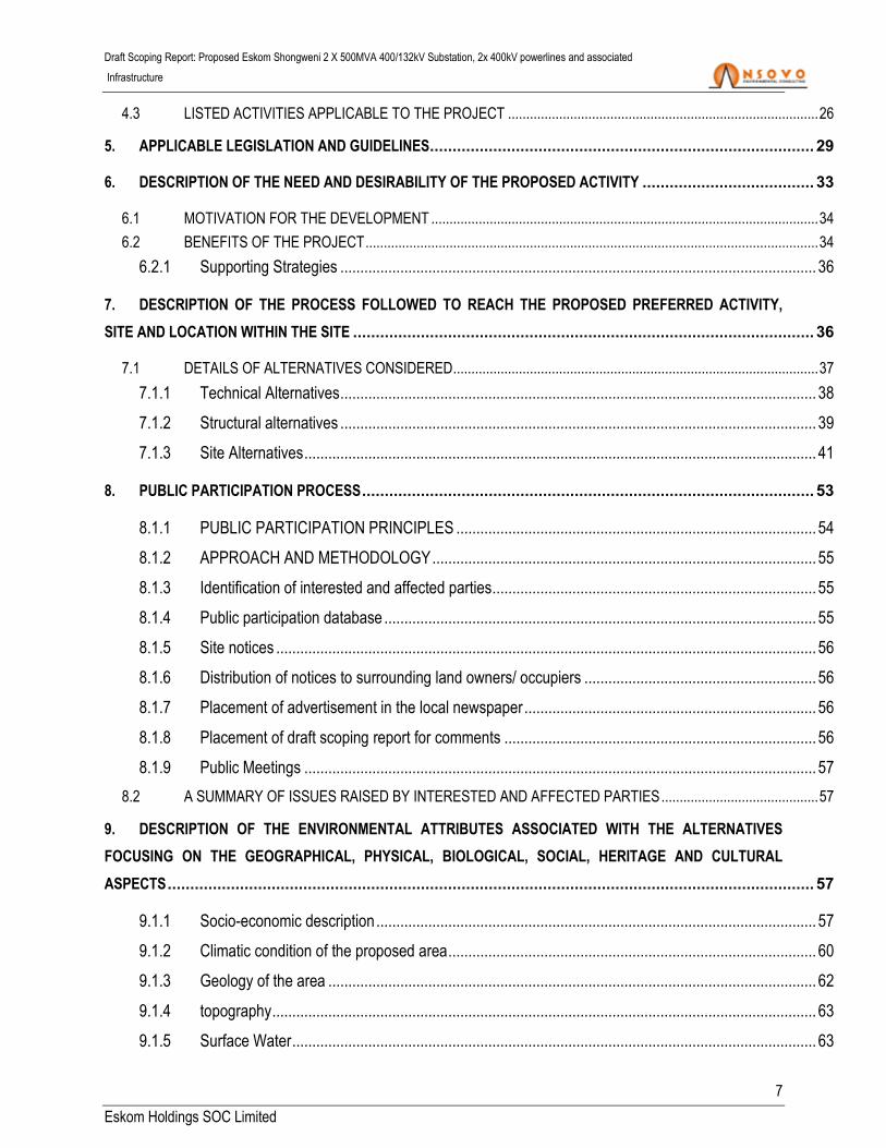
TABLE OF CONTENT
1. INTRODUCTION OF THE PROPOSED PROJECT.................................................................................... 14
2. DETAILS OF THE ENVIRONMENTAL ASSESSMENT PRACTITIONER ........................................................ 15
3. DESCRIPTION OF LOCALITY AND THE PROPERTY ON WHICH THE ACTIVITY IS TO BE UNDERTAKEN
AND LOCATION OF ACTIVITY ON THE PROPERTY ....................................................................................... 17
3.1 LOCALITY OF THE PROPOSED PROJECT ....................................................................................................... 17
3.1.1 Province of the proposed project ...................................................................................................... 17
3.1.2 municipal ward within the proposed project ...................................................................................... 17
3.1.3 affected farms ................................................................................................................................... 18
3.1.4 Coordinates ...................................................................................................................................... 18
3.2 SURROUNDING LAND USES ............................................................................................................................. 19
3.2.1 Farming ............................................................................................................................................ 19
3.2.2 Residential ........................................................................................................................................ 20
3.2.3 Commercial and Industrial ................................................................................................................ 21
3.2.4 Sand mining ...................................................................................................................................... 22
3.2.5 Tourism ............................................................................................................................................. 22
3.3 SURFACE INFRASTRUCTURE .......................................................................................................................... 23
3.3.1 Road Network ................................................................................................................................... 23
3.3.2 Power lines and associated Infrastructure ........................................................................................ 23
4. DESCRIPTION OF THE SCOPE PROPOSED ACTIVITIES ......................................................................... 23
4.1 BACKGROUND AND THE PROPOSED SCOPE OF WORK .............................................................................. 23
4.2 ACTIVITIES ASSOCIATED WITH THE PROJECT .............................................................................................. 24
4.2.1 Corridor walk-down ........................................................................................................................... 24
4.2.2 Access roads .................................................................................................................................... 24
4.2.3 Vegetation clearance ........................................................................................................................ 25
4.2.4 Construction of substation and erection of pylons ............................................................................ 25
4.2.5 Steelworks structures ....................................................................................................................... 25
4.2.6 Stringing ........................................................................................................................................... 25
4.2.7 Feeder bays ...................................................................................................................................... 26
4.2.8 Telecommunication mast .................................................................................................................. 26
4.2.9 Completion of construction work ....................................................................................................... 26
Draft Scoping Report: Proposed Eskom Shongweni 2 X 500MVA 400/132kV Substation, 2x 400kV powerlines and associated
Infrastructure
7
Eskom Holdings SOC Limited
4.3 LISTED ACTIVITIES APPLICABLE TO THE PROJECT ..................................................................................... 26
5. APPLICABLE LEGISLATION AND GUIDELINES..................................................................................... 29
6. DESCRIPTION OF THE NEED AND DESIRABILITY OF THE PROPOSED ACTIVITY ...................................... 33
6.1 MOTIVATION FOR THE DEVELOPMENT .......................................................................................................... 34
6.2 BENEFITS OF THE PROJECT ............................................................................................................................ 34
6.2.1 Supporting Strategies ....................................................................................................................... 36
7. DESCRIPTION OF THE PROCESS FOLLOWED TO REACH THE PROPOSED PREFERRED ACTIVITY,
SITE AND LOCATION WITHIN THE SITE ...................................................................................................... 36
7.1 DETAILS OF ALTERNATIVES CONSIDERED .................................................................................................... 37
7.1.1 Technical Alternatives ....................................................................................................................... 38
7.1.2 Structural alternatives ....................................................................................................................... 39
7.1.3 Site Alternatives ................................................................................................................................ 41
8. PUBLIC PARTICIPATION PROCESS .................................................................................................... 53
8.1.1 PUBLIC PARTICIPATION PRINCIPLES .......................................................................................... 54
8.1.2 APPROACH AND METHODOLOGY ................................................................................................ 55
8.1.3 Identification of interested and affected parties ................................................................................. 55
8.1.4 Public participation database ............................................................................................................ 55
8.1.5 Site notices ....................................................................................................................................... 56
8.1.6 Distribution of notices to surrounding land owners/ occupiers .......................................................... 56
8.1.7 Placement of advertisement in the local newspaper ......................................................................... 56
8.1.8 Placement of draft scoping report for comments .............................................................................. 56
8.1.9 Public Meetings ................................................................................................................................ 57
8.2 A SUMMARY OF ISSUES RAISED BY INTERESTED AND AFFECTED PARTIES ........................................... 57
9. DESCRIPTION OF THE ENVIRONMENTAL ATTRIBUTES ASSOCIATED WITH THE ALTERNATIVES
FOCUSING ON THE GEOGRAPHICAL, PHYSICAL, BIOLOGICAL, SOCIAL, HERITAGE AND CULTURAL
ASPECTS ............................................................................................................................................... 57
9.1.1 Socio-economic description .............................................................................................................. 57
9.1.2 Climatic condition of the proposed area ............................................................................................ 60
9.1.3 Geology of the area .......................................................................................................................... 62
9.1.4 topography ........................................................................................................................................ 63
9.1.5 Surface Water ................................................................................................................................... 63

Draft Scoping Report: Proposed Eskom Shongweni 2 X 500MVA 400/132kV Substation, 2x 400kV powerlines and associated
Infrastructure
8
Eskom Holdings SOC Limited
9.1.6 Air quality and pollution ..................................................................................................................... 67
9.1.7 types of vegetation (flora) ................................................................................................................. 68
9.1.8 Fauna ............................................................................................................................................... 72
9.1.9 Avifauna ............................................................................................................................................ 74
9.1.9.4 South African bird atlas project 2 data (sabap2) ............................................................................... 76
9.1.10 Agricultural Potential ......................................................................................................................... 77
9.1.11 Visual Aspects .................................................................................................................................. 80
9.1.12 Sites of Archaeological and Cultural Significance ............................................................................. 81
10. METHODOLOGY FOR ASSESSING SIGNIFICANCE OF POTENTIAL IMPACTS ............................................ 81
10.1 DESCRIPTION OF THE ENVIRONMENTAL ISSUES AND POTENTIAL IMPACTS INCLUDING
CUMULATIVE IMPACTS IDENTIFIED ................................................................................................................................. 84
10.1.1 Potential Environmental Impacts Identified ....................................................................................... 84
10.1.2 assessment of cumulative impacts per site....................................................................................... 92
10.1.3 General cumulative impacts............................................................................................................ 115
10.2 PLAN OF STUDY FOR EIA ............................................................................................................................... 117
10.2.1 A description of the alternatives to be considered and assessed within the preferred site,
including the option of not proceeding with the activity .................................................................................. 119
10.2.2 A description of the aspects to be assessment as part of the environmental impact
assessment .................................................................................................................................................... 120
10.2.3 A description of the proposed method of assessing the environmental impacts ............................. 121
10.2.4 An indication of the stages at which the competent authority will be consulted .............................. 121
10.2.5 Particulars of the public participation process that will be conducted during the
environmental impact assessment process ................................................................................................... 123
10.2.6 a description of the tasks that will be undertaken as part of the environmental impact
assessment .................................................................................................................................................... 125
10.2.7 Identify suitable measures to avoid, reverse, mitigate or manage identified impacts and to
determine the extent of the residual risks that need to be managed and monitored ...................................... 128
11. UNDERTAKING UNDER OATH OR AFFIRMATION BY THE EAP ............................................................. 128
12. AN UNDERTAKING UNDER OATH OR AFFIRMATION BY THE EAP IN RELATION TO THE LEVEL OF
AGREEMENT BETWEEN THE EAP AND INTERESTED AND AFFECTED PARTIES ON THE PLAN OF STUDY
FOR UNDERTAKING THE ENVIRONMENTAL IMPACT ASSESSMENT ............................................................. 129
13. WHERE APPLICABLE, ANY SPECIFIC INFORMATION REQUIRED BY THE COMPETENT AUTHORITY .......... 129

Draft Scoping Report: Proposed Eskom Shongweni 2 X 500MVA 400/132kV Substation, 2x 400kV powerlines and associated
Infrastructure
9
Eskom Holdings SOC Limited
14. ANY OTHER MATTER REQUIRED IN TERMS OF SECTION 24(4) (A) AND (B) OF THE ACT.......................... 129
15. CONCLUSION ............................................................................................................................... 129
16. REFERENCES ............................................................................................................................... 131

Draft Scoping Report: Proposed Eskom Shongweni 2 X 500MVA 400/132kV Substation, 2x 400kV powerlines and associated
Infrastructure
10
Eskom Holdings SOC Limited
LIST OF TABLES
Table 1: Details of the Environmental Assessment Practitioner (EAP) ........................................................ 16
Table 2: The GPS coordinates of the centre points for the substation alternative sites ............................... 19
Table 3: The start, middle and end coordinate of the 3 corridors under consideration ................................ 19
Table 4: List of residential areas along the study area ................................................................................. 20
Table 5: Main economic sectors (Integrated Development Plan (IDP), 2017) ............................................. 21
Table 6: Listed Activities described in Government Notice No 983, 984 and R985 applicable to this project
(as per numbering in the Government Notice) ............................................................................................. 27
Table 7: Legislation pertaining to the proposed project ............................................................................... 29
Table 8 : Summary of Specialist Findings-Site Alternative E ....................................................................... 42
Table 9: Summary of Specialist Findings-Site Alternative F ........................................................................ 44
Table 10: Summary of Specialist Findings-Site Alternative G ...................................................................... 46
Table 11: Corridor coordinates .................................................................................................................... 48
Table 12: Summary of Specialist Findings Corridors Alternatives ............................................................... 50
Table 13: The annual precipitation of the proposed location ....................................................................... 61
Table 14: The mean, maximum and minimum temperatures as well as the evaporation of the proposed
area ............................................................................................................................................................. 61
Table 15: Numbers of the species within the different conservation status categories as indicated below,
data derived from the SANBI SIBIS database. ............................................................................................ 71
Table 16: Methodology used in determining the significance of potential environmental impacts ............... 82
Table 17 : Summary Potential Environmental Impact Identified .................................................................. 84
Table 18: Impact Rating ............................................................................................................................... 93
Table 19: Alternative Analysis ................................................................................................................... 119
Table 20: Specialist and Aspects ............................................................................................................... 121
Draft Scoping Report: Proposed Eskom Shongweni 2 X 500MVA 400/132kV Substation, 2x 400kV powerlines and associated
Infrastructure
11
Eskom Holdings SOC Limited
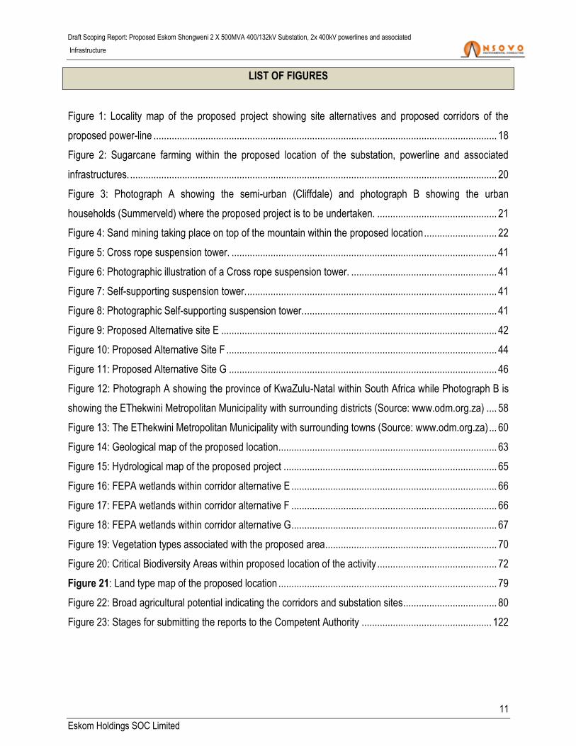
LIST OF FIGURES
Figure 1: Locality map of the proposed project showing site alternatives and proposed corridors of the
proposed power-line .................................................................................................................................... 18
Figure 2: Sugarcane farming within the proposed location of the substation, powerline and associated
infrastructures. ............................................................................................................................................. 20
Figure 3: Photograph A showing the semi-urban (Cliffdale) and photograph B showing the urban
households (Summerveld) where the proposed project is to be undertaken. .............................................. 21
Figure 4: Sand mining taking place on top of the mountain within the proposed location ............................ 22
Figure 5: Cross rope suspension tower. ...................................................................................................... 41
Figure 6: Photographic illustration of a Cross rope suspension tower. ........................................................ 41
Figure 7: Self-supporting suspension tower. ................................................................................................ 41
Figure 8: Photographic Self-supporting suspension tower. .......................................................................... 41
Figure 9: Proposed Alternative site E .......................................................................................................... 42
Figure 10: Proposed Alternative Site F ........................................................................................................ 44
Figure 11: Proposed Alternative Site G ....................................................................................................... 46
Figure 12: Photograph A showing the province of KwaZulu-Natal within South Africa while Photograph B is
showing the EThekwini Metropolitan Municipality with surrounding districts (Source: www.odm.org.za) .... 58
Figure 13: The EThekwini Metropolitan Municipality with surrounding towns (Source: www.odm.org.za) ... 60
Figure 14: Geological map of the proposed location.................................................................................... 63
Figure 15: Hydrological map of the proposed project .................................................................................. 65
Figure 16: FEPA wetlands within corridor alternative E ............................................................................... 66
Figure 17: FEPA wetlands within corridor alternative F ............................................................................... 66
Figure 18: FEPA wetlands within corridor alternative G ............................................................................... 67
Figure 19: Vegetation types associated with the proposed area.................................................................. 70
Figure 20: Critical Biodiversity Areas within proposed location of the activity .............................................. 72
Figure 21: Land type map of the proposed location .................................................................................... 79
Figure 22: Broad agricultural potential indicating the corridors and substation sites .................................... 80
Figure 23: Stages for submitting the reports to the Competent Authority .................................................. 122

Draft Scoping Report: Proposed Eskom Shongweni 2 X 500MVA 400/132kV Substation, 2x 400kV powerlines and associated
Infrastructure
12
Eskom Holdings SOC Limited
LIST OF APPENDICES
Appendix A: Locality Map
Appendix B: Photographs
Appendix C: Specialist Reports
Appendix C1: Draft Wetland Impact Assessment Report
Appendix C2: Draft Heritage Impact Assessment Report
Appendix C3: Draft Soil and Agricultural Potential Report
Appendix C4:
Appendix C5
Appendix C6
Draft Fauna and Flora Impact Assessment Report
Draft Aquatic Ecology Impact Assessment Report
Draft Avifauna Impact Assessment Report
Appendix C7 Draft Eco Tourism Impact Assessment
Appendix D: Public Participation Process
Appendix D1: Site Notices
Appendix D2: Newspaper Advert
Appendix D3: Proof of stakeholders Notification
Appendix D4: Proof of Landowner Notification
Appendix D5: Issues and Response Report
Appendix D6: I&AP Database
Appendix D7: Background Information Document
Appendix E: EAP and Qualifications
Appendix F: Specialists declaration
Appendix G Facility Illustration
Appendix H Farm Details

Draft Scoping Report: Proposed Eskom Shongweni 2 X 500MVA 400/132kV Substation, 2x 400kV powerlines and associated
Infrastructure
13
Eskom Holdings SOC Limited
ACRONYMS AND ABBREVATION
ARC Agricultural Research Council
CBA Critical Biodiversity Area
CLN Customer Load Network
DEA Department of Environmental Affairs
EA Environmental Authorisation
EMA EThekwini Municipality Area
EIA Environmental Impact Assessment
EMPr Environmental Management Programme
HV
IDP
High Voltage
Integrated Development Plan
I&APs Interested and Affected Parties
km
kV
Kilometers
Kilovolts
MTS
mm
Main Transmission Substation
Millimetre
NEMA
NFEPA
National Environmental Management Act
The National Freshwater Ecosystem Priority Areas
SAHRA South African Heritage Resources Agency
SANBI
Tx
South African National Biodiversity Institute
Transmission
WULA Water Use Licence Application

Draft Scoping Report: Proposed Eskom Shongweni 2 X 500MVA 400/132kV Substation, 2x 400kV powerlines and associated
Infrastructure
14
Eskom Holdings SOC Limited
1. INTRODUCTION OF THE PROPOSED PROJECT
Nsovo Environmental Consulting has been appointed by Eskom Holdings SOC Limited (hereafter referred
as Eskom) to undertake the Scoping and Environmental Impact Assessment (EIA) studies in terms of the
National Environmental Management Act, 1998 (Act No. 107 of 1998) (NEMA) and the Environmental
Impact Assessment Regulations of 2014 (as amended in April 2017) for the proposed development of the
Eskom Shongweni 2X500MVA 400/132kV substation, an approximately 15km 2x400kV Hector –
Shongweni power-lines and associated infrastructures within the jurisdiction of eThekwini Metropolitan
Municipality in KwaZulu-Natal Province.
The eThekwini Electricity network forms part of the Pinetown CLN (Customer Load Network) within the
KwaZulul-Natal Operating unit (KZN OU). Currently, the eThekwini electricity network has four 275kV
Transmission in-feeds from Georgedale, Hector, Illovo and Avon substations to the substations listed
below:
Avon Substation supplies Ottawa and Durban North Substations;
Georgedale and Hector Substations supply Klaarwater Substation; and
llovo Substation supplies Durban South and Lotus Park Substations.
Subsequently, the load forecast shows load demand doubling in the geographical area supplied by Ottawa
and Durban North Substations in the next 20 years. The area supplied by Klaarwater is expected to grow
by 20% and the area supplied by Durban South and Lotus Park Substations is expected to grow by 30%
over the same period. Consequently, Eskom has proposed to construct the new 2X500MVA 400/132kV
Shongweni Substation and the 2x400kV Hector-Shongweni powerlines in order to cater for future electricity
demands.
The fundamental aim of the proposed project is to develop the Shongweni substation, 400kV powerlines
and associated infrastructure in order to meet the electricity demands in KwaZulu-Natal. The proposed
project will directly and indirectly improve the standard of living for Kwazulu-Natal communities as it will
create employment opportunities, generate income and contribute to local economy as well as the country
at large.
In summary, the proposed project will consist of the following activities and infrastructure:
Draft Scoping Report: Proposed Eskom Shongweni 2 X 500MVA 400/132kV Substation, 2x 400kV powerlines and associated
Infrastructure
15
Eskom Holdings SOC Limited
Establishment of the proposed Shongweni 2 x 500MVA 400/132kV substation;
Development of the proposed 2X400kV powerlines from the existing Hector substation to the
proposed Shongweni substation and associated infrastructures.
Three powerline corridors and three substation locations have been proposed wherein one corridor and
one substation location will be considered for the proposed project. The study area required for the
proposed substation is approximately 800m x 800m (i.e. 340 000m2) in extent, as such; the substation
footprint will be anywhere within the study area. The proposed 2 x 400kV single circuit lines will be
approximately 15km in length, however, the final distance will be determined by the substation location.
In terms of National Environmental Management Act (NEMA) Section 24C, the Competent Authority for this
proposed project is the National Department of Environmental Affairs (DEA) as the applicant is a State
Owned Enterprise (SOE). The Environmental Impact Assess (EIA) process will be undertaken in terms of
the National Environmental Management Act, 1998 (Act 107 of 1998) (NEMA) and the EIA Regulations of
2014 as amended (hereafter referred as the Regulations). Other applicable Acts and Legislation will be
equally considered.
2. DETAILS OF THE ENVIRONMENTAL ASSESSMENT PRACTITIONER
Nsovo Environmental Consulting meets the general requirements for an independent Environmental
Assessment Practitioner (EAP) as contemplated in regulation 13 (1) of the EIA Regulations of
2014Accordingly,, Nsovo has been appointed by Eskom as an independent EAP for the proposed project
and is thus:
Independent and Objective;
Has expertise in conducting EIA’s;
Takes into account all relevant factors relating to the application; and
Provides full disclosure to the applicant and the relevant environmental authority.
Table 1 below provides details of the EAP and relevant experience. A detailed CV and Qualifications are
attached as Appendix E.

Draft Scoping Report: Proposed Eskom Shongweni 2 X 500MVA 400/132kV Substation, 2x 400kV powerlines and associated
Infrastructure
16
Eskom Holdings SOC Limited
Table 1: Details of the Environmental Assessment Practitioner (EAP)
Name of Company Nsovo Environmental Consulting
Person Responsible Munyadziwa Rikhotso
Professional Registration South African Council for Natural Scientific Professions
(SACNASP)
Postal Address P/Bag x29
Postnet Suite 697
Gallo Manor
2052
Telephone Number 011 041 3689
Fax Number 086 602 8821
Email [email protected]
Qualifications and Experience B.Sc. Honours Environmental Management
13 years of experience
Project Related Expertise In terms of project related expertise the EAP has
completed the following projects:
EMPr, WULA and EA amendment for the
proposed Juno Gromis 400kV power line
Basic Assessment for the proposed
Decommissioning and Demolition of
Verwoedberg Substation and 275kV power.
BAR for the proposed Abersethin Substation and
loop in and out power lines in Bethlehem.
Basic Assessment for Bloemendal Substation
and loop in and out lines.
BAR for the proposed Abersethin Substation and
loop in and out power lines in Bethlehem.
EIA, EMP and WULA for Senakangwedi‐
Senakangwedi B Integration in Limpopo.
EIA for the proposed Tubatse strengthening
phase 1 – Senakangwedi B integration within the

Draft Scoping Report: Proposed Eskom Shongweni 2 X 500MVA 400/132kV Substation, 2x 400kV powerlines and associated
Infrastructure
17
Eskom Holdings SOC Limited
jurisdiction of Greater Tubatse Local Municipality
in Limpopo Province.
3. DESCRIPTION OF LOCALITY AND THE PROPERTY ON WHICH THE ACTIVITY IS TO BE
UNDERTAKEN AND LOCATION OF ACTIVITY ON THE PROPERTY
This section provides detailed information of the proposed location of the substation, power-line and
associated infrastructure. The primary objective of this section is to provide a detailed description of the
environmental aspects found within the proposed study area and its surroundings.
3.1 LOCALITY OF THE PROPOSED PROJECT
3.1.1 PROVINCE OF THE PROPOSED PROJECT
The proposed project is located in KwaZulu-Natal Province which is located South-East of South Africa
along the Indian Ocean. The KwaZulul Natal province borders on three other provinces such as:
Eastern Cape;
Free State; and
Mpumalanga provinces.
3.1.2 MUNICIPAL WARD WITHIN THE PROPOSED PROJECT
The proposed project will traverse various farms within Wards 4 and 103 which fall within the jurisdiction of
eThekwini Metropolitan Municipality. Figure 1 below and Appendix A show the Locality map which depicts
the proposed study area at a scale of 1:50 000. The proposed area is fairly steep with undulating hills which
suddenly rise from the surrounding environment and it is currently used for various purposes including
farming, residential and other related activities.

Draft Scoping Report: Proposed Eskom Shongweni 2 X 500MVA 400/132kV Substation, 2x 400kV powerlines and associated
Infrastructure
18
Eskom Holdings SOC Limited
Figure 1: Locality map of the proposed project showing site alternatives and proposed corridors of
the proposed power-line
3.1.3 AFFECTED FARMS
The farms affected by the proposed project together with the 21 digit Surveyor General Code are shown in
Appendix G.
3.1.4 COORDINATES
Tables 2 and 3 below provide coordinates of the proposed substation sites as well as the powerline
corridors.

Draft Scoping Report: Proposed Eskom Shongweni 2 X 500MVA 400/132kV Substation, 2x 400kV powerlines and associated
Infrastructure
19
Eskom Holdings SOC Limited
Table 2: The GPS coordinates of the centre points for the substation alternative sites
Substation Alternative Site Latitude Longitude
Alternative E 29°47ˈ54.07 S 30°43ˈ47.01 E
Alternative F 29°48ˈ13.11 S 30°43ˈ45.40 E
Alternative G 29°48ˈ44.77 S 30°44ˈ03.54 E
Existing Hector substation 29°46ˈ43.91 S 30°39ˈ38.62 E
Table 3: The start, middle and end coordinate of the 3 corridors under consideration
Alignment Start Middle End
Corridor 1 29°46'52.67"S
30°39'30.29"E
29°47'04.50"S
30°42'52.47"E
29°49'28.19"S
30°44'50.50"E
Corridor 2 29°46'37.04"S
30°39'25.27"E
29°47'31.47"S
30°42'26.29"E
29°48'40.36"S
30°45'26.25"E
Corridor 3 29°46'24.55"S
30°39'29.17"E
29°48'11.06"S
30°42'09.17"E
29°48'08.09"S
30°45'25.04"E
3.2 SURROUNDING LAND USES
This section provides the surrounding infrastructures and structures as well as the activities that are already
taking place within the proposed study area.
3.2.1 FARMING
The majority of the proposed locations within the study area have been transformed by intensive agriculture
practices with all three substation site alternatives falling within agricultural land. As shown in Figure 2
below, most of the agricultural land is mainly used for the sugarcane cultivation in the area. Sugarcane
farming appears to be the largest contributor, while other farming practises such as horse rearing and
subsistence farming are also taking place.

Draft Scoping Report: Proposed Eskom Shongweni 2 X 500MVA 400/132kV Substation, 2x 400kV powerlines and associated
Infrastructure
20
Eskom Holdings SOC Limited
Figure 2: Sugarcane farming within the proposed location of the substation, powerline and
associated infrastructures.
3.2.2 RESIDENTIAL
The residential properties located in proximity to the proposed site are both rural and urban households and
are shown below in Figures 3A and 3B respectively. Subsistence farming activities is also taking place
within low density residential areas as well as within the rural households. The proposed corridor stretches
across small towns and villages that are used for residential purposes. Such towns include:
Table 4: List of residential areas along the study area
Municipality Town/Suburb Description
City of eThekhwini Metropolitan
Municipality
Elangeni Elangeni is a township where the
existing Hector substation is
located.
Cliffdale The residential settlement is a
township next to the existing
Hector substation.
Summerveld The settlement is suburban
located next to the proposed
Shongweni substation.
A B

Draft Scoping Report: Proposed Eskom Shongweni 2 X 500MVA 400/132kV Substation, 2x 400kV powerlines and associated
Infrastructure
21
Eskom Holdings SOC Limited
Figure 3: Photograph A showing the semi-urban (Cliffdale) and photograph B showing the urban
households (Summerveld) where the proposed project is to be undertaken.
3.2.3 COMMERCIAL AND INDUSTRIAL
The main economic sectors within the Municipality are indicated in Table 5 below as follows:
Table 5: Main economic sectors (Integrated Development Plan (IDP), 2017)
Economic Sectors Percentage Contribution
Finance 22%
Manufacturing 22%
Community services 18%
A
B

Draft Scoping Report: Proposed Eskom Shongweni 2 X 500MVA 400/132kV Substation, 2x 400kV powerlines and associated
Infrastructure
22
Eskom Holdings SOC Limited
Economic Sectors Percentage Contribution
Trade 16%
Transport 16%
Construction 3%
Electricity 2%
3.2.4 SAND MINING
Several human activities were identified within the proposed project site and this includes sand mining
which is causing several environmental problems such as dust pollution, degradation, habitat destruction
for the immediate communities
Figure 4: Sand mining taking place on top of the mountain within the proposed location
3.2.5 TOURISM
There is emphasis on ecotourism and cultural heritage tourist activities within the eThekhwini Municipality
with major tourism activities taking place in Durban. Studies have shown that Durban Tourism is the leading
domestic destination in South Africa with estimated visitor number averaging 9, 95 million per annum. The
value of the domestic tourism economic impact on the region’s GDP is estimated to be 8% per annum. This
industry characterised by fine hotels, nightspots, shopping malls, ethnic attractions, traditional villages, craft
markets, sparkling dams, and game parks.

Draft Scoping Report: Proposed Eskom Shongweni 2 X 500MVA 400/132kV Substation, 2x 400kV powerlines and associated
Infrastructure
23
Eskom Holdings SOC Limited
3.3 SURFACE INFRASTRUCTURE
3.3.1 ROAD NETWORK
The proposed study area is located along the N3 and R613. The N3 is a national route in South Africa that
connects Johannesburg and Durban, which are South Africa's largest and third-largest cities respectively.
Durban is South Africa's key port and one of the busiest ports in the Southern Hemisphere and is also a
holiday destination. Durban is the port through which Johannesburg imports and exports most of its goods.
As a result, the N3 is a very busy highway and has a high volume of traffic.
3.3.2 POWER LINES AND ASSOCIATED INFRASTRUCTURE
There are several other existing power lines and substations located in the proposed area. The existing
substations include the Hector 400/275Kv substation; further there are other Transmission and distribution
substations, traction stations as well as powerlines of varying capacity and length.
Other infrastructure would include the existing road networks which currently form the primary access to the
proposed sites.
4. DESCRIPTION OF THE SCOPE PROPOSED ACTIVITIES
This section provides the description of the proposed activities which include the scope of the proposed
project with specific focus on the listed activities which triggers the EIA process. As indicated in Appendix 2
of the amended EIA Regulation under section 1 (d) (ii), activities to be undertaken including the associated
structures and infrastructure for the proposed project are detailed below.
4.1 BACKGROUND AND THE PROPOSED SCOPE OF WORK
The eThekwini Electricity forms part of the Pinetown CLN within the KwaZulul Natal Operating Unit.
Currently, the eThekhwini Electricity network has four 275kV Transmission in-feeds from the Eskom
Transmission network including Georgedale, Hector, Illovo and Avon Substations as discussed above. The
load forecast shows load demand to be doubling in these geographical areas. Consequently, Eskom

Draft Scoping Report: Proposed Eskom Shongweni 2 X 500MVA 400/132kV Substation, 2x 400kV powerlines and associated
Infrastructure
24
Eskom Holdings SOC Limited
proposes the development of the Shongweni Substation and associated Hector Shongweni powerline in
order to cater for future electricity demands.
The proposed scope of work entails the following developments and associated infrastructure:
The proposed construction and operation of Shongweni 2 x 500MVA 400/132kV substation within
three proposed sites whereby one site with minimal environmental impacts will be considered;
The proposed construction of approximately 15km, 2x 400Kv Hector-Shongweni powerlines; and
The requisite infrastructure to allow for proper integration into the existing network.
Three (3) approximately 4km corridors are proposed for the Hector Shongweni powerline which will require
55m servitude each and the powerlines will be 3.5m apart.
4.2 ACTIVITIES ASSOCIATED WITH THE PROJECT
This section describes the structures, activities and infrastructures to be undertaken as part of the proposed
project. The description is for activities that will take place during the pre-construction, construction and
rehabilitation phases. It is anticipated that the construction phase of the proposed project will take
approximately 3 years and the activities will entail the following:
4.2.1 CORRIDOR WALK-DOWN
Prior to commencement of construction phase, a corridor walk down survey will be undertaken with
ecological and heritage specialists who will identify sensitive flora species and heritage artefacts within the
corridor as to inform the compilation of the final construction EMPr. The main aim of the corridor walk-down
will be to ensure that sensitive areas are identified, avoided and buffers are created for conservation
purposes.
4.2.2 ACCESS ROADS
Primary access to the proposed sites will be through the N3 and/or R613 while secondary access will be
through the public roads as well as the private farm roads negotiated with land owners. However, where
there is no access, roads may need to be established. Therefore the establishment phase will entail the

Draft Scoping Report: Proposed Eskom Shongweni 2 X 500MVA 400/132kV Substation, 2x 400kV powerlines and associated
Infrastructure
25
Eskom Holdings SOC Limited
development of roads wider than 4 metres with a reserve less than 13, 5 metres. The access roads will be
compliant with minimum Type 6 or 7A/B gravel road; which comprises of approximately 6 meter wide raised
gravel extended with meadow drainage in flat terrain, with additional meters to cater for the ‘V’ type
drainage in rolling terrain. Where necessary, suitable erosion control measures such as the construction of
gabions and culverts to control storm-water will be implemented. Temporary access roads will be
constructed for the construction phase (6m wide gravel road) and permanent access road (7m wide gravel)
for the operation phase.
4.2.3 VEGETATION CLEARANCE
Fifty five meter (55m) servitude is required for each of the proposed 400kV power line; as such, a total of
110m servitude will need to be cleared for construction purposes. Clearance will be in accordance with
requirements of the Environmental Management Programme (EMPr) as well as Eskom’s policies and
guidelines with regard to clearance of vegetation.
4.2.4 CONSTRUCTION OF SUBSTATION AND ERECTION OF PYLONS
The civil works comprises of the setting out and construction of the concrete plinth to support the electrical
infrastructure that will be installed. The civil works will include the establishment of foundations for the
Shongweni substation and for installation of pylons.
4.2.5 STEELWORKS STRUCTURES
Various types of pylons are under consideration and the final selection will depend on the terrain and the
possible visual aspects of the selected pylon will be taken into consideration. Pylons are usually
transported in segments and assembled on site; which is likely be the case for the proposed project. Anti-
vandalism bolts will be installed up to the antic limb.
4.2.6 STRINGING
Following erection of pylons, electrical conductors will be threaded between pylons and bird guards to be
installed as per recommendation of the Avifauna specialists.

Draft Scoping Report: Proposed Eskom Shongweni 2 X 500MVA 400/132kV Substation, 2x 400kV powerlines and associated
Infrastructure
26
Eskom Holdings SOC Limited
4.2.7 FEEDER BAYS
Feeder bays will be erected within the existing Hector substation and proposed Shongweni substation near
Elangeni and Pinetown respectively.
4.2.8 TELECOMMUNICATION MAST
The proposed development will also include the installation of a telecommunication lattice mast at the
Shongweni substation that will be used for communication purposes.
4.2.9 COMPLETION OF CONSTRUCTION WORK
Once construction work is complete, the site will be rehabilitated as per the specifications of the EMPr and
approved Method Statements. The rehabilitation activities will include:
Removal of excess building material and waste;
Repairing any damage caused by construction activities;
Rehabilitating the area affected by temporary access roads;
Reinstating existing roads; and
Replacing topsoil and planting indigenous vegetation where necessary.
4.3 LISTED ACTIVITIES APPLICABLE TO THE PROJECT
The Listed Activities applicable to this project are listed in Table 6 below:
Draft Scoping Report: Proposed Eskom Shongweni 2 X 500MVA 400/132kV Substation, 2x 400kV powerlines and associated
Infrastructure
27
Eskom Holdings SOC Limited
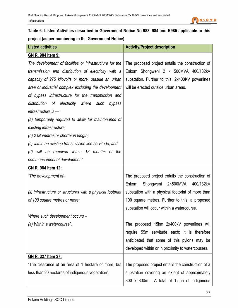
Table 6: Listed Activities described in Government Notice No 983, 984 and R985 applicable to this
project (as per numbering in the Government Notice)
Listed activities Activity/Project description
GN R. 984 Item 9:
The development of facilities or infrastructure for the
transmission and distribution of electricity with a
capacity of 275 kilovolts or more, outside an urban
area or industrial complex excluding the development
of bypass infrastructure for the transmission and
distribution of electricity where such bypass
infrastructure is —
(a) temporarily required to allow for maintenance of
existing infrastructure;
(b) 2 kilometres or shorter in length;
(c) within an existing transmission line servitude; and
(d) will be removed within 18 months of the
commencement of development.
The proposed project entails the construction of
Eskom Shongweni 2 × 500MVA 400/132kV
substation. Further to this, 2x400KV powerlines
will be erected outside urban areas.
GN R. 984 Item 12:
“The development of–
(ii) infrastructure or structures with a physical footprint
of 100 square metres or more;
Where such development occurs –
(a) Within a watercourse”.
The proposed project entails the construction of
Eskom Shongweni 2×500MVA 400/132kV
substation with a physical footprint of more than
100 square metres. Further to this, a proposed
substation will occur within a watercourse.
The proposed 15km 2x400kV powerlines will
require 55m servitude each; it is therefore
anticipated that some of this pylons may be
developed within or in proximity to watercourses.
GN R. 327 Item 27:
“The clearance of an area of 1 hectare or more, but
less than 20 hectares of indigenous vegetation”.
The proposed project entails the construction of a
substation covering an extent of approximately
800 x 800m. A total of 1.5ha of indigenous
Draft Scoping Report: Proposed Eskom Shongweni 2 X 500MVA 400/132kV Substation, 2x 400kV powerlines and associated
Infrastructure
28
Eskom Holdings SOC Limited
Listed activities Activity/Project description
vegetation will be cleared.
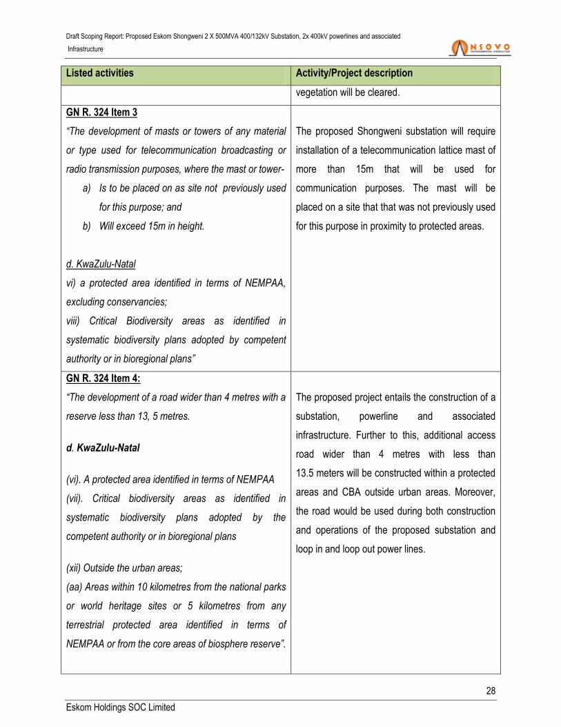
GN R. 324 Item 3
“The development of masts or towers of any material
or type used for telecommunication broadcasting or
radio transmission purposes, where the mast or tower-
a) Is to be placed on as site not previously used
for this purpose; and
b) Will exceed 15m in height.
d. KwaZulu-Natal
vi) a protected area identified in terms of NEMPAA,
excluding conservancies;
viii) Critical Biodiversity areas as identified in
systematic biodiversity plans adopted by competent
authority or in bioregional plans”
The proposed Shongweni substation will require
installation of a telecommunication lattice mast of
more than 15m that will be used for
communication purposes. The mast will be
placed on a site that that was not previously used
for this purpose in proximity to protected areas.
GN R. 324 Item 4:
“The development of a road wider than 4 metres with a
reserve less than 13, 5 metres.
d. KwaZulu-Natal
(vi). A protected area identified in terms of NEMPAA
(vii). Critical biodiversity areas as identified in
systematic biodiversity plans adopted by the
competent authority or in bioregional plans
(xii) Outside the urban areas;
(aa) Areas within 10 kilometres from the national parks
or world heritage sites or 5 kilometres from any
terrestrial protected area identified in terms of
NEMPAA or from the core areas of biosphere reserve”.
The proposed project entails the construction of a
substation, powerline and associated
infrastructure. Further to this, additional access
road wider than 4 metres with less than
13.5 meters will be constructed within a protected
areas and CBA outside urban areas. Moreover,
the road would be used during both construction
and operations of the proposed substation and
loop in and loop out power lines.
Draft Scoping Report: Proposed Eskom Shongweni 2 X 500MVA 400/132kV Substation, 2x 400kV powerlines and associated
Infrastructure
29
Eskom Holdings SOC Limited
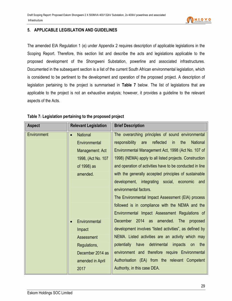
5. APPLICABLE LEGISLATION AND GUIDELINES
The amended EIA Regulation 1 (e) under Appendix 2 requires description of applicable legislations in the
Scoping Report. Therefore, this section list and describe the acts and legislations applicable to the
proposed development of the Shongweni Substation, powerline and associated infrastructures.
Documented in the subsequent section is a list of the current South African environmental legislation, which
is considered to be pertinent to the development and operation of the proposed project. A description of
legislation pertaining to the project is summarised in Table 7 below. The list of legislations that are
applicable to the project is not an exhaustive analysis; however, it provides a guideline to the relevant
aspects of the Acts.
Table 7: Legislation pertaining to the proposed project
Aspect Relevant Legislation Brief Description
Environment National
Environmental
Management: Act
1998, (Act No. 107
of 1998) as
amended.
Environmental
Impact
Assessment
Regulations,
December 2014 as
amended in April
2017
The overarching principles of sound environmental
responsibility are reflected in the National
Environmental Management Act, 1998 (Act No. 107 of
1998) (NEMA) apply to all listed projects. Construction
and operation of activities have to be conducted in line
with the generally accepted principles of sustainable
development, integrating social, economic and
environmental factors.
The Environmental Impact Assessment (EIA) process
followed is in compliance with the NEMA and the
Environmental Impact Assessment Regulations of
December 2014 as amended. The proposed
development involves “listed activities”, as defined by
NEMA. Listed activities are an activity which may
potentially have detrimental impacts on the
environment and therefore require Environmental
Authorisation (EA) from the relevant Competent
Authority, in this case DEA.

Draft Scoping Report: Proposed Eskom Shongweni 2 X 500MVA 400/132kV Substation, 2x 400kV powerlines and associated
Infrastructure
30
Eskom Holdings SOC Limited
Aspect Relevant Legislation Brief Description
Biodiversity
National Environmental
Management:
Biodiversity Act, 2004
(Act No. 10 of 2004)
The purpose of the National Environmental
Management Biodiversity Act, 2004 (Act No. 10 of
2004) (NEMBA) is to provide for the management and
conservation of South Africa’s biodiversity within the
framework of the NEMA and the protection of species
and ecosystems that warrant national protection. As
part of its implementation strategy, the National Spatial
Biodiversity Assessment was developed.
The proposed study area is transformed and
considered to have low sensitivity.
Protected Areas
National Environmental
Management:
Protected Areas Act,
2003 (Act No. 57 of
2003)
The purpose of this Act is to provide for the protection,
conservation and management of ecologically viable
areas representative of South Africa’s biological
diversity and its natural landscapes.
Heritage Resources
National Heritage
Resources Act, 1999
(Act No. 25 of 1999)
The National Heritage Resources Act, 1999 (Act No.
25 of 1999) legislates the necessity for cultural and
heritage impact assessment in areas earmarked for
development, which exceed 0.5 ha. The Act makes
provision for the potential destruction to existing sites,
pending the archaeologist’s recommendations through
permitting procedures. Permits are administered by
the South African Heritage Resources Agency
(SAHRA).
Air quality
management and
control
National Environmental
Management: Air
Quality Act, 2004( Act
The objective of the Act is to protect the environment
by providing reasonable measures for the protection
and enhancement of air quality and to prevent air
pollution.
Draft Scoping Report: Proposed Eskom Shongweni 2 X 500MVA 400/132kV Substation, 2x 400kV powerlines and associated
Infrastructure
31
Eskom Holdings SOC Limited
Aspect Relevant Legislation Brief Description
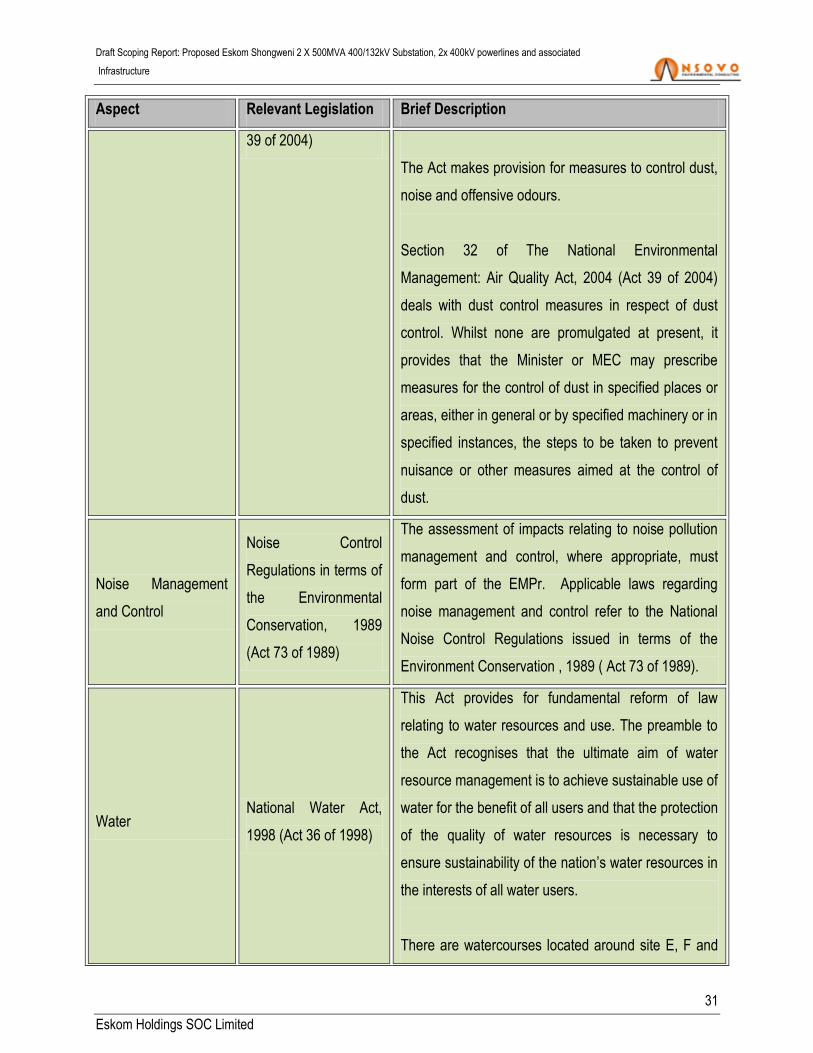
39 of 2004)
The Act makes provision for measures to control dust,
noise and offensive odours.
Section 32 of The National Environmental
Management: Air Quality Act, 2004 (Act 39 of 2004)
deals with dust control measures in respect of dust
control. Whilst none are promulgated at present, it
provides that the Minister or MEC may prescribe
measures for the control of dust in specified places or
areas, either in general or by specified machinery or in
specified instances, the steps to be taken to prevent
nuisance or other measures aimed at the control of
dust.
Noise Management
and Control
Noise Control
Regulations in terms of
the Environmental
Conservation, 1989
(Act 73 of 1989)
The assessment of impacts relating to noise pollution
management and control, where appropriate, must
form part of the EMPr. Applicable laws regarding
noise management and control refer to the National
Noise Control Regulations issued in terms of the
Environment Conservation , 1989 ( Act 73 of 1989).
Water National Water Act,
1998 (Act 36 of 1998)
This Act provides for fundamental reform of law
relating to water resources and use. The preamble to
the Act recognises that the ultimate aim of water
resource management is to achieve sustainable use of
water for the benefit of all users and that the protection
of the quality of water resources is necessary to
ensure sustainability of the nation’s water resources in
the interests of all water users.
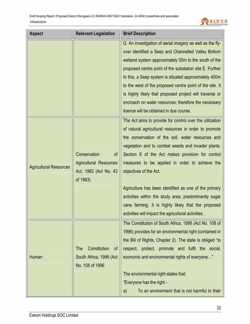
There are watercourses located around site E, F and
Draft Scoping Report: Proposed Eskom Shongweni 2 X 500MVA 400/132kV Substation, 2x 400kV powerlines and associated
Infrastructure
32
Eskom Holdings SOC Limited
Aspect Relevant Legislation Brief Description
G. An investigation of aerial imagery as well as the fly-
over identified a Seep and Channelled Valley Bottom
wetland system approximately 50m to the south of the
proposed centre point of the substation site E. Further
to this, a Seep system is situated approximately 400m
to the west of the proposed centre point of the site. It
is highly likely that proposed project will traverse or
encroach on water resources; therefore the necessary
licence will be obtained in due course.
Agricultural Resources
Conservation of
Agricultural Resources
Act, 1983 (Act No. 43
of 1983)
The Act aims to provide for control over the utilization
of natural agricultural resources in order to promote
the conservation of the soil, water resources and
vegetation and to combat weeds and invader plants.
Section 6 of the Act makes provision for control
measures to be applied in order to achieve the
objectives of the Act.
Agriculture has been identified as one of the primary
activities within the study area; predominantly sugar
cane farming. It is highly likely that the proposed
activities will impact the agricultural activities.
Human
The Constitution of
South Africa, 1996 (Act
No. 108 of 1996
The Constitution of South Africa, 1996 (Act No. 108 of
1996) provides for an environmental right (contained in
the Bill of Rights, Chapter 2). The state is obliged “to
respect, protect, promote and fulfil the social,
economic and environmental rights of everyone…”
The environmental right states that:
“Everyone has the right -
a) To an environment that is not harmful to their

Draft Scoping Report: Proposed Eskom Shongweni 2 X 500MVA 400/132kV Substation, 2x 400kV powerlines and associated
Infrastructure
33
Eskom Holdings SOC Limited
Aspect Relevant Legislation Brief Description
health or well-being; and
b) To have the environment protected, for the
benefit of present and future generations, through
reasonable legislative and other measures that -
-Prevent pollution and ecological degradation;
-Promote conservation; and
-Secure ecologically sustainable development and
use of natural resources while promoting justifiable
economic and social development.”
Waste
National Environmental
Management: Waste
Act 59 of 2008
This act provide fundamental reform of the law
regulating waste management in order to protect
health and the environment by providing reasonable
measures for the prevention of pollution and ecological
degradation and for securing ecologically sustainable
development. This act also ensures the provision of
national norms and standards for regulating the
management of waste by all spheres of government.
The National Environmental Management: Waste Act
provides for specific waste management measures;
licensing and control of waste management activities;
remediation of contaminated land; compliance and
enforcement; and for matters connected therewith.
In preparation of the scoping report, these Acts were not read in isolation, they were read with absolute
consideration of municipal policies, plans and by-laws as well as consideration of Eskom policies and world
best practices.
6. DESCRIPTION OF THE NEED AND DESIRABILITY OF THE PROPOSED ACTIVITY

Draft Scoping Report: Proposed Eskom Shongweni 2 X 500MVA 400/132kV Substation, 2x 400kV powerlines and associated
Infrastructure
34
Eskom Holdings SOC Limited
This section provides the justification for the need of the proposed project to be undertaken mainly focusing
on the benefits and importance of the proposed project to the KwaZulu-Natal communities and the country
as a whole. The motivation and the need of the proposed project are discussed as follows:
6.1 MOTIVATION FOR THE DEVELOPMENT
Eskom Transmission’s ten years plan indicates that a reliable electricity supply of acceptable quality is
essential for the economic development of South Africa. It is also a pre-requisite for socio-economic
development, as it paves the way to access to education, improved nutrition and health care, as well as
jobs, amongst others. The transmission system plays a vital role in the delivery of a reliable, high quality
electricity supply throughout the region and South Africa at large, by delivering electricity in bulk to load
centres and end-users. From there, the distribution networks owned by Eskom and Municipalities deliver
electricity to end-users. The transmission system needs to be well-maintained to deliver a reliable supply of
electricity, and it also needs to be strengthened to meet changing customer needs.
Consequently, the proposed Shongweni substation and the powerline form part of the Network
Strengthening which is driven by industries and agriculture (i.e. mainly sugarcane plantation around
proposed location) and it forms part of the new infrastructures that Eskom has planned. The main aim
being to respond to the demand and ensure reliable electricity supply to their customers (i.e. eThekhwini
Electricity). Accordingly the proposed project is a customer application wherein eThekwini Municipality
highlighted the need to strengthen their network
The proposed project will ensure the following:
That the supply link between the existing Hector substation and the proposed Shongweni substation
and powerline supply network is strengthened; and
Improvements in reliability of electricity supply which will benefit agriculture, tourism, residential and
industries in the area; thus improve South Africa’s socio-economic status.
6.2 BENEFITS OF THE PROJECT
The proposed project is beneficial as it will allow for load growth in the region. It is envisaged that the
proposed project would ensure reliable supply to industry, predominantly the agricultural, tourism,
residential and manufacturing industries in the area. This will indirectly benefit communities as reliable

Draft Scoping Report: Proposed Eskom Shongweni 2 X 500MVA 400/132kV Substation, 2x 400kV powerlines and associated
Infrastructure
35
Eskom Holdings SOC Limited
electricity will result in uninterrupted production and therefore growth in industry, which could potentially
yield additional jobs. The overarching impact will be positive economic spinoffs, which benefit the
community, the region and country at large.
Electrification has significant positive benefits from a socio-economic and ecological perspective. The
provision of electricity leads to a number of social benefits for organs of state, individuals, industries and
communities including the following:
Enables economic and human social development; and
Encourages small and medium enterprise development, and as a result, contributes to a possible
increase in disposable income.
At the local level, the benefits of the project would centre on ensuring improved reliability of supply as well
as entrench the reach of electricity into communities. It is envisaged that the proposed project would ensure
that marginal communities in the region are supplied with electricity. This will indirectly have an added
benefit as it may reduce the community’s reliance on firewood as their primary energy source, thus allow
for sustainable livelihoods.
Electrification has significant positive benefits from the socio-economic and ecological perspective. The
provision of electricity leads to a number of social benefits for organs of state, individuals, industries and
communities such as:
Electrification of educational and training facilities (schools and the like).
Electrification of health facilities (clinics, hospitals and the like).
Electrification of security facilities (police stations, court houses and the like).
Electrification for the provision of essential services (water supply pumps and the like).
Electrification of religious and cultural facilities.
Enables rural development.
Enables the provision of lighting, thereby vastly improving the safety and security of communities.
For individuals and communities:
Electrification of homes (for cooking, heating and lighting of homes which improves the lives of the
individuals within the home).
Draft Scoping Report: Proposed Eskom Shongweni 2 X 500MVA 400/132kV Substation, 2x 400kV powerlines and associated
Infrastructure
36
Eskom Holdings SOC Limited
Encourages small and medium enterprise development, and as a result, contributes to a rise in
disposable income.
From an ecological perspective, the availability of electricity can lead to a decrease in the harvesting of
firewood with resultant biodiversity benefits. This also leads to a decrease in respiratory disease due to a
reduction of biomass burning. The relative efficiency of using electricity will reduce overall air emissions
and can lead to an improved quality of life.
6.2.1 SUPPORTING STRATEGIES
At the regional level, the proposed project would contribute to reliability of power supply. There would also
be less tangible but nonetheless important benefits of positioning the Municipality ahead in terms of
sustainable energy supply. At the national level, the proposed project would contribute to implementing
South Africa’s new energy policy as embodied in the White Paper on Energy (DME, 1998). The priorities to
which this project would contribute are laying the groundwork for enhancing power supply and
electrification capacity.
7. DESCRIPTION OF THE PROCESS FOLLOWED TO REACH THE PROPOSED PREFERRED
ACTIVITY, SITE AND LOCATION WITHIN THE SITE
The identification of alternatives is an important component of the EIA process. The identified alternatives
are assessed in terms of environmental acceptability, technical as well as economic feasibility during the
process wherein the preferred alternative is highlighted and presented to the Authorities.
Three alternative substation sites and the no-go alternative are being considered for the proposed
Shongweni 2 x 500 MVA 400/132kV substations. Further, three corridors are considered for the proposed
2x400kV single circuit power lines which are planned to connect the proposed Shongweni substation and
the existing Hector substation. The length of the powerline corridor will be determined by the location of the
substation site. The project has considered technical alternatives (Section 7.1.1) which were found to be
economically and environmentally viable compared to the other options. The alternatives are presented as
part of this scoping report and will be scrutinised further during the EIA phase.

Draft Scoping Report: Proposed Eskom Shongweni 2 X 500MVA 400/132kV Substation, 2x 400kV powerlines and associated
Infrastructure
37
Eskom Holdings SOC Limited
The selection of project alternatives was primarily based on Eskom’s prefeasibility study that technically
determined the broad location based on the need. Subsequent site visits were undertaken by the
engineering, the designers, environmental and specialist teams. Further a detailed public consultation is
being undertaken to assess the viability of the selected alternative sites which resulted in the identification
of more sites for consideration to assess the economic need and desirability of the project, the site
selection process also focused on reviewing the municipal Integrated Development Plan, Eskom’s 10 Year
Development Plan and associated documents that address current and future development in and around
the area.
The selection of the preferred location will also take into consideration the eThekhwini Electricity’s
strengthening plan which highlights the requirement of the proposed establishment of the Shongweni 2x
500 MVA 400/132kV substation and the construction of the two 400kV single circuit lines as proposed.
Further the plan indicates that the associated scope of work for eThekhwini Municipality entails the
following:
Two 132kV circuits to Hillcrest 132/11kV substation;
Two 132kV circuits to Stockville 132kV switching station
Two 132kV circuits to Umngeni 132/33kV substation;
Two 132kV circuits to Shongweni development; and
The upgrade of Shongweni-Stockville132 kV lines.
It is therefore imperative that the selection of the preferred alternatives considers the customers plans to
connect; however, it must be noted that the Municipalities distribution lines do not form part of this
application. In an effort to ensure that the most suitable site is selected, the eThekhwini Municipality has
been involved in the planning phase and they have been identified as a key stakeholder in the project.
7.1 DETAILS OF ALTERNATIVES CONSIDERED
This section describes in detail the alternatives considered for the proposed substation, powerline and
associated infrastructures. This includes the technical, structural, site and no-go alternatives which are
discussed as follows:
Draft Scoping Report: Proposed Eskom Shongweni 2 X 500MVA 400/132kV Substation, 2x 400kV powerlines and associated
Infrastructure
38
Eskom Holdings SOC Limited
7.1.1 TECHNICAL ALTERNATIVES
7.1.1.1 UNDERGROUND VS ABOVE GROUND
Two technical alternatives have been identified for the proposed project, this include the overhead
powerline and underground cabling. Instead of constructing the proposed powerline above ground,
underground construction is considered to be an alternative option. The advantages of the underground
alternative would include a reduced impact on bird interaction and distinct visual impact benefit. However,
for the proposed project the underground powerline alternative would not be the most feasible owing to the
undulating nature of the area. This could cause major technical problems and would have major cost
implications. Technically, underground cables need to be insulated against the surrounding soil. On low
voltage reticulation networks (11kV & 22kV) the heat generated by the cable is low enough for standard
insulation to be used; however, on larger power lines (e.g. 400kV as proposed) the method of electrical and
heat insulation becomes more burdensome.
Control of electrical losses and heat control are critical for underground cables. As a result, cables are as
much as 4 times the diameter and 10 times the weight of equivalent overhead lines. Heat control is also a
factor in the laying of the cables. The three phases of low and medium voltage cables (up to 132kV) can be
placed in the same trench, while the phases for high voltage cables must be spaced apart, typically in a flat
formation.
Bush fires, lightning strikes and bird related faults make up 80% of faults on overhead transmission power
lines in South Africa; however, such risks are not associated with underground cables. Further, faulting on
underground cable is rare. When faults occur on overhead lines they are usually re-energised by
automatically reclosing the circuit-breaker within a few seconds of the fault. More serious faults, such as a
damaged line may be easily found and repaired within a few days at most. Underground cables have faults
that are almost exclusively permanent, requiring inspection and correction on site. This usually requires
excavating a section of the powerline. As a result, finding the location of faults is not easy unless there is
clear evidence of excavation damage. Therefore, the search and repair of underground cables can take
several weeks. This may severely compromise the network of the operation.
Economically, costs vary and are dependent on terrain, land use and size of line. However, underground
cabling is in orders of magnitude greater than overhead power lines. Underground 132kV is 3 to 10 times

Draft Scoping Report: Proposed Eskom Shongweni 2 X 500MVA 400/132kV Substation, 2x 400kV powerlines and associated
Infrastructure
39
Eskom Holdings SOC Limited
more expensive than overhead lines. There is not much expertise for higher voltage underground cabling in
the country; as a result such expertise would have to be sourced from the international market.
In terms of maintenance, underground cables are reported to be much more reliable, but outages are more
difficult to fix as it is harder to find the faults, and therefore the outages last much longer. The lifespan for
underground cables is reported to be much shorter, about half that of overhead power lines.
None of the two alternatives are dismissed, as such; they will be assessed further during the EIA phase.
7.1.1.2 SINGLE CIRCUIT VS. DOUBLE CIRCUIT
Other technical alternatives that were considered include the single circuit and the double circuit wherein
the single circuit has been selected as the most feasible from a technical perspective; subsequently
structural designs considered and presented hereunder are for single circuit structures.
7.1.2 STRUCTURAL ALTERNATIVES
Several design alternatives have been proposed, and they include one or more of the following single
circuit pylons:
Cross-Rope suspension type;
Self-supporting type; and
Guyed V towers.
These are illustrated in Figures 5 to 10 below. It is important to note that the topography will largely dictate
the types of towers to be used. From this perspective, it should be noted that where the line crosses
undulating terrains and when it changes direction at an angle, there will be a need to use self-supporting
towers.

Draft Scoping Report: Proposed Eskom Shongweni 2 X 500MVA 400/132kV Substation, 2x 400kV powerlines and associated
Infrastructure
40
Eskom Holdings SOC Limited
Figure 5: Guide V tower Figure 6: Photographic Guide V tower

Draft Scoping Report: Proposed Eskom Shongweni 2 X 500MVA 400/132kV Substation, 2x 400kV powerlines and associated
Infrastructure
41
Eskom Holdings SOC Limited
Figure 5: Cross rope suspension tower. Figure 6: Photographic illustration of a Cross
rope suspension tower.
Figure 7: Self-supporting suspension tower.
Figure 8: Photographic Self-supporting
suspension tower.
None of the above options have been dismissed and they remain alternatives depending on the terrain and
topography. Given the comments received from stakeholders regarding the visual impacts of the proposed
project, the selection of the pylons to be used for the proposed powerline will take the potential impacts into
consideration.
7.1.3 SITE ALTERNATIVES
This section provides detailed information of the site alternatives considered for the proposed substation.
This entails the description of three site alternatives which are discussed hereunder. Three areas are
proposed for substation and are referred to as Shongweni E, F and G. The proposed substation
alternatives are located south-eastwards from the proposed corridors and are all within the same vicinity;
which is characterised by predominantly agriculture, undulating topography, as well as critical endangered
ecosystems.

Draft Scoping Report: Proposed Eskom Shongweni 2 X 500MVA 400/132kV Substation, 2x 400kV powerlines and associated
Infrastructure
42
Eskom Holdings SOC Limited
7.1.3.1 SUBSTATION SITE ALTERNATIVE E
Site alternative E is the most northerly substation site of the three and is situated within an area cultivated
for sugarcane in close proximity to Winston Park and other residential areas. This substation alternative is
closest to the N3 and also close to Wekeweke River as depicted in the figure below.
Figure 9: Proposed Alternative site E
Table 8 : Summary of Specialist Findings-Site Alternative E
Specialist Description
Agricultural Potential
Substation Alternative E occurs within land type Aa11, which has a generally
high agricultural potential and fairly level terrain. The site is situated within an
area cultivated for sugarcane.
Aquatic ecology Site E is associated with two quaternary catchments (U60C and U60F). The site
is located on the eastern side of the Wekeweke River.
Biodiversity (Fauna & Flora) Site E is located within the study area which extends over five vegetation types.
Two of these five feature more prevalently, namely the Savanna Biome,
Substation alternative E

Draft Scoping Report: Proposed Eskom Shongweni 2 X 500MVA 400/132kV Substation, 2x 400kV powerlines and associated
Infrastructure
43
Eskom Holdings SOC Limited
Specialist Description
comprised of KwaZulu-Natal Sandstone Sourveld and the Grassland biome,
comprised of Dry Coast Hinterland Grassland and Moist Coast Hinterland
Grassland. The substation site footprint is within transformed habitat and there
are no significant features within 200m of the proposed site.
Avifauna
The most sensitive of the micro habitats within the study areas are the rivers,
wetlands, waterbodies and woodland vegetation which may provide foraging,
roosting and breeding habitat for the waterbird, raptors and passerine species
recorded in the area. There are no Important Bird Area’s (IBAs) within the
immediate study area, further, the closest IBA to the proposed project (SA078 –
KwaZulu Natal Mistbelt Grasslands) is located approximately 30km to the west.
Eco-Tourism
Tourism in the study area is highly clustered around Botha’s Hills and
Shongweni Dam areas and relatively diverse. Tourism directly within the
proposed Site E substation is very limited; however, activities in the broader
context of the receiving environment have been included.
Wetland
Seepage and Channelled Valley Bottom wetland systems were noted
approximately 50m to the south of the proposed centre point of the substation
site. Further, a Seep system is situated approximately 400m to the west of the
proposed centre point of the site.
Heritage
Site E is located on undulating plains which are significantly transformed by the
plantation of sugarcane. Given the nature of the site, ancestral graves may remain
undetected underground until such time that construction commences.
7.1.3.2 SUBSTATION SITE ALTERNATIVE F
Similar to Site E, Site F is also located along the N3 and R613 on agricultural land wherein sugar cane is
being extensively cultivated, especially on the eastern section. The closest town to this site is Summerveld,
which is characterised by medium to high density residential settlements as well as industries.

Draft Scoping Report: Proposed Eskom Shongweni 2 X 500MVA 400/132kV Substation, 2x 400kV powerlines and associated
Infrastructure
44
Eskom Holdings SOC Limited
Figure 10: Proposed Alternative Site F
Table 9: Summary of Specialist Findings-Site Alternative F
Specialist Description
Agricultural Potential Similar to substation alternative Site E; Site F also occurs within land type
Aa11, which has a generally high agricultural potential and level terrain.
Aquatic ecology
Site F will is located on the western side of the identified Wekeweke, thus the
proposed power lines will connect into the substation without crossing the
River.
Biodiversity (Flora and
Fauna)
The biodiversity on Site F is located within the study area which extends over
five vegetation types, two of which feature more prevalently, namely the
Savanna Biome, comprised of KwaZulu-Natal Sandstone Sourveld and the
Grassland biome, comprised of Dry Coast Hinterland Grassland and Moist
Coast Hinterland Grassland. Studies highlight that the remaining extent of
listed ecosystems layer indicates that there is significant remnant vegetation
in the vicinity of substation Alternative F. However, there appear to have
been significant changes since the layer was made as the site visit indicated
that there was very little intact vegetation in this area apart from a narrow belt
Substation Alternative F

Draft Scoping Report: Proposed Eskom Shongweni 2 X 500MVA 400/132kV Substation, 2x 400kV powerlines and associated
Infrastructure
45
Eskom Holdings SOC Limited
Specialist Description
of vegetation along the drainage line that occurs north of the substation site
Avifauna
The most sensitive of the micro habitats within the study areas are the rivers,
wetlands, waterbodies and woodland vegetation which may provide foraging,
roosting and breeding habitat for the waterbird, raptors and passerine
species recorded in the area. There are no Important Bird Area’s (IBAs)
within the immediate study area, further, the closest IBA to the proposed
project (SA078 – KwaZulu Natal Mistbelt Grasslands) is located
approximately 30km to the west.
In recent years, anthropogenic impacts, mostly in the form of cultivation and
urbanisation have largely transformed the landscape resulting in a negative
impact on avifaunal diversity and abundance within the study area.
Eco-tourism
Tourism in the study area is highly clustered around Botha’s Hills and
Shongweni Dam areas and relatively diverse. Similar to Site E, tourism
directly within the proposed Site F substation is limited.
Wetland
This site alternative is situated to the south of site alternative E within an area
utilised for sugarcane cultivation. A seep and channelled valley bottom
wetland systems were noted approximately 80m to the east of the proposed
centre point of the site as well as a seep system approximately 500m to the
west of the proposed centre point of the site.
Heritage
Site F is neighboring site E and it is located on a fairly steep area which is
concentrated with commercial sugarcane farming activities. No obvious sites
of heritage significance were noted.
7.1.3.3 SUBSTATION SITE ALTERNATIVE G
This is the southernmost substation alternative as depicted in the figure below and is also situated within an
area used for the cultivation of sugarcane. Substation alternative G is located close to the existing 275 kV
powerline as well as the moderately modified perennial river (Wekeweke River).

Draft Scoping Report: Proposed Eskom Shongweni 2 X 500MVA 400/132kV Substation, 2x 400kV powerlines and associated
Infrastructure
46
Eskom Holdings SOC Limited
Figure 11: Proposed Alternative Site G
Table 10: Summary of Specialist Findings-Site Alternative G
Specialist Description
Agricultural potential
The sites are within the same vicinity, therefore similar to substation
alternative E and F, the site alternative G also occurs within land type Aa11,
which has a generally high agricultural potential and level terrain.
Aquatic ecology
Site G situated directly adjacent to a channelled valley bottom system, with
a second channelled valley bottom system identified approximately 500m
east of the proposed centre point of the site. This alternative is located
within a spring and a direct tributary of the NFEPA River (Wekeweke River).
Biodiversity (flora & fauna)
Similar to Sites E and F, Site G is located within the study area which
extends over five vegetation types, two of which feature more prevalently,
namely the Savanna Biome, comprised of KwaZulu-Natal Sandstone
Sourveld and the Grassland biome, comprised of Dry Coast Hinterland
Grassland and Moist Coast Hinterland Grassland. Site G is located within a
critically endangered ecosystem; however, the footprint of the site is within
Substation alternative G

Draft Scoping Report: Proposed Eskom Shongweni 2 X 500MVA 400/132kV Substation, 2x 400kV powerlines and associated
Infrastructure
47
Eskom Holdings SOC Limited
Specialist Description
transformed habitat.
Avifauna
The most sensitive of the micro habitats within the study areas are the
rivers, wetlands, waterbodies and woodland vegetation which may provide
foraging, roosting and breeding habitat for the waterbird, raptors and
passerine species recorded in the area. There are no Important Bird Area’s
(IBAs) within the immediate study area, further, the closest IBA to the
proposed project (SA078 – KwaZulu Natal Mistbelt Grasslands) is located
approximately 30km to the west.
In recent years, anthropogenic impacts, mostly in the form of cultivation and
urbanisation have largely transformed the landscape resulting in a negative
impact on avifaunal diversity and abundance within the study area. Given
the presence of existing habitat degradation and disturbance, it is
anticipated that the proposed Shongweni substation can be constructed
within the study area with acceptable levels of impact on the resident
avifauna.
Ecotourism
Tourism in the study area is highly clustered around Botha’s Hills and
Shongweni Dam areas and relatively diverse. Similar to Sites E and F,
tourism directly within the proposed Site G substation is very limited;
however, activity in the broader context of the receiving environment has
been included.
Wetland
Site G is a southern most substation alternative and similar to F it is situated
within an area used for the cultivation of sugar cane. The centre point of the
substation is situated directly adjacent a channelled valley bottom system,
with a second one identified approximately 500m east of the site.
Heritage Site G is located on an area which is transformed by the plantation of
sugarcane. No obvious sites of heritage significance were noted.
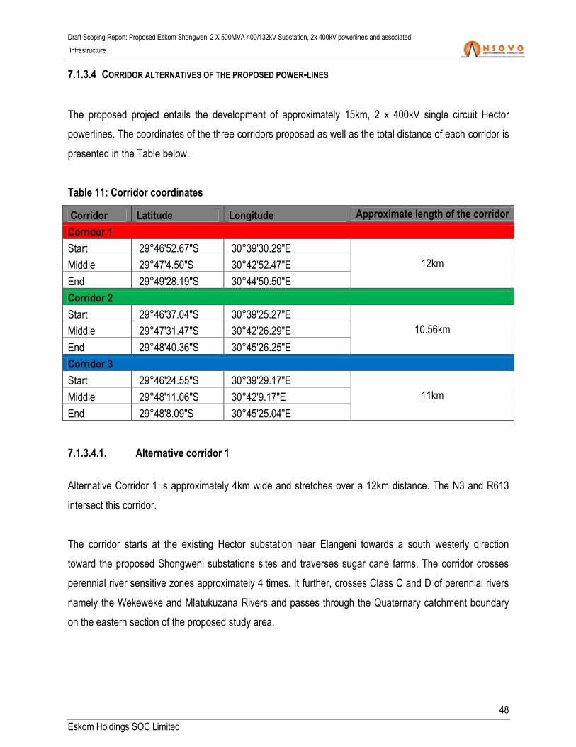
Draft Scoping Report: Proposed Eskom Shongweni 2 X 500MVA 400/132kV Substation, 2x 400kV powerlines and associated
Infrastructure
48
Eskom Holdings SOC Limited
7.1.3.4 CORRIDOR ALTERNATIVES OF THE PROPOSED POWER-LINES
The proposed project entails the development of approximately 15km, 2 x 400kV single circuit Hector
powerlines. The coordinates of the three corridors proposed as well as the total distance of each corridor is
presented in the Table below.
Table 11: Corridor coordinates
Corridor Latitude Longitude Approximate length of the corridor
Corridor 1
Start 29°46'52.67"S 30°39'30.29"E
12km Middle 29°47'4.50"S 30°42'52.47"E
End 29°49'28.19"S 30°44'50.50"E
Corridor 2
Start 29°46'37.04"S 30°39'25.27"E
10.56km Middle 29°47'31.47"S 30°42'26.29"E
End 29°48'40.36"S 30°45'26.25"E
Corridor 3
Start 29°46'24.55"S 30°39'29.17"E
11km Middle 29°48'11.06"S 30°42'9.17"E
End 29°48'8.09"S 30°45'25.04"E
7.1.3.4.1. Alternative corridor 1
Alternative Corridor 1 is approximately 4km wide and stretches over a 12km distance. The N3 and R613
intersect this corridor.
The corridor starts at the existing Hector substation near Elangeni towards a south westerly direction
toward the proposed Shongweni substations sites and traverses sugar cane farms. The corridor crosses
perennial river sensitive zones approximately 4 times. It further, crosses Class C and D of perennial rivers
namely the Wekeweke and Mlatukuzana Rivers and passes through the Quaternary catchment boundary
on the eastern section of the proposed study area.

Draft Scoping Report: Proposed Eskom Shongweni 2 X 500MVA 400/132kV Substation, 2x 400kV powerlines and associated
Infrastructure
49
Eskom Holdings SOC Limited
There is an existing substation (Assagay 88kV substation) and powerlines (Dx HV 88kV and 132kV
powerlines) which pass through the proposed corridor towards southerly direction to the Dellville wood
88kV traction substation.
7.1.3.4.2. Alternative corridor 2
Corridor 2 is approximately 3.4km wide and stretches over a 10.56km distance. It follows the same
alignment as Corridor 1 in a more southerly direction and sections of this corridor overlaps Corridor 1.
The corridor follows the existing 275kV Tx powerlines for approximately 3km before it turns to the northerly
direction. The corridor traverses Class C and D of perennial rivers (Wekeweke and Mlatukuzana rivers)
approximately 4 times on the eastern section of the study area. It also passes through the Quaten
catchment boundary on the eastern section of the proposed study area and directly intersects Groovy Balls
Adventure as well as sugar cane farms. .
7.1.3.4.3. Alternative corridor 3
Alternative Corridor 3 is the southernmost corridor which varies between 900m to 3.8km in width and
stretches over an 11km distance. The corridor starts at the existing Hector substation in Empangeni close
to the existing Elangeni 132kV substation as well as Hammarsdale 88kV substation. It continues in a south-
easterly direction towards the Tungati area. Within the proposed Corridor 3 there are other existing
servitudes which include the 275kV Tx powerline, Cliffdale 88kV Traction substation and Dx Hv 88kV as
well as 132kV powerlines which goes to Deville wood 88kV Traction substation in the southerly direction.
The Corridor also crosses Class C and D perennial rivers (Wekeweke and Mlatukuzana) approximately 4
times on the eastern section of the study area. It also traverses sugar cane farms and the N3 as well as the
R613 roads are on the eastern section of the study area. .
The table below provides a high level summary of the specialist findings within the proposed corridors for
the proposed development.

Draft Scoping Report: Proposed Eskom Shongweni 2 X 500MVA 400/132kV Substation, 2x 400kV powerlines and associated
Infrastructure
50
Eskom Holdings SOC Limited
Table 12: Summary of Specialist Findings Corridors Alternatives
Specialist Description of the alternatives corridors
Corridor 1 Corridor 2 Corridor 3
Agricultural
potential
This is the northern most corridor
alternative, from an agricultural perspective,
it is considered feasible for the proposed
development.
Corridor 2 is a northerly route alternative. The
agricultural specialist found this corridor to be
feasible for the proposed development.
This is the southern corridor alternative, from
an agricultural perspective, it is also considered
feasible for the proposed development.
Aquatic ecology
All corridors including Corridor 1 are viable
from aquatic ecology perspective as long as
they proceed in the most direct route to the
proposed substation.
The Aquatic Ecology specialist indicated that all
the proposed corridors including Corridor 2 are
viable as long as they proceed in the most
direct route to the proposed substation.
According to Aquatic Ecology specialist, all the
proposed corridors including Corridor 3 are
viable only if they proceed in the most direct
route to the proposed substations.
Avifauna
The specialist highlighted that this corridor
has a higher potential of increase the
collisions of Red List avifauna with the
earth-wire. Furthermore, resulting in a
negative direct mortality impacts (i.e.
particularly large terrestrial, waterbirds and
to a lesser extent raptors).
However, given the presence of existing
habitat degradation and disturbance, it is
anticipated that the proposed Corridor 1 can
This corridor is similar to corridor 1. The
specialist highlighted that this corridor has a
higher potential of increase the collisions of Red
List avifauna with the earth-wire. Furthermore,
resulting in a negative direct mortality impacts
(i.e. particularly large terrestrial, waterbirds and
to a lesser extent raptors). However, it is
anticipated that the proposed Corridor 2 can be
constructed within the study area with
acceptable levels of impact on the resident
avifauna subject to recommendations made by
According to the Avifauna specialist, Corridor 3
emerged as the preferred power line corridor
from a bird impact assessment perspective.
Given the presence of existing habitat
degradation and disturbance, it is anticipated
that the proposed Hector-Shongweni 275kV
powerline can be constructed within the study
area with acceptable levels of impact on the
resident avifauna.

Draft Scoping Report: Proposed Eskom Shongweni 2 X 500MVA 400/132kV Substation, 2x 400kV powerlines and associated
Infrastructure
51
Eskom Holdings SOC Limited
Specialist Description of the alternatives corridors
Corridor 1 Corridor 2 Corridor 3
be constructed within the study area with
acceptable levels of impact on the resident
avifauna subject to recommendations made
by the specialist.
the specialist.
Biodiversity
The Biodiversity specialist indicated that
there are several areas of mesic grassland
along the route that cannot easily be
avoided. This corridor is therefore not the
most preferred from a biodiversity
perspective.
This route is the most preferred alternative from
biodiversity perspective as it has the greatest
scope to avoid impact to the sensitive features
available. It also has the lowest abundance of
habitats of concern.
According to the biodiversity specialist, there
are several areas of high sensitivity along the
route of corridor 3 that would need to be
avoided to make this a viable and favorable
corridor alternative from biodiversity
perspective.
Eco-tourism
Corridor 1 is expected to have minimal
direct impact on existing tourism products.
The proposed corridor intersects only one
tourism product which is Durban
Shongweni. It is, however, worth
considering the impact of the powerlines on
this product as it serves as a hub for many
sporting routes/trails.
Corridor 2 directly intersects Groovy Balls
Adventure Park. An existing high voltage
powerline already cuts through this product so
the direct impact of the proposed powerline is
negligible.
Corridor 3 will have impacts on the tourism
products as it is closer to the existing Tx 275kV
powerlines. However, it will only have direct
impacts on the Summerveld Equestrian Center
but the overall impact of this corridor will be
minor. This is the most preferred corridor route
from the ecotourism perspective because it is
much closer to existing power lines.
Wetland Any of the three proposed corridors (i.e.
including alternative Corridor 1) can be
According to wetland specialist, any of the three
proposed corridors including alternative
From wetland perspective, any of the three
proposed corridors including alternative

Draft Scoping Report: Proposed Eskom Shongweni 2 X 500MVA 400/132kV Substation, 2x 400kV powerlines and associated
Infrastructure
52
Eskom Holdings SOC Limited
Specialist Description of the alternatives corridors
Corridor 1 Corridor 2 Corridor 3
utilized from wetland perspective. Corridor 2 can be utilized. Corridor 3 can be utilized.
Heritage
Corridor 1 is significantly transformed and it is
dominated by informal settlement which
provides residence for migrant workers. No
obvious graves were noted on site during the
site visit.
Corridor 2 is located on agricultural land wherein
sugar cane is extensively cultivated, especially on
the eastern section. The western section is
dominated by residential land. Similar to Corridor
1, this site is fairly steep and there are well
defined access roads that intersect the study
area. Furthermore, this site was found to be
seriously degraded by previous farming activities,
such that no archaeological material could have
remained in situ on the affected property.
Corridor 3 has a high percentage of residential
settlements and as a result it has high potential
for graves as most villagers in the province still
conduct their burials at their place of residence.
No heritage resources were identified, it is
however possible that ancestral graves and burial
grounds located in areas of dense vegetation
along drainage lines and watercourses can be
found.

Draft Scoping Report: Proposed Eskom Shongweni 2 X 500MVA 400/132kV Substation, 2x 400kV powerlines and associated
Infrastructure
53
Eskom Holdings SOC Limited
7.1.3.5 NO-GO ALTERNATIVE
In accordance with GN R.326, consideration must be given to the option not to act. This option is usually
considered when the proposed development is envisaged to have significant negative environmental
impacts that mitigation measures cannot ameliorate effectively. The no-go alternative would be the option
of not undertaking the development of the proposed project. It would imply that the current electricity supply
network is not strengthened, industrial development in the area will be hindered and the integration of any
potential renewable energy in the area will not be possible. Should the no-go alternative be adopted, the
KwaZulu-Natal grid will be deprived of the much needed essential service, particularly given the already
existing energy supply challenge countrywide.
8. PUBLIC PARTICIPATION PROCESS
The EIA Regulations, require that during the Scoping and EIA process, the organs of State together with
interested and affected persons and the general public be informed of the application for Environmental
Authorisation (EA) and also be afforded an opportunity to comment on the application.
Public Participation Process (PPP) is any process that involves the public in problem solving and decision-
making and it forms an integral part of the Scoping and EIA process. The PPP provides people who may be
interested in or affected by the proposed development, with an opportunity to provide comments and to
raise issues or concern, or to make suggestions that may result in enhanced benefits for the project.
Chapter 6, regulation 39 through 44 of the EIA Regulations stipulates the manner in which the PPP should
be conducted as well as the minimum requirements for a complaint process. These requirements include
but not limited to:
(a) Fixing a notice board at a place conspicuous to the public at the boundary or on the fence of—
(i) The site where the activity to which the application relates is or is to be undertaken;
(b) Giving written notice to—
(i) The occupiers of the site where the activity is or is to be undertaken or to any alternative site
where the activity is to be undertaken;

Draft Scoping Report: Proposed Eskom Shongweni 2 X 500MVA 400/132kV Substation, 2x 400kV powerlines and associated
Infrastructure
54
Eskom Holdings SOC Limited
(ii) The owners or persons in control of that land occupiers of land adjacent to the site where the
activity is or is to be undertaken and to any alternative site where the activity is to be
undertaken;
(iii) The municipal councillor of the ward in which the site and alternative site is situated and any
organisation of rate payers that represent the community in the area;
(iv) The municipality which has jurisdiction in the area;
(v) any organ of state having jurisdiction in respect of any aspect of the activity; and
(vi) any other party as required by the competent authority;
(b) Placing an advertisement in-
(i) One local Newspaper
The primary purpose of the report is as follows:
To outline the PPP that was undertaken;
To synthesise the comments and issues raised by the key stakeholders, interested and affect
parties; and
To ensure that the EIA process fully address the issues and concerns raised, if any.
8.1.1 PUBLIC PARTICIPATION PRINCIPLES
The principle of the Public Participation holds that those who are affected by a decision have the right to be
involved in the decision-making process (i.e. the public’s contribution will influence the decision). One of the
primary objectives of conducting the PPP is to provide interested and affected parties with an opportunity to
express their concerns and views on issues relating to the proposed project. The principles of public
participation are to ensure that the PPP:
Communicates the interests of and meet the process needs of all participants.
Seek to facilitate the involvement of those potentially affected.
Involves participants in defining how they participate.
Is as inclusive and transparent as possible, it must be conducted in line with the requirements of
regulation 39 - 44 of the April 2017 EIA Regulations.

Draft Scoping Report: Proposed Eskom Shongweni 2 X 500MVA 400/132kV Substation, 2x 400kV powerlines and associated
Infrastructure
55
Eskom Holdings SOC Limited
8.1.2 APPROACH AND METHODOLOGY
The Public Participation approach adopted in this process is in line with the processes contemplated in
regulation 39 - 44 of the EIA Regulations of 2014, in terms of the National Environmental Management Act,
1998 (Act 107 of 1998) (“the Act”), which provides that:
8.1.3 IDENTIFICATION OF INTERESTED AND AFFECTED PARTIES
Interested and Affected Parties (I&APs) identified include pre-identified stakeholders (government
department), landowners and the general public.
Notification and request for comments were submitted to the following key stakeholders:
EThekwini Metropolitan Municipality;
South African Heritage Resource Agency;
KwaZulu-Natal Department of Transport and Public Works;
KwaZulu-Natal Department of Water and Sanitation;
Wildlife and Environmental Society of South Africa;
KwaZulu-Natal Department Economic Development, Tourism and Environmental Affairs;
National Department of Environmental Affairs; and
National Department of Water and Sanitation.
The notifications were sent by registered mail; refer to Appendix D3
8.1.4 PUBLIC PARTICIPATION DATABASE
In accordance with the requirements of the EIA Regulations under Section (24) 5 of NEMA, regulation 42 of
GN R. 982, a Register of I&APs must be kept by the public participation practitioner. In fulfilment of this
requirement, such a register is compiled and details of I&APs including their comments will be updated
throughout the project cycle. The database is attached as Appendix D5.

Draft Scoping Report: Proposed Eskom Shongweni 2 X 500MVA 400/132kV Substation, 2x 400kV powerlines and associated
Infrastructure
56
Eskom Holdings SOC Limited
8.1.5 SITE NOTICES
A2 size notices were fixed at different conspicuous locations within and around the proposed project study
area on 21 – 25 November 2016 and 22 – 24 May 2017, in the EThekwini Metropolitan Municipality,
including the Hector substation site as well as at the sites E, F, and G along N3. Photographic evidence of
the site notices is attached as Appendix D1.
8.1.6 DISTRIBUTION OF NOTICES TO SURROUNDING LAND OWNERS/ OCCUPIERS
Notification letters were posted via registered mail to stakeholders on the 10th December 2016 (Refer to
Appendix D3 for proof of postage), whereas site notices were hand delivered to landowners/occupiers on
the 22nd – 25th November 2016. These notifications were informing government stakeholders and the public
of the project as well as affording them an opportunity (30 days as per the NEMA Regulations) to register
as I&AP and also to comment or raise any issue.
8.1.7 PLACEMENT OF ADVERTISEMENT IN THE LOCAL NEWSPAPER
An advertisement was placed on the Daily News on the 11th November 2016. The advertisement was
aimed at further informing I&APs of the proposed activity. A 30 day period was allowed for the public to
submit their comments, issues and concerns. Proof of newspaper advertisement is attached as
Appendix D2.
8.1.8 PLACEMENT OF DRAFT SCOPING REPORT FOR COMMENTS
The availability of the draft scoping report will be advertised in local newspaper/s and copies of the report
will also be published on the Nsovo website. Furthermore, copies of the draft Scoping report will be
submitted to various departments for review and comments, these include the KwaZulu-Natal Department
of Economic Development, Tourism and Environmental Affairs, Department of Water Affairs and eThekwini
Metropolitan Municipality.

Draft Scoping Report: Proposed Eskom Shongweni 2 X 500MVA 400/132kV Substation, 2x 400kV powerlines and associated
Infrastructure
57
Eskom Holdings SOC Limited
8.1.9 PUBLIC MEETINGS
Public and focus group meetings will be scheduled accordingly during the EIA phase to address and iron
out all issues and comments raised during the scoping phase.
8.2 A SUMMARY OF ISSUES RAISED BY INTERESTED AND AFFECTED PARTIES
Appendix D4 contains the comments, issues and concerns raised together with the responses provided by
the Environmental Assessment Practitioner (EAP).
9. DESCRIPTION OF THE ENVIRONMENTAL ATTRIBUTES ASSOCIATED WITH THE ALTERNATIVES FOCUSING
ON THE GEOGRAPHICAL, PHYSICAL, BIOLOGICAL, SOCIAL, HERITAGE AND CULTURAL ASPECTS
This section outlines the socio-economic and biophysical environment that could be affected by the
proposed development. Using the project description, and knowledge of the existing environment, potential
interactions between the project and the environment are identified in the next section. The potential effects
of the project on the human environment, socio-economic conditions, physical and cultural resources are
included. Below is the description of the receiving environment.
9.1.1 SOCIO-ECONOMIC DESCRIPTION
9.1.1.1 PROVINCIAL DESCRIPTION
The proposed project will be undertaken in KwaZulu-Natal province which is located in the south-east of
South Africa, along the Indian Ocean. It also borders other provinces including Eastern Cape, Free State
and Mpumalanga provinces. It also borders on the following countries: The province stretches from the lush
subtropical east coast washed by the warm Indian Ocean, to the sweeping savannah in the east and the
majestic Drakensberg Mountain Range in the west.
The KwaZulu-Natal province covers an area of 94 361km² and is the third-smallest in South Africa., It has a
population of 11 065 240, making it the second most heavily populated province in the country of South
Africa. The capital is Pietermaritzburg while the largest city is Durban. Other major cities and towns include
Richards Bay, Port Shepstone, Newcastle, Escort, Ladysmith and Richmond.

Draft Scoping Report: Proposed Eskom Shongweni 2 X 500MVA 400/132kV Substation, 2x 400kV powerlines and associated
Infrastructure
58
Eskom Holdings SOC Limited
The province's manufacturing sector is the largest in terms of contribution to GDP. Richards Bay is the
centre of operations for South Africa’s aluminium industry. The Richards Bay Coal Terminal is instrumental
in securing the country’s position as the second-largest exporter of steam coal in the world. The province
has undergone rapid industrialisation owing to its abundant water supply and labour resources.
Agriculture is also central to the economy. The sugar cane plantations along the coastal belt are the
mainstay of KwaZulu-Natal’s agriculture. The coastal belt is also a large producer of subtropical fruit, while
the farmers inland concentrate on vegetable, dairy and stock farming. Another source of income is forestry
in the areas around Vryheid, Eshowe, Richmond, Harding and Ngome. KwaZulu-Natal is a Metropolitan
Municipality (eThekwini Metropolitan Municipality) and comprises of 10 district municipalities as shown in
Figure 14 below, which are further subdivided into 43 local Municipalities.
Figure 12: Photograph A showing the province of KwaZulu-Natal within South Africa while
Photograph B is showing the EThekwini Metropolitan Municipality with surrounding districts
(Source: www.odm.org.za)
The eThekwini Metropolitan Municipality is a sophisticated, cosmopolitan city and is well known as the
home of Africa's best-managed, busiest port. The eThekwini consist of ten districts namely; Amabuja, Harry
Gwala, iLembe, Ugu, King Cetshwayo, uMgungundlovu, uMkhanyakude, uMzunyathi, uThukela and
Zululand districts. However, this Metropolitan Municipality is surrounded by four districts which are: iLembe
to the north, the Indian Ocean to the east, Ugu to the south and lastly, Umggungundlovu to the west. The
A B

Draft Scoping Report: Proposed Eskom Shongweni 2 X 500MVA 400/132kV Substation, 2x 400kV powerlines and associated
Infrastructure
59
Eskom Holdings SOC Limited
population of the municipal area is relatively young with 73.6% of the population being younger than 39
years of age while the gender division for the area is 48.87% male and 51.13% female.
9.1.1.2 ETHEKWINI METROPOLITAN MUNICIPALITY
The eThekwini Metropolitan Municipality is a Category “A” municipality situated within the KwaZulu-Natal
province in South Africa. Durban (eThekwini) is the largest city of the KwaZulu-Natal province and the third-
largest city in the country of South Africa. It is 229 193 ha in extent, bounded by the Tongati River in the
north, the aMahlongwa River in the south and the Indian Ocean to the east. The western, landward
boundary is narrowest at both the northern and southern limits becoming progressively wider toward the
vicinity of Cato Ridge, where it is at its broadest, approximately 50 km inland. This metropolitan municipality
has the land area which is comparatively larger than other South African cities. Geographically, the
eThekwini Metropolitan Municipality is topographically hilly, with many gorges and ravines and almost no
true coastal plain.
According to the 2016 and 2011 census the EThekwini Metropolitan Municipality has a population of 3 702
231 in 1 125 767 households. Of this population, 73.80% are "Black African", 16.66% as "Indian/Asian",
and 6.64% as "white", 2.50% as coloured and 0.14%. The first language of 62.82% of the population is
isiZulu, while 26.77% speak English and 3.91% speak isiXhosa.
This municipality is a major centre of tourism because of the City's warm, subtropical climate and extensive
beaches. EThekwini tourism (i.e. Durban) is the leading domestic destination in South Africa. The
estimated visitor number for the financial year 2010/11 is 9, 95 million. The value of the domestic tourism
economic impact on the region’s GDP is estimated to be 8% per annum. The hospitality industry consists of
many fine hotels, nightspots, shopping malls, ethnic attractions, traditional villages, craft markets, sparkling
dams, and big-game parks. The main economic sectors are finance (22%) and manufacturing (22%)
followed by the community services (18%), trade and transport (16%) while 3% and 2% are for construction
and electricity respectively (IDP, 2017).
In summary the socio-economic context associated with eThekwini municipality is discussed as follows:
The eThekwini Municipality is the third largest metropolitan area in South Africa, following Johannesburg
and Cape Town, with a population of approximately 3.4 million (Statistics South Africa 2011). Of the major
South African cities, Durban has the highest percentage of people subject to conditions associated with
poverty. The Gini coefficient for Durban, a metric describing the relative inequality in household income, is

Draft Scoping Report: Proposed Eskom Shongweni 2 X 500MVA 400/132kV Substation, 2x 400kV powerlines and associated
Infrastructure
60
Eskom Holdings SOC Limited
also high relative to the other major cities (eThekwini Municipality 2015).The EMA accounts for 65.5% of
the Gross Domestic Product (GDP) of KZN, a disproportionately high figure given that the EMA makes up
only 2.5% of the surface area of KZN. Key economic activities driving this include: manufacturing,
wholesale and retail trade, transport, storage and communication, financial and business services, and
community services (eThekwini Municipality, 2015).
Figure 13: The EThekwini Metropolitan Municipality with surrounding towns (Source:
www.odm.org.za)
9.1.2 CLIMATIC CONDITION OF THE PROPOSED AREA
Generally, the climate of the eThekwini Municipality is subtropical with humid warm summers and mild
winters. Temperatures are generally warmest at the coast and get progressively cooler as one move inland.
Temperature seasonality (i.e. the degree to which average temperatures change between seasons) is

Draft Scoping Report: Proposed Eskom Shongweni 2 X 500MVA 400/132kV Substation, 2x 400kV powerlines and associated
Infrastructure
61
Eskom Holdings SOC Limited
greatest in two regions: in the outer west (largely related to altitude), and at the central and northern coastal
region. Rainfall is generally more abundant in the south and at the coast. There is strong seasonality in
rainfall in the outer west regions with most of the rain falling in the summer months. The predominant winds
blow parallel to the coastline in a north-easterly and south-westerly direction and frost is limited to a few
days in inland, high altitude, areas.
The eThekwini area is characterised by a summer rainfall pattern with sporadic rainfall events in the winter
months. As shown in Table 10, the mean annual precipitation of the proposed location is approximately
973mm. Frost is infrequent and often occurring in valleys where cold air is trapped. The wettest time of the
year is February with an average of 127mm and the driest is July with 26mm). The seasonality of
precipitation is a driving factor behind the hydrological cycles of rivers and drainage lines within the area.
Typically, rivers and drainage lines have a higher flow rate during the summer months. Temperatures are
also relatively high with maximum temperatures ranging from 22.9°C in July to 28.4°C in February. The
region is coldest in July with minimum temperatures of 9.8°C on average (Mucina and Rutherford, 2006;
climatologically data; BRU Ya13).
Table 13: The annual precipitation of the proposed location
Annual Jan Feb March April May June July Aug Sept Oct Nov Dec
Mean
annual
rainfall
973 126 127 114 70 55 33 26 42 68 91 111 110
Table 14: The mean, maximum and minimum temperatures as well as the evaporation of the
proposed area
Annual Jan Feb March April May June July Aug Sept Oct Nov Dec
Mean
Temp
(°C)
20.5 23.9 24.2 23.3 21.2 18.8 16.5 16.3 20.1 19.1 20.1 21.6 23.0
Max
Temp
(°C)
25.5 28.0 28.4 27.7 26.2 24.7 23.1 23.1 22.9 23.2 24.7 25.9 27.3
Min 15.4 19.8 20.0 18.9 16.2 12.9 9.9 9.8 11.4 15.6 15.6 17.3 18.8
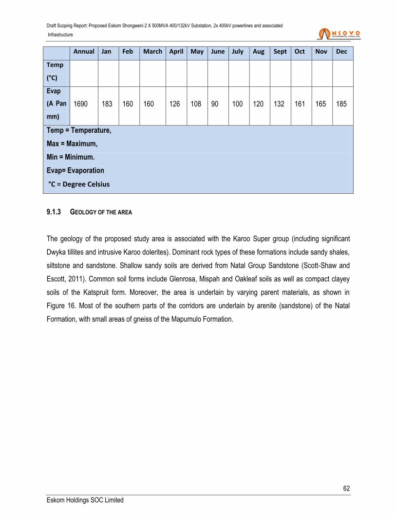
Draft Scoping Report: Proposed Eskom Shongweni 2 X 500MVA 400/132kV Substation, 2x 400kV powerlines and associated
Infrastructure
62
Eskom Holdings SOC Limited
Annual Jan Feb March April May June July Aug Sept Oct Nov Dec
Temp
(°C)
Evap
(A Pan
mm)
1690 183 160 160 126 108 90 100 120 132 161 165 185
Temp = Temperature,
Max = Maximum,
Min = Minimum.
Evap= Evaporation
°C = Degree Celsius
9.1.3 GEOLOGY OF THE AREA
The geology of the proposed study area is associated with the Karoo Super group (including significant
Dwyka tillites and intrusive Karoo dolerites). Dominant rock types of these formations include sandy shales,
siltstone and sandstone. Shallow sandy soils are derived from Natal Group Sandstone (Scott-Shaw and
Escott, 2011). Common soil forms include Glenrosa, Mispah and Oakleaf soils as well as compact clayey
soils of the Katspruit form. Moreover, the area is underlain by varying parent materials, as shown in
Figure 16. Most of the southern parts of the corridors are underlain by arenite (sandstone) of the Natal
Formation, with small areas of gneiss of the Mapumulo Formation.

Draft Scoping Report: Proposed Eskom Shongweni 2 X 500MVA 400/132kV Substation, 2x 400kV powerlines and associated
Infrastructure
63
Eskom Holdings SOC Limited
Figure 14: Geological map of the proposed location
9.1.4 TOPOGRAPHY
The main topographical unit within the proposed area consists of moderately undulating plains and
ridgelines with rolling hills which are characteristic of the study area. These topographical units often give
rise to wetlands and watercourse systems.
9.1.5 SURFACE WATER
This section provides the description of the surface water within the proposed location of the proposed
substation, power-line and associated infrastructures. The description of surface water is mainly focusing
on the alternatives of the proposed sites as follows:

Draft Scoping Report: Proposed Eskom Shongweni 2 X 500MVA 400/132kV Substation, 2x 400kV powerlines and associated
Infrastructure
64
Eskom Holdings SOC Limited
9.1.5.1 CHARACTERISTICS AND WATERCOURSES OF THE PROPOSED AREA
The three powerline corridor alternatives traverse the North Eastern Coastal Belt Eco-region and the South-
Eastern Uplands Eco-region (Figure 17). Further to this, the route alternatives are located within the
following three quaternary catchments:
U60C
U60D
U60F
These three quaternary catchments are located within the Mgeni Sub Water Management Area and the
Mvoti to Umzimkulu Water Management Area (WMA). The Mvoti to Umzimkulu WMA lies along South
Africa’s eastern coast, primarily within KwaZulu-Natal. The landscape is characterised by rolling terrain with
the Drakensberg escarpment forming the main topographical feature (National Water Resource Strategy,
2004). The Mvoti to Umzimkulu WMA is comprised of a diverse economic sector with forestry, agriculture
(both subsistence and commercial) and eco-tourism forming the primary land use activities. The quaternary
catchments are associated with a Moderate ecological sensitivity status
(www.dwa.gov.za/war/systems.html). The Wekeweke Rivers and the Mhlatuzana Rivers are the main
watercourses within the three corridor alternatives.

Draft Scoping Report: Proposed Eskom Shongweni 2 X 500MVA 400/132kV Substation, 2x 400kV powerlines and associated
Infrastructure
65
Eskom Holdings SOC Limited
Figure 15: Hydrological map of the proposed project
9.1.5.2 NATIONAL FRESHWATER ECOSYSTEM PRIORITY AREAS (NFEPA)
The NFEPA project was developed to provide strategic spatial priorities for conserving South Africa’s
freshwater ecosystems and supporting sustainable use of water resources. These strategic spatial priorities
are known as Freshwater Ecosystem Priority Areas, or FEPAs (Driver, et al., 2011). An examination of the
NFEPA database revealed that a number of FEPA wetlands were identified throughout the proposed
corridors of the proposed Shongweni powerline. Wetlands have been classified as both natural and artificial
in nature and consist of Seeps, Channelled Valley Bottom wetlands as well as a Wetland Flat. Artificial
wetlands are agricultural dams. Natural wetlands are classified as FEPA wetlands due to their moderately
modified to largely natural condition as depicted in Figures 18 to 20.

Draft Scoping Report: Proposed Eskom Shongweni 2 X 500MVA 400/132kV Substation, 2x 400kV powerlines and associated
Infrastructure
66
Eskom Holdings SOC Limited
Figure 16: FEPA wetlands within corridor alternative E
Figure 17: FEPA wetlands within corridor alternative F

Draft Scoping Report: Proposed Eskom Shongweni 2 X 500MVA 400/132kV Substation, 2x 400kV powerlines and associated
Infrastructure
67
Eskom Holdings SOC Limited
Figure 18: FEPA wetlands within corridor alternative G
9.1.6 AIR QUALITY AND POLLUTION
Air quality is defined to include noise and odour and addresses all sources of air pollution (i.e. point, area
and mobile sources). The Air Quality Management Plan for the Shongweni proposed project has been
developed to comply with the National Environmental Management: Air Quality Act, 39 of 2004 and more
specifically, to provide guidance on Air Quality Management in the eThekwini metropolitan municipality.
The Plan identifies air pollution sources in the proposed locations as follows:
Dust from the sand mining taking place within the proposed location;
Clay brick manufacturing;
Agricultural activities such as crop burning and spraying;
Agricultural activities such as sugarcane farming;
Biomass burning (veld fires);
Domestic fuel burning (wood and paraffin);
Vehicle emissions;

Draft Scoping Report: Proposed Eskom Shongweni 2 X 500MVA 400/132kV Substation, 2x 400kV powerlines and associated
Infrastructure
68
Eskom Holdings SOC Limited
Waste treatment and disposal;
Dust from infrastructural development;
Dust from unpaved roads; and
Other fugitive dust sources such as wind erosion of exposed areas
There are few sources of air pollutants in the eThekwini Metropolitan Municipality and even fewer within the
immediate proposed area. The ambient air quality is generally good; however, emissions from industrial
boilers are likely to result in local areas of elevated concentrations of air pollutants. Ambient particulate
concentrations are likely to be high in low – income residential areas where wood is used as primary fuel
source. The motor vehicle congestion in holiday towns and along the N3 road results in elevated ambient
concentrations of particulates and NO2 (Nitrogen Oxides) at times.
9.1.7 TYPES OF VEGETATION (FLORA)
The study area is located within three broad vegetation types within the Savanna and the Grassland
Biomes (Mucina and Rutherford, 2006). The three broad vegetation types which include, KwaZulu-Natal
Sandstone Sourveld, Moist Coast Hinterland Grassland and Dry Coast Hinterland Grassland are discussed
below. Patches of the Highveld Alluvial Vegetation type and the Scarp Forest vegetation type are
interspersed within these broad vegetation types (Figure 21).
9.1.7.1 KWAZULU-NATAL SANDSTONE SOURVELD
This vegetation type is distributed on elevated coastal inland sandstone plateaus with altitudes of between
500m to 1100m above sea level. The vegetation consists of short, species rich grassland with scattered low
shrubs. Proteaceae trees and shrubs can also be locally common. The dominant topographical features are
flat or rolling plateau tops and steep slopes forming Table Mountains. This vegetation type is considered
Endangered with only 0.2% conserved (Mucina and Rutherford, 2006).
9.1.7.2 THE DRY COAST HINTERLAND GRASSLAND
Dry Coast Hinterland Grassland is distributed within the KwaZulu-Natal and Eastern Cape Provinces. Other
vegetation units often associated with the Hinterland Grassland include the KwaZulu-Natal Hinterland

Draft Scoping Report: Proposed Eskom Shongweni 2 X 500MVA 400/132kV Substation, 2x 400kV powerlines and associated
Infrastructure
69
Eskom Holdings SOC Limited
Thornveld, Bisho Thornveld and Eastern Valley Bushveld (Scott-Shaw and Escott, 2011). Dry Coast
Hinterland veld is comprised of Sourveld wiry grassland assemblages dominated by Aristida junciformis
(Ngongoni Grass), however veld in a healthy condition are dominated by Themeda triandra and Tristachya
leucothrix (Scott-Shaw and Escott, 2011). The mono-dominance displayed by this vegetation unit is
associated with low species diversity. This vegetation unit is typically associated with undulating plains and
hilly landscape within the drier coast hinterland valleys (in the rain-shadow of the rain-bearing frontal
weather systems) (Scott-Shaw and Escott, 2011). Patches of wooded vegetation is often confined to
valleys and ridgelines embedded within the Sub Escarpment Grassland assemblages. Termitaria support
bush clumps within this grassland unit including Acacia spp, Cussonia spicata, Ehretia rigida, Grewia
occidentalis and Coddia rudis. Herbaceous species richness is not as abundant as adjoining vegetation
units namely KwaZulu-Natal Sandstone Sourveld and Moist Coast Hinterland Grassland. This vegetation
type is considered Vulnerable (Mucina and Rutherford, 2006).
9.1.7.3 THE MOIST COAST HINTERLAND GRASSLAND
The Moist Coast Hinterland Grassland is distributed within the KwaZulu-Natal and Eastern Cape Provinces.
Hinterland veld is comprised of tall dense Sourveld grassland assemblages with mono-dominance
associated with low species diversity. The mono-dominance is by Aristida junciformus (Ngongoni Grass),
however veld in a healthy condition are dominated by Themeda triandra and Tristachya leucothrix (Scott-
Shaw and Escott, 2011). As with the Dry Coast Hinterland Grassland, this vegetation unit is typically
associated will rolling and hilly landscapes. Patches of wooded vegetation is often confined to valleys and
ridgelines embedded within the Sub Escarpment Grassland assemblages. This vegetation unit is statutorily
conserved in Vernon Crookes and Entumeni Nature Reserve and is considered Vulnerable (Mucina and
Rutherford, 2006).

Draft Scoping Report: Proposed Eskom Shongweni 2 X 500MVA 400/132kV Substation, 2x 400kV powerlines and associated
Infrastructure
70
Eskom Holdings SOC Limited
Figure 19: Vegetation types associated with the proposed area
9.1.7.4 LISTED AND PROTECTED SPECIES
According to the SANBI SIBIS database, more than 1300 indigenous species have been recorded from the
two quarter degree squares containing the site. This includes 54 species of high conservation concern
(Table 11), illustrating the high diversity of the area and potential for impact on species of conservation
concern. This impact can be minimized through avoidance of the sensitive features and habitats at the site,
especially areas of forests, wetlands and drainage lines. The majority of the intact habitat that would be
affected by the development would be in the western section of the site around the Hector Substation
where the vegetation was in a generally poor state and the likely abundance of species of conservation
concern would be low.

Draft Scoping Report: Proposed Eskom Shongweni 2 X 500MVA 400/132kV Substation, 2x 400kV powerlines and associated
Infrastructure
71
Eskom Holdings SOC Limited
Table 15: Numbers of the species within the different conservation status categories as indicated below,
data derived from the SANBI SIBIS database.
Status/ IUCN Red List Category No. Species
Critically Endangered (CR) 3
Endangered (EN) 6
Vulnerable (VU) 19
Near Threatened (NT) 10
Rare 2
Declining 10
Data Deficient - Insufficient Information (DDD) 0
Data Deficient - Taxonomically Problematic (DDT) 4
Least Concern 1336
Total 1390
9.1.7.5 CRITICAL BIODIVERSITY AREA
The KwaZulu-Natal (2016) CBA map for the general area surrounding the site is depicted below in Figure
22. Although there are some irreplaceable CBAs within the study area, the overall density of these areas
within the power line corridors is relatively low. This can be ascribed to the highly impacted and
transformed nature of a significant proportion of the study area. While the majority of the CBAs can be
avoided, some impact to these areas may occur as a result of the power lines. However, these CBAs are
considered irreplaceable and are not very extensive; they would be vulnerable to cumulative habitat loss.
As a result these areas should be avoided as much as possible to avoid significant risk to the biodiversity of
these areas.
The remaining extent of listed ecosystems layer indicates that there is significant remnant vegetation in the
vicinity of substation Alternative F. However, there appear to have been significant changes since the layer
was made as the site visit indicated that there was very little intact vegetation in this area apart from a
narrow belt of vegetation along the drainage line that occurs north of the substation site. Although the
drainage line is some distance from the drainage line and would not be directly affected by the substation,
access roads may be required to traverse the drainage line and as a result, this not considered a favorable
alternative compared to Alternative E and G which are confined to extensive areas of sugarcane.

Draft Scoping Report: Proposed Eskom Shongweni 2 X 500MVA 400/132kV Substation, 2x 400kV powerlines and associated
Infrastructure
72
Eskom Holdings SOC Limited
Figure 20: Critical Biodiversity Areas within proposed location of the activity
9.1.8 FAUNA
9.1.8.1 MAMMALS
According to the Mammal Map database, 51 mammal species have been recorded from the area (Annex
2), including several conservation dependent species such as Blesbok, Nyala, and Plains Zebra, which
would not be encountered in the study area outside of conservation areas. The study area has been
significantly impacted by transformation and development with the result that the remnant areas of intact
grassland or forest are high fragmented and exposed to anthropogenic influences. As a result, species that
are not tolerant of human disturbance are not likely to present and the remnant fauna consists largely of
smaller and more wary nocturnal species.
In terms of listed species, Oribi Ourebia ourebi (Endangered), Blue Duiker Philantomba monticola
(Vulnerable), Serval Leptailurus serval (Near Threatened), African Striped Weasel Poecilogale albinucha
(Near Threatened) and Leopard Panthera pardus (Vulnerable) are species of conservation concern that
occur in the wider area. However, of these only the African Striped Weasel and possibly the Blue Duiker

Draft Scoping Report: Proposed Eskom Shongweni 2 X 500MVA 400/132kV Substation, 2x 400kV powerlines and associated
Infrastructure
73
Eskom Holdings SOC Limited
are likely to be present as the area is too disturbed or no longer suitable for the other species due to habitat
changes and fragmentation. The intact grasslands would originally have contained Serval and Oribi but the
extent of intact grassland is not sufficient to support viable populations of these species and it is also likely
that hunting pressure on these species would have extirpated them from the area some time ago. There
are some relatively intact and inaccessible forests remaining at the site especially in the east and these
potentially support remnant Blue Duiker populations (McLean et al. 2016).
As a result of the high levels of transformation of the area the development is likely to generate low levels
of impact on mammals. All of the substation sites are within transformed habitat and it is likely that the
power line can also be routed so as to minimize loss of currently intact habitat, with the result that overall
impacts on fauna can be mitigated to low levels.
9.1.8.2 REPTILES
According to the Reptile Map database, 58 reptile species have been recorded from the quarter degrees
covering the site which indicates the high diversity of the area as this is not an exhaustive list. Five species
are considered of conservation concern. The Durban Dwarf Burrowing Skink Scelotes inornatus (CE) is an
endemic and McLean et al. (2016) recognize this species as a flagship species for the region. It occurs in
coastal habitat on Berea red sands from Canelands in the north to Clansthal in the south (Marais 2011, in
McLean et al. 2016). The KwaZulul Dwarf Chameleon Bradypodion melanocephalum (VU) is also endemic
and has much of its range within the eThekwini District Municipality, particularly more open habitat near the
coast (McLean et al. 2016). The ranges of both species overlap built up areas and are thus susceptible to
habitat transformation and degradation. McLean et al. (2016) recommends that in order to conserve these
species, a matrix of connected and genetically viable populations will need to be protected and managed.
The Green Mamba Dendroaspis angusticeps (VU) is considered an indicator of dune forest health and is
fairly specialist in its habitat requirements with the result that it is not likely to be widely distributed within the
study area and would potentially only occur in the far east of the site, but as a result of the near-total
transformation of this area is not likely to be present. The Natal Black Snake Macrelaps microlepidotus
(Near Threatened) and Large-scaled Grass Lizard Chamaesaura macrolepis (Near Threatened) are reptile
species which also have more specialist than generalist habitat requirements (McLean et al. 2016) and are
likely to still occur within the intact parts of the site.

Draft Scoping Report: Proposed Eskom Shongweni 2 X 500MVA 400/132kV Substation, 2x 400kV powerlines and associated
Infrastructure
74
Eskom Holdings SOC Limited
The most important habitats in the area for reptiles would be the intact remnants of grassland and
Thornveld in the west and the forests and drainage systems of the east. Provided that loss of currently
intact habitat is kept to a minimum, then impacts on reptiles are likely to be relatively low and no significant
long-term impacts are likely occur.
9.1.8.3 AMPHIBIANS
The broader area has exceptional frog species richness, with as many as thirty-two frog species known
from the area. This includes four species of conservation concern. Pickersgill’s Reed Frog Hyperolius
pickersgilli (EN) inhabits densely vegetated, stagnant valley bottom wetlands from the coast to ca. 200 m
above sea level (McLean et al. 2016). As this habitat is not present at the site which is almost all above
500m above sea level, it is highly unlikely that this species is present at the site and an impact on this
species can be excluded as a likely outcome of the development. The Endangered Kloof Frog
Natalobatrachus bonebergi is under threat due to the degradation of riverine gorge systems (Minter et al.
2004) as a result of over-exploitation and pollution. Other species of concern include the Spotted Shovel-
nosed Frog Hemisus guttatus (VU), a potential flagship species that is endemic and occurs in wooded and
open habitat adjacent wetlands, but is extremely difficult to locate due to its fossorial habits (McLean et al.
2016).
It is not likely that there would be impact on the habitat of this species as the majority of the site is disturbed
and there would be minimal impact on areas of good condition habitat. The Natal Leaf-folding Frog
Afrixalus spinifrons (VU) is more likely to occur at the site as it is relatively tolerant of some land-use
changes. However as it is associated with wetlands and water bodies, it is not likely to be impacted by the
development as the power lines would specifically avoid these features. Overall, impacts on amphibians
are likely to be relatively as their most important habitats, wetlands and other drainage features are likely to
be minimally impacted by the development and the major footprint areas would be in areas that are already
heavily transformed.
9.1.9 AVIFAUNA
This section provides the avifauna assessment within the proposed location of the proposed project mainly
focusing on the bird population that are situated within the proposed area. The population of the birds’
within the areas is discussed as follows:

Draft Scoping Report: Proposed Eskom Shongweni 2 X 500MVA 400/132kV Substation, 2x 400kV powerlines and associated
Infrastructure
75
Eskom Holdings SOC Limited
9.1.9.1 IMPORTANT BIRD AREAS (IBA’S)
Some sites are exceptionally important for maintaining the taxa dependent upon the habitats and
ecosystems in which they occur. Vigorous protection of the most critical sites is one important approach to
conservation. Site that are carefully identified on the basis of the bird numbers and species complements
they hold, are termed Important Bird Areas (IBAs) and are selected such that, taken together, they form a
network throughout the species’ biogeographic distributions. IBAs are key sites for conservation – small
enough to be conserved in their entirety and often already part of a protected-area network.
There are no IBA’s within the immediate study area. The closest IBA to the proposed project (SA078 –
KwaZulul-Natal Mistbelt Grasslands) is located approximately 30km to the west and it consists of a series
of disconnected grassland patches on farms located in the KwaZulu-Natal Midlands (Marnewick et al,
2015). It has been declared an IBA based on its breeding population of globally threatened Blue Swallows
Hirundo atrocaerulea. The distance of the IBA from the study area and the unlikely occurrence of the
associated trigger species (only Southern Bald Ibis, Martial Eagle and African Marsh Harrier have been
recorded in the study area in low number of between one and five individuals over a ten-year period) within
the project boundary, means that the IBA will not have a significant impact on the establishment of the
proposed Shongweni substation and powerline. .
9.1.9.2 COORDINATED WATER BIRD COUNT (CWAC) DATA
The Animal Demography Unit (ADU) launched the Coordinated Waterbird Counts (CWAC) project in 1992
as part South Africa’s commitment to International waterbird conservation. A CWAC site is any body of
water, other than the oceans, which supports a significant number (set at approximately 500 individual
water birds, irrespective of the number of species) of birds which use the site for feeding, and/or breeding
and roosting (Young et al, 2003). This definition includes natural pans, vleis, marshes, lakes, rivers, as well
as a range of man-made impoundments (i.e. sewage works). The presence of a CWAC site within a study
area is an indication of a large number of water dependent species occurring there and the overall
sensitivity of the area. However, there are no CWAC sites within the immediate study area.
The identified CWAC sites are located approximately 20km east of the project boundary. Therefore given
the distance from the study area and the relatively low numbers of water birds recorded at these locations,

Draft Scoping Report: Proposed Eskom Shongweni 2 X 500MVA 400/132kV Substation, 2x 400kV powerlines and associated
Infrastructure
76
Eskom Holdings SOC Limited
the aforementioned CWAC sites will not have a significant impact on the establishment of the proposed
Shongweni substation and the routing of the final Hector-Shongweni 400kV alignments.
9.1.9.3 COORDINATED AVIFAUNAL ROAD-COUNT (CAR) DATA
Cranes, bustards, storks and other large birds that spend most of their time on the ground, need wide, open
spaces and are certainly not restricted to protected areas. Agricultural habitats are used extensively for
feeding, roosting and breeding, often because no natural, pristine habitats are available, and sometimes
because the agricultural habitats are especially attractive to birds. Because of their size and conspicuous
nature, these birds can be monitored using a relatively simple technique i.e. the road count. The
Coordinated Avifaunal Road counts (CAR) project monitors the populations of 36 species of large terrestrial
birds in agricultural habitats, in addition to game birds, raptors and corvids along 350 fixed routes covering
over 19 000km (http://car.adu.org.za/). Although CAR road counts do not give an absolute count of the all
the individuals in a population, they do provide a measure of relative abundance in a particular area.
There are no CAR routes within the confines of the study area. The closest CAR route (KM03) is located
approximately 50km north-west of study area, near Howick. Despite the absence of CAR counts within the
study area, it is important to note that several of the large terrestrial and raptor species that the CAR counts
consider have been observed in the study area. These include i.e. Southern Bald Ibis, Helmeted
Guineafowl Numida meleagris, Spur-winged Goose Plectropterus gambensis, Black-headed Heron Ardea
melanocephala, Long-crested Eagle Lophaetus occipitalis, Steppe Buzzard Buteo vulpinus and Jackal
Buzzard Buteo rufofuscus which are vulnerable to interactions with power line infrastructure.
9.1.9.4 South African bird atlas project 2 data (sabap2)
A total of 346 bird species have been recorded within the relevant pentads during the SABAP2 atlas sing
period to date. The presence of these species in the broader area provides an indication of the diversity of
species that could potentially occur within the areas earmarked for the proposed developments, particularly
where pockets of natural vegetation/habitats persist. Of the 346 species, 22 of these are considered to be
of conservation concern (Red Data), according to the 2015 Eskom Red Data Book of Birds of South Africa,
Lesotho and Swaziland (Taylor et al 2015) and the IUCN Red List (2016). The White Stork Ciconia ciconia,

Draft Scoping Report: Proposed Eskom Shongweni 2 X 500MVA 400/132kV Substation, 2x 400kV powerlines and associated
Infrastructure
77
Eskom Holdings SOC Limited
which is not listed, but is protected internationally under the Bonn Convention on Migratory species, was
also recorded
9.1.10 AGRICULTURAL POTENTIAL
9.1.10.1 SOIL PATTERN WITHIN THE PROPOSED AREA
Two broad soil pattern classes have been noted within the study areas as follows:
Aa Humic topsoils overlying red and/or yellow apedal sub soils; and
Fb Shallow, and/or rocky, often steep, highly leached (very little lime)
The summarized soil patterns of the land types that occur within one or more of the various route corridors
or substation study areas are shown are presented in the table below and the dominant class of agricultural
potential is shaded in bold. The distribution of the land types across the three corridors within the study
area is further described in the Table below and further depicted in Figure 21.

Draft Scoping Report: Proposed Eskom Shongweni 2 X 500MVA 400/132kV Substation, 2x 400kV powerlines and associated
Infrastructure
78
Eskom Holdings SOC Limited
Land
Type
Dominant soils Depth (mm) Percent of
land type
Characteristics Agric.
Potential
(%)
Aa11 Inanda 10/11
Nomanci 10
800-1200+
500-800
33%
21%
Red, loamy, structureless soils with humic topsoil
Brown to dark red, loamy, structureless soils with humic topsoil
High: 69.3
Mod: 16.6
Low: 14.1
Fa509 Glenrosa 17/18
Hutton 16
300-700
600-1200
36%
16%
Reddish-brown, loamy, structureless soils
Red, loamy, structureless soils
High: 31.9
Mod: 53.0
Low: 16.1
Fa510 Glenrosa 14/15/17/18
Hutton 16/17
150-300
1000-1200
25%
24%
Reddish-brown, sandy/loamy, structureless soils
Red, loamy, structureless soils
High: 43.7
Mod: 10.8
Low: 45.5
Fa512 Cartref 21/31
Glenrosa 13/16
600-800
200-400
53%
10%
Grey-brown, sandy, structureless soils
Reddish-brown, sandy, structureless soils
High: 8.9
Mod: 64.7
Low: 26.4
Fa513 Cartref 21/22
Glenrosa 14/17
350-500
150-500
38%
21%
Grey-brown, sandy, structureless soils
Reddish-brown, sandy, structureless soils
High: 0.0
Mod: 13.6
Low: 86.4
Fa515 Glenrosa 14/15
Cartref 21/31
200-500
300-650
37%
29%
Reddish-brown, sandy/loamy, structureless soils
Grey-brown, sandy/loamy, structureless soils
High: 7.1
Mod: 32.9
Low: 60.0

Draft Scoping Report: Proposed Eskom Shongweni 2 X 500MVA 400/132kV Substation, 2x 400kV powerlines and associated
Infrastructure
79
Eskom Holdings SOC Limited
Figure 21: Land type map of the proposed location
9.1.10.2 TRANSMISSION LINE CORRIDORS AND SUBSTATION SITES
The occurrence and characteristics of the soils occurring in each land type have been summarized and
assessed in terms of broad agricultural potential. This is expressed in the percentage of soils within a land
type that can be regarded as being of high potential, so that land types with a higher potential of such soils
would be regarded as more suitable for agriculture, especially cultivation. Soils falling into this category will
include freely-drained, loamy soils with a sufficient rooting depth (generally >900 mm), lacking strong
structure, stoniness or any signs of wetness.

Draft Scoping Report: Proposed Eskom Shongweni 2 X 500MVA 400/132kV Substation, 2x 400kV powerlines and associated
Infrastructure
80
Eskom Holdings SOC Limited
The major area with high potential soils (>60% of the landscape) occurs in the east of the study area,
where deep, apedal soils with a humic (more organic-rich) topsoil predominate. Towards the western end of
the study area, the soils become shallower which, coupled with slightly more undulating terrain, leads to a
lower class of agricultural potential.
Figure 22: Broad agricultural potential indicating the corridors and substation sites
9.1.11 VISUAL ASPECTS
Visual appreciation or dislike is subjective and thus what is aesthetically pleasing to one can be displeasing
to another. The visual analysis of a landscape, the impact of new developments and structures tend to be
complicated and it is evident from previous experience that when dealing with reaction to landscape
changes, a large diversity of opinion exists. Much of the proposed area is utilised for purposes of
agriculture (i.e. sugarcane plantation).

Draft Scoping Report: Proposed Eskom Shongweni 2 X 500MVA 400/132kV Substation, 2x 400kV powerlines and associated
Infrastructure
81
Eskom Holdings SOC Limited
The agricultural landscapes of much of the proposed location or sites are not necessarily sensitive but are
important to preserve for their aesthetics. It is thus necessary to maintain a near natural visual landscape,
with limited effect on aesthetic, to enable the continuation of nature-based economic activities such as
ecotourism in the area.
As such, it is an imperative that Eskom be sensitive from a visual impact perspective, to the requirements
of the local people, notably rural communities, farmers and operators involved in eco-tourism activities.
Many topographical features influence this environment and these features will need to be utilised when
selecting substation location and loop alignment so as to minimise visual impacts and intrusions.
9.1.12 SITES OF ARCHAEOLOGICAL AND CULTURAL SIGNIFICANCE
The archaeological and cultural heritage impact assessment for the proposed development revealed no
obvious archaeological (Stone and Iron Ages) or historical material that will need to be mitigated prior
construction in the footprint of the study area. This however could be two fold, firstly and most likely it could
have been that there are no archaeological sites in the proposed area, secondly, it could have been as a
result of bush encroachment, wherein materials could have been hidden in some of the dense vegetation
that had been noted in the area. It should be borne in mind that, none of the materials that can be found
here can be considered to be of such significance that can prevent the proposed development from
proceeding. Noteworthy that houses (structures) which bears historical significance where noted in the
proposed area. Although no significant archaeological materials were identified on the proposed area for
substation and power-line, the recommendation from the heritage specialist will be considered.
10. METHODOLOGY FOR ASSESSING SIGNIFICANCE OF POTENTIAL IMPACTS
The assessment of impacts is largely based on the Department of Environmental Affairs and Tourism’s
(1998) Guideline Document: Environmental Impact Assessment Regulations. The assessment will consider
impacts arising from the proposed activities of the project both before and after the implementation of
appropriate mitigation measures.
The impacts are assessed according to the criteria outlined in this section. Each issue is ranked according
to extent, duration, magnitude (intensity) and probability. From these criteria, a significance rating is

Draft Scoping Report: Proposed Eskom Shongweni 2 X 500MVA 400/132kV Substation, 2x 400kV powerlines and associated
Infrastructure
82
Eskom Holdings SOC Limited
obtained, the method and formula is described below. Where possible, mitigation recommendations have
been made and are presented in tabular form.
The criteria given in the table below will be used to conduct the evaluation. The nature of each impact will
be assessed and described in relation to the extent, duration, intensity, significance and probability of
occurrence attached to it. This will be assessed in detail during the EIA phase.
Table 16: Methodology used in determining the significance of potential environmental impacts
Status of Impact
The impacts are assessed as either having a:
negative effect (i.e. at a `cost' to the environment),
positive effect (i.e. a `benefit' to the environment), or
Neutral effect on the environment.
Extent of the Impact
(1) Site (site only),
(2) Local (site boundary and immediate surrounds ),
(3) Regional (within the City of Johannesburg),
(4) National, or
(5) International.
Duration of the Impact
The length that the impact will last for is described as either:
(1) immediate (<1 year)
(2) short term (1-5 years),
(3) medium term (5-15 years),
(4) long term (ceases after the operational life span of the project),
(5) Permanent.
Magnitude of the Impact
The intensity or severity of the impacts is indicated as either:
(0) none,
(2) Minor,
(4) Low,
(6) Moderate (environmental functions altered but continue),
(8) High (environmental functions temporarily cease), or
(10) Very high / Unsure (environmental functions permanently cease).
Probability of Occurrence
The likelihood of the impact actually occurring is indicated as either:

Draft Scoping Report: Proposed Eskom Shongweni 2 X 500MVA 400/132kV Substation, 2x 400kV powerlines and associated
Infrastructure
83
Eskom Holdings SOC Limited
(0) None (the impact will not occur),
(1) improbable (probability very low due to design or experience)
(2) low probability (unlikely to occur),
(3) medium probability (distinct probability that the impact will occur),
(4) high probability (most likely to occur), or
(5) Definite.
Significance of the Impact
Based on the information contained in the points above, the potential impacts are assigned a significance
rating (S). This rating is formulated by adding the sum of the numbers assigned to extent (E), duration (D) and
magnitude (M) and multiplying this sum by the probability (P) of the impact.
S=(E+D+M)P
The significance ratings are given below
(<30) low (i.e. where this impact would not have a direct influence on the decision to develop in the area),
(30-60) medium (i.e. where the impact could influence the decision to develop in the area unless it is effectively
mitigated),
(>60) high (i.e. where the impact must have an influence on the decision process to develop in the area).

Draft Scoping Report: Proposed Eskom Shongweni 2 X 500MVA 400/132kV Substation, 2x 400kV powerlines and associated
Infrastructure
84
Eskom Holdings SOC Limited
10.1 DESCRIPTION OF THE ENVIRONMENTAL ISSUES AND POTENTIAL IMPACTS INCLUDING CUMULATIVE IMPACTS IDENTIFIED
This section of the Scoping Report describes the potential impacts that the proposed project may pose on the receiving environment. Impacts associated
with the relevant environmental components within the study area as identified, have been assessed based on the consultant’s opinion after numerous
visits to the site and previous experience on similar undertakings as well as consultation with specialist studies. Refer to Table 17 below, for the potential
impacts identified. These impacts are similar for all three alternatives and will be comprehensively assessed during the EIA phase of the project and
associated mitigation measures proposed
10.1.1 POTENTIAL ENVIRONMENTAL IMPACTS IDENTIFIED
Table 17 : Summary Potential Environmental Impact Identified
Issue Rating Description
Employment Positive-No mitigation
required
Job creation and investments into the proposed project will result in opportunities during the planning and
design phase. This impact will typically be limited to skilled engineers and planning professionals.
Proposed project will result in very limited opportunities to the skilled local community during the
construction phase. This impact will be positive and provincial in extent.
Air Pollution Neutral
Potential air pollutant during construction may be dust emanating from site preparation and excavations
during construction. Given the nature and magnitude of the proposed project it is anticipated that if not
mitigated the impact will be local in extent, and short term. Mitigation measures such as regular dust
suppression can reduce the impact to become site specific.

Draft Scoping Report: Proposed Eskom Shongweni 2 X 500MVA 400/132kV Substation, 2x 400kV powerlines and associated
Infrastructure
85
Eskom Holdings SOC Limited
Issue Rating Description
Visual Impact Negative
The visual impact of an object in the landscape decreases quickly as the distance between the observer
and the object increases. The visual impact at 1km is approximately a quarter of the impact viewed from
500m; and the visual impact at 2km is one eighth of the impact viewed from 500m. Therefore, objects
appear insignificant in any landscape beyond 5km.
The visibility of the proposed structure and infrastructure would be a function of several factors, including:
landform, vegetation, views and visibility, genius loci (or sense of place), visual quality, existing and future
land use, landscape character and scale.
The proposed activity will change the visual character of the site particularly considering that the proposed
site is located in an area that is undulating; the elevated points of the site can be viewed from the nearby
roads, however, it must be noted that there are already existing overheard power lines and a substation
located within the vicinity of the proposed project site. Local variations in topography and man-made
structures could cause local obstruction of views in certain parts of the view shed. Given the topography of
the study area the impact can be considered definite, long term, local in extent but low in significance.
Fauna Negative
Considering the insignificant extent of the substation campus and the relatively narrow and linear
servitude it is not expected that any endangered species of conservation will be put at risk.
No sensitive species or sensitive areas are flagged. The project will not substantially change the reigning
ecological character of the general area. Further, the proposed project will not significantly impact

Draft Scoping Report: Proposed Eskom Shongweni 2 X 500MVA 400/132kV Substation, 2x 400kV powerlines and associated
Infrastructure
86
Eskom Holdings SOC Limited
Issue Rating Description
negatively on the assemblages and conservation of the general area.
Flora Negative
Potential ecological impacts resulting from the development of the Shongweni substation and grid
strengthening would stem from a variety of different activities and risk factors associated with the pre-
construction, construction and operational phases of the project potentially including the following:
Construction Phase
Vegetation clearing for access roads, laydown areas and the substation site may impact on
vegetation.
Increased erosion risk would occur due to the loss of plant cover and soil disturbance during the
construction phase. The terrain is undulating; therefore the risk of erosion would be relatively
high. This may impact downstream riparian and wetland habitats if a lot of silt enters the drainage
systems.
Increased human presence can lead to illegal plant harvesting and other forms of disturbance
such as fire.
Operational Phase
The presence of the facility may disrupt the connectivity of the landscape for some species which
may impact their ability to disperse or maintain gene flow between subpopulations.
The facility will require management and if this is not done appropriately, it could impact adjacent
intact areas through impacts such as erosion, alien plant invasion and contamination from
pollutants, herbicides or pesticides.

Draft Scoping Report: Proposed Eskom Shongweni 2 X 500MVA 400/132kV Substation, 2x 400kV powerlines and associated
Infrastructure
87
Eskom Holdings SOC Limited
Issue Rating Description
Cumulatively, the development would contribute to the cumulative fragmentation of the landscape and
would potentially disrupt the connectivity of the landscape for fauna and flora and impair their ability to
respond to environmental fluctuations.
Noise Negative
In South Africa, the assessment of noise levels in the environment is governed by the South African
Bureau of Standards (SABS) noise standard 0103 – ‘The measurement and rating of environmental noise
with respect to annoyance and to speech communication’ (SABS 1994). Additional SABS standards cover
the measurement of noise over different distances from the source (SABS 0357 – ‘The calculation of
sound propagation by the Concave method’), and standards for different sectors (e.g. industry).
An increase in noise is expected to emanate from construction activities, which might have an impact
especially on the surrounding farms. Noise associated with the construction activities can be mitigated by
limiting the construction operation to business hours, during which noise will not be of such a big concern
to surrounding residents. According to the SABS 0103 acceptable noise levels at day time is 45dBA. A
noise intrusion is disturbing if it exceeds 7dBA or more. Given the nature of the project, it is highly unlikely
that the stipulated noise levels will be exceeded at any given time. During the operational phase the
impact of noise will also be reduced to almost insignificant levels, given the nature of the proposed
project.
Noise has been identified as potentially low due to the proposed development being in a remote area, far

Draft Scoping Report: Proposed Eskom Shongweni 2 X 500MVA 400/132kV Substation, 2x 400kV powerlines and associated
Infrastructure
88
Eskom Holdings SOC Limited
Issue Rating Description
removed from communities in most cases. The noise impact may be local during construction and site
specific during operations.
Soil and Agricultural
potential Negative
The predominant land use within the study area is commercial agriculture (i.e. mainly sugarcane). Any
development activity in a natural system will have an impact on the surrounding environment, usually in a
negative way. The construction of the substation will not have a significant impact on the agricultural
activities at any of the proposed sites.
The overall impacts of the proposed substation on the soil and agricultural capability of any of the target
sites and their immediate surrounds will be low due to the shallow soils present, the relatively small size of
the substation study area (800m x 800m) and the continued use of the land adjacent to the substation for
agricultural activities.
Bird Population Negative
Due to its size and prominence, electrical infrastructure constitutes an important interface between wildlife
and man. Negative interactions between wildlife and electricity structures take many forms, but two
common problems in southern Africa are electrocution of birds (and other animals) and collision of birds
with power lines. With proper mitigation measures implemented, these potential impacts can be reduced.
For the proposed development, major risks to birds that may be caused by the proposed facilities are
disturbance by construction activities (temporary), on-going disturbance during operation phase, collision
with and electrocution on the power line.
The proposed construction of the new Shongweni substation and associated power lines will pose a

Draft Scoping Report: Proposed Eskom Shongweni 2 X 500MVA 400/132kV Substation, 2x 400kV powerlines and associated
Infrastructure
89
Eskom Holdings SOC Limited
Issue Rating Description
limited threat to the birds occurring in the vicinity of the new infrastructure. The power line poses a low
collision risk and a low electrocution risk. The impact of displacement due to habitat transformation will
have a low impact on avifauna due the largely transformed nature of the proposed site.
The construction and maintenance activities associated with the proposed development will have an
impact on avifaunal species through disturbance. Species will be particularly sensitive to this disturbance
during the breeding season. The proposed site alternatives are located within an agricultural habitat close
to National and Domestic roads. Therefore, species within this landscape often experience disturbance
and as a result disturbance of birds by the proposed substation is anticipated to be of low significance.
The impact assessment phase will undertake a comprehensive assessment of the extent of the impact at
all alternative sites.
Waste Negative
Naturally, the inhabitation of the land will result in the accumulation of various forms of waste in the area.
The aesthetic value of the area would decrease if such waste is not collected and disposed of
appropriately. Waste material will be generated during the construction phase. Such waste may
accumulate from the workers campsite or from litter left around the work area by the construction staff.
Other waste substances may accumulate from cement bags amongst other construction material.
The impact of waste is definite and will last for the duration of the construction phase as well as the
operational phase, although reduced.
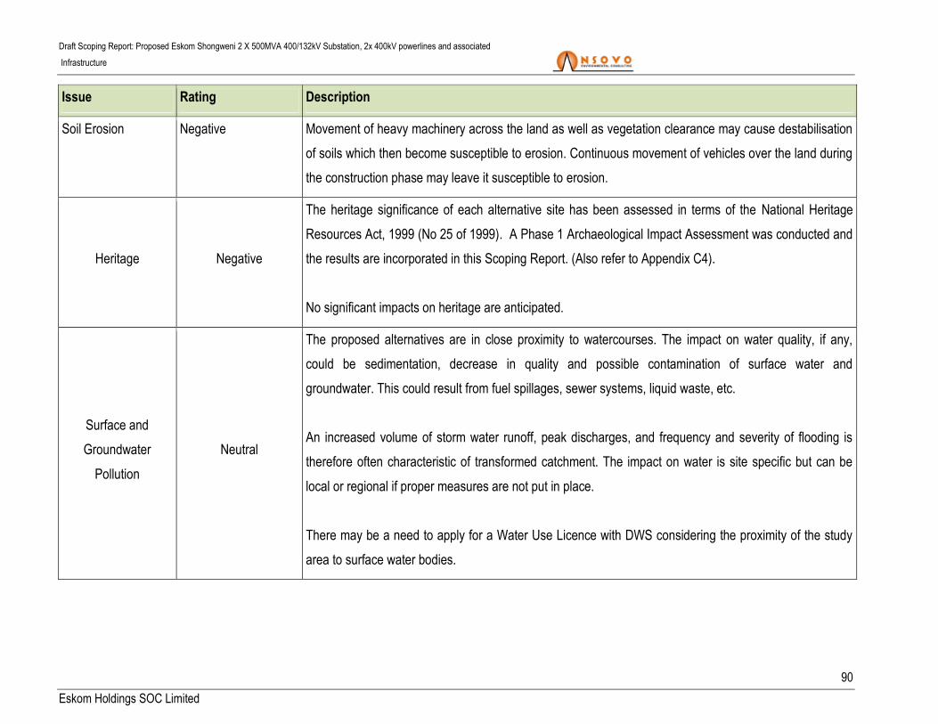
Draft Scoping Report: Proposed Eskom Shongweni 2 X 500MVA 400/132kV Substation, 2x 400kV powerlines and associated
Infrastructure
90
Eskom Holdings SOC Limited
Issue Rating Description
Soil Erosion Negative Movement of heavy machinery across the land as well as vegetation clearance may cause destabilisation
of soils which then become susceptible to erosion. Continuous movement of vehicles over the land during
the construction phase may leave it susceptible to erosion.
Heritage Negative
The heritage significance of each alternative site has been assessed in terms of the National Heritage
Resources Act, 1999 (No 25 of 1999). A Phase 1 Archaeological Impact Assessment was conducted and
the results are incorporated in this Scoping Report. (Also refer to Appendix C4).
No significant impacts on heritage are anticipated.
Surface and
Groundwater
Pollution
Neutral
The proposed alternatives are in close proximity to watercourses. The impact on water quality, if any,
could be sedimentation, decrease in quality and possible contamination of surface water and
groundwater. This could result from fuel spillages, sewer systems, liquid waste, etc.
An increased volume of storm water runoff, peak discharges, and frequency and severity of flooding is
therefore often characteristic of transformed catchment. The impact on water is site specific but can be
local or regional if proper measures are not put in place.
There may be a need to apply for a Water Use Licence with DWS considering the proximity of the study
area to surface water bodies.

Draft Scoping Report: Proposed Eskom Shongweni 2 X 500MVA 400/132kV Substation, 2x 400kV powerlines and associated
Infrastructure
91
Eskom Holdings SOC Limited
Issue Rating Description
Social Environment Negative/Positive
The construction phase may have a negative impact on the surrounding landowners if not properly
managed. It could result to disturbance of residents as a result of construction related activities. Other
social related issues may include theft and risk of fire.
Conversely, a positive impact can emanate from the proposed development through employment of local
residents. Also, a micro-economic environment could be created through vending/trade between contract
workers and the locals. This impact will be local.
Climate Neutral
Local climate conditions do not appear to be of a significant concern to the proposed project. In a broader
scale the project will have no impact on the local and/or global climate change.
Topography Negative
The topography of the study area is undulating; this may pose design challenges particularly in the
steeper area. The substation sites are located fairly low lying terrain.
Tourism Neutral The positioning of the substation and the power line must take into consideration the potential impact on
tourism in the area.
Traffic Negative
A significant amount of material and equipment will be delivered to the site during the construction phase
of the development. It is therefore expected that there will be a considerable impact considering that the
N3 considering that it forms part of the national road. This will have an indirect impact on tourism.

Draft Scoping Report: Proposed Eskom Shongweni 2 X 500MVA 400/132kV Substation, 2x 400kV powerlines and associated
Infrastructure
92
Eskom Holdings SOC Limited
10.1.2 ASSESSMENT OF CUMULATIVE IMPACTS PER SITE
Cumulative impacts in relation to an activity, means the past, current and reasonably foreseeable future
impacts of an activity, considered together with the impacts of activities associated with that activity, that in
itself may not be significant, but may become significant when added to the existing and reasonably
foreseeable impacts eventuating from similar or diverse activities (DEA, 2014 EIA Regulations).
This section presents the assessment anticipated cumulative impacts of the proposed project per site
alternative as well as mitigation measures. Cumulative impacts to be considered for this alternative would
include:
Impact on agriculture (i.e. mainly sugarcane cultivation);
Ecological Fragmentation;
Bird collision with power lines;
Heritage;
Traffic;
Tourism; and
Visual.

Draft Scoping Report: Proposed Eskom Shongweni 2 X 500MVA 400/132kV Substation, 2x 400kV powerlines and associated
Infrastructure
93
Eskom Holdings SOC Limited
Table 18: Impact Rating per alternatives
Alternatives Corrective
measures
Impact rating criteria Significance
Nature Extent Duration Magnitude Probability
Agricultural potential
The impacts of constructing a transmission line will be negative, as the natural environment will be disturbed. However, the isolated nature of the transmission
towers means that the impact on the soil resource will be small as most agricultural activities can still be practiced next to or underneath a transmission line;
therefore the specific significance on the potential loss of agricultural soil, as well as soil disturbance will be low. Most of the study area is not significantly
susceptible to erosion as the area is generally characterised by good natural vegetation cover. Even with the relatively high rainfall, the vegetation cover counter
affects the potential impact. These potential impacts will be medium without mitigation measures which can be reduced to low after application of mitigation
measures.
Site E No Negative 1 5 8 5 70 = High
Yes Negative 1 4 6 4 44 = Medium
Site F No Negative 1 5 8 5 70 = High
Yes Negative 1 4 6 4 44 = Medium
Site G No Negative 1 5 8 5 70 = High
Yes Negative 1 4 6 4 44 = Medium
Corridor 1 No Negative 1 5 6 4 48 =Medium
Yes Negative 1 4 4 3 27 = Low
Corridor 2 No Negative 1 5 6 4 48 =Medium
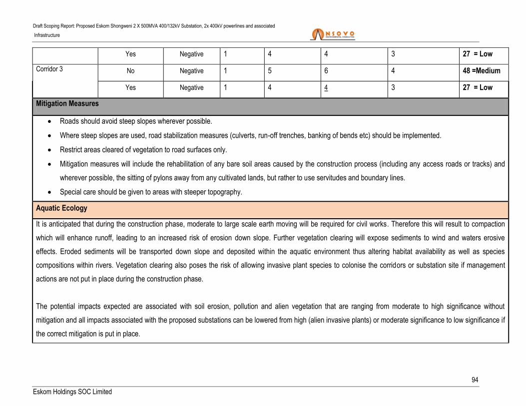
Draft Scoping Report: Proposed Eskom Shongweni 2 X 500MVA 400/132kV Substation, 2x 400kV powerlines and associated
Infrastructure
94
Eskom Holdings SOC Limited
Yes Negative 1 4 4 3 27 = Low
Corridor 3 No Negative 1 5 6 4 48 =Medium
Yes Negative 1 4 4 3 27 = Low
Mitigation Measures
Roads should avoid steep slopes wherever possible.
Where steep slopes are used, road stabilization measures (culverts, run-off trenches, banking of bends etc) should be implemented.
Restrict areas cleared of vegetation to road surfaces only.
Mitigation measures will include the rehabilitation of any bare soil areas caused by the construction process (including any access roads or tracks) and
wherever possible, the sitting of pylons away from any cultivated lands, but rather to use servitudes and boundary lines.
Special care should be given to areas with steeper topography.
Aquatic Ecology
It is anticipated that during the construction phase, moderate to large scale earth moving will be required for civil works. Therefore this will result to compaction
which will enhance runoff, leading to an increased risk of erosion down slope. Further vegetation clearing will expose sediments to wind and waters erosive
effects. Eroded sediments will be transported down slope and deposited within the aquatic environment thus altering habitat availability as well as species
compositions within rivers. Vegetation clearing also poses the risk of allowing invasive plant species to colonise the corridors or substation site if management
actions are not put in place during the construction phase.
The potential impacts expected are associated with soil erosion, pollution and alien vegetation that are ranging from moderate to high significance without
mitigation and all impacts associated with the proposed substations can be lowered from high (alien invasive plants) or moderate significance to low significance if
the correct mitigation is put in place.
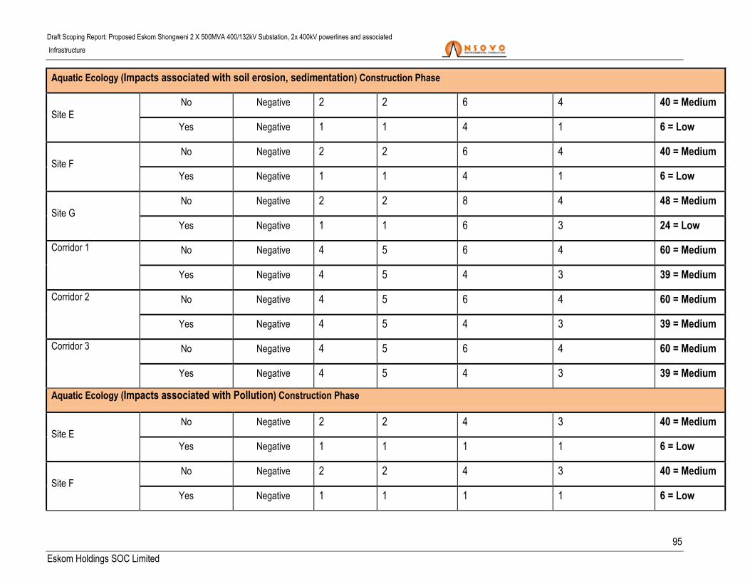
Draft Scoping Report: Proposed Eskom Shongweni 2 X 500MVA 400/132kV Substation, 2x 400kV powerlines and associated
Infrastructure
95
Eskom Holdings SOC Limited
Aquatic Ecology (Impacts associated with soil erosion, sedimentation) Construction Phase
Site E No Negative 2 2 6 4 40 = Medium
Yes Negative 1 1 4 1 6 = Low
Site F No Negative 2 2 6 4 40 = Medium
Yes Negative 1 1 4 1 6 = Low
Site G No Negative 2 2 8 4 48 = Medium
Yes Negative 1 1 6 3 24 = Low
Corridor 1 No Negative 4 5 6 4 60 = Medium
Yes Negative 4 5 4 3 39 = Medium
Corridor 2 No Negative 4 5 6 4 60 = Medium
Yes Negative 4 5 4 3 39 = Medium
Corridor 3 No Negative 4 5 6 4 60 = Medium
Yes Negative 4 5 4 3 39 = Medium
Aquatic Ecology (Impacts associated with Pollution) Construction Phase
Site E No Negative 2 2 4 3 40 = Medium
Yes Negative 1 1 1 1 6 = Low
Site F No Negative 2 2 4 3 40 = Medium
Yes Negative 1 1 1 1 6 = Low

Draft Scoping Report: Proposed Eskom Shongweni 2 X 500MVA 400/132kV Substation, 2x 400kV powerlines and associated
Infrastructure
96
Eskom Holdings SOC Limited
Site G No Negative 2 2 4 3 48 = Medium
Yes Negative 1 1 3 1 24 = Low
Corridor 1 No Negative 4 5 6 4 60 = Medium
Yes Negative 4 5 4 3 39 = Medium
Corridor 2 No Negative 4 5 6 4 60 = Medium
Yes Negative 4 5 4 3 39 = Medium
Corridor 3 No Negative 4 5 6 4 60 = Medium
Yes Negative 4 5 4 3 39 = Medium
Aquatic Ecology (Impacts associated alien vegetation) Construction Phase
Site E No Negative 2 5 6 3 56 = Medium
Yes Negative 1 2 4 2 16 = Low
Site F No Negative 2 5 6 3 56 = Medium
Yes Negative 1 2 4 2 16 = Low
Site G No Negative 2 5 6 3 56 = Medium
Yes Negative 1 2 4 2 16 = Low
Corridor 1 No Negative 4 5 6 4 60 = Low
Yes Negative 4 5 4 3 39 = Medium
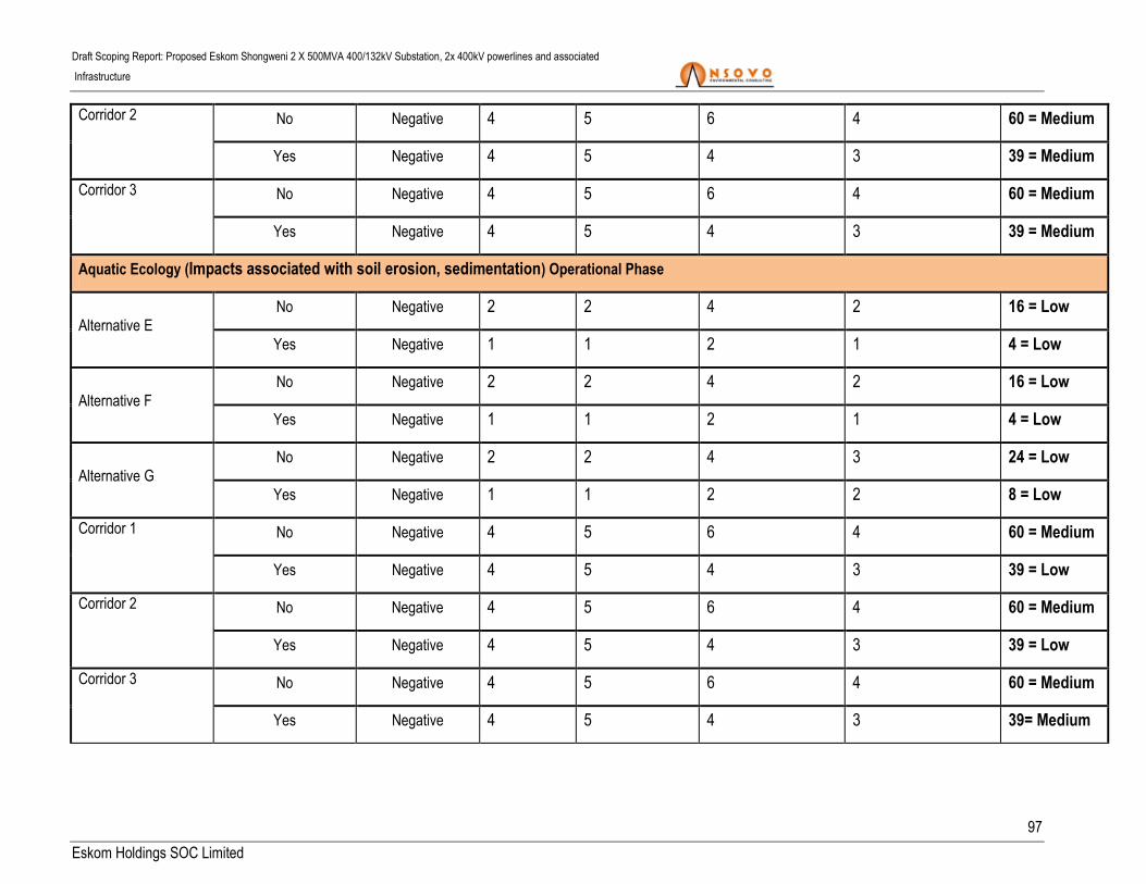
Draft Scoping Report: Proposed Eskom Shongweni 2 X 500MVA 400/132kV Substation, 2x 400kV powerlines and associated
Infrastructure
97
Eskom Holdings SOC Limited
Corridor 2 No Negative 4 5 6 4 60 = Medium
Yes Negative 4 5 4 3 39 = Medium
Corridor 3 No Negative 4 5 6 4 60 = Medium
Yes Negative 4 5 4 3 39 = Medium
Aquatic Ecology (Impacts associated with soil erosion, sedimentation) Operational Phase
Alternative E No Negative 2 2 4 2 16 = Low
Yes Negative 1 1 2 1 4 = Low
Alternative F No Negative 2 2 4 2 16 = Low
Yes Negative 1 1 2 1 4 = Low
Alternative G No Negative 2 2 4 3 24 = Low
Yes Negative 1 1 2 2 8 = Low
Corridor 1 No Negative 4 5 6 4 60 = Medium
Yes Negative 4 5 4 3 39 = Low
Corridor 2 No Negative 4 5 6 4 60 = Medium
Yes Negative 4 5 4 3 39 = Low
Corridor 3 No Negative 4 5 6 4 60 = Medium
Yes Negative 4 5 4 3 39= Medium

Draft Scoping Report: Proposed Eskom Shongweni 2 X 500MVA 400/132kV Substation, 2x 400kV powerlines and associated
Infrastructure
98
Eskom Holdings SOC Limited
Aquatic Ecology (Impacts associated with Pollution) Operational Phase
Alternative E No Negative 2 2 4 2 16 = Low
Yes Negative 1 1 2 1 4 = Low
Alternative F No Negative 2 2 4 2 16 = Low
Yes Negative 1 1 2 1 4 = Low
Alternative G No Negative 2 2 4 2 16 = Low
Yes Negative 1 1 2 1 4 = Low
Corridor 1 No Negative 4 5 6 4 60 = Medium
Yes Negative 4 5 4 3 39 = Medium
Corridor 2 No Negative 4 5 6 4 60 = Medium
Yes Negative 4 5 4 3 39 = Medium
Corridor 3 No Negative 4 5 6 4 60 = Medium
Yes Negative 4 5 4 3 39 = Medium
Aquatic Ecology (Impacts associated alien vegetation) Operational Phase
Alternative E No Negative 2 5 8 4 60 = Medium
Yes Negative 1 2 4 2 14 = Low
Alternative F No Negative 2 5 8 4 60 = Medium

Draft Scoping Report: Proposed Eskom Shongweni 2 X 500MVA 400/132kV Substation, 2x 400kV powerlines and associated
Infrastructure
99
Eskom Holdings SOC Limited
Yes Negative 1 2 4 2 14 = Low
Alternative G No Negative 2 5 8 4 60 = Medium
Yes Negative 1 2 4 2 14 = Low
Corridor 1 No Negative 4 5 6 4 60 = Medium
Yes Negative 4 5 4 3 39 = Medium
Corridor 2 No Negative 4 5 6 4 60 = Medium
Yes Negative 4 5 4 3 39 = Medium
Corridor 3 No Negative 4 5 6 4 60 = Medium
Yes Negative 4 5 4 3 39 = Medium
Mitigation measures
Maintenance vehicles are to be prohibited from driving within the riparian zone and must be constrained to established support roads at all times;
No vehicles should be allowed within any river system;
If significant work needs to be carried out within an aquatic ecosystem a risk assessment should be conducted with input from an aquatic ecologist;
Erosion monitoring at the bases of the pylons and at the substations must be carried out in order to identify issues early and implement remedial
measures to reduce environmental degradation;
Storm water controls within the substation facility are essential; therefore, a storm water management plan must be compiled to prevent the threat of high
rainfall events leading to erosion and the deposition of sediments within aquatic ecosystems;
Water must not be abstracted from any river for any irrigation, construction or rehabilitation purposes unless a water use license has been granted
allowing the specific activity

Draft Scoping Report: Proposed Eskom Shongweni 2 X 500MVA 400/132kV Substation, 2x 400kV powerlines and associated
Infrastructure
100
Eskom Holdings SOC Limited
Rehabilitation of the disturbed sediments needs to be conducted in a timely manner and the indigenous vegetation planted should be monitored and
maintained to prevent die off and alien invasive plant encroachment;
Construction activity should be restricted to the immediate footprint of the infrastructure; and
The selection of corridor 2 will reduce the collision of the red list with the earth wire of the proposed powerline.
Avifauna
The development of the proposed project will result in various impacts of low to medium significance to the birds occurring in the vicinity of the new infrastructure
which can be reduced through the application of mitigation measures. Given the presence of existing habitat degradation and disturbance, it is anticipated that the
proposed project can be undertaken within the study area with acceptable levels of impact on the resident avifauna.
Displacement as a result of habitat transformation
Site E No Negative Local (2) Permanent (5) Low (4) Probable (3) 33 = Medium
Yes Negative Local (2) Permanent (5) Low (4) Improbable (2) 22 = Low
Site F No Negative Site (1) Permanent (5) Low (4) Improbable (2) 20 = Low
Yes Negative Site (1) Permanent (5) Minor (2) Very Improbable (1) 8 = Low
Site G No Negative Site (1) Permanent (5) Minor (2) Improbable (2) 16 = Low
Yes Negative Site (1) Permanent (5) Small (0) Very Improbable (1) 16 = Low
Corridor 1 No Negative Local (2) Long (4) Moderate (6) Highly Probable (4) 48 = Medium
Yes Negative Local (2) Long (4) Low (4) Probable (3) 30 = Medium
Corridor 2 No Negative Local (2) Long (4) Low (4) Probable (3) 30 = Medium

Draft Scoping Report: Proposed Eskom Shongweni 2 X 500MVA 400/132kV Substation, 2x 400kV powerlines and associated
Infrastructure
101
Eskom Holdings SOC Limited
Yes Negative Local (2) Long (4) Minor (2) Improbable (2) 16 = Low
Corridor 3 No Negative Site (1) Long (4) Minor (2) Improbable (2) 14 = Low
Yes Negative Site (1) Long (4) Small (0) Improbable (2) 10 = Low
Displacement as a result of disturbance
Site E No Negative Local (2) Short (2) Low (4) Probable (3) 24 = Low
Yes Negative Local (2) Short (2) Low (4) Improbable (2) 16 = Low
Site F No Negative Site (1) Short (2) Low (4) Improbable (2) 14 = Low
Yes Negative Site (1) Short (2) Minor (2) Very Improbable (1) 5 = Low
Site G No Negative Site (1) Short (2) Minor (2) Improbable (2) 10 = Low
Yes Negative Site (1) Short (2) Small (0) Very Improbable (1) 3 = Low
Corridor 1 No Negative Local (2) Short (2) Moderate (6) Probable (3) 30 = Medium
Yes Negative Local (2) Short (2) Low (4) Improbable (2) 16 = Low
Corridor 2 No Negative Local (2) Short (2) Low (4) Probable (3) 24 = Low
Yes Negative Local (2) Short (2) Minor (2) Improbable (2) 12 = Low
Corridor 3 No Negative Site (1) Short (2) Low (4) Probable (3) 21 = Low
Yes Negative Site (1) Short (2) Minor (2) Improbable (2) 10 = Low
Collision
Corridor 1 No Negative Local (2) Long (4) High (8) Probable (3) 42 = Medium

Draft Scoping Report: Proposed Eskom Shongweni 2 X 500MVA 400/132kV Substation, 2x 400kV powerlines and associated
Infrastructure
102
Eskom Holdings SOC Limited
Yes Negative Local (2) Long (4) Moderate (6) Improbable (2) 24 = Low
Corridor 2 No Negative Local (2) Long (4) Moderate (6) Probable (3) 36 = Medium
Yes Negative Local (2) Long (4) Low (4) Improbable (2) 20 = Low
Corridor 3 No Negative Local (2) Long (4) Low (4) Improbable (2) 20 = Low
Yes Negative Local (2) Long (4) Minor (2) Very Improbable (1) 8 = Low
Mitigation
Construction activity should be restricted to the immediate footprint of the infrastructure.
Access to the remainder of the site should be strictly controlled to prevent unnecessary disturbance of avifaunal species.
Maximum use of existing access roads and the construction of new roads should be kept to a minimum.
Bird flight diverters must be installed on according to Eskom guidelines.
Biodiversity
The impact assessment of the proposed project identified the following potential negative impacts associated with biodiversity:
• Impacts on vegetation and protected plant species;
• Faunal Impacts During Construction;
• Increased Erosion Risk during operational phase;
• Impact on Critical Biodiversity Areas; and
• Cumulative impacts on broad-scale ecological processes.

Draft Scoping Report: Proposed Eskom Shongweni 2 X 500MVA 400/132kV Substation, 2x 400kV powerlines and associated
Infrastructure
103
Eskom Holdings SOC Limited
The Increased levels of noise, pollution, disturbance and human presence during construction will be detrimental to fauna resident or utilising the site. Sensitive
and shy fauna would move away from the area during the construction phase as a result of the noise and human activities present, while some slow-moving
species would not be able to avoid the construction activities and might be killed. Some mammals and reptiles would also be vulnerable to illegal collection or
poaching.
Operational phase disturbance may result in large amounts of erosion and silt movement into drainage lines with negative consequences for fauna and flora in
these areas. Disturbance along the power line route is likely to increase the vulnerability of the disturbed areas to erosion. Impacts associated with the
biodiversity were found to be medium without mitigation measures which can be reduced to low after the appropriate mitigation measures.
Impacts on Vegetation and Plant Species of Conservation Concern
Site E No Negative Local Long Term Low Probable Low
Yes Negative Local Long Term Low Improbable Negligible
Site F No Negative Local Long Term Low Probable Low
Yes Negative Local Long Term Low Improbable Negligible
Alternative G No Negative Local Long Term Low Probable Low
Yes Negative Local Long Term Low Improbable Negligible
Corridor 1 No Negative Regional Long Term Moderate Certain Moderate
Yes Negative Local Long Term Low Probable Low
Corridor 2 No Negative Regional Long Term Moderate Highly Probable Moderate

Draft Scoping Report: Proposed Eskom Shongweni 2 X 500MVA 400/132kV Substation, 2x 400kV powerlines and associated
Infrastructure
104
Eskom Holdings SOC Limited
Yes Negative Local Long Term Low Probable Low
Corridor 3 No Negative Regional Long Term Moderate Highly Probable Moderate
Yes Negative Local Long Term Low Probable Low
Impacts on Fauna During Construction
Alternative E No Negative Local Short Term Low Probable Low
Yes Negative Local Short Term Low Improbable Low
Alternative F No Negative Local Short Term Low Probable Low
Yes Negative Local Short Term Low Improbable Low
Site G No Negative Local Short Term Low Probable Low
Yes Negative Local Short Term Low Improbable Low
Corridor 1 No Negative Local Short Term Moderate Highly Probable Moderate
Yes Negative Local Short Term Low Probable Low
Corridor 2 No Negative Local Short Term Moderate Highly Probable Moderate
Yes Negative Local Short Term Low Probable Low
Corridor 3 No Negative Local Short Term Moderate Highly Probable Moderate
Yes Negative Local Short Term Low Probable Low
Increased Erosion Risk during Operation
Site E No Negative Local Short Term Low Probable Low

Draft Scoping Report: Proposed Eskom Shongweni 2 X 500MVA 400/132kV Substation, 2x 400kV powerlines and associated
Infrastructure
105
Eskom Holdings SOC Limited
Yes Negative Local Short Term Low Improbable Low
Site F No Negative Local Short Term Low Highly Probable Low
Yes Negative Local Short Term Low Improbable Low
Site G No Negative Local Short Term Low Probable Low
Yes Negative Local Short Term Low Improbable Low
Corridor 1 No Negative Local Medium Term Moderate Probable Moderate
Yes Negative Local Short Term Low Improbable Low
Corridor 2 No Negative Local Medium Term Moderate Probable Moderate
Yes Negative Local Short Term Low Improbable Low
Corridor 3 No Negative Local Medium Term Moderate Highly Probable
Moderate to
High
Yes Negative Local Short Term Low Improbable Low
Impact on Critical Biodiversity Areas and Listed Vegetation Types
Alternative E No Negative Local Long Term Low Probable Low
Yes Negative Local Long Term Low Improbable Low
Alternative F No Negative Local Long Term Low Highly Probable Medium-Low
Yes Negative Local Long Term Low Improbable Low
Alternative G No Negative Local Long Term Low Probable Low

Draft Scoping Report: Proposed Eskom Shongweni 2 X 500MVA 400/132kV Substation, 2x 400kV powerlines and associated
Infrastructure
106
Eskom Holdings SOC Limited
Yes Negative Local Long Term Low Improbable Low
Corridor 1 No Negative Regional Long Term Moderate Highly Probable Moderate
Yes Negative Local Long Term Low Probable Low
Corridor 2 No Negative Regional Long Term Moderate Highly Probable Moderate
Yes Negative Local Long Term Low Probable Low
Corridor 3 No Negative Regional Long Term Moderate Highly Probable Moderate
Yes Negative Local Long Term Low Probable Low
Cumulative Impacts
Site E No Negative Local Short Term Low Probable Low
Yes Negative Local Short Term Low Improbable Low
Site F No Negative Local Short Term Medium Highly Probable Medium-Low
Yes Negative Local Short Term Low Improbable Low
Site G No Negative Local Short Term Low Probable Low
Yes Negative Local Short Term Low Improbable Low
Corridor 1 No Negative Regional Long Term Moderate Highly Probable
Moderate to
High
Yes Negative Local Long Term Moderate Probable Moderate
Corridor 2 No Negative Regional Long Term Moderate Probable Moderate

Draft Scoping Report: Proposed Eskom Shongweni 2 X 500MVA 400/132kV Substation, 2x 400kV powerlines and associated
Infrastructure
107
Eskom Holdings SOC Limited
Yes Negative Local Long Term Low Probable Low
Corridor 3 No Negative Regional Long Term Moderate Probable Moderate
Yes Negative Local Long Term Low Probable Low
Mitigation measures
There should be a preconstruction walk-through of the power line route and substation site to identify species of conservation concern that should be
avoided;
Existing roads and access routes should be used wherever possible;
Avoid development within the High sensitivity parts of the site;
The development footprint should be kept to a minimum and natural vegetation should be encouraged to return to disturbed areas;
Avoid impact to potential corridors such as the riparian corridors associated with the larger drainage lines within the area;
Any fauna threatened by construction activities should be removed to safety by the ECO or other suitably qualified person;
During construction all vehicles should adhere to demarcated tracks or roads and the speed limit should not exceed 40km/h on larger roads and should
be 20-30km/h o All construction staff should undergo environmental induction before construction commences in order to raise awareness and reduce
potential faunal impacts;
To avoid impacts on amphibians, all spills of hazardous material should be cleared in the appropriate manner according to the nature and identity of the
spill and all contaminated soil removed from the site;
Avoid sensitive faunal habitats such as drainage lines and wetlands;
No pylons should be located within drainage lines or the adjacent floodplains.

Draft Scoping Report: Proposed Eskom Shongweni 2 X 500MVA 400/132kV Substation, 2x 400kV powerlines and associated
Infrastructure
108
Eskom Holdings SOC Limited
CBAs should be avoided by the final power line route as much as possible, especially where these related to sensitive habitats such as forest or wetlands;
The options containing the least sensitive vegetation types should be selected;
Disturbance within or near the drainage lines should be kept to a minimum;
Any roads along slopes should have water diversion structures placed at regular intervals to ensure that they do not capture overland flow and become
eroded; and
Any erosion problems observed along the power line servitude should be rectified as soon as possible using the appropriate re-vegetation and erosion control
works.
Ecotourism
The impacts of electricity transmission infrastructure on eco-tourism are closely related to the impacts on the surrounding natural environment, upon which
ecotourism products rely. The impact assessment of the proposed project identified the potential negative impacts on the environment that will in turn affect the
tourism product as follows:
Clearing of vegetation;
Disturbance of topographic features of the land;
Degradation as a result of erosion/loss of top soil; and
Fauna mortality resulting from powerline strikes.
Ecotourism specialist indicated that construction of a powerline along a freeway or alongside existing powerlines has a much lower relative visual impact than a
powerline running through a pristine area without existing “eyesores”. In addition, powerline corridor proposed alongside an existing servitude (or where an
existing line falls closer to a tourism product than the proposed line) the direct and visual impacts were deemed negligible. The specialist emphasised that
Shongweni corridor 3 is considered to have a low impact as it is closer to the route of existing powerline (Existing_Tx_lines_275kV). The impact significance of the
project will be low to medium.
Alternative E No Negative 2 4 6 2 24 = Low
Yes Negative 2 3 6 2 22 = Low

Draft Scoping Report: Proposed Eskom Shongweni 2 X 500MVA 400/132kV Substation, 2x 400kV powerlines and associated
Infrastructure
109
Eskom Holdings SOC Limited
Alternative F No Negative 2 4 4 2 20 = Low
Yes Negative 2 3 4 2 18 = Low
Alternative G No Negative 2 4 2 2 16 = Low
Yes Negative 2 3 2 2 14 = Low
Corridor 1 No Negative 2 4 2 2 16 = Low
Yes Negative 2 3 2 2 14 = Low
Corridor 2 No Negative 2 4 6 2 24 = Low
Yes Negative 2 3 6 2 22 = Low
Corridor 3 No Negative 2 4 4 2 20 = Low
Yes Negative 2 3 4 2 18 = Low
Mitigation measures
The seasonality of the domestic and international tourism markets needs to be taken into account during the construction phase for the proposed projects.
It is imperative that construction phase/s is strategically selected outside of the peak holiday’s season in KwaZulu-Natal, at least around the main tourism
nodes identified in this report.
Make use of existing access roads where possible. Where new access roads are required, disturbance should be minimized by keeping roads narrow and
using two-track dirt roads wherever possible.
Suitable screening should be made available to reduce the visibility of these activities.

Draft Scoping Report: Proposed Eskom Shongweni 2 X 500MVA 400/132kV Substation, 2x 400kV powerlines and associated
Infrastructure
110
Eskom Holdings SOC Limited
Heritage
The heritage impact assessment was conducted within the proposed study area and there no archaeological resources were noted in the proposed area. The
impacts on heritage were found to range from low to medium, with the alternative E the most preferred site, followed by F and then G. This recommendation is
mostly based on the area less likely to yield graves and historical structures.
Alternative E No Negative 1 4 2 3 Low = 21
Yes Negative 1 4 2 2 Low = 14
Alternative F No Negative 1 4 4 4 Medium = 36
Yes Negative 1 4 2 3 Low = 21
Alternative G No Negative 1 4 4 4 Medium =36
Yes Negative 1 4 2 3 Low =21
Corridor 1 No Negative 2 4 2 2 16 = Low
Yes Negative 2 3 2 2 14 = Low
Corridor 2 No Negative 2 4 6 2 24 = Low
Yes Negative 2 3 6 2 22 = Low
Corridor 3 No Negative 2 4 4 2 20 = Low
Yes Negative 2 3 4 2 18 = Low
Mitigation measures
Should any heritage or archaeological artefacts be discovered during construction or operational phase, all works must be stopped at the affected area
and SAHRA must be contacted.

Draft Scoping Report: Proposed Eskom Shongweni 2 X 500MVA 400/132kV Substation, 2x 400kV powerlines and associated
Infrastructure
111
Eskom Holdings SOC Limited
Wetland: Soil erosion, sedimentation and degradation within water resource systems
The impact assessment of the proposed project identified the potential negative impacts on the wetland systems as follows:
Soil compaction leading to erosion, sedimentation and degradation of wetland systems;
Pollution of wetlands and soil as a result of the construction phase of the project; and
Disturbance within the wetland systems thereby increasing the encroachment of alien invasive species and the loss of natural habitat for fauna and flora.
The impacts associated with the wetland system would be moderate which can be reduced to low through the application of appropriate mitigation measures.
Alternative E No Negative 2 2 8 5 60 = High
Yes Negative 1 2 6 3 27 = Low
Alternative F No Negative 2 2 8 5 60 = High
Yes Negative 1 2 6 3 27 = Low
Alternative G
No Negative 2 2 8 5 60 = High
Yes Negative 1 2 6 4 36 =
Moderate
Corridor 1 No Negative 2 2 8 4
48 =
Moderate
Yes Negative 1 2 6 3 27 = Low
Corridor 2 No Negative 2 2 8 4
48 =
Moderate
Yes Negative 1 2 6 3 27= Low

Draft Scoping Report: Proposed Eskom Shongweni 2 X 500MVA 400/132kV Substation, 2x 400kV powerlines and associated
Infrastructure
112
Eskom Holdings SOC Limited
Corridor 3 No Negative 2 2 8 4
48 =
Moderate
Yes Negative 1 2 6 3 27 = Low
Wetland: Pollution of water resources and soil
Alternative E No Negative 2 2 8 5 60 = High
Yes Negative 1 2 4 3 21 = Low
Alternative F No Negative 2 2 8 5 60 = High
Yes Negative 1 2 4 3 21 = Low
Alternative G No Negative 2 2 8 5 60 = High
Yes Negative 1 2 6 4 36 =
Moderate
Corridor 1 No Negative 2 2 8 5 60 = High
Yes Negative 1 2 4 4 28 = Low
Corridor 2 No Negative 2 2 8 5 60 = High
Yes Negative 1 2 4 4 28 = Low
Corridor 3 No Negative 2 2 8 5 60 = High
Yes Negative 1 2 4 4 28 = Low
Wetland: Alien invasive species

Draft Scoping Report: Proposed Eskom Shongweni 2 X 500MVA 400/132kV Substation, 2x 400kV powerlines and associated
Infrastructure
113
Eskom Holdings SOC Limited
Site E No Negative 2 2 8 5 60 = High
Yes Negative 1 2 6 4 36 =
Moderate
Site F No Negative 2 2 8 5 60 = High
Yes Negative 1 2 6 4 36 =
Moderate
Site G No Negative 2 2 8 5 60 = High
Yes Negative 1 2 6 4 36 =
Moderate
Corridor 1 Yes Negative 2 2 8 5 60 = High
No Negative
1 2 6 4 36 =
Moderate
Corridor 2 Yes Negative 2 2 8 5 60 = High
No Negative
1 2 6 4 36 =
Moderate
Corridor 3 Yes Negative 2 2 8 5 60 = High
No Negative
1 2 6 4 36 =
Moderate
Mitigation measures

Draft Scoping Report: Proposed Eskom Shongweni 2 X 500MVA 400/132kV Substation, 2x 400kV powerlines and associated
Infrastructure
114
Eskom Holdings SOC Limited
The enforcement of the buffer and the placement of towers outside wetland systems will significantly reduce the impact on the wetlands;
Areas which have been disturbed will be quickly colonised by invasive alien plant species;
All waste generated during construction is to be disposed of at an appropriate facility and no washing of paint brushes, containers, wheelbarrows, spades,
picks or any other equipment adjacent to the watercourses is permitted;
The creation of access roads must take all wetlands and watercourses into consideration and these systems must be avoided;
All disturbed areas must be rehabilitated as soon as construction in an area is complete or near complete and not left until the end of the project to be
rehabilitated;
Do not locate the construction camp or any depot for any substance which causes or is likely to cause pollution within a distance of 100m of the
delineated water resources;
No release of any substance i.e. cement, oil, that could be toxic to fauna or faunal habitats within the watercourses; and
Spillages of fuels, oils and other potentially harmful chemicals must be cleaned up immediately; and disposed at solid/hazardous waste facilities (not to be
disposed of within the natural environment); and
Any contaminated soil must be removed and the affected area rehabilitated immediately.

Draft Scoping Report: Proposed Eskom Shongweni 2 X 500MVA 400/132kV Substation, 2x 400kV powerlines and associated
Infrastructure
115
Eskom Holdings SOC Limited
10.1.3 GENERAL CUMULATIVE IMPACTS
This section outlines the general cumulative impacts that might results from the proposed substation, powerline
and associated infrastructures as follows:
10.1.3.1 WASTE GENERATION
During the construction phase there will be a variety of waste material produced.
Aspect Corrective
measures
Impact rating criteria Significan
ce Nature Extent Duration Magnitude Probability
Waste No Negative 2 2 4 5
40
=Medium
Yes Negative 1 2 4 2 14 = Low
Mitigation
Measures
No waste will be buried on site or incorporated into the foundation trenches.
The work force must be encouraged to sort waste into recyclable and non-recyclable
waste.
No burning of waste will be allowed on site.
Waste must be regularly removed from site and disposed of at a registered waste
disposal facility.
10.1.3.2 SOCIO-ECONOMIC IMPACT
The proposed development will result in a positive socio-economic impact as the demand for equipment,
building material and labour will increase. Secondary service provision such as food supply, toilet hire,
equipment maintenance etc. would also stimulate the local economy especially during the construction phase.
Aspect Corrective
measures
Impact rating criteria Significan
ce Nature Extent Duratio
n Magnitude Probability
Socio-
economic
No Positive 3 2 8 5 65
Medium
Yes Negative 1 2 4 2 14 Low

Draft Scoping Report: Proposed Eskom Shongweni 2 X 500MVA 400/132kV Substation, 2x 400kV powerlines and associated
Infrastructure
116
Eskom Holdings SOC Limited
Mitigation
Measures
Contractors must by all means practice the localisation matrix while seeking for
construction equipment or building materials.
For minimal jobs, the appointed contractor should by all means consider the local
residents for jobs that do not need any skill transfer.
Property owners or occupiers must be treated with respect and courtesy at all times;
The culture and lifestyles of the communities living in close proximity to the proposed
development must be respected;
A register must be maintained of all complaints or queries received as well as action
taken.
10.1.3.3 VISUAL IMPACT
The proposed activity will change the visual character of the area particularly considering that the proposed site
is located next to major roads (i.e. N3). Given the undulating topography on some other areas of the site and
the proximity to these routes, the impact can be considered definite and long term. Cumulatively, the impact
may be lower than anticipated due to existing power lines and substation. A visual impact study will be
conducted during the EIA phase.
Aspect Corrective
measures
Impact rating criteria Significanc
e Nature Exten
t
Duratio
n Magnitude Probability
Visual
impacts
No Negative 2 4 8 5 70 High
Yes Negative 2 4 6 3 36 Medium
Mitigation
Measures
Keep disturbed areas to a minimum.
No clearing of land to take place outside the demarcated footprints.
The contractor should maintain good housekeeping on site to avoid litter.
New road construction must be kept to a minimum. Utilise existing roads and tracks to
the extent possible.
All contractors to adhere to a construction phase Environmental Management
Programme

Draft Scoping Report: Proposed Eskom Shongweni 2 X 500MVA 400/132kV Substation, 2x 400kV powerlines and associated
Infrastructure
117
Eskom Holdings SOC Limited
10.1.3.4 TRAFFIC IMPACT
During the construction phase increased heavy vehicle traffic should be expected. Without management, such
increased traffic loads may negatively impact existing traffic flow. Further unmanaged construction vehicles may
decrease road safety for other road users and uncontrolled movement of construction vehicles may result in
unnecessary impacts to the environment through vegetation and habitat destruction.
Aspect Corrective
measures
Impact rating criteria Significanc
e Nature Exten
t
Duratio
n Magnitude Probability
Traffic
impact
No Negative 3 2 8 3 39 Medium
Yes Negative 2 2 6 2 20 Low
Mitigation
Measures
The delivery of construction material and equipment should be limited to hours outside
peak traffic times (including weekends) prevailing on the surrounding roads.
Access roads must be clearly marked.
Delivery vehicles must comply with all traffic laws and bylaws.
10.2 PLAN OF STUDY FOR EIA
The Scoping phase of the Environmental Impact Assessment (EIA) process is fundamental as it allows for the
identification of potential impacts on the environment, as well as facilitation of the process of compiling the EIA
and Environmental Management Programme (EMPr). The draft Scoping Report attached hereto has been
compiled from information from the client, specialist studies, site visits, literature reviews as well as previous
environmental studies conducted in the area; it therefore, provides a comprehensive baseline of the
environment at the proposed site.
This Scoping Process has followed the appropriate standards and procedure for the EIA application, as set out
in the National Environmental Management Act, 1998 (Act No. 107 of 1998) (NEMA), as amended, and the EIA
Regulations of 2014. The Scoping Study includes a description of the various alternatives and indicates those
alternatives, which should be pursued as part of the detailed assessment of the EIA process. Impact
significance of the proposed activity on the environment will be assessed in the EIA phase with the assistance
of the various specialist studies.

Draft Scoping Report: Proposed Eskom Shongweni 2 X 500MVA 400/132kV Substation, 2x 400kV powerlines and associated
Infrastructure
118
Eskom Holdings SOC Limited
The purpose of this section is to outline how the EIA for the proposed development of Shongweni 2 x 500MVA
400/132kV substation, 400KV powerline and associated infrastructures will proceed during EIA phase. The
detailed assessment phase of the EIA process entails the integration of the specialist studies for those potential
impacts evaluated to be of significance. Relevant mitigation measures will be used to compile an EMPr. This
section provides specific terms of reference and impact assessment methodology for utilisation by the specialist
team and EAP. The Plan of study for EIA also outlines the remainder of the PPP as well as the process in terms
of the NEMA EIA Regulations.
The Plan of Study for EIA is intended to provide a summary of the key findings of the Scoping Phase and to
describe the activities to be undertaken in the Impact Assessment Phase of the EIA process. According to the
amended EIA regulations and other legislation, the document is required to provide the following:
A description of the alternatives to be considered and assessed within the preferred site, including the
option of not proceeding with the activity;
A description of the aspects to be assessed as part of the environmental impact assessment process;
Aspects to be assessed by specialists;
A description of the proposed method of assessing the environmental aspects, including a description of the
proposed method of assessing the environmental aspects including aspects to be assessed by specialists;
A description of the proposed method of assessing duration and significance;
An indication of the stages at which the competent authority will be consulted;
Particulars of the public participation process that will be conducted during the EIA process;
A description of the tasks that will be undertaken as part of the environmental impact assessment process;
and
Identify suitable measures to avoid, reverse, mitigate or manage identified impacts and to determine the
extent of the residual risks that need to be managed and monitored.
The EAP will ensure that the entire process is undertaken as dictated by the Regulations.

Draft Scoping Report: Proposed Eskom Shongweni 2 X 500MVA 400/132kV Substation, 2x 400kV powerlines and associated
Infrastructure
119
Eskom Holdings SOC Limited
10.2.1 A DESCRIPTION OF THE ALTERNATIVES TO BE CONSIDERED AND ASSESSED WITHIN THE PREFERRED SITE,
INCLUDING THE OPTION OF NOT PROCEEDING WITH THE ACTIVITY
The scoping phase of the project assessed technical, site and structural alternatives. These alternatives will be
assessed further during the EIA. The preferred site will be the site with the relatively shorter loop in and loop out
power lines, least sensitivity, easy to access, relatively flat terrain and least contested by the I&AP as well as
stakeholder.
10.2.1.1 SITE ALTERNATIVES
The substation sites to be assessed further during the EIA include alternative Sites E, F, G and the associated
powerline corridors as well as the No-Go Alternative.
10.2.1.2 TECHNICAL ALTERNATIVES
The technical alternatives that were considered included above ground power lines as well as underground. Following
which the option of constructing an underground cable was assessed and dismissed during the scoping phase of the
project. The dismissal was based on the technical non-feasibility due to the geology and topography of the proposed
routes as well as consideration of advantages and disadvantages as indicated in the Table below.
Table 19: Alternative Analysis
Advantages Disadvantages
Underground 400 kV power line Minimal Visual Impact
Increased ground disturbance,
therefore increased impact on
sensitive environments.
High maintenance cost
High construction costs;
underground costs 4 times more
than the above ground cables
Above Ground 400kV power line Minimal ground disturbance
therefore reduced impact on
sensitive environments.
Considerable Visual Impact

Draft Scoping Report: Proposed Eskom Shongweni 2 X 500MVA 400/132kV Substation, 2x 400kV powerlines and associated
Infrastructure
120
Eskom Holdings SOC Limited
Economically feasible as it offers
a cost saving
Easy maintenance and reduced
maintenance cost
It is therefore evident that the merits of the underground option are minimal, given the nature of the terrain as
well as other technical requirements the underground option is not feasible. The underground alternative will not
be assessed any further during the EIA. The aboveground (overhead option) is the remaining option which will
be assessed further during the EIA process
10.2.1.3 STRUCTURAL ALTERNATIVES
The following three structural alternatives are under consideration:
Cross-Rope suspension type;
Self-supporting type; and
Guyed V towers.
Given the comments received from stakeholders regarding the visual impacts of the proposed project, the
selection of the pylons to be used for the proposed powerline will take the potential impacts into consideration.
None of the above options have been dismissed and they remain alternatives depending on the terrain and
topography.
10.2.2 A DESCRIPTION OF THE ASPECTS TO BE ASSESSMENT AS PART OF THE ENVIRONMENTAL IMPACT ASSESSMENT
During the draft scoping phase, seven specialist studies were undertaken and these include Agricultural
Potential, Eco-Tourism, Wetland, Aquatic ecology, Biodiversity, Heritage and Avifauna Studies and the reports
are attached herein. The studies undertaken during the scoping phase assessed all the seven alternative sites
and will continue with the three alternative sites as well as the No-go option during the EIA phase. The following
are aspects to be assessed as part of the EIA:
Agriculture;
Biodiversity (flora and fauna);
Avifauna;

Draft Scoping Report: Proposed Eskom Shongweni 2 X 500MVA 400/132kV Substation, 2x 400kV powerlines and associated
Infrastructure
121
Eskom Holdings SOC Limited
Water resources;
Heritage and archaeology;
Aesthetics;
Noise;
Tourism;
Access;
Waste management;
Traffic; and
Socio-economics.
Aspects to be assessed by the specialist are included in Table 20:
Table 20: Specialist and Aspects
Specialist Study Specialist Aspects
Biodiversity Simon Todd Flora and fauna
Heritage Munyadziwa Magoma of Vhubvo
Archaeo-Heritage Consultants
Heritage and Palaeontology
Avifauna Megan Diamond of Feathers
Environmental
Avifauna
Agriculture Garry Peterson of ARC Soils and Agricultural potential
Wetland Delineation and Aquatic Rowena Harrison of Malachite Hydrology and
Wetland
Eco Tourism Edward Rice of ETC Tourism
10.2.3 A DESCRIPTION OF THE PROPOSED METHOD OF ASSESSING THE ENVIRONMENTAL IMPACTS
The description of the proposed method of assessing the duration and significance is included on Table 16
above.
10.2.4 AN INDICATION OF THE STAGES AT WHICH THE COMPETENT AUTHORITY WILL BE CONSULTED
Figure 25 below indicates the different stages at which the Competent Authority will be consulted.

Draft Scoping Report: Proposed Eskom Shongweni 2 X 500MVA 400/132kV Substation, 2x 400kV powerlines and associated
Infrastructure
122
Eskom Holdings SOC Limited
Figure 23: Stages for submitting the reports to the Competent Authority
10.2.4.1 SCOPING PHASE
As part of the Scoping phase, the draft Scoping Report together with the Application Form will be submitted to
the DEA for review and comments. Comments will be received by the EAP and respond to the accordingly.
Furthermore, the final Scoping Report will be submitted to the DEA for consideration.
10.2.4.2 ENVIRONMENTAL IMPACT ASSESSMENT PHASE
The draft Environmental Impact Assessment Report will be prepared and distributed for public review and
comments. Further, copies of the draft EIA will be submitted to the DEA and other stakeholders for review and
comment. Then the final EIR that incorporate all comments and specialist reports and recommendations will be
submitted to DEA for decision making.
Draft Scoping Report: Proposed Eskom Shongweni 2 X 500MVA 400/132kV Substation, 2x 400kV powerlines and associated
Infrastructure
123
Eskom Holdings SOC Limited
10.2.5 PARTICULARS OF THE PUBLIC PARTICIPATION PROCESS THAT WILL BE CONDUCTED DURING THE
ENVIRONMENTAL IMPACT ASSESSMENT PROCESS
The extensive database of stakeholders developed during the scoping process will be used as a basis to ensure
that those stakeholders involved in the Scoping Phase also participate in the EIA phase. The database will also
be expanded to include I&APs that wish to be involved in the process. Registered I&APs will be informed of the
availability of the Draft EIA Report for review and will be given 30 days to provide their comment.
The comments received during the 30-day review period of the Draft EIA Report will be incorporated into an
updated Comments & Response Report. Further public consultation will take place in the form of Public
meetings and focus group meetings as appropriate.
The purpose of the public meetings would be to present the findings of the Draft EIA Report as well as the
alternatives considered to the relevant stakeholders, registered I&APs and the affected landowners. Nsovo will
use this forum to provide more information about the proposed development including the specialist input, and
also to provide the stakeholders with the opportunity to further comment on the proposed development.
In the event that the comments and issues raised highlight information that changes or influences the impact
evaluation provided in the Draft EIA, the necessary amendments will be made to the report. The Final EIA
Report will be submitted to the DEA, subsequent to the second phase of public consultation.
10.2.5.1 ADVERTISING
In line with the EIA Regulations, the commencement of the EIA process i.e. the Scoping Phase of the project
was advertised in a local newspapers in English. The proposed project was further announced publicly through
the following forms of information sharing:
Newspaper adverts providing a description of the proposed development and location, as well as contact
details of where more information can be obtained and announcing the availability of the Draft Report for
review and comment;
Notices (with descriptions as above) were placed at conspicuous locations around the proposed alternative
sites as well as at the eThekwini Metropolitan Municipality offices;

Draft Scoping Report: Proposed Eskom Shongweni 2 X 500MVA 400/132kV Substation, 2x 400kV powerlines and associated
Infrastructure
124
Eskom Holdings SOC Limited
A5 notices were distributed in the immediate vicinity of the development; and
Letters were submitted to key stakeholders.
Further advertising will take place during the EIA phase and will relate to the availability of the reports for public
review and announcement of public meetings that will be held at strategically located sites, which will allow for
maximum attendance.
10.2.5.2 INTERACTION WITH DEA AND PROVINCIAL ENVIRONMENTAL DEPARTMENTS
Interaction with DEA and the other provincial environmental authorities was undertaken during the Scoping
Phase and will continue into the EIA Phase of the project. Further interaction will occur in the following manner:
Submission of the Final Scoping Report to DEA;
A consultation meeting with various stakeholders and I&APs as appropriate, to discuss the findings of
the Draft EIA;
Submission of the Final EIA report, following a public review period; and
Notification of registered I&APs of the Environmental Authorization (EA) once it is issued by the DEA.
The draft EIR will be reviewed by I&AP’s, authorities and key stakeholders. The Report will be submitted to:
eThekwini Metropolitan Municipality;
South African Heritage Resource Agency;
KwaZulul Natal Department of Transport and Public Works;
KwaZulul Natal Department of Water and Sanitation;
Wildlife and Environmental Society of South Africa;
KwaZulul Natal Department Economic Development, Tourism and Environmental Affairs;
National Department of Environmental Affairs;
National Department of Water and Sanitation.
Registered Interested & Affected Parties; and
Department of Water and Sanitation.
Further, the Report will be made available on Nsovo website.
Draft Scoping Report: Proposed Eskom Shongweni 2 X 500MVA 400/132kV Substation, 2x 400kV powerlines and associated
Infrastructure
125
Eskom Holdings SOC Limited
10.2.5.3 DEVELOPING A STRATEGY AND RESOLVING KEY ISSUES
A strategy for addressing and resolving key issues is to be developed and will include:
Details on all assessments and investigations carried out;
Use of the Public Participation Meetings to present the findings of the reports and test the acceptability of
priority issues and mitigations;
Openly and honestly relating both positive and negative impacts of the proposed development during the
Public Meetings; and
Allowing the public to understand the consequences of the proposed development on the area.
10.2.6 A DESCRIPTION OF THE TASKS THAT WILL BE UNDERTAKEN AS PART OF THE ENVIRONMENTAL IMPACT
ASSESSMENT
The section below indicates the tasks that will be undertaken as part of the EIA process.
10.2.6.1 PREPARATION OF THE DRAFT EIA REPORT AND EMPR
The draft EIA Report and the EMPr will be prepared as per Appendices 3 and 4 of the EIA Regulations. The EIA
Report and EMPr will include input from the specialist studies as indicated in Section 7.7.3 above.
Contents of the draft EIR (Appendix 3) will include the following:
Details and expertise of the EAP;
Location of the Activity;
A plan which locates the proposed activity or activities applied for as well as associated structures and
infrastructure at an appropriate scale;
A description of the scope of the proposed activity;
A description of the policy and legislative context within which the proposed development is located and an
explanation of how the proposed development complies with and responds to the legislation and policy
context;
A motivation for the need and desirability for the proposed development, including the need and desirability
of the activity in the context of the preferred location;
Draft Scoping Report: Proposed Eskom Shongweni 2 X 500MVA 400/132kV Substation, 2x 400kV powerlines and associated
Infrastructure
126
Eskom Holdings SOC Limited
A motivation for the preferred development footprint within the approved site;
A full description of the process followed to reach the proposed development footprint within the approved
site;
A full description of the process undertaken to identify, assess and rank the impacts the activity and
associated structures and infrastructure will impose on the preferred location through the life of the activity;
An assessment of each identified potentially significant impact and risk including (i) and (vii) as per the
Regulations;
A summary of the findings and recommendations of specialist reports;
Environmental Impact Statement inclusive of (i) to (iii) as per the Regulations;
Recommendations from the specialist reports, the recording of proposed impact management objectives,
and the impact management outcomes for the development for inclusion in the EMPr as well as for
inclusion as conditions of authorisation;
The final proposed alternatives which respond to the impact management measures, avoidance, and
mitigation measures identified through the assessment;
Aspects which were conditional to the findings of the assessment either by the EAP or specialist which are
to be included as conditions of authorisation;
A description of any assumption, uncertainties and gaps in knowledge which relate to the assessment and
mitigation measures proposed;
A reasoned opinion as to whether the proposed activity should or should not be authorised, and if the
opinion is that it should be authorised, any conditions that should be made in respect of that authorisation;
The period for which the environmental authorisation is required and the date on which the activity will be
concluded and the post construction monitoring requirements finalised;
The undertaking under oath by the EAP in relation to (i) and (iv) as per the regulations; and
An indication of any deviation from the approved Scoping Report, including the Plan of Study including (i)
and (ii) as per the Regulations.
Contents of the EMPr (Appendix 4) will include the following:
An EMPr must comply with Section 24N of the Act and include - details of the EAP who prepared the EMPr;
and the expertise of that EAP to prepare an EMPr, including a curriculum vitae;
A detailed description of the aspects of the activity that are covered by the EMPr as identified by the project
description;

Draft Scoping Report: Proposed Eskom Shongweni 2 X 500MVA 400/132kV Substation, 2x 400kV powerlines and associated
Infrastructure
127
Eskom Holdings SOC Limited
A map at an appropriate scale which superimposes the proposed activity, its associated structures, and
infrastructure on the environmental sensitivities of the preferred site, indicating any areas that any areas
that should be avoided, including buffers;
A description of the impact management objectives, including management statements, identifying the
impacts and risks that need to be avoided, managed and mitigated as identified through the environmental
impact assessment process for all phases of the development including (i) to (v) of the EIA Regulations;
A description of proposed impact management actions, identifying the manner in which the impact
management outcomes contemplated above will be achieved, and must, where applicable, include actions
as indicated on (i) to (iv) of the EIA Regulations.
The method of monitoring the implementation of the impact management actions contemplated above;
The frequency of monitoring the implementation of the impact management actions contemplated above;
An indication of the persons who will be responsible for the implementation of the impact management
actions;
The time periods within which the impact management actions contemplated above must be implemented;
The mechanism for monitoring compliance with the impact management actions contemplated above;
A program for reporting on compliance, taking into account the requirements as prescribed by the
Regulations;
An environmental awareness plan describing the manner in which-
(i) the applicant intends to inform his or her employees of any environmental risk which may result from their
work; and
(ii) risks must be dealt with in order to avoid pollution or the degradation of the environment; and
Any specific information that may be required by the competent authority.
10.2.6.2 PUBLIC PARTICIPATION PROCESS
The draft EIA Report will be distributed to I&APs as well as the Organs of State for a 30 days review and
comments period. Various means of notifying the I&APs of the availability of the draft EIA Report will be used
and this include newspaper advert, e-mails, letters etc. The public participation process will be undertaken as
indicated on Section 7 above.

Draft Scoping Report: Proposed Eskom Shongweni 2 X 500MVA 400/132kV Substation, 2x 400kV powerlines and associated
Infrastructure
128
Eskom Holdings SOC Limited
10.2.6.3 PREPARATION OF THE FINAL EIA REPORT AND EMPR
The final EIA Report and EMPr will be prepared as per Appendices 3 and 4 of the EIA Regulations, further; it
will be submitted to DEA in hard copy and electronic version (CD) and will include the following:
10.2.7 IDENTIFY SUITABLE MEASURES TO AVOID, REVERSE, MITIGATE OR MANAGE IDENTIFIED IMPACTS AND TO
DETERMINE THE EXTENT OF THE RESIDUAL RISKS THAT NEED TO BE MANAGED AND MONITORED
The aspects that will be assessed have been identified and their potential impacts and mitigation measures will
be indicated. The proposed method of assessing environmental aspects is included on Section 8, Table 16
above.
11. UNDERTAKING UNDER OATH OR AFFIRMATION BY THE EAP
In undertaking the draft and final Scoping phases of the project the EAP has taken into consideration the
requirements stipulated in the EIA Regulation as amended, as well as other relevant Acts and Regulations. The
EAP hereby confirm that with the information available at the time of preparing the Scoping Report and the
reports prepared by the specialists, the following has been taken into account in preparing this report:
The correctness of the information provided in the report;
The inclusion of comments and inputs from stakeholders and interested and affected parties; and
Any information provided by the EAP to the interested and affected parties and any responses by the
EAP to comments or inputs made by interested and affected parties.
Refer to Appendix E2 for the Declaration of the EAP.

Draft Scoping Report: Proposed Eskom Shongweni 2 X 500MVA 400/132kV Substation, 2x 400kV powerlines and associated
Infrastructure
129
Eskom Holdings SOC Limited
12. AN UNDERTAKING UNDER OATH OR AFFIRMATION BY THE EAP IN RELATION TO THE LEVEL OF
AGREEMENT BETWEEN THE EAP AND INTERESTED AND AFFECTED PARTIES ON THE PLAN OF
STUDY FOR UNDERTAKING THE ENVIRONMENTAL IMPACT ASSESSMENT
The draft Plan of Study was part of the draft Scoping Report which was made available to I&APs and Organs of
State for a 30 days review and comment period. Comments/issues raised have been addressed and are
included in the Issues and Response Report (Appendix D4).
No agreement between the EAP and I&APs is in place.
13. WHERE APPLICABLE, ANY SPECIFIC INFORMATION REQUIRED BY THE COMPETENT AUTHORITY
The information required by the authority and is currently available, has been included in this draft Scoping
Report.
14. ANY OTHER MATTER REQUIRED IN TERMS OF SECTION 24(4) (a) AND (b) OF THE ACT.
This Report has been prepared in terms of NEMA, its respective EIA Regulations as well as other various Acts.
Information that is required by the NEMA has been included in the Scoping Report and will also be included in
the EIA phase.
15. CONCLUSION
The Scoping study was undertaken as dictated by the NEMA and the EIA Regulations as well as associated
Legislations.
The site alternatives have been proposed and the primary objective was to assess the suitability of each site for
the intended use as well as to assess the impacts of the proposed development i.e. the Shongweni substation
and associated loop in and loop out power lines on the environment. This report has comprehensively
addressed the baseline environment which will form the backdrop of the impact assessment. Information
provided has been supported by specialist studies that were undertaken and attached hereto.

Draft Scoping Report: Proposed Eskom Shongweni 2 X 500MVA 400/132kV Substation, 2x 400kV powerlines and associated
Infrastructure
130
Eskom Holdings SOC Limited
No fatal flaws or highly significant impacts were identified during the scoping phase that would necessitate
substantial redesign or termination of the project. The main impacts are outlined below, and recommended
mitigation measures and a summary of site suitability and residual impacts will further be assessed in detail
during the EIA phase. Such potential impacts include the following:
Impacts on agriculture;
Impacts on flora and fauna;
Impacts on avifauna;
Impacts on water resources;
Impacts on heritage and archaeology;
Impact on aesthetics;
Impact on noise;
Traffic impact; and
Impact on tourism.
The subsequent EIA phase will provide a detailed assessment of the identified aspect, rate the significance
accordingly and propose mitigation measures as applicable.

Draft Scoping Report: Proposed Eskom Shongweni 2 X 500MVA 400/132kV Substation, 2x 400kV powerlines and associated
Infrastructure
131
Eskom Holdings SOC Limited
16. REFERENCES
http://weatherhq.co.za//swellendam
DEAT, 1998. A National Strategy for Integrated Environmental Management in South Africa. Compiled by
Environomics
DEAT, 1998 Guideline Document: Environmental Impact Assessment Regulations
DWAF (2005). A Practical Field Procedure for Identification and Delineation of Wetlands and Riparian Areas -
Edition 1
Eskom, December 2015. Network Planning: KwaZulu-Natal Operating Unit
Harrison, J.A., Allan, D.G., Underhill, L.G., Herremans, M., Tree, A.J., Parker, V & Brown, C.J. (eds). 1997. The
atlas of southern African birds. Vol. 1&2. Bird Life South Africa: Johannesburg.
EThekwini Metropolitan Municipality., Integrated Development Plan (IDP) annual report IDP, 2017.
Mucina, L. & Rutherford, M.C. (2006): The vegetation of South Africa, Lesotho and Swaziland. Strelitzia 19.
South African National Biodiversity Institute, Pretoria.
Raimondo, D., von Staden, L., Foden, W., Victor, J.E., Helme, N.A., Turner, R.C., Kamundi, D.A. & Manyama
P.A., (eds) (2009): Red List of South African plants 2009. Strelitzia 25, South African National
Biodiversity Institute.
Scott-Shaw, R., & Escott, B. (2012). KwaZulu-Natal Provincial Pre-transformation Vegetation Type.
Pietermaritzburg: Ezemvelo KZN Wildlife
Overberg district Air quaity Managemnet Plan , November 2012