Appendix A1 Locality Map - SAHRIS
239
Appendix A1 Locality Map
-
Upload
khangminh22 -
Category
Documents
-
view
0 -
download
0
Transcript of Appendix A1 Locality Map - SAHRIS
Appendix A1 Locality Map

!
!
!
!
!
!
!!
!
!
!
!!
!!
!!
!!
!!
!!
!!
!!
!!
!!
!!
!!
!!
!!
!!
!!
!!
!!
!!
!
!!
!!
!
!!
!!
!
!
!
!
!
!
!
!
!
!
!
!
!!!
!
!
!
!
!
!!!
9 87
2
1
65
4 310
Proposed 132 kV powerline
LOCALITY MAP: VILJOENSKROON-RAMMULOTSI 132 kV LINE PROJECT
Compiled by: NW / Date: 31/10/2016
-0 1 2 3Km
1:50,000Scale as printed at A3

Appendix A2 Layout Plan

Proposed 132 kV powerline
LAYOUT MAP: VILJOENSKROON-RAMMULOTSI 132 kV LINE PROJECT
Compiled by: NW / Date: 31/10/2016
-0 1 2 3Km
1:50,000Scale as printed at A3
Rural Servitude429/2001001
LegendNational Land Cover
Cultivated, temporary, subsistence, irrigated
Forest Plantations (Eucalyptus spp)Mines & Quarries (mine tailings, waste dumps,underground & subsurface mining)Unimproved (natural) Grassland
Urban / Built-up (residential)
Waterbodies
Wetlands

Appendix A3 Sensitivity Map

Proposed 132 kV powerline
SENSITIVITY MAP: VILJOENSKROON-RAMMULOTSI 132 kV LINE PROJECT
Compiled by: NW / Date: 31/10/2016
-0 1 2 3Km
1:50,000Scale as printed at A3
LegendTerrestrial Critical Biodiversity Areas
CBA1
CBA2
ESA1
ESA2
Protected

Appendix A4 Alternatives Assessment Map

#*#*
#*
#*
#*
#*
#*
#*
#*#*
#*
#*
#*
#*
#*
#*
#*#*#*9 8
7
2
1
65
4 310
Cross road back east
Marseilles SS preferred siteMarseilles SS alternative site
Approximate 270m span across river
Cross back to western side of R76 to avoid river - preferred alternative
Cross road to eastern side to avoid social impact - preferred alternative
Proposed 132 kV powerline
LOCALITY MAP: VILJOENSKROON-RAMMULOTSI 132 kV LINE PROJECT
Compiled by: NW / Date: 31/10/2016
-0 1 2 3Km
1:50,000Scale as printed at A3
Proposed 132 kV powerline Alternative Alignment
Scale 1 : 10 000

Appendix A5 250m Coordinates

APPENDIX A5: 250m Coordinates of 132kV line from Viljoenskroon to Marseilles switchin station
Project 111982 File 111982_AppA5_250m_Coordinates.docx 17 February 2017 Revision 0 Page 1
Latitude Longitude Start: Viljoenskroon 27°11’27.76”S 26°55’33.86”E 27°11’23.18”S 26°55’41.33”E 27°11’18.52”S 26°55’48.96”E 27°11’13.66”S 26°55’56.38”E 27°11’9.23”S 26°56’4.12”E 27°11’4.4”S 26°56’11.5”E 27°10’59.87”S 26°56’19.3”E 27°10’53.57”S 26°56’20.53”E 27°10’46.66”S 26°56’15.83”E 27°10’39.53”S 26°56’11.41”E 27°10’32.67”S 26°56’6.47”E 27°10’25.64”S 26°56’2.5”E 27°10’18.8”S 26°55’57.11”E 27°10’11.69”S 26°55’52.68”E 27°10’4.74”S 26°55’47.8”E 27°9’57.88”S 26°55’42.89”E 27°9’50.71”S 26°55’38.5”E 27°9’43.82”S 26°55’33.58”E 27°9’36.66”S 26°55’29”E 27°9’29.8”S 26°55’24.36”E 27°9’22.95”S 26°55’19.29”E 27°9’15.92”S 26°55’18.98”E 27°9’8.61”S 26°55’14.54”E 27°9’1.68”S 26°55’9.72”E 27°8’54.38”S 26°55’5.62”E 27°8’45.11”S 26°55’0.56”E 27°8’40.13”S 26°54’56.89”E 27°8’33.6”S 26°54’52.29”E 27°8’25.83”S 26°54’48.23”E 27°8’18.84”S 26°54’43.36”E 27°8’11.55”S 26°54’39.26”E 27°8’4.22”S 26°54’35.43”E 27°7’56.99”S 26°54’31.26”E 27°7’49.49”S 26°54’27.57”E 27°7’42.23”S 26°54’23.38”E 27°7’34.75”S 26°54’19.86”E 27°7’27.52”S 26°54’15.61”E 27°7’20.33”S 26°54’11.28”E 27°7’13.86”S 26°54’5.33”E 27°7’6.78”S 26°54’1.17”E 27°7’1.66”S 26°53’54.22”E 27°6’56.89”S 26°53’46.74”E 27°6’51.61”S 26°53’39.89”E 27°6’45.2”S 26°53’34.58”E 27°6’39.35”S 26°53’28.7”E 27°6’34.3”S 26°53’21.21”E 27°6’28.26”S 26°53’14.8”E 27°6’22.92”S 26°53’7.86”E 27°6’17.11”S 26°53’1.55”E 27°6’11.71”S 26°52’54.58”E 27°6’5.96”S 26°52’48.23”E 27°6’0.63”S 26°52’41.26”E 27°5’54.83”S 26°52’34.91”E 27°5’49.47”S 26°52’28”E 27°5’43.69”S 26°52’21.69”E End: Marseilles switching station

APPENDIX B: Site Photographs
Project 111982 File 111982_Photographs.docx 17 February 2017 Revision 0 Page 1
Figure 1 | Viljoenskroon Substation
Figure 2 | View from Viljoenskroon Substation, looking northwest.
Figure 3 | View along R76, where the 132kV line from Viljoenskroon to Marseilles switching station would run.
Figure 4 | View along R76, where the 132kV line from Viljoenskroon to Marseilles switching station would run.
Figure 5 | View along R76, where the 132kV line from Viljoenskroon to Marseilles switching station would run.
Figure 6 | View along R76, where the 132kV line from Viljoenskroon to Marseilles switching station would run.

APPENDIX B: Site Photographs
Project 111982 File 111982_Photographs.docx 17 February 2017 Revision 0 Page 2
Figure 7 | Vierfontein substation, looking northeast.
Figure 8 | Vierfontein substation, looking east.
Figure 9 | Vierfontein substation, looking southeast.
Figure 10 | Vierfontein substation, looking south.
Figure 11 | View of the Vierfontein line, to be decommissioned.

Project111786 File 111786_Facility_Illustration.docx 14 February 2017 Revision 0 Page 1
APPENDIX C: FACILITY ILLUSTRATION The illustrations provided below are concept designs of 132 kV monopole structure types.

Appendix D1 Heritage Impact Assessment

PHASE 1
ARCHAEOLOGICAL SCOPING STUDY
ARCHAEOLOGICAL AND HERITAGE IMPACT ASSESSMENT FOR THE PROPOSED LINE FROM VILJOENSKROON MUNIC SUBSTATION TO
SENWESCO SUBSTATION IN THE FREE STATE PROVINCE.
SEPTEMBER 2016
PREPARED FOR Aurecon South Africa (Pty) Ltd
PREPARED BY Vhufa Hashu Heritage Consultants cc
25 Roodt Street, Mbombela
P.O.Box 1856, Mbombela, 1200
Tel:+27 13 752 3227, Fax: 086 263 5671
E-mail: [email protected]

ii
EXECUTIVE SUMMARY
BACKGROUND This report focuses on the proposed construction of 11kV twin Hare powerline from
Viljoenskroon Munic Substation to Senwesco Substation, Vierfontein Viljoenskroon 88kV
line T-Off to Senwesco Substation, Viljoenskroon-marseilles Switching Station 132kv
line,Marseilles 132kV Switching Station and construct new Vierfontein Rural Substation
132/11kV next to the existing one within the Free State Province.
SUMMARY RESULTS
The field survey was conducted on the 22 of August and 17 September 2016. The survey
covered the proposed Powerline servitude route. By nature, the proposed powerline
development’s potential impact footprint is limited to individual powerline tower
positions.The heritage investigation revealed buildings and structures older than 60 years
and grave sites.
SUMMARY RECOMMENDATIONS
We recommend that a heritage-monitoring program be designed to deal with potential
chance finds during the construction process. However, should any chance
archaeological or any other physical cultural resources be discovered subsurface,
heritage authorities should be informed.
No further studies / Mitigations are recommended given the fact that within the
proposed powerline development foot print and its surrounding there are no
archaeological or place of historical significance that will be impacted by the proposed
power line establishment.

iii
Acknowledgements: CLIENT NAME: Aurecon S A (Pty) Ltd
CLIENT CONTACT PERSON: Humphrey Mathada
CONTACT N0: T+ 012 427 2124, C+: 082 849 5671
Email address: [email protected]
HERITAGE CONSULTANT: Vhufahashu Heritage Consultants
CONTACT PERSON: Munyai Rudzani Richard
CONTACT NUMBER: 013 752 3227
Fax: 086 263 5671
Email address:[email protected]
REPORT AUTHORS: Munyai RR & Mathoho Ndivhuho Eric
…………………………………………………….
Mr. Mathoho Ndivhuho Eric
Archaeologist and Heritage Consultant for Vhufahashu Heritage Consultants
ASAPA Member

iv
TABLE OF CONTENTS
CONTENT PAGE EXECUTIVE SUMMARY .............................................................................................................................. II
SUMMARY RESULTS ................................................................................................................................. II
ACKNOWLEDGEMENTS: .......................................................................................................................... III
1. INTRODUCTION ................................................................................................................................. 6
HISTORICAL REMAINS ..................................................................................................................................... 7 ARCHAEOLOGICAL REMAINS .......................................................................................................................... 7 BURIAL GROUNDS AND GRAVES ...................................................................................................................... 7 CULTURE RESOURCE MANAGEMENT ............................................................................................................... 7
2. AIM OF STUDY .......................................................................................................................................... 8
2.1. PROJECT DEVELOPERS AND CONSULTANTS ............................................................................................. 8
3. TERMS OF REFERENCE ......................................................................................................................... 9
4. TERMINOLOGY ......................................................................................................................................... 9
5. METHODOLOGY ......................................................................................................................................10
PHYSICAL SURVEY ........................................................................................................................................10 RESTRICTIONS ...............................................................................................................................................11 DOCUMENTATION ..........................................................................................................................................11
6. ASSESMENT CRITERIA .........................................................................................................................11
6.1 SITE SIGNIFICANCE ..................................................................................................................................11 6.2 IMPACT RATING .......................................................................................................................................13 6.3 CERTAINTY ..............................................................................................................................................14 6.4 DURATION ...............................................................................................................................................14 6.5 MITIGATION .............................................................................................................................................14
7. RESULTS ...................................................................................................................................................15
SITE LOCATION ............................................................................................................................................15
8. A BRIEF BACKGROUND TO THE GREATER STUDY AREA .........................................................26
STONE AGE (ESA, MSA AND LSA) AND THE IRON AGE ..................................................................26
HISTORICAL / COLONIAL PERIOD ..........................................................................................................28
9. ASSESMENT OF SITES AND FINDS ...................................................................................................29
9.1. ARCHAEOLOGICAL .............................................................................................................................29
9.2. HISTORICAL ..........................................................................................................................................29
10. THE SIGNIFICANCE OF GRAVES AND BURIAL SITES ...............................................................29
11. RECOMMENDATIONS ..........................................................................................................................30
12. STATEMENT OF OVERALL IMPACTS ..............................................................................................31

v
13. OVERALL RECOMMENDATIONS ......................................................................................................31
14. CONCLUDING REMARKS ....................................................................................................................32
15. REFERENCE ...........................................................................................................................................33

6
1. INTRODUCTION Eskom Transmission proposes Electrification, Refurbishment and Strengthening the lines and
Substations between Viljoenskroon and Vierfontein areas. In order to obtain Heritage clearance
from the South African Heritage Resources Agency for the proposed power-line upgrade.
Eskom appointed Aurecon to handle the environmental aspects of the proposed project. They
appointed Vhufahashu Heritage Consultants to undertake the HIA study as part of the
Environmental Impact Assessment (EIA) for the proposed project. This Heritage Impact
Assessment (HIA) study was conducted to fulfil the requirements of the National Heritage
Resources Act, Act 25 of 1999 Section 36 and 38. The HIA focuses on identifying and
assessing archaeological, cultural, and historical heritage resources associated with the
proposed power-lines and substation construction project’s receiving environment.
This HIA study primarily seeks to:
Identifying heritage resources affected by the proposed power-line
Assess the significance of the resources.
Evaluate the impact thereon with respect to the socio-economic opportunities and benefits
that would be derived from the proposed power-line.
Make recommendations on mitigation measures with the view to reduce specific adverse
impacts and enhance specific positive impacts on the heritage resources.
In terms of Section 35 (4) of the National Heritage Resources Act, 1999 (Act No. 25 of 1999)
…no person may, without a permit issued by the relevant heritage resources authority, destroy, damage, excavate, alter, deface or otherwise disturb any archaeological or palaeontological site or material or any meteorite; or bring onto, or use at an archaeological or palaeontological site any excavation equipment or any equipment that assists in the detection or recovery of metals or archaeological and palaeontological material or objects, or use such equipment for the recovery of meteorites.
Clearly, archaeological and palaeontological sites, materials, and meteorites are seen in the
NHRA as “the source of our understanding of the evolution of the earth, life on earth and the
history of people.” In this context, the law emphasize that the management of heritage
resources is integrated with environmental resources and this means that heritage resources
should be assessed and, if necessary, rescued before development is allowed to take place.

7
In areas where there has not yet been systematic survey to identify conservation-worthy places,
a permit is required to alter or demolish any historic structure older than 60 years old. This will
apply until a survey is done and identified heritage resources are formally protected.
Historical remains
Section 34(1) No person may alter or demolish any structure or part of a structure, which is
older than 60 years without a permit issued by the relevant provincial heritage resources
authority.
Archaeological remains
Section 35(4) No person may, without a permit issued by the responsible heritage resources
authority:
destroy, damage, excavate, alter, deface or otherwise disturb any archaeological or
palaeontological site or any meteorite
Burial grounds and graves
Section 36 (3) No person may, without a permit issued by SAHRA or a provincial heritage
resources authority:
(i) destroy, damage, alter, exhume, remove from its original position or otherwise disturb
any grave or burial ground older than 60 years which is situated outside a formal cemetery
administered by a local authority; or
(ii) bring onto or use at a burial ground or grave any excavation equipment, or any
equipment which assists in detection or recovery of metals.
Culture resource management
Section 38(1) Subject to the provisions of subsection (7), (8) and (9), any person who intends to
undertake a development:

8
must at the very earliest stages of initiating such development notify the responsible
heritage resources authority and furnish it with details regarding the location, nature and
extent of the proposed development.
development means any physical intervention, excavation, or action, other than those caused
by natural forces, which may in the opinion of the heritage authority in any way result in a
change to the nature, appearance or physical nature of a place, or influence its stability and
future well-being, including:
(i) Construction, alteration, demolition, removal or change of use of a place or a structure at
a place;
(ii) Any change to the natural or existing condition or topography of land, and
(iii) Any removal or destruction of trees, or removal of vegetation or topsoil;
place means a site, area or region, a building or other structure
structure means any building, works, device or other facility made by people and which is fixed
to the ground.
2. AIM OF STUDY
The aim of this Archaeological Impact Assessment (AIA) Study was to determine the presence
or absence of heritage resources such as archaeological, historical sites, features, graves,
places of religious and cultural significance, and to submit appropriate mitigation
recommendations with regard to the identified cultural resources management measures that
may be affected by the proposed development.
2.1. Project Developers and Consultants
Developers are encouraged to consider archaeological values in their project planning and
design from the outset. This will minimize scheduling and budget difficulties at later stages. As
Consultants in the archaeological assessment process, we are responsible for: (see table 1)

9
Determining the presence of archaeological sites that may be adversely impacted by the proposed development, and evaluate their significance.
Identification of potential adverse impacts to archaeological sites protected under the National Heritage Resources Act No: 25 of 1999.
Assessing of the heritage significance of identified archaeological sites to assist in the development of appropriate mitigation strategies.
Make recommendations for avoidance or mitigation of protected or otherwise significant archaeological sites.
Reporting the results of these studies to the Heritage Authorities.
Table 1
3. TERMS OF REFERENCE
The Terms of Reference for the study were to:
(I) To establish whether any of the type and ranges of heritage resources as outlined in
section 3 of the National Heritage Resources Act (Act 25 of 1999) do occur in or near
the proposed project, and, if so to establish the significance of such cultural
resources within their aspect of their occurrence in terms of their historical, social,
religious, aesthetic and scientific value.
(II) To establish whether such heritage resources will be affected by the proposed
development, and if so, to determine/develop possible mitigation or control measures
that can be applied to these heritage resources to minimize/preserve the identified
cultural resources
(III) Develop procedures to be implemented if previously unidentified cultural resources
are uncovered during the construction.
4. TERMINOLOGY
The following aspects have direct bearing on the survey and the resulting report:
Archaeological sites are places where people lived and left evidence of their presence
in the form of artifacts, food remains and other traces such as rock paintings or
engravings, burials, fireplaces and structures.

10
Cultural Resources are all non-physical human-made occurrences, as well as natural
occurrences that are associated with human activity. These include all sites, structures
and artifacts of importance, either individually or in groups, in the history, architecture
and archaeology of human (cultural) development.
Cultural Significance is the aesthetic, historical, scientific and social value for past,
present and future generations.
Conservation means all the processes of looking after a place so as to retain its cultural
significance.
Historic means significant in history.
Historical means belonging to the past.
In Situ material means archaeological remains that have not been disturbed.
Place means site, area, building or other work, group of buildings or other works,
together with pertinent contents, surroundings and historical and archaeological
deposits.
Preservation means protecting and maintaining the fabric of a place in its existing state
and retarding deterioration or change, and may include stabilization where necessary.
5. METHODOLOGY
Physical Survey
The extent of the proposed area and corridors were determined as well as the extent of the
areas to be affected by secondary activities (access route) during the development. Physical
survey was aided by vehicle and on foot covering the proposed area, peripheral areas which will
not be affected by the proposed project. A systematic inspection of the area on along linear
transects resulted in the maximum coverage of the proposed area. The survey was conducted
on 22 August and 17 September 2016.
A brief literature survey relating to the Pre-historical and historical context of the project area
where the proposed Eskom Strengthening work have been earmarked was consulted, Institute
such as South African Heritage resource agency were consulted to determine whether any
heritage resources have been identified during earlier archaeological survey near the proposed

11
site. In addition, the proposed site was studied by means of the 1:50 000 topographical maps
and the 1:250 000 map on which the proposed study area appears.
Restrictions
It must be pointed out that heritage resources can be found in unexpected places, it must also
be borne in mind that survey may not detect all the heritage resources in a given project area.
While some remains may simply be missed during surveys (observation) others may occur
below the surface of the earth and may be exposed once development (such as the
construction of the facilities and access roads) commences.
Documentation
All sites/find spots located during the foot surveys were briefly documented. The documentation
included digital photographs and descriptions as to the nature and condition of the site and
recovered materials. The sites/find spots were plotted using a Global Positioning System (GPS
Garmin Oregon 650) and numbered accordingly.
6. ASSESMENT CRITERIA This section describes the evaluation criteria used for determining the significance of
archaeological and heritage sites. The significance of archaeological and heritage sites were
based on the following criteria:
The unique nature of a site
The amount/depth of the archaeological deposit and the range of features (stone walls,
activity areas etc.)
The wider historic, archaeological and geographic context of the site.
The preservation condition and integrity of the site
The potential to answer present research questions.
6.1 Site Significance
The site significance classification standards is indicated by means of stipulation derived from
the National Heritage Resources Act (Act 25 of 1999) and endorsed by the South African
Heritage Resources Agency (2006) approved by the Association for Southern African
Professional Archaeologists (ASAPA) for the Southern African Development Community

12
(SADC) region, have been used as guidelines in determining the site significance for the
purpose of this report
Grading and rating systems of identified heritage resources in terms of National Heritage Resources Act (Act 25 of 1999).
FIELD RATING
GRADE
SIGNIFICANCE
RECOMMENDED MITIGATION
National Significance
(NS)
Grade 1 - Conservation; National Site
nomination
Provincial Significance
(PS)
Grade 2 - Conservation; Provincial Site
nomination
Local Significance (LS) Grade 3A High Significance Conservation; Mitigation not advised
Local Significance (LS) Grade 3B High Significance Mitigation (Part of site should be
retained)
Generally Protected A
(GP.A)
Grade
4A
High / Medium
Significance
Mitigation before destruction
Generally Protected B
(GP.B)
Grade
4B
Medium
Significance
Recording before destruction
Generally Protected C (GP.C)
Grade 4C
Low Significance Destruction

13
6.2 Impact Rating
VERY HIGH These impacts would be considered by society as constituting a major and usually permanent
change to the (natural and/or cultural) environment, and usually result in severe or very severe
effects, or beneficial or very beneficial effects.
Example: The loss of a species would be viewed by informed society as being of VERY HIGH
significance.
Example: The establishment of a large amount of infrastructure in a rural area, which previously
had very few services, would be regarded by the affected parties as resulting in benefits with
VERY HIGH significance.
HIGH These impacts will usually result in long term effects on the social and /or natural environment.
Impacts rated as HIGH will need to be considered by society as constituting an important and
usually long term change to the (natural and/or social) environment. Society would probably
view these impacts in a serious light.
Example: The loss of a diverse vegetation type, which is fairly common elsewhere, would have
a significance rating of HIGH over the long term, as the area could be rehabilitated.
Example: The change to soil conditions will impact the natural system, and the impact on
affected parties (e.g. farmers) would be HIGH.
MODERATE These impacts will usually result in medium- to long-term effects on the social and/or natural
environment. Impacts rated as MODERATE will need to be considered by the public or the
specialist as constituting a fairly unimportant and usually short term change to the (natural
and/or social) environment. These impacts are real, but not substantial.
Example: The loss of a sparse, open vegetation type of low diversity may be regarded as
MODERATELY significant.
Example: The provision of a clinic in a rural area would result in a benefit of MODERATE
significance.
LOW These impacts will usually result in medium to short term effects on the social and/or natural
environment. Impacts rated as LOW will need to be considered by society as constituting a fairly
important and usually medium term change to the (natural and/or social) environment. These
impacts are not substantial and are likely to have little real effect.

14
Example: The temporary changes in the water table of a wetland habitat, as these systems are
adapted to fluctuating water levels.
Example: The increased earning potential of people employed as a result of a development
would only result in benefits of LOW significance to people living some distance away.
NO SIGNIFICANCE There are no primary or secondary effects at all that are important to scientists or the public.
Example: A change to the geology of a certain formation may be regarded as severe from a
geological perspective, but is of NO SIGNIFICANCE in the overall context.
6.3 Certainty
DEFINITE: More than 90% sure of a particular fact. Substantial supportive data exist to verify
the assessment.
PROBABLE: Over 70% sure of a particular fact, or of the likelihood of an impact occurring.
POSSIBLE: Only over 40% sure of a particular fact, or of the likelihood of an impact
occurring.
UNSURE: Less than 40% sure of a particular fact, or of the likelihood of an impact
occurring.
6.4 Duration
SHORT TERM : 0 – 5 years
MEDIUM: 6 – 20 years
LONG TERM: more than 20 years
DEMOLISHED: site will be demolished or is already demolished
6.5 Mitigation
Management actions and recommended mitigation, which will result in a reduction in the impact
on the sites, will be classified as follows:
A – No further action necessary
B – Mapping of the site and controlled sampling required
C – Preserve site, or extensive data collection and mapping required; and
D – Preserve site

15
7. RESULTS Site Location Province: Free State Magisterial District: Fezile Dabi Local Municipality: Moqhaka Proposed development: Electrification, Refurbishment and Strengthening The location details and the field survey findings are presented below.

16
Figure 1:Locality map

17
Location and Description Cultural Heritage Site Type Found Cultural Heritage Significance Recommendation
The New Proposed Viljoenskroon Munic Substation Site next to the existing Substation.
No Cultural Heritage sites were identified in the affected area
Plate 1:View of the proposed Viljoenskroon Munic Substation (New 132kv Sub) GPS S27̊ 12’44.5” E26̊ 56’32.3”
None Place site under heritage monitoring covering the period of construction.

18
Location and Description Cultural Heritage Site Type Found Cultural Heritage Significance Recommendation
The proposed new Senwesco substation site. The existing sub station to be upgraded.
No Cultural Heritage sites were identified within the proposed development foot print
Plate 2: View of Senwesco Substation GPS S27̊ 12’07.0” E26̊ 54’43.4”
None Place site under heritage monitoring covering the period of construction.

19
Location and Description Cultural Heritage Site Type Found Cultural Heritage Significance Recommendation
View of the Old Silos,the proposed new line will be constructed on the western side of the Silos from New Senwesco Substation to New Viljoenskroon Substation.
No Cultural Heritage sites were identified in the affected area
Plate 3:View of the Old Silos on the South of the Senwesco Substation GPS S27̊
12’23.3” E26̊ 55’03.1”
None Place site under heritage monitoring covering the period of construction.

20
Location and Description Cultural Heritage Site Type Found Cultural Heritage Significance Recommendation
View of the Historical Building at Senwesco Railway Station.
The proposed powerline transverse alongside the existing tarred road. The identified building are situated outside the proposed development foot print. No Cultural Heritage sites were identified alongside the proposed power line route.
Plate 4: View of the Old House on the South of the Senwesco Substation GPS S27̊ 12’27.4” E26 ̊55’08.5”
Medium, The historical buildings are
protected in term of the National Heritage Resource
Act, (Act 25 of 1999)
Place site under heritage monitoring covering the period of construction.

21
Location and Description Cultural Heritage Site Type Found Cultural Heritage Significance Recommendation
A single grave indicated by granite tombstone as grave dressing on farm Grootrietpan. The grave is located approximately 100 meters from the proposed development foot print.
No Cultural Heritage sites were identified in the affected area
Plate 5: View of an isolated grave GPS S27̊ 10’42.2” E26̊ 56’09.2”
High The site should be clearly marked or barricaded with danger tape for clear visibility during powerline construction process.
22
Location and Description Cultural Heritage Site Type Found Cultural Heritage Significance Recommendation
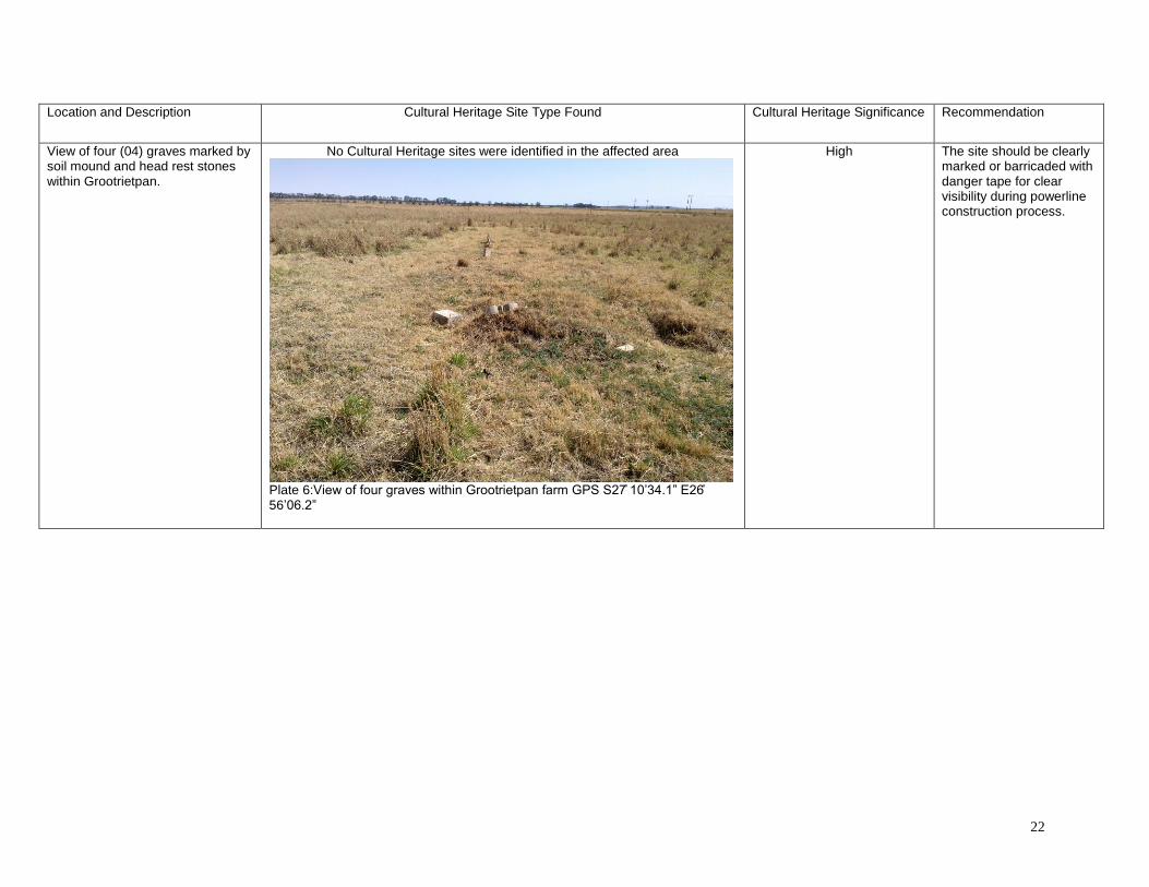
View of four (04) graves marked by soil mound and head rest stones within Grootrietpan.
No Cultural Heritage sites were identified in the affected area
Plate 6:View of four graves within Grootrietpan farm GPS S27̊ 10’34.1” E26̊ 56’06.2”
High The site should be clearly marked or barricaded with danger tape for clear visibility during powerline construction process.

23
Location and Description Cultural Heritage Site Type Found Cultural Heritage Significance Recommendation
View of the proposed area where the proposed power line transverse along road R 76. The surrounding area is dominated by cultivated or disturbed farmland.
No Cultural Heritage sites were identified in the affected area
Plate 7: Plate 6:View of the area where the proposed powerline transverses.
None Place site under heritage monitoring covering the period of construction.

24
Location and Description Cultural Heritage Site Type Found Cultural Heritage Significance Recommendation
The proposed Vierfontein Substation will be constructed in close proximity to the existing substation. The area is located in close proximity to residential area
No Cultural Heritage sites were identified in the affected area
Plate 8: View of Vierfontein Rural Substation GPS S27̊ 05’34.7” E26̊ 46’31.0”
None Place site under heritage monitoring covering the period of construction.

25
Location and Description Cultural Heritage Site Type Found Cultural Heritage Significance Recommendation
View of the proposed area for Marseilles 132kv Switching Station at GPS S27̊ 05’34.7” E26̊ 46’31.0”
No Cultural Heritage sites were identified in the affected area
Plate 8: General view of the area
None Place site under heritage monitoring covering the period of construction.

26
8. A Brief background to the greater study area
Stone Age (Esa, Msa and Lsa) and the Iron Age Sections of Free State Province is marked by outstretch of plains, rocky outcrops, grassland
and Thornveld with strong trees growth along major rivers. Most of these sites preferably are
around springs and fountains that are surrounded by evidence of Stone Age occupations.
Evidence of Stone Age within the study area dates back to 500 000 years ago, this time period
is associated with the earliest Homo predecessors who lived near water source. These sites are
represented by caches of stone tools manufactured from dolerites with Sangoan feature has
been found.
These tools were simple meant to chop and butcher meat, de- skin animal and probably to
smash bones to obtain marrow. The presence of cut marks from animal fossil bones dating to
this period has led to the conclusion by researchers that human ancestors were scavengers and
not hunters (Esteyhuysen, 2007). They may have preyed on a drowned or crippled animals or
shared a kill by another predator, which explains why at some ESA sites occur high bone
proportions of large, dangerous game (Wadley, 2007).
The industries were later replaced by the Acheulian stone tool Industry which is attested to in
diverse environments and over wide geographical areas. The Industry is characterized by large
cutting tools mostly dominated by hand axes and cleavers. Bifaces emerged and have been
reported from a wide range of areas in South Africa. These stone tools products were
astonishingly similar across the geographical and chronological distribution of the Acheulian
techno-complex: large flakes that were suitable in size and morphology for the production of
hand axes and cleavers perfectly suited to the available raw materials (Sharon, 2009). Evidence
presented from Sterkfontein cave shows that the first tool making hominids belong to either an
early species of the Homo or an immediate ancestor which is yet to be discovered here in South
Africa (Esteyhuysen, 2007). Both the Oldwan and Acheulian industries are well represented in
the archaeology of the North West, Free State, Northern Cape and Gauteng Province in the
Cradle of Humankind from sites (Strekfontein and Kromdraai).
These discoveries have made considerable contribution to the body of scientific knowledge in
the subject of tool manufacturing process in association with human evolutions. The Middle
Stone Age dates back to about 250 000 ago ending at around 25 000 years ago. In general

27
Middle Stone Age tools are smaller than those of the Early Stone Age period. They are
characterized by smaller hand axes, cleavers, and flake and blade industries. The period is
marked by the emergence of modern humans through the change in technology, behavior,
physical appearance, art, and symbolism. Various stone artifact industries occur during this time
period, although less is known about the time prior to 120 000 years ago, extensive systemic
archaeological research is being conducted on sites across southern Africa dating within the last
120 000 years (Thompson & Marean, 2008). Surface scatters of these flake and blade
industries occur widespread across southern Africa although rarely with any associated
botanical and faunal remains. It is also common for these stone artifacts to be found between
the surface and approximately 50-80cm below ground. Fossil bone may be associated with
MSA occurrences. These stone artifacts, like the Earlier Stone Age hand axes are usually
observed in secondary context with no other associated archaeological material.
An early South African Middle Stone Age stone artifact industry referred to as the Mangosian
had a very wide distribution stretching across Limpopo, the eastern Orange Free State, around
Cape Point and Natal (Malan 1949). This stone artifact industry, according to the period, may
have represented the final development that the prepared core technique of the Middle Stone
Age reached prior to its replacement by the microlithic techniques of the Later Stone Age. Malan
(1949) also made mention that there are variations of Middle Stone Age assemblages
throughout South Africa (Binnerman et al, 2011).
A variety of MSA tools includes blades, flakes, scraper and pointed tools that may have been
hafted onto shafts or handles and used as pear heads. Residue analyses on some of the stone
tools indicate that these tools were certainly used as spear heads (Widely, 2007). The presence
of spear heads on some of the MSA assemblages is an indication that these group of people
were hunters who targeted middle sized game such as hartebeest, wildebeest and zebra
(Wadley, 2007), some assemblages show the presence of bone tools such as bone points.
The last phase of stone tool industry is associated the late stone age. The Karoo landscape is
exceptionally rich in the distribution of this phase and is characterized by wide distribution of
engravings. The greatest concentrations of engravings occur on the basement rocks and the
intrusive Karoo dolerites, but sites are also found on rock types including dolomite, granite,
gneiss, and in a few cases on sandstone (Morris, 1988). Most of these paintings depict a wide
variety of the fauna of the artistic renderings of animal such as giraffes and other large grazers

28
and mixed feeders such as zebra, wildebeest, hartebeest, eland and buffalo (Parkinton et al.
2008) Late Stone age period is associated with the use of micro- lithic stone tools. On farm
fourteen stream Rossouw (2008) recorded a rock art site with over 80 different rock engravings
in close proximity to the Vaal River bank. Since there are no caves or rock shelters in the study
area no LSA sites of significance were recorded and no isolated finds or occurrence were
recorded. The above also applies to the early and Middle Iron Age. The study area is well
represented during the historical era associated with the arrival of the white communities.
HISTORICAL / COLONIAL PERIOD
Historical archaeology refers to the last 500 years when European settlers and colonialism
entered into southern Africa. Movement into the interior was closely linked with the change from
farming to stock farming. The movement of Boer into the interior got underway when Wilhelm
Adrien van der Stel began to issue free grazing permits in 1703. The exoduses went hand in
hand with hunting expeditions into the interior which not only provided the farmers with meat,
but also enable them to learn more about the resources of the hinterland. British government
made its laws which undermine the freedom of the Boers. The mounting conflict between
African and white stock farmers played the dominant part. This led to the general dissatisfaction
and a feeling of insecurity among the Afrikaner. The frontier wars of 1834/35 caused the frontier
farmers to suffer heavy losses. To aggravate matters, land prices rose sharply during the 1820
and 1830 and drought was a serious problem. These conditions threatened the pastoral
lifestyle. There was no land for the younger generations. They opted to migration in search of
land and grazing in the interior.
During the great trek into the interior they were already acquainted with conditions of the interior
and with the main trek routes. They got available information from travelers, hunters and
missionaries.
The 18th century’s period is marked by the presence of white, where land was taken from
African chiefs and redistributed to the Boers; this was followed by demarcation of portions of
land into farms. The first white farms were established along the rivers and tributaries, close to
springs. Many of these farms have been in the ownership of families for generations. As a
result, they possess a large corpus of information with regarding to the area and its history. A
significant number of battles and skirmishes took place in the region (Van Schalkwyk, 2011).

29
9. ASSESMENT OF SITES AND FINDS
This section contains the results of the heritage site/find assessment. The phase 1 heritage
scoping assessment program as required in terms of the section 38 of the National Heritage
Resource Act (Act 25 of 1999) done for the proposed Eskom project.
There are no primary or secondary effects at all that are important to scientist or the general
public.
Heritage Significance: No significance
Impact: Negative
Impact Significance: High Certainty: Probable
Duration: Permanent
Mitigation: A
9.1. Archaeological
No archaeological materials were found in the study area.
9.2. Historical
Structures older than 60 years where noted near Senwesco Substation however these
structures are located outside the proposed development foot print.
9.3. Graves Two grave sites with five graves where noted and provenience geo-referenced.
10. THE SIGNIFICANCE OF GRAVES AND BURIAL SITES
Graves and burial grounds are considered to be very sensitive (high cultural significance). Burial
grounds and graves as stipulated by the National Heritage Resources Act 25 of 1999
(Act 25 of 1999)
Section 36 (3) No person may, without a permit issued by SAHRA or a provincial heritage
resources authority:

30
(i) destroy, damage, alter, exhume, remove from its original position or otherwise disturb
any grave or burial ground older than 60 years which is situated outside a formal cemetery
administered by a local authority; or
(ii) bring onto or use at a burial ground or grave any excavation equipment, or any
equipment which assists in detection or recovery of metals.
Subsection 36 (6) Subject to the provision of any person who in the course of development or
any other activity discover the location of a grave, the existence of which was previously
unknown, must immediately cease such activity and report the discovery to the responsible
heritage resource authority which must, in co-operation with the South African Police service
and in accordance with regulation of the responsible heritage resource authority-
(I) carry out an investigation for the purpose of obtaining information on whether or not such
grave is protected in terms of this act or is of significance to any community; and
if such grave is protected or is of significance, assist any person who or community
which is a direct descendant to make arrangements for the exhumation and re-interment
of the contents of such grave or, in the absence of such person or community, make any
such arrangement as it deems fit.
11. RECOMMENDATIONS
Grave and Graveyards can be mitigated by one of the following strategies, Namely:
Graveyards can be considered as a ‘NO GO’ area and be conserved insitu
underneath or in close proximity of power line/s, the area could be fenced or a
danger tape could be placed around the entire site for clear visibility to mitigate
future damage during construction period.
In case where graves are to be exhumed and relocated. The exhumation process
is regulated by various legislations, regulations and administrative procedures.
This task is undertaken by Forensic archaeologist and reputed undertakers who
are acquainted with all administrative procedures and relevant legislation that
have to be adhered to whenever human remains are exhumed and relocated.
This process also include social facilitations process with 60 days statutory notice
period for grave older than sixty years. Permission of exhumations and relocation

31
have to be obtained from the decedents of the deceased, the National
Department of Health, the Provincial Department of Health, The Premier of the
Province and the Local Police. This process is time consuming and very costly
The identified burial grounds are located outside the proposed development foot
print and we strongly recommend that the proposed powerline route not to be
shifted to avoid the identified graves.
All construction activities including clearing of access route should be designed
not to disturb the identified burial grounds.
Site monitoring process is strongly recommended during powerline construction
process.
12. STATEMENT OF OVERALL IMPACTS From a cultural heritage point of view, any development that alters the ground surface status
quo will potentially destroy any archaeological resources in its direct path, and the impact will be
permanent in nature, extent and duration. Archaeological resources are fixed in space. Any
activities that threatens to alter the status quo is, therefore an immediate and direct threat to the
heritage resources (Bickford and Sullivan, 1977) However, since there were no archaeological
or cultural heritage sites that was identified on the proposed sites the overall impact of the
proposed Alternative is considered to be low.
Generally speaking, the proposed Eskom Strengthening project will have minimal impact upon
any cultural heritage resources given the fact that the survey did not encounter any such sites
with any significance threshold.
13. OVERALL RECOMMENDATIONS
No further predevelopment study or mitigation is necessary for the archaeological and
cultural heritage resources with regards to the proposed Eskom Strengthening project.
However, there is always a probability of discovering archaeological sites during sub-surface

32
earth moving activities such as digging the foundations or any other trenches. This study
recommends that a heritage-monitoring plan (as part of the EMP) be put in place during
construction period.
Furthermore, the construction team should be informed about the value of the cultural
heritage resources in general so as to ensure that they do not damage or destroy the
chance archaeological sites they may encounter during construction.
14. CONCLUDING REMARKS From a heritage perspective, in the absence of any known heritage resources and taking into
consideration the socio-economic and other values of the proposed development, there are no
barriers to the proposed development. The cultural landscape affected by the Viljoenskroon
Vierfontein Electrification,Refurbishment and Strengthening does not have significance
threshold to call for a total protection of the landscape. Nonetheless, detailed monitoring
procedures should be scheduled into the project EMP in order to adequately respond to chance
finds that may be found accidentally during the Construction phase. The proposed project may
proceed as planned subject to a heritage monitoring programme. With the constraints herein
discussed and appropriate monitoring measures adopted, there are no objections to the
proposed development project and we recommend to the heritage authorities to approve the
project accordingly.

33
15. REFERENCE
Acocks, J.P.H. 1975. Veld Types of South Africa. Memoirs of the Botanical Survey of South
Africa, No.40. Pretoria: Botanical Research Institute.
Deacon, J. 1997. Report: Workshop on Standards for the Assessment of Significance and
Research Priorities for Contract Archaeology. South African Association of Archaeology. No.
49,
Esterhuysen, A., 2007. The Earlier Stone Age. In Bonner, P., Esterhuysen, A.Jenkins, T. (eds.):
A Search for Origins: Science, History and South Africa'sn(Cradle of Humankind',
Johannesburg: Wits University Press. Pg 110 -121.
Holm, S.E. 1966. Bibliography of South African Pre- and Protohistoric archaeology. Pretoria:
J.L. van Schaik
Huffman, T. N., 2007. The Early Iron Age at Broederstroom and around the 'Cradle of
humankind'. In Bonner, P., Esterhuysen, A., Jenkins, T. (eds.): A Search for Origins: Science,
History and South Africa's (Cradle of Humankind' Johannesburg: Wits University Press. Pg 148
-161.
Seliane,M. 2009. Cultural Heritage Impact Assessment of the proposed WRDM Multi Purpose
Community Centre at portion 26 of the farm Kromdraai 520JQ, unpublished report.
Mason, R.J. 1962. Prehistory of the Transvaal. Johannesburg: Witwatersrand University Press.
Maggs,T. 1984. The Iron Age south of the Zambezi, in Klein, R. G 1984. South African
Prehistory and Paleoenvironments. A.A.Balkema/Rotterdam
Maggs. T. 1986. The early History of the Black people in southern Africa, in Cameroon. T. &
S.B. Spies. 1986. An illustrated history of south Africa, Jonathan Ball Publisher, Johannesburg.
Mitchell, P. 2002. The archaeology of South Africa. Cambridge: Cambridge University Press.
Mitchell, P. & G. Whitelaw. 2005. The Archaeology of southernmost Africa from c.2000 BP to
the Early 1800s: A review of Recent Research: The journal of African History, Vol 46, No2, pp
209-241.

34
Pearce, D., 2007. Rock Engraving in the Magaliesberg Valley. In Bonner, P.,Esterhuysen, A.,
Jenkins, T. (eds.): A Search for Origins: Science, History and South Africa's (Cradle of
Humankind'. Johannesburg: Wits University Press. Pg136 - 139.
Philipson, D.W. 1976. The Early Iron Age in eastern and southern Africa critical re appraisal.
Azania 11.1-23
Philipson, D.W. 1977. The later Prehistory of Eastern and Southern Africa. Heinemann
Publication, London.
Philipson, D.W. 1993. African archaeology, Cambridge University Press
Philipson, D.W. 2005. African archaeology, Cambridge: 3rd edition, Cambridge University
Press
SAHRA, 2005. Minimum Standards for the Archaeological and the Palaeontological
Components of Impact Assessment Reports, Draft version 1.4.
Tobias. P.V 1985. Hominid evolution- past present and future, New York
Tobias. P.V. 1986. The last million years in southern Africa. In Cameroon. T. & S.B. Spies.
1986. An illustrated history of South Africa, Jonathan Ball Publisher, Johannesburg.
Tobias. P.V. 1986. The dawn of the Human family in Africa. In Cameroon. T. & S.B. Spies.
1986. An illustrated history of South Africa, Jonathan Ball Publisher, Johannesburg
Van Schalkwyk, J. A. 2006. Investigation of archaeological features in site A of the proposed
Pumped Storage Power Scheme, Lydenburg district, Mpumalanga. Unpublished report
2006KH78. Pretoria: National Cultural history museum.
Van Warmelo, N. J. 1935. Preliminary survey of the Bantu Tribes of South Africa. Ethnological
Publications No. 5. Pretoria: Government Printer.
Wadley. L., 2007. The Middle Stone Age and Later Stone Age. In Bonner, P.,Esterhuysen, A.,
Jenkins, T. (eds.): A Search for Origins: Science, History and South Africa's 'Cradle of
Humankind'. Johannesburg: Wits University Press. Pg122 -135.Strategic

Appendix D2 Terrestrial Ecology Report

Terrestrial Ecology Study Report for the Proposed
Upgrade to the 400 KV Transmission Powerlines
at Viljoenskroon and Vierfontein in the northern
Free State.
Submitted to:
Eskom Distribution NWR
Attention: Mr Earl Daniels Eskom Distribution: Free State Operating Unit Land Development and Environmental Management [email protected]
Contact person:
Mr Doug McCulloch
T: +27 079 693 6326
M:
Submission date and time:
28 February 2017 COB

Terrestrial Ecology Study Report for the Proposed Upgrade to the 132 KV Transmission Powerlines at Viljoenskroon and Vierfontein in the northern Free State
i
TABLE OF CONTENTS
1. INTRODUCTION 4
1.1 Background .................................................................................................................................4
1.2 Scope of work ..............................................................................................................................4
1.3 Assumptions and limitations .........................................................................................................5
2. APPROACH AND METHODOLOGY 5
2.1 Terrestrial Ecological Assessment ...............................................................................................5
3. SITE CHARACTERISTICS 6
4. SOILS 7
5. RESULTS: TERRESTRIAL COMPONENT 9
5.1 Benchmark Vegetation Types ......................................................................................................9
5.2 Vegetation Assessment ............................................................................................................. 10
4.2.1 Primary Grassland ...................................................................................................................... 12
4.2.2 Formal Development ................................................................................................................... 14
4.2.3 Secondary Grassland ................................................................................................................. 15
4.2.4 Wetlands .................................................................................................................................... 16
4.2.5 Commercial Crop Cultivation ....................................................................................................... 18
5.3 Ecological Sensitivity ................................................................................................................. 19
5.4 Degree of Historic Disturbance .................................................................................................. 20
5.5 Rare / Red Data Species ........................................................................................................... 21
5.6 Current Biodiversity Value of the Site ......................................................................................... 21
5.7 Conservation Priority ................................................................................................................. 22
5.8 Biodiversity Impacts of Proposed Development at the Local Level.............................................. 24
5.9 Importance of the Site for Biodiversity at a Regional or Landscape Level. .................................. 25
5.10 Potential for the Site to be Re-colonised by Rare Species and Communities .............................. 25
5.11 Impact of the Proposed Development on Ecological Processes .................................................. 25
6. CONCLUDING REMARKS 26
7. REFERENCES 27
8. APPENDIX A: PLANT SPECIES LIST 28

Terrestrial Ecology Study Report for the Proposed Upgrade to the 132 KV Transmission Powerlines at Viljoenskroon and Vierfontein in the northern Free State
ii
ALL RIGHTS RESERVED
The findings, results, observations, conclusions and recommendations given in this report are based on the
author’s best scientific and professional knowledge as well as available information. The report is based on survey
and assessment techniques which are limited by time and budgetary constraints relevant to the type and level of
investigation undertaken. Aurecon reserves the right to modify aspects of the report including the
recommendations if and when new information may become available from on-going research or further work in
this field, or pertaining to this investigation.
Although Aurecon exercises due care and diligence in rendering services and preparing documents, they accept
no liability, and the client, by receiving this document, indemnifies Aurecon against all actions, claims, demands,
losses, liabilities, costs, damages and expenses arising from or in connection with services rendered, directly or
indirectly by Aurecon and by the use of the information contained in this document.
This report must not be altered or added to without the prior written consent of the author. This also refers to
electronic copies of this report which are supplied for the purposes of inclusion as part of other reports, including
main reports. Similarly, any recommendations, statements or conclusions drawn from or based on this report must
make reference to this report. If these form part of a main report relating to this investigation or report, this report
must be included in its entirety as an appendix or separate section to the main report.

Terrestrial Ecology Study Report for the Proposed Upgrade to the 132 KV Transmission Powerlines at Viljoenskroon and Vierfontein in the northern Free State
iii
EXECUTIVE SUMMARY
Aurecon was appointed to assess the state of the terrestrial ecosystems along the proposed upgraded
132kV transmission line route near Viljoenskroon in northern Free State. In order to negate or mitigate
the ecological impacts associated with the development it is necessary to determine the nature and
ecological value of the various vegetation types within the proposed route.
Five disturbance units were identified. A summary of the historic disturbance, ecological sensitivity and
conservation priority values for each disturbance unit is given in the table below.
Disturbance Unit Disturbance Ecological Sensitivity Biodiversity Value Conservation
Priority
Wetlands Moderately High Moderate Moderately High High
Development High Low Low Low
Crop Cultivation High Low Moderately Low Low
Primary Grassland Moderately High Moderately High Moderate High
Secondary Grassland High Low Moderately Low Low
The following conclusions were drawn from the above study:
� The main ecological concerns relate to the proximity of the powerline to areas that support
populations of large birds that may be of conservation importance, such as flamingos, cranes,
bustards and waterbirds. Mitigation measures are important, and described in the text;
� The conservation priority rests with the wetlands and primary grasslands.
� The biodiversity value across the site is generally low;
� The wetlands are moderately sensitive, but from a geophysical perspective rather than a
biodiversity perspective because they occur within a transformed landscape;
� The physical impact of the development is anticipated to be spatially and temporally limited,
particularly if superimposed on existing disturbances;
� The potential for recolonization is relatively high, but dependent on an unlikely change in
landuse;
� The development is unlikely to alter the prevailing ecological processes operating on the site;
� While the ecological risks associated with the development are unlikely to be severe enough to
exclude the route, the proximity of the development to wetland areas that support populations
of large birds is cause for concern. The route proposed may therefore not be the best available
alternative.

Terrestrial Ecology Study Report for the Proposed Upgrade to the 132 KV Transmission Powerlines at Viljoenskroon and Vierfontein in the northern Free State
4
1. Introduction
1.1 Background
Aurecon was appointed to assess the state of the terrestrial ecosystems along the proposed upgraded
132kV transmission line route near Viljoenskroon in the northern Free State. In order to negate or
mitigate the ecological impacts associated with the construction and maintenance of the transmission
line, it is necessary to determine the nature and ecological value of the various vegetation types within
the proposed route.
The development is linear, and the anticipated disturbances associated with it are spatially and
temporally confined. The guiding principle of biodiversity conservation relating to development is one
of achieving no-nett loss of biodiversity and ecosystem processes. Achieving this principle requires the
adoption of a positive planning approach towards biodiversity that ensures:
• The early identification and evaluation of potential impacts that may constitute significant threats to
local biodiversity;
• The early identification of conceptual alternatives which may mitigate against these impacts; and
• Appropriate mitigation recommendations to offset, minimise or avoid these impacts.
In adhering to the above principles, the objectives of the terrestrial component of the study are:
• To identify the vegetation type/s likely to be impacted by the development;
• To assess the degree of disturbance already experienced by each vegetation type, or the
ecological deviation of the vegetation from a perceived benchmark.
• To assess the sensitivity of the vegetation type to further disturbance;
• To determine the biodiversity value represented by each vegetation type;
• To determine the conservation value of each vegetation type;
• To determine the nature of the potential impacts of the development on the various vegetation
types, both at the local and the landscape level;
• To describe the implications of these impacts;
• To suggest realistic mitigation measures to minimise or avoid these impacts; and
• To provide information that will determine the most ecologically responsible and biodiversity-
sensitive route for the proposed development.
The potential pitfalls to development will be identified, and possible alternatives discussed.
1.2 Scope of work
The scope of work for the project includes:
• The mapping of the various vegetation types within the development corridor;
• Evaluation and description of vegetation types;
• Ecological analysis of each vegetation type;
• Compilation of relevant environmental management recommendations.

Terrestrial Ecology Study Report for the Proposed Upgrade to the 132 KV Transmission Powerlines at Viljoenskroon and Vierfontein in the northern Free State
5
1.3 Assumptions and limitations
The following considerations are relevant:
• The project boundary was extrapolated based on information provided by the client;
• The study area was considered to be a corridor of 500m on either side of the proposed route;
• An alternative, and possibly more accurate term, for the vegetation types mapped is disturbance
units. This encompasses areas and land-uses that have limited vegetation cover, allowing their
inclusion in the analysis;
• The vegetation units were sampled with the main priority being to identify the vegetation types, the
level of disturbance they have sustained and their conservation value. This was done by assessing
their species composition, the presence of key species and the structure of the vegetation within
each type. It was assumed that the closer the vegetation type to the benchmark, i.e. the less
disturbance a vegetation type has sustained or the greater its recovery from historic disturbance,
the higher its biodiversity value. Hence the biodiversity value of a particular vegetation type was
deemed to be directly proportional to its ecological sensitivity and conservation priority.
• Data on specific Red Data species was not collected as such, with the rationale being the higher
the level of disturbance sustained, the lower the chance of reliably finding rare and endangered
species there. Conversely, vegetation types with a high ecological sensitivity and conservation
priority are more likely to provide suitable long-term habitat for Red Data species.
• The conclusions and recommendations provided in this report apply only to the stipulated
development. Any alternative land-use is likely to require specific management recommendations
according to the anticipated impacts.
• Ecosystems vary both temporally and spatially. Once-off surveys such as this are therefore likely
to miss certain ecological information, thus limiting accuracy, detail and confidence;
• The anticipated impacts of the proposed development are based on generic issues that have arisen
with similar developments.
• The ecological assessment tools are qualitative, and caution and experience is required in
interpreting the numbers produced;
• The terrestrial fieldwork was carried out in October 2016, and consisted of two site visits within
several weeks of one another. This may be at a time of year when certain plants may not be
flowering, potentially undermining the location and identification of single plants, and providing
further rationale for the adoption of a collective approach to evaluating the respective vegetation
types;
2. Approach and methodology
2.1 Terrestrial Ecological Assessment
The following approach was adopted:
• The different vegetation types within the development corridor were mapped at a scale of 1:5 000
using aerial imagery supplied by the national surveyor-general’s office. The vegetation units could
also be defined as “disturbance units” within a disturbed landscape.
• Detailed field sampling was carried out in order to ground truth the mapping of the vegetation types.
This took the form a modified Braun-Blanquet method, where several releves spread across a
representative sample of the vegetation type polygons were sampled according to species

Terrestrial Ecology Study Report for the Proposed Upgrade to the 132 KV Transmission Powerlines at Viljoenskroon and Vierfontein in the northern Free State
6
composition and species abundance. Tall, woody vegetation communities were sampled using a
transect method instead of releves;
• The vegetation types, or disturbance units, within the site were classified and described according
to the dominant plant species identified. Species dominance was established by recording:
o The number of species identified;
o Their respective abundances; and
o Their estimated percentage cover within a particular polygon;
• Selected representative polygons were sampled in detail, with each remaining polygon within the
corridor verified to ensure the appropriate disturbance unit classification;
• The observed vegetation types were compared to those corresponding to the area in The
Vegetation of South Africa, Lesotho and Swaziland (Mucina and Rutherford, 2006), which
represented the perceived benchmark, or natural vegetation communities. By estimating the
degree of removal from this benchmark, inferences were drawn as to the degree of historic
disturbance sustained by the vegetation within the study site;
• A qualitative estimate of the ecological sensitivity of the various vegetation types was derived from
the above information, in conjunction with information on the perceived ecological resilience of the
identified vegetation types. “Ecological sensitivity” refers to the system’s ability to recover to its
prior vegetation state following the occurrence of physical disturbance, such as that represented
by the construction of a powerline.
• The conservation status of each vegetation types was estimated based on up to date available
governmental resources (SANBI; provincial regulatory authorities).
3. Site Characteristics
The route to be evaluated extends approximately 20km north-west from Viljoenskroon, in the northern
Free State (refer to Figure 1). The route traverses commercial maize farming land, which forms the
dominant landuse in the area. The topography is gently undulating, characterised by long, gentle slopes
and broad, shallow bottomlands. The region is underlain by sandstone, with localised dolerite extrusions
forming the higher lying areas. This geology has given rise to catchment soils that are deep, well-
drained, luvic sandy loams. The lower-lying areas are dominated by heavy, dark mellanic soils.

Terrestrial Ecology Study Report for the Proposed Upgrade to the 132 KV Transmission Powerlines at Viljoenskroon and Vierfontein in the northern Free State
7
Figure 1: Locality of the Viljoenskroon Transmission Line Route
4. Soils
An examination of the soils traversed by the powerline was undertaken, albeit at a cursory level. Soils
were classified according to the Soil Working Group (1991). Due to the uniform underlying geology, the
dominant soils forms are broadly related. The main differences are related to topography, organic
matter accumulation and moisture content.
The soils are generally deep (>1.5m), sandy loams that are well-drained and luvic. It should be
recognised that the classification of soil is related to the depth that is excavated to. An auger sample
point may be 1.3m deep, and facilitate the classification of a certain soil type. However, that same
sample point excavated to 2m may uncover an underlying horizon that may alter the classification.
Hence, a soil profile is only definitively classified once an impenetrable horizon is reached.
The general pattern is that the high-lying areas are occupied by Hutton soils (orthic A/ red apedal B/
unspecified). The sandy nature if the soil facilitates the oxidation of iron compounds in the soil to form
the compound haematite. This coats the surfaces of the soil peds, imparting a deep red colour to the
soil. The leaching of clay, organic matter and mineral particles into the lower parts of the profile results
in the formation of a dense, clay-rich luvic layer that still qualifies as a red apedal horizon.

Terrestrial Ecology Study Report for the Proposed Upgrade to the 132 KV Transmission Powerlines at Viljoenskroon and Vierfontein in the northern Free State
8
In situations lower down in the topography the soil tends to carry more moisture for longer periods,
without actually becoming a wetland. The increased moisture content results increased plant growth,
with a consequent increase in organic matter the content in the soil. The resulting moist, acid conditions
promote the oxidation of iron oxides to form goethite, rather than haematite. Goethite is a pale yellow
or brown colour, and this sesquioxide coats the soil peds to produce a yellow-brown apedal horizon.
The dominant soil forms within the study area with this definitive horizon are the Avalon (orthic A/ yellow-
brown apedal/ soft plintic B) and Clovelly (orthic A/ yellow-brown apedal B/ unspecified).
The mid-slope areas often have sufficient moisture and organic matter to form goethite, which
penetrates the coarser material in the part of the profile to create a yellow/ brown apedal B horizon. The
denser, clay-rich material further down the profile is more difficult to penetrate, and haematite remains
the dominant sesquioxide, maintaining the red apedal B horizon. The Griffin soil form (orthic A/ yellow-
brown apedal B/ red apedal B) tends to be located on longer mid-slopes in this landscape.
The sandy nature of the soils facilitates rainfall infiltration, and the subsequent leaching of colloidal
material and minerals down to the base of the profile results in a dense layer of material at the base of
the profile. This acts as an aquitard, with subsurface water seeping laterally along the upper layer of
the less permeable horizon. The more mobile minerals are leached laterally and deposited in the flatter
parts of the landscape. These areas also tend to be settling points for subsurface water. Water
movement is vertical as well as gradually lateral. This establishes a fluctuating water table. Iron and
manganese are reduced when waterlogged, and oxidised when dry, producing orange, red and maroon
colours. Colloidal material also becomes gleyed, imparting grey colours to the matrix. This is a soft
plinthic horizon, and its significance is that it forms the dominant aquitard across the landscape, and
hence governs the subsurface movement of water and subsequent formation of wetlands. The Avalon
is the dominant soil form in the flatter, lower parts of the landscape (Figure 2).
Figure 2: Soil profiles: Avalon (orthic A/ yellow-brown apedal/ soft plinthite (left) and Bonheim
(melanic A/ pedocutanic B/ unspecified) (right)

Terrestrial Ecology Study Report for the Proposed Upgrade to the 132 KV Transmission Powerlines at Viljoenskroon and Vierfontein in the northern Free State
9
Certain valley bottoms are characterised by dark, strongly structured, clay-rich Bonheim soils (melanic
A/ pedocutanic B/ unspecified) (Figure 2). The dark colours are indicative of high concentrations of
magnesium oxides. The parent material is either base-rich rock, or as in this case, alluvial deposits from
base-rich material transported from elsewhere. Melanic soils usually have a high clay content, and the
dominant clays are vermiculite, micaceous or kaolinite, rather than the smectitic clays associated with
the similar vertic soils. The formation of the pedocutanic B-horizon indicates the formation of cutans on
the subsoil peds as a result of illuviation from further up the profile. These soils tend to be highly
erodible, although they are stable provided the topsoil is intact. Confined surface flow, however, rapidly
leads to the formation of erosional features.
The agricultural potential of these soils is high, as is shown by the intensive nature of the current
landuse. However, the topography largely negates the erosion risk. Construction of pylons on the
Bonheim soils on slopes should be avoided. On flat areas, provided the disturbed footprint is
revegetated, the risk of environmental degradation should be small. The construction of pylons on the
apedal soils outside wetlands is not expected to pose a risk to the environment. Water movement is
diffuse, subsurface and gradual, and any introduced, localised concrete structure is unlikely to
constitute a major impediment. It is likely that water will seep around the plinth. The plinth may, in fact,
essentially form an artificial extension of the aquitard.
5. Results: Terrestrial Component
5.1 Benchmark Vegetation Types
According to Mucina and Rutherford (2006), the original vegetation covering the study area was Vaal-
Vet Sandy Grassland (Gh 10), part of the Dry Highveld Grassland complex of vegetation types (Figure
3). The vegetation types consists of short, low-tussock grasslands of which Themeda triandra is an
important constituent. The landscape is an undulating plain with irregular hills. There is a prominent
karroid shrub element. The key indicator species are T.triandra, Aristida congesta, Elionurus muticus,
Eragrostis chloromelas, E.plana, Brachiaria serrata, Tragus berteronianus and Heteropogon contortus.
This vegetation type is considered to be Endangered and hardly protected. The conservation target is
24%, and scarcely 0.3% of the area under primary vegetation is formally protected. Approximately 63%
has been transformed by crop cultivation, and the remaining intact areas are under substantial grazing
pressure from cattle and sheep.
The dry Highveld grasslands occur in temperate areas with a marked seasonal rainfall regime, and a
low mean annual precipitation (MAP) of 400 – 550mm. The main ecological driver is climate, with low
rainfall the main determinant (Cadman et al., 2013). The low rainfall influences the rate of leaching of
nutrients from the sandstone-derived soils, which in turn governs the palatability of the grass sward. A
higher nutrient status of the soil translates into more nutritious grazing, rendering these grasslands as
sweetveld, and bale to carry animal production for the entire year. Herbivory is hence also an important
ecological process. The low rainfall also translates into a lower rate of primary production and less
biomass accumulation. Fire, although also an important ecological process, are less frequent and of
lower intensity.

Terrestrial Ecology Study Report for the Proposed Upgrade to the 132 KV Transmission Powerlines at Viljoenskroon and Vierfontein in the northern Free State
10
These grasslands tend to be more resilient that mesic grasslands, provided their topsoil layer remains
intact. The plant species have adapted to withstanding frequent droughts and variable rainfall by
investing in viable seed production at the expense of vegetative production (Cadman et al., 2013).
Semi-arid grasslands are hence able to recover following a disturbance such as fire or grazing. It should
also be possible to restore them following a major disturbance such as ploughing, provided the soil
conditions are still natural. The removal or degradation of the soil is likely to result in the establishment
of an alternative stable state that differs substantially from the primary vegetation in structure and
species richness.
Figure 3: Original vegetation types for the area traversed by the powerline route.
5.2 Vegetation Assessment
The results of the vegetation survey are visually represented in Figure 4. The term ‘disturbance unit’
has been adopted as a synonym for vegetation type due to the extensive human disturbance sustained
within the project area. This allows the inclusion of distinct, although essentially unnatural, vegetation
communities such as those within urban environments. Five disturbance units were identified as shown
in Table 1. The dominant disturbance unit is cultivated land, covering 67% of the project area. The most
important vegetation types ecologically are:

Terrestrial Ecology Study Report for the Proposed Upgrade to the 132 KV Transmission Powerlines at Viljoenskroon and Vierfontein in the northern Free State
11
• The primary grassland blocks, although these are highly fragmented and severely affected by
edge effects. The study area contains approximately 90ha of the original vegetation type,
equating to 3.9% of the study area; and
• The wetlands. Approximately 11% of the study area, or 259ha, consists of wetland habitat.
Table 1: Summary of the Disturbance Units Identified Within the Study Area
Disturbance Units Area (ha)
Proportion
(%)
Wetlands 258.9 11.28
Primary Grassland 90.6 3.95
Secondary Grassland 193.1 8.41
Developed 207.7 9.05
Cultivated Lands 1545.4 67.32
Total 2295.7 100
The detailed plant species lists have been provided in Appendix 1.
Figure 4. The disturbance units associated with the site.

Terrestrial Ecology Study Report for the Proposed Upgrade to the 132 KV Transmission Powerlines at Viljoenskroon and Vierfontein in the northern Free State
12
4.2.1 Primary Grassland
Most of the primary grassland within the study area occurs within the Vierfontein section (Figure 5).
The main impacts sustained by the extant primary grasslands are associated with the transformation of
the adjacent blocks of land to cultivation and development. The resulting fragmentation of ever-smaller
blocks has the following consequences:
• The influence of edge effects is amplified as grassland blocks get smaller;
• The blocks become more isolated, resulting in a reduction in the transfer of genetic material
between areas;
• The key ecological processes of fire and grazing by smaller herbivores is disrupted.
Figure 5: Fragmented blocks of degraded primary grassland
Physical disturbances such as trampling and overgrazing have also manifested themselves. An
important means of diversifying agricultural output is to put cattle on maize stover following harvesting.
Once the maize production cycle begins again, cattle that have not been sold are allowed to graze the
wetland and grassland areas. This results in seasonally heavy grazing and trampling pressure. The
grasslands are also nutritious enough to provide forage throughout the year. This may encourage
farmers to carry stocking rates higher than those recommended.
The indications of healthy grasslands are (Cadman et al., 2013):
• High basal cover, which binds the soil and so prevents erosion.
• A high diversity of growth forms (e.g. soft-leaved herbaceous plants – or forbs, bulbs, etc in
addition to grasses).
• A high diversity of grass species, rather than dominance by any single species.
• Topsoil that is intact, rich in organic matter and uncompacted, with evidence of soil-turning
through the action of various animals.
• An even grass sward, rather than tussocked veld (an indicator of selective grazing).
• An absence of invasive alien plants or areas with heavy bush encroachment;
The primary grassland areas show evidence of degradation in the form of tussocking, compacted
topsoil, a poor diversity of grass species and lower diversity in growth forms than would be expected.
Terrestrial Ecology Study Report for the Proposed Upgrade to the 132 KV Transmission Powerlines at Viljoenskroon and Vierfontein in the northern Free State
13
Degree of Historic Disturbance
The identification of primary grassland within the site was largely dependent on the presence of several
key indicator species, namely Themeda triandra and Heteropogon contortus. These are part of the
“Decreaser” functional group of fire climax species, and their presence indicates stable, long-lived
vegetation cover. Due to their life-history strategies, they do not re-establish as quickly as pioneers and
Increaser species once they have been removed. The degree of historic physical disturbance to the
primary grassland areas is considered to be Moderately High. This is corroborated by the evidence of
heavy grazing pressure.
Ecological Sensitivity
Ecological sensitivity refers to the ecological resilience of an ecosystem, and as with most biological
systems, the relationships and processes governing resilience are non-linear and unpredictable.
Ecosystems experience disturbances and perturbations that reorganise their constituents. Depending
on their resilience, the systems are able to recover to their original state. If the disturbance or
perturbation is too great, then the system is pushed into an alternative stable state, or a vegetation
community that is better able to cope with the prevailing disturbance regime and the altered set of
environmental variables.
A resilient system, or one with low ecological sensitivity, is able to respond quickly to a disturbance,
and recover to its pre-disturbance state within a relatively short period of time. These systems are easy
to restore. Less resilient, sensitive, systems do not recover quickly once a certain disturbance threshold
has been reached. They transition to an alternative state and are difficult or impossible to restore, or
recovery takes the lifespan of several human generations.
Dry primary grasslands have evolved under a regime of low and variable seasonal rainfall, frequent
drought, and frequent grazing. The grazing regime is varied, occurring at a range of spatial and temporal
scales. The consequence of this is that the plants have developed life history strategies that allow them
to persist through drought (via serotiny) and recover from severe defoliation. The main strategy used is
the production of viable seed that is able to perpetuate the species once the parent plant has died. They
are hence able to recover from severe physical disturbance, provided the seed bank is maintained and
soil conditions are conducive to germination and recruitment. They are recognised as being relatively
resilient systems. However, should the magnitude, timing and frequency of the disturbance be severe
enough to remove or alter the soil conditions, then the system may be pushed into an alternative stable
state with little potential to restore the grassland. There is also uncertainty as to the success, length of
time and costs associated with restoring grassland from outside source areas. With these
considerations in mind it is concluded that the primary grassland patches within the site are considered
to have a Moderately High ecological sensitivity.
Biodiversity Value
Primary grasslands are noted as having a high alpha-diversity (Huntley, 1989). This refers to the
number of species within a localised area, or species richness, and was found to be approximately 81
species per 1000m2. By way of comparison, fynbos has approximately 65 species per 1000m2. Most
of the plant diversity is contained in the forb component, and there is a high degree of endemism among
grassland species (Cadman et al, 2014).
Evaluating the species richness of grasslands is heavily dependent on the flowering of these plants.
Not only does this aid identification, but it also highlights the presence of the more nondescript species.
There are three interacting variables driving forb flowering: rainfall, season of burning and time of year.

Terrestrial Ecology Study Report for the Proposed Upgrade to the 132 KV Transmission Powerlines at Viljoenskroon and Vierfontein in the northern Free State
14
Certain forbs flower during the spring but require a short sward in which to do so. In the absence of
herbivory or fire during late winter, they will not flower. The consequence of this variation is that, in order
to gain an accurate assessment of the species richness within a patch of primary grassland, one would
have to undertake regular surveys over several years. A reliable surrogate for this is to use plant and
physical indicators to judge the degree of disturbance that has occurred, and infer the likelihood of the
grassland maintaining its full forb component. Current management policy, connectivity within the
landscape and proximity to other grassland blocks are also important considerations in evaluating
whether the key grassland ecological processes are being maintained, and the habitat is able to support
species of conservation significance.
The site is considered important in providing suitable habitat for threatened grassland floral and faunal
species, particularly given the scale of the transformation that has occurred across the landscape.
Negating this, however, is the disturbance sustained by the habitat through fragmentation and
overgrazing. This has undoubtedly compromised the biodiversity value of the vegetation type, and the
corresponding biodiversity value is considered to be Moderate.
Conservation Priority
The vegetation type is deemed to be of High conservation importance due to:
• The severe fragmentation of primary grasslands that has occurred across the landscape;
• The threat status attached to Vaal-Vet Sandy Grassland, which reflects the extent of transformation
and lack of adequate protected areas;
• The scarcity of suitable blocks of primary grassland that could act as source areas for flora and
fauna to recolonise disturbed areas in the event of a change in landuse.
4.2.2 Formal Development
Approximately 9% of the project area is composed of urban development, with light industrial factories
being a prominent feature. Urban development is generally associated with the complete removal of
indigenous vegetation communities, and its subsequent replacement, primarily with hardened surfaces,
but to a lesser extent with indigenous and exotic lawns and garden plants.
Degree of Historic Disturbance
The nature of urban development implies a High level of historic disturbance.
Ecological Sensitivity
The plant communities associated with urban development are essentially artificial, and are therefore
considered to have a Low ecological sensitivity.
Biodiversity Value
The artificial and secondary plant communities have a Low biodiversity value.
Conservation Priority
Urban ecosystems, due to the level of sustained impact and their being ubiquitous across the
landscape, are of Low conservation value.

Terrestrial Ecology Study Report for the Proposed Upgrade to the 132 KV Transmission Powerlines at Viljoenskroon and Vierfontein in the northern Free State
15
4.2.3 Secondary Grassland
Secondary grassland refers to a grassland community that becomes established following a major
physical disturbance to the original vegetation. Within the context of the development, the disturbance
is mostly associated with the removal of the natural vegetation to make way for crops. The distribution
of the secondary grassland community within the project area is dynamic, with lands left fallow as part
of the crop rotation policy. This gives rise to short-lived plant communities of ruderal and pioneer
species. The dominant, and characteristic, species within secondary grassland are Digitaria eriantha,
Sporobolus pyrimidalis, Tagetes minutae, Bidens pilosa, Verbena bonariestris, Aristida congesta,
Setaria sphacelata, Sporobolus pyrimidalis, Eragrostis curvula, E.plana, Sporobolus africanus,
Imperata cylindrica and Hyparrhenia hirta. The forb component is markedly poorer in species richness
and is dominated by ruderal species. Figure 6 provides typical views of the secondary grassland on
the site.
Degree of Historic Disturbance
The level of historic disturbance sustained by secondary grassland is High, because it is an indicator
of the complete removal of the original, primary vegetation.
Ecological Sensitivity
The vegetation community is dominated by grass species of the Increaser I functional group. They are
vigorous, tufted pioneer species that are able to establish quickly from seed. Although they resprout
following fire, their life history strategy is aimed at exploiting disturbed areas and they are also common
constituents of savanna ecosystems. They typically occupy drier climatic areas, below 700mm/annum,
where rainfall is lower and notably more variable, and drought tolerance through dormant seed
production is needed to persist. These species hence put more resources into producing viable seeds.
The species are able to recover quickly following mature plant dieback associated with droughts, which
partly explains why they are better suited to colonising and dominating disturbed and bare areas than
the Decreaser suite of grasses and various types of forbs typical of the primary plant community.
Figure 6: Examples of secondary grassland within the site
These systems are by definition comprised of pioneer herbaceous plant communities, usually
evidenced by the high number of ruderal weed species recorded. Secondary grasslands are resilient

Terrestrial Ecology Study Report for the Proposed Upgrade to the 132 KV Transmission Powerlines at Viljoenskroon and Vierfontein in the northern Free State
16
systems, and re-establish quickly following disturbance. They are easily replicable, ubiquitous within
the modern South African landscape, and the time taken for the pre-disturbance vegetation ecological
state to be reached following a disturbance is short. They are therefore are considered to have a Low
ecological sensitivity.
Biodiversity Value
While most of the species that characterise secondary grasslands are localised components of the
primary grassland community, secondary grasslands contain few primary grassland components.
Within crop interval period typical grazing and fire-climax grass species such as Tristachya leucothrix,
Themeda triandra and Heteropogon contortus do not re-establish in the secondary community. Likewise
the forb component of the primary grassland community is mostly removed from the system once the
topsoil has been physically disturbed. The secondary plant community is notably depauperate, with the
forb component dominated by ruderal species and certain grassland pioneers. The biodiversity value,
when compared against primary grasslands, is considered to be low. Secondary grasslands do,
however, add ecological value to the landscape in that they reinstate the main grassland ecological
processes such as soil protection, nutrient cycling, fire support, and rainfall infiltration. Within this
landscape, they also provide refugia for fauna such as Yellow Mongoose, Cape Cobra and Ground
Squirrel. They therefore allow many faunal species to persist within a monospecific landscape defined
by severe periodic disturbance. They also provide the initial successionary stage for the eventual
restoration of the primary grassland community. In view of this they are considered to have a
Moderately Low biodiversity value.
Conservation Priority
Secondary grassland communities quickly recover to their original state following a severe disturbance.
It is fair to say that, given its ubiquitous and widespread distribution; the ease with which it may be
recreated; the dominance of ruderal and pioneer species and its comparatively limited species richness,
secondary grassland has a Low conservation priority.
4.2.4 Wetlands
Several large wetlands were identified within the project area, and these were treated as a separate
disturbance unit. The wetlands are relatively extensive unchannelled valley bottom systems
characterised by longitudinal and lateral subsurface seepage, and large pans fed by groundwater
discharge. The temporary wetland zone fringing the wetlands has mostly been incorporated into the
cultivated maize lands. The wetland vegetation consists mainly of seasonal and permanent saturation
zone plant species dominated by dense stands of Arundanella nepalensis, Andropogon
appendiculatus, Andropogon eucomis, Imperata cylindrica, Cyperus latifolius (refer to Figure 7), Typha
capensis and Schoenoplectus brachyceras. Additional species are Cyperus textillis, Leersia hexandra,
Juncus effusus, Phragmites australis and Juncus lomataphyllus.
Degree of Historic Disturbance
The degree of historic disturbance experienced by the wetland habitat is Moderate to Moderately High.
The main disturbances are road crossings, cultivation, infilling, and overgrazing.

Terrestrial Ecology Study Report for the Proposed Upgrade to the 132 KV Transmission Powerlines at Viljoenskroon and Vierfontein in the northern Free State
17
Figure 7: Typical permanent zone wetland habitat within the site (right); and temporary zone
hygrophilous grassland within a depression (left).
Ecological Sensitivity
Wetlands are dynamic environments because they are sites where comparatively large volumes of
water move through the soil, and hence they are inherently physically sensitive ecosystems. However,
a feature of permanently to seasonally wet habitats within this landscape is that they respond quickly
to rehabilitation efforts, and provided the soil remains within the system, they recover quickly to their
original vegetation communities following physical disturbance (Cowden et al, 2007). The hydrological
drivers are mostly still intact, and erosion is not severe within these systems. Therefore, within certain
rehabilitation parameters, the more saturated areas are considered to be resilient and have a Moderate
ecological sensitivity.
The lateral seepage zones, consisting of the seasonal/ temporary zone interface, forms the ecotone
between aquatic and terrestrial habitats. They contain constituents of both vegetation communities, and
hence are particularly important for local biodiversity. The primary grassland constituent that would form
the matrix in which these systems occur is of moderate ecological sensitivity, further substantiating the
conclusion of moderate ecological sensitivity.
Biodiversity Value
The biodiversity value of the seepage wetlands has been compromised by past disturbance, which has
resulted in reduced species richness. Balancing this are the following considerations:
• The wetlands provide aquatic habitat to the landscape, and hence improve the habitat
heterogeneity within a landscape spatially dominated by terrestrial ecosystems. The aquatic
fauna associated with these habitats increases local biodiversity;
• The wetlands support populations of unique aquatic species, such as Greater Flamingo;
• The wetlands could potentially support populations of aquatic species of conservation
significance.
These considerations support the conclusion that the biodiversity value of the wetlands within the site
is Moderately High.

Terrestrial Ecology Study Report for the Proposed Upgrade to the 132 KV Transmission Powerlines at Viljoenskroon and Vierfontein in the northern Free State
18
Conservation Priority
The conservation of the wetland habitat within the site is important, from both a water resources and
biodiversity perspective. The wetlands also assist with maintaining ecological connectivity within the
landscape. They are therefore considered to have a High conservation priority.
4.2.5 Commercial Crop Cultivation
Commercial maize cultivation represents the most important landuse within the route corridor (Figure
8). A feature of the maize lands is the low degree of biodiversity, with a handful of plant species recorded
including Chloris virgatea, Tagetes minutae and Eragrostis plana as well as several ruderal and alien
weed species.
Figure 8: Commercial croplands on clayey melanic soils (left) and sandy loams apedal soils
(right)
Degree of Historic Disturbance
The complete removal of indigenous vegetation associated with establishing maize lands constitutes a
High degree of physical disturbance.
Ecological Sensitivity
The ruderal and transient nature of the non-maize plant community ensures that this system returns
quickly to its current state following a disturbance such as harvesting. This disturbance unit therefore
has a Low level of ecological sensitivity.
Biodiversity Value
The croplands offer relatively little value with regards to biodiversity and species richness because their
original vegetation has been replaced essentially by a monospecific community. They may, however,
seasonally support bird species of conservation importance, such as Bald Ibis, Blue Crane and
bustards.
Conservation Priority
The croplands have a Low conservation priority.

Terrestrial Ecology Study Report for the Proposed Upgrade to the 132 KV Transmission Powerlines at Viljoenskroon and Vierfontein in the northern Free State
19
5.3 Ecological Sensitivity
The classes used to evaluate the various ecological concepts are given below.
Class Low
Moderately Low
Moderate
Moderately High
High
South African rangelands are dynamic, disturbance-driven ecosystems where the flora have had to
develop mechanisms to cope with stochastic environmental events such as fire, drought and herbivory.
In the dry Highveld grasslands of the South African hinterland the dominant ecological driver is arguably
the low rainfall. This governs the leaching patterns of nutrients from the soil, the consequent palatability
of the grass sward, and the accumulation of biomass that acts as a fuel load for fire. The plant
community is dominated by genotypes that invest resources in the production of viable seed to carry
the species through periods of drought. The plants have also adapted to a pattern of defoliation
throughout the year, and infrequent, low-intensity fires. The vegetation is hence able to recover
following severe disturbances. This is offset by the reliance of the vegetation on relatively stable,
consistent topsoil textural and mineral conditions. These considerations support the ultimate conclusion
that the ecological sensitivity of the primary grassland ecosystem is moderately high (Figure 9).
The wetlands are considered to be moderately sensitive, although their high conservation value for
water resources and aquatic biodiversity gives them a high importance. Their ultimate sensitivity has
been compromised by the removal of the vegetation of the temporary zone ecotone. The remaining
seasonal and permanent wetland vegetation is reasonably resilient. The remaining disturbance units
are of low ecological sensitivity because they are a product of severe disturbance; they are ubiquitous
within the modern landscape; the recover quickly following a perturbation; and they are easily replicable.

Terrestrial Ecology Study Report for the Proposed Upgrade to the 132 KV Transmission Powerlines at Viljoenskroon and Vierfontein in the northern Free State
20
Figure 9: Ecological sensitivity of the vegetation types within the study area
5.4 Degree of Historic Disturbance
The conservation value of a vegetation type within a transformed landscape is likely to be inversely
proportional to the degree of historic disturbance sustained. This is particularly true for vegetation types
with a low resilience. Within the context of the development, the cheapest, easiest and least onerous
recommendation in minimising the ecological footprint is to superimpose the disturbance of the
development on top of historic disturbances. Hence mapping the degree of disturbance sustained is a
useful tool in identifying areas in which to concentrate mitigation measures. The map is provided in
Figure 10. The entire site has been substantially disturbed through cultivation, urban and infrastructure
development, and overgrazing.

Terrestrial Ecology Study Report for the Proposed Upgrade to the 132 KV Transmission Powerlines at Viljoenskroon and Vierfontein in the northern Free State
21
Figure 10: Historical disturbance sustained by the vegetation types within the study area
5.5 Rare / Red Data Species
The wetland habitats have the potential to hold species of conservation importance, and particularly
bird species. To date Grass Owl, Greater and Lesser Flaming have been confirmed as occurring within
the development corridor. Several endemic species such as South African Cliff Swallow and Cape
Sparrow were also observed. The wetland sections contain habitat suitable for migratory and resident
skulking birds and mammals such as crakes, flufftails and Serval. The number of waterbirds warrants
consideration. With appropriate planning and mitigation, the development should not affect the
suitability of the habitat to support these species.
5.6 Current Biodiversity Value of the Site
In view of the severe disturbance sustained by the respective vegetation types, the relatively low
species richness encountered, the ruderal and exotic nature of the species present, and the low level
of local habitat heterogeneity evident, the estimated poor biodiversity value across the site is
represented in Figure 11. The exception is the wetland habitat, although this has been compromised
by the encroachment of cultivated lands into the ecotone of the temporary wetland zone.

Terrestrial Ecology Study Report for the Proposed Upgrade to the 132 KV Transmission Powerlines at Viljoenskroon and Vierfontein in the northern Free State
22
Figure 11: Biodiversity value of the vegetation types within the study area
5.7 Conservation Priority
The conservation value of the various disturbance units is shown in Figure 12. Most of the vegetation
is secondary, resilient, ubiquitous in the landscape and easy to replicate. They are of low conservation
priority. The wetlands and primary grassland areas are areas of conservation significance within the
study area because they: offer refuge for remnant populations of terrestrial flora and fauna; may serve
as source areas for future recolonization should the adjacent landuse change; contribute the most to
promoting habitat heterogeneity in the landscape; may support species of conservation importance;
and improve ecological connectivity across the landscape.

Terrestrial Ecology Study Report for the Proposed Upgrade to the 132 KV Transmission Powerlines at Viljoenskroon and Vierfontein in the northern Free State
23
Figure 12: Conservation priority of the vegetation types within the study area.
A summary of the results of the evaluation of the various vegetation types is given in Table 2.
Table 2: Summary of Results of the Evaluations of the Various Vegetation Types
Disturbance Unit Disturbance Ecological Sensitivity Biodiversity Value Conservation
Priority
Wetlands Moderately High Moderate Moderately High High
Development High Low Low Low
Crop Cultivation High Low Moderately Low Low
Primary Grassland Moderately High Moderately High Moderate High
Secondary Grassland High Low Moderately Low Low

Terrestrial Ecology Study Report for the Proposed Upgrade to the 132 KV Transmission Powerlines at Viljoenskroon and Vierfontein in the northern Free State
24
5.8 Biodiversity Impacts of Proposed Development at the Local Level
The biodiversity of the site has been completely compromised by:
• The extent of historic disturbance;
• The establishment of ruderal and exotic plant communities that suppress colonisation by
native species;
• The prevailing disturbance regime within and surrounding the site;
• The transformation of the landcover within a 7km radius of the site. There is hence no source
area for colonising native flora and fauna;
• There is poor ecological connectivity linking the site to larger intact “source” areas;
• The key ecological processes such as fire, herbivory and pollination have been removed from
the site.
The footprint of the development is confined to the pylons, with most of the structure suspended above
the ground. The spatial disturbance is hence relatively small, and unlikely to affect the quality of the
habitat for the fauna currently occupying the site. Species such as the South African Cliff Swallow have
actually capitalised on the expansion of infrastructure by building nests in the concrete culverts beneath
the tar road, and using the existing powerline for roosting and resting between feeding periods. The
disturbance is also likely to be confined to the construction phase, and is hence temporally limited. In
my opinion, the physical impact of the development on the existing suitability of the terrestrial and
aquatic habitats is likely to be limited, provided the effort is made to superimpose the footprint on land
that has already been transformed. The development is unlikely to alter the ecological processes
operating across the ecosystems from the current status quo. The fire regime is likely to remain
unchanged, as will the grazing regime and the connectivity of the habitats. Current faunal movement,
floral dispersal and patterns of colonisation are unlikely to be changed by the development.
The main impacts of the development on the surrounding environment are likely to take the form of bird
collisions and electrocutions, which could potentially take a toll on local large-birds populations. The
following mitigation measures are recommended (from SEF, 2011):
1. Bird Collisions:
• Lines traversing open areas must be marked with anti-collision devices;
• Bird Flight Diverters on the earth wires must be installed as per specifications devised
by the Endangered Wildlife Trust (EWT);
• Only pole structures that are approved as “bird friendly” by Eskom’s ENVIROTECH
Forum should be used;
• Powerlines should be routed alongside existing infrastructure such as existing
powerlines, roads, buildings, and railway lines where possible.
2. Bird Electrocutions:
• All jumpers at transformers, T-offs and strain structures should be insulated;
• Only pole structures that are approved as “bird friendly” by Eskom’s ENVIROTECH
Forum should be used;
• Powerlines should be routed alongside existing infrastructure such as existing
powerlines, roads, buildings, and railway lines where possible;
• Lines traversing open areas must be marked with anti-collision devices;

Terrestrial Ecology Study Report for the Proposed Upgrade to the 132 KV Transmission Powerlines at Viljoenskroon and Vierfontein in the northern Free State
25
• Bird Flight Diverters on the earth wires must be installed as per specifications devised
by the EWT.
These measures should help mitigate against the identified impacts. While there may be avian
casualties, the development is unlikely to have any effect on the current ecological or biodiversity status
quo within the site.
5.9 Importance of the Site for Biodiversity at a Regional or Landscape
Level.
The site is associated with wetlands which may support regionally important biodiversity. These are
primary ecological focus of the development, and the assumption of their value has been incorporated
into the planning of the development project.
5.10 Potential for the Site to be Re-colonised by Rare Species and
Communities
The wetland systems, particularly the seasonal and permanent zones, within the landscape are
relatively intact because maize cannot grow in waterlogged conditions. They have mostly been
excluded from cultivation, and extend across via the lowlands across the undulating landscape. The
potential for disturbed wetlands within the development to be recolonised with aquatic flora and fauna
is hence considered to be high because ecological connectivity has been maintained. Aquatic birds are
also able to migrate considerable distances in order to find suitable habitat.
This connectivity extends to terrestrial fauna, which use the wetland areas as corridor for dispersal. The
maizelands are also relatively porous. In addition, there is a broad contiguous band of intact grassland
between Klerksdorp and Wolmaransstad approximately 29km to the west of the site. It is fair to say that
the terrestrial ecosystems within the site will only have the opportunity to be recolonised in the event of
a change in landuse. Should this occur in some future scenario, then this block of grassland could
become a source area for grassland plants and animals to recolonise the landscape. All things
considered, in my opinion the potential for recolonization of the terrestrial habitat is considered to be
moderate (given their current fragmentation) to fairly high.
5.11 Impact of the Proposed Development on Ecological Processes
The surrounding urban and agricultural development has irreversibly disrupted the natural ecological
processes that would be operating within the site. The agricultural development has effectively removed
the development corridor from the wider landscape. Under these conditions it is highly unlikely that fire
events, a heterogenous regime of herbivory and physical disturbance, pollination and natural dispersal
mechanisms will be returned to the site. The development is unlikely to alter the patterns of the current
suite of ecological processes.

Terrestrial Ecology Study Report for the Proposed Upgrade to the 132 KV Transmission Powerlines at Viljoenskroon and Vierfontein in the northern Free State
26
6. Concluding Remarks
The development is situated within a completely transformed landscape. As such the focus, from a
biodiversity perspective, is on the wetland systems, and in particular the large pans and saturated
unchannelled valley bottom wetlands. These contain suitable habitat for species of conservation
significance, several of which have been recorded. While their ecological sensitivity has been
undermined by the surrounding disturbances, their importance to the landscape is high. The terrestrial
disturbance units are mostly of little ecological value and low conservation priority. The exceptions are
the vestiges of primary grassland remaining, although these have been degraded by overgrazing and
progressive fragmentation.
Against this backdrop, the main impacts likely to be associated with the development are in the form of
bird collisions and electrocutions. Important mitigation measures are recommended to avert or minimise
the risks associated with these impacts. It is unlikely that the development will alter the prevailing suite
of ecological processes operating on the local landscape. It must be said that, while the development
is unlikely to fundamentally alter the ecology and biodiversity of the associated habitats (particularly if
mitigation measures are adopted), it does traverse areas that are likely to intersect with bird movements.
It may therefore not be the best potential alternative available.

Terrestrial Ecology Study Report for the Proposed Upgrade to the 132 KV Transmission Powerlines at Viljoenskroon and Vierfontein in the northern Free State
27
7. References
COWDEN C, ELLERY W, KOTZE D, GRENFELL M, MCCULLOCH D, WOODS D, GRENFELL S
AND BAMBUS O. 2007. Performance evaluation of the wetland rehabilitation undertaken at Killarney
Wetland in Ntsikeni Nature Reserve. (In Progress). Water Research Commission, Pretoria.
CADMAN, M; DE VILLIERS, C; LECHMERE-OERTEL, R.; AND D.MCCULLOCH. 2013. Grasslands
Ecosystem Guidelines: landscape interpretation for planners and managers. Compiled by Cadman, M.,
de Villiers, C., Lechmere-Oertel, R. and D. McCulloch. South African National Biodiversity Institute,
Pretoria. 139 pages
DRIVER, A., MAZE, K., ROUGET, M., LOMBARD, A.T., TURPIE, J.K., COWLING, R.M., DESMET,
P., GOODMAN, P., HARRIS, J., ZUZIWE, J., REYERS, B., SINK, K., AND STRAUSS, T. 2004.
National Spatial Biodiversity Assessment: priorities for biodiversity conservation in South Africa.
Strelitzia publications, South African National Biodiversity Institute, Pretoria.
EZEMVELO KZN-WILDLIFE INTEGRATED ENVIRONMENTAL MANAGEMENT GROUP. 2009.
Biodiversity Impact Assessment Handbook for KwaZulu-Natal (Draft). EKZNW, Pietermaritzburg.
HAWES, E. AND SMITH, M. 2005. Riparian Buffer Zones: Functions and Recommended
Widths. Eightmile River Wild and Scenic Study Committee Report.
HUNTLEY,B.J. (ed.). 1989. Biotic diversity in Southern Africa-concepts and conservation. Oxford
University Press. Cape Town. 136-147.
MUCINA, L. AND RUTHERFORD, M. 2006. The vegetation of South Africa, Lesotho and Swaziland.
Strelitzia publications, South African National Biodiversity Institute, Pretoria.
OLLIS, D.J., SNADDON, C.D., JOB. N.M. & MBONA, M. 2013.Classification system for wetlands and
other aquatic ecosystems in South Africa. User manual: Inland systems. SANBI Biodiversity Series 22.
South African National Biodiversity Institute, Pretoria.
UYS, R. 2006. Patterns of Plant Diversity and their Management Across South African Rangelands.
PhD Thesis, University of Cape Town.

Terrestrial Ecology Study Report for the Proposed Upgrade to the 132 KV Transmission Powerlines at Viljoenskroon and Vierfontein in the northern Free State
28
8. Appendix A: Plant Species List
Species Secondary Grassland
Primary Grassland
Croplands Wetlands
Acroceras macrum x x x
Agrostis latchnantha x x
Andropogon appendiculatum x
Andropogon eucomis x x
Aristida congesta x
Arundanella nepalensis x
Bidens pillosa x x
Bothriochloa bladhii x x
Bothrochloa insculpta x x
Bulbostylis hispidula x x
Chloris virgata x x
Chroris guyana x x
Cymbopogon validis x
Cympopogon propischilli x x
Cynodon dactylon x x
Cyperis sexangularis x
Cyperus compressus x
Cyperus denudatus x
Cyperus escalentus x x
Cyperus fastigiatus x
Cyperus latifolius x
Dactylocteneum aegyptium x x
Digitaria eriantha x x
Digitaria sanguinalis x x
Echinochloa holubi x
Eleusine indica x
Eliocharis dregeana x
Enneapogon cenchroides x
Eragrostis capensis x
Eragrostis chloromelas x x
Eragrostis curvula x x
Eragrostis lehmanniana x x
Eragrostis plana x
Eragrostis planiculmis x
Eragrostis racemosa x
Eragrostis superba x x
Eragrostis trichofera x x
Fimbristylis complanata x
Fiurena pubescens x
Helictrotrichon turgidulum x x
Heteropogon contortus x
Hyparrhenia hirta x x
Imperata cylindrica x x
Juncus effusus x
Leersia hexandra x
Melinis repens x x

Terrestrial Ecology Study Report for the Proposed Upgrade to the 132 KV Transmission Powerlines at Viljoenskroon and Vierfontein in the northern Free State
29
Panicum colloratum x x
Panicum maximum x x
Panicum schinzii x
Paspalum dilatatum x x
Paspalum distichum x
Paspalum urvellei x
Perotix patens x
Phtagmites australis x
Pogonarthria squarrosa x x
Pycreus nitidis x x
Schoenoplectus brachyceras x
Setaria palide-fusca x
Setaria sphacellata x x x
Sorghum hallipense x x
Sporobolus africanus x x
Sporobolus pyrimidalis x x
Tagetes minutae x x
Themeda triandra x
Tragus berteronianus x x
Trichoneura grandiglumis x
Triraphis andropogonoides x
Typha capensis x
Urochloa panicoides x

Appendix D3 Wetland Report

Wetland/ Riparian Study Report for the Proposed
Upgrade to the 400 KV Transmission Powerlines
at Viljoenskroon and Vierfontein in the northern
Free State.
Submitted to:
Eskom Distribution NWR
Attention: Mr Earl Daniels Eskom Distribution: Free State Operating Unit Land Development and Environmental Management [email protected]
Contact person:
Mr Doug McCulloch
T: +27 079 693 6326
M:
Submission date and time:
28 February 2017 COB

Wetland/ Riparian Study Report for the Proposed Upgrade to the 132 KV Transmission Powerlines at Viljoenskroon and Vierfontein in the northern Free State
i
TABLE OF CONTENTS
1. INTRODUCTION 4
1.1 Background .................................................................................................................................4
1.2 Scope of work ..............................................................................................................................4
1.3 Assumptions and limitations .........................................................................................................4
2. APPROACH AND METHODOLOGY 5
2.1 Wetland and Riparian Desktop Delineation ..................................................................................5
2.2 Ground-Truthing ..........................................................................................................................5
2.3 Hydro-geomorphic Setting ...........................................................................................................5
2.1 Wetland Functional Assessments ................................................................................................6
2.2 Present Ecological State (PES) and Ecological Importance and Sensitivity (EIS)..........................6
3. SITE CHARACTERISTICS 6
4. RESULTS 9
4.1 Wetland Delineation and Classification ........................................................................................9
4.2 Wetland Functional Assessment ................................................................................................ 11
4.3 Present Ecological Status (PES) ................................................................................................ 14
4.4 Ecological Importance and Sensitivity (EIS) Assessment ........................................................... 15
5. POTENTIAL IMPACTS OF THE DEVELOPMENT ON THE AQUATIC HABITAT 17
6. MITIGATION STRATEGY 17
7. REFERENCES 19

Wetland/ Riparian Study Report for the Proposed Upgrade to the 132 KV Transmission Powerlines at Viljoenskroon and Vierfontein in the northern Free State
ii
ALL RIGHTS RESERVED
The findings, results, observations, conclusions and recommendations given in this report are based on the
author’s best scientific and professional knowledge as well as available information. The report is based on survey
and assessment techniques which are limited by time and budgetary constraints relevant to the type and level of
investigation undertaken. Aurecon reserves the right to modify aspects of the report including the
recommendations if and when new information may become available from on-going research or further work in
this field, or pertaining to this investigation.
Although Aurecon exercises due care and diligence in rendering services and preparing documents, they accept
no liability, and the client, by receiving this document, indemnifies Aurecon against all actions, claims, demands,
losses, liabilities, costs, damages and expenses arising from or in connection with services rendered, directly or
indirectly by Aurecon and by the use of the information contained in this document.
This report must not be altered or added to without the prior written consent of the author. This also refers to
electronic copies of this report which are supplied for the purposes of inclusion as part of other reports, including
main reports. Similarly, any recommendations, statements or conclusions drawn from or based on this report must
make reference to this report. If these form part of a main report relating to this investigation or report, this report
must be included in its entirety as an appendix or separate section to the main report.

Wetland/ Riparian Study Report for the Proposed Upgrade to the 132 KV Transmission Powerlines at Viljoenskroon and Vierfontein in the northern Free State
iii
EXECUTIVE SUMMARY
Aurecon was appointed to conduct a wetland delineation study along a proposed upgraded 132kV
transmission line route near Viljoenskroon in the northern Free State province. The aquatic systems
associated with the development corridor were mapped and ecologically evaluated to determine: (i) the
nature of the primary ecological drivers, (ii) the potential for the development to affect these, and (iii)
the nature of the likely impacts.
The topography is gently undulating, characterised by long, gentle slopes and broad, shallow
bottomlands. The region is underlain by sandstone, with localised dolerite extrusions forming the higher
lying areas. This geology has given rise to catchment soils that are deep, well-drained, luvic sandy
loams, which in turn promote infiltration and subsurface seepage as the dominant hydrological process.
The powerline corridor intersects with a number of wetland hydrogeomorphic (HGM) units. Three have
been identified as being in a good ecological state, and are of high ecological importance and sensitivity.
The remaining wetlands are in poor to moderate health, with low to moderate ecological importance.
The important ecological services provided by the respective wetlands are described.
The route follows a tar road, and the construction of new access roads is not anticipated. The main
impacts relate to the potential initiation of soil erosion within the wetlands. The landscape, however, is
stable and conditions are not conducive to producing a high erosion threat, even in temporarily
saturated conditions. Ideally, the pylons should be situated outside the permanent and seasonal zones
of saturation within the wetland habitat. There are three areas where pylons may have to be moved.

Wetland/ Riparian Study Report for the Proposed Upgrade to the 132 KV Transmission Powerlines at Viljoenskroon and Vierfontein in the northern Free State
4
1. Introduction
1.1 Background
Aurecon was appointed to conduct a wetland delineation study along a proposed upgraded 132kV
transmission line route near Viljoenskroon in the northern Free State. In order to negate or mitigate the
ecological impacts associated with the construction and maintenance of the transmission line, it is
necessary to determine the distribution of freshwater aquatic habitat within the proposed route.
1.2 Scope of work
The development is linear, and the aquatic systems associated with the development site were mapped
and ecologically evaluated to determine: (i) the nature of the primary ecological drivers, (ii) the potential
for the development to affect these, and (iii) the nature of the likely impacts. The objectives of the aquatic
study are:
• To determine the extent and distribution of wetland and riparian habitat in relation to the proposed
development;
• To identify the dominant ecological functions provided by the wetland habitat to the landscape;
• To assess the current ecological state of the wetland and riparian habitats, and their relative
importance at the landscape level;
• To evaluate the likely impacts of the proposed development on the aquatic habitat; and
• To propose a strategy that will appropriately mitigate the identified impacts. This will incorporate
the principles of the mitigation hierarchy favoured by the South African Biodiversity Institute
(SANBI).
1.3 Assumptions and limitations
The following considerations are relevant:
• The project boundary was extrapolated based on information provided by the client;
• Aquatic ecosystems vary both temporally and spatially. Once-off surveys such as this are therefore
likely to miss certain ecological information, thus limiting accuracy, detail and confidence;
• The anticipated impacts of the proposed development are based on generic issues that have arisen
with similar developments;
• The ecological assessment tools are qualitative, and caution and experience is required in
interpreting the numbers produced;
• The transmission line corridor was assumed to be approximately 1km wide (500m on either side of
the provided route);
• There is a degree of flexibility available in the positioning of the powerline pylons;
• The development is a linear feature, and the nature of the disturbance associated with it is spatially
and temporally limited;

Wetland/ Riparian Study Report for the Proposed Upgrade to the 132 KV Transmission Powerlines at Viljoenskroon and Vierfontein in the northern Free State
5
2. Approach and methodology
2.1 Wetland and Riparian Desktop Delineation
A desktop assessment was conducted of the proposed powerline route, with wetland and riparian units
crossed by the powerline identified using a range of tools, including:
• 1: 50 000 topographical maps;
• S A Water Resources;
• Recent, relevant aerial and satellite imagery, including Bing Aerial Maps and GoogleTM Earth.
All areas suspected of being wetland and riparian habitat based on the visual signatures on the digital
base maps were mapped using ArcView.
2.2 Ground-Truthing
The wetland and riparian habitat identified during the desktop assessment was ground-truthed, and the
boundaries determined according to A Practical Field Procedure for Identification and Delineation of
Wetland and Riparian Areas- Edition 1 (DWAF, 2005). Using this procedure, wetlands are identified
and delineated using:
• The terrain unit indicator;
• The soil form indicator;
• The soil wetness indicator; and
• The vegetation indicator.
The riparian habitat was classified in accordance with the stream channel classification within DWAF
(2005), and the edge identified as the point near the edge of the macro channel bank where there is a
distinct difference between the riparian vegetation and the adjacent terrestrial vegetation. The riparian
unit is further characterised by alluvial deposits and the topographic unit.
2.3 Hydro-geomorphic Setting
A classification system has recently been proposed, and widely accepted, that recognises the link
between wetland types to water and their geomorphological position in the landscape, commonly
referred to as the hydro-geomorphic (HGM) approach. This approach is based on three fundamental
factors that influence how wetlands function, namely:
• Position in the landscape (geomorphic setting);
• Water source (hydrology); and
• The flow and fluctuation of the water once in the wetland (hydrodynamics).
The HGM approach classifies wetlands based on their differences in functioning, and importantly
defines the functions that each class of wetland is likely to perform. The approach has been modified
for use locally by Marneweck and Batchelor (2002) and Kotze, Marneweck, Batchelor, Lindley and
Collins (2004), and has recently been proposed as the basis of inland wetland classifications in South
Africa (Ewart-Smith et al., 2006). Each wetland system encountered was classified accordingly, and
the subsequent information assimilated to produce a Geographical Information System (GIS) coverage
of the wetland habitat within the boundary of the development corridor.

Wetland/ Riparian Study Report for the Proposed Upgrade to the 132 KV Transmission Powerlines at Viljoenskroon and Vierfontein in the northern Free State
6
2.1 Wetland Functional Assessments
The ecological benefits and services associated with the wetland habitat within the study site were
assessed using the functional assessment technique, WET-Ecoservices (Kotze et al., 2009). This
assessment technique serves to:
• Quantify the current level of functioning of the wetland systems, highlighting their relative
importance at a landscape level; and
• Identify the important ecological services being provided by the wetland systems identified within
the site.
2.2 Present Ecological State (PES) and Ecological Importance and
Sensitivity (EIS)
A PES and EIS analysis was conducted for the wetland and riparian systems identified within the study
site. This was done in order to establish a baseline of the current state of the wetlands, as required in
the Water Act in terms of setting a reserve for the water resource. The scoring system described in the
document “Resource Directed Measures for Protection of Water Resources. Volume 4. Wetland
Ecosystems” (DWAF, 1999) was applied for the determination of the PES and EIS.
3. Site Characteristics
The route to be evaluated extends approximately 20km north-west from Viljoenskroon, in the northern
Free State (refer to Figure 1). The route traverses commercial maize farming land, which forms the
dominant landuse in the area. The topography is gently undulating, characterised by long, gradual
slopes and broad, shallow bottomlands.

Wetland/ Riparian Study Report for the Proposed Upgrade to the 132 KV Transmission Powerlines at Viljoenskroon and Vierfontein in the northern Free State 7
Figure 1: Locality of the Viljoenskroon Transmission Line Route

Wetland/ Riparian Study Report for the Proposed Upgrade to the 132 KV Transmission Powerlines at Viljoenskroon and Vierfontein in the northern Free State
8
The region is underlain by sandstone, with localised dolerite extrusions forming the higher lying areas.
This geology has given rise to catchment soils that are deep, well-drained, luvic sandy loams. The
vertical movement of colloidal material down the profile is a dominant process, resulting in the
accumulation of a dense layer of clay and soft plinthite below the apedal B-horizon (Figure 2). This
forms an aquiclude that promotes the subsurface lateral movement of water. This water carries colloidal
material such as clay, organic matter and minerals from the catchment soils, depositing it into the
bottomlands. This, allied to historic colloidal and alluvial deposition, has resulted in the formation of
dark, clay-rich mellanic soils in the bottomlands (Figure 2).
Figure 2: Dominant catchments soils. Slopes and uplands are characterised by deep, apedal,
sandy loams (left), while the bottomlands consist of dark, heavy, mellanic clays (right).

Wetland/ Riparian Study Report for the Proposed Upgrade to the 132 KV Transmission Powerlines at Viljoenskroon and Vierfontein in the northern Free State
9
4. Results
4.1 Wetland Delineation and Classification
The wetland units identified along the length of the transmission line route are shown in Figure 3. Ten
hydrogeomorphic (HGM) units intersect with the proposed route, belonging to the following categories:
• Unchannelled Valley Bottom Wetlands: HGMs A, B, E, H and J. These are valley bottom
areas with no clearly defined stream channel, usually gently sloped and characterised by alluvial
sediment deposition, generally leading to a net accumulation of sediment. Water inputs are
mainly from channels entering the wetland and also from the adjacent slopes. The broadly flat
landscape topography; extensive catchment areas; moderate seasonal rainfall (530mm MAP);
and deep sandy soils promote the infiltration of rainfall. The dominant ecological drivers are
longitudinal seepage from the systems upstream and lateral subsurface seepage from the
adjacent slopes. The seepage is a combination of lateral flow across the top of the aquiclude,
and connection to the shallow aquifer, whereby water flowing through breaks and cracks in the
underlying rock layers is expressed to the surface. This is governed by the intactness of the
underlying sandstone and shale strata.
• Hillslope Seepage Wetlands: HGMs D and F. These are wetlands located on (gently to
steeply) sloping land, which is dominated by the colluvial (i.e. gravity-driven), unidirectional
movement of material down-slope. Water inputs are primarily from groundwater or precipitation
that enters the wetland from an up-slope direction in the form of subsurface flow. Water
movement through the wetland is mainly in the form of interflow, with diffuse overland flow
(sheetwash) often being significant during and after rainfall events. The two seepage wetlands
are connected to an unchannelled valley bottom wetland, and water leaves the seeps by means
of a combination of diffuse surface flow, interflow, evaporation and infiltration.
• Pan/Depression: A basin shaped area with a closed elevation contour that allows for the
accumulation of surface water (i.e. it is inward draining). It may also receive sub-surface water.
An outlet is usually absent, and therefore this wetland type is usually isolated from the stream
channel network. HGMs C and G are considered to be depressions, where the basin is confined
to the soil layer, and hence is only in contact with the shallow aquiclude. The saturation regime
tends to be seasonal. HGM is a considered to be a pan, where the depression is deep enough
to penetrate the underlying rock layers, bringing the system into permanent contact with the
aquifer and resulting in the permanent discharge of subsurface water into the pan. The pan
usually has permanent surface water. HGM E is unusual in that it is connected to, and partly fed
by, a large pan to its west.
• Marginal Seepage Zones: The surrounding landscape is intensively used, maximising the area
of arable land available for commercial maize, soyabean and sunflower production. These
crops, however, do not cope well with “wet feet”, i.e. their yield is compromised by the temporary
soil waterlogging at certain times in their phenological cycle. An observation made during the
fieldwork is that local farmers have effectively delineated the wetlands by leaving those areas
prone to periodic saturation fallow. The saturation regime across the landscape is variable,
however. Those areas showing distinct temporary or seasonal zone soil hydromorphy were
mapped and classified according to the preceding descriptions.

Wetland/ Riparian Study Report for the Proposed Upgrade to the 132 KV Transmission Powerlines at Viljoenskroon and Vierfontein in the northern Free State 10
Figure 2: View of the aquatic habitat along the route.
HGM A
HGM J
HGM I
HGM H
HGM G
HGM F HGM E
HGM D
HGM C
HGM B

Wetland/ Riparian Study Report for the Proposed Upgrade to the 132 KV Transmission Powerlines at Viljoenskroon and Vierfontein in the northern Free State
11
In contrast, areas prone to either seasonal periods of brief but substantial saturation, or areas prone to
extended periods of saturation at intervals of several years, were classified as marginal seepage zones.
These features displayed faint soil hydromorphy at depths of 50cm because the period of saturation
and/or the interval between saturations was insufficient to impart well-defined wetland signatures to the
soil peds. The ecological driving processes are the same as for hillslope seepage wetlands, although
rainfall is likely to have a greater proportional importance for the water budget.
4.2 Wetland Functional Assessment
Wetlands reflect the movement of water through the landscape, and typically water derived from largely
intact catchments is clean, being essentially mineralised rain water. Additionally the soils within the
catchment provide extended storage, behaving like slowly leaking reservoirs, reflected by seepage
wetlands. The wetland habitat within the study area consists of unchannelled valley bottom wetland
systems, hillslope seeps and several depression wetlands, the general features of which were assessed
in terms of functioning. This allowed the most important benefits provided to be identified, and the
overall importance of these benefits to be determined at a landscape level.
Unchannelled Valley Bottom Wetlands
Unchannelled valley bottom wetlands reflect conditions where surface flow velocities are such that they
do not, under existing flow conditions, have sufficient energy to transport sediment to the extent that a
channel is formed. It is expected that they play an important role in retaining water in the landscape and
slowly releasing this water to downstream reaches (streamflow augmentation) as well as in contributing
to influencing water quality through for example mineralisation of rain water. These wetlands could be
seen to play an important role in nutrient removal, including ammonia through adsorption onto clay
particles. Extensive areas of unchannelled valley bottom wetlands are also characterised by subsurface
flows, which allow these wetlands to support conditions that facilitate both sulphate and nitrate reduction
as interflow emerges through the organically rich wetland soil profile, and are thus thought to contribute
to water quality improvement.
HGM Units H and E consist of mostly permanent zone wetland, and are characterised by extensive
areas of surface water (Figure 4). This is thought to be contributing to water quality enhancement, the
main pollutant removal mechanism being sedimentation. By retaining a permanent pool of water, the
wetland can benefit from the added biological and biochemical pollutant removal mechanisms provided
by aquatic plants and microorganisms, mimicking a natural pond or lake ecosystem. In addition to
sedimentation, other pollutant removal mechanisms in surface water systems include filtration of
suspended solids by vegetation, filtration, biological uptake of nutrients by aquatic plants and algae,
volatilization of organic compounds, uptake of metals by plant tissue, and biological conversion of
organic compounds.
HGM unit H carries considerable quantities of water even through the dry season. The source of the
water is likely to be groundwater discharge, and the system may be indicative of unusual underlying
geology. The contact point where sandstone or shale overlies a dolerite intrusion sheet may support a
substantial underground aquifer, which could be expressed to the surface at the wetland via a broken
sedimentary rock layer. Filled voids from underground mining may also be discharge water to the
surface via the drainage system in this way.

Wetland/ Riparian Study Report for the Proposed Upgrade to the 132 KV Transmission Powerlines at Viljoenskroon and Vierfontein in the northern Free State
12
Figure 4: HGM H upstream of the tar road in winter (left) and downstream of the road in summer
(right).
HGM Units J and B have been modified considerably. The former has undergone substantial
desiccation as a result of the construction of several earthen dams upstream. Longitudinal surface and
subsurface flow is intercepted by the impoundments, facilitating increased water losses from the
wetland via extraction and evaporation. The quantity of longitudinal flow reaching downstream sections
is reduced significantly, resulting in the desiccation of the wetland habitat (Figure 5). This has been
exacerbated by the construction of a central drain that is intercepting longitudinal flow from below the
main road, and directing it into a narrow, confined channel down the middle of the wetland.
Figure 5: The desiccated wetland habitat of HGM J (left) and the modified wetland habitat of
HGM B (right)
HGM B is likely to have been a broad, unchannelled valley bottom wetland. This appears to have been
excavated in order to drop the base level, essentially lowering the local water table and extending the
suitable crop growing area of the adjacent crop lands (Figure 5). The result is a broad riparian channel
that effectively operates as a narrow unchannelled valley bottom wetland. This has been colonised by
Phragmites australis and other herbaceous hydrophytes.

Wetland/ Riparian Study Report for the Proposed Upgrade to the 132 KV Transmission Powerlines at Viljoenskroon and Vierfontein in the northern Free State
13
Hillslope Seepage Wetlands
Hillslope seepage wetlands are generally associated with shallow to deep, well-drained soils associated
with an impeding horizon that limits deep infiltration. They typically reflect the presence of seasonal,
shallow interflow. The key ecological benefits they confer on society are:
o Biodiversity support
Hillslope seepage wetlands reflect an ecotone between what is typically regarded as non-wetland
and wetland areas. This transitional ecotone supports a range of fauna and flora not generally
found in permanently wet areas or in the areas where the water table is deeper than 500mm. For
this reason they contribute to increasing regional species richness. It should be noted, however,
that in this landscape the temporary wetland zone and temporary/seasonal zone interface have
been converted into maizelands. This is likely to have undermined the biodiversity value of the
seepage wetlands, which is confined to obligate hydrophytes and their related fauna.
o Water quality
The hillslope seepage wetlands within the site are relatively large, and the volume of water stored
in the landscape and emerging in these wetlands is expected to be considerable. In addition as
this water is mostly derived from rainfall, it is expected to have a low total dissolved solids content.
These two factors combined would suggest that one of the values of the seepage wetlands is their
use as indicators of high quality water.
o Groundwater recharge
As hillslope seepage wetlands, for the most part, are dependent on the presence of an aquiclude,
they are not generally regarded as significant sites for groundwater recharge (Parsons, 2003).
o Flow augmentation
The presence of hillslope seepage wetlands indicates the emergence of water that is retained in
the landscape but which is moving in the subsurface, with the rate of flow being a function of head,
slope, soil depth and porosity. Because of this relationship between interflow and its emergence at
the soil surface, hillslope seepage wetlands are often associated with streamflow augmentation.
o Flood attenuation
Hillslope seepage wetlands are likely to contribute to flood attenuation early in the wet season when
the soils are only partially saturated. However with progression of the rainy season the soils are
likely to be saturated and any further flows entering them is likely to be converted to overland flow
(McCartney, 2000, Riddel, 2008). Their presence in the landscape indicates water storage and its
slow release from the contributing catchment.
Depressions and Pans
Given the position of most pans within the landscape, which is usually isolated from any stream
channels, their opportunity to attenuate floods is fairly limited, though some run-off is stored in pans.
The landscape does not, however, lend itself to producing flood events. It is suspected that in some
pans this stored water may be released into the downstream systems and in some years contribute to
flow augmentation via the subsurface hydrological connectivity between the pan and the nearby wetland
systems. Pans are also not considered important for sediment trapping, as many pans are formed

Wetland/ Riparian Study Report for the Proposed Upgrade to the 132 KV Transmission Powerlines at Viljoenskroon and Vierfontein in the northern Free State
14
through the removal of sediment by wind when the pan basins are dry. Some precipitation of minerals
and de-nitrification is expected to take place within pans, which contributes to improving water quality.
Some of the accumulated salts and nutrients can however be exported out of the system and deposited
on the surrounding slopes by wind during dry periods. An important function usually performed by pans
is the support of faunal and floral biodiversity. Pans of this size are rare within the provincial context,
and as a result the wetlands do constitute a valuable habitat type.
4.3 Present Ecological Status (PES)
The PES assessment is a rapid technique aimed at assessing the influence of land use changes on the
broad ecological functioning of wetland systems. The results are given in Table 1, with the
corresponding category descriptions in Table 2. The main impacts on the site are:
• Maize cultivation across the entire catchment;
• Canalisation of HGM J;
• The excavation of HGM B;
• The construction of several road crossings;
• Discharge of stormwater and excess potable water from the urban areas of Viljoenskroon into
HGMs J and G.
Table 1: Table showing the results of the PES assessment
PES Criteria and attributes HGM
A
HGM
B
HGM
C HGM D
HGM
E
HGM
F
HGM
G
HGM
H
HGM
I
HGM
J
HYDROLOGIC
Flow modification 4 3 3 4 3 4 1 5 4 0
WATER QUALITY
Water quality modification 2 2 1 2 4 2 1 3 3 2
Sediment load modification 4 3 4 3 5 4 2 5 5 3
HYDRAULIC /
GEOMORPHIC/PHYSICAL
Canalisation 5 3 5 4 5 4 2 4 5 1
Impounding 3 5 5 3 3 5 4 2 5 0
Topographic alteration 5 2 3 3 4 5 3 5 5 4
Modification of key driver or keypoint 5 4 5 4 5 5 2 5 4 0
BIOTA
Change in species composition and
richness 2 3 0 2 4 0 2 5 4 1
Invasive plant encroachment 4 4 0 4 4 0 4 4 5 4
Over utilization of biota (including over-
grazing) 4 4 0 4 4 0 4 5 5 2
Land-use modification (including
conversion to pasture or crops) 3 3 0 2 4 0 4 4 5 1
TOTAL 41 36 26 35 45 29 29 47 50 18
MEAN 3.73 3.27 2.36 3.18 4.09 2.64 2.64 4.27 4.55 1.64
Adjusted PES for future ecological
status based on the key driver B C D B A C C A A D

Wetland/ Riparian Study Report for the Proposed Upgrade to the 132 KV Transmission Powerlines at Viljoenskroon and Vierfontein in the northern Free State
15
Most of the wetlands are natural to largely natural. This is because, while the catchment has been
transformed, the wetlands have generally been left intact, and the key hydrological processes are still
operational. HGM C and HGM J are considered to be largely modified due to cultivation, impoundment,
and canalisation.
Table 2: Table showing the rating scale used for the PES assessment.
Mean* Category Explanation
Within generally acceptable range
>4 A Unmodified, or approximates natural condition
>3 and <=4 B Largely natural with few modifications, but with some loss of natural habitats
>2.5 and <=3 C Moderately modified, but with some loss of natural habitats
<=2.5 and >1.5 D Largely modified. A large loss of natural habitat and basic ecosystem function
has occurred.
Outside generally acceptable range
>0 and <=1.5 E Seriously modified. The losses of natural habitat and ecosystem functions are
extensive
0 F Critically modified. Modification has reached a critical level and the system has
been modified completely with almost complete loss of natural habitat.
4.4 Ecological Importance and Sensitivity (EIS) Assessment
The self-evident results of the Ecological Importance and Sensitivity (EIS) assessment for the wetlands
are provided in Tables 3 and 4. The following system was used to score each of criteria in Table 3.
Scoring
Very high 4
High 3
Moderate 2
Marginal/low 1
None 0
HGM Units E, H and I are of very high ecological importance and sensitivity due to the intactness of the
wetland vegetation, the extent of the permanent wetness zone and the presence of species of
conservation significance, such as Lesser Flamingos. HGM Units C, G and J are of low EIS due to the
extent of the impacts they have sustained. It should, however, be recognised that the impacts are largely
reversible, and that restoration measures are likely to be able to improve their ecological importance
substantially. The remaining wetlands are of moderate EIS.

Wetland/ Riparian Study Report for the Proposed Upgrade to the 132 KV Transmission Powerlines at Viljoenskroon and Vierfontein in the northern Free State
16
Table 3. Table showing the rating scale used for the EIS assessment.
Criteria
HGM
A HGM B
HGM
C
HGM
D
HGM
E
HGM
F
HGM
G
HGM
H
HGM
I
HGM
J
1. Rare and endangered species 2 2 0 2 4 2 0 4 4 1
2. Populations of unique species 3 2 0 2 4 3 0 4 4 1
3. Species / taxon richness 3 2 0 2 4 2 0 4 4 1
4. Diversity of habitat types or features 3 2 0 1 4 3 0 4 4 1
5. Migration/breeding and feeding site
for wetland species 3 2 0 1 4 3 0 4 4 1
6. Sensitivity to changes in natural
hydrological regime 4 3 1 3 2 3 1 2 1 1
7. Sensitivity to water quality changes 2 2 1 2 1 2 1 1 2 1
8. Flood storage, energy dissipation
and particulate/element removal 3 2 1 1 2 1 1 2 3 1
Modifying Determinants
9. Protected status 2 2 1 1 3 1 1 3 4 1
10. Ecological integrity 3 2 1 2 3 2 1 3 3 1
TOTAL 28 21 5 17 31 22 5 31 33 10
MEDIAN 3 2 1 2 4 2 1 4 4 1
EISC B C D" C A C D" A A D"
Table 4. Table showing the rating scale used for the EIS assessment.
Range of
Median
Recommended
Ecological
Management
Class Ecological Importance and Sensitivity categories
Very high
>3 and
<=4
A
Wetlands that are considered ecologically important and sensitive on a national or even
international level. The biodiversity of these wetland is usually very sensitive to flow and habitat
modifications. They play a major role in moderating the quantity and quality of water of major
rivers.
High
>2 and
<=3
B
Wetlands that are considered to be ecologically important and sensitive. The biodiversity of
these wetlands may be sensitive to flow and habitat modifications. They play a role in moderating
the quantity and quality of water of major rivers.
Moderate
>1 and
<=2
C
Wetlands that are considered to be ecologically important and sensitive on a provincial or local
scale. The biodiversity of these wetlands is not usually sensitive to flow and habitat
modifications. They play a small role in moderating the quantity and quality of water of major
rivers.
Low/marginal
>0 and
<=1
D
Wetlands that are not ecologically important and sensitive at any scale. The biodiversity of these
wetlands is ubiquitous and not sensitive to flow and habitat modifications. They play an
insignificant role in moderating the quantity and quality of water of major rivers.
Wetland/ Riparian Study Report for the Proposed Upgrade to the 132 KV Transmission Powerlines at Viljoenskroon and Vierfontein in the northern Free State
17
5. Potential Impacts of the Development on the Aquatic Habitat
The following considerations are pertinent with regards to the development:
• It is linear in nature, with a confined footprint extending across the landscape;
• Most of the development footprint will be suspended above the landscape;
• The physical disturbance will be limited at the temporal and spatial scale; and
• Most of the physical disturbance will be associated with the construction and maintenance
access road network. This, however, may largely be avoided by the use of existing roads.
The major risks relate to:
• The alteration of flow regimes linked mainly to the establishment of ruts by the heavy machinery
used in spanning the cable as it passes through wetland habitat. Ruts perpendicular to slope
may create preferential flowpaths for confined flow, resulting in lateral gully erosion, while ruts
made parallel to slope may intercept surface and subsurface lateral flow, disrupting the
hydrological regime of the wetland.
• Pylons constructed in wetland habitat may also be in a position to impede flow, although this is
localised;
• Sedimentation due to the physical disturbance to the wetland periphery caused by vehicular
traffic, possible destabilisation and protracted lateral soil erosion;
6. Mitigation Strategy
The following considerations are relevant to the development:
1. The construction phase of the project will entail the construction of pylons based on concrete
plinths, and the sequential spanning of electricity cables between the pylons. Care should be taken
to position the pylons outside aquatic habitat, although this may not be possible across the entire
route.
2. The nature of the disturbance is linear, confined to a relatively narrow band across the landscape,
and most importantly, is limited in temporal scale and frequency. It is important to note that the
construction phase does not favour the construction of permanent infrastructural features, although
this may be unavoidable in certain localities. The overall aim is for impacts to be temporary and
reversible.
3. The construction and post-development phases of the development should take measures to
ensure that soil is not mobilized and deposited into the receiving environment;
4. The combination of deep, sandy soils; a flat to gently undulating topography and relatively low
rainfall ensures that the volume and velocity of surface flow outside the seasonal and permanent
wetland zones is unlikely to pose a serious erosion threat.
There are three areas of concern with regards to the positioning of pylons, and these relate to HGM
Units H, E and A. These are wetlands that:
• Are mostly permanently wet, and may not provide a stable foundation for the structure;

Wetland/ Riparian Study Report for the Proposed Upgrade to the 132 KV Transmission Powerlines at Viljoenskroon and Vierfontein in the northern Free State
18
• May carry longitudinal surface flow due to their temporal extent of saturation, potentially
posing an erosion threat;
• Are noted as being ecologically important and sensitive.
A potential strategy aimed at preventing erosion is to construct the concrete foundation level with the
soil surface so that surface water flows over the concrete. A drawback of this is the corrosion caused
by permanent immersion in water. A more prudent strategy may be to construct the pylons on either
side of the wetland where there is little opportunity for the sustained disruption to surface water flow
that may initiate soil erosion, and span the wetland with the transmission lines. The longest crossing is
approximately 380m. The development will use existing roads, and the construction of new roads is not
anticipated.
The objectives of mitigation measures should centre around minimising the magnitude of the impact,
and restoring and rehabilitating the site of impact as soon as possible after completion of the
construction phase. Key principles to consider are:
• The time of year of construction. The soils associated with the powerline corridor harden as they
dry out and in a climate with a strictly seasonal rainfall regime it is possible to confine
construction across sensitive wetland areas to the driest period of the year (April to September
according to Mucina and Rutherford, 2006). The soils during this period are likely to be more
resistant to compaction and able to withstand the passage of heavy machinery. This, however,
may not apply to all of the wetlands and a judicious approach should be adopted.
• Existing roads, tracks and watercourse crossings should be preferentially adopted to gain
access to the powerline corridor.
• Rehabilitation should aim to stabilise banks, minimise soil erosion, stabilise disturbed areas and
re-establish indigenous vegetation within disturbed areas.

Wetland/ Riparian Study Report for the Proposed Upgrade to the 132 KV Transmission Powerlines at Viljoenskroon and Vierfontein in the northern Free State
19
7. References
DEPARTMENT OF WATER AFFAIRS AND FORESTRY (2005). A Practical Field Procedure for
Identification and Delineation of Wetland and Riparian areas. Edition 1, September 2005. DWAF,
Pretoria.
EWART-SMITH, J.L., OLLIS, D.J., DAY, J.A. AND MALAN, H.L. 2006. National Wetland Inventory:
Development of a Wetland Classification System for South Africa. WRC Report No. KV 174/06. Water
Research Commission, Pretoria.
KOTZE, D.C., MARNEWECK, G.C., BATCHELOR, A.L., LINDLEY, D.S. AND COLLINS, N.B. 2007.
Wet-Ecoservices: A technique for rapidly assessing ecosystem services supplied by wetlands.
Unpublished Water Research Commission Report.
MARNEWECK, G.C. AND BATCHELOR, A. 2002. Wetland inventory and classification. In: Ecological
and economic evaluation of wetlands in the upper Olifants River catchment. (Palmer, R.W.,Turpie, J.,
Marneweck, G.C and Batchelor (eds.). Water Research Commission Report No. 1162/1/02.
MUCINA, L. AND RUTHERFORD, M.C.(eds). 2006. The Vegetation of South Africa, Lesotho and
Swaziland. Strelitzia 19. South African National Biodiversity Institute, Pretoria.

Appendix E1 Advertisements and Site Notices
1.1 Newspaper Advertisement
1.2 Site Notice Exemplar
1.3 Site Notice Photographs

14 PARYS GAZETTE DONDERDAG 15 SEPTEMBER 2016www.parysgazette.co.za
GEKLASSIFISEERD
Betrekkings / Vacancies
VEREISTES: • VERPLEEGKUNDIGE AGTERGROND• KLINIESE VAARDIGHEDE• REGISTRASIE BY SANC• NIE ROKER
CV’S KAN AFGEGEE WORD BY:
DR R. VAN WYK INC,KRUISSTRAAT 13,PARYS, 9585
OF EPOS BY:[email protected]
SUKSESVOLLE KANDIDATE SAL GENOOI WORD VIR ONDERHOUDE
POS BESKIKBAAR VERPLEEGKUNDIGE
DR R. VAN WYK INC VAKANTE BETREKKINGADMINISTRATIEWE POS(Voldag)
Moet ten volle rekenaarvaardig wees, ondervinding in die Versekeringsbedryf
sal ‘n aanwins wees, maar nie ‘n vereiste.
SALARIS ONDERHANDELBAAR
Stuur volledige opdatum CV na - Epos [email protected]
Aansoeke sluit 23 September 2016Suksesvolle aansoekers sal gekontak
word vir onderhoud.
VAKANTE BETREKKINGBEAUTRIX PROFFESIONAL
BEAUTY STUDIO is opsoek na ‘n
GEKWALIFISEERDE Somatoloog.
Sy moet selfstandig, hardwerkend en Professioneel wees.
CV’s kan gestuur word na [email protected]
KENNISGEWING IN DIE BOEDEL VAN WYLE
GIDEON EDWARD SCHOEMAN
GEBORE: 1 FEBRUARIE 1930
IDENTITEITSNOMMER: 300201 5013 08 2
DATUM VAN AFSTERWE: 1 FEBRUARIE 2016
ADRES: NAJAARSRUS AFTREE-OORD, DOLF
STRAAT, PARYS, 9585
MEESTER SE VERWYSING: 1678/2016
GELIEWE KENNIS TE NEEM DAT DIE EERSTE EN FINALE LIKWIDASIE- EN DISTRIBUSIEREKENING VAN BOGEMELDE BOEDEL BY DIE LANDDROS-KANTOOR TE PARYS EN BY DIE MEESTER VAN DIE HOË HOF TE BLOEMFONTEIN TER INSAE SAL LÊ VIR ‘N TYDPERK VAN 21 DAE EN WEL VANAF VRYDAG 16 SEPTEMBER 2016.
GETEKEN TE PARYS OP HIERDIE 2DE DAG VAN SEPTEMBER 2016.
_________________________EBEN KRIEK INGELYFPROKUREURSKERKSTRAAT 17POSBUS 256PARYS, 9585
VERW.: MNR KRIEK/RLR/S6347
.........................................................................................P1
KENNISGEWINGS • NOTICES
KENNISGEWINGS • NOTICES
KENNISGEWING AAN KREDITEURE
REGISTRASIENOMMER VAN BOEDEL: 7519/2016
VAN: VAN DER WALT
VOORNAME: RENSCHE
GEBOORTEDATUM: 23 JULIE 1946
LAASTE ADRES: LOOPSTRAAT 4, PARYS, 9585
DATUM OORLEDE: 3 AUGUSTUS 2016
MEESTERSKANTOOR: BLOEMFONTEIN
SKULDEISERS IN BOGENOEMDE BOEDEL WORD VERSOEK OM HULLE VORDERINGE IN TE LEWER EN SKULDENARE OM HULLE SKULDE TE BETAAL BY DIE ONDERGETEKENDE BINNE 30 DAE VANAF 16 SEPTEMBER 2016. GETEKEN TE PARYS OP HIERDIE 5DE DAG VAN SEPTEMBER 2016.
____________________________EBEN KRIEK INGELYFPROKUREURSKERKSTRAAT 17POSBUS 256PARYS9585
VERW.: MNR KRIEK/RLR/V6342
.........................................................................................P2
KENNISGEWINGS • NOTICES
KENNISGEWINGS • NOTICES
KENNISGEWING
IN DIE BOEDEL VAN WYLE DIANA MAGRIETHA GREEN Gebore: 11 APRIL 1940Identiteitsnommer: 400411 0081 08 8Datum van afsterwe: 4 DESEMBER 2007Adres: BUITENSTRAAT 54, PARYS, 9585 Meester se verwysing: 1102/2016
Geliewe kennis te neem dat die Eerste en Finale Likwi-dasie- en Distribusierekening van bogemelde boedel by die Landdroskantoor te Parys en by die Meester van die Hoë Hof te Bloemfontein ter insae sal lê vir ‘n tydperk van 21 dae en wel vanaf Vrydag 16 September 2016.
GETEKEN te PARYS op hierdie 7de dag van SEPTEM-BER 2016. ----------------------------------------------------------------EBEN KRIEK INGELYFPROKUREURSKERKSTRAAT 17POSBUS 256PARYS, 9585
VERW.: MNR KRIEK/RLR/G4506 P4
KENNISGEWINGS • NOTICES
KENNISGEWINGS • NOTICES
K E N N I S G E W I N G
in die Boedel van wyle WILLEM DANIEL DE VILLIERS, IDENtItEItSNoMMER 430225 5013 08 4), geBore op 25 FeBrUarie 1943 en oorlede op 9 JUlie 2016, getroUd Binne gemeenskap van goedere met HEStER HELENA DE VIL-LIERS, IDENtItEItSNoMMER 450214 0017 08 9, van eUgene marais straat 39, sasolBUrg, 9570.
BoEDEL NoMMER 6861/2016
skUldeisers in Bogemelde Boedel word versoek om hUlle vorderinge in te lewer en skUldenare om hUlle skUlde te Betaal By die ondergetekende Binne ‘n tydperk van 30 (dertig) dae vanaF 16 SEPtEMBER 2016.
gedateer te parys op hierdie 5de dag van septemBer 2016.
CoEtZEES ING prokUreUrs vir eksekUtriseBUitenstraat 25 posBUs 5 parys 9585(verw. mnr Jp CoetZee (Jnr)/adt/v1132) p5
KENNISGEWINGS • NOTICES
KENNISGEWINGS • NOTICES
Traditional Healers
YOSSI THE SPIRITUAL HEALER
We heal and cast spells using real magic to fight demos and evil spirits we have endless powers to solve physical and spiritual problems, it’s your time to let sprits help you enjoy the RICH life filled with LOVE, HAPPINESS AND WEALTH We offer;
1. Life decisions 2. Marriage problems 3. Relationship issues and lost love 4. Financial and more
Confidentiality guaranteed, pay after results, and call for counselling any time THE DIFFRENCE BETWEEN RIGHT AND WRONG IS HOW IT ENDS!
Call Yossi 079 639 5085 Website www.herbal-healer1.co.za
AFTER 3 YEARS OF HARDSHIP, THIS SUPER RING & MONEY WALLET “CHANGED MY FINANCIAL- LIFE AND MARRIAGE”
3 years back before I met DR RUTH, I struggled financially due to bank loans. As a result my house & cars were repossessed. I Struggled to provide for the needs of my family, this caused my wife to separate from me. It was a very painful experience.
I tried seeking for help several spiritual healers around town, but they kept asking For more money from me without any single results. I lost hope of living a better life; Fortunately I met a former workmate of mine who told me how DR RUTH had helped his Brother through serious marriage and financial problems.
I booked an appointment and paid R100 consultation fee and without me Saying a single word to her, she told me all my problems I had.I was shocked everything was so true. She performed special prayers for me & gave me the super magic-ring & money wallet which cost me R200. I went to the casino & won jackpots; I also tried playing lotto & won!!! I am so grateful I met DR RUTH ; all my debts have been paid off & My wife is back home.
DR RUTH has brought ever-lasting happiness to my life, I highly recommend her to those struggling like i Was before. She also helps with other problems like: *Financial Problems *Love Relationship *Work Difficulties *Family Problems *Bad Luck *Health Problems *and Many More...
CELL: 063 372 2312NOTICE OF ENVIRONMENTAL BASIC ASSESSMENT
PROCESS & WATER USE LICENSE APPLICATION
Aurecon Reference 111982 Aurecon South Africa (Pty) Ltd (“Aurecon”) was appointed by Eskom Holdings SOC Limited – Free State Operating Unit to provide environmental services for the Basic Assessment (BA) for the proposed Viljoenskroon munic substation and Vierfontein substation related projects.
Notice is given in terms of the National Environmental Management Act (Act No. 107 of 1998) (NEMA) and Government Notice No. 983 of December 2014 of the intention to carry out a Basic Assessment (BA) process. In order to ensure that you are identified as an interested and/or affected party, please submit your name, contact information and interest in the matter to Humphrey Mathada at the contact details provided below within 30 days of this advertisement.
Tel: 012 427 2124Fax: 0865422438E-mail: [email protected] Postal address: P.O. Box 74381 Lynnwood Ridge 0040
Trad
ition
al
Heal
ers

NOTICE OF ENVIRONMENTAL BASIC ASSESSMENT PROCESSES & WATER USE LICENSE APPLICATION
15 August 2016 Notice is hereby given in terms of the National Environmental Management Act (No. 107 of 1998) (NEMA) and Government Notice No. 983 of December 2014 of the intention to carry out a Basic Assessment (BA) process for the proposed Viljoenskroon munic substation and Vierfontein substation related projects. Location:
Proponent: Eskom Holdings SOC Limited
Environmental Assessment Practitioner Organisation Aurecon (Pty) Ltd Reference 111378 Representative Humphrey Mathada Postal Address PO Box 74381 Tel: 012 427 2124 Fax: 0865422438 e-mail [email protected]
In order to ensure that you are identified as an interested and/or affected party please submit your name, contact information and interest in the matter to the Aurecon within 30 days of publication of this advertisement.


Appendix E2 Written Notification to Stakeholders
2.1 Background Information Document (BID)
2.2 Copy of letters to Interested and Affected Parties (I&APs)
2.3 Emails to I&APs
2.4 Courier records to I&APs
2.5 Registered mail to I&APs

BACKGROUND INFORMATION DOCUMENT
NOTICE OF ENVIRONMENTAL BASIC ASSESSMENT PROCESS FOR THE PROPOSED VILJOENSKROON MUNIC & VIERFONTEIN
SUBSTATION RELATED PROJECTS
AURECON REFERENCE NUMBER: 111982
Aurecon South Africa (Pty) Ltd (“Aurecon”) was appointed by Eskom Holdings SOC Limited – Free State Operating Unit to provide environmental services for the Basic Assessment (BA) for the proposed Viljoenskroon munic substation and Vierfontein substation related projects.
Legal Requirements
National Environmental Management Act
The Environmental Impact Assessment (EIA) Regulations (Government Notices R983 to 985) promulgated in terms of the National Environmental Management Act (No. 107 of 1998) (NEMA) identify certain activities which could have a substantial detrimental effect on the environment and may not commence without an Environmental Authorisation from the competent authority, in this case the National Department of Environmental Affairs (DEA).
The activities listed in terms of NEMA, Government Notice (GN) No. R983, December 2014 are as follows:
Purpose of this document
The purpose of this Background Information Document (BID) is to provide background information on the above mentioned project and to allow stakeholders the opportunity to register as interested
and affected parties (I&APs).
If you would like to register as an I&AP, please submit your contact details, comments and interest in the project to the Public Participation Office. Contact details as well as a comment form are
provided at the end of this document.

The relevant Listed Activity (ies) read as follows:
GN 983 of 2014, Activity 11: “The development of facilities or infrastructure for the transmission and distribution of electricity-
(i) outside urban areas or industrial complexes with a capacity of more than 33 but less than 275kilovolts;
GN 983 of 2014, Activity 27:
“The clearance of an area of 1 hectares or more, but less than 20 hectares of indigenous vegetation.”
Accordingly, the proposed project will require the submission of a Basic Assessment Report (BAR) as outlined in GN R 983.
What is a Basic Assessment?
A Basic Assessment (BA) is a short environmental impact assessment process used to identify and assess potential negative and positive consequences of a proposed project and recommend ways to enhance positive impacts and to avoid or reduce negative impacts. The BA process will include: a) Stakeholder engagement;b) Assessment of current site conditions;c) A description of the proposed activity;d) Description of the environment which may be affected;e) Description of the need and desirability of the proposed activity and identification of
alternatives.f) Description and assessment of the significance of environmental impacts.
* Authority and stakeholder comment incorporation into documentation will occur between phasese) and f).
* Authority decision-making process and a public appeal opportunity will occur after phase f).

Project Details
The proposed project and associated activities are listed below. Note that the activities in green text are activities triggering the need for a BA to be conducted and are therefore indicated on the project layout map in Figure 1.
Viljoenskroon munic substation related projects
1) De-commission 1.64km 88kV T-off line that is aligned from the 88kV Vierfontein -Viljoenskroon Munic Substation power line to Senwesco Substation;
2) Construct a 17.24km 132kV Single circuit Mono pole single Kingbird conductor line onthe eastern side from the new Viljoenskroon Munic Substation aligning next to the tarroad until it reaches the Reitzburg 132kV line at the vicinity of E 26° 52' 3.1"and S 27° 5'40.9”;
3) Construct a New 132kV Switching Station at a proposed location E 26° 52' 3.1",S 27° 5'40.9"S and name it Marseilles Switching Station;
4) Construct a ±4.6km 11kV twin Hare line from the new Viljoenskroon Munic Substation tothe new Senwesco Substation;
5) Construct a New Viljoenskroon 132kV substation (E 26° 56' 32.2", S 27° 12' 43.8") nextto the existing Viljoenskroon munic substation (E 26° 56' 33.0", S 27° 12' 44.9");
6) Construct a New 1x11/6.6kV 10MVA Senwesco substation (E 26° 54' 45.1", S 27° 12'6.6") next to existing Senwesco substation (E 26° 54' 45.3", S 27° 12' 7.2");
7) Disconnect the Vierfontein-Viljoenskroon 88kV Line from the 88/11kV Vierfontein RuralSubstation and Decommission the existing 88/11kV Vierfontein Substation;
8) Connect the Vierfontein-Viljoenskroon Kingbird line to the new 132kV ViljoenskroonMunic Substation; and
9) Decommission the existing 88/11kV Viljoenskroon Munic Substation.
Vierfontein substation related projects
1) Construct a new 1.969km 132kV single circuit single Kingbird Mono structure line fromthe 132kV Grootkop 1 power line, which is near the existing Vierfontein RuralSubstation, to the newly constructed 132kV Vierfontein Rural Substation;
2) Demolish 4km 132kV Panther line from MERGRO 49 towards the new MarseillesSwitching Station;
3) Construct a New Vierfontein rural 132/11kV Substation (E 26° 46' 31.0", S -27° 5' 31.6")next to existing substation;
4) Connect the Vierfontein-Viljoenskroon Kingbird line to the new 132kV VierfonteinSubstation; and
5) Decommission the existing 5.96km Vierfontein-Jersey 88kV power line.

Proposed Location
Figure 1: Proposed project layout
How You Can Get Involved You have been identified as a potential Interested and / or Affected Party (I&AP) for this project, either because you represent an affected organisation or because of your proximity/location to the proposed project. Public participation is a key component of this environmental process and will take place at various stages throughout the project. This process will include the following steps:
Advertising the project in a local newspaper; Erecting a site notice; Distributing this BID to all identified stakeholders; Allowing an initial I&AP registration period; Lodging the Draft BAR in appropriate locations and informing the public regarding the
availability of the Draft BAR for a 30 day comment period during which the public has theopportunity to review the draft document and raise any issues or concerns;
Finalising the BAR, taking cognisance of comments received from I&AP’s; Lodging the Final BAR in appropriate locations for a 21 day comment period and inviting
all registered I&APs to submit written comment on the report; Submitting the Final BAR to DEA to inform their decision about the proposed project; Advertising the decision received from DEA and the opportunity for appeal.
Site notices will be available in English. All advertising, correspondence & reporting for this project will be in English. I&APs requiring assistance in another language may contact Aurecon.
Your responsibilities as an I&AP
According to Regulation No. 982, Section 43 the responsibilities of an I&AP are as follows:
a) Comments must be submitted within the approved timeframes or within any extension ofa timeframe agreed to by the applicant or EAP;
b) A copy of any comments submitted directly to the relevant environmental authority mustbe submitted to the EAP; and
c) Any direct business, financial, personal or other interest which that party may have in theapproval or refusal of the application must be disclosed.

Contact details
Mrs Amelia Visagie
Aurecon South Africa (Pty) Ltd 4 Daventry Street, Lynnwood Bridge Office Park PO Box 743810040
Tel: 012 427 3149
Email: [email protected]
Way Forward
Following the completion of the Draft BAR, it will be lodged at appropriate locations. Registered I&APs will be notified of the lodging and given a 30 day opportunity in which to comment on the report. Should you wish to raise any initial issues or concerns regarding the proposed project, or if you wish to register as an I&AP, please contact the person listed below.

Interested and/or Affected Party Response Form Eskom Holdings SOC Limited
NAME
DESIGNATION
ORGANISATION
TEL
FAX
POSTAL
ADDRESS
INTEREST IN DEVELOPMENT
COMMENTS
Please indicate how you would prefer to be contacted: FAX EMAIL MAIL


1
Lynette Herbst
From: Amelia VisagieSent: Wednesday, November 23, 2016 10:51 AMTo: '[email protected]'; '[email protected]'; '[email protected]'Subject: Basic Assessment (BA) for the proposed Viljoenskroon municipality substation and
Vierfontein substation related projects.Attachments: Stakeholders.pdf; Viljoenskroon final BID_Nov2016.pdf
Dear Stakeholder, Please find attached the notification letter as well as the Background information document (BID) for the BasicAssessment (BA) for the proposed Viljoenskroon municipality substation and Vierfontein substation related projects. Please reply “Unsubscribe” if you want to be taken of the projects stakeholder database. Regards
Amelia Visagie Project Manager : Socio Economic Development, Aurecon T +27 12 4273149 F +27 86 5386115 M +27 83 4544317 [email protected] Aurecon Centre, Lynnwood Bridge Office Park,4 Daventry St, Lynnwood Manor, Tshwane South Africa 0081 PO Box 74381 Lynnwood Ridge 0040 South Africa aurecongroup.com
DISCLAIMER

1
Lynette Herbst
From: [email protected]: Monday, November 07, 2016 12:21 PMTo: Amelia VisagieCc: Terence Cornelius; Fiona Du ToitSubject: DHL ONLINE SHIPPING PREALERT ADVISORY
DHL EXPRESS SHIPMENT ADVISORY The following 1 piece(s) have been sent by Amelia Visagie from Aurecon SA via DHL Express on 07-11-2016 via AWB# 5439633334 If you wish to track this(these) shipment(s) please contact your local DHL customer service office or visit the DHL Web Site at www.dhl.co.za If you have a Web-enabled mail reader, click the link below to view shipment tracking details: http://www.dhl.co.za/publish/za/en/eshipping/track.high.html5439633334 SHIPMENT TO: Nederduitse Gereformeerde Kerk Nederduitse Gereformeerde Kerk Wag N Bietjie Street Nederduitse Gereformeerde Kerk Bldg VIERFONTEIN 2615 South Africa SHIPMENT FROM: Aurecon SA Amelia Visagie 4 Daventry Street Lynnwood Bridge Office Park Lynnwood Manor LYNNWOOD MANOR 0081 South Africa SHIPMENT CONTENTS: Urgent Documents Deliver by 09/11/2016 ASAP SHIPPER REFERENCE: 77916 ADDITIONAL MESSAGE FROM SHIPPER: Urgent Documents to Nederduitse Gereformeerde Kerk, Vierfontein, for delivery by 09/1 1/2016.ASAPThank youKind regards RECAP AWB:5439633334 WEIGHT:0.5 PIECES:1

2
CONTENTS:Urgent Documents Deliver by 09/11/2016 ASAP REF:77916 Thank you for requesting DHL Express for your delivery needs DHL Express is an authorized financial services provider

1
Lynette Herbst
From: [email protected]: Monday, November 07, 2016 12:16 PMTo: Amelia VisagieCc: Terence Cornelius; Fiona Du ToitSubject: DHL ONLINE SHIPPING PREALERT ADVISORY
DHL EXPRESS SHIPMENT ADVISORY The following 1 piece(s) have been sent by Amelia Visagie from Aurecon SA via DHL Express on 07-11-2016 via AWB# 5439621434 If you wish to track this(these) shipment(s) please contact your local DHL customer service office or visit the DHL Web Site at www.dhl.co.za If you have a Web-enabled mail reader, click the link below to view shipment tracking details: http://www.dhl.co.za/publish/za/en/eshipping/track.high.html5439621434 SHIPMENT TO: Makgane Andries Maloganye Makgane Andries Maloganye 504 Thulo Street Makgane Andries Maloganye RAMMULOTSI 9520 South Africa SHIPMENT FROM: Aurecon SA Amelia Visagie 4 Daventry Street Lynnwood Bridge Office Park Lynnwood Manor LYNNWOOD MANOR 0081 South Africa SHIPMENT CONTENTS: Urgent Documents Deliver by 09/11/2016 ASAP SHIPPER REFERENCE: 77816 ADDITIONAL MESSAGE FROM SHIPPER: Urgent Documents to Rammulotsi, for delivery by 09/11/2016.ASAPThank youKind regards RECAP AWB:5439621434 WEIGHT:0.5 PIECES:1 CONTENTS:Urgent Documents Deliver by 09/11/2016 ASAP

2
REF:77816 Thank you for requesting DHL Express for your delivery needs DHL Express is an authorized financial services provider

1
Lynette Herbst
From: [email protected]: Monday, November 07, 2016 12:11 PMTo: Amelia VisagieCc: Terence Cornelius; Fiona Du ToitSubject: DHL ONLINE SHIPPING PREALERT ADVISORY
DHL EXPRESS SHIPMENT ADVISORY The following 1 piece(s) have been sent by Amelia Visagie from Aurecon SA via DHL Express on 07-11-2016 via AWB# 5439611004 If you wish to track this(these) shipment(s) please contact your local DHL customer service office or visit the DHL Web Site at www.dhl.co.za If you have a Web-enabled mail reader, click the link below to view shipment tracking details: http://www.dhl.co.za/publish/za/en/eshipping/track.high.html5439611004 SHIPMENT TO: Hendrina J. Jansen Van Rensburg Hendrina J. Jansen Van Rensburg 3 Scott Street 11 Arbor Park Kroonheuwel KROONSTAD 9499 South Africa SHIPMENT FROM: Aurecon SA Amelia Visagie 4 Daventry Street Lynnwood Bridge Office Park Lynnwood Manor LYNNWOOD MANOR 0081 South Africa SHIPMENT CONTENTS: Urgent Documents Deliver by 09/11/2016 ASAP SHIPPER REFERENCE: 77716 ADDITIONAL MESSAGE FROM SHIPPER: Urgent Documents to Kroonheuwel, Kroonstad, for delivery by 09/11/2016.ASAPThank youK ind regards RECAP AWB:5439611004 WEIGHT:0.5 PIECES:1

2
CONTENTS:Urgent Documents Deliver by 09/11/2016 ASAP REF:77716 Thank you for requesting DHL Express for your delivery needs DHL Express is an authorized financial services provider


Appendix E3 Comments and Responses Report
The Comments and Responses Report (CRR) will be included in the Final Basic Assessment Report.

Appendix E4 Written Notification to Authorities
2.2 Copy of letters to Authorities/Organs of State
2.3 Emails to Authorities/Organs of State


1
Lynette Herbst
From: Amelia VisagieSent: Wednesday, November 23, 2016 10:51 AMTo: '[email protected]'; '[email protected]'; '[email protected]'Subject: Basic Assessment (BA) for the proposed Viljoenskroon municipality substation and
Vierfontein substation related projects.Attachments: Stakeholders.pdf; Viljoenskroon final BID_Nov2016.pdf
Dear Stakeholder, Please find attached the notification letter as well as the Background information document (BID) for the BasicAssessment (BA) for the proposed Viljoenskroon municipality substation and Vierfontein substation related projects. Please reply “Unsubscribe” if you want to be taken of the projects stakeholder database. Regards
Amelia Visagie Project Manager : Socio Economic Development, Aurecon T +27 12 4273149 F +27 86 5386115 M +27 83 4544317 [email protected] Aurecon Centre, Lynnwood Bridge Office Park,4 Daventry St, Lynnwood Manor, Tshwane South Africa 0081 PO Box 74381 Lynnwood Ridge 0040 South Africa aurecongroup.com
DISCLAIMER

1
Lynette Herbst
From: Amelia VisagieSent: Wednesday, November 23, 2016 11:33 AMTo: '[email protected]'Subject: Basic Assessment (BA) for the proposed Viljoenskroon municipality substation and
Vierfontein substation related projects.Attachments: Stakeholders.pdf; Viljoenskroon final BID_Nov2016.pdf
Dear Stakeholder, Please find attached the notification letter as well as the Background information document (BID) for the BasicAssessment (BA) for the proposed Viljoenskroon municipality substation and Vierfontein substation related projects. Please reply “Unsubscribe” if you want to be taken of the projects stakeholder database. Regards
Amelia Visagie Project Manager : Socio Economic Development, Aurecon T +27 12 4273149 F +27 86 5386115 M +27 83 4544317 [email protected] Aurecon Centre, Lynnwood Bridge Office Park,4 Daventry St, Lynnwood Manor, Tshwane South Africa 0081 PO Box 74381 Lynnwood Ridge 0040 South Africa aurecongroup.com
DISCLAIMER

1
Lynette Herbst
From: Amelia VisagieSent: Wednesday, November 23, 2016 10:51 AMTo: '[email protected]'; '[email protected]'; '[email protected]'Subject: Basic Assessment (BA) for the proposed Viljoenskroon municipality substation and
Vierfontein substation related projects.Attachments: Stakeholders.pdf; Viljoenskroon final BID_Nov2016.pdf
Dear Stakeholder, Please find attached the notification letter as well as the Background information document (BID) for the BasicAssessment (BA) for the proposed Viljoenskroon municipality substation and Vierfontein substation related projects. Please reply “Unsubscribe” if you want to be taken of the projects stakeholder database. Regards
Amelia Visagie Project Manager : Socio Economic Development, Aurecon T +27 12 4273149 F +27 86 5386115 M +27 83 4544317 [email protected] Aurecon Centre, Lynnwood Bridge Office Park,4 Daventry St, Lynnwood Manor, Tshwane South Africa 0081 PO Box 74381 Lynnwood Ridge 0040 South Africa aurecongroup.com
DISCLAIMER

Appendix E5 Database of I&APs
5.1 I&AP database
5.2 Authority contact details

FARMNAME SG_CODE O PORTION Owner information Address Postal address Phone Mobile Work Email Label
Neighbou PENRITH F03600000000032100002 321 2 A C BOTMA FAMILIE TRUST
Neighbou
r MARAIS RUST F03600000000038100000 381 0 Arnold Botha
1 FARM, VIERFONTEIN, 2615
P O BOX 385,
VILJOENSKROON
9520 184411167 837010220 184411167 x
Neighbou
r HELPMEKAAR F03600000000037600004 376 4 CAREL JOHANNES WEYDEMAN
POWRIESTRAAT 76
VILJOENSKROON
9520
P O BOX 318
SECTION A
VILJOENSKROON
9520 056 343 2312 084 514 6990 056 343 2312 x
Neighbou
r MARSEILLES F03600000000002400001 24 1 COBUS BOTHA TRUST NO II
Posbus 804
Viljoenskroon
9520 0824644429 x
Affected MARSEILLES F03600000000002400002 24 2 COBUS BOTHA TRUST NO II
Posbus 804
Viljoenskroon
9520 0824644429
Neighbou
r THE DOWNS F03600000000002600000 26 0 COISTEEN BELEGGINGS PTY LTD
VASTRAP
VILJOENSKROON
9520
P O BOX 377
VILJOENSKROON
9520 563430522 825772295 563430521 x
Neighbou MARAIS RUST F03600000000038100001 381 1 COLEPHI & FAMILY TRUST
Neighbou
r GOEDEHOOP F03600000000035500000 355 0 D G GOSSAYN FAMILY TRUST
P.O. Box 112
Viljoenskroon
9520 0829003094 x
Affected TEVREDEN F03600000000020500005 205 5 D G GOSSAYN FAMILY TRUST
P.O. Box 112,
Viljoenskroon
9520 0829003094
Neighbou AVONDSTER F03600000000004600000 46 0 DAWID SENEKAL TRUST
Neighbou OLIPHANTSVLEY F03600000000035600000 356 0 DEE GEE FARMS PTY LTD 0829003093
Affected TEVREDEN F03600000000020500003 205 3 DEE GEE FARMS PTY LTD 0829003094
Neighbou
r VLAKWATER F03600000000032200000 322 0
DEKEDUAN NYWERHEDE PTY
LTD (Naude *Brothers*)
BREDENKAMPSTRAAT 42,
WESSELSBRON, 9680 / 6
WILLEMSE
WESSELSBRON
9680 / 30 LOUIS BOTHA
STREET
WESSELSBRON
9680
POSBUS 114,
WESSELSBRON
9680
534441782 /
0578991200 /
0578992996
824111117 /
0824111118 /
0828088383 578991200 x
Affected JAGTERS SPRUIT F03600000000007300000 73 0
DEKEDUAN NYWERHEDE PTY
LTD / Velevutha Broiler Farms
Pty. Ltd.
P.O. Box 843
9542 563430113 744879725
Neighbou HELPMEKAAR F03600000000037600002 376 2 DERRICK GOSSAYN TRUST
Neighbou
r RENDEZVOUS F03600000000039800016 398 16 EDUARD JOHANNES MULLER
7 SENATOR SENEKAL STREET
VILJOENSKROON
9520
P O BOX 239
KROONSTAD
9500 056 343 0841 082 441 6803 056 343 0841 x
Neighbou KRIJGSVLEI F03600000000008000010 80 10 ELSUM TRUST
Neighbou TWEEPUNT F03600000000001400005 14 5 FARE TRUST
Neighbou ZANDFONTEIN F03600000000038200010 382 10 FARE TRUST
Neighbou FONTEINTJES F03600000000043600001 436 1 FONTEINTJES TRUST
Neighbou ZAAILAND F03600000000033600000 336 0 GREGORY GOSSAYN TRUST
Affected GROOTRIETPAN F03600000000045100000 451 0 GROOTRIETPAN FARMS PTY LTD
Neighbou
r GOEDGENOEG F03600000000026700001 267 1
HENDRINA JOHANNA JANSEN
VAN RENSBURG
11 ARBORPARK
3 SCOTT STREET
KROONHEUWEL
KROONSTAD
9499 823260394 056 215 1920
johanvr@nort
hmec.co.za x Courier
Neighbou
r LA MOTTE F03600000000049600000 496 0 J J S BOERDERY PTY LTD
PLAAS LA MOTTE,
VILJOENSKROON, 9520
POSBUS 333
VILJOENSKROON
9520 x
Affected TEVREDEN F03600000000020500004 205 4 J P MEINTJES TRUST
KRUISPAN
VILJOENSKROON
9520
POSBUS 78,
VILJOENSKROON
9520 563430562 824131000 185811000 x
Neighbou
r GOEDGENOEG F03600000000026700000 267 0 JOHAN DANIEL KOCH
82 STEYN STREET
VILJOENSKROON
9520
P O BOX 389
VILJOENSKROON
9520 056 343 0065 083 279 2148 056 343 0065 x
Affected GROOTRIETPAN F03600000000045100001 451 1 KOEKS BOTHA TRUST 0823770088
Neighbou HELPMEKAAR F03600000000037600005 376 5 KURTEN TRUST
Neighbou HELPMEKAAR F03600000000037600014 376 14 KURTEN TRUST
Neighbou HELPMEKAAR F03600000000037600015 376 15 KURTEN TRUST
Neighbou
r JAGTERSHOEK F03600000000007700002 77 2 LIENFRA BELEGGINGS PTY LTD
VASTRAP
VILJOENSKROON
9520
P O BOX 377
VILJOENSKROON
9520 563430522 825772295 563430521 x
Neighbou
r LIZETTA F03600000000008700001 87 1 LIENFRA BELEGGINGS PTY LTD
VASTRAP
VILJOENSKROON
9520
P O BOX 377
VILJOENSKROON
9520 563430522 825772295 563430521
Neighbou
r TWEEPUNT F03600000000001400003 14 3 LUCIA JOHANNA DERKSEN
108 STREETANDER STREET
GENEVAFONTEIN
GEORGE
6529
P O BOX 4340
GEORGE
6539 448710408 x
Neighbou
r KRIJGSVLEI F03600000000008000008 80 8
MAKGANE ANDRIES
MALOGANYE
504 THULO STREET
RAMMULOTSI
9520 056 343 1832 056 343 1832 x Courier
Neighbou FONTEINTJES F03600000000043600002 436 2 MARIA CATHARINA WESSELS
Neighbou
r AVONDSTER F03600000000004600004 46 4
MICHIEL COENRAAD
LOMBAARD
6 SONDAGSRIVIER STREET
AERORAND
1055
P O BOX 226
CHRISTIANA
2680 013 282 5423 082 442 8500 013 282 5423 x
Neighbou NORTHLEIGH F03600000000042200000 422 0 MOQHAKA LOCAL
Neighbou NORTHLEIGH F03600000000042200001 422 1 MOQHAKA LOCAL
Neighbou RAMMULOTSI F03600000000056400000 564 0 MOQHAKA LOCAL
Neighbou RENDEZVOUS F03600000000039800013 398 13 MOQHAKA LOCAL
Neighbou
r
SWARTWOONGE
BIED F03600000000055300000 553 0
MOQHAKA LOCAL
MUNICIPALITY
Affected
VILJOENSKROON
TOWNLANDS
STREETS AND
SQUARES F03600000000041100000 411 0
MOQHAKA LOCAL
MUNICIPALITY
Neighbou ALMANSDAM F03600000000040600000 406 0 MOSES GOSSAYN FAMILY TRUST
Neighbou WAAGDIT F03600000000033500000 335 0 MOSES GOSSAYN FAMILY TRUST
Affected GROOTRIETPAN F03600000000045100002 451 2 MURASIE BOERDERYE PTY LTD
Posbus 311
Ottosdal
2610 0832502503
Dawie Van Zyl,
083 3590093 x
Affected GROOTRIETPAN F03600000000045100003 451 3 MURASIE BOERDERYE PTY LTD
Posbus 311
Ottosdal
2610 0832502503
Dawie Van Zyl,
083 3590094
Neighbou
r RENDEZVOUS F03600000000039800004 398 4 MURASIE BOERDERYE PTY LTD
Posbus 311
Ottosdal
2610 0832502503
Dawie Van Zyl,
083 3590094
Neighbou
r GROENFONTEIN F03600000000031300032 313 32
NEDERDUITSE
GEREFORMEERDE KERK‐
1991/08/15 VIERFONTEIN
Wag n Bietjiestraat
Vierfontein
2615 (018) 441‐0063 x Courier
Neighbou
r GROENFONTEIN F03600000000031300012 313 12
NEDERDUITSE
GEREFORMEERDE KERK‐
1991/08/15 VIERFONTEIN
Wag n Bietjiestraat
Vierfontein
2615 (018) 441‐0063
Neighbou
r GROENFONTEIN F03600000000031300014 313 14
NEDERDUITSE
GEREFORMEERDE KERK‐
1991/08/15 VIERFONTEIN
Wag n Bietjiestraat
Vierfontein
2615 (018) 441‐0063

Neighbou
r GROENFONTEIN F03600000000031300030 313 30
NEDERDUITSE
GEREFORMEERDE KERK‐
1991/08/15 VIERFONTEIN
Wag n Bietjiestraat
Vierfontein
2615 (018) 441‐0063
Neighbou F03600000000057400000 574 0 No information
Neighbou F03600000000057500000 575 0 No information
Affected GROOTRIETPAN F03600000000045100004 451 4 No information
Neighbou MUNSTER F03600000000039800012 398 12 No information
Neighbou
r Vreesniet ? F03600000000025100000 251 0
No longer exists & no
information
Neighbou
r DRIEFONTEIN F03600000000004400002 44 2
No longer exists & no
information
Neighbou
r GROENFONTEIN F03600000000031300046 313 46
No longer exists & no
information
Neighbou
r GROENFONTEIN F03600000000001700000 17 0
No longer exists & no
information
Neighbou
r GROENFONTEIN F03600000000031300016 313 16
No longer exists & no
information
Affected GROENFONTEIN F03600000000031300017 313 17
No longer exists & no
information
Affected GROENFONTEIN F03600000000031300039 313 39
No longer exists & no
information
Neighbou
r GROENFONTEIN F03600000000031300045 313 45
No longer exists & no
information
Neighbou
r PANBIT ? F03600000000048500001 485 1
NUTRI FEEDS PTY LTD (Maria
Jose Camacho Antunes)
12A WEG LOUW STREET,
LANGENHOVENPARK,
BLOEMFONTEIN, 930
P O BOX 6851,
BLOEMFONTEIN
9300 514452218 834443614 515034335 x
Affected RENDEZVOUS F03600000000039800006 398 6
NUTRI FEEDS PTY LTD (Maria
Jose Camacho Antunes)
12A WEG LOUW STREET,
LANGENHOVENPARK,
BLOEMFONTEIN, 930
P O BOX 6851,
BLOEMFONTEIN
9300 514452218 834443614 515034335
Neighbou KRIJGSVLEI F03600000000008000000 80 0 OUBAAS BOTHA FAMILIE TRUST
Neighbou JAGTERSHOEK F03600000000007700001 77 1 PAUL MARE TRUST
Affected RENDEZVOUS F03600000000039800000 398 0 PHILIP SHAHIM FAMILY TRUST
Neighbou
r GROENFONTEIN F03600000000031300040 313 40 Renier Hamilton
VYFHOEK 801
POTCHEFSTROOM
2531
P O BOX 1355
POTCHEFSTROOM
2520 182901785 764279977 182901785 x
Neighbou
r GROENFONTEIN F03600000000031300037 313 37 Renier Hamilton
VYFHOEK 801
POTCHEFSTROOM
2531
P O BOX 1355
POTCHEFSTROOM
2520 182901785 764279977 182901785
Neighbou
r GROENFONTEIN F03600000000031300038 313 38 Renier Hamilton
VYFHOEK 801
POTCHEFSTROOM
2531
P O BOX 1355
POTCHEFSTROOM
2520 182901785 764279977 182901785
Neighbou
r GROENFONTEIN F03600000000031300041 313 41 Renier Hamilton
VYFHOEK 801
POTCHEFSTROOM
2531
P O BOX 1355
POTCHEFSTROOM
2520 182901785 764279977 182901785
Neighbou
r GROENFONTEIN F03600000000031300001 313 1
RUITJESPAN PTY LTD (Adolph
Johan, Brugert Adriaan Naude
and Christoffel Gerhardus
Fouche)
Neighbou
r GROENFONTEIN F03600000000031300003 313 3
RUITJESPAN PTY LTD (Adolph
Johan, Brugert Adriaan Naude
and Christoffel Gerhardus
Fouche)
Neighbou
r GROENFONTEIN F03600000000031300008 313 8
RUITJESPAN PTY LTD (Adolph
Johan, Brugert Adriaan Naude
and Christoffel Gerhardus
Fouche)
PLAAS DOORNBULT
123HP
MAKWASSIE
2650 / 205 WELTEVREDEN
ODENDAALSRUS
9480 / 2 OPPENHEIMER
GOLF KLUBWE
STUURMANSPAN
WELKOM
9459
P O BOX 411
WESSELSBRON
9680 / P O BOX 304
ODENDAALSRUS
9480 / P O BOX 1777
WELKOM
9460
185974366 /
0573532027 /
0573528587
828708912 /
0825521887
185974366 /
0573542455 /
0573884155 xxx
Affected JAGTERSHOEK F03600000000007700003 77 3 S G KRUGER FAMILIE TRUST
Posbus 1000
Viljoenskroon
9520 0827760872 x
Affected JAGTERSHOEK F03600000000036200000 362 0 S G KRUGER FAMILIE TRUST
Posbus 1000
Viljoenskroon
9520 0827760872
Neighbou
r TEVREDEN F03600000000020500001 205 1
S J MEINTJES BOERDERY PTY
LTD (Jacobus Phillipus
Meintjies)
KRUISPAN
VILJOENSKROON
9520
POSBUS 78
VILJOENSKROON
9520 563430562 824131000 185811000
Schalk
Meintjies
Trust
Neighbou FONTEINTJES F03600000000043600000 436 0 SANDFONTEIN TRUST
Neighbou
r AFSNY F03600000000003500000 35 0 SCHALK MEINTJES TRUST
1 KRUISPAN
VILJOENSKROON
9520
POSBUS 78,
VILJOENSKROON
9520 563432142 825507602 0824131000 x
Neighbou
r BLOUGOM F03600000000009200000 92 0 SCHALK MEINTJES TRUST
1 KRUISPAN
VILJOENSKROON
9520
POSBUS 78,
VILJOENSKROON
9520 563432142 825507602 0824131000
Affected JAGTERSHOEK F03600000000007700000 77 0 SCHALK MEINTJES TRUST
1 KRUISPAN
VILJOENSKROON
9520
POSBUS 78,
VILJOENSKROON
9520 563432142 825507602 0824131000
Affected LIZETTA F03600000000008700000 87 0 SCHALK MEINTJES TRUST
1 KRUISPAN
VILJOENSKROON
9520
POSBUS 78,
VILJOENSKROON
9520 563432142 825507602 0824131000
Neighbou
r PENRITH F03600000000032100000 321 0 SCHALK MEINTJES TRUST
1 KRUISPAN
VILJOENSKROON
9520
POSBUS 78,
VILJOENSKROON
9520 563432142 825507602 0824131000
Neighbou
r THE DOWNS F03600000000002600001 26 1 SCHALK MEINTJES TRUST
1 KRUISPAN
VILJOENSKROON
9520
POSBUS 78,
VILJOENSKROON
9520 563432142 825507602 0824131000
Neighbou
r THE DOWNS F03600000000002600003 26 3 SCHALK MEINTJES TRUST
1 KRUISPAN
VILJOENSKROON
9520
POSBUS 78,
VILJOENSKROON
9520 563432142 825507602 0824131000
Neighbou
r RENDEZVOUS F03600000000039800010 398 10
SENWES LTD (ELIZABETH MARIA
JOYNT)
JAWNOSTRAAT 4
MONUMENTHOOGTE
DORINGKRUIN
8301
P O BOX 5867
DORINGKRUIN
NORTHWOLD
2576 018 464 7800 083 440 1345 018 464 7104 x
Neighbou
r
GROOT RIETPAN
SIDING ANNEX F03600000000013300000 133 0 TRANSNET LTD
Neighbou
r
GROOTRIETPAN
SIDING F03600000000000500000 5 0 TRANSNET LTD
Neighbou RENDEZVOUS F03600000000039800009 398 9 TRANSNET LTD
Neighbou RENDEZVOUS F03600000000039800011 398 11 TRANSNET LTD
Neighbou RENDEZVOUS F03600000000039800015 398 15 TRANSNET LTD
Neighbou RENDEZVOUS A F03600000000006800000 68 0 TRANSNET LTD
Neighbou
r
SAGEFIELD
(KROONSTAD
COAL ESTATE,
198, 0
(REMAINING
EXTENT)) F03600000000019800000 198 0 TRANSNET LTD
Neighbou
r Vreesniet ? F03600000000025100001 251 1
VERGENOEG PYPE PTY LTD
(Johannes Andries Pretorius and
Frans Roelf Petrus Van Wyk)
SLABBERTSTRAAT 6
SANNIESHOF
2760
P O BOX 276
FALLOUFIELD
VILJOENSKROON
9520
056 343 1113 / 056 343
1365 082 771 0061 x

Neighbou
r EINDELIK F03600000000052900000 529 0
WILLEM HELMUS VAN DER
MERWE
P O BOX 309
VILJOENSKROON
9520 056 343 1090 x
Neighbou
r KRIJGSVLEI F03600000000008000002 80 2 WILLEM HENDRIK ERASMUS
3 ALICE LA
SANDTON
2196
P O BOX 417
VILJOENSKROON
9520 056 343 0911 083 409 5086 x
Neighbou
r KRIJGSVLEI F03600000000008000009 80 9 WILLEM HENDRIK ERASMUS
3 ALICE LA
SANDTON
2196
P O BOX 417
VILJOENSKROON
9520 056 343 0911 083 409 5086
Neighbou
r MORGENSON F03600000000008100000 81 0
YSTER BOERDERY CC (Johan
Petrus Uys)PLAAS SWARTFONTEIN,
VILJOENSKROON, 9520
POSBUS 428,
VILJOENSKROON
9520 x

Authority Contact personAddress Tel Email
Moqhaka Local
Municipality
Deneyssen Street,
Viljoenskroon, 9520
(056) 343 9400
or
(056)2169911 [email protected]
Fezile Dabi District
Municipality
P.O.Box 10,
Sasolburg, 1947 (016) 970 8600 [email protected]
Free State Department of
Economic, Small Business
Development, Tourism
and Environmental
Affairs (DESTEA)
Private Bag x
20801,
Bloemfontein, 9300 086 110 2185 [email protected]
Free State Department of
Water and Sanitation Dr Tseliso Ntili
P.O.Box 528,
Bloemfontein, 9300 (051) 405 9000 [email protected]
LIST OF LOCAL AUTHORITIES

Appendix E6 Correspondence with I&APs
6.1 Email from I&AP
6.2 Letter to I&AP
6.3 BID to I&AP

1
Lynette Herbst
From: PPP AurecongroupSent: Wednesday, December 21, 2016 4:03 PMTo: Ntataise; PPP AurecongroupCc: Natanya WhitehornSubject: RE: Notification of application for environmental authorisation: NEMA basic
assessment proc4es and water use license application for the proposed Viljoenskroon Munic 132 KV line & Vierfontein substation relation projects
Attachments: Kennisgewing_Bl1_Viljoenskroon_Des2016.jpg; Kennisgewing_Bl2_Viljoenskroon_Des2016.jpg; Viljoenskroon BID_Afrikaans_Dec2016_vers2.pdf
Goeie middag Michelle Aangeheg is die volgende Afrikaanse dokumente soos belowe:
1. Die Kennisgewingsbrief – bladsy 1 en 2 2. Die Agtergrondinligtingsdokument (AID)
Geniet julle Kerstyd. Groete Amelia Visagie Project Manager : Socio Economic Development, Aurecon T +27 12 4273149 F +27 86 5386115 M +27 83 4544317 [email protected]
DISCLAIMER From: Ntataise [mailto:[email protected]] Sent: Thursday, December 8, 2016 3:11 PM To: PPP Aurecongroup <[email protected]> Subject: RE: Notification of application for environmental authorisation: NEMA basic assessment proc4es and water use license application for the proposed Viljoenskroon Munic 132 KV line & Vierfontein substation relation projects Lovely thanks Amelia. Regards Michelle
From: PPP Aurecongroup [mailto:[email protected]] Sent: 08 December 2016 02:18 PM To: Ntataise; PPP Aurecongroup Subject: RE: Notification of application for environmental authorisation: NEMA basic assessment proc4es and water use license application for the proposed Viljoenskroon Munic 132 KV line & Vierfontein substation relation projects Good day Michelle I am currently working on the translation of the Afrikaans documents and will send it through to you early next week. Warm regards Amelia Visagie Project Manager : Socio Economic Development, Aurecon T +27 12 4273149 F +27 86 5386115 M +27 83 4544317 [email protected]

2
DISCLAIMER From: Ntataise [mailto:[email protected]] Sent: Monday, December 5, 2016 10:30 AM To: PPP Aurecongroup <[email protected]> Subject: Notification of application for environmental authorisation: NEMA basic assessment proc4es and water use license application for the proposed Viljoenskroon Munic 132 KV line & Vierfontein substation relation projects Importance: High Dear Mrs Visagie, We are in receipt of the above correspondence. We would like to request that you send as the same correspondence in Afrikaans. Would this be possible? You are welcome to email it this to address. Regards Michelle van der Merwe Plaas Eindelik P O Box 309 Viljoenskroon 9520


AGTERGRONDILIGTINGSDOKUMENT (AID)
KENNISGEWING VAN OMGEWINGSIMPAKBEPLAINGSPROSES: WET OP NASIONALE OMGEWINGSBESTUUR (WNOB) SE BASIESE
EVALUERING EN DIE WATERGEBRUIKSLISENSIEAANSOEK (WGLA) WAT ONDERNEEEM WORD VIR DIE BEOOGDE VILJOENSKROON MUNISIPALITEIT SE 132KV KRAGLYN & VIERFONTEIN SUBSTASIE
VERWANTE PROJEKTE.
AURECON VERWYSINGS NOMMER: 111982 Aurecon Suid Afrika (Edms) Bpk is aangestel deur Eskom Holdings SOC Bpk - Vrystaat Staat Bedryfseenheid om die Omgewingsimpakmagtingingsproses (OIB) te doen vir die beoogde konstruksie van die Viljoenskroon Munisipaliteit se 132kv kraglyn & Vierfontein substasie se verwante projekte.
Wetlike vereistes Wet op Nasionale Omgewingsbestuur Ingevolge die Omgewimngsimpakbepalings wet wat gepromulgeer is in terme van die Wet op Nasionale Omgewingsbestuur, 107 van 1998 (WNOB), is sekere aktiwiteite geidentifiseer wat ‘n beduidende impak op die omgewing mag hê en wat nie kan begin voordat omgewingsmagting verleen is deur die bevoegde owerheid nie – in die geval Departement van Omgewingsake (DO). Die aktiwiteite wat ingevolge Staatskennisgewing No. R983, Desember 2014 24(5) van die Wet op Nasionale Omgewingsbestuur: (WNOG) gelys is, is soos volg: Staatskennisgewing R 983 van 2014, Aktiwiteit 11: “Die ontwikkeling van fasiliteite of infrastruktuur vir die transmissie en distribusie van elektrisiteit -
Doel van die dokument
Die doel van die AID is om agtergrondinligting oor die bogenoemde projek te gee en al die belanghebbendes in kennis te stel om te registreer as Belanghebbende en Geaffekteerde Partye
(B&GP’e).
Indien U wil registreer as ‘n B&GP word U gevra om asseblief U kontakbesonderhede deur te gee aan ons Publieke Openbare kantoor. Kontakbesonderhede word aan die einde van die dokument
verskaf.

I. Buite die stedelike area of industriële komplekse wat ‘n kapasiteit meer as 33 maar minder as 275 kilowats het;
Staatskennisgewing R 983 van 2014, Aktiwiteit 27:
“Die skoonmaak van die area van 1 hektar of meer, maar minder as 20 hektars uitheemse plantasie”
Die voorgestelde projek is afhanklik van die voorlegging van ‘n Basiese Evalueringsverslag (BEV) soos uiteengesit in Staatskennisgewing R 983.
Wat is a Basiese Evaluering? ‘n Basiese Evaluering (BE) is a kort Omgewingsimpakstudie (OIS) wat gebruik work om sekere negatiewe en positiewe impakte asook die gevolge te identifiseer en te evalueer en daarna voorstelle te maak oor hoe om die negatiewe impakte te verminder. Die BE proses sluit die volgende in: a) Betrokkenheid deur belanghebbendes; b) Evaluering van die bestaande omgewingsomstandighede; c) ‘n Beskrywing van die voorgestelde aktiwiteite; d) ‘n Beskrywing van die omgewings wat dalk beinvloed mag word; e) ‘n Beskrywing van die behoefte vir die voorgestlede aktiwiteite en die identifisering van
alternatiewe; f) ‘n Beskrywing en evaluering van die betekenis van omgewingsimpakte. * Die Owerheid en belanghebbendes se terugvoer sal tussen fases e) en f) plaasvind. * Die owerheid se belsuitnemingsproses en belanghebbendes segeleentheid om te appélleer sal in fase f) plaasvind.
Projekbesonderhede
Die aktiwiteite soos hieronder genome is deel van die voorgestelde projek. Die aktiwiteite in groen hieronder is die aktiwiteite waarvoor die BE gedoen moet word en word in die projekkaart in Figuur 1 gewys. Viljoenskroon munisipale substasie en ander verwante projekte
1) Die ontkoppeling van die 1.64km 88kV T-kraglyn wat inlyn is met die 88kV Vierfontein -
Viljoenskroon munisipale substasie kraglyn na Senwesco Substasie; 2) Die konstruksie van ‘n 17.24km 132kV enkel kring Monopaal, enkel Kingbird geleierlyn
aan die oostelike kant van die nuwe Viljoenskroon munisipale substasie, die lyn sal inlyn wees met die teerpad tot dit die Reitzburg 132kV lyn bereik, in die omgewing van E 26° 52' 3.1"and S 27° 5' 40.9”;
3) Konstruksie van ‘n nuwe 132kV skakelstasie in die area E 26° 52' 3.1",S 27° 5' 40.9"S wat Marseilles skakelstasie genoem sal word;
4) Die bou van ‘n ±4.6km 11kV tweelinglyn vanaf Viljoenskroon munisipale substasie na die nuwe Senwesco substasie;

5) Konstruksie van die nuwe Viljoenskroon 132kV substasie (E 26° 56' 32.2", S 27° 12' 43.8") langs die bestaande Viljoenskroon munisipale substasie (E 26° 56' 33.0", S 27° 12' 44.9");
6) Konstruksie van ‘n nuwe 1x11/6.6kV 10MVA Senwesco substasie (E 26° 54' 45.1", S 27° 12' 6.6") langs die bestaande Senwesco substasie (E 26° 54' 45.3", S 27° 12' 7.2");
7) Ontkoppeling van die Vierfontein-Viljoenskroon 88kV Lyn van die 88/11kV Vierfontein landelike substasie en die ontkoppeing van die bestaande 88/11kV Vierfontein substasie;
8) Verbinding van die Vierfontein-Viljoenskroon Kingbird lyn na die 132kV Viljoenskroon munisipale substasie; en
9) Ontkoppeling van die bestaande 88/11kV Viljoenskroon munisipale substasie.
Vierfontein substasie en ande verwante projekte
1) Konstruksie van die nuwe 1.969km 132kV enkel kring, enkel Kingbird Mono geleierlyn vanaf 132kV Grootkop 1 kraglyn, wat naby die bestaande Vierfontein landelike substasie is na die nuwe 132kV lyn by Vierfontein landelike substasie;
2) Ontkoppeling 4km 132kV Panther lyn van MERGRO 49 na die nuwe Marseilles skakelstasie;
3) Konstruksie van die nuwe Vierfontein landelike 132/11kV substasie (E 26° 46' 31.0", S -27° 5' 31.6") langs die bestaande substasie;
4) Verbinding van die Vierfontein-Viljoenskroon Kingbird lyn met die nuwe 132kV Vierfontein substasie; en
5) Ontkoppeling die bestaande 5.96km Vierfontein-Jersey 88kV kraglyn.

Voorgestelde Area
Figuur 1: Voorgestelde area

Hoe kan U betrokke raak? U is geidentifiseer as ‘n moontlike Belanghebbende en Geaffekteerde Party (B&GP) vir die projek, omdat U ‘n groep mense verteenwoordig of as gevolg van die ligging van U area ten opsigte van die projek. Openbare deelname is ‘n baie belangrike deel van die omgewingsimpakproses en sal gedurende verskillende fases van die projek plaasvind. Hierdie proses sal die volgende stappe insluit:
Advertering van die projek in die plaaslike koerant; Die oprigting van ‘n kennisgewing op die perseel; Beskikbaarstelling van die AID aan alle BG&P’e; Toelating vir ‘n BG&P registrasieperiode; Beskikbaarstelling van die Konsep BEV by gepaste plekke. Die inlig van die publiek ten
opsigte van die beskikbaarheid van die Konsep BEV vir ‘n kommentaar periode van 30 dae, waartydens die publiek die geleentheid gegun word om die verslag na te gaan en enige kwessies of bekommernisse te opper;
Finalisering van die BEV, nadat al die kommentaar wat ontvang is van die B&GP’e in ag geneem is;
Beskikbaarstelling van die Finale BEV by gepaste plekke vir ‘n kommentaar periode van 21 dae, asook die uitnooi can alle B&GP’e om skriftelike kommentaar op die verslag in te dien;
Indiening van die Finale BEV by die Departement van Omgewingsake (DO) vir goedkeuring; en
Advertering van die besluit ontvang van die DO asook die geleentheid om te appélleer teen die besluit.
Kennisgewings sal beskikbaar wees in Engels, asook alle advertensies, korrespondensie en verlae vir hierdie projek. B&GP’e wat hulp benodig in ‘n ander taal kan die Publieke Deelname Kantoor van Aurecon skakel.
Jou verantwoordelikhede as ‘n B&GP
Die verantwoordelikhede van ‘n B&GP volgens Regulasie nr. 982, Afdeling 43 is soos volg: a) Kommentaar moet gegee word binne die goedgekeurde tydperiodes soos ooreengekom
deur die aansoeker of die Omgewingsimpakbepalingspraktisyn (OBP); b) ‘n Afsrif van die kommentaar wat aan die verantwoordelike omgewingsdepartement
gestuur word, moet direk na die OBP toe gaan; c) Enige direkte besigheid, finansiele, persoonlike of ander belangstelling wat die projek
positief of negatief kan beinvloed, moet openbaar gemaak word.
Pad vorentoe
Nadat die konsep Basiese Evaluaring gedoen is sal dit beskikbaar gemaak word by gepaste plekke. Geregistreerde B&GP’e sal dan ingelig word van die indiening en 30 dae gegee word om kommentaar te lewer op die verslag en enige kwessies en bekommernisse te opper. Indien u enige aanvanklike kwessies of bekommernisse rakende die voorgestelde projek will opper, of as u wil registreer as 'n B&GP, kontak die persoon hieronder genoem.

Kontakbesonderdhede Mev Amelia Visagie
Aurecon Suid Afrika (Edms) Bpk 4 Daventry Straat, Lynnwood Bridge Kantoor
Posbus 74381 0040 Tel: 012 427 3149 Faks: 086 538 6115
E-pos: [email protected]

Belanghebbende en Geaffekteerde Party (B&GP) Reaksievorm Eskom Holdings SOC Bpk NAAM
DESIGNATION
ORGANISASIE
TEL
FAKS
EPOS
POS ADRES
U BELANGSTELLING IN DIE PROJEK
KOMMENTAAR
Dui asseblief aan hoe U gekontak wil word: FAKS E-POS POS

APPENDIX F: IMPACT ASSESSMENTS
Project 111982 File 111982_Impact_Assessment.docx Select Date Revision 0 Page 1
Sub-/switching stations Construction Phase Code Impact
Pre-mitigation: Post-mitigation: Duration Extent Intensity Consequence Probability Significance Duration Extent Intensity Consequence Probability Significance
1 Loss of floral and faunal species of
conservation concern
Medium-term Site-specific Moderate - negative Slightly detrimental Fairly likely Low - negative Medium-term Site-specific Negligible Negligible Fairly likely Very low
2 Loss of floral and faunal diversity and ecological
intactness Medium-term Site-specific Low - negative Slightly detrimental Very likely Low -
negative Short-term Site-specific Low - negative Negligible Fairly likely Very low
3 Loss of floral and faunal habitat Medium-term Site-specific Low - negative Slightly detrimental Fairly likely Low -
negative Short-term Site-specific Low - negative Negligible Unlikely Very low
4 Soil erosion Short-term Site-specific Low - negative Negligible Fairly likely Very low Short-term Site-specific Negligible Negligible Unlikely Very low
5 Soil compaction Medium-term Site-specific Low - negative Slightly detrimental Fairly likely Low - negative Short-term Site-specific Negligible Negligible Fairly likely Very low
6 Soil contamination Medium-term Site-specific Low - negative Slightly detrimental Fairly likely Low -
negative Short-term Site-specific Negligible Negligible Unlikely Very low
7 Dust emissions Short-term Local Low - negative Slightly detrimental Very likely Low - negative Short-term Site-specific Negligible Negligible Very likely Very low
8 Air pollution
caused by vehicle emissions
Short-term Local Low - negative Slightly detrimental Very likely Low - negative Short-term Local Negligible Negligible Very likely Very low
9 Temporary increase in traffic Short-term Local Low - negative Slightly detrimental Fairly likely Low -
negative Short-term Site-specific Negligible Negligible Unlikely Very low
10
For the no-go alternative:
cumulative social impact of a lack
of basic infrastructure
provision
Long-term Local High - negative Highly detrimental Very likely High - negative Medium-term Local Moderate - negative Moderately detrimental Unlikely Low -
negative
Transmission lines Construction phase
Code Impact Pre-mitigation: Post-mitigation:
Duration Extent Intensity Consequence Probability Significance Duration Extent Intensity Consequence Probability Significance
1
Loss of floral and faunal species of
conservation concern
Medium-term
Site-specific
Moderate - negative Slightly detrimental Fairly likely Low -
negative Medium-
term Site-
specific Negligible Negligible Unlikely Very low
2 Loss of floral and faunal
diversity and Medium-
term Site-
specific Low - negative Slightly detrimental Very likely Low - negative Short-term Site-
specific Low - negative Negligible Unlikely Very low

APPENDIX F: IMPACT ASSESSMENTS
Project 111982 File 111982_Impact_Assessment.docx Select Date Revision 0 Page 2
ecological intactness
3 Loss of floral and faunal
habitat Medium-
term Site-
specific Low - negative Slightly detrimental Fairly likely Low - negative Short-term Site-
specific Low - negative Negligible Unlikely Very low
4 Loss of wetland
habitat and ecological structure
Medium-term
Site-specific Low - negative Slightly detrimental Very likely Low -
negative Short-term Site-specific Low - negative Negligible Unlikely Very low
5
Changes to wetland
ecological structure and sociocultural
service provision
Medium-term
Site-specific Low - negative Slightly detrimental Fairly likely Low -
negative Short-term Site-specific Low - negative Negligible Unlikely Very low
6 Impacts on
wetland hydrological
function
Medium-term
Site-specific
Moderate - negative Slightly detrimental Fairly likely Low -
negative Medium-
term Site-
specific Low - negative Slightly detrimental Unlikely Very low
7 Soil erosion Short-term Site-specific Low - negative Negligible Fairly likely Very low Short-term Site-
specific Negligible Negligible Unlikely Very low
8 Soil compaction Medium-term
Site-specific Low - negative Slightly detrimental Fairly likely Low -
negative Short-term Site-specific Negligible Negligible Fairly likely Very low
9 Soil contamination
Medium-term
Site-specific Low - negative Slightly detrimental Fairly likely Low -
negative Short-term Site-specific Negligible Negligible Unlikely Very low
10 Loss of land capability
Medium-term
Site-specific
Moderate - negative Slightly detrimental Unlikely Very low Short-term Site-
specific Negligible Negligible Unlikely Very low
11 Dust emissions Short-term Local Low - negative Slightly detrimental Very likely Low - negative Short-term Site-
specific Negligible Negligible Unlikely Very low
12 Air pollution caused by
vehicle emissions
Short-term Local Low - negative Slightly detrimental Very likely Low - negative Short-term Local Negligible Negligible Unlikely Very low
13 Temporary increase in
traffic Short-term Local Low - negative Slightly detrimental Fairly likely Low -
negative Short-term Site-specific Negligible Negligible Unlikely Very low
14 For alternative 2: disturbance
to local landowner
Long-term Site-specific
Moderate - negative Moderately detrimental Fairly likely Low -
negative Short-term Site-specific Low - negative Negligible Unlikely Very low
15
For the no-go alternative: cumulative
social impact of a lack of basic infrastructure
provision
Long-term Local High - negative Highly detrimental Very likely High - negative
Medium-term Local Moderate -
negative Moderately detrimental Unlikely Low - negative
16 Heritage resource Long-term Site-
specific Moderate - negative Moderately detrimental Unlikely Low -
negative Short-term Site-specific Negligible Negligible Very unlikely Very low

APPENDIX F: IMPACT ASSESSMENTS
Project 111982 File 111982_Impact_Assessment.docx Select Date Revision 0 Page 3
damage/destruction
Transmission lines and substations
Operational Phase
Code Impact Pre-mitigation: Post-mitigation:
Duration Extent Intensity Consequence Probability Significance Duration Extent Intensity Consequence Probability Significance
1 Visual impact Long-term Site-specific Low - negative Slightly detrimental Very likely Low -
negative Long-term Site-specific Low - negative Slightly detrimental Very likely Low - negative
2 Job continuation Long-term Local Low - positive Moderately beneficial Fairly likely Low - positive Long-term Local Low - positive Moderately
beneficial Fairly likely Low - positive
3
For the no-go alternative, i.e. if no
maintenance activities take place: decrease in
quality of electricity provision
Long-term Local High - negative Highly detrimental Very likely High -
negative Medium-
term Local Moderate - negative
Moderately detrimental Unlikely Low -
negative

Project 111982 13 January 2017 Revision 1
ENVIRONMENTAL MANAGEMENT PROGRAMME (EMPR)
EMPr for the Construction of new 132 kV distribution lines substations, a switching- and
substation in the Viljoenskroon and Vierfontein areas, Moqhaka Local Municipality,
Free State Province
Reference: 111982
Prepared for: Eskom
Revision: 1
13 January 2017

Project 111982 13 January 2017 Revision 1
Document control record
Document prepared by:
Aurecon South Africa 4 Daventry Street Lynnwood Manor 0081 PO Box 74381 Lynnwood Ridge 0040 South Africa
T F E W
+27 12 427 2000 +27 86 556 0521 [email protected] www.aurecongroup.com
A person using Aurecon documents or data accepts the risk of: a) Using the documents or data in electronic form without requesting and checking them for accuracy against the original hard copy version. b) Using the documents or data for any purpose not agreed to in writing by Aurecon.
Document control
Report title EMPr for the Construction of new 132 kV distribution lines substations, a switching- and substation in the Viljoenskroon and Vierfontein areas, Moqhaka Local Municipality, Free State Province
Document ID Viljoenskroon EMPr Project number 111982
File path
Client Eskom Client contact Earl Daniels
Rev Date Revision details/status Prepared by Author Verifier Approver
0 13 January 2017 Draft EMPr LH WM NW RH
Current Revision 1
Approval
Author signature
Approver signature
Name Lynette Herbst Name Reuben Heydenrych
Title Junior Environmentalist Title EAP
Project 111982 13 January 2017 Revision 1
ENVIRONMENTAL MANAGEMENT PROGRAMME (EMPR)
Date 13 January 2017 Reference 111982 Revision 1
Aurecon South Africa
Aurecon Centre Lynnwood Bridge Office Park 4 Daventry Street Lynnwood Manor 0081
T F E W
+27 12 427 2000 +27 86 556 0521 [email protected] www.aurecongroup.com

Project 111982 13 January 2017 Revision 1
CONTENTS 1 UNDERTAKING TO IMPLEMENT THE ENVIRONMENTAL MANAGEMENT PROGRAMME 1
2 CONTEXT AND INSTITUTIONAL MATTERS 1
2.1 Background to the Project 1
2.2 Project Locality 1
2.3 Purpose of this Document 3
2.4 Legislative Context 3
3 ROLES AND RESPONSIBILITIES 5
3.1 Environmental Control Officer 5
3.2 Engineer/ Project Manager 5
3.3 Contractor 5
3.4 Environmental Officer 6
3.5 Organisational and Institutional Matters 6
3.6 Monitoring and Auditing Framework 7
4 DESCRIPTION OF ACTIVITIES 9
4.1 Pre-construction and Construction Phase 9
4.2 Rehabilitation Phase 10
4.3 Operational Phase 11
5 IMPACTS AND ASSOCIATED MITIGATION MEASURES 12
5.1 Section 6 : Pre-construction and construction site environmental management 12
5.2 Section 7 : Materials 12
5.3 Section 8 : Waste 13
5.4 Section 9 : Surrounding properties 13
5.5 Section 10: Flora, fauna, air quality, noise, water and other 13
5.6 Section 11: Planning and engineering considerations 14
5.7 Section 12: Decommissioning 14
6 PRE-CONSTRUCTION AND CONSTRUCTION SITE ENVIRONMENTAL MANAGEMENT 15
7 MATERIALS 25
8 WASTE 28

Project 111982 13 January 2017 Revision 1
9 SURROUNDING PROPERTIES 30
10 FLORA, FAUNA, AIR QUALITY, NOISE, WATER AND OTHER 31
11 PLANNING AND ENGINEERING CONSIDERATIONS 38
12 DECOMMISSIONING 42
13 CONTRACTOR TO SUPPLY AT TENDER STAGE 43
13.1 List of method statements required prior to construction 43
14 REHABILITATION 44
14.1 Rehabilitation of the site 44
14.2 Eradication of weeds 44
LIST OF FIGURES Figure 1: Locality map of the proposed powerline, sub-, and switching stations. 2 Figure 2: Proposed organisational and reporting structure 7 Figure 3: Various phases of the proposed project 9
LIST OF TABLES
Table 1: Applicable legislation 4 Table 2: Requisite environmental authorisation processes 4
GLOSSARY OF ABBREVIATIONS BA Basic Assessment
DEA Department of Environmental Affairs
DWS Department of Water and Sanitation
EA Environmental Authorisation
EIA Environmental Impact Assessment
ECO Environmental Control Officer
EMPr Environmental Management Programme
EO Environmental Officer

Project 111982 13 January 2017 Revision 1
GN Government Notice
MLM Moqhaka Local Municipality
NEMA National Environmental Management Act (No. 107 of 1998)
PM Project Manager
WULA Water Use Licence Application

Project 111982 13 January 2017 Revision 1
Undertaking by the Contractor
I, , acting on behalf of the Contractor, hereby indicate that I have read through the Environmental Management Programme (EMPr) and understand the measures required to be implemented in terms of the EMPr. I hereby undertake to implement these measures and carry out my duties as specified herein.
Signed on at
Contractor’s Environmental Representative
Witness Witness
Undertaking by the Environmental Control Officer
I, , the Environmental Control Officer appointed by Eskom, hereby indicate that I have read through the EMPr, and understand the measures required to be implemented in terms of the EMPr and hereby undertake to fulfil my duties as specified herein.
Signed on at Environmental Control Officer
Witness Witness
1 UNDERTAKING TO IMPLEMENT THE ENVIRONMENTAL MANAGEMENT PROGRAMME

This section provides an overview of the proposed project and the purposes of this documents. It also outlines the pieces
of legislation applicable to the project and associated authorisations required prior to the commencement of construction
activities.
2.1 Background to the Project
Eskom intends to construct and decommission various electricity infrastructure components in the Vierfontein and Viljoenskroon area in the Free State Province. Aurecon South Africa (Pty) Ltd (“Aurecon”) has been appointed as independent environmental consultants to undertake the required environmental authorisation processes as per the applicable legislation. In terms of the EIA Regulations of Government Notice (GN) No. 982 of 2014, promulgated under the National Environmental Management Act (No. 107 of 1998) (NEMA), a Basic Assessment (BA) process is required to obtain an Environmental Authorisation (EA) from the Department of Environmental Affairs (DEA). Along with the BA process, a Water Use Licence Application (WULA) process will be undertaken in terms of the National Water Act (Act No. 36 of 1998) for constructing within 500 m of a watercourse.
2.2 Project Locality
The proposed area is situated in the towns of Vierfontein and Viljoenskroon, as indicated in Figure 1.The area lies within the Moqhaka Local Municipality (MLM), under the jurisdiction of the Fezile Dabi District Municipality (WDM) in the Free State Province.
2 CONTEXT AND INSTITUTIONAL MATTERS

Project 111982 13 January 2017 Revision 1 Page 2
Figure 1: Locality map of the proposed powerline, sub-, and switching stations.

2.3 Purpose of this Document The purpose of this Environmental Management Programme (EMPr) is to provide measures to ensure legal compliance and guidelines for environmental best practice to the Contractor appointed to construct the proposed distribution line. This document shall be seen as part of the contract and supplementary to tender documentation.
The EMPr is considered a “live” document and should always strive to be applicable to the specific project. Should the need arise to amend any specifications or requirements contained in the EMPr; this must be discussed with the Environmental Control Officer (ECO) for approval. Due to the diverse nature of construction, it is recommended that the EMPr be reviewed annually to ensure its applicability to the project.
The EMPr has a long-term objective to ensure that:
1) Environmental management considerations are implemented from the start of the project,
2) Precautions against damage and claims arising from damage are taken timeously, and
3) The completion date of the contract is not delayed due to problems with neighbouring property owners arising during the course of construction.
Eskom requires a commitment from the Project Manager and Contractors on the following issues:
1) Take into consideration the surrounding Landowners as the line traverses private land;
2) Always behave professionally on and off site.
3) Ensure quality in all work done, technical and environmental.
4) Resolve problems and claims arising from damage immediately to ensure an uninterrupted flow of operations.
5) To read and understand this EMPr and use it for the benefit of all involved.
6) To preserve the natural environment by limiting destructive actions on site.
2.4 Legislative Context This EMPr has been compiled in terms of the EIA Regulations, which provides a framework for the content and intent of an EMPr. The EMPr also follows the rationale of the ISO 14001: Environmental Management System international standard in that it addresses and differentiates between Activity, Aspect, Impact, Mitigatory Measures, Performance Indicators,
Responsibility, Resources and Time Schedule.

2.4.1 Applicable Legislation
The following legislation is applicable to the proposed project:
Table 1: Applicable legislation
Title of legislation, policy or guideline:
Administering authority:
Date:
Constitution of South Africa, 1996 (Act No. 108 of 1996) National Government 1996 National Environmental Management Act (Act No. 107 of 1998
Department of Environmental Affairs 1998
National Water Act (Act No. 36 of 1998) and regulations Department of Water and Sanitation (DWS 1998 National Heritage Resources Act (Act No. 25 of 1999) and regulations
the applicable provincial Heritage Resources Agency
1999
National Environmental Management Biodiversity Act (Act No. 10 of 2004)
Department of Environmental Affairs 2004
2.4.2 Authorisations required
The following environmental authorisations area required prior to commencement of the proposed activities:
Table 2: Requisite environmental authorisation processes
Authorisation/ licence
Applicability
Administering authority:
Environmental Authorisation:
through the BA process
Due to the above sensitivities and size of the project’s proposed footprint, a basic assessment (BA) process will need to be conducted in order to obtain environmental authorisation according to Listing Notice 1, activity 11 which reads: “The development of facilities or infrastructure for the transmission and distribution of electricity- (i) outside urban areas or industrial complexes with a capacity of more than 33 but less than 275 kilovolts;” And activity 27: “The clearance of an area of 1 hectares or more, but less than 20 hectares of indigenous vegetation.”
DEA
Water Use Licence
In some areas the construction activities will take place within 500m of a watercourse, thus triggering the following activities in terms of the NWA:
• Section 21(c): Impeding or diverting the flow of water in a water course
• Section 21(i): Altering the bed, banks, course or characteristics of a water course
DWS

This section aims to outline the roles and responsibilities of the various partied involved in the construction phase of the
project.
.
3.1 Environmental Control Officer The ECO is the independent person responsible for monitoring of the implementation of the EMPr and is the liaison person between the project and affected parties. The ECO shall not be appointed by the Contractor, and will report to the project manager appointed by the developer. The ECO has the authority to stop any works if, in his/her opinion, there is or may be a serious threat to or impact on the environment; caused directly by the contractor’s actions or activities during the construction phase. In all such work stoppage situations the ECO is to inform the Contractor of the reasons for the stoppage within 24 hours. All ECO reports will be sent on a monthly basis to the project manager to keep abreast of compliance on site.
Upon failure by the Contractor, or its employees, to show adequate consideration to the EMPr, the ECO may recommend to the Contractor to have the Contractor's representative or any employee(s) removed from the site, or work suspended until the matter is resolved.
3.2 Engineer/ Project Manager The Engineer responsible for the design of the distribution lines will be an Eskom appointment. It will be the responsibility of the Engineer to oversee the overall implementation of the project as well as the compliance of the EMPr and incorporate any potential environmental aspects mentioned into the design.
3.3 Contractor As part of being responsible for the construction of the proposed distribution line, the Contractor will be responsible for the overall implementation of the EMPr. The Contractor will nominate a representative on site as an environmental representative, known as the Environmental Officer (EO).
The Contractor is also responsible for all sub-contractors and service providers and is to ensure that all persons on site (temporary or permanently) have undergone induction training and are aware of and understand all the EMPr requirements. The EO will monitor the movements of such subcontractors and service providers daily to ensure they comply with the EMPr requirements.
3 ROLES AND RESPONSIBILITIES

3.4 Environmental Officer The EO will be responsible, on behalf of the Contractor, to ensure that the EMPr is implemented and complied with on site on a daily basis. The EO will liaise with the ECO (see below) in all matters relating to the implementation of the EMPr. All site non-conformances shall immediately be reported to the ECO. The EO need to be a qualified environmentalist with experience in construction projects and will take responsibility for environmental performance at the site. The EO shall ensure that all employees are aware of all the emergency procedures and EMPr specifications.
3.4.1 Environmental Awareness Training
Prior to construction, all contractor teams involved in work on the project are to be briefed on their obligations towards environmental controls and methodologies in terms of this EMPr. It is recommended that the briefings take the form of an on-site toolbox talks by the EO. The education/awareness programme should be aimed at all levels of management and construction workers within the contractor’s team. All new employees arriving on site shall undergo this training. Environmental induction must be done according to the Contractors Environmental Management System, and must include all aspects of the EMPr.
Toolbox talks are to be used as a tool for continuous training of employees and must be conducted on a weekly basis. Toolbox talks must be conducted in an interactive way as to ensure the employees understand the content and purpose of the specific EMPr requirements.
As construction continues, an effort must be made by the Contractor to assess the training needs of workers on site. Cognisance must be given to the specific work to be undertaken at the time and, if necessary, additional training on environmental requirements must be conducted to ensure all workers understand the risks involved as well as how to adequately implement mitigation measures.
An effort to ensure environmental awareness on site must be made at all times during construction.
A signed register documenting all employees’ environmental training and awareness programmes must be kept on record.
3.4.2 Record Keeping
The EO is responsible for maintaining all records in relation to the EMPr requirements on site. Such records must be made available to the ECO on request during the monthly audits, as well as at any time as requested by the ECO, regulatory authorities or project managers. Record keeping must be done in an orderly fashion with the intent of ensuring easy reference.
3.5 Organisational and Institutional Matters Any changes to the EMPr or requirements must be approved by the DEA. Should approval of the proposed changes be granted by the DEA, the project managers will in turn need to communicate this to the property owning entity(ies).
The Contractor shall communicate the final reporting structure to the Project Manager and the ECO for the construction phase of the project. A provisional reporting and communications structure is indicated in Figure 2 below.

3.6 Monitoring and Auditing Framework
3.6.1 Monitoring Programme
The purpose of the monitoring programme is to ensure that mitigation measures identified and described in the EMPr are implemented. Construction activities of the new distribution line will be monitored and recorded by the ECO and audited against the EMPr on a monthly basis. A report must be submitted at the end of each month prior to the progress meetings where they will form part of the agenda. The ultimate target is to achieve 100 % compliance with the EMPr. The ECO is to note and adhere to any additional requirements that may be contained in the conditions of the Environmental Authorisation regarding monitoring and general duties of the ECO.
3.6.2 Penalties
The Contractor will comply with the environmental management requirements of this EMPr on an on-going basis, any failure on their part to do so will entitle the Project Manager (PM), in consultation with the ECO to certify the imposition of a fine. The value of the fine will be agreed between the PM and ECO based on the nature, extent and duration of the offence and subsequent environmental damage. Such penalties shall be payable in addition to any remediation costs for correction of environmental damage as a result of non-compliance to this EMPr, that will also be for the Contractor’s account. Time penalties may also be awarded by the contract’s manager where the contractors do not comply. These details are to be included into the contracts.
Note that the following is applicable:
• In terms of the Conventional Penalties Act (1962) a creditor is not entitled to recover both the penalty and damages,
• Accordingly, where a Contractor causes damage, the project manager can either enforce a penalty or make the Contractor make good the damage, but not both.
DEA
(Competent Authority)
ECO
(Eskom Appointment)
Project Manager
(Eskom appointment)
EO
(Still to be appointed)
Contractor
(Still to be appointed)
Figure 2: Proposed organisational and reporting structure

The Contractor is deemed NOT to have complied with this specification if:
• Within the boundaries of the site, site extensions and access roads there is evidence of contravention of the requirements of the EMPr,
• Environmental damage ensues due to negligence,
• The Contractor fails to comply with corrective or other instructions issued within a specific time,
• The Contractor fails to comply with a site instruction given by the engineer based on the ECO report.
• The Contractor fails to respond adequately to complaints from the public,
• Legal action is instituted against the developer in terms of environmental laws.
Payment of any fines in terms of the contract will not absolve the offender from being liable from prosecution in terms of any law.

This section describes different phases of the project with their associated activities. The section also looks at potential
issues/ problems that might arise during the different phases of the project and possible ways of mitigation measures.
Figure 3: Various phases of the proposed project
4.1 Pre-construction and Construction Phase
4.1.1 Associated Activities
• Clearing vegetation;
• Removal and stockpiling of topsoil;
• Establishment of the contractor’s camp;
• Personnel conduct;
• Storage of hazardous material; and
• Handling and disposal of construction waste.
4.1.2 Expected Issues
4.1.2.1 Pre-construction
Affected landowners may perceive construction activities as interference with their daily activities. There is a risk of a negative attitude towards the whole construction process. Landowners are always apprehensive toward changes they do not control.
Possible solutions:
• Proper liaison between Eskom, the Contractor and Landowners.
• Landowners shall therefore be informed timeously of the construction programme, duration and all interference with their daily.
1Construction
Phase
2Operational
Phase
3Rehabilitation
Phase
4 DESCRIPTION OF ACTIVITIES

4.1.2.2 During construction
Landowners may not be comfortable when strangers gain access to their properties for security reasons. They are likely to look for reasons to interfere with the construction process and may therefore cause delays in the process that can be very costly to Eskom and the Contractor. During construction activities damage to fences, gates and other infrastructure may occur
Possible solutions:
• The Contractor must adhere to all conditions of contract including the EMPr.
• A physical access plan along the servitude shall be compiled and the Contractor shall adhere to this plan at all times. Proper planning when the physical access plan is drawn up by the ECO in conjunction with the Contractor shall be necessary to ensure access to all tower sites.
• No camping shall be allowed on any private property. If the contractor wants to leave guards on site, it shall only be done with the written consent of the landowners involved.
• All damage must be repaired immediately and to the satisfaction of the landowner.
• Where existing private roads are in a bad state of repair, such roads’ condition shall be documented before they are used for construction purposes. If necessary some repairs should be done to prevent damage to equipment or property.
• Environmental audits to be carried out on a monthly basis during and upon completion of construction.
• Proper site management and regular monitoring of site works.
• Proper documentation and record keeping of all complaints and actions taken.
• Regular site inspections and good control over the construction process throughout the construction period.
4.2 Rehabilitation Phase
4.2.1 Associated Activities
• Removal/decommissioning of Contractor’s camp;
• Removal of all construction, hazardous and domestic waste; and
• Rehabilitation of the areas disturbed as a result of construction works.
4.2.2 Expected Issues
Landowners may not be comfortable when strangers gain access to their properties, for security reasons. Damage to fences, gates and other infrastructure may occur.
Possible solutions:
• The Contractor must adhere to all conditions of contract including the EMPr.
• All damage must be repaired immediately and to the satisfaction of the landowner.
• The Contractor shall not be released from site until the ECO is satisfied that the Contractor has restored the environment to a condition suitable for the Landowner to sign the release form, according to the conditions agreed with the landowner prior to the commencement of construction or decommissioning (whichever is relevant to the particular landowner).

4.3 Operational Phase
4.3.1 Associated Activities
The operation phase will involve inspections, maintenance of the power line and associated infrastructure.
4.3.2 Expected Problems
Landowners may not be comfortable when strangers gain access to their properties for security reasons.
Possible solutions:
• Proper liaison between Eskom, the Contractor and Landowners.
• All damage must be repaired immediately and to the satisfaction of the landowner.
• Maintenance staff need to make prior arrangements with the landowners, to get permission to access the property.

This section details the expected impacts on site during the various phases of the project, as well as the mitigation
measures and environmental management procedures required to manage the expected impacts.
Below is the summary of potential environmental issues associated with the proposed activity:
5.1 Section 6 : Pre-construction and construction site environmental management
• Health of public and/or landowners;
• Infringement of the EMPr requirements by personnel;
• Water contamination;
• Soil contamination;
• Noise pollution;
• Disturbance of soils due to parking of vehicles outside of designated areas;
• Unpleasant odours on site;
• Inadequate number of latrines on site;
• Unnecessary removal of vegetation;
• Loss of topsoil;
• Safety risks;
• Erosion of topsoil;
• Dust generation;
• Damage or loss of existing vegetation;
• Damage to heritage resources;
• Design incompatible with environment; and
• Potential impacts associated with the closure of the construction camp.
5.2 Section 7 : Materials
• Contamination of soil by hazardous materials;
• Inadequate remediation measures for spills;
• Loss of soil fertility;
• Contamination of soil by fuel; and
• Decrease in ambient air quality.
5 IMPACTS AND ASSOCIATED MITIGATION MEASURES

5.3 Section 8 : Waste
• Dust during transportation;
• Excessive noise;
• Land pollution (litter);
• Bad odours;
• Decreased aesthetic integrity of the site; and
• Soil pollution.
5.4 Section 9 : Surrounding properties
• Damage to access roads;
• Damage to surrounding property infrastructure (gates, fences, etc.)
• Damage to environment; and
• Erosion.
5.5 Section 10: Flora, fauna, air quality, noise, water and other
• Noise pollution;
• Air pollution;
• Avifauna disturbance;
• Loss of avifauna;
• Intentional or unintentional killing of fauna on site;
• Loss of fauna due to habitat disturbance;
• Introduction of alien plants / seeds on site;
• Unnecessary removal of flora;
• Removal of vegetative matter for firewood;
• Damage to existing fences;
• Security risks;
• Interference by vegetation to flow of electricity;
• Erosion due to removal of vegetation;
• Damage to vegetation;
• Damage and erosion to river and stream embankments;
• Siltation of water; and
• Disturbance/loss of topsoil.

5.6 Section 11: Planning and engineering considerations
• Damage to expensive structures and crops;
• Disruption of services;
• Surface water contamination;
• Damage to vegetation;
• Damage to topsoil;
• Erosion; and
• Disruption of services, damage to installations, damage or loss of plant.
5.7 Section 12: Decommissioning
• Damage to structures and property
• Disruption of services

Project 111982 13 January 2017 Revision 1 Page 15
Aspect Potential Impact Mitigation Measure(s)
(Objective and Target)
Performance Indicator Implementation Responsibility
Resources Time Schedule Verification Responsibility
Frequency
ACTIVITY: 6.1 Engineering Design
All the aspects listed in the EMPr
Design incompatible with environment
Objective:
To ensure the design of the powerlines and stations take the environment into account.
Targets:
• Assimilate requirements of the EMPr in the design and construction management, giving special attention to proposed pylon positions within the corridor.
Design meets environmental objectives as indicated in the BAR and does not degrade the environment
Engineering Design Consultant
Contract and allowance in P&G’s
During Tender Design & Design Review Stage
Engineering design consultant
Design Phase
ACTIVITY: 6.2 Establishment of construction camp sites
Construction camp establishment
Damage or loss of existing vegetation and changes to the area’s water quality
Objective:
To minimise negative influence to the surrounding surface and groundwater and existing vegetation.
Targets:
• The planning and design for the construction camp must ensure that there is a minimal impact on the environment. The construction camp may not be established before the ECO has approved the location and size of the camp, in writing.
• The camp must, as far as possible, be placed on already disturbed land.
• The camp should be fenced off so as to limit the removal of unnecessary vegetation.
• Site establishment shall take place in an orderly manner and all amenities shall be installed at camp sites before the main workforce move onto site.
• A method statement is required from the Contractor at tender stage that includes the layout of the camp, management of ablution facilities and wastewater management.
• The layout plan of the camp must indicate waste storage areas, storage areas of construction materials and hazardous materials as well as placement of ablution facilities.
Construction camp established in compliance with objectives.
Contractor, EO.
Contract and allowance in P&G’s
Pre-construction, Establishment of Site
ECO
Once off
6 PRE-CONSTRUCTION AND CONSTRUCTION SITE ENVIRONMENTAL MANAGEMENT

Project 111982 13 January 2017 Revision 1 Page 16
Aspect Potential Impact Mitigation Measure(s)
(Objective and Target)
Performance Indicator Implementation Responsibility
Resources Time Schedule Verification Responsibility
Frequency
• The camp shall have the necessary ablution facilities in the form of chemical toilets unless there are existing facilities available.
• The Contractor shall supply a wastewater management system that will comply with legal requirements and be acceptable to Eskom.
• The Contractor shall instruct all site staff to make use of ablution facilities supplied. Under no circumstances shall indiscriminate excretion and urinating be allowed other than in supplied facilities.
• The Contractor shall supply waste collection bins. • Where a registered waste site is not available close to the
construction site, the Contractor shall provide a method statement with regard to waste management. Under no circumstances may solid waste be burned on site.
• Refuse bins will be secured. • All fences removed to facilitate access will be replaced by the
contractor once machinery and personnel have been removed from the site to the satisfaction of all the relevant landowners.
• Emergency numbers and contact numbers of the contractors must be available and prominently displayed on a signage board that is clearly visible at the camp.
Loss of soil fertility
Objective
The environmental objective when establishing the contractor’s camp is to minimise the footprint of disturbance, thereby preventing the degradation and loss of topsoil.
Targets:
• Allowance for one contractor’s camp along the alignment. • Once the site has been cleared of vegetation, the topsoil should
be stripped. • Topsoil must be stored in a demarcated area. Soil conservation
measures to be put in place to prevent erosion. • The area must be rehabilitated once the construction camp has
been decommissioned.
Established construction camp in compliance with objectives and no evidence of environmental degradation
Contractor, EO
Contract and allowance in P&G’s
Pre-construction, Establishment of Site
ECO
Once off
ACTIVITY: 6.3 Closure of the construction camp
Objective(s):
Whenever the construction camp is

Project 111982 13 January 2017 Revision 1 Page 17
Aspect Potential Impact Mitigation Measure(s)
(Objective and Target)
Performance Indicator Implementation Responsibility
Resources Time Schedule Verification Responsibility
Frequency
Construction camp closure
Potential impacts associated with the closure of the construction camp
To limit potential impacts on the environment for the period for which the construction camp is closed.
Targets:
Should the construction camp be closed for a period of more than one week, a report on compliance will be lodged with the Contractor, Engineer and Project manager confirming the following:-
• No persons allowed other than project employees; • Minimal materials are stored; • Materials are stored in leak-proof, sealable containers or
packaging; • All storage areas are secured and locked; • Fire extinguishers are serviced and accessible; • The area is secure from accidental damage through vehicle
collision, etc.; • Emergency and contact numbers of the contractor are available
and prominently displayed; • Chemical toilets are empty, clean and secured; • 24 hour security is on site during this period.
Closure of the construction camp in line with the requirements of the EMPr.
Engineer, Contractor and
EO
Contract and allowance in P&G’s
Closure of camp
Engineer
ECO
closed for longer than a week.
ACTIVITY: 6.4 Storage of topsoil
Stripping and stockpiling of topsoil
Mixing of topsoil and subsoil
Erosion of topsoil
Contamination of top soil;
Dust
Objective(s):
Topsoil is conserved, maintained and reused.
Targets:
• The topsoil in the specific region is regarded as the top 300 mm (maximum) of the soil profile irrespective of the fertility appearance or physical depth, unless otherwise confirmed by the ECO.
• Topsoil is to be stripped up to this depth when it is in as dry a condition as possible in order to prevent compaction.
• The topsoil, including the existing grass cover is to be shallowly ripped (only the depth of the topsoil) before removal. This is to ensure that organic plant material, and the natural seed base is included in the stripping process.
• Topsoil stockpiles shall not be stored for a period longer than 4 months.
• The topsoil stockpiles must not exceed 1.5 m in height.
No mixing of subsoil and topsoil.
Minimal loss of the stockpiled topsoil.
Contractor, EO.
Contract and allowance in P&G’s
Pre-construction, Establishment of Site
ECO
Once off

Project 111982 13 January 2017 Revision 1 Page 18
Aspect Potential Impact Mitigation Measure(s)
(Objective and Target)
Performance Indicator Implementation Responsibility
Resources Time Schedule Verification Responsibility
Frequency
• Topsoil stockpiles shall not be allowed to become contaminated with oil, diesel, petrol, garbage or any other material, which may inhibit the later regrowth of vegetation.
• The contractor shall apply soil conservation measures to the stockpiles to prevent erosion. This could include the use of erosion control fabric or grass seeding.
• All grass and other vegetation should be left on the topsoil stockpiles so that they colonize the area after construction.
• Photographic record must be kept of the topsoil stockpiles. • Dust and erosion of topsoil from runoff must be minimised
through appropriate watering and the avoidance of transporting and placing of topsoil in areas exposed to high wind or excessively rainy conditions.
• The contractor shall devise a soil conservation and stockpiling plan, to be approved by the ECO and Engineer, which shall detail:- o Stockpile sizes, layout and form; o Means of erosion (wind and water) prevention for
stockpiles; o The rehabilitation measures to be taken for the area
occupied by the temporary stockpile; o A generic schedule of soil replacement for areas where
work has been completed. Soil replacement should preferably run in parallel (where feasible) with the construction process;
o Soil erosion prevention measures for general site use. • Alien vegetation growing on stockpiles must be eradicated. • Herbicides shall not be used to remove alien vegetation unless
approved by the ECO. • No pesticides may be used.
ACTIVITY: 6.5 Construction of site buildings
Soil pollution and permanent
Objective(s):
To minimise the impacts of the construction of the buildings on the environment and ensure the material for site buildings are recyclable.
Targets:
• No permanent structures will be permitted at the contractor’s camp.
On site buildings constructed according to

Project 111982 13 January 2017 Revision 1 Page 19
Aspect Potential Impact Mitigation Measure(s)
(Objective and Target)
Performance Indicator Implementation Responsibility
Resources Time Schedule Verification Responsibility
Frequency
Buildings materials
alternation to the natural environment
• Temporary structures shall be founded on a platform, either subsoil or screed slab.
• Buildings should preferably be pre-fabricated or constructed of re-usable/recyclable materials.
• All temporary structures must be soundly built and not pose a danger to workers.
• Containers are to be used for the storage of materials which have the potential to release pollutants into the environment.
• All structure footprints to be rehabilitated and re-vegetated after construction is complete.
the requirements of the EMPr.
Contractor and EO.
Contract and allowance in P&G’s
Pre-construction, Establishment of site.
ECO Once off
ACTIVITY:
6.6 Fencing of the construction sites that will be affected by the proposed project
Demarcation of the site
Unnecessary removal of vegetation
Loss of topsoil
Safety risks
Objective(s);
Whilst establishing the site, the footprint of disturbance must be minimised and the extent of soil erosion, loss of vegetation and the potential for the pollution of soils must be prevented.
Targets:
• All excavations must be demarcated using danger tape with steel droppers or other methods as approved by the ECO.
• The width of the construction footprint must be agreed upon by the ECO and the Engineer and as far as possible must be kept to a minimum.
• No personnel or construction materials will be allowed to move outside the designated/demarcated site during construction activities.
• Do not perform any activities or operations that are likely to adversely affect the aesthetic quality of the environment.
• Fences and security access must be maintained throughout the project.
The site is demarcated according to the requirements of this section of the EMPr.
Contractor and EO
Contract and allowance in P&G’s
Construction sites must be fenced off along the alignment before site clearance.
Engineer, ECO.
As construction proceeds along the alignment.
ACTIVTY: 6.7 Cooking of food
Objective(s):
To ensure that the cooking facilities used on site do not pose risks to the environment.

Project 111982 13 January 2017 Revision 1 Page 20
Aspect Potential Impact Mitigation Measure(s)
(Objective and Target)
Performance Indicator Implementation Responsibility
Resources Time Schedule Verification Responsibility
Frequency
Cooking
Type and placement of cooking facilities used, and how they will be used
Targets:
• The contractor must supply gas and /or electricity cooking facilities for the labourers at the construction camp if required.
• No fires are allowed to be lit on site.
Evidence of presence of gas and /or electricity cooking facilities where required.
Contractor.
Contract and allowance in P&G’s
Pre-construction, Establishment of site.
ECO
During ECO audits.
ACTIVITY 6.8 Operation of the sanitation system(s)
Sanitation systems
Unpleasant odours on site
Inadequate number of latrines on site
Position of latrines and shower systems
Bad management of waste water
Possible contamination / pollution of watercourses
Objective(s):
To ensure good sanitation system and management throughout the construction period.
Targets:
• Adequate chemical toilets must be provided for all staff. Alternatively, existing ablution facilities on site can be utilised if available and authorised by the owner.
• Chemical toilets must be emptied / serviced on a regular basis to prevent them overflowing. Proof of this must be provided to the ECO.
• Toilets shall not be placed in or next to watercourses. • A minimum of one toilet must be provided per 11 persons at
each working area within 100 m from worker activity. • Where shower facilities are provided for use by staff the
following must be imposed:- o Positioning of the showers, specifically the discharge
point , must be placed in a way to ensure that erosion and build-up of detergents does not occur;
o All discharge from the shower and other washing facilities must pass through a suitable filter to reduce the load of detergents to the environment;
o Use of the shower facilities must be limited to staff or authorised persons only.
Adequate toilets and showers will be positioned at the right places as per the EMPr and ECO.
Absence of odours, erosion and build-up of detergents.
Contractor
Contract and allowance in P&G’s
Pre-construction, Establishment of site.
ECO
Weekly

Project 111982 13 January 2017 Revision 1 Page 21
Aspect Potential Impact Mitigation Measure(s)
(Objective and Target)
Performance Indicator Implementation Responsibility
Resources Time Schedule Verification Responsibility
Frequency
ACTIVITY: 6.9 Vehicle parking area and storage of equipment.
Vehicle parking and parking area(s)
Storage of equipment
Pollution of soils
Disturbance of soils due to parking of vehicles outside of designated areas
Objective(s):
To ensure vehicles are parked according to the specifications in the EMPr and that equipment is handled appropriately.
Target:
• No storage of vehicles or equipment will be allowed outside of the designated area.
• Drip trays or any form of oil absorbent material must be placed underneath vehicles and equipment when not in use.
Drip trays must be provided and placed under vehicles and equipment which are not being utilised on site.
Vehicles and equipment not stored outside demarcated area.
Contractor and EO
Contract and allowance in P&G’s
Throughout the construction period.
ECO
Whenever there are stationary vehicles or equipment present on site.
ACTIVITY: 6.10 Servicing and washing of vehicles and machinery
Workshop and equipment storage areas
Water contamination
Soil contamination
Noise pollution
Objective(s):
To ensure that the environment is not polluted by ensuring that service areas and wash bays for vehicles and machinery are made available and utilised.
Targets:
• Where possible and practical all maintenance of vehicles and equipment shall take place in a workshop area.
• During servicing of vehicles or equipment, a suitable drip tray shall be used to prevent spills onto the soil.
• Should emergency repairs be necessary outside of the designated area, drip trays or tarpaulins must be utilised to ensure the collection of the oil. The area for emergency repairs should be identified by ECO.
• Leaking equipment shall be repaired immediately or be removed from site to facilitate repair.
• All potentially hazardous and non-degradable waste shall be collected and removed to an appropriate registered waste site.
Evidence of prescribed servicing and washing services.
Contractor, EO.
Contract and allowance in P&G’s
During construction.
ECO
Whenever servicing or maintaining of vehicles or equipment throughout the construction period.

Project 111982 13 January 2017 Revision 1 Page 22
Aspect Potential Impact Mitigation Measure(s)
(Objective and Target)
Performance Indicator Implementation Responsibility
Resources Time Schedule Verification Responsibility
Frequency
• Workshop areas shall be monitored for oil and fuel spills and such spills shall be cleaned and re-mediated to the satisfaction of the ECO.
• A method statement is required from the Contractor detailing possible emergencies that can occur, such as fire and accidental leaks and spillage and how these emergencies will be dealt with.
• The Contractor shall be in possession of an emergency spill kit that must be complete and available at all times on site.
• The contractor must ensure that delivery drivers and plant operators are informed of all relevant procedures and restrictions required ensuring compliance with this document. Proof of this must be filed on site.
• All vehicles and equipment must be well maintained to ensure that there are no oil or fuel leakages.
• The following shall apply: o All contaminated soil / yard stone shall be removed and
be placed in containers for further disposal; o Contaminated material can be taken to one central point
where bio-remediation can be done; o Smaller spills can be treated on site; o A specialist Contractor shall be used for the bio-
remediation of contaminated soil where the required remediation material and expertise is not available on site; and
o All major spills of hazardous substances must be reported to the ECO and relevant authorities.
ACTIVITY: 6.11 Personnel conduct
Personnel conduct
Infringement of the EMPr requirements by personnel
Objective(s):
To ensure that personnel are adhering to the EMPr requirements.
Target:
• The Contractor will adhere to all requirements of the Occupational Health and Safety Act (Act 56 of 2004), including the drafting of a suitable Health and Safety Plan which will be implemented during the construction phase.
• All personnel to undergo Environmental Awareness Training. A signed register of attendance must be kept for proof.
• Eskom induction must be attended by all parties involved in the construction. Proof of this must be filed on site.
• Weekly toolbox talks on aspects of the EMPr shall be held.
Personnel wearing proper safety uniform.
Absence of trespassers on site.
Contractor and labourers.
Contract and allowance in P&G’s
All phases of the project.
ECO
Throughout construction period.

Project 111982 13 January 2017 Revision 1 Page 23
Aspect Potential Impact Mitigation Measure(s)
(Objective and Target)
Performance Indicator Implementation Responsibility
Resources Time Schedule Verification Responsibility
Frequency
• Copies of toolbox talks undertaken as well as signed registers of attendance must be filed on site.
• Labourers associated with the contractor must be easily recognizable (i.e. company issued overalls with company name/logo etc.), and other persons will not be allowed within the construction camp at any time without prior permission from the project manager.
• The Contractor shall take all necessary precautions against trespassing on private properties.
• Warning signs must be placed on and around the site as per the Occupational, Health and Safety requirements.
• Adequate first aid services must be provided by the contractor at the contractor’s camp.
• The contractor will be responsible for his own security arrangements and shall comply will all site security instructions.
• Basic firefighting equipment must be available on site. • Ensure that firefighting equipment is working and recently
serviced. • PPE to be provided and well maintained at contractor’s camp. • All incidents should be reported to ECO, investigated,
documented and kept in safety file.
ACTIVTY: 6.12 Construction activities
Use of machinery and plant that can cause injury
Use of construction vehicles on public and private roads
Injuries to public and/or landowners
Health of public and/or landowners
Objective(s):
To ensure that the Public at large is not injured or affected negatively in any way.
Target:
• The Contractor shall recognise that the sites are situated close to inhabited and agricultural areas and shall therefore take all reasonable measures to ensure the safety of people in the surrounding area.
• Where the public could be exposed to danger by any of the works or site activities, the Contractor shall provide suitable flagmen, barriers and/ or warning signs in English and Afrikaans all to the approval of the Project Manager.
• All unattended open excavations shall be adequately demarcated.
No injuries or health consequences to neighbouring people.
No complaints from neighbouring people.
Contractor and EO
Contract and allowance in P&G’s
Throughout the construction period.
ECO
Throughout construction period.

Project 111982 13 January 2017 Revision 1 Page 24
Aspect Potential Impact Mitigation Measure(s)
(Objective and Target)
Performance Indicator Implementation Responsibility
Resources Time Schedule Verification Responsibility
Frequency
Damage to heritage resources
• Adequate protective measures must be implemented to prevent unauthorised access to and climbing of partly constructed towers and protective scaffolding.
• No firearms shall be permitted on Site without the prior approval of the Project Manager.
• If positions of the pylons cannot avoid the respective historical structures, a buffer of at least a 20 m from the historical structures must be implemented during the construction phase and maintained during the operational and decommissioning phases of the project.
• If the sites are still to be affected by the proposed development, a mitigation permit is required from SAHRA (section 34 and 35 of the NHRA). Once received, the structures will have to be documented through mapping and excavations (after a mitigation permit is obtained from SAHRA). Thereafter, a destruction permit is required from SAHRA (section 34 and 35 of the NHRA).
• A finds management protocol shall be developed for construction activities should stone tools be encountered during pre-construction and construction activities.

Project 111982 13 January 2017 Revision 1 Page 25
Aspect Potential Impact Mitigation Measure(s)
(Objective and Target)
Performance Indicator Implementation Responsibility
Resources Time Schedule Verification Responsibility
Frequency
ACTIVITY: 7.1 Transportation of material
Material transport
Traffic congestion
Dust during transportation
Excessive noise
Objective(s)
To ensure that whilst material is transported, it cannot be of negative influence to the surrounding environment.
Targets:
• The contractor should note that there are existing roads in places which are sufficient to facilitate access to the sites, however the following should be adhered to: o Access to privately owned land will be arranged
with the various landowners along the alignment by the contractor.
o Adequate and appropriate traffic warning signage must be erected along transport routes and access roads where applicable.
o The Contractor shall take preventative measures e.g. screening, muffling, timing, pre-notification of affected parties to minimise complaints regarding noise and vibration nuisance from sources.
o Fine materials (such as sand) must be covered during transportation.
o Appropriate response plans must be prepared by Contractors to ensure the fastest possible reaction to spills or accidents.
o All trucks and vehicles removing spoil from the site must have load areas and must be covered by a tarpaulin (plastic/synthetic sheets/covers) to prevent rocks and spoil falling onto the road surfaces.
o Vehicle speeds on site should not exceed 40km/hr on site.
o All drivers and operators are to have licences for driving and moving of plant on site.
o All road vehicles to be roadworthy.
Mufflers and silencers fitted to construction vehicles and equipment.
Covering of material during transportation.
Emergency reaction plan (for spills/accidents) must always be readily available on site.
Contractor and EO Contract and allowance in P&G’s
Prior to construction start.
ECO Throughout construction period or as required by the ECO.
7 MATERIALS

Project 111982 13 January 2017 Revision 1 Page 26
Aspect Potential Impact Mitigation Measure(s)
(Objective and Target)
Performance Indicator Implementation Responsibility
Resources Time Schedule Verification Responsibility
Frequency
ACTIVITY: 7.2 Storage of hazardous material
Hazardous Material storage areas
Contamination of soil by hazardous materials
Inadequate remediation measures for spills
Objective(s):
To ensure adequate protection of soil and soil remediation measures in case of spills.
Targets:
• Hazardous materials – such as paint, cement, fuels, bitumen, oil, herbicides, battery acid or detergents – must be stored in sealed, lockable containers when not in use.
• A register shall be kept on all substances and be available for inspection at all times. Storage areas shall be monitored for spills and any spills shall be contained, cleaned and rehabilitated immediately.
• Drip trays shall be used when decanting hazardous substances.
• No decantation into unmarked containers. • No decanted fuel to be left unattended in the sun to avoid
fire. • When handling hazardous materials, manufacturer’s
specifications must be complied with. The 16 point Material Safety Data Sheet for all hazardous materials kept on site must be available.
• All reasonable care must be taken to prevent spills of any hazardous material when in use.
• All spills (minor and major) must be cleaned and remediated to the satisfaction of the ECO and EO within 24 hours of occurrence.
• The contractor must ensure that there is a supply of absorbent material (e.g. Drizit) and clean-up materials readily available to absorb, breakdown and, where possible, encapsulate minor hazardous material spillages.
• No material may be stacked higher than 2 m. • All products are to be stored with compatibility in mind. • Storage areas shall display the required safety signs
depicting “No smoking”, “No naked lights” and “Danger”. Containers shall be clearly marked to indicate contents as well as safety requirements.
Storage of hazardous materials in sealed and lockable containers.
No evidence of spills on site.
Absorbent and clean-up material readily available on site.
Contractor and EO. Contract and allowance in P&G’s
Construction period
ECO
For the duration of the construction period dependent on the presence of hazardous material on site.

Project 111982 13 January 2017 Revision 1 Page 27
Aspect Potential Impact Mitigation Measure(s)
(Objective and Target)
Performance Indicator Implementation Responsibility
Resources Time Schedule Verification Responsibility
Frequency
• The contractor shall supply a method statement to the engineer for approval for the storage of hazardous materials prior to site preparation works.
ACTIVITY: 7.3 Storage of fuel
Storage areas
Contamination of soil by fuel
Inadequate remediation measures for spills
Objective(s):
To ensure that there is optimum environmental protection (especially soil) from fuel spills.
Targets:
• Fuel must be stored in above ground storage tanks or sealed containers, contained within a bunded area with sump drainage.
• All bunds must be designed to contain at least 110% of the tank or drum storage capacity (this shall apply to above ground storage, and include fuels, welding equipment and oxy-acetylene cutting equipment).
• No drainage from fuel storage areas shall be permitted. • Any other hazardous substances stored in bulk will
require bunding.
Established fuel storage areas in compliance with the objectives of the EMPr.
Contractor and EO
Contract and allowance in P&G’s
Pre-construction, Establishment of site.
ECO Throughout construction period or as required by the ECO.

Project 111982 13 January 2017 Revision 1 Page 28
Aspect Potential Impact
Mitigation Measure(s)
(Objective and Target)
Performance Indicator Implementation Responsibility
Resources Time Schedule Verification Responsibility
Frequency
ACTIVITY: 8.1 Storage, removal and disposal of construction waste
Domestic waste
Land pollution
Unpleasant odours
Decreased aesthetic integrity of the site
Objective(s)
To ensure that waste is correctly stored and disposed of, decreasing the visual and possible environmental impact during the construction and post construction period.
Targets:
• The Contractor must supply sealable waste bins at the construction camp for the storage of domestic waste.
• Waste gathered at working areas must be disposed of in the waste bins at the construction camp at the end of each day.
• Personnel must be informed about the necessity of using the waste drums.
• The Contractor must do site clean-ups of litter on a daily basis, and dispose of it in the designated waste bins provided at the Contractor’s Camp.
• The contractor must ensure that general site-wide litter clean-up will occur at least once a week.
• The Contractor must dispose of all domestic refuse generated by his staff and Sub-Contractors on a weekly basis at a registered waste disposal facility. The Contractor must provide proof of this to the ECO in the form of a disposal certificate.
• Grey water must be stored in sealable marked containers and disposed of with other waste water from the construction works.
Evidence of domestic waste stored, removed and disposed of according to the requirements indicated in this EMPr.
Contractor and EO
Contract and allowance in P&G’s
The waste bins/ skips must be available prior to construction.
Removal of waste throughout the construction period.
ECO
Throughout construction period.
Domestic waste shall not be stored on site for longer than 30 days. Weekly removal is recommended. Waste bins shall not be left to overflow but shall be removed from site and disposed of at a registered landfill site regularly enough.
Daily litter clean-ups.
Weekly site-wide clean-up of all waste types.
ACTIVITY:
8.3 Storage, removal and disposal of hazardous waste
Generation of hazardous waste
Soil pollution Objective(s):
To ensure that soil and the rest of the surrounding environment on site is protected from hazardous waste.
All mitigation measures with regards to Hazardous
Contractor and EO
Contract and allowance in P&G’s
Hazardous wastes must be collected
ECO Hazardous waste may not be stored on site for longer than 90 days.
8 WASTE

Project 111982 13 January 2017 Revision 1 Page 29
Aspect Potential Impact
Mitigation Measure(s)
(Objective and Target)
Performance Indicator Implementation Responsibility
Resources Time Schedule Verification Responsibility
Frequency
Targets:
• The Contractor is required to refer to the Hazardous Substances Act No 15 of 1973 act to determine whether any substance (new or waste) stored on site is subject to controls contained within the act.
• All hazardous waste must be stored in sealed and suitably marked containers for removal to a registered hazardous waste disposal facility.
• Any oil spillage on site will be excavated to a depth determined between the EO and ECO and disposed of for removal to a registered hazardous waste disposal site. Excavated areas are to be refilled with suitable replacement material. Alternative in-situ remediation techniques could be used, if approved by the ECO.
waste mentioned in the EMPr are implemented.
in sealable, safe containers.
Removal of hazardous waste throughout the construction process.

Project 111982 13 January 2017 Revision 1 Page 30
Aspect Potential Impact
Mitigation Measure(s)
(Objective and Target)
Performance Indicator Implementation Responsibility
Resources Time Schedule
Verification Responsibility
Frequency
ACTIVITY: 9.1 Entering different properties
Use and maintenance of access roads
Damage to access roads
Damage to environment
Loss of topsoil
Erosion
Objective(s):
To minimise damage to existing access roads. To minimise damage to the environment due to construction of new access roads. To minimise loss of topsoil and erosion.
Targets:
• No new access roads shall be constructed as adequate access to site exists. • Planning of access routes must be done in conjunction between the Contractor,
ECO, Engineer and applicable Landowners. • All agreements reached should be documented. No verbal agreements should
be made. • The Contractor shall properly mark all access roads. Roads not to be used shall
be marked with a "NO ENTRY” sign. • Where necessary, a suitable mixture of grass seed shall be used to re-seed
damaged areas. • Deteriorated areas shall be fenced off to enhance rehabilitation.
No claims from Landowners due to further damage on existing access roads.
No erosion visible on access roads three months after completion of construction.
No loss of topsoil due to run-off water on access roads.
Contractor and EO
Contract and allowance in P&G’s
During the establishment of the construction site
ECO
Once off or as required during construction
9 SURROUNDING PROPERTIES

Project 111982 13 January 2017 Revision 1 Page 31
Aspect Potential Impact Mitigation Measure(s)
(Objective and Target)
Performance Indicator Implementation Responsibility
Resources Time Schedule Verification Responsibility
Frequency
ACTIVITY: 10.1 Construction activities (Physical issues and their control)
Earthmoving activities
Scarring of soil surface
Disturbance/loss of topsoil
Objective(s):
Minimise scarring of the soil surface and land features. Minimise disturbance and loss of topsoil. Rehabilitate all disturbed areas along the servitude.
Target:
• Topsoil to be stripped to 300 mm where required by ECO. • Topsoil only to be stripped where absolutely necessary. • The areas within and around the servitude will most likely be
disturbed by construction activities and rehabilitation is required to reinstate such areas.
No visible erosion scars once construction is completed.
Minimum loss of topsoil at any one site.
No barren areas visible three months after construction is completed.
All damaged areas successfully rehabilitated.
Contractor and EO
Contract and allowance in P&G’s
During the establishment of the construction sites along the alignment
ECO
Vegetation will be cleared as construction proceeds along the alignment
Construction within or adjacent to wetlands
Damage and erosion to wetlands
Siltation
Compaction
Objective(s):
Minimise damage to wetlands. Avoid contamination of water. Limit soil erosion in wetland areas.
Targets:
• Care should be taken to position the pylons outside aquatic habitat, although this may not be possible across the entire route.
• All conditions as stipulated in the Water Use Licence shall be adhered to during construction.
• It is recommended that concrete foundations are constructed level with the soil surface to enable surface water flow over the foundations. Alternatively, pylons should be situated out of wetland areas altogether, where possible.
• Construction should, where possible, take place during the dry season, to avoid soil compaction.
No access roads through river and stream banks
No visible erosion scars on embankments once construction is completed
Water Use License
Contractor, EO
ECO
Contract and allowance in P&G’s
During construction of pylons in close proximity to river
ECO During construction
ACTIVITY:
10 FLORA, FAUNA, AIR QUALITY, NOISE, WATER AND OTHER

Project 111982 13 January 2017 Revision 1 Page 32
Aspect Potential Impact Mitigation Measure(s)
(Objective and Target)
Performance Indicator Implementation Responsibility
Resources Time Schedule Verification Responsibility
Frequency
10.2 Vegetation clearing
General construction activities
Earthmoving activities
Damage to vegetation
Interference by vegetation to flow of electricity
Erosion due to removal of vegetation
Objective(s):
Minimise damage to vegetation. Keep the servitude as natural-looking as possible. Minimise the potential interference of vegetation to the flow of electricity. Minimise possibility of erosion due to removal of vegetation. Minimise removal of plant material on river and stream embankments. Eradication of alien invader species.
Targets:
• The objective of vegetation clearing is to trim, cut or clear the minimum number of trees and vegetation necessary for the safe mechanical construction and electrical operation of the distribution line.
• Only an 8 m strip may be cleared flush with the ground to allow vehicular passage.
• No scalping shall be allowed on any part of the servitude road unless absolutely necessary.
• Permits from the Department of Forestry will be attained where necessary and the removal of all economically valuable trees or vegetation shall be negotiated with the Landowner before such vegetation is removed. All trees and vegetation cleared from the site shall be cut into manageable lengths and neatly stacked at local villages for further use.
• No vegetation shall be pushed into heaps or left lying all over the veld.
• Vegetation clearing on tower sites must be kept to a minimum. Big trees with large root systems shall be cut manually and removed, as the use of a bulldozer will cause major damage to the soil when the root systems are removed.
• Stumps shall be treated with herbicide. Smaller vegetation can be flattened with a machine, but the blade should be kept above ground level to prevent scalping.
• Any vegetation cleared on a tower site shall be removed or flattened and not be pushed to form an embankment around the tower.
• No vegetation clearing in the form of de-stumping, scalping or uprooting shall be allowed.
• Vegetation shall only be cut to allow for the passage of the pilot-cables and headboard.
• No vegetation clearing shall be allowed across ravines and gullies, as this vegetation will very rarely interfere with the
No vegetation removed unnecessarily
No vegetation interfering with structures and statutory distances upon completion of the contract
No de-stumping of vegetation on river and stream embankments
No visible erosion scars three months after completion of the contract due to vegetation removal
No visible damage to the vegetation along the servitude one year after completion of the contract due to herbicide use
Contractor and EO
Contract and allowance in P&G’s
During the establishment of the construction sites along the alignment
ECO
Vegetation will be cleared as construction proceeds

Project 111982 13 January 2017 Revision 1 Page 33
Aspect Potential Impact Mitigation Measure(s)
(Objective and Target)
Performance Indicator Implementation Responsibility
Resources Time Schedule Verification Responsibility
Frequency
clearance to the strung conductor. Trees and vegetation not interfering with the statutory clearance to the conductors can be left under the line. Dense vegetation under the line which could cause a fire hazard, particularly in the middle third of the span in the vicinity of the lowest point of the conductors, will be considered as a separate case.
• Protected or endangered species of plants shall not be removed unless they are interfering with a structure. Where such species have to be removed due to interference with a structure, the necessary permission and permits shall be obtained from Provincial Nature Conservation.
• All protected species not to be removed must be clearly marked and such areas fenced off if required.
• The use of herbicides shall only be allowed after a proper investigation into the necessity, the type to be used, the long-term effects and the effectiveness of the agent.
• ECO’s approval for the use of herbicides is mandatory. Application shall be under the direct supervision of a qualified technician. All surplus herbicide shall be disposed of in accordance with the supplier’s specifications.
No litigation due to unauthorised removal of vegetation.
All alien invaders eradicated from the servitude
ACTIVITY: 10.3 Gate installation and control
Gate installation and control
Damage to existing fences
Security risks
Objective(s):
Properly install gates to allow access to the servitude. To minimise damage to fences, limit access of Eskom- and Contractor personnel with gate keys. To minimise the extent of removal of vegetation.
Targets:
• All gates shall be fitted with locks and be kept locked at all times during the construction phase. Gates shall only be left open on request of the Landowner if he accepts partial responsibility for such gates in writing, once the Contractor have left site and the gates are fitted with Eskom locks.
• All claims arising from gates left open shall be investigated and settled in full by the Contractor
• If any fencing interferes with the construction process, such fencing shall be deviated until construction is completed.
No transgressions of the Fencing Act.
No damage to fences and subsequent complaints from Landowners.
All gates equipped with locks and kept locked at all times to limit access to key holders.
Contractor and EO.
Contract and allowance in P&G’s
During the establishment of the construction sites along the alignment.
ECO During construction

Project 111982 13 January 2017 Revision 1 Page 34
Aspect Potential Impact Mitigation Measure(s)
(Objective and Target)
Performance Indicator Implementation Responsibility
Resources Time Schedule Verification Responsibility
Frequency
All fences properly tied off to the gate posts.
All gates properly and neatly installed according to specifications.
No complaints about open gates.
ACTIVITY: 10.4 Removal of vegetation
General construction activities
Unnecessary removal of flora
Objective(s):
To minimise the extent of removal of vegetation.
Targets:
• Vegetation outside of the construction area are not to be disturbed, destroyed or removed.
• The Contractor will be held liable for the replacement of any plant or feature under the protection of these specifications that is removed or damaged by the Contractor’s negligence or mismanagement.
• No open fires permitted near trees. • No material storage or lay down is permitted under trees. • All woody material not donated to local villages is to be chipped
and used on site for rehabilitation.
No unnecessary loss of vegetation.
Contractor and EO.
Contract and allowance in P&G’s
During the establishment of the construction sites along the alignment.
ECO During construction

Project 111982 13 January 2017 Revision 1 Page 35
Aspect Potential Impact Mitigation Measure(s)
(Objective and Target)
Performance Indicator Implementation Responsibility
Resources Time Schedule Verification Responsibility
Frequency
ACTIVTY: 10.5 General construction activities
Soil disturbance
Bringing propagules of invasive plants onto site
Introduction of alien plants/ seeds on site
Objective(s):
To prevent alien plants/ seeds from being introduced on site.
To remove alien plants from site, where possible
Targets:
• The Contractor should train the labourers on the removal and disposal of alien vegetation.
• All sites disturbed by construction activities must be monitored for exotic or invasive plant species and weeds.
• Chemical removal shall be used in accordance with manufacturer’s specification for weeds.
• The type of chemical to be utilised must be approved by the ECO.
• Any eradicated exotic/invasive plant or weed vegetation must be removed from site and disposed of at an approved waste disposal facility.
• Operator must have Pest Control Operators licence. • A maintenance schedule is to be provided after reinstatement is
completed to ensure that alien vegetation is prevented from using the disturbed alignment as a corridor.
• Eskom will be responsible for the implementation of the maintenance schedule.
Decrease of alien plants on site
Contractor, Labourers, EO
Contract and allowance in P&G’s
For the duration of the construction period
ECO During construction
All activities that have the potential to interact with fauna
Intentional or unintentional killing of fauna on site
Loss of fauna due to habitat disturbance
Objective(s):
To ensure that fauna found on site are protected and not interfered with.
Targets:
• The contractor must ensure that the site is kept clean and free of rubbish that could potentially attract animal pests, and that rubbish bins are scavenger proof.
• All contractors and employees will be made aware of the restrictions on collecting / harvesting fauna and flora from the veld for consumption / medicinal purposes.
• The contractor must report problem animals or vermin to the ECO.
• The presence of any rare or protected fauna species will be continually monitored. If any rare or protected species are
No evidence of domestic animals on site.
The site is kept clean and does not attract fauna.
Contractor, EO. Contract and allowance in P&G’s
Throughout the construction and post construction period.
ECO During construction

Project 111982 13 January 2017 Revision 1 Page 36
Aspect Potential Impact Mitigation Measure(s)
(Objective and Target)
Performance Indicator Implementation Responsibility
Resources Time Schedule Verification Responsibility
Frequency
observed, they will be recorded, reported and relocated under the correct permit.
• Ensure that domesticated and livestock animals belonging to the local community are kept away from the construction works.
• The contractor may under no circumstances make use of pesticide or poison to control unwanted animals.
• Workers should be educated so as not to kill any fauna found onsite.
• The footprint of disturbance should be kept to a minimum. • No hunting or trapping is permitted along the alignment. • Access roads should be planned so that only minimum linear
distances are developed. • Excavations must be checked on a daily basis for any signs of
wildlife which may have fallen in.
General construction activities that can interact with birds
Avifauna disturbance
Loss of avifauna
Objective(s):
To minimise disturbance of animals. To minimise interruption of breeding patterns of birds.
Targets:
• The breeding sites of wild bird species shall be taken into consideration during the planning of the construction programme
• It is imperative that the breeding sites of birds are kept intact and that the breeding pairs are not disturbed especially where there are young nestlings
• Should any new sites or nests be found during the construction process, that was not known or have been noted before, each site shall be assessed for merit and the necessary precautions be taken to ensure the least disturbance
• Bird guards and diverters shall be installed, as per the recommendations of the site specific recommendations.
• Anti-collision devices should be installed on power lines that cross corridors, rivers, wetlands and ridges.
No complaints from Landowners or Nature Conservation.
No litigation concerning stock losses and animal deaths
Contractor, EO. Contract and allowance in P&G’s
Sites should be assessed pre-construction and continuously throughout construction
ECO During construction
ACTIVITY:
10.6 Trenching

Project 111982 13 January 2017 Revision 1 Page 37
Aspect Potential Impact Mitigation Measure(s)
(Objective and Target)
Performance Indicator Implementation Responsibility
Resources Time Schedule Verification Responsibility
Frequency
Presence of exposed soil in open trenches and on access roads
Movement of vehicles over exposed soil and on roads
Air pollution
Objective(s):
To reduce the generation of dust on the construction site.
Targets:
• Dust suppression is to be conducted during construction or as complaints are received.
• All soil stockpiles should be covered with hessian or sprayed with water.
• Warning barricading should be placed around open trenches and should be suitable for high winds so that it is not blown away.
• The Contractor is to take appropriate measures to minimise the generation of dust as a result of excavation works. Such measures include frequent spraying during low rainfall periods.
• Speed limits must be enforced in all areas to reduce the generation of dust.
Dust is kept at its possible lowest level on site.
No complaints received from landowners.
Contractor and EO.
Contract and allowance in P&G’s
Throughout construction period.
ECO
During periods of low rainfall or as required by the ECO
ACTIVITY: 10.7 Use of construction vehicles and equipment
Movement of construction vehicles, plant and machinery
Noise and vibration
Objective(s):
Maintaining noise levels within legal requirements
Targets:
• Should construction have to continue after hours, all affected residents must be notified in writing, well in advance of such activities.
• All machinery and equipment must be maintained in good working order, and fitted with approved and specified muffler systems.
Construction vehicles and machinery fitted with mufflers silencers.
Working hours are adhered to.
Contractor and EO.
Contract and allowance in P&G’s
The vehicles and machinery must be fitted with mufflers prior to the commencement of construction.
Work hours, unless otherwise permitted, must be adhered to through the construction period.
ECO Ongoing

Project 111982 13 January 2017 Revision 1 Page 38
Aspect Potential Impact Mitigation Measure(s)
(Objective and Target)
Performance Indicator Implementation Responsibility
Resources Time Schedule Verification Responsibility
Frequency
ACTIVITY: 11.1 General construction activities
Potential disturbance of existing infrastructure
Disruption of services, damage to installations, damage or loss of plant
Objective(s):
To have control and prevent over temporary or permanent damage to plant and installations. To prevent interference with the normal operation of plant and installations. Securing of the safe use of infrastructure, plant and installations have control over actions and activities in close proximity to inhabited areas.
Targets:
• Telephone lines shall not be dropped during the stringing operations.
• Where pipelines are found along the route, the depth of the pipes under the surface shall be determined to ensure that proper protection is afforded to such structures.
• Any damage to pipelines shall be repaired immediately. • All existing private access roads used for construction
purposes, shall be maintained at all times to ensure that the local people have free access to and from their properties.
• Speed limits shall be enforced in such areas and all drivers shall be sensitised to this effect.
• Upon completion of the project all roads directly damaged by construction activities shall be repaired to their original state.
• Power cuts to facilitate construction, especially stringing, must be carefully planned. If possible, disruptions must be kept to a minimum and should be well advertised and communicated to the Landowners.
No unplanned disruptions of services.
No damage to any plant or installations.
No complaints from authorities or Landowners regarding disruption of services.
No litigation due to losses of plant, installations and crops.
Contractor, EO. Contract and allowance in P&G’s
For the duration of the construction period.
ECO During construction
ACTIVITY: 11.2 Pylon site selection
11 PLANNING AND ENGINEERING CONSIDERATIONS
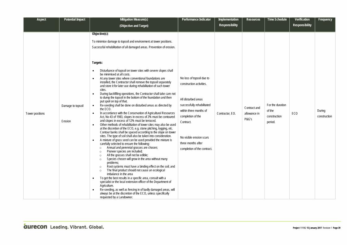
Project 111982 13 January 2017 Revision 1 Page 39
Aspect Potential Impact Mitigation Measure(s)
(Objective and Target)
Performance Indicator Implementation Responsibility
Resources Time Schedule Verification Responsibility
Frequency
Tower positions
Damage to topsoil
Erosion
Objective(s):
To minimise damage to topsoil and environment at tower positions. Successful rehabilitation of all damaged areas. Prevention of erosion.
Targets:
• Disturbance of topsoil on tower sites with severe slopes shall be minimised at all costs.
• At any tower sites where conventional foundations are installed, the Contractor shall remove the topsoil separately and store it for later use during rehabilitation of such tower sites.
• During backfilling operations, the Contractor shall take care not to dump the topsoil in the bottom of the foundation and then put spoil on top of that.
• Re-seeding shall be done on disturbed areas as directed by the ECO.
• In accordance with the Conservation of Agricultural Resources Act, No 43 of 1983, slopes in excess of 2% must be contoured and slopes in excess of 12% must be terraced.
• Other methods of rehabilitation of tower sites may also be used at the discretion of the ECO, e.g. stone pitching, logging, etc. Contour banks shall be spaced according to the slope on tower sites. The type of soil shall also be taken into consideration.
• A mixture of grass seed can be used provided the mixture is carefully selected to ensure the following: o Annual and perennial grasses are chosen; o Pioneer species are included; o All the grasses shall not be edible; o Species chosen will grow in the area without many
problems; o Root systems must have a binding effect on the soil; and o The final product should not cause an ecological
imbalance in the area • To get the best results in a specific area, consult with a
specialist or the local extension officer of the Department of Agriculture.
• Re-seeding, as well as fencing in of badly damaged areas, will always be at the discretion of the ECO, unless specifically requested by a Landowner.
No loss of topsoil due to construction activities.
All disturbed areas successfully rehabilitated within three months of completion of the Contract.
No visible erosion scars three months after completion of the contract.
Contractor, EO. Contract and allowance in P&G’s
For the duration of the construction period.
ECO During construction

Project 111982 13 January 2017 Revision 1 Page 40
Aspect Potential Impact Mitigation Measure(s)
(Objective and Target)
Performance Indicator Implementation Responsibility
Resources Time Schedule Verification Responsibility
Frequency
ACTIVITY: 11.3 Construction activities on private land
All activities involving potential interaction with Landowners or their fixed or moveable property
Damage to structures and property
Disruption of services
Objective(s):
To maintain good relationships with Landowners.
Targets:
• The Contractor should keep a record of before and after photos for the whole project.
• The success of the project depends on the good relations with the Landowners. It is required that the Contractor will supply one person to be the community liaison officer (CLO) for the entire contract. This person shall be available to investigate all problems arising on the work sites concerning the Landowners.
• All negotiations for any reason shall be between Eskom, the Landowner and the Contractor.
• No verbal agreements shall be made. All agreements shall be recorded properly and all parties shall co-sign the documentation.
• The Contractor shall keep a photographic record of access roads. This will then be available should any claims be instituted by any Landowners.
• All claims instituted by the Landowners shall be investigated and treated promptly.
• Unnecessary delays should be avoided at all costs. • The Landowners shall always be kept informed about any
changes to the construction program should they be involved. • The contact numbers of the CLO and the Eskom ECO shall be
made available to the Landowners. This will ensure open channels of communication and prompt response to queries and claims.
• The rights of the Landowners shall be respected at all times and all staff shall be sensitised to this.
• Eskom must ensure that the owner of the property over which the servitude traverses is allowed free access to and through the servitude so as to prevent unnecessary negative impact on the owners.
No delays in the project due to Landowner interference.
Contractor, EO Contract and allowance in P&G’s
For the duration of the construction period.
ECO During construction
ACTIVITY: 11.6 Actions by site staff
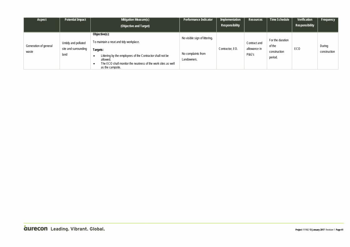
Project 111982 13 January 2017 Revision 1 Page 41
Aspect Potential Impact Mitigation Measure(s)
(Objective and Target)
Performance Indicator Implementation Responsibility
Resources Time Schedule Verification Responsibility
Frequency
Generation of general waste
Untidy and polluted site and surrounding land
Objective(s):
To maintain a neat and tidy workplace.
Targets:
• Littering by the employees of the Contractor shall not be allowed.
• The ECO shall monitor the neatness of the work sites as well as the campsite.
No visible sign of littering.
No complaints from Landowners.
Contractor, EO. Contract and allowance in P&G’s
For the duration of the construction period.
ECO During construction

Project 111982 13 January 2017 Revision 1 Page 42
Aspect Potential Impact Mitigation Measure(s)
(Objective and Target)
Performance Indicator
Implementation Responsibility
Resources Time Schedule Verification Responsibility
Frequency
ACTIVITY: 12.1 Storage, removal and disposal of waste
Generation of decommissioning waste
Land pollution
Unpleasant odours
Decreased aesthetic integrity of the site
Objective(s):
To ensure that waste is correctly stored and disposed of, decreasing the visual impact during the decommissioning period. To keep the servitude neat and clean. Disposal of rubble and refuse in an appropriate manner. Minimise litigation. Minimise landowner complaints.
Targets:
• No material shall be left on site that could be of harm to humans and animals. • Broken, damaged and unused nuts, bolts and washers shall be picked up and
removed from site. • Concrete foundations may not be dumped indiscriminately on site once removed,
but shall be removed from site. • Bins and containers must be made available by the contractor for the storage of
construction waste. • Temporary storage of construction waste will take place within the site, and within
areas designated by the ECO and the Contractor although construction waste will not be stored on site for longer than 30 days.
• The Contractor will be responsible to remove and transport all construction waste material off site to a registered waste disposal facility (proof of this as well as a copy of the sites Registration Permit, must be provided by the Contractor to the ECO).
Construction waste stored, collected and disposed of as per the requirements of this EMPr.
Contractor and EO Contract and allowance in P&G’s
Waste bins/ skips must be available prior to decommissioning Removal of waste throughout the construction period.
ECO
Throughout decommissioning period.
The ECO will determine the frequency of waste removed from site.
0
12 DECOMMISSIONING

This section outlines the important information the Contractor needs to supply for the tender purposes.
13.1 List of method statements required prior to construction Contractors to supply the following method statements:
• The Contractor shall supply a method statement that outlines the approximate number of people on site, the layout of the camp, management of ablution facilities and wastewater management.
• The Contractor shall provide a method statement with regard to waste management.
• The Contractor shall provide a method statement to provide procedures for dealing with possible emergencies that can occur, such as fire and accidental leaks and spillage of carbon fuels and oils.
• The Contractor shall supply a method statement for the storage of hazardous substances.
The Contractor shall provide all method statements to the ECO prior to associated activities being undertaken on the site.
13 CONTRACTOR TO SUPPLY AT TENDER STAGE

This section below describes how the disturbed areas should be rehabilitated after construction
14.1 Rehabilitation of the site The removal of all construction facilities and materials from the site will be required, and rehabilitation will have to be carried out, including the removal of the following:-
• Concrete and compacted earth platforms;
• Chemical toilets.
Any contaminated material or soil must be removed to a registered hazardous waste disposal facility and the prescribed re-vegetation process must then be followed thereafter.
14.2 Eradication of weeds All alien vegetation spread over the entire construction footprint must be removed, irrespective of its existence prior to construction. Chemical removal shall be used in accordance with manufacturer’s specification for weeds. All chemicals used must be approved by the ECO.
14 REHABILITATION

Aurecon South Africa
Aurecon Centre Lynnwood Bridge Office Park 4 Daventry Street Lynnwood Manor 0081
Address1
Lynnwood Manor 0081
T +27 12 427 2000
F +27 86 556 0521
W www.aurecongroup.com
Aurecon offices are located in: Angola, Australia, Botswana, China, Ghana, Hong Kong, Indonesia, Kenya, Lesotho, Macau, Mozambique, Namibia, New Zealand, Nigeria, Philippines, Qatar, Singapore, South Africa, Swaziland, Tanzania, Thailand, Uganda, United Arab Emirates, Vietnam.

Barend Smit Technical Director Barend is currently the head of Aurecon's Environmental Division at its Tshwane office in South Africa, taking full professional responsibility for, and managing the work of this team of professional and support staff who work on a range of projects from environmental assessments to implementation of environmental management plans nationally and internationally. He is also the Competency Leader for Environmental Works for Aurecon's Africa and Middle East regional team. Since graduating in 1985, he has gained 30 years' experience in the strategic management of environmental aspects relating to the construction of bulk water supply projects such as dams, pipelines and tunnels, but also relating to roads, industrial and residential developments, and recreation and tourism infrastructure.
Through the years, Barend gained extensive experience in leading, managing and conducting a range of environmental impact assessments, and the preparation and subsequent implementation of project specific environmental management plans. He has also managed social impact studies in the course of his work, and has experience in liaison with local communities in project areas. He gained significant experience in the contractual aspects of implementing environmental management plans as part of larger construction projects, and the procurement of specialist services for impact assessments. In addition, he has undertaken landscape designs especially for rehabilitation of rock quarries, borrow pits and spoil dumps in relation to tunnels, dams and roads, in addition to purely aesthetic landscape design.
Barend is experienced in working as part of consortiums or independent projects teams set up for large scale engineering projects.
Experience Afam power station due diligence, Nigeria, Taleveras Group of Companies, 09/2013 - 02/2014, Project leader Aurecon was appointed by Televaras as Technical Advisor to undertake a technical assessment of the Afam Power Station and its refurbishment/development plans. Aurecon's services included independent technical assessment of the Afam IV and V power plants and the refurbishment and capacity recovery plans, review of the permitting and commercial agreements, environmental review, plant management strategy review, development of benchmark capital and O&M costs estimates for the refurbishment plans, and review of the project financial model.
Wetland delineation to determine the extent of wetland or wet areas related to the proposed routes of the new Pangaea and Kanga 88Kv powerlines., Mpumalanga Province, South Africa, Eskom, 05/2013 - 03/2014, Project Director Eskom proposed the establishment of two 88 kV substations (Pangaea and Kanga) in conjunction with two 88 kV loop-in, loop-out lines from the existing 88 kV Erasmus-Arbor line in order to ensure electric supply for the upcoming Kusile railway line. This railway line will be constructed as a private siding which is needed to transport limestone to the Kusile power station. Aurecon was appointed to conduct a level 1 wetland assessment to determine the extent of wetland or wet areas that are related to the proposed routes chosen for the construction of the Pangaea and Kanga 88Kv powerlines.
Qualifications B Landscape Architecture Member, South African Affiliate of the International Association for Impact Assessment (IAIAsa) Registered Professional Landscape Architect, South African Council for the Landscape Architectural Profession (SACLAP) Member and Former President, The South African Institute of Landscape Architects Member, Gauteng Society of Landscape Architects Member, International Federation of Landscape Architects
Specialisation Landscape architect
Years in industry 31.33

Barend Smit Technical Director
Environmental impact assessment (EIA) for the Swaziland Rail Link Project, South Africa and Swaziland, Transnet Capital Projects, 02/2013 - 02/2014, Project Director Aurecon is providing environmental services for the upgrade and new construction related to the Swaziland rail link project. A comprehensive environmental impact assessment (EIA) will ensure that the project is implemented in compliance with relevant national and provincial environmental legislation. Through the EIA process, potential negative impacts will be identified and mitigation determined in order to minimise the project's impact on the environment and the community. The EIA also provides an opportunity to enhance the beneficial impacts associated with the project.
Zulti South asset based community development programme, South Africa, Richards Bay Minerals (RBM), 02/2013 - 05/2013, Project Advisor The project entails the development of a framework that will be used to execute and project manage relocation and resettlement of impacted families, various fields of livelihood and burial sites in the exclusion zone, inside the mine lease area and services corridor for the Zulti South Project near Richards Bay.
Kleinkopje environmental management programme report (EMPR) amendment, Mpumalanga Province, South Africa, Anglo Coal Limited Johannesburg, 09/2012 - 10/2013, Project Director Kleinkopje colliery is an open-pit mine situated eight kilometres south of Emalahleni. Aurecon was engaged to amend the environmental management programme report (EMPR) for the Kleinkopje colliery.
State of energy reports for Polokwane and Mbombela, Nothern Province, South Africa, South African Local Government Association (SALGA), 05/2012 - 02/2014, Environmental Project Leader The project entailed an investigation and report on the current supply and demand of energy usage in the cities of Polokwane and Mbombela, as a basis for generating appropriate energy usage and efficiency strategies.
Feasibility study for the treatment of acid mine drainage (AMD), Gauteng Province, South Africa, Department of Water Affairs (DWA), 01/2012 - 02/2013, Phase Leader: Environmental Aurecon was appointed to conduct a feasibility study to address the treatment of acid mine drainage (AMD) from Gauteng's underground mining basins, by removing salts and metals, to protect the receiving water resources and reduce the dilution releases from the Vaal Dam to the Vaal Barrage. The work included investigating future scenarios, analysing alternative infrastructure options and exploring alternatives for implementation.

Barend Smit Technical Director
Front-end loading (FEL4) study for Nacala Port, Nampula, Mozambique, Vale Mozambique Limitada, 10/2011 - 11/2013, Team Leader: Environmental Services Aurecon was appointed for the complete on-shore port front-end-engineering design (FEED) for the Nacala Port, consisting of bulk materials handling (BMH), bulk earthworks, rail embankment and utilities and transportation infrastructure. Aurecon undertook a number of general functions during its detailed design, including verifying and updating the design criteria documents generated during the Nacala Port front-end loading 3 (FEL 3) study and the engineering design to achieve the requirements for the construction phase. Responsible for ensuring the designs meet the requirements of the approved Environmental Management Plans, environmental specifications, environmental rehabilitation specifications and design, and detail landscape design for facilities.
Simandou project: FEL 2 study for a new 50 Mtpa railway, Nzerekore-Kerouane, Liberia and Guinea, Vale (VBG -Vale BSGR Guinea) or VBG Logistics (Vale BSGR Logistics), 03/2011 - 11/2011, Team Leader: Environmental Services Aurecon was appointed to conduct the conceptual (FEL 2) study for a new 50 Mtpa railway line. The scope of services included surveying existing data; field investigation, laboratory tests and topographic survey; hydraulic/hydrological studies; geological/geotechnical management; railway studies and geometric design, earthworks, drainage and contentions. Responsible for environmental rehabilitation specifications and design.
Detailed design of the Nacala Railway Corridor, Tete, Mozambique, Vale Moçambique Limitada, 05/2011 - 07/2012, Team Leader: Environmental Services The project comprised the detailed design (FEL 4) for the Nacala Railway Corridor project. Aurecon previously developed FEL 1, 2 and 3 studies for the development of the corridor. The FEL 4 entailed the design of the entire railway line and its associated infrastructure, including the geometric design of the rail; cut and fill slope design and the design of the foundations, namely bridges, culverts and building structures. It also included the design of retaining walls; borrow pits; interference and access roads; building structural and electrical services; building wet and fire services; bulk water, sanitation and electricity and the mechanical design of pump stations. Responsible for ensuring the designs meet the requirements of the approved Environmental Management Plans, environmental specifications, environmental rehabilitation specifications and design, and detail landscape design for facilities.
Environmental Officer for the Kusile 400 kV tie-ins and tie-outs of the transmission line project, Bronkhorspruit, Mpumalanga Province, South Africa, Consolidated Power Projects (Pty) Ltd, 05/2011 - 03/2013, Project leader Eskom's Kusile power station under construction is to be linked to other transmission feeder lines and new connecting lines are required to the power station. Consolidated Power Projects (CONCO) were appointed as main contractor for the tie-in and out work as well as installation of droppers during this time. CONCO appointed Aurecon as permanent on-site Environmental Officer (EO) for the short duration of the project. This individual and his role are managed for the duration of the project. Time is spent on site to provide assistance with environmental issues and provide expertise to environmental challenges.

Barend Smit Technical Director
Pre-feasibility study (FEL 2) to investigate the expansion of the iron ore corridor, Northern and Western Cape, South Africa, Turner & Townsend, 04/2011 - 03/2012, Team Leader: Environmental Services Aurecon was appointed to investigate the export of the iron ore capacity and the addition of manganese exports to the corridor. The study was for the development of the Hotazel-Postmasburg rail link. The scope of works included a depreciated optimised replacement cost (DORC) study, rail and port study, iron ore and manganese studies, terminal and marine development, financial modelling, risk assessments, project execution plan (PEP), feasibility study (FEL 3) and detailed engineering (FEL 4) and a preliminary design report. Responsible for providing environmental background and support regarding environmental impact mitigation measures to the engineering team.
Environmental authorisation process for the Sigma Theta powerline, KwaZulu-Natal Province, South Africa, Eskom, 10/2010 - 08/2014, Project Director The increased demand in load centres in KZN necessitates the strengthening of the transmission network. Aurecon was appointed by Eskom as the independent EAP to undertake the EIA for the construction of the 400kV line between the proposed Isundu substation near Pietermaritzburg to the proposed Mbewu substation near Empangeni. The project is part of the strengthening of the KZN transmission network by Eskom.
Environmental impact assessment and geohydrological and surface water investigations for Khanyisa power station, Mpumalanga Province, South Africa, Anglo Coal, 09/2010 - 01/2014, Project Director Anglo American appointed Aurecon to perform an environmental impact assessment (EIA) for the proposed Khanyisa power station near Witbank in the Mpumalanga Province. As part of the EIA, several specialist studies were required to be included in documentation which would form part of the environmental authorisations for the proposed project.
Demolition of a redundant plant for Procter & Gamble, Gauteng, South Africa, Procter & Gamble, 06/2010 - 10/2010, Environmental Site Specialist The project entailed tender documentation for the demolition of an existing redundant plant, to provide space for the construction of a new plant. The demolition work comprised the termination of all services; the demolition of an office building, industrial buildings and roads; and the preparation of the area for new construction. Aurecon appointed Deltaplan as a sub-consultant for the site survey work. Responsible for environmental impact assessment guidance during the demolition of the building.
Engineering design (FEL 3) study of the railway line from Moatize to the Port of Nacala, Malawi and Mozambique, Vale Moçambique Limitada, 04/2010 - 08/2011, Team leader: Environmental Services The project entailed a basic engineering (FEL 3) study for the railway line between Moatize and the port of Nacala, including the upgrading and design of railway infrastructure. The railway connects the existing mine in Moatize to a new coal terminal in Nacala. The infrastructure was designed and built for 25 t loading to prepare the system for future expansions. Responsible for providing environmental background and support regarding environmental impact mitigation measures to the engineering team.

Barend Smit Technical Director
Environmental impact assessment (EIA) for the Nacala rail corridor, Malawi and Mozambique, Vale Mocambique Limitada, 03/2010 - 09/2011, Team Leader: Environmental Services The project entailed the completion of four environmental impact assessments (EIA's) for the upgrading of existing and the construction of new railway sections along the Nacala corridor from the Moatize Coal Mine in Tête Province, Mozambique, through Malawi, to the port of Nacala-a-Velha, and a new coal handling terminal. Responsible for supporting the EIA teams regarding environmental impact mitigation measures.
Concept study (FEL 1) to investigate the expansion of the Iron Ore Line in South Africa to 92 Mtpa, Northern and Western Cape, South Africa, BHP Billiton, Kumba Iron Ore, Assmang and BURK Mining Consortium, 03/2010 - 08/2010, Team Leader: Environmental Services In this project, a study was undertaken to identify the optimal solution for the expansion of the rail and port capacity of the existing iron ore export channel (“Orex Channel”) to the Port of Saldanha. This included utilising the “Orex Channel” for future manganese exports. In addition, the project included the development of a new Environmental Impact Assessment application for the envisaged manganese ore export through the channel. Responsible for providing environmental background and support regarding environmental impact mitigation measures to the engineering team.
Muela hydropower upgrading, Lesotho, Lesotho Highlands Water Commission, 04/2009 - 12/2010, Environmental Project Director The project consisted of a social and resettlement study focussing particularly on the social impacts of anticipated construction and related resettlement; this also included the compilation of an HIV/Aids management programme which could be implemented during the project implementation phase. Responsible for assistance in terms of the Environmental Impact Assessment (EIA), and general Geographic Information Systems (GIS) support.
Develop an environmental management plan (EMP) for the ash dumps at Kriel power station, Mpumalanga Province, South Africa, Eskom, 11/2009 - 04/2015, Project Director The Kriel power station employs wet ashing for the disposal of its ash. Presently two of the ashing dams have reached their capacity whilst the remaining ash dam will reach its capacity within the next four years. In order for the station to continue ashing in an environmentally responsible manner, one site has been identified adjacent to the current ash dam, within the Kriel power station premises, and the project will allow for an extension of the existing ash dams facility. An EIA process and subsequent environmental management report (EIR) needed to be undertaken that took into consideration construction, commissioning, operating and decommissioning impacts that will be submitted to the relevant authority.
Lesotho MCA Health Infrastructure Programme 2010, Lesotho, Millennium Challenge Account (MCA) - Lesotho, 10/2009 - 09/2014, Health, Safety and Environmental Manager This project involved the provision of programme management, construction supervision and environmental management services for the health infrastructure programme in Lesotho. This included the design of the National Reference Laboratory (NRL) and blood transfusion centre, the design of student and staff hostels at existing Lesotho Hospital, and the construction of 138 new health centres and 14 new outpatient departments (OPDs).

Barend Smit Technical Director
Benoni Dams basic assessment, Gauteng, South Africa, Ekurhuleni Metropolitan Municipality, 2009 - 2010, Project Director Basic assessment for the widening of the Kleinfontein Dam Spillway in Benoni, Gauteng. Responsible for Geographic Information Systems (GIS) mapping requirements and project management.
Environmental Impact Assessment (EIA) for the Orange-Riet canal balancing Dam S1, Free State, South Africa, Department of Water Affaris, 01/2009 - 02/2009, Project Director Overseeing, managing and conducting a scoping and environmental impact assessment (EIA) process.
Mokolo Crocodile Water Augmentation Project, Limpopo, South Africa, Trans-Caledon Tunnel Authority (TCTA), 09/2009 - 12/2014, Team Leader: Environmental Services The project entailed comprehensive engineering services for the Mokolo Crocodile Water Augmentation Project (MCWAP), including the construction of two major bulk raw water transfer systems and associated infrastructure. The MCWAP supplies raw water to meet the demands of the new power station in Lephalale, mines and industry, and domestic users. The main components of the scheme are abstraction weirs, pump stations, pipelines and balancing storage. Responsible for leading and managing environmental team on the project with development of project specific environmental management plan, detailed environmental management pre-qualification documentation and specifications, tender evaluation and environmental monitoring during construction.
Olifants River Water Resources Development Project, Phase 2 (ORWRDP-2), Limpopo Province, South Africa, Trans-Caledon Tunnel Authority (TCTA), 09/2009 - 01/2014, Environmental Specialist The second phase of the Olifants River Water Resources Development Project (ORWRDP-2) was an extensive water resource development project to supply water for domestic and industrial (mining) use in Limpopo. The project was divided into two main schemes. The first scheme comprised a 70 km-long pumping main from the Flag Boshielo Dam to Mokopane, including three 6 MW pump stations en route. The second scheme consisted of the abstraction and distribution of water from the De Hoop Dam to various end points. Both schemes were monitored and controlled from a single remote control point with all elements linked via approximately 180 km of fibre optic cable. Responsible for Environmental Impact Assessment (EIA) and environmental monitoring of construction.
Environmental impact assessment (EIA) for proposed stone quarries in Ucua and Quicabo (Conduril), Angola, Conduril Sucursal Luanda, 06/2009 - 10/2010, Environmental Project Director The project entailed the environmental impact assessment (EIA) for proposed stone quarries. Responsible for the project management of the environmental component as well as the EIA for the project.

Barend Smit Technical Director
Raising of the northern boundary dam wall, Gauteng Province, South Africa, AngloGold Ashanti Ltd, 04/2009 - 04/2013, Environmental Project Director AngloGold Ashanti appointed Aurecon in 2008 to conduct the feasibility study to investigate the possibility of raising the existing 2.5 m earthfill dam as the storage capacity in the dam was too small and hence led to constant spills of the dirty stormwater originating from contaminated zones into the Wonderfonteinspruit. The raised dam would also have to comply with Regulation 704 in terms of providing sufficient storage capacity to fully absorb the 1:50 year flood. Responsible for project management of all EIA related activities and Environmental Management Programme Report (EMPR) amendment.
Zuikerbosch wastewater treatment works: upgrading Filter Block 1, Gauteng, South Africa, Rand Water, 08/2008 - 06/2013, Environmental Practitioner and GIS Support The site is an old sludge dam adjacent to the Zuikerbosch pumping station owned by Rand Water. The embankment failed a number of years before and discharged sludge into the Vaal River. The dam was then subjected to a form of rehabilitation by providing a gabion type of overflow structure in the zone where the breach occurred. Responsible for public participation, obtaining environmental authorisation for an exemption application while providing general geographic information systems (GIS) support to the project team.
Updating of the bankable feasibility study (BFS) to evaluate the transport of coal from Moatize to Nacala, Tete, Mozambique, Vale Mozambique, 10/2008 - 03/2009, Environmental Project Director Aurecon was appointed to update the 2006 bankable feasibility study (BFS) to 14 million tons per annum, and to develop the rail capacity simulation and trade-offs model for the ramp-up period. Alternative heavy haul routes on Sections 2 and 3 had to be investigated before it was assumed that the base case route was the best route for the new tonnages. An options analysis of other modes of transport for these sections was conducted. The project also entailed a phased upgrade of the railway line from 4mt to 26mt; and an update of the existing port terminal BFS to a 26 Mtpa solution. The project also included master planning for a 40 Mtpa port terminal facility. Responsible for cost estimates for environmental and social mitigation and resettlement and identification of cost estimates for additional studies required to develop a full social impact assessment, social mitigation and resettlement plans.
Open cycle gas turbine peaking power plants in KwaZulu-Natal and the Coega Industrial Development Zone (IDZ), KwaZulu-Natal and Eastern Cape Provinces, South Af, Merz & McLellan, 08/2008 - 12/2012, Project Director The project entailed the construction of open cycle gas turbine peaking power plants in KwaZulu-Natal and the Coega Industrial Development Zone (IDZ) in the Eastern Cape, for the provision of electricity during peak demand.

Barend Smit Technical Director
Phased rehabilitation of 7 000 km of rural roads in Sudan, South Sudan, Government of Southern Sudan: Ministry of Transport and Roads, 05/2008 - 12/2011, Environmental Specialist The project's aim was to prepare a programme to improve access and ensure the maintenance of prioritised rural feeder roads in linking critical communities and social service centres, production areas and markets. Aurecon was appointed for the rehabilitation and re-establishment of the entire rural network over a period of five years. The proposed road improvements are expected to cover about 7 000 km of priority rural roads spread over South Sudan. Services offered included road inventory and mapping, a road condition survey and environmental and social impact assessments (ESIAs). The scope and cost of improvement works were provided, together with the prioritisation of roads for rehabilitation. Aurecon prepared a development plan, cost estimates and improvement packages for conventional or labour-based works.
Upgrading of Simon Vermooten Road, Gauteng, South Africa, Ninham Shand Semenya Furumele JV, 05/2008 - 02/2011, Landscape Architect The project consisted of planning for the doubling and upgrading of a portion of Simon Vermooten Road over a total length of approximately 5.3km to a four-lane dual carriageway road. The project included the upgrading of Simon Vermooten Road between Waltloo Road and Pretoria Road (both intersections included) and the N4 Freeway intersection of the existing interchange, the doubling and upgrading of Simon Vermooten Road between Pretoria Road and the N4 Interchange and between the N4 Interchange and Lynnwood Road, as well as the upgrading of intersections/accesses from Simon Vermooten Road to 18 roads, streets and localities. Responsible for landscape design on this main arterial road as part of the upgrading to a dual carriageway.
Duplication of the Vlakfontein (Benoni) - Mamelodi water supply pipeline: phase 1, Gauteng, South Africa, Rand Water, 04/2008 - 04/2009, Environmental Project Director Conducted the basic assessment for the construction of a water supply pipeline. Responsible for obtaining the environmental authorisation for the duplication of the water supply pipeline, phase 1.
Fish impact study for the Drakensberg pumped storage scheme, KwaZulu-Natal, South Africa, Eskom, 03/2008 - 05/2010, Project Director The project entailed the study of the impacts of proposed changes in the scheme operating regime on fish biodiversity. Responsible for managing the project, report writing and client liaison.
Morgenzon/Sivukile Wastewater Treatment Works (WWTW), South Africa, Lekwa Local Municipality, 03/2008 - 06/2009, Project Director Assisted with the Environmental Impact Assessment (EIA) for a proposed Wastewater Treatment Works (WWTW) for the town of Morgenzon.
Development of Sonland Park, Extension 1, Gauteng, South Africa, Masingita Property Investment, 10/2007 - 12/2009, Environmental Project Director Aurecon was appointed to assist with the development of an approximately 90ha plot, including approximately 1600 erven residential township and 20ha mixed use development, in order to cater for a housing shortage in the area. Responsible for assisting in the environmental impact assessment (EIA).

Barend Smit Technical Director
Basic assessments for the upgrading of the Valhalla reservoir, Gauteng Province, South Africa, 2007 - 2008, Project Director The project consisted of a basic environmental assessment to obtain authorisation for the construction of a new reservoir adjacent to an existing reservoir.
Basic assessment for the upgrading of Laudium pipelines, Pretoria, Gauteng Province, South Africa, 2007 - 2008, Project Director The project entailed basic a environmental assessment to gain authorisation for the upgrading and replacement of water mains.
Basic assessment for the upgrading of the Khutala Pump Station, Kriel, Mpumalanga Province, South Africa, Department of Water Affairs and Forestry (DWAF), 2007 - 2008, Project Director This project included a basic environmental assessment to gain authorisation for the upgrading and replacement of water mains at this major Department of Water Affairs and Forestry (DWAF) pump station.
Independent monitoring of Pecanwood Estate environmental management system (EMS), Hartbeespoort, North West Province, South Africa, Exigent Engineering Consultants, 06/2007 - 02/2009, Specialist Advisor The project entailed an environmental management system (EMS) audit, reporting and recommendations on the Pecanwood Golf Estate at Hartbeespoort dam. Responsible for assisting Pecanwood Golf Estate and Exigent Engineering Consultants CC with the implementation of an ISO 14 001 compliant environmental management system for the estate.
Environmental management system (EMS) for Automotive Supplier Park in Rosslyn, Gauteng, South Africa, Supplier Park Development, 02/2007 - 06/2011, Project Director This project entailed the implementation of an Environmental Management System (EMS) at the Automotive Supplier Park (ASP). The Supplier Park Development Company was established in 2002 to develop and manage the Automotive Supplier Park. The project was one of the Gauteng Provincial Government's Blue IQ initiatives aimed at delivering strategic infrastructure in the South African automotive industry to stimulate sustainable economic growth and job creation in the province.
Extension of the Sunderland Ridge wastewater treatment works (WWTW), Pretoria, Gauteng, South Africa, City of Tshwane, 01/2007 - 12/2011, Project Director Aurecon was appointed to provide the engineering services for the extension of the Sunderland Ridge wastewater treatment works (WWTW) to 95 Ml/d. The purpose of the project was to provide a feasibility study for the 30 Ml/d extension; licence applications; environmental impact assessments (EIAs) and the relevant authorisations for the 30 Ml/d extension; and process design of the extension. Responsible to provide independent Environmental Control Officer (ECO) for the construction work that formed part of the extensions.

Barend Smit Technical Director
Conceptual and detail design for the link lines, staging line and all civil structures and services between Salkor yard and the tipplers in Saldanha Port, Saldanha Port, South Africa, Transnet Capital Projects, 11/2006 - 03/2012, Team Leader: Environmental Services The upgrading of capacity at the Saldanha Port to 93 Mtpa had to take place by 2013 and was undertaken in three phases. This project entailed the concept development and subsequently the detailed design for the railway portion of Phase 1A, which consisted of an upgrade from 29 Mtpa to 47 Mtpa. Responsible for providing environmental background and support regarding environmental impact mitigation measures to the engineering team.
Environmental Impact Assessment (EIA) for EIA for 66KV Liqhobong power linep, Lesotho, Platinum JV, 09/2006 - 06/2010, Project Director the objective of the project was to carry out an EIA for the new 40km power line reticulation to Liqhobong Diamond Mine. Responsible for overseeing the project.
Environmental Impact Assessment (EIA) for a landfill at the Rietfontein Weir, Mpumalanga Province, South Africa, Department of Water Affairs and Forestry (DWAF), 2006 - 2008, Project Director Aurecon was appointed by the Department of Water Affairs and Forestry (DWAF) to complete an Environmental Impact Assessment (EIA) for a new landfill site to be used for disposing contaminated sludge from the dredging of the Rietfontein Weir.
Development of contractor housing at the De Hoop dam, Limpopo, South Africa, Department of Water Affairs and Forestry (DWAF), 08/2006 - 12/2011, Environmental Project Director Assisted in the basic assessment for the proposed development according to the Limpopo Department of Economic Development, Environment and Tourism.
Scoping environmental impact assessment (EIA) for the power line reticulation from As river mini hydropower projects, Free State Province, South Africa, 2006 - 2007, Project Manager and Environmental Impact Assessment (EIA) Leader This project included an environmental impact assessment (EIA) and liaison with local communities for power line reticulation from two mini hydro power stations on the As River.
Detail design, upgrading and supervision of the construction of the Siphofaneni Bridge - St Phillips Road: Phase I, II, and III - preliminary, and detail technical design study, and assistance with tendering evaluation for works, Swaziland, Delegation of the European Commission in Swaziland, 06/2006 - 10/2014, Project Director - Environmental component The project consisted of construction of a new 300m two-lane bridge over the River Usuthu at Siphofaneni, a 1km link from the MR8 on the MR14 up to existing junction to St Phillips road, a 23km link from the MR14 junction to St Phillips, as well as a 7.7km link from St. Phillips road to the MR8 over the Usuthu River. Responsible for the compilation and implementation of the socio-economic impact assessment.

Barend Smit Technical Director
Upgrading of a sewer main in Noordwyk, Gauteng Province, South Africa, Johannesburg Water (Pty) Ltd, 2006, Project Manager Aurecon was appointed to carry out an environmental authorisation exemption application and public consultation on this project, which comprised an upgrade of the existing sewer main that performed under capacity.
Environmental assistance to Golden Creek Property Developers, Gauteng South Africa, Golden Greek Property Developers, 2006, Environmental Specialist Responsible for assisting in legal proceedings and acting as an expert witness in a legal appeal against the environmental authorisation of a regional waste landfill adjacent to a property owned by the developer.
Lesotho Highlands water project Phase II: feasibility study, Lesotho, Lesotho Highlands Water Commission (LHWC), 10/2005 - 11/2007, Environmental Specialist The Treaty between the Government of the Republic of South Africa and the Government of the Kingdom of Lesotho, signed in 1986, defines the framework for implementing the Lesotho Highlands water project (LHWP). The project's objective was to transfer up to 70 cubic metres per second from the Senqu/Orange to the Vaal river system and to utilise this water transfer to generate hydropower in Lesotho.. Responsible to provide specialist input related to ongoing manpower requirements for the environmental monitoring of the Lesotho Highlands Water Project (LHWP).
Development of two hydropower stations near Bethlehem, Free State Province, South Africa, Bethlehem Hydro (Pty) Ltd, 09/2005 - 08/2010, Project Director and Environmental Control Officer (ECO) Bethlehem Hydro (Pty) Ltd appointed Aurecon to undertake the detailed design, construction supervision and project management duties for two small hydropower stations located near the town of Bethlehem, Free State Province, South Africa. The first scheme is a run of river scheme located on the Ash river and the second scheme was constructed on the flank of the existing Sol Plaatje dam. The two schemes were constructed simultaneously, offering significant cost savings to the project. Barend was appointed as an independent Environmental Control Officer (ECO) for the construction work that was part of the establishment of two new mini hydropower stations on the As River.
Environmental Management Plan (EMP) for the Gautrain Rapid Rail Link, Gauteng Province, South Africa, 2005 - 2006, Project Manager The Bombela Consortium appointed Aurecon to develop a requisite ISO 14 001 compliant Environmental Management Plan (EMP) for the construction and operation of this rapid rail link between Johannesburg, Pretoria and the OR Tambo International Airport (ORTIA).

Barend Smit Technical Director
The augmentation of the Moreleta Spruit outfall sewer, Gauteng Province, South Africa, City of Tshwane Metropolitan Municipality (CTMM), 01/2005 - 02/2014, Phase Leader: Environmental Impact assessment The Moreleta Spruit outfall sewer had insufficient capacity to handle the flow of sewage, resulting in regular spillage of raw effluent. Aurecon was appointed for the feasibility and preliminary design of the Moreleta Spruit outfall sewer to determine the most viable option for refurbishment and upgrading. The detailed design, environmental impact assessment (EIA), geotechnical investigation and project risk assessment of the required works were completed in Phases 1 and 2. Phase 3 involved the rehabilitation of outfall/collector sewer pipes in the Moreleta Spruit catchment area.
Operational Environmental Control Officer (ECO) for the Cosmo City project, Gauteng Province, South Africa, City of Johannesburg, 2005, Project Manager In this project, the City of Johannesburg required an operational Environmental Control Officer (ECO) for its Cosmo City project. Responsible for monitoring and reporting on the level of environmental compliance of all operational service providers, training residents on the efficient use of energy, and maintaining facilities.
Vaal River Eastern Sub-system Augmentation Project (VRESAP), Mpumalanga Provinces, South Africa, Trans-Caledon Tunnel Authority (TCTA), 11/2004 - 11/2008, Project Manager and EIA Leader on part time secondment to the Trans-Caledon Tunnel Authority (TCTA) The project entailed the design and construction supervision of the Vaal River Eastern Sub-system Augmentation Project (VRESAP), an emergency water transfer scheme abstracting water from the Vaal Dam and pumping it to the Knoppiesfontein division structure over a distance of 115km. From the division structure the water is gravitated to the Bosjesspruit and Trichardsfontein Dams near Secunda.very tight timelines. Responsible for managing the complete environmental impact assessment (EIA).
Feasibility study for Rivière Pistache dam and related treatment and bulk distribution infrastructure, Island of Rodrigues, Mauritius, Rodrigues Regional Assembly (RRA), 03/2003 - 09/2004, Environmental Impact Assessment (EIA) Leader The Island of Rodrigues, situated approximately 500km east of Mauritius, experienced severe seasonal shortages of potable and irrigation water, despite regular tropical cyclones. Aurecon, in association with Servansingh Jadav and Partners (Mauritius), was appointed by the Rodrigues Regional Assembly (RRA) in March 2003 to carry out a feasibility study for a dam and related treatment and bulk distribution infrastructure. Responsible for a complete environmental impact assessment (EIA) for a 42m high concrete face rockfill dam (CFRD) and the distribution network to supply water to this water-deprived Indian Ocean Island.
Environmental control of the construction of the Doornkraal Reservoir, Polokwane, Limpopo Province, South Africa, Potgietersrus Platinums Ltd, 02/2003 - 02/2009, Project Manager and Environmental Control Officer (ECO) Aurecon was appointed by Anglo Platinum Ltd as a construction environmental management control officer for the new 30Ml reservoir on the outskirts of Polokwane.
Design and construction supervision for the Berg River dam and supplement scheme, Western Cape Province, South Africa, Trans-Caledon Tunnel

Barend Smit Technical Director
Authority (TCTA), 02/2003 - 02/2014, Environmental Specialist and part time secondment to the Trans-Caledon Tunnel Authority (TCTA) The Berg water project was implemented to augment the water supply of the Greater Cape Town Metropolitan area in the Western Cape Province, South Africa. The brief involved a dam type selection study, detailed design and construction supervision of the dam and supplement scheme. Responsible for compiling a comprehensive and integrated Environmental Management Plan (EMP) for the implementation of the 60m high concrete face rockfill Berg River Dam.
Scoping Environmental Impact Assessment (EIA) for the upgrading of the Road K46 and a new bridge over the Jukskei River, Gauteng, South Africa, Gautrans, 2002 - 2003, Project Manager Aurecon was appointed by Gautrans to conduct a scoping Environmental Impact Assessment (EIA) as part of the approval process for upgrading this major arterial road.
Development of the Polokwane water supply scheme, Northern South Africa, Anglo Platinum Management Services, 09/2002 - 11/2007, Project Manager and Environmental Control Officer (ECO) Aurecon was appointed by Anglo Platinum Management Services to provide engineering services for the development of the Polokwane water supply scheme. Acted as the construction environmental management control officer for the new 60km, 500mm diameter effluent pipeline from Polokwane to Makopane.
Upgrading of the existing water treatment works and pump station at Doorndraai dam, Northern Province, South Africa, Anglo Platinum Ltd, 09/2002 - 01/2004, Project Manager and Environmental Control Officer (ECO) The project was concerned with Doorndraai water supply scheme in the Limpopo Province. Aurecon's responsibilities included preliminary and detailed design of pump station, mechanicals and reservoir, as well as the tender documentation and adjudication. It also included contract administration and construction monitoring. Responsible for construction environmental management control
Scoping Environmental Impact Assessment (EIA) for the raising of Flag Boshielo Dam, Limpopo Province, South Africa, 2002 - 2004, Environmental Impact Assessment (EIA) Specialist and Reviewer This project provided specialist Environmental Impact Assessment (EIA) services to a study team for the scoping EIA for raising Flag Boshielo Dam by 5m to increase its storage capacity from 100 million cubic metres to 188 million cubic metres, thereby increasing the dam's yield from 56 million cubic metres per annum to 72 million cubic metres per annum. Responsible for mentoring and skills transfer.
Study to restore the storage capacity of three Algerian dams, Various Provinces, Algeria, 2002, Environmental Specialist A study on the dams Meurat, Hammiz and Beni Bahdel was carried out to establish the optimal approach to restore the storage capacity lost due to siltation. The evaluated alternatives included the dredging and disposal of silt adjacent to the dam, raising the dam walls, constructing new dams and implementing the appropriate catchment management practices.

Barend Smit Technical Director
Alexandra Renewal Project: Hofmeyer Road upgrading and the construction of a new bridge over the Jukskei River, Gauteng, South Africa, Johannesburg Road Agency, 2002, Project Manager Aurecon was appointed by the Johannesburg Road Agency to conduct a scoping Environmental Impact Assessment (EIA) as part of the approval process for the upgrading of this major arterial road through Alexandra, a previously disadvantaged area.
Environmental Control Officer (ECO) for the Alexandra Renewal Project, Gauteng, South Africa, City of Johannesburg, 2002, Project Manager The City of Johannesburg required the services of an Environmental Control Officer (ECO) for the Alexandra Renewal Project. Responsible for monitoring and reporting the level of environmental compliance of all projects that formed part of the Alexandra Renewal Project. Also responsible for training a Historically Disadvantaged Individual (HDI) ECO as part of the project.
Environmental Management Plan (EMP) and Environmental Control Officer (ECO) for the construction of a new bridge over the Levuvu River, Limpopo Province, South Africa, 2002, Project Manager The project entailed the provision of an Environmental Management Plan (EMP) and independent monitoring of the environmental compliance of construction activities.
Alexandra Renewal Project: scoping Environmental Impact Assessment (EIA) for three new pedestrian bridges over the Jukskei River, Gauteng, South Africa, Johannesburg Roads Authority, 2002, Project Manager Aurecon was appointed by the Johannesburg Road Agency to conduct a scoping Environmental Impact Assessment (EIA) as part of the approval process for this vital link between the communities on both sides of the Jukskei River.
Alexandra Renewal Project: scoping Environmental Impact Assessment (EIA) for the upgrading of Da Gama Road and a new bridge over the Jukskei River, Gauteng, South Africa, Johannesburg Road Agency, 2002, Project Manager Aurecon was appointed by the Johannesburg Road Agency to conduct a scoping Environmental Impact Assessment (EIA) as part of the approval process for the upgrading of this major arterial road through Alexandra, a previously disadvantaged area.
Alexandra renewal project: scoping Environmental Impact Assessment (EIA) of the upgrading of Rautenbach Road, Gauteng, South Africa, Johannesburg Roads Authority, 2002, Project Manager Aurecon was appointed by the Johannesburg Road Agency to conduct a scoping Environmental Impact Assessment (EIA) as part of the approval process for the upgrading of this major arterial road through Alexandra, a previously disadvantaged area.
Accommodation in the Memel Nature Reserve: Environmental Impact Assessment (EIA), Free State Province, South Africa, 2002, Project Manager and Environmental Impact Assessment (EIA) Leader The Memel Nature Reserve is a Ramsar Convention on Wetlands registered wetland area, but does not have any accommodation facilities. Aurecon was appointed by an architect to conduct an Environmental Impact Assessment (EIA) for the proposed development of accommodation facilities, water supply and wastewater treatment.

Barend Smit Technical Director
Alexandra Renewal Project: scoping Environmental Impact Assessment (EIA) for the upgrading of London Road, Gauteng, South Africa, Johannesburg Roads Agency, 2002, Project Manager Aurecon was appointed by the Johannesburg Road Agency to conduct a scoping Environmental Impact Assessment (EIA) as part of the approval process for the upgrading of this major arterial road through Alexandra, a previously disadvantaged area.
Environmental Impact Assessment (EIA) for the extension (40Ml to 60Ml) of the existing Sunderland Ridge Wastewater Treatment Works (WWTW), Pretoria, Gauteng, South Africa, 2002, Project Manager During this project, the Environmental Impact Assessment (EIA) was completed as part of the environmental authorisation process to obtain approval for the extensions to this regional Wastewater Treatment Works (WWTW).
Scoping Environmental Impact Assessment (EIA) for the upgrading of the Nuwejaarspruit, Harrismith, Free State Province, South Africa, 2002, Project Manager and Environmental Impact Assessment (EIA) Leader The project included an environmental assessment of measures to reduce erosion induced by water releases from the Sterkfontein Dam into the Nuwejaarspuit. During construction, this project was extended to include construction monitoring and rehabilitation.
Upgrading of a sewer main in the Saaiplaas Mining Village near Harmony, Free State Province, South Africa, 2002, Project Manager The project consisted of an environmental authorisation exemption application and public consultation for the upgrade of an existing sewer main that was leaking.
Upgrading of the stormwater system in Meloding Township, Virginia, Free State Province, South Africa, 2002, Project Manager The project entailed an environmental authorisation exemption application and public consultation for this project, which aimed to formalise stormwater systems in this previously disadvantaged community.
Upgrading of the stormwater system in Phomolong Township, Welkom, Free State Province, South Africa, 2002, Project Manager The project included an environmental authorisation exemption application and public consultation for this project, which sought to formalise stormwater systems in this previously disadvantaged community.
Scoping Environmental Impact Assessment (EIA) for the As River mini hydropower projects, Free State Province, South Africa, 2002, Project Manager and Environmental Impact Assessment (EIA) Leader The project covered an Environmental Impact Assessment (EIA) and liaison with local communities as part of feasibility investigations for the establishment of two new mini hydropower stations on the As River.
Scoping Environmental Impact Assessment (EIA) for the Winburg Wastewater Treatment Works (WWTW), Winburg, Free State Province, South Africa, 2002, Project Manager and Environmental Impact Assessment (EIA) Leader This project conducted the required scoping Environmental Impact Assessment (EIA) to get authorisation for a new Wastewater Treatment Works (WWTW) in the town of Winburg.

Barend Smit Technical Director
Extensions to Caledon Nature Reserve's administration buildings: scoping Environmental Impact Assessment (EIA), Free State Province, South Africa, 2002, Project Manager and Environmental Impact Assessment (EIA) Leader Aurecon was appointed by an architect to conduct an Environmental Impact Assessment (EIA) scoping assessment on proposed extensions to the office facilities, water supply and wastewater treatment.
Report on the benefits of ISO 14001 certification for industry in Greater Maputo, Maputo, Mozambique, 2002, Environmental Specialist Responsible for compiling a substantive report on the likely benefits for industry in gaining ISO 14001 certification on behalf of Fundo De Investimento E Património Do Abastecimento De Áqua (FIPAG), the water supply investment and assets fund in Mozambique, as a sub-consultant to Salomon Ltd.
Environmental Management Programme Report (EMPR) for borrow pits on the P277-1 Thoyandou Road, Limpopo Province, South Africa, 2002, Project Manager Responsible for compiling Environmental Management Programme Reports (EMPRs) as part of the mining authorisation for borrow pits along this road to be used in the upgrading and surfacing of the road.
Soweto highway off-ramp: environmental fatal flaw analysis, Soweto, Gauteng Province, South Africa, 2002, Project Manager Appointed by the engineering consultants to assess options for a new off-ramp from the highway.
Feasibility study for a community slate mine, Dinokana, North West Province, South Africa, Development Bank of Southern Africa (DBSA), 2002, Project Manager of Environmental Studies Appointed by the Development Bank of Southern Africa (DBSA) as part of a consortium of firms to investigate the feasibility of community slate mining in the Dinokana Tribal Area. Also responsible for an environmental fatal flaw analysis and environmental management guidelines for community mining activities.
Technikon Service Station development, Bloemfontein, Free State Province, South Africa, 2002, Environmental Specialist Appointed by the developer of this filling station in the city of Bloemfontein. Responsible for facilitating the approval processes between a number of authorities and the developer.
Development of Griffiths Grounds, Bloemfontein, Free State Province, South Africa, 2002, Landscape Architect Appointed by the engineering company to develop a remedial landscape plan in consultation with interested and affected parties. Also responsible for creating specifications for the rehabilitation aimed at restoring the landscape, which was damaged by previous indiscriminate construction activities.
Bassonia Rock Residential Estate development, Alberton, Gauteng Province, South Africa, 2002, Project Manager Appointed by the property developer as a construction environmental management control officer for the construction of infrastructure for this housing estate.

Barend Smit Technical Director
Development of the Terms of Reference (TOR) for the Maputo Environmental Management Framework (EMF), Maputo, Mozambique, Salomon Ltd, 2002, Environmental Specialist Responsible for compiling the Terms of Reference (TOR) for the proposal call for the Maputo Environmental Management Framework (EMF) as sub-consultant to Salomon Ltd.
Pecanwood Golf Estate ISO 14001 Environmental Management System (EMS), Hartbeespoort, North West Province, South Africa, 2001 - 2003, Project Manager The project consisted of the development and implementation of an ISO 14001 Environmental Management System (EMS) for this prestigious golf estate. A unique feature of this project was that the system had to be user friendly for both sophisticated service providers and relatively unsophisticated contractors, and so pro-forma policies and documents were developed to be used by these contractors for reporting. The assignment was later extended to provide implementation support for a one year period.
The design and implementation of a water management plan for the Komati river basin, South Africa and Swaziland, Komati Basin Water Authority (KOBWA), 03/2001 - 05/2004, Environmental Specialist The Komati Basin Water Authority (KOBWA) is responsible for the management of the water resources of the Komati basin, in accordance with the treaties between Swaziland and South Africa. They appointed the Maguga Dam Joint Venture (MDJV), lead by Aurecon, to implement a water management plan. Responsible for developing and implementing further studies to refine the ecological reserve, baseline conditions and ongoing monitoring strategies. Also responsible for procuring consultants to implement specific monitoring on behalf of the Water Authority.
Visual impact assessment for Owlswood Broiler Farm, Buffelspoort, North West Province, South Africa, 2001, Landscape Architect Appointed by the landowner to take responsibility for conducting a visual impact assessment and making recommendations on softening the visual impact of the structures.
Bergoord Development, Wapadrand, Pretoria, Gauteng Province, South Africa, 2001, Project Manager and Landscape Architect The project, carried out by a property developer, was aimed at finding an environmentally sound concept for the development of a large property in the Bronberg area that supported two endangered species. A development option with very low density “in the bush” type housing units, without any impact on specific habitat requirements of the endangered species, was developed. The entire area was managed as a “bavaria” (conservation area) with a view to protect the habitat. The focus of this development was on residents who wished to support conservation in the area where they lived.

Barend Smit Technical Director
Bassonia Rock Residential Estate development, Alberton, Gauteng Province, South Africa, 2001, Project Manager and Landscape Architect The landowner appointed Aurecon to facilitate the approval of development applications by the Gauteng environmental authorities. This process resulted in the development of a site-specific Environmental Management Plan (EMP) based on the outcomes of a visual impact (the site is located high on the Klipriviers Mountain) assessment and biological assessment. This EMP satisfied authorities and the development rights were granted.
Scoping Environmental Impact Assessment (EIA) for a residential and golf course development, Dainfern Extension 21, Randburg, Gauteng Province,, 2001, Environmental Impact Assessment (EIA) Leader The project comprised the development of a golf course and housing estate with related uses on a 225ha site.
Pecanwood Estate Extension 17 scoping Environmental Impact Assessment (EIA), Hartbeespoort, North West Province, South Africa, 2001, Project Manager and Environmental Impact Assessment (EIA) Leader The project included a scoping Environmental Impact Assessment (EIA) for rezoning agricultural land adjacent to the existing Pecanwood Golf Estate for a low density office complex, upmarket school and equestrian centre.
Scoping Environmental Impact Assessment (EIA) for the rehabilitation and reconstruction of the Tsomo River Bridge on Road T246 near the village of Lufuta, Cala/Xalanga District, Eastern Cape, South Africa, 2000, Environmental Impact Assessment (EIA) Leader The project comprised the upgrade of the Tsomo River Bridge to reduce overtopping and the washing away of approaches to the bridge. Two of the three piers were removed to double the width of the clear openings and a new bridge deck, supported by the remaining centre bridge pier and the existing east and west abutments, was constructed on top of the existing bridge deck.
Environmental due diligence report for repairs to the Sterkspruit River N3 Bridge, KwaZulu-Natal Province, South Africa, 2000, Environmental Specialist Appointed by the engineering consultant to conduct an environmental due diligence report on proposed methods for carrying out repairs to the N3 Road Bridge over the Sterkspruit River following a serious collision, large diesel spill and fire on the bridge resulting in damage to the bridge, approaches and the river's environment.
Environmental scan for the proposed realignment of the Road K73, Midrand, Gauteng Province, South Africa, Sage Properties, 2000, Project Leader Aurecon was appointed by Sage Properties to conduct an environmental scan for a proposed realignment of approximately 8km of the Road K73.
Scoping Environmental Impact Assessment (EIA) for the development and operation of the services area comprising a sewage treatment plant and potable water treatment plant, Pecanwood Golf Estate, Hartbeespoort, North West Province, South Africa, 2000, Environmental Impact Assessment (EIA) Leader To cope with an anticipated increase in loading, a new sewage treatment and water purification plant with a capacity of 585 cubic metres per day and 25.2 cubic metres per hour respectively, was developed.

Barend Smit Technical Director
Scoping Environmental Impact Assessment (EIA) for Extension 9 of the Pecanwood Golf Estate, Hartbeespoort, North West Province, South Africa, 2000, Environmental Impact Assessment (EIA) Leader The development entailed the reclamation of land below the full supply line of the Hartbeespoort Dam to construct a peninsula approximately 2ha in size into the dam.
Scoping Environmental Impact Assessment (EIA) erosion for protection works along the As River downstream of the delivery tunnel's north outfall channel to the Saulspoort Dam, Bethlehem, Free State Province, South Africa, 1999, Environmentalist The project comprised an earth dam 19m high and 195m long with a reinforced concrete and Roller Compacted Concrete (RCC) overspill section and stilling basin; an earth flank wall 80m long; a 120m long, 5m high weir with a 27m long Reinforced Concrete (RC) overspill section and a 3m high crest; a 285m long 5m, high earth embankment weir with a 90m long central rockfill overspill section, and the upgrading of an existing farm dam, which was breached to prevent the river from silting.
Scoping Environmental Impact Assessment (EIA) for the upgrading of the delivery tunnel's north outfall channel, Clarens, Free State Province, South Africa, 1999, Environmentalist The project concerned the upgrading of the delivery tunnel's north outfall channel and constructed a gabion weir across the As River approximately 80m downstream of the existing concrete outfall structure.
Landscape design for the new main road in Teanong, Tembisa, Gauteng Province, South Africa, 1999, Landscape Architect Responsible for the landscape design along this main arterial road as part of the general upgrading of the road infrastructure.
Rehabilitation of construction sites of the Matsoku Tunnel component of Phase 1B of the Lesotho Highlands Water Project (LHWP), Lesotho, Matsoku Diversion Partnership (MDP), 1999, Environmental Auditor The project entailed the development and implementation of a rehabilitation strategy and specifications for one major and one satellite construction site, and one large tunnel spoil dump.
Environmental Auditor for the Matsoku Diversion component of Phase 1B of the Lesotho Highlands Water Project (LHWP), Lesotho, Matsoku Diversion Partnership (MDP), 1998 - 2001, Environmental Auditor Aurecon was appointed by the consulting engineering consortium for this project as an external environmental auditor responsible for biannual audits of compliance with the Environmental Management Plan (EMP).
Detailed landscape design around the main buildings of the Saldanha Steel Mini Steel Mill, Saldanha, Western Cape Province, South Africa, 1998, Environmental Manager of the Project Team Responsible for managing a team of landscape architects preparing ecologically appropriate and water wise designs for various building complexes at the mill.

Barend Smit Technical Director
Establishment of the Saldanha Steel Mini Steel Mill on a greenfields site, Saldanha, Western Cape Province, South Africa, 1996 - 1999, Environmental Manager of the Project Team and Environmental Control Officer (ECO) This project was a finalist in the Environmental Planning Professionals Interdisciplinary Committee's National Premium Award for excellence in environmental management. Responsible for managing the compilation of an Environmental Management Plan (EMP) and then implementing this plan on Engineering Procurement Construction Management (EPCM) and turnkey contracts as part of the project team, up to proofing the facility. Also responsible for fulfilling the role of Environmental Control Officer (ECO) reporting to an independent environmental monitoring committee.
Rehabilitation of construction sites of the delivery tunnel's south component of Phase 1A of the Lesotho Highlands Water Project (LHWP), Lesotho, Lesotho Highlands Tunnel Partnership (LHTP), 1996 - 1997, Environmental Monitor The project comprised the development and implementation of a rehabilitation strategy and specifications for three major construction sites and two large tunnel spoil dumps.
Detailed landscape design of the delivery tunnel's north outfall channel view site as part of the Lesotho Highlands Water Project (LHWP), Clarens, Free State Province, South Africa, 1996, Landscape Architect The project consisted of the development of a low maintenance but aesthetically pleasing view site from where water being transferred in the Lesotho Highlands Water Project (LHWP) could be viewed. This project received the Concrete Manufacturer's Premium Award for innovative design.
Environmental Impact Assessment (EIA) for the Matsoku Diversion component of Phase 1B of the Lesotho Highlands Water Project (LHWP), Lesotho, Matsoku Diversion Partnership (MDP), 1996, Environmentalist Responsible for providing general support to the Environmental Impact Assessment (EIA) leader and carrying out specialist studies on the rehabilitation and visual impact assessment on this weir and tunnel project.
Environmental Impact Assessment (EIA) for the Likalaneng Weir, Likalaneng, Lesotho, Lesotho Highlands Tunnel Partnership (LHTP), 1996, Environmentalist The project conducted an Environmental Impact Assessment (EIA) for this small weir in the Likalaneng River and formed part of the advanced infrastructure for the implementation of Phase 1B of the Lesotho Highlands Water Project (LHWP).
Environmental Impact Assessment (EIA) for the Mohale Tunnel component of Phase 1B of the Lesotho Highlands Water Project (LHWP), Lesotho, Lesotho Highlands Tunnel Partnership (LHTP), 1996, Environmentalist and Environmental Impact Assessment (EIA) Leader Responsible for conducting the Environmental Impact Assessment (EIA) for this 35km long, 2m diameter water transfer tunnel project. Also responsible for managing various specialist studies, and assessing and compiling recommendations for the management of residual impacts.

Barend Smit Technical Director
Environmental Management Plan (EMP) for the Mohale Tunnel component of Phase 1B of the Lesotho Highlands Water Project (LHWP), Lesotho, Lesotho Highlands Tunnel Partnership (LHTP), 1996, Environmental Specialist Responsible for compiling an extensive Environmental Management Plan (EMP) for the implementation of the Mohale Tunnel project.
Environmental auditing for the Mohale Tunnel component of Phase 1B of the Lesotho Highlands Water Project (LHWP), Lesotho, 1996 - 2000, Environmental Auditor for the Lesotho Highlands Tunnel Partnership (LHTP) Aurecon was appointed by the consulting engineering consortium for this project as an external environmental auditor responsible for biannual audits of compliance with the Environmental Management Plan (EMP) and groundwater monitoring plan.
Rehabilitation of construction sites of the delivery tunnel's north component of Phase 1A of the Lesotho Highlands Water Project (LHWP), Free State Province, South Africa, 1995 - 1997, Environmental Officer for the Highlands Delivery Tunnel Consultants (HDTC) This project entailed the development and implementation of a rehabilitation strategy and specifications for three major construction sites and two large tunnel spoil dumps.
Environmental Management Programme Report (EMPR) for a sand borrow pit on farm Botterkloof, Free State Province, South Africa, 1993, Landscape Architect Responsible for compiling an Environmental Management Programme Report (EMPR) as part of the mining authorisation for a large sand borrow pit used as part of the construction of the Lesotho Highlands Water Project (LHWP) delivery tunnel north component.
Environmental Control Officer (ECO) for the delivery tunnel's south component of Phase 1A of the Lesotho Highlands Water Project (LHWP), Lesotho, 1991 - 1996, Environmental Monitor for the Lesotho Highlands Tunnel Partnership (LHTP) Aurecon was appointed as Environmental Control Officer (ECO) by the consulting engineering consortium for this project. Responsible for monitoring the project in accordance with Environmental Impact Assessment (EIA) requirements, developing an Environmental Management Plan (EMP), and conducting, monitoring and managing data.
Environmental Control Officer (ECO) for the delivery tunnel's north component of Phase 1A of the Lesotho Highlands Water Project (LHWP), Free State Province, South Africa, 1991 - 1996, Environmental Control Officer (ECO) for the Highlands Delivery Tunnel Consultants (HDTC) Aurecon was appointed as the Environmental Control Officer by the consulting engineering consortium for this project. This project won the Environmental Planning Professionals Interdisciplinary Committee's National Premium Award for excellence in environmental management. Responsible for monitoring the project in accordance with Environmental Impact Assessment (EIA) requirements, developing an Environmental Management Plan (EMP), conducting monitoring and managing data, and reporting to an external environmental monitoring committee.

Barend Smit Technical Director
Houwteq (Pty) Ltd, Haasvlakte development facility and Overberg missile testing range development projects, Western Cape Province, South Africa, 1990 - 1991, Environmental Officer Responsible for managing in-house and contracted teams implementing rehabilitation work on disturbed areas in the unique “fynbos” environment where these facilities were located. Also responsible for designing and constructing indigenous aesthetic landscapes around some facilities.
Houwteq (Pty) Ltd, Haasvlakte development facility and Overberg missile testing range development projects, Western Cape Province, South Africa, 1988 - 1991, Environmental Control Officer (ECO) This project won the Environmental Planning Professionals Interdisciplinary Committee's National Premium Award for excellence in environmental management. As the on-site Environmental Control Officer (ECO), responsible for implementing the Environmental Management Plan (EMP) for the construction and operation of these large armaments (missiles and low orbit satellites) development facilities by a subsidiary of the Armscor (now Denel) group. Also responsible for reporting to an independent environmental monitoring committee.
South African Department of Water Affairs and Forestry's (DWAF's) standard environmental specifications, South Africa, 1987, Team Member Responsible for specifications and quality control of large scale procurement of grass seed for the rehabilitation of disturbed areas.
South African Department of Water Affairs and Forestry's (DWAF) standard environmental specifications, South Africa, 1984 - 1987, Team Member Responsible as a member of the Department of Water Affairs and Forestry's (DWAF) team, for the preparation of standard environmental rehabilitation specifications and later environmental management specifications to be used in departmental projects. Specifically responsible for visiting various departmental construction sites to evaluate work methods.
Landscaping various regional office complexes of the South African Department of Water Affairs and Forestry (DWAF), South African, Department of Water Affairs and Forestry (DWAF), 1984 - 1987, Landscape Architect Responsible for providing technical assistance to the Department of Water Affairs and Forestry's (DWAF) regional offices with regard to landscape master planning of its facilities and implementation thereof.
Novo pump station and Modder River water transfer scheme, Free State Province, South Africa, 1984 - 1987, Environmental Impact Assessment (EIA) Team Member Responsible for acting as a member of the Department of Water Affairs' team which conducted a voluntary Environmental Impact Assessment (EIA) on this project that was a further extension of the Knellpoort Dam project. Also responsible for environmental surveys along the Modder River, and assessment of erosion potential of river sections and the impact on agricultural potential of riparian properties.

Barend Smit Technical Director
Knellpoort Dam environmental assessment, Free State Province, South Africa, 1984, Environmental Impact Assessment (EIA) Team Member Responsible, as a member of the Department of Water Affairs' (DWA) team, for conducting a voluntary Environmental Impact Assessment (EIA) on this 50m high off-channel storage Roller Compacted Concrete (RCC) arch gravity dam and desilting works. Also responsible for recording and rescuing rock art in the dam basin and transporting rescued art to an appropriate museum. Further responsible for locating and laying out the operations' staff housing near the dam wall.
Palmiet pump storage scheme, Western Cape Province, South Africa, 1984, Landscape Architect This project won the Environmental Planning Professionals Interdisciplinary Committee's National Premium Award for excellence in environmental management. Responsible, as a member of the Department of Water Affairs (DWA) head office team, for monitoring the environmental rehabilitation programmes.

Appendix I1 Heritage Specialist: Declaration of Interest


Appendix I2 Ecology Specialist: Declaration of Interest

Ecology Doug McCulloch PO Box 74381, Lynnwood Ridge 0040 Cell:
Fax: 079 693 6326
012 427 2091 [email protected] SACNASP (Pr. Sci. Nat Reg. no. 400060/09)
Aurecon South Africa Natanya Whitehorn PO Box 74381, Lynnwood Ridge 0040 Cell:
Fax: 082 214 3716
012 427 3081 [email protected]
DETAILS OF SPECIALIST AND DECLARATION OF INTEREST
File Reference Number: NEAS Reference Number: Date Received:
(For official use only) 12/12/20/ or 12/9/11/L DEA/EIA
Application for integrated environmental authorisation and waste management licence in terms of the- (1) National Environmental Management Act, 1998 (Act No. 107 of 1998), as amended and
the Environmental Impact Assessment Regulations, 2014; and (2) National Environmental Management Act: Waste Act, 2008 (Act No. 59 of 2008) and
Government Notice 921, 2013
PROJECT TITLE
Construction of the proposed Viljoenskroon Munic 132kV Line and Vierfontein Substation related projects
Specialist: Contact person: Postal address: Postal code: Telephone: E-mail: Professional affiliation(s) (if any)
Project Consultant: Contact person: Postal address: Postal code: Telephone: E-mail:


Aurecon South Africa (Pty) Ltd Reg No 1977/003711/07 Aurecon Centre Lynnwood Bridge Office Park 4 Daventry Street Lynnwood Manor 0081 PO Box 74381 Lynnwood Ridge 0040 South Africa T F E W
+27 12 427 2000 +27 86 556 0521 [email protected] aurecongroup.com
Aurecon offices are located in: Angola, Australia, Botswana, China, Ghana, Hong Kong, Indonesia, Kenya, Lesotho, Macau, Mozambique, Namibia, New Zealand, Nigeria, Philippines, Qatar, Singapore, South Africa, Swaziland, Tanzania, Thailand, Uganda, United Arab Emirates, Vietnam.