8 HERITAGE IMPACT ASSESSMENT - SAHRIS
21
Volume 2: EIA Specialist Volume – Heritage Impact Assessment 8 HERITAGE IMPACT ASSESSMENT This report should be cited as follows: van Schalkwyk, L and Wahl, B. Heritage Impact Assessment for the Proposed Knysna N2 Toll Highway. eThembeni Cultural Resources,. Prepared by:eThembeni Cultural Heritage (Pty) Ltd
-
Upload
khangminh22 -
Category
Documents
-
view
1 -
download
0
Transcript of 8 HERITAGE IMPACT ASSESSMENT - SAHRIS

Volume 2: EIA Specialist Volume – Heritage Impact Assessment
8 HERITAGE IMPACT ASSESSMENT
This report should be cited as follows: van Schalkwyk, L and Wahl, B. Heritage Impact Assessment for the Proposed Knysna N2 Toll Highway. eThembeni Cultural Resources,.
Prepared by:eThembeni Cultural Heritage (Pty) Ltd

Volume 2: EIA Specialist Volume – Heritage Impact Assessment
8.1 Introduction
eThembeni Cultural Heritage was appointed by Water for Africa to undertake a heritage impact assessment of the proposed Knysna N2 toll highway, in terms of the Heritage Resources Management Act No 25 of 1999. Section 38(1) of the Act requires such an assessment in case of:
(a) The construction of a road, wall, power line, pipeline, canal or other similar form of linear development or barrier exceeding 300 m in length;
(b) The construction of a bridge or similar structure exceeding 50 m in length; (c) Any development or other activity which will change the character of a site (i) exceeding 5 000 m2 in extent; or (ii) involving three or more existing erven or subdivisions thereof; or (iii) involving three or more erven or subdivisions thereof which have been consolidated
within the past five years; or (d) The costs of which will exceed a sum set in terms of regulations by the South African
Heritage Resources Agency (SAHRA) or a provincial heritage resources authority; (e) The re-zoning of a site exceeding 10 000m² in extent; or (f) Any other category of development provided for in regulations by SAHRA or a provincial
heritage resources authority.
A heritage impact assessment is not limited to archaeological artefacts, historical buildings and graves. It is far more encompassing and includes intangible and invisible resources such as places, oral traditions and rituals. In the Act, a heritage resource is defined as any place or object of cultural significance i.e. of aesthetic, architectural, historical, scientific, social, spiritual, linguistic or technological value or significance. This includes the following wide range of places and objects:
(a) Places, buildings, structures and equipment; (b) Places to which oral traditions are attached or which are associated with living heritage; (c) Historical settlements and townscapes; (d) Landscapes and natural features; (e) Geological sites of scientific or cultural importance; (f) Archaeological and palaeontological sites; (g) Graves and burial grounds, including
(i) Ancestral graves, (ii) Royal graves and graves of traditional leaders, (iii) Graves of victims of conflict, (iv) Graves of important individuals, (v) Historical graves and cemeteries older than 60 years, and (vi) Other human remains which are not covered under the Human Tissues Act, 1983 (Act No.65 of 1983 as amended);
(h) Sites of significance relating to the history of slavery in South Africa; (i) Movable objects, including
(i) Objects recovered from the soil or waters of South Africa including archaeological and palaeontological objects and material, meteorites and rare geological specimens; (ii) Ethnographic art and objects; (iii) Military objects; (iv) Objects of decorative art; (v) Objects of fine art; (vi) Objects of scientific or technological interest; (vii) Books, records, documents, photographic positives and negatives, graphic, film or
video material or sound recordings; and (viii) Aany other prescribed categories,
but excluding any object made by a living person. A ‘place’ is defined as:
(a) A site, area or region;

Volume 2: EIA Specialist Volume – Heritage Impact Assessment
(b) A building or other structure (which may include equipment, furniture, fittings and articles
associated with or connected with such building or other structure); (c) A group of buildings or other structures (which may include equipment, furniture, fittings and
articles associated with or connected with such group of buildings or other structures); and (d) An open space, including a public square, street or park; and in relation to the management of a
place, includes the immediate surroundings of a place. ‘Structures’ means any building, works, device, or other facility made by people and which is fixed to land and any fixtures, fittings and equipment associated therewith older than 60 years. ‘Archaeological’ means
(a) Material remains resulting from human activity which are in a state of disuse and are in or on land and are older than 100 years, including artefacts, human and hominid remains and artificial features and structures;
(b) Rock art, being a form of painting, engraving or other graphic representation on a fixed rock surface or loose rock or stone, which was executed by human agency and is older than 100 years including any area within 10 m of such representation; and
(c) Wrecks, being any vessel or aircraft, or any part thereof, which was wrecked in South Africa, whether on land or in the maritime cultural zone referred to in section 5 of the Maritime Zones Act 1994 (Act 15 of 1994), and any cargo, debris or artefacts found or associated therewith, which are older than 60 years or which in terms of national legislation are considered to be worthy of conservation;
(d) Features, structures and artefacts associated with military history which are older than 75 years and the sites on which they are found.
‘Palaeontological’ means any fossilised remains or fossil trace of animals or plants which lived in the geological past, other than fossil fuels or fossiliferous rock intended for industrial use, and any site which contains such fossilised remains or trace. ‘Grave’ means a place of interment and includes the contents, headstone or other marker of and any other structures on or associated with such place. Heritage Western Cape will only issue a permit for the alteration of a grave if it is satisfied that every reasonable effort has been made to contact and obtain permission from the families concerned. The following procedures are usually required in the event of exhumation and re-interment:
• Notification of the impending removals (using appropriate language media and notices at the grave site);
• Consultation with individuals or communities related or known to the deceased;
• Satisfactory arrangements for the curation of human remains and / or headstones in a museum, where applicable;
• Procurement of a permit from Heritage Western Cape;
• Appropriate arrangements for the exhumation (preferably by a suitably trained archaeologist) and re-interment (sometimes by a registered undertaker, in a formally proclaimed cemetery);
• Observation of rituals or ceremonies required by the families. 8.1.1 The Study Team The study team for this specialist study consisted of Len van Schalkwyk and Beth Wahl each of whom are equal partners in eThembeni Cultural Heritage. Provided below is a synopsis of their respective qualifications and experience demonstrating their ability to complete heritage impact assessments. They are accredited by Amafa aKwaZulu-Natali to complete heritage impact assessments in KwaZulu-Natal, and by the Cultural Resources Management section of the Association of South African Professional Archaeologists to do so in the rest of South Africa.

Volume 2: EIA Specialist Volume – Heritage Impact Assessment
Len van Schalkwyk holds a master’s degree in archaeology (specialising in the history of early farmers in southern Africa) from the University of Cape Town and sixteen years’ experience in cultural heritage management. He left his position as assistant director of Amafa aKwaZulu-Natali, the provincial cultural heritage authority, to start eThembeni. Len has worked on projects as diverse as the establishment of the Ondini Cultural Museum in Ulundi, the cultural management of Chobe National Park in Botswana and various archaeological excavations and oral history recording projects. He was part of the writing team that produced the KwaZulu-Natal Heritage Act, 1997. Len has worked with many rural communities to establish integrated heritage and land use plans and speaks good Zulu. Beth Wahl has an honours degree in African studies (majoring in archaeology and sociology) from the University of Cape Town and is completing her masters in heritage and tourism at the University of KwaZulu-Natal. Most recently she was employed by Amafa aKwaZulu-Natali as head of archaeology, which position she left to start eThembeni. Beth was a co-developer of the cultural heritage management plan for the uKhahlamba Drakensberg Park World Heritage Site and has developed and implemented training programmes for community guides and members of the public. Much of this training has focussed on the rock paintings of the uKhahlamba (Drakensberg) mountains. 8.1.2 Structure of this Report The structure of this report is as follows: Section 8.2: Briefly outlines the methodology followed to generate the required information for this specialist study as well as the assumptions and limitations under which this report was compiled. Section 8.3: Sets the project against the heritage background of the study area. Section 8.4: Analyses and assesses the impacts and makes recommendations regarding mitigation. Section 8.5: Presents the conclusions to this study.
8.2 Methodology
Two eThembeni staff members inspected the proposed development area between 9 and 12 June 2008. A controlled-exclusive surface survey was completed, where, ‘sufficient information exists on an area to make solid and defensible assumptions and judgements about where [heritage resource] sites may and may not be’ and ‘an inspection of the surface of the ground, wherever this surface is visible, is made, with no substantial attempt to clear brush, turf, deadfall, leaves or other material that may cover the surface and with no attempt to look beneath the surface beyond the inspection of rodent burrows, cut banks and other exposures that are observed by accident’ (King, 1978). Various provincial databases, including historical, archaeological and geological sources were consulted and a limited literature review undertaken (included as Appendix F1). The value and significance of heritage resources, as defined in the Heritage Resources Management Act 25 of 1999 and the criteria contained in Appendix F2 was assessed. Culturally significant landscapes were assessed according to the criteria in Appendix F3. The client (SANRAL) provided maps of the area which due to their size have been submitted to Heritage Western Cape separately. Geographic coordinates were obtained using a handheld Garmin GPS72 global positioning unit and photographs were taken with a Nikon Coolpix S200 digital camera.

Volume 2: EIA Specialist Volume – Heritage Impact Assessment
The standard rating scales provided by CES (see Chapter 3) was used to assess and quantify the identified impacts. It is important to note however, that the measure of impact significance has been developed for social and ecological impacts, and needs to be considered with care when applied to heritage resources. For example, a localised impact is given the lowest weight when considering impacts. However, in heritage terms, localised impact might merit the highest weight; when a significant building is destroyed, the impact is local, but the weight does not reflect the severity of the impact. 8.2.1 Assumptions and Limitations The assumptions and limitations of this heritage impact assessment are as follows:
• The description of the proposed project, provided by Water for Africa, was accurate.
• The public consultation process undertaken as part of the Environmental Impact Assessment (EIA) was sufficient and adequate and does not require repetition as part of the heritage impact assessment.
• The heritage study team did not have access to information concerning the ‘Do Nothing’ option at the time of field visit. Accordingly, broad assumptions have been made concerning the impact of this option on the Knysna CBD.
• Soil surface visibility was moderate to poor overall.
• No subsurface investigation (including excavations or sampling) were undertaken, since a permit from Heritage Western Cape is required to disturb a heritage resource. Accordingly, subsurface heritage resources might be present and the client is reminded that should environmental authorisation be granted by DEAT, the Act requires that a developer cease all work immediately and notify Heritage Western Cape should any heritage resources, as defined in the Act, be discovered during the course of development activities.
8.3 Heritage Description of the Area
8.3.1 Historical settlements and townscapes The name Knysna probably derives from a Khoikhoi word, but its exact meaning is uncertain. It could mean 'place of wood', or 'fern leaves', or ‘straight down' – the latter a reference to the Knysna Heads. This striking geological feature (pictured on the cover page of this report) flanks a deep but potentially treacherous channel through which the sea pours in to flood the wide lagoon at the mouth of the Knysna River. Geological formations known locally as ‘The Map Stones’, are located near the Knysna Heads. The town of Knysna is located in the Western Cape Province of South Africa and is part of the Garden Route. It is primarily built on the northern shore of a large warm-water estuary, fed by the Knysna River. It lies 34 degrees south of the equator, 72 kilometres east of the town of George along the N2 highway, and 25 kilometres west of Plettenberg Bay along the same road. Knysna was founded around its port, which could provide shelter for up to 50 ships, as well as the region's abundant timber which was exported from here from as early as 1787. Landowner George Rex (1765-1839), who landed at the Cape in 1796, played a significant role in Knysna’s early development and is considered the town's founder. He arrived in Knysna in 1803 or 1804, and was rumoured to be the illegitimate son of King George lll and Hannah Lightfoot. This could never be proved, and is now regarded as historically improbable. Certainly the local people believed that his lavish lifestyle could be explained in no other way. He purchased the estate known as Melkhoutkraal on the shores of the lagoon and moved his entire family and considerable entourage to Knysna to settle. His supposed royal descent attracted many other settlers, and in 1825 the town of Knysna was officially founded by the Governor of the Cape, Lord Charles Somerset. The town's harbor, built on the initiative of George Rex, brought Knysna prosperity during the course of the 19th century. Being a difficult port to enter, a harbour pilot was employed to assist

Volume 2: EIA Specialist Volume – Heritage Impact Assessment
large vessels. One of the better-known pilots was John Benn, originally a shipwright from Mossel Bay, appointed as pilot in 1868 and whose name is borne by a double-deck pleasure cruiser currently operating as a tourist attraction on the Knysna lagoon. In 1928 the railroad superseded ships as a means of transport, and in 1954 the harbor was closed. George Rex’s prominence as a Knysna citizen is exemplified by the town’s coat of arms: ‘The arms were devised in 1959 and show in the first quarter a white horse's head in memory of George Rex. It is popularly believed that he was a son of George III, King of Great Britain and of Hannover, although evidence has come to light that this was not so. The arms of the Kingdom of Hannover are a white horse on a red field. The second quarter shows a fern leaf and the third a yellow-wood tree, both are indigenous plant species. The elephant in the fourth quarter symbolises that at the time elephants were still found in the area. The crest is the brig Knysna, which was built by George Rex and which was well known in Knysna. The motto means, 'with co-operation and prudence'’ (www.ngw.nl/int/zaf/k/knysna.htm). In 1985 the region of salt lakes and swamps around Knysna was declared a National Lake Area, and it is administered by South African National Parks. To the north of Knysna, Afro-Montane or temperate rainforest covers the hilly terrain for twenty kilometres until changing to fynbos or macchia high in the Outeniqua Mountains. The town is a popular destination for both tourists and senior citizens entering retirement, especially among the British and former expatriates due to the year-round warm climate. Recently the town has also become a preferred destination among golfers, as the town boasts several world class golf courses including Pezula Golf Course, Simola Golf Course and the well established Knysna Golf Course situated on the lagoon. Knysna's other claims to fame are as the end point of the Outeniqua Choo Tjoe steam railway, and as home to the Knysna forest elephant. 8.3.2 Places, buildings, structures and equipment The proclaimed road reserve between Bracken Hill and Buffelsvermaak runs through the following urban residential areas (from east to west):
o Concordia o White Location o Salt River Valley o Narnia o Kurtzenhof o Cobble Creek o Welbedacht o Eastford suburbs.
Most, if not all, of the buildings in these urban residential areas are affected indirectly by the ‘Proposed’ and ‘Short’ routes and are younger than sixty years, and do not constitute heritage resources of significance. There are also a large (as yet uncounted) number of households living on the proclaimed road reserve, comprising informal residences (see below). These structures and buildings will be directly affected by the ‘Proposed’ and ‘Short’ routes, since they will be demolished. However, none of these structures constitutes heritage resources older than sixty years, or with other heritage significance, and may therefore be altered or demolished with no permit from Heritage Western Cape. The proposed highway would also pass through SAFCOL forests between Bracken Hill and the intersection with the Uniondale road, as well as a number of private farms and small holdings, mostly on the west of the Knysna River. The ‘Do Nothing’ alternative would affect the Knysna CBD which has numerous places, buildings and structures older than sixty years. These heritage resources have various levels of significance for their historic, aesthetic, social, spiritual and cultural values. The following Provincial Heritage

Volume 2: EIA Specialist Volume – Heritage Impact Assessment
Sites occur in the Knysna CBD and surrounds32:
o Anglo-Boer War Fort; o Millwood House, Queen Street; Old Gaol, Queen Street; o Public Library, Main Road; and o St George’s Church, Church Street.
8.3.3 Geological sites of scientific or cultural importance Examination of the formation and structure of the features of Knysna’s geology displays a complex history based on the geological foundations of Gondwana during the Proterozoic period (~600Myr ago).There was further substantial change but by the Middle Pleistocene the gross geomorphology was well established. Since then the current landscape has been modified through the Late Pleistocene and into the Holocene through a series of fluctuations in both climate and sea level change. The Knysna Basin is typical of most southern Cape catchments, being relatively narrow with its source on the Outeniquaberg some 34 kilometers inland. The Basin has an area of 480 km² and can be divided into three sectors: Sector 1: From the Outeniquaberg to the northern limit of the coastal platform. This is a steep, deeply dissected mountain catchment incised into the Cape Supergroup rocks. Sector 2: This sector consists of the dissected and fairly level segments of the Coastal Platform. Much of this sector overlies the Knysna half-graben which contain the less-resistant younger sediments. Rivers cut gorges through these areas. Sector 3: This is the sector which lies below 180 mamsl. It extends to the coast and an example is the area around the Knysna Estuary. Within this sector lies the area in which the alignment of the N2 Toll Highway is proposed. Most of this area consists of relatively soft sediments. Some Tertiary and Quaternary sediments in this area include talus fans such as that which underlies the Knysna Old Town. Early Tertiary Knysna Formation Aeolian sands incorporating lignite deposits occur in pockets on the surface of the Coastal Platform to the northeast of Knysna. Younger sand deposits include the cover sands which form an extensive superficial deposit which is easy to landscape and is highly susceptible to erosion. The cover sands’ range is from the coast up to eight kilometres inland and varies in depth down to 15 metres adjacent to the Knysna Estuary yet it diminishes rapidly further inland. Its texture is up to 80% fine and medium sand with little inherent cohesion. The result is a complex landscape within the Knysna Basin and can be considered one with a high sensitivity. This implies that the landscape has the potential for rapid and often irreversible change. Such change is often initiated by cumulative human impacts and can be triggered by meteorological events. 8.3.4 Landscapes and natural features The western extent of the project area is dominated by the Knysna River system, classified as an estuarine bay permanently open to the sea and medium to large in size. It is the only system of its kind in South Africa and is one of the richest systems along the coastline, supporting a great diversity of estuarine fauna and including some of the largest and most productive salt marshes. The lagoon is approximately three kilometres wide and twelve kilometres long with the tidal reach extending approximately ten kilometres. The eastern bank of the Knysna lagoon on which the proposed project will take place is situated below the White Bridge and is therefore situated predominantly in a marine dominated environment with areas of estuarine salt marsh habitats situated towards the White Bridge.
32
(obtained from the South African Heritage Resources Agency register at http://www.sahra.org.za/PHS%20and%20Register.pdf)

Volume 2: EIA Specialist Volume – Heritage Impact Assessment
Much of the vegetation along the ‘Proposed’ and ‘Short’ routes is taken up by state forest or agricultural land. In these areas little indigenous vegetation occurs. In other areas two categories of natural vegetation types are found, namely fynbos and forest. Where fynbos vegetation still occurs within the affected environment, it consists of communities which are a natural transition between Grassy Fynbos and Mesic to Arid Mountain Fynbos. The forests of the Upper Salt River Valley are termed dry valley forests, which are part of the southern Cape forest complex, which, in turn is considered to belong to the larger grouping of Afromontane forests. The two main forest subtypes recognised in the study area are dry high forest and dry scrub forest. The former occurs on less steep and higher-lying portions of the study areas; grading into dry scrub forest on drier, steeper and lower lying sites. The ‘Proposed’ and ‘Short’ routes are aligned along the ridges of the hills that lie parallel to the coastline inland from the town of Knysna. These are part of the Cape Fold Mountain System and valley slopes are steep and deeply incised between the flatter topped interfluvial areas. In summary, the landscape affected by the ‘Proposed’ and ‘Short’ routes is dominated by the Knysna River estuarine system in the west, and state forest and commercial timber production in the central and eastern portions. The estuary is a proclaimed Protected Area for its natural attributes, and may be considered a landscape or natural feature with cultural significance for its aesthetic, historical and scientific values. It will be affected directly and indirectly by these routes. The landscape affected by the ‘Do Nothing’ route is dominated by the Knysna River estuary to the south, and the historical townscape of Knysna to the north. This highly modified urban landscape is serviced by the TR2, the main road through Knysna and the primary surfaced road leaving the town in both an easterly and westerly direction. This main road forms the core of the “Do Nothing’ route while the ‘Do Minimum’ route has the addition of the development of Waterfront Drive and Gordon streets as the new thoroughfare through the CBD. As stated above, the estuary is a proclaimed Protected Area for its natural attributes, and may be considered a landscape or natural feature with cultural significance for its aesthetic, historical and scientific values. It will be affected indirectly (aesthetically or visually) by this route.
8.4 Impacts identified and assessed
No development activities associated with the proposed project had begun at the time of our visit, in accordance with provincial heritage legislation. Some of the following information was obtained from the Final Scoping Report prepared by CES (2007). 8.4.1 Impact 1: Alteration of destruction of places, buildings, structures and equipment Description of impact Most, if not all, of the buildings in these urban residential areas are affected indirectly by the ‘Proposed’ and ‘Short’ routes are younger than sixty years, and do not constitute heritage resources of significance. There are also a large (as yet uncounted) number of households living on the proclaimed road reserve, comprising informal residences (see below). These structures and buildings will be directly affected by the ‘Proposed’ and ‘Short’ routes, since they will be demolished. However, none of these structures constitutes heritage resources older than sixty years, or with other heritage significance, and may therefore be altered or demolished with no permit from Heritage Western Cape. The effects of the ‘Do Nothing’ and ‘Do Minimum’ routes would be limited to the Knysna CBD. While the ‘Do Nothing’ option would not directly impact any buildings or structures older than sixty years, the ‘Do Minimum’ route would directly and indirectly affect numerous places, buildings and structures older than sixty years. These heritage resources have various levels of significance for their historic, aesthetic, social, spiritual and cultural values. A permit from Heritage Western Cape

Volume 2: EIA Specialist Volume – Heritage Impact Assessment
would be required for any alteration to them. An architectural impact assessment should identify all heritage resources in this category affected directly and indirectly and propose appropriate mitigation measures. Provincial Heritage Sites are proclaimed and protected in terms of Section 27 of the Heritage Resources Management Act of 1999, and comprise places with special qualities that make them significant in the context of the province or a region. No person may destroy, damage, deface, excavate, alter, remove from its original position, subdivide or change the planning status of any such heritage site without a permit issued by Heritage Western Cape. In the case of the ‘Do Nothing’ case, impacts on heritage resources will not be direct but would probably indirectly affect the character of the CBD. Impacts on heritage resources in this case will be negative, with a slight to moderate severity and significance over the medium to long term and may occur. This impact is assessed with a medium to high level of confidence. In the case of the ‘Do Minimum’ route, impacts on heritage resources in this category will be negative, with a medium to high intensity and significance and will highly probably or definitely occur. This impact is assessed with a medium to high level of confidence. Mitigation measures ‘Proposed’ and ‘Short’ routes – Not applicable. The only mitigation appropriate for the ‘Do Nothing’ option is to implement one of the alternative routes. ‘Do Minimum’ route –A permit from Heritage Western Cape is required to alter any structure older than sixty years in any way. Significace Statement
Effect Phase Temporal
Scale Spatial Scale
Severity of Impact
Risk or Likelihood
Total Score
Overall Significance
Proposed Route - Before Mitigation
Construction NA NA NA NA NA
Operation NA NA NA NA NA
Proposed Route - After Mitigation
Construction NA NA NA NA NA
Operation NA NA NA NA NA
Short Route - Before Mitigation
Construction NA NA NA NA NA
Operation NA NA NA NA NA
Short Route – After Mitigation
Construction NA NA NA NA NA
Operation NA NA NA NA NA
Do Minimum Option – Before Mitigation
Construction Permanent 4 Localised 1 Severe 4 Definite 4 13 HIGH -
Operation Permanent 4 Localised 1 Severe 4 Definite 4 13 HIGH -
Do Minimum Option – After Mitigation
Construction Permanent 4 Localised 1 Moderate 2 Probable 3 10 MODERATE -
Operation Permanent 4 Localised 1 Moderate 2 Probable 3 10 MODERATE -
Do Nothing option - Before Mitigation
Construction N/A N/A N/A N/A N/A
Operation Medium term
2 Localised 1 Slightly severe
1 May occur
2 6 LOW -

Volume 2: EIA Specialist Volume – Heritage Impact Assessment
Do Nothing option – After Mitigation
Construction N/A N/A N/A N/A N/A
Operation N/A N/A N/A N/A N/A
8.4.2 Impact 2: Destruction or alteration of places to which oral traditions are attached or which are associated with living heritage
Description of impact ‘There are a large (as yet uncounted) number of households living on the proclaimed road reserve. These people will be directly affected as they will have to be relocated if the proposed toll highway is to go ahead along the proclaimed reserve. In general, these residents do not appear to have a serious objection to the idea of relocating from the area as long as they are properly consulted and alternative sites and accommodation is provided as well as assistance with moving. They did, however, raise concerns about problematic negotiation processes in the past and the lack of delivery on compensation issues. As a result of this, people have doubts about the current process and are concerned about whether housing and services will be provided. Although we were not able to gain direct access to households living within the proclaimed road reserve, we have studied the Social Impact Assessment prepared for this project and consider that it is very unlikely that significant heritage resources in this category will be affected by the ‘Proposed’ and ‘Short’ routes. The effects of the ‘Do Nothing’ route would be limited to the Knysna CBD, indirectly affecting various places to which oral traditions are attached or which are associated with living heritage, such as churches and market places. The effects of the ‘Do Minimum’ route would be limited to the Knysna CBD, directly and indirectly affecting various places along Gordon Street and other areas that may need to be acquired and transformed to construct a new one way street parallel to waterfront drive, to which oral traditions may be attached or which are associated with living heritage, such as churches and market places. Mitigation objective To limit or eliminate direct and indirect impacts on places to which oral traditions are attached or which are associated with living heritage. Mitigation measures ‘Proposed’ and ‘Short’ routes – Not applicable; no heritage resources in this category will be affected directly. ‘Do Nothing’ route – the only mitigation is to adopt one of the other alternatives. ‘Do Minimum’ route – Architectural and historical impact assessments should identify all heritage resources in this category affected directly and indirectly and propose appropriate mitigation measures. Assessment The ‘Proposed’ and ‘Short’ routes are both preferable to the ‘Do Nothing’ and ‘Do Minimum’ options. Without mitigation: No heritage resources in this category will be affected directly by the ‘Proposed’ and ‘Short’ routes. In the case of the ‘Do Nothing’ route, impacts on heritage resources in this category will be negative, with a slight to moderate severity and significance and may occur. This impact is assessed with a medium to high level of confidence.

Volume 2: EIA Specialist Volume – Heritage Impact Assessment
In the case of the ‘Do Minimum’ route, impacts on heritage resources in this category will be negative, with a moderate to high severity and significance over a permanent timeframe and will highly probably or definitely occur. This impact is assessed with a medium to high level of confidence. With mitigation: No heritage resources in this category will be affected directly by the ‘Proposed’ and ‘Short’ routes. In the case of the ‘Do Minimum’ route, impacts on heritage resources in this category will be neutral to negative, with a low to medium intensity and significance and will probably or highly probably occur. This impact is assessed with a medium to high level of confidence. In the case of the ‘Do Nothing’ route, impacts on heritage resources in this category will be neutral to negative, with a slight severity and significance and may occur. This impact is assessed with a medium to high level of confidence. Significance Statement
Effect Phase Temporal
Scale Spatial Scale
Severity of Impact
Risk or Likelihood
Total Score
Overall Significance
Proposed Route - Before Mitigation
Construction NA NA NA NA NA
Operation NA NA NA NA NA
Proposed Route - After Mitigation
Construction NA NA NA NA NA
Operation NA NA NA NA NA
Short Route - Before Mitigation
Construction NA NA NA NA NA
Operation NA NA NA NA NA
Short Route – After Mitigation
Construction NA NA NA NA NA
Operation NA NA NA NA NA
Do Minimum option - Before Mitigation
Construction Permanent 4 Localised 1 Severe 4 Definite 4 13 HIGH -
Operation Permanent 4 Localised 1 Severe 4 Definite 4 13 HIGH -
Do Minimum option – After Mitigation
Construction Permanent 4 Localised 1 Moderate 2 Probable 3 10 MODERATE -
Operation Permanent 4 Localised 1 Slight 1 Probable 3 9 MODERATE -
Do Nothing option - Before Mitigation
Construction NA 0 NA 0 NA 0 NA 0 0 N/A
Operation Medium 2 Localised 1 Moderate 2 May Occur
2 7 LOW -
Do Nothing option – After Mitigation
Construction NA 0 NA 0 NA 0 NA 0 0 N/A
Operation Medium 2 Localised 1 Slight 1 May Occur
2 6 LOW -
8.4.3 Impact 3: Destruction of alteration of historical settlements and townscapes Description of impact Direct effects of the ‘Proposed’ and ‘Short’ routes on the historical townscape of Knysna will be minimal, whereas indirect effects (improved traffic flow, less heavy vehicular traffic) could be considered positive.

Volume 2: EIA Specialist Volume – Heritage Impact Assessment
The effects of the ‘Do Minimum’ route would be limited to the Knysna CBD, directly and indirectly affecting Knysna’s historical townscape. The sense of place of the CBD would be altered significantly and permanently. The effects of the ‘Do Nothing’ route would be limited to the Knysna CBD, indirectly affecting Knysna’s historical townscape. The sense of place of the CBD would be compromised significantly over the short to medium (until such time something is done to address the traffic problems). Mitigation measures ‘Proposed’ and ‘Short’ routes – Not applicable; this heritage resource category will not be affected directly. ‘Do Minimum’ route – An appropriately qualified specialist should undertake an assessment of the historical townscape of Knysna to determine whether effective implementation of the ‘Do Minimum’ route could limit or eliminate direct and indirect impacts on this heritage resource category. ‘Do Nothing’ route – the only appropriate mitigation measure would be one of the alternative route options. Assessment The ‘Proposed’ and ‘Short’ routes are both preferable to the ‘Do Minimum’ and ‘Do Nothing’ options. Without mitigation: No heritage resources in this category will be affected directly by the ‘Proposed’ and ‘Short’ routes. In the case of the ‘Do Minimum’ route, impacts on heritage resources in this category will be negative, with a medium to high intensity and significance and will definitely occur. This impact is assessed with a high level of confidence. In the case of the ‘Do Nothing’ route, impacts on heritage resources in this category will be negative, with a slight to medium intensity and significance and may occur over the short-medium term. This impact is assessed with a high level of confidence. With mitigation: No heritage resources in this category will be affected directly by the ‘Proposed’ and ‘Short’ routes. In the case of the ‘Do Minimum’ route, impacts on heritage resources in this category will be neutral to negative, with a medium intensity and significance and will highly probably occur. This impact is assessed with a medium to high level of confidence. In the case of the ‘Do Nothing’ route, impacts on heritage resources in this category will be negative, with a slight intensity and significance and may occur over the short-medium term. This impact is assessed with a high level of confidence.

Volume 2: EIA Specialist Volume – Heritage Impact Assessment
Significance Statement
Effect Phase Temporal
Scale Spatial Scale
Severity of Impact
Risk or Likelihood
Total Score
Overall Significance
Proposed Route - Before Mitigation
Construction NA NA NA NA NA
Operation NA NA NA NA NA
Proposed Route - After Mitigation
Construction NA NA NA NA NA
Operation NA NA NA NA NA
Short Route - Before Mitigation
Construction NA NA NA NA NA
Operation NA NA NA NA NA
Short Route – After Mitigation
Construction NA NA NA NA NA
Operation NA NA NA NA NA
Do Minimum option - Before Mitigation
Construction Permanent 4 Localised 1 Severe 4 Definite 4 13 HIGH -
Operation Permanent 4 Localised 1 Severe 4 Definite 4 13 HIGH -
Do Minimum option – After Mitigation
Construction Permanent 4 Localised 1 Moderate 2 Probable 3 10 MODERATE -
Operation Permanent 4 Localised 1 Moderate 2 Probable 3 10 MODERATE -
Do Nothing Option – Before Mitigation
Construction NA 0 NA 0 NA 0 NA 0 0 N/A
Operation Medium 2 Localised 1 Moderate 2 May Occur
2 7 LOW -
Do Nothing Option – After Mitigation
Construction NA 0 NA 0 NA 0 NA 0 0 N/A
Operation Medium 2 Localised 1 Slight 1 May Occur
2 6 LOW -
8.4.4 Impact 4: Destruction or alteration of landscapes and natural features Description of impact The landscape affected by the ‘Proposed’ and ‘Short’ routes is dominated by the Knysna River estuarine system in the west, and state forest and commercial timber production in the central and eastern portions. The estuary is a proclaimed Protected Area for its natural attributes, and may be considered a landscape or natural feature with cultural significance for its aesthetic, historical and scientific values. Both the construction of a new road and bridge across the Knysna river for the Proposed route and the widening of White Bridge and the associated construction of the Viaduct on the east bank, will directly and indirectly affect the landscape and nature features of this estuarine area.. Impacts on the estuary will be negative, with a medium to high intensity and significance and will highly probably or definitely occur. This impact is assessed with a medium to high level of confidence. The landscape affected by the ‘Do Minimum’ and ‘Do Nothing’ routes is dominated by the Knysna River estuary to the south, and the historical townscape of Knysna to the north. Although these routes will not entail any new bridges or road widenings, traffic will continue to travel through the townscape and along the TR2 Lagoon Road and over White Bridge. Consequently, the estuary which is considered a landscape or natural feature with cultural significance for its aesthetic, historical and scientific values, will be affected indirectly (aesthetically or visually) by these routes.

Volume 2: EIA Specialist Volume – Heritage Impact Assessment
In this case, the impacts on heritage resources in this category will be neutral to negative, with a low to medium intensity and significance and will probably occur. This impact is assessed with a medium to high level of confidence. Mitigation objective To limit or eliminate direct and indirect impacts on landscapes and natural features protected for their cultural significance. Mitigation measures ‘Proposed’ and ‘Short’ routes – The recommendations of the Ecological and Visual Impact Assessments for this project to limit direct and indirect impacts on the Knysna estuary should be implemented. ‘Do Minimum’ and ‘Do Nothing’ routes – The recommendations of the Ecological and Visual Impact Assessments for this project to limit direct and indirect impacts on the Knysna estuary should be implemented. Significance Statement
Effect Phase Temporal
Scale Spatial Scale
Severity of Impact
Risk or Likelihood
Total Score
Overall Significance
Proposed Route - Before Mitigation
Construction Permanent 4 Localised 1 Severe 4 Definite 4 13 HIGH -
Operation Permanent 4 Localised 1 Severe 4 Definite 4 13 HIGH -
Proposed Route - After Mitigation
Construction Permanent 4 Localised 1 Moderate 2 Probable 3 10 MODERATE -
Operation Permanent 4 Localised 1 Moderate 2 Probable 3 10 MODERATE -
Short Route - Before Mitigation
Construction Permanent 4 Localised 1 Severe 4 Definite 4 13 HIGH -
Operation Permanent 4 Localised 1 Severe 4 Definite 4 13 HIGH -
Short Route – After Mitigation
Construction Permanent 4 Localised 1 Moderate 2 Probable 3 10 MODERATE -
Operation Permanent 4 Localised 1 Moderate 2 Probable 3 10 MODERATE -
Do Minimum option - Before Mitigation
Construction Permanent 4 Localised 1 Moderate 2 Definite 4 11 MODERATE -
Operation Permanent 4 Localised 1 Moderate 2 Definite 4 11 MODERATE -
Do Minimum option – After Mitigation
Construction Permanent 4 Localised 1 Slight 1 Probable 3 9 MODERATE -
Operation Permanent 4 Localised 1 Slight 1 Probable 3 9 MODERATE -
Do Nothing option - Before Mitigation
Construction Permanent 4 Localised 1 Moderate 2 Definite 4 11 MODERATE -
Operation Permanent 4 Localised 1 Moderate 2 Definite 4 11 MODERATE -
Do Nothing option – After Mitigation
Construction Permanent 4 Localised 1 Slight 1 Probable 3 9 MODERATE -
Operation Permanent 4 Localised 1 Slight 1 Probable 3 9 MODERATE -
8.4.5 Impact 5: Destruction or alteration of geological sites of scientific or cultural
importance Description of impact As indicated in the description of the geological environment provided in section 3.3 of this report, the landscape within the Knysna Basin is complex and can be considered one with a high sensitivity. This implies that the landscape has the potential for rapid and often irreversible change. Such change is often initiated by cumulative human impacts and can be triggered by

Volume 2: EIA Specialist Volume – Heritage Impact Assessment
meteorological events. Although no specific geological sites of scientific or cultural importance occur in the project area, the ‘Proposed’ and ‘Short’ routes could directly and indirectly affect sectors 2 and 3 of this sensitive geological landscape. Given the greater length of the ‘Proposed’ route the impact of this route is likely to be greater than that of the ‘Short’ route. In the case of the ‘Proposed’ routes impacts would be neutral to negative, with a severe intensity and high significance and will probably occur. This impact is assessed with a medium level of confidence. In the case of the ‘Short’ routes impacts would be neutral to negative, with a moderate intensity and significance and will probably occur. This impact is assessed with a medium level of confidence. Given the highly modified urban landscape in which the ‘Do Minimum’ and ‘Do Nothing’ routes will be implemented, it is highly unlikely that any geological sites of scientific or cultural importance would be affected by these routes option. In terms of impacts on geological features, the ‘Do Minimum’ and ‘Do Nothing’ option is preferable to the ‘Proposed’ and ‘Short’ routes. Mitigation measures ‘Proposed’ and ‘Short’ routes – The recommendations of the Erosion Impact Assessment for this project to limit direct and indirect impacts on sensitive geological features should be implemented. ‘Do Nothing’ route – Not applicable Significance Statement
Effect Phase Temporal
Scale Spatial Scale
Severity of Impact
Risk or Likelihood
Total Score
Overall Significance
Proposed Route - Before Mitigation
Construction Permanent 4 Localised 1 Severe 4 Probable 3 12 HIGH -
Operation Permanent 4 Localised 1 Moderate 2 Probable 3 10 MODERATE -
Proposed Route - After Mitigation
Construction Permanent 4 Localised 1 Moderate 2 Probable 3 10 MODERATE -
Operation Permanent 4 Localised 1 Slight 1 Probable 3 9 MODERATE -
Short Route - Before Mitigation
Construction Permanent 4 Localised 1 Moderate 2 Probable 3 10 MODERATE -
Operation Permanent 4 Localised 1 Moderate 2 Probable 3 10 MODERATE -
Short Route – After Mitigation
Construction Permanent 4 Localised 1 Slight 1 Probable 3 9 MODERATE -
Operation Permanent 4 Localised 1 Slight 1 Probable 3 9 MODERATE -
Do Minimum option - Before Mitigation
Construction NA NA NA NA NA
Operation NA NA NA NA NA
Do Minimum option – After Mitigation
Construction NA NA NA NA NA
Operation NA NA NA NA NA
Do Nothingoption - Before Mitigation
Construction NA NA NA NA NA
Operation NA NA NA NA NA
Do Nothing option - After Mitigation
Construction NA NA NA NA NA
Operation NA NA NA NA NA

Volume 2: EIA Specialist Volume – Heritage Impact Assessment
8.4.6 Impact 6: Destruction or alteration of archaeological and palaeontological sites Description of impact We accessed the site records of the Archaeological Data Recording Centre at the Iziko Museums of Cape Town on 5 June 2008. Only one site is recorded on the relevant 1:50 000 map sheet, 3423AA KNYSNA. This was a quartzite cobble Early Stone Age tool manufacturing site exposed during quarrying activities in the vicinity of the Harkerville Forest Station. The site was subsequently destroyed by expansions of the quarry in 1971. Washed quartzite cobbles are a feature of the basement deposits of the coastal plain, emanating from the intertidal zones of past raised sea levels. Accordingly, the potential for the occurrence of similar sites at the bases of valleys during road construction is high. (I will expand on these descriptions on Wednesday when I receive requested geological descriptions from Hillary; palaeontological details to follow also). The adjacent map sheet to the east, 3423 AB, records more than twenty archaeological sites. These span the Early, Middle and Later Stone Ages but are largely confined to the immediate coastal littoral where they occur as open air middens or cave deposits immediately along the foreshore (Robberg Peninsula, Matjes River etc.). The occurrence of this class of archaeological site is unlikely within or immediately adjacent to the road reserve, due to the nature of the topography and geology. In summary, it is unlikely that significant archaeological or palaeontological sites will be affected by the ‘Proposed’,‘Short’, and ‘Do Minimum’ route options. The impact ratings in the table below are attributed with a medium to high level of confidence for these routes. As there would be no construction associated with the ‘Do Nothing’ route this impact is not applicable to this option. Mitigation measures ‘Proposed’, ‘Short’, and ‘Do Minimum’ routes – If any archaeological or palaeontological sites are encountered during construction, a permit from Heritage Western Cape will be required to alter these sites in any way. Depending on its significance, a heritage resource in this category might require detailed recording and / or excavation and curation of material in an approved heritage institution. ‘Do Nothing’ route – this impact does not apply.
Volume 2: EIA Specialist Volume – Heritage Impact Assessment
Significance Statement
Effect Phase Temporal
Scale Spatial Scale
Severity of Impact
Risk or Likelihood
Total Score
Overall Significance
Proposed Route - Before Mitigation
Construction Permanent 4 Localised 1 Moderate 2 Probable 3 10 MODERATE -
Operation Permanent 4 Localised 1 Moderate 2 Probable 3 10 MODERATE -
Proposed Route - After Mitigation
Construction Permanent 4 Localised 1 Slight 1 Probable 3 9 MODERATE -
Operation Permanent 4 Localised 1 Slight 1 Probable 3 9 MODERATE -
Short Route - Before Mitigation
Construction Permanent 4 Localised 1 Moderate 2 Probable 3 10 MODERATE -
Operation Permanent 4 Localised 1 Moderate 2 Probable 3 10 MODERATE -
Short Route – After Mitigation
Construction Permanent 4 Localised 1 Slight 1 Probable 3 9 MODERATE -
Operation Permanent 4 Localised 1 Slight 1 Probable 3 9 MODERATE -
Do Minimum Highway option - Before Mitigation
Construction Permanent 4 Localised 1 Moderate 2 Probable 3 10 MODERATE -
Operation Permanent 4 Localised 1 Moderate 2 Probable 3 10 MODERATE -
Do Minimum option – After Mitigation
Construction Permanent 4 Localised 1 Slight 1 Probable 3 9 MODERATE -
Operation Permanent 4 Localised 1 Slight 1 Probable 3 9 MODERATE -
Do Nothing option - Before Mitigation
Construction NA NA NA NA NA
Operation NA NA NA NA NA
Do Nothing option – After Mitigation
Construction NA NA NA NA NA
Operation NA NA NA NA NA
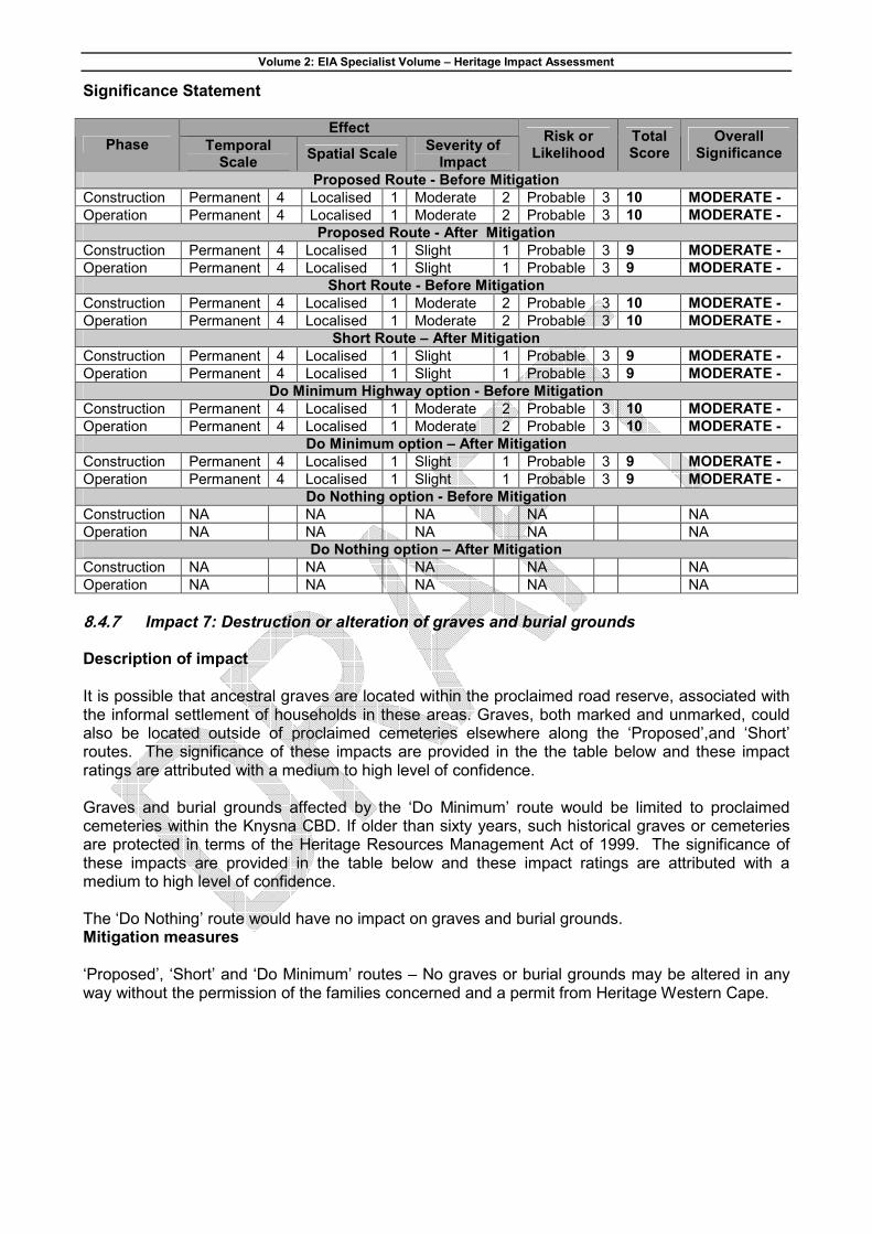
8.4.7 Impact 7: Destruction or alteration of graves and burial grounds Description of impact It is possible that ancestral graves are located within the proclaimed road reserve, associated with the informal settlement of households in these areas. Graves, both marked and unmarked, could also be located outside of proclaimed cemeteries elsewhere along the ‘Proposed’,and ‘Short’ routes. The significance of these impacts are provided in the the table below and these impact ratings are attributed with a medium to high level of confidence. Graves and burial grounds affected by the ‘Do Minimum’ route would be limited to proclaimed cemeteries within the Knysna CBD. If older than sixty years, such historical graves or cemeteries are protected in terms of the Heritage Resources Management Act of 1999. The significance of these impacts are provided in the table below and these impact ratings are attributed with a medium to high level of confidence. The ‘Do Nothing’ route would have no impact on graves and burial grounds. Mitigation measures ‘Proposed’, ‘Short’ and ‘Do Minimum’ routes – No graves or burial grounds may be altered in any way without the permission of the families concerned and a permit from Heritage Western Cape.

Volume 2: EIA Specialist Volume – Heritage Impact Assessment
Significance Statement
Effect Phase Temporal
Scale Spatial Scale
Severity of Impact
Risk or Likelihood
Total Score
Overall Significance
Proposed Route - Before Mitigation
Construction Permanent 4 Localised 1 Severe 4 Probable 3 12 HIGH -
Operation Permanent 4 Localised 1 Severe 4 Probable 3 12 HIGH -
Proposed Route - After Mitigation
Construction Permanent 4 Localised 1 Severe 4 Probable 3 12 HIGH -
Operation Permanent 4 Localised 1 Severe 4 Probable 3 12 HIGH -
Short Route - Before Mitigation
Construction Permanent 4 Localised 1 Severe 4 Probable 3 12 HIGH -
Operation Permanent 4 Localised 1 Severe 4 Probable 3 12 HIGH -
Short Route – After Mitigation
Construction Permanent 4 Localised 1 Severe 4 Probable 3 12 HIGH -
Operation Permanent 4 Localised 1 Severe 4 Probable 3 12 HIGH -
Do Minimum option - Before Mitigation
Construction Permanent 4 Localised 1 Moderate 2 Unlikely 1 8 MODERATE -
Operation Permanent 4 Localised 1 Moderate 2 Unlikely 1 8 MODERATE -
Do Minimum option – After Mitigation
Construction Permanent 4 Localised 1 Moderate 2 Unlikely 1 8 MODERATE -
Operation Permanent 4 Localised 1 Moderate 2 Unlikely 1 8 MODERATE -
Do Nothing option - Before Mitigation
Construction NA NA NA NA NA
Operation NA NA NA NA NA
Do Nothing option – After Mitigation
Construction NA NA NA NA NA
Operation NA NA NA NA NA
8.4.8 Impact 8: Destruction or alteration of sites of significance relating to the history of
slavery in South Africa Description of impact There are no records for sites of significance relating to the history of slavery in South Africa in and around Knysna. Accordingly, it is highly unlikely that any heritage resources in this category will be affected by any of the proposed highway alternatives. Mitigation measures Not applicable; no heritage resources in this category will be affected. Significance Statement
Effect Phase Temporal
Scale Spatial Scale
Severity of Impact
Risk or Likelihood
Total Score
Overall Significance
All Alternatives
Construction NA NA NA NA NA
Operation NA NA NA NA NA
8.4.9 Movable objects excluding any object made by a living person Description of impact No records exist of records in and around Knysna for any relevant movable objects. Accordingly, it is highly unlikely that any heritage resources in this category will be affected by these routes.

Volume 2: EIA Specialist Volume – Heritage Impact Assessment
Mitigation measures Not applicable; no heritage resources in this category will be affected. Significance Statement
Effect Phase Temporal
Scale Spatial Scale
Severity of Impact
Risk or Likelihood
Total Score
Overall Significance
All Route Alternatives- Before Mitigation
Construction NA NA NA NA NA
Operation NA NA NA NA NA
8.5 Conclusion
Table 8-1 that follows compares the nine heritage resource categories and ranks the alternatives in terms of their anticipated impacts. A ranking of 1 is the most preferred route and a ranking of 4 the least preferred option. In some cases some of the route options have similar impacts and are therefore ranked the same. Some of the differences between the ‘Proposed’ and ‘Short’ routes are due to the fact that the ‘Proposed’ route has a significantly longer footprint than the ‘Short’ route. It is clear that the ‘Proposed’ and ‘Short’ routes will have a similar effect on heritage resources overall except for impacts 1 and 5 where the greater length of the ‘Proposed’ route may result in more significant impacts. When comparing the routes to the ‘Do Minimum’ option, two factors emerge: The greatest mitigation cost could be incurred by category 7, if the ‘Proposed’ or ‘Short’ routes are chosen and if many graves are located within the proclaimed road reserve. However, since these households comprise illegal settlements, they and their ancestral graves will have to be relocated irrespective of the proposed highway project. Categories 1, 2 and 3 have higher overall heritage significance relative to categories 5, 6, 8 and 9 in the project area.
Accordingly, this heritage specialist study recommends that either the ‘Short’ or the ‘Proposed’ route is implemented in preference to the ‘Do Minimum’ or ‘Do Nothing’ options. Mitigation measures for the nine heritage resource categories are summarised Table 8-2.
This study further recommends that the development proceed with the proposed heritage mitigation and the specialists have submitted this report to Heritage Western Cape in fulfilment of the requirements of the Heritage Resources Management Act. According to Section 38(4) of the Act:
The report shall be considered timeously by the Council which shall, after consultation with the person proposing the development, decide -
(a) Whether or not the development may proceed; (b) Any limitations or conditions are to be applied to the development; (c) What general protections in terms of this Act apply, and what formal protections may be applied to such heritage resources; (d) Whether compensatory action shall be required in respect of any heritage resources damaged or destroyed as a result of the development; and (e) Whether the appointment of specialists is required as a condition of approval of the proposal.
The relevant Heritage Western Cape personnel member is Calvin van Wijk (telephone 021 483 9692).

Volume 2: EIA Specialist Volume – Heritage Impact Assessment
Table 8-1: Ranking of alternatives for the proposed Knysna N2 Toll Highway based on the impacts on heritage resource categories.
Heritage resource category ‘Proposed’ Routes
‘Short’ Route
‘Do Minimum’ option
‘Do Nothing’ option
1. Places, buildings, structures and equipment
2 1 4 3
2. Places to which oral traditions are attached or which are associated with living heritage
1 1 4 3
3. Historical settlements and townscapes
1 1 4 3
4. Landscapes and natural features
4 4 1 1
5. Geological sites of scientific or cultural importance
4 3 1 1
6. Archaeological and palaeontological sites
4 4 4 1
7. Graves and burial grounds 4 4 2 1
8. Sites of significance relating to the history of slavery in South Africa
N/A N/A N/A N/A
9. Movable objects excluding any object made by a living person
N/A N/A N/A N/A
Table 8-2: Recommended heritage resource mitigation measures
Mitigation Measures Heritage resource category ‘Proposed’ and ‘Short’ routes ‘Do Minimum’ option
‘Do Nothing’ Option
1. Places, buildings, Structures & equipment
Not applicable
Architectural impact assessment must identify all heritage resources and propose mitigation measures. Permit from Heritage Western Cape is required to alter any structure older than sixty years in any way.
Implement one of the alternative routes
2. Places to which oral traditions are attached or which are associated with living heritage
Not applicable
Architectural and historical impact assessments should identify all heritage resources and propose appropriate mitigation measures.
Implement one of the alternative routes
3. Historical settlements and townscapes
Not applicable
An appropriately qualified specialist should undertake an assessment of the historical townscape of Knysna to determine whether effective implementation of this route could limit or eliminate impacts.
Implement one of the alternative routes
4. Landscapes and Natural features
The recommendations of the Ecological and Visual Impact Assessments for this project to limit direct and indirect impacts on the Knysna estuary should be implemented.
5. Geological sites of scientific or cultural importance
The recommendations of the Geological Impact Assessment for this project to limit direct and indirect impacts on sensitive geological features should be implemented.
Not applicable
6. Archaeological and palaeontological sites
A permit from Heritage Western Cape is required to alter archaeological or palaeontological sites in any way. Depending on
Not applicable

Volume 2: EIA Specialist Volume – Heritage Impact Assessment
Mitigation Measures
Heritage resource category ‘Proposed’ and ‘Short’ routes ‘Do Minimum’ option
‘Do Nothing’ Option
its significance, a heritage resource in this category might require detailed recording and / or excavation and curation of material in an approved heritage institution.
7. Graves and burial grounds
No graves or burial grounds may be altered in any way without the permission of the families concerned and a permit from Heritage Western Cape.
Not applicable
8. Sites of significance relating to the history of slavery in South Africa
Not applicable
9. Movable objects excluding any object made by a living person
Not applicable