BASIC ASSESSMENT REPORT - SAHRIS
58
Basic Assessment Report Page 1 of 58 GIBELA UMKHUMBI OLWA NOBUBHA (For official use only) EIA File Reference Number: DM/0052/2012 NEAS Reference Number: KZN/EIA/0000864/2012 Waste Management Licence Number: (if applicable) Date Received: BASIC ASSESSMENT REPORT Submitted in terms of the Environmental Impact Assessment Regulations, 2010 promulgated in terms of the National Environmental Management Act, 1998 (Act No. 107 of 1998) This template may be used for the following applications: • Environmental Authorization subject to basic assessment for an activity that is listed in Listing Notices 1or 3, 2010 (Government Notices No. R 544 or No. R 546 dated 18 June 2010); or • Waste Management Licence for an activity that is listed in terms of section 20(b) of the National Environmental Management: Waste Act, 2008 (Act No. 59 of 2008) for which a basic assessment process as stipulated in the EIA Regulations must be conducted as part of the application (refer to the schedule of waste management activities in Category A of Government Notice No. 718 dated 03 July 2009). Kindly note that: 1. This basic assessment report meets the requirements of the EIA Regulations, 2010 and is meant to streamline applications. This report is the format prescribed by the KZN Department of Agriculture & Environmental Affairs. Please make sure that this is the latest version. 2. The report must be typed within the spaces provided in the form. The size of the spaces provided is not indicative of the amount of information to be provided. The report is in the form of a table that can extend itself as each space is filled with text. 3. Where required, place a cross in the box you select. 4. An incomplete report will be returned to the applicant for revision. 5. The use of “not applicable” in the report must be done with circumspection because if it is used in respect of material information that is required by the competent authority for assessing the application, it will result in the rejection of the application as provided for in the regulations. 6. No faxed or e-mailed reports will be accepted. 7. The report must be compiled by an independent environmental assessment practitioner (“EAP”). 8. Unless protected by law, all information in the report will become public information on receipt by the competent authority. Any interested and affected party should be provided with the information contained in this report on request, during any stage of the application process.
-
Upload
khangminh22 -
Category
Documents
-
view
0 -
download
0
Transcript of BASIC ASSESSMENT REPORT - SAHRIS

Basic Assessment Report
Page 1 of 58
GIBELA UMKHUMBI OLWA NOBUBHA
(For official use only)
EIA File Reference Number: DM/0052/2012
NEAS Reference Number: KZN/EIA/0000864/2012
Waste Management Licence Number: (if applicable)
Date Received:
BASIC ASSESSMENT REPORT Submitted in terms of the Environmental Impact Assessment Regulations, 2010 promulgated in terms of the National Environmental Management Act, 1998 (Act No. 107 of 1998)
This template may be used for the following applications:
• Environmental Authorization subject to basic assessment for an activity that is listed in Listing Notices 1or 3, 2010 (Government Notices No. R 544 or No. R 546 dated 18 June 2010); or
• Waste Management Licence for an activity that is listed in terms of section 20(b) of the National Environmental Management: Waste Act, 2008 (Act No. 59 of 2008) for which a basic assessment process as stipulated in the EIA Regulations must be conducted as part of the application (refer to the schedule of waste management activities in Category A of Government Notice No. 718 dated 03 July 2009).
Kindly note that: 1. This basic assessment report meets the requirements of the EIA Regulations, 2010 and is meant to
streamline applications. This report is the format prescribed by the KZN Department of Agriculture & Environmental Affairs. Please make sure that this is the latest version.
2. The report must be typed within the spaces provided in the form. The size of the spaces provided is not indicative of the amount of information to be provided. The report is in the form of a table that can extend itself as each space is filled with text.
3. Where required, place a cross in the box you select. 4. An incomplete report will be returned to the applicant for revision. 5. The use of “not applicable” in the report must be done with circumspection because if it is used in respect of
material information that is required by the competent authority for assessing the application, it will result in the rejection of the application as provided for in the regulations.
6. No faxed or e-mailed reports will be accepted. 7. The report must be compiled by an independent environmental assessment practitioner (“EAP”). 8. Unless protected by law, all information in the report will become public information on receipt by the
competent authority. Any interested and affected party should be provided with the information contained in this report on request, during any stage of the application process.

Basic Assessment Report
Page 2 of 58
GIBELA UMKHUMBI OLWA NOBUBHA
9. The KZN Department of Agriculture & Environmental Affairs may require that for specified types of activities in defined situations only parts of this report need to be completed.
10. The EAP must submit this basic assessment report for comment to all relevant State departments that administer a law relating to a matter affecting the environment. This provision is in accordance with Section 24 O (2) of the National Environmental Management Act 1998 (Act 107 of 1998) and such comments must be submitted within 40 days of such a request.
11. Please note that this report must be handed in or posted to the District Office of the KZN Department of Agriculture & Environmental Affairs to which the application has been allocated (please refer to the details provided in the letter of acknowledgement for this application).

Basic Assessment Report
Page 3 of 58
GIBELA UMKHUMBI OLWA NOBUBHA
DEPARTMENTAL REFERENCE NUMBER(S) File reference number (EIA):
DM/0052/2012 KZN/EIA/0000864/2012
File reference number (Waste Management Licence):
N/A
SECTION A: DETAILS OF THE ENVIRONMENTAL ASSESSMENT PRACTITIONER AND SPECIALISTS 1. NAME AND CONTACT DETAILS OF ENVIRONMENTAL ASSESSMENT PRACTITIONER (EAP) Name and contact details of the EAP who prepared this report:
Business name of EAP:
Green Door Environmental
Physical address:
400 Old Howick Road, Hilton
Postal address: P.O. Box 11, Hilton Postal code: 3245 Cell: 072 181 4236 Telephone: 033 343 4176 Fax: 033 343 4201 E-mail: [email protected]
2. NAMES AND EXPERTISE OF REPRESENTATIVES OF THE EAP Names and details of the expertise of each representative of the EAP involved in the preparation of this report:
Name of representative of the EAP
Education qualifications
Professional affiliations
Experience at environmental assessments (yrs)
Rebecca Bowd MEnvDev, BA (Hons) Enviro Sci & Geog
EAPSA, IAIA, SAIEA, IWMSA
10 years
3. NAMES AND EXPERTISE OF SPECIALISTS Names and details of the expertise of each specialist that has contributed to this report:
Name of specialist
Education qualifications
Field of expertise
Section/ s contributed to in this basic assessment report
Title of specialist report/ s as attached in Appendix D
G Davie - Geozone GeoServices
M.Sc. Pr.Sci.Nat
Geotechnical Appendix D1 -Geotechnical Assessment
The Results of a Geotechnical Investigation for a Proposed Mixed-use Development on Portion 361 (of 25) of the Farm Uitkomst and Doornrug No.852, Georgedale, KwaZulu-Natal
Frans Prins - Active
MA (Archaeology)
Archeologist
Appendix D2 -Heritage Impact
Cultural Heritage Impact Assessment Of The Proposed
Basic Assessment Report
Page 4 of 58
GIBELA UMKHUMBI OLWA NOBUBHA
Heritage CC
Assessment 11ha Mixed-Use Development On Portion 361 (Of 25) Of The Farm Uitkomst And Doornrug No 852, Near Hammarsdale, Kwazulu-Natal.
Dewald Jacobs - Fernridge Consulting (Pty) Ltd
BsC: Town & Regional Planning
Business Analyst Appendix D3 – Feasibility Study
Feasibility Study: Georgedale, KwaZulu-Natal Retail Development
Jannie Cronje - Umsunguli Project Management
PrTechni (Civil), PrCPM
Engineer Appendix D4 – Storm Water Management Plan
Storm Water Management Plan for Georgedale Mixed Use Development
Stan Walden – Asanta Sana
Pr.Tech, MCom Traffic Consultant Appendix D5 – Traffic Impact Assessment
Proposed Mixed Use Development on Portion 361 (of 25) of the Farm Uitkomst and Doornrug No. 852, near Hammarsdale, KwaZulu-Natal - Traffic Impact Assessment
C. Cowden - GroundTruth
B. Sc (Agric) Pr. Sci. Nat - Ecology
Wetland Ecology Appendix D6 – Wetland Assessment
Wetland Study: Georgedale Development Site

Basic Assessment Report
Page 5 of 58
GIBELA UMKHUMBI OLWA NOBUBHA
SECTION B: ACTIVITY INFORMATION 1. PROJECT TITLE Describe the project title as provided on the application form for environmental authorization:
The proposed 11 ha Mixed-Use Development on Portion 361 (of 25) of the Farm Uitkomst and Doornrug No. 852, located near to Hammarsdale, KwaZulu-Natal.
2. PROJECT DESCRIPTION Provide a detailed description of the project:
The Applicant proposes to establish an 11 ha Mixed-Use Development on Portion 361 (of 25) of the Farm Uitkomst and Doornrug No. 852, located near to Hammarsdale, KwaZulu-Natal. The proposed development comprises:
• A filling station – 500 m2;
• Retail space – 4 100 m2;
• An office block – 3 000 m2;
• Parking areas – 12 000 m2;
• Warehousing – 2 000 m2; and
• Light industrial – 2 421.2 m2. The Municipality’s definition of Light industrial and Manufacturing is – “an industrial process that does not emit noxious effluent and does not use solid fuel, i.e. coal, and does not use motors of more than 25kw in power”. The proposed development will be constructed over a disused sand quarry and consist of double storey buildings. The site is located along a Future Residential Corridor, the increased number of people both living and working in the area will create increased opportunity for local retailers and service providers as people living and working in the area need conveniences. Access to commercial facilities for residents will be improved, alleviating the need to travel to other serviced areas, which costs money, time and also produces pollution. Local level buying is a theme for future sustainable living practices. This also applies to the access of fuel; the closest filling stations are located 9 km (Wallers Garage) and 15 km (Cato Ridge Motors) away on opposite ends of the MR385 road. Water will be provided via a link to Municipal infrastructure. Eskom has confirmed that connection is possible for the site. Access to the site will be via the M385 and D140 Roads. The soils are unsuitable for effluent disposal via percolation methods unless some steps are taken to create an evapotranspiration bed into which the effluent is directed. A new bulk outfall sewer from Cato Ridge to Hammersdale is to be established; the preferred sewage disposal method is therefore via link to Municipal infrastructure.
The proposed mixed use development will be constructed in two phases: Phase 1 being 4 000 m2 and Phase 2 being 20 000 m2. Phase 1 will be serviced by a conservancy tank, whereas Phase 2 is subject to a link into the outfall sewer planned by the municipality between Cato Ridge and Hammersdale. A conservancy tank is a covered tank without an overflow which is
Basic Assessment Report
Page 6 of 58
GIBELA UMKHUMBI OLWA NOBUBHA
used for the reception and temporary retention of sewage that requires routine emptying at intervals. The proposed development will generate 400 litres of effluent per 100 m2 per day (400 L / 100 m2 / day). Phase 1 will therefore generate approximately 16 000 litres of effluent per day. The conservancy tank will be collected and disposed of via honey sucker (4 collections / trips per day collecting 10 000 litres per trip). The conservancy tank will have a two day storage capacity.
3. ACTIVITY DESCRIPTION Describe each listed activity in Listing Notice 1 (GNR 544, 18 June 2010), Listing Notice 3 (GNR 546, 18June 2010) or Category A of GN 718, 3 July 2009 (Waste Management Activities) which is being applied for as per the project description: GNR 544: Part 11: The construction of iii) bridges… where such construction occurs within a watercourse or within 32 metres of a watercourse, measured from the edge of a watercourse… The development will be constructed within 32 m of a watercourse. Part 13: The construction of facilities or infrastructure for the storage, or storage and handling of dangerous good, where such storage occurs in containers with a combined capacity of 80 but not exceeding 500 cubic meters. The proposed development includes the construction of a filling station. Part 18: The infilling or depositing of any material of more than 5 m
3 into or the dredging,
excavation, removal or moving of soil, sand, shells, shell grit, pebbles or rock or more than 5 m
3 from:
i) a watercourse The proposed development will involve infilling and depositing of soil near to or from a watercourse. Part 23: The transformation of undeveloped, vacant or derelict land to – (i) residential, retail, commercial, recreational, industrial or institutional use, inside an urban area, and where the total area to be transformed is 5 hectares or more, but less than 20 hectares, or (ii) residential, retail, commercial, recreational, industrial or institutional use, outside an urban area and where the total area to be transformed is bigger than 1 hectare but less than 20 hectares; - The Applicant proposes to establish an 11 ha Mixed-Use Development.
4. FEASIBLE AND REASONABLE ALTERNATIVES “alternatives”, in relation to a proposed activity, means different means of meeting the general purpose and requirements of the activity, which may include alternatives to—
(a) the property on which or location where it is proposed to undertake the activity;
Alternative property or locations have not been investigated as this would not be financially feasible for the Applicant. The property on which the proposed development is to be

Basic Assessment Report
Page 7 of 58
GIBELA UMKHUMBI OLWA NOBUBHA
established is owned by the Applicant, and the Applicant does not own any other land in the area to locate a development of this nature on.
(b) the type of activity to be undertaken; The following types of alternative activities have been investigated: (b1) Light Industrial The Applicant proposes to include light industrial and service units (warehousing) as part of the mixed-use development. The freight route between the Port of Durban and Pietermaritzburg is outlined in the eThekwini Municipality IDP 2013/2014; with emphasis a dedicated freight management for both inbound and outbound cargo. The Feasibility Study in Appendix D3 of this report identified that a large portion of the residents in the area are employed by industrial and agriculture industries. The inclusion of a light industrial component to the proposed mixed-use development is therefore in line with the requirements of the eThekwini’s IDP. One of the primary aims of the proposed mixed-use development is to service the current and future low-income residential components in the area, so as to limit the need for extensive commuting by these residents to neighbouring towns. Convenience is ultimately the aim of the mixed use development. This aim would not be fulfilled, nor would it be feasible to develop a purely light industrial development. This does not fulfil the needs of the current and future residents in the area, nor is it feasible according the Feasibility Study conducted. (b2) Commercial / Retail A retail component will be included in the mixed-use development. The Feasibility Study in Appendix D3 of this report concluded the following with regard to a retail / commercial component:
• A proposed retail centre on the proposed site will either need to compete in terms of size with Hammarsdale Junction, or serve a different need / function with a unique set of tenants not present in the catchment area.
• In this regard it will be important not to duplicate the offer that Hammersdale Junction provide with a similar type of centre, but rather provide an unique offer that service different needs amongst catchment residents.
• Free standing retail can rather be considered at the proposed site, such as a Building Materials Supplier with a service station complemented by government offices.
• Possible residential expansion along the in the future (Residential Corridor according to the eThekwini Municipality SDF) can open the possibility for a retail centre in the long term future on the proposed site.
• A catchment area was delineated for the proposed retail development which is indicative of the anticipated support for the proposed centre.
Provided the retail components of the proposed mixed use development do not conflict with those on offer at the Hammersdale Junction or service an alternative need (i.e. building supplies) then the retail component of the mixed use development is supported by the Specialist (Business Analyst). As stated in B1 above, one of the primary aims of the proposed mixed-use development is to service the current and future low-income residential components in the area, so as to limit the need for extensive commuting by these residents to neighbouring towns. Convenience is

Basic Assessment Report
Page 8 of 58
GIBELA UMKHUMBI OLWA NOBUBHA
ultimately the aim of the mixed use development. This aim would not be fulfilled, nor would it be feasible to develop a purely commercial development. This does not fulfil the needs of the current and future residents in the area, especially with regard to addressing job creation / opportunities. (b3) Residential Development The residential component of the mixed-use development has been investigated and it was concluded that this would not be included in the mixed-use development. The proposed site is decentralized on the northern edge of the in-formal low income residential fabric of Georgedale. The Feasibility Study in Appendix D3 of this report draws attention to the Future Residential Growth Corridor - a number of residential developments proposed for the area. In total, ± 4,100 residential units are planned where ± 1,000 bondable units will compose of bonded houses and the remainder ± 3,100 RPD houses. These developments are expected to be completed and occupied by 2018. Due to the influx of low income residential development proposed in the area, a residential component has been determined unfeasible and will not be pursued. The focus of the proposed mixed use development will be to service the residents of these housing developments.
(c) the design or layout of the activity; (c1) Preferred Layout attached as “Final Layout” The layout attached as Appendix C1 is the preferred layout. Development is focused on one side of the D140 Road – the southern portion. Developing this portion of land will minimise the negative impacts on the wetland which is located on the northern portion of land across the D140 Road. The southern portion of land is not environmentally sensitive and is in a more visible position from both the MR385 Road and the D140 road. (c2) Alternative Layout attached as “Alternative Layout” The alternative layout is attached as Appendix C2. This layout features development on both portions of land on either side of the D140 road – the northern and southern portions. The northern portion features the parking area for the development in the southern portion. This is not the preferred layout as the proposed parking area on the northern portion could have negative impacts on the wetland located there. Having the parking located across the D140 road also poses negative impacts in terms of pedestrian safety when having to cross the road.
(d) the technology to be used in the activity; Not applicable.
(e) the operational aspects of the activity; and The following types of alternative sewage disposal options have been investigated:
(e1) Septic Tanks According to the Geotechnical Assessment (Appendix D1), the soils are unsuitable for effluent disposal via percolation methods unless some steps are taken to create an evapotranspiration bed into which the effluent is directed. In this regard an evapotranspiration bed would need to be prepared and sized according to the amount of effluent that will be generated by the development. This may best be accomplished by firstly removing the topsoil and then ripping the substrate to a depth of at least 1.5 m. The French drains should then be constructed within

Basic Assessment Report
Page 9 of 58
GIBELA UMKHUMBI OLWA NOBUBHA
the upslope third of this prepared area. The topsoil can then be replaced, and vegetation and grass allowed to grow back over the ripped area to assist with the transpiration component of the sewer system. The disposal of sewage via this method is not considered “Best Practice” from an environmental perspective due to the number of negative impacts that can occur due to the mismanagement and lack of maintenance of the systems. Due to this, and the results of the Geotechnical Assessment, septic tanks systems are not the preferred sewage disposal option. (e2) Conservancy Tank The proposed mixed use development will be constructed in two phases: Phase 1 being 4 000 m2 and Phase 2 being 20 000 m2. Phase 1 will be serviced by a conservancy tank. A conservancy tank is a covered tank without an overflow which is used for the reception and temporary retention of sewage that requires routine emptying at intervals. The proposed development will generate 400 litres of effluent per 100 m2 per day (400 L / 100 m2 / day). Phase 1 will therefore generate approximately 16 000 litres of effluent per day. The conservancy tank will be collected and disposed of via honey sucker (4 collections/trips per day collecting 10 000 litres per trip). The conservancy tank will have a two day storage capacity. (e3) Municipal The proposed mixed use development will be constructed in two phases: Phase 1 being 4 000 m2 and Phase 2 being 20 000 m2. Phase 2 will be serviced by the new outfall sewer from Cato Ridge to Hammersdale WWTW. Connection to municipal sewage infrastructure is the preferred option. Even though this option may result in initial additional costs for the Applicant, it is the preferred method due to the long-term sustainability and maintenance of the sewage system.
(f) the option of not implementing the activity. The “do-nothing” option would be to keep the property as it is i.e. vacant (veld dominated by alien vegetation). The planning context for the area puts the site in a prime location for development. This is because the site has access off the main road, M385. The M385 road intersects with the N3 National Road, and thus provides excellent access opportunities for all. The site is located in close proximity to the freight route between the Port of Durban and Pietermaritzburg as outlined in the eThekwini Municipality IDP 2013/2014. The proposed development is intended to be a building block for the National economic strategy which has prioritised development corridors because of their ability to improve spatial equity, especially in the context of South Africa where millions of people suffer spatial inequality daily as a legacy of apartheid. If the site is not developed, and remains vacant, then there will be a wasted opportunity to contribute to the vision of the development corridor and to deliver all of the benefits that have been described in the Need and Desirability Section 11.
Sections B 5 – 15 below should be completed for each alternative.

Basic Assessment Report
Page 10 of 58
GIBELA UMKHUMBI OLWA NOBUBHA
5. ACTIVITY POSITION Indicate the position of the activity using the latitude and longitude of the centre point of the site for each alternative site. The co-ordinates should be in degrees, minutes and seconds. List alternative sites were applicable. Alternative:
Latitude (S): Longitude (E):
Alternative S11 (preferred or only site alternative)
29o 46‘ 45.87“ 30o 36‘ 31.24“
6. PHYSICAL SIZE OF THE ACTIVITY Indicate the physical size of the preferred activity/technology as well as alternative activities/technologies (footprints): Alternative: Size of the activity:
Alternative A12 (preferred activity alternative) 24 000 m2
Alternative:
Length of the activity:
Alternative A1 (preferred activity alternative) N/A
Indicate the size of the alternative sites or servitudes (within which the above footprints will occur): Alternative: Size of the
site/servitude:
Alternative A1 (preferred activity alternative) 110 801 m2
7. SITE ACCESS
Does ready access to the site exist? YES
If NO, what is the distance over which a new access road will be built m
Describe the type of access road planned:
Access to the site is proposed to be provided onto District Road 140 at four locations with entrances and exits as separate accesses. A separate entrance and exit will be provided to both the portion lying to north of D140 (to serve the light industrial portion) and to the portion lying to the south of D140 (to serve the portion containing the retail, warehouse, office and the petrol filling station).
Include the position of the access road on the site plan and required map, as well as an indication of the road in relation to the site.
1 “Alternative S..” refer to site alternatives.
2 “Alternative A..” refer to activity, process, technology or other alternatives.
Basic Assessment Report
Page 11 of 58
GIBELA UMKHUMBI OLWA NOBUBHA
8. SITE OR ROUTE PLAN
A detailed site or route plan(s) must be prepared for each alternative site or alternative activity. It must be attached as Appendix A to this report. The site or route plans must indicate the following:
8.1. the scale of the plan which must be at least a scale of 1:500; 8.2. the property boundaries and numbers/ erf/ farm numbers of all adjoining properties of
the site; 8.3. the current land use as well as the land use zoning of each of the properties adjoining
the site or sites; 8.4. the exact position of each element of the application as well as any other structures
on the site; 8.5. the position of services, including electricity supply cables (indicate above or
underground), water supply pipelines, boreholes, street lights, sewage pipelines, storm water infrastructure and telecommunication infrastructure;
8.6. walls and fencing including details of the height and construction material; 8.7. servitudes indicating the purpose of the servitude; 8.8. sensitive environmental elements within 100 metres of the site or sites including (but
not limited thereto): � rivers, streams, drainage lines or wetlands; � the 1:100 year flood line (where available or where it is required by DWA); � ridges; � cultural and historical features; � areas with indigenous vegetation including protected plant species (even if it is
degraded or infested with alien species); 8.9. for gentle slopes the 1 metre contour intervals must be indicated on the plan and
whenever the slope of the site exceeds 1:10, the 500mm contours must be indicated on the plan; and
8.10. the positions from where photographs of the site were taken. 9. SITE PHOTOGRAPHS Colour photographs from the centre of the site must be taken in at least the eight major compass directions with a description of each photograph. Photographs must be attached under Appendix B to this report. It must be supplemented with additional photographs of relevant features on the site, if applicable. 10. FACILITY ILLUSTRATION A detailed illustration of the facility must be provided at a scale of 1:200 and attached to this report as Appendix C. The illustrations must be to scale and must represent a realistic image of the planned activity/ies.

Basic Assessment Report
Page 12 of 58
GIBELA UMKHUMBI OLWA NOBUBHA
11. ACTIVITY MOTIVATION
11.1. Socio-economic value of the activity
What is the expected capital value of the activity on completion? R 20 million
What is the expected yearly income that will be generated by or as a result of the activity?
R 10 million
Will the activity contribute to service infrastructure? NO
Is the activity a public amenity? NO
How many new employment opportunities will be created in the development phase of the activity?
250
What is the expected value of the employment opportunities during the development phase?
R 3 million / month
What percentage of this will accrue to previously disadvantaged individuals? 95 %
How many permanent new employment opportunities will be created during the operational phase of the activity?
300
What is the expected current value of the employment opportunities during the first 10 years?
R 360 million
What percentage of this will accrue to previously disadvantaged individuals? 95 %
11.2. Need and desirability of the activity
Motivate and explain the need and desirability of the activity (including demand for the activity): A Feasibility Study (Appendix D3) was conducted for the proposed mixed-use development and concluded the following: • Development Planning SDF of the eThekwini Municipality, the site is located along a Future
Residential Corridor. The site rates as good (62%). The site enjoys excellent visibility and access from the MR385 main transient route.
• The proposed site is decentralised from the residential fabric in the area, and lacks complimentary facilities which attract people from all over the catchment area. The proposed filling station and offices will add to complimentary facilities at the site and increase the rating slightly.
• Important for the proposed retail development will be to establish a public transport rank on site with complimentary facilities, in order to attract the critical mass needed for such a development.
• Currently a limited amount of formal retail exists within the catchment area, except for a few centers. • Outflow mainly occurs to Hillcrest for a larger retail variety. For higher order goods, outflow occurs
as far as Pietermaritzburg and Durban. Hammarsdale Junction Shopping Centre • Hammarsdale Junction SC (19,300m² GLA) is currently under construction within the catchment
area. • The Hammarsdale Junction Shopping Centre located along the MR385 is near completion (2013)
and is planned to be sized at ± 19,300m² GLA. Possible main anchors at the Hammarsdale Junction Shopping Centre may include Superspar and Pick ‘n Pay.
• A proposed retail centre on the proposed site will either need to compete in terms of size with Hammarsdale Junction, or serve a different need / function with a unique set of tenants not present in the catchment area.
• There are a number of residential developments proposed for the area. • In total, ± 4,100 residential units are planned where ± 1,000 bondable units will compose of bonded
houses and the remainder ± 3,100 RPD houses. These developments are expected to be completed and occupied by 2018.

Basic Assessment Report
Page 13 of 58
GIBELA UMKHUMBI OLWA NOBUBHA
• Hammarsdale Neighbourhood Centre is planned opposite the existing Boxer. The size of the proposed centre is planned to be ± 11,000m² GLA with Shoprite as a possible main anchor. Construction should begin soon as final approval is awaited from the council for the proposed centre.
• The proposed Hammarsdale retail site itself is part of a larger mixed use development. This scheme depicts the whole development of Mpumalanga. The Municipality wants to develop this whole area into a new Town Centre for the Mpumalanga area. Construction of the infrastructure has already commenced. This Mpumalanga New Town Centre Development is a project emanating from the Municipality Integrated Development Plan (IDP) and Metropolitan Spatial Development Framework (SDF) Plan.
• This Hammarsdale Junction node is clearly a priority growth area for the council. The SDF indicates that the corridor along the M385 further north, past the site, is also a future residential growth corridor, but residential development is not anticipated in the short term along this corridor.
The following section makes use of the Western Cape Department of Environmental Affairs and Development Planning (DEA&DP) Guideline on Need and Desirability (August 2010) (DEA&DP 2010c):
1. Is the activity permitted in terms of the property’s existing land use rights? The property is currently un-zoned, and a Development Consent will be applied for through the PDA Process.
2. Will the activity be in line with the following?
a) Provincial Spatial Development Framework (PSDF)
The Kwazulu-Natal Provincial Spatial Development aims include: • The promotion of development in support of the N3 National Road Primary Development
Priority Corridor; • The promotion of ‘’compact urban development and the combating of urban sprawl’’; • The promotion of ‘’focused investment and managed growth’’.
Of interest to this Application, the Provincial Spatial Development Framework also includes the promotion of small town regeneration. The proposed mixed use development addresses the abovementioned aims of the PSDF, in that the development will service needs of the residents of the current and future low income housing developments which targets growth management and urban sprawl in the area.
b) Urban edge / Edge of Built environment for the area Policies concerning the ‘urban edge’ and the ‘case for densification’ have been made by the Kwazulu-Natal Department of Local Government and Traditional Affairs within the Urban Development Framework Manual, July 2011. Chapter 4. Support for urban densification in South Africa is derived from International Best Practise. Planning policies at all levels of government have adopted, and promote the objective of urban densification. Although there are negative environmental implications associated with the densification of suburban areas, the benefits are numerous. These benefits include:
• The protection of agricultural potential and environmentally sensitive land; • Shorter travel distances within compacted areas and public transport viability; • Reduced infrastructural costs; and • Reduced carbon footprint. The development site is a vacant disused sand mining operation that is infested with alien vegetation, and is therefore not environmentally sensitive nor does it have any agricultural potential. The aim of the proposed mixed use development is to service the residents of the
Basic Assessment Report
Page 14 of 58
GIBELA UMKHUMBI OLWA NOBUBHA
current and future low income housing developments in the area. The development will be in close proximity to these low income housing developments which will reduce transport costs and in turn reduce carbon footprints.
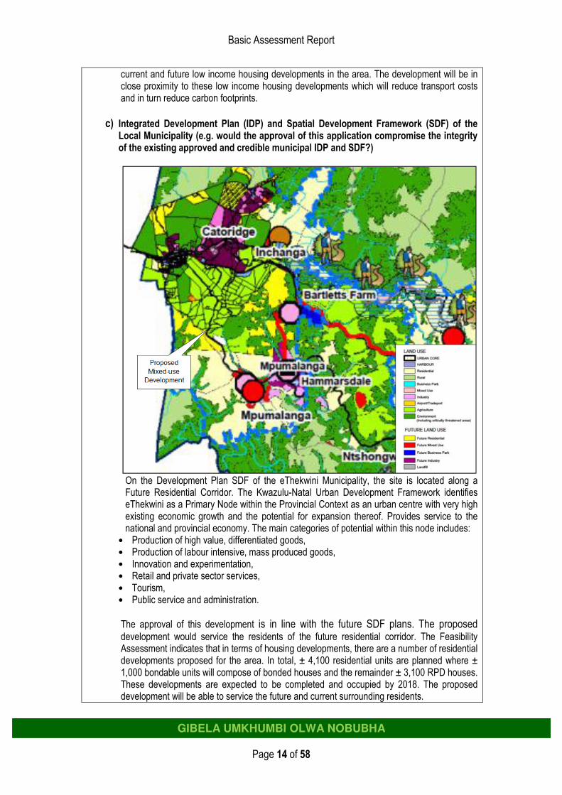
c) Integrated Development Plan (IDP) and Spatial Development Framework (SDF) of the
Local Municipality (e.g. would the approval of this application compromise the integrity of the existing approved and credible municipal IDP and SDF?)
On the Development Plan SDF of the eThekwini Municipality, the site is located along a Future Residential Corridor. The Kwazulu-Natal Urban Development Framework identifies eThekwini as a Primary Node within the Provincial Context as an urban centre with very high existing economic growth and the potential for expansion thereof. Provides service to the national and provincial economy. The main categories of potential within this node includes:
• Production of high value, differentiated goods, • Production of labour intensive, mass produced goods, • Innovation and experimentation, • Retail and private sector services, • Tourism, • Public service and administration.
The approval of this development is in line with the future SDF plans. The proposed development would service the residents of the future residential corridor. The Feasibility Assessment indicates that in terms of housing developments, there are a number of residential developments proposed for the area. In total, ± 4,100 residential units are planned where ± 1,000 bondable units will compose of bonded houses and the remainder ± 3,100 RPD houses. These developments are expected to be completed and occupied by 2018. The proposed development will be able to service the future and current surrounding residents.

Basic Assessment Report
Page 15 of 58
GIBELA UMKHUMBI OLWA NOBUBHA
d) Approved Structure Plan of the Municipality
See above.
e) An Environmental Management Framework (EMF) adopted by the Department (e.g.
Would the approval of this application compromise the integrity of the existing environmental management priorities for the area and if so, can it be justified in terms of sustainability considerations?) An EMF has not been developed for this area. The eThekwini SDF: Environmental Planning does not identify Georgedale as an area that is environmentally sensitive. The implementation of the eThekwini Environmental Services Management Plan (EESMP), or open space plan, will however contribute significantly to: • Achieving the aims and objectives of the Municipality’s Integrated Development Plan, • Improving the quality of life of the residents of Durban, and • Meeting national and international environmental commitments.
f) Any other Plans (e.g. Guide Plan) Not applicable.
3. Is the land use (associated with the activity being applied for) considered within the
timeframe intended by the existing approved SDF agreed to by the relevant environmental authority (i.e. is the proposed development in line with the projects and programmes identified as priorities within the credible IDP)? As the site is located along a Future Residential Corridor, the increased number of people both living and working in the area will create increased opportunity for local retailers and service providers as people living and working in the area need conveniences. Access to commercial facilities and fuel for residents will be improved, alleviating the need to travel to other serviced areas, which costs money, time and also produces pollution. Local level buying is a theme for future sustainable living practices.
4. Does the community/area need the activity and the associated land use concerned (is it
a societal priority)? (This refers to the strategic as well as local level (e.g. development is a national priority, but within a specific local context it could be inappropriate.) As the site is located along a Future Residential Corridor, the increased number of people both living and working in the area will create increased opportunity for local retailers and service providers as people living and working in the area need conveniences. Access to commercial facilities for residents will be improved, alleviating the need to travel to other serviced areas, which costs money, time and also produces pollution. Local level buying is a theme for future sustainable living practices. This also applies to the access of fuel; the closest filling stations are located 9 km and 15 km away on opposite ends of the MR385 road.
5. Are the necessary services with adequate capacity currently available (at the time of
application), or must additional capacity be created to cater for the development? It has been confirmed by eThekwini Municipality that an electricity supply will be made available. Any relocation or extensions of infrastructure are the Applicant’s expense. Water will be supplied from Municipal Source. This will be confirmed in the signed Services Agreement which will be included in the Final Basic Assessment Report. eThekwini Municipality have not confirmed that refuse will be collected from the development during the operational phase – this will be confirmed in the Final Basic Assessment Report in the Services Agreement. In the event that refuse is not collected by the Municipality, refuse collection will be the responsibility of the mixed use development to contract a private service
Basic Assessment Report
Page 16 of 58
GIBELA UMKHUMBI OLWA NOBUBHA
provider to collect refuse from a dedicated refuse collection area on a weekly basis. The refuse shall be taken to an approved municipal landfill e.g. Shongweni. The proposed mixed use development will be constructed in two phases: Phase 1 being 4 000 m2 and Phase 2 being 20 000 m2. Phase 1 will be serviced by a conservancy tank, whereas Phase 2 is subject to a link into the outfall sewer planned by the municipality between Cato Ridge and Hammersdale. The proposed development will generate 400 litres of effluent per 100 m2 per day (400 L / 100 m2 / day). Phase 1 will therefore generate approximately 16 000 litres of effluent per day. The conservancy tank will be collected and disposed of via honey sucker (4 collections/trips per day collecting 10 000 litres per trip). The conservancy tank will have a two day storage capacity. According to the Geotechnical Assessment (Appendix D1), the soils are unsuitable for effluent disposal via percolation methods unless some steps are taken to create an evapotranspiration bed into which the effluent is directed. Connection to the Municipal Sewage System is the “Best Practice” and preferred option.
6. Is this development provided for in the infrastructure planning of the municipality, and
if not what will the implication be on the infrastructure planning of the municipality (priority and placement of services and opportunity costs)? There is no implication for infrastructural planning for the Municipality. With regard to sewage disposal, eThekwini is planning a new outfall sewer from Cato Ridge to Hammersdale WWTW. Connection to municipal sewage infrastructure is the preferred option.
7. Is this project part of a national programme to address an issue of national concern or
importance? The eThekwini’s SDF aligns itself with the National Development Plan (NDP). The most pertinent issue that the proposed development will address is the creation of employment opportunities.
8. Do location factors favour this land use (associated with the activity applied for) at this
place? (This relates to the contextualisation of the proposed land use on this site within its broader context.) The site enjoys excellent visibility and access from the MR385 main transient route and is located along a Future Residential Corridor. The increased number of people both living and working in the area will create increased opportunity for local retailers and service providers as people living and working in the area need conveniences. Access to commercial facilities for residents will be improved, alleviating the need to travel to other serviced areas, which costs money, time and also produces pollution. Local level buying is a theme for future sustainable living practices.
9. Is the development the best practicable environmental option for this land/site?
From an environmental perspective, the proposed activity does not pose any significant negative environmental impacts, which cannot be mitigated. The development location is proposed on a disused sand mining operation. There is alien vegetation thriving on the site (increasing year on year). There is also a wetland located on the proposed site. The approval of the proposed development will better allow the ability to enforce the conservation of the wetland (i.e through the implementation of buffers), as well as the removal of alien vegetation. The layout of the proposed development does not encroach into environmentally sensitive areas.
10. Will the benefits of the proposed land use/development outweigh the negative impacts
of it?

Basic Assessment Report
Page 17 of 58
GIBELA UMKHUMBI OLWA NOBUBHA
Negatives: • Increased hardened areas and stormwater management requirements. • Vacant land is infested with alien vegetation.
Positives: • Social Upliftment – servicing the existing and future residents of the area through job
creation, access to facilities, and alleviating the need to travel to other serviced areas (costing time and money, and causing pollution).
• Environmental Benefits – through the implementation of alien vegetation management plans and buffer to secure and preserve the associated wetland on the site.
• Location – the development has excellent visibility and access as it is located off the MR385 main transient route.
• Development of vacant land: will aid in crime prevention, as well as, the removal of alien vegetation.
• Increased opportunity for public transportation. • Resident’s reduction of trips will lower their transport costs, lower consumption of resources
and thus lower carbon footprint for society.
11. Will the proposed land use/development set a precedent for similar activities in the area (local municipality)? It is likely that this could occur.
12. Will any person’s rights be negatively affected by the proposed activity/ies?
The development will result in the uplifting of people’s rights.
13. Will the proposed activity/ies contribute to any of the 18 Strategic Integrated Projects (SIPS)? SIP 2: Durban-Free State-Gauteng logistics and industrial corridor The concept of corridor development at a local level facilitates spatial equity. The aim of the projects in SIP2 are to develop a robust ‘’logistics and transport corridor between South Africa’s main industrial hub and to improve access to Durban's export and import facilities’’. The development of the corridor will stimulate significant employment opportunities during both development and afterwards. The proposed development is located in the vicinity of the N3 highway. The proposed development would have the ability to cater for the events created by the development of the corridor i.e. the corridor will create employment which will in turn see people seeking residence, which will increase the need for commercial facilities.
14. What will the benefits be to society in general and to the local communities?
Benefits are listed below for the development: • There are employment opportunities for local communities, both temporary and permanent,
from the construction and operational phases. • Viability of public transport will potentially increase. • Resident’s reduction of trips will lower their transport costs, lower consumption of resources
and thus lower carbon footprint for society. • Better utilization of vacant land. • Create a climate of long term spontaneous growth.
15. Any other need and desirability considerations related to the proposed activity?
Not applicable.
16. How does the project fit into the National Development Plan for 2030?

Basic Assessment Report
Page 18 of 58
GIBELA UMKHUMBI OLWA NOBUBHA
See answer (7) above.
17. Please describe how the general objectives of Integrated Environmental Management as set out in section 23 of NEMA have been taken into account. Numerous Specialists have been consulted as part of the feasibility work undertaken for this development (Appendix D). Mitigation measures have been developed to address the potential environmental impacts identified by the Specialists and mitigation measures have been included in the EMPr (Appendix F). Participation of all Interested and Affected Parties has been facilitated (refer to Appendix E).
18. Please describe how the principles of environmental management as set out in section 2 of NEMA have been taken into account. Section 2 of NEMA states that ‘environmental management must place people and their needs at the forefront of its concern, and serve their physical, psychological, developmental, cultural and social interests equitably’. The disturbance of ecosystems has been minimised and rehabilitation guidance is included in the Environmental Management Programme (Appendix F).
Conclusion • The proposed site is on the fringe of the existing residential fabric. According to the SDF for the
area, future densification is expected along the M385 road towards the N3. However, this is seen as the long term plan.
• Another similar retail centre at the site will duplicate the offer and hence be at risk as it enters the market much later after shopping patterns have been established to the Hammarsdale Junction centre.
• However, free standing retail can be considered at the proposed site such as a Building Materials Supplier together with the proposed service station complemented by Government Offices.
• Proposed retail on the proposed site should not duplicate the offer at the nearly completed Hammarsdale Junction, but rather host a unique type of national branded retail such as a Building Materials Supplier or a service station.
• The specialist does not see scope for another large scale Community Centre in the catchment as there will remain high levels of outflow support to larger nodes.
• The development of the filling station and government offices at the site will be to the benefit of any type of development at the site as it would establish a node.
• A large scale building material supplier could be opened at the site and at a later stage when the residential corridor along the MR385 develops, the site could be developed to a convenience centre or a larger community centre, pending demand.
• The railway station passengers at the site currently does not warrant a strong enough support base for the retail centre, but it will be a definite benefit for a building material supplier and /or motor dealerships or a future retail centre at the site when the residential corridor develop.
• Please note that many factors contribute to the ultimate success of a centre, such as: layout, management, marketing, offering (tenant mix), changing existing shopping patterns, and market trends along with macro economic conditions. Demographic potential is only one aspect.
• The proposed development is in line with the aims of the Provincial Spatial Development Framework (PSDF).
• The proposed development promotes the objective of urban densification. • The proposed development does not compromise the Integrated Development Plan (IDP) and
Spatial Development Framework (SDF) of the eThekwini Municipality. The Kwazulu-Natal Urban Development Framework identifies eThekwini Municipality as a Primary Node within the Provincial Context as an urban centre with very high existing economic growth and the potential for expansion thereof.
• The eThekwini SDF: Environmental Planning does not identify Georgedale as an area that is environmentally sensitive.

Basic Assessment Report
Page 19 of 58
GIBELA UMKHUMBI OLWA NOBUBHA
• As the site is located along a Future Residential Corridor, the increased number of people both living and working in the area will create increased opportunity for local retailers and service providers as people living and working in the area need conveniences. Access to commercial facilities and fuel for residents will be improved, alleviating the need to travel to other serviced areas, which costs money, time and also produces pollution. Local level buying is a theme for future sustainable living practices. This also applies to the access of fuel; the closest filling stations are located 9 km and 15 km away on opposite ends of the MR385 road.
• From an environmental perspective, the proposed activity does not pose any significant negative environmental impacts, which cannot be mitigated.
• The approval of the proposed development will better allow the ability to enforce the conservation of the wetland (i.e. through the implementation of buffers), as well as the removal of alien vegetation. The layout of the proposed development does not encroach into environmentally sensitive areas.
• Development of vacant land: will aid in crime prevention, as well as, the removal of alien vegetation. • Increased opportunity for public transportation. • Location – the development has excellent visibility and access as it is located off the MR385 main
transient route. • Social Upliftment – servicing the existing and future residents of the area through job creation,
access to facilities, and alleviating the need to travel to other serviced areas (costing time and money, and causing pollution).
• The proposed development contributes to SIP (Strategic Integrated Projects) 2 - Durban-Free State-Gauteng logistics and industrial corridor: The proposed development is located in the vicinity of the N3 highway. The proposed development would have the ability to cater for the events created by the development of the corridor i.e. the corridor will create employment which will in turn see people seeking residence, which will increase the need for commercial facilities.
Indicate any benefits that the activity will have for society in general:
See answer (14) above.
Indicate any benefits that the activity will have for the local communities where the activity will be located:
See answer (14) above.
12. APPLICABLE LEGISLATION, POLICIES AND/OR GUIDELINES List all legislation, policies and/or guidelines of any sphere of government that are relevant to the application as contemplated in the EIA regulations, if applicable: Title of legislation, policy or guideline: Administering authority: Date: National Environmental Management Act (NEMA) (Act No. 107 of 1998)
DEA 1998
EIA Guideline & Information Document Series. Western Cape Department of Environmental Affairs and Development Planning
DEA&DP 2010
National Water Act (Act No. 36 of 1998). DWA 1998
National Heritage Resources Act (Act 25 No. of 1999) AMAFA 1999
KwaZulu-Natal Planning and Development Act (Act No. 5 of 1998).
Municipality 1998
Conservation of Agricultural Resources Act (Act 43 of 1983) –– for control and removal of alien invasive plants (Regulations 14 & 15).
DEA&DP 1983
KZN Urban Development Framework Manual KwaZulu-Natal Department of Local Government and Traditional Affairs
2011
KZN Provincial Growth and Development Plan KZN Provincial Planning 2013

Basic Assessment Report
Page 20 of 58
GIBELA UMKHUMBI OLWA NOBUBHA
Commission
KZN Provincial Spatial Economic Development Strategy (PSEDS)
KwaZulu-Natal Department of Local Government and Traditional Affairs
KZN Provincial Spatial Development Framework (PSDF) KwaZulu-Natal Department of Local Government and Traditional Affairs
2011
National Development Plan (NDP) National Planning Commission
2011
eThekwini Municipality Spatial Development Framework (SDF)
eThekwini Metropolitan Municipality
2013 / 2014
eThekwini Municipality Integrated Development Plans (IDP)
eThekwini Metropolitan Municipality
2013 / 2014
DWA Groundwater Protocol (March 2003). DWA 2003
Mineral and Petroleum Resources Development Act (Act No. 28 of 2002).
DMR 2002
South African National Standard (SANS) 10 089 The Petroleum Industry Part 1: Storage and distribution of petroleum products Part 2: Electrical Code Part 3: The Installation of Underground Storage Tanks etc
SABS
2008 2007 1999
National Building Regulations and Standards Act (Act No. 103 of 1977) (as amended)
Economic Affairs and Technology
1996
South African National Standard (SANS) 10 108 The classification of hazardous locations and the selection of apparatus for use in such locations.
SABS 2005
South African National Standard (SANS) 10 131 Section 5
SABS 2004
13. WASTE, EFFLUENT, EMISSION AND NOISE MANAGEMENT
13.1. Solid waste management
Will the activity produce solid construction waste during the construction/initiation phase?
YES
If yes, what estimated quantity will be produced per month? Impossible to predict
How will the construction solid waste be disposed of? (describe) All solid waste generated during the construction phase will be disposed of in a bulk waste collection area, and re-cycling will be done where possible. The waste will be cleared regularly. Litter collection bins will be provided and regularly cleared. Hazardous waste will be collected by an approved waste disposal Service Provider (e.g. Enviroserv) and will be disposed of at an approved hazardous waste disposal landfill site (e.g. Shongweni). Where will the construction solid waste be disposed of? (provide details of landfill site)
Provision is made in the EMPr for the private contractor to provide disposal certificates, which will verify the registered landfill site that the waste is disposed at. Will the activity produce solid waste during its operational phase? YES
If yes, what estimated quantity will be produced per month? Impossible to predict
How will the solid waste be disposed of? (provide details of landfill site)
Basic Assessment Report
Page 21 of 58
GIBELA UMKHUMBI OLWA NOBUBHA
eThekwini Municipality have not confirmed that refuse will be collected from the development during the operational phase – this will be confirmed in the Final Basic Assessment Report. In the event that refuse is not collected by the Municipality, refuse collection will be the responsibility of the mixed use development, which will contract a private service provider to collect refuse from a dedicated refuse collection area on a weekly basis. The refuse shall be taken to an approved municipal landfill i.e. Shongweni. The proposed refuse collection area must be designed to cater for the storage of a week’s refuse from the development. The collection area should be easily accessible to refuse collection trucks. The collection area must be provided with water to clean, wash and disinfect the area and linked into the sewer system. Where will the solid waste be disposed if it does not feed into a municipal waste stream (describe)? Recyclable waste (paper, plastic, tins and glass) will be taken to the nearest recycling depots in Cato Ridge. Any leftover solid waste will either be disposed of at a registered landfill site or donated to the local community. If the solid waste (construction or operational phases) will not be disposed of in a registered landfill site or be taken up in a municipal waste stream, then the applicant should consult with the competent authority to determine the further requirements of the application.
Can any part of the solid waste be classified as hazardous in terms of the relevant legislation?
NO
If yes, contact the KZN Department of Agriculture & Environmental Affairs to obtain clarity regarding the process requirements for your application.
Is the activity that is being applied for a solid waste handling or treatment facility?
NO
If yes, contact the KZN Department of Agriculture & Environmental Affairs to obtain clarity regarding the process requirements for your application.
13.2. Liquid effluent
Will the activity produce effluent, other than normal sewage, that will be disposed of in a municipal sewage system?
NO
If yes, what estimated quantity will be produced per month? N/A
Will the activity produce any effluent that will be treated and/or disposed of on site?
YES
If yes, contact the KZN Department of Agriculture & Environmental Affairs to obtain clarity regarding the process requirements for your application.
Will the activity produce effluent that will be treated and/or disposed of at another facility?
NO
If yes, provide the particulars of the facility:
Facility name: Hammersdale Waste Water Treatment Works
Contact person:
Umgeni Water
Postal address:
310 Burger St, PMB
Postal code: 3201
Telephone: 033 341 1111 Cell: -
E-mail: - Fax: 033 341 1167
Describe the measures that will be taken to ensure the optimal reuse or recycling of waste water, if any:
Basic Assessment Report
Page 22 of 58
GIBELA UMKHUMBI OLWA NOBUBHA
The proposed development is aspiring to utilise a green system which will separate the grey water from the black water. Rain storage will also be encouraged.
13.3. Emissions into the atmosphere
Will the activity release emissions into the atmosphere? YES
If yes, is it controlled by any legislation of any sphere of government? NO
If yes, contact the KZN Department of Agriculture & Environmental Affairs to obtain clarity regarding the process requirements for your application.
If no, describe the emissions in terms of type and concentration: Dust will be temporarily created during the construction phase, due to machinery and an increase in construction related traffic. When operational, the only sources of air pollution will be from the exhaust fumes from vehicles, possible the light industrial component and the emissions from the tank vent pipes during refilling. Odours may arise from the waste generated on-site if not disposed of appropriately. However the filling station will not contribute to any significant air pollution during construction and operation if it is managed correctly.
13.4. Generation of noise
Will the activity generate noise? YES
If yes, is it controlled by any legislation of any sphere of government? NO
If yes, the applicant should consult with the competent authority to determine whether it is necessary to change to an application for scoping and EIA.
If no, describe the noise in terms of type and level: Noise will be most obvious during the construction phase through the use of heavy machinery, vehicles and the presence of the construction workforce on the site. During the operational phase, the noise produced on site will be higher than what is currently experienced on the site as the land is vacant at present. This will be unavoidable but mitigations to keep this to an acceptable level have been included in the EMPr. Once the operational phase commences, noise will be in line with normal commercial retail main street levels. 14. WATER USE Please indicate the source(s) of water that will be used for the activity by ticking the appropriate box(es):
municipal water board
groundwater river, stream, dam or lake
other the activity will not use water
If water is to be extracted from groundwater, river, stream, dam, lake or any other natural feature, please indicate the volume that will be extracted per month:
N/A
Does the activity require a water use permit from the Department of Water Affairs?
NO
If YES, please submit the necessary application to the Department of Water Affairs and attach proof thereof to this report.

Basic Assessment Report
Page 23 of 58
GIBELA UMKHUMBI OLWA NOBUBHA
15. ENERGY EFFICIENCY Describe the design measures, if any, that have been taken to ensure that the activity is energy efficient: The proposed buildings must comply with the requirements specified in SANS 10400-XA:2011 Part X Environmental Sustainability and Part XA Energy Usage in Buildings as well as SANS 204:2011 Energy Efficiency in Buildings. Where artificial lighting is required throughout the proposed development, energy-saving Compact Fluorescent Light-bulbs (CFL) must be used, not incandescent globes.
Standard filling station construction designs, including SANS/SABS specifications will apply: • Ceiling insulation will help the building’s climate to remain comfortable and electricity efficient. • Caulking and weather-stripping will ensure against air leakage. Describe how alternative energy sources have been taken into account or been built into the design of the activity, if any: • Conservation of energy or the utilisation of renewable and sustainable energy technologies will be
encouraged. For example solar panels that generate and store, solar water heater(s), backed up with gas, as well as gas appliances are proposed.
• All lights used for non-security purposes will be energy efficient. For example compact fluorescent lights (CFL).
• Air-conditioning units will be installed out of direct sunlight. • Doors will be automated to open and close automatically, thereby maintaining the internal climatic
conditions (filling station).
SECTION C: SITE/ AREA/ PROPERTY DESCRIPTION Important notes:
• For linear activities (pipelines, etc) as well as activities that cover very large sites, it may be necessary to complete this section for each part of the site that has a significantly different environment. In such cases please complete copies of Section C and indicate the area, which is covered by each copy No. on the Site Plan.
Section C Copy No. (e.g. A):
• Subsections 1 - 6 below must be completed for each alternative. 1. GRADIENT OF THE SITE Indicate the general gradient of the site. Alternative S1:
Flat 1:50 – 1:20
1:20 – 1:15
1:15 – 1:10 1:10 – 1:7,5
1:7,5 – 1:5 Steeper than 1:5

Basic Assessment Report
Page 24 of 58
GIBELA UMKHUMBI OLWA NOBUBHA
2. LOCATION IN LANDSCAPE Indicate the landform(s) that best describes the site (Please cross the appropriate box). Alternative S1 (preferred site):
Ridgeline Plateau Side slope of hill/mountain
Closed valley
Open valley
Plain Undulating plain/low hills
Dune Sea-front
3. GROUNDWATER, SOIL AND GEOLOGICAL STABILITY OF THE SITE Has a specialist been consulted for the completion of this section? YES
If YES, please complete the following:
Name of the specialist: Gerald Davie
Qualification(s) of the specialist: M.Sc. Pr.Sci.Nat
Postal address: Suite H69, Private Bag X9118, Pietermaritzburg
Postal code: 3200
Telephone: 033 343 3915 Cell: 082 926 0626
E-mail: [email protected] Fax: 086 672 4258
Are there any rare or endangered flora or fauna species (including red data species) present on any of the alternative sites?
NO
If YES, specify and explain:
N/A
Are their any special or sensitive habitats or other natural features present on any of the alternative sites?
NO
If YES, specify and explain:
N/A
Are any further specialist studies recommended by the specialist? NO
If YES, specify:
N/A
If YES, is such a report(s) attached in Appendix D? NO
Signature of specialist: See Appendix D1 Date: 15 October 2012
Is the site(s) located on any of the following (cross the appropriate boxes)? Alternative S1:
Shallow water table (less than 1.5m deep)
YES
Dolomite, sinkhole or doline areas
NO
Seasonally wet soils (often close to water bodies)
YES
Unstable rocky slopes or steep slopes with loose soil
NO
Dispersive soils (soils that dissolve in water)
NO
Soils with high clay content (clay fraction more than 40%)
YES
Any other unstable soil or geological feature
NO
An area sensitive to erosion
NO
If you are unsure about any of the above or if you are concerned that any of the above aspects may be an issue of concern in the application, an appropriate specialist should be appointed to

Basic Assessment Report
Page 25 of 58
GIBELA UMKHUMBI OLWA NOBUBHA
assist in the completion of this section. (Information in respect of the above will often be available as part of the project information or at the planning sections of local authorities. Where it exists, the 1:50 000 scale Regional Geotechnical Maps prepared by the Council for Geo Science may also be consulted). 4. GROUNDCOVER Has a specialist been consulted for the completion of this section? NO
If YES, please complete the following:
Name of the specialist: N/A
Qualification(s) of the specialist:
Postal address:
Postal code:
Telephone: Cell:
E-mail: Fax:
Are there any rare or endangered flora or fauna species (including red data species) present on any of the alternative sites?
YES NO
If YES, specify and explain:
Are their any special or sensitive habitats or other natural features present on any of the alternative sites?
YES NO
If YES, specify and explain:
Are any further specialist studies recommended by the specialist? YES NO
If YES, specify:
If YES, is such a report(s) attached in Appendix D? YES NO
Signature of specialist: Date:
The location of all identified rare or endangered species or other elements should be accurately indicated on the site plan(s).
Natural veld - good conditionE
Natural veld with scattered aliensE
Natural veld with heavy alien infestationE
Veld dominated by alien speciesE
Gardens
Sport field Cultivated land Paved surface Building or other structure
Bare soil
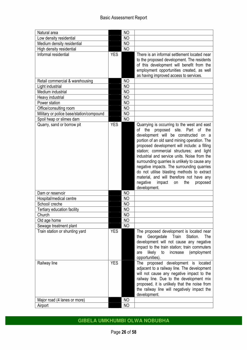
If any of the boxes marked with an “E “is ticked, please consult an appropriate specialist to assist in the completion of this section if the environmental assessment practitioner doesn’t have the necessary expertise. 5. LAND USE CHARACTER OF SURROUNDING AREA Cross the land uses and/or prominent features that currently occur within a 500m radius of the site and give a description of how this influences the application or may be impacted upon by the application: Land use character Description
Basic Assessment Report
Page 26 of 58
GIBELA UMKHUMBI OLWA NOBUBHA
Natural area NO
Low density residential NO
Medium density residential NO
High density residential NO
Informal residential YES There is an informal settlement located near to the proposed development. The residents of this development will benefit from the employment opportunities created, as well as having improved access to services.
Retail commercial & warehousing NO
Light industrial NO
Medium industrial NO
Heavy industrial NO
Power station NO
Office/consulting room NO
Military or police base/station/compound NO
Spoil heap or slimes dam NO
Quarry, sand or borrow pit YES Quarrying is occurring to the west and east of the proposed site. Part of the development will be constructed on a portion of an old sand mining operation. The proposed development will include: a filling station; commercial structures; and light industrial and service units. Noise from the surrounding quarries is unlikely to cause any negative impacts. The surrounding quarries do not utilise blasting methods to extract material, and will therefore not have any negative impact on the proposed development.
Dam or reservoir NO
Hospital/medical centre NO
School/ creche NO
Tertiary education facility NO
Church NO
Old age home NO
Sewage treatment plant NO
Train station or shunting yard YES The proposed development is located near the Georgedale Train Station. The development will not cause any negative impact to the train station; train commuters are likely to increase (employment opportunities).
Railway line YES The proposed development is located adjacent to a railway line. The development will not cause any negative impact to the railway line. Due to the development mix proposed, it is unlikely that the noise from the railway line will negatively impact the development.
Major road (4 lanes or more) NO
Airport NO

Basic Assessment Report
Page 27 of 58
GIBELA UMKHUMBI OLWA NOBUBHA
Harbour NO
Sport facilities NO
Golf course NO
Polo fields NO
Filling station NO
Landfill or waste treatment site NO
Plantation NO
Agriculture NO
River, stream or wetland YES The Sterkspruit Stream and tributary of this stream runs from west to east above the proposed development, and through the bottom portion of land of the proposed development site. A freshwater ecosystem, characterised by wetland conditions, was identified within the development site. Some of the wetland area identified is considered to be artificial in origin. The wetland habitat, regardless of if origins, serves to provide benefits and services within the landscape. To prevent further impacts on the system, buffers (20m), appropriate storm water management; stabilisation of erosional features within the wetland habitat; and wetland habitat management will be implemented. These are included in the EMPr.
Nature conservation area NO
Mountain, hill or ridge YES The proposed site is located adjacent to a gravel access road off of the M385. The road is propped up on a steep embankment onto the proposed development site. This could cause erosion. Erosion mitigation measures and stormwater management need to be taken into consideration during the planning phase of the development. This is outlined in the EMPr.
Museum NO
Historical building NO
Protected Area NO
Graveyard NO
Archaeological site NO
Other land uses (describe) Eskom Sub station
YES The proposed development will not negatively impact on the Eskom infrastructure. Eskom servitudes and building restrictions will be included in the EMPr to mitigate against any negative impacts.

Basic Assessment Report
Page 28 of 58
GIBELA UMKHUMBI OLWA NOBUBHA
6. CULTURAL/ HISTORICAL FEATURES
Are there any signs of culturally or historically significant elements, as defined in section 2 of the National Heritage Resources Act, 1999, (Act No. 25 of 1999), including archaeological or palaeontological sites, on or within 20m of the site?
NO
If YES, contact a specialist recommended by AMAFA to conduct a heritage impact assessment. The heritage impact assessment must be attached as an appendix to this report.
Briefly explain the recommendations of the specialist:
The proposed mixed-use development on the property may proceed from an archaeological point of view as no heritage sites or features are in danger of being destroyed or altered. It should, however, be pointed out that the KwaZulu-Natal Heritage Act requires that operations exposing archaeological and historical residues should cease immediately pending an evaluation by the heritage authorities.
Will any building or structure older than 60 years be affected in any way? NO
Is it necessary to apply for a permit in terms of the National Heritage Resources Act, 1999 (Act 25 of 1999)?
NO
If YES, please submit the necessary application to AMAFA and attach proof thereof to this report.
SECTION D: PUBLIC PARTICIPATION 1. ADVERTISEMENT The person conducting a public participation process must take into account any guidelines applicable to public participation as contemplated in section 24J of the Act and must give notice to all potential interested and affected parties of the application which is subjected to public participation by— (a) fixing a notice board (of a size at least 60cm by 42cm; and must display the required
information in lettering and in a format as may be determined by the competent authority) at a place conspicuous to the public at the boundary or on the fence of— (i) the site where the activity to which the application relates is or is to be
undertaken; and (ii) any alternative site mentioned in the application; (b) giving written notice to—
(i) the owner or person in control of that land if the applicant is not the owner or person in control of the land;
(ii) the occupiers of the site where the activity is or is to be undertaken or to any alternative site where the activity is to be undertaken;
(iii) owners and occupiers of land adjacent to the site where the activity is or is to be undertaken or to any alternative site where the activity is to be undertaken;
Basic Assessment Report
Page 29 of 58
GIBELA UMKHUMBI OLWA NOBUBHA
(iv) the municipal councillor of the ward in which the site or alternative site is situated and any organisation of ratepayers that represent the community in the area;
(v) the local and district municipality which has jurisdiction in the area; (vi) any organ of state having jurisdiction in respect of any aspect of the activity (as
identified in the application form for the environmental authorization of this project); and
(vii) any other party as required by the competent authority; (c) placing an advertisement in— (i) one local newspaper; or
(ii) any official Gazette that is published specifically for the purpose of providing public notice of applications or other submissions made in terms of these Regulations;
(d) placing an advertisement in at least one provincial newspaper or national newspaper, if the activity has or may have an impact that extends beyond the boundaries of the metropolitan or district municipality in which it is or will be undertaken: Provided that this paragraph need not be complied with if an advertisement has been placed in an official Gazette referred to in subregulation 54(c)(ii); and
(e) using reasonable alternative methods, as agreed to by the competent authority, in those instances where a person is desiring of but unable to participate in the process due to— (i) illiteracy; (ii) disability; or (iii) any other disadvantage.
2. CONTENT OF ADVERTISEMENTS AND NOTICES A notice board, advertisement or notices must: (a) indicate the details of the application which is subjected to public participation; and (b) state—
(i) that an application for environmental authorization has been submitted to the KZN Department of Agriculture & Environmental Affairs in terms of the EIA Regulations, 2010;(ii)
(iii) a brief project description that includes the nature and location of the activity to which the application relates;
(iv) where further information on the application can be obtained; and (iv) the manner in which and the person to whom representations in respect of the
application may be made. 3. PLACEMENT OF ADVERTISEMENTS AND NOTICES Where the proposed activity may have impacts that extend beyond the municipal area where it is located, a notice must be placed in at least one provincial newspaper or national newspaper, indicating that an application will be submitted to the competent authority in terms of these regulations, the nature and location of the activity, where further information on the proposed activity can be obtained and the manner in which representations in respect of the application can be made, unless a notice has been placed in any Gazette that is published specifically for

Basic Assessment Report
Page 30 of 58
GIBELA UMKHUMBI OLWA NOBUBHA
the purpose of providing notice to the public of applications made in terms of the EIA regulations. Advertisements and notices must make provision for all alternatives. 4. DETERMINATION OF APPROPRIATE PROCESS The EAP must ensure that the public participation process is according to that prescribed in regulation 54 of the EIA Regulations, 2010, but may deviate from the requirements of subregulation 54(2) in the manner agreed by the KZN Department of Agriculture & Environmental Affairs as appropriate for this application. Special attention should be given to the involvement of local community structures such as Ward Committees, ratepayers associations and traditional authorities where appropriate. Please note that public concerns that emerge at a later stage that should have been addressed may cause the competent authority to withdraw any authorisation it may have issued if it becomes apparent that the public participation process was inadequate. 5. COMMENTS AND RESPONSE REPORT The practitioner must record all comments and respond to each comment of the public before this application is submitted. The comments and responses must be captured in a comments and response report as prescribed in the EIA regulations (regulation 57 in the EIA Regulations, 2010) and be attached as Appendix E to this report. 6. PARTICIPATION BY DISTRICT, LOCAL AND TRADITIONAL AUTHORITIES District, local and traditional authorities (where applicable) are all key interested and affected parties in each application and no decision on any application will be made before the relevant local authority is provided with the opportunity to give input. The planning and the environmental sections of the local authority must be informed of this application and provided with an opportunity to comment.
Has any comment been received from the district municipality? YES
If “YES”, briefly describe the feedback below (also attach any correspondence to and from this authority with regard to this application):
Diane van Rensburg, eThekwini Metropolitan Municipality, 26 November 2012:
• With reference to the abovementioned Background information Document, please be advised that various Municipal Departments have had sight of the proposal and the following comments are submitted for your attention:
• eThekwini Electricity Department - The Electricity Department has no objection, however please note: - The Applicant must consult eThekwini Electricity’s mains records (held at the drawings office at eThekwini
Electricity Headquarters, 1 Jeff Taylor Crescent, for the presence of underground electrical services. In addition should any overhead line and/or servitude be affected, the specific permission of the Head: Electricity must be sought regarding the proposed development.
- The relocation of MV/LV electrical services, if required in order to accommodate the proposed development, will be carried out at the expense of the applicant.

Basic Assessment Report
Page 31 of 58
GIBELA UMKHUMBI OLWA NOBUBHA
• Environmental Planning and Climate Protection Department - This Department will comment on the Basic Assessment Report when more information is available to
assess the proposed development fully.
• Framework Planning Branch - Mpumalanga Town Centre has been identified to accommodate mixed use and commercial development.
The proposal is not in line with the Outer West SDP which identifies the property for Future Residential, Future Cemetery and Agriculture. In light of the proposed Framework Planning Branch does not support the proposed development.
• Land Use Management Branch - The abovementioned property is zoned Undetermined. - The Land Use Management Branch has no objection to the proposed residential development, as it is in
line with the Outer Wet Spatial Development Plan (OW SDP). - However the branch does not support the proposed light industrial and commercial developments. This is
due to the fact that there are existing industrial sites in the Hammersdale area. In addition, the Mpumalanga Town Centre has been identified to accommodate commercial development. There have not been any studies conducted to prove that the light industrial and commercial developments are viable.
• Engineering Department - The Department must liaise with Parks, Recreation and Cemeteries as the site immediately north west of
the proposed development has been acquired for a new regional cemetery. All stormwater and waste water coming off the development will need to be sufficiently controlled and will need to be sufficiently controlled and will need to meet all the necessary bacterial/contamination regulations so that it does not impact on the water courses and seepage zones that run through the proposed cemetery site which could then lead to additional loading on what is anticipated from the decomposition of bodies etc.
- The nearest sewer connection is approximately 3 km away opposite the new town centre at Mpumalanga.
• Parks, Recreation and Cemeteries - Development should take place 30 m away from the wetland.
• eThekwini Transport Authority - Town Planning / Framework Planning Branch to confirm if this proposal is in line with their SDP / LAP. - Subject to one above, a comprehensive TIA will be required. - The TIA must take cognisance of the macro level traffic study that was undertaken for Cato Ridge Local
Area Plan. - KZNDoT must comment on this application since access may be dependent on MR 385 which is a
provincial road.
• Coastal, Stormwater and Catchment Management - This Department requires a Stormwater Management Plan.
• eThekwini Water and Sanitation - No comment at this stage as more information is needed regarding the type of activities that will be carried
out on site.
• Durban Solid Waste - Cleansing and Solid Waste would like to see the actual location for Waste storage facilities for both
business and residential on the plans, especially if the residential will be clustered in a gated area. This Department generally has problems with developers not catering for Waste storage facilities or adequate facilities. This Department would also like the developer to contact this Department once plans are available as it is important for this Department to know the actual numbers of the residential units as well as the types of business proposed, this will affect service delivery in terms of frequency. Further instructions and requirements will then be communicated with the developer.
- When carrying out the investigation, the design must take into account adequate storage facilities for refuse such that the storage areas can be easily serviced by the collection vehicles.
• Geotechnical Engineering Branch - No geotechnical objection in principle, however, a few geotechnical concerns: - The northern triangular site is on a south easterly aspect sandstone slope (sandstone bedding typically
dipping east to south east) with seepage associated with the valley line and as such may be prone to slope stability concerns when modified; this must be investigated by a suitably experienced engineering geologist.
- The GIS shows no water borne sewers from these sites. The thin sandy soils (more so where past sand mining has removed much of the cover from the southern site) may not be suitable for on-site waste water disposal by sub soil percolation.
- Once the vegetation cover is removed, these fine sandy soils will be moderately to highly erodible and all

Basic Assessment Report
Page 32 of 58
GIBELA UMKHUMBI OLWA NOBUBHA
due care must be exercised to reduce erosion.
• Fire Safety - This Department has no objections to the above proposal provided that building plans are submitted for
approval.
• Should you seek clarification on any of the above issues, please contact the writer on tel: 031 311 7136 or email: [email protected]. In addition, the Department requests that a copy of the Environmental Authorisation be emailed to the same email address.
Has any comment been received from the local municipality? YES NO
If “YES”, briefly describe the feedback below (also attach any correspondence to and from this authority with regard to this application):
See above.
Has any comment been received from a traditional authority? NO
If “YES”, briefly describe the feedback below (also attach any correspondence to and from this authority with regard to this application):
Not applicable as the land is privately owned.
7. CONSULTATION WITH OTHER STAKEHOLDERS Any stakeholder that has a direct interest in the site or property, such as servitude holders and service providers, should be informed of the application and be provided with the opportunity to comment.
Has any comment been received from stakeholders? YES
If “YES”, briefly describe the feedback below (also attach copies of any correspondence to and from the stakeholders to this application): Roy Ryan, Department of Transport, 13 September 2012:
• I have no objections to the application.
• I will require the following;-
• A detailed development plan of the sites and a Traffic Impact Assessment on Main Road 385 and on District Road 140 is to be submitted to this office for assessment and comment.
• District Road 140 has a road reserve of 20m measured 10m on either side of the constructed road centre line.
• A 15m building line is imposed over and above the 10m road reserve that is a building line of 25m from centre line.
Andrew Ferendinos, KZN Crane Foundation, 13 September 2012:
• Thank you for advising the KZN Crane Foundation of this project proposal.
• We take note of the facts that:
• This project will create employment and other opportunities for the local community.
• The aerial imagery indicates that the property is not in a natural state - so most of the Foundation's concerns with biodiversity do not apply.
• If the project design is well thought through and properly executed we believe it deserves to be supported.
• However, we would appreciate it if you could forward a photo or two of the drainage line to the KZN Crane Foundation. Just so we can see if there any concerns to do with wetlands.
• We trust proper attention will be given to stormwater management - the principles contained in the CSIR (Building and Construction Technology section's) Red Book on Human Settlement and Design are worth studying.
Thobani Vetsheza, DAFF, 14 September 2012:
• This is to acknowledge the receipt of the above – mentioned BID. The Department will comment further after the vegetation specialist report has been sent to us.
Basic Assessment Report
Page 33 of 58
GIBELA UMKHUMBI OLWA NOBUBHA
Casper Landman, SANRAL, 14 September 2012:
• This development falls outside of the SANRAL area of jurisdiction. It should be referred to KZN Department of Transport for attention Mr Roy Ryan.
Roland Moore, Eskom, 19 September 2012:
• I confirm that Eskom Sub Transmission and Reticulation have no objection to the proposed “mixed-use development” as defined (light industrial, commercial and residential development).
• We trust that your client understand the Eskom servitude conditions pertaining to the property, particularly regarding the building restrictions. The 11kV line has a 24 m wide building restriction and the underground cable requires vehicle access width of 5 m.
• All correspondence relevant to this matter should be addressed to the Principal Survey Technician, Mr R.M. Moore, Eskom Sub-transmission Survey, P.O. Box 5 Mkondeni, 3212.
Bianca Torre, Leads to Business, 21 September 2012:
• I am just emailing you with regard to the above project that is undergoing an Environmental Impact Assessment Process.
• Please would you be so kind as to email me a copy of the Background Information Document?
• Can you also please list me as an Interested Party. Carolyn Schwegman, WESSA, 8 October 2012:
• We note the proposal to establish light industrial, commercial and residential components on 2 portions of land. Please register WESSA as an I&AP and the following issues, in addition to those identified for consideration, are of interest to the Society –
• Services. Should municipal infrastructure (such as sewage disposal) not be available in the area we would like to know what is proposed for each of the sites, what alternatives will be considered and what operational measures will be in place to deal with normal and abnormal conditions.
• Services – from the outset planning and design must consider options which reduce resource use and pressure on supplies.
• The site is adjacent to the Georgedale substation and WESSA understands that the electricity supply to the area is being strengthened. The siting of the individual components of the development must take the documented effects of working or residing in close proximity to such infrastructure on human health into consideration.
• Stormwater management.
• Thank you for the opportunity to comment. Azrah Essop, Ezemvelo KZN Wildlife, 18 October 2012:
• Thank you for forwarding the Background Information Document for the abovementioned application to Ezemvelo KZN Wildlife (Ezemvelo) for review and comment. It is brought to you attention that the site supports a Freshwater Ecosystem Priority Areas (FEPA1) “Class C” wetland. Wetlands are characterised by intrinsically high biodiversity and perform a number of important ecological functions (or ecosystem services).
• Wetlands are considered to be globally threatened ecosystems and have been recognised in both national and provincial environmental legislation as important resources that need to be safeguarded.
• Ezemvelo shall await the Basic Assessment Report (BAR) which should include a stormwater management plan and mitigatory measures with regards to abovementioned wetlands.
• Please be advised that this constitutes as Ezemvelo’s preliminary comment and an official comment will be submitted upon receipt of the Basic Assessment Report. Should you wish to discuss any of the points raised in this correspondence or should you have any biodiversity related queries, please do not hesitate to contact us.

Basic Assessment Report
Page 34 of 58
GIBELA UMKHUMBI OLWA NOBUBHA
SECTION E: IMPACT ASSESSMENT The assessment of impacts must adhere to the requirements in the EIA Regulations, 2010, and should take applicable official guidelines into account. The issues raised by interested and affected parties should also be addressed in the assessment of impacts. 1. ISSUES RAISED BY INTERESTED AND AFFECTED PARTIES List the main issues raised by interested and affected parties. 1. A detailed development plan of the sites and a Traffic Impact Assessment on Main Road 385 and on District
Road 140i is to be submitted to the Department of Transport for assessment and comment. 2. Please forward a photo or two of the drainage line to the KZN Crane Foundation. Just so we can see if there
any concerns to do with wetlands. 3. Stormwater management - the principles contained in the CSIR (Building and Construction Technology
section's) Red Book on Human Settlement and Design are worth studying. 4. DAFF will comment further after the vegetation specialist report has been sent to us. 5. Eskom Sub Transmission and Reticulation have no objection to the proposed “mixed-use development” as
defined (light industrial, commercial and residential development). We trust that your client understand the Eskom servitude conditions pertaining to the property, particularly regarding the building restrictions. The 11kV line has a 24 m wide building restriction and the underground cable requires vehicle access width of 5 m.
6. Services. Should municipal infrastructure (such as sewage disposal) not be available in the area we would like to know what is proposed for each of the sites, what alternatives will be considered and what operational measures will be in place to deal with normal and abnormal conditions.
7. Services – from the outset planning and design must consider options which reduce resource use and pressure on supplies.
8. The site is adjacent to the Georgedale substation and WESSA understands that the electricity supply to the area is being strengthened. The siting of the individual components of the development must take the documented effects of working or residing in close proximity to such infrastructure on human health into consideration.
9. The eThekwini Electricity Department has no objection, however please note: The Applicant must consult eThekwini Electricity’s mains records for the presence of underground electrical services. In addition should any overhead line and/or servitude be affected, the specific permission of the Head: Electricity must be sought regarding the proposed development. The relocation of MV/LV electrical services, if required in order to accommodate the proposed development, will be carried out at the expense of the applicant.
10. eThekwini Framework Planning Branch: Mpumalanga Town Centre has been identified to accommodate mixed use and commercial development. The proposal is not in line with the Outer West SDP which identifies the property for Future Residential, Future Cemetery and Agriculture. In light of the proposed Framework Planning Branch does not support the proposed development.
11. eThekwini Land Use Management Branch: The Land Use Management Branch has no objection to the proposed residential development, as it is in line with the Outer Wet Spatial Development Plan (OW SDP). However the branch does not support the proposed light industrial and commercial developments. This is due to the fact that there are existing industrial sites in the Hammersdale area. In addition, the Mpumalanga Town Centre has been identified to accommodate commercial development. There have not been any studies conducted to prove that the light industrial and commercial developments are viable.
12. eThekwini Engineering Department: The Department must liaise with Parks, Recreation and Cemeteries as the site immediately north west of the proposed development has been acquired for a new regional cemetery. All stormwater and waste water coming off the development will need to be sufficiently controlled and will need to be sufficiently controlled and will need to meet all the necessary bacterial/contamination regulations so that it does not impact on the water courses and seepage zones that run through the proposed cemetery site which could then lead to additional loading on what is anticipated from the decomposition of bodies etc.
13. eThekwini Durban Solid Waste: would like to see the actual location for Waste storage facilities for both business and residential on the plans, especially if the residential will be clustered in a gated area. This Department generally has problems with developers not catering for waste storage facilities or adequate facilities. This Department would also like the developer to contact this Department once plans are available as it is important for this Department to know the actual numbers of the residential units as well as the types of

Basic Assessment Report
Page 35 of 58
GIBELA UMKHUMBI OLWA NOBUBHA
business proposed, this will affect service delivery in terms of frequency. Further instructions and requirements will then be communicated with the developer. When carrying out the investigation, the design must take into account adequate storage facilities for refuse such that the storage areas can be easily serviced by the collection vehicles.
14. The northern triangular site is on a south easterly aspect sandstone slope (sandstone bedding typically dipping east to south east) with seepage associated with the valley line and as such may be prone to slope stability concerns when modified; this must be investigated by a suitably experienced engineering geologist.
15. The GIS shows no water borne sewers from these sites. The thin sandy soils (more so where past sand mining has removed much of the cover from the southern site) may not be suitable for on-site waste water disposal by sub soil percolation.
16. Once the vegetation cover is removed, these fine sandy soils will be moderately to highly erodible and all due care must be exercised to reduce erosion.
17. eThekwini Fire Safety: This Department has no objections to the above proposal provided that building plans are submitted for approval.
Response from the practitioner to the issues raised by the interested and affected parties (A full response must be given in the Comments and Response Report that must be attached as Appendix E to this report): 1. Noted, is be included in the Basic Assessment Report (Appendix D). 2. Noted, however a Wetland Assessment has been conducted and is included in the Basic Assessment Report
(Appendix D6). 3. Noted. A Stormwater Management Plan is included in Appendix D4 of this report. 4. Noted, however the EAP has visited the site; the site is dominated by alien vegetation and bares no ecological
significance. 5. Noted. The Applicant is aware of this. 6. Sewage will be directed to municipal infrastructure. A signed Services Agreement will be included in the
FBAR. 7. Noted, recommendations are included in the Environmental Management Programme (EMPr). 8. Noted. See above response from Eskom. There is no evidence that working or residing in close proximity to
such infrastructure has any negative impact on human health. 9. Noted. 10. Noted, however the proposed development is not located in Mpumalanga, it is located in Georgedale.
Furthermore the Feasibility Study (Appendix D3) concluded that the proposed development is in line with the eThekwini SDF Framework.
11. Noted. Please refer to the Feasibility Study included in Appendix D3. 12. Noted. The proposed cemetery will undergo its own independent Environmental Authorisation Process.
Stormwater management will be assessed during the process for the cemetery itself. A Stormwater Management Plan is included in Appendix D4 of this report.
13. Noted. The proposed development no longer includes a residential component for this development as the Feasibility Study identified that there was not sufficient demand. Waste storage and accessibility will be taken into consideration and will be included in the preferred layout of the development. The Department will be contacted once the plans are available.
14. This portion of land is not being developed. A Geotechnical Assessment has been conducted onsite and is included in Appendix D1 of this report.
15. The Geotechnical Assessment concluded that soils where unsuitable for effluent disposal via percolation methods unless some steps are taken to create an evapotranspiration bed into which the effluent is directed.
16. Rehabilitation and re-vegetation requirements are included in the EMPr. 17. Noted, this will be done.
2. IMPACTS THAT MAY RESULT FROM THE PLANNING AND DESIGN,
CONSTRUCTION, OPERATIONAL, DECOMMISSIONING AND CLOSURE PHASES AS WELL AS PROPOSED MANAGEMENT OF IDENTIFIED IMPACTS AND PROPOSED MITIGATION MEASURES

Basic Assessment Report
Page 36 of 58
GIBELA UMKHUMBI OLWA NOBUBHA
2.1. IMPACTS THAT MAY RESULT FROM THE PLANNING AND DESIGN PHASE
a. Site alternatives List the potential impacts associated with site alternatives that are likely to occur during the planning and design phase: Alternative S1 (preferred alternative)
Direct impacts:
• There are positive economic impacts associated with the employment of appropriate professionals involved in the development and assessment of the proposal. Direct job creation (temporary) during the planning phases, through the employment of engineers, and other skilled professionals will be required.
Indirect impacts:
• There are no indirect impacts for the environment in the Planning and Design Phase, other than those associated with the employment of appropriate professionals involved in the development and assessment of the proposal.
Cumulative impacts:
• There are no cumulative impacts for the environment associated with the Planning and Design Phase other than those associated with the employment of appropriate professionals involved in the development and assessment of the proposal.
No-go alternative (compulsory)
Direct impacts:
• None Indirect impacts:
• None
Cumulative impacts:
• None Indicate mitigation measures to manage the potential impacts listed above: Alternative S1
Although there are few impacts associated with the Planning and Design Phase, the following considerations will optimise the planning and design of this development, thereby mitigating potential negative impacts that could result from inadequate planning. In response to this, the following should be implemented / taken into consideration in the Planning and Design Phase:
• The recommendations made by the Business Analyst must be taken into consideration: � Proposed retail on the proposed site should not duplicate the offer at the nearly completed
Hammarsdale Junction, but rather host a unique type of national branded retail such as a Building Materials Supplier or a service station.
� We do not see scope for another large scale Community Centre in the catchment as there will remain high levels of outflow support to larger nodes.
� The development of the filling station and government offices at the site will be to the benefit of any type of development at the site as it would establish a node.
� A large scale building material supplier could be opened at the site and at a later stage when the residential corridor along the MR385 is developed, the site could be developed to a convenience centre or a larger community centre, pending demand.
� The railway station passengers at the site currently does not warrant a strong enough support base for the retail centre, but it will be a definite benefit for a building material supplier and /or motor dealerships or a future retail centre at the site when the residential corridor develop.
� Please note that many factors contribute to the ultimate success of a centre, such as: layout, management, marketing, offering (tenant mix), changing existing shopping patterns, market trends along with macro economic conditions. Demographic potential is only one aspect.
• The recommendations made by the Wetland Specialist must be adhered to: � To reduce impacts on the receiving ecosystem, the development should incorporate an
appropriate buffer zone from the edge of the freshwater ecosystems to protect the system from

Basic Assessment Report
Page 37 of 58
GIBELA UMKHUMBI OLWA NOBUBHA
further degradation. It is recommended that a buffer of 20m be implemented around the wetland. � The recommendation above is subject to the adoption of the following:
• Rehabilitation of the buffer zone, with the removal of alien invasive vegetation species; and the active replanting of indigenous plants, to ensure a DENSE, undisturbed vegetative community;
• Ideally, the establishment of indigenous vegetative cover within the buffer should take place prior to the implementation of construction activities to filter runoff before it enters the wetland habitat. However, if practical limitations exist, the existing vegetation should be maintained to fulfill the buffer role during the construction phases. This would require a commitment from the developer to undertake the rehabilitation of the buffer zone upon completion of the construction activities; and
• Enforcement and management of the buffer zone to ensure that there is no encroachment that would reduce the efficacy of the buffer zone.
� To limit the impacts of storm water runoff on the freshwater ecosystems the discharge of storm water runoff into the identified system should be managed by means of:
• Multiple discharge points that are reasonably spread out across the development adjoining the wetland habitat;
• The erosional features will have to be appropriately stabilised to ensure that no further erosion of the systems occurs, especially from water entering the erosion gully from the adjacent slopes;
• Flow through the buffer zone should be via diffuse flow and concentrated flow should be avoided. This would assist in reducing the concentration of flows and hence the risks of erosion and further degradation of the receiving environments;
• Accompanying each discharge point should be suitable baffle structures (e.g. gabion mattresses) that will dissipate the energy of storm flow and encourage infiltration thus reducing the likelihood of erosion;
• The runoff entering the buffer zone should not exceed 1.5m/sec as this is considered to reduce the pollutant removal performance of the buffer area; and
• Outflow points incorporate a best management practice approach to trap excess suspended solids and other pollutants originating from the proposed development before entering the buffer zones. These will need to be regularly serviced and maintained to ensure adequate functioning and efficacy.
• The recommendations made by the Geologist must be adhered to: � Groundwater seepage was encountered across the site and therefore proper drainage
requirements should be accommodated for during construction. � Soft excavation in terms of SABS 1200 is generally anticipated to at least 2.0 m below existing
ground level. Intermediate and hard excavation and heavy ripping may be required to accommodate the steel structures associated with the filling station at depths of 2.5 m to 3.0 m. It is recommended that all earthworks be carried out in accordance with SABS 1200 (current version).
� One of the more important factors in the promotion of a stable site is the control and removal of surface water from the property. In this regard it is important that the design of the stormwater management system allows for the drainage of accumulated surface water from the platforms and into the stormwater system or natural drainage lines.
� The site has been classified as NHBRC Site Class C1 and in this light it is recommended that modified normal foundation solutions be adopted, with foundation loads not exceeding 50 kN/m2. Alternatively the foundation must be taken down to material of at least dense consistency.
� The soils are unsuitable for effluent disposal via percolation methods unless some steps are taken to create a evapotranspiration bed into which the effluent is directed.
� It is possible that conditions at variance with those discussed above may be encountered elsewhere on the property. In this regard it is important that a Geologist carry out periodic inspections of the site during construction to ensure that any variation in the anticipated ground conditions can be assessed and revised recommendations made to avoid unnecessary delays and expense. Furthermore it is important that the construction phase of the project be treated as an augmentation of the geotechnical investigation.
• The recommendations made by the Traffic Engineer (Appendix D4) must be adhered to:

Basic Assessment Report
Page 38 of 58
GIBELA UMKHUMBI OLWA NOBUBHA
� The intersection of Main Road 385 and District Road 140 is to be modified and converted to meet the standards of a KZNDoT Type B2 intersection. Appropriate ‘daylighting’ in the form of landscaping should be incorporated into the design (towards the south).
� The District Road 140 side road approach at the intersection of Main Road 385 would benefit by the provision of two lanes, a right turn and a left turn lane.
� A speed limit of 80km/h should be enforced along Main Road 385 from a point 0.5km north of District Road 140 stretching all the way to Hammarsdale.
� The accesses to the site along District Road 140 are to be designed in accordance with the content of Sub-Section 6.5, the design to be carried out by a registered professional and submitted to the KwaZulu-Natal Department of Transport for approval. These locations should be checked for adequate sight distance and, if deficient, measures should be put in place to ensure safe traffic operational conditions. These measures should entail landscaping and verge maintenance to achieve the minimum recommended shoulder sight distances.
� If the required minimum sight distances cannot be achieved by landscaping of the road verges a speed hump should be installed on District Road 140 just to east of the site exit points.
� Traffic speeds on District Road 140 should be limited to 60km/h (40km/h at the speed hump) by the installation of appropriate regulatory signage.
� Public transport laybys are to be provided on both sides of Main Road 385 at the intersection of Main Road 385 and District Road 140. These are to be to the KZNDoT standards.
� Pedestrian sidewalks are to be provided along both Main Road 385 and District Road 140 between the public transport laybys and the first internal access roads.
• The recommendations of the Stormwater Management Plan (Appendix D4) must be adhered to: � That the storm water design parameters used in the design of the storm water management
system are accepted and approved. � That the detailed design of the storm water system include recommendations of this plan. � This design should include the following:
• A detailed topographical survey is undertaken of the property that includes 1m contours, existing services, overhead powerlines and the MR385/D140 intersection.
• A detailed Site Development Plan is prepared for Phase 1 including planning of Phase 2 to carefully plan and identifies entrance/access roads, parking, buildings, the position and size of the attenuation ponds and storm water pipes following the detail topographical survey.
• A detailed road intersection design is prepared for the main intersection of the MR385 and D140, after the completion of a Traffic Impact Assessment (TIA).
� The storm water system must be kept separate from the sewerage system. � All chemicals, cement, fuel and other hazardous material used during construction should be
stored in controlled areas, at least 100m from any water resource and potentially sensitive areas. � Concentration of storm water should be prevented where possible, but energy dissipaters should
be provided in areas of concentration. � All exposed earthworks on completion of the construction of platforms and attenuation ponds must
be vegetated as soon as possible, including the use of “Soilsaver”.
• The Heritage Assessment (Appendix D2) states that the KwaZulu-Natal Heritage Act requires that operations exposing archaeological and historical residues should cease immediately pending an evaluation by the heritage authorities.
• The Engineering Report states that the proposed development can be served with infrastructure services, subject to the Conclusion of a Service Agreement with eThekwini Municipality for the:
� Upgrade and link into the existing potable water supply. � Future link into the proposed outfall sewer and to allow the effluent from the conservancy tank to
be discharged into the Hammersdale WWTW. � Submission of an application to eThekwini Municipality for a bulk electrical connection to the
development, sufficient for the proposed phases. The above needs to be in place prior to the commencement of the construction phase.
• Planning must incorporate the building requirements for the conservancy tank: � Fresh air inlet and intercepting trap; � Tank must be constructed with a 215 mm brick or 150 mm reinforced concrete slab on a

Basic Assessment Report
Page 39 of 58
GIBELA UMKHUMBI OLWA NOBUBHA
foundation slab of mass concrete not less than 150 mm thick; � Located out of the 1:100 year floodline or not within 100m of any watercourse; � Airtight manhole covers to allow access to the tank foe emptying; and � The tank must be impervious to liquid.
• Planning must incorporate re-vegetation using indigenous grasses, trees and shrubs, to establish suitable cover where possible.
• Planning must incorporate green building principles, energy efficiency and water saving measures where possible.
b. Process, technology, layout or other alternatives
List the impacts associated with any process, technology, layout or other alternatives that are likely to occur during the planning and design phase (please list impacts associated with each alternative separately): Alternative A1 (preferred alternative)
Direct impacts:
• There are positive economic impacts associated with the employment of appropriate professionals involved in the development and assessment of the proposal. Direct job creation (temporary) during the planning phases, through the employment of engineers, and other skilled professionals will be required.
Indirect impacts:
• There are no indirect impacts for the environment in the Planning and Design Phase, other than those associated with the employment of appropriate professionals involved in the development and assessment of the proposal.
Cumulative impacts:
• There are no cumulative impacts for the environment associated with the Planning and Design Phase other than those associated with the employment of appropriate professionals involved in the development and assessment of the proposal.
No-go alternative (compulsory)
Direct impacts:
Nuisance impacts
• The no-go alternative will mean that the nuisance impacts (i.e. noise, dust, loiterers and potential security concerns) associated with construction will not be realised.
Socio-economic
• The no-go alternative will mean that the positive socio-economic benefits of job creation, skills transfer and support of the local economy will not be realised.
Fire risk
• No potential for fires to be started by construction workers. Traffic impacts
• No potential for increased traffic congestion as a result of slow moving construction vehicles. Soil and water management
• Erosion and sedimentation of fresh water ecosystems is unlikely to transpire. Waste management
• The amount of litter and waste is unlikely to increase. Flora and fauna disturbance
• Further alien vegetation infestation is unlikely to occur. Aquatic ecosystem impacts
• Pollution of the associated wetland would not occur.
• The lack of stormwater management and the impacts thereof (erosion and sedimentation) would not transpire. Indirect impacts:
Job creation
• The positive impacts associated with job creation (improvement in quality of life of the workers, increased spending in the local economy and the support of small business in the local area) would not be realised.
Cumulative impacts:
Job creation
• No job creation or skills transfer would occur – this is not in line with the aims of the IDP or SDF.

Basic Assessment Report
Page 40 of 58
GIBELA UMKHUMBI OLWA NOBUBHA
Other
• Stormwater runoff would not be an issue, nor would the potential for erosion and sedimentation of the wetland occur.
• Potential for alien vegetation infestation of cleared areas would not be realised. Indicate mitigation measures to manage the potential impacts listed above: Alternative A1:
Same as those listed in the Site Alternatives Section.
2.2. IMPACTS THAT MAY RESULT FROM THE CONSTRUCTION PHASE
a. Site alternatives
List the potential impacts associated with site alternatives that are likely to occur during the construction phase:
Alternative S1 (preferred site)
Direct impacts:
Job creation:
• The proposed Development will result in job provision and skills transfer. This in turn will promote the opportunity for re-employment.
Fire risk:
• Construction workers could cause a fire on site (construction usually takes place in the dry winter months when the danger of veld fires is highest).
Construction nuisance impacts include the potential for the following:
• Noise will be created during construction via machinery, equipment and vehicles.
• Increased emissions are likely to occur in the form of dust and other emissions resulting from construction activities (vegetation clearing, earthworks, uncovered topsoil stockpiles and sand piles and vehicle movement).
• Perceived security concerns.There is potential for crime in the area to increase during construction.
• Construction sites attract unemployed people, so people may gather on or around the site looking for work. Traffic Impact
• Increased traffic congestion is likely to occur as a result of slow moving construction vehicles moving onto and off the site. However, this is likely to be minimal.
Soil and water management
• During construction, before stormwater attenuation has been built, water runoff, if not managed, has the potential to cause erosion and sedimentation of freshwater ecosystems.
Waste management
• An increase in the amount of litter being generated
• Non-use of sanitation facilities. Heritage Impacts
• Although no heritage resources have been observed on the sites, it is always possible that a heritage resource could be encountered.
Flora and Fauna disturbance
• Disturbance to the environment encourages further alien infestation if not managed correctly. Aquatic ecosystem impacts
• Pollution from construction-related activities could enter the Wetland system downstream (fuel leaks, shutter oil and lubricating fluid spills, litter, cement and contaminated wash-down water).
• Stormwater runoff during construction has the potential to erode topsoil and result in sedimentation of water courses if not controlled.
Indirect impacts:
Job creation
• The potential impact of this is significant and have a number of indirect positive impacts, such as improvement in quality of life of the workers, increased spending in the local economy and the support of small business in the local area.

Basic Assessment Report
Page 41 of 58
GIBELA UMKHUMBI OLWA NOBUBHA
Cumulative impacts:
Job creation
• Cumulatively, the impact of the rehabilitation plan is judged to be of high positive significance. The programme will create jobs and transferred skills to numerous previously unskilled persons. The construction phase will result in jobs being created for various other work sectors as well as retailers (suppliers of building materials, etc).
Other
• The increase in paved area will increase the amount of stormwater runoff which, if not managed in the interim, could result in erosion off site, and the occurrence of sedimentation to the wetland system downstream. This in turn may eventually degrade the freshwater ecosystem system downstream.
• Potential for alien vegetation, which may become established on the cleared sites prior to completion of construction, to spread to other natural areas.
No-go alternative (compulsory)
Direct impacts:
Nuisance impacts
• The no-go alternative will mean that the nuisance impacts (i.e. noise, dust, loiterers and potential security concerns) associated with construction will not be realised.
Socio-economic
• The no-go alternative will mean that the positive socio-economic benefits of job creation, skills transfer and support of the local economy will not be realised.
Fire risk
• No potential for fires to be started by construction workers. Traffic impacts
• No potential for increased traffic congestion as a result of slow moving construction vehicles. Soil and water management
• Erosion and sedimentation of fresh water ecosystems is unlikely to transpire. Waste management
• The amount of litter and waste is unlikely to increase. Flora and fauna disturbance
• Further alien vegetation infestation is unlikely to occur. Aquatic ecosystem impacts
• Pollution of the associated wetland would not occur.
• The lack of stormwater management and the impacts thereof (erosion and sedimentation) would not transpire. Indirect impacts:
Job creation
• The positive impacts associated with job creation (improvement in quality of life of the workers, increased spending in the local economy and the support of small business in the local area) would not be realised.
Cumulative impacts:
Job creation
• No job creation or skills transfer would occur – this is not in line with the aims of the IDP or SDF. Other
• Stormwater runoff would not be an issue, nor would the potential for erosion and sedimentation of the wetland occur.
• Potential for alien vegetation infestation of cleared areas would not be realised. Indicate mitigation measures to manage the potential impacts listed above: Alternative S1
Job creation:
• Project workers should be sourced from local communities where possible.
• Local business should be supported, with respect to the purchase of materials, where possible. Fire risk:
• Workers should be made aware of the potential for fires to become out of control and the damage that could be caused.
• No burning of refuse or vegetation is permitted on site.

Basic Assessment Report
Page 42 of 58
GIBELA UMKHUMBI OLWA NOBUBHA
• Fire response procedures should be in place. Construction nuisance impacts
• Site workers must undergo environmental induction training before undertaking work so that they are aware of the various environmental requirements. The induction training must address keeping noise to a minimum and labourers conduct.
• Noise levels must be kept within acceptable limits set out in the National Noise Laws and local by-laws regarding noise.
• No sound amplification equipment such as sirens, loud hailers or hooters are to be used on site except in emergencies and no amplified music is permitted on site.
• Activities that may disrupt neighbours must be preceded by notice being given to the affected neighbours at least 24 hours in advance.
• Equipment that is fitted with noise reduction facilities (e.g. side flaps, silencers etc) must be used as per operating instructions and maintained properly during site operations.
• Vehicles and machinery must be kept in good working condition so as to prevent unnecessary air emissions and excessive noise pollution.
• Contractors should be advised that dust generation should be prevented and if not possible, kept to a minimum.
• Dust must be suppressed on access roads and construction areas during dry periods by the regular application of water or a biodegradable soil stabilisation agent.
• Excavating, handling or transporting erodible materials in high wind or when dust plumes are visible must be avoided.
Soil and water management
• All construction vehicles and machinery and equipment must be properly maintained to prevent leaks.
• Vegetation clearing on the site should take place only immediately prior to construction in order to minimise the time the soil is bare, thus minimising soil erosion, dust and visual impacts.
• Once earthworks are complete, disturbed areas are to be stabilised to prevent erosion. Waste Management
• The environmental induction training must address the management of sanitation facilities and general site management.
• The site must be managed appropriately and all rubbish and rubble must be collected in appropriate waste receptacles and disposed of at a Registered Landfill site.
Heritage Impacts
• Should any artefact / suspected artefact / site of cultural significance be encountered during construction, then the Contractor must cease work in that vicinity and alert the relevant authorities.
Safety of construction employees
• The site and crew are to be managed in strict accordance with the Occupational Health and Safety Act (Act No. 85 of 1993) and the National Building Regulations.
• Potentially hazardous areas are to be cordoned off and clearly marked at all times.
• All vehicles and equipment used on site must be operated by appropriately trained and / or licensed personnel.
• The Contractor must make available safe drinking water fit for human consumption.
• Washing and toilet facilities must be provided on site.
• Adequate numbers of chemical toilets must be maintained to service the staff using this area. At least 1 toilet must be available per 20 workers. Toilet paper must be provided.
• Necessary Personal Protective Equipment (PPE) and safety gear appropriate to the task being undertaken is to be provided to all site personnel (e.g. hard hats, safety boots, masks etc.).
Security
• Signs should be erected on all entrance gates indicating that no temporary jobs are available, thereby limiting opportunistic labourers and crime.
• No unauthorized firearms are permitted on site.
• All construction workers must be issued with ID badges and clearly identifiable uniforms. Flora and fauna disturbance
• An alien vegetation control programme must be implemented on the site during construction.
• It must be ensured that the disturbed areas are re-vegetated as soon as possible after clearing. Emergency
• Adequate emergency facilities must be provided for the treatment of any emergency on the site.
• Emergency contact numbers are to be displayed at prominent locations around the construction site at all

Basic Assessment Report
Page 43 of 58
GIBELA UMKHUMBI OLWA NOBUBHA
times.
• Emergency procedures must be produced and communicated to all the employees on site. This will ensure that accidents are responded to appropriately and the impacts thereof are minimised. This will also ensure that potential liabilities and damage to life and the environment are avoided.
Odours/ Leakages/Spillages
• The chemical toilets must be emptied on a regular basis.
• The chemical toilets must be sited taking into account the possibility of the prevailing wind unfavourably dispersing unpleasant odours.
• The chemical toilets must be maintained in a good state, and any spills or overflows must be attended to immediately.
• The Construction Manager must have a basic spill control kit available. The spill control kit must include absorptive material that can handle all forms of spills.
• Machinery and vehicles are to be repaired immediately upon developing leaks and drip trays should be supplied for all repair work undertaken onsite.
• Drip trays should be utilized to catch any incidental spills and prevent contamination. These should be regularly monitored for leaks and when rain is experienced so as to prevent overflow.
b. Process, technology, layout or other alternatives List the impacts associated with process, technology, layout or other alternatives that are likely to occur during the construction phase (please list impacts associated with each alternative separately): Alternative A1 (preferred alternative)
Direct impacts:
Job creation:
• The proposed Development will result in job provision and skills transfer. This in turn will promote the opportunity for re-employment.
Fire risk:
• Construction workers could cause a fire on site (construction usually takes place in the dry winter months when the danger of veld fires is highest).
Construction nuisance impacts include the potential for the following:
• Noise will be created during construction via machinery, equipment and vehicles.
• Increased emissions are likely to occur in the form of dust and other emissions resulting from construction activities (vegetation clearing, earthworks, uncovered topsoil stockpiles and sand piles and vehicle movement).
• Perceived security concerns.There is potential for crime in the area to increase during construction.
• Construction sites attract unemployed people, so people may gather on or around the site looking for work. Traffic Impact
• Increased traffic congestion is likely to occur as a result of slow moving construction vehicles moving onto and off the site. However, this is likely to be minimal.
• Soil and water management.
• During construction, before stormwater attenuation has been built, water runoff, if not managed, has the potential to cause erosion and sedimentation of freshwater ecosystems.
• Increased traffic congestion is likely to occur as a result of slow moving construction vehicles moving onto and off the site. However, this is likely to be minimal.
Waste management
• An increase in the amount of litter being generated
• Non-use of sanitation facilities. Heritage Impacts
• Although no heritage resources have been observed on the sites, it is always possible that a heritage resource could be encountered.
Flora and Fauna disturbance
• Disturbance to the environment encourages further alien infestation if not managed correctly. Aquatic eco-system impacts
• Pollution from construction-related activities could enter the Wetland system downstream (fuel leaks, shutter oil and lubricating fluid spills, litter, cement and contaminated wash-down water).
• Stormwater runoff during construction has the potential to erode topsoil and result in sedimentation of water courses if not controlled.

Basic Assessment Report
Page 44 of 58
GIBELA UMKHUMBI OLWA NOBUBHA
Indirect impacts:
Job creation
• The potential impact of this is significant and have a number of indirect positive impacts, such as improvement in quality of life of the workers, increased spending in the local economy and the support of small business in the local area.
Cumulative impacts:
Job creation
• Cumulatively, the impact of the rehabilitation plan is judged to be of high positive significance. The programme will create jobs and transferred skills to numerous previously unskilled persons. The construction phase will result in jobs being created for various other work sectors as well as retailers (suppliers of building materials, etc).
Other
• The increase in paved area will increase the amount of stormwater runoff which, if not managed in the interim, could result in erosion off site, and the occurrence of sedimentation to the wetland system downstream. This in turn may eventually degrade the freshwater ecosystem system downstream.
• Potential for alien vegetation, which may become established on the cleared sites prior to completion of construction, to spread to other natural areas.
No-go alternative (compulsory)
Direct impacts:
Nuisance impacts
• The no-go alternative will mean that the nuisance impacts (i.e. noise, dust, loiterers and potential security concerns) associated with construction will not be realised.
Socio-economic
• The no-go alternative will mean that the positive socio-economic benefits of job creation, skills transfer and support of the local economy will not be realised.
Fire risk
• No potential for fires to be started by construction workers. Traffic impacts
• No potential for increased traffic congestion as a result of slow moving construction vehicles. Soil and water management
• Erosion and sedimentation of fresh water ecosystems is unlikely to transpire. Waste management
• The amount of litter and waste is unlikely to increase. Flora and fauna disturbance
• Further alien vegetation infestation is unlikely to occur. Aquatic ecosystem impacts
• Pollution of the associated wetland would not occur.
• The lack of stormwater management and the impacts thereof (erosion and sedimentation) would not transpire. Indirect impacts:
Job creation
• The positive impacts associated with job creation (improvement in quality of life of the workers, increased spending in the local economy and the support of small business in the local area) would not be realised.
Cumulative impacts:
Job creation
• No job creation or skills transfer would occur – this is not in line with the aims of the IDP or SDF. Other
• Stormwater runoff would not be an issue, nor would the potential for erosion and sedimentation of the wetland occur.
• Potential for alien vegetation infestation of cleared areas would not be realised. Indicate mitigation measures to manage the potential impacts listed above: Alternative A1:
Same as those listed in the Site Alternatives Section.

Basic Assessment Report
Page 45 of 58
GIBELA UMKHUMBI OLWA NOBUBHA
2.3. IMPACTS THAT MAY RESULT FROM THE OPERATIONAL PHASE
a. Site alternatives
List the potential impacts associated with site alternatives that are likely to occur during the operational phase:
Alternative S1 (preferred alternative)
Direct impacts:
• Direct job creation (permanent) in the operational phase. Creation of 300 additional jobs. In rural areas of KwaZulu-Natal one employee has seven dependents. Thus the creation of 300 jobs will directly benefit 2100 local rural people.
• There will be additional traffic during the operational phase. If appropriate road modifications are not planned and implemented in tandem for this site, road traffic congestion will occur and levels of service will drop to below acceptable levels.
• The increase in paved areas will increase the amount of stormwater runoff, and thus reduce the infiltration. Stormwater run-off has the potential to erode the topsoil downslope and result in sedimentation of wetlands if not controlled. Stormwater run-off also has the potential to pollute the surrounding environmental and fresh water ecosystems.
• Possible soil, surface and ground water contamination resulting from spillages during the refueling of the Underground Storage Tanks.
• Risk of explosion and fire when fuel is handled, transported and stored, which is most likely to occur during underground tank filling when the road tanker is on site. Any source ignition in close proximity to fuel could lead to a fire and the explosion of the road tanker. In addition, a vehicle accident involving the tanker, during filling, could lead to fire and explosion.
• Safety of staff, customers and property may be compromised as a result of the fire risk associated with a filling station.
• Risk of overflowing / leaking effluent from the conservancy tank, should they be mismanaged and not routinely emptied and maintained.
Indirect impacts:
• Promotion of the N3 Primary Development Corridor to deliver spatial equity and job opportunities.
• Densification of existing rural/urban areas to protect agricultural potential and environmentally sensitive land.
• Densification of existing rural/urban areas to reduce travel distances (especially from rural areas) and to promote public transport viability.
• Densification of existing rural/urban areas to reduce service infrastructural costs.
• Densification of existing rural/urban areas to reduce carbon footprint. Cumulative impacts:
• Reduced overall carbon footprint provides substantial contribution to combating climate change.
• If stormwater run-off from the development is inadequately managed, then contaminated water feeding the wetland could alter the water quality, affecting the aquatic ecosystem and exceeding natural tolerance limits. Biodiversity becomes threatened and ultimately the ecosystem functionality is compromised.
No-go alternative (compulsory)
Direct impacts:
• There is a wetland on the site. The retention of the site in its current state will not guarantee the maintenance and preservation of this wetland.
• Retention of the property in its current state has limited benefits. The proposed site borders the main road, and is in a prime location earmarked for development.
• No employment would be created.
• No additional traffic would be created.
• No increase in stormwater run-off and the sedimentation of the wetland.
• The possibility of soil, surface and ground water contamination resulting from spillages during the refueling of the Underground Storage Tanks would not occur.
• No risk of explosion and fire when fuel is handled, transported and stored.

Basic Assessment Report
Page 46 of 58
GIBELA UMKHUMBI OLWA NOBUBHA
• The safety of staff, customers and property would not be compromised as a result of the fire risk associated with a filling station.
• No risk of effluent leaking / overflowing from the conservancy tanks. Indirect impacts:
• Benefits associated with the development will not be realised and there will be a lost opportunity for community upliftment as a result.
• The opportunity for urban densification as a way to protect agricultural potential and environmentally sensitive land, reduce travel distances, reduce service infrastructural costs, and reduce carbon footprint would not be realised.
Cumulative impacts:
• The benefits of reduced carbon outputs which are associated to the international best practice of urban densification will not be realised.
• Contamination of the associated wetland would not occur. Indicate mitigation measures to manage the potential impacts listed above: Alternative S1
• The recommendations contained in the TIA must be implemented.
• It is recommended that the quality of water in the wetland and drainage line be monitored during operation to establish the effectiveness of the on-site Stormwater Management Plan.
• Any incident that causes or may cause water pollution must be reported to the relevant authorities.
• A robust monitoring programme must be in place and records of logged incidents must be kept (e.g. flooding, pollution events).
• The parking area must be constructed with permeable pavers and a stormwater run-off attenuation pond must regulate the resulting run-off.
• Fuel dispenser pumps must be located on a hardened surface to contain spillages.
• The pump, refueling and forecourt areas must all be located on a hardened surface which drains into a common drain.
• Overfill and spillages during tanker refueling and fuel dispensing must be prevented by the installation of automatic cut off devices.
• Tanker delivery driver must be present during delivery of fuel with the emergency cut off switch.
• In the event of the pump dispenser or the hoses being knocked over or ripped off the fuel supply must be cut off by shear off valves.
• Staff must be trained to prevent spillages during fuel dispensing.
• Staff must be trained adequately so as to identify and minimise the impacts of leaks.
• Fuel stock must be monitored on a daily basis.
• The Underground Storage Tanks must comply with the relevant SANS standards with respect to tank manufacture and installation.
• Underground Storage Tanks must have corrosion protection and leak detectors with automatic cut off valves must be installed.
• Underground Storage Tanks must be insulated from the soil.
• Dipstick readings of all the fuel tanks must be taken daily. These records must be kept on site.
• If contamination or leakage is detected a rehabilitation plan must be compiled and executed.
• Fuel stocks must be reconciled on a monthly basis.
• Authorities must be informed of any leaks or spillages.
• Fire extinguishers must be easily accessible.
• Staff must be trained adequately so as to identify and deal with fires.
• Fire fighting facilities must conform to the oil industry standard and be regularly inspected.
• The filling station management must develop an Emergency Plan. All staff must be adequately trained in the implementation of this plan.
• The owner of the property is responsible for the maintenance and routine emptying (at the owner’s cost) of the conservancy tanks. A reputable company must be appointed to empty the tanks and dispose of the effluent; the details of which must be submitted to the competent authority. Disposal certificates or proof of disposal at a registered facility must be sent to the competent authority on a regular basis.

Basic Assessment Report
Page 47 of 58
GIBELA UMKHUMBI OLWA NOBUBHA
b. Process, technology, layout or other alternatives List the impacts associated with process, technology, layout or other alternatives that are likely to occur during the operational phase (please list impacts associated with each alternative separately): Alternative A1 (preferred alternative)
Direct impacts:
• Direct job creation (permanent) in the operational phase. Creation of 300 additional jobs. In rural areas of KwaZulu-Natal one employee has seven dependents. Thus the creation of 300 jobs will directly benefit 2100 local rural people.
• There will be additional traffic during the operational phase. If appropriate road modifications are not planned and implemented in tandem for this site, road traffic congestion will occur and levels of service will drop to below acceptable levels.
• The increase in paved areas will increase the amount of stormwater runoff, and thus reduce the infiltration. Stormwater run-off has the potential to erode the topsoil downslope and result in sedimentation of wetlands if not controlled.
• Risk of overflowing / leaking effluent from the conservancy tank, should they be mismanaged and not routinely emptied and maintained.
Indirect impacts:
• Promotion of the N3 Primary Development Corridor to deliver spatial equity and job opportunities.
• Densification of existing rural/urban areas to protect agricultural potential and environmentally sensitive land.
• Densification of existing rural/urban areas to reduce travel distances (especially from rural areas) and to promote public transport viability.
• Densification of existing rural/urban areas to reduce service infrastructural costs.
• Densification of existing rural/urban areas to reduce carbon footprint. Cumulative impacts:
• Reduced overall carbon footprint provides substantial contribution to combating climate change.
• If stormwater run-off from the development is inadequately managed, then contaminated water feeding the wetland could alter the water quality, affecting the aquatic ecosystem and exceeding natural tolerance limits. Biodiversity becomes threatened and ultimately the ecosystem functionality is compromised.
No-go alternative (compulsory)
Direct impacts:
• There is a wetland on the site. The retention of the site in its current state will not guarantee the maintenance and preservation of this wetland.
• Retention of the property in its current state has limited benefits. The proposed site borders the main road, and is in a prime location earmarked for development.
• No employment would be created.
• No additional traffic would be created.
• No increase in stormwater run-off and the sedimentation of the wetland.
• No risk of effluent overflowing / leaking from the conservancy tanks. Indirect impacts:
• Benefits associated with the development will not be realised and there will be a lost opportunity for community upliftment as a result.
• The opportunity for urban densification as a way to protect agricultural potential and environmentally sensitive land, reduce travel distances, reduce service infrastructural costs, and reduce carbon footprint would not be realised.
Cumulative impacts:
• The benefits of reduced carbon outputs which are associated to the international best practice of urban densification will not be realised.
• Contamination of the associated wetland would not occur. Indicate mitigation measures to manage the potential impacts listed above:

Basic Assessment Report
Page 48 of 58
GIBELA UMKHUMBI OLWA NOBUBHA
Alternative A1
Same as those listed in the Site Alternatives Section.
2.4. IMPACTS THAT MAY RESULT FROM THE DECOMISSIONING OR CLOSURE PHASE
The proposed development is intended to be a permanent development thus decommissioning and/ or closure is not relevant to this application.
2.5. PROPOSED MONITORING AND AUDITING For each phase of the project and for each alternative, please indicate how identified impacts and mitigation will be monitored and/or audited. Alternative S1 (preferred site)
Environmental Management Programme (EMPr) • The Developer and the Contractors must sign that they have read and understood the EMPr. Environmental Control Officer (ECO) • An Independent Environmental Control Officer (ECO) must be appointed. • The ECO is responsible for the implementation of the EMPr during the Construction Phase. The
ECO’s responsibilities include the following: Compliance Monitoring • It is recommended that environmental monitoring of the construction of the proposed development
is undertaken by the ECO monthly audits. These audits can be conducted randomly and do not require prior arrangement with the project manager. The ECO is responsible for the compliance monitoring on the site, specifically:
• Undertaking routine monitoring and appointing a competent person / institution to be responsible for specialist monitoring, if necessary.
• Ensuring compliance with the EMPr, Environmental Authorisation and any other conditions which may be imposed from time to time.
• Compilation of an EMPr audit report. This report will be submitted to the relevant authorities, the KZN Department of Agriculture and Environmental Affairs (DAEA).
Site Handover • The ECO will attend the site handover meeting, where the EMPr will form part of the agenda. Key
environmental matters discussed at this meeting must be minuted and submitted as part of the environmental reporting.
Site Inspections and Meetings • If any environmental matters occur at or between the site meetings they must be reflected in written
correspondence (email/fax/letter) directed or copied to the ECO. A copy of this correspondence must be placed in the environmental management file. Should it be deemed necessary the ECO must conduct a site visit and the matter must be recorded in the next inspection checklist.

Basic Assessment Report
Page 49 of 58
GIBELA UMKHUMBI OLWA NOBUBHA
3. ENVIRONMENTAL IMPACT STATEMENT Taking the assessment of potential impacts into account, please provide an environmental impact statement that summarises the impact that the proposed activity and its alternatives may have on the environment after the management and mitigation of impacts have been taken into account, with specific reference to types of impact, duration of impacts, likelihood of potential impacts actually occurring and the significance of impacts. Alternative S1 (preferred site)
The main environmental impacts are discussed in the headings below: Fire risk: (temporary duration, low probability of occurrence post mitigation, medium impact) • Construction workers could cause a fire on site; construction usually takes place in the dry winter
months when the danger of veld fires is highest. Workers are not permitted to start fires onsite for cooking or for the burning of refuse. Mitigation measures and fire safety requirements have been indicated in this report and included in the EMPr.
Traffic impact: (temporary duration, low probability of occurrence post mitigation, low impact) • The use of construction vehicles is unavoidable.Increased traffic congestion is likely to occur as a
result of slow moving construction vehicles moving onto and off the site. Appropriate warning signage needs to be implemented to avoid unnecessary congestion or accidents from occurring, as per the attached EMPr.
Waste management: (permanent duration, low probability of occurrence post mitigation, medium impact) • The implementation of the construction phase introduces an increase in the amount of litter and
waste being generated. A system to collect and remove waste from site must be implemented and monitored by the designated ECO. This extends to the temporary chemical toilet systems that are to be provided for during the construction phase. Disposal certificates are to be provided on request. This is included in the EMPr.
Flora and fauna disturbance: (temporary duration, low probability of occurrence post mitigation, low impact) • Clearance of the site and the stock piling of soil encourage alien infestation if not managed correctly.
An Alien Management Plan is included in the EMPr. Recommendations are also included in the EMPr with regard to any fauna found on the construction site.
Soil and water pollution: (temporary duration, low probability of occurrence post mitigation, medium impact) • Portion 361 (of 25) of the Farm Uitkomst and Doornrug No. 852 is surrounded by sand quarries and
informal housing. The property is bounded by the M385 and intersected by the D410. There is a wetland located on the proposed site. Consideration of the health of the wetland necessitates the careful management of activities on the construction sites. Contamination of the soil and water on the construction sites must be avoided. Where it cannot be avoided, a system to collect and remove contaminated soil and water must be in place to ensure that water draining through the proposed site to the catchment areas, remain unaffected by construction. Thus the Stormwater Management Plan (Appendix D4) must allow drainage to continue but ensures that the water draining towards the wetland is uncontaminated.
• Whilst the natural drainage must continue to occur, drainage from the sites during the operational phase must be designed with the consideration of the health of the catchment area. As in the construction phase there must be strict operational control to avoid soil and water contamination. Adequate spill contingency and emergency procedures must be in place to combat a potential incident. The increase in paved areas will increase the amount of stormwater runoff, and thus

Basic Assessment Report
Page 50 of 58
GIBELA UMKHUMBI OLWA NOBUBHA
reduce the infiltration. Stormwater run-off has the potential to erode the topsoil downslope and result in sedimentation of wetlands if not controlled. Thus the operational Stormwater Management Plan must ensure that drainage is allowed to continue towards the wetland areas and that the water is at all times, uncontaminated.
• An increase in paved surfaces will exacerbate the impact of stormwater surface run-off, therefore permeable pavers must be used to construct the parking area to control the quantity and quality of stormwater run-off. The stormwater run-off must be directed to an attenuation pond so that stormwater discharge exits the site at pre-development values, and, as part of the process, it must remove any pollution.
Construction nuisances: (temporary duration, high probability of occurrence, medium impact) • During preparation of the site, the use of heavy construction machinery and vehicles are
unavoidable. These activities will cause noise and air pollution. Slow moving construction vehicles will also impact the current levels of service on the local road network. These nuisances, although higher than normal ambient levels, will not be constant, will only occur during the day and will be of temporary duration. Mitigations to limit and control noise and dust levels will be of high importance during construction. Recommendations have been indicated in this report and included in the EMPr.
Traffic Impact: (permanent duration, high probability, low negative impact) • The traffic impact once operation commences will be ‘moderate’. The traffic control measures listed
below must be implemented before the operational phase to ensure that the existing road network can accommodate the traffic demand generated by the Development:
� The intersection of Main Road 385 and District Road 140 is to be modified and converted to meet the standards of a KZNDoT Type B2 intersection. Appropriate ‘daylighting’ in the form of landscaping should be incorporated into the design (towards the south).
� The District Road 140 side road approach at the intersection of Main Road 385 would benefit by the provision of two lanes, a right turn and a left turn lane.
� A speed limit of 80km/h should be enforced along Main Road 385 from a point 0.5km north of District Road 140 stretching all the way to Hammarsdale.
� The accesses to the site along District Road 140 are to be designed in accordance with the content of Sub-Section 6.5, the design to be carried out by a registered professional and submitted to the KwaZulu-Natal Department of Transport for approval. These locations should be checked for adequate sight distance and, if deficient, measures should be put in place to ensure safe traffic operational conditions. These measures should entail landscaping and verge maintenance to achieve the minimum recommended shoulder sight distances.
� If the required minimum sight distances cannot be achieved by landscaping of the road verges a speed hump should be installed on District Road 140 just to east of the site exit points.
� Traffic speeds on District Road 140 should be limited to 60km/h (40km/h at the speed hump) by the installation of appropriate regulatory signage.
� Public transport laybys are to be provided on both sides of Main Road 385 at the intersection of Main Road 385 and District Road 140. These are to be to the KZNDoT standards.
� Pedestrian sidewalks are to be provided along both Main Road 385 and District Road 140 between the public transport laybys and the first internal access roads.
Socio-Economic Impact: (permanent duration, high probability ,high positive impact) • To promote jobs and spatial equity, Government and Local Authorities are pursuing the concept of
‘development corridors’. To combat urban sprawl and the environmental threats thereof, urban densification and infill development is also being actively supported. The development is located in a Future Residential Corridor, and is aimed at servicing the increase in residents in the area. The proposed development will contribute 150 temporary jobs during construction and 100 permanent jobs once operational. The Feasibility Assessment indicates that in terms of housing developments, there are already a number of residential developments proposed for the area; hence the decision not to pursue a residential component for the development, but rather focus on servicing the needs

Basic Assessment Report
Page 51 of 58
GIBELA UMKHUMBI OLWA NOBUBHA
of the current and future residents of these housing developments. • The environmental benefits of urban densification and infill development include shorter travelling
distances; increased public transport viability; the protection of agricultural potential lands; the protection of environmentally sensitive lands, the reduction of Government and Local Authority infrastructural costs and the overall lowering of carbon emissions.
Underground Fuel Storage Tank Impacts: (permanent duration, low probability, high negative impact) • Soil, surface and ground water contamination could occur from spillages during the refueling of the
Underground Storage Tanks. Mitigation measures have been indicated in this report and included in the EMPr.
• Risk of explosion and fire when fuel is handled, transported and stored could occur. Mitigation measures and fire safety requirements have been indicated in this report and included in the EMPr.
• Safety of staff, customers and property may be compromised as a result of the fire risk associated with a filling station. Staff must be trained to prevent spillages during fuel dispensing and to identify and minimise the impacts of leaks. This must be included in an Emergency Plan that is to be developed and implemented by the filling station staff.
Effluent Conservancy Tank Impacts: (permanent duration, low probability, high negative impact) • The risk of leaks and the subsequent contamination of the surrounding environment could occur of
the following building specifications are not adhered to: � Fresh air inlet and intercepting trap; � Tank must be constructed with a 215 mm brick or 150 mm reinforced concrete slab on a
foundation slab of mass concrete not less than 150 mm thick; � Located out of the 1:100 year floodline or not within 100m of any watercourse; � Airtight manhole covers to allow access to the tank foe emptying; and � The tank must be impervious to liquid.
• The conservancy tank could overflow if routine emptying is not conducted during the operational phase. Measures have been included in the EMPr to make sure the sewage system is maintained and managed appropriately.
Conclusion As demonstrated, the proposed site is well positioned and the activities proposed are in keeping with the future planned sense of place. The site is degraded and does not contain vegetation types of conservation importance. To the north of the property a wetland originates. Provided that the management controls indicated in this Report are robustly applied, then the probability for soil and water contamination to the wetland system will be low, and the continuation of stormwater contribution from the proposed sites to the wetland system will be maintained without compromising the health of that system. The authorisation of the proposed development will allow for the conservation and maintenance of the wetland, which may be affected by the future development proposed in the area. No-go alternative (compulsory)
The “do-nothing” option would be to keep the property as it is i.e. Vacant previously operational sand mine. The planning context for the area puts the site in a prime location for development. This is because the site fronts the main road, M385. The M385 intersects with the N3 National Road, and thus provides excellent access opportunities for all. The site is located in a Future Residential Corridor. The proposed development is intended to be a building block for the National economic strategy which has prioritised development corridors because of their ability to improve spatial equity, especially in the context of South Africa where millions of people suffer spatial inequality daily as a legacy of apartheid. If the site is not developed, and remains vacant, then there will be a wasted opportunity to contribute to the vision of a development corridor and to deliver all of the benefits that have been described in the Need and Desirability Section 11.
The property is surrounded by sand quarries and informal / low income residential. If the site was to

Basic Assessment Report
Page 52 of 58
GIBELA UMKHUMBI OLWA NOBUBHA
remain vacant, in the future, it will in all probability feature on the urban landscape as vacant land surrounded by other developments. Most of the vacant land in the vicinity of the proposed site is planned to be developed as the site is located along a Future Residential Corridor. If the site is not developed, then it will not be in keeping with the future vision for the immediate area, nor will the residents of the future residential development benefit from the services provided by the proposed development. The property is also located in an area identified for future Agriculture and future Cemetery. The size and condition of the proposed property does not allow for feasible agricultural activities to take place. The eThekwini Municipality have made it known that a new regional cemetery is to be established near to the proposed site. It would therefore be unfeasible for the Applicant to pursue the establishment of another cemetery. Densification of existing urban areas, as an urban approach, is an international trend which is proven to be the best environmentally practicable option for managing growth which importantly results in less uptake of agricultural land or environmentally valuable land. If the proposed site aligns with planning strategies and is not environmentally sensitive, then net environmental benefit potentially far outweigh the negative impact of the development. For this development, maintaining the site as vacant on the M385 Road would not contribute to raising the quality of life for people living in the eThekwini Municipal Area, nor would it facilitate the indirect biophysical benefits of this development (e.g. carbon reduction). The no-go option is thus not the best practicable environmental option.
SECTION F. RECOMMENDATION OF EAP Is the information contained in this report and the documentation attached hereto in the view of the EAPr sufficient to make a decision in respect of this report?
YES
If “NO”, please contact the KZN Department of Agriculture & Environmental Affairs regarding the further requirements for your report.
If “YES”, please attach the draft EMPr as Appendix F to this report and list any recommended conditions, including mitigation measures that should be considered for inclusion in any authorisation that may be granted by the competent authority in respect of the application: PLANNING • Planning must incorporate the findings and recommendations of the Feasibility Study, especially
with regard to appropriate tenant mix to suit the existing and future development for the area. • The buffer of 20m as recommended by the Wetland Specialist must be implemented prior to
construction, and proper enforcement and management of the wetland and its buffer must be adhered to.
• A Stormwater Management System must be designed and approved, taking the recommendations of the Stormwater Management Plan (Appendix D4) and Wetland Assessment into consideration for both the construction and operational phases:
� This design should include the following: • A detailed topographical survey is undertaken of the property that includes 1m
contours, existing services, overhead powerlines and the MR385/D140 intersection. • A detailed Site Development Plan is prepared for Phase 1 including planning of Phase
2 to carefully plan and identifies entrance/access roads, parking, buildings, the position and size of the attenuation ponds and storm water pipes following the detail topographical survey.
Basic Assessment Report
Page 53 of 58
GIBELA UMKHUMBI OLWA NOBUBHA
• A detailed road intersection design is prepared for the main intersection of the MR385 and D140, after the completion of a Traffic Impact Assessment (TIA).
� Multiple discharge points that are reasonably spread out across the development adjoining the wetland habitat;
� The erosional features will have to be appropriately stabilised to ensure that no further erosion of the systems occurs, especially from water entering the erosion gully from the adjacent slopes;
� Flow through the buffer zone should be via diffuse flow and concentrated flow should be avoided. This would assist in reducing the concentration of flows and hence the risks of erosion and further degradation of the receiving environments;
� Accompanying each discharge point should be suitable baffle structures (e.g. gabion mattresses) that will dissipate the energy of storm flow and encourage infiltration thus reducing the likelihood of erosion;
� The runoff entering the buffer zone should not exceed 1.5m/sec as this is considered to reduce the pollutant removal performance of the buffer area; and
� Outflow points incorporate a best management practice approach to trap excess suspended solids and other pollutants originating from the proposed development before entering the buffer zones. These will need to be regularly serviced and maintained to ensure adequate functioning and efficacy.
� The storm water system must be kept separate from the sewerage system. � All chemicals, cement, fuel and other hazardous material used during construction should
be stored in controlled areas, at least 100m from any water resource and potentially sensitive areas.
� Concentration of storm water should be prevented where possible, but energy dissipaters should be provided in areas of concentration.
� All exposed earthworks on completion of the construction of platforms and attenuation ponds must be vegetated as soon as possible, including the use of “Soilsaver”.
• The recommendations made by the Traffic Engineer must be adhered to: � The intersection of Main Road 385 and District Road 140 is to be modified and converted
to meet the standards of a KZNDoT Type B2 intersection. Appropriate ‘daylighting’ in the form of landscaping should be incorporated into the design (towards the south).
� The District Road 140 side road approach at the intersection of Main Road 385 would benefit by the provision of two lanes, a right turn and a left turn lane.
� A speed limit of 80km/h should be enforced along Main Road 385 from a point 0.5km north of District Road 140 stretching all the way to Hammarsdale.
� The accesses to the site along District Road 140 are to be designed in accordance with the content of Sub-Section 6.5, the design to be carried out by a registered professional and submitted to the KwaZulu-Natal Department of Transport for approval. These locations should be checked for adequate sight distance and, if deficient, measures should be put in place to ensure safe traffic operational conditions. These measures should entail landscaping and verge maintenance to achieve the minimum recommended shoulder sight distances.
� If the required minimum sight distances cannot be achieved by landscaping of the road verges a speed hump should be installed on District Road 140 just to east of the site exit points.
� Traffic speeds on District Road 140 should be limited to 60km/h (40km/h at the speed hump) by the installation of appropriate regulatory signage.
� Public transport laybys are to be provided on both sides of Main Road 385 at the intersection of Main Road 385 and District Road 140. These are to be to the KZNDoT standards.
� Pedestrian sidewalks are to be provided along both Main Road 385 and District Road 140 between the public transport laybys and the first internal access roads.
• The recommendations made by the Geologist must be adhered to:

Basic Assessment Report
Page 54 of 58
GIBELA UMKHUMBI OLWA NOBUBHA
� Groundwater seepage was encountered across the site and therefore proper drainage requirements should be accommodated for during construction.
� Soft excavation in terms of SABS 1200 is generally anticipated to at least 2.0 m below existing ground level. Intermediate and hard excavation and heavy ripping may be required to accommodate the steel structures associated with the filling station at depths of 2.5 m to 3.0 m. It is recommended that all earthworks be carried out in accordance with SABS 1200 (current version).
� One of the more important factors in the promotion of a stable site is the control and removal of surface water from the property. In this regard it is important that the design of the stormwater management system allows for the drainage of accumulated surface water from the platforms and into the stormwater system or natural drainage lines.
� The site has been classified as NHBRC Site Class C1 and in this light it is recommended that modified normal foundation solutions be adopted, with foundation loads not exceeding 50 kN/m2. Alternatively the foundation must be taken down to material of at least dense consistency.
� The soils are unsuitable for effluent disposal via percolation methods unless some steps are taken to create an evapotranspiration bed into which the effluent is directed.
� It is possible that conditions at variance with those discussed above may be encountered elsewhere on the property. In this regard it is important that a Geologist carry out periodic inspections of the site during construction to ensure that any variation in the anticipated ground conditions can be assessed and revised recommendations made to avoid unnecessary delays and expense. Furthermore it is important that the construction phase of the project be treated as an augmentation of the geotechnical investigation.
• Planning must incorporate the building requirements for the conservancy tank: � Fresh air inlet and intercepting trap; � Tank must be constructed with a 215 mm brick or 150 mm reinforced concrete slab on a
foundation slab of mass concrete not less than 150 mm thick; � Located out of the 1:100 year floodline or not within 100m of any watercourse; � Airtight manhole covers to allow access to the tank foe emptying; and � The tank must be impervious to liquid.
• Planning must incorporate re-vegetation using indigenous grasses, trees and shrubs, to establish suitable cover where possible.
• Planning must incorporate green building principles, energy efficiency and water saving measures where possible.
CONSTRUCTION Job creation: • Project workers should be sourced from local communities where possible. • Local business should be supported, with respect to the purchase of materials, where possible. Fire risk: • Workers should be made aware of the potential for fires to become out of control and the damage
that could be caused. • No burning of refuse or vegetation is permitted on site. • Fire response procedures should be in place. Construction nuisance impacts • Site workers must undergo environmental induction training before undertaking work so that they
are aware of the various environmental requirements. The induction training must address keeping noise to a minimum and labourers conduct.
• Noise levels must be kept within acceptable limits set out in the National Noise Laws and local by-laws regarding noise.
• No sound amplification equipment such as sirens, loud hailers or hooters are to be used on site except in emergencies and no amplified music is permitted on site.
• Activities that may disrupt neighbours must be preceded by notice being given to the affected

Basic Assessment Report
Page 55 of 58
GIBELA UMKHUMBI OLWA NOBUBHA
neighbours at least 24 hours in advance. • Equipment that is fitted with noise reduction facilities (e.g. side flaps, silencers etc) must be used as
per operating instructions and maintained properly during site operations. • Vehicles and machinery must be kept in good working condition so as to prevent unnecessary air
emissions and excessive noise pollution. • Contractors should be advised that dust generation should be prevented and if not possible, kept to
a minimum. • Dust must be suppressed on access roads and construction areas during dry periods by the regular
application of water or a biodegradable soil stabilisation agent. • Excavating, handling or transporting erodible materials in high wind or when dust plumes are visible
must be avoided. Soil and water management • Consideration of the health of the wetland necessitates the careful management of activities on the
construction sites. Contamination of the soil and water on the construction sites must be avoided. Where it cannot be avoided, a system to collect and remove contaminated soil and water must be in place to ensure that water draining through the proposed site to the catchment areas, remain unaffected by construction. Thus the Stormwater Management Plan must allow drainage to continue but ensures that the water draining towards the wetland is uncontaminated.
• The increase in paved areas will increase the amount of stormwater runoff, and thus reduce the infiltration. Stormwater run-off has the potential to erode the topsoil downslope and result in sedimentation of wetlands if not controlled. Thus the operational Stormwater Management Plan must ensure that drainage is allowed to continue towards the wetland areas and that the water is at all times, uncontaminated.
• Water Quality Monitoring Programme must be compiled and implemented prior to the commencement of construction in order to establish a baseline.
• An increase in paved surfaces will exacerbate the impact of stormwater surface run-off, therefore permeable pavers must be used to construct the parking area to control the quantity and quality of stormwater run-off. The stormwater run-off must be directed to an attenuation pond so that stormwater discharge exits the site at pre-development values, and, as part of the process, it must remove any pollution.
• All construction vehicles and machinery and equipment must be properly maintained to prevent leaks.
• Vegetation clearing on the site should take place only immediately prior to construction in order to minimise the time the soil is bare, thus minimising soil erosion, dust and visual impacts.
• Once earthworks are complete, disturbed areas are to be stabilised to prevent erosion. Waste Management • The environmental induction training must address the management of sanitation facilities and
general site management. • The site must be managed appropriately and all rubbish and rubble must be collected in appropriate
waste receptacles and disposed of at registered landfill site. Disposal certificates must be made available upon request.
Heritage Impacts • Should any artefact / suspected artefact / site of cultural significance be encountered during
construction, then the Contractor must cease work in that vicinity and alert the relevant authorities. Safety of construction employees • The site and crew are to be managed in strict accordance with the Occupational Health and Safety
Act (Act No. 85 of 1993) and the National Building Regulations. • Potentially hazardous areas are to be cordoned off and clearly marked at all times. • All vehicles and equipment used on site must be operated by appropriately trained and / or licensed
personnel. • The Contractor must make available safe drinking water fit for human consumption. • Washing and toilet facilities must be provided on site. • Adequate numbers of chemical toilets must be maintained to service the staff using this area. At
Basic Assessment Report
Page 56 of 58
GIBELA UMKHUMBI OLWA NOBUBHA
least 1 toilet must be available per 20 workers. Toilet paper must be provided. • Necessary Personal Protective Equipment (PPE) and safety gear appropriate to the task being
undertaken is to be provided to all site personnel (e.g. hard hats, safety boots, masks etc.). Security • Signs should be erected on all entrance gates indicating that no temporary jobs are available,
thereby limiting opportunistic labourers and crime. • No unauthorized firearms are permitted on site. • All construction workers must be issued with ID badges and clearly identifiable uniforms. Flora and fauna disturbance • A plant rescue programme should be conducted on the property prior to the commencement of any
necessary vegetation clearing. Removal of vegetation should be limited to only the area necessary for construction. Indigenous vegetation must be stockpiled for reuse for rehabilitation when construction is complete.
• An alien vegetation control programme must be implemented on the site during construction. • It must be ensured that the disturbed areas are re-vegetated as soon as possible after clearing. Emergency • Adequate emergency facilities must be provided for the treatment of any emergency on the site. • Emergency contact numbers are to be displayed at prominent locations around the construction site
at all times. • Emergency procedures must be produced and communicated to all the employees on site. This will
ensure that accidents are responded to appropriately and the impacts thereof are minimised. This will also ensure that potential liabilities and damage to life and the environment are avoided.
Odours/ Leakages/Spillages • The chemical toilets must be emptied on a regular basis. • The chemical toilets must be sited taking into account the possibility of the prevailing wind
unfavourably dispersing unpleasant odours. • The chemical toilets must be maintained in a good state, and any spills or overflows must be
attended to immediately. • The Construction Manager must have a basic spill control kit available. The spill control kit must
include absorptive material that can handle all forms of spills. • Machinery and vehicles are to be repaired immediately upon developing leaks and drip trays should
be supplied for all repair work undertaken onsite. Drip trays should be utilized to catch any incidental spills and prevent contamination. These should be regularly monitored for leaks and when rain is experienced so as to prevent overflow.
OPERATION General • The recommendations contained in the TIA to mitigate traffic congestion, as a result of the
proposed development, must be implemented. • Water quality in the wetland and drainage line be monitored during operation to establish the
effectiveness of the on-site Stormwater Management Plan. Any incident that causes or may cause water pollution must be reported to the relevant authorities.
• A robust monitoring programme must be in place and records of logged incidents must be kept (e.g. flooding, pollution events).
• The parking area must be constructed with permeable pavers and a stormwater run-off attenuation pond must regulate the resulting run-off.
• Recycling of waste will be recommended and encouraged. Filling Station • Fuel dispenser pumps must be located on a hardened surface to contain spillages. • The pump, refueling and forecourt areas must all be located on a hardened surface which drains
into a common drain. • Overfill and spillages during tanker refueling and fuel dispensing must be prevented by the

Basic Assessment Report
Page 57 of 58
GIBELA UMKHUMBI OLWA NOBUBHA
installation of automatic cut off devices. • Tanker delivery driver must be present during delivery of fuel with the emergency cut off switch. • In the event of the pump dispenser or the hoses being knocked over or ripped off the fuel supply
must be cut off by shear off valves. • Staff must be trained to prevent spillages during fuel dispensing. • Staff must be trained adequately so as to identify and minimise the impacts of leaks. • Fuel stock must be monitored on a daily basis. • The Underground Storage Tanks must comply with the relevant SANS standards with respect to
tank manufacture and installation. • Underground Storage Tanks must have corrosion protection and leak detectors with automatic cut
off valves must be installed. • Underground Storage Tanks must be insulated from the soil. • Dipstick readings of all the fuel tanks must be taken daily. These records must be kept on site. • If contamination or leakage is detected a rehabilitation plan must be compiled and executed. • Fuel stocks must be reconciled on a monthly basis. • Authorities must be informed of any leaks or spillages. • Fire extinguishers must be easily accessible. • Staff must be trained adequately so as to identify and deal with fires. • Fire fighting facilities must conform to the oil industry standard and be regularly inspected. • The filling station management must develop an Emergency Plan. All staff must be adequately
trained in the implementation of this plan. Effluent Conservancy Tank • The owner of the property is responsible for the maintenance and routine emptying (at the owner’s
cost) of the conservancy tanks. A reputable company must be appointed to empty the tanks and dispose of the effluent; the details of which must be submitted to the competent authority. Disposal certificates or proof of disposal at a registered facility must be sent to the competent authority on a regular basis.
Basic Assessment Report
Page 58 of 58
GIBELA UMKHUMBI OLWA NOBUBHA
SECTION G: APPENDIXES The following appendixes must be attached as appropriate: Appendix A: Site plan(s) Appendix B: Photographs Appendix C: Facility illustration(s)
Appendix C1 – Preferred Layout Appendix C2 – Alternative Layout
Appendix D: Specialist reports
Appendix D1: Geotechnical Assessment
Appendix D2: Heritage Impact Assessment
Appendix D3: Feasibility Study
Appendix D4: Stormwater Management Plan
Appendix D5: Traffic Impact Assessment
Appendix D6: Wetland Assessment
Appendix E: Comments and responses report Appendix F: Draft Environmental Management Programme (EMPr) Appendix G: Other information