Cultural and built environment final copy.pdf - SAHRIS
96
PROPOSED GAMMA KAPPA 2 ND 765KV ESKOM POWERLINE NORTHERN & WESTERN CAPE Heritage Impact Assessment specialist component Built Environment, Spatial History and Cultural Landscape SCOPING AND ASSESSMENT REPORT NOVEMBER 2013 HERITAGE WESTERN CAPE CASE NO: 121004JL10E Prepared For Nzumbululo Heritage Solutions (Pty) Ltd. 4 Berger Road, Vorna Valley, Midrand 1686, South Africa Tel: +27 11 021 4937, +27 15 291 3661 SALLY TITLESTAD HERITAGE CONSULTANTS IN ASSOCIATION Mobile: 071 1090 900 Tel: +27 21 789 0222 Fax: 086 511 0389 Mobile: 072 212 8246 Tel 021 686 8124 Email: [email protected] Web: www.bridgetodonoghue.com Email: [email protected] 4 OAKDALE ROAD NEWLANDS 7708 CAPE TOWN SOUTH AFRICA 22 BIRKETT ROAD RONDEBOSCH 7700 CAPE TOWN SOUTH AFRICA
-
Upload
khangminh22 -
Category
Documents
-
view
4 -
download
0
Transcript of Cultural and built environment final copy.pdf - SAHRIS

PROPOSED GAMMA KAPPA 2ND
765KV
ESKOM POWERLINE
NORTHERN & WESTERN CAPE
Heritage Impact Assessment specialist component Built Environment, Spatial History and Cultural Landscape
SCOPING AND ASSESSMENT REPORT
NOVEMBER 2013
HERITAGE WESTERN CAPE CASE NO: 121004JL10E
Prepared For
Nzumbululo Heritage Solutions (Pty) Ltd.
4 Berger Road, Vorna Valley, Midrand 1686, South Africa Tel: +27 11 021 4937, +27 15 291 3661
SALLY TITLESTAD
HERITAGE CONSULTANTS IN ASSOCIATION
Mobile: 071 1090 900 Tel: +27 21 789 0222 Fax: 086 511 0389 Mobile: 072 212 8246 Tel 021 686 8124
Email: [email protected] Web: www.bridgetodonoghue.com Email: [email protected]
4 OAKDALE ROAD NEWLANDS 7708 CAPE TOWN SOUTH AFRICA 22 BIRKETT ROAD RONDEBOSCH 7700 CAPE TOWN SOUTH AFRICA

ESKOM PROPOSED 2nd 765KV POWERLINES GAMMA KAPPA SPECIALIST ASSESSMENT OF SPATIAL HISTORY, CULTURAL LANDSCAPE AND BUILT ENVIRONMENT
___________________________________________________________________________________________________
BRIDGET O’DONOGHUE & SALLY TITLESTAD
HERITAGE CONSULTANTS IN ASSOCIATION
ii
TABLE OF CONTENTS
GLOSSARY AND DEFINITIONS VI SECTION 1 INTRODUCTION 1
1.1 INTRODUCTION 1 1.2 LEGAL REQUIREMENTS 1 1.3 TERMS OF REFERENCE 2 1.4 PROPOSED POWERLINES AND ASSOCIATED INFRASTRUCTURE 3 1.5 HIA BUILT ENVIRONMENT AND CULTURAL LANDSCAPE SCOPE OF WORK 3 1.6 APPROACH TO THE SPECIALIST STUDY 4 1.7 STUDY METHODOLOGY 5 1.8 ASSUMPTIONS AND LIMITATIONS 9
1.8.1 Assumptions 9 1.8.2 Limitations 9
1.9 SPECIALIST TEAM AND DETAILS 10 1.10 DECLARATION OF INDEPENDENCE 10 1.11 REPORT STRUCTURE 11
SECTION 2 PROJECT DESCRIPTION 12
2.1 INTRODUCTION 12 2.2 ALTERNATIVE ROUTES OPTIONS 13 2.3 PYLON TOWERS 14
SECTION 3: REGION AND SITES DESCRIPTION 16
3.1 INTRODUCTION 16 3.2 HISTORICAL OVERVIEW 16 3.3 CULTURAL LANDSCAPE 17 3.4 BUILT ENVIRONMENT 21
SECTION 4: HERITAGE LEGISLATION & ASSESSMENT CRITERIA 22
4.1 INTRODUCTION 22 4.2 ADMINISTRATIVE CONTEXT AND STATUTORY FRAMEWORK 22
4.2.1 Overview 22 4.2.2 National Heritage Resources Act No. 25 of 1999 (NHRA) 22 4.2.3 Existing Heritage Studies 23
4.3 HERITAGE ASSESSMENT CRITERIA 24 4.3.1 Definition of Cultural Significance and Criteria for the Assessment of Cultural Significance 24 4.3.2 Contextual/Experiential Significance 25 4.3.3 Assessments of Impacts 25
4.4 PRELIMINARY ASSESSMENT GUIDELINES 26 4.5 HERITAGE INDICATORS AND THEIR APPLICATION 27

ESKOM PROPOSED 2nd 765KV POWERLINES GAMMA KAPPA SPECIALIST ASSESSMENT OF SPATIAL HISTORY, CULTURAL LANDSCAPE AND BUILT ENVIRONMENT
___________________________________________________________________________________________________
BRIDGET O’DONOGHUE & SALLY TITLESTAD
HERITAGE CONSULTANTS IN ASSOCIATION
iii
SECTION 5 IDENTIFIED HERITAGE RESOURCES & STATEMENTS OF HERITAGE
SIGNIFICANCE 37
5.1 INTRODUCTION 37 5.2 ROUTE OPTION 1 38 5.3 ROUTE OPTION 2 39 5.4 ROUTE OPTION 3 41
SECTION 6: IMPACT ASSESSMENT 42
6.1 INTRODUCTION 42 6.2 ZONES AND ROUTE OPTIONS 43 6.3 ASSESSMENT TABLES 44
6.3.1 Impact Assessment Route Option 3 44 6.3.2 Impact Assessment Route Option 2 51 6.3.3 IMPACT ASSESSMENT ROUTE OPTION 3 60
6.4 SUMMARY OF IMPACT ASSESSMENT 68
SECTION 7 RECOMMENDATIONS OF SPECIALIST ASSESSMENT 68
SECTION 8 BIBLIOGRAPHY OF SOURCES 69
ANNEXURE 1: RECORDS OF DECISION APPLICABLE TO THE STUDY 74
ANNEXURE 2: BRIEF HISTORICAL TIMELINE FOR THE GREAT KAROO AND THE KOUP
(NORTHERN AND WESTERN CAPE) 75
ANNEXURE 3: MAP BOOK SHOWING BUILT STRUCTURES ASSESSED WITHIN CORRIDORS 88

ESKOM PROPOSED 2nd 765KV POWERLINES GAMMA KAPPA SPECIALIST ASSESSMENT OF SPATIAL HISTORY, CULTURAL LANDSCAPE AND BUILT ENVIRONMENT
___________________________________________________________________________________________________
BRIDGET O’DONOGHUE & SALLY TITLESTAD
HERITAGE CONSULTANTS IN ASSOCIATION
iv
TABLE OF FIGURES:
Figure 1: Location of proposed new 765kV transmission line within South Africa (Metro GIS, 2013) 12
Figure 2: Kappa Gamma 2nd 765kV powerlines corridors options 1 (red line), Option 2 (green line), Option 3 (blue line) Metro GIS 2013 13
Figure 3: Pylons for 765kV powerlines (ESKOM Line Engineering services, ESKOM 400kV and 765kV Tower Guide May 2013) 14
Figure 4: Existing powerlines immediately south of Gamma substation, iillustrating the difference in height between 400kV self supporting suspension pylons and the 765kV Guyed-V suspension pylons (765kV powerline right), BOD/ST 2013 15
Figure 5: The northern part of the Great Karoo landscape showing undulating features (BOD & ST, 2013) 18
Figure 6: Merweville Dutch Reformed Church building, a Provincial Heritage site and raison d'etre for the creation of a settlement (BoD and ST 2013) 19
Figure 7: Cultural landscape regions occurring along the length of the alternate routes, Metro GIS 2013 20
Figure 8: Existing powerline infrastructure on N1 roadway 31
Figure 9: Images Laingsburg context 31
Figure 10: Images Merweville 32
Figure 11: Images Gamma Kappa 765kV Transmission line south Beaufort West 33
Figure 12: Images Karoo National Park 34
Figure 13: Images Beaufort West to Gamma Substation 35
Figure 14: Images Karoo Landscape Option Route 1 Corridor north Laingsburg 36
Figure 15: Kappa Gamma 2nd 765kV powerlines corridors options 1 (red line), Option 2 (green line), Option 3 (blue line) Metro GIS 2013 37
Figure 16: Gamma Kappa 2nd 765kV powerline alternatives: Cultural landscape diagram identifying significant settlements along proposed routes, BOD/ST 2013 42

EXECUTIVE SUMMARY
This assessment constitutes specialist input on spatial history, cultural landscape and the built environment towards the Heritage Impact Assessment component of and EIA conducted in line with the requirements of the National Environmental Management Act (Act 107/1998).
The proposal is for a second 765kV powerline between Gamma and Kappa substations in the Northern and Western Cape. The three alternative powerline routes identified by ESKOM all start at Gamma substation (southeast of Victoria West) and end at Kappa (Koruson) substation, north of Touws River. This specialist assessment identifies, assesses and maps the heritage resources within the three identified alternative 4km powerline corridors. It also provides heritage design indicators for development and assesses the potential impacts of the proposed powerlines on the identified heritage resources within the corridors. It assesses the impacts of the proposals on spatial history, cultural landscape and the built environment. The recommendations of the assessment are that the heritage indicators are adopted; that route option 2 is the preferred route as it constitutes lower impact on heritage resources due to already existing infrastructure along this proposal. We further recommend mitigation of impacts by repositioning a section of the route south of the current proposal affecting the settlement of Merweville and farmsteads Goede Hoop, Kraanskraal, Knoffelfontein, Bokrivier, Meintiesplaas, Avondrus, and Saaiplaas.

GLOSSARY AND DEFINITIONS
The approach to the definitions and application of the HIA is extracted from the National Heritage Resources Act, no 25 of 1999 and the ICOMOS Australian Burra Charter, revised in 1999. Adaptation
The process of adaptation introduces a sufficient degree of flexibility to the treatment of a place or resource to enable change to be managed and still fulfil conservation objectives (Kerr, Baumann). Such change should be appropriate and should not affect the cultural significance of a structure or site. Associations
Associations mean the special connections that exist between people and a place. Significant associations between people and a place should be respected, retained and not obscured. Opportunities for the interpretation, commemoration and celebration of these associations should be investigated and implemented. Archaeological resources
Material remains resulting from human activities which are older than 100 years including artefacts, human and hominid remains and artificial features and structures which are in a state of disuse. They may also include rock art, marine shipwrecks and structures associated with military history (NHR Act). Authenticity
That which is genuine or original and not in an altered or modified state. Authenticity may reside in the fabric itself with its evidence of workmanship and age, or in the design and layout of a place or in the integrity of traditions. It may reside in use, customs, appropriate technology and ownership associated most closely with the heritage resource (Kerr, modified). Compatible use Compatible use means a use that respects the cultural significance of a place. Such a use must have minimal or no impact on cultural significance. Context
The area around a place or heritage resource, which may include the visual catchment (Burra). (May also refer to how a resource is “read” and understood, and as a result may refer to the histories and societal values associated with it.) Conservation
Conservation means all the processes of looking after a place so as to retain its cultural significance. Contextual value
The cumulative value associated with an object or place when read as part of a whole. (MA). Cultural landscape
A physical area with natural features and elements modified due to human activity and resulting in patterns of evidence layered over time in the landscape, which give a place its distinctive spatial, historical, aesthetic, symbolic and memorable character (Lennon, Australia- modified).

ESKOM PROPOSED 2nd 765KV POWERLINES GAMMA KAPPA SPECIALIST ASSESSMENT OF SPATIAL HISTORY, CULTURAL LANDSCAPE AND BUILT ENVIRONMENT
___________________________________________________________________________________________________
BRIDGET O’DONOGHUE & SALLY TITLESTAD
HERITAGE CONSULTANTS IN ASSOCIATION
vii
Cultural significance
Cultural significance means aesthetic, historical, scientific, social or spiritual value for past, present or future generations. Cultural significance is embodied in the place itself, its fabric, setting, use, associations, meanings, records, related places and related objects. Places may have a range of values for different individuals or groups. The cultural significance of a place and other issues affecting its future are best understood by collecting and analysing the required information before making decisions. Conservation (of heritage resources)
The processes necessary for managing heritage resources so as to retain their cultural significance. These may include protection, maintenance, preservation and sustainable use of resources and adaptive re-use. Conservation requires the retention of an appropriate visual setting and other relationships that contribute to the cultural significance of the place. New construction, demolition, intrusions or other changes which would adversely affect the setting or its relationships are not appropriate. Cultural heritage
What society inherits and attaches sufficient value to, to nurture for future generations, while at the same time recognizing the value of the past. Development
Physical intervention, excavation or action other than those caused by natural forces, which may change the nature or appearance of a place. Those may include construction, alteration, demolition, removal or change of use of a place or structure at a place, the removal or destruction of trees or changes to the natural topography of the land (NHR Act). Heritage Indicators
Using a combination of topography, settlement patterns and the heritage significance of cultural landscapes and built structures, a series of constraints and opportunities for appropriate new development are generated. These are used as the basis for assessing impacts of a proposal. Heritage resources
Places or objects of cultural significance. (NHR Act) Heritage area
Designated area of special architectural historic, social, symbolic, aesthetic/scenic character which is protected by legislative mechanisms either at a provincial or local level. Heritage management
The sensitive and sustainable management of heritage resources and the application of the relevant laws within the context of development and community values (MA). Heritage Impact Assessment (HIA)
A requirement of the National Heritage Resources Act (Section 38) whereby development of a certain magnitude and character require the assessment of the impact of the development on the heritage resources on the site.

ESKOM PROPOSED 2nd 765KV POWERLINES GAMMA KAPPA SPECIALIST ASSESSMENT OF SPATIAL HISTORY, CULTURAL LANDSCAPE AND BUILT ENVIRONMENT
___________________________________________________________________________________________________
BRIDGET O’DONOGHUE & SALLY TITLESTAD
HERITAGE CONSULTANTS IN ASSOCIATION
viii
Intrinsic value
A heritage resource that has value in its own right, either for reasons of aesthetic, architectural and scientific excellence, or the stories and persons associated with the resource. Interpretation
Interpretation means all the ways of presenting the cultural significance of a place. Intangible heritage
Non-material heritage or non-material culture including traditions, oral history, ritual, ceremonies, language, popular memory and indigenous knowledge systems (NHR Act). Object
Any movable property of cultural significance, which may be protected in terms of the NHR Act. Place
A site area or region, a building or structure, a group of buildings, an open space, including a public square, street or park, and the immediate surroundings of a place (NHR Act). Place means site, area, land, landscape, building or other work, group of buildings or other works, and may include components, contents, spaces and views (Burra Charter). The physical location of a place is part of its cultural significance. A building, work or other component of a place should remain in its historical location. Relocation is generally unacceptable unless this is the sole practical means of ensuring its survival. Meanings denote what a place signifies, indicates, evokes or expresses. Related place means a place that contributes to the cultural significance of another place. Preservation
Preservation is appropriate where the existing fabric or its condition constitutes evidence of cultural significance, or where insufficient evidence is available to allow other conservation processes to be carried out.
Significant meanings Significant meanings including spiritual values, of a place should be respected. Opportunities for the continuation or revival of these meanings should be investigated and implemented. Not rally clear what this means.
Setting Setting means the area around a place, which may include the visual catchment.

ESKOM PROPOSED 2nd 765KV POWERLINES GAMMA KAPPA SPECIALIST ASSESSMENT OF SPATIAL HISTORY, CULTURAL LANDSCAPE AND BUILT ENVIRONMENT
___________________________________________________________________________________________________
BRIDGET O’DONOGHUE & SALLY TITLESTAD
HERITAGE CONSULTANTS IN ASSOCIATION
1
SECTION 1 INTRODUCTION
1.1 INTRODUCTION
Nzumbululo Sustainable Energy and Environmental Solutions, on contract to ESKOM Holdings Soc Limited, appointed heritage consultants Sally Titlestad and Bridget O’Donoghue in association, for the specialist assessment of the spatial history, cultural landscape and built environment component of the Heritage Impact Assessment (HIA) (Scoping and assessment phases) for the proposed Gamma Kappa 2nd 765kV powerlines. This specialist assessment identifies, assesses and maps the heritage resources within the three identified alternative 4km powerline corridors. It also provides heritage design indicators for development and assesses the potential impacts of the proposed powerlines on the identified heritage resources within the corridors. This specialist assessment does not assess impacts of the substations themselves, which are part of separate proposals.
1.2 LEGAL REQUIREMENTS
This is a specialist assessment component of a Heritage Impact Assessment (HIA) being conducted within an Environmental Impact Assessment (EIA). The HIA and EIA are undertaken by Nzumbululo in compliance with the National Environmental Management Act, Act 107/1998 (NEMA), and Environmental Impact Assessment (EIA) regulations No 543 of 2010. The National Department of Environmental Affairs (DEA) is the decision-making authority for the EIA. The Western Cape Provincial Government (WCPG) Department of Environmental Affairs and Development Planning (DEA&DP) will comment on the EIA to DEA. (NEAS reference: DEA/EIA/0001267/2012 and DEA Reference 14/12/16/3/3/2/353). Integration of the specialist studies into a Heritage Impact Assessment in terms of Section 38(8) of the National Heritage Resources Act, (Act 25/1999) (NHRA) is undertaken by Nzumbululo Heritage Solutions. Heritage Western Cape (HWC) will be the commenting authority on the HIA to DEA&DP and DEA on resources situated in the Western Cape. The Northern Cape Provincial Heritage authority will be the commenting authority on resources located in the Northern Cape, and the South African Heritage Resources Agency (SAHRA) will be commenting authority failing the Northern Cape Heritage Provincial Authority’s (PHRA) comment on resources in the Northern Cape. In terms of the NHR Act Section 38 (1) a Notification for Intent to Develop (NID) was submitted to HWC by Nzumbululo in 2012. The NID identified the alternative powerline corridors and the proposed scale of the pylons. The HWC Decision, dated 17 October 2012 on the NID was: “ Since there is reason to believe that heritage resources will be impacted upon, HWC requires an HIA in terms of S. 38(3) (Act 25 of 1999) assessing the impacts to all identified heritage resources within a 10km corridor around the proposed line, including but not limited to mountainscapes, natural and cultural landscapes, declared natural areas and conservancies, agricultural sites, scenic routes, archaeological and paleontological resources. The 4 proposed alternative lines must each be

ESKOM PROPOSED 2nd 765KV POWERLINES GAMMA KAPPA SPECIALIST ASSESSMENT OF SPATIAL HISTORY, CULTURAL LANDSCAPE AND BUILT ENVIRONMENT
___________________________________________________________________________________________________
BRIDGET O’DONOGHUE & SALLY TITLESTAD
HERITAGE CONSULTANTS IN ASSOCIATION
2
assessed for their relative impact to heritage resources. The outcome of the Public participation Process must be included in the HIA”. As ESKOM was dissatisfied with the HWC decision that assessment should be conducted across 10km corridors for each alternative corridor, ESKOM officials and Nzumbululo legal representatives discussed the HWC decision at the HWC IACOM meeting on 13 January 2013. HWC adjusted their decision and the final comment on the NID was dated 27 February 2013: “Heritage Western Cape agreed that the request to reduce the study corridors from 10km to 4km is accepted but reserves the right to require wider corridors in particular areas if necessary on basis of information coming from the EIA process”
(refer Annexure 1: HWC Decision 12 October 2012 and Final Comment 13 February 2013).
The SAHRA comment, dated 23 February 2012 on the HIA Phase 1 for the proposed development on the affected sites was: “it is apparent that the sections of the Northern Cape Province through which the above transmission line crosses have a relatively high archaeological sensitivity. Consequently, there is reasonable cause to believe that the implementation of the Gamma – Kappa 2 765 kV transmission line may impact negatively upon archaeological heritage resources along these particular sections. It is noted in the NID that a Heritage Impact Assessment, inclusive of an Archaeological and Paleontological Impact Assessment, will be compiled. These reports should assess a corridor of no less than 4km, however, as most of the alignment falls within the Western Cape, the corridor specified by Heritage Western Cape should be adhered to for the Northern Cape portions as well.” In addition there were directives for paleontological assessment and possible mitigation in phase two. The Northern Cape PHRA has neither acknowledged receipt of nor given directives for the study corridors falling within the Northern Cape cultural landscape and built environment realm. Failing their response SAHRA will be required to comment on the areas of the study corridors that fall within the Northern Cape.
1.3 TERMS OF REFERENCE
The broad terms of reference for this study are an assessment of the impacts of the proposed transmission lines on the historical built environment and cultural landscape in terms of section 38 (8) of the NHRA. The minimum requirements for HIA’s are set out in section 38 (3) of the NHRA. These are:
The identification and mapping of heritage resources. Assessment of the significance of heritage resources in terms of the criteria set down by the
Act (refer section 4 and methodology and limitations for detailed application). Assessment of the impacts of the proposals on resources identified, and evaluation of
impact relative to the sustainable social and economic benefits to be derived from the development.
If heritage resources will be adversely impacted, the consideration of alternatives. Recommendations for mitigation of adverse impacts where these are identified.

ESKOM PROPOSED 2nd 765KV POWERLINES GAMMA KAPPA SPECIALIST ASSESSMENT OF SPATIAL HISTORY, CULTURAL LANDSCAPE AND BUILT ENVIRONMENT
___________________________________________________________________________________________________
BRIDGET O’DONOGHUE & SALLY TITLESTAD
HERITAGE CONSULTANTS IN ASSOCIATION
3
As requested by HWC in initial consultation, an evaluation from the specialists on the benefits or otherwise of introducing new infrastructural corridors as opposed to the cumulative impacts of a second 765kV line in the already approved first corridor.
1.4 PROPOSED POWERLINES AND ASSOCIATED INFRASTRUCTURE
A second ESKOM 765kV transmission powerline is proposed from the Gamma (Victoria West) substation to the Omega substation near Koeberg in Cape Town. The project motivation is incremental growth in electricity demand in the Western Cape and the limitation of the existing substructure to meet this demand. The provision of additional power to the Western Cape is considered important to meet projected demand and to improve the stability and reliability of the power supply. All proposed route alternatives are located within the Western and Northern Cape provinces of the Republic of South Africa. Due to their linear nature and length, each of the proposed route alternatives traverses a number of Local Municipal level administrative areas located within District Municipalities.
The three alternative powerline routes identified by ESKOM all start at Gamma substation (southeast of Victoria West) and end at Kappa (Koruson) substation, north of Touws River. The Gamma Kappa 765kV section is approximately 485km in length. The sites proposed for these developments vary in cultural landscape character, spatial history, and to some degree their built environment structures vary: route options traverse mountainous areas, scenic routes, settlements, agricultural lands, nature reserves, and identified sites of heritage significance. A detailed description of the route alignments for each alternative is provided in Section 2.
1.5 HIA BUILT ENVIRONMENT AND CULTURAL LANDSCAPE SCOPE OF WORK
Based on the terms of reference for the study, the scope of work entails the provision of specialist heritage services to the HIA Phase 1 and 2 (scoping and assessment phases) required in terms of section 38 of the NHRA. This specialist assessment is submitted to Nzumbululo for integration with other Heritage Impact Assessment specialists’ reports into a submission to the Impact Assessment Committee (IACOM) of HWC and Heritage Northern Cape for comment.
The aim of the Scoping Phase was to assess the affected areas within a 4km corridor of proposed routes for potential negative impacts. The Scoping Phase identified the routes with the least negative impact on identified significant heritage resources. This provided the HIA team with factors to study further for impact, and the EIA team with clear information about which routes will have the lowest impact from a heritage perspective.
The HIA Phase 1 specialist assessment Scoping Phase achieved the following scope of work:
Consultation with heritage authorities has taken place to ensure that all required directives are being followed at the outset of the project.
Research into the history of the settlements, context and specific heritage resources: Collection and review of project information and previous studies conducted within the area of the proposed routes. This has been analysed and mapped to establish

ESKOM PROPOSED 2nd 765KV POWERLINES GAMMA KAPPA SPECIALIST ASSESSMENT OF SPATIAL HISTORY, CULTURAL LANDSCAPE AND BUILT ENVIRONMENT
___________________________________________________________________________________________________
BRIDGET O’DONOGHUE & SALLY TITLESTAD
HERITAGE CONSULTANTS IN ASSOCIATION
4
the density and significance of the heritage resources and issues along the proposed routes in relation to patterns of human occupation and land use over time;
Site visits of all alternative routes; Project initiation meetings with Nzumbululo and an integration workshop with all
project specialists at Scoping Phase completion. Identification and mapping of all significant heritage resources within the 4 km
corridors that could be affected by these development proposals. Assessment of the significance of the identified heritage resources in terms of the
NHRA criteria at settlement level. Identification of relevant heritage design indicators. Identification of issues and concerns for further study.
All public participation processes (PPP) are undertaken within the EIA. No separate consultation with local conservation civics has been undertaken by the built environment and cultural landscape specialists. The visual impact assessment (VIA) has been undertaken as a specialist study and the integration of this information into the EIA is undertaken by Nzumbululo. The HIA cultural landscape and built environment Assessment phase study achieved the following scope of work:
Assessment of the impacts of the proposals on cultural landscape and built environment resources identified, and evaluation of impact relative to the sustainable social and economic benefits to be derived from the development.
Where heritage resources will be adversely impacted, the consideration of alternatives. Identification of heritage sensitive and no-go areas, and where these are identified
recommendations for use of alternate routes. Recommendations for mitigation of adverse impacts where these are identified on less
sensitive sections of routes. As requested by HWC, an evaluation from the specialists on the benefits or otherwise of
introducing new infrastructural corridors as opposed to the cumulative impacts of a second 765kV line in the already approved first corridor.
The preparation of integrated HIA and EIA reports will be undertaken by the Principal Investigator, Nzumbululo. The report will integrate the heritage specialists’ findings and comment on the potential heritage issues associated with each route and identify potentially suitable powerline routes that can be taken forward and assessed during the walk down and construction phases should the proposal be approved by the relevant authorities.
1.6 APPROACH TO THE SPECIALIST STUDY
The proposed approach to this specialist study is based and guided by the following reports, legislation and guidelines:
NHRA. Guidelines for Involving Heritage Specialists in EIA processes: Edition 1 CSIR report No. ENV-
S-C 2005 053 RSA, Provincial Government of the Western Cape, Department of Environmental Affairs and Planning, Cape Town (DEA&DP). These guidelines are based on accepted international best practice guidelines.

ESKOM PROPOSED 2nd 765KV POWERLINES GAMMA KAPPA SPECIALIST ASSESSMENT OF SPATIAL HISTORY, CULTURAL LANDSCAPE AND BUILT ENVIRONMENT
___________________________________________________________________________________________________
BRIDGET O’DONOGHUE & SALLY TITLESTAD
HERITAGE CONSULTANTS IN ASSOCIATION
5
Heritage Western Cape Guidelines for Heritage Grading. International Council on Monuments and Sites (ICOMOS) Burra Charter (1999).
The specific approach to the assessment is defined by the linear nature of the proposed development and the complexity of heritage factors across the areas covered by the proposals. In this regard linear infrastructure projects, such as powerlines, create unique challenges due to the linear extent of the impact and the large areas whose heritage resources are potentially impacted by the proposed new infrastructure.
This specialist input will form part of an integrated HIA-EIA process for the implementation of the NEMA and its guidelines through the DEA&DP and the implementation of the NHRA through both HWC (responsible for heritage resources in the Western Cape), SAHRA (responsible for archaeological resources in the Northern Cape) and the Northern Cape Provincial Heritage Resources Authority (responsible for heritage resources in the built environment and cultural landscape in the Northern Cape).
The proposed Gamma Kappa powerlines assessment is approached from a macro, regional and micro scale. Consultation with the relevant Heritage Authorities, Heritage Western Cape (HWC) and SAHRA early in the assessment process has ensured that full compliance with their requirements is met.
1.7 STUDY METHODOLOGY
The methodology implemented in this assessment included the following:
Route alternatives: ESKOM Transmission determined route alternatives before the beginning of the project, based on existing ESKOM lines and servitudes, feedback from the first 765kV line application and the need to extend electrical power supply to the Western Cape. Specialists were not involved in route selection.
Study corridors: The study corridors for the EIA are a 1km buffer zone either side of the proposed route/s. As outlined above, the study corridors for the Heritage specialists’ inputs were determined through a process of negotiation between ESKOM Transmission and HWC, and a 4km corridor, with the proposed route marking the central line of that corridor, has been used as definition and assessment. Should the position of the line be moved within the study corridor, it is possible that structures and settlements that have not been assessed may be impacted. For this reason, assessment tables include position of the resource in the corridor, and where known resources of significance are close to the edge of the corridor this has been noted.
Collection of baseline information: Previous studies, most importantly those included in the application for the first 765kV line have been consulted. Baumann and Winter’s scoping report and Jabobs’ phase 2 assessment have been extensively studied, and the methodology and conceptual frameworks of this report incorporate the guidelines set down in those studies. Applications submitted to HWC and to SAHRA prior to July 2013 that are recorded and publicly accessible and that fall within the corridors of this study have been consulted, and their findings incorporated into the baseline of this report where appropriate.
ESKOM PROPOSED 2nd 765KV POWERLINES GAMMA KAPPA SPECIALIST ASSESSMENT OF SPATIAL HISTORY, CULTURAL LANDSCAPE AND BUILT ENVIRONMENT
___________________________________________________________________________________________________
BRIDGET O’DONOGHUE & SALLY TITLESTAD
HERITAGE CONSULTANTS IN ASSOCIATION
6
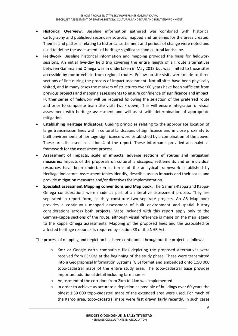
Historical Overview: Baseline information gathered was combined with historical cartography and published secondary sources, mapped and timelines for the areas created. Themes and patterns relating to historical settlement and periods of change were noted and used to define the assessments of heritage significance and cultural landscape.
Fieldwork: Baseline historical information and mapping provided the basis for fieldwork sessions. An initial five-day field trip covering the entire length of all route alternatives between Gamma and Omega was in undertaken in May 2013 but was limited to those sites accessible by motor vehicle from regional routes. Follow up site visits were made to three sections of line during the process of impact assessment. Not all sites have been physically visited, and in many cases the markers of structures over 60 years have been sufficient from previous projects and mapping assessments to ensure confidence of significance and impact. Further series of fieldwork will be required following the selection of the preferred route and prior to composite team site visits (walk down). This will ensure integration of visual assessment with heritage assessment and will assist with determination of appropriate mitigation.
Establishing Heritage Indicators: Guiding principles relating to the appropriate location of large transmission lines within cultural landscapes of significance and in close proximity to built environments of heritage significance were established by a combination of the above. These are discussed in section 4 of the report. These informants provided an analytical framework for the assessment process.
Assessment of Impacts, scale of impacts, adverse sections of routes and mitigation
measures: Impacts of the proposals on cultural landscapes, settlements and on individual resources have been undertaken in terms of the analytical framework established by Heritage Indicators. Assessment tables identify, describe, assess impacts and their scale, and provide mitigation measures and/or directives for implementation.
Specialist assessment Mapping conventions and Map book: The Gamma-Kappa and Kappa-Omega considerations were made as part of an iterative assessment process. They are separated in report form, as they constitute two separate projects. An A3 Map book provides a continuous mapped assessment of built environment and spatial history considerations across both projects. Maps included with this report apply only to the Gamma-Kappa sections of the route, although visual reference is made on the map legend to the Kappa Omega assessments. Mapping of the proposed lines and the associated or affected heritage resources is required by section 38 of the NHR Act.
The process of mapping and depiction has been continuous throughout the project as follows:
o Kmz or Google earth compatible files depicting the proposed alternatives were received from ESKOM at the beginning of the study phase. These were transmitted into a Geographical Information Systems (GIS) format and embedded onto 1:50 000 topo-cadastral maps of the entire study area. The topo-cadastral base provides important additional detail including farm names.
o Adjustment of the corridors from 2km to 4km was implemented. o In order to achieve as accurate a depiction as possible of buildings over 60 years the
oldest 1:50 000 topo-cadastral maps of the extended area were used. For much of the Karoo area, topo-cadastral maps were first drawn fairly recently. In such cases

ESKOM PROPOSED 2nd 765KV POWERLINES GAMMA KAPPA SPECIALIST ASSESSMENT OF SPATIAL HISTORY, CULTURAL LANDSCAPE AND BUILT ENVIRONMENT
___________________________________________________________________________________________________
BRIDGET O’DONOGHUE & SALLY TITLESTAD
HERITAGE CONSULTANTS IN ASSOCIATION
7
the oldest and closest to 1953 was used, with the date of the map being noted in the naming of places (see below).
o Existing covered structures and nodes within the corridors were located and place marked on Google earth. This was done by cross-referencing Google earth imagery with recent edition 1: 50 000 topo-cadastral maps.
o Urban areas were excluded. Urban edges and the Beaufort West heritage area were drawn from the Beaufort West SDF – Conceptual Framework (Draft - May 2013).
o Identification of structures and nodes for consideration as potential heritage resources cross-referenced the identified nodes with historical 1: 50 000 topo-cadastral maps. Use was made of the nearest historical record to 1953. Structures which do not appear on historical maps were screened out as being too recent. For those which do appear, icons were assigned (see below), and the name and number of structures mapped at the time, as well as the mapping date, were recorded (in the label) - e.g. Vrede (69T – 3) = Farm Vrede (1969 topo-cadastral – 3 structures on 1969 map).
o In tandem with the previous step, historic and recent 1: 50 000 topo-cadastral maps for the relevant areas were checked for markers indicating cemeteries, graves, blockhouses and other significant structures representative of historical patterns, and such information recorded. A number of graves indicated on historic maps are no longer indicated on recent maps. In a number of instances, Google Earth imagery indicates still clearly discernible (farm) cemetery footprints, while in others the exact locations are no longer discernible. This information was transferred back into GIS and is depicted on the section maps in the A3 map book for the project. All information is also made available to the client in kmz.
o Provincial Heritage Sites were included from the currently accepted list1 provided by Heritage Western Cape.
Exclusions:
Structures inside currently demarcated urban edges were excluded as settlements were assessed and graded individually. Uncovered structures, e.g. kraals, weirs, dams were not marked, but have been noted in assessment. Historic and modern ruins have not been marked unless they are provincial heritage sites, as they form part of the archaeological assessment. San rock art/ Bushman painting sites have not been shown, to protect the sites.
1 An undated document entitled ‘National Monuments Council, Western Cape Regional Office Administration of Conservation Register of Specific Cases (e.g. 9/2 files)’ was confirmed by pers. Comm. Christina Jikela, 17.2.2014 to constitute the current list, which is up for review.

ESKOM PROPOSED 2nd 765KV POWERLINES GAMMA KAPPA SPECIALIST ASSESSMENT OF SPATIAL HISTORY, CULTURAL LANDSCAPE AND BUILT ENVIRONMENT
___________________________________________________________________________________________________
BRIDGET O’DONOGHUE & SALLY TITLESTAD
HERITAGE CONSULTANTS IN ASSOCIATION
8
Table 1.1 Mapping Icons for Built Environment and Cultural Landscape Assessment
ICON EXPLANATION
Distributions Substation Transmission substation
Urban areas
Urban conservation area
Provincial Heritage Sites
Rural node 20+ structures at the time of first topocadastral depiction
Rural node 10+ structures at the time of first topocadastral depiction
Rural node 5-10 structures at the time of first topocadastral depiction
Rural node under 5 structures at the time of first topocadastral depiction
Recent (excluded) white dots without labels
Cemeteries and graves
Railway sidings
Block Houses
Scenic routes (from sources other than those below, detail in assessment tables) Depictions included from the draft Western Cape Spatial Development Framework:
Major (provincial) scenic routes
Secondary and linking (Local) scenic routes
Recommended National Heritage Resource (Landscapes)
Recommended Provincial Heritage Resource (Landscapes)
Recommended Local Heritage Resource (Landscapes) Please note that the currently under construction 765kV line is mapped as an existing powerline in
blue. This allows comparison of the current and proposed 765kV line routes.
Naming conventions on the mapping series
Please note that the name used below is an example
Houmoed (61T – 3) – Main werf. (Houmoed) (61T – 3) – secondary node on Houmoed. “Houmoed” (61T – 3) – historic (data record) name (where changed). ? Grave (69T) – grave indicated on 1969 map (not recent), but location no longer clear.
MAPPING LIMITATIONS
The 1: 50 000 topographical data record does not precisely match the 1953 search date, and therefore does not precisely record structures older than 60 years. The record for the area covers the period 1949 to 1973, with the bulk of records clustered around 1968 to 1973. Beaufort West, is however covered by a near-matching 1949 map. Other settlements (except Nelspoort, which is beyond the study corridor and was inaccessible) were significantly studied in the fieldwork process to attempt to compensate for the lack of early mapping.

ESKOM PROPOSED 2nd 765KV POWERLINES GAMMA KAPPA SPECIALIST ASSESSMENT OF SPATIAL HISTORY, CULTURAL LANDSCAPE AND BUILT ENVIRONMENT
___________________________________________________________________________________________________
BRIDGET O’DONOGHUE & SALLY TITLESTAD
HERITAGE CONSULTANTS IN ASSOCIATION
9
Historic structure counts indicate the number of structures at a location at the time of the early topocadastral map only. Historic footprints have not been matched up with current ones. Existing structures may therefore not necessarily indicate historic ones.
No information is provided with regard to current number/s of structures within nodes. Primary, secondary and unused structures are not differentiated.
Visual impacts have not been depicted in the mapping exercise as the VIA forms part of a separate study within the EIA.
1.8 ASSUMPTIONS AND LIMITATIONS
1.8.1 Assumptions
The following items are assumed:
The data on the proposed project provided by Nzumbululo Heritage solutions is accurate and up to date at the time of finalising the report.
The proposed transmission line routes identified by ESKOM are technically feasible. The technical data provided by ESKOM is accurate and sufficient for the assessment of the
proposed routes.
1.8.2 Limitations
The specialist assessments of the HIA have faced the following limitations:
All corridors were selected by ESKOM prior to the initiation of the HIA. The exact measurement of the servitude required for construction and maintenance may
vary depending on which pylons are implemented in different places. Measurements cited in this report have been provided by ESKOM and the PI team.
The assessment of cultural landscape cannot be determined in absolute terms. Meetings of the specialists have only occurred twice during the study period, resulting in
minimal cross reference of specialist inputs. Visual Impact assessment and public participation are separate specialist studies and have
not been available to the built environment and cultural landscape specialists.
The specialist assessments and report have produced the following limitations:
This assessment does not consider the ancillary project infrastructure required for construction and maintenance (such as access roads, borrow pits, soil dumps, construction worker housing, etc), nor does it take into account possible impacts of the expansion of existing substations to accommodate the new transmission lines. Expansion of the substations form separate studies. It is envisaged that ancillary infrastructure will be considered once a preferred route has been selected and design and implementation of the project continue.
This assessment is aware of a number of wind and solar energy proposals in the Western Cape, but has not mapped these.
Buildings older than 60 years cannot be precisely established from topocadastral maps, and are therefore estimates.

ESKOM PROPOSED 2nd 765KV POWERLINES GAMMA KAPPA SPECIALIST ASSESSMENT OF SPATIAL HISTORY, CULTURAL LANDSCAPE AND BUILT ENVIRONMENT
___________________________________________________________________________________________________
BRIDGET O’DONOGHUE & SALLY TITLESTAD
HERITAGE CONSULTANTS IN ASSOCIATION
10
SAHRA and Heritage Western Cape have a memorandum of agreement in place regarding Grade I (National) and II (Provincial) heritage sites. It is not clear at the present time which of these sites have been declared and which are ‘regarded’ as sites in the cited category but have not yet been declared. The location of provincial sites is taken from the SAHRA list as a listing from Heritage Western Cape is not currently available.
Public participation and visual assessment has not been integrated at the level of this specialist report as it falls within the scope of work of the Principal Investigator.
Assessments of archaeological and paleontological resources (and impacts thereon) have been undertaken as separate specialist studies, and are not depicted within this report. Integration of archaeological and paleontological impacts with the spatial history, cultural landscape and built environment assessments is therefore not part of this specialist study, and will be addressed by Nzumbululo at the HIA level.
The processes and outcomes of the VIA and public participation will be integrated into the HIA by the Principal Investigator, and have not been accessible to the built environment specialists.
1.9 SPECIALIST TEAM AND DETAILS
The Built environment specialist team consists of Bridget O’Donoghue and Sally Titlestad. Bridget O’Donoghue (B Arch, UCT; M Phil (Environmental Science), (UCT) has extensive heritage experience in public organisations and the private sector. As a registered Architect and accredited Professional Heritage Practitioner, Bridget has the qualifications and the skills to conduct complex heritage impact assessments that deal with the built environmental and cultural landscape issues. During her position within the City of Cape Town, Bridget managed development in sensitive heritage and natural areas in the urban and rural landscape. She has an extremely good practicing understanding and knowledge of national, provincial, and local legislation applicable to development. As a private consultant since 2007, Bridget has completed numerous heritage assessments, audits, and surveys for public and private clients. Work for public clients has included a Heritage Impact assessment for Green Market Square, Bo Kaap Quarries, Relocation of the Cenotaph and Adderley Street IRT Bus Station, and surveys of Sculptures, Monuments, and memorials within the CCT on public land, heritage surveys and reviews of urban conservation area boundaries.
Sally Titlestad (B Soc Sci (Social Work)(Hons), UCT; BA (Psych) (Hons), UWC; MPhil Arch (UCT) is a senior independent specialist spatial historian and heritage management consultant on complex projects. She has been part of the PI team for the Department of Public Works (Groote Schuur Presidential Estate) Integrated Conservation and Management Plan, has prepared and presented expert evidence to the Land Claims Court and is the Principal Heritage Consultant to the Lutheran Church in Cape Town. Sally is an accredited Professional Heritage Practitioner.
1.10 DECLARATION OF INDEPENDENCE
This is to confirm that Sally Titlestad and Bridget O’Donoghue are responsible for undertaking the above specialist studies and are independent and have no vested or financial interest in the proposed development on the alternative routes being either approved or rejected by the relevant authorities.

ESKOM PROPOSED 2nd 765KV POWERLINES GAMMA KAPPA SPECIALIST ASSESSMENT OF SPATIAL HISTORY, CULTURAL LANDSCAPE AND BUILT ENVIRONMENT
___________________________________________________________________________________________________
BRIDGET O’DONOGHUE & SALLY TITLESTAD
HERITAGE CONSULTANTS IN ASSOCIATION
11
1.11 REPORT STRUCTURE
The report is divided into 8 Sections, namely: Section 1: Introduction: Presents the site description, terms of reference and report structure.
Section 2: Project Description: includes the powerline routes and infrastructure description.
Section 3: Regions and Sites Description: Includes the historical background and physical description of the sites and the context.
Section 4: Heritage Legislation and assessment criteria: outlines legislation applied in the assessment, defines cultural landscapes, identifies sensitivities, and provides Heritage Indicators for the proposed project at regional, local and at site specific scales.
Section 5: Identified heritage resources and statements of cultural significance/s: Provides a brief definition of settlements and collections of resources, identifying features of heritage significance and providing a recommended grade for settlements and landscape features of significance.
Section 6: Assessment of impacts measures the scale, permanence and degree of impact, recommending mitigation where appropriate
Section 7: Recommendations: Presents the cultural landscape and built environment recommendations for the preferred route
Section 8: Bibliography

ESKOM PROPOSED 2nd 765KV POWERLINES GAMMA KAPPA SPECIALIST ASSESSMENT OF SPATIAL HISTORY, CULTURAL LANDSCAPE AND BUILT ENVIRONMENT
___________________________________________________________________________________________________
BRIDGET O’DONOGHUE & SALLY TITLESTAD
HERITAGE CONSULTANTS IN ASSOCIATION
12
SECTION 2 PROJECT DESCRIPTION
2.1 INTRODUCTION
The proposal is to construct a second powerline of approximately 485 km carrying 765kV from Gamma substation near Victoria West in the Northern Cape to Kappa substation in the Western Cape near Touws River. A first 765kV line traversing the landscape between these substations is currently under construction.
By constructing the powerline, ESKOM wishes to address the existing electricity network constraints and the projected electricity demand within the Western Cape. Koeberg Nuclear Power Station generates the majority of electricity for Cape Town. When the station requires maintenance or a shutdown occurs, a network large enough to provide for the city and province’s demands is required. The proposed powerlines will transmit electricity generated mainly by the Limpopo and Mpumalanga coal power stations.
A new powerline requires auxiliary infrastructures such as roads, and will enter and exit upgraded Gamma and Kappa substations. The upgrading of substations forms part of separate proposals.
Three alternative corridors were selected by ESKOM based on economic and technical feasibility. Once environmental authorisation is approved ESKOM officials consult with the relevant landowners to permit powerlines and pylons on their land.
Heritage specialists’ assessments study resources within a 4km buffer of the proposed line, while Environmental specialists’ studies address a 2km corridor.
Figure 1: Location of proposed new 765kV transmission line within South Africa (Metro GIS, 2013)

ESKOM PROPOSED 2nd 765KV POWERLINES GAMMA KAPPA SPECIALIST ASSESSMENT OF SPATIAL HISTORY, CULTURAL LANDSCAPE AND BUILT ENVIRONMENT
___________________________________________________________________________________________________
BRIDGET O’DONOGHUE & SALLY TITLESTAD
HERITAGE CONSULTANTS IN ASSOCIATION
13
2.2 ALTERNATIVE ROUTES OPTIONS
The three alternative powerline routes identified by ESKOM for assessment all start at Gamma substation and end at Kappa substation. The Gamma Kappa 2nd 765kV section is approximately 485km in length and is potentially sensitive from a heritage perspective, as alternative routes traverse sensitive areas such as the Karoo National Park and mountainous areas which currently have little or no infrastructural intrusion, and are proposed adjacent to historic settlements such as Beaufort West and Merweville as follows: (refer to Map 1). Route Option 1 (Red): The most southerly route The route is from Gamma substation to south of Beaufort West, travelling at varying distances adjacent to the N1 roadway until Kappa substation north of Touws River. Route Option 2 (Green): The central route Route Option 2 is the middle route option from Gamma substation to adjacent of Three Sisters, Beaufort West, Merweville, to Kappa substation. Route Option 3 (Blue): The northern route Route Option 3 is the most northerly route option from Gamma substation to north of Beaufort West, through Karoo National Park, and in an almost straight line towards Kappa substation.
Figure 2: Kappa Gamma 2nd 765kV powerlines corridors options 1 (red line), Option 2 (green line), Option 3 (blue line) Metro GIS 2013

ESKOM PROPOSED 2nd 765KV POWERLINES GAMMA KAPPA SPECIALIST ASSESSMENT OF SPATIAL HISTORY, CULTURAL LANDSCAPE AND BUILT ENVIRONMENT
___________________________________________________________________________________________________
BRIDGET O’DONOGHUE & SALLY TITLESTAD
HERITAGE CONSULTANTS IN ASSOCIATION
14
2.3 PYLON TOWERS
Pylons towers for the proposed powerlines will be between 42 – 44m in height and have a footprint of approximately 40 – 50 square meters. The servitude required width for the construction of the pylon towers is 110m.
Three types of pylon towers are proposed for the powerlines:
Cross Rope Suspension tower. Guyed Suspension tower. Self supporting suspension pylons and strain suspension pylons are used at positions where
a change of direction takes place in the route or where strain on the lines from wind and other factors requires additional stability.
At each change of direction a self-supporting strain and suspension tower is required. Topography is the determining criteria for choice of pylon.
Figure 3: Pylons for 765kV powerlines (ESKOM Line Engineering services, ESKOM 400kV and 765kV Tower Guide May 2013)
PYLON NAME SPECIFICS NOTES IMAGE
702B: Guyed-V
Suspension
pylon
Max Footprint: 39.5 x 53.5m Max tower height: 50m Average CAH: 36m
Used for altitudes between 1000 and 1200 meters. There is a model modified for altitudes above 1500m, named 702B-M
703B: Guyed-V
Suspension
pylon
Max Footprint: 36.8 x 52.6m Max tower height: 42.8m Average CAH: 33m
The 703B is an alternative to the 702B to be used at altitudes below 1000m. It also has more compact phase spacing than the 702B pylon.
701C: Self
Supporting
Suspension
pylon
Max Footprint: 11.625 x 11.625m Max tower height: 40m Average CAH: 25m
Used in conjunction with the Guyed 702B and 703B towers when the Guyed-Vs cannot be used

ESKOM PROPOSED 2nd 765KV POWERLINES GAMMA KAPPA SPECIALIST ASSESSMENT OF SPATIAL HISTORY, CULTURAL LANDSCAPE AND BUILT ENVIRONMENT
___________________________________________________________________________________________________
BRIDGET O’DONOGHUE & SALLY TITLESTAD
HERITAGE CONSULTANTS IN ASSOCIATION
15
701 D, E and F:
Self Supporting
Strain
Max Footprint: 15.4 x 15.4m Max tower height: 41 - 44m Average CAH: 25m
701F Self Supporting Strain is the 15 – 35 degree angle strain tower commonly used on the 765kV networks
705A: Self
Supporting
Strain
Max Footprint: 76.6.625 x 43.5m Max tower height: 53m Average CAH: 45m
705A is to be a high performance, cost saving tower to be used on the 765kV network
Figure 4: Existing powerlines immediately south of Gamma substation, iillustrating the difference in height between 400kV self supporting suspension pylons and the 765kV Guyed-V suspension pylons (765kV powerline right), BOD/ST 2013

ESKOM PROPOSED 2nd 765KV POWERLINES GAMMA KAPPA SPECIALIST ASSESSMENT OF SPATIAL HISTORY, CULTURAL LANDSCAPE AND BUILT ENVIRONMENT
___________________________________________________________________________________________________
BRIDGET O’DONOGHUE & SALLY TITLESTAD
HERITAGE CONSULTANTS IN ASSOCIATION
16
SECTION 3: REGION AND SITES DESCRIPTION
3.1 INTRODUCTION
The 3 alternative routes traverse regions with a few cultural landscapes, historic settlements and built environment structures. Scenic routes are located along and within corridors, and parts of all three alternatives are scenic and have iconic characteristics.
3.2 HISTORICAL OVERVIEW
The alternative routes from Gamma to Kappa traverse vast fairly sparsely settled terrain. Settlements along the routes include Beaufort West and Merweville. Adjacent to Route alternative 1, but outside of the study corridor are Leeuw Gamka, Touws River and Lainsburg. Adjacent to Route alternative 2, but outside of the study area are Three Sisters, Nelspoort, and Komsberg.
The historical significance of the route itself and its associated settlements can be summarised as follows (for detailed historical assessments and associations see Appendix 2):
Pre Colonial Settlement, the area served as a hunting area for the San, and later as seasonal grazing grounds for the Khoekoen populations that migrated south and entered the region, evidenced by the plethora of rock art sites across the region.
During the Dutch Colonial period (1652-1795) the area became part of a frontier zone, providing grazing for the livestock of trekboers. After 1740 the area became a site of conflict between indigenous people and the trekboers. Trekboers began establishing homesteads in areas with easily accessible water. The conflicts between indigenous people and settlers intensified and commando conflict followed. The area is characterised by having been a contested zone of occupation and ownership since that time.
During the British occupation of the Cape (from 1806) the area became one of changing labour relations and agriculture, and later a region for the banishment of some offenders, and as a wool and ostrich farming region. During this period the beginnings of regional settlements began to be established. Beaufort West was laid out and planned in 1820. The freeing of slaves (1834) entrenched already existing power imbalances between farm owners and farm labour. The intensification of agricultural production in the region followed.
Following the discovery of the mineral wealth of the hinterland (1860s and 70s), rail routes began to be developed and the area became a notable transit route between the Cape and the reefs in the north and east of the country. Laingsburg was established in 1880, shortly after the construction of a railway siding. Small settlements at sidings continued to be established (e.g. Leeuw Gamka and Three Sisters).
Late in the 19th century (1896) segregated housing was developed at Beaufort West, making this one of the oldest ‘township’ developments in the Western Cape. The development of the wind pump (now iconic markers of settlement across the Karoo landscape) made the Karoo more easily able to be permanently occupied, and farming intensified thereafter.
A new parish was established at Merweville in 1897, and a Church town developed thereafter.
The Anglo-Boer or South African war (focussed between 1899 and 1902) saw the establishment of blockhouses to protect rail-bridges, an important part of the British communication infrastructure during that period. These were frequently the sites of skirmishes. The area continued to be a zone of conflict and Matjiesfontein (outside of the study area) became a central British troop station and convalescent home for officers.

ESKOM PROPOSED 2nd 765KV POWERLINES GAMMA KAPPA SPECIALIST ASSESSMENT OF SPATIAL HISTORY, CULTURAL LANDSCAPE AND BUILT ENVIRONMENT
___________________________________________________________________________________________________
BRIDGET O’DONOGHUE & SALLY TITLESTAD
HERITAGE CONSULTANTS IN ASSOCIATION
17
After 1910 (the Union of South Africa) the introduction of refrigeration facilitated diversified agricultural production in the region. In 1924 Nelspoort established a sanatorium for the treatment of tuberculosis, a centre which later became a psychiatric facility.
During the apartheid era a battery of legislation was introduced which segregated towns across the region. Forced removals and the prohibition of Black land ownership further entrenched already existing power imbalances. Capital investments increased on farms after World War 2, and the introduction of mechanisation altered the ways in which farming activities were implemented. The wealth generated by increased production led to the development of elite markers among successful farmers.
Electrification of the railroad and the formalisation of a National vehicular route (N1 in the 1950s) increased the importance of towns as refuelling points and emphasised Beaufort West as the regional centre along a National route. A shift in the modes of passenger transportation followed.
In 1981 devastating floods at Laingsburg exemplified the characteristic drought/flood nature of the area. The deaths of over 100 people and massive destruction of historic buildings and gravestones resulted.
From the 1980s onward, the region began to develop as an area for the conservation of game. Recent history has seen democratic changes to towns, the development of new housing and the growth in populations of regional centres. It has also resulted in widespread concern over the social impacts of settlements being nodes on a national transportation network.
3.3 CULTURAL LANDSCAPE
3.3.1 The Term ‘Cultural Landscape’
Cultural landscapes provide the meaningful context for a range of heritage resources that take a variety of forms and constitute heritage resources in their own right. Following the well-established guidelines set by the first 765kV linear assessments, the following cultural landscape understandings and assessment criteria have been utilised2:
“It could be regarded as the tapestry within which all other heritage resources are embedded and which gives them their sense of place and meaning. The concept of cultural landscape gives spatial and temporal expression to the processes and products of interaction of people with the environment. It may thus be conceived of as a particular configuration of topography, vegetation cover, land use and settlement pattern that establishes some coherence of natural and cultural processes”3.
UNESCO identifies three broad categories of cultural landscape4
Designed landscapes are clearly defined and created intentionally by people. These include gardens and parklands, most commonly constructed for aesthetic purposes;
Organically evolved landscapes result from an initial social, economic, administrative and/or religious imperative and develop their form by a combination of these and in response to the natural environment. These landscapes reflect evolutionary processes in their form and in component features. They can be divided into relic landscapes (no longer used) and continuing landscapes, where the organic nature of their form continues to evolve through active contemporary use including the traditional associations;
2 Baumann and Winter, 2009, pp14-16 3 Baumann and Winter, 2009:14 4 adapted from Baumann and Winter, 2009

ESKOM PROPOSED 2nd 765KV POWERLINES GAMMA KAPPA SPECIALIST ASSESSMENT OF SPATIAL HISTORY, CULTURAL LANDSCAPE AND BUILT ENVIRONMENT
___________________________________________________________________________________________________
BRIDGET O’DONOGHUE & SALLY TITLESTAD
HERITAGE CONSULTANTS IN ASSOCIATION
18
Associated cultural landscapes are those that have powerful religious, artistic or cultural associations that may not be evidenced in historical fabric;
Natural Landscapes : Distinctive vivid landscapes have qualities that set them apart from their surroundings, a dramatic visual quality which is legible and easily understood. These landscapes do not necessarily appear to have been subject to human intervention;
Representative landscapes are particularly representative of the region of which they form a part; they reveal a combination of characteristics and qualities that may be regarded as reflecting the quintessential character of the region;
In order for landscapes to have significance they should be intact and authentic and relatively undisturbed by visual intrusions.
3.3.2 CULTURAL LANDSCAPES OCCURRING ALONG ROUTE ALTERNATIVES
Characterisation of landscapes is a fluid and dynamic process. There are no hard edges to the types of landscapes encountered along the routes. The transitions between landscape typologies are zones where there is a blending of typology, but sections of the routes have fairly distinctive general characteristics, differentiated in part by changing morphology. The proposed lines traverse three morphological zones in this section of the route, which are the Great Karoo, the Moordenaars Karoo and the Ceres Karoo.
3.3.2.1 The Great Karoo
The Great Karoo constitutes the largest area traversed by the proposed powerlines between Gamma and Kappa substations. The general character of the Great Karoo is rural and pastoral with homesteads and settlements widely dispersed and predominantly situated adjacent to riverine corridors. The character of the Great Karoo is of wide plains, vivid expansive spaces, framed at a distance by mountain ranges and peaks. A sense of timelessness and a lack of human modification of the landscape is apparent. The exception to this is the N1 where infrastructure, transportation and human adjustment to the landscape for utility purposes marks a zone of human intervention not reflected by the rest of the Great Karoo.
There are two distinct character zones within the Great Karoo landscape between Gamma and Kappa. North of Beaufort West to the Gamma substation is a series of undulating hills and mountains with more diverse features than those of the plains south of Beaufort West. Three Sisters, an iconic natural landscape feature is found in this area. The geology is predominantly sandstone and shale, and the resulting vegetation is low and predominantly grass and small shrubs occasionally interspersed with Acacia trees in dry riverbeds5. Collections of larger trees tend to occur around farmsteads. Rural built structures of heritage significance tend to have a vernacular typology characteristic of the Karoo, and are typically constructed of either mud brick, plaster and limewash, or local stone.
Figure 5: The northern part of the Great Karoo landscape showing undulating features (BOD & ST, 2013)
5 Baumann and Winter, 2009:23

ESKOM PROPOSED 2nd 765KV POWERLINES GAMMA KAPPA SPECIALIST ASSESSMENT OF SPATIAL HISTORY, CULTURAL LANDSCAPE AND BUILT ENVIRONMENT
___________________________________________________________________________________________________
BRIDGET O’DONOGHUE & SALLY TITLESTAD
HERITAGE CONSULTANTS IN ASSOCIATION
19
South of Beaufort West the landscape is characterised by wide plains framed by distant mountain ranges, sparse settlements and dotted farmsteads. The area is arid and remote. Views are open and expansive. The landscape is coherent and intact, with the only intrusions being infrastructural systems along the N1 route. The Karoo National Park constitutes a natural conservation park on raised mountainous terrain immediately northeast of Beaufort West. Karoo National Park is a Provincial heritage site and denotes an area of regional heritage significance.
Cultural historical considerations in the Great Karoo include the natural, coherent, and undisturbed landscape setting, except for the N1 infrastructure corridor. Settlements that occur along the corridors are Merweville and Beaufort West.
Figure 6: Merweville Dutch Reformed Church building, a Provincial Heritage site and raison d'etre for the creation of a settlement (BoD and ST 2013)
Beaufort West is an urban settlement of regional and provincial significance that includes 25 individual Provincial Heritage sites and a heritage conservation area at the centre of the historic settlement. The attention paid to the impacts of apartheid legislation on the community by the local Museum has raised awareness of the histories associated with the town. Beaufort West also houses the Chris Barnard Museum. The role of the town at the confluence of regional transport routes and as regional administrative centre reflect its cultural history and heritage significance.
Merweville (on the border between the Great and Moordenaars Karoo) is a remote authentic, intact and coherent late nineteenth/early twentieth century Church town located at the centre of the Koup district. The Koup has both distinctive landscape and cultural heritage significance for its location as a zone of conflict between indigenous people and settlers, and later during the Anglo Boer War. The Stone Church and parsonage at Merweville, and the grave of W.O Arnot (a single grave not included in the cemetery) are Provincial heritage sites. The cultural landscape significance at Merweville is the distinctive layering of apartheid housing provision for people excluded from the town by the Group Areas Act. This has been added to by the creation of new Reconstruction and Development Programme (RDP) housing as an extension to the apartheid ‘township’.
The Moordenaars Karoo
The Moorednaars Karoo is bordered by but does not include any towns. The character is vast, expansive, gently undulating to steeply rising topography, its aridity and low vegetation, and sparse isolated human settlement. There is a perceived lack of human presence or intervention in the area, and it is imbued with the expansive rural qualities quintessentially associated with the Karoo.
The proposed Option Routes 2 and 3 traverse landscapes north of the first 765kV powerline, and Option Route 3 traverses through steep and virtually untouched terrain. Option Route 1 travels adjacent the N1 infrastructure corridor, but both east and west of Laingsburg moves outside of the infrastructure corridor into the quintessentially Karoo experience of this area.
The Ceres Karoo
Constituting the smallest of the cultural landscape regions in the study area, the Ceres Karoo is characterised by a dramatic change in topography and landscape from the mountainous regions to its southwest, and smaller changes from the vast Karoo landscapes to the northeast. The Ceres

ESKOM PROPOSED 2nd 765KV POWERLINES GAMMA KAPPA SPECIALIST ASSESSMENT OF SPATIAL HISTORY, CULTURAL LANDSCAPE AND BUILT ENVIRONMENT
___________________________________________________________________________________________________
BRIDGET O’DONOGHUE & SALLY TITLESTAD
HERITAGE CONSULTANTS IN ASSOCIATION
20
Karoo is characterised by vast open spaces, long range views and low scrub vegetation. The expansiveness of the landscapes are firmly framed by distant mountains. Farm settlements are sparse and typically dispersed single farms practicing stock or game farming. The lower border of the Ceres Karoo region lies southwest of the Kappa substation. Buildings tend to reflect a remote vernacular typology characteristic of Karoo buildings, and settlement has been informed by the location of outspans (outside of the study area).
Figure 7: Cultural landscape regions occurring along the length of the alternate routes, Metro GIS 2013
Summary:
The majority of landscapes in the assessed area between Gamma and Kappa fall within the range of organically evolved landscapes. The following sub-categories for these landscapes are used to further depict the heritage resources potentially affected by the lines6:
Historical townscape Historical farm werf Scenic landscape Pristine cultural landscape Wilderness mountainscape Productive agricultural landscape Remote arid landscape Relic landscape Organically developed low density productive agricultural landscape
6 Adapted from Baumann and Winter, 2009:15

ESKOM PROPOSED 2nd 765KV POWERLINES GAMMA KAPPA SPECIALIST ASSESSMENT OF SPATIAL HISTORY, CULTURAL LANDSCAPE AND BUILT ENVIRONMENT
___________________________________________________________________________________________________
BRIDGET O’DONOGHUE & SALLY TITLESTAD
HERITAGE CONSULTANTS IN ASSOCIATION
21
3.4 BUILT ENVIRONMENT
The alternative powerline corridors predominately traverse undeveloped areas, which are used for agriculture and conservation. However, in certain circumstances, the periphery of townscapes fall within the 4 km corridors (refer Table 3.1).
Table 3.2: Settlements
OPTION ALTERNATIVE TOWN POSITION WITHIN CORRIDOR
Option 1 Laingsburg On periphery of southern edge of corridor
Option 2 Merweville
Within 1-2km of centreline of corridor
Beaufort West
Within 0 – 2km of centreline of corridor
Nelspoort Within 1– 2km of outer buffer of corridor
Option 3 Beaufort West Within 1 – 2km of centreline of corridor

ESKOM PROPOSED 2nd 765KV POWERLINES GAMMA KAPPA SPECIALIST ASSESSMENT OF SPATIAL HISTORY, CULTURAL LANDSCAPE AND BUILT ENVIRONMENT
___________________________________________________________________________________________________
BRIDGET O’DONOGHUE & SALLY TITLESTAD
HERITAGE CONSULTANTS IN ASSOCIATION
22
SECTION 4: HERITAGE LEGISLATION & ASSESSMENT CRITERIA
4.1 INTRODUCTION
Section 4 provides an overview of the administration context of the sites and the applicable statutory framework. The historical development for the settlement is provided in addition to descriptions of the individual sites and their context, current structures, landscape features and land uses.
4.2 ADMINISTRATIVE CONTEXT AND STATUTORY FRAMEWORK
4.2.1 Overview
The corridors are located within multiple districts including Victoria West in the Northern Cape and Beaufort West, Three Sisters, Merweville, Murraysburg, Prince Albert, Laingsburg, Touwsriver and Ceres in the Western Cape. Municipal areas traversed include Pixley-ka Seme District Municipality and Ubuntu Local Municipality (Victoria West ), Central Karoo District Municipality with Beaufort West, Prince Albert and Liangsburg Local Municipalities and Cape Winelands District Municipality with Breede Valley and Witzenberg Local Municipalities.
For the purposes of this study, the following relevant South African and city policy and planning documents were reviewed:
National Heritage Resources Act No. 25 of 1999 (NHR Act); Municipal Zoning Policies, Frameworks and Regulations; Municipal planning strategy and reports;
4.2.2 National Heritage Resources Act No. 25 of 1999 (NHRA)
The NHR Act serves as the controlling legal framework for heritage conservation in South Africa. The Act lays down general principles for governing heritage resources management throughout the republic and provides for the identification, assessment and management of the heritage resources of the country. The Act only applied to “those heritage resources of South Africa, which are of cultural significance or other special value for the community and for future generations”. A heritage resource is described as “any place or object of cultural significance” (NHR Act, Section 26 [xvi]). Heritage resources significant enough to be considered part of the national ‘estate’, may include inter alia (Section 3[2]):
o Places, buildings, structures and equipment of cultural significance; o Places to which oral traditions are attached or which are associated with living heritage; o Historical settlements and townscapes; o Landscapes and natural features of cultural significance; o Geological sites of scientific or cultural importance; o Archaeological sites and objects; o Graves and burial grounds; o Sites of significance relating to the history of slavery in South Africa; o Moveable objects including military objects, fine art, books records, documents,
archaeological and paleontological objects and materials. Cultural heritage significance means aesthetic, historical, scientific, architectural, scientific, spiritual, technological or social value or significance. The process of deciding why a place is of heritage significance is called heritage assessment. The NHR Act requires the heritage significance of any site

ESKOM PROPOSED 2nd 765KV POWERLINES GAMMA KAPPA SPECIALIST ASSESSMENT OF SPATIAL HISTORY, CULTURAL LANDSCAPE AND BUILT ENVIRONMENT
___________________________________________________________________________________________________
BRIDGET O’DONOGHUE & SALLY TITLESTAD
HERITAGE CONSULTANTS IN ASSOCIATION
23
or object be assessed so as to ensure the appropriate level of management of the country’s heritage resources. The South African Heritage Resources Authority (SAHRA) has in terms of Section 7 (1) of the NHR Act, published regulations providing for grading systems and heritage resources assessment criteria (Government Gazette No. 24893. Government Notice No. 694 dated 30 May 2003). This criteria is to be applied in assessment the significance of heritage resources for Grade 1, 2 and 3 heritage resources (refer to Annexure 4: Cultural Significance Assessment Criteria). A culturally significant resource or site is considered part of the national estate if it has cultural significance or any other specials value because of – Its importance in the community, or pattern of South Africa’s history; Its possession of uncommon, rare or endangered aspects of South Africa’s natural or cultural
history; Its potential to yield information that will contribute to an understanding of South Africa natural
or cultural heritage; Its importance in demonstrating the principal characteristics of a particular class of South
Africa’s natural or cultural places or objects; Its importance in exhibiting particular aesthetic characteristics valued by a community or
cultural group; Its importance in demonstrating a high degree of creative or technical achievement at a
particular period; Its strong association with a particular community or cultural group for social, cultural or
spiritual reasons; Its strong and special association with the life or work of a person, group or organisation of
importance in the history of south Africa; Sites of significance in relations to the history of slavery (Section 3[3] NHR Act). The Act provides formal protections for national and provincial heritage sites in addition to the protection of heritage resources that have not been formally protected. Section 34 requires that “no person may alter of demolish any structure or part of a structure which is older than 60 years without a permit issued by the relevant provincial heritage authority”. Section 38 is intended to ensure that heritage resources that have not been formally identified and protected are not unknowingly damaged or destroyed during development or administration change to site/s.
4.2.3 Existing Heritage Studies
The HIA for the initial 756kV powerlines corridor from Kappa to Omega provided baselines for the degree of required assessment for the current study. In addition, site and settlement heritage studies have provided information on the various cultural significances of affected areas within the study corridors.

ESKOM PROPOSED 2nd 765KV POWERLINES GAMMA KAPPA SPECIALIST ASSESSMENT OF SPATIAL HISTORY, CULTURAL LANDSCAPE AND BUILT ENVIRONMENT
___________________________________________________________________________________________________
BRIDGET O’DONOGHUE & SALLY TITLESTAD
HERITAGE CONSULTANTS IN ASSOCIATION
24
4.3 HERITAGE ASSESSMENT CRITERIA
4.3.1 Definition of Cultural Significance and Criteria for the Assessment of Cultural Significance
Cultural significance is defined as “historical, architectural, aesthetic, environmental, social or technological/scientific value or significance” (NHRA 25 of 1999).
The NHRA lists broad criteria for the assessment of cultural significance. This is based on the following:
Importance in the community or pattern in South African history; Possession of uncommon, rare or endangered aspects of South African's natural or cultural
heritage; Potential to yield information that will contribute to an understanding of South Africa's
natural and cultural heritage; Importance in exhibiting particular aesthetic characteristics valued by a community or
cultural group; Importance in demonstrating a high degree of creative of technical achievement during a
particular period; Strong or special association with a particular community of cultural group for social, cultural
or spiritual reasons; Strong or special association with the life of work of a person, group or organisation of
importance in the history of South Africa.
Such criteria can be categorised, in terms of the NHRA, as follows:
Historical:
Associated with an historic person or group Associated with a historic event, use or activity Is representative of a historical period
Architectural:
Significant to architectural or design history Important example of a building type Possesses special features, fine details or workmanship Work of a major architect
Environmental:
Contributes to the character of an area Part of an important group of heritage resources or features Landmark quality Important for reasons of natural environmental considerations
Social:
Associated with economic social and religious activity Significant in terms of social memory Associated with living heritage and cultural traditions
Technical/Scientific:
Important to industrial technological or engineering development

ESKOM PROPOSED 2nd 765KV POWERLINES GAMMA KAPPA SPECIALIST ASSESSMENT OF SPATIAL HISTORY, CULTURAL LANDSCAPE AND BUILT ENVIRONMENT
___________________________________________________________________________________________________
BRIDGET O’DONOGHUE & SALLY TITLESTAD
HERITAGE CONSULTANTS IN ASSOCIATION
25
Important to archaeology, palaeontology, geology and botany. The following additional criteria are used in understanding cultural landscapes and the cultural significance of a place in terms of its physical evidence and contextual qualities7: Intrinsic Significance: Ability for physical or material evidence to demonstrate a past design style period technique, philosophy or belief. The degree of heritage significance is determined by:
Age Scarcity value Intactness (presence of original features) Representational value (outstanding, important or typical value) Evidence of historical layering
Associational Significance: Associational links with past events, activities, persons or social groupings for which there may not be physical evidence. Degree of Significance is determined by:
The significance of past events Intimacy of the association Duration of the association Evocative quality of a place and its stetting relative to the period of association
4.3.2 Contextual/Experiential Significance
Qualities that give a place historical character, a sense of continuity with the past, a sense of orientation, and structure within the landscape. It encompasses the physical properties (scale, form edges, alignments, views spaces, orientation) of a place and it's setting. Degree of significance is determined by:
Level of coherence or unity Level of intactness Level of interpretive qualities Level of continuity or historical layering Level of vividness Relationship with its setting Evocative versus disruptive qualities of contrasting elements. The NHRA grades sites according to their national (Grade 1) provincial (grade 2) or local
(grade 3) significance.
4.3.3 Assessments of Impacts
Criteria for the assessment of heritage impacts has been based on those contained in the EIA regulations, as follows:
Nature of the impact in terms of: Physical and material impacts Visual spatial qualities Associational impacts
Extent of the impact in terms of: Regional/townscape scale
7 Kerr 2000, used by Bauman and Winter 2003

ESKOM PROPOSED 2nd 765KV POWERLINES GAMMA KAPPA SPECIALIST ASSESSMENT OF SPATIAL HISTORY, CULTURAL LANDSCAPE AND BUILT ENVIRONMENT
___________________________________________________________________________________________________
BRIDGET O’DONOGHUE & SALLY TITLESTAD
HERITAGE CONSULTANTS IN ASSOCIATION
26
Local scale Farm/site scale Individual element scale
Duration of the impact may be: Permanent Long term Medium term Short term Temporary
Magnitude of the impact may be: High involving severe alteration or damage. Substantial mitigation required Medium involving significant alteration or change. Significant mitigation required. Low involving minimal alteration or change. Minimal mitigation required Very low and within the capacity of the site to absorb.
Status of impact in terms of cost benefit analysis
The NHRA requires that impacts on heritage resources are also to be assessed in the light of the projects’ ability to provide social and economic benefit to the communities and economy at large (either positive, negative, neutral).
4.4 PRELIMINARY ASSESSMENT GUIDELINES
Preliminary guideline principles for powerline construction were developed by the authors in the process of assessment. These were based primarily on the assessment of the impacts of existing powerlines of varying voltage capacities on site.
Powerlines have less impact on identified heritage resources if situated in the following situations:
Mountain foothills; Rugged mountainous terrain; Disturbed land e.g. agricultural lands; Within a concentrated corridor; A distance of approximately 500 – 1km from an established transport route; On the edge of a valley i.e. not bisecting a valley.
Powerlines have more impact on identified heritage resources if situated in the following situations:
Road intersections; Smooth Mountainous terrain; Unspoilt terrain/landscapes; Variety of powerlines corridors within a context; Flatter topography i.e. less backdrop; In close proximity to established routes; Bisecting a valley Interrupting coherent patterns, such as agricultural lands.
Sensitivities
• Coherent natural and cultural landscapes, for example Karoo National Park, Karoo mountainscapes and agricultural landscapes;

ESKOM PROPOSED 2nd 765KV POWERLINES GAMMA KAPPA SPECIALIST ASSESSMENT OF SPATIAL HISTORY, CULTURAL LANDSCAPE AND BUILT ENVIRONMENT
___________________________________________________________________________________________________
BRIDGET O’DONOGHUE & SALLY TITLESTAD
HERITAGE CONSULTANTS IN ASSOCIATION
27
• Settlements of within powerline corridors, for example Merweville and Beaufort West;
• ‘Pristine’ landscapes, for example sections of the Karoo;
• Cumulative impact vs. cutting new corridors;
• Iconic Scenic routes, for example sections of the N1 past Three Sisters;
• Certain route options that will impact more than other route options on the cultural and natural landscapes.
4.5 HERITAGE INDICATORS AND THEIR APPLICATION
Heritage indicators were identified to assess the impact of the current proposals on the identified cultural landscapes and built environment. These were developed at regional, local and micro (site specific) scales.
4.7.1. Regional scale
In areas where the proposed powerline will have high impact on identified heritage resources on a regional and sub-regional scale the following heritage indicators apply: Table 4.7.1.1: Heritage design Indicators at a regional and sub-regional scale NO HERITAGE RESOURCES THAT
ARE SENSITIVE AT REGIONAL
SCALE
HERITAGE INDICATOR
1 Distinct landscapes that are large scale and representative of regional characteristics, e.g. agricultural valleys, mountain backdrops, riverine corridors, mountain passes, escarpment edges, mountainous ridges.
Avoid interventions in significant regional landscapes; If powerline proposals traverse a significant regional landscape, alignments must be considered in terms of their impacts on that landscape. Mitigation would involve moving the line to less intrusive position.
2 Intact, undisturbed areas of high wilderness qualities and scenic values
Avoid interventions in intact scenic wilderness areas. If powerline proposals traverse significant wilderness landscapes, alignments must be considered in terms of their high negative impacts on that landscape. Mitigation would involve moving the line to less intrusive position. Site power lines in areas where there is existing infrastructure, such as roads, railway lines and existing power line corridors. Consideration is to be given where there could be cumulative impacts from multiple infrastructure.
3 Areas of low visual absorption, such as vast open spaces without mountain backdrops where settlement is dispersed
Avoid new interventions in areas of low visual absorption. If powerline proposals traverse areas of low visual absorption, alignments must be considered in terms of their high negative impacts on that landscape. Mitigation would

ESKOM PROPOSED 2nd 765KV POWERLINES GAMMA KAPPA SPECIALIST ASSESSMENT OF SPATIAL HISTORY, CULTURAL LANDSCAPE AND BUILT ENVIRONMENT
___________________________________________________________________________________________________
BRIDGET O’DONOGHUE & SALLY TITLESTAD
HERITAGE CONSULTANTS IN ASSOCIATION
28
involve moving the line to less intrusive position. Site power lines in areas where visual absorption is high.
4 Concentration of heritage resources (built environment and /or cultural landscapes);
Avoid interventions into historic settlements or representative cultural landscapes. If powerline proposals traverse significant historical settlements, alignments must be considered in terms of their high negative impacts. Mitigation would involve moving the line to less intrusive position. Site power lines in areas away from regionally significant historical settlements or cultural landscapes.
5 Dominant vistas and views of historic towns and their primary access routes
Avoid interventions into historic settlements or representative cultural landscapes. If powerline proposals traverse significant vistas and views, appropriate alignments should be determined by visual impact assessment.
6 Scenic routes Avoid powerlines travelling parallel to scenic routes. If powerline proposals must be sited near scenic routes, the lines should cross perpendicular to routes, should not be sited on ridge lines, should be positioned on lower topography, and not be placed closer than 600m to the route if travelling parallel. This should be determined by detailed site visit.
In summary
Avoid sensitive distinct character landscapes; Choose disturbed areas over wilderness areas; Choose areas with a high visual absorption capacity; Position new infrastructure in existing infrastructure corridors where possible; Consider how the powerlines traverse significant scenic routes.
4.7.2 Local Scale
In areas where the proposed powerline will have high impacts on identified heritage resources on a local scale, the scale of impacts will determine the suitability of the proposal. Once a preferred route has been established by integrated assessment, it is possible that some areas of a route will have negative impacts at local level. These can be mitigated as indicated below:

ESKOM PROPOSED 2nd 765KV POWERLINES GAMMA KAPPA SPECIALIST ASSESSMENT OF SPATIAL HISTORY, CULTURAL LANDSCAPE AND BUILT ENVIRONMENT
___________________________________________________________________________________________________
BRIDGET O’DONOGHUE & SALLY TITLESTAD
HERITAGE CONSULTANTS IN ASSOCIATION
29
Table 4.7.1.2: Heritage design Indicators at a local scale No Heritage resources that are
sensitive at local scale Heritage Indicator
1 Areas of low visual absorption qualities, e.g. flat topography, localised valleys with low scale vegetation and buildings
Position power lines along foothills of mountains so that the power lines have a backdrop; Select mountains with rugged characteristics as opposed to smooth terrain; Position pylons on either side of mountain ridge and not on its crest; Utilise topographical features and variations (mountain slopes, ridges, vegetation) and buildings to provide a background setting and avoid pylons being seen in silhouette; Positions powerlines where there is existing infrastructure, such as roads, railway lines, existing power lines, tree belts; Consideration is to be given where there could be cumulative impacts from multiple infrastructure.
2 Visual contextual setting of significant built environments, e.g. farmsteads, historic settlements.
Power lines should be positioned perpendicular to the geometry of historic routes, roads, farmsteads and/or werf. Powerlines should be situated behind the dominant vista between significant structures and access route i.e. at the rear of the farmstead/farm node.
3 Features reflective of the cultural landscape and settlement patterns, e.g. siting of farmsteads with mature trees adjacent to river corridors
Powerlines should not be positioned between farm nodes and adjacent riverine corridors, nor should they divide any built components of the farm node.
4 Coherent historical settlement precincts
Avoid intact settlements and their immediate context. Position powerlines at a distance from settlements. Visual impact to be considered. On site determination by composite team to determine best possible option for route.
5 Gateways and thresholds of settlements and landform typologies;
Consider gateways and thresholds in landscapes and how pylons are situated in sensitive contexts. On site determination by composite team to determine best possible option for route.
6 Scenic routes Avoid powerlines travelling parallel to scenic routes. If powerline proposals must be sited near scenic routes, the lines should cross perpendicular to routes, should not be sited on ridge lines, should be positioned on lower topography, and not be placed closer than 600m to the route if travelling

ESKOM PROPOSED 2nd 765KV POWERLINES GAMMA KAPPA SPECIALIST ASSESSMENT OF SPATIAL HISTORY, CULTURAL LANDSCAPE AND BUILT ENVIRONMENT
___________________________________________________________________________________________________
BRIDGET O’DONOGHUE & SALLY TITLESTAD
HERITAGE CONSULTANTS IN ASSOCIATION
30
parallel. On site determination by composite team to determine best possible option for route.
7 Historical landscape patterns
Relationships between towns and their spatial settings should be retained. Position powerlines beyond/outside these spatial settlement contexts. On site determination by composite team to determine best possible option for route.
8 Farm nodes with adjacent infrastructure
Avoid framing farmsteads and farm nodes by introducing infrastructure on more than one side of node. If powerline proposals introduce new powerlines near existing ones, the new lines must be positioned on the same side of the node as the existing. Consideration is to be given where there could be cumulative impacts from multiple infrastructure.
4.7.2 Micro Scale
In areas where the proposed powerline will have high impacts on identified heritage resources on a local scale, the scale of impacts will determine the suitability of the proposal. Once a preferred route has been established by integrated assessment, it is possible that some areas of a route will have negative impacts at site scale. These can be mitigated as indicated below: Table 4.7.1.3: Heritage design Indicators at a Micro scale No Heritage resources that are
sensitive at local scale Heritage Indicator
1 Farmstead structure alignments with their access routes and dominant vistas
Powerlines should be situated behind the dominant vista between the farmstead and the access route/river corridor, at the rear of the farmstead front façade. Power lines should be aligned parallel to the established historical geometry of the farm node. Powerline should not be placed between farm node and the adjacent river corridor.
2 Topographical features Landscape features such as rocky outcrops and folds in landscapes can be utilised to mitigate the negative impact on the landscape at a micro site level.
3 Farm nodes with adjacent infrastructure
Avoid framing farmsteads and farm nodes by introducing infrastructure on more than one side of node. If powerline proposals introduce new powerlines near existing ones, the new lines must be positioned on the same side of the node as the existing. Consideration is to be given where there could be cumulative impacts from multiple infrastructure.
4 Significant tree avenues Power lines should not result in the removal of trees within a

ESKOM PROPOSED 2nd 765KV POWERLINES GAMMA KAPPA SPECIALIST ASSESSMENT OF SPATIAL HISTORY, CULTURAL LANDSCAPE AND BUILT ENVIRONMENT
___________________________________________________________________________________________________
BRIDGET O’DONOGHUE & SALLY TITLESTAD
HERITAGE CONSULTANTS IN ASSOCIATION
31
tree avenue. Powerlines should be aligned parallel to the avenue or cross perpendicular.
Figure 8: Existing powerline infrastructure on N1 roadway
Image 4.1: Existing substation adjacent to N1 and Prince Albert Roads, BOD/ST 2013
Image 4.2: Examples of infrastructure in Karoo landscape, BOD/ST 2013
Image 4.3: Existing powerlines adjacent to N1 in context of the Prince Albert Road intersection, BOD/ST 2013
Image 4.4: Confluence of existing powerlines at substations (adjacent to N1 in context of the Prince Albert Road intersection), BOD/ST 2013
Figure 9: Images Laingsburg context
Image 4.5: Existing powerline in the context of Laingsburg, note the backdrop effect of the surrounding topography, BOD/ST 2013
Image 4.6: Existing powerline in the context of Laingsburg, note the backdrop effect of the local topography, BOD/ST 2013

ESKOM PROPOSED 2nd 765KV POWERLINES GAMMA KAPPA SPECIALIST ASSESSMENT OF SPATIAL HISTORY, CULTURAL LANDSCAPE AND BUILT ENVIRONMENT
___________________________________________________________________________________________________
BRIDGET O’DONOGHUE & SALLY TITLESTAD
HERITAGE CONSULTANTS IN ASSOCIATION
32
Figure 10: Images Merweville
Image 4.7: Context south of Merweville, existing powerlines in view, BOD/ST 2013
Image 4.8: View south towards existing powerlines from Merweville, BOD/ST 2013
Image 4.9: Context south of Merweville with Merweville in the distance, BOD/ST 2013
Image 4.10: Context south of Merweville with existing powerlines, BOD/ST 2013
Image 4.11: Example of Merweville 19th c locally significant architecture, BOD/ST 2013
Image 4.12: Merweville streetscape, views south towards existing powerlines, BOD/ST 2013

ESKOM PROPOSED 2nd 765KV POWERLINES GAMMA KAPPA SPECIALIST ASSESSMENT OF SPATIAL HISTORY, CULTURAL LANDSCAPE AND BUILT ENVIRONMENT
___________________________________________________________________________________________________
BRIDGET O’DONOGHUE & SALLY TITLESTAD
HERITAGE CONSULTANTS IN ASSOCIATION
33
Figure 11: Images Gamma Kappa 765kV Transmission line south Beaufort West
Image 4.13: Existing powerlines adjacent N1 road south of Beaufort West, BOD/ST 2013
Image 4.14: Existing powerlines adjacent N1 road south of Beaufort West, BOD/ST 2013
Image 4.15: Existing powerlines crossing N1 road south of Beaufort West, BOD/ST 2013
Image 4.16: Example of distance between existing powerlines, N1 road in foreground, south of Beaufort West, BOD/ST 2013
Image 4.17: Existing 2 powerlines adjacent N1 road south of Beaufort West, BOD/ST 2013
Image 4.18: Existing 2 powerlines adjacent N1 road south of Beaufort West, BOD/ST 2013

ESKOM PROPOSED 2nd 765KV POWERLINES GAMMA KAPPA SPECIALIST ASSESSMENT OF SPATIAL HISTORY, CULTURAL LANDSCAPE AND BUILT ENVIRONMENT
___________________________________________________________________________________________________
BRIDGET O’DONOGHUE & SALLY TITLESTAD
HERITAGE CONSULTANTS IN ASSOCIATION
34
Figure 12: Images Karoo National Park
Image 4.19: Karoo National Park, viewing south towards the park’s interior, BOD/ST 2013
Image 4.20: Karoo National Park views south towards the N1 roadway, BOD/ST 2013
Image 4.21: Karoo National Park, viewing south towards the park’s interior, BOD/ST 2013
Image 4.22: Karoo National Park, valleys between mountain ranges, BOD/ST 2013
Image 4.23: Karoo National Park, views south towards N1 roadway and existing powerlines in the distance, BOD/ST 2013
Image 4.24: Karoo National Park, pristine landscape, BOD/ST 2013

ESKOM PROPOSED 2nd 765KV POWERLINES GAMMA KAPPA SPECIALIST ASSESSMENT OF SPATIAL HISTORY, CULTURAL LANDSCAPE AND BUILT ENVIRONMENT
___________________________________________________________________________________________________
BRIDGET O’DONOGHUE & SALLY TITLESTAD
HERITAGE CONSULTANTS IN ASSOCIATION
35
Figure 13: Images Beaufort West to Gamma Substation
Image 4.25: Existing powerlines in distance below horizon between Beaufort West and Gamma Substation, BOD/ST 2013
Image 4.26: Existing 765kV powerline between Beaufort West and Gamma Substation, BOD/ST 2013
Image 4.27: Powerline adjacent to N1 roadway south of Gamma substation, pylons visible over low topography, BOD/ST 2013
Image 4.28: Powerlines between Beaufort West and Gamma Substation, BOD/ST 2013
Image 4.29: Scale of existing powerline between Beaufort West and Gamma Substation crossing N1 roadway, note lightness of cable indicate new cable which will fade, BOD/ST 2013
Image 4.30: Existing 2 powerlines immediately south of Gamma substation, (765kV powerline right), BOD/ST 2013

ESKOM PROPOSED 2nd 765KV POWERLINES GAMMA KAPPA SPECIALIST ASSESSMENT OF SPATIAL HISTORY, CULTURAL LANDSCAPE AND BUILT ENVIRONMENT
___________________________________________________________________________________________________
BRIDGET O’DONOGHUE & SALLY TITLESTAD
HERITAGE CONSULTANTS IN ASSOCIATION
36
Figure 14: Images Karoo Landscape Option Route 1 Corridor north Laingsburg
Image 4.31: Karoo Landscape with mountainscapes in distance, BOD/ST 2013
Image 4.32: Karoo Landscape, BOD/ST 2013
Image 4.33: Typical Karoo Landscape and vegetation, BOD/ST 2013
Image 4.34: Karoo Landscape with minimal of infrastructure visible adjacent to N1 roadway, BOD/ST 2013

ESKOM PROPOSED 2nd 765KV POWERLINES GAMMA KAPPA SPECIALIST ASSESSMENT OF SPATIAL HISTORY, CULTURAL LANDSCAPE AND BUILT ENVIRONMENT
___________________________________________________________________________________________________
BRIDGET O’DONOGHUE & SALLY TITLESTAD
HERITAGE CONSULTANTS IN ASSOCIATION
37
SECTION 5 IDENTIFIED HERITAGE RESOURCES & STATEMENTS OF
HERITAGE SIGNIFICANCE
5.1 INTRODUCTION
The values and patterns of identified heritage resources provide the basis for understanding the significance of sites and settlements. These informants provide the basis for assessing the impacts of linear interventions on the resources themselves. The following assessment is informed by the criteria outlined in Section 3(3) of the NHRA, which have been expanded to include intrinsic and associational values.
Natural and scenic landscapes of heritage significance are dealt with under cultural landscapes below.
Figure 15: Kappa Gamma 2nd 765kV powerlines corridors options 1 (red line), Option 2 (green line), Option 3 (blue line) Metro GIS 2013

ESKOM PROPOSED 2nd 765KV POWERLINES GAMMA KAPPA SPECIALIST ASSESSMENT OF SPATIAL HISTORY, CULTURAL LANDSCAPE AND BUILT ENVIRONMENT
___________________________________________________________________________________________________
BRIDGET O’DONOGHUE & SALLY TITLESTAD
HERITAGE CONSULTANTS IN ASSOCIATION
38
5.2 ROUTE OPTION 1
Route Option 1: The most southerly route The route is from Gamma substation (above Three Sisters) to south of Beaufort West, travelling at varying distances from and adjacent to the N1 roadway until Kappa substation north of Touws River. Table 5.1: Route Option 1: Settlement Laingsburg
NAME OF TOWN LAINGSBURG
Historical Pattern Grid layout, bordering a railway line, Church town initially called Vischkuil, after the farm on which it was created and thereafter Buffelsrivier (Buffalo River). When the rail arrived the place was called Nassau. John Laing moved a servitude so that the modern town could become a reality and to honour him it became Laings Town. Thereafter it became Laingsburg
Date of settlement 1881
Relationship to natural systems Confluence the Buffels and Baviaans Rivers
Rarity No
Potential to yield Information Yes, geological formations, detail study of structures, land use and social histories
Particular Aesthetic Character Low scaled Karroo townscape
Technical/creative achievement
of period
Geological formations
Social/Cultural/Spiritual
Association
Anglo Boer War: a major skirmish at Driefontein in the Seweweekspoort area. The casualties are buried in Laingsburg cemetery.
Associated with flood on 25 January 1985 and the heroic events of the residents and rescue services. Buildings of heritage significance were destroyed in this natural disaster, leaving a townscape apparently almost devoid of the historical core that had previously existed.
Scenic route south of Laingsburg
Association with life/work of
people of importance in SA
history
Boer Commandant Gideon Scheepers was captured nearby Laingsburg
Association with history of Slavery Not known
Statement of Significance Anglo-Boer War Blockhouse Scientific (Geological) significances: one of the Karoo's most geologically interesting area with rare fossils and an international study area Low local architectural significance as only 21 historical buildings survived the flood on 25 January 1981
Proposed grading of settlement Grade 2 as high geological significance
Table 5.2: Route Option 2: Landscapes NO. LANDSCAPE PROPOSED SIGNIFICANCES PROPOSED GRADE
1 Moordenaars Karoo Aesthetic, biophysical, associational, Grade 2 2 Great Karoo Aesthetic, biophysical, associational Grade 2

ESKOM PROPOSED 2nd 765KV POWERLINES GAMMA KAPPA SPECIALIST ASSESSMENT OF SPATIAL HISTORY, CULTURAL LANDSCAPE AND BUILT ENVIRONMENT
___________________________________________________________________________________________________
BRIDGET O’DONOGHUE & SALLY TITLESTAD
HERITAGE CONSULTANTS IN ASSOCIATION
39
5.3 ROUTE OPTION 2
Route Option 2: The central route Route Option 2 is the middle route option from Gamma substation to adjacent of Three Sisters, Beaufort West, Merweville, to Kappa substation. Table 5.3: Route Option 2: Settlement Beaufort West
NAME OF TOWN BEAUFORT WEST
Historical Pattern Grid plan by surveyor JL Leeb determined by parallel rivers and existing road to eastern frontier and existing farm walls. Long streets set 125 metres apart bisected by short streets. Main road terminates in former Gaol, now a Police Station. Established on farm Hooyvlakte.
Date of settlement 1821, first erven sold
Relationship to natural systems Situated between the Gamka and Kuils Rivers with natural springs
Rarity Pear tree avenue, townscape, concentration of significant buildings
Beaufort West has been the regional centre along a National transport route since its inception as a settlement
Potential to yield Information Yes
Particular Aesthetic Character Karoo townscape with identifiable historic core
Technical/creative achievement
of period
19th c buildings with layered development of the town as expansion has occurred over time
Social/Cultural/Spiritual
Association
Establishment of first Municipality and construction of first town hall in SA
Association with life/work of
people of importance in SA
history
Oldest known Stone Age sites lie on the outskirts of town and San with their rock engravings Dr. Christiaan Neethling Barnard, heart surgeon (born and childhood
in town, Museum acknowledging his achievements in town centre) Named after Charles Somerset’ family name James Bisset Architect of Town Hall JJ Meintjies, former Resident Magistrate Dr Cecil Alport, who gave his name to the rare and debilitating
kidney condition known as Alports Disease Dr Victor Dubowitz a world leader in paediatric neurology and
"floppy" infant syndrome known as Dubowitz's Syndrome In 1872, Sir John Charles Molteno, ‘The Lion of Beaufort West”
became South Africa's first premier; Significant and widespread removals under the Group Areas Act, and
the associations of the dispossessed communities have recently been recorded in an exhibition
Patricia de Lille, current Mayor of City of Cape Town
Association with history of Slavery Not known
Statement of Significance Settlement dating from early 19th C of historic significance (first municipality in South Africa established on February 3, 1838; country's first town hall was opened on July 20, 1866)
Architecture: Provincial heritage sites (Dutch Reformed Church, Old Drosty, and local heritage sites (19th c and 20th c locally of architectural significance
Historic core with Pear tree avenue of aesthetic significance

ESKOM PROPOSED 2nd 765KV POWERLINES GAMMA KAPPA SPECIALIST ASSESSMENT OF SPATIAL HISTORY, CULTURAL LANDSCAPE AND BUILT ENVIRONMENT
___________________________________________________________________________________________________
BRIDGET O’DONOGHUE & SALLY TITLESTAD
HERITAGE CONSULTANTS IN ASSOCIATION
40
San rock engravings of historic, aesthetic and archaeological significances
Stone Age sites of historic and archaeological significances Technical significance: world's land speed record speed record was
broken twice on the tar road near the airport by Vic Procter on May 23 1952
Proposed settlement grading Historic core of PHS Grade 2
Table 5.4: Route Option 2: Settlement Merweville
NAME OF TOWN MERWEVILLE
Historical Pattern Church Town, on former farm Vanderbylskraal Koup Karoo, grid layout
Date of settlement 1905
Relationship to natural systems Adjacent river and several permanent fountains
Rarity Yes, character and size of town in section of Karroo
Potential to Yield Information Yes, detail study of structures, land use and social histories
Demonstrates a particular class of
place
Karoo Church town with historic layout, streetscape and 20th C residential layering reflecting segregation and changes in the political order across South Africa
Particular Aesthetic Character Karoo townscape with surrounding Karroo Koup natural and agricultural landscapes
Technical/creative achievement
of period
Meteorite landed in close proximity to town, on the farm Waterval in 1977
Social/Cultural/Spiritual
Associations
Johannes Jacobus Le Seur van der Byl, farm owner on which Merweville exists. He was a farmer, shopkeeper, postmaster and Justice of the Peace.
Bernard Israel Nowitz and other members of Merweville Jewish community (Katz, Magid, Samuel, Godliep, Lazarus and Solomon families)
Lieutenant Walter Oliphant 3rd South Australian Contingent (Merweville community tend his grave)
Anglo Boer War, e.g. a series of tiny coal mines on several farms provided the people of several towns with fuel
Association with life/work of
people of importance in SA
history
Architects Heese and Heese (Church designers)
Association with history of Slavery None
Statement of Significance Settlement dating from early 19th c of historic significance
Architecture: Provincial heritage site (Church), local heritage sites (19th c) of local architectural significance
Town with historic buildings of aesthetic significance
Meteorite landing in context: scientific significance
Proposed grading of settlement Grade 3B

ESKOM PROPOSED 2nd 765KV POWERLINES GAMMA KAPPA SPECIALIST ASSESSMENT OF SPATIAL HISTORY, CULTURAL LANDSCAPE AND BUILT ENVIRONMENT
___________________________________________________________________________________________________
BRIDGET O’DONOGHUE & SALLY TITLESTAD
HERITAGE CONSULTANTS IN ASSOCIATION
41
Table 5.5: Route Option 2: Settlement Nelspoort NAME OF TOWN NELSPOORT
Historical Pattern Irregular ribbon layout
Date of settlement Mid 19th c
Relationship to natural systems Adjacent to river
Rarity Yes, geologically formations, rock art in surrounding area, establishment of sanatorium, later a TB Hospital
Potential to Yield Information Yes, detail study of structures, land use and social histories
Demonstrates a particular class of
place
Yes, early 19th C ‘town’ which used to be a popular stopover for travellers
Particular Aesthetic Character Karoo townscape
Technical/creative achievement
of period
19th C structures (e.g. coach house) and former farmstead Klipkraal
Social/Cultural/Spiritual
Associations
Health
Association with life/work of
people of importance in SA
history
San rock art reflects associations with pre-colonial use of the region
Association with history of Slavery No
Statement of Significance Settlement dating from early 19th c of historic significance
Rock Engravings of historic and aesthetic significance
Proposed grading of settlement Grade 2: Rock Art
Table 5.6: Route Option 2: Landscapes NO. LANDSCAPE PROPOSED SIGNIFICANCE PROPOSED GRADE
1 Three Sisters Biophysical, aesthetic, iconic landscape Grade 2 2 Karoo National Park Biophysical, aesthetic, associational Grade 2, consideration as a
National site 3 Karoo landscape Biophysical, aesthetic, historical,
associational along a National transport route
Grade 2
4 Moordenaars Karoo Biophysical, aesthetic, Grade 2
5.4 ROUTE OPTION 3
Route Option 3: The northern route Route Option 3 is the most northerly route option form gamma substation to north of Beaufort West, through Karoo National Park, and in an almost straight line towards Kappa substation (refer section 5.3 for Beaufort West information). Table 5.7: Route Option 2: Landscapes NO. LANDSCAPE PROPOSED SIGNIFICANCE PROPOSED GRADE
1 Karoo Landscape Biophysical, aesthetic, historical, associational
Grade 2
2 Karoo National Park Declared Provincial Heritage Site Grade 2

ESKOM PROPOSED 2nd 765KV POWERLINES GAMMA KAPPA SPECIALIST ASSESSMENT OF SPATIAL HISTORY, CULTURAL LANDSCAPE AND BUILT ENVIRONMENT
___________________________________________________________________________________________________
BRIDGET O’DONOGHUE & SALLY TITLESTAD
HERITAGE CONSULTANTS IN ASSOCIATION
42
SECTION 6: IMPACT ASSESSMENT
6.1 INTRODUCTION
This section of the report presents assessment of the impacts of the proposals on cultural landscapes, settlements and on individual resources. The assessment of impact has been undertaken in terms of the analytical framework established by Heritage Indicators. Assessment tables below identify and describe resources and assess impacts on the resource. The scale of impact, degree of scale (low, medium high) and duration of impact are recorded. Where negative impacts are assessed, mitigation measures and/or directives for implementation are provided.
Figure 16: Gamma Kappa 2nd 765kV powerline alternatives: Cultural landscape diagram identifying significant settlements along proposed routes, BOD/ST 2013

ESKOM PROPOSED 2nd 765KV POWERLINES GAMMA KAPPA SPECIALIST ASSESSMENT OF SPATIAL HISTORY, CULTURAL LANDSCAPE AND BUILT ENVIRONMENT
___________________________________________________________________________________________________
BRIDGET O’DONOGHUE & SALLY TITLESTAD
HERITAGE CONSULTANTS IN ASSOCIATION
43
6.2 ZONES AND ROUTE OPTIONS
The linear nature of the proposals has necessitated dividing the routes into zones for clear communication. Each zone includes a portion of all three-route options as described and illustrated below:
Zone 1
Zone one extends from Gamma substation in the north to below Karoo National Park. The cultural landscape of this area is the Great Karoo, and the region above Beaufort west is characteristically different to the region south west of Beaufort West. See Cultural landscape description for detail.
On route option 1, zone one extends to south of Blouboskuil and north of Mierfontein. On route option 2, zone 1 extends to south of the Droerivier railway siding and north of ‘Unnamed’. On route option 3, zone one extends to south of Noordeinde and Beaufort West and north of La de da.
Zone 2
Zone 2 extends across the central Great Karoo and nears the transition zone into the Moordenaars Karoo. See Cultural landscape description for detail.
On route option 1, zone 2 extends to south of the Dwyka Blouckhouse and Bloukrans and north of Antjieskraal. On route option 2, zone 2 extends to south of de Drift and north of Jukrivier. On route option 3, zone 2 extends to south of Plaatdorings and north of Sambokkraal.
Zone 3
Zone 3 incorporates areas of the Ceres Karoo, Moordenaars Karoo and Great Karoo and the zones of transition between these. See Cultural landscape description for detail. Zone 3 ends at Kappa substation in the Ceres Karoo north of Touws River.
On route option 1, zone 3 extends from Antjieskraal. On route option 2, zone 3 extends from Jukrivier to the substation . On route option 3, zone 3 from Sambokkraal to Kappa substation.

ESKOM PROPOSED 2nd 765KV POWERLINES GAMMA KAPPA SPECIALIST ASSESSMENT OF SPATIAL HISTORY, CULTURAL LANDSCAPE AND BUILT ENVIRONMENT
___________________________________________________________________________________________________
BRIDGET O’DONOGHUE & SALLY TITLESTAD
HERITAGE CONSULTANTS IN ASSOCIATION
44
6.3 ASSESSMENT TABLES
6.3.1 Impact Assessment Route Option 3
Table 6.3.1 Impact Assessment Route Option 1 Zone 1
No. GAMMA KAPPA 2ND
765KV POWER LINE ROUTE OPTION 1 ZONE 1: BUILT ENVIRONMENT AND CULTURAL LANDSCAPE RESOURCES
Heritage Resources
Type of resource:
Cultural Landscape
typology
Description (farm name and
descript. Position in corridor)
Impact assessment
Duration of Impact
Scale (regional, sub regional, local) Impact
measurement
(High, medium, low, positive, neutral, negative)
Mitigation of assessed
negative impacts
Confidence of
assessment
Image where
available
F1/1/1 Nuwerus Productive agricultural node within a remote arid landscape
Over 10 structures Irrigated fields, structures older than 60 years Large established farm (1972T-10)
Mid corridor 1300m from homestead Position of line acceptable, minimal impacts Permanent
Local Low Negative
PI check visual impact in VIA
Medium High
F2/1/1 Hamelkuil Productive agricultural node within a remote arid landscape
Small farm node livestock On edge of corridor, kraals (1970T-3)
Position of line acceptable No impacts Permanent
Local Neutral
No mitigation required
Medium High
F3/1/1 Hillside Formal layout on productive farm within remote arid landscape
Large Established farm complex with significant trees and infrastructure, irrigated lands, kraals, local resource structures 10+
(1970T -4)
Farm node 700m to mid corridor Power line situated on ridge Permanent
Local
High Negative
PI check visual impact in VIA recommend power line moved off ridgeline onto saddle between 2 ridges If line moved west, negative impact to large significant farm immediately west of corridor. Position power line minimum 600m from farm node. Position to be determined at walk down
High
F4/1/1 Groot Aar Productive agricultural node within a remote arid landscape
Large farm with irrigated lands, structures 10+ (1970T-5)
Farm approx. 1200m from centre corridor line on higher ground on ridge line Impact on farm node Permanent
Local Medium Negative
PI check visual impact in VIA Line must follow contour of foothills before it cross ridgeline
Medium High
F5/1/1 Hopewell Productive agricultural node within a remote arid landscape
Large farm with irrigated lands. Structures 10+ On edge of corridor (1970T-7)
Farm node 1770m from mid corridor, Line crosses over cultivated lands Minimal impact assessed Permanent
Local Low Negative
No mitigation measures required
Medium High
F6/1/1 Soutrivier Productive agricultural node within a remote arid landscape
Small farm livestock, kraals, + 10 structures 580m from corridor centre line downslope, (1970T-7)
Farm node 590m from mid corridor Permanent
Local Medium Negative
Position power line minimum 500m from farm node
Medium High

ESKOM PROPOSED 2nd 765KV POWERLINES GAMMA KAPPA SPECIALIST ASSESSMENT OF SPATIAL HISTORY, CULTURAL LANDSCAPE AND BUILT ENVIRONMENT
___________________________________________________________________________________________________
BRIDGET O’DONOGHUE & SALLY TITLESTAD
HERITAGE CONSULTANTS IN ASSOCIATION
45
No. GAMMA KAPPA 2ND
765KV POWER LINE ROUTE OPTION 1 ZONE 1: BUILT ENVIRONMENT AND CULTURAL LANDSCAPE RESOURCES
Heritage Resources
Type of resource:
Cultural Landscape
typology
Description (farm name and
descript. Position in corridor)
Impact assessment
Duration of Impact
Scale (regional, sub regional, local) Impact
measurement
(High, medium, low, positive, neutral, negative)
Mitigation of assessed
negative impacts
Confidence of
assessment
Image where
available
F7/1/1 Helvetia Formal layout on productive farm within remote arid landscape
Farm situated on mountain foothills and adjacent to roadway, significant formal farm layout with significant trees, kraals, irrigated lands northern edge of corridor, structures older than 60 years (1969T-4)
Farm node 1000m from mid corridor directly in view shed
Local Medium Negative
Position power line minimum 1000m from farm node
Medium High
F8/1/1 Plaatdoorns Productive agricultural node within a remote arid landscape
Few infrastructure with large evidence of extensive irrigated fields and kraals, structures older than 60 years (1969T-4)
Farm node 1000m from corridor mid line Minimal impacts Permanent
Local Low Negative
No mitigation required Medium High
F9/1/1 Blouboskuil Productive agricultural node within a remote arid landscape
Small farm with irrigated fields (1949T-2)
Farm node 1900m from mid corridor on southern corridor boundary Minimal impact Permanent
Local Low Negative
No mitigation required Medium High
Table 6.3.2 Impact Assessment Route Option 1 Zone 2
No. GAMMA KAPPA 2ND
765KV POWER LINE ROUTE OPTION 1 ZONE 2: BUILT ENVIRONMENT AND CULTURAL LANDSCAPE RESOURCES
Heritage Resources Landscape typology Description (farm name and
descript. Position in corridor)
Impact assessment
Duration of Impact
Scale (regional, sub regional, local) Impact
measurement
(High, medium, low, positive, neutral, negative)
Mitigation of assessed
negative impacts
Confidence of
assessment
Image where
available
F1/1/2 Steynskraal Formal layout on productive farm within remote arid landscape
Small established farm, formal layout, adjacent to railway and river corridor. Kraals and irrigated fields, large trees, entrance avenue. (1969T-1)
Farm node 1900m from mid corridor on southern corridor boundary Minimal impact Permanent
Local Neutral
No mitigation required Medium High
F2/1/2 Mierfontein Productive agricultural node within a remote arid landscape
Very small mixed use agriculture kraal and irrigated fields, (1969T-1)
Farm node 800m from mid corridor Minimal impact, power line behind ridge Permanent
Local Neutral
No mitigation required if power line remains behind ridge
Medium High

ESKOM PROPOSED 2nd 765KV POWERLINES GAMMA KAPPA SPECIALIST ASSESSMENT OF SPATIAL HISTORY, CULTURAL LANDSCAPE AND BUILT ENVIRONMENT
___________________________________________________________________________________________________
BRIDGET O’DONOGHUE & SALLY TITLESTAD
HERITAGE CONSULTANTS IN ASSOCIATION
46
No. GAMMA KAPPA 2ND
765KV POWER LINE ROUTE OPTION 1 ZONE 2: BUILT ENVIRONMENT AND CULTURAL LANDSCAPE RESOURCES
Heritage Resources Landscape typology Description (farm name and
descript. Position in corridor)
Impact assessment
Duration of Impact
Scale (regional, sub regional, local) Impact
measurement
(High, medium, low, positive, neutral, negative)
Mitigation of assessed
negative impacts
Confidence of
assessment
Image where
available
F3/1/2 Nooitgedacht Productive agricultural node within a remote arid landscape
Large farm node with over 10 structure in valley adjacent to river corridor, irrigated fields, infrastructure (1969T-5)
Farm node 250m from mid corridor. Impact on farm node and context if power line positioned between node and river corridor Permanent
Local High Negative
Do not position the power line between farm node and river corridor and not within 500m of farm node.
Medium High
F4/1/2 Bosmansrivier Productive agricultural node
within a remote arid landscape
Small farm complex on riverine corridor, large dam infrastructure, minimal farm node, irrigated fields (1969T-5)
Farm node between roads 500m north of mid corridor line. Impact minimal. Permanent
Local Neutral
No mitigation required Medium High
F5/1/2 Leeukraal Productive agricultural node within a remote arid landscape
Small farm node situated adjacent to river, mature trees on node, kraals (1969T-1)
250m south of mid corridor line situated being ridge, Impact minimal if line remains on centre corridor or moves north behind ridge Permanent
Local Neutral
PI to check VIA on farm node Power line not to be positioned between farm node and river corridor or on escarpment ridge
Medium High
F6/1/2 Kafferskraal Productive agricultural node within a remote arid landscape
Small farm node situated on large river corridor with intensive farming activities, Ruins of structures evident (1972-2)
550m south east of mid corridor Permanent
Local Low Negative
Position power line minimum 500 m from farm node
Medium High
F7/1/2 Mimosa Productive agricultural node within a remote arid landscape
Small farm node with farm structures dispersed, situated adjacent to large riverine corridor which is actively farmed, irrigated fields (1972T-1)
On edge of south edge of corridor boundary, minimal impact Permanent
Local Neutral
No mitigation required Medium High
F8/1/2 Danskraal Productive agricultural node within a remote arid landscape
Small farm node situated on large riverine corridor that is actively farmed, large irrigated fields graves on farm. Access form R 353 which is adjacent to farm (1972T-2)
Farm node 290m from south corridor boundary, No impact. Permanent
Local Neutral
No mitigation required Medium High
F9/1/2 Wilgerfontein Productive agricultural node within a remote arid landscape
Small functioning farm on riverine corridor, kraals, structures over 60 years (1953T-2)
Farm node 320m to mid corridor Impacted due to immediate position Permanent
Local potentially high negative due to proximity
PI to check VIA Walk down to determine mitigatory measures
Medium High

ESKOM PROPOSED 2nd 765KV POWERLINES GAMMA KAPPA SPECIALIST ASSESSMENT OF SPATIAL HISTORY, CULTURAL LANDSCAPE AND BUILT ENVIRONMENT
___________________________________________________________________________________________________
BRIDGET O’DONOGHUE & SALLY TITLESTAD
HERITAGE CONSULTANTS IN ASSOCIATION
47
No. GAMMA KAPPA 2ND
765KV POWER LINE ROUTE OPTION 1 ZONE 2: BUILT ENVIRONMENT AND CULTURAL LANDSCAPE RESOURCES
Heritage Resources Landscape typology Description (farm name and
descript. Position in corridor)
Impact assessment
Duration of Impact
Scale (regional, sub regional, local) Impact
measurement
(High, medium, low, positive, neutral, negative)
Mitigation of assessed
negative impacts
Confidence of
assessment
Image where
available
F10/1/2 Deelfontein Formal layout on productive farm within remote arid landscape
Larger functioning farm than Wilgerfontein, adjacent to river with small farm node (under 5 structures) with large irrigated fields between farm node and river. Mature trees on river corridor and around irrigated fields (1953T-3)
Farm node 380m to mid corridor Impact due to immediate position Permanent
Local High negative due to proximity of mid corridor
PI to check VIA Walk down to determine mitigatory measures
Medium High
F11/1/2 Weltevrede Productive agricultural node
within a remote arid landscape
Adjacent to rail and N1 irrigated fields, kraals mature trees in farm node (1953T-1)
Farm node on edge of southern corridor No impact due to existing road and rail infrastructure Permanent
Local Neutral
No mitigation measures Medium High
F12/1/2 Melkbosfontein Productive agricultural node within a remote arid landscape
Small functioning farm on riverine corridor, irrigated fields, minimal farm node (under 5 structures), mature trees, kraals, seemingly intact since established (historic farm) (1953T-3)
Farm node 1 100m south of mid corridor, No impact of power line Permanent
Local Neutral
No mitigation measures Medium High
F13/1/2 Vlakkraal Formal layout on productive farm within remote arid landscape
10 +structures with 6 structures over 60 years Well established farm on rail and N1 and between river corridor an escarpment (1953T-6)
Edge of southern corridor No Impacts assessed Permanent
Local Neutral
No mitigation measures Medium High
F14/1/2 Wamakerskraal Productive agricultural node within a remote arid landscape
Farm complex on river in proximity to N1 highway (1965T-4)
Farm node 20m from mid corridor Power line crosses adjacent roadway numerous times Permanent
Local High Negative
Power line to follow adjacent topography. Position power line minimum 300m from farm node and adjacent farm Rheebokskop. Recommend power line is moved towards southern boundary of corridor
Medium High
F15/1/2 Rhebokskop Productive agricultural node within a remote arid landscape
Small farm node situated on river corridor, kraals (1965T-1)
Farm node 580m from mid corridor Permanent
Local High Negative
Move power line 500m south of Rhebokskop
Medium High
F16/1/2 Bloukrans Productive agricultural node within a remote arid landscape
Small farm node with intact and demolished structures, kraals (1965T -2)
Farm node 640m from mid corridor High negative impact
Local High Negative
PI to check VIA High

ESKOM PROPOSED 2nd 765KV POWERLINES GAMMA KAPPA SPECIALIST ASSESSMENT OF SPATIAL HISTORY, CULTURAL LANDSCAPE AND BUILT ENVIRONMENT
___________________________________________________________________________________________________
BRIDGET O’DONOGHUE & SALLY TITLESTAD
HERITAGE CONSULTANTS IN ASSOCIATION
48
No. GAMMA KAPPA 2ND
765KV POWER LINE ROUTE OPTION 1 ZONE 2: BUILT ENVIRONMENT AND CULTURAL LANDSCAPE RESOURCES
Heritage Resources Landscape typology Description (farm name and
descript. Position in corridor)
Impact assessment
Duration of Impact
Scale (regional, sub regional, local) Impact
measurement
(High, medium, low, positive, neutral, negative)
Mitigation of assessed
negative impacts
Confidence of
assessment
Image where
available
B1/1/2 Dwyka Blockhouse Historic structure Situated on rail and river crossing (1965T)
Farm node 1500m from mid corridor No impact Permanent
Local Neutral
No mitigation measures High
R1/1/2 Weltevrede Rail siding Historic infrastructure within arid landscape
Situated on rail, immediate outside corridor southern boundary
No Impact Permanent
Local Neutral
No mitigation measures High
R2/1/2 Botesland Rail siding Historic infrastructure within arid landscape
Situated on rail No Impact Permanent
Local Neutral
No mitigation measures High
R3/1/2 Dwyka Rail siding Historic infrastructure within arid landscape
Situated on rail No Impact Permanent
Local Neutral
No mitigation measures High
R3/1/2 Steins Rail siding Historic infrastructure within an arid landscape
In proximity to Nooitgedacht farm and river corridor
No Impact Permanent
Local Neutral
No mitigation measures High
Table 6.3.3 Impact Assessment Route Option 1 Zone 3
NO. GAMMA KAPPA 2ND
765KV POWER LINE ROUTE OPTION 1 ZONE 3: BUILT ENVIRONMENT AND CULTURAL LANDSCAPE RESOURCES
Heritage Resources Landscape typology Description (farm name and
descript. Position in corridor)
Impact assessment
Duration of Impact
Scale (regional, sub regional, local) Impact
measurement
(High, medium, low, positive, neutral, negative)
Mitigation of assessed
negative impacts
Confidence of
assessment
Image where
available
F1/1/3 Elim Formal layout on productive farm within remote arid landscape
Well established farm Mature trees orchards, kraals, developed infrastructure Homestead Adjacent to rail, rail siding and road (1965T-2)
Farm node 600m to mid corridor 600m, Situated adjacent to rail infrastructure, minimal impacts Permanent
Local Low Negative
Power line should not be placed between farm node and river and preferably located south of mid corridor PI to check VIA
Medium high
F2/1/3 Antjieskraal Productive agricultural node within a remote arid landscape
Small farm node (under 5 structures) irrigated fields On slopes of escarpment and adjacent to riverine corridors, Road and rail infrastructures to south (lower topography) (1970T-1)
Farm node 950m from mid corridor. Minimal impact Permanent until infrastructure removed Permanent
Local Neutral
Power line should not be placed between farm node and river and preferably south of mid corridor
Medium High
F2/1/3 Vaalfontein Productive agricultural node within a remote arid landscape
Small farm node situated adjacent to river ox bow (1970T-2)
Proposed mid corridor line directly over farm house Permanent
Local High Negative
Power line to be relocated outside edge of river bed and minimum of 500m from farm node
High

ESKOM PROPOSED 2nd 765KV POWERLINES GAMMA KAPPA SPECIALIST ASSESSMENT OF SPATIAL HISTORY, CULTURAL LANDSCAPE AND BUILT ENVIRONMENT
___________________________________________________________________________________________________
BRIDGET O’DONOGHUE & SALLY TITLESTAD
HERITAGE CONSULTANTS IN ASSOCIATION
49
NO. GAMMA KAPPA 2ND
765KV POWER LINE ROUTE OPTION 1 ZONE 3: BUILT ENVIRONMENT AND CULTURAL LANDSCAPE RESOURCES
Heritage Resources Landscape typology Description (farm name and
descript. Position in corridor)
Impact assessment
Duration of Impact
Scale (regional, sub regional, local) Impact
measurement
(High, medium, low, positive, neutral, negative)
Mitigation of assessed
negative impacts
Confidence of
assessment
Image where
available
F3/1/3 Grootfontein Productive agricultural node within a remote arid landscape
Situated between river corridor and roadway. Kraals, small farm node (under 5 structures) (1970T-4)
Farm node 1800m from mid corridor, 820m from N1 and 970m from rail. No impact assessed Permanent
Local Neutral
No mitigation required Medium High
F4/1/3 Becksvlakte Productive agricultural node within a remote arid landscape
Dispersed farm node situated on slopes of escarpment, Irrigated farmlands, orchards (1970T-4)
Farm node 1100m from mid corridor and 950m from N1 roadway, wedged between first 675kV line and proposed line, has existing power lines overhead Permanent
Local High Negative
No mitigation required Medium High
F5/1/3 Opskopvlakte Formal layout on productive farm situated on transition between Great and Moodernaars Karoo
Formal farm layout in valley on edge of escarpment mature trees, kraals (1970T-2)
Farm node 350m from south corridor boundary, wedged between first 675kV line and proposed line Permanent
Local High Negative
No mitigation required Medium High
F6/1/3 Kanonfontein Productive agricultural
node within a remote arid landscape, Farm situated on transition between Great and Moodernaars Karoo
Small farm node (under 5 structures) situated on riverine corridor (1970T-1)
Farm node 1600m from mid corridor boundary No impact Permanent
Local Neutral
No mitigation required Medium High
F7/1/3 Geelbek Productive agricultural node within a remote arid landscape
Situated on riverine valley within escarpment, (over 10 structures) (1969T-3)
Line situated on south of ridge line. Farm 1100m north of mid corridor No impact Permanent
Local Neutral
No mitigation required Medium High
F8/1/3 Unnamed Productive agricultural node within a remote arid landscape Directly north of Laingsburg
Large farmland farm with small historic node and larger modern node situated adjacent to river corridor Older fabric close to farm demolished Modern farm infrastructure and irrigated fields established west of original structures. Bridge south of farm (1969T-1)
Farm node 1700m from mid corridor No impact Permanent
Local Neutral
No mitigation required Medium High
F9/1/3 Doorenfontein Livestock outpost North east of Majiesfontein
On edge of escarpment adjacent to river corridor, only kraals (1969T-2)
960m north of mid corridor No impacts Permanent
Local Neutral
No mitigation required Medium High
F10/1/3 Vrede Productive agricultural Very well established farm with On edge of southern Local No mitigation required Medium High

ESKOM PROPOSED 2nd 765KV POWERLINES GAMMA KAPPA SPECIALIST ASSESSMENT OF SPATIAL HISTORY, CULTURAL LANDSCAPE AND BUILT ENVIRONMENT
___________________________________________________________________________________________________
BRIDGET O’DONOGHUE & SALLY TITLESTAD
HERITAGE CONSULTANTS IN ASSOCIATION
50
NO. GAMMA KAPPA 2ND
765KV POWER LINE ROUTE OPTION 1 ZONE 3: BUILT ENVIRONMENT AND CULTURAL LANDSCAPE RESOURCES
Heritage Resources Landscape typology Description (farm name and
descript. Position in corridor)
Impact assessment
Duration of Impact
Scale (regional, sub regional, local) Impact
measurement
(High, medium, low, positive, neutral, negative)
Mitigation of assessed
negative impacts
Confidence of
assessment
Image where
available
node within a remote arid landscape
irrigated lands and orchards, + 10 structures (1969T-2)
boundary of corridor No impacts Permanent
Neutral
F11/1/3 Palmietfontein Productive agricultural node within a remote arid landscape
Situated west of river corridor opposite farm Vrede extensive irrigated fields extending down river corridor, 10 structures(1969T-4)
1450m from mid corridor No impacts assessed Permanent
Local Neutral
No mitigation required Medium High
F12/1/3 Drie Koppe Productive agricultural node within a remote arid landscape
Small farm node situated adjacent to river corridor, possible graves irrigated fields (1969T-5)
Farm node 570m north of mid corridor Permanent
Local Medium Negative
PI to check VIA Do not position power lines between farm node and river corridor.
Medium high
F13/1/3 Patasrivier Productive agricultural node within a remote arid landscape. Located within Ceres Karoo
Small farm node situated adjacent to river corridor, large dam infrastructure (1969T-2)
1700 from mid corridor No impact assessed Permanent
Local Neutral
No mitigation required High
F14/1/3 Melkboskraal Livestock outpost Small farm node Not on river, kraals, building seemingly service labourers, (1969T-2)
720m south of mid corridor, No impact Permanent
Local Neutral
No mitigation measures High
F15/1/3 Driekoppe Productive agricultural node within a remote arid landscape. Farm in transition between Moddernaars and Ceres Karoo
Small farm node, kraals Not on river, confluence of 3 roads, active (1969T-2)
1200m south of mid corridor. No impact assessed Permanent
Local Neutral
No mitigation measures High
F16/1/3 Toorberg Productive agricultural node within a remote arid landscape
5-10 structures, on confluence of roadways (1968T-2)
1800m east of existing Kappa substation, within large infrastructure region, 1st 765 kV line 680m north west of farm minimal additional impacts Permanent
Local Neutral
No mitigation measures High
R1/1/3 Ketting rail siding Historic infrastructure Situated immediately north of mid corridor
Local Low Negative
No mitigation measures High
R2/1/3 Gemsbok Rail siding Historic infrastructure In close proximity to N1 No impact
Local Neutral
No mitigation measures, even if power line is moved south as recommended for Block House
Medium High
B1/1/3 Blockhouse near
Ketting
(70T; 05T) Blockhouse 70m from mid corridor High negative impact
Local High Negative
Power line should be placed south of river corridor
High

ESKOM PROPOSED 2nd 765KV POWERLINES GAMMA KAPPA SPECIALIST ASSESSMENT OF SPATIAL HISTORY, CULTURAL LANDSCAPE AND BUILT ENVIRONMENT
___________________________________________________________________________________________________
BRIDGET O’DONOGHUE & SALLY TITLESTAD
HERITAGE CONSULTANTS IN ASSOCIATION
51
6.3.2 Impact Assessment Route Option 2
Table 6.3.4 Impact Assessment Route Option 2 Zone 1
NO GAMMA KAPPA 2ND
765KV POWER LINE ROUTE OPTION 2 ZONE 1: BUILT ENVIRONMENT AND CULTURAL LANDSCAPE RESOURCES
Heritage Resources Landscape typology
Description (farm name and descript.
Position in corridor)
Impact assessment
Duration of Impact
Scale (regional, sub regional, local) Impact
measurement (High, medium, low, positive, neutral, negative)
Mitigation of
assessed negative
impacts
Confidence of
assessment
Image where
available
F1/2/1 Gabrielsbaken Productive agricultural node within a remote arid landscape
Farm complex, situated along river course, irrigated fields
(1973T-3)
On edge of corridor No impact assessed Permanent
Local Neutral
No mitigation required
Medium high
F2/2/2 Taaibosfontein Formal layout on productive farm within remote arid landscape
Farm complex situated adjacent to river, in close proximity to N1 roadway infrastructure (dam), mature treed avenues, structures over 60 years ( 1972T-2)
Existing power line 300m south from homestead New 1st 765kV is south of homestead. Farm node 540m south to mid corridor Permanent
Local High Negative Farm would be framed by 765kV and 2 x 400kV power lines
Recommend Route relocation to south east of 1st 765kV
High
F3/2/2 Hartebeesfontein Formal layout on productive farm within remote arid landscape
Significant formal farm complex layout on river corridor mature trees avenues, irrigated fields, kraals, extended fields on river corridor. Heritage resource (1970T-2)
High negative impact as proposed power line through middle of farm complex. Existing power lines 340m south east of farm node. 1st 765kV line south east of farm node Permanent
Local High Negative
Route relocation must be south east of 1st 765kV a minimum of 600m from farm node Walk down required
Medium high
F4/2/2 Bruinrug Formal layout on productive farm within a remote arid landscape directly south of Three Sisters
Farm complex, mature trees surrounding homestead, dispersed structures (1970T-8)
Farm node 450m to mid corridor Permanent
Local High Negative
Recommend route relocation to south east of 1st 765kV
Medium high
F5/2/2 Unnamed Outpost node within a remote arid landscape directly south of Three Sisters
Outpost with minimal structures, kraals (1970T-2)
Farm node 1200m from mid corridor
Local Neutral
No mitigation required
High
S1/2/2 Nelspoort Settlement associated with TB sanatorium
Falls between Options routes 2 and 3 outside of corridors
Impacts on Nelspoort to be avoided Permanent
F6/2/2 Katjieskop Diary Formal layout on productive farm within remote arid landscape
Three farm complexes, well established farm on river corridor adjacent to N1, irrigated lands, kraals, mature trees on node
Farm node 2000m from mid corridor Permanent
Local Neutral
No mitigation required
High

ESKOM PROPOSED 2nd 765KV POWERLINES GAMMA KAPPA SPECIALIST ASSESSMENT OF SPATIAL HISTORY, CULTURAL LANDSCAPE AND BUILT ENVIRONMENT
___________________________________________________________________________________________________
BRIDGET O’DONOGHUE & SALLY TITLESTAD
HERITAGE CONSULTANTS IN ASSOCIATION
52
NO GAMMA KAPPA 2ND
765KV POWER LINE ROUTE OPTION 2 ZONE 1: BUILT ENVIRONMENT AND CULTURAL LANDSCAPE RESOURCES
Heritage Resources Landscape typology
Description (farm name and descript.
Position in corridor)
Impact assessment
Duration of Impact
Scale (regional, sub regional, local) Impact
measurement (High, medium, low, positive, neutral, negative)
Mitigation of
assessed negative
impacts
Confidence of
assessment
Image where
available
(1949T-7)
F7/2/2 Hansrivier Productive agricultural node within a remote arid landscape
Extensive farm on river corridor irrigated fields, mature trees, extensive water storage facilities (1949T-4)
Farm node 1100m from mid corridor No impacts Permanent
Local Neutral
Line should not position southwards from mid corridor
Medium high
S1 Beaufort West Historic 19th c settlement, regional node
20/21st c expansion to historic settlement of regional administrative significance, cemetery on urban edge
No impacts, Existing power lines, 1st 765kV line and substations within corridor Permanent
Regional Neutral Heritage impact
No mitigation required
High
R1/2/2 Droerivier Rail Siding Historic infrastructure Local Medium high

ESKOM PROPOSED 2nd 765KV POWERLINES GAMMA KAPPA SPECIALIST ASSESSMENT OF SPATIAL HISTORY, CULTURAL LANDSCAPE AND BUILT ENVIRONMENT
___________________________________________________________________________________________________
BRIDGET O’DONOGHUE & SALLY TITLESTAD
HERITAGE CONSULTANTS IN ASSOCIATION
53
Table 6.3.5 Impact Assessment Route Option 2 Zone 2
NO GAMMA KAPPA 2ND
765KV POWER LINE ROUTE OPTION 2 ZONE 2: BUILT ENVIRONMENT AND CULTURAL LANDSCAPE RESOURCES
Heritage Resources Landscape typology Description (farm name and descript.
Position in corridor)
Impact
assessment
Duration of
Impact
Scale (regional, sub regional, local) Impact
measurement
(High, medium, low, positive, neutral, negative)
Mitigation of
assessed negative
impacts
Confidence of
assessment
Image where
available
N1/2/2 Karoo National Park Provincial Heritage site and declared national nature reserve
High aesthetic and natural landscape significance Scenic route transverses Park. Provides natural backdrop to Beaufort West
Mid corridor is adjacent to park’s southern boundary with 2km of corridor within reserve Permanent
National and Provincial High Negative
No mitigation measures available. Route must relocate south of existing power line corridors
High
F1/2/2 La de da Historic farm complex directly abutting Karoo National Park boarded by scenic route
Large historic farm (over 10 structures) with historic layout situated in valley adjacent to river corridor and escarpments, orchards, mature trees, irrigated fields, infrastructure
(1969T-7)
Situated within options 2 & 3 corridors: farm node 1400m from option 2 mid corridor & 1000 m from option 3 mid corridor; 1 500 m from option 2 mid corridor; Permanent
Local Low Negative due to distance from mid corridor
Locate power line as far as possible from farm and out of visual captive area Relocate power line away from scenic route south of existing power lines and 1st 765kV power line
High
F2/2/2 Unnamed Productive agricultural node within a remote arid landscape
Small farm node on river corridor, kraals (1969T-2)
Farm node 700m to mid corridor Minimal impact Permanent
Local Low negative
No mitigation measures providing line down not move north into riverine setting
High
F3/2/2 Mynhardskraal Possible an outpost Small farm node in proximity to river corridor, kraals, possibly an outpost (1969T- 1)
Farm node 600m to mid corridor On existing 400kV power line and 2280m north of 1st 765kV power line Minimal impact Permanent
Local Low negative
No mitigation required
High
F4/2/2 Vlaefontein Productive agricultural node within a remote arid landscape
Large farm node situated adjacent to river, irrigated fields, infrastructure, historic buildings (1969T-3)
Farm node 1200m north of mid corridor No impact Permanent
Local Neutral
PI to check VIA Walk down required
Medium
F5/2/2 Goede Hoop Productive agricultural node within a remote arid landscape
Farm node situated adjacent to river (1969T- 2)
Farm node 600m north of 1st 765kV
Local
Power lines and pylons to be moved
Medium high

ESKOM PROPOSED 2nd 765KV POWERLINES GAMMA KAPPA SPECIALIST ASSESSMENT OF SPATIAL HISTORY, CULTURAL LANDSCAPE AND BUILT ENVIRONMENT
___________________________________________________________________________________________________
BRIDGET O’DONOGHUE & SALLY TITLESTAD
HERITAGE CONSULTANTS IN ASSOCIATION
54
NO GAMMA KAPPA 2ND
765KV POWER LINE ROUTE OPTION 2 ZONE 2: BUILT ENVIRONMENT AND CULTURAL LANDSCAPE RESOURCES
Heritage Resources Landscape typology Description (farm name and descript.
Position in corridor)
Impact
assessment
Duration of
Impact
Scale (regional, sub regional, local) Impact
measurement
(High, medium, low, positive, neutral, negative)
Mitigation of
assessed negative
impacts
Confidence of
assessment
Image where
available
and therefore has been negatively impact. Proposed mid line 1500m north of farm. Negatively impacted by proposed line as the farm will be framed in 765kV power lines Permanent
High negative
south of 1st 765kV power line in parallel servitude corridor
F6/2/2 Kekkelaarskop Productive agricultural node within a remote arid landscape
Very small node possibly outpost adjacent to riverine corridor, graves on other side of river bed (1972T-2)
Structure 600m to mid corridor No impacts Permanent
Local Neutral
No mitigation required
Medium high
F7/2/2 Kranskraal Productive agricultural node within
a remote arid landscape 1 farm with 2 developed nodes ion river corridor, irrigated fields Existing Pylons and power lines 160m to farm structures, possibly vacated farm (buildings have no roof), kraals (1972T-1)
Farm node 600m to mid corridor Negative cumulative impact dividing farm nodes, farm will be framed by 765kV lines Permanent
Local High Negative, due to existing power lines on farm and new 765kV on opposite side of node
Move line south of 1st 765kV power line
Medium high
F9/2/2 Zoekoerivier al layout on productive farm within remote arid landscape
Small farm node adjacent to river corridor, irrigated fields, kraals (1972T-2)
Existing power line 200m south from farm node and 1st 765kV power line 150m south of farm node. Farm highly impacted already by 765kV power lines in close proximity to farm node. Permanent
Local High negative
No mitigation required
Medium high

ESKOM PROPOSED 2nd 765KV POWERLINES GAMMA KAPPA SPECIALIST ASSESSMENT OF SPATIAL HISTORY, CULTURAL LANDSCAPE AND BUILT ENVIRONMENT
___________________________________________________________________________________________________
BRIDGET O’DONOGHUE & SALLY TITLESTAD
HERITAGE CONSULTANTS IN ASSOCIATION
55
NO GAMMA KAPPA 2ND
765KV POWER LINE ROUTE OPTION 2 ZONE 2: BUILT ENVIRONMENT AND CULTURAL LANDSCAPE RESOURCES
Heritage Resources Landscape typology Description (farm name and descript.
Position in corridor)
Impact
assessment
Duration of
Impact
Scale (regional, sub regional, local) Impact
measurement
(High, medium, low, positive, neutral, negative)
Mitigation of
assessed negative
impacts
Confidence of
assessment
Image where
available
F10/2/2 oed Productive agricultural node within a remote arid landscape
Small farm node adjacent to river corridor with mature trees, irrigated fields and kraals (1972T-1)
Farm node 830m to mid corridor and 1800m north 1st 765kV power line Permanent
Local High negative due to farm being framed between lines
PI to check VIA
Medium high
F11/2/2 Poortjie Productive agricultural node within
a remote arid landscape Small farm node on edge of escarpment (1972T-1)
On northern edge of corridor No impact Permanent
Local Neutral
No mitigation required
Medium high
F12/2/2 Knoffelfontein Productive agricultural node within a remote arid landscape
Small farm node on river corridor, stone walls, graves, irrigated fields (1972T-1)
Farm node 300m north of mid corridor and 700m from existing 400kV line, 1900m from 1st 765kV High negative Permanent
Local High Negative
PI to check VIA Walk down required to determine mitigation measures Position power line south or parallel in close proximity to 1st 765kV
Medium high
F13/2/2 Unnamed Productive agricultural node within a remote arid landscape
Small farm node south and in close proximity to Merweville cemetery (1972T-1)
Farm node 30m from mid corridor. Proposed power line will run directly adjacent to farm node Permanent
Local High Negative
Move line south (refer Merweville below)
Medium high
S1/3/2 Merweville Small early 20thc Church town of cultural significances (historic, architectural, social)
Three PHS, entire settlement of historical and heritage value
High negative as proposed line severs the town from its burial ground and the entire town’s urban edge is within the assessment corridor Proposed power line 900m from PHS (Church and parsonage) Permanent
Regional High Negative
Move line south of 1st 765kV corridor

ESKOM PROPOSED 2nd 765KV POWERLINES GAMMA KAPPA SPECIALIST ASSESSMENT OF SPATIAL HISTORY, CULTURAL LANDSCAPE AND BUILT ENVIRONMENT
___________________________________________________________________________________________________
BRIDGET O’DONOGHUE & SALLY TITLESTAD
HERITAGE CONSULTANTS IN ASSOCIATION
56
NO GAMMA KAPPA 2ND
765KV POWER LINE ROUTE OPTION 2 ZONE 2: BUILT ENVIRONMENT AND CULTURAL LANDSCAPE RESOURCES
Heritage Resources Landscape typology Description (farm name and descript.
Position in corridor)
Impact
assessment
Duration of
Impact
Scale (regional, sub regional, local) Impact
measurement
(High, medium, low, positive, neutral, negative)
Mitigation of
assessed negative
impacts
Confidence of
assessment
Image where
available
F14/2/2 Unnamed Productive agricultural node within a remote arid landscape
Small farm node on river corridor, irrigated fields, kraal
Farm node 1000m from mid corridor and 400m north from 1st 765kV No impact, already impacted from 1st 765kV Permanent
Low Neutral
No mitigation required
High medium
F15/2/2 Bokrivier Productive agricultural node within a remote arid landscape
Established farm node on river corridor, irrigated fields, Infrastructure, mature trees, graves (1972T-2)
Farm node 680m north of mid corridor Permanent
Local Medium Negative
Move line south of 1st 765kV corridor
Medium high
F16/2/2 De Drift Possible outpost within a remote arid landscape
2 x small farm nodes with possible graves, situated adjacent to small river corridors, irrigated fields, eastern node possible outpost (1972T-2)
Farm node 870m north of mid corridor (east node) Permanent
Local Low negative
PI to check VIA Medium high
Table 6.3.6 Impact Assessment Route Option 2 Zone 3
No. GAMMA KAPPA 2ND
765KV POWER LINE ROUTE OPTION 2 ZONE 3: BUILT ENVIRONMENT AND CULTURAL LANDSCAPE RESOURCES
Heritage Resources Landscape typology Description (farm name and descript.
Position in corridor)
Impact
assessment
Duration of
Impact
Scale (regional, sub regional, local) Impact
measurement
(High, medium, low, positive, neutral, negative)
Mitigation of
assessed negative
impacts
Confidence of
assessment
Image where
applicable
F1/2/3 Jukrivier Productive agricultural node within a remote arid landscape
Situated adjacent to river corridor, (5 -10 structures), possible graves on farm, large dam infrastructure (1972T-)
Mid corridor line transverses farm node. High local impact to farm node Permanent
Local High Negative
Place power lines south in corridor with 1st 765kV power line. Position to be determined at walk down. Avoid placing power lines directly over farm nodes
Medium high
F2/2/3 Koolgat Productive agricultural node within a remote arid landscape
Situated adjacent to river corridor, small farm node, (2 structures), irrigated fields
Farm node 1400m south of mid corridor minimum
Local Neutral
No mitigation required
Medium high

ESKOM PROPOSED 2nd 765KV POWERLINES GAMMA KAPPA SPECIALIST ASSESSMENT OF SPATIAL HISTORY, CULTURAL LANDSCAPE AND BUILT ENVIRONMENT
___________________________________________________________________________________________________
BRIDGET O’DONOGHUE & SALLY TITLESTAD
HERITAGE CONSULTANTS IN ASSOCIATION
57
No. GAMMA KAPPA 2ND
765KV POWER LINE ROUTE OPTION 2 ZONE 3: BUILT ENVIRONMENT AND CULTURAL LANDSCAPE RESOURCES
Heritage Resources Landscape typology Description (farm name and descript.
Position in corridor)
Impact
assessment
Duration of
Impact
Scale (regional, sub regional, local) Impact
measurement
(High, medium, low, positive, neutral, negative)
Mitigation of
assessed negative
impacts
Confidence of
assessment
Image where
applicable
(1972T-1)
impact to farm node. Existing power line and 1st 765kV 400m south of farm Permanent
F3/2/3 Ouberg Productive agricultural node within a remote arid landscape
Situated adjacent to river corridor on slope, small farm node (under 5 structures), kraals(1972T-1)
500m north of mid corridor line
Local Medium Negative
PI to check VIA Medium high
F4/2/3 Klipfontein Formal layout on productive farm within remote arid landscape
Large farm node with extensive infrastructure situated adjacent to confluence of river corridors, irrigated fields, kraals (1968T-6)
Farm node 960 m south of mid corridor farm node 220m and 600m from existing power lines. 1st 765kV power line 280m from farm node
Local Neutral Already negative impacted by existing and approved power lines
No mitigation measures required
Medium high
F5/2/3 Kruisrivier Productive agricultural node within a remote arid landscape in transition zone to Moodernaars Karoo
Farm node with dispersed irrigated fields and infrastructure situated on river corridor (1968T-5)
750m north of mid corridor No impact assessed Permanent
Local Neutral
No mitigation measures required
Medium high
F6/2/3 Vlakkraal Agricultural structures within a remote arid landscape
Small farm node (under 5 structures) possible outpost possible an outpost, Situated adjacent to river corridor on edge of escarpment (1968T-1)
Existing power line and 1st 765kV on edge of escarpment 100m north of farm node No impact from proposed lines Permanent
Local Neutral
No mitigation measures required
Medium high
F7/2/3 Kerksdrif Productive agricultural node within a remote arid landscape
Small farm node (under 5 structures) on ox bow river corridor, kraal, possible farm outpost (1968T-2)
Farm node 730m north of mid corridor minimal impact Permanent
Local Low negative on built structures
Place power line south of mid corridor, adjacent to existing power line Avoid positioning power lines along ridges.
Medium high
F8/2/3 Spitskop Productive agricultural node within a remote arid landscape
Small farm node, situated adjacent to ox bow river corridor, disbursed building over large farm nodal area, Irrigated fields, infrastructure (1968T-)
Farm node 970m north of mid corridor minimal impact Permanent
Local Low negative
Place power line south of mid corridor, adjacent to existing power line. Avoid positioning power lines along ridges.
Medium high

ESKOM PROPOSED 2nd 765KV POWERLINES GAMMA KAPPA SPECIALIST ASSESSMENT OF SPATIAL HISTORY, CULTURAL LANDSCAPE AND BUILT ENVIRONMENT
___________________________________________________________________________________________________
BRIDGET O’DONOGHUE & SALLY TITLESTAD
HERITAGE CONSULTANTS IN ASSOCIATION
58
No. GAMMA KAPPA 2ND
765KV POWER LINE ROUTE OPTION 2 ZONE 3: BUILT ENVIRONMENT AND CULTURAL LANDSCAPE RESOURCES
Heritage Resources Landscape typology Description (farm name and descript.
Position in corridor)
Impact
assessment
Duration of
Impact
Scale (regional, sub regional, local) Impact
measurement
(High, medium, low, positive, neutral, negative)
Mitigation of
assessed negative
impacts
Confidence of
assessment
Image where
applicable
F9/2/3 Kareedoornkraal Productive agricultural node within a remote arid landscape
Small farm node situated adjacent to ox bow river corridor, dispersed farm infrastructure. (1968T-2)
Farm node 420m north of mid corridor Medium negative impact Permanent
Local Medium negative
Place power line south of mid corridor, adjacent to existing power line. Avoid positioning power lines along ridges.
Medium high
F10/2/3 Meintiesplaas Productive agricultural node within a remote arid landscape
Small farm node situated adjacent to river ox bow corridor (under 5 structures), Graves (1972T-3)
Farm node 190m from existing power line, Farm in between 1st 756kV and proposed line Permanent
Local High Negative impact, local resource will be framed by power lines in a fine grained cultural landscape
Proposed line should be moved south adjacent to 1st 756 kV in order to frame farm node
Medium high
F11/2/3 Avondsrus Productive agricultural node within a remote arid landscape
Large active farm situated on river corridor and slopes of escarpment, irrigated fields, kraals, dispersed farm node, infrastructure. Regional scenic route R 354 within immediate proximity to power line route (1968T-3)8
Farm node 450m north of mid corridor and existing power lines and 420m of mid corridor line minimal impact if power line situated south of existing line Permanent
Local High negative
PI to check VIA to determine cumulative impacts Walk down to determine position of line
Medium high
F12/2/3 Saaiplaas Formal layout of historic farm node Large farm node (over 10 historic structures) situated on river corridor, on edge of escapement, extensive irrigated fields, matures trees, formal cemetery with mature trees, mountainous surrounds, Regional scenic route R 354 traverses farm and is within view shed to power line route (1968T-5)
Farm node 1400m from mid corridor High negative Permanent
Local High negative by creation of additional power line corridor in fine grained cultural landscape
Proposed line should be south east and parallel to 1st 756 kV in order to not create a 3rd local power line corridors.
Medium
F13/2/3 Swartland Productive agricultural node with formal garden to homestead within a remote arid landscape
Established large farm (over 10 structures) situated on river corridor, large infrastructure (dam), large irrigated fields, large trees in farm node, farm adjacent to regional scenic roadway R 354 (1968T-3)
Farm node 1500m south of mid corridor Low negative impact Permanent
Local Low negative
No mitigation measures required recommend new corridors are not created. Position power line parallel to
Medium High
8 R354 is a regional route connecting Majiesfontein, Sutherland and Calvinia

ESKOM PROPOSED 2nd 765KV POWERLINES GAMMA KAPPA SPECIALIST ASSESSMENT OF SPATIAL HISTORY, CULTURAL LANDSCAPE AND BUILT ENVIRONMENT
___________________________________________________________________________________________________
BRIDGET O’DONOGHUE & SALLY TITLESTAD
HERITAGE CONSULTANTS IN ASSOCIATION
59
No. GAMMA KAPPA 2ND
765KV POWER LINE ROUTE OPTION 2 ZONE 3: BUILT ENVIRONMENT AND CULTURAL LANDSCAPE RESOURCES
Heritage Resources Landscape typology Description (farm name and descript.
Position in corridor)
Impact
assessment
Duration of
Impact
Scale (regional, sub regional, local) Impact
measurement
(High, medium, low, positive, neutral, negative)
Mitigation of
assessed negative
impacts
Confidence of
assessment
Image where
applicable
1st 765kV F14/2/3 Bonne Esperance Productive agricultural node within
a remote arid landscape Dispersed farm node situates adjacent to river corridor, historic farmhouse with associated matures trees, infrastructure, irrigated fields (1968T-2)
Farm node 1300m from mid corridor boundary No Impact Permanent
Local Neutral
No mitigation measures required
Medium High
F15/2/3 Besemgoedgat Edge of transitions zone between Moodernaars and Ceres Karoo Productive agricultural node within a remote arid landscape
Small farm node situated on confluence of river corridors, kraals (1968T-1)
Node situated 1100m from mid corridor boundary No impact on building. Proposed line situated on ridgeline with high negative impact to landscape Permanent
Local Neutral
No mitigation measures required for farm. Power lines should not be situated on ridges and must be moved off ridgeline
Medium High
F16/2/3 Klipbanksfontein Transitions zone between Moodernaars and Ceres Karoo Productive agricultural node within a remote arid landscape
Small farm node (under 5 structures within node) situated on river corridor, infrastructure, kraals (1968T-2)
Farm node 650m north of mid corridor Impact
Local Low negative
Power lines should not be situated on ridges and must be moved off ridgeline
Medium High
F17/2/3 Bamtamfontein Productive agricultural node within a remote arid landscape
Large farm node situated on river corridor, irrigated field, kraals, sheds (1968T-2)
Farm node 1750m from mid corridor No impact Permanent
Local Neutral
No mitigation measures required
Medium High
F18/2/3 Unnamed Productive agricultural node within a remote arid landscape
Small farm node (homestead and kraals) situated on river corridor (1969T-1)
600m from mid corridor line, Low negative impact Permanent
Local Low negative
No mitigation measures required
Medium High
F19/2/3 Toorberg Productive agricultural node within a remote arid landscape
5-10 structures, on confluence of roadways (1968T-2)
1800m east of existing Kappa substation, within large infrastructure region, 1st 765 kV line 680m north west of farm minimal additional impacts Permanent
Local Neutral
No mitigation measures
High

ESKOM PROPOSED 2nd 765KV POWERLINES GAMMA KAPPA SPECIALIST ASSESSMENT OF SPATIAL HISTORY, CULTURAL LANDSCAPE AND BUILT ENVIRONMENT
___________________________________________________________________________________________________
BRIDGET O’DONOGHUE & SALLY TITLESTAD
HERITAGE CONSULTANTS IN ASSOCIATION
60
6.3.3 IMPACT ASSESSMENT ROUTE OPTION 3
Table 6.3.7 Impact Assessment Route Option 3 Zone 1
No. GAMMA KAPPA 2ND
765KV POWER LINE ROUTE OPTION 3 ZONE 1: BUILT ENVIRONMENT AND CULTURAL LANDSCAPE RESOURCES
Heritage Resources Landscape typology Description (farm name and descript.
Position in corridor)
Impact
assessment
Duration of
Impact
Scale (regional, sub regional, local) Impact
measurement
(High, medium, low, positive, neutral, negative)
Mitigation of
assessed negative
impacts
Confidence of
assessment
Image where
applicable
F1/3/1 Gabrielsbaken Productive agricultural node within a remote arid landscape
Farm complex, situated along river course, irrigated fields (1973T-3)
On edge of corridor No impact assessed Permanent
Local Neutral
No mitigation required
Medium high
F2/3/1 Taaibosfontein Formal layout on productive farm within remote arid landscape
Existing power line 300m south from homestead New 1st 765kV is south of homestead. Farm node 540m south to mid corridor Permanent
High Negative Permanent
Local High Negative Farm would be framed by 765kV and 2 x 400kV power lines
Recommend Route relocation to south east of 1st 765kV
Medium high
N2/3/1 Three Sisters Natural Iconic landscape feature Corridor travels directly over the peaks of the Three Sisters, an iconic landscape feature of this region
High Negative impact on natural landscape feature Permanent
National High Negative
No mitigation. Impossible to reduce negative impacts. No go corridor
Very High
F3/3/1 Kromrivier Productive agricultural node within a
remote arid landscape Large farm on foothills of Three Sisters mountainscape, adjacent to N1 roadway, railway line and Krom river. Irrigated fields, Minimal structures (1972T-3)
Farm spans northern power line corridor. High Negative impact on Three Sisters foothills Permanent
Regional High negative
No mitigation. Impossible to reduce negative impact. No go corridor
High
F4/3/1 Drie Koppies Productive agricultural node within a remote arid landscape
Small farm situated adjacent to river, irrigated fields, minimal structures and infrastructure (1970T-2)
On northern edge of corridor, no impacts Permanent
Local High Negative on cultural landscape, neutral on resource
Do not create new corridors through fine grain cultural landscape with minimum infrastructure.
High
F5/3/1 Seekoeigat Productive agricultural node within a remote arid landscape
Large farm node on river with few structures and large irrigated fields, kraals, mature trees around homestead which is over 60 years (1970T-1)
Farm node 850m south of mid corridor Permanent
Local High Negative on cultural landscape, neutral on resource
Do not create new corridors through fine grain cultural landscape with minimum infrastructure.
High
F6/3/1 Unnamed Productive agricultural node within a remote arid landscape
Small farm complex (5 – 10 structures) on river course with mature trees on farm node and river course, irrigated fields, 1 structure’s roof has been
Impact on farm context if power lines are positioned within
Local High Negative on cultural landscape, neutral on resource
Do not create new corridors through fine grain cultural landscape with
High

ESKOM PROPOSED 2nd 765KV POWERLINES GAMMA KAPPA SPECIALIST ASSESSMENT OF SPATIAL HISTORY, CULTURAL LANDSCAPE AND BUILT ENVIRONMENT
___________________________________________________________________________________________________
BRIDGET O’DONOGHUE & SALLY TITLESTAD
HERITAGE CONSULTANTS IN ASSOCIATION
61
No. GAMMA KAPPA 2ND
765KV POWER LINE ROUTE OPTION 3 ZONE 1: BUILT ENVIRONMENT AND CULTURAL LANDSCAPE RESOURCES
Heritage Resources Landscape typology Description (farm name and descript.
Position in corridor)
Impact
assessment
Duration of
Impact
Scale (regional, sub regional, local) Impact
measurement
(High, medium, low, positive, neutral, negative)
Mitigation of
assessed negative
impacts
Confidence of
assessment
Image where
applicable
removed (1949T-1)
300m of homestead node Permanent
minimum infrastructure
F7/3/1 Unnamed (x2) Productive agricultural node within a remote arid landscape
Small farm complexes situated adjacent to dam with mature trees and irrigated fields (1949T-1)
Farm node is 720m from centre of power line corridor High negative impact Permanent
Local High Negative on cultural landscape, neutral on resource
Do not create new corridors through fine grain cultural landscape with minimum infrastructure
High
N1/3/1 Karoo National Park
Nature Reserve Declared Provincial Heritage site Site of high cultural significances (aesthetic, historic, contextual)
Power line through boundary of national park Permanent
National High Negative
No mitigation. Impossible to reduce negative impacts. No Go corridor
High
F8/3/1 Noordeinde Historic farm subdivided into suburb
extension of Beaufort West Nestled on foothills of Karoo National Park. Suburban extension on edge of historic townscape, Beaufort West (1949T)
as power line on higher ground High negative Permanent
Sub regional High negative
Do not create new corridors through fine grain cultural landscape
High
S1/3/1 Beaufort West
Conservation Area
Historic regional scale settlement Beaufort West Conservation Area contains 24 PHS.
High negative on historic core of regional and administrative town Permanent
Regional High negative
No mitigation. Impossible to reduce negative impacts. No go corridor
High
R1/3/1 Kromrivier Rail
Sidings
Historic infrastructure Adjacent to Kromrivier farm On edge of corridor and adjacent to existing infrastructure Minimum impacts assessed
Local No mitigation measures required
high

ESKOM PROPOSED 2nd 765KV POWERLINES GAMMA KAPPA SPECIALIST ASSESSMENT OF SPATIAL HISTORY, CULTURAL LANDSCAPE AND BUILT ENVIRONMENT
___________________________________________________________________________________________________
BRIDGET O’DONOGHUE & SALLY TITLESTAD
HERITAGE CONSULTANTS IN ASSOCIATION
62
Table 6.3.7 Impact Assessment Route Option 3 Zone 2
No. GAMMA KAPPA 2ND
765KV POWER LINE ROUTE OPTION 3 ZONE 2: BUILT ENVIRONMENT AND CULTURAL LANDSCAPE RESOURCES
Heritage Resources Landscape typology Description (farm name and descript.
Position in corridor)
Impact
assessment
Duration of
Impact
Scale (regional, sub regional, local) Impact
measurement
(High, medium, low, positive, neutral, negative)
Mitigation of
assessed negative
impacts
Confidence of
assessment
Image where
applicable
F1/3/2 La de da Historic farm complex directly abutting Karoo National Park boarded by scenic route
Large historic farm (over 10 structures) with historic layout situated in valley adjacent to river corridor and escarpments, orchards, mature trees, irrigated fields, infrastructure
(1969T-7)
Situated within options 2 & 3 corridors; 1000 m from option 3 mid corridor; 1 500 m from option 2 mid corridor;
Local High Negative
Locate power line as far as possible from farm and out of visual captive area Relocate power line south of existing power lines and 1st 765kV power line
High
F2/3/2 Leeurivier Productive agricultural node within a remote arid landscape
Large functioning farm situated adjacent to river, over 10 structures, mature trees in homestead complex, irrigated fields, Farm situated on scenic drive
(1969T -5)
270m from mid corridor outside structure Positioned close to homestead and traverses immediate farm context Permanent
Local Medium negative
PI to check VIA Do not create new corridors
Medium high
S Scenic Route Declared scenic route Scenic route within corridor in three places (NE of La de Da, N of Leeurivier and W of Aasvoelbos)
High Negative Permanent
Regional High negative
Do not create new power line corridors on regional scenic routes
High
F3/3/2 De Cypher Productive agricultural node within a remote arid landscape
Large functioning farm with two nodes on river corridor, irrigated fields
(1969T – 1)
Mid corridor between extension of farmlands & homestead Permanent
Local Medium negative Line situated between farm nodes
Move power line south, do not bisect farm
Medium high
F4/3/2 Hoekraal Productive agricultural node within a remote arid landscape
Small node situated on river with 0-5 structures (1972T-)
Farm node 650m to mid corridor Minimum impacts
Low Neutral
No mitigation required
Medium high
F5/3/2 Morewag Formal layout on productive farm within remote arid landscape
Small farm complex (0-5 buildings) with irrigated fields on river corridor (1972T-2)
Farm node 640m from mid line Permanent
Local Medium negative
PI to check VIA Medium high

ESKOM PROPOSED 2nd 765KV POWERLINES GAMMA KAPPA SPECIALIST ASSESSMENT OF SPATIAL HISTORY, CULTURAL LANDSCAPE AND BUILT ENVIRONMENT
___________________________________________________________________________________________________
BRIDGET O’DONOGHUE & SALLY TITLESTAD
HERITAGE CONSULTANTS IN ASSOCIATION
63
No. GAMMA KAPPA 2ND
765KV POWER LINE ROUTE OPTION 3 ZONE 2: BUILT ENVIRONMENT AND CULTURAL LANDSCAPE RESOURCES
Heritage Resources Landscape typology Description (farm name and descript.
Position in corridor)
Impact
assessment
Duration of
Impact
Scale (regional, sub regional, local) Impact
measurement
(High, medium, low, positive, neutral, negative)
Mitigation of
assessed negative
impacts
Confidence of
assessment
Image where
applicable
F6/3/2 Good Hope
Productive agricultural node within a remote arid landscape
Established farm node with mature trees situated adjacent to river, irrigated fields, kraals, graves (1972T- 3)
Farm node 95m to mid corridor high negative impact Permanent
Local High negative
Move power line minimum 600m south of graves
Medium high
F7/3/2 Die Bad Productive agricultural node within a remote arid landscape
Small farm situated adjacent to R353 roadway, in proximity to river on foothills of escapement. Minimal structures (house, barn, kraals) (1972T-1)
Farm node 80m from homestead to mid corridor High negative impact Permanent
Local High negative
Move power line minimum 600m south of farm node
Medium high
F8/3/2 Vinddragersfontein Productive agricultural node within a remote arid landscape
Farm situated adjacent to river on foothills of escarpment, irrigated fields, kraals, 10 structures
(1972T-4)
Farm node 600m south of mid corridor, Line runs across escarpment edge, Low negative impact
Permanent
Local Low negative
No mitigation required if line does not move south – if line moves south, impact on farm node would be high negative
Medium high
CL Cultural Landscape Productive agricultural node within a remote arid landscape
Escarpment edge in Great Karoo High negative impact
Permanent
Local High negative impact
Option 3 route high impact on cultural landscape, no mitigation possible – utilise existing infrastructure corridors
Medium high
F9/3/2 De Puts Productive agricultural node within a remote arid landscape
Small farm node situated adjacent to river, kraal(1972T-4)
Edge of corridor No impacts Permanent
Local Neutral
No mitigation required
High
F10/3/2 Petrusville Formal layout on productive farm within remote arid landscape
Compact formal layout of farm node with structures older than 60 years, situated adjacent to river valley on escarpment, treed avenues (1972T-1)
Farm node 1 100m from mid corridor Permanent
Local Potential negative impacts
PI to check VIA Possible walk down required to mitigate
Medium High
F11/3/2 Aasvoelbos Productive agricultural node within a remote arid landscape
Adjacent to Scenic Route between Merweville and Beaufort West, Small farm node with 2 buildings and 2
Farm node 1650m from mid corridor No
Local Neutral
No mitigation required
Medium high

ESKOM PROPOSED 2nd 765KV POWERLINES GAMMA KAPPA SPECIALIST ASSESSMENT OF SPATIAL HISTORY, CULTURAL LANDSCAPE AND BUILT ENVIRONMENT
___________________________________________________________________________________________________
BRIDGET O’DONOGHUE & SALLY TITLESTAD
HERITAGE CONSULTANTS IN ASSOCIATION
64
No. GAMMA KAPPA 2ND
765KV POWER LINE ROUTE OPTION 3 ZONE 2: BUILT ENVIRONMENT AND CULTURAL LANDSCAPE RESOURCES
Heritage Resources Landscape typology Description (farm name and descript.
Position in corridor)
Impact
assessment
Duration of
Impact
Scale (regional, sub regional, local) Impact
measurement
(High, medium, low, positive, neutral, negative)
Mitigation of
assessed negative
impacts
Confidence of
assessment
Image where
applicable
reservoirs situated adjacent to river, irrigated fields, kraals (1972T-3)
impacts Permanent
F12/3/2 Dapperfontein Productive agricultural node within a remote arid landscape
Small farm node with less than 5 structures, large trees on node, situated on riverine courses
(1972T-2)
Farm node 1000m from mid corridor No impacts Permanent
Local Neutral
No mitigation required
Medium high
F13/3/2 Wonderboom Productive agricultural node within a remote arid landscape
Small farm situated adjacent to roadway and adjacent to river, irrigated fields. Wonderboom, Treefontein and Plaatdorings in close proximity to each other adjacent to river (1972T-1)
Structure 1 100m from mid corridor Low negative impact, however does impact the collect of farm nodes Permanent
Local Low negative impacts
Option 3 route high impact on concentration of farm nodes, no mitigation possible – utilise existing infrastructure corridors
Medium high
F14/3/2 Tweefontein
Productive agricultural node within a remote arid landscape
Established farm adjacent to river, large scale irrigated fields, dispersed structures (1972T-3)
Farm node 600m from mid corridor Corridor runs perpendicular to valley, Low negative impact, however does impact the collect of farm nodes Permanent
Local Low negative
Option 3 route high impact on concentration of farm nodes, no mitigation possible – utilise existing infrastructure corridors
Medium high
F15/3/2 Plaatdorings
Productive agricultural node within a remote arid landscape
Small infrastructure farm situated adjacent to river and roadway, Graves, Roofless structures (1972T-2)
750m from mid corridor Corridor runs perpendicular to valley, Low negative impact, however does impact the collect of farm nodes
Local Low negative
Option 3 route high impact on concentration of farm nodes, no mitigation possible – utilise existing infrastructure corridors
Medium high

ESKOM PROPOSED 2nd 765KV POWERLINES GAMMA KAPPA SPECIALIST ASSESSMENT OF SPATIAL HISTORY, CULTURAL LANDSCAPE AND BUILT ENVIRONMENT
___________________________________________________________________________________________________
BRIDGET O’DONOGHUE & SALLY TITLESTAD
HERITAGE CONSULTANTS IN ASSOCIATION
65
Table 6.3.8 Impact Assessment Route Option 3 Zone 3
NO GAMMA KAPPA 2ND
765KV POWER LINE ROUTE OPTION 3 ZONE 3: BUILT ENVIRONMENT AND CULTURAL LANDSCAPE RESOURCES
Heritage Resources Landscape typology Description (farm name and descript.
Position in corridor)
Impact
assessment
Duration of
Impact
Scale (regional, sub regional, local) Impact
measurement
(High, medium, low, positive, neutral, negative)
Mitigation of
assessed negative
impacts
Confidence of
assessment
Image where
applicable
F1/3/3 Sambokkraal Productive agricultural node within a remote arid landscape
Medium sized farm node situated adjacent to river and escarpment foothills, with possible gravesite 160m from homestead (1972T-)
Farm node 300m north of mid corridor with farm infrastructure directly under power line Permanent
Local High Negative
Option 3 route high impact on farm node, no mitigation possible – utilise existing infrastructure corridors
High
F2/3/3 Tierhoek Productive agricultural node within a remote arid landscape
Small farm node adjacent to river corridor (1972T-2)
1350m north of mid corridor No impact Permanent
Local Neutral
No mitigation required
High medium
F3/3/3 Vanwyksberg Productive agricultural node within a remote arid landscape
Very Small farm node adjacent to river corridor, kraals (1972T-1)
Farm node 1950m from mid corridor Permanent
Local Neutral
No mitigation required
High Medium
F4/3/3 Modderfontein Productive agricultural node within a remote arid landscape
Situated on foothills of amphitheatre, numerous kraals, ruined corbel structure, Along river corridor, stone walls, irrigated fields (1972T -1)
Homestead approx. 1km from mid corridor No impact Permanent
Local Neutral
No mitigation required
High Medium
F5/3/3 Anysrivier Productive agricultural node within a remote arid landscape Transition between Great and Moodernars Karoo
Large farm complex, adjacent to river irrigated lands, kraals, over 10 dispersed structures, graves (1972T -3)
Farm node 1500m from mid corridor Permanent
Local Neutral
No mitigation required
High Medium
F6/3/3 Putterskraal Formal layout on productive farm within remote arid landscape within Moodernaars Karoo
Small farm node on formal layout with irrigated fields situated on river corridor, 10 structures, mature trees, on foothills of mountain, watershed edge (1968T-2)
Farm node 1000m from mid corridor Low negative impact Permanent
Local Low negative
PI to check VIA High Medium
F7/3/3 Rondawel Productive agricultural node within a remote arid landscape
Medium farm node structure 5- 10 situated on river corridor, Graves, kraals, irrigated fields (1968T-2)
Powerline directly over burial site High negative Permanent
Local High negative
Move power line minimum 600m from farm node and burial site
High
F8/3/3 Ventersrivier Productive agricultural node within a
remote arid landscape On foothills adjacent to river corridor, kraals (1968T-1)
Farm node 1400m from mid corridor
Local Neutral
No mitigation required
High Medium

ESKOM PROPOSED 2nd 765KV POWERLINES GAMMA KAPPA SPECIALIST ASSESSMENT OF SPATIAL HISTORY, CULTURAL LANDSCAPE AND BUILT ENVIRONMENT
___________________________________________________________________________________________________
BRIDGET O’DONOGHUE & SALLY TITLESTAD
HERITAGE CONSULTANTS IN ASSOCIATION
66
NO GAMMA KAPPA 2ND
765KV POWER LINE ROUTE OPTION 3 ZONE 3: BUILT ENVIRONMENT AND CULTURAL LANDSCAPE RESOURCES
Heritage Resources Landscape typology Description (farm name and descript.
Position in corridor)
Impact
assessment
Duration of
Impact
Scale (regional, sub regional, local) Impact
measurement
(High, medium, low, positive, neutral, negative)
Mitigation of
assessed negative
impacts
Confidence of
assessment
Image where
applicable
No impact to farm node, but negative impact to farm approach Permanent
F9/3/3 De Plaat Formal layout on productive farm within remote arid landscape
Small farm node situated adjacent to river corridor, formal farm layout, Graves, significant trees, kraals, orchard (1968T-3) Heritage resource
Farm node 890m from mid corridor No impact to farm node, High negative impact to farm access roadway Permanent
Local High negative
Option 3 route high impact on farm node, no mitigation possible – utilise existing infrastructure corridors
High Medium
F10/3/3 De Hoop Formal layout on productive farm within remote arid landscape
Formal farm layout, large amount of irrigated lands and dams, kraals, well-resourced with infrastructure, significant trees (1968T-5)
Heritage resource
Homestead m from mid corridor, cultivated lands under centre corridor Permanent
Local High Negative on de Hoop farm node and its Moodernaars Karoo Landscape
Option 3 route high impact on landscape, no mitigation possible – utilise existing infrastructure corridors. Recommend: appropriate position to be moved south and determined at walk down should route be the preferred route
High Medium
F11/3/3 Rietfontein Productive agricultural node within a remote arid landscape
Farm + 10 structures large irrigated cultivated lands along river. Farm extends up and down river
(1968T-3)
Farm node 90m south of centre corridor High Negative impact Permanent
Local High negative
PI to check VIA Option 3 route high impact on farm node and context Appropriate position to be moved minimum 600m from node should Option 3 be the preferred route
High Medium
F12/3/3 Oliviersberg Productive agricultural node within a remote arid landscape in transition zone between Mooderaars and Ceres Karoo
Small farm node on river corridor , kraals, within mountainous terrain (1968T-2)
Farm node 1500m from mid corridor No impact
Local Neutral
No mitigation measures
High Medium

ESKOM PROPOSED 2nd 765KV POWERLINES GAMMA KAPPA SPECIALIST ASSESSMENT OF SPATIAL HISTORY, CULTURAL LANDSCAPE AND BUILT ENVIRONMENT
___________________________________________________________________________________________________
BRIDGET O’DONOGHUE & SALLY TITLESTAD
HERITAGE CONSULTANTS IN ASSOCIATION
67
NO GAMMA KAPPA 2ND
765KV POWER LINE ROUTE OPTION 3 ZONE 3: BUILT ENVIRONMENT AND CULTURAL LANDSCAPE RESOURCES
Heritage Resources Landscape typology Description (farm name and descript.
Position in corridor)
Impact
assessment
Duration of
Impact
Scale (regional, sub regional, local) Impact
measurement
(High, medium, low, positive, neutral, negative)
Mitigation of
assessed negative
impacts
Confidence of
assessment
Image where
applicable
Permanent
NL /3/3 Transition zone
Mooderaars and
Ceres Karoo
Natural Landscape Undulating hills with dispersed farmsteads
Powerline on mountain ridge High impact Permanent
Local High impact
No Go area Option 3 route high impact on farm node, No mitigation possible – utilise existing infrastructure corridors
High Medium
F13/3/3 Branderberg Productive agricultural node within a remote arid landscape
Small livestock farm adjacent to river (1968T-1)
Farm node 1100m from mid corridor Permanent
Local Neutral
No mitigation required
High Medium
F14/3/3 Unnamed x 2 Productive agricultural node within a remote arid landscape
Small farm node (homestead and kraals) situated on river corridor (1969T-1)
Farm node 600m from mid corridor line, Low negative impact Permanent
Local Low negative
No mitigation required
High
F15/3/3 Toorberg refer route
2 (overlap)
Productive agricultural node within a remote arid landscape
5-10 structures, on confluence of roadways (1968T-2)
Farm node 1800m east of existing Kappa substation, within large infrastructure region, 1st 765 kV line 680m north west of farm minimal additional impacts Permanent
Local Neutral
No mitigation required

ESKOM PROPOSED 2nd 765KV POWERLINES GAMMA KAPPA SPECIALIST ASSESSMENT OF SPATIAL HISTORY, CULTURAL LANDSCAPE AND BUILT ENVIRONMENT
___________________________________________________________________________________________________
BRIDGET O’DONOGHUE & SALLY TITLESTAD
HERITAGE CONSULTANTS IN ASSOCIATION
68
6.4 SUMMARY OF IMPACT ASSESSMENT
Impacts of the proposals on cultural landscapes, settlements, and individual resources have been assessed in relation to the established heritage indicators and can be summarised as follows:
Option Route 1 (southern route)
Option Route 1 is assessed as a route with adverse impacts on heritage resources and cultural landscapes due to the high negative impacts on numerous farm nodes and farmsteads and across predominately level topography with low visual absorption. Option 1 creates a new corridor of powerlines in an environment that contains road and rail infrastructure historically relevant to the zone. The infrastructure corridor housing powerlines is in proximity to Option route 2 and although there is an existing 400kV power line within this route, the corridor is characterised by a lack of power lines. In the approach to Laingsburg from north and south, the proposed line introduces infrastructure where none currently exists, and intervenes in a landscape whose visual qualities should be preserved.
Option Route 2
Option Route 2 is assessed as the preferred power line route. This proposal sites the proposed new powerlines in proximity to existing power lines including the first 765kV line along most sections of the proposed route. It is clear from field assessments that in all environments except the extremely sensitive, the effect of accumulating impact where resources have already been impacted is preferable to creating new infrastructural corridors in intact environments.
Mitigation to reduce the negative impacts along certain local sections of the route have been recommended. It is recommended that route option 2 be relocated south of and adjacent to the existing first 765kV line due to high negative impacts on farmsteads Taaibosfontein, Hartebeesfontein and Buiterug, and to reduce impact on Karoo National Park, a provincial heritage resource.
The negative impacts on Merweville of siting the proposed line between the town and its cemetery, and closer yto the historical settlement that the newly constructed can be mitigated by positioning the line south of the first 765kV line and outside of the spatial arrangement of the town. The topography surrounding Merweville ensures that if the line were relocated south, impacts on Merweville would be neutral.
Option Route 3
Option Route 3 is assessed as the least preferred route and a No Go route due to the number of high negative impacts on intact and significant cultural landscapes in the Great Karoo, Moodernaars and Ceres Karoo. Route 3 also has unacceptably high negative impacts on the Three Sisters iconic landscape feature by the establishing a new powerline corridor across the face of the landscape feature and its ridgelines. There are no effective measures to mitigate this high degree of negative impact on iconic landscape features. In addition this option route has a high negative impact on Provincial heritage sites within the Beaufort West historic core and the Karoo National Park.
Option Route 3 will result in Beaufort West’s historic core and certain farms being framed by powerlines in their immediate contexts e.g Taaibosfontein, Rietfontein, de Hoop, de Plaat and Rondawel.
SECTION 7 RECOMMENDATIONS OF SPECIALIST ASSESSMENT
The specialist spatial history, cultural landscape and built environment assessments of the proposed 2nd 765kV power lines recommend:
1. Adoption of the report’s heritage indicators in the assessment of the 2nd 765kV power lines; 2. Acceptance of Option Route 2 as the preferred route due to the presence of existing 400kV and
approved first 765kV power lines; 3. Repositioning of a section of Option Route 2 south of the current proposal to mitigate the negative
impacts on the settlement of Merweville and farmsteads Goede Hoop, Kraanskraal, Knoffelfontein, Bokrivier, Meintiesplaas, Avondrus, and Saaiplaas, as contained in Section 6;
4. Option Route 3 assessed as undesirable and having unacceptably high negative impacts on heritage resources and cultural landscapes, including on iconic landscapes by the establishment of a new powerline corridor.

ESKOM PROPOSED 2nd 765KV POWERLINES GAMMA KAPPA SPECIALIST ASSESSMENT OF SPATIAL HISTORY, CULTURAL LANDSCAPE AND BUILT ENVIRONMENT
___________________________________________________________________________________________________
BRIDGET O’DONOGHUE & SALLY TITLESTAD
HERITAGE CONSULTANTS IN ASSOCIATION
69
SECTION 8 BIBLIOGRAPHY OF SOURCES
Adhikari M. (2010). The Anatomy of a South African Genocide. Cape Town: UCT Press.
Baumann, N & Winter, S. in association with Clift, H. 2009. Heritage Scoping Study of Proposed Gamma-Omega Transmission Power line; Specialist Built Environment and Landscape Study. Unpublished report for Cape Archaeological Survey on behalf of ESKOM Transmission.
Beaufort West Museum (2013). Exhibition on the History of Beaufort West.
BKS, (2004) Beaufort West Municipality: Spatial Development Framework, 2004. Accessed on 6 May 2013 at:
Booth C. & Higgitt N. (2010). An archaeological desktop study for the proposed Karoo renewable energy facility on a site south of Victoria West, Northern and Western Cape Province. Unpublished report prepared for Savannah Environmental. Department of Archaeology, Albany Museum.
Bulpin, T.V. (1980). Discovering Southern Africa (2nd edition). TV Bulpin Publishers: Cape Town.
De Jongh, M. (2012). Roots and Routes: Karretjie People of the Great Karoo. Pretoria: Unisa Press.
Elphick, R. and Giliomee, H. editors (1989). The Shaping of South African Society 1652-1840. (2nd ed) Cape Town: Maskew Miller Longman.
Fransen H &
Fransen, H: The Old Buildings of the Cape, 2004 Jonathan Ball Publishers Limited
Freund, W.B. (1989). The Cape under transitional governments, 1795-1814 in Elphick, R. and Giliomee, H. editors (1989). The Shaping of South African Society 1652-1840. (2nd ed) Cape Town: Maskew Miller Longman.
Heritage Sites and Register Sites (nd). Accessed on 8 May 2013 at:
Heritage Western Cape, A Short Guide to Grading Version 5, 2007
http://en.wikipedia.org/wiki/Three Sisters (Northern_Cape)
http://en.wikipedia.org/wiki/Touws_River_(town) http://www.beaufortwestmun.co.za/corporate_services/content/RUIMTELIKE%20ONTWIKKELINGSRAAMWERK/Reports/Beaufort%20West%20Spatial%20Framework%20Report%20V%207.pdf
http://www.heritage.org.za/karoo_heritage.htm
http://www.heritage.org.za/karoo/nel.htm

ESKOM PROPOSED 2nd 765KV POWERLINES GAMMA KAPPA SPECIALIST ASSESSMENT OF SPATIAL HISTORY, CULTURAL LANDSCAPE AND BUILT ENVIRONMENT
___________________________________________________________________________________________________
BRIDGET O’DONOGHUE & SALLY TITLESTAD
HERITAGE CONSULTANTS IN ASSOCIATION
70
https://www.google.com/search?q=karoo+%22wind+pumps%22&lr=&hl=en&as_qdr=all&tbm=isch&tbo=u&source=univ&sa=X&ei=GiPBUa6jHOTC7AaYwoGYBg&ved=0CFoQsAQ&biw=1366&bih=624
ICOMOS, Charter for the Conservation of Historic Towns and Urban Areas (Washington Charter 1987)
ICOMOS, Guidance on Heritage Impact Assessments for Cultural World Heritage Properties Draft May 2010
Inskeep, R.R. (1978). The Peopling of Southern Africa. Cape Town: David Philip.
James, W.G. and Simons, M. editors (1989). The Angry Divide. Cape Town: David Philip
Laingsburg (nd). Accessed on 29 April 2013 at: http://en.wikipedia.org/wiki/Laingsburg,_Western_Cape
Marquis-Kyle, P and Walker, M: Australia ICOMOS: The Illustrated Burra Charter: making good decisions about the care of important places, Australia ICOMOS 1992
Matjiesfontein (nd). Accessed on 29 April 2013 at: http://en.wikipedia.org/wiki/Matjiesfontein
National Heritage Resources Act, No 25 of 1999
National Monuments Council. Undated. National Monuments Council Western Cape Regional Office Administration of Conservation Register of Specific Cases (eg. 9/2 files). Published by Heritage Western Cape as the currently accepted list of Provincial Heritage Sites, to be reviewed.
Nell, L. (2008). The Great Karoo. Struik: Cape Town.
Nelspoort [nd]. Accessed on 6 May 2013 at:
Orton, J. (2010) Heritage assessment of the proposed upgrade to the N1 between Beaufort West and Three Sisters, Beaufort West And
Parkington, J. et al (2008). Karoo Rock Engravings: Marking Places in the Landscape. Clanwilliam: Living Landscape Project.
Peires, J.B. (1989). The British and the Cape, 1814-1834 in Elphick, R. and Giliomee, H. editors (1989). The Shaping of South African Society 1652-1840. (2nd ed) Cape Town: Maskew Miller Longman.
Penn, N. (1989). Labour, land and livestock in the Western Cape during the eighteenth century: the Khoisan and the colonists. In James, W.G. and Simons, M. editors (1989). The Angry Divide. Cape Town: David Philip
Penn, N. (2005). The Forgotten Frontier. Cape Town: Double Storey Books.
Shearing, Taffy and David (1999). Commandant Gideon Scheepers and the Search for his Grave. Self-published: Sedgefield.
Three Sisters (nd). Accessed on 29 April 2013
Touws River (nd). Accessed on 29 April 2013

ESKOM PROPOSED 2nd 765KV POWERLINES GAMMA KAPPA SPECIALIST ASSESSMENT OF SPATIAL HISTORY, CULTURAL LANDSCAPE AND BUILT ENVIRONMENT
___________________________________________________________________________________________________
BRIDGET O’DONOGHUE & SALLY TITLESTAD
HERITAGE CONSULTANTS IN ASSOCIATION
71
Victoria West Magisterial Districts, Western and Northern Cape. Unpublished report prepared for Aurecon South Africa. Archaeology Contracts Office, University of Cape Town.
Willis, R. [nd] The Great Karoo. Accessed on 6 May 2013 at:
Winter, S., & Oberholzer, B. 2013, in Association with Setplan. Heritage and Scenic Resources: Inventory and Policy Framework: A Study Prepared for the Western Cape Provincial Spatial Development Framework. Published on the DEA&DP website, with associated inventory and maps.
Wind Pumps in the Karoo (nd). Accessed on 13 June at:
GAMMA-KAPPA LIST OF PRIMARY MAPPING SOURCES
HISTORIC 1: 50 000 TOPO-CADASTRAL MAPS
Chief Director Surveys and Mapping (1973). 3123CB Bulberg. First Edition.
Chief Director Surveys and Mapping (1972). 3123CC Three Sisters. First Edition.
Chief Director Surveys and Mapping (1972). 3123CD Tierhoek. First Edition.
Chief Director Surveys and Mapping (1972). 3221BD Petrusrust. First Edition
Chief Director Surveys and Mapping (1972). 3221CA Besemgoedberg. First Edition
Chief Director Surveys and Mapping (1972). 3221CB Ongeluksfontein. First Edition.
Chief Director Surveys and Mapping (1972). 3221DA Merweville. First Edition.
Chief Director Surveys and Mapping (1972). 3221DB De Vlei. First Edition.
Chief Director Surveys and Mapping (1970). 3222BA Kuilspoort. First Edition.
Chief Director Surveys and Mapping (1970). 3222BB Renosterkop. First Edition.
Chief Director Surveys and Mapping (1970). 3222BD Lemoen. First Edition.
Chief Director Surveys and Mapping (1970). 3223AA Nelspoort. First Edition.
Chief Director Surveys and Mapping (1970). 3223AB Kareebos. First Edition.
Chief Director Surveys and Mapping (1970). 3223AC Hopewell. First Edition.
Chief Director Surveys and Mapping (1970). 3321AA Vleifontein. First Edition.
Chief Director Surveys and Mapping (1970). 3321AB Ketting. First Edition.
Chief Director Surveys and Mapping (1969). 3222AC Paalhuis. First Edition.
Chief Director Surveys and Mapping (1969). 3222AD Klipbank. First Edition.
Chief Director Surveys and Mapping (1969). 3222CA Luttig. First Edition.
Chief Director Surveys and Mapping (1969). 3222CB Letjiesbos. First Edition.

ESKOM PROPOSED 2nd 765KV POWERLINES GAMMA KAPPA SPECIALIST ASSESSMENT OF SPATIAL HISTORY, CULTURAL LANDSCAPE AND BUILT ENVIRONMENT
___________________________________________________________________________________________________
BRIDGET O’DONOGHUE & SALLY TITLESTAD
HERITAGE CONSULTANTS IN ASSOCIATION
72
Chief Director Surveys and Mapping (1969). 3320AA Brewelsfontein. First Edition.
Chief Director Surveys and Mapping (1969). 3320AB Tweedside. First Edition.
Chief Director Surveys and Mapping (1969). 3320BA Matjiesfontein. First Edition.
Chief Director Surveys and Mapping (1969). 3320BB Laingsburg. First Edition.
Chief Director Surveys and Mapping (1968). 3220AD Koornplaats. First Edition.
Chief Director Surveys and Mapping (1968). 3220CD Oliviersberg. First Edition.
Chief Director Surveys and Mapping (1968). 3220DC Kruispad. First Edition.
Chief Director Surveys and Mapping (1968). 3220CC Pienaarsfontein. First Edition.
Chief Director Surveys and Mapping (1968). 3221CC Swaerskraal. First Edition.
Chief Director Surveys and Mapping (1965). 3321BA Dwyka. First Edition.
Chief Director Surveys and Mapping (1953). 3221DC Prince Albert Road. First Edition.
Chief Director Surveys and Mapping (1953). 3221DD Fraserburg Road. First Edition.
Chief Director Surveys and Mapping (1949). 3222BC Beaufort West. First Edition.
LATEST EDITION 1: 50 000 TOPO-CADASTRAL MAPS
Chief Director Surveys and Mapping (2007). 3320AA Brewelsfontein. Third Edition.
Chief Director Surveys and Mapping (2007). 3320AB Tweedside. Third Edition.
Chief Director Surveys and Mapping (2007). 3320BA Matjiesfontein. Third Edition.
Chief Director Surveys and Mapping (2007). 3320BB Laingsburg. Third Edition.
Chief Director Surveys and Mapping (2006). 3321AA Vleifontein. Third Edition.
Chief Director Surveys and Mapping (2006). 3321AB Ketting. Third Edition.
Chief Director Surveys and Mapping (2006). 3321BA Dwyka. Third Edition.
Chief Director Surveys and Mapping (2005). 3123CB Bulberg. Second Edition.
Chief Director Surveys and Mapping (2005). 3123CC Three Sisters. Second Edition.
Chief Director Surveys and Mapping (2005). 3123CD Tierhoek. Second Edition.
Chief Director Surveys and Mapping (2005). 3220AD Koornplaats. Third Edition.
Chief Director Surveys and Mapping (2005). 3220CC Pienaarsfontein. Third Edition.
Chief Director Surveys and Mapping (2005). 3220CD Oliviersberg. Third Edition.
Chief Director Surveys and Mapping (2005). 3220DC Kruispad. Third Edition.
Chief Director Surveys and Mapping (2005). 3221BD Petrusrust. Third Edition

ESKOM PROPOSED 2nd 765KV POWERLINES GAMMA KAPPA SPECIALIST ASSESSMENT OF SPATIAL HISTORY, CULTURAL LANDSCAPE AND BUILT ENVIRONMENT
___________________________________________________________________________________________________
BRIDGET O’DONOGHUE & SALLY TITLESTAD
HERITAGE CONSULTANTS IN ASSOCIATION
73
Chief Director Surveys and Mapping (2005). 3221CA Besemgoedberg. Third Edition
Chief Director Surveys and Mapping (2005). 3221CB Ongeluksfontein. Third Edition.
Chief Director Surveys and Mapping (2005). 3221CC Swaerskraal. Third Edition.
Chief Director Surveys and Mapping (2005). 3221DB De Vlei. Third Edition.
Chief Director Surveys and Mapping (2005). 3221DC Prince Albert Road. Third Edition.
Chief Director Surveys and Mapping (2005). 3221DD Leeu Gamka. Third Edition.
Chief Director Surveys and Mapping (2005). 3222AC Paalhuis. Third Edition.
Chief Director Surveys and Mapping (2005). 3222AD Klipbank. Third Edition.
Chief Director Surveys and Mapping (2005). 3222BA Kuilspoort. Third Edition.
Chief Director Surveys and Mapping (2005). 3222BB Renosterkop. Third Edition.
Chief Director Surveys and Mapping (2005). 3222BC Beaufort West. Fourth Edition.
Chief Director Surveys and Mapping (2005). 3222BD Lemoen. Third Edition.
Chief Director Surveys and Mapping (2005). 3222CA Luttig. Third Edition.
Chief Director Surveys and Mapping (2005). 3223AA Nelspoort. Third Edition.
Chief Director Surveys and Mapping (2005). 3223AB Kareebos. Third Edition.
Chief Director Surveys and Mapping (2005). 3223AC Hopewell. Third Edition.
POLICY DOCUMENTS
Beaufort West Local Municipality (May 2013). Beaufort West Spatial Development Framework. Volume 2: Conceptual Development Framework – First Draft. Prepared by CNdV Africa:
o Figure 5.9.2.1: Beaufort West Proposals;
o Figure 5.10.2.1: Merweville Proposals.
INTERNET
Google Earth 2013.

ESKOM PROPOSED 2nd 765KV POWERLINES GAMMA KAPPA SPECIALIST ASSESSMENT OF SPATIAL HISTORY, CULTURAL LANDSCAPE AND BUILT ENVIRONMENT
___________________________________________________________________________________________________
BRIDGET O’DONOGHUE & SALLY TITLESTAD
HERITAGE CONSULTANTS IN ASSOCIATION
74
ANNEXURE 1: RECORDS OF DECISION APPLICABLE TO THE STUDY
Two HWC RoD and SAHRA

ESKOM PROPOSED 2nd 765KV POWERLINES GAMMA KAPPA SPECIALIST ASSESSMENT OF SPATIAL HISTORY, CULTURAL LANDSCAPE AND BUILT ENVIRONMENT
___________________________________________________________________________________________________
BRIDGET O’DONOGHUE & SALLY TITLESTAD
HERITAGE CONSULTANTS IN ASSOCIATION
75
ANNEXURE 2: BRIEF HISTORICAL TIMELINE FOR THE GREAT KAROO AND THE KOUP (NORTHERN AND WESTERN CAPE)
Research and compilation by Richard Whiteing for Bridget O’Donoghue and Sally Titlestad
PERIOD ROLE OF THE KOUP DISTRICT ASSOCIATIONS/PEOPLE/EVENTS/
ACTIVITIES/ELEMENTS/BUILDINGS
MATERIAL EVIDENCE
PHYSICAL/DOCUMENTARY
± 2000 BP
PRE COLONIAL
SETTLEMENT
- As a hunting area for the San. - As seasonal grazing grounds for the Khoekhoen populations that entered the region.
- The San had been living in the region for many thousands of years. - Around 2000 BP, a group of pastoralists called the Khoekhoen migrated down through southern Africa towards the south-western area of the continent where the winter rains of the Western Cape are present. They were a group of people that derived from the aboriginal hunters of Southern Africa, in particular a group found in northern Botswana. [Inskeep 1978]
- Physical evidence of the San and Khoekhoen is found in rock engravings and paintings in the region. A number of rock engravings can be seen around Nelspoort ot the north of Beaufort West as well as rock paintings in shelters such as Grootplaat on what was the town commonage of Beaufort West, now part of the Karoo National Park. [Bulpin 1980; Parkington et al, 2008] - “Nelspoort is home to one of the world's richest rock-art traditions. Most of this rock art dates back several thousand years and most was done by the "San" or "Bushmen". The Nelspoort Rock Art Site, archaeologically known as "The Klipkraal Engraving Site" is between 50 and 10 000 years old. [BKS, 2004] - The Nelspoort area also includes San rock gongs, sometimes called “rock pianos”; these are ‘perched or cracked dolerite boulders that make a ringing sound when struck’. [Orton, 2010] - Some 2 000 years ago Khoekhoen pastoralists entered into the region and lived mainly in small settlements. They were the first food producers in South Africa and introduced domesticated animals (sheep, goat and cattle) and ceramic vessels to southern Africa. Often, these archaeological sites are found close to the banks of large streams and rivers. Large piles of freshwater mussel shell (called middens) usually mark these sites. Precolonial groups collected the freshwater mussel from the

ESKOM PROPOSED 2nd 765KV POWERLINES GAMMA KAPPA SPECIALIST ASSESSMENT OF SPATIAL HISTORY, CULTURAL LANDSCAPE AND BUILT ENVIRONMENT
___________________________________________________________________________________________________
BRIDGET O’DONOGHUE & SALLY TITLESTAD
HERITAGE CONSULTANTS IN ASSOCIATION
76
PERIOD ROLE OF THE KOUP DISTRICT ASSOCIATIONS/PEOPLE/EVENTS/
ACTIVITIES/ELEMENTS/BUILDINGS
MATERIAL EVIDENCE
PHYSICAL/DOCUMENTARY
muddy banks of the rivers as a source of food. Mixed with the shell and other riverine and terrestrial food waste are also cultural materials. Human remains are often found buried in the middens [Deacon and Deacon 1999, in Booth and Higgitt 2010].
1652 – 1795
DUTCH COLONIAL PERIOD
1652 - 1740
1740 - 1795
- As an area for the trekboers grazing their livestock - As a site of conflict between indigenous people, Khoekhoen and San, and the trekboers. - As an area for the trekboers grazing their livestock; and establishing homesteads in a few well-watered areas.
- The free burghers who became pastoralists required “extensive areas of land which, if need be, they could vacate once the grazing deteriorated” thus a system of renting land, loan farm system, was instituted by the VOC at the Cape. The consequence was that it encouraged rapid dispersal of the free burghers into the interior; this in turn had major impacts on the KhoeSan societies. The Khoekhoen lost their livestock and land to the colonisers and either became hunter gatherers (i.e. San) or were absorbed into the colonial society as labourers. [Penn 1989] - By 1740 the KhoeSan had been subdued or driven out of the Western Cape region, and Trekboers entered the Hantam, Roggeveld, Nieuweveld and Koup regions. Some of the defeated KhoeSan became herders or servants for the settlers, including those captured in raids..Due to the harsh conditions of the Koup, the settler numbers were low and contestation over the area’s resources continued. [Penn 2005] - In 1760 Abraham de Clerq was granted a farm on the banks of the Gamka River, Hooivlakte in de Carro. The farm later became the site of the first village in the Koup –
- Evidence of the expansion is “seen” as much in the absence of the earlier societies as in the farms which have been developed in the region. - In 1775 the Inboekseling system of indenturing indigenous people was legalised. - Photographs in the Vivier Collection provide evidence of the Hooivlakte farmhouse. [Beaufort West Museum 2013] - On the farm Skietkuil, to the north-east of Three Sisters, ‘stone

ESKOM PROPOSED 2nd 765KV POWERLINES GAMMA KAPPA SPECIALIST ASSESSMENT OF SPATIAL HISTORY, CULTURAL LANDSCAPE AND BUILT ENVIRONMENT
___________________________________________________________________________________________________
BRIDGET O’DONOGHUE & SALLY TITLESTAD
HERITAGE CONSULTANTS IN ASSOCIATION
77
PERIOD ROLE OF THE KOUP DISTRICT ASSOCIATIONS/PEOPLE/EVENTS/
ACTIVITIES/ELEMENTS/BUILDINGS
MATERIAL EVIDENCE
PHYSICAL/DOCUMENTARY
- As a site of conflict between indigenous people, Khoekhoen and San, and commandos and settlers.
Beaufort West. De Clerq farmed sheep, cattle, horses, corn, barley and fruit. He dug irrigation canals for the fruit trees. [Bulpin 1980] - When settlers arrived in the Laingsburg area in 1776, the Buffels River was dry but evidence of flooding was seen. - Fierce resistance in the late 1700s in the Sneeuberg and Zeekooi River districts by large numbers of San, also affected the Koup where raiding by the San resulted in many of the settlers abandoning their farms. The extent of the resistance and consequent abandonment of farms was such that no district government was set up as the farmers were unable to establish a permanent presence. [Penn, 2005] - In 1776 a band of 111 San were massacred in the Nieuweveld by a commando. [Penn 2005, Adhikhari 2010] - After an audacious raid on herds in the area of present-day Leeuw-Gamka in 1792, about 300 San were killed and 15 captured by a commando raised in response to the activities of the San raiders. [Penn 2005, Adhikari 2010]
packed foundations of a rectangular cottage and associated dumping (waste) area were observed, as well as four stone packed kraals positioned slightly up an adjacent koppie (hillock). Mainly broken and fragmented pieces of iron implements, glass bottles and European ceramic wares including stoneware, transfer print and willow pattern ceramic types were observed around the historical settlement area. It is likely that these features may be associated with early farming activities where shepherds would live with their flocks and herds of domestic animals.’ [Booth and Higgitt 2010] - There is little evidence of this conflict in the landscape although there is reference to a mass grave near Gunsfontein in the Nieuweveld district. [Penn 2005] - The fierce resistance can be ascribed to the San’s spiritual relationship to the land. “Writing about the /Xam, Janette Deacon attests that in the San world-view ‘the physical features of the landscape became congruent with mythical structure and are homogenised through spiritual and emotional ties’, confirming ‘a powerful bond between the people and the landscape in which they lived’.” [Deacon 1994 cited in Adhikari 2010]
1795 -1806
INTERREGNUM

ESKOM PROPOSED 2nd 765KV POWERLINES GAMMA KAPPA SPECIALIST ASSESSMENT OF SPATIAL HISTORY, CULTURAL LANDSCAPE AND BUILT ENVIRONMENT
___________________________________________________________________________________________________
BRIDGET O’DONOGHUE & SALLY TITLESTAD
HERITAGE CONSULTANTS IN ASSOCIATION
78
PERIOD ROLE OF THE KOUP DISTRICT ASSOCIATIONS/PEOPLE/EVENTS/
ACTIVITIES/ELEMENTS/BUILDINGS
MATERIAL EVIDENCE
PHYSICAL/DOCUMENTARY
1806 - 1910
BRITISH OCCUPATION OF
THE CAPE
1806 - 1867 (to the discovery of diamonds)
- As a region of changing labour relations - As a region of agriculture - As a region for banishment of some categories of wrongdoers.
- The Caledon Code requiring labour contracts between employers and workers was introduced in 1809. The code introduced the first pass laws in that indigenous people tied by contract were required to have signed permission when leaving farms they worked on. It also legalised the ‘apprenticeship’ or indentured labour of Khoekhoen between the ages of 8 and 18. Despite some protection for indigenous workers, the code entrenched the power of the farmers. [Penn 2005] - In 1813 a proclamation to end the loan farm system was issued and the Quitrent system was introduced. Farmers were compelled to look at the output of the land. However some farmers then made use of ‘request farms’ in order to reduce their costs, while others moved to away to border lands with their stock. [Freund 1989, Peires 1989, Wilson 1969] - In 1813 a proclamation to end the loan farm system was issued and the Quitrent system was introduced. Farmers then made use of ‘request farms’ in order to reduce their costs. [Freund 1989, Peires 1989] - The Cape Government set up the Cape Land Board in1828; the Board was tasked with recording farm boundaries accurately [Peires 1989] - In 1815 the Slagtersnek participants were banished to the Koup region. - In 1818 the farms Hooivlakte in de Carro and Boesjemansberg were bought as the site of the new town of Beaufort, later renamed Beaufort West to distinguish it from Fort Beaufort. [Bulpin 1980] - 1820 the town of Beaufort West was laid out and the
- Today fences marking boundaries of farms as well as dividing farms into camps are highly visible features of the Karoo landscape. - Two of the surviving pear trees were declared provincial heritage sites but were cut down later. About 12 buildings in Beaufort West have been declared provincial heritage sites including the town hall which now forms part of the museum.

ESKOM PROPOSED 2nd 765KV POWERLINES GAMMA KAPPA SPECIALIST ASSESSMENT OF SPATIAL HISTORY, CULTURAL LANDSCAPE AND BUILT ENVIRONMENT
___________________________________________________________________________________________________
BRIDGET O’DONOGHUE & SALLY TITLESTAD
HERITAGE CONSULTANTS IN ASSOCIATION
79
PERIOD ROLE OF THE KOUP DISTRICT ASSOCIATIONS/PEOPLE/EVENTS/
ACTIVITIES/ELEMENTS/BUILDINGS
MATERIAL EVIDENCE
PHYSICAL/DOCUMENTARY
- As a place for further changes to labour relations - As a place of agriculture for the production of wool and ostrich feathers
first erven sold the following year. The first landdrost, J. Baird, introduced the furrows for channelling water along the sides of the streets and planted pear trees for shade. [Bulpin 1980] - Slaves in the Cape were declared freed on 1 December 1834 however a 4-year ‘apprenticeship’ indentured them to their owners until 1838. - Wool farming was introduced during the 1830s and 40s. Arthur Kinnear introduced the first merino wool sheep in 1849. A devastating drought caused the disappearance of the huge herds of plains game which were replaced by extensive flocks of merino sheep – this resulted in the need for additional labour for shearing of the sheep. [Bulpin 1980, De Jongh 2012] - In 1859 newspaper reports stated that farmers had begun catching wild ostriches for their feathers. Large stone enclosures were built to contain the captured birds with the result that “hundreds of kilometres” of stone walls were built. [De Jongh 2012]
[Heritage Sites nd]
1868 - 1910
(to the Union of South
Africa)
- As a region for agricultural development - As a transit route for a railway line linking Cape Town and Kimberley; and later also the Reef.
- By 1868 dams, fencing and access roads had been built on farms in the area. [De Jongh 2012] - The section of railway from Cape-Town to Matjiesfontein opened in 1877 and a station was built here in 1878. [Matjiesfontein nd] - In 1878 the Railway reached Laingsburg and a small siding named Buffelsrivier was built. [Laingsburg nd] - In 1879 Greeff purchased a large farm covering over 10 000ha, Vischkuil, on the Buffels River in order to
The Royal Commonwealth Society (1898) records how the route was chosen: ‘When Mr. Molteno formulated his railway scheme he sent for his consulting engineer, who asked him what was the route he desired. Mr. Molteno asked for a map of South Africa, which was brought to him. Taking a ruler he drew his pen along it, in a direct line from Cape Town to Beaufort West. "But," said the engineer, "that means you go slap bang through the Hex River Mountains." "Never mind," said Mr. Molteno, "that is the way I want it to go." And that is the way it did go.’ [Touws River nd]

ESKOM PROPOSED 2nd 765KV POWERLINES GAMMA KAPPA SPECIALIST ASSESSMENT OF SPATIAL HISTORY, CULTURAL LANDSCAPE AND BUILT ENVIRONMENT
___________________________________________________________________________________________________
BRIDGET O’DONOGHUE & SALLY TITLESTAD
HERITAGE CONSULTANTS IN ASSOCIATION
80
PERIOD ROLE OF THE KOUP DISTRICT ASSOCIATIONS/PEOPLE/EVENTS/
ACTIVITIES/ELEMENTS/BUILDINGS
MATERIAL EVIDENCE
PHYSICAL/DOCUMENTARY
- As a region of intensified agriculture, markers of technological advancement, some of which have been iconographic of the karro landscape - As a region for a new church town
establish a settlement at a newly constructed siding of the railway line. The first plots were sold in 1880, and the town of Nassau established in 1881. It was later renamed Laingsburg after John Laing, the Commissioner of Lands in the Cape. [Bulpin, 1980] - During the 1870s other sidings built between Laingsburg and Beaufort West included those of Koup, Prince Albert
Road and Leeu-Gamka. [ - In 1880 the railway reached Beaufort West which became a major locomotive depot and marshalling yard. [Bulpin 1980]. The railhead reached Three Sisters in 1881 and a small siding was built. [Three Sisters nd] - In 1883 Stuart Perry perfected the wind pump invented by Daniel Halliday in 1854. This invention made the Karoo more habitable as thousands of wind pumps were introduced and pumped water into reservoirs and drinking troughs. Previously people were confined to the few places where water was available. [Bulpin 1980] - In 1896 segregated housing was constructed in ‘Old Location’, Beaufort West, making it one of the oldest townships in the Western Cape. A few of the early buildings are still standing. It was later declared a ‘Bantu’ area despite the fact that most residents were to be designated ‘Coloured’. [Beaufort West Museum 2013] - In 1897 a new parish was established at Merweville after the purchase of a portion of the farm Vanderbylskraal; and the town of Merweville came into being in 1904. [Nell 2008, Merweville nd]
Most of the sidings have become desolate sites due to the electrification of the railway. [Nell nd] Wind pumps stand stark in the expansive Karoo; many are no longer operational but bear testimony to their impact on the history of agriculture in the Karoo. [Wind pumps nd] Photographs in the Museum Service archive provide evidence of the historic buildings. [Beaufort West Museum 2013] The church designed by architects Heese and Heese is a declared provincial heritage site. [Merweville nd]

ESKOM PROPOSED 2nd 765KV POWERLINES GAMMA KAPPA SPECIALIST ASSESSMENT OF SPATIAL HISTORY, CULTURAL LANDSCAPE AND BUILT ENVIRONMENT
___________________________________________________________________________________________________
BRIDGET O’DONOGHUE & SALLY TITLESTAD
HERITAGE CONSULTANTS IN ASSOCIATION
81
PERIOD ROLE OF THE KOUP DISTRICT ASSOCIATIONS/PEOPLE/EVENTS/
ACTIVITIES/ELEMENTS/BUILDINGS
MATERIAL EVIDENCE
PHYSICAL/DOCUMENTARY
- As a region of conflict and important infrastructural links during the Anglo-Boer War
- During the Anglo-Boer or South African War of 1899-1902, blockhouses were constructed by the British to protect bridges along the railway line, a key communication link for the British cause. [Orton 2010] - In April 1901 some 50 hungry Boer commandos surrounded the farm, Bakensrug, not far from Nelspoort
and took clothing, all the food and 150 horses from two farms. [Shearing and Shearing 1990] - In July 1901, Scheepers’ commando decided to attack the passenger train to Cape Town. After sleeping on the farms Waaifontein and Hartebeestfontein, they made for Ganna
Siding in order to avoid the blockhouses on the Krom and Sout Rivers. After the train stopped, the commando allowed a nurse and the children she was caring for to be taken to safety. The conductor however went for help and an armoured train was sent to rescue the soldiers on the passenger train. [Shearing and Shearing 1999] - ‘There was a skirmish just north of the settlement on July 20, 1901, when Boer forces captured a train at Ganna
Siding. Three British soldiers, Sgt A M Geary, of the Cape Colony Cycle Corps; Trooper J Welsh of the S A Light Horse and Trooper A J Farmer, of the Imperial Yeomanry, who were killed are buried behind the old post office, near the station. A Boer soldier, Hendrik Johannes Botha, from Cradock, was shot in the stomach and also died and was buried at Kruidfontein. In the 1960s changes along a gravel route necessitated his reinterment in Murraysburg. Two Imperial Yeomanry Troopers, A Lynn-Smart and Francis White, were wounded, but later died and were buried in Beaufort West. Two civilians received awards for bravery.
Many of the blockhouses still stand and have been declared Provincial Heritage Sites. Remains of stone buttresses on strategically positioned hills, built by British troops to provide protection and look-out posts. [De Jongh] In places of troop concentrations and defensive positions, broken bottles (beer, gin and medicine), cartridges, remains of canned food containers, and tunic buttons still lie scattered in the veld. [De Jongh] - The graves can still be seen at Nelspoort; and the blockhouse still guards one of the bridges over the Krom River. The other blockhouse was swept away by a flood. [Willis nd]

ESKOM PROPOSED 2nd 765KV POWERLINES GAMMA KAPPA SPECIALIST ASSESSMENT OF SPATIAL HISTORY, CULTURAL LANDSCAPE AND BUILT ENVIRONMENT
___________________________________________________________________________________________________
BRIDGET O’DONOGHUE & SALLY TITLESTAD
HERITAGE CONSULTANTS IN ASSOCIATION
82
PERIOD ROLE OF THE KOUP DISTRICT ASSOCIATIONS/PEOPLE/EVENTS/
ACTIVITIES/ELEMENTS/BUILDINGS
MATERIAL EVIDENCE
PHYSICAL/DOCUMENTARY
One was the stoker of the train, Mr A Rabolini, who ran to Courlandskloof farm for help. The other was the engine driver, who refused to leave his post and so made it impossible for the Boers to move the train. These men were each given £10, a gold watch and commended for their bravery by the British. Their "stirling action in a time of extreme danger" was praised in the Beaufort West Courier.’ [Nelspoort nd] - In 1901 a very sick Commandant Gideon Scheepers was captured by the British on the farm Kopjeskraal, close to Blood River Siding, now Anesberg Siding, and was taken by train to Matjiesfontein and then to Beaufort West for treatment. About 100 of his commando linked up with Jan Smuts near Willowmore. [Shearing and Shearing 1999] - Matjiesfontein was important during the war – officers lived in Logan’s residence and troops camped around the village. The hotel was used as the temporary headquarters for the Cape command. It also became a convalescent home for officers. [Nell 2008] - Major-General Wauchope who died at Magersfontein was later buried near the village. [Nell 2008] - 1902-1906 Fencing for grazing camps was introduced; and farming became more intensive with the introduction of boreholes and more dams. [De Jongh 2012]
The buildings of Matjiesfontein have been refurbished and retain their Victorian era charm. The village is regarded as a heritage area. [Nell 2008]

ESKOM PROPOSED 2nd 765KV POWERLINES GAMMA KAPPA SPECIALIST ASSESSMENT OF SPATIAL HISTORY, CULTURAL LANDSCAPE AND BUILT ENVIRONMENT
___________________________________________________________________________________________________
BRIDGET O’DONOGHUE & SALLY TITLESTAD
HERITAGE CONSULTANTS IN ASSOCIATION
83
PERIOD ROLE OF THE KOUP DISTRICT ASSOCIATIONS/PEOPLE/EVENTS/
ACTIVITIES/ELEMENTS/BUILDINGS
MATERIAL EVIDENCE
PHYSICAL/DOCUMENTARY
1910-1948
UNION OF SOUTH AFRICA
- As a region of further agricultural activity - As a place for curing people with chest infections.
- The possibility of exporting eggs, meat, fruit and other perishable produce was enabled by the development of refrigeration during WWI. [Wilson, 1975] - In 1924 the first patients were admitted to the Nelspoort
sanatorium for Tb patients. The Karoo is known as a good place for people with chest problems due to the dryness of the air and soil, the strong sunlight and air being rich in ozone. The sanatorium was established on the farm Salt River on which there was a plentiful supply of drinking water and for irrigation from the river of the same name. In 1969 psychiatric patients were also admitted and later phased out the admission of Tb patients. [Bulpin 1980]
1948- present day
FROM APARTHEID TO
DEMOCRATIC FREEDOM
- As a region of segregated towns
- In 1948 the newly elected National Party government formalised segregation under its apartheid policy. - The Population Registration Act of 1950 required every South African to register and be classified according to their ‘racial’ characteristics. Linked to this act, the Group Areas Act of 1950 divided towns into residential and business for different groups classified by apartheid legislation, resulting in complete segregation of people of colour as thousands of people were forcibly removed from their homes. New ‘townships’ were developed for the different ‘race’ groups. - A number of areas in Beaufort West were declared ‘white’ including Bo-Dorp and North End. The people designated ‘Coloured’ who had been living there, were forced to move to Rustdene, Essopville and Prince Valley. Others had to move from “Old Location’ [renamed Kwa-Mandlenkosi] as the area was designated for Africans. [Beaufort West Museum 2013]
Photographs of newly built houses, geographically removed from ‘white’ areas, in 1958 are archived in the Vivier Collection. [Beaufort West Museum 2013] Photographs and newspaper articles testify to the forced removal process. [Beaufort West Museum 2013] The newly developed areas can be easily identified due to the new house designs which are generally square in shape as compared to the oblong semi-detached houses of the 1960-80 period. This is particularly obvious in the small town of Merweville. [Google Maps 2013]

ESKOM PROPOSED 2nd 765KV POWERLINES GAMMA KAPPA SPECIALIST ASSESSMENT OF SPATIAL HISTORY, CULTURAL LANDSCAPE AND BUILT ENVIRONMENT
___________________________________________________________________________________________________
BRIDGET O’DONOGHUE & SALLY TITLESTAD
HERITAGE CONSULTANTS IN ASSOCIATION
84
PERIOD ROLE OF THE KOUP DISTRICT ASSOCIATIONS/PEOPLE/EVENTS/
ACTIVITIES/ELEMENTS/BUILDINGS
MATERIAL EVIDENCE
PHYSICAL/DOCUMENTARY
- As a region for communications between Cape Town and the Reef. - As a region for game conservation. - As a region prone to droughts and floods.
- Capital investment on farms increased after WWII with the construction of dams and contour banks, the closing of dongas and other improvements. This was made possible through the availability of credit, tax concessions and the rapid increase in land values. [Wilson 1975] - Mechanisation with the purchasing of tractors and harvesters increased exponentially in the 1940s and 50s. The wealth generated saw the construction of large brick houses, tennis courts and the introduction of electricity on farms. [Wilson 1975] - Electrification of the railway resulted in the demise of refuelling points along the line. [Nell 2008] - Construction of the national road (N1) through the Koup region of the Karoo in the 1950s changed the nature of towns with refuelling for vehicles rather than trains. - The Karoo National Park was established on Beaufort West’s commonage and two farms, Stolshoek and Buttersvlei, a total area of 20 000ha. Black wildebeest, springbok, mountain zebra, hartebeest, gemsbok and black rhino were re-introduced to the area. It is an important conservancy for the riverine rabbit. [Bulpin 1980] Eleven of the newly bred quaggas were also introduced to the park. [Willis, nd]

ESKOM PROPOSED 2nd 765KV POWERLINES GAMMA KAPPA SPECIALIST ASSESSMENT OF SPATIAL HISTORY, CULTURAL LANDSCAPE AND BUILT ENVIRONMENT
___________________________________________________________________________________________________
BRIDGET O’DONOGHUE & SALLY TITLESTAD
HERITAGE CONSULTANTS IN ASSOCIATION
85
PERIOD ROLE OF THE KOUP DISTRICT ASSOCIATIONS/PEOPLE/EVENTS/
ACTIVITIES/ELEMENTS/BUILDINGS
MATERIAL EVIDENCE
PHYSICAL/DOCUMENTARY
- As a place for the development of democracy - As a site for new housing projects - As a home for nomadic people.
- In 1981 a devastating flood resulted in over 100 deaths in Laingsburg. Much damage was caused to buildings and the general environment leading to the loss of historic buildings and gravestones. [ - During 1990-91 the “1913 and 1936 Land Acts, Group Areas Act, Population Registration Act, and separate Amenities Act repealed; political organizations unbanned; state of emergency revoked; amid widespread violence, delegates from 18 parties start formal negotiations.” [Thompson 1995: xix in Randle 2005] - After 1994 new legislation introduced free RDP (Reconstruction and Development Programme) houses for people below with low incomes. - The nomadic “karretjie people” of the Karoo travel around searching for seasonal work such as sheep shearing. [De Jongh 2012]
Small carts drawn by donkeys, and outspans, often near river bridges, are visible echoes of the nomadic lifestyles of earlier inhabitants of the region. [De Jongh 2012]
REFERENCES
Adhikari M. (2010). The Anatomy of a South African Genocide. Cape Town: UCT Press. Beaufort West Museum (2013). Exhibition on the History of Beaufort West. BKS, (2004) Beaufort West Municipality: Spatial Development Framework, 2004. Accessed on 6 May 2013 at: http://www.beaufortwestmun.co.za/corporate_services/content/RUIMTELIKE%20ONTWIKKELINGSRAAMWERK/Reports/Beaufort%20West%20Spatial%20Framework%20Report%20V%207.pdf

ESKOM PROPOSED 2nd 765KV POWERLINES GAMMA KAPPA SPECIALIST ASSESSMENT OF SPATIAL HISTORY, CULTURAL LANDSCAPE AND BUILT ENVIRONMENT
___________________________________________________________________________________________________
BRIDGET O’DONOGHUE & SALLY TITLESTAD
HERITAGE CONSULTANTS IN ASSOCIATION
86
Booth C. & Higgitt N. (2010). An archaeological desktop study for the proposed Karoo renewable energy facility on a site south of Victoria West, Northern and Western Cape Province. Unpublished report prepared for Savannah Environmental. Department of Archaeology, Albany Museum. Bulpin, T.V. (1980). Discovering Southern Africa (2nd edition). TV Bulpin Publishers: Cape Town. De Jongh, M. (2012). Roots and Routes: Karretjie People of the Great Karoo. Pretoria: Unisa Press. Elphick, R. and Giliomee, H. editors (1989). The Shaping of South African Society 1652-1840. (2nd ed) Cape Town: Maskew Miller Longman. Freund, w.B. (1989). The Cape under transitional governments, 1795-1814 in Elphick, R. and Giliomee, H. editors (1989). The Shaping of South African Society 1652-1840. (2nd ed) Cape Town: Maskew Miller Longman. Heritage Sites and Register Sites (nd). Accessed on 8 May 2013 at: http://www.houtbayheritage.org.za/List%20of%20Heritage%20sites.pdf Inskeep, R.R. (1978). The Peopling of Southern Africa. Cape Town: David Philip. James, W.G. and Simons, M. editors (1989). The Angry Divide. Cape Town: David Philip Laingsburg (nd). Accessed on 29 April 2013 at: http://en.wikipedia.org/wiki/Laingsburg,_Western_Cape Matjiesfontein (nd). Accessed on 29 April 2013 at: http://en.wikipedia.org/wiki/Matjiesfontein Nell, L. (2008). The Great Karoo. Struik: Cape Town. Nelspoort [nd]. Accessed on 6 May 2013 at: http://www.heritage.org.za/karoo/nel.htm Orton, J. (2010) Heritage assessment of the proposed upgrade to the N1 between Beaufort West and Three Sisters, Beaufort West And Victoria West Magisterial Districts, Western and Northern Cape. Unpublished report prepared for Aurecon South Africa. Archaeology Contracts Office, University of Cape Town. Parkington, J. et al (2008). Karoo Rock Engravings: Marking Places in the Landscape. Clanwilliam: Living Landscape Project.

ESKOM PROPOSED 2nd 765KV POWERLINES GAMMA KAPPA SPECIALIST ASSESSMENT OF SPATIAL HISTORY, CULTURAL LANDSCAPE AND BUILT ENVIRONMENT
___________________________________________________________________________________________________
BRIDGET O’DONOGHUE & SALLY TITLESTAD
HERITAGE CONSULTANTS IN ASSOCIATION
87
Peires, J.B. (1989). The British and the Cape, 1814-1834 in Elphick, R. and Giliomee, H. editors (1989). The Shaping of South African Society 1652-1840. (2nd ed) Cape Town: Maskew Miller Longman. Penn, N. (1989). Labour, land and livestock in the Western Cape during the eighteenth century: the Khoisan and the colonists. In James, W.G. and Simons, M. editors (1989). The Angry Divide. Cape Town: David Philip Penn, N. (2005). The Forgotten Frontier. Cape Town: Double Storey Books. Shearing, Taffy and David (1999). Commandant Gideon Scheepers and the Search for his Grave. Self-published: Sedgefield. Three Sisters (nd). Accessed on 29 April 2013 at: http://en.wikipedia.org/wiki/Three Sisters (Northern_Cape) Touws River (nd). Accessed on 29 April 2013 at: http://en.wikipedia.org/wiki/Touws_River_(town) Willis, R. [nd] The Great Karoo. Accessed on 6 May 2013 at: http://www.heritage.org.za/karoo_heritage.htm Wind Pumps in the Karoo (nd). Accessed on 13 June at: https://www.google.com/search?q=karoo+%22wind+pumps%22&lr=&hl=en&as_qdr=all&tbm=isch&tbo=u&source=univ&sa=X&ei=GiPBUa6jHOTC7AaYwoGYBg&ved=0CFoQsAQ&biw=1366&bih=624

ESKOM PROPOSED 2nd 765KV POWERLINES GAMMA KAPPA SPECIALIST ASSESSMENT OF SPATIAL HISTORY, CULTURAL LANDSCAPE AND BUILT ENVIRONMENT
___________________________________________________________________________________________________
BRIDGET O’DONOGHUE & SALLY TITLESTAD
HERITAGE CONSULTANTS IN ASSOCIATION
88
ANNEXURE 3: MAP BOOK SHOWING BUILT STRUCTURES ASSESSED WITHIN CORRIDORS