1. The site was inspected on foot. - SAHRIS
18
-
Upload
khangminh22 -
Category
Documents
-
view
0 -
download
0
Transcript of 1. The site was inspected on foot. - SAHRIS

1\.-......./,
I
\o'-..j
limitations or obstacles were experienced during site visit.
1. The site was inspected on foot. GPS points were taken on the outskirts and the surrounding areas and features were recorded on camera.
INVESTIGA TION
2
The site at Mauersnek, Ladybrand, where extensions of the residential area are planned was visited on 1 September 2010.
Mr. Piet de Bie from Phethogo Environmental Consultants, Bloemfontein, gave directions to the site at Ladybrand.
The area was examined for possible archa~ological and historical material and to estabiish the potential impact on any cultural material that might be found. The Heritage Impact Assessment (HIA) is done in terms of the National Heritage Resources Act (NHRA), (25 of 1999) and under the Environmental Conservation Act, (73 of 1989).
The study aims to locate and evaluate the significance of cultural heritage sites, archaeological material, manmade structures older than 60 years, and sites associated with oral histories and graves that might be affected by the proposed developments.
LOCALITY
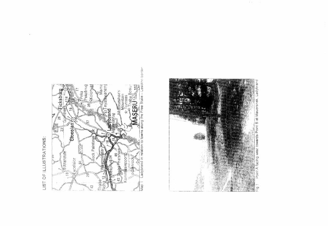
The proposed developments are planned as an extension of Mauersnek along the foot of the mountain and to the west of the town of Ladybrand (2927 AB) (Map 2).
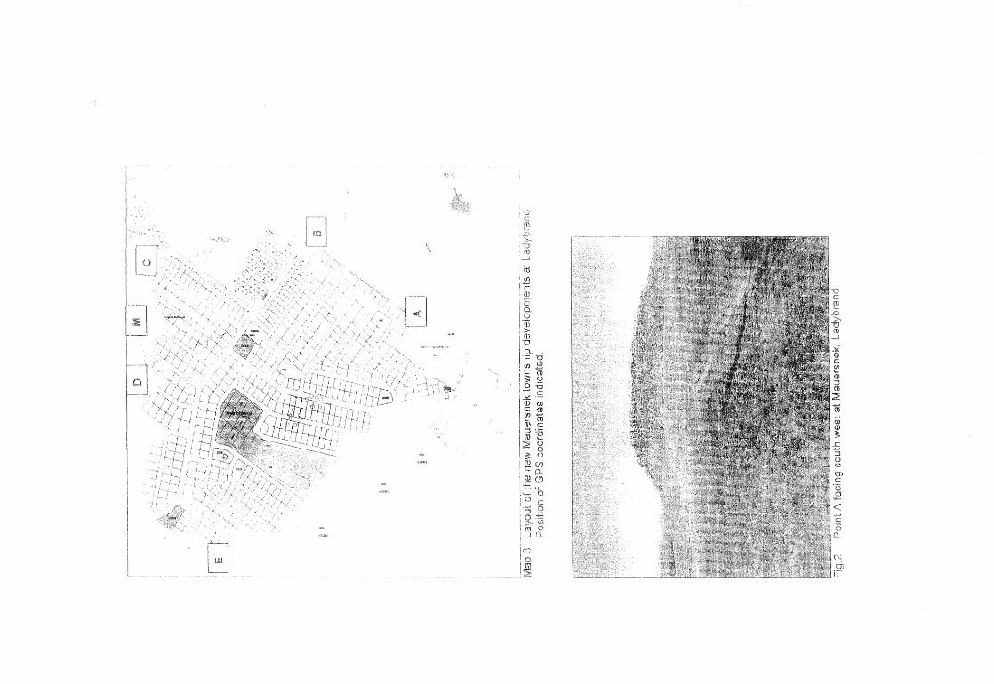
The following GPS co-ordinates (Cape scale) were taken on the outskirts of the proposed area of development (Map 3).
Point A 29°11 '28"8 027°26'42"E Altitude 1592m (Figs.1 &2)
Point 8 29°11'23"S 027°26'31"E Altitude 1596m (Figs.3-5).
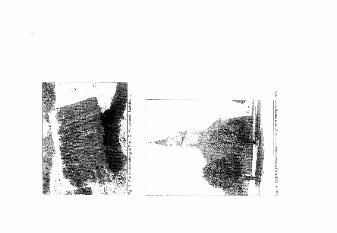
Point C 29°11 '25"8 027°26'17"E Altitude 1623m (Fig.6)
Point 0 29°11'40"8 027°26'13"E Altitude 1624m (Figs.7&8)

',,-.../
3
E 29°11 '47"8 027°26'2T'E Altitude 1593m (Fig.9)
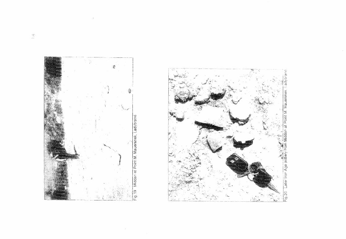
Midden M 29°11'28tJS 027°26'Q4"E Altitude 1628m (Figs.19&20)
RESULTS
FINDS
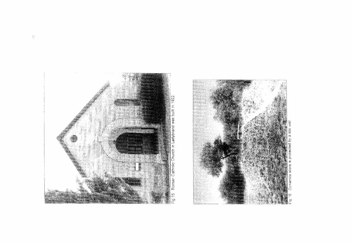
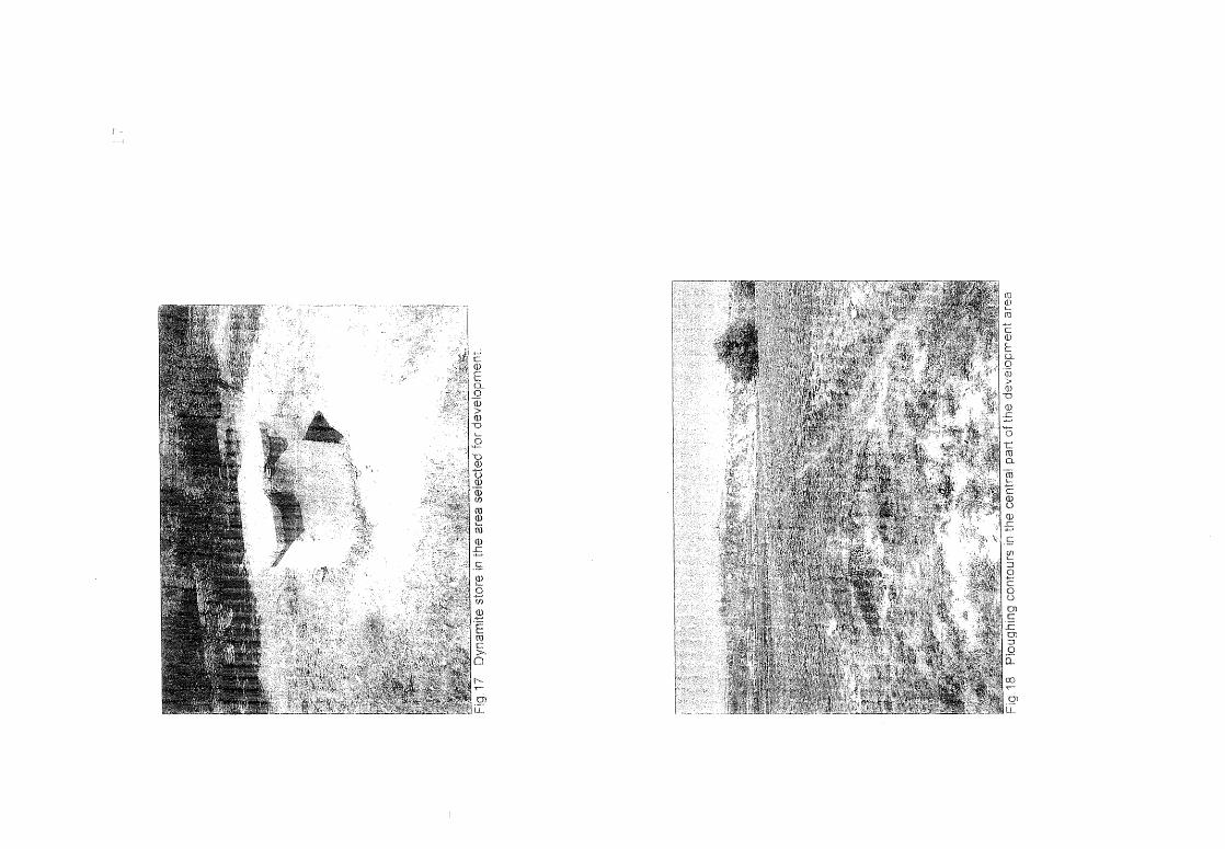
The remains of a dynamite store (Fig.i7) are found in a cluster of Black wattle trees towards the centre of the proposed area of development. The structure is made out of concrete slabs and although the doors have been removed the container seems to be in a good condition. Relatively high soil wans were erected as protection on three sides (Fig.i6). The exact history of this feature at Ladybrand could not be traced. A replica of this construction was found at the town lands of Vrede in the eastern Free State, but due to its damaged state, could not be preserved (Dreyer 2006d). It might be possible that during a specific period of time in the past this type of building could have been a general arrangement for municipalities or local roads departments to store caches of explosives .
. Archaeological finds in the form of a wide scatter of Later iron Age undecorated pottery and a single finger decorated pot rim (Fig.20) occur on a midden at Point M and against the foot of the hill (Fig.19).
Remains of sandstone blocks (Fig.13) are found against the hill near Point C. These blocks have been quarried in the mountain and most probably produced building material for many of the attractive old buildings in town. The drill holes and break fevels are already heavily pennated and appear to be old fractures. The Roman Catholic (Fig.15) and Dutch Reformed Churches (Fig.14) in town are excellent specimens of the sandstone building style and date from 1922 and 1889 respectively. Judging from the considerable measurements of the sandstone blocks it is speculated that the building material for at least some of the public buildings and domestic houses could have been mined here.
No graves were found on the proposed area of development.
DISCUSSION
The ash heap and ceramic scatter along the foot of the hill are clearly remains of Later Iron Age settlements in this area and on the plateau above the site. I nformation obtained from the limited finds on the surface and research on archaeological material from elsewhere in the Free State indicate that the
'~'
4
have been part of the area along the Lesotho border (Maggs 1976, Dreyer 1996).
Radio-carbon dating places the Later Iron Age occupation in the Free State between about mid-17th century to early 19th century (Maggs 1976, Dreyer 1992).
ASSESSMENT
The present placing of farm animals could create a problem that will have to be addressed (Figs. 1 0 ... 12). In this regard, the relocation of the animals to a more formal setting of enclosures near to the community could be an acceptable solution. The community kraals at Tweespruit could be a practical example to follow.
The midden and associated Late I ron Age pottery fall outside the present area of development and it is accepted that the new development will have no immediate affect on this find. In future people living close by could finally destruct the midden and finds without even noticing the historical deposit.
The new township developments at Mauersnek will have no direct impact on any archaeological or heritage remains at the site at present.
RECOMMENDATIONS
The old dynamite stofe could be of general significance and it is left to the local society to decide on the preservation of the structure. I have brought the occurrence to the attention of Mr Jan Oberholzer from the Maloti Tourism Office in Ladybrand (051-924 2556,0826902489).
There are no obvious reasons to delay further development of the township at Mauersnek t Ladybrand.
I recommend that the planning of the proposed township could proceed.
MITIGATION
Mitigation measures will be required to preserve the remains of the old dynamite store.
For mere practical reasons it could be wise to consider the removal of the informal farming activities before the final planning of the township layout.

\,,--,/
"'>_//
5
I thank Piet de Bie from Phethogo Environmental Consultants, Bloemfontein, for directing me to the site.
I also owe gratitude to Jan Oberholzer of Maloti Tourism, Ladybrand for information on the history of the town.
SELECT BIBLIOGRAPHY:
BOSCH, J.A. 1967. Ladybrand 1867 -1967. Ladybrand: Town Council.
DEACON, J. 1992. Archaeology for Planners, Developers and Local Authorities. Cape Town: National Monuments Council.
DREYER, J.J.B. 1992. The Iron Age Archaeology of Doornpoort, Winburg, Orange Free State. Navorsinge van die Nasionale Museum, Bloemfontein, Vol. 8(7) :262-390.
DREYER 1 J. 1996. Introduction to Free State Iron Age Archaeology. tn: Guide to archaeological sites in the Free State and Lesotho. Southern African Association of Archaeologists (SA3) , 14th Biennial Conference, Bloemfontein, Post~ conference tour 5-8 July 1996. Bloemfontein: National Museum.
DREYER, J. 2000. Mountains and Rivers of the Free State - Manual for field research I Berge en Riviere van die Vrystaat - Handfeiding vir veldnavorsing. Bloemfontein: University of the Free State, Department of Anthropology, Occasional Paper No.2.
DREYER, J. 2006a. Archaeological and cultural heritage assessment of the proposed extensions of the quarry at Ladybrand, Free State. EIA Report for MDA Environmental Consultants, Sroemfontejn.
DREYER, J. 2006b. First phase archaeological and cultural heritage assessment of the proposed township developments at ladybrand, free state. EIA Report for Phetogo Environmental Consultants, Bloemfontein.
DREYER, J. 2006c. Archaeological and cultural heritage assessment of the proposed water reservoir and pipeline installation at Ladybrand, Free State. EIA Report for Bokamoso Environmental Consultants, Bloemfontein.
6
DREYER, J. 2006d. First phase archaeological and cultural heritage assessment of the proposed residential developments at the Farm Krynauwslust 275 1 Vredey Free State. EIA Report for Bokamoso Environmental Consultants, Bloemfontein.
DREYER, J. 2007. Archaeological and cultural heritage assessment of the proposed residential developments at leliehoek, Ladybrand, Free State. EIA Report for MDA Environmental consultants, Bloemfontein.
HUMPHREYS, A.J.B. 1986. Searching for the past Cape Town: David Philip.
LEACH, M. 1991. Horace Coaker - The story of a South African. Sandion: Sandton Literary Agency.
MAGGS, T.M. 1976. Iron Age Communities of the Southern Highveld. Pietermarifzburg: Natal Museum.
PISTORIUS, J.C.C. 1994. Eskom Archaeological Site Identification Guide. Johannesburg: Eskom.
SURVEYOR-GENERAL O.F.S. 1973. Index of Orange Free State Farms. Bloemfontein.