EXCAVATIONS AT BLOMBOS CAVE AND THE ... - SAHRIS
315
1 HOLOCENE PREHISTORY OF THE SOUTHERN CAPE, SOUTH AFRICA: EXCAVATIONS AT BLOMBOS CAVE AND THE BLOMBOSFONTEIN NATURE RESERVE Christopher Stuart Henshilwood Institute for Human Evolution University of the Witwatersrand, Johannesburg, South Africa & Institute for Archaeology, History, Culture and Religion University of Bergen, Bergen, Norway
-
Upload
khangminh22 -
Category
Documents
-
view
0 -
download
0
Transcript of EXCAVATIONS AT BLOMBOS CAVE AND THE ... - SAHRIS

1
HOLOCENE PREHISTORY OF THE SOUTHERN CAPE, SOUTH
AFRICA:
EXCAVATIONS AT BLOMBOS CAVE AND THE
BLOMBOSFONTEIN NATURE RESERVE
Christopher Stuart Henshilwood
Institute for Human Evolution
University of the Witwatersrand, Johannesburg, South Africa
&
Institute for Archaeology, History, Culture and Religion
University of Bergen, Bergen, Norway
2
PREFACE
During 1992/3 nine Later Stone Age (LSA) coastal midden sites ranging in age from 6960 B.P. to
290 B.P., and representing 28 depositional units were excavated in the Blombosfontein Nature
Reserve and in the directly adjacent Blombos Estates, situated 20 km to the west of Still Bay,
southern Cape, South Africa (Figs. 1.1). This research formed the core of the authors doctoral thesis
‘Holocene archaeology of the coastal Garcia State Forest, southern Cape, South Africa’ completed
at Cambridge University in 1995 (Henshilwood 1995). This monograph is based on the results
derived from this research. Additional data derived from the 1997 – 1999 excavations of the Later
Stone Age levels at Blombos Cave (BBC) has been added into the text (also see appendix) and a
brief review of the results from the 1997 – 2005 excavations of the Middle Stone Age (MSA) levels
is included.
In this monograph the term Blombosfontein is used to cover both the Blombosfontein Nature
Reserve and the Blombos Estates. On some older topographical maps the area is designated Garcia
State Forest but the currently accepted name is Blombosfontein (lit. flower bush spring). The sites
excavated were originally numbered from 1 – 9 and given the acronym GSF (Henshilwood 1995).
In this monograph the acronym has been changed to BBF (for Blombosfontein); BBF 1 is the oldest
and BBF 9 the youngest site (Fig. 1). Blombos Cave, previously given the acronym GSF 8, is
renamed BBC in this monograph as this is the acronym in current use (Henshilwood et al 2001a).
The original excavations at this site in 1992 revealed Middle Stone Age (MSA) deposits but
excavation in these levels was limited and the age of the deposits could not be determined.
Subsequent excavations of the MSA levels show that the BBC deposits range in age from over 140
000 years to less than 300 years (Henshilwood et al 2001a; Jacobs et al 2006). Excavation of these
MSA levels is continuing (Henshilwood 2008).
Primary objectives of the Blombosfontein Research Project
The primary objectives of the initial research at Blombosfontein were to examine the economic and
cultural diversity present within and across these nine coastal middens. Although a few isolated
sites had been excavated on the southern and south-western Cape coast previously, for example Die
Kelders, Byneskranskop 1 and Nelson Bay Cave (Fig. 1.1), the BBF project was the first study in
this region which involved a detailed examination of multiple sites located in close proximity to one
another. The 3.5 sq. km Blombosfontein area is well suited to a project of this kind. There are 21
Later Stone Age sites of various ages, size and location in the area. Although a number of these
sites had the potential to meet the objectives of the project, 9 sites were eventually chosen for
excavation based on their age, contents, location and state of preservation. Other factors taken into
3
consideration included whether they were single or multiple occupation sites, and the amount of in
situ deposit.
The core of the project revolved around the excavation of the 9 sites and the subsequent analysis
and interpretation of the recovered data. The area and extent of a site to be excavated was carefully
marked out in order to retrieve as representative a sample of that site as was possible within the
confines of the project. Prior to the commencement of excavation it was realised that the project
could not only be centred on the recovered assemblages but would need to be extended to address a
multiplicity of other issues.
Initially, the foremost of these was palaeoenvironmental. To what extent had the ecology of the
BBF area altered over the last 7000 years in terms of vegetation cover and the range of terrestrial
fauna, and what effect had changes in sea levels, erosion, currents etc. had on the morphology of
the coastline and its resources? Basically, we needed to know whether the inhabitants of the earliest
site excavated, BBF 1, had the same set of resources to choose from as did the group who were the
last occupants at Blombos Cave (BBC), about 350 years ago. If they did, then what factors may
have motivated one group to select a particular set of resources for exploitation and another group a
different set and, if this was the case, would we be able to recognise these differences from the
archaeological record and/or relate them to environmental change? On the other hand, if
environmental factors were responsible for changing the range and mix of exploitable resources at
different times, how did human subsistence patterns change to meet the different demands placed
on them by these ecological shifts?
The location of the BBF sites are distinctly patterned, the earlier sites are all situated in the elevated
dune-field at least 90 m a.s.l. (Fig. 5.2) One interesting exception is an extensive, multi-layered
midden situated on a coastal promontory at the base of the cliffs which dated to around 4000 B.P.
All the sites which post-date 2000 B.P., a date which coincides with the arrival of the first groups of
pastoralists in the southern Cape, are located in small shelters situated in the coastal cliffs. Was this
change in site location at 2000 B.P. coincidental, could it be related to environmental factors or was
it due to pressures placed on hunter gatherer groups by the arrival of herders? There is also a
noticeable decrease in the size of sites occupied in the post- 2000 B.P. era suggesting that the size
of hunter gatherer bands decreases in the later period.
One method of examining the social interaction between herders and hunter gatherers was to
investigate the ethnohistoric accounts of early European travellers to the region. The earliest written
records date to around the period of the last occupations at BBF. Although the numbers of
ethnohistoric coastal observations are sparse they contained some information relating to the use of
the near coastal area, both by herders and, unfortunately, less so, hunter gatherers. However, it was

4
also realised that while ethnohistoric accounts may provide some insight into the demographics and
social relations of indigenous people in the southern Cape at around 300 - 400 years ago, it would
be be imprudent to extrapolate this information back in time and apply it to the earlier occupations
at BBF. Therefore, the only information we had to work with, which would assist in interpreting the
earlier BBF occupations, was that contained in the excavated archaeological assemblages. This data
also had its limitations. In most cases there were gaps of hundreds of years between occupation
units and these could be interpreted in a number of ways. Either the BBF area was not occupied
during these interim periods, or the evidence of these occupations was buried under the dunes or
had not survived. It was also possible that during the last 7000 years ecological factors had, at
times, made the BBF area less attractive for human occupation. Although climatic conditions on the
western Cape coast were markedly different to those in the southern Cape during the Holocene, the
coastal area in the Eland's Bay area was not occupied between around 8000 - 4000 B.P., suggesting
that sections of the Cape coast were abandoned when ecological conditions were not conducive to
human exploitation.
Fortunately, the two well-excavated and radiocarbon dated sites at Nelson Bay Cave (Fairhall &
Young 1973; Inskeep 1965, 1987) and Byneskranskop 1 (Schweitzer & Wilson 1982) (Fig. 1.1),
situated respectively on the southern and south-western Cape coast, provide a useful comparative
measure for the BBF sequence, despite the geographical distance separating the three sites. A fairly
extensive review of the cultural sequence of the southern, south-western and eastern Cape during
the Holocene, gained mainly from the excavation of sites located inland, was available for
consultation and provided practical insights into the differences between the lithics from sites
situated to the west of the Gouritz River, including BBF, and those in the eastern sector.
Shellfish recovered from BBF sites are regarded as one of the key components in examining the
range of diversity relating to marine subsistence strategies, both over time, but also in relation to
site location and site type. On the southern Cape coastline different species of shellfish occur within
each of the intertidal zones. This means we are able to determine the range of the intertidal zone
exploited by the inhabitants at each site, and also possibly whether visits were timed to coincide
with low spring tides as certain species would only have been accessible during these periods. The
range of shellfish species at a site may also reflect the ecology of the coastline at the time, and
provide information on the effects of varying sea levels, sea surface temperatures and salinity.
Measuring the size of shellfish species from each site is a useful yardstick for gauging not only
changes in mean sizes over time but also for examining the effects of varying sea temperatures on
growth rates and/or human predation pressures which may reduce or increase the mean size of a
species.
5
Although some of the BBF middens are almost exclusively shell dumps, the majority of sites in the
area point to the pursuit of a range of subsistence activities, apart from shellfishing. Thus, while
shellfish may have been one of the main attractions for visiting coastal areas it seems that other
food resources also formed a major part of human subsistence strategies while at the coast. Poor
bone preservation at open sites which predate 2000 B.P. precludes us from making any definitive
statements about the ratio of shellfish to other fauna exploited during the earlier BBF occupations,
with the exception of the regular presence of tortoise bone and some fish. However, there are some
clues which point to the exploitation of fauna other than shellfish at these sites. During excavation
large weathered bone fragments were frequently encountered within the earlier assemblages but
could not be identified to taxa. The presence of stone scrapers at most of the early sites, in
particular the very large number at BBF 4, suggests that hide working was included in the range of
activities carried out at a site.
At the youngest sites, BBC & BBF 9, the range and quantity of fauna other than shellfish points to
the utilisation of a wide range of foods, most of which were probably found within the BBF area.
The presence of sheep in the oldest LSA layers at BBC is of singular significance as the direct
dating of the sheep bone by the accelerator radiocarbon method produced a date of 1960 ± 50 B.P.,
the earliest recorded appearance of sheep in the southernmost regions of the Cape (Henshilwood
1996).
The lithics, particularly those from BBF sites dating to the mid-Holocene, raise a number of
interesting questions. While the formal tool component is dominated by a range of microlithic tools
made in fine-grained raw materials, particularly silcrete, and therefore can be described as broadly
conforming to the well described Wilton tradition in certain respects, there are also fundamental
differences. The ratio of backed elements, which were presumably hafted, is out of all proportion to
that described for formal tool assemblages from sites to the east of BBF. Backed scrapers are
ubiquitous, particularly at BBF 4, and confirm the evidence from sites such as Byneskranskop and
possibly Brakfontein, located to the west of BBF, which are also dominated by backed formal tools.
Could these differences be ascribed to variations in the range of activities carried out at sites to the
east and west of the Gouritz River, did hafted tools perform some special function which was
confined only to a certain area or did groups in the east follow a different trajectory in the
development of stone tool manufacturing techniques to those in the more western areas?
Attempting to establish the season of occupation of shell middens is an integral part of many
prehistoric coastal studies and raised a number of issues in the BBF project. Were the BBF sites
consistently occupied during certain seasons only, for how long were they occupied and did the
exploitation of coastal resources form only a part of a greater seasonal round? If, as the evidence

6
from BBF suggests, the occupation of coastal sites was relatively brief did these groups move on to
other coastal locations or possibly head inland to maximise on seasonal resources elsewhere?
Oxygen isotope analysis of shell carbonates had demonstrated that seasonality could be tested at
southern Cape sites (cf. Shackleton 1973) and it was this method that was applied to two species of
shells, Scutellastra tabularis and Turbo sarmaticus, which were recovered from BBF sites.
The Middle Stone Age levels at BBC
Excavations at Blombos Cave (BBC) were restarted in 1997 and are continuing. The emphasis now
is on excavating the Middle Stone Age (MSA) levels that date from c. 70 ka - > 140 ka (Jacobs et al
2003 a,b, 2006). The 1997 – 2008 excavations of the MSA levels at BBC have allowed for a sound
understanding of the stratigraphic complexity of the site that is complex due to slumping, folding
and faulting of the deposits (Henshilwood et al, 2001a; Henshilwood 2005).
Three phases of MSA occupation have been identified named M1, M2 and M3 (Fig. 5.24). Dating
by the optically stimulated luminescence (OSL) (Henshilwood et al 2002; Jacobs et al 2003a,b,
2006) and thermoluminescence (TL) methods (Tribolo 2003; Tribolo et al, 2005, 2006) have
provided occupation dates for each phase: these are c. 73 ka for the M1 Still Bay phase (oxgen
isotope stage - OIS 5a/4), c. 77 for the M2 Still Bay phase (OIS 5a), c. 80 ka for the M2 low density
phase (layers CGAA, CGAB, CGAC), and c. 100 - >140 ka for the M3 phase (OIS 5e/6). The
stratigraphically secure occupations in each phase are relatively brief and the depth of deposit per
layer is mostly less than 10 cm. A hiatus period represented by sterile aeolian sand separates the
LSA deposits from those of the MSA, and low density deposits also separate the M2 and M3 phases
(M2 hiatus). This depositional history suggests that Blombos Cave was occupied sporadically and
for relatively short periods of time with long periods of non-occupation.
Seven human teeth have been recovered from the MSA levels (Grine et al 2000; Grine &
Henshilwood, 2002). It is highly probable the hominids at BBC were anatomically modern. Fish
bones, in particular those of large specimens, occur throughout the MSA layers at BBC, albeit in
small numbers. It is possible the fish were lured close to shore by chumming and then speared,
possibly with bone or stone tipped projectiles (Henshilwood et al 2001a). Shellfish are extensively
exploited in the MSA at BBC (Henshilwood et al 2001a) and the species represented are similar to
those from the LSA levels (Henshilwood 1995). A range of sizes of terrestrial animals were hunted
and trapped (Henshilwood et al, 2001a).
About 400 bifacial points were recovered from the M1 and M2 phases. More than 60 % of bifacials
in M1 and more than 99% in M2 are made in silcrete, an exotic raw material (Henshilwood et al
2001a; Villa et al submitted). Bone tools are found in the M2 and M1 phases and more than 50 have
been recovered. (Henshilwood et al, 2001b; d’Errico & Henshilwood 2007). The production of the
7
BBC bone tools results from a sequence of deliberate technical choices starting with blank selection
up to the final shaping of the finished artefact. MSA tools are shaped using at least one or multiple
techniques (Henshilwood et al 2001b). An engraved bone fragment was recovered from the Still
Bay levels (d’Errico et al 2001)
Ochre is ubiquitous in the M3 phase and 4000 pieces, many of them very small, have been
recovered from the small sample excavated. Two thousand pieces come from the upper phases and
many of these are also fragments (Henshilwood et al, 2001a; Watts 2002). Traces of utilisation are
common and the finds include crayons and stone tools with ochre on their working edges. (Watts
1999, 2002; Henshilwood et al 2001a). Fourteen pieces are potentially engraved and under study
(Henshilwood et al submitted). Two other ochre pieces have been described (Henshilwood et al,
2002) and are unequivocally engraved to produce cross-hatched abstract designs.
More than 60 beads made on Nassarius kraussianus marine shells recovered from the M1 phase
have been described (Henshilwood et al, 2004. d’Errico et al, 2005). Each bead was deliberately
pierced and then strung. Groups of beads came from discrete areas and the wear patterns are similar
within groups. The recovery of a number of discrete sets of personal ornaments suggests that the
wearing of beads was not idiosyncratic behaviour. Shell that may have been worn as personal
ornaments is described from MSA levels at Sibudu Cave, KwaZulu Natal. Beads made on shell of
the same genus have been recovered recently from MSA contexts in Algeria and possibly the
Levant (Vanhaeren 2006).
The origins of 'modern’ human behaviour generates lively debate, world wide (Mellars 1989, 1996,
2005, 2006; Klein 1995, 1999; McBrearty & Brooks 2000; Klein & Edgar, 2002; Henshilwood &
Marean 2003, 2006; Henshilwood 2004, 2007; Henshilwood & d’Errico 2005; Henshilwood &
Dubreuil in press). Preliminary results from the BBC excavations complement recent and not so
recent findings from a number of African MSA sites suggesting that some aspects of modern
behaviour may have evolved during the early Late Pleistocene (Henshilwood 2007, 2008, in press).
Further analyses of the BBC material and ongoing excavations will, we believe, help provide a firm
foundation for assessing the behavioural modernity of African hominids up to and perhaps beyond
140 ka.

8
CHAPTER 1
INTRODUCTION
Coastal environments, located at the interface of two major ecosystems, namely marine and
terrestrial, provide unique advantages for the investigation of past human behaviour (e.g. Bailey
1978, 1983; Bailey & Parkington 1988; Avery et al 1997; Jerardino 1992, 1998, 2003;
Henshilwood et al 2001a; Thomas 2002; Stothert et al 2003; Sealy et al 2004). On the one hand a
suite of marine resources ranging from sessile intertidal organisms, fish, marine mammals and
plants are available for human exploitation while on the other hand a choice of terrestrial resources
are also accessible. This boundary zone, or ecotone, provides the archaeologist with an opportunity
to study the different possibilities and limitations provided by the available range of resources and
the way that human subsistence strategies were organised.
Prehistoric shell middens are ubiquitous along the coasts of many parts of the world, for example in
north-west and south-eastern America (e.g. Stein 1992; Stein et al 1992; Moss 1992; Claassen
1986, 1991a,b; Erlandson et al 1999), Australia (e.g. Geering 1982, Hall 1982; Meehan 1983;
Beaton 1985), southern and eastern Africa (e.g. Laidler 1935; Avery 1976; Robertshaw 1977, 1979;
Buchanan et al 1984; Parkington et al 1988; Avery et al 1997; Jerardino 1998, 2003; Breen & Lane
2003; Sealy et al 2004) and in Europe and Britain (e.g. Bailey 1978; Mellars 1987; Deith 1988;
Lubell et al 2007). In the late 19th and early 20th C. archaeological investigations were being
conducted into shell middens, for example in the United States (White 1870; Gifford 1916, 1949)
and South Africa (Leith 1898; Colson 1905; Peers 1929; Laidler 1935; Peers & Goodwin 1953),
leading to a tradition in which the size of a shell midden became an estimate of prehistoric
population size, diet and site age (Stein 1992; Stein & Deo 2003).
Ambrose (1967) classified then state of shell midden research in the 1960s into four categories:
examining faunal remains in terms of food supply and calculating meat weights and calories;
interpreting changing ecological conditions based on plotting shellfish species acquired from
column samples; establishing the positions of ancient shorelines from the locations of shell
middens; constructing cultural historical sequences from the recovered artefacts only and ignoring
the shellfish remains. Increasingly, since then, the range of research questions and the value of shell
midden studies is being realised. The broader objectives of the Oronsay project (Mellars 1987), for
example, address a wide range of issues. Basic questions deal with essential subsistence strategies,
i.e. establishing the range of resources exploited, strategies of optimisation, and potential variations
in the productivity, availability and edibility of these resources on a seasonal basis. In addition, the
relationship between the locations of the various middens, whether and why they were occupied
9
once only, or repeatedly, and what factors, environmental or other, influenced these decisions are
also questioned as are the functions of the Oronsay middens - were they 'occupation' or 'extraction'
sites and why did Mesolithic groups colonise and exploit the resources of Oronsay Island?
Ethnohistoric evidence from Tasmania (e.g. Lourandos 1968; Vanderwal & Horton 1984),
Australasia (e.g. Hall 1982; Meehan 1983; Gorecki 1988; Nicholson & Cane 1991; Thomas 2002)
and South Africa (e.g. Deacon 1969, 1976; Gordon 1984; Parkington 2001) suggest that coastal
resources were used by hunter gatherers on a seasonal basis and that, in some cases, midden sites
may represent the accumulation of only a few days occupation. The contents of shell middens are
often well suited to testing for seasonality. Many species of fish and marine mammals have strongly
migratory patterns, the bony structure of some sea mammals and fish indicate the season of death as
do the growth increments in some species of molluscs (Bailey & Parkington 1988). Oxygen isotope
analysis of shell carbonates has positively identified the season of occupation at some sites (e.g.
Shackleton 1973; Deith & Shackleton 1986). Conversely isotope analysis of human skeletons from
a number of sites suggests that at least from dietary evidence some hunter gatherers in the Cape did
not move seasonally between the coast and inland (Sealy et al 1986, 2000; Sealy & van der Merwe
1985, 1992; Jerardino et al 2000).
Other current issues in shell midden research are the effects of post-depositional factors (Schiffer
1983), e.g. groundwater (Stein et al 1992), the effects of competition by neighbouring groups of
people on coastal subsistence patterns (Bailey & Parkington 1988; Parkington et al 1988; Sealy et
al 2004) and the advantages of excavating a number of coastal sites situated in close proximity to
one another (Vanderwal & Horton 1984; Torben & Erlandson 2000; Jerardino 1992, 1998, 2003;
Lubell et al 2007). Moss (1992) has pointed out that despite the conspicuous nature of shell
middens, few archaeologists have explicitly addressed the activities represented by the shell in such
deposits, particularly the traditional role of women in shell collecting (also see Meehan 1983;
Clarke 2002; Thomas 2002).
Shorelines are dynamic zones which are reshaped by factors such as rising or falling sea levels, land
tectonics, changes in the direction and strength of currents and by climate (Hendey & Volman
1986; Shackleton 1988; Bailey & Parkington 1988; Thackeray 1992, 2007; Lambeck & Chapell
2001; Butzer 2004; Mastronuzzia et al 2005; Turney & Brown 2006; Carr et al 2006; Thackeray
2007; Henshilwood in press). Environmental changes may affect the range and mix of marine
resources available for human exploitation (Henshilwood et al 2001a; Breen & Lane 2003) leading
in some cases to the abandonment of sections of the coastline for long periods, for example in South
Africa (Parkington et al 1988; Henshilwood in press) and the Mediterranean (Shackleton et al
1984; Gamble et al 2004), or to the relocation of populations to new coastal sites, as was the case in

10
Northern Queensland at around 6000 B.P. (Beaton 1985). However, the direction of economic
change may not be solely predetermined by environmental factors but, as Bailey and Parkington
(1988) point out, it is likely to be a critical factor with regard to the timing of the change (Gamble et
al 2004; Henshilwood in press).
The 400 km of south-western and southern Cape coastline, between the well excavated and
radiocarbon dated sites of Byneskranskop 1 (Schweitzer & Wilson 1982) and Nelson Bay Cave
(Fairhall & Young 1973; Inskeep 1965, 1987) has an abundance of shell middens, both in cave and
open sites, most of them unrecorded and only a handful excavated. In the area between Pearly
Beach and Cape Agulhas alone (Fig. 1.1), Avery (1976) counted 205 open shell middens and 17
coastal cave sites. Interestingly 92 % of the open station shell middens are located along rocky
shorelines, while only 8 % are found near sandy beaches. In the area between the Breede River
mouth and Still Bay the author noted over 80 shell middens most of which were situated above
sections of rocky shore. From 2003 – 2008 during various surveys along the De Hoop coastline,
located just east of Cape Agulhas, the author and students recorded 141 Later- and Middle Stone
Age shell middens, some in the open and some in caves or shelters. Although a few coastal sites
between Cape Agulhas and Cape Seal have been excavated (e.g. Grobbelaar & Goodwin 1952)
none of these have been radiocarbon dated. The few site reports which have been published contain
little more than a list of the cultural elements of the middens, the faunal component being largely
ignored.
Within the coastal Blombosfontein Nature Reserve (35024’30 S 21012’12 E) also referred to as
Blomboschfontein (see topo-cadastral 1:50 000 map 3421 AC Vermaaklikheid), and Blombos
Estates (Blombosfontein Erf No. 495/57) the author recorded 21 Later Stone Age sites; 9 of these
sites were regarded as suited to the objectives of this project and during excavation 28 discrete
depositional units were recorded. The range of site types at BBF, their generally high standard of
preservation, and diversity in midden content, provided a unique opportunity to study various
aspects of human behaviour on this section of the coast during the period from around 7000 B.P. up
until 290 B.P. (Table 5.5). Seven of the sites are open station shell middens, six are elevated at
above 90 m a.s.l. and located on a coastal foreland, one is directly adjacent to the coast and all the
open sites predate 3000 B.P.; two sites are in shelters located in the coastal cliffs to the south of
BBF and postdate 2000 B.P.(Fig. 5.2). Only sites which contained in situ assemblages were
selected for excavation, no site was further than 1.5 km from the coast and all were located within a
1.5 km radius.

11
BBF is the first area on the southern Cape coast in which a number of Holocene sites in close
proximity have been excavated thus allowing for a detailed inter-site comparative study. In
accordance with Jarman et al’s (1972) findings it seems possible that the extent of the area
exploited by the sites inhabitants around BBF is unlikely to have exceeded a 2 hour walk or about
10 km. If correct, this approach allows for a direct comparison of different site types and locations
and provides an opportunity to examine changes in subsistence strategies and cultural patterning,
both spatially and temporally, given that the extent of the area exploited was likely to be similar in
all cases. It is of course important to also take into account the likely effects of environmental
change in such a study (Stothert et al 2003; Gamble et al 2004). One of the disadvantages of
comparing sites which are spatially linked is that the time gap between occupations, for example at
BBF, may be over 1000 years. This means that inter-site temporal comparisons can only be made in
a general sense as we are unable to determine whether there was an hiatus in occupation in the
interim periods, or whether we were simply unable to locate these sites.
A major aim of the Blombosfontein project was specifically to investigate the diversity present
among a suite of Holocene coastal sites which were located in close proximity to one another.
Fundamental to this objective was a consideration of environmental factors which may have
influenced or limited human choice as to the range of resources exploited, the location of sites and
the activities represented at each site. An integral part of the project was to excavate sufficient sites,
within the time available, which could demonstrate the degree of diversity within the BBF area. The
area and extent of each excavation was carefully planned to collect as wide a representation of the
assemblage as was possible. Shellfish were ubiquitous at all sites and were regarded as one of the
key factors in examining subsistence strategies over time but also in determining seasonality
through the application of oxygen isotope analysis to shell carbonates. Cultural artefacts, in
particular stone tools, provided vital clues in tracing cultural change and allowed comparisons to be
made with excavated sequences from other sites in the southern Cape and further afield. A further
key aim of the BBF project was to compare assemblages which fell within the pre- and post-2000
B.P. period, and to determine, first, whether the arrival of the first herders at the Cape could be
detected in the later assemblages and second. what effects, if any, the arrival of the first herders at
the Cape had on hunter gatherers in the BBF region. Careful consideration was given to the
possibility of identifying units, in the younger excavated sites, which may have represented
occupations by pastoralists.
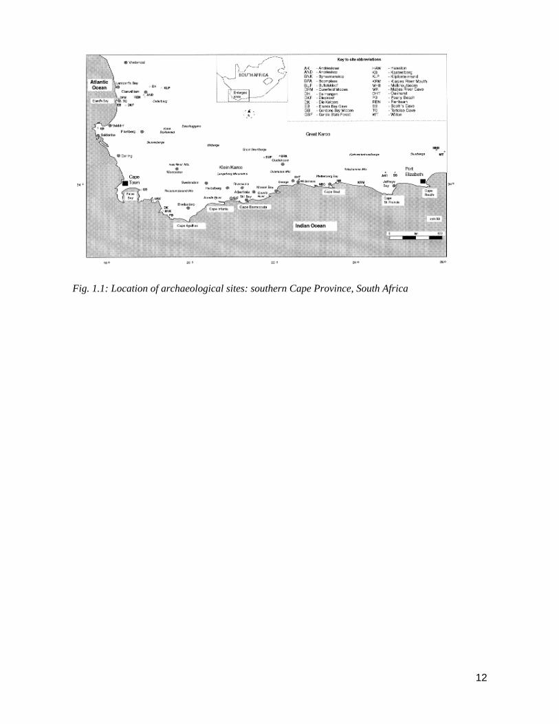
12
Fig. 1.1: Location of archaeological sites: southern Cape Province, South Africa

13
CHAPTER 2
ENVIRONMENT AND PALAEOENVIRONMENT
The point is that we simply cannot assume that Holocene environments in South Africa were unchanging or identical.
Instead we must allow that the environment was a variable parameter in any model of Later Stone Age economy or
ecology (Butzer 1974:37)
2.1: Introduction
Most hunter gatherers, worldwide, are known to move their camps, often seasonally, to make
optimal use of a variety of resources within their territorial range (e.g. Lee 1968; 1984; Marshall
1976; Tanaka 1976; Draper 1977; Meehan 1982; Parkington 1977a,b, 2001; Lee 2006). The size
and content of the excavated sites at BBF suggests that these sites were occupied for relatively short
periods, and that the BBF area may have formed only a part of a larger subsistence strategy. Based
on the limited evidence from the BBF sites we cannot even be sure that any of the inhabitants
utilised the area more than once. Setting up camp at BBF may have been an opportune decision
taken en route to another location, or it may have been specifically targeted for its known resources.
In either event it is likely that prehistoric visitors to BBF also had a knowledge of the resources
which were currently available in the surrounding Cape coastal plain, the inter-montane Cape
Folded Belt regions, and even beyond into the Karoo.
However, the landscape of the Riversdale Plain, coast and inter-montane region was not static
during the Holocene. Climatic variations affected wind, rainfall and temperature patterns (Cohen &
Tyson 1995) and this, in turn, caused changes in the distribution of vegetation and fauna. Higher
and lower sea levels covered or exposed sections of the coastal peneplain and affected the location
and nature of the shoreline. Variations in ocean temperature provided optimum conditions, at
different times, for a diverse range of marine organisms.
An understanding of ecological variation during the Holocene is essential in order to interpret at
least some of the differences observed in the excavated assemblages at BBF . Those aspects of the
environment which were subject to change are discussed in this chapter. A review of the modern
physiography of the region (Section 2.2) and the geology of the Riversdale Plain (Section 2.3)
provides an introduction to the physical features of the landscape. The formation of calcretes and
the activation and stabilisation of the BBF dunefield were ongoing processes during the occupation
of the BBF sites and the latter aspect may have influenced the surrounding vegetation and
consequently the choice of location of a campsite.
14
Shellfish are ubiquitous at all the BBF sites indicating that the opportunities for gathering marine
molluscs were apparently available for most of the Mid- to Later Holocene period. Table Mountain
Sandstone (TMS) outcrops occur directly below BBF and provide ideal conditions for the
establishment of colonies of shellfish. The extent and depth of the TMS outcrops, as well as the
formation of beaches in sigmoidal bays, is discussed in the section on bathymetry of the Agulhas
Bank (Section 2.4). Changes in sea levels can impact significantly on the availability of shallow
marine resources, but the extent of the impact may depend on the offshore bathymetry (Shackleton
1988). Various sea level stands for the Holocene are predicted in Section 2.5 and the possible
effects of these changes on the availability of shallow marine organisms discussed.
Present climate of the Riversdale region, palaeoclimatic models and the affect of coastal ocean
temperatures on terrestrial climate and rainfall are presented in Section 2.6. A palaeoclimatic
synthesis for the Holocene shows variations in rainfall and temperature affected the ratios of
grassland to forest taxa in the southern Cape.
Fynbos has been the dominant vegetation type in the southern Cape during the Holocene. The
possible impact of changes in the vegetation for the animals and people in the region are discussed
in Section 2.7. A gradual change from grassland, to forest and scrub, during the Early Holocene
resulted in an increase in browsing animals and a decrease in grazers in the southern Cape. These
changes are reflected in the faunal assemblages from a number of Cape sites. More than fifty
species of large mammals were recorded historically in the Cape ecozone but by the Late Holocene
the numbers and distribution of these animals had been affected by human predation, the impact of
domestic animals, and by deliberate burning of the veld (cf. Section 2.8).
2.2: Physiography
Blombosfontein Nature Reserve (BBF) is a small coastal nature reserve of approximately 350
hectares (Fig. 1.1, 5.1, 5.2). situated on the extreme southern end of a coastal foreland at 34o 25' S
and 21o 13' E (see topo-cadastral 1:50 000 map 3421 AC Vermaaklikheid). Directly adjacent and on
the seaward side is Blombos Nature Reserve (Erf Blomboschfontein 495/57). Unconsolidated dune
sands, calcrete hardpans and calcarenites form the exposed surfaces in the reserve. Once a sparsely
vegetated, active dune field the BBF land surface has now been stabilised as a result of a re-
forestation programme suggested in the 1930s (Laver 1936) and started in the 1960s. The average
elevation of BBF is around 150 m a.s.l.; the highest point, Vlakrant, is 167 m a.s.l. and the lowest
point, to the west, is 90 m a.s.l. To the north the reserve is bordered by dense scrub and arable land,
mostly used to graze cattle. Steep, wave cut and eroded coastal cliffs composed of calcarenites,
calcretes and Table Mountain Sandstone form the southern boundary.

15
Originally, Blombosfontein formed a part of the Blomboschfontein land grant made to Hendrik van
de Graaff in 1808 by the Earl of Caledon. It is now under the control of Cape Nature, a provincial
nature conservation body (previously known as the Western Cape Nature Conservation Board).
Riversdale is the closest major town situated 38 km to the north. Still Bay, a coastal village, located
at the mouth of the Goukou River lies 19 km to the north-east. The Duivenhoks River mouth and
nearby village of Vermaaklikheid is situated 19 km to the north-west (Fig. 5.1). Cape Town is 250
km due west (Fig. 1.1).
The southern Cape physiographic region includes three distinct elements: the Cape Folded Belt
mountains, the Coastal Foreland and the Great Karoo Basin, which lies between the Folded Belt
and the South African Plateau. BBF is located on a coastal foreland, here named the Riversdale
Plain, which extends 40 km inland and lies mostly below the 300 m contour line. This section of the
southern Cape coastal plain is naturally bound by the perennial Goukou and Duivenhoks rivers. To
the north the Riversdale plain is bordered by the Langeberg mountains, a part of the Cape Folded
Belt mountain range (Fig. 5.1). Perdeberg at 1340 m is the highest peak. Beyond the 15 km wide
Langeberg lies the Little Karoo (Klein Karoo).
2.3: Geology of the Riversdale Plain
Bedrock Topography
Between Cape Agulhas and Mossel Bay, Palaeozoic deposits comprise a basement of folded and
faulted sediments of the Cape Supergroup. Table Mountain Group sandstones dipping in a southerly
direction outcrop on the coast between Odendaals Point and Still Bay. These are on the southern
limb of an overturned syncline and are succeeded by Bokkeveld shales a short distance north of the
coast. Contact between the Table Mountain Group and Bokkeveld shales is consistently in a west-
south-west direction. Table Mountain Group sandstones re-occur in the anticline of the Langeberg
to the north of Riversdale. An east-west downfault in the Palaeozoic sediments occurs at around 26
km from the coast on the Riversdale Plain and sediments of the Enon Formation fill the graben. The
Enon and Cape Supergroup sediments are truncated by a marine peneplain (Deacon et al 1992;
Rogers 1984,1988; Johnson et al 2005).
Generally the bedrock is surf-cut to form a smooth, and in places stepped, surface plain that dips
seawards by approximately 6 m per km (Whittingham 1971; Marker 1986). Echograms show that
while the Bokkeveld shales are easily plained to a relatively smooth surface, sandstones of the
Table Mountain Group may produce highly irregular topography and major bedrock depressions
(Rogers 1984, 1988; Johnson et al 2005).
16
Lithostratigraphy
A suite of Cenozoic sediments, known as the Bredasdorp Group, overly the marine peneplain and
extend for approximately 15 km inland. These facies record a number of changes in sea levels in
this area and reflect the variations in the volumes of sea water locked up in the ice caps during
glacial and inter-glacial periods (Leroux 1989; Deacon et al 1992; Lambeck & Chappell 2001;
Mastronuzzia et al 2005). The Bredasdorp Group consists of a succession of limestones, sandy
limestones, sandstones and conglomerates and can be divided into six different formations (Table
2.1) (Ellis 1973; Malan 1986; Rogers 1984, 1988; Wickens (pers.comm); Leroux 1989; Johnson et
al 2005). ( classification of the Cenozoic sequence by Schloms et al (1983) has divided the
calcareous, chiefly aeolian deposits into three sets ranging from A3 (oldest) to A1 (youngest).
Outliers of iron stained, quartzose sands of the Knysna Formation which overly bedrock are
exposed at a number of locations on the Riversdale Plain (Thwaites & Jacobs 1987). Red sandy
rock was recovered from two boreholes at a depth of around 30 m at Blombos (Whittingham 1971),
and at Jongensfontein and Still Bay red sandstone is visible beneath the overlying aeolianite and
calcarenite (Whittingham 1971; Rogers 1984).
In many places the De Hoop Vlei Formation lies directly on bedrock and forms the base unit of the
calcrete-capped calcareous A3 type sediments (Malan 1986; Rogers 1984; Schloms et al 1983;
Johnson 2005). A 3.3 m thick sequence overlying Bokkeveld shale is exposed near to Still Bay. The
Mio/Pliocene De Hoop Vlei Formation is characterised by a shelly conglomerate layer, low-angle
marine sands and bioturbated glauconite sand. A feature of this sequence is rare sharks teeth.
The Wankoe Formation is an aeolian facies of Mio/Pliocene age which volumetrically comprises
the bulk of the Bredasdorp Group and may be up to 300 m thick in places. It is typified by
regressional coastal calcarenite dunes made up of broken shelly material and well rounded quartz
grains with glauconite visible in the cross-bedded aeolianite. Advanced pedogenesis of this A3 sub-
unit produces the terra rossa soils which are widely exposed on the Riversdale Plain, particularly
on dissected slopes and in gorges. To the west of Still Bay the distinctive and well grassed slopes of
terra rossa soils form the foundation of small farming units (Ellis 1973).
Sediments of the younger Rooikrans Formation, termed A2 by Schloms et al (1983), are comprised
of a basal pebble layer and an overlying shelly quartzose sand and are of Late Pleistocene age,
possibly around 125,000 years old. Vegetated and semi-consolidated dune sands which form a
narrow band along the Riversdale Plain coastline form the Waenhuiskrans Formation. These
aeolianites are attributed to increased aeolian activity during the Late Pleistocene transgression

17
about 20,000 years ago when the coastline was situated at the present 130 m isobath on the Agulhas
Bank. Outcrops may be up to 60 m thick.
Partially-vegetated unconsolidated dunes, often mobile, mappable as A1 sediments (Schloms et al
1983), occur on the coast at Witsands, near the Duiwenhoks River, at Blombosfontein Nature
Reserveand at Jongensfontein and Still Bay. Mapped as A1 sediments (Schloms et al 1983) these
Holocene coastal dunes have been designated as the Witzand Formation (Rogers 1984; Johnson et
al 2005).

18
Formation Description Age
Witzand (A1) Unconsolidated wind-blown
dunes
Holocene
Waenhuiskrans (A1) Semi-consolidated aeolianite Pleistocene
Rooikrans (A2) Shelly quartzose sand and
conglomerate
Pleistocene
Wankoe (A3) Consolidated aeolianite Mio/Pliocene
De Hoopvlei (A3) Shelly quartzose sand and oyster-
bearing conglomerate
Mio/Pliocene
Table 2.1: Geological sequence of the Bredasdorp Group Cenozoic sediments (after Rogers 1984; Malan 1986;
Johnson et al 2005)
Calcretes
Older calcretes and calcarenites of the Bredasdorp Formation underlie most of the aeolianites of the
Holocene Witzand Formation at BBF and elsewhere in the southern Cape (Bateman et al 2004). At
the seaward edge of the reserve, areas of separate depositional facies of calcrete are exposed on the
cliff tops. In places these calcrete layers are up to 20 m thick. Similar thick calcrete capped deposits
are recorded at Rooikrans east of Still Bay, and their formation is attributed to strong winds during
the Late Pleistocene (Rogers 1984). Mobile coastal dunes also overly calcretes at Melkbos, near
Cape Town (Netterberg 1974a) at Elands Bay and elsehere in the south western Cape (Butzer 1979,
2004), and at Swartklip (Netterberg 1974a; Barwis & Tankard 1983).
Calcretes are formed by the mobilisation of calcium carbonates from overlying calcareous or beach
sand during alternating wet-dry-wet conditions (Bateman et al 2004). They represent a period of
slow deposition and stability of the overlying soils. In some cases, for example at Sambio in
Namibia, hardpan calcretes may provide the parent material for the overlying calcrete (Netterberg
1974b). The formation of hardpan calcretes, exposed in some areas at BBF, are generally associated
with periods of rainfall below 550 mm and may also relate to a period of change from wet to dry
(Netterberg 1974b). Climatic conditions strongly influence the physical and chemical composition
of calcrete. However, the exact processes of calcrete formation are imperfectly understood and
palaeoclimatic information derived from calcretes should be treated with caution (Deacon &
Lancaster 1988).
At Swartklip the deposition of the last facies of calcrete may date to the start of the Last Glacial
when sea levels dropped and atmospheric circulation was more intense (Barwis & Tankard 1983;

19
Hendey & Volman 1986). It is not clear when the upper layers of the hardpan calcretes at BBF were
formed, although a Late Pleistocene/ Early Holocene date is not unlikely. Calcrete formation is an
ongoing process at BBF and at two sites the archaeological deposits are surrounded by a heavily
brecciated matrix.
Coastal Dunes: Activation and Stabilisation
An aerial photograph of BBF taken in 1954 shows unvegetated mobile dune fields covering the
whole reserve. In the 1960s an extensive fynbos planting programme, as a result of earlier
recommendations (Laver 1936), was undertaken by the Department of Forestry to stabilise the dune
field. An aerial photograph of the same area taken in 1983 shows vegetation extending over most of
the reserve.
Admiralty charts for 1860, 1867 and 1869 show no evidence of extensive stretches of open sand
along the Riversdale coast, although surveys carried out at the time did not note minor details and
existing dune fields may not have been recorded. Heese (n.d.) reports that as recently as 1917
extensive and dense forest covered the coastal tract from Still Bay to BBF. In order to get rid of
marauding predators, including leopards, local farmers set fire to the forest causing destabilisation
of the dunes. However, denudation and re-activation of the BBF dune fields may have started at
least 130 years ago due to a combination of trampling, veld burning and overgrazing (Walsh 1968;
also see Novellie 1987). Cattle were brought to the coast from the acidic soils further inland to
graze on the alkaline dune fields. The coastline between BBF and Still Bay was particularly
attractive for this purpose as, at the interface of the basal TMS and overlying Bredasdorp Group
Limestones, perennial fresh water springs could be found above the high water mark. The general
absence of fresh water away from the main rivers of the Riversdale Plain meant that in order to
utilise the coastal dunes for grazing, cattle had to be watered at the coastal springs every second
day. By 1960 there were 3500 acres of major drift-sands in the area between Still Bay and BBF
(Heese n.d.; Walsh 1968).
The aeolianite facies of the Holocene Witzand Formation at BBF shows episodes of dune
stabilisation alternating with renewed aeolian activity. Some palaeoenvironmental reconstruction is
possible by associating the geo-stratigraphy of BBF sites with the radiocarbon dates obtained from
these sites.(c.f. Ch. 5).
A major accumulation of aeolian sands and dune ridges took place in the southern Cape some time
during the -130 m sea levels of the Last Glacial (Butzer & Helgren 1972; Bateman et al 2004; Carr
et al 2006, 2007a,b). Coastal dune formation is a function of a plentiful supply of sand and close
proximity to beaches (Walsh 1968; Deacon & Lancaster 1988; Butzer 2004; Bateman et al 2004).
20
Renewed accumulation of dune ridges in the Late Pleistocene and early Holocene was probably a
response to a massive input of fluvial and aeolian deposits exposed during the Last Glacial
transgression (Dingle & Rogers 1972; Bateman et al 2004; Carr et al 2006, 2007a,b). The dominant
winds causing the deposition of dunes at Robberg during the Late Pleistocene were from the south-
east and south-west. Strong winds in this area now come from the west and north-west, suggesting
changes in storm winds since the Pleistocene (Deacon & Lancaster 1988).
Blombos Beach, stretching 15 km in a west-north-west direction, is the modern source of the
aeolianites at BBF. The mean axial alignment of the dunes at BBF is in a north-south direction and
at right angles to the coast. Prevailing winds determine dune alignment but other factors such as
natural barriers, vegetation and wind deflection cause variations in the alignment of major dunes
and also cause continual realignment of the axes of the lesser interior dunes (Roberts et al 2008). At
Cape Agulhas, west of BBF, the greatest sand displacement for the summer months (September -
April) of 1940-43 was caused by westerly and easterly winds and in winter by westerly winds
(Walsh 1968). At Cape Agulhas the westerly wind is the main rain-bearing wind but, being very
stormy, can cause considerable sand movement prior to the main rainfall periods in spring and
autumn. A westerly wind striking the coast to the west of BBF would be partly deflected by the
coastal cliffs above Blombos Beach. Beach aeolianites carried by the wind are then funnelled
upwards at the eastern end of the beach thereby feeding the BBF dune fields. Periods of lowered sea
level may have led to increased aeolian activity and coastal dune instability (Carr et al 2006,
2007a,b). Contrary to this argument Faure et al (2002:47) propose that during low sea level stands
in Africa fresh water would flow onto emerging shelves. As the ocean regressed the gradient of the
coastal water Table increased and concomitantly amplified the hydrostatic head on groundwater
aquifers inland. On the Agulhas shelf up to 120 m of hydrostatic pressure would have been released
resulting in an enhanced flow of groundwater to the coast. In their ‘coastal oasis’ model Faure et al
(2002:54) suggest the perennial fresh water supply to the exposed coast resulted in a rapid
colonisation of vegetation and terrestrial animals, including humans. Following this model the
volume of sand available for dune formation during periods of marine regression would thus be
minimised (also see Barwis & Tankard 1983; Illenberger 1996). Significant aeolian deposition in
the southern Cape after the MIS 5e high stand when sea levels were rapidly changing (Hearty et al
2007) suggests that aeolian sedimentation follows interglacials and is not necessarily a function of
exposed shelves. Aeolianite deposition at the MIS 5/4 boundary and into the MIS 4 interstadial
follows this pattern signifying conditions in the southern Cape at the transition were wetter and
cooler (Bateman et al 2004). High sea levels during the Mid-Holocene may have resulted in periods
of dune stabilisation, increased vegetation cover and the formation of humic palaeosols and valley

21
peat floors although the possibility of dune formation during high sea levels clearly cannot be ruled
out.
Similar areas of unconsolidated sands and weathered aeolianites are widespread in the Cape coastal
areas (Bateman et al 2004; Roberts et al 2008). In the Wilderness area, to the east of BBF, Butzer &
Helgren (1972) distinguished at least six generations of aeolianites based on palaeosol stratigraphy,
and Martin (1968) recognised four successive aeolian dune belts in the same region. Based on
geomorphological and palynological data from the Wilderness Lakes area, Butzer (1974, 2004)
records episodes of dune stabilisation, pedogenesis and local peat accumulation during the
Holocene (also see Bateman et al 2004). The first period of dune stabilisation with attendant
pedogenesis at about 8000 B.P. is followed by renewed aeolian activity and inland soil erosion from
7000 - 4200 B.P. Humic soils and valley peat floors develop until about 1000 B.P. followed by
another phase of gullying and aggradation. After 200 B.P. Butzer (1974) reports renewed gullying
with dune re-activation. Palaeosols mapped on the Robberg Peninsula by Butzer & Helgren (1972)
also indicate a period of dune stabilisation prior to 7030 B.P. Renewed sand mobilisation occurs
from 7000 B.P., followed by stabilisation and peat formation during the period 4850 - 1300 B.P.
and again at 500 B.P. (also see Carr et al 2006). The Mid-Holocene period of stabilisation,
increased vegetation cover and higher precipitation would have coincided with a +2 m sea level
(Butzer & Helgren 1972). At Nelson Bay Cave, Butzer (1984a, b, 2004) notes a strong input of
aeolian dune sands at 5500 B.P. but minimal sedimentation after 4000 B.P. Renewed deposition of
dry shelly sands is also reported from Die Kelders at around 6000 B.P. (Tankard 1976a).
Pedogenesis, peat accumulation and the development of humic soil horizons on aeolian sands are
the result of a combination of reduced sediment supply and/or increased vegetation cover (Butzer &
Helgren 1972; Butzer 1984a, b, 2004; Bateman et al 2004). Specific climatic conditions may be
reflected by the degree and type of pedogenesis. Increased precipitation is also likely to contribute
to humic palaeosol formation although Deacon & Lancaster (1988) point out that even without an
increase in precipitation, vegetation may develop on dunes as a result of a regressing shoreline
(Faure et al 2002).
Incised Rivers: The Goukou and Duivenhoks Rivers.
The Goukou and Duiwenhoks Rivers, respectively 54 km and 48 km in length, border the
Riversdale Plain to the east and west. Both rivers originate in the Langeberg Mountains of the Cape
Folded Belt and from here cut through a peneplain plateau at 100 - 300 m which slopes to the coast.
Both the Goukou and Duiwenhoks rivers cut through highly erodible Cretaceous sedimentary rocks
of the Enon Formation. For the next 40 km and 20 km, respectively, the rivers flow over Bokkeveld
22
shale. The surroundings at the mouth of the Goukou River are aeolianites and coastal sands with
some outcrops of Table Mountain sandstone. From Vermaaklikheid, the Duiwenhoks River cuts
through 7 km of Bredasdorp Formation calcarenite overlain by Quaternary sands to emerge at the
coast. Both the Goukou and Duivenhoks estuaries are permanently open with constricted tidal inlets
and have a tidal reach of 19 km and 14 km respectively (Carter & Brownlie 1990).
After the Late Pliocene uplift the surfaces above the marine peneplain were incised by the two
rivers. The degree and intensity of erosion of the river valleys would have increased during the Late
Pleistocene (Marker 1986; Rogers 1984, 1988; Johnson et al 2005). The cooler world climate at the
time inhibited the hydrological cycle but also caused less evaporation and any rainfall would have
more effectively eroded the landscape. Seismic surveys of the continental shelf show that as a result
of the Holocene transgression the lower reaches of the two rivers were drowned (Friedinger 1985;
Rogers 1984). It is possible that the extent of the marine estuaries at the present mouths of the
Goukou and Duivenhoks Rivers may have been substantially greater during the Mid-Holocene
(Rogers 1984, 1988).
2.4: Bathymetry of the Agulhas Bank
Resistant outcrops of the Cape Supergroup quartzites have led to the formation of a series of
eastwards facing sigmoidal bays along the southern Cape coast (Deacon & Lancaster 1988; Johnson
et al 2005). The continental shelf, known as the Agulhas Bank, begins as a relatively shallow
topographical feature south of Port Elizabeth and extends to the south and west beyond Cape
Agulhas. At its widest point, south of Cape Infanta, the Agulhas Bank extends more than 200 km
and at Cape Barracouta the edge of the continental shelf is around 100 km to the south (van Andel
1989; Bateman et al 2004; Carr et al 2006, 2007a,b; Roberts et al 2008).
The bathymetry of the Agulhas Bank between the Duivenhoks and Goukou Rivers is characterised
by three major zones: Table Mountain Group outcrops form a narrow shelf 4 - 15 km wide, the base
of which lies at a depth of 20 - 80 m; to the west of Cape Barracouta, and farther offshore, the
middle shelf is smooth and lies at a depth of between 60 - 100m; the middle shelf is underlain by
south to south-east dipping Cretaceous strata covered by unconsolidated sediment; on the middle
shelf east of Cape Barracouta outcropping Tertiary rocks are responsible for less regular isobaths
(Friedinger 1985:143; van Andel 1989; Bateman et al 2004).
2.5: Sea level Changes
The effects of changing sea levels can have a significant impact on the availability of shallow
marine resources (Yates et al 1986; Jerardino 1993; Henshilwood et al 2001) and the responses of
hunter-gatherers to these environmental changes are global issues in the study of coastal prehistory.

23
Examples include Australia (Lourandos et al n.d.; Kershaw et al 2006), south-eastern United States
(Claassen 1986; Morey & Crothers 1998), parts of Western Europe (Bailey & Parkington 1988;
Lubell et al 2007) and East and South Africa (Klein 1973, Avery, G. 1975, Yates et al 1986;
Parkington et al 1988, van Andel 1989, Jerardino 1993, 1998, 2003; Breen & Lane 2003; Sealy et
al 2004).
During the Last Glacial Maximum, between ca. 20000 and 17000 B.P., sea levels on the southern
Cape coast were between -100 m and -165 m (Dingle & Rogers 1972; Shackleton 1977; Cronin
1982; van Andel 1989; Bateman et al 2004; Carr et al 2006). As the sea regressed a coastal plain
more than 100 km wide was exposed to the south of BBF (van Andel 1989; Carr et al 2006 ).
Increasing evidence provides clues to the post-glacial recovery of sea level (Ramsay & Cooper
2002). Most authors have assumed a more or less steady rise from the Late Pleistocene until the
Mid-Holocene when sea levels were similar to the present. The general rise curve rests on data
selected for stability from Bloom (1977) and takes account of the recently established two-step
course of northern hemisphere deglaciation (Ruddiman & Duplessy 1985).
Although Tankard (1976b) could find no evidence for higher Holocene sea levels on the western
Cape coast there is firmly dated evidence from KwaZulu Natal which suggests a mid-Holocene sea
level c. 2.75 – 3.5 m above present (Ramsay & Cooper 2002). A +2-3 m sea level is reported from
Langebaan Lagoon at between 6500 and 5000 B.P. (Birch 1976; Flemming 1977; Miller et al 1993;
Compton 2001). A raised cobble beach at 2.8 m above present sea levels at the Verlorenvlei mouth
is dated at 3820 B.P. (Yates et al 1986).
Based on an analysis of shellfish remains and certain types of marine sediments present in the
archaeological deposit at Tortoise Cave on the Cape West coast, Jerardino (1993) suggests a series
of transgressions and regressions occurred during the Mid- to Late Holocene. A +2 - 3 m sea level
is indicated at 6000 B.P. followed by a rapid regression to present sea level by 4200 B.P.; a further
2 m transgression until 3800 B.P. and modern sea levels by ca. 3500 B.P. A small but temporary
rise may have occurred at around 1800 B.P. (Jerardino 1993).
A raised gravel beach on the southern Cape coast near the Gouritz River is interpreted by Rogers
(1988) as a storm beach associated with a Holocene sea level high of +2 - 3 m dating to between
3000 - 2000 B.P. A Mid to Late Holocene high sea level of +1.5 m based on diatom analysis from
Groenvlei near Wilderness is dated at between 6870 B.P. and 1905 B.P. (Martin 1968).
Evidence for a shore at this elevation on the southern Cape coast has also been cited (Martin 1962;
Maud 1968; Butzer and Helgren 1972; Singer and Wymer 1982; Ramsay & Cooper 2002; Carr et al
2006). Evidence for a tectonic origin for higher sea levels is ruled out and evidence presented by
24
Clark and Lingle (1979) suggests that isostatic compensation was responsible for the Holocene high
sea stand in some regions, including southern Africa.
Available sea level data suggest that during the early Holocene the sea was less than 1 km from the
present coastline at BBF and at its current elevation by Mid-Holocene (van Andel pers. comm.).
The impact of a predicted +2 m sea level (Lambeck pers. comm.) rise on the 120 m high coastal
cliffs to the south of BBF may have been minimal, although wave erosion of calcarenites at the cliff
base is evident. A raised cobble beach below BBC at Skuinsbaai may be a relic of a previous
Holocene sea level higher than at present. Although some of the presently exposed TMS outcrop to
the south of BBF would have been inundated by a +2 m transgression, a considerable portion of the
rocky coast would still have been exposed during low tides and the impact on shallow marine
resources would have been minimal. The quantity and variety of shellfish recovered from the
middens at BBF dating to between ca. 6000 B.P. and 500 B.P. supports this hypothesis. The impact
of a higher sea level on the sandy Blombos Beach, situated to the west of Cape Barracouta, may
have caused extensive erosion of the littoral dune margin above the beach. Scouring of sections of
the beach down to bedrock level may also have occurred, as is evidenced at present during high
seas caused by winter storms.
2.6: Climate and Palaeoclimate
Present Climate
Southern Africa, dominated by strongly seasonal precipitation and dry climates, lies almost entirely
within the subtropical high pressure belt. The land mass of Africa divides this belt into two cells:
the South Atlantic and Indian Ocean anticyclones causing a mean anticyclonic circulation above the
atmospheric boundary layer throughout the year. These two anticyclonic cells are centred on 30o S
with 5 - 6o of seasonal latitudinal movement. To the south of the subcontinent lie the circumpolar
westerlies and their associated temperature low pressure disturbances. As a result the climate in
southern Africa is affected by the interaction of tropical and temperate circulations during all
seasons (Deacon & Lancaster 1988; Barrable et al 2002; Bateman et al 2004).
The general anti-cyclonic nature of circulation patterns in southern Africa strongly influences the
pattern of surface winds, those in coastal areas generally being stronger than inland areas. Strong
winds, generally parallel to the coast, are a feature of the weather along the Cape coast.
Atmospheric moisture content is highest in the east, as the major moisture source for most of
southern Africa is the Indian Ocean. A gradient in moisture content from east to west is especially
true in summer and is evidenced by pan evaporation rates being least along the southern Cape coast
(Deacon & Lancaster 1988; Cohen 1993; Bateman et al 2004).

25
The Riversdale Plain is classified as Climatic Region A (Schulze 1965) and receives rain almost
equally in all seasons with peaks in spring and autumn. The orographic effects of the Cape Folded
Mountains leads to higher precipitation in the intermontane regions than at the coast. The mean
annual precipitation (MAP) for the Goukou River Catchment is 482 mm and 634 mm for the upper
catchment area. In the Duivenhoks River Catchment the MAP is 480 mm, and 750 mm in the upper
catchment (Carter & Brownlie 1990). The minimum and maximum MAP recorded at Still Bay for
the period 1926 - 1950 was 380 mm and 470 mm (Walsh 1968), and the mean annual rainfall for
1980 - 1992 was 430 mm. During winter and spring the predominant winds are from the west and
south-west and have an average daily strength of 54 km/h. Easterly and south-easterly winds
predominate in the summer months with an average speed of 64,8 km/h but are less frequent than
the winds of the winter months (Carter & Brownlie 1990; Rebelo et al 1991).
The average daily maximum temperatures are 22 oC in January and 16 oC in July. Extreme
temperatures reach 42 oC and 32 oC respectively. Average daily minimum temperatures are about
15 oC in January and 7o C in July. Occasional extremes of 4o C are recorded in summer and -4 oC
in winter. In winter and spring snow occasionally falls on the Langeberg Mountains. Frost rarely
occurs and hail and thunderstorms are infrequent (Carter & Brownlie 1990; Rebelo et al 1991).
The Agulhas Current, the Agulhas Bank and Ocean Temperatures
Coastal ocean temperatures affect terrestrial climate and rainfall. Close to the edge of the
continental shelf, the warm Agulhas current flows rapidly in a south-westerly direction and near the
southern tip of Africa is retroflected back towards the south-west Indian Ocean. The Agulhas
current usually has a minimal influence on the water temperature of the inshore waters of the
southern Cape coast during summer although advective processes, such as intermittent summer
upwelling, can have an effect (Cohen 1993; Bateman et al 2004). However, the Agulhas current can
influence the coastal weather by being causative in establishing a sharp and areally extensive
thermocline over the area in the summer months (Carr et al 2006). During winter, strong south-
westerly winds may affect surface and sub-surface sea temperatures by forcing warm water plumes
inshore (Cohen & Tyson 1995). Solar insolation is the major factor in determining intra-annual
variability in sea surface temperatures (SST) on the Agulhas Bank (Cohen 1993; Cohen & Tyson
1995).
A strong correlation between phase changes of the southern ocillation and intra-annual SST's is also
present. Anomalously high SST's during summer months are recorded during the low phase El
Niño, and anomalously low summer SST's during the high phase La Nina. The effects of these
phases on winter SST's are not necessarily synchronic (Cohen 1993).
26
Strong seasonal signals are evident in sea surface temperatures with an average amplitude of 5 oC
for the period January 1972 - December, 1992, recorded at Still Bay. The highest SST's recorded
during this period are consistently in the mid-summer months and the lowest SST's in mid-winter.
Cohen (pers. comm.) measured the changes in the stable oxygen isotopes present in the carbonate
of a modern Scutellastra tabularis shell collected at BBF. The results demonstrate that for the
period January 1990 - January 1993 the average temperature range between mid-summer and mid-
winter was 7.8 o C.
Palaeoclimatic Models
Climatic conditions during the Holocene in southern Africa have been reconstructed from a range
of evidence including: pollen (Martin 1968; Avery 1982a; Scholtz 1986; Scott 1984, 2002; Baxter
1996); micromammals (Avery 1982a, b, 1995; A.I. Thackeray 1989, 1992) charcoal and botanical
studies (van Zinderen Bakker 1982; Deacon et al 1983; Prior & Price Williams 1985; Scholtz 1986;
Tusenius 1989; February 1992; Cowling et al 1999; Parkington et al 2000); terrestrial fauna (Klein
1973, 1975, 1980, 1984); geomorphology (Butzer & Helgren 1972; Tankard 1976a; Helgren &
Butzer 1977; Butzer 1974, 1984a, b, 2004; Illenberger 1996; Bateman et al 2004; Carr et al
2007a,b); and ocean based models (Cohen & Branch 1992; Compton 2001; Ramsay & Cooper
2002). Most of the models predict past temperature and/or precipitation changes suggesting a link
between the two variables. Palynological evidence, suggests that changes in temperature and
precipitation were not necessarily in harmony, particularly during the Mid-Holocene (cf. Cohen
1993; Baxter 1996) . However, Cockroft et al (1987) and Tyson & Lindsay (1992) imply that cooler
periods are generally drier and that wet conditions relate to periods of global warming. A summary
of the available data and a suggested reconstruction of the Holocene climate in southern Africa is
discussed, for example in Deacon & Lancaster (1988), Tyson (1986), Cohen (1993) and Cohen &
Tyson (1992), Avery (1995), Baxter (1996), Cowling et al (1999), Barrable et al (2002), Ramsay &
Cooper (2002), Butzer (2004), Bateman et al (2004), Carr et al (2006, 2007a,b), Chase & Meadows
(2007), Chase & Thomas (2007)..
Temperatures in the southern Cape during the Holocene have been markedly warmer than at any
other time during the last 100,000 years. Deacon & Lancaster (1988:157) point out that the scale of
change in terms of fluctuations in temperature and humidity during the Holocene was considerably
lower than that of the glacial and inter-glacial modes of the Late Pleistocene and Holocene.
Temperature changes for the Holocene, calculated from multivariate analyses of micromammal
species (Thackeray 1987, 1992) and from the oxygen isotope contents of a Cango speleothem, show
fluctuations of less than 1o C around the present day mean, although in some areas variability may
27
have been higher (Deacon & Lancaster 1988; Butzer 2004; Chase & Meadows 2007a; Chase &
Thomas 2007).
A synthesis of the available palaeoclimatic evidence suggests that some broad, time-related patterns
can be charted for the southern Cape climate during the Holocene.
Palaeoclimatic Synthesis
10,000 - 7,000 B.P.
Increasingly warm temperatures are recorded with evidence for alternating cooler/warmer intervals
at Byneskranskop and Boomplaas (Deacon, H.J. 1979; Deacon et al 1984). High sea surface
temperatures in the Indian Ocean are recorded at about 10000 - 9000 B.P.(cf. Cohen 1993) and an
early Holocene thermal rise is reported in isotope data from Antarctic deep-ice cores between
10000 - 7500 B.P. (cf. Cohen 1993). Precipitation estimates for the Cape suggest generally dry
conditions (Deacon & Lancaster 1988).
7,000 - 4,000 B.P.
A synthesis of palaeoclimatic data for this period by Cockroft et al (1987), Deacon and Lancaster
(1988) and Tyson & Lindsay (1992) indicates increasing summer rainfall and a decrease in winter
rainfall. Higher air temperatures on the east and southern Cape coasts meant greater precipitation
(Cohen & Tyson 1995).
Oxygen isotope analysis of Scutellastra tabularis shells from Nelson Bay Cave show that prior to
6300 B.P. summer and winter temperatures were lower on the coast than today. Between 6300 -
5300 B.P. the mean SST was 2 oC higher than at present. Higher SST's and greater precipitation
than at present prevailed in the region until 3800 B.P. although there is some evidence for a cooling
trend after 4300 B.P.(Cohen & Tyson 1995). However, Van Andel (pers. comm.) points out
microclimatic changes, such as that recorded at Nelson Bay Cave, may only apply to a confined
region, and some caution is therefore needed in extending observations from one region to another.
Pollen analyses from Groenvlei (Martin 1968), and a period of dune stabilisation at Beacon Island
(Helgren & Butzer 1977), suggests that warm and moist conditions post-date 7000 B.P. in the all-
year rainfall region of the southern Cape. Pollen analysis from Groenvlei shows an increase in
forest taxa in the Mid-Holocene (Martin 1968). The presence of warm water diatoms from the same
site (Martin 1968), and the evidence of warmer temperatures at Langebaan Lagoon on the west
coast (Flemming 1977), may relate to higher Mid-Holocene sea levels and SST's.

28
4,000 - 0 B.P.
Oxygen isotope data from shells at Nelson Bay Cave show a mean decrease in SST of 1 oC after
3300 B.P. Colder sea temperatures, possibly associated with the start of a Little Ice Age, are also
reported at 650 B.P. (Cohen & Tyson 1995). A lower incidence of forest taxa and a higher grass
component in the Cape ecozone during the last 2000 years (Martin 1968; Scholtz 1986) suggests
cooler conditions in the southern Cape. Optimum forest conditions in the southern Cape prevailed
during the warm, moist period from around 6000 -2000 B.P. Thereafter, cool and wet conditions
prevail along the southern and south-western Cape coast (Deacon & Lancaster 1988; Avery 1982a,
1983, 1995).
2.7: Vegetation
The vegetation of the Riversdale Plain (defined in this section as the area between the Duivenhoks
River to the east, the Gouritz River to the west and the Langeberg Mountains to the north) has been
described by Muir (1929), Acocks (1953; 1988) and Cowling et al (1997). The flowering plants in
the region were surveyed by Bohnen (1986) and Cowling et al (1997), and veld plants suitable for
grazing by Marais (1937) and van Breda & Barnard (1991). Despite these publications the
Riversdale Plain remains one of the lesser studied regions in the Fynbos Biome (Rebelo et al 1991).
An ecological survey of the Riversdale Plain plant communities has been undertaken by Rebelo et
al (1991) and forms the basis for the resume below.
The term 'fynbos' requires some clarification as it is used in the context of a vegetation type, a
biome and a flora. Dutch settlers first used the term fijnbos to describe the fine or small-leafed
vegetation they encountered in the south-western Cape. Acocks (1953) introduced the term
'macchia' in an attempt to replace the parochial term 'fynbos' but the latter term is still widely used
and now generally accepted in both scientific and popular literature (Cowling 1992:vii; Cowling et
al 1997).
Within the Cape Floristic Region, fynbos is the dominant vegetation type and includes elements
from two floras, five phytochoria and five biomes (Cowling 1992; Cowling et al 1997).
Phytogeographically, the Riversdale Plain is a region distinct from that of the Langeberg Mountains
and is unique in the Cape fynbos biome. The region contains the largest Enon deposits on the coast
and the largest development of Tertiary Limestone in the Fynbos Biome. Within the 2800 square
km of the Riversdale Plain, 1580 plant species have been recorded and 88% of the total Dune
Fynbos found in the Cape occurs here; unique patches of Dune Scrub Forest patches are also
present (Rebelo et al 1991).

29
Three major vegetation groups occur on the Riversdale Plain consisting of two non-fynbos groups
(Forest and Thicket, and Karroid and Renoster Shrubland) and one Fynbos Group made up of four
series: Grassy, Asteraceous, Restioid and Proteoid). The BBF environment, consisting of well
drained calcareous sands on recent coastal dunes, supports a Dune Asteraceous Fynbos and differs
from other Asteraceous Fynbos types due to its high cover of non-ericaceous ericoids and an
absence of proteoids. Few Ericaceae are found but a high cover of Rutaceae and Restionaceae may
be present. Dominant plant species include Agathosma apiculata, Carpobrotus acinaciformis and
Ischyrolepis eleocharis. In the absence of fire, a critical factor in the life-cycle of fynbos
regeneration, Dune Thicket replaces Dune Asteraceous communities especially in mesic areas.
Dune Thicket typically now occurs on the northern and western boundary of BBF and is
characterised by a high cover of fleshy-leafed shrubs, a high cover of non-proteoids mostly below 2
m and a low cover of succulents. Typical species of Dune Thicket are Syderoxylon inerme,
Canthium mundianum, Cassina peragua and Salvia africana-lutea. Deep, organic-rich alkaline
sands are preferred by Dune Thicket species but they may also be found on recent coarse dryish
sands with lower organic levels, generally situated on the littoral fringe (Rebelo et al 1991;
Cowling et al 1997).
In an attempt to stabilise the shifting aeolian dune field which characterised BBF during the first
half of this century an extensive programme of stabilisation and re-planting of indigenous plant
species was carried out by the Department of Forestry in the 1960s. During 1993 Richard Cowling
collected samples of the woody plant species found within an approximate 20 km radius of BBF. A
list of the species collected is presented in Table 2.2.
The present distribution of vegetation groups in the BBF area suggests there were periods of Dune
Asteraceous Fynbos cover and Dune Thicket type vegetation during the Holocene. However when
the shifting aeolian dunes were active, ground cover would have been minimal or absent.
Vegetation during the Late Holocene is likely to have alternated between a light Dune Asteraceous
Fynbos cover and unvegetated shifting dunes.
Lower sea levels after the Mid-Holocene high resulted in a wider expanse of beach to the west of
BBF, with a concomitant increase in the amount of aeolian sand available to feed the dune field.
After 2000 B.P. the BBF dune vegetation may have been utilised by Khoe herders to seasonally
graze stock on the 'sweet' pasture of the alkaline dune sand, just as European settlers later grazed
their stock on the dunes in the 18th and 19th C. (cf. Heese n.d.; Godee-Molsbergen 1916a,b; 1932;
Blommaert & Wiid 1937). An extreme shortage of water on most of the Riversdale Plain meant the
coastal dunes had to be crossed by stock to gain access to the fresh water springs found on the coast
below BBF, thereby damaging a fragile ecosystem (Marais 1968). It is also likely that game
30
animals used the same access route to the coastal spring water and grazed or browsed in the littoral
dunes.
Vegetation may have been periodically burnt in the BBF area (cf. Heese n.d.) to encourage the
growth of new shoots, a practice which was widespread among the Khoe and the Dutch settlers at
the Cape (cf. Marais 1937: Avery, G. 1976; Wilson & Thompson 1969; Deacon, H.J. 1976; Smith
1986; Parkington 1991; Deacon & Deacon 1999). One or a combination of any of these actions is
likely to have impacted considerably on the stability of the dune fynbos (Marais 1968). The effects
of poor veld management in the littoral zones of the Cape, mainly due to fires and overgrazing this
century are still evident (Marais 1937; Walsh 1968; Novellie 1987). The unstable, shifting aeolian
dune field which constituted BBF in the 1950s may have persisted for much of the last 2000 years
and highlights the fragility of this coastal environment. (Heese n.d.; Walsh 1968).
Changes in the vegetation cover at BBF during the Holocene may help explain the variation in the
location of prehistoric campsites. Seven of the radiocarbon dated sites at BBF are older than 3000
years B.P. and all are situated within the dune area. Both the later sites, BBC and BBF 9, post-date
2000 B.P. and are situated in shelters immediately adjacent to the coast. BBC was repeatedly
occupied between 290 B.P. and 1840 B.P., yet there is no evidence of the dunes being re-occupied
after 2000 B.P. Palaeosols underlying the deposits of the dune sites provide useful pointers to past
vegetation cover at BBF and the significance of these soil horizons is discussed in Chapter 5. A
change from Dune Thicket type vegetation to Dune Asteraceous Fynbos cover on the BBF dunes
would have led to a reduction or absence of milkwood (Syderoxylon inerme) within the dunefield.
Milkwood is a shrub which grows several metres in height and forms an extensive and dense
canopy. Natural hollows form under these milkwood canopies and make excellent camping spots
offering protection from the elements. A link between the location of coastal shell middens and
clumps of milkwood (melkbosch) was suggested by Martin (1872:55).
I have often been surprised when walking round the coast to come upon heaped-up mounds of fresh-looking shells, in
very bare parts. I now find that where the mounds are there was a dense clump of melkbosch - a bush so close, that as
all know who ever camped out at Cometjie, is almost as good a shelter as a house. The bush has long been cut down
and burnt, but its roots can be found running down under the shells. These mounds were kitchen-middens, without
doubt; and the conditions attending their situation invariably are, shelter, which the bush would give, suitability of sea-
shore for successful fishing and a fresh-water spring near by.
Only a limited number of milkwood trees now grow in the dunes at BBF but fossilised root-casts,
tentatively identified as those of milkwood (Cowling pers. comm.), are evident in the locality of
five sites, BBF 1, BBF 2, BBF 3, BBF 4 and BBF 5. As the root-casts have not been radiocarbon
dated they cannot be positively correlated with the times these sites were occupied. However, it is
reasonable to argue that the location of the sites related to the protection afforded by suitable

31
vegetation and that stands of milkwood made the dunes an attractive area for habitation. At the
Gordon's Bay shell midden, dated to around 3000 B.P., carbonised milkwood seeds were recovered
in Layers 1 and 3, although milkwood is now rare in the vicinity of the site (van Noten 1974).
Ethnographic and ethnohistoric records indicate that a wide range of plants were used by
indigenous people for food, raw materials and medicines (van Wyk et al 1997; van Wyk & Gericke
2000). The importance of plants as food resources for prehistoric people in the Cape can be traced
back to the Middle Stone Age. Plant materials dating to the Late Pleistocene are preserved in
human occupation layers at Klasies River mouth and Boomplaas (Deacon, H.J. 1978, 1979; Deacon
& Deacon 1999) and at Eland’s Bay Cave (Cowling et al 1999; Parkington et al 2000). Geophytes -
plants with underground tubers, corms or bulbs - reflect the best collecting opportunities as they
offer higher kilojoule returns than any stems, leaves or inflorescences (Parkington 1991; Deacon,
H.J. 1992; van Wyk & Gericke 2000). Well preserved plant remains have been recovered from a
number of Holocene sites in the southern Cape, most notably at Scott's Cave (Wells 1965),
Melkhoutboom and Highlands Rock Shelter (Deacon H.J. 1976; Deacon & Deacon 1999; Mitchell
2002) suggesting that plant foods were being systematically collected by people throughout the
Holocene as food, but also for a variety of other uses. The most common geophytes at these sites
are Watsonia, Hypoxis, Cyperus usitatus and the rootstock Bulbine alooides. A key factor in the
seasonal movement model of hunter gatherers between the coast and the interior during the
Holocene is the inland availability of corm bearing plants during the summer months, followed by a
reliance on coastal resources during winter (Wells 1965; Avery 1974; Deacon H.J. 1976;
Parkington 1977a, 1991; Buchanan et al 1978; Parkington et al 1988).
Some of the more common plants recovered from archaeological sites in the southern Cape include
Freesia, Schotia afra sp., Tritonia and a variety of grass species. Cyperus textilis was used for
bedding and also to make rope, matting and nets (Grobbelaar & Goodwin 1952; van Wyk &
Gericke 2000). Helichrysum sp. a soft, woolly-haired shrub is still used for bedding (Bohnen 1986;
van Wyk & Gericke 2000) and in the western Cape seaweed was used for bedding at Hoffman's
Cave and at Eland's Bay Cave (Deacon, H.J. 1972; Klein 1973, 1975).
A synthesis of the vegetation changes in the Cape ecozone can be constructed from pollen samples
and archaeological floral data (Scott 2002). An increase in forest taxa is reflected in pollen profiles
from Groenvlei and Norga during warmer and wetter conditions between 7000 B.P. and 3000 B.P.
(Martin 1968; Scholtz 1986). Thereafter, grassland species increase and forest taxa decrease in the
southern Cape. Prior to the present day renosterveld, grassland was the natural climax (Deacon &
Lancaster 1988; Scott 2002). Cowling (1983) suggests that the most common vegetation in the
southern Cape during the last 5,000 years was grassland rather than renosterveld as suggested by

32
Acocks (1953). An increase in forest cover is likely during the mid-Holocene high sea levels due to
increased temperatures and precipitation. In the last 2000 years, conditions in the Cape were
somewhat cooler and drier with a high grass component (Martin 1968; Scholtz 1986; Avery, D.M.
1982a, b, 1995; Scott 2000). Peat deposits from Cape Hangklip in the south-western Cape dated to
between 6000 and 2000 B.P. show that fynbos vegetation is represented for the whole period and no
significant changes are reflected (Gatehouse 1955; Deacon & Lancaster 1988; Cowling et al 1997).
Perhaps the most significant feature of the last 4000 - 5000 years is that, based on the available
biological evidence, it was only during this period that modern plant and animal community
alliances in the southern Cape were formed (Deacon & Lancaster 1988; Cowling et al 1997).
Genus / Species Family Collect
Code
Comm 1 Comm 2 Comm 3
Agathosma apiculata Rutaceae A C
Azima tetracantha Salvadoraceae B R C C
Canthium cf. mundianum Rubiaceae B C
Carissa bispinosa Apocynaceae B C C C
Cassine aethiopica Celastraceae A C D D
Cassine maritima Celastraceae A C C R
Cassine peragua Celastraceae B R C C
Cassine tetragona Celastraceae A R R R
Chrysanthemoides monolifera Asteraceae A C C R
Clutia daphnoides Euphorbiaceae B C C R
Colpoon compressum Santalaceae A R R
Diospyros dicrophylla Ebenaceae B R C D
Euclea racemosa Ebenaceae A D C C
Leucadendron salignum Proteaceae B R
Lycium cinereum Solanaceae A C C C
Maytenus procumbens Celastraceae A C C R
Maytenus heterophylla Celastraceae B C C
Metalasia muricata Asteraceae C
Myrica cordifolia Myricaceae A C
Myrsine africana Myrsinaceae A R R R
Olea europeae subsp. africana Oleaceae B R C
Olea exasperata Oleaceae A D C R
Olinia cymosa Oliniceae B C
Passerina rigida Thymeleaceae C C
Polygala myrtifolia Polygalaceae A R R R

33
Pterocelastrus tricuspidatus Celastraceae A C C C
Putterlickia pyracantha Vitaceae A R C R
Rhoicissus digitata Anacardiceae A R R R
Rhus crenata Anacardiceae C D R
Rhus glauca Anacardiceae D D C
Rhus laevigata Anacardiceae A R R R
Rhus longispina Anacardiceae A R C C
Rhus lucida Anacardiceae B R
Salvia africana-lutea Lamiaceae A R R
Syderoxylon inerme Sapotaceae A D D D
Zanthoxylum capense Rutaceae B C
Zygophyllum morgsana Zygophyllaceae A C C
R = Rare C = Common D = Dominant
Collect Codes Comm Data A: Collected on red sands, Jongensfontein Comm A: Thicket on white dune sand B: Collected in forest, Heuningbos Comm B: Thicket on older reddish sand C: Collected on white sands, Jongensfontein Comm C: Forest
Table 2.2: Woody plants collected in the Jongensfontein/ Blombosfontein area, southern Cape, South Africa.
Notes to Table 2.2.
1. Collection date: June, 1993.
2. Collection and Identification: Prof. Richard Cowling, (then: Botany Department, University of Cape Town now
Nelson Mandela Metropolitan University, Port Elizabeth, South Africa).
3. The predominant vegetation in the Blombosfontein Nature Reserve area at present is dune thicket on white,
calcareous sand.
4. Myrica cordifolia, Passorina rigida, Rhus crenata and Metalasia muricata currently are the dominant species in the
mobile dune area of Blombosfontein Nature Reserve (possibly as a result of stabilisation / restoration attempts by
Forestry Dept.).
2.8: Fauna
Mammals
The Cape Ecozone forms one of six ecozones defined within the southern African sub-continent.
Major variables such as climate, topography, phytogeography and zoogeography characterise each
ecozone but an overlapping of features prevents each region from being sharply divided. Due
largely to the lack of vegetation suitable as animal food, the Cape Ecozone has the lowest diversity
of large mammal species found in southern Africa (Klein 1984; Skinner & Smithers 1990; Stuart &
Stuart 1988, 2001). Fifty species of large mammals are recorded historically in the Cape (Skead
1980) although even within this ecozone some of these animals were restricted by their habitat and
dietary preferences and not all were endemic to the coastal areas of the southern Cape.

34
Elephant, Cape buffalo, hippopotamus and eland were present in the Riversdale District in the 17th-
and 18th C. (Le Vaillant 1790; Raven-Hart 1967:21: Skead 1980). In 1777, William Patterson
reported seeing lion spoor at Riviersonderend and both Anders Sparrman in 1775 (Forbes 1977a,b)
and J.W. Moodie in 1820 recorded leopards near Swellendam. La Trobe saw wild dogs (Lycaon
pictus), and hyenas (H.crocuta & H.vilosa) near Mossel Bay in 1816, and the latter were again
reported in the Swellendam area in 1838 by James Backhouse (Skead 1980). By the latter part of
the 19th C. most of the larger mammals, in particular predators, had been eradicated and most of the
land on the Riversdale Plain had been granted for settlement by farmers.
The largest samples of well excavated faunal assemblages in southern Africa are derived from
Holocene sites excavated in the Cape ecozone. After the Last Glacial Maximum warmer conditions
and generally higher precipitation led to a gradual change from open grasslands to increasing forest
or scrub cover in the southern Cape. Relatively higher numbers of vaalribbok, mountain reedbuck
and roan antelope occur in early Holocene assemblages but are rare after 5000 B.P. (Klein 1980).
At Nelson Bay Cave prominent grazers are replaced by small browsers by around 8000 B.P.,
although at Melkhoutboom and Elands Bay Cave the presence of hartebeest, buffalo, wildebeest
and zebra in the Early Holocene implies an environment with more grass and less fynbos than at
present (Klein 1973, 1975, 1980; Deacon, J. 1984a, b; Deacon & Lancaster 1988). Based on
measurements of jackal, dune mole rats, hyraxes and grysbok recovered from Cape sites, Klein
(1984) has demonstrated a correlation between past temperature and rainfall, and body size
(Henshilwood et al 2001). Similarly, modern dune mole rats in low rainfall areas are smaller than
those found in the high rainfall areas of the southern Cape (Klein 1984). At all Holocene sites in the
southern Cape the micromammalian community structure was distinctly different to that observed
during the Late Pleistocene (Avery, D.M. 1982a, b, 1995).
The effects of human predation, the introduction of herding, and accidental or deliberate and
repeated burning of veld have also been cited as attributable factors in changes in faunal
distributions during the Later Holocene (cf. Marais 1937; Deacon, H.J. 1972; Klein 1973, 1975;
Avery, G. 1974; Deacon, H.J. 1976; Smith 1986; Parkington 1991; Deacon & Deacon 1999;
Mitchell 2002).
The overall picture in the Cape Ecozone is one of a gradual change from grazers to browsers during
the early Holocene and, by 5000 B.P., the large mammal communities were essentially similar to
those of historical times (Klein 1973, 1980, 1984; Deacon, J. 1984b; Deacon & Lancaster 1988).
A recent survey indicates at least 26 species of mammals now occur in the area between the
Goukou and Duiwenhoks Rivers (Stuart & Stuart 1988, 2001; Carter & Brownlie 1990; also cf.
Inskeep 1987 for a list of southern Cape mammals). These include 12 species of rodents; the
35
African wild cat (Felis lybica), African lynx (Felis caracal); steenbok (Raphicerus campestris),
grey rhebuck (Pelea capreolus); black backed jackal (Canis mesomelas); Cape porcupine (Hystrix
africaeaustralis); Cape clawless otter (Aonyx capensis), water mongoose (Atilax paludinosus), 2
species of genet (Genetta sp.); 2 species of hare (Lepus sp.); Smiths red rock rabbit (Pronolagus
rupestris); the common mole rat (Cryptomys hottentotus). Sea mammals found in the southern Cape
waters include the Cape fur seal (Arctocephalus pusillus) and a number of species of dolphins and
whales (cf. Stuart & Stuart 1988, 2001; Skinner & Smithers 1990).
Fish
Ocean temperature is a critical factor in determining the abundance, distribution and presence of
marine animals and plants. The generally warm waters found on the southern Cape coast are a
combination of solar insolation and the effect of the Agulhas current originating in the tropical
regions of the Indian Ocean. Periodic low water temperatures at the coast are the result of
upwellings of cold water situated off the Agulhas Bank being driven onshore (Cohen 1993; Cohen
& Tyson 1995). The resultant disparate conditions provide for enormous biodiversity, allowing both
cold and warm water faunal communities to co-exist (Smith 1952; Tietz & Robinson 1974; Branch
& Branch 1981; van der Elst 1988; Branch et al 1999; Heemstra & Heemstra 2004).
Rocky shores, sandy beaches and offshore reefs occur in the immediate vicinity of BBF providing
conditions suited to a wide range of sea fishes. Additionally, to the east and west of BBF, estuaries
are found at the mouths of the Duivenhoks and Goukou Rivers. Angling on this section of the coast
is generally excellent although in recent years the number of fish landed has diminished due to
excessive fishing. At least 25 species of edible fish are found in these waters, some of the more
common species landed included galjoen (Dichistius capensis), elf (Pomotamus saltatrix), kob
(Argyrosomus inodorus/japonicus) and white musselcracker (Cymatoceps nasutus) (Smith 1953;
van der Elst 1988). During the Holocene fish were probably abundant in this area and the bones of
both small and large species were recovered from a number of sites at BBF, and elsewhere along
the southern Cape coast (cf. Goodwin 1946; Inskeep 1965, 1972, 1987; Klein 1973; Avery, G.
1975, 1976; Henshilwood et al 2001).
Shellfish
Five distinct inter-tidal zones are recognised on the rocky shores of the southern Cape coast.
Highest on the shore is the Littorina zone, followed by the Upper Balanoid, the Lower Balanoid, the
Cochlear and the Infratidal zone. Particular species of shellfish are adapted to specific conditions
leading to regular zoning in each of the inter-tidal bands. Factors affecting the density and size of
marine shellfish colonies are a combination of water temperature, light, salinity, wave action,
36
available food and competition, both intra- and inter-specific. (Tietz & Robinson 1974; Branch &
Branch 1981; Branch et al 1999).
During low neap tides a variety of edible shellfish species can be gathered from the upper shore.
Greater exposure during low spring tides increases the number and size of species available for
collection. The larger species of gastropods found in the lower intertidal zone include alikreukel
(Turbo sarmaticus) and occasionally perlemoen (Haliotis midae). Turbo can be collected during
neap tides as they also occur in the mid-tidal zone; their shells are ubiquitous in many middens
along the southern Cape coast. A variety of limpets (Patella sp.) are easily gathered; periwinkles
(Diloma sp.), whelks (Burnupena sp.), Venus ear (Haliotis spadicea.) and chitons (e.g. Dinoplax
gigas) are common. Brown mussels (Perna perna) are found in large colonies attached to rocks in
the upper- and mid-tidal zones and are easily collected. Other marine organisms, for instance crabs
(e.g. Cyclograpsus sp. and Plagusia sp.) and octopus (Octopus granulatus), may be
opportunistically gathered.
Shellfish offer a sessile, dependable source of protein and the large numbers of shell middens
situated along much of the southern Cape coastline attests to the importance of this resource to
prehistoric people.
Other Fauna
Additional fauna which may been utilised for food by prehistoric people in the vicinity of BBF
includes a wide range of land and marine birds (cf. Sinclair 1987), amphibians and reptiles,
including 4 species of tortoise, 22 of snake and 15 types of lizard (cf. Branch 1990). The recovery
and identification of faunal remains from sites at BBF is discussed in Chapters 6 & 7.
2.9: Summary
Blombosfontein Nature Reserve is situated in a once active dunefield on the southern edge of a
coastal foreland. It is bound to the east and west by the Goukou and Duivenhoks Rivers
respectively; to the north of the coastal foreland are the Langeberg Mountains which form a part of
the Cape Folded Mountain range.
Underlain by bedrock Palaeozoic deposits, the overlying Cenozoic sediments are known as the
Bredasdorp Group and consist of five sedimentary groups. From oldest to youngest these are: De
Hoopvlei and Wankoe of Mio/Pliocene age; Rooikrans and Waenhuiskrans of Pleistocene age;
Witzand dunes deposited during the Holocene.
Calcretes and calcarenites of the Bredasdorp formation underlie most of the Holocene Witzand
Formations at BBF and were formed during alternating wet-dry-wet conditions. Calcrete formation

37
is an ongoing process at BBF and a heavily brecciated matrix surrounds the deposit at two of the
sites.
Episodes of dune stabilisation alternating with periods of renewed aeolian activity are recorded
during the aeolianite facies of the Holocene Witzand Formation at BBF. During the Late
Pleistocene and Early Holocene a re-accumulation of dune ridges occurred as a response to a
massive input of fluvial and aeolian deposits exposed during the Last Glacial transgression. High
sea levels during the Mid-Holocene may have resulted in periods of dune stabilisation and
increased vegetation cover at BBF. Renewed activation of the BBF dunefields is recorded during
this century although this process may have started at an earlier date.
Eastwards facing sigmoidal bays, for example St. Sebastian Bay, are formed by the resistance of
outcrops of the Cape Supergroup. A continental shelf, the Agulhas Bank, extends for more than 100
km to the south at Cape Barracouta. Table Mountain Group outcrops form an inner narrow shelf 4 -
15 km wide.
Sea levels on the southern Cape coast were between -100 m and -165 m during the Last Glacial
Maximum. A steady rise in sea levels occurs during the Early Holocene and by the Mid-Holocene a
+ 2 m sea level is likely. During the Later Holocene a series of regressions are possible but after
about 3500 B.P. modern sea levels were maintained. During the Early Holocene the sea was about 1
km from the present coastline at BBF. The impact of a predicted + 2 m sea level on the coastal cliffs
to the south of BBF may have been minimal, although Blombos Beach to the west is likely to have
been inundated, causing erosion of the coastal dunes. Shallow marine resources are unlikely to have
been severely affected by a + 2 m transgression in the area below BBF as the irregular TMS
outcrops are sufficiently elevated to allow marine organisms to move to a higher plateau.
Surface winds are strongly influenced by the general anti-cyclonic nature of circulation patterns in
southern Africa and coastal winds are stronger along the coast than in inland areas. Predominant
winds during winter and spring are from the west and south-west and in summer easterly and south-
easterly winds predominate. Atmospheric moisture content is highest in the east as the Indian
Ocean is the major moisture source for southern Africa. Mean annual rainfall for Still Bay is around
450 mm but higher precipitation is recorded in the catchment areas of the Duivenhoks and Goukou
Rivers. The Riversdale Plain receives rain in all seasons with peaks in spring and autumn.
Coastal weather is also influenced by the Agulhas Current which is causative in establishing an
extensive thermocline over the area during the summer months. Intra-annual variability in sea
surface temperatures on the Agulhas Bank are determined mainly by solar insulation but strong
south-westerly winds in winter may also force warm water plumes inshore. An average amplitude

38
of 5 oC in sea surface temperatures recorded over a 20 year period at Still Bay provides evidence
for strong seasonal signals with mid-summer highs and mid-winter lows.
Based on a range of evidence including pollen, micromammals, charcoal, botanical studies,
terrestrial fauna and ocean based research a palaeoclimatic model for the southern Cape has been
established. A synthesis of this data suggests that during the Early Holocene, land and sea
temperatures increase but precipitation is relatively low. Summer rainfall on the southern Cape
coast increases in the Mid-Holocene due to higher air temperatures. Sea surface temperatures are 2 o C. higher than at present. After 3300 B.P., sea surface temperatures show a slight decrease at
Nelson Bay Cave and again at 650 B.P., possibly associated with the start of a Little Ice Age. A
higher grass component and a lower incidence of forest taxa suggests cooler conditions in the Cape
after 2000 B.P. Optimum forest conditions are likely to have prevailed in the Cape between 6000 -
2000 B.P.
The modern vegetation of the Riversdale Plain has, until recently, been poorly documented. Recent
surveys show three major vegetation groups occur on the Riversdale Plain. A Dune Asteraceous
Fynbos is supported in the BBF environment with a high cover of Rutaceae and Restionaceae. To
the north and west of BBF, Dune Thicket replaces Dune Asteraceous communities and is
characterised by a high cover of fleshy-leaved shrubs. Typical among Dune Thicket species are
milkwood, Syderoxylon inerme, which has a spreading canopy and is well suited for use as a
campsite. Dune Thicket species are likely to have occurred within BBF in the past when the
dunefields were stable. Ground cover, on the other hand, would have been minimal or absent during
periods when the aeolian dunes were active. Vegetation during the Late Holocene at BBF is likely
to have alternated between a light Dune Asteraceous Fynbos cover and unvegetated shifting dunes.
In the latter period possible burning of vegetation in the BBF area by herders, and later by Dutch
farmers, may have impacted considerably on the stability of the Dune fynbos.
Seven of the excavated sites at BBF predate 3000 B.P. and all are located within the dunefield area.
Sites postdating 2000 B.P. are located in shelters to the seaward side of the coastal cliffs. One of the
reasons for the variation in the location of BBF campsites may be changes in vegetation cover in
this area during the Late Holocene.
Based on available biological evidence it seems that modern plant and animal community alliances
were only formed in the Cape during the last 4000 - 5000 years. The Cape Ecozone, one of six
ecozones defined within the southern African subcontinent, has the lowest diversity of large
mammal species. A number of well excavated faunal assemblages are derived from Holocene sites
located in the Cape Ecozone. Prior to 8000 B.P. grazers are dominant but are gradually replaced by

39
small browsers. Animals such as vaalribbok, mountain reedbuck and roan antelope are rare in
assemblages which postdate 5000 B.P.
Small mammals, such as dune mole rats and hyraxes are more common in later assemblages in the
southern Cape and indicates a greater use of small food parcels during the Mid- and Later
Holocene. Faunal assemblages from BBF sites provide evidence that a diverse range of animals
were collected, hunted or opportunistically scavenged. Various species of shellfish provided a
dietary staple and may have been one of the principal reasons for coastal visits. Fish were also
caught; sea birds trapped; and seals hunted or scavenged. There is evidence of a whale at BBF 9,
probably scavenged after a wash-up. Bovids, ranging from eland to grysbok, were hunted or
trapped. Evidence of a variety of smaller animals including tortoises, snakes, lizards, birds, dune
mole rats, hares, and hyraxes illustrates the diverse tastes of the BBF inhabitants.
40
CHAPTER 3
ETHNOHISTORY OF THE SOUTHERN CAPE
3.1: Introduction
During the 15th C. Portuguese explorers sailed around the tip of Africa and landed on the southern
Cape coast. Vasco da Gama and Bartholomew Diaz both stopped at Mossel Bay and reported
contact with indigenous people (Axelson 1940, 1954, 1960, 1973a,b). In 1576, Manuel de Mesquita
Perestrello arrived at the Breede River mouth and named the bay between Cape Infanta and Cape
Barracouta after St. Sebastian. A party of seamen were landed at the Breede River mouth and
walked overland to Cape St. Bras (Mossel Bay), presumably crossing close to the present BBF area
(Fontoura da Costa 1939; Kruger & Beyers 1977).
Calibrated radiocarbon dates for some of the excavated sites at BBF overlap with those of the early
explorers; BBC layer L1 dates to 1651 A.D. and BBF 9, Layer OH to 1493 A.D. One method of
broadening our interpretation of the BBF archaeology for this period is to examine the
ethnohistorical records for this region.
Warnings abound as to the uncritical use of ethnohistoric accounts in the interpretation of
archaeological evidence (e.g. Avery 1976; Gordon 1984; Klein 1986; Henshilwood 1990; Solway
& Lee 1992; Echo-Hawk 2000; Hodder 1986, 2003). The same criticisms often levelled at
archaeologists in their imprudent use of ethnographic analogy can equally be applied in the field of
ethnohistory. Rigorous standards of empirical observation, developed in the archaeological field,
are frequently not applied to the evidence afforded by ethnography, leading to weak and ambiguous
analogies (Gould 1977:362). Furthermore, the uncritical use of analogy may mask an understanding
of past behaviour by imposing on it, and limiting it to the categories of the ethnographic or
ethnohistoric present (Ascher 1961; Gould 1977; Yellen 1977; Gordon 1984; Wylie 1985; Solway
& Lee 1992). Hodder (1985; 1986, 2003) has pointed to the inadequacies of examining the
relationship between statics (the archaeological record) and dynamics (human behaviour) without
understanding the generation of that relationship by individuals in an active social context.
Compilations of ethnohistoric accounts of indigenous people in the Cape (eg, Axelson 1954; Thom
1952; Raven-Hart 1967) clearly illustrate the problems of the relationship between archaeology and
historic observation. Eurocentric viewpoints surface in the use of words such as 'savage' and
'barbaric' to describe the local inhabitants, implying the use of a value system heavily loaded in
favour of European cultural norms and which frequently fails to grasp the complexity of interaction
amongst indigenes (cf. Raven-Hart 1967). Observations frequently lack ethnographic objectivity

41
and thoroughness and as such are not directed at the questions which concern archaeologists (Klein
1986).
The instigation of a trade in livestock with local herders by the Europeans, the formation of
alliances, and the later establishment of a permanent Dutch presence at the Cape in 1652, led to
gradual changes in local economic and subsistence strategies, demographics and intergroup
dynamics. In addition, a large body of ethnohistoric data postdates the mid-17th C., and may not
therefore reflect conditions during the prehistoric period.
Early misconceptions arising from attempts to group indigenous people illustrate the points above.
Mendelslo, who visited the Cape in 1639, describes two distinct groups, Watermen and
Solthanimen. The former, he says, live by the shore eating herbs, roots, fishes and dead whales, the
latter own cattle and sheep and being dependent on adequate grazing for their stock move between
the coast and inland pastures. In later accounts the Watermen are also described as Strandloopers
(litt. beach walkers) (Raven-Hart 1967). In a report to van Riebeeck in the 1650s, Herry, initially
himself described as a Waterman, added a third group called Fishermen who subsist on fishing,
own cattle and are continuously at war with the Saldanhamen (Solthanimen). Herry's group, who
through past misfortunes had been forced to rely on coastal resources, later acquire cattle from the
Dutch and revert to a herding way of life (Thom 1952). A further cultural group, the Soaqua or
Sonqua, who live a 'meagre existence' and own no stock, are met with by Jan Wintervogel on an
expedition inland. He also notes that the so-called Fishermen do not always possess cattle and
equates the Sonqua with the Fishermen. This is later confirmed by Herry who also states that cattle
are only acquired by the Fishermen when stolen from the Saldanhamen (Solthanimen), hence the
constant state of war between the two groups (Thom 1952).
Confusion in the grouping and naming of the two economic groups persists throughout the
ethnohistoric literature and misnomers, such as Strandlooper (alt. Strandloper), persist to the
present day (cf. Raven-Hart 1967; Avery 1976; Jerardino 2003; Sealy et al 2004). The clearest
distinction which characterises indigenous groupings at the Cape can be made on economic
grounds. San hunter gatherers (Bushmen, Soaqua, Sonqua, Watermen, Fishermen) subsisted by
utilising a wide range of resources inland and on the coast, possibly on a seasonal basis, and did not
manage stock although sheep and cattle may have been opportunistically stolen (e.g. Schapera
1926, 1930; Raven-Hart 1967; Deacon, H.J. 1976; Buchanan et al 1978; Parkington et al 1988;
Parkington 1991). Khoe groups ( Khoekhoe, Hottentots, Saldanhamen) on the other hand were
pastoralists who managed domestic stock, but also hunted and gathered and were seasonally
transhumant (e.g. Kolben 1738; Schapera 1930; Epstien 1937; Goodwin 1952; Raven-Hart 1967;
Robertshaw 1978; Smith 1986, 1987; Klein 1986). Transitional categories for people falling in the
42
grey area between the two may include hunters acquiring stock and becoming herders, herders
losing stock and reverting to hunting and gathering and various forms of clientship. Social and
economic differences between these two groups, and recognising these differences in the
archaeological record, is the subject of an ongoing and lively archaeological debate (cf. Denbow
1984; Schrire 1984, 1992; Parkington 1984, 2001; Smith 1986, 1990a,b; Hall 1986; Klein 1986;
Parkington & Mills 1990; Smith et al 1991; Sadr et al 2003). These issues are discussed more fully
later in this chapter and in Chapter 7.
Despite the limitations imposed by ethnohistorical analogy there is merit in the judicious
application of some of this data in expanding our understanding of the later archaeological record at
BBF. For instance, the recorded presence of Khoe huts, cattle and sheep on the Riversdale Plain
coincides roughly with the occupation of Layer 1 at BBC and this information may be useful in
understanding the identity and purpose of these coastal visitors. For obvious reasons attempts at
using ethnohistoric data to interpret earlier BBF sites must be less secure.
3.2: Ethnohistory of the Riversdale Plain
Although Perestrello was possibly the earliest European explorer to make contact with indigenous
people on the Riversdale Plain in 1576 there is scant record of this meeting (e.g. Axelson 1960;
1988; Kruger & Beyers 1977), presumably he was more intent on finding a suitable port for future
Portuguese ships. The Breede River mouth was described by Perestrello as adequate to 'shelter a
great fleet' (Kruger & Beyers 1977:681) but later explorers preferred the shelter of Mossel Bay
situated 100 km to the north-east. Both da Gama and Diaz had sought refreshment in Mossel Bay in
the late 15th C., as the Dutch seafarers did a century later. Although not on the Riversdale Plain,
Mossel Bay ethnohistory contains some interesting early accounts of the regions indigenous people
on the coast. Cornelis de Houtman, arrived at Mossel Bay on the 2nd August, 1595 aboard the
'Mauritius' and his journal records the crews contact with locals and their efforts to obtain fresh
meat. The extract below is translated from the Dutch account (Rouffaer & Ijzerman 1915; Cape
Archives VC94 No.1).
The locals were very afraid but after a while they came up to our two people .... We asked them to bring sheep and
cattle in exchange for money but they did not know of any money but only wanted iron, copper and bracelets. They
spoke in their own way and indicated that they would bring cattle but when we heard them talk we wondered about
their speech as they spoke like turkeys gobbling through their throat, they had ugly, flat noses and teeth like dogs and
had an animal hide around their waist and in front of their manliness the tail of an ox and wide pieces of leather tied
around their feet. They smelt so much that we could not stand their company. They were very glad when we gave them
a small knife and within one hour they went and fetched four sheep.

43
On the fifth instant we went ashore again and bartered with the 'wild ones' exchanging iron for animals and we shot the
best of the animals with our muskets ... they saw us throw away the stomach and intestines and they grabbed these. ....
soon after they made a knife from a stone and cut the stomach open with it. They shook the dirt from the stomach and
ate the stomach as if they were dogs.
On the 9th August about forty men armed with muskets went inland to find the Bushmen's living places. When our
people had travelled some distance towards the mountains, the wild ones ran away and started to make fires
everywhere. Some of our people returned as they could not walk due to scurvy.
This account, and others like it (cf. Thom 1952; Raven-Hart 1967) provide some clues as to the
local economy. Sheep and cattle were in the vicinity of Mossel Bay, presumably indicating the
presence of Khoe herders. A local knowledge of iron and copper suggests that bartering had taken
place previously, possibly with earlier seafarers, but the expedient manufacture of a stone knife may
indicate that iron was not in common use, or at least not by the people they met. In other respects
the account is ambiguous; what was the identity of the 'Bushmen' people they met, were they
coastal hunter gatherers acting as go-betweens for the Khoe, or were they itinerant stock owners
trading opportunistically?
In July, 1601, Paulus van Caerden aboard the 'Hof van Holland' records they were unable to obtain
fresh meat at Mossel Bay as the eight 'natives' they met did not possess stock. However, a week
later the ship is driven close inshore at Vleesch Baai, 50 km to the north-east of Still Bay where
they are able to trade with the locals 'as many oxen, calves and sheep as they wanted until the salt
for drying ran out'. On the 23rd July they are forced to anchor in Visch Baai, slightly to the east of
their last location, but are only able to obtain five sheep (Cape Archives VC94 No.1).
The above accounts suggest that in the late 16th C. Khoe people with sheep and cattle could be
found along the coast in the vicinity of the Riversdale Plain during the winter months, but that their
location was not fixed, possibly due to a need for fresh pasture. Other coastal dwellers, without
stock, were also encountered who presumably hunted and gathered opportunistically. Whether they
occasionally acted as agents for the pastoralists is not clear.
In the latter half of the 17th C. relations between the Dutch and western Cape Khoe deteriorated and
the large amounts of fresh meat required to provision passing ships became increasingly difficult to
obtain. As a result the Dutch looked to setting up trade relations with the Khoe in the southern and
south-western Cape. By 1660 the pastoralists occupying the area between the Breede and Gouritz
Rivers, known as Hessequas, had been contacted and were reputed to be 'rich in cattle' (Mossop
1931). The Houtniquas occupied the area to the east of the Gouritz River up to Algoa Bay, and to
the west the Chainoqua were situated between Swellendam and the Hottentots Holland Mountains
(Kruger & Beyers 1977). In 1667, Sergeant Cruijthoff met with Hessequas at the Breede River and
his party returned with 170 cattle and 300 sheep. The following year Hieronymous Cruse sailed to

44
Mossel Bay on the 'Voerman' to set up trading relations with the Khoe (van Wyk 1988). Further
expeditions to obtain sheep and cattle from the Hessequas are recorded in 1685 and 1686
(Resolution of Council, DEIC). In 1687, Gammou Kouchama, described as a Hessequa 'captain',
visited the Castle in Cape Town to invite further trade with his 'country' described as 'populous and
overflowing with oxen, sheep and goats' (Moodie 1838, 1841). There is no evidence that the Khoe
kept goats, historically or archaeologically, and this reference to goats may be an error in
translation.
Ensign Isak Schrijver, sent to trade with the Hessequas in January 1689, recorded his journey across
the Riversdale Plain in considerable detail. At the Duivenhoks River his party meet thirteen
Hessequas who were sent to direct them to 'the Swart Captains kraal'. The following day they pass
'many kraals of Hessequas' and outspan at the kraal of the 'Captain', also known as the 'Oude Heer'.
In the vicinity of modern-day Riversdale, Schrijver reports 'we saw on all sides Hessequa kraals'
and the following day more kraals are noted near the Gouritz River. At this point the Hessequas
who accompanied Schrijver are sent away and 'out of mischief' set fire to the veld. Schrijver
returned to the Castle two months later with over 1000 cattle (Mossop 1931). In 1690 Schrijver
returns to the Riversdale area to barter for livestock, and again in 1692 and 1693. During the last
two expeditions he records that the Hessequa are increasingly hostile and it is becoming difficult to
obtain stock (Beyers 1981).
However, Jan Hartogh meets with a party of Hessequa 'Captains' at the Breede River in 1707 who
indicate they are most willing to trade their sheep and cattle. One reason for this change in attitude
may relate to the deaths of large numbers of Khoe from war and sickness in 1665, 1672 and 1673.
A major outbreak of smallpox in 1713 is estimated to have killed ninety percent of the Khoe
population. An entry in the Company diary dated 6th May, 1713 notes that the 'Hottentots' are
almost extinct (Godee-Molsbergen 1916b). After the smallpox epidemic many new 'Captains' are
appointed and new 'tribe' names are also recognised, for example the 'Gouritz Hottentots' (Godee-
Molsbergen 1916b; Goodwin 1952; Elphick 1977, 1985). Despite these setbacks the trade in
livestock with the Hessequas continues; for example, Lichtenstein visits the Zoetemelks Valley in
1803 and notes that the Cape government use this area to rest cattle bought from the Hessequas and
Outeniquas (Plumptre 1928, 1930).
The presence of Khoe kraals on the Riversdale Plain is recorded intermittently by travellers to the
area during the 18th C. A number of Hessequa kraals are reported near the Gouritz River by Carel
Haupt in 1752 (Godee-Molsbergen 1922) and in 1776 Hendrik Swellengrebel records seeing a
number of kraals, most consisting of six to seven huts (Godee-Molsbergen 1932). It seems likely,
though, that the power and population of Khoe people on the Riversdale Plain had been
45
considerably diminished by the mid 18th C., effectively opening the land for settlement by Dutch
colonists.
During the late 18th C. and early 19th C. most of the land on the Riversdale Plain was subdivided
by the Cape Government and allocated to settlers of European origin, although scattered groups of
Khoe herders were still in evidence. On a visit to Commandant Lombard’s farm in 1803, J.W.
Janssens reports that Khoe kraals can still be seen on the Slang River, one hour away from his hosts
farm situated on the Duiwenhoks River (Godee-Molsbergen 1932). The application by H. van de
Graaff to the Earl of Caledon for the granting of the land rights to the farm Blomboschfontein, on
which Blombosfontein Nature Reserve is situated, is dated 1808.
By the mid-19th C. most of the Khoe were no longer stock owners and had been recruited by the
Dutch as servants. The demise of the Khoe is best summed up by Lt. Henry Pemberton who records
visiting a local farmer near the Gouritz River mouth in the mid-1800s (Kruger & Beyers 1977).
The Dutch farmer at whose house we lodged, Frederic Potskeeter, a native of the country, informed us he had lived at
Croutz Riviere 17 years ... he has a few slaves, mostly Malays with Hottentot servants ... The original inhabitants, the
Hottentots, are of peacable, mild and laborious dispositions making most excellent household and farm servants, and
free from slavery. The country is at present but thinly inhabited by Dutch.
There are few historical references to San hunter gatherers in the vicinity of the Riversdale Plain.
O.F. Mentzel refers to 'Bushmen' living in the Swellendam and Riversdale mountains who rob the
other 'tribes' when they have the opportunity. He also records the presence of San 'Bushmen' in the
Mossel Bay area (Mandelbrote 1921;1944:330)
From Mossel Bay to the Gamtoos River only Bushmen are found who manage to exist in small numbers, either in the
crevices of rocks or in miserable hovels. They live on game, roots and herbs but occasionally also help themselves to an
animal belonging to one of the colonists who are very scattered and isolated in these regions. They seldom take more
than one at a time, for they never keep a live animal with them overnight.
In a letter written by C.H. Heese in 1929, he comments on the age of the fish traps at Still Bay by
referring to stories told by the first 'Voortrekkers' who settled in the area during 1810 - 1820. At the
time the 'Voortrekkers' arrived, there were still 'wild Bushmen' living on the coast and operating
fish traps between the mouths of the Goukou and Duiwenhoks Rivers. Parts of Heese's letter are
translated below (own translation).
Whether they belonged to the Hessequa or the Attaqua tribe will only be determined by academics when they consider
the names of the old farms in the area such as Wankou, Kragga etc. The kitchen middens on the sand dunes along the
coast, also at Platbosch, provide overwhelming evidence that the Khoisan who lived near Still Bay were very fond of
fish; fish, both great and small and shellfish of all types. Undoubtedly they also gathered fish that washed up on the
coast.

46
Heese's letter effectively sums up the problems inherent in determining the origins of these coastal
hunter gatherers. It is quite possible they were Hessequas, dispossessed of their stock and pasture,
who chose to hunt and gather along the coast rather than be taken into service by the Dutch. On the
other hand they may have been the remnants of San hunter gatherer bands whose territory had been
gradually diminishing, both due to the expansion of the Khoe in the area during the previous 2000
years, and now due to Dutch land claims. No evidence of such late occupation was found at BBF
and at present the identity of these last coastal hunter gatherers remains enigmatic.
3.3: Observations at Garcia State Forest: 1928-9.
Although not strictly ethnohistoric, this section deals with observations made by C.H.Heese in the
BBF area in the late 1920s. Heese named the BBF area 'Blombosch Sands' after the shifting
dunesands which then characterised this area. The information Heese provides is useful as some of
the sites he describes are covered by sand and no longer visible, suggesting the BBF area may have
been occupied more regularly than is currently apparent. Surface collections of selected lithics,
although not specifically documented, may have been made from some of the sites currently
excavated at BBF.
Numerous bones of elephant, rhino, buffalo and other animals were observed protruding from the
sand along a western route through the dunes and Heese claims this may have been an ancient game
trail. The same route had been followed for decades by local farmers who regularly brought their
cattle from inland pastures for watering at the numerous 'bakke' or springs located on Blombos
Beach and at the base of the cliffs. One reason for this seasonal movement may be related to copper
deficiencies – inland grazing provided the required copper but this was not the case at the coast
(Schulz et al 1951). However the coastal grazing did provide vital calcium necessary for bone
growth (van der Merwe & Perold 1967).
Alongside the protruding animal bones he noted at least a dozen small 'Wilton' middens containing
variously bone, shell, stone pestles, bored stones, a bone amulet, some sites with pottery and also
two skeletons protruding from the sand. Walking eastwards along the clifftops he came across
further 'Wilton' middens composed of shell, bone, stone chips and tools in quartzite, quartz and
silcrete. In some cases the action of percolating calcium carbonates had cemented the assemblages
into a solid breccia, the effect of which was to protect the stone artefacts from the erosive actions of
the wind and sand.
Implements from the MSA 'Still Bay Culture' were also noted, as were some ESA or 'Stellenbosch'
handaxes. Below the cliff face, and at the eastern edge of BBF 1, a number of rock shelters were

47
reported, one of which contained a deep layer of shells and which Heese (n.d.) describes as a
'Wilton station'. From a nearby shelter a skeleton was recovered by the local schoolmaster.
3.4: Summary
At about the same time that early European explorers were recording their observations at the Cape,
BBC and BBF 9 were occupied by indigenous people. Ethnohistoric documents, if used judiciously,
can be a useful adjunct in the interpretation of the later occupations at BBF.
In the historic period two distinct economic groups can be recognised at the Cape, namely hunter
gatherer egalitarian San who did not possess livestock and pastoralist Khoe groups, hierarchically
structured, who accumulated wealth by managing sheep and cattle but also hunted and gathered.
Representatives of both groups are recorded historically within the Riversdale Plain region. Reports
of the Hessequa Khoe are more numerous than that of San, presumably because of greater Khoe/
colonist contact due to an active trade in livestock in the 17th- and 18th C. Contact was made with
Khoe pastoralists both at the coast and inland suggesting that the Khoe made use of grazing
opportunities in a range of environments, possibly, in part, to obtain the necessary trace elements
required by their cattle (Schulz et al 1951). Although the hierarchical structures existing within the
Khoe groups on the Riversdale Plain are only hinted at, the Dutch recognised that a distinct group,
known as the Hessequa, occupied the coastal foreland between the Breede and Gouritz Rivers.
During a visit by a Hessequa 'Captain', Gammou Kouchama, to the Castle at Cape Town in 1687,
reference is made to the 'king' of the Hessequas, suggesting that some unity existed at that stage
among the Riversdale Plain pastoralists. War and disease, particularly smallpox in the early 18th C.,
decimated a large section of the Khoe population in most areas of the Cape leading to demographic
changes and the emergence of new 'tribal' groupings. At about the same time Dutch farmers were
expanding into the southern and south-western Cape, filling the land vacuum left by the diminished
and fragmented Khoe survivors. By the early 19th C. only small surviving groups of Khoe
pastoralists were scattered in the southern Cape and many had been taken into service by the Dutch
settlers.
Few historic records relate the presence of San in the southern Cape, although accounts from
elsewhere in the Cape are more numerous. It seems likely that parts of the Riversdale Plain area
were inhabited by San but due to the remoteness of the regions they occupied, contact between San
and travellers or colonists was an infrequent occurrence. However, there are a few incidents where
Dutch and Portuguese explorers, in the 16th and 17th C., report the presence of indigenous folk at
the coast who do not possess stock and live on shellfish and fish. In the Riversdale and Mossel Bay
areas, O.F Mentzel, indicates that there were still San people living on the fringe of Khoe society in

48
the late 18th C (Mandelbrote 1921, 1925). In the region of BBF, Heese (n.d.) relates the presence of
coastal hunter gatherers in the early 1800s. The origins of these later 'Bushmen' are not clear; they
may have been dispossessed stock owners or surviving San.
The fate of the hunter gatherer San in the southern Cape is mostly unrecorded. This is not surprising
as San survival depended on escaping detection by Khoe and colonist, by whom they were
frequently hunted. In the Eastern Cape Mentzel records that on two separate occasions traps were
set by Dutch farmers to trap 'Bushmen'. In one instance in 1775, 122 'Bushmen robbers' were
reported shot. (Mandelbrote 1921, 1944).
Based on ethnohistoric accounts of the Riversdale Plain it is clear that the Khoe were well
established in the region by the 17th C. and probably had been for a considerable time prior to this
date. The presence of sheep bone at BBC, radiocarbon dated at 1960 ± 50 B.P, indicates a long
history of pastoralism in this region (Henshilwood 1996). BBC was repeatedly occupied during the
last two millennia and it seems certain that the occupants of this site witnessed some of the major
changes which occurred in the Riversdale Plain region at this time, firstly the advent of livestock at
around 2000 B.P., and secondly, the arrival of the first Europeans.

49
CHAPTER 4
HOLOCENE ARCHAEOLOGY OF THE SOUTHERN CAPE
4.1: Introduction
This chapter provides a synopsis of the archaeology of the southern Cape primarily, and sets the
background for the chapters that follow. As the oldest Later Stone Age excavated site at BBF is
radiocarbon dated at 6960 ± 70 B.P. and the youngest at 290 ± 20 B.P. the discussion in this chapter
centres around the archaeology of the Early Middle- to Late Holocene period.
Assemblages containing ethnographically known items of material culture appear during the last
40,000 years in southern Africa (Deacon & Deacon 1999; Mitchell 2002), although it is only during
the Holocene that characteristic Later Stone Age (LSA) elements commonly occur at most sites.
The similarity between articles typically occurring in LSA sites (see below and cf. Deacon, J.
1984b:221-222; 1990) and the material culture of the historically known San and Khoe suggests
that LSA sites represent the prehistory of these indigenous people.(cf. Goodwin & van Riet Lowe
1929; Goodwin 1935; Clark 1959; Inskeep 1967; Deacon H.J. 1972, 1976; Parkington 1972, 1977;
Phillipson 1977; Deacon, J. 1984b, 1990; Rightmire 1984; Deacon & Deacon 1999; Mitchell 2002).
However, the material culture of the LSA should not be viewed as an unchanging static entity but
rather as a continuing tradition, subject to gradual modification and adaptation through the effects
of diffusion and migration (Deacon, J. 1984b, 1990).
For most of the Holocene, San hunter gatherers had exclusive use of the coastal and interior regions
of the Cape. Pastoralism was introduced to the Cape at around 2000 B.P. (Henshilwood 1996),
possibly by herder groups originally from northern Botswana. San social organisation and
subsistence strategies at the Cape were disrupted by the economics of herding, possibly only
marginally initially, but by historic times hunter gatherers had been forced into peripheral areas
(Smith 1986; Parkington 1987; Parkington et al 1988; Hall 1986; Smith et al 1991; Jerardino 1998,
2003; Sadr et al 2003).
Iron Age, Bantu-speaking agropastoralists arrived in South Africa about 1600 years ago but were
confined by the nature of their crops to the summer rainfall areas in the eastern and central regions
(Mitchell 2002). In the Cape they only penetrated as far south as the Great Fish River, 800 km east
of Cape Town (Maggs 1984). Although contact was made with local San groups the effects of this
interaction are only archaeologically visible within the immediate area (Hall 1986). More extensive
contact may have occurred between early Khoe pastoralists and Iron-age agropastoralists in the
western part of the sub-continent - at about 1600 B.P. both groups had domesticated sheep and
cattle and made pottery (Sealy & Yates 1994; Henshilwood 1996).

50
As a result of archaeological excavations at a number of sites in the Cape over almost a century a
substantial base of information has been built up documenting the occupation of the region by
indigenous people during the Holocene. The results of this research, particularly in the southern
Cape, are discussed in this chapter. In later chapters the results of the excavations at BBF are
interpreted with reference to our present understanding of the archaeology of the region.
4.2: History of LSA archaeology
Based largely on recovered lithic implements, the LSA tradition in South Africa was first defined in
the 1920s by Goodwin (1926, 1935) and Goodwin & van Riet Lowe (1929). They saw the LSA as
being essentially similar to the Mesolithic in Europe, divided it into two main industries, the Wilton
and the Smithfield, placing the origins of the Wilton microlithic industry to the north, and proposed
a 'successive wave' or invasion theory to account for its arrival in the south (Goodwin & van Riet
Lowe 1929).
In the following decades an expanding data base allowed for more detailed inter-site comparisons.
A number of LSA coastal and near-coastal cave sites in the Cape were excavated (e.g. Dreyer 1933;
Goodwin 1935, 1938, 1946; Drennan 1937; Grobbelaar & Goodwin 1952; Fagan 1960; Louw
1960), as well as open station shell middens, or 'kitchen middens' (e.g. Colson 1905; Goodwin
1946; Rudner & Rudner 1954; Mabbutt et al 1955) (cf. Fig. 1.1). However, the orientation of most
interpretations remained lithocentric (but cf. Deacon & Deacon 1963; Wells 1965) and the
'invasion' hypothesis was retained. Few attempts were made to test this 'invasion' model, most
explanations resting on what J. Deacon (1984a) terms 'post-hoc' accomodative arguments (e.g.
Clark 1959; Sampson 1967, 1972, 1974).
Re-excavation and subsequent interpretation of the Wilton rock shelter in the Eastern Cape
demonstrated ongoing stone artefact changes through time and the Wilton tradition was likened to
an ontogenetic model which stresses cultural change associated with continuity (Deacon J. 1972).
Ecological modelling formed a composite part of most research strategies in the 1970s and
hypotheses were proposed which related climatic and environmental variables with perceived
cultural, subsistence and demographic change. Early examples of this new approach in the southern
Cape were at Nelson Bay Cave (Klein 1972a,b, 1974) and Melkhoutboom (Deacon, H.J. 1972,
1976), where changes in artefact manufacture were linked to a shift in hunting patterns, rising sea
levels and environmental changes in the Late Pleistocene and Early Holocene. Although ecocentric
'cause and effect' modelling is now regarded by some as too simplistic, ignoring as it does the
'human' factor as a catalyst for change, it remains an essential determinant in defining the
51
parameters within which 'human' choice could have been exercised (cf. Deacon, J 1984a,b, 1990;
Bailey & Parkington 1988; Mazel 1989; Wadley 1989; Henshilwood in press).
The contributions of Klein (1972a, b, 1973) and H.J Deacon (1972, 1976) led to the naming of a
three stage system in the Later Stone Age of the Southern Cape, namely Robberg, Albany and
Wilton, with a further Pottery Wilton subdivision in the post 2000 B.P. period, the latter associated
with the arrival of pastoralist people (cf. Deacon, J. 1984a). These culture-stratigraphic sequences
can be broadly applied to all known LSA assemblages situated within, and to the seaward side, of
the Cape Folded Belt Mountains in the Western Cape Province.
In a later study the correlation between environmental change and stone artefact manufacture was
tested at three sites in the Southern Cape, namely Nelson Bay Cave, Kangkara and Boomplaas.
Although the timing of the changes for the Robberg, Albany and Wilton Industries are similar at all
sites, some assemblages reflected minor variations in toolkits which were site specific. On the other
hand, macroevolutionary or significant changes in lithic tool traditions cut across environmental
boundaries and subsistence strategies, and a direct relationship between environmental change and
stone tool manufacture could not be demonstrated (Deacon J. 1984a).
Parkington's (1972, 1976, 1999) pioneering study on floral and faunal remains found at coastal and
inland sites in the Western Cape is linked to ecological modelling. The results suggest that some
LSA people followed seasonal subsistence rounds. Archaeological evidence from other sites in the
southern and south-western Cape has been interpreted as support for a seasonal subsistence model
(cf. Shackleton 1973; Deacon, H.J. 1969, 1976; Klein 1973; Avery, G. 1976; Buchanan et al 1978;
Parkington1977a, 1991, 2001). This model has been challenged based on dietary evidence extracted
from human bones buried at archaeological sites. (e.g. Sealy et al 1986, 2000; Sealy & van der
Merwe 1985, 1992; Jerardino et al 2000) .
4.3: The Holocene Period (8,000 - 2,000 B.P.):
At around 8000 - 7000 B.P. the Albany Industry is broadly replaced by the microlithic Wilton
Industry in the southern and eastern Cape and is accompanied by a florescence in the number of
occupation sites (Deacon 1984b; Deacon & Deacon 1999; Mitchell 2002).
The type site of the Wilton culture, Wilton Large Rock Shelter, is situated near Alicedale in the
eastern extension of the Cape Folded Belt Mountains (Deacon & Deacon 1999) and was first
excavated by Hewitt (1921), and later by H.J. Deacon. The lithic assemblage from the Wilton site
was described in terms of an ontogenetic model displaying typical formative/maturity/decline
phases (Deacon, J. 1972). The formative range of the new Wilton is at around 8000 B.P. with little
variety in tool types and a low artefact density. Scrapers are small and round, mainly in chalcedony.

52
The climax phase lies between 5000 - 2500 B.P., with a high density of artefacts and a wide variety
of tools recorded. Formal tools are dominated by a selection of small scrapers less than 20 mm in
length with a mean width/length ratio of 1:1. Backed microliths include blades and segments. The
predominant raw material is silcrete, with some quartz and chalcedony. After around 2300 B.P. the
scrapers are more similar to those in the early layers as is the tool inventory. The artefact density
decreases and although silcrete remains dominant, there is increasing use of shales and quartzite.
The Wilton system is in decline after 2000 B.P., scrapers become more variable , the number of tool
types declines, there are no adzes and few backed tools, and a wide variety of raw materials is
evident. These changes coincide with the arrival of pottery makers/ herders and it is possible that
they replaced the existing population at the Wilton site. The changes in the faunal component at the
Wilton site are broadly coincident with those of the lithics. In the formative phase, small game are
mainly present and marine shells indicate coastal contact. This continues through the climax phase
with evidence of some freshwater mussels. After 2300 B.P. there is a marked decline in marine
shells and a pronounced shift to the freshwater mussel, Unio caffer.
The trajectory of lithic change at Wilton is broadly consistent with a number of southern Cape sites.
Amongst others, these include Oakhurst (Goodwin 1933, 1938; Schofield 1938), Glentyre (Fagan
1960), Melkhoutboom (Deacon, H.J. 1976), Kangkara (Deacon, J. 1984a) and Boomplaas (Deacon,
J. 1984a). Lithic assemblages from a number of coastal sites, however, reflect considerable
variation from the Wilton pattern. The formal tool component at Nelson Bay Cave (Inskeep 1987)
during the Holocene comprises scrapers, backed scrapers, segments, some doubtful backed
bladelets, tanged points, drills, reamers, bored stones, two doubtful adzes, sinkers, grooved stones
and ochre pencils, but all in relatively small numbers. This is despite the fact that the total number
of stone artefacts at the site exceeds 47,000 units; 82% of these are of quartzite. During the period
6000 - 3300 B.P. the majority of scrapers are of chalcedony, followed by quartz with some of
quartzite. The mean size in the former two categories is <13mm, in the latter >34mm. Only one
silcrete scraper is reported. The large size of the quartzite scrapers led Inskeep (1987) to suggest
that they were used to perform different functions from the smaller scrapers. After 3300 B.P.
quartzite scrapers dominate and small scrapers in fine grained materials are virtually absent. Of the
40 segments recovered all are of chalcedony and predate 3300 B.P.. One retains traces of mastic
suggesting hafting. An unusual component are the 8 backed scrapers which date to around 4500
B.P.
Similar tools are recorded from only a few other sites all situated to the west of Nelson Bay. These
sites are Matjes River (Hoffman 1958; Louw 1960; Dockel 1998) and Byneskranskop (Schweitzer
& Wilson 1982), and a small number may be present at Oakhurst (Schrire 1962). At Matjes River

53
(Louw 1960) the range of tools in Layer C are more varied than in the mid-levels at Wilton and
include more saws, lance heads, more bone tools, shell ornaments and painted grave stones. The
largest numbers of backed scrapers (>10,000) are reported from undated surface collections made
by C.H.Heese (n.d.) in the 1930s at the open site, Brakfontein, located 12 km from the coast and 20
km to the north-west of the Blombosfontein Nature Reserve sites. Over 30,000 LSA artefacts which
include large numbers of small scrapers, segments and adzes were collected but these have yet to be
formally studied.
Broad similarities in the trajectory of artefact change in the Mid/Later Holocene are evident, but
there is considerable variation between inland and coastal assemblages, and also between sites in
the western and eastern zones of the southern Cape. This agrees with H.J. Deacon's (1976:171)
observations
... artefact occurences to the west of the Gouritz River fall outside any concept of a specific Wilton content unit
Apart from the lithics a wide variety of tools, decorated items, ornaments and grave goods have
been recovered from mid-Holocene sites (Inskeep 1987; Jerardino & Yates 1996; Deacon &
Deacon 1999). Bone tools include arrow points, foreshafts and linkshafts, 'spoons', spatulas, and
fish hooks. A variety of beads, pendants and other ornaments are made in shell, stone and bone.
Ostrich egg shell containers and fragments are sometimes decorated, tortoise shells are worked to
form bowls and scoops. Due to the excellent preservation of organic materials at some sites a range
of items in leather, wood and plant fibre have been recovered. These include wooden digging sticks
and pegs, fire sticks, bows, arrows, fragments of sewn leather and rope/netting. A few artefacts
mounted in mastic provide clear evidence of the hafting of microlithic tools (Maingard 1932;
Goodwin 1938; Louw 1960; Wells 1965; van Noten 1974; Deacon, H.J. 1976; Deacon, J. 1984a, b,
1990; Inskeep 1987; Deacon & Deacon 1999; Mitchell 2002).
Burials may be accompanied by a range of grave goods including grindstones/ hammerstones,
painted stones, palettes, bone awls, ornaments such as beads and pendants, ochre pencils and
powdered ochre, tortoise carapace bowls (e.g. Louw 1960; Rudner 1971;Voigt 1972; Deacon, H.J.
1979:69-70; de Villiers & Wilson 1982; Inskeep 1987; Hall & Binneman 1987; Deacon & Deacon
1999; Jerardino et al 2000; Sealy et al 2000). Grave goods are most commonly found associated
with burials in the southern and eastern Cape, and although the symbolic significance of these is not
understood it may illustrate social differences between people in this area and those in the south-
western Cape (Hall & Binneman 1987; Binneman 1999).
Subsistence strategies broaden in the Holocene to include a wide range of 'small' food parcels
(Henshilwood 1997) and may be related to both higher population densities and available resources
(Henshilwood 2001a). At most sites large bovids are rare; one exception is the Uniondale site in the

54
eastern Cape where large numbers of Cape Buffalo have been recovered (Brooker 1989). In the
Wilton layers at Nelson Bay Cave the emphasis is on smaller terrestrial animals, especially small
bovids (Klein 1973; Inskeep 1987), a pattern repeated at a number of other sites including Wilton
Rock Shelter, Melkhoutboom, Andrieskraal I, Kangkara, Boomplaas, Matjes River and Oakhurst
(Goodwin 1933, 1938; Louw 1960; Deacon & Deacon 1963; Deacon, J. 1965, 1972; Deacon, H.J.
1976, 1979; Deacon, J. 1984a).
With the mid-Holocene rise in sea temperature, Perna perna replaces C. meridionalis at Nelson
Bay. A wider range of molluscs from the whole intertidal zone are also represented including
Patella sp., Haliotis sp., Turbo sarmaticus, Diloma sp., Donax serra and Burnupena (Inskeep
1987). Klein (1973, 1999) suggests this is due to greater efficiency at cropping marine resources, or
simply not minding getting wet, and not to environmental changes. It is interesting to note that at
the Andrieskraal I site, situated 50km from the coast in the Gamtoos River Valley, shells from these
same species were recovered, suggesting that coastal resources formed a part of the occupants
subsistence strategy (Hendey & Singer 1965; Deacon, J. 1965, 1974). At around 3000 B.P. a similar
molluscan species composition is evident at the Gordon's Bay shell midden with the exception of
the continued presence of C. meridionalis. On the western Cape coast at Eland's Bay there is an
hiatus in occupation between 7800 - 4400 B.P., possibly due to low rainfall and higher sea levels,
but thereafter marine molluscs are heavily exploited, particularly C. meridionalis but also limpets
and whelks (Parkington 1987; Parkington et al 1988). Between 3000 and 2000 B.P. isotopic
measurements on skeletons indicate a marked emphasis on marine resources. Megamiddens, very
large shell middens, are present on the west Cape coast during this time period. Support for the
isotopic evidence comes from Pancho's Kitchen Midden, as site that contains rich shellfish deposits
dating to between 3000 and 2000 B.P. (Jerardino 1998). A stretch of coast, south of Eland’s Bay on
the west Cape coast, show abundant occupation of sites on the rocky coast after 3000 years ago but
with few sites where sandy shores occur (Jeradino 2003).
By the Mid-Holocene the proportions of marine species, which includes fish, birds and mammals
increases rapidly in relation to terrestrial fauna at Nelson Bay Cave. Technological innovations
include fish gorges and net sinkers and the application of these is evident in both the species variety
and numbers of fish caught at Nelson Bay (Klein 1973; Inskeep 1987). Large numbers of fish bones
were also recovered at Oakhurst (Goodwin 1933, 1938) and fish remains are mentioned at Matjes
River (Hoffman 1958; Louw 1960; Dockel 1998).
Systematic collection of a range of plant foods, particularly geophytes, is evident at a number of
inland sites in the southern Cape, but are virtually absent at coastal sites (Deacon & Deacon 1999).
It seems unlikely this is due to preservation as seaweed bedding is found at Eland's Bay and at

55
Hoffman's Cave, and milkwood seeds at the Gordon's Bay shell midden (van Noten 1974). At
coastal sites the dietary emphasis appears to be on shellfish rather than plant foods, although plants
foods may be present (Parkington 1972, 1976, 1987; Deacon 1972; Klein 1973, 1999; Jerardino
1998, 2003; Deacon & Deacon 1999; Mitchell 2002; Sadr et al 2003; Henshilwood & van Niekerk
2006). Common species at the inland Melkhoutboom site include the geophytes Watsonia and
Hypoxis (Deacon & Deacon 1999). At the time of new growth during May/June the corms of these
plants are unusable and H.J. Deacon (1976) suggests this period may have coincided with coastal
visits (also cf. Parkington 1972, 1976; 2001).
4.4: The Late Holocene (2,000 B.P. - Historic Period):
Perhaps the most characteristic feature of this period is the arrival of a new economic system at the
Cape, namely animal husbandry (Epstein 1937). In the historic period the widely dispersed Khoe
groups in South Africa all spoke similar dialects which have linguistic affinities to the Central Bush
family of languages spoken by hunter gatherers in northern Botswana and south-western Zimbabwe
(Westphal 1963). Based on ethnographic data and Westphal's linguistic evidence, Elphick (1977)
proposed two alternative routes for the arrival of pastoralists in the Cape. The initial movement was
from northern Botswana towards the Orange River. One element continues along the Orange River
in a westerly direction to the Atlantic coast, then south to Namaqualand and finally to the western
Cape; the other continues south through the Central Karoo. Earlier, Cooke (1965) had proposed
similar origins but favoured the western coastal route. However, there are problems with the
linguistic evidence as most Khoe had been decimated before their language was adequately
documented (Inskeep 1978; Deacon, J. 1984b; Klein 1986; Smith 1986).
An alternative scenario is that a variety of routes were followed at different times and that
consequently there were multiple introductions of livestock to the Cape. Sheep may have been
introduced at around 2000 B.P. via the west coast route, but cattle could have been obtained from
Iron Age people on the east coast and only brought to the southern and western Cape at a later date
(Klein 1986; Sealy & Yates 1994; Henshilwood 1996). Archaeologically we would therefore expect
earlier dates for sheep on the west coast but some of the earliest associated radiocarbon dates come
from the southern and south-western Cape sites of Die Kelders (1960 ± 85 B.P.), Nelson Bay Cave
(1930 ± 60 B.P.), Byneskranskop (1880 ± 50 B.P.) (cf. Schweitzer 1974, 1979; Schweitzer &
Wilson 1982; Klein 1986) and 1960 ± 50 B.P. at Blombos Cave (Henshilwood 1996). At the west
coast site, Kasteelberg A, sheep may date to 1860 B.P. (Smith 1986).
Sealy and Yates (1994) argued that the dates for sheep at the above sites are based on indirect
dating, that is by association of faunal materials with recovered charcoal from within stratigraphic
layers. Direct accelerator radiocarbon dating of sheep bone from six sites in the western and south-
56
western Cape produced a younger set of dates; Kasteelberg A 1630 ±60 B.P. & 1430 ±55 B.P., Die
Kelders 1325 ±60 B.P. & 1290 ±60 B.P. and Byneskranskop 1370 ± 60 B.P. The oldest dates are
from Spoegrivier in the north-western Cape at 2105 ± 65 B.P. The results, they argue, point to a
lack of evidence for stock-keeping in the southernmost Cape prior to 1600 B.P. and tentatively
suggest a southerly movement of stock may be detected.
Two samples of sheep bone, excavated from BBC, layers 5 & 6 were submitted for accelerator
radiocarbon dating. The dates obtained, 1880 ± 55 B.P. and 1960 ± 50 B.P. (Henshilwood 1996)
contradict the Sealy & Yates (1994) model for a 1600 B.P. date and indicate that sheep were
present in the southern Cape at around 2000 B.P. (cf. Chapter 7).
The wild ancestors of domestic stock - sheep and cattle - originated in north-eastern Africa or
south-western Asia. Goats were unknown in the southern and south-western Cape during the
prehistoric period and there is no evidence of any indigenous species of animals being domesticated
by the Khoe. Klein (1986, 1999) suggests this is clear evidence that the herding concept was
introduced to the Cape from elsewhere, but whether this introduction was through a process of
diffusion or through the migration of herders colonising new areas is unclear. Support for the latter
model is provided by Smith (1986, 1990a) and Smith et al (1991) who argues that pastoralism is a
coherent strategy which requires specific social relations between people and animals and that
consequently the egalitarian ethic practised by hunter gatherers was not consistent with the
economics of animal husbandry (Epstein 1937). A combination of both migration and acculturation
by resident hunter gatherers is recognised by some archaeologists as a more plausible explanation
(cf. Denbow 1984; Schrire 1984, 1992; Klein 1986, 1999; Sadr et al 2003). It seems likely,
therefore, that by the historic period Khoe ancestors could be traced to both indigenous people and
migrant groups, but clearly there still were, and possibly always had been, separations both
economically and socially between the San and Khoe (cf. Parkington 1984; Parkington & Mills
1990; Deacon & Deacon 1999; Mitchell 2002).
Recognising the Khoe/San distinction in the archaeological record has proved problematic as
herders and hunter gatherers, despite their economic differences, also shared many cultural and
physical characteristics, and the occupation site residues left by both appear very similar (cf.
Schweitzer 1974, 1975; Klein 1986; Smith et al 1991, 2001; Deacon & Deacon 1999; Sadr et al
2003). The general range of tools, ornaments and other cultural materials found in the Mid/Late
Holocene persist in the post-pottery period and there is generally sparse evidence of artefacts
specifically linked to a herding economy. At some sites, however, the evidence for the presence of
herders may be more convincing, for example at Bloeddrift 23 situated in the Richtersveld (Smith et
al 2001. Wooden or grass bowls and containers would provide convincing evidence as these were

57
used by the Khoe for storing milk but archaeologically these items seem invisible (Deacon 1984b;
Deacon & Deacon 1999).
Stone artefact traditions show broad continuity at a number of sites after the arrival of the Khoe. At
Boomplaas microlithic artefacts continue to be manufactured during the Late Holocene and are
found associated with pottery (Deacon, H.J. 1978, 1979; Deacon & Deacon 1999). Some changes
are evident at coastal shell middens after 2000 B.P. where flaked quartzite cobbles and large,
unretouched flakes become more common, although this trend towards larger quartzite tools is
evident at the Gordon's Bay Midden before 3000 B.P. (van Noten 1974). Formal tools are absent, or
near absent, at some coastal sites (e.g. Deacon & Deacon 1963, 1999; Avery 1974; Robertshaw
1977, 1979; Jerardino 1998; Henshilwood & van Niekerk 2006). A comparison of the pre-pottery
and post-pottery assemblages shows the most common differences are a reduction in the frequency
of microlithic backed tools, especially segments, and decreasing use of fine grained raw materials
(Deacon 1984b; Mitchell 2002; Sadr et al 2003).
The introduction of pottery at the Cape is generally associated with the arrival of the first
pastoralists, although some authors note that early pottery dates are more common than those for
sheep (Deacon 1984b, Klein 1986). Based on a date of 1600 B.P. for the introduction of livestock to
the southernmost Cape, and on secure pottery dates clustered around 2000 B.P. from a number of
sites, Sealy and Yates (1994) speculate that the arrival of pottery may predate pastoralism. Pottery
is found in Layer L5 at BBC in association with sheep bone radiocarbon dated at 1960 ± 50 B.P.
suggesting that the introduction of pottery to the Cape does coincide with that of stock
(Henshilwood 1996). Klein (1986, 1999) notes that in every assemblage with domestic stock,
pottery is present. Although pottery does occur in the absence of domestic stock, Klein suggests this
is due to sampling error as a result of the small size of the faunal sample.
Distinguishing Khoe and San sites on this basis would thus seem to be clear cut, but this is not the
case. Historically, it is known that part of the enmity between San and Khoe was due to hunters
stealing cattle and sheep from herders (cf. Raven-Hart 1967), and livestock remains may occur at
both herder and hunter gatherer San sites. Pottery was used, and possibly made by the Khoe and
San (cf. Schapera 1926, 1933).
One method suggested by Schweitzer (1974) for resolving this issue is to examine the sex and age
of domestic stock. At the Die Kelders site, Schweitzer found that 78% of the 23 sheep in Layer 2
(Radiocarbon dates 1465 B.P & 1600 B.P.) were juveniles and predominantly male, and 3 were more
than 4 years old. Based on the assumption that in order to maintain a successful breeding herd, only
the young males or old animals would be slaughtered by the Khoe, he concluded that Die Kelders
was a Khoe site. If the assemblage had, on the other hand, been composed mainly of ewes, this may
58
suggest the sheep were stolen by San people. Domestic stock samples of this size are very rare
however, and we have no record of the sex/age composition of Khoe flocks. However, the dietary
elements in the layers which contain sheep at Die Kelders, are the same as those found in the lower
pre-stock levels, and include dune mole rats, tortoises, small antelope, seals, marine birds, fish and
molluscs (Schweitzer 1974). On the basis of a lack of clear evidence for a Khoe presence, and the
physical inaccessibility of the site to herders with stock other authors believe that Die Kelders was
occupied by San who were simply proficient at stealing or bartering sheep from the Khoe (Avery,
G. 1976; Wilson pers. comm.).
On the basis of the rarity of domestic animal bones, Klein (1986, 1999) suggests that in the Late
Holocene Eland's Bay Cave, Nelson Bay Cave, Byneskranskop 1 and Die Kelders were primarily
used for hunting and gathering, perhaps seasonally, but may also have been used for brief periods as
herder bases. The abundance of stock at Kasteelberg (Smith et al 1991; Sadr et al 2003), and the
calcined dung layers at Boomplaas (Deacon et al 1978; Deacon & Deacon 1999), suggests these
sites were primarily occupied by herders.
Structural features such as kraal remnants and site location may also provide further evidence of the
identity of the occupants (Klein 1986, 1999). Differences in the style of shelters used by the San
and Khoe at open sites may also be archaeologically visible. Historical and ethnographic accounts
show that the Khoe lived in portable, dome shaped shelters. These were constructed of a wooden
framework and covered by woven mats and could be dismantled and carried on the backs of oxen
when moving (Deacon & Deacon 1999). The San constructed small windbreaks of brush,
sometimes thatched with grass, which in fine weather were fairly insubstantial but during the rainy
season were more sturdily built (Schapera 1930, 1933; Raven-Hart 1971; Parkington & Mills 1991;
Mitchell 2002). Being constructed of organic materials, the shelters of both Khoe and San are
archaeologically invisible and would have caused minimal disturbance to the local environment.
The remains of some habitation features have been preserved, notably where stone was used for
anchoring these structures. Avery (1976) suggests that stone features at Pearly Beach shell middens
indicate the positions of past structures.
Spatially mapping the extent and nature of surviving debris may serve to mark out the focal points
of domestic activities, and the position of hearths or hearth stones may serve as site 'anchors' around
which the likely positions of other features, including shelters, can be estimated (cf. Hodder 1987;
Kent & Vierich 1989; Henshilwood 1990; Nicholson & Cane 1991; Deacon & Deacon 1999; Smith
et al 2001). In this regard ethnoarchaeological studies among contemporary hunter gatherer peoples
may provide us with useful analogues (Gorecki 1988; Solway & Lee 1992). Khoe camps consisting

59
of a few hundred people were recorded historically in the Cape (Raven-Hart 1971), but few
archaeological traces of these have been found.
Early contacts made between herders and hunter gatherers at the Cape might have been amicable,
but in later periods this was clearly not the case. Gradually increasing demands made on the
environment by Khoe stock led to a reduction in available grazing and hence the ungulate
population in some areas. As Khoe wealth increased there was greater disparity between them and
the San, and as both groups utilised the same diminishing natural resources this led to competition
and conflict between Khoe and San, but also amongst the hierachically controlled Khoe groups. San
raids on Khoe stock led to retaliatory attacks and open warfare on hunter gatherers, forcing the San
into refuge situations in the Cape Folded Mountains and the more remote coastal areas (Parkington
1984; Smith 1986; Hall 1986; Deacon & Deacon 1999; Mitchell 2002). The effects of this probably
disrupted traditional San seasonal subsistence rounds and reduced the size of bands. Coincidentally
the number of sites situated in small shelters in the inland Cape Folded Mountains increases
considerably in this later period (Hall 1986; Parkington 1987; Parkington et al 1988). As the coastal
plains were favoured for grazing Khoe stock (cf. Hall 1986; Smith 1986; Smith et al 1991; Sadr et
al 2003), San visits to the coast may have become less frequent or timed so as not to coincide with
Khoe rounds. Related to this may be a greater use of small coastal caves by hunter gatherers and a
reduction in the occupation of open coastal sites (Parkington 1984; Deacon & Deacon 1999).
A strong relationship between site location and date of occupation, observable at BBF, may reflect
the trend towards a greater use of small shelters by hunter gatherers in the Late Holocene. Only
sites which predate 2000 B.P. are in open locations on the coastal foreland, those later than 2000
B.P. are situated in small shelters in the coastal cliffs, although, as mentioned earlier, a reduction in
vegetation cover in the BBF dune area may also be a relevant factor.
4.5: Summary
In this chapter the archaeology of the southernmost Cape is reviewed as a background to
understanding and interpreting the events which occurred at the nine Holocene sites excavated at
BBF. Holocene lithic traditions follow distinct temporal patterns throughout the region although
some local variations are recorded. Major changes in stone tool traditions occur at around 8000 B.P.
and again at 3000 -2000 B.P., but are not linked to environmental changes.
Excavated sites at BBF date to the period between 7000 B.P. and 300 B.P. At about 8000 - 7000
B.P. a change in lithic traditions occurs at the Cape with the replacement of the Albany Tradition by
the Wilton Tradition. Characteristic of the Wilton are small scrapers, segments and some backed
elements in fine grained raw materials. The trajectory of lithic change is broadly consistent at a

60
number of southern Cape sites although some coastal sites reflect considerable variation from the
Wilton site pattern. Comparison of coastal lithic assemblages with those from the early BBF sites is
therefore of particular interest. Coincident with the arrival of herders and pottery at around 2000
B.P. the Wilton tradition is in decline although at some sites microlithic artefacts continue to be
manufactured and are found in association with pottery. A comparison of the lithics from the pre-
and post 2000 B.P. sites at BBF is made in Chapter 8 and confirms the Late Holocene decline in
microlithic tools.
A wide variety of cultural artefacts including bone tools, decorative items in shell, stone and bone,
leather items and wooden tools have been recovered from Mid-Holocene sites. Burials may be
accompanied by a range of grave goods, particularly in the southern and eastern Cape.
Subsistence in the mid-Holocene is based on a broad range of resources consisting mainly of 'small'
food parcels. Large bovids are rare and at coastal sites the proportion of marine species increases
relative to terrestrial fauna. The wide range of molluscs found at coastal sites also occurs at BBF
indicating exploitation of the whole intertidal zone. Fish bones are also common and a wide range
of species are reported.
The advent of pastoralists at the Cape marks the start of the Late Holocene period and a sheep bone
from BBC, dated at 1960 ± 50 B.P., is the earliest evidence for the arrival of livestock in the
southern Cape. Based on the direct radiocarbon dating of sheep bone from a number of Cape sites,
Sealy and Yates (1994) recently proposed that 1600 B.P. may be the earliest date for the arrival of
herding groups in the region. They also propose that pottery, dated at around 2000 B.P. may have
preceded the introduction of livestock but this is contradicted by the evidence at BBC as pottery is
found in the same layer as the dated sheep bone (Henshilwood 1996).
Recognising the presence of hunter gatherer or herder groups from the archaeological record at the
Cape is the subject of ongoing debate. Few cultural markers are specific enough for a clear
distinction to be made. Similar problems are encountered in determining the identity of the later
occupants at BBF sites. However, the inaccessible location and small size of the post 2000 B.P.
sites at BBF strongly suggests they would not have been suitable for habitation by herders with
livestock and were therefore probably occupied by San hunter gatherers. A fuller discussion of this
proposal follows in Chapter 7.
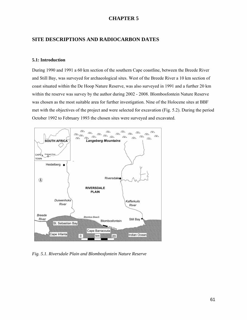
61
CHAPTER 5
SITE DESCRIPTIONS AND RADIOCARBON DATES
5.1: Introduction
During 1990 and 1991 a 60 km section of the southern Cape coastline, between the Breede River
and Still Bay, was surveyed for archaeological sites. West of the Breede River a 10 km section of
coast situated within the De Hoop Nature Reserve, was also surveyed in 1991 and a further 20 km
within the reserve was survey by the author during 2002 - 2008. Blombosfontein Nature Reserve
was chosen as the most suitable area for further investigation. Nine of the Holocene sites at BBF
met with the objectives of the project and were selected for excavation (Fig. 5.2). During the period
October 1992 to February 1993 the chosen sites were surveyed and excavated.
Fig. 5.1. Riversdale Plain and Blombosfontein Nature Reserve

62
Fig. 5.2. Blombosfontein Nature Reserve and Blombos Estates indicating position of excavated sites
BBF 1,2,3,4,5,6,7,9 and BBC
Based on detailed field notes and photographs taken during excavation a description of each site, its
stratigraphic units and location are recorded below. All the recovered material was taken to the
University of Cape Town for sorting, analysis and where necessary, measurement. Expert advice
was sought in the analysis of terrestrial fauna, microfauna, some species of marine shell and fish
bones. Cultural artefacts were separated by raw material and category, described and measured.
Sediment samples, collected from three sites at BBF, were submitted for textural analysis.
Shell and charcoal were collected in situ for radiocarbon dating during the excavation of sites at
BBF and sixteen samples submitted to the CSIR, Pretoria. Additionally, two sheep bones,
excavated at BBC, were sent to the Oxford University radiocarbon accelerator unit for dating.
5.2: Survey Methods and Site Selection
In order to suit the objectives of the project certain selection criteria were applied to all the sites
recorded in the De Hoop Nature Reserve in 1991 and to those situated between the Breede River
and Still Bay to assess their suitability for excavation:
(i) Age of sites: A temporal cross-section of Holocene sites was required for excavation; exposed
lithics, particularly in open sites, were used to aid initial dating estimates; lithics and pottery,
excavated from a 1 m deep test pit at BBC in June 1992, were also available as dating guides.
(ii) Location of sites: All the sites chosen for excavation should ideally fall within a 10 sq. km
radius and be located on or near the coast. This aim of this requirement was to gain spatial control
63
over the likely extent of the foraging zone utilised by the sites inhabitants, thereby enhancing the
comparability of inter-site data. Open and cave or shelter sites were sought in order to obtain
variability in site types.
(iii) Number of sites: Enough sites were needed to demonstrate diversity, but not more than could
be excavated or analysed in the time available; a sampling strategy for each site would determine
the size of an excavation.
(iv) Site content: At least a part of the assemblage of each site selected had to be in situ and
considered homogeneous; the effects of diagenesis at each site were taken into consideration.
As a result of the survey more than sixty open, cave and shelter sites were recorded along the
coastline. Many of these sites were well preserved and suited to some of the requirements of the
project, however the distance between sites was often large. It was also difficult to gauge the age
and extent of the archaeological deposits in cave sites as a limited time schedule precluded the
possibility of excavating sample trenches at these sites. Some of the open middens were well
preserved and considered suitable for excavation, others were no longer in situ, too small, or
contained deposits of mixed age.
Blombosfontein Nature Reserve was considered the most promising area for further investigation.
An aerial photograph of BBF was gridded in 50 m wide sections and a detailed physical survey
carried out in each transect. Of the 21 LSA sites noted, 9 were selected for excavation. For record
purposes a copy of the BBF survey was submitted to the Iziko-South African Museum.
5.3: Excavation Procedures
During October, 1992 the 9 selected sites were surveyed, measured and drawn. Where practicable,
the extent of in situ deposit and of talus material was noted for each site, base lines fixed and the
area to be excavated was established.
Excavations at BBF commenced in early November 1992. A grid of 1 x 1 m squares was laid down
at a site to be excavated. During excavation, features such as hearths were mapped in a horizontal
and vertical plane. At five sites, BBF 1-5, the deposit seldom exceeded 5 cm in depth; each
assemblage was considered to be a homogeneous single occupation unit. Three sites, BBF 6-9, and
BBC had multiple episode deposits and were excavated in individual, stratigraphic units; exposed
sections were plotted. Samples of shell or charcoal were taken in situ from all sites for radiocarbon
dating; soils were also sampled. Site notes were kept, slides taken and the progress of each
excavation recorded on videotape.

64
Recovered material was sieved in a 1.5 mm sieve. Some elementary sorting of shell, bone and stone
took place on site; generally the unsorted, sieved residue was bagged for later sorting and analysis
in the laboratory.
At the completion of the excavation of a site, the exposed areas were protected, either by backfilling
in the case of open sites, or by lining the walls with sand-filled polythene bags in the case of the
BBC site.
Excavations at all nine sites were completed by the end of February 1993. A total of 140 sq. m.
comprising 66 individual units, was excavated. The gross mass of recovered material, after sieving,
was 1425 kg, comprising in broad categories: marine shell, 662 kg; stone 366 kg; residue 296 kg;
bone 90 kg; ostrich egg shell and other 11 kg.
5.4: SITE DESCRIPTIONS and Stratigraphy
Six of the open sites, BBF 1-5 and BBF 7 are located on a coastal foreland in the BBF dunefield
and are elevated at between 90 m and 165 m a.s.l. The direct distance of these sites from the coast
varies between 180 m and 1000 m. Three sites, BBF 6 and 9 and BBC are situated on the seaward
side of the coastal cliffs less than 50 m from the sea and comprise, respectively, an open midden, a
cave and a shelter. Figure 5.2 indicates the location of each excavated site at BBF.
Sites are numbered from oldest to youngest, thus BBF 1 is the oldest and BBF 9 the youngest. The
BBC LSA deposits fall between BBF 9 and BBF 7. Radiocarbon dates for each site are listed below
in Section 5.7, Table 5.4 & 5.5.
BBF 1 (34024’31.18 S 21012’48.02 E)
Site Description (Fig. 5.3, 5.4)
Elevated at 90 m a.s.l., the entire BBF 1 site lies on a bed of aeolian sand, 80 - 100 cm thick. At the
base of the aeolian sand is a calcretised hardpan surface The full extent of this site was not
quantifiable as a 1.5 m layer of dune sand covers the surface; an estimate of the size is 22 m in a
north-south direction and 9 m east-west. At the southern edge of the dune, heavily brecciated
sections of deposit have been undercut by wind action and deposited on the talus slope, thereby
exposing the site boundary. The entire visible deposit is encased in a hard calcretised breccia. As no
stratigraphic differences could be observed within the breccia, BBF 1 is considered a single
occupation unit .
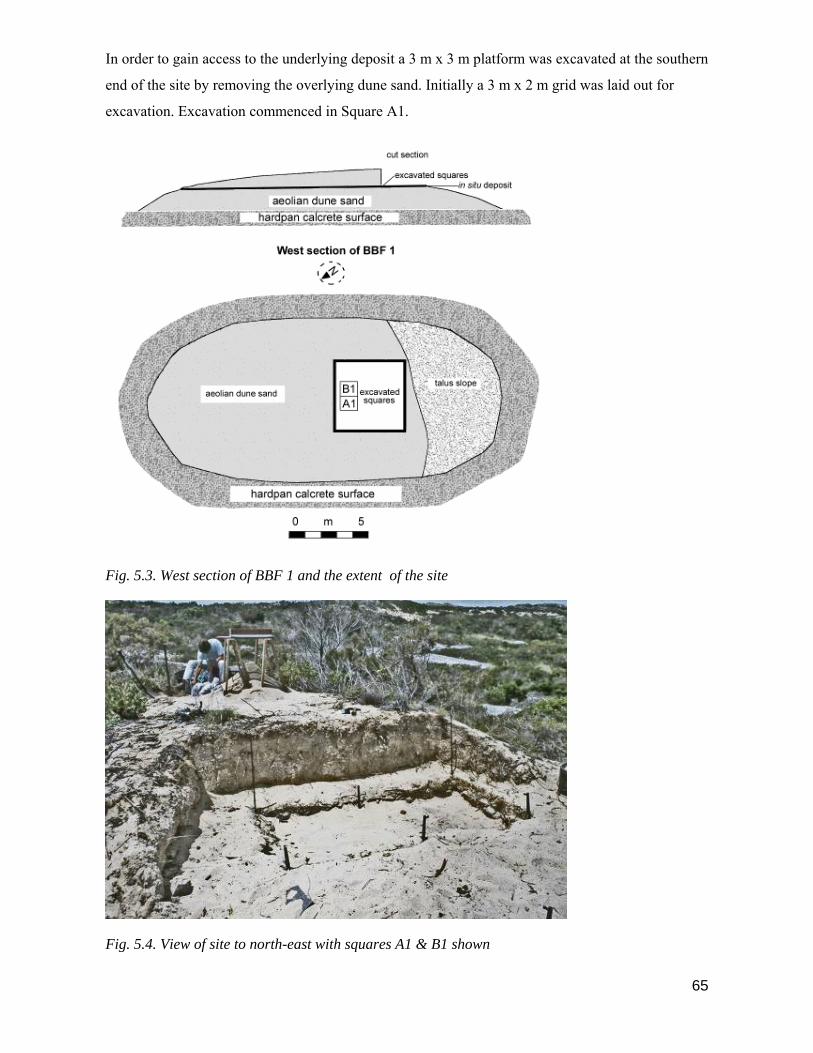
65
In order to gain access to the underlying deposit a 3 m x 3 m platform was excavated at the southern
end of the site by removing the overlying dune sand. Initially a 3 m x 2 m grid was laid out for
excavation. Excavation commenced in Square A1.
Fig. 5.3. West section of BBF 1 and the extent of the site
Fig. 5.4. View of site to north-east with squares A1 & B1 shown

66
Stratigraphy
Square A1
The surface of Square A1 was exposed by brushing. Slides and video footage were taken. On the
surface a dense deposit of bone, in particular tortoise, and marine shell and stone were visible. A
hard, calcareous matrix encased the deposit making the removal of individual artefacts difficult. A
hammer and chisel were necessary to break up the deposit into manageable chunks. Throughout the
square the thickness of the deposit was between 5 - 8 cm, but no individual stratigraphic units were
observed within the excavated assemblage, nor in the cut and exposed sections.
Square B1
Square B1 was excavated in the same way as Square A1. A decision was taken not to excavate
further squares at the site as it was uncertain whether a suitable method could be found for
separating the breccia in the laboratory. The deposit was of a similar thickness to Square A1. At the
conclusion of the excavation the site was backfilled.
BBF 2 (34024’29.54S 21013’48.24 E)
Site Description (Figs. 5.5, 5.6, 5.7 )
Situated 1 km from the sea and elevated at 150 m a.s.l., the site extends for about 210 sq. m. The 16
sq. m of in situ deposit was encased in a soft, calcretised breccia and truncated by a forestry track.
The western portion of the in situ section had been undercut by wind and water erosion causing a
part of the original assemblage, possibly around 10 sq. m, to be deposited on the talus slope. Marine
shells, bone, stone and ostrich egg shell were visible on the surface. Some preserved bone was
evident but was generally friable and not easily identifiable to taxa. No stratigraphic differences
could be detected within the deposit giving a strong impression that the assemblage represented a
single occupation. Additionally the homogeneity of stone tool types and the relatively small size of
the original site reinforces the impression that BBF 2 was occupied once only.
A grid of 14 m x 15 m was laid over the entire site which included the talus slope. All the in situ
deposit was excavated, sieved and bagged. Additionally, a 15 m x 2 m wide transect running from
squares J1 to K15 was laid out on the talus and all visible bone and stone collected.

67
Fig. 5.5: Layout of BBF 2 site showing excavated area
Fig. 5.6. BBF 2: View of site to north with sieving and sorting in progress

68
Fig. 5.7. BBF 2: Close up view of site
Stratigraphy
The depth of the excavated deposit varied between 5 - 25 cm and was underlain by an aeolian sand
bed. No stratigraphic layers could be discerned in any section of the deposit and the assemblage
was considered homogeneous.
BBF 3 (34024’45.49 S 21013’55.10 E)
Site Description (Figs. 5.8, 5.9)
BBF 3 is elevated at 160 m and located 500 m from the sea. Three discrete areas of dense in situ
deposit cover 55 sq. m. and contain shell, bovid and tortoise bone, ostrich egg shell, silcrete and
quartzite in a medium density breccia. A further ± 1000 sq. m of thinly dispersed shell and stone is
talus scatter. The site which extends for 30 m north-south and 35 m east-west was gridded in 4 m x
4 m blocks and six transects of 4 sq. m each were selected for excavation. The three in situ areas are
regarded as dumps surrounding a central ashy section located in squares C 1- 4 and D 1- 4. Due to
the homogeneity of all aspects of the deposit in the in situ areas, the whole site is regarded as a
single occupational episode.
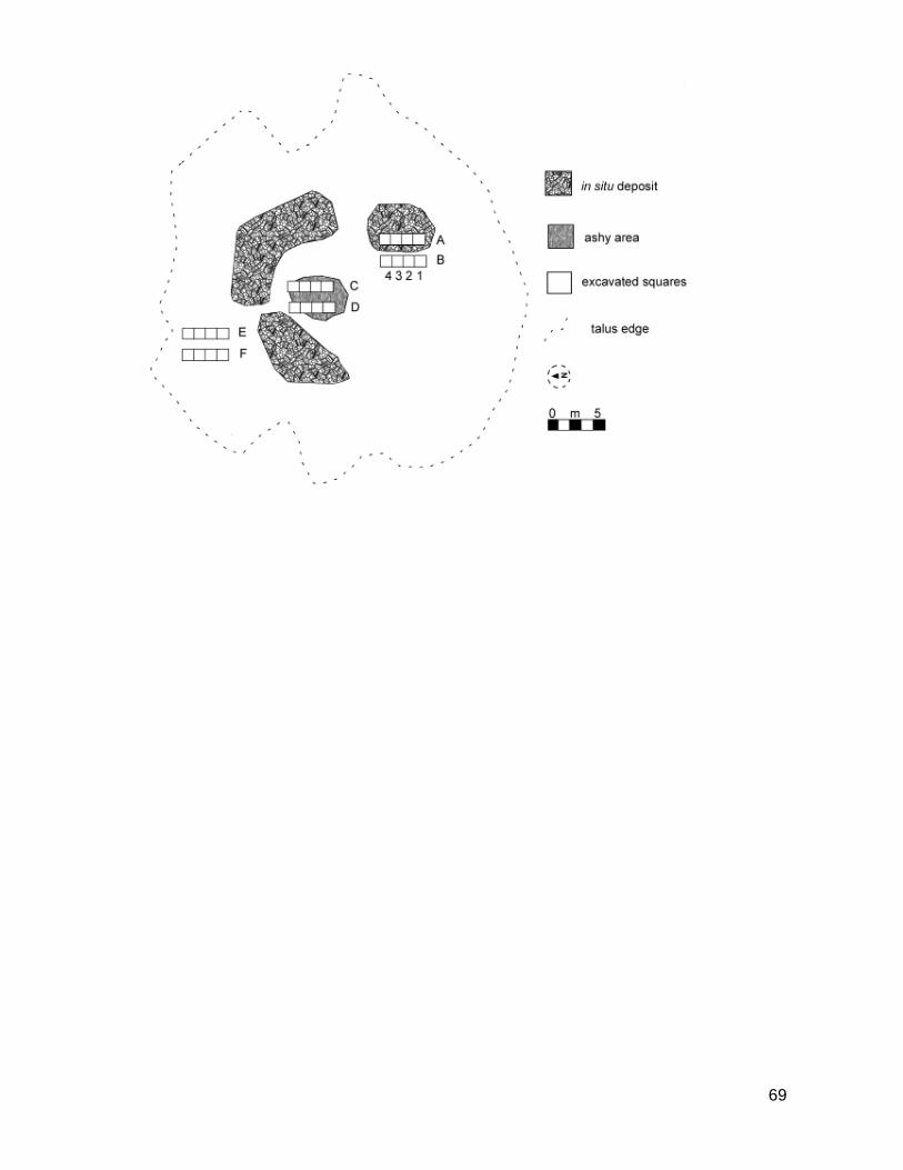
69
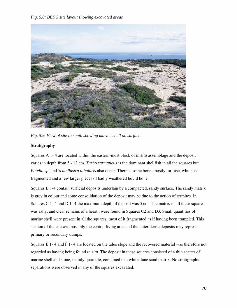
70
Fig. 5.8: BBF 3 site layout showing excavated areas
Fig. 5.9. View of site to south showing marine shell on surface
Stratigraphy
Squares A 1- 4 are located within the eastern-most block of in situ assemblage and the deposit
varies in depth from 5 - 12 cm. Turbo sarmaticus is the dominant shellfish in all the squares but
Patella sp. and Scutellastra tabularis also occur. There is some bone, mostly tortoise, which is
fragmented and a few larger pieces of badly weathered bovid bone.
Squares B 1-4 contain surficial deposits underlain by a compacted, sandy surface. The sandy matrix
is grey in colour and some consolidation of the deposit may be due to the action of termites. In
Squares C 1- 4 and D 1- 4 the maximum depth of deposit was 5 cm. The matrix in all these squares
was ashy, and clear remains of a hearth were found in Squares C2 and D3. Small quantities of
marine shell were present in all the squares, most of it fragmented as if having been trampled. This
section of the site was possibly the central living area and the outer dense deposits may represent
primary or secondary dumps.
Squares E 1- 4 and F 1- 4 are located on the talus slope and the recovered material was therefore not
regarded as having being found in situ. The deposit in these squares consisted of a thin scatter of
marine shell and stone, mainly quartzite, contained in a white dune sand matrix. No stratigraphic
separations were observed in any of the squares excavated.
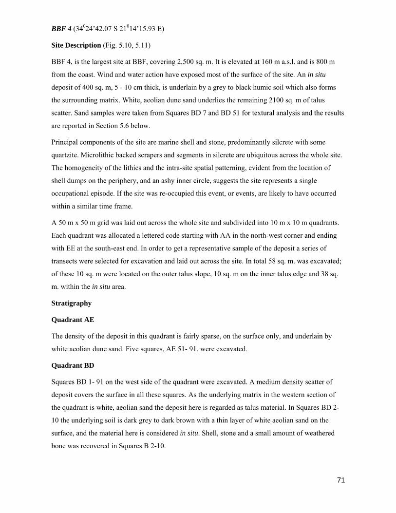
71
BBF 4 (34024’42.07 S 21014’15.93 E)
Site Description (Fig. 5.10, 5.11)
BBF 4, is the largest site at BBF, covering 2,500 sq. m. It is elevated at 160 m a.s.l. and is 800 m
from the coast. Wind and water action have exposed most of the surface of the site. An in situ
deposit of 400 sq. m, 5 - 10 cm thick, is underlain by a grey to black humic soil which also forms
the surrounding matrix. White, aeolian dune sand underlies the remaining 2100 sq. m of talus
scatter. Sand samples were taken from Squares BD 7 and BD 51 for textural analysis and the results
are reported in Section 5.6 below.
Principal components of the site are marine shell and stone, predominantly silcrete with some
quartzite. Microlithic backed scrapers and segments in silcrete are ubiquitous across the whole site.
The homogeneity of the lithics and the intra-site spatial patterning, evident from the location of
shell dumps on the periphery, and an ashy inner circle, suggests the site represents a single
occupational episode. If the site was re-occupied this event, or events, are likely to have occurred
within a similar time frame.
A 50 m x 50 m grid was laid out across the whole site and subdivided into 10 m x 10 m quadrants.
Each quadrant was allocated a lettered code starting with AA in the north-west corner and ending
with EE at the south-east end. In order to get a representative sample of the deposit a series of
transects were selected for excavation and laid out across the site. In total 58 sq. m. was excavated;
of these 10 sq. m were located on the outer talus slope, 10 sq. m on the inner talus edge and 38 sq.
m. within the in situ area.
Stratigraphy
Quadrant AE
The density of the deposit in this quadrant is fairly sparse, on the surface only, and underlain by
white aeolian dune sand. Five squares, AE 51- 91, were excavated.
Quadrant BD
Squares BD 1- 91 on the west side of the quadrant were excavated. A medium density scatter of
deposit covers the surface in all these squares. As the underlying matrix in the western section of
the quadrant is white, aeolian sand the deposit here is regarded as talus material. In Squares BD 2-
10 the underlying soil is dark grey to dark brown with a thin layer of white aeolian sand on the
surface, and the material here is considered in situ. Shell, stone and a small amount of weathered
bone was recovered in Squares B 2-10.

72
Fig. 5.10. Layout of BBF 4 site showing excavated areas
Fig. 5.11. View of BBF 4 site to north showing shell and lithics on surface
Quadrant CC.
In Quadrant CC the deposit was recovered from the surface or just below it. The matrix and
underlying soil is dark grey, light grey or brown and is ashy in parts. Two rows of squares were
excavated in this quadrant, CC 1- 10 and CC 11- 91.

73
Quadrant DB
One row of 10 squares, labelled DB 1- 91, were excavated. A high density of Turbo sarmaticus
shells was visible in the surface deposit and during excavation a number of Turbo were located
below the surface. In Square DB 51, a hard ashy surface was exposed and although an absence of
charcoal suggests this feature was not a dense hearth, it may represent a shallow fireplace. The
matrix in the surrounding area is very ashy, mostly light to dark grey or brown. A hardish crust of
darker soil underlies the excavated squares.
Quadrant EA
Five squares, EA 1-41 were excavated in the north-east corner of the quadrant. A thin scatter of
deposit covers the surface. The deposit in this quadrant lies on the talus slope and is underlain by
white aeolian dune sand. No distinct separations in the deposit were visible in any of the excavated
squares and consequently the excavated assemblage was regarded as a single stratigraphic unit.
BBF 5 (34024’37.41 S 21014’23.99 E)
Site Description (Fig. 5.12, 5.13)
The BBF 5 site consists mostly of a thin scatter of exposed shell and stone extending for 550 sq. m
down the slope of a stabilised dune. Situated 900 m from the sea the site is elevated at 165 m a.s.l.
At the centre of the site, 18 sq. m of the densest deposit, regarded as being in situ, was selected for
excavation. The southern end of the site, below the excavated area, represents the talus slope as the
material here was not in situ. A base line was laid out and an outline of the site mapped. In the area
to be excavated a 6 m x 3 m grid was laid out.
A number of quartzite hammer stones and anvils and a dense concentration of S. tabularis and
broken T. sarmaticus shells characterise the BBF 5 assemblage. Curiously, T. sarmaticus opercula,
evident in abundance at other sites, are almost absent from BBF 5. The almost exclusive presence
of S. tabularis and T. sarmaticus suggests that these two shellfish species were being specifically
targeted and that BBF 5 may have been a shellfish processing site used during a single visit (see
Henshilwood et al 1994). This issue is discussed more fully in Chapter 6.
Stratigraphy
All the excavated deposit lay on the surface surrounded by a yellow aeolian sand matrix. The
maximum depth of deposit was 5 cm.

74
Fig. 5.12. Layout of BBF 5 site with excavated area
Fig. 5.13. Close-up of BBF 5 site with shell and lithics

75
BBF 6 (34024’54.30 S 21013’12.13 E)
Site Description (Fig. 5.14, 5.15, 5.16)
Situated on a rocky coastal promontory, 20 m from the waters edge, BBF 6 is a large midden
covering over 500 sq. m. Marine shellfish are the major component of the BBF 6 site and only
small quantities of fish bone and stone were recovered. The site had been repeatedly re-used,
mainly it seems as a shellfish dump or processing area. Hearths are visible in some of the excavated
units indicating that BBF 6 was also used as a shellfish cooking area. As the site offers no
protection from the elements and is particularly exposed to the strong north-westerly and south-
easterly winds, it seems unlikely it was used as an overnight campsite.
The north-west face of the midden had been eroded by wind and water exposing a 70 cm deep
section of the deposit. In preparation for excavation this face was vertically cleaned. Due to the
very high density of shellfish in the deposit a column section of 50 cm x 50 cm was chosen for
sampling. Stratigraphic excavation yielded 12 discrete depositional episodes in a 1.3 m deep
section, underlain by sterile aeolian dune sand. These units were subsequently numbered, from top
to bottom, Layer 6/1 to Layer 6/12. Abbreviations for the original units are given below in brackets.

76
Fig. 5.14. Layout of BBF 6 site showing position of excavated square
Fig. 5.15. BBF 6 with excavated column

77
Fig. 5.16. Close up of BBF 6 site showing shells and ash lenses
Stratigraphy (Fig. 5.14)
Layer 6/1 (ABA)
The top layer was 10 cm in depth and contained a dense deposit of shell including Turbo, Patella
sp. Diloma sp. and Haliotis midae in a yellow dune sand matrix.
Layers 6/2 (ASBA)
A radiocarbon date of 3630 ±70 B.P. was obtained on shell from this layer. It is very ashy with
some charcoal and a hearth is clearly visible in the north side of the square with an ash layer 15 cm
thick on the southern side and 8 cm thick in the north. Shell in this layer is generally fragmented
and often burnt.
Layer 6/3 (MUS)
A matrix of yellow dune sand surrounds a dense shell layer approximately 5 cm thick.
Layer 6/4 (LIM)
On the surface of this layer is a hard, sandy deposit with numerous small inclusions which look like
flaked bone. Some fish bone is also evident but shellfish dominates the whole layer. In the northern
half of the square the deposit is 12 cm deep and 7 cm deep in the south.
Layer 6/5 (OLL)
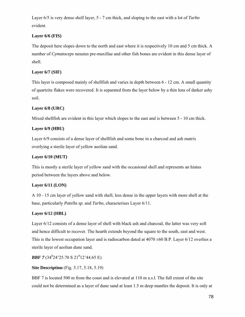
78
Layer 6/5 is very dense shell layer, 5 - 7 cm thick, and sloping to the east with a lot of Turbo
evident.
Layer 6/6 (FIS)
The deposit here slopes down to the north and east where it is respectively 10 cm and 5 cm thick. A
number of Cymatoceps nasutus pre-maxillae and other fish bones are evident in this dense layer of
shell.
Layer 6/7 (SIF)
This layer is composed mainly of shellfish and varies in depth between 6 - 12 cm. A small quantity
of quartzite flakes were recovered. It is separated from the layer below by a thin lens of darker ashy
soil.
Layer 6/8 (URC)
Mixed shellfish are evident in this layer which slopes to the east and is between 5 - 10 cm thick.
Layer 6/9 (HBU)
Layer 6/9 consists of a dense layer of shellfish and some bone in a charcoal and ash matrix
overlying a sterile layer of yellow aeolian sand.
Layer 6/10 (MUT)
This is mostly a sterile layer of yellow sand with the occasional shell and represents an hiatus
period between the layers above and below.
Layer 6/11 (LON)
A 10 - 15 cm layer of yellow sand with shell, less dense in the upper layers with more shell at the
base, particularly Patella sp. and Turbo, characterises Layer 6/11.
Layer 6/12 (HBL)
Layer 6/12 consists of a dense layer of shell with black ash and charcoal, the latter was very soft
and hence difficult to recover. The hearth extends beyond the square to the south, east and west.
This is the lowest occupation layer and is radiocarbon dated at 4070 ±60 B.P. Layer 6/12 overlies a
sterile layer of aeolian dune sand.
BBF 7 (34024’25.70 S 21012’44.65 E)
Site Description (Fig. 5.17, 5.18, 5.19)
BBF 7 is located 500 m from the coast and is elevated at 110 m a.s.l. The full extent of the site
could not be determined as a layer of dune sand at least 1.5 m deep mantles the deposit. It is only at

79
the southern end that a section of the BBF 7 site is exposed and eroded, resulting in ± 200 sq. m of
fairly dense talus scatter.
At the southern end of the site a section of humic soil over 2 m deep is exposed; this was spade cut
to obtain a clean section. It was evident from the exposed face that the uppermost deposit lies in a
matrix of yellow sand directly on the surface of a dense, dark humic layer. Protruding marine shells
were visible in the top 30 cm of the humic soil. A 3m x 3m grid was laid out above the southern
face of the site and the overlying 1.5 m of sterile overburden removed.
As it was thought that a palaeovlei (small inland lagoon) might have been the source of the humic
soil at the BBF 7 site a number of soil samples were taken from various sections in the exposed
southern face. These samples were analysed to determine the size of the sand fractions, and for the
presence of fresh water molluscs. The results are reported in Section 5.6 below.
Stratigraphy (Fig. 5.17)
The upper layer, 7/1 (YSL) was excavated across 9 squares numbered A1 - C3. A yellow, dune
sand matrix enclosed the deposit composed of marine shell, bone, ostrich egg shell and stone. In all
squares the deposit was 1 - 2 cm deep. Underlying this layer was a firm, compacted humic surface
with no underlying deposit evident, suggesting that Layer 7/1 was deposited after the formation of
the humic palaeosol.
Due to the compactness of the humic soil and consequent difficulty in excavating the three lower
units it was decided to confine the excavation to three squares, B1 - B3. In the upper humic layer,
7/2 (HL1) a small amount of generally fragmented shell and some stone was evident and these were
darkly stained, unlike the clean deposit in Layer 7/1. A clear distinction could not be made between
Layers 7/2 and 7/3 and an arbitrary separation was made. The upper spit was 5 - 7 cm deep.
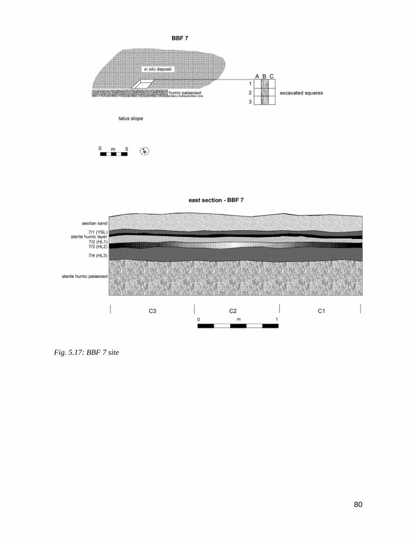
80
Fig. 5.17: BBF 7 site
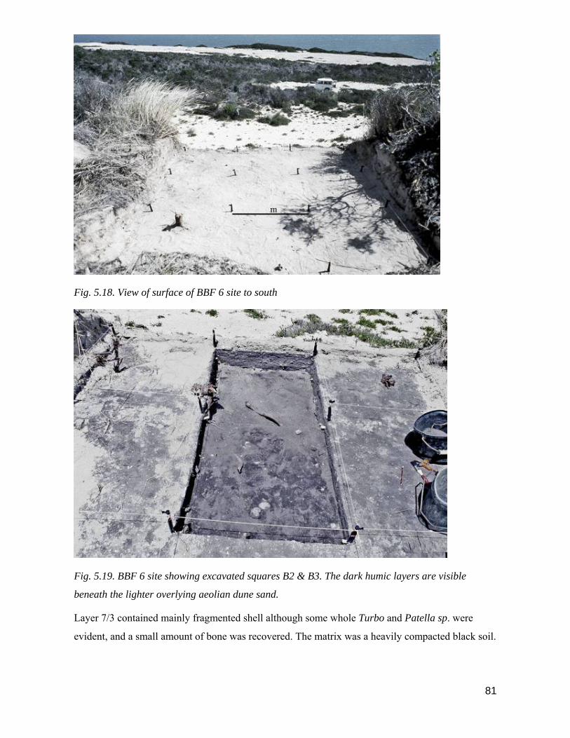
81
Fig. 5.18. View of surface of BBF 6 site to south
Fig. 5.19. BBF 6 site showing excavated squares B2 & B3. The dark humic layers are visible
beneath the lighter overlying aeolian dune sand.
Layer 7/3 contained mainly fragmented shell although some whole Turbo and Patella sp. were
evident, and a small amount of bone was recovered. The matrix was a heavily compacted black soil.

82
There was clearer evidence for a separation between layers 7/3 and 7/4. The density of shell
deposits increases in 7/4, more whole Turbo and Perna perna are present, and the shell is mostly
found in discrete pockets. More bone is present in 7/4, although it is generally very soft and wet and
degenerated quickly when moved. Two bones from a large Cymatoceps nasutus fish were
recovered. The surrounding matrix is still a compact, black soil. In the lower section of Layer 7/4
the deposit rapidly diminishes and is underlain by a sterile humic soil.

83
BBC (Blombos Cave) (34024’56.75 S 21013’24.94 E)
Background
Blombos Cave, situated near Still Bay in the southern Cape is some 100 m from the coast and 35 m
above sea level (Fig. 5.20). The interior of the cave contains 55 sq. m of deposit with an estimated
depth of c. 3 m at the front and c. 1.5 m toward the rear (Fig. 5.21. When excavations at BBC
commenced in 1991 the cave entrance was almost totally sealed by dune sand; also c. 20 cm of
undisturbed aeolian sand overlay the surface of the LSA indicating no disturbance of the cave’s
contents since the final LSA occupation c. 290 years ago. A test pit was dug at the rear of the cave
in 1991 and excavations then commenced in the same location in 1992. There have been subsequent
team excavations during 1997 – 2008 (Henshilwood et al 2001a; Henshilwood 2005, 2008).
The LSA deposits are less than 2 ka in age, not as deep as the MSA, and are more massively bedded
and undistorted. In addition, burned layers tend to be thicker and several appear to preserve their
original hearth-like structures. In the MSA levels the matrix is composed mainly of aeolian, marine-
derived dune sand, blown in through the cave entrance and is intercalated with marine shell,
decomposed humic materials and limestone, and wind-borne halites. Ground waters rich in CaCO3
percolate through the cave roof and walls creating an environment suited to the preservation of
bone and shell, particularly near hearths and ash deposits. Carbonised partings represent occupation
horizons and separate major units. The MSA deposits undulate considerably from the back to front
of the cave due to subsidence that produces a ‘wrapping effect’ over the rock falls and occasional
slump faults into gaps between rocks (Henshilwood et al, 2001a; Henshilwood 2005).
Sterile yellow dune sand 10 – 60 cm thick named BBC Hiatus blew into the unoccupied cave during
lowered sea levels at c 70 ka. Shortly afterwards the cave entrance was blocked by a > 40 m dune
(Jacobs et al 2006). It is likely that the cave only reopened during the mid-Holocene when high sea
levels eroded the base of this dune 30 m below the cave causing the aeolian dune sand at the
entrance to subside. BBC Hiatus separates the LSA and MSA across > 95% of the excavated area
and provides visible evidence that the LSA occupation did not disturb the underlying MSA deposits
(Henshilwood 2005).

84
Fig. 5.20. View of Blombos Cave looking to east. Entrance of cave is circled.
Fig. 5.21. Layout of Blombos Cave showing squares excavated from 1992 – 2008

85
Fig. 5.22. Cedric Poggenpoel excavating at BBC in 1998.
BBC: The Later Stone Age Levels
(Note: this site was originally given the acronym GSF 8 in Henshilwood 1995)
The roof height of the cave, prior to the initial excavation varied between 1 - 1,5 m. A ridge of
aeolian dune sand which had accumulated at the cave entrance, virtually blocking access to the
cave, was removed by excavating down to the level of the interior floor. All the sand removed was
sieved for deposit but was found to be sterile. A baseline which coincided with the dripline at the
cave entrance was established and the interior of the cave gridded in 1 sq. m units numbered from
A1 to I9.

86
Fig. 5.23. BBC (Blombos Cave) site after excavations in 1992. Layers 1-6 fall within the LSA and
Layers 7-11 within the MSA. The latter layers were subsequently subsumed with the M1 phase that
contains Still Bay artefacts (Henshilwood 2001a, 2005)
In July 1991 a test pit of 1 sq. m. in Square E2 was stratigraphically excavated to a depth of 1 m by
the author and Peter Nilssen. In November 1992, the author and Cedric Poggenpoel (Fig. 5.22)
continued with the excavation in Square E2 to a depth of 1.5 m and a further three squares, F2, E3
and E4 were excavated. In total, 37 units were removed as discrete stratigraphic entities. Changes in
soil colour and texture, localised features such as hearths and hearth stones, and the presence of
discrete depositional units, for instance shell pockets, provided useful guides to ensure precise
stratigraphic control during excavation. Due to the percolation of calcium-rich ground water and the
presence of air-borne halites, bone and some organic materials are generally well preserved at BBC.
The lower layers of the cave deposit, particularly Layers BBC L4 & BBC L5, are characterised by
dense deposits of mammal and fish bone, and marine shell.
Based on an examination of the stratigraphy of unexcavated deposit, and after analysis of the
various units in the laboratory, the 37 units removed were allocated to 11 individual layers (Fig.
5.8). Note that the acronym L, denoting LSA, is placed before the BBC layers that fall within the
LSA, for example BBC L2. The MSA layers carry the acronym M and are numbered BBC M7 –

87
M11. These numbers bear no relation to the MSA phases denoted the M1, M2 and M3 phases in
Henshilwood 2001a and in subsequent publications.
LSA Layers (Fig. 5.8)
Layer BBC L1
The surface layer consisted of a pale brown to dark brown aeolian sand containing a number of
inclusions including small quantities of marine shell, fish and mammal bone and Procavia capensis
coprolites. An ashy unit and hearth were removed. Charcoal samples taken from the hearth are
radiocarbon dated at 290 ±20 B.P. The distribution and density of decomposed vegetation found in
Layer BBC L1 suggests it was bedding.
Layer BBC L2
Speckled limestone inclusions in a tan to dark brown soil characterise the matrix in Layer BBC L2.
A large hearth was excavated in Square E4. A medium density deposit was found in all squares
consisting of marine shell, fish and mammal bone, some stone, mainly quartzite, and two pieces of
pottery.
Layer BBC L3
Three units make up Layer BBC L3 and the deposits are similar in content and density to Layer
BBC L2. Soil changes distinguish this layer from those above and below. The amount of limestone
rapidly decreases in this layer, and in the northern end of the square Layer BBC L3 is underlain by
sterile, aeolian sand which banks up from the back of the cave towards the front. A small ashy lens
overlies the dune sand in Square F2.
Layer BBC L4
A range of soil colours is represented in Layer BBC L4, ranging from a white limestone patch to
reddish brown and dark brown. However, the main factor which distinguishes this layer from the
others is a very high density of well preserved marine shell, fish and mammal bone and stone,
mainly quartzite. A number of large, contiguous hearths were excavated.

88
Layer BBC L5
Layer BBC L5 is similar in content to Layer BBC L4 but could be clearly separated from the above
layer by changes in soil colour, in particular a loamy unit in Square E2 and the re-appearance of
soft limestone inclusions. Layer 8/5 slopes steeply downwards towards the north in Square E2.
Underlying Layer BBC L5 is a yellow, aeolian sand which slopes up steeply towards the south-west
at the back of the cave.
Layer BBC L6
This layer consists of a combination of white and yellow aeolian sands, white clayey soil and
isolated patches of dark soil containing deposit. Layer 8/6 is regarded as an hiatus layer composed
of aeolian sand blown into the cave. Although a fair amount of deposit was recovered from Layer
BBC L6, this almost certainly came from the lower levels of Layer BBC L5 and was worked into
the soft sand by disturbance and trampling during the occupation of the upper layers. No hearths or
other distinctive features are present in Layer BBC L6 and there are no clear stratigraphic
separations within the layer.
The Middle Stone Age Still Bay levels: c. 77 – 70 ka
The Still Bay levels at the cave were first excavated in 1992 and then annually or biennially from
1997 - 2008. The results of the excavations from 1992 – 2005 are summarised below. Excavation of
the >100 ka levels at the site is continuing. During excavations in 1992 we did not expect to find
MSA deposits at the BBC site, or at least not at such a shallow depth (c. 60 – 80 cm from surface)
(Fig. 5.24). Although the MSA was not an integral part of the research objectives of this project we
decided at the time that we would test excavate a small section of these deposits (Henshilwood
1995, 2001a). Five MSA layers containing 12 stratigraphically distinct lenses were removed in a 20
cm deep section in 1992 (Henshilwood 1995, 2005) (Fig. 5.24). All layers contain a variety of Still
Bay ‘laurel-leaf’ bifacial points, mainly in silcrete, but also in quartzite and quartz; end and side
scrapers and blades are also present (Henshilwood et al 2001a; Villa et al submitted). At the time of
excavation of these levels at BBC in 1992 ages for the Still Bay were not available, and there were
limited options for dating beyond the c. 40 ka limits of C14 .

89
Fig. 5.24. Middle Stone Age levels at BBC indicating names of layers and ages.
The Still Bay was first suggested as a period or industry within the MSA to Goodwin (e.g. 1935) by
C.H.T.D. Heese in the 1920s. The ‘lance-head’ in elongated laurel-leaf-form typified the Still Bay-
type artefact according to Heese (n.d.). He did not subscribe to Goodwin’s view that the oak-leaf
shaped ‘spear point’ or ‘point’ should be included in the definition (Goodwin & van Riet Lowe,
1929:119). However, the Still Bay Industry, as proposed by Goodwin, extended to include
numerous lithic forms attributed to the newly named ‘Middle Stone Age’ (Goodwin 1928, 1929,
1935). Strangely, considering his previous opposition to Goodwin’s schema Heese (n.d) later wrote
“the Still Bay here covers Glen Grey, Pietersburg and Howiesons Poort. There is no necessity for
treating them as separate entities” (Heese 1933:44). The imprecise definition of the Still Bay was a
major factor that led to confusion in subsequent Middle Stone Age excavations, a prime example
being the Peers Cave site located in the Fish Hoek Valley, Cape Province (see Jolly 1948; Anthony
1963, 1967) although at the time of excavation Peers (1929:9) did state that the “true Still Bay with
…typical laurel-leaf spear heads…lay beneath the Howiesons Poort”. The chronological position of
the Still Bay relative to the Howiesons Poort remained unclear and by the 1950s lanceolate bifacial
points were largely regarded as an integral component of the Howiesons Poort (e.g. Goodwin 1958;
Malan 1955). After the 1960’s the term Still Bay gradually fell out of use and its validity was

90
questioned by Sampson (1974) although Schirmer (1975) still uses the term in her monograph on
Dale Rose Parlour. Imprecision in use of the term Still Bay was exacerbated by its application in
Kenya (Anthony 1972) and as far north as Ethiopia (Wendorf & Schild 1974).
There were hints at the relationship between the Still Bay and Howiesons Poort though, particularly
at Klasies River where bifacially retouched flakes came from levels below the Howiesons Poort
(Singer & Wymer 1982; Wurz, 2000), and similar finds were made at Nelson Bay Cave (Volman
1981) and Paardeberg (Wurz 2000) . New schemes for the Middle Stone Age were suggested (e.g.
Volman 1984; Singer & Wymer 1982) and although the term Howiesons Poort was maintained the
Still Bay was not.
Excavations at BBC in the 1990s (Henshilwood 1995; 2008) and at Hollow Rock Shelter (Evans
1994), also in the Cape Province revived the term. At both sites Still Bay lanceolate bifacial points
were found in situ (Figure 3). At BBC good organic preservation meant the Still Bay artefacts lay in
the remains of food debris, including bone and marine shell (Henshilwood et al. 2001a). The BBC
excavations led to a revival of the proposal to include the Still Bay as a sub-division of the Middle
Stone Age
Still Bay bifacial points are a distinct type restricted to the Cape. We propose “Still Bay sub-stage”
as a regional, culture-stratigraphic term for assemblages with fully bifacially flaked, lanceolate
shaped points”. Henshilwood et al. 2001a: 429, 2008).
Recent excavations at Diepkloof rock-shelter (Parkington et al 2005; Rigaud et al., 2006) in the
Western Cape and at Sibudu (Wadley 2007) in Kwazulu-Natal have uncovered a Still Bay facies
with bifacial points below the Howiesons Poort levels.
BBC is at present the only site where the Still Bay has been dated using a number of methods and
the results published (Jones 2001; Jacobs et al. 2003a,b, 2006; Tribolo 2003; Tribolo et al. 2005,
2006). The Middle Stone Age levels at BBC are divided into three phases, M1, M2 and M3 (Fig.
5.24). The two upper phases M1 and M2 contain bifacial foliate points (Fig. 5.25) and are both
assigned to the Still Bay. Sterile sand 10 - 50 cm thick covers the M1 phase across the cave and is
named the Hiatus level. Optically stimulated dating of this hiatus by the multiple grain technique
yielded a depositional age of 69 ± 5 ka and 70 ± 5 ka (Henshilwood et al. 2002: Jacobs et al. 2003a,
b; Jacobs et al. 2006), and provides a minimum age for the Still Bay levels below.
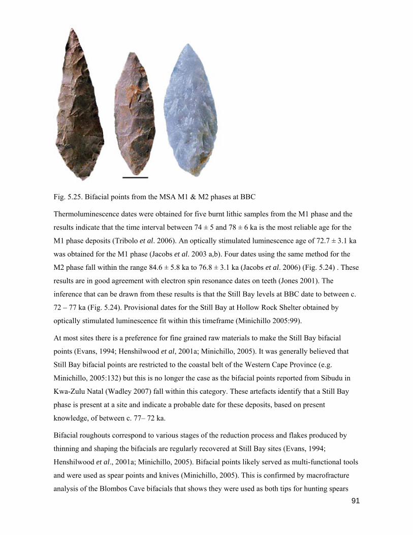
91
Fig. 5.25. Bifacial points from the MSA M1 & M2 phases at BBC
Thermoluminescence dates were obtained for five burnt lithic samples from the M1 phase and the
results indicate that the time interval between 74 ± 5 and 78 ± 6 ka is the most reliable age for the
M1 phase deposits (Tribolo et al. 2006). An optically stimulated luminescence age of 72.7 ± 3.1 ka
was obtained for the M1 phase (Jacobs et al. 2003 a,b). Four dates using the same method for the
M2 phase fall within the range 84.6 ± 5.8 ka to 76.8 ± 3.1 ka (Jacobs et al. 2006) (Fig. 5.24) . These
results are in good agreement with electron spin resonance dates on teeth (Jones 2001). The
inference that can be drawn from these results is that the Still Bay levels at BBC date to between c.
72 – 77 ka (Fig. 5.24). Provisional dates for the Still Bay at Hollow Rock Shelter obtained by
optically stimulated luminescence fit within this timeframe (Minichillo 2005:99).
At most sites there is a preference for fine grained raw materials to make the Still Bay bifacial
points (Evans, 1994; Henshilwood et al, 2001a; Minichillo, 2005). It was generally believed that
Still Bay bifacial points are restricted to the coastal belt of the Western Cape Province (e.g.
Minichillo, 2005:132) but this is no longer the case as the bifacial points reported from Sibudu in
Kwa-Zulu Natal (Wadley 2007) fall within this category. These artefacts identify that a Still Bay
phase is present at a site and indicate a probable date for these deposits, based on present
knowledge, of between c. 77– 72 ka.
Bifacial roughouts correspond to various stages of the reduction process and flakes produced by
thinning and shaping the bifacials are regularly recovered at Still Bay sites (Evans, 1994;
Henshilwood et al., 2001a; Minichillo, 2005). Bifacial points likely served as multi-functional tools
and were used as spear points and knives (Minichillo, 2005). This is confirmed by macrofracture
analysis of the Blombos Cave bifacials that shows they were used as both tips for hunting spears

92
and also as cutting tools (Lombard 2007). Still Bay bifacials may have also served in a symbolic
role (Henshilwood et al., 2001a; Villa et al submitted) and in this regard it is interesting to note that
Burkitt (1928) interpreted the Still Bay as marking the arrival of ‘modern people’ on the
subcontinent. Still Bay bifacials represent a high level of technical skill in the Middle Stone Age
and the method of manufacture was undoubtedly in keeping with people deemed ‘modern’ in their
behaviour (Henshilwood & Marean 2003, 2006; Minichillo 2005:133). The predominant use of
non-local raw materials, recorded for example at Blombos, may relate to adding exchange value to
those tools (cf. Wiessner 1983) and promoting social relations (Mellars 1996), rather than having a
functional significance.
Ochre, a mineral rich in iron oxide, is present after ca. 100 ka at most Middle Stone Age sites
(Watts 1999, 2002; Barham 2001; Wurz 2000; Wadley 2001). It is found at a number of Still Bay
sites, for example at Hollow Rock Shelter (Evans 1994), Dale Rose Parlour (Schirmer 1975) and
Diepkloof (Parkington et al 2005; Rigaud et al. 2006). Evidence of scraping or grinding is observed
on many pieces, probably to produce powder and some pieces have crayon or pencil shapes as a
result of direct application of the ochre to an abrasive surface (Singer & Wymer 1982:117; Clark &
Williamson 1984, Rigaud et al. 2006). The presence of ochre at these archaeological sites is
interpreted by some researchers as early evidence of the symbolic use of colourants (Watts 1999;
Henshilwood et al. 2001a, 2002) while others have more practical explanations (Klein 1999) with
some suggesting it was used for skin protection, as medicine (Velo 1984) or to enhance hafting
(Wadley 2005). Various views may be correct as it seems probable that ochre can be used in several
ways.
At Blombos Cave more than 2000 pieces of ochre, many bearing signs of utilisation have been
recovered from the Still Bay (M1 & M2 phases) (Henshilwood et al. 2002) (Figure 3). Two
deliberately engraved pieces come from the M1, AA-8937 and AA-8938 (Henshilwood et al. 2002)
and further engraved pieces from M1 and M2 have been identified (Henshilwood et al. submitted).
Two ground facets are present on specimen AA 8937 and on the larger of these a cross-hatched
design is engraved. Specimen AA 8938 has one ground facet and on this a complex cross-hatched
pattern was engraved (Fig. 5.25) . On both pieces it is clear that the designs result from deliberate
intent and arguably are among the most complex and clearly-formed of objects claimed to be early
abstract representations (d’Errico et al. 2003; Lewis-Williams & Pearce 2004; Mithen 2005;
Mellars 2005, 2006). These pieces would certainly not be out of place if placed amongst symbolic
representations in the Upper Palaeolithic (Mellars 2005). It is reasonable to contend that the ochre
assemblage from the Still Bay levels at Blombos Cave, and arguably at other Still Bay sites,
provides evidence for social and stylistic elaboration during this period.

93
Fig. 5.26. Engraved ochre SAM – 8938 from the M1 phase at BBC. The age of this phase is c. 72
ka.
Still Bay assemblages were in the past regarded as one-dimensional in that only stone artefacts were
preserved (Schirmer 1975; Evans 1994). The Peers Cave site was a rare exception as some organic
material is reported but not well described (Peers & Goodwin 1953). Organic materials, associated
with the Still Bay bifacials, are generally well preserved at BBC and provide new insights into this
period of the Middle Stone Age. Shellfish and fish are regularly consumed during the Still Bay
occupation and a range of terrestrial and marine animals were hunted, trapped and collected. The
overall subsistence pattern at BBC signifies that no clear distinction can be made between Later
Stone Age and Middle Stone Age subsistence behaviour at the site (Henshilwood et al 2001a;
Henshilwood 2004, 2007,2008).The implication is that during the Still Bay occupations the
subsistence mode was essentially modern.
Bone tools are an unexpected technological innovation in the Still Bay at Blombos Cave. Regarded
as a distinctive marker in the Eurasian transition to modern cognitive behaviour (e.g. Clark 1989;
Thackeray, A.I. 1992; Klein 1995) they are rare at Middle Stone Age sites (McBrearty & Brooks
2000). More than thirty formal bone artefacts have been recovered from the Still Bay levels at
Blombos Cave, including awls and ‘points’ (Henshilwood & Sealy 1997; Henshilwood et al.
2001a,b; d’Errico & Henshilwood 2007). There is clear evidence that these tools were in situ when
recovered (Henshilwood 2005). The majority are awls made on long-bone shaft fragments (Fig.
5.27 b), further manufactured by scraping and then used to pierce soft material such as leather
(Henshilwood et al 2001b or pierce shells to make beads (d’Errico et al. 2005). At least some bone
tools that were carefully polished after being shaped by scraping are probably projectile points
made for hafting (Fig. 5.27 a). It is noteworthy that points are treated differently to awls. The high
polish on these points has no apparent functional reason that can de detected but seems rather a
technique that gives a distinctive appearance - an “added value” - to these artefacts. These too may
have formed part of a material culture exchange system amongst groups to maintain or even

94
enhance social relations. The Blombos bone tools provides comprehensive evidence for systematic
bone tool manufacture and use but we cannot be certain if this was also the case at other Still Bay
sites. Bone tools are also reported from the c. 60 – 65 ka Howiesons Poort levels at Sibudu Cave
(Backwell et al in press) and from Klasies River (d’Errico & Henshilwood 2007). A note of caution
is that we are not certain that the production of worked bone gives a modern character to all Middle
Stone Age material culture since little is known about the evolutionary significance of bone shaping
(Henshilwood & Marean 2003, 2006; Backwell & d’Errico 2005). Symbolic marking on bone is a
likely feature that supports a symbolic interpretation (Henshilwood et al 2001b). Microscopic
analysis of a bone fragment marked with eight parallel lines from the Still Bay levels indicates they
are the result of deliberate engraving and were possibly made with symbolic intent (d’Errico et al.
2001).
Fig. 5.27. Bone tools from the M1 & M2 phases (c. 77 – 72 ka) at BBC: a) points b) awls. (Image
courtesy of Francesco d’Errico).
A strong argument for early behavioural modernity in the Upper Palaeolithic is the presence of
personal ornaments (Klein 1995, 1999; Wadley 2001; Mellars 1996, 2005; d’Errico et al. 2005).
The discovery of more than 70 shell beads in the Still Bay techno-tradition at Blombos Cave has
added a new dimension to the modern human behaviour debates (Fig. 5.27). An analysis of 41 of
these shell beads has been published (Henshilwood et al. 2004; d’Errico et al. 2005) and a report on
the additional beads is pending. All the recovered Nassarius kraussianus ‘tick’ shells (Fig. 5.27)
were carefully pierced using a bone tool to create a keyhole perforation (d’Errico et al. 2005).
These perforations are anthropogenic and deliberate. These beads were then strung, perhaps on cord
or sinew and worn as personal ornaments. Repeated rubbing of the beads against one another and
against the cord resulted in discrete use wear facets on each bead that are not observed on these
shells in their natural environment. Microscopic analysis shows distinct facets which flatten the
outer lip or create a concave surface on the lip close to the anterior canal. A similar concave facet is

95
often seen opposite to the first one, on the parietal wall of the aperture. These use-wear patterns,
and the keyhole perforations, are the principal factors that defines the shells as beads. Microscopic
residues of ochre occur inside some of the beads and result from deliberate colouring or by transfer
when worn (Henshilwood et al. 2004; d’Errico et al. 2005).
The wearing and display of personal ornaments during the Still Bay phase was not idiosyncratic.
Discrete groups of beads with wear patterns and colouring specific to that group were recovered
from various levels and squares within the site. This patterning suggests that at least a number of
individuals may have worn beads, perhaps on their person or attached to clothing or other artefacts.
The shell beads also provide insights into technological aspects of the Still Bay including the ability
to drill, the use of cord or gut for threading and the probable tying of knots to secure the beads. A
comprehension of self-awareness or self recognition is implied by the wearing of the beads or other
personal ornaments and was likely an important factor in cognitive evolution that was selected long
before the introduction of beads (Vanhaeren 2006). Further, syntactical language would have been
essential for the sharing and transmission of the symbolic meaning of personal ornaments within
and between groups and also over generations, as is also suggested for the engraved ochre pieces
(Henshilwood et al. 2004; d’Errico et al. 2005; Mellars 2005).
Fig. 5.28. Nassarius kraussianus shell beads from the M1 phase at BBC (c. 72 ka). (Image courtesy
of Francesco d’Errico).
BBC: Environmental change and symbolic signalling in the Still Bay levels (after Henshilwood
in press)
Rapid expansion of social learning and the use of symbolic culture to mediate human behaviour
may be related to adaptations to highly variable environments (Richerson & Boyd 1998; Alvard
2003:83). Technological complexity and curation of material culture is likely to increase in cold

96
climates or during periods of social and/or environmental stress (Henshilwood & Marean 2003,
2006). If models linking cultural complexity with ecological variability are correct would this fit the
environmental conditions in the Western Cape during the Still Bay and Howiesons Poort techno-
traditions (Henshilwood in press) ?
During the initial phases of the Still Bay during MIS 5a at c. 77 ka years ago conditions in the
Western Cape Province, particularly in the southern Cape, were mild with moisture levels higher
than during the Late Holocene (Henshilwood et al 2001a). On both the west and southern Cape
coasts the ocean and coastal plains offered a rich source of readily accessible nutrients.
(Henshilwood & Sealy 1997; Henshilwood et al 2001a). In particular, seafood would have provided
nutrients, now known to be important in infant brain development, in particular the omega-3 fatty
acid, docosahexaenoic acid (Broadhurst et al 2002). Ecological conditions during mid MIS 5a were
certainly conducive to population growth in the Western Cape. This was not the case in the tropical
and sub tropical zones in east and central Africa where drought conditions persisted from c. 135 –
70 ka years ago (Scholz et al 2007). Expansions of humans from these regions in southerly and
perhaps northerly directions are not unlikely (Marean & Assefa 2005; Mellars 2006; Wadley 2007).
Although there is no direct evidence at this stage it is conceivable that the Still Bay techno-tradition
of bifacial points emanated from further north as they bear at least some physical relationship to the
lanceolates of the final Lupembo-Tshitolian tradition from Twin Rivers in Zambia provisionally
dated at c. 95 ka years ago or later (Clark & Brown 2001) and to some of the thin elegant
lanceolates found in the Lupemban dated at c. 300 ka years ago (McBrearty 1988). The distinct
similarity in physical appearance between these Zambian lanceolates and those of the Aterian
Industrial complex found in North Africa that date to c. 80 -70 ka years ago is noted by Clark and
Brown (2001:325). Whether a Pan-African cognitive system was then operational is speculative,
but a drift of ideas from south to north and vice-versa that may have coincided with the movement
of people is possible. Local variants in the Western Cape of the Still Bay and Howiesons Poort may
have developed in situ and could represent two examples of localised evolution.
At the latter stages of MIS 5a and into MIS 4 environmental conditions in the Western Cape
deteriorate and lowered sea levels, sea surface temperatures and precipitation are reported (Vimeux
et al 1999). The densities of shellfish collected at Blombos, for example, decrease as sea levels fall
in the latter stages of the Still Bay. Changes in the vegetation of the Western Cape suggest drier and
cooler conditions prevailed with increased aeolian deposition on the coastlines in the southern and
western Cape. By 70 ka years ago the entrance to Blombos Cave is blocked by aeolian sand (Jacobs
et al 2003 a,b) and the Still Bay occupations cease at this site.
97
In the latter stages of the Still Bay occupations in the Western Cape maintaining good social
relations amongst regional groups may have been vital. Environmental degradation would have
placed greater stress on subsistence strategies and increased demographic pressure on coastal areas
may have resulted from groups being forced to move out of the arid interior regions of the Western
Cape. One way of ensuring good social relations between groups, or even within groups, is through
the exchange of high value items. Exactly how or which items of recovered Still Bay material
culture played a symbolic role, or whether a form of hxaro (exchange) even took place is largely
speculative. Blombos Cave, Hollow Rock Shelter, Peers Cave and Dale Rose Parlour seem to
represent ‘craft specialisation’ locations during the Still Bay phase. At these sites there appears to
be an emphasis on regionalism though the production of distinctive foliate bifacial points, often in
very large quantities. It is tempting to speculate that these artefacts, and perhaps others, served a
practical and symbolic role (Henshilwood et al 2001a; Henshilwood & Marean 2003, 2006; Mellars
2006).
The Still Bay levels at Blombos Cave provide a useful case study for assessing, at least at this site,
whether intensification in the production of material culture with possible symbolic connotations
may be related to environmental change. Of the artefacts recovered from the Still Bay levels at
Blombos perhaps the beads and the engraved ochres are the best candidates for the ‘symbolic’
artefact category, but bifacial points, ochre and some bone tools may also have served in this role.
Most are present in small numbers in the M2 phase corresponding with the start of the Still Bay. A
rapid increase in the numbers of these artefacts in the early levels of the M1 phase corresponds
fairly well with deteriorating climatic conditions at about c 72 ka years ago. Almost 60% of the
bifacial points (n= 168) and beads (n = 65) were found in this phase. The highest numbers of bone
tools (n = 28) and at least two engraved ochre pieces also date to this period. The highest quantity
of ochre is also reported in the M1 phase (74%). In the terminal phases of the Still Bay occupation
at BBC, just below the c. 70 ka hiatus level, the numbers of these artefacts decreases, especially the
bone tools and bifacial points. The exact significance of these decreases is unclear, but it may signal
a lesser importance placed on symbolic material culture. Additionally, the decrease in numbers of
bifacial points and bone tools may indicate a change in the tools used for hunting and processing
that was precipitated by environmental change. In either event the intensity of manufacture of tools
and objects with possible symbolic value decreases just prior to the final phases of the Still Bay
occupation. Subsequently the cave is abandoned and shortly thereafter the entrance is closed by
aeolian sand (Jacobs et al 2006).
A post Still Bay hiatus, although hypothetical at this stage, may link to a period of human
expansion, perhaps climate driven, out of the Cape via the east coast and northwards along a
98
coastline exposed by lower sea levels (Henshilwood in press). Ameliorating climatic conditions
reported for East Africa after c. 70 ka years ago (Scholz et al 2007) may have encouraged this
process. The expansion of the L2 and L3 mt DNA lineages at this time and the correspondence of a
demographic and geographical expansion out of Africa at about 60 – 80 ka years ago also fits this
model (Stringer 2000; Rose 2004; Forster 2004; Mellars 2005; Hudjashov et al 2007).
The innovative technologies and social practices recorded at archaeological sites during the period
77 – 70 ka years ago in the Western Cape are only one part of a behavioural montage that also
spread across other regions in Africa at this time. Rapid advances in human cognition after c. 200
ka years ago, partly driven by climatic variability, manifest in material culture practices not
previously observed in the Middle Stone Age (Henshilwood in press). After c. 100 ka years ago
symbolically mediated behaviour seems strongly allied to material culture. The innovations that are
manifest during the Still Bay and Howiesons Poort periods may have been driven by group or
individual endeavour to adapt or adopt technology to cope with variable environments, so called
variability selection (Alvard 2003:142). These same artefacts, it seems, functioned symbolically as
mechanisms for social cohesion although the adaptive advantage of the acquired capacity for
complex human culture probably only became apparent when complex traditions began to evolve
(Henshilwood in press).
Human culture can be minimally defined as socially transferred information that has material form
stored as information in our brains (Pearce 2002). Once the capacity for complex human culture
was in place, whether it was ecologically driven or not, the process that followed is unlikely to have
been random. Cultural novelty is never random, but is generated and assimilated both strategically
and contextually (Gabora 2001: 219). Innovation is a reflection of the accumulated knowledge of
individuals, the circumstances they found themselves in, and the social structure in which they are
embedded. Innovations will thus have a much better than chance probability of being fitter than
their predecessors (see Shennan 2002; Boyd and Richerson 1985). The incremental, marginal
modifications built up over many generations contributed to the complexities of subsistence
systems, material culture and languages during the Still Bay and were almost certainly carried to
later periods. We are able to work now only with a fraction of the knowledge that was driving these
processes then, but amongst this complexity it seems that climatic determinants, as is the case
today, was a major driver in promoting innovation and variability in material culture in the past
(Henshilwood in press).

99
BBF 9 (34024’52.91 S 21013’12.13 E)
Site Description (Figs. 5.29, 5.30, 5.31)
Elevated at 25 m a.s.l., BBF 9 is a small shelter located in a calcarenite cliff to the south of BBF
and is 40 m from the sea. The deposit extends over little more than the 8 sq. m that was excavated.
Initially, the only visible evidence of occupation was a light scattering of quartz chunks and some
shell on the surface of the shelter. A plan of the shelter was drawn and a 4 m x 2 m grid laid out for
excavation. A large slab of calcarenite roof spall covered Squares A1 and B1 and had to be
removed using a hammer and chisel before excavation commenced.
During excavation six discrete units were identified at BBF 9. All these units were contiguous and
although they could be stratigraphically isolated during excavation there was no indication that they
were temporally separated. Aeolian dune sands originating from the dunefields above the cliff face
are continually being deposited on the surface of the shelter and during the excavation it was
necessary to remove a layer of windblown sand each morning which had been deposited overnight.
No evidence was found of the deposition of similar wind blown sand between the various layers at
BBF 9, leading to the conclusion that the excavated assemblage was formed during a single,
continuous period of occupation.
The most dominant feature at BBF 9 is a large hearth, 10 - 15 cm deep, which extends over 6 sq. m.
Dense deposits of shellfish, in particular Diloma and Turbo, were found in and around the hearth.
Mammal species recovered include dolphins, seals and a range of bovids. The presence of two
Coronula diadema barnacles, found only on cetaceans, suggests that whale meat was brought to the
site. Quartz chips, chunks and flakes are ubiquitous, but formal tools are rare. A small number of
pottery sherds are present.

100
Fig. 5.29: Layout of BBF 9 site with excavated area
Fig. 5.30. BBF 9 shelter site – south aspect

101
Fig. 5.31. BBF 9 site showing unit ‘Hearth in KHA’ facing to east.
Stratigraphy
Unit OH
OH was a large hearth containing dense deposits of ash and charcoal, which extended in an east-
west direction across most of the site. The hearth dipped down to the west and was 12 cm deep in
Squares A1 and B1. OH extended only thinly into Square D1. A dense concentration of Diloma sp.
shells were mixed with the charcoal in the hearth. In Square B1, a 10 cm deep depression in the
hearth contained three distinct circular impressions. A channel emanating from these impressions
cut through the body of the hearth to the western edge of Square A1. These impressions appear to
have been made by pots placed in the fire which were later dragged to the edge of the hearth
causing the channel found in Square A1. In the northern section of Squares A1 and B1, where the
OH unit is 10 - 12 cm thick, the hearth extends beyond the site boundary and terminates just short
of the northern wall of the shelter.
Unit KHA
The surface unit, KHA, extended over most of the site and dipped downwards from south to north
increasing in thickness from 5 cm to 14 cm. It is not found in Squares A1 and B1. Within the dune
sand matrix small amounts of bone, marine shell and quartz were present. The KHA unit appears to
be a surface scatter emanating from a migration of some objects from dense lower units into later
aeolian sand deposits. Three small hearths containing a dense concentration of charcoal were found

102
in the south-eastern section of the site in Squares D1, D2 and C2. These hearths were contiguous
with the main hearth OH and may have been either an extension of OH or may represent charcoal
dumps raked from the main hearth.
Unit ORA
A dense deposit of shell, mainly Turbo sarmaticus, characterises the ORA unit which lies on the
southern and western side of the large hearth OH and is confined mainly to the Squares A2 and B2.
It is possible that after Turbo were cooked on the fire, possibly in earthernware pots, the meat was
removed and the shells dumped in the area surrounding the hearth. The ORA unit is typical of a
shell dump.
5.5: Site classification and taphonomy
The main objective of classifying the excavated sites/units at BBF to type was to enhance the clarity
of inter-site comparisons, both spatially and temporally. During the early stages of analysis of the
recovered shellfish it was observed that a certain amount of 'noise' was apparent if comparisons
were only made on an inter-site/unit basis. As it was felt that this 'noise' may mask any, or some, of
the patterning present, it was decided to classify the sites to type. In the event the 28 excavated
sites/units at BBF were classified into 3 types based on age, location and artefactual content. Type 1
sites include BBF 1, 2, 3, 4, 5 and BBF 7 (all units); Type 2 sites are BBC (all units) and BBF 9;
Type 3 is represented by the BBF 6 site (all units).
Type 1 sites predate 2000 B.P. and are located in the dune area of the coastal foreland. BBF 1-5 are
single occupation sites, BBF 7 is a multiple-occupation site with four stratigraphic units BBF 7\1,
7\2, 7\3 and 7\4. Type 2 sites postdate 2000 B.P. and are situated in shelters in the near coastal
cliffs. BBC is a multiple-occupation cave site with six stratigraphic layers, namely BBC layers L1 -
L6. BBF 9 is regarded as a single occupation site. BBF 6 is classified as a Type 3 site and is sub-
divided into 12 stratigraphic units, BBF 6\1 - 6\12. It is situated immediately adjacent to the sea and
is regarded primarily as an 'extraction' or processing site (cf. Mellars 1987; Henshilwood et al
1994). The oldest unit is dated at 4170 B.P. and the youngest at 3630 B.P. Type 1 and Type 2 sites
all contain artefactual material, including stone tools, a range of marine and terrestrial faunal; some
have evidence of hearths. All the Type 1 and Type 2 sites, with the possible exception of BBF 5 (cf.
Chapter 6) are regarded as occupation sites.
Further refinement in the classification of sites was also considered by examining three additional
variables, namely. taphonomy, site size and whether a site was single or multiple occupation. Site
size was rejected as a controllable variable on a number of grounds: firstly, the original size of open
sites was difficult to determine as the original in situ portion had frequently been eroded by wind

103
and water action resulting in much of the sites contents being deposited on the talus slope (e.g. BBF
2, 4, 5); secondly, some of the open sites were partially covered by a thick layer of overlying dune
sand (e.g. BBF 1 & 7) and the full extent of the site could not be determined; thirdly, in the cases of
BBF 6 & BBC only a portion of each stratigraphic unit was excavated and the full spatial extent of
a unit could therefore not be determined.
Establishing a measure for comparing the preservation of inter-site assemblages was regarded as
potentially promising for examining inter-site variability. The reasons for good or poor taphonomy
could of course be linked to a number of factors including the length of time the site was exposed to
the elements, how soon a site was covered by sand after occupation, the alkalininity or acidity of
the matrix, the kinds of faunal or other materials originally deposited, the susceptibility of a
shellfish species to breakage and/ or damage associated with burning, the method of meat extraction
from a species of shellfish, the age of the site, the degree of trampling at the time of occupation or
during later re-occupation and post-depositional damage by animals, roots etc. Attempting to
unravel the multi-factorial causes of good or poor preservation for each site was considered beyond
the scope of this project.
However, one promising method for comparing inter-site taphonomy was by examining the
fragmentation of marine shells. Shells occur in abundance at all sites and during excavation a
method was established to measure the degree of shell fragmentation for each site. All the shells
recovered from each site were retained after sieving, with the exception of shell fragments smaller
than 1.5 mm. Shells which were whole or part-whole and identifiable to species were separated
from the fragmented shell bulk. Whole or part-whole shells were weighed separately from
comminuted shell (Table 5:1).
A ratio of the mass of whole/part-whole shell (g) to comminuted shell was calculated for each of the
28 site/units and plotted on a histogram in classes falling between <1 and >15 (Fig. 5.10). Low
ratios indicate poor shell preservation and vice versa. Two distinct classes are observed: 22 of the
site/units fall below values of 6; 6 sites/units have a value >10.
Sites with a ratio of <1 include BBF 7\1 , 7\2 & 7\3 (Type 1) and BBC layers L1, L2 & L6 (Type
2). Sites in the 1 - 3 class include BBF 1, 4, 7\4, BBC layers L1, L2, L3, L4 & L6. These results
suggest that multi-occupation living sites have the highest shell fragmentation rate, irrespective of
location. There are some explanations for the two exceptions in this category, namely BBF 1 & 4
which are considered single occupation sites: the whole BBF 1 assemblage was enclosed in a dense
breccia, and shell fragmentation is largely attributed to damage occurring to shells during the
extraction process in the laboratory; a forestry road is known to have cut across the BBF 4 site in
the past causing excessive shell fragmentation on its western edge.

104
Site Type BBF Site
No.
Whole Shell
(WS)
Comminuted
Shell (CS)
Ratio WS:CS
(g) (g)
1 BBF 1 12219 7298 1.67 1 BBF 2 52494 12247 4.29 1 BBF 3 78962 14891 5.30 1 BBF 4 59951 30316 1.98 1 BBF 5 17116 3762 4.55
1 BBF 7\1 8342 12117 0.69 1 BBF 7\2 2961 4717 0.63 1 BBF 7\3 4338 6412 0.68 1 BBF 7\4 13306 6838 1.95 2 BBC L1 1833 2694 0.68 2 BBC L2 5946 12328 0.48 2 BBC L3 901 330 2.73 2 BBC L4 33269 11993 2.77 2 BBC L5 9104 2209 4.12
2 BBC L6 2073 5090 0.41 2 BBF 9 68294 17724 3.85 3 BBF 6\1 3495 365 9.58 3 BBF 6\2 6129 1802 3.40 3 BBF 6\3 3251 313 10.39 3 BBF 6\4 5610 395 14.20 3 BBF 6\5 2277 152 14.98 3 BBF 6\6 2280 181 12.60 3 BBF 6\7 2341 524 4.47
3 BBF 6\8 2059 517 3.98 3 BBF 6\9 744 194 3.84 3 BBF 6\10 385 18 21.39 3 BBF 6\11 2003 307 6.52 3 BBF 6\12 1295 401 3.23
Table 5.1: Ratio of whole or part whole shell (g) to comminuted shell (g).
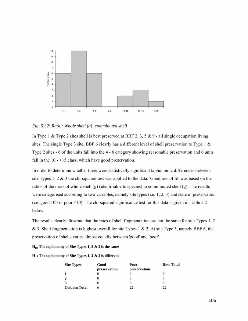
105
Fig. 5.32: Ratio: Whole shell (g): comminuted shell
In Type 1 & Type 2 sites shell is best preserved at BBF 2, 3, 5 & 9 - all single occupation living
sites. The single Type 3 site, BBF 6 clearly has a different level of shell preservation to Type 1 &
Type 2 sites - 6 of the units fall into the 4 - 6 category showing reasonable preservation and 6 units
fall in the 10 - >15 class, which have good preservation.
In order to determine whether there were statistically significant taphonomic differences between
site Types 1, 2 & 3 the chi-squared test was applied to the data. 'Goodness of fit' was based on the
ratios of the mass of whole shell (g) (identifiable to species) to comminuted shell (g). The results
were categorised according to two variables, namely site types (i.e. 1, 2, 3) and state of preservation
(i.e. good 10> or poor <10). The chi-squared significance test for this data is given in Table 5.2
below.
The results clearly illustrate that the rates of shell fragmentation are not the same for site Types 1, 2
& 3. Shell fragmentation is highest overall for site Types 1 & 2. At site Type 3, namely BBF 6, the
preservation of shells varies almost equally between 'good' and 'poor'.
H0: The taphonomy of Site Types 1, 2 & 3 is the same
H1: The taphonomy of Site Types 1, 2 & 3 is different
Site Types Good preservation
Poor preservation
Row Total
1 0 9 9 2 0 7 7 3 6 6 6 Column Total 6 22 22

106
Expected value 0 22 2 0 7 7 Site Types Good
preservation Poor preservation
Row Total
1 0 9 9 Expected value 0 22 3 6 6 6 Expacted value 6 22 Column total 6 22 22
Calculation Table for obtaining chi-squared value
Category Oi Ei (Oi-Ei) (Oi-Ei)2 (Oi-Ei)2
Ei
1 0 0 0 0 0 2 9 22 -13 169 8 3 0 0 0 0 0 4 7 22 -15 225 10 5 6 6 0 0 0 6 6 22 -16 256 12
X2 = 30
No. of degrees of freedom 2
Significance level α = 0.05
Chi-squared tabulated value 5.99
X2calc = 30 > X2α, reject Ho
Table 5.2: Chi-squared test for goodness of fit between site type and taphonomy based on ratio of mass of whole
or part-whole shell ( identifiable to species) (g) to mass of comminuted shell (g) .

107
A second chi-square test was applied to the shell mass data to determine whether shell preservation
was similar in single occupation and multiple occupation sites. The results were categorised
according to two variables, namely site types (i.e. single or multiple occupation) and state of
preservation (i.e. good >10 or poor <9). The chi-squared significance test for this data is given in
Table 5.3 below.
H0: The taphonomy of single occupation and multiple occupation sites is the same
H1: The taphonomy of single occupation and multiple occupation sites is different
Occupation Good preservation
Poor preservation
Row Total
Single 0 6 6 Multiple 6 16 22 Column Total 6 22 28 Occupation Good
preservation Poor preservation
Row Total
Single 0 6 6 Expected value 0 22 Multiple 6 16 22 Expected value 22 30 Column total 6 22 28 Calculation Table for obtaining chi-squared value
Category Oi Ei (Oi-Ei) (Oi-Ei)2 (Oi-Ei)2
Ei
1 0 0 0 0 0 2 6 22 -16 256 12 3 6 22 -16 256 12 4 16 30 -14 196 7 X2 = 31 No. of degrees of freedom 1
Significance level α = 0.05
Chi-squared tabulated value 5.99 X2calc
= 31 > X2α, reject Ho
Table 5.3: Chi-squared test for goodness of fit between single occupation and multiple occupation sites based on
ratio of mass of whole or part-whole shell ( identifiable to species) (g) to mass of comminuted shell (g) .
Discussion
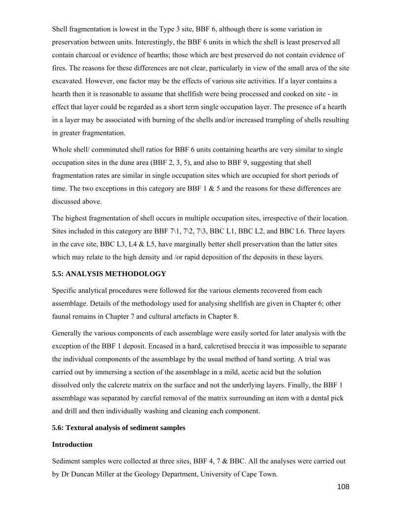
108
Shell fragmentation is lowest in the Type 3 site, BBF 6, although there is some variation in
preservation between units. Interestingly, the BBF 6 units in which the shell is least preserved all
contain charcoal or evidence of hearths; those which are best preserved do not contain evidence of
fires. The reasons for these differences are not clear, particularly in view of the small area of the site
excavated. However, one factor may be the effects of various site activities. If a layer contains a
hearth then it is reasonable to assume that shellfish were being processed and cooked on site - in
effect that layer could be regarded as a short term single occupation layer. The presence of a hearth
in a layer may be associated with burning of the shells and/or increased trampling of shells resulting
in greater fragmentation.
Whole shell/ comminuted shell ratios for BBF 6 units containing hearths are very similar to single
occupation sites in the dune area (BBF 2, 3, 5), and also to BBF 9, suggesting that shell
fragmentation rates are similar in single occupation sites which are occupied for short periods of
time. The two exceptions in this category are BBF 1 & 5 and the reasons for these differences are
discussed above.
The highest fragmentation of shell occurs in multiple occupation sites, irrespective of their location.
Sites included in this category are BBF 7\1, 7\2, 7\3, BBC L1, BBC L2, and BBC L6. Three layers
in the cave site, BBC L3, L4 & L5, have marginally better shell preservation than the latter sites
which may relate to the high density and /or rapid deposition of the deposits in these layers.
5.5: ANALYSIS METHODOLOGY
Specific analytical procedures were followed for the various elements recovered from each
assemblage. Details of the methodology used for analysing shellfish are given in Chapter 6; other
faunal remains in Chapter 7 and cultural artefacts in Chapter 8.
Generally the various components of each assemblage were easily sorted for later analysis with the
exception of the BBF 1 deposit. Encased in a hard, calcretised breccia it was impossible to separate
the individual components of the assemblage by the usual method of hand sorting. A trial was
carried out by immersing a section of the assemblage in a mild, acetic acid but the solution
dissolved only the calcrete matrix on the surface and not the underlying layers. Finally, the BBF 1
assemblage was separated by careful removal of the matrix surrounding an item with a dental pick
and drill and then individually washing and cleaning each component.
5.6: Textural analysis of sediment samples
Introduction
Sediment samples were collected at three sites, BBF 4, 7 & BBC. All the analyses were carried out
by Dr Duncan Miller at the Geology Department, University of Cape Town.

109
The objectives of the sediment collections were different for each site. At BBF 4 two samples were
collected, one from Square BD 7 located on the talus slope and one from BD 51 located within
ostensibly in situ deposit. The purpose of the collection was to determine whether a material
distinction could be made between the apparent in situ matrix and that on the talus slope.
Due to the presence of a dense, compact humic palaeosol at BBF 7 it was thought that its formation
might relate to the existence of a palaeovlei. Sediment was collected from Layers 7/1, 7/2 & 7/4.
The upper layer appeared to be aeolian dune sand and this sample was collected for use as a
comparative measure to determine, firstly, whether the sediments of Layer 7/2 & 7/4 were
materially different from that of the upper layer and, secondly, were sufficiently fine to be regarded
as vlei deposits. The lower samples were also examined for the presence of fresh-water molluscs.
Layer 7 at BBC lies beneath the aeolian sand deposits (now known as BBC Hiatus cf. Henshilwood
et al 2001a) which characterise the lowest LSA deposits at the cave, and directly above Layer 8
which contains MSA material. This was a particularly soft and organic layer which was not noted
elsewhere during excavation and is confined to the squares at the rear of the cave. It was thought
that textural analysis of a sample might provide some information relating to the formation of
sediments at the cave in the hiatus period between the LSA and the MSA.
Results
The criteria for typical sand sizes are => 2 mm or 63 microns and mud/silt < 63 microns. Based on
these criteria all the samples, except that from BBC, Layer 8/7, are typically sand, that is they have
a greater than 90% composition of sand. Layer BBC L7 is typically a muddy sand having just over
a 50% sand composition. The sample collected from BBF 4, Square BD 7 located on the talus
contained clean quartz and small pieces of abraded shell. Dirty quartz grains, minute pieces of shell
and echinoid spines characterised the sample from the in situ deposit in Square BD 51 at BBF 4.
Sediment from Layer 7/1 (YSL) at BBF 7 contained clean quartz, abraded echinoid spines and
small fragments of shell. In contrast, the sediment in Layer 7/2 (Hl1) and 7/4 (HL3) was dirty but
also consisted of uniform-size quartz crystals. The BBC sample consisted of clear, quartz grains of
a uniform size, minute pieces of shell, calcite globules, abraded echinoid spines and a large amount
of organic material which dissolved in H2O2.
All the sand fractions sent for sampling show a similar profile in a settling tube and the grain size
was that of medium sand (1-2 phi). Sorting of the sand is generally very good (± 0.35 phi) which
means there is a very small size distribution among grains. Plotted results show that the skewness of
all the samples is either very slightly positive or negative meaning that the sand fractions have

110
neither significantly fine nor coarse tails. No subordinate trend is therefore observable in the
samples.
After fine sieving the sediment collected from BBF 7 was examined for the presence of freshwater
molluscs by Dr. John Pether at the Iziko-South African Museum. Only terrestrial gastropods,
naturally occurring in the area at present, were identified indicating that the humic layers at BBF 7
are not due to sedimentation in a palaeovlei. All the indications are that the sediments from the
three BBF sites sampled are of marine origin, that is beach sand which has been wind transported
over no great distance to its present position. Although wind transported sediments have a fine tail,
the lack of this tail can be attributed to leaching of the sediments post-depositionally. A coarser tail
is present in the sample from BBC than in the other samples but the reason for this is not clear,
although some post-depositional alteration in the sediment content can be deduced from the profile
which contains almost 50% fines.
Discussion
Quartz grains of a similar size make up the major part of the sediments collected from all the sites
with the exception of the BBC sample. All the sand is of marine origin and has not been transported
a great distance suggesting that the present source of the dune sand at BBF is the nearby Blombos
Beach situated to the west, although at times of lowered sea levels in the past a greater supply of
sand may have been available from an exposed marine peneplane.
The presence of dirt and consequent staining of the sediment collected from the in situ deposit at
BBF 4 clearly distinguishes it from the talus sediment. This observation confirms that the central
portion of the deposit at the site is still contained within its original ash and organic matrix,
suggesting that it is in situ. Material on the talus has been relocated due to the actions of wind and
water erosion.
At the BBF 7 site, the upper layer 7/1 (YSL) sediments shows no sign of staining. The surrounding
matrix is clean quartz sand indicating that the assemblage was deposited after the formation of the
underlying humic deposits and probably at a time when the surrounding dune fields were active and
the area not heavily vegetated. Quartz crystals of a similar size to those recovered from the upper
7/1 (YSL) layer characterise the two lower humic layers 7/2 (HL1) and 7/4 (HL3), but the sediment
is dirty and stained. During the period of occupation of the lower layers the dunefield was probably
stable and more heavily vegetated than during the Layer 7/1 occupation, but the presence of a
palaeovlei here is unlikely.
During the hiatus period between the LSA and MSA occupations a humic rich layer of material was
deposited within the BBC site. It is highly likely that during periods of lower sea level in the Late

111
Pleistocene and early Holocene the entrance to the cave was blocked by aeolian marine sands
(Jacobs et al 2006). A layer of hyrax dung, removed from the surface of the cave prior to
excavation, confirms this practice and suggests that the humic material in Layer 8/7 is comprised, at
least partially, of hyrax coprolites. Hyraxes, Procavia capensis, habitually occupy crevices and
caves along this section of the coast and may have used the cave once a small opening was
revealed, perhaps after the mid-Holocene.
5.7: Radiocarbon Dating
Sixteen shell and charcoal samples collected in situ from BBF sites, were submitted to the CSIR,
Pretoria for radiocarbon dating (Table 5.4).
The C-14 half-life used is 5568 years. Ages are corrected for variations in isotope fractionation and
calibrated shell dates are corrected for the marine reservoir effect; 400 years should be subtracted
from uncalibrated shell dates to correct for the marine reservoir effect. Age has also been calibrated
for the southern hemisphere with the Pretoria programme (Talma & Vogel 1993). The calibrated
date is the most probable calendar date, with 1 sigma dates also listed. Funding for the sixteen
radiocarbon dates was supplied by The Swan Fund, Oxford.
Two sheep bone samples recovered from Layer 5 & 6 at BBC were submitted to the Oxford
University radiocarbon accelerator unit for dating (Table 5.5; Henshilwood 1996). The dates are
uncalibrated in radiocarbon years B.P. using the half life of 5568 years. Corrections have been
made for isotopic fractionation. Calibrated dates use the calibration curve of Stuiver & Pearson
(1993) plus 40 years for the southern hemisphere.
Site Layer Unit Sq. Ref. No. Dating
Material
14C Age
BP
± 1σ Calib-
rated
Date
1σ BC/
AD
BBF 1 B1 Pta-6177 Shell 6960 70 5437 5363 5308 BC BBF 2 I3 Pta-6181 Shell 6740 70 5230 5198 5123 BC BBF 3 B2 Pta-6180 Shell 5960 70 4361 4322 4241 BC BBF 4 DB21 Pta-6176 Shell 5680 70 4046 3985 3942 BC BBF 5 C2 Pta-6182 Shell 5520 70 3928 3802 3751 BC BBF 6 6/12HBL Pta-6178 Shell 4070 60 2064 1981 1899 BC 6/2 ASBA Pta-6709 Shell 3630 70 1468 1399 1327 BC BBF 7 7/1YSL B2 Pta-6179 Shell 3110 50 835 801 776 BC 7/4HL3 B2 Pta-6183 Shell 3170 25 888 846 826 BC BBC 5 MC4 E4 Pta-6185 Charcoal 1840 50 135 225 254 AD 5 MC4 E4 Pta-6175 Shell 2400 40 27 74 115 AD

112
5 MC4 E4 Pta-6246 Shell 2280 50 84 133 198 AD 5 MC4 E4 Pta-6247 Shell 2340 50 84 133 198 AD 1 COK E4 Pta-6184 Charcoal 290 20 1646 1651 1657 AD BBF 9 OH A2 Pta-6187 Charcoal 480 45 1426 1443 1461 AD OH A2 Pta-6248 Shell 940 50 1462 1493 1531 AD Table 5.4: Blombosfontein Nature Reserve: Shell & charcoal radiocarbon dates.
Layer Skeletal Part Reference No. Uncalibrated
radiocarbon
determination
(B.P.)
Calibrated 1σ date
range
δ 13C
5 Left mandible OxA-4543 1960 ± 50 3 -89 AD -12.6
6 Calcaneum OxA-4544 1880 ± 55 82-215 AD -12.9
Table 5.5: BBC: Sheep bone accelerator radiocarbon dates
5.8: Summary
Archaeological sites of Holocene age are scattered along the coastline between the Duivenhoks and
Goukou Rivers. Further sites are found within the De Hoop Nature Reserve to the west of Cape
Infanta.
Based on a set of criteria which fulfilled the objectives of this project the BBF area was selected for
more detailed investigation. A total of 21 Holocene sites were recorded at BBF and 9 selected for
excavation. Six of those sites selected were situated in the BBF dunefields on a coastal foreland,
and three on the seaward side of the southerly coastal cliffs.
All the sites selected were surveyed, drawn and measured and excavation commenced in October
1992. Detailed notes were kept and photographs taken during the excavations. Five of the sites,
BBF 1-5, were single occupation units and four sites, BBF 6, 7, 9 and BBC showed stratigraphic
evidence of repeated use. Excavations at BBF and BBC were completed in February, 1993.
Detailed descriptions of sites and, where applicable, stratigraphic units given in this chapter
illustrate diversity in site location, size, type, use and content. A distinct difference is observable
between open middens and shelter sites in the preservation of organic materials, particularly bone.
A textural analysis of sediment samples from three BBF sites provided useful evidence relating to
aspects of site formation. At the BBF 4 site a clear distinction could be made between in situ and
talus deposit. The suspected presence of a palaeovlei at BBF 7 was refuted by the evidence which
pointed rather to the presence of dense vegetation during the period this site was occupied. A
compact, organic palaeosol, uncharacteristic of other excavated layers at BBC, separated the LSA

113
and MSA units. Textural analysis of these BBC layer L7 sediments indicated the presence of a high
percentage of fine material in association with quartz sand of marine origin. This humic material is
attributed to the deposition of hyrax coprolites during a hiatus occupation period in the cave, and
may be associated with the closure of the cave entrance.
All the sediment analysed contained quartz crystals of a similar size and were of marine origin.
Blombos Beach, situated to the west of BBF, and a larger marine peneplain which existed during
the Late Pleistocene and Early Holocene, are the most likely source of the aeolian sands which
constitute the BBF dunefield.
Radiocarbon dates for the BBF sites were obtained from charcoal, shell and bone. The earliest site,
BBF 1, dates to 6960 ± 70 B.P. and the youngest, BBF 9, to 290 ± 20 B.P. The balance of the
excavated sites at BBF are spaced fairly evenly between the oldest and youngest dates. Some
pulsing is observable at around 6000 B.P., with five sites dating to between 5520 B.P. and 6960
B.P. Dates from the BBF 6 site show it was in use between 4070 B.P. (Layer 6\12) and 3630 B.P
(Layer 6\2) and BBF 7 between 3170 B.P. (Layer 7\4) and 3110 (Layer 7\1). Evidence of
occupation of the BBF area after 2000 B.P. is provided by the excavated units at BBC and BBF 9.
However, only the top and lower layers of BBC were dated and the dates for the middle layers are
not known, but it can be assumed they fall within the range of the upper and lower dates.
Accelerator radiocarbon dates of 1960 ± 50 B.P. and 1880 ± 55 B.P. obtained on sheep bone from
BBC are the earliest dates for sheep obtained by this direct method for the western, southern and
south-western Cape (Henshilwood 1996) and point to an early arrival for herding in the region.

114
CHAPTER 6
SHELLFISH ANALYSIS
6.1: Introduction
The rocky sections of the southern Cape coastline are richly endowed with a wide range of marine
fauna, most of which is edible by humans (Tietz & Robinson 1974; Branch & Branch 1981; Inskeep
1987; Branch et al 1999; Deacon & Deacon 1999; Henshilwood et al 2001). Hunter gatherers who
visited the BBF area during the Holocene utilised a wide range of marine species for food and some
of this diversity is reflected in Chapter 7. Although we are only able to reflect on the fauna which
leaves traces in the archaeological deposits, the range of marine fauna that was utilised by hunter
gatherers is undoubtedly far greater than the record shows. Some examples of marine organisms
eaten by local residents in the southern Cape today, and which would be mostly undetectable in the
BBF deposits, include octopus (Octopus granulatus), red bait (Pyura stolifera) which is stewed by
local farmers and said to be highly nutritious (cf. Bigalke 1973), sea cucumbers (e.g. Cucumaria
sp.), rock crabs (e.g. Cyclograpsus punctatus) (evidence of crabs seldom survives as the soft shells
are easily fragmented), and possibly some species of cartilaginous fishes (e.g. catsharks of the
Scyliorhinidae family) (cf. van der Elst 1988; Heemstra & Heemstra 2004). In environments, such
as the southern Cape, where marine species diversity is high (Branch & Branch 1981; Branch et al
1999), it may therefore be imprudent to make attempts at calculating, for instance, band size or
length of stay at a site based on the marine derived kilojoules provided by shellfish only. At best a
study based on the surviving marine evidence from archaeological deposits can represent only a
portion of the whole spectrum of marine species likely to have been exploited (cf. Bailey 1983;
Henshilwood 2001a).
Shellfish are a highly sustainable commodity, being sessile are easily gathered, and provide a
reliable source of high protein food. On the rocky, southern Cape shores shellfish species are
regularly zoned in bands, namely the Littorina, Upper Balanoid, Lower Balanoid, Cochlear and
Infratidal zones (Branch & Branch 1981; Branch et al 1999)(Figure 6.1). As these zones coincide
with the positions of the spring and neap tide high and low phases it means that, usually, a more
limited range of shellfish species can be gathered during the neap low tides. During spring low tide
a wider choice of species are exposed or available. By analysing the shellfish species found at BBF
sites we are able to surmise which bands of the rocky shore were exploited by humans and also the
likely tidal situation at the time the shellfish were collected. Some caution is needed, though, as
tidal conditions in this area can vary considerably depending on the sea, weather and season. In
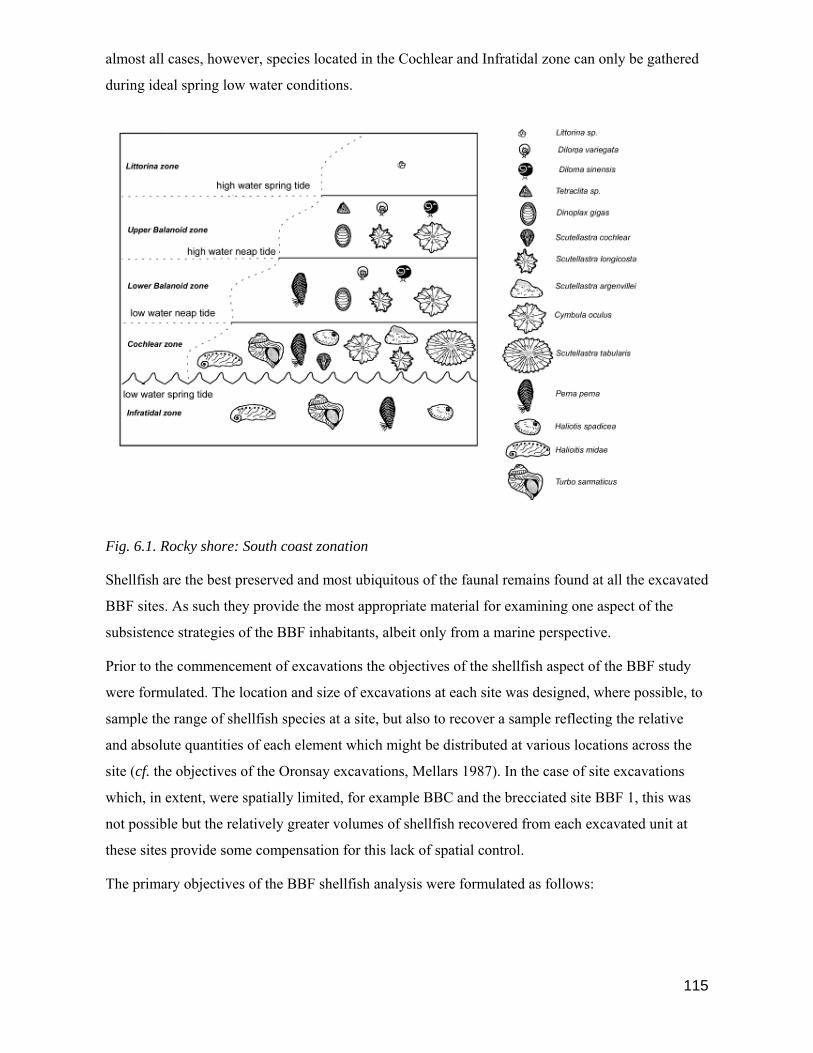
115
almost all cases, however, species located in the Cochlear and Infratidal zone can only be gathered
during ideal spring low water conditions.
Fig. 6.1. Rocky shore: South coast zonation
Shellfish are the best preserved and most ubiquitous of the faunal remains found at all the excavated
BBF sites. As such they provide the most appropriate material for examining one aspect of the
subsistence strategies of the BBF inhabitants, albeit only from a marine perspective.
Prior to the commencement of excavations the objectives of the shellfish aspect of the BBF study
were formulated. The location and size of excavations at each site was designed, where possible, to
sample the range of shellfish species at a site, but also to recover a sample reflecting the relative
and absolute quantities of each element which might be distributed at various locations across the
site (cf. the objectives of the Oronsay excavations, Mellars 1987). In the case of site excavations
which, in extent, were spatially limited, for example BBC and the brecciated site BBF 1, this was
not possible but the relatively greater volumes of shellfish recovered from each excavated unit at
these sites provide some compensation for this lack of spatial control.
The primary objectives of the BBF shellfish analysis were formulated as follows:
116
1. To establish the range of shellfish species exploited at each of the nine excavated sites and within
each of the distinct occupation units and to quantify these both in terms of relative and absolute
values.
2. To compare, on an equitable basis, the species ranges and relative and absolute quantities of a
species from each site/unit with those of other BBF sites/units, taking into account spatial and
temporal variations and site types (cf. Ch. 5).
3. To determine from the shellfish species represented at each site/unit the range of inter-tidal zones
exploited and to ascertain whether there is a relationship between site age and/or location and the
inter-tidal zone exploited.
4. To examine whether there is a spatial and/or temporal relationship between the size of measured
shells for selected species recovered from the various BBF sites, and whether size differences may
relate to human predation pressure or palaeoenvironmental factors or both.
5. To compare the range of shellfish species exploited at all BBF sites to that likely to have been
available for exploitation on the BBF coastline, taking into account seasonal availability and
palaeoenvironmental factors such as rising and falling sea levels, sea temperature changes and
changes in the morphology of the coastline.
In order to satisfy the objectives of the study it was essential to establish what the shellfish project
aimed to accomplish prior to the commencement of fieldwork and laboratory analysis. To meet
these objectives a programme was drawn up stating the mimimum data which would be required,
namely, the range of species exploited by site/unit, the shell weights (g) and MNI's per species per
site/unit and the individual shell measurements by species for each site/unit (for more details cf.
Section 6.2 below).
6.2: Analysis Methodology
The shellfish recovered from 9 BBF sites, comprising 28 units, forms the basis for this study. All
whole shells or shell fragments larger than 1.5 mm in size were retained, initially in bulk, for later
sorting and identification, where possible, to species. MNI's were calculated and the shell weight
(g) of a species recorded for each unit (cf. Table 6.1 & Table 6.2 below ); additionally all whole
shells were measured. A distinction was made between 'food' shellfish species and those species
unlikely to have been eaten but that were incidentally carried to a site attached to larger shells or by
some other means (Table 6.3). For instance, certain species of juvenile Patella attach themselves to
mussels to avoid detection; other shell species live among the byssus threads of mussels; S.
cochlear juveniles live on adult shells; juvenile S. longicosta attach themselves to winkles (Branch
& Branch 1981; Branch et al 1999). It is possible that some of the smaller shells were deliberately

117
collected, perhaps to be used for decorative purposes; for example, Nassarius kraussianus shells
recovered from Nelson Bay Cave were deliberately pierced, perhaps to be threaded and worn as
necklaces, arm bands or sown to garments (Inskeep 1987:178). However, unless a shell displayed
evidence of deliberate human alteration (cf. Ch. 8 for examples) it was classified either as 'food' or
incidental. Fragments and unidentifiable pieces of comminuted shell were listed as shell residue (cf.
Ch. 5).
Species >
Haliotis midae
Haliotis spadicea Perna perna Donax serra
Dinoplax gigas
Chiton crawfordi
Scutellastra argenvillei
Scutellastra cochlear
Scutellastra tabularis
Patella barbar
a Scutellastra longicosta
Site n n n n n n n n n n n
BBF 1 1 15 50 2 0 0 0 0 2 5 10
BBF 2 0 166 842 5 1 8 0 0 1 2 155
BBF 3 4 74 112 2 5 2 0 2 79 37 498
BBF 4 1 3 14 26 9 3 0 2 22 2 333
BBF 5 0 0 7 0 0 0 2 3 71 3 38 BBF 6/1 1 25 4 0 0 1 10 53 1 6 57 BBF 6/2 1 19 94 0 0 1 9 129 1 1 59 BBF 6/3 0 19 37 0 0 3 4 23 0 0 16 BBF 6/4 2 29 21 0 0 3 5 12 1 0 17 BBF 6/5 1 11 2 0 0 1 2 3 0 0 22 BBF 6/6 1 10 1 0 0 4 5 5 0 1 20 BBF 6/7 0 11 4 0 0 2 0 7 0 2 12 BBF 6/8 1 302 38 0 0 1 1 5 1 0 22 BBF 6/9 0 1 33 0 0 0 0 1 0 2 5 BBF 6/10 0 1 0 0 0 0 0 0 1 0 1 BBF 6/11 0 2 0 0 0 1 1 0 1 0 54 BBF 6/12 0 6 2 0 0 1 0 0 1 0 36 BBF 7/1 0 11 302 0 0 0 4 15 1 7 119 BBF 7/2 0 8 151 0 0 0 0 0 0 1 20 BBF 7/3 0 10 212 0 0 0 3 0 0 2 28 BBF 7/4 0 45 307 0 0 0 1 6 1 8 60
BBC L1 1 3 7 0 0 0 0 8 0 0 0
BBC L2 0 9 42 4 1 5 5 68 0 0 32
BBC L3 0 0 5 0 0 0 2 15 0 0 5
BBC L4 0 65 270 4 0 4 27 419 0 2 191
BBC L5 0 13 31 0 0 1 2 149 0 0 44
BBC L6 0 0 8 1 0 1 0 34 0 0 8
BBF 9 9 64 52 0 16 12 18 1 3 1 20
Table 6.1: MNI of all shellfish species from BBF units

118
Species >
Haliotis midae
Haliotis spadicea Perna perna Donax serra
Dinoplax gigas
Chiton crawfordi
Scutellastra argenvillei
Scutellastra cochlear
Scutellastra tabularis
Patella barbar
a Scutellastra longicosta
Site g g g g g g g g g g g
BBF 1 25 223 278 18 0 0 2 0 163 51 259
BBF 2 0 1741 4417 15 3 7 0 0 164 26 3350
BBF 3 171 824 414 3 11 3 14 24 4472 1046 7896
BBF 4 131 66 14 28 12 0 0 21 1696 34 3755
BBF 5 0 7 6 0 0 0 36 21 5671 124 350 BBF 6/1 149 221 14 0 0 0 155 429 78 88 587 BBF 6/2 61 228 786 0 0 1 130 1071 126 24 803 BBF 6/3 0 181 290 0 0 1 60 216 0 0 239 BBF 6/4 97 338 300 0 0 3 101 130 34 0 306 BBF 6/5 34 0 43 0 0 2 35 30 0 0 582 BBF 6/6 36 58 1 0 0 3 114 48 0 75 410 BBF 6/7 2 127 65 0 0 1 0 53 3 8 239 BBF 6/8 29 273 452 0 0 0 16 43 49 0 362 BBF 6/9 3 24 228 0 0 0 0 10 1 7 66 BBF 6/10 0 4 6 0 0 0 0 0 80 0 9 BBF 6/11 0 20 0 0 0 0 31 0 124 0 797 BBF 6/12 0 52 10 0 0 0 1 0 95 0 491 BBF 7/1 0 109 944 0 0 0 68 87 59 125 1058 BBF 7/2 0 42 438 0 0 0 2 2 4 11 253 BBF 7/3 0 76 1022 0 0 0 57 0 18 36 430 BBF 7/4 0 418 2402 0 0 0 20 60 67 165 814
BBC L1 20 18 38 0 0 0 12 50 0 0 19
BBC L2 0 51 92 14 0 1 99 516 0 0 467
BBC L3 0 0 0 0 0 0 15 129 7 0 57
BBC L4 8 544 2284 16 0 1 571 3298 0 49 2561
BBC L5 0 134 251 0 0 0 33 1160 0 0 664
BBC L6 0 3 0 0 0 0 0 287 0 0 106
BBF 9 480 619 330 0 60 23 317 3 168 10 331
Table 6.2: Mass (g) of all shellfish species from BBF sites
Site no. > BBF
1 BBF
2 BBF
3 BBF
4 BBF
5 BBF
6 BBF
7 BBC BBF
9
n n n n n n n n n
Species
Assiminea ovata 1

119
Austramitra sp. 1
Austromegabalanus cylindricus 5
Barbatia obliquata 1 1
Burnupena cincta 3 1 3 4 7
Calliostoma africanum 1
Calliostoma sp. 1
Chlamys tincta 11
Clionella taxea 1
Coronula diadema 2
Crepidula porcellana 1
Cthalamus dentatus 1
Dendrofissurella scutellum 1 1
Diadora sp. 2
Duplicaria capensis 2
Fauxulus capensis 1
Fauxulus capensis 1
Fissurella mutabilis 1 1 7
Gibbula sp. 2
Helcion pectunculus 1 7
Helcion pruinosus 1 3
Helcion sp. 3 1
Homalopoma quantillum 1
Lasaea adansoni turtoni 1
Limaria rotundata 55 1
Littorina knysnaensis 6021
Macoma litoralis 1
Nassarius kraussianus 388
Nucella cingulata 2
Nucella squamosa 3 1 6 1
Ocenebra babingtonii 3
Ocenebra fenestrata 2 6
Ocenebra purpuroides 1
Ocenebra scrobiculata 1 1 8 1
Octomeris angulosa 1
Ostrea sp. 1 1 2
Diloma variegata 11
Reclusia rollandiana 1
Sheldonia cotyledonis
Siliquaria wilmanae
Siphonaria aspera 1
Siphonaria capensis
Siphonaria concinna 1 1
Terebra suspensa 1
Tetraclita serrata 2
Thais castanea 3
Thecalia concamerata 2
Trachycystis bisculpta 1
Trachycystis capensis 1
Tricolia capensis 2
Trimusculus costatatus 2
Tropidophora ligata 1 2

120
Turbo cidaris 2
Turritella carinifera 2 1 20
Venus verrucosa 1 1
Vermetus sp. 1
Table 6.3: MNI’s of ‘incidental’ shellfish species recovered from BBF sites
Gastropoda
Turbo sarmaticus
Unit values for Turbo sarmaticus were derived by counting the numbers of columella and opercula;
the highest respective value was regarded as the MNI. Opercula lengths were recorded and the
height of whole Turbo shells measured from the apex to the outside edge below the shell opening
(following the method of Yssel 1989:16).
Diloma sp .
Initially an attempt was made to separate the Diloma sub-species (i.e. D. sinensis, D. tigrina & D.
variagata) and to count the columella for each species. However, due to the small size of the shells
and high breakage patterns (probably in the process of meat extraction) it was realised that this
approach was too inaccurate and an alternative method was sought.
On five separate occasions 100 live Diloma sp. were collected from random locations in the Upper
and Lower Balanoid Zone. Generally, there was some skewing in the collection process towards
larger animals but no particular preference was given to the sub-species chosen, although D.
sinensis occurred most commonly. Similarly, D. sinensis was the dominant Diloma sp. recovered
from BBF sites. The collected sample was boiled to remove the meat, the shells were washed and
left to dry in the sun for one week. Each batch of dry shells was then weighed. The results are listed
in Table 6.4 below.
Diloma sp. shells for each excavated unit were weighed and the mass (g) divided by the mean mass
of the 500 samples listed below (i.e. 542 g) to calculate MNI's.

121
Sample No. n Dry Shell Mass
(g)
1 100 511
2 100 535
3 100 552
4 100 552
5 100 559
Mean 542
Table 6.4: Diloma sp.: Dry mass (g) of 5 x 100 shells
Haliotis midae & Haliotis spadicea
The two sub-species of Haliotis sp. were separated and MNI's calculated on the number of apices;
shell mass was recorded.
Patellidae
Patella/Scutellastra were sorted to species and MNI values calculated by counting the number of
apices. The lengths of unbroken limpet shells were measured and the total mass of shell (g)
identified to a species was recorded.
Bivalvia
Perna perna & Donax serra
MNI values for Perna perna and Donax serra were calculated by using hinges, separating left and
right sides. The lengths of whole shells for both species were measured. An attempt was made to
determine the original lengths of broken Perna perna shells using the method advocated by Hall
(1980) which examines the relationship between measurements of the pedal retractor muscle scar
and the length of the complete specimen. In almost all specimens examined the pedal retractor scar
was obscured by calcium carbonate deposits and the method was therefore not considered
satisfactory for establishing the length of the broken mussel shells from BBF sites.

122
Polyplacophora
Dinoplax gigas & Chiton crawfordi
The plates of chitons are divided into terminal and medial groups. Frontal and terminal plates were
sorted according to species and size and MNI's established. All the recovered shell plates were
weighed.
6.3: Shellfish analysis by site/unit
The first objective was to establish the total range of shellfish which was collected by the
inhabitants of each of the units or layers at all nine of the excavated BBF sites, and to quantify these
in terms of relative and absolute values. Two approaches were adopted, firstly to calculate MNI's
and secondly the weight (g) of shell for each species. The reason for adopting both methods is that
different sets of information or patterning are reflected by MNI's and by weight. For example, a
high number (MNI) of the small winkle, Diloma sp. conversely has a relatively small weight (g). If
the dominant species for a site was calculated using the MNI method only, it would elevate Diloma
sp., which was collected in large numbers, to a prominent position. A much larger gastropod, such
as Turbo sarmaticus, which may have contributed a substantially higher meat weight, but had a
lower MNI count, may then appear to be under-represented. Ideally, the flesh weight of each
individual of a species should be calculated for all sites and cross-comparisons made on this basis,
but a project of this magnitude was beyond the scope of this study. In the event, the overall
patterning in species diversity and dominance for each site/unit, and across sites/units, became
clearer when both MNI and mass tables were considered together and this approach was considered
satisfactory.
The results of the elementary shellfish analysis are presented in Tables 6.1 & 6.2 above. Fifteen
species of shellfish were exploited by the BBF inhabitants for food although the whole range of
species is not found at all sites. Only two species, Turbo sarmaticus and Diloma sp. occur at all
sites/units; other shellfish commonly gathered for food include Haliotis spadicea, Perna perna, and
various Patella sp. The rarest shellfish are Patella granularis, Chitons, Haliotis midae and Donax
serra.
6.4: Inter-site/unit shellfish analysis
The objective of this part of the shellfish study was to compare, on an equitable basis, the species
ranges and relative and absolute quantities of a species from each site/unit with those of other BBF
sites/units taking into account spatial and temporal variations and site types.

123
Establishing an equal basis which allows for inter-site or inter-unit comparisons of assemblage
components is a common problem encountered by archaeologists. One of the more usual methods is
to record the total volume of deposit excavated from a unit (e.g. bucket counts converted to mass
per cu. m.) and to express the recorded mass or MNI of a component as mass per unit volume of
excavated deposit, or MNI per unit volume of deposit , respectively (e.g. Voigt 1973, 1975;
Buchanan et al 1984; Thackeray, J.F. 1988).
There are a number of drawbacks to this method; firstly the commodity we wish to study makes up
a part of the volume of excavated deposit, therefore the resultant equation is influenced by the
respective volume of that category we wish to analyse. Secondly, there are subjective decisions
made during an excavation with regard to the amount of matrix recovered which surrounds the
deposit. For example, the amount of dune sand recovered during the excavation of an open, single
occupation dune site may vary, depending on the excavator. Seldom is the in situ deposit so clearly
stratified that only that layer is excavated. Parts of the assemblage may migrate up into the
overburden or into the underlying layers and inevitably sand from above and below the deposit will
be included during recovery, thus increasing the volume of recovered deposit.
Thirdly, the mass of excavated deposit may be influenced by uncontrollable factors which falsely
inflate the mass of deposit for a particular square or unit. For example, a single, large grindstone
weighing several kilograms will add substantially to the total mass recovered from a single square
or unit and may distort comparisons with other units or sites, particularly where stone is absent.
An alternative method was therefore sought which would allow for more objective inter-site/unit
comparisons at BBF. The first step was to eliminate some of the background 'noise' contributed by
shellfish species infrequently found at BBF sites.
Species >
Haliotis spadicea Perna perna
Scutellastra cochlear
Scutellastra tabularis
Scutellastra longicosta
Cymbula oculus Diloma sp.
Turbo sarmaticus
Site
BBF 1 3 4 1 2 5
BBF 2 3 5 2 1 4
BBF 3 2 1 4 3 5
BBF 4 1 4 2 3 5
BBF 5 4 3 1 2 5
BBF 6/1 2 4 5 1 3
BBF 6/2 4 5 3 2 1
BBF 6/3 2 5 3 1 4
BBF 6/4 4 3 1 2 5
BBF 6/5 3 1 2 4 5
BBF 6/6 3 1 2 4 5
BBF 6/7 3 1 2 4 5
BBF 6/8 3 4 2 1 5

124
BBF 6/9 5 1 3 2 2 4 BBF 6/11 1 5 3 4 4 BBF 6/12 1 5 3 3 2
BBF 7/1 4 2 1 4 5
BBF 7/2 1 5 2 4 3
BBF 7/3 5 2 1 4 3
BBF 7/4 1 5 2 5 3
BBC L1 1 2 3 5 4
BBC L2 1 3 2 5 4
BBC L3 1 4 2 5 3
BBC L4 3 4 1 5 1
BBC L5 3 5 4
BBC L6 1 4 2 5 3
BBF 9 2 1 2 3 5 4
Table 6.5. Shellfish seriation of the 5 most common species per site/unit based on MNI’s. Weighted
values are in descending order of importance.
Species >
Haliotis spadicea Perna perna
Scutellastra argenvillei
Scutellastra cochlear
Scutellastra tabularis
Scutellastra longicosta
Cymbula oculus Diloma sp.
Turbo sarmaticus
Site
BBF 1 2 4 1 3 5
BBF 2 2 4 3 1 5
BBF 3 3 4 1 2 5
BBF 4 3 4 1 2 5
BBF 5 4 3 2 1 5
BBF 6/1 2 1 3 4 5
BBF 6/2 1 2 4 3 5
BBF 6/3 1 4 2 3 5
BBF 6/4 4 2 1 3 5
BBF 6/5 3 2 1 4 5
BBF 6/6 2 3 1 4 5
BBF 6/7 3 2 1 4 5
BBF 6/8 3 4 1 3 5
BBF 6/9 1 4 2 3 5 BBF 6/11 1 3 4 2 5 BBF 6/12 1 5 3 2 4
BBF 7/1 2 3 1 4 5
BBF 7/2 4 2 1 3 5
BBF 7/3 4 2 1 3 5
BBF 7/4 1 4 2 3 5
BBC L1 1 2 3 4 5
BBC L2 2 1 3 5 4
BBC L3 3 1 2 5 4
BBC L4 3 1 2 5 4
BBC L5 3 2 1 4 5
BBC L6 4 2 1 5 3
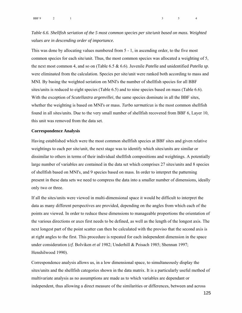
125
BBF 9 2 1 3 5 4
Table 6.6. Shellfish seriation of the 5 most common species per site/unit based on mass. Weighted
values are in descending order of importance.
This was done by allocating values numbered from 5 - 1, in ascending order, to the five most
common species for each site/unit. Thus, the most common species was allocated a weighting of 5,
the next most common 4, and so on (Table 6.5 & 6.6). Juvenile Patella and unidentified Patella sp.
were eliminated from the calculation. Species per site/unit were ranked both according to mass and
MNI. By basing the weighted seriation on MNI's the number of shellfish species for all BBF
sites/units is reduced to eight species (Table 6.5) and to nine species based on mass (Table 6.6).
With the exception of Scutellastra argenvillei, the same species dominate in all the BBF sites,
whether the weighting is based on MNI's or mass. Turbo sarmaticus is the most common shellfish
found in all sites/units. Due to the very small number of shellfish recovered from BBF 6, Layer 10,
this unit was removed from the data set.
Correspondence Analysis
Having established which were the most common shellfish species at BBF sites and given relative
weightings to each per site/unit, the next stage was to identify which sites/units are similar or
dissimilar to others in terms of their individual shellfish compositions and weightings. A potentially
large number of variables are contained in the data set which comprises 27 sites/units and 8 species
of shellfish based on MNI's, and 9 species based on mass. In order to interpret the patterning
present in these data sets we need to compress the data into a smaller number of dimensions, ideally
only two or three.
If all the sites/units were viewed in multi-dimensional space it would be difficult to interpret the
data as many different perspectives are provided, depending on the angles from which each of the
points are viewed. In order to reduce these dimensions to manageable proportions the orientation of
the various directions or axes first needs to be defined, as well as the length of the longest axis. The
next longest part of the point scatter can then be calculated with the proviso that the second axis is
at right angles to the first. This procedure is repeated for each independent dimension in the space
under consideration (cf. Bolviken et al 1982; Underhill & Peisach 1985; Shennan 1997;
Henshilwood 1990).
Correspondence analysis allows us, in a low dimensional space, to simultaneously display the
sites/units and the shellfish categories shown in the data matrix. It is a particularly useful method of
multivariate analysis as no assumptions are made as to which variables are dependant or
independent, thus allowing a direct measure of the similarities or differences, between and across

126
each of the variables (Underhill & Peisach 1985). This factor is particularly important when
analysing the BBF sites as it is not obvious which variables should be regarded as dependent, and
which independent. From the scattergram produced, the patterning in the data can be visually
appreciated allowing for recognition of clustering of sites/units, and also the relationship between
sites/units and shellfish categories. The display of the data in two dimensions shows on the one
hand those sites/units which are similar, and on the other the correlation between the shellfish
categories (cf. Henshilwood 1990).
In order to appreciate the spatial relationship of each of the sites/units and shellfish categories we
need to understand why they are clustered. The ranked, raw data matrix, shown in Tables 6.5 & 6.6,
is converted by a set of mathematical equations into a simultaneous display of sites/units and
shellfish categories using the DECORANA program. Due to a reduction in dimensionality from
eight or nine dimensions to two some of the data's original integrity is lost. If the first principal
component, defined as a comparison of sites/units and shellfish categories, is projected onto a single
line (Axis 1), this becomes the principal axis of inertia and the maximum inertia (or line of closest
fit) explains 42.7% of the total inertia.
Inertia describes the total amount of information in the data matrix (Underhill pers. comm.);
geometrically, inertia may be thought of as weighted spread or dispersion (Greenacre 1981). By
projecting the 27 sites/units onto a single line, 57.3 % of the inertia is lost. If a second component is
introduced then the second axis, at right angles to the first, accounts for a further 27.2 % of the
inertia. Thus by projecting 27 sites/units and 8 or 9 categories of shellfish onto two axes, and
reducing them to two dimensions, the plane of the first two axes accounts for 69.9% of the total
inertia; 30.1% of the inertia has been lost (Underhill & Peisach 1985; also cf. Henshilwood 1990).
Interpretation of the Scattergrams (Figs. 6.2, 6.3 & 6.4)
The information contained in Tables 6.5 & 6.6 is conveyed graphically in Figs. 6.2, 6.3 & 6.4 after
conversion of the data by the DECORANA program. Underhill & Peisach (1985:55) have identified
three basic principals for interpreting correspondence analysis scattergrams and these can be
applied to the BBF data. Sites/units which cluster closely together tend to be similar in their profiles
of shellfish categories, that is high values are associated with high values and vice versa. The same
principle can be applied to the shellfish categories. Distances between a site/unit point and a
shellfish category point have no interpretative value. The joint interpretation of shellfish category
points, and site/unit points, is through the transition formulae contained in the DECORANA
program. Thus, site/unit points on the scattergram are attracted away from the origin in the direction
of the shellfish categories for which they have high scores. Site/unit points falling close to the
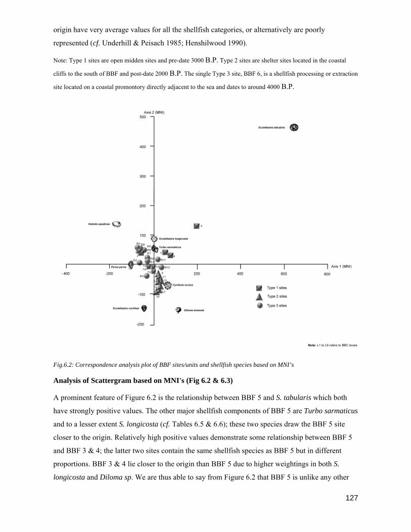
127
origin have very average values for all the shellfish categories, or alternatively are poorly
represented (cf. Underhill & Peisach 1985; Henshilwood 1990).
Note: Type 1 sites are open midden sites and pre-date 3000 B.P. Type 2 sites are shelter sites located in the coastal
cliffs to the south of BBF and post-date 2000 B.P. The single Type 3 site, BBF 6, is a shellfish processing or extraction
site located on a coastal promontory directly adjacent to the sea and dates to around 4000 B.P.
Fig.6.2: Correspondence analysis plot of BBF sites/units and shellfish species based on MNI’s
Analysis of Scattergram based on MNI's (Fig 6.2 & 6.3)
A prominent feature of Figure 6.2 is the relationship between BBF 5 and S. tabularis which both
have strongly positive values. The other major shellfish components of BBF 5 are Turbo sarmaticus
and to a lesser extent S. longicosta (cf. Tables 6.5 & 6.6); these two species draw the BBF 5 site
closer to the origin. Relatively high positive values demonstrate some relationship between BBF 5
and BBF 3 & 4; the latter two sites contain the same shellfish species as BBF 5 but in different
proportions. BBF 3 & 4 lie closer to the origin than BBF 5 due to higher weightings in both S.
longicosta and Diloma sp. We are thus able to say from Figure 6.2 that BBF 5 is unlike any other
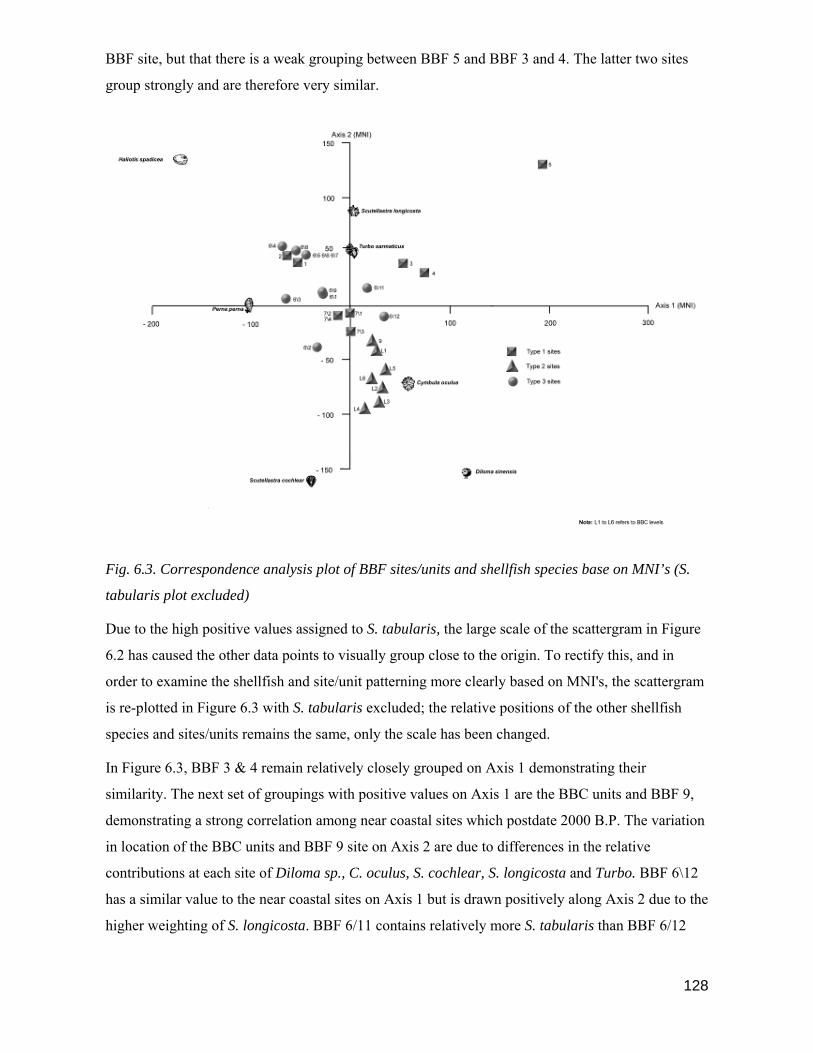
128
BBF site, but that there is a weak grouping between BBF 5 and BBF 3 and 4. The latter two sites
group strongly and are therefore very similar.
Fig. 6.3. Correspondence analysis plot of BBF sites/units and shellfish species base on MNI’s (S.
tabularis plot excluded)
Due to the high positive values assigned to S. tabularis, the large scale of the scattergram in Figure
6.2 has caused the other data points to visually group close to the origin. To rectify this, and in
order to examine the shellfish and site/unit patterning more clearly based on MNI's, the scattergram
is re-plotted in Figure 6.3 with S. tabularis excluded; the relative positions of the other shellfish
species and sites/units remains the same, only the scale has been changed.
In Figure 6.3, BBF 3 & 4 remain relatively closely grouped on Axis 1 demonstrating their
similarity. The next set of groupings with positive values on Axis 1 are the BBC units and BBF 9,
demonstrating a strong correlation among near coastal sites which postdate 2000 B.P. The variation
in location of the BBC units and BBF 9 site on Axis 2 are due to differences in the relative
contributions at each site of Diloma sp., C. oculus, S. cochlear, S. longicosta and Turbo. BBF 6\12
has a similar value to the near coastal sites on Axis 1 but is drawn positively along Axis 2 due to the
higher weighting of S. longicosta. BBF 6/11 contains relatively more S. tabularis than BBF 6/12

129
but less Diloma sp. giving it a higher positive rating on Axis 2 and drawing the site closer towards
BBF 3 & 4.
Fig. 6.4: Correspondence analysis plot of BBF sites/units and shellfish species based on mass (g).
BBF 7\1, 7\2, 7\3 & 7\4 cluster around the origin suggesting a strong grouping in one respect, that
is they contain similar proportions of the same species, but in another respect it shows that these
four sites are the least differentiated from all the other BBF sites. The BBF 6\1, 6\9 & 6\2 units are
similarly grouped on Axis 1, the only minor difference being in the relative proportions of S.
longicosta and S. cochlear causing the spatial difference between 6\2 and 6\1 and 6\9 on Axis 2.
BBF 1, 2, 6\4, 6\5, 6\6, 6\7 & 6\8 form a strong group on both Axis 1 & Axis 2 containing the same
species of shellfish in similar proportions. BBF 6\3 is also similar to this last group but with a
higher rating for P. perna causing it to be drawn closer to Axis 1.
A summary of the interpretations of the scattergrams (Figures 6.2 & 6.3) shows there is
considerable variation in the shellfish component of Type 1 sites, namely open, single occupation
dune sites. BBF 5 is different from all the other BBF sites; BBF 3 & 4 are similar to one another;
BBF 1 & 2 are grouped but dissimilar to other Type 1 sites. The only multi-occupation, Type 1,

130
dune site, BBF 7 shows continuity in the shellfish component in all four units, BBF 7\1 -7\4, but the
BBF 7 units are the least differentiated from all other BBF sites.
The Type 2 sites, BBC (all units) and BBF 9 are strongly clustered, suggesting that the shellfish
component of near coastal shelter sites, which post-date 2000 B.P., are distinct and different from
that of all earlier Type 1 sites located in the dune area, and to the Type 3 site, BBF 6. There are also
strong associations between the BBC L1 layer and BBF 9 site, which are of a similar age; the older
units, BBC L2 - L6, are also tightly correlated, suggesting that although shellfish subsistence
strategies at BBF have been similar during the last 2000 years, there are some changes observable
within early and later Type 2 sites/units.
Although there are similarities among some of the units from the single Type 3 site, BBF 6, (e.g.
BBF 6\4-6\7; BBF 6\11 & 6\12), overall there is no coherence in the shellfish patterning across the
various layers. At times therefore, BBF 6 units look similar to Type 1 sites, and to a lesser extent
Type 2 sites. The result suggests there was no cohesive strategy in terms of the shellfish species
targeted for collection and brought to BBF 6. One reason may be that the site is situated directly
adjacent to the shell beds. If the site was used for 'snacking' or processing (see Henshilwood et al
1994) then it is possible that a range of shellfish in the vicinity of the site were opportunistically
gathered for on-site consumption or extraction. Species which are noticeably absent at the BBF 6
site are Diloma sp (all layers) and C. oculus (Layers 6\8 - 6\1).
Some shellfish may have been processed or shucked on site for transport to occupation sites
situated elsewhere, perhaps further inland. If this was the case then we would not expect Diloma sp.
to have been processed on site due to their small size, and this might account for their absence. On
the other hand Diloma sp may simply have been avoided; in any event their absence at BBF 6 is
unlikely to have been due to environmental factors, such as changes in sea temperature, or this
would also reflect on the presence/absence of other species which occupy the same habitat as
Diloma sp.
The location of the points for shellfish categories on the scattergrams indicates which sites are most
strongly affiliated to which species. As expected Turbo falls relatively close to the origin as it is
strongly associated with all the BBF sites. BBF 5, and to a lesser extent BBF 3, 4 and 6\11 are
characterised by having relatively high quantities of S. tabularis. The positions of C. oculus,
Diloma sp. and S. cochlear show strong affinities with the post 2000 B.P. sites, BBC (all units) and
BBF 9. The relative quantities of Haliotis spadicea, Perna perna and S. longicosta from BBF 1, 2 ,
6/4, 6/5, 6/6, 6/7, 6/8 have caused these sites/units to be relatively loosely grouped on Axis 1, but
more tightly grouped on Axis 2. All the BBF 7 layers are plotted close to the origin as they have no

131
distinguishing features which draws them strongly in any one direction. The BBF 7 layers are thus
least differentiated from the other BBF sites.
Analysis of Scattergram based on Mass (Figure 6.4)
Although the relative positions of the sites and shellfish categories plot differently on the
scattergram calculated from shell mass to that based on MNI's, the overall groupings are very
similar to those described in the previous section. The most obvious grouping, again, is within the
post 2000 B.P. sites, BBC (all layers) and BBF 9, on both Axis 1 and Axis 2. Clearly the shellfish
content of these sites distinguishes this group from the other, and earlier, BBF sites. The BBF 7
layers are also loosely correlated on Axis 1 and Axis 2, but now lie further from the origin due to
the influence of a high Turbo mass and low Diloma sp. mass. (cf. Section 6.3). BBF 3 & 4 are
plotted on the same point and show a strong affinity with BBF 5; there is still a loose grouping of
these three sites with BBF 6\11 & 6\12. The balance of the BBF 6 units, with the exception of BBF
6\4, are loosely grouped on Axis 1 and Axis 2. BBF 1 & 2 group on Axis 1 with similar Axis 1
values to BBF 3, 4 & 5. However BBF 1 & 2 are less positive on Axis 2 due to the strong presence
of Perna perna in these two sites, which are not found in BBF 3, 4 & 5, and also because of the
presence of Haliotis spadicea in BBF 1 & 2.
Summary of Shellfish Analysis based on MNI and Mass
In summary, there is a strong correlation among all the Type 2 sites/units, BBC (all layers) and
BBF 9; these sites are also distinctly different from Type 1 and Type 3 sites, suggesting a change
occurred in shellfish subsistence strategies at BBF after 2000 B.P. This change appears to be a
function of the length of time a site was occupied, the tidal situation at the time the shellfish were
collected and/or possibly human predation pressure leading to reduced availability of some species,
rather than to site location, as the species mix found in the Type 3 site, BBF 6 (all layers), also
situated on the coast, is distinctly different from that of the later period near coastal sites/units. In
Type 2 sites Turbo features less strongly than in earlier sites and Diloma sp. becomes the dominant
shellfish component followed by S. cochlear, C. oculus. and S. longicosta. Species that are absent,
or only occur in small quantities in the post 2000 B.P. sites include Perna perna, S. argenvillei, S.
tabularis and Haliotis spadicea.
The Type 1 site, BBF 7 (all layers) which predates Type 2 sites (ca 3000 B.P.) is more similar in
species mix and relative quantities to Type 2 sites than are the earlier Type 3 and Type 1 sites. The
main differences between BBF 7 and the Type 2 sites are the presence of relatively high quantities
of Perna perna at BBF 7 and the absence of S. cochlear. The latter is found in all layers at BBC &

132
9. This trend reinforces the observation that changes in the species composition at BBF are related
to length of occupation and tidal conditions, and are not a function of site location.
The upper layers of the Type 3 site, BBF 6, namely 6\1 - 6\9, correlate more closely with one
another than with BBF 6\11 & 6\12, due to the influence of S. tabularis in the latter two layers,
again suggesting a temporal influence on species mix. Scutellastra tabularis is most common in
sites predating ca. 3700 B.P. and occurs rarely in later sites. However, the mix of shellfish species
found at BBF sites is not necessarily time related: for instance, BBF 6\11 & 6\12 (ca. 3670 B.P.) are
not dissimilar to BBF 3 & 4 (ca. 5300 B.P.), despite the time differences, and BBF 1 & 2 (ca. 6400
B.P.) contain a similar composition, and weighting, of shellfish species to some of the later BBF 6
layers, especially BBF 6\5 & 6\8, which post date 4000 B.P.
The early Type 1 sites which are all open, single occupation sites situated in the elevated dune area
of BBF fall into three categories: BBF 1 & 2 (ca. 6400 B.P.) are almost identical, with the exception
of low weightings of S. tabularis at the BBF 2 site ; BBF 3 & 4 (ca. 5300 B.P.) are identical both in
species mix and in relative weightings; BBF 5 is unique due to the presence of high numbers of S.
tabularis and Turbo. However, BBF 5 is also different from the other Type 1 sites in a number of
respects: it has a very low incidence of cultural artefacts; the central in situ part of the site is only a
light scatter of deposit, unlike BBF 1 - 4; there are a disproportionately large number of
hammerstones, anvils and broken quartzite cobbles on the site; there are no traces of a hearth area
on the site; less than 1 % of the Turbo shells found on the site are unbroken (Table 6.7); the ratio of
Turbo opercula to Turbo shells is very low (Table 6.7).
Site % Whole Turbo shells to
broken Turbo shells
calculated from MNI's
No. of Turbo
opercula
MNI of Turbo
shells
Ratio: Opercula to Turbo
shells
BBF 1 45 122 84 1.45
BBF 2 59 545 774 0.7
BBF 3 52 929 1236 0.75
BBF 4 30 907 1108 0.82
BBF 5 0.82 71 244 0.29
Table 6.7: Early Type 1 sites: Analysis of Turbo sarmaticus shells and opercula
Two species of shellfish were specifically targeted by the occupants at BBF 5, Turbo sarmaticus
and Scutellastra tabularis. Both species have the highest flesh yields of all the shellfish exploited at
BBF sites, with the exception of Haliotis midae and, possibly, Haliotis spadicea. Once cooked,
either in coals or boiled, the flesh of Turbo sarmaticus can be shaken loose from the shell, making it
unnecessary for the shell to be broken to extract the flesh. After cooking, the opercula remains
loosely attached to the flesh and is easily removed, or drops off. At all the BBF sites, with the

133
exception of BBF 5, it appears that Turbo were cooked on site as the majority of the shells
recovered were whole, or only marginally damaged. Also the numbers of opercula generally exceed
or are found in similar proportions to the number of Turbo shells. At the BBF 5 site less than 1% of
the Turbo shells are whole, the rest are heavily damaged and the proportion of opercula to shells is
very low. A likely explanation for these differences is that BBF 5 was a processing or extraction
site and not an occupation site. It would appear that whole Turbo shells were broken open whilst
the flesh was raw, which may also account for the large number of hammerstones, anvils and
cobbles found at the site. Many of the Scutellastra tabularis shells are broken, suggesting that the
flesh was also removed from the limpets while raw.
It seems unlikely that the flesh from these shellfish was consumed on site, and may have been
transported elsewhere; the low numbers of Turbo opercula found at the site supports this hypothesis
as the opercula would remain firmly attached to the raw flesh. Clearly the patterns of shellfish
exploitation and processing at BBF 5 are different from those observed at any of the other BBF
sites/units, and the evidence points to it being an extraction or processing site.
One of the questions which remains unanswered is why these relatively large and heavy shellfish
were transported more than 600 metres from the sea to the dune area to be processed. We can only
speculate that it may have been a rendezvous point with band members who were hunting inland, or
that there were hostile groups at the coast which forced these collectors into the dune area where the
shellfish could be processed at their leisure.
6.5: Shellfish Exploitation of the Intertidal zone
The third objective of the BBF shellfish analysis was to determine from the shellfish species
represented at each site/unit the range of inter-tidal zones exploited, and to ascertain whether there
is a relationship between site age and/or location and the inter-tidal zone exploited. Of particular
interest here was whether a difference could be observed between sites which pre-dated 2000 B.P.
and the arrival of the first pastoralists, and the later sites. Spatially a clear distinction could be made
between the later and earlier sites: All 7 of the sites/units which post-date the arrival of herders are
located in small, near-coastal shelters; all the earlier sites are located in the elevated dune area, with
the exception of BBF 6, which is an exposed site on a coastal headland.
Clearly, a question that needed asking was whether there was a temporal and spatial link between
shellfish subsistence strategies in the pre- and post 2000 B.P. period. Three approaches were
considered: first, establish the range of shellfish found at Type 1, 2 & 3 sites and determine where
each species would have been located in the intertidal zone by graphically plotting the location of
each in its respective zone or zones (Figure 6.5); second, determine the range of intertidal zones

134
exploited during the pre- and post 2000 B.P. period (i.e. compare Type 2 sites/units with Type 1 &
3 sites/units) and plot the results graphically (Figure 6.6); third, determine whether there is an
increase/decrease in the size of a species over time (cf. Section 6.6), and particularly whether Type
2 sites/units are different in both the above respects to Type 1 and Type 3 sites/units.
Fig. 6.5: Dominant shellfish species from BBF sites, calculated from shell mass (g) occurring in
Site Types 1,2 & 3
Based on the shellfish data contained in Table 6.6, the nine dominant shellfish species found at
Type 1, 2 & 3 sites units are plotted in Figure 6.5 according to the locations they occupy within the
inter-tidal zone. Figure 6.5 graphically illustrates that, with the exception of S. tabularis (Type 1 &
2 sites only), S. cochlear (Type 2 & 3 sites only) and S. argenvillei (Type 3 sites only) the other six
dominant species occur in all three site types. S. tabularis, S. cochlear and S. argenvillei are
commonly found on the BBF coast today and it seems unlikely that these species were not available
throughout the period that the BBF sites were occupied, although perhaps some were rarer at times
due to palaeoenvironmental factors, sea levels or human predation pressures.
The method adopted to compare the range of inter-tidal zones exploited in the early and later period
was to construct a table based on the relative weightings of each shellfish species for each site unit,
calculated from shell mass, and to order these from most common, on the left, to least common, on
the right. Sites were also ordered from oldest to youngest. The mean weighting of each species was

135
calculated for all sites which predated 2000 B.P. and for those which post-dated 2000 B.P. (Table
6.8).
< most common > least common
R/C Date B.P.
BBF site no.
Turbo sarmaticus
Scutellastra longicosts
Cymbula oculus
Oxystele sinensis
Perna perna
Haliotis spadicea
Scutellastra cochlear
Scutellastra tabularis
Scutellastra argenvillei
Sites> 2000 B.P.
6560 1 5 3 4 2 1
6340 2 5 3 1 4 2
5460 3 5 4 1 2 3
5280 4 5 4 1 2 3
5120 5 5 3 2 1 4
3670 6\12 4 5 3 2 1
6\11 5 4 2 1 3
6\9 5 2 3 4 1
6\8 5 3 4 3 1
6\7 5 4 2 3 1
6\6 5 4 2 1 3
6\5 5 4 3 1 2
6\4 5 3 2 4 1
6\3 5 3 4 1 2
6\2 5 3 2 1 4
6\1 5 4 2 3 1
2770 7\4 5 2 3 4 1
7\3 5 2 1 3 4
7\2 5 2 1 3 4
2710 7\1 5 3 1 4 2 > 2, 000 B.P. Mean 5 3 2 3 3 2 2 2 2
Sites
< 2000 B.P.
1960 L6 3 2 1 5 4
1840 L5 5 2 1 4 3
L4 4 1 2 5 3
L3 4 1 2 5 3
L2 4 1 3 5 2
290 L1 5 3 4 1 2
480 9 4 3 5 1 2 <
2000 B.P. Mean 4 1 2 5 1 2 3 0 0
Table 6.8: Ranking of weighted values for BBF shellfish species by site/unit according to mass
A visual plot was constructed based on the table above whereby each species was plotted according
to its weighting, where it occurs in the intertidal zone, and whether it falls in the pre- or post 2000
B.P. period. For instance, if Turbo had a mean score of 4 in the post 2000 B.P., then 4 depictions of

136
a Turbo shell were plotted in the Cochlear zone for this period. Shellfish species were allocated to
the shallowest intertidal zone in which they are likely to occur. Turbo, for example, are found in the
Cochlear and Infratidal zones, but are only plotted in the shallower Cochlear zone.
Figure 6.6 shows that subsistence strategies after 2000 B.P. were concentrated more intensively on
shellfish species situated in the shallower tidal zones. In the Upper Balanoid zone, both Diloma sp.
and Scutellastra cochlear score higher values than in the >2000 B.P. period; in the later period
Perna perna are less intensively exploited in the Lower Balanoid Zone, S. argenvillei are absent
although more S. cochlear are taken; the most marked difference between the earlier and later sites
is observable in the Cochlear zone. The numbers of Turbo decrease and S. tabularis are absent in
the later sites. We can conclude from Figure 6.6 that during the post 2000 B.P. period BBF
inhabitants utilised the upper reaches of the tidal zone more intensively; also that the species mix,
and relative proportions of species taken in the later period were substantially different from that of
the earlier period.
Fig. 6.6: Graphic representation of means weighted values based on MNI’s for periods >2000 B.P.
& < 2000 B.P. for BBF sites
6.6: Comparison of mean shellfish size by species per site/unit
The objective of this part of the BBF shellfish study was to determine whether the mean size of a
species increases/decreases across sites and over time, and particularly whether shellfish decrease in
size in the later Type 2 sites/units.
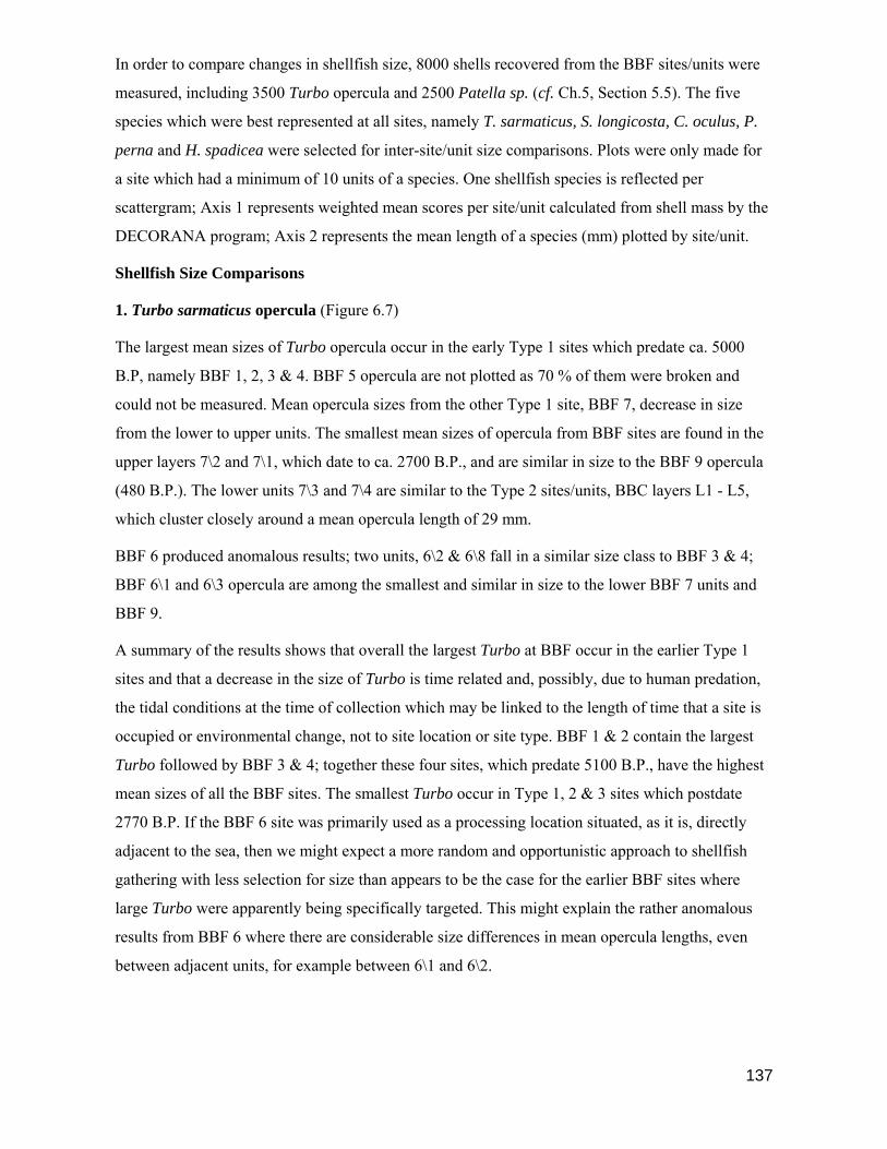
137
In order to compare changes in shellfish size, 8000 shells recovered from the BBF sites/units were
measured, including 3500 Turbo opercula and 2500 Patella sp. (cf. Ch.5, Section 5.5). The five
species which were best represented at all sites, namely T. sarmaticus, S. longicosta, C. oculus, P.
perna and H. spadicea were selected for inter-site/unit size comparisons. Plots were only made for
a site which had a minimum of 10 units of a species. One shellfish species is reflected per
scattergram; Axis 1 represents weighted mean scores per site/unit calculated from shell mass by the
DECORANA program; Axis 2 represents the mean length of a species (mm) plotted by site/unit.
Shellfish Size Comparisons
1. Turbo sarmaticus opercula (Figure 6.7)
The largest mean sizes of Turbo opercula occur in the early Type 1 sites which predate ca. 5000
B.P, namely BBF 1, 2, 3 & 4. BBF 5 opercula are not plotted as 70 % of them were broken and
could not be measured. Mean opercula sizes from the other Type 1 site, BBF 7, decrease in size
from the lower to upper units. The smallest mean sizes of opercula from BBF sites are found in the
upper layers 7\2 and 7\1, which date to ca. 2700 B.P., and are similar in size to the BBF 9 opercula
(480 B.P.). The lower units 7\3 and 7\4 are similar to the Type 2 sites/units, BBC layers L1 - L5,
which cluster closely around a mean opercula length of 29 mm.
BBF 6 produced anomalous results; two units, 6\2 & 6\8 fall in a similar size class to BBF 3 & 4;
BBF 6\1 and 6\3 opercula are among the smallest and similar in size to the lower BBF 7 units and
BBF 9.
A summary of the results shows that overall the largest Turbo at BBF occur in the earlier Type 1
sites and that a decrease in the size of Turbo is time related and, possibly, due to human predation,
the tidal conditions at the time of collection which may be linked to the length of time that a site is
occupied or environmental change, not to site location or site type. BBF 1 & 2 contain the largest
Turbo followed by BBF 3 & 4; together these four sites, which predate 5100 B.P., have the highest
mean sizes of all the BBF sites. The smallest Turbo occur in Type 1, 2 & 3 sites which postdate
2770 B.P. If the BBF 6 site was primarily used as a processing location situated, as it is, directly
adjacent to the sea, then we might expect a more random and opportunistic approach to shellfish
gathering with less selection for size than appears to be the case for the earlier BBF sites where
large Turbo were apparently being specifically targeted. This might explain the rather anomalous
results from BBF 6 where there are considerable size differences in mean opercula lengths, even
between adjacent units, for example between 6\1 and 6\2.

138
Fig. 6.7: Mean length (mm) of Turbo opercula for sites/units with MNI’s 10> plotted against
weighted mean species scores calculated from shell weights (Axis 1)
2. Scutellastra longicosta (Figure 6.8)
Mean lengths of S. longicosta at BBF 1, 2 & 4 exceed 64 mm. Curiously, the mean length of S.
longicosta at the BBF 3 site (5460 B.P.) is around 60 mm, placing it in the same size category as
the BBF 6 units (<3670 B.P.). BBF 6 units are combined due to the small sample size of S.
longicosta from this site. All the BBC units are closely correlated with a mean size of between 58.5
mm and 59.5 mm. BBF 7 (all units) has the smallest mean size of S. longicosta at 57.5 mm.
Overall, the trend for S. longicosta sizes is similar to that of Turbo where the largest mean shell
lengths occur in the early Type 1 sites. BBC (all units) shells are tightly clustered with regards to
shell length and are substantially smaller than those of the early Type 1 sites. BBF 7 has the
smallest mean sizes of S. longicosta and follows the same pattern observed for Turbo. BBF 6 shells
are marginally larger than the BBC units, but considerably smaller than the early Type 1 sites.

139
Fig. 6.8: Mean lengths (mm) of Scutellastra longicosta for sites/units with MNI's <10 plotted
against weighted mean species scores calculated from shell weights
3. Cymbula oculus (Figure 6.9)
Cymbula oculus shells from BBF 4 (mean 71 mm) are, on average, substantially larger than those
from BBF 3 (mean 66 mm) and BBF 2 (mean 64 mm). Despite these inter-site differences, the mean
shell sizes from early Type 1 sites are the largest for all the BBF sites. The BBC units are again
tightly correlated with regard to the average size of C. oculus at around 61 mm; BBF 9 shells are
slightly smaller averaging 60 mm. At BBF 6 & 7, C. oculus are marginally larger than at BBC with
a mean of 61.5 mm.
Cymbula oculus are, on average, larger in the early Type 1 sites, BBF 2, 3 & 4. C. oculus are
common in the lower three layers at BBF 6, but virtually absent from the upper nine layers. If this
absence in the upper layers is due to heavy predation of this species in the earlier layers we would
expect an overall relatively smaller mean for C. oculus at BBF 6. Similar mean sizes (60 - 62 mm)
are recorded for the BBC units and BBF 7 & 9 which post-date 2770 B.P.
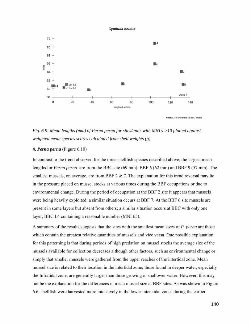
140
Fig. 6.9: Mean lengths (mm) of Perna perna for sites/units with MNI's >10 plotted against
weighted mean species scores calculated from shell weights (g)
4. Perna perna (Figure 6.10)
In contrast to the trend observed for the three shellfish species described above, the largest mean
lengths for Perna perna are from the BBC site (69 mm), BBF 6 (62 mm) and BBF 9 (57 mm). The
smallest mussels, on average, are from BBF 2 & 7. The explanation for this trend reversal may lie
in the pressure placed on mussel stocks at various times during the BBF occupations or due to
environmental change. During the period of occupation at the BBF 2 site it appears that mussels
were being heavily exploited; a similar situation occurs at BBF 7. At the BBF 6 site mussels are
present in some layers but absent from others; a similar situation occurs at BBC with only one
layer, BBC L4 containing a reasonable number (MNI 65).
A summary of the results suggests that the sites with the smallest mean sizes of P. perna are those
which contain the greatest relative quantities of mussels and vice versa. One possible explanation
for this patterning is that during periods of high predation on mussel stocks the average size of the
mussels available for collection decreases although other factors, such as environmental change or
simply that smaller mussels were gathered from the upper reaches of the intertidal zone. Mean
mussel size is related to their location in the intertidal zone; those found in deeper water, especially
the Infratidal zone, are generally larger than those growing in shallower water. However, this may
not be the explanation for the differences in mean mussel size at BBF sites. As was shown in Figure
6.6, shellfish were harvested more intensively in the lower inter-tidal zones during the earlier

141
occupations at BBF, and not in the post 2000 B.P. period. Therefore, we should expect that, on
average, the larger mussels would be found in the earlier sites. As this is not the case, the effects of
higher predation rates or environmental change seems a more likely explanation for decreasing
mussel size in the earlier sites. In order to confirm that high predation rates were responsible for a
decrease in mussel size we would need considerably more sites which date to the same period to get
a better idea of the likely pressures placed on marine stocks at a particular time.
Interestingly, the smallest mussels, on average, come from the BBF 7 site (all layers) providing
further confirmation of the overall small size of shellfish from this site.
Fig. 6.10: Mean lengths (mm) of Perna perna for sites/units with MNI's >10 plotted against
weighted mean species scores calculated from shell weights (g)
5. Haliotis spadicea (Figure 6.11)
As is the case for P. perna, noted above, the largest mean sizes of H. spadicea are found in the later
Type 2 sites, BBC & BBF 9. The early Type 1 sites, BBF 2 and, in particular, BBF 3 reflect smaller
means. BBF 6 size distributions are somewhat ambivalent and fall between Type 1 early sites and
Type 2 sites. The smallest mean sizes of H. spadicea are again found in the BBF 7 site, reflecting a
similar pattern observed for P. perna, S. longicosta, C. oculus and Turbo at this site. The relative
numbers of H. spadicea are highest in the early sites, BBF 2 & 3, but this species is only
sporadically represented in the BBF 6 & 8 units. This patterning suggests that in the later sites H.
spadicea was not consistently targeted for collection although at times, for instance in the BBC L4
unit and at BBF 9, H. spadicea do occur in reasonable numbers.

142
Changes in the mean sizes of H. spadicea may, in part, be linked to patterns of predation; at sites
where this species is consistently targeted their mean size decreases, for example at BBF 2, 3 and 7
(all units). If they occur only sporadically within the various units at a single site, as is the case in
the BBF 6 and 8 units the mean size of H. spadicea is larger. The large mean size of H. spadicea at
BBF 9 suggests that during the period this site was occupied H. spadicea were commonly available,
and that, possibly, larger animals were being deliberately selected. Other factors which may account
for the changes in the mean sizes of H. spadicea are environmental factors or the level of the
intertidal zone from which they were collected - generally the larger specimens are found in the
lower reaches of the intertidal zone.
Fig. 6.11: Mean lengths (mm) of Haliotis spadicea for sites/units with MNI's >10 plotted against
weighted mean species scores calculated from shell weights

143
Summary of Results: Mean shellfish size at BBF sites
Turbo sarmaticus is the most common shellfish species (both for mass and MNI's) and was
consistently targeted by the inhabitants at all the BBF sites. Changes in mean Turbo sizes appear to
be time related, that is they are larger, on average, in the early sites and vice versa. One of the major
difficulties in attempting to make inter-site comparisons is the small number of sites excavated
relative to the time period involved; we have evidence of only 28 sites/units which were occupied
sporadically over a 6000 year period. In some cases over 1000 years may separate two sites, for
example BBF 5 and BBF 6\12. As a result we are not able to accurately gauge the pressures placed
on marine resources in the interim periods, or indeed that BBF was even occupied during these
interims. A great deal more sites would need to be excavated in the BBF area if we are to begin to
understand the finer details of marine subsistence strategies over the 6000 year period.
Scutellastra longicosta are the most common limpet found in all the BBF sites/units, particularly
during the period prior to 2770 B.P. There is a noticeable decrease in the numbers and mean size of
S. longicosta in the units which post date 2770 B.P. It is difficult to assess from the BBF data what
factors were responsible for the apparent lack of interest in this species of limpet in the later time
period. Either size or availability, or both may have been responsible; it may not have been
considered economic to harvest S. longicosta if the mean size or numbers of this species were
relatively small. Unfortunately, we are not able to accurately gauge from the archaeological data
whether this was the case. However, we can observe a distinct switch from S. longicosta to C.
oculus and S. cochlear in the units which post-date 1840 B.P. The mean size of C. oculus in the
Type 2 sites is only marginally larger than that of S. longicosta, suggesting that increased
harvesting of C. oculus and S. cochlear in the post 2000 B.P. period was motivated by species
availability, or idiosyncratic choice, rather than mean size.
Both P. perna and H. spadicea were harvested consistently during the pre- 2770 B.P. period at most
sites which may account for the relatively small mean size of these species in the earlier period. At
the BBF 7 site, P. perna are the second most common shellfish species and were harvested in large
numbers. H. spadicea and P. perna only occur in very small numbers in the post 2000 B.P. period
and appear to have been targeted only during the occupation of the BBC L4 unit and at BBF 9.
However, even in the latter two sites both species feature relatively low down on the list of
preferred shellfish. The relatively large mean sizes of H. spadicea and P. perna from Type 2 sites
appears to be a function of low predation on these species in the post- 2000 B.P. period.
The overall conclusion that can be drawn from the shellfish size data presented above is that the age
of a site, its location, or type (i.e. single occupation or multiple occupation) do not appear to have
had a significant influence on the mean size of shellfish collected. The reasons for the increase or

144
decrease in the sizes of various shellfish species collected may be related to human predation
patterns but could also be due to environmental factors, the length of time a site was occupied, tidal
conditions or to size selection procedures adopted by inhabitants of the various sites.
6.7: Palaeoenvironmental Factors and Predation Pressure
We cannot look at the results from the above data in isolation but need also consider a number of
other factors which may have influenced the shellfish subsistence strategies of the BBF inhabitants.
The final objective of the BBF shellfish analysis was to compare the range of shellfish species
exploited at all BBF sites to those likely to have been available for exploitation on the BBF
coastline, taking into account seasonal availability and palaeoenvironmental factors such as rising
and falling sea levels, sea temperature changes and changes in the morphology of the coastline.
Some of the answers are provided in Sections 6.5 & 6.6 above; further consideration is given to
some of the points below.
Palaeoenvironmental Factors
Figure 6.5 (i.e. Type 1, 2, 3 sites zone comparison) shows that the same species of shellfish were
available during the periods that the BBF sites were occupied, although we are unable to estimate
their availability in the interim periods between occupations. Sea level changes during the Holocene
may have had little, or no effect, on species availability. In part, this may be due to the topography
of the coastline in the vicinity of BBF. An increase or decrease of 2-3 m in sea levels would only
marginally have affected the inter-tidal zones which provided suitable conditions for the
establishment of a range of shellfish at BBF. TMS outcrops extensively over a wide range of
elevations on this part of the coast forming natural rocky bays and inlets and these would have been
relatively unaffected by minor changes in sea level.
This may not have been the case at Blombos Beach situated to the west of BBF. A marginal rise of
1-2 m in sea levels would substantially affect the expanse of exposed level beach causing changes
in sand distribution patterns and also erosion of the dunes situated at the rear of the present beach.
The habitat of the white mussel, Donax serra, is restricted to beaches which are evenly planed and
this species is particularly vulnerable during periods when beach sand is being heavily eroded.
Donax serra is only found in the early BBF sites 1, 2, 3 & 4 and in some of the BBC units. Between
5280 B.P. and 1840 B.P. Donax serra may not have been available for collection at Blombos Beach
due to the high sea levels postulated for the Mid- and Later Holocene periods (cf. Ch. 2).
However, other factors may also be responsible for the absence of this species from BBF sites
during this time period. For example, changes in the slope of the beach shelf may not have provided
favourable conditions for the establishment of white mussel colonies or Donax serra may have been

145
avoided by choice, perhaps for cultural reason or because the effort involved in locating and
excavating the mussels outweighed the returns. Donax serra are not currently found at Blombos
Beach. and possibly the beach is, and has always been, only marginally suitable as a habitat for this
species.
Patella granularis is found along almost the entire South African coast and is unaffected by ocean
temperatures (Tietz & Robinson 1974; Branch et al 1999). This species of limpet is only found in
two units at the BBF site, and then in very small quantities. It seems unlikely that its almost
complete absence at BBF sites can be attributed to environmental factors or to the shellfish
sampling strategies adopted. A more likely explanation is the relatively small size of this species
(maximum length 30 mm); it may have been considered uneconomic to gather a limpet of this size,
given that a wide range of larger limpets were also easily available (cf. Schweitzer & Wilson
1982:114). Chiton are found in small quantities throughout most of the period that the BBF sites
were occupied, indicating that this species was available for collection for most of the Holocene.
Once cooked, the individual components of a chiton shell are separated, and being relatively fragile
are easily broken. In part, this may account for the low numbers of chitons found at BBF sites;
however, it may be that chitons were simply not a highly sought after shellfish, although they may
have been gathered opportunistically and on a sporadic basis.
Changes in mean sea temperatures may have had an effect on the growth rates of some species, for
example Turbo (Yssel 1989). Individual species of shellfish have an optimal range of temperatures
for maximum growth (Branch pers. comm.); if water temperatures increase or decrease below a
tolerable level an animal may respond by growing more slowly or a species may disappear from an
area altogether. Several species of Patella may decrease in size as the mean sea temperature
increases, for example S. longicosta. (Branch 1974). Based on the mean sizes of S. longicosta
recovered from layers 8 - 3 at Byneskranskop 1 site, which span a 2500 year period, Schweitzer &
Wilson (1982:115) suggest that, at times, a marginal decrease in shell lengths may be attributable to
increasing sea temperatures and not human predation. However, for a large part of this period the
minimum lengths of the S. longicosta population increase and the maximum lengths remain
constant, suggesting that the overall effect of sea temperature changes on this species may have
been marginal.
At Nelson Bay Cave the brown, warm water mussel, Perna perna replaced the black mussel,
Choromytilus meridionalis after 8000 B.P. in response to increasing sea temperatures (Klein 1973).
A wider range of molluscs from the whole intertidal zone is represented during the Mid-Holocene
period at Nelson Bay Cave (NBC) including Patella sp., Haliotis sp., Turbo sarmaticus, Diloma
sp., Donax serra and Burnupena than in the Early Holocene (Klein 1973; Inskeep 1987). Klein
146
(1973) suggests that the increase in the range of shellfish exploited in the Mid- and Later Holocene
at NBC is due to greater efficiency at cropping marine resources, or simply not minding getting
wet, and not to environmental changes. A further factor is the closer proximity of the rocky coast to
NBC during this time period.
The shellfish evidence from BBF sites suggests that during the last 6,000 years minor changes in
mean sea temperatures did not substantially affect the range of shellfish species available (cf. Figure
6.5), although the mean size of some species of shellfish may have been affected. This last factor is
not measurable, both because we have insufficient knowledge of the precise changes in sea
temperatures during the Holocene at the Cape, but also of the specific effects of sea temperature
change on the rate of growth of the shellfish species found at BBF.
Predation Pressure
Heavy predation during the last thirty years on a number of shellfish species found on the Cape
shores has impacted both on species availability and size. In particular, Haliotis midae are virtually
extinct in some areas, and the mean size of adults in most areas has been greatly reduced (Griffiths
pers. comm.). A reduction in the range of shellfish species and in the size of shellfish are recorded
in the Transkei, Eastern Cape Province, due to heavy predation by local inhabitants in recent years
(Bigalke 1973; Hockey et al 1988; Lasiak & Dye 1989; Tregoning & van der Elst n.d.); similar
results due to overpredation of molluscs are reported from Papua New Guinea (Poiner & Catterall
1988), Washington State (Dethier et al 1989) and Tonga (Spenneman 1986). At the Dunefield
Midden site, situated on the western Cape coast, Parkington et al (1992) have demonstrated that
even during the course of a single occupation changes are observable both in the choice of shellfish
species harvested and their mean size. During the early stages of occupation at the Dunefield
Midden site the larger animals, and larger shellfish species, are preferred, but during the latter
stages of occupation the smaller shellfish species and smaller animals are also gathered.
Unfortunately, we are unable to ascertain the human demographic changes which occurred in the
BBF area during the Holocene from the limited site evidence that we have available and also
because of the long time periods between some of the occupation units. However, archaeological
evidence gathered from a number of other sites in the Cape region points to increasing population
pressures during the Late Holocene, in particular after the arrival of pastoralists. For example, the
number of sites situated in small shelters in the inland Cape Folded Mountains increases
considerably in this later period (Hall 1986; Parkington 1987; Parkington et al 1988). As the coastal
plains were favoured for grazing Khoe stock (cf. Hall 1986; Smith 1986; Sadr et al 2003), San visits
to the coast may have become less frequent, or timed so as not to coincide with Khoe rounds.
Related to this may be a greater use of small coastal caves and a reduction in the extent of open

147
coastal sites. Within the BBF area, open sites all predate the arrival of herders, and coastal caves
and shelters are only occupied in the post 2000 B.P. period.
Increasing pressure on marine resources during the later occupations at BBF may have contributed
to a reduction in the mean sizes of some shellfish species, for example Turbo, C. oculus and S.
longicosta but as this is not the case for P. perna and H. midae it is not possible to generalise on the
causes and effects of changes in shellfish size or species availability.
Based on the evidence available from the BBF sites, it is more prudent to conclude that during
periods of heavy predation by humans on a particular species the mean size of animals collected
decreases. Conversely, if a species is left relatively undisturbed for a period of time, perhaps only
for short periods of 10 -20 years, the overall population of a species will increase and the proportion
of older and larger animals will correspondingly expand resulting in an increase in the mean size of
the animals available for collection (Branch pers. comm.).
6.8: Comparison of BBF shellfish patterns with other southern Cape sites
If direct comparisons could be made between shellfish exploitation patterns at BBF with those from
excavated sites situated elsewhere on the southern Cape coast we would be in a better position to
examine and compare the broad trajectory of shellfish exploitation within the region. However,
there are a number of problems which complicate these kinds of comparisons. Within a 200 km
radius of BBF only a handful of coastal sites have been excavated; at two of these sites, excavated
in the 1930s, the shellfish component is ignored in the site reports, i.e. Oakhurst (Goodwin 1933,
1938) and Matjes River (Dreyer 1934). Goodwin (1946) mentions the presence of large middens at
Slang River, near Humansdorp containing P. perna, Diloma sp. and D. serra, and at the Gouritz
River mouth where piles of shells appeared to be sorted into species, mainly H. spadicea and P.
perna - however no further information is provided or an attempt made at quantification. At the
Tsitsikama National Park sites a small sample of shellfish were analysed from two coastal cave
sites but no radiocarbon dates are given (Deacon, H.J. 1970).
Further afield, excavations at Cape St. Francis (Cairns 1975) in the eastern Cape produced a
shellfish sample too small to allow a meaningful comparison with the BBF shellfish. Van Noten's
(1974) excavation at the Gordon's Bay shell midden in the south-western Cape lists details of the
shellfish from the L3 layer only, dated at 3220 B.P., but the author states that the list was compiled
from a random sample taken from the unit. A comparison of the four most common species from
the L3 layer, namely Diloma sp., S. longicosta, C. oculus, Turbo and Burnupena cincta shows some
similarity to the most common species found at the BBF 7 site (2770 B.P.). Limited excavations
were carried out at coastal middens located in the Pearly Beach (PB) area in the south-western Cape

148
by G. Avery (1974). He notes that extensive scatters of marine shell had been exposed by recent
dune movement in the area and obtained a date of 1680 B.P. from one of the middens. Similar
species to those found at the BBF sites are recorded at the PB1 - PB 6 and SFT1 middens, including
H. spadicea, Diloma sp., Turbo, a range of Patella sp.and a few D.serra. Haliotis midae and
Choromytilus meridionalis, a cold water mussel, are common at the PB sites. The presence of black
mussels at the PB sites emphasises the difference in marine environments, in particular with regard
to sea temperature, between the BBF area and the south-western Cape coast. Lower mean sea
temperatures which occur in the vicinity of south-western Cape sites, for example at Die Kelders,
Byneskranskop 1 and Pearly Beach, influence the range of shellfish species found in the inter-tidal
zones in this area. Turbo are rarer in the western sector of the southern Cape coast (Tietz &
Robinson 1974); H. midae are more common in the colder waters of the south-western Cape, for
instance at Hermanus, than they are further eastwards towards Still Bay (Griffiths pers. comm.).
Changes in the distribution and mix of the range of shellfish species along the Cape coast due to
palaeoenvironmental factors highlights the problems of comparing marine subsistence strategies
adopted by prehistoric people in different areas, and at different times. It also emphasises the need
to concentrate on increasing the numbers of sites excavated within a circumscribed area of the
coast. By adopting this approach we are likely to gain a greater understanding of the variations in
Holocene shellfish subsistence strategies within a particular region, rather than by comparing sites
situated often hundreds of kilometres apart.
The closest well excavated site to BBF is Nelson Bay Cave, situated approximately 200 km to the
north-east, with coastal conditions similar to those in the BBF area. Shellfish from Nelson Bay
Cave (NBC) were sampled from some of the later excavated units, but bulk samples taken from
earlier excavations have not been analysed (cf. Inskeep 1987:213). As there is no detailed analysis
of shellfish by unit from NBC it makes comparison with the BBF sites/units difficult. A divison has
been made between the upper and lower units, the oldest date for the upper Unit 63 is 3600 B.P.;
the oldest unit in the lower levels is dated at 5890 B.P. Patella and Perna are major contributors to
the shellfish in all layers. C. oculus are more common in the lower layers with a marginal increase
in S. argenvillei in the lower units. The major groups of shellfish found at the BBF sites, namely
Turbo and Diloma occur in small quantities at NBC suggesting a distinct difference in shellfish
strategies at NBC and BBF. Unfortunately it is not possible to quantify these differences more
specifically, especially in the pre- and post 2000 B.P. periods, due to the limited data set from the
NBC site.
The most comprehensive analyses of shellfish from sites situated on the south-western Cape coast
are from Byneskranskop 1 ( Schweitzer & Wilson 1982) and Die Kelders (Schweitzer 1979). At the

149
latter site the author emphasises that the sampling strategies employed for shellfish collection
during excavation varied among the various layers, although he considers the methods employed
were adequate for statistical analysis.
The LSA layers at Die Kelders post-date 2000 B.P. Choromytilus and Perna are the most
commonly occurring genera at Die Kelders and account for 67 % of the total shell sample.
Burnupena accounts for 17 % of the sample from all layers; Bullia and Chiton are infrequent.
Patella species include P. granatina (most common) followed by P. granularis, but in most units
Patella sp. account for less than 10 % of the total marine shell component. Turbo was recovered
from most units but in relatively small quantities. Schweitzer concludes from the Die Kelders data
that two species were being consistently and primarily targeted by the inhabitants at the site,
namely Choromytilus and Perna.
The largest variety of shellfish are found in the earliest layers, ca. 1960 B.P. and the shells are, on
average, of a larger size; the period of occupation during this time was also relatively short. He
suggests that there is a reduction in both the diversity and richness of the shellfish fauna over time -
in the upper layers there is evidence of increasing reliance on other foods, in particular domestic
animals, but that the time spent at the coast was more protracted than in the earlier occupations
(Schweitzer 1979:194).
Clearly there are distinct differences in the shellfish strategies adopted by the Die Kelders
inhabitants from those followed by the occupants of the BBF sites which post-date 2000 B.P. The
most apparent reason for the differences relates to species availability. Choromytilus and Perna
were available in abundance in the early occupation layers at Die Kelders and were consequently
heavily exploited; over time the mean size of both species decreases, possibly due to heavy
predation pressures, and by 1500 B.P. there is a change in the shellfish species mix, and less
reliance on marine shells.
At the BBC & BBF 9 sites this is not the case and shellfish continue to be heavily exploited until, at
least, 500 B.P. One reason for this may relate to differences in the population demographics of the
two areas; the BBF shellfish stocks may have been relatively less exploited after 2000 B.P.
compared to the shellfish at Die Kelders thereby ensuring a continuing and sustainable shellfish
population in the BBF area.
The relative richness of marine fauna available in the two areas during this period is difficult to
ascertain, as a rule species diversity increases in an easterly direction along the southern Cape coast,
although not necessarily the total mass available for human exploitation. The BBF coastline may
have been able to sustain higher rates of predation than was the case at Die Kelders, particularly if a
150
wider range of marine fauna were available for exploitation at BBF, and as a consequence there was
less pressure on a limited number of species. However, the mean decrease in the size of
Choromytilus and P. perna at Die Kelders, which may be due to heavy human predation, is similar
to the pattern observed for most shellfish species at the BBF sites.
If a genera is consistently and heavily targeted, possibly even during the course of a single
occupation at a site (cf. Parkington et al 1992), the mean size of the animals is likely to decrease
over time. At some stage during the course of a single occupation it may not be considered
economic to continue harvesting the same species and this could precipitate a switch to the
collection of another species, or a different suite of shellfish (cf. Parkington et al 1992). A possible
example of this is the substitution of C. oculus, common in the lower BBF 6\9 - 6\12 layers, with S.
cochlear which becomes increasingly common in the layers above BBF 6\7, but is absent in the
lower layers.
Byneskranskop 1 (BNK 1) is situated approximately 10 km to the south-east of Die Kelders. Layer
9 is dated at ca. 6000 B.P. and the top layer at 255 B.P. As is the case at BBF, Turbo is the most
commonly represented shellfish at BNK 1, accounts for 32 % of the site total, and is dominant in
the upper layers post-dating 3000 B.P. and in the early layers ca. 6000 B.P. In the middle layers, ca.
3900 B.P., Diloma sp. increase in relative numbers and are common in the upper and later units.
Patella species are more frequent before 3900 B.P. at BNK 1 and consistently decrease in numbers
over time. Layers 1 & 9 at BNK 1 have the lowest frequencies of Patella, but also have the largest
mean sizes and range of Patella species. Because of the time differences between the various layers
at BNK 1, Schweitzer & Wilson (1982: 116) are cautious in associating changes in the mean
lengths of shellfish species to the effects of sea temperature changes or human predation.
6.9: Summary
A wide range of marine fauna are found on the rocky portions of the southern Cape coast. From the
shells excavated at the BBF sites we have evidence that a wide range of shellfish were exploited
over a 6000 year period; some of the shellfish were brought to the sites to be eaten, others were
introduced incidentally, perhaps by being attached to host shells.
All the shellfish recovered from the BBF sites were identified to species, where possible; MNI's
were calculated and the mass of each species per site/unit recorded; whole shells were measured.
Fifteen species of shellfish regarded as 'food' were exploited by the BBF prehistoric inhabitants.
Two species are found within all the sites/units excavated, namely Turbo and Diloma; other
shellfish commonly gathered include Haliotis spadicea , Perna and Patella sp. The rarest species
are Chitons, Donax, Haliotis midae and P. granularis.

151
In order to make fair inter-site/unit comparisons of the shellfish found at all the BBF sites/units, the
five most common species at each site were allocated a weighting of between 1 - 5, the higher
number being allocated to the most common species. This ranking procedure was applied to tables
calculated both from mass and MNI's; the results were converted by the DECORANA
correspondence analysis program and plotted graphically on scattergrams reflecting the relative
positions of the 27 BBF sites/units and, respectively, 8 categories of shellfish based on MNI's, and 9
based on mass.
In summary, the correspondence analysis results show a strong correlation among all the Type 2
sites, namely BBC (all units) and BBF 9. In comparison to Type 1 and Type 3 sites, which predate
2000 B.P., both the shellfish mix and relative species weightings are distinctly different in Type 2
sites, suggesting a change occurred in shellfish subsistence strategies at BBF after 2000 B.P. In
Type 2 sites, Turbo features less strongly than is the case for the earlier sites and Diloma becomes
the dominant shellfish component, followed by S. cochlear, C. oculus and S. longicosta; species
that are absent, or only occur in small quantities in Type 2 sites include Perna, S. argenvillei, S.
tabularis and H. spadicea. It is possible that longer periods of site occupation, tidal conditions at
the time of collection and/or higher rates of human predation on shellfish in the BBF area after
2000 B.P. were responsible for the observed changes rather than site location. Both Type 2 and
Type 3 sites are situated on the coast, yet the species mix in the earlier Type 3 site is distinctly
different from that recovered from the later Type 2 sites. Within the Type 3 site, the species mix in
the upper layers, 6\1 - 6\9 correlate fairly strongly and are different, on average, to the shellfish
found in the lower layers, 6\11 and 6\12, suggesting that shellfish changes at this site are time
related. BBF 7 (ca. 2700 B.P.), which is situated in the elevated dune area at BBF and immediately
predates the Type 2 sites, is more similar in both species mix and in the relative quantities of each
species to Type 2 sites than it is to the earlier Type 1 sites situated in the dune area, or to the Type 3
site.
The early Type 1 dune sites can be separated into three categories based on species composition:
BBF 1 & 2 (ca. 6400 B.P.) are almost identical; BBF 3 & 4 (ca. 5300 B.P.) are identical both in
species mix and relative weightings; BBF 5 is unique due to the presence of high numbers of S.
tabularis and Turbo. Based on the overall assemblage excavated at this site it appears that BBF 5
was a location for processing shellfish.
The third objective of the BBF shellfish study was to determine the range of inter-tidal zones
exploited by its prehistoric inhabitants, and in particular whether a difference could be observed
between sites which pre-dated 2000 B.P. and the arrival of the first pastoralists at BBF (cf. Ch. 5 &
7), and the later sites. From the range of shellfish found at Type 1, 2 & 3 sites the location of each

152
species in the intertidal zone was graphically plotted (Fig. 6.5). A graphic comparison was then
made between the range of intertidal zones exploited during the pre- and post 2000 B.P. periods
(Fig. 6.6). The results show that subsistence strategies after 2000 B.P. were concentrated more
intensively on shellfish species situated in the shallower tidal zones. The most marked difference
between the earlier and later sites is in the Cochlear zone; after 2000 B.P. Turbo are less heavily
exploited and S. tabularis is absent.
Five species of shellfish, T. sarmaticus, S. longicosta, C. oculus, Perna and H. spadicea, are best
represented at all the BBF sites, and were consequently selected for a study comparing mean
shellfish sizes. Over 8000 shells were measured including 3500 Turbo opercula and 2500 Patella
species. Scattergrams for each species reflect weighted mean scores per site/unit calculated from
shell mass on Axis 1 and the mean length of a species plotted by site/unit on Axis 2. Three species
decrease in size in relation to time. The largest mean sizes of Turbo, S. longicosta and C. oculus are
found, on average, in the earlier sites. However, the mean sizes of Perna and H. spadicea are
largest in the post 2000 B.P. sites. The overall conclusion that can be drawn from the data on
shellfish mean sizes is that during periods of low predation (i.e. low relative numbers of a species
within a site/unit) the size of all five species, on average, is largest; conversely, when a species is
heavily exploited the mean size decreases. The length of time that a site is occupied (i.e. not only
during spring low tides) and the tidal conditions at the time of collection may also have a significant
effect on mean sizes as generally the smaller specimens of a particular species are found in the
upper reaches of the intertidal zone. The age of a site, its location or type (ie. single occupation or
multiple occupation) do not appear to have had a significant influence on the mean size of shellfish
collected.
A number of other factors are also likely to have influenced the shellfish collection strategies of the
BBF inhabitants. These include palaeoenvironmental factors such as rising and falling sea levels,
sea temperature changes and changes in the morphology of the coastline. Changes in sea levels are
not considered a major influencing factor on shellfish availability as suitable habitats for all the
species found at BBF were present throughout the Mid- and Later Holocene. Blombos Beach is
likely to have been inundated during periods of higher sea levels during the Mid-Holocene, but this
would have affected only one species, Donax serra and may explain the absence of this species in
the Mid-Holocene sites. Changes in sea temperatures may have had a marginal effect on the growth
rate of some species but, overall, the shellfish evidence from BBF, Nelson Bay Cave (Klein 1973)
and Byneskranskop 1 (Schweitzer & Wilson 1982) suggests that changes in sea temperatures did
not substantially affect the range of shellfish species available during the past 6000 years.
153
Consistent human predation of a single shellfish species has been shown to decrease the mean size
of animals available for collection both in modern studies (Bigalke 1973; Lasiak & Dye 1989;
Tregoning & van der Elst) and at single occupation archaeological sites (Parkington et al 1992).
Based on the evidence available from the BBF sites it is prudent to conclude that during periods of
heavy predation by humans on a species, particularly those that are long lived, the mean size of
animals available for collection may decrease. Conversely, if a population is left relatively
undisturbed, possibly for only short periods of time, the mean size of that species will consequently
increase.
Comparing the patterns of shellfish exploitation at BBF with those from other southern and south-
western Cape sites has proved to be a difficult task. In part, this is due to the general lack of
shellfish data recorded at some of the excavated sites, but also due to differences in the ecology of
the various regions. In particular, the range of shellfish species recovered from some sites in the
south-western Cape is not comparable to genera from the BBF sites.
Perhaps the biggest hurdle in attempting to interpret changes in shellfish strategies at BBF, and at
the other excavated sites in the southern Cape is the large time gaps between the various occupation
units. In effect, we are only able, temporally, to get a 'snap shot' view of the various units, which
may be separated by more than 1000 years. These time gaps make it difficult to attribute changes,
for example, in shellfish sizes to a specific cause. In consequence, we are only able to generalise
about changing shellfish strategies, both on a temporal and spatial scale.

154
CHAPTER 7
FAUNA: MAMMALS, REPTILES & FISH
7.1: Introduction
At least fifty species of large mammals are recorded historically in the Cape Ecozone (Skead 1980;
Skinner & Smithers 1990). Travellers passing through the Riversdale district during the 18th and
19th C. reported seeing elephant, Cape buffalo, hippopotamus, eland, lions. leopards, wild dogs,
hyaenas and a range of bovids including eland, bush buck, steenbuck and bontebok (le Vaillant
1790; Raven-Hart 1967; Skead 1980). Based on the faunal evidence recovered from archaeological
sites excavated in the Cape Ecozone we can establish that by the Mid-Holocene the large mammal
communities in the southern Cape were similar to those of historical times (Klein 1973, 1980, 1984;
Deacon, J. 1984b; Deacon & Lancaster 1988). We can therefore speculate on the range of large
mammals that would have been available to the prehistoric inhabitants of the BBF sites.
Unfortunately, the bones of large mammals are poorly preserved in the early open Type 1 sites, and
are absent in the Type 3 site. It was therefore not possible to establish the range of large mammals
which were hunted, or possibly scavenged, in the BBF area prior to 2000 B.P. The best preservation
of large mammals comes from the Type 2 sites, BBC (all layers) and BBF 9 and this information is
presented below.
In addition to the large mammals a wide range of other animals were also available for exploitation
at BBF including small mammals, reptiles, birds and fish. Some information on this latter group of
animals is available from the earlier sites, but again the best bone preservation occurs in the later,
near coastal, shelter sites.
The mammal bones from the BBC & BBF 9 sites were identified by Richard Klein, Graham Avery,
Cedric Poggenpoel and the author. Microfauna from the BBC site were identified by Margaret
Avery. Cedric Poggenpoel analysed the fish bones. Bird and snake bones were separated from other
fauna but in the time available it was not possible to locate an expert to identify these to genera.
7.2. Mammals
NISP's and MNI's for the mammals recovered from BBC (all units) and BBF 9 were calculated by
Richard Klein and are presented in Table 7.1. below. Mammal bones recovered from the other BBF
sites were badly weathered or fragmented and it was not possible to identify these to genera. An
analysis of the mammal bones from the later 1997 – 1999 excavations of the LSA layers at BBC are
detailed in Henshilwood et al 2001a.

155
Frequencies of individual taxa per layer are generally too low to allow a meaningful interpretation
of the faunal data. Large bovids occur in marginally greater numbers in the lower BBF layers which
date to ca. 1800 B.P., but this may be attributed to the relatively larger volume of deposit excavated
from layers BBC L4 & BBC L5. Animals in this category include Syncerus caffer and Taurotragus
oryx; both animals are found in the Holocene layers at NBC, Die Kelders and Byneskranskop 1
indicating their widespread distribution in the southern Cape. The largest NISP's and MNI's are
recorded in the small and small-medium bovid size classes. Oreatragus, Sylvicapra, Raphicerus
and Tragelaphus.are still found in the BBF area today and it is likely that these bovids were
available for hunting or snaring within the immediate BBF vicinity. The range of bovids found at
BBF are dominated by browsers indicating that scrub and bush were the predominant vegetation
types in this area in the Late Holocene; large mammal communities in the southern Cape were
essentially similar to historic times by 5000 B.P. (Klein 1980; 1984; Deacon & Lancaster 1988). It
is probable, therefore, that the range of mammals available to the Late Holocene BBF inhabitants
was similar to that in the Mid Holocene.
Hippopotamus amphibius bones are found in layers BBC L3 and BBC L4, but possibly come from
the same animal. Historically, hippo were observed in the Goukou and Duivenhoks Rivers which
are situated more than 20 km from BBF. As hippo are unlikely to have been found within the
immediate BBF area the bones may have been carried here from either of the rivers. Hippos occur
in most layers at NBC, and occasionally at Byneskranskop and Die Kelders; however, we have no
indication of how these animals were captured although it is seems more likely that hippo carcasses
were opportunistically scavenged and not hunted.
No colonies of Arctocephalus pusillus or other seal species are currently found in the vicinity of the
BBF coast, but occasionally single animals are observed basking on the rocks or on Blombos
Beach. In the past, seals may have been opportunistically hunted or clubbed but the relatively small
numbers found in the BBC layers do not give any indication of whether these animals were hunted
or scavenged on a regular basis.
Order/ Species BBC L1
BBC L2 BBC L3 BBC L4 BBC L5 BBC L6 9
Insectivora,Leporidae, Rodentia, Hyracoidea
Erinaceus frontalis 00/0 0/0 0/0 0/0 2/1 0/0 Lepus saxatilis 02/1 1/1 13/2 0/0 0/0 0/0 Bathyergus suillus 27/2 64/3 269/14 162/10 82/4 1/1 Procavia capensis 3
392/5 6/1 14/1 12/1 0/0 23/6
Carnivora
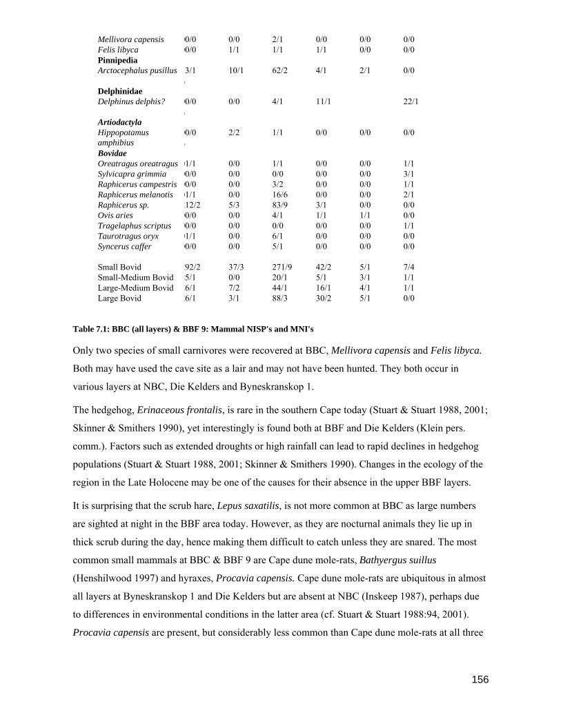
156
Mellivora capensis 00/0 0/0 2/1 0/0 0/0 0/0 Felis libyca 00/0 1/1 1/1 1/1 0/0 0/0 Pinnipedia Arctocephalus pusillus
/3/1 10/1 62/2 4/1 2/1 0/0
Delphinidae Delphinus delphis? 0
/0/0 0/0 4/1 11/1 22/1
Artiodactyla Hippopotamus amphibius
0/0/0 2/2 1/1 0/0 0/0 0/0
Bovidae Oreatragus oreatragus 01/1 0/0 1/1 0/0 0/0 1/1 Sylvicapra grimmia 00/0 0/0 0/0 0/0 0/0 3/1 Raphicerus campestris 00/0 0/0 3/2 0/0 0/0 1/1 Raphicerus melanotis 01/1 0/0 16/6 0/0 0/0 2/1 Raphicerus sp. 212/2 5/3 83/9 3/1 0/0 0/0 Ovis aries 00/0 0/0 4/1 1/1 1/1 0/0 Tragelaphus scriptus 00/0 0/0 0/0 0/0 0/0 1/1 Taurotragus oryx 01/1 0/0 6/1 0/0 0/0 0/0 Syncerus caffer 00/0 0/0 5/1 0/0 0/0 0/0 Small Bovid 292/2 37/3 271/9 42/2 5/1 7/4 Small-Medium Bovid 85/1 0/0 20/1 5/1 3/1 1/1 Large-Medium Bovid 36/1 7/2 44/1 16/1 4/1 1/1 Large Bovid 26/1 3/1 88/3 30/2 5/1 0/0
Table 7.1: BBC (all layers) & BBF 9: Mammal NISP's and MNI's
Only two species of small carnivores were recovered at BBC, Mellivora capensis and Felis libyca.
Both may have used the cave site as a lair and may not have been hunted. They both occur in
various layers at NBC, Die Kelders and Byneskranskop 1.
The hedgehog, Erinaceous frontalis, is rare in the southern Cape today (Stuart & Stuart 1988, 2001;
Skinner & Smithers 1990), yet interestingly is found both at BBF and Die Kelders (Klein pers.
comm.). Factors such as extended droughts or high rainfall can lead to rapid declines in hedgehog
populations (Stuart & Stuart 1988, 2001; Skinner & Smithers 1990). Changes in the ecology of the
region in the Late Holocene may be one of the causes for their absence in the upper BBF layers.
It is surprising that the scrub hare, Lepus saxatilis, is not more common at BBC as large numbers
are sighted at night in the BBF area today. However, as they are nocturnal animals they lie up in
thick scrub during the day, hence making them difficult to catch unless they are snared. The most
common small mammals at BBC & BBF 9 are Cape dune mole-rats, Bathyergus suillus
(Henshilwood 1997) and hyraxes, Procavia capensis. Cape dune mole-rats are ubiquitous in almost
all layers at Byneskranskop 1 and Die Kelders but are absent at NBC (Inskeep 1987), perhaps due
to differences in environmental conditions in the latter area (cf. Stuart & Stuart 1988:94, 2001).
Procavia capensis are present, but considerably less common than Cape dune mole-rats at all three

157
sites. Further details of these two species, which are prevalent in large numbers in the BBF area
today, are discussed below.
Bathyergus suillus
Cape dune mole-rats are common in the sandy soils of the southern Cape and may weigh up to 750
g. Although they live underground in extensive burrows they are relatively easily captured as they
move to the surface at night or when they leave their burrows during heavy rain. A study by the
Department of Nature Conservation showed that dune mole-rats are most active during the mid-
winter months suggesting they could be most easily hunted at this time (Schweitzer 1979:206).
Cape dune mole-rats are considered a delicacy by some local folk in the Riverdale area and are still
hunted for their meat (Henshilwood 1997); their pelts may also have been used in the past although
recent investigations into the viability of commercially farming dune mole-rat for their pelts have
not proved successful (cf. Schweitzer 1979:205).
As the BBC & BBF 9 sites are situated in the steep coastal cliffs they are unlikely to have been
accessible to burrowing dune mole-rats (Jarvis pers.comm.); additionally there were no signs of
burrows in the stratigraphy at either site, suggesting the animals were brought to the site as food,
either by humans or animals. The incisors in the premaxilla and mandible are used for digging and
are permanently exposed in live animals. A thin layer of skin forming the animals nose covers the
premaxilla, but the mandibles are well protected by a thick layer of fur and skin. Eagle owls and
small carnivores prey on Cape dune mole-rats and some may have been brought to the sites by these
agents (Henshilwood 1997).
The author observed the manner in which local people cooked dune mole-rats; the animal is placed
on its back in a bed of hot coals and allowed to roast for 20-30 minutes. In each of three cases
observed, the skin covering the premaxilla was burnt away and the premaxilla charred (Fig. 7.1).
Both the upper and lower incisors, being exposed, showed evidence of burning. However, the
mandibles which were protected by a layer of fur, remained unburnt (Henshilwood 1997).
Fig. 7.1. Bathyergus suillus: areas that are charred during cooking on open coals.

158
Bearing in mind the burning patterns seen in the above examples, all the mole-rat bones from the
five LSA units at BBC were examined for charring. Less than 10% of the post-cranial bones show
evidence of burning. Those that are burnt constitute a random selection of body parts suggesting
that burning took place after the animal had been disarticulated and possibly post-depositionally.
Examination of the cranial bones shows that the crania are unburnt but distinct burning patterns are
observable on the incisors, premaxillae and mandibles (Table 7.2). Of the mole-rat premaxillae
from the BBC units, 89% show evidence of burning and 11% are unburnt. Of the premaxillae
incisors, 94% are burnt and 6% unburnt. Of the 53 mandibles examined, 9·5% are burnt and 90·5%
show no evidence of burning. All the mandibular incisors are burnt (Henshilwood 1997). These
results closely parallel the burning patterns noted in the local observations above. We can therefore
conclude that most of the dune mole-rats in the BBC LSA assemblage were brought to the site by
its human inhabitants, probably cooked at the cave in the same manner as described above, and then
eaten on site.
The relatively high numbers of mole-rats found at other archaeological sites in the Cape littoral
zone show that these animals were commonly sought after, probably as a source of food. The BBC
evidence points to the likelihood that humans, and not animals, were responsible for the presence of
mole-rats at many other sites (Henshilwood 1997).
BBC Unit Premaxilla Incisors in
Premaxilla
Burnt Unburnt Burnt Unburnt
L2 0 1 0 1
L3 1 0 2 0
L4 10 1 18 0
L5 3 0 6 0
L6 2 0 4 0
Total 16 2 30 1
BBC Unit Mandible Incisors in
Mandible
Burnt Unburnt Burnt Unburnt
L2 0 4 4 0
L3 0 2 3 0
L4 2 22 21 0
L5 2 16 15 0
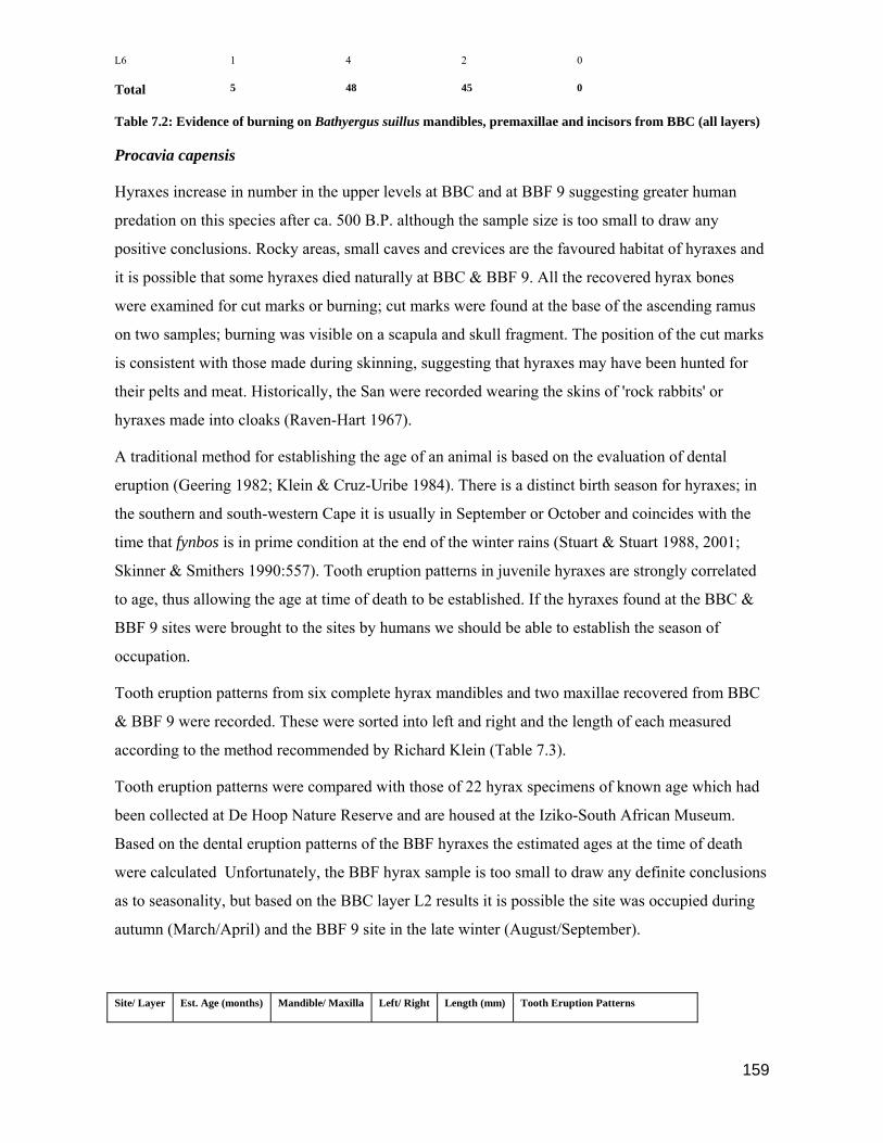
159
L6 1 4 2 0
Total 5 48 45 0
Table 7.2: Evidence of burning on Bathyergus suillus mandibles, premaxillae and incisors from BBC (all layers)
Procavia capensis
Hyraxes increase in number in the upper levels at BBC and at BBF 9 suggesting greater human
predation on this species after ca. 500 B.P. although the sample size is too small to draw any
positive conclusions. Rocky areas, small caves and crevices are the favoured habitat of hyraxes and
it is possible that some hyraxes died naturally at BBC & BBF 9. All the recovered hyrax bones
were examined for cut marks or burning; cut marks were found at the base of the ascending ramus
on two samples; burning was visible on a scapula and skull fragment. The position of the cut marks
is consistent with those made during skinning, suggesting that hyraxes may have been hunted for
their pelts and meat. Historically, the San were recorded wearing the skins of 'rock rabbits' or
hyraxes made into cloaks (Raven-Hart 1967).
A traditional method for establishing the age of an animal is based on the evaluation of dental
eruption (Geering 1982; Klein & Cruz-Uribe 1984). There is a distinct birth season for hyraxes; in
the southern and south-western Cape it is usually in September or October and coincides with the
time that fynbos is in prime condition at the end of the winter rains (Stuart & Stuart 1988, 2001;
Skinner & Smithers 1990:557). Tooth eruption patterns in juvenile hyraxes are strongly correlated
to age, thus allowing the age at time of death to be established. If the hyraxes found at the BBC &
BBF 9 sites were brought to the sites by humans we should be able to establish the season of
occupation.
Tooth eruption patterns from six complete hyrax mandibles and two maxillae recovered from BBC
& BBF 9 were recorded. These were sorted into left and right and the length of each measured
according to the method recommended by Richard Klein (Table 7.3).
Tooth eruption patterns were compared with those of 22 hyrax specimens of known age which had
been collected at De Hoop Nature Reserve and are housed at the Iziko-South African Museum.
Based on the dental eruption patterns of the BBF hyraxes the estimated ages at the time of death
were calculated Unfortunately, the BBF hyrax sample is too small to draw any definite conclusions
as to seasonality, but based on the BBC layer L2 results it is possible the site was occupied during
autumn (March/April) and the BBF 9 site in the late winter (August/September).
Site/ Layer Est. Age (months) Mandible/ Maxilla Left/ Right Length (mm) Tooth Eruption Patterns
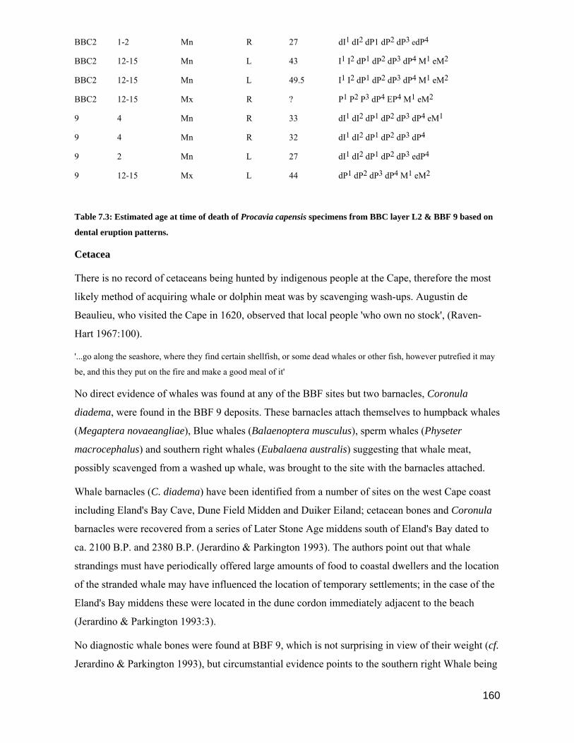
160
BBC2 1-2 Mn R 27 dI1 dI2 dP1 dP2 dP3 edP4
BBC2 12-15 Mn L 43 I1 I2 dP1 dP2 dP3 dP4 M1 eM2
BBC2 12-15 Mn L 49.5 I1 I2 dP1 dP2 dP3 dP4 M1 eM2
BBC2 12-15 Mx R ? P1 P2 P3 dP4 EP4 M1 eM2
9 4 Mn R 33 dI1 dI2 dP1 dP2 dP3 dP4 eM1
9 4 Mn R 32 dI1 dI2 dP1 dP2 dP3 dP4
9 2 Mn L 27 dI1 dI2 dP1 dP2 dP3 edP4
9 12-15 Mx L 44 dP1 dP2 dP3 dP4 M1 eM2
Table 7.3: Estimated age at time of death of Procavia capensis specimens from BBC layer L2 & BBF 9 based on
dental eruption patterns.
Cetacea
There is no record of cetaceans being hunted by indigenous people at the Cape, therefore the most
likely method of acquiring whale or dolphin meat was by scavenging wash-ups. Augustin de
Beaulieu, who visited the Cape in 1620, observed that local people 'who own no stock', (Raven-
Hart 1967:100).
'...go along the seashore, where they find certain shellfish, or some dead whales or other fish, however putrefied it may
be, and this they put on the fire and make a good meal of it'
No direct evidence of whales was found at any of the BBF sites but two barnacles, Coronula
diadema, were found in the BBF 9 deposits. These barnacles attach themselves to humpback whales
(Megaptera novaeangliae), Blue whales (Balaenoptera musculus), sperm whales (Physeter
macrocephalus) and southern right whales (Eubalaena australis) suggesting that whale meat,
possibly scavenged from a washed up whale, was brought to the site with the barnacles attached.
Whale barnacles (C. diadema) have been identified from a number of sites on the west Cape coast
including Eland's Bay Cave, Dune Field Midden and Duiker Eiland; cetacean bones and Coronula
barnacles were recovered from a series of Later Stone Age middens south of Eland's Bay dated to
ca. 2100 B.P. and 2380 B.P. (Jerardino & Parkington 1993). The authors point out that whale
strandings must have periodically offered large amounts of food to coastal dwellers and the location
of the stranded whale may have influenced the location of temporary settlements; in the case of the
Eland's Bay middens these were located in the dune cordon immediately adjacent to the beach
(Jerardino & Parkington 1993:3).
No diagnostic whale bones were found at BBF 9, which is not surprising in view of their weight (cf.
Jerardino & Parkington 1993), but circumstantial evidence points to the southern right Whale being

161
the most likely host. St. Sebastian Bay has been identified as one of the main calving areas for this
species during the winter months, from around May to October (Best pers. comm.; Stuart & Stuart
1988, 2001). Pods of southern right whales have been observed by the author less than 100 m from
the shore near Blombos Beach and local inhabitants recall southern right whales being washed
ashore in the recent past. If the Coronula barnacles found at BBF 9 were from southern right
whales, then it seems likely the site was occupied during the winter months.
Dolphins, possibly Delphinis delphis (Best pers. comm.; Stuart & Stuart 2001), are found in the
lower BBC layers and at BBF 9; these were probably also wash-ups on the beach or rocks which
were scavenged.
7.3: Domestic Animals
Ovis aries
Sheep bones were identified from Layers L4, L5 & L6 at the BBC site (Henshilwood 1996). Two
sheep bones from Layer L5 & L6 were submitted for accelerator radiocarbon dating to the Research
Laboratory for Archaeology and the History of Art at Oxford University (Henshilwood 1996; Table
7.4).
From travellers descriptions, and the Resolutions of the Dutch East India Company at the Cape it is
clear that the Khoe were well established in the Riversdale region by the 17th C (cf. Ch. 3) and the
presence of sheep in the lower BBC layers confirms a long history of pastoralism in this area. The
BBC site was repeatedly occupied during the last two millennia and it seems certain that the early
occupants of this site were in contact with domestic stock shortly after 2000 B.P. In Chapter 4
(Section 4.5) the origins of the Khoe, their likely migration routes and the timing of the arrival of
sheep at the Cape are discussed more fully; a review of the salient points is presented below.
Sealy & Yates (1994) argue that the early dates for the presence of sheep at Die Kelders (1960 ± 85
B.P.), Nelson Bay Cave (1930 ± 60 B.P.) and Byneskranskop 1 (1880 ± 50 B.P) (cf. Schweitzer
1974, 1975, 1979; Schweitzer & Wilson 1982; Klein 1986) may be incorrect as they were
calculated by associating sheep bones with recovered charcoal from within stratigraphic layers. In
his report on Nelson Bay Cave, Inskeep (1987:258) expresses doubts about the dates for sheep from
this site and points out that the reliability of the association of sheep bone and radiocarbon dates is
far from certain. As a result of this uncertainty a sheep bone, recovered from an NBC layer
radiocarbon dated at 1930 ± 60 B.P., was submitted for direct dating. The result, obtained by the
accelerator radiocarbon method, dated the bone at only 1100 ± 80 B.P. (Gowlett et al 1987; Inskeep
1987).
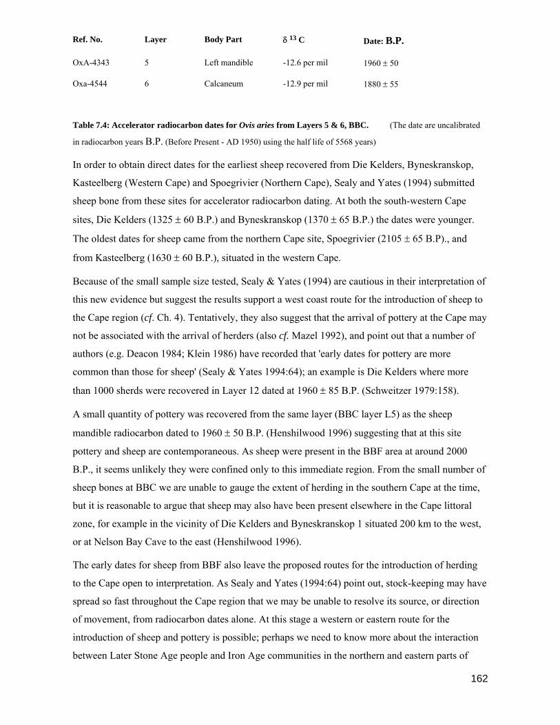
162
Ref. No. Layer Body Part δ 13 C Date: B.P.
OxA-4343 5 Left mandible -12.6 per mil 1960 ± 50
Oxa-4544 6 Calcaneum -12.9 per mil 1880 ± 55
Table 7.4: Accelerator radiocarbon dates for Ovis aries from Layers 5 & 6, BBC. (The date are uncalibrated
in radiocarbon years B.P. (Before Present - AD 1950) using the half life of 5568 years)
In order to obtain direct dates for the earliest sheep recovered from Die Kelders, Byneskranskop,
Kasteelberg (Western Cape) and Spoegrivier (Northern Cape), Sealy and Yates (1994) submitted
sheep bone from these sites for accelerator radiocarbon dating. At both the south-western Cape
sites, Die Kelders (1325 ± 60 B.P.) and Byneskranskop (1370 ± 65 B.P.) the dates were younger.
The oldest dates for sheep came from the northern Cape site, Spoegrivier (2105 ± 65 B.P)., and
from Kasteelberg (1630 ± 60 B.P.), situated in the western Cape.
Because of the small sample size tested, Sealy & Yates (1994) are cautious in their interpretation of
this new evidence but suggest the results support a west coast route for the introduction of sheep to
the Cape region (cf. Ch. 4). Tentatively, they also suggest that the arrival of pottery at the Cape may
not be associated with the arrival of herders (also cf. Mazel 1992), and point out that a number of
authors (e.g. Deacon 1984; Klein 1986) have recorded that 'early dates for pottery are more
common than those for sheep' (Sealy & Yates 1994:64); an example is Die Kelders where more
than 1000 sherds were recovered in Layer 12 dated at 1960 ± 85 B.P. (Schweitzer 1979:158).
A small quantity of pottery was recovered from the same layer (BBC layer L5) as the sheep
mandible radiocarbon dated to 1960 ± 50 B.P. (Henshilwood 1996) suggesting that at this site
pottery and sheep are contemporaneous. As sheep were present in the BBF area at around 2000
B.P., it seems unlikely they were confined only to this immediate region. From the small number of
sheep bones at BBC we are unable to gauge the extent of herding in the southern Cape at the time,
but it is reasonable to argue that sheep may also have been present elsewhere in the Cape littoral
zone, for example in the vicinity of Die Kelders and Byneskranskop 1 situated 200 km to the west,
or at Nelson Bay Cave to the east (Henshilwood 1996).
The early dates for sheep from BBF also leave the proposed routes for the introduction of herding
to the Cape open to interpretation. As Sealy and Yates (1994:64) point out, stock-keeping may have
spread so fast throughout the Cape region that we may be unable to resolve its source, or direction
of movement, from radiocarbon dates alone. At this stage a western or eastern route for the
introduction of sheep and pottery is possible; perhaps we need to know more about the interaction
between Later Stone Age people and Iron Age communities in the northern and eastern parts of
163
South Africa before this complex issue can be resolved (cf. Sealy & Yates 1994:65; Schweitzer
1979:216).
Whether the skills of pottery making accompanied the introduction of domestic animals to the
Cape, or whether they were introduced from elsewhere at more or less the same time remains an
open question (cf. Inskeep 1978; Deacon 1984; Schweitzer 1979; Henshilwood 1996).
If the picture is restored of sheep and pottery being contemporaneous, as seems to be the case at
BBC, they may not necessarily have formed part of a 'package' brought to the region by Khoekhoe
herder groups constituted in the way described in historical documents (e.g. Kolben 1738). Finely
made pottery recovered from the early layers at Die Kelders (Schweitzer 1979; Klein pers. comm.)
and possibly Boomplaas (Deacon et al. 1978) suggests ancient pottery making skills were brought
to the Cape at an early stage. The 'bowl form' earthenware from these two sites may represent the
craft of the earliest potters in the Cape, a skill that may have been lost or adapted. During the 400
years after c. 2000 B.P. the practice of stock-keeping and pottery manufacture gradually increased
within the region with the arrival of further pastoralists and continuing acculturation amongst
indigenes. After 1600 B.P., stock-keeping became well established in the Cape, sheep were the
main domesticates and cattle were also present (cf. Deacon, J 1984b; Klein 1986; Sealy & Yates
1994; Henshilwood 1996; Sadr et al; 2003).
The origins of Khoekhoe herders at the southernmost Cape may relate to the early arrival of small
stock between 2000 B.P. and 1600 B.P., but the traits typically associated with large Khoekhoe
herding groups, such as are documented for the historical period including material culture,
hierarchical group structures, clan affinities and territorial control (cf. Kolben 1738; Epstein 1937;
Deacon 1984; Klein 1986; Smith 1990 a,b; Sadr et al 2003), may only have developed more
recently (Henshilwood 1996).
Establishing whether hunter gatherers or herders were responsible for the accumulation of layers
L4, L5 & L6 at BBC is a difficult task, partly because of the small quantities of sheep bone
recovered. A review of the evidence from sites which contain sheep, given below, highlights some
of the difficulties in distinguishing between herder and hunter sites at the Cape.
Sheep are infrequent in the Nelson Bay Cave units, and consequently Inskeep (1987:259) suggests
it unlikely the NBC site was used as a kraal, but rather that sheep were brought to the site by hunter
gatherers who had acquired them by capture, or barter, from local herders. Schweitzer (1979:203)
carried out a detailed study on the age groups and sex ratios of sheep from Die Kelders site but the
results were too inconclusive to make a definitive statement as to the economic identity of the sites
inhabitants. He tentatively suggests that hunter gatherers probably acquired the sheep found in the

164
lower layers by theft or barter, although the occupants of Layer 2 and above may have been herders
who were managing their flocks. As Ovis aries are restricted to Layer 1 at Byneskranskop 1, with
low frequencies occurring within each sub-unit, Schweitzer & Wilson (1982:162) avoid speculating
as to the identity of the occupants of these levels, or how the sheep were acquired.
Some authors argue that a clear cut case can be made for distinguishing between the economic and
social differences of hunters and herders at some sites. For example, an abundance of domestic
stock in successive layers at Kasteelberg is interpreted by Klein (1986) as being indicative of a
herder site (also cf. Smith 1986; 1987; 1990 a, b; Smith et al 1991; Smith & Woodborne 1994; Sadr
et al 2003). Calcined dung layers in the upper units at Boomplaas are cited as evidence that the site
was used as a sheep kraal (Deacon, H.J et al 1978; Deacon, H.J. 1979; von den Driesch & Deacon
1985).
Hunting and herding are also viewed as separate economic categories by Parkington (1984); hunters
utilise wild resources and exist on the fringe of herding societies. Although they occasionally may
enter into client relationships with herders they also steal animals from Khoekhoe herds. As
hunters and herders have distinct social and economic systems, Parkington (1984) suggests the two
groups should be identifiable archaeologically. Schrire (1984, 1992) supports Elphick (1977, 1985)
who describes the differences between a hunting and herding way of life as being exaggerated. Both
authors agree there was a great deal of overlap between social and economic categories;
consequently hunters who obtained stock could become herders and herders who lost their stock
reverted to hunting and gathering (also cf. Goodwin 1952; Klein 1986; Sadr et al 2003).
Although Smith (1986; Smith et al 1991) has pointed out that the economic systems and social
organisation of the Khoekhoe and San are likely to have been very different there are a number of
similarities in the subsistence strategies of both groups. For example, the littoral zones of the Cape
were utilised by Khoekhoe and San for hunting, collecting shellfish and plant foods. Their
technology was also very similar (cf. Schapera 1926, 1933) and although some utensils, for
example milking bowls, were characteristically used by herders these were made of organic
materials and have not survived (Schapera 1933; Avery 1976; Hall 1986; Klein 1986). On
archaeological grounds, it is therefore often difficult to distinguish between occupations by herders
or hunters. Hunters opportunistically stole Khoekhoe stock, or acquired them though barter, and the
presence of domestic animals at a site is therefore not conclusive evidence of the identity of its
occupants.
Initial contact between San and Khoekhoe in the early part of the second millennium may have
been amicable but as the competition for available resources increased San subsistence rounds were
probably disrupted by expanding Khoekhoe demands for grazing land and territory on the Cape

165
coastal plain. San groups increasingly used the marginal inter-montane and remote coastal areas for
subsistence; raids on Khoekhoe stock by San people led to retaliatory attacks and a common
enmity. In the post 2000 B.P. period the numbers of sites situated in small shelters in the inland
Cape Folded Mountains and remote coastal areas increased rapidly (Hall 1986; Parkington et al
1986; 1988; Parkington 1987; Deacon & Deacon 1999; Mitchell 2002).
All seven of the occupation units which post-date 2000 B.P. at BBF are located in two small
shelters immediately adjacent to the coast. Gaining access to the small BBC site, situated in the
coastal cliffs, involves a long scramble over boulders along the coastline, followed by a fairly
arduous climb from below; the cave is inaccessible from above. It seems highly unlikely that a
group of herders would choose to camp at this site, particularly as their stock could not be corralled
overnight within close proximity of the cave, thereby leaving the animals vulnerable to predators.
The inaccessible location of BBC, its small size, and the low frequency of sheep bones found in the
lower units suggests rather that the site was occupied by hunter gatherers, possibly a small domestic
group (cf. Parkington & Mills 1991). The nutrient rich fynbos found in the BBF region is well
suited to grazing sheep (cf. Ch. 2), and it seems likely that herders with small stock were present in
the area at the same time that the BBC site was occupied by San hunter gatherers or dispossessed
Khoekhoe. Whether the sheep at the site were acquired through barter, or stolen from the
Khoekhoe, is open to debate; in either event the presence of sheep at BBC suggests that contact was
being made between hunters and herders in the BBF area shortly after 2000 B.P.
7.4: Micromammals
Dr. Margaret Avery at the Iziko-South African Museum identified the micromammals from BBC
(Table 7.5) and the report below is based on her interpretation; due to the very low frequency
and/or poor condition of the micromammalian remains recovered from BBF 7 and BBF 9 it was
decided to exclude them from the study. Minimum numbers of individuals were based on mandibles
and maxillae only, as is the practice in micromammalian studies. Scores were calculated for
individual excavation units, as given in the cave matrix (cf. Ch. 5) and then summed to provide
scores per layer.
A complete bat skeleton, with fur attached, supports the contention that bats are likely to have been
roosting in the cave and to have died there naturally. A few of the shrews jaws contain teeth that
have been attacked by salt (possibly from the deposit) or predator stomach acid. Possibly they were
eaten by a small mammalian carnivore. The remainder of the collection is consistent with
accumulation by barn owls (Avery pers. comm.).

166
In almost all cases the species are what one would expect in the area today. One possible exception
is the red veld rat, Aethomys chrysophilus, which presently occurs in savanna areas further north.
One would expect the species represented to be A. namaquensis. The occurrence of the lesser dwarf
shrew, Suncus varilla, constitutes a slight range extension on the basis of the map given by Skinner
& Smithers (1990). This, however, is not significant because the species certainly covers a wider
area than is indicated by the map. For instance, they have been found in modern barn-owl pellets at
the Wilderness (Avery 1982a) which is not reflected on Skinner & Smithers map (Avery pers.
comm.).
Conversely. the gerbil specimens have been assigned to the Cape gerbil, Tatera afra, on the
grounds of the present distribution of this species, since it has so far proved impossible to identify
Tatera spp. to species on cranial material. The fat mouse material has been assigned to Kreb's fat
mouse, Steatomys krebsii for the same reason. It is also considered that the specimens assigned to
Verreaux's mouse Myomyscus verreauxi are more likely to represent this species than the
multimammate mouse, Mastomys coucha, on general distributional grounds, although the ranges of
the two overlap in this vicinity.
The presence of Steatomys krebsii is of interest as it is also only found in the Later Stone Age layers
from Boomplaas Cave and Die Kelders. It seems that this species did not occur in the southern and
south-western Cape until after the Last Glacial Maximum (Avery 1982a).
Some general environmental conditions may be discerned from the micromammalian data. Rank,
grassy vegetation seems to be emphasised by the BBC Layers L5 & L6 sample, although Steatomys
krebsii suggests relatively dry grass on a sandy substrate, particularly during the occupation of
Layers L3 & L4. The Namaqua rock mouse, Aethomys namaquensis, indicates scrub on hillsides.
Subsequently, there is some indication of drier, rather more open vegetation. The apparently wetter
conditions indicated in the early samples dating to about 1800 B.P. are similar to the evidence from
the west coast at Spoeg Rivier (Avery pers. comm.). Here relatively benign conditions are
suggested about the same time in a harsh environment (Avery 1992).
Species Common Name 8/1 BB
C
L2
BB
C
L3
BB
C
L4
BB
C
L5
BB
C
L6
Mysorex varius forest shrew 1 2 1 2 1 3
Crocidura flavescens greater musk shrew 1 1
Crocidura cyanea reddish-grey musk shrew 4 2 1
Suncus varilla lesser dwarf shrew 3 1 1
Rhinolophus clivosus Geoffroy's horseshoe bay 6 9 1 7 2

167
Rhinolophus capensis Cape horseshoe bat 2
Minitopterus schreibersii Schreiber's long-fingered bat 1 1 1 1
Otomys irroratus vlei rat 5 6 4 10 3 8
Tatera afra Cape gerbil 1 2 1
Mystromys albicaudatus white-tailed rat 1
Dendromus mesomelas Brant's climbing mouse 1 1 1
Steatomys krebsii Kreb's fat mouse 1 1 3 2 1 1
Acomys subspinosus Cape spiny mouse 1 1 1
Rhabdomys pumilio striped mouse 3 6 2 7 3 5
Mus minutoides pygmy mouse 1
Myomyscus verreauxi Verreaux's mouse 1 1 1
Aethomys sp. 1
Aeothomys chrysophilus red veld rat 2 2 1
Aeothomys namaquensis Namaqua rock mouse 1
Total 29 36 13 37 12 20
Table 7.5: MNI's of micromammals at BBC
(species identification by Dr. M. Avery, South African Museum)
7.5: Reptiles
1. Tortoises
Indigenous people at the Cape are recorded eating tortoises and also using tortoise shells as
drinking receptacles and storage containers (cf. Ch. 8). This extract is from the journal, dated 1673,
of Wilhelm ten Rhyne (Schapera 1933:121).
They do sometimes use cups.....or the shells of tortoises which they have eaten. These they call sirigoos, and roast them
in the ashes and eat them
Simon van der Stel, on a journey to the Namaquas in 1685, describes Sonqua (San) they meet at
Vier-en-Twintig Rivier (Conradie 1934:38)
even poorer than the Gregriquas are the Sonquas, who must survive on bulbs, 'uintjies', tortoises, grubs and locusts
Chersina angulata
Surprisingly, tortoise bones are relatively well preserved at most of the BBF sites. Perhaps, the
small size of the bones and carapace at open sites ensured they were rapidly buried after deposition
by aeolian dune sand thus preserving them, unlike the weathered and fragmented large mammal
bones from the same sites.

168
In common with Die Kelders and Byneskranskop, only one species of land tortoise, Chersina
angulata, occurs at BBF sites. One other species of land tortoise, Homopus areolatus, is commonly
found in the southern Cape but it is much smaller than Chersina which may weigh up to 1,5 kg
(Branch 1990). Perhaps the small size of Homopus, and its habit of hiding under rocks and bushes,
accounts for its absence at southern Cape sites. Tortoise bone and carapace recovered from each site
was weighed to determine the percentage of tortoise bone relative to the total mass of the recovered
assemblage (stone excluded) (Table 7.6)
Site Tortoise Mass (g) Total Mass (g) excl.
stone
% of Tortoise to Total
Mass
BBF 1 7636 33481 22.8
BBF 2 8652 78973 11
BBF 3 1129 96296 1.2
BBF 4 339.4 92184 0.4
BBF 7 1652 62928 2.6
BBC 1966 101525 1.9
BBF 9 897 89577 1
Table 7.6: BBF : Percentage of Tortoise mass (g) to Total mass (g) (excl. stone) by site
The highest percentage of tortoises are found in the two oldest sites, BBF 1 & 2. This phenomenon
cannot be ascribed only to preservation; certainly the absence of large mammal bones at these two
sites increases the percentage of tortoise relative to the total mass of the assemblage, but then we
would expect the same results from the BBF 3, 4 and 7 sites but this is not the case. Due to an
absence of evidence it is difficult to gauge the proportionate weight that large mammal bones would
have contributed to these four sites, nevertheless it does seem that tortoises were more actively
hunted (or gathered) in the earlier sites, than in the later ones.
Schweitzer & Wilson (1982:119) note that tortoises are more abundant during dry conditions than
wet; the high percentages of tortoises at BBF 1 & 2 (ca. 6960 B.P. - 6740 B.P.) may therefore
indicate drier conditions during this period. Renewed aeolian activity and inland soil erosion, which
are indicative of dry periods, are recorded by Butzer (1974) from the Wilderness Lakes area after
7000 B.P. Similarly, Butzer & Helgren (1972) mapped renewed sand mobilisation on the Robberg
Peninsula from 7000 B.P. and Tankard (1976a) reports renewed deposition of dry shelly sands at
Die Kelders at around 6000 B.P. A synthesis of palaeoclimatic data for the period 7000 B.P. - 4000
B.P. (Cockroft et al 1987; Deacon and Lancaster 1988; Tyson & Lindsay 1992; Barrable et al 2002;
Bateman et al 2004; Carr et al 2006, 2007) indicates increasing summer rainfall and a decrease in

169
winter rainfall in the general southern Cape area although this may not apply specifically to the
BBF area which today has a lower mean precipitation than the intermontane and eastern sector of
the region (cf. Ch. 2).
Relatively high percentages of tortoise are recorded in the layers at Byneskranskop 1 which date to
ca. 6000 B.P., but as tortoise is so common in almost all layers at this site it is difficult to draw any
conclusions concerning palaeoenvironmental change from the data (Schweitzer & Wilson
1982:119).
Mean individual sizes for tortoise from the BBF sites were calculated by measuring the breadths of
the distal humeri (cf. Klein & Cruz-Uribe 1984:97). The breadth of the humerus bone represents the
size of the tortoise, and estimates of average size within a layer or phase can be made after
measuring the specimens present in the layer. Tortoises grow continuously throughout their lives,
thus the older the tortoise the larger it becomes (Hillestad-Nel in press). The results are presented
below in Table 7.7
Site Sample size (n) Mean (mm)
BBF 1 24 7.6
BBF 2 17 7.6
BBF 3 3 7.9
BBF 4 1 7
BBF 7 7 6.28
BBC 10 7.7
BBF 9 5 7.5
Table 7.7: BBF : Mean breadths (mm) of Chersina angulata distal humeri.
We would expect that the mean size of the tortoises in the two early sites may have decreased as a
result of heavy predation, but this is not the case suggesting that tortoises may have been abundant
at this time and that, on average, the tortoises available for collection were larger. Modern
populations of Chersina angulata are up to 50% larger in length and weight on the drier west coast
and on Dassen Island than in the wetter southern Cape regions (Branch 1990).
Unfortunately, the sample sizes are small from the BBF 3 & 4 sites which also may fall within the
'dry' period at BBF, although the mean sizes are comparable to those at BBF 1 & 2.
A lower incidence of forest taxa and a higher grass component in the Cape ecozone during the last
2000 years (Martin 1968; Scholtz 1986) suggests cooler conditions in the southern Cape and

170
although the eastern section of the southern Cape may have been wetter (Deacon & Lancaster 1988;
Avery 1982a, 1983) this may not have been the case in the coastal BBF region which generally has
a lower rainfall. The mean sizes of tortoises from the post 2000 B.P. sites, BBC & BBF 9, is similar
to those from BBF 1 & 2, which may indicate similar precipitation levels during the periods these
sites were occupied.
The BBF 7 site (ca. 3100 B.P.) contains the smallest mean sizes of tortoises of all the BBF sites. It
is interesting to note that the shellfish from this site were also, on average, the smallest (cf. Ch. 6).
Assemblages from all the open dune sites at BBF were surrounded by a matrix of generally white to
grey aeolian dune site, while the BBF 7 assemblage is encased in a dark, humic matrix. Although it
has been suggested that optimum forest conditions in the southern Cape generally prevailed during
the warm, moist period from around 6000 -2000 B.P. (Deacon & Lancaster 1988; Avery 1982a,
1983) this may not necessarily have been the case at BBF. Dense vegetation may only have
occurred in the BBF area during the latter part of this period, at around 4000-3000 B.P. The small
size of the tortoises at BBF 7 may therefore reflect the moist and possibly warm conditions that
existed in the BBF area at this time.
When comparing the average size of C. angulata from the LSA with the MSA phases at BBC it is
evident that the LSA tortoises are smaller (Hillestad-Nel in press). The low numbers of C. angulata
humeri from the LSA relative to the MSA and the smaller sizes might indicate that tortoise numbers
reacted to external pressures, either from heavy exploitation as a human food resource in the LSA
(more so than in the MSA) and/or unfavourable climatic conditions (Hillestad-Nel in press). The
LSA at BBC and the other BBF sites corresponds with OIS 1 which was very warm and moist.
However, the sites postdate 5 ka, with the exception of BBF 1 and BBF 2 (Henshilwood 1995: 99).
After 5 ka the climate became cooler and dryer, and similar to the present. Climate cannot be ruled
out as a factor influencing tortoise sizes in the LSA, as it could have contributed to either an
increase in tortoise size (favourable dry habitat) or a decrease (unfavourable cool habitat)
(Hillestad-Nel in press).
The small sample sizes of tortoises from the BBF sites and the general uncertainty about specific
palaeoenvironmental conditions during the Holocene, particularly with regard to the microclimate
of a particular region, precludes us from making any certain statements about either the BBF
climatic changes or about the tortoise predation strategies of BBF people. At this stage, with the
available evidence, we are only able to speculate about the relationships between tortoises,
prehistoric people and palaeoclimates in the BBF area.

171
2. Snakes & Lizards
Snake bones were recovered from BBF 2, 3, 4, 6, 9 & BBC. Small quantities of vertebra and ribs
were present in the early sites and are most common at BBC; 346 vertebra and 617 ribs were
counted from all units at the latter site. Diagnostic snake jaws from the BBC site were submitted to
the Herpetology Department at the Iziko-South African Museum but they were unable to positively
identify them to species. The most likely candidates are mole snakes, Pseudaspis cana, and puff
adders, Bitis arietans, as these are the largest and most common snakes in the BBF area. Only these
two species are recorded in the Byneskranskop 1 units (Schweitzer & Wilson 1982). It is possible
that snakes were brought to BBC as food but some may have died naturally at the site. Mole snakes
and puff adders are known to occupy abandoned animal burrows (Branch 1990) but the absence of
burrows in the LSA stratigraphy at BBC, and the fact that none of the snake bones excavated were
still articulated, suggests they were brought to the site as food.
The small number of lizard and frog jaws from BBC & BBF 9 have not been identified; it seems
most likely they died there naturally or were brought to the sites by birds or small carnivores .
7.6: Fish
Fish bones were recovered from five of the BBF sites, 1, 2, 6, 7 and BBC. Their preservation at the
early open sites, BBF 1 & 2 may be attributed to their small size causing them to be rapidly buried
by dune sand, as may have been the case for tortoise bones. Fish bones were sorted to species and
MNI's were calculated separately on two sets of body parts by Cedric Poggenpoel at the University
of Cape Town. The first calculation was based only on maxillae, premaxillae and dentaries, the
second on all other body parts. Although the MNI's derived from 'other' body parts was marginally
higher, the differences were slight - 112 fish from all sites/layers by the first method and 136 fish
by the second. It is of interest that the sites with the highest MNI's also have the highest species
diversity suggesting that at sites with low frequencies, particularly the older sites, a wider range of
fish may have been caught than have been identified.
MNI's of fish species by site/unit are presented in Table 7.8. A total of 11 fish species were
identified from BBC and the BBF sites. At Nelson Bay Cave more than 14,000 fish were counted
with a total of 19 species; 9 species are represented at Die Kelders and 11 at Byneskranskop 1.
Table 7.9 shows the fish species that are present or absent at each of the four sites.

172
BBF 1
Species Common Name
Dichistius capensis galjoen 1
Diplodus hottentotus zebra fish 1
Diplodus capensis dassie or blacktail 3
Lithognathus lithognathus white steenbras 1
Sparodon durbanensis white musselcracker 3
Site Total 9
BBF 2
Species Common Name
Cymatoceps nasutus black musselcracker 1
Diplodus capensis dassie or blacktail 2
Seriola lalandi yellowtail 1
Site Total 4
BBF 6
Species Common Name 6\2 6\3 6\4 6\7 6\8 6\11
Cymatoceps nasutus black musselcracker 2 5 2 2 3 3
Diplodus capensis dassie or blacktail 2
Petrus rupestris red steenbras 1
Sparodon durbanensis white musselcracker 1
Spondyliosoma emarginatum steentjie 2
Layer Totals 7 5 3 2 3 3
BBF 7
Species Common Name 7\2 7\3 7\4
Cymatoceps nasutus black musselcracker 1
Diplodus capensis dassie 1
Spondyliosoma emarginatum steentjie 1
Layer Totals 1 2
BBC

173
Species Common Name BBC
L1
BBC
L2
BBC
L3
BBC
L4
BBC
L5
BBC
L6
Chrysoblephus laticeps red roman 1
Dichistius capensis galjoen 1 1
Cymatoceps nasutus black musselcracker 1 3 3 27 11 3
Diplodus hottentotus zebra fish 1
Diplodus capensis dassie or blacktail 1 1
Liza richardsonii haarder 2 13 3 1
Pomatomus saltatrix elf 1
Seriola lalandi yellowtail 1 1
Sparodon durbanensis white musselcracker 1
Spondyliosoma emarginatum steentjie 1 14 5
Layer Totals 1 8 4 59 21 4
Table 7.8: MNI's for fish species from BBF sites
Species Common name BBF NBC BNK DK
Argyrozona argyrozona carpenter X X
Argyrosomus inodorus/japonicus kob X X
Clinidae klipfish X
Dichistius capensis galjoen X X X X
Chrysoblephus laticeps red roman X
Cymatoceps nasutus black musselcracker X X X
Diplodus hottentotus zebra X ?
Diplodus capensis dassie or blacktail X X X X
Epinephelus andersoni catface rockcod X
Lithognathus mormyrus sand steenbras X X
Lithognathus lithognathus white steenbras X X X X
Liza richardsonii haarder X X X
Pachymetopon blochii hottentot X X X
Petrus rupestris red steenbras X
Pomatomus saltatrix elf X X X X
Rhabdosargus globiceps white stumpnose X X X
Sarpa salpa strepie X
Seriola lalandi yellowtail X X
Sparodon durbanensis white musselcracker X X ?
Spondyliosoma emarginatum steentjie X

174
Table 7.9: Presence/ absence table for fish species from BBF, Nelson Bay Cave (NBC), Byneskranskop 1 (BNK)
& Die Kelders (DK). (X = present)
The fish species found at all the above sites are Dichistius capensis, Diplodus capensis,
Lithognathus lithognathus, and Pomatomus saltatrix. Those species occurring at three of the four
sites include Cymatoceps nasutus, Pachymetopon blochii, Rhabdosargus globiceps and possibly
Sparodon durbanensis. Two species are found only at BBF, namely Chrysoblephus laticeps and
Spondyliosoma emarginatum. The overall pattern suggests that, with some exceptions, the same
broad range of species were being caught at all the sites, and that most of the species listed above
would have occurred along the section of coast between Die Kelders and Nelson Bay Cave, a
distance of some 400 km. Varying environmental conditions, such as the presence of rocky banks or
beaches may have affected the availability of some species at the various sites. For example,
Chrysoblephus laticeps shelter in underwater caves or holes, and are commonly found in the BBF
area today because sections of the offshore shelf provide an ideal habitat for this species. Offshore
conditions for this fish may not have been similar at the other sites which may explain their
presence at BBF and absence elsewhere. The very large fish sample from Nelson Bay Cave may
also explain why some of the rarer species such as Epinephelus andersoni are reported only at this
site.
With the exception of Pachymetopon blochii, most of the species found at Die Kelders and
Byneskranskop 1 occur in relatively small numbers. At Die Kelders, P. blochii account for 96.4 %
of the fish taken (Schweitzer 1979) and 37.4 % at Byneskranskop 1 (Schweitzer & Wilson 1982).
Schweitzer (1982:197) suggests that at Die Kelders this species may have been specifically targeted
and caught on baited lines. P. blochii is absent from the BBF sites and found in relatively small
numbers at Nelson Bay Cave, mainly because these areas lack the dense kelp beds found in the
south-western Cape which are the preferred habitat of this fish. It seems that although the range of
available species at all four sites was similar, the fishing strategies at the south-western Cape sites
were different to those of the southern Cape. At the latter sites a wider range of species was caught,
either intentionally or opportunistically; this pattern is particularly evident at Nelson Bay Cave,
again perhaps because the large fish sample is better able to reflect specific strategies than is the
case for most of the BBF sites.
BBC is an exception as relatively larger numbers of fish were identified within the six layers than is
the case at the other BBF sites. The black musselcracker, Cymatoceps nasutus, is particularly
prevalent in the BBC layers L4 & L5 and accounts for 47.5 % of the fish in these two units. In the
same layers Liza richardsonii makes up 20 % of the total and Spondyliosoma emarginatum, 23.8 %;
in total these three species account for 91.3 % of the fish found in these two layers and 90 % of all
175
fish at the BBC site. Cymatoceps nasutus accounts for 74 % of the fish found in all layers at BBF 6,
and the same species occurs at BBF 2. & 7.
In total, Cymatoceps nasutus makes up 42 % of all the fish recovered from BBF sites. This apparent
pattern of continuous predation of this species at BBF is clearly not the case at Nelson Bay Cave
where Cymatoceps nasutus accounts for only 2.3 % of the fish recovered from all layers.
The reasons for the predominance of black musselcrackers at BBF are unclear and may be
multifactorial. From the available modern evidence it is difficult to gauge how prolific this species
may have been in the past in the BBF area. Both deep and shallow rocky reefs occur offshore and
provide an ideal habitat for black musselcrackers (poenskop) which are a solitary species feeding
mainly on red-bait, crabs, sea urchins and other shellfish (van der Elst 1988; Heemstra & Heemstra
2004); presumably similar offshore conditions pertained in this area during most of the Holocene
(cf. Ch. 2). Although black musselcrackers are very scarce in the BBF area today, Biden (1954)
records a number of landings of this fish along the southern Cape coast in the 1940s ; on the other
hand Smith (1953) states that nowhere on the South African coast are they found in abundance (also
cf. van der Elst 1988).
One of the reasons that black musselcrackers may have been specifically targeted at BBF was
because of the large amount of fat found in the fishes head. The marine component of hunter
gatherer diets throughout the world has elicited much controversy (e.g. Draper 1977; Speth 1990;
Dunbar 1991; Malainey et al 2001) due to the need to maintain a nutritional balance between
protein and fat- or carbohydrate rich sources to avoid the effects of protein poisoning (Noli &
Avery 1988). At the coast protein was readily available from shellfish and other marine animals
but, at most, could only constitute 50 % of the energy needs of the human body; fat and
carbohydrates were therefore essential dietary elements (Noli & Avery 1988; Dunbar 1991). From
ethnographic evidence we know that fat is still regarded as a coveted foodstuff by modern hunter
gatherers (Marshall 1976; Tanaka 1976; Draper 1977; Lee 1984; Speth 1990; Dunbar 1991;
Malainey et al 2001). Carbohydrates may have been available from plant foods although in some
areas along the coast suitable plants are a scarce resource (Deacon, J. 1984; Liengme 1987).
Possible sources of animal fat at the coast are limited mainly to seals and some species of cetacea,
but these sources may not always have been readily available or are avoided (Malainey et al 2001;
Jerardino 2003).
Smith (1953:271) notes that the head of the black musselcracker is often retained by fishermen and
regarded as a delicacy, while the coarser body flesh is fed to pigs or dogs. Biden (1954:264) records
similar sentiments among fishermen on the Cape south coast.

176
South coast fishermen value the poenskop (black musselcracker) head as a delicious and nourishing food. A party of
rock anglers caught a 110-pounder and presented it to some farmers nearby....the al fresco dinner consisted of steamed
poenskop head....and nine hungry men made an excellent meal of the large, soft, fatty and fleshy flakes of the fish's
head.
If black musselcrackers were specifically sought after by the BBF inhabitants then we need to
examine how this species may have been caught. Catch records from stone-walled fish traps in the
Kleinmond to Cape Agulhas area indicate the presence of Cymatoceps nasutus (Avery, G. 1975;
also cf. Goodwin 1946; Heese, n.d.; van Noten 1974). However, for this type of fish trap to be
effective a regular, gently sloping sea bottom with an extensive intertidal zone is essential. These
conditions could not be met in the BBF area today with its deep gulleys and irregular seabed
topography. Fish traps, still in operation today, are found at Still Bay, 20 km to the east of BBF and
at Steenkoolfontein, 18 km to the west but it seems unlikely that large musselcrackers were carried
this distance to the BBF sites. The range of non-shoaling fish caught in stone walled traps is usually
diverse (Avery,G. 1975) and catches by this method should reflect this diversity. Clearly this is not
the case at the BBF sites suggesting that stone fish traps were not the method used here to catch
black musselcrackers.
All the fish species found at BBF sites, with the exception of Liza richardsonii, could have been
caught using a hook and line. Double ended sharpened bone points, found in the Wilton layers at
Nelson Bay Cave, have been interpreted as fish gorges (Klein 1973). Goodwin (1946:137) records
that a local fisherman in the Gouritz River area found
fishing line made of a shredded wild vine and the hook was a bone tied in the middle and sharpened on each side.
Although no evidence of bone gorges was found at BBF sites, clearly these early fishermen had the
technology and skill to hook and land large fish - the black musselcrackers at BBF are a case in
point as these fish are known for their strength and fighting ability, and are seldom landed even on
modern tackle (van der Elst 1988). Nets may have been used to capture the haarders, Liza
richardsonii, which often shoal in the shallows at Blombos Beach, but it is highly unlikely that a
black musselcracker would have been easily netted.
Based on the available evidence, it seems that the inhabitants of the BBF 6 and BBC sites
deliberately sought to catch black musselcrackers, possibly for their fat, and the most likely method
used was a line, and hook or bone gorge. As black musselcrackers are seldom found in the southern
Cape during summer (Smith 1953: van der Elst 1988) it is more likely they were taken during the
winter when they would have been most plentiful. The presence of these fish thus supports a winter
occupation for the layers in which the fish occurs.

177
7.7: Summary
Large mammal bones are poorly preserved in the earlier BBF sites due to exposure and weathering,
and are absent at the BBF 6 site. Although preservation of large mammals was excellent at BBC &
BBF 9 the relatively small quantities recovered make an overall interpretation difficult. Large
bovids are marginally more frequent in the lower layers and small and small-medium bovids occur
in all the BBC layers. No large bovids were found at BBF 9 suggesting that smaller animals were
taken more frequently in the later period, perhaps due to a decrease in the availability of the larger
classes. Small numbers of carnivores, seals and a single hippo are represented at BBC.
The most common small mammal at BBC & BBF 9 is the Cape dune mole-rat, Bathyergus suillus;
rock hyraxes, Procavia capensis, are less common as are scrub hares, Lepus saxatilis. Evidence
from the burning patterns observable on mandibles, premaxillae and incisors of Bathyergus suillus
suggest that these animals were brought to BBF sites as food, and were cooked in the same manner
that local folk use today. Cut marks are visible on the jaws of two Procavia capensis specimens
which may indicate skinning, but a larger sample is needed to demonstrate this. As hyraxes have
distinct birth seasons and the dental eruption patterns in juveniles are predictable, young specimens
found in archaeological sites may be be used as indicators of the season of human occupation.
Unfortunately, the juvenile hyrax sample sizes from BBC & BBF 9 are too small to draw any
definite conclusions but the evidence suggests that BBC layer L2 was deposited during late summer
and the BBF 9 site was occupied in early spring.
The presence of Coronula diadema barnacles at BBF 9 points to the presence of whale meat at the
site; the most likely candidate is the southern right whale, Eubalaena australis, as these are known
to calve in the BBF area during winter and early spring. It is possible that whale meat, with
barnacles attached, was scavenged from a wash-up and brought to the site. Dolphins occur in the
BBC layers and at BBF 9 and are also likely to have been washed up on the rocks or beach and
scavenged for their meat.
Two sheep bones from layers 5 & 6 at BBC were submitted for accelerator radiocarbon dating; the
layer L5 bone was dated at 1960 ± B.P. and that from layer L6 at 1880 ± 55 B.P. These are the
earliest dates for sheep obtained by direct dating in the southern and south-western Cape and
suggest a long history for pastoralism in the Riversdale area and probably for the whole southern
Cape region. Pottery was recovered from the same stratigraphic layers at BBC as the sheep bone,
suggesting that both sheep and pottery were introduced to the Cape at around the same time, ca.
2000 B.P. However, the art of pottery making may not have come to the Cape along the same routes
as that of sheep, although at this stage we cannot be sure of the routes by which either may have
been introduced. Knowing more about the interaction between Later Stone Age people and Iron

178
Age agropastoralists in the northern and eastern parts of southern Africa might, in the future, shed
further light on this issue.
Although we cannot be sure whether the occupants of the lower BBC units were Khoekhoe or San,
it seems that the inaccessibility of the cave and the small quantity of sheep recovered points to
occupancy by a small group of hunter gatherers rather than herders. If this was the case, then the
sheep in these layers may have been acquired by theft or barter from local Khoekhoe.
Micromammals from the BBC site provide a limited insight into palaeoenvironmental conditions at
BBF in the Late Holocene. During the early occupation at the BBC site, ca. 2000 B.P. - 1800 B.P.
rank. grassy vegetation seems to be emphasised, but this changes to relatively dry, grassier
conditions on a sandy substrate during the period that the middle and upper layers were occupied.
Unlike large mammal bones, tortoise bones are relatively well preserved at a number of the BBF
sites, including the earliest ones. Only one species, Chersina angulata, was identified at the BBF
sites. Contrary to expectations, the highest frequencies of tortoise bones occur in the two earliest
sites, BBF 1 & 2. The mean size of tortoises during this period, calculated by measuring the breadth
of distal humeri, are among the largest for all the BBF sites. Tortoises favour drier conditions and
are both larger and more prolific during such periods. This might explain the higher frequencies and
larger mean sizes of the tortoises found in the early and later sites when the area was more arid, and
also the small mean sizes of tortoises from BBF 7, ca. 3100 B.P., when optimum forest conditions
were likely at BBF.
Eleven species of fish are recorded, but most occur in small quantities. Exceptions are the black
musselcracker, Cymatoceps nasutus, haarders, Liza richardsonii and steentjies, Spondyliosoma
emerginatum. The black musselcracker is the most common fish found at BBF and accounts for 42
% of fish found at all sites. The reasons for the predominance of this species at BBF are probably
multifactorial and include suitable offshore conditions and therefore availability, the highly
nutritious fat found in the fishes head and the ability of the locals to catch them, probably using
hand lines and gorges or hooks. With the exception of Liza richardsonii, which may have been
netted, all the other species of fish found at BBF sites could have been caught using handlines.
Stone walled fish traps are unlikely to have been used in the BBF area as the coastal topography
here is unsuited to this method; however, it is possible that the same groups of people who visited
BBF may, at other times, have operated the fish traps which are still extant in the Still Bay and
Steenkoolfontein areas.

179
CHAPTER 8
CULTURAL ARTEFACTS
8.1: Introduction.
The cultural artefacts recovered from BBF sites include stone and bone tools, decorative items in
bone and shell, and pottery. By comparing these artefacts with those recovered from archaeological
sites in the southern, south-western and eastern Cape we are able to make some predictions as to the
cultural changes which occurred in these regions over space and time, although not necessarily
explain why these changes occurred. It seems likely there was an extensive network of social
contact between hunter gatherer groups living in the Cape during the Holocene which resulted in a
broad Pan-San cognitive system operating throughout the region and beyond (Deacon, J. 1984a, b,
1990; Deacon & Deacon 1999). One of the ways in which this interlinking of San cultural systems
has been demonstrated is by comparing San rock art from a broad spectrum of sites, ranging from
Natal to the western Cape. Distinct numerical emphases of certain subjects, over an extensive
geographical area, suggests that a widely held cognitive system and social convention, rather than
idiosyncratic choice, determined the species of animals painted (Vinnicombe 1976; Lewis Williams
1982, 1987; Lewis-Williams & Dowson 1989; Lewis-Williams & Pearce 2004).
This does not imply that Pan-San cognitive systems were static during the Holocene but rather that,
over time and space, a multitude of interactive causes triggered changes within the system which
were disseminated through an extensive network of interaction. Changes that occur within a broad
social system are not necessarily synchronic nor gradual, there may also be long periods of relative
stasis followed by rapid change.
A broad trajectory of industrial change is similar in the lithics from a number of sites in the Cape
Folded Belt mountains and along the coastal regions of the Cape Province. H.J. Deacon (1976)
attributes this relative homogeneity to social contact. He rejects earlier models which favoured
cultural change brought about by the arrival of successive 'waves' of new people and favours
diffusion, possibly along linguistic pathways, which would have been tempered through time by
local adaptive responses to environmental and ecological conditions. An overall pattern of grading
within assemblages, rather than sharp contrasts, was also noticed suggesting a long trajectory of
locally induced change. Inter-site variability in subsistence modes and technology may have been
linked to adaptive strategies designed to take advantage of locally available resources. Varying
frequencies of formal tool types could also be a function of the particular tasks carried out a site,
rather than necessarily a marker of 'cultural' or social affinities (Deacon, H.J 1976; Deacon, J.
1984a, 1990; Deacon & Deacon 1999).

180
Janette Deacon (1978, 1984a) tested the assumed correlation between environmental change, stone
artefact manufacture and subsistence strategies based on the results from three sites in the southern
Cape, namely Nelson Bay Cave, Kangkara and Boomplaas. Her results showed there was a broad
correlation between environmental and subsistence change but, contrary to H.J. Deacon's (1976)
hypothesis, macroevolutionary changes in stone artefacts at these three sites cut across both
environmental boundaries and subsistence strategies. However, at all three sites the timing of the
industrial changes from Robberg to Albany to Wilton are similar, which suggests diffusion/
borrowing due to intergroup contact (Deacon & Deacon 1999; Mitchell 2002). Stone artefact
traditions could therefore best be described in terms of a model of punctuated equilibria in which
for long periods there was cultural continuity followed by a period of rapid change (Deacon, J.
1984a, 1990; Deacon & Deacon 1999). At the microevolutionary level, though, distinctions can be
made between lithic traditions from the three sites Nelson Bay Cave, Boomplaas and Kangkara.
The frequencies of certain tool types and preferred raw materials are site specific and may relate to
individual choice, availability of materials and activity variation (Deacon, J. 1978, 1984a).
A band of hunter-gatherers moving in a seasonal round may have utilised tool-kits best suited to the
tasks carried out within each environment. For instance, in the western Cape adzes are associated
with inland sites and were possibly used for the manufacture of digging sticks, whereas at coastal
sites, where marine resources may have replaced plant foods, adzes are absent or infrequent
(Parkington 1972, 1976, 1987, 1991; Parkington et al 1988; Orton 2002). However, assigning
assemblages from different sites to an individual hunter gatherer band is not yet within our
capabilities and to test this model of tool selection, or seasonal transhumance, we are reduced to
piecing together circumstantial archaeological, bioarchaeological and chemical evidence (cf.
Deacon H.J. 1969, 1976; Parkington 1972; Buchanan et al 1978; Sealy 1986, 1989; Sealy & van der
Merwe 1985; Parkington et al 1988; Parkington 1991; Jerardino 1998, 2003; Henshilwood et al
2001a; Orton 2002; Sadr et al 2003; Sealy et al 2004).
Inter- and intra-site comparisons of stone tool assemblages have yielded useful information on the
broad trajectory of industrial changes within the Cape region and have provided some interesting
insights into the factors which may have motivated these changes (Deacon, H.J. 1976; Deacon, J,
1984a, b, 1990; Inskeep 1987; Orton 2002; Jerardino 2003; Sealy et al 2004). Archaeologists are
faced with the task of interpreting past social systems based on the sparse information contained in
excavated assemblages and it is therefore understandable that most attempt to extract as much
information as possible from the data to hand (Henshilwood 1990; Orton 2002). This is particularly
true in the case of lithic assemblages where often every dimension of each artefact is measured and
recorded. In the past the resulting site reports contain extensive charts and tables comparing, for
181
example, scraper or adze sizes or shapes from a range of sites and regions. Rarely, was there an
accompanying interpretation for the reasons which motivated the changes in the sizes or shapes of
tools but rather the data was presented as a set of facts to be interpreted by the reader. Perhaps, this
is not surprising as the functions of some of the tools are, in any case, poorly understood, and
therefore attempting to explain the minute variations in the length or breadths of these same tools is
complex.
Recent approaches now seek to address the issue of understanding the use of the tools and their
likely function, not simply their dimensions (e.g. Wurz et al 2003; Lombard 2005, 2007; Minichillo
2005; Soriano et al 2007; Villa et al submitted) . The shape and size of a particular tool, or even its
function, may be related to a multiplicity of factors which may include, among others, cultural
norms operating at the time; the choice of raw materials available; the specific function for which it
was intended to be used; re-working of a worn out tool; the location and age of the site and to some
measure the idiosyncrasies of its maker (Lombard 2005, 2006 a,b, 2007a,b; Villa et al submitted.
This implies that even though broad trajectories of change in the size and shape of scrapers, for
example at the Wilton site (Deacon 1972), can be mapped over time it may not, by extension, hold
true that the reasons motivating these changes at one site will hold true for other sites in similar or
different locations (Deacon & Deacon 1999). Remnants of past social systems lie in the cultural
artefacts we recover from archaeological sites, and from the collective data at our disposal we can
recognise that a social and material cognitive system operated over a wide geographical area in
southern Africa during the Holocene and before (Henshilwood 2008; in press). In order to interpret
the reasons for the observed changes in cultural artefacts we would ideally need to examine a suite
of sites of similar age situated within a circumscribed geographical area (Henshilwood 2008).
The objectives of the study of cultural artefacts from BBF sites were to examine synchronic and
diachronic changes observable within a defined and limited region. However, although the BBF
sites are spatially linked their temporal differences provide us only with a tantalising glimpse of the
social and cultural systems which were in operation here over the past 7000 years and in the case of
BBC, into the more distant past.
The Lithic Artefacts
8.2: Classification Scheme and inventory
Lithic artefacts recovered from BBF sites were classified according to the scheme devised by J.
Deacon (1984a:370-409) which is 'based on the reduction sequence from raw material to formal
tool'. All the recovered stone was initially sorted into three classes, namely Unmodified,
Modified/Utilised and Retouched . Each artefact within a class was then classified according to

182
category and raw material. In total, over 14,000 pieces of artefactual stone were recovered from the
BBF sites but, as is usual for southern Cape coastal sites, the frequencies of diagnostic artefacts are
low, for example at Die Kelders, Byneskranskop 1, Vaalkrans Shelter located in De Hoop Nature
Reserve (Henshilwood & van Niekerk 2006) and Nelson Bay Cave (cf. Deacon, J. 1978; Schweitzer
1979; Schweitzer & Wilson 1982; Inskeep 1987). Similar observations were made at Klasies River
Mouth Caves 1 & 5 (Singer & Wymer 1969), Storms River Mouth middens (Deacon, H.J 1970),
Hoffman's Cave (Klein, unpublished) and Bonteberg Shelter (Maggs & Speed 1967) where there is
a near absence of formal tools. On the south-western Cape coast low frequencies of formal tools are
also reported at coastal sites, especially after 2000 B.P. (Orton 2002; Jerardino 2003; Sealy et al
2004).
Klein (1973) interpreted this pattern as being either due to sampling error or because formal tools
were not particularly important in the exploitation of marine resources. In the light of the greater
number of coastal sites now excavated (Schweitzer & Wilson 1982; Inskeep 1987; Jerardino 1998,
2003; Orton 2002; Sadr et al 2003; Sealy et al 2004; Henshilwood & van Niekerk 2006), sampling
error seems an unlikely explanation. Marine resources are likely to have been only part of a
seasonal round of subsistence strategies (Parkington 2001) suggesting that the same groups of
people were utilising inland resources as well although this may not always have been the case
(Sealy et al 1986, 2000). The occupants of coastal sites were therefore undoubtedly aware of the
range of formal tools found at inland sites, and possibly proficient in their manufacture. A more
likely explanation for the generally low incidence of formal tools at coastal sites is that the range of
activities carried out in a coastal environment were different to those of the inland or intermontane
regions and did not, therefore, require the same tools. Also, the economic activities of herders and
hunter gatherers were different, even at similar locations (Sadr et al 2003), and hence the tools used
were different (Sealy et al 2004).
An example of a coastal site with a relatively high formal tool component is BBF 4 site where
formal tools account for 8.5 % of the lithics. This figure suggests that the magnitude of activities
requiring retouched tools at this site was different to that at other BBF sites (Table 8.1). The high
percentages reflected for retouched artefacts at BBF 6\12, 7\2 & 7\3, are not considered statistically
significant due to the small frequencies of artefacts in these units. BBF 3 & 7\4 are interesting as
the ratio of retouched artefacts to the site total is high, suggesting that either there was minimal
knapping at the sites and that the formal artefacts here were manufactured elsewhere, or that the site
sampling strategy was inadequate.
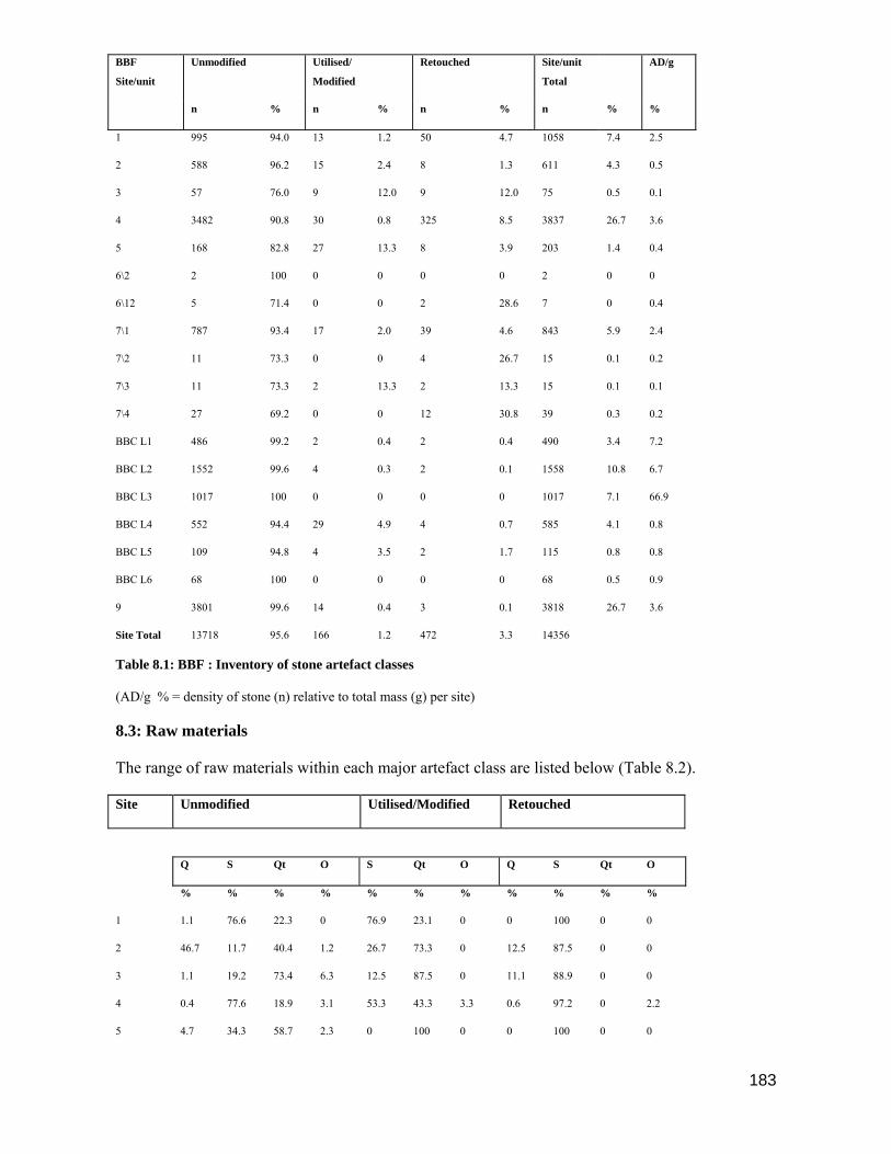
183
BBF
Site/unit
Unmodified Utilised/
Modified
Retouched Site/unit
Total
AD/g
n % n % n % n % %
1 995 94.0 13 1.2 50 4.7 1058 7.4 2.5
2 588 96.2 15 2.4 8 1.3 611 4.3 0.5
3 57 76.0 9 12.0 9 12.0 75 0.5 0.1
4 3482 90.8 30 0.8 325 8.5 3837 26.7 3.6
5 168 82.8 27 13.3 8 3.9 203 1.4 0.4
6\2 2 100 0 0 0 0 2 0 0
6\12 5 71.4 0 0 2 28.6 7 0 0.4
7\1 787 93.4 17 2.0 39 4.6 843 5.9 2.4
7\2 11 73.3 0 0 4 26.7 15 0.1 0.2
7\3 11 73.3 2 13.3 2 13.3 15 0.1 0.1
7\4 27 69.2 0 0 12 30.8 39 0.3 0.2
BBC L1 486 99.2 2 0.4 2 0.4 490 3.4 7.2
BBC L2 1552 99.6 4 0.3 2 0.1 1558 10.8 6.7
BBC L3 1017 100 0 0 0 0 1017 7.1 66.9
BBC L4 552 94.4 29 4.9 4 0.7 585 4.1 0.8
BBC L5 109 94.8 4 3.5 2 1.7 115 0.8 0.8
BBC L6 68 100 0 0 0 0 68 0.5 0.9
9 3801 99.6 14 0.4 3 0.1 3818 26.7 3.6
Site Total 13718 95.6 166 1.2 472 3.3 14356
Table 8.1: BBF : Inventory of stone artefact classes
(AD/g % = density of stone (n) relative to total mass (g) per site)
8.3: Raw materials
The range of raw materials within each major artefact class are listed below (Table 8.2).
Site Unmodified Utilised/Modified Retouched
Q S Qt O S Qt O Q S Qt O
% % % % % % % % % % %
1 1.1 76.6 22.3 0 76.9 23.1 0 0 100 0 0
2 46.7 11.7 40.4 1.2 26.7 73.3 0 12.5 87.5 0 0
3 1.1 19.2 73.4 6.3 12.5 87.5 0 11.1 88.9 0 0
4 0.4 77.6 18.9 3.1 53.3 43.3 3.3 0.6 97.2 0 2.2
5 4.7 34.3 58.7 2.3 0 100 0 0 100 0 0

184
6\2 0 0 100 0 0 0 0 0 0 0 0
6\12 60 20 20 0 0 0 0 50 50 0 0
7\1 9.1 20.3 66.1 4.5 52.9 35.3 0 12.8 87.2 0 0
7\2 18.2 36.4 45.5 0 52.9 35.3 0 12.8 87.2 0 0
7\3 0 36.4 45.5 18.2 0 100 0 0 100 0 0
7\4 3.6 25 67.9 3.6 0 0 0 0 83.3 0 16.7
BBC L1 8.6 35.7 55.3 0.4 0 100 0 0 0 100 0
BBC L2 15.8 19.1 65.1 0 0 100 0 0 100 0 0
BBC L3 0.3 0 99.7 0 0 0 0 0 0 0 0
BBC L4 47.7 21.9 30.4 0 0 0 0 25 50 25 0
BBC L5 33.6 19.1 46.4 0.9 0 100 0 50 50 0 0
BBC L6 85.8 0 13.2 0 0 100 0 0 0 0 0
9 73.4 0.7 25.8 0.2 0 0 0 100 0 0 0
Total % 22.5 24.8 49 3.7 20.2 78.4 1.4 17.5 66.3 8.3 7.9
Table 8.2: Frequencies by site/unit of raw materials in the major artefact classes
Raw Materials: Q = quartz, S = silcrete, Qt = quartzite, O = other (c.c.s & limestone)
Quartz
In the unmodified class quartz is virtually absent in the early sites which predate ca. 3200 B.P. One
exception is BBF 2 where quartz is the most common raw material in this class. The high
percentage of quartz in 6\12 is not statistically significant due to the low frequencies of unmodified
artefacts recovered. Unit 7\1 shows a significant trend towards an increase in the presence of quartz
in later sites (9.1 %); only small quantities of quartz are present in the units 7\2 -7\4.
The highest percentages of unmodified quartz artefacts are found in sites post-dating 2000 B.P.,
especially the lower layers at BBC and BBF 9; BBC layer L3 is the one exception with a high
unmodified artefact count but low percentage of quartz (0.3 %). Despite the two exceptions, BBF 2
and BBC L3, the overall trend shows a minimal presence of unmodified quartz in the early sites
followed by a rapid increase in the use of this raw material after 2000 B.P. A similar trend is
reported from some post 2000 B.P. sites on the south-western Cape coast (Orton 2002; Sadr et al
2003; Sealy et al 2004) but also with a high percentage of quartz, mostly debitage and a few
scrapers, from sites falling with the 3000 – 2000 B.P. range (Jerardino 2003). At the Vaalkrans
shelter located in the De Hoop Nature Reserve, southern Cape the quartz pieces from levels dating
to c. 1680 AD are unmodified (Henshilwood & van Niekerk 2006).
Quartz is absent in the modified/utilised category at all the BBF sites. Retouched quartz is virtually
absent in the BBF 1 - 5 sites with only two artefacts recorded. Only chunks and flakes occur in
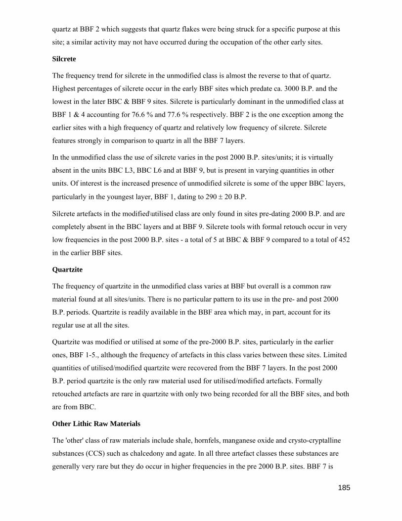
185
quartz at BBF 2 which suggests that quartz flakes were being struck for a specific purpose at this
site; a similar activity may not have occurred during the occupation of the other early sites.
Silcrete
The frequency trend for silcrete in the unmodified class is almost the reverse to that of quartz.
Highest percentages of silcrete occur in the early BBF sites which predate ca. 3000 B.P. and the
lowest in the later BBC & BBF 9 sites. Silcrete is particularly dominant in the unmodified class at
BBF 1 & 4 accounting for 76.6 % and 77.6 % respectively. BBF 2 is the one exception among the
earlier sites with a high frequency of quartz and relatively low frequency of silcrete. Silcrete
features strongly in comparison to quartz in all the BBF 7 layers.
In the unmodified class the use of silcrete varies in the post 2000 B.P. sites/units; it is virtually
absent in the units BBC L3, BBC L6 and at BBF 9, but is present in varying quantities in other
units. Of interest is the increased presence of unmodified silcrete is some of the upper BBC layers,
particularly in the youngest layer, BBF 1, dating to 290 ± 20 B.P.
Silcrete artefacts in the modified\utilised class are only found in sites pre-dating 2000 B.P. and are
completely absent in the BBC layers and at BBF 9. Silcrete tools with formal retouch occur in very
low frequencies in the post 2000 B.P. sites - a total of 5 at BBC & BBF 9 compared to a total of 452
in the earlier BBF sites.
Quartzite
The frequency of quartzite in the unmodified class varies at BBF but overall is a common raw
material found at all sites/units. There is no particular pattern to its use in the pre- and post 2000
B.P. periods. Quartzite is readily available in the BBF area which may, in part, account for its
regular use at all the sites.
Quartzite was modified or utilised at some of the pre-2000 B.P. sites, particularly in the earlier
ones, BBF 1-5., although the frequency of artefacts in this class varies between these sites. Limited
quantities of utilised/modified quartzite were recovered from the BBF 7 layers. In the post 2000
B.P. period quartzite is the only raw material used for utilised/modified artefacts. Formally
retouched artefacts are rare in quartzite with only two being recorded for all the BBF sites, and both
are from BBC.
Other Lithic Raw Materials
The 'other' class of raw materials include shale, hornfels, manganese oxide and crysto-cryptalline
substances (CCS) such as chalcedony and agate. In all three artefact classes these substances are
generally very rare but they do occur in higher frequencies in the pre 2000 B.P. sites. BBF 7 is

186
exceptional in that 'other' raw materials are found in all four units. It is the only site containing
artefacts in these raw materials which show evidence of modification/utilisation, and of formal
retouch.
Sources of Raw Materials
Silcrete
Numerous exposures of silcrete occur both in quarries and as natural outcrops between Riversdale
and Albertinia, around 30 km to the north and north-east of BBF (Bosazza 1939, Frankel 1952,
Summerfield 1981; Henshilwood et al 2001a; Johnson et al 2005). Silcrete occurs predominantly as
cappings up to 5 m in thickness on dissected erosion surfaces but is also found outcropping along
valley sides. The bedrock in this area is predominantly Bokkeveld Series shale, much of the shale
being weathered to a white locally ferruginous clay often to a depth of several metres (Johnson et al
2005). A Post Mio/Pliocene to Present age is proposed for the Cape coastal zone silcretes
(Summerfield 1981;1983).
Three types of silcrete have been noted in the area. A hard, fine grained massive grey and a less
hard, white or cream silcrete. Both of these commonly occur in clay. The grey silcrete fractures
sub-conchoidally and the less indurated material fractures irregularly and/or angularly producing
rectangular or cubic blocks when shattered. Nodular or glaebular silcrete is generally present on the
surface of flat topped hills and does not occur in clay. The third type of silcrete is a conglomerate
consisting of angular silcrete pebbles (Frankel 1952; Summerfield 1981).
Ochre
Concentrations of red and yellow (impure) ochre occur within the lenses of ferruginous clay which
overly the Bokkeveld Series shales in the area between Riversdale and Albertinia (Visser 1937;
Bosazza 1939; Summerfield 1981). Ochre was first commercially mined near Albertinia, c. 50 km
east of BBF, in 1925 by W.R van As (Frankel 1952).and these mines are still operating, in addition
to quartzite and kaolin extraction
Quartz
Quartz veins occur in the Table Mountain Group sandstones (TMS) which outcrop on the coast
below BBF. At Skurwebaai there is evidence of chipping and crushing of quartz veins suggesting
the mineral was mined here in the past. Rounded quartz pebbles can be found on Blombos Beach
and in the inter-tidal pools. Vein quartz pebbles, derived from the quartz veins in the Bokkeveld
shale, are found associated with silcrete outcrops to the east of Riversdale (Frankel 1952).

187
Quartzite
Smoothed and rounded quartzite pebbles and quartzite angular blocks are found in abundance in the
areas where TMS outcrops below BBF and on Blombos beach.
Manganese Oxide
Manganese oxide nodules are formed by precipitation on the ocean floor. Small quantities were
recovered from BBF 4; nodules may occur naturally in the low dune areas of BBF and at the coast.
8.4: Unmodified Artefacts
Unmodified artefacts, also known as 'waste' artefacts or manuports, are those that show no evidence
of having been used. The term 'waste' has deliberately not been applied here as Schweitzer &
Wilson (1982:28) point out that artefacts in this category may have been used but the evidence is
not readily detectable, particularly on quartz and quartzite. Detailed descriptions are not provided
for each category of unmodified artefacts below as these are fully described elsewhere (cf. Deacon,
H.J. 1976; Schweitzer 1979; Schweitzer & Wilson 1982; Deacon, J. 1984a, 1990; Inskeep 1987).
An inventory of classes of unmodified lithic artefacts is contained in Table 8.4; Table 8.5 reflects
raw materials by artefact categories and site/unit.
Chips & Chunks
Chips and chunks are of irregular shape with no obvious bulbar or platform scar, nor obvious
potential use. They represent the coarse debris that results when raw material is worked. Chips are
<10 mm in size, chunks are 10 mm>.
These two categories account for 78.1 % of the class total. Silcrete chips and chunks dominate at
the early sites, BBF 1, 3 & 4, but occur in lower frequencies at BBF 7 and are least common at
BBC & BBF 9. With the exception of BBF 4, quartz chips and chunks are present in small
quantities in the early sites but increase in frequency at BBF 7 and are most common in the post
2000 B.P. sites, particularly BBC layers L4, L5, L6 & BBF 9. Quartzite chunks are more frequent
than quartzite chips at all the BBF sites which may relate to the coarseness of the raw material.
Quartz, on the other hand, is brittle and shatters readily producing large numbers of chips and
flakes; as a result quartz chips outnumber chunks at virtually all the BBF sites.
Flakes, Blades & Bladelets
The flakes in this class are unmodified with no visible lateral damage that can be ascribed to usage
or retouch and are generally irregular in shape but have a discernible platform, bulbar scar and/or
recognisable dorsal or ventral surface. Silcrete flakes dominate the early assemblages at BBF 1, 3 &
4; occur in similar quantities to quartzite at BBF 7, and in the later sites quartzite and quartz flakes

188
have the highest frequencies, indicating a decrease in the use of silcrete for flake manufacture over
time. The same trend is observable for the chips and chunks categories.
Blades are parallel-sided flakes with a length greater than twice their maximum width and are 15
mm > in length; bladelets are <15 mm in length. All the blades and bladelets recovered from the pre
2000 B.P. sites are in silcrete and many of these blanks were probably struck with the intention of
retouching them for use as scrapers, backed blades, backed scrapers or borers.
Cores
Cores were separated into six categories, namely radial, blade, irregular, bipolar, single platform
and cobble. Radial cores show evidence that blades were struck from the circumference of a
discoidal core towards into centre and are found in early and late BBF sites in silcrete, quartz and
quartzite. Blade cores show evidence of parallel-sided flake scars at least twice as long as they are
wide; they occur only at BBF 1 & 4 and are in silcrete. Irregular cores do not fall within any core
sub-class, are the most frequent at BBF sites and occur in quartz, quartzite, silcrete and 'other'
materials. Bipolar cores show evidence of crushing at both ends and were probably placed on an
anvil prior to a blow being struck to the top of the piece; some may have been wrapped in leather
prior to striking. They are most commonly found in quartz suggesting this technique was applied
mainly to brittle raw materials to obtain numerous small flakes, for example at BBF 4 & 9. Single
platform cores are found only in the early sites, BBF 1, 2, 4 & 5 in quartz and silcrete. Flakes struck
directly from an unprepared cobble frequently show evidence of cortex on one surface. Cobble
cores are mainly in quartz and found only at BBF 2.
Silcrete cores predominate in the pre 2000 B.P. sites but are less frequent in later sites where quartz
cores have the highest frequency, for example in the lower BBC layers and at BBF 9.
Ochre
Ochre was classified according to three categories; pencils, chunks and ground. Ochre pencils are
elongate in shape and one end has one or more flat abraded surfaces usually forming a point;
chunks vary in shape and size but show no sign of having been worked; ochre pieces in the 'ground'
category are striated through rubbing or working but assume no particular shape.
Apart from BBF 2 & 6, ochre is found at all the BBF sites. It is less common in the earlier sites
BBF 1, 3, 4 & 5 but occurs in greater frequencies at BBF 7 & BBC. Details of the recovered ochre
are listed in Table 8.3.
BBF Site Mass Pencils Chunks Ground
pieces
g n n n

189
1 20.3 - 14 -
3 8.2 - 5 -
4 38.9 1 21 1
5 7.2 - 3 -
7 74.6 1 43 1
BBC 234.9 - 182 15
9 1.6 - 2 -
Total 385.7 2 270 17
Table 8.3: Inventory of ochre from BBF sites
Class> Chips Chunks Flakes Blades B/lets Cores Site/unit
Total
Site/
unit
15mm> <15mm Radial Blade Irreg
.
Bipolar SP Cobble n
1 445 218 208 47 63 3 6 0 5 0 995
2 140 201 221 1 2 6 7 10 588
3. 18 33 1 2 2 1 57
4 1153 1223 848 208 4 5 37 3 1 3482
5 18 82 37 8 2 11 2 8 168
6\2 2 2
6\12 2 1 1 1 5
7\1 65 479 228 2 3 6 4 787
7\2 2 6 2 1 11
7\3 6 5 11
7\4 17 10 27
BBC
L1
223 194 64 2 1 2 486
BBC
L2
1017 406 118 6 3 2 1552
BBC
L3
637 308 71 1 1017
BBC
L4
159 253 124 4 2 10 1 552
BBC
L5
17 54 34 1 2 1 109
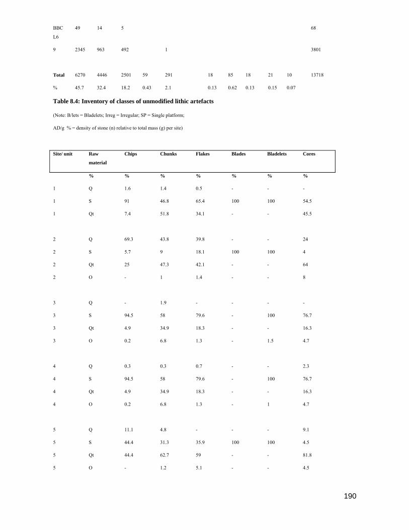
190
BBC
L6
49 14 5 68
9 2345 963 492 1 3801
Total 6270 4446 2501 59 291 18 85 18 21 10 13718
% 45.7 32.4 18.2 0.43 2.1 0.13 0.62 0.13 0.15 0.07
Table 8.4: Inventory of classes of unmodified lithic artefacts
(Note: B/lets = Bladelets; Irreg = Irregular; SP = Single platform;
AD/g % = density of stone (n) relative to total mass (g) per site)
Site/ unit Raw
material
Chips Chunks Flakes Blades Bladelets Cores
% % % % % % %
1 Q 1.6 1.4 0.5 - - -
1 S 91 46.8 65.4 100 100 54.5
1 Qt 7.4 51.8 34.1 - - 45.5
2 Q 69.3 43.8 39.8 - - 24
2 S 5.7 9 18.1 100 100 4
2 Qt 25 47.3 42.1 - - 64
2 O - 1 1.4 - - 8
3 Q - 1.9 - - - -
3 S 94.5 58 79.6 - 100 76.7
3 Qt 4.9 34.9 18.3 - - 16.3
3 O 0.2 6.8 1.3 - 1.5 4.7
4 Q 0.3 0.3 0.7 - - 2.3
4 S 94.5 58 79.6 - 100 76.7
4 Qt 4.9 34.9 18.3 - - 16.3
4 O 0.2 6.8 1.3 - 1 4.7
5 Q 11.1 4.8 - - - 9.1
5 S 44.4 31.3 35.9 100 100 4.5
5 Qt 44.4 62.7 59 - - 81.8
5 O - 1.2 5.1 - - 4.5

191
6\2 Qt - 100 - - - -
6\12 S - - - - 100 -
6\12 O - 50 - - - -
7\1 Q 26.2 7.1 8.8 - - 30
7\1 S 18.5 15.4 30.7 - 50 0
7\1 Qt 43.1 74.1 56.6 - - 10
7\1 O 12.3 3.3 4 - 50 40
7\2 Q 100 - - - - -
7\2 S - 33.3 50 - - 100
7\2 Qt - 66.7 50 - - -
7\3 S - 33.3 40 - - -
7\3 Qt - 50 40 - - -
7\3 O - 16.7 20 - - -
Table 8.5: Unmodified class lithics: Raw material by artefact categories and site /unit
(continued on next page)
(Table 8.5: Continued from previous page)
Site/ unit Raw
material
Chips Chunks Flakes Blades Bladelets Cores
% % % % % % %
7\4 Q - 5.9 - - - -
7\4 S - 23.5 30 - - -
7\4 Qt - 70.6 70 - - -
7\4 O - 5.9 - - - -
BBC L1 Q 15.2 2.6 4.7 - - -
BBC L1 S 40.4 30.4 32.8 100 - 66.6
BBC L1 Qt 44.4 67 62.5 - - 33.3
BBC L1 O - 1 - - - -
BBC L2 Q 22.2 4.2 1.7 - - -
BBC L2 S 15.1 21.7 38.1 - 100 80

192
BBC L2 Qt 62.6 74.1 60.2 - - 20
BBC L3 Q - 1 - - - -
BBC L3 Qt 100 99 100 - - 100
BBC L4 Q 71.1 31.2 50 - 25 81.8
BBC L4 S 17 23.7 25.8 - 50 -
BBC L4 Qt 11.9 45.1 24.2 - 25 18.2
BBC L5 Q 100 7.4 38.2 - - 66.6
BBC L5 S - 20.4 26.5 - - 33.3
BBC L5 Qt - 72.2 35.3 - - -
BBC L5 O - 1.9 - - - -
BBC L6 Q 93.9 57.1 100 - - -
BBC L6 Qt 6.1 42.9 - - - -
9 Q 81.8 62.8 55.3 - - 59.1
9 S 0.1 0.8 3.5 - 0 -
9 Qt 18 36.3 41.3 - 100 40.9
9 O 0 0.2 0.6 - - 4.5
Table 8.5: (Continued) : Unmodified class lithics: Raw material by artefact categories and site /unit.
Raw Materials: Q = quartz, S = silcrete, Qt = Quartzite, O = other (c.c.s & limestone)
8.5 Utilised/Modified Class
Artefacts falling within the utilised/modified class show evidence of use damage, or of modification
of their shape for, or through use. Utilised/modified stone artefacts account for 1.1 % of the total of
lithic artefacts recovered from all BBF sites. The low frequencies found in most categories of
utilised/modified tools make it difficult to analyse trends in raw material use and tool type over
time, although there are some clear differences between sites pre- and post-dating 2000 B.P. and
these are discussed below. Table 8.6 is an inventory of categories of utilised/modified lithic
artefacts; Table 8.7 lists the raw materials by artefact categories and site/unit for utilised/modified
artefacts.

193
Flakes, blades and bladelets
Utilised flakes, blades or bladelets were recovered only from sites pre-dating 2000 B.P., and with a
few minor exceptions in quartzite, the predominant raw material is silcrete. Schweitzer (1979:177)
suggested that some untrimmed flakes in the unmodified category at Die Kelders may have been
used, possibly mounted in mastic, but no utilisation damage was visible. Most of the flakes, blades
and bladelets from BBF sites were examined through a microscope for edge or utilisation damage,
but as the data in Table 8.6 shows, the numbers of these artefacts that appear to have been used are
small. The intended purpose of the large numbers of unmodified flakes, blades and bladelets
manufactured at BBF sites is therefore unclear. A small percentage (18 %) were utilised, modified
or retouched, but the majority are unmodified. At BBF 9 almost 500 quartz flakes were counted but
none showed signs of use or retouch.
However, two chunks of mastic were recovered from the western side of the OH hearth suggesting
that some of these flakes may have been mounted as armatures. An example of a small mastic-
mounted quartz flake was found in Layer 12 at Die Kelders dated at 1960 ± 85 B.P. (Schweitzer
1979:177). In two watercolours painted by F. Steeb in 1813, 'Bushmen' are depicted near Graaff
Reinet, Eastern Cape Province, carrying arrows which have triangular tips (iron?) mounted in
mastic (Cape Archives A1415 (73)). It therefore seems probable this practice persisted throughout
the Late Holocene.
Pièce esquille (Scaled Pieces)
Scaled pieces show evidence of crushing or chipping along the striking platform, possibly as a
result of being used on wood (Deacon, J, 1984a:379) although Schweitzer (1982:37) suggests that
scaled pieces may be worked-out bladelet cores which have their edges crushed during attempts at
removing further bladelets (also cf. Inskeep 1987:53).
Scaled pieces in silcrete only occur in the earlier BBF sites but examples in quartzite are found in
small quantities throughout the BBF occupation sequence.
Hammerstones, Grindstones and Combinations
Hammerstones from the BBF sites are generally water-worn pebbles or cobbles which show pitting
or bruising consistent with use as a hammer. A total of 38 were recovered from 9 BBF sites/units
and all are quartzite. Hammerstones are a regular feature of coastal exploitation patterns and may,
among other applications, have been used for processing shellfish, breaking up pigment nodules or
in the production of quartz waste (e.g. at BBF 9) (Deacon, H.J. 1976; Avery 1976; Schweitzer
1979; Schweitzer & Wilson 1982; Inskeep 1987; Orton 2002).The highest number of hammerstones
come from the BBF 5 site (29 %) and lends support to the proposal made in Chapters 5 & 6 that the

194
site was primarily used for processing Turbo and S. tabularis. Twelve lower grindstones (36 % of
total BBF grindstones) came from BBF 5 and show evidence of scarring and pitting consistent with
use as anvils; these may have been collected from surrounding sites.
Lower grindstones bear smoothed grooves or concave surfaces as a result of being used as a fixed
grinding surface. Rubbers, or upper grindstones, are smaller stones which can be hand-held and
have one or more facetted surfaces caused by use during rubbing; 38 % of the BBF upper
grindstones were stained with ochre as were 43 % of the lower grindstones. Combination tools
include hammer/grindstones and a single grindstone/core. With the exception of BBF 6
hammerstones and grindstones are found at all the BBF sites.
Fig. 8.1. Quartzite grindstone in situ. The ground surfaces of the grindstones on this site were
turned face down.
Flaked cobbles are stones that have been opportunistically used, perhaps once or twice, as hammers
or anvils resulting in abrasion marks, the removal of surface cortex or of a few flakes. As such, they
cannot be classified within the above categories and are infrequent at BBF sites.
All the hammerstones, upper and lower grindstones, combination hammer/grindstones and a
grindstone/core from BBF are in quartzite.
Site/
Unit
Flakes Blades B/lets PE HS Grind-
stones
Comb-
ination
F.C Total
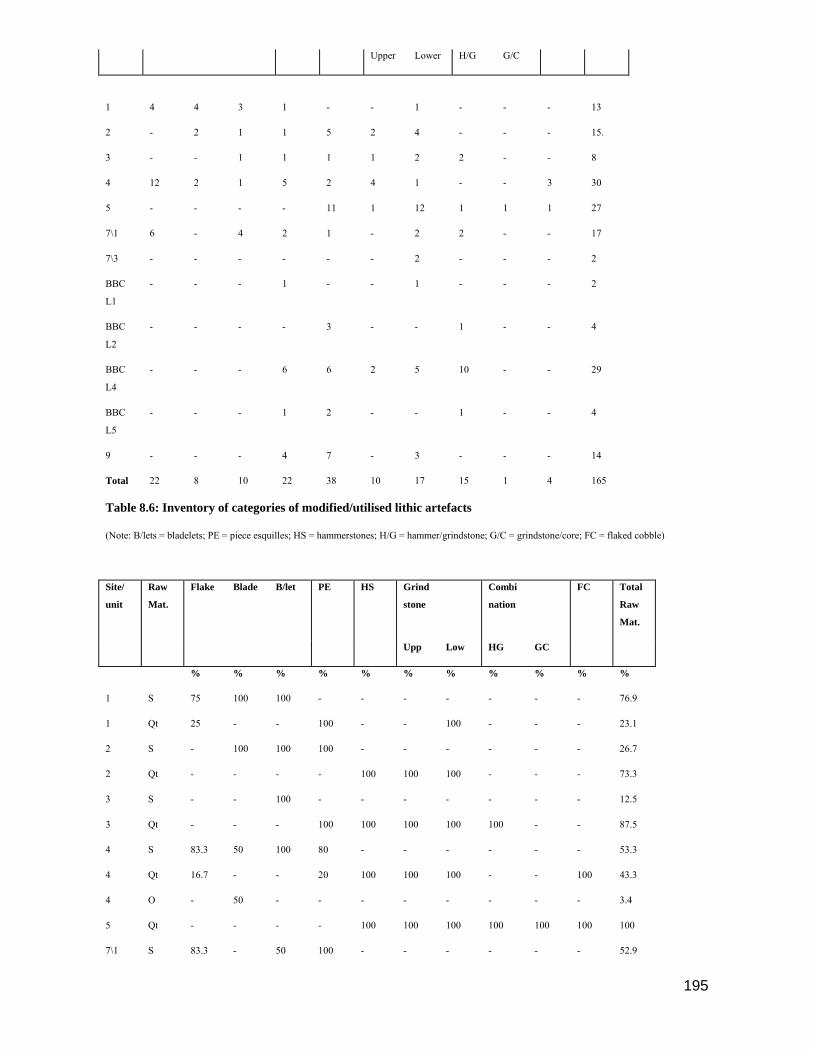
195
Upper Lower H/G G/C
1 4 4 3 1 - - 1 - - - 13
2 - 2 1 1 5 2 4 - - - 15.
3 - - 1 1 1 1 2 2 - - 8
4 12 2 1 5 2 4 1 - - 3 30
5 - - - - 11 1 12 1 1 1 27
7\1 6 - 4 2 1 - 2 2 - - 17
7\3 - - - - - - 2 - - - 2
BBC
L1
- - - 1 - - 1 - - - 2
BBC
L2
- - - - 3 - - 1 - - 4
BBC
L4
- - - 6 6 2 5 10 - - 29
BBC
L5
- - - 1 2 - - 1 - - 4
9 - - - 4 7 - 3 - - - 14
Total 22 8 10 22 38 10 17 15 1 4 165
Table 8.6: Inventory of categories of modified/utilised lithic artefacts
(Note: B/lets = bladelets; PE = piece esquilles; HS = hammerstones; H/G = hammer/grindstone; G/C = grindstone/core; FC = flaked cobble)
Site/
unit
Raw
Mat.
Flake Blade B/let PE HS Grind
stone
Combi
nation
FC Total
Raw
Mat.
Upp Low HG GC
% % % % % % % % % % %
1 S 75 100 100 - - - - - - - 76.9
1 Qt 25 - - 100 - - 100 - - - 23.1
2 S - 100 100 100 - - - - - - 26.7
2 Qt - - - - 100 100 100 - - - 73.3
3 S - - 100 - - - - - - - 12.5
3 Qt - - - 100 100 100 100 100 - - 87.5
4 S 83.3 50 100 80 - - - - - - 53.3
4 Qt 16.7 - - 20 100 100 100 - - 100 43.3
4 O - 50 - - - - - - - - 3.4
5 Qt - - - - 100 100 100 100 100 100 100
7\1 S 83.3 - 50 100 - - - - - - 52.9
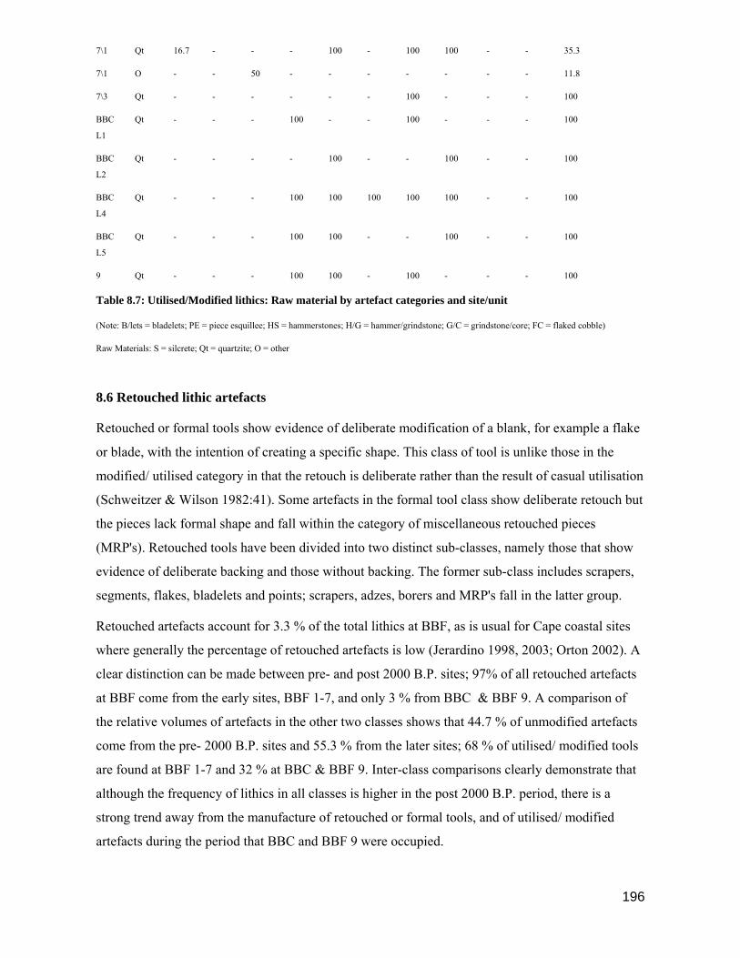
196
7\1 Qt 16.7 - - - 100 - 100 100 - - 35.3
7\1 O - - 50 - - - - - - - 11.8
7\3 Qt - - - - - - 100 - - - 100
BBC
L1
Qt - - - 100 - - 100 - - - 100
BBC
L2
Qt - - - - 100 - - 100 - - 100
BBC
L4
Qt - - - 100 100 100 100 100 - - 100
BBC
L5
Qt - - - 100 100 - - 100 - - 100
9 Qt - - - 100 100 - 100 - - - 100
Table 8.7: Utilised/Modified lithics: Raw material by artefact categories and site/unit
(Note: B/lets = bladelets; PE = piece esquillee; HS = hammerstones; H/G = hammer/grindstone; G/C = grindstone/core; FC = flaked cobble)
Raw Materials: S = silcrete; Qt = quartzite; O = other
8.6 Retouched lithic artefacts
Retouched or formal tools show evidence of deliberate modification of a blank, for example a flake
or blade, with the intention of creating a specific shape. This class of tool is unlike those in the
modified/ utilised category in that the retouch is deliberate rather than the result of casual utilisation
(Schweitzer & Wilson 1982:41). Some artefacts in the formal tool class show deliberate retouch but
the pieces lack formal shape and fall within the category of miscellaneous retouched pieces
(MRP's). Retouched tools have been divided into two distinct sub-classes, namely those that show
evidence of deliberate backing and those without backing. The former sub-class includes scrapers,
segments, flakes, bladelets and points; scrapers, adzes, borers and MRP's fall in the latter group.
Retouched artefacts account for 3.3 % of the total lithics at BBF, as is usual for Cape coastal sites
where generally the percentage of retouched artefacts is low (Jerardino 1998, 2003; Orton 2002). A
clear distinction can be made between pre- and post 2000 B.P. sites; 97% of all retouched artefacts
at BBF come from the early sites, BBF 1-7, and only 3 % from BBC & BBF 9. A comparison of
the relative volumes of artefacts in the other two classes shows that 44.7 % of unmodified artefacts
come from the pre- 2000 B.P. sites and 55.3 % from the later sites; 68 % of utilised/ modified tools
are found at BBF 1-7 and 32 % at BBC & BBF 9. Inter-class comparisons clearly demonstrate that
although the frequency of lithics in all classes is higher in the post 2000 B.P. period, there is a
strong trend away from the manufacture of retouched or formal tools, and of utilised/ modified
artefacts during the period that BBC and BBF 9 were occupied.
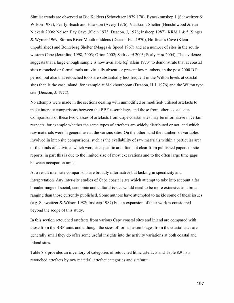
197
Similar trends are observed at Die Kelders (Schweitzer 1979:170), Byneskranskop 1 (Schweitzer &
Wilson 1982), Pearly Beach and Hawston (Avery 1976), Vaalkrans Shelter (Henshilwood & van
Niekerk 2006; Nelson Bay Cave (Klein 1973; Deacon, J, 1978; Inskeep 1987), KRM 1 & 5 (Singer
& Wymer 1969, Storms River Mouth middens (Deacon H.J. 1970), Hoffman's Cave (Klein
unpublished) and Bonteberg Shelter (Maggs & Speed 1967) and at a number of sites in the south-
western Cape (Jerardino 1998, 2003; Orton 2002; Sadr et al 2003; Sealy et al 2004). The evidence
suggests that a large enough sample is now available (cf. Klein 1973) to demonstrate that at coastal
sites retouched or formal tools are virtually absent, or present low numbers, in the post 2000 B.P.
period, but also that retouched tools are substantially less frequent in the Wilton levels at coastal
sites than is the case inland, for example at Melkhoutboom (Deacon, H.J. 1976) and the Wilton type
site (Deacon, J. 1972).
No attempts were made in the sections dealing with unmodified or modified/ utilised artefacts to
make intersite comparisons between the BBF assemblages and those from other coastal sites.
Comparisons of these two classes of artefacts from Cape coastal sites may be informative in certain
respects, for example whether the same types of artefacts are widely distributed or not, and which
raw materials were in general use at the various sites. On the other hand the numbers of variables
involved in inter-site comparisons, such as the availability of raw materials within a particular area
or the kinds of activities which were site specific are often not clear from published papers or site
reports, in part this is due to the limited size of most excavations and to the often large time gaps
between occupation units.
As a result inter-site comparisons are broadly informative but lacking in specificity and
interpretation. Any inter-site studies of Cape coastal sites which attempt to take into account a far
broader range of social, economic and cultural issues would need to be more extensive and broad
ranging than those currently published. Some authors have attempted to tackle some of these issues
(e.g. Schweitzer & Wilson 1982; Inskeep 1987) but an expansion of their work is considered
beyond the scope of this study.
In this section retouched artefacts from various Cape coastal sites and inland are compared with
those from the BBF units and although the sizes of formal assemblages from the coastal sites are
generally small they do offer some useful insights into the activity variations at both coastal and
inland sites.
Table 8.8 provides an inventory of categories of retouched lithic artefacts and Table 8.9 lists
retouched artefacts by raw material, artefact categories and site/unit.
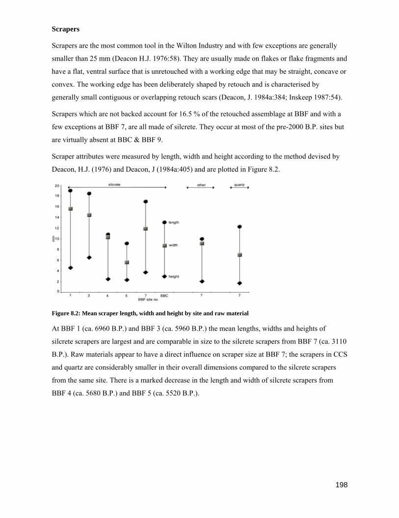
198
Scrapers
Scrapers are the most common tool in the Wilton Industry and with few exceptions are generally
smaller than 25 mm (Deacon H.J. 1976:58). They are usually made on flakes or flake fragments and
have a flat, ventral surface that is unretouched with a working edge that may be straight, concave or
convex. The working edge has been deliberately shaped by retouch and is characterised by
generally small contiguous or overlapping retouch scars (Deacon, J. 1984a:384; Inskeep 1987:54).
Scrapers which are not backed account for 16.5 % of the retouched assemblage at BBF and with a
few exceptions at BBF 7, are all made of silcrete. They occur at most of the pre-2000 B.P. sites but
are virtually absent at BBC & BBF 9.
Scraper attributes were measured by length, width and height according to the method devised by
Deacon, H.J. (1976) and Deacon, J (1984a:405) and are plotted in Figure 8.2.
Figure 8.2: Mean scraper length, width and height by site and raw material
At BBF 1 (ca. 6960 B.P.) and BBF 3 (ca. 5960 B.P.) the mean lengths, widths and heights of
silcrete scrapers are largest and are comparable in size to the silcrete scrapers from BBF 7 (ca. 3110
B.P.). Raw materials appear to have a direct influence on scraper size at BBF 7; the scrapers in CCS
and quartz are considerably smaller in their overall dimensions compared to the silcrete scrapers
from the same site. There is a marked decrease in the length and width of silcrete scrapers from
BBF 4 (ca. 5680 B.P.) and BBF 5 (ca. 5520 B.P.).

199
Fig. 8.3. BBF 1a) thumbnail scrapers and b) silcrete backed scrapers; BBF 3 silcrete scrapers;
BBF 5 silcrete scrapers; BBF 7 quartz scrapers
Interestingly, the silcrete scrapers from BBC which post dates 2000 B.P are similar in size to those
from BBF 4, but the sample size is too small to observe any trends. It is possible that the scrapers
found at BBC were not manufactured at the site but collected from one of the dune sites and
brought to the cave. Scrapers are also rare at Die Kelders after 2000 B.P. and less abundant at
Nelson Bay Cave in the upper units. On the south-western Cape coast scrapers are rarely recorded
at post 2000 B.P. sites (Jerardino 2003). For example at Dunefield Midden scrapers make up less
than 0.1 % of the ‘non-rounded’ lithics recovered from levels that date to post c. 900 B.P. (Orton
2002). At the Kasteelberg sites on the Vredenberg Peninsula the numbers of formal tools, and
scrapers, associated with hunter and/or herder occupations in the first millennium A.D. is also very
low (Sadr et al 2003). However scrapers are relatively common in the dune deflation hollows away
from the Eland’s Bay coast after about 4000 B.P., as are adzes, but the numbers decrease after c.
3000 B.P., particularly in the coastal megamiddens in the region that date to c. 3000 – 2000 B.P.
(Jerardino & Yates 1996, 1997)
As is the case at BBF, silcrete dominates the scraper category (83.8%) at Byneskranskop 1 (BNK);
quartz scrapers are almost absent after 6000 B.P. but rapidly increase in frequency in Layers 5-3
(ca. 3900 B.P.), similar to the trend observed at BBF 7. Morphological changes in scraper size over
time are also similar to those at BBF. Scrapers are longest in the lower BNK levels which pre-date
6540 B.P., those in Layers 10 - 6 (>6540 B.P.) change to being wider and shorter in size and after
3900 B.P again increase in mean size.
At the Wilton site, the climax phase of the Wilton Industry is in Layers 3F - B which coincides with
the occupation of the BBF 4, 5 & 7 sites. During this period scrapers are generally short and wide
and mainly in silcrete (Deacon 1972). Brooker (1989) records a reduction in scraper size at

200
Uniondale after ca. 5000 B.P. and similar trends are observable at Buffelskloof (Opperman 1976,
1978) and at Kangkara (Deacon 1984a). Similar trajectories in scraper size over time occur at the
southern Cape sites, Oakhurst (Goodwin 1933, 1938; Fagan 1960; Schrire 1962) and Matjes River
(Louw 1960) but a lack of reliable radiocarbon dates from these sites makes direct comparison
difficult (also cf. Deacon 1984a:307).
Direct comparisons with scrapers from Nelson Bay Cave are complicated by the raw materials used
at the site for scraper manufacture; differences in the raw materials used at NBC and BBF are
therefore likely to affect scraper size and morphology. Only one silcrete scraper was recovered at
the NBC site and the balance are in quartzite, quartz and chalcedony. The most likely explanation is
a lack of availability of silcrete in the NBC region and conversely the relative abundance of silcrete
in the BBF and BNK region (cf. Ch. 2). The mean size of the few quartz scrapers from BBF 7 are
similar in size to those from NBC dating to the same time period.
In summary, the overall trend in scraper size and morphology is similar to that observed at other
Wilton and Pottery Wilton sites in the southern Cape and elsewhere. At BBF the transition from
longer scrapers to shorter and wider scrapers occurs at around 5700 B.P. and appears to have been a
relatively rapid process after the occupation of the BBF 3 site (ca. 6000 B.P.). The mean sizes of
silcrete scrapers increase again after 3110 B.P. at BBF 7, and this trend is similar to that observed at
other coastal and inland sites. Scrapers made from CCS at BBF 7 are similar in size to the BBF 4
scrapers, but due to the relatively small numbers recovered (5) this observation should be treated
with caution.
Generally, scrapers are the most common formal tool in the Wilton Industry (Deacon, H.J.
1976:58), for example they account for 52 % of the retouched tools at BNK 1 (Schweitzer &
Wilson 1982) and 72.4 % at the Wilton site (Deacon, J. 1972). This is not the case at BBF where
scrapers make up only 16.5 % of the retouched class and are overshadowed by backed scrapers
which constitute 31 % of formal tools. The largest assemblage of formal tools comes from the BBF
4 site, and here scrapers account for only 7.2 % of retouched artefacts, whereas backed scrapers
make up 43 % of the class total. The role of backed scrapers at BBF is discussed in greater detail
below.
Adzes
Adzes show evidence of retouch or step flaking along one or both of their laterals and may be made
on flakes or pebbles. They may have one or two working edges which are shaped by a set of flake
scars and often display evidence of secondary step-flaking resulting from being used in a chopping
motion at a steep angle (Deacon, H.J.1976:60; Deacon, J. 1984a:391; Schweitzer & Wilson

201
1982:49). The mean length of adzes in the southern Cape is between 25 - 40 mm making them
generally larger than scrapers; over time there is less variability in the size of adzes (Deacon
1984a:391). Mastic is retained on some samples from Melkhoutboom indicating that adzes were
hafted, and a few examples from this site indicate end-mounting (Deacon, H.J. 1976:60). As the
opposing sides of adzes are often retouched it suggests they were sometimes reversed in their
mounts (Deacon, J. 1984a:391).
Fig. 8.4. Silcrete adzes from BBF 4 & BBF 7.
At BBF adzes account for 6 % of total retouched tools; small numbers occur at BBF 3, 4 & BBC
L5. The BBF 7 site is quite exceptional as adzes constitute 38.6 % of the formal tool assemblage. If
adzes were used as woodworking tools (cf. Mazel & Parkington 1981) then their high profile at
BBF 7 may relate to the ecology of the region at the time. A series of dark, humic paleosols form
the matrix for the BBF 7 layers suggesting a heavily wooded environment at the time of occupation
(cf. Ch. 5) and lends support to the view that forest conditions in the southern Cape may have been
optimal at this time (ca. 3000 B.P.) (cf. Ch. 2). On the south-western Cape coast adzes are relatively
important at Steenbokfontein Cave and at Pancho’s Kitchen Midden between c. 2700 – 2200 B.P.
(Jerardino & Yates 1996, 1997). To the east of this region and towards the Cape Fold Belt
mountains the frequency of adzes increases after 3500 B.P. (Manhire 1993). This apparent pattern
in the increase of adze use on the south-western and southern Cape coasts (Schweitzer & Wilson
1982) at about the same time perhaps suggests an increasing emphasis on woodworking, at least in
some regions, and an ameliorable climate with conditions conducive to forest growth.
A relative paucity of adzes during the early period of occupations at BBF (e.g. BBF 3 & 4) and in
the later period (BBC layer L5) may relate to the relatively drier conditions predicted for these

202
periods, but this theory must remain highly speculative until we are better able to decipher the
function of adzes and of the ecology of the Holocene.
All the adzes from BBF were made in silcrete and in this respect BBF is similar to BNK 1 where
98.5 % of adzes were also in silcrete. At the NBC site adzes were probably not in use as only two
doubtful examples were recovered from the whole excavated sequence (Inskeep 1987:140); they are
also not present at Die Kelders (Schweitzer 1979), although H.J. Deacon (1976:60) reports that
adzes are found in many eastern Cape site, for example at Wilton, Uniondale and Highlands.
Adzes from BBF 4 are only marginally smaller than those from BBF 7\1, with the largest adzes
occurring in the lower layers at BBF 7. The size differences may not be temporally related but
rather to the specific application of the tool, particularly as all the adzes in 7\4 are substantially
larger than those from 7/ & 7\3 although the time differences between the layers is minimal. The
mean sizes of the adzes from BBF fall within the size ranges reported from BNK 1 (Schweitzer &
Wilson 1982:49) and for the southern Cape in general (cf. Deacon, J. 1984:391).
Figure 8.5: Mean sizes of adzes from BBF sites
Backed Pieces
Backed microliths are usually made on flakes or blades and are characterised by the presence of
backing, with abrupt retouch along one lateral margin and a sharp edge along the other margin
(Akazawa et al 1980:88). The classification of sub-classes of backed pieces are based on the shape
of the backed margin, for example segments are curved and backed bladelets are straight. Backed
microliths are less than 25 mm in length, are characteristic of LSA assemblages and are usually
made on fine grained materials such as silcrete, CCS, quartz and hornfels (Deacon, J. 1984a:390).
Backing or abrupt retouch on a tool may increase its purchase when inserted in mastic prior to, or
during, hafting (Inskeep 1987:54). Sub-classes of backed pieces include scrapers, segments, flakes,
bladelets and backed points (Table 8.8).
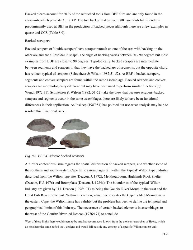
203
Backed pieces account for 60 % of the retouched tools from BBF sites and are only found in the
sites/units which pre-date 3110 B.P. The two backed flakes from BBC are doubtful. Silcrete is
predominantly used at BBF in the production of backed pieces although there are a few examples in
quartz and CCS (Table 8.9).
Backed scrapers
Backed scrapers or 'double scrapers' have scraper retouch on one of the arcs with backing on the
other arc and are ellipsoidal in shape. The angle of backing varies between 60 - 90 degrees but most
examples from BBF are closer to 90 degrees. Typologically, backed scrapers are intermediate
between segments and scrapers in that they have the backed arc of segments, but the opposite chord
has retouch typical of scrapers (Schweitzer & Wilson 1982:51-52). At BBF 4 backed scrapers,
segments and convex scrapers are found within the same assemblage. Backed scrapers and convex
scrapers are morphologically different but may have been used to perform similar functions (cf.
Wendt 1972:31); Schweitzer & Wilson (1982: 51-52) take the view that because scrapers, backed
scrapers and segments occur in the same assemblages there are likely to have been functional
differences in their application. As Inskeep (1987:54) has pointed out use-wear analysis may help to
resolve this functional issue.
Fig. 8.6. BBF 4: silcrete backed scrapers
A further contentious issue regards the spatial distribution of backed scrapers, and whether some of
the southern and south-western Cape lithic assemblages fall within the 'typical' Wilton type Industry
described from the Wilton type-site (Deacon, J. 1972), Melkhoutboom, Highlands Rock Shelter
(Deacon, H.J. 1976) and Boomplaas (Deacon, J. 1984a). The boundaries of the 'typical' Wilton
Industry are given by H.J. Deacon (1976:171) as being the Gouritz River Mouth in the west and the
Great Fish River to the east. Within this region, which incorporates the Cape Folded Mountains in
the eastern Cape, the Wilton name has validity but the problem has been to define the temporal and
geographical limits of this Industry. The occurence of certain backed elements in assemblages to
the west of the Gouritz River led Deacon (1976:171) to conclude
West of these limits there would seem to be artefact occurrences, known from the pioneer researches of Heese, which
do not share the same hafted tool, designs and would fall outside any concept of a specific Wilton content unit.

204
East of the Gouritz River, backed scrapers are generally rare; only 8 specimens were recovered at
NBC (Inskeep 1987) and a few at Oakhurst (Schrire 1962), but the dating and curation of this latter
assemblage is problematic; in Layer C at Matjes River, 74 backed scrapers are reported but undated
(Louw 1960).
As H.J. Deacon (1976) correctly predicted, hafted tools from assemblages to the west of the Gouritz
River increase rapidly in frequency relative to scrapers. An example of this is at BNK 1 where
backed scrapers account for 7.4 % of retouched tools at the site and 33 % of backed pieces. Small
numbers of backed scrapers come from BBF 1, 5 & 7\1, but the largest assemblage of retouched
artefacts is from BBF 4 (5680 ± 70 B.P.). Of the 325 retouched tools recovered from this site, 139
(42,7 %) are backed scrapers and a further 33.5 % are backed pieces; scrapers from BBF 4 make up
only 7,7 % of the formal tools. All the backed scrapers are made in silcrete. The remarkable
similarity in the mean lengths, widths and heights of backed scrapers, segments, flakes and blades
suggest that these tools were being made to a specific size pattern, perhaps because they were
hafted in a similar way; backed bladelets and points are noticeably smaller which may be a function
of use or hafting technique (Fig. 8.3).
In the 1930s Heese (n.d.) made a surface collection of artefacts at Brakfontein, situated 25 km to the
north-west of BBF. More than 30,000 scrapers, backed pieces, adzes and segments were collected;
it is thought that at least 10,000 of these artefacts, now housed at the University of Stellenbosch and
inspected by the author, may be backed scrapers (Deacon, H.J. pers. comm.). Excavations at the
Castle in Cape Town have also revealed the presence of backed scrapers in the south-western Cape
(Yates pers. comm.) and a few backed scrapers come from the c. 2300 B.P. levels at
Steenbokfontein. Clearly, the hafted tool components at BBF 4 and BNK 1, and possibly
Brakfontein, set these sites apart from 'typical' Wilton assemblages described by J. Deacon (1972)
and H.J. Deacon (1976). The reasons for the high numbers of backed artefacts are not clear and may
indicate different cultural affinities between people in the eastern and western regions and/or may
be activity related.

205
Figure 8.7: Mean lengths, widths and heights of backed pieces from BBF 4
Segments, Flakes, Bladelets, Points and Borers
Segments are made on flakes or blades to form a curved arc backed with abrupt retouch and an
opposite sharp-edged unretouched chord. It may have been used as a cutting tool, as is suggested by
an artefact from De Hangen in which a segment is mounted in a lump of mastic so that it projects at
an oblique angle (Parkington pers. comm.); a quartz segment mounted in mastic is reported from
BNK 1 (Schweitzer 1982:61); evidence of segments being mounted was also found at
Melkhoutboom (Deacon. H.J. 1976:58) and at NBC (Inskeep 1987:120). Middle Stone Age
Howiesons Poort segments were also mounted on armatures for use as weapons more than 55 000
years ago in Kwazulu Natal and in the Western Cape (Lombard 2007b, 2008).

206
Fig. 8.8. BBF 4 silcrete scraper/borer; BBF 7 quartz borers; BBC (a) silcrete & quartzite
segments; BBC (b) Quartzite borers
Segments were recovered from BBF 1, 3 & 5 and account for 23 % of all backed pieces; 96 % of
the segments are made of silcrete and the balance are in quartz and CCS. At BBF 4 segments make
up 15 % of the total assemblage and 20 % of backed pieces. The disproportionately high numbers
of backed scrapers found at BBF 4 decreases the relative percentage of segments and other backed
pieces at the site. At BNK 1 segments are the most common backed artefact accounting for 42 % of
the class total; at Wilton segments make up 32 % of backed pieces and 71 % of segments are in
silcrete. Only 40 segments were found in all the NBC units, the majority are in chalcedony (72.5
%), and the rest in quartz and quartzite which reinforces the evidence that silcrete was rarely used at
the site (cf. Inskeep 1987).
Backed flakes are morphologically diverse but are characterised by being backed wholly, or
partially, along one edge. Sampson (1974) suggests that backed flakes may, after constant use, take
the form of backed scrapers but Schweitzer & Wilson (1982:62) point to a lack of intermediate
forms at BNK 1 which does not support Sampson's hypothesis; additionally few of the backed
flakes from BNK 1 have a convex backed lateral, a prerequisite for backed scrapers. Backed flakes
could be classed as intermediate tools as some examples are very similar to borers and others to

207
scrapers. At BBF 4, backed flakes make up 14 % of the retouched class and 16.5 % of backed
pieces; 91 % are in silcrete and the rest in quartz and CCS. Most backed flakes from BNK 1 are in
silcrete (88.5 %) but are less frequent in the retouched class (4.2 %) than is the case at BBF.
Backed blades and bladelets form only a small percentage of the BBF 4 backed class (2.8 %) and
all are in silcrete; only one other example was found at BBF 2. In plan form backed bladelets have
two or more straight margins and show backing along one margin and a straight cutting edge
opposite. Small frequencies of this tool type are reported from BNK 1 (Schweitzer & Wilson 1982)
and NBC (Inskeep 1987). At Wilton they are more common (22.6 % of backed tools), as well as at
other eastern Cape sites (Deacon, H.J. 1976), again highlighting differences in the relative
importance of certain tool types in the two regions.
Backed points are similar to borers (drills) but display evidence of backing along one or both the
laterals to form a tapered point . Borers tend to be cylindrical in shape but the retouch on these
artefacts does not conform to the 'backing' observable on backed points (Schweitzer & Wilson
1982); both forms were probably hafted and used as drill-bits (Inskeep 1987:54). At Melkhoutboom
traces of mastic are evident on some borers, suggesting that only the sharp tip of the tool was
exposed for use (Deacon, H.J. 1976:59). Backed points and borers occur in small numbers at BBF
1, 2, 4 and 7\1 suggesting they were in use from the earliest occupation up until around 3000 B.P.
Raw materials used include quartz and silcrete. Borers are in use at BNK 1, NBC and
Melkhoutboom during the same period as at BBF
Miscellaneous Retouched Pieces (MRP's)
These artefacts cannot be typologically assigned to any of the more cohesive classes of retouched
artefacts except that all show sustained formal retouch either on the dorsal or ventral surface of the
tool, or on both. Many of these tools could be included in the utilised/modified class (cf. Inskeep
1987:55) but they are separated on the basis that the retouch is more deliberate and extends over a
larger portion of the tool (Deacon, J, 1984a); in practice, the differences between utilised flakes,
blades etc. and MRP's are marginal. MRP's are found in most assemblages of Holocene age
throughout the Cape region (Deacon 1984a). Most MRP's in the pre 2000 B.P. sites at BBF are
made on silcrete, those at BBC & BBF 9 have a wider range of raw materials including quartz and
quartzite. In total, MRP's account for 16 % of retouched artefacts from BBF sites and are the most
common retouched artefact found in the later sites, although only in very small quantities in the
BBC units.
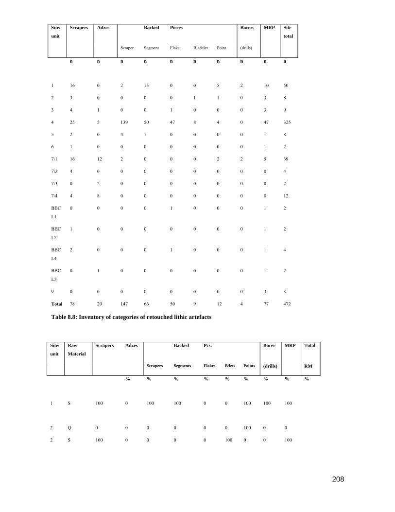
208
Site/
unit
Scrapers Adzes Backed Pieces Borers MRP Site
total
Scraper Segment Flake Bladelet Point (drills)
n n n n n n n n n n
1 16 0 2 15 0 0 5 2 10 50
2 3 0 0 0 0 1 1 0 3 8
3 4 1 0 0 1 0 0 0 3 9
4 25 5 139 50 47 8 4 0 47 325
5 2 0 4 1 0 0 0 0 1 8
6 1 0 0 0 0 0 0 0 1 2
7\1 16 12 2 0 0 0 2 2 5 39
7\2 4 0 0 0 0 0 0 0 0 4
7\3 0 2 0 0 0 0 0 0 0 2
7\4 4 8 0 0 0 0 0 0 0 12
BBC
L1
0 0 0 0 1 0 0 0 1 2
BBC
L2
1 0 0 0 0 0 0 0 1 2
BBC
L4
2 0 0 0 1 0 0 0 1 4
BBC
L5
0 1 0 0 0 0 0 0 1 2
9 0 0 0 0 0 0 0 0 3 3
Total 78 29 147 66 50 9 12 4 77 472
Table 8.8: Inventory of categories of retouched lithic artefacts
Site/
unit
Raw
Material
Scrapers Adzes Backed Pcs. Borer MRP Total
Scrapers Segments Flakes B/lets Points (drills) RM
% % % % % % % % %
1 S 100 0 100 100 0 0 100 100 100
2 Q 0 0 0 0 0 0 100 0 0
2 S 100 0 0 0 0 100 0 0 100

209
3 Q 0 0 0 0 100 0 0 0 0
3 S 100 100 0 0 0 0 0 0 100
4 Q 0 0 0 2.1 0 0 0 0 2.1
4 S 100 100 100 94.6 90.7 100 100 0 97.9
4 O 0 0 0 4.3 9.3 0 0 0 0
5 S 100 0 100 100 0 0 0 0 100
6\12 Q 100 0 0 0 0 0 0 0 0
6\12 S 0 0 0 0 0 0 0 0 100
7\1 Q 6.7 0 0 0 0 0 100 100 0
7\1 S 93.3 100 100 0 0 0 0 0 100
7\2 O 100 0 0 0 0 0 0 0 0
7\3 S 0 100 0 0 0 0 0 0 0
7\4 S 50 100 0 0 0 0 0 0 0
7\4 O 50 0 0 0 0 0 0 0 0
BBC
L1
Qt 0 0 0 0 100 0 0 0 100
BBC
L2
S 100 0 0 0 0 0 0 0 100
BBC
L4
Q 0 0 0 0 100 0 0 0 0
BBC
L4
S 50 0 0 0 0 0 0 0 100
BBC
L4
Qt 50 0 0 0 0 0 0 0 0
BBC
L5
Q 0 0 0 0 0 0 0 0 100

210
BBC
L5
S 0 100 0 0 0 0 0 0 0
9 Q 0 0 0 0 0 0 0 0 100
Table 8.9: Retouched lithics: Raw material by artefact categories and site/unit
(Note: MRP = miscellaneous retouched pieces; RM = raw material)
8.7: Bone Artefacts
Very few bone artefacts were recovered at BBF and all came from the later sites, BBC & BBF 9.
One bone spatula, possibly made on a limb bone, was found at BBF 7, measuring 40.5 mm in length
and 5.3 mm in width. Some wear is evident along half the length of the tool. A similar bone spatula
was recovered from the Vaalkrans Shelter site in De Hoop Nature reserve and is dated at about
1660 – 1680 AD (Henshilwood & van Niekerk 2006). Schweitzer & Wilson (1982:77) suggest that
bone spatulas may have been used to pry shellfish from the rocks; however, it is not clear from the
wear patterns on the BBF 7 spatula, nor that from Vaalkrans, whether it was used for this purpose.
Based on the wear patterns and shape of some bone spatulas from NBC Inskeep (1987:164) has
speculated they may have been used for working skins.
Fig. 8.9. a) Bone artefacts from BBC (various layers), b) BBC bone beads (Image courtesy of
Francesco d’Errico)
Two bone tubes, possibly used as beads, with an interior diameter of 5.7 mm and exterior diameter
of 9.4 mm, were recovered from BBC layer L5 dated at 1840 B.P. Similar bone tubes are reported
from a number of southern and south-western Cape sites including Oakhurst (Goodwin 1933,
1938), Gordon's Bay Midden (van Noten 1974), Die Kelders (Schweitzer 1979) and Byneskranskop

211
1 (Schweitzer & Wilson 1982). At all these sites bone tubes are only found in units which post-date
3900 B.P.
A single turtle carapace, identified as Pelomedusa subrufa, was found intact in BBC layer L4.
Numerous scrape marks on the interior and grinding on the edges suggests it was used as a bowl,
possibly to store or mix ochre, as both the edges and inner surface were ochre stained. As this
species of turtle is not currently found in the immediate vicinity of BBF, it may have been captured
in the Duivenhoks or Goukou Rivers and brought to the site. Worked tortoise carapaces are reported
from Uniondale (Brooker 1989) and NBC (Inskeep 1987). A watercolour painted by F. Steeb in
1812 depicts a 'Bushman' with a tortoise shell container and a bone suspended from his neck
(Sketch no. 96: Cape Archives A1415(73))..
8.8: Marine Shell Artefacts
Marine shell pendants and beads were found at BBF 7 and BBC only. Two perforated and ground
Conus shells from BBC L2 and one from BBC L3 were probably threaded and used as ornaments.
All three shells have v-shaped grooved perforations on the anterior end consistent with deliberate
filing (Vibe 2007:63). Two of them have worn perforations, suggesting they were strung. The
pendants measure between 21 and 29 mm in length, and all show traces of ochre (Vibe 2007:63).
Almost identical artefacts come from Layer 1 and 12 at BNK 1, and from Units 18 and 36 at NBC,
suggesting that Conus shells were used as decorative items from the Mid-Holocene. A single
ground Turbo pendant measuring 36 mm x 14.5 mm was found in BBC L5. Similar items are
common at BNK 1 and NBC and are also found at inland sites, for example Uniondale (Brooker
1989), suggesting they were in widespread use during the Mid- and Late Holocene.
Fig. 8.10. BBC: marine shell personal ornaments a) bored Patella, b) bored Turbo sarmaticus, c)
partially bored Turbo sarmaticus, d) bored Conus, e) bored Conus (burnt).

212
Four Glycimeris connollyi pendants were recovered from the BBC LSA layers (Vibe 2007). They
measure between 9 x 9 mm and 14 x 15 mm. Two of them were found in the same square and level
in L2, and are probably from the same beadwork item. They are both perforated (probably by
punching) on the apex, and wear traces are visible on the perforation edges (Vibe 2007:62). The
other two G. connollyi pendants were found in L4. These pendants have perforations on the apices
consistent with drilling through the shell by Natica tecta or another similar predator. However, they
both show traces of wear on the perforation edges, probably from being strung (Vibe 2007:62). All
four pendants are stained with ochre. Similar items are found at BNK 1, NBC and Die Kelders. One
perforated shell pendant from a mother-of-pearl colored shell, possibly Haliotis sp. or Turbo sp.,
was recovered from BBC L1 (Vibe 2007). One Bullia digitalis pendant measuring 25 mm was
recovered from BBC L4. It was perforated by punching and show wear all along the perforation
ridge. It also shows traces of ochre (Vibe 2007).
Nassarius kraussianus shells were found only at BBC, and a total number of 1886 shells were
recovered. Of these are 367 shells not perforated, but are counted into the total number as it is
highly likely they were intended for bead manufacture (Vibe 2007:58). Particularly high
concentrations (55% of the total number) of the shells were recovered from L4 (Vibe 2007:57).
Taphonomic, morphological and microscopic analyses prove the authenticity of the perforated LSA
N. kraussianus shells as human made beads (Vibe 2007).
A large proportion of the N. kraussianus shells have perforations and show use-wear traces
consistent with bead manufacture and use (Vibe 2007:59-61). The perforation type on all shells
with perforations and intact lip and columella (category 2 shells) was recorded with a system based
on the method established by d’Errico et al. (2005) for the BBC MSA shells. Perforation types 3, 5,
6, 8, and 9 are present on the LSA shells. Perforation type 8 is by far the most common (88 % of the
total number of 501 category 2 shells), and these large perforations are probably due to the
prolonged use of the shells as threaded beads (Vibe 2007:59, d’Errico et al. 2005:15). Wear-traces
are visible on 78.6 % of the category 2 shells (Vibe 2007:60). An examination of a random sample
of category 2 shells from all LSA levels in BBC showed that 46% of the beads had traces of ochre
(Vibe 2007:61).
A single Turbo sarmaticus pendant came from the HL3 level in BBF 7. It is oblong in shape and
measures 2.1 x 4.2 cm (Vibe 2007:62). The edges are perfectly ground and rounded, otherwise it is
not worked. It is not perforated, but it is highly likely it was intended for ornamentation as other
similar non-complete “pendants” have been found at other sites along with finished ones
(Schweitzer 1979, Schweitzer & Wilson 1982, Inskeep 1987). A conus sp. pendant, 3.1 cm long,

213
was recovered from the YSL level. This shell is perforated, probably by punching, and very worn
(Vibe 2007:62). All the marine shell species used to occur in the vicinity of the sites and were
possibly collected there.
8.9: Ostrich Egg-Shell Artefacts
Ostrich egg-shell fragments were found in varying quantities at all sites, but are particularly
common at BBF 2, 4 & 7 (Vibe 2007:16). Fragments with ground edges came only from BBF 7, but
the purpose of this grinding is unknown; Schweitzer & Wilson (1982:91) suggest they may be parts
of pendants or discs. One flask opening, presumably from a water bottle (cf. Inskeep 1987:173),
was recovered from BBF 3; decorated fragments occur only at BBF 3 and BBF 4 (Table 8.10). Two
types of decoration were recorded, namely parallel incised lines and looped circles. The former
design is similar to that from Layer 6 at BNK1 (precise date not given) and unit 78 at NBC (4520
B.P.). The looped circle design from BBF 4 is identical to that found on OES fragments found in
Layer 9 at BNK1 dated at ca. 6000 B.P.(Schweitzer & Wilson 1982). BBF 4 is dated at 5680 B.P.
suggesting that this looped circle design may have been a cultural marker in the area to the west of
the Gouritz River, although more samples would be needed to confirm this hypothesis.
Fig. 8.11. Decorated ostrich egg shell from BBF 4.
Site Plain Frags. Ground Frags. Total Flask
openings Decorated
frags. AD/kg
Plain + Ground
g g g n n
1 251 - 251 - 7.1

214
2 1435 - 1435 - - 7.7
3 334 - 334 1 1 2.0
4 1149 - 1149 - 19 5.7
5 47 - 47 - - 0.5
6 7 - 7 - - 0
7 1020 79 1099 - - 7.4
8 79 - 79 - - 0.1
9 1 - 1 - - 0
Table 8.10: Ostrich egg-shell data from BBF sites
(AD/Kg = average density of ostrich shell per kg of deposit recovered, excluding stone)
Beads
Beads were found at all the BBF sites apart from BBF 6 (Vibe 2007). Whole or partially finished
beads are the most common artefacts made in ostrich egg-shell. They are particularly common at
BBF 4, BBF 7 and BBC. Table 8.11 reflects the numbers of finished and unfinished beads
recovered from each site.
Fig. 8.12. Completed and part completed ostrich egg shell beads from BBF 1, 3, 7 & BBC
Site Finished Beads Unfinished Beads Indeterminable* Total Beads
1 10 3 - 13
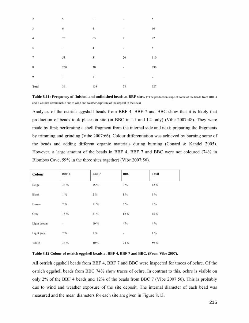
215
2 5 - - 5
3 6 4 - 10
4 25 65 2 92
5 1 4 - 5
7 53 31 26 110
8 260 30 - 290
9 1 1 - 2
Total 361 138 28 527
Table 8.11: Frequency of finished and unfinished beads at BBF sites. (*The production stage of some of the beads from BBF 4
and 7 was not determinable due to wind and weather exposure of the deposit in the sites)
Analyses of the ostrich eggshell beads from BBF 4, BBF 7 and BBC show that it is likely that
production of beads took place on site (in BBC in L1 and L2 only) (Vibe 2007:48). They were
made by first; perforating a shell fragment from the internal side and next; preparing the fragments
by trimming and grinding (Vibe 2007:66). Colour differentiation was achieved by burning some of
the beads and adding different organic materials during burning (Conard & Kandel 2005).
However, a large amount of the beads in BBF 4, BBF 7 and BBC were not coloured (74% in
Blombos Cave, 59% in the three sites together) (Vibe 2007:56).
Colour BBF 4 BBF 7 BBC Total
Beige 38 % 15 % 3 % 12 %
Black 1 % 2 % 1 % 1 %
Brown 7 % 11 % 6 % 7 %
Grey 15 % 21 % 12 % 15 %
Light brown - 10 % 4 % 4 %
Light grey 7 % 1 % - 1 %
White 33 % 40 % 74 % 59 %
Table 8.12 Colour of ostrich eggshell beads at BBF 4, BBF 7 and BBC. (From Vibe 2007).
All ostrich eggshell beads from BBF 4, BBF 7 and BBC were inspected for traces of ochre. Of the
ostrich eggshell beads from BBC 74% show traces of ochre. In contrast to this, ochre is visible on
only 2% of the BBF 4 beads and 12% of the beads from BBC 7 (Vibe 2007:56). This is probably
due to wind and weather exposure of the site deposit. The internal diameter of each bead was
measured and the mean diameters for each site are given in Figure 8.13.
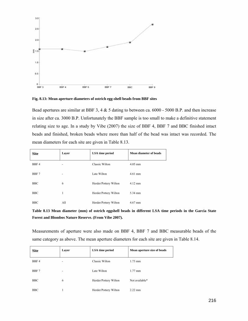
216
Fig. 8.13: Mean aperture diameters of ostrich egg-shell beads from BBF sites
Bead apertures are similar at BBF 3, 4 & 5 dating to between ca. 6000 - 5000 B.P. and then increase
in size after ca. 3000 B.P. Unfortunately the BBF sample is too small to make a definitive statement
relating size to age. In a study by Vibe (2007) the size of BBF 4, BBF 7 and BBC finished intact
beads and finished, broken beads where more than half of the bead was intact was recorded. The
mean diameters for each site are given in Table 8.13.
Site Layer LSA time period Mean diameter of beads
BBF 4 - Classic Wilton 4.05 mm
BBF 7 - Late Wilton 4.61 mm
BBC 6 Herder/Pottery Wilton 4.12 mm
BBC 1 Herder/Pottery Wilton 5.34 mm
BBC All Herder/Pottery Wilton 4.67 mm
Table 8.13 Mean diameter (mm) of ostrich eggshell beads in different LSA time periods in the Garcia State
Forest and Blombos Nature Reserve. (From Vibe 2007).
Measurements of aperture were also made on BBF 4, BBF 7 and BBC measurable beads of the
same category as above. The mean aperture diameters for each site are given in Table 8.14.
Site Layer LSA time period Mean aperture size of beads
BBF 4 - Classic Wilton 1.73 mm
BBF 7 - Late Wilton 1.77 mm
BBC 6 Herder/Pottery Wilton Not available*
BBC 1 Herder/Pottery Wilton 2.22 mm

217
BBC All Herder/Pottery Wilton 1.90 mm
Table 8.14 Mean internal diameter (aperture size) of ostrich eggshell beads in different LSA time periods in the
Garcia State Forest and Blombos Nature Reserve. (From Vibe 2007). (*The apertures of the beads in Layer 6 in Blombos Cave
were not measurable.)
Analyses of the ostrich eggshell beads from BBF 4, BBF 7 and BBC show that there is a small
increase in bead size and bead aperture within the area and within Blombos Cave over time. The
beads from pre-herder sites BBF 4 and BBF 7 have a mean diameter less than 5 mm, which is the
suggested division between hunter-gatherer associated and herder associated beads (Yates 1995,
Conard & Kandel 2005). A total comparison of the beads from BBC also gives a mean diameter
less than 5 mm, but a comparison of beads in different layers shows that the mean is increasing over
time (Vibe 2007). The mean diameter of the beads in the upper layer, L1, is 5.34 mm.
Personal Ornaments: Other
One broken bone ring was recovered from L4 in BBC. Two intact ones, measuring 9.3 and 9.9 mm
in diameter, were found in the same square and level in L5, suggesting they come from the same
beadwork item. These two bone rings also show traces of ochre. All three are finely worked and
polished (Vibe 2007:64).
One piece of string made from plant material was recovered from BBC L4 (Vibe 2007). It is not
possible to determine whether its use was related to any of the ornaments, but it may have been
used to string beads. The string is +/- 15 cm long, ca. 2 mm thick, and weighs about 20 grams. It is
a 12/6 ply string, meaning two and two fibre lengths, or strands, are twined into 6 strings which
again are twined into one string (Vibe 2007:65). It has no knots. The string is coated in deposit from
the cave, including tiny pieces of silica and quartz.
8.10: Pottery
Relatively small quantities of pottery sherds came from the BBC cave site, although the frequencies
increase in Layers BBC L1 and BBC L2 and ten sherds came from BBF 9. Unfortunately most of
the pottery sherds were small and therefore not very informative as to the type or shape of vessels
from which they originated. A few diagnostic vessel rims without decoration came from the later
BBC units and BBF 9 but it was not possible to reconcile these with Rudner's (1968:523-524)
descriptions of pottery types from this area. The oldest sherds were from BBC L5 dated at 1840
B.P., and were found in the same layer as the two sheep bones dated at 1880 B.P. and 1960 B.P.,
suggesting that sheep and pottery were contemporaneous at this time (for a full discussion cf. Ch.
7). Table 8.15 lists the characteristics of the BBC & BBF 9 pottery.
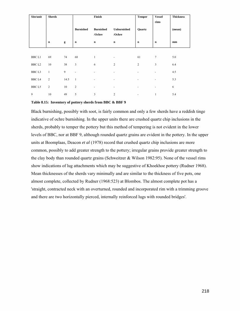
218
Site/unit Sherds Finish Temper Vessel
rims
Thickness
Burnished Burnished
/Ochre
Unburnished
/Ochre
Quartz (mean)
n g n n n n n mm
BBC L1 69 74 68 1 - 61 7 5.0
BBC L2 10 38 3 6 2 2 3 6.4
BBC L3 1 9 - - - - - 4.5
BBC L4 2 14.5 1 - - - - 5.3
BBC L5 2 10 2 - - - - 6
9 10 49 5 3 2 - 1 5.4
Table 8.15: Inventory of pottery sherds from BBC & BBF 9
Black burnishing, possibly with soot, is fairly common and only a few sherds have a reddish tinge
indicative of ochre burnishing. In the upper units there are crushed quartz chip inclusions in the
sherds, probably to temper the pottery but this method of tempering is not evident in the lower
levels of BBC, nor at BBF 9, although rounded quartz grains are evident in the pottery. In the upper
units at Boomplaas, Deacon et al (1978) record that crushed quartz chip inclusions are more
common, possibly to add greater strength to the pottery; irregular grains provide greater strength to
the clay body than rounded quartz grains (Schweitzer & Wilson 1982:95). None of the vessel rims
show indications of lug attachments which may be suggestive of Khoekhoe pottery (Rudner 1968).
Mean thicknesses of the sherds vary minimally and are similar to the thickness of five pots, one
almost complete, collected by Rudner (1968:523) at Blombos. The almost complete pot has a
'straight, contracted neck with an overturned, rounded and incorporated rim with a trimming groove
and there are two horizontally pierced, internally reinforced lugs with rounded bridges'.
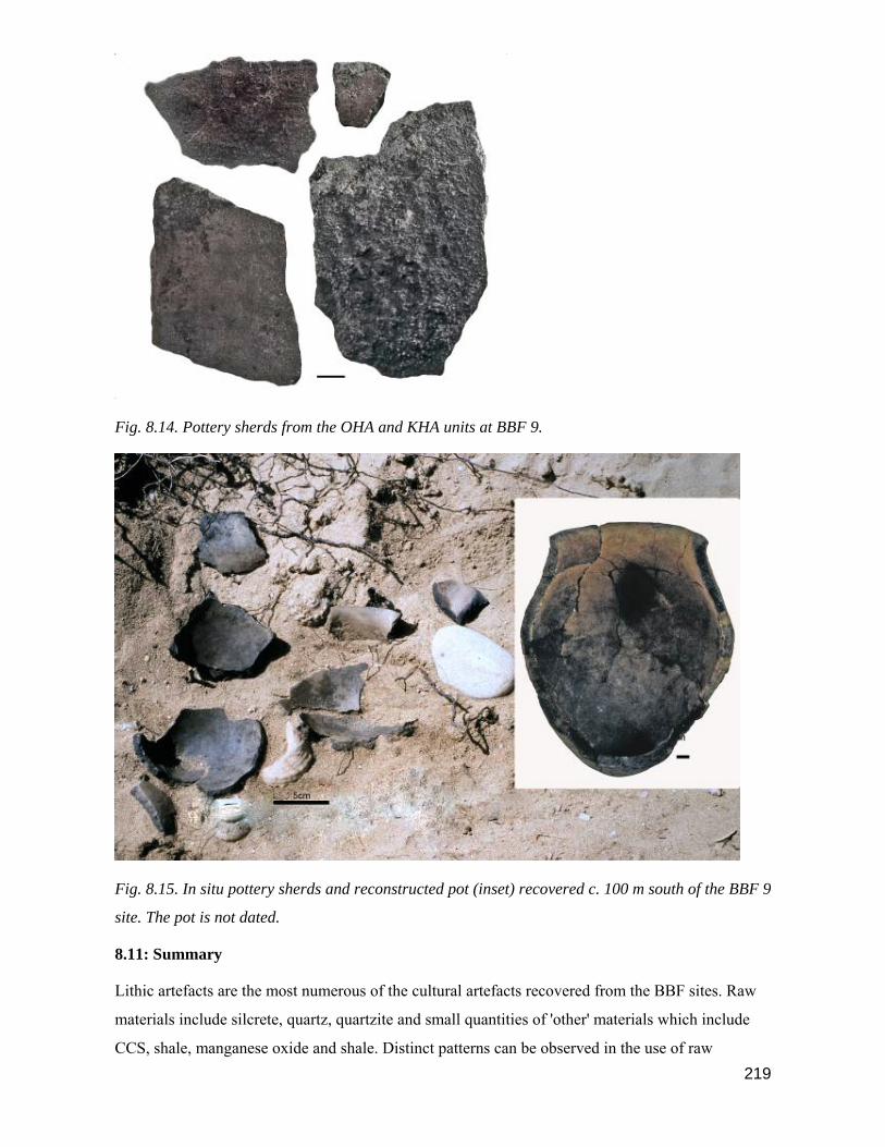
219
Fig. 8.14. Pottery sherds from the OHA and KHA units at BBF 9.
Fig. 8.15. In situ pottery sherds and reconstructed pot (inset) recovered c. 100 m south of the BBF 9
site. The pot is not dated.
8.11: Summary
Lithic artefacts are the most numerous of the cultural artefacts recovered from the BBF sites. Raw
materials include silcrete, quartz, quartzite and small quantities of 'other' materials which include
CCS, shale, manganese oxide and shale. Distinct patterns can be observed in the use of raw

220
materials over time. Silcrete predominates at sites which predate 2000 B.P., although one exception
is at BBF 2 where quartz is in common use in the unmodified category. Quartzite occurs throughout
the whole BBF sequence, possibly due to its ready availability in the immediate area. Because of
the relatively large size range, and weight, of quartzite cobbles and pebbles they are suitable for
opportunistic use as hammers, anvils, upper and lower grinders; occasionally quartzite flakes are
utilised. Quartzite is unknown in the retouched category prior to 2000 B.P. at BBF when almost all
retouched or formal tools are manufactured in silcrete, and occasionally in quartz. There appears to
be no strong relationship between the frequency of quartz in the unmodified category at a site and
the number of retouched artefacts in quartz from that site. An example is the BBF 2 site where 46.7
% of the unmodified stone is quartz yet 87. 5 % of the retouched artefacts are in silcrete. We can
confidently say that at all the pre-2000 B.P. BBF sites silcrete is overwhelmingly the preferred
material for the manufacture of retouched artefacts and that a clear distinction can be drawn
between the pre- and post- 2000 B.P. sites in the choice of raw materials used. Quartz and quartzite,
which are both available in the immediate vicinity of BBF predominate after 2000 B.P.
Silcrete is not available in the immediate BBF vicinity and would have been brought to the sites
from further afield, possibly from Riversdale or Albertinia (Henshilwood et al 2001a). A reduction
in the quantity of silcrete at later sites suggests it may not have been a desirable material for the
types of tools manufactured, or that it was not easily obtainable. If the seasonal range of hunter
gatherer groups was reduced after the arrival of herders (cf. Ch 4 & 7), then silcrete sources,
situated inland, may not have been easily accessible.
Utilised/modified artefacts make up the smallest class of lithic artefacts. Silcrete flakes and
bladelets showing utilisation damage occur in limited quantities in sites pre-dating 2000 B.P. Scaled
pieces are more common throughout the BBF sequence and are made on a wider variety of raw
materials including quartz, quartzite and silcrete. Hammerstones, anvils and grindstones are a
regular feature at most sites and were probably used for a range of functions including the
production of lithic artefacts, grinding of ochre and processing plant materials and shellfish. BBF 5
has the highest incidence of hammerstones and anvils and may have been a shellfish processing
location (cf. Ch. 6).
Retouched or formal tools account for 3.3 % of the total lithics at BBF as is usual for Cape coastal
sites where the incidence of this class is generally low. Retouched artefacts predominate in the pre-
2000 B.P. sites and are still common ca. 3000 B.P. at the BBF 7 site. Scrapers, normally the most
common retouched artefact in Wilton assemblages only make up 16.5 % of the formal tool class at
BBF. Changes in the mean sizes of scrapers are temporally related and these grade from longer and
broader scrapers in the early sites BBF 1 & 3 to smaller broad scrapers by the Mid-Holocene, and

221
again back to longer scrapers by 3000 B.P. A similar trend in scraper morphology is reported from
a number of other Cape sites including BNK 1 and NBC. Adzes may have been woodworking tools
and are most common at the BBF 7 site. Dark, humic paleosols at the site point to the BBF area
being wooded at the time of the BBF 7 occupation and palaeoenvironmental conditions may explain
the high frequency of adzes found here.
Backed lithic elements make up a major proportion of the retouched class at BBF sites predating
2000 B.P. Tools with backing include segments, flakes, bladelets, points and scrapers. The lithic
assemblage from BBF 4 is the most informative of the pre-2000 B.P. sites, partially because of is
size, but also due to the unusually high ratio of backed tools within the retouched class. Deacon
(1976) suggested that lithic assemblages to the west of the Gouritz River did not share the same
hafted tool components as those of the typical Wilton type assemblages found in the more easterly
Cape Folded Belt regions. Backed scrapers are the most dominant formal tool at BBF 4 and in this
regard the site is similar to BNK 1 and Brakfontein.
At NBC, Oakhurst and Matjes River, situated to the east of BBF, backed scrapers are less common,
or virtually absent, suggesting that Deacon's (1976) observation was correct. The reasons for the
high frequencies of backed elements, particularly scrapers at BBF 4, BNK 1 and Brakfontein are
not clear but may relate to differences in cultural affinities between the regions to the east and west,
or to variations in the kinds of activities carried out in the various regions. The results also suggest
that the activities at some coastal sites in the Mid-Holocene may not have been directed mainly at
the utilisation of marine resources (cf. Klein 1973) but also at a range of other resources, perhaps
terrestrial fauna, and that these animals were being specifically exploited. Unfortunately, a lack of
well preserved faunal bone at BBF 4 precludes us from making any definitive statements about this
hypothesis.
After the BBF 7 occupation at ca. 3000 B.P. a reduction in the number of formal tools is rapid at
BBF sites, and appears to coincide with the presence of the first herders in this region at around
2000 B.P. As there is no evidence at BBC or BBF 9 of the kinds of retouched artefacts which were
substituted for the earlier formal tools, it is difficult to gauge the extent to which the activities
typical of the earlier sites were modified as a result of the arrival of herders. Unmodified flakes,
particularly in quartz, were produced in large numbers at BBF 9 and it is possible these were the
functional equivalents of some of the earlier retouched tools.
Bone tools are generally more common in the Late Holocene at a number of Cape coastal sites, but
are also found in the pre-pottery period (cf. Grobbelaar & Goodwin 1952; Schweitzer 1974;
Deacon, J. 1974; Schweitzer 1979; Schweitzer & Wilson 1982; Inskeep 1987); in some areas shell
artefacts, in the form of scrapers and segments, may replace their earlier stone equivalents (Avery
222
1975, 1976; Brooker 1989). As no bone tools, apart from a spatula, came from any BBF sites it is
not possible to speculate whether functional bone artefacts replaced the earlier stone tools. At BBC
bone tools from the Middle Stone Age M2 phase dated at c. 77 000 years may have replaced the
function of some stone tools and were possibly mounted as armatures. This is in contrast to the later
c. 70 000 year phase where stone projectile points are more common, in particular the bifacial
points in the Still Bay M1 phase. In the earlier >100 000 year M3 phase stone convergent flake
points are also relatively common but there is no worked bone in this phase (Henshilwood et al
2001a,b).
Some changes in shellfish exploitation patterns are observable during the transitional pre- and post-
2000 B.P. period at BBF (cf. Ch. 6) but due to a lack of preserved mammalian fauna in the pre-2000
B.P. sites the overall subsistence picture at BBF is incomplete (cf. Ch. 7). Changes in the location of
sites at BBF may well be linked to the arrival of herders in the area; only near coastal caves and
shelters are occupied after 2000 B.P. whereas prior to this period all sites are located in the elevated
dune area or are open middens. An overview of the lithic changes, subsistence strategies and
changes in site locations at around 2000 B.P. suggests that, at BBF, this was a period of
considerable upheaval and adaptation to a new set of influences, hitherto not encountered by bands
of hunter gatherers who had utilised this area during the Mid-Holocene.
Bone and shell artefacts are scarce at most BBF sites, but those recovered show affinity with similar
artefacts from other coastal sites in the southern and south-western Cape. Bone tubes, for example,
are reported from a range of sites, as are marine shell ornaments. A mean increase in the aperture of
ostrich egg-shell beads occurs over time, and is particularly noticeable in the later sites BBF 7, 8 &
9; a similar trend is observed for many Cape sites with the largest beads occurring in sites attributed
to herders (Yates. pers. comm.).
The relatively minor quantities of small pottery sherds from BBC and BBF 9 are not particularly
informative as to the type or shape of vessels from which they originate. Finishes and methods of
tempering are typical of Cape coastal pottery as described by Rudner (1968). There is a noticeable
increase in the inclusion of crushed quartz, as opposed to rounded quartz, in pottery from the upper
BBC layers, presumably an innovation which gave pots greater durability.
Pottery from BBC layer L5 dated at 1840 B.P. is contemporaneous with two sheep bones directly
dated at 1880 B.P. and 1960 B.P., and confirms that the arrival of pottery and sheep in the BBF
region were more or less simultaneous events.

223
CHAPTER 9
SEASONALITY AND OXYGEN ISOTOPE ANALYSIS
9.1: Introduction
Determining whether prehistoric coastal sites were occupied occasionally, for long periods, and in
what season is of significant interest in mapping the movement of ancient populations.
Archaeological research programmes on shell middens in the United States, Australia, Europe and
South Africa have examined the issue of seasonality from a number of perspectives. One of the
most promising techniques for determining seasonality, namely oxygen isotope analysis of marine
shell carbonates, was first applied by Shackleton (1973, 1982) using two shells excavated from
Nelson Bay Cave in the southern Cape. This study demonstrated that both shells were collected
during winter. Application of the same technique to shells from coastal middens in Spain (Deith &
Shackleton 1986) and California (Killingley 1981) has subsequently yielded valuable seasonal
information.
Seasonal movement of indigenous hunter gatherer populations between the littoral and inter-
montane zones of the Cape during the Holocene, and possibly earlier, has been a recurrent theme of
archaeological research in the Cape since the 1960s (e.g. Wells 1965; Deacon, H.J. 1969,1976;
Parkington 1972, 1976, 1977, 1991, 2001; Shackleton 1973; Klein 1973; Avery 1974; Buchanan et
al 1978; Deacon & Deacon 1999; Mitchell 2002) but the topic is not without its controversies
(Sealy 1989; Sealy & van der Merwe 1992; Sealy et al 2000; Jerardino et al 2000). The basis of a
transhumance argument is one of maximising seasonally available and reliable staple resources; the
best collecting opportunities for carbohydrate rich corms, bulbs and tubers can occur inland during
the summer months; coastal shellfish foods offer a dependable source of protein in winter. A wide
range of additional foods, in both locales, were obtained from strategies employing hunting,
trapping and gathering but were probably less reliable.
However, only a few of the remains found in archaeological sites in the Cape provide reliable
pointers to the season of occupation. Some sites suggest, based on human dietary evidence, that
movement between the coast and inland was not a regular occurrence, at least in the south-western
Cape (e.g. Jerardino et al 2000; Sealy et al 2000).
Oxygen isotope analysis of modern shells collected from the inter-tidal zones adjacent to BBF and
of archaeological marine shells excavated from BBF sites/units provides a method for determining
the season of occupation of BBF sites during the Holocene.

224
9.2: Basic Principles of Oxygen Isotope Analysis
Development of the basic techniques of oxygen isotope analysis of marine shells are described in
Urey (1947) and McCrea (1950). The technique for determining the season of collection of shells
from archaeological assemblages using this method is well established (Shackleton 1973; Killingley
1981; Deith & Shackleton 1986; Jones & Quitmyer 1996; Keene 2004), as are the limits and
potential of the method (Bailey et al 1983; Goodwin et al 2001). A brief summary of the method is
given here.
Oxygen in the atmosphere is comprised of three naturally-occurring stable isotopes, 16O, 17O and 18O in the ratio 3000:1:6. The 18O abundance ratio varies by up to 10% depending on the
constituent in which it is present. A variation in this ratio will be present in sea water. During shell
growth calcium carbonate is precipitated from sea water; the ratio in the precipitate is determined
both by the ratio in the sea water and by a small isotopic discrimination based on temperature. A
depletion of approximately 0.2 %0 will occur for each 1o C rise in water temperature. Varying
temperatures in the shell carbonate of an ocean mollusc will record the changing seasons. The
season of death will be indicated by the value at the growing edge.
Carbon dioxide present in the shell carbonate is released by reacting the carbonate with 100 %
orthophosphoric acid at 50o C after removal of contaminants. A mass spectrometer compares the
ratio of 16O to 18O in the sample with that of a standard gas of known composition. Deviation of
the sample from the standard in parts per thousand is expressed as the delta value (δ). In stable
conditions of salinity a higher ratio of 18O to 16O indicates a colder environment at the time of
deposition and vice-versa.
9.3: Current Problems in Seasonality Research in South Africa.
There have been many approaches to the problem of reconstructing seasonality at Cape coastal
sites. Much of the evidence is circumstantial and derives from ecological modelling (e.g. Buchanan
et al 1978; Henshilwood et al 1994; Parkington 1991), ethnographic analogy and oral traditions (cf.
Deacon 1969, 1976). Some direct evidence is provided by biological indicators, namely plant
remains at inland sites (e.g. Wells 1965; Deacon, H.J. 1976), by deriving 'time of death' from seal
and hyrax dental patterns (cf. Parkington 1991, 2001; Smith & Woodborne 1994), and by the
analysis of .human bones to determine dietary intake and hence movement across the landscape
(Sealy & van der Merwe 1985, 1992; Sealy et al 2000; Jerardino et al 2000).
Stable carbon and nitrogen isotope measurements on human bone recovered from archaeological
sites reflect the long term diets of the inhabitants. An analysis of bone from a burial at
Steenbokfontein, south-western Cape coast, show a diet rich in marine foods suggesting limited, if

225
any seasonal movement between the coast and inland (Jerardino et al 2000). A similar analysis of
three juvenile skeletons recovered from a burial in the inland Clanwilliam district indicate their
diets were based on terrestrial foods. The authors indicate the results clearly distinguish these
children’s diets from those of coastal peoples of the same period (Sealy et al 2000).
Previous Research :
Careful oxygen isotope measurements made on carbonates in the edge of the shell and in sequential
growth increments provide the means to determine the season of death of the organism and hence
the time of collection by prehistoric people.
1. Two Scutellastra tabularis shells analysed from early Holocene deposits at Nelson Bay Cave
showed that both shells were collected during the winter months (cf. Shackleton 1973).
2. Oxygen isotope analysis of Turbo sarmaticus opercula from the Middle Stone Age levels at
Klasies River Mouth provided palaeotemperature curves for oxygen isotope stratigraphic
correlation. Due to the poor condition of the opercula edges the results could not be used to
determine seasonality (Shackleton 1982).
3. Specimens of Turbo sarmaticus opercula from the Middle Stone Age layers at Klasies River
Mouth were analysed in 1986 but the results are unpublished. (Thackeray pers. comm.). to be
checked
9.4: Objectives of the BBF seasonality study
The objectives of the BBF seasonality study were:
1. Determining which species of shellfish are suitable for seasonality studies. Past research was
taken into account in addition to experimenting with modern shellfish samples. Two species were
selected, namely S. tabularis and T. sarmaticus. Modern specimens of these species were collected
by the author at various locations on the coast to the south of BBF at regular intervals during 1993
and 1994 for isotopic testing.
2. To select samples of S. tabularis and T. sarmaticus opercula during the excavation of BBF sites
which were suitably preserved for seasonality studies. These were taken to the Godwin Laboratory,
Cambridge for preparation and for oxygen isotope analysis on the mass spectrometer.
9.5: Methodology and Results: Turbo sarmaticus
1. Modern samples:
Twenty two live Turbo specimens were collected at Blombos on 22/6/93 and fifteen specimens on
1/1/93. The opercula were removed, cleaned and dried.

226
Two methods were adopted to collect carbonate samples from the opercula.
Method 1: In the Godwin laboratory the leading growth edge of each opercula (see Fig. 9.1) was
lightly burred and a carbonate powder sample of between 1 mg and 3 mg collected. Each sample
was loaded into individual pyrex boats and roasted under vacuum for 1 hour at 450 oC to remove
the organic matrix. Batches of 20 samples were loaded into the mass spectrometer for measurement
of the isotopic ratio.
Fig. 9.1: Position of leading growth edge on Turbo opercula
Method 2: A series of holes were drilled used a 1 mm diamond-tipped drill bit at approximately 2
mm intervals, starting at the leading growth edge and ending at the edge of the inner vortex of the
opercula (Fig. 9.2). The collected carbonate was processed, as described above, for measurement of
the isotopic ratio.
Fig. 9.2: Drill pattern for Turbo opercula
2. Samples from BBF sites:
Turbo opercula were selected from each of the excavated BBF sites and cleaned and dried in the
Godwin Laboratory. Both methods, described above for modern opercula, were adopted to obtain
carbonate samples from the archaeological specimens and for measurement of the isotopic ratio.
Results:
As the intra-annual variability in sea surface temperature is highly seasonal at Still Bay (Fig. 9.11),
Turbo sarmaticus (Thackeray pers. comm.) and Scutellastra tabularis are well suited to
determining seasonality from the oxygen isotope analysis of their marine carbonates (cf. Cohen &
Branch 1995). The cyclicity in temperature variations is well demonstrated by the results from
modern Turbo opercula plotted in Fig. 9.4.
In the case of Turbo opercula, which are mainly aragonitic in composition (Cohen pers. comm.;
Thackeray pers. comm.), Shackleton's (1974) palaeotemperature equation (given below) shows that
the minimum and maximum δ18O values are enriched by approximately 0.7 o/oo relative to those
expected for calcite/aragonite equilibrium precipitation from sea water with a δw value of 0.3 o/oo.
(cf. Cohen & Branch 1995)
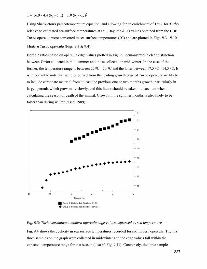
227
T = 16.9 - 4.4 (δc - δ w) + .10 (δc - δw)2
Using Shackleton's palaeotemperature equation, and allowing for an enrichment of 1 o/oo for Turbo
relative to estimated sea surface temperatures at Still Bay, the δ18O values obtained from the BBF
Turbo opercula were converted to sea surface temperatures (oC) and are plotted in Figs. 9.3 - 9.10.
Modern Turbo opercula (Figs. 9.3 & 9.4):
Isotopic ratios based on opercula edge values plotted in Fig. 9.3 demonstrates a clear distinction
between Turbo collected in mid-summer and those collected in mid-winter. In the case of the
former, the temperature range is between 22 oC - 20 oC and the latter between 17.5 oC - 14.5 oC. It
is important to note that samples burred from the leading growth edge of Turbo opercula are likely
to include carbonate material from at least the previous one or two months growth, particularly in
large opercula which grow more slowly, and this factor should be taken into account when
calculating the season of death of the animal. Growth in the summer months is also likely to be
faster than during winter (Yssel 1989).
Fig. 9.3: Turbo sarmaticus: modern opercula edge values expressed as sea temperature
Fig. 9.4 shows the cyclicity in sea surface temperatures recorded for six modern opercula. The first
three samples on the graph were collected in mid-winter and the edge values fall within the
expected temperature range for that season (also cf. Fig. 9.11). Conversely, the three samples
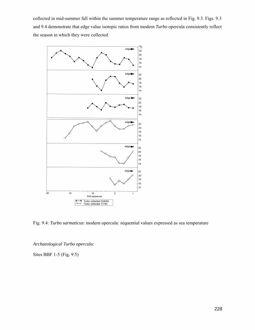
228
collected in mid-summer fall within the summer temperature range as reflected in Fig. 9.3. Figs. 9.3
and 9.4 demonstrate that edge value isotopic ratios from modern Turbo opercula consistently reflect
the season in which they were collected
Fig. 9.4: Turbo sarmaticus: modern opercula: sequential values expressed as sea temperature
Archaeological Turbo opercula:
Sites BBF 1-5 (Fig. 9.5)

229
Fig. 9.5: Turbo sarmaticus opercula: Sites BBF 1-5: sequential values expressed as sea
temperature
One Turbo opercula from each of the sites BBF 1 - 5 was analysed using Method 2, described
above. The results are plotted in Fig. 9.5 and show that seasonal variation in sea temperatures are
recorded in the carbonate of opercula growth rings. However, the spacing between seasonal growth
rings is frequently less than 1 mm meaning that carbonate from more than one seasons growth may
be obtained when using a 1 mm drill-bit. If a smaller drill-bit is used the size of the carbonate
sample collected is less than 1 mg and hence too small for processing. Problems were also
experienced when drilling the first hole on the leading growth edge of the opercula as the carbonate
from more than one seasons growth is generally included in the sample giving a misleading time of
the season of death of the animal. The edge values from BBF 1 and 4 suggest collection in winter,
BBF 2 and 5 are intermediate and point to spring or autumn temperatures. The sample from BBF 3
appears to have been collected during summer but the result does not agree with that of the edge
values of other Turbo opercula from the site (Fig. 9.6) and is probably inaccurate.

230
Fig. 9.6: Turbo sarmaticus opercula: BBF 1-5: edge values expressed as sea temperature
Sites BBF 1 - 5 (Fig. 9.6):
Fig. 9.6 reflects the mean sea surface temperature at the time of death of the Turbo samples from
the sites BBF 1 - 5 dating to between 6960 B.P. and 5520 B.P. Isotopic ratios are determined from
edge values of Turbo opercula. An analysis of S. tabularis samples collected from Nelson Bay Cave
by Cohen and Branch (1995) shows that during the period 6300 B.P. - 5000 B.P. summer
temperatures on the southern Cape coast were similar to those of the present day. Both the means,
and the ranges for the samples from the BBF 1 - 4 sites fall within the expected sea surface
temperatures for the winter months suggesting that these sites were all occupied between May and
October. BBF 5 may have been occupied during the early summer months i.e. November or
December (cf. Fig. 9.11).
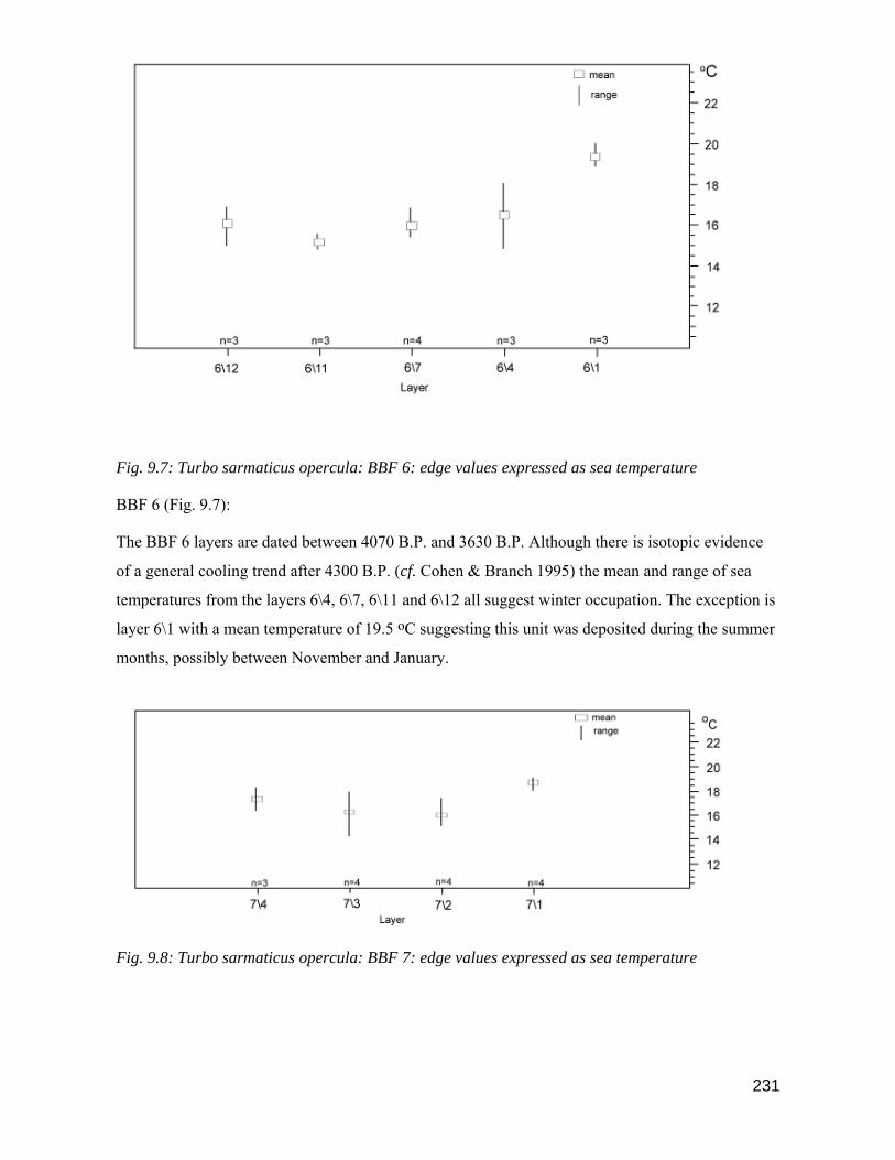
231
Fig. 9.7: Turbo sarmaticus opercula: BBF 6: edge values expressed as sea temperature
BBF 6 (Fig. 9.7):
The BBF 6 layers are dated between 4070 B.P. and 3630 B.P. Although there is isotopic evidence
of a general cooling trend after 4300 B.P. (cf. Cohen & Branch 1995) the mean and range of sea
temperatures from the layers 6\4, 6\7, 6\11 and 6\12 all suggest winter occupation. The exception is
layer 6\1 with a mean temperature of 19.5 oC suggesting this unit was deposited during the summer
months, possibly between November and January.
Fig. 9.8: Turbo sarmaticus opercula: BBF 7: edge values expressed as sea temperature
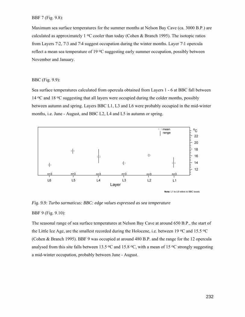
232
BBF 7 (Fig. 9.8):
Maximum sea surface temperatures for the summer months at Nelson Bay Cave (ca. 3000 B.P.) are
calculated as approximately 1 oC cooler than today (Cohen & Branch 1995). The isotopic ratios
from Layers 7\2, 7\3 and 7\4 suggest occupation during the winter months. Layer 7\1 opercula
reflect a mean sea temperature of 19 oC suggesting early summer occupation, possibly between
November and January.
BBC (Fig. 9.9):
Sea surface temperatures calculated from opercula obtained from Layers 1 - 6 at BBC fall between
14 oC and 18 oC suggesting that all layers were occupied during the colder months, possibly
between autumn and spring. Layers BBC L1, L3 and L6 were probably occupied in the mid-winter
months, i.e. June - August, and BBC L2, L4 and L5 in autumn or spring.
Fig. 9.9: Turbo sarmaticus: BBC: edge values expressed as sea temperature
BBF 9 (Fig. 9.10):
The seasonal range of sea surface temperatures at Nelson Bay Cave at around 650 B.P., the start of
the Little Ice Age, are the smallest recorded during the Holocene, i.e. between 19 oC and 15.5 oC
(Cohen & Branch 1995). BBF 9 was occupied at around 480 B.P. and the range for the 12 opercula
analysed from this site falls between 13.5 oC and 15.8 oC, with a mean of 15 oC strongly suggesting
a mid-winter occupation, probably between June - August.

233
Fig. 9.10: Turbo sarmaticus: BBF 9: edge values expressed as sea temperature
9.6: Methodology and Results: Scutellastra tabularis
1. Modern samples:
Two live S. tabularis specimens were collected at Blombos on 1/1/93 The shells were scrubbed to
remove surface algae and dried. The whole shells were sectioned longitudinally along one of the
shell ridges and the exposed surface polished. Holes were drilled using a 1 mm diamond-tipped
drill-bit at 2 mm intervals along the inner calcitic layer from the shell edge to the apex. Carbonate
samples of between 1 mg and 3 mg were roasted in individual pyrex boats for one hour to remove
the organic matrix. Batches of 20 samples were loaded into the mass spectrometer at the Godwin
laboratory, Cambridge for measurement of the isotopic ratio (cf. Shackleton 1973; Cohen and
Branch 1995).
2. Samples from BBF sites:
Due to limited time available on the mass spectrometer, and the cost involved, it was only possible
to analyse one S. tabularis shell from each of the sites BBF 1 -5. Carbonate from archaeological
samples were collected and processed in the manner described above for modern S. tabularis in
order to obtain isotopic ratios.
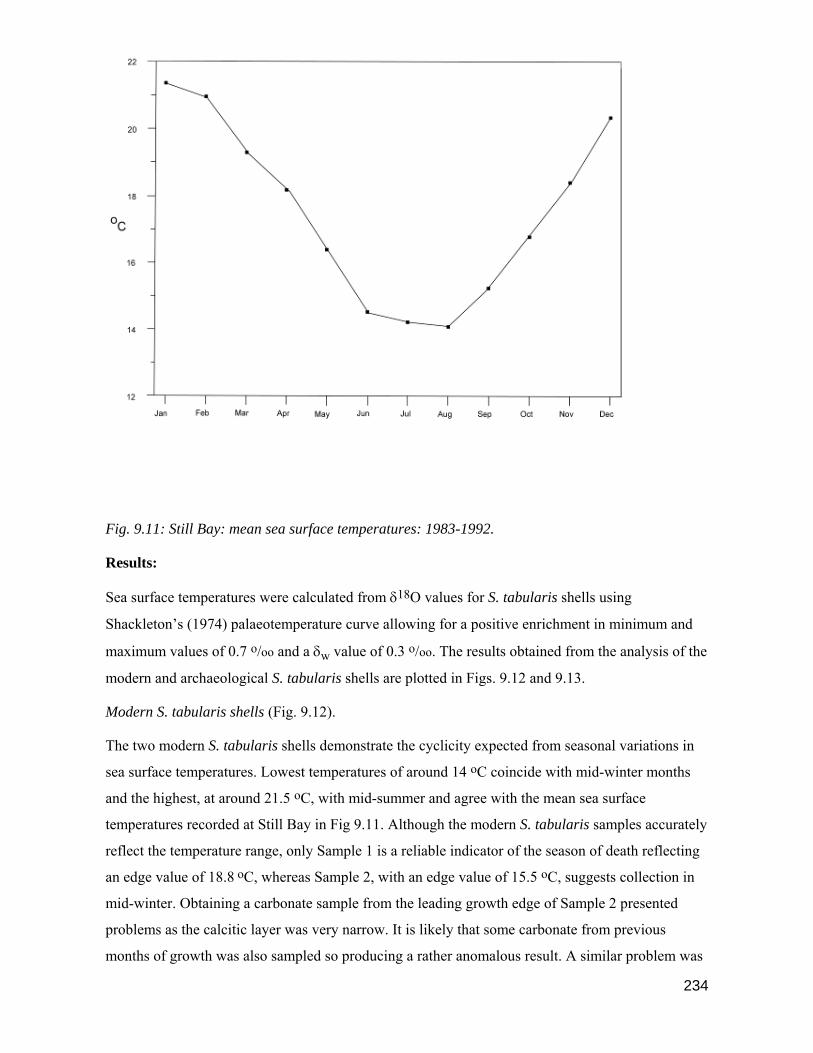
234
Fig. 9.11: Still Bay: mean sea surface temperatures: 1983-1992.
Results:
Sea surface temperatures were calculated from δ18O values for S. tabularis shells using
Shackleton’s (1974) palaeotemperature curve allowing for a positive enrichment in minimum and
maximum values of 0.7 o/oo and a δw value of 0.3 o/oo. The results obtained from the analysis of the
modern and archaeological S. tabularis shells are plotted in Figs. 9.12 and 9.13.
Modern S. tabularis shells (Fig. 9.12).
The two modern S. tabularis shells demonstrate the cyclicity expected from seasonal variations in
sea surface temperatures. Lowest temperatures of around 14 oC coincide with mid-winter months
and the highest, at around 21.5 oC, with mid-summer and agree with the mean sea surface
temperatures recorded at Still Bay in Fig 9.11. Although the modern S. tabularis samples accurately
reflect the temperature range, only Sample 1 is a reliable indicator of the season of death reflecting
an edge value of 18.8 oC, whereas Sample 2, with an edge value of 15.5 oC, suggests collection in
mid-winter. Obtaining a carbonate sample from the leading growth edge of Sample 2 presented
problems as the calcitic layer was very narrow. It is likely that some carbonate from previous
months of growth was also sampled so producing a rather anomalous result. A similar problem was

235
encountered in taking edge samples from archaeological specimens of S. tabularis, particularly
where the ridged edge of the shell had been worn due to exposure.
Fig. 9.12: Scutellastra tabularis: Isotopic temperatures: modern samples collected at Blombos
1/1/93
Archaeological S. tabularis samples (Fig. 9.13):
The shell from BBF 1 reflects a temperature range between 21.5 oC and 13.5 oC suggesting
conditions similar to today. A temperature of 13.5 oC at the shell edge suggests the animal was
collected in winter and agrees with the results obtained from Turbo sarmaticus specimens.
Due to algal borings and surface wear a complete range of carbonate samples could not be obtained
from the shell from BBF 2. However, the edge value of 15 oC is similar to the results obtained for
Turbo opercula from the site and confirms the suggestion that the site was occupied during the
winter months.

236
Fig. 9.13: Scutellastra tabularis: BBF 1-5: Isotopic temperatures
Two shells were sampled from BBF 3. One shell reflects a seasonal temperature range of between
21.5 oC and 14 oC while the other records a maximum sea temperature of 18 oC and a minimum of
14 oC. The variation between the edge values of the two samples is 2.5 oC, i.e. 15 oC and 17.5 oC.
Both edge values rule out summer occupation at the BBF 3 site and agree with the Turbo opercula
results suggesting collection in spring or autumn.
The BBF 4 shell suggests higher summer sea temperatures of around 22 oC - 23 oC with winter
temperatures of 14 oC. An edge value of 18 oC suggests occupation during spring or autumn.
Anomalously high summer temperatures are recorded in the shell from BBF 5 although winter
temperatures are around 14 oC which is similar to the results from BBF 1 - 4. Both the Turbo
237
opercula and S. tabularis edge results suggest the site may have been occupied during the early
months of summer.
9.7: Summary
Seasonal variation in sea surface temperatures in the Still Bay area are reflected in the carbonates of
Scutellastra tabularis and Turbo sarmaticus opercula. Modern samples of S. tabularis and T.
sarmaticus collected in the Blombos area were analysed using the basic techniques of oxygen
isotope analysis (cf. Urey 1947; McCrea 1950) to confirm that the method for establishing the
season of collection of shells, proposed by Shackleton (1973), could be applied to shellfish
collected in the BBF area. The results obtained from both species of shellfish demonstrate the
accuracy of establishing the season of death of the animal from shell carbonates. The most accurate
results were obtained by lightly burring the leading growth edges of Turbo opercula and
subsequently analysing the sample obtained for measurement of the isotopic ratio. δ18O values for
both T. sarmaticus and S. tabularis were converted to sea surface temperatures (oC) using
Shackleton's (1974) palaeotemperature formula allowing for enrichment of the minimum and
maximum values of approximately 0.7 o/oo and a δw value of 0.3 o/oo.
Turbo opercula and S. tabularis shells were collected during excavations at each of the BBF sites
for oxygen isotope analysis at the Godwin Laboratory, Cambridge. The results obtained from edge
value isotopic ratios of Turbo opercula and S. tabularis show that the sites BBF 1 - 4 were occupied
during the winter months, possibly between May and October. BBF 5 was probably occupied
during the early summer months as was layer 6\1 at BBF 6. Layers 6\4, 6\7 , 6\11 and 6\12 were all
deposited during winter. At the BBF 7 site, the results from lower layers, 7\2 - 7\4 all suggest
winter occupation although the top layer 7\1 was probably deposited during the early summer
months between November and January.
No summer occupations are reflected in the results obtained from BBF sites which post-date 2000
B.P. At the BBC site layers L1, L3 and L6 were probably occupied during the mid-winter months
and Layers L2, L4 and L5 during spring or autumn. BBF 9 results strongly indicate mid-winter
occupation, probably between June and August. If Khoekhoe pastoralists were present in the BBF
area then the most suitable time for grazing stock at the coast would have been during winter (cf.
Blommaert & Wiid 1937; Mandelbrote 1944). As the occupants of the BBC and BBF 9 sites are not
regarded as pastoralists (cf. Ch. 8) it seems that the seasonal round of hunter gatherers making use
of coastal resources here during the winter was not disrupted, possibly due to a limited presence of
238
herders in the BBF area or because there was no threat to hunter gatherer bands in the BBF area
from Khoekhoe herders.
The overall pattern for the occupation of BBF sites between 6960 B.P. and 480 B.P. is strongly
biased towards occupation during autumn, winter or spring suggesting that throughout this period
the seasonal pattern of coastal occupation remained fairly constant. It is interesting to note that two
of the sites which indicate summer occupation, i.e. BBF 5 and Layer 6\1 at BBF 6 are both regarded
as shellfish processing sites and not 'occupation sites' suggesting that coastal resources may, at
times, have been opportunistically used during the summer months, perhaps while passing through
the area, but that coastal occupations were rare during summer. BBF 7, Layer 7/1, may be regarded
as an exception to the rule as this is regarded as an 'occupation site' and was deposited during the
early summer, possibly between November and January.
239
CHAPTER 10
SUMMARY & DISCUSSION
10.1: Summary
The final conclusions of the BBF project attempt to address most of the issues raised in previous
chapters and are presented in two sections. The first is a brief synopsis of the findings from each of
the sites excavated, roughly divided into time periods, and the second considers the major issues
raised in each of the chapters, although the discussions frequently overlap and are therefore not
strictly presented in chapter order.
10.2: Site Synopses
The nine sites in the BBF area are divided into 3 site types based on age and location. Type 1 sites
predate 2000 B.P., are located in the dune area of the BBF coastal foreland and are all open sites,
either single or multiple occupation, One exception is the BBF 5 site which was not 'occupied', i.e.
was not a camp site, but was used for processing shellfish, perhaps for one day only, and then
abandoned. The minimum elevation of these sites is 90 m a.s.l. and the maximum 165 m a.s.l. There
is only a single Type 3 site, BBF 6, which dates to around 4000 B.P. and is an open site situated on
a rocky promontory directly adjacent to the sea. BBF 6 is essentially a large shell dump containing
a minimum of cultural artefacts and bone. Twelve discrete depositional units were recognised at the
site and on the basis of the content of these layers BBF 6 is designated a shellfish processing or
extraction site. Type 2 sites post-date 2000 B.P., are located in shelters situated in the coastal cliffs
to the south of the dune area and are less than 100 m from the sea. There are two Type 2 sites, BBC
& BBF 9, the former is a multi-occupation site and the latter was occupied once only. The Type 2
sites post-date the arrival of the first pastoralists in the BBF area.
Note: Sites are described below in chronological order i.e. Type 1, Type 3 and then Type 2.
1. Type 1 Sites:
Type 1 sites are located in the elevated dune area of the BBF coastal foreland and pre-date 2000
B.P.
ca. 7000 - 6700 B.P.
BBF 1 & 2 (Figs. 5.2, 5.3, 5.4, 5.5, 5.6, 5.7)
Both BBF 1 & 2 are single occupation sites of similar size. The extent and volume of deposit at
BBF 1 suggests it may have been occupied for a week or two, BBF 2 may only have been used for a

240
few days. An estimate of group size at each site is between 10 - 20 people. Warm and moist coastal
conditions, with increasing summer rainfall and a possible decrease in winter rainfall at this time
probably means the BBF dunefield was stable and forested (cf. Martin 1968; Helgren & Butzer
1977; Cockroft et al 1987; Deacon & Lancaster 1988; Tyson & Lindsay 1992; Cohen & Tyson
1995; Scott 2002; Barrable et al 2002; Carr eta la 2006; Chase & Meadows 2007; Chase & Thomas
2007). Two species of shrubs in particular Syderoxylon inerme and Euclea racemosa, both well
known for their extensive canopy and spreading branches, would have provided congenial areas,
protected from the elements, to set up camp (van Breda & Barnard 1991).
Sea levels gradually rose during the early Holocene (Bloom 1979; Ruddiman & Duplessey 1985;
Compton 2001; Carr et al 2006) and between 7000 - 6000 B.P. the sea levels on the BBF coastline
may have been similar to today or slightly higher, possibly + 1-1.5 m (cf. Birch 1976; Flemming
1977; Miller et al 1993).
In any event, a range of shellfish were exploited by the sites inhabitants and the lists of the five
most common species found at BBF 1 & 2 are almost identical. In descending order of magnitude
these are T. sarmaticus, P. perna, H. spadicea, S. longicosta and C. oculus. Two of these species, T.
sarmaticus and H. spadicea occur only in the Cochlear and Infratidal zones suggesting they were
collected during low water at spring tide. Although the largest mean sizes of T. sarmaticus are
found at BBF 1 & 2 , the mean size of P. perna from the BBF 2 site are the smallest of all the BBF
sites. Of the five species of shellfish measured from all sites there is a definite trend indicating that
three of the species are generally larger in the earlier sites, but that P. perna and H. spadicea are
smaller (cf. Ch. 6).
The assemblages from both sites were encased in breccia and during excavation it was noted that
although bone was common at both sites it was very friable and could subsequently not be
identified to taxa. However the presence of bone and numerous lithic artefacts suggests that a range
of activities, in addition to shell-fishing, were performed at BBF 1 & 2. Retouched stone tools, all
in silcrete, are common at BBF 1 but rare at BBF 2. In keeping with the general trend observed
during the early stages of the Wilton Tradition at other Cape sites, scrapers are larger than those
from Mid-Holocene sites. Backed pieces, including backed scrapers and segments are already
apparent at BBF 1 at around 7000 B.P. and make up 44 % of the retouched artefacts pointing to an
early start at BBF for the manufacture of backed tools. A distinct contrast between the lithics from
BBF 1 & 2 is the high proportion of waste quartz, hammerstones and grindstones at the latter site
suggesting that the range of activities involving lithic artefacts was not the same at both sites.
The results of oxygen isotope analysis on shell carbonate tested from BBF 1 & 2 indicate that both
sites were occupied during the winter months, possibly between May and October. It seems likely

241
that coastal sites such as these formed only a part of a possibly much larger seasonal round and
were occupied for only brief periods during the year. Although one of the main objectives of
visiting this section of the coastline may have been to gather shellfish, it is likely that a range of
other resources were also exploited in the surrounding area.
ca. 6000 - 5500 B.P.
BBF 3 (Figs. 5.2, 5.8, 5.9)
Almost 800 years separates the occupation of BBF 2 and BBF 3. Whether the BBF area was
occupied during this period cannot be established from the limited number of sites that were
excavated. There does seem to be an hiatus in occupation at Byneskranskop 1 at around the same
period (Schweitzer & Wilson 1982) and possibly at Nelson Bay Cave (Inskeep 1987) but this may
be a function of insufficient radiocarbon dates or simply that we have not yet located any sites
which date to this interim. A rapid rise in sea level is possible at around 6000 B.P. and may have
temporarily reduced the amount and range of marine resources available for exploitation.
BBF 3 is a single occupation site covering around 900 sq. m and therefore considerably larger than
BBF 1 & 2. Three discrete depositional areas on the perimeter, possibly linked in the past to the
positions of shelters, and a central hearth area point to a layout typical of many hunter gatherer
camps. Judging from the extent and depth of the deposit at BBF 3, the size of the band occupying
this site was probably larger than at the earlier sites, BBF 1 & 2, but the camp may not have been
occupied for longer than a week or two. Protection from the elements would have been provided by
well vegetated surroundings.
The available range of shellfish at BBF after 6000 B.P. seems unaffected by the proposed higher
sea levels and a similar mix of species is found at BBF 1, 2 & 3. There is a slight shift in emphasis
towards greater exploitation of S. tabularis and Diloma sp. but T. sarmaticus remains the most
commonly exploited mollusc and suggests that the BBF 3 inhabitants were exploiting the full range
of the intertidal zone. A part of the occupation must therefore have coincided with a spring tide.
A large amount of tortoise and fragmented bovid bone was apparent on the surface of the partially
brecciated assemblage pointing to activities at the site other than shell-fishing. During recovery the
larger bovid bone was found to be very friable and could not be classified to taxa. The numbers of
waste and modified/utilised lithic artefacts were very low, similarly retouched stone tools were rare
and consisted of a few scrapers in silcrete and a single backed flake in quartz suggesting minimal
activities relating to the use of lithic artefacts were carried out at the site. Analysis of shell
carbonates from the site indicates occupation during winter, possibly between May and October.
BBF 4
242
The most distinguishing features of the BBF 4 site are its size and the large numbers of lithics
visible in the deposit. In total, the site extends over 2500 sq. m, of which 400 sq. m is in situ. Three
distinct areas of high density deposit encircle a central area containing a light scatter of shell (Fig.
5.11) and the overall layout of the site is similar to that at BBF 3 (Fig. 5.8). However, the size of
BBF 4 points to occupation by a larger band than is proposed for BBF 3, possibly 30 - 40 people.
The high incidence of formal tools at BBF 4, numerous traces of ochre on upper and lower
grindstones and its size and layout suggests it may have been an aggregation site (cf. Wadley 1989)
where a number of smaller bands gathered to exchange ritual hxaro gifts and for social interaction.
At the time of occupation the dunefield was probably well vegetated and as the site is situated in a
low-lying area of the dunes it probably afforded protection from the northerly and westerly winds.
Although a + 2 m high sea stand is predicted for the mid-Holocene (cf. Ch. 2) this does not seem to
have affected the shellfish resources on the rocky coast below BBF. The five most common
shellfish species at BBF 5 are very similar to those found at BBF 3 and include, in descending
order, T. sarmaticus, S. longicosta, Diloma sp., C. oculus and S. tabularis. Patella sp. feature
strongly at the BBF 4 site, unlike BBF 1 & 2 where P. perna and H. spadicea are common. It seems
more likely that this change in species preference was out of choice, rather than due to availability,
as overall the range of shellfish exploited at BBF 4 is the same as that at BBF 1 & 2, but in different
proportions. The whole range of the intertidal zone was exploited by the BBF 4 inhabitants
indicating that part of the occupation period coincided with low spring tide. Oxygen isotope
analysis of shells from the site shows occupation during autumn, or winter, or early spring.
Fragmented bone was scattered throughout the deposit but the few whole bones present were too
friable for recovery. Two mandibles containing teeth were identified as Taurotragus oryx. Despite
the lack of identifiable bone, it is obvious from the lithics that activities at the site extended beyond
those relating only to shellfish. Almost 3500 unmodified artefacts were recovered, 77 % in silcrete,
indicating extensive stone knapping activity. Backed artefacts, mainly backed scrapers, account for
76 % of the retouched artefact category and point to the extensive use of hafted tools at the BBF 4
site. If we assume that backed tools were used in the processing of animal carcasses (cf. Ch. 8), then
the 139 backed scrapers, 50 backed segments and 47 backed flakes suggest intensive activity
revolving around meat and hides.
A clear distinction can be made between typical Wilton tradition assemblages from sites to the east
of the Gouritz River, dated at around 5000 B.P., and the lithics from BBF 4. These differences
support H.J. Deacon's (1976:171) contention that 'west of these limits (the Gouritz River) there
would seem to be artefact occurrences... which fall outside any concept of a specific Wilton content
unit'.
243
BBF 5 (Figs. 5.2, 5.12, 5.13)
The BBF 5 site dates to around the same period as BBF 4 but clearly the site was used for a very
different purpose. BBF 5 consists of a thin scatter of shell and stone covering 550 sq. m on the
slope of a stabilised dune and a core area of dense deposit of 18 sq. m. Two species, T. sarmaticus
and S. tabularis, account for 70 % of the shellfish assemblage. Formal stone tools are almost absent
and the modified lithics class is dominated by 11 hammerstones, and 12 lower grindstones used as
anvils. Based on the large number of broken S. tabularis and Turbo shells, low numbers of Turbo
opercula and the stone tools, the BBF 5 site has been designated a shellfish processing or
'extraction' site (for a full discussion cf. Ch. 6). BBF 5 is one of the few sites utilised during
summer. The shellfish were almost certainly gathered during a low spring tide, brought whole to the
site to extract the raw meat which was then probably transported elsewhere, possibly to a site
located further inland. As such, the BBF 5 site reflects a brief and opportunistic visit to the coast
during summer in order to gather a quantity of protein rich meat intended for consumption at
another location.
ca. 3000 B.P.
BBF 7 (Figs. 5.2, 5.17, 5.18. 5.19)
Unlike BBF 1- 5, BBF 7 is a multi-occupation site located in the BBF dunes. The BBF 7 site has
two unusual features: firstly, the large number of adzes recovered and secondly the dark, humic
matrix surrounding Layers 7\2 - 7\4. Layer 1 rests directly on this humic layer. Analysis of the BBF
7 sediment indicates a high organic component mixed with quartz sand typical of the BBF dunes. A
rapid deposition of humic rich palaeosols at around 3000 B.P. can be attributed to the dense forest
cover which likely pertained at BBF at this time. With the exception of BBF 4, adzes are virtually
absent in BBF assemblages. Adzes were probably used as woodworking tools (Deacon, H.J. 1976;
Deacon, J. 1984a: Schweitzer & Wilson 1982) and at BBF 7, adzes account for 40 % of the
retouched tools suggesting a high incidence of woodworking activity.
The black mussel, P. perna, dominates the shellfish assemblage at BBF 7, and in this respect is
similar to the BBF 1 & 2 sites. Although T. sarmaticus features strongly in all the BBF 7 layers,
Diloma sp. and Patella sp. and P. perna are also common. The mean sizes of the shellfish from
BBF 7 are the smallest recorded for all the BBF 7 sites. After 4000 B.P. sea surface temperatures
may have decreased by 1 or 2 oC (Cohen & Tyson 1995) which could have had an effect on
shellfish growth rates and size.
It is interesting to note that only the top layer at BBF, Layer 7\1 was occupied during summer. This
layer lies directly on top of the humic layers and is surrounded by a white dune sand matrix.
244
Although the radiocarbon dates for the top and bottom layers at this site are tightly grouped, it
suggests that either the ecological conditions rapidly changed at the site prior to the period that
Layer 7/1 was deposited, i.e. became less forested or that during the drier summer months dune
sand was more mobile and covered the 7/1 layer fairly rapidly. The former explanation seems more
likely as there is no evidence of further humic palaeosols being deposited at the site after the 7/1
occupation. This suggests a rapid change in forest conditions may have occurred at BBF at around
the time of the last occupation with dense forest being replaced by grassier vegetation and possibly
re-activation of the dune field. Layers 7\2, 7\3 & 7\4 were occupied during winter, probably during
periods of high rainfall, rapid deposit of humic palaeosols and dense forest cover.
The BBF 7 site, dated at ca. 3100 B.P., is the last occupation recorded at BBF prior to the arrival of
the first pastoralists. A similar pattern is recorded at Byneskranskop 1 and, at this stage, it is not
known whether this section of the coast was utilised between 3000 - 2000 B.P. Possibly there was a
deterioration in climatic conditions during this period leading to increasing aridity and a reduction
in vegetation cover after the occupation of Layer 7/1 and as a result the BBF area may have been
abandoned.
2. Type 3 sites
The only Type 3 site, BBF 6, is an open midden located on a coastal promontory directly adjacent
to the sea.
c. 4000 B.P.
BBF 6 (Figs. 5.2, 5.14, 5.15, 5.16)
BBF 6 is primarily a shell midden covering over 500 sq.m and with a maximum recorded depth of
1.3 m. Within the section excavated 12 discrete depositional episodes were noted. The top layer
dates to 3630 B.P. and the bottom to 4070 B.P. Apart from two retouched pieces, cultural artefacts
were absent in all the units excavated. Small quantities of fish bone were found in some layers.
Charcoal and ash lenses, probably the remains of hearths, occurred in some units suggesting that
shellfish were being cooked on site. However, it is highly unlikely that BBF 6 was an occupation
site, firstly as the contents are almost exclusively marine shell and secondly as the site is on a rocky
headland totally exposed to the south-easterly and north-westerly winds. Shells from five of the
layers were tested for seasonality and with the exception of the top layer, 6\1, which was deposited
during summer, the other four layers were deposited during winter. It is interesting to note that the
top layer, 7/1 at BBF 7 was also occupied during summer. Although there is some time difference
in the radiocarbon dates for 7/1 and 6/1, i.e. 3110 B.P. and 3630 B.P, this may have been a period

245
when coastal resources were opportunistically used during summer but the sample size is too small
to make any definitive statements about overall seasonality patterns during this time.
Predicted sea levels for the ca. 4000 B.P. period are + 1.5 - 2 m, but seem to have had little, if any,
effect on the species of shellfish available in the BBF area. Thirteen species of shellfish were
recorded within the 12 layers, T. sarmaticus are the most common followed by Patella sp., H.
spadicea and P. perna. During the 400 years that the site was intermittently in use the pattern of
exploitation appears to have been similar. A range of shellfish were gathered from the surrounding
rocky bays and brought to the site for processing. Processing sites are also recorded on the western
Cape coast. At Eland's Bay the formation of megamiddens between 3000 - 1700 B.P. has been
attributed to short-lived coastal visits during which shellfish were processed for transport elsewhere
(Henshilwood et al 1994; Jerardino 1998, 2003).
Some 'snacking' may have occurred at the BBF 6 site, but the main purpose of the hearths are
probably for cooking and extracting the meat of the shellfish which may then have been transported
to an occupation site situated elsewhere. No evidence of sites dating to this period has been found
in the BBF area suggesting either we were unable to locate them during the area survey or they are
located further inland.
3. Type 2 sites
Type 2 sites post-date 2000 B.P. and are located in shelters in the cliff face directly above the
coastline.
Post 2000 B.P.
BBC (Figs. 5.2, 5.20, 5.22, 5.23)
BBC is a multi-occupation cave site situated 50 m from the sea. During excavation 6 stratigraphic
LSA layers were recognised. The uppermost layer, BBC L1, is dated at 290 B.P. or 1651 A.D.
Shortly after the BBC L1 unit was deposited the first European travellers were exploring the trade
potential of the southern Cape. Ethnohistoric accounts record many Khoekhoe camps on the
Riversdale Plain, an area described as rich in cattle although we are unsure whether the BBF area
was being used by Khoekhoe at this time. The last inhabitants at BBC occupied the site only very
briefly, perhaps as an overnight stop, and may have been among the last hunter gatherers to leave
evidence of their visit in the BBF area.
Radiocarbon dates for Layers BBC L5 & BBC L6, based on charcoal and bone samples, are
between 1960 B.P. and 1840 B.P. Layers BBC L2, BBC L3 & BBC L4 are undated. The lower
layers, in particular, BBC L4 and BBC L5 consist of dense deposits of shell, bone, stone and

246
hearths and in some sections the deposit is up to 20 cm in depth. Layers BBC L1 - L3 are less
compact but made up of similar elements to those in the lower layers.
Two sheep bones, obtained from Layers BBC L5 & BBC L6, were radiocarbon dated to 1960 ± 50
B.P. and 1880 ± 55 B.P. and are the earliest dates, using a direct dating method, for the
southernmost Cape area (Henshilwood 1996). The presence of sheep, at this early date, is of
particular significance as it indicates contact between herders and hunter gatherers took place
during the earliest occupation at the site and coincides with a change in site type and location. All
units which post-date 2000 B.P. in the BBF area are located in cliff shelters and the dunefields are
no longer occupied. In Chapters 5 & 7 it was proposed that BBC was occupied by hunter gatherers
and not herders, due to its size, location and difficult access. Herders were probably grazing their
stock on the coastal plain to the north of BBF and it is here that contact is likely to have occurred.
Cooler conditions and a lower incidence of forest taxa are predicted by Martin (1968) and Scholtz
(1986) for the southern Cape after 2000 B.P. A reduction in vegetation cover and possible
reactivation of the BBF dunefields may have caused the change to shelter sites on the coast and
may be unrelated to the coincidental arrival of herders at this time.
However, there is some contrary evidence suggesting that the BBF area may have been forested
after 2000 B.P. Charcoal from the BBC LSA layers was identified to species level from anatomical
features within cell structures by Dr. Caroline Cartwright. Euclea racemosa and Syderoxylon
inerme account for 29 % of the combined totals for all layers and, in addition, a further 15 species
of plants were identified. The range of plant species is what we would expect to find in a coastal
dune area and it is possible that the firewood used at BBC was collected from the BBF dunefield
which, at this time, was at least partially forested.
Although we are unable to determine the population demographics of the Riversdale Plain at around
2000 B.P, we do know that herders were present in the BBF area. Animosity between the two
groups may have arisen due to stock theft and/or the disruption of seasonal utilisation of resources
by hunter gatherers (e.g. Parkington 1984, 2001; Smith 1986) and it seems most likely that a switch
to the use of coastal shelters at BBF after 2000 B.P., can, in part, be attributed to social tensions
between hunter gatherers and herders.
Excellent preservation of bone at BBC has allowed a detailed study to be made of the fauna from
this site, although the sample size is small. The results show that in addition to shellfish gathering a
wide range of other animals were also utilised for food including small, medium and large bovids,
small terrestrial mammals, reptiles, marine mammals, birds and fish.
247
Diloma sp. is the most common species of shellfish in most of the BBC layers, followed by T.
sarmaticus and Patella sp. Overall, the results of the shellfish analysis from this site indicates a
shift towards greater utilisation of shellfish located in the upper sections of the intertidal zone. Two
species in particular, H. spadicea and S. tabularis, found only in the Cochlear and Infratidal zones
are relatively common in sites pre-dating 2000 B.P., but virtually absent at BBC.
Cultural artefacts include stone and bone tools, pottery, and shell and bone ornaments. In common
with other coastal sites which postdate 2000 B.P. (e.g. Die Kelders, Byneskranskop, Nelson Bay
Cave) retouched lithics are rare. Unmodified stone tools in quartz and quartzite predominate and
silcrete is rarely used. Pottery was found in the same levels as the dated sheep bone suggesting a
more or less simultaneous arrival at the Cape of sheep and pottery, although the sources of sheep
and pottery may have been from different areas (cf. Ch. 8; Henshilwood 1996).
Shells were selected from each layer at BBC for oxygen isotope analysis. The results show that
Layers BBC L1, BBC L3 and BBC L6 were occupied during the mid-winter months and Layers
BBC L2, BBC L4 and BBC L5 during spring or autumn. This fairly regular pattern of seasonal
occupation suggests that coastal visits by hunter gatherers were still timed to coincide with the
colder months, even after the arrival of herders, and that during the summer months optimal use
may have been made of resources, particularly geophytes, on the upper coastal plain and in the
intermontane regions. In this respect, the effect of herders on hunter gatherer movements seems to
be minimal.
The small sizes of the post 2000 B.P. sites indicates that hunter gatherer bands were smaller,
perhaps less than 10 – 20 people, compared to the larger bands of between 10 - 40 people who
utilised open sites during the earlier period at BBF. The high density of deposits, particularly in
Layers BBC L4 and BBC L5, point to longer periods of occupation, perhaps a few weeks, than is
the case for open sites. Visits may not have been timed to coincide only with low spring tides and
could account for the increase in shellfish species at BBC which habituate the upper intertidal
zones.
BBF 9 (Figs. 5.2, 5.29, 5.30, 5.31)
At the time the BBF site was occupied, ca. 480 B.P., cool climatic conditions pertained and this is
reflected in reduced mean sea surface temperatures (cf. Ch. 2 & 9). Situated in the shelter of an
overhang, BBF 9 was a single occupation site probably occupied for a week or two by a small band
of hunter gatherers. The main features of the site are a large central hearth surrounded by a shell
dump composed mainly of T. sarmaticus, C. oculus and Diloma sp. Pot-shaped impressions in the
central hearth suggest that some of the shellfish may have been boiled, possibly the small Diloma

248
winkles. The Turbo were gathered at low spring tide but it is possible that Diloma and Patella were
collected during a different phase of the occupation when the tides were not as low.
Other fauna from the site includes small and small-medium bovids, hyraxes and a dolphin. Two
Coronula diadema barnacles, found only on whales, were recovered at BBF 9 suggesting that
dolphin and whale meat were brought to the site, probably scavenged from wash-ups.
Almost 4000 unmodified stone artefacts were found at the site, mainly chips, chunks and flakes; 73
% are in quartz and 26 % in quartzite. Only 3 artefacts show signs of retouch. A chunk of resinous
mastic, found at the edge of the main hearth, suggests unretouched quartz flakes may have been
mounted in mastic and hafted for use as armatures, or possibly cutting tools. A quantity of pottery
sherds came from the central hearth area.
Oxygen isotope analysis showed that the 12 opercula tested from the site reflected a mean sea
temperature of 15 oC indicating that the site was occupied in mid-winter.
10.3: Discussion
The Blombosfontein Project demonstrates that the excavation of a suite of coastal sites, situated in
close proximity to one another yet temporally separated, provides a broad range of insights into the
way that prehistoric people utilised coastal resources over a 7000 year period. In particular the
project has demonstrated the advantages of excavating a relatively large number of units, i.e. in the
case of BBF, 28 separate depositional episodes, and how these affect ones interpretation of the
range of likely activities and how sites are linked to one another, spatially and temporally. If the
project had been restricted to say only three sites, and had not investigated sites situated in a range
of locations and of different types the conclusions of the project may have been very different. The
significance of the BBF approach to excavating shell middens, namely excavating as large a
number as is feasibly possible within close proximity of one another, is that it highlights the
problems associated with the excavation of perhaps only a single coastal site. Inevitably, in the
latter case ones interpretations would be limited to the data of that site only. The advantages of an
expanded data base are demonstrated by the BBF project and hopefully future coastal excavations
will concentrate on this type of approach.
The core of the project revolved around the analysis of the cultural and faunal components
recovered from the nine sites excavated but the study also took into account a number of related
issues including palaeoenvironmental changes, site type, size and location, seasonality and
ethnohistoric accounts. Where applicable, comparisons were made with coastal and inland sites
excavated elsewhere in the Cape and these are discussed in detail in the relevant chapters.

249
Two of the major events which occurred during the period that BBF was occupied were firstly the
arrival of pastoralists in the southern Cape at around 2000 B.P. and the secondly the settlement of
Europeans at the Cape in 1652 A.D. Both events are considered likely to have had considerable
impact on the hunter gatherer way of life and are one of the focal points of the BBF study.
As expected, shellfish formed a major component of all the assemblages excavated at BBF and
indeed may have been one of the main reasons for coastal visits. Less expected was that the total
range of shellfish species exploited over 7000 years remained fairly constant indicating that
conditions in the intertidal zones remained conducive to supporting the same range of shellfish
species found in the area today. This conclusion can now be extended to include the Middle Stone
Age levels dating from c. 70 ka - > 140 ka (Jacobs et al 2006) where the same species of shellfish
were exploited with a few minor exceptions (Henshilwood et al 2001a). Sea levels of + 1 - 2 m
pertained from around the Mid-Holocene and are likely to have stabilised at their present level after
2000 B.P. Massive outcrops of Table Mountain sandstone at various elevations form the substrate
of the rocky bays and inlets found directly below BBF. As such, an incursion of 1 - 2 m would have
altered the morphology of the coastline to some extent but had minimal impact on intertidal
conditions suited to the establishment of shellfish colonies. Evidence of wave erosion of
calcarenites at the base of the cliffs indicates that during periods of high sea levels much of the
presently exposed coastline was inundated during high spring tides.
Although the total range of shellfish exploited at BBF remained constant, there was a distinct shift
in emphasis in the ranking of species exploited. During the period between 7000 - 2000 B.P.
species found in the lower reaches of the intertidal zone were more heavily exploited, specifically
T. sarmaticus, S. tabularis and H. spadicea. One reason for this shift is that the pre-2000 B.P.
occupations may have been timed to coincide with spring low tides and were generally of shorter
duration than is the case for the later sites.
The five species of shellfish best represented at BBF sites were selected for measurement to
determine whether there were changes in their mean sizes. The largest mean sizes of T. sarmaticus,
S. longicosta and C. oculus occur in the earliest sites, BBF 1-4. Contrary to expectations P. perna
and H. spadicea are largest in the later sites BBF 6 & 9 and BBC. The smallest mean sizes for the
five species measured come from the BBF 7 site dating to ca. 3000 B.P. Changes in sea
temperature, salinity and currents are likely to have had some effects on the size of certain species
of shellfish, although in a similar study at Byneskranskop 1, Schweitzer & Wilson (1982)
considered the overall effect of ecological change on shellfish size to be minimal. Ethnographic
studies have demonstrated that constant human predation on a particular species of shellfish will
lead to a reduction in mean size over time (e.g. Bigalke 1973; Spenneman 1986; Lasiak & Dye
250
1989). However, because of the time gaps between depositional units at BBF we are unable to
assess the likely effects of human predation on shellfish size. A combination of ecological
conditions and human predation may be responsible for the shellfish size patterns observed, but a
more definitive answer can only be given if considerably more sites, of a similar time period, are
excavated at BBF.
In addition to shellfish, a wide range of marine and terrestrial resources were exploited by the BBF
inhabitants. Poor bone preservation in open sites pre-dating 2000 B.P. precludes us from making
inter-site faunal comparisons, but the presence of large bone flakes, tortoise, fish bone and lithics
associated with meat and hide production suggests that a wide range of animals were brought to
some of these sites. At the two sites which post-date 2000 B.P., BBC & BBF 9, we have well
preserved evidence of the range of marine and terrestrial animals exploited. In the former category
seals, dolphins, whales and sea birds were utilised. Terrestrial animals include various sizes of
bovids ranging from the large Taurotragus oryx to the small Oreatragus oreatragus although small
animals such as the Cape dune mole rat and hyraxes dominate the faunal assemblages. Reptiles
include tortoises, which are common, and snakes. The overall impression created by the faunal
assemblages at BBC & BBF 9, and the limited evidence from the earlier sites, is that while shellfish
may have been a dietary staple, prehistoric exploitation of coastal resources extended well beyond
shellfish only (also see Dunbar 1991). The variety of marine and terrestrial animals which could be
hunted, trapped or scavenged in the BBF area, and the availability of fresh water at coastal springs,
must also have been major factors prompting these coastal visits.
Two sites, BBF 5 & 6, are designated as shellfish processing or 'extraction' sites (cf. Mellars 1987)
and it is considered unlikely that either site was a residential site. Two species of shellfish, S.
tabularis and T. sarmaticus were targeted for collection and brought to the BBF 5 site for
processing. The meat of these shellfish was extracted raw and probably carried to an occupation site
elsewhere. The BBF 6 site is a large shell midden utilised between 4070 B.P. and 3630 B.P. and
contains 12 discrete depositional units. A range of shellfish was brought to the site for cooking and
processing and the extracted meat taken elsewhere. BBF 5 & 6 highlight the diversity associated
with the exploitation of coastal resources in the BBF area.
Stone tools dominate the cultural artefacts recovered from BBF sites. Between 7000 - 3000 B.P.
microlithic tools which broadly conform to the Wilton tradition (cf. Deacon, J. 1984a) occur at most
sites. Retouched artefacts are predominantly made on fine-grained silcrete. Silcrete does not occur
in the immediate vicinity of BBF and is likely to have been brought to the site from the Riversdale
or Albertinia area, c. 30+ km to the north-east, where outcrops are common. The use of raw
materials not found locally provides some information on the movements of early populations at
251
BBF and suggests that the inland areas of the coastal plain may have been utilised, possibly
seasonally, during the Mid-Holocene. An unusual feature of the lithic assemblages from BBF 1 & 4
is the high ratio of backed pieces in the formal tool category, in particular backed scrapers. Lithic
assemblages dating to this period are distinctly different at sites located to the east of the Gouritz
River, including Nelson Bay Cave, in that scrapers dominate the retouched tool categories and
backed pieces are rare. Byneskranskop 1 and Brakfontein, located to the west of BBF, both contain
high ratios of backed tools. New evidence of the numbers of backed lithic elements from the BBF 1
& 4 sites confirms H.J. Deacon's (1976) observations that assemblages to the west of the Gouritz
River fall outside any concept of a specific Wilton unit. It is not clear whether backed pieces, which
were probably hafted, were used to perform a different function to unbacked scrapers, nor why they
occur almost exclusively in sites situated west of the Gouritz River. The reasons could be cultural
or functional or both but, as Inskeep (1987) and Lombard (2005b, 2007a) have pointed out, use-
wear, residue and macrofracture analysis may be the best approaches to help resolve this issue.
Interestingly, the retouched stone tools from BBF 7 are dominated by adzes. Dense, humic
palaeosols at this site suggest a high incidence of forest taxa at the time of occupation and the
presence of adzes may be related to woodworking activities at the site and possibly the exploitation
of plant foods during the summer occupation at BBF 7\1, although at around the time that Layer 7\1
was occupied it is possible that forest taxa were on the decrease and the BBF dunefield was in the
process of re-activation.
Lithic assemblages which post-date 2000 B.P. are dominated by unretouched artefacts in quartz and
quartzite and formal tools are rare. A similar pattern is recorded at Nelson Bay Cave,
Byneskranskop 1 and Die Kelders suggesting that lithics broadly conforming to the Wilton
Tradition are replaced by assemblages dominated by informal tools at coastal sites.
Other cultural artefacts recovered from BBF sites include bone tools, shell and bone beads and
ornaments, and pottery; all are broadly similar to those found at Cape coastal sites. Pottery occurs
in the same levels as the dated sheep bone at BBC, suggesting they were both introduced to the
southern Cape more or less synchronically (Henshilwood 1996).
The location of the BBF sites follows a specific temporal pattern. All sites, with the exception of
BBF 6, which predate 2000 B.P. are situated in the elevated dune area and those post-dating 2000
B.P. are in small shelters in the coastal cliffs. For most of the period between 7000 - 2000 B.P. the
dunefields were probably stable and well vegetated and provided suitable conditions for the
establishment of camp sites. The size of these open sites suggests that hunter gatherer bands were
larger in the pre-2000 B.P. period, perhaps between 10 - 40 people, but the relatively low density of
the in situ deposit points to coastal visits of short duration. Coastal caves and shelters in the BBF
252
area are too small to accommodate groups of this size and may be one of the reasons why the dune
area was occupied. After 2000 B.P. the size of hunter gatherer bands may have been smaller,
perhaps extended family units of less than 10 – 20 people. Groups of this size could be comfortably
accommodated in the small BBF shelters. The high density and volume of assemblages within a
single occupation layer at BBC, particularly in the lower units BBC L4 and BBC L5, suggest that
some coastal visits after 2000 B.P. were of longer duration than is the case for open sites.
Two sheep bones recovered from BBC layers L5 & L6 were directly dated by the accelerator
radiocarbon method to 1960 ± 50 B.P. and 1880 ± 55 B.P. and provide the earliest direct evidence
for herding in the southernmost Cape (Henshilwood 1996). Both because of the small size of the
BBC & BBF 9 sites and their relative inaccessibility, it is unlikely they were occupied by herders
with stock (cf. Ch. 7). Both BBC & BBF 9 are therefore regarded as hunter gatherer sites. The
sheep at BBC may have been acquired by theft or barter from local herders. Initially, the numbers
of herders in the southern Cape may have been low, although by the 17th C. ethnohistorical
accounts record large numbers of Khoekhoe herders with cattle and sheep on the Riversdale Plain.
During the early stages of contact between hunter gatherers and herders relationships may have
been amicable but both archaeological (e.g. Parkington 1986, 1988; Hall 1986) and ethnohistoric
evidence (e.g. Parkington 1984; Smith 1986) suggests that shortly after the arrival of herders there
was enmity between the two groups which persisted into the historic period. As a result hunter
gatherer seasonal rounds may have been disrupted and some bands forced into marginal areas of the
Cape. There is a rapid increase in the numbers of small cave sites occupied by hunter gatherers in
the western Cape after 2000 B.P., and Parkington (1984) attributes this to domination of the coastal
plains by pastoralists. The presence of herders in the BBF area may therefore have been a
contributing factor to the abandonment of the dune area and the use of shelter sites by hunter
gatherers.
Marine shells from 21 of the BBF sites/units were tested for seasonality by analysing the oxygen
isotopes within the shell carbonates. The results show that an overwhelming number of BBF
sites/units, i.e. 86 %, were occupied during autumn or winter or spring. Only 3 units were utilised
during summer and 2 of these, BBF 5 & 6/1 are regarded as processing sites. A consistent pattern of
exploitation of coastal resources during the colder months is evident for the 7000 years that BBF
was intermittently occupied, and this pattern continues after the arrival of herders at 2000 B.P.,
suggesting a minimal disruption of hunter gather seasonal rounds in this area. Summer visits appear
to have been short and possibly opportunistic - perhaps coinciding with the movement of a band
along the coastal plain who were within striking distance of the coast. In general though, summer

253
visits seem to be highly irregular but provide a further interesting insight into the diverse ways in
which coastal resources were utilised in the BBF area.
The last occupation at BBC coincides more or less with the settlement of the first Europeans at the
Cape in 1652. By the end of the 18th C. few Khoekhoe herders were left on the Riversdale Plain -
mostly due to a series of smallpox epidemics and the effects of Dutch expansionism. Some
Khoekhoe may have reverted to a hunting and gathering existence, for example in the early 1800s
visitors to Still Bay noted that indigenous people were still utilising coastal resources and operating
stone fish traps in the area. In 1808 a land grant was made to Hendrik van de Graaff by the Earl of
Caledon giving him rights to the farm Blomboschfontein, of which Blombosfontein Nature Reserve
forms a part. Shortly afterwards extensive sections of coastal forest were burnt to eradicate
predators and it is likely that at this time the last 'hunter gatherers' in the BBF area were forced to
abandon their way of life, either to be taken into employment on farms or forced to move to other
areas.
A range of issues relating to the utilisation of coastal resources by prehistoric people during the
Holocene was addressed by the BBF project. The results of the study clearly demonstrate the
advantages of excavating a range of sites situated within a limited geographical area but also the
limitations imposed by time gaps between occupational units and by the numbers of sites which can
be excavated and analysed within a limited time period. Nevertheless, the BBF study, in
combination with the results from archaeological excavations from other southern and south-
western Cape sites, has contributed substantially to our understanding of the economic and cultural
diversity present in coastal shell middens situated on this section of the southern Cape coast. In
order to understand more fully the diversity of prehistoric human populations, their movements
across the landscape and to test our models of seasonality we need both to excavate more coastal
sites situated within a circumscribed locality, but also to look further afield, in particular the
Riversdale Plain and the intermontane regions of the Langeberg Mountains to the north of BBF.
254
BIBLIOGRAPHY
Acocks, J.P.H. 1953. Veld types of South Africa. Memoirs of the Botanical Survey of South Africa
40. Pretoria: South African Government Printer.
Acocks, J.P.H. 1988. Veld types of South Africa. Memoirs of the Botanical Survey of South Africa
No.57. Pretoria: South African Government Printer.
Akazawa, T., Oda, S. & Yamanaka, I. 1980. The Japanese paleolithic: a techno-typological study.
Tokyo: Rippu Shobo.
Alvard, M.S. 2003. The adaptive nature of culture. Evolutionary Anthropology 12: 136-49.
Ambrose, W.R. 1967. Archaeology and shell middens. Archaeology and Physical Anthropology in
Oceania. 2:169-187.
Ambrose, S. H. 2001. Paleolithic technology and human evolution. Science 291: 1748-1753.
Anthony, B. W. 1963. Report on excavations at Peers’ Cave, Fish Hoek, C.P. March –June 1963.
Unpublished manuscript, South African Museum, Cape Town.
Anthony, B. W. 1967. Excavations at Peers Cave, Fish Hoek, South Africa. Palaeoecology Africa 2:
58-59.
Anthony, B., 1972. The Stillbay question. In: Actes du Vie Session du Congrès Panafricain de
Préhistoire, Dakar, 1967.Chambéry: Les Imprimeries Réunis de Chaméry.
Avery, D.M. 1982a. Micromammals as palaeoenvironmental indicators and an interpretation of the
Late Quaternary in the southern Cape Province, South Africa. Annals of the South African Museum
85:183-374.
Avery, D.M. 1982b. The micromammalian fauna from Border Cave, Kwazulu, South Africa.
Journal of Archaeological Science 9:187-204.
Avery, D.M. 1983. Palaeoenvironmental implications of the small Quaternary mammals of the
fynbos region. In Fynbos palaeoecology: a preliminary synthesis, South African National Scientific
Progress Report No. 75 (eds. H.J. Deacon, Q.B. Hendey & J.J.N. Lambrechts):139-155.
Avery, D.M. 1992. Micromammals and the Late Holocene environment of Spoeg River, western
Cape Province, South Africa. South African Archaeological Bulletin 47:116-121.
Avery, D. M. 1995. Physical Environment and Site Choice in South Africa. Journal of
Archaeological Science 22; 343-353.

255
Avery, G. 1974. Open station shell middens and associated features from the Pearly Beach area,
south-western Cape. South African Archaeological Bulletin 29: 104-114.
Avery, G. 1975. Discussion on the age and use of tidal fish traps (visvywers). South African
Archaeological Bulletin 30: 105-113.
Avery, G. 1976. A systematic investigation of open station shell middens along the south-western
Cape coast. Unpublished M.A. thesis: University of Cape Town.
Avery, G, Cruz-Uribe, K, Goldberg, P, Grine, FE, Klein, RG, Lenardi, MJ, Marean, CW, Rink, WJ,
Schwarcz, HP, Thackeray, AI & Wilson, ML 1997, The 1992-1993 Excavations at the Die Kelders
Middle and Later Stone Age Cave Site, South Africa, Journal of Field Archaeology, 24, pp. 263-
291.
Axelson, E. 1940. South-east Africa: 1488-1530. London: Longmans, Green and Co.
Axelson, E. 1954. South African explorers. London: Oxford University Press.
Axelson, E. 1960 Portuguese in south-east Africa 1I600-1I700. Johannesburg: Witwatersrand Press.
Axelson, E. 1973a. Congo to Cape: Early Portuguese explorers. London: Faber and Faber.
Axelson, E. 1973b. Portuguese in south-east Africa: 1488-1600. Johannesburg: Struik.
Axelson, E. 1988. Dias and his successors. Cape Town: Saayman & Weber.
Backwell, L.R. & d’Errico, F. 2005. The origin of bone tool technology and the identification of
early hominid cultural traditions, in F d’Errico and L Backwell (eds), From tools to symbols. From
early hominids to modern humans. Johannesburg: Wits University Press: 238-275.
Backwell, L., d’Errico, F. & Wadley, L. in press. Middle Stone Age bone tools from the Howiesons
Poort layers, Sibudu Cave, South Africa. Journal of Archaeological Science.
Bailey, G.N. 1978. Shell middens as indicators of post-glacial economies; a territorial perspective.
In P. Mellars (ed.) The early postglacial settlement of Europe. London: Duckworth: 38-63.
Bailey, G.N. 1983. Problems of site formation and the interpretation of spatial and temporal
discontinuities in the distribution of coastal middens. In P.M. Masters & N.C. Flemming (eds.)
Quartenary coastlines and marine archaeology. London: Academic Press:559-582.
Bailey, G., Deith, M. & Shackleton, N. 1983. Oxygen isotope analysis and seasonality
determination: Limits and potential of a new technique. American Antiquity 48(2): 390-398.
Bailey, G. & Parkington, J.E. 1988. The archaeology of prehistoric coastlines: an introduction. In
Bailey, G. & Parkington, J. (eds.) The archaeology of prehistoric coastlines:1-10. Cambridge:
Cambridge University Press.

256
Barham, L.S. 2001. Central Africa and the emergence of regional identity in the Middle
Pleistocene’, In: Barham, L.S. & Robson-Brown, K. (eds) Human Roots: Africa and Asia in the
Middle Pleistocene: 65-80. Bristol: Western Academic and Specialist Press.
Barrable, A., Meadows, M.E. & Hewitson, B.C. 2002. Environmental reconstruction and climate
modelling of the Late Quaternary in the winter rainfall region of the Western Cape, South Africa.
South African Journal of Science 96; 611–616.
Barwis, J.H. & Tankard, A.J. 1983. Pleistocene shoreline deposition and sea-level history level at
Swartklip, South Africa. Journal of Sedimentary Petrology 53:1281-1294.
Bateman M. D, Holmes, P.J., Carr, A.S., Horton, B.P., Jaiswal, M.K. 2004. Aeolianite and barrier
dune construction spanning the last two glacial–interglacial cycles from the southern Cape coast,
South Africa Quaternary Science Reviews 23; 1681–1698
Baxter, A., 1996. Late Quaternary palaeoenvironments of the Sandveld, Western Cape Province,
South Africa. Ph.D. Thesis, University of Cape Town.
Beaton, J.M. 1985. Evidence for a coastal occupation time-lag at Princess Charlotte Bay (North
Queensland) and implications for coastal colonisation and population growth theories for
Aboriginal Australia. Archaeologia Oceania, 20:1-20.
Beyers, C.J. (ed.) 1981. Dictionary of South African Biography Vol. IV. Human Sciences Research
Council. Durban: Butterworth.
Biden, C.L. 1954. Sea-angling fishes of the Cape. Cape Town: Juta & Co. Ltd.
Bigalke, E.H. 1973. The exploitation of shellfish by coastal tribesmen of the Transkei. Annals of
the Cape Province Museums (Natural History) 9: 159-175.
Binneman J. 1999. Mummified human remains from the Kouga Mountains, Eastern Cape. The
Digging Stick 16(2): 1-3.
Birch, G.F. 1976. Surficial sediments of Saldanha Bay and Langebaan Lagoon. Transactions of the
Geological Society of South Africa 79:293-300.
Blommaert, W. & Wiid, J.A. (eds.) 1937. Die Joernaal van Dirk Gysbert van Reenen, 1803. Cape
Town: van Riebeeck Society.
Bloom, A.L. 1977. Atlas of sea level curves. International Geological Correlation Program, Project
16. Ithaca, N.Y.: Cornell University, Geology Department.
Bohnen, P. 1986. Flowering plants of the southern Cape. Still Bay: Still Bay Trust.
257
Bolviken, E.. Helskog, E., Helskog, K., Holm-Olsen, I.M., Solheim, L. & Bertelsen, R. 1982.
Correspondence analysis: an alternative to principal components. World Archaeolopgy 14:41-60.
Bosazza, V.L. 1939. The silcretes and clays of the Riversdale - Mossel Bay area. Johannesburg:
Fulcrum 3:17-29.
Boyd, R & Richerson, P.J. 1985. Culture and the evolutionary process. Chicago, University of
Chicago Press.
Branch, G.M. 1974. The ecology of Patella Linnaeus from the Cape Peninsula, South Africa. 3.
Growth rates. Transactions of the Royal Society of South Africa 41: 161-193.
Branch, G. & Branch, M. 1981. The living shores of southern Africa. Cape Town: Struik.
Branch, G.M., Griffiths, C.L., Branch, M.L. & Beckley, L.E. 1999. Two oceans: a guide to the
marine life of southern Africa. Cape Town: David Philip Publishers
Branch, W. 1990. A field guide to the snakes and other reptiles of southern Africa. Cape Town:
Struik.
Breen, C & Lane, P.J. 2003. Archaeological approaches to East Africa's changing seascapes. World
Archaeology 35 (3), Seascapes: 469-489.
Broadhurst, C.L., Wang, Y., Crawford, M.A., Cunnane, S.C., Parkington, J.E. & Schmidt, W.F.
2002. Brain-specific lipids from marine, lacustrine, or terrestrial food resources: potential impact on
early African Homo sapiens. Comparative Biochemistry and Physiology 131 (B): 653-678.
Brooker, M.L. 1989. The Holocene sequence from Uniondale Rock Shelter in the eastern Cape.
South African Archaeological Bulletin Goodwin Series 6: 17-32.
Buchanan, W.F., Hall, S.L., Henderson, J., Olivier, A., Pettigrew, J.M., Parkington, J.E. &
Robertshaw, P.T. 1978. Coastal shell middens in the Paternoster area, south-western Cape. South
African Archaeological Bulletin 3: 89-93.
Buchanan, W.F., Parkington, J.E., Robey, T.S. & Vogel, J.C. 1984. Shellfish, subsistence and
settlement: some western Cape Holocene observations. In Hall, M., Avery, G., Avery, D.M.,
Wilson, M.L. & Humphreys, A.J.B. (eds.) Frontiers: Southern African archaeology today. BAR
International Series 207.
Burkitt, M.C. 1928. South Africa’s past in stone & paint. London: Cambridge University Press.
Butzer, K.W. 1974. Reflections on the stability of Holocene environmental zonation in South
Africa. South African Archaeological Bulletin Goodwin Series 2: 37-38.'
Butzer, K. 1979. Geomorphology and geo-archaeology at Elandsbaai, western Cape,
258
Butzer, K. 1984a. Late Quaternary palaeoenvironments in South Africa. In Southern African
palaeoenvironments and prehistory (ed. R.C.Klein):1-64. Balkema: Rotterdam
Butzer , K. 1984b. Late Quaternary environments in South Africa. In J.C. Vogel (ed.) Late
Cainozoic Palaeoclimates of the southern hemisphere. Balkema: Rotterdam: 235-264
Butzer, K.W. 2004. Coastal eolian sands, paleosols, and Pleistocene geoarchaeology of the
SouthwesternSouth-western Cape, South Africa. Journal of Archaeological Science 31; 1743- 1781.
Butzer, K.W. & Helgren, D. 1972. Late Cenozoic evolution of the Cape coast between Knysna and
Cape St. Francis, South Africa. Quaternary Research (N.Y.) 2: 143-169.
Cairns, P. 1975. A report on circular stone features associated with coastal shell middens at Cape
St. Fra\ncis. South African Archaeological Bulletin 30:36-39.
Carr, A.S., Thomas, D.S.G. & Bateman, M.G. 2006. Climatic and sea level controls on Late
Quaternary aeolian activity on the Agulhas Plain. South Africa. Quaternary Research 65; 252- 263.
Carr, A.S., Bateman, M.D., Holmes, P.J., 2007a. Developing a 150 ka luminescence chronology for
the coastal dunes of the southern Cape, South Africa. Quaternary Geochronology 2; 110-116.
Carr, A. Bateman, M.D., Murray-Wallace, C.V., Roberts, D.L. & Holmes, P.J. 2007b. Quaternary
sea level changes and coastal geomorphic responses 140 -80 ka, Western Cape Province, South
Africa. Oral poster presentation, XVII INQUA Congress 2007, Cairns,Australia.
Carter, R.A. & Brownlie, S. 1990. Report No. 34: Goukou (CSW24), Duiwenhoks (CSW 23). In
Heydorn, A.F. and Morant, P.D. (eds.) Estuaries of the Cape: Part II: Synopses of available
information on individual systems, CSIR Research Report 433. Stellenbosch: Estuarine and Coastal
Research Unit, CSIR.
Chase, B.M. & Meadows, M.E. 2007. Late Quaternary dynamics of southern Africa's winter rainfall
zone. Earth Science Reviews 84 (3-4); 103-138.
Chase, B.M. & Thomas, D.S.G. 2007. Multiphase late Quaternary aeolian sediment accumulation in
western South Africa: timing and relationship to palaeoclimatic changes inferred from the marine
record. Quaternary International 166; 29-41.
Claassen, C. 1986. Temporal patterns in marine shellfish-species use along the Atlantic coast in the
southeastern United States.Southeastern Archaeology 5:120-137.
Claassen, C. 1991a. Normative thinking and shell bearing sites. In M.B. Schiffer (ed.)
Archaeological method and theory, Vol. 3. Tucson: University of Arizona Press: 249-298.
259
Claassen, C. 1991b. Gender, shellfishing and the shell mound archaic. In M. Conkey & J.M. Gero
(eds.) Engendering archaeology: women and prehistory. Cambridge: Basil Blackwell: 276-300.
Clark, J.A., & Lingle, C.S. 1979. Predicted relative sea-level changes (18,000 years BP to Present)
caused by Late Glacial retreat of the Antarctic ice sheet. Quaternary research 11: 279-298.
Clark, J.D. 1959. The prehistory of southern Africa. Harmondsworth: Penguin.
Clark, J.D. 1989. The origins and spread of modern humans: a broad perspective on the African
evidence. In Mellars, P & Stringer, C (eds), The human revolution: behavioral and biological
perspectives on the origins of modern humans. Edinburgh and Princeton: The University Presses
Edinburgh and Princeton: 565-588.
Clark, J.D. & Williamson, K.R. 1984. A Middle Stone Age occupation site at Porc Epic Cave, Dire
Dawa east-central Ethiopia. Part I. The African Archaeological Review 2; 37-64.
Clark, J.D. & Brown, K. S. 2001. The Twin Rivers Kopje, Zambia: Stratigraphy, Fauna, and
Artefact Assemblages from the 1954 and 1956 Excavations. Journal of Archaeological Science 28;
305–330.
Clarke, A. 2002. The ideal and the real: cultural and personal transformations of archaeological
research on Groote Eylandt, Northern Australia. World Archaeology 34 (2): 249-264.
Cockroft, M.J., Wilkinson, M.J.,& Tyson, P.D. 1987. The application of present-day climatic
models to the Late Quaternary in southern Africa. Climatic Change 10:161-191.
Cohen, A.L. 1993. A Holocene sea surface temperature record in molluscs from the coast of South
Africa. Unpublished Ph.D thesis: University of Cape Town.
Cohen, A.L. & Branch, G.M. 1992. Environmentally controlled variation in the structure and
mineralogy of Patella granularis shells from the coast of southern Africa: implications for
palaeotemperature assessments. Palaeogeography, Palaeoclimatology, Palaeoecology 91:49-57.
Cohen, A.L. & Tyson, P.D. 1995. Coastal ocean temperatures during the Holocene at the
southernmost tip of Africa: implications for terrestrial climate and rainfall. Unpublished paper,
University of Cape Town, Department of Archaeology.
Colson, R. 1905. The Port Nolloth kitchen middens. Man 5: 166-168.
Compton, J.S., 2001. Holocene sea-level fluctuations inferred from the evolution of depositional
environments of the southern Langebaan Lagoon salt marsh, South Africa. The Holocene 11, 395–
405.

260
Conradie, E.J.M. 1934. Hollandse skrywers uit Suid Afrika. Deel 1:1652-1875. Pretoria: J.H.de
Bussy
Cooke, C.K. 1965. Evidence of human migrations from the rock art of southern Rhodesia. Africa
35: 263-285.
Cowling, R.M. 1983. Phytochorology and vegetation history in the south-eastern Cape, South
Africa. Journal of Biogeography 10:393-419.
Cowling, R.M. 1992. Preface:vii-ix. In Cowling, R.M. (ed.) The ecology of fynbos: nutrients, fire
and diversity. Cape Town: Oxford University Press.
Cowling, R.M., Richardson, D.M., Mustart, P. 1997. Fynbos. In: R.M. Cowling, D.M. Richardson,
S.M. Pierce (eds.), Vegetation of Southern Africa. Cambridge :Cambridge University Press: 99-
130.
Cowling, R.M., Cartwright, C.R., Parkington, J.E., & Allsop, J., 1999. Fossil wood and charcoal
assemblages form Elands Bay Cave, South Africa: implications for Late Quaternary vegetation and
climates in the winter rainfall fynbos biome. Journal of Biogeography 26; 367–378.
Cronin, T.M. 1982. Rapid sea level change and climate: evidence from Continental and Island
margins. Quaternary Science Reviews 1:177-214.
d’Errico, F., Henshilwood, C.S., & Nilssen, P. 2001. An engraved bone fragment from ca. 75 kyr
Middle Stone Age levels at Blombos Cave, South Africa: implications for the origin of symbolism .
Antiquity. 75, 309-18.
d’Errico F., Henshilwood C., Lawson G., Vanhaeren M., Soressi M., Bresson F., Tillier A.M.,
Maureille B., Nowell A., Backwell L., Lakarra J.A., Julien M. 2003. The search for the origin of
symbolism, music and language: a multidisciplinary endeavour. Journal of World Prehistory, 17
(1): 1-70.
d’Errico, F., Henshilwood, C., Vanhaeren, M., and van Niekerk, K. 2005. Nassarius kraussianus
shell beads from Blombos Cave: Evidence for symbolic behaviour in the Middle Stone Age. Journal
of Human Evolution 48; 3-24.
d’Errico, F. & Henshilwood, C. 2007 . Additional evidence for bone technology in the southern
African Middle Stone Age. Journal of Human Evolution. 52 (2); 142-163
d’Errico, F., Vanhaeren, M. & Wadley, L. In press. Possible shell beads from the Middle Stone Age
of Sibudu Cave. Journal of Archaeological Science.

261
de Villiers, H. & Wilson. M.L. 1982. Human burials from Byneskranskop, Bredasdorp District,
Cape Province, South Africa. Annals of the South African Museum 88(2):205-248.
Deacon, H.J. 1969. Melkhoutboom Cave, Alexandria District, Cape Province a report on the 1967
investigation. Annals of the Cape Provincial Museums 6: 141-169.
Deacon, H.J. 1970. Two shell midden occurences in the Tsitsikama National Park, Cape Province: a
contribution to the study of the ecology of the Strandlopers. Koedoe 13: 37-49.
Deacon, H.J. 1972. A review of the Post-Pleistocene in South Africa. South African Archaeological
Society Goodwin Series 1: 26-45.
Deacon, H.J. 1976. Where hunters gathered: a study of Holocene Stone Age people in the Eastern
Cape. Claremont: South Africa Archaeological Society Monograph 1.
Deacon, H.J. 1978. Excavations at Boomplaas Cave: A sequence through the Upper Pleistocene and
Holocene in South Africa. World Archaeology 10(3): 241-257.
Deacon, H.J. 1979. Excavations at Boomplaas Cave - a sequence through the Upper Pleistocene and
Holocene in South Africa. World Archaeology 10 (3):241-257.
Deacon, H.J. 1992. Human settlement. In: R.M. Cowling (ed.) The ecology of fynbos: nutrients, fire
and diversity. Cape Town: Oxford University Press: 260-270.
Deacon, H.J. & Deacon, J. 1963. Scott's Cave: A Late Stone Age site in the Gamtoos Valley.
Annals of the Cape Province Museums 3: 96-121.
Deacon, H.J., Deacon, J., Brooker, M. & Wilson, M.L. 1978. The evidence for herding at
Boomplaas Cave in the southern Cape, South Africa. South African Archaeological Bulletin 33: 39-
65.
Deacon, H.J., Deacon, J., Scholtz, A., Thackeray, J.F., Brink, J.S. & Vogel, J.C. 1984. Correlation
of palaeoenvironmental data from the Late Pleistocene and Holocene deposits at Boomplaas Cave,
southern Cape. In: J.C. Vogel (ed) Late Cainozoic
Deacon, H.J., Jury, M.R. & Ellis, F. 1992. Selective regime and time. In Cowling, R.M. (ed.): The
ecology of Fynbos. Oxford: Oxford University Press: 6-22.
Deacon, H.J., Scholtz, A. & Daitz, L.D. 1983. Fossil charcoals as a source of palaeoecological
information in the fynbos region. In: Deacon, H.J., Hendey, Q.B. and Lambrechts, J.J.N. (eds.)
Fynbos palaeoecology: A preliminary synthesis. Report South African National Scientific
Programme, 75:174-182.
262
Deacon, H.J. & Deacon, J. 1999. Human beginnings in South Africa: uncovering the secrets of the
stone age. Cape Town: David Philip Publishers.
Deacon, J. 1965. Part 1: Cultural material from the Gamtoos Valley Shelters (Andrieskraal 1).
South African Archaeological Bulletin 20: 193-200.
Deacon, J. 1972. Wilton: An assessment after 50 years. South African Archaeological Bulletin 27:
10-45.
Deacon, J. 1974. Patterning in the radiocarbon dates for the Wilton and Smithfield complexes in
southern Africa. South African Archaeological Bulletin 29: 3-18.
Deacon, J. 1978. Changing patterns in the late Pleistocene/ early Holocene prehistory of southern
Africa as seen from the Nelson Bay stone artefact sequence. Quaternary Research 10: 84-111.
Deacon, J. 1984a. The Later Stone Age of Southernmost Africa. Oxford: BAR series 123.
Deacon, J. 1984b. Later Stone Age people and their descendants in southern Africa. In Klein, R.
(ed.) Southern African prehistory and paleoenvironments. Rotterdam: Balkema: 221-328..
Deacon, J. 1990. Weaving the fabric of Stone Age research in southern Africa. In Robertshaw, P.
(ed.) A history of African archaeology. Portsmouth: Heinemann: 39-58.
Deacon, J. & Lancaster, N. 1988. Late Quaternary palaeoenvironments of southern Africa. Oxford:
Clarendon Press
Deith, M.R. 1988. A molluscan perspective on the role of foraging in Neolithic farming
communities. In Bailey, G. & Parkington, J. (eds.) The archaeology of prehistoric coastlines.
Cambridge: Cambridge University Press: 116-124.
Deith, M. R. & Shackleton, N. 1986. Seasonal exploitation of marine molluscs: oxygen isotope
analysis of shell from La Riera Cave. In Straus, L.G. & Clark, G.A. (eds.) Excavations at La Riera
Cave. Tempe: Arizona University Press: 299-313.
Denbow, J. R. 1984. Prehistoric herders and foragers of the Kalahari: The evidence for 1500 years
of interaction. In C. Schrire (ed.) Past and present in hunter gatherer studies. London: Academic
Press: 175-190.
Dethier, M.N., Duggins, D.O., & Mumford, T.F. 1989. Harvesting of non-traditional marine
resources in Washington State: trends and concerns. The Northwest Environmental Journal 5: 71-
87.
Dingle, R.V. & Rogers, J. 1972. Effects of sea-level changes on the Pleistocene palaeoecology of
the Agulhas Bank. Palaeoecology of Africa 6: 55-58.
263
Dockel, W. 1998. Re-investigation of the Matjes River Rock Shelter. M.A. thesis: University of
Stellenbosch
Draper, H.H. 1977. The aboriginal Eskimo diet in modern perspective. American Anthropologist
83:622-625.
Drennan, M.R. 1937. Archaeology of the Oakhurst shelter, George. Transactions of the Royal
Society of South Africa 25: 268.
Drennan, M.R. 1938. The cave dwellers and the children of the cave dwellers. Transactions od the
Royal Society of South ASfrica 25: 259-293.
Dreyer, T.F. 1933. The archaeology of the Matjes River rock shelter. Transactions of the Royal
Society of South Africa 21: 187-209.
Dunbar, R. 1991. Foraging for nature's balanced diet. New Scientist: 25-28.
Echo-Hawk, R. 2000. Ancient history in the New World: integrating oral traditions and the
archaeological record in deep time. American Antiquity 65 (2): 267-290.
Ellis, F. 1973. Soil studies in the Duivenhoks River catchment area. Unpublished M.Sc. in
Agriculture: University of Stellenbosch.
Elphick, R. 1977. Kraal and Castle: Khoikhoi and the founding of white South Africa. New Haven:
Yale Univerity Press.
Elphick, R. 1985. Khoikhoi and the founding of white South Africa. Johannesburg: Ravan Press.
Epstein, H. 1937. Animal husbandry of the Hottentots. Onderstepoort Journal of Veterinary Res. 9:
631-666.
Erlandson, J., Rick, T.C., Vellanoweth, R.L. & Kennett. D.J. 1999. Maritime subsistence at a 9300
year old shell midden on Santa Rosa Island, California. Journal of Field Archaeology 26:255-265.
Evans, U. 1994. Hollow Rock Shelter, a Middle Stone Age site in the Cederberg. South African
Field Archaeology. 3; 63-72.
Fagan, B.M. 1960. The Glentyre Shelter and Oakhurts re-examined. South African Archaeological
Bulletin 15: 80-94.
Fairhall, A.W. & Young, A.W. 1973. Methodology of radiocarbon dating and radiocarbon dates
from Nelson Bay cave. South African Archaeological Bulletin 28: 90-93.
Faure, H., Walter, R.C. & Grant, D.R. 2002. The coastal oasis: ice age springs on emerged
continental shelves. Global and Planetary Change 33; 47–56

264
February, E. 1992. Archaeological charcoals as indicators of vegetation change and human fuel
choice in the Late Holocene at Elands Bay, western Cape province, South Africa. Journal of
Archaeological Science 19:347-354.
Flemming, B.W. 1977. Distribution of recent sediments in Saldanha Bay and Langebaan lagoon.
Transactions of the Royal Society of South Africa 42: 317-340.
Fontoura da Costa, A. 1939. Roteiro of south and southeast Africa from the Cape of Good Hope to
Cape Corrientes (1576). Lisbon.
Forbes, V.S. (ed.) 1977a. A voyage to the Cape of Good Hope towards the Antarctic Polar circle,
round the world and to the country of the Hottentots and the Caffres from the year 1772-1776 by
Anders Sparrman. Vol. 1 No.6. Translated by Rudner, J. & Rudner, I. Cape Town: van Riebeeck
Society
Forbes, V.S. (ed.) 1977b. A voyage to the Cape of Good Hope towards the Antarctic Polar circle,
round the world and to the country of the Hottentots and the Caffres from the year 1772-1776 by
Anders Sparrman. Vol. II. No.7. Translated by Rudner, J. & Rudner, I. Cape Town: van Riebeeck
Society
Forster P. 2004. Ice Ages and the mitochondrial DNA chronology of human dispersals: a review.
Philosophical Transactions of the Royal Society of London 359(1442); 255-64
Frankel, J.J. 1952. Silcrete near Albertinia, Cape Province. South African Journal of Science 39:
263-279.
Friedinger, P.J.J. 1985. Bathymetry of the northern Agulhas Bank between Cape Agulhas and
Vleesbaai.Technical Report No.16. University of Cape Town: Marine Geoscience unit.
Gabora, L. 2001. Cognitive mechanisms underlying the origin and evolution of culture. Ph.D
Thesis, Center Leo Apostel for Interdisciplinary Studies, Vrije Universiteit Brussels, Brussels,
Belgium.
Gamble, C., Davies, W., Pettitt, P. & Richards, M. 2004. Climate change and evolving human
diversity in Europe during the Last Glacial. Philosophical Transactions: Biological Sciences 359
(1442), The Evolutionary Legacy of the Ice Ages: 243-254
Gatehouse, R.P. 1955. The prehistoric site at Cape Hangklip. Transactions of the Royal Society of
South Africa 34; 335-345.
Geering, K. 1982. An attempt to establish the seasonaility oif occupation of the Stockyard Site,
Hunter Island. In: S. Bowdler (ed.) Coastal archaeology in eastern Australia. Canberra: Australian
National University:141-150.

265
Gifford, E.W. 1916 Composition of California shellmounds. University of California Publications
in American Archaeology and Ethnology 12(1):1-29.
Gifford, E.W. 1949. Diet and age of California shellmounds. American Antiquity 14(3):223-224.
Godee- Molsbergen, E.C. 1916a. Reizen in Zuid Afrika in de Hollandse tijd. Deel I: 1652-1686.
S'Gravenhage: Martinus Nijhoff.
Godee- Molsbergen, E.C. 1916b. Reizen in Zuid Afrika in de Hollandse tijd. Deel II: 1686-1806.
S'Gravenhage: Martinus Nijhoff.
Godee- Molsbergen, E.C. 1922. Reizen in Zuid Afrika in de Hollandse tijd. Deel III: Tochten langs
de Zuid Oos kust an naar het oosten, 1670-1752. S'Gravenhage: Martinus Nijhoff
Godee Molsbergen, E.C. 1932. Reizen in Zuid Afrika in de Hollandse tijd. Deel III. Tochten in het
Kafferland, 1776-1895. S'Gravenhage: Martinus Nijhoff
Goodwin, A.J.H. 1926. South African stone implement industries. South African Journal of Science
23: 784-788.
Goodwin, A.J.H. 1928. An introduction to the Middle Stone Age in South Africa. South African
Journal of Science 25; 410-418.
Goodwin, A.J.H. 1929. The Stone Ages in South Africa. Journal of the International African
Institute 2 (2); 174-182.
Goodwin, A.J.H. 1933. A preliminary report on excavation in the Oakhurst Cave. South African
Journal of Science 30:524.
Goodwin, A.J.H. 1935. A commentary on the history and present position of South African
prehistory with full bibliography. Bantu Studies 9: 292-417.
Goodwin, A.J.H. 1938. Archaeology of the Oakhurst Shelter, George. Transactions of the Royal
Society of South Africa 25: 229-324.
Goodwin, A.J.H. 1946. Prehistoric fishing methods in South Africa. Antiquity 20: 134-139.
Goodwin, A.J.H. 1952. The van Riebeeck Festival Fair. South African Archaeological Bulletin 6:
53-4.
Goodwin. A.J.H. 1958. Formative years of our prehistoric terminology. South African
Archaeological Bulletin 13; 25-33.
Goodwin, A.J.H. & van Riet Lowe, C. 1929. The Stone Age cultures of South Africa. Annals of the
South African Museum 27; 1-146.

266
Gordon, R.J. 1984. The !Kung in the Kalahari exchange: An ethnohistorical perspective. In:
Schrire, C. (ed.) Past and present in hunter gatherer studies: London: Academic Press: 1-21.
Gorecki, P.P. 1988. Hunters and shelters: the need for ethnoarchaeological data. In Meehan, B. &
Jones, R. (eds.) Archaeology with ethnography: An Australian perspective. Australian National
University, Canberra: 159-170.
Gould. R.A.1977.Some current problems in ethnoarchaeology.In: Ingersoll. D. Yellen. J.E.
Macdonald. W. (eds.), Experimental archaeology. New York: Columbia University Press: 359-377.
Gowlett, J.A.J., Hedges, R.E.M., Law, I.A. & Perry, C. 1987. Radiocarbon dates from the Oxford
AMS system: Archaeometry Datelist 5, Archaeometry 29:125-155.
Greenacre, M.J. 1981. Practical correspondence analysis. In V. Barnett (ed.) Interpreting
multivariate analysis. Chichester: John Wiley & Sons.
Grine, F.E., Henshilwood, C.S. & Sealy, J.C. 2000. Human remains from Blombos Cave, South
Africa: (1997-1998 excavations). Journal of Human Evolution, 37: 755-765.
Grine, F.E. & Henshilwood, C.S. 2002. Additional Human Remains from Blombos Cave, South
Africa: (1999-2000 excavations). Journal of Human Evolution 42: 293-302.
Grobbelaar, C.S. & Goodwin, A.J.H. 1952. Report on the skeletons and implements in association
with them from a cave near Bredasdorp, Cape Province. South African Archaeological Bulletin 7:
95-107.
Hall, J. 1982. Sitting on the crop of the bay. In: Bowdler. S. (ed.) Coastal Archaeology in eastern
Australia. Department of Prehistory, Research School of Pacific Studies. Canberra: Australian
National University: 79-95.
Hall, M. 1980. A method of obtaining metrical data from fragmentary molluscan material found at
archaeological sites. South African Journal of Science 76: 280-281.
Hall, S. 1986. Pastoral adaptations and forager reactions in the eastern Cape. South African
Archaeological Society Goodwin Series 5: 42-49.
Hall, S. & Binneman, J. 1987. Later Stone Age Burial Variability in the Cape: A Social
Interpretation. The South African Archaeological Bulletin 42 (146): 140-152.
Hearty, P.J., Hollin, J.T., Neumann, A.C. O’Leary, M.J. & McCulloch, M. 2007. Global sea-level
fluctuations during the Last Interglaciation MIS 5e. Quaternary Science Reviews 26 (17-18); 2090-
2112.

267
Heemstra, P & Heemstra, E. 2004. Coastal fishes of southern Africa. South African Institute for
Aquatic Biodiversity.
Heese, C. H. T. D. n.d. Collected papers of C. H. T. D. Heese. On file at the African Heritage
Research Institute, Cape Town.
Heese, C.H.T.D. 1933. The evolution of palaeolithic technique. Annals of the University of
Stellenbosch. Vol.X1(2). Cape Town: Nasionale Pers.
Helgren, D.M. & Butzer, K.W. 1977. Paleosols of the southern Cape coast, South Africa:
implications for laterite definition, genesis and age. Geographical Review 67(4): 430-445.
Hendey, Q.B. & Singer, R. 1965. Part III: The faunal assemblages from the Gamtoos Valley
Shelters. South African Archaeological Bulletin 20: 206-213.
Hendey, Q. & Volman, T. 1986. Last Interglacial sea levels and coastal caves in the Cape Province.
Quaternary Research 25: 189-198.
Henshilwood, C.S. 1990. Home is where the hearth is: an interpretation of hearth associated activity
areas and domestic organisation at the Dunefields Midden Site, Elands Bay. Honours thesis:
University of Cape Town.
Henshilwood, C.S. 1995. Holocene archaeology of the coastal Garcia State Forest, Southern Cape,
South Africa. Ph.D. thesis. University of Cambridge.
Henshilwood, C. S. 1996. A revised chronology for the arrival of pastoralism in southernmost
Africa: new evidence of sheep at ca. 2000 b.p. from Blombos Cave, South Africa. Antiquity
70:945-949.
Henshilwood, C.S. 1997. Identifying the collector: Evidence for human consumption of the Cape
dune mole-rat, Bathyergus suillus, from Blombos Cave, southern Cape, South Africa. Journal of
Archaeological Science 24:659-662.
Henshilwood, C.S. 2004. The origins of modern human behaviour – exploring the African
evidence. In combining the past and the present: archaeological perspectives on society. Edited by
Terje Oestigaard, Nils Anfinset and Tore Saetersdal. BAR International Series 1210: 95-106.
Henshilwood, C. S. 2005. Stratigraphic integrity of the Middle Stone Age levels at Blombos Cave.
In: d’Errico, F. and Backwell, L. (eds) From tools to symbols: from early hominids to modern
humans: 441 - 458. Johannesburg, Witwatersrand University Press.
Henshilwood, C.S. 2007. Fully symbolic sapiens behaviour: Innovation in the Middle Stone Age at
Blombos Cave, South Africa. In (Stringer, C & Mellars, P. eds.): Rethinking the Human

268
Revolution: New Behavioural and Biological Perspectives on the Origins and Dispersal of Modern
Humans: 123-132. MacDonald Institute Research Monograph series. Cambridge, University of
Cambridge Press: 123-132.
Henshilwood, C.S. 2008. The “Upper Palaeolithic” of southern Africa: the Still Bay and Howiesons
Poort techno-traditions. In: African Genesis: Perspectives on hominid evolution (eds. S. Reynolds
& A. Gallagher). Johannesburg: Wits University Press.
Henshilwood, C.S. (in press). Winds of change: palaeoenvironments, material culture and human
behaviour in the Late Pleistocene (c. 77 – 48 ka) in the Western Cape Province, South Africa.
Goodwin Volume in honour of Lyn Wadley, South African Archaeological Bulletin.
Henshilwood, C.S., Nilssen, P. & Parkington, J. 1994. Mussel drying and food storage in the Late
Holocene, sw Cape, South Africa. Journal of Field Archaeology 21:103-109.
Henshilwood, C. S. & Sealy, J.C. 1997. Bone artefacts from the Middle Stone Age at Blombos
Cave, southern Cape, South Africa. Current Anthropology 38(5):890-895.
Henshilwood, C.S., Sealy, J.C., Yates, R.J., Cruz-Uribe, K., Goldberg, P., Grine, F.E., Klein, R.G.,
Poggenpoel, C., van Niekerk, K.L., & Watts, I. 2001a. Blombos Cave, southern Cape, South Africa:
Preliminary report on the 1992 – 1999 excavations of the Middle Stone Age levels. Journal of
Archaeological Science 285; 421-448.
Henshilwood, C.S., d’Errico, F.E., Marean, C.W., Milo, R.G., & Yates, R. 2001b. An early bone
tool industry from the Middle Stone Age at Blombos Cave, South Africa: implications for the
origins of modern human behaviour, symbolism and language. Journal of Human Evolution 41;
631-678.
Henshilwood, C.S., d’Errico, F., Yates, R., Jacobs, Z., Tribolo, C., Duller, G.A.T., Mercier N.,
Sealy, J.C., Valladas, H., Watts, I. & Wintle, A.G. 2002. Emergence of modern human behaviour:
Middle Stone Age engravings from South Africa. Science 295:1278-1280.
Henshilwood, C.S. & Marean, C.W. 2003. The origin of modern human behaviour: A review and
critique of models and test implications. Current Anthropology 44 (5); 627-651.
Henshilwood, C.S., d’Errico, F., Vanhaeren, M., van Niekerk, K. & Jacobs, Z. 2004. Middle Stone
Age shell beads from South Africa. Science 384; 404.
Henshilwood, C.S. & d’Errico, F. 2005. Being modern in the Middle Stone Age: Individuals and
innovation. (eds. C. Gamble & M. Porr). The Individual hominid in context: Archaeological
investigations of Lower and Middle Palaeolithic landscapes, locales and artefacts. Routledge
(Taylor Francis): 244-264
269
Henshilwood, C. & van Niekerk, K. 2006. Report on the 2002 - 2005 excavations at Vaalkrans
Shelter, De Hoop Nature Reserve, ssouthern Cape. Report submitted to Heritage Western Cape and
Cape Nature.
Henshilwood, C. S. & Marean, C. W. 2006. Remodelling the origins of modern human behaviour.
In: Soodyall, H. (ed) The prehistory of Africa: tracing the lineage of modern man: 31-46.
Johannesburg: Jonathan Ball Publishers.
Henshilwood, C.S. & Dubreuil, B. (in press). Reading the artefacts: gleaning language skills from
the Middle Stone Age in southern Africa. In: Botha, R & Knight, C. (eds) Cradle of Language
Conference Proceedings, Volume 2: The Cradle of Language. Oxford: Oxford University Press.
Henshilwood, C.S., d’ Errico, F. & Watts, I. Submitted. Engraved ochres from the Middle Stone
Age levels at Blombos Cave, South Africa. Journal of Human Evolution.
Hewitt, J. 1921. On several implements and ornaments from Strandloper sites in the eastern
Province. South African Journal of Science 18: 454-467.
Hillestad-Nel, T. in press. Middle Stone Age palaeoenvironments: a study of faunal material from
Blombos Cave, southern Cape, South Africa. Nyame Akuma.
Hockey, P.A.R., Bosman, A.L. & Siegfried, W.R. 1988. Patterns and correlates of shellfish
exploitation by coastal people in Transkei: an enigma of protein production. Journal of Applied
Ecology 25:353-363.
Hodder, I. 1985. Postprocessual archaeology. In: Schiffer, M. (ed.) Advances in Archaeological
Method and Theory 8:1-26. New York: Academic Press.
Hodder, I. 1986. Reading the past: Current approaches to interpretation in archaeology. Cambridge:
Cambridge University Press.
Hodder, I. 1987. The meaning of discard: Ash and domestic space in Baringo. In: Kent, S. (ed.)
Method and Theory for activity area research. New York: Columbia University Press: 424-448..
Hodder, I. 2003. Archaeological reflexivity and the "local" voice. Anthropological Quarterly 76 (1):
55-69.
Hoffman, A.C. 1958. New excavations in the Matjes river rock shelter. South African Museums
Association Bulletin 6: 342-348.
Hudjashov, G., Kivisild, T., Underhill, P.A., Endicott, P., Sanchez, J.J., Lin, A.A., Shen, P., Oefner,
P., Renfrew, C., Villems, R. & Forster P. 2007. Revealing the prehistoric settlement of Australia by

270
Y chromosome and mtDNA analysis. Proclamations of the National Academy of Science 104
(21):8726-30.
Illenberger, W.K., 1996. The geomorphic evolution of the Wilderness dune cordons, South Africa.
Quaternary International 33; 11–20.
Inskeep, R.R. 1965. University of Cape Town excavations at Plettenberg Bay. Scientific South
Africa 2: 12.
Inskeep, R.R. 1967. The Late Stone Age. In Bishop, W.W. & Clark, J.D. (eds.) Background to
evolution in Africa. Chicago: University of Chicago Press: 557-582.
Inskeep, R.R. 1972. Nelson Bay Cave, Robberg Peninsula, Plettenberg Bay. Palaeoecology of
Africa 6: 247-8.
Inskeep, R.R. 1978. The peopling of southern Africa. Cape Town: David Philip.
Inskeep, R.R. 1987. Nelson Bay Cave, Cape Province, South Africa. The Holocene levels. Part i &
Part ii. Oxford: BAR International Series 357(i) & 357(ii).
Jacobs, Z. 2004. Development of luminescence techniques for dating Middle Stone Age sites in
South Africa. Ph.D. thesis, University of Wales, Aberystwyth.
Jacobs, Z. Duller, G.A.T. Henshilwood, C.S. Wintle, A.G. 2006. Extending the chronology of
deposits at Blombos Cave, South Africa, back to 140 ka using optical dating of single and multiple
grains of quartz. Journal of Human Evolution 51: 255-273.
Jacobs, Z., A. G. Wintle, and Duller, G. A. T. 2003a. Optical dating of dune sand from Blombos
Cave, South Africa: I—Multiple Grain Data. Journal of Human Evolution 44; 599–612.
Jacobs, Z. G.A.T. Duller, A.G. Wintle. 2003b. Optical Dating Of Dune Sand From Blombos
Cave,South Africa: II—Single Grain Data, Journal Of Human Evolution 44:613–625.
Jarman, M.R., Vita-Finzi, C. & Higgs, E.S. 1972. Site catchment analysis. In Ucko, P.J., Tringham,
R. & Dimbleby, G.W. (eds.) Man, Settlement and Urbanism. London: Duckworth: 61-66.
Jerardino, A. 1993. Mid- to Late Holocene sea-level fluctuations: the archaeological evidence at
Tortoise Cave, southwesternsouth-western Cape, South Africa. South African Journal of Science
89:481-488.
Jerardino, A. 1998. Excavations at Pancho's Kitchen Midden, western Cape coast, South Africa:
Further observations into the megamidden period. The South African Archaeological Bulletin 53
(167): 16-25.
271
Jerardino, A. 2003. Pre-colonial settlement and subsistence along sandy shores south of Elands
Bay, West Coast, South Africa. The South African Archaeological Bulletin 58 (178): 53-62.
Jerardino, A, Castilla, J.C. Ramirez, K.M. & Hermosilla, N. 1992. Early coastal subsistence
patterns in central Chile: A systematic study of the marine-invertebrate fauna from the site of
Curaumilla-1. Latin American Antiquity 3(1):43-62.
Jerardino, A. & Parkington, J.E. 1993. New evidence for whales on archaeological sites in the
south-western. Cape. South African Journal of Science 89:6-7.
Jerardino, A. & Yates, R. 1996. Preliminary results from excavations at Steenbokfontein Cave:
implications for past and future research. South African Archaeological Bulletin 51:7-16.
Jerardino, A. & Yates, R. 1997. Excavations at Mike Taylor's Midden: a summary report and
implications for a recharacterization of megamiddens. South African Archaeological Bulletin 52:
43-51.
Jerardino, A., Sealy, J. & Pfeiffer, S. 2000. An infant burial from Steenbokfontein Cave, West
Coast, South Africa: its archaeological, nutritional and anatomical context. South African
Archaeological Bulletin 55: 44-48.
Johnson, M. R., Anhaeusser, C. R., and Thomas, R. J. (eds.). 2005. The geology of South Africa.
Pretoria: Geological Society of South Africa/Council for Geoscience.
Jolly, K. 1948. The development of the Cape Middle Stone Age in the Skildergat Cave, Fish Hoek.
South African Archaeological Bulletin 312; 106-7.
Jolly, K. 1948. The development of the Cape Middle Stone Age in the Skildergat Cave, Fish Hoek.
South African Archaeological Bulletin 312; 106-7.
Jones, D.S. & Quitmyer, I.R. 1996. Marking time with bivalve shells: oxygen isotopes and season
of annual increment formation. Palaios 11 (4): 340-346.
Jones, H. L. 2001. Electron spin resonance dating of tooth enamel at three Palaeolithic sites,
M.Sc.thesis, McMaster University, Hamilton, Ontario, Canada.
Keene, D.A. 2004. Re-evaluating late prehistoric coastal subsistence and settlement strategies: new
data from Grove's Creek Site, Skidaway Island, Georgia. American Antiquity 69 (4): 671-688.
Kent. S. & Vierich. H. 1989.The myth of ecological determinism - anticipated mobility and site
spatial organisation. In: Kent. S. (ed) Farmers as hunters: The complications of sedentism: 96-130.
Cambridge: Cambridge University Press.

272
Kershaw, P. van der Kaars, S. Moss, P. Opdyke, B. Guichard, F. Rule, S. & Turney, C. 2006.
Environmental change and the arrival of people in the Australian region. Before Farming 2006/1
article 2.
Killingley, J.S. 1981. Seasonality of mollusk collecting determined from O-18 profiles of midden
shells. American Antiquity 46(1):152-158.
Kim, S., Crowley, T.J, & Stossel, A. 1998. Local orbital forcing of Antarctic climate change during
the last interglacial. Science 280; 728-30.
Klein, R.G. 1972a. Preliminary report on the July through September 1970 excavations at Nelson
Bay Cave, Plettenberg Bay (Cape Province, South Africa). Palaeoecology of Africa 6:177-208.
Klein, R.G. 1972b. The Late Quaternary mammalian fauna of Nelson Bay Cave (Cape Province,
South Africa): its implications for megafaunal extinctions and environmental and cultural change.
Quaternary Res. 2:135-142.
Klein, R.G. 1973. Environment and subsistence of prehistoric man in the southern Cape Province,
South Africa. World Archaeology 5: 249-284.
Klein, R.G. 1975. Ecology of stone ageStone Age man at the southern tip of Africa. Archaeology
28: 238-247.
Klein, R.G. 1980. Environmental and ecological implications of large mammals from Upper
Pleistocene and Holocene sites in southern Africa. Annals of the South African Museum 81: 223-
283.
Klein, R.G. 1984. The large mammals of southern Africa: Late Pliocene to Recent. In R.G. Klein
(ed.) Southern African prehistory and palaeoenvironments. Balkema:Rotterdam: 107-146.
Klein, R.G. 1986. The prehistory of Stone Age herders in the Cape Province of South Africa. South
African Archaeological Society Goodwin Series 5: 5-12.
Klein, R. G. 1995. Anatomy, behavior, and modern human origins. Journal of World Prehistory 9:
167-198.
Klein, R.G. 1999. The human career: human biological and cultural origins, Chicago: University of
Chicago Press.
Klein, R.G & Cruz-Uribe, K. 1984. The analysis of animal bones from archaeological sites.
Chicago: Chicago University Press.
Klein, R & Edgar, B. 2002. The Dawn of Human Culture. John Wiley, New York.

273
Kolben, P. 1738. The present state of the Cape of Good Hope" or, a particular account of the several
nations of the Hottentots. 2nd ed. London: Innys & Manby.
Kruger, D.W. & Beyers, C.J. 1977. Dictionary of South African Biography Vol. III. Human
Sciences Research Council. Cape Town: Tafelberg.
Laidler, P.W. 1935. Shell mound cultures. South African Journal of Science 32: 560-571.
Lambeck, K & Chappell, J. 2001. Sea level change through the Last Glacial cycle. Science
292:679-686.
Lambeck, K., Esat, M.T. & Potter, E.K. 2002. Links between climate and sea levels for the past
three million years. Nature 419; 199-206.
Lasiak, T. & Dye, A. 1989. The ecology of the brown mussel Perna perna in Transkei, southern
Africa: implications for the management of a traditional food resource. Biological Conservation
47:245-257.
Laver, C.G. 1936. Reclamation of drift sands. Farming in South Africa, February, 1936.
Le Vaillant, F. 1790. Travels into the interior parts of Africa in 1780-1785. London.
Lee, R.B. 1968. What hunters do for a living, or how to make out on scarce resources. In: Lee, R.B.
& DeVore, I. (eds.) Man the hunter. Chicago: Aldine: 30-48.
Lee, R.B. 1984. The Dobe !Kung. New York: Holt, Rinehart & Winston.
Lee, R.B. 2006. Commonalities and diversities in contemporary hunter-gatherers: from settlement
archaeology to development ethnography. Archeological Papers of the American Anthropological
Association 16 (1): 157–169.
Leith, G. 1898. On the caves, shell mounds and stone implements of South Africa. Journal of the
Royal Anthropological Institute 28: 258-274.
Leroux, F.G. 1989. The lithostratigraphy of Cenozoic deposits along the south-eastern Cape coast.
Unpublished M.Sc. Thesis, University of Stellenbosch.
Lewis-Williams, J.D. 1982. The economic and social context of southern San rock art. Current
Anthropology 23: 429-449.
Lewis-Williams, J.D. 1987. A dream of eland: an unexplored component of San shamanism and
rock art. World Archaeology 19 (2):165-177.
Lewis-Williams, J.D. & Dowson, T. 1989. Images of power. Johannesburg: Southern Book
Publishers.

274
Lewis-Williams, D. & Pearce, D .2004. San spirituality: roots, expression, and social consequences.
Walnut Creek (CA): Altamira Press.
Liengme, C. 1987. Botanical remains from archaeological sites in the western Cape. In J.
Parkington & M. Hall (eds.), Papers in the prehistory of the western Cape, South Africa. BAR
International Series 332:237-261.
Lombard, M. 2005. Evidence of hunting and hafting during the Middle Stone Age at Sibudu Cave,
KwaZulu-Natal, South Africa: a multianalytical approach. Journal of Human Evolution 48: 279-
300.
Lombard, M. 2006a. First impressions on the functions and hafting technology of Still Bay pointed
artefacts from Sibudu Cave. Southern African Humanities 18(1); 27-41.
Lombard, M. 2006b. Direct evidence for the use of ochre in the hafting technology of Middle Stone
Age tools from Sibudu Cave, KwaZulu-Natal. Southern African Humanities 18(1); 57-67.
Lombard, M. 2007a. Evidence for change in Middle Stone Age hunting behaviour at Blombos
Cave: results of a macrofracture analysis. South African Archaeological Bulletin 62 (185): 62–67.
Lombard, M. 2007b. The gripping nature of ochre: the association of ochre with Howiesons Poort
adhesives and Later Stone Age mastic. Journal of Human Evolution 53: 406-419.
Lombard, M. 2008. Finding resolution for the Howiesons Poort through the microscope: micro-
residue analysis of segments from Sibudu Cave. Journal of Archaeological Science 35: 26-41.
Lourandos, H. 1968. Dispersal of activities - the east Tasmanian Aboriginal sites. Papers and
Proceedings of the Royal Society of Tasmania 102:41-6.
Lourandos, H., Barker, B., & McInnes, P. (n.d). Sea levels, productivity and prehistory:
pleistocene-Holocene coastal use in Australia. Unpublished paper. University Queensland:
Department of Anthropology and Sociology.
Louw, J.T. 1960. Prehistory of the Matjes River Shelter. Research of the National Museum,
Bloemfontein 1: 1-143.
Lubell, D., Jackes, M., Sheppard, P & Rowley-Conwy, P. 2007. The Mesolithic-Neolithic in the
Alentejo: archaeological investigations, 1984-1986. From the Mediterranean basin to the
Portuguese Atlantic shore: Papers in honor of Anthony Marks. Actas do IV congresso de
arqueologia peninsular. Algarve, Portugal, Universidade do Algarve.

275
Mabbutt, J.A., Rudner, I., Rudner, J.& Singer, R. 1955. Geomorphology, archaeology and
anthropology from Bok Baai, Darling District, Cape Province. South African Archaeological
Bulletin 10: 85-93.
Maggs, T.M. O'C. 1984. The Iron Age south of the Zambezi. In Klein, R.G. (ed.) Southern African
prehistory and palaeoenvironments. Rotterdam: Balkema: 329-360.
Maggs, T. & Speed, E. 1967. Bonteberg Shelter. South African Archaeological Bulletin 22: 80-93.
Maingard, L.F. 1932. The history and distribution of the bow and arrow in South Africa. South
African Journal of Science 29: 711-723.
Malainey, M.E., Przybylski, R & Sherriff, B.L. 2001. One person's food: how and why fish
avoidance may affect the settlement and subsistence patterns of hunter-gatherers. American
Antiquity 66 (1): 41-161
Malan, B. D. 1955. The archaeology of Tunnel Cave and Skildergatkop, Fish Hoek. South African
Archaeology Bulletin 10; 3-9.
Malan, J.A. 1986. The Bredasdorp group in the area between Gans Bay and Mossel Bay.In W.K.
Illenberger & W.J. Smuts (eds.) Tertiary to recent coastal geology. Seminar proceedings held at
University of Port Elizabeth, January, 1986.
Mandelbrote, H.J. (ed.) 1921. A geographical and typographical description of the Cape of Good
Hope by O.F.Mentzel. Part I: first published 1785. Cape Town: van Riebeeck Society.
Mandelbrote, H.J. (ed.) 1925. A geographical and typographical description of the Cape of Good
Hope by O.F.Mentzel. Part 2: first published 1785. Cape Town: van Riebeeck Society.
Mandelbrote, H.J. (ed.) 1944. A geographical and topographical description of the Cape of Good
Hope by O.F. Mentzel. Part 3: first published 1787. Glogau: C.F. Gunther. Cape Town: van
Riebeeck Society.
Manhire, A. 1993. A report on the excavations at Faraoskop Rock Shelter in the Graafwater district
of the south-western Cape. Southern African Field Archaeology 2:3-23.
Marais, A. 1937. Improvement of Renosterbos veld. Farming South Africa 12:452-460.
Marean, C.W. & Assefa, Z. 2005. The middle and upper Pleistocene African record for the
biological and behavioral origins of modern humans. In: Stahl, A.B. (ed) African Archaeology: 93 -
129. Blackwell, Oxford.
276
Marker, M. 1986. Relative age of the coastal limestone as determined from the intensity of karst
development.In W.K. Illenberger & Smuts, W.J. (eds.) Tertiary to recent coastal geology. Seminar
proceedings at the University of Port Elizabeth, January, 1986.
Marshall, L. 1976. Sharing, talking and giving: relief of social tensions among the !Kung. In R.B.
Lee & I. DeVore (eds.) Kalahari hunter gatherers: Studies of the !Kung San and their neighbours.
London: Harvard University Press.
Martin, A.R.H. 1962. Evidence relating to the Quaternary history of the Wilderness Lakes.
Transactions of the Geological Society of South Africa 65:19-42.
Martin, A.R.H. 1968. Pollen analysis of Groenvlei Lake sediments, Knysna. Review Paleobotany
and Palynology 7:107-144.
Martin, P.D. 1872. Stone Implements and shell caves. Cape Monthly Magazine (N.S) 5:53-55.
Mastronuzzia, G., Sansò, P., Murray-Wallace, C.V. & Shennan, I. 2005. Quaternary coastal
morphology and sea-level changes - an introduction. Quaternary Science Reviews 24 (18-19):
1963-1968.
Maud, R.R. 1968. Quaternary geomorphology and soil formation in coastal Natal. Zeitschrift fur
Geomorphologie (Suppl.) 7:155-199.
Mazel, A.D. 1989. Changing social relations in the Thukela Basin, Natal, 7,000-2,000 BP. South
African Archaeological Society Goodwin Series 6:33-41.
Mazel, A. 1992. Early pottery from the eastern part of southern Africa. South African
Archaeological Bulletin 47:3-7.
Mazel, A.D. & Parkington, J.E. 1981. Stone tools and resources: a case study from southern Africa.
World Archaeology 13:16-30.
McBrearty, S. 1988. The Sangoan-Lupemban and Middle Stone Age sequence at the Muguruk site,
western Kenya. World Archaeology 19; 379-420.
McBrearty, S. & Brooks, A.S. 2000. The revolution that wasn't: a new interpretation of the origin of
modern human behavior. Journal of Human Evolution 39; 453-563.
McCrea, J.M. 1950. Isotopic chemistry of carbonates. Journal of Chemistry Phys. 18: 849-857.
Meehan, B. 1982. Shell bed to shell midden. Canberra: Australian Institute of Aboriginal Studies.
Meehan, B. 1983. A matter of choice? Some thoughts on shell-gathering strategies in Northern
Australia. In: Grigson, C & Clutton-Brock, J (eds.), Animals and Archaeology Oxford: BAR
International Series 183: 3-18.

277
Mellars, P. 1987. Excavations on Oronsay: Prehistoric human ecology on a small island.
Edinburgh: Edinburgh University Press.
Mellars, P. 1989. Major issues in the emergence of modern humans. Current Anthropology 30: 349-
385.
Mellars, P. 1996. Symbolism, language and the neanderthal mind. In: Mellars, P. & Gibson, K.
(eds.). Modelling the early human mind. Cambridge: McDonald Institute for Archaeological
Research: 15-32..
Mellars, P. 2005. The impossible coincidence. A single-species model for the origins of modern
human behavior in Europe. Evolutionary Anthropology 14; 12–27.
Mellars, P. 2006. Why did modern human populations disperse from Africa ca. 60,000 years ago?
A new model. Proceedings of the National Academy of Science 103 (25); 9381–9386. -
Miller, D.E., Yates, R.J., Parkington, J.E. and Vogel, J.C. 1993. Radiocarbon-dated evidence
relating to a mid-Holocene relative high sea-level on the south-western Cape coast, South Africa.
South African Journal of Science 89:35-44.
Minichillo, T.J. 2005. Middle Stone Age lithic study, South Africa: An examination of modern
human origins. Ph.D. thesis. University of Washington.
Mitchell, P. 2002. The archaeology of southern Africa. Cambridge: Cambridge University Press.
Mithen, S. 2005. The singing Neanderthals. London: Weidenfeld and Nicolson.
Moodie, D. 1838. The record of a series of official papers relative to the condition and treatment of
the native tribes of South Africa 1830-1942. Amsterdam: A.A. Balkema.
Moodie, D. 1841. Specimens of the authentic records of the Colony of the Cape of Good Hope
relative to the aboriginal tribes. Cape Town.
Morey, D. F. & Crothers, G.M. 1998. Clearing up clouded waters: Palaeoenvironmental analysis of
freshwater mussel assemblages from the Green River shell middens, Western Kentucky. Journal of
Archaeological Science 25:907-925.
Moss, M.L. 1992. Shellfish, gender and status on the Northwest Coast: reconciling archaeological,
ethnographic and ethnohistoric records of the Tlingit. American Anthropologist (In press).
Mossop, E.E. (ed.) 1931. Journals of the expeditions of Olaf Bergh (1682 & 1683) and Isaq
Schrijver (1689). Edited and translated by E.E.Mossop. Cape Town: van Riebeeck Society.
Muir, J. 1929. The vegetation of the Riversdale area. Botanical Survey of South Africa Memoir
No.13.
278
Netterberg, F. 1974a. Observations on calcretes at some archaeological and palaeontological sites in
South Africa. South African Archaeological Society Goodwin Series 2: 20-24.
Netterberg, F. 1974b. Calcretes and silcretes at Sambio, Okavangoland, South West Africa. South
African Archaeological Bulletin 29: 83-88.
Nicholson, A. & Cane, S. 1991. Desert Camps: analysis of Australian Aboriginal proto-historic
campsites. In Gamble, C.S. & Boismier, W.A. (eds.) Ethnoarchaeological approaches to mobile
campsites: hunter gatherer and pastoralist case studies: 263-354.
Noli, D. & Avery, H. 1988. Protein poisining and coastal subsistence. Journal of Archaeological
Science 15: 395-401.
Novellie, P. 1987. Interrelationships between fire, grazing and grass cover at the Bontebok National
Park. Koedoe 30:1-17.
Opperman, H. 1976. 'n Ondersoek van 'n Holoseen argeologiese afsetting in die distrik Calitzdorp,
suidelike Kaap (Die Buffelskloofrottsskuiling). M.A. thesis : University of Stellenbosch.
Opperman, H. 1978. Excavations in the Buffelskloof rock shelter near Calitzdorp. South African
Archaeological Bulletin 33: 18-38.
Orton, J. 2002. Patterns in stone: the lithic assemblage from Dunefield Midden, Western Cape,
South Africa. South African Archaeological Bulletin 57: 31-37.
Parkington, J. 1972. Seasonal mobility in the Late Stone Age. African Studies 31: 223-243.
Parkington, J. 1976. Coastal settlement between the mouths of the Berg and Olifant rivers, Cape
Province. South African Archaeological Bulletin 31:127-140.
Parkington, J. 1977a. Follow the San. Ph.D thesis. University of Cambridge.
Parkington, J. 1977b. Soaqua: hunter-fisher-gatherers of the Olifants River, western Cape. South
African Archaeological Bulletin 32: 150-157.
Parkington, J. 1984. Soaqua and Bushmen: Hunters and robbers. In Schrire, C. (ed.) Past and
present in hunter gatherer studies. London: Acedemic Press: 151-172..
Parkington, J. 1987. Changing views of prehistoric settlement in the Western Cape. In Parkington,
J. & Hall. M. (eds.) Papers in the prehistory of the Western Cape, South Africa:4-23. Oxford: BAR
332.
Parkington, J. 1991. Approach to dietary reconstruction in the western Cape: Are you what you
have eaten? Journal of Archaeological Science 18: 331-342.
Parkington, J. 1999. Western Cape landscapes. Proceedings of the British Academy 99: 25–35.
279
Parkington, J. 2001. Presidential address: mobility, seasonality and Southern African hunter-
gatherers. The South African Archaeological Bulletin 56 (173/174): 1-7
Parkington, J., Yates, R.J., Manhire, A.H., Halkett, D.J. 1986. The social impact of pastoralism in
the south western Cape. Journal of Anthropological Research 5: 313-329.
Parkington, J., Poggenpoel, C., Buchanan, W., Robey, T., Manhire, A. & Sealy, J. 1988. Holocene
coastal settlement patterns in the western Cape. In Bailey, G. & Parkington, J. (eds.) The
archaeology of prehistoric coastlines. Cambridge: Cambridge University Press.
Parkington, J. & Mills, G. 1990. From space to place: The architecture and social organisation of
southern African mobile communities. In Gamble, C.S. & Boismier, W.A. (eds.)
Ethnoarchaeological Approaches to mobile campsites. International Monographs in Prehistory.
Michigan: Ethnoarchaeological Series 1.
Parkington, J., Nilssen, P., Reeler, C. and Henshilwood, C. 1992. Making sense of space at
Dunefield Midden campsite, Western Cape, South Africa. South African Field Archaeology:1:63-
70.
Parkington, J., Cartwright, C., Cowling, R.M., Baxter, A. & Meadows, M., 2000. Palaeovegetation
at the Last Glacial maximum in the Western Cape, South Africa: wood charcoal and pollen
evidence from Elands Bay Cave. South African Journal of Science 96 (11- 12); 543 -546.
Parkington, J., Poggenpoel, C., Rigaud, J.P. & Texier, J.P. 2005. From tool to symbol: the
behavioural context of intentionally marked ostrich eggshell from Diepkloof, Western Cape. In:
d’Errico, F., and Backwell, L. (eds) From Tools to Symbols: From Early Hominids to Modern
Humans: 475-492. Johannesburg: Wits University Press.
Pearce, T. 2002. Consciousness and the archaeological record. Paper presented to the ninth
international conference on hunting and gathering societies. Edinburgh, Scotland.
Peers, B. 1929. Preliminary report on the archaeology of the Fish Hoek – Noord Hoek valley.
Unpublished Manuscript, South African Museum.
Peers, B. & Goodwin, A. 1953. Peers Shelter B/102. South African Archaeological Bulletin 8; 67-
77.
Phillipson, D.W. 1977. The later prehistory of eastern and southern Africa. London: Heinemann.
Plumptre, A. (ed. and translator) 1928. Travels in southern Africa in the years 1803, 1804, 1805 and
1806 by Henry Lichtenstein. Vol.1. First published 1812. London: Henry Colburn. Cape Town:
Van Riebeeck Society.

280
Plumptre, A. (ed. and translator) 1930. Travels in southern Africa in the years 1803, 1804, 1805 and
1806 by Henry Lichtenstein. Vol.2. First published 1815. London: Henry Colburn.
Poiner, I.R. & Catterall, C.P. 1988. The effects of traditional gathering on populations of the marine
gastropod Strombus Iuhuanus linne 1758, in southern Papua New Guinea. Oecologia 76:191-199.
Prior, J & Price-Williams, D.1985. An investigation of climatic change in the Holocene epoch using
archaeological charcoal from Swaziland, southern Africa. Journal of Archaeological Science
12:457-475.
Ramsay, P.J. & Cooper, J.A.G. 2002. Late Quaternary Sea-Level Change in South Africa.
Quaternary Research 57; 82–90.
Raven-Hart, R. 1967. Before van Riebeeck: Callers at South Africa from 1488-1652. Cape Town:
C. Struik.
Raven-Hart, R. 1971. Cape Good Hope 1652-1702. The first fifty years of Dutch colonisation as
seen by Dutch callers. Cape Town: Balkema.
Rebelo, A.G. Cowling, R.M. Campbell, B.M. & Meadows, M. 1991. Plant communities of the
Riversdale Plain. South African Journal of Botany 57(1):10-28.
Richerson, P. and Boyd, R. 1998. The Pleistocene and the Origins of Human Culture: Built For
Speed. Paper presented at the 5th Biannual Symposium on the Science of Behaviour: Behaviour,
Evolution and Culture. Mexico :University of Guadalajara.
Rigaud, J-P., Texier, P-J., Parkington, J. & Poggenpoel, C. 2006. South African Middle Stone Age
chronology: new excavations at. Diepkloof Rock Shelter; preliminary results. Paleovol 5; 839-849.
Rightmire, G.P. 1984. The fossil evidence for hominid evolution in southern Africa. In R. Klein
(ed.) Southern African Prehistory and Paleoenvironments. Rotterdam, A.A.Balkema
Roberts, D. L., Bateman, M. D., Murray-Wallace, C. V., Carr, A. S., Holmes, P. J., 2008. Last
interglacial fossil elephant trackways dated by OSL/AAR in coastal aeolianites, Still Bay, South
Africa. Palaeogeography, Palaeoclimatology, Palaeoecology 257 (3): 261-279.
Robertshaw, P.T. 1977. Excavations at Paternoster, south-western Cape. South African
Archaeological Bulletin 32: 63-73.
Robertshaw, P.T. 1978. The origins of pastoralism in the Cape. South African Historical Journal 10:
117-133.
Robertshaw, P.T. 1979. Excavations at Duiker Eiland, Vredenburg District, Cape Province. Annals
of the Cape Province Museums (Human sciences) 1: 1-26.
281
Rogers, J. 1984.Cenozoic geology of the southern Cape coastal plain between Cape Agulhas and
Mossel Bay, focussing on the area between the Goukou and Gouritz rivers.Technical Report No.15:
University of Cape Town: Marine Geoscience Unit.
Rogers, J. 1988.Stratigraphy and geomorphology of three generations of regressive sequences in the
Bredasdorp group, southern Cape Province, South Africa.In: G.F. Dardis & B.P.Moon (eds.)
Geomorphological Studies in southern Africa., Rotterdam: A.A. Balkema.
Rose, J.I. 2004. New evidence for the expansion of an Upper Pleistocene population out of East
Africa, from the site of Station One, Northern Sudan. Cambridge Archaeological Journal 14 (2);
205–216.
Rouffaer, G.P. & Ijzerman, J.W. 1915. De eerste schipvaart der Nederlanders naar Oost-Indie onder
Cornelis de Houtman, 1595-1597. S'Gravenhage: Martinus Nijhoff.
Ruddiman, W.R & Duplessy, J.C. 1985. Conference on the last deglaciation: Timing and
mechanism. Quaternary Research 23:1-17.
Rudner, J. 1968. Strandloper pottery from South and South West Africa. Annals of the South
African Museum 49: 441-563.
Rudner, J. 1971. Painted burial stones from the Cape. South African Journal of Science Special
Issue 2: 54-61.
Rudner, I. & Rudner, J. 1954. A local Later Stone Age development. South African Archaeological
Bulletin 9: 103-107.
Rudner, I & Rudner, J. 1959. Wilton sand-dune sites in north-western Cape and South West Africa.
South African Archaeological Bulletin 14: 142-145.
Sadr, K., Smith, A., Plug, I., Orton, J. & Mütti, B. 2003. Herders and foragers on Kasteelberg:
interim report of excavations 1999-2002. The South African Archaeological Bulletin 58 (177): 27-
32.
Sampson, G.C. 1967. Zeekoegat 13: a Later Stone Age open-site near Venterstad, Cape. Res.
National Museum Bloemfontein 2: 41-124.
Sampson, C.G. 1972. The Stone Age industries of the Orange River scheme and South Africa.
Memoirs National Museum Bloemfontein 6:1-283.
Sampson, C.G. 1974. The Stone Age archaeology of southern Africa. New York: Academic Press.
Schapera, I. 1926. A preliminary consideration of the relationships between the Hottentots and
Bushmen. South African Journal of Science 23: 833-866.
282
Schapera, I. 1930. The Khoisan peoples of South Africa. London: Routledge & Kegan Paul.
Schapera, I. 1933. The early Cape Hottentots. Cape Town: van Riebeeck Society.
Schiffer, M.B. 1983. Toward the identification of formation processes. American Antiquity 48 (4):
675-706
Schirmer, G.R. 1975. An analysis of lithic material from Dale Rose Parlour, Trappies Kop, Kalk
Bay, Cape Peninsula. Unpublished Archaeology Additional report, University of Cape Town.
Schloms, B.H.A., Ellis, F. & Lambrechts, J.J.N. 1983. Soils of the Cape coastal platform. In:
Deacon, H.J., Hendey, Q.B. and Lambrechts, J.J.N. (eds.) Fynbos Palaeoecology: A preliminary
synthesis. Report South African National Scientific Programme, 75:70-86.
Schofield, J.F. 1938. Archaeology of the Oakhurst Shelter, George. Part V - the pottery.
Transactions of the Royal Society of South Africa 25: 295-301.
Scholtz, A. 1986. Palynological and palaeobotanical studies in the southern Cape. Unpublished MA
thesis, University of Stellenbosch.
Scholz, C.A., Johnson, T.C., Cohen, A.S., King, J.W., Peck, J.A., Overpeck, J.T., Talbot, M.R.,
Brown, E.T., Kalindekafe, L., Amoako, P.Y., Lyons, R.P., Shanahan, T.M., Castañeda, I.S., Heil,
C.W., Forman, S.L., McHargue, L.R., Beuning, K.R., Gomez, J. & Pierson, J. 2007. East African
megadroughts between 135 and 75 thousand years ago and bearing on early-modern human origins.
PNAS 104; 16416-16421.
Schrire, C. 1962. Oakhurst: A re-examination and vindication. South African Archaeological
Bulletin 17: 181-195.
Schrire, C. 1984. Wild surmises on savage thoughts. In: Schrire, C. (ed.) Past and present in hunter
gatherer studies. London: Academic Press: 1-21.
Schrire, C. 1992. The archaeological identity of hunters and herders at the Cape over the Last 2000
Years: a critique. The South African Archaeological Bulletin 47 (155): 62-64.
Schulz, K.C.A. et al 1951. Studies in demyelinating diseases of sheep associated with copper
deficiency. Onderstepoort Journal of Veterinary Research 25: 35-76.
Schulze, B.R. 1965. Climate of South Africa Part 8. General Survey. Pretoria: Weather Bureau
Publication 28.
Schweitzer, F.R. 1974. Archaeological evidence for sheep at the Cape. South African
Archaeological Bulletin 29: 75-82.
283
Schweitzer, F.R. 1975. The ecology of Post-Pleistocene peoples on the Gansbaai coast, south
western Cape. Unpublished M.A. thesis, University of Stellenbosch.
Schweitzer, F.R. 1979. Excavations at Die Kelders, Cape Province, South Africa - The Holocene
deposits. Annals of the South African Museum 78(10): 101-233.
Schweitzer, F.R. & Wilson, M.L. 1982. Byneskranskop I: A late Quaternary living site in the
southern Cape Province, South Africa. Annals of the South African Museum 88: 1-203.
Scott, L. 1984. Palynological evidence for Quaternary palaeoenvironments in southern Africa. In
R.G. Klein (ed.) Southern African prehistory and palaeoenvironments. Balkema: Rotterdam: 65-80.
Scott, L. 2002. Grassland development under glacial and interglacial conditions in southern Africa:
review of pollen, phytolith and isotope evidence. Palaeogeography, Palaeoclimatology,
Palaeoecology 177: 47-57.
Sealy, J.C. 1986. Stable carbon isotopes and prehistoric diets in the south-western Cape Province,
South Africa. Cambridge Monographs in African Archaeology 15. Oxford: BAR International
Series 293.
Sealy, J.C. 1989. The use of chemical techniques for reconstructing prehistoric diets: a case study in
the south-western Cape. South African Archaeological Society Goodwin Series 6: 69-76.
Sealy, J.C. & van der Merwe, N.J. 1985. Isotope assessment of Holocene human diets in the south-
western Cape, South Africa. Journal of Archaeological Science 15L 425-438.
Sealy, J.C. & van der Merwe, N.J. 1986. Isotope assessment and the seasonal mobility hypothesis in
the south-western Cape, South Africa. Current Anthropology 27: 135-150.
Sealy, J. C. & Van der Merwe, N.J. 1992. On ‘Approaches to dietary reconstruction in the Western
Cape: are you what you have eaten?. a reply to Parkington. Journal of Archaeological Science 19:
459-466.
Sealy, J. & Yates, R. 1994. The chronology of the introduction of pastoralism to the Cape, South
Africa. Antiquity 68:58-67.
Sealy, J., Pfeiffer, S., Yates, R., Willmore, K., Manhire, A., Maggs, T. & Lanham, J. 2000. Hunter-
gatherer child burials from the Pakhuis Mountains, Western Cape: growth, diet and burial practices
in the Late Holocene. The South African Archaeological Bulletin 55 (171): 32-43
Sealy, J. Maggs, T.; Jerardino; A & Kaplan, J. 2004. Excavations at Melkbosstrand: variability
among herder sites on Table Bay, South Africa. The South African Archaeological Bulletin 59
(179): 17-28.

284
Shackleton, J.C. 1988. Reconstructing past shorelines as an approach to determining factors
affecting shellfish collecting in the prehistoric past. In Bailey, G. & Parkington, J. (eds.) The
archaeology of prehistoric coastlines. Cambridge: Cambridge University Press.
Shackleton, J.C., van Andel, T.H. & Runnels, C.N. 1984. Coastal paleogeography of the central and
western Mediterranean during the last 125,000 years and its archaeological implications. Journal of
Field Archaeology, 11 (3); 307-314.
Shackleton, N.J. 1973. Oxygen isotope analysis as a means of determining season of occupation of
prehistoric midden sites. Archaeometry 15: 133-141.
Shackleton, N.J. 1977. The oxygen isotope record of the Late Pleistocene. Philosophical
Transactions of the Royal Society of London Series B280:169-182.
Shackleton, N.J. 1982. Stratigraphy and chronology of the KRM deposits: Oxygen isotope
evidence. in R. Singer & J. Wymer (eds.) The Middle Stone Age at Klasies River Mouth in South
Africa. Chicago, University of Chicago Press, 194-199.
Shennan, S.1997. Quantifying Archaeology. Edinburgh: Edinburgh University Press.
Shennan, S. 2002, Genes, memes and human history: Darwinian archaeology and cultural
evolution. London: Thames & Hudson.
Sinclair, I. 1987. A field guide to the birds of southern Africa. Cape Town: Struik.
Singer, R & Wymer, J. 1969. Radiocarbon dates for two painted stones from a coastal cave in South
Africa. Nature 244:508-510.
Singer, R. & Wymer, J. 1982. The Middle Stone Age at Klasies River Mouth in South
Africa.London: University of Chicago Press.
Skead, C.J. 1980. Historical mammal incidence in the Cape Province. Vol.1: Department of Nature
and Environmental Conservation, Cape Provincial Administration, South Africa.
Skinner, J.D, & Smithers, H.N. 1990. The mammals of the southern African subregion. Pretoria:
University of Pretoria.
Smith, A.B. & Woodborne, S. 1994. The seals of Kasteelberg: Seasonal indicators for pastoral
occupation in the south-western Cape, South Africa. Paper presented at the SAfA conference,
Indiana University, Bloomington,
Smith, A.B. 1986. Competition, conflict and clientship: Khoi and San relationships in the western
Cape. South African Archaeological Society Goodwin Series 4: 36-41.

285
Smith, A.B. 1987. Seasonal exploitation of resources on the Vredenburg peninsular after 2,000 B.P.
In: Parkington, J. & Hall. M. (eds.) Papers in the prehistory of the Western Cape, South Africa.
Oxford: BAR series 332: 393-402..
Smith, A.B. 1990a. On becoming herders: Khoikhoi and San ethnicity in southern Africa. African
Studies 49:51-73.
Smith, A.B. 1990b. The origins and demise of the Khoikhoi: the debate. South African Historical
Journal 23:3-14.
Smith, A.B., Sadr, K., Gribble, J. & Yates, R. 1991. Excavations in the south-western Cape, South
Africa, and the archaeological identity of prehistoric hunter-gatherers within the last 2000 years.
The South African Archaeological Bulletin 46 (154): 71-91.
Smith, A.B., Halkett, D., Hart, T. & Mutti, B. 2001. Spatial patterning, cultural identity and site
integrity on open sites: evidence from Bloeddrift 23, a pre-colonial herder camp in the Richtersveld,
Northern Province, South Africa. South African Archaeological Bulletin 56:23-33
Smith, J.L.B. 1953. The sea fishes of southern Africa. Cape Town. Sea Fishes Book Fund.
Solway, J.S. & Lee, R.B. 1992. Foragers, genuine or spurious? Situating the Kalahari San in
history.Current Anthropology, Supplement: Inquiry and Debate in the Human Sciences:
Contributions from Current Anthropology, 1960-1990 33(1): 187-224.
Soriano, S., Villa, P. & Wadley, L. 2007. Blade technology and tool forms in the Middle Stone Age
of South Africa: the Howiesons Poort and post-Howiesons Poort at Rose Cottage Cave. Journal of
Archaeological Science.
Spenneman, D.H.R. 1986. Availability of shellfish resources on prehistoric Tongatapu, Tonga:
effects of human predation and changing environment. Archaeology in Oceania 22:81-96.
Speth, J.D. 1990. Seasonaility, resource stress and food sharing in the so called egalitarian foraging
societies. Journal of Anthropological Archaeology 9:148-188.
Stein, J. 1992. The analysis of shell middens. In: J. Stein (ed.). Deciphering a shell midden. New
York: Academic Press: 1-24.
Stein, J., Kornbacher, K.D. & Tyler, J.L. 1992. British Camp sShell midden stratigraphy. In: J.
Stein (ed.), Deciphering a shell midden.: 95-134 (ed. J. Stein). New York: Academic Press: 95-134.
Stein, J. & Deo, J.N. 2003. Big sites--short time: Accumulation rates in archaeological sites.
Journal of Archaeological Science 30:297-316.

286
Stothert, K.E., Piperno, D.R. Andres, T.C. 2003. Terminal Pleistocene/Early Holocene human
adaptation in coastal Ecuador: the Las Vegas evidence. Quaternary International 109-110: 23-43.
Stringer, C.B. 2000. Palaeoanthropology: coasting out of Africa. Nature 405; 24-6.
Stuart, C. & Stuart, T. 1988. Field guide to the mammals of southern Africa. Cape Town: Struik.
Stuart, C. & Stuart, T. 2001. Field guide to the mammals of southern Africa. Cape Town: Struik.
Stuiver, M. & Pearson, G.W. 1993. High precision bidecadal calibration of the radiocarbon time
scale, AD 1950-500BC and 2500-6000 BC. Radiocarbon 35:1-24.
Summerfield, M.A. 1981. The nature and occurrence of silcrete, southern Cape Province, South
Africa. Oxford: University of Oxford.
Summerfield, M.A.1983. Petrography and diagenesis of silcretes from the Kalahari Basin and Cape
coastal zone, southern Africa. Journal of Sedimentary Petrology 52(3):895-909.
Talma, A.S. & Vogel, J.C. 1993. A simplified approach to calibrating 14C dates. Radiocarbon
35:317-322.
Tanaka, J. 1976. Subsistence ecology of Central Kalahari San. In: Lee, R.B. & De Vore, I. (eds.)
Kalahari hunter gatherers: Studies of the !Kung San and their neighbours. London. Harvard
University Press.
Tankard, A.J. 1976a. The stratigraphy of a coastal cave and its palaeoclimatic significance.
Palaeoecology of Africa 9: 151-159.'
Tankard, A.J. 1976b. Pleistocene history and coastal morphology of the Yserfontein-Elands Bay
area, Cape Province. Annals of the South African Museum 69:73-119.
Thackeray, A. I. 1989. Changing fashions in the Middle Stone Age: the stone artefact sequence
from Klasies River Mouth main site, South Africa. African Archaeological Review 7; 33–57.
Thackeray, A. I. 1992. The Middle Stone Age south of the Limpopo River. Journal of World
Prehistory 6; 385–440.
Thackeray, J.F. 1987. Late Quaternary environmental changes inferred from small mammalian
fauna, southern Africa. Climatic Change 10:285-305.
Thackery, J.F. 1988. Molluscan fauna from Klasies River, South Africa. South African
Archaeological Bulletin 43:27-32.
Thackeray, J.F. 1992. Chronology of Late Pleistocene deposits associated with Homo sapiens at
Klasies River Mouth, South Africa. Palaeoecology of Africa 23; 177-191.
287
Thackeray, J.F. 2007. Sea levels and chronology of Late Pleistocene coastal cave deposits at
Klasies River in South Africa. Annals of the Transvaal Museum 44:219-220.
Thom, H.B. 1952. Journal of van Riebeeck. Vol.1. Cape Town: Balkema.
Thomas, F.R. 2002. An evaluation of central-place foraging among mollusk gatherers in Western
Kiribati, Micronesia: linking behavioral ecology with ethnoarchaeology. World Archaeology 34
(1): 182-208
Thwaites, R.N. & Jacobs, E.O. 1987. The Knysna lignites: a review of their position within the
geomorphological development of the southern Cape Province, South Africa. South African Journal
of Geology 90:137-146.
Tietz, R.M. & Robinson, G.A. 1974. The Tsitsikamma shore. Pretoria: National Parks Board.
Torben, R.C & Erlandson, J.M. 2000. Early Holocene fishing strategies on the California coast:
Evidence from CA-SBA-2057. Journal of Archaeological Science 27:621-633.
Tregoning, C. & van der Elst, R. n.d. A preliminary study on the intertidal food organisms
harvested along the Maputaland coast. Unpublished paper: University of Port Elizabeth.
Tribolo, C. 2003. Apports des méthodes de la luminescence à la chronologie de techno-faciès du
Middle Stone Age associés aux premiers Hommes modernes d’Afrique du Sud. Ph. D thesis,
Bordeaux: Université Bordeaux-1,.
Tribolo, C., Mercier, N. & Valladas, H., 2005. Chronology of the Howieson’s Poort and Still Bay
techno-complexes: assessment and new data from luminescence. In: d’Errico, F. and Backwell, L.
(eds) From tools to symbols: from early hominids to modern humans; 493–511. Johannesburg:
Witwatersrand University Press,.
Tribolo, C., Mercier, N., Selo, M., Joron, J-L., Reyss, J-L., Henshilwood, C., Sealy, J. & Yates, R.
2006. TL dating of burnt lithics from Blombos Cave South Africa: further evidence for the antiquity
of modern human behaviour. Archaeometry, 48 (2); 341–357.
Turney, C.S.M. & Brown, H. 2006. Catastrophic early Holocene sea level rise, human migration
and the Neolithic transition in Europe Quaternary Science Reviews, 26,(17-18): 2036-2041.
Tusenius. M. L. 1989. Charcoal analytical studies in the North-Eastern Cape, South Africa.
Goodwin Series 6: 77-83.
Tyson, P.D. 1986. Climatic change and variability in southern Africa. Oxford University Press:
Cape Town.
Tyson, P.D. & Lindsay, J.A. 1992. Climatic record in the Cape. The Holocene 2:272-278
288
Underhill, L.G. & Peisach, M. 1985. Correspondence analysis and its application in multi-elemental
trace analysis. Journal of Trace and Microprobe Techniques 3 (1&2): 41-65.
Urey, H.C. 1947. The thermodynamic properties of isotopic substances. Journal of the Chemistry
Soc. 1947:562-581.
Van Andel, T.H. 1989. Late Pleistocene sea levels and the human exploitation of the shore and
shelf of southern South Africa. Journal of Field Archaeology 16:133-154.
van Breda, P.A.B. & Barnard, S.A. 1991. Veld plants of the winter rainfall region. Bulletin 422.
Pretoria: Government Printer.
van der Elst, R. 1988. A guide to the common sea fishes of southern Africa. Cape Town: Struik.
van der Merwe, F.J. & Perold, I.S. 1967. Trace elements in natural pastures. Journal of South
African Veterinary Medicine Association 38: 355-363.
Van Noten, F.L. 1974. Excavations at the Gordon's Bay shell midden, south-western Cape. South
African Archaeological Bulletin 29: 122-142.
van Wyk, B.E. & Gericke, N. 2000. People’s plants: a guide to useful plants of southern Africa.
Pretoria: Briza Publications.
van Wyk, B.E., van Oudtshhoorn, B. & Gericke, N. 1997. Medicinal plants of South Africa.
Pretoria: Briza Publications.
van Wyk, F. 1988. Riversdal: 150 jaar - 1838-1988. Cape Town: National Press.
van Zinderen Bakker, E.M. 1982. Pollen analytical studies of the Wonderwerk Cave, South Africa.
Pollen et Spores 24:325-250.
Vanderwal, R. & Horton, D. 1984. Coastal southwest Tasmania: the prehistory of Louisa Bay and
Maatsuyker Island. Department of Prehistory, Research School of Pacific Studies. Canberra:
Australian National University.
Vanhaeren, M., d'Errico, F., Stringer, C., James, S.L., Todd, J.A. & Mienis, H.K. 2006, Middle
Paleolithic shell beads in Israel and Algeria. Science, 312; 1785-1788.
Velo, J. 1984. Ochre as medicine: a suggestion for the interpretation of the archaeological record.
Current Anthropology 25 (5):674.
Vibe, I. 2007. San personal ornaments from the Later Stone Age at Blombos Cave and
Blomboschfontein, southern Cape, South Africa. M.A. Thesis, University of Bergen, Norway.
Villa, P., Soressi, M., Henshilwood, C.S. & Mourre, V. (submitted). The Still Bay points of
Blombos Cave (South Africa). Journal of Human Evolution.

289
Vimeux, F., Masson, V., Jouzel, J., Stievenard, M. & Petit. J.R. 1999. Glacial and interglacial
changes in ocean surface conditions in the Southern Hemisphere. Nature 398; 410-413.
Vinnicombe, P. 1976. People of the eland. Pietermaritzburg: University of Natal Press.
Visser, D.J.K. 1937. The ochre deposits of the Riversdale district, Cape Province. Bulletin No. 9,
Geological Survey, Pretoria.
Voigt, E. 1972. A burial on Groot Hagelkraal, Bredasdorp District, Cape. South African
Archaeological Bulletin 27: 87-89.
Voigt, E.A. 1973. Stone age molluscan utilisation at Klasies River Mouth Caves. South African
Journal Science 69: 306-9.
Voigt, E.A. 1975. Studies of marine mollusca from archaeological sites: dietary preferences,
environmental reconstructions and ethnological parallels. In Clason, A. (ed.) Archaeozoological
Studies: 87-98. Amsterdam: North Holland Publishing Company.
Volman, T.P. 1981. The Middle Stone Age in the Southern Cape. Unpublished Ph.D. dissertation
submitted to University of Chicago; Chicago.
Volman, T.P. 1984. Early prehistory of southern Africa. In: R.Klein (ed.) Southern African
Prehistory and Paleoenvironments. Amsterdam, A.A.Balkema
Wadley, L. 1989. Legacies from the Later Stone Age. South African Archaeological Society
Goodwin Series 6: 42-53.
Wadley, L. 2001a. What is cultural modernity? A general view and a South African perspective
from Rose Cottage Cave. Cambridge Archaeological Journal 11; 201-221.
Wadley, L. 2001b. Preliminary report on excavations at Sibudu Cave, KwaZulu-Natal. Southern
African Humanities. 13; 1–17.
Wadley, L. 2005. Putting ochre to the test: replication studies of adhesives that may have been used
for hafting tools in the Middle Stone Age. Journal of Human Evolution 49; 587-601.
Wadley, L. 2007. Anouncing a Still Bay industry at Sibudu Cave, South Africa. Journal of Human
Evolution 52: 681 – 689.
Walsh, B.N. 1968. Some notes on the incidence and control of driftsands along the Caledon,
Bredasdorp and Riversdale coastline of South Africa. Department of Forestry Bulletin 44: 1-79.
Pretoria: Government Printer.
Watts, I. 1999. The origin of symbolic culture. In: Dunbar, R., Knight, C. & Power, C. (eds) The
Evolution of Culture: 113-146. Edinburgh: Edinburgh University Press.

290
Watts, I. 2002. Ochre in the Middle Stone Age of southern Africa: Ritualized display or hide
preservative? South African Archaeological Bulletin 57; 64-74.
Wells, M.J. 1965. An analysis of plant remains from Scott's Cave in the Gamtoos Valley. South
African Archaeological Bulletin 20: 79-84.
Wendorf, F. & R. Schild, 1974. A Middle Stone Age Sequence from the Central Rift Valley,
Ethiopia. Warsaw: Polska Akademia Nauk Instytut Historii Kultury Materialnej.
Wendt, W.E. 1972. Preliminary report on an archaeological research programme in South West
Africa. Cimbebasia B 2(1): 1-61.
Westphal, E.O.J. 1963. The linguistic prehistory of southern Africa: Bush, Kwadi and Bantu
linguistic relationships. Africa 33(3): 237-265.
White, C. A. 1870. Kjoekkenmoeddings in Iowa. American Naturalist 3:54-55.
Whittingham, J.K. 1971. Geohydrological investigation of underground water supplies in the Duine
between Duiwenhoks and Goukou Rivers, Riversdale District. Technical Report, Department of
Water Affairs, South African Geohydrological Division, GH1566:1-15.
Wiessner, P. 1983. Style and social information in Kalahari San projectile points. American
Antiquity 48; 253-276.
Wilson, M. & Thompson, L. 1969. The Oxford history of South Africa. Oxford: Oxford University
Press.
Wurz, S. 2000. The Middle Stone Age at Klasies River. Ph.D. thesis, University of Stellenbosch.
Wurz, S., ,Le Roux, N.J., Gardner, S & Deacon, H.J. 2003, Discriminating between the end
products of the earlier Middle Stone Age sub-stages at Klasies River using biplot methodology.
Journal of Archaeological Science 30; 1107–1126.
Wylie. A.1985. The reaction against analogy. Advances in archaeological method and theory 8:63-
111.
Yates, R.J., Miller, D.E., Halkett, D.J., Manhire, A.H. and Parkington, J.E. 1986. A late mid-
Holocene high sea level: a preliminary report on geo-archaeology at Elands Bay, western Cape
Province, South Africa. South African Journal of Science 82:164-5.
Yellen, J. 1977. Archaeological approaches to the present: Models for reconstructing the past. New
York: Academic Press.
Yssel S.G. 1989. Long-term trends in a population of Turbo sarmaticus Linneaus 1758, in the
Tsitsikamma Coastal National Park. Ph.D. thesis, University of Port Elizabeth.

291

292
ACKNOWLEDGMENTS
Special thanks to Geoff Bailey who supervised my Ph.D at Cambridge and to my referees Paul Mellars and Ray Inskeep. Cedric Poggenpoel kindly analysed the fish bones, assisted with excavations, faunal identifications and lithic analysis. The BBF collection is curated at theIziko- South African Museum and special thanks are due to Graham Avery who helped with faunal identifications and made working space available to me. Richard Klein kindly identified the fauna from BBC and BBF 9. John Pether helped with identifying some of the shells and Peter Best gave advice on cetaceans. Margaret Avery kindly identified the micromammalian fauna. Nick Winder at the University of Cambridge assisted with the statistics and deserves special thanks. Caroline Cartwright at the British Museum identified the charcoal from BBC and BBF 9. Richard Cowling assisted with the identification of fynbos in the Blombosfontein area. Tjeerd van Andel advised on coastal geomorphology and drew bathymetric contour maps of the Blombos coastal area.
Thanks go to the Directors of Blombos Estates (Pty) Ltd, in particular Boet Naudè and David Henshilwood who gave permission to excavate three of the sites, BBC and BBF 6 & 9. The Department of Nature and Environmental Conservation kindly gave access and permission to excavate sites in the Garcia State Forest. Excavation permits were issued by the National Monuments Council. The University of Cape Town kindly provided laboratory space during my stay in Cape Town.
My parents provided support and encouragement. This monograph is dedicated to my great-aunt, the late Norah Henshilwood, long time friend and patron of archaeology. I also thank the following who unsparingly gave of their time: Anne Cohen, Connie Feast, Dawn Fourie, Bronwen Henshilwood, Nicholas Henshilwood, Mike Herbert, Antonieta Jerardino, John Lanham, Julia Lee-Thorpe, Duncan Miller, Peter Nilssen, John Parkington, Andy Smith, Val Taylor, Todd Whitelaw and Sarah Winter.
Very special thanks is due to my colleagues who have shared the long road and some of the breakthroughs that pointed to the origins of modern human behaviour. Among many others these include Francesco d’Errico, Hilary Deacon, Janette Deacon, Geoff Duller, Fred Grine, Zenobia Jacobs, Curtis Marean, Judy Sealy, Chantal Tribolo, Marian Vanhaeren, Karen van Niekerk, Ian Watts, Ann Wintle and Sarah Wurz. I appreciate the additions to this monograph provided by two of my ex-Masters students, Turid Hillestad (tortoises) and Ingrid Vibe (personal ornaments) and by Karen van Niekerk in the updated BBC report in the appendix . Editorial assistance was kindly provided by Jane Noah, Marlize Lombard, Laurence Smith and Karen van Niekerk.
During 1991 – 1995 this research was supported by grants from the University of Cape Town's Harry Crossley Bursary and a Max and Lillie Sonnenberg Scholarship. Other financial support

293
came from the Cambridge Overseas Trust, the Centre for Science Development, the Smuts Memorial Fund, Clare Hall and the Overseas Research Students Award Scheme. The Swan Fund, Oxford kindly provided the finance for radiocarbon dates.
Financial support for the Blombos Cave project since 1995 has been provided by the Anglo-
American Chairman’s Fund, C.N.R.S. (France), Leakey Foundation, Medi-Atelier (Japan), National
Geographic, National Research Foundation (SA), National Science Foundation (USA) and the
Wenner-Gren Foundation.

294
APPENDIX
Report on the 1992 – 1999 Later Stone Age archaeological excavations at Blombos Cave, southern Cape, South Africa.
May, 2005
Report compiled by: C. S. Henshilwood & K. L. van Niekerk
Introduction
The Later Stone Age layers at Blombos Cave (34025’S, 21013’E), were excavated in 1992, 1997, 1998 and
1999. The 1992 excavations are published in Henshilwood (1995) and elements of this and later LSA excavations are published in Henshilwood et al, 2001a, b, 2004, in press (b & d) and van Niekerk, 2004.
Middle Stone Age (MSA) excavations also commenced in 1992 and continued in 1997, 1998, 1999, 2000, 2002, 2004. Further excavations of MSA layers are planned for the future. A list of publications arising from
the MSA excavations is listed below the final discussion. A detailed description of the MSA deposits excavated during 1992 – 2000 is contained in the report by Henshilwood et al, 2001a. Later publications deal with selected MSA elements excavated up to and including 2004 and LSA elements excavated up to 1999. Here we report on the excavations of the MSA layers and subsequent analysis of the recovered material for
the period 2000-2004.
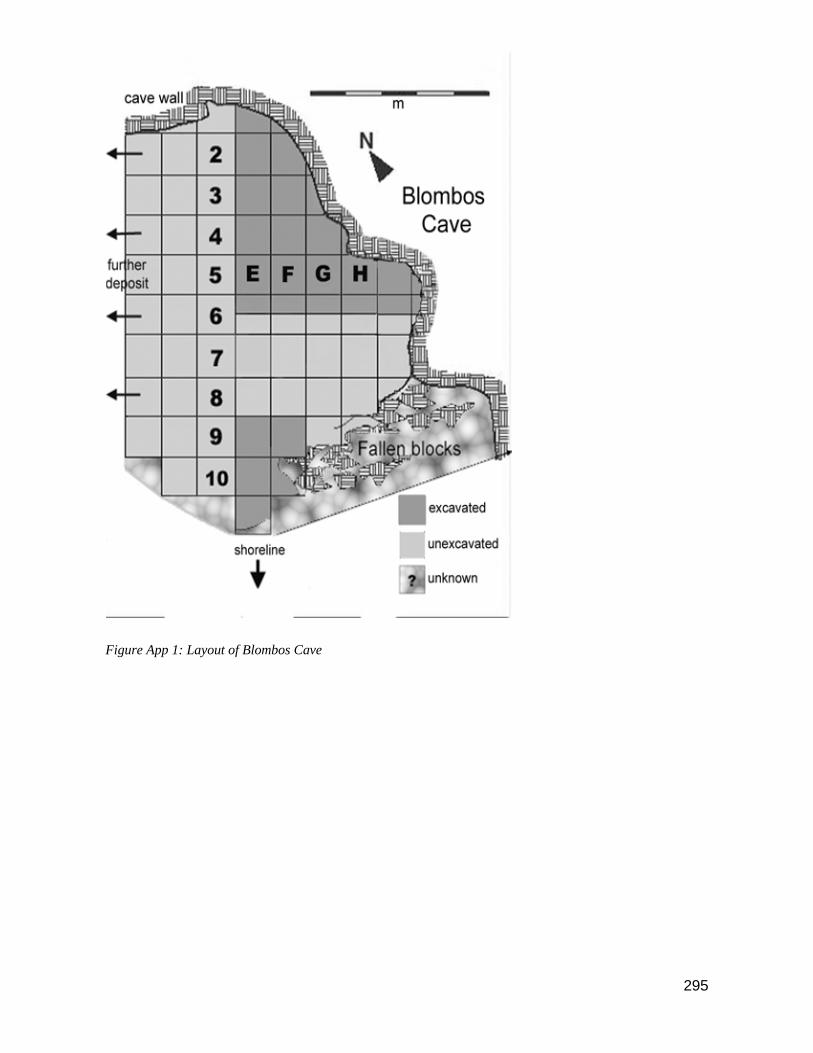
295
Figure App 1: Layout of Blombos Cave

296
PART ONE: LATER STONE AGE EXCAVATIONS (1992-1999)
The Later Stone Age (LSA) excavations at Blombos Cave commenced in 1992, with additional excavations in 1997, 1998 and 1999. No LSA material was excavated during 2000 – 2004. The volumes excavated are:
1992 - 166.6 buckets = 1.83 m3
1997 - 67.41 buckets = 0.74 m3
1998 - 442.4 buckets = 4.86 m3
1999 - 137.67 buckets = 1.51 m3
Total volume LSA excavated = 8.94 m3
Table APP 1:Total volume of excavated LSA material.
Analysis of LSA Material (1992-1999)
All the excavated LSA material from BBC has been sorted into the primary categories of lithics, bone, shellfish, OES, charcoal etc. All finds are packed in labelled plastic bags in acid free boxes and are curated at Iziko-SA Museum.
A sample of the LSA excavated material (20.4%) has been analysed in detail (See Henshilwood, 1995).
All the recovered LSA mammalian fauna (1992-1999) has been analysed by Richard Klein and Kathy Cruz-Uribe (Table APP 5).
All LSA fish bone has been separated from mammalian and other bone. The fish bone from all units in squares E5, F4 and F5 have been analysed in terms of species present per layer (Table APP 6) as well as skeletal element representation per species (Tables APP 7 & 8) (Van Niekerk, 2004).
Layers 1 & 5 have been radiocarbon dated (Tables APP 3 & 4). Layer 1 dates to 290 ±20 BP, and layer 5 dates to 1840 ± 50 b.p. (Henshilwood 1995).
LSA Stratigraphy
The LSA subunits are grouped into 6 main layers. The units that make up Layers 1 - 5 are contained in Table APP 2 (Henshilwood 1995). Layer 6 contains some deposit in unit BSDUN but is primarily regarded as a hiatus layer of aeolian dune sand that separates the LSA from the MSA layers (Henshilwood 1995). It is thought that the deposit in this layer probably derives from the layer above.
SUR Layer 1
BBS H S ABS H2S COK CBS HBS
HBC/HbCOK HBSUR BSBCOK

297
GAL Layer 2
AAL
FLIM LIM FAL HBFLIM HBLIM HBFL PER
Layer 3
BSACOC WSACOC
COC '98 HACOC
CLR DAS ABD HBCOC SC4 MC1 MCIMC
4 MCITU
R
Layer 4
MC123 MC2 PIN TUR
HM123 MC3 HIMC3 MC13 HBMC2
Layer 5a
HARS MC4 BMC4 RSMC4
HBMC4 BSMC4 Layer 5b
RS1
KAR RSKAR KAR2 RSKAR2 HBKAR2 RAK1 &
RAK2 THRAK
RSRAK HBRAK Layer 6
BSDUN DUN GSDUN RS Table APP 2. LSA stratigraphy at BBC.
Figure APP 2. West section of LSA stratigraphy squares E4, E3 and E2.
Radiocarbon Dates – LSA
Layer
Unit Sq. Ref. No. Dating Material 14C Age BP
± 1σ Calibrated Date
1σ BC/ AD
1 COK E4 Pta-6184 Charcoal 290 2 164 1651 165 AD5 MC4 E4 Pta-6185 Charcoal 1840 5 135 225 254 AD5 MC4 E4 Pta-6175 Shell 2400 4 27 74 115 AD
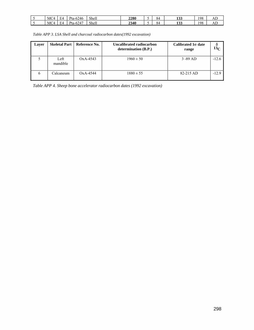
298
5 MC4 E4 Pta-6246 Shell 2280 5 84 133 198 AD5 MC4 E4 Pta-6247 Shell 2340 5 84 133 198 AD Table APP 3. LSA Shell and charcoal radiocarbon dates(1992 excavation)
Layer Skeletal Part Reference No. Uncalibrated radiocarbon determination (B.P.)
Calibrated 1σ date range
δ 13C
5 Left mandible
OxA-4543 1960 ± 50 3 -89 AD -12.6
6 Calcaneum OxA-4544 1880 ± 55 82-215 AD -12.9
Table APP 4. Sheep bone accelerator radiocarbon dates (1992 excavation)

299
Faunal remains
Mammalian fauna (1992-1999)
The mammalian fauna of all the LSA layers has been analysed by Klein & Cruz-Uribe and are listed in the table below.
Genus & Species NISPs MNIs
Erinaceus frontalis hedgehog 0 0
Lepus capensis Cape hare 4 1
Lepus saxatilis scrub hare 33 3
Bathyergus suillus Cape dune molerat 1189 64
Hystrix africaeaustralis porcupine 1 1
Papio ursinus chacma baboon 0 0
Homo sapiens people 0 0
Canis mesomelas black-backed jackal 0 0
Canis sp. dog or jackal 4 1
Ictonyx striatus striped polecat 0 0
Mellivora capensis honey badger 21 2
Aonyx capensis clawless otter 0 0
Genetta sp. genet 0 0
Herpestes pulverulentus gray mongoose 1 1
Hyaenidae gen. et sp. indet. hyena 0 0
Felis libyca wildcat 6 1
Arctocephalus pusillus Cape fur seal 288 4
Procavia capensis rock hyrax 394 12
Elephantidae indet. indet elephant 1 1 Rhinocerotidae gen. et sp. indet. rhinoceros 2 1
Hippopotamus amphibius hippopotamus 11 2
Taurotragus oryx eland 13 2
Oreotragus oreotragus klipspringer 2 1
Raphicerus campestris steenbok 27 8
Raphicerus melanotis grysbok 23 8
Raphicerus sp(p.) grysbok/steenbok 178 19
Pelea capreolus vaalribbok 2 1

300
Ovis aries sheep 33 5
Syncerus or Bos buffalo or cattle 12 1
Syncerus caffer Cape buffalo 6 1
Small bovid(s) 1407 22
Small-medium bovid(s) 239 5
Large-medium bovid(s) 166 5
Large bovid(s) 530 6
Table APP 5. MNI and NISP of LSA mammalian fauna
Fish
All LSA fish bone has been separated from mammalian and other bone. The fish bone from all units in squares E5, F4 and F5 (excavated in 1998) have been analysed in terms of species present per layer (Table APP 6) as well as skeletal element representation per species (Tables 7 & 8) (Van Niekerk, 2004).
Note: The category Sparidae sp 1 includes the species C. nasutus, C. cristiceps and C. laticeps where these species could not be differentiated from each other. The Sparidae sp 2 category contains the same above-mentioned species as well as C. gibbiceps.
The highest density and widest range of species present at BBC were found in the older levels. Five of the eleven species identified at the site occur in all the levels, and a sixth species occurs in all but one level. As the results are from a sample only, the bigger variety of species in the older levels can probably be attributed to a function of sample size as the quantity of fish in the overlying levels is considerably lower. The most
frequently occurring species in the site in terms of numbers is a small shoaling fish (L. richardsonii) that was most likely captured in stone fish traps. Almost all the other species present were in all probability caught with some kind of hook and line equipment, although no evidence of such technology has been found.
LEVEL 1 2 3 4 5 6
SPECIES MNI/NISP MNI/NISP MNI/NISP MNI/NISP MNI/NISP MNI/NISP
C. cristiceps (dageraad) 2/3 5/6 1/7 15/108 6/31 29/155
C. laticeps (roman) 1/1 2/3 4/13 13/72 6/27 26/116
C. cristiceps/laticeps 1/1 2/4 7/11 16/60 4/26 30/102
C. nasutus (black musselcracker) 2/3 1/1 3/5 6/24 2/9 14/42
Sparidae sp 1 4/10 4/10 11/43 25/166 9/56 53/285
Sparidae sp 2 2/2 3/3 6/7 25/53 5/15 41/80
D. sargus capensis( dassie) - - - 2/3 2/9 4/12
G. curvidens (john brown) - - - 2/8 1/3 3/11
P. blochii (hottentot) - - - 4/9 3/6 7/15
P. rupestris (red steenbras) - - 1/1 - 1/1 2/2
S. durbanensis (white musselcracker) - - - - 2/3 2/3
S. emarginatum (steentjie) 2/2 2/2 3/7 12/68 5/21 24/100
Sparidae sp 8/39 7/31 16/123 40/812 12/287 83/1308

301
E. marginatus (rockcod) 1/1 - 2/2 4/16 2/2 9/21
L. richardsonii (haarder) 2/13 4/10 7/55 41/374 10/96 64/548
Shark sp. - - 1/2 - - 1/2
Sp Indet 2/6 1/5 11/24 44/69 18/44 76/148
Total excluding vertebrae 27/79 31/76 73/300 249/1856 88/639 468/2950
No. unidentified vertebrae 87 58 292 1454 435 2326
TOTAL 27/166 31/134 73/592 249/3310 88/1074 468/5276
Table APP 6. Total MNI (Minimum Number of Individuals) and NISP (Number of Identified Skeletal Parts) of fish per species and level found in the L

302
SPECIES C.cristiceps C. laticeps C. cristiceps/ laticeps C. nasutus Sparidae sp 1 Sparidae sp 2 D.sargus
capensis G.curvidens P. blochii P.rupestris S. durbanensis S.emarginatum Sparidae sp
articular 12.9 17.2 12.7 2.4 1.1 0.0 0.0 9.1 0.0 0.0 0.0 3.0 0.5
basioccipital 0.0 0.0 0.0 0.0 0.0 0.0 0.0 0.0 0.0 0.0 0.0 0.0 2.7
basipterygium 0.0 0.0 0.0 0.0 0.0 0.0 0.0 0.0 0.0 0.0 0.0 0.0 4.7
basisphenoid 0.0 0.0 0.0 0.0 0.0 0.0 0.0 0.0 0.0 0.0 0.0 0.0 0.8
ceratohyal 0.0 0.0 2.9 0.0 0.0 25.0 8.3 0.0 0.0 0.0 66.7 15.0 0.0
circumorbital 0.0 0.0 0.0 0.0 0.0 0.0 0.0 0.0 0.0 0.0 0.0 0.0 0.0
circumorbital # 2 0.0 0.0 0.0 0.0 0.0 0.0 0.0 0.0 0.0 0.0 0.0 0.0 0.0
cleithrum 0.0 0.0 0.0 0.0 0.0 0.0 0.0 0.0 0.0 0.0 0.0 0.0 4.1
coracoid 0.0 0.0 0.0 0.0 0.0 0.0 0.0 0.0 0.0 0.0 0.0 0.0 3.7
dentary 8.4 6.0 0.0 9.5 9.5 0.0 0.0 0.0 6.7 0.0 0.0 4.0 0.0
epihyal 0.0 0.0 21.6 2.4 0.0 0.0 16.7 0.0 0.0 0.0 0.0 11.0 0.2
epiotic 0.0 0.0 0.0 4.8 6.7 0.0 8.3 9.1 0.0 0.0 0.0 0.0 2.4
ethmoid 0.0 0.0 4.9 2.4 1.4 0.0 0.0 0.0 6.7 0.0 0.0 0.0 0.2
exoccipital 0.0 0.0 0.0 0.0 0.0 0.0 0.0 0.0 0.0 0.0 0.0 0.0 4.3
frontal 0.6 0.9 1.0 0.0 0.0 0.0 0.0 0.0 0.0 0.0 0.0 3.0 1.2
hyomandibular 0.0 0.0 33.3 9.5 0.0 0.0 8.3 0.0 0.0 0.0 0.0 16.0 2.0

303
hypohyal dorsal 0.0 0.0 0.0 0.0 0.0 0.0 0.0 0.0 0.0 0.0 0.0 0.0 0.6
hypohyal ventral 0.0 0.0 0.0 0.0 1.4 1.3 0.0 0.0 0.0 0.0 0.0 0.0 0.4
interopercle 0.0 0.0 0.0 0.0 0.0 0.0 0.0 0.0 0.0 0.0 0.0 0.0 3.0
jugal 0.0 0.0 0.0 0.0 6.3 0.0 0.0 0.0 0.0 0.0 0.0 0.0 0.0
lachrymal 8.4 6.9 0.0 4.8 0.4 0.0 8.3 0.0 0.0 0.0 0.0 0.0 0.0
maxilla 0.0 0.0 0.0 2.4 19.3 0.0 8.3 0.0 6.7 0.0 0.0 6.0 0.1
mesopterygoid 0.0 0.0 0.0 0.0 0.0 0.0 0.0 0.0 0.0 0.0 0.0 0.0 2.8
metapterygoid 0.0 0.0 0.0 0.0 0.4 0.0 0.0 0.0 0.0 0.0 0.0 0.0 1.5
nasal 14.8 23.3 0.0 9.5 0.0 0.0 0.0 9.1 0.0 0.0 0.0 0.0 0.1
opercle 0.0 0.0 0.0 0.0 11.6 0.0 8.3 0.0 0.0 50.0 0.0 12.0 0.6
otolith 0.0 0.0 0.0 0.0 0.0 0.0 0.0 0.0 0.0 0.0 0.0 0.0 3.8
palatine 0.0 0.0 0.0 2.4 24.2 0.0 8.3 9.1 0.0 0.0 0.0 0.0 1.2
Table APP 7. % frequency of the MNI of each element per Sparidae species for all squares analysed

304
SPECIES C.cristiceps C. laticeps C. cristiceps/ laticeps C. nasutus Sparidae sp 1 Sparidae sp 2 D.sargus
capensis G.curvidens P. blochii P.rupestris S. durbanensis S.emarginatum Sparidae sp
parasphenoid 0.0 0.0 15.7 4.8 1.4 0.0 0.0 0.0 0.0 0.0 0.0 1.0 0.4
parietal 0.0 0.0 0.0 0.0 1.1 0.0 0.0 9.1 0.0 0.0 0.0 0.0 2.0
pharyngeal 0.0 0.0 0.0 0.0 0.0 0.0 0.0 0.0 0.0 0.0 0.0 0.0 0.0
Postcleithrum Lower 0.0 0.0 0.0 0.0 0.0 0.0 0.0 0.0 0.0 0.0 0.0 0.0 2.9
Postcleithrum Upper 0.0 0.0 0.0 0.0 0.0 0.0 0.0 0.0 0.0 0.0 0.0 0.0 3.6
posttemporal 0.0 0.0 0.0 0.0 0.0 0.0 0.0 18.2 0.0 0.0 0.0 0.0 4.6
prefrontal 1.9 4.3 0.0 2.4 0.0 0.0 0.0 0.0 0.0 0.0 0.0 9.0 0.6
premaxilla 17.4 15.5 0.0 28.6 2.1 0.0 8.3 9.1 0.0 0.0 0.0 7.0 0.0
preopercle 16.8 12.1 0.0 9.5 0.7 0.0 8.3 0.0 0.0 0.0 0.0 1.0 0.1
prootic 0.0 0.0 0.0 0.0 0.0 0.0 0.0 9.1 0.0 0.0 0.0 0.0 3.0
pterosphenoid 0.0 0.0 0.0 0.0 0.7 0.0 8.3 0.0 0.0 0.0 0.0 2.0 2.4
pterotic 0.0 0.0 0.0 0.0 0.0 0.0 0.0 0.0 0.0 0.0 0.0 0.0 3.2
pterygoid 0.0 0.0 0.0 0.0 0.0 73.8 0.0 0.0 0.0 0.0 0.0 6.0 0.0
quadrate 0.0 0.0 0.0 0.0 0.0 0.0 0.0 0.0 0.0 0.0 33.3 0.0 5.2
retroarticular 5.8 6.9 7.8 0.0 0.4 0.0 0.0 0.0 0.0 50.0 0.0 0.0 1.1
scapula 0.0 0.0 0.0 0.0 0.0 0.0 0.0 0.0 0.0 0.0 0.0 0.0 5.9
sphenotics 0.0 0.0 0.0 0.0 0.0 0.0 0.0 0.0 0.0 0.0 0.0 0.0 3.9
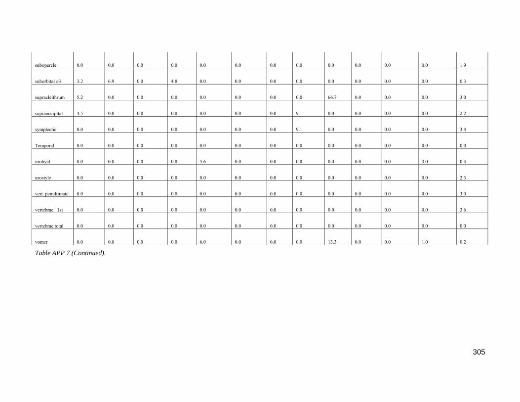
305
subopercle 0.0 0.0 0.0 0.0 0.0 0.0 0.0 0.0 0.0 0.0 0.0 0.0 1.9
suborbital #3 3.2 6.9 0.0 4.8 0.0 0.0 0.0 0.0 0.0 0.0 0.0 0.0 0.3
supracleithrum 5.2 0.0 0.0 0.0 0.0 0.0 0.0 0.0 66.7 0.0 0.0 0.0 3.0
supraoccipital 4.5 0.0 0.0 0.0 0.0 0.0 0.0 9.1 0.0 0.0 0.0 0.0 2.2
symplectic 0.0 0.0 0.0 0.0 0.0 0.0 0.0 9.1 0.0 0.0 0.0 0.0 3.4
Temporal 0.0 0.0 0.0 0.0 0.0 0.0 0.0 0.0 0.0 0.0 0.0 0.0 0.0
urohyal 0.0 0.0 0.0 0.0 5.6 0.0 0.0 0.0 0.0 0.0 0.0 3.0 0.4
urostyle 0.0 0.0 0.0 0.0 0.0 0.0 0.0 0.0 0.0 0.0 0.0 0.0 2.3
vert. penultimate 0.0 0.0 0.0 0.0 0.0 0.0 0.0 0.0 0.0 0.0 0.0 0.0 3.0
vertebrae 1st 0.0 0.0 0.0 0.0 0.0 0.0 0.0 0.0 0.0 0.0 0.0 0.0 3.6
vertebrae total 0.0 0.0 0.0 0.0 0.0 0.0 0.0 0.0 0.0 0.0 0.0 0.0 0.0
vomer 0.0 0.0 0.0 0.0 6.0 0.0 0.0 0.0 13.3 0.0 0.0 1.0 0.2
Table APP 7 (Continued).
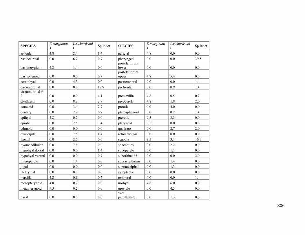
306
SPECIES E.marginatus
L.richardsonii Sp Indet SPECIES E.marginatu
s L.richardsonii Sp Indet
articular 4.8 2.4 1.4 parietal 4.8 0.0 0.0 basioccipital 0.0 6.7 0.7 pharyngeal 0.0 0.0 39.5
basipterygium 4.8 1.4 0.0 postcleithrum lower 0.0 0.0 0.0
basisphenoid 0.0 0.0 0.7 postcleithrum upper 4.8 5.4 0.0
ceratohyal 0.0 4.3 0.0 posttemporal 0.0 0.0 1.4 circumorbital 0.0 0.0 12.9 prefrontal 0.0 0.9 1.4 circumorbital # 2 0.0 0.0 4.1 premaxilla 4.8 0.5 0.7 cleithrum 0.0 8.2 2.7 preopercle 4.8 1.8 2.0 coracoid 0.0 3.4 2.7 prootic 0.0 4.0 0.0 dentary 0.0 2.2 0.7 pterosphenoid 0.0 0.2 1.4 epihyal 4.8 0.7 0.0 pterotic 9.5 3.3 0.0 epiotic 0.0 2.5 3.4 pterygoid 9.5 0.0 0.0 ethmoid 0.0 0.0 0.0 quadrate 0.0 2.7 2.0 exoccipital 0.0 7.8 1.4 retroarticular 0.0 0.0 0.0 frontal 0.0 2.7 0.0 scapula 9.5 3.1 10.9 hyomandibular 0.0 7.6 0.0 sphenotics 0.0 2.2 0.0 hypohyal dorsal 0.0 0.0 1.4 subopercle 0.0 1.1 0.0 hypohyal ventral 0.0 0.0 0.7 suborbital #3 0.0 0.0 2.0 interopercle 0.0 1.4 0.0 supracleithrum 0.0 1.4 0.0 jugal 0.0 0.0 0.0 supraoccipital 0.0 1.3 0.0 lachrymal 0.0 0.0 0.0 symplectic 0.0 0.0 0.0 maxilla 4.8 0.9 0.7 temporal 0.0 0.0 1.4 mesopterygoid 4.8 0.2 0.0 urohyal 4.8 6.0 0.0 metapterygoid 9.5 0.2 0.0 urostyle 0.0 4.5 0.0
nasal 0.0 0.0 0.0 vert. penultimate 0.0 1.3 0.0

307
opercle 0.0 3.4 3.4 vertebrae 1st 4.8 1.1 0.0 otolith 0.0 0.2 0.0 vertebrae total 0.0 0.0 0.0 palatine 0.0 0.0 0.0 vomer 4.8 0.0 0.7 parasphenoid 4.8 2.9 0.0 Total 100.0 100.0 100.0
Table APP 8. % Frequency of the MNI of each element of L. richardsonii, E. marginatus and Sp. Indeterminate
Shellfish
The shellfish from all squares (Squares E2, E3, E4 and F2) and units of the 1992 excavation has been fully analysed (Tables APP 10 & 11). The ‘incidental” (non-food item) species have been analysed by John Pether (Table APP 9). In addition, 1003 Nassarius kraussianus shells from all LSA layers have been analysed for
evidence of bead making in conjunction with those from the MSA (Henshilwood et al. 2004, in press).
Diloma sp. is the most common species of shellfish in most of the layers, followed by T. sarmaticus and Patella sp. Overall, the results of the shellfish analysis indicates a shift towards greater utilisation of shellfish located in the upper sections of the intertidal zone. Two species in particular, H. midae and S. tabularis, found
only in the Cochlear and Infratidal zones are relatively common in sites pre-dating 2000 B.P., but virtually absent at BBC.
T. sarmaticus opercula were selected from each layer for oxygen isotope analysis. The results show that Layers 1, 3 and 6 were occupied during the mid-winter months and Layers 2, 4 and 5 during spring or autumn. This fairly regular pattern of seasonal occupation suggests that coastal visits by hunter gatherers were still
timed to coincide with the colder months, even after the arrival of herders, and that during the summer months optimal use may have been made of resources, particularly geophytes, on the coastal plain and in the intermontane regions.
Species n Species n Assiminea ovata 1 Nassarius kraussianus 388 Austramitra sp. 1 Nucella cingulata 2 Austromegabalanus cylindricus
5 Nucella squamosa 6
Barbatia obliquata 1 Ocenebra babingtonii 3 Burnupena cincta 4 Ocenebra fenestrata 6
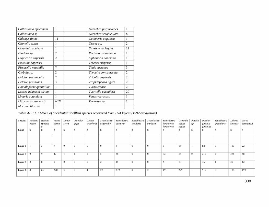
308
Calliostoma africanum 1 Ocenebra purpuroides 1 Calliostoma sp. 1 Ocenebra scrobiculata 8 Chlamys tincta 11 Octomeris angulosa 1 Clionella taxea 1 Ostrea sp. 2 Crepidula aculeata 1 Oxystele variegata 11 Diadora sp. 2 Reclusia rollandiana 1 Duplicaria capensis 2 Siphonaria concinna 1 Fauxulus capensis 1 Terebra suspensa 1 Fissurella mutabilis 7 Thais castanea 3 Gibbula sp. 2 Thecalia concamerata 2 Helcion pectunculus 7 Tricolia capensis 2 Helcion pruinosus 3 Tropidophora ligata 2 Homalopoma quantillum 1 Turbo cidaris 2 Lasaea adansoni turtoni 1 Turritella carinifera 20 Limaria rotundata 1 Venus verrucosa 1 Littorina knysnaensis 6021 Vermetus sp. 1 Macoma litoralis 1
Table APP 11: MNI's of 'incidental' shellfish species recovered from LSA layers (1992 excavation)
Species Haliotis midae
Haliotis spadicea
Perna perna
Donax serra
Dinoplax gigas
Chiton crawfordi
Scutellastra argenvillei
Scutellastra cochlear
Scutellastra tabularis
Scutellastra barbara
Scutellastra longicosta longicosta
Cymbula oculus oculus
Patella sp.
Patella juvenile juveniles
Scutellastra granularis
Diloma sinensis
Turbo sarmaticus
Layer n n n n n n n n n n n n n n n n n
Layer 1 1 3 7 0 0 0 0 8 0 0 0 18 1 52 0 103 22
Layer 2 0 9 42 4 1 5 5 68 0 0 32 58 0 217 2 378 68
Layer 3 0 0 5 0 0 0 2 15 0 0 5 10 1 46 1 35 12
Layer 4 0 65 270 4 0 4 27 419 0 2 191 229 1 917 0 1841 193

309
Layer 5 0 13 31 0 0 1 2 149 0 0 44 39 0 316 0 605 168
Layer 6 0 0 8 1 0 1 0 34 0 0 8 5 0 182 0 59 17
Table APP 9. MNI of all shellfish species from BBC LSA layers(1992 excavation)
Species Haliotis midae
Haliotis spadicea
Perna perna
Donax serra
Dinoplax gigas
Chiton crawfordi
Scutellastra argenvillei
Scutellastra cochlear
Scutellastra tabularis
Scutellastra barbara
Scutellastra longicosta
Cymbula oculus
Patella sp.
Patella juvenile juveniles
Scutellastra granularis granularis
Diloma sinensis
Turbo sarmaticus
Layer g g g g g g g g g g g g g g g g g
Layer 1 20 18 38 0 0 0 12 50 0 0 19 270 27 12 0 517 590
Layer 2 0 51 92 14 0 1 99 516 0 0 467 790 4 40 9 1890 1261
Layer 3 0 0 0 0 0 0 15 129 7 0 57 97 1 16 4 174 158
Layer 4 8 544 2284 16 0 1 571 3298 0 49 2561 2569 36 287 0 9205 5314
Layer 5 0 134 251 0 0 0 33 1160 0 0 664 376 0 99 0 3020 4903
Layer 6 0 3 0 0 0 0 0 287 0 0 106 68 0 47 0 294 282
Table APP 10: Mass (g) of all shellfish species from BBC LSA layers (1992 excavation)

310
Cultural artefacts
Ostrich Eggshell (OES)
The OES beads from all LSA layers were classified according to degree of completeness and quantified (Table 12). Other OES was examined for modification and weighed. Two pieces showed some sign of possible flask modification and the total weight of the unmodified OES
from 1992 – 1999 is 56g.
Whole Broken Fragment Whole unfinished
Broken unfinished
Fragment unfinished
Layer 1 10 1 2 10 1 2 Layer 2 15 3 3 3 6 2
Layer 3 20 1 21 Layer 4 82 3 4 89 Layer 5 40 1 2 43
Layer 6 4 1 5
Table APP 12. State of completeness of OES beads and from the LSA layers of BBC. (1992 –
1999 excavations)
Bone tools
The majority of the LSA bone tools have been analysed in conjunction with those from the LSA layers of Byneskranskop and Nelson Bay Cave, as well as the BBC MSA bone tools in terms of raw material selection, blank production, shaping techniques, other modifications and use-wear (Tables APP 13 – 19) (Henshilwood et al. 2001b).
LSA Season SAM-
AA Tool type
Square Dug As Phase Body Part Source Size Class
Age Bone type
1992 8974 "Awl" E4 MC3 BBC Tibia Bovid I Adult cs 1992 8976 "Awl" E4 GAL BBC
L2Shaft Bird/smal
l lUnknow n.a./unknow c
1992 8977 "Awl" E4 COK BBC L1
Shaft Bovid Unknow Adult c 1992 8978 "Awl" E4 AAL BBC
L2Rib/vertebra Bovid IV Adult c
1992 8979 "Awl" E4 HIS BBC L1
Radius Bird n.a. Unknown cs 1999 8980 "Point
"I5 KAR 2 BBC
L4Shaft Bovid II Adult c
1998 8981 "Awl" F3 MC4 BBC L5
Shaft Bovid II Adult c
Table APP 13. Detail of the analysed bone tools from the LSA layers (c = cortical; cs = cortical
& spongy). (Henshilwood et al, 2001b)
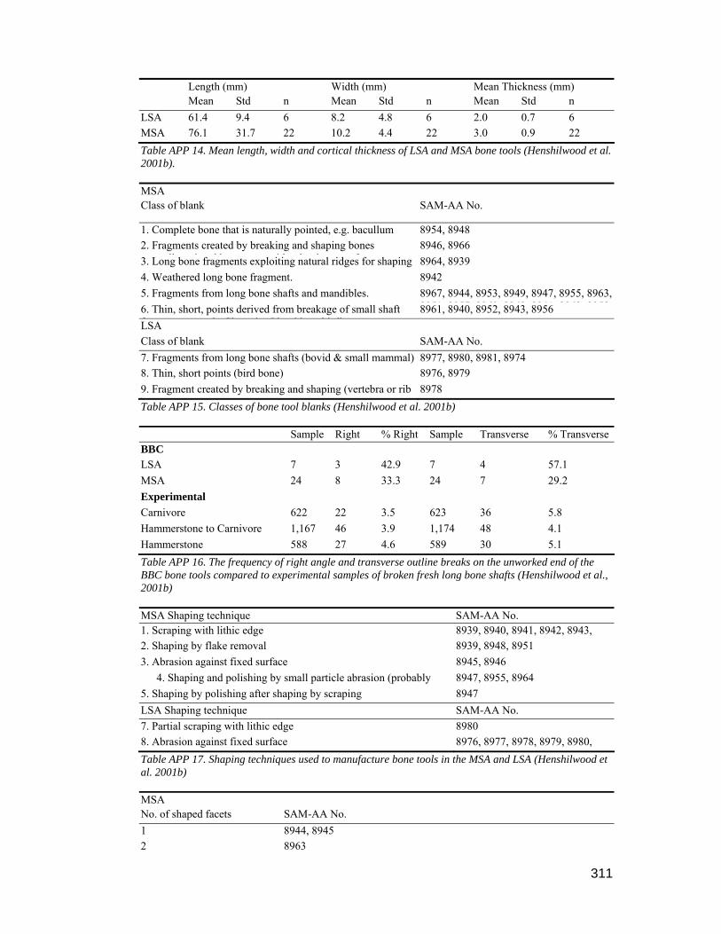
311
Length (mm) Width (mm) Mean Thickness (mm) Mean Std n Mean Std n Mean Std n LSA 61.4 9.4 6 8.2 4.8 6 2.0 0.7 6 MSA 76.1 31.7 22 10.2 4.4 22 3.0 0.9 22 Table APP 14. Mean length, width and cortical thickness of LSA and MSA bone tools (Henshilwood et al. 2001b). MSA Class of blank SAM-AA No.
1. Complete bone that is naturally pointed, e.g. bacullum 8954, 8948 2. Fragments created by breaking and shaping bones
ll i d b i h h b f8946, 8966
3. Long bone fragments exploiting natural ridges for shaping 8964, 8939 4. Weathered long bone fragment. 8942 5. Fragments from long bone shafts and mandibles. 8967, 8944, 8953, 8949, 8947, 8955, 8963,
8951 8957 8960 8968 8941 8962 89586. Thin, short, points derived from breakage of small shaft f l Cl i I b id bi db
8961, 8940, 8952, 8943, 8956 LSA Class of blank SAM-AA No. 7. Fragments from long bone shafts (bovid & small mammal) 8977, 8980, 8981, 8974 8. Thin, short points (bird bone) 8976, 8979 9. Fragment created by breaking and shaping (vertebra or rib )
8978 Table APP 15. Classes of bone tool blanks (Henshilwood et al. 2001b) Sample Right % Right Sample Transverse % Transverse BBC LSA 7 3 42.9 7 4 57.1 MSA 24 8 33.3 24 7 29.2 Experimental Carnivore 622 22 3.5 623 36 5.8 Hammerstone to Carnivore 1,167 46 3.9 1,174 48 4.1 Hammerstone 588 27 4.6 589 30 5.1 Table APP 16. The frequency of right angle and transverse outline breaks on the unworked end of the BBC bone tools compared to experimental samples of broken fresh long bone shafts (Henshilwood et al., 2001b) MSA Shaping technique SAM-AA No. 1. Scraping with lithic edge 8939, 8940, 8941, 8942, 8943, 2. Shaping by flake removal 8939, 8948, 8951 3. Abrasion against fixed surface 8945, 8946
4. Shaping and polishing by small particle abrasion (probably fi i d d)
8947, 8955, 8964 5. Shaping by polishing after shaping by scraping 8947 LSA Shaping technique SAM-AA No. 7. Partial scraping with lithic edge 8980 8. Abrasion against fixed surface 8976, 8977, 8978, 8979, 8980,
8981Table APP 17. Shaping techniques used to manufacture bone tools in the MSA and LSA (Henshilwood et al. 2001b) MSA No. of shaped facets SAM-AA No. 1 8944, 8945 2 8963

312
3 8941, 8946, 8949, 8952, 8959, 8966, 8967, 8968 4 8939, 8940, 8942, 8943, 8947, 8948, 8951, 8953, 8954, 8955, 8956,
8957, 8958, 8960, 8964, 8965LSA No. of shaped facets SAM-AA No. 3 8978, 8980, 4 8974, 8976, 8977, 8979, 8981 Table APP 18. Number of shaped facets for MSA and LSA bone tools (Henshilwood et al. 2001b) Category MSA LSA 1. Shaping Scraping, flake removal, fine abrasion,
polishing Abrasion by grinding against fixed coarse surface
2. Other tool modifications
Oblique engraving, deliberate burning, ochre incorporation in polish
Notches with screw-like morphology, surface ochre deposited post-depositionally
3. Taphonomic differences
Tools medium to dark brown in color, most with heavy patina
Tools light in colour with minimal or no patina
Table APP 19. Principal technological differences between MSA and LSA bone tools (Henshilwood et al. 2001b)
Other bone tools
Two bone tubes, possibly used as beads, with an interior diameter of 5.7 mm and exterior
diameter of 9.4 mm, were recovered from Layer 5 dated at 1840 B.P. Similar bone tubes are reported from a number of southern and south-western Cape sites including Oakhurst (Goodwin 1938), Gordon's Bay Midden (van Noten 1974), Die Kelders (Schweitzer 1979) and Byneskranskop 1 (Schweitzer & Wilson 1982). At all these sites bone tubes are only found in
units which post-date 3900 B.P.
A single turtle carapace, identified as Pelomedusa subrufa, was found intact in Layer 4. Numerous scrape marks on the interior and grinding on the edges suggests it was used as a bowl,
possibly to store or mix ochre, as both the edges and inner surface were ochre stained. As this species of turtle is not found in the immediate vicinity of Blombos Cave, it may have been captured in the Duivenhoks or Goukou Rivers and brought to the site.
Marine Shell Artefacts
Two perforated and ground Conus shells came from Layer 2 and were probably threaded and used as ornaments. A single ground Turbo pendant measuring 36 mm x 14.5 mm was found in Layer 5.
Pottery
Relatively small quantities of pottery sherds came from BBC, although the frequencies increase
in Layers 1 and 2 (Table APP 20). Unfortunately most of the pottery sherds were small and therefore not very informative as to the type or shape of vessels from which they originated. A few diagnostic vessel rims without decoration came from the later units but it was not possible to

313
reconcile these with Rudner's (1968:523-524) descriptions of pottery types from this area. The oldest sherds were from the Layer 5 dated at 1840 B.P., and were found in the same layer as the
two sheep bones dated at 1880 B.P. and 1960 B.P., suggesting that sheep and pottery were contemporaneous at this time
Layer Sherds Finish Temper Vessel Thickness Burnishe Burnished Unburnished Quartz (mean) n g n N n n n mm 1 69 74 68 1 - 61 7 5.0 2 10 38 3 6 2 2 3 6.4 3 1 9 - - - - - 4.5 4 2 14.5 1 - - - - 5.3 5 2 10 2 - - - - 6
Table APP 20: Inventory of pottery sherds (1992 excavation)
Black burnishing, possibly with soot, is fairly common and only a few sherds have a reddish tinge indicative of ochre burnishing. In the upper layers there are crushed quartz chip inclusions in the sherds, probably to temper the pottery but this method of tempering is not apparent in the lower layers, although rounded quartz grains are present.
Lithics
Lithic artefacts recovered were classified according to the scheme devised by J. Deacon (1984:370-409) which is 'based on the reduction sequence from raw material to formal tool'. All
the recovered stone was initially sorted into three classes, namely Unmodified; Modified/Utilised and Retouched (Table APP 21). Each artefact within a class was then classified according to category and raw material (Table APP 22).
Layer Unmodified Utilised/ Modified Retouched Site/unit Total AD/g n % n % N % n % % Layer 1 486 99.2 2 0.4 2 0.4 490 3.4 7.2
Layer 2 1552 99.6 4 0.3 2 0.1 1558 10.8 6.7
Layer 3 1017 100 0 0 0 0 1017 7.1 66.9
Layer 4 552 94.4 29 4.9 4 0.7 585 4.1 0.8
Layer 5 109 94.8 4 3.5 2 1.7 115 0.8 0.8
Layer 6 68 100 0 0 0 0 68 0.5 0.9
Site Total 13718 95.6 166 1.2 472 3.3 14356 Table APP 21. Inventory of stone artefact classes (1992 excavation) (AD/g % = density of stone (n) relative to total mass (g) per site) (Henshilwood 1995) Layer Unmodified Utilised/Modified Retouched

314
Q S Qt O S Qt O Q S Qt O % % % % % % % % % % % Layer 1 8.6 35.7 55.3 0.4 0 100 0 0 0 100 0
Layer 2 15.8 19.1 65.1 0 0 100 0 0 100 0 0
Layer 3 0.3 0 99.7 0 0 0 0 0 0 0 0
Layer 4 47.7 21.9 30.4 0 0 0 0 25 50 25 0
Layer 5 33.6 19.1 46.4 0.9 0 100 0 50 50 0 0
Layer 6 85.8 0 13.2 0 0 100 0 0 0 0 0
Total % 32.0 16.0 51.8 0.2 0 100 0 18.75 50 31.25 0
Table APP 22. Frequencies by layer of raw materials in the major artefact classes (1992 excavation) Raw Materials: Q = quartz, S = silcrete, Qt = quartzite, O = other (c.c.s & limestone) (Henshilwood 1995).
The lithic assemblage of BBC LSA post-dates 2000 B.P. and is dominated by unretouched artefacts in quartz and quartzite and formal tools are rare. A similar pattern is recorded at Nelson Bay Cave, Byneskranskop 1 and Die Kelders suggesting that lithics broadly conforming to the
Wilton Tradition are replaced by assemblages dominated by informal tools at coastal sites

315