MIKVEH CAVE Q27 The First Three Seasons of Excavations 2003, 2006, 2012

Müslümantepe Kaz›lar› 2005-2008Eyyüp AY* – Ayflen AY – Ça¤r› M. TARHAN
Müslümantepe Diyarbak›r ili, Bismil ilçesi s›n›rlar› içinde yer al›r. Bismil’in Tepe beldesinegiden yol güzergâh›nda yaklafl›k 22 km. mesafededir. Höyük Algaze taraf›ndan ziyaret edil-mifl1, 1999 y›l›nda taraf›m›zdan yüzey araflt›rmas› yap›larak yay›nlanm›flt›r2. Il›su Baraj› kur-tarma kaz›lar› çerçevesinde, OTDÜ-TAÇDAM’›n koordinatörlü¤ünde Diyarbak›r Müzesi Bafl-kanl›¤› ve bizim bilimsel dan›flmanl›¤›m›zda 2000 y›l›nda kaz› çal›flmalar›na bafllanm›flt›r.2000–2002 y›llar› aras›nda ODTÜ-TAÇDAM bünyesinde yap›lan kaz› çal›flmalar› yine TAÇ-DAM’›n yay›nlar› içerisinde de¤erlendirilmifltir3. 2003–2004 y›llar›nda TAÇDAM’›n Müslü-mantepe kaz›lar› için bütçe ay›rmamas› dolay›s›yla kaz› çal›flmalar› tatil edilmifltir. 2005 y›-l›nda proje koordinatörlü¤ü TAÇDAM’dan al›narak Kültür Varl›klar› ve Müzeler Genel Mü-dürlü¤ü’ne verilmesi üzerine Müslümantepe kaz›lar›na bütçe tahsisat› yap›lm›fl ve kaz›laryeniden bafllam›flt›r. Bu çal›flmada Müslümantepe’de 2005–2008 y›llar› aras›nda yap›lan ka-z›lar›n bir ön raporu sunulacakt›r.
Yeni kaz› çal›flmalar› ile birlikte baflta höyü¤ün topo¤rafik haritas› tekrardan haz›rlanm›fl veayr›ca yeni ekipman al›m›na gidilmifltir. Bunun yan› s›ra 2015 y›l›na kadar sürmesi prog-ramlanan kaz›n›n kaz› stratejisi ve çal›flma takvimi de yeniden belirlenmifltir. Buna göre hö-yü¤ün yatay ve dikey yay›l›m›n› detayl› bir biçimde araflt›rmak üzere üç ana kaz› alan› be-lirlenmifl ve bu kaz› alanlar›ndaki çal›flma yöntemi ve süresi programlanm›flt›r (fiekil 1). Buba¤lamda Müslümantepe höyük alan› daha çok dikey stratigrafik oluflumu belirlemek üze-re ana çal›flma alan›, H›ristiyantepe alan› ise höyükte saptanan M.Ö. 3. bin ve 2. bin yerle-flim alanlar›n›n yatay yay›l›m› ile bu alanda belgelendirilen Obeid Dönemini araflt›rmak üze-re ayr› bir kaz› alan› olarak belirlenmifltir. Daha önceki dönemlerde de kaz›lan ve höyü¤ünyaklafl›k 150 m. güneybat›s›nda yer alan mezarl›k alan› da üçüncü bir kaz› alan› olarak be-lirlenmifltir. Mezarl›k alan›ndaki kaz› çal›flmalar›n› teflvik eden önemli bir etmen höyüktekiM.Ö. 3. bin ve 2. bin yerleflmelerinin mezarl›¤› olmas›n›n yan› s›ra ayn› alanda M.Ö. 4. bin-y›la kadar geri giden bir yerleflimin de tespit edilmifl olmas›d›r. Dolay›s›yla 2005 kaz› sezo-nundan itibaren mezarl›k alan› Müslümantepe yerlefliminin M.Ö. 4. biny›la ait kültür kat-manlar›n›n izlenebilmesi aç›s›ndan da önemli bir çal›flma alan› haline gelmifltir.
Müslümantepe’nin topo¤rafik yap›s›na ve tespit edilen yerleflim alanlar›n›n tarihsel gelifli-mine bak›ld›¤›nda, höyü¤ün co¤rafi konumunun Dicle nehri ile olan iliflkisinin önemli bir
* Yrd. Doç. Dr. Eyyüp Ay, Gaziantep Üniversitesi, Fen-Edebiyat Fakültesi, Arkeoloji Bölümü, fiehitka-mil/Gaziantep, Türkiye.Ö¤r. Gör. Ayflen AY, Gaziantep Üniversitesi, Fen-Edebiyat Fakültesi, Arkeoloji Bölümü, fiehitkamil/Ga-ziantep, Türkiye.Arfl. Gör. Ça¤r› Murat TARHAN, Gaziantep Üniversitesi, Fen-Edebiyat Fakültesi, Arkeoloji Bölümü, fie-hitkamil/Gaziantep, Türkiye.
1 Algaze at al. 1991: 213, Fig. 2b/23.2 Ay 2001: 697–698.3 Ay 2002: 491–516; Ay 2004: 375–386.

rol oynad›¤› anlafl›lmaktad›r. Müslümantepe yerleflmesi güneyden bafllayan ve Dicle?yedo¤ru geniflleyerek yay›lan tar›ma elveriflli bir vadide yer almaktad›r. Ayr›ca höyü¤ü çevre-leyen yüksek tepelerde yak›n tarihe kadar mefle a¤açlar›n›n bulunmas› ve özellikle de H›ris-tiyantepe kaz› alan›ndan ele geçen av köpe¤i iskeletleri yörenin tar›msal imkânlar›n›n yan›s›ra, yaban›l yaflama ve onun sa¤lad›¤› imtiyazlara da sahip oldu¤unu göstermektedir. Je-olojik sondajlar›n bizlere sa¤lad›¤› bilgiye göre Müslümantepe yerleflmesi güneyden gelenve Dicle taban›na sokulan yar›m ada görünümlü bir sedimantasyon üzerinde kuruldu¤u an-lafl›lm›flt›r. Bu da Müslümantepe yerleflmesinin dönemin koflullar› içerisinde savunmas›n›kolaylaflt›ran önemli bir etmen olarak not edilmelidir. Mezarl›k alan›n›n hemen do¤usun-dan geçen Çoramezri deresi kurumufl bir çay görünümünde olup 2007 y›l›nda bölgedeki selolaylar›na ba¤l› olarak söz konusu dere yata¤›nda bir p›nar ortaya ç›km›flt›r. Bu beklenme-dik olay Mezarl›k kaz› alan›ndaki M.Ö. 4. bin yerlefliminin bu alanda kurulmufl olmas›na ye-ni bir anlam kazand›rm›flt›r.
Müslümantepe yerleflmesinin arazide gözlenen höyük konisi d›fl›nda yatay düzlemde san›-lan›n aksine 20 hektarl›k alana yay›ld›¤› tespit edilmifltir. Topo¤rafik haritadan da izlenebil-di¤i gibi yap›lan yüzey araflt›rmas›nda ve höyük konisi d›fl›nda aç›lan sondaj çukurlar›ndanelde edilen sonuçlar; gerek yerleflimin ve gerekse mezarl›¤›n dönem dönem genifl alanlarayay›ld›¤› görülmektedir (fiekil 1). Buna göre höyük konisinin Dicle taraf›na bakan kesimininhali haz›rdakinin iki misli büyüklükte olmas› gerekmektedir. Ancak toprak çekmek suretiy-le ve Dicle nehrinin taflk›nlar› sonucunda -M.Ö. 3. binde büyük bir kerpiç surla ve M.Ö. 2.binde dereden toplama tafllarla örülmüfl bir ihata duvar›n›n da iflaret etti¤i gibi- döneminyerleflmelerinin kuzey yar›s› tamamen tahrip olmufltur. Nitekim höyükteki kaz›larda ele ge-çen mimari kal›nt›lar›n ço¤unlukla tahrip olan alanda var olmas› gereken yap›lar›n güney-deki avlu ve müfltemilat›na iliflkin mimari kal›nt›lar olmas› söz konusu tahribat› do¤rula-maktad›r. Mevcut höyük konisinin yaklafl›k 60 m. kuzeyinde ve 15 m. afla¤›da Dicle kena-r›nda tarla olarak kullan›lan alanda yap›lan sondaj çal›flmalar›nda, yaklafl›k 2 m. kal›nl›ktakültür dolgusuna rastlanm›flt›r. Bütün bu veriler kaz› çal›flmalar›n› yürütmekte oldu¤umuzMüslümantepe’nin yerleflim dokusunun ve buna ba¤l› önemli sivil ve resmi yap›lar›n›n sap-tanmas›n› ve kendi dönemleri içindeki ba¤lamlar›n›n kurgulamas›n› neredeyse imkâns›z ha-le getirmektedir. Bütün bu olumsuzluklara ra¤men önümüzdeki sezonlarda yapaca¤›m›zkaz› çal›flmalar›nda Müslümantepe’de kendi dönemini ayd›nlatacak dini, idari ve sivil me-kânlar bulmam›z, bölge arkeolojisi aç›s›ndan önemli bir kazan›m olacakt›r.
Höyük konisinin bat›s›nda, güneyinde ve güney do¤usunda hali haz›rda tarla olarak kulla-n›lan alanlarda gerek yüzey araflt›rmas›nda ele geçen seramik parçalar› ve gerekse tar›msalsulamalar s›ras›nda köylüler taraf›ndan bulunan mezar ve mezar arma¤anlar›n›n da göster-di¤i gibi gerek M.Ö. 2. biny›l ve gerekse Geç Demir Ça¤› ve sonras› dönemlerinde Müslü-mantepe yerleflmesine ait mezarl›¤›n genifl bir alana yay›ld›¤›n› göstermektedir. Ayr›ca köyiçinde yap›lan temel kaz›lar›nda ve sondaj çal›flmalar›nda özellikle Geç Demir Ça¤› ve son-ras› (Selçuklu ve Osmanl› dâhil) yerleflimin höyü¤ün güneydo¤u ete¤inde ça¤dafl köy yer-leflmesinin alt›nda kald›¤› anlafl›lm›flt›r. Dolay›s›yla söz konusu verileri dâhil ederek bir bü-tün halinde düflündü¤ümüzde Müslümantepe’nin Obeid döneminden modern zamanlarakadar önemli bir iskân gördü¤ü ve bu iskân›n zaman zaman geniflleyip darald›¤› anlafl›l-maktad›r. Dolay›s›yla su havzas›nda kalmadan önce Müslümantepe’nin bar›nd›rd›¤› kültürkatmanlar›n›n bir bütün olarak kaz›larak anlafl›lmas› için genifl bir zamana ve maddi ola-
2 Eyyüp AY – Ayflen AY – Ça¤r› M. TARHAN

naklara ihtiyaç duyulmaktad›r. Önemli bir baflka konu da Geç Demir Ça¤› ve sonras› yerlefl-melerin sa¤l›kl› bir biçimde araflt›r›labilmesi için modern köy yerleflmesinin biran önce yenibir alana tafl›nmas› gerekmektedir.
MÜSLÜMANTEPE 2005–2008 “TEPE KAZI ALANI”
2005–2006 Kaz› sezonunda ST 41–46 açmalar›nda kaz› çal›flmalar›na devam edilmifltir. S44-T44 açmalar›nda etraf› kerpiç duvarla çevrili bir tand›r tespit edilmifltir. Söz konusu f›-r›n›n üst k›sm›nda küllü alanda daha önce de Orta Asur’a tarihlenen dü¤me dipli bir bar-dak ele geçmifltir. Hemen karfl›s›nda T 44 açmas›nda içinde bir oca¤›n bulundu¤u piflirmealan› olarak kullan›ld›¤› düflünülen bir yap› a盤a ç›kar›lm›flt›r. Yap›da insitu olarak oca¤›nyan›nda Mitanni Barda¤› olarak tan›mlanan bir bardak ele geçmifltir. ST 44–45 açmalar›n-da ayn› seviyelerde yap›lan kaz› çal›flmalar›nda ise Nuzi çanak çömlek parçalar›na rastlan-m›flt›r. Kuzey Suriye ve Kuzey Mezopotamya’da M.Ö. 2. biny›l›n ikinci yar›s›n› temsil edensöz konusu seramik parçalar›n›n bu alanda ele geçmesi, Müslümantepe tepe kaz› alan›ndagüçlü bir Geç Tunç Ça¤ yap›laflmas›n›n var oldu¤unu kan›tlamaktad›r. ST 44–46 açmala-r›nda yap›lan kaz› çal›flmalar›nda S46’dan bafllayarak T44 açmas›na do¤ru geliflen iri taflbloklardan infla edilmifl bir merdiven yap›s› ve bu merdiven yap›s›n›n kenar›nda T 45–46 aç-mas›nda iki küçük mekân düzenlemesinin tafl temel kal›nt›lar› saptanm›flt›r (fiekil 2, 4).
2006–2007 kaz› sezonunda S, T, U 41–43 açmalar›nda a盤a ç›kar›lan mimari kompleksindaha genifl alanda izlenebilmesi için aradaki açma kenarlar› kald›r›lm›flt›r. Söz konusu alan-da gerçeklefltirilen kaz›lar s›ras›nda Orta Ça¤’a tarihlendirilen çok say›da mezar a盤a ç›ka-r›lm›flt›r. Mezar buluntular› aras›nda M.S. 14 yüzy›la tarihlendirilen bir gümüfl sikke ele geç-mifltir. Mezarlar ‹slami Dönem’e ait olmakla birlikte kolye, afl›k kemi¤i, küpe ve benzeri ölühediyelerine rastlanm›flt›r. Ayr›ca bir kad›n mezar›nda kefen bezi veya baflörtüsü kal›nt›s› ol-du¤u tahmin edilen bir kumafl parças› ele geçmifltir. Kumafl parças› belgelendirilerek kon-servasyonu yap›lmak üzere ayn› günde Diyarbak›r Arkeoloji Müzesi’ne teslim edilmifltir (fie-kil 5).
S, T 42–43 açmalar›nda yap›lan derinleflme çal›flmalar›nda tafl temelli yap› kal›nt›lar› ile çev-reden toplama tafllarla örülmüfl bir sarn›ç a盤a ç›kar›lm›flt›r (fiekil 2). Kuzeybat›-Güneydo-¤u yönlerinde geliflen bu yap› kompleksinin geliflimi takip edilmifl ve U,V 43 açmalar›ndakidevam› a盤a ç›kar›lm›flt›r. ‹çinde ocaklar›n yo¤unlukla bulundu¤u yap› dizisinden ele ge-çen seramik parçalar› Orta Asur karakterini yans›tmaktad›r. Yap›n›n kuzey kesiminde U, V42–43 açmalar›ndaki alanda tafl döfleli bir avlunun varl›¤› saptanm›flt›r. Dolay›s›yla S, T, U,V 42–43 açmalar›nda tespiti yap›lan yap› kal›nt›lar›n›n Orta Asur Dönemi’ne ait bir avlu veavlunun içinde yer alan ocak ve f›r›nlardan oluflan bir ifllik müfltemilat› oldu¤u anlafl›lmak-tad›r.
2007–2008 kaz› sezonunda daha önceki dönemlerde varl›¤› tespit edilen S, T, U 41–42 aç-malar›ndaki kal›n kerpiç duvarl› yap›n›n bulundu¤u alanda çal›flmalar yo¤unlaflt›r›lm›flt›r(fiekil 2). Dörtgen planl› yap›n›n d›fl duvarlar› 35x39x10 ebad›nda kerpiçlerden örülmüflolup ortalama 1, 45 m. kal›nl›¤›ndad›r. Güney cephesinde bulunmas› gereken yap› unsur-lar› daha geç evreye ait olan Orta Asur duvarlar› ile içinde kandil ele geçen bir Ortaça¤ çöpçukuru taraf›ndan tahrip edilmifltir. Yap›n›n içi tek s›ral› kerpiçlerden oluflan ince duvarlar-la iki mekâna bölünmüfltür. Söz konusu ince duvarlarda kullan›lan kerpiçler önceden pifli-
3MÜSLÜMANTEPE

rilmifltir. ‹nce bölme duvarlar› anlafl›ld›¤› kadar›yla çat› tafl›maktan çok sadece iç mekân› iki-ye ay›ran bir iflleve sahiptir. Mekânlardan kuzeydeki küçük olan› mekân 1 ve güneydeki bü-yük olan› mekân 2 olarak taraf›m›zdan tan›mlanm›flt›r (fiekil 2, 6). Mekân 1 ve Mekân 2’yibir birinden ay›ran k›sa duvar›n her iki yüzünde duvar s›vas› korunmufltur. Mekân içinde ya-p›lan derinleflme çal›flmalar›nda mekân 2 ile mekân 1 aras›nda T 41 açmas›nda bir kap› ge-çifli tespit edilmifltir. Mekân 1’de s›val› tabana ulafl›lm›fl oldu¤u halde herhangi bir bulun-tuya rastlan›lmam›flt›r. Ancak mekân 2’de farkl› seviyelerde iki ayr› taban tespit edilmifltir.Mekân 2’de ele geçen eserlerin hemen hepsi üst seviyedeki tabana ait buluntulard›r. Büyükbir yang›n geçiren mekân›n 2. kat taban› üzerinde yer alan ve daha çok kült eflyas› oldu¤udüflünülen buluntular yang›n sonucunda a¤aç sütunlar›n tafl›d›¤› üst taban›n çökmesiylebirlikte etrafa düzensiz olarak da¤›lm›fl görünümündedir (fiekil 6). Taban üstünde ele ge-çen çanak-çömlek parçalar›n›n etrafa saç›lm›fl ve farkl› ›s›lara maruz kalarak farkl› renkleralmas› ile zeminde ve duvarlarda herhangi bir deprem izi tespit edilmemifl olmas›; mekân-lar›n ç›kan bir yang›n (Sald›r›?) sonucunda y›k›ld›¤› izlenimini güçlendirmektedir.
Mekân 2’de ele geçen eserlerin kullan›m alanlar›na bak›ld›¤›nda kült ifllevi gören seyyarocaklar, içi kütlevi olarak tasarlanm›fl kaideli altar, yeralt› tanr›lar›na sunuda kullan›lan vebir tür altar ifllevi gören dibi ç›kar›lm›fl çanak, fallus görünümlü tafl nesne, ayakl› ve üzeriyuvarlak oyuklu piflmifl topraktan altar, içinde tütsü ifllevi olmas› muhtemel karbonize bit-ki kal›nt›lar› bulunan vazo formunda üç adet derin çanak, iki adet tek tutamakl› kapak, ek-mek kal›b›, iç bükey formlu ve ortas› dü¤me tutamakl› muhtemelen tütsü ayininde kulla-n›lan piflmifl topraktan bir nesne, bir zilin parças› olmas› muhtemel üstü delikli bronz nes-ne ve literatürde kule biçimli kandil olarak geçen ön cephesinde bir kad›n figüri yer alankült nesnesi ele geçmifltir (fiekil 7). Ayr›ca yine “Mitanni Serami¤i” olarak tan›mlanabilecekk›rm›z› astarl› genifl a¤›zl› bir vazo ele geçmifltir. Yukar›da sözü edilen ve Mitanni Barda¤›formundaki derin çanaklardan birisinin üzeri mitolojik sahnelerle boya bezemelidir. Yukar›-da da belirtildi¤i gibi eserlerin buluntu durumu üst kattan afla¤›ya çökmüfl olmal›d›r. Gerekbuluntu durumu ve gerekse ifllevleri dikkate al›nd›¤›nda mekân 2, tap›nak olmaktan çokaç›k havada yap›lan dini törenlerin kült eflyalar›n›n korundu¤u depo görünümündedir. Mi-mari kal›nt›lara ve höyü¤ün topo¤rafik geliflimine bak›ld›¤›nda tap›nak yap›s›n›n daha ku-zeyde olmas› gerekti¤i, ancak tahribat sonucunda ortadan kalkt›¤› anlafl›lmaktad›r. Bunun-la birlikte 2009 kaz› sezonunda söz konusu mekân›n do¤u ve bat› yönlerindeki geliflimi iz-lenerek yap› kompleksinin korunan müfltemilat› a盤a ç›kar›lmaya çal›fl›lacakt›r.
Mekân içinde insitu olarak ele geçen kült eflyalar›n›n en az›ndan bir k›sm›n›n içinde baz›bitki kal›nt›s› olabilecek beyaz renkte karbonize olmufl kal›nt› saptanm›flt›r. Kal›nt›dan ana-lizlik örnek al›nm›flt›r. Bunun yan› s›ra Mekân 2’nin güney ucunda Orta Asur tabakas› ta-raf›ndan tahrip edilmifl alanda k›smen söz konusu tabakan›n duvar kal›nt›s›n›n alt›nda gi-ren e¤im içinde karbonize olmufl bu¤day ve arpa kümesi ele geçmifltir. Ayn› flekilde bu¤dayve arpa kal›nt›lar›ndan da analizlik örnek al›nm›flt›r. Gerek mimari stratigrafinin geliflimi vegerekse mekân içinden ele geçen çanak çömlek grubunun teknik ve tipolojik özellikleri me-kân›n ve içindeki buluntunun Hurri-Mitanni dönemine (15–14 yy) tarihlendirilme imkân›sunmufltur.
2008 y›l› kaz› sezonunda tümüyle a盤a ç›kar›lan mekân 2’nin M.Ö. 2. biny›l›n ikinci yar›-s›nda Yukar› Dicle Bölgesi’nin dini prati¤ine ›fl›k tutaca¤› ve ayr›ca yap› içinden ele geçenkült eflyalar›n›n bölgenin seramik tan›mlamas›na ve kronolojik geliflimine önemli katk› sa¤-
4 Eyyüp AY – Ayflen AY – Ça¤r› M. TARHAN

layaca¤› muhakkakt›r. Söz konusu arkeolojik kefliflerimiz Kuzey Mezopotamya ve Kuzey Su-riye’deki çekirdek Hurri-Mitanni bölgesinin bir bak›ma kuzey taflras› ile göçebe karakterinisürdürmekte olan erken dönem Hurri inanc›n›n Mezopotamya dini hayat›ndan fazla etki-lenmemifl görünümünü tasvir etmesi aç›s›ndan da önemlidir.
MÜSLÜMANTEPE HÖYÜ⁄Ü “HIR‹ST‹YANTEPE KAZI ALANI”
Höyü¤ün kuzeybat› köflesine denk gelen alanda, 2005 y›l› kaz› sezonunda do¤u-bat› yö-nünde geliflen bir merdiven açma aç›lm›flt›r. Kaz› planlamas›na göre höyü¤ün bu alandakistratigrafik geliflimi amaçlanm›fl ve GG 18 – LL 18 açmalar›ndan oluflan merdiven yarmadaçal›fl›lm›flt›r. LL 18, 20, 21 – KK 18 açmas›nda monimental bir yap›ya ait kerpiç duvarlartespit edilmifltir. Alanda Ninive V ve Metalik serami¤in yan› s›ra Sümer tipi balta formundabronz bafll› i¤ne ele geçmifltir. Dolay›s›yla seramik buluntusu ve söz konusu bafll› i¤neninbulunmas›yla birlikte alan›n M.Ö. 3. biny›la tarihlendirilmesi uygun olacakt›r. Söz konusukerpiç duvar kal›nt›lar›n›n bat›s›nda 2007 y›l› kaz› sezonunda yap›lan kaz› çal›flmalar›ndaduvar temelinin alt›na inilmifl ve bu alanda M.Ö. 3. biny›la tarihlendirilen beyaz boya be-zemeli intramural bir çömlek mezar ele geçmifltir. Mezar birkaç ayl›k oldu¤u düflünülen birbebe¤e aittir.
JJ, KK 18–19 açmalar›nda yukar›da sözünü etti¤imiz duvar kal›nt›lar›n›n d›fl›na denk gelenalanda yap›lan kaz› çal›flmalar›nda do¤u-bat› yönünde geliflen ve üç mekândan oluflan biryap› toplulu¤u saptanm›flt›r (fiekil 8, 9). Alanda izleri takip edilebilen Geç Kalkolitik taba-kalar›n söz konusu Erken Tunç Ça¤ yap›laflmas› s›ras›nda teraslanarak tahrip edildi¤i anla-fl›lm›flt›r. Mekân içlerinde yap›lan kaz›larda ele geçen Ninive V ve Metalik seramik örnekle-ri ile bir iki parçadan oluflan Karaz seramikleri alandaki tarihlendirme çal›flmalar›nda temelreferans olarak kabul edilmifltir. Tüm bu verilerin yan› s›ra KK 19 açmas›nda yürütülen me-kan içi derinleflme çal›flmalar› s›ras›nda üç adet av köpe¤i (Taz›) iskeleti in-situ olarak elegeçmifltir (fiekil 10).
HH 18–19 açmas›nda, Erken Tunç Ça¤ yap›laflmas›n›n bat› kesimini s›n›rland›ran alanda,d›fl yüzü tafllarla örülmüfl, iç k›sm› ise içinde kemik ve seramik parçalar›n›n yo¤un olarakbulundu¤u molozla doldurulmufl bir istinat duvar› tespit edilmifltir (fiekil 8). M.Ö. IV.-III.biny›l geçifl dönemini yans›tan buluntular›yla göze çarpan söz konusu istinat duvar› çevre-sinde yap›lan çal›flmalarda, duvar›n Erken Tunç Ça¤’a ait k›rm›z› kerpiçli mimari unsurlar ileolan iliflkisi araflt›r›lm›flt›r. Yap›lan kaz› çal›flmalar›nda M.Ö. III. biny›la ait k›rm›z› kerpiçli ya-p›n›n istinat duvar›na dayand›¤› görülmüfltür. ‹stinat duvar›n›n gerek iç gerekse d›fl kesi-minde ele geçen çanak çömlek buluntular›, obsidyen ve sileks tafl›ndan ok uçlar› ile piflmifltoprak havyan figürinleri, M.Ö. IV. biny›l sonu ve III. biny›l bafllar›n›n teknik ve tipolojiközelliklerini yans›tmaktad›r. Mezarl›k alan›nda a盤a ç›kar›lan tafl sanduka mezar gruplar› veiçindeki mezar buluntular› da bu alanla paralellik göstermektedir. Dolay›s›yla H›ristiyante-pe’deki söz konusu yerleflme ile Mezarl›k alan›ndaki tafl sanduka mezarlar ça¤dafl olmal›d›r.
H›ristiyantepe alan›nda 2006–2007 kaz› sezonlar›nda, KK/18–19, LL/18–21, MM/18–21açmalar›nda a盤a ç›kar›lan ve kerpiç bedenli kal›n bir istinat (Sur?) duvar›n›n çevreledi¤iyap› kompleksinin do¤u ve güneydeki olas› ba¤lant›lar›n›n anlafl›labilmesi için, 2008 kaz›sezonunda NN/20-21, OO/20-22 ve PP/21-22 açmalar›nda kaz› çal›flmalar› bafllat›lm›flt›r(fiekil 1, 11). Alandaki derinleflme çal›flmalar›nda MM, NN ve OO açmalar›nda yüzeye yak›n
5MÜSLÜMANTEPE

seviyelerde M.Ö. I. biny›la ait baz› ifllikler tespit edilmifltir. ‹fllikler daha çok maden ergitmeifllevi yans›tan f›r›n tabanlar› görünümündedir. NN ve OO açmalar›nda söz konusu madenergitme ocaklar›n›n yak›nlar›nda geçici konaklamayla iliflkilendirilebilecek ahflap sütun yu-valar› bulunmufltur. Eldeki bu verilerden yola ç›k›larak, alanda mevsimlik bir çal›flman›n yü-rütüldü¤ü önerilebilir. Devam eden çal›flmalarda söz konusu Demir Ça¤ evrelerinin k›smentahrip etti¤i kerpiç duvar kal›nt›lar›yla karfl›lafl›lm›flt›r. Bir birlerini düzenli akslarla kesen vebir yön birli¤inde infla edildikleri anlafl›lan bu duvarlar, yukar›da de¤indi¤imiz istinat duva-r›yla mimari aç›dan uyumluluk göstermektedir. Yüzeysel olarak izleri takip edilebilen duvarkal›nt›lar›ndan; NN, OO/ 20–21 açmalar›nda yer alan duvarlar›n birbirine bitiflik iki mekânoluflturdu¤u tespit edilmifltir. Mekan içlerinde gerçeklefltirilen derinleflme çal›flmalar›n›n ka-z› sezonunun sonlar›na denk gelmesi sebebiyle, olas› taban ve taban üstü kal›nt›lar› sapta-namadan çal›flmalar sonland›r›lm›flt›r.
Yukar›da de¤indi¤imiz çal›flmalar›n yan› s›ra H›ristiyantepe’deki basamakl› açman›n bat›ucuna, Erken Tunç Ça¤ öncesi dönemlerin daha sa¤l›kl› araflt›r›labilmesi için DD/18–19 aç-malar› ilave edilmifltir. Ayr›ca söz konusu erken dönemlerdeki tabakalanman›n tespit edile-bilmesine yönelik olarak da DD/11 açmas›nda 2x2 m. boyutlar›nda bir sondaj çukuru aç›l-m›flt›r. DD11 açmas›ndaki sondaj çukurunda 529.32 kodunda kaz› çal›flmalar› bafllat›lm›fl ve528,19 kodunda Obeid Dönemi çanak çömlek örnekleri ile karfl›lafl›lm›flt›r. Kaz› çal›flmala-r›nda yaklafl›k olarak 4,5 m derinleflilmifl olmas›na ra¤men ana topra¤a ulafl›lamam›flt›r. Bu-nunla birlikte 528,19 seviyesinde Obeid çanak çömleklerinin bulunmufl olmas› derinlerdedaha erken dönemlere ait (Halaf vb.) kültürlerin olma ihtimalini pekifltirmifltir. Sonuç ola-rak 2008 y›l› DD/11’deki sondaj kaz›lar› Müslümantepe’nin kültür stratigrafisini Obeid Dö-nemi’ne kadar indirmifltir.
MEZARLIK ALANI KAZI ÇALIfiMALARI
2005 kaz› sezonunda Mezarl›k alan›nda daha önceki çal›flmalar›n yaratt›¤› beklenti do¤rul-tusunda mezar kaz›s› hedeflenmifltir. Ancak alandaki kaz› çal›flmalar› s›ras›nda C79, E/F85-87 açmalar›nda daha çok mimari ö¤elere iliflkin duvarlar a盤a ç›km›flt›r (fiekil 12). Duvar-lar ço¤unlukla çift s›ral› toplama dere tafllar›ndan oluflan temel duvarlar›d›r. BunlardanE/F84-85 açmalar›nda yer alan kal›nt›lar dörtgen planl› bir mekan bütünlü¤ü sergilemek-tedir. Mekan›n yaklafl›k orta k›sm›nda bir ocak yap›s› yer almaktad›r. Ayr›ca hemen kuzeykesimde F84 açmas›nda bir sokak ya da avluya ait olabilecek çak›l döfleli bir alan tespit edil-mifltir. Duvar yap›lar› genel olarak de¤erlendirildi¤inde yön birli¤i ve yap›sal karakter olarakuyumluluk sergilemektedir.
C79 açmas›nda tespit edilen tafl temel yap›s›n›n M.Ö. 3. biny›la tarihlenen bir tafl sandukamezar taraf›ndan tahrip edilmesi, duvar› söz konusu mezardan daha erken evrelere tarihle-memize imkan vermiflti (fiekil 12). Ayr›ca E87 açmas›nda benzer baflka bir duvar içinde in-situ olarak Geç Kalkolitik-Erken Tunç Ça¤ karakterli emzikli bir çömle¤in ele geçmesi sözkonusu durumu desteklemekteydi. Son olarak 2008 kaz› sezonunda F84 açmas›nda yeralan tafl döfleli avluda ve D81 açmas›nda Geç Uruk-Jemdet Nas›r stilinde geometrik desen-li silindir mühürlerin ele geçmifl olmas› yap›lan tarihlendirmeleri kesin hale getirmifltir.
2006–2007 kaz› sezonlar›nda E 82 açmas›nda yap›lan kaz›larda M.Ö. II. biny›l küp mezar-lar› taraf›ndan k›smen tahrip edilen dört s›ra tafl temelli, ›zgara planl› bir yap› kal›nt›s› aç›-
6 Eyyüp AY – Ayflen AY – Ça¤r› M. TARHAN

¤a ç›kar›lm›flt›r (fiekil 12). Izgara biçimli yap› duvarlar› kuzeydo¤u-güneybat› yönlerinde ge-liflen bir plan göstermektedir. Temelin kuzey uçlar› M.Ö. III. biny›la ait bir tafl örgülü/san-duka mezar taraf›nda kesilmifl izlenimi vermifltir. Ancak 2008 y›l› kaz› sezonunda alanda ya-p›lan kaz› ve temizlik çal›flmalar›nda tafl temellerin alt›na giren gri çamur harc›n söz konu-su mezar›n dibine kadar dayand›¤› görülmüfltür. Ancak tafl örgünün mezara ulaflmamas›n-dan dolay›, ›zgara planl› yap›n›n mezar taraf›ndan tahrip edilip-edilmedi¤i konusunu kesin-lefltirmemifltir. Bununla birlikte ›zgara planl› tafl temelin, alanda a盤a ç›kar›lan ve Geç Kal-kolitik ça¤a ait oldu¤u düflünülen di¤er tafl temellere olan yap›sal benzerli¤i ayn› dönemeiliflkin olma olas›l›¤›n› güçlendirmektedir.
F80–81 açmalar›nda yap›lan derinleflme çal›flmalar›nda G80–81 açmalar›na yay›lan ›zgaraplanl› ve pise duvarl› bir yap› saptanm›flt›r (fiekil 12). G81 açmas›nda güney-kuzey do¤rul-tusunda uzanan dört s›ra halindeki ›zgara planl› pise duvarlar, E 82 açmas›ndaki tafl temel-li ›zgara planl› yap›yla yön birli¤i içindedir. Ancak söz konusu yap›n›n tespit çal›flmalar› ka-z› sezonu sonuna denk geldi¤inden detayl› araflt›rma imkan› bulunamam›flt›r.
D–81 ve E–81 açmalar›nda birbirine simetrik duran piflmifl topraktan iki alem ele geçmifl-tir. Kaideleri sa¤lam olarak ele geçen alemlerin uç k›s›mlar› k›r›kt›r. Alemlerin k›r›k olan uç-lar› yukar›ya do¤ru hilal(sin/ay tanr›s› sembolü?) fleklinde uzan›r izlenimini vermektedir.Alemlerin buluntu durumu ile teknik ve tipolojik özellikleri Kalkolitik Ça¤ dönemini yans›t-maktad›r.
Mezarl›k alan›nda yap›lan kaz› çal›flmalar›nda çok say›da mezar a盤a ç›kar›lm›flt›r. BunlarTafl sanduka, Küp ve basit toprak mezarlardan oluflmufltur. 2000 y›l› kaz› çal›flmalar›ndanbafllayan süreçte Müslümantepe’den bu farkl› üç mezar tipi ele geçmifltir. Bir genelleme ya-pacak olursak Tafl sanduka mezarlar›n ilk kullan›m› –baz›lar› ikinci kullan›m görmüfltür.- Er-hanedanlar devrine aittir. Arma¤an buluntusu olarak sadece çanak-çömlek ve ender olarakspiral yivli topuz bafll› bronz i¤neler ele geçmifltir. Mezar hediyeleri “Chalica Ware” denilenayakl› kâseler baflta olmak üzere bezemesiz Ninive V ve Metalik çanaklardan oluflmufltur veErhanedanlar I-II evresini yans›t›r. Ayakl› kâseler ise “K›rm›z› Perdahl›” Geç Uruk Mallar› ge-lene¤inde üretilmifltir. El yap›m› olup, ço¤unlukla iç ve d›fl yüzeyleri sert bir çisimle –muh-temelen kemik aletle- diyagonal ince hatlar fleklinde perdahlanm›flt›r. Ancak baz›lar› sankiyavafl dönen bir çark üzerine konularak elle s›vazlanm›fl ve cidarlar› daha düzgün hale ge-tirilerek, masif bir görünüm kazand›r›lm›flt›r. Önemli bir ayr›nt› da “Chalica Ware” mal gru-buna giren arma¤anlar sadece Ninive V’ler ile ayn› mezarlardan ele geçmesidir. Dolay›s›ylasöz konusu çanak grubunun ele geçti¤i Tafl Sanduka mezarlar Erhanedanlar I, sadece Ni-nive V ve Metalik serami¤in birlikte ele geçti¤i Tafl sanduka mezarlar ise Erhanedanlar IIdevrine tarihlendirilmelidir.
Basit toprak mezarlar, buluntular›na ba¤l› olarak M.Ö. III. ve II. biny›la tarihlendirilebilmek-tedir. ‹çlerinde Metalik ve Ninive V seramiklerin ele geçti¤i Mezarlar M.Ö. III. biny›la, “Dark-Rim” ve “Red-Brown Wash” seramiklerin bir arada bulundu¤u mezarlar ise ço¤unlukla er-ken 2. biny›la tarihlendirilmelidir. Bu son mezar grubu için ço¤unluk dememizin sebebi2007 ve 2008 y›l› kaz› çal›flmalar›nda a盤a ç›kan fakl› mezar buluntular›na dayan›r. 2007kaz› sezonunda ayn› mezarda Dark-Rim çanaklarla birlikte bir adet bezemesiz Ninive V bar-da¤›n›n ele geçmesi önemlidir. Çünkü Ninive V barda¤›yla birlikte ele geçen Dark-Rim ça-naklar M.Ö. II. biny›la ait olanlardan farkl› olarak el yap›m›d›r. 2008 kaz› sezonunda a盤aç›kar›lan bir küp mezarda el yap›m› “Dark-Rim ”lerle birlikte Metalik seramik çömleklerin
7MÜSLÜMANTEPE

birlikte ele geçmesi görüflümüzü pekifltirmifltir. Dolay›s›yla söz konusu verilerden yola ç›ka-rak “Dark-Rim” ile “Red-Brown” mal gruplar›n›n M.Ö. III. Biny›lda da kullan›m gördü¤üsöylenebilir (fiekil 15).
Küp mezarlar bir iki istisna d›fl›ndakilerin hepsi kremasyon’dur (fiekil 13). Baz›lar›nda s›n›r-l› miktarda iskelet parçalar› bulunmas›na karfl›n büyük ço¤unlu¤unda tam kremasyon uy-gulanm›flt›r. 2007 y›l› kaz› sezonunda C-82 açmas›nda a盤a ç›kar›lan küp mezar, teknik vetipolojik özelliklerinin yan› s›ra ölü gömme gelene¤i aç›s›ndan da di¤er küp mezarlardanfarkl›l›k göstermektedir. Mezar daha önce her hangi bir tahribat görmemifl olmas›na karfl›niçindeki iskelet tam olarak ele geçmemifltir. Tafl sanduka mezarlarda oldu¤u gibi ceset gö-mü yap›lm›fl olmas›na karfl›n, arazideki sulu tar›ma ba¤l› olarak iskeletin büyük bir bölümüufalanm›fl olmal›d›r.
Müslümantepe Mezarl›k kaz›s›n›n önemli bir keflfi kuflkusuz Dark-Rim ile Red-Brown malgruplar›n›n gerek teknik yap›m ve gerekse kullan›m sürelerine iliflkin sa¤lad›¤› yeniliklerdir.Bölgedeki di¤er kaz› çal›flmalar›nda da söz konusu mal gruplar›na ait seramik buluntular›ele geçmifltir. Söz konusu seramik buluntular, teknik ve tipolojik aç›dan “Dark RimmedOrange Ware” ile “Red Brown Wash Ware” olmak üzere iki farkl› mal grubu olarak tan›m-lanm›fl ve Dark-Rim daha erken olmak üzere her iki mal grubu, M.Ö. II. biny›l›n ilk yar›s›natarihlendirilmifltir. Oysa Müslümantepe kaz›lar›ndan ele geçen söz konusu iki seramik gru-bu üzerinde yap›lan çal›flmalarda hem buluntu yeri hem de teknik yap›m aç›s›ndan ayn› malgrubu oldu¤u ve bir birine koflut kullan›m sürecinden geçti¤i anlafl›lm›flt›r. Her iki mal gru-bu örneklerinin ayn› mezarlardan ve iç içe ele geçmifl olmas›n›n yan› s›ra; Dark-Rim olaraktan›mlanan çanak grubunun da asl›nda t›pk› Red-Brown seramiklerinde oldu¤u gibi tümyüzeyleri ayn› renkte (Red-Brown) boya-banyo tekni¤iyle astarlanm›flt›r. Ancak f›r›na konu-lurken iç içe yerlefltirilen çanaklar›n gövde k›s›mlar›n›n büyük bir bölümü aç›k renk al›rken,d›flar›da kalan a¤›z kenarlar› ise ›s› ve oksijene ba¤l› olarak koyu renk almaktad›r (fiekil 14).Dolay›s›yla söz konusu mal gruplar› için, M.Ö.III.biny›ldan bafllayarak M.Ö. II. biny›l›n ilk ya-r›s›n›n sonuna kadar uzun bir kullan›m süresi ön görülmelidir.
Sonuç olarak ulaflt›¤›m›z veriler ›fl›¤›nda diyebiliriz ki, Müslümantepe M.Ö. 5. biny›lda Obe-id döneminden bafllayarak günümüze de¤in uzun bir iskan süreci geçirmifl ve Mezopotam-ya’n›n önemli kültürlerine ev sahipli¤i yapm›flt›r. Ayr›ca öyle görünüyor ki Müslümante-pe’nin de içinde bulundu¤u Yukar› Dicle Havzas›, kuzeydeki da¤l›k alanlardan gelerek ova-l›k Mezopotamya kültürlerine kar›flan ve/veya tam tersi güneyden gelerek kuzeye do¤ru ya-y›l›m içinde bulunan kültürlerin karfl›laflt›¤› önemli bir kavflakt›r. Bu ba¤lamda Müslüman-tepe; mimari kal›nt›lar›, çanak-çömlek buluntular› ve ölü gömme gelene¤i aç›s›ndan kuzeyve güneyin kültürel farkl›l›k ve benzerliklerini yans›tarak, Yukar› Dicle Havzas›n›n arkeolo-jik miras›na önemli katk›lar sa¤lamaktad›r.
8 Eyyüp AY – Ayflen AY – Ça¤r› M. TARHAN

Müslümantepe Excavations 2005-2008Eyyüp AY* – Ayflen AY – Ça¤r› M. TARHAN
Müslümantepe is located in Bismil, Diyarbak›r. It is 22 kms away from the Bismil, on theway to the village of Tepe. The mound was visited by Algaze1 and the landscape surveyscarried out on the mound were published in 1999 by the writers of this article2. Within thescope of the Il›su Damn rescue excavations, the Müslümantepe excavations started in 2000with ODTÜ-TAÇDAM as the coordinator, the Diyarbak›r Museum as the president and thewriters of this article as the academic consultants. The excavations that were carried out incoordination with ODTÜ-TAÇDAM were evaluated in the publications of TAÇDAM3. In theyears 2003-2004 the excavations had to be suspended due to the fact of TAÇDAM notallocating the funding for Müslümantepe. In 2005, the project coordinator position wastaken from TAÇDAM and was given to the Directorate of Cultural Heritage and Museums,thus funding was once again allocated and the excavations continued. In this paper wewill present a pre-report of the excavations carried out in Müslümantepe between the years2005-2008.
Within the new excavations, a topographical map of the mound was prepared once againand new equipment was acquired. In addition, a strategy and schedule has been determinedfor the excavations, which are planned to carry on until 2015. According to these plans,three main excavation areas were designated in order to understand the horizontal and ver-tical diffusion of the mound and the method and duration of the excavation was pro-grammed (Figure 1, 2). In this context, the Müslümantepe mound area will be the mainresearch area used to determine the vertical stratigraphic formation. The H›ristiyantepe area,on the other hand, has been established as a separate excavation area which will help deter-mine the horizontal diffusion of the 3rd and 2nd millennium BC settlement and understandthe Ubaid Period that has already been documented there. The cemetery area that hasalready been excavated in previous expeditions located approximately 150 m away from themound, towards the southwest, has been established as the third excavation area. Otherthan this area being the cemetery of the 3rd and 2nd millennium settlement, an importantfactor that has encouraged the excavations here was the existence of a settlement that goesback to the 4th millennium BC. Thus it has become an important research area which willhelp follow the 4th millennium BC cultural strata of the Müslümantepe settlement.
9MÜSLÜMANTEPE
* Ass. Prof. Dr. Eyyüp Ay, Gaziantep University, Faculty of Science and Letters, Department ofArchaeology, fiehitkamil/Gaziantep, Türkiye.Lecturer Z.Ayflen AY Gaziantep University, Faculty of Science and Letters, Department of Archaeology,,fiehitkamil/Gaziantep, Türkiye.Researcher Ça¤r› Murat TARHAN, Gaziantep University, Faculty of Science and Letters, Department ofArchaeology, fiehitkamil/Gaziantep, Türkiye.
1 Algaze at al. 1991: 213, Fig. 2b/23. 2 Ay 2001: 697–698.3 Ay 2002: 491–516; Ay 2004: 375–386.

Looking at the topographical formation of Müslümantepe and the historical developmentof the determined settlements in the area, it is obvious that the relation between the geo-graphical location of the mound and the Tigris River played an important role in the his-tory of the region. Müslümantepe is located on a fertile valley which starts on the southand expands towards the Tigris River. Also the fact that up until recent years there wereoak trees on the high hills surrounding the mound and the skeletons of hound dogs foundduring the H›ristiyantepe excavations all reveal that other than agricultural possibilities thearea accommodated a wild life and certain advantages that came with it. According to theinformation gathered from the geological soundings, the Müslümantepe settlement wasbuilt on a peninsula-formed sedimentation which started in the south and inserted itselfinto the Tigris riverbed. This fact should be noted as an important element in defendingthe Müslümantepe settlement within the conditions of the period. The Çoramezri brookwhich is located on the immediate west of the cemetery area seems to be a dried streamand a new spring appeared in 2007 due to the floods in the region. This unexpected eventhas shed light on the reason for the existence of a 4th millennium BC settlement in thecemetery area.
Other than the mound cone seen on the surface, it has been discovered that theMüslümantepe settlement spreads on a land as large as 20 hectares. The topographicalmap, the landscape surveys and the sounding carried out outside the mound cone all con-firm that both the settlement and the cemetery spread to wide lands in certain periods(Figure 1, 2). According to this fact, the side of the mound cone overlooking the TigrisRiver must have been twice as large. However, due to the settlers conveying soil from thisside of the mound and due to the overflows of the Tigris River, the northern part of thesettlement was totally destroyed – this is confirmed also by the mud-brick wall of the 3rd
millennium BC and the supporting wall of the 2nd millennium BC built with stones gath-ered from the river bed. Therefore, the fact that the architectural remains found during theexcavations were generally uncovered in the destroyed area and that the the required buld-ings are remains of the courtyards and its outhouses supports the destruction theory.During the soundings carried out in the area used as fields on the river side, approximate-ly 60 m north and 15 m below the mound cone, a 2 m thick cultural layer was encoun-tered. All these data make it almost impossible to understand the settlement pattern of theMüslümantepe excavation site and to identify the public and official buildings with theircontexts in their own period. In spite of all these disadvantages, discovering religious,administrative and public building constructions will be an important achievement for thearchaeology of the region.
The pottery fragments found during the landscape surveys and the tombs and funerarygifts found by the villagers during agricultural activities in the areas already used as fieldsto the west, south and southeast of the mound cone confirm that in the 2nd millenniumBC and in the Late Iron Age, the cemetery of the Müslümantepe settlement expanded ona large piece of land. Also, the foundation excavations and soundings carried out in thevillage have shown that the Late Iron Age and later period layers (including the Seljuk andOttoman Periods) have remained underneath the modern village settlement, on the south-eastern skirts of the mound. Thus, looking at the situation as a whole, including the men-tioned data, it can be seen that Müslümantepe was inhabited from the Ubaid period up
10 Eyyüp AY – Ayflen AY – Ça¤r› M. TARHAN

until the present day and at different points in time this settlement grew larger and small-er. Therefore, excavating and understanding the cultural layers of Müslümantepe before itwas swallowed by the river basin requires a long period of time and economical funding.Another important fact is the necessity of transferring the modern village settlement toanother area as soon as possible in order to do an accurate research on the Late Iron Ageand succeeding settlements.
MÜSLÜMANTEPE 2005-2008 “THE HILL EXCAVATION SITE”
During the 2005-2006 excavation season, work continued in the trenches ST 41-46. In thetrenches S44-T44 a kiln surrounded by a mud-brick wall was encountered. A nipple-baseddrinking vessel, already dated to Middle Assyrian Period was found on top of this kiln, inan ashy area. Just across from it, in trench T44, a construction housing a hearth, possiblya cooking area, was unearthed. In this structure a drinking vessel identified as the “MitanniCup” was found in-situ next to the hearth. During the works carried out in the same lay-ers in the trenches ST 44-45 Nuzi pottery fragments were uncovered. Finding this type ofpottery which represents the second half of the 2nd millennium BC in Northern Syria andNorthern Mesopotamia proves that within the Müslümantepe hill excavation site there wasa strong Late Bronze Age settlement. During the excavation works carried out in thetrenches ST 44-46 a stepped structure built with large stone blocks was uncovered – itstarts off in trench S46 and widens towards trench T44. On the side of this stepped struc-ture, in the trench T 45-46 remains of stone foundations belonging to two small roomswere discovered (Figure 2, 4).
In order to follow the architectural complex found in trenches S, T, U 41-43 in a widerarea, the trench borders were removed. During the excavation works carried out in thementioned area, many Middle Age burials were unearthed. Among the burial finds, anotable artifact was a silver coin dated to the 14th century AD. The tombs date back to theIslamic period and they housed funerary offerings such as necklaces, astragals and earrings.Furthermore, in one of the tombs belonging to a female, a cloth fragment was found, pos-sibly the remains of a shroud or a headscarf. After being documented, the cloth fragmentwas delivered to the Diyarbak›r Archaeology Museum on the same day so as to start thenecessary conservation processes (Figure 5).
During the excavations carried out in the trenches S, T 42-43 a cistern built with stonesgathered from the vicinity and remains of a building with a stone foundation wasunearthed (Figure 2). The continuation of the complex built in a northwest – southeastdirection was found in the trenches U,V 43. The pottery fragments found in the buildingcomplex, which accommodates many hearths, show a Middle Assyrian character. On thenorthern part of the building, in the trenches U, V 42-43 a stone paved courtyard wasfound. Therefore this building encountered in the trenches S, T, U, V 42-43 has been iden-tified as a Middle Assyrian courtyard with workshops composed of hearths and kilns.
During the 2007-2008 excavation season the works continued in the trenches S, T, U 41-42 where the building with thick mud-brick walls was found in the prior years (Figure 2).The outside walls of the quadrilateral structure was built with 35x39x10 mud bricks andhas a thickness of 1,45 m. The architectural elements that should be present on the south-
11MÜSLÜMANTEPE

ern façade were destroyed by a Middle Age waste pit where an oil lamp was encountered.The interior of the structure was divided into two rooms by a thin wall built with one rowof mud bricks which had been fired before being used. These thin dividing walls don’t seemto have been built to support the roof, but look as though their only function was to dividethe room in two. The smaller room on the north has been identified as room 1 and thelarger one on the south as room 2 (Figure 2, 6). Remains of plaster can be seen on eitherside of the short wall that divides Room 1 from Room 2. During the works carried out inthe rooms, a doorway between room 2 and 1 was discovered in the trench T 41. Althoughthe plastered floor has been reached in Room 1, no artifact was unearthed. However, inroom 2, two different floors were encountered in different layers. Almost all the artifactsdiscovered in room 2 belong to the period of the floor in the upper layer. The artifacts dis-covered on the floor of the second storey of the room, which suffered a serious fire, aregenerally cult objects and they look scattered on the ground probably due to the collapseof the upper floor carried by wooden columns as a result of the fire (Figure 6). The factthat the pottery fragments found on the floor are scattered around and that they have dif-ferent colors due to being exposed to different temperatures, together with the lack of evi-dence for an earthquake on the floor surface or the walls, all reinforce the theory that therooms were destroyed as a result of a fire (attack?).
The artifacts uncovered in Room 2 are as follows; cult-related mobile hearths, an altar witha block base, a baseless pot used as a kind of altar, a phallic stone object, a terracotta altarwith pedestal and round alcoves on top, three deep vase-formed pots containing car-bonized plant remains possibly used as incenses, two single-handled lids, bread mould, aconcave terracotta object with a knob handle in the center possibly used during an incenseceremony, a bronze object with holes on top possibly a part of a bell and a cult object witha female figure on the front defined as tower-shaped lamp in terminology (Figure 7). Inaddition a red-slipped, wide rimmed vase that could be defined as “Mitanni Pottery” wasencountered. The pot mentioned above and one of the “Mitanni Cup” shaped deep pots isdecorated in paint with mythological scenes. As stated above, looking at the positioningof the artifacts it is possible to assume that they fell down to the bottom floor when thetop floor collapsed. Taking the positioning of the artifacts and their functions into con-sideration, rather than being a temple, Room 2 seems to be a storage area for the cultobjects used in open air ceremonies. Considering the architectural remains and the topo-graphical development of the mound it may be said that the temple was more than likelyon the north but no longer exists due to the destruction. Furthermore, in the 2009 exca-vation season, the outhouses of the workshop complex will be uncovered once the devel-opment towards the east and west is tracked.
Some of the in-situ cult objects discovered in the room contained white colored carbonizedremains which could be plant remnants. A sample has already been taken from these rem-nants to be analyzed. In addition, on the southern side of Room 2, in the area destroyedby the Middle Assyrian layer, partially underneath the wall from the mentioned period, agroup of carbonized wheat and barley was found. Likewise samples for analyses were takenfrom the wheat and barley remains. Both the development of the architectural stratigra-phy and the technical and the typological characteristics of the pottery found within theroom have made it possible to date the room and the artifacts it contained to the Hurri-
12 Eyyüp AY – Ayflen AY – Ça¤r› M. TARHAN
Mitanni Period (15th-14th century BC).
It is certain that Room 2 which was completely uncovered in the 2008 excavation seasonwill shed light on the religious practices of the Upper Tigris Region of the 2nd millenniumBC and that the cult objects found in the building will help define the pottery and con-tribute to understanding the chronological development of the region. These archaeolog-ical discoveries are significant in terms of suggesting that the early Hurrian beliefs, whichmaintain the northern rustic and nomadic character of the Hurri-Mitanni region – the coreof the Northern Mesopotamia and Northern Syria – were hardly influenced by theMesopotamian religion.
MÜSLÜMANTEPE MOUND “HIR‹ST‹YANTEPE EXCAVATION SITE”
During the 2005 excavation period, a stepped trench was opened with east-westerly direc-tion which covered northwest corner of the mound. According to the excavation plan, theobjective was to understand the stratigraphic development of the mound in this zone andwork was carried out in the stepped trench of GG18 and LL18. In trenches LL 18, 20, 21– KK18, the remains of a mud brick wall which appeared to belong to a monumental build-ing was spotted. Furthermore, alongside Ninive V and Metallic Pottery a bronze headed pinin the form of Sumerian type axe was found. Therefore, in view of the pottery and thebronze headed pin that were unearthed, it would be appropriate to date the area to the3rd millennium BC. During the 2007 excavation period, in the area to the west of the mudbrick wall mentioned above, the excavations reached beneath the foundations of the sub-ject wall and an intramural pot burial decorated with white paint was discovered. The find-ing was dated to 3rd millennium BC and appeared to belong to a baby who was no morethan a few months old.
During the excavation work carried out in trenches JJ, KK 18-19, around the periphery ofthe wall stated above, a structure group was noticed, comprising three rooms and extend-ing in the east-west direction (Figure 8, 9). It has been determined that the LateChalcolithic layers, traces of which are visible in the excavation area, were destroyed as aresult of land terracing carried out for the Early Bronze Age structure mentioned above.Remnants of Ninive V and Metallic Pottery, along with a few pieces of Karaz potteryuncovered in the rooms have been recognized as the main references for dating. In addi-tion to these findings, three hound (greyhound) skeletons were discovered in-situ whilstdigging deeper inside the structure in trench KK 19 (Figure 10).
In the zone bordering the west side of the Early Bronze Age settlement, in trench HH 18-19, a sustaining wall, of which the exterior façade was built of stone, was found. The inte-rior of the wall was filled with debris containing numerous pieces of pottery and bones(Figure 8). The wall has been dated to the transition period between the 4th and 3rd mil-lennium BC. Investigations were carried out to establish relevance of the wall structure withthe red mud brick architectural components of the Early Bronze Age. The work proved thatthe red mud brick structure from the 3rd millennium was resting on the sustaining wall.The fragments of pottery, arrow heads made of obsidian and flint stone and terracotta ani-mal figurines discovered inside and outside the sustaining wall reflected technical andtypological characteristics of work done in late 4th millennium and the early 3rd millenni-
13MÜSLÜMANTEPE

um. The groups of sarcophagi unearthed in the cemetery area together with their contentsdrew a parallel to the findings in this zone. Therefore it was concluded that the sarcopha-gi found in this grave yard and the settlement in Hiristiyantepe belong to the same era.
Work was initiated during the 2008 excavation period at trenches NN/20-21, OO/20-22and PP/21-22 in order to detect the possible connections between the areas in the southand the east and the settlement surrounded with a thick mud brick sustaining wall (citywall?) which was unearthed during the excavations in 2006 and 2007 at trenchesKK/18–19, LL/18–21, MM/18–21 (Figure 1, 11). As the excavations progressed deeper, afew workshops dated to the 1st millennium BC were found in the trenches MM, NN andOO at levels near to the surface. They appeared to be bases of smelting furnaces. In trench-es NN and OO, near to the smelting furnaces, slots for timber columns were discoveredwhich could be evidence of temporary dwellings. The findings suggest that the activitiesin the area were of seasonal nature. During the ensuing excavations, remnants of a mudbrick wall system were found which was partly destroyed during the various phases of theIron Age. It was understood that the walls were heading towards the same direction andformed an orderly grid. These walls demonstrated architectural similarities with the sus-taining walls mentioned above. It was determined that the walls in question, the marks ofwhich could be traced in trenches NN, OO / 20-21, constituted two adjacent rooms. As thework was progressing within the enclosures to get deeper in order to reach the bottom lay-ers, the excavation term was drawing to a close and work had to be terminated before finalconclusions were possible to be made.
Alongside the work we mentioned above, two more trenches (DD/18-19) were opened atthe west end of the stepped trench in H›ristiyentepe. This was to bring further clarity tothe investigations pertaining to the period before the Early Bronze Age. In addition, a2x2m. sounding shaft was dug in trench DD/11, in order to verify the layer structure ofearly ages. Digging commenced at an elevation of 529,32 m from the sea level in trenchDD 11; at elevation 528,19 m Ubaid Period pottery fragments were discovered. Still, it wasnot possible to get to the virgin soil despite the fact that a depth of approximately 4,5mwas reached. However, the discovery of Ubaid pottery at 528,19 m is an indication of thepossibility of finding evidence of earlier cultures (such as Halaf) in further depths. To con-clude, the soundings in trench DD/11 carried out in 2008, enabled us to bring the cultur-al stratigraphy of Müslümantepe down to the Ubaid Period.
EXCAVATION AT THE CEMETERY SITE
In line with the expectations created as a result of earlier investigations, a new excavationplan at the cemetery area was targeted for the year 2005. However, in trenches C79, E/F85-87 mostly walls and relevant articles of architecture were unearthed (Figure 12). The wallswere mostly of foundation type and built in double row with stones gathered from therivers. The wall remains discovered in trench E/F84/85 appeared to belong to a quadrilat-eral room. A furnace structure was uncovered approximately in the middle of the room. Tothe north, in trench F84, an area covered with gravel was discovered. This area could havebeen a court yard or part of a street. The wall structures displayed a general harmony interms of direction and masonry characteristics.
14 Eyyüp AY – Ayflen AY – Ça¤r› M. TARHAN

In trench C79, remnants of a stone foundation were found. The fact that it was partlydamaged by a sarcophagus of 3rd Millennium BC, enabled us to determine that the foun-dation was built before subject sarcophagus (Figure 12). Furthermore, the spouted potwhich carried characteristics of the Late Chalcolithic - Early Bronze Age found in-situ inanother wall at trench E87, supports our above mentioned theory. Finally, the cylindershaped seals with Uruk – Jemdet Nasir style geometrical designs found in trench D81 aswell as those which were found in the courtyard covered with slabs of stone in trench E87during the excavation period of 2008, left doubt as far as dating is concerned.
During the 2006 – 2007 digs, in trench E 82, remnants of a grid planed structure were dis-covered with a stone foundation consisting of four rows (Figure 12). The foundation waspartly damaged by burial pithoi from 2nd millennium BC. The gridded walls of the struc-ture extended in a northeast-southwesterly direction. The northern corners of the founda-tion appeared to have been interrupted by a 3rd millennium stonework sarcophagus.However, in 2008, while the site was being further excavated and cleaning works were inprogress, it was noticed that the grey mud mortar which went beneath the stone founda-tion extended all the way up to the sarcophagus in question. But because the foundationstones did meet up with the sarcophagus, it was not possible to determine weather it wasthe sarcophagus that damaged the gridded structure or not. Nevertheless, the structuralsimilarity between the grid-planned stone foundation and the other stone foundationsunearthed in the site, which are believed to belong to late Chalcolithic Age, strengthensthe suggestion that they are all of the same era.
As work was progressing deeper, a pisé walled structure with a grid plan was spotted to bespreading all across trenches G80 – 81 (Figure 12). The grid-planned four rows of pisé wallsextending in a south-northerly direction in trench G81, point to the same direction withthat of the stone foundations of the grid planned structure in trench E 82. However, adetailed investigation could not be carried out as the excavation season ended at that stageof the digs.
Two terracotta crescents with bases were discovered in trenches D-81 and E-81, they werepositioned symmetrically. Thebases were intact but the ends of the crescent were broken.The broken ends of the crescents gave an appearance as if they point upwards like a cres-cent moon (symbol of the moon god/sin?). The way they were found lying and their tech-nical and typological characteristics suggested that they belong to Late Chalcolithic Era.
The excavations at the burial site revealed quite a number of tombs of various forms suchas stone sarcophagus, pithos and simple earth burials. These were the three different typesof burial forms encountered in Müslümantepe during the excavation process which start-ed in 2000. It can generally be stated that the sarcophagus type of burial was first used(some of them have been utilized twice over) during the Early Dynastic Era. As far as bur-ial offerings are concerned, only pottery and very rarely bronze pins with spiral fluted headswere discovered. The bowls with pedestals had been manufactured in the traditionalmethod of “Red Burnished” Late Uruk wares. The bowls are hand made and their inner andouter surfaces are generally burnished with thin diagonal streaks created with a hard tool– probably bone. Some of them give the appearance as if they were smoothened by handon a slow potters’ wheel and thereby given massif a solid look. An important detail is thatburial gifts that can be considered “Chalica Ware” are only found in the same tombs con-
15MÜSLÜMANTEPE

taining Ninive V pottery. Therefore, the sarcophagus in which the subject group of potteryis found should be dated to Early Dynasty I and sarcophagus in which Ninive V andMetallic Pottery are found together should be dated to Early Dynasty II.
According to the content, simple earth burials could be dated to 3rd and 2nd millennium.Those tombs in which Metallic Pottery and Ninive V ware are found should be dated to 3rd
millennium and those with “Dark-Rim” and “Red-Brown Wash” ware are found together,should generally be dated to the early 2nd Millennium. Regarding this last group of tombs,we say “generally” because, during the excavations in 2007 and 2008, a varied set of tombofferings were discovered. During the excavations in 2007, a Ninive V cup with no deco-ration was found. The discovery was important for the fact that this article was foundtogether with “Dark Rim” pottery in the very same tomb. The Dark Rim pots found togeth-er with the Ninive V cup were all hand-made unlike the ones dating to the 2nd millenni-um BC. Our suggestion was confirmed when “Dark Rim” pottery and Metallic Pottery, allhand made, were found together in a pithos burial during the last stages of excavationperiod of 2008. Therefore, in view of the above facts, it can be concluded that “Dark-Rim”and “Red-Brown” wares were in use also during the 3rd millennium (Figure 15).
With the exception of a few, all pithos burials were used for cremation burials (Figure 13).Though a limited amount of bone remnants have been found in some of the pithoi, mostof them, were used for full cremation. The pithos burial discovered in 2007 at trench C 82,displays a difference from the rest of the pithos burials, not only in terms of technical andtypological characteristics but also in burial traditions; the pithos had not been damagedin any way, yet the skeleton inside was not intact. Although the body was put into thepithos like it would have been put in a sarcophagus, the skeleton was found partially dis-integrated due to irrigated farming practices.
An important discovery of the Müslümantepe excavations is without a doubt, the freshinformation it revealed about the manufacturing techniques of Dark-Rim and Red–Brownwares and the periods in which they stayed in use. Excavations in the area revealed frag-ments of ware groups with characteristics similar to those mentioned above. Such itemshave been identified in two different groups according to their technical and typologicalspecifications; “Dark Rimmed Orange Ware” and “Red Brown Wash Ware”. Both types havebeen dated to the first half of the 2nd millennium, Dark Rim being somewhat earlier to theother. The researches on both ware groups discovered in Müslümantepe showed that theseitems should belong to the same group in terms of their location and methods with whichthey were manufactured and that they were used within the same period. Examples of bothware groups were discovered together in the same graves. Also, the surfaces of the potteryin the group identified as Dark-Rim, just like the ones in Red-Brown, were all given a primecoat of paint in a dip with the same colour all around (Red-Brown) and in the same tech-nique. However, since the pots were stacked and then placed in the furnace, the bodies ofthe pots obtained slightly in a lighter shade while the rims were darker because these partswere more exposed to heat and oxygen. The groups of wares had a long span of usage;from the beginning of the 3rd millennium BC to the end of the first half of 2nd millenni-um.
In the light of the evidence we accumulated, it can concluded that Müslümantepe was asettlement that lasted from the Ubaid era in 5th millennium BC, all the way up to date and
16 Eyyüp AY – Ayflen AY – Ça¤r› M. TARHAN

was home for many important cultures of Mesopotamia. Furthermore, it seems that theUpper Tigris Basin where Müslümantepe is located, was an important junction where cul-tures that came from the mountainous region in the North mixed with those who camefrom the opposite direction, meaning the South, which were in the process of spreadingtowards the north. Architectural findings, pottery fragments and burial traditions discov-ered in Müslümantepe, reflect the similarities and differences between the North andSouth. In this context, it is a substantial contribution to the archaeological heritage ofUpper Tigris Basin.
17MÜSLÜMANTEPE

18 Eyyüp AY – Ayflen AY – Ça¤r› M. TARHAN
Kaynakça
Algaze G., R. Breuninger, C. Lightfoot and M. Rosenberg, 1991 “The Tigris-EuphratesReconnaissance Project: A Preliminary Report of the 1987-1990 Seasons?, Anatolica 17, 175-240.
Ay E., 2001 “Yukar› Dicle Vadisi 1999 Y›l› Yüzey Araflt›rmalar› / Upper Tigris Valley Survey: 1999Season”, in N. Tuna and J. Öztürk-J. Velibeyo¤lu (eds.) Il›su ve Karkam›fl Baraj Gölleri Alt›ndaKalacak Arkeolojik ve Kültür Varl›klar›n› Kurtarma Projesi 1999 Y›l› Çal›flmalar› / SalvageProject of the Archaeological Heritage of the Il›su and Carchemish Dam Reservoirs Aktivities in1999. METU, Ankara, 695-728.
Ay E., 2002 “2000 Y›l› Müslümantepe (fiahintepe) Kaz›s› / 2000 Excavations at Müslümantepe(fiahintepe)”, in N. Tuna and J. Velibeyo¤lu (eds.) Il›su ve Karkam›fl Baraj Gölleri Alt›nda KalacakArkeolojik ve Kültür Varl›klar›n› Kurtarma Projesi 2000 Y›l› Çal›flmalar› / Salvage Project of theArchaeological Heritage of the Il›su and Carchemish Dam Reservoirs Aktivities in 2000. METU,Ankara, 491-516.
Ay E., 2004 “2001 Y›l› Müslümantepe Kaz›s› / 2001 Excavations at Müslümantepe”, in N. Tuna, J.Greenhalgh and J. Velibeyo¤lu (eds.) Il›su ve Karkam›fl Baraj Gölleri Alt›nda Kalacak Arkeolojikve Kültür Varl›klar›n› Kurtarma Projesi 2001 Y›l› Çal›flmalar› / Salvage Project of theArchaeological Heritage of the Il›su and Carchemish Dam Reservoirs Aktivities in 2001. METU,Ankara, 375-386.

19MÜSLÜMANTEPE
fiekil 1: Müslümantepe’de kaz› alanlar›n› gösteren topografik harita.Figure 1: Topographic map of Müslümantepe showing areas of excavation.

20 Eyyüp AY – Ayflen AY – Ça¤r› M. TARHAN
fiekil 2: Müslümantepe “tepe kaz› alan›” M.Ö. 2. biny›l tabakalar›n›n plan›.Figure 2: Müslümantepe “mound area” plan of the levels dated to the 2nd millennium B.C.
21MÜSLÜMANTEPE
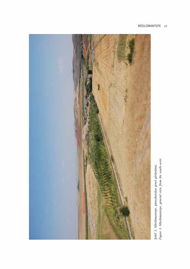
fieki
l 3:
Müs
lüm
ante
pe, gü
neyb
at›d
an g
enel
gör
ünüm
ü.Fi
gure
3:
Müs
lüm
ante
pe, ge
nera
l vi
ew f
rom
the
sou
th-w
est.

22 Eyyüp AY – Ayflen AY – Ça¤r› M. TARHAN
fiekil 5: Müslümantepe “tepe kaz› alan›” ‹slami dönem mezarlar›.Figure 5: Islamic burials of Müslümantepe “mound area”.
fiekil 4: Müslümantepe “tepe kaz› alan›” Geç Tunç Ça¤ tabakas›.Figure 4: Late Bronze Age level of Müslümantepe “mound area”.

23MÜSLÜMANTEPE
fiekil 7: Yanm›fl yap›lardan ele geçen buluntular.Figure 7: Artifacts from the Burnt Buildings.
fiekil 6: M.Ö. 2. Biny›l, Yanm›fl Yap›lar (Mekan 1, Mekan 2).Figure 6: Burnt Buildings (Room 1, Room 2), dated to the 2nd millennium B.C.

24 Eyyüp AY – Ayflen AY – Ça¤r› M. TARHAN
fiekil 8: Müslümantepe “H›ristiyan Tepe kaz› alan›” M.Ö. 3. biny›l tabakalar›n›n plan›.Figure 8: Müslümantepe “H›ristiyan Tepe Excavation Site”, plan of the levels dated to the3rd millennium B.C.

25MÜSLÜMANTEPE
fiekil 9: Müslümantepe“H›ristiyan Tepe kaz›alan›” M.Ö. 3. biny›l
tabakalar›..Figure 9:
Müslümantepe “H›ris-tiyan Tepe ExcavationSite”, levels dated tothe 3rd millennium
B.C.
fiekil 10: Av Köpe¤i(Taz›) ‹skeletleri.
Figure 10: Skeletonsof three hounds (grey-
hound).
fiekil 11: H›ristiyanTepe, NN/20-21,
OO/20-22 ve PP/21-22 açmalar›.
Figure 11: H›ristiyanTepe, trenches NN/20-
21, OO/20-22 andPP/21-22.

26 Eyyüp AY – Ayflen AY – Ça¤r› M. TARHAN
fiekil 12: Müslümantepe, “Mezarl›k Kaz› Alan›”Figure 12: Müslümantepe, “Cemetery Excavation Area”

27MÜSLÜMANTEPE
fiekil 13: M.Ö. Geç 3. biny›l küp mezar örne¤i.Figure 13: An example of a pithos burial dated to the late 3rd millennium B.C.

28 Eyyüp AY – Ayflen AY – Ça¤r› M. TARHAN
fiekil 14: Mezarl›k Kaz› Alan›, koyu a¤›z kenarl› portakal renkli çanak örnekleri.Figure 14: Cemetery Excavation Area, examples of dark-rimmed orange bowls.

29MÜSLÜMANTEPE
fiekil 15: Mezarl›k Kaz› Alan›, M.Ö. Geç 3. biny›l mezar buluntular›.Figure 15: Cemetery Excavation Area, examples of burial finds dated to the late 3rd millenniumB.C.

30 Eyyüp AY – Ayflen AY – Ça¤r› M. TARHAN
fiekiller Listesifiekil 1: Müslümantepe’de kaz› alanlar›n› gösteren topografik harita.fiekil 2: Müslümantepe “tepe kaz› alan›” M.Ö. 2. biny›l tabakalar›n›n plan›.fiekil 3: Müslümantepe, güneybat›dan genel görünümü.fiekil 4: Müslümantepe “tepe kaz› alan›” Geç Tunç Ça¤ tabakas›.fiekil 5: Müslümantepe “tepe kaz› alan›” ‹slami dönem mezarlar›.fiekil 6: M.Ö. 2. Biny›l, Yanm›fl Yap›lar (Mekan 1, Mekan 2).fiekil 7: Yanm›fl yap›lardan ele geçen buluntular.fiekil 8: Müslümantepe “H›ristiyan Tepe kaz› alan›” M.Ö. 3. biny›l tabakalar›n›n plan›.fiekil 9: Müslümantepe “H›ristiyan Tepe kaz› alan›” M.Ö. 3. biny›l tabakalar›.fiekil 10: Av Köpe¤i (Taz›) ‹skeletleri.fiekil 11: H›ristiyan Tepe, NN/20-21, OO/20-22 ve PP/21-22 açmalar›.fiekil 12: Müslümantepe, “Mezarl›k Kaz› Alan›”fiekil 13: M.Ö. Geç 3. biny›l küp mezar örne¤i.fiekil 14: Mezarl›k Kaz› Alan›, koyu a¤›z kenarl› portakal renkli çanak örnekleri.fiekil 15: Mezarl›k Kaz› Alan›, M.Ö. Geç 3. biny›l mezar buluntular›.
List of FiguresFigure 1: Topographic map of Müslümantepe showing areas of excavation.Figure 2: Müslümantepe “mound area” plan of the levels dated to the 2nd millennium B.C.Figure 3: Müslümantepe, general view from the south-west.Figure 4: Late Bronze Age level of Müslümantepe “mound area”.Figure 5: Islamic burials of Müslümantepe “mound area”.Figure 6: Burnt Buildings (Room 1, Room 2), dated to the 2nd millennium B.C.Figure 7: Artifacts from the Burnt Buildings.Figure 8: Müslümantepe “H›ristiyan Tepe Excavation Site”, plan of the levels dated to the 3rdmillennium B.C.Figure 9: Müslümantepe “H›ristiyan Tepe Excavation Site”, levels dated to the 3rd millenniumB.C.Figure 10: Skeletons of three hounds (greyhound).Figure 11: H›ristiyan Tepe, trenches NN/20-21, OO/20-22 and PP/21-22.Figure 12: Müslümantepe, “Cemetery Excavation Area”Figure 13: An example of a pithos burial dated to the late 3rd millennium B.C. Figure 14: Cemetery Excavation Area, examples of dark-rimmed orange bowls.Figure 15: Cemetery Excavation Area, examples of burial finds dated to the late 3rd millenniumB.C.
Copyright © 2022 FDOKUMEN