HYPERION SOLAR DEVELOPMENT 4 - SAHRIS
228
HYPERION SOLAR DEVELOPMENT 4 Northern Cape Province Final Scoping Report December 2018
-
Upload
khangminh22 -
Category
Documents
-
view
1 -
download
0
Transcript of HYPERION SOLAR DEVELOPMENT 4 - SAHRIS

HYPERION SOLAR DEVELOPMENT 4
Northern Cape Province
Final Scoping Report
December 2018

Final Scoping Report December 2018
Hyperion Solar Development 4,Northern Cape Province
Prepared by:
Prepared for:
Nomispan (Pty) Ltd
14th Floor Pier Place,
31 Heerengracht Street,
Foreshore,
Cape Town
8001

Hyperion Solar Development 4, Northern Cape ProvinceFinal Scoping Report December 2018
Project Details Page i
PROJECT DETAILS
DEA Reference Number 14/12/16/3/3/2/1112
Title : Environmental Impact Assessment Process: Final Scoping Report for the
Hyperion Solar Development 4, Northern Cape Province
Authors : Savannah Environmental (Pty) Ltd
Thalita Botha
Shaun Taylor
Jo-Anne Thomas
Applicant : Nomispan (Pty) Ltd
Report Status : Final Scoping Report for submission to the Department of Environmental
Affairs
Date : December 2018
When used as a reference this report should be cited as: Savannah Environmental (2018) Scoping Report
for the Hyperion Solar Development 4, Northern Cape Province.
COPYRIGHT RESERVED
This technical report has been produced for Nomispan (Pty) Ltd. The intellectual property contained in this
report remains vested in Savannah Environmental (Pty) Ltd. No part of the report may be reproduced in
any manner without written permission from Savannah Environmental (Pty) Ltd or Nomispan (Pty) Ltd.

Hyperion Solar Development 4, Northern Cape ProvinceFinal Scoping Report December 2018
Public Review Period for Scoping Report Page ii
PUBLIC REVIEW PERIOD FOR SCOPING REPORT
Members of the public, local communities and stakeholders were invited to comment on the Scoping
Report for Hyperion Solar Development 3 which was made available for public review and for a 30-day
public review period from 26 October 2018 to 26 November 2018. The Scoping Report, which was
submitted to the national Department of Environmental Affairs (DEA) and the Northern Cape Department
of Environment and Nature Conservation (DENC) is also available for download on www.savannahsa.com
or on request from Savannah Environmental (Pty) Ltd.
The report was distributed to relevant Organs of State and will also be made available at the following
locations:
» Kathu Public Library, 1 Hendrik van Eck Road, Kathu
» www.savannahsa.com
Comments received from the public during the public review period and throughout the process to date
have been included within this Final Scoping Report. Changes made to this Final Report have been
underlined for ease of reference.
Hyperion Solar Development 4, Northern Cape ProvinceFinal Scoping Report December 2018
Executive Summary Page iii
EXECUTIVE SUMMARY
The applicant, Nomispan (Pty) Ltd (a subsidiary
of Building Energy South Africa (Pty) Ltd), is
proposing the construction of a photovoltaic
(PV) solar energy facility (known as the Hyperion
Solar Development 4) situated on a site
approximately 16km north of the town of Kathu.
Hyperion Solar Development 4 is intended to
form part of the Department of Energy’s (DoE’s)
Renewable Energy Independent Power
Producer Procurement (REIPPP) Programme.
The REIPPP Programme aims to secure 14
725MW of new generation capacity from
Renewable Energy sources, while simultaneously
diversifying South Africa’s electricity mix, and
positively contributing towards socio-economic,
and environmentally sustainable growth.
The Remaining Extent of the Farm Lyndoch 432
has been identified by the applicant as the
preferred project site suitable for the
development of a commercial PV facility. From
a technical perspective, the Kathu area is
considered favourable for the development of
commercial solar energy facilities (SEFs) by
virtue of the prevailing climatic conditions
(primarily as the economic viability of a solar
energy facility is directly dependent on the
annual solar irradiation values for a particular
area), relief and aspect, the extent of the site,
the availability of a direct grid connection (i.e.
point of connection to the national Eskom grid),
and the availability of land on which
development can take place.
The SEF will be located within the Remaining
Extent of the Farm Lyndoch 432, hereafter
referred to as the project site. The proposed
project site falls under the jurisdiction of the
Gamagara Local Municipality and within the
greater John Taolo Gaetsewe District
Municipality in the Northern Cape Province. The
SEF is proposed to be connected to the
national grid at Eskom’s existing Ferrum
Substation, located 16km south of the project
site. The construction of the 132kV overhead
power line (OHPL) will be assessed as part of a
separate Basic Assessment (BA) process which
will consider feasible alternatives for the power
line route. The project site is accessible via an
existing gravel farm road (known as T26) which
provides access to the farm off of the N14
national road and which is located south of the
project site.
Three (3) additional 75MW PV facilities are
concurrently being considered on the same
project site (Remaining Extent of the Farm
Lyndoch 432) and will be known as Hyperion
Solar Development 1, Hyperion Solar
Development 2, and Hyperion Solar
Development 3 respectively. Each of these SEFs
will be assessed through a separate
Environmental Impact Assessment (EIA) process.
Hyperion Solar Development 4 will have a
contracted capacity of up to 75MW, and will
make use of photovoltaic (PV) solar technology
for the generation of electricity. The project will
comprise the following key infrastructure and
components:
» Arrays of PV panels (static or tracking PV
system).
» Mounting structures to support the PV panels.
» Cabling between the project components, to
be laid underground where practical.
» On-site inverters to convert the power from a
direct current (DC) to an alternating current
(AC).
» An on-site substation to facilitate the
connection between the SEF and the Eskom
electricity grid.
» A new 132kV power line between the on-site
substation and the existing Ferrum Substation.
» Battery storage mechanism with a storage
capacity of up to 300MWh.
» Water purification plant.

Hyperion Solar Development 4, Northern Cape ProvinceFinal Scoping Report December 2018
Executive Summary Page iv
» Site Offices and Maintenance Buildings,
including workshop areas for maintenance
and storage.
» Batching plant.
» Temporary laydown areas.
» Internal access roads and fencing around the
development area.
The applicant is also considering two access road
alternatives:
» Alternative 1 - Upgrade approximately 3,6km
of the T26 gravel road between the project
site and the N14; or
» Alternative 2 - The construction of a new
access road and the formalisation of an
informal access road between the project
site and the T25 gravel road, approximately
5km in length.
The development of Hyperion Solar Development
4 requires Environmental Authorisation (EA) from
the National Department of Environmental Affairs
(DEA) in accordance with the requirements of
the National Environmental Management Act
(No. 107 of 1998) (NEMA), and the 2014 EIA
Regulations (GNR 326). EA required for the
project is subject to the completion of a full
Scoping and Environmental Impact Assessment
(EIA) process. Savannah Environmental (Pty) Ltd
has been appointed as the independent
environmental consultants responsible for
managing the application for EA and supporting
Scoping and EIA process, inclusive of
comprehensive, independent specialist studies.
The Scoping Phase includes the identification
and description of potential issues associated
with the project through a desktop study and
consultation with Interested and Affected Parties
(I&APs) and key stakeholders through a Public
Participation process. The entire project site is
considered within this process at a desktop level.
Through this study, areas of sensitivity within the
broader site are identified and delineated in
order to identify any environmental fatal flaws,
and environmentally sensitive, or no-go areas.
The Scoping Phase aims to:
» Identify and evaluate potential
environmental (biophysical and social)
impacts and benefits of all phases of the
proposed development (including design,
construction, operation and
decommissioning) within the broader study
area through a desktop review of existing
baseline data and specialist studies.
» Identify potentially sensitive environmental
features and areas within the broader site in
order to inform the preliminary design process
of the facility.
» Define the scope of studies to be undertaken
during the EIA Phase.
» Provide the authorities with sufficient
information in order to make a decision
regarding the scope of issues to be
addressed in the EIA Phase, as well as
regarding the scope and extent of specialist
studies that will be required to be undertaken
as part of the EIA Phase.
Potential impacts associated with the
development of Hyperion Solar Development 4
are expected to occur during both the
construction and operation phases. Impacts
associated with the construction of Hyperion
Solar Development 4 can also be expected to be
associated with the decommissioning phase
(however, to a lesser extent as the project site
would have previously undergone transformation
and disturbance during construction).
Ecology Impacts
Overall, no potential impacts of high significance
that are associated with the proposed
development, which cannot be mitigated to an
acceptable level, have been identified. This will
however, be confirmed during a detailed field
study of the area, to be conducted as part of the
EIA phase. The most significant potential impacts
expected to occur with the development of
Hyperion Solar Development 4 are:
» Impacts on vegetation and protected
plant species such as the Acacia erioloba

Hyperion Solar Development 4, Northern Cape ProvinceFinal Scoping Report December 2018
Executive Summary Page v
and A.haematoxylon. Vegetation
clearing during construction will lead to
the loss of currently intact habitat within
the development footprint and is an
inevitable consequence of the proposed
development. This impact is certain to
occur and the consequences will persist
for a long time after construction.
» The construction and operation phases
will result in disturbance, transformation
and loss of habitat and will have a
negative effect on resident fauna. Due to
noise and operation of heavy machinery,
faunal disturbance will extend well
beyond the footprint and extend into
adjacent areas.
» The development of the SEF and
associated infrastructure may impact
CBAs, ESAs and broad-scale ecological
processes such as the ability of fauna to
disperse.
Cumulative impacts in the area are a concern
due to mining activities that characterise the
area and due to the proliferation of solar energy
development in the wider Kathu area. In terms of
habitat loss, the affected Kathu Bushveld
vegetation type is still approximately 90% intact
and while this is not a very extensive vegetation
type, the loss of approximately 180ha of habitat
associated with the development footprint is
however not considered highly significant given
that there are still relatively large contiguous
intact areas available adjacent to the project
site. However, the development of all four (4)
SEFs on the same project site would generate
over 700ha of habitat loss which is considered to
generate a moderate local cumulative impact.
It is envisaged that some of the impacts listed
above may constitute a high ecological impact.
These need to be assessed in greater detail
during the EIA phase of the project.
Impacts on watercourses (i.e. surface water)
Overall, no significant impacts to watercourses
that could pose a problem to the proposed SEF
were identified during the Scoping Phase. This will
however, be confirmed during a detailed field
study of the project site, to be conducted as part
of the EIA Phase. Watercourses identified within
the project site and along the access road
alternatives (i.e. the Vlermuisleegte River and
depression wetland) could be considered of
increased ecological importance and sensitivity.
The most significant potential impacts expected
to occur with the development of the Hyperion
Solar Development 4 are:
» Direct disturbance of the remaining
habitat of the Vlermuisleegte River;
» The decrease of riparian vegetation and
habitat integrity;
» Alteration of runoff patterns;
» Altered stream and baseflow patterns;
» Mis-management and ineffective
rehabilitation of the Vlermuisleegte River;
Aspects relating to the significance, extent,
duration probability and magnitude of potential
impacts will likely be relatively low and will be
assessed during the EIA Phase of the project.
These aspects can be reduced to very low
through the necessary mitigation measures
including the exclusion of these areas from the
development footprint.
Impacts on Avifauna
The main impacts on avifauna in the area
associated with the proposed PV facility are
expected to be the following:
» The loss of habitat and subsequent
displacement of bird species due to the
footprint required during construction.
Bird species include:
∗ Small passerines;
∗ Medium terrestrial birds and raptors;
and
∗ Large terrestrial birds and raptors.

Hyperion Solar Development 4, Northern Cape ProvinceFinal Scoping Report December 2018
Executive Summary Page vi
» Direct interaction (collision trauma) by
birds with the surface infrastructure
(photovoltaic panels).
Habitat loss and disturbance during the
construction phase of the development will
potentially impact mostly small passerine species
and medium-sized non-passerines, with
consequences restricted to the local area only.
Potential impacts related to collisions with PV
panels and associated infrastructure (such as
fencing) will impact mostly medium-sized non-
passerines (e.g. korhaans, francolin and thick-
knees). Red-listed species will potentially be
impacted by the loss of foraging habitat and
disturbances. Given the extensive national
ranges of these species and their apparently
infrequent use of the project site, the potential
impact of the development on habitat loss for
these species would be minimal and a long-term
impact unlikely. These impacts require further
investigation as part of the EIA Phase.
Identified sensitive habitats, such as the Acacia
erioloba woodland to the east of the
Vlermuisleegte River, and the Vlermuisleegte
River itself, should be excluded from the
development footprint and provided an
adequate buffer zone.
Impacts on Soil, Land Use, Land Capability and
Agricultural Potential
Following the land capability classification data
obtained from the DAFF, the project site has low
to moderately low land capability (and
therefore, is only suitable for grazing with certain
management practises required). Although the
anticipated impacts of the proposed project on
soil are very limited, these impacts will require
further investigation as part of the EIA Phase.
Below follows a description of the impacts
anticipated:
Potential impacts on soil:
» The most significant impact will most likely
be caused by the traversing of vehicles
over the terrain during the construction
phase. This impact will be restricted to the
access roads and will result in soil
compaction. Soil compaction affects the
infiltration of rain into the soil, and will
increase the risk of erosion as a result of
this. Deep level soil compaction (as
caused by heavy vehicle traffic) is difficult
to alleviate.
» Soil erosion, especially where vegetation
will be removed during the construction
phase of the project.
» In any area where topsoil will be stripped
for construction purposes, the inherent soil
fertility and in situ soil horizon organisation
will be compromised.
» Chemical soil pollution may occur as a
result of oil and fuel spills from construction
and maintenance vehicles as well as any
other waste products that may be
generated on site and not properly
handled.
Potential impacts on land use:
The only impact on land will be the change of
land use within the development area from
livestock farming to that of renewable energy
generation. The current land use can continue
on those portions of land not utilised for the
project. The cumulative impact on land use is
that portions of land that were previously used for
agriculture in the region are converted into
alternative land uses. There are also other
existing and proposed renewable energy
projects in the area that will cumulatively reduce
the areas currently available for agriculture.
Potential impacts on land capability:
The land capability of the area where the
proposed development will be located will not
be affected by the project.
Impacts on Heritage Resources (Archaeological
and Palaeontological)
Impacts to palaeontology and archaeology may
occur during the construction phase but can be
easily mitigated and/or managed. Several grave
sites have been identified within the project site.

Hyperion Solar Development 4, Northern Cape ProvinceFinal Scoping Report December 2018
Executive Summary Page vii
The possibility of impacts on graves are
considered to be extremely small. The vast
majority of the archaeological resources within
the project site are likely to be of low cultural
significance for their scientific value. Denser
clusters of artefacts may have medium cultural
significance for their scientific value due to the
contribution that these artefacts might have to
an understanding of the declared Grade 1 Kathu
Complex cultural landscape to the south.
Overall, a field rating of GP A is applied to
archaeology. No highly significant impacts to
archaeological materials are expected to occur
as a result of the project.
The structures identified within the project site,
and immediate surroundings, have low cultural
significance in terms of their architectural and
historical values. Direct impacts to structures are
not expected to occur, although very minor
contextual impacts may occur through
construction activities in close proximity to
historical structures. The surface cultural
landscape has low cultural significance for its
aesthetic value. Direct impacts to the cultural
landscape would occur through the introduction
of an alternative land use.
Palaeontological resources are not known to
occur within the project site, but should any fossils
be identified, these would most likely be of low to
medium heritage significance. Overall, a field
rating of GP B is applied to palaeontology.
Impacts associated with heritage resources
which have been identified for the project,
require further investigation as part of the EIA
phase. As there are no structures of heritage
significance present within the project site, this
aspect does not require further study during the
EIA Phase.
Visual Impacts
The operation of the SEF could impact on the
current landscape character and particularly the
rural landscape character of the area. The
affected landscape currently appears to be
largely a semi-natural rural character. There is
however evidence that this character is being
eroded by other SEFs in the vicinity of the
proposed development. Anticipated issues
related to the potential visual impact of the
proposed SEF include the following:
» The visibility of the facility to, and potential
visual impact on, observers travelling
along the N14, the R308 regional road
and local roads (T25 and T26).
» The visibility of the facility to, and potential
visual impact on observers residing at
homesteads (farm residences) located
within close proximity of the project site.
» The visibility of the facility to, and potential
visual impact on the Sishen Airport.
» Potential cumulative visual impacts (or
alternately, consolidation of visual
impacts) with specific reference to the
potential construction of another SEF
within close proximity to the project site.
» The potential visual impact of the
construction of ancillary infrastructure (i.e.
the substation at the facility, and access
roads) on observers in close proximity of
the facility.
» The potential visual impact of operational,
safety and security lighting of the facility
at night on observers residing in close
proximity of the facility.
It is envisaged that the issues listed above may
constitute a low visual impact at a local scale.
These need to be assessed in greater detail
during the EIA Phase of the project.
Social Impacts
A number of potential positive and negative
social impacts have been identified for the
project, which require further investigation as part
of the EIA phase. These include:
» Creation of direct and indirect
employment and skills development
opportunities (during both construction
and operation).
» Economic multiplier effects

Hyperion Solar Development 4, Northern Cape ProvinceFinal Scoping Report December 2018
Executive Summary Page viii
» In-migration of people (non-local
workforce and jobseekers).
» Safety and security impacts.
» Impacts on daily living and movement
patterns.
» Nuisance impact (noise and dust).
» Visual and sense of place impacts.
» Development of clean, renewable energy
infrastructure.
» Contribution to Local Economic
Development and Social Upliftment
» Impacts associated with the loss of
agricultural land.
The potential social impacts identified for the
project have been identified based on an
assessment of available information and the
current understanding of the proposed project,
and are not exhaustive. The possibility therefore
exists that additional impacts may be identified
as part of the public review period, or during the
collection of primary data as part of the EIA level
Social Impact Assessment (SIA). All potential
social impacts identified as part of the SIA
process will be assessed in detail during the EIA
Phase.
An Environmental Sensitivity Map which illustrates
potentially sensitive areas identified within the
project site has been compiled for the project
(refer to Figure 1). The Scoping Phase
environmental sensitivity map provides an
informed illustration of sensitivity within and
around the larger site. The detail is based on the
desktop review of the available baseline
information for the study area, specialist inputs
and limited field surveys. The environmental
sensitivity map is intended to inform the location
and layout of the PV facility and associated
infrastructure, and must be used as a tool by the
developer to, as far as possible, avoid those
areas flagged to be of potential high sensitivity as
far as possible.
The findings of the desktop Scoping Study
indicate that no environmental fatal flaws,
associated with the proposed development of
Hyperion Solar Development 4 on the project site
(i.e. the Remaining Extent of the Farm Lyndoch
432), have been identified to date. While some
impacts of potential significance do exist, it is
anticipated that the implementation of
appropriate mitigation measures would assist in
reducing the significance of such impacts to
acceptable levels. It is however recommended,
that the development area for the development
of the facility be considered outside of the
identified areas of a high sensitivity as far as
possible in order to ensure that the development
does not have a detrimental impact on the
environment. This forms part of the ‘funnel-down
approach’ for the development area
identification within the project site. Even with
the appropriate avoidance of sensitive areas,
there are extensive areas present on the site
which can accommodate the proposed facility
with relatively low impacts on the environment.
The access road alignments provided by the
developer will be assessed from an
environmental perspective with the input from
specialist studies in order to identify the most
suitable alternative.
With an understanding of which areas within the
site are considered sensitive to the development
of the proposed facility, the project applicant
can prepare the detailed infrastructure layout for
consideration within the EIA Phase. During the
EIA Phase, more detailed environmental studies
will be conducted in line with the Plan of Study
for EIA contained in Error! Reference source not
found. of this Scoping Report. These studies will
consider the detailed layouts produced by the
developer, and make recommendations for the
implementation of avoidance strategies (if
required), and mitigation and management
measures to ensure that the final assessed layout
retains an acceptable environmental impact.

Hyperion Solar Development 4, Northern Cape ProvinceFinal Scoping Report December 2018
Executive Summary Page ix
Figure 1: Environmental Sensitivity Map for Hyperion Solar Development 4.

Hyperion Solar Development 4, Northern Cape ProvinceFinal Scoping Report December 2018
Definitions and Terminology Page x
DEFINITIONS AND TERMINOLOGY
Alternatives: Alternatives are different means of meeting the general purpose and need of a proposed
activity. Alternatives may include location or site alternatives, activity alternatives, process or technology
alternatives, temporal alternatives or the ‘do nothing’ alternative.
Archaeological material: Remains resulting from human activities which are in a state of disuse and are in
or on land and which are older than 100 years, including artefacts, human and hominid remains and
artificial features and structures.
Commence: The start of any physical activity, including site preparation and any other activity on site
furtherance of a listed activity or specified activity, but does not include any activity required for the
purposes of an investigation or feasibility study as long as such investigation or feasibility study does not
constitute a listed activity or specified activity.
Construction: Construction means the building, erection or establishment of a facility, structure or
infrastructure that is necessary for the undertaking of a listed or specified activity. Construction begins with
any activity which requires Environmental Authorisation.
Cumulative impacts: Impacts that result from the incremental impact of the proposed activity on a
common resource when added to the impacts of other past, present or reasonably foreseeable future
activities (e.g. discharges of nutrients and heated water to a river that combine to cause algal bloom and
subsequent loss of dissolved oxygen that is greater than the additive impacts of each pollutant).
Cumulative impacts can occur from the collective impacts of individual minor actions over a period and
can include both direct and indirect impacts.
Decommissioning: To take out of active service permanently or dismantle partly or wholly, or closure of a
facility to the extent that it cannot be readily re-commissioned. This usually occurs at the end of the life of
a facility.
Direct impacts: Impacts that are caused directly by the activity and generally occur at the same time and
at the place of the activity (e.g. noise generated by blasting operations on the site of the activity). These
impacts are usually associated with the construction, operation, or maintenance of an activity and are
generally obvious and quantifiable.
Disturbing noise: A noise level that exceeds the ambient sound level measured continuously at the same
measuring point by 7 dB or more.
‘Do nothing’ alternative: The ‘do nothing’ alternative is the option of not undertaking the proposed activity
or any of its alternatives. The ‘do nothing’ alternative also provides the baseline against which the impacts
of other alternatives should be compared.
Endangered species: Taxa in danger of extinction and whose survival is unlikely if the causal factors
continue operating. Included here are taxa whose numbers of individuals have been reduced to a critical
level or whose habitats have been so drastically reduced that they are deemed to be in immediate
danger of extinction.
Hyperion Solar Development 4, Northern Cape ProvinceFinal Scoping Report December 2018
Definitions and Terminology Page xi
Emergency: An undesired/ unplanned event that results in a significant environmental impact and requires
the notification of the relevant statutory body, such as a local authority.
Endemic: An "endemic" is a species that grows in a particular area (is endemic to that region) and has a
restricted distribution. It is only found in a particular place. Whether something is endemic or not depends
on the geographical boundaries of the area in question and the area can be defined at different scales.
Environment: the surroundings within which humans exist and that are made up of:
i. The land, water and atmosphere of the earth;
ii. Micro-organisms, plant and animal life;
iii. Any part or combination of (i) and (ii) and the interrelationships among and between them; and
iv. The physical, chemical, aesthetic and cultural properties and conditions of the foregoing that
influence human health and well-being.
Environmental impact: An action or series of actions that have an effect on the environment.
Environmental impact assessment: Environmental Impact Assessment, as defined in the NEMA EIA
Regulations and in relation to an application to which scoping must be applied, means the process of
collecting, organising, analysing, interpreting and communicating information that is relevant to the
consideration of that application.
Environmental management: Ensuring that environmental concerns are included in all stages of
development, so that development is sustainable and does not exceed the carrying capacity of the
environment.
Environmental management programme: An operational plan that organises and co-ordinates mitigation,
rehabilitation and monitoring measures in order to guide the implementation of a proposal and its ongoing
maintenance after implementation.
Heritage: That which is inherited and forms part of the National Estate (Historical places, objects, fossils as
defined by the National Heritage Resources Act of 2000).
Indigenous: All biological organisms that occurred naturally within the study area prior to 1800.
Indirect impacts: Indirect or induced changes that may occur because of the activity (e.g. the reduction
of water in a stream that supply water to a reservoir that supply water to the activity). These types of
impacts include all the potential impacts that do not manifest immediately when the activity is undertaken
or which occur at a different place because of the activity.
Interested and affected party: Individuals or groups concerned with or affected by an activity and its
consequences. These include the authorities, local communities, investors, work force, consumers,
environmental interest groups, and the public.
Method statement: A written submission to the ECO and the site manager (or engineer) by the EPC
Contractor in collaboration with his/her EO.

Hyperion Solar Development 4, Northern Cape ProvinceFinal Scoping Report December 2018
Definitions and Terminology Page xii
Mitigation hierarchy: The mitigation hierarchy is a framework for managing risks and potential impacts
related to biodiversity and ecosystem services. The mitigation hierarchy is used when planning and
implementing development projects, to provide a logical and effective approach to protecting and
conserving biodiversity and maintaining important ecosystem services. It is a tool to aid in the sustainable
management of living, natural resources, which provides a mechanism for making explicit decisions that
balance conservation needs with development priorities
No-go areas: Areas of environmental sensitivity that should not be impacted on or utilised during the
development of a project as identified in any environmental reports.
Perennial and non-perennial: Perennial systems contain flow or standing water for all or a large proportion
of any given year, while non-perennial systems are episodic or ephemeral and thus contains flows for short
periods, such as a few hours or days in the case of drainage lines.
Photovoltaic effect: Electricity can be generated using photovoltaic solar panels which are comprised of
individual photovoltaic cells that absorb solar energy to directly produce electricity. The absorbed solar
radiation excites the electrons inside the cells and produces what is referred to as the Photovoltaic Effect.
Pollution: A change in the environment caused by substances (radio-active or other waves, noise, odours,
dust or heat emitted from any activity, including the storage or treatment or waste or substances.
Pre-construction: The period prior to the commencement of construction, this may include activities which
do not require Environmental Authorisation (e.g. geotechnical surveys).
Rare species: Taxa with small world populations that are not at present Endangered or Vulnerable, but are
at risk as some unexpected threat could easily cause a critical decline. These taxa are usually localised
within restricted geographical areas or habitats or are thinly scattered over a more extensive range. This
category was termed Critically Rare by Hall and Veldhuis (1985) to distinguish it from the more generally
used word "rare.”
Red data species: Species listed in terms of the International Union for Conservation of Nature and Natural
Resources (IUCN) Red List of Threatened Species, and/or in terms of the South African Red Data list. In
terms of the South African Red Data list, species are classified as being extinct, endangered, vulnerable,
rare, indeterminate, insufficiently known or not threatened (see other definitions within this glossary).
Riparian: the area of land adjacent to a stream or river that is influenced by stream-induced or related
processes. Riparian areas which are saturated or flooded for prolonged periods would be considered
wetlands and could be described as riparian wetlands. However, some riparian areas are not wetlands
(e.g. an area where alluvium is periodically deposited by a stream during floods but which is well drained).
Significant impact: An impact that by its magnitude, duration, intensity, or probability of occurrence may
have a notable effect on one or more aspects of the environment.
Waste: means—
a) any substance, material or object, that is unwanted, rejected, abandoned, discarded or disposed of,
or that is intended or required to be discarded or disposed of, by the holder of that substance, material

Hyperion Solar Development 4, Northern Cape ProvinceFinal Scoping Report December 2018
Definitions and Terminology Page xiii
or object, whether or not such substance, material or object can be re-used, recycled or recovered
and includes all wastes as defined in Schedule 3 to this Act; or
b) any other substance, material or object that is not included in Schedule 3 that may be defined as a
waste by the Minister
Watercourse: as per the National Water Act means -
(a) a river or spring;
(b) a natural channel in which water flows regularly or intermittently;
(c) a wetland, lake or dam into which, or from which, water flows; and
(d) any collection of water which the Minister may, by notice in the Gazette, declare to be a watercourse,
and a reference to a watercourse includes, where relevant, its bed and banks
Wetlands: land which is transitional between terrestrial and aquatic systems where the water table is
usually at or near the surface, or the land is periodically covered with shallow water, and which under
normal circumstances supports or would support vegetation typically adapted to life in saturated soil
(Water Act 36 of 1998); land where an excess of water is the dominant factor determining the nature of
the soil development and the types of plants and animals living at the soil surface (Cowardin et al., 1979).

Hyperion Solar Development 4, Northern Cape ProvinceFinal Scoping Report December 2018
Acronyms Page xiv
ACRONYMS
BGIS Biodiversity Geographic Information System
BNCA Bophuthatswana Nature Conservation Act (No. 03 of 1973)
CBA Critical Biodiversity Area
DAFF Department of Agricultural, Forestry and Fisheries (National)
DEA Department of Environmental Affairs (National)
DWS Department of Water and Sanitation
CBA Critical Biodiversity Area
CBIPPP Coal Baseload Independent Power Producer Procurement
CR Critically Endangered
CSIR Council for Scientific and Industrial Research
CSP Concentrated Solar Power
DM District Municipality
DoE Department of Energy
EAP Environmental Assessment Practitioner
EGIS Environmental Geographic Information System
EIA Environmental Impact Assessment
EMF Environmental Management Framework
EMP Environmental Management Plan
EMPr Environmental Management Programme
EN Endangered
EP Equator Principles
ESA Ecological Support Area
GA General Authorisation
GHG Greenhouse Gas
IBA Important Bird Area
IDP Integrated Development Plan
IEM Integrated Environmental Management
IEP Integrated Energy Plan
IFC International Finance Corporation
IPP Independent Power Producer
IRP Integrated Resource Plan
IUCN International Union for Conservation of Nature
I&AP Interested and Affected Party
km Kilometre
kWh Kilowatt hour
LC Least Concern
LM Local Municipality
LNG Liquid Natural Gas
m Metre
m² Square meters
m³ Cubic meters
m amsl Metres Above Mean Sea Level
MTS Main Transmission Substation

Hyperion Solar Development 4, Northern Cape ProvinceFinal Scoping Report December 2018
Acronyms Page xv
MW Megawatts
NDP National Development Plan
NEMA National Environmental Management Act (No. 107 of 1998)
NEM:AQA National Environmental Management: Air Quality Act (No. 39 of 2004)
NEM:BA National Environmental Management: Biodiversity Act (No. 10 of 2004)
NEM:WA National Environmental Management: Waste Act (No. 59 of 2008)
NFA National Forests Act (No. 84 of 1998)
NFEPA National Freshwater Ecosystem Priority Area
NHRA National Heritage Resources Act (No. 25 of 1999)
NT Near Threatened
NWA National Water Act (No. 36 of 1998)
ONA Other Natural Area
PA Protected Area
PV Photovoltaic
RE Renewable Energy
READ North West Department of Rural, Environmental, and Agricultural Development
REIPPP Renewable Energy Independent Power Producer Procurement
SABAP South African Bird Atlas Project
SAHRA South African Heritage Resources Agency
SAHRIS South African Heritage Resources Information System
SAIAB South African Institute for Aquatic Biodiversity
SANBI South African National Biodiversity Institute
SANParks South African National Parks
SDF Spatial Development Framework
TOPS Threatened or Protected Species
TNCO Transvaal Nature Conservation Ordinance (No. 12 of 1983)
UNESCO United Nations Educational, Scientific and Cultural Organisation
VU Vulnerable
WB World Bank
WUL Water Use License
WWF World Wide Fund for Nature

Hyperion Solar Development 4, Northern Cape ProvinceFinal Scoping Report December 2018
Table of Content Page xvi
TABLE OF CONTENTS
Page
PROJECT DETAILS ............................................................................................................................................................ i
PUBLIC REVIEW PERIOD FOR SCOPING REPORT .......................................................................................................... ii
Executive Summary ..................................................................................................................................................... iii
DEFINITIONS AND TERMINOLOGY ................................................................................................................................x
ACRONYMS.................................................................................................................................................................xiv
TABLE OF CONTENTS ...................................................................................................................................................xvi
APPENDICES LIST ..........................................................................................................................................................xx
CHAPTER 1 INTRODUCTION .....................................................................................................................................1
1.1..... Project Overview 3
1.2..... Requirement for an Environmental Impact Assessment Process 5
1.3..... Legal Requirements as per the EIA Regulations, 2014 (as amended) 5
1.4..... Overview of this Environmental Impact Assessment (EIA) Process 6
1.5..... Appointment of an Independent Environmental Assessment Practitioner (EAP) 7
1.5.1 Details and Expertise of the Environmental Assessment Practitioner (EAP)...........................................7
1.5.2 Details of the Independent Specialist Team................................................................................................8
CHAPTER 2 PROJECT DESCRIPTION.........................................................................................................................9
2.1..... Legal Requirements as per the EIA Regulations, 2014 (as amended) 9
2.2..... Project Site Overview 9
2.3..... Summary of Site Selection Process and Pre-Feasibility Analysis 12
2.4..... Technology considered for the Solar Energy Facility and the Generation of Electricity 16
2.5..... Description of the Associated Infrastructure 17
2.5.1. Project Footprint ..............................................................................................................................................18
2.5.2. Details of the proposed project infrastructure ..........................................................................................19
2.5.3. Water Supply....................................................................................................................................................19
2.5.4. Energy Storage ................................................................................................................................................19
2.5.5. Panel Cleaning................................................................................................................................................20
2.5.6. Effluent and Wastewater ...............................................................................................................................20
2.5.7. Waste.................................................................................................................................................................21
2.6..... Alternatives Considered in the Scoping Phase 21
2.6.1. Consideration of Fundamentally Different Alternatives ..........................................................................21
2.6.2. Consideration of Incrementally Different Alternatives.............................................................................21
2.6.3. Technology Alternatives ................................................................................................................................25
2.6.4. The ‘Do-Nothing’ Alternative........................................................................................................................26
2.7..... Activities during the Project Development Stages 26
2.7.1. Design and Pre-Construction Phase............................................................................................................26
2.7.2. Construction Phase.........................................................................................................................................27
2.7.3. Operation Phase .............................................................................................................................................29
2.7.4. Decommissioning Phase................................................................................................................................29
CHAPTER 3 POLICY AND LEGISLATIVE CONTEXT .................................................................................................30
.... Legal Requirements as per the EIA Regulations for the undertaking of an Environmental Impact
Assessment Report, 2014 (as amended) 30
.... Strategic Electricity Planning in South Africa 30
.... Regulatory Hierarchy 31

Hyperion Solar Development 4, Northern Cape ProvinceFinal Scoping Report December 2018
Table of Content Page xvii
.... National Policy 32
3.4.1. The National Energy Act (No. 34 of 2008) ..................................................................................................32
3.4.2. White Paper on the Energy Policy of South Africa, 1998.........................................................................32
3.4.3. White Paper on the Renewable Energy Policy, 2003...............................................................................33
3.4.4. The Electricity Regulation Act (No. 04 of 2006) (ERA) ..............................................................................34
3.4.5. Integrated Energy Plan (IEP), November 2016 ..........................................................................................34
3.4.6. Integrated Resource Plan (IRP) for Electricity 2010 - 2030.......................................................................35
3.4.7. New Growth Path (NGP) Framework, 23 November 2010......................................................................38
3.4.8. The National Development Plan (NDP) 2030.............................................................................................38
3.4.9. Strategic Integrated Projects (SIPs) and the Green Economy Accord (2011)....................................39
3.4.10. Climate Change Bill, 2018..........................................................................................................................40
3.4.11. National Climate Change Response Policy, 2011 ................................................................................40
.... Provincial Policy and Planning Context 41
3.5.1. Northern Cape Province Spatial Development Framework (PSDF) (2012)..........................................41
.... Local Policy and Planning Context 41
3.6.1. John Taolo Gaetsewe District Municipality Final Draft Integrated Development Plan (IDP) 2018 –
2019 (2017).......................................................................................................................................................................41
3.6.2. John Taolo Gaetsewe District Municipality Phase 5 Draft Spatial Development Framework (SDF)
(2017) 42
3.6.3. Gamagara Local Municipality Integrated Development Plan (IDP) 2017 – 2022 (2017) .................42
.... International Policy and Planning Context 44
3.7.1. United Nations Framework Convention on Climate Change (UNFCCC) and Conference of the
Party (COP)......................................................................................................................................................................44
3.7.2. The Equator Principles III (June, 2013) .........................................................................................................45
3.7.3. International Finance Corporation (IFC) Performance Standards on Environmental and Social
Sustainability (January 2012) ........................................................................................................................................47
NEED AND DESIRABILITY.....................................................................................................................49
.... Legal Requirements as per the EIA Regulations for the undertaking of an Environmental Impact
Assessment Report, 2014 (as amended) 49
.... Need and Desirability from an International Perspective 49
.... Need and Desirability from a National Perspective 50
.... Need and Desirability of the project from a Regional Perspective 53
.... Receptiveness of the proposed project site to development of Hyperion Solar Development 4 54
4.5.1. Benefits of Renewable Energy and the Need and Desirability thereof ................................................55
APPROACH TO UNDERTAKING THE SCOPING PHASE......................................................................58
.... Legal Requirements as per the EIA Regulations 2014 (as amended) 58
.... Relevant legislative permitting requirements 59
5.2.1. National Environmental Management Act (No. 107 of 1998) (NEMA).................................................59
5.2.2. National Water Act (No. 36 of 1998) (NWA) ..............................................................................................62
5.2.3. National Heritage Resources Act (No. 25 of 1999) (NHRA).....................................................................63
.... Overview of the Scoping and EIA (S&EIA) Process being undertaken for the project 64
.... Objectives of the Scoping Phase 65
.... Overview of the Scoping Phase 66
5.5.1. Authority Consultation and Application for Authorisation in terms of the 2014 EIA Regulations
(GNR 982).........................................................................................................................................................................67
5.5.2. Public Participation Process ..........................................................................................................................67
5.5.3. Evaluation of Issues Identified through the Scoping Process .................................................................73

Hyperion Solar Development 4, Northern Cape ProvinceFinal Scoping Report December 2018
Table of Content Page xviii
5.5.4. Finalisation of the Scoping Report ...............................................................................................................74
.... Legislation and Guidelines that have informed the preparation of this Scoping Report 74
5.6.1. Best Practice Guidelines Birds & Solar Energy (2017) ...............................................................................86
5.6.2. The IFC Environmental Health and Safety (EHS) Guidelines ...................................................................87
5.6.3. IFC’s Project Developer’s Guide to Utility-Scale Solar Photovoltaic Power Plants (2015).................89
DESCRIPTION OF THE RECEIVING ENVIRONMENT............................................................................90
.... Legal Requirements as per the EIA Regulations for the undertaking of an Environmental Impact
Assessment Report, 2014 (as amended) 90
.... Regional Setting: Description of the Broader Study Area 91
.... Regional Setting: Location and description of the Project Site 93
.... Climatic Conditions 95
.... Landscape Features 96
.... Geology 97
.... Soil, Land types and Agricultural Potential 97
.... Hydrology and Geohydrology 97
.... Ecological Profile 101
6.9.1. Broad vegetation types and the vegetation conservation status..................................................... 101
6.9.2. Listed and protected plant species of the project site ........................................................................ 102
6.9.3. Fauna.............................................................................................................................................................. 102
6.9.4. Critical Biodiversity Areas (CBAs) and Ecological Support Areas (ESAs)........................................... 103
6.9.5. Avifauna......................................................................................................................................................... 104
.. Visual Quality 108
6.10.1. Landscape Character ............................................................................................................................ 108
6.10.2. Visual Receptors ....................................................................................................................................... 109
.. Social Characteristics of the Broader Study Area and the Project Site 110
.. Heritage Resources 111
6.12.1. Heritage and archaeology .................................................................................................................... 111
6.12.2. Palaeontology (Fossils) ............................................................................................................................ 113
SCOPING OF POTENTIAL ISSUES ......................................................................................................116
.... Legal Requirements as per the EIA Regulations, 2014 (as amended) 117
.... Evaluation of Potential Impacts Associated with the Construction Phase 118
7.2.1. Potential Impacts on Ecology ................................................................................................................... 118
7.2.2. Potential Impacts on Watercourses ......................................................................................................... 121
7.2.3. Potential Impacts on Avifauna.................................................................................................................. 127
7.2.4. Potential Impacts on Soil, Land Use, Land Capability and Agricultural Potential........................... 131
7.2.5. Potential Impacts on Heritage (Archaeology and Palaeontology) .................................................. 135
7.2.6. Potential Visual Impacts.............................................................................................................................. 145
7.2.7. Potential Socio-Economic Impacts .......................................................................................................... 145
.... Evaluation of Potential Impacts Associated with the Operational Phase 150
7.3.1. Potential Impacts on Ecology ................................................................................................................... 150
7.3.2. Potential Impacts on Watercourses ......................................................................................................... 151
7.3.3. Potential Impacts on Avifauna.................................................................................................................. 154
7.3.4. Potential Impacts on Soil, Land Use, Land Capability and Agricultural Potential........................... 155
7.3.5. Potential Impacts on Heritage (Archaeology and Palaeontology) .................................................. 157
7.3.6. Potential Visual Impacts.............................................................................................................................. 157
7.3.7. Potential Socio-Economic Impacts .......................................................................................................... 163
.... Evaluation of Potential Cumulative Impacts Associated with the project 166

Hyperion Solar Development 4, Northern Cape ProvinceFinal Scoping Report December 2018
Table of Content Page xix
CONCLUSIONS..................................................................................................................................172
.... Legal Requirements as per the EIA Regulations, 2014 (as amended) 172
.... Conclusions drawn from the Evaluation of the Proposed Development 172
8.2.1. Ecology Impacts........................................................................................................................................... 175
8.2.2. Impacts on watercourses (i.e. surface water)........................................................................................ 175
8.2.3. Impacts on Avifauna................................................................................................................................... 176
8.2.4. Impacts on Soils, Land Use, Land Capability and Agricultural Potential .......................................... 176
8.2.5. Impacts on Heritage Resources (Archaeological and Palaeontological)....................................... 177
8.2.6. Visual Impacts............................................................................................................................................... 178
8.2.7. Social Impacts .............................................................................................................................................. 178
.... Sensitivity Analysis for the Study Site 179
8.3.1. Ecology: ......................................................................................................................................................... 179
8.3.2. Watercourses: ............................................................................................................................................... 180
8.3.3. Avifauna: ....................................................................................................................................................... 181
8.3.4. Heritage: ........................................................................................................................................................ 182
8.3.5. Soils, Land Use, Land Capability and Agricultural Potential:............................................................... 182
8.3.6. Visual:.............................................................................................................................................................. 182
.... Overall Conclusion and Fatal Flaw Analysis 183
PLAN OF STUDY FOR THE EIA............................................................................................................185
.... Legal Requirements as per the EIA Regulations, 2014 (as amended) 185
.... Objectives of the EIA Phase 185
.... Authority Consultation 185
.... Consideration of Alternatives 186
.... Assessment of Potential Impacts and Recommendations regarding Mitigation Measures 187
.... Assessment of Potential Impacts Associated with the Project 196
.... Public Participation Process 198
.... Key Milestones of the Programme for the EIA 199
REFERENCES ......................................................................................................................................200

Hyperion Solar Development 4, Northern Cape ProvinceFinal Scoping Report December 2018
Appendices Page xx
APPENDICES LIST
Appendix A: EIA Project Consulting Team and Specialist CVs
Appendix B: Correspondence with Authorities
Appendix C: Public Participation Information
Appendix C1: I&AP Database
Appendix C2: Site Notices and Newspaper Advertisements
Appendix C3: Background Information Document
Appendix C4: Organs of State Correspondence
Appendix C5: Stakeholder Correspondence
Appendix C6: Comments Received
Appendix C7: Minutes of Meetings
Appendix C8: Comments and Responses Report
Appendix D: Ecology Impact Assessment
Appendix E: Avifauna Impact Assessment
Appendix F: Watercourse Impact Assessment
Appendix G: Soils and Agricultural Potential Assessment
Appendix H: Visual Impact Assessment
Appendix I: Heritage and Palaeontological Impact Assessment
Appendix J: Social Impact Assessment
Appendix K: EAP Affirmation and Declaration
Appendix L: Specialist Declarations
Appendix M: A3 Maps and Coordinates

HYPERION SOLAR DEVELOPMENT 4, NORTHERN CAPE PROVINCEFinal Scoping Report December 2018
Introduction Page 1
CHAPTER 1 INTRODUCTION
The applicant, Nomispan (Pty) Ltd (a subsidiary of Building Energy South Africa (Pty) Ltd), is proposing the
construction of a photovoltaic (PV) solar energy facility (known as the Hyperion Solar Development 4)
situated on a site approximately 16km north of the town of Kathu (refer to Figure 1.1). The solar energy
facility (SEF) will comprise several arrays of tracking or static PV panels and associated infrastructure and
will have a contracted capacity of up to 75MW. The SEF will be located within the Remaining Extent of the
Farm Lyndoch 432, hereafter referred to as the project site. The proposed project site falls under the
jurisdiction of the Gamagara Local Municipality and within the greater John Taolo Gaetsewe District
Municipality in the Northern Cape Province. The SEF is proposed to be connected to the national grid at
Eskom’s existing Ferrum Substation, located 16km south of the project site. The construction of the 132kV
overhead power line (OHPL) will be assessed as part of a separate Basic Assessment (BA) process which
will consider feasible alternatives for the power line route. The project site is accessible via an existing
gravel farm road (known as T26) which provides access to the farm off of the N14 national road and which
is located south of the project site.
Three (3) additional 75MW PV facilities are concurrently being considered on the same project site
(Remaining Extent of the Farm Lyndoch 432) and will be known as Hyperion Solar Development 1, Hyperion
Solar Development 2, and Hyperion Solar Development 3 respectively. Each of these SEFs will be assessed
through a separate Environmental Impact Assessment (EIA) process.
From a regional perspective, the greater Kathu area is considered favourable for the development of a
commercial solar electricity generating facility by virtue of the prevailing climatic conditions (primarily as
the economic viability of a SEF is directly dependent on the annual solar irradiation values for a particular
area), relief and aspect, the extent of the project site, the availability of a direct grid connection (i.e. point
of connection to the Eskom National grid) and the availability of land on which the development can take
place.
The proposed SEF is planned to be bid into the Department of Energy’s (DoE) Renewable Energy
Independent Power Producers Procurement (REIPPP) Programme with the aim of evacuating the
generated power into the Eskom national electricity grid and aiding in the diversification and stabilisation
of the country’s electricity supply in line with the objectives of the current Integrated Resource Plan (IRP).

HYPERION SOLAR DEVELOPMENT 4, NORTHERN CAPE PROVINCEFinal Scoping Report December 2018
Introduction Page 2
Figure 1.1: Locality map illustrating the location of the Hyperion Solar Development 4 project site (i.e. Remaining Extent of the Farm Lyndoch 432) (refer to
Appendix M for A3 map).

HYPERION SOLAR DEVELOPMENT 4, NORTHERN CAPE PROVINCEFinal Scoping Report December 2018
Introduction Page 3
1.1 Project Overview
The project site has been identified by the applicant as a technically feasible site which has the potential
for the development of a SEF. The broader project site considered for the development is approximately
1600ha in extent. It can therefore be anticipated that the PV panels and the associated infrastructure of
the facility can be placed at appropriate locations within the boundaries of the project site to potentially
avoid any identified environmental sensitivities or constraints identified through this Scoping and EIA
process.
The full extent of the Remaining Extent of the Farm Lyndoch 432 has been considered within this Scoping
Report with the aim of identifying areas that should be avoided by the proposed development footprint of
the SEF (extent of ~180ha). On the basis of the findings of the Scoping Study, the SEF and associated
infrastructure can be appropriately designed and sited taking environmental and any other identified
constraints into consideration. Therefore, the exact location of the development footprint within the
development area1 for the Hyperion Solar Development 4 facility is not defined at this stage but will be
positioned based on sensitivities identified in the scoping phase, and this will be further assessed during the
EIA Phase.
Table 1.1: A detailed description of the project.
Province Northern Cape Province
District Municipality John Taolo Gaetsewe District Municipality
Local Municipality Gamagara Local Municipality
Ward Number (s) 7
Nearest town(s) Kathu (~14km south of the project site); Deben (~18km west of the project
site); Kuruman (~34km north east of the project site) and Hotazel (~41.6km
north of the project site)
Farm name(s) and number(s) of
properties affected by the SEF
Farm Lyndoch 432
Portion number(s) of properties affected
by the SEF
Remaining Extent of the Farm Lyndoch 432
SG 21 Digit Code (s) C04100000000043200000
Current zoning Agricultural (grazing of cattle)
Site Coordinates (centre of affected
property)
27° 32'43.22"S; 23°04'19.01"E
Site Co-ordinates (project site)
Latitude: Longitude:
North-eastern extent 27°32’12.31’’ S 23°06’23.35’’ E
North-western extent 27°34’06.94’’ S 23°06’36.08’’ E
South-eastern extent 27°34’20.63’’ S 23°03’46.03’’ E
South-western extent 27°32’21.53’’ S 23°03’49.88’’ E
1 The development area (~200ha in extent) is a smaller focus area within the project site which has been selected as the best
practicable option for the facility, considering technical preference and environmental constraints identified in the Environmental
Screening Exercise and Scoping Phase.

HYPERION SOLAR DEVELOPMENT 4, NORTHERN CAPE PROVINCEFinal Scoping Report December 2018
Introduction Page 4
Centre point 27° 32'43.22” S 23°04'19.01” E
Access Road Alternative 1 Latitude: Longitude:
Start 27°34’12.03’’S 23°05’59.37’’E
Middle 27°34’59.94’’S 23°06’39.67’’E
End 27°35’47.09’’S 23°07’18.75’’E
Access Road Alternative 2 Latitude: Longitude:
Start 27°34’20.61’’ S 23°03’46.52’’ E
Middle 27°35’44.69’’ S 23°03’58.32’’ E
End 27°37’03.98’’ S 23°04’09.44’’ E
PV technology is proposed to be utilised for the generation of electricity. The proposed Hyperion Solar
Development 4 will have a contracted capacity of up to 75MW. The SEF will include the following
infrastructure:
» Arrays of PV panels (static or tracking PV system).
» Mounting structures to support the PV panels.
» Cabling between the project components, to be laid underground where practical.
» On-site inverters to convert the power from a direct current (DC) to an alternating current (AC).
» An on-site substation to facilitate the connection between the SEF and the Eskom electricity grid.
» A new 132kV power line between the on-site substation and the existing Ferrum Substation2.
» Battery storage mechanism with a storage capacity of up to 300MWh.
» Water purification plant.
» Site Offices and Maintenance Buildings, including workshop areas for maintenance and storage.
» Batching plant.
» Temporary laydown areas.
» Internal access roads and fencing around the development area.
The applicant is also considering two access road alternatives:
» Alternative 1 - Upgrade approximately 3,6km of the T26 gravel road between the project site and the
N14; or
» Alternative 2 - The construction of a new access road and the formalisation of an informal access road
between the project site and the T25 gravel road, approximately 5km in length.
The key infrastructure components proposed as part of the Hyperion Solar Development 4 are described in
greater detail in Chapter 2 of this Scoping Report.
The overarching objective for the Hyperion Solar Development 4 is to maximise electricity production
through exposure to the available solar resource, while minimising infrastructure, operational and
maintenance costs, as well as potential social and environmental impacts. In order to meet these
objectives, local level environmental and planning issues will be assessed through the EIA process with the
2 The construction of the 132kV overhead power line will be assessed as part of a separate Basic Assessment process which will
consider feasible alternatives for the power line route.

HYPERION SOLAR DEVELOPMENT 4, NORTHERN CAPE PROVINCEFinal Scoping Report December 2018
Introduction Page 5
aid of site-specific specialist studies in order to delineate areas of sensitivity within the identified project site;
this will serve to inform and optimise the design of the SEF.
1.2 Requirement for an Environmental Impact Assessment Process
Section 24 of South Africa’s National Environmental Management Act (No. 107 of 1998) (NEMA) pertains to
Environmental Authorisations (EA), and requires that the potential consequences for, or impacts of, listed or
specified activities on the environment be considered, investigated, assessed, and reported on to the
Competent Authority (CA). The 2014 Environmental Impact Assessment (EIA) Regulations, as amended
(GNR 326) published under NEMA prescribe the process to be followed when applying for Environmental
Authorisation (EA), while the Listing Notices (Listing Notice 1 (GNR 327), Listing Notice 2 (GNR 325), and
Listing Notice 3 (GNR 324)) contain those activities which may not commence without EA from the CA.
In terms of NEMA, the 2014 EIA Regulations (GNR 326), and Listing Notices (Listing Notice 1 (GNR 327), Listing
Notice 2 (GNR 325), and Listing Notice 3 (GNR 324)), the proposed development of Hyperion Solar
Development 4 requires Environmental Authorisation (EA) from the National Department of Environmental
Affairs (DEA) subject to the completion of a full Scoping and Environmental Impact Assessment (S&EIA), as
prescribed in Regulations 21 to 24 of the 2014 EIA Regulations (GNR 326). The need for EA subject to the
completion of a full S&EIA is triggered by the inclusion of, amongst others, Activity 1 of Listing Notice 2 (GNR
325)3, namely:
“The development of facilities or infrastructure for the generation of electricity from a renewable resource
where the electricity output is 20MW or more.”
In terms of GNR 779 of 01 July 2016, the National DEA has been determined as the Competent Authority
(CA) for all projects which relate to the Integrated Resource Plan for Electricity (IRP) 2010 – 2030, and any
updates thereto. Through the decision-making process, the DEA will be supported by the Northern Cape
Department of Environment and Nature Conservation (DENC) as the commenting authority.
1.3 Legal Requirements as per the EIA Regulations, 2014 (as amended)
This Final Scoping Report has been prepared in accordance with the requirements of the EIA Regulations
published on 08 December 2014 (as amended) promulgated in terms of Chapter 5 of the National
Environmental Management Act (Act No 107 of 1998). This chapter of the Scoping Report includes the
following information required in terms of Appendix 2: Content of Scoping Report:
Requirement Relevant Section
(a)(i) the details of the EAP who prepared the report and
(ii) the expertise of the EAP to carry out scoping
procedures; including a curriculum vitae
The details of the EAP has been who prepared the
report is included in Section 1.5.1. The Curriculum Vitae
of the Savannah Environmental team and the relevant
specialists have been included as Appendix A.
3 Refer to Chapter 5 for a full list of applicable listed activities.

HYPERION SOLAR DEVELOPMENT 4, NORTHERN CAPE PROVINCEFinal Scoping Report December 2018
Introduction Page 6
(b) the location of the activity, including (i) the 21 digit
Surveyor General code of each cadastral land parcel;
(ii) where available, the physical address and farm
name and (iii) where the required information in items (i)
and (ii) is not available, the coordinates of the boundary
of the property or properties
The location of the proposed Hyperion Solar
Development 4 has been included under Section 1.1
and within Table 1.1.
(c) a plan which locates the proposed activity or
activities applied for at an appropriate scale, or, if it is (i)
a linear activity, a description and coordinates of the
corridor in which the proposed activity or activities is to
be undertaken; or (ii) on land where the property has
not been defined, the coordinates within which the
activity is to be undertaken
A locality map illustrating the location of the Hyperion
Solar Development 4 has been included as Figure 1.1 in
this chapter.
This Final Scoping Report consists of nine chapters, which include:
» Chapter 1 provides background to the proposed project and the environmental impact assessment.
» Chapter 2 describes the activities associated with the project (project scope) and provides insight of
the available technologies.
» Chapter 3 provides the Regulatory and Planning Context.
» Chapter 4 provides the need and desirability of the SEF.
» Chapter 5 outlines the process which was followed during the Scoping Phase of the EIA process,
including the consultation programme that was undertaken and input received from interested and
affected parties.
» Chapter 6 describes the existing biophysical and socio-economic environment.
» Chapter 7 provides an identification and evaluation of the potential issues associated with the
proposed SEF and associated infrastructure.
» Chapter 8 presents the conclusions of the scoping evaluation for the SEF.
» Chapter 9 describes the Plan of Study (PoS) for the EIA phase.
» Chapter 10 provides references used to compile the Scoping report.
1.4 Overview of this Environmental Impact Assessment (EIA) Process
An EIA is an effective planning and decision-making tool for the project developer as it allows for the
identification and management of potential environmental impacts. It provides the opportunity for the
developer to be forewarned of potential environmental issues and allows for the resolution of the issues
reported on in the Scoping and EIA reports as well as dialogue with interested and affected parties
(I&APs).
The EIA process comprises of two (2) phases (i.e. Scoping and Impact Assessment) and involves the
identification and assessment of potential environmental impacts through the undertaking of independent
specialist studies, as well as public participation. The processes followed in these two phases is as follows:
» The Scoping Phase includes the identification of potential issues associated with the project through a
desktop study (considering existing information) and consultation with affected parties and key
stakeholders. This phase considers the broader project site in order to identify and delineate any
environmental fatal flaws, no-go and / or sensitive areas. Following a public review period of the

HYPERION SOLAR DEVELOPMENT 4, NORTHERN CAPE PROVINCEFinal Scoping Report December 2018
Introduction Page 7
Scoping report, this phase culminates in the submission of a final Scoping Report and Plan of Study for
the EIA to the CA for consideration and acceptance.
» The EIA Phase involves a detailed assessment of the potentially significant positive and negative
impacts (direct, indirect, and cumulative) identified in the Scoping Phase. This phase considers a
proposed development footprint within the project site and includes detailed specialist investigations
as well as public consultation. Following a public review period of the EIA Report, this phase culminates
in the submission of a final EIA Report and an Environmental Management Programme (EMPr),
including recommendations of practical and achievable mitigation and management measures, to
the CA for final review and decision-making.
1.5 Appointment of an Independent Environmental Assessment Practitioner (EAP)
In accordance with Regulation 12 of the 2014 EIA Regulations (GNR 326), the applicant has appointed
Savannah Environmental (Pty) Ltd as the independent environmental consultants responsible for
managing the application for EA and supporting Scoping and Environmental Impact Assessment (S&EIA)
process; inclusive of comprehensive, independent specialist studies. The application for EA and S&EIA
process will be managed in accordance with the requirements of NEMA, the 2014 EIA Regulations (GNR
326), and all other relevant applicable legislation.
Neither Savannah Environmental nor any of its specialists are subsidiaries of, or are affiliated to the
applicant. Furthermore, Savannah Environmental does not have any interests in secondary developments
that may arise out of the authorisation of the proposed SEF. A signed Environmental Assessment
Practitioner (EAP) declaration of interest confirming the EAP’s independence is included in Appendix K of
this Final Scoping Report.
1.5.1 Details and Expertise of the Environmental Assessment Practitioner (EAP)
Savannah Environmental is a leading provider of integrated environmental and social consulting, advisory
and management services with considerable experience in the fields of environmental assessment and
management. The company is wholly woman-owned (51% black woman-owned) and is rated as a Level
2 Broad-based Black Economic Empowerment (B-BBEE) Contributor. Savannah Environmental’s team
have been actively involved in undertaking environmental studies over the past 12 years, for a wide
variety of projects throughout South Africa, including those associated with electricity generation and
infrastructure development.
The Savannah Environmental team for this project includes:
» Thalita Botha – the principle author of this report. She holds a Bachelor degree with Honours in
Environmental Management from the North-West University of Potchefstroom and has three (3) years of
experience in the environmental field. Thalita’s key focus is on environmental impact assessments,
public participation, environmental management plans and programmes, as well as mapping using
ArcGIS for a variety of environmental projects.
» Shaun Taylor – the environmental and lead permitting consultant at Savannah Environmental. Shaun
has a Master’s degree in Aquatic Health. He has approximately ten (10) years of experience
consulting in the environmental field. His competencies are in environmental impact assessments
mainly within the renewable energy (wind and solar) sector, as well as for infrastructure (roads, water
pipeline and power line) related projects.

HYPERION SOLAR DEVELOPMENT 4, NORTHERN CAPE PROVINCEFinal Scoping Report December 2018
Introduction Page 8
» Jo-Anne Thomas is a Director at Savannah Environmental (Pty) Ltd. Jo-Anne has a Master of Science
Degree in Botany (M.Sc. Botany) from the University of the Witwatersrand and is registered as a
Professional Natural Scientist (400024/2000) with the South African Council for Natural Scientific
Professions (SACNASP). She has gained extensive knowledge and experience on potential
environmental impacts associated with electricity generation and transmission projects through her
involvement in related EIA processes over the past 20 years. She has successfully managed and
undertaken EIA processes for infrastructure development projects throughout South Africa.
» Nicolene Venter – holds a Higher Secretarial Diploma and has over twenty-one (21) years of
experience in public participation, stakeholder engagement, awareness creation processes and
facilitation of various meetings (focus group, public meetings, workshops, etc.). She is responsible for
project management of public participation processes for a wide range of environmental projects
across South Africa and Neighbouring countries.
Curricula Vitae (CVs) detailing Savannah Environmental team’s expertise and relevant experience are
provided in Appendix A.
1.5.2 Details of the Independent Specialist Team
In order to adequately identify and assess potential impacts associated with the project, a number of
independent specialist consultants have been appointed as part of the project team and have provided
specialist input into this Final Scoping Report (refer to Table 1.2).
Table 1.2: Specialist Consultants which form part of the S&EIA project team.
Specialist Company Specialist Area of Expertise Specialists Names
3Foxes Biodiversity Solutions Ecology and Avifauna Simon Todd
Eric Herman
Scientific Aquatic Services Watercourses Stephen van Staden
Christel du Preez
Environmental Planning and
Design
Visual Impact Assessment Jon Marshall
TerraAfrica Soils and Agricultural Potential Impact
Assessment
Mariné Pienaar
Asha Consulting (in consultation
with John Almond of Natura Viva)
Heritage (Archaeology and
Palaeontology)
Jayson Orton
Savannah Environmental Social Impact Assessment Sarah Watson with external review by
Neville Bews
CVs detailing the independent specialist consultants’ expertise and relevant experience are provided in
Appendix A.

HYPERION SOLAR DEVELOPMENT 4, NORTHERN CAPE PROVINCEFinal Scoping Report December 2018
Project Description Page 9
CHAPTER 2 PROJECT DESCRIPTION
This Chapter provides a description of the Hyperion Solar Development 4 and associated infrastructure
proposed for development. It must be noted that the project description presented in this Chapter is
subject to change to some extent based on the outcomes and recommendations of detailed engineering
and other technical studies, the findings and recommendations of the EIA and supporting specialist
studies, and any licencing, permitting, and legislative requirements.
2.1. Legal Requirements as per the EIA Regulations, 2014 (as amended)
This chapter of the Scoping Report includes the following information required in terms of Appendix 2:
Content of the Scoping Report:
Requirement Relevant Section
(g)(i) details of all the alternatives considered The details of the alternatives considered as part of the
Hyperion Solar Development 4 and as part of the
Scoping Phase have been included in Section 2.6.
(g)(ix) the outcome of the site selection matrix Refer to Section 2.3 for a description of the selection of
the proposed project site.
(g)(x) if no alternatives, including alternative locations for
the activity were investigated, the motivation for not
considering such
The details of the alternatives considered as part of the
Hyperion Solar Development 4 and as part of the
Scoping Phase have been included in Section 2.6.
2.2. Project Site Overview
The project is proposed to be developed on the Remaining Extent of the Farm Lyndoch 432, located
approximately 16km north of Kathu in the Northern Cape Province. The project site falls within the
Gamagara Local Municipality and within the greater John Taolo Gaetsewe District Municipality. The full
extent of the project site (i.e. approximately 1600ha) has been considered within this Scoping Phase of the
EIA process, within which the development area4 for the SEF (approximately 200ha in extent) has been
appropriately located.
Based on the specialist studies undertaken during this Scoping Phase (refer to Appendix D – J), all sensitive
areas and no-go areas which are classified as undevelopable have been identified within the project site.
In order to avoid these areas of potential sensitivity and to ensure that potential detrimental environmental
impacts are minimised as far as possible, the developer will identify the preferred and most suitable
4 The development area (~200ha in extent) is a smaller focus area within the project site which has been selected as the best
practicable option for the facility, considering technical preference and environmental constraints identified in the Scoping Phase.
The development area will be subject to detailed assessment in the EIA Phase, and provides the boundary within which the
development footprint (~180ha) of the SEF will be located.

HYPERION SOLAR DEVELOPMENT 4, NORTHERN CAPE PROVINCEFinal Scoping Report December 2018
Project Description Page 10
development footprint5 within which the infrastructure of the SEF is proposed to be located during the EIA
Phase. From a technical perspective, the Kathu area is considered favourable for the development of
commercial SEFs by virtue of the prevailing climatic conditions (primarily as the economic viability of a SEF
is directly dependent on the annual solar irradiation values for a particular area), relief and aspect, the
extent of the project site, the availability of a direct grid connection (i.e. point of connection to the
national Eskom grid), and the availability of land on which development can take place.
The development area (approximately 200ha) will accommodate the development footprint of the SEF
which will include the PV panels, on-site substation, inverters, buildings and internal access roads. The
Hyperion Solar Development 4 and associated infrastructure is proposed to include:
» Arrays of PV panels (static or tracking PV system) with a contracted capacity of up to 75MW.
» Mounting structures to support the PV panels.
» Cabling between the project components, to be laid underground where practical.
» On-site inverters to convert the power from a direct current (DC6) to an alternating current (AC)7.
» An on-site substation to facilitate the connection between the SEF and the Eskom electricity grid.
» A new 132kV power line between the on-site substation and the existing Ferrum Substation8.
» Battery storage mechanism with a storage capacity of up to 300MWh.
» Water purification plant.
» Site Offices and Maintenance Buildings, including workshop areas for maintenance and storage.
» Batching plant.
» Temporary laydown areas.
» Main access road to the site, internal access roads and fencing around the development area.
Table 2.1 provides information regarding the proposed project site identified for Hyperion Solar
Development 4.
5 The total development footprint located within the development area for the SEF, including associated infrastructure is ~180ha in
extent. The development footprint will be determined within the EIA Phase of the project.6 DC (direct current) is the unidirectional flow or movement of electric charge carriers (which are usually electrons). The intensity of
the current can vary with time, but the general direction of movement stays the same at all times. As an adjective, the term DC is
used in reference to voltage whose polarity never reverses. In a DC circuit, electrons emerge from the negative, or minus, pole and
move towards the positive, or plus, pole. Nevertheless, physicists define DC as traveling from plus to minus. (sourced from
https://whatis.techtarget.com/definition/DC-direct-current).
7 An alternating current (AC) occurs when charge carriers in a conductor or semiconductor and periodically reverse their direction of
movement. The voltage of an AC power source can be easily changed by means of a power transformer. This allows the voltage to
be stepped up (increased) for transmission and distribution (sourced from https://whatis.techtarget.com/definition/alternating-
current-AC).
8 The construction of the 132kV overhead power line will be assessed as part of a separate Basic Assessment process which will
consider feasible alternatives for the power line route.

HYPERION SOLAR DEVELOPMENT 4, NORTHERN CAPE PROVINCEFinal Scoping Report December 2018
Project Description Page 11
Table 2.1: A description of the project site identified for Hyperion Solar Development 4 and access
road alternatives.
Province Northern Cape Province
District Municipality John Taolo Gaetsewe District Municipality
Local Municipality Gamagara Local Municipality
Ward Number(s) 7
Nearest Town(s) Kathu (~14km south of the project site); Deben (~18km west of the
project site); Kuruman (~34km north east of the project site) and Hotazel
(~41.6km north of the project site)
Farm Portion(s), Name(s) and Number(s)
associated with the SEF
Remaining Extent of the Farm Lyndoch 432
Farm Portion(s), Name(s) and Number(s)
associated with Access Road Alternative 1
Remaining Extent of the Farm Lyndoch 432
Portion 1 of the Farm Cowley 457
Portion 2 of the Farm Cowley 457
Remaining Extent of the Farm Cowley 457
Farm Portion(s), Name(s) and Number(s)
associated with Access Road Alternative 2
Remaining Extent of the Farm Lyndoch 432
Portion 1 of the Farm Cowley 457
Portion 2 of the Farm Cowley 457
Remaining Extent of the Farm Uitkomst 463
SG 21 Digit Code (s) Remaining Extent of the Farm
Lyndoch 432
C04100000000043200000
Portion 1 of the Farm Cowley 457 C04100000000045700001
Portion 2 of the Farm Cowley 457 C04100000000045700002
Remaining Extent of the Farm
Cowley 457
C04100000000045700000
Remaining Extent of the Farm
Uitkomst 463
C04100000000046300000
Current Zoning Agriculture
Current land use Grazing (mainly cattle)
Site Extent (project site) 1600ha
Site Co-ordinates
Latitude: Longitude:
North-eastern extent 27°32’12.31’’ S 23°06’23.35’’ E
North-western extent 27°34’06.94’’ S 23°06’36.08’’ E
South-eastern extent 27°34’20.63’’ S 23°03’46.03’’ E
South-western extent 27°32’21.53’’ S 23°03’49.88’’ E
Centre point 27° 32'43.22” S 23°04'19.01” E
Access Road Alternative 1 Latitude: Longitude:
Start 27°34’12.03’’S 23°05’59.37’’E
Middle 27°34’59.94’’S 23°06’39.67’’E
End 27°35’47.09’’S 23°07’18.75’’E
Access Road Alternative 2 Latitude: Longitude:
Start 27°34’20.61’’ S 23°03’46.52’’ E
Middle 27°35’44.69’’ S 23°03’58.32’’ E
End 27°37’03.98’’ S 23°04’09.44’’ E

HYPERION SOLAR DEVELOPMENT 4, NORTHERN CAPE PROVINCEFinal Scoping Report December 2018
Project Description Page 12
2.3. Summary of Site Selection Process and Pre-Feasibility Analysis
The broader study area (i.e. the greater Kathu area) was identified by the applicant as having the
potential for the installation of PV panels on the basis of key technical criteria being met, including the
solar resource, accessibility of the site, accessibility to the Eskom grid, and local site topography. Pre-
feasibility investigations were undertaken during the early-stages of project development wherein several
farm portions were initially considered for the development of a SEF. The pre-feasibility investigations
undertaken by the applicant considered favourable climatic conditions (solar renewable energy facilities
are directly reliant on average solar radiation values for a particular area), access and capacity of the
electricity grid and connection cost, accessibility of the properties, compatibility of current land use and
local site topography to determine an ideal project site for the establishment of the SEF. The investigation
also focussed on the sensitivity and density of the vegetation type. Due to sensitive vegetation being
present on some of the properties in the area as well as the high concentration of vegetation, several
properties were excluded as feasible options for further consideration.
From the initial pre-feasibility analysis, the applicant excluded properties from the feasible land parcels
where:
a) the current land use was not considered compatible with the proposed land use,
b) properties which were considered to present greater environmental constraints which would have a
higher environmental impact if selected for the development and reduce the chances of success for
the project (i.e. environmentally constrained), and
c) properties presented greater technical constraints (i.e. solar energy availability, topography, access,
etc.) on other sites which would influence the cost effectiveness and therefore influence the South
African Economy.
After the consideration of the various farm portions within the broader Kathu area for the development of
a SEF, the developer identified the preferred project site as the Remaining Extent of the Farm Lyndoch 432.
The affected property was identified by the project developer as being technically viable and, given its
attributes, is also considered to be commercially feasible and competitive (i.e. able to offer electricity to
the national grid of South Africa at a highly competitive tariff in order to stabilise and diversify the energy
mix of the country and therefore, ensuring the availability of electricity to the South African citizens). No
alternative project sites were identified for assessment within this Scoping and EIA process.
The detail regarding site-specific characteristics, and how these provide further motivation for the selection
of the specific site for this project is provided below:
Project site extent, conditions and land availability: Availability of level land of sufficient extent can be a
restraining factor for the development of a SEF. Hyperion Solar Development 4 will have a contracted
capacity of up to 75MW which requires an area of ~180ha (i.e. the development footprint) for the
construction of the facility. The project site is ~1600ha in extent, which provides for sufficient space for the
development of four (4) SEFs and allows for the avoidance of potential environmental sensitivities located
within the project site. The landowner of the property on which the SEF infrastructure is proposed is in
support of the development and therefore enthusiastic to allow the development of SEFs to take place on
his property and further allow the developer to lease the development areas proposed for the SEFs.
HYPERION SOLAR DEVELOPMENT 4, NORTHERN CAPE PROVINCEFinal Scoping Report December 2018
Project Description Page 13
The following are key considerations:
» The project site conditions are optimal for a development of this nature, with the site being of a
suitable gradient for the development of a PV facility.
» The region within which the project site is located can be described as flat to very slightly undulating.
The area is consistent with the land type and classifies the landscape with an average slope of
between 0% and 3% which is suitable for a development of this nature.
» The development area (inclusive of the development footprint) of the SEF would comprise ~12.5% of
the total extent of the project site. The development areas of the four (4) SEFs would comprise ~50% of
the total extent of the project site.
This project site is therefore considered suitable and favourable from a technical perspective for the
construction and operation of Hyperion Solar Development 4, allowing for avoidance of sensitivities within
the greater project site.
Site access: Access to the project site is considered as an important characteristic as easy access is
required for the transportation of project related infrastructure and heavy machinery during construction.
The proximity of the project site to viable access routes decreases the impact on secondary roads in terms
of traffic during the construction and operation phases. The project site can be accessed via the national
route (N14) which is situated approximately 6km south of the project site and provides general access to
the area from Kuruman and Upington. Access routes within the surrounding areas are also an important
characteristic to consider. The R325 regional road provides access to the area from Postmasburg.
Agricultural considerations: The majority of the project site is classified as Class V in terms of the
Department of Agriculture, Forestry and Fisheries (DAFF) Land Capability Classification System, which is
associated with limitations that make it generally impractical for cultivation. The project site also includes
areas which are classified as Class VI which is associated with severe limitations that make it generally
unsuited for cultivation and limits the use largely to livestock grazing. Limitations for agriculture that cannot
be avoided include erosion hazards, effects of past erosion, stoniness, shallow rooting zone, low water-
holding capacity, salinity or sodicity and severe climate. It can be concluded that very little, if any, of the
project site contains high potential soils. Therefore, it can be considered that the development of the
Hyperion Solar Development 4 within the project site will not result in a loss of viable agricultural land as the
possibility for successful agricultural activities, including crop production, is minimal.
Land use considerations: The current land use of the site is an important consideration in site selection in
terms of limiting disruption to existing land use practices. There is no cultivated agricultural land within the
affected property (as a result of low agricultural potential) which could be impacted upon by the
proposed SEF. The affected property is currently used for livestock grazing (mainly cattle). Sites that
facilitate easy construction conditions (i.e. relatively flat topography, lack of major rock outcrops, etc.) are
also favoured during site selection. The landowner is currently considering options for the alternative use
for their land other than for grazing due to economic constraints. It is considered that the development of
the SEF is a suitable alternative land use for the project site and will not present a conflicting land-use in line
with the landowner’s intentions.
The proposed project site is also located within close proximity to other existing solar facilities. These
include Kalahari Solar Power Project, Sishen Solar Farm, and Kathu Solar Farm. The proposed project site
therefore compliments existing and future land use.

HYPERION SOLAR DEVELOPMENT 4, NORTHERN CAPE PROVINCEFinal Scoping Report December 2018
Project Description Page 14
Grid connection considerations: Ease of access into the Eskom national electricity grid is vital to the
viability of a SEF, and addresses Eskom’s concerns for lower cost connection alternatives given current
funding constraints. SEFs which are in close proximity to a grid connection point and/or demand centre
are favourable and reduce the losses associated with power transmission. The grid connection option to
connect the facility to the national grid from the proposed site is likely to include a direct connection to
the existing Ferrum Substation located ~16km south of the project site. The connection between the
facility on-site substation and grid connection point will be assessed in a separate Basic Assessment (BA)
process.
Local labour and poverty alleviation: The project site is located ~16km of the town of Kathu, which will act
as the source of local labour during the construction and operation of the SEF.
Following the confirmation of the preferred project site as being technically feasible for the development
of a SEF, the developer set out to screen the project site, and assess the main constraints and opportunities
and whether or not there were any potential fatal flaws or significant no-go areas that might compromise
or limit the development of the Hyperion Solar Development 4. The screening exercise included the
consideration of sensitive areas and features within the project site. The screening exercise and the
sensitivities identified during this screening exercise was then considered by the developer and a
development area was identified for the proposed SEF within the project site, which as far as possible
avoided these features. The identified development area (~200ha) is located in the south western portion
of the project site (refer to Figure 2.1).
A locality map illustrating the location of the project site, development area and properties to be
impacted by Access Road Alternative 1 and Alternative 2 is provided in Figure 2.1.

HYPERION SOLAR DEVELOPMENT 4, NORTHERN CAPE PROVINCEFinal Scoping Report December 2018
Project Description Page 15
Figure 2.1: Map illustrating the development area (~200ha in extent) within the project site proposed for Hyperion Solar Development 4.

HYPERION SOLAR DEVELOPMENT 4, NORTHERN CAPE PROVINCEFinal Scoping Report December 2018
Project Description Page 16
2.4. Technology considered for the Solar Energy Facility and the Generation of Electricity
The Hyperion Solar Development 4 will have a contracted capacity of 75MW and will make use of PV
technology. SEFs, which utilise PV technology, use the energy from the sun to generate electricity through
a process known as the Photovoltaic Effect. This effect refers to photons of light colliding with electrons,
and therefore placing the electrons into a higher state of energy to create electricity (refer to Figure 2.2).
Figure 2.2: Diagram illustrating the Photovoltaic Effect (Source: Center for Sustainable Energy).
The Photovoltaic Effect is achieved through the use of the following components:
Photovoltaic Cells
A PV cell is made of silicone that acts as a semi-conductor used to produce the Photovoltaic Effect. PV
cells are arranged in multiples / arrays and placed behind a protective glass sheet to form a PV panel
(refer to Figure 2.3). Each PV cell is positively charged on one side and negatively charged on the
opposite side, with electrical conductors attached to either side to form a circuit. This circuit captures the
released electrons in the form of an electric current (i.e. Direct Current (DC)).
Figure 2.3: Overview of a PV cell, module and array / panel (Source: pveducation.com).

HYPERION SOLAR DEVELOPMENT 4, NORTHERN CAPE PROVINCEFinal Scoping Report December 2018
Project Description Page 17
Support Structures
PV panels will be fixed to a support structure. PV panels can either utilise fixed / static support structures, or
single or double axis tracking support structures (refer to Figure 2.4). PV panels which utilise fixed / static
support structures are set at an angle (fixed-tilt PV system) so as to optimise the amount of solar irradiation.
With fixed / static support structures the angle of the PV panel is dependent on the latitude of the
proposed development, and may be adjusted to optimise for summer and winter solar radiation
characteristics. PV panels which utilise tracking support structures track the movement of the sun
throughout the day so as to receive the maximum amount of solar irradiation.
Figure 2.4: Overview of different PV tracking systems (from left to right: fixed-tilt, single-axis tracking,
and double-axis tracking (Source: pveducation.com)).
PV panels are designed to operate continuously for more than 25 years, mostly unattended and with low
maintenance.
2.5. Description of the Associated Infrastructure
A summary of the planned infrastructure proposed as part of Hyperion Solar Development 4 is provided in
Table 2.2, and described in more detail under the sub-headings below.
Table 2.2: Planned infrastructure proposed as part of Hyperion Solar Development 4.
Infrastructure Dimensions/ Details
Solar Facility » Photovoltaic (PV) technology.
» Solar panels approximately 5m in height.
» Fixed-tilt, single-axis tracking, and/or double-axis tracking systems.
Supporting Infrastructure » Gate house and security building.
» Maintenance building.
» Office building.
» Batching plant.
» Battery storage area with a storage capacity of up to 300MWh.
» Temporary laydown area (500m x 200m).
» Perimeter fencing.
On-site substation » On-site substation with a 132kV capacity.
Grid Connection » A single 132kV powerline is required for grid connection.

HYPERION SOLAR DEVELOPMENT 4, NORTHERN CAPE PROVINCEFinal Scoping Report December 2018
Project Description Page 18
Infrastructure Dimensions/ Details
» Power line will potentially connect to the existing Ferrum Substation.
Access road Two access road alternatives are being considered:
» Access to the proposed site via the existing T26 gravel road which will need
to be upgraded to 9m in width. This access road will be approximately
3.6km in length; or
» The construction of a new access road and the formalisation of an informal
access road (consisting a two tyre tracks serving as a fire break in some
places) between the project site and the T25. This access road alternative
will be approximately 5km in length.
Water Supply » Approximately 10 000m³ of water per year is required during construction (12
months).
» Approximately 50 000m³ of water per year is required for operation (25
years). Water will be sourced from two existing borehole located on the
property during construction and operation.
» Water purification plant may be installed to purify the borehole water to
potable standards,
Services required » Refuse material disposal - all refuse material generated from the proposed
development will be collected by a private contractor and will be disposed
of at a licensed waste disposal site off site. This service will be arranged with
the municipality when required.
» Sanitation – during construction chemical toilets will be used and will be
emptied by the municipality. During operation, the facility will utilise
conservancy tanks. A contractor will be appointed to empty the tanks and
to dispose of the sewage at a licensed waste disposal site.
» Water supply – water will be sourced from the two existing boreholes
located on the property. If required, these boreholes will be licensed with
the DWS post preferred bidder status.
» Electricity supply – agreements with the Gamagara Local Municipality will be
established for the supply of electricity to the SEF.
2.5.1. Project Footprint
An area of approximately 200ha (equivalent to 12.5% of the total project site) is required for the
development of Hyperion Solar Development 4. The PV structures / modules, supporting infrastructure such
as internal roads, auxiliary buildings, and an on-site substation will occupy approximately 180ha. During
construction, a temporary laydown area approximately 500m x 200m in extent will be required. The
development areas of the four (4) proposed SEFs (including the proposed Hyperion Solar Development 4)
would comprise ~50% of the total extent of the project site should all proceed to construction.
The type of technology selected for implementation, outcomes of the EIA process, and the completion of
additional technical studies (e.g. geotechnical and other surveys) to be conducted as part of the detailed
design phase will ultimately influence the final project layout and development footprint. The extent of the
project site under investigation, and the fact that approximately 50% of the total project site would be
required for the four (4) proposed SEFs (including the proposed development), allows for layout design and
site-specific alternatives to be identified.

HYPERION SOLAR DEVELOPMENT 4, NORTHERN CAPE PROVINCEFinal Scoping Report December 2018
Project Description Page 19
2.5.2. Details of the proposed project infrastructure
Hyperion Solar Development 4 will be designed to have a nett generating capacity (i.e. contracted
capacity) of up to 75MW. The project will make use of fixed-tilt, single-axis tracking, and/or double-axis
tracking PV technology. PV technology is considered by the developer to be more suitable than
Concentrated Solar Power (CSP) technology as it has relatively negligible water requirements, is not
associated with the generation of effluent, is more competitive from an economic / cost perspective, and
has a reduced visual impact.
The project will comprise solar panels which, once installed, will stand up to 5m above ground level. The
solar panels will include centralised inverter stations, or string inverters mounted above ground. If
centralised inverter stations are used, Mega Volt (MV) distribution transformers are located internally,
whereas string inverters are containerised with switchgear.
The main transformer capacity varies according to detailed design and client / project specific
requirements. It is anticipated however that 1 x 80MVA transformation capacity will be applicable,
stepping up from 11kV to 132kV for evacuation into the Eskom electricity grid.
2.5.3. Water Supply
Hyperion Solar Development 4 will utilise water during both the construction and operation phases of
development. Water is required during construction for dust suppression, and potable water will be
required on site for the construction crew. During operations, water is required to clean the PV panels, for
human consumption, and for use in the auxiliary buildings (i.e. for use in the office building, ablutions, and
canteen, etc.). Approximately 10 000m³ of water per year is required over a 12 to 18-month period during
construction, and approximately 50 000m³ of water per year is required per year over the 25-year
operational lifespan of the project. Water will be sourced from two (2) existing boreholes located on the
project site.
A water purification plant may be constructed. The water purification plant will be required for the
purposes of purifying water, to be drawn from the two existing boreholes located on the project site, to
drinking standards for use during construction and operation.
2.5.4. Energy Storage
The battery storage mechanism will have a storage capacity of up to 300MWh. There are different battery
technology which can be utilised for energy storage. Energy generated by the project can be stored in
the Li-ion batteries, Lead Acid batteries, Salt Batteries, Vanadium Redox Flow batteries or other
technologies for use after hours, when the facility is no longer generating electricity (i.e. at night or on
cloudy days). The battery mechanism can also be used to stabilise power generation variability, and assist
with power system frequency regulation. Figure 2.5 provides an example of battery storage units.

HYPERION SOLAR DEVELOPMENT 4, NORTHERN CAPE PROVINCEFinal Scoping Report December 2018
Project Description Page 20
Figure 2.5: Example of battery storage units installed by Tesla (Source: fastcompany.com).
2.5.5. Panel Cleaning
It is anticipated that the PV panels will be washed twice a year during operation. Only clean water (i.e.
with no cleaning products), or non-hazardous biodegradable cleaning products will be utilised for the
washing of panels. Wastewater generated by washing panels will either be collected and recycled for
future use, or alternatively, in the event that an environmentally friendly non-hazardous biodegradable
cleaning product is utilised, wastewater can be allowed to run-off under the panels.
2.5.6. Effluent and Wastewater
During construction, chemical toilets will be used. These will be serviced regularly and effluent will be
disposed of at a registered wastewater treatment works. It is expected that approximately 360m3 of
effluent will be generated during the construction phase. Any other effluent discharge during construction
will be collected in sealed containers / tanks, and collected by a registered service provider (i.e. the Local
Municipality (LM) / Contractor) to be disposed of at a nearby and approved facility off-site.
Apart from normal sewage from site and operation staff, no effluent will be produced during operation.
Sewage will be collected and treated as per normal standards using a septic or conservancy tank.
Approximately 365 000 litres of effluent will be generated during the operation phase. In cases where the
LM does not permit the use of septic tanks, sewage will be stored in a conservancy tank and collected by
a registered service provider (the LM / Contractor) to be treated at a nearby and approved facility off-
site.

HYPERION SOLAR DEVELOPMENT 4, NORTHERN CAPE PROVINCEFinal Scoping Report December 2018
Project Description Page 21
2.5.7. Waste
Solid waste generated during construction will mainly be in the form of construction material, excavated
substrate and domestic solid waste. Waste will be disposed of in either waste skips and / or scavenger
proof recycling bins (where possible) and temporarily placed in a suitable location for removal by an
appropriate contractor. Where possible, waste will be recycled. Non-recyclable solid construction waste
will be temporarily held in skip or other appropriate waste containers to be disposed of at an appropriately
licensed landfill site. Any other waste and excess material will be removed once construction is complete
and disposed of at a registered waste facility. It is anticipated that no waste will be associated with the
battery storage mechanism proposed.
During construction, use of the following hazardous substances are anticipated: paint, grease, petrol /
diesel for trucks, cranes, bulldozers etc. Limited amounts of transformer oils and chemicals. Dangerous
goods required to be stored during construction (e.g. limited quantities of fuel, oil, lubricants etc.) will be
stored in compliance with relevant legislation (i.e. stored on covered and bunded areas / bin, and
disposed of at a registered hazardous waste site). Hazardous waste will be appropriately stored and
disposed of.
2.6. Alternatives Considered in the Scoping Phase
In accordance with the requirements of Appendix 2 of the 2014 Environmental Impact Assessment (EIA)
Regulations (GNR 326), reasonable and feasible alternatives including but not limited to site and
technology alternatives, as well as the “do-nothing” alternative should be considered. Alternatives are
required to be assessed in terms of social, biophysical, economic and technical factors.
Most guidelines use terms such as “reasonable”, “practicable”, “feasible” or “viable” to define the range
of alternatives that should be considered. Essentially there are two types of alternatives:
» Incrementally different (modifications) alternatives to the project.
» Fundamentally (totally) different alternatives to the project.
2.6.1. Consideration of Fundamentally Different Alternatives
Fundamentally different alternatives are usually assessed at a strategic level, and project-specific EIAs are
therefore limited in scope and ability to address fundamentally different alternatives. Electricity generating
alternatives have been addressed as part of the Department of Energy’s (DoE’s) IRP 2010 – 2030. In this
regard, the need for renewable energy power generation from solar has been identified as part of the
technology mix for power generation in the country for the next 20 years.
2.6.2. Consideration of Incrementally Different Alternatives
Incrementally different alternatives relate specifically to the project under investigation. “Alternatives”, in
relation to a proposed activity, means different ways of meeting the general purposes and requirements of
the activity, which may include alternatives to:
» The property on which, or location where the activity is proposed to be undertaken.
» The type of activity to be undertaken.

HYPERION SOLAR DEVELOPMENT 4, NORTHERN CAPE PROVINCEFinal Scoping Report December 2018
Project Description Page 22
» The design or layout of the activity.
» The technology to be used in the activity.
» The operational aspects of the activity.
In addition, the option of not implementing the activity (i.e. the “do-nothing” alternative) must also be
considered.
These alternatives are discussed under the respective sub-headings below.
2.6.2.1. Property or Location Alternatives
The placement of a SEF is strongly dependent on several factors including climatic conditions (solar
radiation levels), topography, the location of the site, and in particular the location in a planned node for
renewable projects, availability of grid connection, the extent of the project site, and the need and
desirability for the project. The applicant considers the proposed site to be highly favourable and the most
suitable site for the development of a PV solar facility due to the following site characteristics:
» Solar resource: The economic viability of a solar facility is directly dependent on the annual direct solar
irradiation values. The Global Horizontal Irradiation (GHI) for the proposed project site is in the region of
approximately 2 227.5kWh/m2/annum, which is well suited to the development of a commercial SEF.
» Topography: A surface area with favourable topography allows for the work involved during
construction and maintenance of the SEF to be achieved. The proposed project site is characterised
as having flat topography with slopes of 0 – 3% across the full extent.
» Site extent: The project site is approximately 1600ha in extent, which is sufficient for the installation of
the facility allowing for avoidance of site sensitivities. The development footprint of the facility
(Hyperion Solar Development 4) would occupy an area equivalent to approximately 12.5% of the full
project site. The development areas of the proposed four (4) SEFs would comprise ~50% of the total
extent of the project site.
» Site access: Access to the project site is obtained via the T26 gravel road which can be accessed from
the N14 national route located approximately 6km south of the project site.
» Grid access: A key factor in the siting of any project is that the project must have a viable grid
connection. Grid connection options are available via the existing Ferrum Substation which is located
approximately 16km south of the project site.
» Land suitability: There is no cultivated agricultural land within the affected property (as a result of low
agricultural potential) which could be impacted upon by the proposed SEF. The affected property is
currently used for livestock grazing, and the majority of farming practices can continue in tandem to
the operation of the SEF once the construction and commissioning of the project is complete.
» Geographic location: The proposed project site is located within an area which has become a node
for renewable energy projects, with the three existing solar facilities in close proximity to the project site:
Kalahari Solar Power Project, Sishen Solar Farm, and Kathu Solar Farm (refer to Figure 2.6). The

HYPERION SOLAR DEVELOPMENT 4, NORTHERN CAPE PROVINCEFinal Scoping Report December 2018
Project Description Page 23
proposed project site is in close proximity to an existing cluster or node for solar development and
therefore compliments existing and future land use.
» Landowner consent: The selection of a site where the landowner is supportive of the development of
renewable energy is essential for ensuring the success of the project. The landowner does not view the
development as a conflict with their current and intended land use practices
Based on these considerations, the applicant considers the proposed project site as highly preferred in
terms of the development of a SEF, and expects that the development will be able to draw on synergies
with the projects proposed and / or currently under construction within the vicinity of the proposed project
site. No feasible site alternatives are proposed as part of this EIA process.

HYPERION SOLAR DEVELOPMENT 4, NORTHERN CAPE PROVINCEFinal Scoping Report December 2018
Project Description Page 24
Figure 2.6: Map showing the location of existing solar facilities in close proximity to the proposed project site.
HYPERION SOLAR DEVELOPMENT 4, NORTHERN CAPE PROVINCEFinal Scoping Report December 2018
Project Description Page 25
2.6.2.2. Design and Layout Alternatives
The full extent of the ~1600ha identified project site was considered within an environmental screening
exercise. Specialist field surveys and assessments were undertaken in order to provide the developer with
site specific information regarding the larger project site considered for the development (refer to
Appendices D-J). Areas to be avoided by the development were identified, specifically relating to
ecological and hydrological features and sensitivities present within the project site. The identified
sensitivities were utilised as a tool by the developer to identify and locate the development area of the SEF
(~200ha) within the project site. This was undertaken with the aim of avoiding possible sensitive areas
within the project site so as to limit impacts associated with the development.
Hyperion Solar Development 4 will have a development footprint of approximately 180ha, to be located
within the development area of approximately 200ha. The SEF and the associated infrastructure can
therefore be appropriately located within the broader project site and development area. Potential
environmentally sensitive areas have been identified as part of the Scoping Phase (refer to Chapter 7) for
further detailed consideration (through site-specific specialist studies) during the EIA Phase. The
environmental sensitivity identification process will inform the layout design for the SEF, avoiding sensitive
areas as far as possible, and thereby ensuring that the layout plan taken forward for consideration during
the EIA Phase is the most optimal from an environmental perspective.
2.6.2.3. Access Road Alternatives
Two access road alternatives will be considered for the establishment of Hyperion Solar Development 4.
These include:
» Alternative 1: the upgrade of the existing T26 gravel road to be 9m in width, situated south of
the project site alng the Vlermuisleegte River. Approximately 3.6km of this access road will be
required to be upgraded.
» Alternative 2: the construction of a new access road, and the formalisation of an informal
access road between the project site and the existing T25 gravel road. The informal access
road currently consists of a two-tyre track serving as a fire break in some places. This access
road alternative will be approximately 5km in length.
Both alternatives will be considered and assessed during the EIA Phase in order to determine the most
optimal route from an environmental perspective.
2.6.3. Technology Alternatives
Few technology options are available for SEF. The use of those considered are usually differentiated by
weather and temperature conditions that prevail on site, so that optimality is obtained by the final site
selection. Solar energy was considered to be the most suitable renewable energy technology for this
project site, based on the site location, ambient conditions and energy resource availability. Solar PV was
determined as the most suitable option for the proposed project site as large volumes of water are not
required for power generation purposes compared to Concentrated Solar Power (CSP) technology. PV is
also preferred when compared to CSP technology because of the lower visual profile. Two solar energy
technology alternatives are being considered for the proposed project, and include:

HYPERION SOLAR DEVELOPMENT 4, NORTHERN CAPE PROVINCEFinal Scoping Report December 2018
Project Description Page 26
» Fixed mounted PV systems (static / fixed-tilt panels).
» Single-axis tracking or double-axis tracking systems (with solar panels that rotate around a defined
axis to follow the sun’s movement).
The primary difference between available technologies, which affect the potential for environmental
impacts, relate to the extent of the facility, or land-take (disturbance or loss of habitat), as well as the
height of the facility (visual impacts). From an environmental perspective, both technologies are
considered to be environmentally acceptable for implementation. The technology preference will
therefore be determined on the basis of technical considerations. The PV panels are designed to operate
continuously for more than 25 years, mostly unattended and with low maintenance.
2.6.4. The ‘Do-Nothing’ Alternative
The ‘do-nothing’ alternative is the option of not constructing Hyperion Solar Development 4. Should this
alternative be selected, there would be no environmental impacts on site as a result of construction and
operation activities associated with a SEF. While the no-go alternative will have limited socio-economic
benefits at a local and regional scale, the extent of the physical impact in the area would be minimised by
the number of projects under development in the Kathu area. The ‘do-nothing’ alternative will therefore
likely result in minimising the cumulative impact on the land, although it is expected that pressure to
develop the site for renewable energy purposes will be actively pursued due to the same factors which
make the site a viable option for renewable energy development (refer to section 2.6.2.1). This alternative
will be assessed within the EIA Phase of the process.
2.7. Activities during the Project Development Stages
A series of activities are proposed as part of the design, pre-construction, construction, operation, and
decommissioning phases associated with the development of Hyperion Solar Development 4. These are
discussed in more detail under the respective sub-headings below.
2.7.1. Design and Pre-Construction Phase
Pre-planning: Several post-authorisation factors are expected to influence the final design of the SEF and
could result in small-scale modifications of the PV array and/or associated infrastructure. An objective of
the Engineering, Procurement and Construction (EPC) Contractor, who will be responsible for the overall
construction of the project, will be to comply with the approved facility design as far as possible. It should
be understood however, that the construction process is dynamic and that unforeseen changes to the
project specifications may take place. This Final Scoping Report therefore describes the project in terms of
the best available knowledge at the time. The final facility design is required to be approved by the DEA.
Importantly, should there be any substantive changes or deviations from the original scope or layout of the
project, the DEA will need to be notified and where relevant, environmental approval obtained.
Conduct Surveys: Prior to initiating construction, a number of surveys will be required including, but not
limited to confirmation of the micro-siting footprint (i.e. the precise location of the PV panels, on-site
substation and the plant’s associated infrastructure) and a geotechnical survey. Geotechnical surveys are
executed by geotechnical engineers and geologists to acquire information regarding the physical
characteristics of soil and rocks underlying a proposed project site. The purpose is to design earthworks

HYPERION SOLAR DEVELOPMENT 4, NORTHERN CAPE PROVINCEFinal Scoping Report December 2018
Project Description Page 27
and foundations for structures and to execute earthwork repairs necessitated due to changes in the sub-
surface environment.
2.7.2. Construction Phase
The construction phase will take approximately 12 to 18 months to complete, and will entail a series of
activities including:
Procurement and employment
At the peak of construction, the project is likely to create a maximum of 500 employment opportunities.
These employment opportunities will be temporary, and will last for a period of approximately 12 to 18
months (i.e. the length of construction). Employment opportunities generated during the construction
phase will include low skilled, semi-skilled, and skilled opportunities. Solar PV projects make use of high
levels of unskilled and semi-skilled labour so there will be good opportunity to use local labour.
Employment opportunities for the proposed SEF will peak during the construction phase, and significantly
decline during the operation phase. The injection of income into the area in the form of wages will
represent an opportunity for the local economy and businesses in the area.
The majority of the labour force is expected to be sourced from the surrounding towns, and no labour will
be accommodated on-site during the construction period.
Establishment of an Access Road to the Site
Access to the project site will be established for the construction of the SEF. Access to the project site is
possible through the use of existing unsurfaced farm roads such as the T26, which can be accessed from
the N14 national road. Within the development footprint itself, access will be required from new / existing
roads for construction purposes (and limited access for maintenance during operation). The final layout
will be determined following the identification of site related sensitivities.
Undertake Site Preparation
Site preparation activities will include clearance of vegetation. These activities will require the stripping of
topsoil which will need to be stockpiled, backfilled and / or spread on site.
Transport of Components and Equipment to Site
The national, regional, secondary and proposed internal access roads will be used to transport all
components and equipment required during the construction phase of the SEF. Some of the components
(i.e. substation transformer) may be defined as abnormal loads in terms of the National Road Traffic Act
(No. 93 of 1996) (NRTO)9 by virtue of the dimensional limitations. Typical civil engineering construction
equipment will need to be brought to the project site (e.g. excavators, trucks, graders, compaction
equipment, cement trucks, etc.) as well as components required for the mounting of the PV support
structures, construction of the substation and site preparation.
9 A permit will be required in accordance with Section 81 of the National Road Traffic Act (No. 93 of 1996) (NRTA) which pertains to
vehicles and loads which may be exempted from provisions of Act.

HYPERION SOLAR DEVELOPMENT 4, NORTHERN CAPE PROVINCEFinal Scoping Report December 2018
Project Description Page 28
Establishment of Laydown Areas on Site
Laydown and storage areas will be required for typical construction equipment. Once the required
equipment has been transported to site, a dedicated equipment construction camp and laydown area
(500m x 200m in extent) will need to be established adjacent to the workshop area. The equipment
construction camp serves to confine activities and storage of equipment to one designated area, to limit
the potential ecological impacts associated with this phase of the development. The laydown area will
be used for the assembly of the PV panels, and the general placement / storage of construction
equipment. It is anticipated that the temporary laydown area will be included within the ~200ha
development area.
Erect PV Cells and Construct Substation and Invertors
The construction phase involves installation of the PV solar panels, structural and electrical infrastructure
required for the operation of the SEF. In addition, preparation of the soil and improvement of the access
roads are likely to continue for most of the construction phase. For array installations, vertical support posts
will be driven into the ground. Depending on the results of the geotechnical report, a different foundation
method, such as screw pile, helical pile, micropile or drilled post/piles could be used. The posts will hold
the support structures (tables) on which the PV modules would be mounted. Brackets will attach the PV
modules to the tables. Trenches are to be dug for the underground AC and DC cabling, and the
foundations of the inverter enclosures and transformers will be prepared. While cables are being laid and
combiner boxes are being installed, the PV tables will be erected. Wire harnesses will connect the PV
modules to the electrical collection systems. Underground cables and overhead circuits will connect the
Power Conversion Stations (PCS) to the on-site AC electrical infrastructure, and ultimately the SEF’s on-site
substation.
The construction of the substation will require a survey of the development area, site clearing and levelling
and construction of access road(s) (where applicable), construction of a level terrace and foundations,
assembly, erection, installation and connection of equipment, and rehabilitation of any disturbed areas,
and protection of erosion sensitive areas.
Establishment of Ancillary Infrastructure
Ancillary infrastructure will include a power line for connection to the Eskom national grid, workshop,
storage and laydown areas, gatehouse and security complex, as well as a temporary contractor’s
equipment camp. The 132kV overhead power line will be assessed as part of a separate Basic Assessment
Process.
The establishment of the ancillary infrastructure and support buildings will require the clearing of
vegetation and levelling of the development footprint, and the excavation of foundations prior to
construction. Laydown areas for building materials and equipment associated with these buildings will also
be required.
Undertake Site Rehabilitation
Once construction is completed and all construction equipment has been removed, the development
area will be rehabilitated where practical and reasonable. In addition, on full commissioning of the SEF,
any access points which are not required during operation must be closed and rehabilitated accordingly.

HYPERION SOLAR DEVELOPMENT 4, NORTHERN CAPE PROVINCEFinal Scoping Report December 2018
Project Description Page 29
2.7.3. Operation Phase
The proposed SEF is expected to operate for a minimum of 25 years. The facility will operate continuously,
7 days a week, and will include battery storage of up to 300MWh. The battery mechanism stores excess
renewable energy generated, dispatching excess power as and when required. This will allow operations
to continue for a period during high cloud cover and at night. The battery mechanism can also be used
to stabilise power generation variability, and assist with power system frequency regulation. While the solar
facility will be largely self-sufficient, monitoring and periodic maintenance activities will be required. Key
elements of the Operation and Maintenance (O&M) plan include monitoring and reporting the
performance of the solar facility, conducting preventative and corrective maintenance, receiving visitors,
and maintaining security.
The operation phase of the SEF will create approximately 65 full-time equivalent employment positions.
The number of low-skilled and semi-skilled personnel will comprise 70%, and skilled personnel will comprise
30% of the workforce during the operation phase. Employees that can be sourced from the local
municipal area include the less skilled and semi-skilled personnel (such as safety and security staff and
certain maintenance crew). Highly skilled personnel may need to be recruited from outside the local
area.
2.7.4. Decommissioning Phase
Depending on the continued economic viability of the solar farm following the initial 25-year operation
lifespan, the SEF will either be decommissioned, or the operation phase will be extended. If it is deemed
financially viable to extend the operation phase, existing components would either continue to operate or
be dissembled and replaced with new, more efficient technology / infrastructure available at the time. If
the decision is made to decommission the SEF, the following decommissioning activities will take place:
Site Preparation
Site preparation activities will include confirming the integrity of the access to the site to accommodate
the required decommissioning equipment.
Disassembly and removal of existing components
When the SEF is ultimately decommissioned, the equipment to be removed will depend on the land use
proposed for the project site at the time. All above ground facilities that are not intended for future use at
the project site will be removed. Much of the above ground wire, steel, and PV panels of which the system
is comprised are recyclable materials, and would be recycled to the extent feasible. The components of
the SEF would be de-constructed and recycled, or disposed of in accordance with applicable regulatory
requirements. The project site will be rehabilitated where required, and can potentially be returned to a
beneficial land-use.
Future plans for the site and infrastructure after decommissioning
The generation capacity of the facility would have degraded by approximately 15% over the 25-year
operational lifespan. The SEF will potentially have the opportunity to generate power for a Merchant
Market operation (i.e. the client would sell power on a bid basis to the market). Another option for the site
after decommissioning is for agricultural activities to resume.

HYPERION SOLAR DEVELOPMENT 4, NORTHERN CAPE PROVINCEFinal Scoping Report December 2018
Policy and Legislative Context Page 30
CHAPTER 3 POLICY AND LEGISLATIVE CONTEXT
This Chapter provides an overview of the policy and legislative context within which the Hyperion Solar
Development 4 is being proposed. It identifies legislation, policies, plans, guidelines, spatial tools, municipal
development planning frameworks, and instruments which may be applicable, or may have relevance to
the proposed project, and which have been considered as part of the S&EIA process.
Legal Requirements as per the EIA Regulations for the undertaking of an Environmental Impact
Assessment Report, 2014 (as amended)
This chapter of the Scoping Report includes the following information required in terms of Appendix 2:
Content of the Scoping Report:
Requirement Relevant Section
(e) a description of the policy and legislative context
within which the development is proposed including an
identification of all legislation, policies, plans, guidelines,
spatial tools, municipal development planning
frameworks and instruments that are applicable to this
activity and are to be considered in the assessment
process.
Chapter 3, as a whole, provides an overview of the
policy and legislative context which is considered to be
associated with the development of the solar energy
facility. The regulatory and planning context has been
considered at national, provincial and local levels.
Strategic Electricity Planning in South Africa
The need to expand electricity generation capacity in South Africa is based on national policy, and is
informed by on-going strategic planning undertaken by the DoE. The hierarchy of policy and planning
documentation that supports the development of Independent Power Producer (IPP) projects is illustrated
in Figure 3.1. These policies are discussed in more detail in the relevant subsections, along with provincial
and local policies or plans that have relevance to the development of the project.
Figure 3.1: Hierarchy of Electricity Policy and Planning Documentation.
National Energy Policy, NEMA,Energy Efficiency Strategy
DoE:
Integrated Resource Plan
NERSA
Provincial & Local LegislationPlanning

HYPERION SOLAR DEVELOPMENT 4, NORTHERN CAPE PROVINCEFinal Scoping Report December 2018
Policy and Legislative Context Page 31
Regulatory Hierarchy
The regulatory hierarchy for energy generation projects consists of three tiers of authorities who exercise
control through both statutory and non-statutory instruments, namely National, Provincial and Local levels.
At National Level, the main regulatory agencies are:
» Department of Energy (DoE): This Department is responsible for policy relating to all energy forms, and is
responsible for compiling and approving the IRP for Electricity.
» National Energy Regulator of South Africa (NERSA): This body is responsible for regulating all aspects of
the electricity sector, and will ultimately issue licenses for IPP projects to generate electricity.
» Department of Environmental Affairs (DEA): This Department is responsible for environmental policy and
is the controlling authority in terms of NEMA and the 2014 EIA Regulations (GNR 326). The DEA is the CA
for this project (as per GNR 779 of 01 July 2016), and is charged with making a decision in terms of the
relevant Environmental Authorisation (EA) for the project.
» South African Heritage Resources Agency (SAHRA): SAHRA is a statutory organisation established under
the National Heritage Resources Act (No. 25 of 1999) (NHRA), as the national administrative body
responsible for the protection of South Africa’s cultural heritage.
» South African National Roads Agency Limited (SANRAL): This Agency is responsible for the regulation
and maintenance of all national roads and routes.
» Department of Water and Sanitation (DWS): This Department is responsible for effective and efficient
water resources management to ensure sustainable economic and social development. DWS is also
responsible for evaluating and issuing licenses pertaining to water use (i.e. Water Use Licenses (WULs)
and / or registration of General Authorisations (GAs)).
» Department of Agriculture, Forestry and Fisheries (DAFF): This Department is the custodian of South
Africa’s agricultural, forestry, and fishery resources and is primarily responsible for the formulation and
implementation of policies governing the Agriculture, Forestry and Fisheries Sector. DAFF is also
responsible for the issuing of permits for the disturbance or destruction of protected tree species.
» Department of Mineral Resources (DMR): Approval from the DMR will be required to use land surface
contrary to the objects of the Mineral and Petroleum Resources Development Act (No. 28 of 2002)
(MPRDA) in terms of Section 53 of the Act. In terms of the MPRDA, approval from the Minister of Mineral
Resources is required to ensure that proposed activities do not sterilise a mineral resource that may
occur on site.
» Department of Rural Development and Land Reform (DRDLR): DRDLR is dedicated to the social and
economic development of rural South Africa, and is responsible for providing a framework for rural
development.
At Provincial Level, the main regulatory agencies are:
» Northern Cape Department of Environment and Nature Conservation (NC DENC). This Department is
the commenting authority for this project and is also responsible for issuing any biodiversity and
conservation-related permits. DENC’s involvement relates specifically to sustainable resource
management, conservation of protected species and land care.
» Northern Cape Department of Transport and Public Works (NCDRPW): This Department is responsible for
roads and the granting of exemption permits for the conveyance of abnormal loads on public roads.

HYPERION SOLAR DEVELOPMENT 4, NORTHERN CAPE PROVINCEFinal Scoping Report December 2018
Policy and Legislative Context Page 32
» Northern Cape Department of Agriculture and Rural Development: This is the provincial authority
responsible for matters affecting agricultural land.
» Ngwao Boswa ya Kapa Bokone (NBKB): NBKB, the Northern Cape Provincial Heritage Resources
Authority is responsible for the identification, conservation and management of heritage resources, as
well as commenting on heritage related issues within the Province.
At Local Level, the local and municipal authorities are the principal regulatory authorities responsible for
planning, land use and the environment. The project is proposed in the Gamagara Local Municipality
(LM), and John Taolo Gaetsewe District Municipality (DM).
National Policy
3.4.1. The National Energy Act (No. 34 of 2008)
The purpose of the National Energy Act (No. 34 of 2008) is to ensure that diverse energy resources are
available, in sustainable quantities and at affordable prices, to the South African economy in support of
economic growth and poverty alleviation, while taking into account environmental management
requirements and interactions amongst economic sectors, as well as matters relating to renewable energy.
The National Energy Act also provides for energy planning, increased generation and consumption of
renewable energies, contingency energy supply, holding of strategic energy feedstocks and carriers,
adequate investment in, appropriate up-keep and access to energy infrastructure. The Act provides
measures for the furnishing of certain data and information regarding energy demand, supply and
generation, and for establishing an institution to be responsible for promotion of efficient generation and
consumption of energy and energy research.
The Act provides the legal framework which supports the development of power generation facilities, such
as Hyperion Solar Development 4.
3.4.2. White Paper on the Energy Policy of South Africa, 1998
The South African Energy Policy, published by the then Department of Minerals and Energy (DME) in
December 1998 identifies five key objectives, namely:
» Increasing access to affordable energy services.
» Improving energy sector governance.
» Stimulating economic development.
» Managing energy-related environmental impacts.
» Securing supply through diversity.
In order to meet these objectives and the developmental and socio-economic objectives of South Africa,
the country needs to optimally use available energy resources. The South African Government is required
to address what can be done to meet these electricity needs both in the short and long-term. The White
Paper identifies key objectives for energy supply, such as increasing access to affordable energy services,
managing energy-related environmental impacts, and securing energy supply through diversifying South
Africa’s electricity mix.

HYPERION SOLAR DEVELOPMENT 4, NORTHERN CAPE PROVINCEFinal Scoping Report December 2018
Policy and Legislative Context Page 33
This policy recognises that renewable energy applications have specific characteristics which need to be
considered. The Energy Policy is “based on the understanding that renewables are energy sources in their
own right, and are not limited to small-scale and remote applications, and have significant medium- and
long-term commercial potential.” In addition, the National Energy Policy states that “Renewable resources
generally operate from an unlimited resource base and, as such, can increasingly contribute towards a
long-term sustainable energy future”.
The support for the Renewable Energy Policy is guided by a rationale that South Africa has a very
attractive range of renewable resources, particularly solar and wind, and that renewable applications are,
in fact, the least cost energy service in many cases from a fuel resource perspective (i.e. the cost of fuel in
generating electricity from such technology), more so when social and environmental costs are taken into
account. In spite of this range of resources, the National Energy Policy acknowledges that the
development and implementation of renewable energy applications has been neglected in South Africa.
Government policy on renewable energy is therefore concerned with addressing the following challenges:
» Ensuring that economically feasible technologies and applications are implemented.
» Ensuring that an equitable level of national resources is invested in renewable technologies, given
their potential and compared to investments in other energy supply options.
» Addressing constraints on the development of the renewable industry.
Therefore, the policy supports the advancement of renewable energy sources at ensuring energy security
through the diversification of supply, which is in line with the proposed SEF.
3.4.3. White Paper on the Renewable Energy Policy, 2003
The White Paper on Renewable Energy Policy supplements the Government’s overarching policy on
energy as set out in the White Paper on the Energy Policy of the Republic of South Africa (DME, 1998). The
White Paper on Renewable Energy Policy recognises the significance of the medium and long-term
potential of renewable energy. The main aim of the policy is to create the conditions for the development
and commercial implementation of renewable technologies. The position of the White Paper on
Renewable Energy is based on the integrated resource planning criterion of:
“Ensuring that an equitable level of national resources is invested in renewable technologies, given their
potential and compared to investments in other energy supply options.”
The White Paper on Renewable Energy sets out the Government’s vision, policy principles, strategic goals
and objectives for promoting and implementing renewable energy in South Africa. It also informs the
public and the international community of the Government’s vision, and how the Government intends to
achieve these objectives; and informs Government agencies and organs of their roles in achieving the
objectives.
South Africa relies heavily on coal to meet its energy needs because it is well-endowed with coal resources
in particular. However, South Africa is endowed with renewable energy resources that can be sustainable
alternatives to fossil fuels, but which have so far remained largely untapped. This White Paper fosters the
uptake of renewable energy in the economy and has a number of objectives that include:

HYPERION SOLAR DEVELOPMENT 4, NORTHERN CAPE PROVINCEFinal Scoping Report December 2018
Policy and Legislative Context Page 34
» Ensuring that equitable resources are invested in renewable technologies.
» Directing public resources for implementation of renewable energy technologies.
» Introducing suitable fiscal incentives for renewable energy.
» Creating an investment climate for the development of renewable energy sector.
The objectives of the White Paper are considered in six focal areas, namely:
i) Financial instruments.
ii) Legal instruments.
iii) Technology development.
iv) Awareness raising.
v) Capacity building and education.
vi) Market based instruments and regulatory instruments.
The policy supports the investment in renewable energy facilities as they contribute towards ensuring
energy security through the diversification of energy supply, reducing GHG emissions and the promotion of
renewable energy sources.
3.4.4. The Electricity Regulation Act (No. 04 of 2006) (ERA)
The Electricity Regulation Act (No. 04 of 2006) as amended by the Electricity Regulation Act (No. 28 of
2007), replaced the Electricity Act (No. 41 of 1987), as amended, with the exception of Section 5B, which
provides funds for the energy regulator for the purpose of regulating the electricity industry.
The ERA establishes a national regulatory framework for the electricity supply industry, and made the
National Energy Regulator of South Africa (NERSA) custodian and enforcer of the National Electricity
Regulatory Framework. The ERA also provides for licences and registration as the manner in which the
generation, transmission, distribution, reticulation, trading, import and export of electricity is regulated.
3.4.5. Integrated Energy Plan (IEP), November 2016
The purpose and objectives of the Integrated Energy Plan (IEP) are derived from the National Energy Act
(No. 34 of 2008). The IEP takes into consideration the crucial role that energy plays in the entire economy
of the country, and is informed by the output of analyses founded on a solid fact base. It is a multi-
faceted, long-term energy framework which has multiple aims, some of which include:
» To guide the development of energy policies and, where relevant, set the framework for
regulations in the energy sector.
» To guide the selection of appropriate technologies to meet energy demand (i.e. the types and
sizes of new power plants and refineries to be built and the prices that should be charged for fuels).
» To guide investment in and the development of energy infrastructure in South Africa.
» To propose alternative energy strategies which are informed by testing the potential impacts of
various factors such as proposed policies, introduction of new technologies, and effects of
exogenous macro-economic factors.
A draft version of the Integrated Energy Plan (IEP) was released for comment on 25 November 2016. The
purpose of the IEP is to provide a roadmap of the future energy landscape for South Africa which guides

HYPERION SOLAR DEVELOPMENT 4, NORTHERN CAPE PROVINCEFinal Scoping Report December 2018
Policy and Legislative Context Page 35
future energy infrastructure investments and policy development. The development of the IEP is an on-
going continuous process. It is reviewed periodically to take into account changes in the macro-
economic environment, developments in new technologies and changes in national priorities and
imperatives, amongst others.
The 8 key objectives of the integrated energy planning process are as follows:
» Objective 1: Ensure security of supply.
» Objective 2: Minimise the cost of energy.
» Objective 3: Promote the creation of jobs and localisation.
» Objective 4: Minimise negative environmental impacts from the energy sector.
» Objective 5: Promote the conservation of water.
» Objective 6: Diversify supply sources and primary sources of energy.
» Objective 7: Promote energy efficiency in the economy.
» Objective 8: Increase access to modern energy.
The IEP recognises the potential of renewable energy for power generation in South Africa, and therefore
supports the development of the proposed SEF.
3.4.6. Integrated Resource Plan (IRP) for Electricity 2010 - 2030
The Integrated Resource Plan (IRP) for Electricity 2010 – 203010 constitutes a subset of the IEP, and is South
Africa’s national electricity plan. The current iteration of the IRP for South Africa, initiated by the DoE after
a first round of public participation in June 2010, led to the Revised Balanced Scenario (RBS) that was
published in October 2010. A second round of public participation was conducted in November /
December 2010, which led to several changes to the IRP model assumptions.
The document outlines the proposed generation new-build fleet for South Africa for the period 2010 – 2030.
This scenario was derived based on a cost-optimal solution for new-build options (considering the direct
costs of new build power plants), which was then “balanced” in accordance with qualitative measures
such as local job creation.
The Policy-Adjusted IRP includes the same amount of coal and nuclear new builds as the RBS, while
reflecting recent developments with respect to prices for renewables. In addition to all existing and
committed power plants (including 10GW committed coal), the plan includes 17.8GW of renewables,
9.6GW of nuclear; 6.25GW of coal, and approximately 8.9GW of other generation sources such as hydro,
and gas.
Figure 3.2 includes the new capacities of the IRP 2010 commitment. The dates shown indicate the latest
capacity that is required in order to avoid security supply concerns. The IRP notes that projects could be
concluded earlier than indicated if feasible.
10 It should be noted that the requirement for renewable energy generation (and specifically that from solar PV) has also been
included in the latest IRP, published in August 2018 for comment. The updated IRP is yet to be finalised and promulgated.

HYPERION SOLAR DEVELOPMENT 4, NORTHERN CAPE PROVINCEFinal Scoping Report December 2018
Policy and Legislative Context Page 36
Figure 3.2: National Energy Development Commitments detailed in the IRP 2010 - 2030.
When promulgated in March 2011, it was indicated that the IRP should be a “living plan” which would be
revised by the DoE every two years. Since the promulgation of the IRP 2010, there have been a number of
developments in the energy sector in South and Southern Africa. In addition, the electricity demand
outlook has changed markedly from that expected in 2010. Updates to the IRP were drafted and released
for public comment in November 2013 and November 2016. Neither of these updates were adopted by
Parliament and were therefore never implemented.
A recent update to the IRP, Draft IRP 2018, was released for comment on 22 August 2018. The Draft IRP
2018 is based on least-cost supply and demand balance, and takes into account security of supply and
the environment (i.e. with regards to minimising negative emissions and water usage). According to the
Draft IRP 2018, key input assumptions that changed from the promulgated IRP 2010 – 2030 include,
amongst others, technology costs, electricity demand projection, fuel costs and Eskom’s existing fleet
performance and additional commissioned capacity.
For the period ending 2030, the Draft IRP 2018 proposes a number of policy adjustments to ensure a
practical plan that will be flexible to accommodate new and innovative technologies that are not
currently cost competitive, the minimisation of the impact of decommissioning of coal power plants, and
the changing demand profile.

HYPERION SOLAR DEVELOPMENT 4, NORTHERN CAPE PROVINCEFinal Scoping Report December 2018
Policy and Legislative Context Page 37
The following policy adjustments and considerations are proposed:
» A least-cost plan with the retention of annual build limits (1 000MW for PV and 1 600MW for wind) for
the period up to 2030. This provides for smooth roll out of renewable energy, which will help sustain
the industry.
» Inclusion of 1 000MW of coal-to-power in 2023 – 2024, based on two already procured and
announced projects. Jobs created from the projects will go a long way towards minimising the
impact of job losses resulting from the decommissioning of Eskom coal power plants, and will ensure
continued utilisation of skills developed for the Medupi and Kusile projects.
» Inclusion of 2 500MW of hydro power in 2030 to facilitate the Republic of South Africa (RSA)-
Democratic Republic of Congo (DRC) treaty on the Inga Hydro Power Project in line with South
Africa’s commitments contained in the National Development Plan (NDP) to partner with regional
neighbours. The Project has the potential to energise and unlock regional industrialisation.
» Renewable energy technologies identified and endorsed for localisation and promotion will be
enabled through Ministerial Determinations utilising the existing PV, Wind and Gas allocations in the
IRP Update. Technologies reflected are therefore a proxy for technologies that provide similar
technical characteristics at similar or less cost to the system. The Electricity Regulations on New
Generation Capacity enables the Minister of Energy to undertake or commission feasibility studies
in respect of new generation capacity taking into account new generation capacity as provided
for in the IRP Update. Such feasibility studies are, among others, expected to consider the cost of
new capacity, risks (technical, financial and operational) and value for money (economic
benefits).
» Annual allocations of 200MW for generation-for-own-use between 1MW to 10MW, starting in 2018.
These allocations will not be discounted off the capacity allocations initially, but will be considered
during the issuing of Ministerial Determinations taking into account generation for own use filed with
NERSA.
With these adopted policy adjustments, the recommended updated Plan is depicted in Figure 3.3. The
following must be noted in terms of Figure 3.3:
» Coal Installed Capacity is less the 12 000MW capacity to be decommissioned between years 2020
and 2030.
» Existing and committed Coal, Nuclear, Hydro and Pumped Storage Capacity is less auxiliary power.
Stated numbers are therefore based on sent out capacity not rated capacity.
» Two additional units at Medupi have since been commissioned earlier than previously assumed.
» Total installed generation for own use regardless of installed capacity is unknown, as these
installations were exempted from holding a generation license or were not required to be
registered.
» The timing of new additional capacity as indicated in Figure 3.3 can change (i.e. move back or
forward) depending on what happens with the projected electricity demand and / or Eskom’s
existing plant performance.

HYPERION SOLAR DEVELOPMENT 4, NORTHERN CAPE PROVINCEFinal Scoping Report December 2018
Policy and Legislative Context Page 38
Figure 3.3: Proposed Updated plan for the Period Ending 2030 (Source: Draft IRP 2018).
Based on the Draft IRP 2018, there is currently 1 474MW of installed PV capacity, while an additional 814MW
has been committed between 2020 and 2022, and an additional 5 670MW capacity has been allocated
between 2025 and 2030. The proposed SEF is therefore considered to be in line with current and future
energy planning for the country.
3.4.7. New Growth Path (NGP) Framework, 23 November 2010
The purpose of the New Growth Path (NGP) Framework is to provide effective strategies towards
accelerated job-creation through the development of an equitable economy and sustained growth. The
target of the NGP is to create 5 million jobs by 2020. With economic growth and employment creation as
the key indicators identified in the NGP. The framework seeks to identify key structural changes in the
economy that can improve performance in term of labour absorption, and the composition and rate of
growth.
To achieve this, government will seek to (amongst other things) to identify key areas for large-scale
employment creation as a result of changes in conditions in South Africa and globally, and to develop a
policy package to facilitate employment creation in these areas.
3.4.8. The National Development Plan (NDP) 2030
The National Development Plan (NDP) 2030 is a plan, prepared by the National Planning Commission in
consultation with the South African public which is aimed at eliminating poverty and reducing inequality
HYPERION SOLAR DEVELOPMENT 4, NORTHERN CAPE PROVINCEFinal Scoping Report December 2018
Policy and Legislative Context Page 39
by 2030. The NDP aims to achieve this by drawing on the energies of its people, growing an inclusive
economy, building capabilities, enhancing the capacity of the state, and promoting leaderships and
partnerships throughout society.
While the achievement of the objectives of the NDP requires progress on a broad front, three priorities
stand out, namely:
» Raising employment through faster economic growth.
» Improving the quality of education, skills development and innovation.
» Building the capability of the state to play a developmental, transformative role.
In terms of the Energy Sector’s role in empowering South Africa, the NDP envisages that, by 2030, South
Africa will have an energy sector that promotes:
» Economic growth and development through adequate investment in energy infrastructure. The
sector should provide reliable and efficient energy service at competitive rates, while supporting
economic growth through job creation.
» Social equity through expanded access to energy at affordable tariffs and through targeted,
sustainable subsidies for needy households.
» Environmental sustainability through efforts to reduce pollution and mitigate the effects of climate
change.
Although electricity generation from coal is still seen as part of the energy mix within the NDP, the plan sets
out steps that aim to ensure that, by 2030, South Africa's energy system looks very different to the current
situation. Coal will contribute proportionately less to primary-energy needs, while gas and renewable
energy resources – especially wind, solar, and imported hydroelectricity – will play a much larger role.
3.4.9. Strategic Integrated Projects (SIPs) and the Green Economy Accord (2011)
The Presidential Infrastructure Coordinating Committee (PICC) is integrating and phasing investment plans
across 18 Strategic Infrastructure Projects (SIPs) which have five core functions: to unlock opportunity,
transform the economic landscape, create new jobs, strengthen the delivery of basic services and support
the integration of African economies. A balanced approach is being fostered through greening of the
economy, boosting energy security, promoting integrated municipal infrastructure investment, facilitating
integrated urban development, accelerating skills development, investing in rural development and
enabling regional integration. SIP 8 and 9 of the energy SIPs support the development of the SEF:
» SIP 8: Green energy in support of the South African economy - Supports sustainable green energy
initiatives on a national scale through a diverse range of clean energy options as envisaged in the
Integrated Resource Plan (IRP 2010), and supports bio-fuel production facilities. The proposed
Hyperion Solar Development 4 is a potential SIP 8 Project.
» SIP 9: Electricity generation to support socio-economic development - The proposed Hyperion Solar
Development 4 is a potential SIP 9 Project, as electricity will be generated, social and economic
upliftment, development and growth will take place within the surrounding communities. It would
become a SIP 9 project if selected as a Preferred Bidder project by the Department of Energy. SIP
9 supports the acceleration of the construction of new electricity generation capacity in

HYPERION SOLAR DEVELOPMENT 4, NORTHERN CAPE PROVINCEFinal Scoping Report December 2018
Policy and Legislative Context Page 40
accordance with the IRP 2010 to meet the needs of the economy and address historical
imbalances.
The Green Economy Accord (signed on 17 November 2011) is also relevant to the development of the
Hyperion Solar Development 4 as the SEF will provide new prospects for economic activity that were not
previously pursued, as well as a reduction in terms of climate change.
3.4.10. Climate Change Bill, 2018
On 08 June 2018, the Minister of Environmental Affairs published the Climate Change Bill (“the Bill”) for
public comment. The Bill provides a framework for climate change regulation in South Africa aimed at
governing South Africa’s sustainable transition to a climate resilient, low carbon economy and society. The
Bill provides a procedural outline that will be developed through the creation of frameworks and plans.
The following objectives are set within the Bill:
a) Provide for the coordinated and integrated response to climate change and its impacts by all spheres
of government in accordance with the principles of cooperative governance;
b) Provide for the effective management of inevitable climate change impacts through enhancing
adaptive capacity, strengthening resilience, and reducing vulnerability to climate change, with a view
to building social, economic, and environmental resilience and an adequate national adaptation
response in the context of the global climate change response;
c) Make a fair contribution to the global effort to stabilise greenhouse gas concentrations in the
atmosphere at a level that avoids dangerous anthropogenic interference with the climate system,
within a timeframe and in a manner that enables economic, employment, social and environmental
development to proceed in a sustainable manner.
Hyperion Solar Development 4 comprises a renewable energy generation facility, and thus would not result
in the generation or release of emissions during its operation.
3.4.11. National Climate Change Response Policy, 2011
South Africa’s National Climate Change Response Policy (NCCRP) establishes South Africa’s approach to
addressing climate change, including adaptation and mitigation responses. The NCCRP formalises the
Government’s vision for a transition to a low carbon economy, through the adoption of the ‘Peak, Plateau
and Decline’ (PPD) GHG emissions trajectory whereby South Africa’s emissions should peak between 2020
and 2025, plateau for approximately a decade, and then decline in absolute terms thereafter. Based on
this, the country has pledged to reduce emissions by 34% and 42% below Business As Usual (BAU) emissions
in 2020 and 2025, respectively.
As an integral part of the policy, a set of near-term priority flagship programmes will be implemented to
address the challenges of climate change, one of which includes the Renewable Energy Flagship
Programme. This flagship programme includes a scaled-up renewable energy programme, based on the
current programme specified in the IRP 2010, and using the evolving South African Renewables Initiative
led by the Department of Public Enterprise and Department of Trade and Industry (DTI), as a driver for the
deployment of renewable energy technologies. The programme will be informed by enhanced domestic
manufacturing potential and the implementation of energy efficiency and renewable energy plans by
local government.
HYPERION SOLAR DEVELOPMENT 4, NORTHERN CAPE PROVINCEFinal Scoping Report December 2018
Policy and Legislative Context Page 41
The development of Hyperion Solar Development 4 is aligned with the Renewable Energy Flagship
Programme identified under South Africa’s NCCRP, and could therefore be argued to be aligned with the
country’s approach to addressing climate change.
Provincial Policy and Planning Context
3.5.1. Northern Cape Province Spatial Development Framework (PSDF) (2012)
As part of the development planning process that underlies the formulation of the Northern Cape Province
Spatial Development Framework (PSDF) (2012), the PSDF states that the overarching goal for the Province
is to enable sustainability through sustainable development. The Province considers social and economic
development as imperative in order to address the most significant challenge facing the Northern Cape,
which is poverty.
The PSDF considers the release of greenhouse gas (GHG) emissions created by human activity as the key
cause of global warming, which in turn could result in major negative effects and disasters in the short- and
medium-term. This effect would increasingly undermine human development gains. Innovative strategies
would have to be implemented to reduce the impact of global deterioration.
The PSDF identifies key sectoral strategies and plans which are considered to be the key components of
the PSDF. Sectoral Strategy 19 refers to a provincial renewable energy strategy. Within the PSDF, a policy
has been included which states that renewable energy sources (including the utilisation of solar energy)
are to comprise 25% of the Province’s energy generation capacity by 2020.
The overall energy objective for the Province also includes promoting the development of renewable
energy supply schemes which are considered to be strategically important for increasing the diversity of
domestic energy supply and avoiding energy imports, while also minimising the detrimental environmental
impacts. The implementation of sustainable renewable energy is also to be promoted within the Province
through appropriate financial and fiscal instruments.
Considering the need for the development of renewable energy facilities in order to achieve the objective
of sustainability and reducing GHG emissions, the development of the proposed SEF within the Northern
Cape and within the regional study area is considered to be aligned with the Northern Cape PSDF.
Local Policy and Planning Context
3.6.1. John Taolo Gaetsewe District Municipality Final Draft Integrated Development Plan (IDP) 2018 – 2019
(2017)
The vision of the John Taolo Gaetsewe District Municipality (DM) as contained within its Final Draft IDP 2018
– 2019 is:
“Working together for a better life for all in the district.”
The mission statement of John Taolo Gaetsewe DM reflects what the DM will do in an on-going manner to
strive towards achieving its vision. The mission of the John Taolo Gaetsewe DM is:

HYPERION SOLAR DEVELOPMENT 4, NORTHERN CAPE PROVINCEFinal Scoping Report December 2018
Policy and Legislative Context Page 42
“Accelerating the implementation of integrated development initiatives and providing support to local
municipalities.”
In terms of development priorities the Final Draft 2018 – 2019 IDP determined that the results of the 2016
Community Survey suggested that the number of people residing within the DM is increasing, as a direct
result of mining related activities. Implications for the DM in this regard include:
» The scope and extent of the DM’s Spatial Development Framework (SDF).
» Service delivery demands placed on the DM and its local municipalities.
» The grading of the local municipalities, and the resources (i.e. grants and subsidies) made available
to them.
The activities of the DM need to reflect its population demographics, both in terms of service delivery, as
well as in terms of employment equity. Gender, racial and disability population demographics have been
identified as being of particular importance in this regard. As a result, special interest groups, such as the
youth, women and persons with disabilities require specific focus in the strategic priorities of the DM.
The implementation of Hyperion Solar Development 4 would contribute towards addressing some of the
John Taolo Gaetsewe DM’s development priorities through the creation of new employment opportunities
which could support a portion of the increasing population, while the increase in revenue from the project
could assist in the municipality in addressing service delivery demands.
3.6.2. John Taolo Gaetsewe District Municipality Phase 5 Draft Spatial Development Framework (SDF)
(2017)
The main economic sectors applied within the John Taolo Gaetsewe DM include eco-tourism, agriculture,
mining and community services. Even though the development of renewable energy is not specifically
mentioned as part of the framework, the development of a solar energy facility within the area will add to
the current economic sectors. That specifically includes community services, as the development of a
solar energy facility will aid in the provision of electricity, as well as employment opportunities and skills
development on a local level.
The SDF states that one of the key objectives for the DM is to attract new business. With the development
of a SEF within the area, other developers might be encouraged to consider the area as a viable location
for further development. This could attract new business to the area and promote financial and socio-
economic development within the DM.
3.6.3. Gamagara Local Municipality Integrated Development Plan (IDP) 2017 – 2022 (2017)
The vision for the Gamagara Local Municipality (LM) as contained within the IDP 2017 – 2022 is as follows:
“Build prosperous and sustainable communities.”
The Mission of the Gamagara LM is as follows:
HYPERION SOLAR DEVELOPMENT 4, NORTHERN CAPE PROVINCEFinal Scoping Report December 2018
Policy and Legislative Context Page 43
“To provide universal, sustainable services to the community in order to attain a safe and healthy
environment, as well as socio-economic development by exploiting economic benefits and strengthening
stakeholder relations.”
The following strength, weaknesses, threats and opportunities (SWOT analysis) have been identified for the
Gamagara LM:
Strengths: Weaknesses:
» High potential for economic growth:
∗ The municipality is at the centre of all economic
activities around the mining industry in the
region. The industrial area growth and
development is phenomenal as many small
industries and big industry come to the area so
as to serve the mining needs in the area.
∗ Small businesses have the potential to grow and
serve the improving commercial and mining
economic set-up. These businesses either
provide mines with equipment or the sub-
contract to big contractors in the mine.
» High tourism potential:
∗ Gamagara has a vast number of heritage sites
that still need to be exploited. These include
religious monuments and heritage sites, the oasis
of the Kalahari, the caves, etc.
» Political maturity and stability:
∗ Co-operation between political parties in
delivering services is a progressive one.
∗ Ward Committees are functional and meeting
their obligations as required.
∗ There is strong political leadership and support
to the municipal functioning.
» Infrastructure:
∗ Inadequate infrastructure to cater for the rapid
development in the municipality.
∗ Ageing infrastructure.
» Ineffective internal systems and controls:
∗ Communicating available systems and controls
to junior officials is lacking, and leading to some
of the crucial tasks not being performed
accordingly e.g. delegation of power.
∗ Culture of non-payment is prevalent in the
municipality because credit control policy is not
fully implemented.
∗ The municipality does not have a culture of
retaining skilled personnel due to inconsistent
implementation of policies or lack of induction
of new employees.
∗ Lack of by-laws to guide and enforce
compliance e.g. credit control.
Opportunities: Threats:
» Developmental potential:
∗ Integration of stakeholder contribution to the
development of the municipality is possible e.g.
sector departments, mining industry,
commercial industry, agricultural industry and
tourism industry.
∗ There is a potential to acquire more land for
development.
∗ Improve infrastructure and create jobs.
» Internal systems could be improved:
∗ Can improve on the credit control system to
encourage culture of payment for services and
increase municipal revenue.
∗ Improve customer care and uphold to the
Batho Pele Principle.
∗ Enhance the Local Economic Development
(LED) and Tourism markets by disseminating the
LED and Tourism strategy to members of the
» National and international economic trends may
destabilise the municipality to achieve its goals.
» Retrenchments from the mines may affect the
municipal revenue.
» Influx of job seekers in the area is causing
infrastructure system failure as they overload the
system.

HYPERION SOLAR DEVELOPMENT 4, NORTHERN CAPE PROVINCEFinal Scoping Report December 2018
Policy and Legislative Context Page 44
community using various methods of awareness.
The implementation of Hyperion Solar Development 4 would contribute somewhat towards addressing
some of the weaknesses and threats identified for the Gamagara LM. Specifically, with regards to
contributing towards Local Economic Development (LED) market, municipal revenue, and job creation.
International Policy and Planning Context
3.7.1. United Nations Framework Convention on Climate Change (UNFCCC) and Conference of the
Party (COP)
Climate change is one of the major global challenges of the 21st century that require global response.
The adverse impacts of climate change include persistent drought and extreme weather events, rising sea
levels, coastal erosion and ocean acidification, further threatening food security, water, energy and
health, and more broadly efforts to eradicate poverty and achieving sustainable development.
Combating climate change would require substantial and sustained reductions in GHG emissions, which
together with adaptation, can limit climate change risks. The convention responsible for dealing with
climate change is the United Nations Framework Convention on Climate Change (UNFCCC).
The UNFCCC was adopted in 1992 and entered into force in 1994. It provides the overall global policy
framework for addressing the climate change issue and marks the first international political response to
climate change. The UNFCCC sets out a framework for action aimed at stabilizing atmospheric
concentrations of GHGs to avoid dangerous anthropogenic interference with the climate system.
The UNFCCC has established a variety of arrangements to govern, coordinate and provide for oversight of
the arrangements described in the documentation. The oversight bodies take decisions, provide regular
guidance, and keep the arrangements under regular review in order to enhance and ensure their
effectiveness and efficiency. The Conference of Parties (COP), established by Article 7 of the Convention,
is the supreme body and highest decision-making organ of the Convention. It reviews the implementation
of the Convention and any related legal instruments, and takes decisions to promote the effective
implementation of the Convention.
COP 21 was held in Paris from 30 November to 12 December 2015. From this conference, an agreement to
tackle global warming was reached between 195 countries. This Agreement was open for signature and
subject to ratification, acceptance or approval by States and regional economic integration organizations
that are Parties to the Convention from 22 April 2016 to 21 April 2017, and thereafter open for accession.
The Paris Agreement, in enhancing the implementation of the Convention, including its objective, aims to
strengthen the global response to the threat of climate change, in the context of sustainable
development and efforts to eradicate poverty, including by:
(a) Holding the increase in the global average temperature to well below 2°C above pre-industrial levels
and to pursue efforts to limit the temperature increase to 1.5°C above pre-industrial levels, recognizing
that this would significantly reduce the risks and impacts of climate change.
(b) Increasing the ability to adapt to the adverse impacts of climate change and foster climate resilience
and low GHG emissions development, in a manner that does not threaten food production.

HYPERION SOLAR DEVELOPMENT 4, NORTHERN CAPE PROVINCEFinal Scoping Report December 2018
Policy and Legislative Context Page 45
(c) Making finance flows consistent with a pathway towards low GHG emissions and climate-resilient
development.
In order to achieve the long-term temperature goal set out in Article 2 of the Agreement, Parties aim to
reach global peaking of GHG emissions as soon as possible, recognizing that peaking will take longer for
developing country Parties, and to undertake rapid reductions thereafter in accordance with best
available science, so as to achieve a balance between anthropogenic emissions by sources and
removals by sinks of GHGs in the second half of this century, on the basis of equity, and in the context of
sustainable development and efforts to eradicate poverty.
The Paris Agreement requires all Parties to put forward their best efforts through “Nationally Determined
Contributions” (NDCs) and to strengthen these efforts in the years ahead. This includes requirements that
all Parties report regularly on their emissions and on their implementation efforts. In 2018, Parties will take
stock of the collective efforts in relation to progress towards the goal set in the Paris Agreement, and to
inform the preparation of NDCs. There will also be a global stocktake every 5 years to assess the collective
progress towards achieving the purpose of the Agreement and to inform further individual actions by
Parties.
In working towards this goal, advanced economies have already included renewables in their energy mix
and have planned to increase their use in order to meet their mitigation goals: Japan aims to derive 22 –
24% of its electricity production from renewable sources by 2030, and the European Union plans for them
to reach 27% of its final energy consumption. Developing countries are also playing their part, including
South Africa which has included a goal of 17.8GW of renewables by 2030 within the IRP.
South Africa signed the Agreement in April 2016, and ratified the agreement on 01 November 2016. The
Agreement was assented to by the National Council of Provinces on 27 October 2016, and the National
Assembly on 1 November 2016. The Agreement came into force on 04 November 2016, thirty days after
the date (on which at least 55 Parties to the Convention accounting in total for at least an estimated 55%
of the total global greenhouse gas emissions) have deposited their instruments of ratification, acceptance,
approval or accession with the Depositary.
COP 23 was held in Bonn, Germany from 06 to 17 November 2017, and is the second COP to be held since
COP 21. One of the key outcomes of COP 23 was the launch of the “Powering Past Coal Alliance”, led by
the UK and Canada. More than 20 countries joined the alliance, including Denmark, Finland, Italy, New
Zealand, Ethiopia, Mexico, and the Marshall Islands; as well as the United States (US) states of Washington
and Oregon. The alliance notes that analysis shows that coal phase-out is needed by no later than 2030 in
the Organisation for Economic Co-operation and Development (OECD) and EU28, and by no later than
2050 in the rest of the world to meet the Paris Agreement, however it does not commit signatories to any
particular phase-out date. It also does not commit the signatories to ending the financing of unabated
coal power stations, but rather just restricting it.
3.7.2. The Equator Principles III (June, 2013)
The Equator Principles (EPs) III constitute a financial industry benchmark used for determining, assessing,
and managing project’s environmental and social risks. The EPs are primarily intended to provide a
minimum standard for due diligence to support responsible risk decision-making. The EPs are applicable to
large infrastructure projects and apply globally to all industry sectors.

HYPERION SOLAR DEVELOPMENT 4, NORTHERN CAPE PROVINCEFinal Scoping Report December 2018
Policy and Legislative Context Page 46
The EPs comprise the following principles:
Principle 1: Review and Categorisation
Principle 2: Environmental and Social Assessment
Principle 3: Applicable Environmental and Social Standards
Principle 4: Environmental and Social Management System and Equator Principles Action Plan
Principle 5: Stakeholder Engagement
Principle 6: Grievance Mechanism
Principle 7: Independent Review
Principle 8: Covenants
Principle 9: Independent Monitoring and Reporting
Principle 10: Reporting and Transparency
When a project is proposed for financing, the Equator Principle Financial Institution (EPFI) will categorise it
based on the magnitude of its potential environmental and social risks and impacts.
Projects can be categorized as follows:
Category A: Projects with potential significant adverse environmental and social risks and / or impacts
that are diverse, irreversible or unprecedented.
Category B: Projects with potential limited adverse environmental and social risks and / or impacts that
are few in number, generally site-specific, largely reversible and readily addressed through
mitigation measures.
Category C: Projects with minimal or no adverse environmental and social risks and / or impacts.
Based on the abovementioned criteria, the Hyperion Solar Development 4 can be anticipated to be
categorised as a Category B project.
Category A and Category B projects require that an assessment process be conducted to address the
relevant environmental and social impacts and risks associated with the project. Such an assessment may
include the following where applicable:
» An assessment of the baseline environmental and social conditions.
» Consideration of feasible environmentally and socially preferable alternatives.
» Requirements under host country laws and regulations, applicable international treaties and
agreements.
» Protection and conservation of biodiversity (including endangered species and sensitive
ecosystems in modified, natural and Critical Habitats) and identification of legally protected areas.
» Sustainable management and use of renewable natural resources (including sustainable resource
management through appropriate independent certification systems).
» Use and management of dangerous substances.
» Major hazards assessment and management.
» Efficient production, delivery and use of energy.
» Pollution prevention and waste minimisation, pollution controls (liquid effluents and air emissions),
and solid and chemical waste management.

HYPERION SOLAR DEVELOPMENT 4, NORTHERN CAPE PROVINCEFinal Scoping Report December 2018
Policy and Legislative Context Page 47
» Viability of Project operations in view of reasonably foreseeable changing weather patterns /
climatic conditions, together with adaptation opportunities.
» Cumulative impacts of existing Projects, the proposed Project, and anticipated future Projects.
» Respect of human rights by acting with due diligence to prevent, mitigate and manage adverse
human rights impacts.
» Labour issues (including the four core labour standards), and occupational health and safety.
» Consultation and participation of affected parties in the design, review and implementation of the
Project.
» Socio-economic impacts.
» Impacts on Affected Communities, and disadvantaged or vulnerable groups.
» Gender and disproportionate gender impacts.
» Land acquisition and involuntary resettlement.
» Impacts on indigenous peoples, and their unique cultural systems and values.
» Protection of cultural property and heritage.
» Protection of community health, safety and security (including risks, impacts and management of
Project’s use of security personnel).
» Fire prevention and life safety.
Such an assessment should propose measures to minimise, mitigate, and offset adverse impacts in a
manner relevant and appropriate to the nature and scale of the proposed SEF. In terms of the EPs, South
Africa is a non-designated country, and as such the assessment process for projects located in South
Africa evaluates compliance with the applicable IFC Performance Standards on Environmental and Social
Sustainability, and Environmental Health and Safety (EHS) Guidelines (refer to Section 0).
Hyperion Solar Development 4 is currently being assessed in accordance with the requirements of the 2014
EIA Regulations, as amended (GNR 326), published in terms of Section 24(5) of the National Environmental
Management Act (No. 107 of 1998) (NEMA), which is South Africa’s national legislation providing for the
authorisation of certain controlled activities. Through this assessment, all potential social and
environmental risks are identified and assessed, and appropriate mitigation measures proposed.
3.7.3. International Finance Corporation (IFC) Performance Standards on Environmental and Social
Sustainability (January 2012)
The International Finance Corporation’s (IFC) Performance Standards (PSs) on Environmental and Social
Sustainability were developed by the IFC, and were last updated on 1 January 2012. The overall
objectives of the IFC PSs are:
» To fight poverty;
» To do no harm to people or the environment;
» To fight climate change by promoting low carbon development;
» To respect human rights;
» To Promote gender equity;
» To provide information prior to project development, free of charge and free of external
manipulation;
» To collaborate with the project developer to achieve the PS;
» To provide advisory services; and
» To notify countries of any Trans boundary impacts as a result of a project.

HYPERION SOLAR DEVELOPMENT 4, NORTHERN CAPE PROVINCEFinal Scoping Report December 2018
Policy and Legislative Context Page 48
The PSs comprise the following:
Performance Standard 1: Assessment and Management of Environmental and Social Risks and
Impacts.
Performance Standard 2: Labour and Working Conditions.
Performance Standard 3: Resource Efficiency and Pollution Prevention.
Performance Standard 4: Community Health, Safety and Security.
Performance Standard 5: Land Acquisition and Involuntary Resettlement.
Performance Standard 6: Biodiversity Conservation and Sustainable Management of Living Natural
Resources.
Performance Standard 7: Indigenous Peoples.
Performance Standard 8: Cultural Heritage.
Performance Standard 1 establishes the importance of:
i) Integrated assessment to identify the social and environmental impacts, risks, and opportunities of
projects.
ii) Effective community engagement through disclosure of project-related information and consultation
with local communities on matters that directly affect them.
iii) The management of social and environmental performance throughout the life of a project through
an effective Environmental and Social Management System (ESMS).
PS 1 requires that a process of environmental and social assessment be conducted, and an ESMS
appropriate to the nature and scale of the project, and commensurate with the level of its environmental
and social risks and impacts, be established and maintained. PS 1 is the overarching standard to which
all the other standards relate. PS 2 through 8 establish specific requirements to avoid, reduce, mitigate or
compensate for impacts on people and the environment, and to improve conditions where appropriate.
While all relevant social and environmental risks and potential impacts should be considered as part of
the assessment, PS 2 through 8 describe potential social and environmental impacts that require
particular attention specifically within emerging markets. Where social or environmental impacts are
anticipated, the developer is required to manage them through its ESMS consistent with PS 1.
Given the nature of the Hyperion Solar Development 4, it is anticipated (at this stage of the EIA process)
that PSs 1, 2, 3, 4, 6, and 8 may be applicable to the project.

HYPERION SOLAR DEVELOPMENT 4, NORTHERN CAPE PROVINCEFinal Scoping Report December 2018
Need and Desirability Page 49
NEED AND DESIRABILITY
Appendix 2 of the 2014 EIA Regulations (GNR 326) requires that a Scoping Report includes a motivation for
the need and desirability of the proposed development, including the need and desirability of the activity
in the context of the preferred location. The need and desirability of the development needs to consider
whether it is the right time and the right place for locating the type of land-use / activity being proposed.
The need and desirability of a proposed development is therefore associated with the wise use of land
and should be able to respond to the question such as but not limited regarding what the most sustainable
use of the land may be.
This Chapter provides an overview of the projected suitability of Hyperion Solar Development 4, being
developed at the preferred project location, from an international, national, regional, and site-specific
perspective. It provides an overview of the need and desirability, and perceived benefits of the project
specifically.
Legal Requirements as per the EIA Regulations for the undertaking of an Environmental Impact
Assessment Report, 2014 (as amended)
This chapter includes the following information required in terms of Appendix 2: Content of a Scoping
report:
Requirement Relevant Section
(f) a motivation for the need and desirability for the
proposed development including the need and
desirability of the activity in the context of the preferred
location;
The need and desirability for the development of the
Hyperion Solar Development 4 in the proposed location
is included in Chapter 4.
Need and Desirability from an International Perspective
From an international perspective the need and desirability of Hyperion Solar Development 4 can be
described through the project’s alignment with internationally recognised and adopted agreements,
protocols, and conventions. South Africa is signatory to a number of international treaties and initiatives,
including the United Nation’s Development Programme’s (UNDP’s) Sustainable Development Goals
(SDGs). The SDGs address social and economic development issues such as poverty, hunger, health,
education, climate change, gender equality, water, sanitation, energy, urbanization, environment and
social justice. The SDGs comprise 17 global goals set by the United Nations. The 17 SDGs are
characterised by 169 targets, and 304 indicators.
Goal 7 of the SGDs relates to “Affordable and Clean Energy”, with the aim of the goal being to ensure
access to affordable, reliable, sustainable and modern energy for all. The following targets and indicators
have been set for Goal 7:
Targets Indicators
7.1 By 2030, ensure universal access to affordable,
reliable and modern energy services.
7.1.1 Proportion of population with access to electricity.
7.1.2 Proportion of population with primary reliance on
clean fuels and technology.

HYPERION SOLAR DEVELOPMENT 4, NORTHERN CAPE PROVINCEFinal Scoping Report December 2018
Need and Desirability Page 50
Targets Indicators
7.2 By 2030, increase substantially the share of
renewable energy in the global energy mix.
7.2.1 Renewable energy share in the total final energy
consumption.
7.3 By 2030, double the global rate of improvement in
energy efficiency.
7.3.1 Energy intensity measured in terms of primary
energy and GDP.
7.A By 2030, enhance international cooperation to
facilitate access to clean energy research and
technology, including renewable energy, energy
efficiency and advanced and cleaner fossil-fuel
technology, and promote investment in energy
infrastructure and clean energy technology.
7.A.1 Mobilized amount of United States dollars per year
starting in 2020 accountable towards the $100
billion commitment.
7.B By 2030, expand infrastructure and upgrade
technology for supplying modern and sustainable
energy services for all in developing countries, in
particular least developed countries, small island
developing States, and land-locked developing
countries, in accordance with their respective
programmes of support.
7.B.1 Investments in energy efficiency as a percentage
of GDP and the amount of foreign direct
investment in financial transfer for infrastructure
and technology to sustainable development
services.
The development of Hyperion Solar Development 4 would contribute positively towards Goal 7 of the SGDs
through the following means:
» By generating up to 75MW of affordable and clean energy.
∗ A study published by the CSIR on 14 October 2016 (“Cost of new power generators in South
Africa Comparative analysis based on recent Independent Power Producer (IPP)
announcements”, Dr Tobias Bischof-Niemz and Ruan Fourie) which took into consideration
the results of the cost prices bid successfully under the DoE’s Renewable Energy (RE) IPP and
Coal Baseload, IPP Procurement Programmes found that solar PV and wind were 40%
cheaper than new baseload coal (i.e. R0.62/kWh for PV and wind vs R1.03 for coal).
∗ PV technology is one of the cleanest electricity generation technologies, as it is not a
consumptive technology and does not result in the release of emissions during its operation.
» By contributing towards South Africa’s total generation capacity, specifically through the utilisation
of renewable energy resources.
Need and Desirability from a National Perspective
Hyperion Solar Development 4 is proposed in specific response to a national government initiative, namely
the DoE’s Renewable Energy Independent Power Producer Procurement (REIPPP) Programme. This
programme was initiated in order to give effect to the requirements of the IRP with regards to renewable
energy targets. As a result, the need and desirability of the project from a national perspective can largely
be associated with the project’s alignment to national government policies, plans, and programmes which
have relevance to energy planning and production (as discussed in detail in Chapter 3). The following key
policies have been developed by government to take into account South Africa’s current energy
production, projected future demands, and provides the necessary framework within which energy
generation projects can be developed:
» Integrated Energy Plan (IEP)
» Integrated Resource Plan (IRP)
HYPERION SOLAR DEVELOPMENT 4, NORTHERN CAPE PROVINCEFinal Scoping Report December 2018
Need and Desirability Page 51
The above-mentioned policies have been extensively researched and are updated on an ongoing basis
to take into consideration changing scenarios, new information, developments in new technologies, and
to reflect updated demands and requirements, for energy production requirements within the South
African context. These plans form the basis of South Africa’s energy generation sector and dictate
national priorities for energy production.
The Integrated Energy Plan (IEP) is intended to provide a roadmap of South Africa’s future energy
landscape which guides future energy infrastructure investments and policy development. The latest
iteration of the IEP (25 November 2016) contained the following statement regarding solar power in South
Africa:
“South Africa experiences some of the highest levels of solar radiation in the world and this renewable
resource holds great potential for the country. The daily solar radiation in South Africa varies between 4.5
and 6.5 kilowatt hours per square meter (kWh/m²) (16 and 23 megajoules per square meter [MJ/m²])
(Stassen, 1996), compared to about 3.6 kWh/m² in parts of the United States and about 2.5 kWh/m² in
Europe and the United Kingdom. The total area of high radiation in South Africa amounts to approximately
194 000 km², including the Northern Cape, which is one of the best solar resource areas in the world. With
electricity production per square kilometre of mirror surface in a solar thermal power station being 30.2
MW, and just 1% of the high radiation area in the country being made available for solar power
generation, the generation potential is approximately 64 GW. Solar energy has the potential to contribute
quite substantially to South Africa’s future energy needs. This would, however, require large investments in
transmission lines from the areas of high radiation to the main electricity consumer centres.”
In terms of electricity generation, the IEP states that South Africa should continue to pursue a diversified
energy mix which reduces reliance on a single or a few primary energy sources, and includes the following
statement regarding solar energy’s contribution to the diversified energy mix:
» Solar should play a much more significant role in the electricity generation mix than it has done
historically and constitutes the greatest share of primary energy (in terms of total installed capacity)
by 2050. The contribution of solar in the energy mix comprises both CSP and solar PV. Solar PV
includes large scale installations for power generation which supply to the grid and individual, off-
grid solar home systems and roof-top panels.
» Several interventions which could enhance the future solar energy landscape are recommended
as follows: − Large scale CSP projects with proven thermal storage technologies and hybridisation /
industrial steam application projects should be incentivised in the short to medium term. In the long
term, the existing incentives could be extended to promote locally developed CSP technology
storage solutions and large-scale solar fuel projects.
» A thorough solar resource assessment for South Africa should continue to be undertaken in the
Northern Cape Province and extended to other provinces deemed to have high solar radiation
levels.
» Investments should be made to upgrade the grid in order to accommodate increasing solar and
other renewable energy contributions.
The IRP for Electricity 2010 – 2030 is a subset of the IEP and constitutes South Africa’s current gazetted
energy plan. The purpose of the plan is to ensure sustainable electricity development which takes into
consideration technical, economic, and social constraints, and identifies investments in the electricity

HYPERION SOLAR DEVELOPMENT 4, NORTHERN CAPE PROVINCEFinal Scoping Report December 2018
Need and Desirability Page 52
sector which are required to meet the country’s forecasted electricity demands at minimum costs. The IRP
2010 - 2030 includes 9.6GW of nuclear, 6.25GW of coal, 17.8GW of renewables, and approximately 8.9GW
of other generation sources such as hydro, and gas in addition to all existing and committed power plants.
On 22 August 2018, the Draft IRP 2018 was released for comment. The latest update of the IRP includes
estimates that 7.82GW of PV, 9GW of wind, 10.94GW of gas (CCGT / CCGE / OCGT), and 0.025GW of
landfill gas would be required by the end of 203011.
In line with government policy to reduce GHG emissions, the IRP update uses the moderate decline
constraint for GHG emissions. Although, this is subject to change following recent correspondence
received from DEA indicating that carbon budget methodology must be used instead of emissions decline
constraints, the consideration of GHG emissions in the determination of the energy generation mix
indicates government’s commitment to international obligations under the Paris Agreement.
In response to the IRP, the DoE initiated a number of IPP Procurement Programmes to secure electricity
generated by a range of resources from the private sector (i.e. from IPPs). Under these Programmes, IPPs
are invited to submit proposals for the finance, construction, operation, and maintenance of electricity
generation facilities for the purpose of entering into an Implementation Agreement with the DoE and a
Power Purchase Agreement (PPA) with Eskom as the buyer. IPPPPs include the Renewable Energy IPP
Procurement Programme (REIPPPP), the Co-generation IPP Procurement Programme, the Liquefied Natural
Gas (LNG) to Power IPP Procurement Programme, and the Coal Baseload IPP Procurement Programme
(CBIPPPP) (refer to Table 4.1).
Table 4.1: Overview of IPP Procurement Programmes and their current allocation (MW).
IPP Procurement Programme Technology MW Total
Renewables
Onshore Wind 6 360 MW
14 725MW
Concentrated solar thermal 1 200 MW
Solar Photovoltaic 4 725 MW
Biomass 210 MW
Biogas 110 MW
Landfill Gas 25 MW
Small hydro 195 MW
Small Projects 400 MW
Solar Parks 1 500MW
Coal Baseload Coal 2 500MW 2 500MW
Cogeneration Cogeneration 800MW 800MW
Gas Gas 3 000MW 3 000MW
Renewable resources are valuable in contributing towards electricity generation and diversifying South
Africa’s electricity mix. Under the REIPPPP the DoE intends to secure 14 725MW of electricity from
renewable energy generation facilities utilising either Onshore Wind, Concentrated Solar Thermal, Solar PV,
Biomass, Biogas, Landfill Gas, or Hydro across a number of bidding windows, while simultaneously
contributing towards socio-economic development. A total of 2 291.83MW of PV generated electricity has
11 These figures reflect capacities for the Least Cost Plan (IRP1) by year 2030 without Annual Build Limits on RE (IRP3).
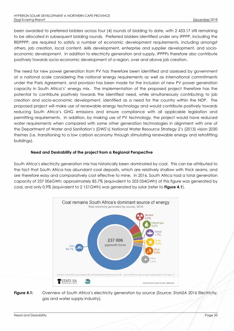
HYPERION SOLAR DEVELOPMENT 4, NORTHERN CAPE PROVINCEFinal Scoping Report December 2018
Need and Desirability Page 53
been awarded to preferred bidders across four (4) rounds of bidding to date, with 2 433.17 still remaining
to be allocated in subsequent bidding rounds. Preferred bidders identified under any IPPPP, including the
REIPPPP, are required to satisfy a number of economic development requirements, including amongst
others, job creation, local content, skills development, enterprise and supplier development, and socio-
economic development. In addition to electricity generation and supply, IPPPPs therefore also contribute
positively towards socio-economic development of a region, over and above job creation.
The need for new power generation from PV has therefore been identified and assessed by government
at a national scale considering the national energy requirements as well as international commitments
under the Paris Agreement, and provision has been made for the inclusion of new PV power generation
capacity in South Africa’s’ energy mix. The implementation of the proposed project therefore has the
potential to contribute positively towards the identified need, while simultaneously contributing to job
creation and socio-economic development, identified as a need for the country within the NDP. The
proposed project will make use of renewable energy technology and would contribute positively towards
reducing South Africa’s GHG emissions and ensure compliance with all applicable legislation and
permitting requirements. In addition, by making use of PV technology, the project would have reduced
water requirements when compared with some other generation technologies in alignment with one of
the Department of Water and Sanitation’s (DWS’s) National Water Resource Strategy 2’s (2013) vision 2030
themes (i.e. transitioning to a low carbon economy through stimulating renewable energy and retrofitting
buildings).
Need and Desirability of the project from a Regional Perspective
South Africa’s electricity generation mix has historically been dominated by coal. This can be attributed to
the fact that South Africa has abundant coal deposits, which are relatively shallow with thick seams, and
are therefore easy and comparatively cost effective to mine. In 2016, South Africa had a total generation
capacity of 237 006GWh; approximately 85.7% (equivalent to 203 054GWh) of this figure was generated by
coal, and only 0.9% (equivalent to 2 151GWh) was generated by solar (refer to Figure 4.1).
Figure 4.1: Overview of South Africa’s electricity generation by source (Source: StatsSA 2016 Electricity,
gas and water supply industry).

HYPERION SOLAR DEVELOPMENT 4, NORTHERN CAPE PROVINCEFinal Scoping Report December 2018
Need and Desirability Page 54
Whereas the majority of South Africa’s electricity generation infrastructure is currently located within
Mpumalanga Province due to the location of coal resources within this province, the Northern Cape
Province has been identified as an area where the development of SEFs is a feasible and suitable option
for electricity generation.
The Kathu area has been earmarked as a hub for the development of solar energy projects due to the
viability of the solar resource for the area. The overarching objective for the SEF is to maximise electricity
production through exposure to the solar resource, while minimising infrastructure, operational and
maintenance costs, as well as social and environmental impacts. From a regional site selection
perspective, this region is considered to be preferred for solar energy development by virtue of its annual
solar irradiation values. The GHI for the area derived from the World Bank Group’s Global Solar Atlas is
approximately 2 227.5kWh/m2/annum, almost equivalent to the highest GHI values in the country (refer to
Figure 4.2).
Figure 4.2: Solar irradiation map for South Africa; the proposed position of Hyperion Solar Development
4 is shown by the yellow star on the map. (Source: World Bank Groups Global Solar Atlas).
Receptiveness of the proposed project site to development of Hyperion Solar Development 4
The placement of a solar PV facility is strongly dependent on several factors including climatic conditions
(solar radiation levels), topography, the location of the site particularly in the location of a developed
node for solar projects, availability of grid connection, the extent of the site, and the need and desirability
for the project. From a local level perspective, the project site has specifically been identified by the
project applicant as being highly desirable from a technical perspective for the development of a solar
facility due to the following site characteristics:

HYPERION SOLAR DEVELOPMENT 4, NORTHERN CAPE PROVINCEFinal Scoping Report December 2018
Need and Desirability Page 55
» Solar resource: The economic viability of a solar facility is directly dependent on the annual direct solar
irradiation values. The GHI for the proposed project site is in the region of approximately
2 227.5kWh/m2/annum, which is well suited to the development of a commercial SEF.
» Topography: A surface area with favourable topography facilitates the work involved in construction
and maintenance of the SEF. The proposed project site is characterised as having flat topography
with slopes of 0 – 3% across the full extent of the site.
» Site extent: The project site is approximately 1600ha in extent, which is sufficient for the installation of
the facility allowing for avoidance of site sensitivities. The development area of the facility would
occupy an area equivalent to approximately 12.5% of the full project site. The development areas of
four (4) SEFs would comprise ~50% of the total extent of the project site.
» Site access: Access to the project site is obtained via the T26 gravel road which can be accessed from
the N14 national route located approximately 6km south of the project site.
» Grid access: A key factor in the siting of any project is that the project must have a viable grid
connection. Grid connection options are available via the existing Ferrum Substation which is located
approximately 16km south of the project site.
» Land suitability: There is no cultivated agricultural land within the affected properties (as a result of low
agricultural potential) which could be impacted upon by the proposed SEF. The affected property is
currently used for livestock grazing and the majority of farming practices can continue in tandem to
the operation of the SEF once the construction and commissioning of the project is complete.
» Geographic location: The proposed project site is located within an area which has become a node
for renewable energy projects, with the following existing solar facilities in close proximity to the project
site: Kalahari Solar Power Project, Sishen Solar Farm, and Kathu Solar Farm. The proposed project site is
in close proximity to an existing cluster or node for solar PV development and therefore compliments
existing and future land use.
» Landowner support: The selection of a project site where the landowner is supportive of the
development of renewable energy is essential for ensuring the success of the project. The landowner
does not view the development as a conflict with their current or future land use practices.
4.5.1. Benefits of Renewable Energy and the Need and Desirability thereof
The generation of electricity from renewable energy resources offers a range of potential socio-economic
and environmental benefits for South Africa; these include:
Socio-economic upliftment of local communities: The proposed project has the potential to create much
needed employment for unskilled locals during the construction phase. Training opportunities will also be
afforded to qualified local people who can be up-skilled to undertake certain roles during the construction
and operation phases. In terms of the needs of the local community, the Local and District Municipality
IDPs identified the need to facilitate economic development by creating an environment which is
conducive for business development, economic growth, sustainable employment opportunities and
growth in personal income levels of communities; unlock opportunities to increase participation amongst
all sectors of society in the mainstream economy to create decent job opportunities; promote Local
Economic Development; and enhance rural development and agriculture. The project has the potential
to make a positive contribution towards the identified community needs. In terms of the economic
development requirements of the REIPPP Programme, the project will commit benefits to the local
community, in the form of job creation, localisation, and community ownership. In accordance with the
DoE bidding requirements of the REIPPP Programme, a percentage of the revenue generated per annum

HYPERION SOLAR DEVELOPMENT 4, NORTHERN CAPE PROVINCEFinal Scoping Report December 2018
Need and Desirability Page 56
during operation will be made available to local communities through a social beneficiation scheme.
Therefore, the potential for creation of employment and business opportunities, and the opportunity for
skills development for local communities is significant. Secondary social benefits can be expected in terms
of additional spend in nearby towns due to the increased demand for goods and services. These socio-
economic benefits would include an increase in the standard of living for local residents within the area as
well as overall financial and economic upliftment.
Increased energy security: Given that renewables can often be deployed in a short timeframe and in a
decentralised manner close to consumers, they offer the opportunity for improving grid strength and
supply quality in the short-term, while reducing expensive distribution losses. As a result of the power
constraints in the first half of 2015, power generators meant to be the “barely-ever-used” safety net for the
system (diesel-fired gas turbines) were running at >30% average load factor in the first half of 2015. Load
shedding occurred during 82 days in the first half of 2015 (out of 181 days). Results of a CSIR Energy Centre
study for the period January to June 2015 (CSIR, August 2015), concluded that the already implemented
renewable projects (wind and solar) within the country avoided 203 hours of so-called 'unserved energy'.
During these hours the supply situation was such that some customer’s energy supply would have had to
be curtailed ('unserved') had it not been for the renewables. The avoidance of unserved energy
cumulated into the effect that during 15 days from January to June 2015 load shedding was avoided
entirely, delayed, or a higher stage of load shedding prevented due to the contribution of renewable wind
and PV projects12.
Resource saving: It is estimated that the achievement of the targets in the Renewable Energy White Paper
will result in water savings of approximately 16.5 million kilolitres per annum. As an already water-stressed
nation, it is critical that South Africa engages in a variety of water conservation measures, particularly due
to the detrimental effects of climate change on water availability. Renewable energy also translates into
revenue savings, as fuel for renewable energy facilities is free while compared to the continual purchase
of fuel for conventional power stations. Results of a CSIR Energy Centre study for January – June 2015
(CSIR, August 2015) have quantified the contribution from renewable energy to the national power system
and the economy over the first 6 months of 2015 compared to the 12 months of 2014:
2015 (6 months) 2014 (12 months)
R3.60 billion saving in diesel and coal fuel costs R3.64 billion saving in diesel and coal fuel costs
200 hours of unserved energy avoided, saving at least an
additional R1.20 billion–R4.60 billion for the economy
120 hours of unserved energy avoided, saving at least an
additional R1.67 billion for the economy
Generated R4.0 billion more financial benefits than cost Generated R0.8 billion more financial benefits than cost
Exploitation of significant renewable energy resource: At present, valuable renewable resources including
biomass by-products, solar radiation and wind power remain largely unexploited. The use of these energy
flows will strengthen energy security through the development of a diverse energy portfolio in South Africa.
12 (http://ntww1.csir.co.za/plsql/ptl0002/PTL0002_PGE157_MEDIA_REL?MEDIA_RELEASE_NO=7526896)

HYPERION SOLAR DEVELOPMENT 4, NORTHERN CAPE PROVINCEFinal Scoping Report December 2018
Need and Desirability Page 57
Economics: As a result of the excellent renewable energy resources and competitive procurement
processes, both wind power and solar PV power have now been proven as cheaper forms of energy
generation in South Africa than coal power. They offer excellent value for money to the economy and
citizens of South Africa while benefitting society as a whole through the development of clean energy.
Pollution reduction: The release of by-products through the burning of fossil fuels for electricity generation
have a particularly hazardous impact on human health and contribute to ecosystem degradation. The
use of solar radiation or wind for power generation is a non-consumptive use of a natural resource which
produces zero emissions during its operation.
Climate friendly development: The uptake of renewable energy offers the opportunity to address energy
needs in an environmentally responsible manner and thereby allows South Africa to contribute towards
mitigating climate change through the reduction of GHG emissions. South Africa is estimated to currently
be responsible for approximately 1% of global GHG emissions (and circa half of those for which Africa is
responsible) and is currently ranked 9th worldwide in terms of per capita carbon dioxide emissions. Since its
inception the REIPPP Programme has achieved carbon emission reductions13 of 25.3 million tonnes of CO2
(IPP Office, March 2018). The development of Hyperion Solar Development 4, and the associated
electricity generated as a result of the SEF, will result in considerable savings on tons of CO2 emissions.
Support for international agreements: The effective deployment of renewable energy provides a tangible
means for South Africa to demonstrate its commitment to its international agreements under the Kyoto
Protocol, and for cementing its status as a leading player within the international community.
Employment creation: The development, procurement, installation, maintenance and management of
renewable energy facilities have significant potential for job creation and skills development in South
Africa. By the end of March 2018, the REIPPP Programme had created 35 702 job years (equivalent of a
full-time employment opportunity for one person for one year) for South African citizens including people
from communities local to IPP operations (IPP Office, March 2018).
Acceptability to society: Renewable energy offers a number of tangible benefits to society including
reduced pollution concerns, improved human and ecosystem health and climate friendly development.
Support to a new industry sector: The development of renewable energy offers the opportunity to establish
a new industry within the South African economy, which will create jobs and skill local communities which
have potential for further renewable energy projects.
Protecting the natural foundations of life for future generations: Actions to reduce our disproportionate
carbon footprint can play an important part in ensuring our role in preventing dangerous anthropogenic
climate change; thereby securing the natural foundations of life for generations to come. This is the basis
of sustainable development.
13 Carbon emission reduction is calculated based on a displacement of power, from largely coal-based to more environmentally
friendly electrical energy generation, using a gross Eskom equivalent emissions factor of 1.015 tons CO2/MWh.

HYPERION SOLAR DEVELOPMENT 4, NORTHERN CAPE PROVINCEFinal Scoping Report December 2018
Approach to Undertaking the Scoping Phase Page 58
APPROACH TO UNDERTAKING THE SCOPING PHASE
An Environmental Impact Assessment (EIA) process refers to the process undertaken in accordance with
the requirements of the relevant EIA Regulations (the 2014 EIA Regulations (GNR 326), as amended), which
involves the identification and assessment of direct, indirect, and cumulative, environmental impacts
associated with a proposed project or activity. The EIA process comprises two main phases: i.e. Scoping
and EIA Phase.
The EIA process is illustrated in Figure 5.1.
Figure 5.1: The Phases of an Environmental Impact Assessment (EIA) Process
Legal Requirements as per the EIA Regulations 2014 (as amended)
This chapter of the Scoping Report includes the following information required in terms of Appendix 2:
Content of the Scoping Report:
Requirement Relevant Section
(d)(i) a description of the scope of the proposed activity,
including all listed and specified activities triggered and
being applied for and (ii) a description of the activities to
be undertaken, including associated structures and
infrastructure.
All listed activities triggered and applied for are included
in section 5.2.
(g)(ii) details of the public participation process
undertaken in terms of Regulation 41 of the Regulations,
including copies of the supporting documents and
inputs.
The public participation process followed throughout the
EIA process of Hyperion Solar Development 4 is included
in section 5.5.2 and copies of the supporting documents
and inputs are included in Appendix C.
(g)(iii) a summary of the issues raised by interested and
affected parties, and an indication of the manner in
which the issues were incorporated, or the reasons for not
including them.
The main issues raised through the undertaking of the
public participation process including consultation with
I&APs are included in the Comments and Responses
Report in Appendix C8.
(g)(vi) the methodology used in determining and ranking
the nature, significance, consequences, extent, duration
and probability of potential environmental impacts and
risks associated with the alternatives;
The methodology used in determining and ranking the
nature, significance, consequences, extent, duration and
probability of potential environmental impacts and risks
associated with the alternatives are included in section
5.6.1.

HYPERION SOLAR DEVELOPMENT 4, NORTHERN CAPE PROVINCEFinal Scoping Report December 2018
Approach to Undertaking the Scoping Phase Page 59
Relevant legislative permitting requirements
The legislative permitting requirements applicable to Hyperion Solar Development 4, as identified at this
stage in the process and considered within this EIA process, are described in more detail under the
respective sub-headings. Additional permitting requirements are detailed within Section 5.7.
5.2.1. National Environmental Management Act (No. 107 of 1998) (NEMA)
NEMA (No. 107 of 1998) is South Africa’s key piece of national environmental legislation that provides for
the authorisation of certain controlled activities known as “listed activities”. In terms of Section 24(1) of
NEMA, the potential impact on the environment associated with listed activities must be considered,
investigated, assessed and reported on to the Competent Authority (the decision-maker - CA) charged by
NEMA with granting of the relevant EA. Due to the fact that Hyperion Solar Development 4 is a power
generation project and therefore relates to the IRP for Electricity 2010 – 2030, the National DEA has been
determined as the CA in terms of GNR 779 of 01 July 2016. The Provincial Northern Cape DENC is a
Commenting Authority on the project.
The need to comply with the requirements of the EIA Regulations published under NEMA ensures that
developers are provided the opportunity to consider the potential environmental impacts of their activities
early in the project development process, and also allows for an assessment to be made as to whether
environmental impacts can be avoided, minimised or mitigated to acceptable levels. Comprehensive,
independent environmental studies are required to be undertaken in accordance with the EIA Regulations
to provide the competent authority with sufficient information in order for an informed decision to be
taken regarding the project.
The EIA process being conducted for Hyperion Solar Development 4 is being undertaken in accordance
with Section 24 (5) of the National Environmental Management Act (No. 107 of 1998) (NEMA). Section 24
(5) of NEMA pertains to EAs, and requires that the potential consequences for, or impacts of, listed or
specified activities on the environment be considered, investigated, assessed, and reported on to the
competent authority. Listed Activities are activities identified in terms of Section 24 of NEMA which are
likely to have a detrimental effect on the environment, and which may not commence without EA from
the competent authority subject to the completion of an environmental assessment process (either a BA of
full S&EIA).
Table 5.1 contains all the listed activities identified in terms of NEMA, the 2014 EIA Regulations (GNR 326),
and Listing Notice 1 (GNR 327), Listing Notice 2 (GNR 325), and Listing Notice 3 (GNR 324) which may be
triggered by the proposed development of Hyperion Solar Development 4, and for which EA has been
applied:
Table 5.1: Listed activities identified in terms of the Listing Notices (GNR 327, 325 and 324).
Notice Number Activity Number Description of listed activity
Listing Notice 1
(GNR 327)
08 December 2014
11 (i) The development of facilities or infrastructure for the transmission
and distribution of electricity –
(i) outside urban areas or industrial complexes with a capacity
of more than 33 but less than 275 kilovolts.

HYPERION SOLAR DEVELOPMENT 4, NORTHERN CAPE PROVINCEFinal Scoping Report December 2018
Approach to Undertaking the Scoping Phase Page 60
Notice Number Activity Number Description of listed activity
The project entails the construction of a new 132kV on-site
substation to evacuate electricity generated by the project into
the national electricity grid. The on-site substation will have a
capacity of 132kV and will be located outside of an urban area.
Listing Notice 1
(GNR 327)
08 December 2014
12(ii)(a)(c) The development of –
(ii) Infrastructure or structures with a physical footprint of 100
square metres or more
Where such development occurs-
(a) within a watercourse
(c) within 32 metres of a watercourse.
The construction of the access road Alternative 2 will be directly
within the Vlermuisleegte watercourse and will be over 100
square metres.
Listing Notice 1
(GNR 327)
08 December 2014
19 The infilling or depositing of any material of more than 10 cubic
metres into, or the dredging, excavation, removal or moving of
soil, san, shells, shell grit, pebbles or rock of more than 10 cubic
metres from a watercourse.
Access Road Alternative 1 will be required to route into the
Vlermuisleegte River and watercourse crossings will be required
to be upgraded and/or constructed.
Listing Notice 1
(GNR 327)
08 December 2014
24 (ii) The development of a road –
(ii) with a reserve wider than 13.5m, or where no reserve exists
where the road is wider than 8m.
The construction of the solar energy facility will require the
construction and formalisation of an existing two-tyre track to
provide access to the facility as well as the construction of new
access roads up to 9m in width.
Listing Notice 1
(GNR 327)
08 December 2014
28 (ii) Residential, mixed, retail, commercial, industrial or institutional
developments where such land was used for agriculture, game
farming, equestrian purposes or afforestation on or after 01 April
1998 and where such development:
(ii) will occur outside an urban area, where the total land to be
developed is bigger than 1ha;
excluding where such land has already been developed for
residential, mixed, retail, commercial, industrial or institutional
purposes.
The total area of land to be developed for the solar energy
facility is larger than 1 hectare. The site is currently used for
agricultural purposes. The total extent of the development
footprint is 180ha.
Listing Notice 1
(GNR 327)
08 December 2014
48 (i)(a)(c) The expansion of –
(ii) infrastructure or structures with a physical footprint of 100
square metres or more;
(a) within a watercourse

HYPERION SOLAR DEVELOPMENT 4, NORTHERN CAPE PROVINCEFinal Scoping Report December 2018
Approach to Undertaking the Scoping Phase Page 61
Notice Number Activity Number Description of listed activity
(c) within 32 metres of a watercourse.
The upgrading of Access Road Alternative 1 within 32m and
within the Vlermuisleegte River will require the widening of the
road by 4m for approximately 2km.
Listing Notice 2
(GNR 325)
08 December 2014
1 The development of facilities or infrastructure for the generation
of electricity from a renewable resource where the electricity
output is 20MW or more.
The project comprises a renewable energy generation facility,
which will utilise photovoltaic (PV) technology and will have a
generation capacity of up to 75MW. The development is
located outside of an urban area and is proposed to be ground-
mounted.
Listing Notice 2
(GNR 325)
08 December 2014
15 The clearance of an area of 20ha or more of indigenous
vegetation14.
The project requires the clearance of an area up to 180ha
(equivalent to the development footprint) of vegetation. The
project is proposed on an agricultural property where the pre-
dominant land use is livestock grazing, and is therefore likely to
comprise indigenous vegetation. The project would therefore
result in the clearance of an area of land greater than 20ha of
indigenous vegetation.
Listing Notice 3
(GNR 324)
08 December 2014
4(g)(ee) The development of a road wider than 4 meters with a reserve
less than 13,5 meters
(g) in Northern Cape
(ee) within Critical biodiversity areas identified in bioregional
plans adopted by the competent authority or in bioregional
plans.
The development of a newly proposed access road (Alternative
2) wider than 4 meters is required for the solar energy facility. A
section of Alternative 2 is located within a critical biodiversity
area identified in the Northern Cape Critical Biodiversity Areas
(CBA) Map.
Listing Notice 3
(GNR 324)
08 December 2014
12(g)(ii) The clearance of an area of 300m² or more of indigenous
vegetation.
(g) in the Northern Cape
(ii) within critical biodiversity areas identified in bioregional plans
The clearance of approximately 18 600m² (to be confirmed
14 “Indigenous vegetation” as defined by the 2014 EIA Regulations (GNR 326) refers to vegetation consisting of indigenous plant
species occurring naturally in an area, regardless of the level of alien infestation and where the topsoil has not been lawfully
disturbed during the preceding ten years.

HYPERION SOLAR DEVELOPMENT 4, NORTHERN CAPE PROVINCEFinal Scoping Report December 2018
Approach to Undertaking the Scoping Phase Page 62
Notice Number Activity Number Description of listed activity
during the EIA Phase once the footprint has been finalised and
assessed in the applicable Phase) of indigenous vegetation will
be required for Access Road Alternative 2. A section of the
access road is located within a critical biodiversity area as
identified in the Northern Cape Critical Biodiversity Areas (CBA)
Map.
Listing Notice 3
(GNR 324)
08 December 2014
18(g)(ii)(ee) The widening of a road by more than 4 metres or lengthening of
a road by more than 1 km
(g) in Northern Cape
(ii) outside urban areas
(ee) critical biodiversity areas as identified in systematic
biodiversity plans adopted by the competent authority or in
bioregional plans.
The Access Road Alternative 2 will require widening of more
than 4m. A section of the access road is located within a critical
biodiversity area as identified in the Northern Cape Critical
Biodiversity Areas (CBA) Map.
5.2.2. National Water Act (No. 36 of 1998) (NWA)
In accordance with the provisions of the National Water Act (No. 36 of 1998) (NWA), all water uses must be
licensed with the Competent Authority (i.e. the Regional Department of Water and Sanitation (DWS) or the
relevant Catchment Management Agency (CMA)). Water use is defined broadly, and includes taking
and storing water, activities which reduce stream flow, waste discharges and disposals, controlled
activities (activities which impact detrimentally on a water resource), altering a watercourse, removing
water found underground for certain purposes, and recreation.
Table 5.2 contains Water Uses associated with the proposed project and identified in terms of the NWA
which require licensing either in the form of a General Authorisation (GA), or in the form of a Water Use
License (WUL). The table also includes a description of those project activities which relate to the
applicable Water Uses.
Table 5.2: List of Water Uses published under Section 21 of NWA, as amended.
Notice No. Activity No. Description of Water Use
NWA
(No. 36 of 1998)
Section 21 (a) Taking water from a groundwater resource
Hyperion Solar Development 4 will utilise water during both
construction and operation. Water is required during
construction for dust suppression, and potable water will be
required on site for the construction crew. During operation,
water is required to clean the PV panels, for human
consumption, and for use in the auxiliary buildings (i.e. for use
in the office building, ablutions, and canteen, etc.).
Approximately 10 000m³ of water is required per year over a
12-month period during construction, and approximately
50 000m³ of water is required per year over the 25 year
operation of the project. Water is proposed to be sourced
from two boreholes located in the project site.

HYPERION SOLAR DEVELOPMENT 4, NORTHERN CAPE PROVINCEFinal Scoping Report December 2018
Approach to Undertaking the Scoping Phase Page 63
Notice No. Activity No. Description of Water Use
NWA
(No. 36 of 1998)
Section 21 (c) Impeding or diverting the flow of water in a watercourse
Infrastructure associated with Hyperion Solar Development 4
will be located within the GN 509 regulated area of a
watercourse (100m zone surrounding the identified river).
NWA
(No. 36 of 1998)
Section 21 (i) Altering the bed, banks, course or characteristics of a
watercourse.
Infrastructure associated with Hyperion Solar Development 4
will be located within the GN 509 regulated area of a
watercourse (100m zone surrounding the identified river).
In the event that water is sourced from a borehole, application would need to be made for a WUL in
accordance with the requirements of the Regulations Regarding the Procedural Requirements for Water
Use License Applications and Appeals (GNR 267), or a GA registered in accordance with the requirements
of Revision of General Authorisation for the Taking and Storing of Water (GNR 538). The process of applying
for a WUL or GA registration will only be completed once a positive EA has been received and the project
selected as a Preferred Bidder; this is in line with the requirements of the DWS.
5.2.3. National Heritage Resources Act (No. 25 of 1999) (NHRA)
The National Heritage Resources Act (No. 25 of 1999) (NHRA) provides an integrated system which allows
for the management of national heritage resources, and to empower civil society to conserve heritage
resources for future generations. Section 38 of NHRA provides a list of activities which potentially require
the undertaking of a Heritage Impact Assessment.
Section 38: Heritage Resources Management
1). Subject to the provisions of subsections (7), (8) and (9), any person who intends to undertake a
development categorised as –
a. the construction of a road, wall, power line, pipeline, canal or other similar form of linear
development or barrier exceeding 300m in length;
b. the construction of a bridge or similar structure exceeding 50m in length;
c. any development or other activity which will change the character of a site –
i). exceeding 5 000m² in extent; or
ii). involving three or more existing erven or subdivisions thereof; or
iii). involving three or more erven or divisions thereof which have been consolidated
within the past five years; or
iv). the costs of which will exceed a sum set in terms of regulations by SAHRA or a
provincial heritage resources authority;
Must at the very earliest stages of initiating such a development, notify the responsible heritage
resources authority and furnish it with details regarding the location, nature and extent of the
proposed development.
In terms of Section 38(8), approval from the heritage authority is not required if an evaluation of the impact
of such development on heritage resources is required in terms of any other legislation (such as NEMA),
provided that the consenting authority ensures that the evaluation of impacts fulfils the requirements of the
relevant heritage resources authority in terms of Section 38(3) and any comments and recommendations

HYPERION SOLAR DEVELOPMENT 4, NORTHERN CAPE PROVINCEFinal Scoping Report December 2018
Approach to Undertaking the Scoping Phase Page 64
of the relevant resources authority with regard to such development have been taken into account prior
to the granting of the consent. However, should heritage resources of significance be affected by the
proposed development, a permit is required to be obtained prior to disturbing or destroying such resources
as per the requirements of Section 48 of the NHRA, and the South African Heritage Resources Agency
(SAHRA) Permit Regulations (GNR 668).
Overview of the Scoping and EIA (S&EIA) Process being undertaken for the project
In terms of NEMA, the 2014 EIA Regulations (GNR 326), and Listing Notices (Listing Notice 1 (GNR 327), Listing
Notice 2 (GNR 325), and Listing Notice 3 (GNR 324)), the development of Hyperion Solar Development 4
requires EA from DEA subject to the completion of a full Scoping and Environmental Impact Assessment
(S&EIA), as prescribed in Regulations 21 to 24 of the 2014 EIA Regulations (GNR 326). The need for a full
S&EIA process to be conducted in support of the application for EA is due to the fact that listed activities
contained within Listing Notice 2 (GNR 325) are likely to be triggered.
The S&EIA process is to be undertaken in two phases as follows:
» The Scoping Phase includes the identification and description of potential issues associated with the
project through a desktop study and consultation with I&APs and key stakeholders through a Public
Participation process. The entire project site is considered within this process at a desktop level.
Through this study, areas of sensitivity within the broader site are identified and delineated in order to
identify any environmental fatal flaws, and environmentally sensitive, or no-go areas. In accordance
with Regulation 21(1) of the 2014 EIA Regulations (GNR 326) the Scoping Report prepared for the
project was subject to a 30-day review period during which members of the public, Interested and
Affected Parties (I&APs), and authorities were invited to review and provide comment on the Scoping
Report (refer to Figure 5.2). Following the conclusion of this review period this a Final Scoping Report,
has been prepared for submission to DEA for its consideration. Following its receipt of the Final Scoping
Report DEA has 43 days within which to either accept the Scoping Report, and advise the applicant to
proceed or continue with the tasks contemplated in the Plan of Study for EIA, or refuse EA in the event
that the proposed activity is in conflict with a prohibition contained in legislation, or the Scoping Report
does not substantially comply with Appendix 2 of the 2014 EIA Regulations (GNR 326).
» The EIA Phase involves a detailed assessment of potentially significant positive and negative direct,
indirect, and cumulative impacts identified during the Scoping Phase. This phase includes detailed
specialist investigations and a Public Participation process, and results in the compilation of an EIA
Report and Environmental Management Programme (EMPr). In accordance with Regulation 23(1)(a)
of the 2014 EIA Regulations (GNR 326) the EIA Report and EMPr prepared for the project will also be
subject to a 30-day public review period during which members of the public, I&APs, and authorities
will be invited to review and provide comment on the EIA Report and EMPr. Following the conclusion
of this review period a Final EIA Report and EMPr which incorporates all comments received during the
30-day review period, will be prepared and submitted to DEA for its consideration. Following its receipt
of the Final EIA Report and EMPr, DEA has 107 days within which to either grant or refuse EA.

HYPERION SOLAR DEVELOPMENT 4, NORTHERN CAPE PROVINCEFinal Scoping Report December 2018
Approach to Undertaking the Scoping Phase Page 65
Figure 5.2: Regulated timeframe of an Environmental Impact Assessment (EIA) Process
Objectives of the Scoping Phase
This Final Scoping Report documents the evaluation of potential environmental impacts of Hyperion Solar
Development 4 and forms part of the EIA process being conducted in support of an Application for EA for
the project. The Scoping Phase has been conducted in accordance with the requirements of the 2014 EIA
Regulations (GNR 326), and therefore aims to:
» Identify and evaluate potential environmental (biophysical and social) impacts and benefits of all
phases of the proposed development (including design, construction, operation and
decommissioning) within the broader project site through a desktop review of existing baseline
data and specialist studies.
» Identify potentially sensitive environmental features and areas within the broader project site in
order to inform the preliminary design process of the facility.
» Define the scope of studies to be undertaken during the EIA process.
Project Initiation
Desktop Independent Specialist Studies
Preparation of Scoping Report (and Plan of Study for EIA)
30-day Public Review of Scoping Report
Finalise Scoping Report and submit to DEA
DEA decision-making on Scoping Report (43 days)
Detailed Independnent Specialist Studies and Site Work
Preparation of EIA Report
30-day Public Review of EIA Report
Finalise EIA Report and submit to DEA
DEA decision-making on EIA Report (107 days)
Issuance of Environmental Authoritsation (EA)
Scoping
Phase
EIA
Phase

HYPERION SOLAR DEVELOPMENT 4, NORTHERN CAPE PROVINCEFinal Scoping Report December 2018
Approach to Undertaking the Scoping Phase Page 66
» Provide the authorities with sufficient information in order to make a decision regarding the scope
of issues to be addressed in the EIA process, as well as regarding the scope and extent of specialist
studies that will be required to be undertaken as part of the EIA Phase.
The following objectives of the Scoping Phase (in accordance with Appendix 2 of the 2014 EIA Regulations
(GNR 326)) have been met, through the undertaking of a consultative process and with the assistance of
specialist input.
» The identification of relevant policies and legislation regarding the activities to be undertaken have
been identified and considered within this Final Scoping Report.
» Activities to be undertaken for the development of Hyperion Solar Development 4 have been
identified and motivated in terms of the need and desirability for the activities to take place.
» Potential impacts associated with the undertaking of the identified activities and technology have
been identified and described.
» Identification of areas of high sensitivity to be avoided by the preferred development area.
» Preferred areas for the development, which are areas associated with low to medium
environmental sensitivity, have been identified within the site through a desktop level impact
assessment process and on-going consultative process. Areas of high sensitivity (i.e. the eastern
portion of the project site) have been avoided.
» Key issues associated with the project to be addressed during the EIA Phase for further detailed
study and ground-truthing have been identified and listed within this Final Scoping Report.
» The level of assessment, expertise and the extent of further consultation to be undertaken in the EIA
Phase of the process, with the aim of determining the extent of impacts associated with the
activities through the life cycle of the project (i.e. construction, operation and decommissioning),
have been identified and included within this Final Scoping Report.
Overview of the Scoping Phase
Key tasks undertaken within the Scoping Phase included:
» Consultation with relevant decision-making and regulating authorities (at National, Provincial and
Local levels).
» Submission of the completed Application for EA to the competent authority (DEA) and a copy of
the form to the provincial authority (NC DENC) in terms of Regulations 5 and 16 of the 2014 EIA
Regulations (GNR 326).
» Undertaking a Public Participation process throughout the Scoping Phase in accordance with
Chapter 6 of the 2014 EIA Regulations (GNR 326) in order to identify issues and concerns associated
with the proposed development.
» Undertaking of independent specialist studies in accordance with Appendix 6 of the 2014 EIA
Regulations (GNR 326).
» Preparation of a Scoping Report and Plan of Study for EIA in accordance with the requirements of
Appendix 2 of the 2014 EIA Regulations (GNR 326).
» Preparation of a Comments and Response (C&R) Report detailing all comments raised by I&APs
and responses provided as part of the Scoping Phase.

HYPERION SOLAR DEVELOPMENT 4, NORTHERN CAPE PROVINCEFinal Scoping Report December 2018
Approach to Undertaking the Scoping Phase Page 67
5.5.1. Authority Consultation and Application for Authorisation in terms of the 2014 EIA Regulations (GNR
982)
In terms of GNR 779 of 1 July 2016, the National DEA has been determined as the competent authority for
all projects which relate to the IRP 2010 and any updates thereto. As the project is proposed within
Northern Cape Province, the Northern Cape Department of Environment and Nature Conservation (DENC)
is the provincial commenting authority for the project. Consultation with these authorities is being
undertaken throughout the Scoping Phase. Authority consultation has included the following:
» Submission of project notification letters to DEA and NC DENC.
» Submission of the Application Form for EA to DEA and NC DENC.
» Submission of the Scoping Report for review and comment by:
∗ The competent and commenting authorities.
∗ State departments that administer laws relating to a matter affecting the environment relevant
to an application for EA (i.e. Ward Councillor, Municipal Manager).
∗ Organs of state which have jurisdiction in respect of the activity to which the application
relates.
A record of authority consultation undertaken with organs of state during the Scoping phase is included in
Appendix C. No comments have been received from DEA.
5.5.2. Public Participation Process
Public participation is an essential and regulatory requirement for any EA process and is guided by
Regulations 41 to 44 of the 2014 EIA Regulations (GNR 326).
The sharing of information forms the basis of the public participation process and offers the opportunity for
Interested and Affected Parties (I&APs) to become actively involved in the EIA Process from the outset.
The public participation process is designed to provide sufficient and accessible information to I&APs in an
objective manner. The public participation process affords I&APs opportunities to provide input into and
receive information regarding the EIA process in the following ways:
» During the Scoping Phase:
∗ Identify issues of concern and suggestions for enhanced benefits.
∗ Verify that issues have been accurately recorded.
∗ Assist in identifying reasonable alternatives, where required.
∗ Contribute relevant local information and knowledge to the environmental assessment.
» During the EIA Phase:
∗ Contribute relevant local information and knowledge to the environmental assessment.
∗ Verify that issues have been considered in the environmental investigations as far as possible.
∗ Comment on the findings of the environmental assessments.
∗ Attend a Public Meeting to be conducted for the project.
» During the decision-making phase:
∗ Be advised of the outcome of the competent authority’s decision, and how and by when the
decision can be appealed.

HYPERION SOLAR DEVELOPMENT 4, NORTHERN CAPE PROVINCEFinal Scoping Report December 2018
Approach to Undertaking the Scoping Phase Page 68
The Public Participation process therefore aims to ensure that:
» Information containing all relevant facts in respect of the application is made available to
stakeholders and I&APs.
» Participation is facilitated in such a manner that I&APs are provided with a reasonable opportunity
to comment on the proposed development.
» Adequate review periods are provided to I&APs to comment on the findings of the Scoping and
EIA Reports.
Chapter 6 of the 2014 EIA Regulations (GNR 326), details the key public participation tasks required to be
undertaken. In compliance with the requirements of Chapter 6 of the 2014 EIA Regulations (GNR 326), the
following summarises the key public participation activities conducted to date:
i. Placement of Site Notices
40.(2)(a) Fixing a notice board at a place conspicuous to and accessible by the public at the boundary, on the
fence or along the corridor of –
(i) The site where the activity to which the application or proposed application relates is or is to be
undertaken; and
(ii) Any alternative site.
Site notices (in English) were placed at visible points along the boundary of the project site (i.e. on the
boundary of the Remaining Extent of the Farm Lyndoch 432), along the proposed access road alternatives
and along the N14 on 03 October 2018. The site notice text, and photographs of the site notices are
included in Appendix C2.
ii. Providing Written Notice
40.(2)(b) Giving written notice, in any of the manners provided for in section 47D15 of the Act, to –
(i) The occupiers of the site and, if the proponent or applicant is not the owner or person in control of
the site on which the activity is to be undertaken, the owner or person in control of the site where
the activity is or is to be undertaken and to any alternative site where the activity is to be
15 Section 47D of NEMA pertains to the delivery of documents, and states that:
(1) A notice or other document in terms of this Act or a specific environmental management Act may be issued to a person –
(a) By delivering it by hand;
(b) By sending it by registered mail –
(i) To that person's business or residential address; or
(ii In the case of a juristic person, to its registered address or principal place of business;
(bA)By faxing a copy of the notice or other document to the person, if the person has a fax number;
(bB) By e-mailing a copy of the notice or other document to the person, if the person has an e-mail address; or
(bC)By posting a copy of the notice or other document to the person by ordinary mail, if the person has a postal address;
(c) Where an address is unknown despite reasonable enquiry, by publishing it once in the Gazette and once in a local
newspaper circulating in the area of that person's last known residential or business address.
(2) A notice or other document issued in terms of subsection (1)(b), (bA), (bB), (bC) or (c) must be regarded as having come to the
notice of the person, unless the contrary is proved.”

HYPERION SOLAR DEVELOPMENT 4, NORTHERN CAPE PROVINCEFinal Scoping Report December 2018
Approach to Undertaking the Scoping Phase Page 69
undertaken;
(ii) Owners, persons in control of, and occupiers of land adjacent to the site where the activity is or is to
be undertaken and to any alternative site where the activity is to be undertaken;
(iii) The municipal councillor of the ward in which the site and alternative site is situated and any
organisation of ratepayers that represent the community in the area;
(iv) The municipality which has jurisdiction in the area;
(v) Any organ of state having jurisdiction in respect of any aspect of the activity; and
(vi) Any other party as required by the competent authority.
A Background Information Document (BID) was compiled in English and Afrikaans in order to provide
information on Hyperion Solar Development 4 and the EIA process being undertaken in support of the
Application for EA for the project (refer to Appendix C3). Copies of the BID and written notice notifying
I&APs of the initiation of the EIA process and copies of the BID were distributed to identified stakeholders
and I&APs on 21 September 2018. Copies of the BID were distributed to key stakeholders via email and
registered mail. The BID was also made available electronically on Savannah Environmental’s website
(www.savannahSA.com).
iii. Newspaper Advertisements
40.(2)(c) Placing an advertisement in –
(i) One local newspaper; or
(ii) Any official Gazette that is published specifically for the purpose of providing public notice of
applications or other submissions made in terms of these Regulations;
40.(2)(d) Placing an advertisement in at least one provincial newspaper or national newspaper, if the activity has
or may have an impact that extends beyond the boundaries of the metropolitan or district municipality
in which it is or will be undertaken: Provided that this paragraph need not be complied with if an
advertisement has been placed in an official Gazette referred to in paragraph (c)(ii); and
40.(2)(e) Using reasonable alternative methods, as agreed to by the competent authority, in those instances
where a person is desirous of but unable to participate in the process due to –
(i) Illiteracy;
(ii) Disability; or
(iii) Any other disadvantage.
A newspaper advertisement notifying the public of the initiation of the EIA process being undertaken was
placed in English in the Kathu Gazette newspaper on 29 September 2018. A separate advertisement
announcing the availability of the Scoping Report for a 30-day public review period and inviting the public
to review and provide comment on the report was placed in English in the Kathu Gazette newspaper on
26 October 2018.
The advertisement text and a copy of the advertisement tear sheet are included in Appendix C2 of this
Final Scoping Report for submission to DEA.
iv. Register of Interested and Affected Parties (I&APs)
42. A proponent or applicant must ensure the opening and maintenance of a register of interested and affected
parties and submit such a register to the competent authority, which register must contain the names, contact
details and addresses of –
(a) All persons who, as a consequence of the public participation process conducted in respect of that
application, have submitted written comments or attended meetings with the proponent, applicant or
EAP;

HYPERION SOLAR DEVELOPMENT 4, NORTHERN CAPE PROVINCEFinal Scoping Report December 2018
Approach to Undertaking the Scoping Phase Page 70
(b) All persons who have requested the proponent or applicant, in writing, for their names to be placed on
the register; and
(c) All organs of state which have jurisdiction in respect of the activity to which the application relates.
I&APs have been identified through a process of networking and referral, obtaining information from
Savannah Environmental’s existing stakeholder databases, undertaking of a deeds search, liaison with
potentially affected parties in the study area, and a registration process involving completion of a
registration and comment sheet. The key stakeholder groups identified to date include authorities, local
and district municipalities, ward councillors, national, provincial and local organs of state, government
bodies and state-owned companies, directly affected and adjacent landowners, environmental groups,
and non-governmental organisations.
An initial list of stakeholders identified and registered is listed in Table 5.4.
Table 5.4: List of Stakeholder Identified during the Scoping Phase
Organs of State
National Government Departments
Department of Agriculture, Forestry and Fisheries (DAFF)
Department of Energy (DoE)
Department of Environmental Affairs (including the Conservation & Biodiversity Directorate)
Department of Mineral Resources (DMR)
Department of Rural Development and Land Reform (DRDLR)
Department of Water and Sanitation (DWS)
Government Bodies and State Owned Companies
Eskom Holdings SOC Limited
National Energy Regulator of South Africa (NERSA)
South African Civil Aviation Authority (SA CAA)
South African Heritage Resources Agency (SAHRA)
South African National Roads Agency Limited (SANRAL)
Provincial Government Departments
Northern Cape Department of Agriculture
Northern Cape Department of Environment and Nature Conservation (NC DENC)
Northern Cape Department of Roads and Public Works
Ngwao Boswa Kapa Bokone (NBKB)
Local Government Departments
John Taolo Gaetsewe District Municipality
Gamagara Local Municipality
Key Stakeholders
BirdLife South Africa
Endangered Wildlife Trust (EWT)
Wildlife and Environment Society of South Africa (WESSA)
Landowners
Affected landowners and tenants
Neighbouring landowners and tenants

HYPERION SOLAR DEVELOPMENT 4, NORTHERN CAPE PROVINCEFinal Scoping Report December 2018
Approach to Undertaking the Scoping Phase Page 71
As per Regulation 42 of the 2014 EIA Regulations (GNR 326), all relevant stakeholder and I&AP information
has been recorded within a register of I&APs (refer to Appendix C1 for a list of recorded parties). The
register of I&APs contains the names, contact details and addresses of:
» All persons who requested to be registered on the database in writing.
» All organs of state which hold jurisdiction in respect of the activity to which the application relates.
» All persons who submitted written comments or attended meetings during the public participation
process.
While I&APs have been encouraged to register their interest in the EIA process from the onset, the
identification and registration of I&APs will be on-going for the duration of the EIA process. The register of
I&APs will be updated throughout the EIA process, and will act as a record of the parties involved in the
Public Participation process.
v. Registered Interested and Affected Parties (I&APs) entitled to Comment on Reports and Plans
43.(1) A registered interested and affected party is entitled to comment, in writing, on all reports or plans
submitted to such party during the public participation process contemplated in these Regulations and to
bring to the attention of the proponent or applicant any issues which that party believes may be of
significance to the consideration of the application, provided that the interested and affected party
discloses any direct business, financial, personal or other interest which that party may have in the approval
or refusal of the application.
(2) In order to give effect to section 24O of the Act, any State department that administers a law relating to a
matter affecting the environment must be requested, subject to regulation 7(2), to comment within 30 days.
44.(1) The applicant must ensure that the comments of interested and affected parties are recorded in reports
and plans and that such written comments, including responses to such comments and records of
meetings, are attached to the reports and plans that are submitted to the competent authority in terms of
these Regulations.
(2) Where a person desires but is unable to access written comments as contemplated in subregulation (1) due
to –
(a) A lack of skills to read or write;
(b) Disability; or
(c) Any other disadvantage;
Reasonable alternative methods of recording comments must be provided for.
I&APs registered on the database were notified by means of notification letters of the release of the
Scoping Report for a 30-day public review period, invited to provide comment on the Scoping Report, and
informed of the manner in which, and timeframe within which such comment must be made. Registered
I&APs will also be provided with an opportunity to review and comment on the EIA Report and EMPr to be
prepared for the project as part of the EIA Phase.
vi. Comments of Interested and Affected Parties (I&APs) to be Recorded in Reports and Plans
Comments received from I&APs to date and responses by the EAP and/or applicant have been included
in a C&R Report attached as Appendix C8 to this Final Scoping Report. The C&R Report includes detailed
responses from members of the EIA project team and / or project proponent.

HYPERION SOLAR DEVELOPMENT 4, NORTHERN CAPE PROVINCEFinal Scoping Report December 2018
Approach to Undertaking the Scoping Phase Page 72
Comments received during the 30-day public review period have also been incorporated into the C&R
Report, and attached as an Appendix C8 to this Final Scoping Report to be submitted to DEA for its review
and consideration.
The C&R Report will be treated as a living document for the duration of the EIA process and will be
updated as necessary throughout the process. Where applicable comments will be used to inform the
preparation of reporting required as part of the EIA process being undertaken.
vii. Consultation
In order to accommodate the varying needs of stakeholders and I&APs within the communities
surrounding the project site, as well as capture their views, issues, and concerns regarding the project,
various opportunities have been and will continue to be provided in order for I&APs to have their issues
noted. I&APs are being consulted through the following means:
» Focus group meetings (pre-arranged and stakeholders invited to attend).
» One-on-one consultation meetings (for example with directly affected or surrounding landowners).
» Telephonic consultation sessions with organs of state and key stakeholders.
» Written, faxed or email correspondence.
The Scoping Report was made available for a 30-day public review period from 26 October 2018 to 26
November 2018 at the following locations:
» Hard copy at the Kathu Public Library, 1 Hendrik van Eck Road, Kathu
» Available for download at www.savannahSA.com.
All registered I&APs were notified of the availability of the Scoping Report for review via email and
registered post (refer to Appendix C5), while a newspaper advertisement informing the general public of
the availability of the Scoping Report for review was placed in English in the Kathu Gazette Newspaper
(refer to Appendix C2 for advertisement text and a copy of the tear sheet). Comments received from
I&APs during the 30-day review period have been collated and responded to in a C&R Report, to be
included in this Final Scoping Report to be submitted to DEA for acceptance.
Within the 30-day review period of the scoping report focus group meetings were held with key
stakeholders, including the relevant authorities, the affected and adjacent landowners and key
representatives of the surrounding communities (refer to Table 5.5).
A summary of consultation activities undertaken as part of the public participation process is provided in
Table 5.4 below.
Table 5.4: Summary of consultation undertaken with I&APs for Hyperion Solar Development 4
Scoping Phase Activity Date
Placement of site notices 03 October 2018
Distribution of EIA process notification letters and background
information document (BID)21 September 2018
Distribution of written notices notifying I&APs of the availability of
the Scoping Report for a 30-day review period.26 October 2018

HYPERION SOLAR DEVELOPMENT 4, NORTHERN CAPE PROVINCEFinal Scoping Report December 2018
Approach to Undertaking the Scoping Phase Page 73
30-day Scoping Report review period.26 October 2018 – 26 November
2018
Focus Group Meetings:
» Department of Agriculture, Forestry and Fisheries
» Adjacent landowners.
08 November 2018 to 09
November 2018
A record of all consultation undertaken for the project to date is included in Appendix C.
5.5.3. Evaluation of Issues Identified through the Scoping Process
Direct, indirect, and cumulative environmental impacts associated with the project identified during the
Scoping Phase have been evaluated through desktop studies. In identifying and evaluating potential
impacts, the following specialists have provided input into this Final Scoping Report.
Table 5.3: List of specialists providing an evaluation of potential impacts associated with Hyperion
Solar Development 4
Specialist Study Specialist Company Specialist Name Appendix
Ecology 3Foxes Biodiversity Solutions Simon Todd Appendix D
Avifauna 3Foxes Biodiversity Solutions Simon Todd Appendix E
Freshwater Ecology Scientific Aquatic Services Stephen van Staden Appendix F
Soils, Land Use, Land
Capability and Agricultural
Potential
Terra Africa Environmental
Consultants
Mariné Pienaar Appendix G
Visual Environmental Planning
and Design
Jon Marshall Appendix H
Heritage (Archaeology and
Palaeontology)
Asha Consulting (in
consultation with John
Almond of Natura Viva)
Jayson Orton Appendix I
Social Savannah Environmental Sarah Watson Appendix J
In order to evaluate issues and assign an order of priority, the following methodology was used to identify
the characteristics of each potential issue/impact:
» The nature, which includes a description of what causes the impact, what will be affected and how it
will be affected.
» The extent, wherein it is indicated whether the impact will be local (limited to the immediate area or
site of development), regional or national.
» Identify sensitive receptors that may be impacted on by the proposed development and the types of
impacts that are most likely to occur.
» The significance of potential impacts in terms of the requirements of the 2014 EIA Regulations
(including (nature, significance, consequence, extent, duration and probability of the impacts, the
degree to which these impacts:
(a) Can be reversed;
(b) May cause irreplaceable loss of resources; and
(c) Can be avoided, managed or mitigated.
» Identify the potential impacts that will be considered further in the EIA Phase through detailed
investigations.
HYPERION SOLAR DEVELOPMENT 4, NORTHERN CAPE PROVINCEFinal Scoping Report December 2018
Approach to Undertaking the Scoping Phase Page 74
The evaluation of the issues resulted in a description of the nature, significance, consequence, extent,
duration and probability of the identified issues, as well as recommendations regarding further studies
required within the EIA Phase. Specialist Scoping Reports are contained within Appendices D – J.
5.5.4. Finalisation of the Scoping Report
The final stage of the Scoping Phase entails the capturing of comments received from stakeholders and
I&APs on the Scoping Report in order to finalise the Scoping Report for submission to DEA for decision-
making.
Legislation and Guidelines that have informed the preparation of this Final Scoping Report
The following legislation and guidelines have informed the scope and content of this Scoping Report:
» National Environmental Management Act (Act No. 107 of 1998)
» The 2014 EIA Regulations (GNR 326), as amended, and the relevant Listing Notices published under
Chapter 5 of NEMA (GNR 327, GNR 325, and GNR 324).
» International guidelines – the Equator Principles and the International Finance Corporation (IFC)
Performance Standards (including Environmental, Health and Safety (EHS) Guidelines).
Several other Acts, standards or guidelines have also informed the project process and the scope of issues
addressed and assessed in this Final Scoping Report. A review of legislative requirements applicable to the
proposed project is provided in Table 5.6.

HYPERION SOLAR DEVELOPMENT 4, NORTHERN CAPE PROVINCEFinal Scoping Report December 2018
Approach to Undertaking the Scoping Phase Page 75
Table 5.4: Relevant legislative permitting requirements applicable to Hyperion Solar Development 4
Legislation Applicable Requirements Relevant Authority Compliance Requirements
National Legislation
Constitution of the Republic of South
Africa (No. 108 of 1996)
In terms of Section 24, the State has an obligation to give
effect to the environmental right. The environmental right
states that:
“Everyone has the right –
» To an environment that is not harmful to their health or
well-being; and
» To have the environment protected, for the benefit of
present and future generations, through reasonable
legislative and other measures that:
∗ Prevent pollution and ecological degradation;
∗ Promote conservation; and
∗ Secure ecologically sustainable development and
use of natural resources while promoting justifiable
economic and social development.”
Applicable to all
authorities
There are no permitting requirements
associated with this Act. The application of
the Environmental Right however implies that
environmental impacts associated with
proposed developments are considered
separately and cumulatively. It is also
important to note that the “right to an
environment clause” includes the notion that
justifiable economic and social development
should be promoted, through the use of
natural resources and ecologically sustainable
development.
National Environmental Management
Act (No 107 of 1998) (NEMA)
The 2014 EIA Regulations, as amended, have been
promulgated in terms of Chapter 5 of NEMA. Listed
activities which may not commence without EA are
identified within the Listing Notices (GNR 327, GNR 325 and
GNR 324) which form part of these Regulations (GNR 326).
In terms of Section 24(1) of NEMA, the potential impact on
the environment associated with these listed activities must
be assessed and reported on to the competent authority
charged by NEMA with granting of the relevant
environmental authorisation.
In terms of the Listing Notices (GNR 327, GNR 325 and GNR
324), a full Scoping and EIA Process is required to be
undertaken for the proposed project.
DEA – Competent
Authority
Northern Cape DENC –
Commenting Authority
The listed activities triggered by the proposed
development have been identified and are
being assessed as part of the EIA process
currently underway for the project. The
Scoping and EIA process will culminate in the
submission of a Final EIA Report to the
competent and commenting authority in
support of the application for EA.

HYPERION SOLAR DEVELOPMENT 4, NORTHERN CAPE PROVINCEFinal Scoping Report December 2018
Approach to Undertaking the Scoping Phase Page 76
Legislation Applicable Requirements Relevant Authority Compliance Requirements
National Environmental Management
Act (No 107 of 1998) (NEMA)
In terms of the “Duty of Care and Remediation of
Environmental Damage” provision in Section 28(1) of
NEMA every person who causes, has caused or may cause
significant pollution or degradation of the environment
must take reasonable measures to prevent such pollution
or degradation from occurring, continuing or recurring, or,
in so far as such harm to the environment is authorised by
law or cannot reasonably be avoided or stopped, to
minimise and rectify such pollution or degradation of the
environment.
In terms of NEMA, it is the legal duty of a project proponent
to consider a project holistically, and to consider the
cumulative effect of a variety of impacts.
DEA
Northern Cape DENC
While no permitting or licensing requirements
arise directly by virtue of the proposed
development, this section finds application
during the EIA Phase through the
consideration of potential cumulative, direct,
and indirect impacts. It will continue to apply
throughout the life cycle of the project.
Environment Conservation Act (No. 73 of
1989) (ECA)
The Noise Control Regulations in terms of Section 25 of the
ECA contain regulations applicable for the control of noise
in the Provinces of Limpopo, North West, Mpumalanga,
Northern Cape, Eastern Cape, and KwaZulu-Natal
Provinces.
The Noise Control Regulations cover the powers of a local
authority, general prohibitions, prohibitions of disturbing
noise, prohibitions of noise nuisance, use of measuring
instruments, exemptions, attachments, and penalties.
In terms of the Noise Control Regulations, no person shall
make, produce or cause a disturbing noise, or allow it to
be made, produced or caused by any person, machine,
device or apparatus or any combination thereof
(Regulation 04).
DEA
Northern Cape DENC
Gamagara LM
Noise impacts are expected to be associated
with the construction phase of the project.
Provided that appropriate mitigation
measures are implemented, construction
noise is likely to present a significant intrusion
to the local community. There is therefore no
requirement for a noise permit in terms of the
legislation.
National Water Act (No. 36 of 1998)
(NWA)
A water use listed under Section 21 of the NWA must be
licensed with the Regional DWS, unless it is listed in
Regional DWS In the event that water required for the
project is sourced from a borehole on-site

HYPERION SOLAR DEVELOPMENT 4, NORTHERN CAPE PROVINCEFinal Scoping Report December 2018
Approach to Undertaking the Scoping Phase Page 77
Legislation Applicable Requirements Relevant Authority Compliance Requirements
Schedule 1 of the NWA (i.e. is an existing lawful use), is
permissible under a GA, or if a responsible authority waives
the need for a licence.
Water use is defined broadly, and includes consumptive
and non-consumptive water uses. taking and storing
water, activities which reduce stream flow, waste
discharges and disposals, controlled activities (activities
which impact detrimentally on a water resource), altering
a watercourse, removing water found underground for
certain purposes, and recreation.
Consumptive water uses may include taking water from a
water resource (Section 21(a)), and storing water (Section
21(b)).
Non-consumptive water uses may include impeding or
diverting of flow in a water course (Section 21(c)); and
altering of bed, banks or characteristics of a watercourse
(Section 21(i)).
Section 21(a) of the NWA would be triggered,
and the project proponent would need to
apply for or Water Use License (WUL) or
register a General Authorisation (GA) with the
DWS.
Minerals and Petroleum Resources
Development Act (No. 28 of 2002)
(MPRDA)
In accordance with the provisions of the MPRDA a mining
permit is required in accordance with Section 27(6) of the
Act where a mineral in question is to be mined, including
the mining of materials from a borrow pit. Any person who
wishes to apply for a mining permit in accordance with
Section 27(6) must simultaneously apply for an
Environmental Authorisation in terms of NEMA.
DMR No borrow pits are expected to be required
for the construction of the proposed
development, and as a result a mining permit
or EA is not required to be obtained.
Section 53 of the MPRDA states that any person who
intends to use the surface of any land in any way which
may be contrary to any object of the Act, or which is likely
to impede any such object must apply to the Minister for
approval in the prescribed manner.
In terms of Section 53 of the MPRDA approval
is required from the Minister of Mineral
Resources to ensure that the proposed
development does not sterilise a mineral
resource that might occur on site.

HYPERION SOLAR DEVELOPMENT 4, NORTHERN CAPE PROVINCEFinal Scoping Report December 2018
Approach to Undertaking the Scoping Phase Page 78
Legislation Applicable Requirements Relevant Authority Compliance Requirements
National Environmental Management:
Air Quality Act (No. 39 of 2004)
(NEM:AQA)
The National Dust Control Regulations (GNR 827) published
under Section 32 of NEM:AQA prescribe the general
measures for the control of dust in all areas; and provide a
standard for acceptable dustfall rates for residential and
non-residential areas.
In accordance with the Regulations (GNR 827) any person
who conducts any activity in such a way as to give rise to
dust in quantities and concentrations that may exceed the
dustfall standard set out in Regulation 03 must, upon
receipt of a notice from the air quality officer, implement a
dustfall monitoring programme.
Any person who has exceeded the dustfall standard set
out in Regulation 03 must, within three months after
submission of the dustfall monitoring report, develop and
submit a dust management plan to the air quality officer
for approval.
Northern Cape DENC /
John Taolo Gaetsewe
DM
In the event that the proposed development
results in the generation of excessive levels of
dust the possibility could exist that a dustfall
monitoring programme would be required for
the project, in which case dustfall monitoring
results from the dustfall monitoring programme
would need to be included in a dust
monitoring report, and a dust management
plan would need to be developed. However,
granted that appropriate mitigation measures
are implemented, the proposed development
is not anticipated to result in significant dust
generation.
National Heritage Resources Act (No. 25
of 1999) (NHRA)
Section 07 of the NHRA stipulates assessment criteria and
categories of heritage resources according to their
significance.
Section 35 of the NHRA provides for the protection of all
archaeological and palaeontological sites, and
meteorites.
Section 36 of the NHRA provides for the conservation and
care of cemeteries and graves by SAHRA where this is not
the responsibility of any other authority.
Section 38 of the NHRA lists activities which require
developers or any person who intends to undertake a
SAHRA
Ngwao Boswa Kapa
Bokone (NBKB)
A Scoping level Heritage Impact Assessment
(HIA) has been undertaken as part of the
Scoping process conducted to date (refer to
Appendix I). The impacts on archaeology
and palaeontology will be confirmed in the
EIA Phase.
Should a heritage resource be impacted
upon, a permit may be required from SAHRA
or Ngwao Boswa Kapa Bokone (NBKB) in
accordance with of Section 48 of the NHRA,
and the SAHRA Permit Regulations (GNR 668).
This will be determined once the final location
of the project and its associated infrastructure
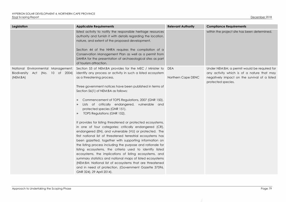
HYPERION SOLAR DEVELOPMENT 4, NORTHERN CAPE PROVINCEFinal Scoping Report December 2018
Approach to Undertaking the Scoping Phase Page 79
Legislation Applicable Requirements Relevant Authority Compliance Requirements
listed activity to notify the responsible heritage resources
authority and furnish it with details regarding the location,
nature, and extent of the proposed development.
Section 44 of the NHRA requires the compilation of a
Conservation Management Plan as well as a permit from
SAHRA for the presentation of archaeological sites as part
of tourism attraction.
within the project site has been determined.
National Environmental Management:
Biodiversity Act (No. 10 of 2004)
(NEM:BA)
Section 53 of NEM:BA provides for the MEC / Minister to
identify any process or activity in such a listed ecosystem
as a threatening process.
Three government notices have been published in terms of
Section 56(1) of NEM:BA as follows:
» Commencement of TOPS Regulations, 2007 (GNR 150).
» Lists of critically endangered, vulnerable and
protected species (GNR 151).
» TOPS Regulations (GNR 152).
It provides for listing threatened or protected ecosystems,
in one of four categories: critically endangered (CR),
endangered (EN), and vulnerable (VU) or protected. The
first national list of threatened terrestrial ecosystems has
been gazetted, together with supporting information on
the listing process including the purpose and rationale for
listing ecosystems, the criteria used to identify listed
ecosystems, the implications of listing ecosystems, and
summary statistics and national maps of listed ecosystems
(NEM:BA: National list of ecosystems that are threatened
and in need of protection, (Government Gazette 37596,
GNR 324), 29 April 2014).
DEA
Northern Cape DENC
Under NEM:BA; a permit would be required for
any activity which is of a nature that may
negatively impact on the survival of a listed
protected species.

HYPERION SOLAR DEVELOPMENT 4, NORTHERN CAPE PROVINCEFinal Scoping Report December 2018
Approach to Undertaking the Scoping Phase Page 80
Legislation Applicable Requirements Relevant Authority Compliance Requirements
National Environmental Management:
Biodiversity Act (No. 10 of 2004)
(NEM:BA)
Chapter 5 of NEM:BA pertains to alien and invasive
species; and states that a person may not carry out a
restricted activity involving a specimen of an alien species
without a permit issued in terms of Chapter 7 of NEM:BA;
and that a permit may only be issued after a prescribed
assessment of risks and potential impacts on biodiversity is
carried out.
Applicable, and exempted alien and invasive species are
contained within the Alien and Invasive Species List (GNR
864).
DEA
Northern Cape DENC
Restricted Activities and the respective
requirements applicable to persons in control
of different categories of listed invasive
species are contained within the Alien and
Invasive Species Regulations (GNR 598)
published under NEM:BA; together with the
requirements of the Risk Assessment to be
undertaken.
Conservation of Agricultural Resources
Act (No. 43 of 1983) (CARA)
Section 05 of CARA provides for the prohibition of the
spreading of weeds.
Regulation 15 of GNR 1048 published under CARA provides
for the classification of categories of weeds and invader
plants, and restrictions in terms of where these species may
occur.
Regulation 15E of GNR 1048 published under CARA
provides requirement and methods to implement control
measures for different categories of alien and invasive
plant species.
DAFF CARA will find application throughout the life
cycle of the project. In this regard, soil erosion
prevention and soil conservation strategies
need to be developed and implemented. In
addition, a weed control and management
plan must be implemented.
The permission of DAFF will be required if the
proposed development requires the draining
of vleis, marshes or water sponges on land
outside urban areas. However, this is not
anticipated to be required for the proposed
development.
In terms of Regulation 15E (GNR 1048) where
Category 1, 2 or 3 plants occur a land user is
required to control such plants by means of
one or more of the following methods:
» Uprooting, felling, cutting or burning.
» Treatment with a weed killer that is

HYPERION SOLAR DEVELOPMENT 4, NORTHERN CAPE PROVINCEFinal Scoping Report December 2018
Approach to Undertaking the Scoping Phase Page 81
Legislation Applicable Requirements Relevant Authority Compliance Requirements
registered for use in connection with such
plants in accordance with the directions
for the use of such a weed killer.
» Biological control carried out in
accordance with the stipulations of the
Agricultural Pests Act (No. 36 of 1983), the
ECA and any other applicable legislation.
» Any other method of treatment
recognised by the executive officer that
has as its object the control of plants
concerned, subject to the provisions of
sub-regulation (4).
» A combination of one or more of the
methods prescribed. Biological control
reserves and areas where biological
control agents are effective shall not be
disturbed by other control methods to the
extent that the agents are destroyed or
become ineffective.
National Forests Act (No. 84 of 1998)
(NFA)
According to this Act, the Minister may declare a tree,
group of trees, woodland or a species of trees as
protected. Notice of the List of Protected Tree Species
under the National Forests Act (No. 84 of 1998) was
published in GNR 536.
The prohibitions provide that “no person may cut,
damage, disturb, destroy or remove any protected tree, or
collect, remove, transport, export, purchase, sell, donate
or in any other manner acquire or dispose of any
protected tree, except under a licence granted by the
Minister”.
DAFF A licence is required for the removal of
protected trees. It is therefore necessary to
conduct a survey that will determine the
number and relevant details pertaining to
protected tree species present on the project
site for the submission of relevant permits to
authorities prior to the disturbance of these
individuals.
The independent ecological specialist study
undertaken as part of the EIA process has
identified two protected tree species within
the project site; Acacia erioloba and Acacia

HYPERION SOLAR DEVELOPMENT 4, NORTHERN CAPE PROVINCEFinal Scoping Report December 2018
Approach to Undertaking the Scoping Phase Page 82
Legislation Applicable Requirements Relevant Authority Compliance Requirements
haematoxylon. A license in terms of the NFA
will be required.
National Veld and Forest Fire Act (No.
101 of 1998) (NVFFA)
Chapter 4 of the NVFFA places a duty on owners to
prepare and maintain firebreaks, the procedure in this
regard, and the role of adjoining owners and the fire
protection association. Provision is also made for the
making of firebreaks on the international boundary of the
Republic of South Africa. The applicant must ensure that
firebreaks are wide and long enough to have a
reasonable chance of preventing a veldfire from
spreading to or from neighbouring land, it does not cause
soil erosion, and it is reasonably free of inflammable
material capable of carrying a veldfire across it.
Chapter 5 of the Act places a duty on all owners to
acquire equipment and have available personnel to fight
fires. Every owner on whose land a veldfire may start or
burn or from whose land it may spread must have such
equipment, protective clothing and trained personnel for
extinguishing fires; and ensure that in his or her absence
responsible persons are present on or near his or her land
who, in the event of fire, will extinguish the fire or assist in
doing so, and take all reasonable steps to alert the owners
of adjoining land and the relevant fire protection
association, if any.
DAFF While no permitting or licensing requirements
arise from this legislation, this Act will be
applicable during the construction and
operation of the proposed development, in
terms of the preparation and maintenance of
firebreaks, and the need to provide
appropriate equipment and personnel for
firefighting purposes.
Hazardous Substances Act (No. 15 of
1973) (HAS)
This Act regulates the control of substances that may
cause injury, or ill health, or death due to their toxic,
corrosive, irritant, strongly sensitising or inflammable nature
or the generation of pressure thereby in certain instances
and for the control of certain electronic products. To
provide for the rating of such substances or products in
relation to the degree of danger; to provide for the
Department of Health
(DoH)
It is necessary to identify and list all Group I, II,
III, and IV hazardous substances that may be
on site and in what operational context they
are used, stored or handled. If applicable, a
license would be required to be obtained
from DoH.

HYPERION SOLAR DEVELOPMENT 4, NORTHERN CAPE PROVINCEFinal Scoping Report December 2018
Approach to Undertaking the Scoping Phase Page 83
Legislation Applicable Requirements Relevant Authority Compliance Requirements
prohibition and control of the importation, manufacture,
sale, use, operation, modification, disposal or dumping of
such substances and products.
» Group I and II: Any substance or mixture of a
substance that might by reason of its toxic, corrosive
etc., nature or because it generates pressure through
decomposition, heat or other means, cause extreme
risk of injury etc., can be declared as Group I or Group
II substance
» Group IV: any electronic product; and
» Group V: any radioactive material.
The use, conveyance, or storage of any hazardous
substance (such as distillate fuel) is prohibited without an
appropriate license being in force.
National Environmental Management:
Waste Act (No. 59 of 2008) (NEM:WA)
The Minister may by notice in the Gazette publish a list of
waste management activities that have, or are likely to
have, a detrimental effect on the environment.
The Minister may amend the list by –
» Adding other waste management activities to the list.
» Removing waste management activities from the list.
» Making other changes to the particulars on the list.
In terms of the Regulations published in terms of NEM:WA
(GNR 912), a BA or EIA is required to be undertaken for
identified listed activities.
Any person who stores waste must at least take steps,
unless otherwise provided by this Act, to ensure that:
DEA – hazardous waste
Northern Cape DENC –
general waste
General waste handling, storage and disposal
will be required during construction and
operation. The National Norms and Standards
for the Storage of Waste (GNR 926) published
under Section 7(1)(c) of NEM:WA will need to
be considered in this regard.

HYPERION SOLAR DEVELOPMENT 4, NORTHERN CAPE PROVINCEFinal Scoping Report December 2018
Approach to Undertaking the Scoping Phase Page 84
Legislation Applicable Requirements Relevant Authority Compliance Requirements
» The containers in which any waste is stored, are intact
and not corroded or in
» Any other way rendered unlit for the safe storage of
waste.
» Adequate measures are taken to prevent accidental
spillage or leaking.
» The waste cannot be blown away.
» Nuisances such as odour, visual impacts and breeding
of vectors do not arise; and
» Pollution of the environment and harm to health are
prevented.
National Road Traffic Act (No. 93 of
1996) (NRTA)
The technical recommendations for highways (TRH 11):
“Draft Guidelines for Granting of Exemption Permits for the
Conveyance of Abnormal Loads and for other Events on
Public Roads” outline the rules and conditions which apply
to the transport of abnormal loads and vehicles on public
roads and the detailed procedures to be followed in
applying for exemption permits are described and
discussed.
Legal axle load limits and the restrictions imposed on
abnormally heavy loads are discussed in relation to the
damaging effect on road pavements, bridges, and
culverts.
The general conditions, limitations, and escort
requirements for abnormally dimensioned loads and
vehicles are also discussed and reference is made to
speed restrictions, power/mass ratio, mass distribution, and
general operating conditions for abnormal loads and
vehicles. Provision is also made for the granting of permits
SANRAL – national
roads
Northern Cape DoT
An abnormal load / vehicle permit may be
required to transport the various components
to site for construction. These include route
clearances and permits will be required for
vehicles carrying abnormally heavy or
abnormally dimensioned loads. Transport
vehicles exceeding the dimensional limitations
(length) of 22m. Depending on the trailer
configuration and height when loaded, some
of the substation components may not meet
specified dimensional limitations (height and
width).

HYPERION SOLAR DEVELOPMENT 4, NORTHERN CAPE PROVINCEFinal Scoping Report December 2018
Approach to Undertaking the Scoping Phase Page 85
Legislation Applicable Requirements Relevant Authority Compliance Requirements
for all other exemptions from the requirements of the
National Road Traffic Act and the relevant Regulations.
Provincial Legislation
Northern Cape Nature Conservation
Act, Act No. 9 of 2009
This Act provides for the sustainable utilisation of wild
animals, aquatic biota and plants; provides for the
implementation of the Convention on International Trade
in Endangered Species of Wild Fauna and Flora; provides
for offences and penalties for contravention of the Act;
provides for the appointment of nature conservators to
implement the provisions of the Act; and provides for the
issuing of permits and other authorisations. Amongst other
regulations, the following may apply to the current project:
» Boundary fences may not be altered in such a way as
to prevent wild animals from freely moving onto or off
of a property;
» Aquatic habitats may not be destroyed or damaged;
» The owner of land upon which an invasive species is
found (plant or animal) must take the necessary steps
to eradicate or destroy such species;
The Act provides lists of protected species for the Province.
Northern Cape DENC A collection/destruction permit must be
obtained from Northern Cape Nature
Conservation for the removal of any
protected plant or animal species found on
site. No protected plant or animal species
have been identified on site to date.

HYPERION SOLAR DEVELOPMENT 4, NORTHERN CAPE PROVINCEFinal Scoping Report December 2018
Approach to Undertaking the Scoping Phase Page 86
5.6.1. Best Practice Guidelines Birds & Solar Energy (2017)
The Best Practice Guidelines Birds & Solar Energy (2017) proposed by the Birds and Renewable Energy
Specialist Group (BARESG) (convened by BirdLife South Africa and the Endangered Wildlife Trust) contain
guidelines for assessing and monitoring the impact of solar generation facilities on birds in Southern Africa.
The guidelines recognise the impact that solar energy may have on birds, through for example the
alteration of habitat, the displacement of populations from preferred habitat, and collision and burn
mortality associated with elements of solar hardware and ancillary infrastructure; and the fact that the
nature and implications of these effects are poorly understood.
The guidelines are aimed at Environmental Assessment Practitioners (EAPs), avifaunal specialists,
developers and regulators and propose a tiered assessment process, including:
(i) Preliminary avifaunal assessment – an initial assessment of the likely avifauna in the area and possible
impacts, preferably informed by a brief site visit and by collation of available data; also including the
design of a site-specific survey and monitoring project should this be deemed necessary.
(ii) Data collection – further accumulation and consolidation of the relevant avian data, possibly including
the execution of baseline data collection work (as specified by the preliminary assessment), intended
to inform the avian impact study.
(iii) Impact assessment – a full assessment of the likely impacts and available mitigation options, based on
the results of systematic and quantified monitoring if this was deemed a requisite at preliminary
assessment.
(iv) Monitoring – repetition of baseline data collection, plus the collection of mortality data. This helps to
develop a complete before and after picture of impacts, and to determine if proposed mitigation
measures are implemented and are effective, or require further refinement. Monitoring may only be
necessary for projects with the potential for significant negative impacts on birds (i.e. large area
affected and / or vulnerable species present).
In terms of the guidelines the quantity and quality of baseline data required to inform the assessment
process at each site should be set in terms of the size of the site and the predicted impacts of the solar
technology in question, the anticipated sensitivity of the local avifauna (for example, the diversity and
relative abundance of priority species present, proximity to important flyways, wetlands or other focal sites)
and the amount of existing data available for the area.
Data collection could vary from a single, short field visit (Regime 1, for e.g. at a small or medium sized site
with low avifaunal sensitivity), to a series of multi-day survey periods, including the collection of various
forms of data describing avian abundance, distribution and movement and spread over 12 months
(Regime 3, for e.g. at a large developments located in a sensitive habitat, or which otherwise may have
significant impacts on avifauna). Table 5.5 is taken from the best practise guidelines and provides a
summary of the recommended assessment regimes in relation to proposed solar energy technology,
project size, and likely risk).

HYPERION SOLAR DEVELOPMENT 4, NORTHERN CAPE PROVINCEFinal Scoping Report December 2018
Approach to Undertaking the Scoping Phase Page 87
Table 5.5: Recommended avian assessment regimes in relation to proposed solar energy technology,
project size, and known impact risks.
Type of technology* Size**Avifaunal Sensitivity***
Low Medium High
All except CSP power tower
Small (< 30ha) Regime 1 Regime 1 Regime 2
Medium (30 – 150ha) Regime 1 Regime 2 Regime 2
Large (> 150ha) Regime 2**** Regime 2 Regime 3
CSP power tower All Regime 3
Regime 1: One site visit (peak season); minimum 1 – 5 days.
Regime 2: Pre- and post-construction; minimum 2 – 3 x 3 – 5 days over 6 months (including peak season); carcass
searches.
Regime 3: Pre- and post-construction; minimum 4 – 5 x 4 – 8 days over 12 months, carcass searches.
* Different technologies may carry different intrinsic levels of risk, which should be taken into account in impact
significance ratings
** For multi-phased projects, the aggregate footprint of all the phases should be used. At 3ha per MW, Small = <
10MW, Medium = 10 – 50MW, Large = > 50MW.
*** The avifaunal sensitivity is based on the number of priority species present, or potentially present, the regional,
national or global importance of the affected area for these species (both individually and collectively), and the
perceived susceptibility of these species (both individually and collectively) to the anticipated impacts of
development. For example, an area would be considered to be of high avifaunal sensitivity if one or more of the
following is found (or suspected to occur) within the broader impact zone:
1) Avifaunal habitat (e.g. a wetlands, nesting or roost sites) of regional or national significance.
2) A population of a priority species that is of regional or national significance.
3) A bird movement corridor that is of regional or national significance.
4) A protected area and / or Important Bird and Biodiversity Area.
An area would be considered to be of medium avifaunal sensitivity if it does not qualify as high avifaunal
sensitivity, but one or more of the following is found (or suspected to occur) within the broader impact zone
1) Avifaunal habitat (e.g. a wetland, nesting or roost sites) of local significance.
2) A locally significant population of a priority species.
3) A locally significant bird movement corridor.
An area would be considered to be of low avifaunal sensitivity if it is does not meet any of the above criteria.
**** Regime 1 may be applied to some large sites, but only in instances where there is abundant existing data to
support the assessment of low sensitivity.
For the purposes of Hyperion Solar Development 4, the proposed development has been classified as a
Regime 2 site. Two sets of monitoring (i.e. a dry and a wet monitoring season) of 3 days each (i.e. 2 x 3
days over 6 months) will be undertaken as part of the independent Avifauna Impact Assessment being
conducted as part of the EIA process. The results from the monitoring will be used to inform both the
development footprint and Avifauna Impact Assessment report, to be attached as an Appendix to the EIA
Report.
5.6.2. The IFC Environmental Health and Safety (EHS) Guidelines
The IFC EHS Guidelines are technical reference documents with general and industry specific examples of
Good International Industry Practice (GIIP). The following IFC EHS Guidelines have relevance to the
proposed project:
» IFC EHS General Guidelines
» IFC EHS Guidelines for Electric Power Transmission and Distribution
HYPERION SOLAR DEVELOPMENT 4, NORTHERN CAPE PROVINCEFinal Scoping Report December 2018
Approach to Undertaking the Scoping Phase Page 88
The General EHS Guidelines are designed to be used together with the relevant Industry Sector EHS
Guidelines, however no Industry Sector EHS Guidelines have been developed for PV solar power to date.
The application of the General EHS Guidelines should be tailored to the hazards and risks associated with a
project, and should take into consideration site-specific variables which may be applicable, such as host
country context, assimilative capacity of the environment, and other project factors. In instances where
host country regulations differ from the standards presented in the EHS Guidelines, whichever is the more
stringent of the two in this regard should be applied.
The General EHS Guidelines include consideration of the following:
» Environmental:
∗ Air Emissions and Ambient Air Quality
∗ Energy Conservation
∗ Wastewater and Ambient Water Quality
∗ Water Conservation
∗ Hazardous Materials Management
∗ Waste Management
∗ Noise
∗ Contaminated Land
» Occupational Health and Safety:
∗ General Facility Design and Operation
∗ Communication and Training
∗ Physical Hazards
∗ Chemical Hazards
∗ Biological Hazards
∗ Radiological Hazards
∗ Personal Protective Equipment (PPE)
∗ Special Hazard Environments
∗ Monitoring
» Community Health and Safety:
∗ Water Quality and Availability
∗ Structural Safety of Project Infrastructure
∗ Life and Fire Safety (L&FS)
∗ Traffic Safety
∗ Transport of Hazardous Materials
∗ Disease Prevention
∗ Emergency Preparedness and Response
» Construction and Decommissioning:
∗ Environment
∗ Occupational Health & Safety
∗ Community Health & Safety

HYPERION SOLAR DEVELOPMENT 4, NORTHERN CAPE PROVINCEFinal Scoping Report December 2018
Approach to Undertaking the Scoping Phase Page 89
5.6.3. IFC’s Project Developer’s Guide to Utility-Scale Solar Photovoltaic Power Plants (2015)
While no Industry Sector EHS Guidelines have been developed for PV Solar Power, the IFC has published a
Project Developer’s Guide to Utility-Scale Solar Photovoltaic Power Plants (IFC, 2015). Chapter 8 of the
Project Developer’s Guide pertains to Permits, Licensing and Environmental Considerations, and states
that in order to deliver a project which will be acceptable to international lending institutions,
environmental and social assessments should be carried out in accordance with the requirements of the
key international standards and principles, namely the Equator Principles and IFC’s Performance
Standards (IFC PS).
Some of the key environmental considerations for solar PV power plants contained within the Project
Developer’s Guide include:
» Construction phase impacts (i.e. OHS, temporary air emissions from dust and vehicle emissions, noise
related to excavation, construction and vehicle transit, solid waste generation and wastewater
generation from temporary building sites and worker accommodation).
» Water usage (i.e. the cumulative water use requirements).
» Land matters (i.e. land acquisition procedures and the avoidance or proper mitigation of involuntary
land acquisition / resettlement).
» Landscape and visual impacts (i.e. the visibility of the solar panels within the wider landscape and
associated impacts on landscape designations, character types and surrounding communities).
» Ecology and natural resources (i.e. habitat loss / fragmentation, impacts on designated areas and
disturbance or displacement of protected or vulnerable species).
» Cultural heritage (i.e. impacts on the setting of designated sites or direct impacts on below-ground
archaeological deposits as a result of ground disturbance during construction).
» Transport and access (i.e. impacts of transportation of materials and personnel).
» Drainage / flooding (i.e. flood risk associated with the site).
» Consultation and disclosure (i.e. consultating with key authorities, statutory bodies, affected
communities and other relevant stakeholders as early as possible).
» Environmental and Social Management Plan (ESMP) (i.e. compile an ESMP to ensure that mitigation
measures for relevant impacts are identified and incorporated into project construction procedures
and contracts).

HYPERION SOLAR DEVELOPMENT 4, NORTHERN CAPE PROVINCEFinal Scoping Report December 2018
Description of the Receiving Environment Page 90
DESCRIPTION OF THE RECEIVING ENVIRONMENT
This Chapter provides a description of the environment that may be affected by Hyperion Solar
Development 4. The information is provided in order to assist the reader in understanding the receiving
environment within which the project is proposed, and features of the biophysical, social, and economic
environment that could be directly or indirectly affected by, or alternatively could impact on, the
proposed development. This information has been sourced from existing available information and the
Scoping-level specialist investigations conducted to date, and aims to provide the context within which
this EIA is being conducted. Copies of the full Scoping-level specialist investigations are attached as
Appendices D to J of this Final Scoping Report.
Legal Requirements as per the EIA Regulations for the undertaking of an Environmental Impact
Assessment Report, 2014 (as amended)
This chapter includes the following information required in terms of Appendix 2: Content of a Scoping
report:
Requirement Relevant Section
(g)(iv) the environmental attributes associated with
the alternatives focusing on the geographical,
physical, biological, social, economic, heritage and
cultural aspects.
The environmental attributes associated with the
development of Hyperion Solar Development 4 is included as
a whole within this chapter. The environmental attributes that
are assessed within this chapter includes the following:
» The regional setting of the broader study area and the
project site indicates the geographical aspects
associated with Hyperion Solar Development 4. This is
included in Section 6.2 and Section 6.3.
» The climatic conditions present within Kathu has been
included in Section 6.4.
» The biophysical characteristics of the project site and the
surrounding areas are included in Section 6.5. The
characteristics considered are topography and terrain,
geology, soils and agricultural potential and the
ecological profile which includes the vegetation
patterns, listed plant species, critical biodiversity areas
and broad-scale processes, freshwater resources,
terrestrial fauna and avifauna.
» The visual quality of the surrounding area and the project
site has been considered in Section 6.5.
» The social and socio-economic characteristics
associated with the broader study area and the project
site has been included in Section 6.7.
» The heritage and cultural aspects (including archaeology
and palaeontology) has been included in Section 6.8.

HYPERION SOLAR DEVELOPMENT 4, NORTHERN CAPE PROVINCEFinal Scoping Report December 2018
Description of the Receiving Environment Page 91
Regional Setting: Description of the Broader Study Area
The Northern Cape Province is located in the north-western extent of South Africa and constitutes South
Africa’s largest province; occupying an area 372 889km² in extent, equivalent to nearly a third (30.5%) of
the country’s total land mass. It is also South Africa’s most sparsely populated province with a population
of
1 145 861 people, and a population density of 3.1/km². The capital city is Kimberley, and other important
towns include Upington, Springbok, Kuruman, De Aar, and Sutherland. It is bordered by the Western Cape,
and Eastern Cape Provinces to the south, and south-east; Free State, and North West Provinces to the east;
Botswana and Namibia, to the north; and the Atlantic Ocean to the west. The Northern Cape is the only
South African province which borders Namibia, and therefore plays an important role in terms of providing
linkages between Namibia and the rest of South Africa. The Orange River, which is South Africa’s largest
river, is a significant feature and is also the main source of water in the Province, while also constituting the
international border between the Northern Cape and Namibia.
The Northern Cape makes the smallest contribution to South Africa’s economy (contributing only 2% to
South Africa’s Gross Domestic Product per region (GDP-R) in 2007). The Northern Cape is rich in minerals
including alluvial diamonds, iron ore, and copper. The province is also rich in asbestos, manganese,
fluorspar, semi-precious stones and marble. The mining sector is the largest contributor to the provincial
GDP. The Northern Cape’s mining industry is of national and international importance, as it produces
approximately 37% of South Africa’s diamond output, 44% of its zinc, 70% of its silver, 84% of its iron-ore, 93%
of its lead and 99% of its manganese. According to the fourth reviewed IDP of the Gamagara LM, the
town of Kathu is considered to be the administrative and economic hub of the municipality which is
located within the centre of the Gamagara Mining Corridor.
The province has fertile agricultural land in the Orange River Valley, especially at Upington, Kakamas and
Keimoes, where grapes and fruit are cultivated intensively. The agricultural sector employs approximately
19.5% of the total formally employed individuals (LED Strategy). The sector is experiencing significant
growth in value-added activities, including game-farming, while food production and processing for the
local and export market is also growing significantly (PGDS, July 2011). Approximately 96% of the land is
used for stock farming, including cattle and sheep or goats, as well as game farming, while approximately
2% of the province is used for crop farming, mainly under irrigation in the Orange River Valley and
Vaalharts Irrigation Scheme (LED Strategy).
The Northern Cape offers unique tourism opportunities including wildlife conservation destinations, natural
features, historic sites, festivals, cultural sites, stars gazing, adventure tourism, agricultural tourism,
ecotourism, game farms, and hunting areas, etc. The Province is home to the Richtersveld Botanical and
Landscape World Heritage Site, which comprises a United Nations Educational, Scientific and Cultural
Organisation (UNESCO) World Heritage Site under the World Heritage Convention. The Northern Cape is
also home to two Transfrontier National Parks, namely the Kgalagadi Transfrontier Park, and the
Richtersveld /Ai-Ais Transfrontier Park, as well as five national parks, and six provincial reserves. The
Northern Cape also plays a significant role in South Africa’s science and technology sector, as it is home to
the Square Kilometre Array (SKA), the Southern African Large Telescope (SALT), and the Karoo Array
Telescope (MeerKAT).
The Northern Cape comprises five (5) Districts, namely Frances Baard, Johan Taolo Gaetsewe, Namakwa,
Pixley Ka Seme, and ZF Mgcawu (refer to Figure 6.1).

HYPERION SOLAR DEVELOPMENT 4, NORTHERN CAPE PROVINCEFinal Scoping Report December 2018
Description of the Receiving Environment Page 92
Figure 6.1: Districts of the Northern Cape Province (Source: Municipalities of South Africa).
The John Taolo Gaetsewe DM (previously known as the Kgalagadi DM) is situated in the north-eastern
extent of Northern Cape Province, and is bordered by ZF Mgcawu DM to the south-west, and south;
Frances Baard DM to the south-east; Dr Ruth Segomotsi Mompati DM of North West Province to the east;
and Botswana to the north. It is the second smallest DM in the Province in terms of land mass (27 283km²,
equivalent to 7.32% of the total Provincial land mass), and third largest in terms of population (224 799,
equivalent to 19.62% of the total Provincial population), with the second highest population density of
8.2/km².
The John Taolo Gaetsewe DM comprises 186 towns and settlements, approximately 80% of which includes
villages. Predominant towns within the DM include: Bankhara-Bodulong, Deben, Hotazel, Kathu, Kuruman,
Mothibistad, Olifantshoek, Santoy, and Van Zylsrus. It is characterised by a mixture of land uses, of which
agriculture and mining are dominant. The main economic sectors within the DM include agriculture,
mining, and retail. The DM holds potential as a viable tourist destination and has numerous growth
opportunities in the industrial sector.
The DM comprises 3 Local Municipalities, namely: Gamagara, Ga-Segonyana, and Joe Morolong Local
Municipalities. In 2006 the boundaries of the John Taolo Gaetsewe DM were demarcated to include the

HYPERION SOLAR DEVELOPMENT 4, NORTHERN CAPE PROVINCEFinal Scoping Report December 2018
Description of the Receiving Environment Page 93
once north-western part of Gamagara and Olifantshoek, along with its surrounds, into the Gamagara LM
(refer to Figure 6.2).
Figure 6.2: Local Municipalities of the John Taolo Gaetsewe District (Source: Municipalities of South
Africa).
The Gamagara LM is situated approximately 200km north east of Upington and 280km north west of
Kimberley in the southern to south-western extent of the John Taolo Gaetsewe DM. It is bordered by the
Gamagara LM to the north, the Ga-Segonyana LM to the east, and the Tsantsabane LM of the ZF Mgcawu
DM of the Northern Cape Province to the south and west. The Gamagara LM has the smallest population
(41 617) compared to the other LM in the John Taolo Gaetsewe, and is the second most densely
populated LM of the John Taolo Gaetsewe DM with a population density of 16/km².
The Gamagara LM comprises five towns, namely: Kathu, Shesheng, Dibeng, Dingleton, and Olifantshoek.
Kathu is the largest town, and is also the administrative centre of the Gamagara LM. Olifantshoek is the
second largest town, and is located near the Gamagara River to the north west of Kathu, and Dingleton is
the smallest of the five towns, and is located in the centre of the mining activities directly south of Kathu.
Regional Setting: Location and description of the Project Site
The closest towns to the proposed development include Kathu, located approximately 16km south (refer
to Figure 6.3). Other towns in proximity of the project site include Dibeng located approximately 18km
west of the project site, and Kuruman located approximately 34km north west of the project site. Built
infrastructure in the form of farm homesteads and workers quarters occur within and around the project
site, and may be impacted on (i.e. in terms of nuisance and / or visual impacts) as a result of the proposed
project.

HYPERION SOLAR DEVELOPMENT 4, NORTHERN CAPE PROVINCEFinal Scoping Report December 2018
Description of the Receiving Environment Page 94
Figure 6.3: Regional context of Hyperion Solar Development 4.

HYPERION SOLAR DEVELOPMENT 4, NORTHERN CAPE PROVINCEFinal Scoping Report December 2018
Description of the Receiving Environment Page 95
The Kathu Forest situated north of the town of Kathu has been declared a protected woodland in terms of
Section 12(1) (c) of the National Forests Act (No. 84 of 1998) (NFA) in 1995. The Kathu Forest is a unique
woodland of exceptionally large camel-thorn trees (A. erioloba). The woodland is approximately 4000ha
in extent and comprises one of only two such woodlands in the world.
Prominent/major road systems within the area include the N14 located approximately 6km south of the
project site, the R380 located approximately 9km west of the project site and the R31 located
approximately 25km north of the project site. Access to the project site is obtained via the T26 gravel road
that joins the N14 located south of the project site.
The project site is located approximately 16km north of the existing Ferrum Substation and approximately
14km from the Existing Kathu Substation. There are also a significant number of power lines within the
general vicinity, including:
» Ferrum/Umtu 400kV power line which traverses the north-eastern corner of the project site;
» Ferrum/Asbes 66kV power line situated approximately 8.2km south east of the project site;
» Fox/Umtu 132kV power line situated approximately 9km west of the project site;
» Ferrum/Umtu 132kV power line situated approximately 13km south west of the project site; and
» Mookodi/Ferrum 400kV power line situated approximately 14km south east of the project site.
Climatic Conditions
The Kathu area is typically characterised as having a local steppe climate (BSh) with little rainfall. The area
receives a mean annual average rainfall of approximately 395mm. Precipitation is highest in March with
an average of 74mm; and lowest in July with an average of 3mm. Minimal rain occurs between May to
September. The average annual temperature in Kathu is 18.9°C. January is the hottest month of the year
with an average temperature of 25.3°C, while July is the coldest month of the year with an average
temperature of 10.8°C (refer to Figure 6.4). Frost is frequent to very frequent during winter, with up to 37
mean frost days per year. Droughts and floods are a regular occurrence at both provincial and local
scales, and play a significant role in almost every aspect of the social, economic, and ecological
environment within the Province.
Figure 6.4: Climate and Temperature graphs for Kathu, Northern Cape Province (Source: en.climate-
data.org).

HYPERION SOLAR DEVELOPMENT 4, NORTHERN CAPE PROVINCEFinal Scoping Report December 2018
Description of the Receiving Environment Page 96
Landscape Features
The landscape within the project site can be described as flat to very slightly undulating and consists of
two terrain units where terrain unit 4 represent the vast flat areas that dominates the landscape and terrain
unit 5 represent areas of slight depression where endorheic pans can develop. The project site consists of
land type Ah9. The main landscape feature within the project site is the Vlermuisleegte (non-perennial
river) which traverses the centre of the project site and is situated below the level of the surrounding plains.
These plains are covered in red sand and grass with some larger A. erioloba species.
The landscape along Access Road Alternative 2 is very similar to that of the project site and can also be
described as flat to very slightly undulating, consisting of two terrain units where terrain unit 4 represents the
flat areas that dominates the landscape and terrain unit 5 areas of slight depression where endorheic pans
can develop. Access Road Alternative 2 traverse an area consisting of Ag110 and Ah9 land types. Figure
6.5 provides a profile of the two terrain types present within the project site and along Access Road
Alternative 2.
Figure 6.5: Terrain units within Ah9 and Ag110 land types (described in Section 6.7 below).
Geology
The Kathu area is largely underlain by Late Cenozoic continental sediments of the Kalahari Group
(Partridge et al. 2006). Much of the broader study area comprises of thick calcretes of the Mokolanen
Formation which could be up to 5 million years old and which are overlain by gravels of the Obobogorop
Formation and red Kalahari aeolian sands of the Gordonia Formation. Substantial calcretised deposits
including possible unconsolidated alluvium, palaeo-vlei or pan deposits and alluvial gravels are associated
with the Vlermuisleegte River.
Small sections of inliers of the Precambrian (Proterozoic) basaltic to andesitic lavas of the Ongeluk
Formation (Postmasburg Group) are exposed in the north-central and southern portions of the project site.
These volcanic rocks form the basement to the Cenozoic Kalahari Group sediments in the region.

HYPERION SOLAR DEVELOPMENT 4, NORTHERN CAPE PROVINCEFinal Scoping Report December 2018
Description of the Receiving Environment Page 97
Soil, Land types and Agricultural Potential
A land type is defined as an area with a uniform terrain type, macroclimate and broad soil pattern. The
area under investigation is covered by the following land types (refer to Figure 6.6):
» Ah9 - The texture of soil in this land type is dominated by sand with the clay fraction estimated as to be
less than 10%. Deep Hutton and Clovelly soil forms (deeper than 120cm) constitutes the largest portion
of this land type with very limited possibility for finding shallow, rocky soils of the Mispah and Glenrosa
forms over the entire land type area (an estimated 3.5%).
» Ag110 - The texture of soil in this land type is dominated by sand and sandy loam with the clay fraction
estimated as to be less than 15%. This land type mainly consists of shallow soil profiles of the Hutton
and Mispah soil forms with an estimated 18.5% of areas in this land type consisting of deeper soil
profiles of the Hutton form.
The project site has a low to low-moderate land capability, and is poorly suited for arable agriculture.
Although the soil forms present within the project site are suitable for arable agriculture in other areas of
the country, the project site has a dry, semi-arid climate with erratic rainfall patterns which are not
appropriate for dryland crop production. The most suitable land use is livestock grazing with management
measures such as controlled grazing, in place. The grazing capacity of the veld for the project site is 21 –
30 hectares per large animal unit (ha/LSU) or large stock unit (Morgenthal et al., 2005). The entire project
site (~1600ha) has the capacity for 53 to 76 head of cattle to graze on. The proposed development area
has the capacity for 7 to 9 head of cattle to graze on. Considered in isolation, the development area is
not a viable unit for livestock farming but in combination with the remaining area of the project site, it is
large enough to function as a sustainable cattle farm.
Hydrology and Geohydrology
The project site is situated within the Lower Vaal Water Management Area (WMA) 10, Quaternary
Catchment D41K (Molopo Catchment) and the Southern Kalahari Ecoregion. The project site is
furthermore located in an area defined as an upstream management catchment (FEPACODE 4).
Upstream management catchments are required to prevent the downstream degradation of FEPAs and
Fish Support Areas (FSAs).
The episodic Vlermuisleegte River bisects the centre of the project site and is located east of the proposed
Access Road Alternative 1 (refer to Figure 6.7). This river drains in a south-eastern to north-western direction
and is considered to be largely natural according to the Present Ecological State (PES) 1999. In contrary,
the river is classified as moderately modified (Class C) according to the National Freshwater Ecosystem
Priority Area (NFEPA) database. Agricultural fields occur within the floodplain associated with the
Vlermuisleegte River. This is most likely due to the episodic nature of the river, and the fact that the river
consist of enriched, deep soils deposited through alluvial processes. Due to these agricultural activities, the
natural indigenous riparian vegetation has been impacted. However, analysis of digital satellite imagery
indicates that some natural riparian vegetation remains within the area east of the river.
A depression wetland has been identified within the northern portion of the project site, situated within
Vlermuisleegte River. A second depression wetland was identified adjacent of the proposed Access Road
Alternative 2 south of the N14. This wetland is well vegetated, with no apparent impacts which might
occur from the adjacent road infrastructure. These wetlands could be considered of increased ecological
importance and sensitivity.

HYPERION SOLAR DEVELOPMENT 4, NORTHERN CAPE PROVINCEFinal Scoping Report December 2018
Description of the Receiving Environment Page 98
Figure 6.6: Land type map for the project site and access road alternatives.

HYPERION SOLAR DEVELOPMENT 4, NORTHERN CAPE PROVINCEFinal Scoping Report December 2018
Description of the Receiving Environment Page 99
Figure 6.7: Locality and extent of the desktop delineated watercourses associated with the project site and access road alternatives.

HYPERION SOLAR DEVELOPMENT 4, NORTHERN CAPE PROVINCEFinal Scoping Report December 2018
Description of the Receiving Environment Page 100
Ecological Profile
6.9.1. Broad vegetation types and the vegetation conservation status
The vegetation within and surrounding the project site comprises Kathu Bushveld. This vegetation type
extends from Kathu and Dibeng in the south through to Hotazel and to the Botswana border between Van
Zylsrus and McCarthysrus. The project site also consists of a well-developed tree layer and a variable-
density grass layer. Three broad vegetation communities can be identified:
» The area west of the Vlermuisleegte River – this area is largely dominated by Tarchonanthus
camphoratus and Acacia haematoxylon with a few areas where A. erioloba and/or Acacia mellifera
become dominant.
» The Vlermuisleegte River – non-perennial river which has largely been in-filled with sand. It is
characterised by a high density of large A. erioloba trees.
» The area east of the Vlermuisleegte River - the vegetation within this area is generally more open and
largely dominated by A. erioloba with some localised areas dominated by Acacia mellifera or
Terminalia sericea.
Table 6.1: Key species associated with the project site.
Growth Form Key Species
Dominant tree species Tarchonanthus camphoratus, Acacia haematoxylon, Acacia erioloba and Acacia
mellifera.
Common woody species Zizyphus mucronata, Gymnosporia buxifolia, Acacia mellifera subsp. detinens,
Searsia ciliata, Ehretia rigida subsp. rigida, Diospyros lycioides subsp. lycioides and
Grewia flava.
Grass layer Schmidtia pappophoroides, Aristida meridionalis, Aristida stipitata subsp. stipitata,
Stipagrostis uniplumis var. uniplumis, Stipagrostis obtusa, Cynodon dactylon,
Enneapogon desvauxii, Eragrostis lehmanniana and Aristida congesta subsp.
congesta
Shrubs Asparagus laricinus, Asparagus retrofractus, Felicia muricata subsp. cinerascens,
Pentzia calcarea, Acacia hebeclada, Hermannia tomentosa, Gnidia polycephala
and Lantana rugosa.
Forbs Dicoma schinzii, Geigeria ornativa, Elephantorrhiza elephantina, Indigofera
daleoides var. daleoides and Gisekia pharnacioides var. pharnacioides.
Although no endemic species are restricted to the Kathu Bushveld vegetation type, a number of Kalahari
endemics are known to occur in this vegetation type such as Acacia luederitzii var luederitzii, Anthephora
argentea, Megaloprotachne albescens, Panicum kalaharense and Neuradopsis bechuanensis.
The vegetation types of South Africa are categorised according to their conservation status, which is
assessed according to the degree of transformation and rates of conservation. The status of a habitat or
vegetation type is based on how much of its original area remains intact, relative to various thresholds. On
a national scale these thresholds are determined by the best available scientific approaches (Driver et al.
2005) (refer to Table 6.2). The level at which an ecosystem becomes Critically Endangered (CR) differs
from one ecosystem to another and varies from 16% to 36% (Driver et al. 2005).

HYPERION SOLAR DEVELOPMENT 4, NORTHERN CAPE PROVINCEFinal Scoping Report December 2018
Description of the Receiving Environment Page 101
Table 6.2: Determining ecosystem status (from Driver et al. 2005). *BT = biodiversity target (the
minimum conservation requirement.
Habitat Remaining (%)
80 – 100 Least Threatened LT
60 – 80 Vulnerable VU
*BT – 60 Endangered EN
0 – *BT Critically Endangered CR
The National List of Ecosystems that are Threatened and in need of protection (GNR 1002 of 2011),
published under the National Environment Management: Biodiversity Act (No. 10 of 2004) (NEM:BA), lists
national vegetation types that are afforded protection on the basis of rates of transformation.
According to Mucina and Rutherford (2006) less than 2% of the Kathu Bushveld vegetation type has been
transformed, mainly due to mining activity. The conservation status of this vegetation unit is classified as
Least Threatened. The vegetation type is however, poorly conserved and does not currently fall within any
formal conservation areas.
6.9.2. Listed and protected plant species of the project site
Two tree species protected under the National Forests Act (No. 84 of 1998) (NFA) occur at the project site;
A. erioloba and Acacia haematoxylon. The density of both species is fairly high across the project site.
The density of Acacia haematoxylon at the project site varies from less than 10 trees/ha to approximately
50 trees/ha in the higher density areas. Although A. erioloba has a higher density in some parts of the
project site, Acacia haematoxylon is widely distributed across the project site and there are no areas
where this species does not occur.
Apart from these two species, it is possible that Devils’ Claw is present at the project site, although it was
not observed during the site visit. This is a provincially protected species that is common within certain
Kalahari veld types and is widespread and common in the Kathu area.
6.9.3. Fauna
a) Terrestrial Mammals
The potential diversity of mammals within the project site is moderate. Although more than 50 species of
terrestrial mammals are known from the broader study area, the extent and habitat diversity of the project
site is too low to support a very wide range of mammals. Species observed within the project site include
Aardvark, Cape Porcupine, Springhare, South African Ground Squirrel, Scrub Hare, Vervet Monkey, Small-
spotted Genet, Yellow Mongoose, Slender Mongoose, Black-Backed Jackal, Steenbok, Duiker and Kudu.
Small mammals trapped in the area include Desert Pygmy Mouse, Multimammate Mouse, Bushveld Gerbil,
Hairy footed Gerbil, Pouched Mouse and Grey Climbing Mouse. Listed terrestrial mammal species that
potentially occur in the area are included in Table 6.3.
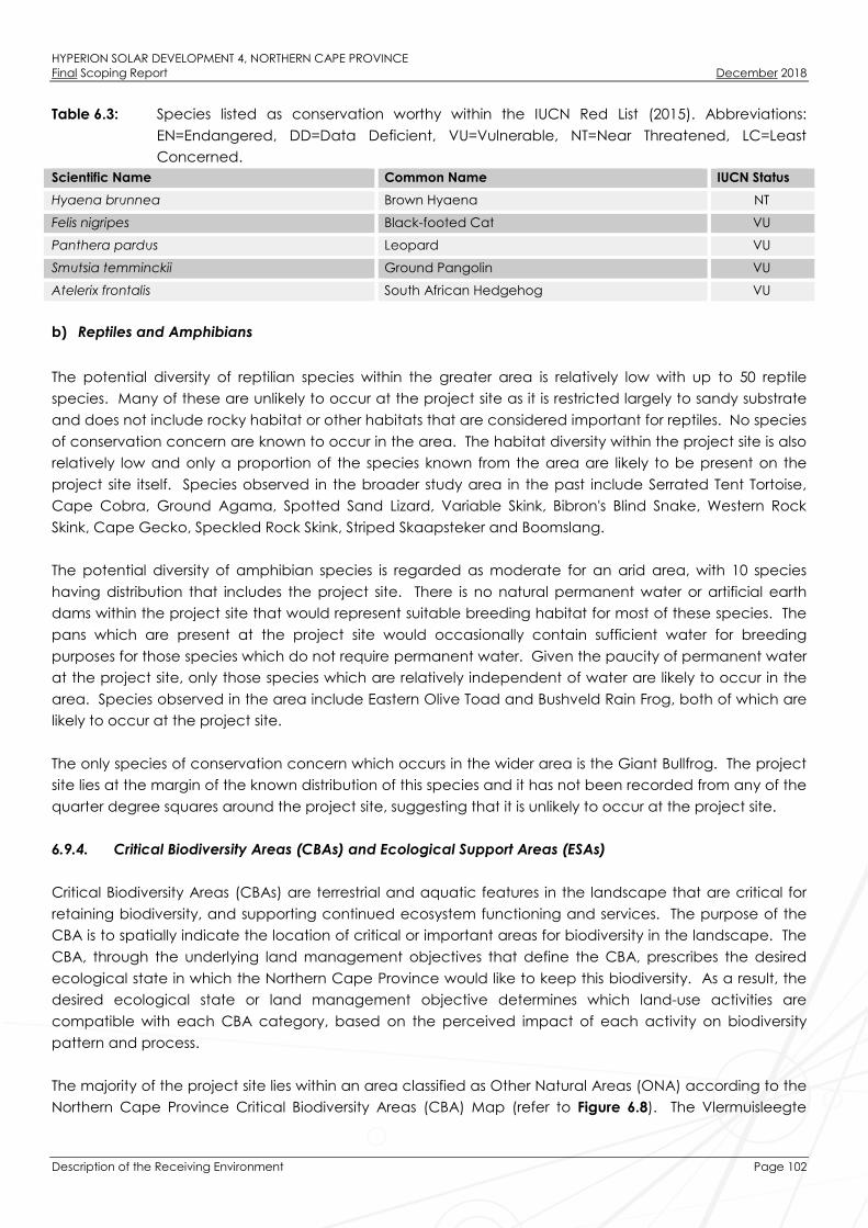
HYPERION SOLAR DEVELOPMENT 4, NORTHERN CAPE PROVINCEFinal Scoping Report December 2018
Description of the Receiving Environment Page 102
Table 6.3: Species listed as conservation worthy within the IUCN Red List (2015). Abbreviations:
EN=Endangered, DD=Data Deficient, VU=Vulnerable, NT=Near Threatened, LC=Least
Concerned.
Scientific Name Common Name IUCN Status
Hyaena brunnea Brown Hyaena NT
Felis nigripes Black-footed Cat VU
Panthera pardus Leopard VU
Smutsia temminckii Ground Pangolin VU
Atelerix frontalis South African Hedgehog VU
b) Reptiles and Amphibians
The potential diversity of reptilian species within the greater area is relatively low with up to 50 reptile
species. Many of these are unlikely to occur at the project site as it is restricted largely to sandy substrate
and does not include rocky habitat or other habitats that are considered important for reptiles. No species
of conservation concern are known to occur in the area. The habitat diversity within the project site is also
relatively low and only a proportion of the species known from the area are likely to be present on the
project site itself. Species observed in the broader study area in the past include Serrated Tent Tortoise,
Cape Cobra, Ground Agama, Spotted Sand Lizard, Variable Skink, Bibron's Blind Snake, Western Rock
Skink, Cape Gecko, Speckled Rock Skink, Striped Skaapsteker and Boomslang.
The potential diversity of amphibian species is regarded as moderate for an arid area, with 10 species
having distribution that includes the project site. There is no natural permanent water or artificial earth
dams within the project site that would represent suitable breeding habitat for most of these species. The
pans which are present at the project site would occasionally contain sufficient water for breeding
purposes for those species which do not require permanent water. Given the paucity of permanent water
at the project site, only those species which are relatively independent of water are likely to occur in the
area. Species observed in the area include Eastern Olive Toad and Bushveld Rain Frog, both of which are
likely to occur at the project site.
The only species of conservation concern which occurs in the wider area is the Giant Bullfrog. The project
site lies at the margin of the known distribution of this species and it has not been recorded from any of the
quarter degree squares around the project site, suggesting that it is unlikely to occur at the project site.
6.9.4. Critical Biodiversity Areas (CBAs) and Ecological Support Areas (ESAs)
Critical Biodiversity Areas (CBAs) are terrestrial and aquatic features in the landscape that are critical for
retaining biodiversity, and supporting continued ecosystem functioning and services. The purpose of the
CBA is to spatially indicate the location of critical or important areas for biodiversity in the landscape. The
CBA, through the underlying land management objectives that define the CBA, prescribes the desired
ecological state in which the Northern Cape Province would like to keep this biodiversity. As a result, the
desired ecological state or land management objective determines which land-use activities are
compatible with each CBA category, based on the perceived impact of each activity on biodiversity
pattern and process.
The majority of the project site lies within an area classified as Other Natural Areas (ONA) according to the
Northern Cape Province Critical Biodiversity Areas (CBA) Map (refer to Figure 6.8). The Vlermuisleegte

HYPERION SOLAR DEVELOPMENT 4, NORTHERN CAPE PROVINCEFinal Scoping Report December 2018
Description of the Receiving Environment Page 103
corridor is however classified as an Ecological Support Area (ESA) and would be marginally impacted by
the proposed development.
Access Road Alternative 1 is aligned within the Vlermuisleegte River ESA. The existing road is already used
by heavy vehicles and any required upgrades would be minor in nature and not likely to generate
significant additional impact to the affected ESA. Access Road Alternative 2 traverse a small extent of
CBA 1 and a larger extent of CBA 2. This section where the CBA occurs has a high density of A. erioloba
trees that would be difficult to avoid and significant additional habitat loss would be associated with this
alternative.
Figure 6.8: Critical Biodiversity Areas Map in relation to the project site and access roads.
6.9.5. Avifauna
The bird assemblage recorded within the project site is typical of the Kalahari bioregion. Based on
information derived from the South African Bird Atlas Project (SABAP1) approximately 219 bird species are
expected to occur within the project site and the surrounding area of which 75 species were recorded
within the project site.

HYPERION SOLAR DEVELOPMENT 4, NORTHERN CAPE PROVINCEFinal Scoping Report December 2018
Description of the Receiving Environment Page 104
During a site survey undertaken from 13 August 2018 to 16 August 2018 (i.e. in the dry season), an average
of 4.9 species were recorded per point count, with an average of 8.9 individual birds. The majority of the
species detected (74%) consist of small passerines species, compared to non-passerines (26%). Five near-
endemic species reported for the broader study area include Fiscal Flycatcher, Karoo Thrush Fairy
Flycatcher, Black-headed Canary and Black Harrier of which only the former two widespread species are
relatively common in the broader study area. The endemic Pied Starling is considered an uncommon
species in the area, occurring more regularly to the east near Kuruman. The two biome-restricted species
that occur in the area, namely, the Kalahari Scrub-robin and Burchell’s Sandgrous are common and have
widespread distributions through the bioregion.
The most abundant species recorded during point counts at the project site was the Scaly-feathered
Finch. Other common species which occurred at significantly lower abundances include Black-chested
Prinia, Kalahari Scrub-robin and Chestnut-vented. These four species had the highest encounter rates of all
detected species within the project site. The remaining species had significantly lower encounter rates,
with the most common of these being Violet-eared Waxbill, Ant-eating Chat, Fork-tailed Drongo, Yellow
Canary, and Burchell’s Sandgrouse (mostly seen flying overhead).
Very few species and individuals were recorded along the walked line transects, and included the
following (with the number of detections in parenthesis), Burchell’s Sandgrouse (four), Red-crested Korhaan
Lophotis ruficrista (two), Orange River Francolin Scleroptila gutturalis (one) and Gabar Goshawk Micronisus
gabar (one). Other medium to large non-passerines that were detected incidentally include Verreaux’s
Eagle-Owl Bubo lacteus (one), Pale Chanting Goshawk Melierax canorus (two) and Southern Yellow-billed
Hornbill Tockus leucomelas (two).
The Critically Endangered White-backed Vulture, the Endangered Martial Eagle, the Vulnerable Lanner
Falcon and the Near-Threatened Kori Bustard are considered the most important priority species in the
area, although these species are not known to breed nor are frequently observed in the area on a regular
basis. No sensitive breeding or roosting sites of any red-listed species were observed at the site during the
field survey. Table 6.4 provides a list of Red listed species recorded in the broader study area during
SABAP1.
a) Important avifaunal habitat types
Broad-scale vegetation patterns influence the distribution and abundance of bird species holistically, while
vegetation structure, rather than plant species composition, has a greater influence on local avifauna
populations and species assemblages (Harrison et al., 1997). The project site supports four avifaunal
microhabitats;
» Tarchonanthus camphoratus dominated scrubland:
The Tarchonanthus camphoratus scrubland dominates the western half of the project site and is the
result of a devastating veld fire in 2009 that transformed an open A. erioloba woodland to a
scrubland. The Tarchonanthus camphoratus scrubland support a low density of A. erioloba trees and
a high density of Acacia haematoxylon trees.
» Arid riparian grassland associated with the Vlermuisleegte:
The riparian grassland supports an almost pan-like habitat that may support a different assemblage of
bird species compared to the scrub and woodland.
HYPERION SOLAR DEVELOPMENT 4, NORTHERN CAPE PROVINCEFinal Scoping Report December 2018
Description of the Receiving Environment Page 105
» A. erioloba woodland and dense Acacia mellifera savanna:
The A. erioloba woodland which occurs on the eastern half of the project site, together with extensive
Acacia mellifera dominated savanna. The Acacia erioloba woodland has a markedly higher density
of large A. erioloba trees interspersed with patches of Acacia mellifera, giving rise to higher structural
diversity. A few dense stands of Terminalia sericea trees also occur and are generally associated with
the A. erioloba woodland.
b) Conservation Areas, Protected Areas and Important Bird Areas (IBA)
The project site is situated approximately 156km south east of the Spitskop Dam which is considered to be
an IBA. There are no other formal protected areas or any IBAs and Biodiversity Areas in close proximity to
the project site.

HYPERION SOLAR DEVELOPMENT 4, NORTHERN CAPE PROVINCEFinal Scoping Report December 2018
Description of the Receiving Environment Page 106
Table 6.4: Red listed species recorded in the broader study area during SABAP1 (1987-1991), ranked according to their red-list status. No species have
been reported during SABAP2 (2007 on-going), most likely due to poor coverage in the area, nor during the field survey (13 to 16 August 2018).
English Name Taxonomix Name Red-list status Regional endemism Estimated importance oflocal population
Preferred habitat Probability of occurrence
Vulture, White-backed Gyps africanus Critically Endangered - Low Savanna Moderate
Bateleur Terathopius ecaudatus Endangered - Low Savanna Low
Bustard, Ludwig's Neotis ludwigii Endangered Near-endemic Low Semi-arid shrublands Low
Eagle, Martial Polemaetus bellicosus Endangered - Low Savanna and shrublands Moderate
Harrier, Black Circus maurus Endangered - LowFynbos, Karoo and
grasslandLow
Courser, Burchell's Cursorius rufus Vulnerable Near-endemic Low Shrubland plains Moderate
Eagle, Verreaux's Aquila verreauxii Vulnerable - LowMountainous and rocky
areasLow
Falcon, Lanner Falco biarmicus Vulnerable - Moderate Widespread High
Secretarybird Sagittarius serpentarius Vulnerable - LowOpen savanna and
grasslandLow
Stork, Black Ciconia nigra Vulnerable - Low Water bodies Low
Bustard, Kori Ardeotis kori Near-threatened - Moderate Open savanna Moderate
Duck, Maccoa Oxyura maccoa Near-Threatened - Low Water bodies Low
Roller, European Coracias garrulus Near-Threatened - Low Open savanna Moderate
Stork, Abdim’s Ciconia abdimii Near-threatened - Low Grassland and savanna Low

HYPERION SOLAR DEVELOPMENT 4, NORTHERN CAPE PROVINCEFinal Scoping Report December 2018
Description of the Receiving Environment Page 107
Visual Quality
6.10.1. Landscape Character
Landscape character is defined as “a distinct, recognisable and consistent pattern of elements in the
landscape that makes one landscape different from another”. Landscape Character is a composite of a
number of influencing factors including:
» Landform and drainage;
» Nature and density of development; and
» Vegetation patterns.
a) Landform and drainage
The Vlermuisleegte River is considered to be the main regional drainage feature located in the vicinity of
the project site which is a non-perennial river that traverses the centre of the project site. The valley floor
falls from southeast to northwest at a gentle gradient of approximately 1:200.
The visual implications of landform include:
» The N14 located approximately 6km to the south at an elevation approximately 30m higher than the
proposed project. It is highly likely that the project will be visible from this road.
» The shallow gradient is likely to indicate that the project will be viewed largely in elevation with little or
no extended overview.
b) Nature and Density of Development
The population density of the area immediately surrounding the proposed development varies. Kathu is
the largest town of five towns within the Gamagara Local Municipality. Rural homesteads were found to
have an average occupancy of 3.5 people. This indicates that there is a rural homestead for
approximately every 0.75km2. Kathu is primarily a rural service centre. It is likely that a proportion of its
economy is derived from local mining operations as well as its position on the N14 as it acts as a transit stop
for travellers including tourists. The town of Kathu also has a regional airport, located approximately
11.7km to the west of the proposed project site.
Given the Province's dry conditions and dependence on irrigation, many Northern Cape farmers are
branching out into value-added activities such as game farming. This is apparent in rural areas
surrounding the proposed development as low intensity grazing appears to be mixed with game farming,
hunting operations and bush lodges.
Apart from agriculture, mining is the largest industrial activity in the area, especially within the area
surrounding Kathu. The Mamatwan Manganese Mine operated by Anglo American is located west of
Kathu and south of the proposed project site. In addition to Mamatwan Mine, there are numerous areas
of degraded land. It is possible that these areas have resulted from informal mining operations. All major
mining activities are a significant distance from the project site and are unlikely to have a significant
influence on the character of the landscape surrounding the project.

HYPERION SOLAR DEVELOPMENT 4, NORTHERN CAPE PROVINCEFinal Scoping Report December 2018
Description of the Receiving Environment Page 108
Visual implications of landcover include the potential that homesteads on adjacent farms could have
tourism importance if they have been developed with bush lodges and are used for game viewing or
hunting operations.
c) Vegetation Patterns
The proposed project is located in a relatively natural area according to Mucina and Rutherford (2006).
Vegetation types within the broader study area include:
» Kuruman Thornveld;
» Kathu Bushveld; and
» Kuruman Mountain Bushveld.
All vegetation types are usually open tree and shrub cover with a sparse grass layer. Visual implications
include;
» Where the viewer is amongst natural vegetation, it is possible that there will be a degree of screening
provided by the natural vegetation.
» Where the viewer is set back from natural vegetation or where ground elevation provides a slightly
elevated overview of the landscape, the extent of screening provided by natural vegetation is likely
to be limited.
6.10.2. Visual Receptors
Visual Receptors are defined as “individuals and/or defined groups of people who have the potential to
be affected by the proposal”.
It is possible that an area might be sensitive due to an existing use of the area. The nature of an outlook is
generally more critical to areas that are associated with recreation, tourism and in areas where outlook is
critical to land values.
Possible visual receptors within the landscape, which due to use, could be sensitive to landscape change
include:
» Point Receptors: include homesteads that are scattered throughout the area. It is likely that the focus
for this area is agricultural production. Unless farms have diversified into the tourism market it is unlikely
that this group of receptors will be overly sensitive to the likely landscape change as long as it does
not impact on agricultural productivity.
» Linear Receptors: include the N14,the R380 and or local routes through the area. The N14 is a primary
tourism route. Local routes surrounding the proposed development is likely to be mainly used by local
people and relate to agricultural activities. The R380 provides access to mining areas around Hotazel,
which is approximately 41.6km to the north of the proposed project site. This road also links to northern
Namibia and probably carries a proportion of tourism traffic. There are existing local roads, which
include a minor road that runs to the south and south west of the site and which provides a link
between the N14 and the R380 (known as the T25 road).
» Kathu (Sishen) Airport: located approximately 11.7km to the southwest of the proposed array. The
airport is a regional airport with daily flights to and from O R Tambo. The main concern that is likely
with regard to the airport is the potential of glint and glare affecting flights particularly on approach to
the airport.

HYPERION SOLAR DEVELOPMENT 4, NORTHERN CAPE PROVINCEFinal Scoping Report December 2018
Description of the Receiving Environment Page 109
Social Characteristics of the Broader Study Area and the Project Site
The following is a baseline summary of the socio-economic profile of the Gamagara Local Municipality
within which the Hyperion Solar Development 4 is proposed:
» The Gamagara LM covers an area of land approximately 2 619km² in extent, and comprises five towns,
namely: Kathu, Shesheng, Dibeng, Dingleton, and Olifantshoek. The town of Kathu is the largest within
the LM and the administrative centre of the LM.
» Between 2001 and 2011 the Gamagara LM experienced a positive population growth rate of 5.8% per
year, almost doubling in size from 23 202 people in 2001 to 41 617 people in 2011.
» The Gamagara LM is male dominated, with males comprising approximately 54.6% of the LM
population.
» Black Africans comprise the predominant population group within the Gamagara LM, John Taolo
Gaetsewe DM, and Northern Cape Province.
» The Gamagara LM, John Taolo Gaetsewe DM, and Northern Cape Provincial population age
structures are youth dominated. A considerable proportion of the respective populations therefore
comprise individuals of the economically active population between the ages of 15 – 64.
» The Gamagara LM has a dependency ratio of 28.1, which is considerably lower than the John Taolo
Gaetsewe DM (38.8), Northern Cape Province (35.8), and South Africa (34.5) as a whole.
» The majority of 31.2% of the Gamagara LM population aged 20 years and older have received some
form of secondary schooling, while 29.5% have completed Matric, and 5.2% have received some form
of higher education. Such figures imply that the LM population can be expected to have a relatively
low-skill level and would either require employment in low-skill sectors, or skills development
opportunities in order to improve the skills level of the area.
» The unemployment rate of the Gamagara LM is lower than that of the John Taolo Gaetsewe DM,
Northern Cape and South Africa as a whole. In addition, the proportion of economically inactive
individuals within the Gamagara LM is lower than in the John Taolo Gaetsewe DM.
» Household income levels in the LM are higher than the DM, province and South Africa as a whole, with
a lower proportion of low-income earners, and higher proportion of high income earners. The area
can therefore be expected to have a lower poverty level with associated social consequences such
as not being able to pay for basic needs and services, and poor living conditions than that of the DM
and Northern Cape Province.
» The primary economic activities within the Gamagara LM include mining, game farming, and business
services.
» The Gamagara LM and John Taolo Gaetsewe DM are poorly serviced in terms of public sector health
facilities. There are only 3 public sector dentists within the John Taolo Gaetsewe DM, and no public
sector optometrists.
» The majority of households within the Gamagara LM comprise formal brick dwellings.
» The majority of households within the Gamagara LM are well serviced with regards to electricity, water,
sanitation, and refuse removal.
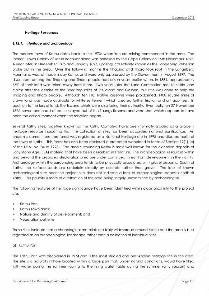
HYPERION SOLAR DEVELOPMENT 4, NORTHERN CAPE PROVINCEFinal Scoping Report December 2018
Description of the Receiving Environment Page 110
Heritage Resources
6.12.1. Heritage and archaeology
The modern town of Kathu dates back to the 1970s when iron ore mining commenced in the area. The
former Crown Colony of British Bechuanaland was annexed by the Cape Colony on 16th November 1895.
A year later, in December 1896 and January 1897, uprisings collectively known as the Langeberg Rebellion
broke out in the area. Over the following months the Tlhaping and Tlharo took root in the Langeberg
Mountains, west of modern-day Kathu, and were only suppressed by the Government in August 1897. The
discontent among the Tlhaping and Tlharo people had arisen years earlier when, in 1884, approximately
75% of their land was taken away from them. Two years later the Land Commission met to settle land
claims after the demise of the Boer Republics of Stellaland and Goshen, but little was done to help the
Tlhaping and Tlharo people. Although ten (10) Native Reserves were proclaimed, 1400 square miles of
crown land was made available for white settlement which created further friction and unhappiness. In
addition to the loss of land, the Tswana chiefs were also losing their authority. Eventually, on 27 November
1896, seventeen head of cattle strayed out of the Taungs Reserve and were shot which appears to have
been the critical moment when the rebellion began.
Several Kathu sites, together known as the Kathu Complex, have been formally graded as a Grade 1
heritage resource indicating that the collection of sites has been accorded national significance. An
endemic camel-thorn tree forest was registered as a National Heritage site in 1995 and situated north of
the town of Kathu. This forest has also been declared a protected woodland in terms of Section 12(1) (c)
of the NFA (No. 84 of 1998). The area surrounding Kathu is most well-known for the extensive deposits of
Early Stone Age (ESA) material that have been described in literature. The archaeological resources within
and beyond the proposed declaration area are under continued threat from development in the vicinity.
Archaeology within the surrounding area tends to be physically associated with gravel deposits. South of
Kathu, the surface sands are underlain directly by calcrete rather than gravel. The lack of known
archaeological sites near the project site does not indicate a lack of archaeological deposits north of
Kathu. This paucity is more of a reflection of this area being largely unexamined by archaeologists.
The following features of heritage significance have been identified within close proximity to the project
site:
» Kathu Pan;
» Kathu Townlands;
» Nature and density of development; and
» Vegetation patterns
These sites indicate that archaeological materials are fairly widespread around Kathu and the area is best
regarded as an archaeological landscape rather than a collection of individual sites.
a) Kathu Pan:
The Kathu Pan was discovered in 1974 and is the most studied and best-known heritage site in the area.
The site is a natural sinkhole located within a large pan that, under natural conditions, would have filled
with water during the summer (owing to the rising water table during the summer rainy season) and

HYPERION SOLAR DEVELOPMENT 4, NORTHERN CAPE PROVINCEFinal Scoping Report December 2018
Description of the Receiving Environment Page 111
become a valuable water supply for prehistoric populations (Van Zinderen Bakker 1995). A sequence of
Early Stone Age (ESA) deposits including some Fauresmith material and evidence for the onset of the
Middle Stone Age (MSA) some 500 000 years ago (Wilkins 2013) have been identified at the site. Wilkins et
al. (2012) have studied fracture patterns on points from the site and determined that they were used in a
hafted manner as spear tips. The site has also yielded very early evidence for blade production (Wilkins &
Chazan 2012). Faunal remains, including remains of species such as hippopotamus have been preserved
at the site which is unusual for Kathu.
b) Kathu Townlands:
The Kathu Townlands is situated across the surface of a low rise within the boundary of the town of Kathu.
It was first reported in 1980 and had initial excavations carried out by Beaumont in 1982 and 1990
(Beaumont 1990). Due to the proposed development on the site, mitigation work was carried out to
enable a better understanding of the deposits identified on the site (Walker et al. 2013). The
archaeological material occurred within a dense accumulation of banded iron formation (BIF) rubble with
a sandy matrix directly over bedrock. The artefacts from both the Beaumont and Walker excavations lack
evidence of water transport, but damage to the artefacts does indicate mechanical damage through
redeposition subsequent to the ESA occupation (Walker et al. 2014).
c) Bestwood:
Archaeological sites were first reported at Bestwood by Dreyer (2008) after which further research was
undertaken by Chazan et al. (2012). Bestwood 1 and Bestwood 2 provide an indication of a larger
landscape of artefacts that have been exposed by sand quarrying activity within in a sandy valley. A third
site, Bestwood 3, is located on the hilltop along the east side of this valley. Initial investigation at Bestwood
1 revealed a lithic industry characterised by well-made hand-axes, well-retouched scrapers, occasional
blades and a great diversity of core types (Chazan et al. 2012:331).
Excavations at Bestwood 1 demonstrated that material is present in situ in a single horizon beneath the
covering sands Walker et al. (2013). This horizon is similar to the surface exposures at Bestwood 3 and
Uitkoms 1 in terms of artefacts. Considering these observations (as well as other currently unpublished work
done at Bestwood), it seems that the archaeological deposit extends beyond the limits of the quarries,
across the landscape and connects the two hilltop exposures as a continuous horizon.
d) Uitkoms:
Various archaeological artefacts have been identified within the farm Uitkoms situated north east of Kathu.
Beaumont has named these occurrences as Uitkoms 1, 2, 3 and 4. Uitkoms 1 appears to be similar to Kathu
Townlands 1 in terms of artefact density and debitage frequency, but occurs on a hilltop. Uitkoms 4 is
largely buried beneath surface sands in a manner similar to Bestwood 1 and 2, where bifaces are very
similar to those from the quarries, but with a formal tool incidence about a thousand times higher
(Beaumont 2008b:3). In 2006, two road cuttings along the N14 towards Kuruman contain ESA artefacts in a
thin rubble of jaspilite and below red sand. One of these, Uitkoms 3, suggests that the Uitkoms 1 extends
over the north western side of the Kathu hill. Uitkoms 2 could represent the extreme western limit of a site
that may range over two upslope hills on Hartnolls (Beaumont, 2007).

HYPERION SOLAR DEVELOPMENT 4, NORTHERN CAPE PROVINCEFinal Scoping Report December 2018
Description of the Receiving Environment Page 112
6.12.2. Palaeontology (Fossils)
The project site is underlain by Late Cenozoic continental sediments of the Kalahari Group, thick calcretes
of the Mokolanen Formation and gravels of the Obobogorop Formation and red Kalahari aeolian sands of
the Gordonia Formation. Small inliers of Precambrian (Proterozoic) basaltic to andesitic lavas of the
Ongeluk Formation crop out in the north-central and southern portions of the project site. These volcanic
rocks form the basement to the Cenozoic Kalahari Group sediments in the region.
Proterozoic (Precambrian) volcanic bedrocks of the Ongeluk Formation are entirely unfossiliferous. The
overlying Kalahari Group deposits in the surrounding Kathu area are considered to be of generally low
palaeontological sensitivity (Almond 2014, 2015a, 2015b, Pether 2011), although localised areas of high
sensitivity may occur. The main palaeontological heritage concern associated with the project site would
be Quaternary mammalian remains (bones, teeth and horncores), trace fossils and plant fossils associated
with solution hollows as well as ancient pan or vlei deposits along drainage lines, such as have been
recorded from the well-known Kathu Pan site situated approximately 5.5.km north west of town of Kathu
(Beaumont 1990, Beaumont 2004, Beaumont et al. 1984) (See also Almond 2013a, 2013b).
The geology of the Kathu region is indicated on 1:250 000 geological map 2722 Kuruman for which a sheet
explanation has not yet been published (refer to Figure 6.9). The project site and both access road
alternatives are located within a moderate fossil sensitivity.
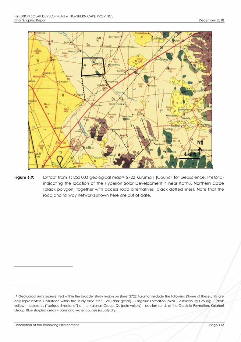
HYPERION SOLAR DEVELOPMENT 4, NORTHERN CAPE PROVINCEFinal Scoping Report December 2018
Description of the Receiving Environment Page 113
Figure 6.9: Extract from 1: 250 000 geological map16 2722 Kuruman (Council for Geoscience, Pretoria)
indicating the location of the Hyperion Solar Development 4 near Kathu, Northern Cape
(black polygon) together with access road alternatives (black dotted lines). Note that the
road and railway networks shown here are out of date.
16 Geological units represented within the broader study region on sheet 2722 Kuruman include the following (Some of these units are
only represented subsurface within the study area itself): Vo (dark green) – Ongeluk Formation lavas (Postmasburg Group); Tl (dark
yellow) – calcretes (“surface limestone”) of the Kalahari Group; Qs (pale yellow) – aeolian sands of the Gordinia Formation, Kalahari
Group; Blue stippled areas = pans and water courses (usually dry).

HYPERION SOLAR DEVELOPMENT 4, NORTHERN CAPE PROVINCEFinal Scoping Report December 2018
Description of the Receiving Environment Page 114
Figure 6.10: Extract from the SAHRIS Palaeosensitivity Map showing the entire project site to be of
moderate sensitivity (green shading). The yellow polygon indicates the project site, while
the blue line indicates Access Road Alternative 1 and the green line indicates Access
Road Alternative 2.

HYPERION SOLAR DEVELOPMENT 4, NORTHERN CAPE PROVINCEFinal Scoping Report December 2018
Scoping of Potential Issues Page 115
SCOPING OF POTENTIAL ISSUES
This Chapter provides an overview of the potential impacts and risks associated with the establishment of
Hyperion Solar Development 4, identified at this stage of the process through a desktop review of
available existing information and specialist studies.
Potential environmental impacts and risks associated with the development of PV solar energy generation
facilities, as described in the IFC’s Project Developer’s Guide to Utility-Scale Solar Photovoltaic Power Plants
(2015), include:
» Construction phase impacts, such as temporary air emissions (dust and vehicle emissions), noise,
solid waste and wastewater generation, and Occupational Health and Safety (OHS) issues such as
the risk of preventable accidents leading to injuries and / or fatalities.
» Water usage, such as the cumulative water use requirement in arid areas where local communities
rely upon scarce groundwater resources.
» Land matters, such as land acquisition procedures and in particular involuntary land acquisition /
resettlement.
» Landscape and visual impacts, such as the visibility of the project within the wider landscape and
associated impacts on landscape designations, character types and surrounding communities.
» Ecology and natural resources, such as habitat loss / fragmentation, impacts on designated areas
and disturbance or displacement of protected or vulnerable species.
» Cultural heritage, such as impacts on the setting of designated sites or direct impacts on below-
ground archaeological deposits as a result of ground disturbance during construction.
» Transport and access, such as impacts associated with the transportation of materials and
personnel on project-affected communities.
» Drainage / flooding, such as the potential for high flood risk associated with the project site.
In order to appropriately identify, assess and, as far as possible, avoid or mitigate potential impacts and
risks that may be associated with the development, construction, operation and decommissioning of
Hyperion Solar Development 4, Savannah Environmental commissioned a team of independent specialists
with relevant scientific knowledge and expertise in the biophysical (i.e. biotic and abiotic) and socio-
economic environments.
The specialists that provided input into this Final Scoping Report and whose in-depth studies will form part
of the EIA process are provided in Table 7.1. Copies of the specialists’ Scoping level assessments are
included in Appendices D – J of this Final Scoping Report.
Table 7.1: Independent Specialist Studies to be conducted as part of the EIA process
Specialist Study Specialist Company Specialist Name
Ecology and Avifauna 3Foxes Biodiversity Solutions Simon Todd
Eric Herman
Watercourses Scientific Aquatic Services Stephen van Staden
Christel du Preez
Visual Impact Assessment Environmental Planning and Design Jon Marshall
Soils and Agricultural Potential Impact
Assessment
TerraAfrica Mariné Pienaar

HYPERION SOLAR DEVELOPMENT 4, NORTHERN CAPE PROVINCEFinal Scoping Report December 2018
Scoping of Potential Issues Page 116
Specialist Study Specialist Company Specialist Name
Heritage (Archaeology and
Palaeontology)
Asha Consulting (in consultation with
John Almond of Natura Viva)
Jayson Orton
Social Impact Assessment Savannah Environmental Sarah Watson
Section 7.2 and Section 7.3 provide a summary of the findings of the scoping study undertaken for the
construction and operation phases of Hyperion Solar Development 4, respectively. Those impacts
associated with construction can also be expected to be associated with the decommissioning phase
(however, to a lesser extent as the project site would have previously undergone transformation and
disturbance during construction). These summaries must be read in conjunction with the specialist reports
attached as Appendices D – J of this Final Scoping Report. Potential impacts associated with the project
are evaluated, and recommendations are made regarding further studies required within the EIA phase. It
must be noted that the evaluations provided in Section 7.2 and Section 7.3 are preliminary in nature, and
will only be finalised once more in-depth investigations and site surveys have been conducted (i.e. during
the EIA phase).
A summary of the potential cumulative impacts that may be associated with the project is provided in
Section 7.4. These impacts are associated with the scale of the project when considered together with
other similar developments within the region, and will be confirmed and assessed within the EIA Phase of
the project.
Legal Requirements as per the EIA Regulations, 2014 (as amended)
This chapter serves to identify the potential environmental impacts associated with the development of
the Hyperion Solar Development 4 from a desktop level. This chapter includes the following information
required in terms of the EIA Regulations, 2014 - Appendix 2: Content of the Scoping Report:
Requirement Relevant Section
(g)(v) the impacts and risks which have informed the
identification of each alternative, including the nature,
significance, consequence, extent, duration and
probability of such identified impacts, including the
degree to which these impacts (aa) can be reversed (bb)
may cause irreplaceable loss of resources and (cc) can
be avoided, managed or mitigated.
The impacts and risks identified to be associated with the
construction and operation phase of Hyperion Solar
Development 4 have been included in Sections 7.2 and
7.3. Impact tables have been included for each field of
study which considers the nature, significance,
consequence, extent duration and probability of the
impacts, as well the reversibility of the impacts, the loss of
resources and avoidance or mitigation.
(g)(vii) positive and negative impacts that the proposed
activity and alternatives will have on the environment and
on the community that may be affected focusing on the
geographical, physical, biological, social, economic,
heritage and cultural aspects.
The positive and negative impacts associated with the
Hyperion Solar Development 4 has been included in
Sections 7.3 and 7.4.
(g)(viii) the possible mitigation measures that could be
applied and level of residual risk
Possible mitigation (i.e. avoidance of sensitive areas) has
been included in Sections 7.3 and 7.4.

HYPERION SOLAR DEVELOPMENT 4, NORTHERN CAPE PROVINCEFinal Scoping Report December 2018
Scoping of Potential Issues Page 117
Evaluation of Potential Impacts Associated with the Construction Phase
7.2.1. Potential Impacts on Ecology
Impact
Impacts on vegetation and protected plant species.
Several protected species occur at the project site which may be impacted by the proposed development and the construction or upgrading of access roads, most notably
A. erioloba and A.haematoxylon. Vegetation clearing during construction will lead to the loss of currently intact habitat within the development footprint and is an inevitable
consequence of the proposed development. As this impact is certain to occur it will be assessed for the construction phase as this is when the impact will occur, although the
consequences will persist for a long time after construction.
Desktop Sensitivity Analysis of the Site
An ecological sensitivity map has been compiled using available Geo-spatial information, data obtained during the site visit as well as existing information such as Critical
Biodiversity Areas in combination with NFEPA Wetlands (refer to Error! Reference source not found.). This ecological sensitivity map is preliminary in nature, and information
obtained during the site visit in the EIA phase will be used to fine-tune and ground-truth the map.
» Very High Sensitivity: The main sensitive feature of the project site is the Vlermuisleegte River which is considered to be a n important corridor for landscape connectivity.
The river is characterised by a high density of large A. erioloba trees and is therefore considered to be unsuitable for development and should be regarded as a no-go
area for all project components. The development area avoids all areas considered to be of very high sensitivity.
» High Sensitivity: These areas are considered to be of high sensitivity due to the high density of A. erioloba trees. An important impact associated with the proposed
development would be the loss of relatively large numbers of A. erioloba and Acacia haematoxylon. Although the density of these species in the area is high, the loss of
the individuals within the proposed development footprint would not compromise the local populations of these species. These areas are avoided by the development
area for Hyperion Solar Development 4.
» Medium Sensitivity: The majority of the area east of the Vlermuisleegte River has a moderate A. erioloba density and are considered to be of medium sensitivity. A low
ridge in the central part of the area west of the Vlermuisleegte River is considered to be of medium sensitivity as it has higher plant diversity than the surrounding area and
is a relatively rare habitat in context of the project site.
» Low Sensitivity: The majority of the western half of the project site is considered to be of low sensitivity due to the lower abundance of protected tree species and
dominance of Tarchonanthus camphoratus which is generally an indicator of poor veld condition. No species of high conservation concern were observed in this area
and is considered potentially suitable for development.

HYPERION SOLAR DEVELOPMENT 4, NORTHERN CAPE PROVINCEFinal Scoping Report December 2018
Scoping of Potential Issues Page 118
Figure 7.1: Ecological sensitivity map prepared for the project site for Hyperion Solar Development 4.

HYPERION SOLAR DEVELOPMENT 4, NORTHERN CAPE PROVINCEFinal Scoping Report December 2018
Scoping of Potential Issues Page 119
Issue Nature of Impact Extent of Impact No-Go Areas
Vegetation clearing will result in loss of
currently intact vegetation.
Habitat loss and impact on plant species
of conservation concern will occur.
Local The bed of the Vlermuisleegte River
should be considered to be a no-go
area. This excludes sections where there
are already existing access roads which
can be used for access to the project site
(i.e. Access Road Alternative 1. Areas of
high tree density east of the
Vlermuisleegte River are also considered
unsuitable for development.
Description of expected significance of impact:
Impacts on vegetation and species of conservation concern are likely to be of moderate significance, depending on the exact location of the development footprint and the
density of protected tree species within the development footprint.
Gaps in knowledge & recommendations for further study
» The density and distribution of protected trees and other plant species of conservation concern across the project site will need to be characterised and quantified within
the proposed development footprint to better inform the EIA Phase.
» The sensitivity map derived for the project site may need to be updated based on the results of the above studies.
Impact
Direct Faunal impacts.
Disturbance, transformation and loss of habitat will have a negative effect on resident fauna during construction. Due to noise and operation of heavy machinery, faunal
disturbance will extend well beyond the footprint and extend into adjacent areas. This will however be transient and restricted to the construction phase.
Desktop Sensitivity Analysis of the Site
Refer to Figure 7.1 for the desktop sensitivity analysis of the project site.
Issue Nature of Impact Extent of Impact No-Go Areas
Construction phase disturbance of fauna. Fauna will be disturbed or killed by
construction phase disturbance.
Local The bed of the Vlermuisleegte River
should be considered to be a no-go
area. This excludes sections where there
are already existing access roads which
can be used for access to the project site

HYPERION SOLAR DEVELOPMENT 4, NORTHERN CAPE PROVINCEFinal Scoping Report December 2018
Scoping of Potential Issues Page 120
(i.e. Access Road Alternative 1. Areas of
high tree density east of the
Vlermuisleegte River are also considered
unsuitable for development.
Description of expected significance of impact:
Faunal impacts due to construction activities will be of relatively high intensity given the clearing and site establishment impacts, but this would be of short duration and of
moderate to low overall significance.
Gaps in knowledge & recommendations for further study
» The fauna associated with the different habitats at the project site will need to be verified and characterised in the field during the EIA Phase.
» Important faunal habitats which have not been captured in the sensitivity map will need to be identified and mapped in the field.
» The overall impact of the development on fauna and faunal habitats will need to be evaluated in the field based on the proposed layout of the development.
7.2.2. Potential Impacts on Watercourses
Impact
Potential encroachment and direct disturbance of the Vlermuisleegte River and depression wetlands, alterations to stormwater run-off, altering the hydrology of the systems
and increased sedimentation due to the development of the SEF.
Impacts associated with the construction activities (within the project site) include potential encroachment and direct disturbance of the Vlermuisleegte River and depression
wetlands located east of the project site as a result of the potential creation of temporary haul roads through the watercourses.
All watercourses identified in the desktop assessment have already been impacted by surrounding agricultural activities. Many of the areas adjacent to the watercourses
have been altered (e.g. by ploughing and road crossings), increasing the likelihood of sediment run-off and proliferation of alien and invasive species. Based on the relevant
databases, these watercourses are in a relatively good ecological condition (NFEPA, 2011); however, based on the investigation of digital satellite imagery, the watercourses
have been impacted upon by agricultural activities and road crossings.
Desktop Sensitivity Analysis of the Site
A sensitivity map was compiled, illustrating areas of sensitivity that were identified within the project site (refer to Figure 7.2). This sensitivity map is preliminary in nature, and
information obtained during the site visit in the EIA phase will be used to fine-tune and ground-truth the map.
» No-go area (new development): includes the extent of the watercourses delineated using desktop analysis. The existing road (where Access Road Alternative 1 is
proposed to be upgraded) is an existing impact on the Vlermuisleegte River. Upgrading of the road has potential to further impact on the river during the construction
phase, with specific reference to increased risk of erosion and associated sedimentation of the river.

HYPERION SOLAR DEVELOPMENT 4, NORTHERN CAPE PROVINCEFinal Scoping Report December 2018
Scoping of Potential Issues Page 121
» High Sensitivity Area: the 32m regulated area associated with a watercourse as stipulated by the NEMA EIA Regulations of 2014 (as amended) watercourses. No new
infrastructure should be placed in these areas. New access roads should only be planned within these areas if it is absolutely unavoidable to circumnavigate these
watercourses;
» Moderate Sensitivity: includes the GN509 regulated area of the watercourse (100m zone surrounding the Vlermuisleegte River, and 500m zone surrounding the two
depression wetlands). Development may take place within these areas but should be avoided if possible, to avoid triggering Section 21 (c) & (i) water uses (exception for
specified activities as per Appendix D2 of GN509 of 2016 as it relates to the NWA); and
» Low Sensitivity: all other areas remaining within the project site. These areas are considered the least sensitive from a watercourse conservation point of view.
As no watercourses are located within the development area, no new infrastructure associated with the SEF is likely to be located within the delineated watercourses (No-Go
Areas for new development) and the associated 32m NEMA regulated area of a watercourse (High Sensitivity), which is considered sufficient for the protection of these
resources. The existing road (where Access Road Alternative 1 is proposed to be upgraded) traverses a section of the Vlermuisleegte River. Despite the river being considered
a “No-go Area” to new development, upgrading of the existing road is not considered a no-go, as it is considered an existing impact.
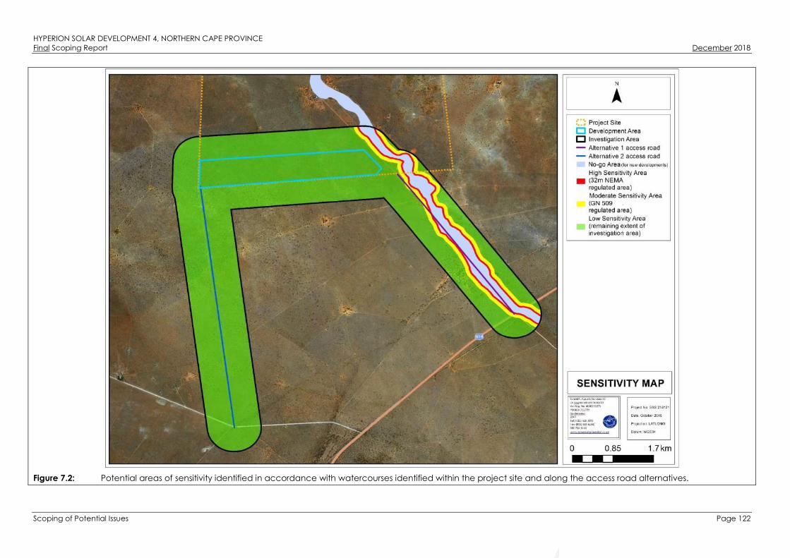
HYPERION SOLAR DEVELOPMENT 4, NORTHERN CAPE PROVINCEFinal Scoping Report December 2018
Scoping of Potential Issues Page 122
Figure 7.2: Potential areas of sensitivity identified in accordance with watercourses identified within the project site and along the access road alternatives.

HYPERION SOLAR DEVELOPMENT 4, NORTHERN CAPE PROVINCEFinal Scoping Report December 2018
Scoping of Potential Issues Page 123
Issue Nature of Impact Extent of Impact No-Go Areas
Direct disturbance of watercourse
habitat.
The potential loss of biodiversity as a result
of construction related activities within
the watercourses, including construction
or upgrading of roads and placement of
cables within watercourses. Decrease in
the provision of watercourse ecoservices
due to the potential degradation of the
watercourses.
Local All delineated watercourses should be
considered to be no-go areas for
development, except for Access Road
Alternative 1 as the impact is existing.
The decrease of watercourse habitat
integrity.
Encroachment of internal road
infrastructure and construction activities
may result in the contamination of the
watercourses (if surface water is present).
This impact may be direct or indirect.
Local
Alteration of runoff patterns. The potential for increased erosion as a
result of earthworks in the vicinity of
watercourses.
Local
Altered hydrology of the watercourses. The potential loss of catchment yield due
to stormwater management during the
construction activities.
Local
Altered stream and baseflow patterns. Potential that the construction of stream
crossings may impact on the hydrology
and sedimentation of systems.
Local
Mismanagement and ineffective
rehabilitation of watercourses.
The potential for siltation and changes in
the hydrological functioning of these
areas.
Local
Description of expected significance of impact
Since no watercourses are located within the development area of the SEF, no direct impacts from the construction of the SEF are expected to occur on watercourses located
outside of the development area. Nevertheless, the potential occurrence of impacts associated with edge effects on the watercourses must be considered. If these edge
effects are managed accordingly, the impact significance on the watercourses is expected to be low. If linear infrastructure (such as roads (upgrading thereof) and
underground cabling) proposed as part of the development crosses any of the watercourses, an impact is expected to occur, unless existing road crossings are utilised. The
significance of impacts cannot be identified until the layout of the proposed development has been finalised, which will be available during the EIA Phase.

HYPERION SOLAR DEVELOPMENT 4, NORTHERN CAPE PROVINCEFinal Scoping Report December 2018
Scoping of Potential Issues Page 124
Gaps in knowledge & recommendations for further study
» As the watercourses have only been assessed by using desktop analysis, their characteristics, Present Ecological State (PES) and goods and services could not accurately
be described. Therefore, a gap in the knowledge of the condition of these watercourses exists, and it is anticipated that these gaps will be sufficiently addressed during a
site investigation as part of the EIA Phase of this project. It is not expected that the delineation of the watercourses will change significantly.
» The positioning of the SEF and infrastructure must be determined. Infrastructure located within the applicable 500m/100m GN 509 regulated area of the watercourses must
be considered by the developer in light of the potential requirements for water use licensing, in line with the requirements of the National Water Act.
Impact
Potential impacts associated with the proposed Access Road Alternative 1.
Direct impacts are expected to occur as a result of the upgrading of the Access Road Alternative 1. Upgrading of this road (potentially, by means of culverts) entail activities
to occur within the active channel of the river. This could disrupt the riparian habitat (albeit considered already impacted upon by the existing road crossing) and impact on
the surface water flow (only when the river has surface water flow, during periods of rainfall), which would then potentially be diverted.
Desktop Sensitivity Analysis of the Site
Refer to Figure 7.2 for the desktop sensitivity analysis of the site.
Despite the river being considered a no-go area, upgrading of the existing road is not a fatal flaw as it is considered to be an existing impact. Based on the relevant
databases, the Vlermuisleegte River is in a relatively good ecological condition (NFEPA, 2011). However, based on the investigation of digital satellite imagery, the river has
been impacted upon by agricultural activities and road crossings, increasing the likelihood of sediment run-off and proliferation of alien and invasive species within the river.
Issue Nature of Impact Extent of Impact No-Go Areas
Direct disturbance of the remaining
habitat of the river.
The potential loss of biodiversity as a result
of upgrading of the road. Decrease in
the provision of watercourse ecoservices
due to the potential degradation of the
river.
Local Despite the river being considered a no-
go area, upgrading of the existing road is
not considered a fatal flaw. It is however
recommended that no new crossings
should be created, and that the route
and crossings of the existing road be
followed if this alternative is selected.
The decrease of riparian vegetation and
habitat integrity.
Encroachment of road infrastructure and
construction activities may result in the
contamination of the river (if surface
water is present). This impact may be
direct or indirect.
Local
Alteration of runoff patterns. The potential for increased soil
compaction and erosion as a result of
Local

HYPERION SOLAR DEVELOPMENT 4, NORTHERN CAPE PROVINCEFinal Scoping Report December 2018
Scoping of Potential Issues Page 125
road crossings.
Altered stream and baseflow patterns. Potential that the crossings (if to be
upgraded) may further impact on the
hydrology and sediment balance of the
river.
Local
Mismanagement and ineffective
rehabilitation of the river.
The potential for siltation and changes in
the hydrological functioning of the river.
Local
Description of expected significance of impact
The proposed Access Road Alternative 1 has an existing impact on the Vlermuisleegte River. Upgrading thereof has the potential to impact on the river, with specific mention
of causing erosion and associated sedimentation of the river. It is recommended that the current route of the access road be used to limit any new disturbance footprint, and
therefore, limit the impact significance of the upgrading of the access road on the river. The significance of the impact cannot be accurately determined during the Scoping
Phase, as the site-specific assessment of the river and its Present Ecological State (PES) needs to be determined. This will be further refined and assessed during the EIA Phase of
this project.
Gaps in knowledge & recommendations for further study
» As the watercourses have only been assessed by using desktop analysis, their characteristics, the PES could not accurately be described. Therefore, a gap in the
knowledge of the condition of the watercourses exists, which will be accurately assessed and refined during a site investigation as part of the EIA Phase of this project.
Impact
Potential impacts associated with the proposed Access Road Alternative 2.
Access Road Alternative 2 is located approximately 4.3 km west of the Vlermuisleegte River and therefore a very low to insignificant impact on the Vlermuisleegte River is
expected (i.e. edge effects). A small depression wetland (a no-go area) is located approximately 83m south of the entrance of the proposed Access Road Alternative 2 from
the N14. Impacts expected would potentially only be from edge effects, such as sediment laden stormwater runoff entering the depression wetland.
Desktop Sensitivity Analysis of the Site
Refer to Figure 7.2 for the desktop sensitivity analysis of the site.
According to the NFEPA database (2011), this depression wetland is considered to be in a moderately modified class (Class C). Based on analysis of digital satellite imagery,
this depression wetland is well vegetated with no apparent crossings (informal road crossings, nor cattle paths). Based on this information, this depression wetland could best
be described as largely natural with a few modifications. As the proposed Access Road Alternative 2 is not within the 32m NEMA regulated area of the depression wetland,
sufficient protection of this watercourse is expected.
Issue Nature of Impact Extent of Impact No-Go Areas
Alteration of runoff patterns. The potential for increased erosion as a Local The delineated depression wetland

HYPERION SOLAR DEVELOPMENT 4, NORTHERN CAPE PROVINCEFinal Scoping Report December 2018
Scoping of Potential Issues Page 126
result of earthworks in the vicinity of the
watercourse.
should be considered as a no-go area.
Altered hydrology of the watercourse. The potential loss of catchment yield due
to stormwater management during the
construction activities.
Local The delineated depression wetland
should be considered as a no-go area
Description of expected significance of impact
Since no activities associated with Access Road Alternative 2 is within close proximity to the depression wetland, the significance of impacts expected from this alternative
could be considered as low. This will be further refined and assessed during the EIA Phase of this project.
Gaps in knowledge & recommendations for further study
» As this depression wetland has only been assessed using desktop analyses, the present ecological state (PES) could not accurately be described. Therefore, a gap in the
knowledge of the condition of this watercourse exists, which will be accurately assessed during a site investigation as part of the EIA Phase of this project. It is expected
that the delineation of the watercourse will not significantly change.
7.2.3. Potential Impacts on Avifauna
Impact
» Habitat loss and disturbance on small passerines:
For the smaller passerine species, the most important impacts will include displacement from the area encompassed by the development footprint as a result of habitat
destruction. The loss of habitat will be permanent while disturbance may be continuous during the operational phase of the solar facility. Other impacts such as
disturbances caused by reflective panels are not likely to have any appreciable impact on these small species. The impacts in general can be expected to be minimal as
the populations of these smaller species are far less susceptible to the associated impacts than larger species.
» Habitat loss, disturbance and collision risk of medium terrestrial birds and raptors:
Small to medium-sized non-passerines that may be impacted to some extent due to habitat loss and displacement include resident raptors such as Gabar Goshawk, Pale
Chanting Goshawk, and the ground-dwelling Burchell’s Sandgrouse, Orange River Francolin and Red-crested Korhaan. These species may also be susceptible to collisions
with associated infrastructure such as the PV panels and site fencing, but this is not expected to have a major impact on most of these species. Red-crested Korhaan and
Orange River Francolin may, however, be at more risk based on the recent research (Visser, 2016).
» Habitat loss and disturbance of large terrestrial birds and raptors:
The group of primary concern is the medium to large non-passerines, which include the large terrestrial birds and diurnal raptors. Many of these are also red-listed, such as
White-backed Vulture, Martial eagle, Verreaux's Eagle, Kori Bustard, and Secretarybird. Besides the loss of potential habitat that these species will experience, disturbances
during construction and maintenance of the facility is also expected to have a negative impact.

HYPERION SOLAR DEVELOPMENT 4, NORTHERN CAPE PROVINCEFinal Scoping Report December 2018
Scoping of Potential Issues Page 127
Desktop Sensitivity Analysis of the Site
Important avian microhabitats in the project site play an integral role within the landscape, providing nesting, foraging and reproductive benefits to the local avifauna. A
preliminary sensitivity map was compiled by integrating avian microhabitats present on the project site and avifaunal information collected during the site (refer to Figure 7.3).
» Very High Sensitivity: The Vlermuisleegte River consists of open grassland and Terminalia sericea trees generally associated with the A. erioloba woodland, which is
considered to be a restricted habitat that has elements similar to that of pans. These areas are very sensitive due to their high use and specialised avifauna that is usually
associated with these features. The Vlermuisleegte River may support a very different assemblage of birds compared to the scrub and woodland habitat and may even
support red-listed species under favourable conditions, such as Burchell’s Courser and Ludwig’s Bustard.
No additional development or transformation is recommended within this area. The continued use of the existing access road is considered acceptable provided that no
large raptor nests of species of concern are found in the trees near the road. Although no such nests were identified during the current survey, this would be confirmed
during the follow-up wet season survey. Provided that this condition can be met, Access Road Alternative 1 would be the preferred access route to the project site.
Access Road Alternative 2 is not recommended as it would open up a new disturbance path through habitat that is currently little disturbed.
» High Sensitivity: The A. erioloba woodland east of the Vlermuisleegte River is considered to be of high sensitivity with respect to avifauna, as it supports large Acacia trees
interspersed with patches of Acacia mellifera and Terminalia sericea, which contribute towards a higher habitat heterogeneity and wider array of nesting sites resulting in
an overall greater diversity of avifauna. This area is not affected by the proposed development area. Data obtained from the current study, is insufficient to illustrate any
potential differences in avifaunal assemblages between the Acacia woodland to the east, and the Tarchonanthus scrub to the west of the Vlermuisleegte River. Findings
from the site visit suggest that it is likely to be more diverse and this is a reasonable assumption as there is a known relationship between habitat heterogeneity and species
richness (Harrison et al., 1997). The area east of the Vlermuisleegte is considered to be a high sensitivity and largely unsuitable for development.
» Medium Sensitivity: The majority of the project site to the west of the Vlermuisleegte River consists of Tarchonanthus camphoratus scrub. This area represents typical
avifauna of the Kalahari bioregion, while also supporting protected tree species such as Acacia haematoxylon, and low numbers of A. erioloba. This area of the project
site experienced a devastating fire in 2009, which destroyed many of the large Acacia trees as found to the west of the Vlermuisleegte River. With time (several decades),
large A. erioloba trees may again become prominent across the Tarchonanthus scrub. The sensitivity rating of this area is a reflection of the current vegetation
composition and not the long-term potential. The entire development area for Hyperion Solar Development 4 is located within this area.
While the development would result in some habitat loss for avifauna of local significance, it will not necessarily impact negatively on red-listed avifaunal species, which
appear to occur sparsely within the broader study area or may be restricted to the highly sensitive habitats.

HYPERION SOLAR DEVELOPMENT 4, NORTHERN CAPE PROVINCEFinal Scoping Report December 2018
Scoping of Potential Issues Page 128
Figure 7.3: Map illustrating the preliminary avifaunal sensitivity of the area based on habitat types supporting bird taxa of conservation concern and important
ecological function.

HYPERION SOLAR DEVELOPMENT 4, NORTHERN CAPE PROVINCEFinal Scoping Report December 2018
Scoping of Potential Issues Page 129
Issue Nature of Impact Extent of Impact No-Go Areas
Loss of intact habitat due to
transformation for the SEF and associated
infrastructure.
Vegetation clearing will potentially lead
to the loss of avifaunal species, habitats
and ecosystems as birds are displaced
from their habitat.
Local The bed of the Vlermuisleegte River
should be considered to be a no-go area
for infrastructure apart from where there
are already existing access roads through
this area which can be used for access.
The areas of high tree density east of the
Vlermuisleegte River are also considered
unsuitable for development.
Construction of the SEF will generate a lot
of noise and disturbance which have a
negative impact on local avifauna.
Construction will involve the use of heavy
machinery on-site as well as a lot of other
associated construction activity which will
displace and deter sensitive species from
the area or from their nesting sites.
Local The bed of the Vlermuisleegte River
should be considered to be a no-go area
apart from where there are already
existing access roads through this area
which can be used for access.
Description of expected significance of impact
» Habitat loss:
Since habitat loss is an unavoidable outcome of the development, this impact cannot be fully mitigated and the impacts on the local avifauna after mitigation are likely to
be low negative for a Hyperion Solar Development 4 but could become of medium significance if four SEF are constructed on the project site.
» Disturbance:
The noise, activity and disturbance generated during construction is unavoidable and cannot be fully mitigated. This impact is however transient and restricted to the
construction period. The impacts on the local avifauna after mitigation are likely to be of low significance.
Gaps in knowledge & recommendations for further study
» The use and presence of larger raptors and other similar species of conservation concern at the project site should be better quantified with a summer-season survey. This
information should be used to inform the sensitivity mapping at the site as well as the final layout of the development footprint of the facility.
» The design of the fence around the facility should consider potential impacts on avifauna. This includes the location and positioning of the electrified strands in relation to
the fence as it has been shown that avifauna may become trapped in the gap between these two components of the fence.

HYPERION SOLAR DEVELOPMENT 4, NORTHERN CAPE PROVINCEFinal Scoping Report December 2018
Scoping of Potential Issues Page 130
7.2.4. Potential Impacts on Soil, Land Use, Land Capability and Agricultural Potential
Impact
Soil compaction.
Desktop Sensitivity Analysis of the Site
A preliminary soil / agricultural sensitivity map was compiled for the project site (refer to Figure 7.4). The full extent of the project site has been assigned a low sensitivity to the
development of the proposed project. The sensitivity rating was assigned using a combination of soil potential and yield. The potential of the site for dryland agriculture is very
low as a result of erratic rainfall. The project site is void of cultivated land. As a result of erratic rainfall, the site only has potential for livestock farming. The project site has
grazing capacity of approximately 21 to 30 hectares per Large Stock Unit (ha/LSU) and therefore the entire project site (which covers an area of approximately 1600ha) has
the potential to feed 56 to 76 head of cattle (permitting that there are no periods of prolonged drought). When considering the development area of 200ha, it has the
capacity to feed 7 to 9 head of cattle. The development area itself is not considered a viable unit for livestock farming but in combination with the rest of the project site, it is
large enough to function as a sustainable cattle farm. Following the land capability classification data obtained from DAFF, the site has low to moderately low land capability
(and is therefore only suitable for grazing with certain management practices required).

HYPERION SOLAR DEVELOPMENT 4, NORTHERN CAPE PROVINCEFinal Scoping Report December 2018
Scoping of Potential Issues Page 131
Figure 7.4: Sensitivity of the project site for Hyperion Solar Development 4 in terms of soils and agricultural potential.

HYPERION SOLAR DEVELOPMENT 4, NORTHERN CAPE PROVINCEFinal Scoping Report December 2018
Scoping of Potential Issues Page 132
Issue Nature of Impact Extent of Impact No-Go Areas
Soil compaction. Negative - Soil compaction reduces the
water infiltration rate of soil that increase
the risk of run-off.
Local No no-go areas have been identified to
date.
Description of expected significance of impact
The most significant impact will most likely be caused by the traversing of vehicles over the terrain during the construction phase. Vehicles will use designated roads and the
impact will only be restricted to certain areas. This will result in soil compaction. Soil compaction affects the infiltration of rain into the soil and will increase the risk of erosion as
a result of this. Even though mitigation measures will be implemented (keep the traffic footprint as small as possible), deep soil compaction is difficult to alleviate and the
impact is considered to remain of moderate significance.
Gaps in knowledge & recommendations for further study
» The site survey will indicate whether the soil physical properties of the site are particularly sensitive to soil compaction.
Impact
Soil erosion.
Desktop Sensitivity Analysis of the Site
Refer to Figure 7.4 for the desktop sensitivity analysis of the site.
Issue Nature of Impact Extent of Impact No-Go Areas
Soil erosion. Negative - Bare soil surfaces are prone to
loss of soil particles as a result of wind and
water movement.
Local No no-go areas have been identified to
date.
Description of expected significance of impact
Soil erosion is considered a possible impact, especially where vegetation will be removed during the construction phase of the project. The impact is expected to be of
moderate significance. With the correct mitigation measures, the impact is expected to be of low significance.
Gaps in knowledge & recommendations for further study
» The textural analysis of soil samples will indicate the sensitivity to soil erosion.
Impact
Loss of soil fertility through disturbance of in situ horizon organisation.
Desktop Sensitivity Analysis of the Site
Refer to Figure 7.4 for the desktop sensitivity analysis of the site.
Issue Nature of Impact Extent of Impact No-Go Areas

HYPERION SOLAR DEVELOPMENT 4, NORTHERN CAPE PROVINCEFinal Scoping Report December 2018
Scoping of Potential Issues Page 133
Loss of soil fertility through disturbance of
in situ horizon organisation.
Negative - Earthworks as part of
construction of the PV plant will result in
disturbance of in situ soil profiles.
Local No no-go areas have been identified to
date.
Description of expected significance of impact
In any area where topsoil will be stripped for construction purposes, the inherent soil fertility and in situ soil horizon organisation will be compromised. The impact is expected to
be of low to moderately low significance. It is expected that management and mitigation measures will keep the expected significance low.
Gaps in knowledge & recommendations for further study
» The soil survey will be used to determine the sensitivity of the in situ soil profiles to this impact.
Impact
Soil chemical pollution.
Desktop Sensitivity Analysis of the Site
Refer to Figure 7.4 for the desktop sensitivity analysis of the site.
Issue Nature of Impact Extent of Impact No-Go Areas
Soil chemical pollution. Negative - Oil and fuel spillages, as well
as waste generation during the project
cycle, will result in soil chemical pollution.
Local No no-go areas have been identified to
date.
Description of expected significance of impact
Chemical soil pollution may occur as a result of oil and fuel spills from construction vehicles as well as any other waste products that may be generated on site and not properly
handled. The significance of this impact is moderate to high. It is expected that with the correct mitigation measures such as proper waste management and spill checks for
vehicles, the impact will be of low significance.
Gaps in knowledge & recommendations for further study
» The only knowledge gap is the full project description that includes detail of activities and materials that may result in soil pollution during the different project phases. A
detailed layout will be assessed during the EIA Phase of the project.
Impact
Change in the agricultural potential of the site.
Following the land capability classification data obtained from the DAFF, the site has low to moderately low agricultural potential (therefore only suitable for grazing with
certain management practices required). The land capability of the grazing areas where the proposed project will be located will not be affected by the proposed project.
Desktop Sensitivity Analysis of the Site

HYPERION SOLAR DEVELOPMENT 4, NORTHERN CAPE PROVINCEFinal Scoping Report December 2018
Scoping of Potential Issues Page 134
Refer to Figure 7. for the desktop sensitivity analysis of the site.
Issue Nature of Impact Extent of Impact No-Go Areas
Impact on agricultural potential. The agricultural potential of areas where
the solar panels are constructed may be
altered as a result of the disturbance to
the soil profiles.
Local No no-go areas have been identified to
date.
Description of expected significance of impact
The agricultural potential of the area where the proposed project will be located will not be affected by the proposed project. The site has low to low-moderate land
capability and although the proposed project will cover a surface area of 180ha, it is not anticipated that the inherent agricultural potential of the site will be changed
permanently by the project. With mitigation measures in place, the impact is expected to remain neutral.
Gaps in knowledge & recommendations for further study
» The final agricultural potential will be determined using the data gathered with the site survey. Soil forms will be grouped into land capability classes.
7.2.5. Potential Impacts on Heritage (Archaeology and Palaeontology)
7.2.5.1. Palaeontology
Impact
Fossils may be impacted during any excavation work for foundations or electrical cabling.
Desktop Sensitivity Analysis of the Site
It is likely that the area close to the Vlermuisleegte River would be the most sensitive palaeontological area within the project site. The palaeontological sensitivity within this
area is however still generally low due to the expected sparse distribution of fossils and the low likelihood of highly sensitive areas. The palaeontological sensitivity within the
remaining areas are expected to be very low.
Issue Nature of Impact Extent of Impact No-Go Areas
Destruction and/or disturbance of fossils. The excavation and construction work
may result in the direct loss of fossils that
could otherwise have provided scientific
information about past environments.
Local The Vlermuisleegte River and immediate
surrounds (~120m) should be excluded
from the PV development area.
Description of expected significance of impact
It is possible that the proposed development will impact palaeontological heritage resources. The spatial extent of impacts would be limited to the local area but the
possibility of impacts occurring are deemed to be very limited. Due to the very low probability of impacts occurring, the significance of destruction and/or disturbance of
fossils as a result of the project is expected to be low. The significance of this impact will be confirmed during the EIA Phase.
Gaps in knowledge & recommendations for further study

HYPERION SOLAR DEVELOPMENT 4, NORTHERN CAPE PROVINCEFinal Scoping Report December 2018
Scoping of Potential Issues Page 135
» The subsurface fossil record can never be fully understood and the EIA Phase report will need to make recommendations on how to proceed should fossils be discovered
during construction activities.
Impact
Fossils may be impacted during the upgrade of Access Road Alternative 1.
Desktop Sensitivity Analysis of the Site
It is likely that the area close to the Vlermuisleegte River would be the most sensitive palaeontological area. The palaeontological sensitivity within this area is however still
generally low due to the expected sparse distribution of fossils. The palaeontological sensitivity within the remaining areas are expected to be very low. Restricting the road
works to the existing road footprint as far as possible will greatly reduce the potential for new impacts to occur.
Issue Nature of Impact Extent of Impact No-Go Areas
Destruction and/or disturbance of fossils. Road works may result in the direct loss of
fossils that could otherwise have provided
scientific information about past
environments.
Local No no-go area has been identified.
Description of expected significance of impact
It is possible that the proposed upgrade to the existing road will impact palaeontological heritage resources. The spatial extent of impacts would be limited to the local area
but the possibility of impacts occurring are deemed to be very limited. Due to the very low probability of impacts occurring, the significance of destruction and/or disturbance
of fossils is expected to be low. The significance of this impact will be confirmed during the EIA Phase.
Gaps in knowledge & recommendations for further study
» The subsurface fossil record can never be fully understood and the EIA Phase report will need to make recommendations on how to proceed should fossils be discovered
during construction activities.
Impact
Fossils may be impacted during the construction and formalisation of Access Road Alternative 2.
Desktop Sensitivity Analysis of the Site
The sensitivity is expected to be very low throughout the proposed road alignment.
Issue Nature of Impact Extent of Impact No-Go Areas
Destruction and/or disturbance of fossils. Road works may result in the direct loss of
fossils that could otherwise have provided
scientific information about past
environments.
Local No no-go area has been identified.

HYPERION SOLAR DEVELOPMENT 4, NORTHERN CAPE PROVINCEFinal Scoping Report December 2018
Scoping of Potential Issues Page 136
Description of expected significance of impact
It is possible that the proposed upgrade to the existing road will impact palaeontological heritage resources. The spatial extent of impacts would be limited to the local area
but the possibility of impacts occurring are deemed to be very limited. Due to the very low probability of impacts occurring, the significance of destruction and/or disturbance
of fossils is expected to be low. The significance of this impact will be confirmed during the EIA Phase.
Gaps in knowledge & recommendations for further study
» The subsurface fossil record can never be fully understood and the EIA Phase report will need to make recommendations on how to proceed should fossils be discovered
during construction activities.
7.2.5.2. Archaeology
Impact
Archaeological stone artefacts may be impacted during any excavation work for foundations or electrical cabling.
Desktop Sensitivity Analysis of the Site
The red sand covering the majority of the project site is considered to be sterile of archaeological materials, with one exception. The exception was a light scatter of artefacts
with a few gravel clasts approximately 70m to the east of the Vlermuisleegte River (refer to site 1185 on Figure 7.5). These included a long, thin blade and were of
indeterminate age. Other areas where stone artefacts were identified were areas which also comprised of gravel. These areas include a low hill approximately 1km to the
south of the proposed development area and along the banks of the Vlermuisleegte River. Other artefacts identified within the project site were almost exclusively of Banded
Iron Formation (BIF). Rare quartz flakes were also identified. It is likely that the area close to the Vlermuisleegte River would be most sensitive as gravel that contains the
artefacts is closer to the surface. In other areas where the sand cover is thick, the sensitivity is expected to be low. The Vlermuisleegte River and immediate surrounds should
be excluded from the development area. A buffer of approximately 120m from the edge of the Vlermuisleegte will protect all areas considered to be potentially sensitive at
the surface.
HYPERION SOLAR DEVELOPMENT 4, NORTHERN CAPE PROVINCEFinal Scoping Report December 2018
Scoping of Potential Issues Page 137
Figure 7.5: Aerial view of the project site (yellow polygon) and development area (blue shaded polygon), heritage finds and the 120m heritage no-go buffer for SEF.

HYPERION SOLAR DEVELOPMENT 4, NORTHERN CAPE PROVINCEFinal Scoping Report December 2018
Scoping of Potential Issues Page 138
Issue Nature of Impact Extent of Impact No-Go Areas
Destruction and/or disturbance of stone
artefacts.
The excavation and construction work
may result in the direct loss of stone
artefacts that could otherwise have
provided scientific information related to
past occupants of the area. It should be
remembered that the Kathu Complex to
the south is a Grade I heritage site which
indicates that it has been accorded
national significance.
Local - Due to the distance to the
declared Kathu Complex area.
The Vlermuisleegte River and a 120m
buffer is considered to be a no-go area.
Description of expected significance of impact
No highly significant impacts to archaeological materials are expected to occur as a result of the development. There is however highly possible that stone artefacts will be
revealed during construction activities. Due to the generally low cultural significance of the archaeological materials, the intensity of impacts is not expected to be high and
the resulting significance would likely be low. The significance of this impact will be confirmed during the EIA Phase.
Gaps in knowledge & recommendations for further study
» The subsurface archaeological record can never be fully understood and the EIA Phase report will need to make recommendations on how to proceed should fossils be
discovered during construction activities.
Impact
Archaeological stone artefacts may be impacted during the upgrade of Access Road Alternatives 1.
Desktop Sensitivity Analysis of the Site
Archaeological artefacts, of which the density was strongly variable, was identified along the Access Road Alternative 1 (refer to Figure 7.6). The artefacts identified, was
associated with gravel. In some places it was evident that gravel had been imported to surface the road. This gravel, too, contained artefacts. A number of excavations
alongside the road were present and examined for archaeology. The artefacts seemed to be from the MSA. This is in contrast to the archaeology in and around the town of
Kathu which is dominated by the ESA. Restricting the road construction activities to the existing road footprint as far as possible will greatly reduce the potential for new
impacts to occur and it is likely that already disturbed gravels would be largely reworked for the road upgrade. The 120m buffer from the edge of the Vlermuisleegte River is
not applicable to access road alternatives.

HYPERION SOLAR DEVELOPMENT 4, NORTHERN CAPE PROVINCEFinal Scoping Report December 2018
Scoping of Potential Issues Page 139
Figure 7.6: Aerial view of the heritage finds identified along Access Road Alternative 1.

HYPERION SOLAR DEVELOPMENT 4, NORTHERN CAPE PROVINCEFinal Scoping Report December 2018
Scoping of Potential Issues Page 140
Issue Nature of Impact Extent of Impact No-Go Areas
Destruction and/or disturbance of stone
artefacts.
The excavation and construction work
may result in the direct loss of stone
artefacts that could otherwise have
provided scientific information related to
past occupants of the area. It should be
remembered that the Kathu Complex to
the south is a Grade I heritage site which
indicates that it has been accorded
national significance.
Local - Due to the distance to the
declared Kathu Complex area.
No no-go areas have been identified for
Access Road Alternative 1.
Description of expected significance of impact
No highly significant impacts to archaeological materials are expected to occur as a result of the development. There is however highly possible that stone artefacts will be
revealed during construction activities. Due to the generally low cultural significance of the archaeological materials, the intensity of impacts is not expected to be high and
the resulting significance would likely be low. The significance of this impact will be confirmed during the EIA Phase.
Gaps in knowledge & recommendations for further study
» The subsurface archaeological record can never be fully understood and the EIA Phase report will need to make recommendations on how to proceed should fossils be
discovered during construction activities.
Impact
Archaeological stone artefacts may be impacted during the construction and formalisation of Access Road Alternative 2.
Desktop Sensitivity Analysis of the Site
The sensitivity is expected to be very low throughout the proposed road alignment because of the sand cover (roadworks may not reach the buried gravel layer). No stone
artefacts were identified along the proposed route.
Issue Nature of Impact Extent of Impact No-Go Areas
Destruction and/or disturbance of stone
artefacts.
Road works may result in the direct loss of
stone artefacts that could otherwise have
provided scientific information about past
occupants of the area.
Local No no-go areas have been identified for
Access Road Alternative 2.
Description of expected significance of impact
No highly significant impacts to archaeological materials are expected to occur as a result of the development. There is however highly possible that stone artefacts will be
revealed during construction activities. Due to the low probability of impacts occurring, the significance of impacts to archaeological resources is expected to be low. The
significance of this impact will be confirmed during the EIA Phase.

HYPERION SOLAR DEVELOPMENT 4, NORTHERN CAPE PROVINCEFinal Scoping Report December 2018
Scoping of Potential Issues Page 141
Gaps in knowledge & recommendations for further study
» The subsurface archaeological record can never be fully understood and the EIA Phase report will need to make recommendations on how to proceed should fossils be
discovered during construction activities.
Impact
Graves may be impacted during any excavation work for foundations or electrical cabling.
Desktop Sensitivity Analysis of the Site
Several graves were identified within the project site which included informal graves, an informal farm workers’ graveyard, a formal grave and a suspicious collection of stones
located in a sandy area on the upper part of the bank of the Vlermuisleegte River (refer to Heritage Site 1157 and 1158 in Figure 7.5 above). The entire project site is expected
to be of low sensitivity due to the scarcity of unmarked graves.
Issue Nature of Impact Extent of Impact No-Go Areas
Destruction and/or disturbance of graves. The excavation and construction work
may result in direct impacts to graves.
Local No no-go areas have been identified.
Description of expected significance of impact
Impacts to graves are not expected, although there is always a small possibility that they could be present within the sand and might be revealed during construction
activities. The impact significance is also expected to be low. The significance of this impact will be confirmed during the EIA Phase.
Gaps in knowledge & recommendations for further study
» The locations of unmarked graves cannot be predicted.
» The EIA Phase report will need to make recommendations on how to proceed should any graves be uncovered during construction activities.
Impact
Graves may be impacted during the upgrading of Access Road Alternative 1.
Desktop Sensitivity Analysis of the Site
The entire area is expected to be of low sensitivity due to the scarcity of unmarked graves. The existing T26 road alignment itself is essentially of zero sensitivity.
Issue Nature of Impact Extent of Impact No-Go Areas
Destruction and/or disturbance of graves. Road works may result in direct impacts
to graves.
Local - No no-go areas have been identified.
Description of expected significance of impact
Impacts to graves are not expected, although there is always a small possibility that they could be present within the sand and might be revealed during construction
activities. The impact significance is expected to be low. The significance of this impact will be confirmed during the EIA Phase.
Gaps in knowledge & recommendations for further study

HYPERION SOLAR DEVELOPMENT 4, NORTHERN CAPE PROVINCEFinal Scoping Report December 2018
Scoping of Potential Issues Page 142
» The locations of unmarked graves cannot be predicted.
» The EIA Phase report will need to make recommendations on how to proceed should any graves be uncovered during construction activities.
Impact
Graves may be impacted during the construction and formalisation of Access Road Alternative 2.
Desktop Sensitivity Analysis of the Site
The entire area is expected to be of low sensitivity due to the scarcity of unmarked graves.
Issue Nature of Impact Extent of Impact No-Go Areas
Destruction and/or disturbance of graves. Road works may result in direct impacts
to graves.
Local No no-go areas have been identified.
Description of expected significance of impact
Impacts to graves are not expected, although there is always a small possibility that they could be present within the sand and might be revealed during construction
activities. The impact significance is also expected to be low. The significance of this impact will be confirmed during the EIA Phase.
Gaps in knowledge & recommendations for further study
» The locations of unmarked graves cannot be predicted.
» The EIA Phase report will need to make recommendations on how to proceed should any graves be uncovered during construction activities.
Impact
Structures may experience minor contextual impacts during all phases of the development. Direct impacts to structures are not expected to occur, although very minor
contextual impacts may occur through development work in close proximity to historical structures.
Desktop Sensitivity Analysis of the Site
No structures of high or even medium heritage significance are present within the project site, and therefore the entire area is of low sensitivity.
Issue Nature of Impact Extent of Impact No-Go Areas
Contextual impacts to structures. The excavation and construction work
may result in contextual impacts to
structures by changing the
setting/context of the buildings.
Local No no-go areas have been identified.
Description of expected significance of impact
No structures of high or medium heritage significance are present within the project site. The impact is expected to be if low significance.
Gaps in knowledge & recommendations for further study
» This impact does not require any further study.

HYPERION SOLAR DEVELOPMENT 4, NORTHERN CAPE PROVINCEFinal Scoping Report December 2018
Scoping of Potential Issues Page 143
Impact
Structures may experience minor contextual impacts during all phases of the SEF, Access Road Alternative 1 and Access Road Alternative 2. Direct impacts to structures are
not expected to occur, although very minor contextual impacts may occur through development work in close proximity to historical structures.
Desktop Sensitivity Analysis of the Site
No structures of high or even medium heritage significance are present within the project site or along the access road alternatives, and therefore the entire area is of low
sensitivity.
Issue Nature of Impact Extent of Impact No-Go Areas
Contextual impacts to structures. The excavation and construction work
may result in contextual impacts to
structures by changing the
setting/context of the buildings.
Local No no-go areas have been identified.
Description of expected significance of impact
No structures of heritage significance are present within the project site. The impact is expected to be if low significance.
Gaps in knowledge & recommendations for further study
» This impact does not require any further study.
Impact
The cultural landscape would be impacted during all phases of the development and access road alternatives. Direct impacts to the cultural landscape would occur through
the introduction of an alternative landuse.
Desktop Sensitivity Analysis of the Site
No sensitivities have been identified.
Issue Nature of Impact Extent of Impact No-Go Areas
Direct impacts to the cultural landscape
through the introduction of competing
land uses.
The presence of the proposed SEF, the
upgrade of Access Road Alternative 1
and the construction of formalisation of
Access Road Alternative 2 would result in
a deterioration of the cultural landscape
qualities.
Local No no-go areas have been identified.
Description of expected significance of impact
The significance cultural landscape of the area is low as a result of modern land uses such as mining activities and other electrical infrastructure in the area. This is also due to

HYPERION SOLAR DEVELOPMENT 4, NORTHERN CAPE PROVINCEFinal Scoping Report December 2018
Scoping of Potential Issues Page 144
the fact that most activities are not older that the 20th century. The addition of a new SEF is not considered to be a concern as the landscape will be able to absorb this
change. The impact is expected to be if low significance.
Gaps in knowledge & recommendations for further study
» This impact does not require any further study.
7.2.6. Potential Visual Impacts
Apart from the potential visual impact of the construction of ancillary infrastructure on observers in close proximity of the facility (i.e. the on-site substation at
the facility, the water purification plant, the battery storage area and access roads), the majority of potential visual impacts associated with the project
would occur during the operation phase (refer to Section 7.3.6).
7.2.7. Potential Socio-Economic Impacts
Impact
Creation of direct and indirect employment opportunities and skills development.
Desktop Sensitivity Analysis of the Site:
No sensitivity identified.
Issue Nature of Impact Extent of Impact No-Go Areas
Construction of the project will result in
the creation of a number of direct and
indirect employment opportunities, which
will assist in addressing unemployment
levels within the area and aid in skills
development of communities in the area.
Positive – The creation of employment
opportunities will assist to an extent in
alleviating unemployment levels within
the area.
The impact will occur at a local, regional,
and national level.
No no-go areas have been identified to
date.
Description of expected significance of impact
At its peak, the construction is likely to result in the creation of approximately 500 employment opportunities. Of those employment opportunities likely to be generated during
construction, approximately 60% will comprise opportunities for low skilled workers, 25% for semi-skilled workers, and 15% for skilled workers. Skills developed through experience
in the construction of the facility will be retained by the community members involved. The impact is likely to be positive, local to national in extent, short-term, and of medium
significance.
Gaps in knowledge and recommendations for further study
» Information on the exact direct and indirect employment opportunities and skills development opportunities likely to be created during construction.

HYPERION SOLAR DEVELOPMENT 4, NORTHERN CAPE PROVINCEFinal Scoping Report December 2018
Scoping of Potential Issues Page 145
Impact
Economic multiplier effects.
Desktop Sensitivity Analysis of the Site:
No sensitivity identified.
Issue Nature of Impact Extent of Impact No-Go Areas
Economic multiplier effects from the use
of local goods and services during the
construction phase.
Positive – There are likely to be
opportunities for local businesses to
provide goods and services during the
construction phase of development.
The impact will occur at a local, and
regional level.
No no-go areas have been identified to
date.
Description of expected significance of impact
Economic multiplier effects from the use of local goods and services opportunities include, but are not limited to, the provision of construction materials and equipment,
provision of workforce essentials such as services, safety equipment, ablution, accommodation, transportation and other goods. The increase in demand for goods and
services may stimulate local business and local economic development (however locally sourced materials and services may be limited due to availability). There is likely to be
a direct increase in industry and indirect increase in secondary businesses. The impact is likely to be positive, local to regional in extent, short-term, and of medium significance.
Gaps in knowledge and recommendations for further study
» Information on capital expenditure to be spent on local goods and services.
Impact
In-migration of people (non-local workforce and jobseekers).
Desktop Sensitivity Analysis of the Site:
No sensitivity identified.
Issue Nature of Impact Extent of Impact No-Go Areas
Increased pressure on infrastructure and
basic services, and social conflicts during
construction as a result of in-migration of
people.
Negative – The in-migration of job seekers
to the area could result in increased
pressure being placed on infrastructure
and basic services, and a rise in social
conflicts.
The impact will occur at a local level. No no-go areas have been identified to
date.
Description of expected significance of impact

HYPERION SOLAR DEVELOPMENT 4, NORTHERN CAPE PROVINCEFinal Scoping Report December 2018
Scoping of Potential Issues Page 146
The in-migration of people to the area as either non-local workforce and / or jobseekers could result in increased pressure being placed on infrastructure and basic services on
the local population (rise in social conflicts). An influx of people into the area, could lead to a temporary increase in crime levels, cause social disruption, and put pressure on
basic services. An influx of people looking for economic opportunities could result in pressure on the local population such as the rise in social conflicts and change in social
dynamics, increase in HIV, pregnancies and drug abuse. Adverse impacts could occur if a large in-migrant workforce, which is culturally different from the local population, is
brought in during construction. The impact is likely to be negative, local in extent, short-term17, and of medium significance due to the number of jobs expected to be created,
and the proportion of which would accrue to the non-local workforce.
Gaps in knowledge and recommendations for further study
» Information on the exact number of employment opportunities likely to accrue to the local labour force, versus the number of employment opportunities likely to accrue to
the non-local workforce and jobseekers.
» Mechanisms for employment of local labour and minimisation of in-migration.
Impact
Safety and security impacts.
Desktop Sensitivity Analysis of the Site:
No sensitivity identified.
Issue Nature of Impact Extent of Impact No-Go Areas
Temporary increase in safety and security
concerns associated with the influx of
people during the construction phase.
Negative – The in-migration of job seekers
to the area could be perceived to result
in increased criminal activity.
The impact will occur at a local level. No no-go areas have been identified to
date. No workers should be allowed to
reside on-site during construction.
Description of expected significance of impact
The perception exists that an influx of jobseekers, and / or construction workers to an area is a contributor to increased criminal activities in an area, such as increased safety
and security risk for neighbouring properties and damage to property, increased risk of veld fire, stock theft, and crime etc. The impact is likely to be negative, local in extent,
short-term, and of medium significance due to the number of jobs expected to accrue to the non-local workforce.
Gaps in knowledge and recommendations for further study
17 While the extent of the impact may be short-term (i.e. people are only likely to move into the area in search of employment prior to and possibly during the construction period), the implications
thereof may be long-term, as people are likely to have settled in the area, and are unlikely to leave immediately after the completion of construction.
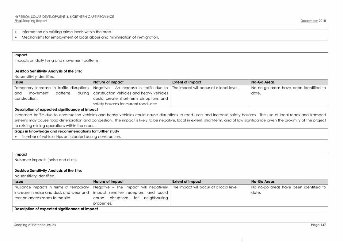
HYPERION SOLAR DEVELOPMENT 4, NORTHERN CAPE PROVINCEFinal Scoping Report December 2018
Scoping of Potential Issues Page 147
» Information on existing crime levels within the area.
» Mechanisms for employment of local labour and minimisation of in-migration.
Impact
Impacts on daily living and movement patterns.
Desktop Sensitivity Analysis of the Site:
No sensitivity identified.
Issue Nature of Impact Extent of Impact No-Go Areas
Temporary increase in traffic disruptions
and movement patterns during
construction.
Negative – An increase in traffic due to
construction vehicles and heavy vehicles
could create short-term disruptions and
safety hazards for current road users.
The impact will occur at a local level. No no-go areas have been identified to
date.
Description of expected significance of impact
Increased traffic due to construction vehicles and heavy vehicles could cause disruptions to road users and increase safety hazards. The use of local roads and transport
systems may cause road deterioration and congestion. The impact is likely to be negative, local in extent, short-term, and of low significance given the proximity of the project
to existing mining operations within the area.
Gaps in knowledge and recommendations for further study
» Number of vehicle trips anticipated during construction.
Impact
Nuisance impacts (noise and dust).
Desktop Sensitivity Analysis of the Site:
No sensitivity identified.
Issue Nature of Impact Extent of Impact No-Go Areas
Nuisance impacts in terms of temporary
increase in noise and dust, and wear and
tear on access roads to the site.
Negative – The impact will negatively
impact sensitive receptors, and could
cause disruptions for neighbouring
properties.
The impact will occur at a local level. No no-go areas have been identified to
date.
Description of expected significance of impact

HYPERION SOLAR DEVELOPMENT 4, NORTHERN CAPE PROVINCEFinal Scoping Report December 2018
Scoping of Potential Issues Page 148
Impacts associated with construction related activities include noise, dust and disruption or damage to adjacent properties. Site clearing activities increase the risk of dust and
noise being generated, which can in turn negatively impact on adjacent properties. The impact is likely to be negative, local in extent, short-term, and of low significance
given the proximity of the project to existing mining operations within the area, which are also likely to be associated with nuisance impacts.
Gaps in knowledge and recommendations for further study
» Impact of the mining operations on surrounding landowners.
Impact
Visual and sense of place impacts.
Desktop Sensitivity Analysis of the Site:
No sensitivity identified.
Issue Nature of Impact Extent of Impact No-Go Areas
Intrusion impacts from construction
activities will have an impact on the
area’s “sense of place”.
Negative – The project could alter the
area’s sense of place which could
negatively impact on sensitive receptors.
The impact will occur at a local level. No no-go areas have been identified to
date.
Description of expected significance of impact
Intrusion impacts such as aesthetic pollution (i.e. building materials, construction vehicles, etc.), noise and light pollution, and other impacts could impact the “sense of place”
for the local community. The Visual Impact Assessment (VIA) undertaken as part of the Scoping Phase determined that the visibility of the proposed project is likely to be
limited, and it is therefore unlikely to have a major influence on the character of the landscape as experienced by the majority of people. The impact is therefore likely to be
negative, local in extent, short-term, and of low significance; given the proximity of the project to existing mining operations and waste rock dumps, and the already
industrialised nature of the surrounding area.
Gaps in knowledge and recommendations for further study
» Potential sensitive visual receptors need to be identified.
» Visual Impact Assessment to inform the impact on the sense of place.

HYPERION SOLAR DEVELOPMENT 4, NORTHERN CAPE PROVINCEFinal Scoping Report December 2018
Scoping of Potential Issues Page 149
Evaluation of Potential Impacts Associated with the Operational Phase
7.3.1. Potential Impacts on Ecology
Impact
Faunal impacts due to the operation phase of the SEF.
The operation and presence of the SEF may lead to disturbance or persecution of fauna within or adjacent to the facility.
Desktop Sensitivity Analysis of the Site
Refer to Figure 7.1 for the desktop sensitivity analysis of the project site.
Issue Nature of Impact Extent of Impact No-Go Areas
Operational phase disturbance of fauna. Fauna will be disturbed or killed by
operational phase disturbances such as
electrocution along the perimeter fence
or run over by maintenance vehicles.
Local The bed of the Vlermuisleegte River
should be considered to be a no-go
area. This excludes sections where there
are already existing access roads which
can be used for access to the project site
(i.e. Access Road Alternative 1. Areas of
high tree density east of the
Vlermuisleegte River are also considered
unsuitable for development.
Description of expected significance of impact:
Faunal impacts during operation are likely to be of low intensity and of low significance with the implementation of appropriate mitigation.
Gaps in knowledge & recommendations for further study
» The fauna associated with the different habitats at the project site will need to be verified and characterised in the field.
» Recommendations regarding the most appropriate avoidance and mitigation measures to be implemented at the project site will need to be informed by the fauna
present at the project site and their distribution and potential movement pathways.
Impact
Negative impact on ESAs, CBAs and broad-scale ecological processes.
Development of the SEF and associated infrastructure may impact CBAs, ESAs and broad-scale ecological processes such as the ability of fauna to disperse.
Desktop Sensitivity Analysis of the Site
Refer to Figure 7.1 for the desktop sensitivity analysis of the project site.

HYPERION SOLAR DEVELOPMENT 4, NORTHERN CAPE PROVINCEFinal Scoping Report December 2018
Scoping of Potential Issues Page 150
Issue Nature of Impact Extent of Impact No-Go Areas
Presence of the SEF may impact broad-
scale ecological processes, while the
access roads may impact on CBAs and
ESAs.
The presence of the facility may disrupt
landscape connectivity for fauna and
cause habitat fragmentation.
Local The development should be restricted to
the lower sensitivity parts of the project
site.
Description of expected significance of impact:
The impact of the development on CBAs and broad-scale processes is likely to be relatively low and of low overall significance.
Gaps in knowledge & recommendations for further study
» The most important areas for faunal movement at the project site will need to be investigated and identified in the field at the site and used to inform the final layout of the
facility to ensure that important movement corridors are not disrupted by the development. While it is clear that the Vlermuisleegte River is an important feature, there may
also be other areas associated with the river which are important.
7.3.2. Potential Impacts on Watercourses
Impact
Potential encroachment and direct disturbance of the Vlermuisleegte River and depression wetlands, alterations to stormwater run-off, altering the hydrology of the systems
and increased sedimentation due to the development of the SEF.
Sediment laden stormwater runoff entering the Vlermuisleegte River is a potential impact that might occur during the operation phase of the SEF. All watercourses identified in
the desktop assessment have already been impacted on by surrounding agricultural activities. Many of the areas adjacent to the watercourses have been altered (e.g. by
ploughing and road crossings), increasing the likelihood of sediment run-off and proliferation of alien and invasive species. Based on the relevant databases, these
watercourses are in a relatively good ecological condition (NFEPA, 2011), however, based on the investigation of digital satellite imagery, the watercourses have been
impacted upon by agricultural activities and road crossings.
Desktop Sensitivity Analysis of the Site
A sensitivity map was compiled, illustrating areas of sensitivity that was identified within the project site (refer to Figure 7.2). This sensitivity map is preliminary in nature, and
information obtained during the site visit in the EIA phase will be used to fine-tune and ground-truth the map.
Issue Nature of Impact Extent of Impact No-Go Areas
Altered hydrology of the watercourses. The potential loss of catchment yield due
to stormwater management during
operation.
Local All delineated watercourses should be
considered to be no-go areas for
development, except for linear.
Mismanagement and ineffective
rehabilitation of watercourses.
The potential for siltation and changes in
the hydrological functioning of these
Local

HYPERION SOLAR DEVELOPMENT 4, NORTHERN CAPE PROVINCEFinal Scoping Report December 2018
Scoping of Potential Issues Page 151
areas.
Description of expected significance of impact
The potential occurrence of impacts associated with edge effects on the watercourses must be considered. If these edge effects are managed accordingly, the impact
significance on the watercourses is expected to be low. If linear infrastructure (such as roads (upgrading thereof) and underground cabling) is proposed as part of the
development, and crossing any of the watercourses, an impact is expected to occur, unless existing road crossings are utilised. The significance of impacts cannot be
identified until the layout of the proposed development has been finalised, which will be available during the EIA Phase.
Gaps in knowledge & recommendations for further study
» As the watercourses have only been assessed by using desktop analysis, their characteristics, Present Ecological State (PES) and goods and services could not accurately
be described. Therefore, a gap in the knowledge of the condition of these watercourses exists, and it is anticipated that these gaps will be sufficiently addressed during a
site investigation as part of the EIA Phase of this project. It is not expected that the delineation of the watercourses will change significantly.
» The positioning of the SEF and infrastructure must be determined. Infrastructure located within the applicable 500m/100m GN 509 regulated area of the watercourses must
be considered by the developer in light of the potential requirements for water use licensing, in line with the requirements of the National Water Act.
Impact
Potential impacts associated with the proposed Access Road Alternative 1.
Direct impacts are expected to occur as a result of the upgrading of the Access Road Alternative 1. During the operational phase, the culvert crossings would convey water
within a concentrated manner, instead of its current natural draining pattern (albeit already impacted upon by the existing road). If proper stormwater management
measures are not implemented, erosion could occur at these crossing points.
Desktop Sensitivity Analysis of the Site
Refer to Figure 7.2 for the desktop sensitivity analysis of the site.
Despite the river being considered a no-go area, upgrading of the existing road is not a no-go as it is not for new infrastructure but rather, it is considered to be an existing
impact. Based on the relevant databases, the Vlermuisleegte River is in a relatively good ecological condition (NFEPA, 2011). However, based on the investigation of digital
satellite imagery, the river has been impacted upon by agricultural activities and road crossings, increasing the likelihood of sediment run-off and proliferation of alien and
invasive species within the river.
Issue Nature of Impact Extent of Impact No-Go Areas
Alteration of runoff patterns. The potential for increased soil
compaction and erosion as a result of
road crossings.
Local Despite the river being considered a no-
go area, upgrading of the existing road is
not considered a fatal flaw. It is however
recommended that no new crossings
should be created, and that the route
Mismanagement and ineffective
rehabilitation of the river.
The potential for siltation and changes in
the hydrological functioning of the river.
Local

HYPERION SOLAR DEVELOPMENT 4, NORTHERN CAPE PROVINCEFinal Scoping Report December 2018
Scoping of Potential Issues Page 152
and crossings of the existing road be
followed.
Description of expected significance of impact
The proposed Access Road Alternative 1 has an existing impact on the Vlermuisleegte River. Upgrading thereof has the potential to impact on the river, with specific mention
of causing erosion and associated sedimentation of the river. It is recommended that the current route of the access road be used to limit any new disturbance footprint, and
therefore, limit the impact significance of the upgrading of the access road on the river. The significance of the impact cannot be accurately determined during the Scoping
Phase, as the site-specific assessment of the river and its Present Ecological State (PES) needs to be determined. This will be further refined and assessed during the EIA Phase of
this project.
Gaps in knowledge & recommendations for further study
» As the watercourses have only been assessed by using desktop analysis, their characteristics, the PES could not accurately be described. Therefore, a gap in the
knowledge of the condition of the watercourses exists, which will be accurately assessed and refined during a site investigation as part of the EIA Phase of this project.
Impact
Potential impacts associated with the proposed Access Road Alternative 2.
Access Road Alternative 2 is located approximately 4.3 km west of the Vlermuisleegte River and therefore a very low to insignificant impact on the Vlermuisleegte River is
expected. A small depression wetland (a no-go area) is located approximately 83m south of the entrance of the proposed Access Road Alternative 2 from the N14. Impacts
expected would potentially only be from edge effects, such as sediment laden stormwater runoff entering the depression wetland.
Desktop Sensitivity Analysis of the Site
Refer to Figure 7.2 for the desktop sensitivity analysis of the site.
According to the NFEPA database (2011), this depression wetland is considered to be in a moderately modified class (Class C). Based on analysis of digital satellite imagery,
this depression wetland is well vegetated with no apparent crossings (informal road crossings, nor cattle paths). Based on this information, this depression could best be
described as largely natural with a few modifications. As the proposed Access Road Alternative 2 is not within the 32m NEMA regulated area of the depression wetland,
sufficient protection of this watercourse is expected.
Issue Nature of Impact Extent of Impact No-Go Areas
Alteration of runoff patterns. The potential for increased erosion in the
vicinity of the watercourse.
Local The delineated depression wetland
should be considered as a no-go area.
Altered hydrology of the watercourse. The potential loss of catchment yield due
to stormwater management.
Local
Description of expected significance of impact
Since no activities associated with Access Road Alternative 2 is within close proximity to the depression wetland, the significance of impacts expected from this alternative

HYPERION SOLAR DEVELOPMENT 4, NORTHERN CAPE PROVINCEFinal Scoping Report December 2018
Scoping of Potential Issues Page 153
could be considered as low. This will be further refined and assessed during the EIA Phase of this project.
Gaps in knowledge & recommendations for further study
» As this depression wetland has only been assessed using desktop analyses, the present ecological state (PES) could not accurately be described. Therefore, a gap in the
knowledge of the condition of this watercourse exists, which will be accurately assessed during a site investigation as part of the EIA Phase of this project. It is expected
that the delineation of the watercourse will not significantly change.
7.3.3. Potential Impacts on Avifauna
Impact
Avian collision impacts related to the PV facility during the operational phase (collision with the PV panels and disturbance).
Desktop Sensitivity Analysis of the Site
Refer to Figure 7.3 for the desktop sensitivity analysis of the site.
Issue Nature of Impact Extent of Impact No-Go Areas
Disturbance due to general operational
activities and mortality of avifauna from
collisions with plant infrastructure.
Mortality among the local avifauna may
result due to direct collisions with solar
panels or entrapment along the fenced
boundaries of the facility.
Local The bed of the Vlermuisleegte River
should be considered to be a no-go area
apart from where there are already
existing access roads through this area
which can be used for access.
Description of expected significance of impact
Specific areas that will require mitigation include design of night-lighting and ensuring that the fence around the facility is constructed according to a bird-friendly design as
well as management of bird interactions will the infrastructure of the facility. With mitigation, the operational phase impact on avifauna is expected to be of low significance.
Gaps in knowledge & recommendations for further study
» The presence and distribution of species with are considered potentially more vulnerable to impact at PV facilities, should be better quantified with a follow-up summer
season survey.
Impact
Attraction of birds to the project site for nesting, roosting or other interactions.
Desktop Sensitivity Analysis of the Site
Refer to Figure 7.3 for the desktop sensitivity analysis of the site.
Issue Nature of Impact Extent of Impact No-Go Areas
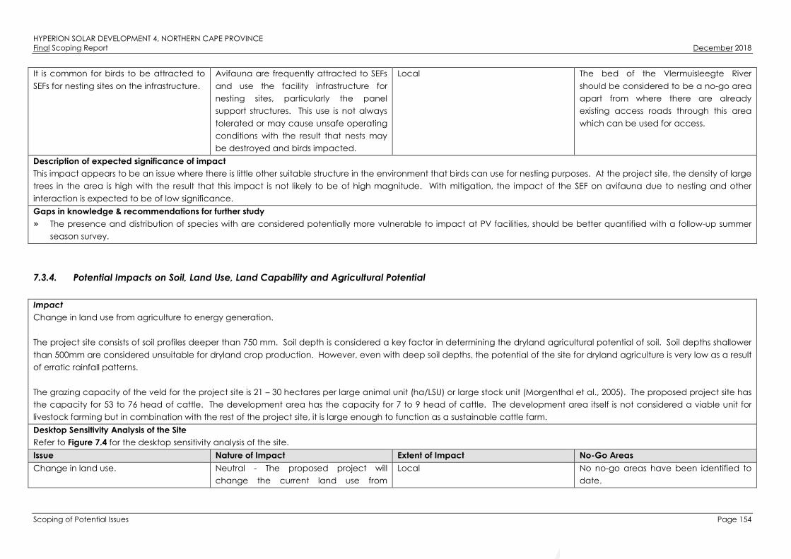
HYPERION SOLAR DEVELOPMENT 4, NORTHERN CAPE PROVINCEFinal Scoping Report December 2018
Scoping of Potential Issues Page 154
It is common for birds to be attracted to
SEFs for nesting sites on the infrastructure.
Avifauna are frequently attracted to SEFs
and use the facility infrastructure for
nesting sites, particularly the panel
support structures. This use is not always
tolerated or may cause unsafe operating
conditions with the result that nests may
be destroyed and birds impacted.
Local The bed of the Vlermuisleegte River
should be considered to be a no-go area
apart from where there are already
existing access roads through this area
which can be used for access.
Description of expected significance of impact
This impact appears to be an issue where there is little other suitable structure in the environment that birds can use for nesting purposes. At the project site, the density of large
trees in the area is high with the result that this impact is not likely to be of high magnitude. With mitigation, the impact of the SEF on avifauna due to nesting and other
interaction is expected to be of low significance.
Gaps in knowledge & recommendations for further study
» The presence and distribution of species with are considered potentially more vulnerable to impact at PV facilities, should be better quantified with a follow-up summer
season survey.
7.3.4. Potential Impacts on Soil, Land Use, Land Capability and Agricultural Potential
Impact
Change in land use from agriculture to energy generation.
The project site consists of soil profiles deeper than 750 mm. Soil depth is considered a key factor in determining the dryland agricultural potential of soil. Soil depths shallower
than 500mm are considered unsuitable for dryland crop production. However, even with deep soil depths, the potential of the site for dryland agriculture is very low as a result
of erratic rainfall patterns.
The grazing capacity of the veld for the project site is 21 – 30 hectares per large animal unit (ha/LSU) or large stock unit (Morgenthal et al., 2005). The proposed project site has
the capacity for 53 to 76 head of cattle. The development area has the capacity for 7 to 9 head of cattle. The development area itself is not considered a viable unit for
livestock farming but in combination with the rest of the project site, it is large enough to function as a sustainable cattle farm.
Desktop Sensitivity Analysis of the Site
Refer to Figure 7.4 for the desktop sensitivity analysis of the site.
Issue Nature of Impact Extent of Impact No-Go Areas
Change in land use. Neutral - The proposed project will
change the current land use from
Local No no-go areas have been identified to
date.

HYPERION SOLAR DEVELOPMENT 4, NORTHERN CAPE PROVINCEFinal Scoping Report December 2018
Scoping of Potential Issues Page 155
agriculture to energy generation.
Description of expected significance of impact
The only impact on land use will be the change of land use from livestock farming to that of renewable energy generation. The cumulative impact on land use is that portions
of land that were previously used for agriculture in the region are converted into alternative land uses. There are also other proposed renewable energy projects in the area
that will cumulatively reduce the areas currently available for agriculture. The proposed project may have a moderate to major positive impact on the current land use and in
the worst case, have a neutral impact. No mitigation measures are recommended and the expected significance of the impact will still be moderately to majorly positive.
Gaps in knowledge & recommendations for further study
» The economic viability of livestock farming vs renewable energy generation will be calculated during the detailed EIA Phase.
Impact
Change in the agricultural potential of the site.
Following the land capability classification data obtained from the DAFF, the site has low to moderately low agricultural potential (therefore only suitable for grazing with
certain management practices required).
Desktop Sensitivity Analysis of the Site
Refer to Figure 7. for the desktop sensitivity analysis of the site.
Issue Nature of Impact Extent of Impact No-Go Areas
Impact on agricultural potential. The agricultural potential of areas where
the solar panels are constructed may be
altered as a result of the disturbance to
the soil profiles.
Local No no-go areas have been identified to
date.
Description of expected significance of impact
The agricultural potential of the area where the proposed project will be located will not be affected by the proposed project. The site has low to low-moderate land
capability and although the proposed project will cover a surface area of 180ha, it is not anticipated that the inherent land capability of the site will be changed permanently
by the project. With mitigation measures in place, the impact is expected to remain neutral.
Gaps in knowledge & recommendations for further study
» The final agricultural potential will be determined using the data gathered with the site survey. Soil forms will be grouped into land capability classes.

HYPERION SOLAR DEVELOPMENT 4, NORTHERN CAPE PROVINCEFinal Scoping Report December 2018
Scoping of Potential Issues Page 156
Impact
Soil chemical pollution.
Desktop Sensitivity Analysis of the Site
Refer to Figure 7.4 for the desktop sensitivity analysis of the site.
Issue Nature of Impact Extent of Impact No-Go Areas
Soil chemical pollution. Oil and fuel spillages, as well as waste
generation during the project cycle, will
result in soil chemical pollution.
Local No no-go areas have been identified to
date.
Description of expected significance of impact
Chemical soil pollution may occur during the operational phase when maintenance will be done on the infrastructure. The significance of this impact is moderate to high. It is
expected that with the correct mitigation measures such as proper waste management and spill checks for vehicles, the impact will be of low significance.
Gaps in knowledge & recommendations for further study
» The only knowledge gap is the full project description that includes detail of activities and materials that may result in soil pollution during the different project phases. A
detailed layout will be assessed during the EIA Phase of the project.
7.3.5. Potential Impacts on Heritage (Archaeology and Palaeontology)
The majority of potential impacts on heritage (archaeology and palaeontology) associated with the project would occur during the construction phase (refer
to Section 7.2.5). No impacts on heritage (archaeology and palaeontology) are expected during the operation phase.
7.3.6. Potential Visual Impacts
Impact
The proposed development could negatively impact on the landscape character of the affected area.
This impact relates to the degradation / industrialisation of the rural landscape character. The proposed development area is located within an area that is perceived as
being a semi-natural rural landscape. It is however being developed rapidly with other similar solar projects. The initial review indicates that whilst glimpses of these projects
may be possible, the perception of a semi-natural landscape is likely to remain. The proposed development is not likely to significantly change this perception.
Desktop Sensitivity Analysis of the Site

HYPERION SOLAR DEVELOPMENT 4, NORTHERN CAPE PROVINCEFinal Scoping Report December 2018
Scoping of Potential Issues Page 157
From the initial review of likely visual impacts, it appears that local homesteads are the only receptors that are likely to be impacted to any significant degree.
In order to provide guidance to the applicant, the following development recommendations have been made:
» Development should not occur within 1km of homesteads outside the development property; and
» Development should not occur within 500m of the homestead within the development property.
At these distances, with appropriate mitigation, the development should be screened from external homesteads and should not dominate views from the internal homestead.

HYPERION SOLAR DEVELOPMENT 4, NORTHERN CAPE PROVINCEFinal Scoping Report December 2018
Scoping of Potential Issues Page 158
Figure 7.7: Visual sensitivity map indicating the areas where from a visual perspective is considered to be undesirable for development.

HYPERION SOLAR DEVELOPMENT 4, NORTHERN CAPE PROVINCEFinal Scoping Report December 2018
Scoping of Potential Issues Page 159
Issue Nature of Impact Extent of Impact No-Go Areas
Industrialisation of the landscape. The proposed development is likely to
have limited impact due general limited
visibility.
The impact is likely to affect the
immediately surrounding area.
No no-go areas have been identified
from a visual perspective.
Description of expected significance of impact
There is likely to be minimal additional industrial influence on surrounding landscape character as experienced by the majority of receptors. The impact is expected to have a
low significance. Possible mitigation measures may include:
» Maintain and augment existing screening vegetation; and
» Colour the back face of PV panels. This may only be applicable to the row / rows of panels that are developed furthest south and directly face onto the adjacent
property.
Gaps in knowledge & recommendations for further study
» Confirmation of sensitivity of the landscape and receptors from a site visit and consultation during the EIA process.
» A development layout and details of structure height is needed to assess the impacts as well as the identification of possible mitigation measures in any detail.
Impact
The proposed development could negatively impact on views from roads.
This impact relates to the industrialisation of the rural landscape as viewed from roads. Possible receptors include travellers on the N14, the R308 and a local road known the
T25. The affected sections of all roads are in excess of 3.8km from the proposed development. Due to the flat topography, the distance involved and the natural vegetation
which is likely to provide a degree of screening, it is unlikely that the project will be obvious from these roads.
Desktop Sensitivity Analysis of the Site
Refer to Figure 7.7 for the desktop sensitivity analysis of the project site.
Issue Nature of Impact Extent of Impact No-Go Areas
Industrialisation of the landscape. The proposed development is likely to
have limited impact due general limited
visibility.
This is likely to affect the immediately
surrounding area.
No no-go areas have been identified
from a visual perspective.
Description of expected significance of impact
There is likely to be minimal additional industrial influence on surrounding landscape character as experienced by the majority of receptors. The impact significance is
therefore anticipated to be low. Possible mitigation measures may include:
» Maintain and augment existing screening vegetation; and
» Colour the back face of PV panels.
Gaps in knowledge & recommendations for further study

HYPERION SOLAR DEVELOPMENT 4, NORTHERN CAPE PROVINCEFinal Scoping Report December 2018
Scoping of Potential Issues Page 160
» Confirmation of sensitivity of the landscape and receptors from a site visit and consultation during the EIA process.
» A development layout and details of structure height is needed to assess the impacts as well as the identification of possible mitigation measures in any detail.
Impact
The proposed development could negatively impact on views from local homesteads.
There is one homestead situated approximately 1km from the proposed development. These buildings are surrounded by trees which are likely to provide a degree of
screening. Any visual impact is also likely to be part mitigated by distance as well as screening that is likely to be provided by existing natural vegetation.
A second homestead is located approximately 1.1km north of the development area. Should Hyperion Solar Development 4 be developed, this project will completely screen
Hyperion Solar Development 4 from this homestead. It should also be noted that this homestead is inhabited by the land owner and his family. It has been confirmed that he is
in agreement with the proposed development. A 500m no development area was recommended by the Visual Specialist in order to ensure that the proposed development
does not completely dominate views from the homestead. This has been incorporated into the proposed layout by the developer.
There is a group of buildings that appears to be comprised of four homesteads approximately 2.3km south east. There is an area of trees between the homesteads and the
proposed development that is likely to at least partly screen views of the proposed development. There is also a group of buildings approximately 2.7km to the east of the
proposed development. Existing vegetation is also likely to provide screening for this receptor.
The remaining four groups of buildings are in further than 4km away from the SEF. It is possible that glimpses of the proposed development may be possible from these,
however, distance and intervening natural vegetation is likely to largely screen views.
Desktop Sensitivity Analysis of the Site
Refer to Figure 7.7 for the desktop sensitivity analysis of the project site.
Issue Nature of Impact Extent of Impact No-Go Areas
Industrialisation of the landscape. The proposed development is likely to
have limited impact due to general
limited visibility.
This is likely to affect the immediately
surrounding area.
No no-go areas have been identified
from a visual perspective.
Description of expected significance of impact
With the exception of the landowner’s house, there is likely to be limited change of surrounding landscape character as experienced from the majority of homesteads.
Possible mitigation measures may include:
» Maintain and augment existing screening vegetation; and
» Colour the back face of PV panels.
Gaps in knowledge & recommendations for further study

HYPERION SOLAR DEVELOPMENT 4, NORTHERN CAPE PROVINCEFinal Scoping Report December 2018
Scoping of Potential Issues Page 161
» Confirmation of sensitivity of the landscape and receptors from a site visit and consultation during the EIA process.
» A development layout and details of structure height is needed to assess the impacts as well as the identification of possible mitigation measures in any detail.
Impact
Glint and glare as experienced from aircraft on approach to Sishen Airport.
Should glint and glare be problematic, it will likely only have an influence during early mornings and during the summer when the sun is furthest south and low on the horizon.
Due to the distance and the angle at which the PV panels are set in relation to the flight path, glint and glare is unlikely to be problematic.
Desktop Sensitivity Analysis of the Site
Refer to Figure 7.7 for the desktop sensitivity analysis of the project site.
Issue Nature of Impact Extent of Impact No-Go Areas
Glint and glare impacting on flight path
to the airport.
The proposed development is unlikely to
impact.
This is likely to affect the immediately
surrounding area.
No no-go areas have been identified
from a visual perspective.
Description of expected significance of impact
If there will be an impact, it is likely to be limited. It will also not impact on the direct line of the flight path due to the location and orientation of PV panels. Possible mitigation
measures may include:
» Ensure non reflective coating is applied to panel faces.
Gaps in knowledge & recommendations for further study
» Confirmation of sensitivity of the landscape and receptors from a site visit and consultation during the EIA process.
» A development layout and details of structure height is needed to assess the impacts.
Impact
Night time lighting impacts.
Security and operational lighting could make the project visible to visual receptors at night. This will be seen in the context of other projects, i.e. lighting associated with mining
and settlements.
Desktop Sensitivity Analysis of the Site
Refer to Figure 7.7 for the desktop sensitivity analysis of the project site.
Issue Nature of Impact Extent of Impact No-Go Areas
Lighting impacts The proposed development is likely to be
obvious during night time.
This is likely to affect the immediately
surrounding area.
No no-go areas have been identified
from a visual perspective.

HYPERION SOLAR DEVELOPMENT 4, NORTHERN CAPE PROVINCEFinal Scoping Report December 2018
Scoping of Potential Issues Page 162
Description of expected significance of impact
Due to the nature of the surrounding landscape which is likely to include lighting from mining operations and other solar projects, the significance of this impact is likely to be
low. Possible mitigation measures may include:
» Infra red security system;
» Motion activated security system; and
» Minimising operational lighting at night.
Gaps in knowledge & recommendations for further study
» Confirmation of sensitivity of the landscape and receptors from a site visit and consultation during the EIA process.
» A development layout and details of structure height is needed to assess the impacts as well as the identification of possible mitigation measures in any detail.
7.3.7. Potential Socio-Economic Impacts
Impact
Direct and indirect employment opportunities and skills development.
Desktop Sensitivity Analysis of the Site:
No sensitivity identified.
Issue Nature of Impact Extent of Impact No-Go Areas
Creation of direct and indirect
employment, skills development
opportunities and skills development as a
result of the operation of the project.
Positive – The creation of employment
opportunities and skills development will
assist to an extent in alleviating
unemployment levels within the area.
The impact will occur at local, regional,
and national levels.
No no-go areas have been identified to
date.
Description of expected significance of impact
During operation, a maximum of approximately 65 employment opportunities will be created. Of those employment opportunities created approximately 70% will comprise
opportunities for semi-skilled workers, and approximately 30% will comprise opportunities for skilled workers. Employment opportunities include safety and security staff,
operation and monitoring; and maintenance crew. Maintenance activities will be carried out throughout the lifespan of the project, and include washing of solar panels,
vegetation control, and general maintenance around the SEF. The impact is likely to be positive, local-to-national in extent, long-term, and of medium significance.
Gaps in knowledge and recommendations for further study
» Information on exact direct and indirect employment opportunities and skills development programmes likely to be created during operation.

HYPERION SOLAR DEVELOPMENT 4, NORTHERN CAPE PROVINCEFinal Scoping Report December 2018
Scoping of Potential Issues Page 163
Impact
Development of non-polluting, renewable energy infrastructure.
Desktop Sensitivity Analysis of the Site:
No sensitivity identified.
Issue Nature of Impact Extent of Impact No-Go Areas
Development of non-polluting,
renewable energy infrastructure.
Positive – Increasing the contribution of
the renewable energy sector to the local
economy would contribute to the
diversification of the local economy and
provide greater economic stability.
The impact will occur at local, regional,
and national levels.
No no-go areas have been identified to
date.
Description of expected significance of impact
The generation of renewable energy will contribute to South Africa’s electricity market, and may contribute to the diversification of the local economy. The growth in the
renewable energy sector as a whole could introduce new skills and development into the area. The impact is likely to be positive, local-to-national in extent, long-term, and of
medium significance.
Gaps in knowledge and recommendations for further study
» Information on the proposed project’s contribution towards diversifying the local economy.
Impact
Contribution to local economic development and social upliftment.
Desktop Sensitivity Analysis of the Site:
No sensitivity identified.
Issue Nature of Impact Extent of Impact No-Go Areas
Benefits to the local area from Socio-
Economic Development (SED) / Enterprise
Development (ED) programmes and
community trust from REIPPP Programme
social responsibilities.
Positive – The creation of employment
opportunities, skills development, and the
proposed project’s contributions to local
economic development will assist to an
extent in both alleviating unemployment
levels within the area, and improving the
quality of life.
The impact will occur at local, regional,
and national levels.
No no-go areas have been identified to
date.
Description of expected significance of impact

HYPERION SOLAR DEVELOPMENT 4, NORTHERN CAPE PROVINCEFinal Scoping Report December 2018
Scoping of Potential Issues Page 164
Under the REIPPP Programme, renewable energy projects are required to contribute to local economic development in the area. Awarded projects are required to spend a
certain amount of their generated revenue (as defined in the agreement with DoE) on Socio-Economic Development (SED) and Enterprise Development (ED) and share
ownership in the project company with local communities. The impact is likely to be positive, local-to-national in extent, long-term, and of high significance.
Gaps in knowledge and recommendations for further study
» Information on the project’s proposed contributions.
Impact
Visual and sense of place impacts.
Desktop Sensitivity Analysis of the Site:
No sensitivity identified.
Issue Nature of Impact Extent of Impact No-Go Areas
Sense of place impacts from a social
perspective associated with the
operation phase of the SEF and
associated infrastructure.
Negative – The project could alter the
areas sense of place which could
negatively impact on sensitive receptors.
The impact will occur at a local level. No no-go areas have been identified to
date.
Description of expected significance of impact
The presence of the SEF could impact the “sense of place” for the local community. The Visual Impact Assessment (VIA) undertaken as part of the Scoping Phase determined
that the visibility of the proposed project is likely to be limited, and it is therefore unlikely to have a major influence on the character of the landscape as experienced by the
majority of people. The impact is therefore likely to be negative, local in extent, short-term, and of low significance; given the proximity of the project to existing mining
operations and waste rock dumps, and the already industrialised nature of the surrounding area.
Gaps in knowledge and recommendations for further study
» Potential sensitive visual receptors need to be identified.
» Visual Impact Assessment to inform impact on sense of place.
Impact
Impacts associated with the loss of agricultural land.
Desktop Sensitivity Analysis of the Site:
No sensitivity identified.
Issue Nature of Impact Extent of Impact No-Go Areas

HYPERION SOLAR DEVELOPMENT 4, NORTHERN CAPE PROVINCEFinal Scoping Report December 2018
Scoping of Potential Issues Page 165
The development footprint on which the
SEF will be developed will be removed
from agricultural production.
Negative – Impacts associated with loss
of agricultural land due to occupation of
land by the SEF.
The impact will occur at a local level. No no-go areas have been identified to
date.
Description of expected significance of impact
The development of the proposed project on an agricultural property (which is currently being utilised for grazing purposes) would result in an area of land required to support
the development footprint being removed from potential agricultural production and could impact on grazing potential. In the event that the land on which the project is
proposed is being productively utilised for agricultural purposes this could have a negative impact on agricultural jobs, and implications in terms of food production and
security. The impact is likely to be negative, local in extent, long-term, and of low significance. The applicability of this impact would need to be determined following the
completion of a soils, land use, land capability, and agricultural potential impact assessment.
Gaps in knowledge and recommendations for further study
» The current land use and agricultural potential of the area likely to be removed from agricultural production needs to be determined.
Evaluation of Potential Cumulative Impacts Associated with the project
Impacts of a cumulative nature place the direct and indirect impacts of the proposed project into a regional and national context, particularly in view of
similar or resultant developments and activities in the region. Potential cumulative impacts associated with Hyperion Solar Development 4 are described
below; these will be assessed in detail as part of the subsequent EIA phase to be conducted for the project.

HYPERION SOLAR DEVELOPMENT 4, NORTHERN CAPE PROVINCEFinal Scoping Report December 2018
Scoping of Potential Issues Page 166
Impact
Cumulative impacts, in relation to an activity, refer to the impact of an activity that in itself may not be significant but may become significant when added to the existing and
potential impacts eventuating from similar or diverse activities or undertakings in the area. For cumulative effects analysis to help the decision-maker and inform interested
parties, it must be limited to effects that can be evaluated meaningfully (DEAT, 2004). Boundaries must be set so analysts are not attempted to measure effects on everything.
Therefore, the cumulative impacts associated with Hyperion Solar Development 4 have been viewed from two perspectives within this Scoping Report:
» Cumulative impacts associated with the scale of the projects (i.e. one 75MW PV Facility proposed on the project site); and
» Cumulative impacts associated with other relevant planned, approved or existing solar developments within a 30km radius of the project site.
Refer to Figure 7.5 for an illustration of other solar energy facilities (approved and constructed) located within the surrounding areas of the project site.
Cumulative effects are commonly understood as the impacts which combine from different projects and which result in significant change, which is larger than the sum of all
the impacts (DEAT, 2004). The complicating factor is that the projects that need to be considered are from past, present and reasonably foreseeable future development.
Cumulative effects can be characterised according to the pathway they follow. One pathway could be the persistent additions from one process. Another pathway could
be the compounding effect from one or more processes. Cumulative effects can therefore occur when impacts are:
» Additive (incremental);
» Interactive;
» Sequential; or
» Synergistic.
Canter and Sadler (1997) describe the following process for addressing cumulative effects in an EIA:
» Delineating potential sources of cumulative change (i.e. GIS to map the relevant renewable energy facilities in close proximity to one another);
» Identifying the pathways of possible change (direct impacts);
» Indirect, non-linear or synergistic processes; and
» Classification of resultant cumulative changes.

HYPERION SOLAR DEVELOPMENT 4, NORTHERN CAPE PROVINCEFinal Scoping Report December 2018
Scoping of Potential Issues Page 167
The Hyperion Solar Development 4 is proposed on the Remaining Extent of the Farm Lyndoch 432, located approximately 16km north of Kathu, in the Northern Cape Province.
Table 7.2 provides details of other known approved solar energy projects / developments located within a 30km radius of Hyperion Solar Development 4. This information was
obtained from the Department of Environmental Affairs’ (DEA’s) latest release of the South African Renewable Energy EIA Application Database (REEA_OR_2018_Q2, 05 July
2018)18.
Table 7.2: Other solar energy projects / developments approved within a 30km radius of Hyperion Solar Development 4.
Project Name DEA Reference Number(s) Location
Approximate distance
from Hyperion Solar
Development 4
Project Status
Kalahari Solar Power Project (CSP)
(1 x 100MW project)12/12/20/1994/1
Remaining Extent of the Farm
Kathu 465~9.3km south west
Preferred Bidder
(already constructed)
Kalahari Solar Power Project (CSP)
(1 x 150MW project)12/12/20/1994/2
Remaining Extent of the Farm
Kathu 465~9.3km south west Approved
Kalahari Solar Power Project (CSP)
(1 x 150MW project)12/12/20/1994/3
Remaining Extent of the Farm
Kathu 465~9.3km south west Approved
Bestwood Solar Farm (PV) 12/12/20/1906Remaining Extent of the Farm
Bestwood 459~14km south Approved
Boitshoko Solar Power Plant (PV) (1 x 115MW
project)14/12/16/3/3/2/935
Remaining Extent of Portion 1 of the
Farm Lime Bank 471~15.4km south west Approved
Sishen Solar Farm (PV) (1 x 75MW project) 12/12/20/1860Portion 6 of the Farm Wincanton
472~15.8km west
Preferred Bidder
(already constructed)
Kathu SEF (PV) (1 x 75MW project) 12/12/20/1858/1Portion 4 of the Farm Wincanton
472~15.8km west
Preferred Bidder
(already constructed)
Kathu SEF (PV) (1 x 25MW project) 12/12/20/1858/2Portion 4 of the Farm Wincanton
472~15.8km west Approved
18 Source: The DEA’s Environment Geographic Information Systems (EGIS) website (https://egis.environment.gov.za/).
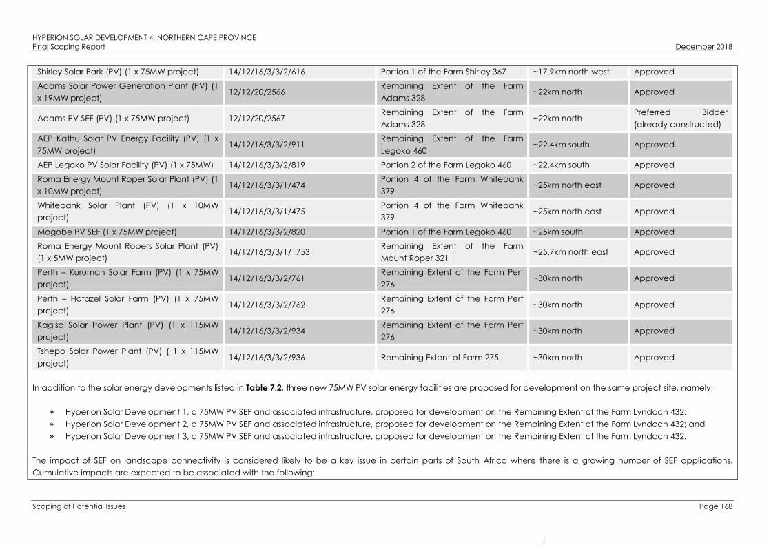
HYPERION SOLAR DEVELOPMENT 4, NORTHERN CAPE PROVINCEFinal Scoping Report December 2018
Scoping of Potential Issues Page 168
Shirley Solar Park (PV) (1 x 75MW project) 14/12/16/3/3/2/616 Portion 1 of the Farm Shirley 367 ~17.9km north west Approved
Adams Solar Power Generation Plant (PV) (1
x 19MW project)12/12/20/2566
Remaining Extent of the Farm
Adams 328~22km north Approved
Adams PV SEF (PV) (1 x 75MW project) 12/12/20/2567Remaining Extent of the Farm
Adams 328~22km north
Preferred Bidder
(already constructed)
AEP Kathu Solar PV Energy Facility (PV) (1 x
75MW project)14/12/16/3/3/2/911
Remaining Extent of the Farm
Legoko 460~22.4km south Approved
AEP Legoko PV Solar Facility (PV) (1 x 75MW) 14/12/16/3/3/2/819 Portion 2 of the Farm Legoko 460 ~22.4km south Approved
Roma Energy Mount Roper Solar Plant (PV) (1
x 10MW project)14/12/16/3/3/1/474
Portion 4 of the Farm Whitebank
379~25km north east Approved
Whitebank Solar Plant (PV) (1 x 10MW
project)14/12/16/3/3/1/475
Portion 4 of the Farm Whitebank
379~25km north east Approved
Mogobe PV SEF (1 x 75MW project) 14/12/16/3/3/2/820 Portion 1 of the Farm Legoko 460 ~25km south Approved
Roma Energy Mount Ropers Solar Plant (PV)
(1 x 5MW project)14/12/16/3/3/1/1753
Remaining Extent of the Farm
Mount Roper 321~25.7km north east Approved
Perth – Kuruman Solar Farm (PV) (1 x 75MW
project)14/12/16/3/3/2/761
Remaining Extent of the Farm Pert
276~30km north Approved
Perth – Hotazel Solar Farm (PV) (1 x 75MW
project)14/12/16/3/3/2/762
Remaining Extent of the Farm Pert
276~30km north Approved
Kagiso Solar Power Plant (PV) (1 x 115MW
project)14/12/16/3/3/2/934
Remaining Extent of the Farm Pert
276~30km north Approved
Tshepo Solar Power Plant (PV) ( 1 x 115MW
project)14/12/16/3/3/2/936 Remaining Extent of Farm 275 ~30km north Approved
In addition to the solar energy developments listed in Table 7.2, three new 75MW PV solar energy facilities are proposed for development on the same project site, namely:
» Hyperion Solar Development 1, a 75MW PV SEF and associated infrastructure, proposed for development on the Remaining Extent of the Farm Lyndoch 432;
» Hyperion Solar Development 2, a 75MW PV SEF and associated infrastructure, proposed for development on the Remaining Extent of the Farm Lyndoch 432; and
» Hyperion Solar Development 3, a 75MW PV SEF and associated infrastructure, proposed for development on the Remaining Extent of the Farm Lyndoch 432.
The impact of SEF on landscape connectivity is considered likely to be a key issue in certain parts of South Africa where there is a growing number of SEF applications.
Cumulative impacts are expected to be associated with the following:

HYPERION SOLAR DEVELOPMENT 4, NORTHERN CAPE PROVINCEFinal Scoping Report December 2018
Scoping of Potential Issues Page 169
» Loss of vegetation and species of conservation concern;
» Impacts on faunal habitats and sensitive faunal species;
» Impacts on watercourses;
» Impacts on soil resources, land use, and agricultural potential;
» Impacts on Critical Biodiversity Areas (CBAs) as defined by the Northern Cape provincial authorities and broad-scale Ecological processes;
» Loss of heritage resources (including archaeological and palaeontological resources);
» Visual impacts; and
» Impacts on the social environment (both positive and negative).
Hyperion Solar Development 4 is proposed in an area which has historically been used for agricultural activities (livestock grazing). The Kathu area and its surrounds (within
which Hyperion Solar Development 4 is proposed) receive a suitable annual amount of solar radiation which is considered appropriate for the development of SEFs, as is
evidenced by the numerous facilities already proposed in the area (as detailed in Table 7.2 above). It can therefore be expected that the area will be developed for SEFs,
adding to the cumulative impact of the overall area.
In addition to cumulative impacts associated with the proposed development of Hyperion Solar Development 4 and other similar developments in the area, cumulative
impacts are also to be considered at a site level. The potential direct cumulative impacts associated with Hyperion Solar Development 4 is expected to be associated
predominantly with the potential ecology impact, potential soil impacts, and potential impacts on visual and social aspects and features in the surrounding areas.
Summary of the nature, significance, consequence, extent, duration and probability of the impacts
» The above-mentioned impacts are considered to be probable, although it is anticipated that the extent, duration, and magnitude of these impacts can be minimised
to levels where this impact can be regarded as having low significance through the implementation of appropriate mitigation measures.
» The operational lifespan of the project and other SEFs within the surrounding areas is expected to be long-term (i.e. a minimum of 20 years) and subsequently the
impact is also expected to be long-term.
» The impact associated with the proposed development is expected to be local, affecting mainly the immediate environment and surrounding areas, as well as other
renewable energy facilities within the vicinity.
Gaps in knowledge & recommendations for further study:
» Each specialist study will consider and assess the cumulative impacts of proposed, approved and authorised renewable projects in the area.
» Cumulative impacts will be fully assessed and considered in the EIA phase.

HYPERION SOLAR DEVELOPMENT 4, NORTHERN CAPE PROVINCEFinal Scoping Report December 2018
Scoping of Potential Issues Page 170
Figure 7.5: Cumulative map illustrating other approved and/or constructed solar energy facilities located within the vicinity of the Hyperion Solar
Development 4 project site (Appendix M).

HYPERION SOLAR DEVELOPMENT 4, NORTHERN CAPE PROVINCEFinal Scoping Report December 2018
Conclusions Page 171
CONCLUSIONS
This Final Scoping Report is aimed at detailing the nature and extent of the proposed development,
identifying and describing potential issues associated with developing the project on the identified project
site, identifying potential environmental fatal flaws and / or areas of sensitivity, and defining the extent of
studies required to be undertaken as part of the detailed EIA phase. This has been achieved through an
evaluation of the proposed development, considering available information, input from I&APs, and input
from the project team with experience on similar projects. This Final Scoping Report has been compiled in
terms of the 2014 EIA Regulations (GNR 326) published in terms of Section 24(5) of NEMA.
A summary of the conclusions of the evaluation of the potential impacts identified to be associated with
the project is provided in Section 8.2. Recommendations regarding investigations required to be
undertaken within the detailed EIA phase are provided within the Plan of Study for EIA, contained in Error!
Reference source not found. of this Final Scoping Report.
Legal Requirements as per the EIA Regulations, 2014 (as amended)
This chapter of the scoping report includes the following information required in terms of Appendix 2:
Content of the Scoping Report:
Requirement Relevant Section
(g)(xi) a concluding statement indicating the preferred
alternatives, including the preferred location of the
activity.
A concluding statement regarding Hyperion Solar
Development 4 is included within this chapter as a whole.
Conclusions drawn from the Evaluation of the Proposed Development
Hyperion Solar Development 4 is proposed on the Remaining Extent of the Farm Lyndoch 432 (referred to
as the project site within this report), which is located approximately 16km north of Kathu. The site falls
within Ward 7 of the Gamagara Local Municipality, of John Taolo Gaetsewe District, in the Northern Cape
Province. The proposed development will have a contracted capacity of up to 75MW, and will make use
of PV solar technology for the generation of electricity. The project will comprise the following key
infrastructure and components:
» Arrays of PV panels (static and tracking PV system) with a contracted capacity of up to 75MW.
» Mounting structures to support the PV panels.
» Cabling between the project components, to be laid underground where practical.
» On-site inverters to convert the power from a direct current to an alternating current.
» An on-site substation to facilitate the connection between the SEF and the Eskom electricity grid.

HYPERION SOLAR DEVELOPMENT 4, NORTHERN CAPE PROVINCEFinal Scoping Report December 2018
Conclusions Page 172
» A new 132kV power line between the on-site substation and the existing Ferrum Substation19.
» Battery storage mechanism with a storage capacity of up to 300MWh.
» Water purification plant.
» Site Offices and Maintenance Buildings, including workshop areas for maintenance and storage.
» Batching plant.
» Temporary laydown areas.
» Main access road to the site, internal access roads and fencing around the development area.
Table 8.1 and Table 8.2 provide a summary of the extent and significance of potential impacts identified at
this stage in the process as being associated with the development of Hyperion Solar Development 4.
These evaluations are preliminary in nature, and will only be finalised once more in-depth investigations
and site surveys have been conducted (i.e. during the EIA phase).
Table 8.1: Potential Impacts associated with the Construction Phase
Construction / Decommissioning Phase Impacts Extent20 Significance21
Potential Negative Impacts
Impacts on vegetation and protected plant species. L M
Direct Faunal impacts. L L M
Direct disturbance of watercourse habitat. L L
The decrease of watercourse habitat integrity. L L
Alteration of runoff patterns. L L
Altered hydrology of the watercourses. L L
Altered stream and baseflow patterns. L L
Mismanagement and ineffective rehabilitation of watercourses. L L
Direct disturbance of the remaining habitat of the river as a result of the upgrade of
Access Road Alternative 1.
L L
The decrease of riparian vegetation and habitat integrity as a result of the upgrade
of Access Road Alternative 1.
L L
Alteration of runoff patterns as a result of the access road alternatives. L L
Altered stream and baseflow patterns as a result of the upgrade of Access Road
Alternative 1.
L L
Mismanagement and ineffective rehabilitation of the river as a result of the upgrade
of Access Road Alternative 1.
L L
19 The construction of the 132kV overhead power line will be assessed as part of a separate Basic Assessment process which will
consider feasible alternatives for the power line route.
20 Extent
*L Local R Regional N National I International
21 Significance
*L Low M Medium H Highn/a Cannot be predicted in
Scoping Phase
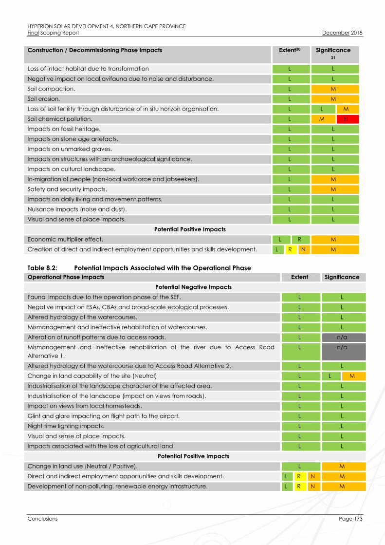
HYPERION SOLAR DEVELOPMENT 4, NORTHERN CAPE PROVINCEFinal Scoping Report December 2018
Conclusions Page 173
Construction / Decommissioning Phase Impacts Extent20 Significance21
Loss of intact habitat due to transformation L L
Negative impact on local avifauna due to noise and disturbance. L L
Soil compaction. L M
Soil erosion. L M
Loss of soil fertility through disturbance of in situ horizon organisation. L L M
Soil chemical pollution. L M H
Impacts on fossil heritage. L L
Impacts on stone age artefacts. L L
Impacts on unmarked graves. L L
Impacts on structures with an archaeological significance. L L
Impacts on cultural landscape. L L
In-migration of people (non-local workforce and jobseekers). L M
Safety and security impacts. L M
Impacts on daily living and movement patterns. L L
Nuisance impacts (noise and dust). L L
Visual and sense of place impacts. L L
Potential Positive Impacts
Economic multiplier effect. L R M
Creation of direct and indirect employment opportunities and skills development. L R N M
Table 8.2: Potential Impacts Associated with the Operational Phase
Operational Phase Impacts Extent Significance
Potential Negative Impacts
Faunal impacts due to the operation phase of the SEF. L L
Negative impact on ESAs, CBAs and broad-scale ecological processes. L L
Altered hydrology of the watercourses. L L
Mismanagement and ineffective rehabilitation of watercourses. L L
Alteration of runoff patterns due to access roads. L n/a
Mismanagement and ineffective rehabilitation of the river due to Access Road
Alternative 1.
L n/a
Altered hydrology of the watercourse due to Access Road Alternative 2. L L
Change in land capability of the site (Neutral) L L M
Industrialisation of the landscape character of the affected area. L L
Industrialisation of the landscape (impact on views from roads). L L
Impact on views from local homesteads. L L
Glint and glare impacting on flight path to the airport. L L
Night time lighting impacts. L L
Visual and sense of place impacts. L L
Impacts associated with the loss of agricultural land L L
Potential Positive Impacts
Change in land use (Neutral / Positive). L M
Direct and indirect employment opportunities and skills development. L R N M
Development of non-polluting, renewable energy infrastructure. L R N M

HYPERION SOLAR DEVELOPMENT 4, NORTHERN CAPE PROVINCEFinal Scoping Report December 2018
Conclusions Page 174
Operational Phase Impacts Extent Significance
Contribution to local economic development and social upliftment. L R N H
8.2.1. Ecology Impacts
Overall, no potential impacts of high significance that are associated with the proposed development,
which cannot be mitigated to an acceptable level, have been identified. This will however, be confirmed
during a detailed field study of the area, to be conducted as part of the EIA phase. The most significant
potential impacts expected to occur with the development of Hyperion Solar Development 4 are:
» Impacts on vegetation and protected plant species such as the A. erioloba and A.haematoxylon.
Vegetation clearing during construction will lead to the loss of currently intact habitat within the
development footprint and is an inevitable consequence of the proposed development. This impact is
certain to occur and the consequences will persist for a long time after construction.
» The construction and operation phases will result in disturbance, transformation and loss of habitat and
will have a negative effect on resident fauna. Due to noise and operation of heavy machinery, faunal
disturbance will extend well beyond the footprint and extend into adjacent areas.
» The development of the SEF and associated infrastructure may impact CBAs, ESAs and broad-scale
ecological processes such as the ability of fauna to disperse.
Cumulative impacts in the area are a concern due to mining activities that characterise the area and due
to the proliferation of solar energy development in the wider Kathu area. In terms of habitat loss, the
affected Kathu Bushveld vegetation type is still approximately 90% intact and while this is not a very
extensive vegetation type, the loss of approximately 180ha of habitat associated with the development
footprint is however not considered highly significant given that there are still relatively large contiguous
intact areas available adjacent to the project site. However, the development of all four (4) SEFs on the
same project site would generate over 700ha of habitat loss which is considered to generate a moderate
local cumulative impact.
It is envisaged that some of the impacts listed above may constitute a high ecological impact. These
need to be assessed in greater detail during the EIA phase of the project.
8.2.2. Impacts on watercourses (i.e. surface water)
Overall, no significant impacts to watercourses that could pose a problem to the proposed SEF were
identified during the Scoping Phase. This will however, be confirmed during a detailed field study of the
project site, to be conducted as part of the EIA Phase. Watercourses identified within the project site and
along the access road alternatives (i.e. the Vlermuisleegte River and depression wetland) could be
considered of increased ecological importance and sensitivity. The most significant potential impacts
expected to occur with the development of the Hyperion Solar Development 4 are:
» Direct disturbance of the remaining habitat of the Vlermuisleegte River;
» The decrease of riparian vegetation and habitat integrity;
» Alteration of runoff patterns;
» Altered stream and baseflow patterns;
» Mis-management and ineffective rehabilitation of the Vlermuisleegte River;
HYPERION SOLAR DEVELOPMENT 4, NORTHERN CAPE PROVINCEFinal Scoping Report December 2018
Conclusions Page 175
Aspects relating to the significance, extent, duration probability and magnitude of potential impacts will
likely be relatively low and will be assessed during the EIA Phase of the project. These aspects can be
reduced to very low through the necessary mitigation measures including the exclusion of these areas
from the development footprint.
8.2.3. Impacts on Avifauna
The main impacts on avifauna in the area associated with the proposed PV facility are expected to be the
following:
» The loss of habitat and subsequent displacement of bird species due to the footprint required
during construction. Bird species include:
∗ Small passerines;
∗ Medium terrestrial birds and raptors; and
∗ Large terrestrial birds and raptors.
» Direct interaction (collision trauma) by birds with the surface infrastructure (photovoltaic panels).
Habitat loss and disturbance during the construction phase of the development will potentially impact
mostly small passerine species and medium-sized non-passerines, with consequences restricted to the local
area only. Potential impacts related to collisions with PV panels and associated infrastructure (such as
fencing) will impact mostly medium-sized non-passerines (e.g. korhaans, francolin and thick-knees). Red-
listed species will potentially be impacted by the loss of foraging habitat and disturbances. Given the
extensive national ranges of these species and their apparently infrequent use of the project site, the
potential impact of the development on habitat loss for these species would be minimal and a long-term
impact unlikely. These impacts require further investigation as part of the EIA Phase.
Identified sensitive habitats, such as the A. erioloba woodland to the east of the Vlermuisleegte River, and
the Vlermuisleegte River itself, should be excluded from the development footprint and provided an
adequate buffer zone.
8.2.4. Impacts on Soils, Land Use, Land Capability and Agricultural Potential
Following the land capability classification data obtained from the DAFF, the project site has low to
moderately low land capability (and therefore, is only suitable for grazing with certain management
practises required). Although the anticipated impacts of the proposed project on soil are very limited,
these impacts will require further investigation as part of the EIA Phase. Below follows a description of the
impacts anticipated:
Potential impacts on soil:
» The most significant impact will most likely be caused by the traversing of vehicles over the terrain
during the construction phase. This impact will be restricted to the access roads and will result in
soil compaction. Soil compaction affects the infiltration of rain into the soil, and will increase the risk
of erosion as a result of this. Deep level soil compaction (as caused by heavy vehicle traffic) is
difficult to alleviate.
» Soil erosion, especially where vegetation will be removed during the construction phase of the
project.

HYPERION SOLAR DEVELOPMENT 4, NORTHERN CAPE PROVINCEFinal Scoping Report December 2018
Conclusions Page 176
» In any area where topsoil will be stripped for construction purposes, the inherent soil fertility and in
situ soil horizon organisation will be compromised.
» Chemical soil pollution may occur as a result of oil and fuel spills from construction and
maintenance vehicles as well as any other waste products that may be generated on site and not
properly handled.
Potential impacts on land use:
The only impact on land will be the change of land use within the development area from livestock
farming to that of renewable energy generation. The current land use can continue on those portions of
land not utilised for the project. The cumulative impact on land use is that portions of land that were
previously used for agriculture in the region are converted into alternative land uses. There are also other
existing and proposed renewable energy projects in the area that will cumulatively reduce the areas
currently available for agriculture.
Potential impacts on land capability:
The land capability of the area where the proposed development will be located will not be affected by
the project.
8.2.5. Impacts on Heritage Resources (Archaeological and Palaeontological)
Impacts to palaeontology and archaeology may occur during the construction phase but can be easily
mitigated and/or managed. Several grave sites have been identified within the project site. The possibility
of impacts on graves are considered to be extremely small. The vast majority of the archaeological
resources within the project site are likely to be of low cultural significance for their scientific value. Denser
clusters of artefacts may have medium cultural significance for their scientific value due to the contribution
that these artefacts might have to an understanding of the declared Grade 1 Kathu Complex cultural
landscape to the south. Overall, a field rating of GP A22 is applied to archaeology. No highly significant
impacts to archaeological materials are expected to occur as a result of the project.
The structures identified within the project site, and immediate surroundings, have low cultural significance
in terms of their architectural and historical values. Direct impacts to structures are not expected to occur,
although very minor contextual impacts may occur through construction activities in close proximity to
historical structures. The surface cultural landscape has low cultural significance for its aesthetic value.
Direct impacts to the cultural landscape would occur through the introduction of an alternative land use.
Palaeontological resources are not known to occur within the project site, but should any fossils be
identified, these would most likely be of low to medium heritage significance. Overall, a field rating of GP
B23 is applied to palaeontology. Impacts associated with heritage resources which have been identified
22 General Protection’ (GP) rated as GP A indicates that impacts to archaeology may be of high to medium significance, and will
require mitigation.
23 General Protection’ (GP) rated as GP B indicates that impacts to archaeology may be of medium significance, and will require to
be recorded.

HYPERION SOLAR DEVELOPMENT 4, NORTHERN CAPE PROVINCEFinal Scoping Report December 2018
Conclusions Page 177
for the project, require further investigation as part of the EIA phase. As there are no structures of heritage
significance present within the project site, this aspect does not require further study during the EIA Phase.
8.2.6. Visual Impacts
The operation of the SEF could impact on the current landscape character and particularly the rural
landscape character of the area. The affected landscape currently appears to be largely a semi-natural
rural character. There is however evidence that this character is being eroded by other SEFs in the vicinity
of the proposed development. Anticipated issues related to the potential visual impact of the proposed
SEF include the following:
» The visibility of the facility to, and potential visual impact on, observers travelling along the N14, the
R308 regional road and local roads (T25 and T26).
» The visibility of the facility to, and potential visual impact on observers residing at homesteads (farm
residences) located within close proximity of the project site.
» The visibility of the facility to, and potential visual impact on the Sishen Airport.
» Potential cumulative visual impacts (or alternately, consolidation of visual impacts) with specific
reference to the potential construction of another SEF within close proximity to the project site.
» The potential visual impact of the construction of ancillary infrastructure (i.e. the substation at the
facility, and access roads) on observers in close proximity of the facility.
» The potential visual impact of operational, safety and security lighting of the facility at night on
observers residing in close proximity of the facility.
It is envisaged that the issues listed above may constitute a low visual impact at a local scale. These need
to be assessed in greater detail during the EIA phase of the project.
8.2.7. Social Impacts
A number of potential positive and negative social impacts have been identified for the project, which
require further investigation as part of the EIA phase. These include:
» Creation of direct and indirect employment and skills development opportunities (during both
construction and operation).
» Economic multiplier effects
» In-migration of people (non-local workforce and jobseekers).
» Safety and security impacts.
» Impacts on daily living and movement patterns.
» Nuisance impact (noise and dust).
» Visual and sense of place impacts.
» Development of clean, renewable energy infrastructure.
» Contribution to Local Economic Development and Social Upliftment
» Impacts associated with the loss of agricultural land.
The potential social impacts identified for the project have been identified based on an assessment of
available information and the current understanding of the proposed project, and are not exhaustive. The
possibility therefore exists that additional impacts may be identified as part of the public review period, or

HYPERION SOLAR DEVELOPMENT 4, NORTHERN CAPE PROVINCEFinal Scoping Report December 2018
Conclusions Page 178
during the collection of primary data as part of the EIA level Social Impact Assessment (SIA). All potential
social impacts identified as part of the SIA process will be assessed in detail during the EIA Phase.
Sensitivity Analysis for the Study Site
An Environmental Sensitivity Map which illustrates potentially sensitive areas identified within the project site
has been compiled for the project (refer to Figure 1). Environmental sensitivities associated with the access
road alternatives will be identified and detailed further during the EIA Phase after in-depth field
investigations have been undertaken. The Scoping Phase environmental sensitivity map provides an
informed illustration of sensitivity within and around the larger project site. The detail is based on the
desktop review of the available baseline information for the project site, specialist inputs and field surveys
(where undertaken). The environmental sensitivity map is intended to inform the location and layout of the
SEF and associated infrastructure, and must be used as a tool by the developer to avoid those areas
flagged to be of potential high sensitivity as far as possible. The map furthermore provides an indication of
the most suitable area located within the broader project site for the construction and operation of the
SEF, i.e. development area. Within the EIA phase, the identified and preferred development area (which is
based on the results of the Scoping phase) will be finalised and a development footprint (i.e. facility
layout) located within the preferred development area will be provided by the applicant for
consideration. Specific sensitivities identified within the scoping study are summarised below.
8.3.1. Ecology:
» Very High Sensitivity (No-go Area): The Vlermuisleegte River which is considered an important corridor
for landscape connectivity. The river is characterised by a high density of large A. erioloba trees, and
is therefore unsuitable for development. This area has been regarded as a no-go area for all project
components except for the existing T26 gravel road. The development area for Hyperion Solar
Development 4 is situated outside of this sensitive area.
From an ecology perspective Access Road Alternative 1 is the preferred alternative as there is already
a substantial access route available and any required upgrades would be minor in nature. There is no
existing access along Access Road Alternative 2 and the construction of a road along this alignment
would result in significant habitat loss compared to the existing access. This will only be confirmed
after an in-depth study and field investigations.
» High Sensitivity: These areas are considered to be of high sensitivity due to the high density of A.
erioloba trees identified within this area. An important impact associated with the proposed
development would be the loss of relatively large numbers of A. erioloba and Acacia haematoxylon.
Although the density of these species in the area is high, the loss of the individuals within the proposed
development footprint would not compromise the local populations of these species. These areas are
avoided by the development area for the Hyperion Solar Development 4.
» Medium Sensitivity: The majority of the area east of the Vlermuisleegte River has a moderate A.
erioloba density and are considered to be of medium sensitivity. Although the density of protected
trees west of the river is much lower than the areas to the east, the overall number trees that are likely
to be affected by the development is still relatively high. The eastern boundary of the development
area infringes on a section of the medium sensitive area consisting of A. erioloba trees. A low ridge (i.e.
gravel hill) in the central part of the area west of the Vlermuisleegte River is considered to be of

HYPERION SOLAR DEVELOPMENT 4, NORTHERN CAPE PROVINCEFinal Scoping Report December 2018
Conclusions Page 179
medium sensitivity as it has higher plant diversity than the surrounding area and is a relatively rare
habitat in context of the project site. The development area for Hyperion Solar Development 4 avoids
the low ridge.
» Low Sensitivity: The majority of the western half of the project site is considered to be of low sensitivity
due to the lower abundance of protected tree species and dominance of Tarchonanthus
camphoratus which is generally an indicator of poor veld condition. No species of high conservation
concern were observed in this area and is considered potentially suitable for development.
8.3.2. Watercourses:
» Very High Sensitivity (No-go Area): The Vlermuisleegte River is considered to be largely natural
according to the Present Ecological State (PES) 199924, and is classified as moderately modified (Class
C) according to the National Freshwater Ecosystem Priority Area (NFEPA) database. Due to
agricultural activities within the floodplain associated with the river, the natural indigenous riparian
vegetation has been impacted. Analysis of digital satellite imagery indicates however that some
natural riparian vegetation remains within the area east of the river. The Vlermuisleegte River is
considered to be a no-go area for all infrastructure except for Access Road Alternative 1. As the
proposed Access Road Alternative 1 has an existing impact on the Vlermuisleegte River, upgrading of
the road is not considered to be a fatal flaw.
A depression wetland has been identified within the northern portion of the project site, situated within
the Vlermuisleegte River. This depression is considered to be in a natural or good ecological condition
(Class AB). A second depression wetland was identified approximately 2.5km east of the proposed
Access Road Alternative 2 and the N14 national route. This wetland is well vegetated and is
considered to be moderately modified (Class C) with no apparent impacts which might occur from
the adjacent road infrastructure. These depression wetlands could be considered of increased
ecological importance and sensitivity, and should be regarded as a no-go area for all infrastructure.
The presence of these watercourses within and surrounding the project site is not considered a fatal
flaw to the project. All watercourses should however be considered as no-go areas for any future
developments, with the exception of the Access Road Alternative 1 which will be an upgrade.
» High Sensitivity Area: A 32m buffer has been applied to the extent of all watercourses identified within
the project site and along the access road alternatives (i.e. depression wetlands and the
Vlermuisleegte River). The 32m buffer represents the 32m regulated area associated with a
watercourse as stipulated by the NEMA EIA Regulations of 2014 (as amended). No infrastructure
should be placed in these areas of high sensitivity. Access roads should only be allowed within these
areas if it is absolutely unavoidable to circumnavigate these watercourses.
24 The most recent database (i.e. DWS 2014 database) did not assess the Vlermuisleegte River and therefore the PES stated in the
1999 database was used.

HYPERION SOLAR DEVELOPMENT 4, NORTHERN CAPE PROVINCEFinal Scoping Report December 2018
Conclusions Page 180
» Medium Sensitivity: A 100m buffer has been applied to the Vlermuisleegte River and a 500m buffer has
been applied to the two depression wetlands. These buffers represent the GN509 regulated area of
the watercourses. Development may take place within these areas but should be avoided if possible,
to avoid triggering Section 21 (c) & (i) water uses.
» Low Sensitivity: The remaining areas within the project site and along the access roads are considered
to be of low sensitivity from a watercourse conservation point of view.
8.3.3. Avifauna:
» Very High Sensitivity: The Vlermuislegte River traverse the centre of the project site. The river consists of
open grassland and Terminalia sericea trees generally associated with the A. erioloba woodland,
which is considered to be a restricted habitat that has elements similar to that of pans. These areas are
very sensitive due to their high use and specialised avifauna that is usually associated with these
features. The Vlermuisleegte River may support a very different assemblage of birds compared to the
scrub and woodland habitat and may even support red-listed species under favourable conditions,
such as Burchell’s Courser and Ludwig’s Bustard.
No additional development or transformation is recommended within this area. The continued use of
the existing access road is considered acceptable provided that no large raptor nests of species of
concern are found in the trees near the road. Although no such nests were identified during the
current survey, this would be confirmed during the follow-up wet season survey. Provided that this
condition can be met, Access Road Alternative 1 would be the preferred access route to the project
site from an avifaunal perspective. Access Road Alternative 2 is not recommended as it would open
up a new disturbance path through habitat that is currently little disturbed. The preferred alternative
will however only be confirmed once in-depth specialist studies and field investigations have been
undertaken.
» High Sensitivity: The A. erioloba woodland east of the Vlermuisleegte River is considered to be of high
sensitivity with respect to avifauna, as it supports large Acacia trees interspersed with patches of
Acacia mellifera and Terminalia sericea, which contribute towards a higher habitat heterogeneity and
wider array of nesting sites resulting in an overall greater diversity of avifauna. This area is not affected
by the proposed development area. Data obtained from the current study is insufficient to illustrate
any potential differences in avifaunal assemblages between the Acacia woodland to the east, and
the Tarchonanthus scrub to the west of the Vlermuisleegte River. Findings from the site visit suggest that
it is likely to be more diverse and this is a reasonable assumption as there is a known relationship
between habitat heterogeneity and species richness (Harrison et al., 1997). The area east of the
Vlermuisleegte is considered to be a high sensitivity and largely unsuitable for development.
» Medium Sensitivity: The remaining area of the project site to the west of the Vlermuisleegte River
consists of Tarchonanthus camphoratus scrub. This area represents typical avifauna of the Kalahari
bioregion, while also supporting protected tree species such as Acacia haematoxylon, and low
numbers of A. erioloba. This area of the project site experienced a devastating fire in 2009, which
destroyed many of the large Acacia trees as found to the west of the Vlermuisleegte River. With time
(perhaps decades), large A. erioloba trees may again become prominent across the Tarchonanthus
scrub. The sensitivity rating of this area is a reflection of the current vegetation composition and not

HYPERION SOLAR DEVELOPMENT 4, NORTHERN CAPE PROVINCEFinal Scoping Report December 2018
Conclusions Page 181
the long-term potential. The entire development area for Hyperion Solar Development 4 is located
within this area.
8.3.4. Heritage:
» Very High Sensitivity (No-go Area): The majority of the project site is considered to be sterile of
archaeological materials except for a light scatter of artefacts with a few gravel clasts approximately
70m to the east of the Vlermuisleegte River (Site 1185 in Figure 8.1). Other areas where stone artefacts
were identified, were areas which also comprised of gravel. These areas include a low gravel hill north
of the proposed development area and along the banks of the Vlermuisleegte River. The
Vlermuisleegte River and immediate surrounds should be considered as a no-go area as it is likely that
the area close to the Vlermuisleegte River may consist of gravel that contains the artefacts which are
closer to the surface, and are regarded as sensitive. A buffer of approximately 120m from the edge of
the Vlermuisleegte is recommended to protect all areas considered to be potentially sensitive at the
surface.
» Low Sensitivity: It is likely that the area close to the Vlermuisleegte River would be the most sensitive
palaeontological area within the project site. The palaeontological sensitivity within this area is
however still generally low due to the expected sparse distribution of fossils. The palaeontological
sensitivity within the remaining areas are expected to be very low.
8.3.5. Soils, Land Use, Land Capability and Agricultural Potential:
» Low Sensitivity: The potential of the site for dryland agriculture is low. The project site only has potential
for livestock farming. The site has grazing capacity of approximately 21 to 30 hectares per Large Stock
Unit (ha/LSU) and therefore, the entire project site can be used to feed 53 to 76 head of cattle. The
proposed development area for Hyperion Solar Development 4, has the capacity for 7 to 9 head of
cattle to graze on. Considered in isolation, the development area is not a viable unit for livestock
farming but in combination with the remaining area of the project site, it is large enough to function as
a sustainable cattle farm.
Following the land capability classification data obtained from the DAFF, the site has low to
moderately low land capability (therefore, only suitable for grazing with certain management
practices required).
8.3.6. Visual:
» A homestead is located approximately 600m from the proposed development area. This homestead is
inhabited by the landowner and his family, and it has been confirmed that he is in agreement with the
proposed development. There is also a group of buildings approximately 3.4km south of the
development area. It is possible that this could include a single homestead. A 500m no development
buffer around the homestead within the project site and a 1km no development buffer around
homesteads outside of the project site are recommended by the Visual Specialist in order to ensure
that the proposed development does not completely dominate views from the homesteads. This has
been incorporated into the proposed layout by the developer. The development area avoids the
suggested 500m and 1km visual buffers.

HYPERION SOLAR DEVELOPMENT 4, NORTHERN CAPE PROVINCEFinal Scoping Report December 2018
Conclusions Page 182
Overall Conclusion and Fatal Flaw Analysis
The findings of the desktop Scoping Study indicate that no environmental fatal flaws, associated with the
proposed development of Hyperion Solar Development 4 on the project site (i.e. the Remaining Extent of
the Farm Lyndoch 432), have been identified to date. While some impacts of potential significance do
exist, it is anticipated that the implementation of appropriate mitigation measures would assist in reducing
the significance of such impacts to acceptable levels. It is however recommended, that the development
area for the development of the facility be considered outside of the identified areas of a high sensitivity
as far as possible in order to ensure that the development does not have a detrimental impact on the
environment. This forms part of the ‘funnel-down approach’ for the development area identification
within the project site. Even with the appropriate avoidance of sensitive areas, there are extensive areas
present on the site which can accommodate the proposed facility with relatively low impacts on the
environment. The access road alignments provided by the developer will be assessed from an
environmental perspective with the input from specialist studies in order to identify the most suitable
alternative.
With an understanding of which areas within the site are considered sensitive to the development of the
proposed facility, the project applicant can prepare the detailed infrastructure layout for consideration
within the EIA Phase. During the EIA phase, more detailed environmental studies will be conducted in line
with the Plan of Study for EIA contained in Error! Reference source not found. of this Scoping Report. These
studies will consider the detailed layouts produced by the developer, and make recommendations for the
implementation of avoidance strategies (if required), and mitigation and management measures to
ensure that the final assessed layout retains an acceptable environmental impact.

HYPERION SOLAR DEVELOPMENT 4, NORTHERN CAPE PROVINCEFinal Scoping Report December 2018
Conclusions Page 183
Figure 8.1: Environmental Sensitivity Map for Hyperion Solar Development 4.

HYPERION SOLAR DEVELOPMENT 4, NORTHERN CAPE PROVINCEFinal Scoping Report December 2018
Plan of Study for EIA Page 184
PLAN OF STUDY FOR THE EIA
One of the key objectives of the Scoping phase is to determine the level of assessment to be undertaken
within the EIA Phase of the process. This will include the methodology to be applied, the expertise required
as well as the extent of further consultation to be undertaken. This is to determine the impacts and risks a
particular activity will impose on a preferred site through the life of the activity (including the nature,
significance, consequence, extent, duration and probability of the impacts) to inform the location of the
development footprint within the preferred site.
This Chapter contains the Plan of Study for the EIA for Hyperion Solar Development 4. The findings of the
Scoping Phase include inputs from the project proponent and the EIA specialist team. The findings are
used to inform the Plan of Study for EIA together with the requirements of the 2014 EIA Regulations (GNR
326) and applicable guidelines. The Plan of Study for EIA describes how the EIA Phase will proceed, and
includes details of the independent specialist studies required to be undertaken to assess the significance
of those impacts identified within the Scoping Study to be of potential significance.
Legal Requirements as per the EIA Regulations, 2014 (as amended)
This chapter of the scoping report includes the following information required in terms of Appendix 2:
Content of the Scoping Report:
Requirement Relevant Section
(h) a plan of study for undertaking the environmental
impact assessment process to be undertaken
A plan of study for the undertaking of the EIA Phase
for Hyperion Solar Development 4 is included within
this chapter.
Objectives of the EIA Phase
The EIA will assess the potential direct, indirect and cumulative environmental impacts and benefits
associated with each phase of the development including design, construction, operation, and
decommissioning. The EIA will aim to provide the CA with sufficient information to make an informed
decision regarding the proposed development. The site layout being proposed, will be assessed by a
range of independent specialist studies. Furthermore, as required in terms of the 2014 EIA Regulations
(GNR 326), the assessment will also include an assessment of the “do nothing” (i.e. no-go) alternative.
Authority Consultation
Consultation with the regulating authorities (i.e. DEA and Northern Cape DENC) will be undertaken and will
continue throughout the EIA process. On-going consultation will include the following:
» Submission of a Final Scoping Report following the 30-day public review period (and consideration
of comments received).
» Submission of an EIA Report for review and comment.
» Submission of a Final EIA Report following a 30-day public review period (and consideration of
comments received).

HYPERION SOLAR DEVELOPMENT 4, NORTHERN CAPE PROVINCEFinal Scoping Report December 2018
Plan of Study for EIA Page 185
» Consultation and a site visit with DEA and Northern Cape DENC (if required) in order to discuss the
findings and conclusions of the EIA Report.
Consideration of Alternatives
The following project alternatives will be investigated in the EIA Phase:
» Design and Layout Alternatives: Hyperion Solar Development 4 will have a development footprint of
up to 180ha, to be located within a development area of approximately 200ha. The solar facility and
its associated infrastructure can therefore be appropriately located within the broader project site
and more specifically within the development area. Potential environmentally sensitive areas were
identified during the Environmental Screening exercise, and as part of the Scoping Phase for further
detailed consideration (through site-specific specialist studies) during the EIA Phase. The
environmental sensitivity identification process will inform the layout design for the solar facility,
avoiding sensitive areas as far as possible, thereby ensuring that the layout plan taken forward for
consideration during the EIA Phase is the most optimal from an environmental perspective. An
optimal location within the broader project site has been identified based on constraints identified as
part of the Environmental Screening concluded for the project. Constraints were also identified during
the independent specialist studies undertaken during the Scoping Phase. An area for the
development of the solar facility has therefore been recommended within the preferred project site
based on this information. These constraints also include any areas considered to be no-go areas (i.e.
the Vlermuisleegte River).
» Access Road Alternatives: Two access road alternatives will be considered during the EIA Phase for
the establishment of Hyperion Solar Development 4. Two alternatives will be considered to determine
the most optimal route from an environmental perspective. These include:
∗ Alternative 1: the upgrade of the existing T26 gravel road to be 9m in width, situated south of the
project site alng the Vlermuisleegte River. Approximately 3.6km of this access road will be required
to be upgraded.
∗ Alternative 2: the construction of a new access road, and the formalisation of an informal access
road between the project site and the existing T25 gravel road. The informal access road currently
consists of a two-tyre track serving as a fire break in some places. This access road alternative will
be approximately 5km in length.
» Technology Alternatives: Few technology options are available for PV facilities, and the use of those
that are considered are usually differentiated by weather and temperature conditions that prevail on
site, so that optimality is achieved by the final site selection. Solar energy is considered to be the most
suitable renewable energy technology for this site, based on the site location, ambient conditions and
energy resource availability. Solar PV was determined as the most suitable option for the proposed
site as large volumes of water are not required for power generation purposes compared to
Concentrated Solar Power (CSP) technology. PV is also preferred when compared to CSP technology
because of the lower visual profile. Two solar energy technology alternatives are being considered for
the proposed project and include:
∗ Fixed mounted PV systems (static / fixed-tilt panels).
∗ Single-axis tracking or double-axis tracking systems (with solar panels that rotate around a defined
axis to follow the sun’s movement).
HYPERION SOLAR DEVELOPMENT 4, NORTHERN CAPE PROVINCEFinal Scoping Report December 2018
Plan of Study for EIA Page 186
The primary difference between technologies available, which affect the potential for environmental
impacts, relate to the extent of the facility, or land-take (disturbance or loss of habitat), as well as the
height of the facility (visual impacts). From an environmental perspective both technologies are
considered to be environmentally acceptable for implementation. The technology preference will
therefore be determined on the basis of technical considerations. The PV panels are designed to
operate continuously for more than 20 years, mostly unattended, and with low maintenance. The
impacts associated with the construction, operation, and decommissioning of the facility are
anticipated to be the same irrespective of the PV technology selected for implementation.
» The ‘Do-Nothing’ Alternative: The ‘do-nothing’ alternative is the option of not constructing Hyperion
Solar Development 4. Should this alternative be selected, there would be no environmental impacts
on site as a result of construction and operation activities associated with a solar PV facility. While the
do-nothing alternative will have limited socio-economic benefits at a local and regional scale, the
extent of the physical impact in the area would be minimised by the number of projects under
development in the Kathu area. The ‘do-nothing’ alternative will therefore likely result in minimising the
cumulative impact on the land, although it is expected that pressure to develop the site for renewable
energy purposes will be actively pursued due to the same factors which make the site a viable option
for this proposed development. Other developers will likely seek to develop the site for renewable
energy purposes in order to realise targets for renewable energy in the country, and the socio-
economic and environmental benefits. This alternative will be assessed within the EIA Phase of the
process.
Assessment of Potential Impacts and Recommendations regarding Mitigation Measures
A summary of those issues identified during Scoping which require further investigation during the EIA
Phase, as well as the proposed activities to be undertaken in order to assess and ground-truth the
significance of these potential impacts, is provided in Table 9.1. The specialists who will undertake
independent specialist studies, field surveys, and provide specialist assessments as part of the EIA Phase
are also reflected in Table 9.1. As part of the EIA Phase, these specialist studies will consider the
development footprint proposed for Hyperion Solar Development 4 and all associated infrastructure
(excluding the power line, which will be assessed as a separate process), as well as feasible and
reasonable alternatives identified for the project.

HYPERION SOLAR DEVELOPMENT 4, NORTHERN CAPE PROVINCEFinal Scoping Report December 2018
Plan of Study for EIA Page 187
Table 9.1: Issues requiring further investigation during the EIA Phase, and activities to be undertaken in order to assess the significance of these potential
impacts relevant to Hyperion Solar Development 4.
Issue Activities to be undertaken in order to assess significance of impacts Specialist
Ecology
(Flora and Fauna)
Sensitivity Analysis and EIA assessment
Ecology (Flora and Fauna):
The specialist study to be undertaken in the EIA Phase will include:
» A detailed field survey of the vegetation to be undertaken, and results will include:
∗ More accurate quatification of the number of individuals of A. erioloba and Acacia haematoxylon affected
within the SEF development footprint so that this can inform the assessment as well as any potentially required
offset calculation.
∗ A more detailed assessment of cumulative impacts associated with the proposed development of the
project site. Including an assessment of the extent of habitat lost to solar energy development in the area to
date and the likely future potential loss from the current as well as other proposed developments in the area.
The potential for there to be disruption of broad-scale ecological processes in the area will be examined by
evaluating the extent of habitat loss to date, and the distribution of this impact in relation to the gradients,
corridors and associated processes operating in the area.
∗ Evaluate, based on the site attributes and final layout of the proposed development, what the most
applicable mitigation measures to reduce the impact of the proposed development on the project site
would be, and if there are any areas where specific pre-cautions or mitigation measures should be
implemented. Particular attention will be paid to potential impacts on important landscape features in the
vicinity of the project site (such as the Vlermuisleegte River area).
∗ A full assessment of impacts in accordance with Savannah Environmental’s assessment criteria.
Assessment of Impacts for the EIA
The methodology described above assists in the evaluation of the overall effect of a proposed activity on the
environment. It includes an assessment of the significant direct, indirect, and cumulative impacts associated with an
activity. The significance of environmental impacts is to be assessed by means of the criteria of extent (scale),
duration, magnitude (severity), probability (certainty) and direction (negative, neutral or positive).
The nature of the impact will be defined and described. It will refer to the causes of the effect, what will be affected,
and how it will be affected. For each anticipated impact, recommendations will be made for desirable mitigation
Simon Todd of 3Foxes
Biodiversity Solutions

HYPERION SOLAR DEVELOPMENT 4, NORTHERN CAPE PROVINCEFinal Scoping Report December 2018
Plan of Study for EIA Page 188
Issue Activities to be undertaken in order to assess significance of impacts Specialist
measures.
Environmental Management Programme
For each overarching anticipated impact, management recommendations for the design, construction, and
operational phase (where appropriate) will be drafted for inclusion in the project EMPr.
Avifauna Sensitivity Analysis and EIA assessment
Due to the limited level of detail that is normally implemented during a scoping assessment, it is imperative that
detailed avifaunal investigations be conducted on the study area within an appropriate season. A winter season
survey has been conducted as part of the Scoping phase, and a summer season survey will be conducted as part of
the EIA Phase.
The following activities and outputs are proposed during the EIA Phase:
» Conduct a summer-season avifaunal survey within the development footprint to confirm the preliminary findings
from the winter-season survey. Include the results of the summer-season survey into the report and assess the
implications of these results for the preliminary impact assessment (as contained herein).
» Provide a more detailed assessment of cumulative impacts associated with the development of the project site.
Including an assessment of the extent of habitat lost to solar energy development in the area to date, and the
likely future potential loss from the current as well as other proposed developments in the area. The potential for
there to be disruption of broad-scale ecological processes in the area will be examined by evaluating, the extent
of habitat loss to date, and the distribution of this impact in relation to the gradients, corridors and associated
processes operating in the area.
» Evaluate, based on the site attributes and final layout of the proposed development, what the most applicable
mitigation measures to reduce the impact of the proposed development on the project site would be, and if
there are any areas where specific pre-cautions or mitigation measures should be implemented. Particular
attention will be paid to potential impacts on important landscape features in the vicinity of the site (such as, the
dense A. erioloba woodland where sensitive avifaunal species may nest or roost).
» Assess the impacts identified in the Avifauna Report in light of the site-specific findings, and the final layout for
assessment in the EIA Phase to be provided by the developer.
Simon Todd and Eric Herman
of 3Foxes Biodiversity Solutions

HYPERION SOLAR DEVELOPMENT 4, NORTHERN CAPE PROVINCEFinal Scoping Report December 2018
Plan of Study for EIA Page 189
Issue Activities to be undertaken in order to assess significance of impacts Specialist
Assessment of Impacts for the EIA
This methodology described above assists in the evaluation of the overall effect of a proposed activity on the
environment. It includes an assessment of the significant direct, indirect, and cumulative impacts. The significance of
environmental impacts is to be assessed by means of criteria including extent (scale), duration, magnitude (severity),
probability (certainty) and direction (negative, neutral or positive).
The nature of the impact will be defined and described. It will refer to the causes of the effect, what will be affected,
and how it will be affected. For each anticipated impact, recommendations will be made for desirable mitigation
measures.
Environmental Management Programme
For each overarching anticipated impact, management recommendations for the design, construction, and
operational phase (where appropriate) will be drafted for inclusion in the project EMPr.
Watercourses Sensitivity Analysis and EIA assessment
Specific outcomes in terms of the EIA Phase are presented below:
» Ground-truthing of delineation of the outermost edge of the watercourses associated with the project site and
investigation area in accordance with “DWAF25200526: A practical field procedure for identification of wetlands
and riparian areas”. Aspects such as soil morphological characteristics, vegetation types and wetness will be
used to delineate the watercourses.
» The watercourse classification assessment will be undertaken according to the Classification System for Wetlands
and other Aquatic Ecosystems in South Africa (User Manual: Inland systems (Ollis et al., 2013)).
» The EIS of the watercourses will be determined according to the method described by Rountree & Kotze (2013).
» The PES of the watercourses will be determined according to the resource-directed measures guideline of
Stephen van Staden and
Christel du Preez of Scientific
Aquatic Services (SAS)
25 The Department of Water Affairs and Forestry (DWAF) was formerly known as the Department of Water Affairs (DWA). At present, the Department is known as the Department of Water and
Sanitation (DWS). For the purposes of referencing in the Watercourse Scoping Report, the name under which the Department was known during the time of publication of reference material, will be
used.26 Even though an updated manual has been available since 2008 (Updated Manual for the Identification and Delineation of Wetlands and Riparian Areas), this is still considered a draft document
currently under review.

HYPERION SOLAR DEVELOPMENT 4, NORTHERN CAPE PROVINCEFinal Scoping Report December 2018
Plan of Study for EIA Page 190
Issue Activities to be undertaken in order to assess significance of impacts Specialist
Macfarlane et al. (2008).
» The watercourses will be mapped according to the ecological sensitivity of the watercourses in relation to the
project site. In addition to the watercourse boundaries, the appropriate provincial recommended buffers and
legislated regulated areas will be depicted where applicable.
» Allocation of a suitable REC (Recommended Ecological Category) to the watercourses based on the results
obtained from the PES and EIS assessments.
» Evaluation of environmental issues and potential impacts (direct, indirect and cumulative impacts and residual
risks) identified.
» Development of recommendations for mitigating potential impacts on the receiving environment.
Assessment of Impacts for the EIA
This methodology described above assists in the evaluation of the overall effect of a proposed activity on the
environment. It includes an assessment of the significant direct, indirect, and cumulative impacts. The significance of
environmental impacts is to be assessed by means of the criteria of extent (scale), duration, magnitude (severity),
probability (certainty) and direction (negative, neutral or positive).
The nature of the impact will be defined and described. It will refer to the causes of the effect, what will be affected,
and how it will be affected. For each anticipated impact, recommendations will be made for desirable mitigation
measures.
Environmental Management Programme
For each overarching anticipated impact, management recommendations for the design, construction, and
operational phase (where appropriate) will be drafted for inclusion in the project EMPr.
Soils, Land Use, Land
Capability and
Agricultural Potential
Sensitivity Analysis and EIA assessment
Once the detailed impact assessment phase commences, a detailed soil survey (150 m x 150 m) will be conducted in
the proposed development area, and the access road alternatives. Observations will be made regarding soil texture,
depth of soil, soil structure, organic matter content and slope of the area. A cold 10% hydrochloric acid solution will
be used on site to test for the presence of carbonates in the soil.
The soil characteristics of each sample point will be noted and logged with a global positioning system (GPS). Soil
samples for chemical analysis will be taken at certain sampling points and at each point both topsoil (0 – 300mm) and
subsoil (300 – 600mm) will be sampled. The soils will be described using the S.A. Soil Classification A Natural and
Mariné Pienaar of Terra Africa
Environmental Consultants

HYPERION SOLAR DEVELOPMENT 4, NORTHERN CAPE PROVINCEFinal Scoping Report December 2018
Plan of Study for EIA Page 191
Issue Activities to be undertaken in order to assess significance of impacts Specialist
Anthropogenic System for South Africa (Soil Classification Working Group, 2018). Soils will be grouped into classes with
relatively similar soil properties and pedogenesis.
The capability and use of the land will be defined using the information obtained during the soil investigation. The
results from the soil survey will be used in conjunction with the DAFF classification system. During the assessment of the
land, the economic and ecological implications of the loss of agricultural production likely to occur as a result of the
proposed project will be described as well as the steps that need to be followed for rehabilitation of any soil profiles
that were temporarily disturbed. The land users will be interviewed and any additional data on land use economics
will be obtained. In addition, observations will be undertaken of the project areas and surrounding areas to
determine their land use practices, how they derive income, and other ecosystem services from the land.
The result of this study will be a report that describes all the pre-project baseline features in detail, and an impact
assessment that will use the method described in Section 9.6. In addition, a Soil and Land Management Plan will be
included that describes all mitigation, management and monitoring measures to be implemented. The report will fulfil
all requirements for specialist studies as indicated in the NEMA regulations (Appendix 6 of GNR 326 of 2014).
Assessment of Impacts for the EIA
The methodology described above assists in the evaluation of the overall effect of a proposed activity on the
environment. It includes an assessment of the significant direct, indirect, and cumulative impacts. The significance of
environmental impacts is to be assessed by means of the criteria of extent (scale), duration, magnitude (severity),
probability (certainty) and direction (negative, neutral or positive).
The nature of the impact will be defined and described. It will refer to the causes of the effect, what will be affected,
and how it will be affected. For each anticipated impact, recommendations will be made for desirable mitigation
measures.
Environmental Management Programme
For each overarching anticipated impact, management recommendations for the design, construction, and
operational phase (where appropriate) will be drafted for inclusion in the project EMPr.
Visual impact Sensitivity Analysis and EIA assessment
The Visual Impact Assessment study to be undertaken in the EIA Phase will include a level 3 assessment which
includes:
Jon Marshall of Environmental
Planning and Design

HYPERION SOLAR DEVELOPMENT 4, NORTHERN CAPE PROVINCEFinal Scoping Report December 2018
Plan of Study for EIA Page 192
Issue Activities to be undertaken in order to assess significance of impacts Specialist
» The identification of issues raised during the Scoping Phase.
» A site visit.
» A description of the receiving environment and the proposed development.
» The establishment of view catchment areas, view corridors, viewpoints and receptors.
» Indication of potential visual impacts using established criteria.
» Inclusion of potential lighting impacts at night.
» Description of alternatives, mitigation measures and monitoring programmes.
» Review by independent, experienced visual specialist (if required by the environmental authority).
Assessment of Impacts for the EIA
This methodology described above assists in the evaluation of the overall effect of a proposed activity on the
environment. It includes an assessment of the significant direct, indirect, and cumulative impacts. The significance of
environmental impacts is to be assessed by means of the criteria of extent (scale), duration, magnitude (severity),
probability (certainty) and direction (negative, neutral or positive).
The nature of the impact will be defined and described. It will refer to the causes of the effect, what will be affected,
and how it will be affected. For each anticipated impact, recommendations will be made for desirable mitigation
measures.
Environmental Management Programme
For each overarching anticipated impact, management recommendations for the design, construction, and
operational phase (where appropriate) will be drafted for inclusion in the project EMPr.
Heritage
(Archaeology and
Palaeontology)
Sensitivity Analysis and EIA assessment
SAHRA has required that a Heritage Impact Assessment (HIA) be produced for Hyperion Solar Development 4. Based
on the available information for the proposed project site, it is likely that the proposed development will impact on
heritage resources. Archaeology is most at risk, and palaeontological impacts can never be ruled out. SAHRA has
requested that specialist assessment of these two aspects of heritage must be included in the HIA. Although the
scoping assessment has shown that other aspects of heritage are not a concern, they will need to be briefly discussed
in the HIA in order to comply with the NHRA. The only aspects of heritage that should be formally assessed in the EIA
Phase are palaeontology, archaeology and the cultural landscape.
Assessment of Impacts for the EIA
Jayson Orton of Asha
Consulting (in consultation
with John Almond of Natura
Viva)

HYPERION SOLAR DEVELOPMENT 4, NORTHERN CAPE PROVINCEFinal Scoping Report December 2018
Plan of Study for EIA Page 193
Issue Activities to be undertaken in order to assess significance of impacts Specialist
The methodology described above assists in the evaluation of the overall effect of a proposed activity on the
environment. It includes an assessment of the significant direct, indirect, and cumulative impacts. The significance of
environmental impacts is to be assessed by means of the criteria of extent (scale), duration, magnitude (severity),
probability (certainty) and direction (negative, neutral or positive).
The nature of the impact will be defined and described. It will refer to the causes of the effect, what will be affected,
and how it will be affected. For each anticipated impact, recommendations will be made for desirable mitigation
measures.
Environmental Management Programme
For each overarching anticipated impact, management recommendations for the design, construction, and
operational phase (where appropriate) will be drafted for inclusion in the project EMPr, as well as a chance finds
procedure.
Social Sensitivity Analysis and EIA assessment
It is recommended that a full EIA level Social Impact Assessment (SIA) be conducted as part of the EIA phase. The
following activities should be undertaken as part of this process:
» Review comments pertaining to social impacts received from members of the public, key stakeholders, and any
organ of state during the public review of the Scoping Report. Where applicable, comments received from the
Department of Environmental Affairs (DEA) on the Final Scoping Report (FSR), which may pertain to social impacts
or have relevance to the SIA, will also be reviewed.
» Collect primary data during a site visit. Interview directly affected and adjacent landowners, and key
stakeholders to obtain primary information related to the project site, social environment, and to gain their inputs
on the proposed project and its perceived social impact (positive and /or negative).
» Update the baseline information with information received during the site visit, as well as any additional
information received from the client, or updates to the project description.
» Assess impacts identified for the project in terms of their nature, extent, duration, magnitude, probability, status,
and significance; as well as the degree to which the impact can be reversed, may cause irreplaceable loss of
resources, and can be mitigated.
» Identify mitigation measures with which to reduce negative impacts, and enhance positive impacts for inclusion
in the Environmental Management Programme (EMPr). As far as possible, the mitigation hierarchy of “avoid,
minimise, and reduce” will be followed in the mitigation of potential negative impacts.
Sarah Watson of Savannah
Environmental
External review by Dr. Neville
Bews of Dr. Neville Bews and
Associates

HYPERION SOLAR DEVELOPMENT 4, NORTHERN CAPE PROVINCEFinal Scoping Report December 2018
Plan of Study for EIA Page 194
Issue Activities to be undertaken in order to assess significance of impacts Specialist
» Identify any conditions for inclusion in the Environmental Authorisation (EA).
» Identify any monitoring requirements for inclusion in the EMPr or EA.
» Provide a reasoned opinion regarding the acceptability of the project, and whether the proposed project should
be authorised.
» Prepare a SIA Report for inclusion in the EIA Report to be prepared for the project.
» Subject the SIA Report prepared for the project for inclusion in the EIA Report to external peer review
Assessment of Impacts for the EIA
This methodology described above assists in the evaluation of the overall effect of a proposed activity on the
environment. It includes an assessment of the significant direct, indirect, and cumulative impacts. The significance of
environmental impacts is to be assessed by means of the criteria of extent (scale), duration, magnitude (severity),
probability (certainty) and direction (negative, neutral or positive).
The nature of the impact will be defined and described. It will refer to the causes of the effect, what will be affected,
and how it will be affected. For each anticipated impact, recommendations will be made for desirable mitigation
measures.
Environmental Management Programme
For each overarching anticipated impact, management recommendations for the design, construction, and
operational phase (where appropriate) will be drafted for inclusion in the project EMPr.

HYPERION SOLAR DEVELOPMENT 4, NORTHERN CAPE PROVINCEFinal Scoping Report December 2018
Plan of Study for EIA Page 195
Assessment of Potential Impacts Associated with the Project
Direct, indirect and cumulative impacts of the above issues, as well as all other issues identified will be
assessed in terms of the following criteria:
» The nature, which shall include a description of what causes the effect, what will be affected and how
it will be affected.
» The extent, wherein it will be indicated whether the impact will be local (limited to the immediate area
or site of development) or regional:
∗ Local extending only as far as the development site area – assigned a score of 1.
∗ Limited to the site and its immediate surroundings (up to 10 km) – assigned a score of 2.
∗ Will have an impact on the region – assigned a score of 3.
∗ Will have an impact on a national scale – assigned a score of 4.
∗ Will have an impact across international borders – assigned a score of 5.
» The duration, wherein it will be indicated whether:
∗ The lifetime of the impact will be of a very short duration (0 – 1 years) – assigned a score of 1.
∗ The lifetime of the impact will be of a short duration (2 – 5 years) - assigned a score of 2.
∗ Medium-term (5 – 15 years) – assigned a score of 3.
∗ Long term (> 15 years) - assigned a score of 4.
∗ Permanent - assigned a score of 5.
» The magnitude, quantified on a scale from 0 – 10, where a score is assigned:
∗ 0 is small and will have no effect on the environment.
∗ 2 is minor and will not result in an impact on processes.
∗ 4 is low and will cause a slight impact on processes.
∗ 6 is moderate and will result in processes continuing but in a modified way.
∗ 8 is high (processes are altered to the extent that they temporarily cease).
∗ 10 is very high and results in complete destruction of patterns and permanent cessation of
processes.
» The probability of occurrence, which shall describe the likelihood of the impact actually occurring.
Probability will be estimated on a scale, and a score assigned:
∗ Assigned a score of 1 – 5, where 1 is very improbable (probably will not happen).
∗ Assigned a score of 2 is improbable (some possibility, but low likelihood).
∗ Assigned a score of 3 is probable (distinct possibility).
∗ Assigned a score of 4 is highly probable (most likely).
∗ Assigned a score of 5 is definite (impact will occur regardless of any prevention measures).
» The significance, which shall be determined through a synthesis of the characteristics described above
(refer formula below) and can be assessed as low, medium or high.
» The status, which will be described as either positive, negative or neutral.
» The degree to which the impact can be reversed.
» The degree to which the impact may cause irreplaceable loss of resources.
» The degree to which the impact can be mitigated.
The significance is determined by combining the criteria in the following formula:
S= (E+D+M) P; where
S = Significance weighting
HYPERION SOLAR DEVELOPMENT 4, NORTHERN CAPE PROVINCEFinal Scoping Report December 2018
Plan of Study for EIA Page 196
E = Extent
D = Duration
M = Magnitude
P = Probability
The significance weightings for each potential impact are as follows:
» < 30 points: Low (i.e. where this impact would not have a direct influence on the decision to develop in
the area).
» 30 – 60 points: Medium (i.e. where the impact could influence the decision to develop in the area
unless it is effectively mitigated).
» > 60 points: High (i.e. where the impact must have an influence on the decision process to develop in
the area).
The project applicant has the responsibility to avoid and / or minimise impacts as well as plan for their
management (in terms of the 2014 EIA Regulations (GNR 326)), the mitigation of significant impacts will be
discussed. Assessment of mitigated impacts will demonstrate the effectiveness of the proposed mitigation
measures.
The results of the impact assessment studies and other available information will be integrated by the
Savannah Environmental project team. The EIA Report will be compiled in terms of the requirements of the
2014 EIA Regulations (GNR 326) and will include:
» The details and expertise of the EAP who prepared the report.
» The location of the activity and a locality map illustrating the location of the proposed activity.
» A description of the scope of the proposed activity including all listed activities triggered and a
description of associated structures and infrastructure.
» The policy and legislative context within which the development is located and an explanation of how
the development complies and responds to the legislation and policy context.
» The need and desirability of the proposed development of the activity in the context of the preferred
location.
» A motivation for the preferred development footprint within the approved site.
» A description of the process followed to reach the proposed development footprint within the
approved site, including:
∗ Details of the development footprint considered.
∗ Details of the public participation process undertaken in terms of Regulation 41 of the 2014 EIA
Regulations, including copies of supporting documents.
∗ A summary of issues raised by interested and affected parties and the manner in which the issues
were incorporated.
∗ The environmental attributes associated with the development footprint alternatives focusing on
the geographical, physical, biological, social, economic, heritage and cultural aspects.
∗ The impacts and risks identified including the nature, significance, consequence extent, duration
and probability of the impacts, including the degree to which these impacts can be reversed, may
cause irreplaceable loss of resources and can be avoided, managed or mitigated.
∗ The methodology used for determining and ranking the nature, significance, consequence, extent,
duration and probability of potential environmental impacts and risks.
HYPERION SOLAR DEVELOPMENT 4, NORTHERN CAPE PROVINCEFinal Scoping Report December 2018
Plan of Study for EIA Page 197
∗ Positive and negative impacts that the activity and alternatives will have on the environment and
the community.
∗ Possible mitigation measures to be applied and the level of residual risk.
∗ A motivation for not considering alternative development locations.
∗ A concluding statement indicating the preferred alternative development location.
∗ A full description of the process followed to identify, assess and rank impacts of the activity and
associated infrastructure on the preferred location including all environmental issues and risks that
have been identified and an assessment of the significance of each issue and risk and the extent
to which the issue/risk can be avoided or mitigated.
» An assessment of the identified potentially significant impacts and risks.
» A summary of the findings and recommendations of any specialist report and an indication as to how
these findings and recommendations have been included.
» An environmental impact assessment containing a summary of key findings, an environmental
sensitivity map, and a summary of the positive and negative impacts and risks of the proposed activity.
» Recommendations from specialist, the recording of proposed impact management objectives and the
impact management outcomes for inclusion in the EMPr as well as inclusion as conditions of
authorisation.
» The final alternatives which respond to the impact management measures, avoidance and mitigation
measures identified.
» Any aspects which were conditional to the findings of the assessment.
» A description of the assumptions, uncertainties and gaps in knowledge relating to the assessment and
mitigation measures proposed.
» An opinion as to whether the proposed activity should or should not be authorised and the conditions
thereof.
» An undertaking or affirmation by the EAP in relation to the correctness of the information, the inclusion
of comments and inputs from stakeholders and Interested and affected parties, the inclusion of inputs
and recommendations from the specialists, and any information provided by the EAP to interested and
affected parties and any responses by the EAP to comments or inputs made by interested or affected
parties.
The EIA Report will be released to the public and relevant stakeholders, Organs of State and Authorities for
a 30-day review period. Comments received from I&APs will be captured within a Comments and
Response Report, which will be included within the Final EIA Report, for submission to DEA for decision-
making.
Public Participation Process
A public participation process will be undertaken by Savannah Environmental during the EIA Phase.
Consultation with key stakeholders and I&APs will be on-going throughout the EIA Phase. Through this
consultation process, stakeholders and I&APs will be encouraged to verify that their issues were recorded
in the Scoping Phase, and to identify additional issues of concern or highlight positive aspects of the
proposed project, and to comment on the findings of the EIA Phase. In order to accommodate the
varying needs of stakeholders and I&APs within the study area, as well as capture their inputs, various
opportunities will be provided for stakeholders and I&APs to be involved in the EIA Phase of the process, as
follows:

HYPERION SOLAR DEVELOPMENT 4, NORTHERN CAPE PROVINCEFinal Scoping Report December 2018
Plan of Study for EIA Page 198
» Focus group meetings and Public Meetings (pre-arranged and I&APs invited to attend).
» One-on-one consultation meetings (for example with directly affected and surrounding landowners).
» Telephonic consultation sessions (consultation with various parties from the EIA project team, including
the public participation consultant, lead EIA consultant, as well as specialist consultants).
» Written, faxed or e-mail correspondence.
The EIA Report will be made available for a 30-day review period prior to finalisation and submission to the
DEA for decision-making. In order to provide an overview of the findings of the EIA process and facilitate
comments, a public meeting will be held during this public review period, depending on the specific
needs of the stakeholders in the area. All comments received during the public review period will be
included within the final report to be submitted to the DEA for review and decision-making.
Key Milestones of the Programme for the EIA
The envisaged key milestones of the programme for the EIA Phase are outlined in the following table (and
include indicative dates):
Key Milestone Activities Proposed timeframe27
Make Scoping Report available to the public, stakeholders and authorities 26 October 2018 – 26 November 2018
Finalisation of Scoping Report, and submission of the Final Scoping Report
to DEANovember 2018
Authority acceptance of the Final Scoping Report and Plan of Study to
undertake the EIA
Within 44 days of receipt of the Final
Scoping Report (i.e. December 2018/
January 2019)
Make EIA Report and EMPr available to the public, stakeholders and
authoritiesMarch 2019.
Finalisation of EIA Report, and submission of the Final EIA Report to DEA April 2019.
Authority review period and decision-making (107 calendar days)
Within 107 days of submission of the
Final EIA Report to the DEA (i.e. July /
August 2019).
27 Indicative dates.

HYPERION SOLAR DEVELOPMENT 4, NORTHERN CAPE PROVINCEFinal Scoping Report December 2018
References Page 199
REFERENCES
Ecology Assessment
Alexander, G. & Marais, J. 2007. A Guide to the Reptiles of Southern Africa. Struik Nature, Cape Town.
Bates, M.F., Branch, W.R., Bauer, A.M., Burger, M., Marais, J., Alexander, G.J. & de Villiers, M. S. 2014. Atlas
and Red List of the Reptiles of South Africa, Lesotho and Swaziland. Strelitzia 32. SANBI, Pretoria.
Branch W.R. 1998. Field guide to snakes and other reptiles of southern Africa. Struik, Cape Town.
Du Preez, L. & Carruthers, V. 2009. A Complete Guide to the Frogs of Southern Africa. Struik Nature., Cape
Town.
EWT & SANBI, 2016. Red List of Mammals of South Africa, Lesotho and Swaziland. EWT, Johannesburg.
Marais, J. 2004. Complete Guide to the Snakes of Southern Africa. Struik Nature, Cape Town.
Nel, J.L., Murray, K.M., Maherry, A.M., Petersen, C.P., Roux, D.J., Driver, A., Hill, L., Van Deventer, H., Funke,
N., Swartz, E.R., Smith-Adao, L.B., Mbona, N., Downsborough, L. and Nienaber, S. (2011). Technical
Report for the National Freshwater Ecosystem Priority Areas project. WRC Report No. K5/1801.
Minter LR, Burger M, Harrison JA, Braack HH, Bishop PJ & Kloepfer D (eds). 2004. Atlas and Red Data book of
the frogs of South Africa, Lesotho and Swaziland. SI/MAB Series no. 9. Smithsonian Institution,
Washington, D.C.
Mucina L. & Rutherford M.C. (eds) 2006. The Vegetation of South Africa, Lesotho and Swaziland. Strelitzia
19. South African National Biodiversity Institute, Pretoria.
Oosthuysen, E. & Holness, S. 2016. Northern Cape Critical Biodiversity Areas (CBA) Map. Northern Cape
Department of Environment and Nature Conservation & Nelson Mandela Metropolitan University.
Available at SANBI BGIS http://bgis.sanbi.org/.
Skinner, J.D. & Chimimba, C.T. 2005. The mammals of the Southern African Subregion. Cambridge University
Press, Cambridge.
Watercourses Assessment
Dada, R., Kotze D., Ellery W. and Uys M. 2007. WET-RoadMap: A Guide to the Wetland Management Series.
WRC Report No. TT 321/07. Water Research Commission, Pretoria, RSA.
Department of Water Affairs, South Africa Version 1.0 of Resource Directed Measures for Protection of
Water Resources, 1999. [Appendix W3].

HYPERION SOLAR DEVELOPMENT 4, NORTHERN CAPE PROVINCEFinal Scoping Report December 2018
References Page 200
Department of Water Affairs and Forestry (2005). A practical field procedure of identification and
delineation of wetlands and riparian areas. DWA, Pretoria.
Nel, JL, Driver, A., Strydom W.F., Maherry, A., Petersen, C., Hill, L., Roux, D.J, Nienaber, S., Van Deventer, H.,
Swartz, E. & Smith-Adao, L.B. 2011a. Atlas of Freshwater Ecosystem Priority Areas in South Africa: Maps
to support sustainable development of water resources. Water Research Commission Report No. TT
500/11, Water Research Commission, Pretoria, RSA.
Ollis, DJ; Snaddon, CD; Job, NM & Mbona, N. 2013. Classification System for Wetlands and other Aquatic
Ecosystems in South Africa. User Manual: Inland Systems. SANBI Biodiversity Series 22. South African
Biodiversity Institute, Pretoria, RSA.
SANBI. 2017. Technical guidelines for CBA Maps: Guidelines for developing a map of Critical Biodiversity
Areas & Ecological Support Areas using systematic biodiversity planning. First Edition (Beta Version),
June 2017. Compiled by Driver, A., Holness, S. & Daniels, F. South African National Biodiversity Institute,
Pretoria.
The South African National Biodiversity Institute - Biodiversity GIS (BGIS) [online]. URL: http://bgis.sanbi.org.
Avifauna Assessment
Harrison, J.A., Allan, D.G., Underhill, L.G., Herremans, M., Tree, A.J., Parker, V. & Brown, C.J. (eds). 1997. The
atlas of southern African birds. Vol. 1 & 2. BirdLife South Africa, Johannesburg.
Hockey, P.A.R., Dean, W.R.J. & Ryan, P.G. (eds). 2005. Roberts Birds of Southern Africa, 7th edition. The
Trustees of the John Voelcker Bird Book Fund, Cape Town.
Jenkins, A.R., Ralston-Paton, S. & Smit-Robinson, H.A. 2017. Birds and solar energy. Guidelines for assessing
and monitoring the impact of solar power generating facilities on birds in southern Africa. Birdlife
South Africa, Johannesburg.
Jenkins, A.R., Shaw, J.M., Smallie, J.J., Gibbons, B., Visagie, R. & Ryan, P.G. 2011. Estimating the impacts of
power line collisions on Ludwig’s Bustards Neotis ludwigii. Bird Conservation International 21: 303–310.
Jenkins, A.R., Smallie, J.J. & Diamond, M. 2010. Avian collisions with power lines: a global review of causes
and mitigation with a South African perspective. Bird Conservation International 20: 263-278.
Kagan, R.A., Verner, T.C., Trail, P.W. & Espinoza, E.O. 2014. Avian mortality at solar energy facilities in
southern California: a preliminary analysis. Unpublished report National Fish & Wildlife Forensics
Laboratory, USA.
Lehman, R.N., Kennedy, P.L. & Savidge, J.A. 2007. The state of the art in raptor electrocution research: A
global review. Biological Conservation 136: 159-174.
Marnewick, M.D., Retief, E.F., Theron, N.T., Wright, D.R. & Anderson, T.A. 2015. Important Bird and Biodiversity
Areas of South Africa. Birdlife South Africa, Johannesburg.
HYPERION SOLAR DEVELOPMENT 4, NORTHERN CAPE PROVINCEFinal Scoping Report December 2018
References Page 201
Martin, G.R. & Shaw, J.M. 2010. Bird collisions with power lines: Failing to see the way ahead? Biological
Conservation 143: 2695-2702.
Mucina L. & Rutherford M.C. (eds) 2006. The Vegetation of South Africa, Lesotho and Swaziland. Strelitzia
19. South African National Biodiversity Institute, Pretoria.
Nel, J.L., Murray, K.M., Maherry, A.M., Petersen, C.P., Roux, D.J., Driver, A., Hill, L., Van Deventer, H., Funke,
N., Swartz, E.R., Smith-Adao, L.B., Mbona, N., Downsborough, L. and Nienaber, S. (2011). Technical
Report for the National Freshwater Ecosystem Priority Areas project. WRC Report No. K5/1801.
Oosthuysen, E. & Holness, S. 2016. Northern Cape Critical Biodiversity Areas (CBA) Map. Northern Cape
Department of Environment and Nature Conservation & Nelson Mandela Metropolitan University.
Available at SANBI BGIS http://bgis.sanbi.org/.
Rudman, J., Gauché, P., Esler, K.J. 2017. Direct environmental impacts of solar power in two arid biomes:
An initial investigation. South African Journal of Science 113(11/12), Art. #2017-0113, 13 pages.
http://dx.doi.org/10.17159/sajs.2017/20170113
Shaw, J.M. 2013. Power line collisions in the Karoo: conserving Ludwig’s Bustard. Unpublished PhD thesis,
University of Cape Town, Cape Town.
Smit, H.A. 2012. Guidelines to minimise the impacts on birds of solar facilities and associated infrastructure
in South Africa. Birdlife South Africa, Johannesburg.
Southern African Bird Atlas Project 2 (SABAP2). http://sabap2.adu.org.za Accessed: August 2018.
Taylor, M.R., Peacock, F. & Wanless, R.W. (eds) 2015. The 2015 Eskom Red Data Book of Birds of South
Africa, Lesotho and Swaziland. Birdlife South Africa, Johannesburg.
Taylor, P.B., Navarro, R.A., Wren-Sargent, M., Harrison, J.A. & Kieswetter, S.L. (eds) 1999. TOTAL CWAC
Report: Coordinated Waterbird Counts in South Africa, 1992-1997. Avian Demography Unit, University
of Cape Town, Cape Town.
Visser, E. 2016. The impact of South Africa’s largest photovoltaic solar energy facility on birds in the
Northern Cape, South Africa. Unpublished MSc thesis, University of Cape Town, Cape Town.
Walston, L.J, Rollins, K.E, LaGory, K.E., Smith, K.P. & Meyers, S.A. 2016. A preliminary assessment of avian
mortality at utility-scale solar energy facilities in the United States. Renewable Energy 92: 405-414.
Young, D.J., Harrison, J.A., Navarro, R.A., Anderson, M.A. & Colahan, B.D. 2003. Big birds on farms: Mazda
CAR report 1993-2001. Avian Demography Unit, Cape Town.
HYPERION SOLAR DEVELOPMENT 4, NORTHERN CAPE PROVINCEFinal Scoping Report December 2018
References Page 202
Soils and Agricultural Potential Assessment
Department of Agriculture, Forestry and Fisheries, (2017). National land capability evaluation raster data:
Soil capability data layer, 2017. Pretoria.
Department of Environmental Affairs, Pretoria. Environmental Potential Atlas of South Africa.
Institute for Soil, Climate and Water of the Agricultural Research Council. Land Type Data of South Africa
Morgenthal, T.L., D.J. du Plessis, T.S. Newby and H.J.C. Smith (2005). Development and Refinement of a
Grazing Capacity Map for South Africa. ARC-ISCW, Pretoria.
The Soil Classification Working Group (1991). Soil Classification – Taxonomic System for South Africa. Dept.
of Agric., Pretoria.
The Soil Classification Working Group (2018). Soil Classification – A Natural ad Anthropogenic System for
South Africa. Agricultural Research Council Institute for Soil, Climate and Water., Pretoria.
Visual Assessment
Guidelines for involving visual and aesthetic specialists in EIA processes, Author; Bernard Oberhozer.
Published by the Provincial Government of the Western Cape: Department of Environmental Affairs
and Development Planning, 2005
Guidelines for landscape and visual impact assessment (third edition), authors; the Landscape Institute
and Institute of Environmental Assessment and Management, published by E & FN Spon, 2013.
Methods of environmental impact assessment, edited by; Peter Morris and RikiTherivel, Oxford Brookes
University, UCL Press, 2000.
The vegetation of South Africa, Lesotho and Swaziland (Strelitziaseries; no. 19), Mucina, L. & Rutherford,
M.C. (eds.), 2006, South African National Biodiversity Institute, Pretoria
Mosaic Land Cover. SANBI, 2009.
Consortium of Spatial Information web site, http://www.cgiar-csi.org/
Heritage and Palaeontological Assessment
Almond, J. 2018. Kathu Hyperion Solar Project near Kathu, Northern Cape: palaeontological heritage
desktop input. Unpublished report prepared for ASHA Consulting (Pty) Ltd. Cape Town: Natura Viva
cc.
Anonymous. (1975). 1-million-year find at Sishen. Diamond Fields Advertiser, 13 Aug 1975

HYPERION SOLAR DEVELOPMENT 4, NORTHERN CAPE PROVINCEFinal Scoping Report December 2018
References Page 203
Beaumont, P.B. (1990). Kathu Townlands 1. In: Beaumont, P.B. & Morris, D. (eds) Guide to archaeological
sites in the Northern Cape. Kimberley: McGregor Museum. 96–97.
Beaumont, P.B. (2004). Kathu Pan and Kathu Townlands / Uitkoms. In: Morris, D. & Beaumont, P.B. (eds)
Archaeology in the Northern Cape: Some Key Sites. Kimberley: McGregor Museum. 50-53.
Beaumont, P. (2006). Phase 1 heritage impact assessment report on erf 1439, remainder of erf 2974,
remainder of portion 1 of farm Uitkoms 463, and farms Kathu 465 and Sims 462 at and near Kathu in
the Northern Cape Province. Unpublished report prepared for MEG Environmental Impact Studies.
Kimberley: McGregor Museum.
Beaumont, P. (2007). Supplementary archaeological impact assessment report on sites near or on the farm
Hartnolls 458, Kgalagadi District Municipality, Northern Cape Province. Unpublished report prepared
for MEG Environmental Impact Studies. Kimberley: McGregor Museum.
Beaumont, P.B. (2008a). Phase 1 Archaeological Impact Assessment Report on Portion 459/49 of the Farm
Bestwood 459 at Kathu, Kgalagadi District Municipality, Northern Cape Province. Unpublished report
prepared for MEG Environmental Impact Studies. Kimberley: McGregor Museum.
Beaumont, P.B. (2008b). Phase 1 heritage impact assessment report on portion 463/8 of the farm Uitkoms
463, near Kathu, Kgalagadi District Municipality, Northern Cape Province. Unpublished report
prepared for MEG Environmental Impact Studies. Kimberley: McGregor Museum.
Chazan, M., Wilkins, J., Morris, D. & Berna, F. (2012). Bestwood 1: a newly discovered Earlier Stone Age living
surface near Kathu, Northern Cape Province, South Africa. Antiquity 86: 331.
De Jong, R.C. (2008). Heritage impact assessment report: proposed residential development and
associated infrastructure on a 200 ha portion of the farm Bestwood 429 RD at Kathu, Northern Cape
Province. Unpublished report prepared for Rock Environmetal Consulting (Pty) Ltd. Queenswood,
Pretoria: Cultmatrix.
Dreyer, C. (2006). First phase archaeological and cultural heritage impact assessment of the proposed
residential developments at the farm Hartnolls 458, Kathu, Northern Cape. Unpublished report
prepared for MDA Environmental Consultants. Brandhof: Cobus Dreyer.
Dreyer, C. (2008). First phase archaeological and cultural heritage assessment of the proposed residential
developments at a portion of the remainder of the Farm Bestwood 459RD, Kathu, Northern Cape.
Unpublished report prepared for Rock Environmental Consulting (Pty) Ltd. Brandhof: Cobus Dreyer.
Dreyer, C. (2010). First phase archaeological & cultural heritage assessment of the proposed iron ore
mining developments on Portion 2 of the farm Demaneng 546, Kuruman, Northern Cape.
Unpublished report. Brandhof: Cobus Dreyer.
Dreyer, C. (2013). First phase archaeological & heritage assessment of the Vaal-Gamagara Water Pipeline
Project, Northern Cape Revisit to the Kathu Pan archaeological site. Unpublished report prepared for
MDA Environmental and Development Consultants. Brandhof: Cobus Dreyer.

HYPERION SOLAR DEVELOPMENT 4, NORTHERN CAPE PROVINCEFinal Scoping Report December 2018
References Page 204
Gaigher, S. (2013). Heritage impact assessment report environmental impact assessment phase proposed
establishment of the San Solar Energy Facility located north of Kathu on a Portion of the Farm
Wincanton 472, Northern Cape Province. Unpublished report prepared for Savannah Environmental
(Pty) Ltd. Louis Trichardt: G&A Heritage.
Heritage Western Cape. (2012). A short guide to and policy statement on grading. Version 6, 30th May
2012.
Humphreys, A.J.B. (1976). Note on the Southern Limits of Iron Age Settlement in the Northern Cape. South
African Archaeological Bulletin 31: 54-57.
Klein, R.G. (1988). The Archaeological Significance of Animal Bones from Acheulean Sites in Southern
Africa. The African Archaeological Review 6: 3-25.
Klein, R.G. (2000). The Earlier Stone Age of southern Africa. South African Archaeological Bulletin 55: 107-
122.
Lombard, M., Wadley, L. Deacon, J., Wurz, S., Parsons, I., Mohapi, M., Swart, J. & Mitchell, P. 2012. South
African and Lesotho Stone Age sequence updated (i). South African Archaeological Bulletin 195:
123-144.
Morris, D. (2014). Rectification and/or regularisation of activities relating to the Bestwood Township
development near Kathu, Northern Cape: Phase 1 archaeological impact assessment. Unpublished
report prepared for Jeffares & Green (Pty) Ltd. Kimberley: McGregor Museum.
Orton, J. 2015. Kathu Solar Project power line: pre-construction inspection of pans. Unpublished letter to
Savannah Environmental (Pty) Ltd. Muizenberg: ASHA Consulting (Pty) Ltd.
Orton, J. & Walker, S. 2015. Archaeological survey for the proposed Kalahari Solar Project, Kuruman
Magisterial District, Northern Cape. Unpublished report prepared for Savannah Environmental (Pty)
Ltd. Muizenberg: ASHA Consulting (Pty) Ltd.
Porat, N., Chazan, M., Grün, R., Aubert, M., Eisenmann, V., Horwitz, L.K. (2010). New radiometric ages for the
Fauresmith industry from Kathu Pan, southern Africa: implications for the Earlier to Middle Stone Age
transition. Journal of Archaeological Science 37: 269–283.
SAHRA. 2007. Minimum Standards: archaeological and palaeontological components of impact
assessment reports. Document produced by the South African Heritage Resources Agency, May
2007.
Saker, H. & Aldridge, J. (1971). The origins of the Langeberg Rebellion. Journal of African History 12: 299-317.
Van Schalkwyk, J. (2010). Archaeological impact survey report for the proposed Kalahari Solar Park
Development ON THE farm Kathu 465, Northern Cape Province. Unpublished report prepared for
Cultmatrix. Monument Park: J. van Schalkwyk.

HYPERION SOLAR DEVELOPMENT 4, NORTHERN CAPE PROVINCEFinal Scoping Report December 2018
References Page 205
Van Schalkwyk, J. (2012). Heritage impact assessment for the proposed estate development on the farm
Kalahari Golf and Jag Landgoed 775, Kathu, Northern Cape Province. Unpublished report prepared
for MEG Omgewingsimpakstudies. Monument Park: J. van Schalkwyk.
Van Zinderen Bakker, E.M. (1995). Archaeology and Palynology, South African Archaeological Bulletin 50:
98-105.
Walker, S., Chazan, M., Lukich, V. & Morris, D. (2013). A second Phase 2 archaeological data recovery at
the site of Kathu Townlands for Erf 5116: Kathu, Northern Cape Province. Unpublished report
prepared for PZK Beleggings 3000 CC. Kimberley: McGregor Museum.
Walker, S.J.H., Lukich, V., Chazan, M. (2014). Kathu Townlands: a high density Earlier Stone Age locality in
the interior of South Africa. PLoS ONE 9(7): e103436. doi:10.1371/journal.pone.0103436.
Wilkins, J. (2013). Technological change in the early Middle Pleistocene: the onset of the Middle Stone Age
at Kathu Pan 1, Northern Cape, South Africa. Unpublished PhD thesis. University of Toronto.
Wilkins, J. & Chazan, M. (2012). Blade production ~500 thousand years ago at Kathu Pan 1, South Africa:
support for a multiple origins hypothesis for early Middle Pleistocene blade technologies. Journal of
Archaeological Science 39: 1883-1900.
Wilkins, J., Schoville, B.J., Brown, K.S. & Chazan, M. (2012). Evidence for Early Hafted Hunting Technology.
Science 338: 942-946.
Social Assessment
Department of Energy (DoE). (2008). National Energy Act (No. 34 of 2008). Republic of South Africa.
Department of Energy (DoE). (2011). National Integrated Resource Plan for Electricity 2010-2030. Republic
of South Africa.
Department of Energy (DoE). (2018). Draft Integrated Resource Plan 2018. Republic of South Africa.
Department of Energy (DoE). (2003). White Paper on Renewable Energy. Republic of South Africa.
Department of Environmental Affairs (DEA). (1998). National Environmental Management Act 107 of 1998
(No. 107 of 1998). Republic of South Africa.
Department of Environmental Affairs (DEA). (2010). National Climate Change Response Green Paper.
Republic of South Africa.
Department of Justice (DoJ). (1996). The Constitution of the Republic of South Africa (Act 108 of 1996).
ISBN 978-0-621-39063-6. Republic of South Africa.

HYPERION SOLAR DEVELOPMENT 4, NORTHERN CAPE PROVINCEFinal Scoping Report December 2018
References Page 206
Department of Minerals and Energy (DME). (1998). White Paper on Energy Policy of the Republic of South
Africa. Republic of South Africa.
International Finance Corporation (IFC). (2007). Stakeholder Engagement: A Good Practice Handbook for
Companies Doing Business in Emerging Markets. International Finance Corporation: Washington.
Interorganizational Committee on Principles and Guidelines for Social Impact Assessment. US Principles
and Guidelines – Principals and guidelines for social impact assessment in the USA. Impact
Assessment and Project Appraisal, 21(3): 231-250.
John Taolo Gaetsewe District Municipality. (2017). John Taolo Gaetsewe District Municipality Spatial
Development Framework (Phase 5, Draft SDF), 2017.
John Taolo Gaetsewe District Municipality. (2017). John Taolo Gaetsewe District Municipality Final Draft
Integrated Development Plan (IDP) 2018 – 2019.
Gamagara Local Municipality. (2017). Gamagara Local Municipality Integrated Development Plan (IDP)
2017 – 2022.
McKay, T. (2013). Report on Adventure Tourism and Adventure Sport on the Ash River, Clarens; in response
to the proposed Boston HEP Station submission. University of Johannesburg.
National Development Agency (NDA). (2014). Beyond 10 years of unlocking potential. Available from:
http://www.nda.org.za/?option=3&id=1&com_id=198 &parent_id= 186&com_task=1
National Planning Commission. (2012). National Development Plan 2030. ISBN: 978-0-621-41180-5.
Republic of South Africa.
Northern Cape Provincial Government. (2012). Northern Cape Provincial Spatial Development Framework
(PSDF) 2012.
Statistics South Africa. (2011). Census 2011 Community Profiles Database. Pretoria.
United Nations Environment Programme (UNEP). (2002). EIA Training Resource Manual. 2nd Ed. UNEP.
United Nations Economic and Social Commission for Asia and the Pacific (UN). (2001). Guidelines for
Stakeholders: Participation in Strategic Environmental Management. New York, NY: United Nations.
Vanclay, F. (2003). Conceptual and methodological advances in Social Impact Assessment. In Vanclay,
F. & Becker, H.A. 2003. The International Handbook for Social Impact Assessment. Cheltenham:
Edward Elgar Publishing Limited.