BASIC ASSESSMENT REPORT Background Information ...
7
BASIC ASSESSMENT REPORT Background Information Document BASIC ASSESSMENT FOR THE PROPOSED LUIPERDSHOEK 33 KV POWER LINE PROJECT TO BE LOCATED NORTH OF THE TOWN OF POFADDER IN THE NORTHERN CAPE (DEA Ref No.: 14/12/16/3/3/1/782) January 2013
-
Upload
khangminh22 -
Category
Documents
-
view
0 -
download
0
Transcript of BASIC ASSESSMENT REPORT Background Information ...

BASIC ASSESSMENT REPORT
Background Information Document
BASIC ASSESSMENT FOR THE PROPOSED LUIPERDSHOEK 33 KV POWER LINE PROJECT TO BE LOCATED NORTH OF THE
TOWN OF POFADDER IN THE NORTHERN CAPE
(DEA Ref No.: 14/12/16/3/3/1/782)
January 2013

Page | 2
WHAT DOES THIS DOCUMENT TELL YOU?
This document aims to provide you, as an
Interested and/or Affected Party (I&AP),
with information regarding the
Environmental Authorisation process being
undertaken for the proposed Luiperdshoek
11 kV power line project. Any person,
company, authority or other entity that
might be directly or indirectly affected by
the proposed activity is invited to register as
an Interested or Affected Party (I&AP). This
includes, but is not limited to landowners,
tenants, municipal and provincial
authorities, interest groups, Non-
Government Organisations and conservation
groups.
This document details how you can become
involved in the project, receive information,
and raise any issues of concern or interest
regarding the proposed project. The sharing
of information forms the basis of the Public
Participation Process and offers you the
opportunity to become actively involved in
the project from the outset. Input from
I&APs ensures that all potential
environmental issues are considered within
the context of the proposed Luiperdshoek
11 kV power line project.
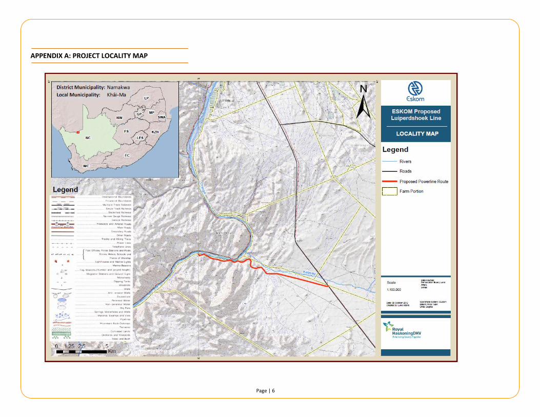
STUDY AREA
The study area is situated to the north-west
of the town of Pofadder (25 km to the
south) and falls within the jurisdiction of the
Khâi-Ma Local Municipality, Northern Cape
Province. (Refer to Appendix A: Project
Locality Map)
The site is situated between the R358 (an
un-surfaced road which connects Pofadder
to the Onseepkans Border Post) and the
Orange River to the west which forms the
RSA-Namibia International Border. The
study site is largely vacant except for a
narrow strip of land along the Orange River
which is used to cultivate fruit. The majority
of the site is utilised for the communal
grazing of livestock (goats).
The topography of the site is varied; the
eastern part of the site is relatively flat
sloping down to a gentle valley bottom in
which the Coboop ephemeral drainage line
runs. To the west of the Coboop Farmstead
the topography changes dramatically
becoming very rugged and mountainous.
The proposed line route alternates from
around 500 – 540 m a.m.s.l. on the higher-
lying eastern flat area down to 330 m
a.m.s.l. along the Orange River.
Three major vegetation types occur in the
study area, differentiated by topography
and landscape setting; on the flat eastern
plains the Eastern Gariep Plains Desert
vegetation type occurs, while the rugged
terrain contains the Eastern Gariep Rocky
Desert vegetation type. A narrow strip along
the Orange River contains the Lower Gariep
Alluvial Vegetation type.
PROJECT DESCRIPTION
The proposed project entails the construction of a new 13.7 km 33 kV line that will be operated at 11 kV power line in the Luiperdshoek area to supply previously disadvantage farmers electricity to their pumps for irrigation as well as electricity to workshops and labourers houses. A pole
SITE DESCRIPTION

Page | 3
mounted transformer with a metering kiosk will also be installed. It should be noted that due to the
constraints imposed by the highly rugged
and mountainous terrain that only one route
is technically able to be developed through
the mountainous area – along the access
route down to the communal farming
project that follows the Coboop River. As
such no alignment alternatives have been
provided, but power line design (tower type)
alternatives will be considered.
A number of potential environmental
impacts associated with the project have
been identified. As part of the Basic
Assessment Report, these potential impacts
will be assessed through the following
specialist studies:
SPECIALIST FIELD ORGANISATION
Surface Water
(Aquatic)
Assessment and
WULA
ROYAL
HASKONINGDHV
Environmental Sector
Avifaunal
Assessment
ROYAL
HASKONINGDHV
Environmental Sector
Biodiversity
Assessment
Clayton Cook
Heritage Assessment Jonathan Kaplan
BASIC ASSESSMENT REPORT
A Basic Assessment Report (BAR) is an
effective planning and decision-making tool,
which allows for the identification of
potential environmental consequences of a
proposed project, and its management
through the planning process.
In terms of the National Environmental
Management Act (No. 107 of 1998) (NEMA)
and associated Regulations (GNR 543 – 546
of 2010) there are a number of listed
activities which may not commence without
environmental authorisation from the
competent authority. Listed activities
triggered by the proposed power line are
detailed in Table 2 below:
The activities triggered are listed in Table 2:
LISTING
NOTICE
ACTIVITIES Description of
listed activity
Listing
Notice 1
GN. R544
10 Construction of
33 kV line that will
be operated at
11 kV
Listing
Notice 1
GN. R544
11 The development
will be within the
Orange River flood
line which will
trigger a WULA
Listing
Notice 1
GN. R544
18 The development
will be within the
Orange River flood
line which
therefore triggers
a WULA
In terms of the EIA Regulations, as per Section
24(5) of the NEMA, authorisation is required
from the Department of Environmental Affairs
(DEA) for these Listed Activities.
Water Use License Application (WULA)
The proposed development will result in the
need for undertaking two water use
activities as identified in Section 21 of the
NWA:
Section 21 (c) – impeding or diverting
the flow of water in a watercourse; and
Section 21 (i) – altering the bed, banks,
course or characteristics of a
watercourse.
POTENTIAL ENVIRONMENTAL IMPACTS ASSOCIATED WITH THE PROPOSED PROJECT
Page | 4
The potentially affected water resource
receiving environment is the Orange River
mainstream and tributaries. The proposed
development site is situated in the Lower
Orange River Water Management Area
(WMA), within quaternary catchment D81F
which is classed as falling outside of the
General Authorisation (GA) areas for water
use licensing and requires the compliance
processing of a Water Use license
Authorisation (WULA).
ROYAL HASKONINGDHV AS AN INDEPENDENT ENVIRONMENTAL
ASSESSMENT PRACTITIONER
Eskom Holdings SOC Limited Western Region
has appointed Royal HaskoningDHV (previously
SSI Engineers and Environmental Consultants),
as an independent Environmental Assessment
Practitioner (EAP), to undertake the required
environmental authorisations for the proposed
power line and substation project.
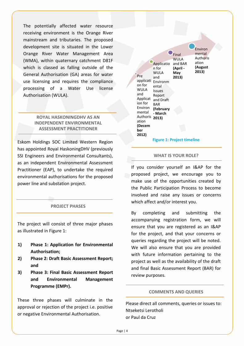
PROJECT PHASES
The project will consist of three major phases
as illustrated in Figure 1:
1) Phase 1: Application for Environmental
Authorisation;
2) Phase 2: Draft Basic Assessment Report;
and
3) Phase 3: Final Basic Assessment Report
and Environmental Management
Programme (EMPr).
These three phases will culminate in the
approval or rejection of the project i.e. positive
or negative Environmental Authorisation.
Figure 1: Project timeline
WHAT IS YOUR ROLE?
If you consider yourself an I&AP for the
proposed project, we encourage you to
make use of the opportunities created by
the Public Participation Process to become
involved and raise any issues or concerns
which affect and/or interest you.
By completing and submitting the
accompanying registration form, we will
ensure that you are registered as an I&AP
for the project, and that your concerns or
queries regarding the project will be noted.
We will also ensure that you are provided
with future information pertaining to the
project as well as the availability of the draft
and final Basic Assessment Report (BAR) for
review purposes.
COMMENTS AND QUERIES
Please direct all comments, queries or issues to:
Ntseketsi Lerotholi
or Paul da Cruz
Pre application for WULA and Application for Environmental Authorisation (December 2012)
Application for WULA and Environmental Issues Report and Draft BAR (February - March 2013)
Final WULA and BAR (April -May 2013)
Environmental Authorisation (August 2013)

Page | 5
Royal HaskoningDHV
P.O. Box 867
Gallo Manor
2052
: 011 798 6000
: 011 798 6010
Page | 6
APPENDIX A: PROJECT LOCALITY MAP

Page | 7
KINDLY COMPLETE THIS FORM IN DETAIL AND RETURN IT TO:
Ntseketsi Lerotholi Telephone: 011 798 6000 Royal HaskoningDHV Fax: 011 798 6010 P.O. Box 867 Gallo Manor 2052 Email: [email protected]
PERSONAL DETAILS:
Title: ……………
First Name: ………………………………………………………………………..
Surname: ……………………………………………………………………………………………………………………………………………………………………………. E-Mail: ……………………………………………………………………………………………………………………………………………………………………………..… Telephone: ……………………………………………………………………
Fax: ……………………………………………………………………………………
Organisation (if applicable): ………………………………………………………………………………………………………………………………………………….…....… Capacity (e.g. Chairperson, member, etc.): …………………………………………………………………………………………………………………….……… Physical Address: ………………………………………………………………………………………………………………………………………………………………… Town: ……………………………………………………………………………………………………………
Code: ……………………………….………………
Postal Address: …………………………………………………………………………………………………………………………………………………………………….… Town: ……………………………………………………………………………………………………………
Code: ………………………………………….……
1. What is your main area of interest with regard to the proposed project?
………………………………………………………………………………………………………………………………………………………………………………………… …………………………………………………………………………………………………………………………………………………………………………………………… ………………………………………………………………………………………………………………………………………………………………………………………… ………………………………………………………………………………………………………………………………………………………………………………..…………… ……………………………………………………………………………………………………………………………………………………………………………………………
2. Do you have any points of concern or support regarding the proposed project?
If “yes”, please briefly list these in point form: …………………………………………………………………………………………………………………………………………………………………………………….…… …………………………………………………………………………………………………………………………………………………………………………………………… …………………………………………………………………………………………………………………………………………………………………………………….…… …………………………………………………………………………………………………………………………………………………………………………………………. …………………………………………………………………………………………………………………………………………………………………………………………
3. Are there any additional stakeholders who you feel should be consulted with regard to the proposed project?
If “yes” please list their names and contact details below: ……………………………………………………………………………………………………………………………………………………………………………………….… ………………………………………………………………………………………………………………………………………………………………………………………… ……………………………………………………………………………………………………………………………………………………………………………………………
Please add more pages if necessary
BASIC ASSESSMENT FOR THE PROPOSED ESKOM LUIPERDSHOEK 11 KV POWER LINE
PROJECT TO BE LOCATED NORTH WEST OF THE TOWN OF POFADDER IN THE
NORTHERN CAPE
REGISTRATION AND COMMENT FORM
YES/NO
YES/NO