ENVIRONMENTAL ASSESSMENT REEVALUATION - ADOT
107
ENVIRONMENTAL ASSESSMENT REEVALUATION for I-10, Ina Road Traffic Interchange and Ina Road; Bridge over the Santa Cruz River & Roadway Improvements— Silverbell Road to Starcommerce Way Pima County, Arizona Prepared for: Arizona Department of Transportation and Federal Highway Administration April 2016 Official Project Name by Stage Federal Aid No. ADOT Project No. I-10, Ina Road Traffic Interchange (Stage A1) NH-STP-010-D(216)S 010 PM 248 F0003 01C I-10, Ina Road Traffic Interchange (Stage A2) NH-STP-010-D(216)S 010 PM 248 H8479 01C Ina Road; Bridge over Santa Cruz River & Roadway Improvements—Silverbell Road to Starcommerce Way (Stage M2) STP-MRN-0(014)S 0000 PM MRN SB413 01C
-
Upload
khangminh22 -
Category
Documents
-
view
1 -
download
0
Transcript of ENVIRONMENTAL ASSESSMENT REEVALUATION - ADOT

ENVIRONMENTAL ASSESSMENT REEVALUATION
for
I-10, Ina Road Traffic Interchange
and
Ina Road; Bridge over the Santa Cruz River & Roadway Improvements—
Silverbell Road to Starcommerce Way
Pima County, Arizona
Prepared for:
Arizona Department of Transportation and
Federal Highway Administration
April 2016
Official Project Name by Stage Federal Aid No. ADOT Project No.
I-10, Ina Road Traffic Interchange (Stage A1) NH-STP-010-D(216)S 010 PM 248 F0003 01C
I-10, Ina Road Traffic Interchange (Stage A2) NH-STP-010-D(216)S 010 PM 248 H8479 01C
Ina Road; Bridge over Santa Cruz River & Roadway Improvements—Silverbell Road to Starcommerce Way (Stage M2)
STP-MRN-0(014)S 0000 PM MRN SB413 01C

This page intentionally left blank.


This page intentionally left blank.

This page intentionally left blank.

Environmental Assessment Reevaluation i I-10, Ina Road | April 2016
CONTENTS
ABBREVIATIONS AND ACRONYMS ..................................................................................... vii
FINAL MITIGATION MEASURES ............................................................................................ ix
Project-Specific Mitigation Measures .................................................................................... ix
I. INTRODUCTION ................................................................................................................... 1
A. Background and Overview .............................................................................................. 1
B. Location ........................................................................................................................... 4
C. Purpose and Need ............................................................................................................ 4
1. Project Need ............................................................................................................... 4
2. Project Purpose .......................................................................................................... 6
D. Conformance with Regulations, Land Use Plans, and Other Plans ................................. 7
II. PROJECT DESIGN................................................................................................................. 9
A. Ina Road TI General Project Scope and Design Changes ................................................ 9
B. Town of Marana Ina Road Project ................................................................................. 18
C. General Project Schedule ............................................................................................... 25
III. AFFECTED ENVIRONMENT, ENVIRONMENTAL CONSEQUENCES, AND MITIGATION MEASURES ................................................................................................. 29
A. Issues Eliminated from Detailed Study .......................................................................... 29
B. Land Ownership, Jurisdiction, and Land Use ................................................................ 29
C. Social and Economic Considerations ............................................................................. 31
1. Residential/Commercial Development and Displacement ...................................... 31
2. Temporary and Permanent Access ........................................................................... 37
3. Neighborhood Continuity/Community Cohesion .................................................... 43
D. Title VI of the Civil Rights Act and Environmental Justice .......................................... 44
E. Cultural Resources ......................................................................................................... 45
1. Effect Finding .......................................................................................................... 46
F. Section 4(f) of the U.S. Department of Transportation Act ........................................... 48
1. Ongoing Coordination Efforts ................................................................................. 50
2. Evaluation of Impacts .............................................................................................. 50
3. Conclusion ............................................................................................................... 55

Environmental Assessment Reevaluation ii I-10, Ina Road | April 2016
G. Air Quality ..................................................................................................................... 56
1. Air Quality Transportation Conformity ................................................................... 59
H. Noise Levels................................................................................................................... 60
1. Overview .................................................................................................................. 60
2. Noise Mitigation ...................................................................................................... 60
I. Utilities and Railroads .................................................................................................... 62
J. Visual Resources ............................................................................................................ 63
K. Water Resources ............................................................................................................ 63
1. Safe Drinking Water Act ......................................................................................... 63
2. Arizona Pollutant Discharge Elimination System ................................................... 64
3. Clean Water Act Section 404/401 Permit ................................................................ 64
L. Drainage and Floodplains .............................................................................................. 66
M. Vegetation and Invasive Species ................................................................................... 67
N. Threatened and Endangered Species, Designated Critical Habitat, and Sensitive Species ........................................................................................................................... 68
1. Threatened and Endangered Species ....................................................................... 68
2. Migratory Bird Treaty Act and Bald and Golden Eagle Act ................................... 69
3. Sensitive Species ...................................................................................................... 70
O. Hazardous Materials ...................................................................................................... 72
P. Material Sources and Waste Materials .......................................................................... 74
Q. Secondary Impacts ......................................................................................................... 74
1. Land Ownership, Jurisdiction, and Land Use .......................................................... 74
2. Social and Economic Considerations ....................................................................... 75
3. Cultural Resources ................................................................................................... 75
4. Biological Resources ............................................................................................... 75
5. Water Resources, Air Quality, Noise, and Hazardous Materials ............................. 76
R. Cumulative Impacts ....................................................................................................... 76
1. Past Actions and Completed Projects ...................................................................... 76
2. Ongoing and Present Actions................................................................................... 76
3. Reasonably Foreseeable Future Actions .................................................................. 77
4. Summary .................................................................................................................. 77

Environmental Assessment Reevaluation iii I-10, Ina Road | April 2016
IV. PUBLIC INVOLVEMENT AND PROJECT COORDINATION........................................ 79
A. Agency Scoping ............................................................................................................. 79
B. Public Scoping and Involvement ................................................................................... 79
C. Public Hearing ............................................................................................................... 80
V. CONCLUSION ..................................................................................................................... 81
Preferred Alternative ............................................................................................................. 84
VI. REFERENCES ...................................................................................................................... 85

Environmental Assessment Reevaluation iv I-10, Ina Road | April 2016
FIGURES
Figure 1. Project location within the state of Arizona ................................................................2
Figure 2. Project vicinity—I-10, Ina Road TI to Ruthruff Road TI, 2012 Environmental Assessment .........................................................................................3
Figure 3a. Change in I-10 Phase II project limits from 2012 EA ................................................5
Figure 3b. I-10 Mainline Typical Sections .................................................................................10
Figure 4a. Phase II design change 2, Ina Road access ...............................................................13
Figure 4b. Phase II design change 3, Ina Road access ...............................................................15
Figure 4c. Ina Road typical sections east of I-10 (A-A) and west of I-10 (B-B) .......................17
Figure 5a. Phase II design CCTV location.................................................................................19
Figure 5b. Town of Marana Ina Road project from Silverbell Road to Starcommerce Way ...........................................................................................................................20
Figure 6a. Town of Marana Ina Road project east of Santa Cruz River ....................................21
Figure 6b. Town of Marana Ina Road bridges at Santa Cruz River ...........................................22
Figure 6c. Town of Marana Ina Road project west of Santa Cruz River ...................................23
Figure 6d. Town of Marana Ina Road project typical sections for bridges at Santa Cruz River (C-C) and Ina Road west of Santa Cruz River (D-D) .....................................24
Figure 7. Phase II construction stage........................................................................................26
Figure 8. Project vicinity land use ............................................................................................30
Figure 9a. Eastbound I-10 to Ina Road proposed traffic access during construction ................38
Figure 9b. Westbound I-10 to Ina Road proposed traffic access during construction ...............39
Figure 9c. Ina Road to westbound I-10 proposed traffic access during construction ................40
Figure 9d. Ina Road to eastbound I-10 proposed traffic access during construction .................41
Figure 10. Section 4(f) properties...............................................................................................49
Figure 11. Santa Cruz River Park North ....................................................................................53

Environmental Assessment Reevaluation v I-10, Ina Road | April 2016
TABLES
Table 1. Commercial and municipal displacements (full acquisition)—2012 DCR/EA compared with 2016 final design and Town of Marana Ina Road project ...............33
Table 2. Commercial and municipal properties (partial acquisition)—2012 DCR/EA compared with 2016 final design and Town of Marana Ina Road project ...............33
Table 3. NRHP eligible or undetermined cultural resources within the APE .........................46
Table 4. National Ambient Air Quality Standards (NAAQS) ................................................56
Table 5. Secondary and cumulative impacts classifications ...................................................74
Table 6. Summary of EA Reevaluation impacts .....................................................................81
APPENDICES
APPENDIX A Cultural Resources Consultation
APPENDIX B Agency Coordination
APPENDIX C Air Quality
APPENDIX D Noise Analysis
APPENDIX E Biological Resources
APPENDIX F Mitigation Measure Attachment
APPENDIX G Hazardous Materials
APPENDIX H Public Involvement Activities

Environmental Assessment Reevaluation vi I-10, Ina Road | April 2016
This page intentionally left blank.

Environmental Assessment Reevaluation vii I-10, Ina Road | April 2016
ABBREVIATIONS AND ACRONYMS
ACHP Advisory Council on Historic Preservation ADEQ Arizona Department of Environmental Quality ADOT Arizona Department of Transportation AGFD Arizona Game and Fish Department APE area of potential effects ASM Arizona State Museum AZ Arizona BE Biological Evaluation CAA Clean Air Act CCTV closed-circuit television CFR Code of Federal Regulations CO carbon monoxide dBA A-weighted decibels DCR Design Concept Report EA Environmental Assessment EPA Environmental Protection Agency ESA Environmental Site Assessment FEMA Federal Emergency Management Agency FHWA Federal Highway Administration FIRM Flood Insurance Rate Map FONSI Finding of No Significant Impact GHG greenhouse gas I-10 Interstate 10 I-11 Interstate 11 I-19 Interstate 19 MP milepost MSAT Mobile Source Air Toxics NAAQS National Ambient Air Quality Standards NEPA National Environmental Policy Act NHPA National Historic Preservation Act NRHP National Register of Historic Places No. Number 03 ozone PA Programmatic Agreement PAG Pima Association of Governments PCDOT Pima County Department of Transportation PCNRPRD Pima County Natural Resources Parks and Recreation Department PCRFCD Pima County Regional Flood Control District

Environmental Assessment Reevaluation viii I-10, Ina Road | April 2016
PCRWRD Pima County Regional Wastewater Reclamation Department PM10 particulate matter less than or equal to 10 microns PM2.5 particulate matter less than 2.5 microns POM polycyclic organic matter ppb parts per billion ppm parts per million ROW right-of-way SHPO State Historic Preservation Office STIP State Transportation Improvement Program SWPPP Stormwater Pollution Prevention Plan TCE temporary construction easement THPO Tribal Historic Preservation Office TI traffic interchange TIP Transportation Improvement Program TMP transportation management plan μg/m3 micrograms per cubic meter UPRR Union Pacific Railroad U.S. United States USACE U.S. Army Corps of Engineers USFWS U.S. Fish and Wildlife Service WIFL Southwestern willow flycatcher WWTP Wastewater Treatment Plant YBCU yellow-billed cuckoo

Environmental Assessment Reevaluation ix I-10, Ina Road | April 2016
FINAL MITIGATION MEASURES
The 2016 final design process resulted in changes to the November 2012 “Interstate 10: Ina Road Traffic Interchange (TI) to Ruthrauff Road TI” Final Environmental Assessment that required additional mitigation measures and some revised mitigation measures. The final list of mitigation reflects measures specific to the project. Measures that are included in the Arizona Department of Transportation (ADOT) Standard Specifications for Road and Bridge Construction (2008 Edition) or measures that are standard commitments or best management practices employed by ADOT are not listed. The following mitigation measures are not subject to change without prior written approval from the Federal Highway Administration.
Project-Specific Mitigation Measures
Arizona Department of Transportation Design Responsibilities • Acquisition would be conducted through an assistance program in accordance with the
Uniform Relocation Assistance and Real Property Acquisition Policies Act of 1970 (49 Code of Federal Regulations § 24), which identifies the process, procedures, and time frame for right-of-way acquisition and relocation of affected residents or businesses (refer to page 43).
• To ensure sufficient access to properties during construction, key local access improvements at Ina Road would be completed prior to reconstruction of the traffic interchange (refer to page 43).
• A transportation management plan would be prepared consistent with the Federal Highway Administration’s Manual on Uniform Traffic Control Devices for Streets and Highways, dated 2010 (refer to page 43).
• During development of the final design, the Arizona Department of Transportation would coordinate with emergency response and transit providers (Arizona Department of Public Safety, City of Tucson Police Department, Town of Marana Police Department, Pima County Sheriff’s Department, Northwest Fire District, Rural/Metro Fire Department, Northwest Medical Center, Sun Tran, and the Amphitheater, Marana Unified, Flowing Wells, and Tucson Unified school districts) to accommodate emergency and transit needs in the transportation management plan (refer to page 44).
• The transportation management plan would account for peak traffic associated with seasonal events (golf tournaments, gem and mineral show, cycling events, etc.) (refer to page 44).
• The transportation management plan would ensure that access to all properties would be provided and maintained during construction (refer to page 44).
• Signs would indicate business access to commercial properties within the construction zone (refer to page 44).

Environmental Assessment Reevaluation x I-10, Ina Road | April 2016
• During final design, testing and data recovery plans would be developed and implemented by the Arizona Department of Transportation Environmental Planning Historic Preservation Team in consultation with the State Historic Preservation Office and other consulting parties. The testing and data recovery plan would be developed in accordance with the Programmatic Agreement Among Federal Highway Administration, Arizona State Historic Preservation Office, Arizona Department of Transportation, Arizona State Land Department, United States Army Corps of Engineers, and Tohono O’odham Nation, September 2015 executed for the project. Construction activities would not occur in areas requiring testing and data recovery until the terms and conditions of the Programmatic Agreement have been fulfilled (refer to page 47).
• During final design, the Arizona Department of Transportation would coordinate with the Pima County Natural Resources Parks and Recreation Department to replace lost parking on-site at Mike Jacobs Sports Park, reconstruct the driveway entrance to the parking lot, and replace the affected landscaping (refer to page 55).
• During final design, the Arizona Department of Transportation would coordinate with the Pima County Natural Resources Parks and Recreation Department and the Town of Marana to develop a temporary Loop trail closure plan and public notification process for the trail segment between Ted Walker Park and Crossroads Park (refer to page 55).
• During final design, the Arizona Department of Transportation would coordinate relocation of utilities with the affected utility companies. If service disruption would be needed for relocation, the Arizona Department of Transportation would coordinate with the utility companies to ensure customers are notified prior to service disruption (refer to page 62).
• The Arizona Department of Transportation would provide Union Pacific Railroad with an opportunity to review and comment on the design plans (refer to page 62).
• The Arizona Department of Transportation would incorporate architectural and landscape treatments into the final design of structures, including retaining walls. Treatment designs would be evaluated and developed with consideration of community input (refer to page 63).
• During final design, Arizona Department of Transportation Environmental Planning would coordinate with the Town of Marana and the United States Army Corps of Engineers to complete a transfer of Clean Water Act Section 404 permit SPL-2001-794-RJD from the Town of Marana to the Arizona Department of Transportation (refer to page 65).
• The Arizona Department of Transportation would provide the Pima County (520.243.1800) and Town of Marana (520.382.2600) floodplain managers with an opportunity to review and comment on the design plans (refer to page 67).
• Landscape plans would include areas of available right-of-way along North Camino de la Cruz to provide a buffer between residential and commercial land uses (refer to page 67).
• All disturbed soils not paved that would not be landscaped or otherwise permanently stabilized by construction would be seeded using species native to the project vicinity (refer to page 67).

Environmental Assessment Reevaluation xi I-10, Ina Road | April 2016
• The Arizona Department of Transportation Environmental Planning Biologist (602.399.3233 or 602.712.7767) would coordinate with the Arizona Game and Fish Department to implement measures found in the project plans and specifications that address the bat colony roosting in the existing Ina Road–Santa Cruz River bridge, including monitoring of the effects of construction on the bat population, installation of artificial roosts on the new bridges, exclusion of bats from roost crevices on the old bridge prior to demolition, and 2 (two) years of post-construction monitoring by the Arizona Game and Fish Department (refer to page 71).
• Site-specific environmental site assessments would be conducted prior to property acquisition for the properties as recommended in the 2009 Phase I Initial Site Assessment (refer to page 73).
• Preliminary site investigations would be conducted for locations where construction activities would occur within 100 feet of relevant facilities and where such activities would involve ground disturbance at depths of 18 inches or greater. The preliminary site investigation would include a drilling and sampling program to verify or refute the existence of actionable concentrations of released hazardous materials. The analytical program would be targeted to determine the concentration of residual impacts for facilities recommended in the 2011 Phase I Initial Site Assessment (refer to page 73).
• During final design, the Arizona Department of Transportation Project Manager would coordinate with the Arizona Department of Transportation Environmental Planning Hazardous Materials Coordinator (602.920.3882 or 602.712.7767) to complete testing for asbestos and lead-based paint within the project limits and, if necessary, recommend remediation measures (refer to page 73).
• The Arizona Department of Transportation Project Manager would contact the Arizona Department of Transportation Environmental Planning Hazardous Materials Coordinator (602.920.3882 or 602.712.7767) 30 (thirty) calendar days prior to bid advertisement to determine the need for additional site assessments and confirm that the asbestos report is still valid (refer to page 73).
Arizona Department of Transportation Roadside Development Section Responsibilities • Protected native plants within the project limits would be affected by this project; therefore, the
Arizona Department of Transportation Roadside Development Section would determine whether Arizona Department of Agriculture notification is needed. If notification is needed, the Arizona Department of Transportation Roadside Development Section would send the notification at least 60 (sixty) calendar days prior to the start of construction (refer to page 67).
• The Arizona Department of Transportation Roadside Development Section would provide special provisions for the control of noxious and invasive plant species during construction that may require treatment and control within the project limits. The Arizona Department of Transportation Roadside Development Section would review and approve or reject the Noxious and Invasive Plant Species Treatment and Control Plan prepared by the contractor and submitted to the Arizona Department of Transportation Resident Engineer as required in the specifications within 10 (ten) working days of receipt. Once approved, the Arizona Department of Transportation Roadside Development Section would return the plan to the Arizona Department of Transportation Resident Engineer (refer to page 68).

Environmental Assessment Reevaluation xii I-10, Ina Road | April 2016
Arizona Department of Transportation Southcentral District Responsibilities • The Arizona Department of Transportation Resident Engineer would contact the Arizona
Department of Transportation Environmental Planning Historic Preservation Team (602.712.8636 or 602.712.7767) to schedule the preconstruction or partnering meeting on a mutually agreeable date to ensure a qualified Environmental Planning representative would be available to attend the meeting (refer to page 47).
• The Arizona Department of Transportation Resident Engineer would ensure that a Stormwater Pollution Prevention Plan is prepared to meet the requirements of the construction general permit, including sampling and analysis plan, as necessary (refer to page 65).
• The Arizona Department of Transportation Resident Engineer would prepare and submit a Notice of Intent for the project to the Arizona Department of Environmental Quality (refer to page 65).
• The Arizona Department of Transportation Resident Engineer would prepare and submit a Notice of Termination upon achieving final stabilization for the project to the Arizona Department of Environmental Quality (refer to page 65).
• The Arizona Department of Transportation Resident Engineer would submit a copy of the authorization to discharge letter to any regulated municipal separate storm sewer system operator (refer to page 65).
• The Arizona Department of Transportation Resident Engineer would submit a copy of the Noxious and Invasive Plant Treatment and Control Plan to the Arizona Department of Transportation Roadside Development Section for review and approval prior to implementation by the contractor (refer to page 68).
• The Arizona Department of Transportation Resident Engineer, in association with the contractor, would complete the National Emissions Standards for Hazardous Air Pollutants documentation and submit it to the Arizona Department of Transportation Environmental Planning Hazardous Materials Coordinator (602.920.3882 or 602.712.7767) for review 5 (five) working days prior to being submitted to the regulatory agencies (refer to page 73).
Contractor Responsibilities • To ensure sufficient access to properties during construction, key local access improvements at
Ina Road would be completed prior to reconstruction of the traffic interchange (refer to page 43).
• Access to adjacent businesses and residences would be maintained throughout construction (refer to page 44).
• If previously unidentified cultural resources are encountered during the undertaking, the contractor would stop work immediately at that location and would take all reasonable steps to secure the preservation of those resources. The contractor would call the Arizona Department of Transportation Environmental Planning Historic Preservation Team (602.712.8636 or 602.712.7767) immediately to make arrangements for the proper treatment of those resources (refer to page 48).

Environmental Assessment Reevaluation xiii I-10, Ina Road | April 2016
• The contractor would not work in any area with previously identified historic properties (archaeological sites, old State Route 84, the railroad) or in any non-site-specific areas where archaeological testing is required until authorized by the Arizona Department of Transportation Environmental Planning Historic Preservation Team (refer to page 48).
• The contractor would maintain access to Mike Jacob Sports Park during construction (refer to page 56).
• The contractor would close the Santa Cruz River Park trail (Loop trail) at Ina Road and provide measures to protect public safety during construction activities related to the Ina Road bridge at the Santa Cruz River. Advance notice would be posted for trail users a minimum of 10 (ten) working days prior to the trail closure (refer to page 56).
• The contractor would document the Santa Cruz River Park trail features at Ted Walker Park and at Ina Road prior to construction. Upon completion of construction, the contractor would return the trails to preconstruction conditions (refer to page 56).
• The contractor would comply with all local air quality and dust control rules, regulations, and ordinances that apply to any work performed pursuant to the contract (refer to page 59).
• In conjunction with the utility provider, the contractor would notify members of the public and business owners of temporary utility service interruptions during construction at least 7 (seven) calendar days in advance of the interruption of service (refer to page 62).
• The contractor would establish emergency response procedures in the case of accidental utility disruptions (refer to page 62).
• The contractor would comply with all terms and conditions of the Individual Section 401 Water Quality Certification certified by the Arizona Department of Environmental Quality (refer to page 65).
• The contractor would comply with all terms and conditions of the attached Section 404 Individual Permit as established by the United States Army Corps of Engineers (refer to page 65).
• The contractor would prepare and implement a Stormwater Pollution Prevention Plan that meets the requirements of the construction general permit, including sampling and analysis plan, as necessary (refer to page 65).
• The contractor would prepare and submit a Notice of Intent for the project and would provide the Stormwater Pollution Prevention Plan and sampling and analysis plan, as necessary, to the Arizona Department of Environmental Quality (refer to page 65).
• The contractor would prepare and submit a Notice of Termination upon approval from the Arizona Department of Transportation Resident Engineer for the project to the Arizona Department of Environmental Quality (refer to page 65).
• The contractor would submit a copy of the authorization to discharge letter to any regulated municipal separate storm sewer system operator (refer to page 65).
• This project is within a designated municipal separate storm sewer system. Therefore, the contractor would send a copy of the Notice of Intent and Notice of Termination to Pima County and the Town of Marana (refer to page 66).
Environmental Assessment Reevaluation xiv I-10, Ina Road | April 2016
• The contractor would develop a Noxious and Invasive Plant Treatment and Control Plan in accordance with the requirements in the contract documents. Plants to be controlled would include those listed in the federal and state noxious weed and the state invasive species lists in accordance with federal and state laws and executive orders. The plan and associated treatments would include all areas within the project right-of-way and easements as shown on the project plans. The treatment and control plan would be submitted to the Arizona Department of Transportation Resident Engineer prior to implementation by the contractor (refer to page 68).
• Prior to the start of ground-disturbing activities, the contractor would arrange for and perform the control of noxious and invasive species in the project area (refer to page 68).
• To prevent the introduction of invasive species seeds, the contractor would inspect all earthmoving and hauling equipment at the storage facility. The equipment would be washed and free of all attached plant/vegetation and soil/mud debris prior to entering the construction site (refer to page 68).
• To prevent invasive species seeds from leaving the site, the contractor would inspect all construction equipment and remove all attached plant/vegetation and soil/mud debris prior to leaving the construction site (refer to page 68).
• All disturbed soils not paved that would not be landscaped or otherwise permanently stabilized by construction would be seeded using species native to the project vicinity (refer to page 68).
• The contractor would employ a qualified biologist to complete a preconstruction survey for burrowing owls 96 (ninety-six) hours prior to construction in all suitable habitats that would be disturbed. The biologist would possess a burrowing owl survey protocol training certificate issued by the Arizona Game and Fish Department. Upon completion of the surveys, the biologist would contact the Arizona Department of Transportation Environmental Planning Biologist (602.399.3233 or 602.712.7767) to provide survey results (refer to page 71).
• If any burrowing owls or active burrows are identified, the contractor would notify the Arizona Department of Transportation Resident Engineer immediately. No construction activities would take place within 100 feet of any active burrow (refer to page 71).
• If the Arizona Department of Transportation Resident Engineer, in cooperation with the Arizona Department of Transportation Environmental Planning Biologist, determines that burrowing owls cannot be avoided, the contractor would employ a qualified biologist holding a permit from the United States Fish and Wildlife Service to relocate burrowing owls from the project area, as appropriate (refer to page 71).
• Prior to construction, all personnel who would be on-site, including, but not limited to, contractors, contractors’ employees, supervisors, inspectors, and subcontractors, would review the attached Arizona Department of Transportation Environmental Planning “Western Burrowing Owl Awareness” flier or attend the environmental awareness program (refer to page 71).
• The contractor would arrange for a qualified biologist to conduct a bird nest search of all vegetation to determine the presence/absence of active bird nests if vegetation removal activities would occur between February 15 and August 31. The survey would be conducted within 10 (ten) calendar days prior to vegetation removal (refer to page 71).

Environmental Assessment Reevaluation xv I-10, Ina Road | April 2016
• If active bird nests are found during the survey, the contractor would arrange for a licensed wildlife rehabilitator permitted by the United States Fish and Wildlife Service to relocate any eggs or nestlings from active nests or buffer any active nest with protective fencing within 3 (three) to 5 (five) calendar days of construction to comply with provisions of the Migratory Bird Treaty Act (refer to page 71).
• The contractor would not remove any trees or large tree limbs or conduct vegetation removal activities such as grubbing or shrub clearing between February 15 and August 31 until a biologist has conducted a bird nest search of all vegetation and has determined that no active bird nests are present. Vegetation may be mowed or removed if it has been surveyed within 10 (ten) calendar days prior to removal as long as only inactive bird nests, if any, are present. Between September 1 and February 14, grubbing, shrub clearing, and tree/limb removal activities are not subject to restriction (refer to page 72).
• If active bird nests are found during the preconstruction survey, the contractor would not commence with any vegetation removal or pruning until the Arizona Department of Transportation has confirmed that all eggs or nestlings have been relocated from the work area by a licensed wildlife rehabilitator and that contractor is cleared to proceed (refer to page 72).
• If suspected hazardous materials are encountered during construction, work would cease at that location and the Arizona Department of Transportation Resident Engineer would be notified. The Arizona Department of Transportation Resident Engineer would contact the Arizona Department of Transportation Environmental Planning Hazardous Materials Coordinator (602.920.3882 or 602.712.7767) immediately and make arrangements for the assessment, treatment, and disposal of those materials (refer to page 73).
• The Arizona Department of Transportation Resident Engineer, in association with the contractor, would complete the National Emissions Standards for Hazardous Air Pollutants documentation and submit it to the Arizona Department of Transportation Environmental Planning Hazardous Materials Coordinator (602.920.3882 or 602.712.7767) for review 5 (five) working days prior to being submitted to the regulatory agencies (refer to page 74).
• The contractor cannot start work associated with the demolition of structures until 10 (ten) working days have passed since the submittal of the notification to the regulatory agencies (refer to page 74).

Environmental Assessment Reevaluation xvi I-10, Ina Road | April 2016
This page intentionally left blank.

Environmental Assessment Reevaluation 1 I-10, Ina Road | April 2016
I. INTRODUCTION
A. Background and Overview
Previous National Environmental Policy Act (NEPA) compliance for proposed improvements to Interstate 10 (I-10) between the Ina Road Traffic Interchange (TI) and the Ruthrauff Road TI in the Tucson metropolitan area of Pima County, Arizona, was documented in a Federal Highway Administration (FHWA) Final Environmental Assessment (FHWA 2012). The Environmental Assessment (EA) and companion Design Concept Report (DCR) were produced under Federal Aid No. 010-D(211)N and Arizona Department of Transportation (ADOT) Project No. 010 PM 247 H7583 01L. The 2012 EA was the subject of a public hearing on June 12, 2012, and the FHWA issued a Finding of No Significant Impact (FONSI) on November 15, 2012. The project was envisioned to be implemented through multiple phases:
• Phase I—I-10 Ruthrauff Road TI, Milepost (MP) 251.8 to MP 252.9
• Phase II—I-10 Ina Road TI, MP 248.2 to MP 249.3
• Phase III—I-10 Orange Grove Road and Sunset Road TIs, MP 249.3 to MP 251.8
• Phase IV—I-10 mainline widening to 10 through lanes and auxiliary lanes, MP 248.2 to MP 252.9
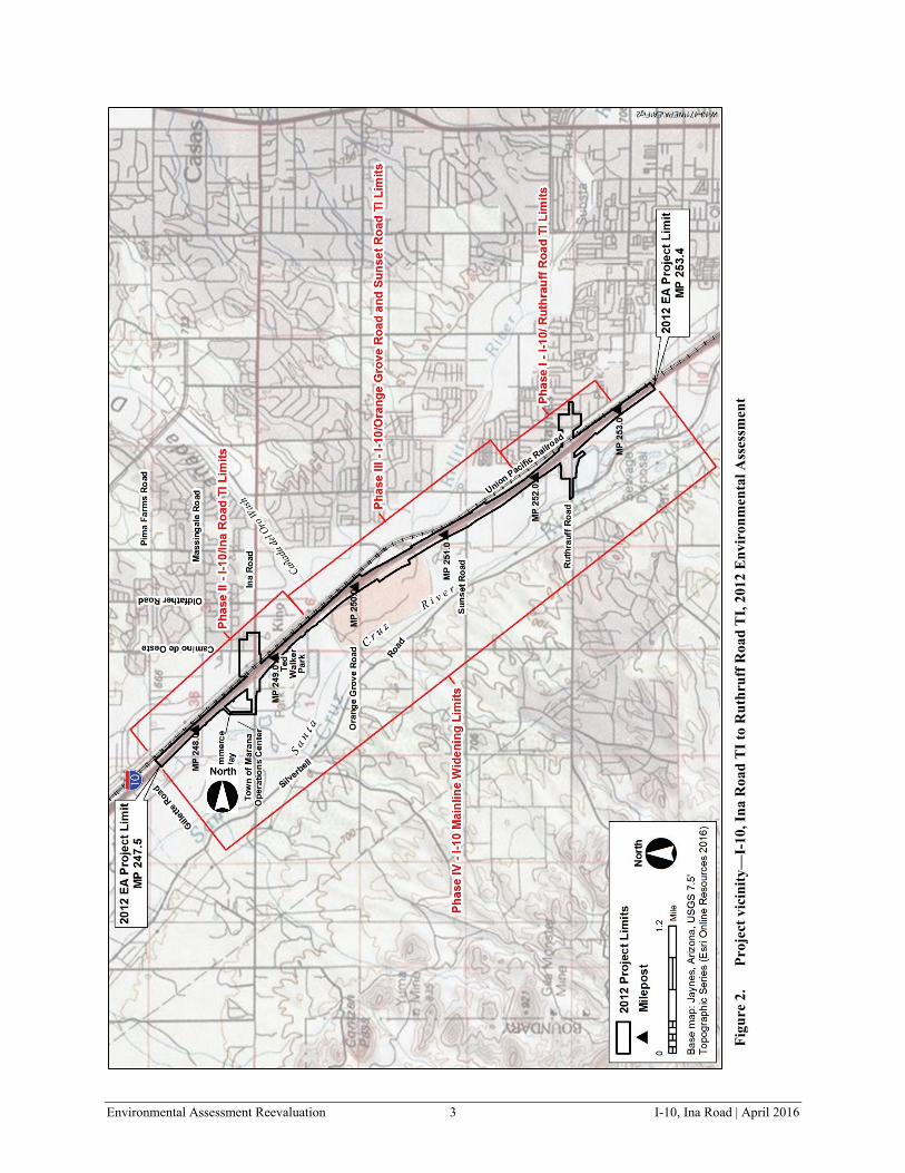
Figure 1 shows the project’s location within the state of Arizona. Figure 2 depicts the limits of the 2012 EA and denotes the limits of the four phases of construction, as planned at that time.
Final design began in November 2013 for the Phase II project, which included the Ina Road TI and related I-10 improvements between MP 248.2 and MP 249.3. The project was assigned Federal Aid No. NH-STP-010-D(216)S and ADOT Project No. 010 PM 247 H8479 01C.
The Town of Marana has been planning a separate federally funded project on Ina Road (officially named “Ina Road; Bridge over Santa Cruz River & Roadway Improvements—Silverbell Road to Starcommerce Way”) that would tie into the ADOT Ina Road TI project limits. The Town of Marana Ina Road project would replace a two-lane bridge over the Santa Cruz River with two new two-lane bridges and widen Ina Road from two lanes to four lanes from Silverbell Road to Starcommerce Way (Chapter II, Figures 6a, 6b, and 6c). Through coordination with the Town of Marana, it was determined that ADOT, the Town of Marana, and the public would benefit from combining the design and construction activities for the Town of Marana Ina Road project with the ADOT Ina Road TI project. The Town of Marana Ina Road project was assigned Federal Aid No. STP-MRN-0(014)T and ADOT Project No. 0000 PM MRN SB413 01C. ADOT and the Town of Marana anticipate entering into an Intergovernmental Agreement (ADOT File No. 15-0005483-I) in spring 2016.

Environmental Assessment Reevaluation 2 I-10, Ina Road | April 2016
Figure 1. Project location within the state of Arizona
Project Location
Environmental Assessment Reevaluation 3 I-10, Ina Road | April 2016
Figu
re 2
. Pr
ojec
t vic
inity
—I-
10, I
na R
oad
TI t
o R
uthr
uff R
oad
TI,
2012
Env
iron
men
tal A
sses
smen
t

Environmental Assessment Reevaluation 4 I-10, Ina Road | April 2016
The purpose of this EA Reevaluation is to reconsider potential project effects and social, economic, and environmental conditions that may have changed in the project area since the FONSI was approved in November 2012 for the ADOT Ina Road TI project, and to evaluate the project effects of the Town of Marana Ina Road project. The EA Reevaluation addresses the 2016 final design changes (referred to as “design changes” throughout document) and expands the original assessment to include the Town of Marana Ina Road project from Silverbell Road to Starcommerce Way (Chapter II, Figure 5b).
B. Location
The EA Reevaluation study area is in the Tucson metropolitan area, Pima County, Arizona. The majority of the project is within the Town of Marana jurisdictional limits (Figure 3a). A portion of the project east of I-10 and north of Ina Road is within unincorporated Pima County. Along I-10, the EA Reevaluation study area extends from MP 247.6 to MP 249.6 (Figure 3a). The Phase II segment of I-10, formerly from MP 248.2 to MP 249.3 (Ina Road TI Phase II limits, 2012 EA), was extended to the current limits of MP 247.6 to MP 249.6. The EA Reevaluation limits reflect this extension of Phase II. The I-10 limits of this EA Reevaluation represent only a portion of the overall limits for the three phases of construction evaluated in the 2012 EA (MP 247.5 to 253.4).
On Ina Road, the EA Reevaluation study area extends from just east of Silverbell Road to Camino de la Cruz east of I-10. The Ina Road limits reflect the addition of the Town of Marana Ina Road project, which added the segment of Ina Road from Silverbell Road to Starcommerce Way (Chapter II, Figures 5b, 6a, 6b, and 6c).
C. Purpose and Need
1. Project Need The project need for the Ina Road TI project as stated in the 2012 EA is unchanged. I-10 is the primary transportation corridor connecting Tucson with Phoenix, Arizona, and with California to the west and New Mexico/Texas to the east. I-10 also connects to Interstate 19 (I-19), facilitating trade with Mexico. In 2015, the United States (U.S.) Congress designated I-10 from I-19 to Casa Grande, Arizona as part of a future Interstate 11 (I-11) in the Fixing America’s Surface Transportation Act. The I-11 route is projected to become the Intermountain West Corridor extending from Arizona to the Pacific Northwest. The exact routing of I-11 is subject to ongoing alternatives studies and an Environmental Impact Statement. Locally, I-10 traverses the length of the Tucson metropolitan area in a northwest to southeast orientation, connecting South Tucson, Tucson, Marana, and Oro Valley. Ina Road is a major east–west arterial serving Marana, Tucson, and unincorporated Pima County.

Environmental Assessment Reevaluation 5 I-10, Ina Road | April 2016
Figu
re 3
a.
Cha
nge
in I-
10 P
hase
II p
roje
ct li
mits
from
201
2 E
A

Environmental Assessment Reevaluation 6 I-10, Ina Road | April 2016
Improvements in the I-10/Ina Road TI project area are needed because:
• ADOT’s long-range plan for I-10 from Tangerine Road to Ruthrauff Road concludes that there is insufficient capacity on the I-10 freeway to meet projected demands (ADOT 1993) and recommends adding capacity.
• Improvements are needed to meet state and local transportation objectives (2012 EA, page 5).
• Traffic capacity deficiencies occur at the westbound frontage road at Ina Road, resulting in long queues that cause traffic to stop on the freeway and ramps in the evening peak hours.
• I-10 in the study area was originally built in the 1960s. Design standards have been refined over time, resulting in portions of the freeway not meeting current American Association of State and Highway Transportation Officials guidelines or requirements (ADOT 2010).
• The Ina Road/Union Pacific Railroad intersection is an at-grade crossing. This results in a higher potential for vehicle-train conflicts and substantive delays to emergency response personnel with each train crossing (ADOT 2010).
Improvements in the Town of Marana Ina Road segment are needed because:
• The existing two-lane (one lane in each direction) Ina Road west of I-10 is undersized to meet current and future transportation demands (ADOT 2010).
• The Ina Road bridge over the Santa Cruz River is of inadequate capacity (one lane in each direction) to serve current and future traffic demands (ADOT 2010).
• Pedestrian facilities on the existing bridge provide only a sidewalk on the south side of the bridge, and pedestrians must cross Ina Road to connect to the Santa Cruz River Park/Loop trail.
• The existing grade control structure within the Santa Cruz River at Ina Road has deteriorated over time and does not offer adequate flood protection.
2. Project Purpose The key project design features from the 2012 EA and the DCR for I-10 Ina Road TI project are retained in the final design and are consistent with the 20-Year Regional Transportation Plan funded by a Pima County–wide sales tax approved by voters in 2006.
The project purpose or objectives for I-10 Ina Road TI are to:
• Accommodate planned transportation improvements from ADOT and Regional Transportation Authority plans
• Improve existing and future level of service and reduce traffic operational deficiencies
• Improve roadways and bridge to meet current design standards
• Eliminate vehicle-train conflicts at crossroads and improve emergency response times

Environmental Assessment Reevaluation 7 I-10, Ina Road | April 2016
The Town of Marana Ina Road Project is consistent with the 20-Year Regional Transportation Plan funded by a Pima County–wide sales tax approved by voters in 2006. The project purpose or objectives for Town of Marana Ina Road project are to:
• Widen Ina Road west of Starcommerce Way to accommodate traffic demand
• Provide improved pedestrian and bicycle access at the Ina Road Bridge to the Santa Cruz River Park/Loop trail
• Replace the two-lane Ina Road bridge at the Santa Cruz River with two two-lane bridges to accommodate traffic demand and provide appropriate flood protection
D. Conformance with Regulations, Land Use Plans, and Other Plans
There are a number of transportation and land use plans that cover the general project area through the local and regional jurisdictions. These plans reflect the importance and function of I-10 and the major arterial roadways crossing the interstate freeway. The proposed I-10 Ina Road TI and Town of Marana Ina Road projects are consistent with the following planning efforts:
• Marana 2010 General Plan (Marana 2010)
• Pima Association of Governments (PAG) 2040 Regional Transportation Plan (PAG 2010, updated 2012)
• Pima Prospers – Pima County Comprehensive Plan Initiative (Pima County 2015)
• Pima Regional Trail System Master Plan (Pima County Natural Resources, Parks and Recreation Department and City of Tucson Parks and Recreation Department 2010)
• City of Tucson General Plan (City of Tucson 2010)
• Tucson Regional Pedestrian Plan (PAG 2014)
The proposed I-10 Ina Road TI and Town of Marana Ina Road projects conform to the area planning documents and are consistent with the jurisdictions expectations.
As noted throughout the document, the projects meet the requirements of applicable laws and regulations with respect to air quality, water quality, endangered species, historic and archaeological resources, Title VI, and Environmental Justice. The addition of the Town of Marana Ina Road project introduces additional Clean Water Act permitting requirements due to the Santa Cruz River crossing. This element is discussed in Chapter III (Section K.3).

Environmental Assessment Reevaluation 8 I-10, Ina Road | April 2016
This page intentionally left blank.

Environmental Assessment Reevaluation 9 I-10, Ina Road | April 2016
II. PROJECT DESIGN
A. Ina Road TI General Project Scope and Design Changes
Final design plans and specifications are currently under way for the Phase II I-10 Ina Road TI project. For the Ina Road TI, the general roadway concept, alignment, and number of lanes described in the 2012 DCR and EA are unchanged. The Build Alternative included the following major elements:
• Mainline I-10 reconstruction would include five 12-foot travel lanes in each direction, with auxiliary lanes between TI entrance and exit ramps. The Phase II project would provide an initial I-10 reconstruction, followed by construction of the ultimate roadway—five lanes in each direction (Figure 3b, I-10 Mainline Typical Sections).
• Two-lane entrance and exit ramps would be configured to accommodate future ramp metering.
• Ina Road TI would be constructed to provide a tight diamond interchange with elevated crossroads over the freeway and the railroad.
• Sidewalks would be provided on Ina Road over I-10 for pedestrian use and paved shoulders included along the frontage roads for bicycle use.
• Lighting would be provided along I-10 mainline, at ramps, and signalized intersections.
• Freeway Management System elements would be installed for future ramp metering, traffic recorder and count stations, message signs, and closed-circuit television cameras.
During final design, refinements and additional detail or new information subsequent to the DCR-level concept have resulted in several design changes that affect the project construction limits or deviate from the description in the 2012 DCR/EA. These changes are described in the following paragraphs.
Design Change 1—I-10 Construction Limits. The 2012 DCR/EA described the Phase II Ina Road TI limits as MP 248.2 to MP 249.3. Final design has shifted the beginning and end points to MP 247.6 and MP 249.6. The adjustment at the north end is to accommodate the I-10 mainline and frontage road paving tapers. At the south end, the limits were extended to accommodate minor frontage road realignment and paving taper. The new Phase II limits on I-10 fall within the 2012 DCR/EA overall project limits and are within the existing right-of-way (ROW) (Figure 3a).

Environmental Assessment Reevaluation 10 I-10, Ina Road | April 2016
Figu
re 3
b.
I-10
Mai
nlin
e T
ypic
al S
ectio
ns

Environmental Assessment Reevaluation 11 I-10, Ina Road | April 2016
Design Change 2—Ina Road Profile at Camino de Oeste. The design described in the 2012 DCR/EA for the Ina Road and Camino de Oeste intersection included a grade separation with Ina Road on a bridge structure over Camino de Oeste and two loop roads north and south of Ina Road to replace the local access. Analysis of the Ina Road bridge profile and local access during final design determined that the Ina Road profile over I-10 and the Union Pacific Railroad (UPRR) could be lowered, eliminating the need for a bridge over Camino de Oeste and a south loop local access road. This allows the retention of the Ina Road and Camino de Oeste intersection and direct access off Ina Road for properties on the south side of Ina Road. The north loop is retained to enhance access on the north side of Ina Road. Bus pullouts have been added to the design to assist traffic flow. The signalized intersection at Ina Road and Camino de la Cruz has been retained. The Ina Freedom Storage facility would establish new access off Camino de Oeste through compensation from ADOT.
These proposed changes fall within the 2012 DCR/EA project limits but alter some of the ROW requirements. The changes are noted on Figure 4a, comparing the 2012 and 2016 designs. The typical roadway cross section for Ina Road east of I-10 is provided on Figure 4c, Typical Section A-A. This cross-section shows lane configurations and sidewalk locations.
Design Change 3—Business Access West of I-10. During final design, ADOT met with representatives of numerous businesses (Chapter IV) to evaluate their access needs. This resulted in minor changes to business access driveways and connector roads along Ina Road between Starcommerce Way and the I-10 area to better serve property owners and the public. The reduced profile of Ina Road over I-10 allows retention of access to the Circle K parcel at 4900 W. Ina Road west of I-10. Access to the Travelodge and Best Western hotels is retained via the driveway west of the Circle K parcel, and Red Roof Inn access continues via Hotel Drive. Ina Road and Starcommerce Way access to the former Ina Road Model Home Center parcel north of Ina Road is relocated in the 2016 design to meet future plans by the property owner. Note that this parcel is currently vacant and planned for future development as a QuikTrip convenience store and gas station. Ina Road turn bays would be provided between I-10 and Starcommerce Way to facilitate entrance to the businesses. The need for temporary construction access roads to serve the area businesses is eliminated in the 2016 design and current access points would be retained during construction.
Access to the Tres Rios Water Treatment Facility south of Ina Road is restored with the 2016 design which includes realignment of the Starcommerce Way intersection. Bus pullouts would be provided for future transit service at Starcommerce Way.
All of these changes fall within the 2012 DCR/EA project limits but alter some ROW requirements. The changes are noted on Figure 4c. The typical roadway cross section for Ina Road east of I-10 is provided on Figure 4c, typical section B-B. This cross-section shows lane configurations and sidewalk locations.

Environmental Assessment Reevaluation 12 I-10, Ina Road | April 2016
This page intentionally left blank.

Environmental Assessment Reevaluation 13 I-10, Ina Road | April 2016
Figure 4a. Phase II design change 2, Ina Road access

Environmental Assessment Reevaluation 14 I-10, Ina Road | April 2016
This page intentionally left blank.

Environmental Assessment Reevaluation 15 I-10, Ina Road | April 2016
Figure 4b. Phase II design change 3, Ina Road access

Environmental Assessment Reevaluation 16 I-10, Ina Road | April 2016
This page intentionally left blank.

Environmental Assessment Reevaluation 17 I-10, Ina Road | April 2016
Figu
re 4
c.
Ina
Roa
d ty
pica
l sec
tions
eas
t of I
-10
(A-A
) and
wes
t of I
-10
(B-B
)

Environmental Assessment Reevaluation 18 I-10, Ina Road | April 2016
Design Change 4—Communications Facility. Analysis of the Freeway Management System determined that a wireless radio device placed on a pole at the Cortaro Farms Road TI is needed to obtain communication with the Ina Road TI closed-circuit television (CCTV) camera. This connection would be made with a wireless radio device. The device must have line-of-sight with the planned Ina Road TI CCTV camera, and due to the elevation difference at Cortaro Farms Road, would require the installation of a new pole. The proposed pole location is behind the interstate guardrail near the top of the Cortaro Farms Road TI bridge deck. This location is outside of the 2012 DCR/EA project limits, approximately 0.5 mile to the north but within the ADOT ROW (Figure 5a).
B. Town of Marana Ina Road Project
As noted in Chapter I, the I-10 Ina Road TI project is being expanded to incorporate the Town of Marana’s planned improvements to Ina Road from Silverbell Road to Starcommerce Way (Figure 5b). This change adds approximately 0.9 mile of roadway west of I-10 to the project, including two new bridges over the Santa Cruz River. The major features of the proposed project extension include:
• All existing property access is maintained and new driveways are provided to vacant parcels west of the Santa Cruz River consistent with Town of Marana coordination (Figures 6a, 6b, and 6c)
• Construct two nine-span bridges (two-lanes each) over the Santa Cruz River, demolish the existing bridge (Figure 6b)
• Construct soil cement bank protection for a multi-use underpass on both sides of the river channel (approximately 200 feet upstream and 200 feet downstream of the bridges) (Figure 6b)
• Repair and armor the existing downstream grade control structure with a concrete cap and extend the depth of the grade control structure footer with soil cement (Figure 6b)
• Widen Ina Road from two lanes to four lanes between Silverbell Road and Starcommerce Way (Figure 6d)
The Town of Marana Ina Road project was not evaluated in the 2012 DCR/EA, though it was noted as a future project by the Town of Marana. The roadway widening and new bridges would require new ROW and temporary construction easements (TCEs).

Environmental Assessment Reevaluation 19 I-10, Ina Road | April 2016
Figu
re 5
a.
Phas
e II
des
ign
CC
TV
loca
tion

Environmental Assessment Reevaluation 20 I-10, Ina Road | April 2016
Figu
re 5
b.
Tow
n of
Mar
ana
Ina
Roa
d pr
ojec
t fro
m S
ilver
bell
Roa
d to
Sta
rcom
mer
ce W
ay

Environmental Assessment Reevaluation 21 I-10, Ina Road | April 2016
Figu
re 6
a.
Tow
n of
Mar
ana
Ina
Roa
d pr
ojec
t eas
t of S
anta
Cru
z R
iver

Environmental Assessment Reevaluation 22 I-10, Ina Road | April 2016
Figu
re 6
b.
Tow
n of
Mar
ana
Ina
Roa
d br
idge
s at S
anta
Cru
z R
iver

Environmental Assessment Reevaluation 23 I-10, Ina Road | April 2016
Figu
re 6
c.
Tow
n of
Mar
ana
Ina
Roa
d pr
ojec
t wes
t of S
anta
Cru
z R
iver

Environmental Assessment Reevaluation 24 I-10, Ina Road | April 2016
Figu
re 6
d.
Tow
n of
Mar
ana
Ina
Roa
d pr
ojec
t typ
ical
sect
ions
for
brid
ges a
t San
ta C
ruz
Riv
er (C
-C)
and
Ina
Roa
d w
est o
f San
ta C
ruz
Riv
er (D
-D)

Environmental Assessment Reevaluation 25 I-10, Ina Road | April 2016
Analysis of potential social, economic, or environmental resource impacts as a result the design scope changes, regulatory revisions, or new resource information is documented in Chapter III. Technical documents supporting the EA Reevaluation include:
• Phase I Environmental Site Assessment: Replacement of the Ina Road Bridge over the Santa Cruz River, Marana, Pima County, Arizona. Westland Resources Inc. (Town of Marana 2014)
• A Cultural Resources Inventory and Assessment of Effects for Replacement of the Ina Road Bridge over the Santa Cruz River, Marana, Pima County, Arizona. Westland Resources, Inc. (Deaver 2014)
• Class I Literature Review for the Interstate 10 Traffic Interchange and Ina Road Improvements, Town of Marana and Pima County, Arizona. EcoPlan Associates, Inc. March 2015 (Vaughn et al. 2015)
• Research Design and Data Recovery Plan for the Interstate 10, Ina Road Traffic Interchange and Improvements to Ina Road and the Ina Road Bridge, Marana, Pima County, Arizona. EcoPlan Associates, Inc. September 2015 (Ballenger et al. 2015)
• Noise Review: I-10, Ina Road Traffic Interchange. Sound Solutions. October 2015 (ADOT 2015b)
• Biological Evaluation: I-10, Ina Road Traffic Interchange (Stages A1 and A2) and Ina Road; Bridge over Santa Cruz River & Roadway Improvements—Silverbell Road to Starcommerce Way (Stages M1 and M2). EcoPlan Associates, Inc. November 10, 2015 (ADOT 2015c)
• Phase I Environmental Site Assessment: Former Whiting Station #163, Circle K #946, and Circle K #3400. HDR, March 27, 2015 (ADOT 2015d)
• Project-Level PM10 Quantitative Hot-Spot Analysis—Project of Air Quality Concern Questionnaire, December 2015 (ADOT 2015a)
C. General Project Schedule
The project is listed in the ADOT State Transportation Improvement Program (STIP) and the PAG Transportation Improvement Program (TIP) under the following numbers:
• STIP/TIP Nos. 3.02 and 88.03, Pima Association of Governments, FY 2016–2020, Date: October 8, 2015.
The STIP and PAG TIP show construction in fiscal years 2016 and 2017 at a cost of $85.3 million for the I-10 Ina road TI and $14.3 million for the Town of Marana Ina Road project. The PAG TIP is being amended to reflect current design cost estimates based on the 2016 design. The planned construction of the I-10 Ina Road TI and the Town of Marana Ina Road project would occur in stages:
Stage A1 project would include the following key elements—reconstructing segments of I-10 mainline and frontage roads, cross drainage and storm drain improvements on portions of the frontage roads and on the south side of Ina Road east of the interstate, and sewer and water relocations within the footprint of this stage. Construction is expected to begin summer of 2016 and take about 6 months to complete. The general limits of Stage A1 are shown on Figure 7.

Environmental Assessment Reevaluation 26 I-10, Ina Road | April 2016
Figu
re 7
. Ph
ase
II c
onst
ruct
ion
stag
e

Environmental Assessment Reevaluation 27 I-10, Ina Road | April 2016
• Stages A2 and M2 would include the following key elements—reconstructing portions of I-10 mainline and frontage roads not competed during the A1 stage, reconstructing the I-10 Ina Road TI including the I-10 and UPRR bridges, reconstructing Ina Road between Starcommerce Way and Camino de la Cruz, reconstructing the loop road connector to Camino de Oeste, reconstructing the new bridges over the Santa Cruz River, installing the new CCTV pole, and widening Ina Road from Starcommerce Way to Silverbell Road. Construction for both Stages A2 and M2 is expected to begin in the winter of 2016 with an expected duration of approximately 20 months and is expected to be completed by spring 2019. The general limits of Stages A2 and M2 are shown on Figure 7.
The estimated costs for the “I-10, Ina Road Traffic Interchange” (Stages A1 and A2) project based on the 2016 design are as follows:
• Construction—$110 million
• Design—$8 million
• ROW—$20 million
• Utilities—$10 million
The estimated costs for the “Ina Road; Bridge over the Santa Cruz River & Roadway Improvements—Silverbell Road to Starcommerce Way” project (Town of Marana Ina Road project) based on the 2016 design are as follows:
• Construction—$25 million
• Design—$1 million
• ROW—$500,000
• Utilities—$1 million

Environmental Assessment Reevaluation 28 I-10, Ina Road | April 2016
This page intentionally left blank.

Environmental Assessment Reevaluation 29 I-10, Ina Road | April 2016
III. AFFECTED ENVIRONMENT, ENVIRONMENTAL CONSEQUENCES, AND MITIGATION MEASURES
A. Issues Eliminated from Detailed Study
The following resource topics are not present in the project area and are not addressed further in this document:
• Wild and Scenic Rivers
• National Natural Landmarks
• Land and Water Conservation Fund Act and Section 6(f) resources
• Wilderness Areas
• Prime or Unique Farmlands
B. Land Ownership, Jurisdiction, and Land Use
Jurisdiction The I-10 Ina Road TI project occurs within Pima County, primarily within the Town of Marana limits. The addition of the Town of Marana Ina Road project extends the planned improvements on Ina Road from Starcommerce Way to Silverbell Road, all within the Marana town limits. No changes in jurisdiction would result from the Ina Road TI project or the Town of Marana Ina Road project.
Land Ownership and Land Use The Ina Road TI project adjacent land ownership within the 2012 EA project limits includes a mix of governmental and private lands (Figure 8). The governmental lands include Pima County Natural Resources Parks and Recreation Department (PCNRPRD), Pima County Regional Wastewater Reclamation Department (PCRWRD), and Town of Marana. ADOT and the Town of Marana hold the existing roadway ROW. The adjacent private lands are primarily commercial (restaurants, conveyance stores, self-storage, motels, car rental, auto and motor cycle sales, recycling services). Tucson Electric Power owns land in the southeast quadrant of I-10 and Ina Road, and Union Pacific Railroad (UPRR) owns land along its tracks paralleling I-10. Residential uses occur north of Ina Road in the vicinity of Camino de la Cruz. The 2012 EA noted the need to acquire two residential properties, which would be replaced by roadway (Camino de la Cruz loop road). No additional residential acquisition would be required with the Ina TI 2016 project design changes.
The Town of Marana Ina Road project added adjacent Pima County Regional Flood Control District (PCRFCD) lands at the Santa Cruz River, the Town of Marana Operations Center, and private commercial and vacant lands along Ina Road. No residential land uses occur in the Starcommerce Way to Silverbell Road project segment. No changes in land use would occur from implementation of the Town of Marana Ina Road project.

Environmental Assessment Reevaluation 30 I-10, Ina Road | April 2016
Figu
re 8
. Pr
ojec
t vic
inity
land
use

Environmental Assessment Reevaluation 31 I-10, Ina Road | April 2016
ROW Requirements For the Ina Road TI project, the 2012 Phase II design would require approximately 8.49 acres of new ROW from governmental and private owners for the project. Several minor ROW acreage changes have occurred as the 2016 design was developed. Overall, the 2016 design changes result in an increase of about 1.71 acres of new ROW, to bring the total to 10.20 acres. Adjacent lands would continue to be suitable for commercial and governmental use.
With the Town of Marana project, 1.11 additional acres of new ROW are required from Pima County. Approximately 14.07 acres of TCEs would be required from Pima County, the Town of Marana, and private landowners. Adjacent lands would continue to be suitable for commercial and governmental use.
In summary, the acres of new ROW and the changes between the 2012 and 2016 designs and the addition of the Town of Marana Ina Road project are noted in Tables 1 and 2. The acres of TCE needed are identified in the table; TCE acreage was not reported in the 2012 EA because it was not available at that time.
Acquisition of the ROW and the TCE’s would be undertaken by ADOT and follow the Uniform Relocation Assistance and Real Property Acquisition Policies Act of 1970 (49 Code of Federal Regulations § 24). ADOT would retain ownership of those lands associated with I-10 and the frontage road. Upon completion of the project, the ROW within the Town of Marana roadway jurisdiction would be transferred to the Town.
C. Social and Economic Considerations
1. Residential/Commercial Development and Displacement Social and economic considerations include relocations and displacements, access to existing properties, emergency access, impacts on existing businesses, and impacts on neighborhood continuity, community services, schools, and recreational facilities.
Businesses and Residences The 2012 project limits primarily included commercial properties along both sides of I-10 and both sides of Ina Road from Starcommerce Way to Camino de la Cruz. The businesses include motels, restaurants/food service, convenience stores, industrial park, mobile home/recreational vehicle sales, auto/motorcycle sales, self-storage, auto repair, rental car and small business. Residential property only occurs north of Ina Road east of Camino de la Cruz. Adjustments to ROW due to final design would result in reduced impacts (fewer acquisitions) and improved access within the 2012 project limits as noted below.
The Town of Marana project extension from Starcommerce Way to Silverbell Road added waste and recycling businesses and vacant private land west of the Santa Cruz River. No residential properties or lands zoned for residential occur in the project extension area. The Town of Marana’s extension of Ina Road to Silverbell Road would not result in any commercial or residential property acquisition. The only acquisition would be the 1.11 acres from Pima County noted earlier.

Environmental Assessment Reevaluation 32 I-10, Ina Road | April 2016
The residential and commercial changes are noted as follows, organized by the project changes introduced in Chapter II:
I-10 Ina Road TI Project • The change in I-10 Construction Limits (Design Change 1) would not result in the need for any
new ROW, relocations, or displacements.
• The lowering of the Ina Road Profile at Camino de Oeste (Design Change 2) would improve local Ina Road and Camino de Oeste access. On the north side of Ina Road, Car Quest Auto Parts, Auto Repair Shop, Donut Wheel, and the closed Circle K (4500 W. Ina Road) would retain access off Ina Road. These parcels were identified for full acquisition based on the 2012 design. The active Circle K (4540 W. Ina Road) would have access restored with the 2016 design changes. Access to property along Camino de la Cruz would continue via the north loop road, plus a short connector road for parcels east of Camino de la Cruz. With the current changes, only TCEs would be required from these properties; acquisition of these properties is not required (see Table 1). Access to Ina Freedom Storage is removed with the 2016 design. Coordination with the owner has determined ADOT will compensate the owner for loss of access and the owner will develop alternate access. No change in residential acquisition would result from Design Change 2. The two residential properties identified in the 2012 EA would still require acquisition to construct the north loop road. As noted in the 2012 EA, secondary access and a connection to Camino de la Cruz would be provided via the north loop road (Figure 4a). Access to the south side of Ina Road is restored in the 2016 design with direct access off Ina Road. The south loop road is eliminated from the 2012 design concept.
• The lowered Ina Road profile over I-10 (Design Change 3) additionally allows improved business access west of I-10 on the north side of Ina Road. The change adds a single direct access driveway to the Circle K (4900 W. Ina Road) from Ina Road and retains access off the service road to the Travelodge and Best Western hotels. However, full acquisition is recommended by ADOT for the Circle K because of the need for TCEs, access impacts during construction, and the property owner’s concerns with resulting changes in access. Access to the former Ina Road Model Home Center parcel (now owned by Quik-Trip) would be adjusted to meet the owners future needs (Figure 4b).
• The installation of the proposed Communications Facility (Design Change 4) would not result in any new ROW, relocations, or displacements. The project element would be located in existing ADOT ROW.
Town of Marana Ina Road Project • The Town of Marana Ina Road project would require additional ROW because of the extension
of the project limits. The majority of the widening (from two through lanes to four) on Ina Road would occur within existing Town of Marana ROW, which is typically 175 feet wide. Required new ROW required is 1.11 acre from Pima County at the Santa Cruz River and south of Ina Road.

Environmental Assessment Reevaluation 33 I-10, Ina Road | April 2016
• For the Town of Marana Ina Road project, several TCEs would be needed to reconstruct or reconnect existing driveways to commercial and governmental facilities (Town of Marana Operations Center and PCRWRD). To construct the new Santa Cruz River bridges, construction access and staging would be needed on both sides of the river. The TCEs are from Pima County (10.99 acres), the Town of Marana (0.28 acre), and private landowners (2.80 acres), totaling 14.07 acres.
• No residential or commercial displacement would occur as a result of the Town of Marana Ina Road project, which extends the project limits from Starcommerce Way to Silverbell Road.
Tables 1 and 2 list the new ROW requirements and note changes from the 2012 DCR/EA.
Table 1. Commercial and municipal displacements (full acquisition)—2012 DCR/EA compared with 2016 final design and Town of Marana Ina Road project Business Name/Ownership Address Parcel No. Status Starbucks: Tucson Sunrise Properties LLC
4905 W. Ina Road 214-01-007M 2012 DCR/EA—full acquisition (1.3 acres)
2016 final design—no change (1.3 acres)
Car Quest Auto Parts, Donut Wheel, Auto Repair Shop; MCC Holdings LLC
4522, 4524, and 4528 W. Ina Road
225-36-014D 2012 DCR/EA—full acquisition (0.5 acre)
2016 final design—TCE (no new ROW)
Vacant building (former Circle K); RI CSI LLC
4500 W. Ina Road 225-36-014C 2012 DCR/EA—full acquisition(0.44 acre)
2016 final design—TCE (no new ROW)
Casa Bonitas Development, Good Realty Group Inc.; Rossco LLC
4460 W. Ina Road 225-37-0250 2012 DCR/EA—full acquisition (0.21 acre)
2016 final design—no change (0.21 acre)
Cheryl K. Copperstone, Attorney, Jahanbakhsh and Patricia Khamsehzadeh
7211 N. Camino de la Cruz
225-37-0-260 2012 DCR/EA—full acquisition (0.19 acre)
2016 final design—no change (0.19 acre)
Enterprise Rental Car, Robbins Inc. Plaza, LLC
4525 W. Ina Road 101-05-010C 2012 DCR/EA—full acquisition (0.89 acre)
2016 final design—partial acquisition (0.10 acre)
Table 2. Commercial and municipal properties (partial acquisition)—2012 DCR/EA compared with 2016 final design and Town of Marana Ina Road project Business Name/Ownership Address Parcel No. Status Town of Marana I-10 Eastbound
Frontage Road 226-35-005C 2012 DCR/EA—partial acquisition,
drainage channel and roadway connection (0.03 acre)
2016 final design—no change

Environmental Assessment Reevaluation 34 I-10, Ina Road | April 2016
Table 2. Commercial and municipal properties (partial acquisition)—2012 DCR/EA compared with 2016 final design and Town of Marana Ina Road project Business Name/Ownership Address Parcel No. Status SVP Investment Managers, LP
I-10 Eastbound Frontage Road
226-35-005B 2012 DCR/EA—partial acquisition, no improvements (0.04 acre)
2016 final design—no change Clayton Homes; Ina Road Group LLC
7400 N. Starcommerce Way
226-35-0210 and 226-35-02A
2012 DCR/EA—partial acquisition, landscape vegetation, signage, fencing, parking (0.68 acre)
2016 final design—no change Pima County Regional Wastewater Reclamation Department
5025 W. Ina Road 214-01-0100 and 214-01-007K
2012 DCR/EA—partial acquisition, frontage amenities (signs, fencing, landscaping) (1.85 acres)
2016 final design—minor reduction (1.34 acres)
Pima County Regional Wastewater Reclamation Department
5025 W. Ina Road 214-01-015A 214-01-015B 214-01-0160 214-01-017C 214-010-017D
2012 DCR/EA—not included within project limits (0.0 acres)
Town of Marana Ina Road project extension; property frontage on south side of Ina Road (1.11 acres)
Valencia Decaf LLC 4907 W. Ina Road 214-01-007N 2012 DCR/EA—partial acquisition (0.14 acre)
2016 final design—full acquisition (0.48 acre)
Union Pacific Railroad Ina Road at Railroad crossing
214-01-005B 214-01-002B
2012 DCR/EA—partial acquisition, new ROW for bridge structures (0.80 acre)
2016 final design—no change (0.80 acre)
Ina Freedom Self Storage, LLC
4676 W. Ina Road 221-38-001G 2012 DCR/EA—partial acquisition, eliminate direct access, rear access improved (0.08 acre)
2016 final design—no change (0.08 acre)
Long John Silvers, G&L Properties LLC
4640 W. Ina Road 221-38-0460 2012 DCR/EA—partial acquisition, landscaping, and direct access to Ina Road (0.01 acre)
2016 final design—no change (0.01 acre)
Jack in the Box; Edwin F. and Diane D. Thorp Trust
4600 W. Ina Road 221-38-0450 2012 DCR/EA—partial acquisition, landscaping and direct access to Ina Road (0.05 acre)
2016 final design—no change (0.05 acre)
Waffle House, Inc. 4601 W. Ina Road 214-010-004A 2012 DCR/EA—partial acquisition, eliminate direct access, new access on Camino de Oeste (0.05 acre)
2016 final design—Full acquisition, loss of access (0.32 acre)
Environmental Assessment Reevaluation 35 I-10, Ina Road | April 2016
Table 2. Commercial and municipal properties (partial acquisition)—2012 DCR/EA compared with 2016 final design and Town of Marana Ina Road project Business Name/Ownership Address Parcel No. Status Tucson Electric Power; Unisource Energy Corporation
4445 W. Ina Road 214-01-005A 101-05-008F
2012 DCR/EA—partial acquisition, landscaping, and fencing (0.27 acre)
2016 final design—minor increase (0.47 acre)
Chuy’s Baja Broiler; Marlee Saguaro LLC; Edwards Ina Lee Mar Inc.
4505 W. Ina Road 4499 W. Ina Road
101-05-1190 2012 DCR/EA—partial acquisition, frontage landscaping, parking reduction, direct access to Ina Road (0.22 acre)
2016 final design—minor reduction (0.03 acre)
Former service station (unoccupied); Danny K. & Jhonette Dobbs Trust
4479 W. Ina Road 101-05-008D 2012 DCR/EA—partial acquisition, eliminate one driveway (0.004 acre)
2016 final design—no change (currently DMKay Properties—auto sales) (0.004 acre)
Town of Marana (alleyway) North of Ina Road between Camino de la Cruz and Camino de Oeste
NA 2012 DCR/EA—convert public alley to ROW (0.0 acre)
2016 final design—no change (0.0 acre)
Circle K Stores, Inc. 4540 W. Ina Road 225-36-014F 2012 DCR/EA—partial acquisition, frontage landscaping (0.68 acre)
2016 final design—no change (0.68 acre)
Motel 6; Wade William Trust
4630 W. Ina Road 221-38-0420 2012 DCR/EA—partial acquisition, frontage landscaping (0.06 acre)
2016 final design—TCE only Ina and Silverbell Limited Partnership
Ina Road frontage east of Silverbell Road, south side
214-04-044B 2012 DCR/EA—not included in project limits (0.0 acre)
Town of Marana Ina Road project extension; Ina Road frontage on south side—TCE only
QuikTrip Corp. 5050 W. Ina Road 226-35-0160 2012 DCR/EA—not included (0.0 acre)
2016 final design—Design Change 3, TCE on west side of parcel and access agreements
Coral Investments 7575 N. I-10 Eastbound frontage road
221-40-049C 2012 DCR/EA—not included (0.0 acre)
2016 final design—Design Change 3, partial acquisition on east side of parcel along I-10 Eastbound frontage road (0.33 acre)

Environmental Assessment Reevaluation 36 I-10, Ina Road | April 2016
Table 2. Commercial and municipal properties (partial acquisition)—2012 DCR/EA compared with 2016 final design and Town of Marana Ina Road project Business Name/Ownership Address Parcel No. Status Stellbrink Inc. 7251 N. I-10
Eastbound frontage road
221-40-049D 2012 DCR/EA—not included (0.0 acre)
2016 final design—Design Change 3, partial acquisition on east side of parcel along I-10 Eastbound frontage road (0.12 acre)
FMW RRI Inc. (Red Roof Inn)
4940 W. Ina Road 226-35-013G 2012 DCR/EA—not included (0.0 acre)
2016 final design—Design Change 3, partial acquisition on east side of parcel along I-10 Eastbound frontage road (0.04 acre)
Amerco Real Estate Company
7651 N. I10 EB Frontage Road
225-35-003D 2012 DCR/EA—no acquisition (0.0 acre)
2016 final design—partial acquisition for utility relocation (0.06 acre)
Robbins Ina Plaza LLC. (Enterprise Car Rental)
4545 W. Ina Road 101-05-010C 2012 DCR/EA—no acquisition (0.0 acre)
2016 final design—partial acquisition for access road (0.10 acre)
West Ina LLC (Phil’s Sheds) 4535 W. Ina Road 101-05-009D 2012 DCR/EA—no acquisition (0.0 acre)
2016 final design—partial acquisition for access road (0.16 acre)
R1 CSI LLC. (Circle K) 4900 W. Ina Road 226-35-0150 2012 DCR/EA—no acquisition (0.0 acre)
2016 final design—due to TCEs, access changes and construction impacts full acquisition may occur (1.46 acres)
Community Services Community services within the 2012 project vicinity are limited. The Pima Vocational High School is located off Ina Road west of Starcommerce Way. The school is leasing space from Pima County at the Tres Rios Water Reclamation Facility. The nearest hospital is about 2.5 miles east of I-10, and Pima County Sherriff’s Department is about 1.25 miles east of I-10. Sun Tran bus services occur on I-10 (four express routes) and the Sun Shuttle has a route on Ina Road. None of these services would be directly impacted by the 2012 project or 2016 design changes. Design Change 3 would add bus pullouts at Starcommerce Way for future use (Figure 6b).The Sun Shuttle route would need to be adjusted during construction based on the traffic control plan noted in the following section. Two recreational facilities, Ted Walker Park and Mike Jacobs Sports Park, are adjacent to I-10 south of Ina Road. They are discussed in detail in Chapter III (Section F).

Environmental Assessment Reevaluation 37 I-10, Ina Road | April 2016
The Town of Marana Ina Road project extension adds the Marana Operations Center to the project limits. Situated west of Starcommerce Way on the north side of Ina Road, the facility includes a Marana Police substation and public access for utility bill payments. No ROW is required from this facility and other than temporary construction access impacts discussed in the following section, no impacts are expected.
2. Temporary and Permanent Access With the proposed changes, the project would continue to provide reduced levels of congestion and better access to the freeway system for all motorists in the long term. The existing I-10 and frontage road access points would be modified by construction; however, the existing traffic patterns (access) would not be substantially altered. Permanent access changes to adjacent properties are discussed in Chapter III.B and shown on Figures 4a, 4b, 6a, 6b, and 6c. Access off I-10 would not substantively change upon completion of the project. Some local access off Ina Road would be permanently modified at Camino de Oeste and the north loop road. Temporary impacts would occur during construction, as noted below; however, access would be maintained. Durations are variable because the project would be constructed in phases.
The Ina Road TI would be closed for up to 24 months during construction. No access to the on- or off-ramps or the Ina Road overpass would be allowed during this closure. Local motorists would access I-10 via the Cortaro Farms Road TI (approximately 1.5 miles north) or the Orange Grove Road TI (approximately 1.0 mile south) using alternate routes to local arterial roads. Refer to Figures 9a, 9b, 9c, and 9d for possible traffic routing.
For local traffic and access, three lanes of traffic in each direction would be maintained on I-10 through the use of the frontage roads. Access to businesses would be maintained throughout project construction, and all properties not acquired by the project would have normal access restored. During construction, local businesses could expect some degree of congestion and delay. Through the implementation of traffic control plans, this impact would be reduced to the extent possible.

Environmental Assessment Reevaluation 38 I-10, Ina Road | April 2016
Figure 9a. Eastbound I-10 to Ina Road proposed traffic access during construction

Environmental Assessment Reevaluation 39 I-10, Ina Road | April 2016
Figure 9b. Westbound I-10 to Ina Road proposed traffic access during construction

Environmental Assessment Reevaluation 40 I-10, Ina Road | April 2016
Figure 9c. Ina Road to westbound I-10 proposed traffic access during construction

Environmental Assessment Reevaluation 41 I-10, Ina Road | April 2016
Figure 9d. Ina Road to eastbound I-10 proposed traffic access during construction

Environmental Assessment Reevaluation 42 I-10, Ina Road | April 2016
The Ina TI project Design Changes 2 and 3 would improve permanent access for properties immediately east and west of the I-10 Ina Road TI. The lowering of the Ina Road bridge over UPRR and I-10 provides access to the Circle K east of I-10 (4540 W. Ina Road), Car Quest Auto Parts, and Donut Wheel, changing their status from full acquisitions to acquisition of TCEs only. On the west side of I-10, the 4900 W. Ina Road Circle K and Denny’s Restaurant access would be improved over the 2012 design by adding right-in access to the Circle K and full access to Hotel Drive west of Denny’s. Temporary access during construction would not be altered by the design changes. The traffic interchange would still be closed for about 24 months requiring alternate routes to reach those businesses.
The Town of Marana Ina Road project, would maintain the commitment to provide local commercial/business access during construction and to restore permanent access. The Ina Road bridges over the Santa Cruz River would require a temporary change in access for pedestrians and cyclists using the Loop trail; this is discussed in Chapter III (Section F). Minimal impacts to the businesses west of Starcommerce Way are expected. The recycling and Waste Management businesses on the north side of Ina Road would experience longer routes for their trucks with the closure of the TI, but access would be fully retained. The airport shuttle commercial business operating on property leased from Pima County at the Tres Rios Wastewater Treatment Plant would likewise experience longer routes to their facility, but all access would be retained during construction.
Transportation Management Plan The project draft transportation management plan (TMP), Interstate 10, Ina Road Traffic Interchange (ADOT 2016) outlines the strategies that would be implemented to minimize impacts to the traveling public during construction of this project. The TMP also outlines the roles and responsibilities of the project stakeholders prior to and during construction.
The TMP complies with ADOT’s Intermodal Transportation Division Policy—ENG 07-3 Work Zone Safety and Mobility Policy. The policy requires a TMP be prepared for all projects determined to be “significant” as defined by the policy. The purpose of the TMP is to minimize motorist delays associated with project construction without compromising public or worker safety, or the quality of the work. The attempt is to achieve this goal by the effective application of traditional traffic mitigation strategies, with a combination of public and motorist information, corridor/network management, incident management, alternate route strategies, construction strategies, and public outreach.
The following strategies and elements are included in the TMP:
• Motorists Information Strategies
• Incident Management
• Construction TMP Strategies
• Stakeholder Coordination
• Corridor/Network Management Strategies
• Alternate Route Strategies

Environmental Assessment Reevaluation 43 I-10, Ina Road | April 2016
• Public Information/Public Awareness Campaign
• Contractor and ADOT Emergency Contingency Plan
These strategies may be modified, changed, or eliminated as necessary, through consultation with the ADOT District Engineer, to maximize safety and/or to minimize traffic congestion throughout the corridor.
3. Neighborhood Continuity/Community Cohesion The proposed design changes with the Ina TI project do not introduce any new construction impacts to neighborhoods or neighborhood continuity and community cohesion not previously addressed in the 2012 DCR/EA. The residential and commercial areas east of I-10 would not experience any substantive change in construction activities related to Design Change 2, Ina Road Profile at Camino de Oeste. The general construction area and final layout of local roads and business access would be consistent with the impacts stated in the 2012 DCR/EA. Local residents would experience traffic congestion as motorists are diverted off I-10 onto the frontage roads and local arterial streets. The 24-month closure of the Ina Road TI would also contribute to traffic delays and congestion. These traffic conditions are not altered by Design Change 2. With the removal of the south loop road from the 2012 design, properties east of I-10 on south side of Ina Road would retain Ina Road access.
Design Changes 1, 3, and 4 are limited to I-10 mainline limits, business access, and a communication pole within the ADOT ROW. These changes are not located in any residential neighborhood, nor would these changes impact any neighborhoods.
The Town of Marana Ina Road project is not situated in or near neighborhood areas. The project extension is in industrial, commercial, or vacant land uses. Local access to properties west of Starcommerce Way would be maintained during construction. No permanent access changes would result from the project once construction is complete, except that pedestrian and bicycle connections to the Loop trail at the Santa Cruz River would be improved.
Mitigation Arizona Department of Transportation Design Responsibilities • Acquisition would be conducted through an assistance program in accordance with the
Uniform Relocation Assistance and Real Property Acquisition Policies Act of 1970 (49 Code of Federal Regulations § 24), which identifies the process, procedures, and time frame for right-of-way acquisition and relocation of affected residents or businesses.
• To ensure sufficient access to properties during construction, key local access improvements at Ina Road would be completed prior to reconstruction of the traffic interchange.
• A transportation management plan would be prepared consistent with the Federal Highway Administration’s Manual on Uniform Traffic Control Devices for Streets and Highways, dated 2010.

Environmental Assessment Reevaluation 44 I-10, Ina Road | April 2016
• During development of the final design, the Arizona Department of Transportation would coordinate with emergency response and transit providers (Arizona Department of Public Safety, City of Tucson Police Department, Town of Marana Police Department, Pima County Sheriff’s Department, Northwest Fire District, Rural/Metro Fire Department, Northwest Medical Center, Sun Tran, and the Amphitheater, Marana Unified, Flowing Wells, and Tucson Unified school districts) to accommodate emergency and transit needs in the transportation management plan.
• The transportation management plan would account for peak traffic associated with seasonal events (golf tournaments, gem and mineral show, cycling events, etc.).
• The transportation management plan would ensure that access to all properties would be provided and maintained during construction.
• Signs would indicate business access to commercial properties within the construction zone.
Contractor Responsibilities • To ensure sufficient access to properties during construction, key local access improvements at
Ina Road would be completed prior to reconstruction of the traffic interchange.
• Access to adjacent businesses and residences would be maintained throughout construction.
D. Title VI of the Civil Rights Act and Environmental Justice
Under Title VI of the Civil Rights Act of 1964 and related statutes, federal agencies are required to ensure that no person is excluded from participation in, denied benefits, or subjected to discrimination under any program or activity receiving federal assistance on the grounds of race, color, religion, national origin, sex, age, or disability. Executive Order 12898, Federal Action to Address Environmental Justice in Minority Populations and Low-Income Populations, requires federal agencies to identify and address disproportionately high and adverse effects on minority and low-income populations. Consideration is also given to elderly, disabled, and female head-of–household populations.
The 2012 EA concluded that project impacts would not have a disproportionately high and adverse effect, either direct or indirect, on minority, low income, elderly, disabled persons, or female head-of-households within the study area. Design Changes 1 through 4 are not expected to alter the impacts to minority or low-income, elderly, disabled, or female head-of-household populations stated in the 2012 EA. No new residential relocations result from these changes, and no new populations would be exposed to temporary construction actions. No population growth has occurred in the project area, because most of the area is commercial/industrial.
A project public scoping meeting was held on June 11, 2015, in the community (see Chapter IV, Section B). The meeting announcements were bilingual (Spanish and English), Spanish speaker interpreters were available, and the meeting location was fully accessible.
The Town of Marana Ina Road project is not in proximity to any residential populations. The nearest homes are about ¼ mile west of Silverbell Road. The project extension falls within the same Census Tracts identified in the 2012 EA (U.S. Census Bureau 2010, Census Tracts 44.26,

Environmental Assessment Reevaluation 45 I-10, Ina Road | April 2016
44.18, 46.46, 46.47, and 46.13). Land uses adjacent to Ina Road from Silverbell Road to Starcommerce Way are industrial, commercial, governmental, or vacant.
In summary, neither the design changes nor the Town of Marana Ina Road project would introduce new sensitive population groups to the project area. It is expected that all residents of the area would experience short-term impacts, such as noise, vibration, dust, and temporary street restrictions and closures, during construction. Impacts to environmental justice protected populations would not be expected to be disproportionate with other populations in the general project area. All residents would benefit from the positive impacts of improving the interstate capacity, widening Ina Road, and eliminating the at-grade UPRR crossing.
Mitigation No new or revised mitigation measures are required.
E. Cultural Resources
Cultural resources are properties that reflect the heritage of local communities, states, and nations. Properties judged to be significant and to retain sufficient integrity to convey that significance are termed “historic properties” and are afforded certain considerations in accordance with federal legislation. The National Historic Preservation Act (NHPA), as amended and recodified (54 U.S.C. § 300101 et seq.), defines historic properties as sites, buildings, structures, districts (including landscapes), and objects included on, or eligible for inclusion on, the National Register of Historic Places (NRHP). “Traditional cultural properties” having heritage value for contemporary communities can also be listed on the NRHP because of their association with historic cultural practices or beliefs that are important in maintaining the cultural identities of such communities. Section 106 of the NHPA requires federal agencies to take into account the effects of their activities and programs on NRHP-eligible properties. Regulations for Protection of Historic Properties, 36 Code of Federal Regulations (CFR) Part 800, which primarily implement Section 106 define a process for responsible federal agencies to consult with either the State Historic Preservation Office (SHPO) or the Tribal Historic Preservation Office (THPO) (as appropriate), Native American groups, other interested parties, and, when necessary, the Advisory Council on Historic Preservation (ACHP) to ensure that historic properties are duly considered as federal projects are planned and implemented.
The 2012 EA tabulated four archaeological sites, two historic-age linear structures, and numerous historic-age architectural properties (individual parcels and subdivisions) within the area of potential effects (APE) for the projects that are the subject of this reevaluation. The direct APE is defined as existing and new ROW (including temporary and permanent easement) within the project limits. The indirect APE is defined as property parcels and subdivisions immediately adjacent to the project limits where architectural properties could be affected by visual, auditory, or atmospheric effects from the projects.
With the addition of the Town of Marana Ina Road project, two additional NRHP eligible or undetermined cultural resources not disclosed in the 2012 EA are now known to be within the APE, site numbers AZ AA:12:314 (ASM) and AZ AA:12:380 (ASM)(Table 3).

Environmental Assessment Reevaluation 46 I-10, Ina Road | April 2016
Table 3. NRHP eligible or undetermined cultural resources within the APE Designation/Name Description NRHP Eligibility (Criterion) AZ Z:2:40 (ASM)/ Southern Pacific Railroad
In-use Union Pacific Railroad Eligible (A)
AZ AA:2:118 (ASM)/ Historic State Route 84
In-use component of the Historic State Highway System (currently the I-10 westbound frontage road)
Eligible (D)*
AZ AA:12:111 (ASM)/ Las Capas
Prehistoric Early Agricultural habitation site Eligible (D)
AZ AA:12:314 (ASM) Prehistoric habitation site with features, including burials
Eligible (D)
AZ AA:12:380 (ASM) Historic house foundation and artifact scatter Undetermined AZ AA:12:503 (ASM)/ Costello-King Site
Prehistoric Early Agricultural artifact scatter and prehistoric habitation with features
Eligible (D)
AZ AA:12:688 (ASM) Prehistoric artifact scatter Eligible (unspecified) AZ AA:12:739 (ASM) Prehistoric artifact scatter Undetermined AZ AA:12:798 (ASM)/ Slip-up Site
Prehistoric one-room structure with artifact scatter and roasting pit
Eligible (D)
AZ AA:12:858 (ASM) Prehistoric and historic artifact scatter with modern (1980s) shrine
Eligible (D)
AZ AA:12:859 (ASM) Prehistoric artifact scatter Eligible (D) AZ AA:12:870 (ASM)/ Cortaro Farms Canal
Historic abandoned and in-use irrigation structure
Eligible (D)
AZ AA:12:905(ASM)/ Massingale Road
Historic in-use residential street Undetermined
AZ AA:12:1004 (ASM) Prehistoric habitation with possible cremations Undetermined Pima County Tax Parcel No. 21401015A
One-story single-family residence Undetermined
*Segment north of Ina Road contributing; segment south of Ina Road noncontributing Criterion A : Properties that are associated with events that have made a significant contribution to the broad patterns of our history Criterion D: Properties that have yielded or may be likely to yield information important in prehistory or history
1. Effect Finding The projects that are the subject of this reevaluation are an aspect of the broader I-10, Ina Road TI to Ruthrauff Road TI improvement project, which was initiated under the terms of a 1993 Programmatic Agreement (PA) for improvements to I-10 between Tangerine Road to the north and the I-10/I-19 TI to the south. The 1993 PA between the FHWA, ADOT, SHPO (see Appendix A), and the ACHP has been superseded by a new PA executed on September 16, 2015, that names the FHWA as the lead (see Appendix A).
The 2015 PA added the Arizona State Land Department, the U.S. Army Corps of Engineers (USACE), the Arizona State Museum, the City of Tucson, the Town of Marana, Pima County, UPRR, the Ak-Chin Indian Community, the Pascua Yaqui Tribe, the White Mountain Apache Tribe, the Yavapai Apache Tribe, the Hopi Tribe, the Gila River Indian Community, the Salt River Pima-Maricopa Indian Community, the Tonto Apache Tribe, and the Tohono O’odham Nation. The FHWA finds that the projects considered in this reevaluation would have an “adverse effect” on historic properties (cultural resources listed on or determined eligible for listing on the NRHP) and may have an “adverse effect” on properties of as yet undetermined eligibility (Wilson for Petty [FHWA] to Jacobs [SHPO] March 16, 2015; SHPO concurrence

Environmental Assessment Reevaluation 47 I-10, Ina Road | April 2016
March 20, 2015) (see Appendix A). The single exception to the “adverse effect” finding is the Southern Pacific Railroad (currently UPRR), which would not be adversely affected. The PA was filed with the ACHP on January 19, 2016.
As mitigation of the “adverse effect” on historic properties, ADOT/FHWA contracted for preparation and implementation of a Research Design and Data Recovery Plan for the Interstate 10, Ina Road Traffic Interchange and Improvements to Ina Road and the Ina Road Bridge, Marana, Pima County, Arizona (Ballenger et al. 2015). That plan includes specifications for:
• Phased archaeological data recovery
• Research and documentation of historic-age linear structures
• Utility relocation monitoring
• Construction monitoring
• Analyses
• Reporting
• Curation
The plan was developed in accordance with stipulations of the 1993 and 2015 PAs (see Appendix A). Adherence to the terms of both PAs demonstrates FHWA’s compliance with Section 106 of the NHPA and with the mitigation measures specified in the draft and final EAs. Continuing Section 106 consultation occurred in August 2015 and approved on September 21, 2015 to address the treatment plan (see letters in Appendix A).
Mitigation Arizona Department of Transportation Design Responsibility • During final design, testing and data recovery plans would be developed and implemented by
the Arizona Department of Transportation Environmental Planning Historic Preservation Team in consultation with the State Historic Preservation Office and other consulting parties. The testing and data recovery plan would be developed in accordance with the Programmatic Agreement Among Federal Highway Administration, Arizona State Historic Preservation Office, Arizona Department of Transportation, Arizona State Land Department, United States Army Corps of Engineers, and Tohono O’odham Nation, September 2015 executed for the project. Construction activities would not occur in areas requiring testing and data recovery until the terms and conditions of the Programmatic Agreement have been fulfilled.
Arizona Department of Transportation Southcentral District Responsibility • The Arizona Department of Transportation Resident Engineer would contact the Arizona
Department of Transportation Environmental Planning Historic Preservation Team (602.712.8636 or 602.712.7767) to schedule the preconstruction or partnering meeting on a mutually agreeable date to ensure a qualified Environmental Planning representative would be available to attend the meeting.

Environmental Assessment Reevaluation 48 I-10, Ina Road | April 2016
Contractor Responsibilities • If previously unidentified cultural resources are encountered during the undertaking, the
contractor would stop work immediately at that location and would take all reasonable steps to secure the preservation of those resources. The contractor would call the Arizona Department of Transportation Environmental Planning Historic Preservation Team (602.712.8636 or 602.712.7767) immediately to make arrangements for the proper treatment of those resources.
• The contractor would not work in any area with previously identified historic properties (archaeological sites, old State Route 84, the railroad) or in any non-site-specific areas where archaeological testing is required until authorized by the Arizona Department of Transportation Environmental Planning Historic Preservation Team.
F. Section 4(f) of the U.S. Department of Transportation Act
Section 4(f) of the U.S. Department of Transportation Act of 1966 (Section 4[f)]) stipulates that the FHWA may approve the use of parks or recreation facilities, wildlife or waterfowl refuges, or historic sites that are listed on or eligible for listing on the NRHP in the development of transportation projects if there is no feasible and prudent alternative, and all possible planning to minimize harm is considered. The “use” of a Section 4(f) resource, as defined in 23 CFR 774, occurs (1) when land is predominately incorporated into a transportation facility, (2) when there is a temporary occupancy of the land that is adverse in terms of the statute’s purposes, or (3) when there is a constructive use of the land. A constructive use of a Section 4(f) resource occurs when the transportation project does not incorporate the land from the Section 4(f) resource, but the project proximity impacts are so severe that the protected activities, features or attributes that qualify a resource for protection under Section 4(f) are substantially impaired.
In August 2005, Section 4(f) was revised under Section 6009 of the Safe, Accountable, Flexible, Efficient Transportation Equity Act: A Legacy for User (Public Law 109-59) to simplify the process and approval of projects with de minimis impacts to resources afforded protection under Section 4(f). Under the revised provisions, projects determined to result in a de minimis impact are not required to undergo an analysis of avoidance alternatives, and once the project impact is determined to be de minimis, the Section 4(f) evaluation process is complete.
An impact to a park or recreation area may be determined by FHWA to be de minimis if the transportation use does not adversely affect the activities, features, and attributes that qualify the resource for protection and is supported with the written concurrence of the officials with jurisdiction over the Section 4(f) property. Further, the public must be provided an opportunity to review and comment on the project’s impacts to the park or recreation area. An impact to a historic site may be determined by FHWA to be de minimis if the transportation use would have no adverse effect on historic properties under Section 106 of the National Historic Preservation Act and is supported with written concurrence of the SHPO.
Pima County–owned Section 4(f) properties identified in the project area are as follows: Mike Jacob Sports Park, Pima County’s Loop trail (formerly named Santa Cruz River Park Trail), and Ted Walker Park (Figure 10). These facilities are considered Section 4(f) properties because they are parks or recreation areas on publicly owned land that are open to the public. Each of these properties is discussed individually below with respect to changes in impacts due to final design.

Environmental Assessment Reevaluation 49 I-10, Ina Road | April 2016
Figu
re 1
0.
Sect
ion
4(f)
pro
pert
ies

Environmental Assessment Reevaluation 50 I-10, Ina Road | April 2016
The 2012 DCR/EA included a mitigation measure to coordinate with the PCNRPRD during final design due to proximity of Ted Walker Park and Mike Jacobs Sports Park. The addition of the Ina Road bridges at the Santa Cruz River in final design resulted in the need to further evaluate impacts to recreation resources. These changes resulted in coordination with the PCNRPRD about Mike Jacob Sports Park and the Loop multi-use recreational trail (Santa Cruz River Park segment). Additional coordination occurred with the PCRFCD due to its involvement in the Loop trail and the Santa Cruz River. The Loop trail was well outside the project limits with the 2012 DCR/EA project. The addition of the Ina Road bridges (Town of Marana Project) would result in temporary impacts to the Loop trail. These impacts are discussed later in this chapter.
The former Southern Pacific Railroad AZ Z:2:40 (ASM) is eligible for listing on the NRHP under Criterion A for its association with the early development of Arizona’s railroad system. The route is currently operated by UPRR as a modern railroad, and is devoid of any historic features in the project area. Therefore, the only key attribute supporting eligibility is the alignment of the railroad. Previous Section 106 consultation concluded Section 4(f) impacts to the historic railroad would be de minimis. No aspect of the I-10 Ina Road TI design changes or Town of Marana Ina Road project would affect the railroad alignment.
1. Ongoing Coordination Efforts On May 21, 2015, ADOT meet with the PCNRPRD to discuss I-10 Ina Road TI and Town of Marana Ina Road project design and construction activities that may impact park facilities. In attendance were the ADOT Project Managers, the ADOT Community Relations Officer, and the PCNRPRD Director, Deputy Director, Recreation Program Manager, and Recreation Superintendent. Proposed impacts to Mike Jacob Sports Park, Ted Walker Park, and the Loop trail were discussed. Responsibilities for ongoing communication, public notification, and mitigation actions were addressed.
ADOT held a meeting with representatives of the PCRFCD and the Town of Marana on June 12, 2015, to discuss the proposed design of the Ina Road bridges at the Santa Cruz River, construction staging, and impacts to the Loop trail as a result of the Town of Marana Ina Road project. ADOT described the planned design, which includes construction of multi-use path connections to the Loop trail on the north and south side of the bridge, and the underpass connections below the bridge designed to provide path users connectivity without having to use the bridge and interface with roadway traffic.
The project team held a public meeting on June 11, 2015, to solicit comments from members of the public regarding the project changes since 2011—including the Loop trail. A summary of comments/responses is included in Chapter IV.
2. Evaluation of Impacts
Mike Jacob Sports Park Description of Resource Mike Jacob Sports Park, 9601 N. Casa Grande Highway, is a Pima County–owned park comprising approximately 51 acres west of I-10 between Ina Road and Cañada del Oro Wash. The park abuts the eastbound I-10 frontage road and is accessed directly from the frontage road.

Environmental Assessment Reevaluation 51 I-10, Ina Road | April 2016
Minor changes in the park facilities have occurred since 2011. A BMX track was added west of the go-cart track in the northernmost corner of the park. Currently available amenities for public use include a parking lot, two concession stands with restrooms, six softball/baseball diamonds, covered pavilions, volleyball courts, and multi-use fields. The former water park feature remains closed, and the equipment has been removed. The go-cart track is not in operation, though the option to reopen the track remains, pending arrangements with the operator. An undeveloped portion of the park is south of the public parking lot—between the active recreational area and I-10. The master plan for the park, included in the Corazón de los Tres Ríos Del Norte concept plan, proposes three additional softball/baseball diamonds and additional parking for this area. The proposed new park facilities would be set back from the eastbound I-10 frontage road. There is currently no programmed funding for the additional park facilities.
Potential Impacts to Resource Design changes to the eastbound frontage road adjacent to the Mike Jacob Sports Park shortened the frontage road realignment. The 2011 preliminary design at the Mike Jacob Sports Park included a temporary access road from Ina Road to the eastbound frontage road and a frontage road alignment shift that would have required approximately 1.6 acres of the park. The current design has eliminated the temporary access road and reduced the eastbound frontage alignment shift, which has reduced the ROW requirements from the Mike Jacob Sports Park to 1 acre. This “use” represents about 2 percent of the park as a whole. The area required for the new ROW consists of portions of the go-cart facility, parking, and landscaped areas. The proposed ROW would not encroach on the planned ball fields.
The project reevaluation includes an updated noise analysis (ADOT 2015b). The analysis concluded that the park currently experiences noise levels from I-10 that exceed the ADOT noise abatement criteria, and future noise levels with construction of the I-10 improvements would further increase the noise level at the ROW. The analysis concluded that the Mike Jacob Sports Park active-use areas would have a 1 decibel change as a result of the I-10 widening. A 1 decibel change is not perceptible to the human ear; therefore, no noise abatement was proposed. The 2015 analysis confirms the recommendation that a noise barrier is not reasonable or prudent.
Measures to Minimize Impacts All measures to minimize and mitigate harm agreed to during the 2011 coordination remain in force. ADOT is coordinating with PCNRPRD to minimize or mitigate impacts to the resources and would compensate the county for the go-cart track impacts and the lost parking and landscaping. The driveway entrance to the parking lot would be reconstructed at its current location and maintained during construction. Because a relatively small area of the park would be converted to transportation uses, the impacted parking and landscaping would be replaced. Following completion of the I-10 widening, PCNRPRD and the operator would determine the feasibility of reopening the go-cart track. The identified impacts would not adversely affect the activities, features, or attributes qualifying the resource for protection under Section 4(f), and the impact would continue to be considered de minimis.

Environmental Assessment Reevaluation 52 I-10, Ina Road | April 2016
The Loop Trail Description of Resource The Loop trail is a complex of paved multi-use bike and pedestrian paths linking the major drainage features found in metropolitan Tucson. When fully completed, the Loop trail would include 131 miles of off-roadway paved paths linking the Santa Cruz River Park, Rillito River Park, Pantano River Park, Cañada del Oro Wash, Julian Wash Greenway, and Harrison Greenway. About 100 miles have been completed to date. The remaining links are under construction or are planned for construction (PCNRPRD 2015). Approximately 3.5 miles of the Loop trail traverse lands adjacent to the Santa Cruz River connecting Ted Walker Park and Crossroads Park. The Loop trail crosses Ina Road at-grade at the bridge over the Santa Cruz River within the project limits expanded for the Town of Marana Ina Road project.
Potential Impacts to Resource Construction of the new Ina Road bridges would be staged over a nearly two-year period, starting in fall 2016 with the eastbound bridge and continuing to late 2018 with the westbound bridge. Due to intense construction activity, including large equipment (cranes, drilling rigs, earth movers), bridge column fabrication, bridge girder staging areas, existing bridge demolition, and reconstruction of Ina Road approaching the bridge, the immediate project area needs to be closed to pedestrian, bike, and equestrian use for public safety. As the Loop trail is currently configured, pedestrians and bicyclists must cross the Ina Road bridge at-grade to travel from Ted Walker Park to Crossroads Park. The consensus from the attendees at the June 12, 2015, meeting was that it would be an unreasonable risk to the public to keep the at-grade pathway open during construction.
Temporary alternative routing was discussed as a solution to this temporary closure. Due to a lack of infrastructure in the area, the options were limited. Routing Loop trail users to the I-10 frontage road is not feasible because the frontage road would be reconstructed as part of the I-10 improvements, would handle additional traffic during I-10 reconstruction, and would not provide connectivity back to the Loop trail. Silverbell Road parallels the river on the west, but the roadway is only two lanes, with narrow shoulders. Pima County added a pavement overlay to Silverbell Road between Camino del Cerro and Ina Road in summer 2015, but no widening for bike or pedestrian use was added.
Measures to Minimize Impacts Closure of the Loop trail during roadway and bridge construction is recommended at Ted Walker Park and Crossroads Park, as shown in Figure 11. Closing the Loop trail at the parks reduces the potential for bike/pedestrian users to reach the Ina Road construction zone and have to turn around due to the closure. Proactive notification through the Loop trail website, the PCNRPRD website, signage, and to user groups was recommended to provide adequate advance notice to potential users.

Environmental Assessment Reevaluation 53 I-10, Ina Road | April 2016
Figure 11. Santa Cruz River Park North

Environmental Assessment Reevaluation 54 I-10, Ina Road | April 2016
Pursuant to 23 CFR 774.13(d), the FHWA may determine an exception to the requirement for Section 4(f) approval when the temporary occupancy of land is so minimal as to not constitute a Section 4(f) use, only if all of the following conditions are satisfied:
• Duration must be temporary, i.e., less than the time needed for construction of the project, and there should be no change in ownership of the land;
• Scope of work must be minor, i.e., both the nature and the magnitude of the changes to the Section 4(f) property are minimal;
• There are no anticipated permanent adverse physical impacts, nor would there be interference with the protected activities, features, or attributes of the property, on either a temporary or permanent basis;
• The land being used must be fully restored, i.e., the property must be returned to a condition which is at least as good as that which existed prior to the project; and
• There must be documentation agreement of the official with jurisdiction over the Section 4(f) resource regarding the above conditions.
The closure of the Loop trail would occur only during the duration of the construction of the Ina Road bridges, and there would be no change in ownership. Changes to the Loop trail would be minor and positive (providing a new multi-use path under the bridges versus users crossing Ina Road traffic). Also, there would be no permanent adverse physical impacts, and the path connections would be fully restored and enhanced with the project. The PCNRPRD director agreed with this analysis and concurred in writing with the FHWA (see Appendix B, Section 4(f) letter, signed September 9, 2015) that the conditions mentioned above were met. The FHWA determined that the temporary closure of the Loop trail would not constitute a use of a Section 4(f) property and that a temporary occupancy exception finding is appropriate for this project.
Ted Walker Park Description of Resource Ted Walker Park, 6775 N. Casa Grande Highway, is a Pima County–owned park comprising approximately 10 acres west of I-10 on the north side of Cañada del Oro Wash. The park is directly accessed from the eastbound frontage road. The park was closed in 2011 during construction of Pima County Regional Optimization Master Plan improvements. The park provides parking for the Loop trail and a public restroom. No additional amenities are currently available. Potential future development may feature a dog park facility.
Potential Impacts to Resource No design changes occurred that would impact the park. No acquisition of ROW or TCEs is anticipated at Ted Walker Park. Project-related activities would take place within the existing ADOT-owned ROW in this area; therefore, construction of the project would have no direct impacts on the park and would not result in “use” of the resource. The Loop trail closure at the park may require temporary fencing or a gate, and signage.

Environmental Assessment Reevaluation 55 I-10, Ina Road | April 2016
Measures to Minimize Impacts The proposed project would not result in a “use” of the resource or adversely affect its activities, features, or attributes other than the temporary closure of the Loop trail noted previously; therefore, no measures to minimize impacts are warranted. The project would not affect access to the park during or after construction.
3. Conclusion The recreation properties protected under Section 4(f) in the project area would not be adversely affected by the proposed project. Approximately 2 percent of the Mike Jacob Sports Park would be incorporated into a transportation facility, resulting in “use” of the Section 4(f) resource; however, impacts to the park would be limited to the removal of a portion of the go-cart track, parking spaces, and landscaping. ADOT would coordinate with PCNRPRD to financially compensate it for the lost parking areas and landscaping on-site, and would maintain access to the park during construction. PCNRPRD would coordinate with the go-cart lease operator for adjustments to the facility. The project requires temporary use of the Loop trail; however, at completion of the project, the Loop trail would be fully restored and improved, thus maintaining continuity of the public resource.
The proposed project would not adversely affect the activities, features, or attributes that qualify the resources for protection under Section 4(f) in the project area. Therefore, project-related impacts to these Section 4(f) properties would constitute a de minimis use of the Mike Jacobs Sports Park, and a temporary occupancy Section 4(f) exception under 23 CFR 774.13(d) for impacts to the Loop trail, and no use of Ted Walker Park. The PCNRPRD director agreed with this analysis with respect to the parks and Loop Trial, and concurred in writing with the FHWA (see Appendix B, Section 4(f) letter, signed September 9, 2015).
The UPRR is the only historic property eligible for preservation in place under Section 4(f) because of its eligibility for the NRHP under Criterion A. Although the project requires 0.80 acre of new ROW from UPRR, the project does not affect the railroad alignment because Ina Road would be reconstructed over the railroad and was determined to have no adverse effect. Section 4(f) impacts would be de minimis, and SHPO concurred with the Section 106 and de minimis finding in 2012. No further impacts to the railroad would result from the 2016 design or the Town of Marana Ina Road project.
Mitigation Arizona Department of Transportation Design Responsibilities • During final design, the Arizona Department of Transportation would coordinate with the
Pima County Natural Resources Parks and Recreation Department to replace lost parking on-site at Mike Jacobs Sports Park, reconstruct the driveway entrance to the parking lot, and replace the affected landscaping.
• During final design, the Arizona Department of Transportation would coordinate with the Pima County Natural Resources and Recreation Department and the Town of Marana to develop a temporary Loop trail closure plan and public notification process for the trail segment between Ted Walker Park and Crossroads Park.

Environmental Assessment Reevaluation 56 I-10, Ina Road | April 2016
Contractor Responsibilities • The contractor would maintain access to Mike Jacob Sports Park during construction.
• The contractor would close the Santa Cruz River Park trail (Loop trail) at Ina Road and provide measures to protect public safety during construction activities related to the Ina Road bridge at the Santa Cruz River. Advance notice would be posted for trail users a minimum of 10 (ten) working days prior to the trail closure.
• The contractor would document the Santa Cruz River Park trail features at Ted Walker Park and at Ina Road prior to construction. Upon completion of construction, the contractor would return the trails to preconstruction conditions.
G. Air Quality
National Ambient Air Quality Standards The Federal Clean Air Act (CAA) of 1970 was the first comprehensive legislation aimed at reducing levels of air pollution throughout the country. The 1970 law required the U.S. Environmental Protection Agency (EPA) to establish National Ambient Air Quality Standards (NAAQS), which set maximum allowable concentrations for seven criteria pollutants: carbon monoxide, nitrogen dioxide, ozone, particulate matter and fine particulate matter, sulfur dioxide, and lead (Table 4).
Table 4. National Ambient Air Quality Standards (NAAQS) Pollutant (final rule cite)
Primary/ Secondary
Averaging Time
Level Form
Carbon monoxide (76 FR 54294, Aug. 31, 2011)
Primary 8-hour 9 parts per million (ppm)
Not to be exceeded more than once per year
1-hour 35 ppm Lead (73 FR 66964, Nov. 12, 2008)
Primary and secondary
Rolling 3-month average
0.15 micrograms per cubic meter (μg/m3) (1)
Not to be exceeded
Nitrogen dioxide (75 FR 6474, Feb. 9, 2010) (61 FR 52852, Oct. 8, 1996)
Primary 1-hour 100 parts per billion (ppb)
98th percentile of 1-hour daily maximum concentrations, averaged over 3 years
Primary and secondary
Annual 53 ppb (2) Annual mean
Ozone (73 FR 16436, March 27, 2008)
Primary and secondary
8-hour 0.075 ppm (3) Annual fourth-highest daily maximum 8-hr concentration, averaged over 3 years
Particle pollution Dec. 14, 2012
PM2.5 Primary Annual 12 μg/m3 Annual mean, averaged over 3 years
Secondary Annual 15 μg/m3 Annual mean, averaged over 3 years
Primary and secondary
24-hour 35 μg/m3 98th percentile, averaged over 3 years
PM10 Primary and secondary
24-hour 150 μg/m3 Not to be exceeded more than once per year on average over 3 years

Environmental Assessment Reevaluation 57 I-10, Ina Road | April 2016
Table 4. National Ambient Air Quality Standards (NAAQS) Pollutant (final rule cite)
Primary/ Secondary
Averaging Time
Level Form
Sulfur dioxide (75 FR 35520, June 22, 2010) (38 FR 25678, Sept. 14, 1973)
Primary 1-hour 75 ppb (4) 99th percentile of 1-hour daily maximum concentrations, averaged over 3 years
Secondary 3-hour 0.5 ppm Not to be exceeded more than once per year
(1) In areas designated nonattainment for the Pb standards prior to the promulgation of the current (2008) standards, and for which implementation plans to attain or maintain the current (2008) standards have not been submitted and approved, the previous standards (1.5 µg/m3 as a calendar quarter average) also remain in effect.
(2) The level of the annual NO2 standard is 0.053 ppm. It is shown here in terms of ppb for the purposes of clearer comparison to the 1-hour standard level.
(3) Final rule signed October 1, 2015, and effective December 28, 2015. The previous (2008) O3 standards additionally remain in effect in some areas. Revocation of the previous (2008) O3 standards and transitioning to the current (2015) standards will be addressed in the implementation rule for the current standards.
(4) The previous SO2 standards (0.14 ppm 24-hour and 0.03 ppm annual) will additionally remain in effect in certain areas: (1) any area for which it is not yet one year since the effective date of designation under the current (2010) standards, and (2) any area for which implementation plans providing for attainment of the current (2010) standard have not been submitted and approved and which is designated nonattainment under the previous SO2 standards or is not meeting the requirements of a SIP call under the previous SO2 standards (40 CFR 50.4[3]). A SIP call is an EPA action requiring a state to resubmit all or part of its State Implementation Plan to demonstrate attainment of the required NAAQS.
The EPA is required to periodically review the NAAQS and modify them, as necessary. The EPA recently modified the NAAQS for ozone (O3) based on new studies that showed a lower level was needed to protect public health. The EPA also regulates air toxics. Most air toxics originate from human-made sources, including vehicles, airplanes, dry-cleaning equipment, factories, and refineries.
The Tucson area is designated as nonattainment for the particulate matter 10 microns or less (PM10) and as maintenance nonattainment for carbon monoxide (CO) under the CAA NAAQS. Pima County operates three monitoring stations near the project area—at 400 W. River Road, at 3401 W. Orange Grove Road, and at 9597 N. Coachline Blvd. The Arizona Department of Environmental Quality (ADEQ) operates the PM10 monitoring site for the Rillito PM10 nonattainment area location—8840 W. Robinson St., Rillito, AZ 85653. The CO monitors have not recorded any violation of the standard since 1988, and CO levels continue to decline. The PM10 monitors have seen a slight increase in PM10 in 2013 and 2014, and the ADEQ is currently developing a new nonattainment plan for the Rillito area to identify strategies to reduce PM10 emissions (Pima County 2015).
The Tucson area continues to meet the CO standards and has an approved CO Limited Maintenance Plan for the Tucson CO nonattainment area that requires project-specific conformity determinations, though that may be accomplished with a qualitative evaluation for CO, depending on project operating conditions. The 2012 EA included a quantitative CO analysis for the addition of travel lanes and the reconfiguration of the TIs. The analysis demonstrated that the proposed project would not likely cause new violations of the NAAQS or contribute to the severity of the number of existing violations of the NAAQS. No changes in the final design or the Marana Ina Road project affect the analysis factors of traffic volumes, traffic speed, or level of service.

Environmental Assessment Reevaluation 58 I-10, Ina Road | April 2016
Mobile Source Air Toxics Mobile Source Air Toxics (MSATs) are a subset of the 188 air toxins defined by the CAA. MSATs consist of 93 compounds emitted from highway vehicles and nonroad equipment. Some toxic compounds are present in fuel and are emitted to the air when the fuel evaporates or passes through the engine unburned. Other toxins are emitted from the incomplete combustion of fueled or as secondary combustion products. Metal air toxins also result from engine wear or from impurities in oil or gasoline. Of the 93 MSATs, a subset of seven compounds has been designated by the EPA as the priority MSATs. These are acrolein, benzene, 1, 3-butadiene, diesel particulate matter plus diesel exhaust organic gasses (diesel particulate matter), formaldehyde, naphthalene, and polycyclic organic matter (POM).
The EPA is the leading federal agency for administering the CAA and has certain responsibilities regarding the health effects of MSATs. The EPA has examined the impacts of existing and newly promulgated mobile source control programs, including its reformulates gasoline program, its national low emission vehicle standards, its Tier 2 motor vehicle emissions standards and gasoline sulfur control requirements and its proposed heavy-duty engine and vehicle standards on-highway diesel fuel sulfur control requirements. The FHWA developed a tiered approach with three categories for analyzing MSATs in NEPA documents, depending on specific project circumstances: 1. No analysis for projects with no potential for meaningful MSAT effects; 2. Quantitative analysis for projects with low potential for meaningful MSAT effects; or 3. Quantitative analysis to differentiate alternatives for projects with higher potential MSAT effects.
The 2012 EA evaluated MSATs and concluded the proposed project would not likely cause new violations of the NAAQS or contribute to the severity or number of existing violations of the NAAQS. Neither the 2016 design changes nor the addition of the Town of Marana Ina Road project would affect the MSAT analysis data.
Particulate Matter Particulate matter refers to solid or liquid particles suspended in the air that may be composed of acids, organic chemicals, metals, or soil and dust particles. Particle sizes range from those large enough to be seen as smoke or haze to those small enough that they act as a gas and are visible only through an electron microscope. Those particles with diameters less than 2.5 microns are denoted as PM2.5, and sources include fuel combustion, power plants, and diesel vehicles. Those particles with diameter of 2.5 to 10 microns are denoted at PM10, and sources include fugitive dust from unstable or disturbed dirt surfaces, vehicle travel on unpaved roads, crushing and grinding operations, and open burning.
A portion of the project area is within the Rillito PM10, nonattainment area. The Rillito PM10
nonattainment area was designated because in the past the area did not meet federal health-based standards for PM10. Nonattainment status was attributed to nearby industrial sources (Arizona Portland Cement), windblown dust, and fugitive dust emissions from paved and unpaved roads. Fugitive dust is highly dependent on atmospheric conditions, including the drought conditions experienced in southern Arizona over the past several years.

Environmental Assessment Reevaluation 59 I-10, Ina Road | April 2016
On November 23, 2015, ADOT provided a copy of the Project-Level PM10 Quantitative Hot-Spot Analysis—Project of Air Quality Concern Questionnaire to the following consultation parties: the EPA, the FHWA, the PAG, the ADEQ, and the Pima County Department of Environmental Quality as the local air agency in Pima County. There were no objections to the project determination, and on December 9, 2015, ADOT concluded interagency consultation by notifying interested parties that this project would proceed as a project that does not require a quantitative PM10 hot-spot analysis under 40 CFR 93.123(b). This determination can be found in Appendix C.
Greenhouse Gas This document does not incorporate an analysis of greenhouse gas (GHG) emissions or climate change effects of the build alternative, as the potential change in GHG emissions is very small in the context of the affected environment. Because of the insignificance on the GHG impacts, those impacts would not be meaningful to a decision on the environmentally preferable alternative. No design changes addressed in this document nor the addition of the Town of Marana Ina road project would substantively alter this conclusion. FHWA is working to develop strategies to reduce transportation’s contribution to GHGs, particularly CO2 emissions, and to assess the risks to transportation systems from climate change. FHWA would continue to pursue these efforts as productive steps to address this important issue. Construction best practices represent practicable project-level measures that, while not substantially reducing global GHG emissions, may help reduce GHG emissions incrementally and could contribute in the long term to meaningful cumulative reduction when considered across the federal-aid highway program. Temporary impacts due to construction activities would require mitigation consistent with ADOT’s Standard Specifications for Road and Bridge Construction.
1. Air Quality Transportation Conformity The CAA requires that the build alternative conform to the adopted Regional Transportation Plan and 5-year Transportation Improvement Program. The build alternative reflects the improvements included in the current Regional Transportation Plan (updated in 2015). Phase II improvements are included in the 2015–2018 STIP and amendments, as noted in Chapter I (Section C). The project does not cause or contribute to any new localized PM10 and/or PM2.5 violations, increase the frequency or severity of violations, or delay timely attainment of any other NAAQS in the nonattainment or maintenance area, pursuant to 40 CFR 93.116. The project is in a conforming Regional Transportation Plan and PAG TIP, pursuant to 40 CFR 93.114,115, and complies with PM10/PM2.5 control measures in the State Implementation Plan 93.117, thereby demonstration that project-level conformity is met.
Mitigation Contractor Responsibility • The contractor would comply with all local air quality and dust control rules, regulations, and
ordinances that apply to any work performed pursuant to the contract.

Environmental Assessment Reevaluation 60 I-10, Ina Road | April 2016
H. Noise Levels
1. Overview The 2012 EA was completed under the 2005 and 2007 ADOT noise policies. Due to changes in the ADOT noise abatement policy in 2011 (ADOT 2011), the addition of the Silverbell Road to Starcommerce Way segment (Town of Marana Ina Road project), and design changes at Camino de Oeste (Design Change 2), the noise analysis was updated in 2015. The updated document, Noise Review: I-10, Ina Road Traffic Interchange (ADOT 2015b), considered the extended limits and changes in the bridge profile at Camino de Oeste, reevaluated the analysis at Mike Jacob Sports Park, and applied the 2011 policy changes.
The primary changes in the ADOT 2011 noise policy are:
• Increasing the maximum reasonable cost per benefitted receiver from $46,000 to $49,000
• Redefining the conditions to consider feasible measures. In the 2005 and 2007 policies, to consider noise mitigation, the mitigated noise level must be no more than 64 decibels weighted to approximate the frequency of the human ear (dBA).1 The 2011 policy removes that condition and directs consideration if a noise abatement measure achieves at least a 5 dBA reduction for 50 percent of the impacted receivers.
• Defining that the number of noise-sensitive receivers at nonresidential land uses, such as parks, be based on size of the area and the land-use-intensity factor.
2. Noise Mitigation The final design changes of the Ina Road TI did not result in any I-10 mainline or frontage road alignment changes, or changes in projected traffic volumes. A roadway profile change would occur with the Ina Road overpass over I-10 and the UPRR. The height of the overpass was lowered, allowing Ina Road to return to grade in a shorter distance and retain local access (Design Change 2). This profile change did not alter predicted noise levels in the vicinity of Ina Road. No noise abatement measures were recommended in the 2012 EA for this area.
Due to changes in the ADOT noise policy in 2011, the 2015 noise analysis reevaluated noise impacts on properties adjacent to I-10 north and south of the Ina Road TI. The analysis confirmed that the motels on the west side of I-10 north of the Ina Road TI exceed the 72 dBA exterior noise abatement criteria (Appendix D). The 2012 EA states that the property owners of these motels were not in support of noise mitigation because of the impact the barriers would have on visibility; therefore, these motels were not considered for mitigation. ADOT contacted the three motels’ owners/managers in December 2015 to determine their preference for a noise barrier (wall). The results were mixed, with two declining a wall and one preferring a wall. Further analysis determined it was not feasible to provide a wall to the one motel situated between the two motels that did not prefer a wall. On the east side of I-10, the Motel 6 also exceeds 72 dBA. However, based on the analysis and ADOT noise policy, the mitigation would exceed the cost per benefitted receiver. This motel would require a 3,000-foot-long, 12-foot-high 1 dBA represents the noise levels in decibels measured with an A-weighted frequency. The A-weighting corresponds to the A-scale on a standard sound level instrument that closely approximates frequencies that the human ear can detect.

Environmental Assessment Reevaluation 61 I-10, Ina Road | April 2016
wall at a cost of $1,260,000 ($84,000 per benefitted receiver). Thus, no mitigation is recommended.
The final 2015 noise report reevaluated Mike Jacob Sports Park in consideration of the changes in the noise analysis process (ADOT 2015b). In the 2012 EA, the park was considered as only one receiver, and no abatement was considered because the park use immediately adjacent to I-10 was a parking lot. The 2015 noise analysis applied current guidance and resulted in 12 benefitted receivers. The cost of a wall (20 feet high by 2,000 feet long) would be approximately $1.4 million ($35 per square foot)—$116,667 per benefitted receiver. The park would not meet the cost per benefited receiver criteria. No wall is recommended for Mike Jacob Sports Park, and the Section 4(f) coordination with the PCNRPRD confirmed that it does not prefer a wall (see Appendix B).
With the addition of the Town of Marana Ina Road project, consideration was given to the potential for noise-sensitive receivers. The adjacent land uses are governmental (i.e., Town of Marana Operations Center), industrial (Tres Rios Wastewater Reclamation Facility and Fairfax Ina Facility—a material recycler), commercial/office (Waste Management of Tucson), and vacant. The 2015 noise reevaluation determined that future noise levels from Ina Road would not be expected to approach 67 dBA and that the addition of noise barriers to mitigate noise would not be feasible because all of the properties have direct access and multiple driveways onto Ina Road. There are no residential uses or parks. The Tres Rios Wastewater Reclamation Facility leases a building to the Pima Vocational High School. There are no outside use areas at the school, the school building is set back from Ina Road, access is directly off Ina Road, and the school is the only sensitive noise receiver along this stretch of Ina Road. Noise mitigation would not be considered for this condition.
Construction Noise Construction noise is anticipated with the project and would last for the duration of the construction period. Individual activities associated with heavy equipment use are the common form of construction noise and are generally of short-term duration. Construction noise is a function of the type of equipment, location, and use cycle. The majority of the project construction would occur in commercial/industrial areas, with limited work adjacent to residential areas. The 2016 design changes do not introduce new construction noise impacts. The Town of Marana Ina Road project adds construction west of Starcommerce Way to Silverbell Road. This area is primarily commercial, industrial, or vacant property.
Construction noise can be minimized by implementing the standard mitigation measures included in the ADOT Standard Specifications for Road and Bridge Construction, Section 104.08. Typical measures include maintaining exhaust systems in good working order, using properly designed engine enclosures and intake silencers where appropriate, maintaining equipment, using newer equipment subject to higher noise emission standards, and locating stationary equipment as far from sensitive receptors as possible.
Mitigation No new or revised mitigation measures are required.

Environmental Assessment Reevaluation 62 I-10, Ina Road | April 2016
I. Utilities and Railroads
The level of design during the DCR process does not include substantive detail of existing utility locations or impacts to those facilities. The 2012 EA notes that utilities are present and identifies the process to work with the utility companies during final design to coordinate relocations and service interruptions. This process has occurred throughout the final design activities and included numerous meetings, opportunities for the utilities to review design plans, and the completion of subsurface investigations (potholing) to determine exact locations of facilities. See Appendix B for a listing of the utility company meetings.
Utility coordination did not identify the need for any major roadway design changes to the DCR concept. No substantive change in the project limits occurred as a result of utility-related design. The presence of a Southwest Gas line along the south side of Ina Road and across the Santa Cruz River would impact potential construction schedules. The line is in conflict with the new Santa Cruz River bridges and would require relocation. Because the line is active, its relocation can only occur from March through October, when Southwest Gas can shut the line down.
The UPRR parallels I-10 the length of the project and has been included in the design coordination. With Ina Road being reconstructed over the UPRR, ADOT requires ROW for bridge structures, aerial rights, and TCEs. Actions are in progress to secure the aerial rights, ROW, and TCE through the UPRR and the Arizona Corporation Commission. No design changes altered the expected impacts or coordination efforts with the UPRR. Coordination with Tres Rios Water Reclamation Facility has occurred. While minor ROW acquisition is needed from the property, the lands to be acquired do not impact operations of the treatment plant.
Coordination with all utilities and the UPRR would continue through final design and construction activities.
Mitigation Arizona Department of Transportation Design Responsibilities • During final design, the Arizona Department of Transportation would coordinate relocation of
utilities with the affected utility companies. If service disruption would be needed for relocation, the Arizona Department of Transportation would coordinate with the utility companies to ensure customers are notified prior to service disruption.
• The Arizona Department of Transportation would provide Union Pacific Railroad with an opportunity to review and comment on the design plans.
Contractor Responsibilities • In conjunction with the utility provider, the contractor would notify members of the public and
business owners of temporary utility service interruptions during construction at least 7 (seven) calendar days in advance of the interruption of service.
• The contractor would establish emergency response procedures in the case of accidental utility disruptions.

Environmental Assessment Reevaluation 63 I-10, Ina Road | April 2016
J. Visual Resources
For visual resources, the views from the project and views to the project corridor are evaluated. Design Changes 1 through 4 would not introduce structural features inconsistent with current conditions or those conditions documented in the 2012 EA. Design Changes 1 and 3 do not alter any views. Design Change 2, Ina Road Profile at Camino de Oeste, would lower the profile of the Ina Road bridge over I-10 and the UPRR, slightly reducing visibility of the structure from a distance. The bridge would continue to incorporate architectural treatments.
Design Change 4, Communications Facilities, would add a new communication pole at the Cortaro Farms Road TI. The pole would not be inconsistent with other communications, traffic control, and lighting fixtures at the TI.
The Town of Marana Ina Road project would widen the pavement section along Ina Road west of Starcommerce Way and would add a second bridge over the Santa Cruz River. This segment of Ina Road is highly commercial, with minimal property landscaping east of the river, and vacant or cleared lands west of the river to Silverbell Road. The river itself presents a ribbon of dense vegetation upstream and downstream of the existing bridge. The vegetation in the proximity of the existing bridge would be substantially removed during construction activities to build the two new bridges, resulting in temporary visual foreground degradation. Following construction, the areas cleared of vegetation would be expected to revegetate due to an abundant water supply from the Tres Rios Wastewater Reclamation Facility outfall about 300 feet upstream of the bridges.
Mitigation Arizona Department of Transportation Design Responsibility • The Arizona Department of Transportation would incorporate architectural and landscape
treatments into the final design of structures, including retaining walls. Treatment designs would be evaluated and developed with consideration of community input.
K. Water Resources
The water resources topic addresses the Safe Drinking Water Act of 1974, the Clean Water Act Section 402 Arizona Pollutant Discharge Elimination System, Clean Water Act Section 404 permitting, and Clean Water Act Section 401 state water quality certification.
1. Safe Drinking Water Act Under Section 1424(e) of the Safe Drinking Water Act, the EPA designated the Upper Santa Cruz and Avra Valley Basin as a sole source aquifer. This aquifer underlies the greater Tucson area and is a principal drinking water source. During the 2012 EA process, the FHWA coordinated by letter with the EPA Groundwater Office with respect to groundwater protection. The EPA indicated that the project would not appear to adversely affect the aquifer. Due to the expansion of the project limits on Ina Road (Town of Marana Ina Road project), an updated letter was sent to the EPA on October 19, 2015. The EPA responded by email on October 26,

Environmental Assessment Reevaluation 64 I-10, Ina Road | April 2016
2015 (see Appendix B), that the expanded project limits and bridges over the river would not adversely affect the Santa Cruz River and Avra Valley Basin sole source aquifer.
2. Arizona Pollutant Discharge Elimination System Section 402 of the Clean Water Act addresses the prevention of erosion, stormwater, and the discharge of pollutants during construction activities. The program is administered locally by the ADEQ through construction general permits and Stormwater Pollution Prevention Plans (SWPPPs). The Town of Marana Ina Road project requires a modification to the SWPPP process described in the 2012 EA. The bridges over the Santa Cruz River require additional review by the ADEQ due to the river’s status as an impaired water. In the reach of the Santa Cruz River from the Roger Road Wastewater Treatment Plant (WWTP) (about 4 miles upstream of Ina Road) to the point where its surface flows become ephemeral (several miles downstream of Ina Road), the surface flows exceed criteria for levels of ammonia (ADEQ 2012) and is considered “non-attaining.” ADEQ considers non-attaining waters the same as impaired. The non-attainment is due to the effluent releases from the WWTP. Coordination with the ADEQ confirmed that the SWPPP would be reviewed by the ADEQ Stormwater and General Permit Group but that no monitoring for ammonia during project construction would be required because the project would not contribute to ammonia levels (Appendix B, ADEQ email, September 17, 2015).
3. Clean Water Act Section 404/401 Permit Sections 404 and 401 of the Clean Water Act address impacts to Waters of the United States. The Phase II project as described in the 2012 EA did not cross or impact any Waters of the United States. The project limits ended before Cañada del Oro Wash on the south and Massingale Wash to the north. However, with the addition of Town of Marana Ina Road project, a Water of the United States is now within the project limits. The Santa Cruz River crosses Ina Road midway between Silverbell Road and I-10. The surface flow is perennial due to releases from two upstream WWTPs and the reach from the Roger Road WWTP downstream to the Pinal County line was designated as a Traditional Navigable Water by the USACE in 2008. There are no outstanding waters in the project vicinity. The nearest Outstanding Arizona Water is Davidson Canyon at Cienega Creek over 30 miles from the project area.
In 2005, the Town of Marana obtained a Section 404 Individual Permit for the replacement of the existing bridge, bank protection, a grade control structure, and other unrelated projects downstream of the bridge. The permit was renewed in 2010 and again on December 30, 2015. The latest renewal is for a period through June 30, 2016. Upon completion of several special conditions noted, the permit would be extended for 5 years (see Appendix B, USACE letter dated December 30, 2015).
The renewed permit would be transferred from the Town of Marana to ADOT for construction. The term of the transfer would be for the period of construction. In accordance with the Town of Marana/ADOT Intergovernmental Agreement, following construction the completed bridges would revert to the Town of Marana for operation and maintenance.
The permit renewal includes a new Section 401 State Water Quality Certification through the ADEQ (see Appendix B, ADEQ letter dated December 16, 2015). Due to the non-attaining status

Environmental Assessment Reevaluation 65 I-10, Ina Road | April 2016
noted earlier, a new certification was required. This segment of the river was not designated as non-attaining at the time of the original and 2010 renewal.
Mitigation Arizona Department of Transportation Design Responsibility • During final design, Arizona Department of Transportation Environmental Planning would
coordinate with the Town of Marana and the United States Army Corps of Engineers to complete a transfer of Clean Water Act Section 404 permit SPL-2001-794-RJD from the Town of Marana to the Arizona Department of Transportation.
Arizona Department of Transportation Southcentral District Responsibilities • The Arizona Department of Transportation Resident Engineer would ensure that a Stormwater
Pollution Prevention Plan is prepared to meet the requirements of the construction general permit, including sampling and analysis plan, as necessary.
• The Arizona Department of Transportation Resident Engineer would prepare and submit a Notice of Intent for the project to the Arizona Department of Environmental Quality.
• The Arizona Department of Transportation Resident Engineer would prepare and submit a Notice of Termination upon achieving final stabilization for the project to the Arizona Department of Environmental Quality.
• The Arizona Department of Transportation Resident Engineer would submit a copy of the authorization to discharge letter to any regulated municipal separate storm sewer system operator.
Contractor Responsibilities • The contractor would comply with all terms and conditions of the Individual Section 401
Water Quality Certification certified by the Arizona Department of Environmental Quality.
• The contractor would comply with all terms and conditions of the attached Section 404 Individual Permit as established by the United States Army Corps of Engineers.
• The contractor would prepare and implement a Stormwater Pollution Prevention Plan that meets the requirements of the construction general permit, including sampling and analysis plan, as necessary.
• The contractor would prepare and submit a Notice of Intent for the project and would provide the Stormwater Pollution Prevention Plan and sampling and analysis plan, as necessary, to the Arizona Department of Environmental Quality.
• The contractor would prepare and submit a Notice of Termination upon approval from the Arizona Department of Transportation Resident Engineer for the project to the Arizona Department of Environmental Quality.
• The contractor would submit a copy of the authorization to discharge letter to any regulated municipal separate storm sewer system operator.

Environmental Assessment Reevaluation 66 I-10, Ina Road | April 2016
• This project is within a designated municipal separate storm sewer system. Therefore, the contractor would send a copy of the Notice of Intent and Notice of Termination to Pima County and the Town of Marana.
L. Drainage and Floodplains
Executive order 11988, Floodplain Management, requires the impacts to floodplains be evaluated for all federal actions, and directs agencies to reduce impacts to floodplains, minimize flood risks on human safety and wellbeing, and restore and preserve floodplain values. Floodplains are delineated and managed by the Federal Emergency Management Agency (FEMA). A floodplain is generally level land subject to periodic flooding from an adjacent body of water.
A 100-year flood is a storm having a 1 percent chance of being exceeded in magnitude in any given year. The 100-year floodplain includes areas adjoining a water body that are inundated by water during a 100-year flood. The floodway is the area within the floodplain where the water is likely to be the deepest and fastest; this area should be kept free of obstructions to allow 100-year floodwaters to move downstream without increasing the water surface elevation more than 1 foot. FEMA Flood Insurance Rate Maps (FIRMs) depict the delineated 100-year floodplain. The 100-year floodplain is divided into flood zones, including:
• Zone A: areas subject to inundation by 100-year floods that have been identified through qualitative methodologies; no base flood elevations have been determined
• Zone AE: areas subject to inundation by 100-year floods that have been identified through quantitative methodologies; base flood elevations have been determined
• Zone AH: areas subject to inundation by 100-year shallow floods where ponding occurs and flood depths are between 1 and 3 feet deep; base flood elevations have been determined
• Zone AO: areas subject to inundation by 100-year shallow floods typified by sheet flow on sloping terrain with flood depths of between 1 and 3 feet; base flood elevations have been determined
With the expansion of the project limits for the Town of Marana Ina Road project, a 100-year floodplain along the Santa Cruz River would fall within the project limits. The floodplain is mapped on the FEMA FIRM No. 040019C1655L, dated June 16, 2011 (FEMA 2011).
Impacts to the floodplain are limited to the Ina Road bridge piers, bank protection, grade control structure, and multi-use path (underpass) at the Santa Cruz River. Due to placement of new fill material for the multi-use path under the Ina Road bridges at the Santa Cruz River, flood elevations would increase above the 0.10 feet allowed by FEMA. The increases are less than 0.30 feet and retained within the river channel. A Letter of Map Revision would be required to address the flood elevation increase. ADOT and Town of Marana would coordinate the Letter of Map Revision through the PCRFCD and FEMA.

Environmental Assessment Reevaluation 67 I-10, Ina Road | April 2016
Mitigation Arizona Department of Transportation Design Responsibility • The Arizona Department of Transportation would provide the Pima County (520.243.1800)
and Town of Marana (520.382.2600) floodplain managers with an opportunity to review and comment on the design plans.
M. Vegetation and Invasive Species
The Arizona Department of Agriculture regulates the destruction, removal, or transport of state-protected plants under the Arizona Native Plant Act (Arizona Revised Statutes, Title 3, Chapter 7). No additional protected plant species would be introduced with the design changes or the project limits expansion along Ina Road (ADOT 2015c). With the widening of Ina Road (Town of Marana Ina Road project), the number of individual plants to be affected by the project would be expected to increase slightly. The Arizona Department of Agriculture must be notified prior to removal of plants protected under the Act.
Executive Order 13112 requires that federal agency actions, including actions on federal lands or projects that are federally funded, shall “…subject to the availability of appropriations, and within Administration budgetary limits, use relevant programs and authorities to: (i) prevent the introduction of invasive species; (ii) detect and respond rapidly to and control populations of such species in a cost-effective and environmentally sound manner; (iii) monitor invasive species and habitat conditions in ecosystems that have been invaded.”
Invasive and noxious species were reevaluated in the 2015 Biological Evaluation (BE) (ADOT 2015c). The list of plants reported by ADOT Southern Region Natural Resources on August 27, 2015, varied slightly from the list included in the 2012 EA. The 2015 list and survey results added amaranth (Amaranthus spp.) and dodder (Cuscuta spp.). Subsequent to the 2012 EA, ADOT added a new mitigation measure to ensure compliance with Executive Order 13112 on invasive species.
Mitigation Arizona Department of Transportation Design Responsibilities • Landscape plans would include areas of available right-of-way along North Camino de la Cruz
to provide a buffer between residential and commercial land uses.
• All disturbed soils not paved that would not be landscaped or otherwise permanently stabilized by construction would be seeded using species native to the project vicinity.
Arizona Department of Transportation Roadside Development Section Responsibilities • Protected native plants within the project limits would be affected by this project; therefore, the
Arizona Department of Transportation Roadside Development Section would determine whether Arizona Department of Agriculture notification is needed. If notification is needed, the Arizona Department of Transportation Roadside Development Section would send the notification at least 60 (sixty) calendar days prior to the start of construction.

Environmental Assessment Reevaluation 68 I-10, Ina Road | April 2016
• The Arizona Department of Transportation Roadside Development Section would provide special provisions for the control of noxious and invasive plant species during construction that may require treatment and control within the project limits. The Arizona Department of Transportation Roadside Development Section would review and approve or reject the Noxious and Invasive Plant Species Treatment and Control Plan prepared by the contractor and submitted to the Arizona Department of Transportation Resident Engineer as required in the specifications within 10 (ten) working days of receipt. Once approved, the Arizona Department of Transportation Roadside Development Section would return the plan to the Arizona Department of Transportation Resident Engineer.
Arizona Department of Transportation Southcentral District Responsibility • The Arizona Department of Transportation Resident Engineer would submit a copy of the
Noxious and Invasive Plant Treatment and Control Plan to the Arizona Department of Transportation Roadside Development Section for review and approval prior to implementation by the contractor.
Contractor Responsibilities • The contractor would develop a Noxious and Invasive Plant Treatment and Control Plan in
accordance with the requirements in the contract documents. Plants to be controlled would include those listed in the federal and state noxious weed and the state invasive species lists in accordance with federal and state laws and executive orders. The plan and associated treatments would include all areas within the project right-of-way and easements as shown on the project plans. The treatment and control plan would be submitted to the Arizona Department of Transportation Resident Engineer prior to implementation by the contractor.
• Prior to the start of ground-disturbing activities, the contractor would arrange for and perform the control of noxious and invasive species in the project area.
• To prevent the introduction of invasive species seeds, the contractor would inspect all earthmoving and hauling equipment at the storage facility. The equipment would be washed and free of all attached plant/vegetation and soil/mud debris prior to entering the construction site.
• To prevent invasive species seeds from leaving the site, the contractor would inspect all construction equipment and remove all attached plant/vegetation and soil/mud debris prior to leaving the construction site.
• All disturbed soils not paved that would not be landscaped or otherwise permanently stabilized by construction would be seeded using species native to the project vicinity.
N. Threatened and Endangered Species, Designated Critical Habitat, and Sensitive Species
1. Threatened and Endangered Species Threatened and endangered species are species that warrant federal protection, as defined in the Endangered Species Act of 1973, and amended in 1988. The U.S. Fish and Wildlife Service (USFWS) Information, Planning and Conservation System list of endangered, threatened, proposed, and candidate species potentially occurring in the project limits was reviewed during

Environmental Assessment Reevaluation 69 I-10, Ina Road | April 2016
the preparation of a BE (ADOT 2015c). ADOT approved the BE on November 10, 2015 (approval page in Appendix E).
Since preparation of the 2012 EA and original BE in 2011, the list of protected species has changed, and the extension of the project limits on Ina Road to Silverbell Road introduces the potential for additional species.
In 2012, the lesser long-nosed bat was the only listed species noted in the 2012 EA as potentially occurring in the project area. Subsequently, the Southwestern willow flycatcher (WIFL) (Empidonax traillii extimus) was listed as endangered with designated critical habitat and the yellow-billed cuckoo (YBCU) (Coccyzus americanus) was listed as threatened with proposed critical habitat. Due to the inclusion of the new Ina Road–Santa Cruz River bridges (Town of Marana Ina Road project), these species were evaluated in the 2015 BE.
The BE analysis concludes that the Santa Cruz River riparian habitat is not suitable habitat for the WIFL, but the species may use the river corridor during migration. The nearest critical habitat for species is on the San Pedro River, more than 35 miles southeast, and 50 miles south on the Santa Cruz River. A biologist from the Town of Marana conducted surveys for the WIFL in the project area using the USFWS protocol between May 23 and July 18, 2014, and May 22 and July 10, 2015. In 2015, potential WIFL habitat was present only south of the existing Ina Road–Santa Cruz River bridge outside the project limits. No WIFLs were detected during these surveys, and there are no records of this species from the project vicinity. The project may affect the WIFL but is not likely to adversely affect the species or its habitat (ADOT 2015c).
Similar to the WIFL, the Santa Cruz River riparian habitat is not suitable for YBCU nesting but is likely used by the species during migration. The Town of Marana conducted surveys for the YBCU along an approximately ¾-mile segment of the Santa Cruz River in the vicinity of the existing Ina Road bridge between June 20 and August 8, 2013. No YBCUs were detected during these surveys. The nearest proposed critical habitat for the species is 35 miles east, in San Pedro River, and 40 miles south at Cienega Creek. The project may affect the YBCU but is not likely to adversely affect the YBCU or its habitat (ADOT 2015c).
The FHWA submitted a Section 7 informal consultation letter to the USFWS on November 24, 2015, and obtained concurrence on December 18, 2015, with the finding of “may affect but not likely to adversely affect” protected species (Appendix B).
The Arizona Wildlife Linkage Assessment (ADOT 2006) identifies a wildlife corridor connecting the Tucson Mountains west of the project area to the Tortolita Mountains east of the project area (Saguaro-Tortolita Linkage #80). The boundaries of this corridor include the Santa Cruz River immediately north of Ina Road. The Town of Marana Ina Road project bridge replacement would not affect the linkage. The new bridges would retain the open channel character and the presence of perennial water from the WWTP would enhance revegetation of the disturbed area after construction.
2. Migratory Bird Treaty Act and Bald and Golden Eagle Act The 2012 EA and BE addressed the Migratory Bird Treaty Act with respect to the original project limits and limited potential bird species expected to be present. The documents concluded

Environmental Assessment Reevaluation 70 I-10, Ina Road | April 2016
that there is a need for Western burrowing owl mitigation. The project limits extension (Town of Marana Ina Road project) introduces riparian vegetation and the potential for additional bird species to be present in and around the Ina Road bridge over the Santa Cruz River. The 2015 BE identifies the potential presence of nesting birds in the riparian vegetation and adds a mitigation measure to address seasonal restrictions on vegetation removal or actions that would need to occur if the nesting period (February 15 to August 31) cannot be avoided.
The 2012 EA did not list any construction mitigation measures for migratory birds because none were expected in the 2012 project area. Migratory Bird Treaty Act–related mitigation has been added due to the addition of the Ina Road bridges over the Santa Cruz River and the Western Burrowing Owl Awareness flier has been added (see Appendix F).
The 2015 BE addresses the bald eagle and the golden eagle, concluding that no suitable foraging habitat is present and that eagles are not known to nest in the project area. The 2012 EA did not reference bald or golden eagles.
3. Sensitive Species The existing Ina Road bridge over the Santa Cruz River provides seasonal roosting habitat for large numbers of bats. Two species have colonies: the Brazilian free-tailed bat and the cave myotis. Other species may take temporary roost in the bridge crevices. The bridge replacement requires the demolition of the bridge and, therefore, removal of the roosts. The Town of Marana and the Arizona Game and Fish Department (AGFD) have evaluated the impacts to the bats and developed mitigation for their humane exclusion prior to bridge demolition and installation of replacement roosts (bat boxes) on the new bridges. The Town of Marana and the AGFD received a funding grant from the Pima County Regional Transportation Authority for the roost replacement, exclusion activities, and monitoring for two years (see Appendix B).
Subsequent to the grant award, the identified bat boxes were no longer available from the manufacturer identified in the grant. An alternate bat box supplier was located and test boxes installed in a nearby bridge over the Santa Cruz River in early 2015. These boxes consist of lightweight concrete panels hung in an array to mimic the existing bridge crevices between the beams. The plan would be to use the new lightweight concrete panel boxes at the new Ina Road bridges.
The timing for construction monitoring, bat exclusion activities, replacement roosts, and post-monitoring would be closely coordinated among ADOT, the Town of Marana, and the AGFD.

Environmental Assessment Reevaluation 71 I-10, Ina Road | April 2016
Mitigation Arizona Department of Transportation Design Responsibility • The Arizona Department of Transportation Environmental Planning Biologist (602.399.3233
or 602.712.7767) would coordinate with the Arizona Game and Fish Department to implement measures found in the project plans and specifications that address the bat colony roosting in the existing Ina Road–Santa Cruz River bridge, including monitoring of the effects of construction on the bat population, installation of artificial roosts on the new bridges, exclusion of bats from roost crevices on the old bridge prior to demolition, and 2 (two) years of post-construction monitoring by the Arizona Game and Fish Department.
Contractor Responsibilities • The contractor would employ a qualified biologist to complete a preconstruction survey for
burrowing owls 96 (ninety-six) hours prior to construction in all suitable habitats that would be disturbed. The biologist would possess a burrowing owl survey protocol training certificate issued by the Arizona Game and Fish Department. Upon completion of the surveys, the biologist would contact the Arizona Department of Transportation Environmental Planning Biologist (602.399.3233 or 602.712.7767) to provide survey results.
• If any burrowing owls or active burrows are identified, the contractor would notify the Arizona Department of Transportation Resident Engineer immediately. No construction activities would take place within 100 feet of any active burrow.
• If the Arizona Department of Transportation Resident Engineer, in cooperation with the Arizona Department of Transportation Environmental Planning Biologist, determines that burrowing owls cannot be avoided, the contractor would employ a qualified biologist holding a permit from the United States Fish and Wildlife Service to relocate burrowing owls from the project area, as appropriate.
• Prior to construction, all personnel who would be on-site, including, but not limited to, contractors, contractors’ employees, supervisors, inspectors, and subcontractors, would review the attached Arizona Department of Transportation Environmental Planning “Western Burrowing Owl Awareness” flier or attend the environmental awareness program.
• The contractor would arrange for a qualified biologist to conduct a bird nest search of all vegetation to determine the presence/absence of active bird nests if vegetation removal activities would occur between February 15 and August 31. The survey would be conducted within 10 (ten) calendar days prior to vegetation removal.
• If active bird nests are found during the survey, the contractor would arrange for a licensed wildlife rehabilitator permitted by the United States Fish and Wildlife Service to relocate any eggs or nestlings from active nests or buffer any active nest with protective fencing within 3 (three) to 5 (five) calendar days of construction to comply with provisions of the Migratory Bird Treaty Act.

Environmental Assessment Reevaluation 72 I-10, Ina Road | April 2016
• The contractor would not remove any trees or large tree limbs or conduct vegetation removal activities such as grubbing or shrub clearing between February 15 and August 31 until a biologist has conducted a bird nest search of all vegetation and has determined that no active bird nests are present. Vegetation may be mowed or removed if it has been surveyed within 10 (ten) calendar days prior to removal as long as only inactive bird nests, if any, are present. Between September 1 and February 14, grubbing, shrub clearing, and tree/limb removal activities are not subject to restriction.
• If active bird nests are found during the preconstruction survey, the contractor would not commence with any vegetation removal or pruning until the Arizona Department of Transportation has confirmed that all eggs or nestlings have been relocated from the work area by a licensed wildlife rehabilitator and that contractor is cleared to proceed.
O. Hazardous Materials
A Phase I Initial Site Assessment was prepared and approved initially in April 2009 for the 2012 EA (approval page in Appendix G). The report noted several properties to be acquired that would need additional investigation prior to acquisition. That report was reviewed in November 2015 and reapproved because no substantive changes had occurred. The ADOT Environmental Planning, in coordination with the ADOT ROW Division, conducted a site-specific Phase I Environmental Site Assessment (ESA) in 2015 on the following properties: 4479 W. Ina Road (former Whiting Gas Station), 4500 W. Ina Road (former Circle K with gas station), and 4540 W. Ina Road (current Circle K with gas station) (ADOT 2015d). Each was investigated due to the presence of underground storage tanks.
The design changes did not result in the need to acquire any additional properties with potential contamination issues. Design Change 2, the Camino de Oeste profile change, resulted in reducing the ROW needs from the closed Circle K at 4500 W. Ina Road from a full acquisition to a partial acquisition.
The Town of Marana Ina Road project expanded the project outside the limits of the Phase I ESA (ADOT Project No. H7583) prepared for the 2012 EA. The Town of Marana, during the development of its Ina Road project, prepared a hazardous materials report titled Phase I Environmental Site Assessment: Replacement of the Ina Road Bridge over the Santa Cruz River, Marana, Pima County, Arizona (Town of Marana 2014) in January 2014. This Phase I ESA (ADOT Project No. SB413) covered Silverbell Road to Starcommerce Way and was approved by ADOT on March 25, 2014. The Phase I ESA revealed no evidence of recognized environmental conditions in connection with the Silverbell Road to Starcommerce Way project area, with the exception of:
• The Ina Road Construction Debris Landfill about 2,000 feet south of Ina Road is upgradient of Ina Road, and there is potential for contamination from operations to have migrated to the project area. The landfill is currently closed, with no plans to reopen. In the 1980s, it was used as a municipal landfill. In the 1990s, it was used as a construction debris/green waste landfill. The Pima County Solid Waste Management Department reported that there are two monitoring wells on-site, and no contamination has been revealed (Town of Marana 2014). No additional investigation would be warranted for the construction of the Ina Road widening.

Environmental Assessment Reevaluation 73 I-10, Ina Road | April 2016
• The Tres Rios and Roger Road WWTPs are upstream of the Ina Road bridges over the Santa Cruz River. Treated wastewater has been flowing through the river for decades. Historically, the releases from the WWTPs have had violations for E. coli, copper, and chlorine; and exceedances of water quality standards for nitrogen and ammonia. Upgrades to both plants, which occurred since 2013, are reported to meet environmental requirements (Town of Marana 2014). The Town of Marana Phase I ESA considers the potential for contamination accumulation in river soils. The Phase I ESA recommends that these riverbed soils be tested if they are to be exported outside the river for reuse. The 2015 bridge plans do not involve the removal of soils from the river.
Mitigation Arizona Department of Transportation Design Responsibilities • Site-specific environmental site assessments would be conducted prior to property acquisition
for the properties as recommended in the 2009 Phase I Initial Site Assessment.
• Preliminary site investigations would be conducted for locations where construction activities would occur within 100 feet of relevant facilities and where such activities would involve ground disturbance at depths of 18 inches or greater. The preliminary site investigation would include a drilling and sampling program to verify or refute the existence of actionable concentrations of released hazardous materials. The analytical program would be targeted to determine the concentration of residual impacts for facilities recommended in the 2011 Phase I Initial Site Assessment.
• During final design, the Arizona Department of Transportation Project Manager would coordinate with the Arizona Department of Transportation Environmental Planning Hazardous Materials Coordinator (602.920.3882 or 602.712.7767) to complete testing for asbestos and lead-based paint within the project limits and, if necessary, recommend remediation measures.
• The Arizona Department of Transportation Project Manager would contact the Arizona Department of Transportation Environmental Planning Hazardous Materials Coordinator (602.920.3882 or 602.712.7767) 30 (thirty) calendar days prior to bid advertisement to determine the need for additional site assessments and confirm that the asbestos report is still valid.
Arizona Department of Transportation Southcentral District Responsibility • The Arizona Department of Transportation Resident Engineer, in association with the
contractor, would complete the National Emissions Standards for Hazardous Air Pollutants documentation and submit it to the Arizona Department of Transportation Environmental Planning Hazardous Materials Coordinator (602.920.3882 or 602.712.7767) for review 5 (five) working days prior to being submitted to the regulatory agencies.
Contractor Responsibilities • If suspected hazardous materials are encountered during construction, work would cease at that
location and the Arizona Department of Transportation Resident Engineer would be notified. The Arizona Department of Transportation Resident Engineer would contact the Arizona Department of Transportation Environmental Planning Hazardous Materials Coordinator (602.920.3882 or 602.712.7767) immediately and make arrangements for the assessment, treatment, and disposal of those materials.

Environmental Assessment Reevaluation 74 I-10, Ina Road | April 2016
• The Arizona Department of Transportation Resident Engineer, in association with the contractor, would complete the National Emissions Standards for Hazardous Air Pollutants documentation and submit it to the Arizona Department of Transportation Environmental Planning Hazardous Materials Coordinator (602.920.3882 or 602.712.7767) for review 5 (five) working days prior to being submitted to the regulatory agencies.
• The contractor cannot start work associated with the demolition of structures until 10 (ten) working days have passed since the submittal of the notification to the regulatory agencies.
P. Material Sources and Waste Materials
The 2016 final design (Design Change 1 and Town of Marana Ina Road project) would not result in any substantive changes to material sources or waste materials. The lowering of Ina Road over I-10 and the UPRR (Design Change 2) would reduce the quantity of fill material required for construction. The contractor would be responsible for obtaining the required fill materials and disposing of any excess materials. ADOT provides a list of approved material sources in Pima County. The project requires extensive fill material. No disposal of excess soils is anticipated.
Mitigation No new or revised mitigation measures are needed.
Q. Secondary Impacts
In the context of NEPA, secondary impacts, or indirect effects, are defined by the Council on Environmental Quality as impacts that are “caused by an action and are later in time or farther removed in distance but are still reasonably foreseeable” (40 CFR 1508.8). Secondary impacts may include growth-inducing effect and other effects related to changes in the pattern of land use, population density or growth rate, and related effects on air, water, and other natural resource systems. Secondary and cumulative impacts (Section III.R) are generally classified as shown in Table 5.
Table 5. Secondary and cumulative impacts classifications Impact Category Impact Classification Description Type Neutral, positive, or
negative Compares the final condition of a given resource with it existing condition (assumes that the expected impacts occurs); impacts on personal property are considered negative
Severity Minor, moderate, or substantial
Considers the relative contribution of the proposed action to a given impact
Duration Temporary or permanent Assumes “permanent” unless otherwise specified
This project, including the design changes and the Town of Marana Ina Road project, would be consistent with the types of secondary impacts stated in the 2012 EA:
1. Land Ownership, Jurisdiction, and Land Use The original 2012 project, its 2016 design changes, and the Town of Marana Ina Road project are expected to result in minimal conversion or changes in land use, but no zoning changes. The

Environmental Assessment Reevaluation 75 I-10, Ina Road | April 2016
changes to transportation use are noted in Table 1. There would be a temporary change in ROW ownership as ADOT acquires the private and governmental parcels noted in Chapter III (Section C). Upon completion of the construction, the ROW along Ina Road outside of the I-10 limits would be transferred to Town of Marana ownership. Some of the acquired land not needed for actual improvements may become surplus property, made available for purchase and thus redeveloped in a similar land use. A substantial positive impact would occur with the separation of the grades for Ina Road and the UPRR. With this change, the UPRR could construct additional tracks with limited or no disruption to Ina Road traffic. Secondary impacts would be considered moderate and positive.
2. Social and Economic Considerations Temporary negative impacts to businesses would occur with construction activities and the traffic interchange closure. Permanent positive economic growth in the Ina Road corridor could be expected through improved traffic operations at the TI and increased roadway capacity on Ina Road. The former Ina Road Model Home Center and adjacent vacant parcel are expected to be developed as a QuikTrip convenience store in the foreseeable future. There is limited available vacant land adjacent to I-10 and Ina Road in the project limits. Much of the west side of I-10 is developed and the east side access is restricted due to UPRR. Along Ina Road west of Starcommerce Way (Town of Marana Ina Road project), there are large undeveloped parcels. These parcels are partially in the 100–year floodplain, thus have limited development potential other than the noted future QuikTrip. With the Town of Marana Ina Road improvements, the Ina Road/Silverbell Road intersection area could be expected to experience new economic development. Negative secondary impacts would temporary.
Secondary social impacts would be considered positive due to the Town of Marana Ina Road project. The new bridges over the Santa Cruz River include the direct multi-use path (Loop trail) under the bridge enhancing bike and pedestrian experiences (eliminating the at-grade crossing of Ina Road). Permanent secondary impacts would be moderate and positive.
3. Cultural Resources With the Town of Marana Ina Road project, the potential for further economic growth would affect cultural resources throughout the Ina Road corridor west of I-10. Much of the Ina Road corridor is within or adjacent to known cultural resource sites. The project expansion to Silverbell Road would expose additional sites to potential development. Future consideration and mitigation of those resources would be expected by the Town of Marana. Secondary impacts would be considered minor to moderate, depending on the extent of development and the relationship to cultural site boundaries.
4. Biological Resources No secondary biological impacts are expected. Completion of the Santa Cruz River bridges as part of the Town of Marana Ina Road project would tie into existing bank protection. No additional channel work would be anticipated as a result of the project. Impacts at the river would be temporary during construction.

Environmental Assessment Reevaluation 76 I-10, Ina Road | April 2016
5. Water Resources, Air Quality, Noise, and Hazardous Materials The project would not be expected to result in substantive secondary impacts to water resources, air quality, noise levels, or hazardous materials exposure.
Mitigation No new or revised mitigation measures are needed.
R. Cumulative Impacts
Within the context of NEPA, cumulative effects are defined as “the impact on the environment which results from the incremental impact of the action when added to other past, present, and reasonably foreseeable future actions” (40 CFR 1508.7). This analysis focuses on the current and future actions which could contribute to cumulative impacts. The actions considered have been or would be undertaken by the Town of Marana, Pima County, and private developers. For the actions considered, the analysis relies on published comprehensive and general plans by the local jurisdictions and assumes those plans would be implemented. Cumulative impacts are generally classified as shown in Table 5.
1. Past Actions and Completed Projects The current environmental considerations are noted in Chapter III and consider the following features completed since the 2012 EA:
• PCRWRD—The Tres Rios Wastewater Treatment Plant (formerly named Ina Road Water Reclamation Facility) was completed in 2014. The plant located west of I-10 and south of Ina Road includes an interconnection with upstream Roger Road WWTP.
• PCNRPRD—The Loop trail (formerly known as Santa Cruz River Park Trail and ROMP Trail) was competed in the project area in January 2014. This segment completes the trail connection from Ina Road to Ruthrauff Road.
• UPRR—UPRR competed double tracking of the line adjacent to the project (2013–2014).
• Pima County Department of Transportation (PCDOT)—Silverbell Road was repaved from Ina Road to Goret Road in summer 2015.
2. Ongoing and Present Actions
• PCDOT—Cortaro Farms Road (Thornydale Road to Camino de Oeste) is under design for widening to four lanes.
• PCDOT—Sunset Road (I-10 to Silverbell Road) construction began in March 2016 and will include a new bridge over the Santa Cruz River.
• City of Tucson—Silverbell Road (Grant Road to Goret Road) widening began in late 2015 and will be completed in 2016.

Environmental Assessment Reevaluation 77 I-10, Ina Road | April 2016
3. Reasonably Foreseeable Future Actions
• City of Tucson—Silverbell Road (Goret Road to El Camino del Cerro) widening is in design with construction planned for 2017–2018.
• Private development—former Ina Road Model Home Center property and adjacent vacant parcel to become a QuikTrip convenience store.
• PCDOT—Cortaro Farms Road (Thornydale Road to Camino de Oeste) widening is planned for 2017–2018.
4. Summary The changes in the final design would not alter the cumulative impact conclusions of the 2012 EA. The Town of Marana Ina Road project was identified in the 2012 EA as a Reasonably Foreseeable Future Action, and as such, was considered in the cumulative impact analysis. Since then, the Town of Marana Ina Road project was merged with the I-10 Ina Road TI project as addressed in this EA Reevaluation.
Land Ownership, Jurisdiction and Land Use Cumulative impacts on land ownership, jurisdiction, and land use would continue to be neutral. No conversion of land use or zoning change is anticipated. With the 2016 design changes, there would be a minor change in the ROW that must be acquired by ADOT for the project. In addition, with the Town of Marana Ina Road project, ADOT would acquire new ROW, which would be transferred to the Town of Marana after construction is complete.
Social and Economic Considerations Cumulative impacts on social and economic considerations would continue to be positive and moderate. The business acquisitions in the 2016 final design are similar to those identified in the 2012 EA. With the added Town of Marana Ina Road project, all land to be acquired would be from Pima County. There are no changes to residential acquisitions and no added impacts due to the project extension to Silverbell Road.
Cultural Resources Cumulative impacts on cultural resources would continue to be minor and negative. Development adjacent to Ina Road could result in new impacts to cultural sites. This impact would be considered through the Town of Marana development process. Any future project with a federal nexus would be required to address impacts through the NHPA.
Air Quality Cumulative air quality impacts would be expected to continue to be a minor and positive. The planned project and ongoing and future transportation projects are all accounted for in the PAG regional air quality conformity in the 2016–2019 PAG TIP. The planned improvements including the Town of Marana Ina Road project would add capacity and reduce congestion over the no build options.

Environmental Assessment Reevaluation 78 I-10, Ina Road | April 2016
Traffic Noise Cumulative noise impacts related to traffic would continue to be a moderate negative impact. With added capacity, projected noise increases from traffic are expected. The Town of Marana Ina Road project is not adjacent to any noise-sensitive receivers and thus would have no new impact. With the 2016 design changes and the Town of Marana Ina Road project, noise barriers would still not be required for the project.
Water Resources Cumulative water resource (use) impacts are dependent on future development or growth in the project area. Because the improved transportation system would be expected to result in some new growth, demand for water would increase. The Town of Marana Ina Road project is not expected to substantially increase that demand. Cumulative impacts on water resources would be expected to be moderate and negative. Water quality impacts are not anticipated. All work at the Santa Cruz River is permitted by the USACE and ADEQ, and standard construction mitigation measures would protect water quality. Future projects would be subject to similar permitting and mitigation requirements.
Biological Resources Cumulative biological resource impacts would be expected to be neutral. The cumulative projects are generally in an area of limited biological resources or are subject to USACE permitting and mitigation requirements (Sunset Road bridge over Santa Cruz River) or under the City of Tucson or Pima County requirements, which considers impacts to biological resources.
Mitigation No new or revised mitigation measures are needed.

Environmental Assessment Reevaluation 79 I-10, Ina Road | April 2016
IV. PUBLIC INVOLVEMENT AND PROJECT COORDINATION
A. Agency Scoping
NEPA and FHWA policies stipulate a responsibility to involve cooperating agencies, stakeholders, and the public throughout project development. During final design, ADOT and the FHWA provided an inclusive process to involve key agency, utility, and public stakeholders. This was kicked off with a partnering meeting on November 5, 2013, and continued with regular status meetings held the last Tuesday of the month. The key agency participants included:
Cooperating Agencies
• U.S. Army Corps of Engineers
• Arizona Department of Environmental Quality
Participating Agencies
• Town of Marana
• Pima Association of Governments
• Pima County Department of Transportation
• Pima County Regional Flood Control District
• Pima County Department of Environmental Quality
• Pima County Natural Resources Parks and Recreation Department
• Arizona Game and Fish Department
• Environmental Protection Agency
• U.S. Fish and Wildlife Service
In addition to the regular status meetings, agency coordination on regulatory items (i.e., Section 404/401 permitting, Section 402 Review, Section 4(f), and the BE) occurred on key reviews/approvals. Coordination with agencies is ongoing.
The Town of Marana Ina Road project, required the most extensive interaction with agencies due to Clean Water Act permitting and Section 4(f).
B. Public Scoping and Involvement
Pubic scoping and involvement through the final design process has been handled through a project website and an open house meeting. The website at www.azdot.gov/InaTI provides current status and contact information through ADOT Office of Community Relations. An open house meeting was held on June 11, 2015, at Coyote Trails Elementary School at 8000 N. Silverbell Road in Marana. The meeting was attended by 170 to 200 individuals.

Environmental Assessment Reevaluation 80 I-10, Ina Road | April 2016
ADOT representatives presented the major design changes noted in this EA Reevaluation, identified possible routing options during the Ina Road TI closure, and provided the general construction phasing and schedule. Public comments were focused on the project extension of Ina Road to Silverbell Road, the Ina Road profile at Camino de Oeste, I-10 widening, and the Loop trail. In general, the public was supportive of the project and eager to see the improvements. Concerns were expressed with traffic routing during the Ina Road TI temporary closure and bike/pedestrian access during the temporary trail closure. Some attendees expressed concern with the condition of the roadways that would provide relief during the Ina Road TI closure. See Appendix H for the meeting summary, which includes a meeting notice and information handouts.
During final design, ADOT has coordinated with area business interests through group meetings held at the Marana Operations Center on 5100 W. Ina Road (May 11, 13, and 21, 2015) and several individual meetings. The Marana mayor and Town Council were briefed on May 12, 2015.
C. Public Hearing
This EA Reevaluation does not require a new public hearing. The design changes have been communicated with the agencies and the public, and no substantive impacts to resources have been determined.

Environmental Assessment Reevaluation 81 I-10, Ina Road | April 2016
V. CONCLUSION
Table 6 summarizes the potential environmental impacts addressed in this EA Reevaluation as associated with the Build Alternative. The impacts are discussed in terms of the 2016 design changes and the Town of Marana Ina Road project.
Table 6. Summary of EA Reevaluation impacts Environmental Consideration Build Alternative No-Build Alternative
Land Ownership, Jurisdiction and Land Use (see page 29)
Would convert 9.45 acres of commercial, governmental, and private land uses to transportation. Design changes since 2012 added 0.60 acre.
The Town of Marana Ina Road project added 1.11 acres.
No impacts.
Social and Economic Considerations (see page 31)
Design changes since 2012 resulted in five properties no longer requiring full acquisition and two new properties requiring full acquisition. Thirteen properties changed in the extent of partial acquisition due to design changes. Most changes resulted from reducing the acreage of acquisition and instead using TCEs.
The Town of Marana Ina Road project results in one new property acquisition from PCRWD and several new TCEs. No commercial or residential impacts would result from project extension.
No acquisition or displacements and no access changes. Continuing congestion and poor level of service, traffic, and emergency-vehicle delays for at-grade UPRR crossing.
Title VI of the Civil Rights Act and Environmental Justice (see page 44)
No disproportionate or adverse impacts are expected. Improved transportation and emergency services would be a benefit to all.
The Town of Marana Ina Road project impacts no resident populations.
No impacts.
Cultural Resources (see page 45)
Cultural resources would be impacted and are addressed in a Programmatic Agreement with consulting parties. Design changes resulted in minimal impact differences compared with the 2012 design.
The Town of Marana Ina Road project adds one NRHP site (AZ AA:12:314 ASM) to the APE and larger portions of two other sites within the original APE. All sites are included in the new Programmatic Agreement.
No impacts.
Section 4(f) of the U.S. Department of Transportation Act (see page 48)
The design changes do not alter the 2012 conclusion of de minimis impacts to Mike Jacobs Sports Park and the historic UPRR alignment.
The Town of Marana Ina Road project adds a temporary occupancy of the Loop trail during construction activities. PCNRPRD have concurred with the findings.
No impacts

Environmental Assessment Reevaluation 82 I-10, Ina Road | April 2016
Table 6. Summary of EA Reevaluation impacts Environmental Consideration Build Alternative No-Build Alternative
Air Quality (see page 56)
The 2016 design changes would not alter the short-term construction-related air quality impacts.
The Town of Marana Ina Road project increases the temporary construction air quality impacts.
Overall air quality would be improved due to congestion relief.
No construction impacts and no air quality improvement.
Noise Levels (see page 60)
The design changes do not alter the temporary noise impacts during construction or projected future noise impacts. A reanalysis of noise in accordance with current ADOT Noise Policy resulted in a determination that three motels on the west side of I-10 would qualify for abatement. Due to commercial visibility issues, the motel owners declined a noise wall.
The Town of Marana Ina Road project is not situated in an area of sensitive noise receptors.
No construction noise. Projected 2–4 dBA increase due to traffic growth.
Utilities and Railroads (see page 62)
The 2016 design changes alter some utility relocations. No new utilities are involved since 2012, and coordination is ongoing.
The Town of Marana Ina Road project adds the relocation of a Southwest Gas line along the new Santa Cruz River bridge alignment. Relocation would be seasonally restricted (summer only), and coordination is ongoing.
No utility impacts. At-grade UPRR crossing remains in place.
Visual Resources (see page 63)
The 2016 design changes do not alter the general size or scope of the TI. Camino de Oeste bridge over Ina Road is slightly lower than the 2012 design.
The Town of Marana Ina Road project adds new bridges at the Santa Cruz River. The bridges are of similar scale as the existing bridge. A temporary loss in vegetation at the bridge would occur, resulting in degraded views. The vegetation is expected to reestablish quickly due to abundant water delivery from treatment plant.
No impacts.
Water Resources (see page 63)
The 2016 design changes do not alter the temporary nature of impacts to water quality.
The Town of Marana Ina Road project requires a Clean Water Act Section 404 Individual Permit and Section 401 Water Quality Certification. The permit was issued to the town and would be transferred to ADOT for construction.
No impacts.
Drainage and Floodplains (see page 66)
The 2016 design changes do not alter any drainage pattern or floodplain identified in the 2012 design.
The Town of Marana Ina Road project impacts the Santa Cruz River 100-year floodplain. Due to placement of fill for the Loop trail underpass, flood elevations within the channel increase by more than 0.10 foot. A Letter of Map Revision would be required from FEMA.
No impacts.

Environmental Assessment Reevaluation 83 I-10, Ina Road | April 2016
Table 6. Summary of EA Reevaluation impacts Environmental Consideration Build Alternative No-Build Alternative
Vegetation and Invasive Species (see page 67)
The 2016 design changes do not alter the vegetation impacts because the 2016 design footprint is similar and limited vegetation is present.
Town of Marana Ina Road project would impact substantially more trees and shrubs in the river channel, though most are non-native species. The potential to introduce invasive species during construction is unchanged.
No impacts.
Threatened and Endangered Species, Designated Critical Habitat, and Sensitive Species (see page 68)
The 2016 design changes do not impact any protected species or habitat.
The Town of Marana Ina Road project adds consideration for two newly listed species—Southwestern willow flycatcher and yellow-billed cuckoo. A 2015 BE with concurrence from the USFWS concluded that project “may effect, but is not likely to adversely affect” both of these species.
No impacts.
Hazardous Materials (see page 72)
The 2016 design changes do not result in the need to acquire any additional parcels identified as having potential contamination issues.
The Town of Marana Ina Road project added construction in the vicinity of potential contamination issues (former landfill and Tres Rios WWTP). A Phase I ESA concluded no recognized environmental conditions.
No impacts.
Material Sources and Waste Materials (see page 74)
The design changes would not result in any substantive changes in material needs or waste material.
The Town of Marana Ina Road project would not result in any substantive material needs or waste material.
No impacts.
Secondary Impacts (see page 74)
The 2016 design changes would not result in substantive secondary impact changes. The project would continue to have a minor, positive impact on air quality, railroad operations and emergency services. Moderate positive impact on land use and socioeconomics are expected.
The Town of Marana Ina Road project would have similar minor and positive impacts.
Neutral to minor impacts on land use, air quality, and railroad operation. Moderate negative impacts on socioeconomic and noise levels.
Cumulative Impacts (see page 76)
The 2016 design changes would continue to have neutral and positive impacts on land use and socioeconomics, and minor negative impacts on cultural resources.
The Town of Marana project’s cumulative impacts would be similar to the overall project.
No impacts on cultural resources. Neutral impacts on land use, socioeconomics, air quality, and noise.

Environmental Assessment Reevaluation 84 I-10, Ina Road | April 2016
Preferred Alternative
The proposed Phase II project presented in the 2012 EA; with the noted design changes and addition of the Town of Marana Ina Road project documented in the EA Reevaluation are considered feasible, and is the recommended Build Alternative. The design changes and additions have been coordinated with stakeholders, subject to public information meeting and remain consistent with project objectives.

Environmental Assessment Reevaluation 85 I-10, Ina Road | April 2016
VI. REFERENCES
ADEQ. 2012. 2010 Status of Water Quality—Arizona’s Integrated 305(b) Assessment and 303(d) Listing Report. June.
ADOT. 1993. I-10 Corridor Improvements General Plan, Ruthrauff Road to Tangerine Road. JHK and Associates, Inc. December.
_____. 2006. Arizona Wildlife Linkages Assessment. 2006.
_____. 2010. Interstate 10 Ina Road Traffic Interchange (TI) to Ruthrauff Road TI Draft AASHTO Controlling Design Criteria Report. HDR Engineering Inc. January.
_____. 2011. Arizona Department of Transportation Noise Abatement Policy.
_____. 2015a. Project-Level PM10 Quantitative Hot-Spot Analysis—Project of Air Quality Concern Questionnaire, Arizona Department of Transportation. December.
_____. 2015b. Noise Review: I-10, Ina Road Traffic Interchange. Sound Solutions. October.
_____. 2015c. Biological Evaluation: I-10, Ina Road Traffic Interchange (Stages A1 and A2) and Ina Road; Bridge over Santa Cruz River and Roadway Improvements—Silverbell Road to Starcommerce Way (Stages M1 and M2). EcoPlan Associates, Inc. November.
_____. 2015d. Phase I Environmental Site Assessment: Former Whiting Station #163, Circle K #946, and Circle K #3400. HDR, March 27.
_____. 2016. Transportation Management Plan: Interstate 10, Ina Road Traffic Interchange (Draft). Psomas, March 2016.
Ballenger, J.A.M., J. S. Bruder, L. Countryman, and B.G. Phillips. . 2015. Research Design and Data Recovery Plan for the Interstate 10, Ina Road Traffic Interchange and Improvements to Ina Road and the Ina Road Bridge, Marana, Pima County, Arizona. EcoPlan Associates, Inc. September.
Deaver, W. 2014. A Cultural Resources Inventory and Assessment of Effects for Replacement of the Ina Road Bridge over the Santa Cruz River, Marana, Pima County, Arizona. Westland Resources, Inc.
FEMA. 2011. FIRM number 040019C1655L. June 16.
FHWA. 2012. Final Environmental Assessment: Interstate 10, Ina Road Traffic Interchange (TI) to Ruthrauff Road TI. November.
PCNRPRD. 2015. The Loop, 2014 Annual Report—The First 100 Miles. June.
Pima County Department of Environmental Quality. 2015. 2014 Air Quality Summary Report. July.

Environmental Assessment Reevaluation 86 I-10, Ina Road | April 2016
Town of Marana. 2014. Phase I Environmental Site Assessment: Replacement of the Ina Road Bridge over the Santa Cruz River, Marana, Pima County, Arizona. Westland Resources, Inc. January 2.
Vaughan C.S., J. Heilman and J. S. Bruder.. 2015. Class I Literature Review for the Interstate 10 Traffic Interchange and Ina Road Improvements, Town of Marana and Pima County, Arizona. EcoPlan Associates, Inc. March.