DRAFT ENVIRONMENTAL IMPACTASSESSMENT AND ...
254
DRAFT ENVIRONMENTAL IMPACTASSESSMENT AND ENVIRONMENTAL MANAGEMENT PLAN FOR PROPOSED MINING OF SAND AT Sarkhej Sand Quarry Area at Block No A & B, Survey no. Vatrak Riverbed Paiki Adjoining survey no.-5, Mineral Block Area (1.76 ha & 2.37 ha.) Sarkhej Village, and Gadvel Sand Quarry Area at Block no A &B, SURVEY NO. Vatrak Riverbed Paiki 76, 87, 87&88, Mineral Block Area (1.42 ha and 1.42 ha) Gadvel Village, Taluka -Kathlal of District- Kheda, Gujarat PROJECT PROPONENT M/s Sarkhej & M/s Gadvel, Taluka –Kathlal, District- Kheda, Gujarat EIS/2022/KHEDA/EIA&EMP/R0 FEBRUARY 2022 PREPARED BY ENVIRO INFRA SOLUTIONS PVT. LTD. (Accredited by NABET (Quality Council of India) For EIA studies as ‘A’ Category Consultant (S. No. 54 th , List of Accredited Consultant Organizations January 2022) Address: 301,302 & 305, SRBC, Sec-9, Vasundhara, Ghaziabad, U.P. Ph.: 0120- 4151183 Email: [email protected] Website: www.enviroinfrasolutions.com
-
Upload
khangminh22 -
Category
Documents
-
view
0 -
download
0
Transcript of DRAFT ENVIRONMENTAL IMPACTASSESSMENT AND ...

DRAFT
ENVIRONMENTAL IMPACTASSESSMENT
AND
ENVIRONMENTAL MANAGEMENT PLAN
FOR
PROPOSED MINING OF SAND
AT
Sarkhej Sand Quarry Area at Block No A & B, Survey no. Vatrak
Riverbed Paiki Adjoining survey no.-5, Mineral Block Area (1.76
ha & 2.37 ha.) Sarkhej Village, and Gadvel Sand Quarry Area at
Block no A &B, SURVEY NO. Vatrak Riverbed Paiki 76, 87,
87&88, Mineral Block Area (1.42 ha and 1.42 ha) Gadvel Village,
Taluka -Kathlal of District- Kheda, Gujarat
PROJECT PROPONENT
M/s Sarkhej & M/s Gadvel, Taluka –Kathlal,
District- Kheda, Gujarat
EIS/2022/KHEDA/EIA&EMP/R0 FEBRUARY 2022
PREPARED BY
ENVIRO INFRA SOLUTIONS PVT. LTD. (Accredited by NABET (Quality Council of India)
For EIA studies as ‘A’ Category Consultant
(S. No. 54th, List of Accredited Consultant Organizations January 2022)
Address: 301,302 & 305, SRBC, Sec-9, Vasundhara, Ghaziabad, U.P.
Ph.: 0120- 4151183
Email: [email protected]
Website: www.enviroinfrasolutions.com

Proposed Sarkhej Sand Quarry Area at Block No A & B, Survey no. Vatrak Riverbed Paiki Adjoining survey no.-5, Mineral Block Area (1.76 ha & 2.37 ha.) Sarkhej Village, and Gadvel Sand Quarry Area at Block no A &B, SURVEY NO. Vatrak Riverbed Paiki 76, 87, 87&88, Mineral Block Area (1.42 ha and 1.42 ha) Gadvel Village, Taluka -Kathlal of District- Kheda, Gujarat
Draft EIA/EMP
Enviro Infra Solutions Pvt. Ltd. i
TABLE OF CONTENTS
S. No. Description Page No.
1.0 Introduction
1.1 Purpose Of The Eia Report 1
1.2 Identification Of The Project & Project Proponent 1
1.3 Brief Description Of Project 2
1.3.1 Nature 2
1.3.2 Size 2
1.3.3 Location 2
1.4 Project’s Importance To The Country And The Region 6
1.5 Scopo Of The Study 6
1.6 Point Wise Compliance 6
2.0 Project Description
2.1 Type Of The Project 18
2.2 Need For The Project 18
2.3 Location Details 19
2.3.1 Lease Hold Area 20
2.4 Topography & Geology 21
2.5 Climate 22
2.5.1 Temperature, Relative Humidity And Wind 23
2.5.2 Rainfall 23
2.6 Surface Drainage Pattern 23
2.7 Proposed Method Of Mining 24
2.7.1 Existing Mining Method 24
2.7.2 Proposed Mining Method 24
2.8 Site Facilities And Utilities 42
2.9 Statutory Requirements 42
2.10 Other Mine Lease Present Within The Cluster Area 43
3.0 Description Of The Environment
3.1 Preamble 44
3.2 Study Area And Period 44
3.3 Methodology/Approach 45
3.3.1 Methodology Of Eia 45
3.3.2 Approach 45
3.4 Metrological Conditions 46
3.4.1 Climate Of The Project District 46
3.4.2 Wind Speed/Direction 46
3.5 Air Environment 48
3.5.1 Ambient Air Quality 48
3.5.2 Methodology Adopted For The Study 48
3.5.3 Baseline Scenario 50
3.6 Noise Environment 51
3.6.1 Source Of Noise 52
3.6.2 Noise Level In The Study Area 52
3.6.3 Ambient Noise Standards 53
3.6.4 Baseline Scenario 54
3.7 Water Environment 54
3.7.1 Hydrogeology For The Study Area 54
3.7.2 Water Quality 57
3.7.3 Sampling Frequency And Sampling Techniques 62
3.7.4 Result & Conclusion 63
3.8 Soil Characterstics 63

Proposed Sarkhej Sand Quarry Area at Block No A & B, Survey no. Vatrak Riverbed Paiki Adjoining survey no.-5, Mineral Block Area (1.76 ha & 2.37 ha.) Sarkhej Village, and Gadvel Sand Quarry Area at Block no A &B, SURVEY NO. Vatrak Riverbed Paiki 76, 87, 87&88, Mineral Block Area (1.42 ha and 1.42 ha) Gadvel Village, Taluka -Kathlal of District- Kheda, Gujarat
Draft EIA/EMP
Enviro Infra Solutions Pvt. Ltd. ii
3.8.1 Methodology 63
3.8.2 Results Of Analysis Of The Soil 67
3.9 Land Use/Land Cover Mapping 67
3.10 Traffic Study 68
3.11 Biological Environment 69
3.11.1 Methodology For The Study 70
3.11.2 Physical Environment Of The Study Area 70
3.11.2.1 Drainage 70
3.11.2.2 Climate 71
3.11.2.3 Agriculture 71
3.11.3 Forests Cover And Forest Type 71
3.11.4 Taxonomic Diversity: Floristic Of Terrestrial Ecosystem 72
3.11.5 Fauna Diversity: Terrestrial Ecosystem 77
3.12 Socio-Economic Environment 81
3.12.1 Socio-Economic Impact Assessment 81
3.12.1.1 Steps Taken To Prepare The Seia Report 82
3.12.1.2 Approach 82
3.12.1.3 Objectives Of Seia 82
3.12.1.4 Scope 82
3.12.2 Methodology 82
3.12.2.1 Census Survey 83
3.12.3 Rajkot District (Project District) 83
3.12.4 Population Profile 83
3.12.5 Caste Wise Distribution Of Popolation 83
3.12.6 Literacy Rate 84
3.12.7 Economic Structure 84 3.13 Socio-Economic Impact Assessment 84
3.13.1 Impact On Population Composition 84 3.13.2 Impact On Employment 84 3.13.3 Increased Supply of Sand 84 3.13.4 Impact On Approach Roads 85
3.13.5 Impact On Law & Order 85
3.13.6 Impact On Vulnerable Groups Of People 85
3.13.7 Income To Government 85
3.14 Conclusion 86
4.0 Anticipated Environmental Impacts & Mitigation Measures
4.1 Details Of The Investigated Environmental Impacts 87
4.1.1 Impact On Drainage 87
4.2 Water Environment 87
4.2.1 Impact On Water Resources 87
4.2.2 Impact On Water Quality 88
4.2.3 Wastewater Generation, Treatment & Disposal 88 4.2.3.1 Measures For Minimizing Adverse Impacts 88
4.3 Impact On Land Use 88 4.4 Impact On Air Environment 90
4.4.1 Change In Ambient Air And GLC 90
4.4.1.1 Dust Dispersion Modeling For Excavation Operation 91
4.4.1.2 Resultant Impact 94
4.5 Proposed Mitigation Measures For Dust Suppression 94
4.6 Noise Environment 95 4.6.1 Noise Impact On Working Environment 95 4.6.2 Prediction Of Noise Impact On Noise Level 95

Proposed Sarkhej Sand Quarry Area at Block No A & B, Survey no. Vatrak Riverbed Paiki Adjoining survey no.-5, Mineral Block Area (1.76 ha & 2.37 ha.) Sarkhej Village, and Gadvel Sand Quarry Area at Block no A &B, SURVEY NO. Vatrak Riverbed Paiki 76, 87, 87&88, Mineral Block Area (1.42 ha and 1.42 ha) Gadvel Village, Taluka -Kathlal of District- Kheda, Gujarat
Draft EIA/EMP
Enviro Infra Solutions Pvt. Ltd. iii
4.6.2.1 Outcome Of The Noise Level Modelling 95 4.6.3 Noise Abatement And Control 95 4.7 Greenbelt And Plantation 96
4.8 Biological Environment 97
4.8.1 Impact On Biodiversity 97
4.9 Socio - Economic Environment 98
4.10 Occupational Hazards And Safety 99
4.11 Public Health Implications 99
4.12 Corporate Social Responsibility 100
4.13 Impact On Traffic 100
5.0 Analysis Of Alternative Technology And Site
5.1 Site Alternatives Under Consideration 102
5.2 Analysis Of Alternative Technology 102
5.2.1 Choice Of Method Of Mining 102
6.0 Environmental Monitoring Programme
6.1 Introduction 103
6.2 Implementation Schedule Of Mitigation Measures 103
6.2.1 Administrative Aspects & Environmental Monitoring Program 103
6.2.2 Institutional Arrangements For Environment Protection And Conservation
104
6.3 Environment Monitoring Programme 105
6.4 Reporting Schedules 105
7.0 Additional Studies
7.1 Public Hearing 109
7.2 Risk Assessment 109
7.2.1 Blasting 109
7.2.2 Machinery 109
7.2.3 Water Logging 109
7.2.4 Natural Resource Conservation 110
7.2.5 Earthquake Management Plan 110
7.2.6 Safety Measures 110
7.3 Disaster Management Plan 111
7.3.1 Objectives Of Disaster Management Plan 111
8.0 Project Benefits
8.1 Improvement In The Physical Infrastructure 112
8.2 Improvement In The Social Infrastructure 112
8.3 Employment Potential 112
8.4 Policy And Action Plan On Social Responsibility 112
8.4.1 CSR Project Details 113
8.4.2 CER Project Details 113
9.0 Environment Management Plan
9.1 ntroduction 114
9.2 Implementation Of Emp 114
9.3 Environmental Monitoring 114
9.4 Organizational Setup For Environment Monitoring 115
9.4.1 Environment Management Cell 115
9.4.1.1 Functions Of The Cell 115
9.5 Air Quality Management 116 9.5.1 Control Of Fugitive Emissions 116 9.5.2 Prevention And Control Of Gaseous Pollution 116 9.6 Noise Pollution Control 116
9.6.1 Noise Abatement And Control 116

Proposed Sarkhej Sand Quarry Area at Block No A & B, Survey no. Vatrak Riverbed Paiki Adjoining survey no.-5, Mineral Block Area (1.76 ha & 2.37 ha.) Sarkhej Village, and Gadvel Sand Quarry Area at Block no A &B, SURVEY NO. Vatrak Riverbed Paiki 76, 87, 87&88, Mineral Block Area (1.42 ha and 1.42 ha) Gadvel Village, Taluka -Kathlal of District- Kheda, Gujarat
Draft EIA/EMP
Enviro Infra Solutions Pvt. Ltd. iv
9.7 Water Quality Management 116
9.8 Waste Management 117
9.9 Greenbelt And Plantation 117
9.10 Biological Management Measures 118
9.10.1 Greenbelt Development Plan 118
9.11 Occupational Hazards And Safety 120
9.12 Environmental Policy 120
9.13 Budget Allocation For Emp Implementation 121
9.14 Corporate Environmental Responsibility (Cer) 121
9.15 Conclusion 122
10.0 Summary And Conclusion
10.0 Introduction 123
10.1 Purpose Of The Report 123 10.2 Identification Of Project & Project Proponent 123
10.2.1 Identification Of Project 123 10.3 Brief Description Of Project 124
10.3.1 Nature 124 10.3.2 Size 124 10.3.3 Location 124 10.4 Project Description 124
10.4.1 Salient Features Of Mine Lease 124
10.4.2 Mine Development And Production 126
10.4.3 Method Of Mining 127
10.5 Impact On Land Use, Reclamation Of Mined Out Areas And Afforestation Programme
128
10.6 Land Use Pattern 129
10.7 Baseline Environmental Status 129
10.7.1 Soil Quality 129
10.7.2 Meteorology 129
10.7.3 Ambient Air Quality 129
10.7.4 Water Quality 124
10.7.5 Noise Levels 124 10.7.6 Ecological Environment 124 10.7.7 Social Environment 124 10.8 Anticipated Environmental Impacts 124
10.8.1 Impact On Air Quality 124 10.8.2 Impact On Water Resources 131
10.8.3 Impact On Water Quality 131 10.8.4 Impact On Noise Levels And Ground Vibrations 131 10.8.5 Impact On Soil 131 10.8.6 Impact On Flora And Fauna 131 10.8.7 Impact On Land Use Pattern 131 10.8.8 Impact On Socio - Economic Aspects 132
10.9 Environmental Management Plan 132
10.10 Analysis Of Alternatives 133
10.11 Cost Estimates 133
10.12 Additional Studies 134
10.12.1 Risk Assessment And Disaster Management Plan 134 10.12.2 Disaster Management Plan 134 10.13 Public Consultation 134
10.13.1 Public Hearing 134 10.14 Project Benefits 134

Proposed Sarkhej Sand Quarry Area at Block No A & B, Survey no. Vatrak Riverbed Paiki Adjoining survey no.-5, Mineral Block Area (1.76 ha & 2.37 ha.) Sarkhej Village, and Gadvel Sand Quarry Area at Block no A &B, SURVEY NO. Vatrak Riverbed Paiki 76, 87, 87&88, Mineral Block Area (1.42 ha and 1.42 ha) Gadvel Village, Taluka -Kathlal of District- Kheda, Gujarat
Draft EIA/EMP
Enviro Infra Solutions Pvt. Ltd. v
LIST OF TABLES
Table Contents Page No.
1.1 Location and Salient feature of Mining Lease Area 2
1.2 Point Wise Compliance of TOR 6
2.1 The lease co-ordinates and connectivity details 19
2.2 Details of the Lease Hold Area 20
2.3 Stratigraphic Succession 22
2.4 Site Elevation and Working Depth Details 25
2.5: Loading and Unloading Equipment 26
2.6 Proposed Year wise production( i) Sarkhej Block A ii Gadvel Block (iii) Sarkhej and Gadvel Block
26
2.7 (a) Proposed exploration for first year for Sarkhej Block A 27
2.7 (b) Proposed exploration for first year for Sarkhej Block B 27
2.7 ( c) Proposed exploration for first year for Gadvel Block A &B 28
2.8 (a) Proposed exploration for second year for Sarkhej Block A 28
2.8 b) Proposed exploration for second year for Sarkhej Block B 28
2.8 (c) Proposed exploration for second year for Gadvel Block A &B 29
2.9 (a) Proposed exploration for Third year for Sarkhej Block A 29
2.9 (b) Proposed exploration for Third year for Sarkhej Block B 29
2.9 (c) Proposed exploration for Third year for Gadvel Block A &B 30
2.10 a) Proposed exploration for four year for Sarkhej Block A 30
2.10 (b) Proposed exploration for four year for Sarkhej Block B 30
2.10 (c) Proposed exploration for four year for Gadvel Block A &B 31
2.11 (a) Proposed exploration for five year for Sarkhej Block A 31
2.11 (b) Proposed exploration for five year for Sarkhej Block B 31
2.11 (c) Proposed exploration for five year for Gadvel Block A & B 32
2.12 (a) Year Wise Development & Recovery of Ordinary Sand (In MT) of Sarkhej Block A,
32
2.12 (b) Year Wise Development & Recovery of Ordinary Sand (In MT) of Sarkhej Block B MT)
32
2.12 (c): Year Wise Development & Recovery of Ordinary Sand (In MT) of Gadvel Block A & B,
32
2.13 (a) Proposed rate of production for Sarkhej Block A 33
2.13 (b) Proposed rate of production for Sarkhej Block B 33
2.13 (c) Proposed rate of production for Gadvel Block A& B 34
2.14(a) Estimation of geological reserve for Sarkhej Block A 36
2.14(b) Estimation of geological reserve for Sarkhej Block B 36
2.14(c) Estimation of geological reserve for Gadvel Block A 37
2.14(d) Estimation of geological reserve for Gadvel Block B 37
2.15 (a) Mineable reserves & mine life for Sarkhej Block A 37
2.15 (b) Mineable reserves & mine life for Sarkhej Block B 38
2.15 (c) Mineable reserves & mine life for Gadvel Block A 38
2.15 (d) Mineable reserves & mine life for Gadvel Block B 38
2.16 (a) Economic aspect of Sarkhej Block A 39
2.16 (b) Economic aspect of Sarkhej Block B 39
2.16 (c) Economic aspect of Gadvel Block A 40
2.16 (d) Economic aspect of Gadvel Block B 40
10.15 Conclusions 135
11.0 Disclosure Of The Consultant Engaged
11.0 Disclosure Of The Consultant Engaged 136

Proposed Sarkhej Sand Quarry Area at Block No A & B, Survey no. Vatrak Riverbed Paiki Adjoining survey no.-5, Mineral Block Area (1.76 ha & 2.37 ha.) Sarkhej Village, and Gadvel Sand Quarry Area at Block no A &B, SURVEY NO. Vatrak Riverbed Paiki 76, 87, 87&88, Mineral Block Area (1.42 ha and 1.42 ha) Gadvel Village, Taluka -Kathlal of District- Kheda, Gujarat
Draft EIA/EMP
Enviro Infra Solutions Pvt. Ltd. vi
2.17 Details of Manpower requirement 41
2.18 Physical properties of Ordinary Sand found 41
3.1(a) Meteorological Data Parameters at Project site for the months of Oct,2021 to Dec,2021
47
3.1 (b): Meteorological Data Parameters at Ahmedabad district (Nearest IMD from the project district Kheda) for the months of October 2021 to December 2021
47
3.2 Location of Ambient Air Quality Monitoring Stations 48
3.3 (i) Ambient Air Quality in the Study Area PM10 49
3.3 (ii) Ambient Air Quality in the Study Area PM2.5 49
3.3 (iii) Ambient Air Quality in the Study Area SO2 49
3.3 (iv) Ambient Air Quality in the Study Area NO2 49
3.4 Noise Level Monitoring Stations in the Study Area 52
3.5 Leq Noise Level in the Study Area (during day and Night) Dec,2021) 52
3.6 Ambient Quality Standards in respect of Noise 53
3.7 Location of Water Sampling Sites 57
3.8 Water Quality during the month of Dec, 2021 59
3.9 Water Quality Criteria as per Central Pollution Control Board 62
3.10 Soil Sample Collection Points 64
3.11 Physiochemical Properties of Soil 65
3.12 Land use of the study area 67
3.13 (i) Existing Traffic Scenario & LOS 68
3.13 (ii) Additional Traffic Scenario & LOS due to proposed project 68
3.14 Mode of data collection & parameters considered during the survey 70
3.15 Tree species recorded in the study area during Post monsoon period Oct 2021- Dec 2021
72
3.16 Shrub species recorded in the study area during Post monsoon period Oct 2021- Dec 2021
73
3.17 Climber species recorded in the study area during Post monsoon period Oct 2021- Dec 2021
75
3.18 List of herb and Grass species observed in the study area during Post monsoon period Oct 2021- Dec 2021
75
3.19 Systematic lists of birds in the study area with its distribution and migratory status
77
3.20 List of Butterflies in the study area 80
3.21 List of Reptiles in the study area 80
3.22 List of Mammals in the Buffer Zone 81
3.23 Demographic details of Project District and Tehsil 83
3.24 Cast Wise distribution of Population 83
3.25 Literacy Rate of Project district and Project Area 84
3.26 Main Workers, Marginal Workers and Non-workers of Project District and Project Area
84
4.1 Site Elevation and Working Depth Details 88
4.2 Proposed land use pattern during 5 year 89
4.3 Existing land pattern within the lease area 89
4.4 Maximum Concentration at receptors 92
4.5 Resultant levels due to excavation 94
4.6 Sources of Pollutions 95
4.7 Noise Exposure Level & Its Effects 96
4.8 Year-wise Afforestation Schedule (Sarkhej Village) 96
4.9 Year-wise Afforestation Schedule (Gadvel Village) 97
4.10 Suitable Plant Species for Green Belt Plantation 97

Proposed Sarkhej Sand Quarry Area at Block No A & B, Survey no. Vatrak Riverbed Paiki Adjoining survey no.-5, Mineral Block Area (1.76 ha & 2.37 ha.) Sarkhej Village, and Gadvel Sand Quarry Area at Block no A &B, SURVEY NO. Vatrak Riverbed Paiki 76, 87, 87&88, Mineral Block Area (1.42 ha and 1.42 ha) Gadvel Village, Taluka -Kathlal of District- Kheda, Gujarat
Draft EIA/EMP
Enviro Infra Solutions Pvt. Ltd. vii
4.11 Year wise allocation of funds for the various activities proposed to be taken up under CSR programme
100
4.12 Existing Traffic Scenario & LOS 101
4.13 Additional Traffic Scenario & LOS due to proposed project 101
6.1 Implementation Schedule 103
6.2 Post Project Monitoring Programme 106
9.1 Year-wise Afforestation Schedule (Sarkhej Village) 117
9.2 Year-wise Afforestation Schedule (Gadvel Village)
9.3 Key suggestive measures under EMP 118
9.4 Budget for Environmental Management Plan 121
9.5 Budget for Corporate Environmental Responsibility (CER) (per year) 121
10.1 Salient features of mine lease area 124
10.2 Proposed Year wise production (i)Sarkhej Block A(ii) Sarkhej Block B (iii)Gadvel Block A& B
126
10.3 Site Elevation and Working Depth Details 128
10.4 Year-wise Afforestation Schedule (Sarkhej Village) 128
10.5 Year wise Afforestation scheduled (Gadvel Village) 129
10.6 Proposed Environmental Mitigation Measures 132
10.7 Budget for Environmental Management Plan 133
10.8 Budget for Corporate Environmental Responsibility (CER) (per year) 133
10.9 Year wise allocation of funds for the various activities proposed to be taken up under CSR programme
134
LIST OF FIGURES
Figure Contents Page No.
1.1 (a) Satellite Image Showing Project Location of Proposed Mines 5
1.1 (b) Location Map Showing 10 km buffer zone of the mine lease area 5
2.1 Index map of the project site 21
2.2 Surface Drainage Map 24
2.3 Details of water requirement 42
2.4 Cluster Map of Mine Area 43
3.1 Study Area Map (10 km radius) 45
3.2 Wind-rose of the project site (October, 2021 to December, 2021)) 47
3.3 Ambient Air Quality Monitoring Locations 50
3.4 Ambient Noise Level Monitoring Locations 53
3.5 Depth to water level map for the pre monsoon period (Source: Ground water Year book, Gujarat, 2019)
55
3.6 Depth to water level map for the post monsoon period ( Source: Ground water Year book, Gujarat, 2019)
56
3.7 Rise and fall in water levels (Fluctuation) (Source: Ground water Year book, Gujarat, 2019)
57
3.8 Location Map of Ground & Surface Water Sampling Sites 58
3.9 Location Map of Soil Sampling Sites 64
3.10 Land use delineation of 10 km radius area 68
3.11 Transportation Route Map 69
3.12 Floral Diversity in Study area 77
3.13 Fauna Diversity in Study area 81
4.1 (a) Isopleth of Maximum Predicted 24 hourly Ground – Level Concentrations for PM10
92

Proposed Sarkhej Sand Quarry Area at Block No A & B, Survey no. Vatrak Riverbed Paiki Adjoining survey no.-5, Mineral Block Area (1.76 ha & 2.37 ha.) Sarkhej Village, and Gadvel Sand Quarry Area at Block no A &B, SURVEY NO. Vatrak Riverbed Paiki 76, 87, 87&88, Mineral Block Area (1.42 ha and 1.42 ha) Gadvel Village, Taluka -Kathlal of District- Kheda, Gujarat
Draft EIA/EMP
Enviro Infra Solutions Pvt. Ltd. viii
4.1 (b) Isopleth of Maximum Predicted 24 hourly Ground – Level Concentrations for PM2.5
93
6.1 Organization Structure for environment Management 104
LIST OF ANNEXURE
Annexure I Copy of Cluster Certificate
Annexure II Copy of LOIs for Both Projects
Annexure III Copy of Terms of Reference for all four projects
Annexure IV Copy of Approved Mining Plans for all four projects
Annexure V Details of Depth of Ground Water of Project District
Annexure VI Laboratory Testing Report
Annexure VII Sample Photograph of Environmental Monitoring
Annexure VIII NABET Certificate
Annexure IX Plagiarism Checker Certificate
LIST OF APPENDIX
Appendix-I CTE Receipt of all four projects
Appendix-II Form-I of all four projects
Appendix-III PFR of all four projects

Proposed Sarkhej Sand Quarry Area at Block No A & B, Survey no. Vatrak Riverbed Paiki Adjoining survey no.-5, Mineral Block Area (1.76 ha & 2.37 ha.) Sarkhej Village, and Gadvel Sand Quarry Area at Block no A &B, SURVEY NO. Vatrak Riverbed Paiki 76, 87, 87&88, Mineral Block Area (1.42 ha and 1.42 ha) Gadvel Village, Taluka -Kathlal of District- Kheda, Gujarat
Draft EIA/EMP
Enviro Infra Solutions Pvt. Ltd. 1
CHAPTER – 1: INTRODUCTION
1.1 PURPOSE OF THE EIA REPORT Environmental Impact Assessment (EIA) is one of the proven management tools for integrating environmental concerns in development process and for improved decision making as there is need to harmonize the developmental activities with the environmental concerns into the larger interest of the society. The growing awareness, over the years, on environmental protection and sustainable development, has given further emphasis to the implementation of sound environmental management practices for mitigating adverse impacts from developmental activities. EIA study plays a vital role in sustainable development of a country. Recognizing its importance, the Ministry of Environment, Forest and Climate Change (MoEF&CC), Government of India has formulated policies and procedures governing the industrial and other developmental activities to prevent indiscriminate exploitation of natural resources and to promote integration of environmental concern in project development. Draft Environmental Impact Assessment report has been prepared to comply with the proposed Terms of Reference (ToR), under EIA notification of the MoEF&CC dated 14th September, 2006 and amended thereof, for seeking environmental clearance for mining of Sand in the applied mining lease area. 1.2 IDENTIFICATION OF PROJECT & PROJECT PROPONENT Proposed lease area falls in cluster having total cluster area of 10.97 Ha with 6 leases are involved in cluster with minimum and maximum individual lease area are 1.42 Ha and 2.37 Ha respectively. In project details, district geologist mentions that proposed lease area is in dry river bed and is not an instream mining. TOR have been granted from SEAC, Gujarat. Cluster map has been attached as Annexure – I. The project is proposed Sarkhej Sand Quarry Area at Block No A & B, Survey no. Vatrak Riverbed Paiki Adjoining survey no.-5, Mineral Block Area (1.76 ha & 2.37 ha.) Sarkhej Village, and Gadvel Sand Quarry Area at Block no A &B, Survey no. Vatrak Riverbed Paiki 76, 87, 87&88, Mineral Block Area (1.42 ha and 1.42 ha) Gadvel Village, Taluka -Kathlal of District- Kheda, Gujarat. The addresses of the proponents are given below: Shri Rahul Amrutlal Patel, R/o 12/92, Kailash Nagar, Near Kalapi Nagar Statue, Ahmedabad, Gujarat-3870016 Shri Vishnubhai Vadilalbhai Patel, R/o H-304, Vandemataram Homes, Chenpur Road, New Ranip Jagatpur, Ahmedabad, Gujarat- 382470 Shri Hardikkumar Govindbhai Patel, R/o Shivabhai Kavi Marg, Haldarvas, Kheda, Gujarat-387110 The proponents have applied for environmental clearance for mining lease in the name of Sarkhej Sand Quarry Area at Block No A & B, Survey no. Vatrak Riverbed Paiki Adjoining survey no.-5, Mineral Block Area (1.76 ha & 2.37 ha.) Sarkhej Village, and Gadvel Sand Quarry Area at Block no A &B, Survey no. Vatrak Riverbed Paiki 76, 87, 87&88, Mineral Block Area (1.42 ha and 1.42 ha) Gadvel Village, Taluka -Kathlal of District- Kheda, Gujarat.

Proposed Sarkhej Sand Quarry Area at Block No A & B, Survey no. Vatrak Riverbed Paiki Adjoining survey no.-5, Mineral Block Area (1.76 ha & 2.37 ha.) Sarkhej Village, and Gadvel Sand Quarry Area at Block no A &B, SURVEY NO. Vatrak Riverbed Paiki 76, 87, 87&88, Mineral Block Area (1.42 ha and 1.42 ha) Gadvel Village, Taluka -Kathlal of District- Kheda, Gujarat
Draft EIA/EMP
Enviro Infra Solutions Pvt. Ltd. 2
1.3 BRIEF DESCRIPTION OF PROJECT 1.3.1 NATURE The mining shall be done in semi-mechanized open cast method in quite a systematic manner by forming 5m to 6m high benches with more than height or 3 times of the width. 1.3.2 SIZE Total mine lease area is 6.97 ha, Sarkhej (Block A: 1.76 ha. & Block B: 2.37 ha), Gadvel (Block A: 1.42 ha. & Block B: 1.42 ha) non forest and Government waste land and the project is contemplated to extracted the mineral (Riverbed sand by open-cast semi mechanized mining). 1.3.3 LOCATION The proposed leases of sand Quarry are situated at Village – Sarkhej and Gadvel Taluka Kathlal & District - Kheda in Gujarat state. The location and Salient feature of mining Lease area has been shown in Table-1.1. Figure-1.1 (a) presents the satellite image showing project location of proposed mines and Figure – 1.1 (b) provides the location map of 10km buffer zone in the mine lease area.
Table-1.1: Location and Salient feature of Mining Lease Area
Sr. No. Particular Details
A. Nature of the Project Proposed Sarkhej Sand Quarry Area at Block No A & B, Survey no. Vatrak Riverbed Paiki Adjoining survey no.-5, Mineral Block Area (1.76 HA & 2.37 HA.) Village: Sarkhej, Taluka: Kathlal Of District: Kheda, Gujarat and Gadvel Sand Quarry Area at Block no A &B, Survey No. Vatrak Riverbed Paiki 76, 87, 87&88, Mineral Block Area (1.42 HA and 1.42 HA) Village: Gadvel, Taluka: Kathlal of District: Kheda, Gujarat.
B. Size of the Project
ML Area Sarkhej (Block A: 1.76 ha. & Block B:2.37 ha) Gadvel (Block A: 1.42 ha. & Block B:1.42 ha)
Proposed Production Capacity Sarkhej: Block No A: 60,000 MT/Annum (maximum) Block No B: 1,00,000 MT/Annum (maximum) Gadvel: Block No A: 60,000 MT/Annum (maximum) Block No B: 60,000 MT/Annum (maximum)

Proposed Sarkhej Sand Quarry Area at Block No A & B, Survey no. Vatrak Riverbed Paiki Adjoining survey no.-5, Mineral Block Area (1.76 ha & 2.37 ha.) Sarkhej Village, and Gadvel Sand Quarry Area at Block no A &B, SURVEY NO. Vatrak Riverbed Paiki 76, 87, 87&88, Mineral Block Area (1.42 ha and 1.42 ha) Gadvel Village, Taluka -Kathlal of District- Kheda, Gujarat
Draft EIA/EMP
Enviro Infra Solutions Pvt. Ltd. 3
Total Geological Resources Sarkhej: Block No A: 95392 MT/Annum Block No B: 128454 MT/Annum Gadvel: Block No A: 1,17,576 MT/Annum Block No B: 77,816 MT/Annum (As per approved mining plan)
Lease Period of Mine Both Leases were granted for a period of 30 Years.
C. Method of Mining
Method Open-Cast semi mechanized Mining
Blasting / Drilling Not Applicable
D. Project Location
Village Sarkhej & Gadvel
Tehsil Kathlal
District Kheda
State Gujarat
Toposheet No. 46A/16, 46B/13
Lease Area Coordinates Sarkhej (Block no A)
Latitude: 22°59’08.07” N to 22°59’06.70” N
Longitude: 72°53’30.35” E to 72°53’30.38” E
Lease Area Coordinates Sarkhej (Block no B)
Latitude: 22°59’08.85” N to 22°59’07.20” N
Longitude: 72°53’46.82” E to 72°53’46.70” E
Lease Area Coordinates Gadvel (Block no A)
Latitude: 22°59’08.07” N to 22°59’06.70” N Longitude: 72°53’30.35” E to 72°53’30.38” E
Lease Area Coordinates Gadvel (Block no B)
Latitude: 22°59’07.33” N to 22°59’07.07” N Longitude: 72°53’45.85” E to 72°53’45.81” E
E. Cost Details
Project Cost Total:1 Crore 70 Lakhs Sarkhej: Rs. 84 Lakhs (Block A - 40 lakhs + Block B - 44 lakhs) Gadvel: Rs. 86 Lakhs (Block A - 43 lakhs + Block B - 43 lakhs)
F. Water Demand
Requirement 20 KLD (Sarkhej: Block A& B-5+5 KLD, Gadvel: Block A& B-5+5 KLD)

Proposed Sarkhej Sand Quarry Area at Block No A & B, Survey no. Vatrak Riverbed Paiki Adjoining survey no.-5, Mineral Block Area (1.76 ha & 2.37 ha.) Sarkhej Village, and Gadvel Sand Quarry Area at Block no A &B, SURVEY NO. Vatrak Riverbed Paiki 76, 87, 87&88, Mineral Block Area (1.42 ha and 1.42 ha) Gadvel Village, Taluka -Kathlal of District- Kheda, Gujarat
Draft EIA/EMP
Enviro Infra Solutions Pvt. Ltd. 4
Source of water The rainwater shall accumulate in working pit. No mining activities shall be carried out during rainy season. The drinking water is made available from PHED supply from village Sarkhej and Gadvel to applied area by water tank & kept in certain pots by the labor working at the site.
G. Man Power Requirement 40(10+10+10+10)
H. Environmental Setting
Nearest Village Sarkhej & Gadvel
Nearest Town Kathlal
Nearest National / State Highway
SH-2 at a distance of 1.31 km (Aerial)
Nearest Railway Station Mahemdabad Railway Station at a distance of 23.60 Km (Aerial) Nearest Airport Ahmedabad Airport at a distance of 29.33 Km. (Aerial)
Ecological Sensitive Areas (National Park, Wild Life Sanctuaries, Biosphere Reserve etc.) within 10 km radius
No wildlife Sanctuary/National Park within 10 km radius from the proposed mine lease area.
Reserved/Protected Forest within 10 km radius
Sardar Moti Muvadi Reserve forest
Proposed tree plantation in next 5 years
1000 nos. of trees Sarkhej (Block A: 250+ Block B: 250) Gadvel(Block A: 250+ Block B: 250) will be planted in the first two years and in the next three years its maintenance will be done.
Water bodies within 10 km radius of the mine site.
Lease Area Exist in The Vatrak River Bed.
Archaeological Important Place
No Archaeological monuments/ places are within 10 km radius from the proposed mine lease area.
Seismic Zone III

Proposed Sarkhej Sand Quarry Area at Block No A & B, Survey no. Vatrak Riverbed Paiki Adjoining survey no.-5, Mineral Block Area (1.76 ha & 2.37 ha.) Sarkhej Village, and Gadvel Sand Quarry Area at Block no A &B, SURVEY NO. Vatrak Riverbed Paiki 76, 87, 87&88, Mineral Block Area (1.42 ha and 1.42 ha) Gadvel Village, Taluka -Kathlal of District- Kheda, Gujarat
Draft EIA/EMP
Enviro Infra Solutions Pvt. Ltd. 5
Figure – 1.1 (a): Satellite Image Showing Project Location of Proposed Mines
Figure 1.1(b): Location Map Showing 10 km buffer zone of the mine lease area
Project Site Map of Khera District

Proposed Sarkhej Sand Quarry Area at Block No A & B, Survey no. Vatrak Riverbed Paiki Adjoining survey no.-5, Mineral Block Area (1.76 ha & 2.37 ha.) Sarkhej Village, and Gadvel Sand Quarry Area at Block no A &B, SURVEY NO. Vatrak Riverbed Paiki 76, 87, 87&88, Mineral Block Area (1.42 ha and 1.42 ha) Gadvel Village, Taluka -Kathlal of District- Kheda, Gujarat
Draft EIA/EMP
Enviro Infra Solutions Pvt. Ltd. 6
1.4 PROJECT’S IMPORTANCE TO THE COUNTRY AND THE REGION The mining project falls in the Kheda District of Gujarat, the area is devoid of industrial growth. The earning sources of the region are limited. Most of the people are dependent upon agriculture only. Mineral wealth of the state Gujarat provides the employment opportunity to the people of the state as well as region also. Mining is one of the major core sector industries which play a crucial role in the process of country economic development. The mineral Ordinary Sand finds extensive use in the construction and infrastructural works. The basic objective of the project is the effective utilization of Material in the country or region. Ordinary Sand is the world's most commonly used material in construction etc. Ordinary Sand will help in the economic growth of the country or region. 1.5 SCOPE OF THE STUDY The SEAC in its meeting dated 17th Dec 2021 examined the proposal. After through discussion and deliberation, it has been conveyed by SEAC that Draft EIA/EMP report will be prepared as per approved TOR and after public consultation conducted through Gujarat Pollution Control Board, the final EIA/EMP report will be submitted after incorporating Public Hearing details to SEIAA, Gujarat for Environmental Clearance since the project comes under B1 category. 1.6 POINT WISE COMPLIANCE The present draft EIA/EMP report of the proposed project is prepared as per proposed ToR No. SEAC/GUJ/TOR/1(a)/1954/2021,SEAC/GUJ/TOR/1(a)/1955/2021,SEAC/GUJ/TOR/1(a)/1956/2021 and SEAC/GUJ/TOR/1(a)/1957/2021 dated 17th December, 2021 issued by State Level Expert Appraisal Committee, Gujarat. The copy of the TORs have been attached as Annexure III. The point wise compliance of TOR has been shown in Table-1.2.
Table-1-2: Compliance to TOR
S. No.
TOR Conditions Compliance of TOR
1. Year-wise production details since 1994 should be given, clearly stating the highest production achieved in any one year prior to 1994. It may also be categorically informed whether there had been any increase in production after the EIA Notification 1994 came into force, w.r.t. the highest production achieved prior to 1994
The proposed River bed Mines are new mine. Therefore the year wise production data since 1994 is not applicable.
2. A copy of the document in support of the fact that the Proponent is the rightful lessee of the mine should be given
The copy of LOI is attached as Annexure II.
3. All documents including approved mine plan, EIA and Public Hearing should be compatible with one another in terms of the mine lease area, production levels, waste generation and its management, mining technology etc. and should be in the name of the lessee.
Complied and Public Hearing points will be complied in Final EIA report.

Proposed Sarkhej Sand Quarry Area at Block No A & B, Survey no. Vatrak Riverbed Paiki Adjoining survey no.-5, Mineral Block Area (1.76 ha & 2.37 ha.) Sarkhej Village, and Gadvel Sand Quarry Area at Block no A &B, SURVEY NO. Vatrak Riverbed Paiki 76, 87, 87&88, Mineral Block Area (1.42 ha and 1.42 ha) Gadvel Village, Taluka -Kathlal of District- Kheda, Gujarat
Draft EIA/EMP
Enviro Infra Solutions Pvt. Ltd. 7
4. All corner coordinates of the mine lease area, superimposed on a High Resolution Imagery/ toposheet, topographic sheet, geomorphology and geology of the area should be provided. Such an Imagery of the proposed area should clearly show the land use and other ecological features of the study area (core and buffer zone).
The corner coordinate of project site has been shown in Figure 1.1(a). Corner coordinates of Sarkhej and Gadvel, Block-A & B is given in Para 2.3 of Chapter-2 of the EIA Report.
5. Information should be provided in Survey of India Toposheet in 1:50,000 scale indicating geological map of the area, geomorphology of land forms of the area, existing minerals and mining history of the area, important water bodies, streams and rivers and soil characteristics.
The land use map of the proposed project has been shown in Figure 3.10 of Chapter 3.
6. Details about the land proposed for mining activities should be given with information as to whether mining conforms to the land use policy of the State; land diversion for mining should have approval from State land use board or the concerned authority.
The details have been have been described in Section 4.3 of Chapter 4.
7. It should be clearly stated whether the proponent Company has a well laid down Environment. Policy approved by its Board of Directors? if so, it may be spelt out in the EIA report with description of the prescribed operating process/procedures to bring into focus any infringement/deviation/violation of the company to deal with the environmental and forest norms/ condition? The hierarchical system or administration order of the company to deal with environmental issues and for ensuring compliance with the EC condition may also be given. The system of reporting of non-compliance/violations of environmental norms to the Board of directors of the company and / or shareholders or stakeholders at large, may also be detailed in the EIA report.
Yes the company will have proper environment department for the environment compliance and the details have been shown in Figure 6.1 of Chapter 6.
8. Issues relating to Mine Safety, including subsidence study in case of underground mining and slope study in case of open cast mining, blasting study etc. should be detailed. The proposed safeguard measures in each case should also be provided.
Blasting is not proposed in the Project.

Proposed Sarkhej Sand Quarry Area at Block No A & B, Survey no. Vatrak Riverbed Paiki Adjoining survey no.-5, Mineral Block Area (1.76 ha & 2.37 ha.) Sarkhej Village, and Gadvel Sand Quarry Area at Block no A &B, SURVEY NO. Vatrak Riverbed Paiki 76, 87, 87&88, Mineral Block Area (1.42 ha and 1.42 ha) Gadvel Village, Taluka -Kathlal of District- Kheda, Gujarat
Draft EIA/EMP
Enviro Infra Solutions Pvt. Ltd. 8
9. The study area will comprise of 10 km zone around the mine lease from lease periphery and the data contained in the EIA such as waste generation etc. should be for the life of the mine / lease period.
The study area of 10 km from the mine leases have been considered for the EIA/EMP study. Details of waste generation has been given in Chapter-4 of the EIA Report.
10. Land use of the study area delineating forest area, agricultural land, grazing land, wildlife sanctuary, national park, migratory routes of fauna, water bodies, human settlements and other ecological features should be indicated. Land use plan of the mine lease area should be prepared to encompass preoperational, operational and post operational phases and submitted. Impact, if any, of change of land use should be given.
The land use map of the proposed project has been shown in Figure 3.10 of Chapter 3.
11. Details of the land for any Over Burden Dumps outside the mine lease, such as extent of land area, distance from mine lease, its land use, R&R issues, if any, should be given.
No over burden or inter burden is required during mining project. The proposed project is in the vacant government land therefore R&R is not applicable.
12. A Certificate from the Competent Authority in the State Forest Department should be provided, confirming the involvement of forest land, if any, in the project area. In the event of any contrary claim by the Project Proponent regarding the status of forests, the site may be inspected by the State Forest Department along with the Regional Office of the Ministry to ascertain the status of forests, based on which, the Certificate in this regard as mentioned above be issued. In all such cases, it would be desirable for representative of the State Forest Department to assist the Expert Appraisal Committees.
No forest land is involved in the proposed mines as the project leases are in the vacant government land.
13. Status of forestry clearance for the broken up area and virgin forestland involved in the Project including deposition of net present value (NPV) and compensatory afforestation (CA) should be indicated. A copy of the forestry clearance should also be furnished.
No forest land is involved in the proposed mine. Therefore forest Clearances in not applicable.
14. Implementation status of recognition of forest rights under the Scheduled Tribes and other Traditional Forest Dwellers (Recognition of Forest Rights) Act, 2006 should be indicated.
Not Applicable as no schedule tribes are present in the mine leases area.

Proposed Sarkhej Sand Quarry Area at Block No A & B, Survey no. Vatrak Riverbed Paiki Adjoining survey no.-5, Mineral Block Area (1.76 ha & 2.37 ha.) Sarkhej Village, and Gadvel Sand Quarry Area at Block no A &B, SURVEY NO. Vatrak Riverbed Paiki 76, 87, 87&88, Mineral Block Area (1.42 ha and 1.42 ha) Gadvel Village, Taluka -Kathlal of District- Kheda, Gujarat
Draft EIA/EMP
Enviro Infra Solutions Pvt. Ltd. 9
15. The Vegetation in the RF/PF areas in the study, with necessary details should be given.
The details have been have been described in Section 3.11 of Chapter 3.
16. A study shall be got done to ascertain the impact of the Mining Project on wildlife of the study area and details furnished. Impact of the project on the wildlife in the surrounding and any other protected area and accordingly, detailed mitigative measures required, should be worked out with cost implications and submitted.
No wildlife Sanctuary/National Park is situated within 10 km radius from the proposed mines.
17. Location of National Parks, Sanctuaries, Biosphere Reserves, Wildlife Corridors, Ramsar site Tiger/Elephant Reserves/(existing as well as proposed), if any, within 10 km of the mine lease should be clearly indicated, supported by a location map duly authenticated by Chief Wildlife Warden. Necessary clearance, as may be applicable to such projects due to proximity of the ecologically sensitive areas as mentioned above, should be obtained from the Standing Committee of National Board of Wildlife and copy furnished.
No wildlife Sanctuary/National Park is situated within 10 km radius from the proposed mines.
18. A detailed biological study of the study area [core zone and buffer zone (10 km radius of the periphery of the mine lease)] shall be carried out. Details of flora and fauna, endangered, endemic and RET Species duly authenticated, separately for core and buffer zone should be furnished based on such primary field survey, clearly indicating the Schedule of the fauna present. In case of any scheduled- I fauna found in the study area, the necessary plan along with budgetary provisions for their conservation should be prepared in consultation with State Forest and Wildlife Department and details furnished. Necessary allocation of funds for implementing the same should be made as part of the project cost.
The detailed biological study of the study area, core zone and buffer zone (10 km radius of the periphery of the mine lease)] has been described in section 3.11 of Chapter 3.
19. Proximity to Areas declared as 'Critically Polluted' or the Project areas likely to come under the 'Aravali Range', (attracting court restrictions for mining operations), should also be indicated and where so required, clearance
Not Applicable as the proposed projects are not situated in Critically Polluted areas.

Proposed Sarkhej Sand Quarry Area at Block No A & B, Survey no. Vatrak Riverbed Paiki Adjoining survey no.-5, Mineral Block Area (1.76 ha & 2.37 ha.) Sarkhej Village, and Gadvel Sand Quarry Area at Block no A &B, SURVEY NO. Vatrak Riverbed Paiki 76, 87, 87&88, Mineral Block Area (1.42 ha and 1.42 ha) Gadvel Village, Taluka -Kathlal of District- Kheda, Gujarat
Draft EIA/EMP
Enviro Infra Solutions Pvt. Ltd. 10
certifications from the prescribed Authorities, such as the SPCB or State Mining Department should be secured and furnished to the effect that the proposed mining activities could be considered.
20. Similarly, for coastal Projects, A CRZ map duly authenticated by one of the authorized agencies demarcating LTL. HTL, CRZ area, location of the mine lease w.r.t CRZ, coastal features such as mangroves, if any, should be furnished. (Note: The Mining Projects falling under CRZ would also need to obtain approval of the concerned Coastal Zone Management Authority)
There are no CRZ areas within 10 km radius from the proposed mines.
21 R&R Plan/compensation details for the Project Affected People (PAP) should be furnished. While preparing the R&R Plan, the relevant State/National Rehabilitation & Resettlement Policy should be kept in view. In respect of SCs /STs and other weaker sections of the society in the study area, a need based sample survey, family-wise, should be undertaken to assess their requirements, and action programmes prepared and submitted accordingly, integrating the sectoral programmes of line departments of the State Government. It may be clearly brought out whether the village(s) located in the mine lease area will be shifted or not. The issues relating to shifting of village(s) including their R&R and socio-economic aspects should be discussed in the Report.
No R&R is required due to the proposed mines.
22. One season (non-monsoon) [i.e. March-May (Summer Season); October-December (post monsoon season) ; December-February (winter season)]primary baseline data on ambient air quality as per CPCB Notification of 2009, water quality, noise level, soil and flora and fauna shall be collected and the AAQ and other data so compiled presented date-wise in the EIA and EMP Report. Site-specific meteorological data should also be collected. The location of the monitoring stations should be such as to represent whole of the study area and justified
One season (October – December) has been collected for the baseline monitoring. The details on Air, Noise, Soil, Water, Flora and Fauna have been presented in Chapter 3 of EIA/EMP report. The meteorological data of Khera district has been collected. The locations of Monitoring stations have been selected keeping in view of pre dominant wind direction.

Proposed Sarkhej Sand Quarry Area at Block No A & B, Survey no. Vatrak Riverbed Paiki Adjoining survey no.-5, Mineral Block Area (1.76 ha & 2.37 ha.) Sarkhej Village, and Gadvel Sand Quarry Area at Block no A &B, SURVEY NO. Vatrak Riverbed Paiki 76, 87, 87&88, Mineral Block Area (1.42 ha and 1.42 ha) Gadvel Village, Taluka -Kathlal of District- Kheda, Gujarat
Draft EIA/EMP
Enviro Infra Solutions Pvt. Ltd. 11
keeping in view the pre-dominant downwind direction and location of sensitive receptors. There should be at least one monitoring station within 500 m of the mine lease in the pre-dominant downwind direction. The mineralogical composition of PM10, particularly for free silica, should be given.
23. Air quality modeling should be carried out for prediction of impact of the project on the air quality of the area. It should also take into account the impact of movement of vehicles for transportation of mineral. The details of the model used and input parameters used for modeling should be provided. The air quality contours may be shown on a location map clearly indicating the location of the site, location of sensitive receptors, if any, and the habitation. The wind roses showing pre-dominant wind direction may also be indicated on the map.
The Air quality modeling for prediction of impact of the project on the air quality of the area has been described in section 4.4 of Chapter 4.
24. The water requirement for the Project, its availability and source should be furnished. A detailed water balance should also be provided. Fresh water requirement for the Project should be indicated.
The details of Water requirement for the proposed projects have been described in section 2.8 of Chapter 2.
25. Necessary clearance from the Competent Authority for drawl of requisite quantity of water for the Project should be provided.
Not required as the water requirement for the proposed project is less than 10 KLD per mine lease area.
26. Description of water conservation measures proposed to be adopted in the Project should be given. Details of rainwater harvesting proposed in the Project, if any, should be provided.
Water conservation measures have been adopted and Rain water harvesting details have been provided in Section-9.13 of Chapter-9.
27. Impact of the Project on the water quality, both surface and groundwater, should be assessed and necessary safeguard measures, if any required, should be provided.
The details have been described in section 4.2 of Chapter 4.
28. Based on actual monitored data, it may clearly be shown whether working will intersect groundwater. Necessary data and documentation in this regard may be provided. In case the working will intersect groundwater table, a detailed Hydro Geological Study should be undertaken and Report furnished. The Report inter-alia, shall include details of
Not required as the water requirement for the proposed project is 5 KLD per mine area.

Proposed Sarkhej Sand Quarry Area at Block No A & B, Survey no. Vatrak Riverbed Paiki Adjoining survey no.-5, Mineral Block Area (1.76 ha & 2.37 ha.) Sarkhej Village, and Gadvel Sand Quarry Area at Block no A &B, SURVEY NO. Vatrak Riverbed Paiki 76, 87, 87&88, Mineral Block Area (1.42 ha and 1.42 ha) Gadvel Village, Taluka -Kathlal of District- Kheda, Gujarat
Draft EIA/EMP
Enviro Infra Solutions Pvt. Ltd. 12
the aquifers present and impact of mining activities on these aquifers. Necessary permission from Central Ground Water Authority for working below ground water and for pumping of ground water should also be obtained and copy furnished.
29. Details of any stream, seasonal or otherwise, passing through the lease area and modification/diversion proposed, if any, and the impact of the same on the hydrology should be brought out.
No streams, seasonal nallahs or river is passing through the proposed mine lease area.
30. Information on site elevation, working depth, groundwater table etc. Should be provided both in AMSL and bgl. A schematic diagram may also be provided for the same.
Minimum depth of water table 20m. Maximum depth of water table 25m. Ultimate Working Depth: 2 m from the surface
31. A time bound Progressive Greenbelt Development Plan shall be prepared in a tabular form (indicating the linear and quantitative coverage, plant species and time frame) and submitted, keeping in mind, the same will have to be executed up front on commencement of the Project. Phase-wise plan of plantation and compensatory afforestation should be charted clearly indicating the area to be covered under plantation and the species to be planted. The details of plantation already done should be given. The plant species selected for green belt should have greater ecological value and should be of good utility value to the local population with emphasis on local and native species and the species which are tolerant to pollution.
The Greenbelt and Plantation have been described in section 4.7 of Chapter-4 and the Greenbelt Development Plan has been described in section 9.9 of Chapter-9.
32. Impact on local transport infrastructure due to the Project should be indicated. Projected increase in truck traffic as a result of the Project in the present road network (including those outside the Project area) should be worked out, indicating whether it is capable of handling the incremental load. Arrangement for improving the infrastructure, if contemplated (including action to be taken by other agencies such as State Government) should be covered. Project Proponent shall conduct Impact of Transportation study as per
The impact on Traffic has been mentioned in section 4.13 of chapter 4.

Proposed Sarkhej Sand Quarry Area at Block No A & B, Survey no. Vatrak Riverbed Paiki Adjoining survey no.-5, Mineral Block Area (1.76 ha & 2.37 ha.) Sarkhej Village, and Gadvel Sand Quarry Area at Block no A &B, SURVEY NO. Vatrak Riverbed Paiki 76, 87, 87&88, Mineral Block Area (1.42 ha and 1.42 ha) Gadvel Village, Taluka -Kathlal of District- Kheda, Gujarat
Draft EIA/EMP
Enviro Infra Solutions Pvt. Ltd. 13
Indian Road Congress Guidelines.
33. Details of the onsite shelter and facilities to be provided to the mine workers should be included in the EIA Report.
The temporary rest shelters and mobile toilets will be provided to the mine workers in the mine site.
34. Conceptual post mining land use and Reclamation and Restoration of mined out areas (with plans and with adequate number of sections) should be given in the EIA report.
The details have been described in section 4.1 of Chapter 4.
35. Occupational Health impacts of the Project should be anticipated and the proposed preventive measures spelt out in detail. Details of pre-placement medical examination and periodical medical examination schedules should be incorporated in the EMP. The project specific occupational health mitigation measures with required facilities proposed in the mining area may be detailed.
The details have been described in section 4.10 of Chapter 4.
36. Public health implications of the Project and related activities for the population in the impact zone should be systematically evaluated and the proposed remedial measures should be detailed along with budgetary allocations.
Complied and its cost has been provided in CSR cost.
37. Measures of socio economic significance and influence to the local community proposed to be provided by the Project Proponent should be indicated. As far as possible, quantitative dimensions may be given with time frames for implementation.
The details have been described in section 4.9 of Chapter 4.
38. Detailed environmental management plan (EMP) to mitigate the environmental impacts which, should inter-alia include the impacts of change of land use, loss of agricultural and grazing land, if any, occupational health impacts besides other impacts specific to the proposed Project.
The detailed Environmental Management Plan (EMP) has been described in Chapter 9.
39. Public Hearing points raised and commitment of the Project Proponent on the same along with time bound Action Plan with budgetary provisions to implement the same should be provided and also incorporated in the final EIA/EMP Report of the Project.
The public hearing issues and its budgetary provisions will be provided in Final EIA/EMP report after conduction of public hearing.
40. Details of litigation pending against the project, if any, with direction /order passed by any Court of Law against the
No court case is pending in any court against the proposed project.

Proposed Sarkhej Sand Quarry Area at Block No A & B, Survey no. Vatrak Riverbed Paiki Adjoining survey no.-5, Mineral Block Area (1.76 ha & 2.37 ha.) Sarkhej Village, and Gadvel Sand Quarry Area at Block no A &B, SURVEY NO. Vatrak Riverbed Paiki 76, 87, 87&88, Mineral Block Area (1.42 ha and 1.42 ha) Gadvel Village, Taluka -Kathlal of District- Kheda, Gujarat
Draft EIA/EMP
Enviro Infra Solutions Pvt. Ltd. 14
Project should be given.
41. The cost of the Project (capital cost and recurring cost) as well as the cost towards implementation of EMP should be clearly spelt out.
The budget of Environmental Management Plan has been presented in Table 9.3 of Chapter 9. The budget of CSR has been presented in Table 4.12 of Chapter 4. The budget of CER has been presented in Table 9.4 of Chapter 9.
42. A Disaster management Plan shall be prepared and included in the EIA/EMP Report.
The detailed Disaster management Plan has been described in section 7.3 of Chapter 7.
43. Benefits of the Project if the Project is implemented should be spelt out. The benefits of the Project shall clearly indicate environmental, social, economic, employment potential, etc.
The detailed project benefits have been described in Chapter 8.
44. Besides the above, the below mentioned general points are also to be followed:-
(a) Executive Summary of the EIA/EMP Report
Complied and provided as the part of EIA/EMP report.
(b) All documents to be properly referenced with index and continuous page numbering.
Complied
(c ) Where data are presented in the Report especially in Tables, the period in which the data were collected and the sources should be indicated.
Complied
(d) Project Proponent shall enclose all the analysis/testing reports of water, air, soil, noise etc. using the MoEF&CC/NABL accredited laboratories. All the original analysis/testing reports should be available during appraisal of the Project.
Detailed Analysis of Air, Water, Soil & Noise is given in chapter-3 of the Draft EIA Report. Laboratory testing report is enclosed at Annexure-VI.
(e) Where the documents provided are in a language other than English, an English translation should be provided.
Complied. The executive summary in Gujarati and English is provided as the part of EIA/EMP report.
(f) The Questionnaire for environmental appraisal of mining projects as devised earlier by the Ministry shall also be filled and submitted.
Will be submitted in Final EIA report.
(g) While preparing the EIA report, the instructions for the Proponents and instructions for the Consultants issued by MoEF&CC vide O.M. No. J-11013/41/2006-IA.II(I) dated 4th August, 2009, which are available on the website of this Ministry, should be followed.
Complied

Proposed Sarkhej Sand Quarry Area at Block No A & B, Survey no. Vatrak Riverbed Paiki Adjoining survey no.-5, Mineral Block Area (1.76 ha & 2.37 ha.) Sarkhej Village, and Gadvel Sand Quarry Area at Block no A &B, SURVEY NO. Vatrak Riverbed Paiki 76, 87, 87&88, Mineral Block Area (1.42 ha and 1.42 ha) Gadvel Village, Taluka -Kathlal of District- Kheda, Gujarat
Draft EIA/EMP
Enviro Infra Solutions Pvt. Ltd. 15
(h) Changes, if any made in the basic scope and project parameters (as submitted in Form-I and the PFR for securing the TOR) should be brought to the attention of MoEF&CC with reasons for such changes and permission should be sought, as the TOR may also have to be altered. Post Public Hearing changes in structure and content of the draft EIA/EMP (other than modifications arising out of the P.H. process) will entail conducting the PH again with the revised documentation.
Complied. No change of basic scope.
(i) As per the circular no. J-11011/618/2010-IA.II(I) dated 30.5.2012, certified report of the status of compliance of the conditions stipulated in the environment clearance for the existing operations of the project, should be obtained from the Regional Office of Ministry of Environment, Forest and Climate Change, as may be applicable.
Not Applicable
(j) The EIA report should also include (i) surface plan of the area indicating contours of main topographic features, drainage and mining area, (ii) geological maps and sections and (iii) sections of the mine pit and external dumps, if any, clearly showing the land features of the adjoining area.
Complied
Beside above standard TOR following additional/specific TORs are recommended
1. Rate of Mining shall be restricted up to the depth of 1 m or the replenishment rate, whichever is less.
Complied
2. Authentication of ground water level data through concerned agency in order to prevent ground water intersection due to working of mine shall be addressed in detail in EIA
The proposed project does not involve intersection of ground water. Details of Ground water table & ultimate working depth is given at Table 4.1 of Chapter-4 of the Draft EIA Report.
3. Community Health Centre for the entire cluster shall be facilitated on permanent basis through a corpus of cluster members.
Health camps/health community center is being facilitated and budget provision has been incorporated in CSR budget.
4. PP shall submit replenishment rate study report prepared by department of Geology and Mining justifying rate of proposed mining is in accordance to rate of replenishment keeping guideline addressed in Sustainable Sand Mining 2016 and its amendment from time to
Replenishment rate study report prepared by department of Geology and Mining justifying rate of proposed mining is in accordance to rate of replenishment keeping guideline addressed in Sustainable Sand Mining 2016 and its amendment from time to

Proposed Sarkhej Sand Quarry Area at Block No A & B, Survey no. Vatrak Riverbed Paiki Adjoining survey no.-5, Mineral Block Area (1.76 ha & 2.37 ha.) Sarkhej Village, and Gadvel Sand Quarry Area at Block no A &B, SURVEY NO. Vatrak Riverbed Paiki 76, 87, 87&88, Mineral Block Area (1.42 ha and 1.42 ha) Gadvel Village, Taluka -Kathlal of District- Kheda, Gujarat
Draft EIA/EMP
Enviro Infra Solutions Pvt. Ltd. 16
time issued by MOEF&CC.
time issued by MOEF&CC is provided as Annexure-IV
5. To form a corpus among the lease holders in cluster to identify need of the villages and commitments made by the project proponent to address concerns raised during the public consultation with inclusion of all the activities proposed by the PP or prescribed by SEAC as the case may be to be part of EMP. A mechanism to monitor implementation of these activities shall be framed by the members making a body among cluster.
This is the Draft EIA & EMP Report and is being submitted to Pollution Control Board for conducting public hearing.
6. To implement all safety measures regarding protection of lighting in mine as per the guidance manual of DGMS vide circular No: DGMS(Tech) Circular No: 10 of 2020 dtd. 23 June 2020.
The Details have shown in Section 2.7 of Chapter 2.
7. To address all the concerns raised during the public consultation and to propose need-based activities preferably covering environmental aspect^ by the PP and shall be part of EMP vide OM dtd 30.09.2020.
This is the Draft EIA & EMP Report and is being submitted to Pollution Control Board for conducting public hearing.
8. To conduct survey for the approach road for the entire cluster and making a pacca road/s to be used by the concerned lease holders to be Used by vehicles carrying mineral up to main road.
Approach road is already pucca and its maintenance will be done by Lease Owners.
9. Vide letter of MOEF&CC dtd Q7.07.2020, EIA, EMP submitted shall have Plagiarism report complying all the conditions mentioned therein.
Complied and attached as Annexure-IX
10. Undertaking shall be submitted by project proponent that after completion of mining activity necessary reclamation and other requirements shall be complied as per the Environment Management Plan (EMP) or else project proponent shall be liable to pay the cost for the same and can be recovered as arrears of land revenue, under the Revenue Recovery Certificate (RRC) to be issued by the competent authority under the Land Revenue Code.
Will be submitted after public hearing in Final EIA report.

Proposed Sarkhej Sand Quarry Area at Block No A & B, Survey no. Vatrak Riverbed Paiki Adjoining survey no.-5, Mineral Block Area (1.76 ha & 2.37 ha.) Sarkhej Village, and Gadvel Sand Quarry Area at Block no A &B, SURVEY NO. Vatrak Riverbed Paiki 76, 87, 87&88, Mineral Block Area (1.42 ha and 1.42 ha) Gadvel Village, Taluka -Kathlal of District- Kheda, Gujarat
Draft EIA/EMP
Enviro Infra Solutions Pvt. Ltd. 17
11. While doing the appraisal the proponent shall submit evidence to the SEAC that the said land is outside the prescribed limit from the boundary of forest or wild life sanctuary etc as may be applicable.
Land is outside the prescribed limit from the boundary of forest or wild life sanctuary. It has been evident from Project site on Toposheet map.
12. All advanced methods for controlling dust emissions and safety of workers and passers-by and neighbourhood should be on feelingly addressed in the EIA.
The Details have shown in Section 2.7 of Chapter 2.
13. Environmental Management Plan with details of capital and recurring cost including following details shall be included in EIA:
The EMP cost provide in Table 9.3
a. Measures after post closure/Working of mine, measures to be adopted as per OM of MOEF&CC dated 16/01/2020 addressing that after ceasing mining operations, PP shall undertake re-grassing of the mining area and any other area which have been disturbed due to mining activities and restore the land to a condition which is for the growth of fodder, floret and fauna.
Details have been shown in EMP Chapter-9.
b. Details of Dust mitigation measures due to mining, handling of mineral, loading, unloading, transportation and other allied activities similar tjo the applicable measures guided in Notification issued by MOEF&CC dated 25/01/2018 vide GSR 94(E).
Regular water sprinkling will be done on the kachha roads to minimize the dust. The provision for the same has been kept in EMP budget in table in 9.3.

Proposed Sarkhej Sand Quarry Area at Block No A & B, Survey no. Vatrak Riverbed Paiki Adjoining survey no.-5, Mineral Block Area (1.76 ha & 2.37 ha.) Sarkhej Village, and Gadvel Sand Quarry Area at Block no A &B, SURVEY NO. Vatrak Riverbed Paiki 76, 87, 87&88, Mineral Block Area (1.42 ha and 1.42 ha) Gadvel Village, Taluka -Kathlal of District- Kheda, Gujarat
Draft EIA/EMP
Enviro Infra Solutions Pvt. Ltd. 18
CHAPTER 2: PROJECT DESCRIPTION 2.1 TYPE OF PROJECT Project is a small-scale semi mechanized-opencast mining project. This project does not have interlink or interdependency on any other project. 2.2 NEED FOR THE PROJECT The project site lies on River bed which is Government Non Agriculture and non-forest area. The mineral Ordinary Sand finds extensive use in the construction and infrastructural works. The basic objective of the project is the effective utilization of Material in the country or region. Ordinary Sand is the world's most commonly used material in construction etc. Ordinary Sand will help in the economic growth of the country or region.
Primary Needs: - Proposed quarry is located at Sarkhej & Gadvel, Taluka Kathal, and District Kheda. It will contribute in enhancing state production of Ordinary sand.
1. The proposed capacity of this project is about maximum ton per year Sarkhej: Block No A: 60,000 MT/Annum (maximum) Block No B: 1,00,000 MT/Annum (maximum) Gadvel: Block No A: 60,000 MT/Annum (maximum)Block No B: 60,000 MT/Annum (maximum).
2. Ordinary sand is essential for construction of building and infrastructure projects. Secondary Needs: - Project will generate employment to nearby villagers. Also it will add up benefit to the existing transportation business. Importance to the country and region:- The mining project falls in the Kheda District of Gujarat, the area is devoid of industrial growth. The earning sources of the region are limited. Most of the people are dependent upon agriculture only. Mineral wealth of the state Gujarat provides the employment opportunity to the people of the state as well as region also. Mining is one of the major core sector industries which play a crucial role in the process of country economic development. The mineral Ordinary Sand finds extensive use in the construction and infrastructural works. The basic objective of the project is the effective utilization of Material in the country or region. Ordinary Sand is the world's most commonly used material in construction etc. Ordinary Sand will help in the economic growth of the country or region.

Proposed Sarkhej Sand Quarry Area at Block No A & B, Survey no. Vatrak Riverbed Paiki Adjoining survey no.-5, Mineral Block Area (1.76 ha & 2.37 ha.) Sarkhej Village, and Gadvel Sand Quarry Area at Block no A &B, SURVEY NO. Vatrak Riverbed Paiki 76, 87, 87&88, Mineral Block Area (1.42 ha and 1.42 ha) Gadvel Village, Taluka -Kathlal of District- Kheda, Gujarat
Draft EIA/EMP
Enviro Infra Solutions Pvt. Ltd. 19
Demand Supply Gap There is a large demand of Ordinary Sand for roads, railway tracks, building construction etc. Imports vs. Indigenous production Development needs will be met only through indigenous produced minerals against the high cost of imported material. Domestic / export Markets The lessee will sell out in domestic market as per requirements. There is no proposal to export the minerals. However, mineral produced from the mine will fulfill the needs of the region and surplus if any, will be considered for export. 2.3 LOCATION DETAILS The proposed leases of Sand mines are situated at village – Sarkhej and Gadvel, Taluka Kathlal & District – Khera in Gujarat state. The lease co-ordinates and connectivity details are listed below in Table-2.1.
Table-2.1: The lease co-ordinates and connectivity details Lease Area Coordinates Sarkhej (Block no A)
Pillars Latitude Longitude
1. 22°59'08.07" N to 72°53'30.35" E
2. 22°59'08.59" N to 72°53'41.73" E
3. 22°59'08.85" N to 72°53'42.72" E
4. 22°59'08.85" N to 72°53'46.82" E
5. 22°59'07.22" N to 72°53'46.70" E
6. 22°59'07.33" N to 72°53'45.85" E
8. 22°59'07.68" N to 72°53'43.47" E
9. 22°59'07.45" N to 72°53'41.64" E
10. 22°59'06.96" N to 72°53'31.90" E
11. 22°59'06.70" N to 72°53'30.38" E
Lease Area Coordinates Sarkhej (Block no B)
Pillars Latitude Longitude
1. 22°59'08.85" N to 72°53'46.82" E
2. 22°59'08.76" N to 72°53'49.31" E
3. 22°59'06.34" N to 72°53'56.39" E
4. 22°59'05.78" N to 72°53'57.37" E
5. 22°59'02.91" N to 72°53'59.72" E
6. 22°59'01.71" N to 72°53'58.54" E
8. 22°59'04.55" N to 72°53'55.62" E
9. 22°59'06.80" N to 72°53'48.97" E
10. 22°59'07.20" N to 72°53'46.70" E
Lease Area Coordinates Gadvel (Block no A) Pillars Latitude Longitude
1. 22°59'06.70" N 72°53'30.38" E
2. 22°59'06.96" N 72°53'31.90" E
3. 22°59'07.45" N 72°53'41.64" E
4. 22°59'07.68" N 72°53'43.47" E
5. 22°59'07.33" N 72°53'45.85" E
6. 22°59'07.07" N 72°53'45.81" E
8. 22°59'07.16" N 72°53'45.44" E
9. 22°59'06.43" N 72°53'39.84" E

Proposed Sarkhej Sand Quarry Area at Block No A & B, Survey no. Vatrak Riverbed Paiki Adjoining survey no.-5, Mineral Block Area (1.76 ha & 2.37 ha.) Sarkhej Village, and Gadvel Sand Quarry Area at Block no A &B, SURVEY NO. Vatrak Riverbed Paiki 76, 87, 87&88, Mineral Block Area (1.42 ha and 1.42 ha) Gadvel Village, Taluka -Kathlal of District- Kheda, Gujarat
Draft EIA/EMP
Enviro Infra Solutions Pvt. Ltd. 20
10. 22°59'06.11" N 72°53'39.41" E
11. 22°59'05.73" N 72°53'32.34" E
12. 22°59'05.04" N 72°53'30.42" E
Lease Area Coordinates Gadvel (Block no B)
Pillars Latitude Longitude
1. 22°59'07.33" N to 72°53'45.85" E
2. 22°59'07.22" N to 72°53'46.70" E
3. 22°59'06.80" N to 72°53'48.97" E
4. 22°59'04.55" N to 72°53'55.62" E
5. 22°59'01.71" N to 72°53'58.54" E
6. 22°59'00.54" N to 72°53'57.11" E
8. 22°59'05.03" N to 72°53'51.61" E
9. 22°59'06.80" N to 72°53'47.52" E
10. 22°59'07.07" N to 72°53'45.81" E
The lease is well connected to State Highway – 31, which is at a distance of 6.78 km from the mine lease area. The index map of the project site has been shown in Figure 2.1. 2.3.1 Lease Hold Area Proposed lease area falls in cluster having total cluster area of 10.97 Ha with 6 leases are involved in cluster with minimum and maximum individual lease area are 1.42 Ha and 2.37 Ha respectively. In project details, district geologist mentions that proposed lease area is in dry river bed and is not an instream mining. The lease has been intended to allot vide Letter of intent (LoI) no GK/Auction/Minor/OSD/2020/1143and GK/Auction/Minor/OSD/2020/1139e-auction dated 12/03/2020 For Sarkhej block A &B and GK/Auction/Minor/OSD/2020/1118 and GK/Auction/Minor/OSD/2020/1147 e-auction dated 19/10/2020and dated 29/08/2019 for block A and block B respectively. The copy of Letter of Intents (LOI) has been attached as Annexure II. Details of the Lease Hold Area have been presented in Table-2.2.
Table-2.2: Details of the Lease Hold Area
Type of Land Sarkhej Gadvel Revenue Survey No
Block A Block B Block A Block B
Area (ha)
Forest Land 0.0000 0.0000 -
Government Land 1.76 2.37 1.42 1.42 Survey no. Vatrak Riverbed Paiki 76, 87,
87&88
Private Land 0.0000 0.0000 -
Schedule Area 0.0000 0.0000 -
Total Concession Area
1.76 2.37 1.42 1.42

Proposed Sarkhej Sand Quarry Area at Block No A & B, Survey no. Vatrak Riverbed Paiki Adjoining survey no.-5, Mineral Block Area (1.76 ha & 2.37 ha.) Sarkhej Village, and Gadvel Sand Quarry Area at Block no A &B, SURVEY NO. Vatrak Riverbed Paiki 76, 87, 87&88, Mineral Block Area (1.42 ha and 1.42 ha) Gadvel Village, Taluka -Kathlal of District- Kheda, Gujarat
Draft EIA/EMP
Enviro Infra Solutions Pvt. Ltd. 21
Figure 2.1: Index map of the project site
2.4 TOPOGRAPHY & GEOLOGY Topography Kheda is one among the oldest districts of Gujarat. It was bifurcated in 1998 and Anand was carved out of it and the head quarter of the district shifted from Kheda to Nadiad. On 17th September 2013, two talukas namely Balasinor and Virpur of Kheda district had been included in the Mahisagar district, and two new talukas namely Vaso and Galteshwar came into existence under the Kheda District. District is spread over 3958.84 sq km. Nadiad is birthplace of Sardar Vallabhbhai Patel and also known for the renowned personalities like Santram Maharaj and Indulal Yagnik. District is bound by two major rivers of Gujarat, on west side Sabaramati and Mahisagar on the East. The district has total 9 (nine) major rivers namely Mahi, Sabarmati, Meshwo, Khari, Luni, Varasi, Sehar, Vatrak and Shedhi. Mahi river is famous by name Mahisagar for its large stretch which passes near by the Thasra taluka. There is no big mountain or mountain range. In the district, some areas of Kapadvanj Taluka are hilly and the remaining district Geography is flat. In the district, there are four types of soil mainly kyari, sandy, black and goradu (spatial) soil. Kyari soil is found in Matar and Mahemdabad taluka. Goradu soil is usually found in Charotar track comprising area of Nadiad and Thasra Taluka. Black soil which is considered good for cotton crop is located in Kapadvanj and Thasra talukas. Some areas of black type soil in Matar Taluka, known as Bhal tract are considered good for wheat crop.

Proposed Sarkhej Sand Quarry Area at Block No A & B, Survey no. Vatrak Riverbed Paiki Adjoining survey no.-5, Mineral Block Area (1.76 ha & 2.37 ha.) Sarkhej Village, and Gadvel Sand Quarry Area at Block no A &B, SURVEY NO. Vatrak Riverbed Paiki 76, 87, 87&88, Mineral Block Area (1.42 ha and 1.42 ha) Gadvel Village, Taluka -Kathlal of District- Kheda, Gujarat
Draft EIA/EMP
Enviro Infra Solutions Pvt. Ltd. 22
Regional Geology: Geologically the area is entirely covered by Quaternary Sediments, most of which have been differentiated on the basis of their deposition agency. The sand sheet and Dunes of aeolian origin classified under the Akhaj formation which is overlaid on the Katpur formation. The Katpur formation older flood plain and Deltaic Components exposed along the bank of Mahi and Sabarmati River and near the Coast. The recent alluvial deposits grouped under the varahi formation include the flood plain, channel-fill deposits. The rocks and sediments of quarternary era is unconfirmably overlain on the basaltic flows of the Dacan volcanism of Igneous province. Between the Quatenary Sediments and Decan Volcanism the Salod formation comprises with laterites, Bauxites and Limestone, Calcareous Sandstone and Marl belong to the Vagadkhol formation of lower Eocene Age, occurring in the form of small patches or as thin bands. Stratigraphic Succession are shown in Table-2.3.
Table-2.3: Stratigraphic Succession
Age Formation Group Lithology
Holocene to Recent
Fluvial Origin
Varahi Formation
Quatenary Group
Channel Fill,Flood Plain Deposits
Katpur Formation
Older Flood Plain and Delta Deposits
Aeolian Origin
Akhaj Formation
Sand Dunes
……………………………Unconfirmity……………………………………………
Eocene Vagadkhol Formation
Limestone,Sandstone and Marl
Paleocene to Eocene
Salod Formation
Laterite & Bauxite
Local Geology Geologically the area is almost occupied by the Channel Fill and Flood Plain Deposits of Quaternary fluvial sediments. The extensive flood plain deposits of Katpur Formation are overlained by the younger sequences of flood plain and channel fill deposits of Varahi Formation. The block area occupies channel fill deposits of Varahi Formation.
Age Formation Group Lithology
Holocene to Recent
Fluvial Origin
Varahi Formation
Quaternary Group
Channel Fill, Flood Plain Deposits
Katpur Formation
Flood Plain Deposits
2.5 CLIMATE The area experiences wide temperature variations of as high as 40° to 42° Celsius in summer and 10° to 5° Celsius in winter. The average rainfall in this area is average, and it hardly exceeds 755 mm. The climate is very humid especially before the arrival of the monsoon season. This humidity is due to the south west monsoons. Heavy rainfall is seen in the region. Sometimes severe floods are caused due to heavy rain. The temperatures gradually drop after the month of October. The winter season starts from the middle of October and lasts till the month of February. However, the winters are mild and pleasant in

Proposed Sarkhej Sand Quarry Area at Block No A & B, Survey no. Vatrak Riverbed Paiki Adjoining survey no.-5, Mineral Block Area (1.76 ha & 2.37 ha.) Sarkhej Village, and Gadvel Sand Quarry Area at Block no A &B, SURVEY NO. Vatrak Riverbed Paiki 76, 87, 87&88, Mineral Block Area (1.42 ha and 1.42 ha) Gadvel Village, Taluka -Kathlal of District- Kheda, Gujarat
Draft EIA/EMP
Enviro Infra Solutions Pvt. Ltd. 23
Kheda. 2.5.1 Temperature, Relative Humidity and Wind January is the coldest month with mean maximum temperature of 10°C, the mean minimum temperature being about 2°C. Temperature drops down to –6°C during January and February in the northern part of the district. June is the warmest month with the mean maximum and the mean minimum temperatures of 25°C and 15°C respectively. The maximum temperature recorded in the district was 40ºC (May) whereas the minimum temperature recorded was 13ºC (January). The Relative Humidity increases rapidly with the onset of monsoon and reaches at about 80% during July to September. The driest part of the year is the pre-monsoon period, when the humidity is as low as 30% in the afternoons. Skies are heavily clouded during the monsoon months and for short spells when the district is affected by Western Disturbances. Two broad wind patterns are observed in the district viz. north easterly to easterly (May to September) and south easterly to westerly (October to March). 2.5.2 Rainfall The average annual rainfall in the region is 788 mm. About 91% of the annual rainfall in the region is received during the southwest monsoon months i.e. June to September. July is the rainiest month. 2.6 SURFACE DRAINAGE PATTERN The lease area forms the river bed of River Vatrak which flow towards SW direction which is moderately sinuous river flowing down the regional slope. The Vatrak river has a confluence with Meswo river tributary at 27 Km down stream of block area where as it meets its trunk river Sabarmati further 50 km downstream. The river forms meander path with variable sinuosity and the block area is located on the low sinuosity of the river meander. The channel bed forms pool and riffles type morphology, the block lies on a riffle form of sand deposit while a pool lie downstream of the block area. The surface drainage pattern map is shown in Figure-2.2.

Proposed Sarkhej Sand Quarry Area at Block No A & B, Survey no. Vatrak Riverbed Paiki Adjoining survey no.-5, Mineral Block Area (1.76 ha & 2.37 ha.) Sarkhej Village, and Gadvel Sand Quarry Area at Block no A &B, SURVEY NO. Vatrak Riverbed Paiki 76, 87, 87&88, Mineral Block Area (1.42 ha and 1.42 ha) Gadvel Village, Taluka -Kathlal of District- Kheda, Gujarat
Draft EIA/EMP
Enviro Infra Solutions Pvt. Ltd. 24
Fig 2.2: Surface Drainage Map
Transportation of Sand – The sand is not a in situ materials but being carried out by flowing water during the monsoon every year from various catchment areas of the river and getting accumulated at convenient locations like bends, escarpments etc. and as such the sand of the lease area is a transported material brought from various locations and getting accumulated at convenient places in the flow direction of the River The size of the accumulated sand varies due to the time factor taken by the river as well as the quantum & velocity of flowing water. The depositions normally take place winding on course (bends)/meanders/loops/circuitous journey (of a river) in flow direction. A Surface Geological Plan is attached on a scale 1:1000, of showing general topography and geology of the area and Geological cross section on scale. 2.7 PROPOSED OF MINING 2.7.1 Existing Mining Method: - The Existing Mining Method is Semi mechanized. 2.7.2 Proposed Mining Method: The mine will be worked by means of semi mechanized opencast method which includes loading and transportation. Extraction of sand will be done through opencast semi mechanized mining method. Mineral will be removed in 1-3m layer only forming in one slice /strips. Mineral will be loaded in Trucks/Dumper /Tractor. Bench will be advanced parallel to the banks of the River. Height of slices /strips will be 1-3m, Mining activities will be carried out in a manner so that there is no obstruction to the movement of water flow and Roads in the QL area for movement of the Trucks/Dumper/Tractor after minerals loading will be towards both sides through approach

Proposed Sarkhej Sand Quarry Area at Block No A & B, Survey no. Vatrak Riverbed Paiki Adjoining survey no.-5, Mineral Block Area (1.76 ha & 2.37 ha.) Sarkhej Village, and Gadvel Sand Quarry Area at Block no A &B, SURVEY NO. Vatrak Riverbed Paiki 76, 87, 87&88, Mineral Block Area (1.42 ha and 1.42 ha) Gadvel Village, Taluka -Kathlal of District- Kheda, Gujarat
Draft EIA/EMP
Enviro Infra Solutions Pvt. Ltd. 25
roads connecting to tar roads. No mining will be done in rainy season. No Ordinary sand mining shall be done within 500m meter distance from any irrigation dams (check dams), French wells, erosion structure and bridge on national Highway. Mining will be stopped in the area where water line is encountered. Barrier zones will be maintained from the banks for stability of the river banks. The slice /strips Parameters shall be for mineral
A. Height - 1-3m B. Width - width shall be more than 3 m the bench height or 3 times of widest m/c used.
Ultimate Pit Limit: The mine able reserves of sand covered almost full of the area. In order to ensure maximum recovery of reserves, the pit would be extended on all sides up to the mineral limits where such limits are within the lease boundary. In case the mineral extend beyond the lease boundary, the pit would be restricted up to the lease boundary. No other features are present within the applied areas that are likely to affect the design of the ultimate pit limit (Annexure IV).
Sarkhej Sand Mine Company (Block A & B) - Area to be covered Under Plantation at the end of mining: -0.10 Ha. The main operation shall be digging, shorting and the transportation by trucks. The Mineral trucks are to be loaded by excavator. Gadvel Sand Mine Company (Block A & B) – Area to be covered Under Plantation: - 0.10 Hect. The main operation shall be digging, shorting and the transportation by trucks. The Mineral trucks are to be loaded by excavator. The details of the site elevation and working depth are shown in Table 2.4.
Table 2.4 Site Elevation and Working Depth Details
Particulars Block A Block B Block A Block B
Elevation 47.5 to 49.5 mRL
47.5 mRL to 49.5 mRL
47.5 to 49.5 mRL
47.5 mRL to 49.5 mRL Ground Water
Table 20m -40m
50.65m 20m -40m
50.65m 20m -40m
50.65m 20m -40m
50.65m Ultimate working depth
2 2 2 2
Source: Approved Mining Plan 2.7.2.1 (a) BLASTING The ordinary sand is loose deposit hence no blasting is required. (b) Proposed Year wise development for next five year. It is proposed to adopt the semi-mechanized open cast method of mining by using conventional excavation manually or by JCB loader/ Excavator. As stated earlier ordinary sand mining is entirely different from conventional type of mining. Rather it would be appropriate to term ordinary sand mining as an "Art" where due care is to taken to maintain environment and ecology. The mining suggested is semi mechanized at present and subsequently based on market it is planned to improvement converted to mechanized operations. All pit working will be securely fenced as per the standards prescribed by DGMS. The detail of equipment has been proposed to be used in mining operation mentioned in Table 2.5 and Proposed Year wise production has been shown in Table-2.6.

Proposed Sarkhej Sand Quarry Area at Block No A & B, Survey no. Vatrak Riverbed Paiki Adjoining survey no.-5, Mineral Block Area (1.76 ha & 2.37 ha.) Sarkhej Village, and Gadvel Sand Quarry Area at Block no A &B, SURVEY NO. Vatrak Riverbed Paiki 76, 87, 87&88, Mineral Block Area (1.42 ha and 1.42 ha) Gadvel Village, Taluka -Kathlal of District- Kheda, Gujarat
Draft EIA/EMP
Enviro Infra Solutions Pvt. Ltd. 26
Table-2.5: Loading and Unloading Equipment
S.no. Type Nos. Bucket Capacity in Cu.m.
Motive Power H.P. Make
1 Dumper 1 10 cu.m. Diesel Engine 10 MT Tata
2 Tractor Mahindra 1 5 MT Diesel Engine 10 HP Mahindra
Miscellaneous
1 Hydraulic Excavator
1 1 cu.m. Diesel Engine
10 HP
Table 2.6: Proposed Year wise production
(i) Sarkhej Block A
Year Pit No. Overburden ROM Mineral in
tonnes
Saleable Mineral in tonnes
Saleable Mineral in tonnes
Overburden ratio
Mineral/O.B.
1 Pit 1 Nil 60,000 60,000 Nil 1:0
2 Pit 1 Nil 60,000 60,000 Nil 1:0
3 Pit 1 Nil 60,000 60,000 Nil 1:0
4 Pit 1 Nil 60,000 60,000 Nil 1:0
5 Pit 1 Nil 60,000 60,000 Nil 1:0
Therefore, taking into consideration 100% recovery, the mine is being designed and planned to handle total 60,000 MT (ROM) of Ordinary Sand proposed to produce in next Five Years. (ii ) Sarkhej Block B
Year Pit No. Overburden ROM Mineral in
tonnes
Saleable Mineral in tonnes
Saleable Mineral in tonnes
Overburden ratio
Mineral/O.B.
1 Pit 1 Nil 1,00,000 1,00,000 Nil 1:0
2 Pit 1 Nil 1,00,000 1,00,000 Nil 1:0
3 Pit 1 Nil 1,00,000 1,00,000 Nil 1:0
4 Pit 1 Nil 1,00,000 1,00,000 Nil 1:0
5 Pit 1 Nil 1,00,000 1,00,000 Nil 1:0
Therefore, taking into consideration 100% recovery, the mine is being designed and planned to handle total 1,00,000 MT (ROM) of Ordinary Sand proposed to produce in next Five Years.

Proposed Sarkhej Sand Quarry Area at Block No A & B, Survey no. Vatrak Riverbed Paiki Adjoining survey no.-5, Mineral Block Area (1.76 ha & 2.37 ha.) Sarkhej Village, and Gadvel Sand Quarry Area at Block no A &B, SURVEY NO. Vatrak Riverbed Paiki 76, 87, 87&88, Mineral Block Area (1.42 ha and 1.42 ha) Gadvel Village, Taluka -Kathlal of District- Kheda, Gujarat
Draft EIA/EMP
Enviro Infra Solutions Pvt. Ltd. 27
(ii) Gadvel Block A &B
Year Pit No. Overburden ROM Mineral in
tonnes
Saleable Mineral in tonnes
Saleable Mineral in tonnes
Overburden ratio
Mineral/O.B.
1 Pit 1 Nil 60,000 60,000 Nil 1:0
2 Pit 1 Nil 60,000 60,000 Nil 1:0
3 Pit 1 Nil 60,000 60,000 Nil 1:0
4 Pit 1 Nil 60,000 60,000 Nil 1:0
5 Pit 1 Nil 60,000 60,000 Nil 1:0
Therefore, taking into consideration 100% recovery, the mine is being designed and planned to handle total 60,000 MT (ROM) of Ordinary Sand proposed to produce in next Five Years. Proposed exploration for first to fifth year Proposed exploration for first year for Sarkhej Block A During the first year the production from this applied lease will be 60,000 MT. During the year entire production from this applied area will be from benches 49.0 to 47.0mRL. The likely positions of the benches, roads & Plantation etc. in this mine area at the end of first year are shown in the Table-2.7 (a).
Table 2.7 (a) Proposed exploration for first year for Sarkhej Block A
BENCH RL SURFACE AREA (SQM)
DEPTH (M) VOLUME (CUM)
MT (VOL x 2.71)
49.0-47.0 11,070 2 22,140 60,000
Mining Losses @ Nil
Total 60,000
Proposed exploration for first year for Sarkhej Block B During the first year the production from this applied lease will be 1, 00,000 MT. During the year entire production from this applied area will be from benches 49.5 to 47.5mRL. The likely positions of the benches, roads & Plantation etc. in this mine area at the end of first year are shown in the Table-2.7 (b).
Table 2.7 (b) Proposed exploration for first year for Sarkhej Block B
BENCH RL SURFACE AREA (SQM)
DEPTH (M) VOLUME (CUM)
MT (VOL x 2.71)
49.5-47.5 18,450 2 36,900 1,00,000
Mining Losses @ Nil
Total 1,00,000

Proposed Sarkhej Sand Quarry Area at Block No A & B, Survey no. Vatrak Riverbed Paiki Adjoining survey no.-5, Mineral Block Area (1.76 ha & 2.37 ha.) Sarkhej Village, and Gadvel Sand Quarry Area at Block no A &B, SURVEY NO. Vatrak Riverbed Paiki 76, 87, 87&88, Mineral Block Area (1.42 ha and 1.42 ha) Gadvel Village, Taluka -Kathlal of District- Kheda, Gujarat
Draft EIA/EMP
Enviro Infra Solutions Pvt. Ltd. 28
Proposed exploration for first year for Gadvel Block A & B During the first year the production from this applied lease will be 60,000 MT. During the year entire production from this applied area will be from benches 49.5 to 47.5mRL. The likely positions of the benches, roads & Plantation etc. in this mine area at the end of first year are shown in the Table-2.7 (c).
Table 2.7 ( c) Proposed exploration for first year for Gadvel Block A &B
BENCH RL SURFACE AREA (SQM)
DEPTH (M) VOLUME (CUM)
MT (VOL x 2.71)
49.5-47.5 11,070 2 22,140 60,000
Mining Losses @ Nil
Total 60,000
Proposed exploration for Second year for Sarkhej Block A During the second year the production from this applied lease will be 60,000 MT. During the year entire production from this applied area will be from benches 49.0 to 47.0mRL. The likely positions of the benches, roads & Plantation etc. in this mine area at the end of second year are shown in the Table 2.8 (a).
Table 2.8 (a) Proposed exploration for second year for Sarkhej Block A
BENCH RL SURFACE AREA (SQM)
DEPTH (M) VOLUME (CUM)
MT (VOL x 2.71)
49.0-47.0 11,070 2 22,140 60,000
Mining Losses @ Nil
Total 60,000
Proposed exploration for Second year for Sarkhej Block B During the second year the production from this mine will be 1,00,000 MT. During the year entire production from this applied area will be from benches 49.5 to 47.5mRL. The likely positions of the benches, roads & Plantation etc. in this mine area at the end of second year are shown in the Table 2.8 (b).
Table 2.8 (b) Proposed exploration for second year for Sarkhej Block B
BENCH RL SURFACE AREA (SQM)
DEPTH(M) VOLUME (CUM)
MT (VOL x 2.71)
49.5-47.5 18,450 2 36,900 1,00,000
Mining Losses @ Nil
Total 1,00,000
The entire area is covered by Ordinary sand. There is no top- soil, overburden and mineral waste or reject hence provision for waste dump site in lease area will not be required. The recovery of ordinary-sand is 100%

Proposed Sarkhej Sand Quarry Area at Block No A & B, Survey no. Vatrak Riverbed Paiki Adjoining survey no.-5, Mineral Block Area (1.76 ha & 2.37 ha.) Sarkhej Village, and Gadvel Sand Quarry Area at Block no A &B, SURVEY NO. Vatrak Riverbed Paiki 76, 87, 87&88, Mineral Block Area (1.42 ha and 1.42 ha) Gadvel Village, Taluka -Kathlal of District- Kheda, Gujarat
Draft EIA/EMP
Enviro Infra Solutions Pvt. Ltd. 29
Proposed exploration for Second year for Gadvel Block A &B During the second year the production from this applied lease will be 60,000 MT. During the year entire production from this applied area will be from benches 49.5 to 47.5mRL. The likely positions of the benches, roads & Plantation etc. in this mine area at the end of second year are shown in the Table 2.8 (c).
Table 2.8 (c) Proposed exploration for second year for Gadvel Block A &B
BENCH RL SURFACE AREA (SQM)
DEPTH (M) VOLUME (CUM)
MT (VOL x 2.71)
49.5-47.5 11,070 2 22,140 60,000
Mining Losses @ Nil
Total 60,000
Proposed exploration for Third year for Sarkhej Block A During the third year the production from this mine will be 60,000 MT. During the year entire production from this applied area will be from benches 49.0 to 47.0mRL. The likely positions of the benches, roads & Plantation etc. in this mine area at the end of third year are shown in the Table 2.9 (a).
Table 2.9 (a) Proposed exploration for Third year for Sarkhej Block A
BENCH RL SURFACE AREA (SQM)
DEPTH (M) VOLUME (CUM)
MT (VOL x 2.71)
49.0-47.0 11,070 2 22,140 60,000
Mining Losses @ Nil
Total 60,000
Proposed exploration for Third year for Sarkhej Block B During the third year the production from this mine will be 1,00,000 MT. During the year entire production from this applied area will be from benches 49.5 to 47.5mRL. The likely positions of the benches, roads & Plantation etc. in this mine area at the end of third year are shown in the Table 2.9 (b).
Table 2.9 (b) Proposed exploration for Third year for Sarkhej Block B
BENCH RL SURFACE AREA (SQM)
DEPTH (M) VOLUME (CUM)
MT (VOL x 2.71)
49.5-47.5 18,450 2 36,900 1,00,000
Mining Losses @ Nil
Total 1,00,000
The entire area is covered by Ordinary sand. There is no top- soil, overburden and mineral waste or reject hence provision for waste dump site in lease area will not be required. The recovery of ordinary-sand is 100%

Proposed Sarkhej Sand Quarry Area at Block No A & B, Survey no. Vatrak Riverbed Paiki Adjoining survey no.-5, Mineral Block Area (1.76 ha & 2.37 ha.) Sarkhej Village, and Gadvel Sand Quarry Area at Block no A &B, SURVEY NO. Vatrak Riverbed Paiki 76, 87, 87&88, Mineral Block Area (1.42 ha and 1.42 ha) Gadvel Village, Taluka -Kathlal of District- Kheda, Gujarat
Draft EIA/EMP
Enviro Infra Solutions Pvt. Ltd. 30
Proposed exploration for Third year for Gadvel Block A &B During the Third year the production from this applied lease will be 60,000 MT. During the year entire production from this applied area will be from benches 49.5 to 47.5mRL. The likely positions of the benches, roads & Plantation etc. in this mine area at the end of third year are shown in the Table 2.9 (c).
Table 2.9 (c) Proposed exploration for Third year for Gadvel Block A &B
BENCH RL SURFACE AREA (SQM)
DEPTH (M) VOLUME (CUM)
MT (VOL x 2.71)
49.5-47.5 11,070 2 22,140 60,000
Mining Losses @ Nil
Total 60,000
Proposed exploration for Forth Year for Sarkhej Block A During the Fourth year the production from this mine will be 60,000 MT. During the year entire production from this applied area will be from benches 49.0 to 47.0mRL. The likely positions of the benches, roads & Plantation etc. in this mine area at the end of fourth year are shown in the Table 2.10 (a).
Table 2.10 (a) Proposed exploration for four year for Sarkhej Block A
BENCH RL SURFACE AREA (SQM)
DEPTH (M) VOLUME (CUM)
MT (VOL x 2.71)
49.0-47.0 11,070 2 22,140 60,000
Mining Losses @ Nil
Total 60,000
Proposed exploration for Forth Year for Sarkhej Block B During the Fourth year the production from this mine will be 1, 00,000 MT. During the year entire production from this applied area will be from benches 49.5 to 47.5mRL. The likely positions of the benches, roads & Plantation etc. in this mine area at the end of fourth year are shown in the Table 2.10 (b).
Table 2.10 (b) Proposed exploration for four year for Sarkhej Block B
The entire area is covered by Ordinary sand. There is no top- soil, overburden and mineral waste or reject hence provision for waste dump site in lease area will not be required. The recovery of ordinary-sand is 100%
BENCH RL SURFACE AREA (SQM)
DEPTH (M) VOLUME (CUM)
MT (VOL x 2.71)
49.5-47.5 18,450 2 36,900 1,00,000
Mining Losses @ Nil
Total 1,00,000

Proposed Sarkhej Sand Quarry Area at Block No A & B, Survey no. Vatrak Riverbed Paiki Adjoining survey no.-5, Mineral Block Area (1.76 ha & 2.37 ha.) Sarkhej Village, and Gadvel Sand Quarry Area at Block no A &B, SURVEY NO. Vatrak Riverbed Paiki 76, 87, 87&88, Mineral Block Area (1.42 ha and 1.42 ha) Gadvel Village, Taluka -Kathlal of District- Kheda, Gujarat
Draft EIA/EMP
Enviro Infra Solutions Pvt. Ltd. 31
Proposed exploration for Forth Year for Gadvel Block A &B During the fourth year the production from this applied lease will be 60,000 MT. During the year entire production from this applied area will be from benches 49.5 to 47.5mRL. The likely positions of the benches, roads & Plantation etc. in this mine area at the end of fourth year are shown in the Table 2.10 (c).
Table 2.10 (c) Proposed exploration for four year for Gadvel Block A &B
BENCH RL SURFACE AREA (SQM)
DEPTH (M) VOLUME (CUM)
MT (VOL x 2.71)
49.5-47.5 11,070 2 22,140 60,000
Mining Losses @ Nil
Total 60,000
Proposed exploration for Fifth Year for Sarkhej Block A During the Fifth year the production from this mine will be 60,000 MT. During the year entire production from this applied area will be from benches 49.0 to 47.0mRL. The likely positions of the benches, roads & Plantation etc. in this mine area at the end of fifth year are shown in the Table 2.11 (a).
Table 2.11 (a) Proposed exploration for five year for Sarkhej Block A
BENCH RL SURFACE AREA (SQM)
DEPTH (M) VOLUME (CUM)
MT (VOL x 2.71)
49.0-47.0 11,070 2 22,140 60,000
Mining Losses @ Nil
Total 60,000
Proposed exploration for Fifth Year for Sarkhej Block B During the Fifth year the production from this mine will be 1,00,000 MT. During the year entire production from this applied area will be from benches 49.5 to 47.5mRL. The likely positions of the benches, roads & Plantation etc. in this mine area at the end of fifth year are shown in the Table-2.11 (b)
Table 2.11 (b) Proposed exploration for five year for Sarkhej Block B
BENCH RL SURFACE AREA (SQM)
DEPTH (M) VOLUME (CUM)
MT (VOL x 2.71)
49.5-47.5 18,450 2 36,900 1,00,000
Mining Losses @ Nil
Total 1,00,000
The entire area is covered by Ordinary sand. There is no top- soil, overburden and mineral waste or reject hence provision for waste dump site in lease area will not be required. The recovery of ordinary-sand is 100%.

Proposed Sarkhej Sand Quarry Area at Block No A & B, Survey no. Vatrak Riverbed Paiki Adjoining survey no.-5, Mineral Block Area (1.76 ha & 2.37 ha.) Sarkhej Village, and Gadvel Sand Quarry Area at Block no A &B, SURVEY NO. Vatrak Riverbed Paiki 76, 87, 87&88, Mineral Block Area (1.42 ha and 1.42 ha) Gadvel Village, Taluka -Kathlal of District- Kheda, Gujarat
Draft EIA/EMP
Enviro Infra Solutions Pvt. Ltd. 32
Proposed exploration for Fifth Year for Gadvel Block A & B During the Five year the production from this applied lease will be 60,000 MT. During the year entire production from this applied area will be from benches 49.5 to 47.5mRL. The likely positions of the benches, roads & Plantation etc. in this mine area at the end of fifth year are shown in the Table 2.11 (c).
Table 2.11 (c) Proposed exploration for five year for Gadvel Block A & B
BENCH RL SURFACE AREA (SQM)
DEPTH (M) VOLUME (CUM)
MT (VOL x 2.71)
49.5-47.5 11,070 2 22,140 60,000
Mining Losses @ Nil
Total 60,000
Year Wise Development & Recovery of Ordinary Sand Year Wise Development & Recovery of Ordinary Sand has been shown in Table-2.12.
Table 2.12 (a): Year Wise Development & Recovery of Ordinary Sand (In MT) of Sarkhej Block A,
YEAR ROM (MT) Mining Loss @ Nil %
Net Production
1. 60,000 Nil 60,000
2. 60,000 Nil 60,000
3. 60,000 Nil 60,000
4. 60,000 Nil 60,000
5. 60,000 Nil 60,000
Total 3,00,000 Nil 3,00,000
Table 2.12 (b): Year Wise Development & Recovery of Ordinary Sand (In MT) of
Sarkhej Block B MT)
YEAR ROM (MT) Mining Loss @ Nil %
Net Production
1. 1,00,000 Nil 1,00,000
2. 1,00,000 Nil 1,00,000
3. 1,00,000 Nil 1,00,000
4. 1,00,000 Nil 1,00,000
5. 1,00,000 Nil 1,00,000
Total 5,00,000 Nil 5,00,000
Table 2.12 (c): Year Wise Development & Recovery of Ordinary Sand (In MT) of
Gadvel Block A & B,
YEAR ROM (MT) Mining Loss @ Nil %
Net Production
1. 60,000 Nil 60,000
2. 60,000 Nil 60,000
3. 60,000 Nil 60,000
4. 60,000 Nil 60,000
5. 60,000 Nil 60,000
Total 3,00,000 Nil 3,00,000

Proposed Sarkhej Sand Quarry Area at Block No A & B, Survey no. Vatrak Riverbed Paiki Adjoining survey no.-5, Mineral Block Area (1.76 ha & 2.37 ha.) Sarkhej Village, and Gadvel Sand Quarry Area at Block no A &B, SURVEY NO. Vatrak Riverbed Paiki 76, 87, 87&88, Mineral Block Area (1.42 ha and 1.42 ha) Gadvel Village, Taluka -Kathlal of District- Kheda, Gujarat
Draft EIA/EMP
Enviro Infra Solutions Pvt. Ltd. 33
Proposed rate of production & life of mine: Proposed rate of production for Sarkhej Block A The proposed production will be uniform during the First to Five Years. After some development work like construction of roads will be done, as has been described earlier, the applicant will produce at the rate of total 3,00,000.MT ROM of mineral in 5 Years (Table-2.13 a)
Table 2.13 (a) Proposed rate of production for Sarkhej Block A
1 Total mineable reserves of Ordinary Sand 52065 (every year will be Replenished by river flow)
2 Total production in next Five Years 3,00,000 MT
3 Remaining reserves at the end of lease period Can Not be ascertained.
4 Rate of production per year 3,00,000
5 Life of the mine at the end of lease period Life of mine can't be decided as the Excavated pits will be replenished by River flow in every monsoon.
6 Total life of the mine Many more years till water flows in river
Proposed rate of production for Sarkhej Block B The proposed production will be uniform during the First to Five Years. After some development work like construction of roads will be done, as has been described earlier, the applicant will produce at the rate of total 5,00,000.MT ROM of mineral in 5 Years (Table-2.13 b)
Table 2.13 (b) Proposed rate of production for Sarkhej Block B
1 Total mineable reserves of Ordinary Sand 52065 (every year will be Replenished by river flow)
2 Total production in next Five Years 5,00,000 MT
3 Remaining reserves at the end of lease period Can Not be ascertained.
4 Rate of production per year 1,00,000
5 Life of the mine at the end of lease period Life of mine can't be decided as the Excavated pits will be replenished by River flow in every monsoon.
6 Total life of the mine Many more years till water flows in river
Mine will run for many years as the transported sand will come every year during monsoon and the excavated pits will be refilled. Proposed rate of production for Gadvel Block A& B The proposed production will be uniform during the First to Five Years. After some development work like construction of roads will be done, as has been described earlier, the applicant will produce at the rate of total 3,00,000.MT ROM of mineral in 5 Years (Table-2.13 c)

Proposed Sarkhej Sand Quarry Area at Block No A & B, Survey no. Vatrak Riverbed Paiki Adjoining survey no.-5, Mineral Block Area (1.76 ha & 2.37 ha.) Sarkhej Village, and Gadvel Sand Quarry Area at Block no A &B, SURVEY NO. Vatrak Riverbed Paiki 76, 87, 87&88, Mineral Block Area (1.42 ha and 1.42 ha) Gadvel Village, Taluka -Kathlal of District- Kheda, Gujarat
Draft EIA/EMP
Enviro Infra Solutions Pvt. Ltd. 34
Table 2.13 (c) Proposed rate of production for Gadvel Block A& B
1 Total mineable reserves of Ordinary Sand 77816 (every year will be replenished by river flow)
2 Total production in next Five Years 3,00,000 MT
3 Remaining reserves at the end of lease period Can Not be ascertained.
4 Rate of production per year 3,00,000
5 Life of the mine at the end of lease period Life of mine can't be decided as the Excavated pits will be replenished by River flow in every monsoon.
6 Total life of the mine Many more years till water flows in river
The proposed working to extend towards North direction along section line A-A' It is also proposed to continue working in this part in future also, until the reserves are exhausted. At the end of Five Years period total Sarkhej Block A: 1.10.70 Hectares Block B 1.84.50 Hectares and Gadvel, Block A & B 1.1070 area will be cover undermining. Ultimate depth of mining and Ground water table in meter BGL The ultimate depth of mining is 2 m and maximum depth of ground water table is 25 mbgl Ultimate Pit Limit: The mine able reserves of sand covered almost full of the area. In order to ensure maximum recovery of reserves, the pit would be extended on all sides up to the mineral limits where such limits are within the lease boundary. In case the mineral extend beyond the lease boundary, the pit would be restricted up to the lease boundary. No other features are present within the applied area that are likely to affect the design of the ultimate pit limit (refer plate no. 4&5). Disposal of Waste and Backfilling: There will not be any mineral waste generated from will naturally be refilled by transported sand every year. During the proposed Five Years period year wise bar around the plantation area. Wire fencing will prevent any inadvertent entry. Salient features of working The mining method will be open cast Semi mechanized mining. Opencast Mining: It is proposed to adopt the manual open cast method of mining by us. The mining suggested is semi mechanized at present. All pit working will be securely fenced as per the standards prescribed by DGMS.

Proposed Sarkhej Sand Quarry Area at Block No A & B, Survey no. Vatrak Riverbed Paiki Adjoining survey no.-5, Mineral Block Area (1.76 ha & 2.37 ha.) Sarkhej Village, and Gadvel Sand Quarry Area at Block no A &B, SURVEY NO. Vatrak Riverbed Paiki 76, 87, 87&88, Mineral Block Area (1.42 ha and 1.42 ha) Gadvel Village, Taluka -Kathlal of District- Kheda, Gujarat
Draft EIA/EMP
Enviro Infra Solutions Pvt. Ltd. 35
Post Mining Land use Pattern: The pits will be refilled by transported sand every year in monsoon. Therefore, the area will be used as river bed in future also. Layout of Mine Working: The layout of working, alignment of the faces, haul road etc. have been shown on working plan as referred plate no.-6. Extent of Mechanization The extent of sand will be carried out manually. Method for resource estimation GEOLOGICAL PLAN The topographical plan prepared on a scale 1:1000 at contour interval of lm has been utilized to prepare the geological plan (Annexure IV) GEOLOGICAL SECTION: The section of each strike and across the body have been drawn, (Annexure IV) FUTURE EXPLORATION: Massive deposit of ordinary sand occurs in the lease area, having exposure on all sides up to bottom of sequence. The huge quantity of material to sustain production more than 5 Years is visible under Measured & indicated category. Therefore, no future exploration will be required. There is no public road passing through the lease area. GEOLOGICAL RESERVES: The reserves estimation are done from the data collected during the survey of lease area and earlier from geological plan, with sections are prepared. The recovery percentage and actual volume is considered for planning for the lower contour. The whole exercise when computed for a depth up to where the contour of 2mts below the surface of the riverbed is considered to the "Measured & indicated reserves" due to the condition laid down by DEIAA, sand mining to be restricted only up to 2mts below the surface. The specific Gravity is taken 2.71 to give tonnage. Geological Assessment / Study: The topographical plan: The topography of the applied area has been shown on Surface Plan (Annexure IV) prepared in the scale of 1:1000 with contour interval of lm. It has been taken as a base plan for preparation of Surface Geological Plan (Annexure IV).
(i) Method of Estimation Reserves Reserve estimation in small-scale non-metallic mineral area is a task which cannot be very definitive and exhaustive but it is only on the basis for prospecting and exploration data of adjoining mine. The reserve of mineral has been estimated by Surface area method. Based on the experiment & the estimated reserves have been only Measured & Indicated category. The Surface area has been calculated from the surface geological plan. The average surface area has been multiplied by thickness of mineral and then multiplied by the bulk density.

Proposed Sarkhej Sand Quarry Area at Block No A & B, Survey no. Vatrak Riverbed Paiki Adjoining survey no.-5, Mineral Block Area (1.76 ha & 2.37 ha.) Sarkhej Village, and Gadvel Sand Quarry Area at Block no A &B, SURVEY NO. Vatrak Riverbed Paiki 76, 87, 87&88, Mineral Block Area (1.42 ha and 1.42 ha) Gadvel Village, Taluka -Kathlal of District- Kheda, Gujarat
Draft EIA/EMP
Enviro Infra Solutions Pvt. Ltd. 36
(ii) INSITU BULK DENSITY: Bulk Density of Ordinary Sand has been taken as 2.71. Thus, in all the categories, the volume is calculated and multiplied by bulk density of the mineral to give the tonnage. (iii) Parameters of estimation of geological reserve and their category: The following parameters have been considered while estimating reserves (in situ):
1. Average 02 m strata have been considered as in measured category. Recovery of
sand may be considered as 100%. The recovery is an assumed it may be changed due to any reason cannot consider for any kind of assessment.
2. Below Measured category average Nil m considered as Indicated Category. As per the condition laid down by DEIAA sand min:mts depth from the surface & 10 mts away from the Reserve Estimation is calculated by Surface area method. (Table 2.14 a, b, c, d)
Table 2.14(a) Estimation of geological reserve for Sarkhej Block A
SURFACE AREA (SQM)
THICKNESS OF
DEPOSIT METERS
VOLUME (CUM)
MT-VOL*2.71 MT REMARKS
17,600 02 35,200 95,392 MESURED DEPTH TAKEN 2 M BELOW FROM SURFACE
Total Resources
Proved Category 95,392MT
Probable Category Nil
Possible Category Nil
Table 2.14(b) Estimation of geological reserve for Sarkhej Block B
SURFACE AREA (SQM)
THICKNESS OF
DEPOSIT METERS
VOLUME (CUM)
MT-VOL*2.71 MT REMARKS
23,700 02 47,400 1,28,454 MESURED DEPTH TAKEN 2 M BELOW FROM SURFACE
Total Resources
Proved Category 1,28,454 MT
Probable Category Nil
Possible Category Nil

Proposed Sarkhej Sand Quarry Area at Block No A & B, Survey no. Vatrak Riverbed Paiki Adjoining survey no.-5, Mineral Block Area (1.76 ha & 2.37 ha.) Sarkhej Village, and Gadvel Sand Quarry Area at Block no A &B, SURVEY NO. Vatrak Riverbed Paiki 76, 87, 87&88, Mineral Block Area (1.42 ha and 1.42 ha) Gadvel Village, Taluka -Kathlal of District- Kheda, Gujarat
Draft EIA/EMP
Enviro Infra Solutions Pvt. Ltd. 37
Table 2.14(c) Estimation of geological reserve for Gadvel Block A
SURFACE AREA (SQM)
THICKNESS OF
DEPOSIT METERS
VOLUME (CUM)
MT-VOL*2.71 MT REMARKS
14,200 03 28,400 1,17,576 MESURED DEPTH TAKEN 2 M BELOW FROM SURFACE
Total Resources
Proved Category 1,17,576
Probable Category Nil
Possible Category Nil
Table 2.14(d) Estimation of geological reserve for Gadvel Block B
SURFACE AREA (SQM)
THICKNESS OF
DEPOSIT METERS
VOLUME (CUM)
MT-VOL*2.71 MT REMARKS
14,200 02 28,400 77,816 MESURED DEPTH TAKEN 2 M BELOW FROM SURFACE
MINEABLE RESERVES & ANTICIPATED LIFE OF THE MINE Mineable reserves have been calculated by taking into account the reserves in Measured and Indicated categories only. Therefore, the mineable reserves & mine life are as given below in Table 2.15 (a, b, c, d).
Table 2.15 (a) Mineable reserves & mine life for Sarkhej Block A
Total Resources
Proved Category 77,816 MT
Probable Category Nil
Possible Category Nil
Total Resources 111+112 95,392 MT
Target 60,000 MT
Life of Mine Cannot be determined
Estimation of Reserves out of Measured Mineral Resources: Proved + Probable mineral resources of are 95,392 MT.

Proposed Sarkhej Sand Quarry Area at Block No A & B, Survey no. Vatrak Riverbed Paiki Adjoining survey no.-5, Mineral Block Area (1.76 ha & 2.37 ha.) Sarkhej Village, and Gadvel Sand Quarry Area at Block no A &B, SURVEY NO. Vatrak Riverbed Paiki 76, 87, 87&88, Mineral Block Area (1.42 ha and 1.42 ha) Gadvel Village, Taluka -Kathlal of District- Kheda, Gujarat
Draft EIA/EMP
Enviro Infra Solutions Pvt. Ltd. 38
Table 2.15 (b) Mineable reserves & mine life for Sarkhej Block B
Table 2.15 (c) Mineable reserves & mine life for Gadvel Block A
Total Resources 111+112 1,17,516 MT
Target 60,000 MT
Life of Mine Cannot be determined
Estimation of Reserves out of Measured Mineral Resources: Proved + Probable mineral resources of are 1, 17,516 MT.
Table 2.15 (d) Mineable reserves & mine life for Gadvel Block B
Total Resources 111+112 77,816 MT
Target 60,000 MT
Life of Mine Cannot be determined
Estimation of Reserves out of Measured Mineral Resources: Proved + Probable mineral resources of are 77,816 MT. Mining: Out of the estimated resources, mineral resources blocked in statutory barriers along the lease boundary, which cannot be mined at present so these resources are classified under UNFC code 211& 222. Beneficiation: No beneficiation is required. Economic Aspects: Mining can be economically continued with open cast method of mining (as described in Table 2.16 a, b, c, d) Environmental concern: In Continuation of Mining Progressive closure activities such as wire fencing around the pit and plantation will be carried out. Legal/administrative aspects:
• Whole land of the applied area is Govt. Waste Land. Neither, National Park, Archeological monument, etc. is within the applied area or in nearby area.
• The sides of excavation will be adequately benched, shaped and secured so as to prevent danger from fall of sides as per regulation 106 of the Metalliferous Mines Regulations, 1961. The applicant will observe all statutory obligations as per applicable mining laws, during mining.
Total Resources 111+112 1,28,454 MT
Target 1,00,000 MT
Life of Mine Cannot be determined
Estimation of Reserves out of Measured Mineral Resources: Proved + Probable mineral resources of are 1,28,454 MT.

Proposed Sarkhej Sand Quarry Area at Block No A & B, Survey no. Vatrak Riverbed Paiki Adjoining survey no.-5, Mineral Block Area (1.76 ha & 2.37 ha.) Sarkhej Village, and Gadvel Sand Quarry Area at Block no A &B, SURVEY NO. Vatrak Riverbed Paiki 76, 87, 87&88, Mineral Block Area (1.42 ha and 1.42 ha) Gadvel Village, Taluka -Kathlal of District- Kheda, Gujarat
Draft EIA/EMP
Enviro Infra Solutions Pvt. Ltd. 39
Table 2.16 (a) Economic aspect of Sarkhej Block A
MEASURED RESOURCES
Reserves (MT) REMAINING RESOURCES (MT)
Economic (Mineable) Potential Economic (non-mineable) Intrinsically Economic
(Mineable Reserves)
Quantity (In-situ)
Non mineable
Total Quantity (in-situ)
Constraints wise Break up of
quantities
Proved ( H I )
95,392 MT
Feasibility Mineral
Resources (221)
Nil Ultimate Pit Limit Remaining Measured Resources ( 331 ) N i l
Lease barrier/statutory pillars in U/G
workings
Non-diverted forest land
Permanent Infrastructure like
Road, Power lines. Habitation
Low grade part
Table 2.16 (b) Economic aspect of Sarkhej Block B
(Mineable Reserves)
Quantity (In-situ)
Non mineable
Total Quantity (in-situ)
Constraints wise Break up of
quantities
Proved ( H I )
1,28,454 MT
Feasibility Mineral
Resources (221)
Nil Ultimate Pit Limit Remaining Measured Resources ( 331 ) N i l
Lease barrier/statutory pillars in U/G
workings
Non-diverted forest land
Permanent Infrastructure like
Road, Power lines. Habitation
Low grade part

Proposed Sarkhej Sand Quarry Area at Block No A & B, Survey no. Vatrak Riverbed Paiki Adjoining survey no.-5, Mineral Block Area (1.76 ha & 2.37 ha.) Sarkhej Village, and Gadvel Sand Quarry Area at Block no A &B, SURVEY NO. Vatrak Riverbed Paiki 76, 87, 87&88, Mineral Block Area (1.42 ha and 1.42 ha) Gadvel Village, Taluka -Kathlal of District- Kheda, Gujarat
Draft EIA/EMP
Enviro Infra Solutions Pvt. Ltd. 40
Table 2.16 (c) Economic aspect of Gadvel Block A
MEASURED RESOURCES
Reserves (MT) REMAINING RESOURCES (MT)
Economic (Mineable) Potential Economic (non-mineable) Intrinsically Economic
(Mineable Reserves)
Quantity (In-situ)
Non mineable
Total Quantity (in-situ)
Constraints wise Break up of
quantities
Proved ( H I )
1,17,516 MT
Feasibility Mineral
Resources (221)
Nil Ultimate Pit Limit Remaining Measured Resources ( 331 ) N i l
Lease barrier/statutory pillars in U/G
workings
Non-diverted forest land
Permanent Infrastructure like
Road, Power lines. Habitation
Low grade part
Table 2.16 (d) Economic aspect of Gadvel Block B
(Mineable Reserves)
Quantity (In-situ)
Non mineable
Total Quantity (in-situ)
Constraints wise Break up of
quantities
Proved ( H I )
77,816 MT
Feasibility Mineral
Resources (221)
Nil Ultimate Pit Limit Remaining Measured Resources ( 331 ) N i l
Lease barrier/statutory pillars in U/G
workings
Non-diverted forest land
Permanent Infrastructure like
Road, Power lines. Habitation
Low grade part

Proposed Sarkhej Sand Quarry Area at Block No A & B, Survey no. Vatrak Riverbed Paiki Adjoining survey no.-5, Mineral Block Area (1.76 ha & 2.37 ha.) Sarkhej Village, and Gadvel Sand Quarry Area at Block no A &B, SURVEY NO. Vatrak Riverbed Paiki 76, 87, 87&88, Mineral Block Area (1.42 ha and 1.42 ha) Gadvel Village, Taluka -Kathlal of District- Kheda, Gujarat
Draft EIA/EMP
Enviro Infra Solutions Pvt. Ltd. 41
Man Power Requirement: As per mining plan, 40 workers including officers will be employed directly in the proposed project. This will create jobs and business opportunities. The Lessee shall employ Geologist as Mine In-charge (Accordance with the provision of GMMCR 2017). The workers to be employed shall be skilled and unskilled. Most of them will come from the nearby villages. With the increase in the production additional man power shall be required. Details of Manpower requirement has been shown in Table-2.17.
Table 2.17: Details of Manpower requirement
Sarkhej Gadvel Man power Block A Block B Block A Block B certificate from DGMS
Manager certificate from DGMS 1 Full Time 1 Full Time 1 Full Time
1 Full Time Skilled
Mines Mates/Mines Foreman 1 Full Time 1 Full Time 1 Full Time
1 Full Time Watchman 1 Full Time 1 Full Time 1 Full
Time 1 Full Time Skilled labours/ Operators 4 Full Time 4 Full Time 4 Full
Time 4 Full Time Un-skilled
Daily wages workers 3 Full Time 3 Full Time 3 Full Time
3 Full Time Total 10 10 10 10
*Additional workers include workers for dust suppression purpose, providing water for drinking & domestic purpose, for maintenance of roads, etc. Material and Disposal of waste
a) Indicate briefly the nature and quantity of top soil, overburden/waste and Mineral
Reject to be disposed off. There will not be any mineral waste generated from mining and excavated pits will naturally be refilled by transported sand every year question does not arise. During the proposed Five Years period year wise barbed wire fencing will be done around the plantation area. Wire fencing will prevent any inadvertent entry.
b) Describe briefly the Physical and chemical composition:- Physical properties:- Physical properties of sand described in Table-2.18.
Table 2.18 Physical properties of Ordinary Sand found
Form Medium to coarse grain
colour Dirtish brownish
Streak colourless
Sp. Gravity 2.71
Cleavage Nonvisible
Chemical properties:- In sand, this silica usually exists in the form of quartz. Quartz has a chemical formula of SiO2 and adopts a crystal structure where every silicon atom is attached to four oxygen atoms and every oxygen atom is attached to two silicon atoms. In some countries, sand is also made up of calcium carbonate. The chemical formula for calcium carbonate is CaCO3.

Proposed Sarkhej Sand Quarry Area at Block No A & B, Survey no. Vatrak Riverbed Paiki Adjoining survey no.-5, Mineral Block Area (1.76 ha & 2.37 ha.) Sarkhej Village, and Gadvel Sand Quarry Area at Block no A &B, SURVEY NO. Vatrak Riverbed Paiki 76, 87, 87&88, Mineral Block Area (1.42 ha and 1.42 ha) Gadvel Village, Taluka -Kathlal of District- Kheda, Gujarat
Draft EIA/EMP
Enviro Infra Solutions Pvt. Ltd. 42
2.8 SITE FACILITIES AND UTILITIES Water Supply Water requirement for the proposed project will be provided for the workers for drinking & domestic purpose. Water will also be provided for dust suppression. Fresh water will be only used for drinking purpose. The break up for water requirement is shown in Figure-2.3. Sarkhej & Gadvel
Figure 2.3: Details of water requirement Temporary Rest Shelter: A temporary rest shelter will be provided for the workers near to the site for rest. Provisions will also be made for following in the rest shelter
First aid box along with anti-venoms to counteract poison produced by certain species of small insects, if any.
Sanitation facility i.e. septic tank or community toilet facility will be provided for the workers.
2.9 STATUTORY REQUIREMENTS It is accepted that effective resource management cannot be done in isolation. The proponent therefore vigorously pursues approaches towards coordination and integration where possible, so as to lead to coordinated regulatory systems. Various acts dealing with matters relating to the conservation and protection of the environment and which a holder of a mining authorization must also take cognizance of include inter alia, the following:
Gujarat State Mineral Policy, 2003
Gujarat Minor Mineral Concession Rules, 2017
The Mines Act, 1952
The Mines and Mineral (Development and Regulation) Act, 1957
Mines Rules, 1955
Mineral Concession Rules, 1960
Mineral Conservation and Development Rules, 1988
The Water (Prevention and Control of Pollution) Act, 1974
The Air (Prevention and Control of Pollution) Act, 1981
The Environment (Protection) Act, 1986
The Forest (Conservation) Act, 1980
Daily Water Demand
5+5+5+5 Dust Suppression
2.5 KLD
Domestic
1 KLD
Gardening/Greenbelt
development
1.5 KLD
1.8 KLD
Block A + Block B

Proposed Sarkhej Sand Quarry Area at Block No A & B, Survey no. Vatrak Riverbed Paiki Adjoining survey no.-5, Mineral Block Area (1.76 ha & 2.37 ha.) Sarkhej Village, and Gadvel Sand Quarry Area at Block no A &B, SURVEY NO. Vatrak Riverbed Paiki 76, 87, 87&88, Mineral Block Area (1.42 ha and 1.42 ha) Gadvel Village, Taluka -Kathlal of District- Kheda, Gujarat
Draft EIA/EMP
Enviro Infra Solutions Pvt. Ltd. 43
2.10 OTHER MINE LEASE PRESENT WITHIN THE CLUSTER AREA Proposed lease area falls in cluster having total cluster area of 10.97 Ha with 6 leases are involved in cluster with minimum and maximum individual lease area are 1.42 Ha and 2.37 Ha respectively. In project details, district geologist mentions that proposed lease area is in dry river bed and is not an instream mining. Out of these leases, 2 mine leases got Environmental clearance, and for remaining 4 mine leases TOR have been granted from SEAC, Gujarat. Cluster map has been presented in Figure – 2.4.
Figure – 2.4: Cluster Map of Mine Area

Proposed Sarkhej Sand Quarry Area at Block No A & B, Survey no. Vatrak Riverbed Paiki Adjoining survey no.-5, Mineral Block Area (1.76 ha & 2.37 ha.) Sarkhej Village, and Gadvel Sand Quarry Area at Block no A &B, SURVEY NO. Vatrak Riverbed Paiki 76, 87, 87&88, Mineral Block Area (1.42 ha and 1.42 ha) Gadvel Village, Taluka -Kathlal of District- Kheda, Gujarat
Draft EIA/EMP
Enviro Infra Solutions Pvt. Ltd. 44
CHAPTER 3: DESCRIPTION OF THE ENVIRONMENT 3.1 PREAMBLE Baseline environmental studies were conducted to monitor micro-meteorology, Ambient Air Quality, Ground and Surface water quality, Noise Levels, present land use pattern, soil quality, biological environment, socio-economic status, health status etc. within a study area of 10 Km. radius around the project site. To establish the existing physical, natural, socio-economic and cultural environment condition of the study area, data has been collected through primary sources (consultation with the key persons) in addition to information gathered from various secondary sources. All project relevant secondary data has been collected on regional environmental and social features from various reports pertaining to Government Agencies / Institutions and through literature reviews. Relevant data has been compiled from the census data of 2011, for obtaining details regarding the demographic and socio-economic features in the study area. The main aim of the impact assessment study depends mainly on two factors. One of the estimation of impact from proposed project on the environment and second one is the assessment of the environmental condition. Both are key factors to arrive at the post project scenario. The estimated impact due to the mine lease area can be superimposed over the existing conditions to arrive at the post project scenario. The scope of the baseline studies includes detailed characterization of following environmental components, which are most likely to be influenced by the setting up of a mine lease area.
Metrological conditions Ambient Air Quality Noise levels Water Quality (Surface and Ground water) Soil Quality Socio economic status
3.2 STUDY AREA AND PERIOD The base-line data has been collected at the project site and 10 km buffer zone for prominent environmental attributes like Ambient Air Quality, Ambient Noise Level, Water quality and Soil profile. Primary and Secondary data has also been collected for other environmental attributes for the preparation of EIA/EMP report. The baseline study for the project was conducted during December 2020 to February 2021 (winter season). The baseline data monitoring procedures conforms to the requirement of EIA Notification, 2006 (as amended on 14.09.2006). The monitoring and analysis was done through Noida Testing Laboratory which is NABL and MoEF&CC accredited. Study area map comprising direct impact area is shown in Figure 3.1

Proposed Sarkhej Sand Quarry Area at Block No A & B, Survey no. Vatrak Riverbed Paiki Adjoining survey no.-5, Mineral Block Area (1.76 ha & 2.37 ha.) Sarkhej Village, and Gadvel Sand Quarry Area at Block no A &B, SURVEY NO. Vatrak Riverbed Paiki 76, 87, 87&88, Mineral Block Area (1.42 ha and 1.42 ha) Gadvel Village, Taluka -Kathlal of District- Kheda, Gujarat
Draft EIA/EMP
Enviro Infra Solutions Pvt. Ltd. 45
Figure 3.1: Study Area Map (10 km radius)
3.3 METHODOLOGY / APPROACH 3.3.1 Methodology of EIA Environmental Impact Assessment study has been conducted within an area of 10 km radius around the ML area. The various steps involved in the study for this project are divided into three following phases.
Identification of significant environmental parameters and assessing the baseline status within the study area and assessment of pollutants envisaged due to proposed activities and the polluting activities in the study area on various environmental parameters.
Evaluation of impacts after superimposing the predicted pollution load over the baseline condition.
Prepare Environmental Management Plan for mitigation of impacts on environment arising out of the proposed activity.
3.3.2 Approach Environmental monitoring in order to establish the baseline environmental status of the study area for Ambient air, Water, Soil, Land use, ecology, etc.
Collection of site specific meteorological data at the mine site.
Carrying out a detailed biological study for the Core and Buffer Zone.
Literature review that includes identification of relevant data and articles from various publications, various government agencies and other sources for socio-economy, meteorology, land use, ecology, etc.

Proposed Sarkhej Sand Quarry Area at Block No A & B, Survey no. Vatrak Riverbed Paiki Adjoining survey no.-5, Mineral Block Area (1.76 ha & 2.37 ha.) Sarkhej Village, and Gadvel Sand Quarry Area at Block no A &B, SURVEY NO. Vatrak Riverbed Paiki 76, 87, 87&88, Mineral Block Area (1.42 ha and 1.42 ha) Gadvel Village, Taluka -Kathlal of District- Kheda, Gujarat
Draft EIA/EMP
Enviro Infra Solutions Pvt. Ltd. 46
Identify various existing pollution loads due to mining and domestic activities in the buffer zone.
Evaluate the predicted impacts on the various environmental attributes in the study area by using scientifically developed and widely accepted Environmental Impact Assessment (EIA) Methodologies.
Preparation of an Environmental Management Plan (EMP) outlining the measures for improving the environmental quality.
Accordingly, field studies were carried out during the study period (December, 2020 to February 2021) to establish the existing baseline conditions. 3.4 METEOROLOGICAL CONDITIONS Meteorology is the key to understand the air quality. The essential relationship between meteorology and atmospheric dispersion involves the wind in the broadest sense. Wind fluctuations over a very wide range of time, accomplish dispersion and strongly influence other processes associated with them. A meteorological station was set up at the proposed mine premises. Meteorological data was generated during the winter period. The following parameters were recorded at hourly intervals continuously during monitoring period, except rainfall which was recorded on daily basis.
Wind speed
Wind Direction
Air Temperature
Rainfall 3.4.1 Climate of the project district General climate of the district is sub-tropical and is characterized by three well defined seasons i.e. summer – From April to June, Monsoon – from July to September, and winter- From October to March. Mean maximum daily temperatures ranges from 28°C to 40°C and mean minimum daily temperatures from 11°C to 26°C. April and May are the hottest months. The winters are generally pleasant with minimum temperatures around 12°C. The relative humidity ranges from 81% during the monsoon season to 40% during winter. Potential evaporate transpiration (PET) is maximum during summer months. It ranges from 4.6 mm/d during December to 10.5 mm/d during May. 3.4.2 Wind speed/Direction Generally, light to moderate winds prevail throughout the year with speed ranging from 1 to 19 kmph. Winds were light and moderate particularly during the morning hours, while during the afternoon hours the winds were stronger. The wind rose diagram developed during the study period is shown in Figure 3.2 reveals that pre-dominant wind direction occurs mostly blowing from North direction in project site and the average wind speed is 4.7 km/hr. Table 3.1(a) shows the Meteorological Data Parameters at the project site whereas Table 3.1 (b) shows the Meteorological Data Parameters of Ahmedabad district (Nearest IMD from the project district Kheda) for the months of October 2021 to December 2021.

Proposed Sarkhej Sand Quarry Area at Block No A & B, Survey no. Vatrak Riverbed Paiki Adjoining survey no.-5, Mineral Block Area (1.76 ha & 2.37 ha.) Sarkhej Village, and Gadvel Sand Quarry Area at Block no A &B, SURVEY NO. Vatrak Riverbed Paiki 76, 87, 87&88, Mineral Block Area (1.42 ha and 1.42 ha) Gadvel Village, Taluka -Kathlal of District- Kheda, Gujarat
Draft EIA/EMP
Enviro Infra Solutions Pvt. Ltd. 47
Table-3.1 (a): Meteorological Data Parameters at Project site for the months of October 2021 to December 2021
Date Temperature, deg C Humidity, % Pressure, hPa
Wind Speed, km/Hr
Predominant Wind
Direction From
Rainfall mm
Min Max Avg Min Max Avg Min Max Avg Avg
Oct. 16.8 37.5 26.4 41 68 54 1002.2 1005.
5 1003.3 4.7 NW 12.1
Nov. 12.2 34.8 23.2 36 54 42 1005.1 1008.
2 1006.5 4.6 E 2.8
Dec. 8.2 33.5 20.4 39 64 47 1007.8 1010.
1 1008.5 5.2 NE 1.5
Source: Weather station
Table-3.1 (b): Meteorological Data Parameters at Ahmedabad district (Nearest IMD from the project district Kheda) for the months of October 2021 to December 2021
Date Temperature, deg C Humidity, % Pressure, hPa
Wind Speed, km/Hr
Predominant Wind Direction
From
Rainfall Mm
Min Max Avg Min Max Avg Min Max Avg Avg
Oct. 17.2 38.4 27.6 42 66 55 1002.
4 1005.
7 1003.7 4.8 NW 11.9
Nov. 12.5 35.9 23.8 37 55 43 1005.
3 1008.
5 1006.8 4.7 E 2.4
Dec. 8.9 33.7 21.3 38 63 49 1007.
5 1010.
6 1008.9 5.4 NE 1.0
Source: IMD
Figure 3.2: Wind-rose of the project site (October 2021 to December 2021)

Proposed Sarkhej Sand Quarry Area at Block No A & B, Survey no. Vatrak Riverbed Paiki Adjoining survey no.-5, Mineral Block Area (1.76 ha & 2.37 ha.) Sarkhej Village, and Gadvel Sand Quarry Area at Block no A &B, SURVEY NO. Vatrak Riverbed Paiki 76, 87, 87&88, Mineral Block Area (1.42 ha and 1.42 ha) Gadvel Village, Taluka -Kathlal of District- Kheda, Gujarat
Draft EIA/EMP
Enviro Infra Solutions Pvt. Ltd. 48
3.5 AIR ENVIRONMENT 3.5.1 Ambient Air Quality The Ambient Air Quality was monitored in the impact area as per MoEF&CC guidelines and as per approved ToR by SEAC, Gujarat. The study area represents mostly rural environment. The prime objective of the baseline air quality study was to assess the ambient air quality of the mining lease area. 3.5.2 Methodology Adopted for the Study The baseline status of the ambient air quality has been assessed through a scientifically designed ambient air quality network. The design of monitoring network in the air quality surveillance programme has been based on the following consideration.
Meteorological parameters covering upwind, downwind and cross wind direction
Topography of the study area
Representative of regional background air quality for obtaining baseline status
Representative of likely impact areas. Ambient Air Quality Monitoring (AAQM) stations were set up at 07 locations, one in core zone and the other six in the study area of 10 km with due consideration to the above mentioned points. AAQM locations were selected in downwind and upwind direction of the proposed mining lease area covering core and buffer zones. The details of the monitoring stations are given in Figure 3.3 and shown in Table-3.2. Ambient air quality monitoring was carried out twice a week with a frequency of 24 hours for 12 weeks during the study period. The common air pollutant namely Particulate Matter-10 (PM10), Particulate Matter-2.5 (PM2.5), Sulphur-dioxide (SO2) and Nitrogen dioxide (NO2) has been measured through a planned field monitoring. The baseline values of the air pollutants of concern are presented in Tables 3.3 (i) to 3 (iv) below statistical parameters like minimum, maximum, average and 98th percentiles have been computed from the observed field data for all sampling stations. These are compared with the standards prescribed by National Ambient Air Quality Standards 2009.
Table 3.2: Location of Ambient Air Quality Monitoring Stations
S. No. Location Name Direction Distance from the
project site (in km)
AAQ1 Sarkhej W 0.65
AAQ2 Gadvel S 0.70
AAQ3 Pato N 2.42
AAQ4 Mirjapur NW 4.22
AAQ5 Pithai SSE 9.15
AAQ6 Kanipur NNW 6.65
AAQ7 Haldarvas SW 6.14
AAQ 8 Torna SSE 9.27

Proposed Sarkhej Sand Quarry Area at Block No A & B, Survey no. Vatrak Riverbed Paiki Adjoining survey no.-5, Mineral Block Area (1.76 ha & 2.37 ha.) Sarkhej Village, and Gadvel Sand Quarry Area at Block no A &B, SURVEY NO. Vatrak Riverbed Paiki 76, 87, 87&88, Mineral Block Area (1.42 ha and 1.42 ha) Gadvel Village, Taluka -Kathlal of District- Kheda, Gujarat
Draft EIA/EMP
Enviro Infra Solutions Pvt. Ltd. 49
Table 3.3 (i): Ambient Air Quality in the Study Area PM10
Location PM10 (µg/m3 )
Code Name of the Station Min Max Average 98th percentile
AAQ-1 Sarkhej 46.9 67.3 59.7 67
AAQ-2 Gadvel 43.2 61.7 53.2 61.6
AAQ-3 Pato 37.8 54.7 47.9 54.3
AAQ-4 Mirjapur 42.3 83.5 64.2 82.5
AAQ-5 Pithai 41.6 54.6 49.1 54.2
AAQ6 Kanipur 49.1 72.5 59.8 71.9
AAQ7 Haldarvas 34.6 52.4 47.5 52.1
AAQ8 Torna 39.7 59.5 48.3 58.6
Table 3.3 (ii): Ambient Air Quality in the Study Area PM2.5
Location PM2.5 (µg/m3 )
Code Name of the Station Min Max Average 98th percentiles
AAQ-1 Sarkhej 24.4 44.5 35.2 44.2
AAQ-2 Gadvel 23.7 42.9 36.8 42.3
AAQ-3 Pato 20.5 41.2. 32.7 40.5
AAQ-4 Mirjapur 27.8 54.1 43.0 53.9
AAQ-5 Pithai 21.8 49.3 35.3 48.7
AAQ6 Kanipur 22.3 44.6 33.9 44.2
AAQ7 Haldarvas 20.8 42.8 32.9 42.1
AAQ8 Torna 22.4 45.9 33.7 44.4
Table 3.3 (iii): Ambient Air Quality in the Study Area SO2
Location SO2 (µg/m3 )
Code Name of the Station Min Max Average 98th percentiles
AAQ-1 Sarkhej 8.9 12.5 11.1 12.5
AAQ-2 Gadvel 8.7 10.8 9.8 10.8
AAQ-3 Pato 8.9 10.5 9.8 10.5
AAQ-4 Mirjapur 10.2 13.8 12.3 13.7
AAQ-5 Pithai 8.3 9.8 8.9 9.8
AAQ6 Kanipur 8.2 10.4 9.5 10.3
AAQ7 Haldarvas 7.8 9.8 8.8 9.7
AAQ8 Torna 8.2 9.7 8.9 9.7
Table 3.3 (iv): Ambient Air Quality in the Study Area NO2
Location NO2 (µg/m3 )
Code Name of the Station Min Max Average 98th percentiles
AAQ-1 Sarkhej 14.3 20.2 16.2 19.7
AAQ-2 Gadvel 13.5 17.8 16.3 17.8
AAQ-3 Pato 8.9 10.5 9.8 10.5
AAQ-4 Mirjapur 15.5 21.3 18.6 21.1
AAQ-5 Pithai 12.3 19.5 16.1 19.2
AAQ6 Kanipur 13.5 17.3 16.1 17.1
AAQ7 Haldarvas 13.4 15.6 14.4 15.3
AAQ8 Torna 13.2 16.3 14.3 15.9

Proposed Sarkhej Sand Quarry Area at Block No A & B, Survey no. Vatrak Riverbed Paiki Adjoining survey no.-5, Mineral Block Area (1.76 ha & 2.37 ha.) Sarkhej Village, and Gadvel Sand Quarry Area at Block no A &B, SURVEY NO. Vatrak Riverbed Paiki 76, 87, 87&88, Mineral Block Area (1.42 ha and 1.42 ha) Gadvel Village, Taluka -Kathlal of District- Kheda, Gujarat
Draft EIA/EMP
Enviro Infra Solutions Pvt. Ltd. 50
Figure 3.3 Ambient Air Quality Monitoring Locations
3.5.3 Baseline Scenario a) Suspended Particulate Matter (PM10) Suspended particulate matter in general terms is the particulate matter in suspension in ambient air. It includes dust and smoke particles etc. In general some of the important sources of suspended particulate matter are mines. The following sources of suspended particulate matter in the study area are identified:
Emission due to vehicular movement
Dust generation from mining operations The minimum and maximum level of PM10 recorded within the study area was in the range of 34.6µg/m3 to 83.5 µg/m3. The 24 hourly average values of PM10 were compared with the National Ambient Air Quality Standards (NAAQS) and found that all sampling stations recorded in the study area are within the applicable limits i.e., 100 µg/m3 for PM10 in Industrial, Residential, Rural and other areas.
b) Particulate Matter (PM2.5) Fine particulate matter in general terms is the particulate matter in suspension in ambient air. It includes dust, smoke etc. In general some of the important sources of suspended particulate matter are mines. The following sources of suspended particulate matter in the study area are identified:
Emission due to vehicular movement
Dust generation from mining operations
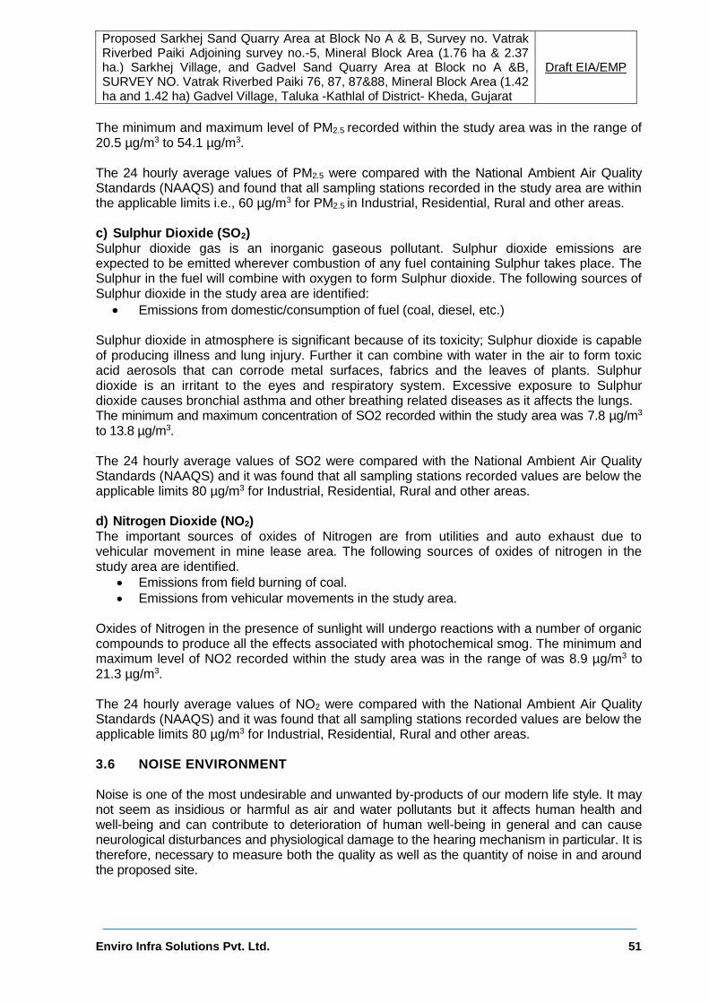
Proposed Sarkhej Sand Quarry Area at Block No A & B, Survey no. Vatrak Riverbed Paiki Adjoining survey no.-5, Mineral Block Area (1.76 ha & 2.37 ha.) Sarkhej Village, and Gadvel Sand Quarry Area at Block no A &B, SURVEY NO. Vatrak Riverbed Paiki 76, 87, 87&88, Mineral Block Area (1.42 ha and 1.42 ha) Gadvel Village, Taluka -Kathlal of District- Kheda, Gujarat
Draft EIA/EMP
Enviro Infra Solutions Pvt. Ltd. 51
The minimum and maximum level of PM2.5 recorded within the study area was in the range of 20.5 µg/m3 to 54.1 µg/m3. The 24 hourly average values of PM2.5 were compared with the National Ambient Air Quality Standards (NAAQS) and found that all sampling stations recorded in the study area are within the applicable limits i.e., 60 µg/m3 for PM2.5 in Industrial, Residential, Rural and other areas. c) Sulphur Dioxide (SO2) Sulphur dioxide gas is an inorganic gaseous pollutant. Sulphur dioxide emissions are expected to be emitted wherever combustion of any fuel containing Sulphur takes place. The Sulphur in the fuel will combine with oxygen to form Sulphur dioxide. The following sources of Sulphur dioxide in the study area are identified:
Emissions from domestic/consumption of fuel (coal, diesel, etc.) Sulphur dioxide in atmosphere is significant because of its toxicity; Sulphur dioxide is capable of producing illness and lung injury. Further it can combine with water in the air to form toxic acid aerosols that can corrode metal surfaces, fabrics and the leaves of plants. Sulphur dioxide is an irritant to the eyes and respiratory system. Excessive exposure to Sulphur dioxide causes bronchial asthma and other breathing related diseases as it affects the lungs. The minimum and maximum concentration of SO2 recorded within the study area was 7.8 µg/m3 to 13.8 µg/m3. The 24 hourly average values of SO2 were compared with the National Ambient Air Quality Standards (NAAQS) and it was found that all sampling stations recorded values are below the applicable limits 80 µg/m3 for Industrial, Residential, Rural and other areas.
d) Nitrogen Dioxide (NO2) The important sources of oxides of Nitrogen are from utilities and auto exhaust due to vehicular movement in mine lease area. The following sources of oxides of nitrogen in the study area are identified.
Emissions from field burning of coal.
Emissions from vehicular movements in the study area. Oxides of Nitrogen in the presence of sunlight will undergo reactions with a number of organic compounds to produce all the effects associated with photochemical smog. The minimum and maximum level of NO2 recorded within the study area was in the range of was 8.9 µg/m3 to 21.3 µg/m3. The 24 hourly average values of NO2 were compared with the National Ambient Air Quality Standards (NAAQS) and it was found that all sampling stations recorded values are below the applicable limits 80 µg/m3 for Industrial, Residential, Rural and other areas. 3.6 NOISE ENVIRONMENT Noise is one of the most undesirable and unwanted by-products of our modern life style. It may not seem as insidious or harmful as air and water pollutants but it affects human health and well-being and can contribute to deterioration of human well-being in general and can cause neurological disturbances and physiological damage to the hearing mechanism in particular. It is therefore, necessary to measure both the quality as well as the quantity of noise in and around the proposed site.

Proposed Sarkhej Sand Quarry Area at Block No A & B, Survey no. Vatrak Riverbed Paiki Adjoining survey no.-5, Mineral Block Area (1.76 ha & 2.37 ha.) Sarkhej Village, and Gadvel Sand Quarry Area at Block no A &B, SURVEY NO. Vatrak Riverbed Paiki 76, 87, 87&88, Mineral Block Area (1.42 ha and 1.42 ha) Gadvel Village, Taluka -Kathlal of District- Kheda, Gujarat
Draft EIA/EMP
Enviro Infra Solutions Pvt. Ltd. 52
3.6.1 Source of Noise The main sources of noise in the study area are domestic activities, industrial activities and vehicular traffic. The main occupation of the villagers in the study area is agriculture and business. 3.6.2 Noise Level in the Study Area The baseline noise levels have been monitored at 08 locations, one in core zone and six within the study area during winter period, using a sound level meter and noise level measurement locations were identified for assessment of existing noise level status, keeping in view the land use pattern, industrial area, Silence Zone, residential areas in villages etc., if available within 10 km radius of the study area. The day levels have been monitored during 6.00 AM to 10.00 PM and night noise levels, during 10.00 PM to 6.00 AM. The noise monitoring stations are shown in Figure 3.4 and represented in Table 3.4. The results are presented in Table 3.5.
Table 3.4: Noise Level Monitoring Stations in the Study Area
S. No. Location Name Direction Distance from the project
site (in km)
NQ1 Sarkhej W 0.65
NQ2 Gadvel S 0.70
NQ3 Pato N 2.42
NQ4 Mirjapur NW 4.22
NQ5 Pithai SSE 9.15
NQ6 Kanipur NNW 6.65
NQ7 Haldarvas SW 6.14
NQ8 Torna SSE 9.27
Table 3.5: Leq Noise Level in the Study Area (during day and Night) (Jan 2021)
Location Code
Noise levels
dB(A), Day (Leq)
Noise levels dB(A) Night,
(Leq)
Noise Limits in dB(A), Leq
Day Time
Noise Limits in dB(A), Leq Night Time
Area
NQ1 69.8 52.3
75 70 Mine Site
(Industrial)
NQ2 62.2 49.7 55 45 Residential
NQ3 53.7 42.3 55 45 Residential
NQ4 55.7 46.2 55 45 Residential
NQ5 50.6 41.5 55 45 Residential
NQ6 54.4 43.7 55 45 Residential
NQ7 53.5 39.6 55 45 Residential
NQ8 52.1 38.4 55 45 Residential

Proposed Sarkhej Sand Quarry Area at Block No A & B, Survey no. Vatrak Riverbed Paiki Adjoining survey no.-5, Mineral Block Area (1.76 ha & 2.37 ha.) Sarkhej Village, and Gadvel Sand Quarry Area at Block no A &B, SURVEY NO. Vatrak Riverbed Paiki 76, 87, 87&88, Mineral Block Area (1.42 ha and 1.42 ha) Gadvel Village, Taluka -Kathlal of District- Kheda, Gujarat
Draft EIA/EMP
Enviro Infra Solutions Pvt. Ltd. 53
Figure 3.4: Ambient Noise Level Monitoring Locations
3.6.3 Ambient Noise Standards Ministry of Environment, Forest and Climate Change (MoEF&CC) has notified the noise standards vide gazette notification dated February 14, 2000 for different zones under the Environment Protection Act (1986). These standards are given in Table-3.6.
Table 3.6: Ambient Quality Standards in respect of Noise
Area Code Category of Area Noise dB (A) Leq
Daytime* Night time*
A Industrial Area 75 70
B Commercial Area 65 55
C Residential Area 55 45
D Silence Zone 50 40
Note: 1. Daytime is from 6.00am to 10.00 pm and Nighttime is from 10.00 pm to 6.00 am. 2. Silence zone is defined as area up to 100 meters around premises of hospitals,
educational institutions and courts. Use of vehicle hours, loud speakers and bursting of crackers are banned in these zones.

Proposed Sarkhej Sand Quarry Area at Block No A & B, Survey no. Vatrak Riverbed Paiki Adjoining survey no.-5, Mineral Block Area (1.76 ha & 2.37 ha.) Sarkhej Village, and Gadvel Sand Quarry Area at Block no A &B, SURVEY NO. Vatrak Riverbed Paiki 76, 87, 87&88, Mineral Block Area (1.42 ha and 1.42 ha) Gadvel Village, Taluka -Kathlal of District- Kheda, Gujarat
Draft EIA/EMP
Enviro Infra Solutions Pvt. Ltd. 54
3.6.4 Baseline Scenario The values of noise observed in some of the areas are primarily owing to vehicular traffic and other anthropogenic activities. Assessment of average logarithm Day time Leq (Ln) varies from 52.3 to 69.8 dB (A) and the average logarithm Night time Leq (Ld) varies from 52.3 dB to 38.4 dB (A) within the study area. The status of noise quality within the 10 km zone of the study area is, therefore, within the MoEF&CC standards. 3.7 WATER ENVIRONMENT 3.7.1 Hydrogeology for the study area Aquifer System Hydro geologically the district can be broadly grouped under hard rocks comprising “Deccan Traps” and soft rocks comprising “tertiaries and Alluvium”. Nearly 70% of the district is underlain by Deccan Traps. The Deccan trap are the most extensive aquifers in the district. Millioite limestone and Alluvium forms a potential aquifer but limited in the coastal and the central parts of the district respectively. The groundwater developments in all these formations are mainly by dug wells. Deccan Trap Deccan trap basalt occupies a major part of the district and forms the most important aquifer system. It generally forms a poor aquifer due to compactness and poor primary porosity. However, the upper weathered parts, which at places are up to 15-20m thick, form good aquifer. At deeper level s, the secondary porosity developed as a result of tectonic activities, in the form of joints, and fractures, shear zones, form repository of ground water at many places. Amygdaloidal horizons within basalt also form potential aquifers at places. The dykes, both basaltic and dolerite, play an important role in occurrence and movement of ground water. At places, the dykes are highly weathered and themselves form potential aquifers. At other places where the dykes are more compact, they act as subsurface barrier for the ground water flow and well-constructed upstream of these dykes have yield good yields. The ground water in basalt occurs under phreatic to confined conditions. The ground water is mainly tapped by dug wells varying in depth from 5 to 50m wells. About 90% of the dug wells have 2 to 3 side bore wells, each side bore wells range between 50 and 100 feet in length. These side bore wells, enhance the yield of the dug wells to greater extent as they act as conduct. The yield of dug wells and dug-cum-bored wells in basalt generally range from 100 to 500 m3/day. During Rabi (post monsoon) season these wells sustain intermittent pumping of 15 minutes to 12 hours, however, during summer, the yield of these wells is considerably diminished. The vesicular & amygdaloidal horizons within basalt at places may have yields of up to 1000 m3/day. The dykes occurring in the district themselves form aquifers at places where they are highly fractured. The wells in such dykes range in depth from 5 to 25 m and the yield of wells range between 15 and 600m3/day. Hydrogeology Characteristics
Unconfined shallow aquifer, leaky confined/ confined and deeper aquifer.
Large to moderate yield prospects:10 to 40 lps,
Storativity: 1.6x10E-4 to 7.3x 10E-4,
Hydraulic Conductivity: 5 to 20m/day,
Transmissivity: 50 to 2000m2/day

Proposed Sarkhej Sand Quarry Area at Block No A & B, Survey no. Vatrak Riverbed Paiki Adjoining survey no.-5, Mineral Block Area (1.76 ha & 2.37 ha.) Sarkhej Village, and Gadvel Sand Quarry Area at Block no A &B, SURVEY NO. Vatrak Riverbed Paiki 76, 87, 87&88, Mineral Block Area (1.42 ha and 1.42 ha) Gadvel Village, Taluka -Kathlal of District- Kheda, Gujarat
Draft EIA/EMP
Enviro Infra Solutions Pvt. Ltd. 55
Achaean and Proterozoic Formation Rocks of Archaean and Proterozoic age occupy the north-eastern and eastern parts of the state and cover extensive areas in parts of Vadodara, Kheda, Panchmahals, Sabarkantha, Mahesana and Banaskantha districts. These rocks, which include gneiss, schist, phyllite, quartzite and metamorphosed igneous intrusives do not form good aquifers due to their poor porosity and permeability. Dug wells, dug-cum-bore wells and bore wells are feasible only in favourable sites where sufficient weathered mantle and/or fractures and joints occur. The wells tapping these aquifers have maximum depth of 30 to 40 mbgl beyond which groundwater occurrence is not common. The yield of wells in these rocks varies from a few cubic meters to 100 cubic meters per day at minimal drawdown. Miliolite Limestone Miliolites form potential aquifers in the coastal areas. The depth of the dug well in this formation range between 4 and 65m bgl, however, most of the wells are less than 25 m deep. Horizontal bore wells increase the yield of the dugwells. The yields range between 15 and 800m3/day. At places, very high yields are observed due to karstic nature of this formation. Depth to Water level:-
Figure 3.5: Depth to water level map for the pre monsoon period (Source: Ground water
Year book, Gujarat, 2019) The Ground water level during the pre-monsoon period ranged from .45 mbgl and the deepest water level of 36.82 mbgl in the project district. Depth to water level map for the pre monsoon period is shown in Figure-3.5. The Details of Depth of Ground Water of project district has been attached as Annexure V.

Proposed Sarkhej Sand Quarry Area at Block No A & B, Survey no. Vatrak Riverbed Paiki Adjoining survey no.-5, Mineral Block Area (1.76 ha & 2.37 ha.) Sarkhej Village, and Gadvel Sand Quarry Area at Block no A &B, SURVEY NO. Vatrak Riverbed Paiki 76, 87, 87&88, Mineral Block Area (1.42 ha and 1.42 ha) Gadvel Village, Taluka -Kathlal of District- Kheda, Gujarat
Draft EIA/EMP
Enviro Infra Solutions Pvt. Ltd. 56
Post Monsoon Period The Ground water level of the project district during post monsoon period ranged from .08 m.bgl. to 13.62 m.bgl. Shallowest water level recorded is .08 m.bgl and the deepest water level is 1 m.bgl. Depth to water level map for the post monsoon period is shown in Figure-3.6.
Figure 3.6: Depth to water level map for the post monsoon period ( Source: Ground
water Year book, Gujarat, 2019)
Rise and fall in Water Levels:- Rise in water level of the project district ranges from .07 to 11.51. Minimum rise is 0.07 m and Maximum rise is 11.51 m. 28-53% of the wells in the district showed fall in water level between May to November. Fall in water level ranges from 0.02 to 4.7m. Minimum fall is 0.02 m and maximum fall is 4.7 Rise and fall in water levels (Fluctuation) between May and November. Figure 3.7 presents water levels fluctuation map.

Proposed Sarkhej Sand Quarry Area at Block No A & B, Survey no. Vatrak Riverbed Paiki Adjoining survey no.-5, Mineral Block Area (1.76 ha & 2.37 ha.) Sarkhej Village, and Gadvel Sand Quarry Area at Block no A &B, SURVEY NO. Vatrak Riverbed Paiki 76, 87, 87&88, Mineral Block Area (1.42 ha and 1.42 ha) Gadvel Village, Taluka -Kathlal of District- Kheda, Gujarat
Draft EIA/EMP
Enviro Infra Solutions Pvt. Ltd. 57
Figure 3.7: Rise and fall in water levels (Fluctuation) (Source: Ground water Year book,
Gujarat, 2019) 3.7.2 Water Quality Water quality assessment is one of the essential components of EIA study. Such assessment helps in evaluating the existing health of water body and suggesting appropriate mitigation measures to minimize the potential impact from development projects. Water quality of ground water has been studied in order to assess proposed water-uses in dust suppression, drinking and green belt watering purpose. The water quality within the study area was monitored during the study period. The water samples were collected once in month. The water sampling locations marked within the study are presented in Table 3.7 and the result of the monitoring and analysis are presented in the Table 3.8 and Figure 3.8a, 3.8b shows the Water Quality Monitoring Locations marked within the Study Area.
Table 3.7: Location of Water Sampling Sites
S. No. Location Name Direction Distance from the project site (in km)
GWQ1 Sarkhej W 0.65
GWQ2 Gadvel S 0.70
GWQ3 Pato N 2.42
GWQ4 Mirjapur NW 4.22
GWQ5 Pithai SSE 9.15
GWQ6 Kanipur NNW 6.65
SW1 Vatrak River Near Pata SW 6.14
SW2 Vatrak River Near Gadvel SSE 9.27

Proposed Sarkhej Sand Quarry Area at Block No A & B, Survey no. Vatrak Riverbed Paiki Adjoining survey no.-5, Mineral Block Area (1.76 ha & 2.37 ha.) Sarkhej Village, and Gadvel Sand Quarry Area at Block no A &B, SURVEY NO. Vatrak Riverbed Paiki 76, 87, 87&88, Mineral Block Area (1.42 ha and 1.42 ha) Gadvel Village, Taluka -Kathlal of District- Kheda, Gujarat
Draft EIA/EMP
Enviro Infra Solutions Pvt. Ltd. 58
Figure 3.8 (a): Location Map of Ground Water Sampling Sites
Figure 3.8 (b): Location Map of Surface Water Sampling Sites

Proposed Sarkhej Sand Quarry Area at Block No A & B, Survey no. Vatrak Riverbed Paiki Adjoining survey no.-5, Mineral Block Area (1.76 ha & 2.37 ha.) Sarkhej Village, and Gadvel Sand Quarry Area at Block no A &B, SURVEY NO. Vatrak Riverbed Paiki 76, 87, 87&88, Mineral Block Area (1.42 ha and 1.42 ha) Gadvel Village, Taluka -Kathlal of District- Kheda, Gujarat
Draft EIA/EMP
Enviro Infra Solutions Pvt. Ltd. 59
Table 3.8: Water Quality during the month of December 2021
S. No
Parameter
Unit
Limit (IS-10500:2012)
GW1 GW2 GW3 GW4 GW5 GW6 SW1 SW2
Desirable Permissible
Sarkhej
Gadvel
Patao Mirjapur
Pithai Kanipur
Vatrak River Near Pata
Vatrak River Near Gadvel
1 Temperature (0C)
(0C) - - 12 14 15 13 16 18 17 15
2 pH - 6.5-8.5 No
Relaxation
8.21 8.18 8.28 8.63 7.65 7.96 7.53 7.62
3 Electrical Conductivity
Microm/hos/cm
- - 2310.
09 2370.
18 2390.
33 2470.6
1285.59
12890.6
1189.3 1221.3
4 TDS mg/l 500 2000 1501.
56 1540.
62 1553.
71 1605.8
9 835.6
4 831.5
1 821.2 822.1
5 TSS Mg/l - - BDL BDL BDL BDL 120.8 123.2 121.2 124.3
6 Dissolved Oxygen
mg/l 4.2 3.9 4.1 4 5.2 5.9 5.8 6.1
7 Alkalinity as (CaCO3)
mg/l 200 600 525 538.2
5 545.5
2 570.78
150.36
154.25
153.89 154.52
8 BOD (at 270C 3-Days)
mg/l - - BDL BDL BDL BDL 19.25 18.21 17.21 16.89
9 COD mg/l - - BDL BDL BDL BDL 49.01 47.2 46.3 47.13
10 Nitrate (as NO3)
mg/l 45 No
Relaxation
110.25
114.85
113.75
114.68 3.68 3.91 3.89 3.71
11 Chloride (as Cl)
mg/l 250 1000 347.8
5 351.2
5 360.2
6 364.29
314.29
316.23
313.2 312.8

Proposed Sarkhej Sand Quarry Area at Block No A & B, Survey no. Vatrak Riverbed Paiki Adjoining survey no.-5, Mineral Block Area (1.76 ha & 2.37 ha.) Sarkhej Village, and Gadvel Sand Quarry Area at Block no A &B, SURVEY NO. Vatrak Riverbed Paiki 76, 87, 87&88, Mineral Block Area (1.42 ha and 1.42 ha) Gadvel Village, Taluka -Kathlal of District- Kheda, Gujarat
Draft EIA/EMP
Enviro Infra Solutions Pvt. Ltd. 60
12 Phosphates
mg/l - - 0.08 0.05 0.03 0.06 0.39 0.37 0.36 0.38
13 Sulphate (as SO4)
mg/l 200 400 245.3
6 250.3
2 254.3
6 261.28
101.28
102.56
101.11 100.23
14 Sodium (as Na)
mg/l - - 319.2
5 327.2
7 325.2
6 333.29
250.29
254.21
252.25 251.3
15 Potassium (as K)
mg/l - - 4.3 6.1 5.18 7.11 18.11 17.25 17.85 16.25
16 Calcium (as CaCO3)
mg/l 75 200 49.3 51.6 54.3 61.4 45.4 44.2 43.98 44.23
17 Magnesium (as CaCO3)
mg/l 30 100 110.2
5 116.2
8 113.2
8 121.37 12.37 11.35 11.11 12.15
18 Oil & Grease
mg/l - - <1.0 <1.00 <1.00 <1.00 <1.01 <1.02 <1.03 <1.03
19 Lead (as Pb)
mg/l 0.01 No
Relaxation
<0.01 <0.01 <0.01 <0.01 <0.01 <0.01 <0.01 <0.01
20 Arsenic (as As)
mg/l 0.01 0.05 <0.01 <0.01 <0.01 <0.01 <0.01 <0.01 <0.01 <0.01
21 Mercu22ry (as Hg)
mg/l 0.001 No
Relaxation
<0.001
<0.001
<0.001
<0.001 <0.00
1 <0.00
1 <0.001 <0.001
22 Cadmium (as Cd)
mg/l 0.003 No
Relaxation
<0.001
<0.001
<0.001
<0.001 <0.00
1 <0.00
1 <0.001 <0.001
23 Chromium (as Cr6+)
mg/l 0.05 No
Relaxation
<0.001
<0.01 <0.01 <0.01 <0.01 <0.01 <0.01 <0.01
24 Total Chromiu
mg/l 0.05 No
Relaxat<0.01 <0.04 <0.05 <0.05 <0.05 <0.05 <0.05 <0.05

Proposed Sarkhej Sand Quarry Area at Block No A & B, Survey no. Vatrak Riverbed Paiki Adjoining survey no.-5, Mineral Block Area (1.76 ha & 2.37 ha.) Sarkhej Village, and Gadvel Sand Quarry Area at Block no A &B, SURVEY NO. Vatrak Riverbed Paiki 76, 87, 87&88, Mineral Block Area (1.42 ha and 1.42 ha) Gadvel Village, Taluka -Kathlal of District- Kheda, Gujarat
Draft EIA/EMP
Enviro Infra Solutions Pvt. Ltd. 61
m (as Cr6+)
ion
25 Copper (as Cu)
mg/l 0.05 1.5 <0.05 <0.05 <0.05 <0.05 <0.05 <0.05 <0.05 <0.05
26 Zinc (as Zn)
mg/l 5 15 0.15 0.16 0.13 0.12 BDL BDL BDL BDL
27 Iron (as Fe)
mg/l 0.3 1 0.89 0.92 0.65 0.72 BDL BDL BDL BDL
Bacteriological Parameter
1 Total Coliform
MPN/100ml
Absent - Absent Absen
t Absent
Absent
112 116 115 117
2 E.coli E.coli /100ml
Absent - Absent Absen
t Absent
Absent
272 264 268 268

Proposed Sarkhej Sand Quarry Area at Block No A & B, Survey no. Vatrak Riverbed Paiki Adjoining survey no.-5, Mineral Block Area (1.76 ha & 2.37 ha.) Sarkhej Village, and Gadvel Sand Quarry Area at Block no A &B, SURVEY NO. Vatrak Riverbed Paiki 76, 87, 87&88, Mineral Block Area (1.42 ha and 1.42 ha) Gadvel Village, Taluka -Kathlal of District- Kheda, Gujarat
Draft EIA/EMP
Enviro Infra Solutions Pvt. Ltd. 62
3.7.3 Sampling Frequency and Sampling Techniques Parameters for analysis of water quality were selected based on the utility of the particular source of water as per MoEF&CC guidance. Hence quality of ground water was compared with IS: 10500: 2012 for drinking purposes. Surface water quality was monitored for parameters as per Methods of Monitoring & Analysis published by CPCB and it was rated according to the CPCB Water Quality Criteria against A, B, C, D & E class of water. Water samples were collected as Grab water sample from sampling location. The samples were analyzed as per standard procedure / method given in IS: 3025 (Revised Part) and standard method for examination of water and wastewater Ed.21st, published jointly APHA, AWWA and WPCF. The surface water quality is compared with CPCB water quality criteria mentioned in Table 3.9 below:
Table 3.9: Water Quality Criteria as per Central Pollution Control Board
Designated-Best-Use Class of water
Criteria
Drinking Water Source without conventional treatment but after disinfection
A Total Coliforms Organism MPN/100ml shall be 50 or less pH between 6.5 and 8.5 Dissolved Oxygen 6mg/l or more Biochemical Oxygen Demand 5 days 20°C 2mg/l or less
Outdoor bathing (Organized)
B Total Coliforms Organism MPN/100ml shall be 500 or less; pH between 6.5 and 8.5; Dissolved Oxygen 5mg/l or more Biochemical Oxygen Demand 5 days 20°C 3mg/l or less
Drinking water source after conventional treatment and disinfection
C Total Coliforms Organism MPN/100ml shall be 5000 or less; pH between 6 to 9; Dissolved Oxygen 4mg/l or more Biochemical Oxygen Demand 5 days 20°C 3mg/l or less
Propagation of Wild life and Fisheries
D pH between 6.5 to 8.5 Dissolved Oxygen 4mg/l or more Free Ammonia (as N) 1.2 mg/l or less
Irrigation, Industrial Cooling, Controlled Waste disposal
E pH between 6.0 to 8.5 Electrical Conductivity at 25°C micro mhos/cm Max.2250 Sodium absorption Ratio Max. 26 Boron Max. 2mg/l
Below-E Not Meeting A, B, C, D & E Criteria

Proposed Sarkhej Sand Quarry Area at Block No A & B, Survey no. Vatrak Riverbed Paiki Adjoining survey no.-5, Mineral Block Area (1.76 ha & 2.37 ha.) Sarkhej Village, and Gadvel Sand Quarry Area at Block no A &B, SURVEY NO. Vatrak Riverbed Paiki 76, 87, 87&88, Mineral Block Area (1.42 ha and 1.42 ha) Gadvel Village, Taluka -Kathlal of District- Kheda, Gujarat
Draft EIA/EMP
Enviro Infra Solutions Pvt. Ltd. 63
3.7.4 Result & Conclusion:
The pH limit fixed for drinking water samples as per IS-10500 Standards is 6.5 to 8.5 beyond this range the water will affect the mucus membrane or water supply system. During the study period, the pH was varying for ground water from 7.65 to 7.62and the surface water is 7.96 to 8.26. The pH values for all the samples collected in the study area during study period were found to be within the limits.
The desirable limit for total dissolved solids as per IS-10500 Standards is 500 mg/l whereas the permissible limits in absence of alternate source is 2000 mg/l, beyond this palatability decreases and may cause gastro intestinal irritation. In ground water samples collected from the study area, the total dissolved solids in ground water are varying from 1501.56 mg/l to 1605.89 mg/l whereas in surface water varying from 835.64 to 822.1 mg/l. The TDS of the samples were above the desirable limit of 500 mg/l.
The desirable limit for chlorides is 250 mg/l as per IS-10500 Standards whereas, permissible limit of the same is 1000 mg/l beyond this limit taste, corrosion and palatability are affected. The chloride level in the ground water samples collected in the study area were ranging from 347.85 mg/l to a maximum of 364.29 mg/l, in surface water samples 314.29 mg/l to 312.8 mg/l. The chloride samples are within the desirable limits.
The desirable limit as per IS-10500 Standards for hardness is 200 mg/l whereas the permissible limit for the same is 600 mg/l beyond this limit encrustation in water supply structure and adverse effects on domestic use will be observed. In the ground water samples collected from the study area, the hardness is varying from 525 mg/l to 570.8mg/l, in surface water samples 150.36 mg/l to 154.52 mg/l.
Overall all the samples collected from the study area were found to be fit for consumption, Most of ground water samples are well within the permissible limits, as per IS-10500. Most of the heavy metals in all samples are below detectable limits. Comparing the values of pH, DO, BOD and total coliforms with ‘Use based classification of surface waters’ published by Central Pollution Control Board; it can be seen that all the analyzed surface waters can be compared with class ‘B’ and can be used as Outdoor bathing (Organized). 3.8 SOIL CHARACTERISTICS The composite soil samples were collected from site and the study area and were analyzed for characterization. The locations of the monitoring sites are depicted in Figure-3.9 and given in Table 3.10. Showing Soil Sample Collection Points marked within the Study Area. 3.8.1 Methodology
The soil samples were collected in the month of January 2021. Soil
samples were collected from 7 locations. The
samples were filled in polythene bags,
labeled in the field with number and site name and sent to laboratory for analysis. The test results are given in
Table-3.11.Particulars
Details
Frequency One grab sample from each station once during the Study Period
Methodology Composite grab samples of the topsoil were collected from 3m depth, and mixed to provide a representative sample for analysis. They were stored in airtight Polythene Bags and analyzed at the laboratory

Proposed Sarkhej Sand Quarry Area at Block No A & B, Survey no. Vatrak Riverbed Paiki Adjoining survey no.-5, Mineral Block Area (1.76 ha & 2.37 ha.) Sarkhej Village, and Gadvel Sand Quarry Area at Block no A &B, SURVEY NO. Vatrak Riverbed Paiki 76, 87, 87&88, Mineral Block Area (1.42 ha and 1.42 ha) Gadvel Village, Taluka -Kathlal of District- Kheda, Gujarat
Draft EIA/EMP
Enviro Infra Solutions Pvt. Ltd. 64
Table 3.10: Soil Sample Collection Points
S. No. Location Name Direction Distance from the project site (in km)
SQ1 Sarkhej W 0.65
SQ2 Gadvel S 0.70
SQ3 Pato N 2.42
SQ4 Mirjapur NW 4.22
SQ5 Pithai SSE 9.15
SQ6 Kanipur NNW 6.65
SQ7 Haldarvas SW 6.14
SQ8 Torna SSE 9.27
Figure 3.9: Location Map of Soil Sampling Sites

Proposed Sarkhej Sand Quarry Area at Block No A & B, Survey no. Vatrak Riverbed Paiki Adjoining survey no.-5, Mineral Block Area (1.76 ha & 2.37 ha.) Sarkhej Village, and Gadvel Sand Quarry Area at Block no A &B, SURVEY NO. Vatrak Riverbed Paiki 76, 87, 87&88, Mineral Block Area (1.42 ha and 1.42 ha) Gadvel Village, Taluka -Kathlal of District- Kheda, Gujarat
Draft EIA/EMP
Enviro Infra Solutions Pvt. Ltd. 65
Table 3.11: Physiochemical Properties of Soil (December 2021)
S. No Parameter
Test Method Unit
SQ-1 SQ-2 SQ-3 SQ-4 SQ-5 SQ-6 SQ-7 SQ8
Sarkhej Gadvel Patao Mirjapur Pithai Kanipur Haldarvas Torna
1 pH (1:2) IS:2720(Part-
26) - 7.65 7.32 7.48 7.55 7.49 7.32 7.38 7.35
2 Electrical Conductivity (1:2)
IS:2720(Part-21)
µmhos/cm
270 285 293 289 291 294 282 288
3 Texture STP/SOIL - Sandy loam
Sandy loam
Sandy loam
Sandy loam
Sandy loam
Sandy loam
Sandy loam Sandy loam
4 Sand STP/SOIL % 56.4 53.3 58.6 52.5 57.8 61.6 62.2 51.5
5 Silt IS:2720(Part-
22) % 20.2 21.3 19 23.3 20.1 20.2 18.1 24.1
6 Clay STP/SOIL % 23.4 25.4 22.4 24.2 27.2 18.2 19.7 24.4
7 Exchangeable Potassium
STP/SOIL mg/kg 112.2 115.3 109.2 105.3 108.2 104.3 103.5 110.8
8 Exchangeable Sodium
STP/SOIL mg/kg 66.8 67.2 64.3 61.3 60.2 61.6 58.3 65.8
9 Exchangeable Calcium
STP/SOIL mg/kg 1120.8 1220.2 1123.3 1236.3 1216.6 1189.3 1191.3 1125.9
10 Exchangeable Magnesium
STP/SOIL mg/kg 270.1 268.1 271.2 264.2 275.3 267.8 268.3 272.5
11 Sodium Absorption Ratio
STP/SOIL - 0.82 1.16 1.21 1.34 1.44 1.22 1.21 1.15
12 Porosity STP/SOIL % 47.8 32.6 35.5 37.2 34.2 40.8 38.2 42.5
13 Organic Matter STP/SOIL % by mass
0.46 0.55 0.42 0.36 0.48 0.39 0.37 0.41
14 Water holding Capacity
STP/SOIL % by mass
24.3 20.4 22.4 21.2 25.7 23.8 24.5 24.8
15 Nitrogen STP/SOIL mg/kg 61.8 63.1 63.7 59.8 62.3 57.5 59.3 59.9

Proposed Sarkhej Sand Quarry Area at Block No A & B, Survey no. Vatrak Riverbed Paiki Adjoining survey no.-5, Mineral Block Area (1.76 ha & 2.37 ha.) Sarkhej Village, and Gadvel Sand Quarry Area at Block no A &B, SURVEY NO. Vatrak Riverbed Paiki 76, 87, 87&88, Mineral Block Area (1.42 ha and 1.42 ha) Gadvel Village, Taluka -Kathlal of District- Kheda, Gujarat
Draft EIA/EMP
Enviro Infra Solutions Pvt. Ltd. 66
16 Phosphorus STP/SOIL mg/kg 8.9 7.9 8.1 7.8 7.9 8.3 7.6 8.8
17 Bulk Density STP/SOIL grm/cc 1.36 1.41 1.56 1.22 1.52 1.42 1.32 1.28
18 Infiltration Rate STP/SOIL mm/hr 10 11 12 10 12 11 10 12
19 Moisture STP/SOIL % 14.6 16.2 15.8 18.5 17.5 16.8 16.8 15.8
20 Sulphates STP/SOIL mg/kg 102.3 101.2 108.3 118.2 116.6 105.3 112.2 104.4
21 Available Sulphur(as S)
STP/SOIL mg/kg 28.4 21.8 23.2 28.2 26.2 24.3 23.8 27.5
22 Available Manganese (as Mn)
STP/SOIL mg/kg 8.3 7.2 8.4 7.35 7.86 7.56 7.89 7.9
23 Available Iron (as Fe)
STP/SOIL mg/kg 9.53 8.36 8.25 7.89 8.89 8.29 8.41 8.81
24 Sodium as Na STP/SOIL mg/kg 61.23 60.3 62.12 59.6 60.8 60.2 61.8 60.4

Proposed Sarkhej Sand Quarry Area at Block No A & B, Survey no. Vatrak Riverbed Paiki Adjoining survey no.-5, Mineral Block Area (1.76 ha & 2.37 ha.) Sarkhej Village, and Gadvel Sand Quarry Area at Block no A &B, SURVEY NO. Vatrak Riverbed Paiki 76, 87, 87&88, Mineral Block Area (1.42 ha and 1.42 ha) Gadvel Village, Taluka -Kathlal of District- Kheda, Gujarat
Draft EIA/EMP
Enviro Infra Solutions Pvt. Ltd. 67
3.8.2 Results of Analysis of the Soil Physical characteristics of soil were characterized through specific parameters viz bulk density, porosity, water holding capacity, pH, electrical conductivity and texture. Soil pH plays an important role in the availability of nutrients. Soil microbial activity as well as solubility of metal ions is also dependent on pH. In the study area, variations in the pH of the soil were found to be slightly basic 7.65 to 7.35. Electrical conductivity (EC) is a measure of the soluble salts and ionic activity in the soil. In the collected soil samples the conductivity ranged from 270 – 288 µmhos/cm. 3.9 LAND USE/LAND COVER MAPPING
Coordinates of the mine lease area Map with all corner coordinates of the mine lease area are super imposed on toposheet is shown in Figure-3.10. To assess the land use pattern surrounding the 10 km radius of the site, a detailed study was carried out. The land use pattern study reveals that the 10 km environs is predominantly forest and agriculture area. The land use details are given in Table-3.12.
Table 3.12: Land use of the study area
S. No. CLASS AREA PERCENTAGE
1 WATER BODY 443.30 1.31
2 NATURAL VEGETATION 1093.03 3.23
3 BUILTUP 835.85 2.47
4 BUILTUP MINE 98.14 0.29
5 BARREN 2598.90 7.68
6 CROP LAND 28770.68 85.02
7 TOTAL AREA 33839.90 100

Proposed Sarkhej Sand Quarry Area at Block No A & B, Survey no. Vatrak Riverbed Paiki Adjoining survey no.-5, Mineral Block Area (1.76 ha & 2.37 ha.) Sarkhej Village, and Gadvel Sand Quarry Area at Block no A &B, SURVEY NO. Vatrak Riverbed Paiki 76, 87, 87&88, Mineral Block Area (1.42 ha and 1.42 ha) Gadvel Village, Taluka -Kathlal of District- Kheda, Gujarat
Draft EIA/EMP
Enviro Infra Solutions Pvt. Ltd. 68
Figure 3.10: Land use delineation of 10 km radius area
3.10 TRAFFIC STUDY Traffic study is carried out by understanding the existing carrying capacity of the road in the vicinity of site and flow towards State highway in the area. Then depending on the capacity of the mine, the number of trucks that will be added to the present scenario will be compared to the carrying capacity as recommended by Indian Road Congress (IRC). The existing volume of traffic and, the Level of Service are given in Table-3.13 (i) and shown in traffic density map as Figure-3.11.
Table 3.13 (i): Existing Traffic Scenario & LOS
Road V
(PCU/day) C
(PCU/day) Existing V/C
Ratio LOS
NH-47 500 1200 0.41 B
V= Volume in PCU’s/day & C= Capacity in PCU’s/ day During Mine operation Total Capacity of Four mines : 2,80,000 MTPA Sarkhej and Gadvel (Block A + Block B) No. of working days : 280 days Total Capacity of mine/day : 2,80,000 /280 = 1000 tonnes/day Truck Capacity : 20 tonnes No. of trucks deployed per day : 1000/20 = 50 trucks per day No. of trucks deployed/day to & fro : 50x2=100 trucks Increase in PCU/day : 300

Proposed Sarkhej Sand Quarry Area at Block No A & B, Survey no. Vatrak Riverbed Paiki Adjoining survey no.-5, Mineral Block Area (1.76 ha & 2.37 ha.) Sarkhej Village, and Gadvel Sand Quarry Area at Block no A &B, SURVEY NO. Vatrak Riverbed Paiki 76, 87, 87&88, Mineral Block Area (1.42 ha and 1.42 ha) Gadvel Village, Taluka -Kathlal of District- Kheda, Gujarat
Draft EIA/EMP
Enviro Infra Solutions Pvt. Ltd. 69
The addition to traffic by the proposed project during its operation is given in Table-3.13 (ii).
Table 3.13 (ii): Additional Traffic Scenario & LOS due to proposed project
Highway V C Modified V/C Ratio LOS
State Highway (SH-2) 800 1200 0.66 B
From the above analysis it can be seen that the V/C ratio is likely to be changed to 0.66 on highway Road with LOS remains “B” which is “Very Good” as per the classification. So the additional load on the carrying capacity of the concerned roads is not likely to have much significant adverse effect.
Figure 3.11: Transportation Route Map
3.11 BIOLOGICAL ENVIRONMENT Biological diversity comprises the variability of species, genus and ecosystems and is very crucial for maintaining the basic processes on which the life depends. Broadly it can be divided in to two types i.e. the floral diversity and faunal diversity. Conservation of the biodiversity is essential for the sustainable development as it not only provides the food, fodder and medicine but also contribute in improvement of essential environmental attributes like air, water, soil, etc. Before starting any Environmental Impact Assessment study, it is necessary to identify the baseline of relevant environmental parameters which are likely to be affected as a result of operation of the proposed project. A similar approach has been adopted for conducting the study on Biological Environment for this Project. Both terrestrial and aquatic ecosystems have been studied to understand the biological environment.

Proposed Sarkhej Sand Quarry Area at Block No A & B, Survey no. Vatrak Riverbed Paiki Adjoining survey no.-5, Mineral Block Area (1.76 ha & 2.37 ha.) Sarkhej Village, and Gadvel Sand Quarry Area at Block no A &B, SURVEY NO. Vatrak Riverbed Paiki 76, 87, 87&88, Mineral Block Area (1.42 ha and 1.42 ha) Gadvel Village, Taluka -Kathlal of District- Kheda, Gujarat
Draft EIA/EMP
Enviro Infra Solutions Pvt. Ltd. 70
3.11.1 Methodology for the study Detailed survey was conducted to evaluate floral and faunal composition of the study area. Primary data on floral and faunal composition was recorded during site visit and secondary data was collected from the Forest department and published relevant literature. Inventory of flora and fauna has been prepared on the basis of collected data. Field study period: The ecological survey has been conducted for one season. All data were collected in winter season (October, 2021 to Dec, 2021). The map showing the details of reserve forest within 10 km radius has been shown in the details as given below:
Table 3.14: Mode of data collection & parameters considered during the survey
Aspect Data Mode of data collection Parameters monitored
Terrestrial Ecology
Primary data collection By conducting field survey
Floral and Faunal diversity
Secondary data collection
From authentic sources like Range office and Forest Department of Gujarat and available published literatures
Floral and Faunal diversity and study of vegetation, forest type, importance etc.
Aquatic Ecology
Primary data collection By conducting field survey
Floral and Faunal diversity
Secondary data collection
From authentic sources like Range office and Forest Department of Gujarat and available published literatures
Floral and Faunal diversity and study of vegetation, forest type, importance etc.
3.11.2 Physical Environment of the study area: Kheda district of Gujarat is known as the land of “Golden Leaf”. The district is situated in the middle part of Gujarat state. The district lies between 22030' N to 23018’ latitude and 72030’ to 73037' E longitudes situated at 32 to 35 meters above sea level. It is located on the bank of river Vatrak, in the northern side Sabarkantha, eastern side Panchmahal, western side Ahmedabad and Gandhinagar in west and in the southern side Anand and Vadodara district are situated. The area covered by the district is 3,953 sq. km it covers 2.01% geographical area of State. The rank of the district is 17th by area among the districts of the State. Geographically, the district has a small hilly area only in northern parts of Kapadvanj and Balasinor talukas. The remaining portion of the district is plain sloping gently from the North-East towards the South-West. Kheda district is a part of Gujarat plain and is subdivided into five sub-micro regions viz. Sabaramati-Vatrak plain, Nadiad plain, Aravalli Forested Rock-outcrops, Mahi plain, Thasra plain and Charotar plain on the basis of topography, climate, geology, soils and natural vegetation. 3.11.2.1 Drainage There are nine rivers in Kheda district, of which Mahi and Sabarmati are principal perennial rivers. The river Mahi is known as Mahisagar. Total length of Mahi River in the district is about 180 km. It originates from Mehad tank situated on Vindhyachal Mountains and empties into Arabian Sea at the bay of Khambhat. The river is very useful for irrigation. Total length of Sabarmati River in the district is 88 km. It originates from Aravalli Mountains and enters into the

Proposed Sarkhej Sand Quarry Area at Block No A & B, Survey no. Vatrak Riverbed Paiki Adjoining survey no.-5, Mineral Block Area (1.76 ha & 2.37 ha.) Sarkhej Village, and Gadvel Sand Quarry Area at Block no A &B, SURVEY NO. Vatrak Riverbed Paiki 76, 87, 87&88, Mineral Block Area (1.42 ha and 1.42 ha) Gadvel Village, Taluka -Kathlal of District- Kheda, Gujarat
Draft EIA/EMP
Enviro Infra Solutions Pvt. Ltd. 71
boundary of the district at Khadiarapura village of Matar taluka and empties in to the Gulf of Khambhat. Unlike Mahi, which is most useful for irrigation the main purpose served by the river Sabarmati is that of drainage. Other rivers of the district viz. Shedhi, Vatrak, Meshwo and Khari meet Sabarmati River at its left bank. Moreover, there are Luni Varanasi and Mahora rivers, which are seasonal and very shallow. Water flows in these rivers for few months in the year. The Gomti Lake at Dakor at the village reservoir of Belara in Matar sub division is of any great size. As most of them are dry or very low in the hot season, they are of little use for perennial crops, but in October and November, after the rains are over they are very serviceable for watering rice. Except in parts of Kapadvanj and Thasra sub divisions, where land is impregnated with soda, the district is well supplied with wells, ponds and rivers of sweet water. 3.11.2.2 Climate The climate of this district is characterized by a hot summer and general dryness except in the southwest monsoon season. The year may be divided into four seasons. The cold season from December to February is followed by the hot season from March to May. The period from June to September is the south-west monsoon season. October and November constitute the post-monsoon or retreating monsoon season. 3.11.2.3 Agriculture Livelihood of millions of people of India depends on agriculture which by and large, influenced by locally available natural resources. “Krishi Mahotsav” in Gujarat launched on the auspicious occasion of Akshay Tritiya every year. It brought about revolution of sorts in a predominantly agrarian country like India. The month-long Mahotsav covered all the villages of each district and creating awareness about the advantage of standard seeds, optimum use. In Kheda as in other districts of Gujarat, agriculture happens to be the main Source of subsistence for the majority of people. According to the 2011 Census, 64.14 percent of the total working population of the district was engaged in agriculture, as against 61.91 percent in the Analytical Note District Census Handbook- Kheda P 26 State as a whole. Paddy, Wheat, Bajara, castor, cotton and Tobacco are the predominant crops of the District. The main crops of the district are Paddy and Bajra in Kharif and Wheat and Potato in Rabi. Active public interventions in the form of development of irrigation and input supply systems coupled with favorable output markets initially boosted the wheat and paddy yields and returns thereby shifting the crop pattern in favour of these crops. The oil seed crop like castor has gain area due to the introduction of high yielding varieties and higher net return. The Vegetable crops like Tomato and Chili area has been increased in recent years. The area under banana and papaya crops is increasing due to the introduction of new technologies like tissue culture, drip irrigation. 3.11.3 Forests cover and Forest Type: The present study area is located in Kheda village, Sarkhej and Gadvel Taluka of Kathlal district, Gujarat State. The area of the present investigation is located in the northern part of Kheda District of Gujarat. Floral Diversity of Core Zone/ Project Site During survey, lease area reported with following common floral species, which includes two grasses and five herbs, and two shrub species apart from green belt plantation. Taxonomic details of floral species recorded from project site are given in the Table-3.15, Table-3.16, Table-3.17, and Table-3.18. Winter period : October 2021 – December 2021 Survey sites : Around the project site in 10 km radius Core zone : At the project site (500m) Buffer zone : Around the project site in 10 km radius.

Proposed Sarkhej Sand Quarry Area at Block No A & B, Survey no. Vatrak Riverbed Paiki Adjoining survey no.-5, Mineral Block Area (1.76 ha & 2.37 ha.) Sarkhej Village, and Gadvel Sand Quarry Area at Block no A &B, SURVEY NO. Vatrak Riverbed Paiki 76, 87, 87&88, Mineral Block Area (1.42 ha and 1.42 ha) Gadvel Village, Taluka -Kathlal of District- Kheda, Gujarat
Draft EIA/EMP
Enviro Infra Solutions Pvt. Ltd. 72
3.11.4 Taxonomic Diversity: Floristic of Terrestrial Ecosystem The project site of mining lease location is situated in in Khera District. The known mineral wealth of Kheda district is substantial though less diversified than in the few other districts of the State. Kheda district is deficient in major minerals such as iron, coal, gold, etc. The pattern of mineral production is, therefore, simple Major minerals found in the district are bauxite, limestone and quartz. Other minerals found in the district include bentonite, brick sand, road metal, sand, and gravel. Limestone occurs in Balasinor taluka of Kheda with 800 Million tonnes of reserves, processing having 7% share in total reserves of the State. Bauxite reserves are found in Thasara and Kapadvanj talukas (approx. 89 Million tonnes) and quartz reserves exist in Balasinor and Thasara talukas of the district. According to the figures available from the Forest Department for the year 2010-2011, out of the total area of the district, an area of about 95.84 sq. km is covered by forest. It accounts for 0.50 percent of the total forest area of the state. The forest area of the district constitutes 2.42 percent of total geographical area of the district. Among them 82.95 sq. km is reserved forest, 0.45 sq. km is protected forest and 12.44 sq. km is unclassified forest. The soils of the district can be classified into six main types: the goradu (gravelly), black, medium black, black, sandy and rocky type. The rich black type suitable for cotton is found in parts of Kapadvanj, Balasinor and Thasra talukas. The sandy type is concentrated in the Kapadvanj and Mehmedabad taluka. Finally, the rocky type is to be found in Balasinor and parts of Kapadvanj taluka. Tobacco is the most valuable article of produce in the district. It is grown mostly in the Charotar tract in the district. Castor seed and sesame are the only oil seeds grown in the district. The cultivation of the cotton occupies large acres of land and is one of the most valuable crops of the district. Garden cultivation is also extensive. Paddy, Wheat, Bajara, castor, cotton and Tobacco are the predominant crops of the District. The main crops of the district are Paddy and Bajra in Kharif and Wheat and Potato in Rabi. A total no of 17 trees families were reported by Khera forest department and it also seen during field survey (Table 3.15).
Table 3.15: Tree species recorded in the study area during winter period
Oct 2021 – Dec 2021
Sr. No Family &Scientific name Common name
1 Anacardiaceae
Mangifera indica L. Ambo
2 Annonaceae
Polylathia longifolia (Conn.) Thw. Asopalav
3 Arecaceae
Phoenix dactylifera (L.) Roxb Khajuri
Cocos nucifera L. Nariiel
4 Avicenniaceae
Avicennia marina var. acutissima Cher
5 Caesalpiniaceae
Peltophorum pterocarpum (DC.) Backer ex Heyne Sonmukhi
Tamarindus indica L. Amali
6 Casuarinaceae
Casuarina equisetifolia L. Sharu
7 Caricaceae
Carica papaya L

Proposed Sarkhej Sand Quarry Area at Block No A & B, Survey no. Vatrak Riverbed Paiki Adjoining survey no.-5, Mineral Block Area (1.76 ha & 2.37 ha.) Sarkhej Village, and Gadvel Sand Quarry Area at Block no A &B, SURVEY NO. Vatrak Riverbed Paiki 76, 87, 87&88, Mineral Block Area (1.42 ha and 1.42 ha) Gadvel Village, Taluka -Kathlal of District- Kheda, Gujarat
Draft EIA/EMP
Enviro Infra Solutions Pvt. Ltd. 73
8 Ehretiaceae
Cordia dichotoma Forst. Mota Gunda
Cordia gharaf (Forsk.) E. & A. Nani Gundi
9 Meliaceae
Azadirachta indica A.Juss Limbado
10 Mimosaceae
Acacia auriculiformis L Austrialanbaval
Acacia nilotica (L.) Del.subsp.indica (Bth.) Brenan Baval
Acacia senegal ( Willd.) Gobita)
Acacia chundra (Roxb.ex.Rottl. Kair
Prosopis cineraria (L.) Druce Khyigdo
Dichrostachys cinerea Wt. & Arn. Mor Dhunadhiya
Pithecellobium dulce Benth. Goras-amli
Albizia lebbeck Benth. Siris
11 Moraceae
Ficus benghalensis L Vad
Ficus religiosa L Piplo
12 Moringaceae
Moringa oleifera Lam Sargavo
13 Myrtaceae
Eucalyptus citriodora Hk. Nilgari
14 Rhamnaceae
Zizyphus glabrata Heyne ex Roth Bor
Zizyphus mauritiana Lam Bordi
15 Sapotaceae
Achras zapota L. Chickoo
16 Simaroubaceae
Ailanthus excelsa Roxb. Aurdso
17 Verbenaceae
Tectona grandis Sag
Source: Field survey & Khera forest department.
Table 3.16: Shrub species recorded in the study area during winter period Oct 2021 – Dec 2021
Sr. No Family & Scientific name Common Name
1 Agavaceae
Agava americana L. -
2 Asclepiadaceae
Leptadenia pyrotechnica (Forsk.) Decne. Khip
Calotropis gigantea (L.) R. Br Akado
Calotropis procera (Ait.) R.Br Akado
3 Apocynaceae
Thevetia peruviana (Pers.) Merrill Pilikarean
4 Balanitaceae
Balanites aegyptiaca (L.) Del. Ingorio
5 Bignoniaceae
Tecoma stans (L.) H.B.& K. Peilafol

Proposed Sarkhej Sand Quarry Area at Block No A & B, Survey no. Vatrak Riverbed Paiki Adjoining survey no.-5, Mineral Block Area (1.76 ha & 2.37 ha.) Sarkhej Village, and Gadvel Sand Quarry Area at Block no A &B, SURVEY NO. Vatrak Riverbed Paiki 76, 87, 87&88, Mineral Block Area (1.42 ha and 1.42 ha) Gadvel Village, Taluka -Kathlal of District- Kheda, Gujarat
Draft EIA/EMP
Enviro Infra Solutions Pvt. Ltd. 74
6 Burseraceae
Commiphora wightii (Arn.)Bhandari Gugal
7 Cactaceae
Opuntia elatior Mill. Fafdo Thor
8 Capparaceae
Capparis decidua (Forsk.) Edgew Kerdo
9 Caesalpiniaceae
Cassia auriculata L Aval
Cassia italica (Mill.) ex. Andrews Mithiaval
10 Convolvulaceae
Ipomoea fistulosa Mart.ex Choisy Nasarmo
11 Euphorbiaceae
Euphorbia nivulia Buch. – Ham. Thor
Euphorbia tirucalli L. Kharsani
Jatropha curcas L. Ratanjot
Jatropha gossypifolia L. Pardesidevalo
Kireganelia reticulata (Poir.) Baill. Kamboi
Ricinus communis L. Devalo
12 Malvaceae
Abelmoschus manihot (L.) Medic. Jagali bhindi
Abutilon indicum (L.) Sw. Khapat
Gossypium herbaceum L.var.acerifolium(Guill & Perr.)
Kapas
13 Mimosaceae
Prosopis juliflora DC Gando baval
Acacia Jacquemontii Bth. Ratobaval
14 Nyctaginaceae
Bougainvillea spectabilis Willd. Bougainvel
15 Rhamnaceae
Zizyphus mauritiana Lam. - Boadi
Zizyphus nummularia (Burm.f.) W. &. Chanibor
16 Solanaceae
Solanum incanum L Ubhi ringan
Datura metel L Daturo
17 Verbenaceae
Clerodendrum multiflorum (Burm.f.) O.Ktze Arni
Clerodendrum inerme (L.) Gaertn. Madhi
Lantana camara L.var.aculeata (L.) Mold. Ganthai
Source: Field survey & Kheda forest department.

Proposed Sarkhej Sand Quarry Area at Block No A & B, Survey no. Vatrak Riverbed Paiki Adjoining survey no.-5, Mineral Block Area (1.76 ha & 2.37 ha.) Sarkhej Village, and Gadvel Sand Quarry Area at Block no A &B, SURVEY NO. Vatrak Riverbed Paiki 76, 87, 87&88, Mineral Block Area (1.42 ha and 1.42 ha) Gadvel Village, Taluka -Kathlal of District- Kheda, Gujarat
Draft EIA/EMP
Enviro Infra Solutions Pvt. Ltd. 75
Table 3.17: Climber species recorded in the study area during winter period
Oct 2021 – Dec2021
Sr. No. Family & Scientific name Common name
1 Asclepiadaceae
Pentatropis spiralis (Forsk.) Decne Shingroti
Pergularia daemia (Forsl.) Chiov. Chamar dudheli
2 Convolvulaceae
Ipomea aquatic Forsk.
Ipomea pes tigridis L Wagpadi
Ipomoea pes-capraeL. Dariani vel
3 Cucurbitaceae
Luffa cylindrica (L.) M.J.Roem Galku
Cucumis callosus Cogn Kothimdu
Source: Field survey & Khera forest department
Table 3.18: List of herb and Grass species observed in the study area during winter period Oct 2021 – Dec 2021
Sr. No Family & Scientific name Common name
1 Acanthaceae
Barleria sp. ---
Hygrophila ainguriculata (Schum.) Kanatashelio, Akaro
2 Aizoaceae
Trianthema portulacastrum L. -
Sesuvium portulacastrum L. -
Sesuvium sesuvioides Verdc. -
3 Araceae
Pistia stratiotes L. -
Lagenandra ovate L. Thaw -
4 Asteraceae
Echinops echinatus Roxb Shulio
Blumea eriantha DC. Kalhar
Tridax procumbens L Pardesi Bhangro
Xanthium indicum Koen
5 Boraginaceae
Trichodesma indicum R. Br. Undha Fuli
6 Cactaceae
Opuntia elatior Mill. Thor
7 Chenopodiaceae
Atriplex stocksii Boiss. Khati Palakh
Salicornia brachiata Roxb.
Suaeda fruticosa Forsk Hhari Lunini Bhaji
Suaeda nudiflora Moq Moras
Cressa cretica L. Palio, Rudanti
Convolvulus arvensis L.
Convolvulus prostrates Forssk.

Proposed Sarkhej Sand Quarry Area at Block No A & B, Survey no. Vatrak Riverbed Paiki Adjoining survey no.-5, Mineral Block Area (1.76 ha & 2.37 ha.) Sarkhej Village, and Gadvel Sand Quarry Area at Block no A &B, SURVEY NO. Vatrak Riverbed Paiki 76, 87, 87&88, Mineral Block Area (1.42 ha and 1.42 ha) Gadvel Village, Taluka -Kathlal of District- Kheda, Gujarat
Draft EIA/EMP
Enviro Infra Solutions Pvt. Ltd. 76
8 Cyperaceae
Cyperus sps. -
Fimbristylis sps. -
9 Fabaceae (Papilionaceae)
Cajanus cajan (L) Tuvar
Crotalaria burhia Bach. – Ham. Kharshan
10 Liliaceae
Aloe barbadensis Mill. Kunvarpato
11 Najadaceae
Potamogeton spp.
12 Nyctaginaceae
Boerhavia diffusa L. -
Boerhavia chinensis Druce Satodi
13 Papaveraceae
Argemone mexicana L. Darudi
14 Poaceae (Gramineae)
Aleuropus lagopoides (L) --
Aristida sp. --
Cynodon barberi Rang. --
Cynodon dactylon (L.) --
Phragmites kara (Retz.) --
Triticum aestivum L. Ghau
Sorghum bicolor (L.) Jowar
15 Polygonaceae
Polygonum glabrum Willd.
Pontederiaceae
Eichhornia crassipes (Mart.)Solms
16 Solanaceae
Solanum nigrum L. -
Solanum xanthocarpum Schrad. & Wendl. -
17 Typhaceae
Typha angustata Bory & Chaub -
Source: Field survey & Khera forest department. During winter season (Oct, 2021 to Dec, 2021), a total of 111 species were recorded inhabiting land. The Floral diversity was dominated by herb and grass species (42); the shrub species recorded as 32, climber (07) and Tree (30) (Figure-3.12).

Proposed Sarkhej Sand Quarry Area at Block No A & B, Survey no. Vatrak Riverbed Paiki Adjoining survey no.-5, Mineral Block Area (1.76 ha & 2.37 ha.) Sarkhej Village, and Gadvel Sand Quarry Area at Block no A &B, SURVEY NO. Vatrak Riverbed Paiki 76, 87, 87&88, Mineral Block Area (1.42 ha and 1.42 ha) Gadvel Village, Taluka -Kathlal of District- Kheda, Gujarat
Draft EIA/EMP
Enviro Infra Solutions Pvt. Ltd. 77
Figure – 3.12: Floral Diversity in Study area
3.11.5 Fauna Diversity: Terrestrial Ecosystem For the documentation of the faunal biodiversity of the study area with respect to birds, reptiles, amphibians, and butterfly species, a detailed survey had been conducted, within 10 km radius from proposed site in Sarkhej and Gadvel Village, in Khera District of Gujarat state. Avifauna 68 Species reported from the buffer zone of project site and there 5 species reported at project site (flying across site) which includes House Crow, Indian Robin, Pond Heron, Red-wattled lapwing and Cattle Egret. Systematic account of the birds in the study area with the status of occurrence is given in Table-3.19.
Table 3.19: Systematic lists of birds in the study area with its distribution and migratory status
Old Common name New Common Name
Scientific Name Status Schedule
I.ORDER: ANSERIFORMES
Mallard Mallard Anas platyrhynchos RW IV
Common Teal Common Teal Anas crecca W IV
Shoveller Northern Shoveller Anas clypeata W IV
Brahminy duck Ruddy Shelduck Tadorna ferruginea rW IV
Spotbill Spot-billed Duck Anas poecilorhyncha R IV
Common Pochard Common Pochard Aythya ferina W IV
II. ORDER: APODIFORMES
Family: Apodidae (swifts)
Common Swift Common Swift Apus apus R IV
House swift Little Swift Apus affinis R IV
III. ORDER :FALCONIFORMES
Family: Accipitridae (vulture, Sparrow hawk, Eagle, Harrier, Kite and Vulture)
Shikra Shikra Accipiter badius R IV
Black-winged Kite Black-winged Kite
Elanus caeruleus R IV
IV ORDER: CICONIIFORMES

Proposed Sarkhej Sand Quarry Area at Block No A & B, Survey no. Vatrak Riverbed Paiki Adjoining survey no.-5, Mineral Block Area (1.76 ha & 2.37 ha.) Sarkhej Village, and Gadvel Sand Quarry Area at Block no A &B, SURVEY NO. Vatrak Riverbed Paiki 76, 87, 87&88, Mineral Block Area (1.42 ha and 1.42 ha) Gadvel Village, Taluka -Kathlal of District- Kheda, Gujarat
Draft EIA/EMP
Enviro Infra Solutions Pvt. Ltd. 78
Family: Anhingidae
Darter or Snake Birds
Oriental Darter Anhinga melanogaster R IV
Family: Ardeidae (heron, Egret, Bittern)
Pond Heron Indian Pond-Heron Ardeola grayii R IV
Cattle Egret Cattle Egret Bubulcus ibis R IV
Median or Smaller Egret
Intermediate Egret Mesophoyx intermedia R IV
Little Egret Little Egret Egretta garzetta R IV
Indian Reef Heron Western Reef-Egret Egretta gularis R IV
Family: Charadriidae (Plover, Stilt, Oystercatcher, Lapwing, Avocet )
Black-winged Stilt Black-winged Stilt Himantopus himantopus
R IV
Red-wattled Lapwing Red-wattled Lapwing Vanellus indicus R IV
Family: Ciconiidae (Open bill, stork, Adjutant)
Openbill stork Asian Open bill Anastomus oscitans R IV
Painted Stork Painted Stork Mycteria leucocephala R IV Family: Laridae (Tern, Gull, Jaeger, Skua , Skimmer and Noody)
Little Tern Little Tern Sterna albifrons R IV
River Tern River Tern Sterna aurantia R IV
Family: Phalacrocoracidae ( Cormorant)
Little Cormorant Little Cormorant Phalacrocorax niger R IV
Indian Shag Indian Cormorant Phalacrocorax fuscicollis R IV
Family: Phoenicopteridae(Flamingo)
Flamingo Greater Flamingo Phoenicopterus rubber rW IV
Family: Podicipedidae (Grebe)
Little Grebe Little Grebe Tachybaptus ruficollis R IV
Family: Pteroclidae (Sandgrouse)
Indian Sandgrouse Chestnut-bellied sandgrouse
Pterocles exustus R IV
Family: Threskiornithidae (Spoonbill and Ibis)
Black Ibis Red-naped Ibis Pseudibis papillosa R IV
White Ibis Anastomus oscitans Threskiornis melanocephalus
R IV
Spoonbill Eurasian Spoonbill Platalea leucorodia RW IV
V ORDER: COLUMBIFORMES
Family: Columbidae (Pigeon, Dove)
Blue Rock Pigeon Rock Pigeon Columba livia R IV
Ring Dove Eurasian Collared-Dove
Streptopelia decaocto R IV
Rufous Turtle Dove Oriental Turtle-Dove Streptopelia orientalis R IV
VI : ORDER: CORACIFORMES
Family: Alcedinidae (King fisher)
Small Blue King Fisher
Common Kingfisher Alcedo atthis R IV
Family: Cerylidae
Pied Kingfisher Pied Kingfisher Ceryle rudis R IV
Family: Dacelonidae (King fishers)
White breasted Kingfisher
White-throated Kingfisher
Halcyon smyrnensis R IV
Family: Coraciidae (Roller)

Proposed Sarkhej Sand Quarry Area at Block No A & B, Survey no. Vatrak Riverbed Paiki Adjoining survey no.-5, Mineral Block Area (1.76 ha & 2.37 ha.) Sarkhej Village, and Gadvel Sand Quarry Area at Block no A &B, SURVEY NO. Vatrak Riverbed Paiki 76, 87, 87&88, Mineral Block Area (1.42 ha and 1.42 ha) Gadvel Village, Taluka -Kathlal of District- Kheda, Gujarat
Draft EIA/EMP
Enviro Infra Solutions Pvt. Ltd. 79
Blue Jay or Roller Indian Roller Coracias benghalensis R IV
Family: Meropidae (Bee Eater)
Chestnut-headed Bee-eater
Chestnut-headed Bee-eater
Merops leschenaulti R IV
Blue-cheeked Bee-eater
Blue-cheeked Bee-eater
Merops persicus R IV
VII.ORDER: GRUIFORMES
Family: Rallidae ( Waterhen, coot, crane water cock, Moorhen, Rail)
Coot Common Coot Fulica atra R IV
Indian Moorhen Common Moorhen Gallinula chloropus R IV
Family: Gruidae
Common Crane Common Crane Grus grus R IV
Demoiselle Crane Demoiselle Crane Grus virgo R IV
VIII. ORDER: CUCULIFORMES
Family: Centropodidae (Cocucal)
Crow-Pheasant Greater Coucal Centropus sinensis R IV
Family: Cuculidae (cuckoo, Koel)
Koel Asian Koel Eudynamys scolopacea R IV
Indian Drongo Black Drongo Surniculus lugubris R IV
Cuckoo Common Cuckoo Cuculus canorus R IV
IX.ORDER: PASSERIFORMES
Family: Paridae (Tit )
Grey Tit Great Tit Parus major R IV
Family: Corvidae
Raven Common Raven Corvus corax R IV
House Crow House Crow Corvus splendens R IV
Family: Laniidae (shrike)
Rufous backed Shrike
Long-tailed Shrike Lanius schach R IV
Grey Shrike Northern Shrike Lanius excubitor R IV
Family: Muscicapidae ( Short wing, Chat, Robin, Shama)
Indian Robin Indian Robin Saxicoloides fulicata R IV
Pied Bushchat Pied Bushchat Saxicola caprata R IV
Family: Nectariniidae ( Sun Birds, Flower pecker, Spider hunter)
Purple Sunbird Purple Sunbird Nectarinia asiatica R IV
Maroon breasted Suinbird
Long-billed Sunbird Nectarinia lotenia R IV
Small Sunbird Crimson-backed Sunbird
Nectarinia minima R IV
Family: Passeridae (Avadavat, Pipit, Wagtail, Munia, Snowfinch, sparrow, weaver, Accentor)
House Sparrow House Sparrow Passer domesticus R IV
Family: Pycnonotidae (Bulbul)
Red-whiskered Bulbul
Red-whiskered Bulbul Pycnonotus jocosus R IV
Red-vented Bulbul Red-vented Bulbul Pycnonotus cafer R IV
Family: Sturnidae (Myna, Starling)
Bank Myna Bank Myna Acridotheres ginginianus R IV
Indian Myna Common Myna Acridotheres tristis R IV
Rosy Paster Rosy starling Sturnus roseus WP IV

Proposed Sarkhej Sand Quarry Area at Block No A & B, Survey no. Vatrak Riverbed Paiki Adjoining survey no.-5, Mineral Block Area (1.76 ha & 2.37 ha.) Sarkhej Village, and Gadvel Sand Quarry Area at Block no A &B, SURVEY NO. Vatrak Riverbed Paiki 76, 87, 87&88, Mineral Block Area (1.42 ha and 1.42 ha) Gadvel Village, Taluka -Kathlal of District- Kheda, Gujarat
Draft EIA/EMP
Enviro Infra Solutions Pvt. Ltd. 80
Family: Sylviidae ( Warbler, Browning, Fulvetta , Babbler, Laughing thrash, Tailor birds)
Common Babbler Common Babbler Turdoides caudatus R IV
Jungle Babbler Jungle Babbler Turdoides striatus R IV
Tailorbird Common Tailorbird Orthotomus sutorius R IV
XI. ORDER: PSITTACIFORMES
Family: Psittacidae (Parrot and Parakeet)
Rose-ringed Parakeet Rose-ringed Parakeet Psittacula krameri R IV
*Note: R = Widespread Resident, W = Widespread Winter Visitor, P Widespread migrant r = Very Local Resident
Butterflies Butterflies in the study area are very few restricted distribution. Butterflies observed during the present study are documented in Table-3.20.
Table 3.20: List of Butterflies in the study area
Sr. No Scientific name & family Common name
1 Family: Papilionidae
Papilio polytes Common Mormon
2 Family: Pieridae
Eurema hecabe Common Grass yellow
Ixias Marianne White orange tip
3 Family: Nymphalidae
Danaus chrysippus Plain Tiger
Danaus genutia Cramer Stripped Tiger
Hypolimanas misippus Danaid egg fly
Mycalesis perseus Common bush brown
Reptiles Table 3.21 gives the data of reptiles in study area. This was secondary data and total 7 reptiles were reported by forest department of Kheda district.
Table 3.21: List of Reptiles in the study area
Sr. No Common Name Scientific name Schedule
1 Common garden lizard Calotes versicolor -
3 House Gecko Hemidactylus flaviviridis -
4 Fan-Throated Lizard Sitana ponticeriana -
5 Indian Cobra Naja naja II
6 Russell’s Viper Daboia russelii II
7 Common Indian Krait Bungarus caeruleus IV
Mammals There were no mammals observed at site during site visit but as per interaction with local people and proponent Lion, Leopard and Nilgai were sometimes observed near the area at times. A study on the ecological aspect of the area with special emphasis on the wildlife of the area was carried out by the Wildlife Institute of India (WII), Dehradun indicates that though the Lions are frequent visitors in and around the study area, but are not permanent resident. The wild mammals documented other than domesticated ones from the study area is given in Table-3.22.

Proposed Sarkhej Sand Quarry Area at Block No A & B, Survey no. Vatrak Riverbed Paiki Adjoining survey no.-5, Mineral Block Area (1.76 ha & 2.37 ha.) Sarkhej Village, and Gadvel Sand Quarry Area at Block no A &B, SURVEY NO. Vatrak Riverbed Paiki 76, 87, 87&88, Mineral Block Area (1.42 ha and 1.42 ha) Gadvel Village, Taluka -Kathlal of District- Kheda, Gujarat
Draft EIA/EMP
Enviro Infra Solutions Pvt. Ltd. 81
Table 3.22: List of Mammals in the Buffer Zone*
Sr. No Common Name Scientific name Schedule
1 Five striped Palm squirrel Funambulus pennanti (Wroughton) IV
2 Common Mongoose Herpestes edwardsi (Geoffroy) IV
3 Nilgai Boselaphus tragocamelus III
4 Hare Lepus nigricollis IV
5 Jackal Canis aureus (Linnaeus) IV
6 The Indian Wild Boar Sus scrofa Linnaeus III
*Not sighted, included based on the information provided by the villagers during the interaction with them with the help of pictorial representation (Secondary information).
Figure– 3.13: Fauna Diversity in Study area
3.12 SOCIO-ECONOMIC ENVIRONMENT Socio-Economic status of the population is an indicator for the development of the region. Any development project of any magnitude will have a bearing on the living conditions and on the economic base of population in particular and the region as a whole. Similarly, the proposed activities will have its share of socio-economic influence in the study area. The section delineates the overall appraisal of society relevant attributes. The baseline data collection of project on socioeconomic aspects in the study area has been done through the analysis of secondary data (Census 2011) available for the study area of 10 km radius around the project site. The information in the context was gathered on the following socio-economic parameters viz.
Demographic profile
Education levels
Occupational Profile
Cropping Pattern
Other Socio-Economic Parameters.
3.12.1 Socio-Economic Impact Assessment Socio-Economic Impact Assessment (SEIA) refers to the systematic analysis of various social and economic characteristics of the human beings living in the geographical / study area around the proposed project location. SEIA is carried out separately but concurrently with Environment

Proposed Sarkhej Sand Quarry Area at Block No A & B, Survey no. Vatrak Riverbed Paiki Adjoining survey no.-5, Mineral Block Area (1.76 ha & 2.37 ha.) Sarkhej Village, and Gadvel Sand Quarry Area at Block no A &B, SURVEY NO. Vatrak Riverbed Paiki 76, 87, 87&88, Mineral Block Area (1.42 ha and 1.42 ha) Gadvel Village, Taluka -Kathlal of District- Kheda, Gujarat
Draft EIA/EMP
Enviro Infra Solutions Pvt. Ltd. 82
Impact Assessment (EIA) study. The SEIA focuses on the likely effects of the project on social and economic well-being of the community. The impact(s) may be direct or indirect, positive or negative. In this Chapter of the EIA Report an attempt has been made to assess the composite Socio-Economic Impact of the project. 3.12.1.1 Steps taken to prepare the SEIA Report Various steps taken to prepare the SEIA report were as follows:
Literature review
Identification of habitations in the study area with the help of google earth and topo sheet
Visit to project site
Collection of secondary data
Planning and designing of the field survey for collection of primary data
Formulation of Data collection tools (Schedule/Questionnaire)
Field testing of Schedule/Questionnaire through a pilot survey
Briefing of field staff
Scrutiny of filled-in-schedules
Data processing and tabulation
Data analysis and preparation of report. 3.12.1.2 Approach Research approach plays an important role to decide suitable methodology. It helps to develop research design and increase the effectiveness of research study. In the present study inductive approach has been adopted, which is a bottom top approach. Under this approach first data is collected both from primary and secondary sources. After scrutiny, tables are generated in pre-designed formats. Subsequently, draft report is prepared after detail analysis of data. The final report has been prepared after incorporation the comments and suggestions of the client. 3.12.1.3 Objectives of SEIA The prime objective of the current study is to assess the likely impact of the project on socio-economic characteristics of people living in the study area. Further, it is to be gauged whether the impact would be direct or indirect and whether the said impact would be positive or negative. Lastly, it is to be comprehended if the impact is negative and how the same could be mitigated. 3.12.1.4 Scope The Scope of the study is as follows:
Collection of baseline data of the study area.
Collation of data, analyses and generation of tables.
Comprehension of socio-economic status of the people living in the study area.
Identification and inventory of probable impacts of the project on social and economic aspects in the study area.
Assessment of the probable impacts of the project on the people living in the study area.
Facilitation of sustainability of positive impact by recommending community development initiatives in the study area.
Suggestion of mitigation measures in case of adverse impact. 3.12.2 Methodology For composite Socio-Economic Impact Assessment of projects, the consultant carries out systematic analysis of the various socio-economic characteristics, both in terms of quality and quantity. Accordingly, both qualitative and quantitative data was collected from secondary sources. The secondary data was collected from the published data / information of the Census Authority. Records of the state and district administration were also referred. For collection of primary data, a sample survey was conducted in the study area which spans a radius of 10 km

Proposed Sarkhej Sand Quarry Area at Block No A & B, Survey no. Vatrak Riverbed Paiki Adjoining survey no.-5, Mineral Block Area (1.76 ha & 2.37 ha.) Sarkhej Village, and Gadvel Sand Quarry Area at Block no A &B, SURVEY NO. Vatrak Riverbed Paiki 76, 87, 87&88, Mineral Block Area (1.42 ha and 1.42 ha) Gadvel Village, Taluka -Kathlal of District- Kheda, Gujarat
Draft EIA/EMP
Enviro Infra Solutions Pvt. Ltd. 83
from the periphery of the boundary of the project site. In each selected habitation, a specified number of representative households were selected for collection of information through face to face interviews with head of the household or any responsible member of the family. 3.12.2.1 Census Survey To assess the likely impacts of the project, Census data (viz. Population Census Abstract and Amenities- 2011) of all the habitations identified were taken into consideration to prepare the data base. It is treated as a census survey because all habitations located in the area were considered for the collection of information. Sample Survey was conducted for substantiating of socio-economic data got through the Census. Further, in selected habitation a household survey was conducted by drawing representative sample of households. Since, collection of information from all the households in a habitation is time consuming and expensive, the sample survey approach was adopted for collection of information from the selection of villages and households in the village(s) / town(s). 3.12.3 Kheda (Project District) Kheda district covers an area of 3953 sq. km., formerly known as Kaira district; it was divided in two with the southern part becoming Anand district in 1997. The Charotar region of Kaira consisted of four talukas (sub-districts): Nadiad, Anand, Borsad, and Petlad. When the district was divided, Nadiad Taluka went with Kheda district and the other three with Anand district. Today, Kheda has eleven talukas. Kheda district has been divided into eleven taluka Nadiad (city), Thasra (code 03878), city of Dakor, villages include Kalsar, Kapadvanj, villages include Abvel, Antroli, Ghadiya, Telnar, Mehmedabad (Mahemdavad), headquartered in the town of Mahemdavad, villages include Haldarvas, Kanij, Sarsavani, Kathlal, villages include Anara, Bajakapura, Matar, headquartered in Matar village, villages include Asamali, Mahudha, headquartered in the municipality of Mahisa, Mahudha, villages include Heranj, Kheda, villages include Dedarda, Vavdi, Nadiad (rural), villages include Davda, Galteshwar (271.28 sq.km.), villages include Anghadi, Kuni, Pali, Vaso, headquartered in Vaso, villages include Palana, Rampur (Rampura)
3.12.4 Population Profile The description of the project district is presented in Table-3.23. According to the 2011 census of India, Kheda has a population of 2,299,885.
Table-3.23: Demographic details of Project District and Tehsil
S. No.
District/Tehsil Households
Population
Total Male % Female % Sex ratio
1. Kheda 2,299,885 2,299,885 1,185,727 52 1,114,158 48 940
Source: Census of India, 2011 3.12.5 Caste Wise Distribution of Population Table 3.24 provides detailed information about the SC, ST population in Kheda district as well as on the Project area. The total SC population in Kheda district is 115,631 which are 5% of the total population, while ST population is 40,336, which is 0.17% of the total population.
Table 3.24: Caste wise distribution of population
Sl. No.
District/ Project Area
Schedule Caste (SC) Schedule Tribes (ST)
Total % of SC Total % of ST
1 Kheda 115,631 5.0 40,336 .17
Source: Census of India, 2011

Proposed Sarkhej Sand Quarry Area at Block No A & B, Survey no. Vatrak Riverbed Paiki Adjoining survey no.-5, Mineral Block Area (1.76 ha & 2.37 ha.) Sarkhej Village, and Gadvel Sand Quarry Area at Block no A &B, SURVEY NO. Vatrak Riverbed Paiki 76, 87, 87&88, Mineral Block Area (1.42 ha and 1.42 ha) Gadvel Village, Taluka -Kathlal of District- Kheda, Gujarat
Draft EIA/EMP
Enviro Infra Solutions Pvt. Ltd. 84
3.12.6 Literacy Rate The literate population in Kheda district 1781751out of which male & female are 98,0003and 80,1748respectively. The male literates represent 82.65%while female represent 71.96%of the total population. The details of literacy rate and literate people in Khera tehsil and district are provided in Table 3.25.
Table 3.25: Literacy Rate of Project District and Project Area
S. No District/Project Area Number of Literate Literacy Rate %
Total Male Female Male Female
1 Kheda 1781751 98,0003 80,1748 82.65% 71.96%
Source: Census of India, 2011 3.12.7 Economic Structure The economy of the district is predominantly based on agriculture, as maximum per cent of the population resides in rural areas and their main occupation is agriculture. Kharif and Rabi are the two principal harvests grown in the district. The Table 3.26 given below describes two sections of workers main and marginal with a third category which is non-worker.
Table 3.26: Main Workers, Marginal Workers and Non-workers of Project District and
Project Area
SI. No.
District/ Project Area
Total workers
Total worker
%
Main workers
Main workers
%
Marginal workers
Marginal workers
%
Non-workers
Non-workers
%
1. Kheda 758080 42.68 568726 32 189354 10.66 1018196
57.32 57.32
Source: Census of India, 2011 3.13 SOCIO-ECONOMIC IMPACT ASSESSMENT 3.13.1 Impact on Population Composition No impact is envisaged on the population composition of the study area as there will be no in-migration or out-migration of villagers. Those who will be engaged in Sand mining will be recruited locally. 3.13.2 Impact on Employment For extraction of Sand mining, the project proponent has ensured that only local people will be recruited for the operation of the upcoming mine. The exact number of people to be recruited will depend upon quantity of the minerals to be extracted over a period of time. In the initial period the number of such people will be less but gradually it will go up when the production will increase in a phased manner. The project proponent has planned to recruit locals for the operation of the upcoming mine. Though marginally, the dependency rate in the study area will decline by one percent with the commencement of the above sand mine. This is a positive impact of the project. 3.13.3 Increased Supply of Sand Sand is widely used as basic material in road and construction work. There is always a good demand for Sand for construction uses. With the commencement of the proposed mining project at project village, the supply of Sand in the domestic market will be increased. This is a direct and positive impact of the upcoming mining project.

Proposed Sarkhej Sand Quarry Area at Block No A & B, Survey no. Vatrak Riverbed Paiki Adjoining survey no.-5, Mineral Block Area (1.76 ha & 2.37 ha.) Sarkhej Village, and Gadvel Sand Quarry Area at Block no A &B, SURVEY NO. Vatrak Riverbed Paiki 76, 87, 87&88, Mineral Block Area (1.42 ha and 1.42 ha) Gadvel Village, Taluka -Kathlal of District- Kheda, Gujarat
Draft EIA/EMP
Enviro Infra Solutions Pvt. Ltd. 85
3.13.4 Impact on Approach Roads Movement of trucks and other vehicles to and fro the quarry site is expected to increase substantially, when the operation of the mine will commence. The existing roads connecting the quarry with the national and state highways are mud roads and they are narrow. There will be mud slide and traffic bottle neck if these roads are not widened and their conditions are not improved by making them paved roads. Hence, there is a wide scope for road development in the area. This is a positive impact of the upcoming mining project. The proposed mining will lead to 419 nos of PCUs in the approach road; hence there shall be negligible impact on the approach road due to the proposed mining. 3.13.5 Impact on Law & Order Since the workers will attend to their duties from their residence and return to their homes after the day’s work is over there will be no law & order problem as such. On the other hand, if the workers are migrants and live in shanties closed to the mining area it may create law & order problem and ethnic issues. To meet any untoward incident one police post may be set up close to the project area. 3.13.6 Impact on Vulnerable Groups of People No impact is envisaged on vulnerable groups of people that include hospital patients, children, pregnant women and elderly persons. There will be no re-habilitation and resettlement issues that may adversely affect the people living adjoining the mine lease area. The social welfare activities to be taken up by the mine owner will definitely make positive impact on the living conditions of people including those who fall under vulnerable groups. 3.13.7 Income to Government The proposed mining at project village will bring income for the state government in the form of royalty, dead rent and taxes. This is a positive impact of the project. Extraction of sand may pose serious health risks if it is not handled carefully. It can affect the body adversely if it is inhaled or if it comes in contract with eyes or skin. Exposure to sand may damage the lungs. Shortness of breath, cough, enlargement of the ends of the fingers and heart failure may occur due to continuous exposure to sand dust. There are reports of cancer cases among the workers engaged in mining of sand. Hence, preventive measures should be taken to protect oneself from the exposure of Sand, while working in Sand mine. This is a negative impact of sand mining. The project proponent will undertake the following preventive measures, in order to protect the workers from the exposure sand.
1) Consult to Physician A physician will be consulted if anyone develops any sign or symptom caused due to exposure to sand. 2) Regular medical surveillances Regular medical surveillances of the workers will be made. In case anyone get adversely affected due to Sand mining the miner will be medically examined and provided medical assistances regularly. They will also be medically checked annually.
3) Provision of First Aid at mining site Extraction of Sand, from the mining site may pose serious health risks due to dust. To meet any emergency during extraction of the minerals from the mining site and subsequent loading in the transport vehicles, provision for First Aid will be made by the project proponent. Before the affected person is removed to a doctor or health institution for necessary medical aid, the miner will be provided with First Aid.

Proposed Sarkhej Sand Quarry Area at Block No A & B, Survey no. Vatrak Riverbed Paiki Adjoining survey no.-5, Mineral Block Area (1.76 ha & 2.37 ha.) Sarkhej Village, and Gadvel Sand Quarry Area at Block no A &B, SURVEY NO. Vatrak Riverbed Paiki 76, 87, 87&88, Mineral Block Area (1.42 ha and 1.42 ha) Gadvel Village, Taluka -Kathlal of District- Kheda, Gujarat
Draft EIA/EMP
Enviro Infra Solutions Pvt. Ltd. 86
4) Tie up with the nearest PHC for medical help At present there are no adequate health facilities available in the mining village. To meet the medical needs of the mine workers, tie-ups with nearest hospital or Primary Health Center (PHC) will be made. Few beds will exclusively be reserved for the mine workers in the above health institutions. This will ensure timely medical aid to the affected persons.
5) Supply of Masks and Gloves The mine workers are subject to respiratory diseases, muscular-skeletal and gastro-intestinal disorders and skin diseases. For protection from dust it will be made compulsory for all mine workers to wear masks and gloves while working in the mines.
6) Health Camps Health Camps will be organized at regular intervals preferably in every quarter. Further, free medical facilities will be made available to the workers and their family members. Administration of Anti-venom injections Provision of Anti-venom therapy will be made available at the nearest health institution. Anti-venom injections will be administrated to the mine workers in case of snake, spider and insect bites, while working in the mines.
7) Special telephone number A special telephone number will be available to the mine workers. In case of emergency the miners can dial the above number for medical assistances. Vehicle will be provided to the patients in short duration for shifting to the health institution.
8) Special Group Insurance Scheme All the mine workers will be covered under a Group Insurance Scheme of LIC or any other Insurance company. 3.14 CONCLUSION The implementation of the sand mining project will generate both direct and indirect employment. It will also promote legally valid mining in the area and bring income to the state exchequer. It is expected that intending entrepreneurs will venture to set up sand based industrial units in the near future making the area a mixed society, dependent on industry, trade and business. With the implementation of the proposed mining project the occupational pattern of the people in the area may change making more people engaged in industrial and business activities rather in agriculture. Thus there will be a gradual shifting of population from agricultural sector to mining and industry. Due to industrialization of the area, employment opportunities will further increase. The study area is still lacking in infrastructure. It is expected that the same will improve to a great extent due to proposed mining project and associated industrial and business activities. It is therefore suggested that the commencement of the mining operation may be taken up on priority basis as employment opportunists are intended for the local aspirant.

Proposed Sarkhej Sand Quarry Area at Block No A & B, Survey no. Vatrak Riverbed Paiki Adjoining survey no.-5, Mineral Block Area (1.76 ha & 2.37 ha.) Sarkhej Village, and Gadvel Sand Quarry Area at Block no A &B, SURVEY NO. Vatrak Riverbed Paiki 76, 87, 87&88, Mineral Block Area (1.42 ha and 1.42 ha) Gadvel Village, Taluka -Kathlal of District- Kheda, Gujarat
Draft EIA/EMP
Enviro Infra Solutions Pvt. Ltd. 87
CHAPTER 4: ANTICIPATED ENVIRONMENTAL IMPACTS & MITIGATION MEASURES
4.1 DETAILS OF THE INVESTIGATED ENVIRONMENTAL IMPACTS This chapter provides a brief overview of the potential impacts on various environmental components due to the proposed opencast mining activities. The opencast mining with blasting operations in general causes environmental degradation and if adequate control measures are not taken to prevent/mitigate the adverse environmental impacts, these operations may cause irreversible damage to the eco-system. The environmental parameters most commonly affected by mining activities are:
Topography and drainage;
Air quality including Climate
Noise levels and ground vibrations;
Water resources and quality;
Land use Pattern;
Soil quality;
Flora and Fauna;
Socio-Economic conditions; and
Occupational Health. Various environmental impacts, which have been identified due to the mining activities, are discussed in the following Chapters and mitigation measures are suggested. 4.1.1 Impact on Drainage The area under study is totally flat with slight slop towards North. The lease area is mostly flat land of riverbed however surrounding area of riverbed is high plain terrain. The general drainage of the area is flows towards NE to SW direction. The rainwater flows down towards the slope in river bed area. There is no public road passing through the area. No agriculture fields are existing in the lease area. 4.2 WATER ENVIRONMENT 4.2.1 Impact on Water Resources Surface Water Resources
There is a possibility of mixing of freshly disturbed material with the rain water. To take care of such happenings, retaining walls will be provided along the backfilled pits which will be used as a water reservoir for rain water.
Monitoring of water will be carried out periodically. Water analysis will be carried out seasonally.
Groundwater Resources
The domestic sewage from the canteen and toilets will be routed to septic tanks
Regular monitoring of water levels and quality in the existing open wells and bore wells in the vicinity will be carried out. If found necessary, additional observation wells will be sunk for monitoring the water levels and quality around the mine representing both upstream and downstream conditions.

Proposed Sarkhej Sand Quarry Area at Block No A & B, Survey no. Vatrak Riverbed Paiki Adjoining survey no.-5, Mineral Block Area (1.76 ha & 2.37 ha.) Sarkhej Village, and Gadvel Sand Quarry Area at Block no A &B, SURVEY NO. Vatrak Riverbed Paiki 76, 87, 87&88, Mineral Block Area (1.42 ha and 1.42 ha) Gadvel Village, Taluka -Kathlal of District- Kheda, Gujarat
Draft EIA/EMP
Enviro Infra Solutions Pvt. Ltd. 88
The details of the site elevation and working depth are shown in Table 4.1.
Table-4.1 Site Elevation and Working Depth Details
Particulars Block A Block B Block A Block B
Elevation 47.5 to 49.5 mRL
47.5 mRL to 49.5 mRL
47.5 to 49.5 mRL
47.5 mRL to 49.5 mRL Ground Water
Table 20m -40m
50.65m 20m -40m
50.65m 20m -40m
50.65m 20m -40m
50.65m Ultimate working depth
2 2 2 2
Source: Approved Mining Plan 4.2.2 Impact on Water Quality The lease area is part of river bed the river flow will be only during monsoon period and there will not be any mining work during monsoon. Domestic wastewater will be disposed off through septic tank with soak pit outside of the lease area at safe distance. 4.2.3 Wastewater Generation, Treatment & Disposal The total water consumption in the Proposed Mine shall be about 20 KLD (Sarkhej: Block A - 5 + Block B - 5 KLD and Gadvel: Block A - 5 + Block B - 5 KLD). The water is used in the following purposes.
For dust suppression
For domestic and Drinking consumption
For greenbelt development It is proposed to obtain water for drinking and operations from water sources under Gram Panchayat. There will no settlement near the site as the workers will be hired from nearby villages so no significant liquid effluent will be generated. 4.2.3.1 Measures for Minimizing Adverse Impacts Surface Water
There is a possibility of mixing of freshly disturbed material with the rain water. To take care of such happenings, retaining walls will be provided along the backfilled pits which will be used as a water reservoir for rain water.
Monitoring of water will be carried out periodically. Water analysis will be carried out seasonally.
Ground Water Pollution
The domestic sewage from the canteen and toilets will be routed to septic tanks
Regular monitoring of water levels and quality in the existing open wells and bore wells in the vicinity will be carried out. If found necessary, additional observation wells will be sunk for monitoring the water levels and quality around the mine representing both upstream and downstream conditions.
4.3 IMPACT ON LAND USE There will not be any land degradation due to mining. The actual land use pattern at the end of first five Years will be as mentioned below in Table 4.2.

Proposed Sarkhej Sand Quarry Area at Block No A & B, Survey no. Vatrak Riverbed Paiki Adjoining survey no.-5, Mineral Block Area (1.76 ha & 2.37 ha.) Sarkhej Village, and Gadvel Sand Quarry Area at Block no A &B, SURVEY NO. Vatrak Riverbed Paiki 76, 87, 87&88, Mineral Block Area (1.42 ha and 1.42 ha) Gadvel Village, Taluka -Kathlal of District- Kheda, Gujarat
Draft EIA/EMP
Enviro Infra Solutions Pvt. Ltd. 89
Table 4.2: Proposed land use pattern during 5 year
Sr. No.
Particulars Sarkhej Gadvel
Block A (Area, ha.)
Block B (Area, ha.)
Block A (Area, ha.)
Block B (Area, ha.)
1. Pits 1.10.70 1.84.50 1.10.70 1.10.70
2. Dumps 0.0 0.0 0.0 0.0
3. Infrastructure roads, building
0.0 0.0 0.0 0.0
4. Plantation 0.0 0.0 0.0 0.0
5. Remaining virgin Land 0.65.30 0.52.50 0.31.30 0.31.30
Total 1.76 2.37.00 1.42.70 1.42.70
Source: Mine plan Existing land pattern Existing land pattern within lease area of Sarkhej and Gadvel (Block A and Block B) are given in Table 4.3 below:
Table 4.3: Existing land pattern within the lease area
S. No.
Particulars Sarkhej Gadvel
Block A (Area, ha.)
Block B (Area, ha.)
Block A (Area, ha.)
Block B (Area, ha.)
1. Pits --- --- --- ---
2. Dumps --- --- --- ---
3. Infrastructure roads, building
--- --- --- ---
4. Plantation --- --- --- ---
5. Remaining virgin Land 1.76 2.37 1.42 1.42
Total 1.76 2.37 1.42 1.42
(A) Mining:
A. Mines out land
Sarkhej
Gadvel
Block A (Area, ha.)
Block B (Area, ha.)
Block A (Area, ha.)
Block B (Area, ha.)
a) (i) Area already broken up - -
(ii) Area already backfilled - -
(iii) Area already reclaimed - -
a) (i) Additional area proposed to be broken up during first 5 year
1.10.70 1.84.50 1.10.70 1.10.70
(ii) Additional area proposed to be backfilled
Nil Nil
(iii) Additional area proposed to be reclaimed
1.10.70 1.84.50 1.10.70 1.10.70

Proposed Sarkhej Sand Quarry Area at Block No A & B, Survey no. Vatrak Riverbed Paiki Adjoining survey no.-5, Mineral Block Area (1.76 ha & 2.37 ha.) Sarkhej Village, and Gadvel Sand Quarry Area at Block no A &B, SURVEY NO. Vatrak Riverbed Paiki 76, 87, 87&88, Mineral Block Area (1.42 ha and 1.42 ha) Gadvel Village, Taluka -Kathlal of District- Kheda, Gujarat
Draft EIA/EMP
Enviro Infra Solutions Pvt. Ltd. 90
(B) Plantation:
Activities Sarkhej Area (ha) Gadvel Area (ha)
Block A BlockB Block A BlockB
(i) Area already covered under plantation - - ```
(ii) Area proposed to be covered under plantation in next five years (outside the area)
0.10 0.10 0.10 0.10
Solid waste generation and management Disposal of Waste: There will not be any mineral waste generated from mining and excavated pits will naturally be refilled by transported sand every year question does not arise. During the proposed Five Years period year wise barbed wire fencing will be done around the plantation area. Wire fencing will prevent any inadvertent entry. Mitigation measures
Access roads from public roads will be aligned in such a way that it would cause least damage.
The banks cut for ramp will also be restored at the closing of mine during monsoon.
Vegetation development is proposed along the lease area as restoration work.
Plantation is proposed along the road sides, civic amenities in consultation with local/ govt. authorities. While selecting the plant species, preference will be given for planting native species of the area.
Proposal for reclamation of land affected by mining activities: During first five years only 2.00 mts deep excavation proposed to be carried out, hence there will not be any kind of requirement will arise.
4.4 IMPACT ON AIR ENVIRONMENT 4.4.1 Change in Ambient air and GLC The air pollution impact of excavation in ordinary earth and boulders and rock is directly dependent upon construction methodology, annual rate of excavation, mode of transport within the construction site, mode of screening and method of crushing. The air pollution sources at the proposed project site can be broadly classified into three categories, viz. area source, line source and instantaneous point source. Excavation by various activities in project area is construed as an area source which includes excavation pit(s) and activities happening in the excavation area like digging, dozing, hauling and loading/unloading. The dust emission from these areas will be fugitive in nature. The excavator operations, loading/unloading operations will also cause dust emission though it will be confined to the area of operation of the machinery. The gaseous emission from their operation shall be minimal and limited within the project. Transportation of excavated material from the project site to dumping sites area categorized as line source. Since the dumper movement on haul road will be within the project area, no adverse impact shall be felt in the settlement area.

Proposed Sarkhej Sand Quarry Area at Block No A & B, Survey no. Vatrak Riverbed Paiki Adjoining survey no.-5, Mineral Block Area (1.76 ha & 2.37 ha.) Sarkhej Village, and Gadvel Sand Quarry Area at Block no A &B, SURVEY NO. Vatrak Riverbed Paiki 76, 87, 87&88, Mineral Block Area (1.42 ha and 1.42 ha) Gadvel Village, Taluka -Kathlal of District- Kheda, Gujarat
Draft EIA/EMP
Enviro Infra Solutions Pvt. Ltd. 91
4.4.1.1 Dust Dispersion Modeling for Excavation Operation In the present study, United States Environmental Protection Agency (USEPA–42 series) approved mathematical equations have been used to predict concentrations for different operations in project including the material transportation. To predict the particulate emissions, Envitrans AERMOD Cloud. (Air Dispersion Modeling Software) an interface based on ISCST3 – was used to predict changes in air quality i.e., maximum ground level concentration (GLC’s) of Particulate Matter. Short term model options were opted for uniform emissions rates. The concentration of other gaseous pollutants i.e. SO2 and NOx was found to be much lower than the threshold limit (80 µg/m3), the air modeling was restricted to determination of PM10 and PM2.5 in the present case. The emission factors adopted for various project operations are mentioned below: Emission Factor for Excavation and Material Loading/unloading For excavation and material handling the emission factor for PM10 has been adopted as per USEPA – 42 series. For Dozing Operation: EFPM10 (kg/hr) = 0.34 X s1.5(%) / M1.4(%) Where, EFPM10 (kg/hr) = emission factor in kg/hr S = silt contents in percentage by weight M = moisture content in percentage by weight For Material Loading/unloading: EFPM10 (kg/hr) = 0.34 [0.119 / M0.9] Where, EFPM10 (kg/hr) = emission factor in kg/ton M = moisture content in percentage by weight. Emission Factor for Material Haulage within Project: The emission rate is dependent on several factors which include soil properties, climatic conditions, vehicular traffic, wind forces and machinery operation. The Empirical equation for calculation of emission rate is as under. E= k*(1.7) *(s/12) *(S/48) *(W/2.7)0.7*(W/2.7)0.7 (w/4)0.5 * (365-p/365) g/VKT Where, E=Emission Rate K = Particle size multiplier s=Silt Content of the Road surface material S= Mean Vehicle Speed (km/hr) W=Mean Vehicle Weight (tons) w=Mean number of wheels p= Number of days with at least 0.254mm of precipitation per year Note: The emission factor for PM2.5 has been considered 60% of PM10. The ambient air quality impact has been analyzed due to construction activities (excavation and crushing) for proposed mine leases area at Block A & Block B. The Isopleths developed are shown in Figure 4.1 (a) and Figure 4.1 (b) for PM10 and PM2.5 respectively. The maximum GLC due to excavation, loading & unloading activities for PM10 and PM2.5 was found to be 11.1 and 6.2 µg/m3 respectively and has been shown in Table 4.6.

Proposed Sarkhej Sand Quarry Area at Block No A & B, Survey no. Vatrak Riverbed Paiki Adjoining survey no.-5, Mineral Block Area (1.76 ha & 2.37 ha.) Sarkhej Village, and Gadvel Sand Quarry Area at Block no A &B, SURVEY NO. Vatrak Riverbed Paiki 76, 87, 87&88, Mineral Block Area (1.42 ha and 1.42 ha) Gadvel Village, Taluka -Kathlal of District- Kheda, Gujarat
Draft EIA/EMP
Enviro Infra Solutions Pvt. Ltd. 92
Table 4.4: Maximum Concentration at receptors
S. No. Pollutants Max. GLC observed, (µg/m3) Distance and Direction
1 PM10 11.1 700, towards W
2 PM2.5 6.2 700, towards W
Figure 4.1 (a): Isopleth of Maximum Predicted 24 hourly Ground – Level Concentrations
for PM10

Proposed Sarkhej Sand Quarry Area at Block No A & B, Survey no. Vatrak Riverbed Paiki Adjoining survey no.-5, Mineral Block Area (1.76 ha & 2.37 ha.) Sarkhej Village, and Gadvel Sand Quarry Area at Block no A &B, SURVEY NO. Vatrak Riverbed Paiki 76, 87, 87&88, Mineral Block Area (1.42 ha and 1.42 ha) Gadvel Village, Taluka -Kathlal of District- Kheda, Gujarat
Draft EIA/EMP
Enviro Infra Solutions Pvt. Ltd. 93
Figure 4.1 (b): Isopleth of Maximum Predicted 24 hourly Ground – Level Concentrations
for PM 2.5

Proposed Sarkhej Sand Quarry Area at Block No A & B, Survey no. Vatrak Riverbed Paiki Adjoining survey no.-5, Mineral Block Area (1.76 ha & 2.37 ha.) Sarkhej Village, and Gadvel Sand Quarry Area at Block no A &B, SURVEY NO. Vatrak Riverbed Paiki 76, 87, 87&88, Mineral Block Area (1.42 ha and 1.42 ha) Gadvel Village, Taluka -Kathlal of District- Kheda, Gujarat
Draft EIA/EMP
Enviro Infra Solutions Pvt. Ltd. 94
4.4.1.2 Resultant Impact The resultant impact due to construction activities (excavation and crushing) for proposed mine leases area at Block A & Block B on the ambient air quality for PM10 and PM2.5 at monitoring station Sarkhej and Gadvel respectively is presented in Table-4.5 which shows that, the resultant concentration level is within the NAAQS.
Table 4.5: Resultant levels due to excavation
Station Name
Pollutants Sampling Station
Max. Conc.
(µg/m3)
Incremental GLC (µg/m3)
Resultant concentration
(µg/m3)
NAAQS (µg/m3)
Sarkhej PM10 AAQ 1 67.3 2.0 69.3 100
PM2.5 AAQ 1 44.5 1.0 45.5 60
Gadvel PM10 AAQ 2 61.7 2.2 63.9 100
PM2.5 AAQ 2 42.9 1.2 44.1 60
4.5 PROPOSED MITIGATION MEASURES FOR DUST SUPPRESSION Emissions due to mineral handling during mining operation are not much and restricted to the lease area only. Air pollution is caused mainly due to dust generation added with gaseous emission from transportation activities along with mining operation like evacuation, loading, haulage etc. Proper mitigation measures will be practiced during mining activities to control air pollution load below the prescribed limits. The same are as follows: Control of Fugitive Emissions
Use of Personal Protection Equipment’s (PPE) like dust masks, ear plugs etc. by the mine workers.
Ambient Air Quality Monitoring will be conducted on regularly basis to assess the quality of ambient air.
Rock breaker will be used for breaking over size boulders in order to reduce dust and noise generation, which otherwise would be generated due to secondary blasting.
Regular water sprinkling on haul roads & loading points will be carried out.
Development of green belt/plantation around the lease boundary, roads, dumps etc. Prevention and control of Gaseous Pollution
Open cast manual method will be adopted in this case. The main source of gaseous emissions would be transportation.
Approx 1000 ton sand will be produced per day and the transportation will be done with covered materials to prevent any spillage and also prevent fugitive dust emission due to wind.
Any gaseous emission transportation will be negligible and not impact the ambient quality.
Exhaust emission will be monitored of the trucks and to be kept below the permissible limit.
Proper maintenance of machines improves combustion process & makes reduction in the pollution. Good maintenance and monitoring of fuel and oil will not allow significant addition in the gaseous emission.
The sources of pollutants from mining activities are given in Table-4.6.

Proposed Sarkhej Sand Quarry Area at Block No A & B, Survey no. Vatrak Riverbed Paiki Adjoining survey no.-5, Mineral Block Area (1.76 ha & 2.37 ha.) Sarkhej Village, and Gadvel Sand Quarry Area at Block no A &B, SURVEY NO. Vatrak Riverbed Paiki 76, 87, 87&88, Mineral Block Area (1.42 ha and 1.42 ha) Gadvel Village, Taluka -Kathlal of District- Kheda, Gujarat
Draft EIA/EMP
Enviro Infra Solutions Pvt. Ltd. 95
Table 4.6: Sources of Pollutants
Sr. No. Source Type of Pollutant
1 Transport of Overburden or soil for dumping/ backfill SPM
2 Dumping of waste SPM
3 Loading of ore SPM
4 Transportation of ore SPM, NOx
4.6 NOISE ENVIRONMENT 4.6.1 Noise Impact on Working Environment As mining will be done by manual cum semi-mechanized means, noise will only be generated due evacuation, transportation activities. The noise generated by the mining activity dissipates within the mine. There is no major impact of the mining activity on the nearby villages. However, pronounced effect of above noise levels is felt only near the active working area. The impact of noise on the villages is negligible as the villages are far located from the mine workings. Since there is no involvement of major machinery, the impact of noise levels will be minimal. 4.6.2 Prediction of Noise Impact on Noise level A noise propagation modeling study has been conducted to find out the impact from the noise generated because of the estimated total traffic flow during operation phase as well as the significance of these impacts. The noise modeling has been done taking into account the additional flow of traffic due to the proposed project. Dhwani PRO is a computer program developed to undertake construction, industrial and traffic noise propagation studies for noise assessment. 4.6.2.1 Outcome of the Noise level Modeling: The outcome of the noise modeling is as follows:
The predicted noise levels during both day and night time are within the prescribed limit and there will be no significant impact on noise due to the proposed project.
4.6.3 Noise Abatement and Control In this mine the noise level will be up to tolerable limit (90 dbA) and the noise level can be reduced by:
Proper maintenance, oiling and greasing of transport vehicles at regular intervals will be done to reduce the generation of noise.
Adequate silencers will be provided in all the diesel engines.
Plantation along the sides of approach roads, around office building and mine area will be done to minimize the propagation of noise.
Personal Protective Equipment (PPE) like earmuffs/earplugs will be provided to all operators and employees working near mining machineries or at higher noise zone.
Periodical noise level monitoring will be done. Frequency levels and associated mental and physical response of humans are given in Table-4.7.

Proposed Sarkhej Sand Quarry Area at Block No A & B, Survey no. Vatrak Riverbed Paiki Adjoining survey no.-5, Mineral Block Area (1.76 ha & 2.37 ha.) Sarkhej Village, and Gadvel Sand Quarry Area at Block no A &B, SURVEY NO. Vatrak Riverbed Paiki 76, 87, 87&88, Mineral Block Area (1.42 ha and 1.42 ha) Gadvel Village, Taluka -Kathlal of District- Kheda, Gujarat
Draft EIA/EMP
Enviro Infra Solutions Pvt. Ltd. 96
Table 4.7: Noise Exposure Levels & Its Effects
Noise Levels dB (A) Exposure Time Effects
85 Continuous Safe
85-90 Continuous Annoyance and irritation
90-100 Short term Temporary shift in hearing threshold, generally with complete recovery Above 100 Continuous Permanent loss of hearing
Short term Permanent hearing loss can be avoided
100-110 Several years Permanent deafness
110-120 Few months Permanent deafness
120 Short term Extreme discomfort
140 Short term Discomfort with actual pain
150 and above Single exposure Mechanical damage to the ear
Source: Hand Book of EIA, Rao & Wooten 4.7 GREENBELT AND PLANTATION Proposed Plantation at the Mine Site The main aim of plantation in the mined out areas is to stabilize the land to protect it from rain and wind erosion. The plantation scheme broadly covers the following areas:
Greenbelt around peripheral portions of the ML; and
Plantation will be raised along the boundaries of the mining lease by planting the native species around ML area, backfilled and reclaimed area, around water body, etc. in consultation with the local DFO/Agriculture department. The density of the trees proposed for 5 years will be 1000 plants.
Greenbelt Development in ML area The entire plantation will be done on the periphery of the reclaimed area. Precautionary measures will be taken for care of the forestation made by regular watering in the afforested area, to protect from grazing animals and proper manuring. Number of Saplings to be Planted and Budgetary Estimate of the Green Cover The breakup of the proposed afforestation programme with reclamation in progressive manner for entire life of mine is given in Table 4.8
Table-4.8 : Year-wise Afforestation Schedule (Sarkhej Village)
Year
Target of Plantation
Assumed survival (80%)
Replenishment of casualties
Total
Block A
Block B Block A
Block B Block A Block B Block A
Block B
Ist Year 50 50 40 40 - - 40 40
IInd Year 50 50 40 40 10 10 50 50
IIIrd Year 50 50 40 40 10 10 50 50
IVth Year 50 50 40 40 10 10 50 50
Vth Year 50 50 40 40 10 10 50 50
Total 250 250 240 160 40 40 240 240
Total 500* (Block A = 250 Block B =250) sapling will be done in five years up to lease period in 33% of lease area at the end of the life of mine.

Proposed Sarkhej Sand Quarry Area at Block No A & B, Survey no. Vatrak Riverbed Paiki Adjoining survey no.-5, Mineral Block Area (1.76 ha & 2.37 ha.) Sarkhej Village, and Gadvel Sand Quarry Area at Block no A &B, SURVEY NO. Vatrak Riverbed Paiki 76, 87, 87&88, Mineral Block Area (1.42 ha and 1.42 ha) Gadvel Village, Taluka -Kathlal of District- Kheda, Gujarat
Draft EIA/EMP
Enviro Infra Solutions Pvt. Ltd. 97
*In addition to this 500 more nos of trees (250 : Block A and 250: Block B) has been recommended to be planted in the first 2 years and in the next 3 years its maintenance will take place. Therefore total 1000 nos. of trees will be planted for both the mine lease areas.
Table 4.9: Year-wise Afforestation Schedule (Gadvel Village)
Year
Target of Plantation
Assumed survival (80%)
Replenishment of casualties
Total
Block A
Block B Block A
Block B Block A Block B Block A
Block B
Ist Year 50 50 40 40 - - 40 40
IInd Year 50 50 40 40 10 10 50 50
IIIrd Year 50 50 40 40 10 10 50 50
IVth Year 50 50 40 40 10 10 50 50
Vth Year 50 50 40 40 10 10 50 50
Total 250 250 240 160 40 40 240 240
Total 500* (Block A = 250 Block B =250) sapling will be done in five years up to lease period in 33% of lease area at the end of the life of mine. *In addition to this 500 more nos of trees (250 : Block A and 250: Block B) has been recommended to be planted in the first 2 years and in the next 3 years its maintenance will take place. Therefore total 1000 nos. of trees will be planted for both the mine lease areas. Plantation Species The plants recommended for afforestation are as per Guidelines for Developing Greenbelts, CPCB, March 2000 and listed in Table 4.10.
Table 4.10: Suitable Plant Species for Green Belt Plantation
No. of Sampling
Species Place of Plantation
Sarkhej (Block
A& B) 500 +
Gadvel (Block A&B) - 500
1. Tectona grandis (Sagwan), 2. Dalbergia sissoo (Seesam) 3. Helictres isora (Atedi), 4. Cassia auriculata (Awal) 5. Ailanthus excels (Maha Neem) 6. Pongamia pinnata (Karanaj)
Along with Road side, School and van Panchayat land.
1000
4.8 BIOLOGICAL ENVIRONMENT The baseline flora and fauna has been depicted in Section-3.11 of Chapter-3. There is no National Parks, Sanctuary, Breeding, roosting places or ecologically sensitive areas within the 10 km periphery of the mine lease area. However, most of the area surrounding to project site are covered with forest land. There no wildlife corridors in 10-km radius area. No loss of forest resource is envisaged due to the project. No medicinal plants exist in the area. 4.8.1 Impact on Biodiversity Present data have been collected through direct inventory as well as various Government Departments such as forests, agriculture, fisheries, animal husbandry and various offices to establish the pre-project biological environmental conditions. There are no endangered species, wildlife sanctuary, wildlife corridors, faunal migratory routes or eco-sensitive area near the whole

Proposed Sarkhej Sand Quarry Area at Block No A & B, Survey no. Vatrak Riverbed Paiki Adjoining survey no.-5, Mineral Block Area (1.76 ha & 2.37 ha.) Sarkhej Village, and Gadvel Sand Quarry Area at Block no A &B, SURVEY NO. Vatrak Riverbed Paiki 76, 87, 87&88, Mineral Block Area (1.42 ha and 1.42 ha) Gadvel Village, Taluka -Kathlal of District- Kheda, Gujarat
Draft EIA/EMP
Enviro Infra Solutions Pvt. Ltd. 98
study area. Save the flora/fauna around the project area, is one of the basic objective of present project. For this, mine owner agency planted a good roadside plantation along both side of the mine road. The mitigative measures proposed are:
Prior to mining, short awareness program will be conducted for labors to make them aware for way of working.
No tree cutting, chopping, lumbering, uprooting of shrubs and herbs will be allowed.
No track or new road for movement of labors or vehicles be laid in adjoining area, this will prevent fragmentation, encroachment and human – animal encounter.
4.9 SOCIO - ECONOMIC ENVIRONMENT The mine area does not cover any habitation. Hence the mining activity does not involve any displacement of human settlement. The mining operation will not disturb/ relocate any village or need resettlement. Thus no adverse impact is anticipated. The impact of mining activity in the area is positive on the socio-economic environment of the region. The proposed Sand Mine will be providing employment to local population and it will be give preference to the local people whenever there is requirement of man power. Probable Impact Assessment Impact on population composition The impact of the proposed mining project on population composition will be marginal as there will be no major immigration of people from distant areas. Only few skilled and managerial staff will be recruited from outside and the rest will be recruited locally. Similarly, there is no scope for emigration of people and there will be no displacement of people due to land acquisition. The Project Proponent will ensure that all the unskilled workers deployed for mining activities are local recruits. Further, no mining operation will be carried till it is assured that local people has been recruited and deployed for mining operation. Impact on employment generation The proposed mining project is expected to provide Direct and Indirect employment opportunities to local people of different skills and trades. It is a positive impact that needs to be encouraged. It has been estimated that 40 workers of various categories will be employed directly. The employment potentiality of the project is expected to ameliorate the economic condition of the families of those persons who will get employed in the proposed mining project. Further, the project will provide indirect employment to people who will be involved in segregation of extracted mining materials, petty business and service oriented industries. Impact on Health Sand mining damages water supply as also a health hazard. Scarring of the lungs are the most frequently reported impacts of contact with polluted water and breathing problem due to sand dust. There is risk of death from cancer of the lungs and pleura disease due to inhale of sand dust. These negative impacts of Sand mining needs to be viewed seriously. Impact on consumption pattern The field survey has revealed that people in the study generally poverty ridden. Increased household income may slightly change and enhance the consumption pattern of few who are burdened with poverty.

Proposed Sarkhej Sand Quarry Area at Block No A & B, Survey no. Vatrak Riverbed Paiki Adjoining survey no.-5, Mineral Block Area (1.76 ha & 2.37 ha.) Sarkhej Village, and Gadvel Sand Quarry Area at Block no A &B, SURVEY NO. Vatrak Riverbed Paiki 76, 87, 87&88, Mineral Block Area (1.42 ha and 1.42 ha) Gadvel Village, Taluka -Kathlal of District- Kheda, Gujarat
Draft EIA/EMP
Enviro Infra Solutions Pvt. Ltd. 99
Impact on road development Movement of trucks and other vehicles to and fro the quarry is expected to increase, when mining will start. There is mule road connectivity from the quarry to existing road. The existing roads connecting the quarry with the state highways are mostly narrow mud roads. There will be mud slide and traffic bottle neck if these roads are not widened and their conditions are not improved by making them paved roads. Hence, there is ample scope for road development in and around the mining areas. It is suggested that concerned department in the Government of the state to undertake widening and strengthening of existing roads connecting the mining sites on priority basis. There should also be budgetary support for road development in and around the mining areas. Impact on law & Order As local people will be employed to run the quarry, no law & order problem is envisaged. It is expected that the workers will attend to their duties from their residence and return to their homes after the day’s work is over. There would have been law & order problem if the workers were migrants and lived in shanties closed to the mining area. 4.10 OCCUPATIONAL HAZARDS AND SAFETY Occupational safety and health is very closely related to productivity and good employer-employee relationship. The factors of occupational health in sand mining project are mainly dust and land degradation. Safety of employees during operation and maintenance etc. shall be as per Mines rules and regulations. To avoid any adverse effect on the health of workers due to various pollutants, sufficient measures relating to safety and health will also be practiced:
Provision of rest shelters for mine workers with amenities like drinking water etc.
All safety measures like use of safety appliances, such as dust masks, helmets, shoes, safety awareness programs, awards, posters, slogans related to safety etc.
Training of employees for use of safety appliances and first aid in vocational training center.
Regular maintenance and testing of all equipment as per manufacturers’ guidelines.
Periodical Medical Examination (PME) of all workers by a Medical Officer
First Aid facility is provided at the mine site.
Close surveillance of the factors in working environment and work practices which may affect environment and worker’s health.
Working of mine as per approved mining plan and environmental plans. 4.11 PUBLIC HEATH IMPLICATIONS With the mitigation measures in relation to air pollution, water pollution, soil contamination and noise pollution proposed to be adopted at the mine along with green belt plantation along the periphery of Mining Lease boundary, it is expected that there will be no impact of mining on the population in the impact zone. However, the following measures shall be adopted: Health check of all villagers in the immediate vicinity of the mine shall be carried out periodically. In case any person or a group of persons is found to be suffering from any ailment, directly related to bauxite mining, their medical treatment will be carried out free of cost. Surface water management shall be adopted to ensure that run-off from the mining are does not adversely affect natural water streams or other water bodies.

Proposed Sarkhej Sand Quarry Area at Block No A & B, Survey no. Vatrak Riverbed Paiki Adjoining survey no.-5, Mineral Block Area (1.76 ha & 2.37 ha.) Sarkhej Village, and Gadvel Sand Quarry Area at Block no A &B, SURVEY NO. Vatrak Riverbed Paiki 76, 87, 87&88, Mineral Block Area (1.42 ha and 1.42 ha) Gadvel Village, Taluka -Kathlal of District- Kheda, Gujarat
Draft EIA/EMP
Enviro Infra Solutions Pvt. Ltd. 100
All water bodies e.g. wells and surface water sources in the vicinity of the mine, shall be periodically tested for any pollution related to mining operations and remedial action taken, if warranted. Operators of all transport vehicles shall be instructed not to honk unnecessarily while passing through villages or near schools. 4.12 CORPORATE SOCIAL RESPONSIBILITY Corporate Social Responsibility (CSR) refers to responsibility of a company to ensure positive impact on environment, consumers, employees, communities, stakeholders and all other members of public sphere. The CSR activities are increasingly being taken up by the project proponents not only as fulfilling of mandatory provisions but also for the formation and or enhancement of brand image. Besides the above, CSR is seen more as a responsibility towards society rather than a business promotion activity. It is the need of the day for expansion of occupational welfare. The activities to be undertaken for the local people under CSR have already been identified. It is expected that this will improve the socio-economic status of the local people and at the same time the popularity of the mining project will enhance. It is proposed to spend five percent of the total cost of the project for the benefits of the local community under CSR activities. The total cost of the project is around Rs. 80 lakhs and the amount earmarked for CSR activities has been worked out to Rs. 2 lakhs. It is proposed to spend the above amount during the first five years of the commissioning of the mining project. Based on ‘Community Needs Survey’ conducted in the study area by the Consultant appointed by the company the following activities are proposed to be taken up for the benefits of the local community. The year wise allocation of funds for the various activities proposed to be taken up under CSR programme has been shown in Table 4.11. The list of activities proposed to be taken up is indicated below:
a) Health Camps b) Drinking Water Facilities c) Maintenance of foot track d) Donation for cultural activities in the surrounding areas
Table 4.11: Year wise allocation of funds for the various activities proposed to be taken
up under CSR programme
Sl. No. Activities Allocation of Fund (Rs.)
Sarkhej Gadvel
Block A Block B Block A Block B
1 Health Camps 20,000 22,000 22,000 22,000
2 Drinking Water Facilities 25,000 27,000 25,000 25,000
3 Maintenance of foot track 15,000 17,000 17,000 17,000
4 Donation for cultural activities in the surrounding areas
20,000 22,000 22,000 22,000
Total 80,000 80,000 88,000 86,000
For each activity the funds to be earmarked by the proponent will be decided after discussion with the local authority and the beneficiaries. It has been planned to undertake a concurrent evaluation of the activities to be taken up under the CSR programme.

Proposed Sarkhej Sand Quarry Area at Block No A & B, Survey no. Vatrak Riverbed Paiki Adjoining survey no.-5, Mineral Block Area (1.76 ha & 2.37 ha.) Sarkhej Village, and Gadvel Sand Quarry Area at Block no A &B, SURVEY NO. Vatrak Riverbed Paiki 76, 87, 87&88, Mineral Block Area (1.42 ha and 1.42 ha) Gadvel Village, Taluka -Kathlal of District- Kheda, Gujarat
Draft EIA/EMP
Enviro Infra Solutions Pvt. Ltd. 101
4.13 IMPACT ON TRAFFIC Traffic study is carried out by understanding the existing carrying capacity of the road in the vicinity of site and flow towards State highway in the area. Then depending on the capacity of the mine, the number of trucks that will be added to the present scenario will be compared to the carrying capacity as recommended by Indian Road Congress (IRC). The existing volume of traffic and, the Level of Service are given in Table-4.12 & 4.13 and shown in traffic density map as Figure 3.11.
Table 4.12 : Existing Traffic Scenario & LOS
Road V
(PCU/day) C
(PCU/day) Existing V/C
Ratio LOS
State Highway (SH-2) 500 1200 0.41 B
V= Volume in PCU’s/day & C= Capacity in PCU’s/ day During Mine operation Total Capacity of Four mines : 2,80,000 MTPA Sarkhej and Gadvel (Block A + Block B) No. of working days : 280 days Total Capacity of mine/day : 2,80,000 /280 = 1000 tonnes/day Truck Capacity : 20 tonnes No. of trucks deployed per day : 1000/20 = 50 trucks per day No. of trucks deployed/day to & fro : 50x2=100 trucks Increase in PCU/day : 300 The addition to traffic by the proposed project during its operation is given table below:
Table 4.13 : Additional Traffic Scenario & LOS due to proposed project
Highway V C Modified V/C Ratio LOS
Highway (NH-47) 800 1200 0.66 B
From the above analysis it can be seen that the V/C ratio is likely to be changed to 0.66 on highway Road with LOS remains “B” which is “Very Good” as per the classification. So the additional load on the carrying capacity of the concerned roads is not likely to have much significant adverse effect.

Proposed Sarkhej Sand Quarry Area at Block No A & B, Survey no. Vatrak Riverbed Paiki Adjoining survey no.-5, Mineral Block Area (1.76 ha & 2.37 ha.) Sarkhej Village, and Gadvel Sand Quarry Area at Block no A &B, SURVEY NO. Vatrak Riverbed Paiki 76, 87, 87&88, Mineral Block Area (1.42 ha and 1.42 ha) Gadvel Village, Taluka -Kathlal of District- Kheda, Gujarat
Draft EIA/EMP
Enviro Infra Solutions Pvt. Ltd. 102
CHAPTER 5: ANALYSIS OF ALTERNATIVES (TECHNOLOGY & SITE) 5.1 SITE ALTERNATIVES UNDER CONSIDERATION The Riverbed sand has been identified based on the result of geological investigations and exploration carried out during prospective mining. The mining projects are site specific as such alternate sites were not considered. 5.2 ANALYSIS OF ALTERNATIVE TECHNOLOGY 5.2.1 Choice of Method of Mining Factors in the choice of an actual mining method for a given deposit are deposit characteristics, percentage recovery, requirement of health and safety and environmental concerns, production, scheduling scope of mechanization and automation, workforce requirements wage rates, land reclamation, operating and capital cost estimates. The selection of the mining method (development and extraction) is a key decision to be made in the opening up of a mine. Surface or open pit mining is used for large, near-surface mineral deposits. Mineral is excavated, loaded into trucks, and hauled to a facility where it is crushed and ground to a uniform size for further processing. Surface mining requires the removal and disposal of layers of top soil and underlying rock commonly called the overburden. Mining must be planned so that the combine of mining processing and reclaiming the land is taken up concurrently. The open cast mining method will be adopted because of the following reasons:
The open cast mining operations ensure higher mineral conservation. The method used for mining is efficient for Sand mining, so no alternative mining method is proposed.

Proposed Sarkhej Sand Quarry Area at Block No A & B, Survey no. Vatrak Riverbed Paiki Adjoining survey no.-5, Mineral Block Area (1.76 ha & 2.37 ha.) Sarkhej Village, and Gadvel Sand Quarry Area at Block no A &B, SURVEY NO. Vatrak Riverbed Paiki 76, 87, 87&88, Mineral Block Area (1.42 ha and 1.42 ha) Gadvel Village, Taluka -Kathlal of District- Kheda, Gujarat
Draft EIA/EMP
Enviro Infra Solutions Pvt. Ltd. 103
CHAPTER 6: ENVIRONMENTAL MONITORING PROGRAMME
6.1 INTRODUCTION The industrial development of any area needs to be intertwined with judicious utilization of non-renewable resources of the study area and within the limits of permissible assimilative capacity. The assimilative capacity of the study area is the maximum amount of pollution load that can be discharged into the environment without affecting the designated use and is governed by dilution, dispersion and removal due to physico-chemical and biological processes. The Environment Monitoring Programme is required to ensure sustainable development in the study area (10 km) of the project site, hence it needs to be an all-encompassing plan for which the plant authorities, Government, Regulating agencies like Pollution Control Board etc. working in the region and more importantly the affected population of the study area need to extend their co-operation and contribution. 6.2 IMPLEMENTATION SCHEDULE OF MITIGATION MEASURES The mitigation measures suggested in Chapter-VI will be implemented so as to reduce the impact on the environment due to the operations of the proposed project. Implementation schedule of mitigation measures is given in Table-6.1.
Table 6.1 Implementation Schedule
Sr. No. Recommendations Time Requirement Schedule
1 Air pollution control measures
Before commissioning of respective units
Immediate
2 Water pollution control measures
Before commissioning of the mine
Immediate
3 Noise control measures Along with the commissioning of the mine
Immediate
4 Ecological preservation and upgradation
Stage-wise implementation Immediate &
Progressive
6.2.1 Administrative Aspects & Environmental Monitoring Program Regular monitoring of environmental parameters is of immense importance to assess the status of environment during project operation. With the knowledge of baseline conditions, the monitoring programme will serve as an indicator for any deterioration in environmental conditions due to operation of the project, to enable taking up suitable mitigatory steps in time to safeguard the environment. Monitoring is as important as that of control of pollution since the efficiency of control measures can only be determined by monitoring. Usually, as in the case of the study, an Impact Assessment study is carried over short period of time and the data cannot bring out all variations induced by the natural or human activities. Therefore, regular monitoring programme of the environmental parameters is essential to take into account the changes in the environmental quality.

Proposed Sarkhej Sand Quarry Area at Block No A & B, Survey no. Vatrak Riverbed Paiki Adjoining survey no.-5, Mineral Block Area (1.76 ha & 2.37 ha.) Sarkhej Village, and Gadvel Sand Quarry Area at Block no A &B, SURVEY NO. Vatrak Riverbed Paiki 76, 87, 87&88, Mineral Block Area (1.42 ha and 1.42 ha) Gadvel Village, Taluka -Kathlal of District- Kheda, Gujarat
Draft EIA/EMP
Enviro Infra Solutions Pvt. Ltd. 104
6.2.2 Institutional Arrangements for Environment Protection and Conservation The mine will be supervised and controlled by an independent Mines Manager supported by adequate team of technically and statutorily qualified personnel apart from the operating staff of skilled, semi-skilled, unskilled and other categories. The organizational structure for Environment Cell for mining operations is shown in Figure-6.1. This Environment Cell is responsible for the management and implementation of the environmental control measures. Basically, this department will supervise the reclamation planning & management, air & water pollution control management, Liasoning with State & Central Statutory agency & Committee. In case the monitored results of environmental pollution are found to exceed the allowable limits, the Environment Management Cell will suggest remedial action and get these suggestions implemented through the concerned authorities. The Environment Management Cell will also co-ordinate all the related activities such as collection of statistics of health of workers and population of the region, afforestation and greenbelt development. The Environment Management Cell will review Corporate Environmental performance along with the reporting of non-compliances.
Figure 6.1: Organization Structure for Environment Management

Proposed Sarkhej Sand Quarry Area at Block No A & B, Survey no. Vatrak Riverbed Paiki Adjoining survey no.-5, Mineral Block Area (1.76 ha & 2.37 ha.) Sarkhej Village, and Gadvel Sand Quarry Area at Block no A &B, SURVEY NO. Vatrak Riverbed Paiki 76, 87, 87&88, Mineral Block Area (1.42 ha and 1.42 ha) Gadvel Village, Taluka -Kathlal of District- Kheda, Gujarat
Draft EIA/EMP
Enviro Infra Solutions Pvt. Ltd. 105
6.3 ENVIRONMENT MONITORING PROGRAMME Monitoring shall confirm that commitments are being met. This may take the form of direct measurement and recording of quantitative information, such as amounts and concentrations of discharges, emissions and wastes, for measurement against corporate or statutory standards, consent limits or targets. It may also require measurement of ambient environmental quality in the vicinity of a site using ecological/biological, physical and chemical indicators. Monitoring may include socio-economic interaction, through local liaison activities or even assessment of complaints. The environmental monitoring will be conducted in the mine operations as follows:
Air quality;
Water and wastewater quality;
Noise levels;
Soil Quality; and
Greenbelt Development The details of post project monitoring are presented in Table 6.2. 6.4 REPORTING SCHEDULES Post project monitoring will be carried out as per conditions stipulated in environmental clearance letter issued by MoEF & CC, consent issued by SPCB as well as according to CPCB guidelines. The project site is considered as core zone and the area lying within 10 km radius from the mine site is considered as buffer zone, where some impacts may be observed on physical and biological environment. In the buffer zone, slight impact may be observed and that too is occasional, table below showing the details of Post Project Monitoring programme.

Proposed Sarkhej Sand Quarry Area at Block No A & B, Survey no. Vatrak Riverbed Paiki Adjoining survey no.-5, Mineral Block Area (1.76 ha & 2.37 ha.) Sarkhej Village, and Gadvel Sand Quarry Area at Block no A &B, SURVEY NO. Vatrak Riverbed Paiki 76, 87, 87&88, Mineral Block Area (1.42 ha and 1.42 ha) Gadvel Village, Taluka -Kathlal of District- Kheda, Gujarat
Draft EIA/EMP
Enviro Infra Solutions Pvt. Ltd. 106
Table-6.2 Post Project Monitoring Programme
Attributes Sampling Measurement Method Test Procedure
Network Frequency
A. Air Environment
Meteorological
Wind direction
Relative humidity
Rainfall
Minimum 1 site in the project impact area
Regularly in one season by Weather Monitoring Station
Mechanical/automatic weather station
-
Pollutants PM10, PM2.5
8 locations in the project impact area (Minimum 3 locations in upwind side, 4 sites in downwind side / impact zone and 1 in core zone)
Once in a season.
Gravimetric method -
Gravimetric method -
SO2 EPA Modified West & Geake method
Absorption in Potassium Tetra Chloromercurate followed by Colorimetric estimation using P-Rosaniline hydrochloride and Formaldehyde (IS: 5182 Part - II).
NO2 Arsenite modified Jacob & Hochheiser
Absorption in dil. NaOH and then estimated colorimetrically with sulphanilamide and N (I Nepthyle) Ethylene diamine Dihydrochloride and Hydrogen Peroxide (CPCB Method).

Proposed Sarkhej Sand Quarry Area at Block No A & B, Survey no. Vatrak Riverbed Paiki Adjoining survey no.-5, Mineral Block Area (1.76 ha & 2.37 ha.) Sarkhej Village, and Gadvel Sand Quarry Area at Block no A &B, SURVEY NO. Vatrak Riverbed Paiki 76, 87, 87&88, Mineral Block Area (1.42 ha and 1.42 ha) Gadvel Village, Taluka -Kathlal of District- Kheda, Gujarat
Draft EIA/EMP
Enviro Infra Solutions Pvt. Ltd. 107
B. Water Environment
pH, Turbidity, Colour, Odour, Taste, TDS, Total Hardness, Calcium hardness, Magnesium hardness, Chloride, Fluoride, Sulphate, Nitrates, Alkalinity, Iron, Copper, Manganese, Mercury, Cadmium, Selenium,
Set of grab Samples during pre and post-monsoon for ground and surface Water in the vicinity.
Diurnal and Season wise
As per IS 10500:2012 Samples for water quality should be collected and analyzed as per : IS : 2488 (Part 1-5) methods for sampling and testing of Industrial effluents Standard methods for examination of water and wastewater analysis published by American Public Health Association
Arsenic, Cyanide, Lead, Zinc, Chromium, Aluminum, Boron, Phenolic Compounds
.
C. Noise
Noise levels at Day & night time - Leq dB (A)
Mine Boundary, High noise generating areas within the lease.
Quarterly / Half yearly
As per CPCB norms As per CPCB norms
D. Soil
pH, Bulk Density, Soil texture, Nitrogen, Available Phosphorus, Potassium, Calcium, Magnesium, Sodium, Electrical Conductivity, Organic Matter, Chloride
8 locations in the project impact area
Yearly/half yearly As per USDA Method As per USDA Method

Proposed Sarkhej Sand Quarry Area at Block No A & B, Survey no. Vatrak Riverbed Paiki Adjoining survey no.-5, Mineral Block Area (1.76 ha & 2.37 ha.) Sarkhej Village, and Gadvel Sand Quarry Area at Block no A &B, SURVEY NO. Vatrak Riverbed Paiki 76, 87, 87&88, Mineral Block Area (1.42 ha and 1.42 ha) Gadvel Village, Taluka -Kathlal of District- Kheda, Gujarat
Draft EIA/EMP
Enviro Infra Solutions Pvt. Ltd. 108
E. Socioeconomic
Demographic structure
Socioeconomic survey is based on proportionate, stratified and random
Minimum for two phases of the project
Primary data collection through Questionnaire
Secondary data from census records, statistical hard books, topo sheets,
health
Infrastructure resource base
sampling method Records and relevant official records available with Govt. agencies
Economic resource base
Morbidity pattern
Cultural and Aesthetic attributes

Proposed Sarkhej Sand Quarry Area at Block No A & B, Survey no. Vatrak Riverbed Paiki Adjoining survey no.-5, Mineral Block Area (1.76 ha & 2.37 ha.) Sarkhej Village, and Gadvel Sand Quarry Area at Block no A &B, SURVEY NO. Vatrak Riverbed Paiki 76, 87, 87&88, Mineral Block Area (1.42 ha and 1.42 ha) Gadvel Village, Taluka -Kathlal of District- Kheda, Gujarat
Draft EIA/EMP
Enviro Infra Solutions Pvt. Ltd. 109
CHAPTER 7: ADDITIONAL STUDIES
7.1 PUBLIC HEARING
In consonance with the EIA notification dated 14th September 2006, vide section 1 (a) related to Public Hearing, the draft EIA/EMP report shall be submitted to the Gujarat Pollution Control Board (GPCB) for public hearing. 7.2 RISK ASSESSMENT The complete mining operation will be carried out under the management control and direction of a qualified mine manager. Moreover, mining staff will be sent to refresher courses from time to time to keep them alert. However, following natural/industrial hazards may occur during normal operation.
Accident due to explosives;
Accident due to mining equipment; and In order to take care of above hazard/disasters, the following control measures will be adopted:
All safety precautions and provisions of Mine Act 1951, Metalliferrous Mines Regulations 1961 and Mines Rules,1955 will be strictly followed during all mining operations;
Entry of unauthorized persons will be prohibited;
Firefighting and first-aid provisions in the mines office complex and mining area;
Provisions of all the safety appliances such as safety boot, helmets, goggles etc. will be made available to the employees and regular check for their use;
Training programmes for all the employees working in hazardous premises; Under Mines rules all employees of mines shall have to undergo the training at a regular interval;
Working of mine, as per approved plans and regularly updating the mine plans;
Regular maintenance and testing of all mining equipment as per manufacturer’s guidelines;
Suppression of dust on the haulage roads and loading & unloading points ;
Increasing the awareness of safety and disaster through competitions, posters and other similar drives.
7.2.1 Blasting
The blasting is not involved in mining operations. 7.2.2 Machinery Most of the accidents during transport by trucks, excavators and dozers and other heavy vehicles are often attributable to mechanical failures and human errors. 7.2.3 Water Logging Water logging in the mine site can be avoided by adopting following measures:
Due care will be taken to provide retaining wall around the pits.
Proper drainage will be maintained to eliminate inundation of working pits during rains from run-off water.
There is no danger of flood or inundation as the ground level.
Mining operations are not carried below the ground water table; therefore, there will be no disturbance to ground water quality due to mining activity.

Proposed Sarkhej Sand Quarry Area at Block No A & B, Survey no. Vatrak Riverbed Paiki Adjoining survey no.-5, Mineral Block Area (1.76 ha & 2.37 ha.) Sarkhej Village, and Gadvel Sand Quarry Area at Block no A &B, SURVEY NO. Vatrak Riverbed Paiki 76, 87, 87&88, Mineral Block Area (1.42 ha and 1.42 ha) Gadvel Village, Taluka -Kathlal of District- Kheda, Gujarat
Draft EIA/EMP
Enviro Infra Solutions Pvt. Ltd. 110
7.2.4 Natural resource conservation
A green belt will be developed so that minimum soil erosion takes place.
The excavated soil will be refilled in order to minimize the impact on environment.
In any case the natural habitats of the existing flora and fauna will not be disturbed.
Use of traditional knowledge in all aspects of conservation.
Water conservation techniques will be employed.
Time to time analysis of the soil, water resources etc will be done in order to analyze the negative impacts of mining activities on the environment.
To prepare management plans for village landscapes. Villages to be seen as landscapes of diverse elements such as forests, scrub, grassland, streams/river, ponds etc.
7.2.5 Earthquake Management Plan Following measures will be undertaken:
The project site is mainly a plain area. There will be drilling and blasting during mining. Flood Management Plan
This is a Sand mining project and the site is not close by to a water body so water bodies in the area will not be disturbed.
7.2.6 Safety Measures Safety Measures at the proposed Open Cast Mining Project
The opencast mines have been planned for working with shovel tipper system which requires proper benching not only for slope stability but also for movement of tippers and other machinery. The inclination of the quarry sides at the final stage i.e. at the dip most point will not exceed 450 to the horizontal. (This angle is measured between the line joining the toe of the bottom most bench to the crest of the top most bench and the horizontal line);
The gradient of the haul road inside the pit, access trench and on the dumps will not be steeper than 1 in 16;
The quarries will be protected by garland drains around the periphery for storm water drainage;
A minimum safe distance of 50m will be kept between the surface edge of the quarry and the nearest public building, roads etc.
Measures Suggested to Avoid Accidents due to Blasting
The blasting shall be done by the authorized contractors on contractual Basis. These contractors have their own safety explosive container as well as Explosive Lease.
Measures to Prevent Accidents due to Trucks and Tippers
All transportation within the main working area should be carried out under the direct supervision and control of the management.
The vehicles must be maintained in good repairs and checked thoroughly at least once a week by a competent person authorized for this purpose by the management;
Broad signs should be provided at each and every turning point specially for the guidance of the drivers at night;
To avoid dangers while reversing the trackless vehicles, especially at the embankment and tripping points, all areas for reversing of lorries should, as far as possible, be made man free, and there should be a light and sound device to indicate reversing of trucks; and
A statutory provision of the fence, constant education, training etc. will go a long way in reducing the incidence of such accidents.

Proposed Sarkhej Sand Quarry Area at Block No A & B, Survey no. Vatrak Riverbed Paiki Adjoining survey no.-5, Mineral Block Area (1.76 ha & 2.37 ha.) Sarkhej Village, and Gadvel Sand Quarry Area at Block no A &B, SURVEY NO. Vatrak Riverbed Paiki 76, 87, 87&88, Mineral Block Area (1.42 ha and 1.42 ha) Gadvel Village, Taluka -Kathlal of District- Kheda, Gujarat
Draft EIA/EMP
Enviro Infra Solutions Pvt. Ltd. 111
7.3 DISASTER MANAGEMENT PLAN 7.3.1 Objectives of Disaster Management Plan The Disaster Management Plan is aimed to ensure safety of life, protection of environment, protection of installation and restoration of production. For effective implementation of the Disaster Management Plan, it should be widely circulated and personnel training should be given. The objective of the Disaster Management Plan is to make use of the combined resources of the mine and the outside services to achieve the following:
Effect the rescue and medical treatment of casualties;
Safeguard other people;
Minimize damage to property and the environment;
Initially contain and ultimately bring the incident under control;
Secure the safe rehabilitation of affected area; and In effect, it is to optimize operational efficiency to rescue rehabilitation and render medical help and to restore normalcy. Fire Fighting Facilities Sufficient fire extinguishers will be installed at selected locations such as mine office, garage, stores etc. Emergency Medical Facilities An ambulance with driver availability in all the shifts, emergency shift vehicle would be ensured and maintained to transport injured or affected persons. Number of persons would be trained in first aid so that, in every shift first aid personnel would be available.

Proposed Sarkhej Sand Quarry Area at Block No A & B, Survey no. Vatrak Riverbed Paiki Adjoining survey no.-5, Mineral Block Area (1.76 ha & 2.37 ha.) Sarkhej Village, and Gadvel Sand Quarry Area at Block no A &B, SURVEY NO. Vatrak Riverbed Paiki 76, 87, 87&88, Mineral Block Area (1.42 ha and 1.42 ha) Gadvel Village, Taluka -Kathlal of District- Kheda, Gujarat
Draft EIA/EMP
Enviro Infra Solutions Pvt. Ltd. 112
CHAPTER 8: PROJECT BENEFITS
8.1 IMPROVEMENT IN THE PHYSICAL INFRASTRUCTURE The impact on the civic amenities will be substantial after the commencement of mining activities. The basic requirement of the community needs will be strengthened by extending health care, educational facilities developed in the township to the community, providing drinking water to the villages, building/strengthening of existing roads in the area. The proponent will initiate the above amenities either by providing or by improving the facilities in the area, which will help in uplifting the living standards of local communities. Medical facilities will be provided in the form of first-aid facility at the mine. These medical facilities will also be available to local people in the surrounding in case of emergencies. 8.2 IMPROVEMENT IN THE SOCIAL INFRASTRUCTURE
Generation of employment and improved standard of living;
Increased revenue to the State by way of royalty, taxes and duties; and
Superior communication and transport facilities etc. In addition to above, due to increase in purchasing power of local habitants:
There will be significant change in the socio-economic scenario of the area.
The proposed project will enhance the prospects of employment. Recruitment for the unskilled and semiskilled workers for the proposed project will be from the nearby villages.
The development of the basic amenities viz. roads, transportation, electricity, drinking water, proper sanitation, educational institutions, medical facilities, entertainment, etc. will be developed as far as possible.
Overall the proposed project will change living standards of the people and improve the socio-economic conditions of the area.
8.3 EMPLOYMENT POTENTIAL Future production planning does not indicate some change from present, in the employment. The number of unskilled labours may increase depending on the quantum of mineral excavation. The lessee has employed miners for raising ores & 40Workers for quarry cleaning & road repairing. The details of employment are given in Chapter-2. The employment of local people in primary and secondary sectors of project will upgrade the prosperity of the region. These will in-turn improves the socio-economic conditions of the area. The total manpower required for the proposed mining project under various categories is 40 persons and persons will be mainly sourced from local as well as other community in and around mining project and few technical persons will be employed during operational phase from local and also from outside area. In addition to the above, contractual labour and indirect employment opportunities will also be getting benefited after installation of mining project. 8.4 POLICY AND ACTION PLAN ON SOCIAL RESPONSIBILITY A detailed Community Social Responsibility plan has been prepared and the details of the report are given below.

Proposed Sarkhej Sand Quarry Area at Block No A & B, Survey no. Vatrak Riverbed Paiki Adjoining survey no.-5, Mineral Block Area (1.76 ha & 2.37 ha.) Sarkhej Village, and Gadvel Sand Quarry Area at Block no A &B, SURVEY NO. Vatrak Riverbed Paiki 76, 87, 87&88, Mineral Block Area (1.42 ha and 1.42 ha) Gadvel Village, Taluka -Kathlal of District- Kheda, Gujarat
Draft EIA/EMP
Enviro Infra Solutions Pvt. Ltd. 113
8.4.1 CSR Project Details Sand mine has proposed to provide financial assistance of Rs. 3.00 lakhs forty thousand every year for the development of social infrastructure of the area. Following measure will be taken to improve the Social infrastructure of the study area:
Health Camps. (Rs. 86,000).
Drinking Water Facilities. (Rs. 1, 02,000).
Maintenance of foot track (Rs. 66,000).
Donation for cultural activities in the surrounding areas (Rs. 86,000). 8.4.2 CER Project Details In addition to the CSR, the provision of Rs. 3.00 lakhs forty thousand every year has been proposed for the Corporate Environmental Responsibility (CER). Following measure will be taken to improve the Social infrastructure of the study area:
Sanitation facilities. (Rs. 86,000).
Skill Development for villagers. (Rs. 1, 02,000).
Awareness to local farmers to increase yield of crop and fodder (Rs. . 66,000).
Plantation in the community areas/schools and on Van Panchayat land of nearby villages. (Rs. 86,000).

Proposed Sarkhej Sand Quarry Area at Block No A & B, Survey no. Vatrak Riverbed Paiki Adjoining survey no.-5, Mineral Block Area (1.76 ha & 2.37 ha.) Sarkhej Village, and Gadvel Sand Quarry Area at Block no A &B, SURVEY NO. Vatrak Riverbed Paiki 76, 87, 87&88, Mineral Block Area (1.42 ha and 1.42 ha) Gadvel Village, Taluka -Kathlal of District- Kheda, Gujarat
Draft EIA/EMP
Enviro Infra Solutions Pvt. Ltd. 114
CHAPTER 9: ENVIRONMENT MANAGEMENT PLAN
9.1 INTRODUCTION An EMP is prepared including all the administrative aspects of ensuring that mitigative measures are effectively monitored, after approval of the EIA. The final EIA/EMP of the proposed project will be submitted to SEAC, Gujarat, for obtaining environmental clearance for the project, in accordance with Environment Impact Assessment (EIA) Notification No. 1533 dt.14.09.2006. The approved Environment Management Plan will be implemented throughout the life of the project and half-yearly monitoring report showing the compliance status of conditions stipulated in Environmental Clearance letter will be submitted to MoEF&CC in every six months. An Environmental monitoring programme has been prepared for the proposed project for periodical assessment of effectiveness of implementation of Environment Management Planned to take corrective measures in case of any degradation in the surrounding environment. To mitigate the adverse impact which will be caused due to the mining operation and overall scientific development of local habitat, environmental management plan (EMP) has been formulated and integrated with the mine planning. The details of the anticipated impacts and mitigative measures have been discussed in Chapter 4 of this report, based on the results of present environmental conditions and environmental impact assessment. The EMP has therefore been made considering implementation and monitoring of environmental protection measures during and after mining operations. The aims of Environment Management Plan are:
Overall conservation of environment.
Minimization of waste generation and pollution.
Judicious use of natural resources and water.
Safety, welfare and good health of the work force and populace.
Ensure effective operation of all control measures.
Vigilance against probable disasters and accidents.
Monitoring of cumulative and longtime impacts.
Ensure effective operation of all control measures. 9.2 IMPLEMENTATION OF EMP As the major environment attributes will continue to be around the project area alone, implementation of the proposed control measures and monitoring thereof will be undertaken on a regional basis. The project proponent will ensure the implementation of the measures within the mine area and carryout efficient monitoring. In order to implement the measures suggested for mitigating the adverse impacts on the environment, it is suggested to monitor the environmental parameters regularly. 9.3 ENVIRONMENTAL MONITORING For assessing the prevailing quality of air, water, noise, soil etc., regular monitoring of parameters are necessary. The data assessed will be helpful in predicting the impact and planning suitable measures to improve/protect the environment. In the study area, the lessee will carry out monitoring studies for ambient air quality, fugitive dust, water quality, noise levels

Proposed Sarkhej Sand Quarry Area at Block No A & B, Survey no. Vatrak Riverbed Paiki Adjoining survey no.-5, Mineral Block Area (1.76 ha & 2.37 ha.) Sarkhej Village, and Gadvel Sand Quarry Area at Block no A &B, SURVEY NO. Vatrak Riverbed Paiki 76, 87, 87&88, Mineral Block Area (1.42 ha and 1.42 ha) Gadvel Village, Taluka -Kathlal of District- Kheda, Gujarat
Draft EIA/EMP
Enviro Infra Solutions Pvt. Ltd. 115
and soil quality as per the standard procedures and schedules. The monitoring system will include:
Monitoring stations in the buffer zone remain the same as selected in this study for Air, water, Soil, Noise etc.,
Implementation of the planned mitigating measures.
Monitoring the programme of implementation. The Environmental parameters will be monitored & samples will be analyzed as per the stipulations of Indian Bureau of Mines & Gujarat Pollution Control Board and as per MoEF&CC Guidelines. The above monitoring proposals shall be adhered to and the results shall be intimated to the appropriate authorities for their perusal and records. 9.4 ORGANIZATIONAL SETUP FOR ENVIRONMENT MONITORING Major attributes of environment are not confined to the mining site alone. Implementation of proposed control measures and monitoring programme has an implication on the surrounding area as well as for the region. Therefore, mine management should strengthen the existing control measures as elaborated earlier in this report and monitor the efficacy of the control measures implemented within the mining area relating to the following specific areas for eco- friendly mining:
a) Collection of air and water samples at strategic locations with frequency suggested and
by analyzing thereof. If the parameters exceed the permissible tolerance limits, corrective regulation measure will be taken.
b) Collection of soil samples at strategic locations once in every year and analysis thereof with regard to deleterious constituents, if any.
c) Measurement of water level fluctuations in the nearby surface resources and bore wells. d) Measurement of noise levels at mine site, stationary and mobile sources, and adjacent
villages will be done in every quarter of the year. e) Monitoring Ground Vibrations: Ground vibrations studies or monitoring is required as
there is proposal of drilling/blasting for scooping operations. 9.4.1 Environment Management Cell No cell is proposed to form; the plan will be implemented through outsourcing suitable and accredited consultants and experts. Environmental Monitoring will be directly coordinated by the Supervisor/Owner. Competent outsourced certified organization/lab personnel will conduct the monitoring operations. A full-fledged laboratory is not essential; part of the work will be given to competent consultants to undertake these jobs. Regular semi-skilled manpower will be required for supervision, assistance in reclamation works followed by trained unskilled labourers to carry out other necessary operations. 9.4.1.1 Functions of the Cell
Implementation of the mitigation measures.
Maintain Records of the operation.
Monitoring the programme of implementation.
To estimate the efficiency of measures taken.
To bring out any other unforeseen effect on environment not covered under the report.
Inspection and regular maintenance of mining equipment and transport vehicles.

Proposed Sarkhej Sand Quarry Area at Block No A & B, Survey no. Vatrak Riverbed Paiki Adjoining survey no.-5, Mineral Block Area (1.76 ha & 2.37 ha.) Sarkhej Village, and Gadvel Sand Quarry Area at Block no A &B, SURVEY NO. Vatrak Riverbed Paiki 76, 87, 87&88, Mineral Block Area (1.42 ha and 1.42 ha) Gadvel Village, Taluka -Kathlal of District- Kheda, Gujarat
Draft EIA/EMP
Enviro Infra Solutions Pvt. Ltd. 116
9.5 AIR QUALITY MANAGEMENT The leased area is barren river bed part of Govt. land. There is no such activity exist that can discharge the pollution. The quality of air is natural and fresh. Some dust will be created during transportation of mineral Regular sprinkling of water will be done at transport routes of mines. Vehicles and equipment used for mining will be maintained properly & will not be overloaded so as to keep vehicular emission in control. Ambient air quality will be maintained at site and nearest human habitation. .9.5.1 Control of Fugitive Emissions
Use of Personal Protection Equipment (PPE) like dust masks, ear plugs etc. by the mine workers.
Regular water sprinkling on haul roads & loading points will be carried out.
Development of green belt/plantation around the lease boundary, roads, dumps etc.
Ambient Air Quality Monitoring will be conducted on regularly basis to assess the quality of ambient air.
9.5.2 Prevention and control of Gaseous Pollution Only 933 tonnes of Sand will be produced per day and the transportation will be done with covered materials to prevent any spillage and also prevent fugitive dust emission due to wind. Any gaseous emission transportation will be negligible and not impact the ambient quality. Exhaust emission will be monitored of the trucks and to be kept below the permissible limit. Proper maintenance of machines improves combustion process & makes reduction in the pollution. Good maintenance and monitoring of fuel and oil will not allow significant addition in the gaseous emission. 9.6 NOISE POLLUTION CONTROL Noise will be produced at mine site during transportation of mineral. Necessary steps will be taken as per the guidelines given by DEIAA. 9.6.1 Noise Abatement and Control
Proper maintenance, oiling and greasing of machines at regular intervals will be done to reduce the generation of noise.
Adequate silencers will be provided in all the diesel engines.
Plantation along the sides of approach roads and mine area will be done to minimize the propagation of noise.
Personal Protective Equipment’s (PPE) like earmuffs/earplugs will be provided to all operators and employees working near mining machineries or at higher noise zone.
Periodical noise level monitoring will be done. 9.7 WATER QUALITY MANAGEMENT Water for drinking and operations is required to be 20 KLD. The water shall be extracted from the nearby surface water resources or natural springs. The lease area is part of river bed the river flow will be only during monsoon period and there will not be any mining work during monsoon. Domestic wastewater will be disposed off through septic tank with soak pit outside of the lease area at safe distance.

Proposed Sarkhej Sand Quarry Area at Block No A & B, Survey no. Vatrak Riverbed Paiki Adjoining survey no.-5, Mineral Block Area (1.76 ha & 2.37 ha.) Sarkhej Village, and Gadvel Sand Quarry Area at Block no A &B, SURVEY NO. Vatrak Riverbed Paiki 76, 87, 87&88, Mineral Block Area (1.42 ha and 1.42 ha) Gadvel Village, Taluka -Kathlal of District- Kheda, Gujarat
Draft EIA/EMP
Enviro Infra Solutions Pvt. Ltd. 117
Impact on land use & reclamation of mined out areas Opencast mining activities may alter the landscape of the lease area and also cause some disturbance to the surface features of the surrounding areas. Plantation will be developed in consultation with district administration/ local authority, wherever feasible. The Existing land use pattern is agricultural land. 9.8 WASTE MANAGEMENT Solid waste generation and management Disposal of Waste: There will not be any mineral waste generated from mining and excavated pits will naturally be refilled by transported sand every year question does not arise. During the proposed Five Years period year wise barbed wire fencing will be done around the plantation area. Wire fencing will prevent any inadvertent entry. Mitigation measures Access roads from public roads will be aligned in such a way that it would cause least damage. The banks cut for ramp will also be restored at the closing of mine during monsoon. Vegetation development is proposed along the lease area as restoration work. Plantation is proposed along the road sides, civic amenities in consultation with local/ govt. authorities. While selecting the plant species, preference will be given for planting native species of the area. 9.9 GREENBELT AND PLANTATION Plantation will be raised around roads, van panchayat land, school etc. in consultation with the local DFO/Agriculture department. The year wise plantation of trees has been shown in Table 9.1 & 9.2.
Table 9.1: Year-wise Afforestation Schedule (Sarkhej Village)
Year
Target of Plantation
Assumed survival (80%)
Replenishment of casualties
Total
Block A
Block B Block A
Block B Block A Block B Block A
Block B
Ist Year 50 50 40 40 - - 40 40
IInd Year 50 50 40 40 10 10 50 50
IIIrd Year 50 50 40 40 10 10 50 50
IVth Year 50 50 40 40 10 10 50 50
Vth Year 50 50 40 40 10 10 50 50
Total 250 250 240 160 40 40 240 240
Total 500* (Block A = 250 Block B =250) sapling will be done in five years up to lease period in 33% of lease area at the end of the life of mine. *In addition to this 500 more nos of trees (250 : Block A and 250: Block B) has been recommended to be planted in the first 2 years and in the next 3 years its maintenance will take place. Therefore total 1000 nos. of trees will be planted for both the mine lease areas.

Proposed Sarkhej Sand Quarry Area at Block No A & B, Survey no. Vatrak Riverbed Paiki Adjoining survey no.-5, Mineral Block Area (1.76 ha & 2.37 ha.) Sarkhej Village, and Gadvel Sand Quarry Area at Block no A &B, SURVEY NO. Vatrak Riverbed Paiki 76, 87, 87&88, Mineral Block Area (1.42 ha and 1.42 ha) Gadvel Village, Taluka -Kathlal of District- Kheda, Gujarat
Draft EIA/EMP
Enviro Infra Solutions Pvt. Ltd. 118
Table 9.2: Year-wise Afforestation Schedule (Gadvel Village)
Year
Target of Plantation
Assumed survival (80%)
Replenishment of casualties
Total
Block A
Block B Block A
Block B Block A Block B Block A
Block B
Ist Year 50 50 40 40 - - 40 40
IInd Year 50 50 40 40 10 10 50 50
IIIrd Year 50 50 40 40 10 10 50 50
IVth Year 50 50 40 40 10 10 50 50
Vth Year 50 50 40 40 10 10 50 50
Total 250 250 240 160 40 40 240 240
Total 500* (Block A = 250 Block B =250) sapling will be done in five years up to lease period in 33% of lease area at the end of the life of mine. *In addition to this 500 more nos of trees (250 : Block A and 250: Block B) has been recommended to be planted in the first 2 years and in the next 3 years its maintenance will take place. Therefore total The following characteristics should be taken into consideration while selecting plant species for green belt development and tree plantation.
They should be fast growing and tall trees.
They should be perennial and evergreen.
They should have thick canopy cover.
Plantation should be done in appropriate alternate rows around the proposed site to prevent lateral pollution dispersion.
The trees should maintain regional ecological balance and conform to soil and hydrological conditions. Indigenous species should be preferred.
9.10 BIOLOGICAL MANAGEMENT MEASURES There is a requirement to establish a stable ecosystem with both ecological and economic returns. Minimization of soil erosion and dust pollution enhances the beauty of the core and the buffer zone. To achieve this, it is planned to increase plantation activities. The basic objectives of plantation are as follows:-
Improvement of Soil quality.
Quick vegetative cover to check soil erosion.
Improvement in mining site stability.
Conservation of biological diversity.
As dust receptor which likely to produce during mining. 9.10.1 Greenbelt Development Plan Green belt is plantation of trees for reducing the pollution as they absorb both gaseous and particulate pollutant, thus removing them from atmosphere. Green plants form a surface capable of absorbing air pollutants and forming sinks for pollutants. It improves the aesthetic value of local environment. Under present project, green belts have been planned with emphasis on creating biodiversity; enhance natural surroundings and mitigating pollution. The greenbelt development plan aims to overall improvement in the environmental conditions of the region. The plan with a five-fold objective addresses issues such as providing sink for air pollutants likely to emitted from the project; enhancing the forest cover for increasing the

Proposed Sarkhej Sand Quarry Area at Block No A & B, Survey no. Vatrak Riverbed Paiki Adjoining survey no.-5, Mineral Block Area (1.76 ha & 2.37 ha.) Sarkhej Village, and Gadvel Sand Quarry Area at Block no A &B, SURVEY NO. Vatrak Riverbed Paiki 76, 87, 87&88, Mineral Block Area (1.42 ha and 1.42 ha) Gadvel Village, Taluka -Kathlal of District- Kheda, Gujarat
Draft EIA/EMP
Enviro Infra Solutions Pvt. Ltd. 119
biodiversity of the region; providing aesthetic value to the project area enhancing the ecological equilibrium of the area; and to a large proportion in combating soil erosion.
Afforestation on degraded forest area, forest protection / conservation will be carried out every year by the mine owner.
This activity will promote the emergence of the primary succession species; hence it will be a silvicultural operation, extremely important for maintaining ecology and environmental health of the area.
This helps in regeneration & establishment of pioneer plant species saving expose land & land cutting.
These plantations will be carried out around roads, van panchayat land, school etc. in consultation with the local DFO/Agriculture department. About twice the area recommended for mining will be used for afforestation/greenbelt as per the “Forest (Conservation) Amendment Rule, 2004”. The scheme of plantation around the project site is given as follows: Afforestation will be put under a protective regulatory framework to ensure that it is not degraded or disturbed. No ecologically disruptive activity will be allowed in this zone. The suggestive measures under EMP are given in Table 9.3.
Table 9.3: Key suggestive measures under EMP
Impact Predicted Suggestive measure
Disturbance of free movement / living of wild fauna
Awareness camps will be conducted for labours to make them aware about sensitivity/importance of forest life.
No tract or new road for movement of labours or vehicles be laid in reserve forest area, this will prevent forest fragmentation, encroachment and human – animal encounter.
Care will be taken that noise produced during vehicles movement for carrying ore materials are within the permissible noise level. Higher noise level in the forest area will lead to restless and failure in detection of calls of mates and young ones.
Care will be taken that no hunting of animals carried out by labours.
If wild animals are noticed crossing the core zone, it will not be disturbed at all.
Labours will not be allowed to discards food, plastic etc., which can attract animals near the core site.
Only low polluting vehicle will be allowed for carrying ore materials. All vehicles allowed in the project site area will have to provide pollution under control certificate at the end of three months.
No honk will be allowed in the forest area, noise level will be within permissible limit (silent zone-50dB during day time) as per noise pollution (regulation and control), rules, 2000, CPCB norms.
Harvesting of forest flora No tree cutting, chopping, lumbering, uprooting of shrubs and herbs should be allowed.

Proposed Sarkhej Sand Quarry Area at Block No A & B, Survey no. Vatrak Riverbed Paiki Adjoining survey no.-5, Mineral Block Area (1.76 ha & 2.37 ha.) Sarkhej Village, and Gadvel Sand Quarry Area at Block no A &B, SURVEY NO. Vatrak Riverbed Paiki 76, 87, 87&88, Mineral Block Area (1.42 ha and 1.42 ha) Gadvel Village, Taluka -Kathlal of District- Kheda, Gujarat
Draft EIA/EMP
Enviro Infra Solutions Pvt. Ltd. 120
No pilling of ore material should in the reserve forest area.
Collections of economically important plants will be fully restricted.
9.11 OCCUPATIONAL HAZARDS AND SAFETY Occupational safety and health is very closely related to productivity and good employer-employee relationship. The factors of occupational health in proposed Sand Mining Project are mainly dust and land degradation. Safety of employees during operation and maintenance etc. shall be as per Mines rules and regulations. To avoid any adverse effect on the health of workers due to various pollutants, sufficient measures relating to safety and health will also be practiced:
Provision of rest shelters for mine workers with amenities like drinking water etc.
All safety measures like use of safety appliances, such as dust masks, helmets, shoes, safety awareness programs, awards, posters, slogans related to safety etc.
Training of employees for use of safety appliances and first aid in vocational training center.
Regular maintenance and testing of all equipment as per manufacturers’ guidelines.
Periodical Medical Examination (PME) of all workers by a medical Officer
First Aid facility is provided at the mine site.
Close surveillance of the factors in working environment and work practices which may affect environment and worker’s health.
Working of mine as per approved mining plan and environmental plans. 9.12 ENVIRONMENTAL POLICY The Owner of proposed Sand Mine believes that responsible environmental stewardship comprises diligent application of well-established natural resource management, controls and practices for the protection, reclamation of the mined out land, preservation of biodiversity and proper disposal of waste following the best environmental practices during the process of mining of sand. Environmental policy prescribed for standard operating process to bring into focus any violation/deviation of the environment and forest norms/conditions that the company operations will implement operational and risk management practices that provide for maximum protection of people and the environment. To this end, the owner resolves that company will follow the below mentioned practices: Operate in accordance with prescribed industry standards while complying with all applicable environmental, health and safety laws and regulations.
Establish and maintain a well-defined environmental, health and safety management system to guide its operations.
Ensure that all employees, officers and directors understand and adhere to its environmental, health and safety management program.
Provide operations with the necessary resources, expertise and training to effectively carry out its EHS management programs.
Engage employees at all levels in programs directed towards minimizing adverse effects on the environment resulting from mining activity.

Proposed Sarkhej Sand Quarry Area at Block No A & B, Survey no. Vatrak Riverbed Paiki Adjoining survey no.-5, Mineral Block Area (1.76 ha & 2.37 ha.) Sarkhej Village, and Gadvel Sand Quarry Area at Block no A &B, SURVEY NO. Vatrak Riverbed Paiki 76, 87, 87&88, Mineral Block Area (1.42 ha and 1.42 ha) Gadvel Village, Taluka -Kathlal of District- Kheda, Gujarat
Draft EIA/EMP
Enviro Infra Solutions Pvt. Ltd. 121
Work proactively with governments and the public in the development of cost effective and realistic regulations that promote enhanced environmental, health and safety protection.
Promote environmental awareness among its employees, their families and the communities in which it operates.
Require those who provide services and products to practice good environmental stewardship.
Mitigate its environmental impacts through efficient use of resources, and the reduction of input materials and waste.
Maintain a high degree of emergency preparedness. 9.13 BUDGET ALLOCATION FOR EMP IMPLEMENTATION It is necessary to include the environmental cost as a part of the budgetary cost component. The project authorities propose to undertake the following environmental works to achieve the environmental quality as desired. The budget for EMP implementation has been shown in Table 9.4.
Table 9.4: Budget for Environmental Management Plan
Sl. No.
Measures Cost (In Rs.)
Sarkhej Gadvel
Block A Block B Block A Block B
1. Pollution Control (Dust Suppression)
22,000/- 29625/- 17,750 17,750
2. Environmental Monitoring (Air, Noise, Soil & Water)
22,000/- 29625/- 17,750 17,750
3. Green Belt Development 22,000/- 29625/- 17,750 17,750
4. Rain Water Harvesting 22,000/- 29625/- 17,750 17,750
Total 88,000/- 1,18,500/- 71,000/- 71,000/-
9.14 CORPORATE ENVIRONMENTAL RESPONSIBILITY (CER) The cost towards Corporate Environmental Responsibility (CER) has been shown in Table 9.5.
Table 9.5: Budget for Corporate Environmental Responsibility (CER) (per year)
Sl. No. Measures
Allocation of Fund (Rs.)
Sarkhej Gadvel
Block A Block B Block A Block B
1. Sanitation facilities 20,000 22,000 22,000 22,000
2. Skill Development for villagers 25,000 27,000 25,000 25,000
3. Awareness to local farmers to increase yield of crop and fodder
15,000 17,000 17,000 17,000
4. Plantation in the community areas/schools and on van panchayat land of nearby villages
20,000 22,000 22,000 22,000
Total 80,000 88,000 86,000 86,000

Proposed Sarkhej Sand Quarry Area at Block No A & B, Survey no. Vatrak Riverbed Paiki Adjoining survey no.-5, Mineral Block Area (1.76 ha & 2.37 ha.) Sarkhej Village, and Gadvel Sand Quarry Area at Block no A &B, SURVEY NO. Vatrak Riverbed Paiki 76, 87, 87&88, Mineral Block Area (1.42 ha and 1.42 ha) Gadvel Village, Taluka -Kathlal of District- Kheda, Gujarat
Draft EIA/EMP
Enviro Infra Solutions Pvt. Ltd. 122
9.15 CONCLUSION As discussed, it is safe to say that the project is not likely to cause any significant impact on the ecology of the area, as adequate preventive measures will be adopted to contain the various pollutants within permissible limits. Green belt development around the area will also be taken up as an effective pollution mitigative technique, as well as to control the pollutants released from the premises of the proposed Sand Mine.

Proposed Sarkhej Sand Quarry Area at Block No A & B, Survey no. Vatrak Riverbed Paiki Adjoining survey no.-5, Mineral Block Area (1.76 ha & 2.37 ha.) Sarkhej Village, and Gadvel Sand Quarry Area at Block no A &B, SURVEY NO. Vatrak Riverbed Paiki 76, 87, 87&88, Mineral Block Area (1.42 ha and 1.42 ha) Gadvel Village, Taluka -Kathlal of District- Kheda, Gujarat
Draft EIA/EMP
Enviro Infra Solutions Pvt. Ltd. 123
CHAPTER 10: SUMMARY AND CONCLUSIONS 10.0 INTRODUCTION 10.1 PURPOSE OF THE REPORT The project is proposed Sarkhej Sand Quarry Area at Block No A & B, Survey no. Vatrak Riverbed Paiki Adjoining survey no.-5, Mineral Block Area (1.76 ha & 2.37 ha.) Sarkhej Village, and Gadvel Sand Quarry Area at Block no A &B, SURVEY NO. Vatrak Riverbed Paiki 76, 87, 87&88, Mineral Block Area (1.42 ha and 1.42 ha) Gadvel Village, Taluka -Kathlal of District- Kheda, Gujarat. The proposal for TOR was considered in its meeting dated 17/12/2021 and since the project comes under B1 Category with cluster situation. The Draft Environmental Impact Assessment report has been prepared to comply with the standard Terms of Reference (ToR), under EIA notification of the MoEF&CC dated 14th September, 2006 and amended thereof, for seeking environmental clearance for mining of sand in the applied mining lease area. 10.2 IDENTIFICATION OF PROJECT & PROJECT PROPONENT 10.2.1 Identification of Project Proposed lease area falls in cluster having total cluster area of 10.97 Ha with 6 leases are involved in cluster with minimum and maximum individual lease area are 1.42 Ha and 2.37 Ha respectively. In project details, district geologist mentions that proposed lease area is in dry river bed and is not an instream mining. TORs have been granted from SEAC, Gujarat. Cluster map has been attached as Annexure-I. The project is proposed Sarkhej Sand Quarry Area at Block No A & B, Survey no. Vatrak Riverbed Paiki Adjoining survey no.-5, Mineral Block Area (1.76 ha & 2.37 ha.) Sarkhej Village, and Gadvel Sand Quarry Area at Block no A &B, Survey no. Vatrak Riverbed Paiki 76, 87, 87&88, Mineral Block Area (1.42 ha and 1.42 ha) Gadvel Village, Taluka -Kathlal of District- Kheda, Gujarat. The addresses of the proponents is given below:
Shri Rahul Amrutlal Patel, R/0 ( Block A Sarkhej) 12/92, Kailash Nagar, Near Kalapi Nagar Statue, Ahmedabad, Gujarat-387016 Shri Vishnubhai Vadilalbhai Patel, R/0 (Block B of Sarkhej and Gadvel) H-304, Vandemataram Homes, Chenpur Road, New RanipJagatpur, Ahmedabad, Gujarat- 382470 Shri Hardikkumar Govindbhai Patel R/0 (Block A Gadvel) R/o Shivabhai Kavi Marg, Haldarvas, Kheda, Gujarat-387110 The proponent has applied for environmental clearance for mining lease in the name of Sarkhej Sand Quarry Area at Block No A & B, Survey no. Vatrak Riverbed Paiki Adjoining survey no.-5, Mineral Block Area (1.76 ha & 2.37 ha.) Sarkhej Village, and Gadvel Sand Quarry Area at Block no A &B, Survey no. Vatrak Riverbed Paiki 76, 87, 87&88, Mineral Block Area (1.42 ha and 1.42 ha) Gadvel Village, Taluka -Kathlal of District- Kheda, Gujarat.

Proposed Sarkhej Sand Quarry Area at Block No A & B, Survey no. Vatrak Riverbed Paiki Adjoining survey no.-5, Mineral Block Area (1.76 ha & 2.37 ha.) Sarkhej Village, and Gadvel Sand Quarry Area at Block no A &B, SURVEY NO. Vatrak Riverbed Paiki 76, 87, 87&88, Mineral Block Area (1.42 ha and 1.42 ha) Gadvel Village, Taluka -Kathlal of District- Kheda, Gujarat
Draft EIA/EMP
Enviro Infra Solutions Pvt. Ltd. 124
10.3 BRIEF DESCRIPTION OF PROJECT 10.3.1 NATURE The mining shall be done in semi-mechanized open cast method in quite a systematic manner by forming 5m to 6m high benches with more than height or 3 times of the width. 10.3.2 SIZE Total mine lease area is 6.97 ha, Sarkhej (Block A: 1.76 ha. & Block B:2.37 ha), Gadvel (Block A: 1.42 ha. & Block B:1.42 ha)non forest and Government waste land and the project is contemplated to extracted the mineral (Riverbed sand by open-cast semi mechanized mining). 10.3.3 LOCATION The proposed leases of sand Quarry are situated at Village – Sarkhej and Gadvel Taluka Kathlal & District - Kheda in Gujarat state. The location and Salient feature of mining Lease area has been shown in Table 1.1. Figure 1.1 (a) presents the satellite image showing project location of proposed mines and figure – 1.1 (b) provides the location map of 10km buffer zone in the mine lease area. 10.4 PROJECT DESCRIPTION 10.4.1 Salient Features of Mine Lease The salient features of mine lease are given in Table 10.1 below:
Table 10.1: Salient Features of mine lease area
Sr. No. Particular Details
A. Nature of the Project Proposed Sarkhej Sand Quarry Area at Block No A & B, Survey no. Vatrak Riverbed Paiki Adjoining survey no.-5, Mineral Block Area (1.76 HA & 2.37 HA.) Village: Sarkhej, Taluka: Kathlal Of District: Kheda, Gujarat and Gadvel Sand Quarry Area at Block no A &B, Survey No. Vatrak Riverbed Paiki 76, 87, 87&88, Mineral Block Area (1.42 HA and 1.42 HA) Village: Gadvel, Taluka: Kathlal of District: Kheda, Gujarat.
B. Size of the Project
ML Area Sarkhej (Block A: 1.76 ha. & Block B:2.37 ha) Gadvel (Block A: 1.42 ha. & Block B:1.42 ha)
Proposed Production Capacity Sarkhej: Block No A: 60,000 MT/Annum (maximum) Block No B: 1,00,000 MT/Annum (maximum) Gadvel: Block No A: 60,000 MT/Annum (maximum) Block No B: 60,000 MT/Annum (maximum) Total Geological Resources Sarkhej: Block No A: 95392 MT/Annum Block No B: 128454 MT/Annum Gadvel: Block No A: 1,17,576 MT/Annum Block No B: 77,816 MT/Annum

Proposed Sarkhej Sand Quarry Area at Block No A & B, Survey no. Vatrak Riverbed Paiki Adjoining survey no.-5, Mineral Block Area (1.76 ha & 2.37 ha.) Sarkhej Village, and Gadvel Sand Quarry Area at Block no A &B, SURVEY NO. Vatrak Riverbed Paiki 76, 87, 87&88, Mineral Block Area (1.42 ha and 1.42 ha) Gadvel Village, Taluka -Kathlal of District- Kheda, Gujarat
Draft EIA/EMP
Enviro Infra Solutions Pvt. Ltd. 125
Lease Period of Mine Both Leases were granted for a period of 30 Years.
C. Method of Mining
Method Open-Cast semi mechanized Mining
Blasting / Drilling Not Applicable
D. Project Location
Village Sarkhej & Gadvel
Tehsil Kathlal
District Kheda
State Gujarat
Toposheet No. 46A/16, 46B/13
Lease Area Coordinates Sarkhej (Block no A)
Latitude: 22°59’08.07” N to 22°59’06.70” N
Longitude: 72°53’30.35” E to 72°53’30.38” E
Lease Area Coordinates Sarkhej (Block no B)
Latitude: 22°59’08.85” N to 22°59’07.20” N
Longitude: 72°53’46.82” E to 72°53’46.70” E
Lease Area Coordinates Gadvel (Block no A)
Latitude: 22°59’08.07” N to 22°59’06.70” N Longitude: 72°53’30.35” E to 72°53’30.38” E
Lease Area Coordinates Gadvel (Block no B)
Latitude: 22°59’07.33” N to 22°59’07.07” N Longitude: 72°53’45.85” E to 72°53’45.81” E
E. Cost Details
Project Cost Total:1 Crore 70 Lakhs Sarkhej: Rs. 84 Lakhs (Block A - 40 lakhs + Block B - 44 lakhs) Gadvel: Rs. 86 Lakhs (Block A - 43 lakhs + Block B - 43 lakhs)
F. Water Demand
Requirement 20 KLD (Sarkhej: Block A& B-5+5 KLD, Gadvel: Block A& B-5+5 KLD)
Source of water The rainwater shall accumulate in working pit. No mining activities shall be carried out during rainy season. The drinking water is made available from PHED supply from village Sarkhej and Gadvel to applied area by water tank & kept in certain pots by the labor working at the site.
G. Man Power Requirement 40(10+10+10+10)
H. Environmental Setting
Nearest Village Sarkhej & Gadvel
Nearest Town Kathlal
Nearest National / State Highway
SH-2 at a distance of 1.31 km (Aerial)

Proposed Sarkhej Sand Quarry Area at Block No A & B, Survey no. Vatrak Riverbed Paiki Adjoining survey no.-5, Mineral Block Area (1.76 ha & 2.37 ha.) Sarkhej Village, and Gadvel Sand Quarry Area at Block no A &B, SURVEY NO. Vatrak Riverbed Paiki 76, 87, 87&88, Mineral Block Area (1.42 ha and 1.42 ha) Gadvel Village, Taluka -Kathlal of District- Kheda, Gujarat
Draft EIA/EMP
Enviro Infra Solutions Pvt. Ltd. 126
Nearest Railway Station Mahemdabad Railway Station at a distance of 23.60 Km (Aerial) Nearest Airport Ahmedabad Airport at a distance of 29.33 Km. (Aerial)
Ecological Sensitive Areas (National Park, Wild Life Sanctuaries, Biosphere Reserve etc.) within 10 km radius
No wildlife Sanctuary/National Park within 10 km radius from the proposed mine lease area.
Reserved/Protected Forest within 10 km radius
Sardar Moti Muvadi Reserve forest mining lease area.
Proposed tree plantation in next 5 years
1000 nos. of trees Sarkhej (Block A: 250+ Block B: 250) Gadvel(Block A: 250+ Block B: 250) will be planted in the first two years and in the next three years its maintenance will be done.
Water bodies within 10 km radius of the mine site.
Lease Area Exist in The Vatrak River Bed.
Archaeological Important Place
No Archaeological monuments/ places are within 10 km radius from the proposed mine lease area.
Seismic Zone III
10.4.2 Mine Development and Production The mine shall be developed by Semi mechanized opencast Mining. The mineral is laying on the sub surface therefore Semi mechanized opencast Mining has been the obvious choice. Year wise Production details are given in Table 10.2 below. Table 10.2: Proposed Year wise production
(i) Sarkhej Block A
Year Pit No. Overburden ROM Mineral in
tonnes
Saleable Mineral in tonnes
Saleable Mineral in tonnes
Overburden ratio
Mineral/O.B.
1 Pit 1 Nil 60,000 60,000 Nil 1:0
2 Pit 1 Nil 60,000 60,000 Nil 1:0
3 Pit 1 Nil 60,000 60,000 Nil 1:0
4 Pit 1 Nil 60,000 60,000 Nil 1:0
5 Pit 1 Nil 60,000 60,000 Nil 1:0
Therefore, taking into consideration 100% recovery, the mine is being designed and planned to handle total 60,000 MT (ROM) of Ordinary Sand proposed to produce in next Five Years.
(ii) Sarkhej Block B
Year Pit No. Overburden ROM Mineral in
tonnes
Saleable Mineral in tonnes
Saleable Mineral in tonnes
Overburden ratio
Mineral/O.B.
1 Pit 1 Nil 1,00,000 1,00,000 Nil 1:0
2 Pit 1 Nil 1,00,000 1,00,000 Nil 1:0
3 Pit 1 Nil 1,00,000 1,00,000 Nil 1:0
4 Pit 1 Nil 1,00,000 1,00,000 Nil 1:0
5 Pit 1 Nil 1,00,000 1,00,000 Nil 1:0

Proposed Sarkhej Sand Quarry Area at Block No A & B, Survey no. Vatrak Riverbed Paiki Adjoining survey no.-5, Mineral Block Area (1.76 ha & 2.37 ha.) Sarkhej Village, and Gadvel Sand Quarry Area at Block no A &B, SURVEY NO. Vatrak Riverbed Paiki 76, 87, 87&88, Mineral Block Area (1.42 ha and 1.42 ha) Gadvel Village, Taluka -Kathlal of District- Kheda, Gujarat
Draft EIA/EMP
Enviro Infra Solutions Pvt. Ltd. 127
Therefore, taking into consideration 100% recovery. The mine is being designed and planned to handle total 1,00,000 MT (ROM) of Ordinary Sand proposed to produce in next Five Years.
(iii) Gadvel Block A &B
Year Pit No. Overburden ROM Mineral in
tonnes
Saleable Mineral in tonnes
Saleable Mineral in tonnes
Overburden ratio
Mineral/O.B.
1 Pit 1 Nil 60,000 60,000 Nil 1:0
2 Pit 1 Nil 60,000 60,000 Nil 1:0
3 Pit 1 Nil 60,000 60,000 Nil 1:0
4 Pit 1 Nil 60,000 60,000 Nil 1:0
5 Pit 1 Nil 60,000 60,000 Nil 1:0
Therefore, taking into consideration 100% recovery. The mine is being designed and planned to handle total 60,000 MT (ROM) of Ordinary Sand proposed to produce 10.4.3 Method of Mining Proposed Mining Method: The mine will be worked by means of semi mechanized opencast method which includes loading and transportation. Extraction of sand will be done through opencast semi mechanized mining method. Mineral will be removed in 1-3m layer only forming in one slice /strips. Mineral will be loaded in Trucks/Dumper /Tractor. Bench will be advanced parallel to the banks of the River. Height of slices /strips will be 1-3m, Mining activities will be carried out in a manner so that there is no obstruction to the movement of water flow and Roads in the QL area for movement of the Trucks/Dumper/Tractor after minerals loading will be towards both sides through approach roads connecting to tar roads. No mining will be done in rainy season. No Ordinary sand mining shall be done within 500m meter distance from any irrigation dams (check dams), French wells, erosion structure and bridge on national Highway. Mining will be stopped in the area where water line is encountered. Barrier zones will be maintained from the banks for stability of the river banks. The slice /strips parameters shall be for mineral
A. Height - 1-3m B. Width - width shall be more than 3 m the bench height or 3 times of widest m/c used.
Ultimate Pit Limit: The mine able reserves of sand covered almost full of the area. In order to ensure maximum recovery of reserves, the pit would be extended on all sides up to the mineral limits where such limits are within the lease boundary. In case the mineral extend beyond the lease boundary, the pit would be restricted up to the lease boundary. No other features are present within the applied area that are likely to affect the design of the ultimate pit limit (refer plate no. 4&5). The project is in undulating terrain and water table does not have any relevance with mining activities. However, concurrent restoration to original topography will not disturb the percolating water. The details of the site elevation and working depth are shown in Table-10.3.

Proposed Sarkhej Sand Quarry Area at Block No A & B, Survey no. Vatrak Riverbed Paiki Adjoining survey no.-5, Mineral Block Area (1.76 ha & 2.37 ha.) Sarkhej Village, and Gadvel Sand Quarry Area at Block no A &B, SURVEY NO. Vatrak Riverbed Paiki 76, 87, 87&88, Mineral Block Area (1.42 ha and 1.42 ha) Gadvel Village, Taluka -Kathlal of District- Kheda, Gujarat
Draft EIA/EMP
Enviro Infra Solutions Pvt. Ltd. 128
Table-10.3: Site Elevation and Working Depth Details
Particulars Block A Block B Block A Block B
Elevation 47.5 to 49.5 mRL
47.5 mRL to 49.5 mRL
47.5 to 49.5 mRL
47.5 mRL to 49.5 mRL Ground Water
Table 20m -40m
50.65m 20m -40m
50.65m 20m -40m
50.65m 20m -40m
50.65m Ultimate working depth
2 2 2 2
Source: Approved Mining Plan BLASTING The ordinary sand is loose deposit hence no blasting is required. 10.5 IMPACT ON LAND USE, RECLAMATION OF MINED OUT AREAS AND
AFFORESTATION PROGRAMME Impact on land use & reclamation of mined out areas Opencast mining activities may alter the landscape of the lease area and also cause some disturbance to the surface features of the surrounding areas. Plantation will be developed in consultation with district administration/ local authority, wherever feasible. The Existing land use pattern is agricultural land. The impact on land form or physiography will be land use on the undulating terrain will undergo radical changes due to the open cast mining. Proposal for reclamation of land affected by mining activities: The mining will commence from the higher levels and will advance towards lower levels. Intermittent backfilling will commence from the higher levels and subsequently advance towards the lower elevation. All recovery of the mineral will be of the saleable grade.. All recovery of the mineral will be of the saleable grade. Plantation will be raised alongside road, school and Van panchayat land by planting the native species in consultation with the local DFO/Agriculture department. The details of the year wise plantation have been shown in Table 10.4 and 10.5.
Table 10.4: Year-wise Afforestation Schedule (Sarkhej Village)
Year
Target of Plantation
Assumed survival (80%)
Replenishment of casualties
Total
Block A
Block B Block A
Block B Block A Block B Block A
Block B
Ist Year 50 50 40 40 - - 40 40
IInd Year 50 50 40 40 10 10 50 50
IIIrd Year 50 50 40 40 10 10 50 50
IVth Year 50 50 40 40 10 10 50 50
Vth Year 50 50 40 40 10 10 50 50
Total 250 250 240 160 40 40 240 240
Total 500* (Block A = 250 Block B =250) sapling will be done in five years up to lease period in 33% of lease area at the end of the life of mine. *In addition to this 500 more nos of trees (250 : Block A and 250: Block B) has been recommended to be planted in the first 2 years and in the next 3 years its maintenance will take place. Therefore total 1000 nos. of trees will be planted for both the mine lease areas.

Proposed Sarkhej Sand Quarry Area at Block No A & B, Survey no. Vatrak Riverbed Paiki Adjoining survey no.-5, Mineral Block Area (1.76 ha & 2.37 ha.) Sarkhej Village, and Gadvel Sand Quarry Area at Block no A &B, SURVEY NO. Vatrak Riverbed Paiki 76, 87, 87&88, Mineral Block Area (1.42 ha and 1.42 ha) Gadvel Village, Taluka -Kathlal of District- Kheda, Gujarat
Draft EIA/EMP
Enviro Infra Solutions Pvt. Ltd. 129
Table 10.5: Year-wise Afforestation Schedule (Gadvel Village)
Year
Target of Plantation
Assumed survival (80%)
Replenishment of casualties
Total
Block A
Block B Block A
Block B Block A Block B Block A
Block B
Ist Year 50 50 40 40 - - 40 40
IInd Year 50 50 40 40 10 10 50 50
IIIrd Year 50 50 40 40 10 10 50 50
IVth Year 50 50 40 40 10 10 50 50
Vth Year 50 50 40 40 10 10 50 50
Total 250 250 240 160 40 40 240 240
Total 500* (Block A = 250 Block B =250) sapling will be done in five years up to lease period in 33% of lease area at the end of the life of mine. *In addition to this 500 more nos of trees (250 : Block A and 250: Block B) has been recommended to be planted in the first 2 years and in the next 3 years its maintenance will take place. Therefore total 1000 nos. of trees will be planted for both the mine lease areas. 10.6 LAND USE PATTERN Presently (pre-mining), the land covered under the mine lease area is non-forest agricultural land. 10.7 BASELINE ENVIRONMENTAL STATUS 10.7.1 Soil Quality Physical characteristics of soil were characterized through specific parameters viz bulk density, porosity, water holding capacity, pH, electrical conductivity and texture. Soil pH plays an important role in the availability of nutrients. Soil microbial activity as well as solubility of metal ions is also dependent on pH. In the study area, variations in the pH of the soil were found to be slightly basic 7.65 to 7.35. Electrical conductivity (EC) is a measure of the soluble salts and ionic activity in the soil. In the collected soil samples the conductivity ranged from 270 – 288 µmhos/cm. Based on the results, it is evident that the soils are not contaminated by any polluting sources. 10.7.2 Meteorology
Meteorological data at the site was taken during October 2021 to December, 2021 representing Post Monsoon Period (October, 2021-December, 2021) season. 10.7.3 Ambient Air Quality Ambient Air Quality Monitoring (AAQM) has been carried out at 08 locations during winter season from Dec 2020 to Feb 2021. The minimum and maximum level of PM10 recorded within the study area was in the range of 34.6µg/m3 to 83.5 µg/m3 with the 98th percentile ranging between 52.1 µg/m3 to 82.5 µg/m3. The minimum and maximum level of PM2.5 recorded within the study area was in the range of 20.5 µg/m3 to 54.1 with the 98th percentile ranging between 40.5 µg/m3 to 53.9 µg/m3. The minimum and maximum concentration of SO2 recorded within the study area was 7.8 µg/m3 to 13.8 µg/m3 with the 98th percentile ranging between 9.7 µg/m3 to 13.7 µg/m3. The minimum and maximum level of NO2 recorded within the study area was in the range of was 8.9 µg/m3 to 21.3 with the 98th percentile ranging between 10.5 µg/m3 to 21.1 µg/m3. The results

Proposed Sarkhej Sand Quarry Area at Block No A & B, Survey no. Vatrak Riverbed Paiki Adjoining survey no.-5, Mineral Block Area (1.76 ha & 2.37 ha.) Sarkhej Village, and Gadvel Sand Quarry Area at Block no A &B, SURVEY NO. Vatrak Riverbed Paiki 76, 87, 87&88, Mineral Block Area (1.42 ha and 1.42 ha) Gadvel Village, Taluka -Kathlal of District- Kheda, Gujarat
Draft EIA/EMP
Enviro Infra Solutions Pvt. Ltd. 130
thus obtained indicate that the concentrations of PM10, PM2.5, SO2 and NO2 in the Ambient Air are well within the National Ambient Air Quality (NAAQ) standards for Industrial, Residential, Rural and other areas. 10.7.4 Water Quality To assess the physical and chemical properties of water in the region, water samples from 8 locations were collected from various water sources around the mine lease area. The pH was varying for ground water from 7.65 to 7.62and the surface water were is 7.96 to 8.26. The total dissolved solids in ground water were varying from 1501.56 mg/l to 1605.89 mg/l whereas in surface water varying from 835.64 to 822.1. The chloride level in the ground water samples collected in the study area were ranging from 347.85 mg/l to a maximum of 364.29 similarly, in surface water samples 314.29 mg/l to 312.8 mg/l. The hardness were varying from the hardness were varying from 525 mg/l to 570.8mg/l and in surface water sample from 150.36 mg/l to 154.52 mg/l. The results indicate groundwater is generally in conformity with the drinking water standards (IS: 10500:2012) and surface water is in conformity with IS-2296 standards. 10.7.5 Noise Levels The values of noise observed in some of the areas are primarily owing to vehicular traffic and other anthropogenic activities. Assessment of average logarithm night time Leq (Ln) varies from 69.8 to 53.5 dB (A) and the average logarithm daytime Leq (Ld) varies from 39.6 dB to 52.3 dB (A) within the study area. 10.7.6 Ecological Environment There are no wildlife sanctuaries and National Parks within the study area of 10-km radius. However, the nearest RF from the mine lease is Sardar Moti Muvadi reserve forest at a distance of 2.2 km. 10.7.7 Social Environment According to the 2011 census of India, The description of the project district is presented in chapter -3. According to the 2011 census of India, Kheda has a population of 2,299,885. The total SC population in Kheda district is 115,631 which are 5% of the total population, while ST population is 40,336, which is 0.17% of the total population. 10.8 ANTICIPATED ENVIRONMENTAL IMPACTS 10.8.1 Impact on Air Quality Sand mine where PM10
and PM2.5 will be the main pollutants generated in mining activities. The emissions of Sulphur dioxide (SO2), Nitrogen Oxide (NO2) contributed by diesel operated equipment and vehicles movement were considered marginal as branded make and vehicles with PUC certificate will be operated only. Fugitive dust and particulates are major pollutants occurred in the mining activities. Fugitive emissions will be settled by 70- 80% by use of multiple water sprinklers. Prediction of impacts on air environment will be made with proposed production and net increase in PM10
and PM2.5 emissions at the proposed site and at the 10 km radius of study area due to mining activities. Air pollution sources in the operating mine was classified into two categories i. Loading and unloading of mineral and OB, IB ii. Transportation on the haul road

Proposed Sarkhej Sand Quarry Area at Block No A & B, Survey no. Vatrak Riverbed Paiki Adjoining survey no.-5, Mineral Block Area (1.76 ha & 2.37 ha.) Sarkhej Village, and Gadvel Sand Quarry Area at Block no A &B, SURVEY NO. Vatrak Riverbed Paiki 76, 87, 87&88, Mineral Block Area (1.42 ha and 1.42 ha) Gadvel Village, Taluka -Kathlal of District- Kheda, Gujarat
Draft EIA/EMP
Enviro Infra Solutions Pvt. Ltd. 131
10.8.2 Impact on Water Resources Surface Water Resources
There is a possibility of mixing of freshly disturbed material with the rain water. To take care of such happenings, retaining walls will be provided along the backfilled pits which will be used as a water reservoir for rain water.
Monitoring of water will be carried out periodically. Water analysis will be carried out seasonally.
Groundwater Resources
The domestic sewage from the canteen and toilets will be routed to septic tanks
Regular monitoring of water levels and quality in the existing open wells and bore wells in the vicinity will be carried out. If found necessary, additional observation wells will be sunk for monitoring the water levels and quality around the mine representing both upstream and downstream conditions.
10.8.3 Impact on Water Quality The lease area is part of river bed the river flow will be only during monsoon period and there will not be any mining work during monsoon. Domestic wastewater will be disposed off through septic tank with soak pit outside of the lease area at safe distance. 10.8.4 Impact on Noise Levels and Ground Vibrations The values of noise observed in some of the areas are primarily owing to vehicular traffic and other anthropogenic activities. Assessment of average logarithm Day time Leq (Ln) varies from 52.3 to 69.8 dB (A) and the average logarithm Night time Leq (Ld) varies from 52.3 dB to 38.4 dB (A) within the study area. 10.8.5 Impact on Soil
The leased area is bearing no soil cover exposure hence storage of top soil will not arise. 10.8.6 Impact on Flora and Fauna There is no forest area in the core zone area of the lease. As the mining activity is restricted to core zone, no significant impact on the flora of the buffer zone due to the proposed mining of Sand is anticipated. Extensive plantation comprising of pollutant resistant trees will be undertaken, which will serve not only as pollute on sink but also as a noise barrier. The incremental dust generations due to the mining operations, at the boundary of the mine lease are insignificant and it is also expected that with the adoption of mitigatory measures as suggested in EMP, the impact due to operation of the mine will be minimal on the terrestrial ecosystem and also on the adjacent forest area. The impact on the fauna of the buffer zone due to the mining activity will be marginal. The proposed progressive plantation over a period of time will reduce the impact, if any, on the fauna. 10.8.7 Impact on Land Use Pattern The proposed opencast mine will result in change the land use pattern of the ML area. The land degradation is expected during mining activities like excavation, overburden dumping, soil extraction etc. Land requirement for the project has been assessed considering functional needs.

Proposed Sarkhej Sand Quarry Area at Block No A & B, Survey no. Vatrak Riverbed Paiki Adjoining survey no.-5, Mineral Block Area (1.76 ha & 2.37 ha.) Sarkhej Village, and Gadvel Sand Quarry Area at Block no A &B, SURVEY NO. Vatrak Riverbed Paiki 76, 87, 87&88, Mineral Block Area (1.42 ha and 1.42 ha) Gadvel Village, Taluka -Kathlal of District- Kheda, Gujarat
Draft EIA/EMP
Enviro Infra Solutions Pvt. Ltd. 132
10.8.8 I mpact on Socio – Economic Aspects The mine area does not cover any habitation. Hence the mining activity does not involve any displacement of human settlement. No public buildings, places, monuments etc exist within the lease area or in the vicinity. The mining operation will not disturb/ relocate any village or need resettlement. Thus no adverse impact is anticipated. The impact of mining activity in the area is positive on the socio-economic environment of the region. The proposed Sand mine will be providing employment to local population and it will be give preference to the local people whenever there is requirement of man power. 10.9 ENVIRONMENTAL MANAGEMENT PLAN The summary of environmental mitigation measures are given in Table-10.6.
Table-10.6: Proposed Environmental Mitigation Measures
Impact Predicted Suggestive measure
Disturbance of free movement / living of wild fauna
Awareness camps will be conducted for labours to make them aware about sensitivity/importance of forest life.
No tract or new road for movement of labours or vehicles be laid in reserve forest area, this will prevent forest fragmentation, encroachment and human – animal encounter.
Care will be taken that noise produced during vehicles movement for carrying ore materials are within the permissible noise level. Higher noise level in the forest area will lead to restless and failure in detection of calls of mates and young ones.
Care will be taken that no hunting of animals carried out by labours.
If wild animals are noticed crossing the core zone, it will not be disturbed at all.
Labours will not be allowed to discards food, plastic etc., which can attract animals near the core site.
Only low polluting vehicle will be allowed for carrying ore materials. All vehicles allowed in the project site area will have to provide pollution under control certificate at the end of three months.
No honk will be allowed in the forest area, noise level will be within permissible limit (silent zone-50dB during day time) as per noise pollution (regulation and control), rules, 2000, CPCB norms.
Harvesting of forest flora No tree cutting, chopping, lumbering, uprooting of shrubs and herbs should be allowed.
No pilling of ore material should in the reserve forest area.
Collections of economically important plants will be fully restricted.

Proposed Sarkhej Sand Quarry Area at Block No A & B, Survey no. Vatrak Riverbed Paiki Adjoining survey no.-5, Mineral Block Area (1.76 ha & 2.37 ha.) Sarkhej Village, and Gadvel Sand Quarry Area at Block no A &B, SURVEY NO. Vatrak Riverbed Paiki 76, 87, 87&88, Mineral Block Area (1.42 ha and 1.42 ha) Gadvel Village, Taluka -Kathlal of District- Kheda, Gujarat
Draft EIA/EMP
Enviro Infra Solutions Pvt. Ltd. 133
10.10 ANALYSIS OF ALTERNATIVES Sand has been identified based on the result of geological investigations and exploration carried out by the Geological Survey of India (GSI). The mining projects are site specific as such alternate sites were not considered. The mine is operated by opencast cum semi-mechanized method of mining. No other alternative technologies can be used because of the hard nature of the ore. Proposed mine is using eco-friendly measures to minimize the impact of mining on the surrounding environment. 10.11 COST ESTIMATES The details of the cost to for the Environmental Management plan for 5 years, the budget for Corporate Environmental Responsibility (CER) (per year) and year wise allocation of funds for the various activities proposed to be taken up under CSR programme has been given in Table 10.7, Table 10.8 and Table 10.9 respectively.
Table-10.7: Budget for Environmental Management Plan
Sl. No. Measures
Cost (In Rs.)
Sarkhej Gadvel
Block A Block B Block A Block B
1. Pollution Control (Dust Suppression)
22,000/- 29,625/- 17,750 17,750
2. Environmental Monitoring (Air, Noise, Soil & Water)
22,000/- 29,625/- 17,750 17,750
3. Green Belt Development 22,000/- 29,625/- 17,750 17,750
4. Rain Water Harvesting 22,000/- 29,625/- 17,750 17,750
Total 88,000/- 1,18,500/- 71,000/- 71,000/-
Table 10.8: Budget for Corporate Environmental Responsibility (CER) (per year)
Sl. No. Measures
Allocation of Fund (Rs.)
Sarkhej Gadvel
Block A Block B Block A Block B
1. Sanitation facilities 20,000 22,000 22,000 22,000
2. Skill Development for villagers 25,000 27,000 25,000 25,000
3. Awareness to local farmers to increase yield of crop and fodder
15,000 17,000 17,000 17,000
4. Plantation in the community areas/schools and on van panchayat land of nearby villages
20,000 22,000 22,000 22,000
Total 80,000 88,000 86,000 86,000

Proposed Sarkhej Sand Quarry Area at Block No A & B, Survey no. Vatrak Riverbed Paiki Adjoining survey no.-5, Mineral Block Area (1.76 ha & 2.37 ha.) Sarkhej Village, and Gadvel Sand Quarry Area at Block no A &B, SURVEY NO. Vatrak Riverbed Paiki 76, 87, 87&88, Mineral Block Area (1.42 ha and 1.42 ha) Gadvel Village, Taluka -Kathlal of District- Kheda, Gujarat
Draft EIA/EMP
Enviro Infra Solutions Pvt. Ltd. 134
Table 10.9: Year wise allocation of funds for the various activities proposed to be
taken up under CSR programme
Sl. No. Activities Allocation of Fund (Rs.)
Sarkhej Gadvel
Block A Block B Block A Block B
1 Health Camps 20,000 22,000 22,000 22,000
2 Drinking Water Facilities 25,000 27,000 25,000 25,000
3 Maintenance of foot track 15,000 17,000 17,000 17,000
4 Donation for cultural activities in the surrounding areas
20,000 22,000 22,000 22,000
Total 80,000 80,000 88,000 86,000
10.12 ADDITIONAL STUDIES 10.12.1 Risk Assessment and Disaster Management Plan The complete mining operation will be carried out under the management control and direction of a qualified mine manager holding Mines Manager’s Certificate of Competency. Moreover, mining staff will be sent to refresher courses from time to time to keep them updated. 10.12.2 Disaster Management Plan Emergency preparedness is an important aspect in the planning of Disaster Management. Personnel would be trained suitably and prepared mentally and physically in emergency response through carefully planned, simulated procedures. Similarly, the key personnel and essential personnel shall be trained in the operations. 10.13 PUBLIC CONSULTATION 10.13.1 Public Hearing
In consonance with the EIA notification dated 14th September 2006, vide section 1 (a) related to Public Hearing, the draft EIA/EMP report shall be submitted to the Gujarat Pollution Control Board (GPCB) for public hearing. 10.14 PROJECT BENEFITS The impact on the civic amenities will be substantial after the commencement of mining activities. Medical facilities will be provided in the form of first-aid facility at the mine. These medical facilities will also be available to local people in the surrounding in case of emergencies.
Generation of employment and improved standard of living;
Increased revenue to the State by way of royalty, taxes and duties; and
Superior communication and transport facilities etc. The employment of local people in primary and secondary sectors of project will upgrade the prosperity of the region.

Proposed Sarkhej Sand Quarry Area at Block No A & B, Survey no. Vatrak Riverbed Paiki Adjoining survey no.-5, Mineral Block Area (1.76 ha & 2.37 ha.) Sarkhej Village, and Gadvel Sand Quarry Area at Block no A &B, SURVEY NO. Vatrak Riverbed Paiki 76, 87, 87&88, Mineral Block Area (1.42 ha and 1.42 ha) Gadvel Village, Taluka -Kathlal of District- Kheda, Gujarat
Draft EIA/EMP
Enviro Infra Solutions Pvt. Ltd. 135
10.15 CONCLUSIONS
The mining operations will meet the compliance requirements of MoEF&CC;
Community impacts will be beneficial, as the project will generate significant economic benefits for the region;
Adoption of Best Available Technology and Best Management Practices with more environmental friendly process; and
With the effective implementation of the Environment Management Plan (EMP) during the mining activities, the proposed project can proceed without any significant negative impact on environment.

Proposed Sarkhej Sand Quarry Area at Block No A & B, Survey no. Vatrak Riverbed Paiki Adjoining survey no.-5, Mineral Block Area (1.76 ha & 2.37 ha.) Sarkhej Village, and Gadvel Sand Quarry Area at Block no A &B, SURVEY NO. Vatrak Riverbed Paiki 76, 87, 87&88, Mineral Block Area (1.42 ha and 1.42 ha) Gadvel Village, Taluka -Kathlal of District- Kheda, Gujarat
Draft EIA/EMP
Enviro Infra Solutions Pvt. Ltd. 136
Chapter 11: DISCLOSURE OF CONSULTANT ENGAGED Declaration by Experts contributing to the EIA: Sarkhej Sand Quarry Area at Block No A & B, Survey no. Vatrak Riverbed Paiki Adjoining survey no.-5, Mineral Block Area (1.76 ha & 2.37 ha.) Sarkhej Village, and Gadvel Sand Quarry Area at Block no A &B, SURVEY NO. Vatrak Riverbed Paiki 76, 87, 87&88, Mineral Block Area (1.42 ha and 1.42 ha) Gadvel Village, Taluka -Kathlal of District- Kheda, Gujarat, Sanjeev Sharma hereby certify that I was a part of the EIA team in the following capacity that developed the above EIA. EIA coordinator Name: Sanjeev Sharma
Signature: Date: 04-02-2022 Period of Involvement: October, 2021 to till date Contact Information: [email protected] Functional area experts:
S. No. Functional Areas
Name of the experts
Involvement (period and task)
Signature and date
1. AP Sanjeev Sharma October, 2021 to Till date
2. WP Anoop Kishore Mishra
October, 2021 to Till date
3. SHW Sanjeev Sharma October, 2021 to Till date
4. SE Ashok Suyal October, 2021 to Till date
5. EB Kashmir Pal Singh October, 2021 to Till date
6. HG R.K. Mishra October, 2021 to Till
date
7. GEO B. M. Sinha October, 2021 to Till
date
8. SC M. L. Sharma October, 2021 to Till
date
9. AQ Sanjeev Sharma October, 2021 to Till
date
10. NV Sanjeev Sharma October, 2021 to Till
date

Proposed Sarkhej Sand Quarry Area at Block No A & B, Survey no. Vatrak Riverbed Paiki Adjoining survey no.-5, Mineral Block Area (1.76 ha & 2.37 ha.) Sarkhej Village, and Gadvel Sand Quarry Area at Block no A &B, SURVEY NO. Vatrak Riverbed Paiki 76, 87, 87&88, Mineral Block Area (1.42 ha and 1.42 ha) Gadvel Village, Taluka -Kathlal of District- Kheda, Gujarat
Draft EIA/EMP
Enviro Infra Solutions Pvt. Ltd. 137
11. LU Ashok Bijalwan October, 2021 to Till
date
12. RH Anoop Kishore Mishra
October, 2021 to Till date
Functional Area Associate (FAA)
1. AP Deepak Pandey October, 2021 to Till date
Declaration of association in the EIA Declaration by the Head of the accredited consultant organization/ authorized person I, ML Sharma hereby, confirm that the above-mentioned experts prepared the EIA of Sarkhej Sand Quarry Area at Block No A & B, Survey no. Vatrak Riverbed Paiki Adjoining survey no.-5, Mineral Block Area (1.76 ha & 2.37 ha.) Sarkhej Village, and Gadvel Sand Quarry Area at Block no A &B, SURVEY NO. Vatrak Riverbed Paiki 76, 87, 87&88, Mineral Block Area (1.42 ha and 1.42 ha) Gadvel Village, Taluka -Kathlal of District- Kheda, Gujarat. I also confirm that the consultant organization shall be fully accountable for any mis-leading information mentioned in this statement.
Signature: Name: ML Sharma Designation: Director Name of the EIA consultant organization: Enviro Infra Solutions Pvt. Ltd. NABET Certificate No. & Issue Date: NABET/EIA/1922/RA 0157 valid till November 13, 2022 (Annexure VIII)

Annexure I Copy of Cluster Certificate


Annexure II Copy of LOIs for four Projects

Sarkhej Block A


Sarkhej Block B


Gadvel Block A


Gadvel Block B


Annexure III Copy of Terms Of Reference for four Projects

Sarkhej Block A


Sarkhej Block B


Gadvel Block A


Gadvel Block B


Annexure IV Copy of Approved Mining Plans for four Projects

Sarkhej Block A


Sarkhej Block B