Draft Initial Environmental Examination (as of Board
493
Initial Environmental Examination (Draft) Project Number: 51308-001 July 2019 India: Chennai-Kanyakumari Industrial Corridor: Power Sector Investment Project Prepared by Tamil Nadu Transmission Company (TANTRANSCO), Government of Tamil Nadu (Department of Energy) for the Asian Development Bank.
-
Upload
khangminh22 -
Category
Documents
-
view
7 -
download
0
Transcript of Draft Initial Environmental Examination (as of Board

Initial Environmental Examination (Draft)
Project Number: 51308-001 July 2019
India: Chennai-Kanyakumari Industrial Corridor: Power Sector Investment Project Prepared by Tamil Nadu Transmission Company (TANTRANSCO), Government of Tamil Nadu (Department of Energy) for the Asian Development Bank.


CURRENCY EQUIVALENTS
(as of 19 July 2019)
Currency unit – Indian rupee (₹) ₹1.00 = $.01458 $1.00 = ₹68.57450
ABBREVIATIONS
ADB – Asian Development Bank ACSR – aluminium conductor steel reinforced AMSL – average mean sea-level CEA – Central Electricity Authority CPCB – Central Pollution Control Board, Government of India DPR – detailed project report EIA – environmental impact assessment EMoP – environmental monitoring plan EMP – environmental management plan EHV – extra high voltage EPC – engineering, procurement and commissioning GCC General Construction Circle of TANTRANSCO GHG – green house gases GoTN – Government of Tamil Nadu GRM – grievance redressal mechanism CKIC – Chennai-Kanyakumari Industrial Corridor TNPCB – Tamil Nadu State Pollution Control Board TANTRANSCO – Tamil Nadu Power Transmission Corporation Limited TNEB – Tamil Nadu Electricity Board IEE – initial environmental examination IFC International Finance Corporation/World Bank LILO – line-in–line-out MFF – multi-tranche financing facility MOEFCC – Ministry of Environment, Forests & Climate Change, Government of
India PCB – polychlorinated biphenyl PGCIL – Power Grid Corporation of India Limited ROW – right of way
WEIGHTS AND MEASURES ha (hectare) – 10,000 square meter km (kilometer) – 1,000 meter kV – kilovolt (1,000 volts) kW – kilowatt (1,000 watts) kWh – kilowatt-hour MVA – megavolt-amperes MW – megawatt

This initial environmental examination is a document of the borrower. The views expressed herein do not necessarily represent those of ADB's Board of Directors, Management, or staff, and may be preliminary in nature. Your attention is directed to the “terms of use” section of this website. In preparing any country program or strategy, financing any project, or by making any designation of or reference to a particular territory or geographic area in this document, the Asian Development Bank does not intend to make any judgments as to the legal or other status of any territory or area.

TABLE OF CONTENTS EXECUTIVE SUMMARY I 1.0 INTRODUCTION 1 1.1 Background 1 1.2 The Project 1 1.3 Scope of Work and Methodology Adopted 3 2.0 POLICY, LEGAL AND ADMINISTRATIVE FRAMEWORK 5 2.1 Indian - National, Local, Other Applicable Environmental Laws, Regulations, and Standards as applicable to the project. 5 2.2 India and Multilateral Environmental Agreements 10 2.3 Technical Standards, Rules and Regulations for Indian Power Sector 11 2.4 Asian Development Bank’s Safeguards Policies 12 3.0 DESCRIPTION OF THE PROJECT 16 3.1 Type of Project 16 3.2 Category of Project 16 3.3 Need for the Project 17 3.4 Location 17 3.5 Size and Magnitude of the Operation 21 3.6 Associated Facilities 33
3.6.1 Existing Thermal and Renewable Power Plants 33 3.6.2 Proposed Thermal Power Plants 34 3.6.3 Renewable Plants that are under construction 35
4.0 DESCRIPTION OF ENVIRONMENT 36 4.1 Physical Resources 36
4.1.1 Geographic Profile of Tamil Nadu 36 4.1.2 Climate, Rainfall and Temperatures 37 4.1.3 Topography and Soils 40 4.1.4 Water Resources (Surface and Ground Water) 43
4.2 Environmental Qualities 46 4.2.1 Baseline Air Quality 48 4.2.2 Baseline Noise Data 51 4.2.3 Baseline Surface Water Quality 51
4.3 Ecological Resources 53 4.3.1 Forest 54 4.3.2 Biosphere Reserves, National Parks, Wildlife and Bird Sanctuaries 57 4.3.3 Wetlands 62
4.4 Economic Development 66 4.4.1 Economy 66 4.4.2 Employment and Livelihood 68 4.4.3 Mining Activities 68 4.4.4 Industries 70 4.4.5 Infrastructure facilities 72 4.4.6 Land Use 75 4.4.7 Agriculture 78 4.4.8 Livestock 78 4.4.9 Fisheries 78 4.4.10 Tourism Facilities 79
4.5 Social and Cultural Resources 81 4.6 Climate Change in Tamil Nadu 82 4.7 Sites of Cultural, Archaeological and Historical Significance 85

5.0 ANTICIPATED ENVIRONMENTAL IMPACTS AND MITIGATION MEASURES 86 5.1 Impact assessment methodology 86
5.1.1 Impact Magnitude 86 5.1.2 Sensitivity of Receptor 87 5.1.3 Assigning Significance 88 5.1.4 Impact Matrix 88
5.2 Environmental Problems Associated with Project Location and Design 93 5.3 Environmental Impacts Associated with Pre-Construction Stage 97
5.3.1 Impact on Environmental Resources 97 5.3.2 Land Resourses 97
5.4 Environmental Problems Associated with Construction Stage 99 5.4.1 Impact on Environmental Resources 100 5.4.2 Impact on Physical Resources 103 5.4.3 Impact on Ecological Resources 105 5.4.4 Impact on Terrestrial Ecology 105 5.4.5 Impact on Socioeconomic Resources 125
5.5 Environmental Impacts Associated with Operations and Maintenance Stage 127 5.5.1 Transmission lines 127 5.5.2 Substations 130 5.5.3 Cumulative Impact Assessment 131
5.6 Possible Hazards 144 6.0 ANALYSIS OF ALTERNATIVES 152 6.1 TANTRANSCO’s Approach for Route Selection 152
6.1.1 Methodology for Selection of Route: Environmental View 152 6.2 Alternatives for Subproject Components 153
6.2.1 Transmission Lines 153 6.2.2 GIS Substations 153 6.2.3 Reasons for the final selection 154
7.0 PUBLIC CONSULTATION AND INFORMATION DISCLOSURE 159 7.1 Information Disclosure 159 7.2 Consultation and Participation 159 7.3 Consultation Details 159 8.0 GRIEVANCE REDRESS MECHANISM 167 8.1 The Grievance Redress Mechanism 167 8.2 Formation of GRC 167
8.2.1 GRC at GCC, Madurai 168 8.2.2 GRC at TANTRANSCO Headquarters 168
8.3 Grievance Redress Process 168 8.3.1 GRC Record Keeping 169
9.0 ENVIRONMENTAL MANAGEMENT PLAN 171 9.1 Mitigation 171
9.1.1 Critical Environmental Review Criteria 171 9.1.2 Emergency Response, Disaster Management, Health and Safety 171 9.1.3 Training Programs 172 9.1.4 Climate Risks Adaptation Measures 174 9.1.5 Environmental Management Plan 175
9.2 Monitoring 216 9.2.1 Environmental Monitoring Plan (EMoP) 216 9.2.2 Performance indicators 223 9.2.3 Reporting 224 9.2.4 Environmental Management Plan Budget Costs 224

9.3 Institutional arrangements 225 9.3.1 Implementation Plan 225 9.3.2 Implementation Arrangements 229 9.3.3 Project Implementation Organizations: Roles and Responsibilities 230
10.0 CONCLUSION AND RECOMMENDATIONS 237
ANNEXURES Annexure 1: Minimum Ground Clearance as Per IE-1956 (Rule 77) 239 Annexure 2: Site Analysis for Grid Substations 242 Annexure 3: Route Analysis for Transmission Lines 245 Annexure 4: Inventory along the Transmission Lines 262 Annexure 5: Environmental Audit Checklist for Electric Power Transmission Substations 269 Annexure 6: Standards, Baseline Environment Monitoring for Air, Water, Noise and Soil Sampling for Subprojects 317 Annexure 7: National Parks and Sanctuaries in Tamil Nadu State 327 Annexure 8: Important Bird Area Information 339 Annexure 9: Details of Sample Public Consultations 389 Annexure 10: Terms of Reference for National Safeguards Consultant for Monitoring during Construction and comissioning 440 Annexure 11: Due Diligence Report of 2x800 Uppur Super Critical Coal based Thermal Power Plant 444
List of Tables Table 1: Proposed Capacities to be installed i Table 2: CKIC Subprojects 2 Table 3: Project Investment Plan ($ million) 3 Table 4: Project Financing Plan ($ million) 3 Table 5: Indian Regulations as Applicable for the project 6 Table 6: Acts and Rules Pertaining to Forest Protection in Tamil Nadu 8 Table 7: Indian Policies related to project 8 Table 8: Environment Safeguards Categorization: Definition 12 Table 9: List of Subprojects in CKIC power sector project in Tamil Nadu 16 Table 10: Different locations of proposed subprojects 17 Table 11: Location Details of substations, and transmission line from Grid Substations to other
substations or LILO points 20 Table 12: Details of Substation Land Area and Coordinates 21 Table 13: Equipment at S1: Virudhunagar 765 kV Substation 21 Table 14: S1-Virudhunagar (2x1500MVA) 22 Table 15: Equipment at S2: Ottapidaram Substation 23 Table 16: S2- Ottapidaram (2x500MVA) + (2x200MVA) 24 Table 17: S3.1-400 kV bays at Kamuthi substation 25 Table 18: S3.2-400 kV bays at Kayathar substation 27 Table 19: S3.3- 110 kV bay at Vijayapuri substation 28 Table 20: T1.1: 765 kV double circuit Virudhunagar - Coimbatore transmission line 30 Table 21: T1.2 - 400 kV double circuit line Virudhunagar – Kayathar transmission line 30 Table 22: T1.3 - 400 kV double circuit line in and out at Virudhunagar for Kamuthi to Thappangundu
details 30 Table 23: T2.1 - 400 kV double circuit line Ottapidaram - Udangudi transmission line details 31 Table 24: T2.2 - 400 kV double circuit line Ottapidaram - Kamuthi transmission line details 31

Table 25: T2.3 - 230 kV double circuit line in and out at Ottapidaram for Sipcot - Kavanoor line details 31
Table 26: T2.4 - 230 kV double circuit line in and out at Ottapidaram for Sipcot - Savasapuram line details 32
Table 27: T2.5 - 110 kV double circuit line in and out at Ottapidaram for Ottapidaram - Eppothumvendran details 32
Table 28: T2.6 - 110 kV single circuit line Ottapidaram - Vijayapuri details 32 Table 29: T2.7 - 110 kV single circuit line in and out at Ottapidaram for TTN Auto - T-off Sipcot line
details 33 Table 30: List of Classifications in Tamil Nadu 38 Table 31: Distribution of rainfall range in various districts 2015-16 38 Table 32: Temperature at selected stations in Tamil Nadu 2005-06 (in Celsius) 39 Table 33: Classification of Tamil Nadu Soils 41 Table 34: River Basins ground water potential 45 Table 35: Locations for Monitoring 48 Table 36: Baseline Air Quality collected in February 2019 50 Table 37: Baseline Noise Monitoring data collected in Feb 2019 51 Table 38: Baseline Surface Water Quality collected in February 2019 52 Table 39: Forest Cover within and outside Recorded Forest Area 54 Table 40: District Wise Forest Cover (area in sq.km) 55 Table 41: Wildlife Sanctuaries, Bird Sanctuaries and National Parks in Tamil Nadu 58 Table 42: Important Wetlands of Tamil Nadu 62 Table 43: Area under Coastal Ecosystems in Tamil Nadu (in Square Kilometres) 64 Table 44: Ecologically Important Sites in Tamil Nadu 64 Table 45: Key Features of Tamil Nadu 66 Table 46: Important Mineral Deposits in Tamil Nadu in 2014-15 69 Table 47: Thermal Power Plant Emissions in Tamil Nadu 71 Table 48: Ports in Tamil Nadu and Total Cargo Handled in 2011-12 and 2012-13 73 Table 49: Distance from various Airports in the area 74 Table 50: Land Use Pattern in Tamil Nadu 75 Table 51: Productivity Position of Tamil Nadu at National Level 78 Table 52: Vital Statistics – Comparison of Tamil Nadu with India 81 Table 53: Climate Change and Moisture Index – Tamil Nadu 83 Table 54: Frequency of Cyclonic Storms in Tamil Nadu 83 Table 55: Season-wise Frequency of Cyclonic Storms in Tamil Nadu 83 Table 56: Parameters for Determining Magnitude 87 Table 57: Criteria for Determining Sensitivity 88 Table 58: Significance of Impact Criteria 88 Table 59: Impact Matrix 88 Table 60: Approximate distance of subprojects from sensitive receptors 93 Table 61: Total land required for subprojects 98 Table 62: Noise Parameters 101 Table 63: Transmission Voltage (kV) Width of Right of Way (in Meters) 104 Table 64: Distance from WLS and National Parks for all Subprojects 106 Table 65: Indian Continental IBAs and distances from Subproject locations 112 Table 66: Total Number of Trees to be felled for subprojects 117 Table 67: Planned Thermal Power Plants to be connected to the system 133 Table 68: Potential Hazards Associated with the Project 145 Table 69: Final alternatives selection 156 Table 70: Locations and Participants (Public Consultations) 160 Table 71: Summary of Environmental Public Consultation 162

Table 72: Grievance Redress Process 168 Table 73: Safety Implication and Mitigation 172 Table 74: Training programme - summary of training needs 173 Table 75: Environmental Management Plan (TANTRANSCO Transmission Line Packages) 176 Table 76: Environmental Management Plan (Substation Packages) 197 Table 77: Phase-wise Monitoring 216 Table 78: Measurement of Environmental Parameters & Periodicity 219 Table 79: Performance Indicators of Environmental Management prior to Construction. 223 Table 80: Estimated Environmental Costs for Implementation 224 Table 81: Project Construction Aspects 225 Table 82: Overall Project Implementation Schedule 227 Table 83: Project Implementation Organizations – Roles and Responsibilities 230 Table 84: Institutional Roles and Responsibilities for EMP Implementation Activities 236
List of Figures Figure 1: Geographic locations of key assets to be built under the project 18 Figure 2: ADB Funded Transmission line network under the project 19 Figure 3: Locations for Virudhunagar substation 23 Figure 4: Locations for Ottapidaram substation 25 Figure 5: Location for Kamuthi substation bay 26 Figure 6: Location for Kayathar substation bay 27 Figure 7: Location for Vijayapuri substation bay 28 Figure 8: Map of Study Area and Coordinates for Termination points for each line 29 Figure 9: Tamil Nadu administrative divisions 37 Figure 10: Rainfall in Tamil Nadu 39 Figure 11: Temperatures in Tamil Nadu 40 Figure 12: Tamil Nadu Soils 41 Figure 13: Hazard Map 42 Figure 14: River Basins of Tamil Nadu 44 Figure 15: Forest Cover Map of Tamil Nadu 55 Figure 16: District-Wise Extent of Reserved and Protected Forests in Tamil Nadu in 2013-14 57 Figure 17: Protected Area map of Tamil Nadu 61 Figure 18: District-Wise Wetlands Area (in ‘000 Ha) and Percentage of Wetlands Area to District
Geographical Area in 2011 62 Figure 19: District-Wise Coastal Length of Tamil Nadu (in Kilometres) 64 Figure 20: Index of Industrial Production in Tamil Nadu and India (Base Year= 2004-05) 70 Figure 21: Power Generation and Consumption in Tamil Nadu 73 Figure 22: District-Wise Total Geographical Area in Tamil Nadu (in ‘000 Hectares) 76 Figure 23: Type of area 76 Figure 24: District-Wise Land Use Classification in 2013-14 (in % of Total District Area) 77 Figure 25: Fish Production in Tamil Nadu from 2000-01 to 2013-14 79 Figure 26: Eco-Tourism Destinations in Tamil Nadu 80 Figure 27: GHG Emissions from Energy Sector in Tamil Nadu 85 Figure 28: Central Asian Flyway 108 Figure 29: The migratory routes through India (not to scale) 109 Figure 30: Flight Paths via Indian Continent to Sri Lankan breeding areas 110 Figure 31: Location of Kullur Sandai Reservoir and the proposed route aligment - Broken Red and
Black line above whereas the Black dash and blue line have been avoided. Arrow shows the proposed distance (approx. 8 km) 114
Figure 32: Locations of IBAs and the sub-project levels 115 Figure 33: Distances from Line for EMF measurements 130

Figure 34: CIA Approach 132 Figure 35: Connectivity Diagram 135 Figure 36: Wind Power Projects Along Ckic Project Overlaying with Kullur IBA 143 Figure 37: Process of Grievance Redressal Mechanism 170 Figure 38: Project Organization Structure 235

i
EXECUTIVE SUMMARY 1. Tamil Nadu presently has more than 29,000 MW power generation capacity. It is estimated that the peak demand of the state would increase from 15,340 MW in FY2017 to 18,900 MW by FY2020, onwards to 27,800 MW by FY2025, reflecting a modest annual growth rate of 7.7%. As the demand grows, the transmission network may not have requisite redundancy (i.e. spare capacity) to maintain the required reliability levels. Tamil Nadu has also been assigned a cumulative capacity target of 21,500 MW of renewable energy by the Government of India (GoI) to be operational by 2022. New power generation zones are at significant distances away from the load centres of Madurai, Coimbatore and Chennai. Therefore, long and high capacity transmission lines are required to be built in a timely manner to deliver generated power to load centres. Scattered nature of wind and solar power generation would require several “pooling” substations to collect power deliveries and transfer to the 400 kV and 765 kV network for delivery to cities in the northern sector of the state. 2. Asian Development Bank (ADB) will support power transmission to improve the reliability of power supply through the proposed Chennai-Kanyakumari Industrial Corridor (CKIC) Power Sector Investment Project (The project), with an estimate cost $645.7 million, among which a regular loan of $451 million from ADB’s ordinary capital resources. This will contribute to economic development in Tamil Nadu through supporting a sustainable electricity sector in the state. The project proposes to finance the construction of the following transmission assets in the state of Tamil Nadu. The assets comprise of two new substations, five new transmission lines of voltage ranging from 110 kV to 765 kV, six line in and line out (LILO) sections, and addition of five bays at three substations. Table 1 gives the information on the capacities proposed to be installed through the project.
Table 1: Proposed Capacities to be installed
1. Substation
a. Transformer capacity installed 4,400 MVA
2. Transmission lines
a 765 kV double circuit lines 242 km b 400 kV double circuit lines including line-in line-out sections 216 km c 230 kV line-in line-out sections 16 km d 110 kV double circuit lines 14 km e 110 kV single circuit lines 34 km
3. As per Government of India Environment Impact Assessment (EIA) Act 2009, Power transmission projects are not listed as environmental sensitive projects and hence no clearance is required from Tamil Nadu State Pollution Control Board (TNPCB) or Ministry of Environment and Forests & Climate Change (MoEFCC), Government of India. Clearance from Tamil Nadu Forest Department is required only in cases where subproject is constructed on forestland or requires cutting of forest trees. However, National Environmental Policy 2006 of Government of India, ADB’s Safeguard Policy Statement (2009) and their procedures and guidelines thereto apply to all components/subprojects funded by ADB. 4. An Initial Environmental Examination (IEE) has been prepared for this project. This IEE report comprises baseline data on existing conditions of physical, ecological, economic, and social aspects, together with the anticipated environmental impacts and proposed mitigation measures. The field studies by Anna University were supported by satellite imagery data, Forest, coastal and other departments for arriving at final route alignments. Field surveys were also undertaken to assess the physical and biological environment of the area. Detailed assessment of the baseline environment has been conducted for all the routes for the proposed alignments and data collection from primary and secondary sources has been done to support the findings of the field survey. Observations were made along the proposed

ii
transmission line tower locations, as well as in and around the proposed premises for new substations. The alignment of transmission line may slightly vary after the exact demarcation of tower locations. 5. The Ottapidaram substation (60.61 Acres) is located on private and government land. This land has been purchased at Tamil Nadu government rates and acquisition of land will not be required from the surrounding communities The Virudhunagar substation (230 Acres) is located on private land which will be acquired as per Tamil Nadu government rates. The five other bays proposed for the project are located in existing substation lands. No environmentally/ecologically sensitive areas are involved in this project. However, some trees will be required to be felled that fall under the right-of-way (RoW). For these substation lands, Table 66 gives the approximate number of trees to be felled/trimmed1. The larger extent of proposed transmission lines will run mostly through barren and agricultural - cultivated and uncultivated lands. These line routes have been selected with least impacts on forests trees, orchards, cultivable land and habitation. Wherever possible, the alignments have been proposed routes or towers with extra heights to reduce the impacts on land underneath while maintaining the mandatory clearance as per Indian Electricity Act (Rules 77 and 80). The proposed alignments pose no disturbance to any reserve forests or any sanctuary and national parks in the state. 6. The proposed project will have a number of positive impacts and negative impacts on the existing environment as follows:
Positive Impacts:
• The proposed project will improve operational efficiency and quality of power, reliability of the system and at the same time will reduce losses due to interconnection with Tamil Nadu Electricity Board (TNEB) network and hence virtual up-gradation to higher voltage level and better voltage profile. Evacuation of power to both the local areas and regions outside the state will boost overall economic development of the state due to extra revenues generated by power sold outside the state because of availability of additional power evacuation infrastructure.
Negative Impacts:
• Removal of trees for the transmission line is the main negative impact on the proposed project area, however as per proposed route alignment, there is no forest land traversed by the lines and therefore no forest trees are required to be cut.
• Environmental pollution due to cut and fill operations, transportation of construction materials, disposal of debris, disturbance to the farming activities, nuisance from dust, noise, vehicle fumes, black smoke, and vibration due to construction activities are short term negative impacts from the project.
• The loss of agricultural productivity due to reduction of land for agricultural and horticultural purposes will be minimal. Any loss of crop, fruit/non-fruit tree to be felled will be compensated based on established rates by concerned Forest/Horticulture departments of Government of Tamil Nadu (GoTN) as per the Compensation Plan/Resettlement Plan.
• Occupational and community H&S risks associated with installation (workers) and presence of electricity infrastructure in community (electrocution, EMF etc.)
7. Various mitigation measures to be taken prior to the project activities are listed in the project's IEE/EMP. Potential adverse environment impacts associated with transmission lines have been avoided or minimised through careful route selection. The alignment is sited away from major settlements, whenever possible, to account for future urban expansion. There are no national parks, sanctuaries, geologically unstable areas, which can pose foundation and route related problems. Route alignment passes through barren and agricultural lands and there are no reserve forests areas and thick vegetation
1 No of trees to be affected will be counted during the detailed survey conducted by EPC contractor after award of contracts.

iii
areas. The alignments in the project will also avoid forest areas as well as geologically unstable areas, which can also pose foundation related problems. Land acquisition is required for placing transmission towers on private land as per standard practice. The land shall be paid/purchased at government rates or even acquired as per GoTN rules. Wherever the land is not acquired, any physical damage to the crops during the construction phase of the project will be compensated at the time of damage as per GoTN rules, as the impacts on agricultural/horticultural lands will be restricted to the construction phase and will be temporary in nature. 8. There are no associated facilities for the project as project will only provide system strengthening for power transmission system in the CKIC corridor. TANTRANSCO is not constructing any dedicated line for any particular power plants but rather a host of generation projects in various project areas. TANTRANSCO as a State Transmission Utility (STU) is responsible to design networks with a principle to provide the power evacuation to an intrastate point. On the other hand, the power plants in Tamil Nadu should have a backup line to evacuate the power, hence, TANTRANSCO system will only be treated as one supplementary line proving redundancy. However, TANTRANSCO has a standard application procedure prescribed by Tamil Nadu Energy Regulatory Commission (TNERC) making it mandatory for all linked power plants to provide information to ensure that their facilities comply with Government of India and GoTN rules for environmental and social clearances before they connect to the TANTRANSCO transmission system. 9. The project will also support five bays in three substations which are recognized as the existing facilities as per ADB’s Safeguard Policy Statement. The compliance audit including on-site assessment was conducted with the findings presented in Annexure 5. 10. Public consultations were conducted with the project affected communities, stakeholders, and government officers focused on existing environmental conditions around the proposed transmission lines/substations where potential construction related impacts could occur due to project implementation. 11. Since the project does not involve activities that have significant adverse impacts, the present IEE has been prepared to determine the impact of power transmission aspects as per ADB’s Safeguard Policy Statement, and consistent with ADB’s Operations Manual F1/BP and F1/OP (2013). Accordingly, the environmental classification for the project is expected to be ‘Environment Category B’. 12. Benefits far outweigh negative impacts. Overall, the major social and environmental impacts associated with transmission projects are limited to the construction period and can be mitigated to an acceptable level by implementation of recommended measures and by best engineering and environmental practices.


1.0 INTRODUCTION 1.1 Background 1. Tamil Nadu was a power deficient state until FY20152 but in FY2017 served the peak demand of 15,340 megawatts (MW3) with no load shedding. The state has since become power surplus. It is estimated that the peak demand of the state would increase from 15,340 MW in FY2017 to 18,900 MW by FY2020, onwards to 27,800 MW by FY2025, reflecting a modest annual growth rate of 7.7%. The total available generating capacity for Tamil Nadu4 was 29,212 MW as of 31 May 2018. As the demand grows, the transmission network may not have requisite redundancy (i.e. spare capacity) to maintain the required reliability levels. Tamil Nadu has also been assigned a cumulative capacity target of 21,500 MW of renewable energy by the Government of India to be operational by 2022. New power generation zones are at significant distances away from the load centres of Madurai, Coimbatore and Chennai. Therefore, long and high capacity transmission lines are required to be built in a timely manner to deliver generated power to load centres.
2. The Government of India has recently declared economic corridors to boost the country’s manufacturing sector, and the second phase of the East Coast Economic Corridor is the CKIC in Tamil Nadu. It is estimated that the peak demand in FY2025 would be 27.8 GW with the CKIC implementation whereas it would be only 22.8 GW (7% demand growth) in the business-as-usual scenario. Most of the energy power plants are at significant distances away from the load centres of Madurai, Coimbatore and Chennai in the southern part of Tamil Nadu, which would require considerable investments in transmission infrastructure to transfer power to the planned CKIC with improved quality and reliability. Scattered nature of wind and solar power generation would require several “pooling” substations to collect power deliveries and transfer to the 400 kV and 765 kV network for delivery to cities in the northern sector of the state. Therefore, long and high capacity transmission lines are required to be built in a timely manner to deliver generated power to load centres. 1.2 The Project 3. The proposed Chennai-Kanyakumari Industrial Corridor (CKIC) Power Sector Investment Project consists of (i) establishment of 765 kV transmission link from the southern section of CKIC (Madurai) to load centers in North (Chennai) and North Western (i.e. Coimbatore) regions of Tamil Nadu (ii) establishment of 400 kV pooling substation in southern region of CKIC (i.e. Thoothukudi) for collecting power generated from proposed upcoming power plants; and (iii) Institutional capacity building of TANTRANSCO for improved financial management and enhanced gender sensitive workplace. 4. The project is aligned with the following impact(s): Industrial development and renewable energy generation in Tamil Nadu will be enhanced. The power supply to industrial demand centers in CKIC will be improved. The project will have following outputs. 5. Output 1: A transmission link from the energy hub in southern CKIC to load centers in northern CKIC established. This will establish a 765 kV power transmission link between the energy generation hub in Madurai–Thoothukudi area and load centers in the western and northern parts of the state. The outputs consist of (a) Virudhunagar (765/400/230 kV, 2x1,500 megavolt ampere [MVA] and 2x500 MVA) substation; (b) 242 kilometers (km) of 765 kV transmission lines from Virudhunagar to Coimbatore; and (c) 77 km of 400 kV transmission lines to link Virudhunagar substation to several 400/230 kV pooling substations for wind and solar power plants;
2 FY2015 means the fiscal year 2014–2015, ending on 31 March 2015. 3 Peak demand in FY2017 occurred in June 2016. 4 Including capacity allocations and long term open access power purchases from outside the state.

2
6. Output 2: A pooling substation for renewable energy established in southern CKIC. This will establish a pooling substation to receive electricity generated from power plants in the Thoothukudi district. This consists of (a) Ottapidaram (400/230/110 kV, 2x315 MVA and 2x200 MVA) substation; (b) 139 km of 400 kV transmission lines to connect Ottapidaram substation with several power plants; and (c) 64 km of 230 kV and 110 kV transmission lines to connect Ottapidaram substation with nearby load centers. 7. Output 3: Enhanced capacity for improved financial management and gender sensitive workplace. This will be delivered through the attached technical assistance grant. This will consist of (a) strengthening the financial management capacity of the Executing Agency, particularly in reconciling intercompany balances and establishing and maintaining a comprehensive fixed asset register; (ii) supporting the Executing Agency in adopting and implementing Indian Accounting Standards; and (iii) facilitating the introduction of gender sensitive workplace practices and (iv) enhancing the capacity of TANTRANSCO for monitoring the environment and social impacts of transmission projects. 8. Table 2 lists all CKIC power sector subprojects in the state of Tamil Nadu.
Table 2: CKIC Subprojects
No. Sub-Projects Details
S Substation Operating voltages (kV)
S1 Virudhunagar (2x1500MVA) 765/400 S2 Ottapidaram (2x500MVA) + (2x200MVA) 400/230/110
T1. Transmission lines associated with Virudhunagar substation Route Length (km)
1.1 765 kV double circuit line Virudhunagar - Coimbatore 242 1.2 400 kV double circuit line Virudhunagar - Kayathar 72 1.3 400 kV double circuit line in and out at Virudhunagar for Kamuthi to
Thappagundu (proposed) line 5
T2. Transmission lines associated with Ottapidaram substation Approx. Route Length (km)
2.1 400 kV double circuit line Ottapidaram - Udangudi 68 2.2 400 kV double circuit line Ottapidaram - Kamuthi 71 2.3 230 kV double circuit line in and out at Ottapidaram for Sipcot -
Kavanoor line 10
2.4 230 kV double circuit line in and out at Ottapidaram for Sipcot - Savasapuram line
6
2.5 110 kV double circuit line in and out at Ottapidaram for Ottapidaram - Eppothumvendran
4
2.6 110 kV single circuit line Ottapidaram - Vijayapuri 34 2.7 110 kV double circuit line in and out at Ottapidaram for TTN Auto -
T-off Sipcot line 10
S3 New bays at associated substations Quantity
3.1 400 kV bays at Kamuthi substation 2 3.2 400 kV bays at Kayathar substation 2 3.3 110 kV bay provisions at Vijayapuri substation 1
Cost Estimates Preparation and Revisions 9. Base cost estimates were prepared by TANTRANSCO based on its assessment of unit quantities and recent tender prices received for similar works. Price contingencies and financial charges during implementation were estimated by ADB. The project cost is estimated at $645.7 million, including physical and price contingencies, financing charges during implementation, taxes and duties. The project investment plan is summarized in Table 3.

3
Table 3: Project Investment Plan ($ million) ($ million)
Item Amount
A. Base Cost a 1. Transmission link from southern CKIC to northern CKIC (output 1) 401.8 2. Pooling substation for renewable energy in southern CKIC (output 2) 105.7 3. Capacity building (output 3) 0.4 3. Environmental and social mitigation costs 51.1 Subtotal (A) 558.9 B. Contingencies b 54.6 C. Financing Charges During Implementation c 32.1 Total (A+B+C) 645.7
CKIC = Chennai-Kanyakumari industrial corridor. a In Jan 2019 prices. Includes GST of $68.8 million b. Physical contingency computed at 5% of base costs (excluding environmental and social mitigation costs and capacity
building). Price contingency computed using ADB's forecasts of international and domestic inflation and includes provision for potential exchange rate fluctuation under the assumption of a purchasing power parity exchange rate.
c. Interest during construction has been computed at 3.15% of disbursed loan amount. Commitment charge has been computed at 0.15% of undisbursed loan amounts.
Sources: TANTRANSCO and Asian Development Bank estimates
10. The government has requested (i) a regular loan of $451.0 million from ADB’s ordinary capital resources and (ii) technical assistance grant of $ 0.5 million to help finance the project. The Counterpart funds to be provided by the Government of Tamil Nadu will be utilized for payment of compensation for right of way for transmission lines and Goods and Service Tax (GST) on turnkey contracts. TANTRANSCO has financed the land acquisition cost for substations and will finance part of the contingencies, commitment charges and project management expense. The Associated Technical Assistance Grant funded by Technical Assistance Special Fund (TASF) - Others administered by ADB will finance the capacity building of TANTRANSCO. The financing plan is in Table 4.
Table 4: Project Financing Plan ($ million)
Source Amount ($ million)
Share of Total (%)
Asian Development Bank OCR loan 451.0 69.8 Attached Technical Assistance (TASF-others) 0.5 0.1 TANTRANSCO/Government of Tamil Nadu 194.2 30.1 Total 645.7 100.0
OCR = ordinary capital resources. Sources: TANTRANSCO and Asian Development Bank estimates.
1.3 Scope of Work and Methodology Adopted 11. This IEE has been prepared for the project. This IEE requires identification of potential environmental issues associated with the project and appropriate mitigation measures to be put in place to minimize the environmental impacts. The broad scope of the IEE is:
i) To conduct field visits to collect data relevant to the study area and also collect secondary data
so as to establish the baseline environmental status of the study area; ii) To assess the impacts on environmental attributes due to the location, design, construction and
operation of the proposed Project; iii) To prepare an Environment Management Plan (EMP) outlining the measures for mitigating the
adverse environmental impacts, as well as institutional arrangements; iv) To identify critical environmental parameters required to be monitored subsequent to the

4
implementation of the proposed project; v) To carry out consultation with local people to identify public perception regarding the project; and vi) To establish an Environment Monitoring Plan (EMoP) for TANTRANSCO to prepare
environmental monitoring reports for ADB’s review at regular intervals. 12. This IEE comprises baseline data of existing conditions on physical, ecological, economic and social aspects, together with the anticipated environmental impacts and proposed mitigation measures. The field studies by Anna University were supported by satellite imagery data, Forest, coastal and other departments for arriving at final route alignments. Field surveys were also undertaken to assess the physical and biological environment of the area. Detailed assessment of the baseline environment has been conducted for the all routes for the proposed alignments and data collection from primary and secondary sources has been done to support the findings of the field survey. Observations were made along the proposed transmission line tower locations, as well as in and around the proposed premises for new substations. The alignment of transmission line may slightly vary after the exact demarcation of tower locations. 13. Public consultations with the project affected communities, stakeholders, and government officers focused on existing environmental conditions around the proposed transmission lines/substations has been conducted and the potential impacts that could happen due to project implementation were explained to the participants. 14. Since the project does not involve activities that have significant adverse impacts, the present IEE has been developed as per ADB’s Safeguard Policy Statement (2009). The IEE conforms to national environmental regulations and is also consistent with ADB’s Safeguard Policy Statement. Accordingly, the environmental classification for the project is expected to be “Category B” as per ADB’s Safeguard Policy Statement.

5
2.0 POLICY, LEGAL AND ADMINISTRATIVE FRAMEWORK 2.1 Indian - National, Local, Other Applicable Environmental Laws, Regulations, and
Standards as applicable to the project. 2.1.1 Tamil Nadu Specific Environmental Regulatory and Policy Framework 15. As per Government of India’s Environment Impact Assessment (EIA) Notification 2009, Power transmission projects are not listed as environmental sensitive projects and hence no clearance is required from Tamil Nadu State Pollution Control Board (TNPCB) or Ministry of Environment, Forests and Climate Change (MoEFCC), Government of India. Clearance from Tamil Nadu Forest Department is required only in cases where subproject is constructed on forestland or requires cutting of forest trees. Moreover, National Environmental Policy 2006 of Government of India and Safeguard Policy Statement of ADB and procedures and guidelines as listed in Annexure 1 thereto apply to all components/subprojects funded by ADB. 16. MoEFCC, Government of India, vide its Notification Nos. S.O. 1533 dated September 14, 2006, reengineered the EIA process in India, also decentralized some powers, and made provision to constitute the State Level Environment Impact Assessment Authority (SEIAA) and the State Level Expert Appraisal Committee (SEAC) for performing functions under the said Notification. For the Tamil Nadu State, the SEIAA and SEAC were constituted vide the MoEFCC, Government of India, Notification on 12th August 2015 vide No. S.O. 2199 (E). In addition, TNPCB’s guidelines for project proponents apply to all Tamil Nadu state projects. Indian Environmental Regulatory and Policy Framework Selection A1.1 National Government Environment Classification 17. The transmission project is exempted from clearance under the Government of India’s EIA Notification 2009. As per the notification, the environmental classification of projects is determined by MoEFCC), Government of India and there are two possible outcomes:
• Category A: A project is classified as Category A if it is likely to have significant negative impacts and is thus one of the types of project listed in this category in the EIA Notification. Such projects require EIA, plus Environmental Clearance (EC) from MoEFCC;
• Category B: A project is classified as Category B if it is likely to have fewer negative impacts and is listed in this category in the EIA Notification. These projects require EC from the State Environment Impact Assessment Authority (SEIAA), who classify the project as B1 (requiring EIA) or B2 (not requiring EIA), depending on the level of potential impacts. Projects classified as B2 require no further study.
2.1.2 Indian Policy, Legal, and Administrative Framework 18. The major Indian acts, rules and policies which are relevant to the project activities are: The Electricity Act (1910) & its Amendments (2004) & (2007) and the Electricity Rule (1956) & its Amendments (2000); The Indian Telegraphic Act (1885) & its Amendments (2003); The Environment Protection Act (1986); The Forest Act (1980); The Right to Fair Compensation and Transparency in Land Acquisition, Rehabilitation and Resettlement Act, 2013); and The National Environment Policy (2006). Table 5 gives
an illustrative list of acts and their applicability to the project.

6
Table 5: Indian Regulations as Applicable for the project
No Name of Regulation Applicability Relevancy to Project
ENVIRONMENTAL REGULATIONS 1 National Green Tribunal (NGT) Act, 2010 Yes If any project components fall
under gambit of NGT. 2 The Environment (Protection) Act 1986 and
Environment (Protection) Rules 1986 & its amendments
Yes Umbrella Act to the Air, Water and Noise Acts and relevant during construction and operations
3 The Bio-medical Waste (Management and Handling) Rules, 1998
No
4 Coastal Regulation Zone Notification, MoEFCC, (Department of Environment, Forests and Wildlife), 6th January, 2011
No
5 The Hazardous Waste (Management, Handling and Trans-boundary Movements) rules, 2009
Yes Use of Transformer oil
6 Batteries (Management and Handling) Rules, 2001 and further amendments
Yes Use of Batteries
7 Ozone Depleting Substances (Regulation) Rules, 2000 as amended in 2005
Yes Use of Sulfer Hexafloride (SF6), a GHG polluting agent.
8 Forests (Conservation) Act, 1980 and Rules 1981 No 9 The Wildlife (Protection) Act, 1972 No 10 The Biodiversity Act, 2002 No 11 The Air (Prevention and Control of Pollution) Act,
1981 Including Rules 1982 and 1983 Yes Applicable during construction
and operations 12 Noise Pollution (Regulation and Control) Rules,
2000 and the Noise Pollution (Regulation and Control) (Amendment) Rules, 2010
Yes Applicable during construction and operations
13 The Water (Prevention and Control of Pollution), Act, 1974 including Rules, 1975 (as amended up to 1988)
Yes Applicable during construction
14 The Water (Prevention and Control of Pollution), Cess Act, 1977 including Rules 1978 and 1991
Yes Applicable during construction and operations
15 The Indian Forest Act 1927 No 16 The National Environmental Appellate Authority
Act, 1997 No
17 National Wetland rules GSR 252 E No
REGULATIONS RELATED TO LAND AND LABOUR
1 Building and Other Construction Workers Act 1996 Yes Key legislations providing guidelines for onsite labour and worker management and welfare during construction
2 Interstate Migrant Workers Act 1979 Yes In case workers and labourers working at the project sites are migrants from other states during construction
4 The Indian Telegraph Act, 1885 Yes Right of Way required for lines 5 Indian Treasure Trove Act, 1878 (as modified upto
September 1949) Yes Change find during
construction.

7
No Name of Regulation Applicability Relevancy to Project 6 The Antiquities and Art Treasures Act, 1972 Yes Change find during
construction. 7 The Child Labour (Prohibition and Regulation) Act,
1986 Yes During construction
8 The Bonded Labour (Abolition) Act 1976 Yes During construction 9 The Trade Union Act, 1926 No 10 Minimum Wages Act, 1948 Yes During construction 11 Workmen's Compensation Act, 1923 Yes ESI Act or Workmen
Compensation Act during construction and operations
12 The Contract Labour (Regulation & Abolition) Act, 1970 and Rules
Yes During construction and operations
13 The E.P.F. and Miscellaneous Provisions act, 1952 Yes During construction and operations
14 Factories Act 1948 Maybe In-case implementing agency more than ten full time employees during the operations phase of the project
15 Employees State Insurance Act, 1948 (ESI) Yes ESI Act or Workmen Compensation Act applicable to the implementing agency
16 Payment of Gratuity Act, 1972 Yes during construction and operations
17 Provisions of the Panchayats (Extension to the Scheduled Area) Act, 1996
Yes During construction and operations
18 The Right to Information Act, 2005 Yes During all stages 19 Employers’ Liability Act no. 24 of 1938 Yes During construction and
operations
OCCUPATIONAL HEALTH AND SAFETY
1 The Indian Factories Act, 1948 and State Rules No 2 The Shops and Establishment Act and State Rules No 3 The Petroleum Act, 1934 and the Petroleum Rules No 4 Gas Cylinder Rules and Static and Mobile Pressure
Vessels (Unfired) Rules, 1981 No
5 National Policy on HIV/AIDS and the World of Work, Ministry of Labour and Employment, Government of India.
Yes During construction and operations
6 National Policy on Safety, Health and Environment at Work Place, Ministry of Labour and Employment, Government of India
Yes During construction and operations
7 Central Electricity Authority (Safety Requirements for Operation, Construction and Maintenance of Electric Plants and Electrical Lines) Regulations 2008
Yes Detailed design, maintenance procedures. Details in 2.1.4. During construction and operations
8 CGWA Notification no.21-4/Guidelines/CGWA/2009-832 dated 14th October 2009
Yes During construction and operations

8
No Name of Regulation Applicability Relevancy to Project 9 Indian Electricity Act, 2003 Yes During construction and
operations
2.1.3 Relevant Environment related Acts of Government of Tamil Nadu and TANTRANSCO A. State Government/TANTRANSCO Policies 19. Some of the Government of Tamil Nadu (GoTN) and TANTRANSCO’s policies that are applicable to the sub-projects are below: Acts and Rules pertaining to forests and wildlife in Tamil Nadu 20. Table 6 summarizes different Acts and Rules pertaining to forests and wildlife in Tamil Nadu.
Table 6: Acts and Rules Pertaining to Forest Protection in Tamil Nadu
Act/Rule Intended Objective Applicability
Madras Wild Elephants Preservation Act, 1873
Enacted to prevent indiscriminate destruction of wild elephants
No elephants in the area
Tamil Nadu Forest Act, 1882 Enacted by the Madras Presidency for protection of forests and wildlife
No forests in the area
Tamil Nadu Preservation of Private Forests Act, 1949 and Tamil Nadu Hill Areas (Preservation of Trees) Act, 1955
Enacted to regulate felling of trees in private forests and hill areas
No private forests in the area
Wildlife Protection Act, 1972 Enacted to protect wild fauna and flora
No wildlife in the substation area
Forest Conservation Act, 1980 Enacted to regulate diversion of forest land to non-forest purposes
Scheduled Tribes and other Traditional Forest Dwellers (Recognition of Forest Rights) Act, 2006
Enacted to recognize community rights of tribes in forest lands
None
Tamil Nadu Sandalwood Transit Rules, 1967 Tamil Nadu Timber Transit Rules, 1968 Tamil Nadu Timber (Movement Control) Order, 1982 Tamil Nadu Wildlife (Transit) Rules, 1991
Rules to regulate forest products and wildlife
None None None None
21. Apart from the above-mentioned regulations, Government of India has also structured a number of policies that are relevant to TANTRANSCO’s initiatives. The key policies are provided in Table 7.
Table 7: Indian Policies related to project
No. Name of Regulation Applicability Relevancy to Project
ENVIRONMENT, FOREST & LAND RELATED POLICIES
1 National Forest Policy, 1988 No 2 National Environmental Policy 2006 Yes During construction

9
and operations 3 Wildlife Conservation Strategy 2002 No
2.1.4 Coastal Regulation Zone (CRZ) applicable to TN transmission projects 22. The Coastal Regulation Zone Notification under section 3(1) and section 3(2)(v) of the Environment (Protection) Act, 1986 and rule 5(3)(d) of the Environment (Protection) Rules, 1986 declaring Coastal Stretches as Coastal Regulation Zone (CRZ) and Regulating Activities in the CRZ. The principal notification was published in the Gazette of India vide number S.O. 114(E), dated, the 19th February 1991 and subsequently amended. However, this project will not include any CRZ. 23. Under the regulation, the Government of India declared the coastal stretches of seas, bays, estuaries, creeks, rivers and backwaters which are influenced by tidal action (in the landward side) upto 500 metres from the High Tide Line (HTL) and the land between the Low Tide Line (LTL) and the HTL as Coastal Regulation Zone; and imposes with effect from the date of this Notification, the following restrictions on the setting up and expansion of industries, operations or processes, etc., in the said CRZ. Classification of Coastal Regulation Zone: 24. 6(1) For regulating development activities, the coastal stretches within 500 metres of HTL on the landward side are classified into four categories, namely:
a. Category I (CRZ-I) (i) Areas that are ecologically sensitive and important, such as national parks/marine parks, sanctuaries, reserve forests, wildlife habitats, mangroves, corals/coral reefs, areas close to breeding and spawning grounds of fish and other marine life, areas of outstanding natural beauty/historically/heritage areas, areas rich in genetic diversity, areas likely to be inundated due to rise in sea level consequent upon global warming and such other areas as may be declared by the Central Government or the concerned authorities at the State/Union Territory level from time to time.
(ii) Area between the Low Tide Line and the High Tide Line.
No new construction shall be permitted within 500 metres of the HTL. No construction activity, except as listed under 2(xii), will be permitted between the Low Tide Line (LTL) and the HTL.
b. Category-II (CRZ-II) The areas that have already been developed upto or close to the shore-line. For this purpose, "developed area" is referred to as that area within the municipal limits or in other legally designated urban areas which is already substantially built up and which has been provided with drainage and approach roads and other infrastructural facilities, such as water supply and sewerage mains.
(i) Buildings shall be permitted neither on the seaward side of the existing road (or roads proposed in the approved Coastal Zone Management Plan of the area) nor on seaward side of existing authorized structures. Buildings permitted on the landward side of the existing and proposed road/existing authorized structures shall be subject to the existing local Town and Country Planning Regulations including the existing norms of floor space index (FSI)/floor area ratio (FAR). (ii) Reconstruction of the authorised buildings to be permitted subject to the existing FSI/FAR norms and without change in the existing use. (iii) The design and construction of buildings shall be consistent with the surrounding landscape and local architectural style.
c. Category-III (CRZ-III) Areas that are relatively undisturbed and those which do not belong to either Category-I or II. These will include coastal zone in the rural areas (developed and undeveloped) and also areas within

10
Municipal limits or in other legally designated urban areas which are not substantially built up. (i) The area upto 200 metres from the HTL is to be earmarked as 'No Development Zone'. No construction shall be permitted within this zone except for repairs of existing authorised structures not exceeding existing FSI, existing plinth area and existing density. However, the following uses may be permissible in this zone-agriculture, horticulture, garden pastures, parks, play fields, forestry and salt manufacture from sea water. (ii) Development of vacant plots between 200 and 500 metres of HT Line in designated areas of CRZ-III with prior approval of Ministry of Environment and Forests (MoEFCC) permitted for construction of hotels/beach resorts for temporary occupation of tourists/visitors subject to the conditions as stipulated in the guidelines at Annexure-II of the Gazette notification. (iii) Construction/reconstruction of dwelling units between 200 and 500 metres of the HTL permitted so long it is within the ambit of traditional rights and customary uses such as existing fishing villages and gaothans. Building permission for such construction/reconstruction will be subject to the conditions that the total number of dwelling unit shall not be more than twice the number of existing units, total covered area on all floors shall not exceed 33 percent of the plot size; the overall height of construction shall not exceed 9 metres and construction shall not be more than 2 floors (ground floor plus one floor). (iv) Reconstruction/alterations of an existing authorised building permitted subject to (i) to (iii) above.
d. Category-IV (CRZ-IV) Coastal stretches in the Andaman & Nicobar, Lakshadweep and small islands, except those designated as CRZ-I, CRZ-II or CRZ-III.
25. In the MoEFCC Notification IV dated 12th April, 2001 Under heading CRZ-I, the following shall be substituted, namely:- "No new construction shall be permitted in CRZ- I except (a) Projects relating to Department of Atomic Energy and (b) Pipelines, conveying systems including transmission lines and (c) facilities that are essential for activities permissible under CRZ-I. Between the LTL and the HTL, activities as specified under paragraph 2 (xii) may be permitted. In addition, between LTL and HTL in areas which are not ecologically sensitive and important, the following may be permitted: (a) Exploration and extraction of Natural Gas, (b) activities as specified under proviso of sub-paragraph (ii) of paragraph 2, and (c) Construction of dispensaries, schools, public rain shelters, community toilets, bridges, roads, jetties, water supply, drainage, sewerage which are required for traditional inhabitants of the Sunderbans Bio-sphere reserve area, West Bengal, on a case to case basis, by the West Bengal State Coastal Zone Management Authority". 2.2 India and Multilateral Environmental Agreements5 26. India is member of almost all major Multilateral Environmental Agreements (MEAs), under four clusters, namely the following:
A. Nature conservation; B. Hazardous material; C. Atmospheric emissions; and D. Marine environment.
27. There are 20 major global MEAs, to which India is a signatory. These are listed below:
A. Nature conservation
Sno. Nature Conservation Relevancy to Project
1 Ramsar Convention on Wetlands IBA exists in the project area
5 Source: http://www.moef.nic.in.

11
2 CITES (Convention on International Trade in Endangered Species of Fauna and Flora)
Yes, Project lies on Central Asian Flyway
3 TRAFFIC (The Wildlife Trade Monitoring Network) No 4 CMS (Convention on the Conservation of Migratory
Species) Yes, Project lies on Central Asian Flyway
5 CAWT (Coalition Against Wildlife Trafficking) No 6 CBD (Convention on Biological Diversity) No 7 ITTC (International Tropical Timber Organisation) No 8 UNFF (United Nations Forum on Forests) No 9 IUCN (International Union for Conservation of Nature and
Natural Resources) No
10 GTF (Global Tiger Forum) No
B. Hazardous material
Sno. Hazardous material Relevancy to Project
1 Cartagena Protocol on Biosafety No 2 SAICM (Strategic Approach to International Chemicals
Management) No
3 Stockholm Convention on Persistent Organic Pollutants (POPs)
No
4 Basel Convention on the Control of Trans-boundary Movement of Hazardous Waste and Their Disposal
Yes, Use of Transformer oil
5 Rotterdam Convention on Prior Informed Consent (PIC) for certain Hazardous Chemicals and Pesticides in International Trade
No
C. Atmospheric emissions
Sno. Atmospheric emissions Relevancy to Project
1 UNFCCC (United Nations Framework Convention on Climate Change)
No
2 Kyoto Protocol No 3 UNCCD (United Nations Convention to Combat
Desertification) No
4 Montreal Protocol (on Ozone Depleting Substances) Yes, Use of SF6
D. Marine environment
Sno. Marine environment Relevancy to Project
1 IWC (International Whaling Commission) No
2.3 Technical Standards, Rules and Regulations for Indian Power Sector 28. Central Electricity Authority (CEA) is the technical agency making regulations consistent with the Electricity Act, 2003 under section 177 and carry out the provisions of the Act. The following relevant regulations are notified and published in official gazette of Government of India and available in the CEA website:
a. CEA (Installation and Operation of Meters) Regulations, 2006 – Notified on 17.3.2006 b. CEA (Grid Standards for Operation & Maintenance of Transmission lines) Regulations,
2010- notified on 26.06.2010. c. CEA (amendment to the regulations on “Installation & Operation of meters”) regulations,
2010- notified on 26.06.2010.

12
d. CEA (Measures relating to safety & Electric Supply) Regulations, 2010- notified on 24-09-2010.
e. CEA (Technical Standards for Construction of Electric Plants and Electric Lines) regulations, 2010-notifed on 20-08-2010
f. CEA (Safety Requirements for Construction, Operation and Maintenance of Electrical Plant and Electrical Lines) Regulations, 2011-notifed on 14-02.2011.
g. CEA (Technical Standards for Construction of Electrical Plants and Electric Lines) – Regulations 2010.
h. CEA (Technical Standards for connectivity to the Grid) (Amendment) Regulations, 2010.
2.4 Asian Development Bank’s Safeguards Policies 2.4.1 Asian Development Bank’s Environment Classification 29. The ADB’s Safeguard Policy Statement is applicable to all projects. These projects can be categorized as A, B, C or FI. Table 8 below provides a list of Environment categorisations as per ADB’s Safeguard Policy Statement requirements:
Table 8: Environment Safeguards Categorization: Definition
Category Environment
A — Significant Investments that anticipate significant adverse environmental impacts that are irreversible, diverse, or unprecedented. These impacts may affect an area larger than the sites or facilities subject to physical works.
B — Less Significant
Investments with potential adverse impacts that are site-specific, few if any of them are irreversible, and in most cases mitigation measures can be more readily designed than for Category A investments.
C — Minimal or No Impacts
Investments that have minimal or no adverse environmental impacts.
FI — Financial Intermediation
Investment of ADB funds through financial intermediaries (FI)
2.4.2 ADB Prohibited Investment Activities List (PIAL) 30. At an initial stage of identifying project activities, ADB's Prohibited Investment Activities List (described below) will apply. If the investment involves a prohibited activity, the implementing agency will not consider the investment. 31. The following types of projects do not qualify for ADB financing:
(i) production or activities involving harmful or exploitative forms of forced labour6 or child labour;7
(ii) production of or trade in any product or activity deemed illegal under host country laws or regulations or international conventions and agreements or subject to international phase
6 Forced labor means all work or services not voluntarily performed, that is, extracted from individuals under threat of force or
penalty 7 Child labor means the employment of children whose age is below the host country's statutory minimum age of employment
or employment of children in contravention of International Labor Organization Convention No. 138 "Minimum Age Convention" (www.ilo.org).

13
outs or bans, such as (a) pharmaceuticals, 8 pesticides, and herbicides, 9 (b) ozone-depleting substances, 10 (c) polychlorinated biphenyls 11 and other hazardous chemicals,12(d) wildlife or wildlife products regulated under the Convention on International Trade in Endangered Species of Wild Fauna and Flora,13 and (e) trans-boundary trade in waste or waste products;14
(iii) production of or trade in weapons and munitions, including paramilitary materials; (iv) production of or trade in alcoholic beverages, excluding beer and wine;15 (v) production of or trade in tobacco; (vi) gambling, casinos, and equivalent enterprises; (vii) production of or trade in radioactive materials, 16 including nuclear reactors and
components thereof; (viii) production of, trade in, or use of unbonded asbestos fibers;17 (ix) commercial logging operations or the purchase of logging equipment for use in primary
tropical moist forests or old-growth forests; and (x) marine and coastal fishing practices, such as large-scale pelagic drift net fishing and fine
mesh net fishing, harmful to vulnerable and protected species in large numbers and damaging to marine biodiversity and habitats.
2.4.3 ADB’s Safeguard Policy Statement Requirements (SR1): Environment Policy 32. ADB’s Safeguard Policy Statement sets out the policy objectives, scope and triggers, and principles for the environmental safeguards. To achieve the policy objectives and deliver the policy principles, ADB carries out the actions described in the “Policy Delivery Process” (subsection “B” of Section Five of the Safeguard Policy Statement. To help borrowers/clients and their projects achieve the desired outcomes, ADB adopts a set of specific safeguard requirements that borrowers/clients are required to meet in addressing environmental and social impacts and risks. ADB staff, through their due diligence, review, and supervision, will ensure that borrowers/clients comply with these requirements during project preparation and implementation. These safeguard requirements are as follows: 33. The objective of ADB’s due diligence for the project loan is that the executing agency ensures the environmental soundness and sustainability of projects and to support the integration of environmental considerations into the project decision-making process. 34. Environmental safeguards are triggered if a project is likely to have potential environmental risks and impacts. 35. Policy principles:
8 A list of pharmaceutical products subject to phaseouts or bans is available at http://www.who.int. 9 A list of pesticides and herbicides subject to phaseouts or bans is available at http://www.pic.int. 10 A list of the chemical compounds that react with and deplete stratospheric ozone resulting in the widely publicized ozone holes
is listed in the Montreal Protocol, together with target reduction and phaseout dates. Information is available at http://www.unep.org/ozone/montreal.shtml.
11 A group of highly toxic chemicals, polychlorinated biphenyls are likely to be found in oil-filled electrical transformers, capacitors, and switchgear dating from 1950 to 1985.
12 A list of hazardous chemicals is available at http://www.pic.int. 13 A list is available at http://www.cites.org. 14 As defined by the Basel Convention; see http://www.basel.int. 15 This does not apply to investee companies who are not substantially involved in these activities. Not substantially involved
means that the activity concerned is ancillary to an investee company's primary operations. 16 This does not apply to the purchase of medical equipment, quality control (measurement) equipment, and any equipment for
which ADB considers the radioactive source to be trivial and properly shielded. 17 This does not apply to the purchase and use of bonded asbestos cement sheeting where the asbestos content is less than
20%.

14
• Use screening process for each proposed project to determine the appropriate extent and type of environmental assessment so that appropriate studies are undertaken commensurate with the significance of potential impacts and risks.
• Conduct an environmental assessment for each proposed project to identify potential direct, indirect, cumulative, and induced impacts and risks to physical, biological, socioeconomic (including impacts on livelihood through environmental media, health and safety, vulnerable groups, and gender issues), and physical cultural resources in the context of the project’s area of influence. Assess potential transboundary and global impacts, including climate change. Use strategic environmental assessment where appropriate.
• Examine alternatives to the project’s location, design, technology, and components and their potential environmental and social impacts and document the rationale for selecting the particular alternative proposed. Also consider the no project alternative.
• Avoid, and where avoidance is not possible, minimize, mitigate, and/or offset adverse impacts and enhance positive impacts by means of environmental planning and management. Prepare an environmental management plan (EMP) that includes the proposed mitigation measures, environmental monitoring and reporting requirements, related institutional or organizational arrangements, capacity development and training measures, implementation schedule, cost estimates, and performance indicators. Key considerations for EMP preparation include mitigation of potential adverse impacts to the level of no significant harm to third parties, and the polluter pays principle.
• Carry out meaningful consultation with affected persons (APs) and facilitate their informed participation. Ensure women’s participation in consultation. Involve stakeholders, including APs and concerned nongovernment organizations, early in the project preparation process and ensure that their views and concerns are made known to and understood by decision makers and taken into account. Continue consultations with stakeholders throughout project implementation as necessary to address issues related to environmental assessment. Establish a grievance redress mechanism to receive and facilitate resolution of AP’s concerns and grievances regarding the project’s environmental performance.
• Disclose a draft environmental assessment (including the EMP) in a timely manner, before project appraisal, in an accessible place and in a form and language(s) understandable to APs and other stakeholders. Disclose the final environmental assessment, and its updates if any, to APs and other stakeholders.
• Implement the EMP and monitor its effectiveness. Document monitoring results, including the development and implementation of corrective actions, and disclose monitoring reports.
• Do not implement project activities in areas of critical habitats, unless (i) there are no measurable adverse impacts on the critical habitat that could impair its ability to function, (ii) there is no reduction in the population of any recognized endangered or critically endangered species, and (iii) any lesser impacts are mitigated. If a project is located within a legally protected area, implement additional programs to promote and enhance the conservation aims of the protected area. In an area of natural habitats, there must be no significant conversion or degradation, unless (i) alternatives are not available, (ii) the overall benefits from the project substantially outweigh the environmental costs, and (iii) any conversion or degradation is appropriately mitigated. Use a precautionary approach to the use, development, and management of renewable natural resources.
• Apply pollution prevention and control technologies and practices consistent with international good practices as reflected in internationally recognized standards such as the World Bank Group’s Environmental, Health and Safety (EHS) Guidelines. Adopt cleaner production processes and good energy efficiency practices. Avoid pollution, or, when avoidance is not possible, minimize or control the intensity or load of pollutant emissions and discharges, including direct and indirect greenhouse gases (GHGs) emissions, waste generation, and release of

15
hazardous materials from their production, transportation, handling, and storage. Avoid the use of hazardous materials subject to international bans or phase-outs. Purchase, use, and manage pesticides based on integrated pest management approaches and reduce reliance on synthetic chemical pesticides.
• Provide workers with safe and healthy working conditions and prevent accidents, injuries, and disease. Establish preventive and emergency preparedness and response measures to avoid, and where avoidance is not possible, to minimize, adverse impacts and risks to the health and safety of local communities.
• Conserve physical cultural resources and avoid destroying or damaging them by using field-based surveys that employ qualified and experienced experts during environmental assessment. Provide for the use of “chance find” procedures that include a pre-approved management and conservation approach for materials that may be discovered during project implementation
2.4.4 Other documents relevant to ADB’s Safeguard Policy Statement
(i) World Bank Group’s EHS Guidelines, 2007 which are currently under revision. (ii) World Bank Group’s EHS Guidelines for Electric Power Transmission and Distribution. (iii) ADB’s Environmental Safeguards: A Good Practice Sourcebook-Draft Working Document
(November 2012); and (iv) International Labor Organization (ILO) Core Labor Standards.

16
3.0 DESCRIPTION OF THE PROJECT 3.1 Type of Project 36. The proposed project will strengthen the transmission network by improving the transmission connectivity at extra high voltage 765 kV level between the proposed energy hub in Madurai- Thoothukudi sector located in the southeast region of Tamil Nadu and demand centers in the northern sector of CKIC (i.e., Chennai-Madurai) and Coimbatore. In addition, the proposed project will evacuate bulk power in Thoothukudi region to the 765 kV network through pooling substations at 400 kV level. The project would develop a transmission link from the energy hub in southern CKIC to load centers in northern CKIC, and establishing pooling substation for renewable energy established in southern CKIC. 37. The project’s impact is aligned with the enhancement of industrial development and renewable energy generation in Tamil Nadu and expected to improve the power supply to industrial demand centers in CKIC. The project also includes institutional strengthening initiatives for the state’s power utility such as enhancing the capacity for improved financial management and gender sensitive workplace through technical assistance grant.
3.2 Category of Project 38. The project proposes to finance the construction of the following transmission assets in the state of Tamil Nadu. The assets comprise two new substations, five new transmission lines of voltage ranging from 110 kV to 765 kV, six LILO sections and addition of five bays at three substations (see Table 9).
Table 9: List of Subprojects in CKIC power sector project in Tamil Nadu
No. Sub-Projects Details
S Substation Operating voltages (kV)
S1 Virudhunagar (2x1500MVA) 765/400 S2 Ottapidaram (2x500MVA) + (2x200MVA) 400/230/110
T1. Transmission lines associated with Virudhunagar substation Route Length (km)
1.1 765 kV double circuit line Virudhunagar - Coimbatore 242 1.2 400 kV double circuit line Virudhunagar - Kayathar 72 1.3 400 kV double circuit line in and out at Virudhunagar for Kamuthi to
Thappagundu (proposed) line 5
T2. Transmission lines associated with Ottapidaram substation Approx. Route Length (km)
2.1 400 kV double circuit line Ottapidaram - Udangudi 68 2.2 400 kV double circuit line Ottapidaram - Kamuthi 71 2.3 230 kV double circuit line in and out at Ottapidaram for Sipcot -
Kavanoor line 10
2.4 230 kV double circuit line in and out at Ottapidaram for Sipcot - Savasapuram line
6
2.5 110 kV double circuit line in and out at Ottapidaram for Ottapidaram - Eppothumvendran
4
2.6 110 kV single circuit line Ottapidaram - Vijayapuri 34 2.7 110 kV double circuit line in and out at Ottapidaram for TTN Auto -
T-off Sipcot line 10
S3 New bays at associated substations Quantity
3.1 400 kV bays at Kamuthi substation 2 3.2 400 kV bays at Kayathar substation 2 3.3 110 kV bay provisions at Vijayapuri substation 1

17
3.3 Need for the Project 39. The Government of India has recently declared economic corridors to boost the country’s manufacturing sector, and the second phase of the East Coast Economic Corridor is the CKIC in Tamil Nadu. It is estimated that the peak demand in FY2025 would be 27.8 GW with the CKIC implementation whereas it would be only 22.8 GW (7% demand growth) in the business-as-usual scenario. Most of the energy power plants are at significant distances away from the load centres of Madurai, Coimbatore and Chennai in the southern part of Tamil Nadu, which would require considerable investments in transmission infrastructure to transfer power to the planned CKIC with improved quality and reliability. Scattered nature of wind and solar power generation would require several “pooling” substations to collect power deliveries and transfer to the 400 kV and 765 kV network for delivery to cities in the northern sector of the state. Therefore, long and high capacity transmission lines are required to be built in a timely manner to deliver generated power to load centres. 3.4 Location 40. The connectivity of the proposed two substations and five new transmission lines of 765 kV, 400 kV), 230 kV and 110 kV lines and five LILO sections of 400 kV, 230 kV and 110 kV is shown in Figure 1 and Figure 2. The proposed subprojects are located in different areas of the Tamil Nadu State listed in Table 10. Table 11 indicates details of the proposed subproject locations with coordinates for the substation or LILO points. Annexure 3 contains the topographic survey details for the transmission lines showing angle point locations on a 1:25,000 topographic map and the substation locations.
Table 10: Different locations of proposed subprojects
No Sub-Project District
S Substation
S1 Virudhunagar (2x1500MVA) Virudhunagar S2 Ottapidaram (2x500MVA) + (2x200MVA) Thoothukudi
T1 Transmission lines associated with Virudhunagar substation
T1.1 765 kV double circuit line Virudhunagar - Coimbatore Virudhunagar, Madurai, Dindigul, Tiruppur
T1.2 400 kV double circuit line Virudhunagar - Kayathar Thoothukudi T1.3 400 kV double circuit line in and out at Virudhunagar for Kamuthi to
Thappangundu (proposed) line Thoothukudi
T2 Transmission lines associated with Ottapidaram substation
T2.1 400 kV double circuit line Ottapidaram - Udangudi Thoothukudi T2.2 400 kV double circuit line Ottapidaram - Kamuthi Thoothukudi,
Ramanthapuram T2.3 230 kV double circuit line in and out at Ottapidaram for Sipcot -
Kavanoor line Thoothukudi
T2.4 230 kV double circuit line in and out at Ottapidaram for Sipcot - Savasapuram line
Thoothukudi
T2.5 110 kV double circuit line in and out at Ottapidaram for Ottapidaram - Eppothumvendran
Thoothukudi
T2.6 110 kV single circuit line Ottapidaram - Vijayapuri Thoothukudi T2.7 110 kV double circuit line in and out at Ottapidaram for TTN Auto - T-
off Sipcot line Thoothukudi
S3 New bays at existing substations
S3.1 400 kV bays at Kamuthi substation Ramanthapuram S3.2 400 kV bays at Kayathar substation Thoothukudi S3.3 110 kV bay provisions at Vijayapuri substation Thoothukudi

18
Figure 1: Geographic locations of key assets to be built under the project

19
Figure 2: ADB Funded Transmission line network under the project

20
Table 11: Location Details of substations, and transmission line from Grid Substations to other substations or LILO points
SNo Description Length Starting Point Ending Point
km Village Name Latitude Longitude Village Name
Latitude Longitude
1. Transmission lines associated with Virudhunagar substation 765/400 kV
T1.1 765 kV DC TL from Virudhunagar 765 kV SS to Coimbatore 765 kV SS
242 Mannarkottai & Valayapatti Village
9° 26' 41.827" N
77° 59' 52.876" E
Near Koundampalayam
11° 14' 51.796" N
77° 26' 58.672" E
T1.2 400 kV DC TL from Virudhunagar 765 kV SS to Kayathar 400 kV SS
72 Mannarkottai & Valayapatti Village
9° 26' 41.827" N
77° 59' 52.876" E
Ayyanar Uthu Village
8° 57' 27.872" N
77° 43' 29.739" E
T1.3 400 kV DC TL (line in and Line out) at Virudhunagar for Kamuthi to Thappangundu (proposed line)
5 Mannarkottai & Valayapatti Village
9° 26' 41.827" N
77° 59' 52.876" E
Malaipatty village
9° 29' 1.892" N 78° 1' 9.807" E
2. Transmission lines associated with Ottapidaram substation 400/230/110 kV
T2.1 400 kV DC TL from Ottapidaram 400 kV SS to Udangudi Switch Yard
68 Swaminatham 8° 53' 39.695" N
78° 2' 53.010" E
Udangudi 8° 26' 3.205" N 78° 3' 30.103" E
T2.2 400 kV DC TL from Ottapidaram 400 kV SS to Kamuthi Switch Yard
71 Swaminatham 8° 53' 39.695" N
78° 2' 53.010" E
Kamuthi 9° 20' 57.983" N
78° 23' 50.9832" E
T2.3 230 kV TL LILO Ottapidaram-Sipcot and Kavanoor
10 Swaminatham 8° 53' 39.695" N
78° 2' 53.010" E
Kumarapuram
8° 54' 42.540" N
78° 7' 54.380" E
T2.4 230 kV TL LILO Ottapidaram-Sipcot and Savaspuram
6 Swaminatham 8° 53' 39.695" N
78° 2' 53.010" E
Venkatachalpuram
8° 54' 15.770" N
78° 5' 47.240" E
T2.5 110 kV Double circuit line in and Line out at Ottapidaram- For Ottapidaram-Eppothumventran
4 Swaminatham 8° 53' 39.695" N
78° 2' 53.010" E
Sinthalakattai
8° 53' 41.320" N
78° 4' 48.410" E
T2.6 110 kV TL Ottapidaram-Vijayapuri
34 Swaminatham 8° 53' 39.695" N
78° 2' 53.010" E
Vijayapuri 9° 8' 12.820" N 77° 53' 56.840" E
T2.7 110 kV TL LILO Ottapidaram-TTN Auto & T Sipcot feeder
10 Swaminatham 8° 53' 39.695" N
78° 2' 53.010" E
South Veerapandiyapuram
8° 49' 13.780" N
78° 4' 21.690" E

21
3.5 Size and Magnitude of the Operation 41. Table 12 provides general information about the substations.
Table 12: Details of Substation Land Area and Coordinates
No Name of Substation
Area of Land in sq meter
Co-ordinates Altitude in meters
S1 Virudhunagar substation
230 acres Swaminthan Village 8° 53' 39.695" N 78° 2' 53.010" E
95 m
S2 Ottapidaram Substation
60.61 acres Mannarkottai & Valayapatti Village 9° 26' 41.827" N 77° 59' 52.876" E
41 m
S3.1
Kamuthi 400/230/110 kV substation
70 Acres (total existing substation)
Ayyanar Uthu Village 8° 57' 27.872" N 77° 43' 29.739" E
29 m
S3.2
Kayathar 400/230/110 kV substation
91 Acres (total existing substation)
Kamuthi village 9° 20' 57.983" N 78° 23' 50.9832" E
89 m
S3.3
Vijayapuri 110 kV substation
5 Acres (total existing substation)
Vijayapuri 9° 8' 12.820" N 77° 53' 56.840" E
91 m
COMPONENT I. Substation and Bays Subproject S1 - 765/400 kV Virudhunagar (2x1500MVA) 42. The work involves construction of Virudhunagar 765/400 kV AIS substation in Tirunelveli Region in Virudhunagar district of Tamil Nadu. The work involves construction of the substation is proposed on private land identified and acquired by TANTRANSCO. Equipment details are given in Table 13 and salient features of the site are given in Table 14. Annexure 2 contains substation land details.
Table 13: Equipment at S1: Virudhunagar 765 kV Substation
Equipment Nos Details
1 765 kV Inter-Connecting Transformers (ICTs)
a 765/400kV, 1500 MVA 2 Nos. 2x1500MVA Three phase ICTS b Single phase 765/400 kV 500
MVA ICT 1 No. Spare
2 765 kV connectivity
a Erection of 765 kV DC line with hex a Zebra conductor
Route length of 242 km.
Virudhunagar 765/400 substation to Coimbatore 765 kV substation
3 765 kV Bays
a Transformer Bay 2 b Feeder Bays (Coimbatore 1&2) 2 c Reactor Bays 2 Bus 3x110 MVAR 2 Line 3x110 MVAR 1 Spare 1x110 MVAR d Tie Breaker Bays 3
4 400 kV Bays
a Transformer Bay 2 nos. b Feeder bays: 6 nos. Kamuthi 1x2, Kayathar 1x2 and
Thoppangundu 1x2

22
Equipment Nos Details c Reactors bays 2 nos 3x110 MVAR d Tie Breaker Bays 3
5 400 kV Connectivity
a Erection of 400 kV DC line from Virudhunagar 765/400 kV substation to Kayathar 400 kV
Route length of 72 km.
Virudhunagar 765/400 kV substation to Kayathar 400 kV
b Erection of 1 no. of 400 kV quad moose DC line and 1 no. 400 kV twin moose DC line
Route length of 5 km
LILO of Kamuthi to Thappangundu 400 kV DC line at Virudhunagar765/400 kV substation.
c 400 kV DC Line on DC tower between Kamuthi 400 kV substation and Thappangundu 400 kV substation (LILO at Virudhunagar 765/400 kV substation).
Table 14: S1-Virudhunagar (2x1500MVA)
No. Feature Description
1 Area of land 230 acres 2 Geographical coordinates 9° 26' 41.827" N 77° 59' 52.876" E 3 Village / town Mannarkottai & Valayapatti Village 4 Ownership of land Private 5 Slope/Plain land Undulating 6 Kind of land Agriculture and barren 7 River/Coast (if any) 61 km from Coastal area 8 Permanent feature nearby if any 100 km from Perumal Peak. 9 Distance from nearest Wildlife
Sanctuary/National Park 62 km Meghamalai WLS, 100 km from Indira Gandhi National Park
43. Land: 230 acres of private land from three parties have been identified. This is a dry land. The land is surrounded by two nearby villages such as Valayapatti which is 2 kilometers on the west and Manarkottai which is 1.5 kilometers on the east. GPS Coordinate: 9° 26' 41.827" N 77° 59' 52.876" E Photographs:

23
Left marker of GSS site Right side of Road opposite the
GSS site Left side of road until next marker (GSS on the left side)
Figure 3: Locations for Virudhunagar substation City nearest to project site: 1. Madurai. About 48 km from Virudhunagar 2. Coimbatore: The terminal point of 400 kV transmission line. Subproject S2 - Establishment of 400/230-110 kV substation at Ottapidaram with 2x500 MVA, 400/230 kV ICTs & 2x200MVA, 400/110 kV ICTs 44. The work involves construction of Ottapidaram 400/230/110 kV AIS substation in Tirunelveli Region in Thoottukudi district of Tamil Nadu. The work involves construction of the substation on private land identified and transferred to TANTRANSCO. Equipment details are given in Table 15 and salient features of the site are given in Table 16. Annexure 2 Contains substation land details.
Table 15: Equipment at S2: Ottapidaram Substation
Equipment Nos Details
1 400 kV Inter-Connecting Transformers (ICTs)
a 400/230 kV, 500 MVA 2 Nos. 500MVA Three phase ICTS 400/110 kV, 200 MVA 2 Nos. 200MVA Three phase ICTS
2 400 kV Bays 4 nos.
a Transformer Bay 4 nos. b Feeder bays 4 nos. c Tie Breaker 4
3 400 kV Connectivity
a Erection of 400 kV DC feeder with Quad Moose conductor
Route length of 68 km.
Ottapidaram to Kamuthi 400 KV SS
b Erection of 400kV DC feeder with Quad Moos e conductor
Route length of 71 km
Ottapidaram to Udangudi switchyard
4 230 kV Bays 7 nos.
a Transformer Bay 2 nos. b Feeder bays: 4 nos.

24
Equipment Nos Details c Bus Coupler: 4 nos.
5 230 kV Connectivity
a Erection of DC zebra 230 kV line
Route length of 10 km.
Ottapidaram to make LILO of T-off Sipcot-Kavanoor 230 kV line
a Erection of DC zebra 230 kV line
Route length of 6 km.
Ottapidaram to make LILO of T-off Sipcot-Savaspuram 230 kV line
6 110 kV Bays 8 nos.
a Transformer Bay 2 nos. b Feeder bays: 5 nos. c Bus Coupler: 1 nos.
7 110 kV Connectivity
a Erection of 110 kV DC line Route length of 4 km.
from Ottapidaram to make LILO of existing 110 kV Ottapidaram-Eppothumvendran feeder Ottapidaram to Kamuthi 400 kV SS
b Erection of 110 kV SC line Route length of 34 km.
from Ottapidaram to Vijayapuri 110/10 kV SS
c Erection of 110 kV DC line Route length of 10 km.
from Ottapidaram to make LILO of existing 110 kV Ottapidaram-TN Auto-Sipcot feeder
Table 16: S2- Ottapidaram (2x500MVA) + (2x200MVA)
No. Feature Description
1 Area of land 60.61 acres 2 Geographical coordinates 9° 26' 41.827" N 77° 59' 52.876" E 3 Village / town Tuticorin. About 36 km from
Ottapidaram 4 Ownership of land Transferred from Ind Bharat to
TNEB 5 Slope/Plain land Plain 6 Kind of land Barren 7 River/Coast (if any) 15 km from Coast 8 Permanent feature nearby if any No permanent feature nearby site. 9 Distance from nearest Wildlife Sanctuary/National
Park 54 km from Kunthangulam Bird Sanctuary (Important Bird Area, IBA)
45. Land: Total land required for the Ottapidaram substation is 60.61 acres. The land was in possession of Ind-Bharat Power Infra Limited (IBPIL), a thermal power producer since 2016. Historically, the land was originally an agricultural land acquired by IBPIL. TNEB has approached Ind Bharat to allocate the land for proposed substation and Ind Bharat has already transferred the land to TNEB. The land is a barren land and not being used by any informal settlers. Figure 4 shows the substation land and its physical location. GPS Coordinate: 9° 26' 41.827" N 77° 59' 52.876" E Photographs:

25
Ottapidaram GSS land in Red outline Ottapidaram GSS location
Figure 4: Locations for Ottapidaram substation 46. There is no compulsory land acquisition for the proposed substation. The land has been procured by TNEB through negotiated settlement and through mutual transfer of land from Ind-Bharat to TNEB.
S3.1 – 400 kV bays at Kamuthi substation 47. Altogether five bays will be erected in three substations. The audit report of the three substations is attached as Annexure 5: Environmental Audit Checklist for Electric Power Transmission Substations. According to the audit report, the corrective action should include a plan for the substation facilities should designate special areas/ points for solid waste collection and collect all unwanted scraps for a safe disposal. Storage areas for SF6 gas cylinders and lined facility for transformer oil, and non-hazardous material needs to be improved especially in storage arrangement and prevention of spillage.
48. Configuration of additional equipment to be installed at 400/230/110 kV existing AIS substation at Kamuthi is as follows:
• 2 nos. of 400 kV bays at Kayathar 400 kV substation for connecting 400 kV DC quad line from Ottapidaram 400 kV substation.
• 2 Nos. of 400 KV Reactor (2x100 MVAR). 49. Table 17 shows the details of bay at Kamuthi substation. Figure 5 shows the location of the Kamuthi substation.
Table 17: S3.1-400 kV bays at Kamuthi substation
No. Feature Description
1 Area of land 70 Acres - existing substation

26
2 Geographical coordinates 9° 20' 57.983" N 78° 23' 50.9832" E 3 Village / town Kamuthi village 4 Ownership of land TNEB 5 Slope/Plain land Plain 6 Kind of land Substation land 7 River/Coast (if any) 26 km from Coast 8 Permanent feature nearby if any Adjacent to Adani solar energy plant 9 Distance from nearest Wildlife Sanctuary/National
Park 50 km from Madurai Tank IBA, 54 km from Chitragudi and Kanjirankulam Bird Sanctuary, 64 km from Big Tank IBA.
Figure 5: Location for Kamuthi substation bay
S3.2 - 400 kV bays at Kayathar substation 50. Configuration of additional equipment to be installed at 400/230/110 kV existing AIS substation at Kayathar is as follows:
• 2 nos. of 400 kV bays at Kayathar 400 kV substation for connecting DC line from Virudhunagar 765/400 kV substation.
• 2 Nos. of 400 KV Reactor (2x100 MVAR).
51. Table 18 shows the details of bay at Kayathar substation. Figure 6 shows the location of the Kayathar substation

27
Table 18: S3.2-400 kV bays at Kayathar substation
No. Feature Description
1 Area of land 91 acres - existing substation 2 Geographical coordinates 8° 57' 27.872" N 77° 43' 29.739" E 3 Village / town Ayyanar Uthu Village 4 Ownership of land TNEB 5 Slope/Plain land Plain 6 Kind of land Substation land 7 River/Coast (if any) 52 km from Coast 8 Permanent feature nearby if any 1 km from solar energy plant 34 km
from Kattabomman Memorial Fort 9 Distance from nearest Wildlife sanctuary/National
Park Pothigai Malai Peak in Western Ghat reserve – 65 km and Agasthayamali Biosphere reserve – 70 km
Figure 6: Location for Kayathar substation bay
S3.3 - 110 kV bay provisions at Vijayapuri substation 52. Configuration of additional equipment to be installed at 110/11 kV existing AIS substation at Vijayapuri is as follows:
• 110 kV Bay provision at Vijayapuri 110 kV substation to connect 110 kV SC line on DC tower from the proposed Ottapidaram 400/110 kV SS.

28
53. Table 19 shows the details of bay at Vijayapuri substation. Figure 7 shows the location of the Vijayapuri substation
Table 19: S3.3- 110 kV bay at Vijayapuri substation
No. Feature Description
1 Area of land 5 acres - existing substation land 2 Geographical coordinates 9° 9' 20" N 77° 53' 56.70" E 3 Village / town Vijayapuri 4 Ownership of land TNEB 5 Slope/Plain land Plain 6 Kind of land Substation land 7 River/Coast (if any) 40 km from Coast 8 Permanent feature nearby if any 11 km from Ettayapuram Palace 9 Distance from nearest Wildlife Sanctuary/National
Park 107 km from Indira Gandhi Wild life sanctuary
Figure 7: Location for Vijayapuri substation bay
COMPONENT II. Transmission lines 54. The routes are planned using Land-use/cover Map prepared using Resources at Satellite (5.8m resolution) and Least Cost Path Analysis in an GIS environment. The least cost path routes are generalized to minimize the number of angle points and crossings. The selection of best route from the available alternatives (Route A, Route B and Route C) is to be decided by TANTRANSCO based on the above details in the table and the maps attached with Annexure 3. Figure 8 provides GPS locations for all terminating points on each transmission line proposed under the project.

29
Figure 8: Map of Study Area and Coordinates for Termination points for each line
55. The given co-ordinates of Angle Points are to be adjusted to suit the local field constraints. For example, if the agricultural land is converted as residential layout and with no buildings on it, it may not be very clearly visible on satellite imagery. Hence, if the route encounters such residential/industrial land, the field engineer can modify the angle point location to overcome the field constraints. Subproject T1.1 - 765 kV double circuit line Virudhunagar - Coimbatore transmission line details. 56. Full details of the location of the towers resulting from the surveys undertaken by TANTRANSCO are presented in Annexure 3 and a summary in

30
Table 20.
Table 20: T1.1: 765 kV double circuit Virudhunagar - Coimbatore transmission line
No. Detail Description
1 Line Length estimated 242 km 2 Total Angle Points estimated 92 3 Total Nos. of River Crossing 4 4 Total Nos. of road crossings 7 5 Total Nos. of HT line crossings 31 6 Nos. of Forest trees to be felled No forest 7 No of Fruit trees to be felled Not estimated 8 Distance from nearest Wildlife
Sanctuary/National Parks 100 km from Indira Gandhi National Park.
Source: Anna University Route Survey 2018
Subproject T1.2 – 400 kV double circuit line Virudhunagar – Kayathar transmission line 57. Full details of the location of the towers resulting from the surveys undertaken by TANTRANSCO are presented in Annexure 3 and a summary in Table 21. Table 21: T1.2 - 400 kV double circuit line Virudhunagar – Kayathar transmission line
No. Feature Description
1 Length of line estimated 72 km 2 Nos. of Angle Points estimated 27 3 Nos. of River Crossings 1 4 Nos. of Road Crossings - 5 Nos. of Existing HT line Crossings 5 6 Nos. of Forest trees to be felled No forest 7 No of Fruit trees to be felled Not estimated 8 Distance from nearest Wildlife Sanctuary/ National
Park 150 km from Western Ghats
Source: Anna University Route Survey 2018
Subproject T1.3 - 400 kV double circuit line in and out at Virudhunagar for Kamuthi to Thappangundu (proposed) line. 58. Full details of the location of the towers resulting from the surveys undertaken by TANTRANSCO are presented in Annexure 3 and a summary in Table 22. Table 22: T1.3 - 400 kV double circuit line in and out at Virudhunagar for Kamuthi to
Thappangundu details
No. Feature Description
1 Length of line estimated 5 km 2 Nos. of Angle points estimated 3 3 Nos. of River Crossings - 4 Nos. of Road Crossings - 5 Nos. of Existing HT line Crossings - 6 Nos. of Forest trees to be felled - 7 No of Fruit trees to be felled - 8 Distance from nearest Wildlife sanctuary/ National
Park Local village pond (waterbody) 1.3 km from tower line
Subproject T2.1 - 400 kV double circuit line Ottapidaram - Udangudi transmission line 59. Full details of the location of the towers resulting from the surveys undertaken by

31
TANTRANSCO are presented in Annexure 3 and a summary in Table 23. Table 23: T2.1 - 400 kV double circuit line Ottapidaram - Udangudi transmission line
details
No. Feature Description
1 Length of line estimated 68 km 2 Nos. of Angle Points estimated 68 3 Nos. of River Crossings 1 4 Nos. of Road Crossings 1 5 Nos. of Existing HT line Crossings 8 6 Nos. of Forest trees to be felled Nil 7 No of Fruit trees to be felled No. of Coconut palms affected not
estimated 8 Distance from nearest Wildlife Sanctuary/ National
Park 10 km from Valasai Bird Sanctuary, Gulf of Mannar Marine National Park and biosphere reserve 18 that is 171 km (21 islands-See Annexure 8) NE aerially from the site. 6.2 km from local village pond (water body).
Source: Anna University Route Survey 2018
60. Full details of the location of the towers resulting from the surveys undertaken by TANTRANSCO are presented in Annexure 3 and a summary in Table 24.
Table 24: T2.2 - 400 kV double circuit line Ottapidaram - Kamuthi transmission line details
No. Feature Description
1 Length of line estimated 71 km 2 Nos. of Angle Points estimated 43 3 Nos. of River Crossings 1 4 Nos. of Road Crossings 1 5 Nos. of Existing HT line Crossings 5 6 Nos. of Forest trees to be felled Nil 7 No of Fruit trees to be felled Not estimated 8 Distance from nearest Wildlife Sanctuary/ National
Park 35 km from Chitragudi and Kanjirankulam Bird Sanctuary
Source: Anna University Route Survey 2018
61. Full details of the location of the towers resulting from the surveys undertaken by TANTRANSCO are presented in Annexure 3 and a summary in Table 25.
Table 25: T2.3 - 230 kV double circuit line in and out at Ottapidaram for Sipcot - Kavanoor line details
No. Feature Description
1 Length of line estimated 10 km 2 Nos. of Angle points estimated 10 3 Nos. of River Crossings - 4 Nos. of Road Crossings 1
18 As mentioned in Annexure 8.

32
No. Feature Description 5 Nos. of Existing HT line Crossings 4 6 Nos. of Forest trees to be felled No forest 7 No of Fruit trees to be felled Not estimated 8 Distance from nearest Wildlife Sanctuary/ National
Park Local village pond (waterbody) 1.1 km in the area
Source: Anna University Route Survey 2018
62. Full details of the location of the towers resulting from the surveys undertaken by TANTRANSCO are presented in Annexure 3 and a summary in Table 26.
Table 26: T2.4 - 230 kV double circuit line in and out at Ottapidaram for Sipcot - Savasapuram line details
No. Feature Description
1 Length of line estimated 6 km 2 Nos. of Angle Points estimated 6 3 Nos. of River Crossings - 4 Nos. of Road Crossings - 5 Nos. of Existing HT line Crossings 2 6 Nos. of Forest trees to be felled No forest 7 No of Fruit trees to be felled None 8 Distance from nearest Wildlife Sanctuary/ National
Park Local village pond (waterbody) 0.8 km from tower line
Source: Anna University Route Survey 2018
63. Full details of the location of the towers resulting from the surveys undertaken by TANTRANSCO are presented in Annexure 3 and a summary in Table 27. Table 27: T2.5 - 110 kV double circuit line in and out at Ottapidaram for Ottapidaram -
Eppothumvendran details
No. Feature Description
1 Length of line estimated 4 km 2 Nos. of Angle points estimated 3 3 Nos. of River Crossings - 4 Nos. of Road Crossings - 5 Nos. of Existing HT line Crossings 2 6 Nos. of Forest trees to be felled None 7 No of Fruit trees to be felled None 8 Distance from nearest Wildlife Sanctuary/ National
Park Local village pond (waterbody) adjoining water body to the line
Source: Anna University Route Survey 2018
64. Full details of the location of the towers resulting from the surveys undertaken by TANTRANSCO are presented in Annexure 3 and a summary in Table 28.
Table 28: T2.6 - 110 kV single circuit line Ottapidaram - Vijayapuri details
No. Feature Description
1 Length of line estimated 34 km 2 Nos. of Angle Points estimated 30 3 Nos. of River Crossings Nil 4 Nos. of Road Crossings Nil

33
No. Feature Description 5 Nos. of Existing HT line Crossings 3 6 Nos. of Forest trees to be felled Nil 7 No of Fruit trees to be felled Not estimated 8 Distance from nearest Wildlife Sanctuary/ National
Park None
65. Full details of the location of the towers resulting from the surveys undertaken by TANTRANSCO are presented in Annexure 3 and a summary in Table 29. Table 29: T2.7 - 110 kV single circuit line in and out at Ottapidaram for TTN Auto - T-
off Sipcot line details
No. Feature Description
1 Length of line estimated 10 km 2 Nos. of Angle points estimated 10 3 Nos. of River Crossings - 4 Nos. of Road Crossings - 5 Nos. of Existing HT line Crossings 2 6 Nos. of Forest trees to be felled - 7 No of Fruit trees to be felled Not estimated 8 Distance from nearest Wildlife Sanctuary/ National
Park 10 km from Kurumalai Reserve Forest. Local village pond (waterbody) 2.2 km from tower line.
3.6 Associated Facilities 66. There are no associated facilities for the project as project will only provide system strengthening for power transmission system in the CKIC corridor. TANTRANSCO as a State Transmission Utility is responsible to design networks with a principle to provide the power evacuation to an intrastate point. TANTRANSCO has a standard application procedure prescribed by Tamil Nadu Energy Regulatory Commission (TNERC) making it mandatory for all linked power plants to provide information to ensure that their facilities comply with Government of India and GoTN rules for environmental and social clearances before they connect to the TANTRANSCO transmission system. 67. The existing power plants, substations and transmission lines in Figure 35 have been assessed to ascertain whether they should be considered as Associate Facilities in accordance with the definition of Associated Facilities provided in ADB Safeguard Policy Statement. The power plants were assessed whether they meet the following conditions.
1) The facility’s (power plant, substation and transmission line) viability and existence exclusively depend on the proposed ADB funded project; and
2) Goods and services produced by the facility (i.e. in this context power generated or transmission connectivity provided by the existing facility) are essential for successful operation of the project.
3.6.1 Existing Thermal and Renewable Power Plants

34
68. As the existing facilities have been justified without taking into account the proposed project and they have been successfully operating without the project, the condition (1) has not been met by any of the existing facilities. Hence it is concluded that none of the existing renewable and thermal facilities meet the Safeguard Policy Statement definition of Associate Facilities.
3.6.2 Proposed Thermal Power Plants
3.6.2.1 SEPC 500 MW Thermal Power Plant
69. This plant is expected to be commissioned in December 2019 and will be connected to existing Thennampathy 400 kV substation. The Thennampathy substation will be connected to proposed Virudhnagar substation via Kayathar 400 kV substation. The 400 kV line Kayathar – Virudhnagar is financed under the ADB loan. 70. SEPC Power plant will be commissioned before the project assets are commissioned and it has been proven that its output can be evacuated without the project. Hence, the condition (1) will not be met. 71. In addition, SEPC plant’s output is not an essential requirement for the successful operation of none of the project assets including Virudhunagar substation and Virudhunagar – Kayatha 400 kV Transmission line. 72. Hence it is concluded that SEPC power plant is not an associate facility of the project.
3.6.2.2 Udangudi 2 X 660 MW Thermal power plant.
73. The Udangudi power plant is currently under construction and it is scheduled to be commissioned in May 2021. It will be initially connected to existing Kayathar 400 kV substation and proposed Ottapidaram 400 kV substation to be build under the ADB project. The 400 kV Transmission Line from Udangudi to Ottapidaram is also included in the ADB Project. 74. The load flow studies have indicated that Udangudi power plant can be dispatched using the existing Kayathar 400 kV substation and 400 kV transmission lines connected to Kayathar substation. The connection to Ottapidaram substation provides only redundancy through an alternate path of power evacuation. Hence condition (1) has not been met. 75. The Ottapidaram 400 kV substation included in the project is adequately loaded without considering the output from Udangudi power plant. However, the Udangudi – Ottapidaram 400 KV transmission line can not be fully justified in the absence of Udangudi power plant. It can be concluded condition (2) has been partially met. 76. As condition (1) has not been mc) et and condition (2) is partially met, it can be concluded that Udangudi power plant is not an associate facility of the project.
3.6.2.3 Uppur 2 X 800 MW Thermal Power Plant
77. The Uppur 2 X 800 MW Thermal Power Plant is currently under construction and it is expected to be commissioned in February 2021. It will be connected to Virudunnagar 765 kV substation through a dedicated 765 kV transmission line to be built.

35
78. The Uppur power plant can not be dispatched without the Virudhnagar substation to be built under the project. Hence Condition (1) has been met. 79. However, Virudhnagar substation is adequately loaded ( more than 1000 MVA) without considering the output of Uppur Power Plant. Hence, condition (2) has not been met. 80. As only condition (1) has been met, it can be concluded that Uppur power plant is not an associate facility of the project. Due diligence (Annexure 11) has been conducted as a good practice.
3.6.3 Renewable Plants that are under construction
81. The renewable plants that are under construction are expected to be commissioned prior to the commissioning of proposed project. They will be dispatched using the existing network and none of the plants will be directly connected to proposed ADB funded transmission assets. 82. Hence, by definition they would not depend on proposed ADB funded project for their viability and operation, Hence Condition (1) is not met and none of the renewable projects under construction will be associate facilities.
83. The proposed project facilities will form part of the overall state-wide transmission network and they are not associated with any of the dedicated power evacuation infrastructure related existing or planned generation facilities in the state. Therefore it is concluded that none of the generation facilities discussed in the previous sections can be considered as associated facilities in the context of safeguards. Separate economic analysis has been conducted and indicates that without some of the new thermal power plants, project is still economically viable.

36
4.0 DESCRIPTION OF ENVIRONMENT
84. Information on the baseline environmental status of the project area is required for the impact assessment process, to assess and predict the possible environmental consequences of the project interventions. Based on the existing environmental scenario, the potential impacts of subprojects were identified and accordingly an environmental management plan was prepared. The baseline environmental conditions will help in comparing and monitoring the predicted negative and positive impacts resulting from the project during the pre-construction, construction and operation phases. The impact assessment focused on the direct adverse changes that might be caused by project activities, including effects on the quality of habitats, flora, fauna and humans, socio-economic conditions, current use of land and resources, climate change aspects, physical and cultural heritage properties and biophysical surroundings. The baseline environment is collected through secondary data and field studies within the possible impact area (project influence area) for various components of the environment, physical, ecological/biological, and socio-economic parameters. Focus group discussions were carried out in the project influenced areas to investigate local environmental conditions, issues, and possible impacts. 4.1 Physical Resources 85. The state can be divided into two natural zones – coastal plains and hilly areas, with temperatures ranging between 21 to 36 °C and 10 to 25 °C, respectively. Tamil Nadu has number of rivers that are relatively small and not perennial. Barring the hills, the climate of Tamil Nadu can be classified as semi–arid tropic monsoonic. The maximum temperature in the plains is about 45°C in the summer and the minimum goes to about 10°C during the winter; the normal rainfall in the state is about 950mm with an average number of 50 rainy days. 4.1.1 Geographic Profile of Tamil Nadu 86. Tamil Nadu is situated on the south eastern side of the India Peninsula as shown in Figure 9. It is bounded on the east by the Bay of Bengal, in the south by the Indian Ocean, in the west by the States of Kerala and Karnataka and in the north by Karnataka and Andhra Pradesh. The state of Tamil Nadu is the Southernmost state located between 8o 5’ and 13o 35’ N latitude and 76o 15’ and 80o 20’ E longitudes. Tamil Nadu has an area of 1,30,058 sq. km and is the eleventh largest state in India. Administratively the state is divided into 32 districts and 385 blocks. With a coastline of 1,076 km, Tamil Nadu is one of the important coastal states of India.

37
Figure 9: Tamil Nadu administrative divisions Source: Central Ground Water Board 4.1.2 Climate, Rainfall and Temperatures Climate 87. The climate of Tamil Nadu is characterized as tropical with little variation in summer and winter temperatures. The hottest period is April-June, with the temperature rising up to 40°C. November-February is the coolest period with average temperature hovering around 20°C. Tamil Nadu gets its rain from North-East Monsoons between October and December. The average annual rainfall in Tamil Nadu ranges between 635-1905 mm. The coastal region of Tamil Nadu becomes uncomfortably warm and humid during summers; however, nights are cool and pleasant due to sea breezes. 88. Tamil Nadu has many different climates, while the dominant one is Aw by Köppen-Geiger classification.

38
Table 30: List of Classifications in Tamil Nadu
Classification Count Köppen-Geiger19
Examples
Tropical savanna climate 1354 Aw Chennai, Vellore, Kanyakumari, Namakkal, Madurai
Hot semi-arid climates 340 BSh Coimbatore, Tiruppur, Erode, Karur, Palladam Subtropical highland oceanic climate
20 Cwb Ooty, Poombarai, Poondi, Vembadi Shola, Kolukkumalai
Oceanic climate 19 Cfb Kodaikanal, Vilpatti, Perumal Malai, Ugharte Nagir, Pambarpuram
Tropical monsoon climate 9 Am Bodimetu, Nadugani, Devala, Nelliyalam, Pandalur
Rainfall 89. In Tamil Nadu, during 2015-16 the maximum rainfall of 1,800 mm and above occurred in the Nilgiris, Tiruvallur, Chennai and Kancheepuram. The minimum rainfall was observed in Thoothukudi district.
Table 31: Distribution of rainfall range in various districts 2015-16
Range of Rainfall
Normal Rainfall expected Actual Rainfall occurred
Below 800 mm Namakkal, Coimbatore, Tiruppur, Erode, Karur, Theni and Thoothukudi
Tiruchirappalli, Namakkal, Virudhunagar, Coimbatore, Tiruppur, Erode, Madurai and Thoothukudi.
801 mm to 1000 mm
Vellore, Salem, Dharmapuri, Krishnagiri Tiruchirapalli, Perambalur, Madurai, Dindigul Ramanathapuram, Virudhunagar, Sivagangai, and Tirunelveli.
Dharmapuri, Krishnagiri, Pudukkottai, Ramanathapuram, Salem, Theni, and Dindigul
1001 mm to 1200 mm
Thiruvallur, Cuddalore, Villupuram, Tiruvannamalai, Thanjavur, Ariyalur and Kanniyakumari
and Sivagangai, Tiruvannamalai, Perambalur, Thanjavur, and Ariyalur.
1201 mm to 1400 mm
Chennai, Kancheepuram, Nagapattinam and Pudukkotaao
Tirunelveli, Villupuram, Vellor, and the Nilgiris
1401 mm to1800 mm
The Nilgiris Kanniyakumari, Cuddalore, Tiruvarur, Nagapattinam
1801 mm and above
Nil The Nilgiris, Chennai, Kancheepuram, Thirvalllur.
Source: Regional Meteorological Center, Chennai - 6
19 The Köppen climate classification is based on the empirical relationship between climate and vegetation. This
classification provides an efficient way to describe climatic conditions defined by temperature and precipitation and their seasonality with a single metric. Because climatic conditions identified by the Köppen classification are ecologically relevant, it has been widely used to map geographic distribution of long-term climate and associated ecosystem conditions. The Köppen climate classification divides climates into five main climate groups, with each group being divided based on seasonal precipitation and temperature patterns. The five main groups are A (tropical), B (dry), C (temperate), D (continental), and E (polar). The second letter indicates the seasonal precipitation type, while the third letter indicates the level of heat.

39
Figure 10: Rainfall in Tamil Nadu
Temperature 90. In Tamil Nadu, temperature is being recorded in different districts. For the present study data from only eight sites has been collected and mapped. They are Nungambakkam, Meenambakkam, Salem, Coimbatore, Tiruchy, Madurai, Kodaikanal and Erode.
Table 32: Temperature at selected stations in Tamil Nadu 2005-06 (in Celsius)
S. No. Station Average actual temperature in 2005
Average actual temperature in 2006
1. Nungambakkam 33.6 33.52 2. Meenambakkam 33.57 34.12 3. Tiruchirappalli 33.81 34.34 4. Madurai 39.78 34.7 5. Kodaikanal 17.94 19.9 6. Coimbatore 31.27 33.12 7. Erode 33.58 35.52 8. Salem 32.22 34.84
91. According to the data, the highest temperature was recorded in Madurai (39.78oC) during

40
2005 and Erode (35.52oC) in 2006. The minimum temperature was recorded in Kodaikanal on both the years.
Figure 11: Temperatures in Tamil Nadu
4.1.3 Topography and Soils Soils 92. In Tamil Nadu soils are classified in to six orders, 12 sub-orders, 20 great groups, 44 sub- groups and 94 soil families in the hierarchy. The six orders are Entisols, Inceptisols, Alfisols, Mollisols, Ultisols, Vertisols. Inceptisols cover about 50% of the State’s total geographical area followed by Alfisols (30%), Vertisols (7%), Entisols (6%), Ultisols (1%) and negligible area by Mollisols. About 5% of the area are miscellaneous land types, which include rocklands, marshes, urban areas and water bodies. (Figure 12).

41
Figure 12: Tamil Nadu Soils
Source: Directorate of Agriculture and Department of Economics and Statistics, Chennai.
Table 33: Classification of Tamil Nadu Soils
Type of Soil Place of occurrence
1. Red loan Parts of Kancheepuram, Cuddalore, Salem, Dharmapuri, Coimbatore, Tiruchirappalli, Thanjavur, Ramanathapuram, Madurai, Tirunelveli, Sivagangai, Thoothukudi, Virudhunagar, Dindigul and Nilgiris districts.
2. Laterite soil Parts of Nilgiris district.
3. Black soil Parts of Kancheepuram, Cuddalore, Vellore, Tiruvannamalai, Salem, Dharmapuri, Madurai, Ramanathapuram, Tirunelveli, Sivagangai, Thoothukudi, Virudhunagar, Dindigul and Nilgiris districts.
4. Sandy coastal alluvial soils
Along the coasts in Ramanathapuram, Thanjavur, Nagapattinam, Cuddalore, Tiruvarur, Kancheepuram and Kanniyakumari districts.
5. Red sandy soils Small patches in Coimbatore and Nilgiris districts.
6. Riverine alluvial soils Parts of Kancheepuram, Tiruvallur, Villupuram, Cuddalore, Thanjavur, Nagapattinam, Tiruvarur, Ramanathapuram and Thoothukudi district.
Source: Directorate of Agriculture and Department of Economics and Statistics, Chennai.

42
93. Soil salinity problems are encountered in some pockets in Vellar, Vaippar, Nambiyar, Koadaiyar and Parambikulam Aliyar Project (PAP) basins. Drainage problems are found in tail end areas in Tambaraparani basin and some parts of PAP basin. Soil salinity is caused due to backwater effect of sea. In Chennai basin seawater intrusion occurs affecting the ground water quality due to indiscriminate pumping of groundwater. Conversion of lands for urbanisation results in loss of cultivable lands. Seismology of the State 94. The seismic hazard map of India was updated in 2000(6) by the Bureau of Indian Standards (BIS). According to the new map more areas of Tamil Nadu are susceptible to damage from earthquakes than previously thought. The city of Chennai, formerly in Zone II now lies in Zone III. Districts in the western part of the state, that lie along the border with Kerala also lie in Zone III, along with districts along the border of Andhra Pradesh and a section of the border with Karnataka. The maximum intensity expected in these areas would be around Medvedev-Sponheuer-Karnik (MSK) VII. The rest of the state lies in Zone II. Since the earthquake database in India is still incomplete, especially with regards to earthquakes prior to the historical period (before 1800 A.D.), these zones offer a rough guide of the earthquake hazard in any particular region and need to be regularly updated (See also: Global Seismic Hazard Assessment Program (GSHAP) Hazard Map20 for Tamil Nadu & Puducherry in Figure 13).
Figure 13: Hazard Map
20 Global Seismic Hazard Assessment Program (GSHAP) was launched in 1992 by the International Lithosphere
Program (ILP) with the support of the International Council of Scientific Unions (ICSU), and endorsed as a demonstration program in the framework of the United Nations International Decade for Natural Disaster Reduction (UN/IDNDR).

43
95. According to GSHAP data, the state of Tamil Nadu falls mostly in a region of low seismic hazard with the exception of western border areas that lie in a low to moderate hazard zone. Puducherry lies in a low hazard region. As per the 2002 BIS21 map, Tamil Nadu & Puducherry fall in Zones II & III. Historically, parts of this region have experienced seismic activity in the M5.0 range. Though not as seismically active as states in the northern and western parts of the country, small to moderate earthquakes have occurred in the state of Tamil Nadu. The frequency of earthquakes is low i.e. the gap between moderate sized events is fairly long. Seismic activity in the recent past (August 2011, Mw=3.5) has occurred in clusters along the borders with Andhra Pradesh, Karnataka and Kerala. 96. The transmission towers and the substation sites fall in Seismic Zone II&III area (High Damage Risk Zone – MSK22 V) which indicates a very moderate damage risk zone. However, TANTRANSCO is required to take measures while erecting transmission lines to ensure least damage during earthquake. The proposed route alignment passes through Zone IV. Similarly, the proposed substations also fall in Seismic Zone – II&III and therefore the TANTRANSCO needs to ensure that the designing and installation of components of subprojects can avoid damage during earthquakes. The transmission lines are lattice structure which can bear the earthquake shocks. Tsunami 97. After the 26th December 2004 tsunami, the soils in the coastal villages comprising Serudhur (near Velankanni), Pradhabaramapuram, Vellapallam (south of Nagapattinam), Erukkatancheri, Sathankudi, Kalamanallur, Manickapanngu, Pillaiperumanallur, Neithalvasal, Vellapallam (north of Nagapattinam) and Koozhaiyur, Nagapattinam district and Killai, Parangipettai, Devanampattiman, Thazhanduda and Uppalvadi, Cuddalore District soils were affected. The massive quantity of seawater that inundated the coastal agricultural lands for 0.5 to 2.0 km area inland, due to reasons of poor drainage, stood for a few days affecting the quality of soil and groundwater. The electrical conductivity (EC) of soil and shallow groundwater increased by about 10 times and 15 times respectively, and the degree of variations differed from place to place.23 Cyclone 98. The cyclone ’OCKHI’ which hit the southern coastal districts of Tamil Nadu on 30th November 2017, with a wind speed of about 55 to 65 km/h followed by heavy rainfall in Kanyakumari and Tirunelveli Districts inundated paddy crop raised in an area of 10,547 acre and the heavy wind in Kanniyakumari district uprooted several coconut trees resulting in colossal crop damage.
4.1.4 Water Resources (Surface and Ground Water) Surface water 99. There are 17 major river basins in Tamil Nadu with 61 reservoirs and about 41,948 tanks (SoERTN, 2006). Despite rich resource availability, the per capita water availability in the state at 900 cubic meters a year is well below the national average of 2,200 cubic meters a year. Tamil Nadu has number of seasonal rivers; the surface water resources are almost fully harnessed by impounding the available water in 61 major reservoirs and also in 39,202 big and small tanks. As per the estimates, 60% of the ground water resources have also been utilized. Figure 14 shows
21 Bureau of Indian Standards 22 Medvedev-Sponheuer-Karnik (MSK) intensity broadly associated with the various seismic zones is VI (or less), VII,
VIII and IX (and above) for Zones II, III, IV and V, respectively. 23 Chandrashekaran, H., V. P. Singh, D. U. M. Rao, M. Nagarajan, B. Chandrasekaran 2005. Effect of tsunami on
coastal crop husbandry in parts of Nagapattinam district, Tamil Nadu, Current Science, Vol. 89, No. 1, 10.

44
the river basins of Tamil Nadu. 100. Agriculture continues to be the single largest user (75%) of available water resources, while demands from both domestic and industrial sectors are also increasing.
Figure 14: River Basins of Tamil Nadu
Source: Central Ground Water Board Report

45
Ground Water 101. The total groundwater potentials of the river basins are furnished besides the well census and the present stage of utilisation indicating the Dark and Grey blocks are given in the following Table 34 below:
Table 34: River Basins ground water potential
River Basins Area in sq.km.
No. of Observation wells
Ground Water Potential in MCM
GW Fluctuation method
Ground Water Estimation
Ground Water Potential considered
1.Chennai 7292 150 - 1120.00 1120.00 2. Palar 18.3 148 3416.00 2610.00 2610.00 3. Varahanadhi 4357 55 - 1482.00 1482.00 4. Ponniyar 11257 172 1499.00 1622.00 1560.00 5. Vellar 7659 103 1022.00 1665.58 1344.00 6. Paravanar 760 13 226.00 225.00 226.00 7. Agniyar 4566 64 - 919.91 920.00
8. Pambar & Kottakaraiyar
5847 84 1272.00 680.00 976.00
9. Vaigai 7031 87 1956.00 993.07 993.00 10. Gundar 5647 87 867.00 665.07 766.00 11. Vaipar 5423 86 1261.00 1073.20 1167.00 12. Kallar 1878.8 18 - 70.00 70.00 13. Thambaraparani
5969 77 762.00 725.43 744.00
14. Nambiyar 2084 31 310.27 275.00 275.00
102. Statistical information shows that there is a considerable increase in number of wells in the river basins of Tamil Nadu. To avoid overdrawal of ground water, recharge of ground water should be facilitated during flood periods by means of construction of percolation ponds check dams and small weirs across the streams etc. Well is avoided to be with 500m of project site by carefull alignment selection. Hydrogeomorphology 103. Geomorphically Tamil Nadu may be broadly divided into three provinces namely Coastal plains, Central Pediplain region with elevation ranging between 150 to 300 m with inselberge and bosses. The western part of the state is bounded by Western Ghat hill ranges, which are the structural hills. The Eastern Ghats namely Javadhu hills, Shevaroys, Kalvaroyans, Pachamalai and Kollimalai hills are the hills occupying the central part of the State. The Pediplains are comprised of vast stretches of Pediments, buried pediments (deep) and buried pediments (shallow). Bazada zones, which are the coalscenes of Alluvial fans and cones, occur in the foothills of Western Ghats and Eastern Ghat hill ranges. 104. Sedimentary formations in the State include coastal sandy zones and river alluvial formations of recent age, the Tertiary formations, Cretaceous formations and Gondwana formations. Lateritic cover over the Tertiaries and Cretaceous formations are observed. Alluvial sands are observed in the coastal stretches all along the rivers in Tamil Nadu. Tertiary sandstones are observed around Cuddalore, Jayankondam and Neyveli areas. Predominantly Cretaceous formations are observed around Tiruchirappalli and Gondwana shales and clays are observed around Sriperumbadur, Sivagangai and other areas. 105. In Tamil Nadu nearly 73% of the total area of the State is occupied by a variety of hard

46
and fissured crystalline rocks like charnockite, gneisses and granites. As per the estimate updated recently, 85% (671 TMC) of the total ground water potential in Tamil Nadu has been developed and is being utilized. Out of 385 revenue blocks, 175 revenue blocks are overexploited and critical, 8 blocks are saline, 105 blocks of semi-critical and 97 blocks of safe category are available for developing the left over 15% of the potential24. 4.2 Environmental Qualities 106. To establish the baseline for environmental qualities, 10 locations (below) were selected with the consideration of receptors to collect the baseline environmental data, together with secondary data. Table 35 lists the locations where the pre-assessment baseline data collection has been done. A more comprehensive analysis of air, noise and water at work sites will be conducted before commencing the construction when the alignment is finalised. The details are provided in the Environment Monitoring Plan in Section 9.2.1 later.
24 Anon, 2007. Tamil Nadu Public Works Department Policy Note, 2007-08, 97pp

47

48
Table 35: Locations for Monitoring
Location No
Description Name Latitude Longitude
1 Virudhunagar Substation
Mannarkottai &Valayapatti village - Virudhunagar
9° 26' 41.827" N 77° 59' 52.876" E
2 Ottapidaram Substation
Swaminatham - Ottapidaram
8° 53' 39.695" N 78° 2' 53.010" E
3 Udangudi Substation Udangudi 8° 26' 3.205" N 78° 3' 30.103" E
4 Coimbatore Substation
Near Kaoothupalayam - Coimbatore
11° 14' 51.796" N 77° 26' 58.672" E
5 765 kV Virudhunagar to Coimbatore line
Poruppumuttupatti (Waterbody)
9°54'26.863"N 77°53'13.197"E
6 765 kV Virudhunagar to Coimbatore line
Samarajapalayam (Waterbody and village)
11°12'56.067"N 77°27'30.375"E
7 400 kV Virudhunagar to Kayathar line
Pothirapatti (waterbody and Village)
9°18'20.814"N 77°57'17.852"E
8 400 kV Ottapidaram to Udangudi line
Alagappapuram (Waterbody)
8°35'40.592"N 78°2'59.063"E
9 400 kV Ottapidaram to Kamuthi line
Kammapatti (Waterbody and village)
9°4'51.115"N 78°9'45.275"E
10 110 kV Ottapidaram to Vijayapuri line
Therkupommayapuram (Waterbody and village)
9°0'45.52"N 77°58'16.818"E
4.2.1 Baseline Air Quality 107. The project area is in the rural area of Tamil Nadu where ambient air quality is dependent on factors like air movement, exhaust gas emissions, and suspended dust particles. A continuous monitoring scheme is essential to evaluate air quality and for the development of any plan for mitigation of health risks caused by polluted air. The “criteria pollutants,” particulate matter (PM10, PM2.5), CO, SO2 and NO2 have to be monitored. The WHO air quality guidelines (2005) provide global guidance on thresholds and limits for key air pollutants that pose health risks. 108. Based on the primary data collected by PPTA consultants as shown in

49
Table 36, locations 2, 5-10, parameters are within World Health Organisation (WHO) ambient air
quality limits and are located mostly in rural areas; whereas Locations 1, 3 and 4 (which are near towns) are above WHO standards limit of 50 ug/m3 for PM10. The more stringent of the two – the Government of India regulations and WHO (IFC/World Bank EHS) guidelines will be followed for monitoring purposes. Data suggest that this would be DA for PM probably due to wind blow dust since the PM2.5 does not exceed whilst PM10 does. Careful attention will be paid to dust management in vicinity of receptors for installation phase.

50
Table 36: Baseline Air Quality collected in February 201925
AQ Parameters 24 hour max content
SO2 in ug/m3 NO2 in ug/m3 TSP РМ10 in ug/m3
TSP РМ2.5 in ug/m3
СО in ug/m3
Remarks
Location 1: Mannarkottai-Valayapatti
BDL 4.2 52.4 9.4 BDL
Location 2: Swaminatham-Ottapidaram
BDL 4.2 42.8 6.55 BDL
Location 3: Udankudi BDL BDL 58.2 7.2 BDL
Location 4: Kaoothupalayam BDL 5.2 68.2 13.4 BDL
Location 5: Poruppumuttupatti
BDL 4.0 40.8 7.14 BDL
Location 6: Samarajapalayam
BDL 3.8 48.2 7.6 BDL
Location 7: Pothirapatti BDL 4.26 40.6 8.4 BDL
Location 8: Alagapuaram BDL BDL 24.6 3.80 BDL
Location 9: Kamapatti BDL 5.05 36.4 6.2 BDL
Location 10: Therkupommayapuram
BDL 3.25 32.8 6.2 BDL
Secondary Data Sources (CPCB Data)
Dindigul (about 11 km from Virudhunagar-Coimbatore line
9 17 66 CPCB 2017
Coimbatore (about 60 km from substation site)
4 32 CPCB 2016
Tirunelveli (about 30 km from Kayathar)
4 13 84 CPCB 2017
Madurai (about 31 km from Kamuthi)
23 48 CPCB 2016
Thootukudi (16 km from Ottapidaram)
20 29 CPCB 2017
GoI regulations -24 hour* 80 80 100 60** 2
WHO Ambient Air Quality (WB EHS 2007) Guidelines-24 hour
20 40 (Annual) 50 25
Red figures means exceedence from WHO/EHS guidelines * Test menthod using IS 5182 ** Test Method using LSL/SOP/CHE/002 BDL (Below detectable limit); CPCB (Central Pollution Control Board) Source: PPTA consultants test reports
109. To correlate the above primary results for the 10 locations, some secondary data of cities that are situated next close to these sub-projects was also collected which shows that the air quality of PM2.5 parameters loacared in suburban area exceed the values of WHO guidelines. This is mostly due to more traffic involved. To develop a reliable project baseline, the EPC contractor shall collect the full set of data during pre-construction phase before construction as per the monitoring requirements in Table 78 using an accredited laboratory under the direction of the TA funded Environment Consultant.
25 The Contractor shall conduct a proper baseline survey before start of construction as per Environment Monitoring
Plan Section 9.2.1.

51
4.2.2 Baseline Noise Data 110. Noise is generated in this area due to the movement of vehicles like van and motorbike. To develop project baseline information for the current prevailing noise levels at several sub-project areas, monitoring of dB(A) LAeq* for daytime hours 6AM to 9 PM with a frequency every 1 hour was collected at select locations. Based on the primary data collected by PPTA consultants as shown in Table 37, locations 1-2, 5-10 are within limit of 55 dBA and are located mostly in rural areas; whereas Locations 3 and 4 (industrial area) are within limit of 70 dBA. 111. To develop a reliable project baseline, the EPC contractor shall collect the full set of data including night time noise levels during pre-construction phase before construction as per the monitoring requirements in the Environment Monitoring Plan (Table 78 in section 9.2.1) using an accredited laboratory under the direction of the TA funded Environment Consultant. IFC/World Bank’s EHS guidelines will be followed for the monitoring.
Table 37: Baseline Noise Monitoring data collected in Feb 2019
Noise Parameters LAeq (dbA) Day time-GoI regulations (dB)26
Day time-World Bank EHS (dB)
Location 1: Mannarkottai-Valayapatti 48.4 55 55
Location 2: Swaminatham-Ottapidaram
50.8 55 55
Location 3: Udankudi 57.3 75 (Industrial) 70 (Industrial)
Location 4: Kaoothupalayam 56.8 75 (Industrial) 70 (Industrial)
Location 5: Poruppumuttupatti 51.4 55 55
Location 6: Samarajapalayam 49.3 55 55
Location 7: Pothirapatti 52.1 55 55
Location 8: Alagapuaram 46.4 55 55
Location 9: Kamapatti 48.0 55 55
Location 10: Therkupommayapuram 54.2 55 55 * dB(A) Leq denotes the time weighted average of the level of sound in decibels on scale A which is relatable to human hearing. Source: PPTA consultants test reports
4.2.3 Baseline Surface Water Quality 112. As per the proposed alignment, some channels are within a few hundreds of meters from the RoW. To develop project baseline information for the current prevailing surface water quality at several subproject areas, a preliminary set of environment data was collected at select locations. Based on the primary data collected by PPTA consultants as shown in
26 http://cpcb.nic.in/who-guidelines-for-noise-quality

52
Table 36, for most Locations BOD/COD is high, TDS also normally high for areas where
construction activity is high (Locations 2, 3, 7 and 9) whereas parameters are more or less in higher range. 113. To correlate the above primary results for the 10 locations, some secondary data of cities that are situated near these subprojects was also collected which shows that the surface water quality parameters also exceed Government of India guidelines (There are no corresponding IFC/World Bank EHS guidelines for surface water). To develop a reliable project baseline, the EPC contractor shall collect the full set of data during pre-construction phase (RoW within 500m to any waterbody)27 as per the monitoring requirements in Table 78 using an accredited laboratory under the direction of the TA funded Environment Consultant.
Table 38: Baseline Surface Water Quality collected in February 201928
AQ Parameters pH * BOD, COD in mg/l *
TDS in mg/l *
DO in mg/l *
NH3
-N * NO2+ NO3
mg/l *
Total P in mg/l *
SO4
** in mg/l
Total and Faecal Coliforms mPN/100 ml**
Remarks
Location 1: Mannarkottai-Valayapatti
7.22 4.0/20 180 5.5 1.2 0.20/ 0.90
0.8 20 40/23
Location 2: Swaminatham-Ottapidaram
8.45 550/1140 1280
1.0 4.8 1.05/ 6.20
3.65 240 170/50
Location 3: Udankudi 9.16 15/54 9840
3.9 1.20 0.30/ 15.4
1.55 1120
30/<2
Location 4: Kaoothupalayam
6.92 12/64 182 4.0 6.0 0.24/ 2.0
1.05 14 30/23
Location 5: Poruppumuttupatti
7.51 18.0/62.0 210 3.8 10.2 0.65/ 1.3
1.8 18.0 70/50
Location 6: Samarajapalayam
6.8 10.0/40.0 240 4.2 2.4 0.92/1.1 1.9 26.0 21/17
Location 7: Pothirapatti
7.55 10.0/40.0 920 4.2 1.4 0.20/2.80
1.05 100 90/30
Location 8: Alagapuaram
7.20 4.0/18.0 240 5.8 1.0 0.20/ 0.68
0.28 42.0 <2/<2
Location 9: Kamapatti
7.68 14.0/62.0 1100
3.8 1.6 0.62/3.80
2.65 155 34/13
Location 10: Therkupommayapuram
7.28 32.0/110.0
430 3.0 2.4 0.85/2.4 2.8 46.0 22/14
Data from Secondary Sources
Erode (about 32 km from Virudhunagar-
7.84 BOD= 430
297 mg/l
6.08
0.99 0.24 <0/005 mg/l
15 mg/l
168 MPN/100
TNPCB 2011-12
27 Included in Environment Monitoring Plan in Section 9.2.1. 28 Based on one spot collection of water (one per site) in February which is a mild season (mixed dry and wet
season)

53
AQ Parameters pH * BOD, COD in mg/l *
TDS in mg/l *
DO in mg/l *
NH3
-N * NO2+ NO3
mg/l *
Total P in mg/l *
SO4
** in mg/l
Total and Faecal Coliforms mPN/100 ml**
Remarks
Coimbatore line& Substation
COD= 18 ml under MINARS program
Vaigai River (about 50 km from Virudhnagar and 35 km from Kamuthi)
7.49 BOD= 7 6.2 1.15 TNPCB 2011-12 under MINARS program
Madurai about 40 km from Kamuthi
6.8 BOD=3.7 0 4 (<50000 MPN/100 ml)
CPCB ENVIS data 2016
GOI regulations (B-D-E outdoor$)
6.5-8.5
BOD=3 (B)
2100 (E)
5 (B)
Nil 50 (C) Nil 1000 (E)
Nil Nil
World Bank EHS# - - - - - - - - - - Red figures means exceedence from GOI/IFC/EHS guidelines # No corresponding standard for surface water for IFC/WHO guidelines– only drinking water standards (See Annexure A6.2). * Test Method IS 3025 ** Test Method: APHA $ As per Surface Water Quality Standard (as per IS: 2296 1982) Classification, the lake shall be classified as B, C, D Classes as described below: Class A – Drinking water without conventional treatment but after disinfection. Class B –Water for outdoor bathing. Class C – Drinking water with conventional treatment followed by disinfection. Class D – Water for fish culture and wild life propagation. Class E – Water for irrigation, industrial cooling and controlled waste disposal. Source: PPTA consultants test reports
4.3 Ecological Resources 114. Based on satellite data pertaining to October-December 2015, the forest cover of the state is 26,281 square kilometres which is 20.21% of the State’s geographic area. In terms of forest canopy density classes, the state has 3,672 sq.km. under very dense, 10,979 sq.km. under moderately dense and 11,630 sq.km. under open forest (India State of Forest Report, 2017, Tamil Nadu). In addition, the state also has about 3,912 hectares of area under teak plantation. 98. The state has five national parks with 82,751 hectares of area– Guindy National Park, Chennai; Gulf of Mannar Biosphere Reserve and National Park; Indira Gandhi National Park, Anamalai; Mudumalai National Park, The Nilgiris; Mukkurthi National Park, The Nilgiris; Fifteen wild life sanctuaries, and Fifteen bird sanctuaries with 17,666 hectares of area and two conservation reserves with 488 hectares of area as of 2014. There is no ecologically/environmentally sensitive national park or forest land in the project area. However of 765 kV Virudhunagar-Comibatore line, there is Kullur Sandai Reservoir, an IBA about 8km east to the line (Reference Annexure 8), although it is not be directly in the footprint. The bird triggered

54
the IBA is Spot-billed Pelican which is Not Threatened as IUCN’s Red List.
4.3.1 Forest 115. Tamil Nadu has pockets of tropical evergreen forest, mangroves along Coromandel Coast, and substantial areas under plain forests in Pudukottai and Trichy districts. On account of the variation in climatic, edaphic and physiographic factors, the forests of Tamil Nadu provide a wide spectrum of variability in terms of structure. Over the past four decades the forest cover in the state has shown significant increase. Watershed protection, biodiversity conservation and carbon sequestration are often mentioned as justification for forest conservation. Many studies highlighted that these environmental services provide greater value than timber and non-timber forest products obtained from forests. 116. Based on satellite data pertaining to October-December 2015, the forest cover of the state is 26,281 sq.km which is 20.21% of the State’s geographic area. In terms of forest canopy density classes, the state has 3,672 sq.km. under very dense, 10,979 sq.km. under moderately dense and 11,630 sq. km. under open forest (India State of Forest Report, 2017, Tamil Nadu).
117. Forest Cover within and Outside Recorded Forest Area: Recorded forest area of the state is 22.877 sq.km. which is 17.59% of the state’s geographic area. The reserved protected and unclassed forests are 88.70%, 7.79%, 3.51% respectively of the recorded Forest Area. Figure 15 shows the forest cover map of Tamil nadu. However, as the digitized boundary of the recorded forest area from the state covers 21,870 sq.km, the analysis of forest cover within and outside the area is depicted in Table 39 below:
Table 39: Forest Cover within and outside Recorded Forest Area
Forest Cover within Recorded Forest Area (Area in Sq. km)
Very Dense Forest (VDF) 3,386 Moderately Dense Forest (MDF) 8,544 Open Forests (OF) 5,651 Total 17,581
Forest Cover Outside Recorded Forest Area
Very Dense Forest (VDF) 286 Moderately Dense Forest (MDF) 2,435 Open Forests (OF) 5,979 Total 8,700 Total Forest cover 26,281 Tree Cover 4,671 Total Forest and Tree Cover 30,952 Of state’s Geographical area 23.80% Of India’s Forest and Tree Cover 3.86% Per Capita Forest and Tree cover 0.04 ha
Source: India State of Forest Report 2017: Forest and Tree Resources in States and Union Territories
118. In addition to forest cover, the total extent of tree cover (which comprises of trees outside forests that are less than 1 hectare in area) in Tamil Nadu in 2013 was 46,716 sq.km, which accounted for almost 3.86% of total geographical area of the State. The extent of tree cover in 2005 was estimated at 5,621 sq.km, which implies more than 13% decline in tree cover over the period 2005 to 2013. Table 40 gives district wise forest cover statistics.

55
Source: FSI (2017).
Figure 15: Forest Cover Map of Tamil Nadu
Table 40: District Wise Forest Cover (area in sq.km)
District Geographic Area
Very Dense
Mod. Dense Forest
Open Forest
Total % of GA
Change *
Scrub
Ariyalur 1,940 0 43 337 380 19.59
53 4
Chennai 175 0 7 7 14 8.00 -2 0 Coimbatore 4,732 364 669 942 1,975 41.7
4 -3 1
Cuddalore 3,703 0 48 334 382 10.32
-34 18
Dharmapuri 4,497 271 842 585 1,698 37.76
16 13
Dindigul 6,036 256 771 849 1,876 31.08
6 34
Erode 5,760 408 1,127 772 2,307 40.0 9 32

56
District Geographic Area
Very Dense
Mod. Dense Forest
Open Forest
Total % of GA
Change *
Scrub
5 Kancheepuram 4,483 0 72 238 310 6.92 15 34 Kanniyakumari 1,684 146 554 294 994 59.0
3 -13 1
Karur 2.904 3 42 83 128 4.41 8 7 Krishnagiri 5,129 95 843 611 1,549 30.2
0 -38 24
Madurai 3,710 40 231 290 561 15.12
12 32
Nagapattinam 2,569 0 33 112 145 5.64 -22 0 Namakkal 3,420 84 284 212 518 16.9
6 4 20
Perambalur 1,756 10 65 69 144 8.20 13 19 Pudukkottai 4,644 1 93 268 362 7.80 -23 8 Ramanathapuram
4,104 0 25 239 264 6.43 5 1
Salem 6,237 199 759 525 1,483 28.32
46 31
Sivaganga 4,233 0 44 300 344 8.13 35 3 Thanjavur 3,411 0 249 107 356 10.4
4 -22 0
The Nilgiris 2,565 496 596 627 1,719 67.02
-144 4
Theni 2,868 185 470 522 1,177 41.04
36 29
Thiruvallur 3,394 11 48 228 287 8.46 43 50 Thiruvarur 2,274 0 38 47 85 3.74 -11 0 Thoothukkudi 4,745 0 29 243 272 5.73 24 38 Tiruchirappalli 4,509 55 226 202 483 10.7
1 30 31
Tirunelveli 6,693 441 564 295 1,300 19.42
4 23
Tiruppur 5,187 50 246 509 805 15.52
34 8
Tiruvannamalai 6,188 234 595 483 1,312 21.20
20 67
Vellore 6,075 203 935 675 1,813 29.84
-28 76
Viluppuram 7,194 80 300 466 846 11.76
0 44
Virudhunagar 4,241 40 131 159 330 7.78 0 5 Total 130,060 3,672 10,97
9 11,630
26,281
20.21
73 657
* Change compared to update 2015 assessment Source: India State of Forest Report 2017: Forest and Tree Resources in States and Union Territories
119. The ‘very dense’ category of forests is mostly found in districts that already have a relatively high total forest cover (above 1,000 sq.km of total forest cover, in general). Erode district

57
has the highest cover under very dense and moderately dense forests (408 and 1,127 sq.km, respectively, in 2015), and Coimbatore district has the highest cover under open forests (942 sq. km). The Nilgiris has the highest percentage of forest cover to total district geographical area (67.02%), followed by Kanniyakumari (59.03%), Coimbatore (41.74%), Theni (41.04%) and Erode (40.05%). There was a 3% increase in total forest cover between 2005 and 2013 in Tamil Nadu; a 11% increase in very dense forests, a 4% increase in moderately dense forests, and a 1% increase in open forests over that time period.
120. Reserved, protected and un-classed are the three major legal classes of forests in India. A legal notification in a government gazette under the Indian Forest Act; 1,927 creates or defines the boundaries of ‘reserved’ and ‘protected’ forests in India and accords them with a certain degree of protection. These forests by definition are owned by the government. The rest of the forest areas recorded in government land records as forests are called un-classed forests. In reserved forests, most activities like hunting, grazing etc. are prohibited unless allowed. In protected forests, most activities are allowed unless prohibited. 121. The district-wise extent of reserved and protected forests in Tamil Nadu is presented in Figure 16. Reserved forests form a higher proportion of total forests in each district compared to protected and un-classed forests. Erode and Vellore districts both have reserved forests in excess of 2,000 sq.km. The total extent of reserved forests in Tamil Nadu in 2013-14 is 19,459 sq.km, of protected forests is 2,152 sq.km, and un-classed forests is 1,266 sq.km, giving a total forest area of 22,877 sq.km. Thus, reserved forests account for approximately 85% of total forest area. Compared to 2004-05 levels, reserved, protected and un-classed forests decreased marginally by 0.7% in 2013-14 the higher declines in protected and un-classed forests (by about 3% each) contributed to this overall decline in total forest area in 2013-14 compared to 2004-05.
Source: DEAR (2013-14)
Figure 16: District-Wise Extent of Reserved and Protected Forests in Tamil Nadu in 2013-14 (in Square Kilometres)
4.3.2 Biosphere Reserves, National Parks, Wildlife and Bird Sanctuaries 122. Tamil Nadu has two biosphere reserves, one in the Nilgiris and the other in the Gulf of

58
Mannar29, which is also a marine national park. A Tiger Reserve has also been established in the State by combining the Kalakad and Mundanthural Wildlife Sanctuaries in Tirunelveli district. In addition, a modern Zoological Park, complete with open moat enclosures, was established in Vandalur (near Chennai) over an area of 602 hectares of reserved forests. Table 41 gives details of the wildlife sanctuaries, bird sanctuaries and national parks in Tamil Nadu, along with a list of major animals founds in each of them. Several species of mammals are found in Tamil Nadu as shown in Figure 17.
Table 41: Wildlife Sanctuaries, Bird Sanctuaries and National Parks in Tamil Nadu
S. No.
Name District in which Located
Area in ha Year Decl.
Major Animals Found
Wildlife Sanctuaries
1. Mudumalai Wildlife Sanctuary
Nilgiris 21,776.00 1940 Elephant, Gaur, Sambar, Chital, Panther, Tiger, Birds, Reptiles
2. Indira Gandhi Wildlife Sanctuary
Coimbatore 84,149.00 1976 Elephant, Gaur, Tiger, Panther, Sloth bear, Wild boar
3. Mundanthurai Wildlife Sanctuary
Tirunelveli 58,207.58 1962 Tiger, Bonnet Macaque, Langurs, Slender Loris, Sloth Bear, Sambar, Chital, Wild Dog
4. Kalakad Wildlife Sanctuary
Tirunelveli 22,358.00 1976 Lion Tailed Macaque, Nilgiri Tahr, Sambar, Sloth Bear, Elephant, Panther, Tiger
5. Srivilliputhur Grizzled Squirrel Wildlife Sanctuary
Virudhunagar 48,520.00 1988 Grizzled Giant Squirrel, Flying Squirrel, Nilgiri Tahr, Elephant, Lion Tailed Macaque
6. Point Calimere Wildlife Sanctuary
Nagapattinam 1,726.00 1967 Black Buck, Bonnet Macaque, Wild Boar, Flamingoes, variety of birds such as Teals, Gulls
7. Vallanadu Black Buck Sanctuary
Thoothukudi 1,641.00 1987 Black buck, Spotted deer, Macaques, Jungle cat, Mongoose, Hares
8. Kanyakumari Wildlife Sanctuary
Kanyakumari 40,239.55 2007 Bonnet Macaque, Nilgiri Langur, Slender Loris, Tiger, Panther, Elephant, Bird, jackal, Nilgiri Tahr
9. Sathyamangalam Wildlife Sanctuary
Erode 141,160.94 2011 Elephant, birds etc.
10. Megamalai Wildlife Sanctuary
Theni& Madurai
26,910.82 2009 Elephant, birds etc.
11. Point Calimere Wildlife Sanctuary Block A & Block B
Thanjavur&Tiruva rur
12,407.27 2013 Black Buck, Bonnet Macaque, Wild Boar, Flamingoes, variety of birds such as Teals, Gulls
12. Kodaikanal Wildlife Sanctuary
Dindigul&Theni 60,895.48 2013 Nilgiri Langur, Common Langur, Bonnet Macaque, Indian Giant Squirrel, Common Giant Flying Squirrel, Tiger, Leopard/Panther, Birds,
29 As noted in Annexure 8.

59
S. No.
Name District in which Located
Area in ha Year Decl.
Major Animals Found
Reptiles, Elephant
13. Gangaikondan Spotted Deer Sanctuary
Tirunelveli 288.40 2013 Spotted Deer
14. Cauvery North Wildlife Sanctuary
Krishnagiri&Dhar mapuri
50,433.48 2014 Grizzled Giant Squirrels, Panthers, Elephants, Dhole, Sloth Bear etc.
15. Nellai Wildlife Sanctuary
Tirunelveli 35,673.33 2015 India Gaur, Leopard, Nilgiri Tahr, Sambar, Wild Boar, Sloth Bear, Indian Elephant, Lion Tailed Macaque etc.
Total 606,386.85
Bird Sanctuaries
16. Vedanthangal Birds Sanctuary
Kancheepuram 30.00 1998 Cormorants, egrets, gray heron, spoon billed stork, migratory birds like garguney, teals, shovallers
17. Karikili Birds Sanctuary
Kancheepuram 61.21 1989 Cormorants, egrets, grey heron, spoon billed stork,
18. Pulicat Lake Birds Sanctuary
Tiruvallur 15,367.00 1980 Flamingoes, ducks, osprey, avocet, cormorants, herons, spoon bills, gulls and other migratory birds
19. Vettangudi Birds Sanctuary
Sivagangai 38.40 1977 Cormorants, egrets, herons, teals, pelicans
20. Kanjirankulam Birds Sanctuary
Ramanathapuram
104.00 1989 Cormorants, egrets, herons, teals, pelicans
21. Chitrangudi Birds Sanctuary
Ramanathapuram
47.63 1989 Cormorants, egrets, herons, teals, pelicans
22. Udayamarthandpuram Birds Sanctuary
Tiruvarur 45.28 1998 Little cormorant, darter, spoon bill, Indian Reef Heron, Grey heron, white necked stork
23. Vaduvoor Birds Sanctuary
Tiruvarur 128.10 1999 Cormorants, egrets, ibis, herons and many variety of birds
24. Koonthankulam- Kadankulam Birds Sanctuary
Tirunelveli 129.00 1994 Grey pelican, painted stork, white Ibis, jackal, rat snake
25. Karaivetti Birds Sanctuary
Ariyalur 453.71 1999 Egrets, pelican, grey heron, white ibis, spoon bill
26. Vellode Birds Sanctuary
Erode 77.18 2000 Spoon bill, teals, pintail ducks, darter
27. Melaselvanur- Kilaselvanur Birds Sanctuary
Ramanathapuram
593.08 1998 Grey pelican, painted stork
28. Theerthangal Bird Sanctuary
Ramanathapuram
29.29 2010 White-breasted kingfisher, spot-billed pelican, brahminy kite

60
S. No.
Name District in which Located
Area in ha Year Decl.
Major Animals Found
29. Sakkarakottai Tank Birds Sanctuary
Ramanathapuram
230.49 2012 Spot-billed pelican, egret, common myna, grey heron, little cormorant, black kite, etc.
30. Oussudu Lake Birds Sanctuary
Villupuram 331.79 2015 Spot-billed pelican, egret, common myna, grey heron, little cormorant, black kite, etc.
Total 17,666.16
National Parks
31. Mudumalai National Park
Nilgiris 10,323.00 2005 Elephant, Gaur, Sambar, Chital, Tiger, Birds, and reptiles
32. Indira Gandhi National Park
Coimbatore 11,710.00 1989 Elephant, Gaur, Tiger, Panther, Sloth Bear, Wild Boar
33. Mukurthi National Park
Nilgiris 7,846.00 2001 Nilgiri Tahr, Jackal, Otter, Jungle cat, Sambar, Barking deer.
34. Guindy National Park
Chennai 270.57 1978 Black Buck, Chital, Jackal, Pangolin and variety of birds
35. Gulf of Mannar Marine National Park (21 Islands) and biosphere reserve30
Ramanathapuram &Thoothukudi
52,602.00 1986 Characteristic tropical flora & fauna of coral reefs, Dugong, Turtles, Dolphins and Balanoglossus
Total 82,751.57
Conservation Reserves
36. Thiruppudaimaruthur Birds Conservation Reserve
Tirunelveli 2.84 2005 Birds
37 Suchindrum-Theroor-Managudi Conservation Reserve
Kaninyakumari 484.77 2015 Birds
Total 487.61 Source: Tamil Nadu Forest Department (personal communication through ENVIS Centre, Chennai).
30 As per Annexure 8.

61
Figure 17: Protected Area map of Tamil Nadu

62
4.3.3 Wetlands 123. In 2011, Tamil Nadu had a wetlands area of 884,240 ha and an additional 18,294 haof wetlands less than 2.25 ha, giving a total wetlands area of 902,534 ha (SAC, 2011). Figure 18 shows the area of different types of wetlands present in Tamil Nadu as a percentage of total wetland area of the State in 2011. Inland wetland types including lakes, ponds, tanks, rivers, streams, reservoirs, barrages, waterlogged areas (man- made and natural) and riverine wetlands account for roughly 86% of total wetland area. On the other hand, coastal wetland types including lagoons, creeks, sandy beaches, intertidal mud flats, salt marshes, mangroves, coral reefs, salt pans and aquaculture ponds account for 14% of total wetland area. Lakes, ponds and tanks alone account for 63% of total wetland area, and rivers and streams account for roughly 15% of total wetland area. Total wetland area (i.e. area of wetlands less than and greater than 2.25 hectares) was approximately 7% of total geographical area of Tamil Nadu in 2011. 124. Figure 18 shows the extent of total wetland area in the districts of Tamil Nadu. Kancheepuram district has the largest wetlands area and Chennai district, the smallest. Ramanathapuram and Nagapattinam districts, however, have the highest percentage of wetlands area to total district geographical area (about 18% each), whereas Coimbatore and Nilgiris have the smallest percentage of wetlands area to total geographical area (about 1% each). In general, districts with relatively higher wetland areas also have a higher percentage of wetland area to total district geographical area, and vice versa.
Source: SAC (2011).
Figure 18: District-Wise Wetlands Area (in ‘000 Ha) and Percentage of Wetlands Area to District Geographical Area in 2011
125. Table 42 lists the important wetlands in Tamil Nadu. These are important sites of biodiversity as a variety of flora and fauna inhabit them, notably mangroves, coral reefs, seagrasses, waterfowl, fish and other mammals.
Table 42: Important Wetlands of Tamil Nadu
No. Name Wetland Type Area (ha) Key Vegetation Key Fauna Threats
1 Pichavaram Mangroves
Mangroves 570.75 Mangroves, Seeweeds and sea grasses
Resident and migrator waterfowl
-
2 Point Calimere Lagoon, 32,010 Forest trees, Commercially -

63
No. Name Wetland Type Area (ha) Key Vegetation Key Fauna Threats
Wildlife and Bird Sanctuary
intertidal mud flats, mangroves and salt pans
insectivorous plants, grasses, mangroves, shrubs
important shellfish and fish; land and sea mammals; resident and migratory birds
3 Pulicat Lake Natural lake 5,324 (in TN)
Algae and phytoplankton
Resident and migratory waterfowl
Siltation
4 Gulf of Mannar Marine National Park and biosphere reserve31
Islands - Coral reefs, seagrasses, mangroves, littoral and swamp forests
Chank and pearl fisheries; marine fish and mammals
Degradation of coral reefs
5 Madurai Tanks Tanks/ponds 2,064.97 Wild rice and other monocots, weeds, reeds, shrubs, trees
Waterfowl; resident peacocks
-
6 Sathanur Reservoir
Reservoir 2,203.81 Forest trees in surrounding areas
Birds, fish; mammals in surrounding forests
Deforestation in the catchment area and siltation
7 Kallur Santhai Reservoir
Reservoir 741.3 - - -
8 Koothakulam and nearby tanks
Tanks/ponds 105.05 - Migratory birds -
Source: SAC (2011).
Wetland 126. Tamil Nadu is situated on the South-Eastern coast of India. It has a coastal length of approximately 1,076 km, which accounts for more than 13% of India’s total coastline (DADF, 2014). Tamil Nadu has the second largest coastline in comparison to other coastal States located on the Indian mainland. Its coast stretches from Thiruvallur district in the north to Kanniyakumari district in the south along the Bay of Bengal and Indian Ocean. There are 13 coastal districts in Tamil Nadu (see Figure 19) with Ramanathapuram having the longest coastal length (237 km) and Chennai having the shortest (19 km). The Tamil Nadu coast comprises of the Coromandel coast between Chennai and Point Calimere (357 km in length), Palk Bay (294 km), Gulf of Mannar (365 km) and the West coast between Kanniyakumari and Neerody (60 km).
31 As noted in Annexure 8.

64
Source: DoE (2006).
Figure 19: District-Wise Coastal Length of Tamil Nadu (in Kilometres) 127. Tamil Nadu is endowed with a variety of coastal and marine ecosystems, which are ecologically sensitive regions of extraordinary biological productivity and high accessibility. They include mangroves, coral reefs, seagrass beds, sand beaches and dunes, mudflats, salt marshes, estuaries and marine waters. Coastal ecosystems provide a host of services that are of vital importance to human well-being, health, livelihoods and survival. Some of these services include the provision of food, water and raw materials (‘provisioning services’), coastal protection and carbon sequestration (‘regulating services’), recreation and spiritual fulfilment (‘tourism and cultural services’), and the provision of genetic diversity and nursery services (‘habitat services’). The area under key coastal ecosystems in Tamil Nadu is given in Table 43. In particular, the Tamil Nadu coast is home to the ecologically important sites given in Table 44.
Table 43: Area under Coastal Ecosystems in Tamil Nadu (in Square Kilometres)
Coastal Ecosystems Area
Estuaries 179
Mudflats 223
Mangroves 65
Salt Marshes 138
Coral Reefs 70
Sand beaches and dunes 579
Seagrass Beds (Gulf of Mannar) 86
Total 1,340 Source: ISRO (2012); Seagrass Beds. Note- estuaries include creeks and lagoons.
Table 44: Ecologically Important Sites in Tamil Nadu
S. No. Site Ecological Importance
District Area (km2)
1. Pulicat Lake Lagoon Thiruvallur 252.04
2. Pichavaram Mangroves Cuddalore 10.61
3. Vedaranyam, Muthupet Mangroves Nagapattinam 24.53

65
4. Gulf of Mannar (21 Coral Reefs, Ramanathapuram 63.22
Islands) Seagrass Beds Source: IOM (2008).
128. Pulicat Lake is the second largest brackish water lagoon in India that is situated on the Coromandel coast. The mixing of freshwater with sea water makes this wetland ecosystem an ideal habitat for marine fauna including exotic migratory birds such as the flamingo and pelican and several species of fish. The rich flora and fauna diversity of the lagoon supports active commercial fisheries (shrimp, crab and finfish) and is also an important tourist destination. 129. Pichavaram is known for its mangrove forest that is located between two estuaries; the Vellar estuary in the north and the Coleroon estuary in the south. The extent of mangrove area in Pichavaram is 8.79 sq.km, mangroves with scrub cover an area of 1.82 sq.km and tidal flats account for 1.44 sq.km (IOM, 2008). The Pichavaram mangrove ecosystem contains a wealth of biological diversity including aquatic flora such as seaweeds, seagrasses and certain types of rare mangrove species like Avicennia and Rhizophora, and aquatic fauna such as oysters, commercially important crustaceans and fin-fish, Olive Ridley turtles, otters and a variety of resident and migratory waterfowl and other birds. The Pichavaram mangroves support commercial fisheries (shrimps, crabs and mullets mainly) and it is also a tourist attraction owing to the unique natural beauty of the mangroves themselves as well as the two rivers and their backwaters that offer abundant scope for boating and water sports. 130. Vedaranyam is an important coastal wetland in Tamil Nadu and it is also one of the six major Wildlife Sanctuaries in India. It comprises of a range of coastal ecosystems including mangroves and salt marshes spread over 24.53 sq.km each, reserved forests covering an area of 19.58 sq.km, and tidal flats and salt pans spanning an area of 97.95 and 37.70 sq.km respectively (IOM, 2008). Several thousand migratory birds and waterfowl visit this site each year (including flamingos, herons, storks, kites, eagles etc.) and it is also home to rare reptile and mammal species including the Blackbuck. 131. The Muthupet mangrove wetland that is part of the larger Vedaranyam swamp is located at the Southern most end of the Cauvery delta. The Muthupet lagoon has an area of 13.32 sq.km. The density of Muthupet mangroves is very high, but its mangrove species diversity is low when compared to the mangroves of Pichavaram since 95% of the total mangrove population is dominated by a single species namely, Avicennia Marina (ICMAM, 2005). Several species of seagrasses and seaweeds are found in the lagoon. The aquatic fauna comprises of commercially important finfish, shrimps and crabs. Birds such as herons and egrets have also been spotted in the area. Other than the fishing activity that takes place in the lagoon, the saltpans are used to produce salts for the manufacture of industrial chemicals. 132. The Gulf of Mannar is a large shallow bay in the Indian Ocean that lies along the south-eastern tip of Tamil Nadu extending from Rameswaram in the north to Kanyakumari in the south. The Gulf of Mannar Biosphere Reserve was set up in 1989 jointly by the Government of India and the GoTN of the reserve. The Gulf of Mannar Marine National Park is a protected area, which is part of the Biosphere Reserve that extends from Rameswaram to Tuticorin. It consists of 21 small islands varying in size from about 0.5 ha to 125 ha and adjacent coral reefs spread over an area of 560 sq.km. It is one of the world’s richest regions of marine biodiversity containing diverse ecosystems such as estuaries, mudflats, beaches, salt marshes, mangroves, coral reefs, seagrasses and algal communities. Several species of mangroves, corals, seagrasses and seaweed are found in this biosphere that support numerous species of crustaceans, molluscs, finfish and ornamental fish in addition to marine mammals like whales, dolphins, porpoises, turtles

66
and Dugong dugong, as well as seabirds and sea snakes. The Gulf of Mannar is famous for its chank and pearl fisheries – there are about 10 pearl banks in the region. It supports the finfish, shellfish and aquaculture industries. It is also rich in mineral resources. Public access to the islands in this region is prohibited and tourism is restricted to glass-bottomed boat rides to protect marine life. 4.4 Economic Development
4.4.1 Economy 133. Error! Reference source not found. shows key features of Tamil Nadu and the profile of six districts (including data for Tamil Nadu state) where subprojects will be implemented and Tamil Nadu.
Table 45: Key Features of Tamil Nadu
Geographical Area 130,058 sq.km*1
Number of Districts (2011) 32*2
Number of Blocks (2011) 411*3
Indicator/Parameter Thoothukudi
Virudhunagar
Madurai Ramanathapuram
Total population 1,750,176 1,942,288 3,038,252 1,353,445
% of rural population 49.90% 49.53% 39.22% 69.66%
% of urban population 50.10% 50.47% 60.78% 30.34%
% of SC population 19.88% 20.59% 13.46% 18.40%
% of ST population 0.28% 0.12% 0.37% 0.08%
Sex ratio 1023 1007 990 983
Literacy rate 86.16 80.15 83.45 80.72
Male literacy rate 91.14 87.71 89.72 87.81
Female literacy rate 81.33 72.69 77.16 73.52
Life expectancy at birth (Male) NA NA 65.4 68.9
Life expectancy at birth (Female)
NA NA 68.9 71.2
Infant Mortality Rate (2013-14) 12.5 13.0 16.13 13.0
Maternal Mortality Rate 105.8 125.09 120.0 49.0
% of HHs covered with drinking water supply
54.14% 6.92% NA NA
% of HHs with toilet facilities (2014)
56.67% NA 52.16% 56.46%
Per capita income during 2011-12 at constant prices (In INR)
74,933 87,361 67,258 44,707
% of BPL HHs (2013-14) 18.33% 42.48% 31.49% 31.27%
Worker participation rate 42.74 NA 44.59 44.55
Worker participation rate (Male)
58.23 NA 59.14 57.53
Indicator/Parameter Thoothukudi
Virudhunagar
Madurai Ramanathapuram
Worker participation rate (Female)
27.61 NA 29.89 31.34
Total worker (Main and marginal)
748,095 950,158 1,354,632 602,977

67
% of cultivator 6.49% 6.02% 6.84% 29.0%
% of agriculture laborer’s 26.82% 21.96% 27.52% 10.0%
% workers in HH industry 3.06% 3.71% 3.49% 4.0%
% of other workers 63.64% 68.30% 62.14% 57.0%
Total cultivated area (In hectares)
200,377 120,940 89,250 284,428
Average size of agriculture land holdings
1.19 0.93 0.57 0.72
Total forest area (In hectares) 10,770 Nil 26,583 4,488
Electricity generation from thermal (In million unit)
5,547.59 Nil Nil NA
Electricity generation from wind mill (In million unit)
329.41 Nil Nil NA
Number of working factories (Registered)
1,036 3,420 1,252 NA
Number of small scale industries
1,346 2,776 8,645 NA
Number of medium & large industries
NA 40 NA 12
Indicator/Parameter Dindigul Tiruppur Tamil Nadu
Total population 2,159,775 2,479,052 72,147,030
% of rural population 62.59 38.64 51.60
% of urban population 37.41 61.36 48.40
% of SC population 20.95 15.97 20.01
% of ST population 0.37 0.22 1.10
Sex ratio 998 989 996
Literacy rate 76.26 78.68 80.09
Male literacy rate 84.23 85.49 86.77
Female literacy rate 68.33 71.82 73.44
Life expectancy at birth (Male) 65.89 67.0 64.97
Life expectancy at birth (Female)
69.16 69.2 68.85
Infant Mortality Rate (2013-14) 13.0 7.3 21.0
Maternal Mortality Rate 43.17 74.0 68.0
% of HHs covered with drinking water supply
80.68% NA NA
% of HHs with toilet facilities (2014)
59.30 68.17 48.29*
Per capita income during 2011-12 at constant prices (In INR)
56,376 88,549 63,996
% of BPL HHs (2013-14) 28.95 33.95 NA
Worker participation rate (Total)
51.17 NA 45.6
Worker participation rate (Male)
61.56 65.72 59.3
Worker participation rate (Female)
40.76 36.05 31.8
Total worker (Main and 1,105,155 1,266,137 32,884,681

68
marginal)
% of cultivator 14.97 10.73 12.92
% of agriculture laborer’s 42.34 19.46 29.21
% workers in HH industry 2.79 3.24 4.15
Indicator/Parameter Dindigul Tiruppur Tamil Nadu
% of other workers 39.90 66.58 53.72
Total cultivated area (In hectares)
NA 211,070 NA
Average size of agriculture land holdings
1.07 NA NA
Total forest area (In hectares) 138,923 NA NA
Electricity generation from thermal (In million unit)
Nil NA NA
Electricity generation from wind mill (In million unit)
444.62 NA NA
Number of working factories (Registered)
714 NA NA
Number of small scale industries
3,880 NA NA
Number of medium & large scale industries
NA NA NA
* The data is for the year 2011 Sources: District Statistical Hand Books (2016-17); District Human Development Reports (2017), State Planning Commission, Tamil Nadu; District Census Handbook, Directorate of Census Operations, Tamil Nadu *1 Department of Statistics and Economics: TN at a Glance 2010 *2 GoTN official website http://www.tn.gov.in/district_statistics.html *3 Rural Development and Panchayat Raj Department http://www.tnrd.gov.in/databases/Blocks.pdf
4.4.2 Employment and Livelihood 134. According to the recent National Sample Survey (NSS) 2009-10 report on Employment and Unemployment, the work force in the State has grown to 31.882 million in 2009-10 creating an additional employment of 29.02 lakh since 1999-2000 with a compounding growth rate of 0.96% annum. The gendered demographic dividend by way of increased women labour force participation could create a multiplier effect in the economy. 135. Tamil Nadu has been very successful in reducing poverty. According to the Tendulkar methodology, which is being followed by the Union Planning Commission, State’s poverty has fallen to 18.3% in 2009-10 (tentative estimate) from 28.9% in 2005-05. In absolute terms as many as 6 million persons in Tamil Nadu have been brought above poverty line whereas about 13 million persons are still languishing in poverty. 4.4.3 Mining Activities 136. Tamil Nadu is a mineral rich state and the leading major minerals produced in the state are lignite, natural gas (ut.), limestone, petroleum (crude) and magnesite. The state had a significant share in the country’s production of certain minerals in 2013-14 including lime kankar (100%), dunite (98.5%), garnet (abrasive – 77.6%, graphite (r.o.m. –60.6%), lignite (60.1%), fireclay (22.9%) and vermiculite (21.6%) (MoM, 2014-15). As of 2013-14, there were 354 reporting mines in Tamil Nadu. The State’s index of mineral production during 2013-14 was 120.87, up from the previous year’s value of 117.28 (base 2004-05=100). The value of mineral production in Tamil Nadu in 2013-14 was Rs. 6,464.93 crores, which represented an increase in value by 4.73% compared to the previous year. Out of 3,318 mines that reported mineral production (excluding

69
minor minerals, petroleum (crude), natural gas and atomic minerals) in India in 2014-15, 272 are located in Tamil Nadu. As of 31st March 2013, 924 mining leases were granted in Tamil Nadu out of an all-India total of 11,104 (PIB-MoM1). Table 46 gives details of important mineral deposits in Tamil Nadu in 2014-15 and the districts in
which they occur.
Table 46: Important Mineral Deposits in Tamil Nadu in 2014-15
S. No. Minerals Found
Reserves (Million Tonnes)
Production (Tonnes)
Districts in which they occur
1 Bauxite 25 86,800 Yercaud, Kodaikanal, Kolli Hill Ranges and Nilgiris District.
2 Crude Oil - 235,077 Nagappattinam, Tiruvarur, Thanjavur, Ramanathapuram and Cuddalore Districts.
3 Fire Clay 110 300,588 Ariyalur, Perambalur, Cuddalore, Tiruchirappalli and Kanchipuram Districts.
4 Garnet 28.35 680,160 Occurs as placer deposits along the coastal tracts.
5 Granite 559.44 79,169 m3 Krishnagiri, Villupuram, Dharmapuri, Erode, Salem, Vellore and Tiruvannamalai Districts.
6 Granite (multi- colour)
- 364,328 m3 Coimbatore, Krishnagiri, Karur, Pudukottai, Madurai, Salem, Namakkal, Tirunelveli, Virudhunagar and Vellore Districts.
7 Graphite 7.91 71,594 Sivagangai and Madurai Districts 8 Gypsum 27.31 1,200 Perambalur, Tiruchirappalli, Coimbatore,
Ramanathapuram and Tirunelveli Districts. 9 Ilmenite 108.02 - Occurs as placer deposits along the coastal
tracts. 10 Iron ore 482 - Salem, Namakkal, Dharmapuri and
Tiruvannamalai Districts 11 Lignite 32892.92 24.20 MT Cuddalore District. 12 Limestone 199243 19.26 MT Ariyalur, Perambalur, Tiruchirappalli, Madurai,
Dindigul, Salem, Namakkal, Karur, Thoothukudi, Tirunelveli and Virudhunagar Districts.
13 Magnesite 40.5 177,753 Salem, Namakkal, Karur and Tiruppur Districts. 14 Natural
Gas - 1,190.65
Million m3 Nagappattinam, Tiruvarur, Thanjavur, Ramanathapuram and Cuddalore Districts.
15 Quartz & Feldspar
9.48 Q – 23,571 F – 85,548
Erode, Salem, Coimbatore, Karur, Namakkal, Dindigul and Madurai Districts.
16 Rutile 8.76 - Occurs as placer deposits along the coastal tracts.
17 Silica Sand
171 125,461 Distributed in Coastal areas in Nagapattinam, Cuddalore, Kanchipuram and Thiruvallur Districts.
18 Zircon 0.2 - Occurs as placer deposits along the coastal tracts.
Source: Department of Geology and Mining, GoTN (personal communication through ENVIS Centre, Chennai). See http://pib.nic.in/newsite/PrintRelease.aspx?relid=124170.

70
4.4.4 Industries 137. Industrial activity in Tamil Nadu has traditionally been among the top in India. Five main industrial complexes having chemical, petro-chemical and other industries in Tamil Nadu are: Manali/Ennore, Ranipet, Cuddalore, Mettur and Tuticorin. 138. Figure 20 shows the index of industrial production in Tamil Nadu and all India during 2006-07 to 2013-14 (based on base year 2004-05). Over the past four years the trend and rate of on industrial production have been similar in Tamil Nadu and India.
Figure 20: Index of Industrial Production in Tamil Nadu and India (Base Year= 2004-05) 139. More than 3,000 industrial units in Tamil Nadu have been classified under the highly polluting or 'red' category. The total effluent generated is about 0.6 million litres per day. Of which, large industries generate more than 0.5 million litres (85%). About 400 units discharge directly into the rivers. Key features and environmental challenges posed by some of the important industries are discussed below. Cement 140. In the non-metallic mineral segment, Tamil Nadu is the third largest producer of cement in India with its share of 14.08% of annual installed capacity and 11.65% of cement production of the nation (in 2011-12). Tamil Nadu has 16 major plants and 4 mini plants, with an annual installed capacity of 34.38 million tons. In 2008-09, the industry as a whole consumed 35 million tonnes of fly-ash and 7.5 million tonnes of slag. According to the Ministry of Commerce and Industry a continuous increase in the production of blended cement is expected to reduce the problem of waste disposal, improve energy efficiency and reduce carbon footprint. Recently the cement industry has started consuming 75% of the fly ash recycled in the country, a hazardous waste posing problems of disposal by thermal power plants. Similarly, the cement industry has also helped in providing a clean environment by consuming blast furnace slag, which also poses a problem of disposal.

71
Thermal Power Plants 141. Thermal power plants are among the most pollution intensive industries. There are nineteen coal based thermal power stations in the state. Table 47 shows the level and intensity of emissions from the power plants owned by TANGEDCO. Wide divergence exists among these plants, indicating significant potential for efficiency improvements.
Table 47: Thermal Power Plant Emissions in Tamil Nadu
Emissions Ennore Mettur North Chennai
Tuticorin
CO2 Emission per day (Tons) 4,282 26,242 32,879 18,792
CO2 Emission (Kg / KWH) 1.22333 0.759317 0.74861 0.745714 Source: TANGEDCO (personal communication through ENVIS Centre, Chennai).
Leather 142. Presently, Tamil Nadu accounts for 70% of tanning capacity of India and meets 6% of global leather requirement. The state has over 9,000 registered small and medium firms in the leather sector, about 70 large scale firms and about 40 composite firms. Most of them are concentrated in a handful of locations dominated by the Palar river basin in Vellore district and the Cauvery river basin. Spatially, the industry is marked by distinct agglomerations near river basins—a feature that adds to the negative externalities associated with environmentally damaging effects of effluents generated by the industry. 143. Nearly 800 tanneries are located in Vellore, Kancheepuram, Thiruvallur, Trichy, Dindigul and Erode districts. The effluents have caused serious problems in the Palar basin. Loss of Ecology Authority, Government of India analysed the impact of tannery pollution on agricultural land and identified about thirty-six thousand individuals for paying compensation to the tune of Rs. 35 crore by the tanneries. Textiles 144. Textile mills in Tamil Nadu are predominantly spinning oriented and provide mass employment. Of 3466 large, medium and small spinning mills in India, 2019 mills (58.2%) are located in Tamil Nadu and provide employment to 2.67 lakh persons Tamil Nadu is also a major knitwear centre in India with more than 9,000 small scale units, contributing to 56% of knitwear exports from India. 145. There are large numbers of textile bleaching and dyeing processing units in Tiruppur, Erode, Karur and Namakkal districts which discharged their effluents into Noyyal, Amaravathy, and other water bodies. In view of continuous action taken by the TNPCB and on strict Court directives, these units have provided Effluent Treatment Plant (ETP)/Common Effluent Treatment Plant (CETP) with Zero Liquid Discharge (ZLD), consisting of Reverse Osmosis (RO) Plant with Reject Management System (RMS). The RO permeate is reused in the process, salt recovered and final rejects into Solar Evaporation Pan. Now none of the units are permitted to operate without above ZLD System. 146. Due to the continuous discharge of effluents by the processing units for over a decade, the level of pollution has increased in the Tirupur area resulting in environmental degradation. From the year 2003 onwards, based on the High Court directives, out of 754 units in Tiruppur, 437 units are treating the effluent in 18 CETPs with ZLD system and 91 units are having individual ETP with ZLD system. Remaining 226 units are under closure.

72
Paper 147. The Government of Tamil Nadu established the Tamil Nadu Newsprint and Papers Limited (TNPL) in 1979. The TNPL has emerged as the largest paper mill in India in a single location and the second largest in terms of paper production in the country. To convert some of the waste materials namely, lime sludge and fly ash generated in the process of manufacture of paper into high grade cement, the TNPL is operating a 600 tons per day cement plant. Sugar 148. Within the food and beverages subgroup, the state contributed to 11% of total sugar production in the country. Bagasse, molasses and press mud are the three by products of sugar industry which cause industrial pollution. The by-product bagasse is used as fuel to generate steam and power for operation of the mill. In the Tamil Nadu cooperative sector, 3 co-generation plants are functioning with an installed capacity of 7.50 MW each. According to the recent industrial policy initiative, it has been decided to set up co-generation plants in 12 sugar mills with a capacity of 183 MW to reduce the power and steam consumption in sugar manufacturing process and also to increase the quantity of power for export to State Grid. To meet with the requirement of 5% blending with petrol, 8 ethanol plants having production capacity of 96 million litres per annum were established in Tamil Nadu. Automobiles 149. Tamil Nadu accounts for 35% of the total auto component production in India. The industry has now attained a turnover of Rs. 165,000 Crores (34 billion USD) and an investment of Rs. 50,000 crore with an estimated share of 25% in the Indian automotive Industry and its contribution to the State's Gross State Domestic Product is 7-8%. Over of Rs. 35,000 Crores of investment is in pipeline. The industry is providing direct and indirect employment to 1.31 Crore people. Automobile industry is highly energy intensive and a major contributor to GHG emissions across its entire value chain from production to consumption. Tamil Nadu has major automobile units like Ford, Hyundai, Ashok Leyland, BMW, Hindustan Motors, Renault etc. 4.4.5 Infrastructure facilities Power Generation in Tamil Nadu 150. Power is one of the key inputs for the overall economic development of any economy. Tamil Nadu ranks sixth in per capita electricity consumption among the major states. The TNEB ranks third in operation size, gauged by generation capacity and volume of energy sold and size of the consumers. The installed power generation capacity (from conventional sources) of the state was 7,924 MW in 2001-02 (end of Ninth Plan). It increased to 10098 MW at the end of the Tenth Plan (i.e., 2006-07) and to 13231 MW in 2014-15. The total generation capacity of renewable energy was 8,470 MW in 2014-15, representing 39 per cent of the grid capacity (see Figure 21). 151. Tamil Nadu purchases power from central sector projects and independent power producers (its own power generation and power purchases forms the gross power availability in the state). The gross power availability increased from 41,764 MU in 2000-01 to 77,218 MU in 2011-12. a significant feature of power generation in Tamil Nadu has been continuously increasing share of electricity produced from renewable sources, especially through wind energy.

73
Figure 21: Power Generation and Consumption in Tamil Nadu
Note: The left-hand side vertical axis shows generation, consumption, purchase and power from renewable sources in MU; the right hand side vertical axis shows the GSDP in crores of Rupees. Source: Srivastava et al. (2014).
Ports and Harbours 152. Physical Infrastructure – Ports. Tamil Nadu has three major ports, at Chennai, Ennore and V O Chidambaranar; it has 15 minor ports. In 2012-13 (April to November), the total traffic handled at Chennai, Ennore and V O Chidambaranar (formerly Tuticorin) ports was 35.58 million tonne, 10.75 million tonne, and 18.46 million tonnes respectively. Together, the three ports accounted for about 18.0 percent of the total traffic handled at all major ports across the country. Between, 2005-06 and 2011-12, the major-port traffic increased at an average rate of 5.0%. The Chennai port handles, mainly, container cargo while the Ennore and V O Chidambaranar ports handle coal, ores and other bulk minerals. All major ports and only six minor ports handled cargo traffic in 2011-12 and 2012-13 (see Table 48).
Table 48: Ports in Tamil Nadu and Total Cargo Handled in 2011-12 and 2012-13
Cargo Handled ('000 tonnes) No. Name of the Port 2012-13 2011-12
A. Major Ports: 1. Chennai 53,404 55,707 2. Tuticorin 28,260 28,105 3. Ennore Port Limited 17,885 14,956
B. Minor Ports: 4. Cuddalore 246 230 5. Nagapattinam 372 630 6. Ennore Minor Port 29 46 7. PY-3 Oil Field - 59 8. Thirukkadaiyur 274 235 9. Kattupalli 12 10 Source: MoS (2012-13).
153. The cargo traffic in Tamil Nadu ports has been increasing over the past decade or so and that the major ports handle more than 99% of the total traffic. Total quantity of cargo handled by all Tamil Nadu ports in 2012-13 was almost 90 per cent higher than the same in 2001-02. The

74
potential environmental impacts of port and harbour development are coastal erosion and accretion and coastal pollution due to shipping activities. Roads 154. Tamil Nadu has 28 National Highways running through it. The State is also an important terminus in the Golden Quadrilateral road link of the National Highways Authority of India (NHAI). The district centres are linked through 187 State Highways. Tamil Nadu is one of the first State in India to have 100% metalled road connectivity even in the rural areas. The State Express Transport Corporation (SETC), formerly, Thiruvalluvar Transport Corporation was established in September 1975 and provides road transport services within the State. To upgrade road infrastructure, the State Government is implementing a World Bank-funded project at a cost of around US$500 million. The State had a road density of 147.89 km per 100 sq.km of area, as of March 2011. Railways 155. Tamil Nadu‟s railway network falls under the jurisdiction of the Southern Railways, which covers Tamil Nadu, Kerala, Puducherry and a small part of Andhra Pradesh. It has six divisions, four of which are in Tamil Nadu; they are Chennai, Tiruchirapalli, Madurai and Salem. Coimbatore is also a key railway junction. As of 2010-11, Tamil Nadu had a 4,062 km rail network with 536 railway stations. Chennai also has a well-established suburban railway network that connects it to the suburbs and the neighbouring cities. The Mass-Rapid-Transit System (MRTS) is an elevated line of the suburban railway in Chennai; it runs from the Chennai beach to the Velachery suburb, covering distance of 25 km and has 21 stations. It is owned by the Southern Railways. Airports 156. Tamil Nadu has international airports at Chennai and Trichy; it has domestic airports at Chennai, Coimbatore, Tuticorin, Salem and Madurai. The Chennai International Airport was the first in the country to get ISO 9001-2000 certification. In 2012-13 (April to September), the Chennai Airport recorded passenger traffic of 6.35 million and Trichy Airport reported 424,401 passengers. In 2012-13 (April to September), the Chennai Airport and Trichy Airport handled 59,013 and 3,893 flights, respectively. construction work has been completed on a new passenger terminal at the Chennai International Airport. The terminal will have a capacity of 10 million passengers. Electronic Data Interchange (EDI) facility for customs clearance is available at the Chennai Airport, and a new integrated terminal building has been constructed at Madurai Airport.
Table 49: Distance from various Airports in the area
Airport Distance from
1. Chennai (not in project aea) 351 km from nearest project components
2 Trichy (not in project area) 146 km from nearest project components
3. Coimbatore 53 km from Coimbatore substation
4. Tuticorin 20 km from Ottapidaram substation
5. Salem (not in project area) 90 km from Coimbatore
6. Madurai 20 km from Virudhunagar Coimbatore line
Telecommunications. 157. Tamil Nadu had a tele-density of 109.644 per cent as compared to an All-India average of 73.34 percent, as of December 2012. According to Telecom Regulatory Authority of India (TRAI), Tamil Nadu had nearly 73.28 million Wifi subscribers and 3.13 million wire-line subscribers, as of December 2012. As of December 2011, the State had 1.6 million broadband subscribers and as

75
of January 2013, the State had 11,895 post offices. The Bharti-Singtel submarine cable link between Chennai and Singapore has a bandwidth of 8.4 terabits per second; a second submarine cable of 5.12 terabits per second bandwidth has been commissioned by Tata Communications Limited (formerly, VSNL) between Chennai and Singapore. 4.4.6 Land Use 158. Tamil Nadu has a total geographical area of 13.006 million hectares, 36.17% of which was put to agricultural use, 16.6% of which was used for non-agricultural purposes, fallow lands (current and other) made up 21.74%, forests accounted for 16.3% and the remaining 8.9% of total land area was distributed between barren and unculturable lands, culturable waste lands, miscellaneous tree crops and permanent pastures and other grazing lands in 2013-14 (See Table 50).
Table 50: Land Use Pattern in Tamil Nadu
Land Use Types Area (in 000’ha) Percentage
Total Geographic Area 13,006 Reporting Area for Land utilization 13,033 100 Forests 2,125 16.3 Not available for land cultivation 2,678 20.55 Permanent Pastures and other grazing lands 110 0.84 Land under Misc. tree crops and groves 245 1.88 Culturable waste land 328 2.52 Fallow land other than current fallows 1,718 13.18 Current Fallows 1,115 8.56 Net Area Sown 4,714 36.17
Source: Land use Statistics, Ministry of Agriculture, 2013-14 India State of Forest Report 2017: Forest and Tree Resources in States and Union Territories
159. Total geographical area of the districts of Tamil Nadu is shown in Figure 22. Villupuram has the largest geographical area in the State (5.54% of total land area in Tamil Nadu) and Chennai accounts for the smallest (0.13% of total) in 2013-14. In 2007, Ariyalur district split from Perambalur district and 52% of land area of the latter made up the former. In 2009, Tiruppur district split from the districts of Erode and Coimbatore, and 30 and 37% of these districts’ land area respectively was allocated to Tiruppur. Other minor changes in land area between 2003-04 and 2013-14 include a 1 percent decline in land area of Tirunelveli district that was allocated to Thoothukudi district.

76
Source: DEAR (2003-04); DoES (2013-14).
Figure 22: District-Wise Total Geographical Area in Tamil Nadu (in ‘000 Hectares) 160. In Dharmapuri, Krishnagiri, Erode and the Nilgiris, the highest percentage of district area comprised of forest area in 2013-14. Land area that was kept fallow in the current year (current fallows) and land area that has been kept fallow for a period of over a year but less than five years (other fallows) accounted for the highest percentage of total district land area in Tiruppur, Karur, Virudhunagar, Sivagangai and Tirunelveli in 2013-14 (Figure 23).
Source: DoES (2013-14).
Figure 23: Type of area 161. Figure 24 shows land use classification in the districts of Tamil Nadu in 2013-14. In a majority of the districts, the highest percentage of district land area is used for agricultural purposes (including the cultivation of tree crops) and the smallest percentage of area makes up permanent pastures and other grazing lands, barren and unculturable land and culturable waste land. In Chennai and Kancheepuram districts the majority of land area is used for non- agricultural purposes including land occupied by industry, buildings, roads and railways, canals etc.

77
Figure 24: District-Wise Land Use Classification in 2013-14 (in Percentage of Total
District Area)

78
4.4.7 Agriculture 162. Agriculture and allied sectors account for nearly 62% of the total employment of the state. In Tamil Nadu, the soil is generally suitable for agriculture in Palar, Varahanadhi, Ponnaiyar, Agniar, Pambar, Kottakkaraiyar, Gundar, Kallar and Vaigai basins.
Table 51: Productivity Position of Tamil Nadu at National Level
Crop Position of Tamil Nadu at National Level
Yield in Tamil Nadu (Kg/ha)
All India Average Yield (Kg/ha)
Maize 1 6,549 2,509 Cumbu 1 2,613 1,154 Groundnut 1 2,509 1,486 Total Oilseeds 1 2,230 968 Rice 2 3,918 2,404 Coarse Cereals 2 3,759 1,596 Sugarcane (MT) 2 103 71 Coconut 2 9,238 6,721 Jowar 3 1,558 780 Food grains 3 3,090 2,056 Sunflower 4 1,089 697 Redgram 4 957 656 Cotton 5 442 432
(Source: Agricultural Statistics at a Glance, 2016 released by Government of India, 4thAdvance Estimate) 163. Agriculture is highly dependent on monsoon rains and the river water in Tamil Nadu. Agricultural crops such as paddy, millets, pulses, oilseeds, cotton and sugarcane are predominantly cultivated following good agricultural practices. 164. The prime inevitable factors influencing successful Agriculture in Tamil Nadu are irrigation, onset of South West and North East monsoons, sufficient storage in 15 major reservoirs which receive inflows mainly during South West Monsoon and sufficient ground water. However, the Cauvery system of irrigation is the major determinant of food grain production especially paddy in the Cauvery delta zone. 165. During 2017-18, the excess rainfall during North East monsoon contributed to significant area coverage under principal crops. Paddy has been cultivated in an area of 18.551 Lakh Ha (42%), Millets in 9.166 Lakh Ha (21%), Pulses in 8.783 Lakh Ha (20% ), Cotton in 1.838 Lakh Ha (4%), Sugarcane in 1.880 Lakh Ha (4%) and Oilseeds in 3.998 Lakh Ha (9%). 4.4.8 Livestock
166. The 19th Livestock Census 2012 has reported the total livestock population of 22.72 million.
4.4.9 Fisheries 167. Tamil Nadu is endowed with rich coastal biodiversity and abundant endemic fish species and thus it has one of the largest fisheries in India. Tamil Nadu has a continental shelf area of 41 thousand square kilometres. It has 34 fish landing centres, 254 fish landing points, 11 fishing ports (including the Chennai, Cuddalore, Nagapattinam, Pazhayar, Poompuhar, Mallipattinam, Thoothukudi, Chinnamuttom, Colochel, Muttom and Thengapattinam fishing harbours), 608

79
marine fishing villages and a fisher folk population of 9.23 lakh persons (Fisheries Department, GoTN1). 168. Marine fish production has been gradually increasing over the past decade or so in Tamil Nadu, except for the period 2004-06, when fish production fell (see ). The average annual marine fish production over the past 14 years has been about 380 tonnes, which accounts for approximately 12.5% of total annual marine fish production in India. Tamil Nadu’s annual percentage contribution to total fish production has been more or less steady over the years. It was the fifth largest marine fish producer in the country in 2013-14 (DADF, 2014).
Source: DADF (2014).
Figure 25: Fish Production in Tamil Nadu from 2000-01 to 2013-14 (in ‘000 Tonnes and as a % of Total All-India Production)
169. Over this past decade, marine fish production has fallen in Cuddalore, Pudukkottai and Ramanathapuram and the same has increased in all other coastal districts of Tamil Nadu. Despite its fall in marine fish production over time, Ramanathapuram continues to be the highest producer among all coastal districts of Tamil Nadu in 2012-13, followed by Nagapattiman (including Thanjavur and Thiruvarur) that is the second highest producer of marine fish. Between them they contributed roughly 40% to total fish production of the State in 2012-13. Marine fish production increased by over 75% in Chennai, Thiruvallur, Villupuram and Kanniyakumari between 2003-04 and 2012-13. The quantity of fish production is the lowest in Tirunelveli and Thiruvallur, each contributing about 2% to the State total in 2012-13. 4.4.10 Tourism Facilities Eco-Tourism 170. Eco-tourism is a form of travel that involves preserving and sustaining the diversity of the world’s natural and cultural environments. It is intended to be low-impact (on the environment), and a small-scale alternative to commercial tourism. It focuses on socially- responsible travel to destinations where flora, fauna and cultural heritage are the main attractions. It also focuses on environmental sustainability by offering tourists insights into the impact of human beings on the environment and by fostering greater appreciation of our natural habitats.

80
171. The Tamil Nadu Forest Department has identified a number of eco-tourism destinations in Tamil Nadu that are depicted in Figure 26. They include national parks, wildlife and bird sanctuaries that have been described above.
Source: TN Forest Department (http://www.forests.tn.nic.in/ecotourism/ecotourism_home.html)
Figure 26: Eco-Tourism Destinations in Tamil Nadu
172. Tamil Nadu is a popular tourist destination with millions of visitors flocking to its historic temples, beaches, hill stations, forests/ sanctuaries and for its festivals of music, dance, art and

81
culture each year. Coastal destinations of Tamil Nadu are popular for their wide sandy beaches (e.g. Chennai, Mamallapuram, Kanniyakumari), temples and places of pilgrimage (e.g. Kancheepuram, Thanjavur) and places of natural beauty (e.g. Pichavaram). In 2012, the coastal destinations of Tamil Nadu received almost 83 million visitors, of which 80 million were domestic tourists and the remaining, foreign tourists. Roughly 44 per cent of all domestic tourists to Tamil Nadu visited coastal destinations and 60% of all foreign tourists visiting Tamil Nadu arrived in coastal destinations. 44% of all tourists (both domestic and foreign) to Tamil Nadu arrived at coastal destinations during 2012. Chennai, Rameswaram and Tiruchendur were the top three coastal destinations in Tamil Nadu with more than 10 million tourist arrivals in each of these destinations in 2012. Total tourist arrivals to Tamil Nadu (including arrivals to coastal destinations) have increased significantly by over 660% between 2001 and 2012. This increasing trend is likely to continue in the future, which implies a considerable amount of pressure on the coastal environment. 173. The major beach tourist locations in Tamil Nadu include Chennai (Marina Beach, Besant Nagar Beach and beaches along the East Coast Road), Mamallapuram, Mudaliar Kuppam, Marakkanam, Cuddalore, Velankanni, Sirzhali, Kodiyakkarai, Vedaranyam, Mannargudi, Tranquebar, Poompuhar, Rameswaram, Kanniyakumari, Thiruchendur, Thondi, Devipattinam and Manapadu. 4.5 Social and Cultural Resources
4.5.1 Population and Community 174. As per the 2018 Statistic data32, Tamil Nadu with a population of 76.67 million represents 5.83% of India’s total population (1,316 million). It is the most urbanized state in India, and has a population density of 586 persons/sq.km, significantly higher than the Indian average of 400 persons/sq.km. 175. The capital of the State constituting of the Chennai Metropolitan area extends over 1,189 sq.km and its population is estimated to be about 8.8 million now. It constitutes more than 25% of the Tamil Nadu State urban population and more than 12% of the Tamil Nadu State total population. The population of the metropolitan area will be about 1.26 crore by 2026. The decadal growth rate for the period 2001-2011 has been 15.6%, which has increased from 11.7% estimated for the period 1991-2000. A comparison of the basic and essential demographic statistics of Tamil Nadu with that of the All India is presented in Table 52. 176. Tamil Nadu has also done well in terms of human development indicators. It ranks fourth in terms of literacy rate and female literacy in 2011 and third in infant mortality rate (among the large Indian states). It also ranks fourth in life expectancy at birth. Tamil Nadu has improved its Human Development Index from 0.359 in 1983 to 0.633 in 2011-12 and has also improved its rank among the large Indian states from 11 in 1983 to 4 in 2011-12 (Mukherjee et al., 2014).
Table 52: Vital Statistics – Comparison of Tamil Nadu with India
Details Tamil Nadu India
Rural Urban Rural Urban
Geographic Area (km2) 130,058 32,87,469 Population (2011; million) 37.22 34.92 833.74 377.10 Decadal Growth Rate, 2001-2011 (%)
15.60 17.70
32 Central Statistics Office

82
Details Tamil Nadu India
Rural Urban Rural Urban Sex Ratio (per 1000 males) 993 1000 949 929 Total Fertility Rate (births per woman) (2009)
1.8 1.7 2.9 2.0
Life Expectancy at Birth (years) (2002-2006)
64.5 69.6 62.1 68.8
Average Land Holding Size (ha) 1970-71: 2010-11:
1.45 0.80
2.28 1.16
Percentage of Population below Poverty Line (2009-10)
21.2 12.8 33.8 20.9
Source: Census (2011a); NABARD (2014); Government of India (2012).
4.5.2 Education Facilities 177. Tamil Nadu has a literacy rate of 80.3% according to the provisional data of Census 2011; the male literacy rate is 86.8% and the female literacy rate is 73.9%. Tamil Nadu is on the States that had to Total Literacy Campaign, the Post-Literacy Mission and the Continuing Education Programme (CEP). In the State Budget 2012-13, an amount of US$ 3.03 billion has been allocated to School Education Department. As of 2011-12, the State had 34,871 primary schools, 9,969 middle schools and 10,827 and higher secondary schools. In 2011-12, students‟ strength in the State was about 3.17 million in primary schools, 2.15 million in middle schools and 6.14 million in high and higher secondary schools. Private participation is being encouraged in technical and vocational education. 4.5.3 Health Facilities 178. The State has a three-tier health system, comprising of Hospitals, Primary Health Centres, Health Units, Community Health Centres and Sub-Centres. As of March 2011, the State had 30 District Hospitals, 231 Sub Divisional Hospitals, 385 Mobile Medical Units, 1,204 Primary Health Centres, 8,706 Sub-Centres and 385 Community Health Centres. 4.6 Climate Change in Tamil Nadu 4.6.1 Land Degradation due to Climate Change 179. The ratio of precipitation (P) to potential evapotranspiration (PE) provides a simple method of estimating the moisture status of a region. If the ratio is less than one, it would imply that the moisture content of the soil is not sufficient to cope with the needs of evapotranspiration, reflecting dry climate of the region. On the other hand, regions with the P/PE ratio greater than one represent humid climate. Gore et al. (2011) calculated two sets of P/PE values using data from different meteorological stations across Indian states for the periods 1901-1950 and 1941-1990. The changes in P/PE values over the two periods have been examined for understanding the implications of climate change for different moisture conservation zones and associated impact on land. 180. shows the estimated moisture index for Tamil Nadu. The districts Madurai and Salem (dry sub-humid region) show increase in the ratio P/PE with significant increase at Salem. The district Coimbatore (semi-arid region) and district Thanjavur (dry sub-humid region) show decrease in the ratio P/PE with significant decrease at Coimbatore. The study concludes that in semi-arid regions Coimbatore, Tiruchirappalli, Tirunelveli and Ramanathapuram show land degradation. Thanjavur shows land degradation among the dry sub-humid regions. Out of 18 identified land degraded districts in the semi- arid and dry sub-humid regions, the most significantly degraded

83
parts of the country include Coimbatore district of Tamil Nadu.
Table 53: Climate Change and Moisture Index – Tamil Nadu
Semi-Arid (P/PE = 0.21-0.50) Dry Sub-Humid (P/PE = 0.51-0.65)
District 1901-1950 1941-1990 District 1901-1950 1941-1990
Coimbatore 0.53 0.38 Madurai 0.51 0.52 Tiruchirappalli 0.42 0.41 Salem 0.49 0.54 Tirunelveli 0.45 0.44 Thanjavur 0.53 0.51 Dharmapuri - 0.50 Ramanathapuram 0.50 0.46 Source: Gore et al. (2011).
4.6.2 Climate Change – Sea Level Rise 181. Over the period 1891 to 2007, Tamil Nadu was hit by as many as 91 cyclonic storms. Table 54 shows the decadal break-up of the frequency of cyclonic storms crossing the northern and southern coasts of Tamil Nadu. The season-wise frequency of cyclonic storms crossing the northern and southern coasts of Tamil Nadu are shown in Table 55. The North-East monsoon period (October to December) brings maximum number of cyclones to both northern and southern coasts.
Table 54: Frequency of Cyclonic Storms in Tamil Nadu
Period Tamil Nadu North Tamil Nadu South
1891-1900 3 0
1901-10 4 1
1911-20 4 1
1921-30 9 2
1931-40 12 0
1941-50 10 1
1951-60 8 1
1961-70 10 2
1971-80 3 3
1981-90 2 2
1991-2000 9 3
2001-07 1 0
Total (1891-2007) 75 16
2007-2017 * 4 2
2018-onwards * 0 1 (Gaza) Source: IMD (2008). * Data from IMD database (2018). However data in above format is not currently available at IMD website in 2019.
Table 55: Season-wise Frequency of Cyclonic Storms in Tamil Nadu
No. of Cyclonic Storms (1891-2007)
Season Tamil Nadu North Tamil Nadu South
CWP 2 (2.67) 1 (6.67)
HWP 9 (12) 1 (6.67)
SWM 0 (0) 0 (6)
NEM 64 (85.33) 13 (86.67)
Total 75 (100) 15 (100) Note: Figures in parentheses are percentages; CWP → Cold weather period (January – February); HWP → Hot weather period (March – May); SWM → South-west monsoon (June – September); NEM → North-east monsoon

84
(October – December). Source: IMD (2008). Cyclonic disturbance during 2007-2018 happened mostly during June-September and October-December. However data in above format is not currently available at IMD website in 2019.
182. Out of the 91 cyclonic storms that hit Tamil Nadu between the years 1891 to 2007, 30 were severe cyclonic storms. There have been 8 severe cyclonic storms having the highest intensity during their crossing from sea to land in the past 30 years in Tamil Nadu (IMD, 2011). Based on this, the annual probability of occurrence of severe cyclonic storms in Tamil Nadu is estimated as 27%, which is considerably large and only slightly lower than that of one other Indian State (i.e. Andhra Pradesh with an annual probability of 30%). Moreover, the widespread destruction to ecosystems, property, infrastructure and loss of human lives due to the 2004 Tsunami demonstrates the vulnerability of the Tamil Nadu coast to natural disasters and extreme weather events.
183. Sea level rise as a result of anthropogenic climate change is likely to have the following impacts on the coast of Tamil Nadu: inundation, flooding and storm damage; wetland loss; beach erosion; saltwater intrusion and rising water tables impeding drainage. 184. Based on data over the period 1916 to 2008 it has been estimated that the sea level is rising at an average rate of 0.32 mm/year along the Chennai coast. The Intergovernmental Panel on Climate Change projects a sea level rise of about 0.5 metres in the Bay of Bengal by 2100 from a 2006 base level and 0.6 m by 2100 (IPCC, 2013). This prediction was based on a scenario of moderate emissions and relatively ambitious reductions. It assumes that with effective climate policies and strong afforestation programs, carbon dioxide emissions will increase only slightly before declining post 2040.
185. The Tamil Nadu State Action Plan on Climate Change, on its part, estimates that temperatures will rise between 1°C and 3.1°C in 2010-2100, resulting in sea levels rising between 0.1 m to 0.7 m by 2100.
186. More information on risk related to climate change related impacts to the project is available in the Climate Risk and Vulnerability Assessment report prepared for the project in January 2019. 4.6.3 Greenhouse Gas Emissions from Energy Sector 187. Electricity generation from eight TNEB power plants – Ennore Thermal Power Station, Tuticorin Thermal Power Station, Mettur Thermal Power Station, North Chennai Thermal Power Station, Basin Bridge Gas Thermal Power Station, Kuttalam Gas Thermal Power Station, Valuthur Gas Thermal Power Station, and Thirumakottai Gas Thermal Power Station; Neyveli Lignite Corporation; captive power plants and independent power producers has been considered in estimating the GHG emissions. Total GHG emissions from electricity generation were estimated as 51.4 million tons of CO2eq for the year 2009-10. 188. Considering roadways and railways as main constituents of GHG emissions from the transport sector, Confederation of Indian Industry (CII) (2012) estimated the total emissions for 2009-10 as 20.9 million tons of CO2eq, with the roadways contributing to almost 90 per cent of these emissions. The emissions from the aviation and navigation sector have not been included in the transport sector emissions due to difficulty in attribution. At the residential level, greenhouse gas emissions are mainly due to cooking and lighting fuels consumed namely kerosene and LPG. Total GHG emissions attributed to this sector for 2009-10 stands at 5.5 million tons of CO2eq.

85
Overall, the total GHG emissions from the energy sector are estimated as 84.72 million tons of CO2eq. Figure 27 shows the distribution of GHG emissions from the energy sector.
Source: CII (2012).
Figure 27: GHG Emissions from Energy Sector in Tamil Nadu
4.7 Sites of Cultural, Archaeological and Historical Significance 189. The state has a rich heritage and is addressed as “The Cradle of Dravidian Culture”. The monuments are evidence of the skills and excellence of the artisans of former times. Tamil Nadu temples have towering gopurams and are adorned with rock-cut inscriptions which is a fine characteristic of ancient architecture. The project location does not affect any monument of cultural or historical importance. 190. Cities/towns of Tamil Nadu such as Mahabalipuram, Kanchipuram, Tirunelveli and Madurai are gems of cultural heritage and history. Madurai’s Meenakshi Temple is an iconic structure, with neat detailing in its carving and the right scheme of color. 191. Mahabalipuram’s Shore Temples, especially its Rathas attracts hundreds of travellers. The Great Living Cholas Temples, the finest specimens of Dravidian Architecture, hold the front seat in Tamilnadu’s heritage and history scenario.

86
5.0 ANTICIPATED ENVIRONMENTAL IMPACTS AND MITIGATION MEASURES
192. The project under consideration has several potential impacts associated with it. The risk assessment of such impacts for this project was done for not only the workers and the eventual employees but also for the local people and the surrounding environment as well. These impacts are identified from the nature of the fieldwork, the occupations and activities related to the project site, by consulting the experts, and through public consultations. Based on the environmental baseline data and environmental screening, impact assessment for the project (substations, transmission lines and LILO lines) was carried out. 5.1 Impact assessment methodology 193. Potential environmental and social impacts were identified based onsite visits, interviews with APs, stakeholder engagement, environmental sampling, collection of relevant and available secondary data, review of relevant project documents such as the feasibility study, survey reports, etc. The significance of potential impacts was assessed using the criteria and methodology described below. 5.1.1 Impact Magnitude
194. The potential impacts have been categorized as major, moderate, minor or nominal, based on consideration of parameters such as: (i) duration of the impact; (ii) spatial extent of the impact; (iii) reversibility; (iv) likelihood; and (v) legal standards and established professional criteria. The magnitude of potential impacts has been identified according to the categories outlined below.

87
Table 56: Parameters for Determining Magnitude
Parameter Major Moderate Minor Minimal
Duration Long-term (more than 15 years)
Medium-term Lifespan of the project (5 to 15 years)
Limited to construction period
Temporary with no detectable potential impact
Spatial extent Widespread far beyond project boundaries
Beyond immediate project components, site boundaries or local area
Within project boundary
Specific location within project component or site boundaries, with no detectable potential impact
Reversibility
Potential impact is effectively permanent, requiring considerable intervention to return to baseline
Potential impact requires a year or so for recovering with some interventions to return to baseline
Baseline returns naturally or with limited intervention within a few months
Baseline remains almost constant
Legal standards and established professional criteria
Breaches national standards and/or international guidelines/ obligations
Complies with limits given in national standards but breaches international lender guidelines in one or more parameters
Meets minimum national standard limits or international guidelines
Not applicable
Likelihood of occurrence
Occurs under typical operating or construction conditions (Certain)
Occurs under worst case (negative impact) or best case (positive impact) operating conditions (Likely)
Occurs under abnormal, exceptional or emergency conditions (Occasional)
Unlikely to occur
5.1.2 Sensitivity of Receptor 195. The sensitivity of an environmental receptor (a parameter that may be affected by the project) has been determined based on review of the local population (including proximity/numbers/vulnerability) and presence of features at the project sites or the surrounding area. Criteria for determining receptor sensitivity are given in Table 57.

88
Table 57: Criteria for Determining Sensitivity
Sensitivity Determination
Definition
Very High • Vulnerable receptor with no capacity to absorb proposed
changes or minimal opportunities for mitigation.
High • Vulnerable receptor with little or no capacity to absorb proposed
changes or limited opportunities for mitigation.
Medium • Vulnerable receptor with some capacity to absorb proposed
changes or moderate opportunities for mitigation
Low • Vulnerable receptor with good capacity to absorb proposed
changes and/or good opportunities for mitigation
5.1.3 Assigning Significance 196. Following the assessment of magnitude, and the quality and sensitivity of the receiving environment or potential receptor has been determined; the significance of each potential impact is established using the impact significance matrix shown in Table 57.
Table 58: Significance of Impact Criteria
Magnitude of Impact Sensitivity of Receptors
Very High High Medium Low
Major Critical Major Moderate Minor
Moderate Major Major Moderate Minor
Minor Moderate Moderate Minor Minimal
Minimal Minimal Minimal Minimal Minimal
5.1.4 Impact Matrix 197. Potential environmental impacts during the pre-construction, construction, and operation phases of the project are presented in a matrix form in Tables 58 below. Detailed environmental impacts and mitigations are discussed in the following sections from 5.2 to 5.5.
Table 59: Impact Matrix
Issues Potential Impacts Sensitivity Magnitude Significance Prior
to Mitigation
1. Pre-construction Stage
Physical-Chemical Environment and Water Resources
Ambient air quality Vehicular emissions; dust from land clearing, and material stockyards may affect ambient air quality
Medium33 (Mostly in
rural area)
Minor Minor Adverse
Ambient noise Noise level may increase due to mobilization of vehicles and unloading of materials.
Low Minor Minimal Adverse
Land and Agricultural Resources
Land acquisition and land use
Would be partially impacted Low Minor Minimal Adverse
33 Due to increased dust on crops can affect crop production.

89
Issues Potential Impacts Sensitivity Magnitude Significance Prior
to Mitigation
Crop production
During the pre-construction period, site clearance work will be done accordingly. Site clearance will impact the crop production.
Medium Moderate Moderate Adverse
Soil
During the pre-construction period, site clearance work will be done accordingly34. Site clearance will impact the fertile top soils that are enriched with nutrients
Low Minor Minimal Adverse
H&S risks during site clearance
Ensure proper Health and safety for workers involved for tower base (approx. 40x40 m) base.
Low Minor Minimal Adverse
Potential for change finds (physical cultural resources)
Proper chance find procedures will also be implemented in case of a chance find.
Low Minor Minimal Adverse
Socioeconomic Resources
Employment opportunities
Temporary opportunities at this stage
Medium Minor Minor Beneficial
2. Construction Stage
Physical-Chemical Environment and Water Resources
Ambient air quality Suspended particulate matter from excavation works and land clearing including vehicular emissions may affect workers and community
Low Moderate Minor Adverse
Ambient noise Mobilization of heavy equipment and machineries, use of construction vehicles, transport of materials, and construction activities may increase ambient noise level. Exposure to high level ambient noise may cause anxiety and disturbance to workers and community.
Low Moderate Minor Adverse
34 Ensure proper Health and safety for workers involved for tower base (approx.. 40x40 m) base. Proper chance find
procedures will also be implemented in case of a chance find.

90
Issues Potential Impacts Sensitivity Magnitude Significance Prior
to Mitigation
Quality of surface water
The surface water quality may get affected in the construction phase where the tower footings are within 500m of the water body. The construction of labor shed, oil spills, stock yard and site preparation activities may generate disposals into adjacent water bodies which might be affected.
Low Moderate Minor Adverse
Waste Construction wastes like metal scraps and wooden packing material, and polythene may create a disturbance to the surrounding land, settlements, and the communities; Domestic wastes from labor camp.
Low Moderate Minor Adverse
Land and Agricultural Resources
Topography The excavation and erection of tower, fill and cut for leveling the tower erection place will change the topography.
Low Moderate Minor Adverse
Land use Would be partially impacted as agricultural land may be permanently lost due to the tower footings
Low Moderate Minor Adverse
Crop production May be moderately affected due to crop loss at the tower footings and in the clearing for RoW
Medium Moderate Moderate Adverse
Soil During construction, top soil at the tower footings may be eroded during excavation. The construction of buildings and sheds, movement of traffic, widening and improvement of existing earth road, etc. will disturb the soil.
Low Moderate Minor Adverse
Terrestrial Resources (Flora and Fauna)
Terrestrial vegetation
Vegetation clearing may be required at the substations, tower footings and RoW
Medium Moderate Moderate Adverse
Birds Noise and lights from construction and labor sheds might disturb the birds in the area.
Medium Minor Minor Adverse
Socioeconomic Resources

91
Issues Potential Impacts Sensitivity Magnitude Significance Prior
to Mitigation
Compensation for crop damage
Standing crops at the tower footings and RoW may be damaged. Permanent loss of land at the tower footings.
Medium Moderate Moderate Adverse
Employment opportunity
Both technical and non-technical laborers will be required.
Medium Moderate Moderate Beneficial
Human health and safety
The safety and health of the public may be impacted due to the hazards created during the construction period, e.g. movement of heavy equipment, vehicles, and machineries. Besides, during construction work there is a probability of accidental risk for laborers and for local people by falling down of wires. Proper Tools and plant to be used by Contractor.
Medium Minor Minor Adverse
Temporary Outage of Electricity
May be impacted by construction activities
Medium Minor Minor Adverse
Traffic Traffic disturbance from vehicles for transporting construction materials.
Low Moderate Minor Adverse
Regional and national development
May create development opportunities in anticipation of stable power supply.
Medium Moderate Moderate Beneficial
3. Operation Stage
Physical-Chemical Environment and Water Resources
Climate Change Fugitive emission of SF6 Low Minor Minimal Adverse
Ambient noise
Noise in the form of buzzing or humming can often be heard around transformers or high voltage power lines producing corona.
Low Minor Minimal Adverse
Land and Agricultural Resources
Soil
The soils of the project area could be disturbed due to maintenance activities and transformer oil spill.
Low Minor Minimal Adverse
Terrestrial Resources (Flora and Fauna)
Terrestrial vegetation
Restriction of vegetation height below the transmission line
Medium Minimal Minimal Adverse

92
Issues Potential Impacts Sensitivity Magnitude Significance Prior
to Mitigation
Birds Flyway paths of avian species may be affected by the transmission towers.
Medium Minimal Minimal35 Adverse
Socioeconomic Resources
Human health and safety
Occupational and community safety risks- both worker and community
Medium Minor Moderate Adverse
Regional and national development
Availability of a stable and reliable power supply may improve productivity and national development.
Medium Moderate Moderate Beneficial
35 The nearest IBA is 8 km approx. from the line. The birds are NT or LC classification.

93
5.2 Environmental Problems Associated with Project Location and Design 198. Potential adverse environmental impacts associated with transmission lines have been avoided or minimised through careful route selection. The alignment is sited away from major settlements, whenever possible, to account for future urban expansion. Forest areas have been avoided; and flexible tower placement, tower design for placing conductor at height and selecting alignment that minimises cutting of trees. Alignment in this project has avoided geologically unstable areas, which can also pose foundation related problems. Land acquisition is required for placing transmission towers on private land. If flexible tower placement is used then the EA/IA must ensure the IEE/EMP is updated as needed if any design changes such as tower locations occurred. 199. However, any damage to the crops during the construction phase of the project will be compensated by TANTRANSCO as per its national, state, corporate and ADB’s policy. Associated impacts on agricultural land will be restricted to the construction phase and will be temporary in nature. After construction, agricultural land within the transmission corridors can be used again for farming purpose of crops less than 3 m in height. 200. The design of equipment must be able to withstand strong seismic events as well as strong cyclone winds since they are likely to become more frequent in the future with the climate change. Distance from Sensitive Receptors 201. The distance from various receptors is given in Table 60 below:
Table 60: Approximate distance of subprojects from sensitive receptors
# From ( km)- To ( km)
Location Name- Village
Primary School
Secondary School
Temple Primary Clinic (PHC)
Main Hospital
Distance of village from line36
Metal Access Path To The Location
T1.1
765 kV Double Circuit Line Virudhunagar - Coimbatore
1 0 km-04 km
Valaya Patti 1 km Chinaya Puram 3 km
1 km Malayapatti
V.Nagar 20 km
1 to 2 km
0 km
2 04 km-09 km
Patham Pudur 1 km Chinaya Puram 2 km
1 km 3 km V.Nagar 18 km
1 km 0 km
3 09 km-20 km
Thathan Patti 1 km 1 km 1 km Alagapuri 3 km
V.Nagar 7 km
1 km 0 km
4 20 km-30 km
M.Puliam Kulam 1 km 1 km 1 km Vellur 5 km
V.Nagar 12 km
2 km 0 km
5 30 km-40 km
Lala Puram 1 km Kaligudu 5 km
1 km Vellur 2 km
V.Nagar 15 km
1 km 0 km
6 40 km-55 km
Gopala Puram 1.5 km Senga Padai 3 km
1.5 km T.Puru Patti 1 km
Trimangalam 10 km
1.5 km 0 km
36 Nearest residential property in the village

94
# From ( km)- To ( km)
Location Name- Village
Primary School
Secondary School
Temple Primary Clinic (PHC)
Main Hospital
Distance of village from line36
Metal Access Path To The Location
7 55 km-65 km
Ammapatti 1 km 1 km 1 km Sathan Kudi 11 km
Trimangalam 10 km
2 km 0 km
8 65 km-58 km
Vagaikulam 1 km T.Mangalam 17 km
1 km 1 km T.Mangalam 17 km
1.5 km 0 km
9 75 km-85 km
Kovilamkulam 1.5 km Karmathur 3 km
1.5 km Salempatti 3 km
Madurai 25 km
1.5 Km 0 km
10 85 km-95 km
Vokovil Patti 1 km Vikkara Mangalam 1 km
1 km Vikkra Magalam 1 km
Vikkara Mangalam 1 km
5 km 0 km
11 95 km-105 km
Meenakshi Puram 1 km Mattparai 1 km
Mattparai 1 km
Vadipatti 7 km
1 km 0 km
12 105 km-115 km
Malaya Ggoundan Patti
1 km Nilakottai 10 km
1 km Ammayakkanur 3 km
Nilakottai 1 km 0 km
13 115 km-125 km
Pudhu Kkottai 1.5 km Kamupilai Chetram 2 km
1.5 km Jambuthirai Kkottai 2 km
Nilakottai 10 km
1.5 km 0 km
14 125 km-135 km
Veerakkal 1 km V.Kuttam Patti 1 km
1 km Alamarthu Patti 10 km
Dindigul 14 km
1 km 0 km
15 135 km-150 km
G.Nadu Patti 1.5 km Sulliryumbu 1 km
1.5 km Pudukottai 5 km
Vada Sandur 10 km
1.5 km 0 km
16 150 km-165 km
Aathamappan Patti 1 km Idaya Kottai 4 km
1 km Idaya Kottai
Oddan Chatram 18 km
1 km 0 km
17 165 km-185 km
Kilan Gundai 1 km Mulanur 6 km
1 km Mulanur 6 km
S.Dharampuram 30 km
1.5 km 0 km
18 185 km-205 km
Dhuram Badi 1 km Mulanur 8 km
1 km Mulanur 6 km
S.Dharampuram 30 km
1 km 0 km
19 205 km-225 km
Padiyandi Palayam 1 km Kangayam 4 km
1 km Viranam Palayam 3 km
Kangayam 15 km
1 km 0 km
20 225 km-245 km
Savadi Palayam 1.5 km Ganapati Playam 2 km
1.5 km Savadi Palayam 1.5 km
Kangayam 15 km
7.5 km 0 km

95
# From ( km)- To ( km)
Location Name- Village
Primary School
Secondary School
Temple Primary Clinic (PHC)
Main Hospital
Distance of village from line36
Metal Access Path To The Location
21 225 km -260 km
Kodumanal 1.5 km Uthukuli 8 km
1.5 km Uthikuli 8 km
Kangayam 20 km
4.5 km 0 km
22 260 km-275 km
Sirukkianji 1.5 km Uthukuli 4 km
1.5 km Kashi Palayam 2 km
Erode 40 km
2.5 km 0 km
23 275 km-285 km
Uthukuli 2 km Uthukuli 2 km
2 km Uthikuli 2 km
Erode 45 km
1.5 km 0 km
24 285 km-300 km
Kavutham Palayam 1.5 km Kunnatur 8 km
1.5 km Kunnatur8 km
Trippur 25 km
1 km 0 km
T1.2
400 kV Double Circuit Line Virudhunagar – Kayathar
1 0 km-0 km
Malaipatti 1 km 1 km 1 km 1 km V.Nagar 20 km
6 km 1 km
2 00 km-5 km
Kotur 1 km 5 km 1 km Malaipatti 5 km
V.Nagar 25 km
3 km 1 km
3 5 km-15 km
Sirukkuiam 1.5 km Verarpatti 8 km
1.5 km Sattur 11 km
Sattur 11 km
1.5 km 1.5 km
4 15 km-25 km
Neeravi Patti 2 km Sattur 7 km
2 km Sattur 7 km
Sattur 11 km
1km 2 km
5 25 km-35 km
Pothireddia Patti 2 km Sattur 9 km
2 km Sattur 9 km
Sattur 9 km
2 km 2 km
6 35 km-45 km
Lingam Patti 1 km Kovilpatti 6 km
1 km Kovilpatti 6 km
Kovilpatti 6 km
2 km 1 km
7 45 km-60 km
Ketchila Puram 1 km Kovilpatti 10 km
1 km Kovilpatti 10 km
Kovilpatti 10 km
1 km 1 km
8 60 km-70 km
Uthupatti 1 km Kovilpatti 15 km
1 km Kovilpatti 15 km
Kovilpatti 15 km
5 km 1 km
9 70 km-75 km
Sivaganana Puram 1 km Villiseri 4 km
1 km Villiseri 4 km
Kovilpatti 20 km
4 km 1 km
10 75 km-80 km
Ayyana Ruthu 3 km 3 km 3 km Kayathar 8 km
Kovilpatti 30 km
9 km 3 km
T2.1
400 kV DC TL From Ottapidaram To 400 Kv SS Udangudi
1 0-5 km S Veerapandian 1.5 km 1.5 km 1.5 km 5 km 12 km 1.5 km 1.5 km
2 5-10 km Siluvaipuram 1.5 km 3 km 1.5 km 3 km 15 km 1.5 km 1.5 km
3 10-12 km Kutiampuli 1.5 km 3 km 1.5 km 3 km 15 km 1.5 km 1.5 km
4 12-15 km Sivaganapuram 2 km 5 km 2 km 1 km 20 km 2 km 2 km
5 15-17 km Servaikaran Madan 2 km 4 km 2 km 4 km 20 km 2 km 2 km
6 17-20 km Sakammalpuram 2 km 3 km 2 km 2 km 22 km 2 km 2 km
7 20-25 km Sapadi 2 km 5 km 2 km 7 km 27 km 2 km 2 km
8 25-35 km Agaram 2 km 2 km 2 km 10 km 20 km 2 km 2 km
9 35-40 km Ramachandrapuram 1.5 km 3 km 1.5 km 8 km 30 km 1.5 km 1.5 km
10 40-50 km Narasanvillai 1 km 2 km 1 km 2 km 30 km 1 km 1 km

96
# From ( km)- To ( km)
Location Name- Village
Primary School
Secondary School
Temple Primary Clinic (PHC)
Main Hospital
Distance of village from line36
Metal Access Path To The Location
11 50-55 km Nagakaniyapuram 1.5 km 5 km 1.5 km 3 km 13 km 15 km 1.5 km
12 55-60 km Thalavapuran 1.5 km 3 km 1.5 km 3 km 20 km 1.5 km 1.5 km
13 60-65 km N Muthiyapuram 1.5 km 6 km 1.5 km 3 km 15 km 1.5 km 1.5 km
14 65-70 km Kallamozhi 1.5 km 9 km 1.5 km 5 km 9 km 1.5 km 1.5 km
T2.2
400 kV DC-TL from Ottapidaram To Kamuthi
1 5-10 km Chandiragiri 1 km 4 km 1 km 10 km 28 km 1.5 km 1 km
2 10-20 km Poosanoor 1 km 12 km 1 km 12 km 40 km 2 km 1 km
3 20-30 km O Lakshmi Narayan Puram
1 km 8 km 1 km 8 km 8 km 1 km 1 km
4 30-40 km Muthiyapuram 1 km 12 km 1 km 12 km 12 km 1 km 1 km
5 40-50 km Pondampuli 1 km 4 km 1 km 4 km 30 km 1 km 1 km
6 50-60 km Sathurnayakkanpatti 1 km 3 km 1 km 5 km 5 km 1 km 1 km
7 60-65 km Thoppadaipatti 1 km 12 km 1 km 12 km 12 km 1 km 1 km
8 65-70 km Nerinjipatti 1 km 3 km 1 km 3 km 18 km 1 km 1 km
9 70-75 km Idaiyankulam 1 km 10 km 1 km 6 km 10 km 1 km 1 km
T2.3
230 kV TL LILO Ottapidaram- SIPCOT & Kavanoor
1 0-2 Saminathan 2 km 4.5 km 2 km 4.5 km 16 km 1 km 0 km
2 2-4 Laxmipuram 1 km 6 km 1 km 6 km 14 km 1 km 2 km
3 4-7 South Sinthalakattai 1 km 3 km 1 km 7 km 20 km 1.5 km 0 km
4 7-10 South Sinthalakattai 5 km 7 km 4 km 10 km 20 km 2.5 km 0 km
5 10-12 South Sinthalakattai 7 km 7 km 6 km 12 km 18 km 1.5 km 0 km
6 12-15 Kumarapur 2 km 5 km 2 km 10 km 20 km 1 km 0 km
T2.4
230 kV TL LILO Ottapidaram SIPCOT & Savasapuram
1 0-2 Saminathan 2 km 4.5 km 2 km 4.5 km 16 km 1 km 1 km
2 2-4 Sillanathan 1 km 6 km 1 km 6.5 km 14 km 2.5 km 1 km
3 4-6 Venkatachalpuram 1 km 4 km 1 km 4 km 13 km 1 km 1 km
4 6-8 Valasamutharam 1 km 4 km 1 km 4 km 13 km 1.5 km 1 km
T2.5
110 kV DC LILO Ottapidaram-Eppothumvendran
1 0-1 Silanathan 1 km 6 km 1 km 6 km 14 km 3 km 1 km
2 1-2 Silanathan 1 km 6 km 1 km 7 km 14 km 2.5 km 1 km
3 2-3 Silanathan 1 km 6 km 1 km 8 km 14 km 1.5 km 2 km
4 3-4 Silanathan 1 km 6 km 1 km 9 km 14 km 1 km 2 km
T2.6
110 kV TL LILO Ottapidaram-Vijayapuri
1 0-5 Saminathan 2 km 4.5 km 2 km 4.5 km 16 km 1 km 0 km
2 5-10 Ottapidaram 2.5 km 2.5 km 2.5 km 2.5 km 22 km 1.5 km 1 km
3 10-15 Keelamudiman 7.5 km 7.5 km 7.5 km 7.5 km 22 km 2.5 km 1 km
4 15-20 Pasuvanthanai 2.5 km 2.5 km 2.5 km 2.5 km 27 km 1.5 km 1 km

97
# From ( km)- To ( km)
Location Name- Village
Primary School
Secondary School
Temple Primary Clinic (PHC)
Main Hospital
Distance of village from line36
Metal Access Path To The Location
5 20-25 Kamanayakkampatti 2 km 2 km 2 km 2 km 35 km 1 km 2 km
6 25-30 Vijayapuri 1 km 1 km 1 km 1 km 40 km 1 km 0 km
T2.7
110 Kv TL LILO Ottapidaram-TTN Auto& TSIPCOT Feeder
1 0-2 Saminathan 2 km 4.5 km 2 km 4.5 km 16 km 1 km 0 km
2 2-4 Saminathan 4 km 6.5 km 4 km 6.5 km 14 km 1.5 km 3 km
3 4-6 Kumargiri 2 km 4 km 2 km 10 km 12 km 1.5 km 2 km
4 6-8 South Veerapandiyan Puram
1.5 km 1.5 km 1.5 km 10 km 12 km 1 km 0 km
5 8-10 South Veerapandiyan Puram
3.5 km 3.5 km 3.5 km 10 km 12 km 1 km 0 km
5.3 Environmental Impacts Associated with Pre-Construction Stage 5.3.1 Impact on Environmental Resources Impact on Air Quality 202. Exhaust from vehicles usually operating for earthwork within the area may contribute to impairment of ambient air quality. Fugitive dust emissions from the material stockyards may also affect ambient air quality. Regular maintenance of vehicles may improve combustion efficiency of engines. Water can be sprayed to unpaved roads and stockyards can be covered to contain dust or generation of suspended particulates. Area allocated as stockyard for construction materials will be enclosed to minimize dispersion of dusts and located atleast 500 m from any residential properties. Impact on Noise Level 203. Noise level may increase due to mobilization of vehicles and unloading of materials. Sources of noise are from activities of settlements living close to the transmission line route which are not an impact of the project as residential settlements are atleast 1 km away. Contractor and suppliers of construction materials should strictly implement noise control regulations stipulated by the Noise Pollution (Regulation and Control Rules 2000) for all construction vehicles and equipment as applicable to residential areas (day time 55 dB/ night time 45 dB) in accordance with the IFC/WB EHS standards. 5.3.2 Land Resourses Acquisition of Cultivable and Non-cultivable Lands 204. There may be some permanent loss of agricultural/horticultural productivity due to reduction in land availability due to acquisition of land for tower bases and substations which will have to be dealt with according to resettlement plan for the project. However, wherever only temporary loss of productivity happens, the following measures will have to be taken prior to the project activities:
• Avoid harvesting season wherever possible for the project activities,
• Ensure existing irrigation facilities are maintained in working condition,

98
• Protect /preserve topsoil and reinstate after construction is completed,
• Repair /reinstate damaged bunds after construction is completed, and
• Provide compensation for temporary loss in agricultural production. 205. Total land requirement for subprojects is given in Table 61.
Table 61: Total land required for subprojects
S. Substation Operating voltages (kV)
Total Land Area
Private Land
Government Land (Waste Lands/Water Bodies etc.)
Forest Land
S1 Virudhunagar (2x1500MVA) 765/400 230 Acres 230 Acres 0
S2 Ottapidaram (2x500MVA) + (2x200MVA)
400/230/110 60.61 Acres 60.61 Acres (transferred
from Ind Bharat
Company to TANTRANS
CO)
0
T1. Transmission lines associated with
Virudhunagar substation
Route Length (km)
1.1 765 kV double circuit line Virudhunagar - Coimbatore
242 1772 hectares
1380 hectares
392 hectares
0
1.2 400 kV double circuit line Virudhunagar - Kayathar
72 354 hectares 234 hectares 120 hectares
0
1.3 400 kV double circuit line in and out at Virudhunagar for Kamuthi to Thappangundu (proposed) line
5 25 hectares 13 hectares 12 Hectare 0
T2. Transmission lines associated with
Ottapidaram substation
Route Length (km)
2.1 400 kV double circuit line Ottapidaram - Udangudi
68 334 hectares 170 hectares 164 hectares
0
2.2 400 kV double circuit line Ottapidaram – Kamuthi
71 349 hectares 263 hectares
86 hectares 0
2.3 230 kV double circuit line in and out at Ottapidaram for Sipcot - Kavanoor line
10 36 hectares 24 hectares 12 hectares 0
2.4 230 kV double circuit line in and out at Ottapidaram for Sipcot - Savasapuram line
6 20 hectares 14 hectares 06 hectares 0
2.5 110 kV double circuit line in and out at Ottapidaram for Ottapidaram - Eppothumvendran
4 8 hectares 03 hectares 05 hectares 0
2.6 110 kV single circuit line 34 77 hectares 53 hectares 24 hectares 0

99
S. Substation Operating voltages (kV)
Total Land Area
Private Land
Government Land (Waste Lands/Water Bodies etc.)
Forest Land
Ottapidaram - Vijayapuri
2.7 110 kV double circuit line in and out at Ottapidaram for TTN Auto - T-off Sipcot line
10 23 hectares 14 hectares 09 hectares 0
Total Land Requirements (Lines and Towers)
2,998 hectares
2,168 hectares
830 hectares
0
S3 New bays at associated substations
Quantity
3.1 400 kV bays at Kamuthi substation
2 70 Acres 0 70 Acres (TANTRAN
SCO)
0
3.2 400 kV bays at Kayathar substation
2 91 Acres 0 91 Acres (TANTRAN
SCO)
0
3.3 110 kV bay provisions at Vijayapuri substation
1 5 Acres 0 5 Acres (TANTRAS
CO)
0
Impacts on Temporary Use of Land 206. The mobilisation of construction equipment and construction materials will require space for storage and parking of construction vehicles and equipment, construction material storage yards, disposal sites, and labour camps for human resource to avoid environmental impacts and public inconvenience. These locations must comply with the local laws and regulations and need approval from authorities to utilise these facilities (access roads, telecommunication). It is important that selection of temporary lands is at least 500m away, depending on practicability as per local site conditions from highly populated areas, water bodies, natural flow paths, agricultural lands, important ecological habitats and residential areas. Removal of trees and green cover vegetation should be minimised during preparation of facilities. 5.4 Environmental Problems Associated with Construction Stage 207. The project activities during construction phase will involve clearing of trees along the route alignment wherever required, excavation for installation of towers, erection of towers, civil works related to transmission line and line stringing. For substations, it will involve excavation for building and equipment foundations, civil works and erection of equipment. During the operation phase, most of the construction phase impacts will get stabilised and the impacts will be restricted only to the operation and maintenance of the project. 208. The potential impacts on the environment from various activities of the project can be categorised as follows:
• Impact on Environmental Resources o Impact on Air Quality o Impact on Noise Levels o Impact on Surface Water Quality

100
o Impact from Waste
• Impact on Land Resources o Impact on Topography o Impact on Climate o Impact on aesthetics of land scape o Impact on Soil and Geology
• Impact on Ecological Resources o Terrestrial Ecology o Birds o Aquatic Ecology
• Impact on Socioeconomic Resources o Health and Safety o Development o Cultural sites o Traffic and Transport
209. The impacts of the project activities on various environmental attributes are discussed in subsequent sections. 5.4.1 Impact on Environmental Resources 210. As per the Safeguard Requirements 1: Environment in Appendix 1 of ADB’s Safeguard Policy Statement “During the design, construction, and operation of the project the borrower/client will apply pollution prevention and control technologies and practices consistent with international good practice, as reflected in internationally recognized standards such as the World Bank Group’s Environment, Health and Safety Guidelines37. These standards contain performance levels and measures that are normally acceptable and applicable to projects. When host country regulations differ from these levels and measures, the borrower/client will achieve whichever is more stringent. If less stringent levels or measures are appropriate in view of specific project circumstances, the borrower/client will provide full and detailed justification for any proposed alternatives that are consistent with the requirements presented in this document”. Accordingly, Annexure 6 lists relevant IFC standards for the project. Impact on Air Quality 211. During the construction phase, the activity would involve excavation, movement of vehicles carrying the construction materials along the haul roads. At majority of tower locations, movement by vehicle is not possible from approach road to construction site and the material has to be head loaded. All these activities would give rise to emission of dust particles thereby affecting air quality marginally at the site. The impact will be transitory in nature and therefore is assessed as of low significance. Covering of stockpiles, minimising double handling and drop loads as well as sprinkling of water during excavation will reduce the dust emission to a great extent. There is no movement of loose soil at base of transmission tower, however, if any loose soil is removed from substation site, it will be done using covered trucks to reduce dust. Impact on Noise Levels 212. The proposed areas are in relatively rural locations. Generation of noise pollution will occur, due to construction of the tower foundations, but these will be sporadic and temporary activities over the landscape. Most of the access roads along the alignment are motor able that will be used by project vehicles. The major work of the construction is only allowed to be carried out during the day time. Apart from vehicles bringing in materials to the nearest road, construction works for the transmission line will not require powered equipment as no piling is estimated for tower foundation. As such, noise emissions will be minor. As the predominant land use along most part of the alignment is agricultural/forest land,
37 World Bank Group, 2007. Environmental, Health, and Safety General Guidelines. Washington, DC

101
there will be few residential areas exposed to noise generated during the construction phase and the noise produced during the construction period will have negligible impact on residents. 213. Noise impacts should not exceed the levels presented in the Table 62 below or result in a maximum increase in background levels of 3 dB at the nearest receptor location off-site.
Table 62: Noise Parameters
Receptor One Hour LAeq (dBA)
Daytime Night-time
Residential; institutional; educational
55 45
Industrial; commercial 70 70 As per IFC/World Bank and Government of India Guidelines mentioned in Annexure 6.
214. Following measures will help to keep noise and vibration in acceptable level during construction phase:
• Contractor shall limit working time for activities that create noise within normal day hours of the public except for construction site near public sensitive receptors. Construction related activities closer to sensitive receptors have to be scheduled in coordination with the relevant authorities and community.
• Noisy equipment such as generators should be sited away from residential areas.
• Contractor and suppliers of construction materials should strictly implement noise control regulations stipulated by the Noise Pollution (Regulation and Control Rules 2000) for all construction vehicles and equipment as applicable to residential areas (55 dB/45 dB) in accordance with the IFC/WB EHS standards (Same).
• At substation sites, contractor shall equip their heavy construction equipment and plants with exhaust silencers to limit the engine noise so as not to exceed 70 dB (compacters/rollers, loaders and cranes) and regularly maintain all construction vehicles and machinery that should meet the Government of India or IFC Noise Standards.
Impact on Surface Water Quality 215. The construction and operation of the transmission lines will not have major impacts on the surface and ground water quality in the area. Contamination of water bodies may result due to construction of access road to the substation site, spilling of construction materials and surface runoff from the construction site joining the waterbody. There may be increase in the turbidity levels temporarily where the proposed tower power cable alignment is crossing small village pond (waterbody) and if the surface runoff during construction meets the river. This can be avoided by careful selection of the tower site and the temporary access roads so that the surface runoff does not meet the river. 216. Proposed activities can create temporary impacts to the existing drainage system in the area including irrigation canals, natural flow paths and also earth and line drains in the agricultural fields. Thus, incorporation of following measures will minimise anticipated impact due to obstruction of natural flow paths and existing drainage:
• Provisions of temporary drainage facilities and routing ponds to the particular locations if existing drains are obstructed due to construction activities.
• Maintenance of all drainage paths by avoiding blockages at all times.
• Contractor should minimise excavation of beds of any streams, irrigation systems, and other water resources available in the project area.
• Stagnant water should be cleared by the contractor.

102
217. Care shall be taken to locate the temporary day-time construction worker sheds 500m away from waterbody. Drinking water facilities38, enclosed sanitary facilities (with soak pit) and drainage in the temporary sheds of construction workers should be provided to avoid the surface water pollution. Provision of washing39 and toilet facilities in numbers and facility should be made obligatory. Impact on Hydrology and Water Resources 218. Water needs during construction of the project would be limited to sanitary water and minimal amounts of water for construction (such as spraying for dust prevention). There would be a negligible impact on water resources considering the abundant water resource in Tamil Nadu. Impact from Waste Solid Scrap Waste Disposal 219. Solid scrap waste at the location of the tower erection site will mostly include metal scraps and wooden packing material. Waste will be minimised and recycled wherever possible. Final wastes will be collected and disposed off to recyclers in compliance with applicable Government of India/GoTN regulations and rules by the contractor. Sanitary Waste Disposal at Construction Sites and Labour Camps
220. EPC contractor will design a solid waste disposal procedure to enhance sanitation of workers who stay in rented houses. Avoid unacceptable solid waste disposal practices such as open dumping of solid waste and poor sanitation facilities will lead to pollution of surrounding environment, contamination of water bodies and increase adverse impact to the aquatic; terrestrial lives and general public inhabited in the area. Surroundings of garbage storage sits and material storage yards provide favourable habitats for vectors of diseases such as mosquitoes, rats and flies. 221. The following measures are needed to protect and enhance the quality of environment during the construction stage:
• A better way to overcome garbage disposal as mentioned above is by reducing reliance on huge labour camps, thus the selection of majority of skilled and unskilled workers from the project influence area will be a proper measure in this regard.
• Provision of solid waste disposal, sanitation and sewage facilities at all substation sites for the construction/labour camps to avoid or minimise health hazards and environmental pollution.
• The contractor will handle and manage waste generated from the construction/labour camps without contamination to natural environment and disposed to licensed, engineered sanitary landfill and it will reduce risk to general public who stay close to substation sites. Also, the contractor should be responsible for enhancing the quality of the environment.
• Supply of hot and cold water should be provided to the urinals, toilets and wash rooms of the workers’ accommodation at substation sites.
• The contractor should provide garbage bins in all workers’ accommodation and construction sites, for dumping wastes regularly in a hygienic manner under the supervision of Public Health Inspector (PHI) in the area.
38 Drinking water must meet national DW standards (should be tested/certificates available). 39 Toilet connected to septic tanks, washing facilities of hot and cold water, male and female, separate
area for preparation of food away from toilet area, provision of gas for cooking etc. Numbers to be decided by EPC contractors based on number of workers.

103
Liquid Waste Disposal40 222. There will be no oil or chemical waste generated during the construction of transmission line, hence no mitigation is required. For substations, the transformer oil is the main constituent of the liquid stored. The transformer oil shall be stored as per IS-1866/200041 and IEC-60422/199842 codes and any waste oil shall be disposed as per Hazardous Waste (Management, Handling, Trans-boundary Movement) Rules 2009 and any waste oil removed from transformer will be sold to government approved recycler and will not be disposed off in the ground or any rivulet/stream as per EMP. 223. Environmental impacts identified during construction are limited in magnitude and are temporary. The scale of the works is relatively minor and the project areas proximity to the work force means that very small construction camps comprising 4-5 persons are required for transmission lines whereas for substation sites, there will be larger labour camps comprising of upto 20-25 persons. 224. Fuel and other lubricants43 will need to be stored at the construction sites. Best industry practice will be required to ensure that accidental spills and discharge to the soil and aquatic environments are prevented. Any fuel (including drums and tanks, if any) should be placed at least 50 m away from waterways and no equipment is to be refueled within this distance.44 225. Only trained personnel will handle fuel and lubricants. In addition, machinery should be properly maintained and waste engine oil and oil filters from any construction machinery must be disposed of to meet the best industry practice. This will be the EPC contractor’s responsibility. 226. At the completion of work, the contractor will be required to rehabilitate and clean up all work sites. This includes repairing damage to pavements, roads, and drainage systems. All waste is to be removed from the sites and recycled or disposed off to licensed, engineered, sanitary landfill. The contractor and the TANTRANSCO will be responsible for implementing this requirement. Hazardous Waste Disposal 227. Transformer oil that is used in substations is covered in previous section. Generation of oil/hazardous waste is not expected during transmission line construction. 5.4.2 Impact on Physical Resources
Impact on Topography 228. During the construction of the transmission line and substation, the topography will change due to excavation and erection of tower, fill and cut for levelling the tower erection place. The most prominent impact on the surface topography will be due to the removing of the trees at the tower erection site if required, and along the RoW. This will lead to change in the surface features only. The impact will be irreversible as the present features along the RoW will be changed due to presence of the transmission line. Table 63 provides the RoW for different voltages types under standard conditions as per handbook of Forest (Conservation) Act, 1980, Forest (Conservation) Rules, 2003 (with amendments made in 2004) and MoEFCC guidelines 5.5.2014. The maximum width of RoW corridor is calculated on the basis of tower design, span and wind speed, maximum sag of conductor and its swing plus other requirement of electric safety.
40 World/IFC EHS guidelines shall be followed.. 41 Code of Practice for Electrical Maintenance and supervision of mineral insulating oil in equipment. 42 Supervision and maintenance guide for mineral insulating oils in electrical equipment. 43 On bunded impermeable surface with 110% volume. 44 Refueling only in designated locations on impermeable surface etc. Proper drip trays etc. need to be provided.

104
Table 63: Transmission Voltage (kV) Width of Right of Way (in Meters)
Transmission Voltage (kV) Width of Right of way (Meter)
11 kV 7 33 kV 15 66 kV 18 132 kV 27 220 kV 35 400 kV S/C* 52 400 kV D/C* 46 +/- 500 kV HVDC 52 765 kV S/C with delta configuration 64 765 kV 67 +/- 800 kV HVDC 69 1200 kV 89
* As amended as per F. No.*-44/2011-FC (Pt) circular dated 24 Jan 2012 and MoEFCC guidelines dated 5.5.2014 229. Cutting and filling of topsoil will be done at substation sites; however, the total muck generated will be used entirely inside the substation land. Impact on Land Use and Crop Production 230. Permanent and temporary loss of agricultural land will occur due to tower location in the agricultural field and loss of crop for access routes. The land use would be partially impacted as agricultural land may be permanently lost due to the tower footings. The crop production may be moderately affected due to crop loss at the tower footings and in the clearing for RoW. As per standard Tamil Nadu policy, land will be acquired for each tower erection45, besides private land required for substations. As far as possible, the prime agricultural land will be avoided and construction will be done after crop harvesting. The impacts on land use and crop production are discussed in the Resettlement Plan in details. Impact on Soil and Geology 231. Project activities including excavation, cut and removal of trees and green cover vegetation will enhance the soil erosion during the rainy season. Removal of trees and green cover vegetation will reduce infiltration rate of rainwater. The impact on soils will be due to the soil erosion at the tower construction sites along the access routes. The excavation activity and land clearance in the erosion prone areas have to be minimised while conducting the site selection for towers. Revetment and stabilisation of tower construction sites will be done after completion of construction activity. Also increased acceleration of surface runoff will damage the topsoil. The impacts associated with excessive erosion and other civil works can be avoided or minimised by following mitigation measures:
• Minimise removal of trees and green cover vegetation.
• Minimise obstruction or destruction to natural drainage pattern of the surrounding area. Proper treatment of clearing and filling areas against flow acceleration.
• Turfing work should be taken prior to rainy season around the foundations.
• Contractors should follow proper muck disposal plan for sharp/deep slope areas.
• Top soil (2-3 cm from the top of the soil), which is removed during construction from the cultivated lands must be stored separately for future utilisation of cultivated lands near tower leg locations.
45 Date of the agreement between per MOP scheme and TN Government order dated 22-11-2017

105
Impact on aesthetics of landscape 232. The transmission lines and substations do not look aesthetic with the scenic landscape of the area as these cause visual pollution in tourist areas. Therefore, TANTRANSCO has undertaken extensive route surveys to ensure to minimise the disturbance of the transmission lines to the area. 5.4.3 Impact on Ecological Resources 233. Since the substation is constructed in vacant government/private land and transmission line is routed away from urban/rural areas and mostly through barren/agricultural land having scattered population, there is no displacement of people or animals. In transmission line construction, there is no dynamic equipment and moving machinery causing noise pollution, water and air pollution. There is no ecologically/environmentally sensitive national park or forest land in the project area. However of 765 kV Virudhunagar-Coimbatore line, there is Kullur Sandai Reservoir an IBA about 8 km (Reference Annexure 8), although it is not be directly in the footprint. The bird triggered the IBA is Spot-billed Pelican which is Not Threatened as IUCN’s Red List. Effect on Flora and Fauna 234. Some private trees will need to be removed from the project area for the RoW. However, since there are no forest areas/trees to be cut, no prior permission from competent authorities of Forest Department (GoTN) is required. According to the site assessments, none of the declared environmentally sensitive areas is located within the route alignment. As per forest department records, none of the flora and fauna that are rare, endangered, endemic or threatened are present in the project affected area. The route alignments and site selection have been done only after informal consultations with local forest authorities. 235. However, noise, vibration and emission from construction vehicles, equipment will occur during pre-construction and construction stages in temporary manner. The impacts related to above activities can be mitigated through following measures:46
• Strict attention on worker force regarding disturbance to surrounding habitats, flora and fauna including stiff penalties for prohibited activities such as hunting of animals and fishing in water bodies,
• Selection of approved locations for material storage yards and labour camps away from the environmental sensitive areas, and
• Prevent entering of construction waste (cement particles, rock, rubbles and waste water) and sanitary waste to the surrounding water bodies.
5.4.4 Impact on Terrestrial Ecology 236. There is no sensitive ecological area / protected forest area such as national wildlife park, wildlife sanctuary, IBAs or any bird sanctuary crossing the proposed route alignment. The removal of herbaceous vegetation from the soil and loosening of the top soil generally causes soil erosion and reduction in soil moisture and vegetation for the birds. However, such impacts would be primarily confined to the project site during initial periods of the construction phase and would be minimised through adoption of mitigation measures like paving and surface treatment and water sprinkling.
237. Any subproject component is not passing by or located near the reserve forest or protected forest area, national park, IBA of subproject area are listed in Table 64 and Table 65. Table 41 (appended earlier) gives the details about national parks and sanctuary.
46 The compliance to the above shall be resonsibility on the contractor as per contract provisions. Any violations reported by the
public shall be dealt as per provisions of the law.

106
Table 64: Distance from WLS and National Parks for all Subprojects
# From (km)- To (km)
Location (GPS Coordinates
Nearest Aerial Distance
Wildlife Sanctuary Buffer Zone
T1.1 765 kV double circuit line Virudhunagar - Coimbatore
1 0km-04km Valayapatti 243km Topship -Anamalai Tiger Reserve (Pollachi) -
2 04-09km Patham pudur 237km Topship -Anamalai Tiger Reserve (Pollachi) -
3 09-20km Thathampatti 225km Topship -Anamalai Tiger Reserve (Pollachi) -
4 20km-30km M.duliam kulam 215km Topship -Anamalai Tiger Reserve (Pollachi) -
5 30km-40km Lalapuram 205km Topship -Anamalai Tiger Reserve (Pollachi) -
6 40km-55km Gobalapuram 195km Topship -Anamalai Tiger Reserve (Pollachi) -
7 55km-65km Ammapatti 185km Topship -Anamalai Tiger Reserve (Pollachi) -
8 65km-75km Vagai kulam 183km Topship -Anamalai Tiger Reserve (Pollachi) -
9 75km-85km Kovilankulam 195km Topship -Anamalai Tiger Reserve (Pollachi) -
10 85km-95km V.kovilpatti 172km Topship -Anamalai Tiger Reserve (Pollachi) -
11 95km-105km Meenakshi puram 148km Topship -Anamalai Tiger Reserve (Pollachi) -
12 105km-115km
Malaya-goundan patti 138km
Topship -Anamalai Tiger Reserve (Pollachi) -
13 115km-125km Podhukkottai 130km
Topship -Anamalai Tiger Reserve (Pollachi) -
14 125km-135km Veerakkal 123km
Topship -Anamalai Tiger Reserve (Pollachi) -
15 135km-150km G.Nadupatti 150km
Topship -Anamalai Tiger Reserve (Pollachi) -
16 150km-165km athamappanpatti 112km
Topship -Anamalai Tiger Reserve (Pollachi) -
17 165km-185km Kilangundal 90km
Topship -Anamalai Tiger Reserve (Pollachi) -
18 185km-205km Dhurambadi 70km
Topship -Anamalai Tiger Reserve (Pollachi) -
19 205-225km Padiyaandi palayam 80km
Topship -Anamalai Tiger Reserve (Pollachi) -
20 225km-245km Savadipalayam 91km
Topship -Anamalai Tiger Reserve (Pollachi) -
21 245km-260km Kodumanal 95km
Topship -Anamalai Tiger Reserve (Pollachi) -
22 260km-275km Sirukalanji 90km
Topship -Anamalai Tiger Reserve (Pollachi) -
23 275km- uthukuli 80km Topship -Anamalai Tiger Reserve -

107
# From (km)- To (km)
Location (GPS Coordinates
Nearest Aerial Distance
Wildlife Sanctuary Buffer Zone
285km (Pollachi)
24 285km-300km kavutham palayam 100km
Topship -Anamalai Tiger Reserve (Pollachi) -
T1.2 400 kV double circuit line Virudhunagar – Kayathar – None
T2.1 400 kV double circuit line Ottapidaram – Udangudi – None
T2.2 400 kV double circuit line Ottapidaram – Kamuthi – None
T2.3 230 kV TL LILO Ottapidaram- SIPCOT & Kavanoor
1 0-2 Saminathan 55 km Vallanad Deer Park -
2 2-4 Laxmipuram 60 km Vallanad Deer Park -
3 4-7 Sinthalakuttai 64 km Vallanad Deer Park -
4 7-10 Sinthalakuttai 67 km Vallanad Deer Park -
5 10-12 Sinthalakuttai 69 km Vallanad Deer Park -
6 12-15 Kumarapuram 72 km Vallanad Deer Park -
T2.4 230 kV TL LILO Ottapidaram SIPCOT & Savasapuram
7 0-2 Saminathan 55 km Vallanad Deer Park -
8 2-4 Sillanathan 57 km Vallanad Deer Park -
9 4-6 Sillanathan 59 km Vallanad Deer Park -
10 6-9 Venkatachalpuram 62 km Vallanad Deer Park -
11 9-11 Valasamutharam 63 km Vallanad Deer Park -
T2.5 110 kV DC LILO Ottapidaram-Eppothumvedran*
12 0-1 Saminathan 7 km Corporation Park (Chalikulam Reserve Forest). No WLS in 10 kms -
13 1-2 Saminathan 6 km Corporation Park (Chalikulam Reserve Forest). No WLS in 10 kms -
14 2-3 Sillanathan 5 km Corporation Park (Chalikulam Reserve Forest). No WLS in 10 kms -
15 3-4 Sillanathan 4 km -
T2.6 110 kV TL LILO Ottapidaram-Vijayapuri
16 0-5 Saminathan 55 km Vallanad Deer Park -
17 5-10 Ottapidaram 50 km Vallanad Deer Park -
18 10-15 Keelamudiman 45 km Vallanad Deer Park -
19 15-20 Pasuvanthanai 40 km Vallanad Deer Park -
20 20-25 Kumanayakkampatti
35 km Vallanad Deer Park -
21 25-30 Vijayapuri 30 km Vallanad Deer Park -
T2.7 110 kV TL LILO Ottapidaram TTN Auto & TSIPCOT Feeder
22 0-4 Saminathan 55 km Vallanad Deer Park -
23 4-6 Kumar Giri 52 km Vallanad Deer Park -
24 6-8 South Veerapandiyan Puram
50 km Vallanad Deer Park -
25 8-10 South Veerapandiyan Puram
50 km Vallanad Deer Park -
* No bird diverter required.

108
238. For selecting the route alignment, any wildlife travel routes have been avoided as far as possible during the walkover surveys. Due diligence has been conducted on the environmental sensitive areas. The subproject sites are away from all eco sensitive zone. As evident from Table and Table 60, all subprojects including transmission lines will not negatively impact the flora and fauna of the
area. Annexure 7 includes specific details regarding Wildlife Sanctuaries and National Park within the districts. Annexure 8 lists all Important Birds Areas and their distances from each subproject. Migratory Birds 239. Most important impact of tower line placement is mostly related to migratory birds colliding with the conductors which are usually at the varying heights from 50m to 25 m. Many bird populations migrate long distances along a flyway. The most common pattern involves flying north in the spring to breed in the temperate or Arctic summer and returning in the fall to wintering grounds in warmer regions to the south. Normally the migratory birds fly at higher altitudes but sometimes perch temporarily on locations enroute on their way to breeding points in flyways. The following section discussed in detail of the various flyways used by the birds and their distances from project impact areas. 240. The Central Asian Flyway (CAF), Central Asian-Indian Flyway, or Central Asian-South Asian Flyway is a flyway covering a large continental area of Eurasia between the Arctic Ocean and the Indian Ocean and the associated island chains as shown in Figure 28. The CAF comprises several important migration routes of waterbirds, most of which extend from the northernmost breeding grounds in Siberia to the southernmost non-breeding wintering grounds in West Asia, India, the Maldives and the British Indian Ocean Territory. India is notable among CAF countries, with an extensive series of important bird areas and protected areas including bird sanctuaries, wildlife sanctuaries and national parks in wetlands that provide convenient stopover and wintering areas for migratory birds using the Central Asian Flyway.
Figure 28: Central Asian Flyway Source: https://en.wikipedia.org/wiki/Central_Asian_Flyway#/media/File:Central_Asian_Flyway_Map.png (Source: Environmental Impact Assessment of The National Large Solar Telescope Project and It’s Ecological Impact In Merak Area CES Technical Report 123, February 2011).
241. There are 3 flying routes across India along which immigrant birds come to Sri Lanka. These are – the western route, the eastern route and the Andaman Island route.

109
242. The pattern of migration shows movements of the birds from the Siberian region crossing the Trans Himalayas and even the mightiest greater Himalaya. Many cranes sp. as red crowned crane, bar headed goose and the high souring raptors do cross these high ranges to enter India and finally leave towards Africa during the winters. The Siberian birds do also enter the country through the north eastern Himalayan ranges. This route traverses through the Western Ghats and southern parts of India before leading the birds to Africa.
Figure 29: The migratory routes through India (not to scale)
(Source: Environmental Impact Assessment of The National Large Solar Telescope Project and It’s Ecological Impact In Merak Area CES Technical Report 123, February 2011)
243. There are also the birds which enter India from the north western side and from the Mexican region. Some birds do migrate along the eastern and the western coasts of the country to Africa and Sri Lanka. According to the geographical location in the Indian Continent, Sri Lanka is situated at the extreme southern point beyond the south of India. Hence, for the migrant birds that travel south from India, Sri Lanka is the final destination.

110
Figure 30: Flight Paths via Indian Continent to Sri Lankan breeding areas
Source: http://walkwithjith.com/htm/itineraries_Migration.htm
244. From the northern and north-western parts of the world along the western coastal line of India, then towards the extreme south of India, which is Commorin point. Then they fly across this coast and arrive in Sri Lanka mostly across this coastal line between Mannar and Kaluthara. The migrant birds take this route initially from Europe, West Asia including western Siberia, & from the western regions of Himalaya including Kashmir. 245. From the northern and north-eastern parts of the world, along the Eastern coast line of India, towards the south. Passing the coastline between Calimere point and Rameswaram, which is further south these migratory birds arrive in Sri Lanka from India, from East Asia which includes eastern Siberia and Mongolia, from the Eastern regions of Himalaya including Tibet, these migratory birds fly along this route initially 246. Table shows the distances of each of the Important Bird Areas from the project area as well as details the transmission line 765 kV Virudhunagar-Coimbatore, there is Kullur Sandai Reservoir, an IBA about 8km to the east of the line (Reference Annexure 8), although it is not be directly in the footprint, and it lies in project impact area (PIA). Figure 31 shows the distance and how the route has been proposed to avoid the reservoir (Broken Red and Black line above whereas the Black dash and blue line have been avoided). The bird triggered the IBA is Spot-billed Pelican which is Not Threatened as IUCN’s Red List. The migratory route in India is not along the line. However, during the detailed design, the EPC contractor shall take proper approvals from relevant authorities and discuss with public or NGO forums regarding the final alignment. 247. The key risk to the bird population is collision with transmission lines erected near the bird flypaths. Large, less manoeuvrable birds are more vulnerable to collisions with power lines. Impacts mostly related to collision of birds with transmission line will be reduced by installation of line markers, the bird diverter where the transmission line passes through migratory flight path in the area to increase line visibility to birds. The EPC contractor and TANTRANSCO will undertake installation of suitable measures described above with the aim of achieving no net loss to biodiversity. TANTRANSCO and Contractor shall decide jointly on the locations to install them during the detailed design. Even though the line will not fall into the flight route, the EPC contractor shall, under the guidance of the TANTRANSCO,

111
install suitable bird diverters/spheres to avoid collision of birds47 with the proposed line. Details are provided in Annexure 8. Figure 32 depicts the project locations with respect to IBAs in the project area.
47 There are no endangered species of birds listed in the IBA as shown in Table 65.

112
Table 65: Indian Continental IBAs and distances from Subproject locations
No. IBA Northing Easting Altitude m Area ha Nearest Location Aerial Distance
1 Naduvattam 11.32 N 76.57 E 1500-0 m 3538 Coimbatore 94 km 2 Big Tank (Peria Kanmai) and Sakkarakotai
Kanmai 9.37 N 78.57 E 0 m 2541 Kamuthi,
Virudhunagar 64 km
3 Gulf of Mannar Marine National Park 8.67 N 78.17 E 0-6 m 623 Udangudi 82 km 4 Srivilliputhur Wildlife Sanctuary 9.52 N 77.42 E 200-1200 m 48520 Virudhunagar 65 km 5 Indira Gandhi Wildlife Sanctuary and
National Park 10.42 N 76.97 E 350-2500 m 98700 Coimbatore 104 km
6 Veeranam Lake 11.25 N 79.54 E 72-0 m 3885 Coimbatore 234 km 7 Vandivoorand Kunnathur Tanks (Madurai) 9.92 N 78.15 E 0 m 287 Kamuthi 50 km 8 Pulicat Lake 13.67 N 80.18 E 0-10 m 60000 Coimbatore 384 km 9 Point Calimere Wildlife Sanctuary 10.30 N 79.85 E 0-3 m 37733 Coimbatore 280 km 10 Chitragudi and Kanjirankulam Bird
Sanctuary 9.33 N 78.48 E 15-0 m 152 Kamuthi,
Virudhunagar 54 km
11 Silent Valley National Park 11.13 N 76.43 E 658-2383 m 8952 Coimbatore 104 km 12 Kullur Sandai Reservoir 9.56 N 78.01 E 80-0 m 1362 Kamuthi Approx. 8* 13 Kuntangulam Bird Sanctuary 8.47 N 77.73 E 0-0 m 129 Udangudi 34 km
* Bird diverters will be installed by EPC contractor under directions of TANTRANSCO at suitable locations on lines that lie on migratory birds path. Item 12-Kullur Sandai Reservoir (8-10 km away IBA from the transmission network), the species IUCN red lists are as below. The 765 kV Line route that been deviated to avoid the reservoir passes 8-10 km from the line as attached in Figure 31.
No. Bird Species IUCN Redlist
Classification
Information available on Ringing sites, breeding sites as per “Indian Bird Migration Atlas” #
1. Spot-billed Pelicans NT Details of any other ringing sites not available currently.
2. Little Grebe LC Details of any other ringing sites not available currently.
3. Common Coot LC The ringing sites are in Northern and central part of India (Rajasthan, Punjab, Madhya Pradesh) in
India while their native resident range is entire India.
4. Northern Shoveler LC The ringing sites are in Northern and central part of India (Rajasthan, Punjab, Uttar Pradesh, Madhya
Pradesh) to central-eastern (Odisha) in India while their non-breeding range is mostly entire south and
south east asia
5. Gadwall LC The ringing sites are in Northern part of India and their non-breeding range is mostly northern
(Bharatpur, Rajasthan) to central-eastern (Chilka Lake, Odisha) in India. None them are in Tamil
Nadu.
6. Indian Spot-billed
Duck
LC Bharatpur in Rajasthan is tonly ringing site in India where it is native resident of entire India and
south east Asian region.
7. Little Cormorant LC Details of any other ringing sites not available currently

113
8. Indian Cormorant LC The ringing sites are in Northern (Bharatpur, Rajasthan)part of India and it is a native resident range
is also in Tamil Nadu, Sri Lanka, and small parts of Central India.
9. Painted Stork NT Details of any other ringing sites not available currently
10. Little Egret LC Details of any other ringing sites not available currently
11. Greater Flamingo LC The ringing sites are in Point Calimere in Tamil Nadu, Andrapradeh, Orissa, Karntaka, Gujarat,
Rajasthan, Punjab, Uttar Pradesh, Madhya Pradesh) to central-eastern (Odisha) in India while their
breeding range is mostly northern, western, central part of India and east coast of Tamil nadu. NT: Near Threatened, LC: Least Concern. None of them are VU and CR and normally ADB mandates only monitoring for VU and CR species.

114
Figure 31: Location of Kullur Sandai Reservoir and the proposed route aligment - Broken Red and Black line above whereas the Black dash and blue line have been avoided. Arrow shows the proposed distance (approx. 8 km)

115
Figure 32: Locations of IBAs and the sub-project levels
Letter in Red are Project locations and the IBA’s in purple are the locations of IBAs in the area.

116
Removal of Trees 248. The project may require some fruit/non-fruit trees to be removed during the construction activities. Table 66 gives the list of trees to be felled for subprojects. The initial construction works along the alignment involving land clearance, cutting, filling, and levelling may cause loss of vegetation. This will be an irreversible impact. Care has been taken to avoid the thick plantations/vegetation as far as possible and tower locations are selected mostly in plain cultivable fields where the vegetation is thin. This will minimise tree losses. Compensation will be paid to tree owners in the private areas as per Compensation plan and GoTN rules. There is no replacement of these fruit/non-fruit private trees. 249. Where the forest area is unavoidable along the route alignment, the compensatory afforestation will be required for forest areas for which clearance will be obtained from the appropriate authority of the forest department; and for fruit and non-fruit trees in the fields, the amount for compensation for fields will be paid directly to the farmers. 250. According to CAMPA Letter No. 23870/FR-10/2009-5 Dated:29.3.2010 to Environment & Forests (Fr.10) Department, Secretariat, Chennai 9. to Government of India, Ministry of Environment and Forests, Ref: letter No.13-1/2009- CAMPA dated 30.11.2009 regarding activity wise conversion of forest lands, NPV collected by Compensatory Afforestation Management and Planning Authority (CAMPA) and compensatory afforestation charges collected. 251. Raising Compensatory Afforestation. The proposed scheme for raising Compensatory Afforestation over an extent of 241.52 ha. of non-forest land taken over from the User Agencies, was agreed to for Rs.60.38 lakhs with pro-rata of Rs.25000/- per ha. For the first year towards the fulfilment of the most important' condition of afforesting compensatory land. The compensatory land handed over to the Forest Department are mostly marginal and difficult sites. Therefore, they require application of intensive inputs and sustained protection to make them successful. It is proposed to plant tall seedlings to achieve good survival and also provide fencing/watch and ward wherever found necessary. Community Organizations Village Forest Committees. nearby may also be involved in protection wherever feasible. The Chairman impressed upon including planting of Ficus Trees and avoiding Monoculture. The Principal Secretary to Government, Environment and Forest Department suggested that the local and native species may be planted. The Member Secretary indicated that a mixture of native species such as Neem, Pungam, lIuppai, Naval are proposed to be planted. The Principal Chief Conservator of Forests informed that native species of the locality found silviculturally suitable by the local Officers' will be' planted. Monitoring of these works will be undertaken by the CAMPA cell besides the established Monitoring System followed in the Forest Department. 252. Demarcation of Forest Boundaries by constructing cairns: Considering the importance of boundary pillars in protecting the forest areas from encroachment, the Committee decided to agree to the Scheme for construction of 3000 cairns at a total Cost of Rs. 36.00 lakhs @ Rs. 1200/- each. The Chairman wanted the areas covered under compensatory afforestation may also be demarcated with boundary pillars as these small areas are prone to encroachment. The Principal Chief Conservator of Forests informed that boundary pillars in such areas will be erected as a part of the plantation work.

117
Table 66: Total Number of Trees to be felled for subprojects
# From (km)- To (km)
Details Private Land Village Panchyat land
Forest Land
Government (Non-forested) land
Total number of fruit trees to be felled
Total number of Non-fruit trees to be felled
Total number of forest trees to be felled
Total number of fruit trees to be felled
Total number of Non-fruit trees to be felled
Total number of Non-fruit trees to be felled
T1.1 765 kV double circuit line Virudhunagar - Coimbatore
1 0.km-4km Babool 12
1
2 Neem 5
3 Palm 3
4 04-09km Neem 4 1
5 Palm 2 1
6 Babool 5 3
7 9km-20km Neem 2
8 Palm 2
9 Babool 2 6
10 20km-30km Neem 2
11 Palm 2
12 Babool 2 4
13 30km-40km Neem 2
14 Palm 2
15 Babool 2 4
16 40km-55km Neem 2
17 Palm 3
18 Babool 1 4
19 55km-65km Neem 2
20 Palm 2
21 Babool 6
22 65km-75km Neem 3
23 Palm 3
24 Babool
25 coconut 2 5
26 75km-85km Neem 3
27 Palm 2
28 coconut 2
29 Babool 2 6
30 85km-95km Neem 7 3
31 emali 3 2
32 coconut 10 9
33 Babool 10 6
34 95km-105km
Neem 15 5
35 coconut
36 Babool 10
37 105km-115km
Neem 2
38 Babool 1 3
39 coconut 2
40 emali 2

118
# From (km)- To (km)
Details Private Land Village Panchyat land
Forest Land
Government (Non-forested) land
Total number of fruit trees to be felled
Total number of Non-fruit trees to be felled
Total number of forest trees to be felled
Total number of fruit trees to be felled
Total number of Non-fruit trees to be felled
Total number of Non-fruit trees to be felled
41 115km-125km
Neem 3 2
42 emali 3 2
43 coconut 5
44 Babool 2
45 125km-135km
Neem 4
46 coconut 6
47 Babool 3 6
48 135km-150km
Neem 5 5
49 coconut 10
50 kikal 5
51 150km-165km
Neem 3 2
52 emali
53 coconut 10 1
54 kikal 5 5
55 Palm 3 3
56 165km-185km
Neem 5 5
57 Palm 5 5
58 coconut 5
59 Babool
60 kikal 10 5
61 185km-205km
Neem 6 4
62 Palm 3
63 coconut 5
64 kikal 10 10
65 205km-225km
coconut 35 5
66 Palm 15 5
67 Neem 15 5
68 Babool 10 10
69 225km-245km
Neem 7 3
70 Palm 6 4
71 Babool/kikar
10 5
72 coconut 5
73 245km-260km
Neem 8 2
74 Palm 7 3
75 coconut 10

119
# From (km)- To (km)
Details Private Land Village Panchyat land
Forest Land
Government (Non-forested) land
Total number of fruit trees to be felled
Total number of Non-fruit trees to be felled
Total number of forest trees to be felled
Total number of fruit trees to be felled
Total number of Non-fruit trees to be felled
Total number of Non-fruit trees to be felled
76 Babool/kikar
77 260km-275km
coconut 5
78 Neem 4 1
79 Palm 3 2
80 Babool/kikar
10 5
81 275km-285km
Neem 3 2
82 Palm 3 2
83 coconut 5
84 Babool/kikar
10 10
85 285km-300km
Neem 6 4
86 coconut 5
87 Palm 6 4
88 Babool/kikar
3 2
89
90 At ss Neem 70
91 coconut 50
92 Palm 35
T1.2 400 kV double circuit line Virudhunagar - Kayathar
93 0-km Neem 5
94 Palm 1 2
95 Babool 0 15
96 0-5Km Neem 3 2
97 Palm 1 4
98 Babool 5 10
99 5-15Km Neem 4 1
100 Palm 8 2
101 Babool 5 15
102 15-25Km Neem 8 2
103 Palm 8 2
104 Babool 5 15
104A 25-35Km Neem 8 2
105 Palm 3 2
106 Babool 5 15
107 35-45Km Neem 10 5
108 Palm 6 4
109 Babool 10 15
110 45-60Km Neem 12 3
111 Palm 6 4

120
# From (km)- To (km)
Details Private Land Village Panchyat land
Forest Land
Government (Non-forested) land
Total number of fruit trees to be felled
Total number of Non-fruit trees to be felled
Total number of forest trees to be felled
Total number of fruit trees to be felled
Total number of Non-fruit trees to be felled
Total number of Non-fruit trees to be felled
112 Babool 5 15
113 60-70Km Neem 5 5
114 Palm 6 4
115 Babool 5 15
116 70-75Km Neem 3 2
117 Palm 2 3
118 Babool 5 5
119 75-80Km Neem 4 1
120 Palm 3 2
121 Babool 5 10
122 emali 2 3
T2.1 400 kV DC TL from Ottapidaram to 400 kV SS Udangudi
5-10km Neem 2 3
Palm tree 2 2
Babool 6 10
10-12km Neem 2
Palm tree 2
Babool 10 10
12-15km Neem 2
Palm tree 2 2
Coconut tree
4 2
Emali 2
15-17km Coconut tree
2 1
Palm tree 3 2
Emali 1 2
Neem 2 2
Babool 5 5
17-20km Neem 2
Coconut tree
2
Palm tree 2 2
Emali 1 2
Babool 10 10
20-25km Coconut tree
4 2
Palm tree 5 2
Neem 5 2
Babool 10 10
25-35km Neem 2 2
Palm tree 2 2
Coconut tree
2
Babool 10 10

121
# From (km)- To (km)
Details Private Land Village Panchyat land
Forest Land
Government (Non-forested) land
Total number of fruit trees to be felled
Total number of Non-fruit trees to be felled
Total number of forest trees to be felled
Total number of fruit trees to be felled
Total number of Non-fruit trees to be felled
Total number of Non-fruit trees to be felled
35-40km Neem 2 2
Palm tree 2 2
Emali 2 2
Babool 10 10
Coconut tree
2 2
40-50km Palm tree 4 2
Neem 3 2
Coconut tree
4 2
Babool 15 10
50-55km Palm tree 3 2
Neem 4 1
Babool 10 10
55-60km Neem 3 2
Palm tree 2 1
Coconut tree
2 1
Emali 2 2
Babool 5 15
60-65km Coconut tree
5
Neem 2 2
Emali 2 2
Palm tree 2 2
Babool 5 10
65-70km Palm tree 2 2
Neem 2 2
Coconut tree
2
Babool 5 10
T2.2 400kv DC-TL from Ottapidaram to Kamuthi
5-10km Neem 3
10-20km Neem 2
Palm tree 3
Babool 1 5
20-30km Neem 2
Palm tree 4
Babool 18 6
30-40km Neem 3
Palm tree 3
Babool 5 9
40-50km Neem 2 2
Palm tree 2 3
Babool 5 6

122
# From (km)- To (km)
Details Private Land Village Panchyat land
Forest Land
Government (Non-forested) land
Total number of fruit trees to be felled
Total number of Non-fruit trees to be felled
Total number of forest trees to be felled
Total number of fruit trees to be felled
Total number of Non-fruit trees to be felled
Total number of Non-fruit trees to be felled
50-60km Neem 2 2
Palm tree 2 2
Babool 6 10
60-65km Neem 2 2
Palm tree 3 3
Babool 5 10
65-70km Neem 2 2
Palm tree 1 2
Babool 5 5
70-75km Neem 4 2
Palm tree 2 2
Babool 5 5
T2.3 230KV TL LILO Ottapidaram- SIPCOT & Kavanoor
16 0-2 Neem 1
Babool 2
Palm tree 1
17 2-4 Babool 2
Neem 1
18 4-7 Babool 3
Neem 1
Palm tree 1
19 7-10 Babool 3
Palm tree 1
Neem 1
20 10-12 Neem 1
Babool 1
Palm tree 1
21 12-15 Babool 2
Neem 1
T2.4 230 kV TL LILO Ottapidaram SIPCOT & Savasapuram
22 0-2 English Babool
4
23 2-4 Shrubs 1
English Babool
3
Neem 1
24 4-6 Neem 1
Babool 4
Palm tree 1
25 6-9 Neem 1
Babool 2
Palm tree 1
26 9-11 Neem 1
Babool 2
Palm tree 1

123
# From (km)- To (km)
Details Private Land Village Panchyat land
Forest Land
Government (Non-forested) land
Total number of fruit trees to be felled
Total number of Non-fruit trees to be felled
Total number of forest trees to be felled
Total number of fruit trees to be felled
Total number of Non-fruit trees to be felled
Total number of Non-fruit trees to be felled
T2.5 110KV DC LILO Ottapidaram-Eppothumvendram
1 0-1 English Babool
2
Neem 1
2 1-2 English Babool
3
3 2-3 English Babool
4
4 3-4 English Babool
3
T2.6 110 kV TL LILO Ottapidaram-Vijayapuri
10 0-5 Neem 4
Babool 10
Emali 1
11 5-10 Neem 3
Babool 11
12 10-15 Neem 3
Babool 10
Palm tree 2
13 15-20 Palm tree 1
Neem 4
Babool 10
14 20-25 Palm tree 1
Neem 2
Babool 7
15 25-30 Neem 3
Babool 8
Palm tree 1
Emali 3
T2.7 110 kV TL LILO Ottapidaram TTN Auto & TSIPCOT Feeder
5 0-2 Palm tree 1
Neem 1
Babool 4
6 2-4 Palm tree 1
Neem 1
Babool 4
7 4-6 Neem 1
Palm tree 1
Babool 6
8 6-8 Babool 6
Neem 2
Palm tree 2
9 8-10 Palm tree
Neem 1
Babool 4

124
# From (km)- To (km)
Details Private Land Village Panchyat land
Forest Land
Government (Non-forested) land
Total number of fruit trees to be felled
Total number of Non-fruit trees to be felled
Total number of forest trees to be felled
Total number of fruit trees to be felled
Total number of Non-fruit trees to be felled
Total number of Non-fruit trees to be felled
Total of all Trees*
1012 643
* Total no. of trees (fruit and non-fruit) to be felled or trimmed depending on tower placement.
Effect on Local Road Network 253. Transformers, tower material, substation equipment, iron bars,and concrete materials will be transported through the provincial and local road network to the project site. Transporting of large quantities of materials using heavy vehicles could exceed the carrying capacity of the road. This would lead to physical damages to local road network. Thus, it will be necessary to obtain consent from Public Works Department (PWD) or National Highway Authority to use local/national highway roads prior to transportation. Also, the contractor should properly maintain all road sections, which will be utilised for the construction related activities. Speed limits should be posted and adhered to by construction vehicles. Aggregates (e.g., sand, gravel, rock) that are transported by trucks should be covered to avoid nuisance to road users. 254. The access road to the substation land from the nearest road head will be constructed. For transmission line, no road is likely to be constructed and existing village roads, footpaths have to be used as no movement of mechanised machinery will be done. The tower line material will be transported up to the nearest road head and thereby taken to tower site manually. The local community cannot encroach along the transmission line routes, as encroachment of any forestland is punishable by law. Disposal of Debris 255. As a result of construction related activities, top soil and debris will be generated during the construction stage of which some may be left over for disposal. Improper disposal of the debris will have an impact on the surrounding ecology, public health and scenic beauty. The following measures will minimise the impacts associated with disposal of debris:
• Spoil materials (soil, sand, rock etc.) generated from construction activities shall be used wherever possible for site levelling, back–filling, etc.
• Preparation of a Disposal Management Plan for the project and selection of the solid waste and hazardous waste disposal site to engineered landfill. Prior approval should be obtained for such engineered sanitary land fill sites from relevant local authorities. For topsoil, the EPC contractor must exclude locations, which are closer to residential, commercial and public sensitive areas. Inert spoil (any waste concrete, if any) from the site will be disposed of as per directions of the local statutory body in the area.
• The excess spoil should be properly disposed of to a suitably approved site marked by the concerned authorities such as Forest, Roads, or Panchayats (local community) by the contractor as per contract provisions. It should not interfere with the drainage pattern of the area, any water bodies, agricultural lands, marshlands and down slope or any environmental sensitive areas.

125
Wildlife 256. The primary project area - route alignments and site selection have been done with the help of satellite imagery and ensuring there are no known paths of migration of wildlife. There will be no impact on any secondary area as the route alignments are planned so that they cross mostly agricultural fields and all forest land is avoided. 257. The subprojects are located much further aerially away from any wildlife sanctuary and national parks listed in Annexure 7. The transmission lines will traverse at a sufficient distance from any reserved forest area and will not negatively impact the flora and fauna of the area. Impact on Aquatic Ecology 258. The proposed transmission lines would cross over the rivers and small streams which are usually perennial in nature. No significant impacts on aquatic ecology of the river are envisaged, as there will be careful selection of the construction time and tower sites near the water body and rivers, to avoid surface water pollution and disturbance to the aquatic fauna of the area during the monsoon period.
259. If any footings are located near any waterbody, the EPC contractor shall ensure the waterbody is not contaminated from waste-water/muck or construction material run off from the digging and erection for Reinforced cement concrete (RCC) base tower footings. The contractor shall construct silt traps, erect barriers to avoid such contamination of the water body that may be used for ecological support by birds, animals and humans alike in the area. 5.4.5 Impact on Socioeconomic Resources Health and Safety 260. Health and safety impacts will be in terms of risk of accidents due to working execution at considerable heights above the ground during tower erection and cable stringing. Accidents may be caused due to electro-cutting, lightning, fires and explosions. To avoid this, houses will not be allowed within the RoW of the project. During the design, the transmission line and substation equipment will be rated to ensure Electromagnetic Field (EMF) is within the permissible limits specified in the International Commission on Non Ionizing Radiation Protection (ICNIRP). The EPC contractor shall provide necessary training regarding safety aspects to its personnel working at the line as well as provide personal protective equipment like safety gloves, helmet, mufflers, etc. during the construction period and during the maintenance work. First aid facilities will fully equip and be made available with the labour gangs and ambulance/doctors on call from nearby towns when necessary. Workers are covered by a statutory workmen compensation as per Government of India laws by the contractor. 261. Project activities may create accidental damage to general public and the construction workers. Therefore, contractors should take necessary action to enhance personal and public safety during construction through following measures:
• Prepare health and safety risk assessment, and develop a health and safety plan which will conform to EHS guidelines.
• Organise awareness programs relevant to personal safety of the workers and general public in the area during erection and stringing of transmission lines during construction.
• Installation of warning signs on particular locations such as transverse points of road network near the overhead transmission lines.
• Provide protective safety belts, footwear, helmets, goggles, eye-shields and clothes to

126
workers, depending on their duty.
• Arrangement of fully equipped first aid unit and transport facilities to take injured people to the hospitals.
• Workers should be covered by the statutory Workmen Compensation as per Government of India laws by the contractor.
• To minimize the risk of public and worker injury appropriate Government of India regulations on Occupational, Safety, and Community Health must be applied or the IFC/World Bank EHS Guidelines (2007) that govern the safe and orderly operation of civil works should be followed.
• Prevent public access to the transmission tower during construction or substation property with effective fencing, and clear signage indicating the dangers of the different facilities. The public should be kept clear of all equipment maintenance areas.
• Proper fire safety equipment must be available at any fuel or oil storage site to avoid any explosion or fatal exposure to any workers/staff during construction.
Employment Opportunities 262. Construction of transmission lines will generate local employment, as a number of unskilled labours (men/women) will be required at the time of construction activities. Local employment during this period will increase socio-economic standards of the residents of the project area. Temporary Outage of the Electricity 263. Temporary disconnection of power supplies will occur during the construction activities. Thus, the general public and commercial/industrial places, which are located in project-affected area, will face inconvenience for short periods of time. Thus, the following measures will have to be taken:
• Advance notice to the public about the time and the duration of the utility disruption, and
• Restore the utilities immediately to overcome public inconvenience. Cultural sites 264. There are no important archaeological, historical or cultural sites along the route alignment, hence no impact on these sites is envisaged. In case archaeological features are discovered during excavation/construction works, chance find procedure as per Government of India’s regulations (Indian Treasure Trove Act, 1878 (as modified upto September 1949) and The Antiquities and Art Treasures Act, 1972) shall apply and will be observed by contractors. Traffic and Transport 265. During the construction phase, traffic disturbance needs to be minimised by avoiding high-density areas, using proper traffic signs, ensuring proper access roads and avoiding road blockage. The EPC contractor shall prepare a traffic management plan before the start of construction. 266. A standing committee, Power Telecom Co-ordination Committee (PTCC), has been constituted by Government of India to plan and implement the mitigating measures for the induced voltage, which may occur nearby telecom circuits and suggest necessary protection measures to be adopted. The committee suggests measures like rerouting of the telecom circuits, conversion of overhead telecom circuits into cables etc. to minimize the interference. It is mandatory for TANTRANSCO to seek clearance prior to construction from telecom authorities and wherever necessary from aviation authorities that are likely to be affected by the construction of overhead transmission lines. The exact cost to mitigate the impacts of induction in neighbouring telecom

127
circuits would vary from case to case. In general, the system is planned and executed in such a way that required clearance is maintained between transmission lines and the railways, civil aviation and defence installations as per mandatory provisions. If the transmission lines pass nearby any proposed or existing airport, it is mandatory to maintain a specific distance and the towers beyond specified height are painted in alternate orange and white stripes for easy visibility and warning lights are placed on the top of these towers. 267. If any line passes existing major power lines, stringing wire across the alignment involves significant health and safety risk. This EPC contractor and the EA shall ensure proper precautions are used in accordance to World Bank EHS Power transmission guidelines that list the distances from operational powerlines. Similarly the road, river and railway crossings require use of proper props to ensure conductor does not injure passing traffic, community living in the vicinity as well damage to the conductor during erection and stringling. Development 268. During construction, there will be opportunities for local people to engage in small-scale and temporary business opportunities of selling food, temporary accommodation, etc. due to the presence of workers. 5.5 Environmental Impacts Associated with Operations and Maintenance Stage 269. Once transmission lines and sub-stations are fully erected, fencing, and danger signs must be installed at each that clearly identify and warn of the dangers of climbing onto an operational substation or operational tower line. A signage that meets the IEEE48 standards will need to be placed on all overhead power lines warning of the electrical hazards. The EPC contractor will also need to advise the community about the location and associated dangers of the same. 5.5.1 Transmission lines 270. During operation phase, the corridor along the alignment will be chopped of vegetation and lopping of trees will be done for maintenance purpose. This will also reduce the chances of fires due to electric sparks. Noise Generation 271. During the operation phase of the project, there may be corona noise from the conductors which will be felt only up to 15 to 30 m area, hence the ambient noise level will meet the Government of India standard for residential areas (55 dB(A) during daytime and 45 dB(A) during night time)49 as no houses exist alongside this Right of way area. 272. Nuisance to the community around the substation site can occur during the project construction and operations stage. Although, there are no villages in their vicinity of 100 m, TANTRANSCO may provide appropriate noise barriers if required and deemed essential. Electromagnetic Interference to nearby radio equipment: Possible exposure to electromagnetic interference could occur during these activities. Design of transmission line should comply with the limits of electromagnetic interference from overhead power lines in accordance with best international practises. EMF (electromagnetic field) 273. Overhead lines produce both electric and magnetic fields. Electric fields are created by
48 Institute of Electrical and Electronics Engineers. 49 IFC/World Bank EHS guidelines also have the same threshold as per above GoI standards as shown in Annexure 6.

128
differences in voltage. The strength of the electric field is measured in kilovolts per meter (kV/m). Any electrical wire that is charged will produce an associated electric field. This field exists even when there is no current flowing. The higher the voltage, the stronger the electric field at a given distance from the wire. Magnetic fields are created when electric current flows; the greater the current, the stronger the magnetic field. Electric fields are strongest close to a charge or charged conductor, and their strength rapidly diminishes with distance from it. Magnetic fields arise from the motion of electric charges. The strength of the magnetic field is measured in micro tesla, µT. 274. According to the Institute of Electrical and Electronics Engineers the maximum permissible exposure level for the general public to electric fields is 5 kV/M, except on transmission line rights-of-way (servitude), where the limit is 10 kV/M. As per the World Health Organisation (WHO) data, the maximum EF strength of the line with the voltage below 420 kV is 5 kV/m, and the MF for 765 kV line is far below the 200 µT limit. 275. World Health Organization (June 2007) recommends using exposure guidelines published by ICNIRP. The ICNIRP (2010) has set the limits at 50 HZ for the public exposure as: (1) electric field strength (kV per meter) is 5 kV/m, and (2) magnetic field strength (micro tesla) is 200 µT (equivalent to 160 A/m); while for the occupational exposure as: (1) electric field strength is 10 kV/m and (2) magnetic field strength is 1000 µT. 276. Based on the literature review,50 the maximum electrical field generated by the 400 kV double circuit line is estimated at 5 kV/m, around the distance of 11 m from axis of line, equivalent to the 5 kV/m safe limit for public specified by ICNIRP. The maximum magnetic field generated by the proposed new lines is estimated to be 81.942 µT at the nearest distance from the line, below the 200 µT limit specified by ICNIRP. Thus, any resident living underneath or very close to the proposed transmission lines are not expected to be exposed to an environment above EMF limits. 277. Health concerns over exposure to EMF are often raised when a new transmission line or substation is proposed. However, in spite of all the studies that have been carried out over the past 30 years, there is still no persuasive evidence that the fields pose any health risks. Rehabilitation of existing power lines is unlikely to increase EMF, but new lines may induce EMF. The transmission and LILO lines will traverse at least 1-2 km away from some populated areas. The design of the transmission line shall ensure that EMF from the line is within threshold described in the Technical Specification of the bidding documents. 278. Power grid India has constructed several 765 kV lines same as this project line design. Based on their examination, all values are within the limits at the edge of RoW. The IEEE defined limits are as below: “The maximum permissible exposure level for the general public to electric fields is 5 kV/M, except on transmission line rights-of-way (servitude), where the limit is 10 kV/M. (See Figure 33). The EPC contractor shall ensure the design to be compliant with above mentioned international standards and the EMF along the transmission line will be complaint with international standards. This will minimize the community based health risks associated with 765 kV and 400 kV transmission lines.
50 Extremely Low Frequency (ELF) Fields (http://www.inchem.org/documents/ehc/ehc/ehc35.htm) published by WHO
1984.

129

130
Figure 33: Distances from Line for EMF measurements
Bird Diverters and Markers 279. As discussed in Construction section, the EPC contractor shall install line markers if the transmission line passes through migratory flight path in the area to increase line visibility51 to birds, even though project footprints are to the west of the IBA, which is to the west of the Eastern Route. The EPC contractor shall check and confirm appropriate marker locations before operations commence and thereafter the O&M contractor or TANTRANSCO shall undertake routine inspection. If the accidents are reported by local public, TANTRANSCO shall assess bird distribution in that particular area and will implement a bird carcass52 collection and monitoring program. 5.5.2 Substations Electric Shock 280. This may lead to death or injury to the workers and public in the area. This can be minimised or avoided by:
• Security fences around substation.
• Establishment of warning signs.
• Careful design using appropriate measures such as effective earthing at towers to
51 Budget provisions have been made installation of bird divertors and spheres at locations deemed fit by
TANTRANSCO and Contractor. 52 Any action on this will be decided once detailed design is complete and it is not mandatory to conduct such a
program until advised by Department of Wildlife etc.

131
minimise electric shocks/hazards. Oil Spillage 281. Contamination of water on land/near bodies of water by the transformer oil can occur during operation due to leakage or accident. Substation transformers are normally located within bunded and secure and impervious areas with a storage capacity of 110% spare oil. Also, proper drainage facilities will be constructed during the construction stage to avoid overflow or contamination with natural flow paths especially during the rainy season. Proper fire safety equipment must be available at any fuel or oil storage site to avoid any explosion or fatal exposure to any workers/substation staff during maintenance. TANTRANSCO will maintain account of the oil usage, using technical methods and procedures for oil monitoring mechanism, and will have mitigation plan for any oil spillage. Storage of bulk fuel should be on bunded and covered concrete pads away from the public and worker camp. Fuel storage areas and tanks must be clearly marked, protected and lighted. Contractors should be required to have an emergency plan to handle fuel and oil spillage. As required by law, TANTRANSCO has procedures for disposal of waste oil to approved recyclers. Sulphur Hexa fluoride (SF6) Leakage53 282. SF6 is a non-toxic greenhouse gas used as a dielectric in circuit breakers, switch gear, and other electrical equipment. Very high-grade sealing system and erection methodology is followed to keep the loss of SF6 within 0.1% every year. SF6 handling is part of each contract technical specifications, and required design and routine test are done after manufacturing of the circuit breaker and gas insulated switchgear. SF6 handling system for evacuation and storage is always used for the maintenance of the circuit breaker and gas insulated switchgear. SF6 leakage records will be maintained in each substation. This allows tracking of any release of SF6 to the atmosphere. SF6 emergency response plan should be prepared. 5.5.3 Cumulative Impact Assessment 283. The IFC Performance Standard 1 defines the broader Project area to include “… areas potentially impacted by cumulative impacts from further planned development of the Project, any existing project or condition, and other project-related developments that are realistically defined at the time the Social and Environmental Assessment is undertaken.” 284. As per ADB’s Safeguard Policy Statement, cumulative impacts meaning impacts from further planned development of the project, other sources of similar impacts in the geographical area, any existing project or condition, and other project-related developments that are realistically defined at the time” 285. The cumulative impacts can be accumulative, interactive, and in-combination/additive as per the cumulative effects. This Chapter considers the additively cumulative impacts that would result from the concurrent or planned future third-party activities to affect the same resources and/or receptors as the proposed project. 5.5.3.1 Cumulative Impact Assessment (CIA)
286. CIA is the process of analysing the potential impacts and risks of proposed development in the context of the potential effects of other human activities and natural environmental and social external drivers over time, and proposing concrete measures to avoid, reduce, or mitigate such cumulative impacts and risk to the extent possible. Cumulative impacts are those that result
53 Level of SF6 leakage are covered by IEEE C37.122

132
from the successive, incremental, and/or combined effects of an action, project, or activity when added to other existing, planned, and/or reasonably anticipated future ones. 287. The main objectives of this CIA study are to assess that whether the proposed project’s cumulative environmental impacts will negatively impact on the environment or not. Approach
288. This assessment follows the approach outlined by the IFC Good Practice Handbook on Cumulative Impact Assessment and Management: Guidance for the Private Sector in Emerging Markets (2013). The overall approach is summarized in Figure 1.
Figure 34: CIA Approach
Source: IFC Good Practice on Cumulative Impact Assessment and Management, 2013
289. Figure 1 illustrates the CIA has an iterative six-step process: scoping (Steps 1 and 2), Valued Environmental Components (VECs) baseline determination (Step 3), assessment of the contribution of the development under evaluation to the predicted cumulative impacts (Step 4), evaluation of the significance of predicted cumulative impacts to the viability or sustainability of the affected VECs (Step 5), and design and implementation of mitigation measures to manage the development’s contribution to the cumulative impacts and risks (Step 6).
Methodology
290. As transmission system projects do not have significant accumulative or interactive impacts, this CIA has focused on potential cumulative effects on VECs adversely impacted by significant Project impacts from in-combination projects only. Other VECs have been scoped out from this assessment on the grounds that the Project will not significantly contribute to those cumulative effects. 291. Two simplified steps are followed to ensure the proper assessment of cumulative impacts. Step 1. Determination of VECs and the extent of cumulative impacts a. Identify potentially significant cumulative impacts associated with the proposed project; and b. Establish the geographic scope and time scale of the assessment; Step 2. Assessment of cumulative impacts a. Determine the magnitude and significance of cumulative impacts; and

133
b. Mitigate the significant cumulative impacts. 292. Per the IFC’s Good Practice Handbook on Cumulative Impact Assessment and Management, the focus of the CIA should be on VECs and not traditional receptors. The Handbook states, “Because it is unrealistic to think that every environmental and social aspect that can be subject to cumulative impacts can be appropriately factored into a CIA, it is good practice to focus the assessment and management strategies on VECs.” 293. VECs are defined as “environmental attributes that are considered to be important in assessing risks; they may be: physical features, habitats, wildlife populations (e.g., biodiversity); ecosystem services; natural processes (e.g., water and nutrient cycles, microclimate); social conditions (e.g., health, economics), or cultural aspects (e.g., traditional spiritual ceremonies).“ 294. Using this definition and considering the proposed project will improve the transmission system capacity and stability through linking the thermal power and renewable power, the ambient air quality to be affected by thermal power and ecosystem services to be affected by wind farms are considered to be VECs. The scope of assessment will cover all the coal-fired power plants and wind farms to be connected to the proposed project. However, the assessment has a number of limitations, for instance, uncertainty associated with other anticipated developments; and absence of strategic regional, sectoral, or integrated resource planning schemes. Hence, the analysis methods of CIA are restricted to carrying capacity analysis for thermal power, more specifically coal-fired power plants, as well as overlay mapping for wind farms. 295. Carrying capacity analysis identifies thresholds (as constraints on development). Carrying capacity in the environmental context is defined as the threshold of stress below which populations and ecosystem functions can be sustained. It can reflect the true measure of cumulative effects against threshold; Addresses effects in system context; and Addresses time Factors. The constraints of carry capacity analysis are rarely can measure capacity directly; may be multiple thresholds and requisite regional data are often absent. 296. Overlay mapping incorporates location information into cumulative effects analysis and identify areas where effects will be greatest. Map overlays can address spatial pattern and proximity of effects, has effective visual presentation, and can optimize development options. However, the constraints also exist, e.g. limited to effects based on location; not explicitly address indirect effects; and difficult to address magnitude of impacts. 5.5.3.2 Development Context
297. Table 67 lists the detailed information of the power plant.
Table 67: Planned Thermal Power Plants to be connected to the system
No. Project Location Status
1. 2X800 MW Uppur
Supercritical
Thermal power plant
90 32’9’’N
780 54’47’’E
The plant is approved for construction with Environmental Clearance NO J-1312/01/2012-IA.II (T) dated 18.05.2016
2. 2x800 MW Super
Critical Coal based
Udangudi Thermal
Power Plant
80 25’20.50”N to 80
26’49.26”N and 780
03’05.85”E to 780
04’13.07”E
However the MoEF, kept the proposal in
abeyance and de-listed till the coal linkage
or environmental clearance for Mandakini
Block is obtained, vide MoEF Reference: J-
13012/19/2008-IA.II dt. 28.05.2010.

134
3. 1x525 MW (Phase-I)
Imported Coal
Based TPP
80 45’05”N to 80 45’34”N
and 780 09’12”E to 780
09’49”E
Environmental clearance has been issued
with No. J-13012/23/2010-IA.II (T) dated
Nov 03, 2010 from MoEFCC.
298. The schematic diagram of the power plants to be connected are as below in Figure 2.

135
Figure 35: Connectivity Diagram

136

137
5.5.3.3 Air Pollution from the Coal-fired Power Plants
2X800 MW Uppur Supercritical Thermal power plant
299. 2X800 MW Uppur Supercritical Thermal power plant, Tehsil Tiruvadanai TN by TNEB, scheduled for commercial operation from 2022, with GPS Coordinate: 90 32’9’’ N 780 54’47’’ E, and Environmental Clearance (NO J-1312/01/2012-IA.II (T) dated 18.05.2016 from Ministry of Environment, Forest and Climate Change). Total size is 912 acres inclusive of 275 acres Green Belt, 138 acres of Ash Disposal area. Photographs
Uppur TPP: Construction Equipment of EPC contractor for Boiler Plant and Generator
Uppur TPP: Location for Boiler and Plant
Air
300. Environmental Impact Assessment is deemed sufficient to fit the Government of India norm for Category A projects. The plant is approved for construction with conditions attached in Environmental Clearance document. Updation of power evacuation scheme is required in the EIA. 301. Air dispersion modelling by AEROMOD has been conducted to assess impact on air emissions from stacks due to numerous merchant power plants. High Efficiency Electrostatic Precipitators (ESPs) shall be installed to ensure that particulate emission does not exceed 30 mg/Nm3. Adequate dust extraction system such as cyclones/bag filters and water spray system in dusty areas such as in coal handling and ash handling points, transfer areas and other vulnerable dusty areas provided along with an environment friendly sludge disposal system. Stack is proposed to the height of 275 m for an effective dispersion of the pollutants. NOC obtained from Airport Authority of India for construction of 275 m height chimney. 302. New Emission Standards vide Notification No. S.O. 3305 (E) dated 01 Jan.2017 are as below,
• Particulate Matter- 30 mg/Nm3
• Sulphur Dioxide (SO2) -100 mg/Nm3
• Oxides of Nitrogen (NOx) -100 mg/Nm3
• Mercury (Hg) 0.03 mg/Nm3 303. AEROMOD View model uses GLCs predictions. Isopleths of predicted GLCs are shown. The Ambient Air Quality (AAQ) was monitored during July – September 2012. There are no existing/proposed industries in 10 km radius study area. The 24hrs maximum base line concentration for PM10, SO2 and NOx was 66.6 μg/m3, 15.4 μg/m3 and 18.9 μg/m3 respectively. The 24 hrs maximum incremental concentration of PM10, SO2 and NOx would be 0.8 μg/m3,

138
35.32 μg/m3 and 14.6 μg/m3 respectively. Final GLCs of all these will be within the prescribed AAQ limits (below).
2x800 MW Super Critical Coal based Udangudi Thermal Power Plant
304. 2x800 MW Udangadi Super Critical Imported Coal Based Thermal Power Plant at village Udangudi, in Thiruchendur Taluk, in Thoothukudi district, in Tamil Nadu. The land requirement will be 939 acres. The plant will be located within the co-ordinates 8025’20.50” N to 8026’49.26” N and 78003’05.85” E to 78004’13.07”E. 305. M/s. Bhagavathi Ana Labs Ltd. Hyderabad approached MoEFCC for Environmental Clearance with the domestic (from Mandakini Coal Block) and imported coal (from Indonesia) in the ratio 30:70. The Experts Appraisal Committee of EIA of Thermal and Coal Mine Projects discussed the proposal in the meeting held on 01.05.2010 and recommended the project for Environmental Clearance. However the MoEF, kept the proposal in abeyance and de-listed till the coal linkage or environmental clearance for Mandakini Block is obtained, vide MoEF Reference: J-13012/19/2008-IA.II dt. 28.05.2010. Air
306. The proposed project is a coal-based supercritical Thermal Power Plant comprising of two units capable of generating 2x800 MW. The important air pollutants generated from thermal power plant are Particulate Matter (PM), Sulphur dioxide (SO2) and Oxides of Nitrogen (NOX). 307. 275m stack height is proposed for adequate dispersion of SO2. Air quality modeling has been carried out using Industrial Source Complex AERMOD View Model. The model considered the sources and receptors in undulated terrain as well as plain terrain and combination of both. Particulate matter will be controlled by providing highly efficient (99.89%) electrostatic precipitators (ESPs) to limit outlet concentration to 50 mg/Nm3. Emission of NOx will be controlled through low NOx burners. The modelling result shows the level of SPM in this study area is 132 Micro gram/m3. The increase in quantity after the project is 4 Microgram/m3. The permissible limit is 200 Microgram/Cub-in as per TNPCB standards.

139
1x525 MW (Phase-I) Imported Coal Based TPP
308. 1x525 MW (Phase-I) Imported Coal Based TPP at Tuticorin Port Area, District Tuticorin, Tamil Nadu by M/s. SEPC Power Private Ltd. The coordinates of the proposed site are at Latitude 80 45’05” N to 8 0 45’34” N and Longitude 78009’12” E to 78009’49” E respectively. Land requirement will be 90.96 acres for the plant. Land for Ash Dyke will be 100 acres at a distance of 20 km from the plant site. Green Belt consisting of three tiers of plantations of native species around plant comprising of 39 acres of land shall be raised. Tree density shall not be less than 2,500 per ha with survival rate not less than 75%. 309. Environmental clearance has been issued with No. J-13012/23/2010-IA.II (T) dated 3rd Nov, 2010 from MoEFCC. Prior environmental clearance for the power plant was obtained vide MOEF letter J-13011/22/95-IA.II (T), dated 17.5.1996 and its amendments dated 10.12.1996 and 01.01.1997 respectively. Environmental clearance for proposed coal jetty and associated foreshore facilities was accorded by MoEFCC vide J-16011/4/97-IA.III, dated 6.8.1997. Since the EIA report is not in public domain, the emissions are not available. 5.5.3.4 Cumulative Impacts on Air
310. In Tamil Nadu air pollution is widespread in urban areas where vehicles are the major contributors and in a few other areas with a high concentration of industries and thermal power plants. Vehicular emissions are of particular concern since these are ground level sources and thus have the maximum impact on the general population. 311. In Tamil Nadu, the National Ambient Air Quality Monitoring (NAAQM) network is carried out in sixteen locations which encompasses Chennai, Coimbatore, Madurai, Thoothukudi and Salem. The direct impact of growth in various causal factors/ pressures is the increase in the emission loads of various pollutants, which has led to deterioration of air quality. The following are the major results of the Annual Average Concentrations of Air Pollutants, 2015-16 for select cities/towns of Tamil Nadu.
• In Chennai, the RSPM is 91 in residential area and 49 in industrial area, SO2 is 12 & 13 respectively while NO2 is 19 & 14 micrograms per cubic meter respectively.
• In Coimbatore, the RSPM is 47 in residential area and 45 in industrial area, SO2 is 4 & 4 respectively while NO2 is 23 & 25 micrograms per cubic meter respectively.
• In Thoothukudi, the RSPM is 91 in residential area and 190 in mixed area, SO2 is 14 & 20 respectively while NO2 is 15 & 24 micrograms per cubic meter respectively.
• In Madurai, the RSPM is 53 in residential area and 63 in industrial area, SO2 is 21 & 23 respectively while NO2 is 10 & 15 micrograms per cubic meter respectively.
• In Salem, the RSPM is 53 in mixed area, SO2 is 27, while NO2 is 8 micrograms per cubic meter.
• In Trichy, the RSPM is 126 in commercial area, SO2 is 21, while NO2 is 15 micrograms per cubic meter.
312. Information from Manali Industrial area: There are 14 major industries located in the Ennore-Manali areas. The industries at Manali and Ennore are mostly chemical based, manufacturing petro-chemicals, fertilizers, pharamaceuticals, paints etc. There are two power plants at Ennore, namely, Ennore Thermal Power Plant with a production capacity of 200 MW and North Chennai Thermal Power Plant with a production capacity of 600 MW. In the study –“Assimilative capacity–based emission load management in a critically polluted industrial cluster

140
by Smaranika Panda and S.M. Shiva Nagendra (09 Nov 2017)”, the approach adopted was to quantify the assimilative capacity (i.e., the maximum emission an area can take without violating the permissible pollutant standards) of a major industrial cluster (Manali, India) and to assess the effectiveness of adopted air pollution control measures at the region. Results indicated that 22.8 tonnes/day of SO2, 7.8 tonnes/day of NO2, and 7.1 tonnes/day of PM10 were emitted from the industries of Manali. The estimated assimilative capacities for SO2, NO2, and PM10 were found to be 16.05, 17.36, and 19.78 tonnes/day, respectively. It was observed that the current SO2 emissions were exceeding the estimated safe load by 6.7 tonnes/day, whereas PM10 and NO2 were within the safe limits. Seasonal analysis of assimilative capacity showed that post-monsoon had the lowest load-carrying capacity, followed by winter, summer, and monsoon seasons, and the allowable SO2 emissions during post-monsoon and winter seasons were found to be 35% and 26% lower, respectively, when compared with monsoon season. 313. Given the above scenarios, it is a fair assumption that the carrying capacity of air pollutants, specifically, RSPM is being exceeded in urban cities due to pollution, SO2 is being exceeded the due to sulphur from stack emissions while the NO2 emissions are basically under control at all locations. 314. A potential indirect cumulative impact associated with the transmission line is increasing emissions from coal fired power generation, such as those facilities listed in Table 1. Operation of the coal power plant may contribute cumulatively adverse impacts to air quality. These effects could add to the ongoing air impacts in the project area in Tamil Nadu. None of the reasonably foreseeable future projects individually or cumulatively are expected to contribute to significant air emission impacts because the projects would be in attainment for all Government of India standards. Those power plants must adhere to Government of India legislation for the protection of ambient air quality (especially for PM is considered as degraded airshed, the stringent emission standard 30mg/NM3 will be applied), cumulative impacts of air quality would have low significance initially, but as more power plants come on-stream, the significance would be medium. The MoEFCC shall ensure the all cumulative impacts within the carrying capacity of air pollutants. 315. However, considering the proposed project will have positive long-term residual impacts on greenhouse gas emissions as they will facilitate further development and connection of renewable energy sources, the proposed project will balance the dependence on fossil fuels with consequent reduction in greenhouse emissions.
5.5.3.5 Cumulative Impacts on Avian Species from Wind Farms
316. Present and proposed wind energy projects will be connected to the system. The CIA examines the potential cumulative effects on avian species, among existing and proposed wind energy projects. In order to better understand cumulative impacts on avian species, it is helpful to understand locations of the various proposed and approved wind farms and interaction with Important Bird Areas (IBAs). Figure 3 shows the windfarms overlaying mapping with Kullur Sandai Reservoir IBA which is the nearest IBA in the project’s area of influence.
Trichy
Sl.
No.
Applicant Connectivity Sought (MW)
Start Date Connectivity transmission
system
Agreed in follow up meeting of 21st connectivity/LTA of SR constituents
1 Gamesa RenewablePvt. 200 March 2019 Gamesa Renewable – Trichy

141
Ltd (200 MW) (revised) S/s230 kV S/c line along with
line bays at both ends
Proposed in Agenda for 22nd connectivity/LTA of SR constituents
2 Viralipatti
RenewablePvt. Ltd.-
(Wind)
200 30th
Sept,
2018
Viralipatti Renewable Pvt. Ltd.–
Trichy 230 kV S/c line along
withthe associated bays at Trichy
&generation switchyard.
Proposed in Agenda for 22nd connectivity/LTA of SR constituents
1 Saunshi Renewable Energy Pvt. Ltd.- (Wind)
200 31st
Mar,2
019
Saunshi Renewable
Energy Pvt. Ltd. –
Trichy S/s (New) 230 kV
S/c line along with the
associatedbays at
Trichy S/s (New)
&generation switchyard.
Tirunelveli
Sl. No Applicant Connectivity Sought (MW)
Start Date Connectivity transmission
system
Agreed in follow up meeting of 21st connectivity/LTA of SR constituents
1. Wind World (India)
Ltd.(300 MW)
300 31st
March,2020
(Revised)
Wind World (India) – TirunelveliPS
(New) 230kV S/c line (with high
capacity conductor suitable to carry
at least 300 MW at nominal voltage)
along with line bays at both ends
2. Aspan Infrastructure Ltd. (200 MW)
200 March 2020
(tentative) Aspan Infrastructure –
TirunelveliPS(New) 230kV S/c line
along with line bays at both ends
3. Clean Wind Power Bhavnagar Pvt. Ltd. (100 MW)
100 March 2020
(tentative) Clean Wind Power Bhavnagar –
Tirunelveli PS(New) 230kV S/c line
along with line bays at both ends
4. Anantapur Windfarms Pvt. Ltd. (200 MW)
200 March 2020
(tentative) Anantapur Windfarms –
TirunelveliPS(New) 230kV S/c line
along with line bays at both ends
5. Clean Wind Power Tuticorin Pvt. Ltd. (100 MW)
100 March 2020
(tentative) Clean Wind Power Tuticorin –
Tirunelveli PS(New) 230kV S/c line
along with line bays at both ends
6. Sitac Kabini Renewables Pvt. Ltd. (250 MW)
250 March 2020
(tentative) Sitac Kabini Renewables –
Tirunelveli PS(New) 230kV S/c line
along with line bays at both ends
7. Kurnool Wind
Farms Pvt. Ltd.
(200 MW)
200 March 2020
(tentative) Kurnool Wind Farms –
TirunelveliPS(New) 230kV S/c line
along with line bays at both ends
Proposed in Agenda for 22nd connectivity/LTA of SR constituents
8. Mytrah Energy (India) Private Ltd (Maniyachi Wind Farm)
200 31st Mar, 2020 Mytrah Energy (India)
PrivateLtd(Maniyachi Wind Farm) –
Tirunelveli PS (New) 230 kV S/c line
along with the associated bays at
Tirunelveli PS (New) & generation
switchyard.
9. Praptha Renewable Energy Pvt. Ltd.
250 30th Mar, 2018 Praptha Renewable Energy Pvt.Ltd.
– Tirunelveli PS (New) 230 kV S/c

142
(Thoothukudi Wind Farm)
line along with the associated bays at
Tirunelveli PS (New) & generation
switchyard.
10. Saffron Ecopower Venture Pvt. Ltd.- (Wind)
250 30th Sept, 2018 Saffron Ecopower Venture Pvt.Ltd.
– Tirunelveli PS (New) 230 kV S/c
line along with the associated bays at
Tirunelveli PS (New) & generation
switchyard.
11. Green Infra Renewable Energy Ltd.-(Wind)
250 15th
Marc
h,201
8
Green Infra Renewable EnergyLtd.
– Tirunelveli PS (New) 230 kV S/c
line along with the associated bays at
Tirunelveli PS (New) & generation
switchyard.
12. Greenmint PowerPvt.
Ltd.-(Wind)
400 31st
Marc
h,201
9
Greenmint Power Pvt. Ltd.–
Tirunelveli PS (New) 230 kV D/c line
along with the associated bays at
Tirunelveli PS (New) & generation
switchyard.
13. Ecoren Anemoi Winds Pvt. Ltd.- (Wind)
250 14th
Marc
h,201
9
Ecoren Anemoi Winds Pvt. Ltd. –
Tirunelveli PS (New) 230 kV S/c line
along with the associated bays at
Tirunelveli PS (New) & generation
switchyard.
14. Green Infra
WindEnergy Ltd.
250 30th Sept, 2018 Green Infra Wind Energy Ltd.–
Tirunelveli PS (New) 230 kV S/c line
along with the associated bays at
Tirunelveli PS (New) & generation
switchyard.
15. Sitac Starcap buildwell Private ltd-(Wind)
600 31st Mar, 2019 Sitac Starcap buildwell Private ltd–
Tirunelveli PS (New) 230 kV D/c line
(with high capacity conductor
suitable to carry at least 600 MW at
nominal voltage) along with the
associated bays at Tirunelveli PS
(New) & generation switchyard.
16. Clean Wind Power
(Tuticorin) Pvt. Ltd
300 31st Mar, 2019 Clean Wind Power (Tuticorin)
Pvt.Ltd – Tirunelveli PS (New) 230
kV S/c line (with high capacity
conductor suitable to carry at
least300 MW at nominal voltage)
along with the associated bays at
Tirunelveli PS (New) & generation
switchyard

143
Figure 36: Wind Power Projects Along Ckic Project Overlaying with Kullur IBA
317. All of the foreseeable wind farms are allocated at least 20km away from any IBAs. Wind turbine impacts are expected to vary with distance from the current wind farm focus. The impacts on birds will increase close to the turbines; consequently, other additional wind farms are expected to act in isolation with respect to breeding birds. However, for migratory species, cumulative impact may occur among raptors that migrate long distance, through additional mortality of barrier effect. This would consequently reduce their population. There is a potential for cumulative impacts to be significant if all the proposed wind farms become operational hence more research is required to understand the uncertainties. However, these cumulative impacts are not expected to be significant, though, due to the isolated nature of these impacts. Hence, the Project is not expected to have a measurable effect on populations of migratory birds and breeding birds.

144
5.5.3.6 Mitigations
318. At this stage mitigation of cumulative impacts can be limited to recommending long term monitoring before construction and during the operational phase of wind farms. Mitigating potential effects at the source is the best way to reduce the potential for cumulative environmental change. For instance, those connected to the system, TANTRANSCO will request annual monitoring report to collect information of bird collisions. This can be done by Site Security during their regular patrol. The Staff can be provided with an environmental checklist that details what to look out for.
5.5.3.7 Conclusion
319. This study represents the first attempt to estimate the cumulative effects of transmission system in Tamil Nadu. Emphasis should be placed on the fact that for this study, assessment has been done qualitatively based on expert knowledge, and observations and available literature. There is little information regarding critical issues e.g. on numbers, trends, life history traits and movements that can be incorporated in the CIA. 320. From the current assessment, it is considered that the proposed project would not result in a significant or unacceptable level of cumulative impacts when connected with other thermal power plants and wind farms. However, any potential significant cumulative impact would be confined at a local scale. 321. As an additional value added, the proposed interconnector will increase transmission capacity and promote the uptake of renewable energy sources, such as wind, by improving access to the end market, which will have cumulative long-term beneficial greenhouse gas and climate change effects.
5.6 Possible Hazards 322. Potential hazard points based on hazard classification and the type of hazard occurrences from the hazard points are listed in Table 68.

145
Table 68: Potential Hazards Associated with the Project
Potential hazard Project
Activities Consequence/Frequency Mitigations Consequence/Frequency
Construction stage
• Trips and falls
• Cuts and bruises
Mobilizing machines, equipment and vehicles for site clearance activities
Moderate/Medium • Arranging toolbox meeting before going out for work
• Regular inspection and maintenance of equipment
• A thorough lorry driver selection process via interviews, checking whether they have the proper licenses and from past experiences
• Training of traffic rules and regulation, including maintaining vehicle speed limit for different categories of road after the selection process is complete
• Limiting movement of vehicles after sunset and before sunrise
• Regular health and safety training to all construction workers and lorry drivers, including the proper use of PPEs.
Minor/Low
• Accidents (burns, electric shocks etc.)
• Injuries from falls and slips
• Inhalation of dust
• Cuts and bruises
Construction of structures and its foundation, cutting, welding, painting works, drilling work, etc.
Moderate/Medium • Arranging toolbox meeting before going out for work (during each construction activities.). Provide each worker with a safety checklist and safety permit (based on their work) before starting work.
• Regular inspection and maintenance of equipment, machineries and especially, safety harness.
• Maintain a registry for any faulty equipment found; inform site
Minor/Low

146
Potential hazard Project
Activities Consequence/Frequency Mitigations Consequence/Frequency
contractors and they should replace those immediately.
• No work should be done until the faulty machineries are replaced and tested.
• Regular health and safety training and fire fighting drills to all construction workers, including the proper use of PPEs during work.
• Enclosing the area with yellow barricade tape and restricting outside access to local people during the whole construction process.
• Spraying water on dust to minimize its spread via wind; put stockpile at a designated place and cover them with Galvanized Iron (GI) sheet; put up GI sheet fencing around the construction site.
• Equipment, machineries and electric wires should be checked for current and voltage ratings. When using an extension cable, its wire rating should match with the equipment wire rating.
• Recording of any unusual activities and issuance of fines or suspensions if any rules are broken
• Work load should be managed effectively. Workers should be given proper rest.
• Maintenance of an accident registry book

147
Potential hazard Project
Activities Consequence/Frequency Mitigations Consequence/Frequency
• Falling of heavy objects/debris from height
• Tipping off heavy solid objects during erection.
• Mechanical failure of lorries/cranes may lead to accidents
Erection of heavy structures
Moderate/Medium • Regular inspection and maintenance of equipment, machineries, vehicles and especially, safety straps of pulleys.
• Maintain safe vehicle speed limit at the construction site.
• Maintain a registry for any faulty equipment found; inform site contractors and have them replace those immediately.
• No work should be done until the faulty machineries are replaced and tested.
• Regular health and safety training and fire fighting drills to all construction workers, including the proper use of PPEs during work.
• Recording of any unusual activities and issuance of fines or suspensions if any rules are broken.
• Work load should be managed effectively. Workers should be given proper rest.
• Maintenance of an accident registry book.
• Monthly health check-up of workers for any sickness or illness. Provide treatment/consultation accordingly. In serious cases of injuries or sickness, an ambulance should be on standby for transporting them to nearby hospital.
Minor/Low
• Accidents Work at heights
Major/Low • Only trained worker can work at height.
Moderate/Rare

148
Potential hazard Project
Activities Consequence/Frequency Mitigations Consequence/Frequency
• Injuries from falls and slips (e.g. broken bones, fractures, traumas, etc.)
• Fatalities
• Regular inspection and maintenance of equipment, safety harness and machineries.
• Maintain a registry for any faulty equipment/safety harness found; inform site contractors and have them replace those immediately.
• No work should be done until the faulty machineries/safety harness are replaced and tested.
• Regular health and safety to all construction workers working at height, including the proper use of PPEs/safety harness during work.
• Recording of any unusual activities and issuance of fines or suspensions if any rules are broken.
• Maintenance of an accident registry book.
• Monthly health check-up of workers for any sickness or illness. Provide treatment/consultation accordingly. In serious cases of injuries or sickness, an ambulance should be on standby for transporting them to nearby hospital.
• Noise generation
• Accident
• Emission from vehicles
• Spread of dust and minute particles due to
Vehicle movement
Moderate/High • Regular inspection and maintenance of equipment, machineries and vehicles.
• Maintain safe vehicle speed limit at the construction site.
• Noise emission should be controlled.
Minor/Low

149
Potential hazard Project
Activities Consequence/Frequency Mitigations Consequence/Frequency
vehicle movement.
• Regular spraying of water (at least twice a day) at earthen road networks should be done at the construction site.
Operation stage
• Fire due to resulting arc flash/arc blast
• Other electric hazard due to unprotected cables
• Slips and trips from unorganized/lose cables lying in the floor
• Stepping up voltage via transformer
• Switchyard to transmit electricity to national grid
Major/Low • Installation and monitoring of fire defence and fighting systems.
• Checking the insulation of the wire, along with the wire’s voltage and electric ratings. Change wires if ratings do not match with the power supply or if the insulation is damaged
• Proper earthlings should be made to avoid electric shocks.
• Open wires should be passed through a plastic pipe to avoid exposing them with outside contact.
• Switch off power before doing any electrical work. Inform supervisor and respected officers before starting any electrical work (Lockout/Tag Out)54. Inform them again after the electrical works are done.
• De-energizing of equipment, machineries and transformers before doing maintenance work.
• Maintenance workers should regularly maintain a risk evaluation form, starting which equipment is being maintained/repaired, their voltage
Minor/Rare
54 Canadian Centre for Occupational Health and Safety (2013). OSH Answers Fact Sheets – Lockout/Tag out. Retrieved from
https://www.ccohs.ca/oshanswers/hsprograms/lockout.html

150
Potential hazard Project
Activities Consequence/Frequency Mitigations Consequence/Frequency
and current capacity and the appropriate PPE for the job.
• The risk evaluation form should be assessed and cleared by the supervisor before staring any maintenance work.
• All power transformers and transmission should be fitted with lightning arrester to protect from lightning strikes.
• Switchyards should be fitted with circuit breaker in case of short circuit or during an unusual surge of electrical current.
• When working with exposed live wire/machines, the maintenance worker should maintain distance of 6 meters from the live exposed part55.
• Maintenance worker must avoid bringing any conductive material whilst any maintenance works. Any conductive materials, such as metal key-chains, coins, watches etc. should be removed.
• Maintain a safe distance from the RoW. Don’t raise any construction under the RoW.
• Any cranes or vehicles passing through a high voltage overhead transmission line should have a minimum 1 meter distance from the overhead transmission line.
55 Parmar, J (2012). Electrical Engineer Portal. Electrical Safety Standards for LV/MV/HV (Part-2). Retrieved from http://electrical-engineering-portal.com/electrical-
safety-standards-for-lvmvhv-part-2#16

151
Potential hazard Project
Activities Consequence/Frequency Mitigations Consequence/Frequency
• Place “electrical hazard” or “high voltage” signs on all switchboards and power transformers.
• Restrict access to power transmission area, switchyards and control area to power plant officials and maintenance workers only.
• Raising awareness on occupational hazards. Arrange monthly health and safety training, electrical safety training and fire fighting drills to all officers and plant workers, including the proper use of PPEs during work
• Monthly health check-up of officers and workers for any sickness or illness. Provide treatment/consultation accordingly. In serious cases of injuries or sickness, an ambulance should be on standby for transporting them to nearby hospital
• Maintain safety precaution measure in case of an accident such as, maintaining fully equipped first aid, on-site medical center, doctors, nurses, ambulance services etc.
• Loss of electricity
• Possible physical harm
Sabotage of equipment
Moderate/Medium • Increased on-site security measures
• Maintaining entry-exit registry of workers and/or visitors
Minor/Low

152
6.0 ANALYSIS OF ALTERNATIVES
6.1 TANTRANSCO’s Approach for Route Selection 323. Preliminary route selection for transmission lines shall be done by TANTRANSCO based on walk over surveys, usage of tools such as the revenue papers, satellite imagery and 1:50,000 topographical maps of the area from Survey of India. It shall strive to move towards using modern tools like Geographical Information System (GIS)/Global Positioning System (GPS) for a precision in route alignment with the larger picture in view while finalizing the route. i. During route alignment, all possible efforts shall be made to avoid forest areas or to keep it to the
barest minimum. Whenever it becomes unavoidable due to the geography of the terrain or heavy cost involved in avoiding it, different alternative options shall be considered to minimize the requirement of forest area. The selected route shall be easily accessible in dry, rainy and winter seasons for maintenance purposes.
ii. At the planning stage itself, one of the factors that govern the establishment of the transmission
line is the infringement of populated/forest/cultivated area and scarce land. Wherever such infringements are substantial, different alternative options are to be considered.
6.1.1 Methodology for Selection of Route: Environmental View 324. Route selection among alternatives considers environmental parameters, availability of logistics support during construction, operation and maintenance of transmission lines and specific geographical condition to construct the lines along most feasible routes that were identified are based on the relevant topographic maps and walkover surveys. 325. For selection of the optimum route/site, the following points are taken into consideration by TANTRANSCO:
i. The transmission line avoids CRZ I area, environmentally sensitive areas, eco sensitive zones, forests, sanctuaries national parks, biosphere reserves.
ii. The transmission line route impacts minimally on natural resources to accomplish this, route selection of transmission line is undertaken in close consultation with representation of the state Forest, Environment, and Revenue Departments. Site-specific alterations are made to avoid environmentally sensitive areas and settlements at execution stage.
iii. The proposed transmission line bypasses human habitation by a safe distance. iv. No monuments of cultural, archaeological or historical significance are affected. v. The proposed transmission line does not adversely impact any local community assets such as
playground, hospitals, schools, places of worship etc. vi. The proposed route of transmission line does not create any threat to the survival of any
community with special reference to tribal community. vii. Avoidance of mining protected and reserved forest, archaeological and other sensitive areas
unstable ground feature, marshy low-lying areas, river beds and earth slip zones. viii. Minimizing number of crossing of major rivers/railway lines, national and state highways,
overhead EHV power line, number of towers and communication lines. ix. Routing is kept away from large habitations, densely populated areas, animal / bird sanctuaries,
and utility pipelines to the extent possible and avoid areas reserved for planned and future development.
x. Restricted areas such as civil and military installations and airfields have been avoided. xi. As a principle, all project components are generally sited atleast 50m away from settlements,

153
whenever possible, to account for future expansion, and water bodies. xii. To minimize adverse impacts on coastal areas, natural habitats, human habitations efforts will
be made to locate majority of substations/towers on barren, waste, or fallow agricultural lands. 326. In addition, TANTRANSCO shall follow the principle of avoidance of any forestland unless it is inescapable and in such instances, it shall obtain prior clearance from competent authorities. It shall abide by the relevant guidelines of state and central government, including the directions of the Supreme Court from time to time.
6.2 Alternatives for Subproject Components 6.2.1 Transmission Lines 327. In order to achieve this, TANTRANSCO has undertaken route selection for transmission lines in close consultation with representatives from Revenue, Departments of Forest and the local community. Although under the national law, TANTRANSCO has the RoW, yet it considers alternative alignments during site selection, with minor alterations to avoid environmentally sensitive areas and settlements at the implementation stage. i. Alternative routes shall be studied in detail using a set of techno-economical, environmental,
ecological and social impact parameters to arrive at the most optimally suitable alignment that is technically feasible, economically viable, socially just and environmentally safe.
ii. A maximum width of RoW for transmission lines and minimum clearances between conductors (depending on specific voltage) and trees to be adhered in route selection.
iii. TANTRANSCO shall attempt at reducing the number of trees affected and width of the RoW etc. through adoption of appropriate technological option like construction of narrow base towers, towers with extension, compact towers, multi-circuits, and monopole towers and/or innovating upon standard procedures. Specially designed high towers shall be used for reducing impact on trees, orchards wildlife and crossing wetlands, riverbeds.
iv. Tower sites shall be located as far as technically feasible and permitted by the safety parameters mandatory under Indian Electricity Act Rules 77 and 80 regarding clearances from ground and buildings respectively (See Annexure 1).
v. All efforts to minimize the involvement of trees falling in RoW shall be made. TANTRANSCO shall minimize number of trees required to be felled even if their costs have been paid. Pruning of trees will be done wherever required instead of heavy lopping or felling.
vi. To minimize damage to the environment TANTRANSCO shall use manual stringing in forest areas and on slopes wherever possible.
vii. Transmission line design shall comply with the limits of electromagnetic interference from overhead power lines.
viii. Visible pathways along the transmission line alignment shall be maintained for patrolling and maintenance purposes.
ix. For aviation safety, in addition to putting visible signs along the conductors and on the towers, the route alignment would be shared with the nearest airport or nearest office of the Airports Authority.
x. In addition, care is also taken to avoid/minimise protected parks/forests, bird sanctuaries and any other ecologically sensitive area rich in wild life.
xi. Ensure all proposed transmission line routes conform to CRZ of Government of India.
6.2.2 GIS Substations 328. For the selection of appropriate site for substation, the following points are taken into consideration: i) Site selection should consider seismicity and geography of the local area; the area should not be

154
prone to landslide or be unstable. ii) Construction activities do not adversely affect the population living near the proposed substations
and does not create any threat to the survival of any community with special reference to tribal community etc.
iii) The location of substation does not affect any monument of cultural or historical importance. iv) No resettlement of households by the substation site, no loss of livelihoods, siting of transformers
away from schools, hospitals and other sensitive receptors, with due consultation with the community and local government units concerned.
v) Transformers and other equipment specifications compliant with Government of India rules/regulations and International Electro-Technical Commission (IEC) standards shall be followed.
vi) Construction techniques and machinery selection shall be made with a view to minimize ground disturbance.
vii) While planning for substations, drainage lines shall also be marked and studied to avoid seepage/leakages and pollution of water sources and springs etc.
viii) Substation location/design to ensure that noise will not be a nuisance to neighbouring properties. Provision of noise barriers near substation sites, if needed, will be made.
ix) Substation design will comply with the limits of electromagnetic interference within floor area. Security fences will be erected around substations. Warning signs shall be displayed.
x) TANTRANSCO shall adopt good practices and shall always strive for a high standard of house-keeping for its substations and ancillary facilities.
xi) TANTRANSCO shall incorporate the best technical practices to deal with environmental issues in its working.
xii) Design of substations shall be made so as to include modern fire control systems/firewalls. Provision of fire fighting equipment would be made to be located close to transformers, switchgears etc.
6.2.3 Reasons for the final selection
329. As far as the transmission lines are concerned, alternative route analysis was conducted based on satellite data and walkover surveys by Anna University, TANTRANSCO and consultants between July-October 2018. Following the preliminary route survey, social safeguards surveys were conducted to assess the potential impact on loss of land, crops, trees and other assets. However, there will be no permanent land acquisition for the transmission line components. All the losses will be compensated as per the Tamil Nadu government compensation norms.
330. Keeping the above in mind, various alignments of each transmission lines were considered. All alternatives were studied by TANTRANSCO officials before being proposed to ADB for funding to arrive at the most optimum route which can be taken up for detailed survey and assessment of environmental and social impacts. Annexure 2 gives the site analysis for the grid substations and Annexure 3 gives route analysis of the transmission line alignments for the proposed subprojects. Annexure 4 gives the inventory along the proposed transmission lines. Table 69 below gives the summary of the final evaluation of each substation site / transmission line alignment selection. 331. Considering the reasons listed above, the proposed substation sites were deemed the best suitable. The alternatives (as shown in Annexure 2) for each substation site were studied by the TANTRANSCO officials before being proposed to ADB for funding to arrive at most optimum site. These are grid substations and all equipment except transformers and reactors if any, shall be housed in the switchyard. Their distance from various receptors shall be maintained as per Indian Electricity Act (Rules 77 and 80). TANTRANSCO is in the process of collecting additional information and has taken up substation sites for detailed survey. These selected options mostly involve no population at the site, lesser cultivated area and minimum acquisition problems and therefore selected for detailed survey as final sites.

155
332. Considering the selection criteria listed earlier, three transmission line alignments for each subproject were considered. As such these three alternatives (as shown in Annexure 3) were studied by the TANTRANSCO officials before being proposed to ADB for funding to arrive at most optimum route which will be taken up for detailed survey and assessment of environmental and social impacts. The proposed transmission line routes were deemed the best suitable as these involved lesser populated areas, uncultivated areas and minimum RoW problems, hence selected for detailed surveys. These line routes have been selected with least impacts on trees cultivable land and habitation. Wherever possible, the alignments have been proposed with towers with extra heights to reduce the impacts on land underneath while maintaining the mandatory clearance as per Indian Electricity Act (Rules 77 and 80). The proposed alignments pose minimum disturbance to any reserve forests or any Important Bird Area, Sanctuary and National parks in the state.

156
Table 69: Final alternatives selection Final Transmission lines associated with Virudhunagar substation
Final Route Length (km)
Name of district
Name of Villages Final Alternative Chosen*
Distance in km (please provide names)
Reserve forest and Name
CRZ 1 boundary
Any wetland, or important bird area & name
Hilly area and name Large Water tanks and name
Any proposed airport/seaport & name
T1.1 765 kV double circuit line Virudhunagar - Coimbatore
241.9 Dindugul, Madurai, Virudhunagar, Tiruppur
Agrahara kathankanni, Ambilikai, Ammapatti, Anaipalayam, Appakkarai, Appayampatti, Chettipatti, Chitragalnattam, Endappuli, Erramalampatti, Erumakkarampalayam, Ganapathipalayam, Genjampatti, Gurunathanaickenur, Ichipalayam, Jambuduraikottai, Jawadupatti, Jivalsaragu, K.Pudukottai, Kadaiyur, Kalanaperi, Kalligudi, Kallimandayam, Kandai, Kandiankoil, Kariyampatti, Kasavanampatti, Kasirediipatti, Kathanganni, Kavuthampalayam, Kedaiyurumbu, Kilavaneri, Koilvirarpatti, Kolathupalayam (TP), Koovanthu, Kothapulli, Kottainattam, Kottaiyur, Kullichettipatti, Kumaralingapuram, Kunampatti, Kunnathur, Kuruvakudi, Malayagoundanpatti, Mandavadi, Mangarai, Mannarkottai, Maruluthu, Misalur, Mudalipalayam, Musuvanuthu, Nadakottai, Naduvakottai, Nakkaluthu, Nallampalayam, Nariyuthu, Nattarmangalam, Odaipatty, Orutattu (Ammainakickanur TP), Pachchaimalaiyankottai, Pallavarayanpalaym, Pandiyur, Pannikkundu, Paruthiyur, Pattampudur, Pavali (CT), Pillaiyarnatham, Ponnivadi, Poosaripatti, Poruppumethupatti, Pottikampatti, Pudupatti (Anaiyur), Puliankulam (Madavanaickanur), Puliyangulam, Puliyurnatham, Punganthurai, Puthurpallapalayam, Reddipalayam, Sadaichipatti, Sammandampalayam, Sankarandampalayam, Sathangudi, Sengalipalayam, Sengappadai, Silukkuvarpatti, Silvarpatti, Sindiapatti, Sirupatti, Sivamalai, Sulakkarai (CT), Sullerumbu, T.Pudupatti (Tirumangalam), Tennamanallur, Thathampatti, Thidian, Thimmanatham, Thovar R.F, Uthappanayakkanur, Uthiyur, Uthukuli (TP), Vadachinnaripalayam, Vadamalikurichi, Vadugapalayam, Vagaikulam, Vaipputtanpatti, Valandur, Valayapatti, Vattamalai, Veriyapur, Virakkal, Viralimayanpatti, Virveedu
Route D Uttapanayakkanur Reserved Forest near to Ayyankovilpatti village = 25m Uttapanayakkanur Reserved Forest near to Vadipatti village = 301m Jambuduraikottai Reserved Forest near to Puduchatram village = 240m Devarmalai Reserved Forest near to Pudur village = 4m
Nil 765 kV Virudhunagar-Comibatore line, there is there is Kullur Sandai Reservoir, an IBA about 8 km (Reference Annexure 8), although it is not be directly in the footprint,
Uttapanayakkanur Reserved Forest near to Ayyankovilpatti village = 25m Uttapanayakkanur Reserved Forest near to Vadipatti village = 301m Jambuduraikottai Reserved Forest near to Puduchatram village = 240m Devarmalai Reserved Forest near to Pudur village = 4m
Vadamalikkurichi, Poruppumettupatti, Ayyampatti, Kuppanapalaiyam, Melankkaraippalayam
Nil
T12 400 kV 72.07 Thoothuk Kottaiyur, Kundalakkuttu, Sirukulam, Mel madai, Route C Kurumalai Reserved Nil NA Kurumalai Reserved Pottireddipat Nil

157
Final Transmission lines associated with Virudhunagar substation
Final Route Length (km)
Name of district
Name of Villages Final Alternative Chosen*
Distance in km (please provide names)
Reserve forest and Name
CRZ 1 boundary
Any wetland, or important bird area & name
Hilly area and name Large Water tanks and name
Any proposed airport/seaport & name
double circuit line Virudhunagar - Kayathar
kudi, Virudhunagar
Nenmeni, Pottireddipatti, Ovanayakkanpatti, Subramaniyapuram, Nallamiuttanpatti, Kanjampatti, Lingampatti, Tittangulam (CT), Pandavarmangalam (CT), Kilalipatti, Manthithoppu (CT), Uttuppatti, Idaiseval, Sivagnanapuram, Akhilandapuram, Kayattar (TP), Pannikkulam, Rajapudukudi
Forest - 1.32 km Forest - 1.32 km ti
T1.3 400 kV double circuit line in and out at Virudhunagar for Kamuthi to Thappagundu (proposed) line
5.13 Virudhunagar
Kottaiyur, Mannarkottai, Kothiparai Route A Nil Nil NA Nil Nil Nil
T2.1 400 kV double circuit line Ottapidaram - Udangudi
68 Thoothukkudi
Ammanpuram, Angamangalam, Aniyaparanallur, Arumuganeri (TP), Chettimallanpatti, Dalvaypuram, Ellainayakkanpatti, Jambulingapuram, Kil Tiruchchendur (TP), Kilpadagai Kasba, Mangalakkurichi, Mavidupannai, Mel Tiruchchendur, Mulaikkarai, Nallur, Ottapidaram, Perungulam (TP), Pudiyamputhur (Part), Ramanthapuram, Ramaswamipuram, Sevalai, Srimulakkarai, Swaminatham, Tentirupperai (Puravur), Thenthiruperai (Kurukatur), Thenthriuperai (Rajapathi), Timmarajapuram, Udangudi (TP), Umarikottai, Varttakareddipatti
Route A Krudiraimoliteri Reserved Forest - 1.98 km Vallanad Reserved Forest - 5.51 km Reserved Forest along the Tambraparani River (Observed during Field Surey)- 84m
Nil NA Krudiraimoliteri Reserved Forest - 1.98 km Vallanad Reserved Forest - 5.51 km
Nattankulam Alagappapuram Nainapuram
Tuticorin Domestic Airport is to be upgraded to International Airport
T2.2 400 kV double circuit line Ottapidaram - Kamuthi
71.05 Thoothukkudi
Ottappidaram, S.Kumarapuram, Candragiri, Mullur, Martandampatti, Ayan Sengalpadai, Kottanatham, Kuralaiyampatti, Vilathikulam (TP), Sundarapatchiapuram, P.Muthuramaligapuram, Timmanathapuram, Keelkudi, Kallakkari, Purasalur, Mudalnadu, Kamuthi (TP), Sengappadai
Route B Chalikulam Reserved Forest - 3.58 km
Nil NA Chalikulam Reserved Forest - 3.58 km
Kammapatti Nil
T2.3 230 kV double circuit line in and out at Ottapidaram for Sipcot -
9.9 Thoothukkudi
Melmaruthur, Valasamuthram, Sindalakottai, Ottapidaram
Route A Chalikulam Reserved Forest - 4.5 km
Nil NA Chalikulam Reserved Forest - 4.5 km
Nil Nil

158
Final Transmission lines associated with Virudhunagar substation
Final Route Length (km)
Name of district
Name of Villages Final Alternative Chosen*
Distance in km (please provide names)
Reserve forest and Name
CRZ 1 boundary
Any wetland, or important bird area & name
Hilly area and name Large Water tanks and name
Any proposed airport/seaport & name
Kavanoor line
T2.4 230 kV double circuit line in and out at Ottapidaram for Sipcot - Savasapuram line
5.58 Thoothukkudi
Valasamuthram, Sindalakottai, Ottapidaram
Route A Chalikulam Reserved Forest - 4.4 km
Nil NA Chalikulam Reserved Forest - 4.4 km
Nil Nil
T2.5 110 kV double circuit line in and out at Ottapidaram for Ottapidaram – Eppothumvendran
3.56 Thoothukkudi
Sindalakottai, Ottapidaram Route A Chalikulam Reserved Forest - 4.5 km
Nil NA Chalikulam Reserved Forest - 4.5 km
Nil Nil
T2.6 110 kV single circuit line Ottapidaram - Vijayapuri
34.43 Thoothukkudi
Sivandippatti, Kodukkamparai, Duraiyur, Kamanaickenpatti, Achchangulam, Tottampatti, Irachchi, Athikinar, Passuvandanai, Minakshipuram, Kumara Ettaiyapuram, K.Dalavaipuram, Vellaram, Duraiswamipuram, Panchalamkurichchi, Ottappidaram
Route B Chalikulam Reserved Forest - 1.15 km Kurumalai Reserved Forest -5.2Km
Nil NA Chalikulam Reserved Forest - 1.15 km. Kurumalai Reserved Forest -5.2Km
Nil Nil
T2.7 110 kV double circuit line in and out at Ottapidaram for TTNAuto - T-off Sipcot line
10.27 Thoothukkudi
Ottapidaram, Pudiyamputhur (p), Swaminatham, Therkuveerapandiyapuram
Route A Chalikulam Reserved Forest - 4.5 km
Nil NA Chalikulam Reserved Forest - 4.5 km
Nil Nil

159
7.0 PUBLIC CONSULTATION AND INFORMATION DISCLOSURE
7.1 Information Disclosure 333. TANTRANSCO will submit to ADB the following documents for disclosure in ADB’s website:
(i) final IEE; (ii) a new or updated IEE and corrective action plan prepared during project design and
implementation, if any; and (iii) the environmental monitoring reports.
334. After finalization of IEE, TANTRANSCO will provide relevant environmental information, including information from the above documents in a timely manner, in an accessible place and in a form and local language(s) understandable to affected people and other stakeholders in accordance with the ADB Safeguard Policy Statement (2009) and Access to Information Policy (AIP) 2018. For illiterate people, other suitable communication methods will be used. 335. IEE results will also be communicated to the local community before commencement of construction through posting on the website of TANTRANSCO, as well as providing a mechanism for the receipt of comments. 7.2 Consultation and Participation 336. During the project formulation stage, TANTRANSCO conducted a project scoping exercise and walkover survey of the proposed system. Accordingly, during public consultation sessions, considerable dialogue had been held between TANTRANSCO representatives, individuals, and groups from the community to make them aware of the proposed project. Stakeholder meeting with forest and revenue department officials was also conducted.
337. The project-affected community residing beside the proposed transmission line has already gained a reasonable knowledge about the potential grievances, which may arise in the future. The community was also informed about the Grievance Redressal Mechanism (GRM), to be followed by TANTRANSCO for making complaints, including the place and the responsible person to contact in this regard. 338. TANTRANSCO and the consultant team have carried out meaningful consultations with APs and other concerned stakeholders, including civil society, and facilitated their informed participation. This consultation process, which began at the project preparation stage, will be carried out by TANTRANSCO on an on-going basis throughout the project cycle. 339. Any periodic consultations undertaken by the TANTRANSCO during the course of construction (i) will provide timely disclosure of relevant information that is understandable and readily accessible to groups and individuals, especially women; (ii) will be undertaken in an atmosphere free of intimidation or coercion; (iii) will be gender inclusive and responsive, and tailored to the needs of disadvantaged and vulnerable groups; and (iv) shall enable the incorporation of all relevant views of APs and other stakeholders into decision making, such as project design, mitigation measures, the sharing of development benefits and opportunities, and implementation issues. This periodic consultation process will be documented and reflected in each periodic environmental monitoring report. 7.3 Consultation Details 340. Public consultations were conducted in the project-affected area up to October 2018. The community aired their opinions freely on the project, its impact, and suggestions for mitigating adverse

160
impacts. People participated in voluntary public consultation sessions to express their views about the proposed project. Table 71 indicates a summary of Environmental public consultations conducted during the field survey. The detailed list of public consultations is in Annexure 9. The transcript of these discussions will help TANTRANSCO and the EPC contractor in conducting a proper needs assessment to ensure that the issues raised by people are addressed appropriately.
Consultation Findings 341. Incorporation of environmental concerns of APs through public consultation will help avoid or minimise conflict situations and enable them to provide meaningful inputs into the project design and implementation process. Consultations and group discussions were carried out along the project sites by the project safeguard consultants between June-November 2018. Discussions were carried out in almost all villages in them56 vicinity of the alignment of transmission lines and at proposed substation sites. Annexure 9 lists the sample public consultations during the field survey of the team. 342. As part of the environment and social assessment, approximately 56 public consultations at 669 households have been surveyed where the heads of the households were interviewed to collect the data on sample basis on the socio-economic baseline. Additionally, social and environmental experts from the consultant team carried out various informal consultations during the site assessment with concerned village heads and local people at various villages. The summary of people’s perception of the project during the consultation is presented in Table A9.13 in Annexure 9. Tables A9.1-12 (in Annexure 9) lists villages where the consultations were held and their photographs respectively at project sites.
Table 70: Locations and Participants (Public Consultations)
# Name of the Transmission Lines
Number of Public Consulta
tions
Total Male
Participants
Total Female Participants #
Participants
(Grand Total)
1 765 kV double circuit line Virudhunagar – Coimbatore. (Consultation at 765 kV Virudhunagar Substation added here)
21 144 14 158
2 400 kV double circuit line Virudhunagar – Kayathar (Consultation near existing Kayathar station added here)
5 32 0 32
3 400 kV double circuit line in and out at Virudhunagar for Kamuthi to Thappangundu (proposed) line
Included in Virudhunagar-Coimbatore line because it is a LILO having only 5 km length
4 400 kV double circuit line Ottapidaram – Udangudi (consultation near Ottapidaram 400 kV Substation included here)
10 56 4 60
5 400 kV double circuit line Ottapidaram – Kamuthi (consultation near existing Kamuthi substation included here)
8 47 8 55
6 230 kV double circuit line in and out at Ottapidaram for Sipcot - Kavanoor line
4 26 0 26
7 230 kV double circuit line in and out at Ottapidaram for Sipcot - Savasapuram line
1 5 0 5
8 110 kV double circuit line in and out at Ottapidaram for Ottapidaram – Eppothumvendran
2 16 0 16
56 The village boundaries extend throughout the project area (and beneath the line) and is different than residential properties
that are within 1-2 kms.

161
# Name of the Transmission Lines
Number of Public Consulta
tions
Total Male
Participants
Total Female Participants #
Participants
(Grand Total)
9 110 kV single circuit line Ottapidaram – Vijayapuri (consultation near existing Vijayapuri substation included here)
5 38 2 40
10
110 kV double circuit line in and out at Ottapidaram for TTN Auto - T-off Sipcot line
0 0 0 0
Total 56 364 28 392
# Focus discussion group discussion had 93 women participants on social cum gender issues

162
Table 71: Summary of Environmental Public Consultation
57 TANTRANSCO will respond to any perception, complaints, compensation queries once detailed design is complete and APs are shortlisted. PPTA team of
surveyors had no direct role in responding to the people of how the project will alleviate their issues. 58 There is an existing transmission line connected to the Industrial Park where Starlite Factory was located. The project includes a LILO to that line. The Starlite
Factory has been closed down by the Supreme Court and is not operating due to environment, strike and manpower issues.
No. Name of the Component/ subproject
Name of the Village
Distance from Project Location
Issues raised by the participants Action Taken57
Substation
S1
Virudhunagar (2x1500MVA)
Vallaipatti 1-2 km • Local people would like to get regular information regarding the project for awareness and transparency.
• HT line should cross only from the waste land side. Tower should install only on the government land not on the private land.
• Availability of jobs/works during the implementation of project. Maximum compensation is requested. Safety is a major concern and site is at least 1 -2 km distance from the village.
• Informed them that TANTRANSCO and EPC Contractor will ensure awareness and transparency as per norms.
• TANTRANSCO and EPC Contractor shall conduct a detailed design and shall ensure their request.
• TANTRANSCO shall take fulfil obligations as per TN state regulations for compensation/jobs etc.
S2 Ottapidaram (2x500MVA) + (2x200MVA)
Manarkottai village, Saminathan
2 km • People have not heard about the project and have no interest in the project.
• Fully depend on rain water-no irrigation facility - only 15-20 borewell in the village.
• No ecologically protected area present.
• Current environmental condition is not good due to Sterlite chemical factory.58
• Agriculture, Agriculture labour, Non-agriculture labour, MGNREGA especially for females. Carpenters, driver is the main occupation in the area. Average land holding size-3-5 acre.
• No NGO working in the village, gram panchayat actively working in the village.
• Informed the participants of the project.
• Informed them that transmission line has no chemical components that can leak or pollute on major scale. Power transmission line does not impact baseline during operations but only in minor footprints every 350 m only during construction. It is a consultation and TANTRANCO can decide on course of action

163
• No critical issue by the local people regarding the project. But other factories specially 'Sterlite' people have environmental issues due to the leakage of gas in the recent past.
• There are number of thermal power and chemical factories in the area that spread air pollution. Especially from thermal power plants in the recent past the local people had to face difficulties due to the gas leak from the chemical factory during the protest 12 people lost their lives in police proceedings. There is still a lot of stress in public on that account in the area.
only after detailed design depending on whose land will be used.
Transmission lines associated with Virudhunagar substation
T1.1
765 kV double circuit line Virudhunagar - Coimbatore
Kavutham Palayam, Sirukalanji, Padiyaandi, Palayam, G.Nadupatti, Pudhukkittat, V.Kovilpatti, Vagaikulam, S.Gobalapuram, Lalapuram, Valayapatt
1-2 km each
• Not aware about the project. No major objection regarding the HT line as already HT line existing in the village.
• Land is not irrigated fully depend on rain for water, wells are used as irrigation after collection of rain water through pump set.
• National park or protected forest are not near the village. More than 150km from the village - Anamalai tiger reserve polachi in Coimbatore district. No ecologically sensitive site nearby.
• The main crops - cotton, groundnuts, green gram, sun flower, maize, bajra.
• The local people demand to avoid the proposed project, land is highly cultivable and good for paddy cultivation which is the main source of livelihood.
• Informed the participants of the project.
• TANTRANSCO and EPC Contractor shall conduct a detailed design and shall ensure their request.
T1.2
400 kV double circuit line Virudhunagar – Kayathar and 400 kV bays at Kayathar substation
Ayyanaruthu, Malaipatti, Sirukkulam, Lingampatti, Sivangvinanpuram
1-2 km each
• Not aware of the project, but local people have not any objection due to existing sub-station and power wind mill established 5 to 10 year before. This area is a hub of power generation.
• Informed the participants of the project.

164
Transmission lines associated with Ottapidaram substation
T2.1
400 kV double circuit line Ottapidaram - Udangudi
1-5 km • People have no information about the project, project is not beneficial for local people. Banana cultivation may be disturbed due to tower and high-tension line.
• The land is not irrigated, no source of irrigation except borewell.
• Farming/ agriculture labour/ non-agriculture labour-60%, land use cultivation, only kharif crops, average land holding 5-10 acre.
• Local people not aware of the proposed project local people want work/job opportunity in the project, people are ready to support the project without any objection.
• Informed the participants of the project
• TANTRANSCO shall take fulfil obligations as per TN state regulations for compensation/jobs etc.
T2.2
400 kV double circuit line Ottapidaram - Kamuthi and 400 kV bays at Kamuthi substation
Chandiragiri O Lakshminarayan puram Muthiya Puram Nerinjipatti
1-2 km • Local people want no more towers and high-tension lines as already many high-tension lines existing in the village. They are not aware about the project.
• No irrigation facility, fully dependant on rain.
• Farming, agriculture labour and non-agriculture labour 80% land use for cultivation, kharif is only crops, average land holding is 3-10 acre.
• Already towers existing surrounding the village so local people demanding basic development instead of the proposed project, a bridge demanded on the river to link and easy travelling for the village.
• TANTRANSCO and EPC Contractor shall conduct a detailed design and shall ensure their request.
T2.3
230 kV double circuit line in and out at Ottapidaram for Sipcot - Kavanoor line
Saminathan Kumarpuram Sinthalakattai
1-2 km Sinthalakattai village
• Common man not aware about the proposed project and not interested in the proposed project.
• The land is not irrigated fully depends on rain.
• Vallanad Deer Park about 50 km away.
• Air pollution is common problem due to thermal power plant. Dust is also a common problem in the area due to power plants etc.
• Farmers, drivers, construction workers work at local plants and factories
• Informed the participants of the project
• TANTRANSCO shall take fulfil obligations as per TN state regulations for compensation/jobs etc.

165
• No NGO in the village.
• Air Pollution dust is major issue raised by the local people.
• There are already many towers in the village and therefore people are not interested in the proposed project. They felt there is no employment opportunity in the project for local people of this area.
T2.4
230 kV double circuit line in and out at Ottapidaram for Sipcot - Savasapuram line T2.7: 110 kV double circuit line in and out at Ottapidaram for TTN Auto - T-off Sipcot line
Valasamuthiram
1-2 km • People are not aware of the project.
• Project is good for the nation but not good for the local people value of land reduced by tower and line.
• Conditional support, government should save the common man from harm. There are already lines crossing and if a job is given to any one from the affected family then they will cooperate with this project.
• Informed the participants of the project
• TANTRANSCO shall take fulfil obligations as per TN state regulations for compensation/jobs etc.
T2.5
110 kV double circuit line in and out at Ottapidaram for Ottapidaram - Eppothumvendran
Sillanathan 1-5 km • The thoughts of people on the proposed project are positive but they have issues regarding transmission line and towers.
• Land is not fully irrigated and entirely depends on rain.
• Current environmental condition is not good due to several industries in local area.
• Main economic activities- agriculture, agriculture labour, construction labour, average land holding 2-5 acres, only single crops in a year.
• No NGO/CBO in the village, Gram panchayat functioning actively SHG formed and working by the women.
• Value of land will be reduced by the tower and transmission line and no construction or development work will be possible in the future.
• TANTRANSCO and EPC Contractor shall conduct a detailed design and shall ensure their request.
• Power transmission line does not impact baseline during operations but only in minor footprints every 350 m only during construction.
• It is a consultation and TANTRANCO can decide on course of action only after detailed design depending on whose land will be used the concerns were mainly related to land acquisition and these are addressed in the RP.

166
• The land for cultivation is very limited farming will be affected by the tower and HT line there are many lines already existing in the village.
• TANTRANSCO shall take fulfil obligations as per TN state regulations for compensation/jobs etc.
T2.6
110 kV single circuit line Ottapidaram – Vijayapuri and 110 kV bay provisions at Vijayapuri substation
Vijayapuri Keelamudiman Kamanayakkam Patti Ottapidaram
1-2 km • Not aware about the project but were mostly unhappy with the proposed project.
• Very few land near the village as irrigated by pump sets, total 20 pump set in the village.
• Vallanad Deer park about 55 km.
• Due to thermal power plant and chemical factories air pollution noticed.
• Agriculture, Agriculture labour, non-agriculture labour, private service, small business, tailoring, only one crop in a year during rainy season, average land holding 3-5 acre.
• No NGO working in the area local gram panchayat actively working, SHG formed but not doing any economic activities.
• People are not feeling good due to the installation of tower and HT line. Land value reduced due to tower, farming disturbed by the tower in the field.
• Nowadays the environment is a big issue in this area, recently there was a lot of protest due to leakage of gas in the Sterlite aluminium chemical factory near Tuticorin. In which 12 people died in the police proceeding. People of the area are afraid of the issue.
• TANTRANSCO shall take fulfil obligations as per TN state regulations for compensation/jobs etc.
• TANTRANSCO and EPC Contractor shall conduct a detailed design and shall ensure deer park is not adversely affected.
• Informed them that transmission line has no chemical components that can leak or pollute on major scale.
Consultations with Stakeholder Departments
Madurai • Forest officials confirmed that once detailed route is finalised and TANTRANSCO intimates them of the final alignment, they will review and confirm if any forests are in the proposed alignment and if any corrective actions are required.
• TANTRANSCO and EPC Contractor shall conduct a detailed design and shall ensure any reserved forest area is not adversely affected.

167
8.0 GRIEVANCE REDRESS MECHANISM 8.1 The Grievance Redress Mechanism 343. ADB procedures require TANTRANSCO to establish a project specific Grievance Redress Mechanism (GRM) having suitable grievance redress procedure to receive and facilitate resolution of affected peoples’ concerns, complaints, and grievances. TANTRANSCO is yet to establish a GRM having suitable grievance redress procedure for the project Aps. The GRM would address APs’ concerns and complaints promptly, using an understandable and transparent process that is gender responsive, culturally appropriate, and readily accessible to the APs at no cost.
344. Grievance can be received at TANTRANSCO in any forms through verbal, telephone or written as deemed necessary by the APs. The GRM will be time-bound to receive and resolve the APs’ grievances and complaints, if any, on the delivery of their entitlements, in particular, and project impacts on them, in general. The grievance mechanism will be developed by forming a Grievance Redress Committee (GRC) at two levels (i) General Construction Circle (GCC)59, Madurai responsible for major role during implementation in redressing grievance (ii) TANTRANSCO headquarters (HQ) in Chennai for the higher level decisions to be provided to the GCC in case of sensitive and unresolved issues. The first level of GRM will be at GCC Madurai. GRM. GRM is not limited to GCC. The affected people have recourse to complain to EA Head office, government officials and courts. 345. Care will always be taken to prevent grievances rather than going through a redress process. TANTRANSCO will ensure that the APs and the line agencies that participate in project activities understand the role and functions of GRM of the project in resolving problems and grievances pertaining to land selection for tower base, environmental impacts that relate to air, noise, soil or water pollution in the area, Right of Way and compensation issues related to losses. 8.2 Formation of GRC 346. The GRC will be established at two levels. The persons who will serve as committee members will be oriented on the environmental compliances, occupation health and safety rules as well as the compensation rules and process. They will be trained in handling grievances and resolving disputes. The grievance committee will be put together prior to implementation of the Project and throughout project implementation period. The main responsibilities of the GRC will be as follow:
• The GRC will examine all kinds of disputes or grievances arising out of implementation of Environment Management Plan, the Compensation Plan and resolve such disputes and grievances in a most transparent manner.
• GRC will not deal with matters pending in the courts of law.
• Only authorized members will be allowed to participate in the GRC meetings.
• Decision of the GRC will be communicated to the aggrieved APs through writing and in person to the AP as required.
347. Communities will be informed about the GRC through the outreach mechanism of the executing agency. The GRCs will be formally notified and established at the project sites, and will function as open forums for hearing complaints and exploring quick resolutions to resolving conflicts. A suitable outreach program would be carried out for local residents to be aware of the presence of such GRM such as notices in the local urban body offices; project sign board providing names and contact details of persons with whom complaints could be lodged, etc. Ideally, the local residents would be encouraged to discuss
59 The EA/ IA has set up General Construction Circles to undertake project implementation in different geographical areas
headed by a Chief Engineer. The project implementation including field level supervision is undertaken by the respective GCC. This project comes under the responsibility of GCC Madurai.

168
their grievances with the contractors.
8.2.1 GRC at GCC, Madurai 348. Most of the Project components will fall within the GCC, Madurai region and therefore, the first level GRC will be created at the GCC Madurai. Some portion of the 765 kV line falls within the GCC, Coimbatore. However, the GCC, Madurai office will coordinate with the GCC Coimbatore for grievance redress activities. Following will be the members of GRC:
• Superintendent Engineer, GCC, Madurai (Head of the GRC).
• Superintendent Engineer, GCC, Coimbatore (for the portion of 765 kV line passing through GCC, Coimbatore).
• Executive Engineer, GCC, Madurai as Project Manager.
• Executive Engineer, GCC, Coimbatore as Project Manager (for the portion of 765 kV line passing through GCC, Coimbatore).
• Deputy Financial Controller GCC - Madurai/Trichy/Coimbatore.
• Representatives from the concerned district officials.
• Representative from the Contractor at site.
• Representative from the Affected Persons.
• Woman representative from the Affected Persons.
8.2.2 GRC at TANTRANSCO Headquarters 349. The central GRC at HQ level will be established at the corporate office of TANTRANSCO in Chennai. Following will be the members of corporate level GRC.
• Joint Managing Director
• Director, Transmission Projects.
• Director Finance and Financial Controller HQ.
• Chief Engineer, Transmission for substations.
• Chief Engineer Civil (for Transmission Lines).
• Superintendent Engineer, Transmission (Central) designated for safeguards at HQ.
8.3 Grievance Redress Process 350. There will be many minor grievances which may not be related to land or compensation rather these are related to day-to-day construction related complaints such as prior notice to harvest crop, environmental issues such as dust, water, flooding, restoration of right of way post construction etc. which will be sorted and resolved informally by the contractor and field team of TANTRANSCO through necessary dialogue and these will not require the intervention of GRC. However, minor grievance will be recorded. Only major grievance which are not redressed instantly on ground will be referred to the GRC. The members of the GRC at both levels will be available during the office hours to address concerns and grievances. The complaints and grievances from the APs will be addressed through the process described below in listed in Table 72.
Table 72: Grievance Redress Process
Steps Process
STEP 1: Project Team and AP
Informal Grievance resolution: These are related to day-to-day construction related complaints such as prior notice to harvest crop, environmental issues such as dust, water, flooding, restoration of right of way post construction etc. which will be sorted and resolved informally by the contractor and field team of TANTRANSCO through necessary dialogue and these will not require the intervention of GRC.
Step 2: GRC at GCC- Madurai)
The aggrieved APs to formally lodge the grievances at GRC in GCC, Madurai. The aggrieved APs will lodge the complaint if there is failure of negotiation at project

169
Steps Process
site level. The GRC member will review the complaint and prepare a Case File for GRC hearing and resolution. A formal hearing will be held with the GRC at a date fixed (no more than 10 days after lodgement) by the GRC member in consultation with aggrieved APs. On the date of hearing, the aggrieved AP will meet with the GRC at the GCC, Madurai office. The GRC members will note down the statements of the complainant and then if needed investigate the claim further if it cannot be resolved at the meeting. The decisions will be issued by the head of the GRC and signed by other members of the GRC. The case record will be communicated to the complainant AP by the GCC, Madurai. The grievance redress at this stage shall be completed within 4 weeks
Step 2: GRC at TANTRANSCO, Headquarters
If any aggrieved AP is unsatisfied with the GRC decision at GCC Madurai or in case GCC Madurai is unable to provide a resolution at their level in case of any higher sensitive cases, then next option will be to lodge grievances to the GRC at TANTRANSCO, HQ within 2 weeks. The GRC, Madurai will compile the documents of the complainants and must produce documents supporting his/her claim to the HQ GRC. The GRC at HQ will review the GRC hearing records by GCC, Madurai and convey its decisions to the GRC, Madurai within 4 weeks after receiving the complaint. Following which GRC, Madurai will convey the decisions to aggrieved APs. The responsibility of GRC at TANTRANSCO HQ is to take higher level decisions or approval related to sensitive cases and when negotiation with APs fails at GCC Madurai level.
351. During implementation, if unanticipated environmental and resettlement impacts occurred, TANTRANSCO will prepare an updated IEE/RP to address and mitigate the issues. Corrective Action Plan (CAP) will be prepared for any non-compliance. All complaint-related documentation such as minutes of the meetings and decisions will be summarized and become part of the environmental and social monitoring reports submitted to ADB. 352. Environmental grievances will be handled in accordance to the project’s GRM. Open and transparent dialogue will be maintained with project APs as and when needed, in compliance with ADB’s Safeguard Policy Statement. This GRM will provide an effective approach for resolution of complaints and issues of the affected person/community and include procedures of taking/recording complaints, handling on-the-spot resolution of minor problems, taking care of complainants and provisions of responses to distressed stakeholders, etc. paying particular attention to the impacts on vulnerable groups.
353. The grievance mechanism should not impede access to the country’s judicial or administrative remedies. APs can approach the court of law at any time and independent of the Project’s grievance redress process. The GRM will not deal with matters pending in a court of law. ADB’s accountability mechanism will also be informed to the Affected People by TANTRANSCO. 354. The flow chart showing the GRM is presented in Figure 37.
8.3.1 GRC Record Keeping 355. Records of all grievances received, including contact details of the complainants, dates of the

170
complaints received, nature of grievances, agreed corrective actions and when these actions were implemented, and the final outcome will be recorded and kept in the project office at GCC, Madurai. The number of grievances recorded and resolved and the outcomes will be displayed/disclosed at the GCC, Madurai Office. All complaint-related documentation such as minutes of the meetings and decisions will be summarized and become part of the environmental and social monitoring reports submitted to ADB. 356. A summary of this information will be included in the semi-annual safeguard monitoring reports which will be submitted to ADB. All GRC meeting deliberations and decisions will be recorded and will be available for public reference. All costs incurred in GRC meetings, consultations, communication and reporting/information dissemination will be borne by TANTRANSCO. ADB’s accountability mechanism will also be informed to the Affected People by TANTRANSCO.
Figure 37: Process of Grievance Redressal Mechanism
(*) Affected Persons can approach the court of law at time during the grievance redressal process. (**) For Health and Safety issues including danger of fatality, grievances must be addressed immediately.
STEP 1: Project team and
Affected Persons*
STEP 3: GRC at
TANTRANSCO
Head Quarters
Grievance
Addressed
STEP 2: GCC
Madurai
Court of Law
Not Addressed
EPC Contractor/ Project
Head
Grievance
Addressed
Grievance
Addressed
Not Addressed
Minor Grievances
Major Grievances**
Addressed
Addressed

171
9.0 ENVIRONMENTAL MANAGEMENT PLAN 9.1 Mitigation 9.1.1 Critical Environmental Review Criteria
Loss of irreplaceable resources 357. The transmission projects will not involve large-scale excavation and mostly agricultural land will be lost to the extent of area covered under each tower foundation. The rest of the area under the tower will continue to be used by the landowner after construction. The EMP includes compensation for the loss by minimising the impact of loss of vegetation as per existing rules of GoTN and MoEFCC. There is no forest or biodiversity involved in the route alignment finalised by TANTRANSCO under the technical assistance by Anna University which was verified using satellite imagery. About 1655 fruit/non-fruit private trees will be lost (some of them may be trimmed as per individual tower location). The net “Biodiversity Loss” will be minor due to project implementation. Accelerated use of resources for short-term gains 358. The project will not use any natural resources occurring in the area that is used by local communities during construction, operation, and maintenance phases. Water shall be sourced from water tankers purchased by the contractor. Construction materials such as tower parts and cement shall come from factories while the excavated soil shall be used for backfilling and revetment to restore the surface. Thus, the project shall not cause any accelerated use of resources for short-term gains. Endangering of species 359. No endangered species of flora and fauna reported in IUCN Red List have been found/reported in the project area as well as in the affected forest thus there will be no possibility of endangering/causing extinction of any species. The minimum distance from the nearest Important Bird Area is 8.5 km (details are provided in Annexure 8). Promoting undesirable rural-to urban migration 360. The project will not cause any submergence or loss of land holdings that normally trigger involuntary migration. It also does not involve acquisition to the extent of any person becoming landless. Hence, there is no possibility of causing rural to urban migration. Increase in affluent/poor income gap 361. The project will increase the availability and reliability of power in state. It is well known that power is a key input to the economic development of any area. Past experience indicates that economic development leads to generation of more jobs which in turn should raise the living standards of poor. Thus, the project is expected to contribute in reduction of affluent/poor income gap by providing opportunities for employment and rural based economic activities.
9.1.2 Emergency Response, Disaster Management, Health and Safety Emergency Preparedness and Response 362. An emergency response plan to take actions on accidents and emergencies, including environmental and public health emergencies associated with hazardous material spills and similar events will be prepared, and submitted to the TANTRANSCO for review and appraisal. A fully equipped first-aid box in each construction site will be provided. EPC Contractor shall maintain contact with local hospitals and hotline connectivity should be available during construction in case of any accidents happen.

172
363. A site-specific emergency response plan will be prepared. This will define protocols to be followed in the event of emergencies or disasters in order to limit the impact on the employees and the local community. The plan will address both on-site and off-site emergency situations due to the operation of the project. The plan will disclose potential disasters and potential risks during construction and operations to the local community as well as the plan of action on emergency protocol in the event of any such eventuality. This will also include awareness programs for the EPC contractor personnel, local community and TANTRANSCO staff. 364. A training and rehearsal of the emergency response by emergency team members and personnel on site will be done regularly. Disaster Management 365. Tamil Nadu State has a Disaster Management Cell working under the Department of Revenue. The project components will be designed to take note of designing related issues identified in the climate change risk assessment performed separately for the project. Disaster resilient features60 will be built into new and expanded substations/bays. The substation and transmission lines will have sound seismic design to withstand earthquakes, cyclonic storms, improved flood control and precipitation resistant features for all the proposed facilities. Health and Safety Issues Management 366. TANTRANSCO will follow national and international61 Environment, Health and Safety Procedure for EHV sub-stations and lines in Operations and Maintenance (O&M) period. Power evacuation system has been designed so that each developer is provided with two distinct points for power evacuation. This arrangement provides reliability and any fault at one point can ensure continuity of power. All power producing elements shall be solidly connected to earth to ensure the safety of operating personnel. Some other implications and mitigations from safety point of view are listed in Table 73 below
Table 73: Safety Implication and Mitigation
No. Implication Mitigation
1 Falling object accidents
Proper signs to avoid areas where falling objects can hurt passer-byes, workers, etc.
2 EMF Required horizontal and vertical clearances are provided as per Indian Electricity Act rules. Design parameters of equipment to ensure low EMF.
3 Mechanical Factor of safety in tower structure, conductor and insulator is provided 4 Lightning stroke Each tower is provided with ground wire and earthed. Earthing system for
permissible step and touch potential in substation design. 5 Ground clearance
infringement No construction is permitted. Land is not allowed to be converted to non-agriculture use. However, there is no restriction on movement of people
9.1.3 Training Programs 367. The training program will be managed by TANTRANSCO team comprising of dedicated staff at HQ and the designated Safeguards Consultant and the Health and Safety Consultant62 who will be contracted with TANTRANSCO through TA fund during project implementation. Each training should last 1 day with specific program and should include interactive problem-solving tasks.
60 The ability of a system, community, or society exposed to hazards to resist, absorb, accommodate to, and recover from the effects of a hazard in a timely and efficient manner, including through the preservation and restoration of its essential basic structures and functions (UNISDR Terminology on Disaster Risk Reduction. https://www.unisdr.org/we/inform/terminology) Source: Reducing Disaster Risk by Managing Urban Land Use, Guidance Notes for Planners, ADB, 2016 61 World Bank EHS guidelines. 62 Terms of Reference for one Environment Consultant and one Health and Safety Consultant is attached in Annexure 10.

173
368. Trainings on EMP implementation for EPC contractor, Emergency Response systems for all emergency situations, Occupational Health and Safety etc. are proposed to be held as per training program as shown below in Table 74. The costs which are included in the EMP for all the training programs are included in ADB funding for the project.
Table 74: Training programme - summary of training needs
Training topic: Summary of training purpose and content Recipients/ Participants
Frequency or target date
Induction to EMP Overview of EMP including site information, pollution risks and controls, and programmes. Preparation of construction EMP for each site and training on implementation to staff of EPC contractor (s)
All engineers / contractors
At beginning of project
Review of EMP, Refresher training on EMP
Review of EMP including new changes and updates
All engineers / contractors
One year after project start, or more frequently if required
Training on specific pollution risks and controls
Emergency case response planning
To identify on-site “potential accident scenario” and how to plan potential emergency response actions.
All Engineers /contractors/Local residents
During the project implementation
Air Quality Monitoring
Ambient Air Quality, Volatile Organic Compounds (VOCs), Particulate Matter (PM), Ozone Depleting Substances (ODS), GHGs
All Engineers /contractors
During the project implementation
Water Conservation Water Monitoring and Management All Engineers /contractors
During the project implementation
Waste water and Ambient Water Quality
Discharge to Surface Water, Septic Systems All Engineers /contractors
During the project implementation
Hazardous Materials Management (Oil, SF6)
General Hazardous Materials Management, Hazard Assessment, Management Actions
All Engineers /contractors
During the project implementation
Fire safety Fire, and Explosion Prevention, Control Measures, All Engineers /contractors
During the project implementation

174
Training topic: Summary of training purpose and content Recipients/ Participants
Frequency or target date
Occupational Safety, Health and Safety
Occupational Health and Safety Emergency Preparedness and Response, Community Involvement and Awareness63
All Engineers /contractors
During the project implementation
Waste Management General Waste Management, Waste Storage, Transportation, Treatment and Disposal
All Engineers /contractors
During the project implementation
Climate change and adaptation (applicable to eligible projects under the Program)
Climate change perspectives due to cyclones, flooding etc. and their impacts during construction and operations
All Engineers /contractors
During the project implementation
Good engineering and construction practices as mitigation measures
Sound construction practices. All Engineers /contractors
During the project implementation
Monitoring and evaluation
Participatory M&E of impacts.
Simple methods for recognizing adverse impacts on environment
Local residents, EPC contractor
During the project implementation
Project management and implementation
M&E, Implementation assessment the program. All Engineers /contractors
At the beginning of the project
9.1.4 Climate Risks Adaptation Measures 369. Climate change impact. The project has low climate change risk. However, climate change adaptation measures will be adopted and incorporated in the project design. These includes designing the transmission lines to withstand higher wind speeds (i.e. in excess of 157 km /hour) in cyclone prone areas. The adaptations measures will be implemented through proper project management. 370. Power transmission networks are the most vulnerable to cyclonic storms and extreme weather events. Improving the overall condition and efficiency of the power delivery system can improve the resiliency of the system, and help hasten recovery from weather-related outages. Substations are extremely vulnerable to flash flood/cyclonic risks and therefore must be designed to overcome these risks. 371. The following measures will be considered to adapt to extreme weather events and climate variability.
• Flood protection/land slide protection will be considered for all towers and substations. Extreme rainfall events have been observed to be increasing in the recent decades. The design
63 Good practise to do this workshop before construction when EA and contractor complete and/or review the detailed health
and safety risk assessment for the sites.

175
flood/cyclones, storm surges will be based on projected worst-case climate scenarios.
• All transmission lines will be built to withstand strong winds. Resources will be allocated to emergency planning and restoration.
• Hot temperatures will affect overhead transmission lines. A minimum overhead clearance of transmission lines shall be maintained for safety. For proper transmission of power in overhead transmission lines, temperature control and sag monitoring are the two major parameters to be kept in mind.
• Some lines that traverse areas of higher wind incidence need to be designed with more resilience. These lines are about 20% higher costs due to extra design features64.
9.1.5 Environmental Management Plan 372. Based on the environmental assessment of the project activities, an Environment Management Plan (EMP) has been developed for the project to mitigate any adverse environmental impacts. 373. The EMP for the project is attached as Table 75 (EMP for transmission lines) and Table 76 (EMP for substations), which identifies feasible and cost-effective measures to be taken to reduce potential significant, adverse, impacts to acceptable levels. Here, proper mitigation measures are proposed for each potential impact, including details on responsible parties for implementation of mitigation measures and supervision. The EMP discusses anticipated impacts, mitigation measures, monitoring requirements and responsible authorities to implement the EMP with respect to the following stages: (i) pre-construction, (ii) construction, and (iii) operation and maintenance. Detailed, site-specific mitigation measures and monitoring plans were developed and will be implemented during the project implementation phase. 374. Proposed mitigation measures will be incorporated into tender documents, construction contracts, and Environmental Management Plans. Both Contractors and TANTRANSCO will implement the measures and their effectiveness will be evaluated on the basis of the results of the environmental monitoring to determine whether to continue them or to make improvements. Detailed, site-specific EMP and mitigation measures and monitoring plans will be developed by the Contractor based on the EMP presented in below.
64 The additional cost of Wind Zone 4 design of 90km of 765 kV line for adaptation cost is about INR 1.25 Crore /per km (1 core=
INR 107) (INR 5.27 Crore/km vs 7 INR. Crore/km) more than Wind zone 2. (Source: TANTRANSCO meetings with ADB team).

176
Table 75: Environmental Management Plan (TANTRANSCO Transmission Line Packages)
Project Activity Potential
Environmental Impact
Mitigation Action Parameters to be Monitored
Standards/ Measurement/ Frequency
Institutional Responsibility
Implementation Responsibility and Schedule
PRE-CONSTRUCTION PHASE65
A Physical Resources
Interference with drainage patterns/Irrigation channels
Temporary flooding hazards/loss of agricultural production
Appropriate siting of towers to avoid channel interference. If not avoidable, an expert will review the structural design, specifications and plans for construction of the transmission towers that will be erected close to the banks.
Site location and transmission line alignment selection
Consultation with local authorities and design engineers – Once
TANTRANSCO Detailed alignment survey and design
B Environment Resources
Location of transmission towers and transmission line alignment and design
Impact to the existing environment
Construction facilities should be placed at suitable distance (more than approved RoW distance for the line) from water bodies, natural flow paths, important ecological habitats and residential areas
Water and Air Quality GoI and IFC66 Air quality Standards and Water Quality standards
TANTRANSCO Baseline during detailed design and before mobilization
65 Borrowers shall ensure that only those power plants meeting GoI regulations, can be connected to the project. 66 TANTRANSCO shall measure parameters whichever are more stringent as per ADB Safeguard Policy Statement 2009 guideline.

177
Project Activity Potential Environmental Impact
Mitigation Action Parameters to be Monitored
Standards/ Measurement/ Frequency
Institutional Responsibility
Implementation Responsibility and Schedule
Noise generation exposure to noise, Nuisance to neighbouring properties
Tower line location/designed to ensure noise will not be a nuisance to neighbouring properties67.
Expected noise emissions based on design, noise levels of the conductor
GoI and IFC Noise control regulations Noise levels to be specified in tender documents
TANTRANSCO Baseline during detailed design and before mobilization
Impact on water bodies / land/ residences
Consideration of site location to avoid water bodies or agricultural land/orchards as much as possible. Careful site selection to avoid existing settlements
Site location, transmission line alignment selection (distance to dwelling, water and/or agricultural land)
Consultation with local authorities and land owners, GoI and IFC water quality standards
TANTRANSCO Baseline during detailed design and before mobilization
Interference with drainage patterns/Irrigation channels
Temporary flooding hazards/loss of agricultural production
Appropriate siting of towers to avoid channel interference
Site location selection Consultation with local authorities and land owners, GoI and IFC water quality standards
TANTRANSCO Baseline during detailed design and before mobilization
C Ecological Resources
Encroachment into precious ecological areas
Loss of precious ecological values/
Avoid encroachment by careful site and alignment selection and reconnaissance
Floral and faunal habitats loss
Enumeration of flora and fauna at site - Once
GCC, TANTRANSCO
Detailed design
67 Conform to EHS guidelines for Power Tranmission and Distribution lines.

178
Project Activity Potential Environmental Impact
Mitigation Action Parameters to be Monitored
Standards/ Measurement/ Frequency
Institutional Responsibility
Implementation Responsibility and Schedule
damage to precious species
before final siting of facilities.
Cutting of Trees Loss of trees along the RoW
The number of trees can be minimized by using flexible tower placement and increasing conductor height. Any wells enroute will also be avoided.
Trees loss Tree Enumeration by EPC and forest department-Once
GCC, TANTRANSCO
Detailed Design and Planning stage
D Human Environment
Involuntary resettlement or land acquisition
Loss of lands and structures
Compensation paid for temporary/ permanent loss of productive land
Public complaints Rates paid as per the Resettlement plan/Frame work for the project – Once
TANTRANSCO Prior to construction phase
Encroachment into farmland
Loss of agricultural productivity
Avoid siting towers on farmland/orchards wherever possible. If flexible tower placement is used then the EA/IA must
ensure the IEE/EMP is
updated as needed if
any design changes
such as tower locations
occurred.
Tower location and transmission line alignment selection Statutory approvals for tree trimming /removal from Horticulture department Implementation of area, crop and tree compensation (based
Consultation with local authorities and design engineers - Once
TANTRANSCO Part of detailed alignment survey and design

179
Project Activity Potential Environmental Impact
Mitigation Action Parameters to be Monitored
Standards/ Measurement/ Frequency
Institutional Responsibility
Implementation Responsibility and Schedule
Farmers compensated for any permanent loss of productive fruit trees that need to be trimmed or removed along RoW.
on affected area)
Location of transmission towers and transmission line alignment and design
Disturbance to adjacent lands and the people due to cut and fill operations
Maintain required68 clearance, construction of retaining structures, minimize cut and fill operations adjoining the dwellings
Specifications and compliance with setback distances (“as-built” diagrams)
Technical specification- Once Measure setback distances to nearest house structures – Once
TANTRANSCO Detailed design
Exposure to EMF69 and other safety related risks, strong seismic
Setback of dwellings to overhead line route designed in accordance with Indian Electricity Act
Tower location and transmission line alignment selection with respect to nearest dwellings. Tower
Setback distances to nearest houses, clearance of
TANTRANSCO through equipment design
Part of tower siting survey, detailed alignment survey and
68According to Central Electricity Authority (Safety Requirements for Operation, Construction and Maintenance of Electric Plants and Electrical Lines) Regulations 2008 69 Conform to EHS guidelines for Power Tranmission and Distribution lines.

180
Project Activity Potential Environmental Impact
Mitigation Action Parameters to be Monitored
Standards/ Measurement/ Frequency
Institutional Responsibility
Implementation Responsibility and Schedule
events, strong cyclonic winds.
(Rule 77 & 80) and permissible limits specified by ICNIRP for each permitted level of power frequency and its proper supervision at each tower site. Ensure design uses seismic design codes for proper seismic resilience. Also ensure it can withstand cyclone strength winds since they are likely to become more frequent in the future with the climate change.
design to include proper design for extreme events – Once
conductor from ground – Once
design
CONSTRUCTION PHASE
A Physical Resources
Site clearance Soil erosion and surface runoff
Construction near seasonal rivers, erosion and flood-prone areas should be restricted to the non-rainy season. Provision and maintenance of drains and retention ponds. Treat clearing and
Soil erosion Visual inspection (Turbidity and sedimentation) – per public complaint – Once each time
Contractor through contract provisions under supervision of GCC, TANTRANSCO
Cost to be borne by contractor & entire Construction period

181
Project Activity Potential Environmental Impact
Mitigation Action Parameters to be Monitored
Standards/ Measurement/ Frequency
Institutional Responsibility
Implementation Responsibility and Schedule
filling areas against flow acceleration and construction work should be carefully designed to minimize obstruction or destruction to natural drainage.
Removal of disturbance to public utility services-Water supply, sanitation
Public inconvenience
Advance notice to the public about the time and the duration of the utility disruption. Use of well trained and experienced machinery operators to reduce accidental damage to the public utilities – pipelines etc. Restore the utilities immediately to overcome public inconvenience.
Disruption to other commercial and public activities/public complaints
Visual inspection and consultations. Technical specification – per public complaint – Once each time
GCC, TANTRANSCO and Contractor through contract provisions
Cost to be borne by contractor & entire Construction period
Surplus earthwork/soil Runoff to cause water pollution, solid waste disposal
Excess fill from tower foundation excavation to be reused on site or disposed of next to roads or around
Location and amount (m3) of fill disposal Soil disposal locations and volume (m3)
Appropriate fill disposal and dispersal locations –half yearly
Contractor through contract provisions under
Cost to be borne by contractor & entire Construction

182
Project Activity Potential Environmental Impact
Mitigation Action Parameters to be Monitored
Standards/ Measurement/ Frequency
Institutional Responsibility
Implementation Responsibility and Schedule
houses, in agreement with the local community or landowners.
supervision of GCC, TANTRANSCO
period
B Environment Resources
Equipment layout and installation
Noise and vibrations
Selection of construction techniques and machinery70 to minimize ground disturbance.
Construction techniques and machinery
Minimal ground disturbance - Monthly
Contractor through contract provisions under supervision of GCC, GCC, TANTRANSCO
Cost to be borne by contractor & entire Construction period
Tower construction Loss of soil Cutting and filling for the foundations obtained by creating or improving local drainage system.
Borrow area siting (area of site in m2 and estimated volume in m3)
GoI norms - Quarterly
Contractor through contract provisions under supervision of GCC, TANTRANSCO
Cost to be borne by contractor & entire Construction period
Construction Waste
Use of durable, long-lasting materials that will not need to be replaced as often, thereby reducing the amount of construction waste generated over
Amenities for Workforce.
GoI norms and IFC standards - Six Monthly
Contractor through contract provisions under supervision of GCC,
Cost to be borne by contractor & entire Construction period
70 Conform to World Bank EHS guidelines.

183
Project Activity Potential Environmental Impact
Mitigation Action Parameters to be Monitored
Standards/ Measurement/ Frequency
Institutional Responsibility
Implementation Responsibility and Schedule
time. Provision of facilities for proper handling and storage of construction materials to reduce the amount of waste caused by damage or exposure to the elements. Purchase of perishable construction materials such as paints incrementally to ensure reduced spoilage of unused materials. Use of building materials that have minimal packaging to avoid the generation of excessive packaging waste. Use of construction materials containing recycled content when possible and in accordance with accepted standards. Facility for waste collection and its storage at site and
TANTRANSCO

184
Project Activity Potential Environmental Impact
Mitigation Action Parameters to be Monitored
Standards/ Measurement/ Frequency
Institutional Responsibility
Implementation Responsibility and Schedule
safe transportation to the disposal sites and disposal methods at designated area shall be provided.
Water pollution Minimize construction activities involving significant ground disturbance (i.e. tower foundation land forming) during the monsoon season. Provide drains and retention ponds if required.
Water Quality (pH, BOD/COD, suspended solids, other) during major earthworks with water bodies located in 500m
GoI and IFC water quality standards – whichever is more stringent - Six Monthly
Contractor through contract provisions under supervision of GCC, TANTRANSCO
Cost to be borne by contractor & entire Construction period-measurement by third party laboratory.
Provision of facilities for construction workers
Contamination of receptors (land, water, air)
Construction workforce facilities to include proper sanitation (soak pits/septic tanks), water supply and waste disposal facilities. Workforce is not allowed to harvest wood, therefore the EPC contractor to ensure LPG gas cylinders are provided to labour camps.
Amenities for Workforce
Presence of proper sanitation, water supply and waste disposal facilities - Visual inspection (Continuous)
Contractor through contract provisions under supervision of GCC, TANTRANSCO
Cost to be borne by contractor & entire Construction period-measurement by third party laboratory.
Mechanized Impairment of Regular spraying of Air Quality GoI and IFC Contractor Cost to be

185
Project Activity Potential Environmental Impact
Mitigation Action Parameters to be Monitored
Standards/ Measurement/ Frequency
Institutional Responsibility
Implementation Responsibility and Schedule
construction ambient air quality Noise, vibration and operator safety, efficient operation Noise,
water to dust-generating areas. Covering excavated soil/dump during off-work with tarpaulin. Provide temporary enclosure of dust-generating construction area/activities. Trucks transporting construction materials that generate dust will be covered. Implement traffic management to minimize vehicular emissions. Sprinkle and cover stockpiles of loose construction materials (e.g., fine aggregates, sand). Avoid use of equipment such as stone crushers at the sites, which produce significant amount of particulate matter. Dust masks should be provided to all
Construction techniques and equipment - estimated noise emissions and operating schedules
Air Quality Standard - Six Monthly Technical specifications, safety regulations, GoI and IFC Noise control
through contract provisions under supervision of GCC, TANTRANSCO
borne by contractor & entire Construction period

186
Project Activity Potential Environmental Impact
Mitigation Action Parameters to be Monitored
Standards/ Measurement/ Frequency
Institutional Responsibility
Implementation Responsibility and Schedule
vibration, equipment wear and tear
personnel. Construction equipment to be well maintained. Provide temporary enclosure of noise-generating activities and equipment; Construction works will be limited to daytime only. Construction techniques and Machinery selection to minimize ground disturbance. Drivers will be instructed to avoid unnecessary use of horn. Proper maintenance and turning off plant not in use.
regulations - Six Monthly
C Ecological Resources
Site clearance Vegetation Marking of vegetation to be removed prior to clearance, and strict control on clearing activities to ensure
Vegetation marking and clearance control (area in m2)
Clearance strictly limited to target vegetation-Once
Contractor through contract provisions under
Cost to be borne by contractor & entire Construction

187
Project Activity Potential Environmental Impact
Mitigation Action Parameters to be Monitored
Standards/ Measurement/ Frequency
Institutional Responsibility
Implementation Responsibility and Schedule
minimal clearance. Ensure proper health and safety measures are implemented during clearing to ensure no accidents71.
supervision of GCC, TANTRANSCO
period
Trimming/cutting of trees within RoW
Loss of vegetation and deforestation
Trees that can survive cutting should be pruned. No plant species of conservation status along the RoW. Construction works will not be scheduled during harvest time to minimize damage to cash crops. EPC Contractor will be required to clear vegetation only in designated areas. Felled trees and other cleared or pruned vegetation to be disposed off by authorized agents/forest
Species-specific tree retention as approved by statutory authorities (average and maximum tree height at maturity, in metres) Disposal of cleared vegetation as approved by the statutory authorities (area cleared in m2)
Presence of target species in RoW following vegetation clearance – Once.
GCC, TANTRANSCO and Contractor through contract provisions under supervision of forest department
Cost to be borne by contractor & entire Construction period
71 Follow EHS safety guideline for community and workers health and safety.

188
Project Activity Potential Environmental Impact
Mitigation Action Parameters to be Monitored
Standards/ Measurement/ Frequency
Institutional Responsibility
Implementation Responsibility and Schedule
department.
Wood/ vegetation harvesting, cut and fill operations
Loss of vegetation and deforestation
Construction workers prohibited from harvesting wood in the project area during their employment. EPC contractor to provide LPG gas cylinder to camps.
Illegal wood/vegetation harvesting (area in m2, number of incidents reported)
Complaints by local people or other evidence of illegal harvesting – Once
GCC, TANTRANSCO and Contractor through contract provisions.
Cost to be borne by contractor & entire Construction period
Effect on fauna Prevent work force from disturbing the flora, fauna including hunting of domestic animals, wildlife and do fishing in water bodies. Proper awareness programme regarding conservation of flora, fauna including ground vegetation to all workers.
Habitat loss Complaints by local people or other evidence of illegal hunting - Once
GCC, TANTRANSCO and Contractor through contract provisions.
Cost to be borne by contractor & entire Construction period
Avian Collision Possible collision of migrant birds with transmission line
Design of towers and cables to follow international good practice. Install and maintain Flight Diverter where necessary to prevent
Installations on transmission lines.
Bird collision survey along the line crossing the flight path or close to any wetlands after
GCC, TANTRANSCO and Contractor through contract provisions.
Cost to be borne by contractor & entire Construction period

189
Project Activity Potential Environmental Impact
Mitigation Action Parameters to be Monitored
Standards/ Measurement/ Frequency
Institutional Responsibility
Implementation Responsibility and Schedule
collision risk on the transmission line.
stringing – Six monthly
D Human Environment
Construction schedules for towers
Noise nuisance to neighbouring properties
Minimize construction activities undertaken during the night and local communities informed of the construction schedule.
Timing of construction (noise emissions, dBA)
Construction as per scheduled timings only
GCC, TANTRANSCO and Contractor through contract provisions
Cost to be borne by contractor & entire Construction period
Usage of cultivable lands for tower foundations
Loss of agricultural productivity
Avoid faming/harvesting season for field crops wherever possible for the project activities. Ensure existing irrigation facilities are maintained in working condition. Protect /preserve topsoil and reinstate after construction completed. Repair /reinstate damaged bunds etc. after construction completed.
Land area of agriculture loss . Usage of existing utilities. Status of facilities (earthwork in m3). Implementation of crop compensation (amount paid, dates, etc.).
Loss of crops-work in post-harvest period but before next crop – Once per site.
GCC, TANTRANSCO and Contractor through contract provisions
Cost to be borne by contractor & entire Construction period

190
Project Activity Potential Environmental Impact
Mitigation Action Parameters to be Monitored
Standards/ Measurement/ Frequency
Institutional Responsibility
Implementation Responsibility and Schedule
Compensation for temporary loss in agricultural production.
Temporary use of land Losses to neighbouring land uses/ values
Contract clauses specifying careful construction practices. As much as possible existing access ways will be used. Productive land will be reinstated following completion of construction. Compensation will be paid for loss of production, if any.
Contract clauses Design basis and layout. Reinstatement of land status (area affected, m2). Implementation of Tree/Crop compensation (amount paid).
Incorporating good construction management, design engineering practices - Once. Consultation with affected parties immediately after completion of construction and after the first harvest – Once.
Contractor through contract provisions under supervision of GCC, TANTRANSCO.
Cost to be borne by contractor & entire Construction period
In case of chance find of physical cultural recourses and property/archaeological features
Loss/theft of precious archaeological item uncovered in digging at sites.
In case of chance find of physical cultural resources and property/archaeological features.
Chance find GoI’s Treasure and Trove Act. - Continuous
Contractor through contract provisions under supervision of GCC, TANTRANSCO
Cost to be borne by contractor & entire Construction period

191
Project Activity Potential Environmental Impact
Mitigation Action Parameters to be Monitored
Standards/ Measurement/ Frequency
Institutional Responsibility
Implementation Responsibility and Schedule
Transportation and storage of materials
Nuisance to the general public
Transport loading and unloading of construction materials should no cause nuisance to the people by way of noise, vibration and dust. Avoid storage of construction materials beside the road, around water bodies, residential or public sensitive locations. Construction materials should be stored in covered areas to ensure protection from dust, emissions and such materials should be bundled in environment friendly and nuisance free manner.
Water and Air Quality GoI and IFC Emission standards and Water Quality standards whichever is stringent - Six monthly.
Contractor through contract provisions under supervision of GCC, TANTRANSCO.
Cost to be borne by contractor & entire Construction period
Temporary outage of the electricity
Loss of power supply to the local community when
Advance notice to the public about the time and the duration of the utility disruption.
Disruption of power supply to houses and commercial premises.
Regular monitoring during the period of construction -
Contractor through contract provisions under
Cost to be borne by contractor & entire Construction

192
Project Activity Potential Environmental Impact
Mitigation Action Parameters to be Monitored
Standards/ Measurement/ Frequency
Institutional Responsibility
Implementation Responsibility and Schedule
distribution lines crossing the new transmission line are switched off
Restore the utilities immediately to overcome public inconvenience.
At each public complaint.
supervision of GCC, TANTRANSCO
period
Health and safety (H&S)
Occupational H&S Community H&S
Engage and designated H& officer (engineer) for each site (there are multiple sites) and each work area responsible for H&S Manager who must be engaged by the construction supervision contractor prior to the start of construction of the towers assigned by EA for each contract/site. Only permitting trained and certified workers to work with any electrical equipment. First aid box and personal protective equipment, PPE (such as helmet, safety shoes, eye protection
Contract clauses (number of incidents and total lost-work days caused by injuries and sickness).
TANTRANSCO and IFC EHS Guidelines – Monthly.
Contractor through contract provisions under supervision of GCC, TANTRANSCO.
Cost to be borne by contractor & entire Construction period

193
Project Activity Potential Environmental Impact
Mitigation Action Parameters to be Monitored
Standards/ Measurement/ Frequency
Institutional Responsibility
Implementation Responsibility and Schedule
glass, ear plugs, waist belt, mask, hand gloves, body protective apron, ear muff and insulating boots, as needed) must be provided to the workers, and ensure their use by workers. Safety signs as needed at the tower sites. Safety barriers and warning signs surrounding the tower construction site. Formulate and implement an emergency risk management plan (by the contractor).
Capacity Building Improve standards of implementation and monitoring
Training of TANTRANSCO staff.
Training schedules. Number of training program – Yearly.
GCC, TANTRANSCO and TASF Consultant
Cost to be borne by contractor, TA & entire Construction period

194
Project Activity Potential Environmental Impact
Mitigation Action Parameters to be Monitored
Standards/ Measurement/ Frequency
Institutional Responsibility
Implementation Responsibility and Schedule
OPERATION AND MAINTENANCE PHASE
A Physical Resources
Soil Erosion at tower base of transmission line
Removal of top soil
Planting of buffer zone re-vegetation species suitable for undulating terrain.
Turbidity of water (Visual Inspection).
Visual inspection (Turbidity and sedimentation) -Quarterly
TANTRANSCO Throughout the operations
B Environmental Resources
Noise generation Nuisance to the community living near the tower line
Remove any encroachments inside the RoW if needed during operations.
Noise level. Noise level (dbA)- Annually.
TANTRANSCO.
Operations period-measurement by third party laboratory.
C Ecological Recourses
Trimming/cutting of trees within RoW
Fire hazards Trees allowed growing up to a height within the RoW by maintaining required clearance between the top of tree and the conductor as per the regulations. Regular pruning is required.
Species-specific tree retention as approved by statutory authorities (average and maximum tree height at maturity, in metres.
Presence of target species in RoW following vegetation clearance) -Quarterly.
TANTRANSCO, with forest department
Avian Collision Mortality of birds
Maintenance of bird diverters and check of any bird mortality during operations
Maintain installations and check for any bird carcasses.
Low Collision Mortality
TANTRANSCO Operations

195
Project Activity Potential Environmental Impact
Mitigation Action Parameters to be Monitored
Standards/ Measurement/ Frequency
Institutional Responsibility
Implementation Responsibility and Schedule
D Human Environment
Maintenance of Transmission line and EMF impact on public living nearby
Exposure to electromagnetic field near the lines
To ensure the clearance. Note that no houses will be directly affected by the TL/LILO lines. Transmission line design to comply with the limits of electromagnetic field as per international standards (State Transmission Lines Standards and Guidelines (USA), ICNIRP72; US National Council on Radiation, the American Conference on Government and Industrial Hygienist (ACGIH)).
Required ground clearance (metres).
Ground clearance, international standards on EMF – Annually
TANTRANSCO Operations
Electric shock Death or injury to the workers and public
Establishment of warning signs. Careful design using
Proper maintenance of fences and sign boards. Usage of
Periodic maintenance. Number of
TANTRANSCO Operations
72 The magnetic field below 400 kV overhead power transmission lines is estimated at a maximum value of 40 micro Tesla (µT). The ICNIRP guidelines present limiting
exposure to EMFs, although it adds that the levels quoted should not be interpreted as distinguishing ‘safe’ from ‘unsafe’ EMF levels. The ICNIRP guideline for the general
public (up to 24 hours a day) is maximum exposure levels of 1,000 mG or 100 µ T. A study carried out by Central Power Research Institute (CPRI) on POWERGRID lines
reveals that the EMF about 1 m above ground near a 400 kV single circuit transmission line range from 3-7.2 µT in the ROW.

196
Project Activity Potential Environmental Impact
Mitigation Action Parameters to be Monitored
Standards/ Measurement/ Frequency
Institutional Responsibility
Implementation Responsibility and Schedule
appropriate technologies to minimize hazards
appropriate earthing/instrumentation (lost work days due to illness and injuries)
programmes and percent of staff/ workers covered
Training for Electric safety
Raising awareness for electrical safety measures
Training of TANTRANSCO personnel.
Training schedules Number of training program - Annually
TANTRANSCO Operations
EPC – Engineering, Procurement and Construction Contractor GCC – General Construction Circle of Madurai/Trichy/Coimbatore at TANTRANSCO GoI – Government of India IFC – IFC/World Bank EHS guidelines 2007

197
Table 76: Environmental Management Plan (Substation Packages)
Project Activity Potential
Environmental Impact
Mitigation Action Parameters to be Monitored
Standards/ Measurement/ Frequency
Institutional Responsibility
Implementation Schedule
PRE-CONSTRUCTION PHASE73
A Physical Resources
Equipment specifications and design parameters
Release of chemicals and harmful gases in receptors (air, water, land)
PCBs, Chlorofluorocarbons (CFCs), including halons not used in transformers, or any other equipment.
Transformers and other equipment specifications compliant with GoI rules/regulations & (International Electro-technical Commission) IEC standards
Exclusion of PCBs, CFCs stated in tender documents - Once.
TANTRANSCO Detailed design
B Environment Resources
Location of land for substations
Impact to the existing environment
Construction facilities should be placed at more than 50 m from water bodies, natural flow paths, important ecological habitats and residential areas
Water and Air Quality GoI and IFC74 Air quality Standards and Water Quality standards
TANTRANSCO Baseline during detailed design and before mobilization
Substation location and design
Noise generation Exposure to noise, Nuisance to neighbouring properties
Substation location/designed to ensure noise will not be a nuisance to neighbouring properties75.
Expected noise emissions based on substation design, noise levels
GoI and IFC Noise control regulations. Noise levels to be specified in tender documents
TANTRANSCO Baseline during detailed design and before mobilization
73 Borrowers shall ensure that only those power plants meeting GoI regulations, can be connected to the project. 74 TANTRANSCO shall measure parameters whichever are more stringent as per ADB Safeguard Policy Statement 2009 guideline. 75 Conform to EHS guidelines for Power Tranmission and Distribution lines.

198
Project Activity Potential Environmental Impact
Mitigation Action Parameters to be Monitored
Standards/ Measurement/ Frequency
Institutional Responsibility
Implementation Schedule
Interference with drainage patterns/Irrigation channels
Temporary flooding hazards/loss of agricultural production
Appropriate siting of substation boundary foundations to avoid channel interference
Site location selection Consultation with local authorities and land owners, GoI and IFC water quality standards
TANTRANSCO Baseline during detailed design and before mobilization
C Ecological Resources
Encroachment into precious ecological areas
Loss of precious ecological values/ damage to precious species
Avoid encroachment by careful site and alignment selection and reconnaissance before final siting of facilities.
Floral and faunal habitats loss
Enumeration of flora and fauna at site - Once
TANTRANSCO Detailed design
D Human Environment
Involuntary resettlement or land acquisition
Loss of lands and structures
Compensation paid for temporary/ permanent loss of productive land
Public complaints Rates paid as per the Resettlement plan/Frame work for the project – Once
TANTRANSCO Prior to construction phase
Location and design of Substation
Disturbance to adjacent lands and the people due to cut and fill operations
Maintain required76 clearance, construction of retaining structures, minimize cut and fill operations adjoining the dwellings
Transformers and specifications and compliance with setback distances (“as-built” diagrams)
Technical specification- Once Measure setback distances to nearest house structures –
TANTRANSCO Detailed design
76 According to Central Electricity Authority (Safety Requirements for Operation, Construction and Maintenance of Electric Plants and Electrical Lines) Regulations 2008

199
Project Activity Potential Environmental Impact
Mitigation Action Parameters to be Monitored
Standards/ Measurement/ Frequency
Institutional Responsibility
Implementation Schedule
Once
Location of substation switchyard and design
Exposure to EMF77 and other safety related risks
Setback of dwellings to substation boundary designed in accordance with Indian Electricity Act (Rule 77 & 80) and permissible limits specified by ICNIRP for each permitted level of power frequency and its proper supervision at substation site.
Substation location with respect to nearest dwellings – Once
Setback distances to nearest houses–Once
TANTRANSCO Part of detailed substation layout and design /drawings
Explosions/Fire Hazards to life Design of substations to include fire control systems/firewalls. Provision of fire fighting equipment to be located close to transformers, switchgear
Substation design compliance with fire prevention and control codes
Tender document to mention detailed specifications – Once
TANTRANSCO Part of detailed substation layout and design /drawings
CONSTRUCTION PHASE
A Physical Resources
Site clearance Soil erosion and surface runoff
Construction near seasonal rivers, erosion and flood-prone areas should be restricted to the non-rainy season. Provision and maintenance of drains and retention ponds.
Soil erosion Visual inspection (Turbidity and sedimentation) – per public complaint – Once each time
Contractor through contract provisions under supervision of GCC, TANTRANSCO
Cost to be borne by contractor & entire Construction period
77 Conform to EHS guidelines for Power Tranmission and Distribution system.

200
Project Activity Potential Environmental Impact
Mitigation Action Parameters to be Monitored
Standards/ Measurement/ Frequency
Institutional Responsibility
Implementation Schedule
Treat clearing and filling areas against flow acceleration and construction work should be carefully designed to minimize obstruction or destruction to natural drainage.
Removal of disturbance to public utility services-Water supply, sanitation
Public inconvenience
Advance notice to the public about the time and the duration of the utility disruption. Use of well trained and experienced machinery operators to reduce accidental damage to the public utilities – pipelines etc. Restore the utilities immediately to overcome public inconvenience
Disruption to other commercial and public activities/public complaints
Visual inspection and consultations. Technical specification – per public complaint – Once each time
GCC, TANTRANSCO and Contractor through contract provisions
Cost to be borne by contractor & entire Construction period
Equipment layout and installation
SF6 leakage during storage and erection of Switchgear
Record of all substation switchgear, cylinders located within secure casings
Switchgear casings and substation bounded area.
As per (International Electro-technical Commission) IEC standards - Once per year
GCC, TANTRANSCO and Contractor through contract provisions
Cost to be borne by contractor & entire Construction period
Surplus earthwork/soil Runoff to cause water pollution, solid waste
Excess fill from substation foundation excavation to be reused
Soil disposal locations and volume (m3)
Appropriate fill disposal and dispersal
Contractor through contract
Cost to be borne by contractor &

201
Project Activity Potential Environmental Impact
Mitigation Action Parameters to be Monitored
Standards/ Measurement/ Frequency
Institutional Responsibility
Implementation Schedule
disposal on site or disposed of next to roads or around houses, in agreement with the local community or landowners.
locations –half yearly
provisions under supervision of GCC, TANTRANSCO
entire Construction period
B Environment Resources
Equipment layout and installation
Noise and vibrations
Selection of construction techniques and machinery to minimize ground disturbance.
Construction techniques and machinery
Minimal ground disturbance - Monthly
Contractor through contract provisions under supervision of GCC, TANTRANSCO
Cost to be borne by contractor & entire Construction period
Substation construction Impairment of ambient air quality
Regular spraying of water to dust-generating areas. Covering excavated soil/dump during off-work with tarpaulin. Provide temporary enclosure of dust-generating construction area/activities. Trucks transporting construction materials that generate dust will be covered. Implement traffic management to minimize vehicular emissions. Sprinkle and
Air Quality GoI and IFC air quality standards whichever is stringent – Six Monthly
Contractor through contract provisions under supervision of GCC, TANTRANSCO
Cost to be borne by contractor & entire Construction period-measurement by third party laboratory.

202
Project Activity Potential Environmental Impact
Mitigation Action Parameters to be Monitored
Standards/ Measurement/ Frequency
Institutional Responsibility
Implementation Schedule
cover stockpiles of loose construction materials (e.g., fine aggregates, sand). Avoid use of equipment such as stone crushers at the sites, which produce significant amount of particulate matter. Dust masks should be provided to all personnel in areas prone to dust emissions throughout the period of construction.
Loss of soil Cutting and filling for the substation foundations obtained by creating or improving local drainage system.
Borrow area siting (area of site in m2 and estimated volume in m3)
GoI norms -Quarterly
Contractor through contract provisions under supervision of GCC, TANTRANSCO
Cost to be borne by contractor & entire Construction period
Water pollution Minimize construction activities involving significant ground disturbance (i.e. substation land forming) during the monsoon season. Provide drains and retention ponds if
Water Quality (pH, BOD/COD, suspended solids, others) during major earthworks nearby water bodies
GoI and IFC water quality standards whichever is stringent – Six Monthly
Contractor through contract provisions under supervision of GCC, TANTRANSCO
Cost to be borne by contractor & entire Construction period-measurement by third party

203
Project Activity Potential Environmental Impact
Mitigation Action Parameters to be Monitored
Standards/ Measurement/ Frequency
Institutional Responsibility
Implementation Schedule
required. laboratory.
Provision of facilities for construction workers
Contamination of receptors (land, water, air)
Construction workforce facilities to include proper sanitation (soak pits/septic tanks), water supply and waste disposal facilities.
Amenities for Workforce.
Presence of proper sanitation, water supply and waste disposal facilities - Visual inspection (Continuous)
Contractor through contract provisions under supervision of GCC, TANTRANSCO
Construction period-measurement by third party laboratory.
Mechanized construction
Noise, vibration and operator safety, efficient operation Noise, vibration, equipment wear and tear
Construction equipment to be well maintained. Use of noise reducers in heavy construction equipment. Provide temporary enclosure of noise-generating activities and equipment. Construction works will be limited to daytime only. Avoid prolonged exposure to noise (produced by equipment) by workers. Construction techniques and Machinery selection to minimize ground disturbance. Drivers will be instructed to avoid unnecessary use of horn. Proper
Construction techniques and equipment - estimated noise emissions and operating schedules
Technical specifications, safety regulations, GoI and IFC Noise limits - Six Monthly
Contractor through contract provisions under supervision of GCC, TANTRANSCO
Construction period

204
Project Activity Potential Environmental Impact
Mitigation Action Parameters to be Monitored
Standards/ Measurement/ Frequency
Institutional Responsibility
Implementation Schedule
Generation of construction wastes from the construction materials
maintenance and turning off plant not in use. Use of durable, long-lasting materials that will not need to be replaced as often, thereby reducing the amount of construction waste generated over time. Provision of facilities for proper handling and storage of construction materials to reduce the amount of waste caused by damage or exposure to the elements. Purchase of perishable construction materials such as paints incrementally to ensure reduced spoilage of unused materials. Use of building materials that have minimal packaging to avoid the generation of excessive packaging waste. Use of construction materials containing recycled
GoI norms and IFC Standards - Six Monthly

205
Project Activity Potential Environmental Impact
Mitigation Action Parameters to be Monitored
Standards/ Measurement/ Frequency
Institutional Responsibility
Implementation Schedule
content when possible and in accordance with accepted standards. Facility for waste collection, separation, and storage at site and safe transportation to the disposal sites and disposal methods at designated area shall be provided.
Construction of roads for accessibility to substations
Increase in airborne dust particles
Existing roads and tracks used for construction and maintenance access to the site wherever possible. All vehicles (e.g., trucks, equipment, and other vehicles that support construction works) shall be well maintained and not emit dark or smoky emissions in excess of the limits. Drivers of vehicles used during construction will be under strict instructions to minimize unnecessary trips and minimize idling of
Air quality
GoI and IFC air quality standards whichever is stringent – Six Monthly
Contractor through contract provisions under supervision of GCC, TANTRANSCO
Construction period

206
Project Activity Potential Environmental Impact
Mitigation Action Parameters to be Monitored
Standards/ Measurement/ Frequency
Institutional Responsibility
Implementation Schedule
Increased land requirement for temporary accessibility
engines. Dust suppression facilities (water sprayer) shall be available where earth and cement works are required. Use of access ways restricted to a minimum of single carriageway width.
Access roads, routes (length and width of access roads)
Use of established roads wherever possible. Access restricted to a minimum of single carriageway width-Once
C Ecological Resources
Site clearance Vegetation Marking of vegetation to be removed prior to clearance, and strict control on clearing activities to ensure minimal clearance. Ensure proper health and safety measures are implemented during clearing to ensure no accidents78.
Vegetation marking and clearance control (area in m2)
Clearance strictly limited to target vegetation-Once
Contractor through contract provisions under supervision of GCC, TANTRANSCO
Cost to be borne by contractor & entire Construction period
Trimming/cutting of trees within RoW
Loss of vegetation and deforestation
Trees that can survive cutting should be pruned. Felled trees and other cleared or pruned
Species-specific tree retention as approved by statutory authorities (average and maximum
Presence of target species in RoW following vegetation
GCC, TANTRANSCO and Contractor through
Cost to be borne by contractor & entire
78 Follow EHS safety guideline for community and workers health and safety.

207
Project Activity Potential Environmental Impact
Mitigation Action Parameters to be Monitored
Standards/ Measurement/ Frequency
Institutional Responsibility
Implementation Schedule
vegetation to be disposed off by authorized agents/forest department.
tree height at maturity, in metres) Disposal of cleared vegetation as approved by the statutory authorities (area cleared in m2)
clearance – Once
contract provisions under supervision of forest department
Construction period
Wood/ vegetation harvesting, cut and fill operations
Loss of vegetation and deforestation
Construction workers prohibited from harvesting wood in the project area during their employment.
Illegal wood/vegetation harvesting (area in m2, number of incidents reported)
Complaints by local people or other evidence of illegal harvesting – Once
GCC, GCC, TANTRANSCO and Contractor through contract provisions.
Cost to be borne by contractor & entire Construction period
Effect on fauna Prevent work force from disturbing the flora, fauna including hunting of animals and fishing in water bodies. Proper awareness programme regarding conservation of flora, fauna including ground vegetation to all workers.
Habitat loss Complaints by local people or other evidence of illegal hunting – Once
GCC, TANTRANSCO and Contractor through contract provisions.
Cost to be borne by contractor & entire Construction period
D Human Environment
Construction schedules for substation
Noise nuisance to neighbouring properties
No construction activities undertaken during the night and local communities informed of the construction schedule.
Timing of construction (noise emissions, dBA)
Construction as per scheduled timings only
GCC, TANTRANSC and Contractor through contract provisions
Cost to be borne by contractor & entire Construction period

208
Project Activity Potential Environmental Impact
Mitigation Action Parameters to be Monitored
Standards/ Measurement/ Frequency
Institutional Responsibility
Implementation Schedule
Acquisition of cultivable lands
Loss of agricultural productivity
Avoid faming/harvesting season for field crops wherever possible for the project activities. Ensure existing irrigation facilities are maintained in working condition. Protect/preserve topsoil and reinstate after construction completed. Repair /reinstate damaged bunds etc. after construction completed. Compensation for temporary loss in agricultural production
Land area of agriculture loss. Usage of existing utilities. Status of facilities (earthwork in m3). Implementation of crop compensation (amount paid, dates, etc.)
Loss of crops-work in post-harvest period but before next crop – Once per site
GCC, TANTRANSCO and Contractor through contract provisions
Cost to be borne by contractor & entire Construction period
Temporary use of land Losses to neighbouring land uses/ values
Contract clauses specifying careful construction practices. As much as possible existing access ways will be used. Productive land will be reinstated following completion of construction. Compensation will be paid for loss of production, if any.
Contract clauses Design basis and layout. Reinstatement of land status (area affected, m2). Implementation of Tree/Crop compensation (amount paid).
Incorporating good construction management, design engineering practices - Once. Consultation with affected parties immediately after completion
Contractor through contract provisions under supervision of GCC, TANTRANSCO
Cost to be borne by contractor & entire Construction period

209
Project Activity Potential Environmental Impact
Mitigation Action Parameters to be Monitored
Standards/ Measurement/ Frequency
Institutional Responsibility
Implementation Schedule
of construction and after the first harvest – Once.
In case of chance find of physical cultural resources and property/archaeological features
Loss/theft of precious archaeological item uncovered in digging at sites.
In case of chance find of physical cultural recourses and property/archaeological features
Chance find GoI’s Treasure and Trove Act. - Continuous
Contractor through contract provisions under supervision of GCC, TANTRANSCO
Cost to be borne by contractor & entire Construction period
Transportation and storage of materials
Nuisance to the general public
Transport loading and unloading of construction materials should no cause nuisance to the people by way of noise, vibration and dust. Avoid storage of construction materials beside the road, around water bodies, residential or public sensitive locations. Construction materials should be stored in covered areas to ensure protection from dust, emissions and such materials should be bundled in environment friendly
Water and Air Quality GoI and IFC Emission standards and Water Quality standards – which is stringent- Semi-annually
Contractor through contract provisions under supervision of GCC, TANTRANSCO
Cost to be borne by contractor & entire Construction period

210
Project Activity Potential Environmental Impact
Mitigation Action Parameters to be Monitored
Standards/ Measurement/ Frequency
Institutional Responsibility
Implementation Schedule
and nuisance free manner.
Temporary outage of the electricity
Loss of power supply to the local community when distribution lines crossing the terminating transmission lines at substations are switched off
Advance notice to the public about the time and the duration of the utility disruption. Restore the utilities immediately to overcome public inconvenience
Disruption of power supply to houses and commercial premises.
Regular monitoring during the period of construction - At each public complaint.
Contractor through contract provisions under supervision of GCC, TANTRANSCO
Cost to be borne by contractor & entire Construction period
Health and safety (H&S)
Occupational H&S
An experienced Health & Safety (H&S) Manager must be engaged by the contractor prior to start of construction. Only permit trained and certified workers to work with any electrical equipment. Safety induction by the H&S Manager should be provided for the workers. Prior to starting work, a tool box meeting should be arranged by the H&S Manager for
Contract clauses (number of incidents and total lost-work days caused by injuries and sickness)
TANTRANSCO and IFC EHS Guidelines – Monthly.
Contractor through contract provisions under supervision of GCC, TANTRANSCO
Cost to be borne by contractor & entire Construction period

211
Project Activity Potential Environmental Impact
Mitigation Action Parameters to be Monitored
Standards/ Measurement/ Frequency
Institutional Responsibility
Implementation Schedule
Community H&S
the workers. First Aid Box and personal protective equipment, PPE (such as safety helmets, safety shoes, eye protection glasses, ear plugs/muffs, waist belts, masks, hand gloves, body protective aprons and insulating boots) must be provided to the workers and ensure their use by the workers. Safety signs, health signs, prohibition signs, warning signs, mandatory signs, emergency escape signs, first-aid signs, information signs, signboards, supplementary signboards, safety collar, symbol, pictogram, illuminated signs, acoustic signals, verbal communication and hand signals must be fitted at the designated sites of the subproject areas.
Complaints Received
TANTRANSCO and ADB Health and safety standards – Monthly.

212
Project Activity Potential Environmental Impact
Mitigation Action Parameters to be Monitored
Standards/ Measurement/ Frequency
Institutional Responsibility
Implementation Schedule
Safety barriers and warning signs surrounding the construction site. Generators should be placed in closed rooms. Formulate and implement an emergency risk management plan (by the contractor).
Capacity Building Improve standards of implementation and monitoring
Training of TANTRANSCO staff
Training schedules Number of training program - Yearly
GCC, TANTRANSCO and TASF Consultants
Cost to be borne by contractor, TA & entire Construction period
OPERATION AND MAINTENANCE PHASE
A Physical Resources
Operation of Switchgear
Leakage of SF6 gas
Record of all substation switchgear located within secure casings
Switchgear casings and substation boundary
Ozone Depleting substances – Monthly
TANTRANSCO Throughout the operation
Training of personnel in storage, recording and operational characteristics of SF6
Substation Half yearly TANTRANSCO Throughout the operations
B Environmental Resources
Soil Erosion at substation boundary
Removal of top soil
Planting of buffer zone re-vegetation species suitable for undulating
Turbidity of water (Visual Inspection)
Visual inspection (Turbidity and sedimentation)-
TANTRANSCO Throughout the operations

213
Project Activity Potential Environmental Impact
Mitigation Action Parameters to be Monitored
Standards/ Measurement/ Frequency
Institutional Responsibility
Implementation Schedule
terrain Quarterly
Oil spillage Contamination of land/nearby water bodies
Used mineral oil (replacement of PCB) as transformer oil is considered hazardous wastes and will be handled properly based on relevant regulations and international environmental agreements such as Stockholm Convention and the Basel Convention. Substation transformers located within secure and impervious bundled areas with a storage capacity of at least 110% of the capacity of oil in transformers and associated reserve tanks. Used mineral oil will be stored in plastic drums with proper labelling. Disposal of excess and used mineral oil will follow the accompanying material safety data sheet.
Substation bounding (“as-built” diagrams)
Hazardous Waste (Management, handling, Trans-boundary Movement) Rules 2009 - Monthly
TANTRANSCO Throughout the operation

214
Project Activity Potential Environmental Impact
Mitigation Action Parameters to be Monitored
Standards/ Measurement/ Frequency
Institutional Responsibility
Implementation Schedule
C Ecological Recourses
Weed/Vegetation Clearance
Fire hazard Regular weeds cleaning inside substations is required.
Growth of weeds inside substation
Weed/vegetation clearance) -Quarterly.
TANTRANSCO Operations
D Human Environment
Substation maintenance
Exposure to electromagnetic interference
Substation design to comply with the limits of electromagnetic interference within floor area
Required noise vibrations levels
Technical specifications – on public complaint
TANTRANSCO Operations
Noise generation Nuisance to the community around the site
Provision of noise barriers near substation sites if needed during operations
Noise level Noise level (dbA)- Annually
TANTRANSCO Operations period-measurement by third party laboratory.
Electric shock Occupation Community
Careful design using appropriate technologies to minimize hazards inside substation and awareness raising programmes Safety barriers and warning signs surrounding the substation sites. Generators should be placed in the closed rooms.
Proper maintenance of fences and sign boards Usage of appropriate earthing/instrumentation (lost work days due to illness and injuries)
Periodic maintenance Number of programmes and percent of staff/ workers covered
TANTRANSCO Operations
Training for Electric Raising O&M of substations Training schedules Number of TANTRANSCO Operations

215
Project Activity Potential Environmental Impact
Mitigation Action Parameters to be Monitored
Standards/ Measurement/ Frequency
Institutional Responsibility
Implementation Schedule
safety awareness for electrical safety measures
should be done in time by experienced personnel. Training of TANTRANSCO personnel.
training program - Annually
EPC – Engineering, Procurement and Construction Contractor; IFC – IFC/World Bank EHS Guidelines 2007 GCC – General Construction Circle of Madurai/Trichy/Coimbatore at TANTRANSCO; GoI – Government of India

216
9.2 Monitoring 9.2.1 Environmental Monitoring Plan (EMoP) 375. During the construction and operation phase of this project, the monitoring of the environmental aspects shall be done at the transmission line by the GCC at the Circle. The mitigation measures suggested in the IEE require monitoring of environmental parameters during construction and operational phases of the project. The monitoring of the environmental aspects shall be ensured by the GCC of TANTRANSCO. During the construction phase, the contractor should ensure that activities like handling of earth works clearing work, access road construction, putting proper traffic signals are done properly to have minimum impact. This in turn should be monitored by the Project Head of the individual transmission line/substation project. The GCC will ensure that site engineers and contractors adhere and comply with all measures and procedures identified in the EMP. The GCC at the Circle will supervise the contractor. 376. Activities to be monitored include: all planning, coordination and management activities related to the implementation of safeguard issues; the identification of corrective and preventive actions; records of health and safety matters and training activities; worker and community near misses, minor, lost days, fatal accidents during construction and operation with a target of zero incident; consultations with project APs (as and when needed, particularly during the implementation); feedback, trouble shooting and project related grievances; preparation of progress and monitoring reports as required by the ADB; and verifying the projects overall compliance with safeguard measures and its progress towards achieving the intended loan outcomes. Other environmental good practices include sanitary waste management, noise abatement, maintaining hygienic conditions, maintenance of fire and safety equipment. 377. Table 77 lists environmental monitoring activities during various phases of project cycle:
Table 77: Phase-wise Monitoring
# Indicators of Monitoring Types of Monitoring/ Method of Monitoring
Monitoring Frequency
Responsibility
I Pre-Construction Phase Monitoring
1 Loss of lands, trees and structures
Compensation paid for temporary/ permanent loss of productive land
Determination of locations before construction activities commence
TANTRANSCO
2 Environmental Parameters Quality
A full set of baseline Air, Water, Noise, soil sampling
At least one month before mobilization
Contractor
3 Disturbance to adjacent lands and the people due to cut and fill operations
Maintain required79 clearance, construction of retaining structures, minimize cut and fill operations adjoining the dwellings
Determination of locations before construction activities commence
TANTRANSCO
4 Exposure to EMF and other safety related risks
Design parameters of equipment, lines etc.
Design stage TANTRANSCO
II Construction Phase Monitoring
79 According to Central Electricity Authority (Safety Requirements for Operation, Construction and Maintenance of Electric
Plants and Electrical Lines) Regulations 2008

217
217
# Indicators of Monitoring Types of Monitoring/ Method of Monitoring
Monitoring Frequency
Responsibility
1 Safe transportation of construction material through neighborhood and roads
Visual Inspection. Continuous
Regular during construction
Civil works contractors
2 Stockpiling of excavated materials and appropriate disposal, water logging at sites
Visual Inspection Regular during construction
EPC contractors
3 Occupational health and safety, use of safety gears by workers, community health and safety issues
Use of PPE. Visual Inspection. Record of injury or accidents (Records of all near miss, minor, major and fatal accidents must be made on a daily basis80)
Regular during construction
Civil works contractors
4 Solid waste segregation disposal
Visual Inspection Regular during construction
Civil works contractors
5 Cutting/trimming of trees – private and forests
Continuous Regular during construction
Civil works contractors
6 Environmental Parameters Quality
Air, Water, Noise, soil sampling Laboratory testing & comparison with baseline of the area
Frequency as per Environment monitoring as per respective EQ parameters
Civil works contractors
III Operations Phase Monitoring
1 EMF monitoring (if required). Measurement of EMF Annual GCC, TANTRANSCO
2 Oil spill and SF6 leakage Transformer maintenance check and SF6 Detector
Regular GCC, TANTRANSCO
3 Number of orientation and trainings on safety, facility usage to staff
Number of orientation and trainings conducted
Regular GCC, TANTRANSCO
4 Monitoring of OHS and CHS incidents, environment monitoring reports and impact audits
Preparation of monitoring reports and Compliance with EMP
Annual until PCR is issued
GCC, TANTRANSCO
PPE: personal protective equipment, EMP = Environmental Management Plan, GCC =General Construction Circle at Madurai/Trichy/Coimbatore, PCR = Project Completion Report
Environmental Parameters to be monitored 378. To ensure that the project will not generate negative impacts to the overall environment quality, monitoring of environmental parameter has to be performed by TANTRANSCO/Contractor as per contract provisions. The monitoring activities of the project include site supervision, verification of permits, monitoring of water quality, soil, noise and air. Monitoring of the quality of water, soil, air and noise during the pre-construction and construction stage is the responsibility of the contractor by the approved government agency. TANTRANSCO will ensure accredited laboratories for testing of environment parameters at project locations.
80 If any major or fatal accient, it must report to ADB within 24-48hr with corrective action plan to ensure it is not repeated.

218
379. Monitoring Methodology for Measurements: Measurements Air quality, water quality, noise and soil quality need to be conducted by the Contractor/TANTRANSCO at the sites as per Government of India and IFC guidelines. The measurement of environmental parameters and its periodicity for the project is summarised in Table 78.

219
Table 78: Measurement of Environmental Parameters & Periodicity
Environmental component
Project stage
Parameters to be monitored
Location Frequency81
Standards Rate (Rs.) Implementation
Supervision
1.Air Quality
A. Pre-construction stage (The project once assigned to contractor)
PM10, PM2.5, SPM 24hrs along with Meteorological data- temperature Humidity, wind speed, wind direction
Close to proposed tower site near a major town/village/ hamlet and substation site
One time National Air quality standards of CPCB82 and IFC Guidelines
Rs. 6200.00 per hour (minimum charges Rs.15,000/-) + Rs.50.00/km run of the van for 24 hours monitoring
CPCB approved laboratory
Turnkey Contractor through contract provisions under supervision of GCC, TANTRANSCO
B. Construction Stage
PM10, PM2.5, SPM 24hrs along with Meteorological data- temperature Humidity, wind speed, wind direction
Close to under construction tower sites near a major town/village/ hamlet and substation site
Four times/ year
National Air quality standards of CPCB and IFC Guidelines
Rs. 6200.00 per hour (minimum charges Rs.15,000/-) + Rs.50.00/km run of the van for 24 hours monitoring
CPCB approved laboratory
Turnkey Contractor through contract provisions under supervision of GCC, TANTRANSCO
2.Water Quality
A. Pre-construction stage
pH, BOD, DO, coliform, Oil and grease
RoW sites with water bodies
One time
National drinking water standards of
Grab Sample -/source/pla
CPCB approved laboratory
Turnkey Contractor through
81 Frequency related to periodic project reporting and project conditions at project locations. 82 Ministry Of Environment, Forests & Climate Change (Central Pollution Control Board) Notification New Delhi, the 24th October, 2016 No. Legal/42(3)/87.

220
Environmental component
Project stage
Parameters to be monitored
Location Frequency81
Standards Rate (Rs.) Implementation
Supervision
(The project once assigned to contractor)
within 500m
CPCB and IFC Guidelines
ce upto 8 hers One time – Rs. 960 and Rs. 440 for any additional sample
contract provisions under supervision of GCC, TANTRANSCO
B. Construction Stage
pH, BOD, DO, coliform, Oil and grease
RoW sites with water bodies within 500m
four times/year
National drinking water standards of CPCB and IFC Guidelines
Grab sample -/source/place upto 8 hers One time – Rs. 960 and Rs. 440 for any additional sample
CPCB approved laboratory
Turnkey Contractor through contract provisions under supervision of GCC, TANTRANSCO
3.Noise/ Vibration/EMF measurement
A. Pre-construction stage (The project once assigned to contractor)
LAeq1hr day and night for 48hr period Occupational exposure and at site boundary/nearest property
Close to proposed tower site near a major town/village/ hamlet and substation site
One time
CPCB standards and IFC Guidelines
Per sample Rs. 7000 (1st time and Rs. 3500 subsequent)
CPCB approved laboratory
Turnkey Contractor through contract provisions under supervision of GCC, TANTRANSCO

221
Environmental component
Project stage
Parameters to be monitored
Location Frequency81
Standards Rate (Rs.) Implementation
Supervision
B. Construction Stage
LAeq1hr day and night for 48hr period Occupational exposure and at site boundary/nearest property
Close to under construction tower site near a major town/village/ hamlet and substation site
4 times/ year
CPCB standards and IFC Guidelines for Noise and vibrations
Per sample Rs. 7000 (1st time and Rs. 3500 subsequent)
CPCB approved laboratory
Turnkey Contractor through contract provisions under supervision of GCC, TANTRANSCO
C. Operation Stage
EMF uF Close to erected tower site near a major town/village/ hamlet and substation site
Yearly ICNIRP; US National Council on Radiation for EMF. CPCB standards and IFC Guidelines for Noise and vibrations
Costing for EMF – to be requested for vendor.
CPCB approved laboratory
O&M contractor through ECC, TANTRANSCO
4. Soil A. Pre-construction stage (The project after assign to contractor
PH, Sulphate (SO3), Chloride, ORP, water Soluble salts EC, Organic Matter, Moisture Content
Close to proposed tower site near a major town/village/ hamlet and substation
One time Technical specifications
Grab sampling/sample/place – Rs. 1050 and additional sample Rs. 530.
CPCB approved laboratory
Turnkey Contractor through contract provisions under supervision of GCC, TANTRAN

222
Environmental component
Project stage
Parameters to be monitored
Location Frequency81
Standards Rate (Rs.) Implementation
Supervision
site SCO
B. Construction Stage
PH, Sulphate (SO3), Chloride, ORP, water Soluble salts EC, Organic Matter, Moisture Content
Close to under construction tower site near a major town/village/ hamlet and substation site
Four times/ year
Technical specifications
Grab sampling/sample/place – Rs. 1050 and additional sample Rs. 530.
CPCB approved laboratory
Turnkey Contractor through contract provisions under supervision of GCC, TANTRANSCO
Abbreviations: PM2.5 - Particulate Matter <2.5µm; PM10 - Particulate Matter <10µm; SPM- Suspended Particulate Matter; EC - Electrical Conductivity; DO - Dissolved Oxygen; BOD - Biological Oxygen Demand; NAAQS - National Ambient Air Quality Standards; NWQS - National Water Quality Standards; TANTRANSCO –Tamil Nadu Transmission Corporation Limited; ORP – Oxidation Reduction Potential; CPCB – Central Pollution Control Board, Ministry of Environment, Forests and Climate Change, Government of India GCC – General Construction Circle of Madurai/Trichy/Coimbatore at TANTRANSCO; Notes: Transport/Accommodation & Sample collection cost, GST are not included Source for Rates: Ministry of Environment, Forests & Climate Change (Central Pollution Control Board) Notification New Delhi, the 24th October, 2016. This notification shall come into force w.e.f. 01.07.2016. Nearest Board’s Laboratory: Regional CPCB Laboratory, Bengaluru, 560079

223
Construction Contracts 380. The EPC Contractors will adhere and comply with all measures and procedures identified in the EMP. The EMP and EMoP which are endorsed by the EA will be monitored in accordance to ADB Safeguard Policy 2009 requirements. Mitigation measures related to construction as specified in the EMP will be incorporated into civil works contracts, and their implementation will be primarily the responsibility of civil works contractors. In addition, civil works contractors will be requested to submit monthly progress reports on the implementation of EMP measures to EA. External Monitoring 381. This is Category B for environment, as per ADB’s Safeguard Policy Statement, this project does not require hiring of any external experts83 for monitoring and review. 9.2.2 Performance indicators 382. Performance indicators which will describe the desired outcomes as measurable events to the extent possible, such as performance indicators, targets, or acceptance criteria that can be tracked over defined time periods will be designed and implemented. Once it is in place the performance monitoring shall be done by TANTRANSCO for each component. General project Performance monitoring indicators are mentioned in Table 79.
Table 79: Performance Indicators of Environmental Management prior to Construction.
i. Indicator ii. Measurement Methods iii. Measurement
iv. Public Disclosure and consultations
v. Issues relating to resettlement settled by GCC before start of the construction.
Yes No
vi. Appropriate rounds of public consultation completed periodically.
Yes No
vii. Grievance Redress Mechanism established with contact points and implemented by GCC and TANTRANSCO/Government
Yes No
viii. Bidding documents and contracts consistent with EMP requirements
ix. Bidding documents and contracts incorporating the environmental activities and safeguards listed as loan assurances
Yes No
x. Bidding documents and contracts incorporating the Environmental mitigation and management provisions of the EMP
Yes No
xi. Contract Awards documents
xii. EMP and Environment Monitoring requirements included in contract documents for construction contractors.
Yes No
xiii. Development of Tree compensation for private trees and replantation plans for any forest trees if any included in contracts and reported
Yes No
xiv. Hiring of Environmental Consultant for monitoring and supervision
xv. Environment Consultant hired and periodic reporting of ADB Environment Monitoring Reports submitted.
Yes No
xvi. Special Protection Areas/Cultural heritage procedure
xvii. TANTRANSCO engineers trained in procedures Yes No
xviii. EMP financial support xix. Environment Mitigation measures fulfilled by construction contractors according to the budget for the EMP
Yes No
83 External expert who is not involved in day-to-day project implementation or supervision.

224
i. Indicator ii. Measurement Methods iii. Measurement
implementation.
xx. Environment Monitoring requirements in the project area fulfilled by EPC contractor/GCC as per EMP
Yes No
Sources: PPTA Team 383. The GCC in consultation with the Environment Consultant may define more quantitative indicators jointly with the EPC Construction companies before start of construction. 9.2.3 Reporting 384. Once the loan has become effective, TANTRANSCO will submit separate environmental and social monitoring reports to ADB semi-annually during construction phase and annually during operation phase. The environmental and social monitoring reports will describe implementation progress of environment and resettlement activities and compliance issues. In the event of any unanticipated environmental or resettlement impacts during implementation, TANTRANSCO will submit to ADB a time-bound corrective action plan (CAP) or updated IEE/RP. The environmental and social monitoring reports and the relevant safeguard reports will be posted to ADB website. 385. Mitigation measures related to construction, as specified in the EMP, will be incorporated into civil works contracts, and their implementation will be the primary responsibility of the contractors. In addition, contractors will be required to submit monthly progress reports on the implementation of EMP measures to GCC. The TANTRANSCO will report on progress achieved against the EMP activities and milestones on a half-yearly basis to ADB. Progress reports will include a description of implementable activities and their status; identify the responsible parties involved in their implementation; and provide project management schedules and timeframes for doing so, along with their associated costs. 386. The GCC with the help of Environment Consultant will prepare and submit the environmental monitoring reports to ADB twice a year during the construction stage, and once a year during the operation stage. This report will include the implementation of EMP, the results of environmental monitoring to demonstrate that sound environmental management practices are applied, and the set environmental targets are achieved. The environmental monitoring reports will be submitted by the GCC to the Director Transmission’s office on semi-annual basis during construction and on annual basis during operation. ADB will continue to monitor project compliance with ADB’s safeguard policy and requirements on an on-going basis throughout the duration of the project. 9.2.4 Environmental Management Plan Budget Costs 387. Compliance with the EMP has been prepared based upon optimum and reasonable costs that are derived upon minimisation of mitigation measures on a “least-cost” basis. Without such expenditures, the project might generate significant environmental impacts, causing the biophysical environment in the area to deteriorate and indirectly depressing the economies of local communities. The main benefits of the mitigation plan are (i) ensuring that environmental standards are met during design, construction, and operation of the project; and (ii) providing offsets to negate project impacts especially ecological impacts. 388. From the total project cost of $642 million (including IDC and contingencies), $3.24 million has been included as the Environmental Mitigation (which includes EMP costs) as shown in Table 80. The compliance costs for minimization of mitigation measures for the EMP has been derived based on optimum and “least-cost” basis.
Table 80: Estimated Environmental Costs for Implementation

225
S.Nº Environmental Cost Elements Costs in INR (million)*
A. Design and Pre-Construction Stage
1 Cost of compensatory afforestation (provisional in case needed) Net Present Value (NPV) of forest land (if any)
1
2. PTCC* of Transmission line 765/400/220/132 kV (525 km@INR50,000/km)
26.25
B. Construction Stage
1 Estimated Cost towards EMP (Contractors cost): - EMP mitigation costs [email protected]% which includes all items listed in
Table 75 and Table 76) - Installation of Bid Diverters/bollards on transmission lines
192
2 EMP implementation Monitoring - Environment monitoring for air, water, noise, soil testing (2 measurements
per year during construction@amount listed in Table Ann 6 for 3 years) for 18 locations
- Public Consultations, Grievance Redress (2 times per year for three years for 18 locations)
6.37
3 Training in Environmental monitoring/Medical camps for workmen and society including check-ups of Sexually Transmitted Infections (STI) and Sexually Transmitted Diseases (STD) including HIV/AIDS and health awareness program on regular basis
5
Total 230.6
* Fixed charge for Power and Telecommunication Coordination Committee. 9.3 Institutional arrangements 9.3.1 Implementation Plan 389. The proposed project involves construction of the following infrastructure.
Table 81: Project Construction Aspects
1 Number of new substations built 2 2 Number of new transmission lines built
a 765 kV lines 1 b 400 kV lines 3 c 400 kV line-in line-out sections 2 d 230 kV line-in line-out sections 2 e 110 kV new lines 1 f 110 kV line-in line-out sections 2
3 Number of new bays at associated substations a 400 kV bays 4 b 110 kV bay provisions 1
390. For construction of transmission lines, the project will involve survey work, clearances, design and engineering of plant equipment, floating tenders for procurement, civil works related to 765/400/230/110 kV lines and 765/400/230/110kV grid substations testing and commissioning. Total project work is expected to be completed in 48 months. The total project cost including interest during construction (IDC) and contingencies is $642 million. 391. The overall project implementation schedule is detailed in Table 82.

226
392. Implementation arrangements specify the implementation schedule showing phasing and coordination with overall project implementation; describes institutional or organizational arrangements, namely, who is responsible for carrying out the mitigation and monitoring measures, which must include one or more of the following additional topics to strengthen environmental management capability: technical assistance programs, training programs, procurement of equipment and supplies related to environmental management and monitoring, and organizational changes; and estimates capital and recurrent costs and describes sources of funds for implementing the EMP.

227
Table 82: Overall Project Implementation Schedule
Indicative Activities 2018
(Mth/Qtr) 2019
(Mth/Qtr) 2020
(Mth/Qtr) 2021
(Mth/Qtr) 2022
(Mth/Qtr) 2023
(Mth/Qtr) 2024
(Mth/Qtr)
Project Formulation Q1
Q2
Q3
Q4
Q1
Q2
Q3
Q4
Q1
Q2
Q3
Q4
Q1
Q2
Q3
Q4
Q1
Q2
Q3
Q4
Q1
Q2
Q3
Q4
Q1
Q2
Q3
Q4
Project preparation and signing
Loan effectiveness
A. DMF Output 1: Transmission link from the energy hub in southern CKIC to load centers in northern CKIC
established
Activity 1.1 – Bid documents for Virudhunagar substation prepared & issued
Activity 1.2 – Bid documents for transmission lines connected to Virudhunagar substation issued
Activity 1.3 – Contract for Virudhunagar substation awarded
Activity 1.4 – Contracts for transmission lines connected to Virudhunagar substation awarded
Activity 1.5 - Virudhunagar substation constructed and commissioned by
Activity 1.6 – Transmission lines connected to Virudhunagar substation constructed and commissioned
Output 2: A pooling substation for renewable energy established in southern CKIC
Activity 2.1 – Bid documents for Ottapidaram substation and transmission lines prepared and issued
Activity 2.2 – Contract for Ottapidaram substation and transmission lines awarded
Activity 1.3 – Ottapidaram substation constructed and commissioned
Activity 1.4 – Transmission lines connected to Ottapidaram substation constructed and commissioned
Output 3: Enhanced capacity for improved financial management and gender sensitive workplace
Activity 3.1 – Selection of Consultant
Activity 3.2 – Fixed Asset registry of TANTRANSCO is made up to date
Activity 3.3 – TANTRANSCO adopts Indian Accounting Standards

228
Indicative Activities 2018
(Mth/Qtr) 2019
(Mth/Qtr) 2020
(Mth/Qtr) 2021
(Mth/Qtr) 2022
(Mth/Qtr) 2023
(Mth/Qtr) 2024
(Mth/Qtr)
Activity 3.4 – Need Assessment of gender sensitive workplace undertaken
Activity 3.6 – Key recommendations of needs assessment implemented
B. Management Activities
Procurement plan key activities to procure contract packages
Environment management plan key activities
Annual and/or midterm review
Project completion report
DMF = design and monitoring framework, mth = month, qtr = quarter. Source (s): Asian Development Bank estimates

229
9.3.2 Implementation Arrangements 393. TANTRANSCO is a state power transmission utility (STU) licensed to operate in the state of Tamil Nadu. TANTRANSCO is both the executing agency and implementation agency for the project. Project Management Arrangement 394. The Nodal Officer from the Executing Agency is the Joint Managing Director of TANTRANSCO. Project Management at corporate level is headed by Director Transmission Projects who is assisted by Chief Engineers for Transmission/Civil/Projects (Trichy & Coimbatore) who will be assisted by Project management staff at headquarters for Administration and Finance, Projects Planning and Design, Procurement and contracts, Project Monitoring and reporting. The Project management units at Circle84 will support Project Construction aspects – compensation, procurement and construction, RoW, EPC contractor management, monitoring and reporting are headed by Superintending Engineers of General Construction Circles at Madurai/Trichy/Coimbatore.
395. At project level, the General Construction Circle (GCC) Madurai of TANTRANSCO with support from contractor(s) will oversee the Project to comply with the IEE/EMP and the RP (Resettlement Plan). GCC will supervise, monitor, audit, and report to ADB on the implementation of the EMP, environmental monitoring plan (EMoP) and RP on a semi-annual basis during construction period. The EMP and RP have been prepared to describe the anticipated impacts, monitoring requirements, and mitigation measures during the whole project. The EMP and Entitlement Matrix in the RP relevant mitigation measures will be incorporated in contract documents for the Engineering, Procurement and Construction (EPC) contractor(s). EPC contractor(s) are required to comply with the EMP and entitlement matrix during pre-construction and construction stage.
396. GCC will also be responsible for overall project planning and implementation, including procurement, accounting, quality assurance, social and environmental issues and coordination with concerned agencies. The duties of GCC at field level include: (i) Conduct overall coordination, preparation, planning, and implementation of all field level activities; (ii) Implement EMP, entitlement matrix in the RP and the environment and social policy guidelines
and good practices at the project site; (iii) Oversight construction contractor(s) on monitoring and implementing mitigation measures during
design, construction and operation phases of the project; (iv) Advise and coordinate to finalize survey and detailed design and update that safeguard
documents following detailed design; (v) Preparation of environmental and social monitoring reports on a semi-annual basis during
construction period. (vi) Ensure the Environment Management Plan (EMP) included in the IEE is implemented. (vii) Ensuring contractors engage an accredited third party laboratory to test environment parameters. (viii) Assessment and approval of compensation payment for ROW of Transmission lines in
accordance with the Entitlement Matrix of Resettlement / Compensation Plan in coordination with the District Revenue Department.
(ix) Ensure timely reimbursement of compensation payment of ROW made by the contractors and maintain records of compensation payments made.
(x) Engage in grievance redress and ensure the prompt resolution of complaints. (xi) Set up appropriate record keeping system; (xii) Disclose relevant information to the affected people and continue consultations; (xiii) Provide training and awareness on environmental issues to the project staff and EPC
84 The EA/IA has set up General Construction Circles to undertake project implementation in different geographical areas
headed by a Chief Engineer. The project implementation including field level supervision is undertaken by the respective GCC. This project comes under the responsibility of GCC Madurai

230
contractor(s); and (xiv) Review and approval of safeguard monitoring reports / gender monitoring report prepared by the
TA consultant. 9.3.3 Project Implementation Organizations: Roles and Responsibilities
397. The GCC has the overall responsibility for project implementation and will undertake field level supervision of project implementation. The consultants to be provided under the TA will assist in monitoring environment, social and H&S aspects. The budget for environment consultant increased to 8 person months and H&S consultant for 3 person months is added to the TA plan and the TORs are included in Annexure 10.
398. For all contracts, contractors will designate one safeguards and one health and safety (H&S) officer to prepare construction EMP and develop H&S plan. The TA funded Environment and H&S consultants can ensure the implementation of this provision in all the contracts. The construction supervision contractor, prior to the start of construction, shall engage a safeguards supervision officer and also designate one H&S officer (engineer) for each site who will report to H&S Manager at contractor’s main office. The R&R for EA/IA/Contractor/ Consultants/Government agencies is responsibility for reach respective organization and dealt with in the RP document. The project level implementation organisations are listed in Table 83.
Table 83: Project Implementation Organizations – Roles and Responsibilities
Project Implementation Organizations
Management Roles and Responsibilities
Department of Energy, Tamil Nadu
Overall responsibility for ensuring the project implementation on behalf of Government of Tamil Nadu,
Department of Finance, Tamil Nadu
Providing ADB loan disbursements in timely manner to the Executing Agency. Providing periodic equity injections to the TANTRANSCO to meet its counterpart fund requirement an to restore financial viability of TANTRANSCO.
Executing & Implementing agency: TANTRANSCO Board of Directors
• Overall responsibility for execution of the Investment Program and subprojects;
• Periodic review of the project activities to ensure timely implementation of the project in a timely manner.
• Ensuring compliance with loan covenants including social and environmental safeguards, financial, economic and others.
• Timely approval of bid documents, bid evaluation reports and contract award.
TANTRANSCO Management The Implementing Agency has multiple levels of management who are responsible for the timely implementation of the project.
• Joint Managing Director o Coordinating the communication with Government of India
and Government of Tamil Nadu with respect to the project. o Ensuring timely approval of bid documents and bid
evaluation reports by TANTRANSCO Board. o Periodic monitoring of the project implementation activities
in coordination with the Director Transmission Projects and Director Finance.
o Ensuring coordination between technical department responsible for project implementation and finance

231
Project Implementation Organizations
Management Roles and Responsibilities
department to ensure timely availability of counterpart funds,
o Ensuring Institutional Capacity Building activities, safeguards training plan and carry out training and workshops under the Output 3 of the Project are implemented.
The project implementation and management unit consist of the following Management Levels -
• Director Transmission Projects o Timely submission of bid documents and bid evaluation
reports to Board Level Tender Committee (BLTC) and Board of Directors of TANTRANSCO.
o Timely administering of the tender, issue of contract award and implementation approvals thereof etc.
o Fortnightly monitoring of the implementation of the project components, environmental management plan implementation and environment monitoring plan along with the respective Chief Engineers Periodic responsible for Substation, Transmission Lines and General Construction Divisions ( Madurai and Coimbatore) including physical visits to the project sites to address any project implementation issues.
o Review grievance redress as per EMP during construction and operations.
o Periodic Reporting to the Board of Directors Joint Managing Director and ADB on project implementation status.
• Director Finance and Financial Controller HQ o Ensuring availability of counterpart funds for the smooth
implementation of the project; o Managing the Advance Account including timely submission
of withdrawal applications based projected project expenses for replenishment of advance account.
o Keeping records of payment made through Advance Account for liquidation of Advance Account and Auditing purposes.
o Keeping records of project related expenses incurred through counterpart funds.
o Engaging Project Auditors to audit all the expenses incurred with respect to the project.
o Final Approval and payment of bills / invoice of the contractor;
o Taking responsibility for implementing Institutional Capacity Building activities related to improving Financial Management Capacity.
o Create separate budgets for environment monitoring, grievance redress and fund remedial measures required as per EMP.

232
Project Implementation Organizations
Management Roles and Responsibilities
o Financial reporting of the project to the to the Joint Managing Director / Project Steering Committee / Funding Agency.
• Chief Engineer Transmission (for Sub Stations) and Chief Engineer Civil (for Transmission Lines) in TANTRANSCO Headquarters (HQ). o Preparation of working estimate of the project scheme, land
acquisition, technical specification, commercial terms, floating and administering of tender, tender negotiation and award of contract and issuance of implementation approvals in coordination with the procurement team responsible for the respective voltage level headed by a Superintending Engineer;
o Approval of design drawings, inspection of equipment’s at factory location etc. in coordination with the procurement team;
o Day to day monitoring of project implementation in coordination with the General Construction Circles (GCC), resolving project implementation issues and reporting to the Director on overall project implementation status.
o Hire and review monitoring activities conducted by Environmental Consultant and Health and Safety Consultant under the TA
• Superintending Engineer General Construction Circle (GCC) - Madurai/Trichy/Coimbatore depending on the location of the project component. o Support HQ in preparing the working estimate of the project
scheme for running the tender; o Upon award of tender, overall responsibility of implementing
the transmission projects coming under the jurisdiction of the circle for both transmission substation and transmission lines, supervision of the dedicated Executive Engineer appointed for implementation of 765kV transmission project;
o Handover of project site to the contractor, inspection of equipment’s at the factory location, issuing of dispatch instructions, day to day monitoring of the project activities, resolving any project site specific issues, fortnightly reporting of project implementation status to the HQ in coordination with the circle Executive Engineers and Asst. Executive Engineers;
o Preparation of all vendor bills with breakdown of all material received in line with the vendor invoice and LOA, verification of the bills with the LOA of the tender including calculating liquidated damages (if any), and final approval of the bills and forwarding for payment to the finance dept. at HQ;
o Assessment and approval of compensation payment for

233
Project Implementation Organizations
Management Roles and Responsibilities
ROW of Transmission lines in coordination with the field Junior Engineer and Revenue Department.
o Ensuring of timely reimbursement of compensation payment of ROW made by the contractors.
o Review and approval of safeguard monitoring reports / gender monitoring report prepared by the Asst. Executive Engineer Civil for the transmission lines;
o Upon completion of the project construction, in coordination with the Protection and Communication Wing (P&C) carry out the testing and commissioning of the equipment’s for handover to the operations department;
o Handover of all project drawings, manual, project billing to the System Operations department for project capitalization and system operation.
o Supervise contractors and their compliance with the environmental management plan; prepares and submits semiannual EMRs during construction and annual EMRs during operations to HQ and ADB.
o Monitors compliance with social safeguards, conduct public consultations, grievance redress as per EMP during construction and operations
o Monitor reporting of supervision consultant’s environment supervision officer and health and safety officer for each project.
• Deputy Financial Controller General Construction Circle (GCC) - Madurai / Trichy / Coimbatore o Verification of all bills containing invoices including
verification of detailed breakup of components to confirm to the LOA of the project, payments to be made on account of ROW compensation;
o Forwarding of the bills for payment to the Finance dept. at the HQ upon final approval of the SE GCC;
o Addressing specific queries on the bills, Record keeping and maintaining of the project account at the GCC level including reporting on the financial progress of the project.
o Supervise budgets for EMP mitigation and environment monitoring, grievance redress and fund remedial measures required as per EMP.
ADB • Support implementation including compliance by the executing/implementing agency of its obligations and responsibilities for project implementation in accordance with ADB’s policies and procedures.
• Monitor the status of compliance with all loan covenants including safeguards;85
• Timely approval of bid documents, contract award and withdrawal applications
85 Review of reports by TA funded consultants to determine if any adverse impacts are observed during construction.

234
Project Implementation Organizations
Management Roles and Responsibilities
• Processing any minor changes to project scope and implementation arrangements during project implementation in a timely manner.
ADB = Asian Development Bank. SOURCE: PAM 2019

235
Figure 38: Project Organization Structure
a) Preparation of technical specification,
commercial terms, administering tender, contract
award (Procurement), Land Acquisition
b) Approval of project drawings, inspection
c) Project monitoring and reporting
Ministry of Finance
(Department of Economic Affairs)
Asian Development
Bank (ADB)
Executing and Implementing
Agency
(TANTRANSCO)
Nodal Officer from Executing Agency
Joint Managing Director
Director Transmission Projects
(TANTRANSCO)
Central Level
Project Level
Director Finance
(TANTRANSCO)
Chief Engineer
TransmissionChief Engineer Civil
Chief Engineer
Projects (Trichy) &
Chief Engineer (
Coimbatore)
Superintending Engineer
(General Construction Circle -
GCC)
Madurai / Trichy / CoimbatoreProject
Coordination
Chief Financial
Controller
a) Support HQ during
procurement
b) Overall responsibility of
implementing TX line and SS
c) Day to day monitoring and
reporting
d) Preparation and approval of
vendor bills
e) Assessment and approval of
ROW compensation
f) Review and approval of
safeguard monitoring reports /
gender monitoring report
g) Handover of project to
system operation on
completion in coordination with
P&C
Deputy Financial
Controller GCC
a) Verification
and approval of
vendor bills
b) Forwarding of
vendor bills for
payment to HQ
c) Record
keeping of
project account
and reporting
financial
progress
Information
flow
Government of Tamil Nadu
(Energy Department and
Finance Deparmtent)

236
Consultants, Construction Contractors, Equipment Suppliers, and Other Service Providers 399. TANTRANSCO will ensure that contractors engaged for each sub-project are engaged in daily EMP monitoring and implementation. EPC contractors will have primary responsibility for environmental and social management, and workers’ health and safety at sub-project construction sites under their control. They will be required to adhere to all national and state level environmental, health, and safety (EHS) guidelines and implement relevant sub-project environmental and social management measures prior to and during construction. The EPC contractor shall implement an Emergency response system for any medical emergency or any unforeseen circumstances (e.g. earthquake, flooding, etc.) during construction. The same system shall be continued by the Operations and Maintenance operator. 400. Further details on agencies responsible for EMP implementation activities are shown in Table 84.
Table 84: Institutional Roles and Responsibilities for EMP Implementation Activities
Activity Responsible Agency
Sub-project Initiation Stage Clearances/approvals from relevant GoI/GoTN agencies- forest, roads, rivers, railways, telecom etc.
GCC, TANTRANSCO
Disclosure of subproject EMP details on TANTRANSCO website
GCC, TANTRANSCO
Grievances Redressal GCC, TANTRANSCO/Sub-Divisional Administration
Updating of EMP mitigation measures based on discussions GCC, TANTRANSCO EMP Implementation Stage Meetings at community/household level with APs GCC, TANTRANSCO Implementation of proposed EMP mitigation measures GCC, TANTRANSCO Consultations with APs during EMP mitigation measures implementation
GCC, TANTRANSCO
Safet Plan, Health and Safety of workers, community etc. H&S Consultant, TANTRANSCO Internal monitoring GCC, TANTRANSCO Training Environment Consultant/ADB
ADB = Asian Development Bank; AP = affected persons; EMP = Environmental Management Plan; GCC = General Construction Circle at Madurai/Trichy/Coimbatore.
Asian Development Bank 401. ADB will review the environmental monitoring reports submitted by the executing agency semi-annually during project construction and annually during project operation.

237
10.0 CONCLUSION AND RECOMMENDATIONS
402. An environmental impact analysis has been done with various criteria like demographic factors, climate and natural habitat, community and employee health and safety, etc. Based on the analysis, it is found that there is no adverse impact on the migration of habitat, any natural existing land resources and affect in the regular life of people. The environmental impact associated with the transmission line project is limited to the extent of construction phase and its environment and social impacts can be mitigated through a set of recommended measures.
403. Environmental impacts likely to result from the proposed transmission system development are manageable and can be managed cost effectively. Careful mitigation and monitoring, specific selection criteria and review/assessment procedures for subprojects have been specified to ensure that minimal impacts take place. The detailed design would ensure inclusion of any such environmental impacts that could not be specified or identified at this stage are taken into account and mitigated where necessary.
404. Most impacts are expected to occur during the construction phase and are considered to be temporary in nature. The transmission corridor was carefully selected after undergoing an options assessment. This enabled the RoW alignment to bypass any reserve forest area, villages and water supplies and resources. The main project impacts are associated with cutting of fruit/nonfruit trees, forest trees, and waste management (excavation of topsoil).
405. The proposed project will have a number of positive and negative impacts to the existing environment as follows:
• The state government will benefit largely from the large volumes for exportable surplus of power. Local people will benefit due to improvement in quality and reliability of the electricity supply as well as funds that will flow into the area to provide them with better roads, health facilities due to higher allocations from Corporate Social Responsibility (CSR) funds from generation projects to the district. Improvement in lifestyles of local people shall be the main positive impact of this project.
• The removal of fruit and non-fruit trees for the transmission line and substations will be the main negative impact to the proposed project area. The compensation for crop and trees shall be made as per GoTN policy. There are no forest areas identified in the proposed route alignment prepared based on Satellite imagery and walkover survey. However, if any forest land is identified during detailed survey by EPC contractor, proper approvals and GOVERNMENT OF INDIA compensatory afforestation rules will be applied.
• Environment pollution due to cut and fill operations, transportation of construction materials, disposal of debris, disturbance to the farming activities, nuisance from dust, noise, vehicle fumes, black smoke, vibration as well as silt runoff due to construction activities are the short-term negative impacts due to the proposed project.
406. This project is located in a mostly barren and agricultural area. No wildlife sanctuaries, national parks, ecologically sensitive areas or national protected areas are marked in the project area. No endangered or protected species of flora or fauna are reported at any of the subproject sites. None of the project components will have significant adverse environmental impacts. 407. The transmission corridor was carefully selected after undergoing an options assessment. This enabled the RoW alignment to bypass any reserve forest area, villages and water supplies and resources.

238
The main project impacts are associated with cutting of fruit/nonfruit trees, forest trees, and waste management (excavation of topsoil).
408. Land acquisition is not required for the project as two new substation sites have been purchased/transferred and under possession of the TANTRANSCO. For Ottapidaram substation lands, which is barren, there will be no need to remove trees for the construction of a new substation.
409. Most impacts are expected to occur during the construction phase and are considered to be temporary in nature. Environmental impacts have been assessed and mitigation measures proposed in the IEE and EMPs to minimize impacts during project construction and operation. Those impacts can be reduced through the use of proper mitigation measures listed in the EMP. The EPC contract will incorporate applicable environmental measures identified in IEE and EMP. 410. TANTRANSCO will adhere to the IEE/EMP and will be responsible for timely implementation to ensure that all activities are in compliance with the applicable national and local policy, legal and administrative framework as well as Safeguard Policy Statement. During implementation, if unanticipated environmental impacts occurred, TANTRANSCO will prepare a corrective action plan (CAP) or update the IEE/EMP to address and mitigate the issues. Corrective actions will be taken for any unanticipated impacts. 411. Primary data for environmental baseline information of water, air and noise at some selected locations was collected by a fresh survey for development of baseline. The EPC contractor will conduct a detailed baseline data collection at locations selected in consultation with GCC, TANTRANSCO and the Environment Consultant before construction and will be used to monitor changes in the quality of water, air, soil and noise during the construction and operation periods at these sites. TANTRANSCO and the Environment Consultant shall ensure that the various sub-contractors engage accredited third party laboratory to test environment parameters at construction sites decided in consultation with GCC, TANTRASCO and the Environment Consultant. 412. GRM will be implemented by TANTRANSCO to overcome public inconvenience during the proposed project activities. 413. Public consultations have been conducted along the transmission corridor. The results indicate broad support for the project based on perceived economic and social benefits. 414. Based on the environmental assessment and surveys conducted for the project, the potential adverse environmental impacts can be mitigated to an acceptable level by implementation of the mitigation measures identified in the EMP. Provisions have been made in the project to cover the environmental mitigation and monitoring requirements, and their associated costs. 415. The potential impacts, as specified in the IEE for the construction and operation of transmission sub-component as a whole, indicate that the project is expected to be classified as a Category “B” in accordance with ADB’s Safeguard Policy Statement. Thus, the IEE report has been prepared for the project to address the potential environmental impacts.

239
ANNEXURES
Annexure 1: Minimum Ground Clearance as Per IE-1956 (Rule 77)
Voltage Mandatory ground clearance as per I.E Rule 77
66 kV 6.1 meters 132 kV 6.1 meters 220 kV 7.0 meters 400 kV 8.84 meters 800 kV 12.40 meters
Clearances from Buildings of HT and EHT voltage lines IE Rule 80
Vertical Distance
High voltage lines up to 33 kV 3.7 Meter Extra High Voltage 3.7 Meter + Add 0.3 meter for every additional 33KV
Horizontal clearance between the conductor and Building
High Voltage Up to 11 kV 1.2 Meter 11 kV To 33 kV 2.0 Meter Extra High Voltage 2.0 Meter + Add 0.3 meter for every additional 33KV
Clearance above ground of the lowest conductor As per IE Rule 77
Overhead Line Across Street Low and Medium Voltage 5.8 Meter High Voltage 6.1 Meter Overhead Line Along Street (Parallel To Street) Low and Medium Voltage 5.5 Meter High Voltage 5.8 Meter Overhead Line Without Across or Along Street Low/Medium/HT line up to 11 kV If Bare Conductor
4.6 Meter
Low/Medium/HT line up to 11 kV If Insulated Conductor
4.0 Meter
Above 11 kV Line 5.2 Meter Above 33 kV Line 5.8 Meter + Add 0.3 meter for every additional 33KV
ROW WIDTH FOR VALLEYS 416. TANTRANSCO is following the Electrical Rules 77 and 80 which is strictly followed and as per guidelines. Therefore, it meets all national and international standards.
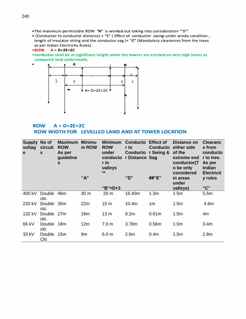
240
Supply voltage
No of circuits
Maximum ROW As per guidelines
Minimum ROW ‘’A”
Minimum ROW under conductor in valleys ** “B”=D+3
Conductor to Conductor Distance ‘’D”
Effect of Conductor Swing & Sag ##“E”
Distance on either side of the extreme end conductor(To be only considered in areas under valleys)
Clearance from conductor to tree. As per Indian Electricity rules “C”
400 kV Double ckt.
46m 30 m 20 m 16.40m 1.3m 1.5m 5.5m
220 kV Double ckt.
35m 22m 15 m 10.4m 1m 1.5m 4.6m
132 kV Double ckt.
27m 19m 13 m 9.2m 0.61m 1.5m 4m
66 kV Double ckt.
18m 12m 7.0 m 3.78m 0.56m 1.5m 3.4m
33 kV Double Ckt
15m 9m 6.0 m 2.6m 0.4m 1.5m 2.8m

241

242
Annexure 2: Site Analysis for Grid Substations List of Projects
Substation Operating voltages (kV)
S1 Virudhunagar (2x1500 MVA) 765/400 S2 Ottapidaram (2x500 MVA) + (2x200 MVA) 400/230/110
New bays at associated substations Quantity
S3.1 400 kV bays at Existing Kamuthi substation 2 S3.2 400 kV bays at Existing Kayathar substation 2 S3.3 110 kV bay provisions at Existing Vijayapuri substation 1
Sub total 5
COMPONENT I: Substations S1 – 765/400 kV Virudhunagar (2x1500MVA) Grid Substation
SNo Description Site
1. Substation details 765/400 kV Virudhunagar substation with 2x1500 MVA, 765/400 kV ICTs
1a Area (dimensions) 226.53 acres
1b Geographical coordinates Mannarkottai & Valayapatti Village 9° 26' 41.827" N 77° 59' 52.876" E
1c Slope/Plain Land Plain
1d Amount of land cutting required Filling required in depressions
2 Number of transformers 2x1500MVA (3x500 MVA ICT each)
3 Number of Bays 2 No 765 kV bays, 6 Nos 400 kV bays
4 Size/ type of oil sump Sump pits & Oil collecting pit etc., which are covered at top, designed for a live load of 500 kg/sq.m
5 Ownership of land (Private / Forest/ Other Government Department/ Other) - Private - Government
Private
6 Private land (in Bighas) 230 acres has been identified in Mannarkottai Village and Valayapatti Village
(i) Agriculture:- a. Irrigated b. Non-irrigated
Non-irrigated
(ii) Non-Agriculture/ Private waste land / banjar. No data available
(iii) House or Building: a. Residential b. Non-Residential
None
7.a Distance from Nearest River/coastal area 61 km from coastal area
7.b Distance from Nearest National / State Highway 9 km from NH 7
7.c Distance from Nearest Forest Area 62 km Meghamalai WLS
7.b Distance from Nearest Village / town 20 km from Virudhunagar
7.e Distance from industry or thermal power plant
8. Distance from Interstate / International Boundaries 65 km from international waters
9. Nos. of Forest Trees:- a. Trees to be felled
No data

243
SNo Description Site
b. Trees to be lopped
10. Nos. of private trees No data
(i) Fruit Trees: a. Trees to be felled b. Trees to be lopped
(ii) Non-Fruit Trees: a. Trees to be felled b. Trees to be lopped
11. Altitude of substation 95 m
12. Nearest distance from Airport 52 km from Madurai airport
13. Distance from nearest religious or Archaeological sites
Not determined
14. Name of villages involved/Name of District Mannarkottai Village and Valayapatti Village, Virudhunagar district
(Source DPR and site visits) S2 – 400/230/110 kV Ottapidaram (2x500MVA) + (2x200MVA) Grid substation
No Description Site
1. Substation details Establishment of 400/230-110 kV substation at Ottapidaram with 2x500MVA, 400/230 kV ICTs & 2x200MVA, 400/110 kV ICTs
1a Area (dimensions) 60.61 acres has been registered and the balance 12.33 cents is under the process of registration (DPR estimates)
1b Geographical coordinates Saminthan Village 8° 53' 39.695" N 78° 2' 53.010" E
1c Slope/Plain Land Plain
1d Amount of land cutting required None
2 Number of transformers 2x500 MVA and 2x200 MVA ICTs
3 Number of Bays 6 Nos. 400 kV bays 4 Nos 230 kV bays 5 No. 110 kV bays
4 Size/ type of oil sump Sump pits & Oil collecting pit etc., which are covered at top, designed for a live load of 500 kg/sq.m
5 Ownership of land (Private / Forest/ Other Government Department/ Other) - Private - Government
Ind Bharat, a private IPP
6 Private land (in Bighas) 60.61 acres (i) Agriculture:- c. Irrigated d. Non-irrigated
(ii) Non-Agriculture/ Private waste land / banjar.
(iii) House or Building: c. Residential d. Non-Residential

244
No Description Site
7.a Distance from Nearest River/Coast 15 km from coast
7.b Distance from Nearest National / State Highway 5.12 km from NH 45B
7.c Distance from Nearest Forest Area No data
7.d Distance from Nearest Village / town 3 km from Puthiamputhur
7e. Distance from any industry/thermal power plant 1.3 km from thermal power plant
8. Distance from Interstate / International Boundaries 26 km international waters
9.. Nos. of Forest Trees:- c. Trees to be felled d. Trees to be lopped
None
10.. Nos. of private trees Not estimated
(iii) Fruit Trees: c. Trees to be felled d. Trees to be lopped
Nil
(iv) Non-Fruit Trees: c. Trees to be felled d. Trees to be lopped
Nil
11. Altitude of substation 41 m
12. Nearest distance from Airport/railway station Aerially 25 km from Tuticorin railway station
13. Distance from nearest religious or Archaeological sites
None
14. Name of villages involved/Name of District Saminathan village, Thoothukudi
(Source DPR and site visits) S3-5. The three bays are also existing and therefore no analysis required. Data and site photographs are attached in Section 3.

245
Annexure 3: Route Analysis for Transmission Lines 3A.1 Maps containing 3 alternatives T1.1 Virudhunagar to Coimbatore
PLOT 1

246
PLOT 2

247
PLOT 3

248
PLOT 4

249
T1.2 Virudhunagar to Kayathar

250
T1.3 Virudhunagar to Thappangundu

251
T2.1 Ottapidaram to Udangudi

252
T2.2 Ottapidaram to Kamuthi

253
T2.3 Ottapidaram to Sipcot-Kavanoor

254
T2.4 Ottapidaram to Savasapuram

255
T2.5 Ottapidaram to Eppothumvendran

256
T2.6 Ottapidaram to Vijayapuri

257
T2.7 Ottapidaram to TTN Auto-T-off Sipcot Lines

258
3A.2: Transmission line alternatives
Transmission lines associated with Virudhunagar substation Route Length
(km)
T1.1 765 kV double circuit line Virudhunagar - Coimbatore 242 T12 400 kV double circuit line Virudhunagar - Kayathar 72 T1.3 400 kV double circuit line in and out at Virudhunagar for Kamuthi to Thappagundu
(proposed) line 5
Transmission lines associated with Ottapidaram substation Route Length
(km)
T2.1 400 kV double circuit line Ottapidaram - Udangudi 68 T2.2 400 kV double circuit line Ottapidaram - Kamuthi 71 T2.3 230 kV double circuit line in and out at Ottapidaram for Sipcot - Kavanoor line 10 T2.4 230 kV double circuit line in and out at Ottapidaram for Sipcot - Savasapuram line 6 T2.5 110 kV double circuit line in and out at Ottapidaram for Ottapidaram -
Eppothumvendran 4
T2.6 110 kV single circuit line Ottapidaram - Vijayapuri 34 T2.7 110 kV double circuit line in and out at Ottapidaram for TTN Auto - T-off Sipcot line 10 Source: Anna University Route Survey 2018
COMPONENT II. Transmission T1.1: Virudhunagar 765 kV SS to Coimbatore 765 kV SS Bee line Length: 208.5 km from Virudhunagar SS Coimbatore SS
Alternative Routes
Length In km
% Deviation From Bee Line
Land use Crossing Details (km) No. of Angle Points
Number of Crossings
Forest
Built-up/ Habitation
Road Crossing
Crop Land + Plantation
Waste land
Water Bodies
0 to 30 deg
30 to 60 deg
60 to 90 deg
Total Number
River
Road (NH/SH)
Rail Line
Major Power lines
Route A 222.93
6.92 - 1.22 0.76 178.94 33.32
8.69 39 18 2 58 5 7 7 33
Route B 227.53
9.13 0.16 1.27 0.68 189.19 25.19
11.04
54 15 3 72 4 7 5 30
Route C 223.80
7.34 0.46 2.89 0.87 176.47 28.80
14.31
43 26 3 72 4 6 4 31
Route D (Combined of
Route A &
Route C)
241.90
16.02 0.89 189.57 39.11
12.31
54 33 5 92 4 7 6 31 Approved (Route
A is approved
by TLC/Madurai and Route C
is approved by TLC/
Perundurai)
Source: Anna University Route Survey 2018

259
T1.2: Route - 400 kV DC Line from Virudhungar 765 kV SS to Kayathar 400 kV SS Bee Line Length: 63.45 km From: Virudhunagar SS To: Kayathar SS
Alternative Routes
Length In km
% Deviation From Bee Line
Land use Crossing Details (km) No. of Angle Points
Number of Crossings
Approval from TANTRANSCO
Forest
Built Up/ Habitation
Road Crossing
Crop Land+ Plantation
Waste Land
Water Bodies
0 to 30 deg
30 to 60 deg
60 to 90 deg
Total Number
River
Road (NH/SH)
Rail Line
Major Power lines
Route A
69.06 8.12
- - 0.13
37.85 27.49 3.59 11 7 5 59 2 2 1 10
Route B
67.32 5.74
- - -
41.17 22.73 3.42 20 4 3 27 2 2 1 8
Route C
72.07 11.96
- -
0.08 47.8
1 20.3 3.88 9 13 5 27 1 - 1 5
Approved by
TANTRANSCO
Source: Anna University Route Survey 2018
T2.1: Route - 400 kV DC Line from Ottapidaram 400 kV SS to Udangudi Switch Yard Bee line Length: 48.3 km From: OTTAPIDARAM 400KV SS to: UDANGUDI SWITCHYARD
Alternative Routes
Length In km
% Deviation From Bee Line
Land use Crossing Details (km) No. of Angle Points
Number of Crossings
Approval from TANTRANSCO
Forest
Built Up/ Habitation
Road Crossing
Crop Land+ Plantation
Waste Land
Water Bodies
Salt Pan
CRZ
0 to 30 deg
30 to 60 deg
60 to 90 deg
Total Number
River
Road (NH/SH)
Rail Line
Major Power lines
Route A
68 28.97 - - 0.024 34.75
20.95 12.23 - - 49 16 3 68 1 1 1 8 Approved by
TANTRANSCO
Route B
52.30
8.28 - - 0.09 27.5 15.54 3.18 5.50
- 13 8 1 22 1 3 2 10
Route C
50.27
4.07 - - 0.09 29.22
13.57 7.08 0.31
- 16 3 - 19 1 3 2 13
Source: Anna University Route Survey 2018

260
T2.2 Route - 110KV TL LILO Ottapidaram 400 kV SS to Kamuthi SS Bee line Length: 63.55 km From: OTTAPIDARAM 400 kV SS to: Kamuthi SS
Alternative
Routes
Length In km
% Deviat
ion From Bee Line
Land use Crossing Details (km) No. of Angle Points
Number of Crossings
Approval from
TANTRANSCO
Forest
Built Up/
Habitation
Road Cross
ing
Crop Land+ Planta
tion
Waste Lan
d
Water
Bodies
Salt
Pan
0 to 30 deg
30 to 60 deg
60 to 90 deg
Total Number
River
Road (NH/SH)
Rail Line
Major Power line
s
Route A
68.08
7.12 - - 0.064 50.93 15.39
1.70 - 11 6 - 17 1 1 - 6
Route B
71.05
10.55 - - 0.05 52.00 15.41
1.71 - 32 10 1 43 1 1 - 5 Approved by
TANTRANSCO
Route C
70.82
11.43 - - 0.055 47.74 17.95
5.09 - 6 9 - 15 1 1 - 6
Source: Anna University Route Survey 2018
T2.3: 230 kV double circuit line in and out at Ottapidaram for Sipcot-Kavanoor line Bee Line Length: 9.38 km From : Ottapidaram SS To: Sipcot-Kavanoor SS
Alternative Routes
Length In km
% Deviation From Bee Line
Land use Crossing Details (km) No. of Angle Points
Number of Crossings
Approval from TANTRANSCO
Forest
Built-up/ Habitation
Road Crossing
Crop Land + Plantation
Waste land
Water Bodies
0 to 30 deg
30 to 60 deg
60 to 90 deg
Total Number
River
Road (NH/SH)
Rail Line
Major Power lines
Route A
9.9 5.54 - - 0.03 6.78 3.06
0.03 5 4 1 10 - 1 - 4 Approved
Source: Anna University Route Survey 2018
T2.4: 230 kV double circuit line in and out at Ottapidaram for Sipcot-Savasapuram line Bee Line Length: 5.41 km From : Ottapidaram SS To: Sipcot-Savasapuram SS
Alternative Routes
Length In km
% Deviation From Bee Line
Land use Crossing Details (km) No. of Angle Points
Number of Crossings
Approval from TANTRANSCO
Forest
Built-up/ Habitation
Road Crossing
Crop Land + Plantation
Waste land
Water Bodies
0 to 30 deg
30 to 60 deg
60 to 90 deg
Total Number
River
Road (NH/SH)
Rail Line
Major Power lines
Route A
5.58 3.14 - - - 3.81 1.62
0.15 5 1 0 6 - - - 2 Approved
Source: Anna University Route Survey 2018
T2.5: 110 kV double circuit line in and out at Ottapidaram for Ottapidaram - Eppothumvendran line Bee Line Length: 3.44 km From : Ottapidaram SS To: Eppothumvendran SS

261
Alternative Routes
Length In km
% Deviation From Bee Line
Land use Crossing Details (km) No. of Angle Points
Number of Crossings
Approval from TANTRANSCO
Forest
Built-up/ Habitation
Road Crossing
Crop Land + Plantation
Waste land
Water Bodies
0 to 30 deg
30 to 60 deg
60 to 90 deg
Total Number
River
Road (NH/SH)
Rail Line
Major Power lines
Route A 3.56 3.48 - - - 1.40
2.16 - 1 1 1 3 - - - 2
Approved
Source: Anna University Route Survey 2018
T2.6: Route - 110KV TL LILO Ottapidaram 400 kV SS to Vijayapuri SS Bee line Length: 31.8 km From: OTTAPIDARAM 400KV SS to Vijayapuri SS
Alternative Route
s
Length In km
% Deviation
From Bee Line
Land use Crossing Details (km) No. of Angle Points
Number of Crossings
Approval from
TANTRANSCO
Forest
Built Up/
Habitation
Road Crossing
Crop Land+ Planta
tion
Waste Lan
d
Water
Bodies
Salt Pan
0 to 30 deg
30 to 60 deg
60 to 90 deg
Total
Number
River
Road
(NH/SH)
Rail Line
Major Power line
s
Route A
35.47
11.54 - - 0.061 16.96 17.81
0.64 - 9 3 - 12 - - - 4
Route B
34.43
7.63 - - 0.072 23.69 7.05
3.62 - 22
5 3 30 - - - 3 Approved
Route C
33.47
5.25 - - 0.061 21.06 11.27
1.08 - 7 5 - 12 - - - 5
Source: Anna University Route Survey 2018
T2.7: 110 kV double circuit line in and out at Ottapidaram for Ottapidaram – TTN Auto-T-off Sipcot line Bee Line Length: 8.26 km From : Ottapidaram SS To: TTN Auto-T-off Sipcot
Alternative Routes
Length In km
% Deviation From Bee Line
Land use Crossing Details (km) No. of Angle Points
Number of Crossings
Approval from TANTRANSCO
Forest
Built-up/ Habitation
Road Crossing
Crop Land + Plantation
Waste land
Water Bodies
0 to 30 deg
30 to 60 deg
60 to 90 deg
Total Number
River
Road (NH/SH)
Rail Line
Major Power lines
Route A
10.27 24.33 - - - 6.41
3.78 0.08 2 2 6 10 - - - 2
Approved
Notes: 1. The routes are planned using Land use/cover Map prepared using Resources at Satellite (5.8m resolution) and Least Cost Path Analysis in an GIS environment. The least cost path routes are generalized to minimize the number of angle points and crossings. The selection of best route from the available alternatives (Route A, Route B and Route C) is to be decided by TANTRANSCO based on the above details in the table and the maps attached earlier. 2. The given co-ordinates of Angle Points are to be adjusted to suit the local field constraints. For example, if the agricultural land is converted as residential layout and with no buildings on it, it may not be very clearly visible on satellite imagery. Hence, if the route encounters such residential/industrial land, the field engineer can modify the angle point location to overcome the field constraints.
Source: Anna University Route Survey 2018

262
Annexure 4: Inventory along the Transmission Lines
TOWER No.
From (km) To (km)
Section length
Name of village/Tehsil/District
Approx. Distance of transmission line from nearby village/Housing (km)
Ownership of Land (Private Govt. Forest)/ Use of Land
Use of Land (Cultivation, plantation/barren)
Name of Crops
Number of trees under cutting/trimming
Types (Names) of Trees cut
T1.1 765 kV double circuit line Virudhunagar - Coimbatore
5-10km Siluvaipuram
1.5 Private
Cultivable
Rice, Banana
25 Neam, Palm, English babool
10-12km
Kutiampuli 1.5 Private
Cultivable
Rice, Banana
24 Neem, Coconut, Palm, Emali
12-15km
Sivaganapuram
2 Private
Cultivable
Rice, Banana
15 Neem, Coconut, Palm, Emali
15-17km
Servaikuranmadan
2 Private
Cultivable
Rice, Banana
25 Neem, Coconut, Palm, Emali
17-20km
Sakammalpuram
2 Private
Cultivable
Rice, Banana
31 Neem, Coconut, Palm, Emali
20-25km
Sampadi 2 Private
Cultivable
Rice, Banana
40 Neem, Coconut, Palm, Emali
25-35km
Agaram 2 Private
Cultivable
Rice, Banana
30 Neem, Palm, Coconut, Babool
35-40km
Ramchandrapuram
1.5 Private
Cultivable
Rice, Banana
36 Palm Tree, Neem, Babool, Coconut
40-50km
Narasanvillai
1 Private
Cultivable
Rice, Banana
42 Palm Tree, Neem, Babool
50-55km
Nagakaniyapuram
1.5 Private
Cultivable
Rice, Banana
30 Palm Tree, Neem, Babool
55-60km
Thalavapuram
1.5 Private
Cultivable
Rice, Banana
35 Palm Tree, Neem, Babool, Coconut
60-65km
N Muthiyapuram
1.5 Private
Cultivable
Rice, Banana
32 Palm Tree, Neem, Babool, Coconut
65-70km
Kallamozhi 1.5 Private
Cultivable
Rice, Banana
25 Palm Tree, Neem, Babool, Coconut
5-10km Siluvaipuram
1.5 Private
Cultivable
Rice, Banana
25 Neam, Palm, English babool
10-12km
Kutiampuli 1.5 Private
Cultivable
Rice, Banana
24 Neem, Coconut, Palm, Emali
12- Sivaganapu 2 Privat Cultiva Rice, 15 Neem, Coconut, Palm,

263
TOWER No.
From (km) To (km)
Section length
Name of village/Tehsil/District
Approx. Distance of transmission line from nearby village/Housing (km)
Ownership of Land (Private Govt. Forest)/ Use of Land
Use of Land (Cultivation, plantation/barren)
Name of Crops
Number of trees under cutting/trimming
Types (Names) of Trees cut
15km ram e ble Banana Emali
15-17km
Servaikuranmadan
2 Private
Cultivable
Rice, Banana
25 Neem, Coconut, Palm, Emali
T1.2 400 kV double circuit line Virudhunagar - Kayathar
Chandiragiri 1 Private
Cultivable
Chilly, Maize, Dal
3 Neem
Poosanoor 1 Private
Cultivable
Chilly, Maize, Dal
10 Neem, Palm, Shrubs
O Lakshminarayanpuram
1 Private
Cultivable
Chilly, Maize, Dal
10 Neem, Palm, Shrubs
Muthiyapuram
1 Private
Cultivable
Coriender, Chilly, Maize, Dal
10 Neem, Palm, Shrubs
Pondampulli 1 Private
Cultivable
Coriender, Chilly, Maize, Dal, Onion
10 Neem, Palm, Shrubs
Sathuranayakkan Patti
1 Private
Cultivable
Coriender, Chilly, Maize, Dal, Onion
10 Neem, Palm, Shrubs
Thoppadiapatti
1 Private
Cultivable
Coriender, Chilly, Maize, Dal, Onion
15 Neem, Palm, Shrubs
Nerinjipatti 1 Private
Cultivable
Chilly, Maize, Dal, Rice, Cotton
10 Neem, Palm, Shrubs
Idaiyankulam
1 Private
Cultivable
Chilly, Maize, Dal, Rice, Cotton
10 Neem, Palm, Shrubs

264
TOWER No.
From (km) To (km)
Section length
Name of village/Tehsil/District
Approx. Distance of transmission line from nearby village/Housing (km)
Ownership of Land (Private Govt. Forest)/ Use of Land
Use of Land (Cultivation, plantation/barren)
Name of Crops
Number of trees under cutting/trimming
Types (Names) of Trees cut
Chandiragiri 1 Private
Cultivable
Chilly, Maize, Dal
3 Neem
Poosanoor 1km Private
Cultivable
Chilly, Maize, Dal
10 Neem, Palm, Shrubs
T2.1 400 kV DC TL from Ottapidaram to 400 kV SS Udangudi
5-10km Siluvaipuram
1.5 Private
Cultivable
Rice, Banana
25 Neam, Palm, English babool
10-12km
Kutiampuli 1.5 Private
Cultivable
Rice, Banana
24 Neem, Coconut, Palm, Emali
12-15km
Sivaganapuram
2 Private
Cultivable
Rice, Banana
15 Neem, Coconut, Palm, Emali
15-17km
Servaikuranmadan
2 Private
Cultivable
Rice, Banana
25 Neem, Coconut, Palm, Emali
17-20km
Sakammalpuram
2 Private
Cultivable
Rice, Banana
31 Neem, Coconut, Palm, Emali
20-25km
Sampadi 2 Private
Cultivable
Rice, Banana
40 Neem, Coconut, Palm, Emali
25-35km
Agaram 2 Private
Cultivable
Rice, Banana
30 Neem, Palm, Coconut, Babool
35-40km
Ramchandrapuram
1.5 Private
Cultivable
Rice, Banana
36 Palm Tree, Neem, Babool, Coconut
40-50km
Narasanvillai
1 Private
Cultivable
Rice, Banana
42 Palm Tree, Neem, Babool
50-55km
Nagakaniyapuram
1.5 Private
Cultivable
Rice, Banana
30 Palm Tree, Neem, Babool
55-60km
Thalavapuram
1.5 Private
Cultivable
Rice, Banana
35 Palm Tree, Neem, Babool, Coconut
60-65km
N Muthiyapuram
1.5 Private
Cultivable
Rice, Banana
32 Palm Tree, Neem, Babool, Coconut
65-70km
Kallamozhi 1.5 Private
Cultivable
Rice, Banana
25 Palm Tree, Neem, Babool, Coconut
T2.2 400kv DC-TL from Ottapidaram to Kamuthi

265
TOWER No.
From (km) To (km)
Section length
Name of village/Tehsil/District
Approx. Distance of transmission line from nearby village/Housing (km)
Ownership of Land (Private Govt. Forest)/ Use of Land
Use of Land (Cultivation, plantation/barren)
Name of Crops
Number of trees under cutting/trimming
Types (Names) of Trees cut
Chandiragiri 1 Private
Cultivable
Chilly, Maize, Dal
3 Neem
Poosanoor 1 Private
Cultivable
Chilly, Maize, Dal
10 Neem, Palm, Shrubs
O Lakshminarayanpuram
1 Private
Cultivable
Chilly, Maize, Dal
10 Neem, Palm, Shrubs
Muthiyapuram
1 Private
Cultivable
Coriender, Chilly, Maize, Dal
10 Neem, Palm, Shrubs
Pondampulli 1 Private
Cultivable
Coriender, Chilly, Maize, Dal, Onion
10 Neem, Palm, Shrubs
Sathuranayakkan Patti
1 Private
Cultivable
Coriender, Chilly, Maize, Dal, Onion
10 Neem, Palm, Shrubs
Thoppadiapatti
1 Private
Cultivable
Coriender, Chilly, Maize, Dal, Onion
15 Neem, Palm, Shrubs
Nerinjipatti 1 Private
Cultivable
Chilly, Maize, Dal, Rice, Cotton
10 Neem, Palm, Shrubs
Idaiyankulam
1 Private
Cultivable
Chilly, Rice, Cotton
10 Neem, Palm, Shrubs
T2.3 230KV TL LILO Ottapidaram- SIPCOT & Kavanoor
0-2 Saminathan 2 Private
Cultivable
Green Gram, Maize, Bajara
4 English Babool
2-4 Laxmipuram 1 Privat Cultiva Green 3 English Babool, Neem

266
TOWER No.
From (km) To (km)
Section length
Name of village/Tehsil/District
Approx. Distance of transmission line from nearby village/Housing (km)
Ownership of Land (Private Govt. Forest)/ Use of Land
Use of Land (Cultivation, plantation/barren)
Name of Crops
Number of trees under cutting/trimming
Types (Names) of Trees cut
e ble Gram, Maize, Bajara
4-7 Sinthalakuttai
1 Private
Cultivable
Green Gram, Maize, Bajara
5 Babool, Neem, Palm tree
7-10 Sinthalakuttai
1 Private
Cultivable
Green Gram, Maize, Bajara
5 Babool, Neem, Palm tree
10-12 Sinthalakuttai
1 Private
Cultivable
Green Gram, Maize, Bajara
3 Babool, Neem, Palm tree
12-15 Kumarapuram
2 Private
Cultivable
Green Gram, Maize, Bajara
3 Babool, Neem
T2.4 230 kV TL LILO Ottapidaram SIPCOT & Savasapuram
0-2 Saminathan 2 Private
Non Cultivable
4 English Babool
2-4 Sillanathan 2 Private
Non Cultivable
5 Babool, Neem, Shrubs
4-6 Sillanathan 4 Private
Non Cultivable
6 Neem, Babool, Palm Tree
6-9 Venkatachalpuram
1 Private
Cultivable
Green Gram, Maize, Bajara
4 Neem, Babool, Palm tree
9-11 Valasamutharam
1 Private
Cultivable
Green Gram,
4 Neem, Babool, Palm tree

267
TOWER No.
From (km) To (km)
Section length
Name of village/Tehsil/District
Approx. Distance of transmission line from nearby village/Housing (km)
Ownership of Land (Private Govt. Forest)/ Use of Land
Use of Land (Cultivation, plantation/barren)
Name of Crops
Number of trees under cutting/trimming
Types (Names) of Trees cut
Maize, Bajara
T2.5 110 kV TL LILO Ottapidaram TTN Auto & TSIPCOT Feeder
0-2 Saminathan 2 Private
Cultivable
Green Gram, Maize, Bajara
6 Palm Tree, Neem, Babool
2-4 Saminathan 4 Private
Cultivable
Green Gram, Maize, Bajara
6 Palm Tree, Neem, Babool
4-6 Kumargiri 2 Private
Cultivable
Green Gram, Maize, Bajara
6 Palm Tree, Neem, Babool
6-8 South Veerapandiyan puram
1.5 Private
Cultivable
Green Gram, Maize, Bajara
10 Palm Tree, Neem, Babool
8-10 South Veerapandiyan puram
3.5 Private
Non Cultivable
No Crop 8 Palm Tree, Neem, Babool
T2.6 110 kV TL LILO Ottapidaram-Vijayapuri
0-5 Saminathan 2 Private
Cultivable
Green Gram, Maize, Bajara, Cotton
10 Palm Tree, Neem, Babool
5-10 Ottapidaram 2.5 Private
Cultivable
Green Gram, Maize, Bajara, Cotton
14 Neem, Babool
10-15 Keelamudiman
2.5 Private
Cultivable
Green Gram,
15 Palm Tree, Neem, Babool

268
TOWER No.
From (km) To (km)
Section length
Name of village/Tehsil/District
Approx. Distance of transmission line from nearby village/Housing (km)
Ownership of Land (Private Govt. Forest)/ Use of Land
Use of Land (Cultivation, plantation/barren)
Name of Crops
Number of trees under cutting/trimming
Types (Names) of Trees cut
Maize, Bajara, Cotton
15-20 Pasuvanthanai
2.5 Private
Cultivable
Green Gram, Maize, Bajara, Cotton
15 Palm Tree, Neem, Babool
20-25 Kamanayakkampatti
2 Private, Barren
Cultivable
Green Gram, Maize, Bajara, Cotton
10 Neem, Emali, Babool, Palm tree
25-30 Vijayapuri 1 Private, Barren
Cultivable
Green Gram, Maize, Bajara, Cotton
15 Neem, Babool, Palm tree
T2.7 110 kV DC LILO Ottapidaram-Eppothumvendran
0-1 Saminathan 2 Private
Barren 10 English Babool
1-2 Saminathan 2 Private
Barren 10 English Babool
2-3 Sillanathan 1 Private
Barren 10 English Babool
3-4 Sillanathan 1 Private
Barren 10 English Babool

269
Annexure 5: Environmental Audit Checklist for Electric Power Transmission Substations
A. Project Details 1. The existing substations are located in Kayathar in Thoothukudi district, Kamuthi in Ramanathapuram
District and Vijayapuri in Thoothukudi District. The direct impact area of augmentation has been defined as the total land extent where bay connectivity works are conducted in the above existing substations.
2. Expansion of bay facilities in these substations will be carried out under component 1 and 2 of the
CKIC Power Project. All three substations have existing land area that is bounded on all sides. Kayathar Substation Details 3. The Kayathar substation has 91 acres and augmentation of the existing 400 bays to connect 400 kV
double circuit line Virudhunagar – Kayathar is expected at this substation. Additional equipment to be installed at 400/230/110 kV existing AIS substation at Kayathar is as follows:
• 2 nos. of 400 kV bays at Kayathar 400 kV SS for connecting DC line from Virudhunagar 765/400 kV substation.
• 2 Nos. of 400 KV Reactor (2x100 MVAR).
Kamuthi Substation Details 4. The 400/230/110 kV existing AIS substation at Kamuthi substation has 70 acres and extension of the
existing 400 kV line bays to connect the 400 kV double circuit line Ottapidaram - Kamuthi constructed by the Project is expected at this substation. Additional equipment to be installed at Kamuthi is as follows:
• 2 nos. of 400 kV bays at Kayathar 400 kV SS for connecting 400 kV DC quad line from Ottapidaram 400 kV substation.
• 2 Nos. of 400 KV Reactor (2x100 MVAR).

270
Vijayapuri Substation Details 5. The Vijayapuri substation has 5 acres and extension of the existing 110 kV line bays to connect the
110 kV single circuit line Ottapidaram - Vijayapuri is expected at this substation. Additional equipment to be installed at 110/11 kV existing AIS substation at Vijayapuri is as follows:
• 110 kV Bay provision at Vijayapuri 110 kV substation to connect 110 kV SC line on DC tower from the proposed Ottapidaram 400/110 kV SS.
B. Methodology Followed:

271
6. Method used for field data collection were the following:
• Consultants conducted a site visit to the three substations listed above.
• Interviewing staff and any workers engaged at these substations.
• Review all health and safety aspects, tools and plant, cleanliness, proper equipment usage and maintenance procedures followed.
• Reviewing all storage facilities for oil, batteries, SF6 cylinder, trash and empty oil durms etc.
• Comparing work procedure at these substations with the EMP applied for the project; review work place practices at the substation.
• Interviewing the likely project affected households due to the project at the substation sites.
• Reviewing any complaints received in the area and check complaint redress process and the situation of current complaints.
C. Applicable Environmental Policies and other Legislations for substatons (Supplements Section 2 earlier) 7. The Government of India (GOI’s) National Environmental Policy 2006 and ADB’s Safeguard Policy
2009 as well as associated procedures and guidelines thereto apply to all components/subprojects funded by ADB. The sub-projects included under this program should comply with the requirements of the following Acts, Rules, Notifications and Standards of Government of India and policies as well as ADB safeguard requirements.
• The Water (Prevention and Control of Pollution) Act, 1974 as amended;
• The Air (Prevention and Control of Pollution) Act, 1981 as amended;
• The Environment (Protection) Act, 1986;
• The Environment Impact Assessment Notification, 1994 as amended;
• The Hazardous Wastes (Management and Handling) Rules, 1989 as amended;
• The Ozone Depleting Substances (Regulation and Control) Rules, 2000;
• The Batteries (Management and Handling) Rules, 2001 as amended;
• The Indian Forest Act, 1927 as amended;
• The Wild Life (Protection) Act, 1972 as amended;
• The Biological Diversity Act, 2002;
• The Forest (Conservation) Act, 1980 as amended.
• The National Environmental Policy, 2006 of Government of India
• The Safeguard Policy, 2009 of ADB 8. The Ministry of Environment, Forests and Climate Change (CC), Government of India, vide its
Notification No. S.O. 1533 dated 14-09-2006, reengineered the EIA process in India and also decentralized some powers and made provision to constitute the State Level Environment Impact Assessment Authority (SEIAA) and the State Level Expert Appraisal Committee (SEAC) for performing functions under the said Notification. The Environmental regulations, legislation, policy guidelines and control that may impact this project, are the responsibility of a variety of government agencies. The principal Environment Regulatory Agency in India is the MoEFCC which formulates environmental policies and accords environmental clearances for different projects.
9. The Important environmental legislations in India are given below:
(i) The Water (Prevention and Control of Pollution) Act, 1974, amended 1988 (ii) The Water (Prevention and Control of Pollution) Rules, 1975 (iii) The Air (Prevention and Control of Pollution) Act 1981, amended 1987 (iv) The Air (Prevention and Control of Pollution) Rules, 1982 (v) The Environment (Protection) Act, 1986, amended 1991 and including the following
Rules/Notification issued under this Act.

272
• The Environment (Protection) Rules, 1986, including amendments
• The Municipal Solid Wastes (Management and Handling) Rules, 2000
• The Hazardous Wastes (Management and Handling) Rules, 1989
• The Hazardous Wastes (management, handling and transboundary movement) Rules 2009
• The Bio-Medical Waste (Management and Handling) Rules, 1998
• Noise Pollution (Regulation and Control) Rules, 2000,
• Wild Life (Protection) Amendment Act, 2002
• Eco Sensitive Zone Notification: Restricting location of industries, mining and other activities in Doon Valley (UP)
• Ministry of Environment and Forest, Guidelines for EIA for River Valley Projects.
• The Environmental Clearance Notification, 1994
• Environmental Impact Assessment Notification-2006
• Environmental Standards of CPCB (vi) Noise Pollution (Regulation and Control) Rules, 2000 (vii) National policy on Resettlement and Rehabilitation for Project Affected Families 2003, MORD
(2004) (viii) The Indian Wildlife (Protection) Act, 1972, amended 1993 (ix) The Wildlife (Protection) Rules, 1995 (x) The Indian Forest Act, 1927 (xi) Forest (Conservation) Act, 1980, amended 1988 (National Forest Policy, 1988)
• Forest (Conservation) Rules, 1981 amended 1992 and 2003
• Guidelines for diversion of forest lands for non-forest purpose under the Forest (Conservation) Act, 1980
(xii) The National Environmental Appellate Authority Act, 1997 Key Environmental Legislations
Name Scope and Objective Key Areas Operational Agencies/Key Players
Water (Prevention and Control of Pollution Act, 1974)
To provide for the prevention and control of water pollution and enhancing the quality of water
Controls sewage and industrial effluent discharges
Central and State Pollution Control Board
Air (Prevention and Control of Pollution Act - 1981)
To provide for the prevention and control of air pollution
Controls emissions of air pollutants
Central and State Pollution Control Boards
Forest Act, 1927 To consolidate acquisition of common property such as forests
Regulates access to natural resources, state has a monopoly right over land, categories forests
State government, forest settlement officers
Forest Conservation Act, 1980
To halt India’s rapid deforestation and resulting Environmental degradation
Restriction on de-reservation and using forest for non-forest purpose
Central Government
Wildlife Protection Act, 1980
To protect wildlife Creates protected areas (national parks, sanctuaries) categories of wildlife
Wildlife Advisory Boards; Central Zoo Authorities

273
which are protected
Environment Protection Act, 1986 Environmental Impact Assessment Notifications 1994
To provide for the protection and improvement of Environment
An umbrella legislation; supplement laws
Central government nodal agency MoEF; can deplete powers to state department of Environment
D. Audit Observations 10. All three substations were visited in February 2019. During the visit visual inspection and cross
checking of critical issues related to Environment audit issues were used for preparing the checklist. The checklist identifies issues as per the following criteria according to ADB Safeguard Policy Statement 2009 guidelines:
• General environmental management
• Waste management practices
• Hazardous material management
• Ground water and soil contamination control
• Occupational health and safety management, and
• Noise management 11. Details for site visits and substation details collected for each substation are list in A5.A for Kayathar
substation, A5.B for Kamuthi substation and A5.C for Vijayapuri substation respectively. 12. These tables provide detailed description of each of the existing substations where additional bays
will be constructed. The table contains details regarding project components that are compliant or non-compliant with national and IFC/World Bank EHS guidelines.
Table A5.A: Physical Features of Existing Kayathar substation 2 nos 400 kV Bay Extension
Features Specification/Type of Equipment
Year of Make/Condition
Land ownership TANTRANSCO 2014 / 91 Acres (36.69 hectares)
Scheme Main busbar scheme
Substation type Outdoor 2014
Voltage kV 400/230kV/110kV
Switchgear type Existing: Air-Insulated Bay extension: Air-insulated
Air Insulated 2013/ SIEMENS/ Good condition 50 Numbers Rated Voltage: 420 kV
Insulation medium power circuit breaker
SF6 Gas/Oil Sf6 Gas SIEMENS-2013 Numbers; 50 Rated voltage: 420kV
Transformer Oil cooled 1 Number: Good condition/ 2013/ Transformers and rectifier India Ltd/ 400/110kV/ 200MVA 2 numbers: Good condition / 2014:

274
Features Specification/Type of Equipment
Year of Make/Condition
2 No: 400/230kV/315MVA
Protection system description Auto fighting water spray system
Auto Nitrogen Injection Fire Protection System
Bay under construction for Virudhunagar line 400kV
Bay under construction for Thennampatty 400 kV line
Information Required
Guidelines Considered Information Required
Type of oil in transformers and switchgear
Transformers Condition/year/make/nos, indicate if PCB oil used
Good/ 2013/ Transformers and rectifier India Ltd/ 1 No Good / 2014/ Transformers and rectifier India Ltd - 2 Numbers
Oil Switchgear Condition/year/make/nos, indicate if PCB oil used
No
Safe disposal of oil Storage location within yard Yes
Prevention of fires Equipment at site Nitrogen Injection Fire Protection System and Fire extinguishers available in Control Room, Admin block and Yard.
Oil Labelling for storage at site No proper storage facility available in the station. Oil is being stored in open in the yard (Refer pictures) Few drums are also found stored in small available store room in the station premises
Oil leakage Minor leakage reported in 2017. Lined pits / sumps available for

275
Guidelines Considered Information Required
the emergency oil leak situations.
Retrofitting No
Use of SF6 and other greenhouse/hazardous gases
Gas insulated switchgear Condition/year/make/nos. Good/ 2013/ SIEMENS/ 50 Numbers Rated Voltage: 420 kV
Gas insulated t/f Condition/year/make/nos -
Presence of SF6 in switchgear Yes
SF6 retrieval arrangements Available
Presence of other hazardous gases No
Storage of liquid fuels, raw and in-process materials, solvents, wastes: to prevent spills, to prevent soil contamination and to prevent ground and surface water contamination
Containment, Dikes, and Berms (e.g. for transformers)
Condition/year/make/nos Good/ 2014/ 3 Nos
Storage facility Type Small store room available
Drainage Type Open drains
Oil leakage No. of leakages in last five years
Leak reported in 2017 in Transformer. Rectified immediately
Need for extra gravel Condition Good / No need of extra gravel at this stage.
Workplace air quality
Monitoring of workplace air quality Any measurement undertaken if any
No
Good ventilation (ensure) Being ensured.
Maintenance of air quality Sufficient exhaust fans available in control room, battery room and administrative block
Providence of respiratory equipment Condition/year/make/nos -
Enforcement of the application of personal protective equipment whenever exposure levels of fumes, solvents and other materials exceed threshold limit
Belts, ropes, gloves, helmets for workers available
Workplace noise
Noise control equipment Locations in yard by capacity No
IFC/ EHS Noise levels Any measurement undertaken since last 5 years
No measurement
Ambient Noise (dB)
Day Night Level within 70/45 dB limit No
Residential 55 45
Industrial 70 70
Maintenance of equipment Condition/year/make/nos -
Use of protective gear when noise level exceeds 85 dB
-
Other Physical Agents

276
Guidelines Considered Information Required
Safe working area (absence of radiation, magnetic fields)
-
Monitor regularly for radiation and field levels and equipment integrity (earthing, protective shields, lockouts etc.
No such measurements being done
Electrocution
Strict procedure for de-energizing before working on electrical equipment
Strict procedure for de-energizing followed.
Training of personnel for safety procedures
Periodic safety training being conducted by Engineers
Occupational health and safety guidelines
Physical factors in the workplace signage
Available but need strengthening
Lighting (including security lights) Available
Fire detection mechanism/equipment Locations in yard by capacity No fire detection system available. Fire fighting equipment available: Nitrogen Injection Fire Protection System for transformers. Sand buckets & Fire extinguishers
Firefighting equipment Condition/year/make/nos Available. Nitrogen Injection Fire Protection System for transformers. Sand buckets & Fire extinguishers, etc. available in yard Fire extinguishers available in control room and Admin block
Cleanness (inside and outside substation)
Need strengthening
First Aid Kit Locations in yard Reportedly available, under lock and key at the time of visit.
Features that pose safety risks (missing or broken slabs, dogged holes, etc.)
Locations in yard At many places around the yard
Fence or enclosure of the site (Restriction of unauthorized people)
Compound wall and chain link fencing available around the station.
Welfare Facilities
Safe and clean drinking water Locations Available
Toilets Location Available in side Admin block and Control room
TV/Radio/internet Internet facility available
Guard kiosk Available at the main gate

277
Guidelines Considered Information Required
Personal Protective Equipment
Eye and face Condition/year/make/nos No
Head Condition/year/make/nos Hard hats available but need strengthenining
Hearing Condition/year/make/nos No
Hand Condition/year/make/nos Gloves available and used in Control room
Respiratory Condition/year/make/nos No
Leg and body Condition/year/make/nos No
Ambient factors in the workplace
Noise Visually within limits at the time of visit
Apparently within limits at the time of visit
Vibration Visually within limits at the time of visit
Apparently within limits at the time of visit
Illumination Visually within limits at the time of visit
Satisfactory
Reflections Visually within limits at the time of visit
-
Temperature Visually within limits at the time of visit
Apparently within limits at the time of visit
Hazardous materials Presence of SF6 Gas and Transformer oil
Presence of SF6 Gas and Transformer oil in Switchgears and transformers. Extra transformer oil stored in yard and little store room. No extra SF6 Gas stored at the time of visit.
Ionization radiation -
Training and Documentation
Regular trainings being conducted. Safety classes register available.
Training (Learning materials, equipment and tools)
-do-
Training on operational hazardous and how to control the hazards
-do-
Training on health risks, hygiene, and exposure prevention
-do-
Training on accidents and accident prevention, protective equipment and clothing
-do-
Performance Monitoring
OHSMS organization policy No OHSMS organization Policy available.
Emergency prevention, preparedness and response
SOP developed by TRANTRANSCO followed
Investigation of work related injuries, ill health, disease and accidents
No record available at station at the time of visit
Safety inspection, testing and Special maintenance being

278
Guidelines Considered Information Required
calibration carried out by another wing (PNC)
Material handling (Hazardous and non-hazardous materials)
Storage Locations in yard by capacity Small store available, Oil being stored in the yard
Labelling Location in yard by capacity Need strengthening.
Handling Location in yard by capacity Being handled in yard.
Solid Waste/Scraps
Handling Locations in yard by capacity Dustbins only available in Admin block. Littering observed across yard.
Disposal Locations in yard by capacity Thrown outside station compound
Space for Expansion
Availability of space for expansion Locations in yard by capacity Available on the entrance side.

279
Photo-Gallery.
Main Gate of Station Approach road and Admin block
Information board Overview of station

280
New 400 kV bay No 1 under construction New 400 kV bay No 1 under construction
New bay No 2 under construction New bay No 2 under construction

281
Transformer No 1 Transformer No 2
Transformer No 2 Transformer No 2

282
Transformer No 3
Fire safety system

283
Fire extinguisher and alarm system
Fire Extinguishers Auto fire system

284
SF6 Switchgear SF6 Switchgear
Lighting arrangement in yard Storage of empty transformer oil drums in yard. Debris is strewn across yard.
Minor oil leaks Storage of oil in store

285
Broken slabs in yard causing health and safety hazard to workers
Sign boards in yard
Guard kiosk and security guard Residential quarters for staff

286
Additional land available in the premises
AC Room Battery room

287
Exhaust fan in battery room Improper storage in admin block
Control room Control room
Safety gloves in control room Safety class register

288
Oil leak trench Drainage system
Gravel Oil refilling tank

289
Waste mismanagement in the yard
Table A5.B: Physical Features of Existing Kamuthi substation – 2 Nos. 400 kV Bay Extension
Features Specification/Type of
Equipment Year of Make/Condition
Land ownership TANTRANSCO 2016 (70 Acres equivalent to 28.23 hectare)
Scheme Main busbar scheme 2016
Substation type Outdoor
Voltage kV 400/230/110kV
Switchgear type Existing: Air-Insulated Bay extension: Air-insulated
Air Insulated ALSTOM/-2015 / Good condition 28 Number : Rated Voltage 245kV
Insulation medium power circuit breaker
SF6 Gas/Oil Sf6 Gas ALSTOM/2015 / Good condition 28 Number : Rated Voltage 245kV
Transformer Oil cooled Oil Cooled 2 Number: 400/230kV, 315mva 3 Number: 400/110kV,200mva
Protection system description
Auto fighting water spray system
Auto Hydrogen gas spray system
Transformers – the open land beyond transformer earmarked for the two bays of the Grid Substation
Existing bay

290
Substation Layout
Information Collected from Project site
Guidelines Considered Information Required
Type of oil in transformers and switchgear
Transformers Condition/year/make/nos, indicate if PCB oil used
Good /2016/Transformers and Rectifier India Ltd/ 5 Nos
Oil Switchgear Condition/year/make/nos, indicate if PCB oil used
-
Safe disposal of oil Storage location within yard
Sumps available
Prevention of fires Equipment at site Auto Hydrogen Gas Spray System. Fire extinguishers and Sand buckets available in yard
Oil Labelling for storage at site No proper storage facility available
Oil leakage No major leaks reported till date, Lined pit available.
Retrofitting -
Use of SF6 and other greenhouse/hazardous gases
Gas insulated switchgear Condition/year/make/nos. Good/ 2015/ ALSTOM/ 28 Rated voltage 245 kV
Gas insulated t/f Condition/year/make/nos -
Presence of SF6 in switchgear Yes
SF6 retrieval arrangements Available
Presence of other hazardous gases No
Storage of liquid fuels, raw and in-process materials, solvents, wastes: to prevent spills, to prevent soil contamination and to prevent ground and surface water contamination
Containment, Dikes, and Berms (e.g. for transformers)
Condition/year/make/nos Available Good /2016/5
Storage facility Type Small store available.

291
Open storage of Oil and Gas in yard observed.
Drainage Type Open drainage
Oil leakage No. of leakages in last five years
No major leakage reported till date
Need for extra gravel Condition Yes, level needs to be raised up to road level.
Workplace air quality
Monitoring of workplace air quality Any measurement undertake if any
No
Good ventilation (ensure) Good ventilation in Admin bloc, Control room etc. Exhaust fans available
Maintenance of air quality Sufficient exhaust fans available in control room, battery room and administrative block
Providence of respiratory equipment Condition/year/make/nos -
Enforcement of the application of personal protective equipment whenever exposure levels of fumes, solvents and other materials exceed threshold limit
Ropes, gloves, helmets for workers available
Workplace noise
Noise control equipment Locations in yard by capacity
None
IFC/ EHS Noise levels Any measurement undertaken since last 5 years
No measurements
Ambient Noise (dB)
Day Night Level within 7045 dB limit No measurements
Residential 55 45 -
Industrial 70 70 -
Maintenance of equipment Condition/year/make/nos -
Use of protective gear when noise level exceeds 85 dB
-
Other Physical Agents
Safe working area (absence of radiation, magnetic fields)
- -
Monitor regularly for radiation and field levels and equipment integrity (earthing, protective shields, lockouts etc.
No such measurements being done
Electrocution
Strict procedure for de-energizing before working on electrical equipment
Strict procedure for de-energizing followed. No previous accident reported.
Training of personnel for safety procedures
Periodic safety training being conducted by Engineers
Occupational health and safety guidelines

292
Physical factors in the workplace signage
Need strengthening
Lighting (including security lights) Sufficient lighting available
Fire detection mechanism/equipment Locations in yard by capacity
Available in Admin block and Control room
Firefighting equipment Condition/year/make/nos Satisfactory, need strengthening by way of providing dustbins in the yard. Empty oil drums and SF6 Gas cylinders were found stacked along with the compound wall on one end of the yard. (Refer pictures). Some scrap was found stacked under the staircase of Control room (refer picture).
Cleanness (inside and outside substation)
Available in Control Room
First Aid Kit Locations in yard New substation, no such situation arise yet All cable trays were covered at the time of visit.
Features that pose safety risks (missing or broken slabs, dogged holes, etc.)
Locations in yard Surrounded by compound wall. Guarded by security guards on the gate
Fence or enclosure of the site (Restriction of unauthorized people)
Satisfactory, need strengthening by way of providing dustbins in the yard. Empty oil drums and SF6 Gas cylinders were found stacked along with the compound wall on one end of the yard. (Refer pictures). Some scrap was found stacked under the staircase of Control room (refer picture).
Welfare Facilities
Safe and clean drinking water Locations Piped water supply not available. Need to be provided
Toilets Location Available in Admin block
TV/Radio/internet Internet available through data card
Guard kiosk Available at main gate
Personal Protective Equipment
Eye and face Condition/year/make/nos No
Head Condition/year/make/nos Need strengthening
Hearing Condition/year/make/nos No
Hand Condition/year/make/nos Gloves and rope available in control room
Respiratory Condition/year/make/nos No

293
Leg and body Condition/year/make/nos No
Ambient factors in the workplace
Noise Within limits at the time of visit
Vibration Within limits at the time of visit
Illumination Sufficient
Reflections -
Temperature -
Hazardous materials SF6 Gas and Transformer oil
Ionization radiation -
Training and Documentation Regular training organized by Engineers. No training record available at the time of visit
Training (Learning materials, equipment and tools)
-do-
Training on operational hazardous and how to control the hazards
-do-
Training on health risks, hygiene, and exposure prevention
-do-
Training on accidents and accident prevention, protective equipment and clothing
-do-
Performance Monitoring
OHSMS organization policy No such policy available
Emergency prevention, preparedness and response
SOP being followed
Investigation of work related injuries, ill health, disease and accidents
No
Safety inspection, testing and calibration
Regularly being done
Material handling (Hazardous and non-hazardous materials)
Storage Locations in yard by capacity
No store facility available
Labelling Location in yard by capacity
-
Handling Location in yard by capacity
Open storage of oil drums and SF6 Gas cylinders in yard.
Solid Waste/Scraps
Handling Locations in yard by capacity
Dustbins available for solid waste, Need strengthening in and around yard.
Disposal Locations in yard by capacity
Disposal of solid waste with local village Panchayat system
Space for Expansion
Availability of space for expansion Locations in yard by capacity
Yes scope for expansion Available on 3 sides except for front Gate side.

294
Photo-Gallery.
Main Gate of Station Admin block & Control Room
Compound wall Information board

295
Security guard and Kiosk Store room
Existing bay Existing bay
Transformer Transformer

296
Auto Hydrogen Gas Spray System Fire extinguishers
Sand buckets SF6 Gas Circuit (ALSTOM)
ALSTOM SF6 Circuit

297
Storage of Transformer oil and SF6 Gas in Yard
Fire Extinguishers in Admin block Smoke detection system in Control room

298
Oil retrieval tank Oil retrieval tank
Lighting arrangement in yard Overview of Station
Storage of oil in yard on ground Battery room

299
Exhaust fan & Fire extinguisher in Battery room
Control Room
Land for new bays

300
Control Room
AC Room Battery room
First Aid box in Control Room (not complete Gloves and Rope in Control room

301
for electrical substation)
AC room AC room
Storage of articles in corridor Storage of distilled water in battery room

302
Solid Waste Management in Station Insufficient store facility
Drainage and overview of station Adjacent ADANI Green Energy Plant
Table A5.C: Physical Features of Existing 110 kV substation Vijayapuri substation – 110 kV Bay Extension
Features Specification/Type of Equipment
Year of Make/Condition
Land ownership TANTRANSCO 09.03.2006: 3.56 Acres land
Scheme Main busbar scheme 09.03.2006 / Good
Substation type Outdoor
Voltage kV 110kV/11 kV 110/33 kV
Switchgear type Existing: Air-Insulated Bay extension: Air-insulated
Air-Insulated
Insulation medium power circuit breaker
SF6 Gas/Oil SF6 2 Nos 2005 & 2013 / Good 2 no. 110 V each

303
Transformer Oil cooled • 2005 / Transformers & Rectifiers India Ltd, Gujrat / Good. Voltage110/33kV
• 2013 / Venkateshwara Electrical Industries Ltd, Chennai / Good. Voltage 110/11 kV
Protection system description Auto fighting water spray system
No. Manual fire fighting
Transformers – the open land beyond transformer earmarked for the new bays of the Grid Substation
Existing Bay Area
Substation Layout Terminal Gantry
Information Collected from Project Site
Guidelines Considered Information Required Details
Type of oil in transformers and switchgear
Transformers Condition/year/make/nos, • Good / 2005 / Transformers & Rectifiers

304
indicate if PCB oil used India Ltd, Gujrat / 1 No and voltage 110/33 kVA
• Good / 2013 / Venkateshwara Electrical Industries Ltd, Chennai / 1 No and voltage 110/11 kVA
Oil Switchgear Condition/year/make/nos, indicate if PCB oil used
None
Safe disposal of oil Storage location within yard No storage of oil being done within the station. Three old empty drums are lying in cycle parking area. There is no lined pit available.
Prevention of fires Equipment at site Manual: 12 No. Fire extinguishers available
Oil Labelling for storage at site
N/a. Three old empty drums are lying in cycle parking area. No lined pit available
Oil leakage Minor leaks observed near transformers.
Retrofitting No
Use of SF6 and other greenhouse/hazardous gases
Gas insulated switchgear
Condition/year/make/nos. Good / 2003 / Shreem / 1 110 kV Good / 2005/ Alstom / 1 110Kv
Gas insulated t/f Condition/year/make/nos -
Presence of SF6 in switchgear
Yes
SF6 retrieval arrangements
By Special maintenance team of TANTRANSCO
Presence of other hazardous gases
No
Storage of liquid fuels, raw and in-process materials, solvents, wastes: to prevent spills, to prevent soil contamination and to prevent ground and surface water contamination
Containment, Dikes, and Berms (e.g. for transformers)
Condition/year/make/nos No
Storage facility Type No
Drainage Type No
Oil leakage No. of leakages in last five years
No major leak reported till date
Need for extra gravel Condition Good, No extra gravel required at this time
Workplace air quality
Monitoring of workplace air quality
Any measurement undertake if any
No
Good ventilation (ensure)
Control room has good ventilation. Exhaust fan available in battery room
Maintenance of air quality
-
Providence of respiratory equipment
Condition/year/make/nos Not provided
Enforcement of the application of personal protective equipment whenever exposure levels of fumes,
Only hand gloves available at the time of visit. Reportedly at the time of maintenance works PPE provided to maintenance team by AE/Rural wing.

305
solvents and other materials exceed threshold limit
Workplace noise
Noise control equipment Locations in yard by capacity
Not available
IFC/ EHS Noise levels Any measurement undertaken since last 5 years
Not measured
Ambient Noise (dB) Day Night Level within 70/45 dB limit
No measurement in past
Residential 55 45 -
Industrial 70 70 -
Maintenance of equipment
Condition/year/make/nos -
Use of protective gear when noise level exceeds 85 dB
-
Other Physical Agents
Safe working area (absence of radiation, magnetic fields)
-
Monitor regularly for radiation and field levels and equipment integrity (earthing, protective shields, lockouts etc.
No such measurements being done
Electrocution
Strict procedure for de-energizing before working on electrical equipment
Strict procedure for de-energizing followed. No previous accident reported.
Training of personnel for safety procedures
Regular monthly trainings conducted by AEE Rural.
Occupational health and safety guidelines
Physical factors in the workplace signage
Not available.
Lighting (including security lights)
Available, need strengthening
Fire detection mechanism/equipment
Locations in yard by capacity
Fire extinguishers available near Control room.
Firefighting equipment Condition/year/make/nos Good/ 2018/ Allanne Safety Fire Engineers/12
Cleanness (inside and outside substation)
Satisfactory but needs strengthening and improvement. Cleaning and housekeeping was good at the time of visit. Three empty oil drums were found lying in cycle parking area. Some paper scrap and litter was found on the back side of the control room.

306
First Aid Kit Locations in yard Reportedly available in Control room in custody of Operator.
Features that pose safety risks (missing or broken slabs, dogged holes, etc.)
Locations in yard None, as all tray were covered at the time of visit.
Fence or enclosure of the site (Restriction of unauthorized people)
Fenced with barbed wire
Welfare Facilities
Safe and clean drinking water
Locations No piped water supply available. Potable water being procured from nearby RO plant.
Toilets Location Available in control room
TV/Radio/internet No Personal mobile internet of operator
Guard kiosk No
Personal Protective Equipment
Eye and face Condition/year/make/nos No
Head Condition/year/make/nos No
Hearing Condition/year/make/nos No
Hand Condition/year/make/nos Gloves available in control room
Respiratory Condition/year/make/nos No
Leg and body Condition/year/make/nos No
Ambient factors in the workplace
Noise Apparently within limits at the time of visit
Vibration Apparently within limits at the time of visit
Illumination Visually within limits at the time of visit
Reflections Visually within limits at the time of visit
Temperature Apparently within limits at the time of visit
Hazardous materials Presence of SF6 Gas and Transformer oil in the Switchgears and transformers. No extra storage of Gas and Oil in the station,
Ionization radiation -
Training and Documentation
Training (Learning materials, equipment and tools)
Regular trainings given by AEE Rural. No training records available at station.
Training on operational hazardous and how to control the hazards
-do-
Training on health risks, hygiene, and exposure prevention
-do-
Training on accidents and accident prevention, protective equipment and clothing
-do-
Performance Monitoring

307
OHSMS organization policy
No OHSMS organization Policy available.
Emergency prevention, preparedness and response
SOP developed by TRANTRANSCO followed
Investigation of work-related injuries, ill health, disease and accidents
No record available at station at the time of visit
Safety inspection, testing and calibration
Special maintenance being carried out on monthly basis
Material handling (Hazardous and non-hazardous materials)
Storage Locations in yard by capacity
No storage facility available in station the drums are not stored in some specific area. Solid waste and scrap is disposed off through local Panchayat system.
Labelling Location in yard by capacity N/A
Handling Location in yard by capacity Manual
Solid Waste/Scraps
Handling Locations in yard by capacity
Relatively clean surrounding Photos look otherwise outside the station, Inside is clean enough.
Disposal Locations in yard by capacity
Some litter found on back side of the control room . Disposal through local panchayat system
Space for Expansion
Availability of space for expansion
Locations in yard by capacity
Space for new bay available. Scope of further expansion limited since only 3.4 acres of land available
Photo- Gallery.
Main Gate of Station Approach road inside station

308
Information board Overview of station
Incoming tower Terminal / outgoing lines

309
Transfer No 1 Transformer No 2
Transformer No 1 Transformer No 2
Switch gear Barbed fencing

310
Fire Extinguishers Sand buckets
Battery room Battery details displayed
Exhaust fan in battery room Store adjacent to control room

311
Land for new bay
Gloves in control room Single line diagram in Control room

312
Layout available on file Emergency numbers displayed
Control room
Oil leak near around transformer Storage of used empty drums

313
Empty drums Scattered litter
Fire extinguisher Scattered littering
E. Audit Report 13. Substations have been audited using the tabular criteria listed in Tables A5.A, A5.B, A5.C.
Accordingly, the major audit findings and required remedial actions for each substation are liste below:
General Observations 14. Kayathar Substation: Audit findings and the required remedial actions are as follows:
• The substation is earthed and has protective shields to minimize radiation and magnetic field effects. Nitrogen Injection Fire Protection System for transformers. Fire extinguishers available in control room, Administration block and the yard.
• The substation has 2 transformers and several SF6 circuit breakers. The substation is PCB free.
• The substation is fenced and has warning signs to prevent the general public from being exposed to any risk of electrocution.
• No workplace related air, water, noise measurements are made during operations.
• The substation needs improvements in the following area: the substation needs the yard

314
cleanliness, oil storage lined facility, SF6 cylinder storage areas and appropriate waste handling and disposal practices.
• Complete health and safety related complete first aid kit boxes, with proper PPRE for supervisors and works at operational sites, proper number of fire extinguishers and fire buckets are required.
15. Kamuthi substation: Audit findings and the required remedial actions are as follows:
• The substation is earthed. Safe touch and step voltages are maintained at all accessible locations. The substation has Auto Hydrogen Gas Spray System for transformer protection. Fire extinguishers and Sand buckets available in yard.
• The substation has 5 nos. 400/230 kV transformers, 230/110 kV transformers and SF6/oil circuit breakers, but none of these use PCB. The substation is PCB free.
• The substation is fenced and has warning signs to prevent the general public from being exposed to any risk of electrocution.
• No workplace related air, water, noise measurements are made during operations.
• The substation needs improvements in the following area: the substation needs a designated oil storage lined area, SF6 cylinder storage areas which are currently stored in unlined unearmarked areas.
• Complete health and safety related complete first aid kit boxes, with proper PPRE for supervisors and works at operational sites, proper number of fire extinguishers and fire buckets are required.
16. Vijayapuri substation: Audit findings and the required remedial actions are as follows:
• The substation is earthed. Safe touch and step voltages are maintained at all accessible locations. The substation has 12 firefighting equipment in working condition.
• The substation has 2 nos. 110/11 kV transformers and 2 nos. SF6 oil circuit breakers. The substation is PCB free.
• The substation is fenced and has warning signs to prevent the general public from being exposed to any risk of electrocution.
• No workplace related air, water, noise measurements are made during operations.
• The substation needs improvements in the following area: the substation needs the yard cleanliness, oil storage lined facility, SF6 cylinder storage areas and appropriate waste handling and disposal practices.
• Complete health and safety related complete first aid kit boxes, with proper PPRE for supervisors and works at operational sites, proper number of fire extinguishers and fire buckets are required.
A5.D Summary of Non Compliances identified during Due Diligence No. Issues Non-compliance with Safeguard Policy Statement 2009
guidelines
A Kayathar
1 H&S hazard Broken slabs in yard. Debris strewn across the yard is a trip hazard
2 Oil leaks from drums Drums appear unlabelled and oil dripping from drums contaminating the land area.
3 Handling of Hazardous Materials Storage areas for SF6 gas cylinders and lined facility for transformer oil, and non-hazardous material needs to be improved especially in storage arrangement and prevention of spillage. 110% bunded area, impermeable surface etc. required
4 Waste mismanagement at yard Storage of empty transformer oil drums in yard. Debris is strewn across yard.
B Kamuthi
1 Health and Safety Hazard For all sites suggest H&S needs improvement based on

315
No. Issues Non-compliance with Safeguard Policy Statement 2009 guidelines
content of First Aid box in Control Room, morefire bucket etc. No proper PPE worn by staff at site.
2 Solid Waste Management in Station Substation facilities should designate special areas/ points for solid waste collection and collect all unwanted scraps for a safe disposal.
3 Material Management/stores Insufficent storage facilities for SF6 gas cylinders
4 Handling of Hazardous Materials Lined facility for transformer oil, and non-hazardous material requried especially in storage arrangement and prevention of spillage. 110% bunded area, impermeable surface etc. required
C Vijayapuri
1 Safety from theft and loss at site Site seems easily accessible by the public with low fence
2 Health and Safety of staff Appropriate personal protective equipment (PPEs) not worn by staff at site
3 Unsafe storage of material Storage of hazardous material- handling of transformer oil at site without 110% bunded area. Stores at substation not properly managed
Public Concern 17. There are no public concerns regarding the substations as the substations are located a safe distance
away from settlements. Infact, during consultations by the survey teams near the substation area, the local people said that though they area not aware of the the proposed line project connecting the substations, they want work/job opportunity in the project and they were ready to support the project without any objection.
F. Corrective Action Plan with Time frame 18. The above review demonstrates that corrective action is required to ensure that adverse impacts
noticed of activities during construction, access to land, working conditions and amenities, health and safety. The regulatory nature of all national laws need to be adhered during implementation of the project activities and internal monitoring to make the project implementation compliant with the agreed policy in the IEE/EMP is required.
19. TANTRANSCO is required to review the Existing Facilities Audit Report and undertake the corrective
action plan, including specific actions, budget responsible agencies/persons and within the required deadline for each action as shown in Table A5.E.
Table A5.E: Final Corrective Action Plan Proposed Sno
Issue Corrective Action By whom By when
1 Improvement of waste management facilities at the substation.
• No proper solid waste management
• Scrap scattered at sites
• Collect waste and wastewater.
• Barricading scrap store and substation area
TANTRANSCO
Immediately
2 Health and Safety of Staff Staff to use personal protective equipment (PPE) at all times.
PPE to be provided to the staff. Staff and Contractor
Immediate
3 UnStorage of SF6 cylinders Hazardous SF6 cylinder lying scattered in yards.
Prepare a storage area for SF6 cylinders.
TANTRANSCO
Immediately
4 Unsafe storage of material Hazardous Transformer oil stored haphazardly
Prepare a bunded area for storage of transformer oil. Remedy the
TANTRANSCO
Immediately

316
Sno
Issue Corrective Action By whom By when
with any bunding to prevent leakage to ground.
leakage into the ground.
5 Theft Issue : Boundary wall Only barbed wire around facility.
Secure a walled boundary for the substation project.
TANTRANSCO
Immediately
6 Health and Safety Equipment H&S equipment such as incomplete first aid box, lesser quantities of fire buckets, fire extinguisher
TANTRANSCO to ensure complete kits, fire safety as well as fire alarms systems should be available at sites
TANTRANSCO
Immediately
G. Budget 20. The full cost of implementation of the above CAP will be borne by TANTRANSCO. Table A5.F: Budget for Corrective Action Plan Issue Costs
1 Improvement of waste management facilities at the substation. No proper solid waste management, Scrap scattered at sites
Costs to be borne by TANTRANSCO for development of area for storage of waste . Under TANTRASCO’s operational procedures for substations and lines lines
2 Health and Safety of Staff Staff to use personal protective equipment (PPE) at all times.
Costs to be borne by TANTRANSCO. Under TANTRASCO’s operational procedures for substations and lines
3 UnStorage of SF6 cylinders Hazardous SF6 cylinder lying scattered in yards.
Constuction of bounded storage area to be borne by TANTRANSCO. Under TANTRASCO’s operational procedures for substations and lines.
4 Unsafe storage of material Hazardous Transformer oil stored haphazardly with any bunding to prevent leakage to ground.
Constuction of bunded area to be borne by TANTRANSCO. Under TANTRASCO’s operational procedures for substations and lines
5 Theft Issue : Boundary wall Only barbed wire around facility.
Costs to be borne by TANTRANSCO. Under TANTRASCO’s operational procedures for substations and lines.
6 Health and Safety Equipment H&S equipment such as incomplete first aid box, lesser quantities of fire buckets, fire extinguisher etc.
Costs to be borne by TANTRANSCO. Under TANTRASCO’s operational procedures for substations and lines

317
Annexure 6: Standards, Baseline Environment Monitoring for Air, Water, Noise and Soil Sampling for Subprojects
A6.1 Government of India Standards Water Quality Protocols (Central Pollution Control Board, GOVERNMENT OF INDIA)

318
Table 3: Drinking Water standards
Parameter Standard Drinking Water Specification as per IS –10500:1991 as amendment up to 3 July 2010
Protocol (Test Method)
Desirable Limit Permissible Limit in absence of alternate source
Essential Characteristics Physical Parameter
Color, Hazen Units 5 25 IS: 3025 Part 4 - 1983
Odor Unobjectionable - IS: 3025 Part 5 - 1983
Taste Agreeable - IS: 3025 Part 7,8 -1984
Turbidity, NTU 5 10 IS: 3025 Part 10 - 1984
pH 6.5 – 8.5 - IS: 3025 Part 11 - 1984
Essential Characteristics-Chemical Parameters
Total Hardness as CaCO3 300 Mg / L 600 Mg / L IS: 3025 Part 21 - 1983
Iron as Fe 0.3 Mg / L 1.0 Mg / L IS: 3025 Part 53 - 2003
Chloride as Cl 250 Mg / L 1000 Mg / L IS: 3025 Part 32 - 1988
Residual Free Chlorine 0.2 Mg / L - IS: 3025 Part 26 - 1986
Desirable Characteristics-Chemical Parameters
Dissolved Solids 500 Mg / L 2000 Mg / L IS: 3025 Part 16 - 1984
Calcium as Ca 75 Mg / L 200 Mg / L IS: 3025 Part 40 - 1991
Magnesium as Mg 30 Mg / L 100 Mg / L IS: 3025 Part 46 - 1994
Copper as Cu 0.05 Mg / L 1.5 Mg / L IS: 3025 Part 42 - 1992
Manganese as Mn 0.1 Mg / L 0.3 Mg / L IS: 3025 Part 59 - 2006
Sulphate as SO4 200 Mg / L 400 Mg / L IS: 3025 Part 24 - 1986
Nitrate as NO3 45 Mg / L No relaxation IS: 3025 Part 34 - 1988
Fluoride as F 1.0 Mg / L 1.5 Mg / L IS: 3025 Part 60 - 2008
Phenolic Compounds as C6H5OH
0.001 Mg / L 0.002 Mg / L IS: 3025 Part 43 - 1991
Mercury as Hg 0.001 Mg / L No relaxation IS: 3025 Part 48 - 1994
Cadmium as Cd 0.01 Mg / L No relaxation IS: 3025 Part 41 - 1992
Selenium as Se 0.01 Mg / L No relaxation IS: 3025 Part 56 - 2003
Arsenic as As 0.05 Mg / L No relaxation IS: 3025 Part 37 - 1998
Cyanide as CN 0.05 Mg / L No relaxation IS: 3025 Part 27 - 1986
Lead as Pb 0.05 Mg / L No relaxation IS: 3025 Part 47 - 1994
Zinc as Zn 5 Mg / L 15 Mg / L IS: 3025 Part 49 - 1994
Anionic Detergents as MBAS
0.2 Mg / L 1.0 Mg / L APHA 5540 C
Chromium as Cr+6 0.05 Mg / L No relaxation IS: 3025 Part 52 - 2003
Mineral Oil 0.01 Mg / L 0.03 Mg / L IS: 3025 Part 39 - 1991
Alkalinity 200 Mg / L 600 Mg / L IS: 3025 Part 23 - 1986
Aluminium as Al 0.03 Mg / L 0.2 Mg / L IS: 3025 Part 55 - 2003
Boron as B 1 Mg / L 5 Mg / L IS: 3025 Part 57 - 2005
Bacteriological Characteristics
Coliform Organisms 10 CFU 10 CFU IS: 1622 - 1981
E. Coli Absent Absent IS: 1622 - 1981

319
Table 4: Surface water quality criteria for different uses (specified by CPCB, 1979 and the Bureau of Indian Standards, 1982)
S. No
Water quality parameter
Characteristic of water body
A * B * C * D * E *
1 Dissolved Oxygen (DO) mg/l (minimum)
6 5 4 4 3
2 Biochemical Oxygen Demand (BOD), mg/l (max)
2 3 3 - -
3 Total Coliform organisms ** MPN/100ml (max)
50 ** 500 500 - -
4 Total Dissolved Solids (TDS) mg/l (max)
500 - 1500 - 2100
5 Chlorides (as Cl-) mg/l (max) 250 - 600 - 600
6 Colour, Hazen units (max) - 10 300 300 -
7 Sodium Absorption Ratio (max) - - - - 20
8 Boron (as B), mg/l (max) - - - - -
9 Sulphates (as SO4)-2, mg/l (max)
400 - 400 - 1000
10 Nitrates (as NO3)- mg/l (max) 20 - 50 - -
11 Free Ammonia (as NH3) mg/l(max)
- - - 1.2 -
12 Conductivity at 25oC micro mhos/cm (max)
- - - 1000 2500
13 pH value 6.5-8.5 6.5-8.5 6.5-8.5 6.5-8.5 6.0-8.5
14 Arsenic (as As), mg/l (max) 0.05 0.2 0.2 - -
15 Iron (as Fe), mg/l (max) 0.3 - - 0.5 -
16 Fluoride (as F), mg/l (max) 1.5 1.5 1.5 - -
17 Lead (as Pb), mg/l (max) 0.1 - 0.1 - -
Note: * Classes of water use: A Drinking water source without conventional treatment but after disinfection B Out door bathing (organised) C Drinking water source with conventional treatment followed by disinfection. D Propagation of wild life, fisheries. E Irrigation, industrial cooling, controlled waste disposal. ** If the coliform is found to be more than the prescribed tolerance limits, the criteria for coliforms shall be satisfied if not more than 20 percent of samples show more than the tolerance limits specified and not more than 5 percent of samples show values more than 4 times the tolerance limits. There should be no visible discharge of domestic and industrial waste into class “A” waters. In case of classes “B” and “C” the discharge shall be so regulated/ treated as to ensure maintenance of the stream standards.

320
Table 5: Ambient Air Quality Standards in respect of Noise
Area Code Category of Area/Zone Limits in dB(A) Leq * Day Time Night Time
(A) Industrial area 75 70 (B) Commercial area 65 55 (C) Residential area 55 45 (D) Silence Zone 50 40
Note 1. Day time shall mean from 6.00 a.m. to 10.00 p.m. 2. Night time shall mean from 10.00 p.m. to 6.00 a.m. 3. Silence zone is defined as an area comprising not less than 100 metres around hospitals,
educational institutions and courts. The silence zones are zones which are declared as such by the competent authority.
4. Mixed categories of areas may be declared as one of the four above mentioned categories by the competent authority.
*dB(A) Leq denotes the time weighted average of the level of sound in decibels on scale A which is relatable to human hearing. A "decibel" is a unit in which noise is measured. "A", in dB(A) Leq, denotes the frequency weighting in the measurement of noise and corresponds to frequency response characteristics of the human ear. Leq: It is an energy mean of the noise level, over a specified period. Source: Ministry of Environment and Forests Notification, New Delhi, the 14 February 2000 S.O. 123(E)

321
Table 6: Air Quality Standards

322

323
A6.2: IFC/World Bank EHS Guidelines
Table 7: WHO Ambient Air Quality Guidelines
7 World Health Organization (WHO). Air Quality Guidelines Global Update, 2005. PM 24-hour value is the 99th percentile. 8 Interim targets are provided in recognition of the need for a staged approach to achieving the recommended guidelines.
Table 8: Noise-Level Guidelines
54 Guidelines values are for noise levels measured out of doors. Source: Guidelines for Community Noise, World Health Organization (WHO), 1999. 55 For acceptable indoor noise levels for residential, institutional, and educational settings refer to WHO (1999).

324
Table 9: Sanitary waste discharge guidelines
Table 10: WHO Guidelines For Drinking Water WHO produces international norms on water quality and human health in the form of guidelines that are used as the basis for regulation and standard setting, in developing and developed countries worldwide. The quality of drinking water is a powerful environmental determinant of health. Assurance of drinking water safety is a foundation for the prevention and control of waterborne diseases. The guidelines developed by WHO are prepared through a vast global consultative process involving WHO member states (India is the member state), national authorities and international agencies, in consultation with the WHO Expert Advisory Panel.

325
Parameters Standard limits as per WHO guidelines (mg/L)
Acrylamide 0.0005
Alachor 0.02
Aldicarb 0.01
Aldrin and Dieldrin 0.00003
Ammonia 1.5
Antimony 0.02
Arsenic 0.01
Atrazine 0.002
Barium 0.7
Benzene 0.01
Benzo(?)pyrene 0.0007
Boron 0.5
Bromate 0.01
Bromodichloromethane (BDCM) 0.06
Bromoform 0.1
Cadmium 0.003
Carbofuran 0.007
Carbon tetrachloride 0.004
Chlorate 0.7
Chlordane 0.0002
Chloramines 0.5 - 1.5
Chloride 200 - 300
Chlorine 5
Chlorite 0.7
Chloroform 0.3
Chlorotoluron 0.03
Chlorpyrifos 0.03
Chromium 0.05
Colour in drinking water No visible colour
Copper 2.0
Cyanazine 0.0006
Cyanide 0.07
1,2-Dichlorobenzene 1.0
1,4-Dichlorobenzene 0.3
1,2-Dichloroethane 0.03
Dichloromethane 0.02
2,4-Dichlorophenoxyacetic acid 0.03
DDT and metabolites 0.001
Di(2-ethylhexyl)phthalate 0.008
1,2-Dichloroethylene 0.05
1,2-Dichloropropane 0.04
Dimethonate 0.006
1,4-Dioxane 0.05
Dissolved oxygen No health-based guideline value is recommended
Edetic acid (EDTA) 0.6
Endrin 0.0006
Epichlorohydrin 0.0004
Ethylbenzene 0.3

326
Fenoprop 0.009
Fluoride 1.5
Hexachlorobutadiene 0.0006
Iron No health-based guideline value is proposed
Isoproturon 0.009
Lead 0.01
Lindane 0.002
Manganese 0.4
Mercury 0.006
Methoxychlor 0.02
Metolachlor 0.01
Microcystin-LR 0.001
Molinate 0.006
Molybdenum 0.07
Monochloroacetate 0.02
N-Nitrosodimethylamine 0.0001
Nickel 0.07
Nitrate 50
Nitrilotriacetic acid (NTA) 0.2
Nitrite 3
Pendimethalin 0.02
Pentachlorophenol 0.009
Permethrin 0.3
pH No health-based guideline value is proposed
Pyriproxyfen 0.3
Selenium 0.01
Simazine 0.002
Sulphate No health-based guideline value has been derived
Styrene 0.02
Terbuthylazine 0.007
Tetrachloroethylene 0.04
Toluene 0.7
Total dissolved solids (TDS) No health-based guideline value is proposed
Trichloroacetate 0.2
Trichloroethylene 0.02
2,4,6,-Trichlorophenol 0.2
Trifluralin 0.02
Trutuim 10000 Bq/L
Uranium 0.015
Vinyl chloride 0.0003
Xylenes-total 0.5
Zinc No health-based guideline value is proposed

327
Annexure 7: National Parks and Sanctuaries in Tamil Nadu State Source: Wildlife Conservation and Management in Tamil Nadu- A Historical Perspective by Tamil Nadu Forest Department 2016
Biodiversity conservation in Tamil Nadu State has a long history with the 15 Wildlife Sanctuaries, 5 National Parks, 4 Tiger Reserves, 15 Bird Sanctuaries and two Conservation Reserves as on date. The various protected areas notified are presented in this annexure. 1. Mudumalai Tiger Reserve 1. Mudumalai Tiger Reserve is located between 11° 31' 54.9” and 11° 42' 18.5” North latitudes and between 76° 21'28.9” and 76° 45' 21.5” East longitudes. The reserve is situated in Gudalur, Udhagai and Pandalur Taluks of the Nilgiris District, Tamil Nadu. Considering its importance as a key Tiger Conservation Unit, the Mudumalai Wildlife Sanctuary and National Park (321 km2) was upgraded as Mudumalai Tiger Reserve during 2007. 2. The Mudumalai Wildlife Sanctuary was formed back during 1940 in G.O.Ms.No.193, development department, dated: 27.01.1940. The Mudumalai Tiger Reserve, which is located at the tri- junction of three states, viz, Karnataka, Kerala and Tamil Nadu plays a unique role by forming part of the Nilgiris Biosphere Reserve, which was the first Biosphere Reserve in India, declared during 1986. It provides a significant corridor for the wildlife, enabling the movement of animals from Western Ghats to Eastern Ghats and vice versa. It is the best breeding ground for the tigers and also allows for the maintenance of genetic diversity of various other fauna and flora. 3. The Mudumalai Tiger Reserve harbors excellent habitat diversity for several species of rare, endangered and endemic Flora and Fauna. This reserve is one of the richest wildlife areas in India, being particularly noted for its diverse assemblage, it acts as a source for populating the northern and eastern parts of the Western Ghats landscape. This tiger population is capable of existing at reasonably high density due to the deciduous nature of the forest tract. 4. The heritage of these rich faunal, floral assemblages, diverse habitats, terrain, climate, the location of the sanctuary along with the tribal communities gives an important scientific, educational and recreational value for Mudumalai Tiger Reserve. Mudumalai remains one of the most popular and largely visited sanctuaries of the country, where more than a lakh tourists visit every year. The predominantly deciduous vegetation interspersed with vayals in the tourism area provide greater visibility during the dry months followed by abundant herbaceous and grass growth in the pre-monsoon periods offering scope for best wildlife sightings. 2. Kalakkad-Mundanthurai Tiger Reserve 5. The Kalakkad-Mundanthurai Tiger Reserve (KMTR) is the 17th and Southern most Tiger Reserve in India and the one of the four Tiger Reserves in Tamil Nadu. As per the provisions of section 38 V Government of Tamil Nadu had issued a notification declaring this area as Tiger Reserve vide G.O.Ms.No.28, Environment and Forests Department Dated: 5.1.1989. 6. The core area has already been declared vide Government of Tamil Nadu, Environment and Forests Department G.O.Ms.No.145 dated 28.12.07 and published in the Tamil Nadu Government Gazette dated 31.12.2007. KMTR is located between 77o 10‟E and 77o 35‟ E longitudes and between 8o 25‟N and 8o 53‟N latitudes. The KMTR is spread over an area of 895 sq.km. encompassing portion of Tirunelveli and Kanyakumari Districts of Tamil Nadu. 7. Kalakkad Mundanthurai Tiger Reserve includes two adjacent sanctuaries namely Kalakkad

328
Sanctuary (1976) and Mundanthurai Sanctuary (1962) in Tirunelveli District. It is also includes part of Kilamalai and Veerapuli Reserved Forests of Kanyakumari Wildlife Sanctuary (2002). All these three conservation Units are the unified administration of KMTR. KMTR also includes non-sanctuary RFs to the extent of 2705.69 ha. Proposal has been sent to the District Collector for declaration this area as sanctuary. 8. KMTR is the source of as many as fourteen rivers and is rightly known as the River Sanctuary of Tamil Nadu. The perennial river Tambiraparani, the life line of Tirunelveli, Thoothukudi and Kanyakumari is sustained by the conservation of Kalakkad Mundanthurai Tiger Reserve. 9. KMTR forming part of the Southern Western Ghats includes part of the Agasthiyarmalai Biosphere Reserve which is recognized as one of the five important centers of Plant species diversity in India and as one of the 24 Micro centers of endemism in India. 10. As many as 448 endemic species of angiosperms have been identified from this region. The major endemic species of the reserve include: Hopea utilis, Gluta travancorica, Humboldtia unijuga (var. unijuga and trijuga) Eugenia singampattiana, Popowia beddomeana, Palaquium bourdilloni, Psychotria beddomei, Symplocos marcrocarpa, and S. macrophylla to name a few. 79 genera and 161 species of ferns have been reported from this reserve. 11. KMTR bears a large contiguous tract of about 400 sq.kms of wet evergreen forests located away from the equatorial region. Besides a rich array of flora and fauna, it harbors a large number of threatened species including the Lion Tailed Macaque (Macaca silenus), a flagship species of rainforests in the Western Ghats. 12. Richest from the faunal point of view: This tiger reserve also supports a large number of mammalian fauna. All the 5 primates of Peninsular India are found in KMTR. All the 14 endemic mammals of Western Ghats are found in KMTR. There are 19 endemic birds formed in Western Ghats are of Tamil Nadu and out of this, 15 are found in KMTR. The threatened species include the Lion Tailed Macaque (Macaca silenus), Nilgiri Langur (Seminopethicus johnii), Nilgiri Marten (Martes gwatkinsi sub sp.,), Brown Palm Civet (Paradoxurus jerdoni), and Nilgiri Tahr (Nilgiritragus hylocrius). Fifteen bird species that are endemic to Western Ghats are reported from KMTR viz., Nilgiri Pipit (Anthus nilghiriensis), Travancore White Breasted Laughing Thrush (Garrulax jerdoni), Grey Headed Bulbul (Pycnonotus priocephalus), Blue Winged Parakeet (Psittacula columboides), Nilgiri Wood Pigeon (Columba elphinstonii), Rufous Babbler (Turdoides subrufus), Malabar Grey Hombill (Tockus griseus) and Black and Rufous Flycatcher (Muscicapa nigrorufa). The reserve has a very diverse fish fauna including 32 species (Annamalai 2004). Butterfly fauna with rare species such as Spot Puffin (Appias lalage). Herpetofaunal assemblage is high with many endemic and rare species such as Dasia haliana, Calotes andamanensis and the Black Microhylid Frog, Melanobatrachus indicus. 13. KMTR houses quite a number of religious places like Nambikoil in Thirukurungudi Range, Karumandiamman and Pattarayan koils in Kalakkad Range, Amman koil in Ambasamudram Range, Agasthiar and Sorimuthuayyanar Koil in Papanasam Range, Siva temple in Mundanthurai Range, Gorakanathar Temple and Dhangha in Kadayam Range. Among these, two main places of religious importance viz, Sorimuthuayyanar Koil on the Mundanthurai plateau, and Nambi Kovil in the Thirukurungudi foothills. These places are visited by a large number of pilgrims that has already impinged on the biological values of the reserve. 14. Further Agasthiyarmalai (1868 M above msl), named after the Sage Agasthiyar, who is a legendary father of Tamil language and literature, is considered to be the sacred mountain and thousands of pilgrims used to visit during the full moon day of Tamil month Chithirai. River Tambiraparani originates

329
from here. Agasthiyar falls, Manimuthar falls, Karaiyar Dam, Banathritham falls, Servalar Dam, Mundanthurai plateau and the Kalakkad Thalayani river attract large number of National and International tourists. 3. Point Calimere Wildlife Sanctuary 15. Point Calimere Wildlife Sanctuary is situated in Vedaranyam Taluk of Nagapattinam District, Tamil Nadu. It is located 60 kilometres south of Nagapattinam and lies where the Bay of Bengal meets the Palk Strait. The sanctuary was created in 1967 as per G.O.Ms.No.1821, Agriculture, 13th June 1967. 16. The sanctuary is home to the largest population (about 1000) of the Blackbuck in Southern India and second Largest population of India as a whole. It harbors the single largest stretch of the unique dry-evergreen forest in the country. With about 154 species of medicinal plants in the dry-evergreen forest, the sanctuary is a rich genepool of dry-tropical species. Two species of insectivorous plants viz., Drocera indica and Drocera burmani are also found in the sanctuary. 17. The sanctuary and its surrounding wetlands are important wintering grounds for water birds from the North. The sanctuary coast has been a regular nesting site of the endangered Olive Ridley turtle. Point Calimere Wildlife Sanctuary Block (A) (Muthupet) notified vide G.O(Ms.) No.59, Environment and Forests (FR.5) department dated 26.04.2013 Statement of significance. 18. The recently notified Block (A) is a sanctuary mangrove wetland, is located in the southern most end of the Cauvery delta it occupies and area of approximately 12,000 ha, including 1700 ha. a lagoon (Muthupet). 4. Anamalai Tiger Reserve 19. Anamalai Tiger Reserve is carved out of the Tamil Nadu portion of the Anamalais. It lies South of the Palakkad gap in the Southern Western Ghats. Geographically it is located between the longitudes 76 49.3‟ and 77 21.4‟E and latitudes 10 13.2‟ and 10 33.3' N. The tiger Reserve falls in four revenue taluks namely; Pollachi, Valparai in Coimbatore district and Udumalpet in Tiruppur District and Kodaikanal taluk in Dindigul district in the State of Tamil Nadu. 20. The Anamalai Tiger Reserve has a long management history since 1848. The erstwhile Coimbatore South Forest division, a model Forest Division for the Madras State was declared as Wildlife Sanctuary in 1976 and named “Anamalai Wildlife Sanctuary” vide G.O.Ms.No.288 Forests and Fisheries dated 14.10.1976. Consequently it was renamed “Indira Gandhi Wildlife Sanctuary” in 1987. The total extent of the notified protected area is 958 sq km. Karianshola (Tamil Nadupart), Grass Hills and Manjampatti have been declared as National Parks and have been protected as the “Indira Gandhi National Park” (108 sq km). 21. Considering its importance as a key Tiger Conservation Unit, being part of a landscape that holds promise for future survival of Tiger, the Government of India accorded in principle approval for declaration of “Indira Gandhi Wildlife Sanctuary and National Park” vide IGF and Director, Project Tiger GOVERNMENT OF INDIA, Ministry of Environment and Forests, New Delhi, Letter No.3-1/03PT Dated 5.8.2006. The Government of Tamil Nadu has notified entire Anamalai Wildlife Sanctuary and National Park as Tiger Reserve vide Government of Tamil Nadu, Environment and Forest (FR V Department) G.O.Ms.No.49 dated 02.04.2007. The entire 958 Sq. km area of Anamalais has been notified as “Critical Wildlife habitat or Core of Tiger Reserve” videG.O.Ms.No.145, Environment and Forests (FR. 5) Dept. dated 28.12.2007 and notified in Tamil Nadu Government Gazette No. 363 dated December 31, 2007. The post Wildlife Warden, Pollachi was upgraded to the level of Conservator of Forests. This post was subsequently upgraded to the level of Chief Conservator of Forests w.e.f. 30.07.2010.

330
22. The Anamalai Tiger Reserve possesses diverse fauna and flora, well representative of the region. The Tiger Reserve supports diverse habitat type viz. wet evergreen forests, semi-evergreen forests, moist deciduous, dry deciduous, dry thorn and shola forests. Other unique habitats like montane grasslands, savannah and marshy grasslands are also present. 23. A revision of flora of the Anaimalais done by Thiru. V. Ganesan, I.F.S., with reference to the Flora of Tamil Nadu revealed that the Tiger Reserve supports around 2500 species of Angiosperms. From field explorations conducted in the Tiger Reserve, certain interesting groups of plants which have rich diversity are Balsams, Crotalarias, Orchids and Kurinchi. There is rich diversity of wild genetic resources of crop plants like Mango, Jack, Banana, Ginger, Turmeric, Pepper, Cardamom, Solaipuli, Nutmeg, Cinnamom, Amla, Jasmine, Capparis, Nervilia, Bittergourd, Snakegourd, Ivygourd Drumstick, Yams, Elephant foot yam, Malabar tamarind, Rice, Strawberry, Rose, Raspberry, Wild guava, Nilgiri lily, Carrisa, Ber. Elaeocarpus, Elaegnus etc. 24. Endemism of the vegetation is very rich in the tiger reserve. There is a long list of red, endangered and threatened species of plants (≥ 39) distributed and well protected in the Tiger Reserve, Gymnosperms like Podocarpus wallichiana, Cycas circinalis, Gnetum ula are distributed in fairly good population. Insectivorous plants like Drosera are found distributed in grass land ecosystem. Ficus, one of the keystone species responsible for supporting important avifauna like hornbills is well represented with over 12 species. The staple food source of Lion Tailed Macaque, the Cullenia exarillata is represented by two varieties in the Tiger Reserve. Interesting plant groups like Ceropegias and Hoya are also represented well. There is a rich diversity of medicinal plant wealth and Kariyan shola is protected as one of the Medicinal Plants Conservation Area (MPCA) in the country. Highly threatened medicinal plants like Utleria salicifolia, Decalepis hamiltonii are well represented in the tiger reserve. 25. The diversity of bamboos, canes, reeds, palms is also unique and interesting. Rich diversity of ferns including tree ferns with endemic elements are noticed. Bryophytes, Thallophytes diversity is also very high due to moist evergreen, shola, and grassland habitats. There is rich diversity of fungi both edible and non-edible categories. 26. The Tiger Reserve supports healthy population of several endangered wild animals (Fishes ≥ 70 species, Amphibians ≥ 70 species, Reptiles ≥ 120 species, Birds ≥ 300 species, Mammals ≥ 80 species. The presence of more than 20 tigers underscores the healthiness of this eco system. Most of the herbivores species of the Western Ghats viz. Asian elephant, Sambar, Spotted deer Barking deer, Mouse deer are well represented. Anamalais supports one of the highest densities of Gaur population in Southern India. A report of white (albino) variety of Gaur is made from Manjampatti area. The only South Indian wild goat, and the State animal of Tamil Nadu, the Nilgiri Tahr is found in sizeable number (600+) on the high altitude rocky hills and grass lands in the Tiger Reserve. It is commonly seen at the 9th hairpin bend rocky portions on the Pollachi – Valparai ghat road. Grass Hills National Park which is contiguous with Eravikulam National Park is supporting the largest Nilgiris Tahr population in the world. A healthy population of more than 600 Lion Tailed Macaque found in evergreen fragments of the Tiger Reserve supports all the five primate species found in Tamil Nadu viz. Lion Tailed Macaque, Nilgiri langur, Common langur, Bonnet macaque and Slender loris. Interesting two giant squirrels both Malabar and the Grizzled are found in healthy numbers in the Tiger Reserve, so also two flying squirrels. 27. Other important wild animals like Wild pig, Sloth bear are also found in large numbers. Canids like Jackal, Wild dog, Indian fox, Felids other than Tiger, viz. Leopard, Jungle cat, Leopard cat, Rusty spotted cat, Fishing cat, Mustelids (Otters) like Smooth coated otter, Small clawed otter, Marten (Nilgiri marten), Viverrid civets – (Small Indian civet) Palm civet – (Common palm civet, Brown palm civet), Herpestids - Mongoose viz. Grey mongoose, Ruddy mongoose, Brown mongoose, Stripe-necked mongoose, Edentates like Indian pangolin, Lagomorph like Indian Hare and Insectivores like House

331
shrew, Day‟s shrew, Kelaart's long clawed shrew, Hedge hog (Madras hedge hog), rodents like Porcupine, Giant squirrels (2), Striped squirrels (Three striped, Dusky striped, Layard's striped), Flying Squirrels (2), several Rats, Mice including Malabar Spiny Dormouse, Tree Shrew (Madras), Bats awaiting to be documented are available in Anamalais. 28. Anamalais support rich diversity of reptiles. Interestingly all the fresh water turtles and tortoises in the South like Tranvancore tortoise, Cochin forest cane turtle, Indian flap shell turtle, Indian Black turtle, Leith‟s soft shell turtle are distributed. Uropeltid snakes are interesting. Unique species of lizard, Salea anamalayana, a Western Ghats endemic is also found in these hills. Avifaunal diversity is amazing with more than 260 species of birds documented representing 16 of the 17 endemic species in the Western Ghats. Amphibian diversity is very unique where new records like Rhacophorus pseudo malabaricus, Naisikabatrachus sahyadrensis are found in Anamalais. Caecilians diversity is very interesting. Fish faunal diversity hitherto was unknown. A recent study made has recorded six new species. 29. Interesting invertebrates like butterflies and moths, mites and spiders, beetles and weevils, bugs, etc. are also well represented in the Tiger Reserve. 30. Anamalais is worth to be designated as „Anthropological Reserve‟ as it supports 6 indigenous people viz. Malasar, Malai malasars, Kadars, Eravallars, Pulayars and Muduvars. This is very unique in the entire Tamil Naduand probably the only Protected Area with diverse groups of indigenous people. These indigenous people protect several traditional varieties of agricultural crops like Rice, Ragi, Tenai, Grain amaranth etc. 31. It has interesting scenic spots like Waterfalls, Nallamudi Pooncholai, Punganodai view point, Chinnakallar waterfalls, Monkey falls etc. and important peaks like Pandaravarai, Koochimalai, Perumkundru, Vellimudi, Thanakamalai etc. 32. The Anamalai Tiger Reserve is dotted with culturally and historically important areas. Many temples of local and historical importance are found inside the Tiger Reserve as enclosures. In the eastern part of the Anamalai Tiger Reserve falling in Udumalpet, Amaravathy ranges, historic sites like ruins of forts of Vijaynagar kings, Pandavar kuzhis are seen. 5. Guindy National Park 33. Guindy National Park is situated in Mambalam-Guindy Taluk of Chennai District in south-west corner of Chennai City. The area was taken over for management by Forest Department in the year 1958. Prior to 1958 the area was under the control of Raj Bhavan. Considering the ecological, faunal, floral geomorphological and zoological importance an area of 270.57 ha of the Guindy Park Reserved Forest, was declared as National Park by the Government of Tamil Nadu in G.O.Ms.No.773, Forest and Fisheries dated 4.9.1978. 34. The presence of dry evergreen forests and endangered Blackbuck, makes the Park more significant. 6. Mukurthi National Park 35. Mukurthi Park is located in the Nilgiri District of Tamil Nadu. It lies between latitude 11°.10‟ to 11°.22‟ North and longitudes 76°.26‟ to 76°.34‟ East. 36. Mukurthi was first declared as a Wildlife Sanctuary in the year 1982. Subsequently its status was enhanced to a National Park in 1990). Final notification of Mukurthi National Park as a National Park was issued in 2001. At present the extent of the National Park is 78.46 sq.km. The park holds the endangered Nilgiri Tahr (Hemitragous hylocrius), population, the State animal of Tamil Naduand endemic to Western

332
Ghats. 7. Vallanadu Black Buck Sanctuary 37. The Vallanadu area was declared as Sanctuary as per G.O.Ms.No.1028 Forest & Fisheries Department dated 28.09.1987. 38. This Sanctuary is located in Vallanadu village of Srivaikundam Taluk of Thoothukudi in district in Tamil Nadu on Tirunelveli- Thoothukudi road at a distance of 16 kilometers from Tirunelveli town. Thoothukudi district is situated in the extreme southeastern corner of Tamil Nadu. Vallanadu Reserved Forests is the southernmost location where Blackbuck is naturally available, which speaks for itself the need for their conservation. 8. Gulf of Mannar Marine National Park and Biosphere Reserve 39. The Gulf of Mannar, the first Marine Biosphere Reserve in the South and South East Asia, running down south from Rameswaram to Kanyakumari in Tamil Nadu, India is situated between Longitudes 78008‟E to 79030‟E and along Latitudes from 8035‟N to 9025‟N with a total area of 10,500 Km2. This marine Biosphere Reserve encompasses a chain of 19 islands and adjoining coral reefs off the coasts of the Ramanathapuram and the Tuticorin districts forming the core zone; the Marine National Park. The surrounding seascape of the Marine National Park and a 10 km strip of the coastal landscape covering a total area 10,500 sq. km., in the Ramanathapuram, Tuticorin, Tirunelveli and Kanyakumari Districts forms the Gulf of Mannar Biosphere Reserve. 40. The Gulf of Mannar has drawn attention of conservationists even before the initiation of the Man and Biosphere (MAB) program by the UNESCO in 1971. With its rich biodiversity of 3600 Species of various flora and fauna part of this Gulf of Mannar has been declared as a Marine National Park in 1986 by the Government of Tamil Nadu and later as the first Marine Biosphere Reserve of India in 1989 by the Government of India. 41. While the Gulf of Mannar Marine National Park (GOMNP) is protected and managed by the Wildlife Wing of the Tamil Nadu State Forest Department, the activities in the GOMBR is facilitated, supported and managed by the multi-agency GOMBRT, wherein besides the Tamil Nadu Forest Department, Environment, Fisheries, Animal Husbandry, Rural Development and other government departments of Tamil Nadu, national and local NGOs, CBOs and academic institutions are also involved. The GOMBR Trust is chaired by the Chief Secretary of Tamil Nadu and its functional Chief Executive is a Chief Conservator of Forests of the Tamil Nadu Government. The GEF-UNDP project is operational upto 2008. 9. Srivilliputhur Grizzled Squirrel Wildlife Sanctuary 42. The Srivilliputhur Grizzled Squirrel Wildlife Sanctuary lies in the Western Ghats falling in the revenue districts of Virudhunagar and Madurai between North latitudes 90 23‟ and 90 48‟ and East and 770 26‟ 770 46‟. 43. The area was declared as a sanctuary in G.O.Ms.No.399, Environment and Forests (FR.II) dated. 26-12-1992 consisting the Reserved Forests of erstwhile Kamarajar Forest Division and Saptur R.F of Madurai Forest Division with the sanctuary headquarters at Srivilliputhur. 44. It is an important landscape for elephant conservation programme in Periyar Tiger Reserve. Owing to its large contiguous forests and connectivity with adjoining Reserve Forest Divisions, this Division has wide varieties of endangered species such as Grizzled Squirrel, Elephant, Tiger, Leopard, Nilgiri tahr, Gaur, Lion Tailed Macaque and Hyena. The diversity of habitat has got an assemblage of several species of rare plants, invertebrates, fishes, amphibians, and reptiles. Srivilliputhur Grizzled

333
Squirrel Wildlife Sanctuary has also got several species of endemic flora and fauna. The total extent of the sanctuary is 48891.91 ha. 45. It is one of the six potential habitats with viable population of Grizzled Squirrel in India. Grizzled Giant Squirrel identified as flagship species for this protected area. The area serves as catchments and assures continuous water supply to the Towns and Villages in the District and sustains the agricultural production. 10. Kanyakumari Wildlife Sanctuary 46. Kanyakumari Wildlife Sanctuary is the southern-most sanctuary of India and forms the part of Southern-most end of Southern Western Ghats, and also forms a part of the Agasthiyarmalai Biosphere Reserve. 47. In G.O.Ms.No.152 E& F Department dated: 16.7.2002 the Kanyakumari Forest division was declared as Wildlife Sanctuary. Administratively out of 45,777.57 ha area of Kanyakumari Forest Division, an area of 40239.55 ha is carved out from reserved forests of Kanyakumari Forest Division, is declared as Kanyakumari Wildlife Sanctuary. The ecological significance of the Kanyakumari Wildlife Sanctuary is of paramount importance as the forests play a vital role in sustaining the water security of the district. 48. The richness and diversity of the flora of this region are due to the variation in its elevation from sea level to about 1800 m, tropical climate, heavy rainfall and the mountainous configuration. 49. The dry deciduous forests of the Panagudi side of the Mahendragiri, the moist deciduous forests of the Asambu Hills and the wet evergreen forests of the Veerapuli and Kilamalai forests are a joy to behold with bamboos, canes, reeds, orchids, endemic palms like Bentinckia condapanna and grasslands abound. The peaks of Varayattumottai, Mahendragiri, Muthukuzhivayal, Upper Kodayar and waterfalls such as Olakkai aruvi, Kutharapanchan aruvi and Kalikesam enchant the unsuspecting tourists. 50. The area is a part of wildlife corridor with high biodiversity, and in addition to tigers, is home to the threatened species: Indian Bison, elephant, Indian Rock Python, Lion-tailed Macaque, Mouse deer, Nilgiri Tahr and Sambar deer. There are a few tribal villages in the sanctuary and adjoining reserve forests. In addition to large number of species of birds, arthropods and other invertebrates a variety of wildlife can be seen in the division. 11. Sathyamangalam Tiger Reserve 51. Sathyamangalam Forest Division encompasses large contiguous Reserve Forests extending over 1455 sq km with diversity of vegetation types from dry thorn shrub to patches of semi-evergreen forests in the upper regions. The southern portion of the division covering an area of 524.34 sq km has been declared as Sathyamangalam Wildlife Sanctuary, vide G.O.Ms.No.122 dated 3.11.08 in the G.O.Ms.No.93, Environment and Forests (FR V) Department dated 11.08.2011, an area of 141,160.94 ha. was notified as Sathyamangalam Wildlife Sanctuary. Subsequently the above has been notified as Sathyamangalam Tiger Reserve in the G.O.Ms.No.41, Environment and Forests (FR V) Department dated 15.03.2013. 52. The Sathyamangalam Wildlife Sanctuary is the meeting place of two distinct geographical regions of bio diversity landscape; Western Ghat and Eastern Ghat. It is an important landscape for elephant conservation programme in Nilgiris and Eastern Ghats. Owing to its large contiguous forests and connectivity with adjoining reserve forest divisions, this division has wide varieties of endangered species such as Elephant, Gaur, Blackbuck, Tiger, Leopard, White backed vulture and Hyena. The diversity of habitat has got an assemblage of several species of rare plants, invertebrates, fishes, amphibians, and reptiles. This sanctuary also harbors several species of wild relatives of cultivated plants including, Wild

334
ginger, Turmeric, Solanum, and Mango that act as a gene pool for the cultivated plants. Sathyamangalam Wildlife Sanctuary has also got several species of endemic flora and fauna. 12. Megamalai Wildlife Sanctuary 53. Megamalai Wildlife Sanctuary is carved out of Madurai and Theni Division forest areas in the Southern Western Ghats. Geographically it is located between the Longitudes 770 45' N and Latitudes 090 31' to 090 58' E. The territorial jurisdiction of the sanctuary falls in two taluks, Uthamapalayam and Periyakulam in Theni district and two taluks, Thirumangalam and usilampatty in Madurai District. 54. The areas included in the Sanctuary have a long management history. Megamalai Wildlife Sanctuary was declared in 2009 vide G.O.(D)No.63, Environment and Forest (FR-V) Department dated26.06.2009. Total extent of the notified sanctuary is 269.10 Km2 (26910.815 Ha). 55. Megamalai Sanctuary falls in Western Ghats bio-geographic zone. A part of the sanctuary falls in Periyar Elephant Reserve. The biota of the region is highly diverse. Sanctuary is known for its rich diversity. It harbors large number of Endemic, endangered and vulnerable flora and fauna. 56. Sanctuary is a home for indigenous tribal group - Paliyars. With biological richness, the sanctuary offers excellent scope for scientific research on biological, anthropological, historical and cultural aspects as this area remains as one of the least studied protected areas in the country. 57. Megamalai Wildlife Sanctuary provides important ecological services for Theni and Madurai region as it forms the catchment of Vaigai River, the life line of the region. Sanctuary also supports some irrigation cum hydroelectric Project like Periyar and Suruliar Hydro Electric Projects. The agricultural and economic prosperity of the region thus depends heavily on the sanctuary. 58. Megamalai Wildlife Sanctuary is thus very rich biologically with floral, faunal and anthropological uniqueness in the Western Ghats with Himalayan faunal associates like Nilgiri Tahr. Sanctuary qualifies as Elephant Reserve, Tiger Reserve, Anthropological reserve, Primate Sanctuary and Wild gene sanctuary. It plays vital role in the water security of the region as water sanctuary and enhances quality of life as very great oxygen sanctuary. Conservation of Megamalai is therefore very crucial for the physical, mental and spiritual well-being of humanity as a whole. 13. Kodaikanal Wildlife Sanctuary 59. The Forests of Kodaikanal Wild Life Sanctuary falls between 770 16‟ and 770 45‟ of East longitude and 100 20‟ and 100 5‟ of North latitude. The Kodaikanal Wild life Sanctuary is spread over an area of 655.70 sq.km encompassing portion of Dindigul and Theni Districts of Tamil Nadu. 60. Kodaikanal Wild Life Sanctuary is formed in G.O.No.143, E&F Dept. Dated 20.9.2013. Major water source for two districts, Dindigul and Theni. 61. Owing to wide variations in the topographical geomorphological, edaphic and climatic features, the forests of Kodaikanal Wild Life Sanctuary consequently justify their wide variations in floristic composition. 62. This sanctuary also supports a large number of mammalian fauna (44 numbers). The threatened species include Nilgiri Langur, Nilgiri Marten, Brown Palm Civet and Nilgiri Tahr. Ten bird species that are endemic to Western Ghats are reported from this sanctuary viz., Nilgiri Pipit, Grey Headed Bulbul, Blue Winged Parakeet, Nilgiri Wood Pigeon, Rufous Babbler and Black and Rufous Flycatcher. The reserve has a very diverse fish fauna including 8 species. Butterfly fauna with rare species such as Spot

335
Puffin, Herpetofaunal assemblage is high with many endemic and rare species such as Dasia haliana, Calotes andamanensis and the Black Microhylid Frog, Melanobatrachus indicus. 63. Kodaikanal Wild Life Sanctuary offers excellent opportunities for practicing restoration ecology particularly shola. 14. Nellai Wildlife Sanctuary 64. The entire reserved forest areas to the extent of 3573.33 ha. of Tirunelveli Forest Division was declared as "Nellai wildlife Sanctuary" in G.O.Ms.No.12, Environment and Forests (FR.V) Department dated: 04.02.2015. 65. This forms part of the broader landscape of Kalakkadu Mundandurai Tiger Reserve, Tirunelveli as link between Kanyakumari Wildlife Sanctuary, Kalakkadu Mundandurai Tiger Reserve and Srivilliputhur Grizzled Giant Squirrel Sanctuary with compare floral and faunal diversity similar to the other adjoining areas. 15. Gangaikondan Wildlife Sanctuary 66. Tirunelveli Wildlife Preservation Association during the year 1976 took initiative to form 'Deer Park' on a leased forest land of 500 acres in Gangaikondan Village in Tirunelveli Division vide G.O.Ms.No.406, Forests and Fisheries Department dated: 11.05.1976. Recently the above park has been notified Gangaikondan Deer Sanctuary in G.O.Ms.No.150, Environment and Forests (FR.V) Department dated: 01.10.2013. Central Asian Flyway and Stop Over Sites in Tamil Nadu 67. Migrating birds cover long distances during their annual migration and how they navigate their flight path is still not fully understood. Birds seem to navigate by a combination of senses, position of sun and stars, setting of sun, earth‟s magnetic field, etc. Water birds generally follow the same route year after year for migration owing to the presence of stop over points enroute which provide food supplies. The stop over sites where migrating birds refuel and rest for several hours to few days are very critical in the survival and success of migrating birds. 68. Sanctuaries which are lying on the migratory route of migrating birds act as stop over sites. Point Calimere and wetlands in Rameswaram and Kanyakumari are not only major stop over sites for water birds during their southward migration but also are wintering sites for portion of the migratory population. Point Calimere is the stop over site for passerine birds and Western Ghats are the major wintering sites. 69. The Central Asian Flyway is spread over more than 30 countries from the Arctic to Indian Ocean. Tamil Nadu is the last landmass in this flyway. The Flyway comprises several important migration routes of water birds, most of which extend from the northernmost breeding grounds in Russia (Siberia) to the southernmost non-breeding (wintering) grounds in West and South Asia, the Maldives and the British Indian Ocean Territory. Bird Migration Studies in Tamil Nadu 70. BNHS has conducted large scale bird ringing studies in Point Calimere, Gulf of Mannar, Kanyakumari, Pulicat, Kaliveli, Nilgiris, Palani hills and some other parts of southern Western Ghats and generated data on the distribution and movement of migratory birds all over Tamil Nadu.BNHS is undertaking ringing and colour flagging studies in Point Calimere and this can be extended to other wetlands of Tamil Nadu. Department staff could be trained on bird ringing and identification at Bird Migration Study Centre, Point Calimere.

336
Bird Sanctuaries in Tamil Nadu 71. All the sanctuaries in Tamil Nadu including Point Calimere, Vedanthangal and Pulicat are significant for nesting of resident birds. Koonthankulam and Karaivetti sanctuaries support thousands of migratory ducks and geese as well. Sanctuaries like Vedanthangal are situated amidst agrarian landscapes and birds spend the day out there in the fields feeding and return back to the lake in the evening for shelter. Out of 223 species of birds recorded from the coastal wetlands of India, the highest number of species was recorded from the east coast. The order Charadriiformes was highest in dominance followed by Falconiformes and Ciconiiformes. 31 threatened birds species were recorded from the coastal wetlands. Hence, there is a need to protect coastal and marine areas with high priority conservation for future research on bird communities.

337
The brief details of Bird Sanctuaries in Tamil Nadu (as on 01-01-2016) are stated below:
Sl.No Name of Sanctuary Area in ha
Legal status
G.O.Ms. No.in which declared
District in which located
Major Species found Section of Wildlife (Protection) Act under which declared
1 Vedanthangal Birds Sanctuary
30.000 PWD TANK
199 E&F Department dated 3.7.98
Kanchee puram
Cormorants, egrets, grey heron, Open billed stork, Pelicans, migratory birds like garguney, teals, shovallers
Final notification issued u/s 26A(1)
2 Karikili Birds Sanctuary
61.210 PWD TANK
332 E&F Department dated 23.5.89
Kanchee puram
Cormorants, egrets, grey heron, spoon billed stork,
18(1)
3 Vettangudi birds Sanctuary
38.400 PWD TANK
574 E&F Department dated 3.6.77
Sivagangai Cormorants, egrets, herons, teals, pelicans
18(1)
4 Kanjirankulam Birds Sanctuary
104.000 PWD TANK
684 E&F Department Dated 21.9.89
Ramanatha puram
Cormorants, egrets, herons, teals, pelicans
18(1)
5 Chitrangudi Birds Sanctuary
47.630 PWD TANK
684 E&F Department dated 21.9.89
Ramanatha puram
Cormorants, egrets, herons, teals, pelicans
18(1)
6 Udayamarthanda puram Birds Sanctuary
45.280 PWD TANK
379 E&F Department dated 31.12.98
Tiruvarur Little cormorant, darter, spoon bill, Indian Reef Heron, Grey heron, white necked stork
Final notification issued u/s 26A(1)
7 Vaduvoor birds Sanctuary
128.100 PWD TANK
169 E&F Department dated 22.7.99
Tiruvarur Cormorants, egrets, ibis, herons and many variety of birds
Final notification issued under section 26A(1)
8 Koonthankulam- Kadankulam Birds Sanctuary
129.000 PWD TANK
301 E&F Department dated 30.11.94
Tirunelveli Grey pelican, painted stork, white Ibis, jackal, rat snake
18(1)
9 Karaivetti Birds Sanctuary
453.710 PWD TANK
92 E&F Department Dated 5.4.99
Arialur Egrets, pelican, Grey heron, White Ibis, Spoon bill
18(1)
10 Vellode Birds Sanctuary
77.180 PWD TANK
44 E&F Department dated 29.2.2000
Erode Spoon bill, Teals, Pintail ducks, Darter
Final notification issued u/s 26A(1)

338
Sl.No Name of Sanctuary Area in ha
Legal status
G.O.Ms. No.in which declared
District in which located
Major Species found Section of Wildlife (Protection) Act under which declared
11 Melaselvanur- Kilaselvanur Birds Sanctuary
593.080 PWD TANK
57 E&F Department dated 10.3.98
Ramanatha puram
Grey Pelican, Painted Stork
18(1)
12 Theerthangal Bird Sanctury
29.290 PWD TANK
G.O.Ms No.220 E&F Department dated 15.12.2010
Ramanatha puram
White -breasted Kingfisher, Spot- billed Pelican, Brahminy Kite
18(1)
13 Sakkarakottai Tank Birds Sanctuary
230.490 PWD TANK
G.O.Ms. No 114 E&F Department dated 17-04-2012
Ramanatha puram
Spot billed Pelican, Egret, Common Myna, Grey Heron, Little Cormorant, Black Kite etc
18( 1 )
14 Oussudu Lake Birds Sanctaury
331.785 PWD TANK
G.O.Ms. No 49 E&F Department dated 31-03-2015
Villupuram Spot billed Pelican, Egret, Common Myna, Grey Heron, Little Cormorant, Black Kite etc
18( 1 )
15. Pulicat Lake Birds Sanctuary
15367.000 LAKE 1247E&F Department dated 22.9.80
Tiruvallur Spot billed Pelican, Egret, Common Myna, Grey Heron, Little Cormorant, Black Kite etc
18( 1)
Total 17666.155

339
Annexure 8: Important Bird Area Information Acoording to Birdlife International, the detailed information of the Important Bird Area are listed as below.
No IBA Northing Easting Altitude m Area ha
IN274 Naduvattam 11.32 N 76.57 E 1500-0 m 3,538
IN258 Big Tank (Peria Kanmai) and Sakkarakotai Kanmai
9.37 N 78.57 E 0 m 2,541
IN264 Gulf of Mannar Marine National Park 8.67 N 78.17 E 0-6 m 623
IN278 Srivilliputhur Wildlife Sanctuary 9.52 N 77.42 E 200-1200 m 48,520
IN265 Indira Gandhi Wildlife Sanctuary and National Park
10.42 N 76.97 E 350-2500 m 98,700
IN258 Veeranam Lake 11.25 N 79.54 E 72-0 m 3,885
IN282 Vandivoorand Kunnathur Tanks (Madurai)
9.92 N 78.15 E 0 m 287
IN224 Pulicat Lake 13.67 N 80.18 E 0-10 m 60,000
IN275 Point Calimere Wildlife Sanctuary 10.30 N 79.85 E 0-3 m 37,733
IN261 Chitragudi and Kanjirankulam Bird Sanctuary
9.33 N 78.48 E 15-0 m 152
IN251 Silent Valley National Park 11.13 N 76.43 E 658-2383 m 8,952
IN271 Kullur Sandai Reservoir 9.56 N 78.01 E 80-0 m 1,362
IN269 Kuntangulam Bird Sanctuary 8.47 N 77.73 E 0-0 m 129
Source: http://datazone.birdlife.org/site/factsheet

340
IN274 : Naduvattam Country/territory: India IBA Criteria met: A1, A2 (2004) Area: 3,538 ha Protection status: Bombay Natural History Society
Most recent IBA monitoring assessment
Year of assessment Threat score (pressure) Condition score (state) Action score (response)
2003 low not assessed not assessed
Site description 1. Naduvattam is a forest range under the jurisdiction of the South Division of Nilgiris. It comprises of two areas, namely Mudimunth (1,346 ha) and Naduvattam beats (2,192 ha). It has several pockets of Shola and exotic plantation. This site is located between Mudumalai and Ooty. Key biodiversity 2. Avifauna: Not much study has been done, but Loven Pereira (pers. comm. 2003) has seen more than 40 species, including some Western Ghats endemics. The site lies in the Western Ghats (Endemic Bird Area 123), where Stattersfield et al. (1998) have listed 16 restricted range species. Eight of them are found in this IBA. All the five restricted range species associated with Wet Temperate sholas and Subtropical Broadleaf Hill Forest (Stattersfield et al. 1998) are found, which proves that some shola habitat is still available, despite extensive plantation of exotics in the past. The Vulnerable Kashmir Flycatcher Ficedula subrubra is also recorded from this IBA. Naduvattam is located in Biome-10 (Indian Peninsula Tropical Moist Forests: BirdLife International, undated). Fifteen species represent this biome. Only two species, White-cheeked Barbet Pomatorhinus horsfieldii and Indian Scimitar Babbler Pomatorhinus horsfieldii, have been located till now, but more are likely to be found once detailed studies are conducted. 3. Other Key Fauna: Not much information is available. Pressure/threats to key biodiversity 4. The IBA is quite well protected. No one is allowed without a permit. A Cinchona plantation has been converted into a tea plantation by the Government of Tamil Nadu. Commercialization of native vegetation types (mainly grassland) has, however, severely effected the ecology of this area. IBA Criteria 5. Year of most recent IBA criteria assessment: 2004 Populations of IBA trigger species
Species Current IUCN Red List Category
Season Year(s) of estimate
Population estimate
IBA Criteria Triggered
Nilgiri Woodpigeon Columba VU resident 2004 present A1, A2

341
elphinstonii
Grey-headed Bulbul Brachypodius priocephalus
NT resident 2004 present A2
Garrulax cachinnans NR resident 2004 present A1, A2
Brachypteryx major NR resident 2004 present A1, A2
Nilgiri Flycatcher Eumyias albicaudatus
LC resident 2004 present A2
Kashmir Flycatcher Ficedula subrubra
VU winter 2004 present A1, A2
Black-and-orange Flycatcher Ficedula nigrorufa
LC resident 2004 present A2
Crimson-backed Sunbird Leptocoma minima
LC resident 2004 present A2
Nilgiri Pipit Anthus nilghiriensis
VU resident 2004 present A2
Note: This table presents the IBA criteria triggered and the species that triggered then at the time of assessment, the current IUCN Red List category may vary from that which was in place at that time. IBA Monitoring
Most recent IBA monitoring assessment
Year of assessment Threat score (pressure)
Condition score (state)
Action score (response)
2003 low not assessed not assessed
Was the whole site covered?
Yes State assessed by unset
Accuracy of information good
Threats to the site (pressure)
Threat Level 1 Threat Level 2 Timing Scope Severity Result
Agricultural expansion and intensification
annual & perennial non-timber crops - agro-industry farming
happening now
small area/few individuals (<10%)
slow but significant deterioration
low
Agricultural expansion and intensification
wood and pulp plantations (includes afforestation) - agro-industry plantations
happening now
small area/few individuals (<10%)
very rapid to severe deterioration
low
Conservation actions taken at site (response)
Conservation Designation Management Planning Conservation Action Result
Not assessed Not assessed Not assessed not assessed
IBA Protection Protection status:
Protected Area
Designation Area (ha)
Relationship with IBA Overlap with IBA (ha)
Western Ghats
World Heritage Site 795,315 protected area is adjacent to site
0
Nilgiri Tahr National Park 7,800 unknown 0
Nilgiri Bird Reserve 552,000 unknown 0

342
Nilgiri UNESCO-MAB Biosphere Reserve
552,000 protected area contains site
3,538
Habitats
IUCN Habitat Habitat detail Extent (% of site)
Forest
-
Shrubland
-
Land use
Land-use Extent (% of site)
forestry -
Country/territory: India Central coordinates: 11o 19' 0" North (11.32o) 76o 34' 0" East (76.57o) Area: 3,538 ha Altitude: 1500-0 m

343
IN258: Big Tank (Peria Kanmai) and Sakkarakotai Kanmai Country/territory: India IBA Criteria met: A1, A4iii (2004) For more information about IBA criteria please click here Area: 2,541 ha Protection status:
Most recent IBA monitoring assessment
Year of assessment Threat score (pressure) Condition score (state) Action score (response)
2003 low not assessed not assessed
Site description 6. Big Tank or Peria Kanmai (System Tank) (891 ha) and Sakkarakottai Kanmai (Non-system Tank) (1,650 ha) are twin wetlands of great importance for bird conservation, although they were initially built to provide irrigation and drinking water. Peria Kanmai is fed by the River Vaigai and Sakkarakottai Kanmai is rainfed. These wetlands are located 5 km north of the district headquarters at Ramanathapuram. The wetlands are rich in aquatic flora, especially Scirpus, Cyperus pygmaeus, Cyperus difformis and Cynodon dactylon. Ipomea carnea can be seen in dense stands on the periphery. Key biodiversity 7. Avifauna: This site has been selected as an IBA based on the large numbers of congregatory waterfowl, and especially as a nesting site for the globally threatened Spot-billed Pelican Pelecanus philippensis. The wetlands have attracted waterfowl immediately after the completion of the dams. Many birds started nesting on the numerous Acacia niloticatrees found inside the tank. Significant numbers of heronry species such as the Grey Heron Ardea cinerea, Purple Heron Ardea purpurea, cormorants Phalacrocorax spp., Cattle Egret Bubulcus ibis, Little Egret Egretta garzetta and Large or Great Egret Casmerodius albus nest there. Coot Fulica atra is also found breeding on these wetlands. Recently small numbers (35-40) of Spotbilled Pelican were found breeding. Balachandran (pers. comm. 2003) has found that the pelicans shift their nesting site between these two wetlands, depending upon availability of water. The Big Tank (Peria Kanmai) is close to the Gulf of Mannar, from where Greater Flamingos Phoenicopterus ruber frequent this lake in thousands when the water level is low (S. Balachandran, per. comm. 2002). During the Annual Waterfowl Count in 2002, nearly 1,600 were sighted. A very large congregation of ducks is also seen. At a time, there may not be as much as 20,000 birds (A4iii criteria), but in a year more than 20,000 birds use these wetlands. These tanks also attract many species listed as Near Threatened. On 25 April, 2002, 1,800 White Ibis Threskiornis melanocephalus, 250 Black Ibis Pseudibis papillosa, 1,300 Glossy Ibis Plegadis falcinellus, 1,500 Painted Stork Mycteria leucocephala and 2000 Little Egret Egretta garzetta were seen, along with other waterbirds (S. Balachandran pers. comm. 2003). The numbers were much more than the 1% mentioned by Wetlands International (2002). 8. Other Key Fauna: As these wetlands are surrounded by human habitation, there is not much large terrestrial fauna. Country/territory: India Central coordinates: 9o 22' 0" North (9.37o) 78o 52' 0" East (78.87o) Area: 2,541 ha Altitude: 0-0 m

344
IBA Criteria Year of most recent IBA criteria assessment: 2004 Populations of IBA trigger species
Species Current IUCN Red List Category
Season Year(s) of estimate
Population estimate
IBA Criteria Triggered
Spot-billed Pelican Pelecanus philippensis
NT resident 2004 present A1
A4iii Species group - waterbirds
n/a unknown 2004 20,000 individuals
A4iii
Note: This table presents the IBA criteria triggered and the species that triggered then at the time of assessment, the current IUCN Red List category may vary from that which was in place at that time. Year of compilation: 2004 Site description 9. Big Tank or Peria Kanmai (System Tank) (891 ha) and Sakkarakottai Kanmai (Non-system Tank)

345
(1,650 ha) are twin wetlands of great importance for bird conservation, although they were initially built to provide irrigation and drinking water. Peria Kanmai is fed by the River Vaigai and Sakkarakottai Kanmai is rainfed. These wetlands are located 5 km north of the district headquarters at Ramanathapuram. The wetlands are rich in aquatic flora, especially Scirpus, Cyperus pygmaeus, Cyperus difformis and Cynodon dactylon. Ipomea carnea can be seen in dense stands on the periphery. Key biodiversity 10. Avifauna: This site has been selected as an IBA based on the large numbers of congregatory waterfowl, and especially as a nesting site for the globally threatened Spot-billed Pelican Pelecanus philippensis. The wetlands have attracted waterfowl immediately after the completion of the dams. Many birds started nesting on the numerous Acacia niloticatrees found inside the tank. Significant numbers of heronry species such as the Grey Heron Ardea cinerea, Purple Heron Ardea purpurea, cormorants Phalacrocorax spp., Cattle Egret Bubulcus ibis, Little Egret Egretta garzetta and Large or Great Egret Casmerodius albus nest there. Coot Fulica atra is also found breeding on these wetlands. Recently small numbers (35-40) of Spotbilled Pelican were found breeding. Balachandran (pers. comm. 2003) has found that the pelicans shift their nesting site between these two wetlands, depending upon availability of water. The Big Tank (Peria Kanmai) is close to the Gulf of Mannar, from where Greater Flamingos Phoenicopterus ruber frequent this lake in thousands when the water level is low (S. Balachandran, per. comm. 2002). During the Annual Waterfowl Count in 2002, nearly 1,600 were sighted. A very large congregation of ducks is also seen. At a time, there may not be as much as 20,000 birds (A4iii criteria), but in a year more than 20,000 birds use these wetlands. These tanks also attract many species listed as Near Threatened. On 25 April, 2002, 1,800 White Ibis Threskiornis melanocephalus, 250 Black Ibis Pseudibis papillosa, 1,300 Glossy Ibis Plegadis falcinellus, 1,500 Painted Stork Mycteria leucocephala and 2000 Little Egret Egretta garzetta were seen, along with other waterbirds (S. Balachandran pers. comm. 2003). The numbers were much more than the 1% mentioned by Wetlands International (2002). 11. Other Key Fauna: As these wetlands are surrounded by human habitation, there is not much large terrestrial fauna. Pressure/threats to key biodiversity 12. Main Threats: Illegal snail collection; Poaching and collection of eggs and chicks; Illegal tree cutting. 13. These wetlands are under the control of the Irrigation Department, but the Forest Department has control on the wildlife. Illegal collection of bird eggs and chicks still occurs, though not to the same extent as before. Effluence from a hospital pollutes the water of Sakkarakotai Kanmai. This needs to be stopped at once. Attempts should be made to involve villagers and students in the conservation of birds. Environmental awareness programmes to highlight the role of guano-rich water in increasing the fertility of the crop fields should be taken up. If the villagers agree, these tanks should be considered as Community Conservation Areas, under the modified Indian Wildlife (Protection) Act. IBA Monitoring
Most recent IBA monitoring assessment
Year of assessment Threat score (pressure)
Condition score (state)
Action score (response)
2003 low not assessed not assessed
Was the whole site covered?
Yes State assessed by unset
Accuracy of information good

346
Threats to the site (pressure)
Threat Level 1
Threat Level 2 Timing Scope Severity Result
Biological resource use
hunting & collecting terrestrial animals - intentional use (species being assessed is the target)
happening now
small area/few individuals (<10%)
no or imperceptible deterioration
low
Biological resource use
logging & wood harvesting - unintentional effects: subsistence/small scale
happening now
small area/few individuals (<10%)
slow but significant deterioration
low
Pollution industrial & military effluents - type unknown/unrecorded
happening now
small area/few individuals (<10%)
slow but significant deterioration
low
Conservation actions taken at site (response) Conservation Designation Management Planning Conservation Action Result Not assessed Not assessed Not assessed not assessed
Habitats
IUCN Habitat Habitat detail Extent (% of site)
Coastline
-
Artificial - aquatic
-
Land use
Land-use Extent (% of site)
agriculture -
fisheries/aquaculture -

347
IN264: Gulf of Mannar Marine National Park IBA Criteria met: A1, A4iii (2004) Area: 623 ha Protection status:
Most recent IBA monitoring assessment
Year of assessment Threat score (pressure) Condition score (state) Action score (response)
2003 medium not assessed not assessed
Site description 14. The Gulf of Mannar, the first marine Biosphere Reserve of India, off the southern extremity of India, includes a group of 21 islands, located 0.2 to 8 km off the coast. Most of the islands are small, from a few hectares to less than 4 sq. km., running roughly parallel to the coast. The islands are mainly of coral origin. The Gulf of Mannar is the first Marine Biosphere Reserve not only in India, but also in south and southeast Asia. It is about 60 km from Ramanathapuram. The Gulf of Mannar has a coastal length of about 141 km. The International Union for Conservation of Nature and Natural Resources (IUCN) commission on National Parks, and the World Wildlife Fund (WWF), identified the Reserve as being an area of “Particular concern” given its biodiversity and special ‘multiple use’ management status. Mandapam lies on a narrow peninsula projecting from the southeast coast of India, with the Gulf of Mannar to the south and Palk Bay to the north. At the end of the peninsular extension is Pamban Island, which is connected to the mainland by a railway bridge. The inshore region of the Palk Bay is largely muddy, while in the Gulf of Mannar, it is rocky and interspersed with small areas of sand and mud (Balachandran 1995). The mixing of waters of Palk Bay and the Gulf takes place through the Pamban Pass and also through Adam’s Bridge between Dhanushkodi and the west coast of Sri Lanka (Jayaraman 1954). The Gulf of Mannar Marine NP consists of 6.23 sq. km, but the Biosphere Reserve stretches 180 km along the coast and is c. 10 km wide. Forty villages lie within the Biosphere Reserve. There are four or five main islands and lagoons: Manali Island, Hare island, Dhanushkodi lagoon, Kundugal inter-tidal area, Pallaimadam lagoon and Dhanushkodi lagoon. Key biodiversity 15. Avifauna: About 187 species of aquatic and terrestrial birds have been identified from this IBA (Balachandran 1990, 1995), which is famous for waders and seabirds. Sometimes >50,000 water birds are found here. Pelagic birds are also recorded (Balachandran 1990). Its proximity to Sri Lanka makes this IBA an important flyway for migratory birds. Among the waders, the Lesser Sand Plover Charadrius mongolus, Curlew Sandpiper Calidris ferruginea and Little Stint Calidrisminuta are the most abundant. Red Knot Calidris canutus is a regular winter visitor in small numbers, and the species is not a vagrant as reported previously. The rare Eastern Knot C. tenuirostris has also been recorded from this area. The occurrence of Crab Plovers Dromas ardeola in hundreds indicates that the two islands (Manali and Hare) in the Gulf of Mannar are important habitats for the species, next only to Pirotan Islands in Kutch (coastal northwest India, another IBA) (where two to three thousand individuals were reported to winter regularly). The Bar-tailed Godwit Limosalapponica, reportedly a straggler in south India, has been recorded in hundreds. The status of Sanderling Calidris albawas confirmed as a regular common winter migrant, after being first recorded by Biddulph (1938) earlier. The marine terns, such as the Lesser Crested Sterna bengalensis and the Sandwich S. sandvicensis commonly occur, and the former was found breeding. The other breeding species at Mandapam are: Little Tern Sterna albifrons, Kentish Plover Charadrius alexandrinus, Stone Plover Esacus magnirostris and Stone Curlew Burhinus oedicnemus. Since Greater flamingos Phoenicopterus ruber frequent this area in several thousands, this IBA ranks third as an important wintering ground for flamingos along the east coast, after Pulicat Lake (IBA) and Great Vedaranyam Swamp. Rare waders in this area are the Broad-billed Sandpiper Limicola falcinellus, Dunlin Calidris alpina, Long-toed Stint Calidris subminuta and Red-necked Phalarope Phalaropus lobatus. The

348
Gulf of Mannar lies within the passage of many migrants such as Black-tailed Godwit Limosa limosa and Broad-billed Sandpiper. Also, 15 species of migratory waders and 8 species of migratory terns were found to summer here especially on the two islands. Along with Chilika Lake in Orissa (an IBA) and Point Calimere in Tamil Nadu (an IBA), the Gulf of Mannar forms an extremely important link for migrant and resident waders. On the Sri Lanka side, about 10 km away, in Jaffna district, there are 4 IBAs (Anatidal-Thondamannar, Araly South-Punale, Kaithady and Kayts Island-Mandativu (Anon. 2003). 16. Other Key Fauna: This IBA is very important for the Dugong Dugong dugon, one of the most endangered species of marine mammals on the east coast of India. Several species of cetaceans also occur in the Park. Marine turtles breed in small numbers, and there is a rich marine fauna associated with the reefs and seagrass. Green Tiger Prawn Penaeussemisulcatus is extensively harvested for export. 17. The Gulf of Mannar NP has 3,600 species of plants and animals. The Gulf of Mannar and Palk Bay contain some of the most extensive beds of sea-grasses (Hydrocharitaceae and Potamogetonaceae) on the east coast of India. Six of the world’s 12 seagrass genera and 11 of the world’s 50 species, occur in the Gulf. Krusadai Island exemplifies the biological significance of this area. The island harbours three species of seagrass endemic to the Gulf of Mannar, and also a unique Balanoglossus (protochordate) Ptychdera fluva, a taxonomically unique living fossil which links vertebrates with invertebrates. The seagrass beds are extremely important for the Dugong. They also provide food and habitat to five species of marine turtles: Green Chelonia mydas, Olive Ridley Lepidochelys olivacea, Hawksbill Eretmochelys imbricata, Leathery Dermochelys coriacea, and Loggerhead Caretta caretta which is very rare. 18. About 120 species of coral have been identified from the Gulf of Mannar NP. Mangroves are also very common. 17 species have been identified so far, including Pemphis acidula, which is endemic to the Gulf of Mannar. IBA Criteria Year of most recent IBA criteria assessment: 2004 Populations of IBA trigger species
Species Current IUCN Red List Category
Season Year(s) of estimate
Population estimate
IBA Criteria Triggered
Spot-billed Pelican Pelecanus philippensis
NT resident 2004 present A1
A4iii Species group - waterbirds
n/a non-breeding
2004 20,000-49,999 individuals
A4iii
Note: This table presents the IBA criteria triggered and the species that triggered then at the time of assessment, the current IUCN Red List category may vary from that which was in place at that time. IBA Monitoring
Most recent IBA monitoring assessment
Year of assessment Threat score (pressure)
Condition score (state)
Action score (response)
2003 medium not assessed not assessed
Was the whole site covered?
Yes State assessed by unset
Accuracy of information good
Threats to the site (pressure)
Threat Level 1 Threat Level 2 Timing Scope Severity Result
Biological fishing & harvesting happening some of slow but medium

349
resource use aquatic resources - unintentional effects: subsistence/small scale
now area/population (10-49%)
significant deterioration
Biological resource use
hunting & collecting terrestrial animals - intentional use (species being assessed is the target)
happening now
small area/few individuals (<10%)
slow but significant deterioration
low
Energy production and mining
mining and quarrying past (and unlikely to return) and no longer limiting
small area/few individuals (<10%)
very rapid to severe deterioration
low
Human intrusions and disturbance
recreational activities happening now
small area/few individuals (<10%)
slow but significant deterioration
low
Invasive and other problematic species and genes
invasive non-native/alien species/diseases - named species
happening now
small area/few individuals (<10%)
slow but significant deterioration
low
Residential and commercial development
commercial and industrial development
happening now
small area/few individuals (<10%)
slow but significant deterioration
low
Transportation and service corridors
shipping lanes likely in long term (beyond 4 years)
small area/few individuals (<10%)
very rapid to severe deterioration
low
Conservation actions taken at site (response)
Conservation Designation Management Planning Conservation Action Result
Not assessed Not assessed Not assessed not assessed
IBA Protection Protection status:
Protected Area
Designation Area (ha) Relationship with IBA Overlap with IBA (ha)
Gulf of Mannar
UNESCO-MAB Biosphere Reserve
1,050,000 protected area contains site
623
Gulf of Mannar
Marine National Park 62,300 protected area contains site
623
Habitats
IUCN Habitat Habitat detail Extent (% of site)
Forest
-
Shrubland
-
Coastline
-
Land use

350
Land-use Extent (% of site)
fisheries/aquaculture -
nature conservation and research -
Country/territory: India Central coordinates: 8o 40' 0" North (8.67o) 78o 10' 0" East (78.17o) Area: 623 ha Altitude: 0-6 m

351
IN278: Srivilliputhur Wildlife Sanctuary Country/territory: India IBA Criteria met: A1, A2 (2004) For more information about IBA criteria please click here Area: 48,520 ha Protection status:
Most recent IBA monitoring assessment
Year of assessment Threat score (pressure) Condition score (state) Action score (response)
2003 high not assessed not assessed
Site description 19. Srivilliputtur Grizzled Giant Squirrel Wild Sanctuary is located about 40 km south of Madurai, north of Sivagiri Hills. Its southwestern boundary abuts Periyar Tiger Reserve in Kerala. The terrain is mostly undulating with high grassy and barren rocky peaks, while the slopes and deep valleys have very dense vegetation. Srivilliputur receives the major part of its annual rainfall from the northeast monsoon from October to November. It also receives heavy rain from the southwest monsoon. The vegetation of the Sanctuary consists of Tropical Dry Deciduous Forest, Tropical Moist Forest, and Tropical Thorn Forest. The Tropical Dry Deciduous Forest dominates in the eastern and lower altitude slopes. It is also an important habitat for the Grizzled Giant squirrel Ratufa macrura dandolena. The higher areas have Tropical Moist Deciduous Forest and Wet Evergreen Forests. The eastern lowlands have Tropical Thorn Forest. Key biodiversity 20. Avifauna: About 220 bird species have been recorded in this area, which includes 14 of the 16 restricted range and endemic species found in the Western Ghats (J. Joshua pers. comm. 2003). There is a clear evidence of change in species composition according to change in altitude and habitat. The valleys with Moist Deciduous, Semi-evergreen and Evergreen forests on the slopes are home to the Small Sunbird Nectarinia minima, White-bellied Treepie Dendrocitta leucogastra, White-bellied Blue Flycatcher Cyornis pallipes and many endemic species, that still exist in good numbers. The Nilgiri Wood-Pigeon Columba elphinstonii is also frequently sighted in this area. The raptors are well represented, with more than 14 species including the Critically Endangered Oriental White-bellied Vulture Gyps bengalensis and Long-billed Vulture G. indicus. Another raptor, the Rufousbellied Hawk Eagle Hieraaetus kienerii, also exists in this area. Three hornbill species, the Great Pied Hornbill Buceros bicornis, Malabar Pied-hornbill Anthracoceros coronatus and Malabar Grey Hornbill Ocyceros griseus can be sighted frequently. 21. Other Key Fauna: The Grizzled Giant Squirrel Ratufa macroura dandolena is the most famous mammal of Srivilliputtur Sanctuary. It is endemic to the southern Western Ghats and Sri Lanka (Prater 1990). This Sanctuary has a viable breeding population of this rare animal. 22. The other threatened mammals found here are Indian Giant Squirrel Ratufa indica indica, Slender Loris Loris tardigradus, Nilgiri Langur Trachypithecus johni, Lion-tailed Macaque Macaca silenus, Nilgiri Marten Martes gwatkinsi, Nilgiri Tahr Hemitragus hylocrius, Asiatic Elephant Elephas maximus, Gaur Bos frontalis and Indian Wild Dog Cuon alpinus. 23. Nineteen species of reptiles were recorded during a study conducted by the World Wide Fund for Nature-India (Bhupathy and Kannan 2002). The following three species are endemic to the Western Ghats: Draco or Gliding Lizard Draco dussumieri, Large-scaled Calotes Calotes grandisquamis and Southern Green Calotes C. calotes (Malhotra and Davis 1991).

352
Pressure/threats to key biodiversity 24. Main Threats: Poaching; Illicit cutting of trees; Over-grazing by livestock; Seasonal fires; Lopping for minor non-timber forest products. 25. Habitat degradation is one of the major conservation issues in this Sanctuary. The last remaining population of the endangered Grizzled Giant Squirrel also faces heavy pressure, along with avifauna and larger mammals, because of habitat degradation mainly due to severe wood cutting for fuel and timber (Joshua and Johnsingh 1994). Forestry practices like monoculture, plantation and weed infestation in the forest should be controlled immediately. Joshua (1992) has reported that the Grizzled Giant squirrel greatly prefers Tamarindus indica trees, for foraging and nesting. There are pressures from the locals adjoining the forest, and from other areas of the nearest towns Srvilliputur and Rajapalayam. Srivilliputur, which is famed for milk products, that has a large population of livestock that uses this forest intensively. Livestock grazing must be stopped entirely. Effective biodiversity need to be implemented to ensure protection of biodiversity. Country/territory: India Central coordinates: 9o 31' 16" North (9.52o) 77o 25' 7" East (77.42o) Area: 48,520 ha Altitude: 200-1200 m IBA Criteria Year of most recent IBA criteria assessment: 2004 Populations of IBA trigger species
Species Current IUCN Red List Category
Season Year(s) of estimate
Population estimate
IBA Criteria Triggered

353
Nilgiri Woodpigeon Columba elphinstonii
VU resident 2004 present A1, A2
White-rumped Vulture Gyps bengalensis
CR non-breeding
2004 present A1
Indian Vulture Gyps indicus CR non-breeding
2004 present A1
Malabar Grey Hornbill Ocyceros griseus
LC resident 2004 present A2
Malabar Parakeet Psittacula columboides
LC resident 2004 present A2
White-bellied Treepie Dendrocitta leucogastra
LC resident 2004 present A2
Broad-tailed Grassbird Schoenicola platyurus
VU resident 2004 present A1, A2
Grey-headed Bulbul Brachypodius priocephalus
NT resident 2004 present A2
Garrulax cachinnans NR resident 2004 present A1, A2
Rufous Babbler Argya subrufa LC resident 2004 present A2
Wynaad Laughingthrush Garrulax delesserti
LC resident 2004 present A2
Brachypteryx major NR resident 2004 present A1, A2
Nilgiri Flycatcher Eumyias albicaudatus
LC resident 2004 present A2
White-bellied Blue-flycatcher Cyornis pallidipes
LC resident 2004 present A2
Black-and-orange Flycatcher Ficedula nigrorufa
LC resident 2004 present A2
Crimson-backed Sunbird Leptocoma minima
LC resident 2004 present A2
Nilgiri Pipit Anthus nilghiriensis VU resident 2004 present A2
Note: This table presents the IBA criteria triggered and the species that triggered then at the time of assessment, the current IUCN Red List category may vary from that which was in place at that time. IBA Monitoring
Most recent IBA monitoring assessment
Year of assessment Threat score (pressure)
Condition score (state)
Action score (response)
2003 high not assessed not assessed
Was the whole site covered?
Yes State assessed by unset
Accuracy of information good
Threats to the site (pressure)
Threat Level 1 Threat Level 2 Timing Scope Severity Result
Agricultural expansion and intensification
livestock farming and ranching (includes forest grazing) - small-holder grazing, ranching or farming
happening now
some of area/population (10-49%)
moderate to rapid deterioration
high
Agricultural wood and pulp plantations happening small area/few slow but low

354
expansion and intensification
(includes afforestation) - agro-industry plantations
now individuals (<10%)
significant deterioration
Biological resource use
gathering terrestrial plants - unintentional effects (species being assessed is not the target)
happening now
small area/few individuals (<10%)
slow but significant deterioration
low
Biological resource use
hunting & collecting terrestrial animals - intentional use (species being assessed is the target)
happening now
small area/few individuals (<10%)
slow but significant deterioration
low
Biological resource use
logging & wood harvesting - unintentional effects: subsistence/small scale
happening now
majority/most of area/population (50-90%)
moderate to rapid deterioration
high
Invasive and other problematic species and genes
invasive non-native/alien species/diseases - unspecified species
happening now
small area/few individuals (<10%)
slow but significant deterioration
low
Natural system modifications
fire & fire suppression - increase in fire frequency/intensity
happening now
small area/few individuals (<10%)
slow but significant deterioration
low
Conservation actions taken at site (response)
Conservation Designation Management Planning Conservation Action Result
Not assessed Not assessed Not assessed not assessed
IBA Protection Protection status:
Protected Area
Designation Area (ha)
Relationship with IBA Overlap with IBA (ha)
Western Ghats
World Heritage Site
795,315 protected area overlaps with site
44,236
Srivilliputhur Sanctuary 48,520 is identical to site 48,520
Habitats
IUCN Habitat Habitat detail Extent (% of site)
Forest
-
Land use
Land-use Extent (% of site)
nature conservation and research -

355
IN265: Indira Gandhi Wildlife Sanctuary and National Park
Country/territory: India IBA Criteria met: A1, A2, A3 (2004) Area: 98,700 ha Protection status:
Most recent IBA monitoring assessment
Year of assessment Threat score (pressure) Condition score (state) Action score (response)
2003 high not assessed not assessed
Country/territory: India Central coordinates: 10o 25' 10" North (10.42o) 76o 58' 10" East (76.97o) Area: 98,700 ha Altitude: 350-2500 m
Site description 26. Anamalai Wildlife Sanctuary, also called Indira Gandhi Wildlife Sanctuary is spread over an area of 98,700 ha. On its western side lies the Parambikulam Wildlife Sanctuary (an IBA) of Kerala which covers 28,500 ha. The inter-state boundary between Tamil Nadu and Kerala separates the two protected areas administratively, but ecologically there is no barrier. The terrain is largely hilly with altitude varying from 350 m to 2,500 m. The Anamalai Hills cover an area of about 2,00,000 ha in the Western Ghats. Between the Anamalai Hills in the south and the Nilgiri Plateau in the north, is a 25 km wide stretch of flat land called the Palghat Gap, which has been an important biogeographic barrier for certain birds and other taxa. This isolation from the northern ranges has resulted in speciation in many plant and animal groups in the Anamalai Hills (Rodgers and Panwar 1988). The altitudinal range (<150 m to >2500 m) has led to a variety of habitats. Due to these factors, Anamalai Hills have assumed special conservation importance. Protected areas cover three-quarters of the total area of Anamalai Hills, of which Anamalai

356
and Parambikulam Sanctuaries form more than 80%. The vegetation can be divided into five broad categories: Tropical Evergreen Rainforest, Tropical Montane Forest, Grassland and Moist Dry Deciduous Forest. Important plant species include Michelia nilagirica, Rhododendronarboreum, Cymbopogon sp., Terminalia-Anogeissus-Tectona grandis series, pure stands of Bambusa arundinacea and Dendrocalamus strictus. Monocultures include plantations of tea Thea sinensis, coffee Coffee arabica, Cinchonacinchona sp., rubber Ficus sp. and teak Tectona grandis which surround this IBA. Key biodiversity 27. Avifauna: From 1991 to 1993, in a bird survey in Indira Gandhi Wildlife Sanctuary and National Park, a total of 218 bird species were recorded. Of these, 12 were endemic and 75 were typical rainforest species (Kannan 1998, Raman 2001). In a recent study that was confined to two ranges (Ulandy and Pollachi) of this IBA, 139 species were recorded, of which 10 are restricted range and three are Vulnerable (Sivakumaran and Rahmani 2002) The Vulnerable Nilgiri Wood-Pigeon Columba elphinstonii, and Near Threatened Great Pied Hornbill Buceros bicornis are breeding residents in the Sanctuary, mainly in Kariyan-Shola, Anaikunthy-Shola, Varagalaiyar, and Vanathiar-Shola of Ulandy Range, and the other ranges such as Valparai and Manjam Patty. Ceylon Frogmouth Batrachostomus moniliger, an uncommon species, breeds in Kariyan-Shola, and probably in other sholas also (Sivakumaran and Rahmani, 2002). Stattersfield et al. (1998) have listed 16 restricted range species in the Western Ghats Endemic Bird Area. In this IBA site, 15 have been recorded till now (Raman 2001, Sivakumaran and Rahmani 2002). Except for the Nilgiri Laughingthrush Garrulax cachinnans, which is in any case not found south of the Palghat Gap (Ali and Ripley 1987, Grimmett et al. 1998), all the endemic birds of the Western Ghats were seen. This is one of the IBAs in the Western Ghats where every expected endemic has been found. Besides threatened species, this site also has five Near Threatened species. This IBA lies in the Biome-10 (Indian Peninsula Tropical Moist Forest), according to the classification by BirdLife International (undated). Fifteen species have been listed in this biome, of which ten are found at this site. 28. Other Key Fauna: The Anamalai Wildlife Sanctuary, the Parambikulam Wildlife Sanctuary and the Eravikulam National Park (both in Kerala), in conjunction with the adjacent forests form a vital conservation unit for many endangered large mammals including the Asian Elephant Elephas maximus and the Nilgiri Tahr Hemitragus hylocrius (Rodgers and Panwar 1988). Mishra and Johnsingh (1994) estimate between 560 and 680 Tahrs in Anamalai and Parambikulam Sanctuaries, and between 1,360 and 1,480 if we include Eravikulam also – this conservation unit contains approximately half of the existing population of Nilgiri Tahr in the wild. Tiger Panthera tigris, Leopard Panthera pardus and Dhole or Wild Dog Cuon alpinus are the major predators of Tahr in the area. This area has a viable population of Gaur Bos frontalis. 29. Mammals endemic to the Western Ghats, besides the Nilgiri Tahr, include the Lion-tailed Macaque Macaca silenus, the Nilgiri Langur Trachypithecus johni, the Dusky-striped Squirrel Funambulus sublineatus, and the Travancore Flying Squirrel Petinomys fuscocapillus (Prater 1980; Ashraf et al. 1993). Pressure/threats to key biodiversity 30. Main Threats: Encroachments in the foothills; Poaching; Excessive tourism. The Anamalai Hills were opened to planters in 1864 when the Government agreed to auction some of the rainforest areas, termed as ‘waste’ in official records, for tea and coffee plantations. Thus began the establishment of the British in the Anamalai, and a century of deforestation and habitat conversion. Vast areas were cleared for coffee, tea, and teak plantations (Kumar 1987). Most of the remaining forests were also selectively logged. These plantations also caused large-scale resettlement of a huge workforce (Kumar 1987). The area abounded in wildlife and attracted hunters, although notes of hunters and planter-naturalists from the early 20th century indicate that hunting was not on a major scale. At present, tea estates occupy about 18,000 ha and Cinchona plantations 4,000 ha within the Anamalai Sanctuary

357
(Sundararaju 1987). The Anamalai is home to nearly 5,000 tribals of six groups: Malasar, Malai Malasar, Kadar, Muduvar, Ervallars and Pulayars. They grow traditional crops, without the use of chemicals. It is possible that due to onslaught of civilization, some of these crops varieties are going extinct, particularly in the plains. There is an urgent need to document the traditional knowledge and wisdom of these tribals. IBA Criteria Year of most recent IBA criteria assessment: 2004 Populations of IBA trigger species
Species Current IUCN Red List Category
Season Year(s) of estimate
Population estimate
IBA Criteria Triggered
Nilgiri Woodpigeon Columba elphinstonii
VU resident 2004 present A1, A2, A3
Malabar Grey Hornbill Ocyceros griseus
LC resident 2004 present A2, A3
Malabar Parakeet Psittacula columboides
LC resident 2004 present A2, A3
White-bellied Treepie Dendrocitta leucogastra
LC resident 2004 present A2, A3
Broad-tailed Grassbird Schoenicola platyurus
VU resident 2004 present A1, A2
Grey-headed Bulbul Brachypodius priocephalus
NT resident 2004 present A2, A3
Garrulax jerdoni NR resident 2004 present A2, A3
Rufous Babbler Argya subrufa LC resident 2004 present A2, A3
Wynaad Laughingthrush Garrulax delesserti
LC resident 2004 present A2, A3
Brachypteryx major NR resident 2004 present A1, A2, A3
Nilgiri Flycatcher Eumyias albicaudatus
LC resident 2004 present A2, A3
White-bellied Blue-flycatcher Cyornis pallidipes
LC resident 2004 present A2, A3
Black-and-orange Flycatcher Ficedula nigrorufa
LC resident 2004 present A2, A3
Crimson-backed Sunbird Leptocoma minima
LC resident 2004 present A2, A3
Nilgiri Pipit Anthus nilghiriensis VU resident 2004 present A2, A3
Note: This table presents the IBA criteria triggered and the species that triggered then at the time of assessment, the current IUCN Red List category may vary from that which was in place at that time. IBA Monitoring
Most recent IBA monitoring assessment
Year of assessment Threat score (pressure)
Condition score (state)
Action score (response)
2003 high not assessed not assessed
Was the whole site covered?
Yes State assessed by unset
Accuracy of information good
Threats to the site (pressure)

358
Threat Level 1 Threat Level 2 Timing Scope Severity Result
Agricultural expansion and intensification
annual & perennial non-timber crops - agro-industry farming
happening now
some of area/population (10-49%)
moderate to rapid deterioration
high
Agricultural expansion and intensification
annual & perennial non-timber crops - small-holder farming
happening now
small area/few individuals (<10%)
moderate to rapid deterioration
low
Agricultural expansion and intensification
wood and pulp plantations (includes afforestation) - agro-industry plantations
past (and unlikely to return) and no longer limiting
some of area/population (10-49%)
very rapid to severe deterioration
low
Biological resource use
hunting & collecting terrestrial animals - intentional use (species being assessed is the target)
happening now
small area/few individuals (<10%)
moderate to rapid deterioration
low
Biological resource use
logging & wood harvesting - unintentional effects: large scale
happening now
majority/most of area/population (50-90%)
slow but significant deterioration
high
Human intrusions and disturbance
recreational activities happening now
small area/few individuals (<10%)
slow but significant deterioration
low
Residential and commercial development
housing and urban areas
happening now
small area/few individuals (<10%)
very rapid to severe deterioration
low
Conservation actions taken at site (response)
Conservation Designation Management Planning Conservation Action Result
Not assessed Not assessed Not assessed not assessed
IBA Protection Protection status:
Protected Area
Designation Area (ha)
Relationship with IBA Overlap with IBA (ha)
Western Ghats
World Heritage Site
795,315 protected area is adjacent to site
0
Indira Gandhi National Park 11,710 protected area contained by site
11,710
Indira Gandhi Sanctuary 84,149 protected area contained by site
84,149
Anamalai Sanctuary 84,149 protected area contained by site
84,149
Habitats
IUCN Habitat Habitat detail Extent (% of site)
Forest
-
Shrubland
-
Grassland
-

359
Artificial - terrestrial
-
For further information about the habitat classification please click here. Land use
Land-use Extent (% of site)
forestry -
nature conservation and research -

360
IN258: Veeranam Lake
IBA Criteria met: A1, A4i, A4iii (2004) Area: 3,885 ha Central coordinates: 11o 15' 0" North (11.25o) 79o 32' 30" East (79.54o) Area: 3,885 ha Altitude: 72-0 m Protection status:
Most recent IBA monitoring assessment
Year of assessment Threat score (pressure) Condition score (state) Action score (response)
2003 medium not assessed not assessed
Year of compilation: 2004 Site description 31. Veeranam lake is situated in Cuddalore district, about 25 km west of Chidambaram town. It is one of the biggest and oldest lakes in Tamil Nadu. The Chola King Paranthaga constructed this lake in the

361
9th century AD. The book Ponniyen Selvan authored by Kalki in 1950 gives information on this lake, stating that it was constructed over 1,000 years ago by Prince Rajathithar, son of Paranthaga Cholan. The lake was originally called Veeranarayanan lake. The lake is about 16 km long and 8 km broad with a waterspread of about 15 sq. km. There are 34 sluices around the lake through which about 40,000 acres of two talukas, namely Chidambaram and Kattumanarkoil receive irrigation. The lake is fed by Vadavar river and Sengal stream. Under the current New Veeranam Project, parts of the lake were desilted recently. Veeranam Lake has a rich aquatic plant diversity with submerged, floating and emergent species. In several parts of the lake, mats of reeds and Ipomoea carnea occur. The trees found in the surrounding areas, islets and on the bunds are Acacia nilotica, Prosopis chilensis, Thespesia populnea, Pithecelobium dulce, Borassus flabellifer, Ficus benghalensis, F. religiosa and Azadirachta indica. Key biodiversity 32. Avifauna: Veeranam lake is an important area for migrant and resident birds. The lake qualifies A4iii criteria as it holds, on a regular basis, more than 20,000 waterbirds. According to Thiyagesan (pers. comm. 2001), about 20,000 Asian Openbill Anastomus oscitans visit this area, and V. Santharam (pers. comm. 2003) has counted about 10,000 Black-tailed Godwits Limosa limosa. According to Wetlands International (2002), the total breeding population of the Asian Openbill in South Asia is 1,25,000 and the 1% population threshold is 1,250. Similarly, the total biogeographic population in South Asia of Black-tailed Godwit is 1,00,000 (Wetlands International 2002). With the sighting of 10,000 in Veeranam, it means that 10% of the population uses this IBA. Therefore, this site also qualifies A4i criteria. The Asian Openbill regularly forages in the lake and nests in the adjacent village Tiruchinapuram. According to the locals, Spotbilled Pelicans Pelecanus philippensis also visit the lake in small numbers especially during summer when the water level is reduced. Altogether, 54 species have been recorded, of which 81% are waterbirds (Anand et al. 1997, Meganathan 2002). 33. Other Key Fauna: As the lake is surrounded by agricultural fields and human habitations, there are no large wild mammals of any conservation concern. The lake is rich source of many commercial fish such as Anabas testudines, Channa punctatus, Mastacembelus armatus and Mystus tenegra, (Anand 1999, Bharathi 2002). Pressure/threats to key biodiversity 34. Main Threats: Poaching of birds; Fishing and associated disturbances; Cattle grazing; Siltation; Encroachment; Weed invasion; Pollution. 35. Improvements of the Vadavar channel, and strengthening of the Veeranam lake main bund are two pressing needs. There has been a demand to declare this area as a bird sanctuary, or to create community conservation areas where water would be managed by the Irrigation Department, and the Forest Department would have the authority to ensure a viable water level for birds. Use of pesticides is very high in the area, which may be causing problems. There is a proposal to divert water from Veeranam to Chennai for drinking purposes. This would deplete the reservoir quickly, much before the migratory waterfowl leave the site. Several research studies have been conducted by the Wildlife Biology Division of Anbanathapuram Vagayara Charity College (Autonomous) (A.V.C), Mayiladuthurai, all of which suggest the importance of this wetland area for the welfare of both the local people and birds. IBA Criteria Year of most recent IBA criteria assessment: 2004 Populations of IBA trigger species
Species Current IUCN Red List Category
Season Year(s) of estimate
Population estimate
IBA Criteria Triggered

362
Asian Openbill Anastomus oscitans
LC - 2004 present A4i
Spot-billed Pelican Pelecanus philippensis
NT resident 2004 present A1
Black-tailed Godwit Limosa limosa
NT winter 2004 present A4i
A4iii Species group - waterbirds
n/a unknown 2004 20,000 individuals
A4iii
Note: This table presents the IBA criteria triggered and the species that triggered then at the time of assessment, the current
IUCN Red List category may vary from that which was in place at that time. IBA Monitoring
Most recent IBA monitoring assessment
Year of assessment Threat score (pressure)
Condition score (state)
Action score (response)
2003 medium not assessed not assessed
Was the whole site covered?
Yes State assessed by unset
Accuracy of information good
Threats to the site (pressure)
Threat Level 1 Threat Level 2 Timing Scope Severity Result
Agricultural expansion and intensification
annual & perennial non-timber crops - small-holder farming
happening now
small area/few individuals (<10%)
slow but significant deterioration
low
Agricultural expansion and intensification
livestock farming and ranching (includes forest grazing) - small-holder grazing, ranching or farming
happening now
small area/few individuals (<10%)
slow but significant deterioration
low
Biological resource use
hunting & collecting terrestrial animals - intentional use (species being assessed is the target)
happening now
small area/few individuals (<10%)
slow but significant deterioration
low
Human intrusions and disturbance
work and other activities happening now
small area/few individuals (<10%)
slow but significant deterioration
low
Invasive and other problematic species and genes
invasive non-native/alien species/diseases - unspecified species
happening now
small area/few individuals (<10%)
slow but significant deterioration
low
Natural system modifications
dams & water management/use - abstraction of surface water (domestic use)
likely in long term (beyond 4 years)
majority/most of area/population (50-90%)
moderate to rapid deterioration
medium
Pollution agricultural & forestry effluents - herbicides and pesticides
happening now
some of area/population (10-49%)
slow but significant deterioration
medium

363
Pollution agricultural & forestry effluents - soil erosion, sedimentation
happening now
some of area/population (10-49%)
slow but significant deterioration
medium
Conservation actions taken at site (response)
Conservation Designation Management Planning Conservation Action Result
Not assessed Not assessed Not assessed not assessed
Habitats
IUCN Habitat Habitat detail Extent (% of site)
Artificial - aquatic
-
Land use
Land-use Extent (% of site)
agriculture -
fisheries/aquaculture -
forestry -
other -
rangeland/pastureland -
water management -

364
IN282: Vandivoorand Kunnathur Tanks (Madurai)
IBA Criteria met: A1 (2004) For more information about IBA criteria please click here Area: 278 ha Protection status:
Most recent IBA monitoring assessment
Year of assessment Threat score (pressure) Condition score (state) Action score (response)
2003 high not assessed not assessed
Central coordinates: 9o 55' 16" North (9.92o) 78o 9' 13" East (78.15o) Area: 278 ha Altitude: 0-0 m Site description 36. The Madurai tank, as the name indicates, is located on the outskirts of Madurai city, north of the river Vaigai. The tank is fed by monsoon rains and also by the Periyar-Vaigai irrigation system, located about 2 km from the tank. This irrigation system is on the two rivers, Periyar in Kerala and the seasonal Vaigai. The water is diverted to Madurai tank through channels. The tank contains water till February/March, after which it dries out. Prosopis chilensis and Ipomea mainly dominate the vegetation of the tank, which is infested with Water Hyacinth Eichhornia crassipes. Key biodiversity 37. Avifauna: The site has become significant as the globally threatened Spotbilled Pelican Pelecanus philippensis is present during the monsoon. About 150 Spot-billed Pelicans were reported from this site during April 1997 (Sathasivam 1997). Apart from this, the site harbours several resident and migratory waterfowl. The significant species are Lesser Whistling Duck Dendrocygna javanica, Comb Duck

365
Sarkidiornis melanotos, Cotton Pygmy Goose Nettapus coromandelianus, Spot-billed Duck Anas poecilorhyncha, Garganey A. querquedula, Northern Shoveller A. clypeata, Common Pochard Aythya ferina, Purple Moorhen Porphyrio porphyrio, Common Coot Fulica atra, Black-winged Stilt Himantopus himantopus, Pheasanttailed Jacana Hydrophasianus chirurgus, Little Grebe Tachybaptus ruficollis, Darter Anhinga melanogaster, Little Cormorant Phalacrocorax niger and Indian Shag P. fuscicollis. 38. Other Key Fauna: As the tank lies close to the city, the site does not have any large mammal of conservation concern. Pressure/threats to key biodiversity 39. Main Threats: Heavy drainage flow from the city; Dumping of wastage in the tank; Human over population; Fishing by explosives. 40. As the tanks are close to Madurai City, there is heavy traffic on the roads surrounding the Vandioor tank, while Kunnathur is slightly inside and hence comparatively undisturbed. Local conservationists have given a proposal to the Forest Department to declare the 2 tanks together as a bird sanctuary. According to Sathsivam (1997), poachers use explosives for fishing. IBA Criteria Year of most recent IBA criteria assessment: 2004 Populations of IBA trigger species
Species Current IUCN Red List Category
Season Year(s) of estimate
Population estimate
IBA Criteria Triggered
Spot-billed Pelican Pelecanus philippensis
NT resident 2004 present A1
Note: This table presents the IBA criteria triggered and the species that triggered then at the time of assessment, the current IUCN Red List category may vary from that which was in place at that time. IBA Monitoring
Most recent IBA monitoring assessment
Year of assessment Threat score (pressure)
Condition score (state)
Action score (response)
2003 high not assessed not assessed
Was the whole site covered?
Yes State assessed by unset
Accuracy of information good
Threats to the site (pressure)
Threat Level 1 Threat Level 2 Timing Scope Severity Result
Biological resource use
fishing & harvesting aquatic resources - unintentional effects: large scale
happening now
majority/most of area/population (50-90%)
moderate to rapid deterioration
high
Human intrusions and disturbance
work and other activities
happening now
small area/few individuals (<10%)
slow but significant deterioration
low
Pollution domestic & urban waste water - run-off
happening now
some of area/population
slow but significant
medium

366
(10-49%) deterioration
Pollution garbage & solid waste happening now
some of area/population (10-49%)
very rapid to severe deterioration
high
Conservation actions taken at site (response)
Conservation Designation Management Planning Conservation Action Result
Not assessed Not assessed Not assessed not assessed
Habitats
IUCN Habitat Habitat detail Extent (% of site)
Artificial - aquatic
-
For further information about the habitat classification please click here. Land use
Land-use Extent (% of site)
fisheries/aquaculture -
water management -

367
IN224: Pulicat Lake
Central coordinates: 13o 40' 0" North (13.67o) 80o 10' 59" East (80.18o) Area: 60,000 ha Altitude: 0-10 m IBA Criteria met: A1, A4iii (2004) Area: 60,000 ha
Protection status:
Most recent IBA monitoring assessment
Year of assessment Threat score (pressure) Condition score (state) Action score (response)
2014 very high favourable high
Site description 41. Pulicat lake is an extensive brackish to saline lagoon with associated marshes and a massive freshwater to brackish swamp to the north. There are two connections with the sea; in general, sea water enters the lagoon through the channel at the northern end of Sriharikota Island, and flows back into the Bay of Bengal through the channel at the southern end. The backwaters attract large congregations of the Greater Phoenicopterus ruber and Lesser P. minor flamingos, Spot-billed or Grey Pelican Pelecanus philippensis, Painted Stork Mycteria leucocephala, Grey Heron Ardea cinerea, and species of ducks, teals, terns, gulls and waders. Pulicat is the third most important wetland for migratory shorebirds on the eastern board of India. Sriharikota Island, well protected as it is the satellite launching station of the Indian Space Research Organisation (ISRO), has remnants of Tropical Dry Evergeen Forest of considerable botanical interest (Suryanarayana et al. 1989, 1998). On the other islands in the lake, where protection is negligible, the exotic Prosopischilensis has invaded many areas (Scott 1989). In the elevated mudflats, succulent halophytes, such as Arthrocnemum indicus, Sesuvium portulacastrum, Salicornia brachiata, Suaeda maritima, S. monoica and S. nudiflora occur. Submerged macrophytes include species of Enteromorpha, Hypnea, Ulva, Halophila and Enhalus (Oswin 1987). Key biodiversity

368
42. Avifauna: Pulicat Lake is an extremely important area for a variety of resident and Palaearctic migratory waterfowl. The lagoon supports significant populations of Spot-billed Pelican Pelecanus philippensis. A total of 88 species of birds has been recorded from Pulicat Bird Sanctuary during a BNHS study (Rao and Mohapatra 1993). During the mid-winter waterfowl count in 1988, 83,000 waterfowl were counted in the Sanctuary. However, during 1991 and 1992, the numbers were 38,722 and 10,902 respectively (Rao and Mohapatra 1993). The abundance of waterfowl fluctuates mainly with the prevailing water regime. This site has been selected as an IBA on the basis of its population of Spot-billed Pelican (Criteria A1) and waterfowl congregation (Criteria A4iii). Pulicat is the major foraging ground of pelicans that breed in Nelapattu Bird Sanctuary, an IBA, less than 20 km away (Manakadan and Kannan 2003). The lagoon in Pulicat Lake is one of the two major wintering grounds in southeast India for shorebirds (Prater et al. 1977). Due to its vastness, only a rough estimate of the wader population is possible (Rao and Mohapatra 1993). Many waders are likely to occur above their 1% geographical population threshold. Therefore this site would qualify for A4i criteria. Most of the waders are distributed over the extensive mudflats along the Sriharikota-Sulurpet road and near Tada in the southwest part of the lagoon. The BNHS has conducted ringing camps in this area, and a notable recovery was that of a Curlew Sandpiper Calidris testacea with a Polish ring. Subsequently, it was found that the bird had been banded in the Arctic Circle region of Russia (Rao and Mohapatra 1993). Taher and Pittie (1989) have prepared a checklist of birds of Andhra Pradesh. During ringing at Pulicat Lake in 1990-91, seven birds were added to the bird list of Andhra Pradesh (Rao and Mohapatra 1994). Interesting among them are the Large Sand Plover Charadrius leschenaultii, Knot Calidris canutus, Eastern Knot C. tenuirostris and Black Tern Chlidonias niger. Pulicat Lake also provides suitable feeding conditions for the two species of flamingos. In October 2002, more than 2,000 Greater Flamingos were seen there. 43. Other Key Fauna: The mammalian fauna includes the Jungle Cat Felis chaus, Golden Jackal Canis aureus, Wild Boar Sus scrofa, Small Indian Mongoose Herpestesauropunctatus and Monitor Lizard Varanus bengalensis. 44. Recently, a dead Leopard Panthera pardus was found, trapped in the slush in the lake. This was the first record of Leopard from Pulicat Lake (Kannan and Manakadan in press). Pressure/threats to key biodiversity 45. Main Threats: Fishing activities; Illegal Prawn farming; Industrial development on the shores of the lagoon; Siltation. More than 1,00,000 people live in 52 villages around the borders and islands of Pulicat Lake. The southernmost end of the lagoon is near the metropolis of Chennai, which burdens it with additional ‘developmental problems’. Due to these and other factors, Pulicat Lake faces a number of threats. The fishing community in Pulicat Lake numbers around 30,000, spread over 50 settlements. An average of c. 1200 tonnes of fish is harvested each year. Sixty percent of the catch is made up of prawns, 23% of mullets, and the rest largely Clupeioides catfish, Beloniformes and crabs. Since the northern side of the lake dries up in summer, a large part of the fishing ground is not productive throughout the year. Depletion of fish resources due to overfishing, use of destructive fishing gear, and changes in the hydrology have resulted in conflicts among fishermen, especially between the fishermen of Andhra Pradesh and Tamil Nadu. Another problem related to fisheries is the conversion of land for prawn aquaculture since 1993, some of which were/are in the sanctuary area. Prawn farms are largely concentrated around Durgarajpatnam, and as of 1994, there were about 32 parties guilty of raising aqua farms illegally in the precincts of the Sanctuary (Ramesh 1994, Panini 1996). The area of Pulicat Lake in Tamil Nadu faces greater threats than those in Andhra Pradesh. The 630MW North Chennai Thermal Power Station (NCTPS), the Ennore Satellite Port project, and a proposed petrochemical park are major threats to the lake’s ecosystem. Thousands of acres of land have been cleared for three projects that will progressively damage the ecosystem, stretching across 40 km, from Ennore (20 km north of Chennai) to Pulicat. The North Chennai Thermal Power Station (NCTPS) draws 44 lakh litres of fresh water from the Ennore Creek, lets out hot coolant water into the Buckingham Canal, and discharges toxic fly ash, in the

369
form of slurry, into the lagoon. This has resulted in an increase of temperatures of 5 °C at the outlets. Despite precipitators and chemical filters, the fly ash contains toxic elements such as arsenic, cadmium, mercury, lead, manganese, fluorine and beryllium. In Athipattu village, 10 km from NCTPS, the contamination of saltpans has forced the people to give up their occupation. Fly ash is especially harmful as it can be inhaled and leads to permanent respiratory disorders, dermatitis, asthma, bronchitis and cancer. The silica in fly ash could cause silicosis. The site of the Ennore Satellite Port falls in Category I (No- Development Zone) of the Coastal Regulatory Zone (CRZ) classification. The port, a sheltered harbour facility, when fully operational, is expected to handle about 16.12 tonnes of coal, which is the daily requirement for the NCTPS and the thermal power stations at Mettur. The construction of the breakwaters for the port has caused the sea to ingress 50 m into the mainland that separates the Pulicat lagoon system and the sea. This has caused severe water erosion at Koraikuppam and eight other fishing hamlets in the Pazhaverkadu area, which form an island, with the sea to its east, and the lagoon to the west. This island is home to a fishing community more than 20,000 strong. The Tamil Nadu Industrial Development Corporation (TIDCO) is acquiring 2,900 ha for the proposed Rs. 600 million petrochemicals industrial complex. It is estimated that the proposed complex would require 45 million litres of water per day, an amount that would seriously deplete coastal aquefers. IBA Criteria Year of most recent IBA criteria assessment: 2004 Populations of IBA trigger species
Species Current IUCN Red List Category
Season Year(s) of estimate
Population estimate
IBA Criteria Triggered
Spot-billed Pelican Pelecanus philippensis
NT resident 2004 present A1
White-rumped Vulture Gyps bengalensis
CR non-breeding
2004 present A1
Greater Spotted Eagle Clanga clanga
VU winter 2004 present A1
A4iii Species group - waterbirds
n/a unknown 2004 20,000 individuals
A4iii
Note: This table presents the IBA criteria triggered and the species that triggered then at the time of assessment, the current IUCN Red List category may vary from that which was in place at that time. IBA Monitoring
Most recent IBA monitoring assessment
Year of assessment Threat score (pressure)
Condition score (state)
Action score (response)
2014 very high favourable high
Was the whole site covered?
Yes State assessed by unset
Accuracy of information good
Threats to the site (pressure)
Threat Level 1 Threat Level 2
Timing Scope Severity Result
Transportation and service corridors
shipping lanes
happening now
majority/most of area/population (50-90%)
very rapid to severe deterioration
very high
Condition of habitat (state)

370
Habitat Habitat Detail
Reference Area (ha)
Actual Area (ha)
% of habitat remaining
% of carrying capacity (overall)
Result
Wetlands (inland)
0 0 good (> 90%) good (> 90%) near
favourable
Conservation actions taken at site (response)
Conservation Designation
Management Planning Conservation Action Result
Whole area of site (>90%) covered by appropriate conservation designation
A comprehensive and appropriate management plan exists that aims to maintain or improve the populations of qualifying bird species
The conservation measures needed for the site are being comprehensively and effectively implemented
high
IBA Protection Protection status:
Protected Area Designation Area (ha)
Relationship with IBA Overlap with IBA (ha)
Pulicat Lake Sanctuary 15,367 protected area contained by site 15,367
Habitats
IUCN Habitat Habitat detail Extent (% of site)
Forest Dry evergreen forest (tropical) -
Coastline Lagoons -
Wetlands (inland)
-
Land use
Land-use Extent (% of site)
urban/industrial/transport -

371
IN275: Point Calimere Wildlife Sanctuary
Country/territory: India Central coordinates: 10o 18' 0" North (10.30o) 79o 50' 59" East (79.85o) Area: 37,733 ha Altitude: 0-3 m IBA Criteria met: A1, A4i, A4iii (2004) Area: 37,733 ha Protection status:
Most recent IBA monitoring assessment
Year of assessment Threat score (pressure) Condition score (state) Action score (response)
2003 high not assessed not assessed
Year of compilation: 2004 Site description Point Calimere Wildlife and Bird Sanctuary is situated on a low promontory on the Coromandel coast in Nagapattinam district. The Great Vedaranyam Swamp stretches for about 48 km from east to west, parallel to the Palk Strait and separated by a sand bank. Its dimensions are about 10 km from north to south, and it is broadest in the east, narrowing to about 8 km in the central part and 6 km at the western end. It is about 11 km from Vedaranyam town. There are only two villages, namely Kodikkarai and Kodikkadu. A motorable road connects the Sanctuary with the nearest town. The control of the area passed from the Revenue Department to the Forest Department in 1907. The forest of Point Calimere Sanctuary has an area of 1,729 ha, comprising of the Kodikkadu Reserve Forest and Kodikkadu Extension Reserve Forest. During 1988, it was proposed to declare Point Calimere Sanctuary as Point Calimere Wildlife Sanctuary and Bird Sanctuary with a total area of 37,733 ha, including the Great Vedaranyam Swamp and Talaignayar Reserve. This IBA comprises of mangrove forest and lagoon in the Muthupet-Adirampattinam, and mudflats interspersed with numerous islets in the Siruthalaikkadu-Kodikkarai area. The IBA also encompasses Tropical Dry Evergreen Forest and low-lying coastal grazing lands. Five freshwater channels empty into the Swamp, most of which have running water only during the monsoon. The Korayar river confluences with the Mullipallam lagoon in the west. The Swamp is demarcated to the north by an artificial bund. There is a 30 m wide belt of mangrove vegetation. The area has variable rainfall regimes, and is not typical of tropical monsoon climate. The northeast monsoon is the main contributor to this area, though some rainfall occurs during the southwest monsoon. The winds are dry, but cause low-pressure depressions in the Bay of Bengal, resulting in cyclonic storms on the mainland (Daniel and Rao 1988-1991).

372
Key biodiversity Avifauna: The IBA is an extremely important staging and wintering ground for migratory birds. Remarkable among them are flamingos, ducks, waders, gulls and terns. It is also a vital foraging ground for several species. It harbours a large number of migratory waders and flamingos (Ali 1963). A total of 110 species of waterbirds has been recorded from the swamp and saltpans. Of these, 34 are winter migrants from the Palearctic region (Sugathan 1982). According to a census in January 1987, 28,000 Flamingos Phoenicopterus ruberand 1,00,000 Garganey Anas querquedula were recorded. The threatened Spot-billed Pelican Pelecanus philippensis also occurs here. Manakadan (1992) had recorded 150-250 birds yearly in the late 1980s in the Great Vedaranyam Swamp during regular bird census. About 1,200 pelicans were recorded in the Great Vedaranyam Swamp during October 1999 (Balachandran pers. comm. 2002). Hussain (1976) has recorded Broad-tailed Grass-Warbler or Grassbird Schoenicola Platyura, a globally Vulnerable species. Many species of ducks and waders occur in much above their 1% biogeographical number as determined by Wetlands International (2002). 46. Other Key Fauna: Major mammals include Blackbuck Antilope cervicapra, Spotted Deer or Chital Axis axis, Jackal Canis aureus, Wild Boar Sus scrofa and Black-naped Hare Lepus nigricollis. Large number of feral cattle and feral horses are seen in the Kodiakkadu forests. Pressure/threats to key biodiversity 47. Main Threats: Encroachment; Poaching; Cattle grazing; Collection of firewood; Industrialisation in Great Vedaranyam Swamp. 48. The entire Swamp and the adjoining Muthupet mangrove area should be declared as a single National Park. No major industries should be allowed within the prescribed limits as per the Wildlife (Protection) Act, 1972. Existing industries should treat their effluents and should have separate effluent storage tanks. A permanent research station should be established to monitor the habitat status of the migratory as well as the resident birds. Studies should be taken up on the autecology of the important medicinal plants occurring in the forest, so as to preserve this invaluable gene pool. Freshwater inflow should be allowed into the Swamp, this would help to provide a healthier habitat for migratory waterbirds. To reduce overgrazing of cattle in the Sanctuary, unregistered animals should be removed from the Sanctuary. Tilling, ploughing and plantation operations should be banned in the open grazing land, as they affect the Blackbuck population. IBA Criteria Year of most recent IBA criteria assessment: 2004 Populations of IBA trigger species
Species Current IUCN Red List Category
Season Year(s) of estimate
Population estimate
IBA Criteria Triggered
Garganey Spatula querquedula
LC - 2004 present A4i
Greater Flamingo Phoenicopterus roseus
LC - 2004 present A4i
Spot-billed Pelican Pelecanus philippensis
NT resident 2004 present A1, A4i
Spoon-billed Sandpiper Calidris pygmaea
CR winter 2004 present A1
Spotted Greenshank Tringa guttifer
EN winter 2004 present A1
A4iii Species group - n/a unknown 2004 20,000 A4iii

373
waterbirds individuals
Note: This table presents the IBA criteria triggered and the species that triggered then at the time of assessment, the current IUCN Red List category may vary from that which was in place at that time. IBA Monitoring
Most recent IBA monitoring assessment
Year of assessment Threat score (pressure)
Condition score (state)
Action score (response)
2003 high not assessed not assessed
Was the whole site covered?
Yes State assessed by unset
Accuracy of information good
Threats to the site (pressure)
Threat Level 1
Threat Level 2 Timing Scope Severity Result
Agricultural expansion and intensification
annual & perennial non-timber crops - small-holder farming
happening now
small area/few individuals (<10%)
moderate to rapid deterioration
low
Agricultural expansion and intensification
livestock farming and ranching (includes forest grazing) - small-holder grazing, ranching or farming
happening now
majority/most of area/population (50-90%)
slow but significant deterioration
high
Biological resource use
hunting & collecting terrestrial animals - intentional use (species being assessed is the target)
happening now
small area/few individuals (<10%)
slow but significant deterioration
low
Biological resource use
logging & wood harvesting - unintentional effects: subsistence/small scale
happening now
small area/few individuals (<10%)
slow but significant deterioration
low
Pollution industrial & military effluents - type unknown/unrecorded
happening now
small area/few individuals (<10%)
slow but significant deterioration
low
Residential and commercial development
commercial and industrial development
happening now
small area/few individuals (<10%)
very rapid to severe deterioration
low
Conservation actions taken at site (response)
Conservation Designation Management Planning Conservation Action Result
Not assessed Not assessed Not assessed not assessed
IBA Protection Protection status:
Protected Area Designation Area (ha)
Relationship with IBA
Overlap with IBA (ha)
Point Calimere Wildlife and Bird Sanctuary
Ramsar Site, Wetland of International Importance
38,500 protected area contains site
37,733

374
Point Calimere Sanctuary 17,260 protected area contained by site
17,260
Habitats
IUCN Habitat Habitat detail Extent (% of site)
Forest Mangrove forest (tropical), Dry evergreen forest (tropical) -
Coastline Estuarine waters, Intertidal mud, sand & salt flats, Lagoons, Sand dunes & beaches
-
Artificial - terrestrial
-
Wetlands (inland)
Coastal lagoons, Intertidal mud, sand or salt flats -
Land use
Land-use Extent (% of site)
agriculture -
fisheries/aquaculture -
other -

375
IN261: Chitragudi and Kanjirankulam Bird Sanctuary IBA Criteria met: A1, A4i (2004) Area: 152 ha Protection status:
Most recent IBA monitoring assessment
Year of assessment Threat score (pressure) Condition score (state) Action score (response)
2003 high not assessed not assessed
Year of compilation: 2004 Site description 49. Chitrangudi (48 ha) and Kanjirankulam (104 ha) Bird Sanctuaries are situated in the Ramanathapuram district of Tamil Nadu, in the villages of the same names. The Sanctuaries are c. 5 km from Mudukulathur and c. 25 km from Paramakudi, in a drought prone area. The floral diversity is very poor and the area seems to be scrub jungle type. The area has been planted with Prosopis chilensis and Acacia nilotica in the villages and around the tanks; the two species were introduced and planted by the Forest Department on a massive scale to sustain firewood collection. Tamarind Tamarindus indicus is the only common tree, seen sporadically on the roads and the tank bunds. Due to the nature of the soil and scanty rainfall, the natural vegetation is sparse. Key biodiversity 50. AVIFAUNA: The site qualifies as an IBA as the threatened Spot-billed Pelican Pelecanus philippensisbreeds here. A maximum of 100 birds reportedly breed, i.e 2.5% of the species biogeographic population at the 1% level of 40 birds (Wetlands International 2002). Chitrangudi and Kanjirankulam Bird Sanctuary are two of the oldest known pelicanries in the state. Since time immemorial, the locals have protected both the pelicanries. In January 1988, in Chitrangudi Sanctuary, 934 Pelicans and 100 nests were found (BirdLife International 2001). Johnson et al. (1993) have seen 700 pelicans in January 1989, and 286 in 1991 in the same tank. Besides the Spot-billed Pelican, the Asian Openbill Anastomus oscitans, Little Egret Egretta garzetta, Large Egret Casmerodius albus, Grey Heron Ardea cinerea, Purple Heron Ardea purpurea, and Indian Pond Heron Ardeola grayii are known to breed in both villages. In Kanjirankulam, Abraham (1973) found Painted Stork Mycteria leucocephala breeding on the same trees as pelicans nests were found. During his visit, the nesting colony was on 60 trees, mainly Ficus religiosa, Thespesia populnea and Acacia arabica. He also found nesting colonies of Oriental White Ibis Threskiornismelanocephalus and Black Ibis Pseudibis papillosa, about 1.6 km away from Kanjirankulam. 51. Other Key FauNA: Due to the presence of scrub jungle and surrounding agricultural fields, the vegetation cover does not permit the presence of large or medium sized mammals. Pressure/threats to key biodiversity Main Threats: Poaching; Encroachment. 52. While poaching at the nesting site is not a major problem, many adult birds are killed by tribals for food. Traditional nesting trees are dying due to drought and poor rainfall. The tanks need reconstruction of their bunds to collect and store adequate water during the monsoon season to safeguard the nesting trees of the pelican. Forest Department should take remedial measures or alternate ways to protect the trees. Conservation education is needed to inform and motivate the locals in order to restrict the anthropogenic pressure on the avifauna. IBA Criteria Year of most recent IBA criteria assessment: 2004 Populations of IBA trigger species
Species Current IUCN Season Year(s) of Population IBA Criteria

376
Red List Category
estimate estimate Triggered
Spot-billed Pelican Pelecanus philippensis
NT resident 2004 present A1, A4i
Note: This table presents the IBA criteria triggered and the species that triggered then at the time of assessment, the current IUCN Red List category may vary from that which was in place at that time. IBA Monitoring
Most recent IBA monitoring assessment
Year of assessment Threat score (pressure)
Condition score (state)
Action score (response)
2003 high not assessed not assessed
Was the whole site covered?
Yes State assessed by unset
Accuracy of information good
Threats to the site (pressure)
Threat Level 1 Threat Level 2 Timing Scope Severity Result
Agricultural expansion and intensification
annual & perennial non-timber crops - small-holder farming
happening now
small area/few individuals (<10%)
slow but significant deterioration
low
Biological resource use
hunting & collecting terrestrial animals - intentional use (species being assessed is the target)
happening now
some of area/population (10-49%)
moderate to rapid deterioration
high
Climate change and severe weather
drought happening now
majority/most of area/population (50-90%)
slow but significant deterioration
high
Conservation actions taken at site (response)
Conservation Designation Management Planning Conservation Action Result
Not assessed Not assessed Not assessed not assessed
IBA Protection Protection status:
Protected Area Designation Area (ha)
Relationship with IBA Overlap with IBA (ha)
Kanjirankulam Sanctuary 104 protected area contained by site 104
Chitrangudi Sanctuary 48 protected area contained by site 48
Habitats
IUCN Habitat Habitat detail Extent (% of site)
Artificial - aquatic
-
Shrubland
-
Artificial - terrestrial
-

377
Land use
Land-use Extent (% of site)
agriculture -
rangeland/pastureland -
water management -
Central coordinates: 9o 19' 48" North (9.33o) 78o 28' 59" East (78.48o) Area: 152 ha Altitude: 15-0 m

378
IN251: Silent Valley National Park
Country/territory: India IBA Criteria met: A1, A2, A3 (2004) Area: 8,952 ha Protection status:
Most recent IBA monitoring assessment
Year of assessment Threat score (pressure) Condition score (state) Action score (response)
2013 low favourable high
Central coordinates: 11o 7' 54" North (11.13o) 76o 25' 46" East (76.43o) Area: 8,952 ha Altitude: 658-2383 m
Site description 53. Silent Valley is a rectangular tableland enclosed by a high contiguous ridge along its northern and eastern borders, and by a lower, irregular ridge along its western and southern borders. It is flanked by steep escarpments to the south and west, which descend some 1,000 m to the plains of Kerala, and by sheer cliffs to the north and east which rise a further 1,000 m to the Upper Nilgiri Plateau. Kunthipuzha river flows southwards through the entire 15 km length of the Park, dividing it into a narrow western sector of less than 2 km and a wider eastern sector of 5 km. The valley is drained by five main tributaries of the Kunthipuzha, which originate near the eastern border and flow westwards. Only a few minor streams drain into the Kunthipuzha from the western sector. The river is uniformly shallow, with no floodplains. Its bed falls from 1,861 m to 900 m over a distance of 12 km, the last 8 km being particularly level, with a

379
fall of only 60 m. Kunthipuzha is one of the less torrential rivers of the Western Ghats, with a pesticide-free catchment area. The soil is blackish and slightly acidic in the evergreen forests, where there is good accumulation of organic matter. The underlying rock in the area is granite with schists and gneiss, which give rise to the loamy laterite soils on slopes (Anon., undated, 1981, 1982; Unnikrishnan, 1989). The total area is 8,951.65 ha. The Park is contiguous to the proposed Karimpuzha National Park (22,500 ha) in the north and to Mukurthi National Park (7,846 ha), Tamil Nadu, in the northeast. The altitude ranges from 658 m to 2,383 m (Balakrishnan 1984). Most of the Park lies between 880 m and 1,200 m (Anon. undated). High peaks such as Anginda (2,383 m), Sispara (2,206 m) and Kozhipara (1,904 m) occur in the northern part of the Park. Four main types of vegetation can be recognized: Tropical Evergreen Forest, Subtropical Hill Forest, Shola forest and grasslands which are restricted to the narrow sector west of the Kunthipuzha and to the higher slopes and hill tops in the eastern sector. Seven new plant species have been recorded from the Silent Valley (Manilal 1988), as well as many rare, endemic and economically valuable species, such as Cardamom Elettaria cardamomum, Pepper Piper nigrum, Yam Dioscorea spp., various beans Phaseolus spp., a pest-resistant strain of Rice (species unknown), and 110 plant species of importance in Ayurvedic medicine (Nair et al. 1980). Key biodiversity 54. Avifauna: Kerala’s avifauna is well represented within the Park. Two hundred species of birds have been recorded (Jayson 1990, Basheer and Nameer 1990). Four globally threatened species are found here. The Nilgiri Wood-Pigeon Columba elphinstonii is an uncommon bird (Zacharias and Gaston 1999, BirdLife International 2001), even in this well protected forest. The Broadtailed Grassbird Schoenicola platyura has a wide range in the Western Ghats but is uncommon everywhere. Santharam (1996) found it in the Poochipara area in December 1990. The site lies in the Western Ghats Endemic Bird Area (EBA) (Stattersfield et al. 1998). In this IBA, all the 16 endemic or restricted range species have been recorded. Flocks of Wynaad Laughingthrush Garrulax delesserti are sighted up to an elevation of 1,700 m. Above that, it seems to be the range of the Nilgiri Laughingthrush Garrulax cachinnans. Vijayan et al. (1999) also found this species in the upper reaches. Both the species confine themselves strictly to their respective altitudinal ranges. Nilgiri Flycatcher Eumyias albicaudata, a Near Threatened species, is common in the foothills of the National Park. Silent Valley is not only a paradise for local species, but it also host a large number of forest migrants in winter, from the Himalaya and beyond. Some of the forest birds noted are Tickell’s Leaf Warbler Phylloscopus affinis, Large-billed Leaf Warbler Phylloscopus magnirostris, Western Crowned Warbler Phylloscopus occipitalis, Rufous-tailed Flycatcher Muscicapa ruficauda, Brown-breasted Flycatcher Muscicapa muttui and Blueheaded Rock-thrush Monticola cinclorhynchus. This site lies in Biome-10 (Indian Peninsula Tropical Moist Forest) where 15 species are considered as representative of this biome’s assemblage. Nine of these species have been recorded from Silent Valley NP. Only those species which live in comparatively drier habitats are not found here, for example, the Small Greenbilled Malkoha or Blue-faced Malkoha Phaenicophaeus viridirostris, a bird of scrub and secondary jungle, and the Jerdon’s Nightjar Caprimulgus atripennis, a bird found in scrub forests, edges of moist forests and secondary growth. Silent Valley NP has been selected as an IBA as it qualifies three criteria (A1, A2, and A3) and more importantly, it has one of the finest undisturbed forests left in the Western Ghats. This famous forest has significant populations of many threatened and endemic birds. It also adjoins another IBA, Mukurthy NP in Tamil Nadu. 55. Other Key Fauna: The faunal diversity is very high and includes a number of endemic and threatened species. Some 26 species of mammals, excluding bats, rodents and insectivores, have been recorded (Balakrishnan 1984). Notable species include Nilgiri Langur Trachypithecus johni, Lion-tailed Macaque Macaca silenus, Tiger Panthera tigris, Leopard P. pardus, Jerdon’s Palm Civet Paradoxurus jerdoni, Wild Dog Cuon alpinus, Nilgiri Marten Martes gwatkinsi, Asian Elephant Elephas maximus, Gaur Bos gaurus and Nilgiri Tahr Hemitragus hylocrius, some of which are endemic to the Western Ghats. Estimates of large mammal populations are provided by Balakrishnan (1984). Six species of bats have been recorded, of which Peshwa’s bat Myotis peshwa and Hairy-winged bat Harpiocephalus harpia are

380
considered rare. Amphibians total 19 species, lizards 9 species and snakes 11 species (Kerala Forest Department 1990). Notable records are two fishes (Holaloptera pillae and Garra menimi) and two amphibians (the primitive caecilian Ichthyophis longicephalus and Malabar tree toad Nectophryne tuberculosa). 56. Lepidoptera comprise about 100 species of butterflies and about 400 of moths, of which 13 are endemic to South India, and now have very restricted distributions, mostly within the Western Ghats (Mathew 1990). Pressure/threats to key biodiversity Main Threats: Grazing; Firewood collection. 57. A large number of people in the Mannarghat plains depend directly on the perennial flow of water in Kunthipuzha. The whole cultural fabric of these people is woven around the fact that this river retains its flow even in the harshest of summer. Bharathapuzha, which receives the water from Kunthipuzha is dry, except for this lean flow through the summer heat. The greatest threat to the forest of Silent Valley has been warded off with the abandonment of the hydroelectric power project and dam and the consequent declaration of the National Park. At present, forest fires have assumed a major role as the destroyer of prime forest. Uncontrolled tourism activities can equally well destroy the forest environment. A constant check on all these major factors is essential to the well being of the National Park. BA Criteria Year of most recent IBA criteria assessment: 2004 Populations of IBA trigger species
Species Current IUCN Red List Category
Season Year(s) of estimate
Population estimate
IBA Criteria Triggered
Nilgiri Woodpigeon Columba elphinstonii
VU resident 2004 present A1, A2, A3
Malabar Grey Hornbill Ocyceros griseus
LC resident 2004 present A2, A3
Malabar Parakeet Psittacula columboides
LC resident 2004 present A2, A3
White-bellied Treepie Dendrocitta leucogastra
LC resident 2004 present A2, A3
Broad-tailed Grassbird Schoenicola platyurus
VU resident 2004 present A1, A2
Grey-headed Bulbul Brachypodius priocephalus
NT resident 2004 present A2, A3
Garrulax cachinnans NR resident 2004 present A1, A2, A3
Garrulax jerdoni NR resident 2004 present A2, A3
Rufous Babbler Argya subrufa LC resident 2004 present A2, A3
Wynaad Laughingthrush Garrulax delesserti
LC resident 2004 present A2, A3
Brachypteryx major NR resident 2004 present A1, A2, A3
Nilgiri Flycatcher Eumyias albicaudatus
LC resident 2004 present A2, A3
White-bellied Blue-flycatcher Cyornis pallidipes
LC resident 2004 present A2, A3
Black-and-orange Flycatcher Ficedula nigrorufa
LC resident 2004 present A2, A3

381
Crimson-backed Sunbird Leptocoma minima
LC resident 2004 present A2, A3
Nilgiri Pipit Anthus nilghiriensis VU resident 2004 present A2, A3
Note: This table presents the IBA criteria triggered and the species that triggered then at the time of assessment, the current IUCN Red List category may vary from that which was in place at that time. IBA Monitoring
Most recent IBA monitoring assessment
Year of assessment Threat score (pressure)
Condition score (state)
Action score (response)
2013 low favourable high
Was the whole site covered?
No State assessed by unset
Accuracy of information medium
Threats to the site (pressure)
Threat Level 1 Threat Level 2
Timing Scope Severity Result
Agricultural expansion and intensification
annual & perennial non-timber crops - agro-industry farming
happening now
some of area/population (10-49%)
no or imperceptible deterioration
low
Condition of habitat (state)
Habitat Habitat Detail
Reference Area (ha)
Actual Area (ha)
% of habitat remaining
% of carrying capacity (overall)
Result
Forest
0 0 good (> 90%) good (> 90%) near favourable
Conservation actions taken at site (response)
Conservation Designation
Management Planning Conservation Action Result
Whole area of site (>90%) covered by appropriate conservation designation
A comprehensive and appropriate management plan exists that aims to maintain or improve the populations of qualifying bird species
The conservation measures needed for the site are being comprehensively and effectively implemented
high
IBA Protection Protection status:
Protected Area Designation Area (ha) Relationship with IBA Overlap with IBA (ha)
Western Ghats World Heritage Site 795,315 protected area contains site
8,952
Silent Valley National Park 8,952 is identical to site 8,952
Habitats
IUCN Habitat Habitat detail Extent (% of site)

382
Forest
-
Grassland
-
Land use
Land-use Extent (% of site)
forestry -
nature conservation and research -

383
IN271: Kullur Sandai Reservoir
Country/territory: India IBA Criteria met: A1 (2004) Area: 1,362 ha Protection status: Central coordinates: 9o 33' 29" North (9.56o) 78o 0' 34" East (78.01o) Area: 1,362 ha Altitude: 80-0 m
Most recent IBA monitoring assessment
Year of assessment Threat score (pressure) Condition score (state) Action score (response)
2003 high not assessed not assessed
Year of compilation: 2004 Site description 58. The Kullur Sandai Reservoir is located in Aruppukottai Taluka of Virudunagar district, about 8 km along the Palavanatham road. It is about 80 km southwest of Madurai. The climate of this region is semiarid tropical monsoon type, with high temperature and low humidity. It receives scanty rainfall, with an annual average of just 800 mm. The reservoir receives most of the rainfall during the northeast monsoon from October to December. It also receives inflows from the Khowsika river, which originates in the Western Ghats. The Vallikulam stream also flows into the Reservoir during the monsoon. Kullur Sandai Reservoir has a waterspread of 1,361 ha. The Public Works and the Fisheries Departments protect the dam and undertake measures for storing water and also for fish culture. Apart from the Kullur Sandai Reservoir, there are other irrigation reservoirs in the area (Anaikootam, Vembakottai and Golwarpatti). Pelicans and other birds move between these various waterbodies according to the availability of water. The dam and its environs are rich in aquatic vegetation, with tall and medium Borassus flabellifer trees along the banks. The fringes have been invaded by Ipomoea carnea. The reservoir is fortunately free of water hyacinth.
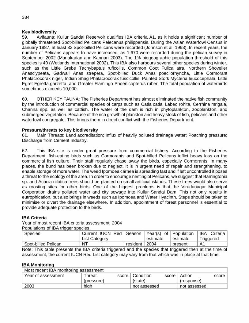
384
Key biodiversity 59. Avifauna: Kullur Sandai Reservoir qualifies IBA criteria A1, as it holds a significant number of globally threatened Spot-billed Pelicans Pelecanus philippensis. During the Asian Waterfowl Census in January 1987, at least 32 Spot-billed Pelicans were recorded (Johnson et al. 1993). In recent years, the number of Pelicans appears to have increased, as 1,670 were recorded during the pelican survey in September 2002 (Manakadan and Kannan 2003). The 1% biogeographic population threshold of this species is 40 (Wetlands International 2002). This IBA also harbours several other species during winter, such as the Little Grebe Tachybaptus ruficollis, Common Coot Fulica atra, Northern Shoveller Anasclypeata, Gadwall Anas strepera, Spot-billed Duck Anas poecilorhyncha, Little Cormorant Phalacrocorax niger, Indian Shag Phalacrocorax fuscicollis, Painted Stork Mycteria leucocephala, Little Egret Egretta garzetta, and Greater Flamingo Phoenicopterus ruber. The total population of waterbirds sometimes exceeds 10,000. 60. OTHER KEY FAUNA: The Fisheries Department has almost eliminated the native fish community by the introduction of commercial species of carps such as Catla catla, Labeo rohita, Cerrhina mrigala, Channa spp. as well as catfish. The water of the dam is rich in phytoplankton, zooplankton, and submerged vegetation. Because of the rich growth of plankton and heavy stock of fish, pelicans and other waterfowl congregate. This brings them in direct conflict with the Fisheries Department. Pressure/threats to key biodiversity 61. Main Threats: Land accreditation; Influx of heavily polluted drainage water; Poaching pressure; Discharge from Cement Industry. 62. This IBA site is under great pressure from commercial fishery. According to the Fisheries Department, fish-eating birds such as Cormorants and Spot-billed Pelicans inflict heavy loss on the commercial fish culture. Their staff regularly chase away the birds, especially Cormorants. In many places, the bund has been broken due to neglect. It is in urgent need of repair and strengthening, to enable storage of more water. The weed Ipomoea carnea is spreading fast and if left uncontrolled it poses a threat to the ecology of the area. In order to encourage nesting of Pelicans, we suggest that Barringtonia sp. and Acacia nilotica trees should be planted on small artificial islands. These trees would also serve as roosting sites for other birds. One of the biggest problems is that the Virudunagar Municipal Corporation drains polluted water and city sewage into Kullur Sandai Dam. This not only results in eutrophication, but also brings in weeds such as Ipomoea and Water Hyacinth. Steps should be taken to minimise or divert the drainage elsewhere. In addition, appointment of forest personnel is essential to provide adequate protection to the birds. IBA Criteria Year of most recent IBA criteria assessment: 2004 Populations of IBA trigger species
Species Current IUCN Red List Category
Season Year(s) of estimate
Population estimate
IBA Criteria Triggered
Spot-billed Pelican NT resident 2004 present A1
Note: This table presents the IBA criteria triggered and the species that triggered then at the time of assessment, the current IUCN Red List category may vary from that which was in place at that time. IBA Monitoring
Most recent IBA monitoring assessment
Year of assessment Threat score (pressure)
Condition score (state)
Action score (response)
2003 high not assessed not assessed

385
Was the whole site covered?
Yes State assessed by unset
Accuracy of information good
Threats to the site (pressure)
Threat Level 1 Threat Level 2 Timing Scope Severity Result
Biological resource use
fishing & harvesting aquatic resources - unintentional effects: large scale
happening now
majority/most of area/population (50-90%)
moderate to rapid deterioration
high
Biological resource use
hunting & collecting terrestrial animals - intentional use (species being assessed is the target)
happening now
small area/few individuals (<10%)
slow but significant deterioration
low
Biological resource use
hunting & collecting terrestrial animals - persecution/control
likely in short term (within 4 years)
small area/few individuals (<10%)
very rapid to severe deterioration
low
Human intrusions and disturbance
work and other activities happening now
small area/few individuals (<10%)
slow but significant deterioration
low
Invasive and other problematic species and genes
invasive non-native/alien species/diseases - named species
happening now
some of area/population (10-49%)
slow but significant deterioration
medium
Pollution domestic & urban waste water - run-off
happening now
some of area/population (10-49%)
moderate to rapid deterioration
high
Pollution industrial & military effluents - type unknown/unrecorded
happening now
small area/few individuals (<10%)
slow but significant deterioration
low
Conservation actions taken at site (response)
Conservation Designation Management Planning Conservation Action Result
Not assessed Not assessed Not assessed not assessed
Habitats
IUCN Habitat Habitat detail Extent (% of site)
Artificial - aquatic
-
Land use
Land-use Extent (% of site)
agriculture -
fisheries/aquaculture -
rangeland/pastureland -
water management -

386
IN269: Kunthangulam Bird Sanctuary Country/territory: India IBA Criteria met: A1, A4i (2004) Area: 129 ha Protection status:
Most recent IBA monitoring assessment
Year of assessment Threat score (pressure) Condition score (state) Action score (response)
2003 high not assessed not assessed
Year of compilation: 2004 Site description 63. The Koonthangulam Bird Sanctuary is located in Naguneri Taluka of Tirunelveli district between Moolakaraipatti and Kariandi. It is about 20 km from Tirunelveli town. It is a rain and river-fed freshwater tank, and receives water from the Manimuthar river. The globally threatened Spot-billed Pelican Pelecanus philippensis breeds here, along with other birds. It is one of the oldest known pelicanries in India, having existed for 200 years or more. Rhenius first reported this pelicanry in 1906 (Rhenius 1907). The villagers believe that the birds that come to Koonthangulam are harbingers of good luck and their yearly arrival ensures good rainfall. They also benefit from the rich guano deposited in the breeding colonies. This is used to fertilize the fields. Guano-rich tank water is used for irrigation. Koonthangulam (also transcribed as Koondakulam) has a large tank within the village precints, and several smaller tanks scattered in the vicinity. These waterbodies and the fields are the main foraging grounds for birds. Koonthangulam is basically an agricultural area, so there is no forest as such. Acacia nilotica has been planted in about 35.5 ha. This is where most of the birds nest. Key biodiversity 64. Avifauna: The pelicanry at Koonthangulam is quite famous and commented upon by various naturalists (e.g. Rhenius 1907, Webb-Peploe 1945, Wilkinson 1961, Nagulu and Rao 1983, Kumar 1993 and Thomas et al. 2000). In the early 1990s, about 1000 Spot-billed Pelicans were recorded (Anon. 1993). This constitutes more than 8% of the biogeographic population. During a pelican survey in January 2003, only about 452 Spot-billed Pelican were recorded breeding. BirdLife International (2001) has listed records of pelicans from 1906 up till 1993 from this site. Besides the Spot-billed Pelican, Painted Stork Mycteria leucocephala breeds in the village in large numbers, sometimes on the trees inside private property. In some years, Greater Flamingo Phoenicopterus ruber also built nest mounds, though breeding has not been confirmed. Asian Openbill Anastomus oscitans, Oriental White or Black-headed Ibis Threskiornis melanocephalus, Black Ibis Pseudibis papillosa, Glossy Ibis Plegadis falcinellus, Eurasian Spoonbill Platalea leucorodia, Little Cormorant Phalacrocorax niger, Pond Heron Ardeola grayii, Grey Heron Ardea cinerea, Black-crowned Night Heron Nycticorax nycticorax, Darter Anhinga melanogaster, Little Egret Egrettagarzetta, Cattle Egret Bubulcus ibis, Bar-headed Goose Anser indicus, Northern Pintail Anas acuta, Northern Shoveller Anas clypeata, Little Grebe Tachybaptus ruficollis, Common Coot Fulica atra, White-breasted Waterhen Amaurornis phoenicurus, Indian Moorhen Gallinula chloropus, Purple Moorhen Porphyrio porphyrio and various species of waders are also seen here, many in numbers greater than their 1% biogeographic population threshold. This IBA site is also famous for its vast flocks of Glossy Ibis Plegadis falcinellussometimes up to 1,000 are seen together, foraging in the inundated crop fields or flying from one foraging area to another. 65. Other Key Fauna: Most of the smaller mammals of rural areas are seen in this site, such as Golden Jackal Canis aureus, Common Palm Civet Paradoxurus hermaphroditus, and Jungle cat Felis chaus.

387
Pressure/threats to key biodiversity 66. Koonthangulam is about 65 km from Kanyakumari, a major tourist area where millions of people, especially school groups come every year. Koonthangulam also receives about 15,000 Indian tourists and about 100 foreigners. It can become a major centre for environmental education for students and public. However, as the villagers are very sensitive to the protection of ‘their’ birds, crass tourism should be avoided. Regulated guided tours, watching birds from selected points and an interpretation centre would help in conveying the message of environmental education. A system should be developed so that at least half of the revenue from tourism should go to village panchayat (council) for the development of social infrastructure. Local youth could be trained as guides. As the birds forage in agricultural fields, it is absolutely necessary to monitor the pesticide use in the area. Regular scientific monitoring of birds, both breeding and wintering species, is also required. It is also recommended that this IBA site should be kept natural, and no attempt should be made to ‘beautify’ the place. Nothing is more beautiful that a hungry pelican chick being fed by its parent, or a flock of 500 Glossy Ibis going to roost. IBA Criteria Year of most recent IBA criteria assessment: 2004 Populations of IBA trigger species
Species Current IUCN Red List Category
Season Year(s) of estimate
Population estimate
IBA Criteria Triggered
Glossy Ibis Plegadis falcinellus
LC - 2004 present A4i
Spot-billed Pelican Pelecanus philippensis
NT resident 2004 present A1, A4i
Note: This table presents the IBA criteria triggered and the species that triggered then at the time of assessment, the current IUCN Red List category may vary from that which was in place at that time. IBA Monitoring
Most recent IBA monitoring assessment
Year of assessment Threat score (pressure)
Condition score (state)
Action score (response)
2003 high not assessed not assessed
Was the whole site covered?
Yes State assessed by unset
Accuracy of information good
Threats to the site (pressure)
Threat Level 1 Threat Level 2 Timing Scope Severity Result
Human intrusions and disturbance
recreational activities happening now
majority/most of area/population (50-90%)
moderate to rapid deterioration
high
Pollution agricultural & forestry effluents - herbicides and pesticides
happening now
majority/most of area/population (50-90%)
slow but significant deterioration
high
Conservation actions taken at site (response)
Conservation Designation Management Planning Conservation Action Result
Not assessed Not assessed Not assessed not assessed
IBA Protection

388
Protection status:
Protected Area Designation Area (ha) Relationship with IBA Overlap with IBA (ha)
Kuthankulam Sanctuary 129 is identical to site 129
Habitats
IUCN Habitat Habitat detail Extent (% of site)
Wetlands (inland)
-
Land use
Land-use Extent (% of site)
water management -
Country/territory: India Central coordinates: 8o 28' 12" North (8.47o) 77o 43' 48" East (77.73o) Area: 129 ha Altitude: 0-0 m

389
Annexure 9: Details of Sample Public Consultations A9.I Village wise List of the participants and their occupation are given in Tables A9.1-5 below. List of 16 86public consultations are listed below for reference. Table A9.1 Consultation at
S1 Virudhunagar (2x1500MVA) 765/400
SNo Village Tehsil/Mandal Districts Distance from the District Head Quarters
Number of Participants
1 Valayapatti Virudhu nagar Virudhu nagar Virudhu nagar 17
SNo Name of the Participants Occupation
Name of the Village: Valayapatti
1 Mr. S Pedamal Agriculture
2 Mr. S Sodigiraj Agriculture
3 Mr. T Kuttimuryan Agriculture
4 Mr .P. Perumal Agriculture
5 Mr. A Sabbiga Agriculture
6 Mr. A Kudbalingam Agriculture
7 Mr. P.Ponna Samy Agriculture
8 Mr. P Kuttiyam Agriculture
9 Mr. S Puniswany Business
10 Mr. B.Solan Agriculture
11 Mr. T. Sivasuriyam Agriculture
12 Mr. M Muthaya Agriculture
13 Mr. G .Rajsekar Driver
14 Mr. V .Gopal Agriculture
15 Mr. A.K Arruppa Swamy Driver
16 Mr. D.Karruppa Swamy Agriculture
17 Mr. Enavara Swamy Agriculture
Table A9.2: Consultation at
S2 Ottapidaram (2x500MVA) + (2x200MVA) 400/230/110 kV
SNo Village Panchayat Districts Distance from the District Head Quarters Number of Participants
1
SNo Name of the Participants Occupation
Name of the Village:
1 Mr. S Pedamal Agriculture
2 Mr. S Sodigiraj Agriculture
3 Mr. T Kuttimuryan Agriculture
4 Mr .P. Perumal Agriculture
5 Mr. A Sabbiga Agriculture
6 Mr. A Kudbalingam Agriculture
86 The detailed consulation formats for 56 locations is available on request from PPTA survey team
engaged separately under the project.

390
SNo Name of the Participants Occupation
7 Mr. P.Ponna Samy Agriculture
8 Mr. P Kuttiyam Agriculture
9 Mr. S Puniswany Business
10 Mr. B.Solan Agriculture
11 Mr. T. Sivasuriyam Agriculture
12 Mr. M Muthaya Agriculture
13 Mr. G. Rajsekar Driver
14 Mr. V .Gopal Agriculture
15 Mr. A. K Arruppa Swamy Driver
16 Mr. D. Karruppa Swamy Agriculture
17 Mr. Enavara Swamy Agriculture

391
Table A9.3: Consultation at Subproject T1.1 765 kV double circuit line Virudhunagar - Coimbatore 242
SNo Village Panchayat
Districts
Distance from the District Head Quarters
Number of Participant
s
1
Qs sl no
Name of Component/ Site
Number of Participant Location Name of village
1 765 kV DC-TL from Virudhunagar to 765 kV SS Coimbatore
7 kavutham Palayam Kavutham Palayam
S.No. Name Occupation Signature
1 Mr C Ramesh Kumar Student
2 Mr K. Arunach Alam Agriculture
3 Mr. A Viswanath Power loom worker
4 Mr. S Sanjnagan Agriculture
5 Mr. G. Vilegiri Power loom worker
6 Mr. A. Planiswamy Pvt.Service
7 Mr. J. Janaradha Pvt.Service
Qnnrs sl no
Name of Component/ Site Number of Participant Location Name of village
2 765 kV DC-TL from Virudhunagar to 765 kV SS Coimbatore
7 At bus stand /Public place Sirukalanji
S.No. Name Occupation Signature
1 Mrt. P Mahender Business
2 Mr V. Anand Service
3 Mr. V Krishanan Pvt. Service
4 Mr. A Sathivel Pvt.Service
5 Mr. R Servanan Driver
6 Mr. C Tanga muttu Agriculture
7 Mr. K Tangavel Agriculture
Qnnrs sl no
Name of Component/ Site
Number of Participant Location Name of village
3 765 kV DC-TL from Virudhunagar to 765 kV SS Coimbatore
8 At the grampanchayat premises
Padiyaandi Palayam
S.No. Name Occupation Signature
1 Mr. Vel Swamy Agriculture
2 Mr. K. Alagumuthu Agriculture
3 Mr.P Karthikeyan Agriculture
4 Mrs P Minakshi H/W
5 Mrs. S Kavitha H/W
6 Mrs. G Geetha H/W
7 Mr. S Murti Farmer
8 Mr. Shiva Chezian Hotel Business
Qnnrs sl no
Name of Component/ Site Number of Participant Location Name of village

392
Qs sl no
Name of Component/ Site
Number of Participant Location Name of village
4 765 kV DC-TL from Virudhunagar to 765 kV SS Coimbatore
7 Public place near the primary school
G.Nadupatti
S.No. Name Occupation Signature
1 Mr. R Raman Bus.conductor
2 Mr. k. Krishanan Agriculture
3 Mr. S Parma Swamy Forman Eb
4 Mr. S Parimal Swamy Retd. Eb
5 Mr. G Govind Student
6 Mr. Kuppa Swamy Agriculture /labour
7 Mr. R Ramanan Agri/labour
Qnnrs sl no
Name of Component/ Site Number of Participant Location Name of village
5 765 kV DC-TL from Virudhunagar to 765 kV SS Coimbatore
6 Near the temple premises/Bus stand
Pudhukkittat
S.No. Name Occupation Signature
1 Mr. S Bala Muruggan Pvt. Service
2 Mr. M Raja Pandiyan Bore well operator
3 Mr. P Muniswamy Govt.service
4 Mrs. Bhagya Lakshmi H/W, Shop
5 Mrs. Pandi Ammal H/W, Shop
6 Mrs. V Lakshmi Agriculture /labour
Qnnrs sl no
Name of Component/ Site Number of Participant Location Name of village
6 765 kV DC-TL from Virudhunagar to 765 kV SS Coimbatore
7 at the bus stand/at temple premise
V.Kovilpatti
S.No. Name Occupation Signature
1 Mr. R Mani Farmer
2 Mr. P Sunder Farmer
3 Mr. M Karuppa Swamy Farmer
4 Mr. Selvan Farmer
5 Mr. C Pandi Farmer
6 Mr. Moka Pandi Agri
7 Mr. Rama Swamy Agri
Qnnrs sl no
Name of Component/ Site Number of Participant Location Name of village
7 765 kV DC-TL from Virudhunagar to 765 kV SS Coimbatore
6 At ex.president resident and bus stand, tea shop
Vagaikulam
S.No. Name Occupation Signature
1 Mr. Pandi Farmer
2 Mr. Mahesh Student
3 Mr. T Shiva Priya Student
4 Mr. C.Kandiban Agri
5 Mrs R. Radha Tea shop

393
Qs sl no
Name of Component/ Site
Number of Participant Location Name of village
6 Mr. R. Pandi Agri labour
Qnnrs sl no
Name of Component/ Site Number of Participant Location Name of village
8 765 kV DC-TL from Virudhunagar to 765 kV SS Coimbatore
8 At temple premises S.Gobalapuram
S.No. Name Occupation Signature
1 Mr. P Senthil Kumar Pvt. service
2 Mr. Narayan Swamy Farmer
3 Mrs. Vatslya Agri
4 Mrs. Analakshi Agri
5 Mrs. Anitha H/W
6 Mrs. Saroja H/W
7 Mrs. Geetha H/W
8 Mrs. Vishnu Priya Govt. service
Qnnrs sl no
Name of Component/ Site Number of Participant Location Name of village
9 765 kV DC-TL from Virudhunagar to 765 kV SS Coimbatore
7 Public place/near the temple premises
Lalapuram
S.No. Name Occupation Signature
1 Mr. R Jay Rachangan Farmer
2 Mr. A Alagar Swamy Agriculture
3 Mr. R Caokappa Rediyar
Agriculture
4 Mr. A shri vasan Agriculture /Labour
5 Mr. R Pandiammal Agriculture /Labour
6 Mr. K Karthiresan Agriculture /Labour
7 Mr. A S Alagar Swamy Agriculture /Labour
Qnnrs sl no
Name of Component/ Site Number of Participant Location Name of village
10 765 kV DC-TL from Virudhunagar to 765 kV SS Coimbatore
6 Public place /Bus stand Valayapatti
S.No. Name Occupation Signature
1 Mr. J Periya Swamy Driver
2 Mr. R Kuttiyan Farmer
3 Mr. A Nalla Muthu Student
4 Mr. K Kuttiyan Student
5 Mr. P Karthik Driver
6 Mr. Chinna cattering Work

394
Table A9.4: List of Participants for Consultation for Subproject T12 400 kV double circuit line Virudhunagar - Kayathar 73
SNo Village Panchayat
Districts
Distance from the District Head Quarters
Number of Participan
ts
1
VIRUDHUNAGAR TO KAYATHAR
Qnnrs sl no
Name of Component/ Site Number of Participant
Location Name of village
11 400 kV DC - TL from Virudhuagar 765 kV SS to Kayathar 400 kV SS
8 At the hotel near the bus stand
Ayyanaruthu
S.No. Name Occupation Signature
1 Mr. B.Abdul Farmer
2 Mr. S.Pulliya Farmer
3 Mr. K Maheshwaran
Private job in jio
4 Mr. V Suppaiya Electrician
5 Mr. V Sanmuggiya
Farmer
6 Mr. P ganeshan Farmer
7 Mr. T Velpande Farmer
8 Mr. S Shantithan Farmer
Qnnrs sl no
Name of Component/ Site Number of Participant
Location Name of village
12 400 kV DC - TL from Virudhuagar 765 kV SS to Kayathar 400 kV SS
7 Malaipaity - at temple
Malaipatti
S.No. Name Occupation Signature
1 Mr. O Jay anand Farmer
2 Mr. M Jayveeran Farmer
3 Mr. K Kumaranan
Agriculture labour
4 Mr. P Kuttiyan Agriculture labour
5 Mr. D Rajender Farmer
6 Mr. R Boss Farmer
7 Mr. S Kahi raj Farmer
Qnnrs sl no
Name of Component/ Site Number of Participant
Location Name of village
13 400 kV DC - TL from Virudhuagar 765 kV SS to Kayathar 400 kV SS
8 Public place near bus stand
sirukkulam
S.No. Name Occupation Signature
1 Mr. M Gajendran Agriculture
2 Mr. E Ramamurthi
Agriculture
3 Mr. R Adinarayan
Agriculture
4 Mr. S Mardisamy Agriculture
5 Mr. N Solaisamy Agriculture
6 Mr. K Agriculture

395
Velmusayan
7 Mr. R Pandiraj Agriculture
8 Mr. R Suburaj Agriculture
Qnnrs sl no
Name of Component/ Site Number of Participant
Location Name of village
14 765 kV DC-TL from Virudhunagar to 765 kV SS Coimbatore
6 Near the bus stand/ tea shop
Lingampatti
S.No. Name Occupation Signature
1 Mr. P Chantiram Agriculture labour
2 Mr. R Shamigaiya
Farmer
3 Mr. S Thangvel Farmer
4 Mr. A Sosail Agriculture labour
5 Mr. A Kovilmuthu Farmer
6 Mr. A Parriyaan Farmer
7 Mr. D John Farmer
8 Mr. S Anal raj Farmer
Qnnrs sl no
Name of Component/ Site Number of Participant
Location Name of village
15 400 kV DC - TL from Virudhuagar 765 kV SS to Kayathar 400 kV SS
8 Aathamappan patti Oddamchathirada
S.No. Name Occupation Signature
1 Mr.N.Nachimthoo
Agri
2 Mr.K.Moothu Swamy
carpenter
3 Mr.K Marudhan Agri labour
4 Mr.N Nachiappa Goundar
Agri
5 Mrs. P Bhagyamnal
Agri labour
6 Mrs.S Velammal Agri labour
7 Mr.A. Muthugatham
Agri labour
Mr.K Mani Agri
16 400 kV DC - TL from Virudhuagar 765 kV SS to Kayathar 400 kV SS
6 G.Nadupatti Dindigul - west
S.No. Name Occupation Signature
1 Mr.S Perumal Swamy
Retd.
2 Mr.S Parma Swamy
Electrician
3 Mr.R.Ramar Bus Contector
4 Mrs.A.Sappammal
Agri Labour
5 Mrs.S.Rukmani Agri-Labour H/W
6 Mrs.A. Geetha H/W
17 400 kV DC - TL from Virudhuagar 765 kV SS to Kayathar 400 kV SS
7 Near the bus stand.
Sivangvinanpuram

396
S.No. Name Occupation Signature
1 Mr. V Rahey reddy
Business
2 Mr. V Periyasammy
Farmer
3 Mr. K Samamurthy
Agriculture labour
4 Mr. C Nagarajan Farmer
5 Mr. P Chandran Agriculture labour
6 Mr. Chalayia Agriculture labour
7 Mr. S Algamanisuney
Agriculture farmer

397
Table A9.5: List of Participants for Consultation for Subproject
T1.3 400 kV double circuit line in and out at Virudhunagar for Kamuthi to Thappagundu (proposed) line
Covered in Virudhunagar Line because of small length
Table A9.6: List of Participants for Consultation for Subproject
T2.1 400 kV double circuit line Ottapidaram - Udangudi 68 km
SNo Village Panchayat
Districts
Distance from the District Head Quarters
Number of Participant
s
1 Sakkamal Puram
6
SNo Name of the Participants Occupation
Name of the Village: Kuttampuli
1. R.A. Joseph Retired Army Official
2. S. Durai Raj Business
3. P. Mookendi Agriculture
4. B. Parvesh Agriculture
5. R. Ramanan Pvt Job
6. Krushna Agriculture
SNo Village Panchayat Districts
Distance from the District
Head Quarters Number of
Participants
2 Sampadi 6
SNo Name of the Participants Occupation
Name of the Village: Siluvaipuram
1. Muthu Raj Government Clerk
2. Jay Raj Agriculture
3. Ashok Kumar Student
4. Muthu Raman Fishing
5. Peran Padayan Agriculture
6. Sampat Private job
SNo Village Panchayat Districts
Distance from the District
Head Quarters Number of
Participants
3 Agaram 6
SNo Name of the Participants Occupation
Name of the Village: Agaram
1. Jeba Singh Private Job
2. Arun Kumar Private Job
3. Jeeya Seelan Agriculture
4. Beniel Student
5. R. Raja Student

398
SNo Name of the Participants Occupation
6 Mr. Sundaram Farmer
SNo Village Panchayat Districts
Distance from the District
Head Quarters Number of
Participants
4 Ramachandra Puram 7
SNo Name of the Participants Occupation
Name of the Village: Servaikaranmadam
1. Kashi Rajan Driver
2. Mariappan Driver
3. Pulamandan Contractor
4. Guru Raj Driver
5. Mutthu Kumar Labour
6 M. Rama Lingam Labour
7 Viswanathan Driver
Table A9.7: List of Participants for Consultation for Subproject T2.2 400 kV double circuit line Ottapidaram - Kamuthi 72 km
SNo Village Panchayat Districts Distance from the District Head Quarters Number of
Participants
1 Chandiragiri 8
SNo Name of the Participants Occupation
Name of the Village: Chandiragiri
1. Mr Marimurthy Driver/Village Head
2. Mr Sekhar Driver
3. Mr Rahul Student
4. Mr K Kumar Labour
5 Mr. Rahul Labour
6 Mr. radha Krishnan Driver
7 Mr. V. Kumaran Farmer
8 Mr. S. Raman Farmer
SNo Village Panchayat Districts
Distance from the District
Head Quarters Number of
Participants
2 O Lakshminarayan puram
6
SNo Name of the Participants Occupation
Name of the Village: O Lakshminarayan puram
1. Mr. Laxmana Perumal Farmer
2. Mr. Gopal Krishnan Service
3. Mrs. R Karuppai Housewife
4. Mr. A. Karuppai Labour
5. Mr. C. Rajan Farmer

399
SNo Name of the Participants Occupation
6 Mr. Krishnan Farmer
SNo Village Panchayat Districts
Distance from the District
Head Quarters Number of
Participants
3 Muthhiyapuram 6
SNo Name of the Participants Occupation
Name of the Village: Muthhiyapuram
1. K. Mallapan Farmer
2. B. Alagu raju Farmer
3. P. Reddy Farmer
4. G. Ganeshan Farmer
5. Seethalaxmi Government Servant
6 K. Swami Labour
7 C. Raja Labour
8 D. Vellu Farmer
SNo Village Panchayat Districts
Distance from the District
Head Quarters Number of
Participants
4 Nerinjipatti 7
SNo Name of the Participants Occupation
Name of the Village: Nerinjipatti
1. Mr. Subhramaniyam Farmer
2. Velusami Farmer
3. Murugan Farmer
4. Bala Murugan Driver
5. Pakkia Raj Labour
6 Chandran Farmer
7 Muriya Swami Farmer
Table A9.8: List of Participants for Consultation for Subproject
T2.2 400 kV double circuit line Ottapidaram - Vijayapuri 35
SNo Village Panchayat Districts Distance from the District Head
Quarters
Number of Participant
s
1 Keelamudiman
7
SNo Name of the Participants Occupation
Name of the Village: Keelamudiman
1. Mr. Joseph Contractor
2. Mr. R. Swami Farmer
3. Mr. B. Amal Raj Labour
4. Mr. M. Swami Labour
5. Mr. Y. Prakashan Labour

400
SNo Name of the Participants Occupation
6. Mr. R. Ramanan Farmer
7. Mr. Deenakaran Business
SNo Village Panchayat Districts
Distance from the District
Head Quarters Number of
Participants
2 Kamanayakkam Patti 8
SNo Name of the Participants Occupation
Name of the Village: Kamanayakkam Patti
1. Mr. J. Moses Farmer
2. Mr. D. Mohan Student
3. Mr. A. Alagapparaj Labour
4. Mr. M. Murugan Labour
5. Mr. A. Daniel Labour
6. Mr. G. Murugan Labour
7. Mr. A. Antony Raj Farmer
8. Mr. R. George Labour
SNo Village Panchayat Districts
Distance from the District
Head Quarters Number of
Participants
3 Ottapidaram 8
SNo Name of the Participants Occupation
Name of the Village: Ottapidaram
1. Mr. P. Jayachnadran Private job
2. Mr. S. Bharat Kamal Private job
3. Mr. N. Kartik Student
4. Mr. G. S. Muthhu Farmer
5. Mr. P.Shiva Perumul Farmer
6. Mr. P. Suresh Kumar Private job
7. Mr. M. Sanmurgaraj Private job
8. Mr. A. Murugan Technician
Table A9.9: List of Participants for Consultation for Subproject
T2.4 230 kV double circuit line in and out at Ottapidaram for Sipcot - Savasapuram line
6 km
SNo Village Panchayat Districts
Distance from the District
Head Quarters Number of
Participants
1 Valasamuthiram 5
SNo Name of the Participants Occupation
Name of the Village: Valasamuthiram
1. Mr. Pakil Nadar Retired
2. Mr. Alagu Krishnan Driver
3. Mrs. Selva Rani Tea Stall

401
SNo Name of the Participants Occupation
4. Mr. Muniandi Agriculture Labour
5. Mr. Ramachandran Agriculture
Table A9.10: List of Participants for Consultation for Subproject
T2.5 110 kV double circuit line in and out at Ottapidaram for Ottapidaram - Eppothumvendran
5
SNo Village Panchayat Districts
Distance from the District
Head Quarters Number of
Participants
1 Silanathan 7
SNo Name of the Participants Occupation
Name of the Village: Silanathan
1. A. Manika Private Job
2. A. Arul Raj Private Job
3. A. Swami Private Job
4. K. Murthy Labour
5. P. Rediara Farmer
6. K. Raj Farmer
7. S. Lingam Labour
Table A9.12: List of Participants for Consultation for Subproject
T2.7 110 kV double circuit line in and out at Ottapidaram for TTN Auto - T-off Sipcot line
10.5 km
SNo Village Panchayat Districts
Distance from the District
Head Quarters Number of
Participants
1
SNo Name of the Participants Occupation
Name of the Village:
1. No data
Table A9.12: List of Participants for Consultation for Subproject
T2.7 230 kV double circuit line in and out at Ottapidaram for Sipcot - Kavanoor line
10 km
SNo Village Panchayat Districts
Distance from the District
Head Quarters Number of
Participants
1 Sinthalakathai 6
SNo Name of the Participants Occupation
Name of the Village: Sinthalakathai
1. Kashi Viswanath Farmer
2. M. Mariappan Retired Government officer
3. J. Mani Driver
4. J. J. Manik raj Retired personnel
5. V.K. Rajan Driver

402
SNo Name of the Participants Occupation
6. N. Raman Carpenter
SNo Village Panchayat Districts
Distance from the District
Head Quarters Number of
Participants
2 Kumarapuram 7
SNo Name of the Participants Occupation
Name of the Village: Sinthalakathai
1. Mr. Mariselvan Private job
2. Mr. Manokaran Farmer
3. Mr. U. Maiyan Business
4. Mr. Ganeshan Farmer
5. Mr. Maheswaran Farmer
6. Mr. C. Munishan Labour
7 Mr. Mkundan Business
SNo Village Panchayat Districts
Distance from the District
Head Quarters Number of
Participants
3 Saminathan 7
SNo Name of the Participants Occupation
Name of the Village: Saminathan
1. A. Ramaswami Artisan
2. Mr. Murugan Labour
3. Mr. N. Selvan Service
4. Mr. N. Nallaselvan Agriculture
5. Mr. P. Achari Agriculture
6. Mr. S. Raja Ratnam Labour
7 Mr. C. Shekhanan Student

403
A9.II General Perception and Summary of Consultations are given in Table A9.13 below. Table A9.13
S.no
Name of component/ site
Number of participant
Location Name of village General perception about the project and the awareness about the proposed project.
Is the land irrigated and what are the sources of irrigation?
Loss of residential/commercial structures, if any due to the project
Loss of community life like any market places or community activities to be affected
Protected areas (national park, protected forest, religiously sensitive sites, historical or archaeological sites), if any
Current environmental conditions in the area – air, dust, noise conditions in the area.
Will the project siting adversely impact the water or soil resource in the locality
1 2 3 4 5 6 7 8 9 10 11 12
765 kV Double Circuit Line Virudhunagar - Coimbatore
1 765 kV DC-TL from Virudhunagar to 765 kV SS Coimbatore
7 Kavutham palayam
Kavutham palayam The local people are not aware about the project, not in favour of this proposed project.
No land is not imigated, fully depends on rain water.
No loss No loss Anamalai tiger reserve, pollachi 275 km, protected forest at 6 km Vijaya manalam village.
Current environmental condation is good.
No air pollution, dust, noise, observed in area.
2 765 kV DC-TL from Virudhunagar to 765 kV SS Coimbatore
7 At bus stand /public place
Sirukalanji The local people are not aware about the project -general perception is against the HT line due to loss of farming,land and its value.
No imigation facility. Fully depend on rain. Wells used to collect water and through pump set lift water for imigation.
No loss of residential structure..
No loss of community life.
Anamalai tiger reserve -polachi-285 km protected forest-3km at vijaymangalam.
Very clean no polluction
Accoording the local peoples opinion ground water may startage by the HT line due to earthing of

404
S.no
Name of component/ site
Number of participant
Location Name of village General perception about the project and the awareness about the proposed project.
Is the land irrigated and what are the sources of irrigation?
Loss of residential/commercial structures, if any due to the project
Loss of community life like any market places or community activities to be affected
Protected areas (national park, protected forest, religiously sensitive sites, historical or archaeological sites), if any
Current environmental conditions in the area – air, dust, noise conditions in the area.
Will the project siting adversely impact the water or soil resource in the locality
1 2 3 4 5 6 7 8 9 10 11 12
towers.
3 765 kV DC-TL from Virudhunagar to 765 kV SS Coimbatore
8 At the grampanchayat premises
Padiyaandi palayam The local people are worry about the proposed project-they have not heared regaring this project.village is closed to the main kangayam city.
Well used for imgation but only in the rainy season.
No loss of residental and community life due to the project.
Anamalai tiger reserve-polachi-100 km, protected forest-25km
Current environmental conditions in the area is clean no air dust noise pollution observed/noticed.
Due to EHV line/tower ground water may goes down.
4 765 kV DC-TL from Virudhunagar to 765 kV SS Coimbatore
7 Public place near the primary school
G.nadupatti The local people are worry about the proposed project-no any objection regarding, the project.
Land is not irrigated fully depend on rain for water,well are used as irrigation after collection of rain water through pump set.
No loss of residentional and community life due to the project.
National park or protected forest are not near the village. More then 150 km from the village. anamalai tiger reserve polachi in
Enviornmental condition is very good no air, dust, noise pollution observed.
No idea/aware about the adversly impect on the water or the soil resourses.

405
S.no
Name of component/ site
Number of participant
Location Name of village General perception about the project and the awareness about the proposed project.
Is the land irrigated and what are the sources of irrigation?
Loss of residential/commercial structures, if any due to the project
Loss of community life like any market places or community activities to be affected
Protected areas (national park, protected forest, religiously sensitive sites, historical or archaeological sites), if any
Current environmental conditions in the area – air, dust, noise conditions in the area.
Will the project siting adversely impact the water or soil resource in the locality
1 2 3 4 5 6 7 8 9 10 11 12
Coimbatore dist. No sensitive site.
5 765 kV DC-TL from Virudhunagar to 765 kV SS Coimbatore
6 Near the temple premises/bus stand
Pudhukkittat The local people have not heared about the project, but not in tower of new HT line already HT line,railway line, NH -existing in the village, distubed the agri and day to day activities.
Not irrigation facility
No less of residential/commercial structure and communication life
Anamalai tiger reserve-200 km no protected forest or secretive site.
By the railway line and nh near the village noise pollution observed but enviormental coundation is clean/good.
No idea about the adverge impects on ground water or on the soil.
6 765 kV DC-TL from Virudhunagar to
7 At the bus stand/at temple premise
V. kovilpatti Local people have not heard regarding the project, not interested in the
Already many HT line going in and near the village,area is paddy field and
Availablity of gound water is very
No loss of any residental and commers
Anamalai tiger reserve -170 km no protected forest near the
Current enviorment condation is very neat and
Wild pig and randiya/deers

406
S.no
Name of component/ site
Number of participant
Location Name of village General perception about the project and the awareness about the proposed project.
Is the land irrigated and what are the sources of irrigation?
Loss of residential/commercial structures, if any due to the project
Loss of community life like any market places or community activities to be affected
Protected areas (national park, protected forest, religiously sensitive sites, historical or archaeological sites), if any
Current environmental conditions in the area – air, dust, noise conditions in the area.
Will the project siting adversely impact the water or soil resource in the locality
1 2 3 4 5 6 7 8 9 10 11 12
765 kV SS Coimbatore
project. dance coconut,fully greenary area.
up.village and pound and chanels are the main sources for irrigation. Land is irrigated by punds, channels, walls
ial and community life due to the towers/HT
village. clean,no air, dust, noise pollution obserbed.
7 765 kV DC-TL from Virudhunagar to 765 kV SS
6 At ex-president resident and bus stand, tea shop
Vagaikulam Local people have not aware before, they don’t want any towers/HT line from this village only from the
Land is irrigated by well pump sets.
No loss of any residential or commersial complex
No loss of any community life due to the HT line of towers.
Anamalai tiger reserve-200 km no any protected forest but due to baren land green area
Current environmental condation in the area like air, dust,
No idea about the adverse impact on the water and soil resourses.

407
S.no
Name of component/ site
Number of participant
Location Name of village General perception about the project and the awareness about the proposed project.
Is the land irrigated and what are the sources of irrigation?
Loss of residential/commercial structures, if any due to the project
Loss of community life like any market places or community activities to be affected
Protected areas (national park, protected forest, religiously sensitive sites, historical or archaeological sites), if any
Current environmental conditions in the area – air, dust, noise conditions in the area.
Will the project siting adversely impact the water or soil resource in the locality
1 2 3 4 5 6 7 8 9 10 11 12
Coimbatore
outside from west distance.
due to the HT lines
noticed. noise, pollution not observed.
8 765 kV DC-TL from Virudhunagar to 765 kV SS Coimbatore
8 At temple premises
S. Gobalapuram Local people have not heared about the project. hands value is very high due to near the NH road both side of the village. fully cultivate land, bore well/well are the main sources of irrigation.
No loss due to the project
No loss of community life due to the tower
Anamalai tiger reserve – 200 km from thois village. no protected forest or sensitive sites near the village
Enviornement condations in the area is clean without any pollution.
This is benefit of the local people that due to tower and line ground water may go down and plantation coconut and other tree may drg.
9 765 kV DC-TL from
7 Public place/near the
Lalapuram Not aware about the project. first time came to
Well and bore well are the main sources of
No loss of residenti
Anamalai tiger reserve-210 km no
Environment condations
No idea regarding the

408
S.no
Name of component/ site
Number of participant
Location Name of village General perception about the project and the awareness about the proposed project.
Is the land irrigated and what are the sources of irrigation?
Loss of residential/commercial structures, if any due to the project
Loss of community life like any market places or community activities to be affected
Protected areas (national park, protected forest, religiously sensitive sites, historical or archaeological sites), if any
Current environmental conditions in the area – air, dust, noise conditions in the area.
Will the project siting adversely impact the water or soil resource in the locality
1 2 3 4 5 6 7 8 9 10 11 12
Virudhunagar to 765 kV SS Coimbatore
temple premises
know about the project.no any major objection regarding the HT line.already HT line existing in the village.
irrigation al/commercial structure and any community life due to the tower and HT line
protected forest, no sensitive site near the village.
in the area is very clean, no any kind of pollucation observed.
adversly impacts on the water and soil.
10 765 kV DC-TL from Virudhunagar to 765 kV SS Coimbatore
6 Public place /bus stand
Valayapatti Not heard about the HT tower project but aware about the sub-station at Mallayapatti already tower exiting in the village
No imagination facility only well and bore well are the main sourses but depend on the rain water only.
No loss of any residential or commercial complex due to the HT lines
Anamalai tiger reserve 250 km. no any project forest and no sensitive site in the village.
Current environmental conditions are good no any kind of pollution observed
Neem, palm (a few), babool shrubs
400 kV DC - TL from Virudhunagar 765 kV SS to Kayathar 400 kV SS
11 400 kV DC - TLl
8 At the hotel
Ayyanaruthu Not aware of the project, but local
Irigation through bore well.
No loss of
Due to many HT line/tower,
No environme

409
S.no
Name of component/ site
Number of participant
Location Name of village General perception about the project and the awareness about the proposed project.
Is the land irrigated and what are the sources of irrigation?
Loss of residential/commercial structures, if any due to the project
Loss of community life like any market places or community activities to be affected
Protected areas (national park, protected forest, religiously sensitive sites, historical or archaeological sites), if any
Current environmental conditions in the area – air, dust, noise conditions in the area.
Will the project siting adversely impact the water or soil resource in the locality
1 2 3 4 5 6 7 8 9 10 11 12
from Virudhunagar 765 kV SS to Kayathar 400 kV SS
near the bus stand
people have not any objection, due to already sub-station and power wind mill established 5 to 10 year before. this is the hub of power
residential/ commercial structure and community life due to the project.
wild birds like peacock and kulbi burent every day. Water level gone down, cancer case increased from the last 5 years in the village.
nt problem,no pollucation observed.
12 400 kV DC - TLl from Virudhunagar 765 kV SS to Kayathar 400 kV SS
7 Malaipaity - at temple
Malaipatti Not aware about the project,not willing to support the proposed project.
Land is irrigeted by bore well
No loss of residental/commercial structures due to the project.
No loss of community life.
No protected area, sensitive sites.
Current environment condations is clean in the area, no pollucation in the area.
The project sitting adversly impact on ground water, gone down due to the HT line and towers.

410
S.no
Name of component/ site
Number of participant
Location Name of village General perception about the project and the awareness about the proposed project.
Is the land irrigated and what are the sources of irrigation?
Loss of residential/commercial structures, if any due to the project
Loss of community life like any market places or community activities to be affected
Protected areas (national park, protected forest, religiously sensitive sites, historical or archaeological sites), if any
Current environmental conditions in the area – air, dust, noise conditions in the area.
Will the project siting adversely impact the water or soil resource in the locality
1 2 3 4 5 6 7 8 9 10 11 12
13 400 kV DC - TLl from Virudhunagar 765 kV SS to Kayathar 400 kV SS
8 Public place near bus stand
Sirukkulam Disturbance in the farming and safety of major issues not avoided about the project
Bore-well is the only source of irrigation.
No loss of any structures fue to the project.
No loss of any community life.
No such area in the village but, dam or Arjuna river 2 km distance
Current environmental condition is clean without air dust and noise problem.
Ground water goes down due to towers.
14 765 kv.dc-tl from v.nagar to 765 kv.ss coimbatore
Near the bus stand/ tea shop
Lingampatti Not awarded about the project .the project is not benefits for the local people
Through the bore-well only irrigation facility.
No loss of registration /common structures and communty life due to the proposed project.
No protected area, but hill side forest department of pollution observed.
Environmental condition is neat and clean no any kind of pollution is observed.
The local people people think that government water goes down due to the towers earthing
15 400 kV DC - TLl
7 Near the bus
Sivangvinanpuram Local people have not
Irrigated through bore-
No No No Neat and clean
By the earthing of

411
S.no
Name of component/ site
Number of participant
Location Name of village General perception about the project and the awareness about the proposed project.
Is the land irrigated and what are the sources of irrigation?
Loss of residential/commercial structures, if any due to the project
Loss of community life like any market places or community activities to be affected
Protected areas (national park, protected forest, religiously sensitive sites, historical or archaeological sites), if any
Current environmental conditions in the area – air, dust, noise conditions in the area.
Will the project siting adversely impact the water or soil resource in the locality
1 2 3 4 5 6 7 8 9 10 11 12
from Virudhunagar 765 kV SS to Kayathar 400 kV SS
stand. awarded about the project. Not in favour of the project from the village want the HT line from the existing time.
well / pump sets.
environmental condition, no air due to noise pollution.
tower, ground water may goes down / impact on farming
S.No
Name of Component/ Site
Number of Participant
Location
Name of village
Type of trees in the area: Fruit/non fruit/forest/ rare/endangered species etc.
Wild, endemic, endangered animals in the area.
Type of agriculture/crops in the area.
Number of Households in the Village/District, Area populated by ethnic minorities etc.
General socio-economic standing: What are the economic activities? Land use, cropping pattern (Seasonal), types of crops, Average land holding size etc.
What other organizations of a social nature (NGOs/CBOs/ Civil Society) active in the area? Name of these organizations
Any critical issue or concern by the local people regarding the project?
Any other observations
1 2 3 4 5 13 14 15 16 17 18 19 20
765 kV double circuit line Virudhunagar - Coimbatore
1 765 kV DC-TL from
7 Kavutham Palaya
kavutham Palayam
The local peoplethinking the
Peocock, chitukubi and many
Main crops bajra,
Totol no of household 120+ only
The main economic activities are agriculture,
Single crops only kharif average
No NGO working in this area.the
The local EB official in trying for the

412
S.No
Name of Component/ Site
Number of Participant
Location
Name of village
Type of trees in the area: Fruit/non fruit/forest/ rare/endangered species etc.
Wild, endemic, endangered animals in the area.
Type of agriculture/crops in the area.
Number of Households in the Village/District, Area populated by ethnic minorities etc.
General socio-economic standing: What are the economic activities? Land use, cropping pattern (Seasonal), types of crops, Average land holding size etc.
What other organizations of a social nature (NGOs/CBOs/ Civil Society) active in the area? Name of these organizations
Any critical issue or concern by the local people regarding the project?
Any other observations
1 2 3 4 5 13 14 15 16 17 18 19 20
Virudhunagar to 765 kV SS Coimbatore
m project will sitting adversly impact on the ground . The main tree are neem, kiker, babool, coconut,water due to HT line and sub-station in the village.
other birds available in large number.
G.nut, Turmeric, maize, coconut
Gounder and Mudaliya communication no any ethic minority living in this village.
powerloom and working in the private company.
landholding 5 acres to 10 acres.
local people are not ready to support the purpose project due to adverise impect by the 1+1 line and sub-station
support of the local people by the local land brokers. The local people demanding high rate of the land and all round development found for the village like route, street, and free power suply in the village.
2 765 kV DC-TL from Virudhun
7 At bus stand /Public place
Sirukalanji Cocone,palm, neem, kikar,
Peocock and wild pig found in plenty in
Cotton, coconut,bazara, turmeric
Total no. HH-100.Nadar and
The main economic activities-Agri + agri labour-70% non agri works -30%.
No working in this village
No critical ossues sitting by the localpeople.
The local people are not in the favour of HT

413
S.No
Name of Component/ Site
Number of Participant
Location
Name of village
Type of trees in the area: Fruit/non fruit/forest/ rare/endangered species etc.
Wild, endemic, endangered animals in the area.
Type of agriculture/crops in the area.
Number of Households in the Village/District, Area populated by ethnic minorities etc.
General socio-economic standing: What are the economic activities? Land use, cropping pattern (Seasonal), types of crops, Average land holding size etc.
What other organizations of a social nature (NGOs/CBOs/ Civil Society) active in the area? Name of these organizations
Any critical issue or concern by the local people regarding the project?
Any other observations
1 2 3 4 5 13 14 15 16 17 18 19 20
agar to 765 kV SS Coimbatore
babools this arera. Kongvilada are the main communities, no ethnic minority living in the village
only one crops in a year in the karif seasons. Average land holding size 5 to 10 areas.
But disturbance in the farming a major issues.
line from the village.They think permanent disturbance in the farming and value of the land become zero. Bad impects on the income.
3 765 kV DC-TL from Virudhunagar to 765 kV SS Coimbatore
8 At the grampanchayat premises
Padiyaandi Palayam
coconut, babool, neem
No endemic/ endangered animals found in the area.
sigle crops in a year,the main crops are - cotton,chilli,coconut
Total no of HH in the village - 70% Kongovalad and adi dranid are the main community.No ethinic minority.
Main occupation-agri+agri labour and non agri labour in the rice, oil textiles mill.
No working in this village
The village is very closed to main city-Kangayan. The area is under industries/ factory/mill. Land value is very high.
The village is attached with the main taluka city Kangayam.The land value of very high. People are not agree

414
S.No
Name of Component/ Site
Number of Participant
Location
Name of village
Type of trees in the area: Fruit/non fruit/forest/ rare/endangered species etc.
Wild, endemic, endangered animals in the area.
Type of agriculture/crops in the area.
Number of Households in the Village/District, Area populated by ethnic minorities etc.
General socio-economic standing: What are the economic activities? Land use, cropping pattern (Seasonal), types of crops, Average land holding size etc.
What other organizations of a social nature (NGOs/CBOs/ Civil Society) active in the area? Name of these organizations
Any critical issue or concern by the local people regarding the project?
Any other observations
1 2 3 4 5 13 14 15 16 17 18 19 20
Mostly demand for industryes coconut plantation is the main crops and sourses of income,through the town and HT line-adverse impacts any possible.
for the proposed project.They want to sift from the other side where waste land available.
4 765 kV DC-TL from Virudhunagar to 765 kV SS Coimbatore
7 Public place near the primary school
G.Nadupatti
Coconut, palm, neem, shrubs, kikar
Wild rabbit, Wild pig, Peacock
Ground nut,Maize, bajara, chilli, Vegetable
Total no of HH-4000+, Goundars,Nayakkan, Maniyam are the main community.No ethnic majority living in the
Main occupation-agri/agri labour-60%, Non agri labour-40%
No working in this village
No critical issue or conserns by the local people regarding the project they want market rate for the
No objection by the local people regarding the proposed project. The demand any maximum compensati

415
S.No
Name of Component/ Site
Number of Participant
Location
Name of village
Type of trees in the area: Fruit/non fruit/forest/ rare/endangered species etc.
Wild, endemic, endangered animals in the area.
Type of agriculture/crops in the area.
Number of Households in the Village/District, Area populated by ethnic minorities etc.
General socio-economic standing: What are the economic activities? Land use, cropping pattern (Seasonal), types of crops, Average land holding size etc.
What other organizations of a social nature (NGOs/CBOs/ Civil Society) active in the area? Name of these organizations
Any critical issue or concern by the local people regarding the project?
Any other observations
1 2 3 4 5 13 14 15 16 17 18 19 20
area. compensation for the loss ofcoconut trees and others tree as per its value.
on as per open market rate.
5 765 kV DC-TL from Virudhunagar to 765 kV SS Coimbatore
6 Near the temple premises/Bus stand
Pudhukkittat
Neem, coconut, emali, kikar/babool
No wild endemic,endangered animals in the village / area.
Onion, vegetable, Flowers (medicinal), bajara, gram, Maize, rice
Total HH - 600hh, sc and bc dewan,gounder, shetiyar are the main communities.
Agri/agri labour -75%, non agri labour 25%, driver, borewell operator/jcb driver mainly. Average land 5 - 10 acres.
No NGO working in the village
Already HT line and railways line exiting in the village. HT line is not beneficial, its disturbed the farming and decreased the value of the land. Compensation given by the EB earlier HT line.
Want perpose componsation for the HT line tower as per less and value of the land and works / job oppertunity in the project.

416
S.No
Name of Component/ Site
Number of Participant
Location
Name of village
Type of trees in the area: Fruit/non fruit/forest/ rare/endangered species etc.
Wild, endemic, endangered animals in the area.
Type of agriculture/crops in the area.
Number of Households in the Village/District, Area populated by ethnic minorities etc.
General socio-economic standing: What are the economic activities? Land use, cropping pattern (Seasonal), types of crops, Average land holding size etc.
What other organizations of a social nature (NGOs/CBOs/ Civil Society) active in the area? Name of these organizations
Any critical issue or concern by the local people regarding the project?
Any other observations
1 2 3 4 5 13 14 15 16 17 18 19 20
6 765 kV DC-TL from Virudhunagar to 765 kV SS Coimbatore
7 at the bus stand/at temple premise
V. Kovilpatti
Yes the local people have opinion of adversly impect on ground weater and plantation Due to HT line /towers.
Neem,coconut, palm, emali, babool are the main tree found in the area.
Main crops - paddy, cotton, coconut
total no of HH 500,only dewar communication living in the village
agri/agri labour are the main occupation non agri labour only 10% double crops in a year possible in the artea average land holding size is 5- 10 acres.
No NGO working in the village
Already many towers/HT line existing in the village, disturbance in farming.
The local people demandtoavoide the praposed project,land is highely cultivable and good for paddy.cultivation is the main sourses of livelihood.
7 765 kV DC-TL from Virudhunagar to 765 kV SS Coimbato
6 At ex. president resident and bus stand, tea
Vagaikulam
Neem, palm, babool, are the main tree
Wild pig and Randiar found in the area.
Main crops - Paddy,cotton, green gram, bajara.
Total no of HH-350HH, main communities are dewar, periyar, sakaliar, pallar
Main occupation-agri + agri labour - 50% non agri works 50% average land size 3 to 5 minimum /maxumum 10 acres.
No NGO working in the village.
Already HT lines existing all the sides of the village which is not beneficial for the farmers and
The local people are work about the towers and HT lines. land value decreased,

417
S.No
Name of Component/ Site
Number of Participant
Location
Name of village
Type of trees in the area: Fruit/non fruit/forest/ rare/endangered species etc.
Wild, endemic, endangered animals in the area.
Type of agriculture/crops in the area.
Number of Households in the Village/District, Area populated by ethnic minorities etc.
General socio-economic standing: What are the economic activities? Land use, cropping pattern (Seasonal), types of crops, Average land holding size etc.
What other organizations of a social nature (NGOs/CBOs/ Civil Society) active in the area? Name of these organizations
Any critical issue or concern by the local people regarding the project?
Any other observations
1 2 3 4 5 13 14 15 16 17 18 19 20
re shop cultivation activities disturbed.
no development near the tower possible. But if the line crossed from the west direction of the village they no any objection.
8 765 kV DC-TL from Virudhunagar to 765 kV SS Coimbatore
8 At temple premises
S.Gobalapuram
Neem, palm, babool, but not at large scale. Trees found only beside the
wild rabbit,wild bear and randiyar found in the baren land/very common animal.
The main crops - cotton, Groundnuts, Green gram,sun flawer, maize, bajra
Total HH-200, majar cast- Nayadu, shetiyar/acharya
Main occupation - agri/agri labour 80% pvt. job 20% average land holding size 3 to 5 aeres.single crops only kharif possible.
No NGO working in this village.
Critical issues is disturbance in the farming and value of land that cases due to the tower no any demand of land near
The village on the road side both side NH road crossing.the land value is very high so people are worry about the

418
S.No
Name of Component/ Site
Number of Participant
Location
Name of village
Type of trees in the area: Fruit/non fruit/forest/ rare/endangered species etc.
Wild, endemic, endangered animals in the area.
Type of agriculture/crops in the area.
Number of Households in the Village/District, Area populated by ethnic minorities etc.
General socio-economic standing: What are the economic activities? Land use, cropping pattern (Seasonal), types of crops, Average land holding size etc.
What other organizations of a social nature (NGOs/CBOs/ Civil Society) active in the area? Name of these organizations
Any critical issue or concern by the local people regarding the project?
Any other observations
1 2 3 4 5 13 14 15 16 17 18 19 20
village within1 to 1.5 km area only.
the tower. proposed project.
9 765 kV DC-TL from Virudhunagar to 765 kV SS Coimbatore
7 Public place/ near the temple premises
Lalapuram Wild bear pig, Randiyar, peacock are very common in this area.
main crops- suger cane, rice, g.nut
main tree - plam,neem,babool
Total house hold- 300, main cost - Recliyar valeyer, Devendrem(s) main occupation-mostely farmers-80% agri labour, non agri labour -20% average land holding size 5 to 10 acres.
No NGO working in this village.
100% land is cultivated, no forest, barren, or barren land in the village. Due to tower farming disturbed, decrease the value of the land, no any development in the future.
The local people don’t want the HT line from the village. Farming disturbed due to the tower/HT line. The crossing of the HT line is at least 3 to 4 km away the village.
10 765 kV DC-TL from
6 Public place/ Bus
Valayapatti Neem, palm, babool,
Wild bear, peacock, found this
The main crops-cotton,
Total no of house hold -230 main
Main occupation-Agri + agri labour 90% non agri
No NGO working in this village.
No critical issue, the local people
The local people have no objection

419
S.No
Name of Component/ Site
Number of Participant
Location
Name of village
Type of trees in the area: Fruit/non fruit/forest/ rare/endangered species etc.
Wild, endemic, endangered animals in the area.
Type of agriculture/crops in the area.
Number of Households in the Village/District, Area populated by ethnic minorities etc.
General socio-economic standing: What are the economic activities? Land use, cropping pattern (Seasonal), types of crops, Average land holding size etc.
What other organizations of a social nature (NGOs/CBOs/ Civil Society) active in the area? Name of these organizations
Any critical issue or concern by the local people regarding the project?
Any other observations
1 2 3 4 5 13 14 15 16 17 18 19 20
Virudhunagar to 765 kV SS Coimbatore
stand shrubs area at large scale.
g.nut, sunflower, bajra, maize
caste valayer only (bc). no ethnic minority living.
labour 10% average land holding size 3 to 5 acres.
are ready to support.
regarding the project. full support by the local people only depend maximum compensation.
400 kv DC - TL from V.nagar 765 kv.ss to kayathar 400 kv. SS
11 400 kV DC - TL from Virudhunagar 765 kV SS to Kayathar 400 kV SS
8 At the hotel near the bus stand
Ayyanaruthu
Neem, coconut, Plam, Babool
Peocock,Kulbi
Paddy,cotton,maize, G.nut, chilli, coconut
Total hh 130, muslims -50% hindu - 50% Agri/agri labour - 50% Mat merchant - 50%
Single crop during kharif only average land holding size 3 to 5 area.
No NGO working in the area.
Bad impact on the health a major issues, cancer cases increasing from the last 5 year. Team from chennai visited to find the reason of
The local people want support and special care about the health concerns want good hospital and care.

420
S.No
Name of Component/ Site
Number of Participant
Location
Name of village
Type of trees in the area: Fruit/non fruit/forest/ rare/endangered species etc.
Wild, endemic, endangered animals in the area.
Type of agriculture/crops in the area.
Number of Households in the Village/District, Area populated by ethnic minorities etc.
General socio-economic standing: What are the economic activities? Land use, cropping pattern (Seasonal), types of crops, Average land holding size etc.
What other organizations of a social nature (NGOs/CBOs/ Civil Society) active in the area? Name of these organizations
Any critical issue or concern by the local people regarding the project?
Any other observations
1 2 3 4 5 13 14 15 16 17 18 19 20
cancer in the village.a very fearful situation in the village.
12 400 kV DC - TL from Virudhunagar 765 kV SS to Kayathar 400 kV SS
7 Malaipaity - at temple
Malaipatti Neem,babool, plam, emali
No wild endemic,endangered animals in the area.
Ured dal, bajra, maize, cotton, chilli, sunflower, g.nut
Total no of hh 1500, Rediyar bc/sc and mbc are in the main castes.
Agri and agri labour are the main occupation total land used for cultivate single crops only during kharif average land holding size 5 to 10 acres
No NGO working in the area.
Due to distrubance in the agri field and farming,the local people are not ready to provide land for the towers and HT line
The local people are worry about the proposed project due to loss of agri,its value and no use in the future due to towers and HT line.
13 400 kv DC - TL from V.nagar 765 kv.ss
8 Public place near bus stand
sirukkulam Neem, palm tree, babool
No wild animals in the area.
Bajra, maize, cotton, chilli, dal.
Total number of household 250 main caste
Farmer-60%, agriculture labour-40% non agriculture is the secondry
No NGO working in the village only gram panchayat active.
Land is fully under cultivation and fully depend on
Due to loss of agriculture land and its value the

421
S.No
Name of Component/ Site
Number of Participant
Location
Name of village
Type of trees in the area: Fruit/non fruit/forest/ rare/endangered species etc.
Wild, endemic, endangered animals in the area.
Type of agriculture/crops in the area.
Number of Households in the Village/District, Area populated by ethnic minorities etc.
General socio-economic standing: What are the economic activities? Land use, cropping pattern (Seasonal), types of crops, Average land holding size etc.
What other organizations of a social nature (NGOs/CBOs/ Civil Society) active in the area? Name of these organizations
Any critical issue or concern by the local people regarding the project?
Any other observations
1 2 3 4 5 13 14 15 16 17 18 19 20
to kayathar 400 kv. Ss
nayadu-200, shetiyar others +50.
occupation single crops only during rainy season, average land holding is 3-5 area.
agriculture land value is very high.
local people are not ready to accept any compention for this project. They want other side.
14 765 kV.DC-TL from v.nagar to 765 kV.SS Coimbatore
near the bus stand/ tea shop
Lingampatti
Neem, palm babool.
No Maize, urad dal, cotton,, bajra.
Total household -2004, main caste, nadar sc tower, naidu and yadav.
Agriculture+ agriculture labour - 80%, non agriculture+ business / private . Service -20% average land hoding 3-5 areas / single crops.
No NGO working.
No critical issues. People want proper compention as per local market rate.
The local people are work due to towers and its negative impacts on farming and value of the land.
15 400kv dc-TL from v nagar to kayathan 400kv ss.
7 Near the bus stand.
Sivangvinanpuram
Neem/ palm/ babool.
No Dal, maize, bajra, lemon plantation and
Total household- 180, nadar sc, dewar, komar main caste.
Farmer/ agriculture labour 80% non agriculture labour -20% average land holding side - 3-5 area single crops in
No NGO working.
Already from the NH-7 left side HT line exsiting, so people want from that
From NH-7 left side, 2 km from the village, HT line crossing, so

422
S.No
Name of Component/ Site
Number of Participant
Location
Name of village
Type of trees in the area: Fruit/non fruit/forest/ rare/endangered species etc.
Wild, endemic, endangered animals in the area.
Type of agriculture/crops in the area.
Number of Households in the Village/District, Area populated by ethnic minorities etc.
General socio-economic standing: What are the economic activities? Land use, cropping pattern (Seasonal), types of crops, Average land holding size etc.
What other organizations of a social nature (NGOs/CBOs/ Civil Society) active in the area? Name of these organizations
Any critical issue or concern by the local people regarding the project?
Any other observations
1 2 3 4 5 13 14 15 16 17 18 19 20
match-box wood plantation.
a year. side only not from the village side.
people of this village demanding proposed line from that side.
No Name of Component/ Site
Location Number of Participant
General perception about the project and the awareness about the proposed project.
Is the land Irrigated and what are the sources of Irrigation?
Loss of residential/commercial structures, if any due to the project
Loss of community life like any market Places or community activities to be affected
Protected areas (national park, protected forest, religiously sensitive sites, historical or archaeological sites), if any
Current environmental conditions in the area – air, dust, noise conditions in the area.
Will the project siting adversely impact the water or soil resource in the locality
1 2 3 4 5 6 7 8 9 10 11
1 T2.3-230 kV TL LILO Ottapidaram SIPCOT
Kumarpuram
7 Generally people are not in the favour of the towers and HT line. Not aware about the
Land is not irrigated full depends on rain
No loss of residential/ commercial structure
No loss of community life
No protected area in and around the village only Vallanad Deer park-55km
After thermal power air pollution and dust is very common but last 3 years plant is closed only 1-2
No adversely impacts on water and soil

423
No Name of Component/ Site
Location Number of Participant
General perception about the project and the awareness about the proposed project.
Is the land Irrigated and what are the sources of Irrigation?
Loss of residential/commercial structures, if any due to the project
Loss of community life like any market Places or community activities to be affected
Protected areas (national park, protected forest, religiously sensitive sites, historical or archaeological sites), if any
Current environmental conditions in the area – air, dust, noise conditions in the area.
Will the project siting adversely impact the water or soil resource in the locality
1 2 3 4 5 6 7 8 9 10 11 & Kavanoor
proposed project
plant is only working
2 T2.3-230 kV TL LILO Ottapidaram SIPCOT & Kavanoor
Saminathan
7 People have not heard about the project no interest in the project
Fully depend on rain water-no irrigation facility only 15-20 borewell in the village
No loss of any kind of structure
No loss of community life
No protected area
Current environmental condition is not good due to starlite chemical factory
No idea but due to wind power mill it may be possible in future but not by this project
3 T2.3-230 kV TL LILO Ottapidaram SIPCOT & Kavanoor
Sinthalakattai
6 Common man not aware about the proposed project not interested in the proposed project.
The land is not irrigated fully depends on rain
No loss of any kind of structure
No loss of community life
Only Vallanad Deer Park-50 km. No protected area in and around this area.
Air pollution is common problem due to thermal power dust in the air a common problem
Not observed any adversely impact on the water or on the soil
4 T2.5-110 kV DC line Ottapidaram-Eppothuri
Sillanathan 8 The thought of the people on the proposed project are positive but they have issues
Land is not irrigated full depends on rain
No loss of residential/ commercial structure
No loss of community life
No national park protected forest religious Sensitive site, historical site affected
Current environmental condition is not good due to industries in local area
No the project will not any adverse effects on the ground water

424
No Name of Component/ Site
Location Number of Participant
General perception about the project and the awareness about the proposed project.
Is the land Irrigated and what are the sources of Irrigation?
Loss of residential/commercial structures, if any due to the project
Loss of community life like any market Places or community activities to be affected
Protected areas (national park, protected forest, religiously sensitive sites, historical or archaeological sites), if any
Current environmental conditions in the area – air, dust, noise conditions in the area.
Will the project siting adversely impact the water or soil resource in the locality
1 2 3 4 5 6 7 8 9 10 11 vendran regarding
Transmission line and tower.
5 T2.6-110 kV TL LILO Ottapidaram-Vijayapuri
Kamanayakkam Patti
8 Local people do not have any benefit from the tower and line, there is no enthusiasm for this project people are not aware.
No irrigation facility due to no availability of ground water fully depend on rain
No loss of any kind of structure
No loss of community life
Only Valland Deer Park -40 km
Current environmental condition is good no air problem dust noise condition in the area
No adversely impacts on water and soil
6 T2.6-110 kV TL LILO Ottapidaram-Vijayapuri
Keelamudiman
7 Mostly people are not aware the project they are not happy with the proposed project
Fully depend on rain water, for vegetable cultivation a few people using pump set for irrigation total-25 borewell in the village
No loss of any kind of structure
No loss of community life
Vallanad Deer park-50 km
Due to strong wind air pollution noticed due to dust otherwise no issue regarding pollution
No idea regarding adversely impact on water or soil
7 T2.6-110 kV TL LILO-
Ottapidaram
8 Not aware about the project mostly
Very few land near the village as irrigated by
No such loss observed
No loss of community life
Vallanad Deer park-55 km
Due to thermal power plant and chemical factories
Not aware

425
No Name of Component/ Site
Location Number of Participant
General perception about the project and the awareness about the proposed project.
Is the land Irrigated and what are the sources of Irrigation?
Loss of residential/commercial structures, if any due to the project
Loss of community life like any market Places or community activities to be affected
Protected areas (national park, protected forest, religiously sensitive sites, historical or archaeological sites), if any
Current environmental conditions in the area – air, dust, noise conditions in the area.
Will the project siting adversely impact the water or soil resource in the locality
1 2 3 4 5 6 7 8 9 10 11 Ottapidaram- Vijayapuri
are unhappy with the proposed project
pump sets, total 20 pump set in the village
air pollution noticed.
1 T2.1 400 kV DC-TL from Ottapidaram to Udankudi
At temple 6 Local people are not happy with the proposed project, they are not aware about the project
Yes land is irrigated through borewell and pond water, area is under wetland.
No No No Current environmental condition in the area is good without any pollution.
No
2 T2.1 400 kV DC-TL from Ottapidaram to Udankudi
At temple 6 Local people are not aware about the project, but people will support the project
Mostly land is irrigated, main source of irrigation is river and pond
No No No Current environmental condition in the area is good without any pollution
No
3 T2.1 400kv DC-TL from Ottapidaram to
At temple 6 People have no any information about the project, project is not beneficial for local people,
Pond water is the only irrigation facility, fully depend on rain water and pond water
No No No Current environmental condition in the area is good without any pollution
No

426
No Name of Component/ Site
Location Number of Participant
General perception about the project and the awareness about the proposed project.
Is the land Irrigated and what are the sources of Irrigation?
Loss of residential/commercial structures, if any due to the project
Loss of community life like any market Places or community activities to be affected
Protected areas (national park, protected forest, religiously sensitive sites, historical or archaeological sites), if any
Current environmental conditions in the area – air, dust, noise conditions in the area.
Will the project siting adversely impact the water or soil resource in the locality
1 2 3 4 5 6 7 8 9 10 11 Udankudi banana
cultivation may disturbed due to tower and high tension line
4 T2.1 400kv DC-TL from Ottapidaram to Udankudi
Community centre
7 Local people are not aware about the project want this project from the other side of the village from the forest area, barren land
Irrigation facility available borewell and river water are the sourece of irrigation
No No No Current environmental condition in the area is good without any pollution
No
5 T2.2 400kv DC-TL from Ottapidaram to Kamuthi
Community centre
8 No objection about the project, people are not aware about the proposed project
The land is not irrigated no any source of irrigation only borewell rarely source of irrigation
No No No Due to power plant and construction site air, dust, noise are noticed
No
6 T2.2 400kv DC-TL
Muthiyapuram
8 Local people have no any objection they
No irrigation facility, fully depend on rain
No No No Current environmental condition in the
No

427
No Name of Component/ Site
Location Number of Participant
General perception about the project and the awareness about the proposed project.
Is the land Irrigated and what are the sources of Irrigation?
Loss of residential/commercial structures, if any due to the project
Loss of community life like any market Places or community activities to be affected
Protected areas (national park, protected forest, religiously sensitive sites, historical or archaeological sites), if any
Current environmental conditions in the area – air, dust, noise conditions in the area.
Will the project siting adversely impact the water or soil resource in the locality
1 2 3 4 5 6 7 8 9 10 11 from Ottapidaram to Kamuthi
are not aware about the proposed project ready to support positively
area is good without any pollution
7 T2.2 400kv DC-TL from Ottapidaram to Kamuthi
At temple 7 Local people want no more towers and high tension line, already many high tension line exisiting in the village, not aware about he project
No irrigation facility, fully depend on rain
No No No Current environmental condition in the area is good without any pollution
No
8 T2.2 400kv DC-TL from Ottapidaram to Kamuthi
O Lakshmi narayan puram
6 People have not heard, not aware about the project but they ready to support this project without objection
No irrigation facility, fully depend on rain
No No No Current environmental condition in the area is good without any pollution
No

428
S.No Name of Componen
t/ Site
Type of trees in
the area: Fruit/non fruit/fores
t/ rare/enda
ngered species
etc.
Wild, endemic,
endangered animals
in the area.
Type of agriculture/cr
ops in the area.
Number of Household
s in the Village/District, Area populated by ethnic minorities
etc.
General socio-economic standing:
What are the economic
activities? Land use, cropping
pattern (Seasonal), types of crops, Average land
holding size etc.
What other organizations
of a social nature
(NGOs/CBOs/ Civil Society) active in the area? Name
of these organizations
Any critical issue or concern by the
local people regarding the
project?
Any other observations
1 2 12 13 14 15 16 17 18 19
1 T2.3-230 kV TL LILO Ottapidaram SIPCOT & Kavanoor
Neem, palm trees, English Babool, Shrubs
No wild endemic or endangered animals
Main crops- Green gram, Maize, Bajra, Cotton
Total 300-HH, Mostly are SC and OBC
Mostly collie work in the plant, construction workers, seasonal agriculture work, a few 20 no area involve in goat raring, average land holding 2to 5 acres only. Mostly are marginal farmers
No NGO working in the village
There are towers and HT line around the village apart from this the wind power mills have been installed but this did not help the common people financially. Land value reduced after towers installation
Local people get no benefit from the project this is why people are unhappy with this project people say that the towers should not be installed in the cultivated land because the land of cultivating very less
2 T2.3-230 kV TL LILO Ottapidaram SIPCOT & Kavanoor
Neem, Palm tree, Babool, Shrubs
No wild endemic or endangered animals
Urad, Maize, Bajra, Cotton are main crops
Total 250 household, no ethnic minority in the village
Agriculture, Agriculture labour, Non agriculture labour, MNREGA especially for female, carpenter drivers main occupation, average land holding size-3-5
No NGO working in the village, gram panchayat actively working in the village
No critical issue by the local people regarding the project. But other factories specially 'Starlite' people have environmental issue by the leakage of gas in the recent past
There is number of thermal power and chemical factories in the area. Whereby pollution spreads. Especially from thermal power plants in the recent past the local people had to face difficulties due to the gas leak from the chemical

429
S.No Name of Componen
t/ Site
Type of trees in
the area: Fruit/non fruit/fores
t/ rare/enda
ngered species
etc.
Wild, endemic,
endangered animals
in the area.
Type of agriculture/cr
ops in the area.
Number of Household
s in the Village/District, Area populated by ethnic minorities
etc.
General socio-economic standing:
What are the economic
activities? Land use, cropping
pattern (Seasonal), types of crops, Average land
holding size etc.
What other organizations
of a social nature
(NGOs/CBOs/ Civil Society) active in the area? Name
of these organizations
Any critical issue or concern by the
local people regarding the
project?
Any other observations
1 2 12 13 14 15 16 17 18 19 acre factory during the protest
12 people lost their life in police proceedings there is still a lot of stress in the area
3 T2.3 : 230 kV TL LILO Ottapidaram SIPCOT & Kavanoor
Neem, English Babool, Palm trees are main trees
No wild endemic or endangered animals
Green Dal, Maize, Bajra, Vegetable
Total-500 HH in the village mostly are SC community
Farmers, Drivers, Construction workers and work in the local plant, factories
No NGO in the village
Air Pollution dust is major issue by the local people
There are already many towers in the village people are not interested for the proposed project they said no employment opportunity in the project for local people of this area
4 T2.5-110 kV DC line Ottapidaram-Eppothurivendran
English Babool, Neem, Palm trees are very common. Fruit trees very less on the
No wild endemic or endangered animals
Moong, tuar dal, cotton, maize jwar, chilly, onion and ragi main crops
Total household-300, no minorities
Main economic activities- agriculture, agriculture labour, construction labour, average land holding -2-5 acres, only single crops in a year
No NGO/CBO in the village, Gram panchayat functioning actively SHG formed and working by the women
Value of land will be reduced by the tower and Transmission line. No construction or development work will be possible in the future
The land for cultivation is very limited farming will be affected by the tower and HT line there are many lines already existed in the village

430
S.No Name of Componen
t/ Site
Type of trees in
the area: Fruit/non fruit/fores
t/ rare/enda
ngered species
etc.
Wild, endemic,
endangered animals
in the area.
Type of agriculture/cr
ops in the area.
Number of Household
s in the Village/District, Area populated by ethnic minorities
etc.
General socio-economic standing:
What are the economic
activities? Land use, cropping
pattern (Seasonal), types of crops, Average land
holding size etc.
What other organizations
of a social nature
(NGOs/CBOs/ Civil Society) active in the area? Name
of these organizations
Any critical issue or concern by the
local people regarding the
project?
Any other observations
1 2 12 13 14 15 16 17 18 19 road side - Neem and Emali
5 T2.6-110 kV TL LILO Ottapidaram-Vijayapuri
Neem, English Desi Babool, Palm trees, Emali Shrubs etc
No wild endemic or endangered animals
Vegetables, Bajra, Maize, Green Gram, Cotton
Total HH-1100
Mostly engaged in agriculture and agriculture based activities non agriculture construction labour factory labour factory workers small business private service etc 50% land only use for cultivation rest is barren only one crops in a year average land holding is 3-5 acre
No NGO in the village
Tower and HT line reduced the value of the land not useful in the future
Local people have no interest in the proposed project no direct benefits by the project no employment opportunity in the project for the local people
6 T2.6-110 kV TL LILO Ottapidara
Neem, English Babool, Shrubs,
No wild endemic or endangered animals
Vegetables, Maize, Green Urad, Bajra,
Total HH-500 No ethnic minority
Agriculture, Agriculture Labour, non-agriculture labour, Business
No NGO in the village
Ground water has iron; kidney stone is very common due to water
Mostly people are ready to support the proposed project but they demand arrangement of safe

431
S.No Name of Componen
t/ Site
Type of trees in
the area: Fruit/non fruit/fores
t/ rare/enda
ngered species
etc.
Wild, endemic,
endangered animals
in the area.
Type of agriculture/cr
ops in the area.
Number of Household
s in the Village/District, Area populated by ethnic minorities
etc.
General socio-economic standing:
What are the economic
activities? Land use, cropping
pattern (Seasonal), types of crops, Average land
holding size etc.
What other organizations
of a social nature
(NGOs/CBOs/ Civil Society) active in the area? Name
of these organizations
Any critical issue or concern by the
local people regarding the
project?
Any other observations
1 2 12 13 14 15 16 17 18 19 m-Vijayapuri
Palm trees
Banana mostly BC/SC
service others only 50% land use for cultivation only one crops in a year average land holding size-3-5 acre
drinking water
7 T2.6-110Kv TL LILO- Ottapidaram- Vijayapuri
Neem, Emali, English Babool, Palm
No wild endemic or endangered animals
Urad, Maize, Bajra, Chilly, Flowers, Vegetable, Cotton, banana
Total household-1000, No ethnic minority
Agriculture, Agriculture labour, non-agriculture labour, private service, small business, tailoring, only one crop in a year during rainy season, average land holding 3-5 acre
No Ngo working in the area local gram panchayat actively working, SHG formed but not doing any economic activities
By the installation of tower and HT line people are not feeling good. Land value reduced due to tower, farming disturbed by the tower in the field
Nowadays the environment is a big issue in this area, recently there was a lot of protest due to leakage of aluminium gas in the Sterlite chemical factory near the Tuticorin. In which 12 person died in the police proceeding that is why the people of the area are afraid.
1 T2.1 400kv DC-TL from Ottapidaram to Udankudi
Neem, Palm tree, Coconut, Emali and
No Banana, Rice main crops
Total-100 household, no ethnic minority living in the village
Mostly are farmers, agriculture labour-60% and non agriculture labour-30%, Business-10%, only kharif
No NGO/CBO working in the village
No critical issue regarding the project but people demading high tension line should cross by the
No issues regarding the proposed project but people want high tension from the forest land or government land.

432
S.No Name of Componen
t/ Site
Type of trees in
the area: Fruit/non fruit/fores
t/ rare/enda
ngered species
etc.
Wild, endemic,
endangered animals
in the area.
Type of agriculture/cr
ops in the area.
Number of Household
s in the Village/District, Area populated by ethnic minorities
etc.
General socio-economic standing:
What are the economic
activities? Land use, cropping
pattern (Seasonal), types of crops, Average land
holding size etc.
What other organizations
of a social nature
(NGOs/CBOs/ Civil Society) active in the area? Name
of these organizations
Any critical issue or concern by the
local people regarding the
project?
Any other observations
1 2 12 13 14 15 16 17 18 19
English Babool
crops, average land holding size 5-10 acre
government land or forest land
2 T2.1 400kv DC-TL from Ottapidaram to Udankudi
Neem, Palm tree, Coconut, Babool are commonly tree in the area
No Banana, Rice main crops
Total No of household 100 (All SC), no any ethnic minority living in the area
Mostly are farmers, agriculture labour-70% and non agriculture labour-25%, Business-5%, only kharif crops, average land holding size 5-10 acre, 20% are landless
No NGO/CBO working in the village
No critical issue, But the area comes and wet land mostly a major issue
Local people have no issue regarding the proposed project but mostly want high tension line from the forest land area.
3 T2.1 400kv DC-TL from Ottapidaram to Udankudi
Coconut, Palm tree, Neem, Emali, Siris
No Banana, Rice main crops
Total no of household 1000, no any ethinic minority in the village
Mostly are farmer and agriculture labour-80%, 20% non agriculture labour and small business, only kharif crop, average land holding size-5-10acre
No NGO/CBO working in the village
Fear of loss land value and loss of banana plantation due to high tension line and tower a critical issue, land are motsly wet land also a critical issue
Loss of banana plantation due to the project a critical issue for the local people they are supporting the project but advice the project should be crossed by the forest area from the other side of the village.
4 T2.1 400kv DC-TL
Coconut, Palm
No Banana, Rice, Maize
Total No of household
Farming and agriculture labour-
No NGO/CBO working in the
Loss of value of the land permanently a
No objection regarding the proposed project,

433
S.No Name of Componen
t/ Site
Type of trees in
the area: Fruit/non fruit/fores
t/ rare/enda
ngered species
etc.
Wild, endemic,
endangered animals
in the area.
Type of agriculture/cr
ops in the area.
Number of Household
s in the Village/District, Area populated by ethnic minorities
etc.
General socio-economic standing:
What are the economic
activities? Land use, cropping
pattern (Seasonal), types of crops, Average land
holding size etc.
What other organizations
of a social nature
(NGOs/CBOs/ Civil Society) active in the area? Name
of these organizations
Any critical issue or concern by the
local people regarding the
project?
Any other observations
1 2 12 13 14 15 16 17 18 19 from Ottapidaram to Udankudi
tree, Neem, Emali, Siris
and vegetable
80, no any ethinic minority in the village
70%, Non agriculture labour-25%, small business 5%, average land holding size is 5-10 acres
village major issue. Mostly land is under wet land
people will support and participate in the implementation as per requriment.
5 T2.2 400kv DC-TL from Ottapidaram to Kamuthi
Only neem, palm tree and shrubs of english babool no fruit tree
No Chilly, maize and dal are the main crops
Total- 275 household, no any ethinic minority in the village
Farming/ agriculture labour/ non agrculture labour-60%, land use cultivation, only kharif crops, average land holding 5-10 acre
No NGO/CBO working in the village
Loss of valuable land and value decreased due to tower and high tension line is the main issue
Local people not aware about the proposed project local people want work/job opportunity in the project, people are ready to support the project without any objection.
6 T2.2 400kv DC-TL from Ottapidaram to Kamuthi
Palm tree, Neem, Shrubs
No Coriender, Chilly, Maize and urad main crop
Mostly are farmer 70%, 30% agriculture labour and non agriculture labour, only kharif crop, average land holding is 5-10 acre
No NGO/CBO working in the village
Loss of cultivable land, disturbance in farming and decreased the value of the land are the main issue
Local people are not aware about the proposed project, nobody shared the information regarding the project. People ready to support without any condition, there is no tower and high tension

434
S.No Name of Componen
t/ Site
Type of trees in
the area: Fruit/non fruit/fores
t/ rare/enda
ngered species
etc.
Wild, endemic,
endangered animals
in the area.
Type of agriculture/cr
ops in the area.
Number of Household
s in the Village/District, Area populated by ethnic minorities
etc.
General socio-economic standing:
What are the economic
activities? Land use, cropping
pattern (Seasonal), types of crops, Average land
holding size etc.
What other organizations
of a social nature
(NGOs/CBOs/ Civil Society) active in the area? Name
of these organizations
Any critical issue or concern by the
local people regarding the
project?
Any other observations
1 2 12 13 14 15 16 17 18 19
line existing so no objection.
7 T2.2 400kv DC-TL from Ottapidaram to Kamuthi
Palm tree, Neem, Emali,Shrubs
No Chilly, maize, cotton and dal
Total 500 household, no any ethinic minority in the village
Farmer, agrciulture labour and non agriculture labour, only kharif crop, average land holding 5-10 acre
No NGO/CBO working in the village
Loss of land value due to tower and high tension line permanently a major concern
Local people not aware and not informed regarding the project, already towers existing surrounding the village so local people demanding basic development instead of the proposed project, a bridge demanded on the river to link and easy travelling for the village.
8 T2.2 400kv DC-TL from Ottapidaram to Kamuthi
Palm tree, Neem and shrubs
No Chilly, onion, maize, dal
Total no of household 150, no any ethinic minority in the village
Farming, agriculture labour and non agriculture labour 80% land use for cultivation, kharif is only crops, average land holding is 3-10 acre
No NGO/CBO working in the village
Loss of value of the land after tower footing and high tension line
There is no any high tension line existing in and around the village, so local people have no any objection regarding the proposed project.

435
A9.III Some Photographs of Public Consultations
T1.1: 765 kV double circuit line Virudhunagar - Coimbatore
Consultation at Valayapatti Consultation at Thathampatti
Consultation at M. Puliamkulam Consultation at Lalapuram
Consultation at Amaapatti Consultation at Vagaikulam

436
Consultation at Virakkal Consultation at Kilangundal T1.2: 400 kV double circuit line Virudhunagar - Kayathar
Consultation at Malaipatti Consultation at Sirukkulam
Consultation at Lingampatti Consultation at Ayyanaruthu T2.1: 400 kV double circuit line Ottapidaram - Udangudi
Consultation at Siluvipuram Consultation at Sampadi

437
Consutlation at Narasan Villai Consultation at Kallamozhi
T2.2: 400 kV double circuit line Ottapidaram - Kamuthi
Consultation at Chandra Giri Consultation at O. Lakshmi Narayanpuram
Consultation at Muthuyapuram Consultation at Nerinjipatti
T2.6: 110 kV single circuit line Ottapidaram to Vijayapuri

438
Consultations at Kamanyakkanpatti Consultations at Pasuvanthanai
Consultation at Ottapidaram Consultation at Vijapuri II
T2.3, T2.4, T2.5 and T2.7- All LILOs
Consultation at Kumarapuram Consultation at Venkatachalapuram
Consultation at Saminathan Consultation at Laxmipuram

439
Consultation at Sillanathan Consultation at Sinthalakattai
Consultation at South Vieerapandiyan Consultation at Valasamutharam

440
Annexure 10: Terms of Reference for National Safeguards Consultant for Monitoring during Construction and comissioning
A. Environmental Consultant for Monitoring, 8-person months
Qualifications: The Environment Monitoring consultant will have the relevant education background with specialization in environmental engineering, environmental planning or environmental sciences to undertake environmental impacts mitigation and monitoring works for similar projects. The consultant will be familiar with implementation of transmission projects complying with India’s environmental protection law and ADB Safeguard Policy Statement and preferably have at least 5 years’ experience in implementation level environmental impact assessment/monitoring. The consultant must have prior experience working on projects funded/ supported by ADB. Tasks to be performed: The consultant will (among other things):
• Review in consultation with the EPC contractor, the final proposed alignment of the new transmission lines, locations of substations, ROW of existing transmission corridors, substation lands, extent of reserved/forest areas for all project components, and gain understanding of the key environmental, health and safety concerns at each subprojects and other associated facilities such as power plants etc.;
• Review baseline environmental information available for all subprojects and provide guidance to EPC contractor in undertaking baseline survey to meet ADB Safeguard Policy Statement requirement. Also access relevant regulatory databases for developing the baseline information for each sub-project;
• Provide oversight on all state/national permissions requirement (e.g. forest clearances/rail/road/river/buffer zones) for both the transmission lines and substations. Work with the TN Forest department and EPC contractor to identify impacts to biodiversity/sensitive receptors within the subproject’s areas from any nearby protected areas, reserved forests, etc.;
• Closely work with the EPC contractor/Design consultant to ensure that care is been undertaken in avoiding project impacts and proper mitigation measure have been initiated.
• Review and record any adverse environmental impacts (direct and indirect impacts, and cumulative and induced impacts), mitigating measures undertaken, and corrective action plan for each subproject and its associated facilities in line with ADB Safeguard Policy Statement requirements. To assist TANTRANSCO to update initial environmental examination reports and environment management plan documents during the course of implementation of sub-projects in line with ADB Safeguard Policy Statement requirements;
• Carry out periodic site visits jointly with EPC contractor staff to monitor the implementation of the environmental management measures. The consultant will review the environment parameters data collected on monthly basis by the EPC contractor as specified in the EMoP and prepare semi-annual environmental monitoring reports. If required, prepare an environmental audit report for transmission lines for any existing facilities, or ongoing construction activities, by identifying gaps against ADB Safeguard Policy Statement requirements and formulate corrective action plan to meet ADB Safeguard Policy Statement requirement. Provide oversight at each sub-project site level to ensure that measures incorporated in the IEE and environmental management plan are implemented during construction;

441
• Update initial environmental examination report, and environmental management plan comprising of mitigation measures, monitoring program, corresponding cost estimates, institutional arrangements, implementation schedule during the course of implementation as required;
• Review the consultation process undertaken by EPC contractor with stakeholders who participated and assess against ADB requirements; the consultant will lead the additional consultations, if still required. The consultant will examine whether there are complaints from the public or local communities regarding the project’s environmental performance. Such measures need to reported semi-annually during construction period and annually during operations until the Project Completion report is issued;
• Report the progress of implementation of the environmental provisions of the various transmission line and substation subprojects on a monthly basis to TANTRANSCO and ADB; and
• In coordination with TANTRANSCO, prepare training materials and carry out capacity development and training programs to the all staff and contractors.
Specific Deliverables: Reports, Workshops and Training
1. The consultant shall support TANTRANSCO in ensuring safeguard compliance for all ADB financed subprojects. The consultant shall submit the following reports: (i) An inception report within one month of mobilization, detailing the approach and
methodology, and (ii) Final completion report on environmental issues once project implementation is
complete.
2. In addition, the consultant shall support TANTRANSCO in preparation and finalization of the following safeguard documents: (i) Updating of Initial Environmental Examination (IEE) report and EMP for the project,
and (ii) Semi-annual Environmental and Social Performance reports to be submitted to
ADB during the period of implementation until when Project Completion report is submitted to ADB.
3. Organize periodic training and capacity building workshops as specified in the IEE/EMP
document to TANTRANSCO staff and contractors. TANTRANSCO will provide logistic support as far as possible.
Counterpart’s Input and Personnel TANTRANSCO will ensure access to the available pertinent information to this assignment to the consultant. The consultant will have to collect relevant project data and reports from the EPC contractors, environment monitoring data from respective departments as required to successfully completing the monitoring reports. The environment parameters data from the EPC contractor will be provided to the consultant on monthly basis as specified in the EMoP. The designated personnel of the entities will interact with the Consultants and provide data, arrange discussions and assistance as required. Assignment Duration The duration of this project will be 36 months.

442
B. Health and Safety Consultant for Monitoring, 3-person months Qualifications: The Health and Safety (H&S) monitoring consultant will have the relevant education background with specialization in civil/mechanical/electrical engineering to undertake worker and community health and safety issues monitoring works for similar projects. The consultant will be familiar with implementation of transmission projects complying with India’s worker safety and community safety laws/acts and international health and safety best practise norms such as the World Bank’s EHS guidelines and preferably have at least 5 years’ experience in implementation level H&S plan preparation, implementation and monitoring. The consultant must have prior experience working on projects funded/ supported by ADB. Tasks to be performed: The consultant will (among other things):
• Review in consultation with the EPC contractor, the final proposed alignment of the new transmission lines, locations of substations, ROW of transmission corridors, substation lands, and gain understanding of the key health and safety concerns at each subprojects and other associated facilities such as power plants etc.;
• Review H&S plans prepared by the EPC contractor and provide guidance to EPC contractor in revise the plan to meet the ADB/World Bank/IFC requirement. Also access relevant regulatory databases, local worker skills status for developing the action plan for each sub-project;
• Provide oversight on all state/national permissions requirement (e.g. Contract Labor Acts, Worker Compensation Act, Employer’s Liability Act and others listed in IEE section 2.) for both the transmission lines and substations. Work with the TN Labor department and ensure employers and supervisors are obliged to implement all reasonable precautions to protect the health and safety of workers;
• EPC contractor to ensure air and noise emissions, wastewater effluents, oil and hazardous materials, electric shocks and wastes should be managed according to the guidance provided in the respective sections of the General EHS Guidelines with the objective of protecting soil and water resources. Closely work with the EPC contractor/Design consultant to ensure that care is been undertaken in avoiding accidents from working at heights for both workers and community at work place and proper measures to ensure safety have been initiated.
• Carry out periodic site visits jointly with EPC contractor staff to monitor the implementation of the H&S plan and review safety procedures employed at site. The consultant will review the H&S data collected on monthly basis by the EPC contractor and prepare semi-annual environmental monitoring reports. Provide oversight at each sub-project site level to ensure that H&S measures are implemented during construction;
• Update H&S plan of the EPC contractor comprising of safety measures, monitoring schedule, corresponding cost estimates, institutional arrangements during the course of implementation as required in line with World Bank EHS guidelines;
• Review the consultation process undertaken by EPC contractor with stakeholders who participated and assess against ADB requirements; the consultant will lead the additional consultations, if still required. The consultant will examine whether there are complaints from the public or local communities regarding the project’s Community Health and Safety issues. Such measures need to reported semi-annually during construction period and annually during operations until the Project Completion report is issued;

443
• Ensure proper Accident and Emergeny reponse plan is prepared and implementaed by the EPC contractor at each worksite. To review safety measures implemented by the contractor’s designated H&S officer at each site -transmission line and substation subprojects; and
• In coordination with TANTRANSCO, prepare training materials and carry out capacity development and training programs to the all staff and contractors on H&S measures as well as Emergency reponse.
Specific Deliverables: Reports, Workshops and Training
4. The consultant shall support TANTRANSCO in ensuring H&S compliance in accordance with EHS guidelines for all ADB financed subprojects. The consultant shall assist in
• Updating of H&S plan for the project, and
• Preparetion of semi-annual H&S reports to be submitted to ADB during the period of implementation until when Project Completion report is submitted to ADB.
5. Organize periodic training and capacity building workshops on H&S issues to TANTRANSCO staff and contractors. TANTRANSCO will provide logistic support as far as possible.
Counterpart’s Input and Personnel TANTRANSCO will ensure access to the available pertinent information to this assignment to the consultant. The consultant will have to collect relevant project data and health and safety plans, reports from the EPC contractors on health and safety data from respective sites. The designated personnel of the entities will interact with the Consultant and provide data, arrange discussions and assistance as required. Assignment Duration The duration of this project will be 36 months.

444
Annexure 11: Due Diligence Report of 2x800 Uppur Super Critical Coal based Thermal Power Plant
TA-8254 REG: Enhancing Economic Analysis and South-South
Learning
2x800 Uppur Super Critical Coal based Thermal Power Plant of
TANGEDCO, Ramanathapuram District, Tamil Nadu, India
Environmental Due Diligence Report

445
1. Introduction a. Project description: title, type of project, location and setting, amount, size (capacity,
number of staff, etc.).
Project Name 2x800 MW Super critical imported coal based thermal power project
Location of Project
Village Uppur, Valamavoor and Thiruppalaikudi
Tehsil Thiruvadanai
District & State Ramanathapuram, Tamil Nadu
1. 9°33'12.62"N 78°53'50.36"E
2. 9°36'02.58"N 78°55'17.84"E
3. 9°35'12.88"N 78°53'50.36"E
Coordinates of Ash Pond Area 9°35'58.04"N 78°55'12.56"E
General Climatic Conditions
Mean Maximum Temperature (0C)
37.8
Mean Minimum Temperature (0C)
20
Relative Humidity (%) 70
Annual Rainfall (mm) : 827
Wind Pattern (during study period)
South
Elevation 4.5 m MSL
Accessibility
Road Connectivity Ramanathapuram-Pattukottai (East Coast Road 600 m)
National Highway-NH-210 (6.0 km)
Rail Connectivity Ramanathapuram (28 km)
Airport Madurai (140 km)
Seaport Tuticorin Port (140 km)
Environmental Sensitivity
Water bodies Peyar River (2.0 km), Uppar River (6.5 km),
Forest Area: None within the 10 km radius of the proposed plant site
Sanctuaries / National Parks None within the 10 km radius of the proposed plant site
Archaeological/Historically Important Site
None within the 10 km radius of the proposed plant site
Seismic zone Seismic Zone-II as per IS: 1893-2002
Staff 324 personnel during plant operation
Land requirement: 912 acres inclusive of 275 acres Green Belt, 138 acres of Ash Disposal area.

446
Tanks such as Uppur Tank, Aladiyendal Tank, Naganendal Small Tank, Naganendal Big Tank, Valamavoor Tank, Mavilangaiyenthal Tank, Thiruppalaikudi Tank, etc., are located in the study area. The Palk Bay is at a distance of 1.0 km. NRSA Satellite imagery available for the project in the EIA: IRS R2 L4 FX indicating drainage, cropping pattern, water bodies, location of nearest villages, reservoirs in the 10 km study area. Project is in a Green Field Location. The total geographical location of study area of the EIA is 56,922.05 ha. The agricultural crops grown in the study area were as follows: Cholam, Paddy, Coconut, Sugarcane, Cotton, Ground nut, Citrus, Pulses, Banana, Sapota, Pomegranate, Papaya, Mango, Guava and Vine yards. The revenue generating plants of the study area are as follows: Borassusflabellifer Handicraft and brush making Agave sp. Making ropes and bags Acacia nilotica and Acacia so. Timber Bombaxmalabaricum Plywood and match box Tamarindiusindica Yield of ripe tamarind b. Environmental categorization and rationale. Terms of Reference (TORs) issued by MoEFCC reference no. F. No. J- 13012/011 2012-IA II (T) dated 28-05-2012. Environment Category A for the project as per Government of India regulations. c. Applicable Environmental Requirements – national and international best practices. Environment Impact Assessment (EIA) document has been prepared by Bhagavathi Ana Labs Pvt. Labs, Hyderabad. It is proposed to use 100% imported coal (5.02 MTPA) for the project with maximum sulphur and ash contents of 0.8% and 10% respectively. Radio activity and heavy metal contents of coal to be sourced have been tested and the parameters are well within limits. Roof tops as well as surface rain water harvesting will be implemented in the proposed plant site. The stored rainwater will be used for green belt development and dust suppression within the plant premises. Brine from the desalination plant and cooling tower blow down will be discharged into the sea after proper dilution. All other effluents will be treated in ETP/STP and utilized within plant premises, so zero discharge of wastewater will be achieved. It is proposed to implement recirculation of ash pond water. The Marine EIA Study has been carried out through M/s. WAPCOS. Field survey was conducted for three seasons i.e., June 2013, September 2013 and January 2014 for primary data generation on various aspects of marine water quality and ecology. 15 Nos. marine sampling points were selected in Thiruppalakudi and Uppur coastal villages. The Marine samples were collected and tested by a team of experts from the Centre of Advanced Study in Marine Biology of Annamalai University. The results of the survey indicate that the water is well oxygenated and nutrients are adequate supporting good plankton population, the base in the food chain. Similarly, the levels of heavy metals and petroleum hydrocarbon were found to be below permissible level in all the seasons. The outfall of the proposed TPP would not change the quality of existing natural coastal

447
environment. The rise in temperature is not likely to cause any alteration in the biotic community of the coastal waters of the project area. The Temperature and Salinity Dispersion Modelling Study for drawl and discharge of sea water has been carried out through M/s. IIT Madras The temperatures in the sea will rise by about 0.5-0.75°C within a radius of 2.0 km. Salinity will rise by about 4 ppt within 1.5 km distance from outfall. Beyond this, ambient conditions will be preserved. The intake/outfall pipelines will be laid over RCC Deck supported by concrete pillars. Height of Deck above Chart Datum will be 7.5 m and this will ensure free movement of fishing vessels. Considering Fish escape velocity of 0.15 m/sec, the Diameter of Intake Well is fixed as 14 m, with offshore pump house. The location of Intake Well is 5.0 Km from LTL and at 4.0 m water depth. The location of Outfall is 7 km at 5.0 m water depth. The total ash generation is only 0.502 MTPA (1,375 Tonnes/day). 100% fly ash utilization is proposed. Many Cement Companies, viz., M/s. Tamil Nadu Cements, M/s. Dalmia Cements Ltd., M/s. Malabar Cements Ltd., M/s. Ultra Tech Cements Ltd., and M/s. Chettinad Cement Company Ltd., have furnished their expression of interest for off take of fly ash. The fly ash from the other running Units is being sold by e-auction and the same is proposed for the instant Unit. TANGEDCO will encourage small scale industry development in the industrially backward region by supplying fly ash to brick manufacturers. Ash Dyke of 138 acres has been provided within the Plant area for disposal of bottom ash in slurry form and the ash dyke will be lined with geo- membrane. As committed, in addition to provision of green belt of 50 m width all around the project boundary, a minimum budget of Rs. 3.0 Crores shall be provided for Green Endowment Fund for planting of trees outside the project boundary. As committed, a budget of Rs. 1.0 Crore shall be provided for mangrove protection and restoration. The mangroves shall be developed in consultation with Government of Tamil Nadu. 2. Gap Analysis The EIA report of Uppur was reviewed and the comparisons of Uppur practice and ADB’s SAFEGUARD POLICY STATEMENT/IFC guidelines are presented in Table 1 below.

448
Table 1. Gap Analysis for Uppur Supercritical Thermal Power Plant No
Items Government of India requirement ADB’s SPS/IFC requirement GAP
1. Category Category A, EIA study Category A, EIA study No Gap
2. Alternative Analysis
As guided by MoEFCC, Alternatives for Siting, Fuel Selection, Power Generation Technology, Water Supply, Cooling System, Ash disposal system are needed.
Fuel Selection Power Generation Technology Water Supply Cooling System Ash disposal system Site Etc.
No Gap
3. Impact Assessment
A. Effluent Discharge
Standards for discharge of liquid effluents more stringent for IFC.

449
No
Items Government of India requirement ADB’s SPS/IFC requirement GAP
The cooling water temperature will not exceed 5 degree C above the receiving water temperature. The modelling result shows temperatures in the sea will rise by about 0.5-0.75°C within a radius of 2.0 km.
B. Air New Emission Standards vide Notification No. S.O. 3305 (E) dated 01 Jan.2017 Particulate Matter- 30 mg/Nm3 Sulphur Dioxide (SO2) -100 mg/Nm3 Oxides of Nitrogen (NOx) -100 mg/Nm3 Mercury (Hg) 0.03 mg/Nm3 AEROMOD View model uses GLCs predictions. Isopleths of predicted GLCs are shown. The Ambient Air Quality (AAQ) was monitored during July – September 2012. There are no existing/proposed industries in 10 km radius study area. The 24hrs maximum base line concentration for PM10, SO2 and NOx was 66.6 μg/m3, 15.4 μg/m3 and 18.9 μg/m3 respectively. The 24 hrs maximum incremental concentration of PM10, SO2 and NOx would be 0.8 μg/m3, 35.32 μg/m3 and 14.6 μg/m3 respectively. Final GLC of all these will be within the prescribed AAQ limits (below).
Solid Fuel (DA)
Particulate Matter- 30 mg/Nm3 Sulphur Dioxide (SO2) -200 mg/Nm3 Oxides of Nitrogen (NOx) -200 mg/Nm3 Air Impact Assessment Process
The emission standards, India is more stringent

450
No
Items Government of India requirement ADB’s SPS/IFC requirement GAP

451
No
Items Government of India requirement ADB’s SPS/IFC requirement GAP
C. Noise The predicted noise levels at the proposed plan boundary are 36 dB(A) which are below the noise standards and the isopleth. However, it is predicted that the high noise levels will be limited to work zone only.
Noise No employee should be exposed to a noise level greater than 85 dB(A) for a duration of more than 8 hours per day without hearing protection. In addition, no unprotected ear should be exposed to a peak sound pressure level (instantaneous) of more than 140 dB(C).
The IFC requirement for workplace noise is more stringent at work place.
4. EMP The project cost is Rs.12,664.76 Crores (approx). The capital and recurring cost towards EMP is Rs. 478 Crores and 48 Crores respectively.
A. Air a. Air: Stack height at 275m
- Parameters SPM, PM10 PM2.5, SO2, NOX, HG, O3 (ground level) covered in AAQ - Location of monitoring stations decided based on pre-dominant downwind direction, population zone, villages in vicinity and sensitive receptors - Monitoring station Tiruppalaikudi considered as upwind direction (North) and Uppar as pre-dominant down wind direction (South) based on wind pattern during the study period. - AEROMOD View model uses GLCs predictions. Isopleths of predicted GLCs are shown. - Air quality contours are plotted on the topographical maps of study area.
b. High Efficiency Electrostatic Precipitators (ESPs) shall be installed to ensure that particulate emission does not exceed 30 mg/Nm. Adequate dust extraction system such as cyclones/bag filters and water spray system in dusty areas such as in coal handling and ash handling points, transfer areas and other vulnerable dusty areas shall be provided along with an environment friendly sludge disposal system.
c. Green belt shall also be developed around the Ash Pond over and
above the Green Belt around the plant boundary. Green Belt consisting
Based on modelling
India is
more
detailed

452
No
Items Government of India requirement ADB’s SPS/IFC requirement GAP
of three tiers of plantations of native species all around plant and at least 50 m width shall be raised. Wherever 50 m width is not feasible a 20 m width shall be raised and adequate justification shall be submitted to the Ministry. Tree density shall not be less than 2500 per ha with survival rate not less than 80 %.
B. Water The specific water consumption shall not exceed 2.5 m3/MWh and zero waste water discharge shall be achieved.
Water consumption impacts should be assessed
India is
more
detailed C. Disaster Management Plan (DMP)
DMP prepared to meet any eventuality in case of an accident taking place due to storage of oil. Adequate safety measures provided in the plant area to check/minimize spontaneous fires in coal yard, especially during summer season. Storage facilities for auxiliary liquid fuel such as LDO/ HFO/LSHS shall be made in the plant area in consultation with Department of Explosives, Nagpur. Sulphur content in the liquid fuel will not exceed 0.5%. First Aid and sanitation arrangements shall be made for the drivers and other contract workers during construction phase.
Emergency and Risk Management Plan included
No Gap
5. Monitoring The project proponent shall upload environmental quality monitored data on a regular basis on its website.
Continuous monitoring at stack and locations and periodicity for AQ is decided. Regular monitoring of ambient air ground level concentration of S02, NOx, PM2.5 & PM10 and Hg shall be carried out in the impact zone and records maintained. If at any stage these levels are found to exceed the prescribed limits, necessary control measures shall be provided immediately. The location of the monitoring stations and frequency of monitoring shall be decided in consultation with SPCB. Periodic reports shall be submitted to the Regional Office of this Ministry. The data shall also be put on the website of the company. Monitoring of surface water quantity and quality shall also be regularly conducted and records maintained. The monitored data shall be submitted to the Ministry regularly. Further, monitoring points shall be located between the plant and drainage in the direction of flow of ground water and records
Air quality Monitoring guidelines Continuous Automatic Air quality sampling EMoP prepared with Parameters, Sampling Frequency, Evaluation Criteria, Sampling points overlaid with relevant site layout/surrounding maps and the Cost

453
No
Items Government of India requirement ADB’s SPS/IFC requirement GAP
maintained. Monitoring for heavy metals in ground water shall also be undertaken and results/findings submitted along with half yearly monitoring report. Disposal of solid/liquid from Desalination plant shall comply with the prescribed standards and if need be, environmental safeguard measures by providing balancing/neutralizing tank may be set up and operated regularly & efficiently. Noise levels emanating from turbines shall be so controlled such that the noise in the work zone shall be limited to 85 dB(A)from source. For people working in the high noise area, requisite personal protective equipment like earplugs/ ear muffs etc. shall be provided. Workers engaged in noisy areas such as turbine area, air compressors etc shall be periodically examined to maintain audiometric record and for treatment for any hearing loss including shifting to non noisy/less noisy areas.
6. Public Consultation
Focus group (includes gender, tribal etc.) discussions followed by Public Hearing for disclosing EIA and get responses. Public Hearing/Public Consultation for the project was conducted by Tamil Nadu Pollution Control Board on 04.07.2014. Detailed Socio-economic & Community Needs Assessment study has been conducted through M/s. Madras School of Social Work, Chennai. Based on the Community Needs Assessment, TANGEDCO has earmarked Rs. 38.0 crores and Rs. 3.0 crores as Capital Cost and recurring cost per annum for CSR respectively. As committed, a minimum amount of Rs. 56 Crores shall be earmarked towards the capital cost of CSR activities to be undertaken during the construction phase of the project.
ADB SPS 2009: For environment category A projects, public consultations will necessarily include consultations at the early stage of EIA field work and when the draft EIA report is available during project preparation, and before project appraisal by ADB.
No Gap. Both require consultations at least twice.
7. External Monitoring
None For projects likely to have significant adverse environmental impacts, the borrower/client will retain qualified and experienced
Third Party
monitoring
lacked in
Uppur

454
No
Items Government of India requirement ADB’s SPS/IFC requirement GAP
external experts or qualified NGOs to verify its monitoring information. The borrower/client will document monitoring results, identify the necessary corrective actions, and reflect them in a corrective action plan. The borrower/client will implement these corrective actions and follow up on these actions to ensure their effectiveness.
8. Grievance Redress system
Grievance as part of local government/EA set up. Also, CSR in consultation with Local bodies and Revenue department/Government of Tamil Nadu
Grievance redress framework (both informal and formal channels), setting out the time frame and mechanisms for resolving complaints about environmental performance.
Time
Frames are
not time
bound.

455
2.1 Scope of review and methodology a. Secondary documents reviewed (e.g., environmental assessment reports, copies of
permits/licenses). Documents prepared for the project approval by TANGEDCO: • Terrestrial Environmental Impact Assessment Study - MIs. Bhagavathi Ana Labs, Hyderabad
carried out during July - September 2012. • Marine Environmental Impact Assessment Study - M/s. WAPCOS Ltd., Government of India
Organisation. • Mathematical Modelling for Intake and Outfall of cooling water for the Project- M/s. IIT Madras. • Detailed Project Report – M/s. Development Consultants Private Limited, Chennai • Geo Hydrological Study - Anna University, Chennai. • Feasibility of Transportation of Coal for the Project - M/s. RITES, Government of India
Organisation. • Socio Economic and Community Needs Assessment Study – M/s. Madras School of Social
Work. Clearances Secured:
• Environment Clearance J-13012/01/2012-IA.1I (T) Dated: 18.05.2016 from Ministry of Environment, Forest and Climate Change, Government of India Titled: 2x800 MW Uppur Supercritical Thermal Power Plant and CRZ clearance for the foreshore facilities (cooling water intake and outfall structures) at Villages Uppur, Valamavoor & Thiruppalaikudi, Tehsil Tiruvadanai, District Ramanatahapuram, Tamil Nadu by Mis Tamil Nadu Generation & Distribution Corporation Ltd. (TANGEDCO).
• Expert Appraisal Committee (EAC - Thermal Power) in its 38th & 52nd Meetings held during 25th-26th June, 2015 & 29th February & 1st March, 2016 respectively and EAC (CRZ) in its 150th & 156th Meetings held during 29-31st July, 2015 & 28th-29th January, 2016 respectively, the Ministry hereby accords environmental clearance to the above power plant under the provisions of ElA Notification dated September 14, 2006 & subsequent amendments therein.
• CRZ clearance for foreshore facilities (cooling water intake and outfall structures) under the provisions of CRZ Notification, 2011 & subsequent amendments.
• Administrative sanction for acquisition of land issued by GOTN vide G.O. dt 21.1.2014. Acts Applicable: • CRZ Notification, 2011. • Water (Prevention and Control of Pollution) Act, 1974. • Air (Prevention and Control of Pollution) Act, 1981. • Environment (Protection) Act, 1986 and rules. • Hazardous Wastes (Management, Handling & Transboundary Movement) Rules, 2008 and
its amendments. • Public Liability Insurance Act, 1991 and its amendments. • National Green Tribunal Act, 2010. NOCs: NOC obtained from Airport Authority of India for construction of 275 m height chimney. NOC from PCCF and Chief Wildlife warden has been obtained on 21.5.2014. b. Methodology adopted (Site visit, inspection report, etc.). No primary data will be
collected.

456
Geographical location of the study area: The project area comprising of Villages Uppur, Velamavoor, Thirupalaikudi, Tehsil Thiruvadanai, Ramanadhapuram District of Tamil Nadu. Satellite data: The Indian Remote Sensing satellite IRS R2 L4 FX was used for present analysis. One scene of satellite imagery covered the entire study area. Topographical maps of the study area: The Survey of India topographical map of 58 Kl11, 58 Kl13, 58 Kl14, 58 Kl15 on 1:50,000 scale covering Ramanadhapuram District of Tamil Nadu, was used as reference map for geo-referencing of the remote sensing data. Land Issues: Govt. of Tamil Nadu issued Administrative Sanction for Acquisition / Alienation of lands for the Project vide G.O.Ms.91, dt.21.1.2014. However, no activity has been carried out in the lands except preliminary survey and geo-technical investigation (bore hole studies). However, only after obtaining requisite statutory clearance, actual work at the field will be started. Land Acquisition will be carried out only as per the prevailing LA Act. Community land of 2 ha (taken from roads, threshing ground). Acquisition of patta lands was done on 10.10.2015 and District Commissioner permission for Poramboke lands was granted on 3.1.2016. c. Review of Special conditions: Technology used by power plant is one of them. The
use of different technologies can produce large differences in environmental impact (e.g. subcritical versus supercritical boilers in thermal power plants).
Super Critical Technology is used that reduces water requirement. 2.2 Status of Environmental Safeguards Standards followed: a. Appropriate identification of major anticipated environmental impacts and risks
- Site levelling and filling of earth material The proposed project site elevation is + 4.5m above MSL. It is proposed to level the site to + 5.0 above MSL. The project area is 912 acres of land, after removing the green belt area (275 acres) and ash dyke area (138 acres), the balance area need to be filled is 499 acres. About 10 lakh cubic
metres of filling material will be required for leveling. The fill earth is proposed to be obtained from Sadaveli and Varavani villages near R.S. Mangalam, which is at a distance of about 15 – 20 km from the project site. The filling earth material will be transported by trucks. There will be a marginal impact on the surrounding land use during the construction activity. The existing ground level and other water levels near to the plant are given below. (i) RL of East Coast Road : MSL + 5.300 m (ii) RL of Project Site (Average) : MSL + 4.800 m (iii) High Flood Level in River : 1.542 m (iv) RL of River Bed : MSL + 3.380 m (v) RL of High Flood Level in River : MSL + 4.922 m (vi) Free Board : 0.300 m (vii) Safe Grade Elevation of Project Site : RL of River Bed + HFL + Free Board
= MSL +5.230 Therefore, MSL +5.230 m has to be adopted as a safe grade elevation throughout the project site.
- Explore commercial utilisation of brine instead of discharging into sea. Only cooling water along with the brines from Desalination plant will be discharged into the sea.

457
b. Adequacy of environmental assessment (for category A projects, including the
adequacy of alternative analysis). Environmental Impact Assessment as prepared by TANDGEDCO is deemed sufficient to fit the Government of India norm for Category A projects. The plant is approved for construction with conditions attached in Environmental Clearance document. Updation of power evacuation scheme is required in the EIA. However, there are additional aspects are needed to be studied: No alternative analysis proposed
in the EIA for: - Alternative location of power plant not mentioned in the EIA. Document mentions that site
was selected based on the Site Selection Criteria stipulated by Central Pollution Control Board (CPCB). The site is away from Cities (Nearest Town Ramanathapuram is at a distance of 28 km, 500m away from East Coast Road, 4 Km away from NH-210 and there are no eco- sensitive zones within 10 km of the project site.
- Alternative sites for ground/surface water source and disposal not mentioned in the EIA c. compliance status with applicable national regulatory requirements on (i) Information disclosure: Public media and websites as per Government of India requirements. (ii) Consultation with affected people and other stakeholders: The public hearing was held on 04.07.2014 at 10:00 AM in Bharathi Thirumanmdapam, Devipattinam, Ramanathapuram district for the project of TANGEDCO, Uppur Thermal Power Plant at Uppur, Thirupalaikudi, and Valamavur village of Thiruvadanal Taluk, Ramanathapuram district. (iii) Occupational and community health and safety, biodiversity conservation and
sustainable natural Occupational Health Assessment of Occupational health as endemic diseases of environmental origin will be carried out after commission of the plant. Evaluation such as following will be followed:
Occupation Type of evaluation
Coal Handling Area Chest X-ray, spirometry and vision testing
Ash Handling Area Chest X-ray, spirometry, Vision; and Hearing tests
Boiler Area & Turbo Generator Area Chest X-ray, spirometry and vision testing
Noise prone areas Audiometry
Main Control Room Far & Near Vision; Colour Vision; and Hearing tests
Biodiversity Conservation:

458
Mangroves in coastal areas, healthy phyto-planktons and fish in the area, salinity in the sea is within limits. (iv) resource management, and physical cultural resources: No PCR in the area. Resources: Sea Water for cooling water; lands used are patta lands and Poramboke lands; fuel is imported or blended coal through conveyors, or rail road. (v) Adequacy of mitigation measures and EMP (mitigation measures, monitoring and
reporting, institutional arrangement, budget), or corrective action plan for existing facilities, if any
No existing facilities at the project site. The areas in question are pristine with no existing/proposed industry within 10 kms of the proposed project area. There are no National Parks, Sanctuaries, Elephant/Tiger Reserves, migratory routes/wildlife corridors within 10 km of the project site. Therefore, no corrective action plan is needed for the project. Moreover, the project proponent will meet the Regulatory requirement: An Environmental Cell comprising of at least one expert in environmental science/ engineering, marine ecology, occupational health and social science, shall be created preferably at the project site itself and shall be headed by an officer of appropriate superiority and qualification. It shall be ensured that the Head of the Cell shall directly report to the Head of the Plant who would be accountable for implementation of environmental regulations and social impact improvement/ mitigation measures. 2.3 Examination of Environmental Impact: a. Examine issues in terms of environmental impacts, mitigation measures and compliance requirements applicable ADB environmental requirements and national laws, regulations, and standards. The site was selected only based on the Site Selection Criteria stipulated by CPCB. The site is away from Cities (Nearest Town Ramanathapuram is at a distance of 28 km), 500m away from East Coast Road, 4 Km away from NH-210 and there are no eco- sensitive zones within 10 km of the project site. There are no major industries in the Core Zone / Buffer Zone of the Project area. The major activities are agriculture and fishing. There are few aqua culture units and salt pans near the project area. b. Review of the following information from all published and available reports from secondary sources for the following items: Air quality
i. Air dispersion modelling - Impact on air emissions from stacks due to numerous merchant power plants. Dust disposal procedure from ESP, other filters.
Stack is proposed to the height of 275 m for an effective dispersion of the pollutants. NOC obtained from Airport Authority of India for construction of 275 m height chimney.

459
Site specific meteorological and air quality data of July, August, September 2012 collected and monitoring done as per MOEFCC notification dated 16.11.2009. Suitably designed ESPs with an efficiency of 99.9% will be placed upstream of the stacks which will separate out the incoming dust in flue gas and limit the dust concentration at its designed outlet concentration to less than 50 mg/Nm3. High Efficiency Electrostatic Precipitators (ESPs) shall be installed to ensure that particulate emission does not exceed 30 mg/Nm3. Adequate dust extraction system such as cyclones/bag filters and water spray system in dusty areas such as in coal handling and ash handling points, transfer areas and other vulnerable dusty areas provided along with an environment friendly sludge disposal system. The SO2, NOx and Hg emissions shall not exceed 100 mg/Nm3, 100 mg/Nm3 and 0.03 mg/ Nm3 respectively.
- Parameters SPM, PM10 PM2.5, SO2, NOX, HG, O3 (ground level) covered in AAQ - Location of monitoring stations decided based on pre-dominant downwind direction,
population zone, villages in vicinity and sensitive receptors - Monitoring station Tiruppalaikudi considered as upwind direction (North) and Uppar as
pre-dominant down wind direction (South) based on wind pattern during the study period. - AEROMOD View model uses GLCs predictions. Isopleths of predicted GLCs are shown. - Air quality contours are plotted on the topographical maps of study area.
Cumulative Impact of Air quality Effect of this plant vs area: The level of suspended particulate matter in this study area is 148 Micro gram/Cub-m. The permissible limit is 200 Microgram/Cub-in as per TNPCB standards. The tentative increase in quantity after the project is 4-6 Microgram/Cub-m (assumption taken from Udangudi plant due to similar technology used). Cumulative impact on air quality of all thermal power plants has not been calculated. ii. Open yard storage of coal – list of measures taken to reduce air pollution due to high
wind velocity. Yard: Coal storage for 45 days approx. and mill bunker storage of 14 hours is proposed. Transportation: Tuticorin port is developing Hare Island for handling of 15-20 rakes of coal per day by railroad. New siding of 5.2 km long Tuticorin Marshalling yard to Hare Island will have attendant loading facilities at Hare Island. Two road over bridges one each on NH Road (Ramnad-Madurai crossing) and EXG. NH Road (Ramnad-Trichy). Open wagons like BOXN where coal is unloaded through tippling will be used. Assuming bunching of 25%, the facilities inside the yard been designed to handle minimum of 6.7 rakes on daily basis. 1400 KL per annum of LDO (11100 KL) for cold start and HFO (3700 KL) for flame stabilization at lower load by road tankers is required for the plant. It is proposed that one full rake for unloading of POL be provided at the plant. iii. Disposal of ash at Ash dyke’s from fly ash plants. MOUs with private parties on Fly
ash utilization.

460
The bottom ash is proposed to be disposed in Ash Dyke. The entire fly ash will be disposed off to Cement Companies / Brick Manufacturers. Many Cement Companies, viz., M/s. Tamil Nadu Cements, M/s. Dalmia Cements Ltd., M/s. Malabar Cements Ltd., M/s.Ultra Tech Cements Ltd., and M/s. Chettinad Cement Company Ltd., have furnished their expression of interest for off take of flyash. Ash (non-exclusive) arrangements with Dalmia Cements have been made to pick up 0.402 MTPA of fly ash (1,100 tonnes per day). A long term study of radio activity and heavy metals contents on coal to be used shall be carried out through a reputed institute and results thereof analysed every two year and reported along with monitoring reports. Thereafter mechanism for an in-built continuous monitoring for radio activity and heavy metals in coal and flyash (including bottom ash) shall be put in place. iv. Air condenser – details of estimated heat dissipation to the atmosphere. The sea water will be used for condenser cooling and portion of it will be desalinated and used for other purposes. The concentrated sea water will be produced from cooling tower blow down and desalination & RO-OM plant, which will be collected in CT blow down cum reject water storage tank and then pumped to sea with diffuser arrangement to dilute the effluent without affecting ocean atmosphere. Details of heat dissipated to atmosphere not included in the EIA. Water Availability The Tuticorin port is at a distance of 140 km. The water bodies in the study area are Peyar River at 2.0 km and Uppar River at 6.5 km from the project site. In addition tanks such as Uppur Tank, Aladiyendal Tank, Naganendal Small Tank, Naganendal Big Tank, Valamavoor Tank, Mavilangaiyenthal Tank, Thiruppalaikudi Tank, etc., are located in the study area. The Palk Bay is at a distance of 1.0 km. The water samples were analyzed as per Standard Methods IS 10500 and for analysis of water and wastewater, American Public Health Association (APHA) Publication.
i. Procedure of generating DM water which will be obtained from captive R.O Plant. Water requirement: Sea water from Palk Bay 15,376 m3/hr. Cooling System: NDCT with closed cycle cooling.
Parameter Description
Water requirement : 15,376 m3/hr
Source of water : Sea water from Palk Bay
Water intake point at 9033'3.49"N 78°58'23"E at a distance of 5.8 km from the shore at a depth of 4.5 m in the sea.
The outfall point of the 9033'38.9"N; 78°59'11.9"E at a distance of 6.5 km from the shore at a depth of 5.0 m in the sea.
Water transportation : The land fall point of intake and outfall is 9034'21.5"N; 78°55'25"E on the sea shore.
The intake and outfall studies were done by Department of Ocean Engineering, lIT Madras, Chennai Tamil Nadu
Raw water treatment : Desalination Plant, RO plant and DM plant
Cooling water system : Natural draft cooling tower with closed cycle cooling

461
ii. Impact on water allocation from TWAD or private suppliers drawing from ground water through tankers. Water for local consumption may be diverted to Coal plants and may raise prices for locals due to huge demand of water from power plants.
Total water requirement The total plant water requirement will be 15,376 m3/hr. The water is used in different processes of the thermal power plant, the main uses are Make-up water for condenser cooling; Cooling of electrical and mechanical auxiliary equipment such as, generators, transformers, compressors, and other heat exchangers; Make-up water for power cycle (boiler make-up); water requirement for ash disposal; Water for miscellaneous services such as Fire-fighting, General services viz. air conditioning, ventilation, service water, dust suppression, potable water for plant and township, etc. Desalination plant (11 MLD capacity) is proposed for plant water, service water and potable water requirement of the plant and for supply of drinking water to nearby villages. In case of failure of Desalination Plant, the Power Plant will be stopped till the Desalination Plant is repaired. Drinking water requirements The water requirement includes the drinking water requirement includes the drinking water supply to the nearby villages. Total present population in the nearby villages of Uppur, Valamavoor and Thiruppalaikudi is about 13,000. Considering the life of the power project as 30 years and gradual influx of migrants to service the power plant, the population in the area may triple in size, ie. to about 39,000. As per the IS 1172-1993, for communities with population up to 20,000, without flushing system, for supply of water through stand post, the per capita per day water requirement is a minimum of 40 litres. Therefore, the water requirement for 13,000 to 39000 persons (taking an average of 25,000 persons), will be about 1000,000 litres per day of drinking water is required for the three villages and to be supplied. Water Disposal/Impact on Marine/Human Life
i. Disposal of brine and waste into sea, on land disposal sites of DM plant wastes from thermal plants.
EIA approval requirements: The specific water consumption shall not exceed 2.5 m3/MWh and zero waste water discharge shall be achieved. Detailed plan for conducting monitoring of water quality and identification of surface and ground water points based on drainage pattern and water quality data in the EIA. Sources of waste water and their treatment method adopted
Source of Wastewater Treatment Method
Filtration plant back wash The sea water filtration plant filters are periodically backwashed with filtered sea water.
OM plant regeneration The generation of the OM plant will be carried with 33% HCI waste and 48% NaOH solution and the effluents will be let in to the neutralizing pit
Sanitary waste from plant The sewage from the plant will be conveyed through closed toilets drains to septic tanks from where they will be treated in the ETP and used for gardening purpose.

462
Boiler blow down Boiler blow down water will be let into the guard pond.
Miscellaneous plant service This will be conveyed to closed drains to the guard pond.
Fuel oil storage and handling area runoff
The effluents will be collected in a pit and after treatment will be let into the ETP
Dust suppression I extraction system runoff
The dust extraction system runoff water will be let into the guard pond and after settling down the water will be allowed in to the ash water tanks.
Coal pile area runoff The Coal pile area runoff water will be let off into a guard pond and after settling down the clear water will be allowed to flow into the ash water tank.
Cooling tower blow down The Cooling tower blow down water will be sent through the CW system return line directly to the sea.
Ash pond effluent The ash recovery water from the ash pond will be pumped to the proposed clarifier. The recovered water will be pumped to the raw water storage tank.
ii. Impact to aquatic and human life in the vicinity of the outfall. Impact of blow down
water on marine life in the outfall area. Disposal of brine into the sea from plant – quantities and level of dilution. Marine/CRZ clearance for permissible facilities required for the power plant. Review fish data at the intake water side.
Clearances for CRZ The Marine Environmental Impact Assessment Study was conducted through M/s. WAPCOS, a Government of India Organisation, accredited by NABET (Accreditation No.168) and Mathematical Model Study for Thermal and Salinity Dispersion of cooling water outfall was conducted through M/s. IIT Madras. Administrative Sanction for acquisition of the land has been issued by GOTN vide G.O dt.21.1.2014 and the survey works have started. NOC from PCCF & Chief Wildlife Warden has been obtained on 21.5.2014. The public hearing meeting was held on 4.7.2014. The District level CRZ meeting was held on 20.8.2014. The State level CRZ Committee in its meeting held on 27.11.2014 recommended the project. Field survey was conducted for three seasons i.e., June 2013, September 2013 and January 2014 for primary data generation on various aspects of marine water quality and ecology. 15 Nos. marine sampling points were selected in Thiruppalakudi and Uppur coastal villages. The Marine samples were collected and tested by a team of experts from the Centre of Advanced Study in Marine Biology of Annamalai University. The results of the survey indicate that the water is well oxygenated and nutrients are adequate supporting good plankton population, the base in the food chain. Similarly, the levels of heavy metals and petroleum hydrocarbon were found to be below permissible level in all the seasons. The outfall of the proposed TPP would not change the quality of existing natural coastal environment. The rise in temperature is not likely to cause any alteration in the biotic community of the coastal waters of the project area. Sea water outfall The cooling water will be drawn at a distance of about 4.0 km from the shore through an Intake Well located at a distance of 5.2 km from shore at 4.0m water depth The Outfall will be at a distance of 7.0 km from shore at 5.0m water depth near ambient temperature due to closed cycle cooling system. The Modelling Study for dispersion of temperature and salinity has been conducted by lIT Madras for worst conditions it is seen that the temperatures in the sea will rise by about 0.5- 0.75 0C and Salinity will rise by about 4 ppt within 2.0 km distance from outfall. Beyond this, ambient conditions will be preserved. Likewise salinity rise will also be diluted within

463
a radius of 2.0 km and then the plume will have ambient conditions. The outfall of the proposed Uppur Power Plant would not change the quality of existing natural coastal environment. The Intake Well has been designed with fish escape velocity as 0.15m/sec. The Intake and Outfall pipes will be laid over Jetty. M/s. WAPCOS, the consultants for Marine EIA Study have concluded that rise in temperature is not likely to cause any alteration in the biotic community of the coastal waters of the project area. Shoreline investigations show no change in shoreline due to construction of the jetty. However,
during construction phase there could be a few meters of shoreline that could be disturbed. Mangrove vegetation loss 0.5 ha of mangrove vegetation associations (i.e. not including the open canopy Avicennia marina scattered vegetation) currently spreadout over an area of 129.15 Ha will be affected (a loss of approximately 0.004%), which is considered to be a negligible impact on this vegetation association. The mangrove area affected due to the proposed project is less than an acre and also it has been observed that there is only sporadic growth of mangroves. It is unlikely that this project will detrimentally impact upon the conservation status of any species of mangrove, marine fauna or avifauna, as there are no known species endemic to present project location. Those species that inhabit these mangrove areas are known to occur more widely along the East Coast of India. Although species impacts are not expected, the loss of mangrove vegetation may impact upon the fisheries and ecosystem services provided by the mangroves temporarily during the construction period. Although such impacts are important, due to the low level of loss of both closed canopy and sparse mangrove vegetation associations, relative to the surrounding habitats (approximately 0.5 ha out of 129.15 ha currently present in the area), it is considered that this impact will be very minimal. iii. Existence of any coral reefs and algal patches – review available marine ecology
studies in the Marine EIA if available. Review the impact on Mangroves and water temperature and quality in creek in outfall area also.
Various results on the chemical and biological parameters indicate that the water is well oxygenated, nutrient rich and biologically productive at primary and secondary levels. The marine flora and fauna also indicate the existence of diverse population. The Uppur coastal area has mangrove vegetation along the shore with Avicennia marina, and Rhizophora apiculata. However, the project is more than 1 km from the sea shore and hence will not affect the mangrove vegetation. The cooling water intake and outfall pipelines will be routed so as to cause minimal impact on the mangrove vegetation. However it may not be possible to avoid all direct impacts on mangroves and impacts have been minimised as far as possible by optimising the design of the infrastructure corridor. iv. Potential impact on Gulf of Mannar National Park –as Gulf of Mannar/Palk Strait is a
sensitive area. CRZ clearance to be reviewed for clearance requirements and approvals for permissible facilities required for the power plant.
The vegetation of study area is of marine habitat type. The existing species are well adapted to high salt tolerance and have some mechanism to conserve their body water. Due to intense interactions between land, sea and air, productivity of natural system along the coastal area is

464
very high. There is no marine national park or sanctuary within study area. The terrestrial vegetation of the study area can be broadly studied under two major groups: • Scrub & Halophytic vegetation • Mangrove vegetation The dominant plant in the study area is Prosopis juliflora, which is found commonly near the nallas and village wastelands. Azardirachta indica is a common tree near the villages and on the hedge of agricultural field. Vegetation of the study area can be broadly categorized under inland and marine nature. Scrub & Halophytic Vegetation This type of vegetation mainly confined towards western part of the study area. The species are sparsely distributed. The common species observed Borassus fabelifer, Prosopis juliflora, Coccos nucifera, Salicornea brachiata, Suaeda maritima, Artiplex repens, Aeluropus lagopoides, etc. Common grass species of the study area were Cynodon dactylon, Chrysopogon fulvus, Heteropogon contortus, etc. Mangrove Vegetation Mangrove scrubs are the salt water vegetation of tropical and subtropical intertidal regions of the world. Mangroves of this area are of fringing type confined to intertidal zones between low tidal and high tide level. The mangrove vegetation was located near mouth of river and sea water. The most dominanting species of this mangrove vegetation was Avicennia marina, Rhizophora mucronata. Their height varies from 0.3 to 3.0 m. Besides Excoecaria agallocha and Thespesia populnea were also observed in some of the patches. The list of mangroves species found in the intertidal zones other than the species mentioned above was as follows: Avicennia officinalis, Suaeda maritime, Suaeda monoica, and Salichornia brachiala. Suaeda maritima of Chenopodiaceae family was found to be the most common species in all locations with grasses having a higher frequency of occurrence at all the locations. Prosopis juliflora of Mimosaceae family is relatively dominant near proposed site. A buffer of 50 m along the mangroves will be left at the project site. v. Review reported statements of affected fishermen at the intake and outlet water
channels. Note enhancement of any community assets, provision of any facility out of public demand.
The total sea water requirement for the Power Plant is about 15,376 m3/h and the cooling water discharge into the sea is 10,508 m3/h. COC of 1.3 has been proposed to optimize water usage. Closed cycle cooling system with Natural Draft Cooling Towers (2 no.) is proposed. Sea Water outfall includes ultrafiltration, desalination plant RO plant, CT blow down cum reject water to the tune of 10,508 m3/hr into Palk Bay. Desalination plant (11 MLD capacity) is proposed for plant water, service water and potable water requirement of the plant and for supply of drinking water to nearby villages. Canals and Tanks The existing surplus drains originating from Tiruppalaikudi, Valamavur, and Nagananthanal Big tank crosses the project site at four different locations. Particularly, the Nagananthal Big tank which is having two surplus drains, crosses at the middle portion of the project site. Continuing the same alignment of these channels may cause the disturbance to the function of thermal power plant. At the same time, these surplus discharges are necessary to maintain the ecosystem balance on the downstream side. Hence, design of new canal is required for the safe disposal of surplus without disturbing the functional activity of the power plant. In order to maintain the

465
environmental stability, the surplus is discharged into the existing natural drainage at the downstream of project site. The existing surplus channel originating from the Thirupalaikudi and Valamavur tanks are used where these channels are passing through the project site on the southern side of project site. The surplus canal originating from Thirupalaikudi tank having length 0.64 km confluences to the new canal originating from Valamavur tank having length 0.911 km used to discharge the peak Discharge (m3/s) surplus of 29.75 m3/s. The canal originating from Thirupalaikudi tank has to be constructed for a width of 6 m and depth 0.8 m. Whereas the canal starting from Valamavur tank should has a width of 8 m and depth of 1.0 m. The new alignment of surplus canal is made on the northern part of Valamavur tank and discharges into coastal area. For this new canal the existing bed slope is maintained (1 in 416). The length of new surplus canal is 1.244 km which will carry a peak runoff of 30.17 m3/s. The width and depth of new rectangular canal are 12 m and 1.2 m respectively. This canal will carry the surplus water safely without affecting any operation of the power plant. In addition to that, the surplus water will reach the coastal habitat located on the eastern side of the power plant. Coal transportation/handling
i. If coal is transported through barges: Impact of high volumes of coal handling at jetty or high seas through barges to the coastal areas. Monsoon period is normally high tide, so the rough seas could lead to spillage of coal in sea and pollute Gulf of Mannar which is sensitive area. Some jetties will be located 7.5 km from shore.
The coal requirement is 4.64 million metric tonnes per annum (MMTPA) with 85% PLF by using 100% imported coal and 5.57 MMTPA with 85% PLF blended coal with the ratio of 30% indigenous coal and 70% imported coal as optional. This imported coal will be transported from Tuticorin Port Trust to the project site through the existing railway line from Tuticorin to Ramanathapuram and then by laying a private siding from Ramanathapuram to the project site. TANGEDCO has carried out the feasibility study for transporting the coal from Tuticorin Port to the site through rail route by M/s RITES. ii. If coal is transported through rail rakes: Impact of loose shunting of rakes and extent
of pilferage and its spillage on land and water bodies. Feasibility study for transportation of coal done by RITES. The coal will be transported from Tuticorin Port Trust to Ramanathapuram through the existing railway route and then from Ramanathapuram to the Project site through a new 25.8 km railway siding. This will be dedicated line for the project and therefore the issue of loose shunting, pilferage and spillage on land and water bodies is limited. iii. Transportation of coal through conveyors - total length and procedure to avoid
spillage. No transportation using conveyors in the project. Mitigation and Emergency Plans, Health and Safety
i. EMPs, Monitoring requirements etc.

466
Ash Management The bottom ash through dry bottom ash handling system will be used for brick manufacturing and road laying purposes. The radio activity and heavy metals in coal / ash will be tested once the coal source is finalised. The bottom ash is proposed to be disposed in ash dyke which will be lined with Geo-membranes. Hence there will be no impact on the ground water.
- Dust suppression system by water sprinkler at dump hopper of coal. - Control of fugitive emissions from the ash dyke through maintaining a permanent blanket
of water cover over the deposited ash. - Green belt development and afforestation in the plant and surroundings of ash disposal
area and building areas. Wastewater The surface water run-off from the coal stack yard will be led to a sump for settling and the overflow will be utilized for green belt development. The major impact on ground/surface water quality is insignificant as all the wastewater generated from the proposed power plant will be treated in effluent treatment plant and reused for ash management, dust suppression and green belt development. Only the cooling tower blow down and desalination plant brines will be suitably diluted and then let out into sea after ensuring that the temperature and salinity of the outfall water are within the limits. The waste water generation and reuse consists of blow down water, DM regeneration, CPU regeneration, wastewater from floor cleaning of plant area, oil waste water from powerhouse, oil handling area run off, CTBD, sewage treatment plant: a total of 3,574 m3/day. The sludge generated in ETP will be about 28.8 tonnes/day and sludge from STP will be 7.5 tonnes/day. The dried STP sludge will be utilized as manure for green belt development and the ETP sludge will be utilized for land filling in low lying areas. ii. Type of emergency accident management plans in case of spillage of oil/coal etc. in
Gulf of Mannar. The main hazards potential are categorized as below:
• Material hazards: Light Diesel Oil (LDO) and Heavy Fuel Oil (HFO) as an auxiliary fuel for start-up and flame stabilization, and coal as the major fuel used in the proposed thermal power plant.
• Process hazards: due to loss of containment during handling of hazardous materials or processes resulting in fire, explosion, etc.
• Mechanical hazards: due to "mechanical" operations such as welding, maintenance, falling objects etc. - basically those NOT connected to hazardous materials.
• Electrical hazards: electrocution, high voltage levels, short circuit, etc. The closest property to the Ash pond is 1 km as in the map below. It is proposed to utilize 100% of the fly ash for which ash utilization plan is ready. During emergency the ash will be disposed off safely in ash pond area. The proposed ash pond area is 138 acres. The average ash dump height is 9.0 m. Bottom ash and unutilized fly ash will be disposed off in the ash pond. To control fugitive dust emission from the ash pond area water layer will be maintained above the ash pond.

467
Ash pond will be lined with non-permeable membrane HOPE lining will be provided. Epoxy lining will be provided for guard pond to prevent seepage. iii. Accidents and incidents management during construction and operations, health
and work safety measures, community severance issues, and state any non-compliance problems and liabilities.
Besides earthquake, cyclone, flood, arson and sabotage, the possible emergencies that can arise in the plant due to storage and handling of the above materials are: - Explosion in boilers, turbo generators, and transformers. - Heavy leakage and subsequent fire in the fuel oil handling area and storage tanks - Large fires involving the coal stockyard and coal handling areas - Accidental release of huge ash slurry - Chlorine leakage in the water treatment plant - Accidental fire due to some other reasons The proposed project site is 1.0 km away from the shoreline and far beyond 100 km from an area where disasters have occurred in the past. The power plant will be established at an elevation of 5.0 m above mean sea level and thick green belt will be developed along the periphery of the project site. Hence, the proposed power plant may not have significant impacts due to natural disasters like tsunami, cyclones. The cyclone atlas is provided in EIA.

468
Other facilities: i. Review environmental clearance for proposed coal jetty and associated foreshore
facilities, and review of marine EIA The Comprehensive Marine EIA Study was carried out to identify the impacts of outfall of the proposed Coal Based Thermal Power Project in Thiruvadanai Taluk, in Ramanathapuram District on marine environment. The currents in the study area are relatively weaker. During the spring period, the currents could range from 0.02-0.1m/s. The conclusions of the study are as follows:
• Approximately 200 dilution takes place within a distance of 2.5 km from the outfall location during flooding tide and ebbing tide.
• The spread of the plume is limited towards south to about 2 km. Hence, it is concluded that a dilution of 200 is possible within a distance of about 2.5 km from outfall.
• The temperatures in the sea will rise by only about 0.5-0.75°C within a radius of 2.5 km. Beyond this, the plume will have ambient conditions.
• The rise in temperature is not likely to cause any alteration in the biotic community of the coastal waters of the project area.
• The pile supported jetty with offshore pump house is recommended since this will cause much lesser disturbance to prevailing marine and seabed environments. Hence the intake and outfall pipeline supported on jetty with the common corridor is recommended with offshore pump house and outfall reservoir respectively. Piles shall be placed at 20-25m c/c along the jetty for minimizing environmental impacts.
• The control of bio-fouling is difficult in buried pipeline as this may clog and reduce the area of flow in the inlet system, hence it is recommended for pipeline on the pile supported jetty.
• The marine water quality and ecology in and around the proposed outfall area is that of any normal coastal environment during the study period in all the seasons.
• The project area has biological features characteristics of any coastal area in the occurrence, abundance and bio diversity of biological community of phytoplankton, zooplankton, benthos and fishes. No rare, endangered, threatened marine species were recorded during marine survey.
• The survey made during periods of June 2013, September 2013 and January 2014 suggests that the physical, chemical and biological parameters exhibited only marginal variation which can be ascribed to seasonal changes. Various results on the chemical and biological parameters indicate that the water is well oxygenated and nutrients are adequate supporting fairly good plankton population, the base in the food chain. Similarly the levels heavy metals and petroleum hydrocarbon were found to be below permissible level.
• For the maintenance of quality of the marine ecology of the study area, critical locations and designated monitoring sites are to be carefully selected for periodic monitoring with respect to marine water, sediment, flora and fauna.
• Regular monitoring of the health of the mangroves in the vicinity of the project area is recommended.
• The outfall of the proposed Uppur Power Project would not change the quality of existing natural coastal environment.
The project site is not defined as wetland as per Ramsar Convention. The site is demarcated under CRZ and it is sited away from CRZ. The authenticated CRZ map prepared by Institute of Remote Sensing, Anna University, Chennai is enclosed in EIA. Moreover, the project site is not defined as wetland as per Ramsar Convention.

469
Intake and Outfall water velocity and shoreline The intake velocity is about 0.15m/s. This is fixed as very low due to sensitivity of the region and requirement of small juvenile fishes to escape intake suction. This velocity is very close to the ambient velocity of tide, which is about 0.1-0.12 m/s. Hence the turbulence generated will be insignificant at the intake. The outfall is provided in such a way to direct the flow into water column. Hence, the sea bed around the diffuser will have minimum impact due to the discharge. The turbidity patterns show up to 8 ppm increase to extent of about 50 m in radius. The diffuser induced turbulence is less than 10% within 5-7 m. The ambient turbulence of seawater will be of the order of 10%. Hence, turbulence will not have any significant impact on the environment. The turbulence near sea bed is less the 3%. This will not cause any sediment movement. Considering Fish escape velocity of 0.15 m/sec, the diameter of Intake Well is fixed as 14 m, with offshore pump house. The location of Intake Well is 5.0 Km from LTL and at 4.0 m water depth. The location of Outfall is 7 km at 5.0 m water depth Erosion However, establishment of the project will not have any impact on the coastal erosion, since the cooling water intake and outfall pipelines are proposed to be laid over Jetty. The support columns will be placed 16m c/c. The Jetty will not block the littoral drift of the coastal waters. Based on the Report prepared by Institute for Ocean Management, Anna University, for MOEF/GOVERNMENT OF INDIA, it is seen that a portion of the coast near Morpannai village has high erosion. Hence as a part of CSR Activity, TANGEDCO has proposed to construct a Sea Wall of 500 m in the village. Surface Water Tanks The core zone, ie., the Project Boundary of the Uppur Thermal Power Project does not contain any tank. However, the Buffer zone of the project area has 37 tanks. The tanks are dry for most of the year. Only during rainy season, the tanks get filled. The entire water is used up for irrigation before the next rainy season. The tanks are not perennial water sources and hence there will not be any impact on the flora and fauna in the Tanks. TANGEDCO has conducted Geo-hydrological Study of the Project area through Anna University and the report has given proposal for desilting and proposes to increase the depth of tanks for increasing the storage capacity. This increase in capacity will improve the irrigation activity as well as economic status of the people surrounding the tanks. The de-silted volume of soil can be used for filling the project site. Based on the design hydrograph, the peak flood discharge can be easily stored within the tanks on the upstream of the project site itself. Impact of flood discharge to the project site is very less. Further, flood discharge can be safely discharged into the Nayar River and drained to Bay of Bengal. Coastal Regulation Zone (CRZ) There shall be no construction or development in the project site falling in CRZ-I. The construction shall strictly be as per the provisions of CRZ Notification, 2011. Filing activities shall be avoided during post monsoon period (January to March period), when regeneration of seagrasses takes place immediately after the North East Monsoon. There shall be no disposal of solid waste including the construction waste in CRZ and in the seagrass area. The location of storages of construction material and labour camps shall be away from the CRZ. There shall no ground water drawl within CRZ. There shall be online monitoring of the temperature and gradients at the discharge point and at a distance of 1.5 km from the final discharge point in the sea.

470
Marine Water & Sediment Quality: The frequency of monitoring shall be once in a season. Detailed studies to be conducted to study the phytoplankton population, genetic diversity, zooplankton biomass, population and group density, macro-benthic biomass, population and group diversity, Marine water and sediment samples will also be analysed for the all designated biological parameters.
ii. Review of other facilities if information is available: i) Green Belt requirements, number of trees felling due to projects, compensatory afforestation status, any gap or improvement, ii) rehabilitation of borrow areas, (iii) soil erosion control measures, embankment protection measures, (iv) re development of quarry areas, (v) restoration of camp sites and plant sites, (vi) suspected land/groundwater contamination, and (vii) impact on sensitive receptors
Green Belt Detailed green belt with native species will be developed around plant boundary. The width of green belt around 50-100 m will be maintained with 3 tiers in the plant site. The tree density of 2000 per ha with 80% survival rate of plant species will be maintained. Photographs along with satellite imageries of the plant site will be submitted before and after green belt development. Green Belt will be developed in an area of 275 acres in the proposed project site. In addition to that plantation will be carried out around the plant boundary. There is no forest land in 10 km radius of study area. 2.4 Monitoring requirements a. Review third party/NGO monitoring requirements according to national requirements No third party review recommended by the EIA. b. Review compliance requirements for EMP implementation According to the EIA approval, the following requirements need to be met for which no reports are provided:
- Harnessing solar power within the premises of the plant particularly at available roof tops shall be carried out and status of implementation including actual generation of solar power shall be submitted along with half yearly monitoring report.
The following requirement will be met in the future by TANGEDCO:
- A long term study of radio activity and heavy metals contents on coal to be used shall be carried out through a reputed institute and results thereof analysed every two year and reported along with monitoring reports
- Assessment of Occupational health as endemic diseases of environmental origin will be carried out after commission of the plant.
- Smaller version of DMP will be prepared in English & Tamil languages and made available after execution of the project.
- Scheme for regeneration and preservation of village ponds in the study area shall be formulated.
- Mangrove conservation and regeneration plan will be formulated. • Mangrove Monitoring Program for management of potential impacts on mangrove
vegetation will consist of: Mangrove mapping; Mangrove health surveys; and Monitoring of any sediment accumulation within mangrove vegetation associations; and Assessment of the potential for changes in soil salinity in the vicinity of the infrastructure corridor. Mangrove Mapping: Aerial photography and field surveys will

471
be used to map the distribution and coverage of mangrove vegetation associations situated near the project footprint. Aerial photography will be ortho-rectified to allow for determination of mangrove cover. Mangrove mapping will be undertaken prior to the commencement of the project to provide current information on mangrove distribution; at project milestones including the completion of clearing activities within the infrastructure corridor; and on completion of the project. Mangrove distribution and cover will be compared to the baseline data to confirm that the area of direct disturbance of mangrove habitat does not exceed the approved limits.
• Mangrove health surveys will be undertaken in an effort to ensure that any negative impacts are detected as soon as possible. Regular visual assessments to determine mangrove condition; and detailed mangrove health surveys prior to dredging, after six months (following commencement of construction) and on completion of the project. Mangrove monitoring sites will be established prior to the commencement of construction activities.
- A common Green Endowment Fund will be created so as to improve the green cove in and around proposed plant site. Surplus channels being realigned to ensure that creeks flow back to original route after crossing the plant.
Burrowing in/around project sites EIA clearance notes that burrowing of earth to be avoided and effort to balance cutting and filling and also to explore the possibility of making an embankment without raising the level of project site. The site is flat terrain and requires minor levelling. No marshy lands are situated near the project. A detailed Hydrogeological study has been done by Anna University, Chennai for regeneration and preservation of village tanks and for diversion of minor canals/natural drains in the study area. Additional soil for levelling of the project site will be procured from the desilting of tanks of surrounding project area. Deepening the area marked for ash dyke and use the cutting earth for filling to reduce burrowing of earth in nearby areas. Air Quality It is proposed to monitor particulate emission qualitatively and quantitatively in the stack and with the aid of a continuous particulate stack monitoring system. The stack monitoring data would be utilized to keep a continuous check on the performance of ESPs. Effluent Quality in Plant
Source of Effluent Frequency of analysis
Parameters for Examination
Ash dyke area Weekly pH, suspended solids, oil and grease, chromium, zinc, iron, manganese, nickel
Effluent quality in Guard Pond & Neutralization pit
Weekly pH, suspended solids, oil and grease, copper, Iron
c. Review requirements for environmental monitoring reports and institutional
arrangement in place for implementation and monitoring of EMP Sea water quality shall be continuously monitored for salinity, turbidity and temperature at selective sites across the impacted zone including estuarine waters. Mitigation measures shall be undertaken for continuous preservation of mangroves and their ecology. The monitoring data shall be uploaded on the company's website and also submitted to Regional Office of the Ministry every six months.

472
CDM 0.941 tones CO2/MWhr (based on CDM Executive Board approved methodology ACM0013 Ver 01). The amount of CO2 expected to be reduced is 1.15 million Tonnes/year. This shall be updated during the development of PIN and POD for the project. No other details are available. d. Review report on Environment related CSR (corporate social responsibility)
activities planned. Rs. 38.00 Crores earmarked under CSR program for the benefit of community in the vicinity of the project to improve standard of living. Several measures include: • Drinking water supply to the nearby villages around the project area • Desilting tanks / ponds around the project area • Augmentation of facilities in nearby Schools, Anganwadis and Public Health Centres • Provision of Community Halls, fish auction halls, net mending sheds, fish drying platforms etc. • Fishermen welfare fund • Women self-help group fund • Roads, streetlights and toilet facilities augmentation Fishing vessels The intake/outfall pipelines will be laid over RCC Deck supported by concrete pillars. Height of Deck above Chart Datum will be 7.5 m and this will ensure free movement of fishing vessels. e. Any recommended mitigation measures, if gaps are identified. After review, state any
risk control or mitigation measures to be taken by the project. Public consultation comment: The project area consists of 37 tanks and the overflow during flood times will reach sea. But the EIA Report does not contain any details about the effect of emissions from the power plant on the flora and fauna in these tanks. f. Adequacy of measures to avoid adverse impacts (measures to mitigate and minimize
adverse impacts, monitoring and reporting, institutional arrangement, budget) Disaster Management Disaster Management Plan (DMP) along with risk assessment study including fire and explosion issues due to storage and use of fuel were carried out. The maximum inventory of storage at site at any point of time was considered for the study. The risk contours were plotted on plant layout map. The proposed safeguard measures against fire hazards are provided. The measures against natural calamities such as Tsunami/Cyclones/Storm Surges are included in DMP. The DMP is containing on-site and off-site emergency plans, likely disaster occurrence and specifically mentioned personnel identified for the task. The proposed project is in Seismic Zone-II as per IS: 1893-2002 BIS. Institutional Arrangements at HQ level TANGEDCO has established one Environment Management Cell at its Headquarters, comprising one Executive Engineer, three Assistant Executive Engineers, one Assistant Engineer and one Chemist and its functions are as follows: To obtain all Statutory Environmental, Coastal Regulation Zone and Aviation clearances for the State Sector Power Projects from the controlling authorities viz., Ministry of Environment and Forests/Government of India, Tamil Nadu Pollution Control Board/ State Environment & Forests Department and Airports Authority of India, including preparation of Environment Impact Assessment and Environment Management Plan. Conducting Ambient Air Quality Survey, Stack Emission Test, Effluent Analysis, Noise level measurements

473
and study of General Environmental Conditions in all the TANGEDCOs Thermal Power Stations (coal and gas based) annually. The team of engineers and chemist go on camp for 10 days each to every Thermal Power Station for conducting the above survey and environmental study. 2.5 Consultation, Grievance Redress a. Adequacy of information disclosure and meaningful consultation. Socio Economic Study, the Consultants, M/s. Madras School of Social Work have conducted direct household interviews, key informants interviews and cluster level focus group discussions regarding the Project. The above interviews have been held in the villages which fall in both core zone and buffer zone of the Project area, which includes Thiruppalaikudi and Morpannai villages. b. Review broad community support, and whether there are complaints from the public
or local communities on the project company’s environmental performance. The public hearing was held on 04.07.2014 at 10:00 AM in Bharathi Thirumanmdapam, Devipattinam, Ramanathapuram district for the project of TANGEDCO, Uppur Thermal Power Plant at Uppur, Thirupalaikudi, and Valamavur village of Thiruvadanal Taluk, Ramanathapuram district. Public Hearing Issues:
- Type of trees in green belt to be listed. - Effect on agriculture due to acquisition not determined. - Land for Land and increase compensation 4 times/vs 20 times of compensation
requested. - Add names of Valamavoor and Thiruppalaikudi village in affected villages. - 30 villages around project are rice bowl of Ramanathapuram, land acquisition must be
under new Act. - 10000 persons are fishing with help of small country boats. Emission from power plant will
affect fish development and hence fishermen livelihood. - Details of CO emission, (well within the limits of 4 mg/m3). - Improve infrastructure of the villages affected. - Due to the discharge of treated effluent, which will contain heat and salinity at the
discharge point will negatively affect fish growth. This will affect the livelihood of the fishermen in the area.
- Sea shallow near project site and biodiversity may be affected. Ramanathapuram District has very longest coastal area and the plankton food for fish is available in plenty in the sea, will be affected by the waste water let out by the power plant.
- Employment to the local people will not be possible in the Thermal Power Plant as it required more technical skills.
- The EIA Report is not covering the site selection criteria given by Central Pollution Control Board like the Thermal Power Plant should not be located within 15 km from any residential area, 5 km away from any NH or 10 km from any tourist or eco-sensitive area.
- There is major chance for discharge of chemicals into sea which are used in the water treatment and therefore micro-organisms, fish growth will be affected.
- The possibility of acid rain will increase due to the SO2 emission - Agriculture will get affected due to the water scarcity. The alternate plan for satisfying
water demand in case of failure of desalination plant is not available. - Details of solar power usage inside the plant are not available. - The details of water flow pattern in case of over flow of tanks are not available. - The disposal details of ash are not available.

474
- The waste water generation points are not given in detail. - The list of industries in the nearby locations is not available. - The details on heavy metal management and radiation are not available. - The details of railway line proposal are not given. - The Natural Disaster Management Report is not available. - The report on Mangrove forest protection is not available. - The details with respect to the effect on the fisheries are not available. - At public consultation, participant informed that around 150m of Ramnad district, the
coastal shore already got eroded and this EIA Report is not having cumulative effect about the coastal erosion.
- M/s. Madras School of Social Work have conducted direct household interviews, Key informants interviews with District level officials, President of the SHG/ President of the Village level association, Block Development Office/ President GP/ Ward member GP/ ICDS-Teacher/ School Headmaster/Head mistress, etc., Cluster level focus group discussions with Women/Self Help Group/ Village level committee/Youth groups/salt pan groups, etc., to get quality data on the community needs. Only based on the Community Needs Assessment, TANGEDCO has fixed the budget for CSR Activity CSR The project cost is Rs. 9600 crores and 0.4% will be provided budget for CSR activities. Rs.38.00crores as capital cost and 3.00 crore as annual recurring cost will be earmarked for the activities to be taken up under CSR in consultation with Local bodies and Revenue department/Government of Tamil Nadu. The following needs for the community are: • Renovation of schools, PHCs, Anganwadis • Toilet facilities • Community halls • Infrastructure facilities • Auction halls for fishermen, fish net mending shed, fish drying platform, berth for boat
anchoring purpose for fishermen • Youth training development programmes • Protection wall for about 500m in Morepannai village shore • Regular health camps • Desilting of village tanks • Laying roads, street lights Corporate Social Responsibility (CSR) Budget
No. Particulars Amount (Rs. In Lakhs)
1. Drinking water supply 1034.00
2. Augmentation of School Facilities 300.00
3. Augmentation of Anganwadi Facilities 80.00
4. Augmentation of PHC Facilities 125.00
5. Toilet facilities 200.00
6. Community halls 150.00
7. Auction halls, net mending sheds, fish drying platforms 120.00
8. Sea wall in Morepannai villaqe 100.00
9. Youth training programmes 100.00

475
10. Library, playground, gym 200.00
11. Roads, street lights 500.00
12. De-silting of Tanks in the study area 600.00
13. Women Empowerment Group 60.00
14. Fishermen Welfare fund 200.00
Total 3769.00 - 3800.00
c. Adequacy of grievance redress mechanism arrangements Community needs assessment conducted by Madras School of Social Work, Chennai – detailed assessment of impact on livelihood of local communities within 10 km study area. The sociological aspects of this study include human settlements, demography, and social strata such as Scheduled Castes and Scheduled Tribes and literacy levels besides infrastructure facilities available in the study area. The economic aspects include occupational structure of workers. The Baseline Demographic and Socio economic characteristics with regards to demography, literacy and occupational status have been described based on the Primary Census Abstract, 2001. The relevant details of the Infrastructure Facilities have also been gathered from the Primary Census Abstract, 2001.

476
3. Environment Action Plan Based on the gap analysis above, an Environmental Action Plan (Table 2) has been prepared to monitor independently the implementation of Uppur TPS.
Table 2. Uppur Project Environmental Action Plan (EAP) No. Recommended Action Risk
Ranking Involved Parties Objectives and
Deliverables Timeframe for Completion
1.
Establish Joint committee between TANTRANSCO, TANGENDCO with TA funded Environment consultant as working team member during construction period in advisory role.
Low
Uppur EPC construction company (s) and TANTRANSCO GCC and Loan funded Environment Consultant
Collect reports on Environmental monitoring during construction and suggest suitable adaptation measures if any adverse impact is noticed
Within 90 days of loan effective
2. TANTRANSCO and TANGEDCO share project monitoring reports as relevant to Power Evacuation
Low Uppur TPS and TANTRANSCO GCC
Environmental monitoring reports for operations
90 days prior to operation

477
Appendix 1
Terms of Reference of Environmental Due Diligence Report Thermal Power Projects in Tamil Nadu, India
Introduction a. Project description: title, type of project, location and setting, amount, size (capacity, number of
staff, etc.). b. Environmental categorization and rationale. c. Applicable Environmental Requirements – national and international best practises. Scope of review and methodology a. Secondary documents reviewed (e.g., environmental assessment reports, copies of
permits/licenses). b. Methodology adopted (Site visit, inspection report, etc.). No primary data will be collected. c. Review of Special conditions: Technology used by power plant is one of them. The use of different
technologies can produce large differences in environmental impact (e.g. subcritical versus supercritical boilers in thermal power plants).
d. Status of Environmental Safeguards Standards followed: a. appropriate identification of major anticipated environmental impacts and risks b. adequacy of environmental assessment (for category A projects, including the adequacy of
alternative analysis). c. compliance status with applicable national regulatory requirements on (i) information disclosure, (ii)
consultation with affected people and other stakeholders, (iii) occupational and community health and safety, biodiversity conservation and sustainable natural (iv) resource management, and physical cultural resources (v) adequacy of mitigation measures and EMP (mitigation measures, monitoring and reporting, institutional arrangement, budget), or corrective action plan for existing facilities, if any
Examination of Environmental Impact: a. Examine issues in terms of environmental impacts, mitigation measures and compliance requirements applicable ADB environmental requirements and national laws, regulations, and standards. b. Review of the following information from all published and available reports from secondary sources for the following items: 1. Air quality v. Air dispersion modelling - Impact on air emissions from stacks due to numerous merchant power
plants. Dust disposal procedure from ESP, other filters. vi. Open yard storage of coal – list of measures taken to reduce air pollution due to high wind velocity. vii. Disposal of ash at Ash dyke’s from fly ash plants. MOUs with private parties on Fly ash utilization. viii. Air condenser – details of estimated heat dissipation to the atmosphere. 2. Water Availability iii. Procedure of generating DM water which will be obtained from captive R.O Plant. iv. Impact on water allocation from TWAD or private suppliers drawing from ground water through
tankers. Water for local consumption may be diverted to Coal plants and may raise prices for locals due to huge demand of water from power plants.

478
3. Water Disposal/Impact on Marine/Human Life vi. Disposal of brine and waste into sea, on land disposal sites of DM plant wastes from thermal plants. vii. Impact to aquatic and human life in the vicinity of the outfall. Impact of blow down water on marine
life in the outfall area. Disposal of brine into the sea from plant – quantities and level of dilution. Marine/CRZ clearance for permissible facilities required for the power plant. Review fish data at the intake water side.
viii. Existence of any coral reefs and algal patches – review available marine ecology studies in the Marine EIA if available. Review the impact on Mangroves and water temperature and quality in creek in outfall area also.
ix. Potential impact on Gulf of Mannar National Park –as Gulf of Mannar/Palk Strait is a sensitive area. CRZ clearance to be reviewed for clearance requirements and approvals for permissible facilities required for the power plant.
x. Review reported statements of affected fishermen at the intake and outlet water channels. Note enhancement of any community assets, provision of any facility out of public demand.
4. Coal transportation/handling iv. If coal is transported through barges: Impact of high volumes of coal handling at jetty or high seas
through barges to the coastal areas. Monsoon period is normally high tide, so the rough seas could lead to spillage of coal in sea and pollute Gulf of Mannar which is sensitive area. Some jetties will be located 7.5 km from shore.
v. If coal is transported through rail rakes: Impact of loose shunting of rakes and extent of pilferage and its spillage on land and water bodies.
vi. Transportation of coal through conveyors - total length and procedure to avoid spillage. 5. Mitigation and Emergency Plans, Health and Safety iv. EMPs, Monitoring requirements etc. v. Type of emergency accident management plans in case of spillage of oil/coal etc. in Gulf of Mannar. vi. accidents and incidents management during construction and operations, health and work safety
measures, community severance issues, and state any non-compliance problems and liabilities. 6. Other facilities: iii. Review environmental clearance for proposed coal jetty and associated foreshore facilities, and
review of marine EIA iv. Review of other facilities if information is available: i) Green Belt requirements, number of trees
felling due to projects, compensatory afforestation status, any gap or improvement, ii) rehabilitation of borrow areas, (iii) soil erosion control measures, embankment protection measures, (iv) re development of quarry areas, (v) restoration of camp sites and plant sites, (vi) suspected land/groundwater contamination, and (vii) impact on sensitive receptors
Monitoring requirements a. Review third party/NGO monitoring requirements according to national requirements b. Review compliance requirements for EMP implementation c. Review requirements for environmental monitoring reports and institutional arrangement in place
for implementation and monitoring of EMP d. Review report on Environment related CSR (corporate social responsibility) activities planned. e. Any recommended mitigation measures, if gaps are identified. After review, state any risk control
or mitigation measures to be taken by the project. f. adequacy of measures to avoid adverse impacts (measures to mitigate and minimize adverse
impacts, monitoring and reporting, institutional arrangement, budget) Consultation, Grievance Redress

479
a. Adequacy of information disclosure and meaningful consultation. b. Review broad community support, and whether there are complaints from the public or local
communities on the project company’s environmental performance. d. Adequacy of grievance redress mechanism arrangements