Biofilm shows spatially stratified metabolic responses to contaminant exposure

INTERCOMPARTMENT • RESEARCH ARTICLE
Combining landslide and contaminant risk:a preliminary assessmentA study of the Göta Älv river Valley, Sweden
Gunnel I. Göransson & David Bendz & P. Magnus Larson
Received: 7 April 2008 /Accepted: 15 September 2008 / Published online: 30 September 2008# Springer-Verlag 2008
AbstractBackground, aim, and scope The aim of this paper is tohighlight a not yet recognized hazard for mass failure(landslides) of contaminated soils into rivers and to providean understanding of important interactions of such events.A first effort to investigate the problem is made focusing onthe south eastern part of the Göta Älv river valley, inSweden, by combining geographical information on poten-tially contaminated sites with slope stability levels on maps.The objectives of this study were to: (1) Review currentSwedish risk assessment methodologies for contaminatedareas and landslides, and analyze their capability toquantify the risk of contaminated areas being subject tolandslides. (2) Investigate the presence of contaminatedareas at landslide risk along the Göta Älv river valley. (3)Provide an overview of the national methods for landsliderisk analysis and for environmental risk classification,followed by a comparison between the methods and theresults from the superposition of the two methods forthe study site. (4) Make a first attempt to conceptualize therelease and transport mechanisms.Materials and methods Environmental risk assessment dataof the study site was combined with data on slope stabilitylevels. Conceptual issues of the release and transportscenario were identified and a first conceptual model wascreated.
Results Of 31 potentially contaminated sites, eight hadmoderate to high probability for landslide, and of theseeight sites, five were classified as having a high or veryhigh environmental risk. These findings had not beenrevealed when the data had only been considered separately.The ‘actual’ risk could hence be even higher than the highestenvironmental risk class actually suggests. By visualizingresults from the landslide risk analysis with the resultsfrom the environmental risk classification of contaminatedsites, a better understanding of the potential hazard involvedis obtained.Discussion The release mechanisms as a result of alandslide into surface water were conceptualized usingtwo time scales: the instantaneous and the long-termrelease. It is clear that the Swedish method for landsliderisk assessment and for environmental risk assessment ofcontaminated soil considers hazard events that are charac-terized by different time scales. The method for landsliderisk assessment addresses events that are rapid (occurringover minutes) with instantaneous impact and consequences.Measurements are made within a short time after the event(days to months). The environmental risk assessment isdone with respect to events that are slowly evolving (overyears or decades) and any possible consequence materi-alizes after a long period of time.Conclusions The combined data provided a more solidbasis for decisions; however, inherent difficulties whencombining data based on different methods were revealed.Separate assessment methodologies executed by differentauthorities may lead to incorrect assessments and inappro-priate protective measures.Recommendations and perspectives The effects and theconsequences of landslides in areas with contaminated soilneed to be further investigated. The climate changeexpected to occur over the next hundred years will increase
J Soils Sediments (2009) 9:33–45DOI 10.1007/s11368-008-0035-z
G. I. Göransson (*) :D. BendzSwedish Geotechnical Institute,581 93 Linköping, Swedene-mail: [email protected]
P. M. LarsonDepartment of Water Resources Engineering, Lund University,P.O. Box 118, 221 00 Lund, Sweden

the probability of slope failures, such as landslides, in manyparts of the world where the precipitation is predicted toincrease (e.g., in Scandinavia). This will accentuate theneed for methods and models to assess the impact of suchevents. In order to achieve established environmentalquality objectives there is an urgent need for models andassessment principles (criteria) for contaminated areas thatare at risk of experiencing slope failure. Knowledge of thegoverning processes that control the release and transport ofsubstances under a variety of conditions, taking intoaccount characteristic spatial and temporal scales, isrequired.
Keywords Climate change . Contaminated soil . Landslide .
Mass failure . Risk assessment . Sediments . Soils .
Surface water
1 Background, aim, and scope
Release of contaminants from soil into surface waters haslong been recognized as an environmental and healthhazard. Settlements and trade centers are often located inthe vicinity of rivers and lakes and some of these industrialsites are contaminated as a result of previous or currentactivities. Depending on the geological history and theerosive situation in an area, the river bank may be subject tounsatisfactory slope stability and, at some places, constitutea risk for landslide (mass failure).
Landslides represent a potential exposure pathway forcontamination of surface waters by an instantaneousexposure of the water to the contaminated soil (Nilsson etal. 2004). The interaction between the surface water, thecontaminated soil, and groundwater as well as the mobili-zation and transport of contaminants (in aqueous phase andas particle or colloids) are affected by a wide range ofphysical, chemical, and biological processes. An increasingregional runoff, rising and fluctuating surface and ground-water levels are major concerns and increase the risk forlandslides at industrial and contaminated sites adjacent tosurface waters (Hultén et al. 2005). The need to assessthe impact of such events has become even greater todaydue to the climate change expected to occur over the nexthundred years. Unfortunately, the hazard presented bylandslides has not been recognized in existing environ-mental risk assessments.
In order to gain insight into risk assessment methodol-ogies and their potential for assessing the environmentalhazard due to landslides, this paper investigates theapplication of the methods currently used in Sweden. Thesite chosen for investigation is the Göta Älv river valley,which has one of the highest landslide frequencies inSweden, including several areas sensitive to landslides
(Fig. 1). From the outlet of Lake Vänern, the Göta Älv riverruns through a large number of industrial areas before itdischarges its water into the harbor and estuary ofGöteborg. As a response to the landslide hazard, a methodfor landslide risk assessment was developed (Alén et al.2000) and applied by the Swedish Geotechnical Institute(SGI 1995, 2004). Although the Göta Älv provides thedrinking water supply for 700,000 people, and the SwedishAdministration Board of Västra Götaland has stated that thecontaminated areas along the river constitute the largest riskfor the water supply in the Göteborg region, only minorconsideration was given to the presence of contaminatedsoil within the method for landslide risk assessment.
The Swedish Environmental Protection Agency (SEPA)has developed a method for risk assessment of contami-nated sites (SEPA 1999). According to the SEPA assess-ment system, contaminated industrial areas along the southeastern part of the Göta Älv river valley present minor tovery large risks for the health and the environment(Länsstyrelsen Västra Götaland 2008); however, this doesnot include the assessment of the probability of landslide as
Fig. 1 Frequency of landslide scars in Sweden (Swedish GeologicalSurvey)
34 J Soils Sediments (2009) 9:33–45

a mechanism for mobilizing and transporting contaminantsinto the river. In general, little attention is given in the SEPAsystem to slope stability and landslides as a potentialpathway for contaminants.
In this paper, spatial information on the risk forlandslides is for the first time combined with the informa-tion on the location and characteristics of the contaminatedareas according to the mapping by the SGI (1995, 2004)and the SEPA. The objectives of the study were to: (1)review current Swedish risk assessment methodologies forcontaminated areas and landslides and analyze theircapability to quantify the risk of contaminated areas beingsubject to landslides, (2) investigate the presence of con-taminated areas at landslide risk along the Göta Älv rivervalley, (3) provide an overview of the national methods forlandslide risk analysis and for environmental risk classifi-cation, followed by a comparison between the methodsand the results from the superposition of the two methodsfor the study site, and (4) make a first attempt to con-ceptualize the release and transport mechanisms under suchcircumstances, based on reviewed literature.
2 Materials and methods
2.1 Swedish risk assessment methods
In Sweden, the Swedish Rescue Services Agency (SRSA)manages the governmental subsides for investigation andactions owing to stability problems, and the SEPA managesthe governmental subsidies for investigations and actionsowing to contaminated soil. These two systems do notinteract since they were developed at separate occasionsand for different purposes; hence, wrong decisions regard-ing preventive actions can be made.
In the mid-to-late 1990s, the SGI and ChalmersUniversity of Technology (Chalmers), commissioned bythe SRSA, developed a method for landslide risk assess-ment that was applied in several communities along theGöta Älv river valley resulting in maps showing levels oflandslide risk (Alén et al. 2000). In this method, theprobability for landslide is divided into four slope stabilitylevels: 1 (negligible probability for landslide), 2 (small), 3(medium), and 4 (high probability). The final estimation ofthe stability level is made based on a combined evaluationof the results from conventional stability analysis, statisticalanalysis, and a subjective assessment based on expertknowledge. In the landslide risk assessment, the con-sequences are restricted to physical consequences such asdamages to humans, real estate, infrastructure, and theenvironment. The consequence levels are defined bythorough descriptions of possible consequences and themagnitude of those consequences. These consequences
include quantitative descriptions on the extent of a potentiallandslide, damages on the surface water system, anddamages on land. Potential consequences are divided intofour levels: 1 (mild consequences), 2 (large), 3 (very large),and 4 (disastrous consequences). The combination of theprobability and the consequence of a landslide arepresented in a risk matrix. The risk level in the matrix isgiven both as a pair of numbers showing stability level andconsequence level, and using a color scale. The landsliderisk assessment results in a number of maps (Fig. 2)showing landslide risk as pairs of numbers, risk levelmarked in grey scales, and stability level marked withcross-hatchings. These maps constitute a base for decisionson further actions before any exploitation is possible.
The method for environmental risk assessment, accordingto the SEPA model (SEPA 1999), is based on an integratedassessment of:
& Degree of hazard (F): The toxicity of suspectedcontaminants, where the degree of hazard is assessedfrom a number of hazard classes developed by theSwedish Chemicals Agency (KemI).
& Level of pollution (N): The level of contamination, i.e.,concentration, volume, and/or area of soil contaminated.
Fig. 2 Example of a landslide risk map. The landslide risk is givenas pairs of numbers and the risk level is indicated by grey scales: darkgrey—not acceptable landslide risk level, preventive measuresrequested; grey—uncertain landslide risk level, investigation needed;light grey—acceptable landslide risk level with certain reservations(Alén et al. 2000)
J Soils Sediments (2009) 9:33–45 35
& The sensitivity of humans to exposure (K): The degreeto which humans and the environment will be exposedto the contaminants today and in the future.
& Worth of protection (S): The protective value of thesurrounding environment, which depends on whetherthe area is already polluted (low value), is a nationalpark, or an area with specific species or eco-systemspresent (high value).
& Spreading conditions: The prerequisites for emissions,pathways, and transportation of substances from thecontaminated site to a receptor.
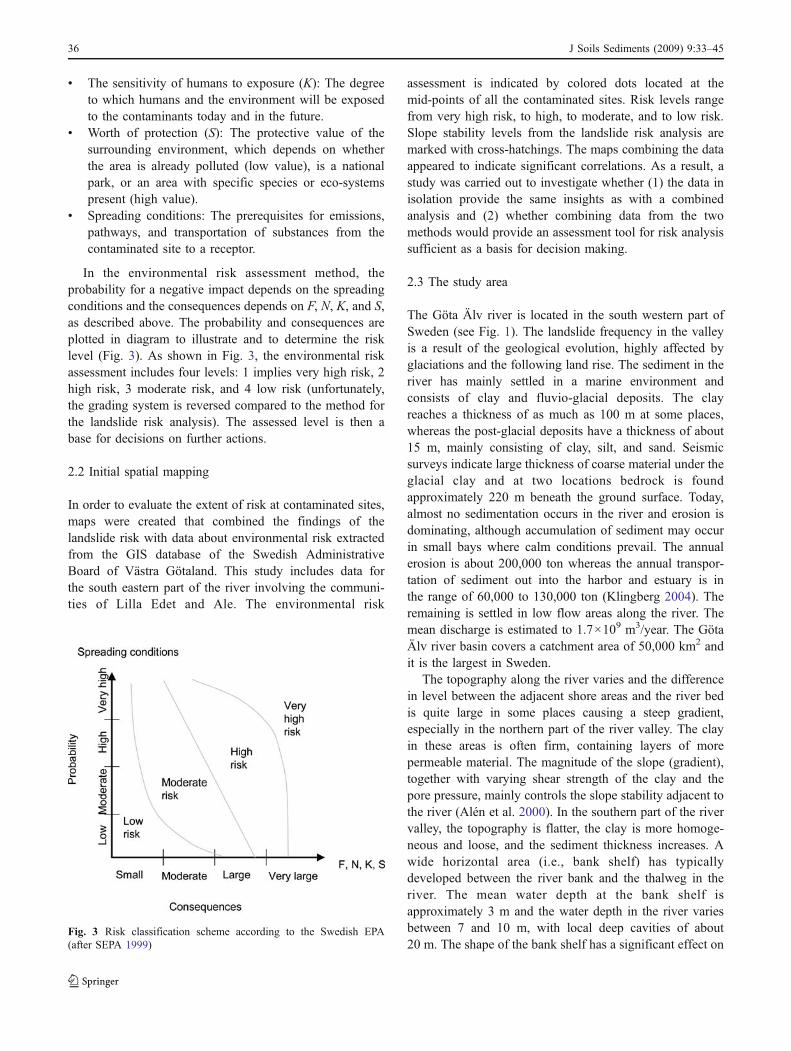
In the environmental risk assessment method, theprobability for a negative impact depends on the spreadingconditions and the consequences depends on F, N, K, and S,as described above. The probability and consequences areplotted in diagram to illustrate and to determine the risklevel (Fig. 3). As shown in Fig. 3, the environmental riskassessment includes four levels: 1 implies very high risk, 2high risk, 3 moderate risk, and 4 low risk (unfortunately,the grading system is reversed compared to the method forthe landslide risk analysis). The assessed level is then abase for decisions on further actions.
2.2 Initial spatial mapping
In order to evaluate the extent of risk at contaminated sites,maps were created that combined the findings of thelandslide risk with data about environmental risk extractedfrom the GIS database of the Swedish AdministrativeBoard of Västra Götaland. This study includes data forthe south eastern part of the river involving the communi-ties of Lilla Edet and Ale. The environmental risk
assessment is indicated by colored dots located at themid-points of all the contaminated sites. Risk levels rangefrom very high risk, to high, to moderate, and to low risk.Slope stability levels from the landslide risk analysis aremarked with cross-hatchings. The maps combining the dataappeared to indicate significant correlations. As a result, astudy was carried out to investigate whether (1) the data inisolation provide the same insights as with a combinedanalysis and (2) whether combining data from the twomethods would provide an assessment tool for risk analysissufficient as a basis for decision making.
2.3 The study area
The Göta Älv river is located in the south western part ofSweden (see Fig. 1). The landslide frequency in the valleyis a result of the geological evolution, highly affected byglaciations and the following land rise. The sediment in theriver has mainly settled in a marine environment andconsists of clay and fluvio-glacial deposits. The clayreaches a thickness of as much as 100 m at some places,whereas the post-glacial deposits have a thickness of about15 m, mainly consisting of clay, silt, and sand. Seismicsurveys indicate large thickness of coarse material under theglacial clay and at two locations bedrock is foundapproximately 220 m beneath the ground surface. Today,almost no sedimentation occurs in the river and erosion isdominating, although accumulation of sediment may occurin small bays where calm conditions prevail. The annualerosion is about 200,000 ton whereas the annual transpor-tation of sediment out into the harbor and estuary is inthe range of 60,000 to 130,000 ton (Klingberg 2004). Theremaining is settled in low flow areas along the river. Themean discharge is estimated to 1.7×10⁹ m3/year. The GötaÄlv river basin covers a catchment area of 50,000 km2 andit is the largest in Sweden.
The topography along the river varies and the differencein level between the adjacent shore areas and the river bedis quite large in some places causing a steep gradient,especially in the northern part of the river valley. The clayin these areas is often firm, containing layers of morepermeable material. The magnitude of the slope (gradient),together with varying shear strength of the clay and thepore pressure, mainly controls the slope stability adjacent tothe river (Alén et al. 2000). In the southern part of the rivervalley, the topography is flatter, the clay is more homoge-neous and loose, and the sediment thickness increases. Awide horizontal area (i.e., bank shelf) has typicallydeveloped between the river bank and the thalweg in theriver. The mean water depth at the bank shelf isapproximately 3 m and the water depth in the river variesbetween 7 and 10 m, with local deep cavities of about20 m. The shape of the bank shelf has a significant effect on
Fig. 3 Risk classification scheme according to the Swedish EPA(after SEPA 1999)
36 J Soils Sediments (2009) 9:33–45
the slope stability in the shoreline zones. Submerge slidesoccur. If the slides contain quick clay,1 it could generatelandward propagating (retrogressive) chain slides whichmay involve large areas (which has been the case forseveral of the historical slides). As a consequence,preventive actions are made and parts of the shore linehave been reinforced.
The river has always been an important route fortransportation and still serves as a significant waterway.As the vessels have increased in size (with a deeper draft),the river is regularly dredged to reach and to maintainnavigable depths (Alén et al. 2000). Vessel-induced erosionand dredging have changed the geometrical configurationof the river bed and the bank. This change in thetopography affects the stress conditions in the river bank,which are built up by the gravity forces of the earth materialitself and counteracting forces governed by cohesion andfriction.
Approximately 700,000 people live around the Göta Älvriver valley, with most of the people located in urban areasconsisting of small communities. Göta Älv is highlyvulnerable to contamination since it provides the drinkingwater supply for these communities. The communities aretypically located close to the river in the vicinity of largeindustries. Examples of industries in the area are surfacecoating industries, pulp and paper industries, scrap yards,car breaking yards, boat yards, and chemical industriesmaking bleaching chemicals, composite polymers, bat-teries, and lubricating oil. There are also old closed-downindustrial sites. Moreover, settlements and localization ofindustries have involved the construction of roads andrailroads.
These various types of construction affect the stabilitythrough increased loading and changes in drain andinfiltration conditions, influencing the groundwater andpore pressure conditions in the ground. Ground vibrationinduced by road and railroad traffic together with dredgingactivities may also have a negative effect on stability.
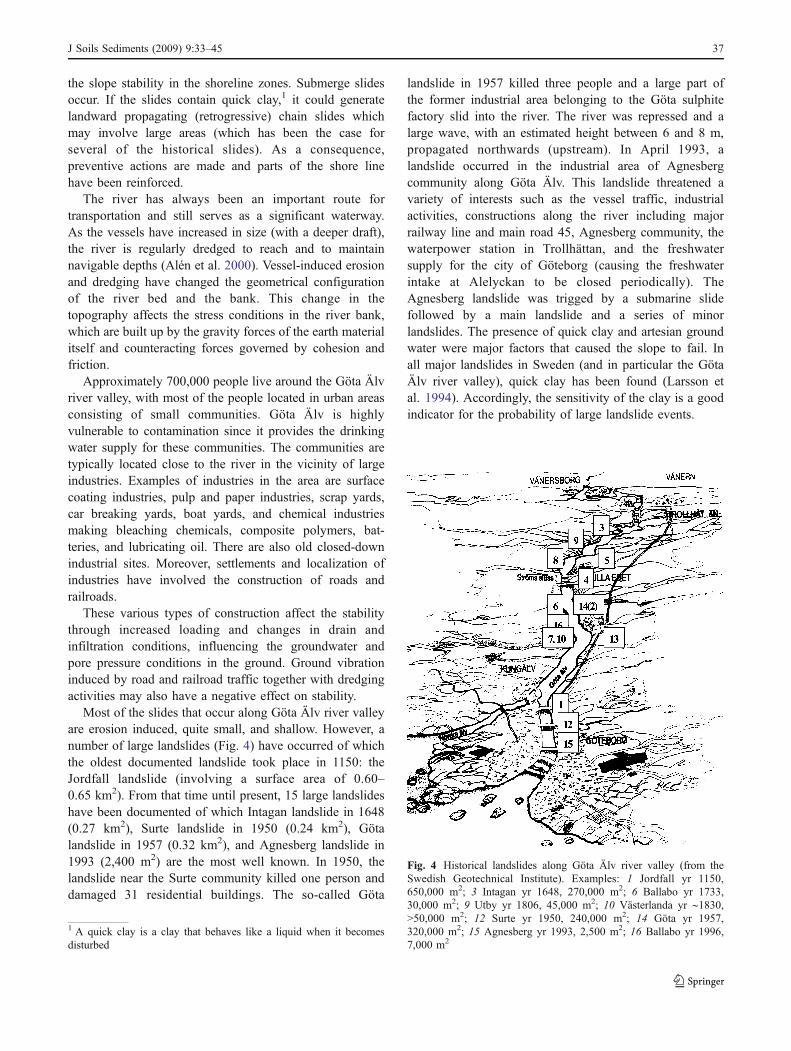
Most of the slides that occur along Göta Älv river valleyare erosion induced, quite small, and shallow. However, anumber of large landslides (Fig. 4) have occurred of whichthe oldest documented landslide took place in 1150: theJordfall landslide (involving a surface area of 0.60–0.65 km2). From that time until present, 15 large landslideshave been documented of which Intagan landslide in 1648(0.27 km2), Surte landslide in 1950 (0.24 km2), Götalandslide in 1957 (0.32 km2), and Agnesberg landslide in1993 (2,400 m2) are the most well known. In 1950, thelandslide near the Surte community killed one person anddamaged 31 residential buildings. The so-called Göta
landslide in 1957 killed three people and a large part ofthe former industrial area belonging to the Göta sulphitefactory slid into the river. The river was repressed and alarge wave, with an estimated height between 6 and 8 m,propagated northwards (upstream). In April 1993, alandslide occurred in the industrial area of Agnesbergcommunity along Göta Älv. This landslide threatened avariety of interests such as the vessel traffic, industrialactivities, constructions along the river including majorrailway line and main road 45, Agnesberg community, thewaterpower station in Trollhättan, and the freshwatersupply for the city of Göteborg (causing the freshwaterintake at Alelyckan to be closed periodically). TheAgnesberg landslide was trigged by a submarine slidefollowed by a main landslide and a series of minorlandslides. The presence of quick clay and artesian groundwater were major factors that caused the slope to fail. Inall major landslides in Sweden (and in particular the GötaÄlv river valley), quick clay has been found (Larsson etal. 1994). Accordingly, the sensitivity of the clay is a goodindicator for the probability of large landslide events.
1 A quick clay is a clay that behaves like a liquid when it becomesdisturbed
Fig. 4 Historical landslides along Göta Älv river valley (from theSwedish Geotechnical Institute). Examples: 1 Jordfall yr 1150,650,000 m2; 3 Intagan yr 1648, 270,000 m2; 6 Ballabo yr 1733,30,000 m2; 9 Utby yr 1806, 45,000 m2; 10 Västerlanda yr ∼1830,>50,000 m2; 12 Surte yr 1950, 240,000 m2; 14 Göta yr 1957,320,000 m2; 15 Agnesberg yr 1993, 2,500 m2; 16 Ballabo yr 1996,7,000 m2
J Soils Sediments (2009) 9:33–45 37

The downstream water bodies are the harbor, the estuary,and finally the sea. Maintenance dredging in the harbor hasresulted in the disposal of contaminated sediments. Thecontaminants originate mainly from activities within theport, the city of Göteborg, and upstream activities alongthe river. However, release and transport of contaminants inrelation to the landslides has never been investigated and nodocumented information is to be found.
3 Conceptualization of the releaseand transport scenario
The landslide scenario shown to be most relevant for riverslike the Göta Älv is a landslide perpendicular to the mainextension of the river, i.e., a transversal slide. The rapidperpendicular movement of a soil mass into the surfacewater will create impulse-generated wave propagation bothup- and downstream, unlike for a longitudinal slide (e.g.,dam break, debris flow in the innermost part of a river, andsubmarine landslide in the open sea) which moves in thesame direction as the river. Earlier studies on landslide-generated waves are based on theories for longitudinalslides and there have been several laboratory testsperformed in flumes on such slides (e.g., Fritz et al.2003a, b, 2004; Liu et al. 2003, 2005; Lynett and Liu2002, 2004). As for transversal landslides, the sliding masson one side of the bank pushes and forces the water againstthe other (opposite) bank, resulting in an initial rise of thewater surface level (Pérez et al. 2006; Queceo et al. 2004).There are few studies on transversal slides into rivers and toour knowledge nothing has been reported on the release andtransportation of matters and contaminants from thelandslide run-out and the river bed/bank.
Generally, landslides typical for the Göta Älv rivervalley are transversal rotational slides, i.e., a large coherentsoil (clay) mass move around a center of rotation. The zonewhere the landslide starts is generally referred to as theinitial zone, and the zone where the material is deposited iscalled the run-out zone. Significant for the slides in thisarea is the rapid course of event of shallow clay slides: it isdifficult to foresee the slides and when they occur themovement is very rapid and may involve large areas,especially if quick clay is present in the slide area. The mostimportant properties governing a slope failure are surfacegradient, undisturbed shear strength, and pore-water pres-sure (Berggren et al. 1991).
Sediment sources generate transport at different timescales with characteristic frequencies. These sources releasesediment more or less continuously, that is, at a highfrequency. The release of sediments due to a landslide canbe referred to as a low frequency but high magnitude event.In general, bank erosion and local slope failure are the
dominant sediment sources for surface water systems(WARMICE 2003). These mechanisms may activate addi-tional sediment sources and move large amounts ofsediment into a river system (Sedymo 2006). The courseof a landslide event containing sediment that might becontaminated can be described as (1) an instantaneousrelease followed by (2) a long-term release of sediment, asdiscussed in the following:
(a) The instantaneous and near-field release of sedimentrepresents the course of event when a landslide rapidlyslides into a river, creating an impulse-generated wave.The instantaneous rise of the surface level generatestwo wave fronts traveling upstream and downstreamthe river and a run-up on the opposite bank (Pérez etal. 2006). The characteristics of the generated wavesdepend mainly on the river width and bed variation(Pérez et al. 2006) and the slide volume (Fritz et al.2003a, b, 2004). The stirring of soil and sediment bythe slide and associated waves generates a largeamount of suspended matter (SPM). This course ofevent is rapid and intense and the contaminants aremobilized instantaneously with the suspended matter.In addition, old contaminants stored in the riversediment may be released as well as contaminantsfrom the bottom sediment and the river bank, whichmay be eroded due to the changes in the hydrody-namic conditions (Gerbersdorf et al. 2007; Hilscherovaet al. 2007). Investigations and evaluation of field datahave shown that, during natural flood waves, sedimentmaterial is transported in pulses with the main pulseoccurring on the rising limb of the wave (e.g., Iadanzaand Napolitano 2006; Sedymo 2006; Zonta et al.2005). This is assumed valid also for landslide impulsewaves. Gradually, the transported material is more andmore lagging behind the corresponding flood wave asit travels downstream (Sedymo 2006). As a result, thepeak concentration of suspended material shifts to therecession limb while the front of the wave may pick upnew material (e.g., Iadanza and Napolitano 2006;Picout et al. 2001; Sedymo 2006; Zonta et al. 2005).When the concentration of suspended material reachesthe critical transport capacity material starts to settle.The time lag between the wave and the SPM pulse isan important factor to determine when assessing theenvironmental impact. Such a characteristic time laghas been observed in several studies on flood waves inconnection with storm events (Lawler et al. 2006;Zonta et al. 2005). Figure 5 shows the generation of aSPM pulse from the Agnesberg landslide which tookplace in the Göta Älv river valley in 1993. The slidestarted as a submerged slide (first high peak), followedby a main slide (highest peak) progressing landward
38 J Soils Sediments (2009) 9:33–45

and creating new slides (i.e., retrogressive slides). Thisslide comprised an area of 80×30 m2 which isconsidered a small slide compared to earlier landslidesalong the river. The slide reached Agnesberg industrialarea, an area that includes several contaminated sites.
(b) The long-term release and associated impact over longdistances takes place when the hydraulic regimereturns to normal conditions and the SPM settles inthe far field. Long-term release of contaminants occursin the areas where sediment from the SPM pulse has
settled and from the submarine landslide run-out. Thesedimentation process is controlled by the bed shearstress, the flow velocity, the flow depth, the fall speed,the concentration of contaminated fraction, and themicrostructure of the river bed and the submerged floodplains (Henderson 1966; Chanson 2007; Juraschek andWestrich 1985). Contaminants are released throughdiffusion, desorption, dissolution, and erosion of thesubsurface landslide run-out. These release processesare influenced by a number of factors such as organiccarbon content, pH, redox, grain size (non-cohesive orcohesive material), bottom shape (bed forms), bacte-ria, algae, biofilms (Gerbersdorf et al. 2007), bio-turbation, fluctuation of intertial water (pore water),and the change between oxic and anoxic water (e.g.,Föstner 2001; Sedymo 2006; Smit et al. 2008). Theerosion and resuspension process of the river bed isdependent on shear stresses.
Figure 6 shows a schematic illustration, a conceptuali-zation, of the contaminant release during a landslide andwhich disciplines to consider. The zone where a landslidestarts to move is denoted as the initial zone and includes thehead and the flowing (sliding) part of the slide. The run-outzone constitutes the area where deposition occurs for mostof the flowing masses and this zone includes the toe of the
Fig. 5 Development of a suspended matter (SPM) pulse from thelandslide at Agnesberg, Göta Älv river valley, in 1993 (afterSandebring and Ottosson 1994)
Fig. 6 Illustration of interdisciplinary processes and propertiesgoverning a landslide of contaminated soil into surface water (thefigure shows a slide in the longitudinal direction only because it is
easier to graphically display the disciplines). The conceptualizationincludes both the instantaneous and the long-term release
J Soils Sediments (2009) 9:33–45 39

slide. In the present study, the term second run-out zone isused to describe a further run-out into the surface waterwhen the transported soil is suspended into the water.Within these zones, the soil/sediment behaves differently,influencing the prerequisites for the contaminating com-pounds to be mobilized and transported. There are manyprocesses and parameters that govern the mobilization,transportation, and settlement of contaminants during thepath from the initial zone to the end of the second run-outzone.
When the slide takes place, it involves disturbance(cracking) of the soil mass, causing the exposure of newand fresh surfaces and exposure of groundwater to air in theinitial zone. There will be a potential for release of volatilecontaminant from the soil and seeping groundwater to theair, and further spreading of soluble and colloid sorbedcontaminant with groundwater. As the run-out enters thewater (run-out zone), the stirring of soil and groundwaterincreases the possibility for contaminants to mobilize as themasses is mixed with air and water (surface water). Theprerequisites for mobilization of contaminants will dependon soil/sediment properties (e.g., grain size, organic carboncontent, redox, pH, and temperature) as well as propertiesof the contaminant (e.g., solubility in water, vapor pressure,density, biodegradability, adsorption properties, stability,and vapor pressure (Kaufman et al. 2005)). Transportationof contaminants will likely be affected by the impulse wavegenerated by the slide.
During its path, the impulse wave will pick up sedimentfrom the river bed and river bank (second run-out zone),causing erosion and resuspension (governed by the shearstresses, e.g., Gerbersdorf et al. 2007) of particles andparticle-bound contaminants. Transportation is governed byadvective and dispersive forces and will depend on waterflow, water velocity, water depth, channel width, channelslope, and channel roughness (Henderson 1966; Chanson2007). Eventually, the suspended sediment will start tosettle and after that exchange between sediment and waterwill be controlled by sorption and desorption mechanisms(Jonsson 2003), affecting algal and benthic communities.
4 Results from the combined assessment
4.1 Visualization of the combined assessment
Spatial information on the risk for landslides was combinedwith information on the characteristics of contaminatedareas according to mapping by the SGI and the SEPA. Thestability (stability level) and landslide consequence classesfrom the SGI mapping and the environmental risk levelfrom the SEPA mapping are summarized in Table 1 foreach industrial site involved in the study. The combined
data in Table 1 show that, of 31 potentially contaminatedsites, at least eight have moderate to high probability forlandslides and of these eight sites, five are assessed asconstituting high or very high environmental risk.
One example of the combined assessment is shown inFig. 7 that visualize information from a total of 13 maps.The maps show the environmental risk level by a coloreddot (here in grey scale) at the mid-points of the contami-nated sites indicating environmental risk level. The levelsof slope stability from the SGI landslide risk mapping aremarked with cross-hatchings for each stability class.
Figure 7 shows that visualizing the combined resultsprovides a better understanding of the potential hazardinvolved than does displaying the information separately.While not all maps are displayed in this paper, Table 1illustrates clearly that the combined assessment revealscertain spots that seem low risk but are, in fact, at higherrisk. As an example, site no. 3 (OK West AB) is assessed asa moderate environmental risk. However, this assessment issomewhat low if it also includes the moderate landslide riskthe site is subject to. The same goes for site no. 8 (ÄlvängenNorthern industrial area), where the environmental riskshould be raised to very high considering the high landsliderisk at the river bank. On the other hand, the landslideconsequence level could be underestimated considering theenvironmental risk (compare site no. 1 in Table 1). Butwhat is more interesting is that some sites assessed as veryhigh environmental risk also have risk for mass failure(e.g., site nos. 18 and 24 in Table 1). Consequently, the‘actual’ risk could therefore be even higher than the highestenvironmental risk level actually suggests.
4.2 Conceptual issues and combined assessment
While the conceptualization, as described in Section 3,provides an insight into possible governing processes andwhat may happen if a larger contaminated area slides, flowsor falls out into a river, the combined analysis gives abroader understanding of the extent of hazard and areas atrisk. Table 2 compares the fundamentals of the SGI andSEPA risk assessment methods described in terms of achain of events consisting of the identified potential source(s) and receptor(s), as well as the potential pathways thembetween, through which the contaminants are transported.Such a chain should include all processes that form the totalprobability of a given event, although the risk onlymaterializes if (1) the chain remains unbroken and (2) thereis a negative effect on the receptor. As seen from the table,combining the two methods is not sufficient to describethese processes. A fundamental distinction is also the timeand duration of the hazardous event. However, thecombined analysis may be used at a screening level forprioritization.
40 J Soils Sediments (2009) 9:33–45

Table 1 Environmental risk assessed sites within landslide risk areas in Ale and Lilla Edet communities Stability class intervals typically imply that thestability decreases with decreasing distance to the river. The consequence intervals imply that the consequences decrease with increased distance to the river
No. Site (place) Activity involved Landslide risk assessment Environmentalrisk assessment
Stability level Consequence level Env. risk level
1 Hoganas-Bohusfactories (Bohus)
Metal works Negligible (1) Large (2) Very high (1)
2 Statoil (Älvängen) Gas station, car cleaning Negligible (1) Very large (3) Moderate (3)3 OK West AB (Nödinge) Gas station, car cleaning Medium (3) Large (2) Moderate (3)4 Preem Bohus (Bohus) Gas station, car cleaning Low (2) Large (2) Moderate (3)5 Statoil (Surte) Gas station, car cleaning Low (2) Large (2) Moderate (3)6 Shell (Surte) Gas station, car cleaning Negligible (1) Disastrous (4) Moderate (3)7 Former Bohus
shipyard (Bohus)Former shipyard Low (2) Large (2) Very high (1)
8 Älvängen northernindustry area (Älvängen)
Floor board etc. Low (2)–High (4) Large (2) High (2)
9 Gulf (Utby) Gas station, car cleaning Negligible (1) Very large (3) Moderate (3)10 Tudor battery factory (Nol) Waste deposit Low (2) Large (2) High (2)11 Garvarns Tannery Medium (3) Mild (1)–Large (2) Moderate (3)12 Robban’s car repair
shop (Surte)Car repair, car cleaning etc. Negligible (1)–
Low (2)Very large (3)–Disastrous (4)
Moderate (3)
13 Car de-fragmentation(Agnesberg)
Car de-fragmentation Low (2)–High (4) Mild (1) Moderate (3)
14 Fast digging machines HB Car cleaning, repairment Low (2) Very large (3) High (2)15 Ledu, former Waso
factory (Nödinge)Mechanical factory Low (2) Very large (3) High (2)
16 Piren (Nödinge) Wood preservation, combustionof electronic scrap
Negligible (1) Mild (1) Moderate (3)
17 EKA Chemicals AB (Bohus) Chlorine alkali for pulpand paper
Low (2) Disastrous (4) Very high (1)
18 PLM (Surte) Former glasswork Negligible (1)–High (4)
Disastrous (4) High (2)–Veryhigh (1)
19 Folke Stigen’s FactoryAB (Bohus)
Metal surface coating Negligible (1) Disastrous (4) High (2)
20 Nödinge factories (Nödinge) Mechanical factories Low (2) Disastrous (4) Moderate (3)21 Tudor AB (Nol) Accumulator industry (batteries) Negligible (1) Disastrous (4) Very high (1)22 Neste Oxo AB (Nol) Organic chemistry Negligible (1) Disastrous (4) Very high (1)23 Neste-Polyester (Nol) Plastic, polyester manufacture Negligible (1) Disastrous (4) Very high (1)24 AB Axel Christiernsson (Nol) Lubricant oil Negligible (1)–
Medium (3)Mild (1)–Large (2) Very high (1)
25 Tiderman’s filling area (Surte) Industrial waste dump Negligible (1)–Medium (3)
Large (2)–Verylarge (3)
Very high (1)
26 Lilla Edet’s Iron andmetal shop (Lilla Edet)
Car scrapyard, scrapshop Low (2) Large (2) Moderate (3)
27 Alvsborg’s paperfactory (Lilla Edet)
Pulp and paper industry Low (2) Large (2) Moderate (3)
28 Göta Cellulosa AB (Göta) Pulp and paper industry Low (2) Large (2)–Verylarge (3)
Very high (1)
29 Edet Mill, SCA HygienePaper AB (Lilla Edet)
Pulp and paper industry Low (2)–High (4) Large (2) Very high (1)
30 Lödöse Varf (Lödöse) Former ship yard Low (2) Large (2) High (2)31 Askania-Ahlsells
Mineral AB (Lödöse)Negligible (1) Mild (1)–Large (2) Low (4)
J Soils Sediments (2009) 9:33–45 41

5 Discussion
The present study is a preliminary effort to investigate therisk of contaminated sites exposed to landslide hazard bycombining information from slope stability level maps withthat from geographical studies on potentially contaminatedsites. The study revealed a pattern of combined environ-mental and geotechnical risk on the riverbank. It wascarried out in response to a lack of coordination amongagencies which meant that the consequences of landslide ofcontaminated soil were not properly considered.
The approach of combining risk assessment methodsprovided a better understanding of the potential hazardinvolved than had previously been possible when display-ing the information separately. The study also revealed theneed to take into account differences in the time scales ofstudies when combining two methods. In this study, themethod for landslide risk assessment addresses events thatare rapid (occurring over minutes) with instantaneousimpact. Consequences are assessed and measurements aremade within a short time after the event (days to months).Environmental risk assessment, on the other hand, is
Fig. 7 The figure shows anexample of the risk maps pro-duced in this study. On the map,the stability levels from thelandslide risk assessment hasbeen superimposed on the envi-ronmental risk levels for pre-sumed contaminated sites
42 J Soils Sediments (2009) 9:33–45

performed with respect to events that evolve slowly (overyears or decades) and any possible consequences material-ize after a long period of time.
The release mechanisms as a result of a landslide intosurface water were herein conceptualized using two timescales: (1) The instantaneous, near-field release of sedi-ment, represents the course of events when a soil massrapidly slides into a river, creating an impulse-generatedwave. (2) The long-term release, and associated impact overlong distances, takes place when the hydraulic regimereturns to normal conditions and the SPM settles in the farfield. The approach proposed here makes it possible to takeinto consideration both the risk for instantaneous (or acute)as well as long-term impacts. The conceptualization was afirst attempt to describe possible governing processes andproperties.
A landslide into surface water in contaminated areas maycause negative consequences on the benthic and on theaquatic life, affecting the overall health of the surface waterbody (Conant et al. 2004), which may also lead to negativeconsequences for the human health. The environmentalconsequences become far more serious if an industrial plantis directly affected by the landslide or the plant becomesflooded due to damming effects. Damage to buildings,factory constructions, sewage systems, containers, andtanks may lead to substantial environmental impact on thesurface water. Dredging of the slided mass in order to clearthe fare way may mobilize substances not yet released.
In a sediment risk management perspective, Babut et al.(2007) divide risk into real risk and potential relative risk.Landslide of contaminated soil into surface water isconsidered a potential relative risk which represents bothan in situ risk as well as a potential risk to downstreamsites. Further, Babut et al. (2007) suggests a screening levelfor risk prioritization based on: (a) location along the up- todownstream gradient, (b) potential energy (slope), (c)
sediment quantity (encompassed by volume of contami-nated sediment available for entrainment, sediment budget,and sediment mobility), (d) sediment quality, and (e)expected risk or benefit of a specific sediment unit todownstream sediments. In addition to these issues, Babut etal. (2007) states the necessity to include the time scale ofmanagement objectives and frequency profile of criticalevents. Even though these issues does not account for soilerosion and soil quality issues, the approach is worthconsidering when managing landslide risk in surface watersystems.
In a larger context that includes decision making in anecosystem perspective, the interplay between scientific,societal, sociological, economic, and political issues needsto be considered (Apitz 2007). Important questions to beaddressed are for example what it means to us that livewithin the ecosystem if contaminated soil slides into what isour drinking water supply and waterway, how does near-and far-field areas affect, during how long a time, andduring what circumstances may the system retain itsfunctions, or, may some functions (services) totally orpartly collapse and are we then able to manage withoutthese. Only by combining two methods for risk assessmentour study clearly shows the need for cross-sectoral assess-ments that, and in the line with Apitz (2007), addressesmultiple risk drivers on multiple spatial and temporalscales. Not at least will this be necessary in a resilientperspective (e.g., Apitz 2007; Folke 2006). A furtherapproach is to look into the environmental securityliterature that addresses ecological risks of catastrophicevents (e.g., Apitz 2007; Wenning et al. 2007). Both inApitz (2007) and Wenning et al. (2007), three broadcategories of environmental security are addressed: (1)manmade or natural gradual changes that slowly erodeeconomic and environmental sustainability (e.g., bird flu,gradual pollution, climate change), (2) natural catastrophic
Table 2 Comparison of the method for landslide risk assessment and the method for environmental risk assessment put in a source–pathway(release/transport)–receptor framework
Method for landslide risk assessment Method for environmental risk assessment
Source: Unstable slope Contaminated soilRelease and transport: Slope failure, instantaneous and rapid event Continuous spreading through different
environmental compartmentsReceptors: Humans, real estate, infrastructure and environment Humans and ecosystemExposure/consequenceprocesses:
Damages in the water region governed by degree ofdamming, duration of navigating stop, degree ofdamage to the water supply system
Consequences: Impact on human healthand environment
Damages on land governed by number and degree ofdestroyed buildings, extent of affected land, numberof people killed, and degree of damaged infrastructure
Governed by:
Environmental consequences governed by releaseof polluting substances, degree and duration of impacton ecosystem, requirement of remediation, and remedial costs
° Degree of toxicity and pollution, characteristicsof surrounding areas, and degree of transportation° Degree of exposure by direct intake ofcontaminated soil, dermal contact, inhalationof dust and vapors, and intake of drinking water,vegetables, and fish
J Soils Sediments (2009) 9:33–45 43

events that, to some extent, may be predictable and therebypossible to plan responses and protection measures (e.g.,extreme weather, earthquakes, waters), and (3) manmadecatastrophic events that are typically sudden and unpredict-able (e.g., sudden pollution, unanticipated accidents, terror-ism). Landslides of contaminated soil into surface watersshould belong to category 2 even though the event may betrigged by man (e.g., by excavation, loading, unloading,etc.). Strategies to manage such events should includereducing disaster potential, ascertaining probability, increas-ing resilience, preventing surprises, and managing emer-gencies (Apitz 2007). But in order to do so, one must haveknowledge of the consequences and what governs theimpact.
6 Conclusions
This paper clearly shows that there exist contaminated areasat risk for landslide. The results indicate the possibility ofpossible serious consequences from landslides in areas withcontaminated soil as well as the need for further investiga-tion into models for predicting such events. Combining themethods raises difficulties; for example, they are beingapplied for different time scales. It can be concluded thatneither the method for landslide risk assessment nor themethod for environmental risk assessment alone providesan adequate basis for decision making and risk manage-ment. It is apparent that the risk assessment of contaminatedsoil and landslide hazards has to be integrated. Separateassessment methodologies executed by different authoritiesmay lead to incorrect assessments and inappropriateprotective measures in an area. Analyses of the effectsand consequences of slope failures in areas with contami-nated soil need to be further developed.
7 Recommendations and perspectives
The aim of this paper was not to give suggestions on howto assess the risk but rather to highlight the probleminvolved. In order to suggest how to consider (such) cross-sectoral hazards, when analyzing the risks, further devel-opment and improvement of the conceptualization isneeded. The climate change expected to occur over thenext hundred years will increase the probability of slopefailures, such as landslides, in many parts of the worldwhere precipitation is predicted to increase (e.g., inScandinavia). This will accentuate the need for methodsand models to assess the impact of such events. In order toachieve established environmental quality objectives, thereis an urgent need for models and assessment principles(criteria) for contaminated areas that are at risk of
experiencing slope failure. Knowledge of the governingprocesses that control the release and transport of sub-stances under a variety of conditions, taking into accountcharacteristic spatial and temporal scales, is required.
Acknowledgements The authors would like to thank HilleviUppmanis at the Swedish Administration Board of Västra Götalandfor supplying us with data from the GIS database, Åke Johansson atthe Swedish Geotechnical Institute for valuable information onlandslides along Göta Älv river valley, and the Swedish GeotechnicalInstitute for funding the project. The authors also would like to thankthree unknown reviewers for valuable comments, especially for thefuture work.
References
Alén C, Bengtsson P-E, Berggren B, Johansson L, Johansson Å(2000) Skredriskanalys i Göta älvdalen—Metodbeskrivning. SGIreport 58. Swedish Geotechnical Institute
Apitz SE (2007) Conceptual frameworks to balance ecosystem andsecurity goals. In: Linkov I, Wenning R, Kiker G (eds) Managingcritical infrastructure risks. Springer, Dordrecht pp 137–161
Babut M, Oen A, Hollert H, Apitz SE, Heise S, White S (2007)Prioritization at river basin scale, risk assessment at site-specificscale: suggested approaches. In: Heise S (ed) Sustainablemanagement of sediment resources: sediment risk managementand communication. Elsevier, Amsterdam, pp 107–152
Berggren B, Fallsvik J, Hintze S, Stille H (1991) Lersläntersstabilitetsförhållanden—Riskvärdering och beslutsteori—Förslagtill metod för riskvärdering. SGI Varia 333. Swedish GeotechnicalInstitute
Chanson H (2007) The hydraulics of open channel flow: anintroduction, 2nd edn. Elsevier, Amsterdam
Conant B Jr, Cherry JA, Gillham RW (2004) A PCE groundwaterplume discharging to a river: influence of the streambed andnear-river zone on contaminant distributions. J Contam Hydrol73(1–4):249–279
Folke C (2006) Resilience: the emergence of a perspective for social–ecological system analyses. Glob Environ Change 16:253–267
Föstner U (2001) Managing contaminated sediments. Part II:integrated process studies. J Soils Sediments 1(2):111–116
Fritz HM, Hager WH, Minor H-E (2003a) Landslide generatedimpulse waves. Exp Fluids 23(6):505–519
Fritz HM, Hager WH, Minor H-E (2003b) Landslide generated impulsewaves. 2. Hydrodynamic impact craters. Exp Fluids 23(6):520–532
Fritz HM, Hager WH, Minor H-E (2004) Near field characteristic oflandslide generated impulse waves. J Waterw Prot C-ASCE 130(6):287–302
Gerbersdorf SU, Jancke T, Westrich B (2007) Sediment properties forassessing the erosion risk of contaminated riverine sites. J SoilsSediments 7(1):25–35
Henderson FM (1966) Open channel flow. Macmillan Series of CivilEngineering
Hilscherova K, Dusek L, Kubik V, Hofman J, Cupr P, Klánová J,Holoubek I (2007) Redistribution of organic pollutants in riversediments and alluvial soils related to major floods. J SoilsSediments 7(3):167–177
Hultén C, Olsson M, Rankka K, Svahn V, Odén K, Engdahl M (2005)Släntstabilitet i jord. Underlag för handlingsplan för att förutseoch förebygga naturolyckor i Sverige vid förändrat klimgat.Deluppdrag 1. SGI Varia 560:1. Swedish Geotechnical Institute,Linköping
44 J Soils Sediments (2009) 9:33–45

Iadanza C, Napolitano F (2006) Sediment transport time series in theTiber River. Phys Chem Earth 31:1212–1227
Jonsson K (2003) Effect of hyporheic exchange on conservative andreactive solute transport in streams. Model assessments based ontracer tests. Dissertation. Uppsala University, Uppsala, Sweden
Juraschek M, Westrich B (1985) Flow transport capacity forsuspended sediment. 21st Cong. Int. Assoc. Hydraulic Research.Melbourne
Kaufman MM, Rogers DT, Murray KS (2005) An empirical model forestimating remediation costs at contaminated sites. Water Air SoilPollut 167:365–386
Klingberg F (2004) Communication. Swedish Geological Survey(SGU)
Larsson R, Ottosson E, Sällfors G (1994) Agnesbergsskredet. SGIreport 44. Swedish Geotechnical Institute
Lawler DM, Petts GE, Foster IDL, Harper S (2006) Turbiditydynamics during spring storm events in an urban headwater riversystem: the Upper Tame, West Midlands, UK. Sci Total Environ360(1–3):109–126
Liu PL-F, Lynett P, Synolakis CE (2003) Analytical solutions forforced long waves on a sloping beach. J Fluid Mech 478:101–109
Liu PL-F, Wu T-R, Raichlen F, Synolakis CE, Borrero JC (2005)Runup and rundown generated by three-dimensional slidingmasses. J Fluid Mech 536:107–144
Lynett P, Liu PL-F (2002) A numerical study of submarine-landslide-generated waves and run-up. Roy Soc 458:2885–2910
Lynett P, Liu PL-F (2004) A two-layer approach to wave modelling.Roy Soc 460:2637–2669
Länsstyrelsen Västra Götaland (2008) Swedish Administration Boardof Västra Götaland, http://www.o.lst.se
Nilsson G, Bendz D, Ottosson E, Larson M (2004) Impact oflandslides with contaminated soils into surface waters—aqualitative description. Nordic Geotechnical Meeting (NGM).Swedish Geotechnical Society, Ystad
Pérez GP, García-Navarro P, Vásquez-Cendón ME (2006) One-dimensional model of shallow water surface waves generatedby landslides. J Hydraul Eng 132(5):462–473
Picout C, Hingray B, Olivry JC (2001) Empirical and conceptualmodelling of the suspended sediment dynamics in a large tropicalAfrican river: the Upper Niger river basin. J Hydrol 250:19–39
Queceo M, Pastor M, Herreros M, Fernández Merodo JA (2004)Numerical modelling of impulse wave generated by fast land-slides. Int J Numer Methods Eng 59(12):1633–1656
Sandebring H, Ottosson E (1994) Agnessbergskredet Skredförebyggandeåtgärder. Agnesbergsutredningen. SGI report 45. SwedishGeotechnical Institute
Sedymo (2006) Sediment dynamics and pollution mobility in riverbasins. Sedymo 2006 symposium. Hamburg University ofTechnology, March 26–29, 2006
SEPA (1999) Methodology for inventory of contaminated sites. Basisfor assessment of contaminated sites. Guidance for collections ofdata. Swedish Environmental Protection Agency (SEPA), Stockholm
SGI (1995) Samhällsutbyggnad och skredriskanalys i södra Götaälvdalen. Underlag vid översiktlig planering och beslut om mark-och vattenanvändning. Slutrapport. SGI Varia 439. SwedishGeotechnical Institute
SGI (2004) Samhällsutbyggnad och skredriskanalys i nordöstra Götaälvdalen inom Lilla Edets kommun. Underlag vid översiktligplanering och beslut om mark- och vattenanvändning. Slutrapport.SGI Varia 548. Swedish Geotechnical Institute
Smit M, Grotenhuis T, Bruning H, Rulkens W (2008) Desorption ofdieldrin from field aged sediments: simulated flood events. JSoils Sediments 8(2):80–85
WARMICE (2003) Water resources management in changing environ-ments: the impact of sediment on sustainability (WARMICE).EU Contract no. ENV4-CT98-0789
Wenning RJ, Apitz SE, Baba A, Citron M, Elliott K, Al-Halasah N,Kapustka L, Lazarescu M, Mohamed M, Rutjes R (2007)Understanding environmental security at ports and harbors. InLinkov I, Wenning R, Kiker G (eds) Managing critical infra-structure risks, Springer, Dordrecht pp 1–12
Zonta R, Collavini F, Zaggia L, Aleardo Z (2005) The effect of floodson the transport of suspended sediments and contaminants: a casestudy from the estuary of the Dese River (Venice Lagoon, Italy).Environ Int 31:948–958
J Soils Sediments (2009) 9:33–45 45
Copyright © 2022 FDOKUMEN