Calakmul: Power, Perseverance, and Persistence
14
37 © The Author(s) 2015 A. Cucina (ed.), Archaeology and Bioarchaeology of Population Movement among the Prehispanic Maya, SpringerBriefs in Archaeology, DOI 10.1007/978-3-319-10858-2_4 Chapter 4 Calakmul: Power, Perseverance, and Persistence William J. Folan Higgins, Maria del Rosario Domínguez Carrasco, Joel D. Gunn, Abel Morales López, Raymundo González Heredia, Gerardo Villanueva García, and Nuria Torrescano Valle Introduction According to (Marcus 2004a), the primary states in the Peten region of the Maya Lowlands include the rise of the Great Cities of Calakmul and Tikal. Of the two, Calakmul is at the center of the Maya Lowlands (Anonymous 1932; Stuart and Stuart 2008). Calakmul exhibits a massive royal court (Fig. 4.1) formed by Temple II, with 56 small rooms on its lower unfinished façade and Rio Bec style upper façade, structures IVa, b, and c, and Structure VI, the E-Group, and Temple VII. A ball court is situated to the west of the main plaza and Structure III, the Palace is to the east (Folan et al. 2001). In addition to Calakmul, this combination of struc- tures is evident in many cities from the Middle Preclassic onward. Examples are Nakbe (Hansen 1991), El Mirador to the south (Hansen 1994; Matheny and Matheny 2011), and Oxpemul (Folan et al. 2000) to the north of Calakmul. W.J. Folan Higgins (*) • M.d.R. Domínguez Carrasco • A. Morales López R. González Heredia Centro de Investigaciones Históricas y Sociales, Universidad Autónoma de Campeche, 24039 Campeche, Campeche, Mexico e-mail: [email protected]; [email protected]; [email protected]; [email protected] J.D. Gunn Department of Anthropology, University of North Carolina, Greensboro, NC 27402, USA e-mail: [email protected] G. Villanueva García Dirección de Salvamento Arqueológico, Centro INAH Campeche, 24100 Campeche, Campeche, Mexico e-mail: [email protected] N. Torrescano Valle ECOSUR, Chetumal, Quintana Roo, Mexico e-mail: [email protected]
Transcript of Calakmul: Power, Perseverance, and Persistence
37© The Author(s) 2015 A. Cucina (ed.), Archaeology and Bioarchaeology of Population Movement among the Prehispanic Maya, SpringerBriefs in Archaeology,DOI 10.1007/978-3-319-10858-2_4
Chapter 4 Calakmul: Power, Perseverance, and Persistence
William J. Folan Higgins , Maria del Rosario Domínguez Carrasco , Joel D. Gunn , Abel Morales López , Raymundo González Heredia , Gerardo Villanueva García , and Nuria Torrescano Valle
Introduction
According to (Marcus 2004a ), the primary states in the Peten region of the Maya Lowlands include the rise of the Great Cities of Calakmul and Tikal. Of the two, Calakmul is at the center of the Maya Lowlands (Anonymous 1932 ; Stuart and Stuart 2008 ). Calakmul exhibits a massive royal court (Fig. 4.1 ) formed by Temple II, with 56 small rooms on its lower unfi nished façade and Rio Bec style upper façade, structures IVa, b, and c, and Structure VI, the E-Group, and Temple VII. A ball court is situated to the west of the main plaza and Structure III, the Palace is to the east (Folan et al. 2001 ). In addition to Calakmul, this combination of struc-tures is evident in many cities from the Middle Preclassic onward. Examples are Nakbe (Hansen 1991 ), El Mirador to the south (Hansen 1994 ; Matheny and Matheny 2011 ), and Oxpemul (Folan et al. 2000 ) to the north of Calakmul.
W. J. Folan Higgins (*) • M. d. R. Domínguez Carrasco • A. Morales López R. González Heredia Centro de Investigaciones Históricas y Sociales , Universidad Autónoma de Campeche , 24039 Campeche , Campeche , Mexico e-mail: [email protected]; [email protected]; [email protected]; [email protected]
J. D. Gunn Department of Anthropology , University of North Carolina , Greensboro , NC 27402 , USA e-mail: [email protected]
G. Villanueva García Dirección de Salvamento Arqueológico , Centro INAH Campeche , 24100 Campeche , Campeche , Mexico e-mail: [email protected]
N. Torrescano Valle ECOSUR , Chetumal , Quintana Roo , Mexico e-mail: [email protected]
38
For some time we have known that Calakmul’s royal court prevailed since Preclassic times based on the investigations of the Centro de Investigaciones Históricas y Sociales of the Universidad Autónoma de Campeche from 1982 until 1994. We carried out excavations on several buildings as well as mapping 6,195 structures over a 30 km 2 area (Folan et al. 1990 ; May Hau et al. 1990 ). These were recently converted into 3D images by Winemiller et al. ( 2013 ). This pattern is also manifested through the stylistic, chemical and statistical analysis of the ceramics of Calakmul by Domínguez Carrasco ( 2008 ) including the analysis of our stratigraphic excavations of Structure II.
Location and Related Components of Settlement Patterns
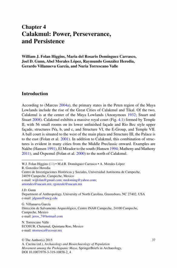
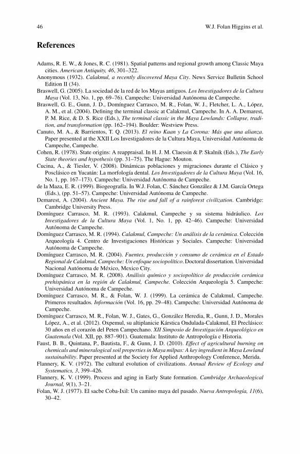
Addressing Marcus’s ( 2004b ) enquiry as to why the capitals and territories of primary states such as Calakmul and Tikal are located where they are is a complex problem. Calakmul, for example, is in the geographical center of the Maya Lowlands (Anonymous 1932 ; Stuart and Stuart 2008 ) and Tikal is the rector center of the Upper Holmul river (Vilma Fialko, personal communication August 7th, 2010). They were also blessed by equitable rainfall for their milpas during the Late Classic (see below), as well as fertile, arable soils around the edges and within the bajos and along escarp-ments ( Folan and Gallegos 1992 ) to provide their local populations with necessary foodstuffs (Fig. 4.2 ) (see Siemens 1998 for the Candelaria River region).
Fig. 4.1 Calakmul, Campeche: the royal court, including its Palace and Group E with Structures II, III, IV-a, b, c, VII, V. The Ball Game fi eld lays on the west outside the fi gure. Painting by Ernesto Tamay Segovia
W.J. Folan Higgins et al.
39
Climate and Water
The settlement of large populations in the Peten provinces of Campeche and Guatemala through time depended on periods of equitable precipitation and the accessibility of potable surface water (Folan et al. 2000 ; Gunn et al. 1994 , 1995 ) supplied by a four-stage hydraulic process to capture, retain, redistribute, and dis-perse this vital liquid (Folan et al. 2013 ).
Once the population increased, water combined with the introduction of horticul-tural activities in one form or another, required not only adequate precipitation to produce one or more harvests of corn and other foodstuffs per year, but the fruit and edible plants of the region from season to season as well as maintain the fauna that they trapped, hunted, or domesticated.
Formation of Complex Societies in the Interior
Once the population increased along with its ability to produce consumables suffi cient to its necessities, extended family groups began to organize themselves into small units. We encountered possible analogs of such groups in our 1974 trip to defi ne the Coba/Ixil sac be that were encamped around a cenote along the sac be (Folan 1977 ). Zetina Gutiérrez ( 2007 ) lately observed such groups systematically in the vicinity of Edzna.
With the appearance of “strong men” and their extended families, small villages formed chieftainships supported by a majority that contributed the energy essential to organize royal courts, including what has been classifi ed as a market area in Calakmul behind Structure VII (Folan 1991–1992 ; Masson and Freidel 2013 ) divided by a 6 m high wall separating the sacred from the secular.
Marcus ( 2004b ) classifi cation refers to primary states in the Maya area as those that are able to maintain their political organization intact for long periods of time in
SEEPAGE
UPLAND
BAJO EDGEBAJO BOTTOM
SEEPAGE
UPLAND
BAJO EDGE
BAJO BOTTOM
Fig. 4.2 Models of crop planting depending on seasons. Left : Four-step model—May/June plant-ing; Right : Four-step model—tornamil (winter-crop) planting
4 Calakmul: Power, Perseverance, and Persistence
40
contrast to those states that not only soon lost their tributary centers and/or allies but also their citizens. It is the location of the center and its region that is of optimal importance as in the case of Rome, the Eternal City. In agreement with Cohen ( 1978 ), Flannery ( 1999 ), and Marcus ( 2004b ), however, some form of military con-fl ict was one of the major routes leading toward state formation and continuity in the Peten and elsewhere in Mesoamerica.
According to Marcus ( 2004a ), although Tikal’s sphere of infl uence may be older than Calakmul’s according to its dynastic texts, Calakmul with its 6,195 structures and 120 stelae, in the end, was the largest metropolis and regional state in the Peten while remaining in the same central place for more than 1500 years. Its indirect infl uence also extended further than any other state. The distribution of its emblem glyph was greater than any other dynasty in the Maya area. It conducted military campaigns over record distances (Demarest 2004 ; Martin and Grübe 2008 ).
Also according to Marcus ( 2004a ), in that Calakmul’s immediate political sphere of infl uence covered some 31,000 km 2 or more, there was always the danger that those loyal political units farthest from the capital at times joined other regional capitals or became tributary cities seeking autonomy, thus presenting a very dynamic situation (Grübe 2000 ; Marcus 2004a ). In AD 751 the Kaan or Chan dynasty, but not Calakmul itself, was apparently conquered/defeated by a king of Oxpemul (Robichaux 2011 ; Robichaux and Pruett 2005 ) who is carved on the face of Stela 9, where he is shown with a weapon in his hand while standing on the body and head of a serpent supported by at least one ally, Tikal.
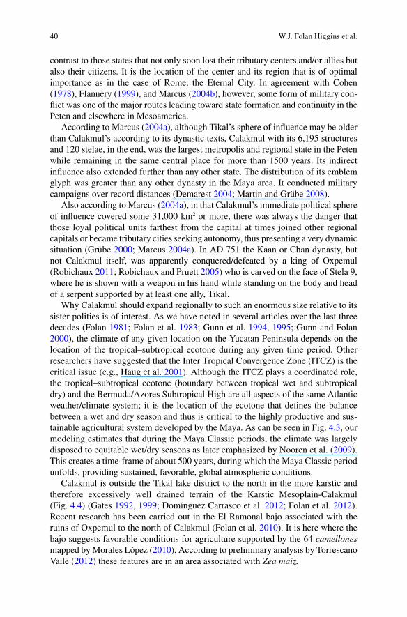
Why Calakmul should expand regionally to such an enormous size relative to its sister polities is of interest. As we have noted in several articles over the last three decades (Folan 1981 ; Folan et al. 1983 ; Gunn et al. 1994 , 1995 ; Gunn and Folan 2000 ), the climate of any given location on the Yucatan Peninsula depends on the location of the tropical–subtropical ecotone during any given time period. Other researchers have suggested that the Inter Tropical Convergence Zone (ITCZ) is the critical issue (e.g., Haug et al. 2001 ). Although the ITCZ plays a coordinated role, the tropical–subtropical ecotone (boundary between tropical wet and subtropical dry) and the Bermuda/Azores Subtropical High are all aspects of the same Atlantic weather/climate system; it is the location of the ecotone that defi nes the balance between a wet and dry season and thus is critical to the highly productive and sus-tainable agricultural system developed by the Maya. As can be seen in Fig. 4.3 , our modeling estimates that during the Maya Classic periods, the climate was largely disposed to equitable wet/dry seasons as later emphasized by Nooren et al. ( 2009 ). This creates a time-frame of about 500 years, during which the Maya Classic period unfolds, providing sustained, favorable, global atmospheric conditions.
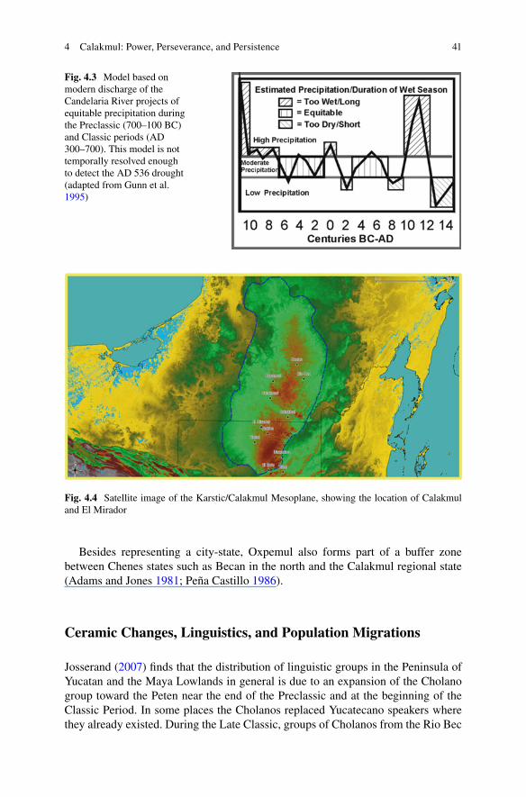
Calakmul is outside the Tikal lake district to the north in the more karstic and therefore excessively well drained terrain of the Karstic Mesoplain-Calakmul (Fig. 4.4 ) (Gates 1992 , 1999 ; Domínguez Carrasco et al. 2012 ; Folan et al. 2012 ). Recent research has been carried out in the El Ramonal bajo associated with the ruins of Oxpemul to the north of Calakmul (Folan et al. 2010 ). It is here where the bajo suggests favorable conditions for agriculture supported by the 64 camellones mapped by Morales López ( 2010 ). According to preliminary analysis by Torrescano Valle ( 2012 ) these features are in an area associated with Zea maiz.
W.J. Folan Higgins et al.
41
Besides representing a city-state, Oxpemul also forms part of a buffer zone between Chenes states such as Becan in the north and the Calakmul regional state (Adams and Jones 1981 ; Peña Castillo 1986 ).
Ceramic Changes, Linguistics, and Population Migrations
Josserand ( 2007 ) fi nds that the distribution of linguistic groups in the Peninsula of Yucatan and the Maya Lowlands in general is due to an expansion of the Cholano group toward the Peten near the end of the Preclassic and at the beginning of the Classic Period. In some places the Cholanos replaced Yucatecano speakers where they already existed. During the Late Classic, groups of Cholanos from the Rio Bec
Fig. 4.3 Model based on modern discharge of the Candelaria River projects of equitable precipitation during the Preclassic (700–100 BC) and Classic periods (AD 300–700). This model is not temporally resolved enough to detect the AD 536 drought (adapted from Gunn et al. 1995 )
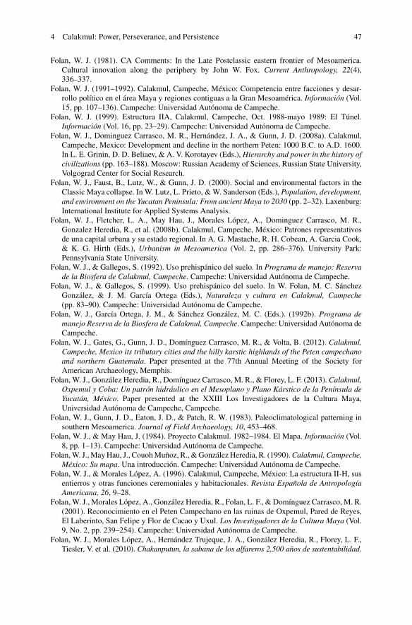
Fig. 4.4 Satellite image of the Karstic/Calakmul Mesoplane, showing the location of Calakmul and El Mirador
4 Calakmul: Power, Perseverance, and Persistence
42
region began to invade Calakmul, weakened by intermittent, lengthy droughts (Folan et al. 1983 ; Gunn et al. 1994 ; Medina-Elizalde et al. 2010 ), and introduced ceramics from the north with traces of palygorskyte (Domínguez Carrasco 2004 , 2008 ). At approximately the same time, members of a Yucatecano linguistic group bearing another ceramic tradition advanced from north to south toward the Calakmul regional state during a drought around AD 800. They brought ceramics and the architectural concepts of small, vaulted rooms which they added to the façade of principal structures in Calakmul (Folan et al. 2008a ) and resembling the lower façade of the Templo de Cinco Pisos in Edzna and El Mirador (Suyuc Ley and Hansen 2006 ). This formed a north/south corridor extending from northern Yucatan to the Guatemalan Peten that has also been defi ned biogeographically by de la Maza ( 1999 ) (see Folan et al. 1992 ).
Calakmul Population Development
According to Gunn et al.’s ( 1994 , 1995 ) calculations, climatic conditions in the Peten were equitable at the interface of the Middle and Late Preclassic from 500 to 310 BC (see Fig. 4.2 ). During this period of time the potassium and magnesium content of the El Laberinto Bajo rose to approximately 8 ppm. The results of Domínguez Carrasco’s (Domínguez Carrasco and Folan 1999 ) analysis of the over 700 Preclassic ceramic sherds from Calakmul, including 22 Middle Preclassic sherds from a tunnel excavated into Structure II in 1993 (Folan 1999 ) indicate a substantial occupation of the royal court distributed around the main plaza at this time.
According to Marcus ( 2004a ), it was during the Early Classic between AD 500 and 600 when Calakmul began to consolidate the center of its territory including at least six second level cities. They included Oxpemul with its Stone Throne emblem glyph (Robichaux and Pruett 2005 ; Robichaux 2011 ) and Uxul with its emblem glyph (Grübe and Paap 2008 ) as well as Naachtun being among the most recogniz-able. As far as we can determine, virtually all of Calakmul’s principal tributaries listed by Flannery ( 1972 ) and Marcus ( 1976 ) probably had their own emblem glyphs.
A new direction is evident in Calakmul during the Early Classic including archi-tectural additions to Structure II at practically all levels. These include several large masks on its façade, perhaps representing a feared or revered member of the new Cholano dynasty. It is very possible that the stucco masks on the façade of Palace Structure III (Pincemin 1994 ) also depict this ruler who may be buried in the Early Classic tomb with his jadeite masks in the base of the structure (Marcus and Folan 1994 ). Other jade masks were associated with tombs in Structure II-H (Folan and Morales López 1996 ) and Structure VII (Domínguez Carrasco 2004 ; Gallegos Gomora et al. 2005 ; Folan et al. 2008b ).
Events were not favorable for Calakmul nor its region when they were severely affected by the AD 536 drought. Oxpemul, Tikal, and virtually all of the Central
W.J. Folan Higgins et al.
43
Peten were also affected. It was during this time that the Kaan dynasty established political as well as military relations with numerous centers (20) of power (Braswell 2005 ) from Piedras Negras in the southwest, Copan in the southeast, La Corona to the south and beyond ( Canuto and Barrientos 2013 ), Oxpemul in the north and, according to A. Benavides (personal communication 2012), Edzna to the northwest.
Despite the regional political relations and conquests of Calakmul were evi-dently successful, there existed indications that not all was well at home. Although they constructed a palace at the top of the principal staircase of Structure II, they failed to complete the remodeling of the façade. This left great sections of the monument unmodifi ed including a large, partially covered mask from the previous dynasty adorning its upper eastern façade. Also unfi nished were the new staircases to access the summit of Structure II. The foundation base of the staircase covered by a layer of mud mortar, arrived at a terrace with a narrow staircase framed within a series of stepped Rio Bec style adornments divided by a 1.20 m wide and 3.50 m long dais accessing the central entrance to Palace Structure II-b. Moreover, several of the small rooms mentioned below were built during the Terminal Classic over the lower reaches of the Preclassic staircases accessing Structure II-A (Folan, et al. 2001 ).
During the Terminal Classic, all indications are that Calakmul’s population increased considerably in the area excavated by us in and around its royal court (Folan et al. 2008a ). Following turbulent times during the Late Classic/Terminal Classic interface, the city was racked by declining precipitation for crops and a paucity of water in its 13 aguadas .
The 34,000 plus sherds pertaining to the Terminal Classic were identifi ed by Domínguez Carrasco ( 1994 ). These were drawn mainly from the multiple rooms on the lower façade of Structure II indicating an implosion of people into central Calakmul during this time period when they built 56 rooms, with 14 preserved door-ways, 13 daises, and 22 niches on the façade of Structure II with the incomplete staircase resembling Temple IV in Tikal (Ponciano et al. 2011 ). It was here where they carried out multiple domestic activities combined with weapon and craft pro-duction, including the formation of molded clay fi gurines, while also adding several rooms at the base of the main staircase accessing Structure II-A (Folan et al. 2008a ).
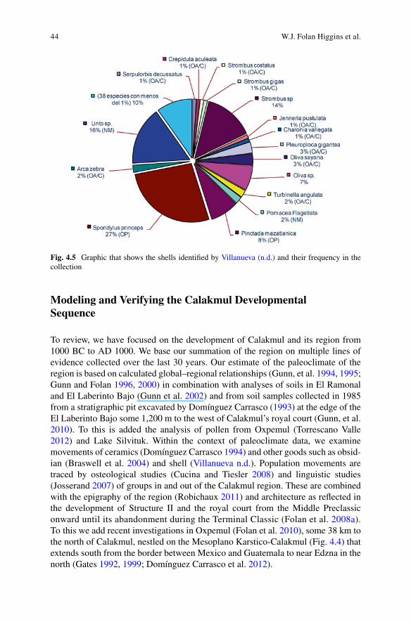
The sea shells, shells, pearls, and stingray spines identifi ed by Gerardo Villanueva ( n.d. ) (Fig. 4.5 ) mostly from Terminal Classic contexts included regular quantities from the Gulf of Mexico and the Caribbean as well as a large quantity of sea shell species (20 %) from the Pacifi c ocean that indicate direct or indirect trade from all directions. A quick comparison of Calakmul’ shell material with Tikal’s (Moholy- Nagy 2008 ) leaves us with the impression that both cities had access to basically the same or similar sources perhaps in varying degrees through time.
Folan et al. ( 2008a ) believe that Calakmul’s multiple alliances and conquests represent its importance as a major player in Mesoamerica as an early urban center and primary state, if the Olmec are not considered part of the equation.
4 Calakmul: Power, Perseverance, and Persistence
44
Modeling and Verifying the Calakmul Developmental Sequence
To review, we have focused on the development of Calakmul and its region from 1000 BC to AD 1000. We base our summation of the region on multiple lines of evidence collected over the last 30 years. Our estimate of the paleoclimate of the region is based on calculated global–regional relationships (Gunn, et al. 1994 , 1995 ; Gunn and Folan 1996 , 2000 ) in combination with analyses of soils in El Ramonal and El Laberinto Bajo (Gunn et al. 2002 ) and from soil samples collected in 1985 from a stratigraphic pit excavated by Domínguez Carrasco ( 1993 ) at the edge of the El Laberinto Bajo some 1,200 m to the west of Calakmul’s royal court (Gunn, et al. 2010 ). To this is added the analysis of pollen from Oxpemul (Torrescano Valle 2012 ) and Lake Silvituk. Within the context of paleoclimate data, we examine movements of ceramics (Domínguez Carrasco 1994 ) and other goods such as obsid-ian (Braswell et al. 2004 ) and shell ( Villanueva n.d. ). Population movements are traced by osteological studies (Cucina and Tiesler 2008 ) and linguistic studies (Josserand 2007 ) of groups in and out of the Calakmul region. These are combined with the epigraphy of the region (Robichaux 2011 ) and architecture as refl ected in the development of Structure II and the royal court from the Middle Preclassic onward until its abandonment during the Terminal Classic (Folan et al. 2008a ). To this we add recent investigations in Oxpemul (Folan et al. 2010 ), some 38 km to the north of Calakmul, nestled on the Mesoplano Karstico-Calakmul (Fig. 4.4 ) that extends south from the border between Mexico and Guatemala to near Edzna in the north (Gates 1992 , 1999 ; Domínguez Carrasco et al. 2012 ).
Fig. 4.5 Graphic that shows the shells identifi ed by Villanueva (n.d.) and their frequency in the collection
W.J. Folan Higgins et al.
45
The whole panoply of change falls within the ancient Yucatecan linguistic sphere that extended south through a cultural pipeline situated between the Xbonil hills to the west and the Xpuhil hills to the east. This linguistic roadway is akin to Cucina and Tiesler’s ( 2008 ) human corridor and de la Maza’s ( 1999 ) biogeographic faunal corridor. It is best described as a north–south right-of-way leading into and out of Calakmul and the Guatemalan Peten.
In the beginning, Calakmul represented an area at the edge of the El Laberinto Bajo. It is here where the earliest Calakmuleños made use of its eroded, fertile soils and its raised natural culencul´ob (Folan and Gallegos 1999 ) along the bajo edge leaving these soils to erode from the uplands, as did the early Romans. They increased, in this manner, the arable soil around what is one of the largest bajos and potential bread baskets in the Campeche and Guatemalan Peten. It may have once formed part and parcel of an inland port in Calakmul (Folan and May Hau 1984 ; Folan et al. 1990 ). A market (Folan 1991–1992 ) and habitation groups accommo-dated the ever-growing population formed around its royal court. El Mirador (Forsyth 2005 ; Hansen 1994 ) may have been conquered by Calakmul (Marcus 2004b ) or liquidated by the 200 BC and/or AD 212–409 drought noted by Gunn et al. ( 1994 ) and Torrescano Valle (personal communication) or a combination of both climate and warfare. Calakmul and Tikal were the major players in the Peten due to power, perseverance, persistence, and sustainability of their location and inhabitants in part through their construction of several major aguadas (Braswell et al. 2004 ; Folan et al. 2008a ) and the control of its soils. In a few words, El Mirador was not prepared at the beginning of various major droughts in the Maya Lowlands leaving it open to conquest (Marcus 2004b ) or a forced abandonment due to a lack of potable water.
Conclusions
Based on the above, it seems reasonable to suggest that the development of Calakmul as a centrally placed Great City and its long lasting resistant and sustained power is associated with its location in the middle of the Maya Lowlands on the elevated mesoplano and, of necessity, equitable rainfall (Faust et al. 2010 ; Folan et al. 2008a ) (tropical–subtropical ecotone). This is in addition to fertile soils including the bases of escarpments, hills, bajo edges, and elevated areas within the bajos in combination with the ability to collect and conserve suffi cient quantities of the rainfall and, pos-sibly, some underground water (Gates 1999 ) through time, especially during the rainy season, while using atmospheric moisture for consumption and ground water laden with gypsum for daily necessities including bathing and other domestic and personal activities but not for irrigation as far as we have been able to determine.
There is no doubt that the trigger that brought down this mighty metropolis, its regional state and empirical aspirations was a lack of equitable rainfall to which anyone living in the waterless waste of the Peten would have to agree. When there is no rain for your milpa there is little or no corn to grind or beans, squash, and chile to fi ll your jicara .
4 Calakmul: Power, Perseverance, and Persistence
46
References
Adams, R. E. W., & Jones, R. C. (1981). Spatial patterns and regional growth among Classic Maya cities. American Antiquity, 46 , 301–322.
Anonymous (1932). Calakmul, a recently discovered Maya City . News Service Bulletin School Edition II (34).
Braswell, G. (2005). La sociedad de la red de los Mayas antiguos. Los Investigadores de la Cultura Maya (Vol. 13, No. 1, pp. 69–76). Campeche: Universidad Autónoma de Campeche.
Braswell, G. E., Gunn, J. D., Domínguez Carrasco, M. R., Folan, W. J., Fletcher, L. A., López, A. M., et al. (2004). Defi ning the terminal classic at Calakmul, Campeche. In A. A. Demarest, P. M. Rice, & D. S. Rice (Eds.), The terminal classic in the Maya Lowlands: Collapse, tradi-tion, and transformation (pp. 162–194). Boulder: Westview Press.
Canuto, M. A., & Barrientos, T. Q. (2013). El reino Kaan y La Corona: Más que una alianza . Paper presented at the XXII Los Investigadores de la Cultura Maya, Universidad Autónoma de Campeche, Campeche.
Cohen, R. (1978). State origins: A reappraisal. In H. J. M. Claessin & P. Skalnik (Eds.), The Early State theories and hypothesis (pp. 31–75). The Hague: Mouton.
Cucina, A., & Tiesler, V. (2008). Dinámicas poblaciones y migraciones durante el Clásico y Posclásico en Yucatán: La morfología dental. Los Investigadores de la Cultura Maya (Vol. 16, No. 1, pp. 167–173). Campeche: Universidad Autónoma de Campeche.
de la Maza, E. R. (1999). Biogeografía. In W.J. Folan, C. Sánchez González & J.M. García Ortega (Eds.), (pp. 51–57). Campeche: Universidad Autónoma de Campeche.
Demarest, A. (2004). Ancient Maya. The rise and fall of a rainforest civilization . Cambridge: Cambridge University Press.
Domínguez Carrasco, M. R. (1993). Calakmul, Campeche y su sistema hidráulico. Los Investigadores de la Cultura Maya (Vol. 1, No. 1, pp. 42–46). Campeche: Universidad Autónoma de Campeche.
Domínguez Carrasco, M. R. (1994). Calakmul, Campeche: Un análisis de la cerámica . Colección Arqueología 4. Centro de Investigaciones Históricas y Sociales. Campeche: Universidad Autónoma de Campeche.
Domínguez Carrasco, M. R. (2004). Fuentes, producción y consumo de cerámica en el Estado Regional de Calakmul, Campeche: Un enfoque sociopolítico . Doctoral dissertation. Universidad Nacional Autónoma de México, Mexico City.
Domínguez Carrasco, M. R. (2008). Análisis químico y sociopolítico de producción cerámica prehispánica en la región de Calakmul, Campeche. Colección Arqueología 5 . Campeche: Universidad Autónoma de Campeche.
Domínguez Carrasco, M. R., & Folan, W. J. (1999). La cerámica de Calakmul, Campeche. Primeros resultados. Información (Vol. 16, pp. 29–48). Campeche: Universidad Autónoma de Campeche.
Domínguez Carrasco, M. R., Folan, W. J., Gates, G., González Heredia, R., Gunn, J. D., Morales López, A., et al. (2012). Oxpemul, su altiplanicie Kárstica Ondulada-Calakmul, El Preclásico: 30 años en el corazón del Peten Campechano. XII Simposio de Investigación Arqueológico en Guatemala (Vol. XII, pp. 887–901). Guatemala: Instituto de Antropología e Historia.
Faust, B. B., Quintana, P., Bautista, F., & Gunn, J. D. (2010). Effect of agricultural burning on chemicals and mineralogical soil properties in Maya milpas: A key ingredient in Maya Lowland sustainability . Paper presented at the Society for Applied Anthropology Conference, Merida.
Flannery, K. V. (1972). The cultural evolution of civilizations. Annual Review of Ecology and Systematics, 3 , 399–426.
Flannery, K. V. (1999). Process and aging in Early State formation. Cambridge Archaeological Journal, 9 (1), 3–21.
Folan, W. J. (1977). El sacbe Coba-Ixil: Un camino maya del pasado. Nueva Antropología, 11 (6), 30–42.
W.J. Folan Higgins et al.
47
Folan, W. J. (1981). CA Comments: In the Late Postclassic eastern frontier of Mesoamerica. Cultural innovation along the periphery by John W. Fox. Current Anthropology, 22 (4), 336–337.
Folan, W. J. (1991–1992). Calakmul, Campeche, México: Competencia entre facciones y desar-rollo político en el área Maya y regiones contiguas a la Gran Mesoamérica. Información (Vol. 15, pp. 107–136). Campeche: Universidad Autónoma de Campeche.
Folan, W. J. (1999). Estructura IIA, Calakmul, Campeche, Oct. 1988-mayo 1989: El Túnel. Información (Vol. 16, pp. 23–29). Campeche: Universidad Autónoma de Campeche.
Folan, W. J., Dominguez Carrasco, M. R., Hernández, J. A., & Gunn, J. D. (2008a). Calakmul, Campeche, Mexico: Development and decline in the northern Peten: 1000 B.C. to A.D. 1600. In L. E. Grinin, D. D. Beliaev, & A. V. Korotayev (Eds.), Hierarchy and power in the history of civilizations (pp. 163–188). Moscow: Russian Academy of Sciences, Russian State University, Volgograd Center for Social Research.
Folan, W. J., Faust, B., Lutz, W., & Gunn, J. D. (2000). Social and environmental factors in the Classic Maya collapse. In W. Lutz, L. Prieto, & W. Sanderson (Eds.), Population, development, and environment on the Yucatan Peninsula: From ancient Maya to 2030 (pp. 2–32). Laxenburg: International Institute for Applied Systems Analysis.
Folan, W. J., Fletcher, L. A., May Hau, J., Morales López, A., Dominguez Carrasco, M. R., Gonzalez Heredia, R., et al. (2008b). Calakmul, Campeche, México: Patrones representativos de una capital urbana y su estado regional. In A. G. Mastache, R. H. Cobean, A. Garcia Cook, & K. G. Hirth (Eds.), Urbanism in Mesoamerica (Vol. 2, pp. 286–376). University Park: Pennsylvania State University.
Folan, W. J., & Gallegos, S. (1992). Uso prehispánico del suelo. In Programa de manejo: Reserva de la Biosfera de Calakmul, Campeche . Campeche: Universidad Autónoma de Campeche.
Folan, W. J., & Gallegos, S. (1999). Uso prehispánico del suelo. In W. Folan, M. C. Sánchez González, & J. M. García Ortega (Eds.), Naturaleza y cultura en Calakmul, Campeche (pp. 83–90). Campeche: Universidad Autónoma de Campeche.
Folan, W. J., García Ortega, J. M., & Sánchez González, M. C. (Eds.). (1992b). Programa de manejo Reserva de la Biosfera de Calakmul, Campeche . Campeche: Universidad Autónoma de Campeche.
Folan, W. J., Gates, G., Gunn, J. D., Domínguez Carrasco, M. R., & Volta, B. (2012). Calakmul, Campeche, Mexico its tributary cities and the hilly karstic highlands of the Peten campechano and northern Guatemala . Paper presented at the 77th Annual Meeting of the Society for American Archaeology, Memphis.
Folan, W. J., González Heredia, R., Domínguez Carrasco, M. R., & Florey, L. F. (2013). Calakmul, Oxpemul y Coba: Un patrón hidráulico en el Mesoplano y Plano Kárstico de la Península de Yucatán, México . Paper presented at the XXIII Los Investigadores de la Cultura Maya, Universidad Autónoma de Campeche, Campeche.
Folan, W. J., Gunn, J. D., Eaton, J. D., & Patch, R. W. (1983). Paleoclimatological patterning in southern Mesoamerica. Journal of Field Archaeology, 10 , 453–468.
Folan, W. J., & May Hau, J. (1984). Proyecto Calakmul. 1982–1984. El Mapa. Información (Vol. 8, pp. 1–13). Campeche: Universidad Autónoma de Campeche.
Folan, W. J., May Hau, J., Couoh Muñoz, R., & González Heredia, R. (1990). Calakmul, Campeche, México: Su mapa . Una introducción. Campeche: Universidad Autónoma de Campeche.
Folan, W. J., & Morales López, A. (1996). Calakmul, Campeche, México: La estructura II-H, sus entierros y otras funciones ceremoniales y habitacionales. Revista Española de Antropología Americana, 26 , 9–28.
Folan, W. J., Morales López, A., González Heredia, R., Folan, L. F., & Domínguez Carrasco, M. R. (2001). Reconocimiento en el Peten Campechano en las ruinas de Oxpemul, Pared de Reyes, El Laberinto, San Felipe y Flor de Cacao y Uxul. Los Investigadores de la Cultura Maya (Vol. 9, No. 2, pp. 239–254). Campeche: Universidad Autónoma de Campeche.
Folan, W. J., Morales López, A., Hernández Trujeque, J. A., González Heredia, R., Florey, L. F., Tiesler, V. et al. (2010). Chakanputun, la sabana de los alfareros 2,500 años de sustentabilidad .
4 Calakmul: Power, Perseverance, and Persistence

48
Paper presented at the Meeting La Costa de Campeche en los Tiempos Prehispánicos, una visión en los últimos 50 años. Facultad de Ciencias Antropológicas, Universidad Autónoma de Yucatán, Mérida.
Forsyth, D. W. (2005). La secuencia ocupacional en la Cuenca Mirador, Guatemala. Los Investigadores de la Cultura Maya (Vol. 13, No. 1, pp. 59–68). Campeche: Universidad Autónoma de Campeche.
Gallegos Gomora, M. J., Domínguez Carrasco, M. R., Armijo, R., & Lagunas, Z. (2005). La cripta funeraria de la Estructura VII de Calakmul, Campeche. Evocando un hallazgo. Los Investigadores de la Cultura Maya (Vol. 13, No. 1, pp. 107–120). Campeche: Universidad Autónoma de Campeche.
Gates, G. (1992). Fisiografía, geología e hidrología. In W. J. Folan, J. M. García Ortega, & M. C. Sánchez González (Eds.), Programa de manejo Reserva de la Biosfera Calakmul, Campeche . Campeche: Universidad Autónoma de Campeche.
Gates, G. (1999). Fisiografía, geología e hidrología. In W. J. Folan, M. C. Sánchez González, & J. M. García Ortega (Eds.), Naturaleza y cultura en Calakmul, Campeche (pp. 31–39). Campeche: Universidad Autónoma de Campeche.
Grübe, N. (2000). The city-states of the Maya. In M. H. Hansen (Ed.), A comparative study of thirty city-state cultures (pp. 547–565). Historisk-fi losofi ske Skrifter 21. Copenhagen: The Royal Danish Academy of Sciences and Letters.
Grübe, N., & Paap, I. (2008). La exploración de Uxul, Peten Campechano: Resultados de las inves-tigaciones en el 2007. Los Investigadoras de la Cultura Maya (Vol. 16, No. 2, pp. 267–290). Campeche: Universidad Autónoma de Campeche.
Gunn, J. D., & Folan, W. J. (1996). Tres Ríos: Una superfi cie de impacto climático global interre-gional para las Tierras Bajas de los mayas del suroeste (La Cuenca de los Ríos Candelaria, Usumacinta y Champoton). Los Investigadores de la Cultura Maya (Vol. 5, No. 1, pp. 57–79). Campeche: Universidad Autónoma de Campeche.
Gunn, J. D., & Folan, W. J. (2000). Three rivers: Subregional variations in earth system impacts in the southwestern Maya Lowlands (Candelaria, Usumacinta, and Champoton Watersheds). In R. Mcintosh, J. Tainter, & S. Mcintosh (Eds.), The way the wind blows: Climate, history, and human action (pp. 263–270). New York: Columbia University Press.
Gunn, J. D., Folan, W. J., Domínguez Carrasco, M. R., & Miller, W. F. (2010). Explicando la sus-tentabilidad de Calakmul, Campeche: Eslabones interiores en el sistema de energía del estado regional de Calakmul. Los Investigadores de la Cultura Maya (Vol. 18, No. 1, pp. 15–40). Campeche: Universidad Autónoma de Campeche.
Gunn, J. D., Folan, W. J., & Robichaux, H. R. (1994). Un análisis informativo sobre la descarga del sistema del Río Candelaria en Campeche, México: Refl exiones acerca de los paleoclimas que afectaron a los antiguos sistemas mayas en los sitios de Calakmul y el Mirador. In W. J. Folan (Ed.), Campeche Maya colonial (pp. 174–197). Colección Arqueología. Campeche: Universidad Autónoma de Campeche.
Gunn, J. D., Folan, W. J., & Robichaux, H. R. (1995). A landscape analysis of the Candelaria watershed in Mexico: Insights into paleoclimates affecting upland horticulture in the southern Yucatan Peninsula semi-karst. Geoarchaeology, 10 , 3–42.
Gunn, J. D., Foss, J. E., Folan, W. J., Domínguez Carrasco, M. R., & Faust, B. B. (2002). Bajo sediments and the hydraulic system of Calakmul, Campeche, Mexico. Ancient Mesoamerica, 13 , 297–315.
Hansen, R. D. (1991). The Maya rediscovered: The road to Nakbe. Natural History, 5 (91), 8–14. Hansen, R. D. (1994). Investigaciones arqueológicas en el norte del Peten de Guatemala: Una
mirada diacrónica de los orígenes mayas. In W. J. Folan (Ed.), Campeche Maya colonial (pp. 14–54). Colección Arqueología. Campeche: Universidad Autónoma de Campeche.
Haug, G. H., Hughen, K. A., Sigman, D. M., Peterson, L. C., & Röhl, U. (2001). Southward migra-tion of the intertropical convergence zone through the Holocene. Science, 293 , 1304–1308.
Josserand, J. K. (2007). Literatura e historia en los textos jeroglífi cos clásicos. Gaceta Universitaria (Vol. 93, pp. 39–46). Campeche: Universidad Autónoma de Campeche.
Marcus, J. (1976). Emblem and state in the Classic Maya Lowlands . Washington, DC: Dumbarton Oaks.
W.J. Folan Higgins et al.

49
Marcus, J. (2004a). Calakmul y su papel en el origen del estado maya. Los Investigadores de la Cultura Maya (Vol. 12, No. 1, pp. 15–32). Campeche: Universidad Autónoma de Campeche.
Marcus, J. (2004b). Primary and secondary state formation in southern Mesoamerica. In E. E. Bell, M. Canuto, & R. J. Sharer (Eds.), Understanding Early Copan (pp. 357–374). Philadelphia: University of Pennsylvania, Museum of Archaeology and Anthropology.
Marcus, J., & Folan, W. J. (1994). Una estela más del siglo V y nueva información sobre Pata de Jaguar, Gobernante de Calakmul, Campeche en el siglo VII. Gaceta Universitaria (Vol. 15, pp. 21–26). Campeche: Universidad Autónoma de Campeche.
Martin, S., & Grübe, N. (2008). Chronicle of the Maya kings and queens: Deciphering the dynasties of the ancient Maya . London: Thames & Hudson.
Masson, M. A., & Freidel, D. A. (2013). Wide open spaces: A long view of the importance of Maya market exchange. In K. Hirth & J. Pillsbury (Eds.), Merchants, markets, and exchange in the pre-Columbian world (pp. 201–228). Washington, DC: Dumbarton Oaks Research Library and Collection.
Matheny, R. T., & Matheny, D. G. (2011). Introduction to investigations at El Mirador, Peten, Guatemala. El Mirador Series, Part 1 . Provo: New World Archaeological Foundation, Brigham Young University.
May Hau, J., Couoh Muñoz, R., González Heredia, R., & Folan, W. J. (1990). Mapa de Calakmul, Campeche, México . Campeche: Universidad Autónoma de Campeche.
Medina-Elizalde, M., Burns, S. J., Lea, D. W., & Asmerom, Y. (2010). High resolution stalagmite climate record from the Yucatán Peninsula spanning the Maya Terminal Classic period. Earth and Planetary Science Letters, 298 , 255–262.
Moholy-Nagy, H. (2008). The artifacts of Tikal: Ornamental and ceremonial artifacts and unworked material . Tikal Report No. 27, University Museum Monograph 127. Philadelphia: University of Pennsylvania Museum of Archaeology and Anthropology.
Morales López, A. (2010). Informe sobre los camellones de Oxpemul: 2009 . Campeche: Universidad Autónoma de Campeche.
Nooren, C. A. M., Hoek, W. Z., Tebbens, L. A., & Del Pozzo, A. L. M. (2009). Tephrochronological evidence for the Late Holocene eruption history of El Chichón Volcano, México. Geofísica Internacional, 48 (1), 97–112.
Peña Castillo, A. (1986). Hormiguero y Dos Aguadas. Análisis comparativa de dos sitios en el sur de Campeche . Master thesis. Mexico City: Escuela Nacional de Antropología e Historia.
Pincemin, S. (1994). Entierro en el Palacio: La tumba de la Estructura III, Calakmul, Campeche . Colección Arqueología. Campeche: Universidad Autónoma de Campeche.
Ponciano, E. M., López, J., & Mazariegos, N. (2011). Arquitectura monumental en la dedicación de templos dinásticos, Templo IV, Tikal, Peten . Paper presented at the XXV Simposio de Investigaciones Arqueológicas, Guatemala.
Robichaux, H. R. (2011). The ancient Maya monuments at Oxpemul, Campeche, Mexico . Retrieved from www.mesoweb.com/publications/Robichaux/Oxpemul.html
Robichaux, H. R., & Pruett, C. (2005). Las inscripciones de Oxpemul. Los Investigadores de la Cultura Maya (Vol. 13, No. 1, pp. 29–43). Campeche: Universidad Autónoma de Campeche.
Siemens, A. H. (1998). A favored place. San Juan river wetlands, central Veracruz, A.D. 500 to the present . Austin: University of Texas Press.
Stuart, G., & Stuart, D. (2008). Palenque eternal city of the Maya . London: Thames and Hudson. Suyuc Ley, E., & Hansen, R. D. (2006). Investigación y conservación en los sitios arqueológicos
El Mirador, La Muñeca, Nakbe, el Porvenir, El Guiro, La Iglesia, La Sarteneja, Cheb Ché y La Cabita . Unpublished fi eld report, 2005. Archaeological Proyect El Mirador Valley.
Torrescano Valle, N. (2012). Incorporación de estudios paleoecológicos a estudios arqueológicos, Proyecto Oxpemul . Paper presented at the XXII Los Investigadores de la Cultura Maya, Universidad Autónoma de Campeche, Campeche.
Villanueva, G. (n.d). Las conchas y caracoles de Calakmul . Manuscript on fi le. Instituto Nacional de Antropología e Historia, Mexico.
Winemiller, T., Folan, W. J., May Hau, J., Fletcher, L., González Heredia, R., & Florey L. F. (2013). Construir un modelo tridimensional: Sistemas de información geográfi ca basado en la nube de
4 Calakmul: Power, Perseverance, and Persistence

50
Calakmul: 3 DMap of Calakmul , Auburn University at Montgomery-Google Maps, Google Maps. Retrieved April 15, 2014, from https://mapsengine.google.com/01342472542092831463-10204004953617443946-4/mapview/ consulted
Zetina Gutiérrez, M. G. (2007). Ecología humana de las rancherías de Pich, Campeche: un análi-sis diacrónico . Merida: Centro de Investigación y Estudios Avanzados del Instituto Politécnico Nacional.
W.J. Folan Higgins et al.