Appendix B - State Water Resources Control Board
355
Appendix B Threats Assessment for the Evolutionarily Significant Units of Winter-run Chinook Salmon (Oncorhynchus tshawytscha) and Central Valley Spring-run Chinook Salmon (O. tshawytscha), and the Distinct Population Segment of Central Valley Steelhead (O. mykiss)
-
Upload
khangminh22 -
Category
Documents
-
view
2 -
download
0
Transcript of Appendix B - State Water Resources Control Board

Appendix B
Threats Assessment for the Evolutionarily Significant Units of
Winter-run Chinook Salmon (Oncorhynchus tshawytscha) and Central Valley Spring-run Chinook
Salmon (O. tshawytscha), and the Distinct Population Segment
of Central Valley Steelhead (O. mykiss)
rbabb
Typewritten Text
California WaterFix Hearing Exhibit No. SWRCB-71

Appendix B Table of Contents/List of Acronyms
Central Valley Chinook Salmon July 2014 and Steelhead Recovery Plan i
Table of Contents
1.0 INTRODUCTION.......................................................................................................... 1-1
2.0 SACRAMENTO RIVER WINTER-RUN CHINOOK SALMON ............................ 2-1
2.1 Background .................................................................................................................... 2-1 2.1.1 Listing History .................................................................................................... 2-1 2.1.2 Critical Habitat .................................................................................................... 2-1 2.1.3 Unique Species Characteristics ........................................................................... 2-2
2.1.3.1 Life History Strategy ........................................................................ 2-2 2.1.3.2 Historic Spawning Habitat Utilization ............................................. 2-5
2.1.4 Status of Winter-run Chinook Salmon ................................................................ 2-5 2.1.4.1 Historic Population Trends ............................................................... 2-5 2.1.4.2 Current Status ................................................................................... 2-6 2.1.4.3 Extinction Risk Assessment ............................................................. 2-8
2.2 Life History and Biological Requirements .................................................................. 2-8 2.2.1 Adult Immigration and Holding ......................................................................... 2-8
2.2.1.1 Geographic and Temporal Distribution ............................................ 2-8 2.2.1.2 Biological Requirements .................................................................. 2-8
2.2.2 Adult Spawning .................................................................................................. 2-9 2.2.2.1 Geographic and Temporal Distribution ............................................ 2-9 2.2.2.2 Biological Requirements ................................................................ 2-10
2.2.3 Embryo Incubation ........................................................................................... 2-10 2.2.3.1 Geographic and Temporal Distribution .......................................... 2-10 2.2.3.2 Biological Requirements ................................................................ 2-10
2.2.4 Juvenile Rearing and Outmigration .................................................................. 2-11 2.2.4.1 Geographic and Temporal Distribution .......................................... 2-11 2.2.4.2 Biological Requirements ................................................................ 2-11
2.2.5 Sub-adult and Adult Ocean Residence ............................................................. 2-12 2.2.5.1 Geographic and Temporal Distribution .......................................... 2-12 2.2.5.2 Biological Requirements ................................................................ 2-12
2.3 Threats and Stressors .................................................................................................. 2-12 2.3.1 Summary of ESA Listing Factors ..................................................................... 2-12
2.3.1.1 Destruction, Modification, or Curtailment of Habitat or Range ..... 2-12 2.3.1.2 Overutilization for Commercial, Recreational, Scientific, or
Educational Purposes ...................................................................... 2-13 2.3.1.3 Disease or Predation ....................................................................... 2-14 2.3.1.4 Inadequacy of Existing Regulatory Mechanisms ........................... 2-14 2.3.1.5 Other Natural and Manmade Factors Affecting the Species’
Continued Existence ....................................................................... 2-15 2.3.2 Non-Life Stage-Specific Threats and Stressors ................................................ 2-16
2.3.2.1 Artificial Propagation Program ...................................................... 2-16 2.3.2.2 Small Population Size Composed of a Single Extant Population ... 2-19 2.3.2.3 Genetic Integrity ............................................................................. 2-19 2.3.2.4 Long-term Climate Change ............................................................ 2-21

Appendix B Table of Contents/List of Acronyms
Central Valley Chinook Salmon July 2014 and Steelhead Recovery Plan ii
2.3.3 San Francisco, San Pablo, and Suisun Bays ..................................................... 2-22 2.3.3.1 Adult Immigration and Holding ..................................................... 2-22 2.3.3.2 Juvenile Rearing and Outmigration ................................................ 2-25
2.3.4 Sacramento-San Joaquin Delta ......................................................................... 2-27 2.3.4.1 Adult Immigration and Holding ..................................................... 2-27 2.3.4.2 Juvenile Rearing and Outmigration ................................................ 2-29
2.3.5 Lower Sacramento River (Princeton [RM 163] to the Delta) ........................... 2-36 2.3.5.1 Adult Immigration and Holding ..................................................... 2-36 2.3.5.2 Juvenile Rearing and Outmigration ................................................ 2-38
2.3.6 Middle Sacramento River (Red Bluff Diversion Dam [RM 243] to Princeton [RM 163]) ............................................................................................ 2-40
2.3.6.1 Adult Immigration and Holding ..................................................... 2-40 2.3.6.2 Juvenile Rearing and Outmigration ................................................ 2-41
2.3.7 Upper Sacramento River (Keswick Dam [~RM 302] to Red Bluff Diversion Dam) .................................................................................................... 2-43
2.3.7.1 Adult Immigration and Holding ..................................................... 2-43 2.3.7.2 Spawning ........................................................................................ 2-45 2.3.7.3 Embryo Incubation ......................................................................... 2-47 2.3.7.4 Juvenile Rearing and Outmigration ................................................ 2-49
2.3.8 Sub-adult and Adult Ocean Residence ............................................................. 2-52 2.3.8.1 Harvest ............................................................................................ 2-52 2.3.8.2 Ocean Conditions ........................................................................... 2-54
2.4 Stressor Prioritization ................................................................................................. 2-55 2.4.1 Stressor Matrix Development ........................................................................... 2-55
2.4.1.1 Stressor Matrix Overview ............................................................... 2-55 2.4.1.2 Population Identification and Ranking ........................................... 2-56 2.4.1.3 Life Stage Identification and Ranking ............................................ 2-56 2.4.1.4 Stressor Identification and Ranking ............................................... 2-56
2.4.2 Stressor Matrix Results ..................................................................................... 2-60
3.0 CENTRAL VALLEY SPRING-RUN CHINOOK SALMON ................................... 3-1
3.1 Background .................................................................................................................... 3-1 3.1.1 Listing History .................................................................................................... 3-1 3.1.2 Critical Habitat Designation ............................................................................... 3-2 3.1.3 Unique Species Characteristics ........................................................................... 3-2 3.1.4 Status of Spring-run Chinook Salmon ................................................................ 3-5
3.2 Life History and Biological Requirements .................................................................. 3-7 3.2.1 Adult Immigration and Holding ......................................................................... 3-7
3.2.1.1 Geographic and Temporal Distribution ............................................ 3-7 3.2.1.2 Biological Requirements .................................................................. 3-7
3.2.2 Adult Spawning .................................................................................................. 3-7 3.2.2.1 Geographic and Temporal Distribution ............................................ 3-7 3.2.2.2 Biological Requirements .................................................................. 3-8
3.2.3 Embryo Incubation ........................................................................................... 3-12 3.2.3.1 Geographic and Temporal Distribution .......................................... 3-12 3.2.3.2 Biological Requirements ................................................................ 3-12
3.2.4 Juvenile Rearing and Outmigration .................................................................. 3-12 3.2.4.1 Geographic and Temporal Distribution .......................................... 3-12 3.2.4.2 Biological Requirements ................................................................ 3-12

Appendix B Table of Contents/List of Acronyms
Central Valley Chinook Salmon July 2014 and Steelhead Recovery Plan iii
3.2.5 Smolt Outmigration .......................................................................................... 3-13 3.2.5.1 Geographic and Temporal Distribution .......................................... 3-13 3.2.5.2 Biological Requirements ................................................................ 3-13
3.2.6 Sub-adult and Adult Ocean Residence ............................................................. 3-13 3.2.6.1 Geographic and Temporal Distribution .......................................... 3-13 3.2.6.2 Biological Requirements ................................................................ 3-13
3.3 Threats and Stressors .................................................................................................. 3-13 3.3.1 Summary of ESA Listing Factors ..................................................................... 3-13
3.3.1.1 Destruction, Modification, or Curtailment of Habitat or Range ..... 3-15 3.3.1.2 Overutilization for Commercial, Recreational, Scientific, or
Educational Purposes ...................................................................... 3-16 3.3.1.3 Disease or Predation ....................................................................... 3-16 3.3.1.4 Inadequacy of Existing Regulatory Mechanisms ........................... 3-16 3.3.1.5 Other Natural and Manmade Factors Affecting the Species’
Continued Existence ....................................................................... 3-17 3.3.2 Non-Life Stage-Specific Threats and Stressors for the ESU ............................ 3-18
3.3.2.1 Feather River Hatchery Artificial Propagation Program ................ 3-18 3.3.2.2 Small Population Size Composed of Only Three Extant Natural
Populations ..................................................................................... 3-19 3.3.2.3 Genetic Integrity ............................................................................. 3-20 3.3.2.4 Long-term Climate Change ............................................................ 3-20
3.3.3 San Francisco, San Pablo, and Suisun Bays ..................................................... 3-21 3.3.3.1 Adult Immigration and Holding ..................................................... 3-21 3.3.3.2 Juvenile Rearing and Outmigration ................................................ 3-21
3.3.4 Sacramento-San Joaquin Delta ......................................................................... 3-21 3.3.4.1 Adult Immigration and Holding ..................................................... 3-21 3.3.4.2 Juvenile Rearing and Outmigration ................................................ 3-21
3.3.5 Lower Sacramento River (Princeton [RM 163] to the Delta) ........................... 3-21 3.3.5.1 Adult Immigration and Holding ..................................................... 3-21 3.3.5.2 Juvenile Rearing and Outmigration ................................................ 3-23
3.3.6 Middle Sacramento River (Red Bluff Diversion Dam [RM 243] to Princeton [RM 163]) ............................................................................................ 3-25
3.3.6.1 Adult Immigration and Holding ..................................................... 3-25 3.3.6.2 Juvenile Rearing and Outmigration ................................................ 3-26
3.3.7 Upper Sacramento River (Keswick Dam to Red Bluff Diversion Dam) .......... 3-28 3.3.7.1 Adult Immigration and Holding ..................................................... 3-28 3.3.7.2 Spawning ........................................................................................ 3-29 3.3.7.3 Embryo Incubation ......................................................................... 3-32 3.3.7.4 Juvenile Rearing and Outmigration ................................................ 3-33
3.3.8 Northern Sierra Nevada Diversity Group ......................................................... 3-35 3.3.8.1 Feather River .................................................................................. 3-37
Adult Immigration and Holding ............................................. 3-37 Spawning ................................................................................ 3-38 Embryo Incubation ................................................................. 3-40 Juvenile Rearing and Outmigration ........................................ 3-41
3.3.8.2 Yuba River ...................................................................................... 3-44 Adult Immigration and Holding ............................................. 3-44 Spawning ................................................................................ 3-45 Embryo Incubation ................................................................. 3-47 Juvenile Rearing and Outmigration ........................................ 3-47

Appendix B Table of Contents/List of Acronyms
Central Valley Chinook Salmon July 2014 and Steelhead Recovery Plan iv
3.3.8.3 Butte Creek ..................................................................................... 3-49 Adult Immigration and Holding ............................................. 3-49 Spawning ................................................................................ 3-51 Embryo Incubation ................................................................. 3-53 Juvenile Rearing and Outmigration ........................................ 3-54
3.3.8.4 Big Chico Creek ............................................................................. 3-55 Adult Immigration and Holding ............................................. 3-55 Spawning ................................................................................ 3-57 Embryo Incubation ................................................................. 3-60 Juvenile Rearing and Outmigration ........................................ 3-61
3.3.8.5 Deer Creek ...................................................................................... 3-63 Adult Immigration and Holding ............................................. 3-63 Spawning ................................................................................ 3-65 Embryo Incubation ................................................................. 3-66 Juvenile Rearing and Outmigration ........................................ 3-67
3.3.8.6 Mill Creek ....................................................................................... 3-68 Adult Immigration and Holding ............................................. 3-69 Spawning ................................................................................ 3-69 Embryo Incubation ................................................................. 3-71 Juvenile Rearing and Outmigration ........................................ 3-71
3.3.8.7 Antelope Creek ............................................................................... 3-72 Adult Immigration and Holding ............................................. 3-73 Spawning ................................................................................ 3-73 Juvenile Rearing and Outmigration ........................................ 3-75
3.3.9 Basalt and Porous Lava Diversity Group .......................................................... 3-76 3.3.9.1 Battle Creek .................................................................................... 3-77
Adult Immigration and Holding ............................................. 3-78 Spawning ................................................................................ 3-79 Embryo Incubation ................................................................. 3-82 Juvenile Rearing and Outmigration ........................................ 3-83
3.3.9.2 Upper Sacramento River ................................................................ 3-84 3.3.10 Northwestern California Diversity Group ........................................................ 3-84
3.3.10.1 Thomes Creek ................................................................................. 3-84 Adult Immigration and Holding ............................................. 3-84 Spawning ................................................................................ 3-87 Embryo Incubation ................................................................. 3-88 Juvenile Rearing and Outmigration ........................................ 3-89
3.3.10.2 Cottonwood/Beegum Creek ........................................................... 3-90 Adult Immigration and Holding ............................................. 3-90 Spawning ................................................................................ 3-91 Embryo Incubation ................................................................. 3-92 Juvenile Rearing and Outmigration ........................................ 3-93
3.3.10.3 Clear Creek ..................................................................................... 3-94 Adult Immigration and Holding ............................................. 3-94 Spawning ................................................................................ 3-95 Embryo Incubation ................................................................. 3-97 Juvenile Rearing and Outmigration ........................................ 3-97
3.3.11 Sub-adult and Adult Ocean Residence ............................................................. 3-99 3.3.11.1 Harvest ............................................................................................ 3-99 3.3.11.2 Ocean Conditions ........................................................................... 3-99

Appendix B Table of Contents/List of Acronyms
Central Valley Chinook Salmon July 2014 and Steelhead Recovery Plan v
3.4 Stressor Prioritization ............................................................................................... 3-101 3.4.1 Stressor Matrix Development ......................................................................... 3-101
3.4.1.1 Stressor Matrix Overview ............................................................. 3-101 3.4.1.2 Population Identification and Ranking ......................................... 3-102 3.4.1.3 Life Stage Identification and Ranking .......................................... 3-105 3.4.1.4 Stressor Identification and Ranking ............................................. 3-105
3.4.2 Stressor Matrix Results ................................................................................... 3-105 3.4.2.1 Northern Sierra Nevada Diversity Group ..................................... 3-105 3.4.2.2 Basalt and Porous Lava Diversity Group ..................................... 3-106 3.4.2.3 Northwestern California Diversity Group .................................... 3-107
4.0 CENTRAL VALLEY STEELHEAD ........................................................................... 4-1
4.1 Background .................................................................................................................... 4-1 4.1.1 Listing History .................................................................................................... 4-1 4.1.2 Critical Habitat Designation ............................................................................... 4-1 4.1.3 Unique Species Characteristics ........................................................................... 4-2
4.1.3.1 Life History Strategy ........................................................................ 4-2 4.1.3.2 Historic Spawning Habitat Utilization ............................................. 4-5
4.1.4 Status of Central Valley Steelhead ..................................................................... 4-5 4.1.4.1 Historic Population Trends ............................................................... 4-5 4.1.4.2 Current Status ................................................................................... 4-5 4.1.4.3 Extinction Risk Assessment ............................................................. 4-6
4.2 Life History and Biological Requirements .................................................................. 4-7 4.2.1 Adult Immigration and Holding ......................................................................... 4-7
4.2.1.1 Geographic and Temporal Distribution ............................................ 4-7 4.2.1.2 Biological Requirements .................................................................. 4-7
4.2.2 Adult Spawning .................................................................................................. 4-7 4.2.2.1 Geographic and Temporal Distribution ............................................ 4-7 4.2.2.2 Biological Requirements .................................................................. 4-7
4.2.3 Embryo Incubation ........................................................................................... 4-12 4.2.3.1 Geographic and Temporal Distribution .......................................... 4-12 4.2.3.2 Biological Requirements ................................................................ 4-12
4.2.4 Juvenile Rearing and Outmigration .................................................................. 4-12 4.2.4.1 Geographic and Temporal Distribution .......................................... 4-12
Biological Requirements ........................................................ 4-12 4.2.5 Smolt Outmigration .......................................................................................... 4-13
4.2.5.1 Geographic and Temporal Distribution .......................................... 4-13 4.2.5.2 Biological Requirements ................................................................ 4-13
4.2.6 Sub-adult and Adult Ocean Residence ............................................................. 4-13 4.2.6.1 Geographic and Temporal Distribution .......................................... 4-13 4.2.6.2 Biological Requirements ................................................................ 4-13
4.3 Threats and Stressors .................................................................................................. 4-14 4.3.1 Summary of ESA Listing Factors ..................................................................... 4-14
4.3.1.1 Destruction, Modification, or Curtailment of Habitat or Range ..... 4-15 4.3.1.2 Overutilization for Commercial, Recreational, Scientific, or
Education Purposes ........................................................................ 4-16 4.3.1.3 Disease or Predation ....................................................................... 4-16

Appendix B Table of Contents/List of Acronyms
Central Valley Chinook Salmon July 2014 and Steelhead Recovery Plan vi
4.3.1.4 Inadequacy of Existing Regulatory Mechanisms ........................... 4-16 4.3.1.5 Other Natural and Manmade Factors Affecting its Continued
Existence ......................................................................................... 4-17 4.3.2 Non-Life Stage-Specific Threats and Stressors for the ESU ............................ 4-18
4.3.2.1 Artificial Propagation Program ...................................................... 4-18 4.3.2.2 Small Population Size ..................................................................... 4-19 4.3.2.3 Genetic Integrity ............................................................................. 4-19 4.3.2.4 Long-term Climate Change ............................................................ 4-19
4.3.3 San Francisco, San Pablo and Suisun Bays ...................................................... 4-20 4.3.3.1 Adult Immigration and Holding ..................................................... 4-20 4.3.3.2 Juvenile Rearing and Outmigration ................................................ 4-20
4.3.4 Sacramento-San Joaquin Delta ......................................................................... 4-20 4.3.4.1 Adult Immigration and Holding ..................................................... 4-20 4.3.4.2 Juvenile Rearing and Outmigration ................................................ 4-20
4.3.5 Lower Sacramento River (Princeton [RM 163] to the Delta) ........................... 4-20 4.3.5.1 Adult Immigration and Holding ..................................................... 4-20 4.3.5.2 Juvenile Rearing and Outmigration ................................................ 4-21
4.3.6 Middle Sacramento River (Red Bluff Diversion Dam [RM 243] to Princeton [RM 163]) ............................................................................................ 4-24
4.3.6.1 Adult Immigration and Holding ..................................................... 4-24 4.3.6.2 Juvenile Rearing and Outmigration ................................................ 4-25
4.3.7 Upper Sacramento River (Keswick Dam to Red Bluff Diversion Dam) .......... 4-27 4.3.7.1 Adult Immigration and Holding ..................................................... 4-27 4.3.7.2 Spawning ........................................................................................ 4-28 4.3.7.3 Embryo Incubation ......................................................................... 4-29 4.3.7.4 Juvenile Rearing and Outmigration ................................................ 4-30
4.3.8 Northern Sierra Nevada Diversity Group ......................................................... 4-32 4.3.8.1 American River .............................................................................. 4-32
Adult Immigration and Holding ............................................. 4-33 Spawning ................................................................................ 4-33 Embryo Incubation ................................................................. 4-35 Juvenile Rearing and Outmigration ........................................ 4-36
4.3.8.2 Auburn/Coon Creek ........................................................................ 4-38 Adult Immigration and Holding ............................................. 4-38 Spawning ................................................................................ 4-40 Embryo Incubation ................................................................. 4-41 Juvenile Rearing and Outmigration ........................................ 4-42
4.3.8.3 Dry Creek ....................................................................................... 4-43 Adult Immigration and Holding ............................................. 4-44 Spawning ................................................................................ 4-44 Embryo Incubation ................................................................. 4-45 Juvenile Rearing and Outmigration ........................................ 4-46
4.3.8.4 Feather River .................................................................................. 4-48 Adult Immigration and Holding ............................................. 4-48 Spawning ................................................................................ 4-49 Embryo Incubation ................................................................. 4-50 Juvenile Rearing and Outmigration ........................................ 4-51

Appendix B Table of Contents/List of Acronyms
Central Valley Chinook Salmon July 2014 and Steelhead Recovery Plan vii
4.3.8.5 Bear River ....................................................................................... 4-53 Adult Immigration and Holding ............................................. 4-53 Spawning ................................................................................ 4-54 Embryo Incubation ................................................................. 4-55 Juvenile Rearing and Outmigration ........................................ 4-55
4.3.8.6 Yuba River ...................................................................................... 4-56 Adult Immigration and Holding ............................................. 4-56 Spawning ................................................................................ 4-58 Embryo Incubation ................................................................. 4-59 Juvenile Rearing and Outmigration ........................................ 4-60
4.3.8.7 Butte Creek ..................................................................................... 4-62 Adult Immigration and Holding ............................................. 4-62 Spawning ................................................................................ 4-63 Embryo Incubation ................................................................. 4-64 Juvenile Rearing and Outmigration ........................................ 4-64
4.3.8.8 Big Chico Creek ............................................................................. 4-66 Adult Immigration and Holding ............................................. 4-66 Spawning ................................................................................ 4-67 Embryo Incubation ................................................................. 4-68 Juvenile Rearing and Outmigration ........................................ 4-69
4.3.8.9 Deer Creek ...................................................................................... 4-71 Adult Immigration and Holding ............................................. 4-71 Spawning ................................................................................ 4-71 Embryo Incubation ................................................................. 4-72 Juvenile Rearing and Outmigration ........................................ 4-73
4.3.8.10 Mill Creek ....................................................................................... 4-74 Adult Immigration and Holding ............................................. 4-74 Embryo Incubation ................................................................. 4-76 Juvenile Rearing and Outmigration ........................................ 4-76
4.3.8.11 Antelope Creek ............................................................................... 4-77 Adult Immigration and Holding ............................................. 4-77 Spawning ................................................................................ 4-78 Embryo Incubation ................................................................. 4-79 Juvenile Rearing and Outmigration ........................................ 4-79
4.3.9 Basalt and Porous Lava Diversity Group .......................................................... 4-81 4.3.9.1 Battle Creek .................................................................................... 4-81
Adult Immigration and Holding ............................................. 4-81 Spawning ................................................................................ 4-82 Embryo Incubation ................................................................. 4-83 Juvenile Rearing and Outmigration ........................................ 4-84
4.3.9.2 Cow Creek ...................................................................................... 4-85 Adult Immigration and Holding ............................................. 4-85 Spawning ................................................................................ 4-86 Embryo Incubation ................................................................. 4-88 Juvenile Rearing and Outmigration ........................................ 4-88
4.3.9.3 Upper Sacramento River Tributaries .............................................. 4-89 4.3.10 Northwestern California Diversity Group ........................................................ 4-90
4.3.10.1 Stony Creek .................................................................................... 4-90 4.3.10.2 Thomes Creek ................................................................................. 4-94
Adult Immigration and Holding ............................................. 4-94 Spawning ................................................................................ 4-95

Appendix B Table of Contents/List of Acronyms
Central Valley Chinook Salmon July 2014 and Steelhead Recovery Plan viii
Embryo Incubation ................................................................. 4-96 Juvenile Rearing and Outmigration ........................................ 4-96
4.3.10.3 Cottonwood/Beegum Creek ........................................................... 4-97 Adult Immigration and Holding ............................................. 4-97 Spawning ................................................................................ 4-97 Embryo Incubation ................................................................. 4-98 Juvenile Rearing and Outmigration ........................................ 4-99
4.3.10.4 Clear Creek ................................................................................... 4-100 Adult Immigration and Holding ........................................... 4-100 Spawning .............................................................................. 4-100 Embryo Incubation ............................................................... 4-101 Juvenile Rearing and Outmigration ...................................... 4-102
4.3.10.5 Putah Creek .................................................................................. 4-102 Adult Immigration and Holding ........................................... 4-103 Spawning .............................................................................. 4-105 Embryo Incubation ............................................................... 4-105 Juvenile Rearing and Outmigration ...................................... 4-106
4.3.11 Southern Sierra Nevada Diversity Group ....................................................... 4-107 4.3.11.1 Mokelumne River ......................................................................... 4-107
Adult Immigration and Holding ........................................... 4-108 Spawning .............................................................................. 4-108 Embryo Incubation ............................................................... 4-110 Juvenile Rearing and Outmigration ...................................... 4-111
4.3.11.2 Calaveras River ............................................................................ 4-113 Adult Immigration and Holding ........................................... 4-113 Spawning .............................................................................. 4-114 Embryo Incubation ............................................................... 4-115 Juvenile Rearing and Outmigration ...................................... 4-115
4.3.11.3 Stanislaus River ............................................................................ 4-116 Adult Immigration and Holding ........................................... 4-117 Spawning .............................................................................. 4-117 Embryo Incubation ............................................................... 4-119 Juvenile Rearing and Outmigration ...................................... 4-119
4.3.11.4 Tuolumne River ............................................................................ 4-121 Adult Immigration and Holding ........................................... 4-121 Spawning .............................................................................. 4-122 Embryo Incubation ............................................................... 4-122 Juvenile Rearing and Outmigration ...................................... 4-123
4.3.11.5 Merced River ................................................................................ 4-124 Adult Immigration and Holding ........................................... 4-124 Spawning .............................................................................. 4-125 Embryo Incubation ............................................................... 4-126 Juvenile Rearing and Outmigration ...................................... 4-127
4.3.11.6 Upper San Joaquin River .............................................................. 4-128 Adult Immigration and Holding ........................................... 4-128 Spawning .............................................................................. 4-129 Embryo Incubation ............................................................... 4-130 Juvenile Rearing and Outmigration ...................................... 4-131

Appendix B Table of Contents/List of Acronyms
Central Valley Chinook Salmon July 2014 and Steelhead Recovery Plan ix
4.4 Stressor Prioritization ............................................................................................... 4-132 4.4.1 Stressor Matrix Development ......................................................................... 4-132
4.4.1.1 Stressor Matrix Overview ............................................................. 4-132 4.4.1.2 Population Identification and Ranking ......................................... 4-132 4.4.1.3 Life Stage Identification and Ranking .......................................... 4-135 4.4.1.4 Stressor Identification and Ranking ............................................. 4-135
4.4.2 Stressor Matrix Results ................................................................................... 4-135 4.4.2.1 Northern Sierra Nevada Diversity Group ..................................... 4-135 4.4.2.2 Basalt and Porous Lava Diversity Group ..................................... 4-136 4.4.2.3 Northwestern California Diversity Group .................................... 4-137 4.4.2.4 Southern Sierra Nevada Diversity Group ..................................... 4-137
5.0 LITERATURE CITED ................................................................................................. 5-1
List of Attachments
Attachment A Stressor Matrix for Sacramento River Winter-run Chinook Salmon Evolutionarily Significant Unit
Attachment B Stressor Matrices for Central Valley Spring-run Chinook Salmon Evolutionarily Significant Unit
Attachment C Stressor Matrices for Central Valley Steelhead Distinct Population Segment
List of Figures
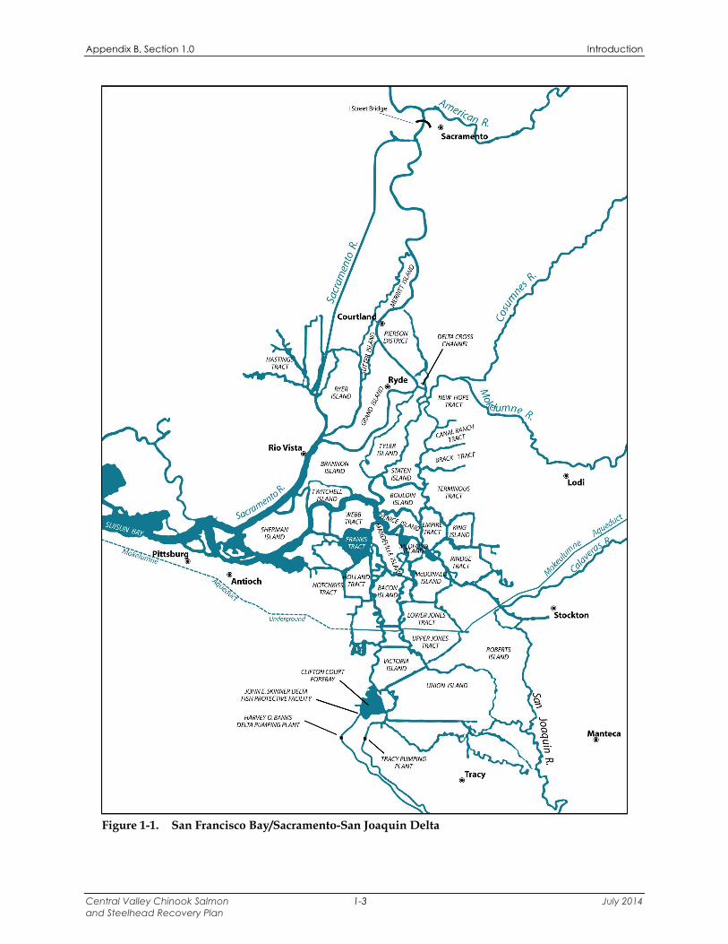
Figure 1-1. San Francisco Bay/Sacramento-San Joaquin Delta ......................................................... 1-3
Figure 1-2. Mainstem Sacramento River and Tributaries................................................................... 1-4
Figure 1-3. San Joaquin River and Tributaries ................................................................................... 1-6
Figure 2-1. Annual Estimate of Sacramento River Winter-run Chinook Salmon Spawning Escapement from 1967-2006 ........................................................................................... 2-6
Figure 2-2. Five-year Moving Average of the Winter-run Chinook Salmon Cohort Replacement Rate ............................................................................................................ 2-7
Figure 2-3. Estimated Sacramento River Winter-run Chinook Spawner Abundance, 1970–2002 ................................................................................................................................. 2-7
Figure 2-4. Geographic and Temporal Distribution of Sacramento River Winter-run Chinook Salmon .............................................................................................................. 2-9
Figure 2-5. Mean Daily Water Temperatures in the Sacramento River at Hood during December Through July from 2000 to 2006 .................................................................. 2-28
Figure 2-6. Historical Upper Sacramento River Winter-run Chinook Salmon Spawning Escapement Estimates .................................................................................................... 2-54
Figure 3-1. Annual Estimated Central Valley Spring-run Chinook Salmon Escapement from 1967 to 2006 .................................................................................................................... 3-6
Figure 3-2. Spring-run Chinook Salmon Combined Population Estimates for Mill, Deer and Butte Creeks from 1992 to 2006 ...................................................................................... 3-6

Appendix B Table of Contents/List of Acronyms
Central Valley Chinook Salmon July 2014 and Steelhead Recovery Plan x
Figure 3-3. Life Stage Timing for Spring-run Chinook Salmon Populations in the Northern Sierra Nevada Diversity Group ........................................................................................ 3-9
Figure 3-4. Life Stage Timing for Spring-run Chinook Salmon Populations in the Basalt and Porous Lava Diversity Group ........................................................................................ 3-10
Figure 3-5. Life Stage Timing for Spring-run Chinook Salmon Populations in the Northwestern California Diversity Group ..................................................................... 3-11
Figure 3-6. Adult Spring-run Chinook Salmon Population Counts for Mill, Deer and Butte Creeks (1995-2001) ....................................................................................................... 3-19
Figure 3-7. Northern Sierra Nevada Spring-run Chinook Salmon Diversity Group ........................ 3-36
Figure 3-8. Water Temperatures Recorded in Butte Creek Near Chico During the Spring-run Chinook Salmon Embryo Incubation Period (September through January) ........... 3-53
Figure 3-9. Average Daily Water Temperatures in Big Chico Creek Near Chico During the Spring-run Chinook Salmon Adult Immigration and Holding Period March through September (2000-2005) .................................................................................... 3-57
Figure 3-10. Average Daily Water Temperature in Big Chico Creek Near Chico During Adult Spring-run Chinook Salmon Spawning Period September through October (2000-2004) ...................................................................................................... 3-59
Figure 3-11. Water Temperatures Recorded in Big Chico Creek Near Chico During the Spring-run Chinook Salmon Embryo Incubation Period (September through January) .......................................................................................................................... 3-61
Figure 3-12. Basalt and Porous Lava Spring-run Chinook Salmon Diversity Group ........................ 3-77
Figure 3-13. Northwestern California Spring-run Chinook Salmon Diversity Group ....................... 3-86
Figure 3-14. Beegum Creek Spawning Escapement Estimates (1993 – 2006) .................................. 3-92
Figure 3-15. Clear Creek Spawning Escapement Estimates (1993 – 2006). ...................................... 3-96
Figure 4-1. Estimated Natural Steelhead Run Size on the Upper Sacramento River, 1967 Through 1993 ................................................................................................................... 4-6
Figure 4-2. Life Stage Timing for Steelhead Populations in the Northern Sierra Nevada Diversity Group ............................................................................................................... 4-8
Figure 4-3. Life Stage Timing for Steelhead Populations in the Basalt and Porous Lava Diversity Group ............................................................................................................... 4-9
Figure 4-4. Life Stage Timing for Steelhead Populations in the Northwestern California Diversity Group ............................................................................................................. 4-10
Figure 4-5. Life Stage Timing for Steelhead Populations in the Southern Sierra Nevada Diversity Group ............................................................................................................. 4-11
Figure 4-6. Estimated Flows in Auburn Ravine Under Natural and Current Conditions ................. 4-40

Appendix B Table of Contents/List of Acronyms
Central Valley Chinook Salmon July 2014 and Steelhead Recovery Plan xi
List of Tables Table 1-1. Extant Central Valley Spring-run Chinook Salmon Populations Included in the
Threats Assessment Categorized by Diversity Group ..................................................... 1-5
Table 1-2. Extant Central Valley Steelhead Populations Included in the Threats Assessment Categorized by Diversity Group ...................................................................................... 1-5
Table 2-1. Winter-run Chinook Salmon Releases from Livingston Stone National Fish Hatchery (Brood Years 1998-2004) ............................................................................... 2-17
Table 2-2. Excerpt from the Winter-run Chinook Salmon Stressor Matrix ................................. 2-58
Table 3-1. Water Temperature Exceedances in Butte Creek in 2002 ............................................. 3-50
Table 3-2. Average Daily Water Temperatures (ºF) in Battle Creek From 1 June through 30 September (Adult Holding Period), 1998 through 2007 ................................................ 3-78
Table 3-3. Extant Central Valley Spring-run Chinook Salmon Populations Included in the Threats Assessment Categorized by Diversity Group ................................................. 3-103
Table 3-4. Weighting Characteristic Scores and Population Weights for Each Population in the Spring-run Chinook Salmon Northern Sierra Nevada Diversity Group ................ 3-104
Table 3-5. Weighting Characteristic Scores and Population Weights for Each Population in the Spring-run Chinook Salmon Basalt and Porous Lava Diversity Group ................. 3-104
Table 3-6. Weighting Characteristic Scores and Population Weights for Each Population in the Spring-run Chinook Salmon Northwestern California Diversity Group ............... 3-104
Table 4-1. Hatcheries Producing Steelhead in the Central Valley .................................................. 4-18
Table 4-2. Steelhead Passage Above Coleman National Fish Hatchery Barrier Weir, 2001-2006. .............................................................................................................................. 4-81
Table 4-3. Putah Creek flow summaries before and after construction of the Solano Project. ..... 4-103
Table 4-4. Extant Central Valley Steelhead Populations Included in the Threats Assessment Categorized by Diversity Group .................................................................................. 4-133
Table 4-5. Weighting Characteristic Scores and Population Weights for Each Steelhead Population in the Northern Sierra Nevada Diversity Group ........................................ 4-133
Table 4-6. Weighting Characteristic Scores and Population Weights for Each Steelhead Population in the Basalt and Porous Lava Diversity Group ........................................ 4-134
Table 4-7. Weighting Characteristic Scores and Population Weights for Each Steelhead Population in the Northwestern California Diversity Group ....................................... 4-134
Table 4-8. Weighting Characteristic Scores and Population Weights for Each Steelhead Population in the Southern Sierra Nevada Diversity Group ........................................ 4-135

Appendix B Table of Contents/List of Acronyms
Central Valley Chinook Salmon July 2014 and Steelhead Recovery Plan xii
List of Acronyms ACID Anderson-Cottonwood Irrigation District AFRP Anadromous Fish Restoration Program AMP Ambient Monitoring Program Bay-Delta San Francisco Bay/Sacramento-San Joaquin Delta Bays San Francisco, San Pablo, and Suisun bays BML Bodega Marine Laboratory BO biological opinion BRT Biological Review Team CDFG California Department Fish and Game CEQA California Environmental Quality Act CESA California Endangered Species Act cfs cubic feet per second cm centimeter cm/sec centimeters per second CMP Sacramento Coordinated Monitoring Program CNFH Coleman National Fish Hatchery CRR Cohort Replacement Rate CVI Central Valley Index CVP Central Valley Project CVPIA Central Valley Project Improvement Act CWA Clean Water Act CWT coded wire tag DDT Dichloro-Diphenyl-Trichloroethane Delta Sacramento-San Joaquin Delta DPS Distinct Population Segment DWR California Department of Water Resources EEZ U.S. Exclusive Economic Zone ENSO El Niño-Southern Oscillation EPA U.S. Environmental Protection Agency ERP Ecosystem Restoration Program ESA Endangered Species Act ESU Evolutionarily Significant Unit FERC Federal Energy Regulatory Commission FL Fork Length FMP Salmon Fishery Management Plan FRFH Feather River Fish Hatchery ft/sec feet per second GCID Glenn-Colusa Irrigation District GCMs General Circulation Models HCP habitat conservation plan HCPP Hamilton City Pumping Plant km kilometers LSNFH Livingston Stone National Fish Hatchery mm millimeter MSA Magnuson-Stevens Fishery Conservation and Management Act

Appendix B Table of Contents/List of Acronyms
Central Valley Chinook Salmon July 2014 and Steelhead Recovery Plan xiii
NCCP Natural Communities Conservation Plan NEPA National Environmental Policy Act NMFS National Marine Fisheries Service MRFH Mokelumne River Fish Hatchery MRH Merced River Hatchery NAHB National Association of Home Builders NOAA National Oceanic and Atmospheric Administration OCAP Operations Criteria and Plan PBDEs Polybrominated diphenyl ethers PCBs polychlorinated biphenyls PFMC Pacific Fishery Management Council PDO Pacific Decadal Oscillation PG&E Pacific Gas and Electric Company ppt parts per thousand PSMFC Pacific States Marine Fisheries Commission RBDD Red Bluff Diversion Dam RCRA Resource Conservation and Recovery Act Reclamation Bureau of Reclamation RM River Mile RMIS Regional Mark Information System RWQCB Regional Water Quality Control Board SDWSC Sacramento Deep Water Ship Channel SMSCS Suisun Marsh Salinity Control Structure SRA shaded riverine aquatic SSIDD South Sutter Irrigation District Dam SVRIC Stanford Vina Ranch Irrigation Company SWP State Water Project SWRCB State Water Resources Control Board TCC Tehama-Colusa Canal TCD temperature control device TMDL Total Maximum Daily Load USACE U.S. Army Corps of Engineers USFWS U.S. Fish and Wildlife Service USGS U.S. Geological Survey VAMP Vernalis Adaptive Management Plan WTP water treatment plant WUA weighted usable area WWTP wastewater treatment plant

Appendix B, Section 1.0 Introduction
Central Valley Chinook Salmon 1-1 July 2014 and Steelhead Recovery Plan
1.0 INTRODUCTION Past recovery plans generally have focused on the abundance, productivity, habitat and other life history characteristics of a species. While knowledge of these characteristics is certainly important for making sound conservation management decisions, the long-term sustainability of a species in need of recovery can only be ensured by alleviating the threats that are contributing to the status of the species as threatened or endangered. Therefore, the identification of the threats to the species should be a key component of any recovery plan and program (NMFS 2006a). To be most useful for recovery planning, a threats assessment should be used to determine the relative importance of various threats to a species. A threats assessment includes (1) identifying threats and their sources, (2) evaluating the effects of threats, and (3) ranking each threat based on relative effects. The Interim Endangered and Threatened Species Recovery Planning Guidance (NMFS 2006a) recommends “…using a threats assessment for species with multiple threats to help identify the relative importance of each threat to the species’ status, and, therefore, to prioritize recovery actions in a manner most likely to be effective for the species’ recovery.” Applying this recommended approach for the National Oceanic and Atmospheric Administration (NOAA) National Marine Fisheries Services’ (NMFS) recovery planning process in the Central Valley, threats assessments were conducted for the Sacramento River winter-run Chinook salmon Evolutionarily Significant Unit (ESU), the Central Valley spring-run Chinook salmon ESU, and the Central Valley steelhead Distinct Population Segment (DPS). The threats assessments identified, evaluated, and ranked factors affecting these two ESUs and DPS in the ocean, in the San Francisco Bay/Sacramento-San Joaquin Delta (Bay-Delta) (Figure 1-1), and in Central Valley rivers and tributaries that currently support populations of winter-run Chinook salmon, spring-run Chinook salmon, and/or steelhead. Threats to winter-run Chinook salmon, spring-run Chinook salmon, and steelhead in the Bay-Delta were geographically distinguished between the Bay and the Delta using the legal definition of the Delta described in Section 12220 of the California Water Code. This places the Delta’s western boundary approximately four miles west of the confluence of the Sacramento and San Joaquin Rivers. The legal Delta extends northward to the I Street Bridge near Sacramento and southward to near Vernalis. Threats in the mainstem Sacramento River were geographically distinguished among the lower, middle, and upper part of the river (Figure 1-2). The lower section extends from the I Street Bridge upstream to Princeton (River Mile [RM] 163), the middle section extends from Princeton to Red Bluff Diversion Dam (RBDD) (RM 243), and the upper section extends from RBDD up to Keswick Dam (RM 302). In-river threats to winter-run Chinook salmon were assessed in the mainstem Sacramento River, which represents the only extant population in the ESU. The threats assessments for the Central Valley spring-run Chinook salmon ESU included rivers that currently support spring-run

Appendix B, Section 1.0 Introduction
Central Valley Chinook Salmon 1-2 July 2014 and Steelhead Recovery Plan
Chinook salmon populations1. Lindley et al. (2004), which describes the population structure of threatened and endangered Chinook salmon ESU's in California's Central Valley Basin was used to identify 12 individual rivers that historically supported and currently support spring-run Chinook salmon populations. These 12 spring-run Chinook salmon populations were categorized into three diversity groups as described by Lindley et al. (2007) (Table 1-1).
1 Although the San Joaquin River system historically supported spring-run Chinook salmon, this river system was not included in the threats assessment because: (1) the current absence of spring-run Chinook salmon from the system prevents direct data collection of stressors; and (2) the system is not included in the ESU listing.
Appendix B, Section 1.0 Introduction
Central Valley Chinook Salmon 1-3 July 2014 and Steelhead Recovery Plan
Figure 1-1. San Francisco Bay/Sacramento-San Joaquin Delta
Tracy @
@ -..... ___ Stockton
Manteca @

Appendix B, Section 1.0 Introduction
Central Valley Chinook Salmon 1-4 July 2014 and Steelhead Recovery Plan
Figure 1-2. Mainstem Sacramento River and Tributaries

Appendix B, Section 1.0 Introduction
Central Valley Chinook Salmon 1-5 July 2014 and Steelhead Recovery Plan
Table 1-1. Extant Central Valley Spring-run Chinook Salmon Populations Included in the Threats Assessment Categorized by Diversity Group
Northern Sierra Nevada Diversity Group
Basalt and Porous Lava Diversity Group
Northwestern California Diversity Group
Feather River Yuba River Butte Creek
Big Chico Creek Deer Creek Mill Creek
Antelope Creek
Battle Creek Upper Sacramento River
Thomes Creek Cottonwood/Beegum Creek
Clear Creek
Source: (Lindley et al. 2007)
For the Central Valley steelhead threats assessment, 26 individual rivers/watersheds2 in the Sacramento and San Joaquin (Figure 1-3) river systems that historically supported and currently support populations of steelhead were identified using literature describing the historical population structure of steelhead in the Central Valley (Lindley et al. 2006) and by using the best professional knowledge of Central Valley salmonid biologists regarding the current distribution of steelhead. These 26 steelhead populations were categorized into four diversity groups based on the geographical structure described in Lindley et al. (2007) Table 1-2.
Table 1-2. Extant Central Valley Steelhead Populations Included in the Threats Assessment Categorized by Diversity Group
Northern Sierra Nevada Diversity Group
Basalt and Porous Lava Diversity Group
Northwestern California Diversity Group
Southern Sierra Nevada Diversity
Group American River
Auburn/Coon Creek Dry Creek
Feather River Bear River Yuba River Butte Creek
Big Chico Creek Deer Creek Mill Creek
Antelope Creek
Battle Creek Cow Creek
Small tributaries to the Upper Sacramento
River3
Upper Sacramento River (mainstem)
Stony Creek Thomes Creek
Cottonwood/Beegum Creek Clear Creek Putah Creek
Mokelumne River Calaveras River Stanislaus River Tuolumne River Merced River
San Joaquin River (mainstem)
Source: (Lindley et al. 2007)
This appendix is comprised of three major sections – one for the Sacramento River winter-run Chinook salmon ESU, one for the Central Valley spring-run Chinook salmon ESU, and one for the Central Valley steelhead DPS. Narrative descriptions of the threats affecting each ESU/DPS (Sections 2.3, 3.3, and 4.3, respectively) are organized hierarchically going from location/population to life stage to threats. In addition to narrative descriptions, matrices were developed in order to structure the life stage, population, and threats information so that the threats affecting each ESU/DPS could be ranked, sorted, and prioritized.
2 It is recognized that more than 26 rivers/watersheds that historically supported and currently support steelhead exist in the Central Valley, however it is assumed that recovery of the Central Valley steelhead DPS is primarily dependent on the 26 populations included in the threats assessment. 3 Includes steelhead utilizing small tributaries in the Redding area including Stillwater, Churn, Sulphur, Salt, Olney, and Paynes creeks.

Appendix B, Section 1.0 Introduction
Central Valley Chinook Salmon 1-6 July 2014 and Steelhead Recovery Plan
Figure 1-3. San Joaquin River and Tributaries
New Melones
< Lake
Don Pedro Reservoir
~ New Exchequer Dam
Friant Dam
----------
@Fresno

Appendix B, Section 1.0 Introduction
Central Valley Chinook Salmon 1-7 July 2014 and Steelhead Recovery Plan
The prioritization of threats was identified as an integral piece in the recovery planning process in NMFS’ recovery planning guidance document titled, “Interim Endangered and Threatened Species Recovery Planning Guidance” (NMFS 2006a). The prioritized ranking of threats provides a recovery planning tool to help guide the identification of diversity group- and/or population- specific actions to recover each ESU/DPS. Detailed descriptions of how the stressor matrices were developed for each ESU/DPS are presented in Sections 2.4, 3.4, and 4.4, while the diversity group- and population-specific prioritized lists of stressors are displayed in Attachments A through C, respectively.

Appendix B, Section 2.0 Sacramento River Winter-run Chinook Salmon
Central Valley Chinook Salmon 2-1 July 2014 and Steelhead Recovery Plan
2.0 SACRAMENTO RIVER WINTER-RUN CHINOOK SALMON
2.1 BACKGROUND
2.1.1 LISTING HISTORY NMFS listed the Sacramento River winter-run Chinook salmon ESU as a threatened species under emergency provisions of the Endangered Species Act (ESA) in August 1989 (54 FR 32085 (August 4, 1989)) and formally listed it as a threatened species in November 1990 (55 FR 46515 (November 5, 1990)). In June 1992, NMFS proposed that winter-run Chinook salmon be reclassified as an “endangered”4 species (57 FR 27416 (June 19, 1992)). NMFS finalized its proposed rule to re-classify winter-run Chinook salmon as an endangered species on January 4, 1994 (59 FR 440 (January 4, 1994)). NMFS concluded that winter-run Chinook salmon in the Sacramento River warranted listing as an endangered species due to several factors, including: (1) the continued decline and increased variability of run sizes since its first listing as a threatened species in 1989; (2) the expectation of weak adult returns resulting from two small year classes in 1991 and 1993; and (3) continued “take”5 of winter-run Chinook salmon (65 FR 42421 (July 10, 2000)). On June 14, 2004, NMFS issued a proposed rule to downgrade the listing status of winter-run Chinook salmon from endangered to threatened (69 FR 33102 (June 14, 2004)). To prevent further decline of the ESU, NMFS proposed to apply the ESA Section 9(a) take prohibitions as the Section 4(d) limits to winter-run Chinook salmon (69 FR 33102 (June 14, 2004)) after this proposed downgrade. Following a series of extensions to the public comment period on the proposed listing determinations, the public comment period closed in November 2004 (69 FR 61348 (October 18, 2004)). On June 28, 2005 NMFS issued a final listing determination for the Sacramento River winter-run Chinook salmon ESU, which concluded that the Sacramento River winter-run Chinook salmon ESU is “in danger of extinction” due to risks to the diversity and spatial structure of the ESU, and therefore, continues to warrant listing as an endangered species under the ESA (70 FR 37160 (June 28, 2005)). The Sacramento River winter-run Chinook salmon ESU includes winter-run Chinook salmon spawning naturally in the Sacramento River and its tributaries as well as winter-run Chinook salmon that are part of the artificial propagation program at the Livingston Stone National Fish Hatchery (LSNFH) (70 FR 37160 (June 28, 2005)).
2.1.2 CRITICAL HABITAT Critical habitat for listed salmonids is comprised of physical and biological features essential to the conservation of the species including: (1) space for the individual and population growth and for normal behavior; (2) cover; (3) sites for breeding, reproduction, and rearing of offspring; and (4) habitats protected from disturbance or are representative of the historical geographical and
4 Under the ESA, an “endangered species” is “…any species which is in danger of extinction throughout all or a significant portion of its range…” (16 USC § 1533(20)). 5 Section 9 of the ESA makes it illegal to “take” (harass, harm, pursue, shoot, wound, kill, trap, capture, or collect or attempt to engage in any such conduct) any endangered species of fish or wildlife with similar provisions for most threatened species of fish and wildlife (16 USC 1538).

Appendix B, Section 2.0 Sacramento River Winter-run Chinook Salmon
Central Valley Chinook Salmon 2-2 July 2014 and Steelhead Recovery Plan
ecological distribution of the species. The primary constituent elements considered essential for the conservation of listed Central Valley salmonids are: (1) freshwater spawning sites; (2) freshwater rearing sites; (3) freshwater migration corridors; (4) estuarine areas; (5) nearshore marine areas; and (6) offshore marine areas. On August 14, 1992, NMFS published a proposed critical habitat designation for winter-run Chinook salmon (57 FR 36626 (August 13, 1992)). The habitat proposed for designation included: (1) the Sacramento River from Keswick Dam, Shasta County (RM 302) to Chipps Island (RM 0) at the westward margin of the Delta; (2) all waters from Chipps Island westward to Carquinez Bridge, including Honker Bay, Grizzly Bay, Suisun Bay, and Carquinez Strait; (3) all waters of San Pablo Bay westward of the Carquinez Bridge; and (4) all waters of San Francisco Bay to the Golden Gate Bridge (NMFS 1997). On June 16, 1993, NMFS issued the final rule designating critical habitat for winter-run Chinook salmon (58 FR 33212 (June 16, 1993)). The habitat identified in the final designation is identical to that in the proposed ruling except that critical habitat in San Francisco Bay is limited to those waters north of the San Francisco-Oakland Bay Bridge.
2.1.3 UNIQUE SPECIES CHARACTERISTICS
2.1.3.1 LIFE HISTORY STRATEGY Chinook salmon life history strategies are divided into two basic types: stream-type Chinook salmon and ocean type Chinook salmon. Stream-type Chinook salmon adults migrate to freshwater streams before they reach full maturity, in spring or summer, and juveniles spend a relatively long time (usually more than one year) rearing in fresh water. Ocean-type Chinook salmon adults spawn soon after entering fresh water, in late-summer and fall, and juveniles spend a relatively short time (3 to 12 months) rearing in freshwater (Moyle 2002). Winter-run Chinook salmon are unique to the Sacramento River and exhibit behaviors characteristic of both stream- and ocean-type Chinook salmon (Healey 1991). They typically migrate upstream as immature silvery fish during winter and spring and then spawn several months later in early summer. Specifically, adult winter-run Chinook salmon enter freshwater in winter or early spring, (December through July with peak upstream migration occurring during March) and delay spawning until spring or early summer (a stream-type trait); whereas, juvenile winter-run Chinook salmon exhibit more ocean-type Chinook salmon behavior by migrating to the ocean after spending as few as five months up to nine months of river life (NMFS 1997). They tend to be smaller than the rest of the runs of Chinook salmon and have low fecundity, mainly because most winter-run Chinook salmon return to spawn as three-year olds. In the Sacramento River reach between Keswick Dam and RBDD, spawning occurs from mid-April to mid-August, peaking in June and July (Killam 2206). Chinook salmon spawn in clean, loose gravel in swift, relatively shallow riffles; or along the margins of deeper river reaches where suitable water temperatures, depths, and velocities favor redd construction and oxygenation of incubating eggs. Winter-run Chinook salmon are adapted for spawning and rearing in the clear, spring-fed rivers of the upper Sacramento River Basin, where summer water temperatures are typically between 50ºF to 59ºF. Historically, these conditions were created by

Appendix B, Section 2.0 Sacramento River Winter-run Chinook Salmon
Central Valley Chinook Salmon 2-3 July 2014 and Steelhead Recovery Plan
glacial and snowmelt water percolating through porous volcanic formations that surround Mt. Shasta and Mt. Lassen and that cover much of northeastern California. Today, Shasta Dam denies access to winter-run Chinook salmon historical habitats and they persist mainly because water released from Shasta Reservoir during the summer is for the most part cold. Sacramento River winter-run Chinook salmon migration corridors begin downstream of the spawning area and extend through the lower Sacramento River and the Delta. Fry emergence generally occurs at night. Upon emergence from the gravel, fry swim or are displaced downstream (Healey 1991). Fry seek habitats containing beneficial aspects such as riparian vegetation and associated substrates that provide aquatic and terrestrial invertebrates for food, cover for predator avoidance, and slower water velocities for resting (NMFS 1996b). These shallow water habitats have been described as more productive juvenile salmon rearing habitat than deeper main river channels. Higher juvenile salmon growth rates, partially due to greater prey consumption rates, as well as favorable environmental temperatures have been associated with shallow water habitats (Sommer et al. 2001c). Juvenile Chinook salmon migration rates vary considerably presumably depending on the physiological stage of the juvenile and hydrologic conditions. Kjelson (1982) found Chinook salmon fry traveled as fast as 30 kilometers (km) per day in the Sacramento River. Sommer et al. (2001a) found rates ranging from approximately 0.5 mile up to more than 6 miles per day in the Yolo Bypass. As juvenile Chinook salmon grow they move into deeper water with higher current velocities, but still seek shelter and velocity refugia to minimize energy expenditures (Healey 1991). Catches of juvenile salmon in the Sacramento River near West Sacramento by the U.S. Fish and Wildlife Service (USFWS) exhibited larger juvenile captures in the main channel and smaller sized fry along the margins (USFWS 1997). Where the river channel is greater than 9 to 10 feet in depth, juvenile salmon tend to inhabit the surface waters (Healey 1980). Stream flow and/or turbidity increases in the upper Sacramento River basin are thought to stimulate emigration (Poytress 2007). Similar to adult salmon upstream movement, juvenile salmon downstream movement is primarily crepuscular. Once downstream movement has commenced, salmon fry might continue this movement until reaching the Delta or they might reside in the stream for a time period that varies from weeks to a year (Healey 1991). The residence time of juveniles in streams is typically 5 to 10 months, followed by an indeterminate time in the Delta. Emigration of juvenile Sacramento River winter-run Chinook salmon past RBDD may begin as early as mid-July, typically peaks in September, and can continue through March in dry years (NMFS 1997; Vogel and Marine 1991). From 1995 to 1999, Sacramento River winter-run Chinook salmon outmigrating as fry passed RBDD by October, and outmigrating pre-smolts and smolts passed RBDD by March (Martin et al. 2001). Rotary screw trap data collected by CDFW at Knights Landing from 1999 through 2011 indicate that winter-run Chinook salmon juveniles migrate past that location from October through March with the peak occurring in December and January. As Chinook salmon begin the smoltification stage, they are found rearing further downstream where ambient salinity reaches 1.5 to 2.5 parts per thousand (ppt) (Healey 1980; Levy and

Appendix B, Section 2.0 Sacramento River Winter-run Chinook Salmon
Central Valley Chinook Salmon 2-4 July 2014 and Steelhead Recovery Plan
Northcote 1981). Emigration to the ocean begins as early as November and continues through May (Fisher 1994; Myers et al. 1998). The importance of the Delta in the life history of Sacramento River winter-run Chinook salmon is not well understood. However, juvenile Sacramento River winter-run Chinook salmon are believed to occur in the Delta primarily from November through early May based on data collected from trawls in the Sacramento River at West Sacramento (RM 57) (USFWS 2001). The timing of migration varies somewhat due to changes in river flows, dam operations, and water year type. Winter-run Chinook salmon juveniles remain in the Delta until they reach a fork length (FL) of approximately 118 millimeters (mm) (NMFS 1997). Within the Delta, juvenile Chinook salmon forage in shallow areas with protective cover, such as tidally influenced sandy beaches and vegetated zones (Healey 1980; Meyer 1979). Cladocerans, copepods, amphipods, and larvae of diptera, as well as small arachnids and ants are common prey items (Kjelson et al. 1982; MacFarlane and Norton 2002; Sommer et al. 2001b). Juvenile Chinook salmon movements within the estuarine habitat are dictated by the interaction between tidally driven salt water intrusions through the San Francisco Bay and fresh water outflow from the Sacramento and San Joaquin rivers. Juvenile Chinook salmon follow rising tides into shallow water habitats from the deeper main channels, and return to the main channels when the tides recede (Levy and Northcote 1981). Kjelson (1982) reported that juvenile Chinook salmon demonstrated a diel migration pattern, orienting themselves to nearshore cover and structure during the day, but moving into more open, offshore waters at night. The fish also distributed themselves vertically in relation to ambient light. During the night, juveniles were distributed randomly in the water column, but would school up during the day into the upper three meters of the water column. Juvenile Chinook salmon were found to spend about 40 days migrating from the confluence of the Sacramento and San Joaquin rivers through the San Francisco Estuary and grew little in length or weight until they reached the Gulf of the Farallones Islands (MacFarlane and Norton 2002). Central Valley Chinook salmon begin their ocean life in the Gulf of the Farallones from where they distribute north and south along the continental shelf primarily between Point Conception and Washington State. Upon reaching the ocean, juvenile Chinook salmon feed voraciously on larval and juvenile fishes, plankton, and terrestrial insects (Healey 1991; MacFarlane and Norton 2002). Chinook salmon grow rapidly in the ocean environment with growth rates dependent on water temperatures and food availability (Healey 1991). The first year of ocean life is considered a critical period of high mortality for Chinook salmon that largely determines survival to harvest or spawning (Beamish and Mahnken 2001; Quinn 2005). Data from the Pacific States Marine Fisheries Commission (PSMFC) Regional Mark Information System (RMIS) database indicate that Sacramento River winter-run Chinook salmon adults are not as broadly distributed along the Pacific Coast as other Central Valley Chinook salmon and tend to concentrate between San Francisco and Monterey. This localized distribution may indicate a unique life history strategy related to the observation that Sacramento River winter-run Chinook salmon also mature at a relatively young age (two to three years old) (Myers et al. 1998). Sacramento River winter-run Chinook salmon remain in the ocean environment for two to four years and tend to enter freshwater as immature fish.

Appendix B, Section 2.0 Sacramento River Winter-run Chinook Salmon
Central Valley Chinook Salmon 2-5 July 2014 and Steelhead Recovery Plan
2.1.3.2 HISTORIC SPAWNING HABITAT UTILIZATION Distribution of winter-run Chinook salmon historically was limited to the upper Sacramento River and its tributaries where cool spring-fed streams supported successful salmon spawning, egg incubation, and juvenile rearing (Slater 1963 and Yoshiyama et al. 1998 in NMFS 2007). The historical distribution of winter-run Chinook salmon prior to construction of Shasta Dam included the headwaters of the McCloud, Pit, and Little Sacramento rivers and tributaries (e.g., Hat Creek and Fall River) (Myers et al. 1998). Since completion of Shasta Dam, the Sacramento River, Battle Creek and the Calaveras River are the only habitats where winter-run Chinook salmon have been reported to occur (USFWS 1987). Primary spawning and rearing habitat in the Sacramento River for winter-run Chinook salmon is now limited to the coldwater areas between Keswick Dam and RBDD. Fish still have access to Battle Creek through the Coleman National Fish Hatchery (CNFH) weir from a fish ladder that is opened during the peak of the winter-run Chinook salmon migration period (Ward and Kier 1999a). Currently, if a winter-run Chinook salmon population exists in Battle Creek; its population size is unknown and is likely very small. In addition, a winter-run Chinook salmon migration to the upper Calaveras River may have occurred between 1972 and 1984, but this information has not been confirmed. Nevertheless, the population seems to have been extirpated by drought, irrigation diversions, and blocked access by the New Hogan Dam (NMFS 1997).
2.1.4 STATUS OF WINTER-RUN CHINOOK SALMON
2.1.4.1 HISTORIC POPULATION TRENDS Estimates of the Sacramento River winter-run Chinook salmon population (including both male and female salmon) reached nearly 100,000 fish in the 1960s before declining to under 200 fish in the 1990s (Figure 2-1) (Good et al. 2005 in NMFS 2007).

Appendix B, Section 2.0 Sacramento River Winter-run Chinook Salmon
Central Valley Chinook Salmon 2-6 July 2014 and Steelhead Recovery Plan
Figure 10. Annual Estimate of Sacramento River Winter-run Chinook Salmon Spawning Escapement from 1967-2006. SOURCE: CDFG Grandtab, 2007
0
20
40
60
80
100
120
140
1967
1969
1971
1973
1975
1977
1979
1981
1983
1985
1987
1989
1991
1993
1995
1997
1999
2001
2003
2005
Year
Es
ca
pe
me
nt
Po
pu
lati
on
(T
ho
us
an
ds
)
Figure 2-1. Annual Estimate of Sacramento River Winter-run Chinook Salmon Spawning Escapement from 1967-2006 Source: (CDFG 2007)
2.1.4.2 CURRENT STATUS Shasta Dam blocks access to the entire historical spawning habitat of winter-run Chinook salmon. It was not expected that winter-run Chinook salmon would survive this habitat alteration (Moffett 1949). However, coldwater releases from Shasta Dam create conditions suitable for winter-run Chinook salmon for roughly 100 km downstream from the dam. Although the Sacramento River winter-run Chinook population has shown improvement in recent years from levels observed in the 1990s, existing population abundance (exhibited by spawning escapement estimates) is far below historic numbers. The five-year moving average of the cohort replacement rate (CRR) has been greater than one since 1995, which is an indication of population growth (Figure 2-2). The CRR is a measure of population growth rate, and is generally defined as the ratio of naturally-produced returning adult spawners, to adult spawners that naturally-spawned in the river during the previous generation or brood year. The population declined from an escapement of near 100,000 in the late 1960s to fewer than 200 in the early 1990s (Good et al. 2005). More recent population estimates of 8,218 (2004), 15,730 (2005), and 17,153 (2006) show a three-year average of 13,700 returning winter-run Chinook salmon (CDFG Website 2007). However, the run size decreased to 2,542 in 2007 and 2,850 in 2008 (Figure 2-3).

Appendix B, Section 2.0 Sacramento River Winter-run Chinook Salmon
Central Valley Chinook Salmon 2-7 July 2014 and Steelhead Recovery Plan
Figure 11. Five-Year Moving Average of Cohort Replacement Rate Winter-run Chinook Salmon
0
0.5
1
1.5
2
2.5
3
3.5
1993
1994
1995
1996
1997
1998
1999
2000
2001
2002
2003
2004
2005
2006
Year
Co
ho
rt R
epla
cmen
t R
ate
Figure 2-2. Five-year Moving Average of the Winter-run Chinook Salmon Cohort Replacement Rate
40,4
0953
,089
37,1
3324
,079
21,8
9723
,430
35,0
9617
,214
24,8
622,
364
1,15
622
,797
1,28
11,
831
2,66
3 5,40
72,
596
2,18
52,
878
696
430
211 1,24
038
718
6 1,29
71,
337
880 2,
992
3,28
81,
352
8,22
47,
464
8,21
87,
869
15,8
7517
,304
2,54
22,
850
0
10,000
20,000
30,000
40,000
50,000
19
70
19
72
19
74
19
76
19
78
19
80
19
82
19
84
19
86
19
88
19
90
19
92
19
94
19
96
19
98
20
00
20
02
20
04
20
06
20
08
Year
Es
tim
ate
d R
un
Siz
e
Figure 2-3. Estimated Sacramento River Winter-run Chinook Salmon Run Size (1970-2008). Total estimate includes mainstem in-river, tributaries, hatcheries, and angler harvest. Prior to 2001, mainstem in-river estimates upstream of RBDD were based on RBDD counts; subsequent estimates were based on carcass survey data.

Appendix B, Section 2.0 Sacramento River Winter-run Chinook Salmon
Central Valley Chinook Salmon 2-8 July 2014 and Steelhead Recovery Plan
Sacramento River winter-run Chinook salmon may be responding to a number of factors, including wetter than normal winters, changes in ocean harvest regulations since 1995 that have significantly reduced harvests, changes in RBDD operation, improved temperature management on the upper Sacramento River (including installation of a coldwater release device on Shasta Dam), water quality improvements due to remediation of Iron Mountain Mine discharges, changes in operations of the State Water Project (SWP) and federal Central Valley Project (CVP), and a variety of other habitat improvements.
2.1.4.3 EXTINCTION RISK ASSESSMENT Although the status of the Sacramento River winter-run Chinook salmon population numbers has shown improvement over the lat six years, there is still only one naturally-spawned component of the ESU, and this single population depends on coldwater releases from Shasta Dam on the Sacramento River. Lindley et al. (2007) considers the Sacramento River winter-run Chinook salmon population at a moderate risk of extinction primarily due to the risks associated with only one existing population. The viability of an ESU that is represented by a single population is vulnerable to changes in the environment through a lack of spatial geographic diversity and genetic diversity that result from having only one population. A single catastrophe with effects persisting for four or more years could extirpate the entire Sacramento River winter-run Chinook salmon ESU (Lindley et al. 2007). Such potential catastrophes include volcanic eruption of Mt. Lassen, prolonged drought which depletes the coldwater pool in Shasta Reservoir or some related failure to manage coldwater storage, a spill of toxic materials with effects that persist for four or more years, or a disease outbreak. Moreover, an ESU that is represented by a single population is vulnerable to the limitation in life history and genetic diversity that would otherwise increase the ability of individuals in the population to withstand environmental variation.
2.2 LIFE HISTORY AND BIOLOGICAL REQUIREMENTS
2.2.1 ADULT IMMIGRATION AND HOLDING
2.2.1.1 GEOGRAPHIC AND TEMPORAL DISTRIBUTION Adult winter-run Chinook salmon on their upstream migration enter San Francisco Bay from November through June and migrate past the RBDD from mid-December through early August (Hallock and Fisher 1985) (Figure 2-4). The majority of the winter-run Chinook salmon adults pass RBDD between January and May (Hallock and Fisher 1985), with the peak typically occurring during March and April (Snider et al. 2001).
2.2.1.2 BIOLOGICAL REQUIREMENTS Suitable water temperatures for adult winter-run Chinook salmon migrating upstream to spawning grounds were reported to range from 57°F to 67°F (NMFS 1997). There is evidence suggesting that water temperatures above 70°F may present a thermal barrier to Chinook salmon upstream migration (Boles et al. 1988; USFWS 1995c). Water temperature requirements for adult Chinook salmon holding while eggs are developing are more restrictive with maximum temperatures reported at 59°F to 60°F (NMFS 1997). However, adults holding at 55°F to 56°F have substantially better egg viability (Boles et al. 1988; NMFS 1997).

Appendix B, Section 2.0 Sacramento River Winter-run Chinook Salmon
Central Valley Chinook Salmon 2-9 July 2014 and Steelhead Recovery Plan
Adult Chinook salmon require water deeper than 0.8 feet and water velocities less than 8 feet per second (ft/sec) for successful upstream migration (Thompson 1972). Adult Chinook salmon are less capable of negotiating fish ladders, culverts, and waterfalls during upstream migration than steelhead, due in part to slower swimming speeds and inferior jumping ability (Bell 1986; Reiser et al. 2006). Adult winter-run Chinook salmon hold in deep, cool, well-oxygenated pools to escape warm water temperatures during the early summer months prior to spawning (DWR and Reclamation 2000). Pools utilized by Chinook salmon for holding are generally greater than 5 feet in depth that contain cover from overhanging vegetation, undercut banks, boulders or large woody debris (Lindsay 1985). Water velocities through these pools range from 0.5 to 2.0 ft/sec (Moyle 2002).
Figure 2-4. Geographic and Temporal Distribution of Sacramento River Winter-run Chinook Salmon
2.2.2 ADULT SPAWNING
2.2.2.1 GEOGRAPHIC AND TEMPORAL DISTRIBUTION The primary spawning area for winter-run Chinook salmon extends 31 miles from Keswick Dam (RM 302) downstream to Battle Creek (RM 271) (Snider et al. 2001). Within this 31-mile reach, the majority of spawning occurs in the upper 14 miles from Keswick Dam to the Redding Water Treatment Plant (WTP) (Snider et al. 2001). Winter-run Chinook salmon primarily spawn from late-April through mid-August, with peak spawning activity in May and June (NMFS 1997).

Appendix B, Section 2.0 Sacramento River Winter-run Chinook Salmon
Central Valley Chinook Salmon 2-10 July 2014 and Steelhead Recovery Plan
2.2.2.2 BIOLOGICAL REQUIREMENTS Generally, successful spawning for Chinook salmon occurs at water temperatures below 60°F (NMFS 1997). Both Chambers (1956), and Reiser and Bjornn (1979) report that upper preferred water temperatures for spawning Chinook salmon range from about 55°F to 57°F. The biological opinion (BO) on the Long-Term CVP and SWP Operations Criteria and Plan (OCAP) requires water temperatures to be maintained below 56°F in the upper Sacramento River above the RBDD (NMFS 2004a). The 56°F temperature criterion is measured as the average daily water temperature and as such, the criterion may allow water temperatures to exceed 56°F for some periods during a day. Chinook salmon spawn in riffles or runs with water velocities ranging from 0.5 to 6.2 ft/sec (DWR and Reclamation 2000; Healey 1991; Moyle 2002; Vogel and Marine 1991). Spawning depths can range from as little as a few inches to several feet (Moyle 2002). Preferred water depths appear to range from 0.8 to 3.3 feet (Allen and Hassler 1986; Moyle 2002). Substrate is an important component of Chinook salmon spawning habitat, and generally includes a mixture of gravel and small cobbles (Moyle 2002). NMFS (1997) reports that preferred spawning substrate is composed mostly of gravels from 0.75 to 4.0 inches in diameter.
2.2.3 EMBRYO INCUBATION
2.2.3.1 GEOGRAPHIC AND TEMPORAL DISTRIBUTION The winter-run Chinook salmon embryo incubation life stage primarily occurs between Keswick Dam and Battle Creek from April through October (NMFS 2004a; Vogel and Marine 1991).
2.2.3.2 BIOLOGICAL REQUIREMENTS Water temperature, dissolved oxygen concentration, and inter-gravel flow are all important factors in successful embryo incubation of Chinook salmon. Within the appropriate water temperature range, eggs normally hatch in 40 to 60 days. Newly hatched fish (alevins) normally remain in the gravel for an additional four to six weeks until the yolk sac has been absorbed (NMFS 1997). Maximum embryo survival is reported at water temperatures ranging from 41°F to 56°F (Moyle 2002; USFWS 1995b). Yoshiyama et al. (2001) report good embryo survival at water temperatures up to 58°F. The USFWS reports decreased embryo survival occurs at water temperatures above 56°F, and no survival of eggs was observed at water temperatures above 62°F (USFWS 1995a). Successful embryo incubation has been observed within a wide range of water depths and velocities, provided that intra-gravel flow is adequate for delivering sufficient oxygen to developing eggs and alevins (Healey 1991). The minimum intra-gravel percolation rate to ensure good survival of incubating eggs and alevins will vary, depending on flow rate, water depth, and water quality. Under controlled conditions, survival rates of 97 percent and greater have been observed with a percolation rate of 0.001 ft/sec (0.03 centimeters per second [cm/sec]), whereas 60 percent survival was observed at a 0.0001 ft/sec (0.0042 cm/sec) percolation rate (Gangmark and Bakkala 1960; Shelton 1955). Raleigh et al. (1986) report optimal embryo survival at dissolved oxygen concentration of 10.5 milligrams per liter.

Appendix B, Section 2.0 Sacramento River Winter-run Chinook Salmon
Central Valley Chinook Salmon 2-11 July 2014 and Steelhead Recovery Plan
2.2.4 JUVENILE REARING AND OUTMIGRATION
2.2.4.1 GEOGRAPHIC AND TEMPORAL DISTRIBUTION Winter-run Chinook salmon fry emerge from the spawning gravels from mid-June through mid-October (NMFS 1997). The downstream migration of juvenile winter-run Chinook salmon past RBDD may begin in late-July, peak in September, and can continue until mid-March (Vogel and Marine 1991). Winter-run Chinook salmon juveniles occur between the RBDD and the confluence of Deer Creek (RM 220) from July through September. Their distribution slowly spreads downstream to Princeton (RM 164) between October and March (Johnson et al. 1992; NMFS 1997). Winter-run Chinook salmon juveniles move downstream past Glenn-Colusa Irrigation District’s (GCID) Hamilton City Pumping Plant (HCPP) from July through March, with peak movement occurring in October and November (CUWA and SWC 2004). The presence of juvenile winter-run Chinook salmon in the Delta may extend from as early as September to as late as June, with a peak from January through April (NMFS 1997). The timing of emigration from the Delta to the Bays and ocean is not well known, but winter-run Chinook salmon juveniles reportedly reside in fresh and estuarine waters for five to nine months before migrating to the ocean from January (possibly late-December) through June (NMFS 1997). Data collected from the Chipps Island trawl show a winter-run sized Chinook salmon emigration peak in March and April (USFWS 2001).
2.2.4.2 BIOLOGICAL REQUIREMENTS Optimal water temperatures for juvenile Chinook salmon are reported to range from 53.6°F to 57.2°F (NMFS 1997). A daily average water temperature of 60°F is considered the upper temperature limit for juvenile Chinook salmon growth and rearing (NMFS 1997). Inhibition of Chinook salmon smolt development in the Sacramento River reportedly may occur at water temperatures above 63°F (Marine 1997; Marine and Cech 2004). Riparian vegetation, including shaded riverine aquatic (SRA) cover, provides juvenile salmon cover from predators, habitat complexity, a source of insect prey, and shade for maintaining water temperatures within suitable ranges for all life stages. Juvenile Chinook salmon prefer riverine habitat with abundant instream and overhead cover (e.g., undercut banks, submerged and emergent vegetation, logs, roots, other woody debris, and dense overhead vegetation) to provide refuge from predators, and a sustained, abundant supply of invertebrate and larval fish prey. On the Sacramento River, juvenile Chinook salmon are more commonly found in association with natural (as opposed to riprapped) riverbanks, and SRA cover (CDFG 1983). Upon arrival in the Delta, it is likely that winter-run Chinook salmon will tend to rear in the more upstream freshwater portions of the Delta for about two months (Kjelson et al. 1981). Within the Delta, juvenile Chinook salmon forage in shallow areas with protective cover, such as intertidal and subtidal mudflats, marshes, channels, and sloughs. Maturing Chinook salmon fry and fingerlings prefer to rear further downstream where ambient salinity is up to 1.5 to 2.5 ppt (Levings and Bouillon 2005). In Suisun Marsh, Moyle et al. (1995) reported that Chinook salmon fry tend to remain close to the banks and vegetation, near protective cover, and in dead-end tidal channels. Winter-run Chinook salmon fry remain in the Delta until they reach a FL of about 118 mm (i.e., 5 to 10 months of age) and then begin emigrating to the ocean maybe as early as November and continue through May (Fisher 1994; Myers et al. 1998).

Appendix B, Section 2.0 Sacramento River Winter-run Chinook Salmon
Central Valley Chinook Salmon 2-12 July 2014 and Steelhead Recovery Plan
2.2.5 SUB-ADULT AND ADULT OCEAN RESIDENCE
2.2.5.1 GEOGRAPHIC AND TEMPORAL DISTRIBUTION Winter-run Chinook salmon ocean residence normally lasts from one to three years. About one-fourth of the population returns to freshwater as two-year olds, two-thirds as three-year olds and the remainder as four-year olds (NMFS 1997). This age-of-return distribution varies - there are years when overwhelmingly two-year old males return to the upper Sacramento, and years such as 2007 when a substantial component of the returning population are four-year olds. The distribution of sub-adult and adult Sacramento River winter-run Chinook salmon in the ocean is believed to primarily extend from Monterey to Fort Bragg (NMFS 1997).
2.2.5.2 BIOLOGICAL REQUIREMENTS The availability of food resources and cold water are likely the most important factors controlling the survival of sub-adult and adult Chinook salmon in the ocean. Food resource availability for these fish is largely dependent on the spatial distribution and abundance of plankton, which has been shown to be associated with coastal upwelling in the Pacific Northwest (Nickelson 1986; Pearcy 1997). Coastal upwelling occurs when offshore moving surface water is replaced by water which upwells along the coast from depths of 50 to 100 meters and more (NMFS 1996a). This upwelled water is cooler than the original surface water and typically has much higher concentrations of nutrients such as nitrate, phosphate and silicate that are key to sustaining biological production (NMFS 1996a). Generally, strong upwelling events lasting several months or more bring an abundance of plankton and cold water to the near shore surface waters of the ocean and have been associated with salmon abundance.
2.3 THREATS AND STRESSORS
2.3.1 SUMMARY OF ESA LISTING FACTORS
2.3.1.1 DESTRUCTION, MODIFICATION, OR CURTAILMENT OF HABITAT OR RANGE
The primary threats to the Sacramento River winter-run Chinook salmon ESU have remained the same as when the ESU was first listed in an emergency interim rule in 1989 and final rule in 1990. Dams in the Central Valley have blocked access to the entire historical spawning grounds, altered water temperatures, and reduced habitat complexity, thus resulting in severe risks to the abundance, productivity, and especially to the spatial structure and genetic diversity of the winter-run Chinook salmon ESU. These four components of abundance, productivity, spatial structure, and diversity are the basis of how NMFS determines population and ESU/DPS viability for salmonids, as defined in (McElhany et al. 2000). The construction and operation of Shasta Dam alone immediately reduced the winter-run Chinook salmon ESU from four independent populations to just one. The remaining available habitat for natural spawners is currently maintained artificially with cool water releases from Shasta and Keswick dams, thereby significantly limiting spatial distribution of this ESU. RBDD, constructed in 1964, presents an impediment to upstream migrants. The construction and operation of the dam were considered one of the primary reasons for the decline of winter-

Appendix B, Section 2.0 Sacramento River Winter-run Chinook Salmon
Central Valley Chinook Salmon 2-13 July 2014 and Steelhead Recovery Plan
run Chinook salmon in listing the ESU. The RBDD gates are now lowered on May 15, allowing for free passage of upstream migrants to access spawning habitats. An estimated 85% of the run has passed RBDD at that time. Red Bluff Diversion Dam is still partly passable when the gates are down, but the dam does delay migration and forces some fish to spawn below it where the river temperatures are warmer, and the habitat less suitable. As described in the final listing determination for the ESU, prior to 2001, the flashboard gates at the Anderson-Cottonwood Irrigation District (ACID) Diversion Dam and the inadequate fish ladders blocked passage for upstream migrant fish. The seasonal operation of the dam created unsuitable habitat upstream of the dam by reducing flow over the eggs, which has led to reduced egg survival. In 2001, a new fish screen was placed at the diversion and a state-of-the-art fish ladder was installed to address the threats caused by the diversion dam. The new fish ladder appears to be effective for successful fish passage. For example, during the period 1987 through 2000 an average of 2.35% of winter-run spawning occurred above the ACID dam, and with post-ladder improvements an average of 42.13% of winter-run spawning has occurred above the ACID dam (Killam 2006). In the first listing determination of the ESU, pollution from Iron Mountain Mine was considered one of the main threats to the ESU. Acid mine drainage produced from the abandoned mine degraded spawning habitat of winter-run Chinook salmon and resulted in high salmon and steelhead mortality. Remediation of Iron Mountain Mine and restoration efforts as outlined in the 2002 Restoration Plan (that was developed by the Iron Mountain Mine Trustee Council composed of several federal and state agencies) are considered to adequately mitigate the threats posed to the ESU. Pollution from Iron Mountain Mine is no longer considered a main factor threatening the ESU. Pollution from agricultural runoff carrying pesticides and fertilizers, however, is still a threat to winter-run Chinook salmon. Bank stabilization structures to prevent bank erosion may affect the quality of rearing and migration habitat along the river. Juvenile salmon prefer natural streambanks as opposed to riprapped, leveed, or channelized sections of the Sacramento River. Bank stabilization projects in the Sacramento River are beginning to incorporate conservation measures in some areas to provide more suitable seasonal habitat for juvenile salmon as well as reduce predation in the artificially created habitat. Additionally, the sediment balance of the Sacramento River is highly disrupted, resulting in reduced inputs of gravel due to dams and regulated flows, as well as gravel mining (The Nature Conservancy 2006).
2.3.1.2 OVERUTILIZATION FOR COMMERCIAL, RECREATIONAL, SCIENTIFIC, OR EDUCATIONAL PURPOSES
Overutilization for commercial, recreational, scientific, or educational purposes no longer appears to have a significant impact on winter-run Chinook salmon populations, but warrants continued assessment. Commercial fishing for salmon is managed by the Pacific Fishery Management Council (PFMC) and is constrained by time and area to meet the Sacramento River winter-run ESA consultation standard, and restrictions requiring minimum size limits and use of circle hooks for anglers. Ocean harvest restrictions since 1995 have led to reduced ocean harvest

Appendix B, Section 2.0 Sacramento River Winter-run Chinook Salmon
Central Valley Chinook Salmon 2-14 July 2014 and Steelhead Recovery Plan
of winter-run Chinook salmon (i.e., Central Valley Chinook salmon ocean harvest index, or Central Valley Index (CVI), ranged from 0.55 to nearly 0.80 from 1970 to 1995, and was reduced to 0.27 in 2001). While overutilization does not seem to be a significant factor under current ocean and terrestrial climate conditions, this could change due to global climate change implications. Scientific and educational projects permitted under Sections 4(d) and 10(a)(1)(A) of the ESA stipulate specific conditions to minimize take of winter-run Chinook salmon individuals during permitted activities. There are currently four active permits in the Central Valley that may affect winter-run Chinook salmon. These permitted studies provide information about winter-run Chinook salmon that is useful to the management and conservation of the ESU.
2.3.1.3 DISEASE OR PREDATION Naturally occurring pathogens may pose a threat to winter-run Chinook salmon, and artificially propagated winter-run Chinook salmon are susceptible to disease outbreaks such as the Infectious Hematopoietic Necrosis Virus (IHNV) and Bacterial Kidney Disease. Predation is a threat to winter-run Chinook salmon, especially in the Delta where there are high densities of non-native fish (e.g., small and large mouth bass, striped bass, catfish, and sculpin) that prey on outmigrating salmon. The presence of man-made structures in the environment that alter natural conditions likely also contributes to increased predation by altering the predator-prey dynamics often favoring predatory species. In the upper Sacramento River, rising of the gates at the RBDD reduces potential predation at the dam by pikeminnow. In the ocean, and even the Delta environment, salmon are common prey for harbor seals and sea lions.
2.3.1.4 INADEQUACY OF EXISTING REGULATORY MECHANISMS Over the past 10 to 15 years, many protective measures have been implemented to help increase the abundance and productivity of winter-run Chinook salmon.
FEDERAL EFFORTS There have been several federal actions to reduce threats to the winter-run Chinook salmon ESU. Actions undertaken pursuant to Section 7 BOs have helped to increase the abundance and productivity of winter-run Chinook salmon. The BOs for the CVP and SWP have led to increased freshwater survival, and the BOs for ocean harvest have led to increased ocean survival and adult escapement. There have also been several habitat restoration efforts implemented under the Central Valley Project Impact Act (CVPIA) and CALFED programs that have led to increased abundance and productivity. There has been successful implementation of the artificial propagation program at LSNFH to supplement the abundance of naturally spawning winter-run Chinook salmon and preserve the ESU’s genetic resources. Section 10(a)(1)(B) of the ESA authorizes habitat conservation plans (HCP) for non-federal actions. However, many private parties are hesitant to engage in the HCP process because it can be costly and time-consuming. Developing an HCP is usually a voluntary process, thus, there are no guarantees that large-scale, long-term planning efforts will occur. However, despite federal actions to reduce threats to the winter-run Chinook salmon ESU through conservation efforts, there is still a lack of diversity within the ESU and there still

Appendix B, Section 2.0 Sacramento River Winter-run Chinook Salmon
Central Valley Chinook Salmon 2-15 July 2014 and Steelhead Recovery Plan
remains only one single extant population. Although there has been a marked increase in abundance of winter-run Chinook salmon over the last several years, the expansion of spatial distribution of winter-run Chinook salmon spawners has not been possible, as winter-run Chinook currently spawn within the only existing suitable habitat. It is uncertain whether ongoing efforts to restore habitat and passage to Battle Creek through the CALFED Ecosystem Restoration Program (ERP) will lead to successful establishment of a second independent population. The funding and implementation of that program remains uncertain. As noted in Lindley et al. (2006), at least two additional populations need to be successfully established to attain ESU viability for winter-run Chinook salmon, but there has not been an active push to establish additional populations. NMFS does not believe that current protective efforts being implemented for the winter-run Chinook salmon ESU provide sufficient certainty that the ESU will not be in danger of extinction in the foreseeable future.
NON-FEDERAL EFFORTS A wide range of restoration and conservation actions have been implemented or are in the planning stages of development to aid in the recovery of the winter-run Chinook salmon ESU. Most of these actions are pursuant to implementation of conservation and restoration actions in the CALFED Bay-Delta Program, which is composed of 25 state and federal agencies, and has aided to increase abundance and productivity of winter-run Chinook salmon. The state of California listed winter-run Chinook salmon as endangered in 1989 under the California Endangered Species Act (CESA). The state’s Natural Communities Conservation Plan (NCCP) involves long-term planning with several stakeholders. The state has also implemented freshwater harvest management conservation measures, and increased monitoring and evaluation efforts in support of conserving this ESU. Local governments, such as the City of Redding, and grassroots organizations, such as the Battle Creek Watershed Conservancy, are engaged in the development and implementation of conservation and recovery measures to improve conditions for winter-run Chinook salmon. Despite federal and non-federal efforts and partnerships, the winter-run Chinook salmon ESU remains at risk of extinction because the existing regulatory mechanisms do not provide sufficient certainty that efforts to reduce threats to the ESU will be fully funded or implemented. The effectiveness of regulations depends on compliance, and tracking and enforcement of compliance has not occurred consistently within this ESU.
2.3.1.5 OTHER NATURAL AND MANMADE FACTORS AFFECTING THE SPECIES’ CONTINUED EXISTENCE
Artificial propagation programs for winter-run Chinook salmon conservation purposes were developed to increase abundance and diversity of winter-run Chinook salmon, but it is still unclear what the effects of the program are to the productivity and spatial structure of the ESU (i.e., fitness and productivity). Global and localized climate changes, such as El Niño ocean conditions and prolonged drought conditions, may play a significant role in the decline of salmon, with unstable Chinook salmon populations potentially reaching lower levels. The ESU is highly vulnerable to drought conditions. During dry years, less cold water is available for release from Shasta Dam, which is the sole provider of cold water on which the fish are dependent. The resulting increased water temperature reduces availability of suitable spawning and rearing conditions.

Appendix B, Section 2.0 Sacramento River Winter-run Chinook Salmon
Central Valley Chinook Salmon 2-16 July 2014 and Steelhead Recovery Plan
Unscreened water diversions entrain outmigration juvenile salmon and fry. Unscreened water diversions and CVP and SWP pumping plants entrain juvenile salmon, leading to fish mortality. The cumulative effect of entrainment at these diversions and delays in outmigration of smolts caused by reduced flows may affect winter-run Chinook salmon survival. Although the status of winter-run Chinook salmon is improving, there is only one population, and it depends on cold water releases from Shasta Dam, which would be vulnerable to a prolonged drought. Increasing the number of independent populations has yet to occur. With only one extant population of winter-run Chinook salmon, there is a need to ensure more diversity within this ESU, because it is more susceptible to catastrophic events arising from natural and/or anthropogenic processes. The need for a second naturally spawning population has been recognized and plans have been proposed to establish a second population in Battle Creek, but implementation of restoration in this watershed continues to be delayed. However, there is no guarantee that this planned protective effort will provide enough certainty to reduce the risk to the population of becoming extinct. Actions to minimize threats will require close collaboration with many agencies, stakeholders, and special interest groups.
2.3.2 NON-LIFE STAGE-SPECIFIC THREATS AND STRESSORS Potential threats to the California Central Valley winter-run Chinook salmon population that are not specific to a particular life stage include the potential negative impacts of the current artificial propagation program utilizing the LSNFH; the small wild population size; the genetic integrity of the population due to both hatchery influence and small population size; and the potential effects of long-term climate change. Each of these potential threats is discussed in the following sections.
2.3.2.1 ARTIFICIAL PROPAGATION PROGRAM A conservation hatchery program for winter-run Chinook salmon was initiated in 1989 at the CNFH on Battle Creek; a tributary of the upper Sacramento River above the RBDD. The purpose of the program is to reduce the risk of extinction by conservation of the winter-run Chinook salmon genome and supplementation of the wild winter-run Chinook salmon spawning population in the upper Sacramento River. Potential winter-run Chinook salmon broodstock have been collected in fish traps at Keswick Dam and RBDD, and were originally spawned at CNFH. As additional insurance, captive broodstock programs also were adopted to provide gametes for artificial propagation as needed, by rearing program winter-run juveniles to maturity in captivity. A captive rearing program was initiated in 1991 at the University of California Bodega Marine Laboratory (BML), where it played a role in winter-run research studies; and at Steinhart Aquarium, which provided a forum to educate the public to the status of the endangered Sacramento River winter-run Chinook salmon. All conservation hatchery winter-run Chinook salmon have been protected under the ESA and have been part of the Sacramento River winter-run Chinook salmon ESU. The first release of hatchery-raised winter-run fry occurred in 1990, with an average annual release of 30,600 juveniles from CNFH between brood years 1991 and 1995. Although the intent of the program is to contribute winter-run adults to the spawning population in the upper Sacramento River, the CNFH winter-run juveniles imprinted on Battle Creek water and returned

Appendix B, Section 2.0 Sacramento River Winter-run Chinook Salmon
Central Valley Chinook Salmon 2-17 July 2014 and Steelhead Recovery Plan
instead to Battle Creek as mature adults. In addition, genetic analyses indicated that 8 of the 129 Chinook salmon used for hatchery propagation in 1993, 1994 and 1995 were likely spring-run (NMFS 1997b). Hybrid fish inadvertently were included in program winter-run releases in 1993 and 1994, but were held back in 1995 (NMFS 1997b). At the time, the microsatellite locus, Ots-2, was being used exclusively to determine run assignment on captured fish; however, most of the major alleles at this locus are shared by both winter-run and spring-run Chinook salmon (Hedgecock et al. 1996). In response to the need to identify fish to run before being used as program broodstock, the genetics team at BML (Banks 1996) identified a number of highly polymorphic microsatellite loci in winter-run which have since been refined with multi-allelic gene markers. While these issues were being addressed, BML operations provided program fish from 1996 through 1998 while a conservation hatchery facility on the upper Sacramento River was being planned. The winter-run conservation program was moved to the LSNFH in 1998 and a third captive rearing program was established at LSNFH. Winter-run production fish are marked with coded wire tags (CWT) and adipose fin-clipped, and released in the upper Sacramento River as pre-smolts each winter in late January or early February. In the CALFED Science Conference of 2003 (Brown and Nichols 2003) it was reported that winter-run conservation program has contributed to the abundance of returning adult winter-run Chinook salmon. Table 2-1 shows the annual number of winter-run Chinook salmon released from the facility from 1999 through 2005. The table also provides information based on data acquired during mark-recapture studies on the amount of time required by the smolts to migrate through the Delta.
Table 2-1. Winter-run Chinook Salmon Juvenile Releases from LSNFH (Broodyears 1998-2008) and Date of Initial Recapture at Chipps Island.
Brood Year Upper Sacramento River Release Date
Number of Pre-Smolts Released1
Initial Date2 of Recapture at Chipps Island
1998 1/28/1999 153,908 3/15/1999
1999 1/27/2000 30,840 3/18/2000
2000 2/01/2001 166,206 3/09/2001
2001 1/30/2002 252,684 3/20/2002
2002 1/30/2003 233,613 2/14/2003
2003 2/05/2004 218,617 2/20/2004
2004 2/03/2005 168,261 2/22/2005
2005 2/02/2006 173,344 2/17/2006
2006 2/08/2007 196,288 2/17/2007
2007 1/31/2008 71,883 3/12/2008
2008 1/29/2009 146,211
Source: (1USFWS Red Bluff; 2Paul Cadrett, USFWS, personal com.) There is evidence that hatchery fish may negatively affect the genetic constitution of wild fish (Allendorf et al. 1997; Hindar et al. 1991; Waples 1991). One indication of this is the observation of a reduction in wild fish populations following the initiation of a hatchery release program (Hilborn 1992; Washington and Koziol 1993). An explanation offered for this observation is that hatchery fish are adapted to the hatchery environment; therefore, natural

Appendix B, Section 2.0 Sacramento River Winter-run Chinook Salmon
Central Valley Chinook Salmon 2-18 July 2014 and Steelhead Recovery Plan
spawning with wild fish reduces the fitness of the natural population to the natural environment. The winter-run conservation program has a broodstock collection target limit of 15 percent of the estimated upriver winter-run escapement, up to a maximum of 120 natural-origin winter-run but no fewer than 20 fish. The number of hatchery-origin winter-run Chinook salmon that may be incorporated as broodstock cannot exceed 10 percent of the total number of winter-run Chinook salmon being spawned. Broodstock collection is based on the historic migration timing of winter-run past RBDD. Collected adults are assessed for phenotypic indicators of winter-run classification and may be selected for the program only after tissue samples are genetically confirmed. The majority of winter-run hatchery releases have been F1 generation (progeny of wild fish crosses spawned at LSNFH). The annual production goal is a maximum of 250,000 pre-smolt winter-run Chinook salmon sub-yearlings for release, which was met in 2001 (Table 2-1). There may be a trade-off over time between reducing the demographic risks and increasing the genetic risks to the wild population with hatchery supplementation; conservation hatchery programs are intended to be phased out as the natural population recovers. USFWS has begun this process with the phase out of the winter-run captive rearing programs at BML and LSNFH in 2005 and 2006, respectively (Steinhart Aquarium discontinued as a captive broodstock site in 2001). Recently, NMFS reports that the rising proportion of hatchery fish among returning adults may threaten to shift the population from a low to moderate risk of extinction. Lindley et al. (2007) recommend that in order to maintain a low risk of genetic introgression with hatchery fish, no more than five percent of the naturally spawning population should be composed of hatchery fish. LSNFH provides a higher level of survival to winter-run at the egg, alevin and early juvenile salmon life stages than what is found in nature. Since 2001, hatchery origin winter-run Chinook salmon have made up more than five percent of the run and in 2005, the contribution of hatchery fish exceeded 18 percent (Lindley et al. 2007). However, Since LSNFH is a Conservation Hatchery (using Best Management Practices), a more appropriate tool to determine associated genetic risk may be the Proportionate Natural Influence (PNI). PNI can be calculated as an approximate index by using the following formula:
PNI Approx = pNOB/(pNOB+pHOS)
Where pNOB is defined as the Proportion of Natural Origin Brood Stock, and pHOS as the Proportion of Hatchery Origin In-River Spawners.
The Hatchery Scientific Review Group (HSRG), an independent scientific review panel for the Pacific Northwest Hatchery Reform Project, developed guidelines as minimal requirements for mini-mizing genetic risks of hatchery programs to naturally spawning populations, and are as follows: PNI must exceed 0.5 in order for the natural environment to have a greater influence than the hatchery environment on the genetic constitution of a naturally-spawning population. In addition, maintaining PNI greater than 0.67 for natural populations considered essential for the recovery or viability of an ESU/DPS.
LSNFH has a calculated PNI average over the last six years (2003-2008) of 0.91, due to following strict management practices, which satisfies the guidelines (Bob Null, personal communication).

Appendix B, Section 2.0 Sacramento River Winter-run Chinook Salmon
Central Valley Chinook Salmon 2-19 July 2014 and Steelhead Recovery Plan
In summary, LSNFH is one of the most important reasons that Sacramento River winter-run Chinook salmon still persist, and the hatchery is beneficial to the ESU over the short term. However, if the continued existence of the ESU depends on LSNFH, it by any reasonable definition cannot be characterized as having a low risk of extinction, and therefore the ESU should not be delisted on that basis. The winter-run Chinook salmon ESU cannot be delisted until there are at least two viable populations (e.g., Battle Creek and Sacramento River above Shasta Dam). If the ESU has a high likelihood of persistence without LSNFH, the LSNFH winter-run Chinook program should be phased out and eventually terminated. To obtain long-term sustainability, ESUs need to have some low-risk populations with essentially no hatchery influence in the long run; they could have additional populations with some small hatchery influence, but there needs to be a core of populations that are not dependent on hatchery production.
2.3.2.2 SMALL POPULATION SIZE COMPOSED OF A SINGLE EXTANT POPULATION
One of the main threats to the Central Valley winter-run Chinook salmon population is the small population size. The Biological Review Team (BRT) (Good et al. 2005) suggests that one of the chief threats to the winter-run Chinook salmon population in the Sacramento River is small population size. The population declined from an escapement of near 100,000 in the late 1960s to less than 200 in the early 1990s (Good et al. 2005). The California Department of Fish and Game (CDFG) estimated that 191 winter-run Chinook salmon returned in 1991 and that 189 returned in 1994 (Arkush et al. 1997). Runs increased to 1,361 in 1995 and 1,296 in 1996 (Arkush et al. 1997). Escapements increased to 8,120, 7,360 and 8,133 in 2001, 2002 and 2003 respectively (CDFG 2004b). However, a significant portion of these fish are likely returns from the winter-run Chinook salmon propagation program at the LSNFH. A small population is particularly vulnerable to changes in environmental conditions such as droughts, El Niño events, and hazardous material spills, any of which could result in a year class failure. Magnifying the problem of a small population size of winter-run Chinook salmon in the Central Valley is that virtually all spawning activity occurs in the upper Sacramento River between the RBDD and Keswick Dam. A problem in this reach of the river could potentially destroy an entire year class. Historically, winter-run Chinook salmon spawned in several different tributaries of the upper Sacramento River including the McCloud, Pit and Little Sacramento rivers (NMFS 1997). Small population sizes are also vulnerable to adverse genetic effects as discussed in Section 2.3.2.3 below. Botsford and Brittnacher (1998) propose a delisting criterion of >10,000 spawning females over any 13 consecutive years. Furthermore, due to the limited accuracy in measuring spawner abundance and the finite number of samples used to estimate population growth rate, estimates must be based on at least 13 years of data (Botsford and Brittnacher 1998).
2.3.2.3 GENETIC INTEGRITY Available literature suggests several concerns with hatchery stocks reproducing with wild stocks. For example, Fleming and Gross (1992) documented the competitive inferiority of hatchery coho when attempting to spawn with wild stocks. Hatchery males were less aggressive, more submissive, and were denied access to spawning females; hatchery females spawned smaller

Appendix B, Section 2.0 Sacramento River Winter-run Chinook Salmon
Central Valley Chinook Salmon 2-20 July 2014 and Steelhead Recovery Plan
portions of their eggs than did wild females and lost more eggs to redd destruction by other females. Busack and Currens (1995) report that raising fish in an artificial environment for all or part of their lives imposes different selection pressures on them than does the natural environment. Fish in hatchery environments may be exposed to higher densities, different food, flow regimes, substrate, protective cover, etc. These changes allow more fish to survive in the hatchery than in the wild but they also create an opportunity for genetic change in the overall population (Busack and Currens 1995). Doyle et al. (1995) report that the presence of a hatchery rearing stage in the life cycle of a fish will inevitably select for improved hatchery performance even when the hatchery broodstock is collected every generation from the wild. Because the correlation of hatchery fitness and fitness in nature is usually negative, this has created a problem in many enhancement programs. Lindley et al. (2007) recommend that in order to maintain a low risk of genetic introgression with hatchery fish, no more than five percent of the naturally spawning population should be composed of hatchery fish. Since 2001, hatchery-origin winter-run Chinook salmon have made up more than five percent of the run and in 2005, the contribution of hatchery fish exceeded 18 percent (Lindley et al. 2007). In contrast to the concerns expressed above, Campton (1995) reviewed the literature on genetic effects of hatchery fish and wild stocks of Pacific salmon and steelhead and concluded that most genetic effects detected to date appear to be caused by hatchery or fishery management practices and not biological factors intrinsic to hatcheries or hatchery fish. Additionally, Olson et al. (1995) reported that based on data gathered on wild and hatchery spring-run Chinook salmon and summer steelhead in an Oregon stream, hatchery production is providing increased contribution to tribal and sport fisheries while not adversely affecting wild stock production. Another potential problem of a small natural population is the potential for artificial propagation to reduce the effective size of the naturally spawning wild population. Ryman and Laikre (1991) suggest that supplementation may, under certain circumstances, decrease the overall effective population size and that the greatest danger of such a reduction occurs when the effective population of the natural proportion of the population is small. USFWS carefully manages the Livingston Stone Fish Hatchery program for winter-run Chinook salmon in order to help conserve the species and avoid any adverse impacts to the effective population size. Small population sizes also reduce genetic variation in the population. Arkush et al. (2007) suggest that pathogen susceptibility in winter-run Chinook salmon will increase if further genetic variation is lost. These are the very circumstances that might occur in the case of an endangered or threatened salmonid species (NMFS 1997). The winter-run captive broodstock program maintained representation of winter-run family groups and maximized genetic variation in spawning matrices. The artificial propagation program collects broodstock on the basis of historic run-timing and abundance of winter-run past RBDD. Collected adults are assessed for phenotypic indicators of winter-run classification and may be selected for the program only after tissue samples are genetically confirmed through molecular and statistical methods. Adult hatchery winter-run returns are intended to contribute to the effective spawning population (Ne) by supplementing the abundance of the natural population. Ne is a measure of the rate of

Appendix B, Section 2.0 Sacramento River Winter-run Chinook Salmon
Central Valley Chinook Salmon 2-21 July 2014 and Steelhead Recovery Plan
genetic drift within a population, and is directly related to the rate of loss of genetic diversity and the rate of increase in inbreeding within a population (Riemann and Allendorf 2001). USFWS conducts an annual analysis on the likelihood of loss of genetic variation in the winter-run effective population as a consequence of releases of hatchery-origin winter Chinook salmon. Two estimates of Ne are calculated for the winter-run population: one assumes genetic contribution by 10 percent of the run size estimate (Bartley et al. 1992) and one assumes genetic contribution by 33 percent of the run size estimate (R. Waples, NMFS Northwest Fisheries Science Center, pers. comm. to USFWS).
2.3.2.4 LONG-TERM CLIMATE CHANGE California’s Central Valley is located at the extreme southern limit of Chinook salmon distribution. The southern limit of Chinook salmon distribution is likely a function of climate. In California, observations reveal trends in the last 50 years toward warmer winter and spring temperatures, a smaller fraction of precipitation falling as snow, a decrease in the amount of spring snow accumulation in lower and middle elevation mountain zones and an advance in snowmelt of 5 to 30 days earlier in the spring (Knowles et al. 2006). Given this trend, it is likely that most species currently at the southern extent of their range, including Chinook salmon, will experience less desirable environmental conditions in the future. Although current models are broadly consistent in predicting increases in global air temperatures, there are considerable uncertainties about precipitation estimates. For example, many regional modeling analyses conducted for the western United States indicate that overall precipitation will increase, but uncertainties remain due to differences among larger scale General Circulation Models (GCMs) (Kiparsky and Gleick 2003). Some researchers believe that climate warming might push the storm track on the West Coast further north, which would result in drier conditions in California. At the same time, relatively newer GCMs, including those used in the National Weather Assessment, predict increases in California precipitation (Roos 2003). Similarly, two popular models, including HadCM2 developed by the U.K. Hadley Center and PCM developed by the U.S. National Center for Atmospheric Research, also predict very different future scenarios. The HadCM2 predicts wetter conditions while the PCM predicts drier conditions (Brekke et al. 2004). While much variation exists in projections related to future precipitation patterns, all available climate models predict a warming trend resulting from the influence of rising levels of greenhouse gasses in the atmosphere (Barnett et al. 2005). The potential effects of a warmer climate on the seasonality of runoff from snowmelt in California’s Central Valley have been well-studied and results suggest that melt runoff would likely shift from spring and summer to earlier periods in the water year (Vanrheenen et al. 2004). Currently, snow accumulation in the Sierra Nevada acts as a natural reservoir for California by delaying runoff from winter months when precipitation is high (Kiparsky and Gleick 2003). Despite the uncertainties about future change in precipitation rates, it is generally believed that higher temperatures will lead to changes in snowfall and snowmelt dynamics. Higher atmospheric temperatures will likely increase the ratio of rain to snow, shorten and delay the onset of the snowfall season, and accelerate the rate of spring snowmelt, which would lead to more rapid and earlier seasonal runoff relative to current conditions (Kiparsky and Gleick 2003). Studies suggest that the spring streamflow maximum could occur about one month earlier by 2050 (Barnett et al. 2005).

Appendix B, Section 2.0 Sacramento River Winter-run Chinook Salmon
Central Valley Chinook Salmon 2-22 July 2014 and Steelhead Recovery Plan
If air temperatures in California rise significantly, it will become increasingly difficult to maintain appropriate water temperatures in order to manage coldwater fisheries, including winter-run Chinook salmon. A reduction in snowmelt and increased evaporation could lead to decreases in reservoir levels and, perhaps more importantly, coldwater pool reserves (California Energy Commission 2003). As a result, water temperatures in rivers supporting anadromous salmonids, including winter-run Chinook salmon, could potentially rise and no longer be able to support over-summering life stages (i.e., winter-run Chinook salmon embryo incubation, fry emergence, and juvenile emigration). The California Department of Water Resources (DWR) (2006) suggests that under a warmer climate scenario, water temperature standards in the upper Sacramento River likely could not be maintained.
2.3.3 SAN FRANCISCO, SAN PABLO, AND SUISUN BAYS Adult winter-run Chinook salmon on their upstream migration enter San Francisco Bay from November through June (Hallock and Fisher 1985). Migration through the Delta and into the lower Sacramento River occurs from December through July, with a peak during the period extending from January through April (USFWS 1995a). The majority of the winter-run Chinook salmon adults pass the RBDD between January and May (Hallock and Fisher 1985), with the peak typically occurring during March and April (Snider et al. 2001). See Section 2.2.1 for a more complete description of the biological requirements and description of this life stage. Factors that may adversely affect winter-run Chinook salmon adult immigration and holding are similar in each of the three river reaches described below although the magnitude of the effects may differ.
2.3.3.1 ADULT IMMIGRATION AND HOLDING
PASSAGE IMPEDIMENTS/BARRIERS Suisun Marsh is one of the largest contiguous brackish water tidal marshes in the United States and is situated west of the Delta and north of Suisun Bay. In 1978, water salinity standards for Suisun Marsh were established by the State Water Resources Control Board’s (SWRCB) Decision 1485 (D-1485) to improve waterfowl food plant production and to preserve the Suisun Marsh as a brackish water tidal marsh. In response to D-1485, DWR initiated a “Plan of Protection for the Suisun Marsh,” which proposed actions to improve the water quality of the inner marsh. The Suisun Marsh Salinity Control Structure (SMSCS), which spans the entire 465-foot width of Montezuma Slough, includes permanent barriers adjacent to the levee on each side of the slough, gates with flashboards, and a boat lock. The SMSCS was installed in 1989 to control salinity levels in the marsh. The gates are operated from September through May, by closing on flood tides and opening on ebb tides (NMFS 2004a). The SMSCS may delay and block immigration of adult Chinook salmon attempting to return to their natal spawning areas. Operation of the SMSCS reverses the net tidal flow within Montezuma Slough from a net eastward to a net westward flow. In addition, water flowing out of Montezuma Slough contains water from the Sacramento River. These hydrologic conditions may increase the attraction of adult Chinook salmon into the slough. Adult Chinook salmon that have entered the lower end of Montezuma Slough from the Delta cannot access spawning areas

Appendix B, Section 2.0 Sacramento River Winter-run Chinook Salmon
Central Valley Chinook Salmon 2-23 July 2014 and Steelhead Recovery Plan
in the upper Sacramento River watershed and may be blocked or hindered by the SMSCS when they attempt to return to the Delta (NMFS 1997). Several studies conducted to assess the effects of the SMSCS on adult salmon passage have confirmed that Chinook salmon may be attracted into Montezuma Slough and subsequently delayed or blocked from reaching spawning habitats in the Sacramento or San Joaquin rivers (CDFG 1996a; DWR and CDFG 2002). In an attempt to minimize passage problems associated with the SMSCS, the flashboards on the gates were modified by incorporating slots for fish to pass through. A SMSCS Steering Group analyzed data collected during salmon passage studies conducted in 1998 and 1999 and concluded that the modified flashboards were not improving salmon passage at the SMSCS (DWR Website 2007a). Results from ultrasonic telemetry studies conducted each year from 2001 through 2004 indicated that Chinook salmon were able to effectively pass upstream and downstream of the SMSCS when the boat lock was open. Subsequently, the OCAP BO included a term and condition stating that the boat lock will be held open when the flashboards are installed (NMFS 2004a). In addition, the OCAP BO states that the Bureau of Reclamation (Reclamation) and DWR should remove the flashboards on the SMSCS in a timely and efficient manner between September and May during periods when the operation of the SMSCS is not required to meet water quality standards in Suisun Marsh. In response to the OCAP BO, DWR and Reclamation developed a proposal describing the operational strategy for minimizing adverse effects of the SMSCS on Chinook salmon migration (DWR and Reclamation 2005).
HARVEST/ANGLING IMPACTS Most fishery impacts on winter-run Chinook salmon occur in the recreational and commercial hook-and-line fisheries off the coast of California (NMFS 1997). Presumably, some harvest of winter-run Chinook salmon adults occurs within the Bays, but the effect of this harvest is likely negligible relative to the ocean harvest.
WATER TEMPERATURE Water temperature at the U.S. Geological Survey (USGS) gage near Carquinez, which is located just east of San Pablo Bay, fluctuates annually between about 46°F and 73°F (USGS Website 2000). Because winter-run Chinook salmon reportedly immigrate through the Bay-Delta from November through June (Hallock and Fisher 1985), when water temperatures are seasonally cool, these fish are not expected to experience thermal stress migrating through this location. Although water temperatures at Carquinez during May and June may reach up to 68°F, a water temperature that reportedly has been stressful to Chinook salmon (Marine 1992; Ordal and Pacha 1963), the majority of winter-run Chinook salmon have already migrated through the Bay-Delta by this time (Yoshiyama et al. 1998).
WATER QUALITY6 Water quality in the Bay-Delta has improved because of regulations that followed the passage of the Clean Water Act (CWA) in 1972. Those regulations have largely have alleviated problems with organic waste and nutrients to led to algae blooms. However, Bay-Delta faces problems with industrial toxins and urban and agricultural runoff. According to the San Francisco Estuary 6 The San Francisco Estuary Institute conducts a Regional Monitoring Program for Water Quality in San Francisco Bay and publishes an associated annual report title, The Pulse of the Estuary. Much of the information in this section was directly derived from the 2007 annual report, which is available at the following website: http://www.sfei.org/rmp/pulse/2007/Pulse2007_full_report_web2.pdf.

Appendix B, Section 2.0 Sacramento River Winter-run Chinook Salmon
Central Valley Chinook Salmon 2-24 July 2014 and Steelhead Recovery Plan
Institute, mercury (total mercury and methylmercury), polychlorinated biphenyls (PCBs), and dioxins are believed to have the most severe impacts on San Francisco Bay water quality because they are distributed throughout the entire bay at concentrations well above established thresholds. Selenium, legacy pesticides (i.e., Dichloro-Diphenyl-Trichloroethane (DDT), Dieldrin, and Chlordane), and polycyclic aromatic hydrocarbons (PAHs) are also of concern because, either the entire bay or several bay locations are included on the 303(d) list and concentrations are above established thresholds of concern. The 303(d) list refers to Section 303(d) of the CWA, which requires states to identify water bodies that do not meet water quality standards (SFEI 2007). The SFEI classifies Polybrominated diphenyl ethers (PBDEs), pyrethroids, sediment toxicity, and pollutant mixtures as rising concerns because although water quality objectives have not yet been established for these pollutants in order to place them on the 303(d) list of impaired waters, there is a significant amount of concern about their impacts on the bay. These concerns are growing, either because of increasing rates of input into the bay or advances in understanding of their hazards (SFEI 2007). Managers have recently shifted their attention toward implementing provisions originally included in the CWA that have not previously enforced. The CWA calls for the development of cleanup plans known as Total Maximum Daily Loads (TMDLs) for pollutants on the 303(d) List. A TMDL recently adopted for mercury and TMDLs in development for PCBs, dioxins, selenium, and legacy pesticides will address some of the most serious current threats to water quality. Implementation of the mercury TMDL is now beginning, with a major focus on the remaining challenge of reducing loads from urban runoff and other pathways that were not an emphasis in the first wave of implementation of the CWA (SFEI 2007). Poor water quality has been demonstrated to affect many aquatic organisms in the Bay-Delta, and particularly has adversely affected organisms at lower trophic levels (e.g., benthic snails) (Thompson et al. 2006). The extent of contaminant effects on fish in the Bay-Delta is not well understood due to the lack of information on the effects of long-term, low-level exposures of fish to contaminants. However, some fairly recent studies (Bacey et al. 2005; Bennett et al. 1995; Kuivla and Moon 2004; Teh et al. 2005; Weston et al. 2004) have shown that contaminants are having some effects on Bay-Delta fish species, although the consequences for fish populations are uncertain (Thompson et al. 2007). Specific to salmonids, Clifford (2005) reported that juvenile Chinook salmon exposed to 100 ng/g of the pyrethroid pesticide esfenvalerate in sediment had reduced time to death compared to the controls after being exposed to the hemapoetic viral necrosis virus. Considering the water quality problems in the Bay-Delta resulting from industrial toxins and urban and agricultural runoff, and the associated effects that have been demonstrated to occur in the aquatic community, water quality is believed to be an important stressor to juvenile winter-run Chinook salmon. However, the adult immigration and holding life stage of winter-run Chinook salmon is likely not substantially affected by water quality problems in the Bay-Delta.

Appendix B, Section 2.0 Sacramento River Winter-run Chinook Salmon
Central Valley Chinook Salmon 2-25 July 2014 and Steelhead Recovery Plan
2.3.3.2 JUVENILE REARING AND OUTMIGRATION
WATER QUALITY Poor water quality in the Bay-Delta, which results from both point- and non-point sources of pollution, introduces the risk of acute toxicity and mortality or long-term toxicity and associated detrimental physiological responses, such as reduced growth or reproductive impairment to Chinook salmon and other organisms utilizing the Bay-Delta (CALFED 2000a). Point source pollution in the Bay-Delta includes the discharge of selenium and contaminants from various municipal and industrial discharges. Non-point source pollution affecting the Bay-Delta includes high levels of suspended sediments and contaminants from stormwater runoff, and agricultural drainage containing high levels of nutrients, herbicides, and pesticides (NMFS 1997). Between both point- and non-point sources, an estimated 5,000 to 40,000 tons of contaminants enter the Bay-Delta annually (CALFED 2000a). The major sources of selenium entering the Bay-Delta include (1) agricultural drainage via direct discharge to the Bay-Delta; (2) effluents from the North Bay oil refineries; (3) San Joaquin River inflows which include agricultural drainage; and (4) Sacramento River inflows (USGS Website 2007). Selenium dissolves in water as selenite and selenate. Effluents from North Bay oil refineries contain concentrations of selenite, while selenium from agricultural drainages is principally in the form of selenate (NMFS 1997). Several laboratory studies have documented the adverse effects of the bioaccumulation of selenium in Chinook salmon (Hamilton 2003). None of these studies were designed to mimic selenium concentrations found in the Bay-Delta, but the results indicate the potential for reduced growth and survival of Chinook salmon in the Bay-Delta. Another factor which may contribute to reduced growth and survival of fish in the Bay-Delta is the effect that inputs of ammonium (NH4) have on the food web. Dugdale et al. (2007) concluded that low annual primary production in San Francisco Bay is partially controlled by high concentrations of NH4 that can prohibit phytoplankton from accessing nitrate (NO3), effectively reducing the occurrence of phytoplankton blooms in the spring. Secondary production by higher trophic levels is adversely affected by this reduced spring phytoplankton production, which results from relatively high (i.e., > 4 µmol L-1) NH4 concentrations (Dugdale et al. 2007). Reducing anthropogenic inputs of NH4 to help achieve target concentrations below 4 µmol L-1 may be a viable management action to promote increased primary and secondary production in the Bay-Delta.
LOSS OF TIDAL MARSH HABITAT Reclamation of land at the edge of the Bay-Delta filled in or altered 85 to 95 percent of the wetlands in the Bay-Delta (SFEP 1999). In San Francisco Bay, remaining tidal marshes are located in isolated pockets or in linear strips along sloughs or bay-front dikes. The largest marshes in the Bay-Delta are in Suisun Bay, along the Petaluma, Sonoma, and Napa rivers, and along the northern shore of San Pablo Bay (NMFS 1997). The importance of marsh habitat to juvenile Chinook salmon in the Bay-Delta is unclear. Some Chinook salmon have been collected in tidal marsh areas near Liberty Island and Little Holland Tract (NMFS 1997), but data supporting that juvenile Chinook salmon extensively rely on tidal

Appendix B, Section 2.0 Sacramento River Winter-run Chinook Salmon
Central Valley Chinook Salmon 2-26 July 2014 and Steelhead Recovery Plan
marsh habitat in the Bay-Delta for rearing do not exist or at least have not been published. However, research in the Pacific Northwest has demonstrated that tidal marsh habitat is important to the growth and survival of juvenile Chinook salmon (Bottom et al. 2005; Levy and Northcote 1981). The benefits of tidal marshes to juvenile Chinook salmon include the availability of rich feeding habitat, refugia from predators, and increasing the overall productivity of tidal habitats. The lack of tidal marsh habitat in the Bay-Delta, relative to estuaries in the Pacific Northwest, may partially explain why juvenile Chinook salmon produced in the Central Valley spend little time rearing in the Bays and Delta, and exhibit slow growth and decreased condition while there (MacFarlane and Norton 2002). The need to restore tidal marsh habitats in the Bay-Delta has been recognized. The first attempt to prescribe restoration needs for the entire Bay-Delta was in 1993, when the Governor and the U.S. Environmental Protection Agency (EPA) approved the Comprehensive Conservation and Management Plan for the Bay-Delta (San Francisco Estuary Project Website). Three North American Wetland Conservation Act grants totaling nearly $3 million have been allocated for wetland conservation actions in Suisun Marsh and in the Yolo and Delta basins. For a comprehensive list of wetland restoration projects that have been implemented around the San Francisco Bay, see the database and maps available at the Wetlands and Water Resources web site, www.swampthing.org (SFEP and CALFED 2006).
INVASIVE SPECIES/FOOD WEB CHANGES Although there is a dearth of information on the feeding and growth of juvenile Chinook salmon as they migrate through the Delta and bays, the available data suggest that these fish may be food limited (Kjelson et al. 1982; MacFarlane and Norton 2002). MacFarlane and Norton (2002) examined the migration timing, diet, and growth of juvenile fall-run Chinook salmon collected at locations spanning from the confluence of the Sacramento and San Joaquin rivers to the Golden Gate Bridge and in the coastal waters of the Gulf of the Farallones. These fish migrated from the confluence to the Golden Gate Bridge in about 40 days and grew little compared to juvenile Chinook salmon in most estuaries to the north. Further evidence that residence in the Bays may not be beneficial to juvenile salmon is that their condition (K-factor) declined while migrating through the San Francisco Estuary. The authors argued that the decline in condition occurred because the quantity and/or quality of prey available to juvenile Chinook salmon was limited, not because of stomach fullness or metabolic state (e.g., smoltification). Once juvenile Chinook salmon reached the Gulf of the Farallones they began to grow rapidly and improve in condition (MacFarlane and Norton 2002). Substantial food web alterations in the Bays and Delta that have occurred over the last few decades may have reduced the availability of preferred prey for juvenile Chinook salmon (and steelhead) rearing and migrating through those locations. These food web changes, which were primarily caused by unintentional introductions of non-native species (Carlton et al. 1990; Kimmerer et al. 1994), are one of several factors identified by the Interagency Ecological Program’s Pelagic Organism Decline Team as causing the recent decline in the abundance of pelagic fish (i.e., longfin smelt, threadfin shad, juvenile striped bass, and delta smelt) in Suisun Bay and the Delta. Because the trophic feeding level of juvenile Chinook salmon overlaps with that of the pelagic fish species that are declining in abundance, at least partially due to food limitation, it is reasonable to assume that juvenile salmon in the San Francisco Estuary may also be food limited.

Appendix B, Section 2.0 Sacramento River Winter-run Chinook Salmon
Central Valley Chinook Salmon 2-27 July 2014 and Steelhead Recovery Plan
ENTRAINMENT Entrainment of winter-run Chinook salmon in San Francisco, San Pablo, and Suisun bays (Bays) is not considered to be a major factor controlling this species’ abundance. Although some level of entrainment may occur at pumping facilities in the Bays, the Delta is the region where entrainment is a serious threat that must be minimized or alleviated. Nevertheless, opportunities to decrease entrainment in the Bays should be identified and implemented.
PREDATION Little is known regarding the level of predation on juvenile salmonids occurring in the Bays. Known predators of salmon occurring in abundance in the Bays include striped bass, water birds such as cormorants and terns, and pinnipeds. Further study is needed in order to develop quantitative information on the effect that these predators may be having on Chinook salmon in the Bays.
HATCHERY EFFECTS Hatchery fish are assumed to utilize the Bay-Delta similar to wild salmonids, for some amount of time to complete acclimation to the marine environment. It does not appear that there is much opportunity for feeding within the habitat. Hatchery fish may aggressively compete with natural juveniles over limited available prey during their residency. Salmonid residence time in the Bays may be very short, which would limit the effects of hatchery winter-run on the natural population. Larger hatchery salmonids occupying the Bays such as juvenile or adult steelhead may predate on smaller-sized winter-run juveniles.
2.3.4 SACRAMENTO-SAN JOAQUIN DELTA
2.3.4.1 ADULT IMMIGRATION AND HOLDING
PASSAGE IMPEDIMENTS/BARRIERS The Sacramento Deep Water Ship Channel (SDWSC) branches off Cache Slough near Ryer Island and extends 25 miles to West Sacramento. At the upstream end of the SDWSC is an 86-foot wide, 640-foot long navigation lock. Adult salmon have been caught close to the lock at the upstream end of the channel and also have been observed to be blocked from migrating upstream by the lock (NMFS 1997). DWR conducted a study in 2003 to provide fish passage information to the Delta Cross Channel/Through Delta Facilities Team and CALFED. During this study, 35 Chinook salmon adults, categorized as winter-run based on month of capture (i.e., November through June) and size, were sampled at the upstream end of the SDWSC, indicating that the SDWSC is a threat to adult winter-run Chinook salmon migrating through the Delta. Additionally, any adult winter-run Chinook salmon that migrate upstream through the central Delta rather than directly up the Sacramento River are blocked from entering the Sacramento River by the Delta Cross Channel gates, which are closed from December to May. These fish must turn around and migrate downstream through the San Joaquin River in order to locate the mouth of the Sacramento River. Thus, the Delta Cross Channel can be a passage barrier that delays winter-run Chinook salmon from reaching their spawning areas.
HARVEST/ANGLING IMPACTS

Appendix B, Section 2.0 Sacramento River Winter-run Chinook Salmon
Central Valley Chinook Salmon 2-28 July 2014 and Steelhead Recovery Plan
There is no commercial fishery for salmon in the Delta. Little information is available on the magnitude of harvest of winter-run Chinook salmon in the Delta, but it should be insignificant largely due to sportfishing regulations designed to protect winter-run Chinook salmon. If current fishing regulations are adhered to, freshwater harvest of winter-run Chinook salmon should be near zero. The extent of poaching of winter-run Chinook salmon in the Delta is unknown, although the potential for poaching is considered high as adult Chinook salmon do become concentrated behind ineffective passage facilities intended to allow fish that migrate up the Yolo and Sutter to pass back into the mainstem Sacramento River.
WATER TEMPERATURE Water temperatures in the Delta are generally suitable throughout the winter-run Chinook salmon adult immigration and holding life stage period (i.e., December through July), except for during June and July (Figure 2-5). Water temperatures in the Delta during June and July are frequently warmer than 67°F, which is reported to be the upper limit of the range acceptable for adult Chinook salmon immigration (NMFS 1997). For example, mean daily water temperatures in the Sacramento River at Hood were warmer than 67°F for all of June and July in 2001, 2002, and 2004, and were warmer than 67°F for 46 days in 2003, 32 days in 2005, and 42 days in 2006. However, most winter-run Chinook salmon adults are expected to have migrated to cooler areas upstream of the Delta before warm water temperatures occur in the Delta.
40
45
50
55
60
65
70
75
80
1-Dec 1-Jan 1-Feb 1-Mar 1-Apr 1-May 1-Jun 1-Jul
DATE
Wat
er T
emp
erat
ure
(F
)
2000/2001
2001/2002
2002/2003
2003/2004
2004/2005
2005/2006
Figure 2-5. Mean Daily Water Temperatures in the Sacramento River at Hood during December Through July from 2000 to 2006. Source: http://cdec.water.ca.gov/
WATER QUALITY Like in the San Francisco, San Pablo, and Suisun bays, water quality is considered an important stressor to the aquatic community, but likely does not substantially affect adult winter-run Chinook salmon migrating through the Delta.

Appendix B, Section 2.0 Sacramento River Winter-run Chinook Salmon
Central Valley Chinook Salmon 2-29 July 2014 and Steelhead Recovery Plan
2.3.4.2 JUVENILE REARING AND OUTMIGRATION Juvenile winter-run Chinook salmon depend on the Delta for rearing and smoltification and may be present there from as early as September to as late as June (NMFS 1997). The highest numbers of juvenile winter-run Chinook salmon in the Delta occurs from January through April (NMFS 1997). The timing of emigration from the Delta to the San Francisco Bay and ocean is not well known but is believed to occur from late-December through June (NMFS 1997).
WATER TEMPERATURE Water temperatures in the Delta likely do not adversely affect winter-run Chinook salmon juveniles until the spring (April through June) (NMFS 1997).
WATER QUALITY An estimated 5,000 to 40,000 tons of contaminants enter the Bay-Delta system annually (CALFED 2000c). Contaminants entering the system are distributed by complex flow patterns influenced by inflow from the rivers and the amount of water being pumped from the Delta. Contaminants include inorganic substances such as heavy metals, nitrates and phosphates, organic contaminants such as PCBs, pesticides, plastics, detergents and fertilizers, and biological pathogens such as bacteria, viruses and protozoans (CALFED 2000c). The origin of these contaminants is from both point and non-point sources. Currently there are several sources of point-source pollution in the Delta. The State Lands Commission identified two oil terminals, three paper processors, four oil production facilities, and several manufacturing facilities, all of which discharge into the Delta (NMFS 1997). Studies examining the uptake of contaminants by juvenile Chinook salmon indicate elevated levels of PCBs and other chlorinated pesticides. The source of these contaminants is not known but likely stem from non-point sources such as stormwater and urban runoff as well as agricultural drainage. The effects of these contaminants include the suppression of immune competence and reduced growth (NMFS 1997). Increased regulation on organophosphate insecticide use has led to increased use of pyrethroid insecticides for both urban and agricultural uses. Pyrethroid use in the Central Valley in 2000-2003 was nearly double that in 1991-1995. Pyrethroid insecticides are hydrophobic compounds with a strong tendency to adsorb to sediments instead of dissolving in the water column. As such, pyrethroid transport likely occurs with mass transport of sediment and particulates during storm and irrigation runoff events. In addition, pyrethroids are most likely to cause toxicity to benthic organisms. Pyrethroids are very toxic to both fish and invertebrates. However, environmental pyrethroid concentration (exposure) data is needed to determine the risk to aquatic organisms in the Delta system. Although pyrethroids are relative insoluble in water, all are sufficiently soluble to cause adverse biological effects. Amphipods and copepods are among the most sensitive to pyrethroids insecticides. Pyrethroid insecticides have been detected in sediments from Central Valley agricultural and urban drainage dominated water bodies at concentrations high enough to contribute to toxicity to sensitive aquatic species. In agricultural drainage dominated water bodies the highest concentrations are detected shortly after their peak use in July (Oros and Werner 2005).

Appendix B, Section 2.0 Sacramento River Winter-run Chinook Salmon
Central Valley Chinook Salmon 2-30 July 2014 and Steelhead Recovery Plan
As described in Section 2.3.3.2, one factor that may contribute to reduced growth and survival of fish in the Bay-Delta is the effect that inputs of ammonium (NH4) have on the food web. Dugdale et al. (2007) concluded that low annual primary production in San Francisco Bay is partially controlled by high concentrations of NH4 that can prohibit phytoplankton from accessing nitrate (NO3), effectively reducing the occurrence of phytoplankton blooms in the spring. Secondary production by higher trophic levels is adversely affected by this reduced spring phytoplankton production, which results from relatively high (i.e., > 4 µmol L-1) NH4
concentrations (Dugdale et al. 2007). Reducing anthropogenic inputs of NH4 to help achieve target concentrations below 4 µmol L-1 may be a viable management action to promote increased primary and secondary production in the Bay-Delta. Mercury contamination in the Bay/Delta and its tributaries has long been recognized as a serious problem. Water column mercury concentrations in the Bay/Delta often exceed the California state standard of 12 ng Hg L-1 (Choe et al. 2003). Although mercury exists in many forms in the aquatic environment, Methylmercury is the form of primary concern because it is readily accumulated in the food web and poses a toxicological threat to highly exposed species. A statewide review of fish monitoring data from the past 30 years concluded that methylmercury contamination is common in California aquatic food webs, with long-term trends indicating little change over the past few decades (SFEI 2007). Little research has been conducted exploring the effects of methylmercury accumulation on fish survival or behavior during any life stage.
FLOW CONDITIONS CVP and SWP operations have changed the seasonal flow regimes in the Delta from historic conditions. Generally, the natural variability in flows has been reduced with flows in late spring and summer less than historic conditions and increased flows in the late summer and fall. Peak flows to the Delta generally occur in the winter and early spring when juvenile winter-run Chinook salmon are present. During the winter and early spring, when both the Sacramento and San Joaquin rivers are at peak discharge, net flows in the Delta move downstream towards the west. During the year, as the quantity of water exported from the Delta increases relative to Sacramento River outflow, water can be drawn upstream through the lower channels of the San Joaquin River creating reverse flow conditions. Additionally, flow patterns are altered when the Delta Cross Channel is opened (generally June through November) and a proportion of the Sacramento River flow is diverted through the Delta Cross Channel. This water is conveyed in a southerly direction towards the CVP and SWP pumping plants. Historically, juvenile Chinook salmon migrated from the Sacramento River into the central Delta via Georgiana and Three Mile sloughs, in proportion to the amount of water transporting them, which was estimated to be about 20 percent (NMFS 1997). Now, with the Delta Cross Channel in operation, as much as 70 percent of Sacramento River flow may be diverted into the central Delta (NMFS 1997). Mark recapture studies with fall-run Chinook salmon have suggested that salmon smolts entering the central Delta via the Delta Cross Channel and Georgiana Slough have a much lower survival index than those remaining in the mainstem Sacramento River (NMFS 1997). Currently, the Delta Cross Channel gates are closed from the beginning of February through May and may be closed an additional 45 days at the discretion of the resource agencies from the beginning of October through January in order to protect juvenile salmonids (Brown and Nichols 2003). However, with the gates closed, large numbers of emigrating salmonids can be entrained into Georgiana Slough. Taking this

Appendix B, Section 2.0 Sacramento River Winter-run Chinook Salmon
Central Valley Chinook Salmon 2-31 July 2014 and Steelhead Recovery Plan
route through the interior Delta as compared to remaining in the mainstem Sacramento River has been shown to increase mortality (Brown and Nichols 2003). The primary factors causing mortality of winter-run Chinook salmon in the Delta are considered to be the diversion of juveniles from the mainstem Sacramento River into the central and southern Delta where environmental conditions are poor and reverse flow conditions exist which may move them into the lower San Joaquin River and into the south Delta waterways (NMFS 1997). Survival through central Delta migratory routes is substantially lower than through northern routes. The numbers of juveniles arriving at the export pumps is lower as river flows increase, pumping decreases, and the Delta Cross Channel gates are closed (Cramer et al. 2003). CVP and SWP operations have profoundly affected flow patterns in the Delta. These changes have resulted in a longer migration route to the ocean. The channel complexity and reverse flow conditions in the central Delta likely delay migration to the ocean thereby increasing the length of time that fish may be exposed to adverse conditions. Historically, the central Delta probably provided beneficial habitat for rearing juvenile Chinook salmon due to the extensive acreage of tidal marsh habitat and associated nutritional and cover benefits. However, degradation of the central Delta waterways have resulted in adverse conditions for the rearing and migration of juvenile Chinook salmon (NMFS 1997). Potential temporary passage impediments also occur when levees protecting Delta islands breach in very wet years as a result of land subsidence and levee failures. A levee breach essentially creates a large-scale diversion that can draw several thousand acre-feet of water onto Delta islands. Levees are generally repaired while or after the islands are emptied. During drainage, fish can be stranded or are potentially harmed passing through the pumps. The magnitude of this potential problem has not been quantified, however, accounts of extensive fish stranding during the 1996 draining of Prospect Island following a levee breach suggest that mortality can be substantial (CALFED 2000c). In June of 2005, the Jones Tract levee broke causing fish to become trapped inside the tract. Althought this break occurred at a time that juvenile winter-run were not present, the probability for more Delta levee breaching and associated fish stranding is high. Mount and Twiss (2005) state that there is a two-in-three chance that a 100-year recurrence interval floods or earthquakes will cause catastrophic flooding and significant change in the Delta by 2050.
LOSS OF RIPARIAN HABITAT AND INSTREAM COVER Much of the historic riparian habitat in the Delta has been lost because of urban and agricultural development as well as levee construction for flood control and water delivery operations.
LOSS OF NATURAL RIVER MORPHOLOGY AND FUNCTION Prior to European colonization, the Delta was a vast marshland complex of multiple channels, natural levees, and frequently inundated islands composed largely of organic rich sediments (CALFED 2000b). Water delivery operations of the CVP and SWP, levee construction, agricultural and urban development have all served to change natural conditions in the Delta.
LOSS OF FLOODPLAIN HABITAT Most of the historic flood plain habitat in the Delta has been converted to agriculture and urban uses. Agricultural and urban areas that were once part of the historic flood plain are now protected by levees.

Appendix B, Section 2.0 Sacramento River Winter-run Chinook Salmon
Central Valley Chinook Salmon 2-32 July 2014 and Steelhead Recovery Plan
LOSS OF TIDAL MARSH HABITAT Few empirical studies on the importance of tidal marsh habitat have been conducted in the Delta. Some monitoring in the Delta has verified the use of this habitat by juvenile Chinook salmon (NMFS 1997). Research conducted in the Pacific Northwest has found that tidal marsh habitat is important to juvenile salmonids (NMFS 1997). Of all the salmonid species, juvenile Chinook salmon show the highest tendency to utilize this habitat type. The benefits of tidal marshes to juvenile Chinook salmon include: (1) the contribution of nutrients to the detritus-based food chain, (2) the availability of rich feeding habitat, (3) refugia from predators, and (4) the provision of suitable habitat for juveniles to undergo smoltification. Historically, tidal marsh was one of the most common habitat types in the Delta. At present, only two percent of historical tidal marsh habitat remains in the Delta (NMFS 1997). In the Delta, tidal marsh habitat is now restricted to remnant patches mainly in channels where the area between levees is wide enough or where substrate has been deposited high enough for tules and reeds to survive. The relative importance of tidal marsh habitat to juvenile winter-run Chinook salmon likely depends on water year type. This habitat may be more important in wetter years or in storm events during dry years when fry may be flushed into the Delta with early storms and require more time for rearing prior to undergoing the smoltification process.
INVASIVE SPECIES/FOOD WEB CHANGES Historically, the San Joaquin River has been an important source of nutrients to the Delta. Most of the San Joaquin River is now being diverted from the south Delta by CVP/SWP operations. The resultant loss in nutrients has likely contributed to an overall decrease in fertility of the Delta, limiting its ability to produce food (NMFS 1997). Additionally, pumping operations may result in a loss of zooplankton reducing their abundance in the Delta. Poor food supply may limit the rearing success of winter-run Chinook salmon. Extensive areas of the Delta are below mean high tide, but because of levees and flapgates installed throughout the Delta, these areas are no longer subject to tidal action. This effectively reduces the volume of water subject to tidal mixing and the size of the Delta floodplain. Reduced residence time of Delta water and associated nutrients restricts the development of foodweb organisms (CALFED 2000c). Invasive species include both plants and animals, most of which have been introduced to the Delta unintentionally through ship ballast. However, some species have been introduced intentionally by resource agencies for sportfishing or forage. Invasive aquatic plants have become established in many areas of the Delta. Establishment of invasive aquatic plants can harm or kill native aquatic species because they form dense mats that block sunlight and deplete oxygen supplies. Most of these aquatic weeds were introduced to the Delta unintentionally and include water hyacinth (Eichhornia crassipes), hydrilla (Hydrilla verticillata) and egeria (Egeria densa). Within the Delta, the construction of levees and the conversion of adjacent riparian communities to other land uses have substantially changed the ecosystem. These changes have stressed native aquatic flora and fauna allowing infestation of

Appendix B, Section 2.0 Sacramento River Winter-run Chinook Salmon
Central Valley Chinook Salmon 2-33 July 2014 and Steelhead Recovery Plan
invasive aquatic weeds. Invasive weeds flourish in the disturbed environment and may reduce foodweb productivity potentially harming fish and wildlife (CALFED 2000c). The majority of clams, worms and bottom dwelling invertebrates currently inhabiting the Delta are non-native species. Non-native species also comprise an increasing proportion of the zooplankton and fish communities in the Bay-Delta system. It is estimated that a new non-native species is identified in the Bay-Delta every 15 weeks (CALFED 2000c). Many fish known to prey on juvenile anadromous salmonids were introduced by resource agencies to provide sportfishing. These fish include striped bass, American shad and largemouth bass. Although introductions have increased diversity in the Bay-Delta system, this increase in diversity has been at the expense of native species, many of which have declined precipitously or become extinct through predation and competition for resources (CALFED 2000c). At the same time, many non-native species are performing vital ecological functions such as serving as primary consumers of organic matter or as a food source for native fish and other wildlife populations (CALFED 2000c).
ENTRAINMENT Fish in the Delta are vulnerable to entrainment in flows leading to export facilities in the southern Delta. Although facilities associated with the export facilities are designed to salvage fish from the water and return them to the Delta, the process is not very efficient (Kimmerer 2006). The efficiency of the fish salvage facilities varies from 14 to 80 percent depending on the size of the fish. For salmonids, unknown losses occur due to predation and cleaning operations, when fish screens are lifted out of the water. Mortality of fish associated with export pumping has been blamed in part for declines of numerous fish species including delta smelt and Chinook salmon. Additionally, many fish are lost to predation in waterways leading to the fish facilities (Kimmerer 2006). According to NMFS (1997), entrainment of juvenile winter-run Chinook salmon is one of the most ubiquitous causes of mortality in the Sacramento River and Delta. A primary source of entrainment is unscreened or inadequately screened diversions. Diversion facilities in the Delta range from small siphons diverting 20 cubic feet per second (cfs) or less to the large export facilities operated by Reclamation and DWR in the southern Delta with a combined capacity of up to 12,000 cfs. A survey by CDFG indicated that a minimum of 2,050 unscreened diversions are present in the Delta (NMFS 1997). Some of these diversions include the Jones Pumping Plant, Banks Pumping Plant, Contra Costa Water District’s unscreened Rock Slough, West Stanislaus Water District’s unscreened diversion, Barker Slough (which is screened but not monitored), as well as numerous agricultural diversions. However, the magnitude of these diversions and the extent to which these diversions cause juvenile losses has not been adequately studied (NMFS 1997). There have been some extensive screening program efforts in the past ten years, however, there are still currently over 2,000 unscreened diversions within the Delta (Calfish Website). Under current CVP/SWP operations, many juvenile salmon are entrained in the Clifton Court Forebay. The Clifton Court Forebay serves as a regulating reservoir providing a reliable water supply for pumping operations at the Banks Pumping Plant (DWR and Reclamation 1996). The forebay has a maximum capacity of 31,000 acre-feet. Five radial gates are opened at high tide to

Appendix B, Section 2.0 Sacramento River Winter-run Chinook Salmon
Central Valley Chinook Salmon 2-34 July 2014 and Steelhead Recovery Plan
allow the forebay reservoir to fill and closed at low tide to retain water that supplies the pumps. Fish that enter the forebay may take up residence, be eaten by other fish, taken by anglers, further entrained at the Banks Pumping Plant, impinged on fish screens at the Skinner Fish Protection Facility or bypassed and salvaged at the fish protection facility. Two large fossil fuel power plants are operated in the Bay-Delta, one is located in Antioch and the other in Pittsburg. Each of these plants utilizes large screened intake systems for cooling. The screens utilize 1950s technology and do not effectively screen juvenile fish. Although the water is returned to the Delta, many entrained juvenile fish are killed by mechanical damage or heat stress (CALFED 2000c).
PREDATION Most of the predation on juvenile Chinook salmon in the Delta likely occurs from introduced species such as striped bass, black crappie, white catfish, largemouth bass and bluegill. Native Sacramento pikeminnow and steelhead also occur in the Delta and are known to prey on juvenile salmonids. Of these non-native predatory species, striped bass bass are likely the most important predators because: (1) the estimated abundance of striped bass in the Sacramento-San Joaquin system greater than 18 inches in length has ranged from about 600,000 to about 1,900,000 during the period between 1969 to 2005; (2) the total number of striped bass preying upon juvenile Chinook salmon in the system is greater than these estimated population sizes because striped bass smaller than 18 inches in length feed on juvenile Chinook salmon; (3) anectodal information indicates that striped bass movements up the Sacramento River coincide with juvenile Chinook salmon emigration, resulting in a co-occupancy of habitat; and (4) striped bass are opportunistic feeders, and almost any fish or invertebrate occupying the same habitat eventually appears in their diet (Moyle 2002).

Appendix B, Section 2.0 Sacramento River Winter-run Chinook Salmon
Central Valley Chinook Salmon 2-35 July 2014 and Steelhead Recovery Plan
0
200,000
400,000
600,000
800,000
1,000,000
1,200,000
1,400,000
1,600,000
1,800,000
2,000,000
1969
1972
1975
1978
1981
1984
1987
1990
1993
1996
1999
2002
2005
Est
. Ab
un
dan
ce o
f 18
"+ S
trip
ed B
ass
Figure 2-6. Striped Bass Population Estimates from 1969 to 2005 for Fish Greater than 18 Inches in Length in the Sacramento-San Joaquin River System. Data were obtained from Marty Gingras (CDFG) Early studies in the Delta indicate that Chinook salmon comprise one to six percent of striped bass diet (NMFS 1997). However, predation at fish salvage release sites is particularly heavy. For example, Orsi (1967) found that predation occurred on approximately 10 percent of the fish released and that 80 percent of that predation was by striped bass. Similarly, Pickard et al. (1982 cited in NMFS 1997) conducted predator studies at salvage release sites and found high densities of striped bass and Sacramento pikeminnow. Additionally, pre-screen loss rates for salmon smolts entering the Clifton Court Forebay have been estimated to range from 68 to 99 percent. In mark recapture studies, mortality rates for juvenile salmon were estimated at 91.3 percent per mile compared to 2.7 percent in the central Delta. This difference in mortality rates was thought to be due to the higher number of predators, primarily striped bass, as well as hydraulic conditions and the operational characteristics of the Clifton Court Forebay (NMFS 1997).
HATCHERY EFFECTS Winter-run hatchery production is released in the upper Sacramento River in late-January or early-February, and has been documented as reaching the Delta pumps within 14 days of release (B. Oppenheim, NMFS, pers. comm.). Up to 250,000 pre-smolt winter-run are released on average at 85 mm FL and may reach 100 mm FL in size by the time they reach the Delta pumps (B. Oppenheim, NMFS, pers. comm.). Natural-produced winter-run begin to appear at the Delta pumps in December through March at 100 to 150 mm FL, peaking in early March. There is likely some competition between hatchery- and naturally-produced winter-run over prey sources and refugia; it is unclear if there are behavioral differences between hatchery and wild winter-run during residency in the Delta. The Delta serves primarily as a migration corridor for winter-run,

Appendix B, Section 2.0 Sacramento River Winter-run Chinook Salmon
Central Valley Chinook Salmon 2-36 July 2014 and Steelhead Recovery Plan
and in general, it is thought that salmonids do not remain in the Delta for any significant length of time. The USFWS is currently providing fish tissue, scale and otolith samples for a study that has the potential to determine residency time of salmon in the Delta (K. Niemela, USFWS, pers. comm.).
2.3.5 LOWER SACRAMENTO RIVER (PRINCETON [RM 163] TO THE DELTA)
2.3.5.1 ADULT IMMIGRATION AND HOLDING In the lower section of the Sacramento River, the potential threats to the adult immigration and holding life stage of winter-run Chinook salmon include passage impediments, harvest in the sportfishery and poaching, adverse water temperatures, poor water quality, and adverse flow conditions.
PASSAGE IMPEDIMENTS/BARRIERS The SDWSC branches off Cache Slough near Ryer Island and extends 25 miles to West Sacramento. At the upstream end of the SDWSC is an 86-foot wide, 640-foot long navigation lock. Adult salmon have been caught close to the lock at the upstream end of the channel and also have been observed to be blocked from migrating upstream by the lock (NMFS 1997). DWR conducted a study in 2003 to provide fish passage information to the Delta Cross Channel/Through Delta Facilities Team and CALFED. During this study, 35 Chinook salmon adults, categorized as winter-run based on month of capture (i.e., November through June) and size, were sampled at the upstream end of the SDWSC, indicating that the SDWSC presents a potential passage barrier and may delay upstream migration of winter-run Chinook salmon (NMFS 1997).
HARVEST/ANGLING IMPACTS There is no commercial fishery for salmon in the Sacramento River. The in-river sportfishery allows for the taking of salmon generally from mid-July through January 1. Little information is available on the magnitude of in-river harvest of winter-run Chinook salmon. Hallock and Fisher (1985) report that the freshwater sport fisheries caught an average of 10 percent of the winter-run Chinook salmon run for the 1968 to 1975 period. More recently, the PFMC’s Sacramento River Winter- and Spring Chinook Salmon Workgroup calculated a harvest rate of 24 percent based on the 1998 cohort reconstruction (PFMC 2003). Currently, sportfishing regulations in the Sacramento River are designed to prevent the taking of salmon during the time periods that adult winter-run Chinook salmon are present. However, Sacramento River regulations allow for the taking of salmon up to January 1 and some early migrating winter-run Chinook salmon are likely taken. For example, CDFG’s Central Valley Salmon and Steelhead Harvest Monitoring Project indicated that a relatively high inland sport harvest of winter-run Chinook salmon may have occurred in late December 2000 and early January 2001. Winter-run Chinook salmon were identified by CWT hatchery-origin fish (CDFG 2004c). However, since the no-retention of salmon regulation was changed from January 15 to January 1 in 2003, no additional CWT winter-run Chinook salmon have been recovered in the CV angler survey. The extent of poaching of winter-run Chinook salmon in this reach of the river is unknown. There are no terminal barriers that would unnaturally increase densities allowing for easy

Appendix B, Section 2.0 Sacramento River Winter-run Chinook Salmon
Central Valley Chinook Salmon 2-37 July 2014 and Steelhead Recovery Plan
poaching. However, some level of poaching likely occurs at the Fremont, Colusa, and Tisdale weirs.
WATER TEMPERATURE Suitable water temperatures for adult winter-run Chinook salmon migrating upstream to spawning grounds range from 57°F to 67°F (NMFS 1997). However, winter-run Chinook salmon are immature when upstream migration begins and need to hold in suitable habitat for several months prior to spawning. The maximum suitable water temperature for holding is 59°F to 60°F (NMFS 1997). Because water temperatures in the lower Sacramento River generally begin exceeding 60°F in April, it is likely that little if any suitable holding habitat exists in this reach and that it is only used by adults as a migration corridor. Adult Chinook salmon migrating into the lower Sacramento River after April may experience water temperatures exceeding 65°F which may result in reduced energy supplies needed for spawning, pre-spawning mortality, and reduced gamete viability (NMFS 1997). The potential for diseases in adults also increases as water temperatures increase. NMFS (1997) reports that water temperatures in the lower Sacramento River may have risen by as much as 4°F to 7°F since the late 1970s. The cumulative losses of riparian habitats and associated shade along the river may have influenced water temperatures in this reach.
WATER QUALITY Agricultural runoff and low water velocities in the lower Sacramento River can lead to poor water quality conditions, especially during late spring and summer. Because adult winter-run Chinook salmon use the lower Sacramento River strictly as a migration corridor on their way to upstream holding and spawning habitats, they likely are not substantially affected by water quality in the lower river. Furthermore, most winter-run adults have migrated upstream to the middle and upper sections of the Sacramento River before the worst water quality conditions set in during the summer months.
FLOW CONDITIONS During high flow or flood events, water is diverted into the Sutter and Yolo bypasses upstream of the City of Sacramento. Adult winter-run Chinook salmon migrating upstream may enter these bypasses, where their migration may be delayed or blocked by control structures. To date, there have not been any measures implemented to protect adult winter-run Chinook salmon from entrainment into the flood control bypasses (NMFS 1997). The lower Sacramento River flows through both agricultural land and a large and growing metropolitan region. This area often is affected by in-water or near-river construction projects. These construction activities have the potential to adversely affect fisheries and aquatic resources through the inadvertent discharge of toxic substances, increased sedimentation, aquatic habitat modification, and vibration and hydrostatic pressure waves generated by blasting activities. Because of the number of construction projects that take place in the area, there is potential for adverse impacts on fish species occurring in the area, including winter-run Chinook salmon. However, this potential is minimized by key environmental regulations governing environmental degradation, species protection, water pollution, hazardous wastes, and reporting requirements including the ESA, CEQA, NEPA, CESA, the CWA, the Porter-Cologne Act, RCRA, the Hazardous Control Law, the Comprehensive Environmental Response, Compensation, and

Appendix B, Section 2.0 Sacramento River Winter-run Chinook Salmon
Central Valley Chinook Salmon 2-38 July 2014 and Steelhead Recovery Plan
Liability Act, the Hazardous Substances Account Act, and the Toxic Substances Control Act. As such, short-term in-water construction in the area is not considered to be a major threat to the adult immigration and holding life stage of winter-run Chinook salmon.
2.3.5.2 JUVENILE REARING AND OUTMIGRATION Factors that may adversely affect the juvenile rearing and outmigration of winter-run Chinook salmon in this reach of the river include fluctuating flow regimes; physical habitat alteration; water quality parameters including temperature and both point and non-point source pollution; predation; and entrainment into water diversions. Each of these factors is described below.
WATER TEMPERATURE Optimal water temperatures for juvenile Chinook salmon range from 53.6°F to 57.2°F (NMFS 1997). A daily average water temperature of 60°F is considered the upper temperature limit for juvenile Chinook salmon growth and rearing (NMFS 1997). Winter-run Chinook salmon juveniles are most abundant in the lower Sacramento River during winter months when average water temperatures are normally less than 60°F. It is possible that early or late outmigrating juveniles are exposed to water temperatures above 60°F. Additionally, late outmigrating winter-run Chinook salmon may be exposed to warmwater releases from the Colusa Drain at Knights Landing. Warm water is released from the drain to the river mainly from April through June. Releases from the drain can exceed 2,000 cfs and 80°F.
WATER QUALITY The major point source threat of pollution in the Sacramento River is the Iron Mountain Mine as described below in Section 2.3.7.3. However, because the Iron Mountain Mine is located many miles north of the lower Sacramento River section, most heavy metal contaminants from the mine have likely either settled out or have been diluted to acceptable EPA standards by the time water reaches this reach of the river. Another point source is the NH4 in the discharge from the Sacramento regional waste treatment facilities. The main non-point sources of pollution in the lower Sacramento River are urban runoff and agricultural drainage. Stormwater runoff from the city of Sacramento has been shown to be acutely toxic to aquatic invertebrates (NMFS 1997). Significant urban runoff also occurs during the dry season and is created from domestic/commercial landscape irrigation, groundwater infiltration, pumped groundwater discharges and construction projects (NMFS 1997). The Colusa Basin Drain is the largest source of agricultural return flow in the Sacramento River. It drains agricultural areas serviced by the Tehama-Colusa and Glenn-Colusa Irrigation districts and discharges to the Sacramento River below Knights Landing. The drain has been identified as a major source of warm water, pesticides, turbidity, suspended sediments, dissolved solids, nutrients and trace metals (NMFS 1997).
FLOW CONDITIONS Flood control structures in the lower Sacramento River are designed to divert water from the river during a major flood event into the Butte Creek basin and the Sutter and Yolo bypasses. The diversions can be significant. For example, the flood control system can divert as much as four to five times more flow down the bypasses than remains in the river (NMFS 1997). Juvenile winter-run Chinook salmon migrating down the river may enter the diversions during

Appendix B, Section 2.0 Sacramento River Winter-run Chinook Salmon
Central Valley Chinook Salmon 2-39 July 2014 and Steelhead Recovery Plan
storm events. Studies conducted on the Sutter Bypass show that the highest proportion of flows are diverted from December through March with a peak occurring in February, corresponding to the range and peak outmigration patterns for juvenile winter-run Chinook salmon (NMFS 1997). Juveniles diverted into the bypasses may experience migration delays, potential stranding as flood flows recede and increased rates of predation. However, both the Sutter and Yolo bypasses provide high quality rearing habitat for juveniles, potentially resulting in greater survival relative to fish that stay in the Mainstem (Sommer et al. 2001).
LOSS OF RIPARIAN HABITAT AND INSTREAM COVER The lower Sacramento River has been channelized for flood control measures. Channelization of the lower river has involved rip-rapping the banks in many areas. Rip-rapping the river bank involves removing vegetation along the bank and upper levees which removes most instream and overhead cover in nearshore areas. Woody debris and overhanging vegetation within SRA habitat provide escape cover for juvenile salmonids from predators. Aquatic and terrestrial insects are an important component of juvenile salmon diet. These insects are dependent on a healthy riparian habitat.
LOSS OF NATURAL RIVER MORPHOLOGY AND FUNCTION Flood control measures, regulated flow regimes and river bank protection measures have all had a profound effect on riparian and instream habitat in the lower Sacramento River. Levees constructed in this reach are built close to the river in order to increase streamflow, channelize the river to prevent natural meandering, and maximize the sediment carrying capacity of the river (NMFS 1997). Additionally, nearshore aquatic areas have been deepened and sloped to a uniform gradient, such that variations in water depth, velocity and direction of flow are replaced by consistent moderate to high velocities. Juvenile Chinook salmon prefer slow and slack water velocities for rearing and the channelization of the river has removed most of this habitat type.
LOSS OF FLOODPLAIN HABITAT The process of channelizing the lower Sacramento River has resulted in a loss of connectivity with the floodplains which serves as an important source of woody debris and gravels that aid in establishing a diverse riverine habitat, as well as providing juvenile salmon rearing habitat.
ENTRAINMENT Entrainment is defined as the redirection of fish from their natural migratory pathway into areas or pathways not normally used. Entrainment also includes the take, or removal, of juvenile fish from their habitat through the operation of water diversion devices and structures such as siphons, pumps and gravity diversions (NMFS 1997). A primary source of entrainment is unscreened or inadequately screened diversions. A survey by CDFG identified 350 unscreened diversions along the Sacramento River downstream of Hamilton City. Entrainment of juvenile winter-run Chinook salmon has been identified as one of the most significant causes of mortality in the Sacramento River and Delta (NMFS 1997). In addition, a program to flood rice field stubble during the winter has been implemented extending the period for potential entrainment (NMFS 1997). Outmigrating juvenile winter-run Chinook salmon also may be diverted into the Yolo or Sutter bypasses during high flow or flood events and stranded as flood waters recede. Additionally, Sacramento River water is diverted into the SDWSC, and

Appendix B, Section 2.0 Sacramento River Winter-run Chinook Salmon
Central Valley Chinook Salmon 2-40 July 2014 and Steelhead Recovery Plan
outmigrating juvenile Chinook salmon may enter the channel where water quality, flow levels and rearing conditions are extremely poor (NMFS 1997).
PREDATION Only limited information on predation of winter-run Chinook salmon juveniles is available. Native species that are known to prey on juvenile salmon include Sacramento pikeminnow and steelhead. Predation by pikeminnow can be significant when juvenile salmon occur in high densities such as below dams or near diversions. Although Sacramento pikeminnow are a native species and predation on juvenile winter-run Chinook salmon is a natural phenomenon, loss of SRA habitat and artificial instream structures tend to favor predators and may change the natural predator-prey dynamics in the system favoring predatory species (CALFED 2000c). Non-native striped bass may also be a significant predator on juvenile salmon. Although no recent studies of striped bass predation on juvenile salmon have been completed, Thomas (1967 in NMFS 1997) found that in the lower Sacramento River, salmon accounted for 22 percent of striped bass diet. Lindley and Mohr (2003) estimate that a striped bass population of one million fish could consume about nine percent of juvenile winter-run Chinook salmon outmigrants.
HATCHERY EFFECTS In the lower Sacramento River, hatchery steelhead from the Feather River Fish Hatchery (FRFH) are planted in the Feather River below Yuba City at a large enough size and at a time when they could intercept outmigrating winter-run Chinook salmon juveniles (NMFS 1997). SRA habitat along this river reach is severely limited and would be competed over by salmonids for rearing and outmigrating refugia. Hatchery fish are more aggressive and typically larger than their wild counterparts, and have a greater chance to displace them from SRA habitat, forcing smaller juveniles into fast-moving flows and leaving them vulnerable to predation and detrimental environmental variables.
2.3.6 MIDDLE SACRAMENTO RIVER (RED BLUFF DIVERSION DAM [RM
243] TO PRINCETON [RM 163])
2.3.6.1 ADULT IMMIGRATION AND HOLDING In the middle section of the Sacramento River, the potential threats to the adult immigration and holding life stage of winter-run Chinook salmon include passage impediments, harvest in the sportfishery and poaching, adverse water temperatures, poor water quality, and adverse flow conditions.
PASSAGE IMPEDIMENTS/BARRIERS There are no known passage impediments or barriers in the middle section of the Sacramento River. Although the GCID HCPP (~RM 205) and associated water diversions may present problems for emigrating juvenile salmonids, adults are likely not affected.
HARVEST/ANGLING IMPACTS Adverse effects due to harvest and poaching in this reach of the river are likely similar to those occurring in the lower Sacramento River as described above in Section 2.3.5.1.

Appendix B, Section 2.0 Sacramento River Winter-run Chinook Salmon
Central Valley Chinook Salmon 2-41 July 2014 and Steelhead Recovery Plan
WATER TEMPERATURE Water temperatures in the middle section of the Sacramento River are similar to, and sometimes slightly cooler than those occurring in the lower Sacramento River. However, some holding of adult winter-run Chinook salmon may occur downstream of the RBDD in deep coldwater pools. With the installation of the temperature control device at Shasta Dam in 1997, water temperatures have cooled slightly and suitable water temperatures for adult holding likely extend downstream of the RBDD for a short distance.
WATER QUALITY Water quality in the Sacramento River has been identified by the State of California as impaired by copper, mercury, toxicity and more than 15 pesticides including diazinon chlorpyrifos and lindane. The effect of these impairments on the adult immigration of winter-run Chinook salmon is unknown.
FLOW CONDITIONS Flows in the middle Sacramento River are sufficient to support upstream migration of adult winter-run Chinook salmon.
2.3.6.2 JUVENILE REARING AND OUTMIGRATION Factors that may adversely affect juvenile winter-run Chinook salmon in the middle Sacramento River are similar to those that occur in the lower river as described above. However, in addition to those factors there is a potential downstream passage impediment at the GCID HCPP at RM 205.
WATER TEMPERATURE Water temperatures in the middle Sacramento River are similar to those described above in the lower Sacramento River. Water temperatures normally exceed 60°F from July through September and in dry years can often exceed 66°F (NMFS 1997).
WATER QUALITY The only point source pollution that has been identified and may potentially affect this reach of the river is the Iron Mountain Mine described in Section 2.3.7.3. Non-point source pollution sources include both urban and agricultural runoff similar to that described above for the lower Sacramento River. Urban runoff is likely not as great in this reach of the river as that occurring in the lower Sacramento River but agricultural runoff is likely similar or greater.
FLOW CONDITIONS Historically, the GCID HCPP at RM 205 has created downstream migration problems for winter-run juvenile Chinook salmon. The GCID pumping plant may divert up to 20 percent of the Sacramento River. Rotary drum fish screens were installed in 1972 to help protect juvenile salmon but they were largely ineffective and never met NMFS or CDFG screen design criteria. Flat plate screens were installed in front of the rotary screens in 1993 to help alleviate the problem until a more permanent solution could be found. Juvenile winter-run Chinook salmon are exposed to the GCID pumping plant facilities as early as mid-July extending through their peak downstream movement during August and September, and into late-November when the diversion season ends.

Appendix B, Section 2.0 Sacramento River Winter-run Chinook Salmon
Central Valley Chinook Salmon 2-42 July 2014 and Steelhead Recovery Plan
The interim flat-plate screens are an improvement over the rotary drum screens but are still likely to subject juvenile salmon to impingement due to high approach velocities along the screens, inadequate sweeping to approach velocities, and long exposure time at the screen (USFWS 1995 in NMFS 1997). Construction of a new screening facility was completed in 2001 and the testing and monitoring program for the facility are now underway (Reclamation 2007). The testing and monitoring of the new facility has indicated that the screen is functioning to protect juvenile entrainment and impingement, but predation rates in the project area remain high. The TAC is studying predation effects and developing designs to reduce these effects (Howard Brown, personal communication).
LOSS OF RIPARIAN HABITAT AND INSTREAM COVER Loss of riparian habitat and instream cover in the middle reach of the Sacramento River is similar to that described above for the lower reach.
LOSS OF NATURAL RIVER MORPHOLOGY AND FUNCTION Physical habitat alteration that has occurred in the middle Sacramento River is similar to that described above for the lower Sacramento River. The river is not quite as confined in this reach as levees are constructed further from the channel than those occurring in the lower river.
LOSS OF FLOODPLAIN HABITAT Similar to the lower Sacramento River, the channelization and construction of levees along the middle reach of the Sacramento River has caused the river to become disconnected from the floodplain.
ENTRAINMENT The exact number of unscreened diversions in this reach of the river is not known. A study by the California Advisory Committee on Salmon and Steelhead Trout completed in 1987 reported that over 300 unscreened irrigation, industrial, and municipal water supply diversions occur on the Sacramento River between Redding and Sacramento (NMFS 1997). Although most of these diversions are small, cumulatively they likely entrain a large number of outmigrating juvenile salmonids. Studies are currently underway to determine the effectiveness of new fish screens at the GCID HCPP to determine the effectiveness of new fish screen installed in 2001 (Reclamation 2007). Historically, of the four Sacramento River Chinook salmon races, winter-run Chinook salmon have probably been the most vulnerable to entrainment because newly emerged fry occur in the vicinity of the pumping plant’s intake facility during the July through August time periods of high diversion (NMFS 1997). However, juvenile emigration data suggest that peak winter-run Chinook salmon movement past the GCID facility occurs in October and November, when pumping volume is low or has ceased for the season (CUWA and SWC 2004).
PREDATION Predation on juvenile winter-run Chinook salmon in the middle Sacramento River is likely occurring from native Sacramento pikeminnow, native and hatchery-reared steelhead and striped bass. Although the extent of predation is unknown, predation from Sacramento Pikeminnow and striped bass is likely similar to that occurring in the lower Sacramento River as described above.

Appendix B, Section 2.0 Sacramento River Winter-run Chinook Salmon
Central Valley Chinook Salmon 2-43 July 2014 and Steelhead Recovery Plan
Opportunities for high predation rates also may be present at the GCID HCPP. The plant is described above as a passage impediment. Studies have indicated that Sacramento pikeminnow are the primary predator at the pumping plant, although striped bass were also found with Chinook salmon in their stomachs (CALFED 2000c). Vogel and Marine (1995) report that predation is likely in the vicinity of the fish screens associated with the diversion.
HATCHERY EFFECTS Predation from hatchery steelhead is likely somewhat less than that occurring in the lower Sacramento River because the Feather River hatchery-reared steelhead enter the Sacramento River downstream of this reach. Additionally, steelhead released from the CNFH are likely more evenly distributed throughout the river by the time they reach this section. SRA habitat is not as limiting along this stretch of the river, and competition between hatchery and natural fish for SRA may not be as intense in years other than dry years when river flow may be limiting and temperatures higher than normal. In those cases, the effects would be the same as previously described for the lower stretch.
2.3.7 UPPER SACRAMENTO RIVER (KESWICK DAM [~RM 302] TO RED
BLUFF DIVERSION DAM)
2.3.7.1 ADULT IMMIGRATION AND HOLDING In the upper section of the Sacramento River, the primary threats to the adult immigration and holding life stage of winter-run Chinook salmon include potential passage impediments at the RBDD, harvest in the sportfishery and poaching. Keswick Dam, at the upstream terminus of this reach of the river presents an impassable barrier to upstream migration.
PASSAGE IMPEDIMENTS/BARRIERS Keswick Dam (~RM 302) presents an impassable barrier to the upstream migration of all winter-run Chinook salmon in the Sacramento River. The ACID Dam (RM 298.5) was constructed in 1917 about three river miles downstream of the current Keswick Dam. Originally the dam was a barrier to upstream fish migration until 1927 when a poorly designed fish ladder was installed (NMFS 1997). The dam is a 450-foot long flashboard structure which has the capability of raising the backwater level 10 feet. The dam is only installed during the irrigation season which typically runs from early April to October or early November. As mentioned above, the fish ladder providing passage around the dam was poorly designed and although winter-run Chinook salmon were able to negotiate the ladder, it did present a partial impediment to upstream migration. In 2001, a new fish ladder was installed. Post-project monitoring indicates that the new fish ladder is operating effectively (CDFG 2004c). Another potential problem associated with the facility is that high volume releases from the ACID’s canal downstream of the dam may create false attraction flows for migrating adult salmon where they could be stranded (NMFS 1997). The proportion of the spawning run that is affected by ACID Dam is uncertain. Although data on the spatial distribution of winter-run Chinook salmon spawning indicate that since the ladder improvements in 2001, an average of 42.13% spawn between Keswick Dam and ACID Dam (CDFG 2004), data on the temporal distribution of winter-run Chinook salmon upstream

Appendix B, Section 2.0 Sacramento River Winter-run Chinook Salmon
Central Valley Chinook Salmon 2-44 July 2014 and Steelhead Recovery Plan
migration suggest that in wet years about 50 percent of the run has passed the RBDD by March, and in dry years, migration is typically earlier, with about 72 percent of the run having passed the RBDD by March (CUWA and SWC 2004). The RBDD at RM 243 is a concrete structure 52 feet high and 740 feet long. The dam has 11 gates which are raised or lowered to control the level of Lake Red Bluff enabling gravity diversion into the Tehama Colusa Canal (TCC). Permanent fish ladders are located on each abutment of the dam. The fish ladders are inefficient in allowing upstream migration of adult salmonids (NMFS 1997). In several radio tagging studies of adult winter-run Chinook salmon, 43 to 44 percent of tagged fish were blocked by the dam (Vogel et al. 1988, Hallock et al. 1982 in NMFS 1997). Tagged winter-run Chinook salmon that eventually passed the dam were delayed by an average of 125 hours in one study (Vogel et al. 1988 in NMFS 1997) and 437 hours in a previous study (Hallock et al. 1982 in NMFS 1997). At present, the dam gates are kept in the raised position from September 15 through May 14 allowing free passage for about 85 percent of the run (NMFS 1997). However, there are intermittent closures during this time period of up to 10 days. The remaining portion of the run (migrating upstream past May 15) is likely to be delayed or blocked from passing the dam.
HARVEST/ANGLING IMPACTS Although California sportfishing regulations are designed to protect winter-run Chinook salmon from recreational harvest, early arriving fish may still be harvested prior to January 1. Additionally, higher densities of fish in this portion of the river may lead to higher early harvest rates. Higher densities of fish, particularly below dams, likely create opportunities for both illegal poaching of salmon and the inadvertent or intentional snagging of fish. In addition, the upper Sacramento River supports substantial angling pressure for rainbow trout. Rainbow trout fishers tend to concentrate in locations and at times where winter-run Chinook are actively spawning (and therefore concentrated and more susceptible to impacts). By law, any winter-run Chinook inadvertently hooked in this section of river must be released without removing it from the water, however, winter-run Chinook are impacted as a result of disturbance and the process of hook-and-release.
WATER TEMPERATURE Following the installation of the Temperature Control Device (TCD) at Shasta Dam in 1997, water temperatures in this reach of the river seldom exceed 60F and are suitable for adult immigration and holding.
WATER QUALITY The only point source pollution that has been identified and may potentially affect this reach of the river is the Iron Mountain Mine described in Section 2.3.7.3. Non-point source pollution sources include both urban and agricultural runoff.
FLOW CONDITIONS Flow conditions in the upper Sacramento River are not likely to adversely affect the upstream adult immigration period for winter-run Chinook salmon.

Appendix B, Section 2.0 Sacramento River Winter-run Chinook Salmon
Central Valley Chinook Salmon 2-45 July 2014 and Steelhead Recovery Plan
2.3.7.2 SPAWNING Spawning escapements of winter-run Chinook salmon in the Sacramento River have declined from near 100,000 in the late 1960s to less than 200 in the early 1990s (Good et al. 2005). The CDFG estimated that 191 winter-run Chinook salmon returned in 1991 and that 189 returned in 1994 (Arkush et al. 1997). Runs increased to 1,361 in 1995 and 1,296 in 1996 (Arkush et al. 1997). Escapements increased to 8,120, 7,360 and 8,133 in 2001, 2002 and 2003 respectively (CDFG 2004c). It should be noted that, some proportion of the escapement is made up of winter-run Chinook salmon propagated at the LSNFH. In 2005, over 18 percent of the run was composed of fish from LSNFH (Lindley et al. 2007). In the Sacramento River, winter-run Chinook salmon spawn from late-April through mid-August with peak spawning activity in May and June (NMFS 1997). See Section 2.2.2 for a more complete description of the biological requirements and description of this life stage. Factors that may adversely affect winter-run Chinook salmon spawning are similar in both river reaches described below although the magnitude of the effects may differ. Spawning in this reach of the Sacramento River may be affected by adverse flow conditions, physical habitat alteration, recreational sportfishing and poaching, and poor water quality (water temperature). Each of these potential effects is described below. Although lower water temperatures in this reach of the Sacramento River make spawning habitat more suitable, the adverse effects of changing flow regimes, physical habitat alteration, sportfishing harvest and poaching are likely magnified in this reach due to higher densities of winter-run Chinook salmon spawning.
PASSAGE IMPEDIMENTS/BARRIERS Keswick Dam presents an impassable barrier to upstream salmonid migration and, therefore, marks the upstream extent of currently accessable spawning habitat in this reach of the Sacramento River.
HARVEST/ANGLING IMPACTS Sport fishing regulations in the Sacramento River are designed to minimize the legal take of winter-run Chinook salmon. However, because the taking of salmon is permitted after August 1, some late spawning winter-run Chinook salmon may be taken. Additionally, the Sacramento River is a popular year-round fishery and some salmon may be inadvertently caught or incorrectly identified by anglers fishing for rainbow trout.
WATER TEMPERATURE Because of suitable water temperatures in this reach of the river and only marginal water temperature conditions downstream of the RBDD, almost all spawning activity occurs in the upper Sacramento River. Other factors affecting winter-run Chinook salmon spawning in the upper Sacramento River are similar to those affecting spawning in the middle Sacramento River described above. Water temperatures in this reach of the river are slightly lower than those found in the middle Sacramento reach making spawning habitat more suitable.

Appendix B, Section 2.0 Sacramento River Winter-run Chinook Salmon
Central Valley Chinook Salmon 2-46 July 2014 and Steelhead Recovery Plan
Generally, successful spawning for Chinook salmon occurs at water temperatures below 60°F (NMFS 1997). The NMFS OCAP BO requires water temperatures to be maintained below 56°F. The 56°F temperature criterion is measured as the average daily water temperature and as such, the criteria may allow water temperatures to exceed 56°F for some periods during a day. However, water temperatures are not likely to exceed 56°F for more than a few hours. Prior to 1997, during some years, water temperatures began exceeding 60°F in May and during July and August, water temperatures were frequently above 60°F (NMFS 1997). In 1997, a TCD was installed at Shasta Dam allowing better management of water temperatures in the Sacramento River. CDFG (2004c) reports that the TCD is working well and that very low egg loss occurred due to adverse water temperatures in 2002 and 2003. Currently the 56°F compliance point is at Bend Bridge near the town of Red Bluff. Downstream of this point, water temperatures likely increase rather quickly during the summer months because of the warm weather and warmwater agricultural return flows.
WATER QUALITY Water quality in the upper Sacramento River is similar to that described in the idle reach described above. Because of the proximity of the Iron Mountain Mine, point source pollutants may be more concentrated in this reach of the river but effects on spawning are likely negligible.
FLOW CONDITIONS Large flow fluctuations are the main concern regarding adverse flow conditions in the middle and upper Sacramento River. The largest and most frequent flow reductions have occurred in the late summer and early fall when flashboards at the ACID Dam require adjustment. However, because the largest flow reductions normally occur after spawning has taken place, it is not likely that adverse flow conditions in this reach of the river have a significant negative effect on winter-run Chinook salmon spawning.
SPAWNING HABITAT AVAILABILITY It is generally thought that available spawning habitat in the upper Sacramento River is sufficient to support the winter-run Chinook salmon population at its currently low level (NMFS 1997). However, as the population recovers, spawning gravel availability could become a limiting factor (NMFS 1997).
PHYSICAL HABITAT ALTERATION Chinook salmon require clean loose gravel from 0.75 to 4.0 inches in diameter for successful spawning (NMFS 1997). The construction of dams in the upper Sacramento River has eliminated the major source of suitable gravel recruitment to reaches of the river below Keswick Dam. Gravel sources from the banks of the river and floodplain have also been substantially reduced by levee and bank protection measures.
HATCHERY EFFECTS Hatchery effects that are not specific to a particular life stage are discussed above in Section 2.3.2.1. Potential negative effects specific to spawning are discussed below. The first release of hatchery-raised winter-run Chinook salmon fry from the CNFH occurred in 1990. Use of the CNFH for the propagation program was unsuccessful primarily because fish imprinted on Battle Creek and adults returned to Battle Creek where instream conditions are too warm to allow successful spawning and embryo incubation. Additionally, genetic analyses

Appendix B, Section 2.0 Sacramento River Winter-run Chinook Salmon
Central Valley Chinook Salmon 2-47 July 2014 and Steelhead Recovery Plan
showed that some spring-run Chinook salmon were misidentified as winter-run and used for hatchery propagation in 1993, 1994 and 1995 (NMFS 1997). Subsequently, hybrids were released in 1993 and 1994. The LSNFH has been producing and releasing winter-run Chinook salmon since 1998. The fish are marked with CWTs, adipose fin clipped and released as pre-smolts each winter in late-January or early-February. Broodstock for the winter-run conservation program is collected from fish traps at Keswick Dam throughout the migration period. The collection target for winter Chinook salmon broodstock is 15% of the estimated run size, up to a maximum of 120 natural-origin adults. The overall strategy of the program is to increase the abundance of the natural population and bring it closer to recovery status. The greatest potential effect on spawning may be dominance of hatchery influence on the natural population. High survival is afforded to hatchery juveniles. Artificial propagation of winter-run preferentially spawns natural adults, but with the limitations of current collection methods, there may be skewing of genetic representation of the population not par with natural selection. Preferential survival of hatchery fish over time may disrupt gene complexes of the natural population with those inherited through artificial selection. Taylor (1991) reports that because hatchery fish are adapted to the hatchery environment, natural spawning with wild fish reduces the fitness of the natural population. Recently, NMFS (2007a) reported that the rising proportion of hatchery fish among returning adults threatens to shift the population from a low to moderate risk of extinction. Additionally, Lindley et al. (2007) recommend that in order to maintain a low risk of genetic introgression with hatchery fish, no more than five percent of the naturally spawning population should be composed of hatchery fish. Since 2001, hatchery-origin winter-run Chinook salmon have made up more than five percent of the run and in 2005, the contribution of hatchery fish exceeded 18 percent (Lindley et al. 2007).
2.3.7.3 EMBRYO INCUBATION In the Sacramento River, winter-run Chinook salmon spawning occurs from late-April through mid-August. Fry emergence occurs from mid-June through mid-October (NMFS 1997). Therefore, embryo incubation is believed to occur from mid-April through mid-October. Nearly all spawning of winter-run Chinook salmon occurs in the upper Sacramento River upstream of the RBDD. In 2002, one redd was observed downstream of RBDD, while in 2003, three redds were observed below this point (CDFG 2004). Embryo incubation is defined as the time span from fertilized egg deposition until fry emergence from the gravel. Within the appropriate water temperature range, eggs normally hatch in 40 to 60 days. Newly hatched fish (alevins) normally remain in the gravel for an additional four to six weeks until the yolk sac has been absorbed (NMFS 1997). See Section 2.2.3 for a more complete description of the biological requirements and description of this life stage. Factors that may affect winter-run Chinook salmon embryo incubation are similar in both river reaches and are described below; however, the magnitude of the effects may differ. Factors affecting winter-run Chinook salmon embryo incubation in the upper Sacramento River are similar to those affecting embryo incubation in the middle Sacramento River described

Appendix B, Section 2.0 Sacramento River Winter-run Chinook Salmon
Central Valley Chinook Salmon 2-48 July 2014 and Steelhead Recovery Plan
above. Water temperatures in this reach of the river are lower than those found in the middle Sacramento River reach making embryo incubation habitat more suitable and warm water temperatures are seldom a problem for developing embryos in this reach of the river. The adverse effects of fluctuating flow regimes and water pollution from both point and non-point sources are likely magnified in this reach of the river because of the higher densities of embryo development.
HARVEST/ANGLING IMPACTS Because recreational fishing in the Sacramento River is permitted year-round, it is possible that incubating embryos in redds could be disturbed by wading anglers.
WATER TEMPERATURE The embryo incubation life stage of winter-run Chinook salmon is the most sensitive to elevated water temperatures. Preferred water temperatures for Chinook salmon egg incubation and embryo development range from 46°F to 56°F (NMFS 1997). Sacramento River water temperatures are managed to provide 56°F or cooler conditions from Keswick Dam downstream to the Balls Ferry to Bend Bridge reach throughout the summer. A significant reduction in egg viability occurs at water temperatures above 57.5°F and total mortality may occur at 62°F (NMFS 1997). Additionally, several diseases that can adversely affect developing embryos become more virulent as water temperatures increase. For example, Saprolegnia is a common fungal disease, which spreads rapidly and suffocates developing eggs in a redd. The rate of fungal growth rises exponentially as water temperatures increase from the mid-50s to the low-60s (NMFS 1997). Historically, water temperatures in the middle Sacramento River typically exceeded 60°F from July through September and in drier years may have exceeded 66°F (NMFS 1997). Winter-run Chinook salmon that spawned downstream of the RBDD normally did not produce viable offspring because of lethal water temperatures (Hallock and Fisher 1985). However, with implementation of the TCD at Shasta Dam in 1997 suitable water temperatures for embryo incubation may extend downstream of Bend Bridge. Currently, river water temperatures just below the RBDD only marginally exceed the incipient lethal level for incubating eggs during June through September, by reaching 57°F to 58°F. These water temperatures are in the range that would typically cause mortality for 10 to 20 percent of eggs (Cramer et al. 2003).
WATER QUALITY Water quality issues that may produce adverse effects on winter-run Chinook salmon include both point source and non-point source pollution. Non-point source pollution consists of sediments from storm events, stormwater runoff in urban and developing areas and agricultural runoff. Sediments constitute nearly half of the material introduced to the river from non-point sources (NMFS 1997). Excess silt and other suspended solids are mobilized during storm events from plowed fields, construction and logging sites and mines. High sediment loading can interfere with eggs developing in redds by reducing the ability of oxygenated water to percolate down to eggs in the gravel. Stormwater runoff in urban areas can transport oil, trash, heavy metals and toxic organics all of which are potentially harmful to incubating eggs. Agricultural runoff can contain excess nutrients, pesticides and trace metals.

Appendix B, Section 2.0 Sacramento River Winter-run Chinook Salmon
Central Valley Chinook Salmon 2-49 July 2014 and Steelhead Recovery Plan
The inactive Iron Mountain Mine in the Spring Creek watershed near Keswick Dam creates the largest point source discharge of toxic material into the Sacramento River. The three metals of particular concern are copper, cadmium and zinc. The early life stages of salmon are the most sensitive to these metals (NMFS 1997). The acid mine drainage from Iron Mountain Mine is among the most acidic and metal laden anywhere in the world (NMFS 1997). Historically, discharge from the mine has produced massive fish kills. In 1983, the Iron Mountain Mine site was declared a superfund site. Since that time various mitigation measures have been implemented including a neutralization plant that has improved the ability to control metal loadings to the river. (NMFS 1997) reported that although significant improvements have been made, basin plan objectives were not yet achieved by 1997. Since that time, other mitigation measures have been implemented resulting in a 95 percent reduction in historic copper, cadmium and zinc discharges (EPA 2006). At present, acid mine waste still escapes untreated from waste piles and seepage on the north side of Iron Mountain and flows into Boulder Creek, which eventually flows into the Sacramento River (EPA 2006). However, there were no significant exceedances of dissolved metal concentrations in the Sacramento River in 2002 and 2003 (CDFG 2004c). Another point source of pollution in the upper Sacramento River is the Simpson Mill near Redding, which discharges PCBs into the river (NMFS 1997).
FLOW CONDITIONS Flow fluctuations are a serious concern related to potential adverse effects on the embryo incubation life stage of winter-run Chinook salmon. For example, if spawning salmon construct redds during periods of high flow, those redds could become dewatered during subsequent periods of low flow. Historically, the largest and most rapid flow reductions have occurred during the irrigation season when adjustments are required at the ACID Dam. To accommodate these adjustments, Sacramento River flows at times have been decreased by one-half or greater, over the course of a few hours (NMFS 1997). Flow fluctuations adversely affecting winter-run Chinook salmon embryo and pre-emergent fry incubation occur every year and could only be controlled by significant changes in dam operations. Specifically, releases from Keswick Dam typically drop from summer high flows of 13,000 to 15,000 cfs to fall flows of 3,250 to 5,500 cfs in September, prior to the emergence of fry from the tail end of the winter-run spawning distribution. Dropping flows from 13,000 cfs to 5,500 cfs would result in dewatering 20.7% of winter-run redds (USFWS 2006). Adherence to NMFS ramping criteria and the use of CVPIA B2 water serve to reduce the adverse effects of flow fluctuation.
2.3.7.4 JUVENILE REARING AND OUTMIGRATION Winter-run Chinook salmon juveniles rearing in the upper Sacramento River exhibit peak abundance during September, with outmigration past the RBDD occurring from July through March (Reclamation 1992; Vogel and Marine 1991). NMFS (1997) reports juvenile rearing and outmigration extending from June through April. Outmigration of juveniles past Knights Landing, approximately 155 river miles downstream of the RBDD, reportedly occurs between November and March peaking in December (Snider and Titus 2000). See Section 2.2.4 for a more complete description of the biological requirements and description of this life stage. Factors that may adversely affect winter-run Chinook salmon juvenile rearing and outmigration are similar in each of the three river reaches described below although the magnitude of the effects may differ.

Appendix B, Section 2.0 Sacramento River Winter-run Chinook Salmon
Central Valley Chinook Salmon 2-50 July 2014 and Steelhead Recovery Plan
Factors that may adversely affect juvenile winter-run Chinook salmon in the upper Sacramento River are similar to those described above in the middle Sacramento River and include passage impediments, physical habitat alteration, water quality, predation, and entrainment. In addition to those factors described above, adverse flow conditions in this reach of the river likely have a greater impact on juveniles as described below.
WATER TEMPERATURE Following the installation of the TCD at Shasta Dam in 1997, water temperatures in much of this reach of river seldom exceed 60°F and are generally suitable for juvenile salmon rearing year-round.
WATER QUALITY Point source pollution may occur from both the Iron Mountain Mine and the Simpson Mill as described above. Iron Mountain Mine was once the largest source of surface water pollution in the U.S.; after clean up operations lead by the EPA in the 1990s and 2000s, there has been a 95 percent reduction in the discharge of acidity, copper, cadmium, and zinc. Because the juvenile life stage of Chinook salmon is the most susceptible to adverse effects from pollution and the proximity of these two potential sources of pollution, potential adverse effects are likely more profound in the upper Sacramento River compared to the lower reaches. Effects of non-point source pollution from urban runoff and agricultural drainage are similar to those described above for the middle Sacramento River. However, pollution associated with urban runoff is likely higher due to the proximity of the cities of Redding and Red Bluff.
FLOW CONDITIONS Almost all spawning and embryo incubation of winter-run Chinook salmon occurs in the upper Sacramento River upstream of the RBDD. Therefore, there is a high density of newly emerged fry in this section of the river. The emergence of fry from the gravel coincides with the irrigation season when flashboard adjustments at the ACID Dam are required and cause reductions in flow. Winter-run Chinook salmon fry prefer shallow nearshore areas with slow current and cover during the late summer and fall. Sudden flow reductions associated with flashboard adjustments at the ACID Dam may strand fry in shallow pools or sidechannels where they may be dewatered or subjected to high water temperatures. Keswick Dam at RM 302 presents an impassable barrier to upstream migrating adult Chinook salmon, and hence represents the upstream extent of winter-run Chinook salmon habitat. The ACID Dam, located about three miles below Keswick Dam, represents the furthest upstream impediment, due to injury, to juvenile outmigration. The dam is only in place during the irrigation season which typically extends from April through November. During the rest of the year neither upstream adult migration nor downstream juvenile outmigration is hindered. However, peak juvenile outmigration occurs in September and October while the dam is in place. Juveniles migrate past the dam by either dropping as much as ten feet over the dam to the river below or moving through the bypass facility. In either case, juveniles may become disoriented and more susceptible to predation. The RBDD, at the downstream extent of the upper Sacramento River, creates the final passage impediment to downstream outmigration in this reach of the river. The dam is described in

Appendix B, Section 2.0 Sacramento River Winter-run Chinook Salmon
Central Valley Chinook Salmon 2-51 July 2014 and Steelhead Recovery Plan
Section 2.3.7.1. When the dam gates are lowered, Lake Red Bluff is formed slowing flows and delaying juvenile outmigration allowing more opportunities for predation as described below under Predation. Historically there was a high level of mortality associated with fish using an ineffective juvenile fish bypass facility at the dam. A “Downstream Migrant Fish Facility” was installed in 1992, which appears to have reduced mortality associated with use of the bypass facility.
LOSS OF NATURAL RIVER MORPHOLOGY AND FUNCTION Physical habitat alteration in the upper Sacramento River is similar to that described above for the middle Sacramento River. However, the adverse effects of loss of riparian habitat on juvenile Chinook salmon rearing in the upper Sacramento River may be more profound because of the higher densities of juveniles in this river reach. Whereas the lower reaches of the river serve more as a migration corridor, the upper Sacramento River is where initial juvenile rearing occurs. Levee building, bank protection measures and the disconnection of the river from its historic floodplain have all had negative effects on riparian habitat. Woody debris and SRA habitat provide important escape cover for juvenile salmon. Aquatic and terrestrial insects, a major component of juvenile salmon diet, are dependent on riparian habitat. Aquatic invertebrates are dependent on the organic material provided by a healthy riparian habitat and many terrestrial invertebrates also depend on this habitat. Studies by the CDFG as reported in NMFS (NMFS 1997) demonstrated that a significant portion of juvenile Chinook salmon diet is composed of terrestrial insects, particularly aphids, which are dependent on riparian habitat.
ENTRAINMENT Adverse effects due to entrainment of outmigrating juvenile winter-run Chinook salmon at unscreened diversions are similar to those described above for the middle Sacramento River. The new downstream migrant fish facility at the RBDD may have reduced entrainment problems at the RBDD.
PREDATION Significant predators of juvenile winter-run Chinook salmon in the upper Sacramento River include Sacramento pikeminnow and both hatchery and wild steelhead. Striped bass, a significant predator in lower reaches of the river typically do not utilize the upper Sacramento River; however, they are present immediately below the RBDD. The most serious adverse effect due to predation occurs in the vicinity of the RBDD. Passage through Lake Red Bluff can delay outmigrating juvenile winter-run Chinook salmon and increases the opportunities for predation by both fish and birds (Vogel and Smith 1986 as citied in NMFS 1997). Winter-run Chinook salmon juveniles passing under the gates at the RBDD are heavily preyed upon by both striped bass and Sacramento pikeminnow (NMFS 1997). Large concentrations of Sacramento pikeminnow have been observed accumulating immediately below the RBDD when juvenile winter-run Chinook salmon begin outmigration in late summer and early fall (Garcia 1989 in NMFS 1997). The extent of predation on juvenile Chinook salmon by hatchery reared steelhead is not known. However, steelhead releases by the CNFH may have a high potential for inducing high levels of

Appendix B, Section 2.0 Sacramento River Winter-run Chinook Salmon
Central Valley Chinook Salmon 2-52 July 2014 and Steelhead Recovery Plan
predation on naturally produced Chinook salmon (CALFED 2000b). The CNFH has a current production target of releasing approximately 600,000 steelhead in January at a size of four fish per pound, approximately 195 mm (USFWS 2001). There is also evidence of residualization of CNFH steelhead in the upper Sacramento River, which would compound the effects of annual CNFH steelhead releases.
HATCHERY EFFECTS The extent of predation on juvenile Chinook salmon by hatchery-reared steelhead is not known. However, steelhead releases by the CNFH may have a high potential for inducing high levels of predation on naturally produced Chinook salmon (CALFED 2000c). The CNFH has a current production target of releasing approximately 600,000 steelhead in January and February at sizes of 125 to 275 mm (CALFED 2000c). LSNFH releases up to 250,000 pre-smolt winter-run at 85 to 90 mm FL, a larger size than their wild counterparts. LSNFH winter-run appear to leave the upper Sacramento River enmass, and may precipitate the outmigration of remaining wild winter-run they encounter through a “pied-piper effect.” The net effect of this phenomenon is two-fold: a smaller wild fish may leave before its development triggers an outmigration response and compete poorly for refugia and prey, but it may be afforded some protection by traveling amid a large number of fish.
2.3.8 SUB-ADULT AND ADULT OCEAN RESIDENCE
2.3.8.1 HARVEST The recent increase in abundance of winter-run Chinook salmon is attributed to the harvest management measures developed by the PFMC in accordance with the NMFS 1996 and 1997 supplemental BOs on the FMP restricting recreational and commercial fisheries south of Point Arena, California (NMFS 2000). The harvest index (CVI) ranged from 0.55 to about 0.80 from 1970 to 1995, when harvest rates were restricted to protect winter-run Chinook salmon. In 2001, the CVI fell to 0.27. The recent release of a significant number of adipose fin-clipped juvenile winter-run Chinook salmon has provided new information on the harvest rates of winter-run Chinook salmon in coastal recreational and troll fisheries. The PFMC’s Sacramento River Winter and Spring Chinook Salmon Workgroup performed a cohort reconstruction of the 1998 brood year (NMFS 2003). Winter-run Chinook salmon are mainly vulnerable to ocean fisheries at age 3. The workgroup estimated that the ocean fishery impact rate on 3-year olds was 0.23, and the in-river sportfishery impact rate was 0.24. These impacts combine to reduce escapement by 59 percent of what it would have been in the absence of fisheries mortalities, assuming no natural mortality during the fishing season. The high estimated rate of harvest from the in-river sportfishery is a consequence of the recovery of eight coded-wire tags, and was not anticipated due to fishery closures from January 15 to July 31 to reduce impacts on winter-run Chinook salmon. Currently (2007), the in-river sportfishery is closed from December 31 through July 16 to avoid harvest of winter-run Chinook salmon during the tail end of the late-fall Chinook salmon run. While ocean sport fishing regulations prevent the retention of winter-run Chinook salmon, there are mortalities associated with the capture and subsequent release of fish. The hook-and-release

Appendix B, Section 2.0 Sacramento River Winter-run Chinook Salmon
Central Valley Chinook Salmon 2-53 July 2014 and Steelhead Recovery Plan
mortality rate for Chinook salmon of all sizes released from recreational ocean fisheries was estimated to be 14 percent by the Salmon Technical Team (PFMC 2000). In addition, the Salmon Technical Team recommended using a drop-off-mortality-rate (i.e., the proportion of fish encountered by fishing gear that are killed without being brought into the vessel) of 5 percent. Pacific coast salmon management is based largely on the analysis of CWT recoveries from hatchery fish. The CWT contains information on the fish’s origin, brood year, year of release and other information. The recent recoveries of CWT fish in the ocean and river have provided data to re-examine the impact of ocean harvest on winter-run Chinook salmon. The CWT data indicate that the harvest fraction on winter-run Chinook salmon was 0.54 for the brood year 1992 (NMFS 1996c). The NMFS Biological Assessment indicates that this harvest fraction was estimated based on relatively limited data due to the small size of juveniles tagged. However, the recovery of tagged winter-run Chinook salmon verifies the incidence of harvest and provides a rough approximation of present ocean impacts. It was determined that the 0.54 harvest rate was acceptable because it was below levels sustained by other Chinook salmon stocks. However, the winter-run Chinook salmon population has shown low spawning abundances and therefore, it may be that a harvest fraction of 0.50 is too high to sustain the winter-run Chinook salmon population. A biological opinion on the winter-run Chinook salmon ocean harvest suggests that for brood years 1998, 1999, and 2000, the spawner reduction rates associated with winter-run ocean harvest were 0.26, 0.23, and 0.24, respectively. The spawner reduction rate is the observed fishery mortality in terms of adult-equivalents (fish that are expected to survive natural mortality and spawn) divided by the predicted number of spawners that would survive natural mortality in the absence of fishery mortality (NMFS 2004b).

Appendix B, Section 2.0 Sacramento River Winter-run Chinook Salmon
Central Valley Chinook Salmon 2-54 July 2014 and Steelhead Recovery Plan
0
5,000
10,000
15,000
20,000
25,000
30,000
35,000
Esc
apem
ent
1971 1973 1975 1977 1979 1981 1983 1985 1987 1989 1991 1993 1995 1997 1999 2001 2003 2005
Year
Historical Upper Sacramento River Winter-run Chinook Salmon Spawning Escapement Estimates
Adults Jacks
Figure 2-6. Historical Upper Sacramento River Winter-run Chinook Salmon Spawning Escapement Estimates
2.3.8.2 OCEAN CONDITIONS In recent years scientific evidence supports hypotheses about the direct and indirect effects of climate change on the ocean production of salmon. Most of this research has focused on the effects of oceanic climate change on the growth and abundance of salmonids (Hollowed et al. 2001; Kruse 1998; Myers et al. 2000; Pearcy 1997). Two of the most researched phenomena are the El Niño-Southern-Oscillation (ENSO) and the Pacific Decadal Oscillation (PDO). ENSO is a short-term (8 to 15 months) climate change event that occurs at irregular intervals (approximately every 3 to 7 years) and alternates between two phases, the El Niño (warm) and the La Nina (cool). The PDO is a multi-decadal (20 to 30 year) ENSO-like pattern of North Pacific climate change. The PDO seems to be associated with an inverse relationship between salmon abundance in the Alaska and the U.S. Pacific Coast regions. During a positive PDO phase, the abundance of Alaska salmon is high, and the abundance of U.S. West Coast salmon is low. ENSO has been shown to produce dramatic effects on marine communities. Alterations in the physical oceanographic properties of the marine environment can be observed as far north as Alaska. Less known is the phenomenon of La Nina, the cool phase of ENSO events that follows El Niño. During the 1982-1983 El Niño event there were observable alternations in oceanic plankton distributions, fish community structure, and reduced ocean catches off the coastal waters of southern California. Along central California coast, the 1992-1993 El Niño corresponded to delayed phytoplankton blooms, changes in the abundance and distribution of invertebrates, an increase in the productivity of southern fish species; however there was a dramatic decline in the northerly rockfish species. More recently, the largest decline in

Appendix B, Section 2.0 Sacramento River Winter-run Chinook Salmon
Central Valley Chinook Salmon 2-55 July 2014 and Steelhead Recovery Plan
macrozooplankton abundance off central southern California occurred during the 1997-1998 El Niño (Brodeur and Pearcy 1992a). Brodeur et al. (1992b) found that juvenile Chinook and coho salmon have the potential to easily exhaust prey resources during years when ocean productivity is low (e.g., El Niño), but during most years they consume less than 1 percent of the total prey production.
2.4 STRESSOR PRIORITIZATION
2.4.1 STRESSOR MATRIX DEVELOPMENT
2.4.1.1 STRESSOR MATRIX OVERVIEW A stressor matrix7, in the form of a single Microsoft Excel worksheet, was developed to structure the winter-run Chinook salmon population, life stage, and stressor information into hierarchically related tiers so that stressors to the ESU could be prioritized. The individual tiers within the matrix, from highest to lowest, are: (1) population; (2) life stage; (3) primary stressor category; and (4) specific stressor. These individual tiers were related hierarchically so that each variable within a tier had several associated variables at the next lower tier, except at the lowest (i.e. fourth) tier. The general steps required to develop and utilize the winter-run stressor matrix are described as follows:
1. Each life stage within the population was weighted so that all life stage weights in the population summed to one;
2. Each primary stressor category within a life stage was weighted so that all primary stressor category weights in a life stage summed to one;
3. Each specific stressor within a primary stressor category was weighted so that all specific stressor weights in a primary stressor category summed to one;
4. A composite weight for each specific stressor was obtained by multiplying the product of the population weight, the life stage weight, the primary stressor weight, and the specific stressor weight by 100;
5. A normalized weight for each specific stressor was obtained by multiplying the composite weight by the number of specific stressors within a particular primary stressor group; and
6. The stressor matrix was sorted by the normalized weight of the specific stressors in descending order.
The completed stressor matrix sorted by normalized weight is a prioritized list of the life stage-specific stressors affecting the ESU. Specific information explaining the individual steps taken to generate this prioritized list is provided in the following sections.
7 For winter-run Chinook salmon, a single stressor matrix was developed corresponding to the mainstem upper Sacramento River population, whereas for spring-run Chinook salmon and steelhead, multiple individual stressor matrices were developed corresponding to each of the extant populations for these species.

Appendix B, Section 2.0 Sacramento River Winter-run Chinook Salmon
Central Valley Chinook Salmon 2-56 July 2014 and Steelhead Recovery Plan
2.4.1.2 POPULATION IDENTIFICATION AND RANKING The winter-run Chinook salmon threats assessment was limited to the Sacramento River population, which represents the only extant8 population in the ESU. Thus, this population received a weight of one in the stressor matrix.
2.4.1.3 LIFE STAGE IDENTIFICATION AND RANKING For the purpose of developing the stressor matrices, the freshwater life cycle for winter-run Chinook salmon was broken up into four commonly acknowledged life stages: (1) adult immigration and holding; (2) spawning; (3) embryo incubation; and (4) juvenile rearing and outmigration. When weighting stressors in the juvenile rearing and outmigration life stage, the temporal and spatial distribution of post-emergent fry, young-of-year, and yearling/smolts was considered along with the factors affecting each of these juvenile age/size classes. The individual life stages of winter-run Chinook salmon were weighted in relative importance according to: (1) the relative importance of each life stage in establishing initial year class strength; and (2) relative vulnerability of each life stage to current stressors. It is recognized that each life stage is important to the production the subsequent year class and, as such, life stages were ranked unequally only when differences were clearly warranted. For example, for winter-run Chinook salmon, the adult immigration and staging life stage was given a lower (i.e., 0.1) ranking relative to the three other life stages because flows are generally high and water temperatures are generally cool during this life stage making the life stage relatively less vulnerable to current stressors. The other three winter-run Chinook salmon life stages were ranked relatively equal (i.e., 0.25-0.35) to one another. The life stage weightings for each spring-run Chinook salmon and steelhead population are presented in Appendices B and C, respectively.
2.4.1.4 STRESSOR IDENTIFICATION AND RANKING The primary stressors affecting winter-run Chinook salmon throughout its life cycle were identified by: (1) conducting three public workshops; (2) reviewing published literature, including the proposed Sacramento winter-run Chinook salmon recovery plan published in 1997 (NMFS 1997), Chinook salmon status review documents (Myers et al. 1998), and numerous other technical sources related to Central Valley salmon; and (3) utilizing the technical expertise of several Central Valley salmonid biologists. The threats lists generated from the public workshops were used as a starting point for identifying and categorizing threats. The following is a list of the primary stressor categories ultimately considered for the stressor matrix development.
1. Passage Impediments/Barriers 2. Harvest/Angling Impacts 3. Water Temperature 4. Water Quality 5. Flow Conditions 6. Loss of Riparian Habitat and Instream Cover 7. Loss of Natural River Morphology and Function
8 Historically, winter-run Chinook salmon inhabited the Little Sacramento River, Pit-Fall-Hat Creeks, the McCloud River, and Battle Creek.

Appendix B, Section 2.0 Sacramento River Winter-run Chinook Salmon
Central Valley Chinook Salmon 2-57 July 2014 and Steelhead Recovery Plan
8. Loss of Floodplain Habitat 9. Loss of Tidal Marsh Habitat 10. Spawning Habitat Availability 12. Physical Habitat Alteration (e.g., lack of instream gravel supply, watershed disturbance) 13. Invasive Species/Food Web Changes 14. Entrainment 15. Predation 17. Hatchery Effects
The primary stressor categories presented were not necessarily considered to be an exhaustive list of stressors. However, the list contains the major threats and stressors to the Sacramento River population that can potentially be alleviated through recovery actions. Threats to the Sacramento River winter-run Chinook salmon population not on this list include low abundance as well as changes in ocean conditions that may adversely affect the ocean food web (i.e., altered ocean currents that limit upwelling). The threat of low abundance should be reduced if the primary stressors considered in the stressor matrix are minimized or eliminated. The threat of an altered oceanic food distribution adversely affecting the population is an impossible threat to alleviate through recovery actions. Some of the primary stressor categories are self explanatory, while others require some elucidation to fully understand their context and how they were considered in the stressor matrix. “Passage Impediments/Barriers” were considered to be threats affecting both the adult immigration and staging, and the spawning life stages, because the impediments/barriers may physically block access to historic staging and spawning habitats. As a consequence, they also eliminate the spatial segregation of spawning habitat that historically existed for spring-run and fall-run Chinook salmon. “Harvest/Angling Impacts” include recreational and commercial harvest in the ocean9, Bay-Delta, and river systems, as well as incidental impacts of anglers physically disturbing incubating embryos while wading through the river. “Flow Conditions” includes flow dependent habitat availability in-river systems and the anthropogenically altered hydrology in the Delta. For example, the CVP and SWP have resulted in changing the Delta from a tidally driven saline-estuarine-freshwater system to one that is primarily fresh water. Additionally, the C.W. Jones (formerly Tracy) and the Harvey O. Banks pumping plants affect Delta flow conditions in several ways including: (1) by creating reverse flow conditions in Old and Middle Rivers; (2) by effectively pulling Sacramento River water down into the central Delta. “Loss of Natural River Morphology and Function” is the result of river channelization and confinement, which leads to a decrease in riverine habitat complexity, and thus, a decrease in the quantity and quality of juvenile rearing habitat. Additionally, this primary stressor category includes the effect that dams have on the aquatic invertebrate species composition and distribution, which may have an effect on the quality and quantity of food resources available to juvenile salmonids. For example, in a natural river system without one or more large dams, there is an upstream source of lotic aquatic invertebrate species available to juvenile salmonids,
9 For ease of application to the stressor matrix, the impact of ocean harvest was considered in the adult immigration and holding/staging life stage.

Appendix B, Section 2.0 Sacramento River Winter-run Chinook Salmon
Central Valley Chinook Salmon 2-58 July 2014 and Steelhead Recovery Plan
whereas on a river with a large terminal dam, the upstream drift of food resources to juvenile salmonids is drastically altered. The “Spawning Habitat Availability” category was considered to include the quantity and quality of spawning habitat currently accessible to the fish, whereas, as previously mentioned, the loss of access to historic spawning habitat was considered in the “Passage Impediments/Barriers” category. The “Invasive Species/Food Web Changes” category included the potential effects of native (i.e., microsystis) and non-native (e.g., Asian clam, A. aspera) species on the quantity and quality of food available to juvenile salmonids in the Bay-Delta system. The “Hatchery Effects” primary stressor category was considered a threat to the spawning and the juvenile rearing and outmigration life stages. The spawning life stage is affected due to the potential for hatchery-origin salmon to compete with naturally-origin for spawning habitat, and due to the potential for reduced genetic integrity when hatchery-origin salmon spawn with natural-origin salmon. The juvenile rearing and outmigration life stage is affected due to competition between hatchery- and natural-origin for habitat and food, and due to predation by yearling-sized or larger steelhead released from hatcheries on young-of-year Chinook salmon. Specific stressors are the individual physical structures or locations at which the primary stressor category is affecting the species. As shown in Table 2-2, four river sections of the Sacramento River system (i.e., the Delta, and the lower, middle, and upper Sacramento River) are identified as specific stressors within the water temperature primary stressor category.
Table 2-2. Excerpt from the Winter-run Chinook Salmon Stressor Matrix
Life Stage
Life Stage Weight
(0-1)Sum to 1
Primary Stressor Category
Primary Stressor Weight
(0-1)Sum to 1
Specific Stressor
Specific Stressor Weight (0-1) Sum to 1
CompositeWeight(X100)
Number of Specific
Stressors
Normalized Weight
(Composite * # of
specific stressors)
Overall Stressor Category
Juvenile Rearing and Outmigration
0.325Water
Temperature0.050 Delta 0.200 0.325 4 1.30 M
Juvenile Rearing and Outmigration
0.325Water
Temperature0.050
Low er Sacramento
River0.300 0.488 4 1.95 H
Juvenile Rearing and Outmigration
0.325Water
Temperature0.050
Middle Sacramento
River0.400 0.650 4 2.60 H
Juvenile Rearing and Outmigration
0.325Water
Temperature0.050
Upper Sacramento
River0.100 0.163 4 0.65 L
The criteria considered when evaluating and weighting primary stressor categories and specific stressors were adapted from the Interim Endangered and Threatened Species Recovery Planning Guidance (NMFS 2006):
Scope – The geographic scope of the threat to the species. Impacts can be widespread or localized.

Appendix B, Section 2.0 Sacramento River Winter-run Chinook Salmon
Central Valley Chinook Salmon 2-59 July 2014 and Steelhead Recovery Plan
Severity – A measure of the level of damage to the species or system that can reasonably be expected within 10 years under current circumstances. Ranges from total destruction, serious or moderate degradation or slight impairment.
Magnitude – The severity plus scope.
Frequency – A temporal measure of the threat.
Immediacy – There are varying degrees of immediacy, including , a species is intrinsically vulnerable to threats, or identifiable threats can be “mapped” and seen as increasing or decreasing, or the threats are reasonably predictable.
Persistence – To identify a persistent threat, the active and historical sources of the stress are evaluated.
In order to account for variation in the number of specific stressors within primary stressor categories, it was necessary to normalize the composite weight. Without this normalization, a given set of specific stressors that have an equal affect on the species may inappropriately receive an unequal weighting if some specific stressors in the set are within a primary stressor category containing only a few specific stressors while the other specific stressors in the set are within a primary stressor category containing several specific stressors. Normalizing the composite weight was accomplished by multiplying the composite weight by the number of specific stressors within a particular primary stressor group. After all of the variables in the matrix were identified and weighted, and all of the normalized weights were calculated, the matrix was sorted by normalized weight in descending order. This sort put the highest weighted stressors – those with the largest biological impact – at the top of the matrix and the lowest weighted stressors at the bottom. After this initial sort, the matrix was reviewed for stressors that appeared to be inappropriately weighted, slight adjustments were then made until the sorted matrix reasonably represented a prioritized list of stressors. It is important to discuss and understand the application of the stressor matrix results. Although the matrix provides a pseudo-quantitative means of comparatively ranking individual stressors, we want to avoid attributing unwarranted specificity to the prioritized stressor list. As such, the prioritized stressor list was distributed into four separate quartiles which represent four tiers of stressor importance. The stressors in the quartile with the highest normalized weights were identified as having “Very High” importance. The stressors in the other three quartiles were identified as having either a “High”, “Medium”, or “Low” importance depending on the magnitude and distribution of the normalized weights. For example, a population with 100 individual stressors with distinct (i.e., unequal) normalized weights would have 25 stressors that were considered of “Very High” importance, 25 with “High” importance, 25 with “Medium” importance, and 25 with “Low” importance. However, if the calculated normalized weight of some of the stressors were equal, then the distribution could be altered such that not all importance categories received the same number of stressors. Staying with this example, if the 25th and 26th ranked stressors in the sorted list of 100 stressors were equal, then the “Very High” importance stressor category would contain 26 stressors. The “High” importance category would receive 25 or more stressors depending on whether the normalized weights for the stressors at the quartile cutoff were equal or not, and so on.

Appendix B, Section 2.0 Sacramento River Winter-run Chinook Salmon
Central Valley Chinook Salmon 2-60 July 2014 and Steelhead Recovery Plan
2.4.2 STRESSOR MATRIX RESULTS Each life stage of winter-run Chinook salmon is affected by stressors of “Very High” importance. These stressors include:
The barriers of Keswick and Shasta dams, which block access to historic staging and spawning habitat;
Ocean harvest;
Flow fluctuations, water pollution, water temperatures in the upper Sacramento River during embryo incubation;
Loss of juvenile rearing habitat in the form of lost natural river morphology and function, and lost riparian habitat and instream cover;
Predation during juvenile rearing and outmigration; and
Changes in Delta hydrology, diversion into the central Delta, and entrainment of juveniles at the C.W. Jones and Harvey O. Banks pumping plants.
The complete prioritized list of life stage-specific stressors to the Sacramento River winter-run Chinook salmon ESU is presented in Attachment A.

Appendix B, Section 3.0 Central Valley Spring-run Chinook Salmon
Central Valley Chinook Salmon 3-1 July 2014 and Steelhead Recovery Plan
3.0 CENTRAL VALLEY SPRING-RUN CHINOOK SALMON
3.1 BACKGROUND
3.1.1 LISTING HISTORY Central Valley spring-run Chinook salmon was proposed as “endangered” by NMFS on March 9, 1998 (63 FR 11482 (March 9, 1998)). NMFS concluded that the Central Valley spring-run Chinook salmon ESU was in danger of extinction because native spring-run Chinook salmon have been extirpated from all tributaries in the San Joaquin River Basin, which represented a large portion of the historic range and abundance of the ESU as a whole. Moreover, the only streams considered to have wild spring-run Chinook salmon at that time were Mill and Deer Creeks, and possibly Butte Creek (tributaries to the Sacramento River). These populations were considered relatively small with sharply declining trends. Hence, demographic and genetic risks due to small population sizes were considered to be high. NMFS also determined that habitat problems were the most important source of ongoing risk to this ESU. Spring-run Chinook salmon cannot access most of their historical spawning and rearing habitat in the Sacramento and San Joaquin River basins (which is now above impassable dams), and current spawning is restricted to the mainstem and a few river tributaries in the Sacramento River (63 FR 11482 (March 9, 1998)). NMFS reported that the remaining spawning habitat accessible to fish is severely degraded. Important juvenile rearing habitat and migration corridor also were degraded. General degradation conditions to rearing and migrating habitat included elevated water temperatures, agricultural and municipal diversions and returns, restricted and regulated flows, entrainment of migrating fish into unscreened or poorly screened diversions, and the poor quality and quantity of remaining habitat. In addition, serious concern existed for threats to genetic integrity posed by hatchery programs in the Central Valley. Most of the spring-run Chinook salmon production in the Central Valley is of hatchery-origin, and naturally spawning populations could be interbreeding with both fall/late fall- and spring-run hatchery fish. NMFS reported that this problem was exacerbated by the increasing production of spring-run Chinook salmon from the Feather River Hatchery. Hatchery strays also were considered to be an increasing problem due to the management practice of releasing a larger proportion of fish off station (into the Delta and San Francisco Bay) (NMFS 2007b). On September 16, 1999, NMFS listed the Central Valley ESU of spring-run Chinook salmon as a “threatened” species (64 FR 50394 (September 16, 1999)). Although in the original Chinook salmon status review and proposed listing it was concluded that the Central Valley spring-run Chinook salmon ESU was in danger of extinction (Myers et al. 1998), in the status review update, the BRT majority shifted to the view that this ESU was not in danger of extinction, but was likely to become endangered in the foreseeable future. A major reason for this shift was data indicating that a large run of spring-run Chinook salmon on Butte Creek in 1998 was naturally produced, rather than strays from Feather River Hatchery (NMFS 2007b). On March 11, 2002, pursuant to a January 9, 2002 rule issued by NMFS under Section 4(d) of the ESA (15 USC § 1533(d)), the take restrictions that apply statutorily to endangered species

Appendix B, Section 3.0 Central Valley Spring-run Chinook Salmon
Central Valley Chinook Salmon 3-2 July 2014 and Steelhead Recovery Plan
began to apply to the Central Valley ESU of spring-run Chinook salmon (67 FR 1116 (January 9, 2002)). On June 14 2004, NMFS proposed that the Central Valley spring-run Chinook salmon remain a “threatened” species based on the BRT strong majority opinion that the Central Valley spring-run Chinook ESU is ‘‘likely to become endangered within the foreseeable future.’’ The BRT based its conclusions on the greatly reduced distribution of Central Valley spring Chinook ESU and hatchery influences on natural population. In addition, the BRT noted moderately high risk for the abundance, spatial structure, and diversity Viable Salmonid Population criteria, and a lower risk for the productivity criterion reflecting positive trends. On June 28, 2005, NMFS reaffirmed the threatened status of the Central Valley spring-run Chinook salmon ESU (70 FR 37160 (June 28, 2005)). All naturally spawned populations of spring-run Chinook salmon in the Sacramento River and its tributaries in California, and the Feather River Hatchery spring-run Chinook salmon population are included as part of the Central Valley spring-run Chinook salmon ESU.
3.1.2 CRITICAL HABITAT DESIGNATION On March 9, 1998, NMFS designated critical habitat for Central Valley spring-run Chinook salmon to include all river reaches accessible to Chinook salmon in the Sacramento River and its tributaries in California. Also included were river reaches and estuarine areas of the Delta, all waters from Chipps Island westward to Carquinez Bridge, including Honker Bay, Grizzly Bay, Suisun Bay, and Carquinez Strait, all waters of San Pablo Bay westward of the Carquinez Bridge, and all waters of San Francisco Bay (north of the San Francisco/Oakland Bay Bridge) from San Pablo Bay to the Golden Gate Bridge. In response to litigation brought by National Association of Homebuilders (NAHB) on the grounds that the agency did not adequately consider economic impacts of the critical habitat designations (NAHB v. Evans, 2002 WL 1205743 No. 00–Central Valley–2799 (D.D.C.)), NMFS sought judicial approval of a consent decree withdrawing critical habitat designations for 19 Pacific salmon and O. mykiss ESUs. The District Court in Washington DC approved the consent decree and vacated the critical habitat designations by Court order on April 30, 2002 (NAHB v. Evans, 2002 WL 1205743 (D.D.C. 2002)). NMFS proposed new critical habitat for Central Valley spring-run Chinook salmon on December 10, 2004, and published a final rule designating critical habitat for this species on September 2, 2005. The critical habitat encompasses 1,158 miles of stream habitat in the Sacramento River Basin and 254 square miles of estuary habitat in the San Francisco-San Pablo-Suisun Bay complex (70 FR 52488 (September 2, 2005)). For a list of designated critical habitat units, see the September 2, 2005 Federal Register Notice (70 FR 52488 (September 2, 2005)).
3.1.3 UNIQUE SPECIES CHARACTERISTICS Spring-run Chinook salmon enter rivers as immature fish in spring and early summer and exhibit a classic stream type life history pattern, although the stay of some juveniles in fresh water may be less than a year (Moyle 2002). Spring-run Chinook salmon require freshwater streams with cold temperatures over the summer and suitable gravel for reproduction (CALFED 2000a).

Appendix B, Section 3.0 Central Valley Spring-run Chinook Salmon
Central Valley Chinook Salmon 3-3 July 2014 and Steelhead Recovery Plan
Adult Central Valley spring-run Chinook salmon leave the ocean to begin their upstream migration in late January and early February (CDFG 1998) and enter the Sacramento River between mid February and September, primarily in May and June (Yoshiyama et al. 1998, Moyle 2002). While maturing, adults typically hold in large, deep (usually > 2 meters) and cold pools, typically with bedrock bottoms and moderate velocities. These fish can reach higher elevations before the onset of elevated water temperatures and low flows that inhibit access to these areas in the fall (Myers et al. 1998). Central Valley spring-run Chinook salmon spawn on the mainstem Sacramento River between RBDD and Keswick Dam and in tributaries such as Mill, Deer, and Butte Creeks. Spawning occurs at the tails of holding pools between late-August and early-October, peaking in September (Moyle 2002; NMFS 2007b). Redd sites are apparently chosen in part by the presence of subsurface flow. Chinook salmon usually seek a mixture of gravel and small cobbles with low silt content to build their redds. Females deposit their eggs in nests in gravel-bottom areas of relatively swift water. Each female produces 2,000 to 7,000 eggs (Moyle 2002). Adult Pacific Chinook salmon usually die after spawning (Allen and Hassler 1986; Moyle 2002). However, mature 1-year-old males that have never gone to sea are assumed to spawn by sneaking into the nest of large adults, and may actually survive to spawn a second time. These precocious yearlings have enormous testes – about 21 percent of the body weight. In addition, behavior includes the presence of small jack males that also spawn as streakers. The combination of regular and irregular males endures a high degree of fertilization of eggs – more than 90 percent (Moyle 2002). The length of time for eggs to develop depends largely on water temperatures. In Butte and Big Chico creeks, emergence occurs from November through January and in the colder waters of Mill and Deer creeks, emergence typically occurs from January through as late as May (Moyle 2002). For maximum embryo survival, water temperatures reportedly must be between 41ºF and 55.4ºF and oxygen levels must be close to saturation (Moyle 2002). Under those conditions, embryos hatch in 40 to 60 days and remain in the gravel as alevins for another 4 to 6 weeks, usually after the yolk sac is fully absorbed. After emerging, Chinook salmon fry tend to seek shallow, nearshore habitat with slow water velocities and move to progressively deeper, faster water as they grow. However, fry may disperse downstream, especially if high-flow events correspond with emergence (Moyle 2002). Movement occurs mostly at night and tends to cease after a couple of weeks, when fry settle down into rearing habitat in streams or estuaries. Emigration timing is highly variable, as they may migrate downstream as young-of-the year, juveniles, or yearling juveniles. The average size of fry migrants (approximately 40 mm between December and April in Mill, Butte, and Deer Creeks) reflects a prolonged emergence of fry from the gravel (Lindley et al. 2004). Studies in Butte Creek (Ward et al. 2003a; Ward and McReynolds 2001) found the majority of Central Valley spring-run Chinook salmon migrants to be fry moving downstream primarily during December, January and February; and that these movements appeared to be influenced by flow. Small numbers of Central Valley spring-run Chinook salmon remained in Butte Creek to rear and migrated as yearlings later in the spring. Juvenile emigration patterns in Mill and Deer Creeks are very similar to patterns observed in

Appendix B, Section 3.0 Central Valley Spring-run Chinook Salmon
Central Valley Chinook Salmon 3-4 July 2014 and Steelhead Recovery Plan
Butte Creek, with the exception that Mill and Deer Creek juveniles typically exhibit a later young-of-the year migration and an earlier yearling migration (Lindley et al. 2004). Spring-run Chinook salmon juveniles may reside in freshwater habitat for 12 to 16 months, but many juveniles migrate to the ocean as young-of-the-year in the winter or spring within eight months after hatching (CALFED 2000a). The social behavior of juveniles varies from schooling to territoriality. Spring-run Chinook salmon emigration tends to peak in the Sacramento River during winter (January and February) and spring (April) (Moyle 2002). Central Valley spring-run Chinook salmon migration corridors begin downstream of the spawning area and extend through the lower Sacramento River and the Delta. Spring-run Chinook salmon in Butte Creek move out as both fry and smolts. Downstream movements of juveniles of all runs serve not only to disperse and move them toward the ocean, but also to provide access to temporary habitats in which slightly warmer water temperatures and abundant food may encourage rapid growth. The tendency of juveniles in rivers to move toward shallow edges, especially during the day, puts them in heavy cover or among emergent vegetation, where invertebrates are abundant and where many predators have a hard time finding them. Riverine and estuarine habitats of the Bay-Delta are important rearing areas for these migrants. Maslin et al. (1999) also have found that substantial numbers of spring-run juveniles use tributaries for non-natal rearing. While small tributaries generally have insufficient flow for spawning adults, juveniles can move upstream to rear, depending on the size, gradient, and quality of the tributary. In the Delta, terrestrial insects are by far the most important food, but crustaceans are also eaten. Juvenile Chinook salmon feed mostly during the day, with peak feeding occurring at dawn and during the afternoon. Chinook salmon spend two to four years maturing in the ocean before returning to their natal streams to spawn. In the ocean, juvenile Chinook salmon become voracious predators on small fish and crustaceans. Recovery of CWT Chinook salmon from the Feather River Hatchery in the ocean recreational and commercial fisheries (PSMFC RMIS Database) indicates that Central Valley spring-run Chinook salmon adults are broadly distributed along the Pacific Coast from Northern Oregon to Monterey. Like other stream-type Chinook salmon, Central Valley spring-run Chinook salmon are found far from the coast in the central North Pacific (Healey 1983; Myers et al. 1984). Central Valley spring-run Chinook salmon remain in the ocean for two to four years and then home to their natal region over great distances (NMFS 2007). Once they reach the region of the stream mouth, many “landmarks” are available to guide them further, including geomagnetic anomalies, visual cues and distinctive odors of their home stream. Upstream migration takes place mainly during the day, with fish apparently tracking stream odors on which they imprinted when small. Some Chinook salmon stray to other streams. Straying is presumably also an adaptive mechanism, allowing Chinook salmon to colonize newly opened areas and to mix genetically with other runs, especially those in other streams close to the natal streams (Moyle 2002).

Appendix B, Section 3.0 Central Valley Spring-run Chinook Salmon
Central Valley Chinook Salmon 3-5 July 2014 and Steelhead Recovery Plan
3.1.4 STATUS OF SPRING-RUN CHINOOK SALMON Historically, spring-run Chinook salmon were predominant throughout the Central Valley occupying the upper and middle reaches (1,000 to 6,000 feet) of the San Joaquin, American, Yuba, Feather, Sacramento, McCloud and Pit rivers, with smaller populations in most tributaries with sufficient habitat for adult salmon holding over the summer months (Stone 1874, Rutter 1904, Clark 1929 in NMFS 2007). Clark (1929) estimated that there were historically 6,000 stream miles of salmonid habitat in the Sacramento-San Joaquin River Basin, but only 510 miles remained by 1928. Completion of Friant Dam extirpated the native population from the San Joaquin River and its tributaries (NMFS 2007b). Central Valley spring-run Chinook salmon were once the most abundant run of salmon in the Central Valley (Campbell and Moyle 1992). The Central Valley drainage as a whole is estimated to have supported spring-run Chinook salmon runs as large as 600,000 fish between the late 1880s and 1940s (CDFG 1998). More than 500,000 Central Valley spring-run Chinook salmon were caught in the Sacramento-San Joaquin commercial fishery in 1883 (CDFG 1998; Yoshiyama et al. 1998). Before construction of Friant Dam, nearly 50,000 adults were counted in the San Joaquin River (Fry 1961). The San Joaquin populations essentially were extirpated by the 1940s, with only small remnants of the run persisting through the 1950s in the Merced River (Yoshiyama et al. 1998). Populations in the upper Sacramento, Feather, and Yuba rivers were virtually eliminated with the construction of major dams during the 1950s and 1960s (NMFS 2007b). On the American River, the completion of Nimbus Dam in 1955 extirpated the spring-run Chinook salmon population, which was already greatly diminished by the effects of smaller dams (e.g., Old Folsom Dam and the North Fork Ditch Company Dam) and mining activities (Yoshiyama et al. 1996). The Central Valley spring-run Chinook salmon ESU has displayed broad fluctuations in adult abundance between 1967 and 2006 (Figure 3-1). Sacramento River tributary populations in Mill, Deer, and Butte Creeks are probably the best trend indicators for the Central Valley spring-run Chinook ESU as a whole because these streams contain the primary independent populations with the ESU. Generally, these streams have shown a positive escapement trend since 1992, which is when consistent escapement methodologies started being used on tributary spring-run surveys, making data comparable between years (Figure 3-2). Escapement numbers are dominated by Butte Creek returns, which have averaged over 7,000 fish since 1995 (NMFS 2007b). During this period (1992-2006), there have been significant habitat improvements (including the removal of several small dams and increases in summer flows) in these watersheds, as well as reduced ocean fisheries and a favorable terrestrial and marine climate (NMFS 2007b). On the Feather River, significant numbers of spring-run Chinook salmon, as identified by run timing, return to the Feather River Hatchery. Coded-wire tag, information from these hatchery returns, however, indicates that substantial introgression has occurred between fall-run and spring-run Chinook salmon populations within the Feather River system due to hatchery practices. This introgression has compromised the genetic integrity of the spring-run Chinook salmon stock. In addition, the Central Valley hatchery practice of trucking fall-run production for out-of-basin release, and the use of large numbers of hatchery fall-run juveniles for

Appendix B, Section 3.0 Central Valley Spring-run Chinook Salmon
Central Valley Chinook Salmon 3-6 July 2014 and Steelhead Recovery Plan
monitoring studies, has resulted in high straying rates of returning adults, and threatening the genetic integrity of all extant spring-run populations as well as natural fall-run populations (Williamson and May 2003).
Figure 13. Annual Estimated Central Valley Spring-run Chinook Salmon Spawning Escapement from 1967 to 2006. SOURCE: CDFG Grandtab 2007
0
5
10
15
20
25
30
1967
1969
1971
1973
1975
1977
1979
1981
1983
1985
1987
1989
1991
1993
1995
1997
1999
2001
2003
2005
Year
Spring-r
un C
hin
ook S
alm
on
Escapem
ent (T
housands)
Figure 3-1. Annual Estimated Central Valley Spring-run Chinook Salmon Escapement from 1967 to 2006 Source: (CDFG 2007)
Figure 14. Spring-run Chinook Salmon Combined Population Estimates for Mill, Deer, and Butte Creeks 1992-2006. SOURCE: CDFG Grandtab 2007
0
5
10
15
20
25
1992 1993 1994 1995 1996 1997 1998 1999 2000 2001 2002 2003 2004 2005 2006
Year
Popula
tion E
stim
ate
(thousa
nds)
Figure 3-2. Spring-run Chinook Salmon Combined Population Estimates for Mill, Deer and Butte Creeks from 1992 to 2006 Source: (CDFG 2007)

Appendix B, Section 3.0 Central Valley Spring-run Chinook Salmon
Central Valley Chinook Salmon 3-7 July 2014 and Steelhead Recovery Plan
Although recent Central Valley spring-run Chinook salmon population trends are positive, annual abundance estimates display a high level of fluctuation, and the overall number of Central Valley spring-run Chinook salmon remains well below estimates of historic abundance. The viability of the Central Valley spring-run Chinook salmon, essentially represented by three populations located within the same ecoregion is vulnerable to changes in the environment through a lack of spatial geographic diversity. The current geographic distribution of viable populations makes the Central Valley spring-run Chinook salmon ESU vulnerable to catastrophic disturbance (Lindley et al. 2007). Such potential catastrophes include volcanic eruption of Lassen Peak, prolonged drought conditions reducing coldwater pool adult holding habitat, and a large wildfire (approximately 30 kilometer maximum diameter) encompassing the Deer, Mill and Butte creek watersheds. Because the Central Valley spring-run Chinook salmon ESU is spatially confined to relatively few remaining streams, continues to display broad fluctuations in abundance, and a large proportion of the population (i.e., in Butte Creek) faces the risk of high mortality rates due to elevated water temperatures during the adult holding period, the population remains at a moderate to high risk of extinction (NMFS 2007b).
3.2 LIFE HISTORY AND BIOLOGICAL REQUIREMENTS
3.2.1 ADULT IMMIGRATION AND HOLDING
3.2.1.1 GEOGRAPHIC AND TEMPORAL DISTRIBUTION Adult Central Valley spring-run Chinook salmon leave the ocean to begin their upstream migration in late-January and early February (CDFG 1998), and enter the Sacramento River between mid February and September, primarily in May and June (Moyle 2002; Yoshiyama et al. 1998). Figures 3-3, 3-4, and 3-5 show the timings of this life stage by diversity group.
3.2.1.2 BIOLOGICAL REQUIREMENTS Similar to the winter-run, spring-run Chinook salmon generally enter rivers as sexually immature fish and must hold in freshwater for up to several months before spawning (Moyle 2002). Spring-run Chinook salmon spawn in areas with water velocities ranging from 0.06 to 3.80 ft/sec (USFWS 2003b). Spawning depths can range from as little as 0.3 feet to 3.3 feet (USFWS 2003b). Preferred water depths (defined as a suitability greater than 0.5) range from 0.5 to 3.0 feet (USFWS 2003b). Substrate is an important component of Chinook salmon spawning habitat, and generally includes a mixture of gravel and small cobbles (Moyle 2002). USFWS (2003b) reports that preferred spring-run Chinook salmon spawning substrate (defined as a suitability greater than 0.5) is composed mostly of large gravel and small cobbles from 1-3 inches to 3-5 inches in diameter.
3.2.2 ADULT SPAWNING
3.2.2.1 GEOGRAPHIC AND TEMPORAL DISTRIBUTION Spawning of Central Valley spring-run Chinook salmon generally takes place from about mid-August through October but may vary somewhat among individual streams within each diversity group as shown in Figures 3-3, 3-4 and 3-5.

Appendix B, Section 3.0 Central Valley Spring-run Chinook Salmon
Central Valley Chinook Salmon 3-8 July 2014 and Steelhead Recovery Plan
3.2.2.2 BIOLOGICAL REQUIREMENTS Spawning of Central Valley spring-run Chinook salmon normally occurs between mid-August and early October, peaking in September (Moyle 2002). Habitat requirements to support the biological needs of spring-run Chinook salmon spawning are similar to those for winter-run described above in Section 2.2.3.2.

Appendix B, Section 3.0 Central Valley Spring-run Chinook Salmon
Central Valley Chinook Salmon 3-9 July 2014 and Steelhead Recovery Plan
Figure 3-3. Life Stage Timing for Spring-run Chinook Salmon Populations in the Northern Sierra Nevada Diversity Group. AIH: Adult immigration and holding; AS: Adult spawning; EI: Embryo incubation; JRO: Juvenile rearing and outmigration; SO: Smolt outmigration

Appendix B, Section 3.0 Central Valley Spring-run Chinook Salmon
Central Valley Chinook Salmon 3-10 July 2014 and Steelhead Recovery Plan
Figure 3-4. Life Stage Timing for Spring-run Chinook Salmon Populations in the Basalt and Porous Lava Diversity Group. AIH: Adult immigration and holding; AS: Adult spawning; EI: Embryo incubation; JRO: Juvenile rearing and outmigration; SO: Smolt outmigration

Appendix B, Section 3.0 Central Valley Spring-run Chinook Salmon
Central Valley Chinook Salmon 3-11 July 2014 and Steelhead Recovery Plan
Figure 3-5. Life Stage Timing for Spring-run Chinook Salmon Populations in the Northwestern California Diversity Group. AIH: Adult immigration and holding; AS: Adult spawning; EI: Embryo incubation; JRO: Juvenile rearing and outmigration; SO: Smolt outmigration

Appendix B, Section 3.0 Central Valley Spring-run Chinook Salmon
Central Valley Chinook Salmon 3-12 July 2014 and Steelhead Recovery Plan
3.2.3 EMBRYO INCUBATION
3.2.3.1 GEOGRAPHIC AND TEMPORAL DISTRIBUTION In the Sacramento River, putative spring-run Chinook salmon spawning occurs from August through October. Embryo incubation is defined as the time span from fertilized egg deposition until fry emergence from the gravel. Within the appropriate water temperature range, eggs normally hatch in 40 to 60 days. Newly hatched fish (alevins) normally remain in the gravel for an additional four to six weeks until the yolk sac has been absorbed (NMFS 1997). Therefore; embryo incubation is expected to last from August potentially through January as shown in Figures 3-3, 3-4 and 3-5.
3.2.3.2 BIOLOGICAL REQUIREMENTS The length of time required for embryo incubation and emergence from the gravel is dependant on water temperature. For maximum embryo survival, water temperatures reportedly must be between 41°F and 55.4°F and oxygen saturation levels must be close to maximum (Moyle 2002). Under those conditions, embryos hatch in 40 to 60 days and remain in the gravel as alevins (the life stage between hatching and egg sack absorption) for another 4 to 6 weeks before emerging as fry (Moyle 2002). Spring-run Chinook salmon fry emerge from the gravel from November to March (Moyle 2002). Habitat requirements to support the biological needs of spring-run Chinook salmon embryo incubation are similar to those for winter-run Chinook salmon described above in Section 2.2.3.2.
3.2.4 JUVENILE REARING AND OUTMIGRATION
3.2.4.1 GEOGRAPHIC AND TEMPORAL DISTRIBUTION Juvenile rearing and outmigration varies by stream within each diversity group as shown in Figures 3-3, 3-4 and 3-5.
3.2.4.2 BIOLOGICAL REQUIREMENTS Upon emergence from the gravel, juvenile spring-run Chinook salmon may reside in freshwater for 12 to 16 months, but some migrate to the ocean as young-of-the-year in the winter or spring months within eight months of hatching (CALFED 2000e). The average size of fry migrants (approximately 40 mm between December and April in Mill, Butte and Deer creeks) reflects a prolonged emergence of fry from the gravel (Lindley et al. 2004). Studies in Butte Creek (Ward et al. 2003a) found the majority of spring-run migrants to be fry moving downstream primarily during December, January and February; and that these movements appeared to be influenced by flow. Small numbers of spring-run juveniles remained in Butte Creek to rear and migrate as yearlings later in the spring. Juvenile emigration patterns in Mill and Deer creeks are very similar to patterns observed in Butte Creek, with the exception that Mill and Deer creek juveniles typically exhibit a later young-of-the-year migration and an earlier yearling migration (Lindley et al. 2004). In contrast, data collected on the Feather River suggests that the bulk of juvenile emigration occurs during November and December (DWR and Reclamation 1999; Painter et al. 1977). Seesholtz et al. (2003) speculate that because juvenile rearing habitat in the Low Flow Channel of the Feather River is limited, juveniles may be forced to emigrate from the area early due to competition for resources. Other habitat requirements to support the biological needs of

Appendix B, Section 3.0 Central Valley Spring-run Chinook Salmon
Central Valley Chinook Salmon 3-13 July 2014 and Steelhead Recovery Plan
spring-run Chinook salmon juvenile rearing and outmigration are similar to those for winter-run described above in Section 2.2.4.2.
3.2.5 SMOLT OUTMIGRATION
3.2.5.1 GEOGRAPHIC AND TEMPORAL DISTRIBUTION Generally smolt outmigration occurs from late fall through early spring. However, the timing of smolt outmigration may differ by stream of origin within each diversity group as shown in figures 3-3, 3-4 and 3-5.
3.2.5.2 BIOLOGICAL REQUIREMENTS After emigration from natal tributaries, little is known about residence time of spring-run Chinook salmon in the main stem Sacramento River. Additionally, little is known about estuarine residence time of spring-run Chinook salmon. MacFarlane and Norton (2002) concluded that unlike populations in the Pacific Northwest, Central Valley Chinook salmon show little estuarine dependence and may benefit from expedited ocean entry. Spring-run Chinook salmon yearlings are larger in size than the other runs of Chinook salmon and are ready to smolt upon entering the Delta; therefore, they probably spend little time rearing in the Delta.
3.2.6 SUB-ADULT AND ADULT OCEAN RESIDENCE
3.2.6.1 GEOGRAPHIC AND TEMPORAL DISTRIBUTION Central Valley spring-run Chinook salmon generally spend from one to four years in the ocean before returning to spawn in their natal streams. Fisher (1994) reports that 87 percent of returning spring-run Chinook salmon are three year olds as determined by catches at the Red Bluff Diversion Dam. Adults normally leave the ocean and enter the Sacramento River between mid February and July as immature fish and hold in cool water pools until sexually mature.
3.2.6.2 BIOLOGICAL REQUIREMENTS Habitat requirements to support the biological needs of spring-run Chinook salmon sub-adult and ocean residence are similar to those for winter-run described above in Section 2.2.5.2.
3.3 THREATS AND STRESSORS
3.3.1 SUMMARY OF ESA LISTING FACTORS Threats to Central Valley spring-run Chinook salmon generally fall into three broad categories: loss of most historical spawning habitat, degradation of remaining habitat, and genetic threats from the Feather River Hatchery spring-run Chinook salmon program. Native spring-run Chinook salmon have been extirpated from all tributaries in the San Joaquin River Basin, which represents a large portion of the historic range and abundance of the ESU. Yoshiyama et al. (2001) estimated that 72 percent of salmon spawning and rearing habitat has been lost in the Central Valley. This figure is for fall- as well as spring-run Chinook salmon; hence NMFS (2005) reported that the amount of spring-run Chinook salmon habitat lost is presumably higher because spring-run Chinook salmon spawn and rear in higher elevations,

Appendix B, Section 3.0 Central Valley Spring-run Chinook Salmon
Central Valley Chinook Salmon 3-14 July 2014 and Steelhead Recovery Plan
areas more likely to be behind impassable dams. Naturally-spawning populations of Central Valley spring-run Chinook salmon currently are restricted to accessible reaches of the upper Sacramento River, Antelope Creek, Battle Creek, Beegum Creek, Big Chico Creek, Butte Creek, Clear Creek, Deer Creek, Feather River, Mill Creek, and Yuba River (CDFG 1998). These populations are likely relatively small. The Feather River population is supplemented by the Feather River Hatchery production, and may be hybridized with fall-run Chinook salmon. Little is known about the status of the spring-run Chinook salmon population on the Yuba River, other than that it appears to be small. The upper Sacramento River supports a small spring-run Chinook salmon population, but population status is poorly documented, and the degree of hybridization with fall-run Chinook salmon is unknown (CDFG 1998). Habitat problems are one of the most important sources of ongoing risk to the Central Valley spring-run Chinook salmon (NMFS 1998). Like most spring-run Chinook salmon, Central Valley spring-run Chinook salmon require cool freshwater while they mature over the summer. In the Central Valley, summer water temperatures are reportedly suitable for Chinook salmon only above 150 to 500-meter elevations, and most such habitat is now upstream of impassable dams (NMFS 2005). Current spawning is restricted to the mainstem and a few river tributaries in the Sacramento River, where the habitat in most of those rivers and creeks is severely degraded (NMFS 1998). General degradation of rearing and migrating habitat includes elevated water temperatures, agricultural and municipal diversions and returns, restricted and regulated flows, entrainment of migrating fish into unscreened or poorly screened diversions, predation by nonnative species, and the poor quality and quantity of remaining habitat (NMFS 1998). Hydropower dams and water diversions in some years have greatly reduced or eliminated instream flows during spring-run migration periods (NMFS 1998). In addition, hatchery programs in the Central Valley may pose threats to spring-run Chinook salmon stock genetic integrity (NMFS 1998). Most of the Central Valley spring-run Chinook salmon production is of hatchery-origin, and naturally spawning populations may be interbreeding with both fall/late fall- and spring-run Chinook salmon hatchery fish. This problem has been exacerbated by the continued production of spring-run Chinook salmon from the Feather River Hatchery, especially in light of reports suggesting a high degree of introgression between spring- and fall/late fall-run broodstock in the hatcheries. In the 1940s, trapping of adult Chinook salmon that originated from areas above Keswick and Shasta dams may have resulted in stock mixing, and further mixing with fall-run Chinook salmon apparently occurred with fish transferred to the CNFH. Deer Creek, one of the locations generally believed most likely to retain essentially native spring-run Chinook salmon, was a target of adult outplants from the 1940s trapping operation, but the success of those transplants is uncertain (NMFS 2005). Hatchery strays are considered to be an increasing problem due to the management practice of releasing a larger proportion of fish off-site (NMFS 1998). Any activity involving the release of hatchery fish away from their natal stream source will result in the straying of some component of the release, with a direct correlation between distance from stream source and rate of straying (CDFG et al. 2001). Since 1967, artificial production has focused on the program at the Feather

Appendix B, Section 3.0 Central Valley Spring-run Chinook Salmon
Central Valley Chinook Salmon 3-15 July 2014 and Steelhead Recovery Plan
River Hatchery. The Feather River Hatchery began trucking and releasing half its spring-run Chinook salmon production into San Pablo Bay, causing high rates of straying (CDFG 2001a). Cramer and Demko (1996) assumed that half of the hatchery-reared spring-run Chinook salmon returning to the Feather River did not return to the hatchery. This assumption was made based on previous data reported in Meyer (1982) as cited in Cramer and Demko (1996), which showed that for one cohort, only about 40 percent of the run entered the hatchery. The number of FRFH spring-run which stray into other Central Valley streams is largely unknown due to the current lack of adequate monitoring. CWT recoveries from Butte Creek do not indicate that FRFH spring-run Chinook salmon are straying into Butte Creek at significant levels. Given the large number of juveniles released off station, the potential contribution of straying adults to rivers throughout the Central Valley is considerable (NMFS 2005). Protective efforts aimed at the Central Valley spring-run Chinook salmon include: (1) the CVPIA; (2) CALFED Bay-Delta ERP; (3), CDFG’s Salmonid Restoration Program for coastal watersheds; (4) NMFS and state-funded multi-county conservation planning efforts in California; (5) the ongoing ESA Section 7 and habitat conservation planning efforts within the range of currently listed species; (6) the state listing of Sacramento River (Central Valley) spring-run Chinook salmon as a threatened species under the CESA; (7) the joint effort of NMFS, DWR and CDFG to address hatchery concerns; incorporating conservation elements into the FRFH spring-run hatchery program; (8) state-implemented freshwater harvest management conservation measures; and (9) increased monitoring and evaluation efforts in support of conservation of this ESU. Specifically, in the Sacramento River Basin, significant efforts are underway to restore habitat in the Battle Creek drainage in the upper Sacramento River. NMFS, USFWS, and CDFG reached agreement with the Pacific Gas and Electric Company (PG&E) to restore access to nearly 42 miles of high quality spawning and rearing habitat. Significant habitat restoration efforts also were conducted in Butte, Deer, Mill and Clear Creeks to remove barriers, improve streamflows, and improve riparian habitat conditions. Major new fish screen projects also were initiated or completed. Additional habitat restoration efforts were funded in the Delta region, which should benefit anadromous salmonids in the Central Valley, San Joaquin River, and the Delta. Unfortunately, existing protective efforts have proved inadequate to ensure that the Central Valley spring-run Chinook salmon ESU is no longer at risk of becoming endangered. Risks persist to the spatial structure and diversity of the ESU. Only three extant independent populations exist (i.e., Mill, Deer, and Butte creeks), and they are especially vulnerable to disease or catastrophic events because they are in close proximity. In addition, until there are means to identify and spatially separate the spring-run and fall-run populations in the lower basin of the Feather River and mainstem Sacramento River, some level of genetic introgression of the races is expected to continue.
3.3.1.1 DESTRUCTION, MODIFICATION, OR CURTAILMENT OF HABITAT OR RANGE
Habitat degradation is the most important source of ongoing risk to spring-run Chinook salmon. The distribution of spring-run Chinook salmon is limited by access to historical spawning habitat above impassable dams and degraded habitat in the Sacramento. Current spawning habitat is restricted to the mainstem and a few tributaries to the Sacramento River. The remaining

Appendix B, Section 3.0 Central Valley Spring-run Chinook Salmon
Central Valley Chinook Salmon 3-16 July 2014 and Steelhead Recovery Plan
accessible habitat for spawning or juvenile rearing is severely degraded by elevated water temperatures, agricultural and municipal diversions and returns, restricted and regulated flows, and entrainment of migrating fish into unscreened or poorly screened diversions. Dams and water diversions for agriculture, flood control, domestic and hydropower purposes have greatly reduced or eliminated historically accessible habitat, and degraded remaining habitat.
3.3.1.2 OVERUTILIZATION FOR COMMERCIAL, RECREATIONAL, SCIENTIFIC, OR EDUCATIONAL PURPOSES
Overutilization for commercial, recreational, scientific or educational purposes does not appear to have a significant impact on spring-run Chinook salmon populations but warrants continued assessment. Commercial fishing for salmon is managed by the PFMC and is constrained by time and area to meet the Central Valley spring-run Chinook salmon ESA consultation standard, and includes restrictions requiring minimum size limits and use of circle hooks for anglers. Ocean harvest restrictions since 1995 have led to reduced ocean harvest of spring-run Chinook salmon (i.e., Central Valley Chinook salmon ocean harvest index, or CVI, ranged from 0.55 to nearly 0.80 from 1970 to 1995, and was reduced to 0.27 in 2001. The permits NMFS issues for scientific or educational purposes stipulate specific conditions to minimize take of spring-run Chinook salmon individuals during permitted activities. There are currently five active permits in the Central Valley that may affect spring-run Chinook salmon. These permitted studies provide information about spring-run Chinook salmon that is useful to the management and conservation of the ESU.
3.3.1.3 DISEASE OR PREDATION Chinook salmon are exposed to bacterial, protozoan, viral, and parasitic organisms in spawning and rearing areas, hatcheries, migratory routes, and the marine environment. Naturally spawned fish tend to be less susceptible to pathogens than hatchery-reared fish, which are more susceptible to disease such as IHNV outbreaks that are common in hatcheries. Predation is a threat to spring-run Chinook salmon, especially in the Delta where there are high densities of non-native fish (e.g., small and large mouth bass, striped bass, catfish, sculpin) that prey on outmigrating salmon. Currently, studies are proposed to evaluated predation rates of juvenile salmonids in riprapped banks in the mainstem Sacramento River and at the oxbow channel near the GCID fish screen. In the ocean environment, salmon are common prey for harbor seals and sea lions.
3.3.1.4 INADEQUACY OF EXISTING REGULATORY MECHANISMS
FEDERAL EFFORTS There have been several federal actions to try to reduce threats to the spring-run Chinook salmon ESU. Actions undertaken pursuant to Section 7 BOs have helped to increase the abundance of spring-run Chinook salmon. Actions taken under the BOs for the CVP and SWP have led to increased freshwater survival, and the BOs for ocean harvest have led to increased ocean survival and adult escapement. There have also been several habitat restoration efforts implemented under CVPIA and CALFED programs that have led to several projects involving fish passage improvements, fish screens, floodplain management, habitat restoration, watershed planning, and other projects that have led to improved fish habitats and increased abundance of

Appendix B, Section 3.0 Central Valley Spring-run Chinook Salmon
Central Valley Chinook Salmon 3-17 July 2014 and Steelhead Recovery Plan
spring-run Chinook salmon. There are several important projects that have been initiated or implemented in the Central Valley, such as restoring salmonid habitat in the Battle Creek drainage, improving fish passage, riparian habitat, and streamflows in Butte, Deer, Mill and Clear creek tributaries in the upper Sacramento River, and installing major new fish screens at large diversions in the Sacramento River. However, despite federal actions to reduce threats to the spring-run Chinook salmon ESU, the existing protective efforts are inadequate to ensure the ESU is no longer at risk of becoming endangered. There remain risks to the spatial structure and diversity of the ESU. There are only three extant independent populations, and they are especially vulnerable to disease or catastrophic events because they are in close proximity.
NON-FEDERAL EFFORTS A wide range of restoration and conservation actions have been implemented or are in the planning states of development to help the spring-run Chinook salmon ESU. Most of these actions are pursuant to implementation of conservation and restoration actions in the CALFED Bay-Delta Program, which is composed of 25 state and federal agencies, and has contributed to increased abundance and productivity of the spring-run Chinook salmon ESU. The state of California listed spring-run Chinook salmon as threatened in 1998 under CESA. The state’s NCCP involves long-term planning with several stakeholders. CDFG has established specific in-river fishing regulations to protect spring-run Chinook salmon. CDFG and DWR have started a marking/tagging and recovery program to evaluate the contribution of hatchery and natural production in naturally spawning populations in the Feather River, as well as to review and modify hatchery operating criteria to help ensure natural stock integrity. CDFG’s 1994 Fish Screen Policy requires screening of all diversions located with the essential habitat of a CESA-listed species. Several spring-run Chinook salmon tributaries have been identified and assigned a high priority for implementing corrective actions and receive restoration funding. Grassroots organizations, such as the Battle Creek Watershed Conservancy, Butte Creek Conservancy, Sutter Bypass water users, Butte Sink Duck Clubs, Mill Creek Conservancy, and Deer Creek Watershed Conservancy, are engaged in the development and implementation of conservation and recovery measures to improve conditions for spring-run Chinook salmon. However, despite federal and non-federal efforts and joint partnerships, some of the ongoing protective efforts are very recent and few address salmon conservation at a scale that is adequate to protect and conserve the entire ESU.
3.3.1.5 OTHER NATURAL AND MANMADE FACTORS AFFECTING THE SPECIES’ CONTINUED EXISTENCE
In the last two decades, the abundance of spring-run Chinook salmon has shown a positive trend, but the increase in fish numbers does not address the concern for lack of spatial structure and diversity within the ESU. The hatchery stock of spring-run Chinook salmon in the Feather River contributes to the ESU in terms of abundance. In the past three years, CDFG has been restoring and enhancing the spring-run genotype at the Feather River Hatchery, in an effort to isolate fish arriving at the hatchery early in the season from those arriving late. If efforts to isolate the spring-run phenotype in the Feather River are successful, the risks to the ESU’s spatial structure

Appendix B, Section 3.0 Central Valley Spring-run Chinook Salmon
Central Valley Chinook Salmon 3-18 July 2014 and Steelhead Recovery Plan
and diversity would be reduced. Reproductive isolation between spring- and fall-run Chinook salmon also is needed on the mainstem Sacramento River. Changes in climatic events and global climate, such as El Niño ocean conditions and prolonged drought conditions, may be a significant factor in the decline of salmon as unstable Chinook salmon populations reach particularly low levels. The ESU is highly vulnerable to drought conditions. With the three independent populations located in such close proximity (Deer, Mill and Butte creeks), any regional catastrophic event may have severe impacts to the remaining independent populations. Unscreened water diversions entrain outmigrating juvenile salmon and fry. Unscreened water diversions and CVP and SWP pumping plants entrain juvenile salmon, leading to fish mortality. The cumulative effect of entrainment at these diversions and delays in outmigration of smolts caused by reduced flow may affect spring-run Chinook salmon fitness.
3.3.2 NON-LIFE STAGE-SPECIFIC THREATS AND STRESSORS FOR THE ESU Potential threats to the California Central Valley spring-run Chinook salmon population that are not specific to a particular life stage include the potential negative impacts of the current artificial propagation program utilizing the FRFH; the small wild population size; the genetic integrity of the population due to both hatchery influence and small wild population size; and the potential effects of long-term climate change. Each of these potential threats is discussed in the following sections.
3.3.2.1 FEATHER RIVER HATCHERY ARTIFICIAL PROPAGATION PROGRAM The FRFH is the only hatchery in the Central Valley that currently produces spring-run Chinook salmon. The FRFH was constructed in 1967 to compensate for anadromous salmonid spawning habitat lost with construction of the Oroville Dam. The FRFH has a goal of releasing 2,000,000 spring-run Chinook salmon smolts annually (DWR 2004a). Adverse effects of artificial propagation programs are described in Section 2.3.2.1 for winter-run Chinook salmon produced at the Livingston Stone National Hatchery and many of these potential adverse effects would also apply to the FRFH’s production of spring-run. Other effects unique to the FRFH and spring-run Chinook salmon are described below. Prior to 2004, FRFH hatchery staff differentiated spring-run Chinook salmon from fall-run Chinook salmon by opening the ladder to the hatchery on September 1. Those fish ascending the ladder from September 1 through September 15 were assumed to be spring-run Chinook salmon while those ascending the ladder after September 15 were assumed to be fall-run (Kastner 2003). This practice led to considerable hybridization between spring- and fall-run Chinook salmon (DWR 2004a). Since 2004, the FRFH fish ladder remains open during the spring months, closing on June 30, and those fish ascending the ladder are marked with an external floy tag and returned to the river. This practice allows FRFH staff to identify those previously marked fish as spring-run when they re-enter the ladder in September (DWR 2004a). Only floy-tagged fish are spawned with floy-tagged fish in the month of September. No other fish are spawned during this time as part of an effort to prevent hybridization with fall-run, and introduce a temporal separation between stocks in the hatchery. During the FRFH spring-run spawning season, all heads from adipose fin-clipped fish will be taken and sent to CDFG’s laboratory in Santa Rosa

Appendix B, Section 3.0 Central Valley Spring-run Chinook Salmon
Central Valley Chinook Salmon 3-19 July 2014 and Steelhead Recovery Plan
for tag extraction and decoding. The tag information will be used to test the hypothesis that early spring-run spawners will produce progeny that maintain that run fidelity. The FRFH also releases a significant portion of its spring-run production into San Pablo Bay. This practice increases the chances that these fish will stray into other Central Valley streams when they return as adults to spawn. This straying has the potential to transfer genetic material from hatchery fish to wild naturally spawning fish and is generally viewed as an adverse hatchery impact. Of particular concern would be the straying of hatchery fish into Deer, Mill or Butte creeks, affecting the genetic integrity of the only significantly distinct spring-run Chinook salmon populations in the Central Valley (DWR 2004a).
3.3.2.2 SMALL POPULATION SIZE COMPOSED OF ONLY THREE EXTANT NATURAL POPULATIONS
Streams that currently support wild, persistent populations of spring-run Chinook salmon in the Central Valley include Mill, Deer and Butte creeks (CDFG 1998). Population index counts for these three creeks for the 1995 to 2007 time period are shown in Figure 3-6.
Figure 3-6 . Adult Spring-run Chinook Salmon Population Index for Mill, Deer and Butte Creeks.
Each of these three populations is small and isolated. Additionally, these populations are genetically distinct from other populations classified as spring-run Chinook salmon in the Central Valley (e.g., Feather River) (DWR 2004a). Banks et al. (2000) suggest that the spring-

Appendix B, Section 3.0 Central Valley Spring-run Chinook Salmon
Central Valley Chinook Salmon 3-20 July 2014 and Steelhead Recovery Plan
run phenotype in the Central Valley is actually shown by two genetically distinct subpopulations- 1) Butte Creek and 2) Deer and Mill creeks spring-run Chinook salmon. Lindley et al. (2007) report that the current distribution of viable populations makes the Central Valley spring-run Chinook salmon ESU vulnerable to catastrophic disturbance. All three extant independent populations are in basins whose headwaters lie within the debris and pyroclastic flow radii of Lassen Peak, an active volcano that USGS views as highly dangerous. Additionally, a fire with a maximum diameter of 30 km, big enough to burn the headwaters of Mill, Deer and Butte creeks simultaneously, has roughly a 10 percent chance of occurring somewhere in the Central Valley each year. Fire-caused loss of overstory vegetation is associated with higher summer water temperatures (Dunham et al. 2007), and streams in severely burned basins often have reduced channel stability and complexity, and higher sediment loads. CDFG (1998) reports that there may be other streams supporting spring-run Chinook salmon including Battle, Antelope, Clear, Cottonwood, and Big Chico creeks, and the mainstem Sacramento, Yuba, and Feather rivers. These populations may be hybridized to some degree with both fall-run due to the lack of spatial separation of spawning habitat and with FRFH spring-run. Other potential problems associated with a small population are similar to those associated with the winter-run Chinook salmon population and are further described in Section 2.3.2.2.
3.3.2.3 GENETIC INTEGRITY Issues concerning the genetic integrity of spring-run Chinook salmon are similar to those described for winter-run Chinook salmon in Section 2.3.2.3 above. Other issues that may be unique to spring-run Chinook salmon in the Central Valley are described below. Historically, spring-run Chinook salmon acquired and maintained genetic integrity through spatiotemporal isolation with other Central Valley Chinook salmon runs. Spring-run Chinook salmon were temporally isolated from winter-run, and largely isolated in both time and space from the fall-run. With the construction of dams presenting impassable barriers to upstream tributaries of the Sacramento River much of this historical spatiotemporal integrity has been eliminated. Several sources suggest that putative spawning by spring-run Chinook salmon in the mainstem Sacramento River may actually be by spring-run/fall-run hybrids or early fall-run. For example, in the NMFS OCAP BO, reports that due to the overlap of ESUs and resultant hybridization since the construction of Shasta Dam, Chinook salmon that spawn in the mainstem Sacramento River during September are more likely to be early fall-run rather than spring-run. In the CVP and SWP OCAP BA (Reclamation 2003), it is reported that the increasing overlap in spring-run and fall-run Chinook salmon spawning periods is evidence that genetic introgression is occurring.
3.3.2.4 LONG-TERM CLIMATE CHANGE The potential effects of long-term climate change on Central Valley spring-run Chinook salmon would be similar to those described above in Section 2.3.2.4 for winter-run Chinook salmon.

Appendix B, Section 3.0 Central Valley Spring-run Chinook Salmon
Central Valley Chinook Salmon 3-21 July 2014 and Steelhead Recovery Plan
However, because spring-run Chinook salmon normally spend a longer time in freshwater as juveniles than other Chinook salmon races, and pre-spawning adults typically hold in the river during the warmest summer months, any negative effects of climate change may be more profound on this race of Chinook salmon.
3.3.3 SAN FRANCISCO, SAN PABLO, AND SUISUN BAYS
3.3.3.1 ADULT IMMIGRATION AND HOLDING Adult spring-run Chinook salmon immigration and holding in California’s Central Valley Basin occurs from mid-February through July, and peaks during April and May (CDFG 1998; DWR and Reclamation 1999; Lindley et al. 2004). Threats to spring-run Chinook salmon adult immigration and holding that potentially occur in the Bays are similar to those described above in Section 2.3.3.1 for winter-run Chinook salmon.
3.3.3.2 JUVENILE REARING AND OUTMIGRATION Threats to spring-run Chinook salmon juvenile rearing and outmigration that potentially occur in San Francisco, San Pablo, and Suisun Bay are similar to those described above in Section 2.3.3.2 for winter-run Chinook salmon.
3.3.4 SACRAMENTO-SAN JOAQUIN DELTA
3.3.4.1 ADULT IMMIGRATION AND HOLDING Threats to spring-run Chinook salmon adult immigration and holding that potentially occur in the Delta are similar to those described above in Section 2.3.4.1 for winter-run Chinook salmon. Because water temperatures in the Delta are normally too warm for this life stage during June and July, it is likely that most spring-run have passed through the Delta into the mainstem Sacramento River and beyond by this time. Water temperatures in the Delta would not be suitable for holding after the end of May.
3.3.4.2 JUVENILE REARING AND OUTMIGRATION Factors creating threats to the juvenile rearing and outmigration life stage of spring-run Chinook salmon would be similar to those described above in Section 2.3.4.2 for winter-run Chinook salmon. Water temperatures in the Delta begin rising in April and are likely unsuitable after May. Recent recoveries of CWT Butte Creek spring-run Chinook salmon in Delta salvage and trawl data indicate that these fish are present during March, April, and May.
3.3.5 LOWER SACRAMENTO RIVER (PRINCETON [RM 163] TO THE DELTA)
3.3.5.1 ADULT IMMIGRATION AND HOLDING Adult spring-run Chinook salmon immigration into the Delta and the lower Sacramento River occurs from mid-February through July, and peaks during April-May (Moyle 2002). See Section 3.2.1 for a more complete description of the biological requirements and description of this life stage. Factors that may adversely affect spring-run Chinook salmon adult immigration and holding in the lower Sacramento River include passage impediments, adverse flow conditions,

Appendix B, Section 3.0 Central Valley Spring-run Chinook Salmon
Central Valley Chinook Salmon 3-22 July 2014 and Steelhead Recovery Plan
harvest in the sportfishery, poaching, and potential water quality problems, particularly adverse water temperatures.
PASSAGE IMPEDIMENTS/BARRIERS In the lower portions of the Sacramento River, flows are diverted into the SDWSC. Adult salmon have been caught close to the locks at the upstream end of the channel and have also been observed to be blocked from migrating upstream by the locks (NMFS 1997).
HARVEST/ANGLING IMPACTS There is no commercial fishery for salmon in the Sacramento River and the in-river sportfishery only allows the taking of salmon from the beginning of August through December 31. Therefore, based on the run timing of spring-run Chinook salmon there is likely no legal harvest in this section of the river. The extent of poaching of spring-run Chinook salmon in this reach of the river is unknown. There are no man-made structures that would unnaturally increase densities allowing for easy poaching however, some level of poaching likely occurs due to snagging by anglers or inadvertent misidentification of caught fish.
WATER TEMPERATURE Suitable water temperatures for adult spring-run Chinook salmon migrating upstream to spawning grounds range from 57°F to 67°F (NMFS 1997). However, spring-run Chinook salmon are immature when upstream migration begins and need to hold in suitable habitat for several months prior to spawning. The maximum suitable water temperature for holding is 59°F to 60°F (NMFS 1997). Because water temperatures in this reach of the lower Sacramento River generally begin exceeding 60°F in April, it is likely that little if any suitable holding habitat exists in this reach and that it is only used by adults as a migration corridor. However, it should be noted that daily average water temperatures exceed 60°F during the holding period in the Central Valley’s most productive spring-run Chinook salmon creeks (i.e., Mill, Deer, and Butte creeks). NMFS (1997) reports that recent research has indicated that water temperatures in the lower Sacramento River may have risen by as much as 4 to 7°F since the late 1970s. Potentially the cumulative losses of shade along the river may have influenced water temperatures in this reach. The loss of shaded habitat and potential effects are described below in Section 3.3.5.2.
WATER QUALITY Water quality in the lower Sacramento River is not likely to adversely affect adult immigrating spring-run Chinook salmon.
FLOW CONDITIONS During high flow or flood events, water is diverted into the Sutter and Yolo bypasses upstream of the City of Sacramento. Adult spring-run Chinook salmon migrating upstream may enter these bypasses, where their migration may be delayed or blocked by control structures, particularly during early spring months. To date, there have not been any measures implemented to protect adult spring-run Chinook salmon from entrainment into the flood control bypasses (NMFS 1997).

Appendix B, Section 3.0 Central Valley Spring-run Chinook Salmon
Central Valley Chinook Salmon 3-23 July 2014 and Steelhead Recovery Plan
3.3.5.2 JUVENILE REARING AND OUTMIGRATION The timing of juvenile spring-run Chinook salmon emigration from the spawning and rearing grounds varies among the tributaries of origin, and can occur during the period extending from October through April (Vogel and Marine 1991). In Mill Creek, spring-run Chinook salmon emigration extends through June.
WATER TEMPERATURE Optimal water temperatures for juvenile Chinook salmon range from 53.6°F to 57.2°F (NMFS 1997). A daily average water temperature of 60°F is considered the upper temperature limit for juvenile Chinook salmon growth and rearing (NMFS 1997). Spring-run Chinook salmon juveniles are most abundant in the lower Sacramento River during winter months when average water temperatures are normally less than 60°F. However, because some spring-run Chinook salmon juveniles may be in this reach of the river at any time during the year it is possible that juveniles are exposed to water temperatures above 60°F. Additionally, outmigrating spring-run Chinook salmon may be exposed to warmwater releases from the Colusa Drain at Knights Landing. Warm water is released from the drain to the river mainly from April through June. Releases from the drain can exceed 2,000 cfs and 80°F.
WATER QUALITY The major point source threat of pollution in the Sacramento River is the Iron Mountain Mine as described for winter-run Chinook salmon above. However, because the Iron Mountain Mine is so far north of the lower Sacramento River, most heavy metal contaminants from the mine have likely either settled out or have been diluted to acceptable EPA standards by the time water reaches this reach of the river. Within the lower Sacramento River and Bay-Delta there are three large municipal water treatment plants which can be an important point source of pollution: the West Sacramento Wastewater Treatment Plant (WWTP), the Sacramento Regional WWTP, and the Stockton Sewage Treatment Plant. Pre-treatment, primary treatment and secondary treatments in place since the 1950s have all reduced pollutant loading to the system however, heavy metal loadings and toxic organic pollutants remain a major concern (NMFS 1997). The main non-point sources of pollution in the lower Sacramento River are urban runoff and agricultural drainage. Stormwater runoff from the city of Sacramento has been shown to be acutely toxic to aquatic invertebrates (NMFS 1997). Significant urban runoff also occurs during the dry season and is created from domestic/commercial landscape irrigation, groundwater infiltration, pumped groundwater discharges and construction projects (NMFS 1997). The Colusa Basin Drain is the largest source of agricultural return flow in the Sacramento River. It drains agricultural areas serviced by the Tehama-Colusa and Glenn-Colusa Irrigation districts and discharges to the Sacramento River below Knights Landing. The drain has been identified as a major source of warm water, pesticides, turbidity, suspended sediments, dissolved solids, nutrients and trace metals (NMFS 1997).
FLOW CONDITIONS Flood control structures in the lower Sacramento River are designed to divert water from the river during a major flood event into the Butte Creek Basin and the Sutter and Yolo bypasses. The diversions can be significant. For example, the flood control system can divert as much as four to five times more flow down the bypasses than remains in the river (NMFS 1997). Juvenile spring-run Chinook salmon migrating down the river may enter the diversions during

Appendix B, Section 3.0 Central Valley Spring-run Chinook Salmon
Central Valley Chinook Salmon 3-24 July 2014 and Steelhead Recovery Plan
storm events. Studies conducted on the Sutter Bypass show that the highest proportion of flows are diverted from December through March with a peak occurring in February (NMFS 1997). Juveniles diverted into the bypasses may experience migration delays, potential stranding as flood flows recede and increased rates of predation. However, the Sutter and Yolo bypasses also provide important rearing habitat to juvenile salmonids. Therefore, stranding likely occurs only during very high flow events followed by a rapid cessation of flow.
LOSS OF RIPARIAN HABITAT AND INSTREAM COVER
Stream bank stabilization in the lower Sacramento River has primarily involved riprapping. Riprapping the river bank involves removing vegetation along the bank and upper levees which removes most instream and overhead cover in nearshore areas. Overhanging vegetation is referred to as SRA habitat. Woody debris and overhanging vegetation within SRA habitat provide escape cover for juvenile salmonids from predators. Aquatic and terrestrial insects are an important component of juvenile salmon diet. These insects are dependent on a healthy riparian habitat. SRA habitat also can provide some degree of local temperature modification and refugia during summer months due to the shading it provides to nearshore habitats (USFWS 1980). The importance of SRA habitat to Chinook salmon was demonstrated in studies conducted by the USFWS (DeHaven 1989). In early summer, juvenile Chinook salmon were found exclusively in areas of SRA habitat, and none were found in nearby riprapped areas (DeHaven 1989).
LOSS OF NATURAL RIVER MORPHOLOGY AND FUNCTION Flood control measures, regulated flow regimes and river bank protection measures have all had a profound effect on riparian and instream habitat in the lower Sacramento River. Levees constructed in this reach are built close to the river in order to increase streamflow, channelize the river to prevent natural meandering, and maximize the sediment carrying capacity of the river (NMFS 1997). Channelization of the river requires bank protection measures such as riprapping to reduce the effects of streambank erosion. Additionally, nearshore aquatic areas are deepened and sloped to a uniform gradient, such that variations in water depth, velocity and direction of flow are replaced by consistent moderate to high velocities.
LOSS OF FLOODPLAIN HABITAT
The process of channelizing the lower Sacramento River and the construction of levees for flood control has resulted in a loss of connectivity with the floodplain which serves as an important source of woody debris and gravels that aid in establishing a diverse riverine habitat. In addition, floodplains in the Central Valley have been shown to provide quality rearing habitat for salmonids (Sommer et al. 2001a).
ENTRAINMENT Entrainment is defined as the redirection of fish from their natural migratory pathway into areas or pathways not normally used. Entrainment also includes the take, or removal, of juvenile fish from their habitat through the operation of water diversion devices and structures such as siphons, pumps and gravity diversions (NMFS 1997). A primary source of entrainment is unscreened or inadequately screened diversions. A survey by CDFG identified 350 unscreened diversions along the Sacramento River downstream of Hamilton City.

Appendix B, Section 3.0 Central Valley Spring-run Chinook Salmon
Central Valley Chinook Salmon 3-25 July 2014 and Steelhead Recovery Plan
Entrainment of juvenile winter-run Chinook salmon has been identified as one of the most significant causes of mortality in the Sacramento River and Delta (NMFS 1997) and is likely also true for spring-run. In addition, a program to flood rice field stubble during the winter has been implemented extending the period for potential entrainment (NMFS 1997). Outmigrating juvenile spring-run Chinook salmon may also be diverted into the Yolo or Sutter bypasses during high flow or flood events and stranded as flood waters recede. The entrance to the Yolo Bypass is the Fremont Weir upstream of Sacramento near the confluence with the Feather River. During high flows weir gates are open and because the weir is not screened, juveniles enter the Yolo Bypass, where they may rear and eventually leave through the lower end upstream of Chipps Island in the Delta, or be trapped in isolated ponds as waters recede. Additionally, Sacramento River water is diverted into the SDWSC, and outmigrating juvenile Chinook salmon may enter the channel where water quality, flow levels and rearing conditions are extremely poor (NMFS 1997).
PREDATION Only limited information on predation of spring-run Chinook salmon juveniles is available. Native species that are known to prey on juvenile salmon include Sacramento Pikeminnow and steelhead. Predation by pikeminnow can be significant when juvenile salmon occur in high densities such as below dams or near diversions. Although Sacramento pikeminnow are a native species and predation on juvenile spring-run Chinook salmon is a natural phenomenon, loss of SRA habitat and artificial instream structures tend to favor predators and may change the natural predator-prey dynamics in the system favoring predatory species (CALFED 2000c). Hatchery reared steelhead may also prey on juvenile salmon. Non-native striped bass may also be a significant predator on juvenile salmon. Although no recent studies of striped bass predation on juvenile salmon have been completed, Thomas (1967 in NMFS 1997) found that in the lower Sacramento River, salmon accounted for 22 percent of striped bass diet.
HATCHERY EFFECTS
In the lower Sacramento River, hatchery steelhead from the FRFH are planted in the Feather River below Yuba City at a large enough size and at a time when they could intercept outmigrating spring-run Chinook salmon juveniles (NMFS 1997).
3.3.6 MIDDLE SACRAMENTO RIVER (RED BLUFF DIVERSION DAM [RM
243] TO PRINCETON [RM 163])
3.3.6.1 ADULT IMMIGRATION AND HOLDING In this reach of the river, the potential threats to the adult immigration and holding life stage of spring-run Chinook salmon arise from a potential passage impediment at the GCID HCPP, potential water quality problems, particularly adverse water temperatures, harvest in the sportfishery and poaching.
PASSAGE IMPEDIMENTS/BARRIERS Although the GCID HCPP (~RM 205) and associated water diversions present problems for emigrating juvenile salmonids, adults are likely not affected.

Appendix B, Section 3.0 Central Valley Spring-run Chinook Salmon
Central Valley Chinook Salmon 3-26 July 2014 and Steelhead Recovery Plan
HARVEST/ANGLING IMPACTS Current sportfishing regulations in the Sacramento River allow for the taking of salmon after August 1. It is possible that some spring-run Chinook salmon could be holding in the mainstem river below the RBDD prior to spawning in mid-August to October. The magnitude of the harvest of spring-run Chinook salmon is not known. The extent of poaching of spring-run Chinook salmon in this reach of the river is unknown. Some level of poaching likely occurs due to snagging by anglers or inadvertent misidentification of caught fish. Additionally, when passage at the RBDD is hindered there may be unusually high densities of salmon downstream of the dam that present poaching opportunities.
WATER TEMPERATURE Water Temperatures in this reach of the river are similar to those occurring in the lower Sacramento River. However, some holding of adult spring-run Chinook salmon may occur downstream of the RBDD in deep coldwater pools. With the installation of the TCD at Shasta Dam in 1997, water temperatures have cooled slightly and suitable water temperatures for adult holding likely extend downstream of the RBDD for a short distance. WATER QUALITY Water quality in the middle Sacramento River is not likely to adversely affect adult immigrating spring-run Chinook salmon.
3.3.6.2 JUVENILE REARING AND OUTMIGRATION Factors that may adversely affect juvenile spring-run Chinook salmon in the middle Sacramento River are similar to those that occur in the lower river as described above. However, in addition to those factors there is a potential downstream passage impediment at the GCID HCPP at RM 205.
PASSAGE IMPEDIMENTS Historically, the GCID HCPP at RM 205 created downstream migration problems for spring-run juvenile Chinook salmon. The GCID pumping plant may divert up to 20 percent of the Sacramento River flow. Rotary drum fish screens were installed in 1972 to help protect juvenile salmon but they were largely ineffective and never met NMFS or CDFG screen design criteria. Flat plate screens were installed in front of the rotary screens in 1993 to help alleviate the problem until a more permanent solution could be found. Juvenile spring-run Chinook salmon are exposed to the GCID pumping plant facilities as early as mid-July extending into late-November when the diversion season ends. The interim flat-plate screens were an improvement over the rotary drum screens but were still likely to subject juvenile salmon to impingement due to high approach velocities along the screens, inadequate sweeping to approach velocities, and long exposure time at the screen (USFWS 1995 in NMFS 1997). Construction of a new screening facility was completed in 2001 and the testing and monitoring program for the facility are now underway (Reclamation 2007). The testing and monitoring of the new facility is scheduled to be completed in 2007 (Reclamation 2007).

Appendix B, Section 3.0 Central Valley Spring-run Chinook Salmon
Central Valley Chinook Salmon 3-27 July 2014 and Steelhead Recovery Plan
WATER TEMPERATURE Water temperatures normally exceed 60°F from July through September and in dry years can often exceed 66°F (NMFS 1997). Therefore, the middle Sacramento River likely provides little habitat suitable for juvenile Chinook salmon rearing.
WATER QUALITY Water quality issues in the middle Sacramento River are similar to those described above in the lower Sacramento River. The only point source pollution that has been identified and may potentially affect this reach of the river is the Iron Mountain Mine described for winter-run Chinook salmon above. Non-point source pollution sources include both urban and agricultural runoff similar to that described above for the lower Sacramento River. Urban runoff is likely not as great in this reach of the river as that occurring in the lower Sacramento River but agricultural runoff is likely similar or greater.
FLOW CONDITIONS Flow conditions, under current regulated flow regimes, in the middle Sacramento River likely have little effect on outmigrating juvenile spring-run Chinook salmon.
LOSS OF RIPARIAN HABITAT AND INSTREAM COVER
Loss of riparian habitat that has occurred in the middle Sacramento River is similar to that described above for the lower Sacramento River.
LOSS OF NATURAL RIVER MORPHOLOGY AND FUNCTION Physical habitat alteration that has occurred in the middle Sacramento River is similar to that described above for the lower Sacramento River. The river is not quite as confined in this reach as levees are constructed further from the channel than those occurring in the lower river.
LOSS OF FLOODPLAIN HABITAT
Although the river is not quite as confined in this reach as levees are constructed further from the channel than those occurring in the lower river, the river is disconnected from its historic floodplain by flood control measures including regulated flows and levees.
ENTRAINMENT Entrainment is defined for winter-run Chinook salmon above. The exact number of unscreened diversions in this reach of the river is not known. A study by the California Advisory Committee on Salmon and Steelhead Trout completed in 1987 reported that over 300 unscreened irrigation, industrial, and municipal water supply diversions occur on the Sacramento River between Redding and Sacramento (NMFS 1997). Although most of these diversions are small, cumulatively they likely entrain a large number of outmigrating juvenile salmonids. Studies are currently underway to determine the effectiveness of new fish screens at the GCID HCPP to determine the effectiveness of new fish screen installed in 2001 (Reclamation 2007). However, juvenile emigration data suggest that peak spring-run movement past the GCID facility occurs in fall and winter months, when pumping volume is low or has ceased for the season (CUWA and SWC 2004).

Appendix B, Section 3.0 Central Valley Spring-run Chinook Salmon
Central Valley Chinook Salmon 3-28 July 2014 and Steelhead Recovery Plan
PREDATION Predation on juvenile spring-run Chinook salmon in the middle Sacramento River is likely occurring from native Sacramento pikeminnow, native and hatchery-reared steelhead and striped bass. Although the extent of predation is unknown, predation from Sacramento pikeminnow and striped bass is likely similar to that occurring in the lower Sacramento River as described above. Predation from hatchery steelhead is likely somewhat less than that occurring in the lower Sacramento River because the Feather River hatchery fish enter the Sacramento River downstream of this reach. Additionally, steelhead released from the CNFH are likely more evenly distributed throughout the river by the time they reach this section. Opportunities for high predation rates also may be present at the GCID HCPP. The plant is described below as a passage impediment. Studies have indicated that Sacramento pikeminnow are the primary predator at the pumping plant, although striped bass were also found with Chinook salmon in their stomachs (CALFED 2000c). Vogel and Marine (1995) report that predation is likely in the vicinity of the fish screens associated with the diversion.
HATCHERY EFFECTS Direct adverse effects of hatchery operations are likely minimal in the middle reach of the Sacramento River primarily because steelhead released from the Feather River Hatchery enter the river downstream and steelhead released by the CNFH are likely more evenly distributed throughout the system by the time they reach the middle reach.
3.3.7 UPPER SACRAMENTO RIVER (KESWICK DAM TO RED BLUFF
DIVERSION DAM)
3.3.7.1 ADULT IMMIGRATION AND HOLDING In this reach of the river, the potential threats to the adult immigration and holding life stage of spring-run Chinook salmon arise from potential passage impediments at the RBDD, harvest in the sportfishery and poaching. Keswick Dam, at the upstream terminus of this reach of the river, presents an impassable barrier to upstream migration.
PASSAGE IMPEDIMENTS/BARRIERS Keswick Dam (~RM 302) presents an impassable barrier to all upstream migration of spring-run Chinook salmon and represents the upstream extent of anadromous salmonid habitat in the mainstem Sacramento River. The ACID Dam (RM 298.5) was constructed in 1917 about three river miles downstream of the current Keswick Dam site. Originally the dam was a barrier to upstream fish migration until 1927, when a poorly designed fish ladder was installed (NMFS 1997). The dam is a 450-foot long flashboard structure which has the capability of raising the backwater level 10 feet. The dam is only installed during the irrigation season which typically runs from early April to October or early November. As mentioned above, the fish ladder that provides passage around the dam was poorly designed and although spring-run Chinook salmon were able to negotiate the ladder, it did present a partial impediment to upstream migration. In 2001 a new fish ladder was installed. Post-project monitoring indicates that the new fish ladder is operating effectively (Killam 2006). Another potential problem associated with the facility is that high volume releases from the ACID’s canal downstream of the dam may create false

Appendix B, Section 3.0 Central Valley Spring-run Chinook Salmon
Central Valley Chinook Salmon 3-29 July 2014 and Steelhead Recovery Plan
attraction flows for migrating adult salmon and encourage them to enter the canal where they could be stranded (NMFS 1997). The reach from the ACID to Keswick Dam is three miles; representing only a small portion of the potential spawning area. Winter-run carcass surveys from 2001 through 2006 (post ladder improvements) indicate that an average of 42.13% of the winter-run spawn above the ACID Dam (Killam 2006) and the same is likely true for spring-run.
HARVEST/ANGLING IMPACTS Harvest of spring-run Chinook salmon in this reach of the river is likely similar to that in the middle reach. High densities of salmon near Keswick Dam could create poaching opportunities.
WATER TEMPERATURE Following the installation of the TCD at Shasta Dam in 1997, water temperatures in this reach of the river seldom exceed 60F and are suitable for spring-run Chinook salmon adult immigration and holding.
WATER QUALITY
Water quality in this reach of the Sacramento River is not at a level to cause adverse effects on immigrating adult salmonids.
FLOW CONDITIONS
Large flow fluctuations are the main concern regarding adverse flow conditions in the middle and upper Sacramento River. Historically, the largest and most frequent flow reductions have occurred in the late summer and early fall when flashboards at the ACID required adjustment. In years of full water deliveries by the CVP, flows had been reduced from levels of 10,000 to 14,000 cfs to a level of 5,000 cfs (NMFS 1997). Flow reduction rates are divided into several intervals to prevent rapid reductions potentially stranding adults. Although these flow reductions may adversely affect other life stages, adult immigration and holding is likely not affected.
3.3.7.2 SPAWNING The amount of spawning of spring-run Chinook salmon in the mainstem Sacramento River is not certain. CDFG (2004b) reports that they cannot make reliable carcass survey estimates of returning adult spring-run Chinook salmon in the mainstem Sacramento River because of the overlap in spawn timing with fall-run Chinook salmon. In 2002, an estimated 608 salmon displaying spring-run characteristics passed RBDD. Of these, 125 were estimated to have entered Beegum Creek, a tributary to Cottonwood Creek. The remaining fish (485) may have spawned in the mainstem Sacramento River or entered other upstream tributaries such as Clear Creek or Battle Creek. Aerial redd surveys showed no redds downstream from RBDD. In 2003, an estimated 145 salmon displaying spring-run characteristics passed RBDD. However, because a greater number than this were estimated to enter Beegum Creek, Clear Creek and Battle Creek, no spring-run Chinook salmon were estimated to have spawned in the mainstem Sacramento River in 2003.

Appendix B, Section 3.0 Central Valley Spring-run Chinook Salmon
Central Valley Chinook Salmon 3-30 July 2014 and Steelhead Recovery Plan
Similarly, Reclamation (2003) reports that redd counts conducted in the Sacramento River during the typical spring-run spawning period (late August and September) have shown low numbers of new redds relative to new redds counted during winter-run spawning timing and fall-run spawning timing. Peaks in redd count numbers are evident during winter-run spawning and fall-run spawning but not during spring-run spawning. During redd surveys the number of new redds has diminished through July and then increased at the end of September before large increase that typically occurs after October 1 when they become classified as fall-run. This suggests that the number of spring-run Chinook salmon spawning in the Sacramento River is low (average of 26 redds counted) relative to the average spring-run escapement estimate of 908 between 1990 and 2001 in the mainstem Sacramento River. The additional fish have not been accounted for in tributaries upstream of the RBDD. Any spawning of spring-run Chinook salmon that may occur in this reach of the river may be adversely affected by poor water quality (water temperature), adverse flow conditions, physical habitat alteration, hybridization with hatchery stock, and recreational sportfishing and poaching. Each of these potential effects is described below.
PASSAGE IMPEDIMENTS/BARRIERS Keswick Dam marks the upstream extent of currently accessable anadromous salmonid habitat in the Sacramento River. If any spawning of spring-run Chinook salmon occurs in the upper Sacramento River it would likely be upstream of the RBDD
HARVEST/ANGLING IMPACTS Sportfishing regulations in the Sacramento River allow for the taking of salmon after August 1 to the end of December. During August, late spawning winter-run and Chinook salmon exhibiting spring-run behavior are present in this reach of the river. Therefore, some take is likely. Beginning in August, early spawning fall-run Chinook salmon begin to arrive and they likely make up the majority of the harvest through the end of the year. The affect of poaching on spring-run Chinook salmon in this reach of the river is not known but deliberate poaching activity is not likely heavy until later in the year when fall-run have arrived. However, this section of the river is a popular year-round sportfishery and some spring-run may be misidentified by anglers and taken prior to August 1.
WATER TEMPERATURE Generally, successful spawning for Chinook salmon occurs at water temperatures below 56°F (USFWS 1999a). Since 1993 managing water temperatures for winter-run Chinook salmon from May through August have exhausted the cold water pool by September. As a result, water temperatures routinely exceed 56°F in the upper Sacramento River durng September and October when spring-run Chinook salmon are spawning.
WATER QUALITY Water quality in this reach of the Sacramento River is generally not at a level to cause direct adverse effects on spawning adult salmonids.
FLOW CONDITIONS

Appendix B, Section 3.0 Central Valley Spring-run Chinook Salmon
Central Valley Chinook Salmon 3-31 July 2014 and Steelhead Recovery Plan
Large flow fluctuations are the main concern regarding adverse flow conditions in the middle and upper Sacramento River. Historically, the largest and most frequent flow reductions have occurred in the late summer and early fall when flashboards at the ACID Dam required adjustment. In years of full water deliveries by the CVP, flows had been reduced from levels of 10,000 to 14,000 cfs to a level of 5,000 cfs (NMFS 1997). Currently, under the CVP/SWP BO, flow reductions are conducted in intervals to prevent the stranding of juveniles and spawning adults likely are not affected by changes in flow. However, eggs in redds and developing embryos may be affected as described below under embryo incubation.
SPAWNING HABITAT AVAILABILITY Spring-run Chinook salmon are the earliest spawning of anadromous salmonids in the Sacramento River Basin, therefore the few spring-run that may spawn in the mainstem Sacramento River would have first access to available habitat. However, later spawning fall-run Chinook salmon are quite numerous in the upper Sacramento River and may superimpose their redds on existing spring-run redds thus eliminating any advantage to spring-run early spawning.
PHYSICAL HABITAT ALTERATION Chinook salmon require clean loose gravel from 0.75 to 4.0 inches in diameter for successful spawning (NMFS 1997). The construction of dams in the upper Sacramento River has eliminated the major source of suitable gravel recruitment to reaches of the river below Keswick Dam. Gravel sources from the banks of the river and floodplain have also been substantially reduced by levee and bank protection measures. Because very little spawning occurs in this portion of the river, it is not likely that a lack of suitable spawning gravel in this reach of the river has a significant negative effect on spring-run Chinook salmon spawning.
HATCHERY EFFECTS The FRFH is the only hatchery in the Central Valley producing spring-run Chinook salmon. Prior to 2004, FRFH hatchery staff differentiated spring-run from fall-run by applying a cut-off date to fish entering the hatchery. Those fish ascending the ladder from September 1 through September 15 were assumed to be spring-run Chinook salmon while those ascending the ladder after September 15 were assumed to be fall-run (Kastner 2003). This practice led to considerable hybridization between spring- and fall-run Chinook salmon (DWR 2004a). Since 2004, the fish ladder remains open during the spring months, closing on June 30, and those fish ascending the ladder are marked with an external tag and returned to the river. This practice allows FRFH staff to identify those previously marked fish as spring-run when they re-enter the ladder in September, reducing potential hybridization with the fall-run (DWR 2004a). There are no observable genetic differences between the FRFH spring and fall runs, however the spring run enters the river in April, May and June as bright (green) fish. In order to reduce mortality associated with downstream migration subsequent to hatchery releases, fish are often trucked to and released in San Pablo Bay. These practices likely increase straying rates increasing the potential for Feather River Hatchery produced spring-run Chinook salmon to hybridize with naturally spawning Chinook salmon throughout the Central Valley (Williams 2006).

Appendix B, Section 3.0 Central Valley Spring-run Chinook Salmon
Central Valley Chinook Salmon 3-32 July 2014 and Steelhead Recovery Plan
3.3.7.3 EMBRYO INCUBATION
HARVEST/ANGLING IMPACTS The Sacramento River supports a popular year-round recreational fishery. It is possible that anglers could disturb developing embryos in redds while wading.
WATER TEMPERATURE The embryo incubation life stage of Chinook salmon is the most sensitive to elevated water temperatures. Preferred water temperatures for Chinook salmon egg incubation and embryo development range from 46°F to 56°F (NMFS 1997). A significant reduction in egg viability occurs at water temperatures above 57.5°F and total mortality may occur at 62°F (NMFS 1997).
WATER QUALITY Water quality issues that may produce adverse effects on spring-run Chinook salmon include both point source and non-point source pollution. The inactive Iron Mountain Mine in the Spring Creek watershed near Keswick Dam creates the largest discharge of toxic material into the Sacramento River. There are three metals of particular concern: copper, cadmium and zinc. The early life stages of salmon are the most sensitive to these metals (NMFS 1997). The acid mine drainage from Iron Mountain Mine is among the most acidic and metal laden anywhere in the world (NMFS 1997). Historically, discharge from the mine has produced massive fish kills. In 1983 the Iron Mountain Mine site was declared a superfund site by the EPA. Since that time various mitigation measures have been implemented including a neutralization plant that has improved the ability to control metal loadings to the river. NMFS (1997) reported that although significant improvements have been made, basin plan objectives had not yet been achieved in 1997. Since that time, other mitigation measures have been implemented resulting in a 95 percent reduction in historic copper, cadmium and zinc discharges (EPA 2006). At present, acid mine waste still escapes untreated from waste pile and seepage on the north side of Iron Mountain and flows into Boulder Creek, which eventually flows into the Sacramento River (EPA 2006). However, there were no significant exceedances of dissolved metal concentrations in the Sacramento River in 2002 and 2003 (CDFG 2004c). Another point source of pollution in the upper Sacramento River identified in NMFS (1997) is the Simpson Mill near Redding which discharges PCBs into the river. Non-point source pollution consists of sediments from storm events, stormwater runoff in urban and developing areas and agricultural runoff. Sediments constitute nearly half of the material introduced to the river from non-point sources (NMFS 1997). Excess silt and other suspended solids are mobilized during storm events from plowed fields, construction and logging sites and mines. High sediment loading can interfere with eggs developing in redds by reducing the ability of oxygenated water to percolate down to eggs in the gravel. Stormwater runoff in urban areas can transport oil, trash, heavy metals and toxic organics all of which are potentially harmful to incubating eggs. Agricultural runoff can contain excess nutrients, pesticides and trace metals.
FLOW CONDITIONS Flow fluctuations are the primary concern related to potential adverse effects on the embryo incubation life stage of spring-run Chinook salmon. For example, if spawning salmon construct

Appendix B, Section 3.0 Central Valley Spring-run Chinook Salmon
Central Valley Chinook Salmon 3-33 July 2014 and Steelhead Recovery Plan
redds during periods of high flow, those redds could become dewatered during subsequent periods of low flow. Historically, the largest and most rapid flow reductions have occurred during the irrigation season (normally, early April through October) when adjustments are required at the ACID Dam. To accommodate these adjustments, Sacramento River flows at times have been decreased by one-half or greater, over the course of a few hours (NMFS 1997). Currently, under the CVP/SWP BO, flow reductions are divided into several intervals to prevent the stranding of juveniles. However, reducing the rates of flow reduction does not protect existing redds from becoming dewatered.
3.3.7.4 JUVENILE REARING AND OUTMIGRATION
PASSAGE IMPEDIMENTS Keswick Dam at RM 302 presents an impassable barrier to upstream migrating adult Chinook salmon hence it represents the upstream extent of spring-run Chinook salmon habitat on the mainstem Sacramento River. The ACID Dam, located about three miles below Keswick Dam, represents the furthest upstream impediment, by potentially causing injury, to juvenile outmigration. The dam is only in place during the irrigation season which typically extends from April through November. During the rest of the year neither upstream adult migration nor downstream juvenile outmigration is hindered. Juveniles outmigrate past the dam by either dropping as much as ten feet over the dam to the river below or moving through the bypass facility. The RBDD, at the downstream extent of the upper Sacramento River, creates the final passage impediment to downstream outmigration in this reach of the river. When the dam gates are lowered (currently mid-May through mid-September), Lake Red Bluff is formed slowing flows and delaying juvenile outmigration allowing more opportunities for predation. Historically there was both direct and indirect mortality associated with fish using an ineffective juvenile fish bypass facility at the dam. A “Downstream Migrant Fish Facility” was installed as part of the Headworks system in 1990 which appears to have reduced mortality associated with use of the bypass facility.
WATER TEMPERATURE Following the installation of the TCD at Shasta Dam in 1997 water temperatures in this reach of the river seldom exceed 60°F and are suitable for juvenile salmon rearing year-round.
WATER QUALITY Point source pollution may occur from both the Iron Mountain Mine and the Simpson Mill as described above. Because the juvenile life stage of Chinook salmon is the most susceptible to adverse effects from pollution and the proximity of these two potential sources of pollution, potential adverse effects are likely more profound in the upper Sacramento River compared to the lower reaches. Effects of non-point source pollution from urban runoff and agricultural drainage are similar to those described above for the middle Sacramento River. However, pollution associated with urban runoff is likely higher due to the proximity of the cities of Redding and Red Bluff.
FLOW CONDITIONS

Appendix B, Section 3.0 Central Valley Spring-run Chinook Salmon
Central Valley Chinook Salmon 3-34 July 2014 and Steelhead Recovery Plan
There is likely very little rearing of juvenile spring-run Chinook salmon that occurs in the upper Sacramento River. Additionally, any spring-run juvenile Chinook salmon juveniles in this reach are likely only there during winter months when flows are not affected by agricultural diversions. LOSS OF RIPARIAN HABITAT AND INSTREAM COVER In certain sections of the Sacramento River from Keswick Dam to Red Bluff Diversion, less than 20 percent of the river bank is built as a levee or used bank protection measures to protect the City of Redding and Red Bluff as well as nearby agricultural land from flooding. The rest of the river has been channelized due to the geological formation and controlled flow regimes in the upper Sacramento River downstream from Keswick Dam and Red Bluff Diversion resulting in channelization and disconnection of the river from its historic floodplain. This has negative effects on riparian habitat due to the river’s inability to naturally recruit riparian species seedlings as well as woody debris to deposit elsewhere. Woody debris and SRA habitat provide important escape cover for juvenile salmon. Aquatic and terrestrial insects, a major component of juvenile salmon diet, are dependent on riparian habitat. Aquatic invertebrates are dependent on the organic material provided be a healthy riparian habitat and many terrestrial invertebrates also depend on this habitat. Studies by the CDFG as reported in NMFS (NMFS 1997) demonstrated that a significant portion of juvenile Chinook salmon diet is composed of terrestrial insects, particularly aphids which are dependent on riparian habitat.
LOSS OF NATURAL RIVER MORPHOLOGY AND FUNCTION Controlled flow regimes and channelization of the upper Sacramento River have resulted in a loss of natural river morphology and function.
LOSS OF FLOODPLAIN HABITAT Controlled flow regimes and channelization of the upper Sacramento River have resulted in a disconnection of the river with its historic floodplain. ENTRAINMENT Adverse effects due to entrainment of outmigrating juvenile spring-run Chinook salmon at unscreened diversions are similar to those described above for the middle Sacramento River. The new downstream migrant fish facility at the RBDD appears to have alleviated entrainment problems at the RBDD.
PREDATION Significant predators of juvenile spring-run Chinook salmon in the upper Sacramento River include Sacramento pikeminnow and both hatchery and wild steelhead. Striped bass, a significant predator in lower reaches of the river, typically do not utilize the upper Sacramento River; however, they are present immediately below the RBDD. The most serious adverse effect due to predation occurs in the vicinity of the RBDD. Passage through Lake Red Bluff can delay outmigrating juvenile spring-run Chinook salmon and increases the opportunities for predation by both fish and birds (Vogel and Smith 1986 as citied in NMFS 1997). Chinook salmon juveniles passing under the gates at the RBDD are heavily preyed upon by both striped bass and Sacramento pikeminnow (NMFS 1997). Large concentrations of Sacramento pikeminnow have been observed accumulating immediately below the RBDD when juvenile Chinook salmon are present (Garcia 1989 in NMFS 1997).

Appendix B, Section 3.0 Central Valley Spring-run Chinook Salmon
Central Valley Chinook Salmon 3-35 July 2014 and Steelhead Recovery Plan
HATCHERY EFFECTS The extent of predation on juvenile Chinook salmon by hatchery-reared steelhead is not known. However, steelhead releases by the CNFH may have a high potential for inducing high levels of predation on naturally produced Chinook salmon (CALFED 2000c). The CNFH has a current production target of releasing approximately 600,000 steelhead in January and February at sizes of 125 to 275 mm (CALFED 2000c).
3.3.8 NORTHERN SIERRA NEVADA DIVERSITY GROUP The northern Sierra Nevada spring-run Chinook salmon Diversity Group historically was comprised of populations in the Mokelumne, American, Yuba, and Feather rivers and Butte, Big Chico, Deer, Mill, and Antelope creeks (Figure 3-7). Currently, spawning populations of Chinook salmon exhibiting spring-run characteristics occur in each of these rivers/creeks except for the Mokelumne and American rivers.

Appendix B, Section 3.0 Central Valley Spring-run Chinook Salmon
Central Valley Chinook Salmon 3-36 July 2014 and Steelhead Recovery Plan
Folsom Nimbus
SA
CR
AM
EN
TO
R
FE
AT
HE
R R
N YUBA R
S YUBA R
YUBA R
FEATHER R, M FK
COSUMNES R
MIDDLE YUBA R
AMERICAN R, N FK
CALAVERAS R
FEAT
HE
R R
, N F
K
MOKELUMNE R
COSUMNES R, N FK
AMERICAN R
STA
NIS
LAU
S R
, N F
K
TUOLUMNE R
SCOTT CR
TUOLUM
NE R, N
FK
FEAT
HER R, S
FK
MOKELUMNE R, S FK
L OR
OV
ILLE
FOLS
OM
L
L ALMANOR
AMERICAN R, SILVER FK
PARDEE RES
FEATHER R, M FK
S YUBA R
Sacramento
CV Spring Chinook
Passage Impediment
Dams
City
River/Creek
Northern Sierra Nevada Populations
County Boundaries
0 9 18 27 36 454.5
Miles
Area of Detail
California
Oroville
New Bullards
Englebright
Daguerre
NF Feather
WB
Fe
ath
er
SF Feather
Butte
Big Chic
o
DeerMil lAntelope
Yuba
NF and MFAmerican
SF American
Mokelumne
MF Feather
CamanchePardee
New Hogan
Figure 3-7. Northern Sierra Nevada Spring-run Chinook Salmon Diversity Group

Appendix B, Section 3.0 Central Valley Spring-run Chinook Salmon
Central Valley Chinook Salmon 3-37 July 2014 and Steelhead Recovery Plan
3.3.8.1 FEATHER RIVER The Feather River watershed is located at the north end of the Sierra Nevada. The watershed is bounded by the volcanic Cascade Range to the north, the Great Basin on the east, the Sacramento Valley on the west, and higher elevation portions of the Sierra Nevada on the south. The Feather River watershed upstream of Oroville Dam is approximately 3,600 square miles and comprises approximately 68 percent of the Feather River Basin. Downstream of Oroville Dam, the basin extends south and includes the drainage of the Yuba and Bear Rivers. The Yuba River joins the Feather River near the City of Marysville, 39 river miles downstream of the City of Oroville, and the confluence of the Bear River and the Feather River is 55 river miles downstream of the City of Oroville. Approximately 67 miles downstream of the City of Oroville, the Feather River flows into the Sacramento River, near the town of Verona, about 21 river miles upstream of Sacramento. The Feather River watershed, upstream of the confluence of the Sacramento and Feather rivers, has an area of about 5,900 square miles. The Feather River supports runs of both spring- and fall-run Chinook salmon. Historically, spring-run Chinook salmon immigrated to the upper tributaries of the Feather River in the spring and early summer where they would hold and eventually spawn in late summer or early fall. Fall-run Chinook salmon would immigrate to the lower Feather River in the fall and spawn immediately upon arrival. The construction of Oroville Dam presented an impassable migration barrier to upstream migration and today spawning is confined to the lower Feather River, primarily in the eight-mile reach extending from the Fish Barrier Dam downstream to the Thermalito Afterbay Outlet. Currently, the genetic distinctness of the two runs is not clear. DWR (2004a) reports that the FRFH-produced spring-run Chinook salmon as well as naturally spawning spring-run Chinook salmon in the Feather River were more closely related to fall-run than the documented spring-run populations in Butte, Mill and Deer creeks. Given that both spring-run and fall-run Chinook salmon spawn in the same reach of the Feather River and at about the same time, in high densities, it is likely that the population is hybridized. Nevertheless, fish exhibiting the typical life history of the spring-run are found holding at the Thermalito Afterbay Outlet and the Fish Barrier Dam as early as March (DWR 2004a). Annually, 30,000 to 170,000 Chinook salmon spawn in the lower Feather River, however, the proportion of putative spring-run to fall-run is unknown.
ADULT IMMIGRATION AND HOLDING
PASSAGE IMPEDIMENTS/BARRIERS
The construction of Oroville Dam presented an impassable migration barrier to upstream migration and today spawning is confined to the lower Feather River, primarily in the eight-mile reach extending from the Fish Barrier Dam downstream to the Thermalito Afterbay Outlet. Sunset pumps may impede salmon at low flows.
HARVEST/ANGLING IMPACTS
The sportfishery in the lower Feather River currently allows the taking of salmon from January 1 through September 30. From about mid-August through September; only Chinook salmon exhibiting spring-run timing would likely be in the river. Additionally, unusually high densities of fish in the lower Feather River likely create favorable poaching opportunities.

Appendix B, Section 3.0 Central Valley Spring-run Chinook Salmon
Central Valley Chinook Salmon 3-38 July 2014 and Steelhead Recovery Plan
WATER TEMPERATURE
Suitable water temperatures for adult spring-run Chinook salmon migrating upstream to spawning grounds reportedly range from 57°F to 67°F (NMFS 1997). However, spring-run Chinook salmon are immature when upstream migration begins and need to hold in suitable habitat for several months prior to spawning. The maximum suitable water temperature for holding is reported to be about 59°F to 60°F (NMFS 1997). Under a 1983 agreement between CDFG and DWR, water temperatures are generally maintained below 60°F year-round above the Thermalito Afterbay Outlet (DWR 1983), but can exceed 65°F downstream during the summer months.
WATER QUALITY
Water quality in the lower Feather River is not likely to adversely affect immigrating adult anadromous salmonids. However, water quality may affect more sensitive life stages as discussed below under embryo incubation.
FLOW CONDITIONS
Except during flood events, flows in the reach of the lower Feather River extending downstream to the Thermalito Afterbay Outlet (Low Flow Channel) are maintained at a constant 600 cfs. Under the new Settlement Agreement, as part of the FERC relicensing for the Oroville Facilities, flows in the Low Flow Channel will be increased to a constant 800 cfs (FERC 2007). The instream flow requirements below the Thermalito Afterbay Outlet are 1,700 cfs from October through March and 1,000 cfs from April through September.
SPAWNING The Feather River supports one of the largest runs of Chinook salmon in the Central Valley (Sommer et al. 2001b). Approximately 75 percent of the natural spawning for Chinook salmon occurs between the Fish Barrier Dam at RM 67 and the Thermalito Afterbay Outlet at RM 59, with the remainder occurring in the reach downstream of the Thermalito Afterbay Outlet to Honcut Creek at RM 44 (Sommer et al. 2001b).
PASSAGE IMPEDIMENTS/BARRIERS
The construction of Oroville Dam and subsequent blocking of upstream migration has eliminated the spatial separation between spawning fall-run and spring-run Chinook salmon. Reportedly, spring-run Chinook salmon migrated to the upper Feather River and its tributaries from mid-March through the end of July (CDFG 1998). Fall-run Chinook salmon reportedly migrated later and spawned in lower reaches of the Feather River than spring-run Chinook salmon (Yoshiyama et al. 2001). Restricted access to historic spawning grounds currently causes spring-run Chinook salmon to spawn in the same lowland reaches that fall-run Chinook salmon use as spawning habitat. The overlap in spawning site locations, combined with an overlap in spawning timing (Moyle 2002) with temporally adjacent runs, may be responsible for inbreeding between spring-run and fall-run Chinook salmon in the lower Feather River (Hedgecock et al. 2001). In the Feather River, spring-run Chinook salmon spawning may occur a few weeks earlier than fall-run spawning, but currently there is no clear distinction between the two, because of the disruption of spatial segregation by Oroville Dam. Thus spawning of spring-run Chinook salmon occurs during the same months as fall-run. This presents difficulties from a management

Appendix B, Section 3.0 Central Valley Spring-run Chinook Salmon
Central Valley Chinook Salmon 3-39 July 2014 and Steelhead Recovery Plan
perspective in determining the proportional contribution of total spawning escapement by the spring- and fall-runs. Because of unnaturally high densities of spawning in the Low Flow Channel, spawning habitat is likely a limiting factor. Intuitively it could be inferred that the slightly earlier spawning Chinook salmon displaying spring-run behavior would have better access to the limited spawning habitat, however, early spawning likely leads to a higher rate of redd superimposition. Redd superimposition occurs when spawning Chinook salmon dig redds on top of existing redds dug by other Chinook salmon. The rate of superimposition is a function of spawning densities and typically occurs in systems where spawning habitat is limited (Fukushima et al. 1998). Redd superimposition may disproportionately affect early spawners, and therefore potentially affect Chinook salmon exhibiting spring-run life history characteristics. As part of the Settlement Agreement for FERC relicensing of the Oroville Facilities, one or more weirs will be installed in the upper section of the river to aid in spatially segregating the spring- and fall runs (FERC 2007).
HARVEST/ANGLING IMPACTS
Regulations allow taking of salmon from January 1 through September 30. During this time period, Chinook salmon displaying spring-run behavior likely make up the majority of the spawning population. Unusually high densities of Chinook salmon in the lower Feather River likely create favorable poaching opportunities.
WATER TEMPERATURE
Releases are made from the coldwater pool in Lake Oroville Reservoir and this cold water generally provides suitable water temperatures in the Low Flow Channel (i.e., reach of the river extending from the Fish Barrier Dam downstream to the Thermalito Afterbay Outlet) (DWR 2001). However, downstream of the Thermalito Afterbay Outlet, water temperatures can reach 74°F in the summer (DWR 2001).
WATER QUALITY
Water quality in the lower Feather River is not likely to adversely affect spawning adult salmon. However, water quality may affect more sensitive life stages as discussed below under embryo incubation.
FLOW CONDITIONS
Flows in the Low Flow Channel are regulated to 600 cfs, except during flood events when flows have reached as high as 150,000 cfs (DWR 1983). The instream flow requirements below the Thermalito Afterbay Outlet are 1,700 cfs from October through March and 1,000 cfs from April through September. PHABSIM indicates that at flows of 600 cfs in the Low Flow Channel, approximately 91 percent of potential spawning habitat is available. In the High Flow Channel, approximately 86 percent of the potential spawning habitat is available at 1,000 cfs (DWR 2004e).
SPAWNING HABITAT AVAILABILITY
Spawning habitat for Chinook salmon below Oroville Dam has been affected by changes to the geomorphic processes caused by several factors, including hydraulic mining, land use practices, construction of flood management levees, regulated flow regimes, and operation of Oroville Dam. The dam blocks sediment recruitment from the upstream areas of the watershed. In the

Appendix B, Section 3.0 Central Valley Spring-run Chinook Salmon
Central Valley Chinook Salmon 3-40 July 2014 and Steelhead Recovery Plan
lower reaches of the river, levees and bank armoring prevent gravel recruitment. Periodic flows of sufficient magnitude to mobilize smaller sized gravel from spawning riffles result in armoring of the remaining substrate. DWR (DWR 1996) evaluated the quality of spawning gravels in the lower Feather River based on bulk gravel samples and Wolman surface samples obtained during spring 1996. The study concluded that the worst scoured areas had an armored surface layer too coarse for spawning salmonids. Additionally, much of the streambed substrate in the reach from the Fish Barrier Dam to the Thermalito Afterbay Outlet is composed of large gravel and cobble, which is too large for construction of spawning redds for Chinook salmon. This reach of the lower Feather River is by far the most intensively used spawning habitat of the river for salmon. The settlement agreement as part of the Oroville FERC relicensing process provides provisions for a gravel supplementation and monitoring program (FERC 2007).
PHYSICAL HABITAT ALTERATION
Regulation of the lower Feather River by the Oroville facilities has changed both streamflow and sediment discharge. Attenuation of peak flows, decreased winter flows, increased summer flows, and changes to flow frequencies have led to a general decrease in channel complexity downstream of Oroville Dam. Because several species and races of fish occur in the lower Feather River, a diversity of habitat types is required. Decreases in channel diversity lead to a decrease in habitat diversity and quality.
HATCHERY EFFECTS
The FRFH is the only hatchery in the Central Valley producing spring-run Chinook salmon. Prior to 2004, FRFH staff differentiated spring-run from fall-run by applying a cut-off date to fish ascending the fish ladder. Those fish ascending the ladder from September 1 through September 15 were assumed to be spring-run Chinook salmon while those ascending the ladder after September 15 were assumed to be fall-run (Kastner 2003). This practice led to considerable hybridization between spring- and fall-run Chinook salmon (DWR 2004a). Since 2004, the fish ladder remains open during the spring months and those fish ascending the ladder are marked with an external tag and returned to the river. This practice allows FRFH staff to identify those previously marked fish as spring-run when they re-enter the ladder in September (DWR 2004a). While this practice reduces the potential for hybridization with the fall-run in the hatchery, it is likely that many hatchery produced spring-run hybridize with the fall-run because of the lack of temporal and spatial isolation in the Feather River Low Flow Channel as mentioned above.
EMBRYO INCUBATION Redd superimposition is likely the most serious factor affecting embryo incubation of spring-run Chinook salmon in the Feather River. Chinook salmon spawning escapements to the lower Feather River are much higher than available spawning habitat can support leading to high rates of redd superimposition. Spring-run Chinook salmon redds would be more affected than fall-run because spring-run spawn earlier in the year. The Settlement Agreement under the FERC relicensing for the Oroville Facilities calls for the installation of one or more weirs in the Low Flow Channel of the Feather River to aid in the spatial segregation of fall and spring-run Chinook salmon which should reduce the adverse effects of redd superimposition on spring-run Chinook salmon redds (FERC 2007).
HARVEST/ANGLING IMPACTS

Appendix B, Section 3.0 Central Valley Spring-run Chinook Salmon
Central Valley Chinook Salmon 3-41 July 2014 and Steelhead Recovery Plan
The lower Feather River supports a popular year-round fishery. It is possible that redds could be disturbed by wading anglers.
WATER TEMPERATURE
Spring-run Chinook salmon embryos incubating in the Low Flow Channel are likely not adversely affected by high water temperatures as water temperatures seldom exceed 60°F. However, embryos from early spawning spring-run Chinook salmon that may have constructed redds downstream of the Thermalito Afterbay Outlet may experience water temperatures lethal to embryos. However, under the Settlement Agreement as part of the FERC relicensing process for the Oroville Facilities, increases in flow through the Low Flow Channel will likely lead to a slight reduction in water temperatures downstream of the Thermalito Afterbay Outlet.
WATER QUALITY
As part of the FERC relicensing process for the Oroville Facilities, six of the relicensing studies specifically address metals contamination in the lower Feather River. As part of these studies, water quality samples were collected at 17 locations within the lower Feather River. Samples exceeding aquatic life water quality criteria occurred for four constituents: total aluminum, iron, copper, and lead. In the reach of the Feather River extending from the Fish Barrier Dam downstream to the Thermalito Afterbay Outlet, 19 percent of the water quality samples exceeded aquatic life water quality criteria. Samples taken from the reach of the Feather River extending from the Thermalito Afterbay Outlet downstream to the confluence with the Sacramento River were variable, but all were higher than the upstream reach and 3 exceeded aquatic life water quality criteria 100 percent of the time. Copper exceeded aquatic life water quality criteria in 5 of 276 samples; two of these occurrences were in the reach of the Feather River extending from the Fish Barrier Dam downstream to the Thermalito Afterbay Outlet. Iron only exceeded aquatic life water quality criteria at three sampling locations; all locations were downstream of the lower Feather River confluence with Honcut Creek. Lead exceeded aquatic life water criteria only once at several stations, but three or four times at the two most downstream stations on the Feather River. Heavy metal contamination could affect embryo survival.
FLOW CONDITIONS
Adverse effects on developing embryos could occur if a flow fluctuation caused redds to become dewatered while eggs were incubating. Oroville Facilities releases are regulated and subject to regulatory flow criteria. Under an agreement with CDFG, flows in the Low Flow Channel are regulated to 600 cfs, except during flood events when flows have reached as high as 150,000 cfs (DWR 1983). The instream flow requirements below the Thermalito Afterbay Outlet are 1,700 cfs from October through March and 1,000 cfs from April through September. Results from the PHABSIM indicate that at flows of 600 cfs in the Low Flow Channel, approximately 91 percent of potential spawning habitat is available, and in the reach extending downstream from the Thermalito Afterbay Outlet approximately 86 percent of the potential spawning habitat is available at 1,000 cfs (DWR 2004e).
JUVENILE REARING AND OUTMIGRATION

Appendix B, Section 3.0 Central Valley Spring-run Chinook Salmon
Central Valley Chinook Salmon 3-42 July 2014 and Steelhead Recovery Plan
Juvenile Chinook salmon in the lower Feather River have been reported to emigrate from approximately mid-November through June, with peak emigration occurring from January through March (Cavallo Unpublished Work; DWR 2002a; Painter et al. 1977). From 1999 to 2003 DWR conducted snorkel, seine and electrofishing surveys in the lower Feather River. Age-0 Chinook salmon were very abundant in the spring but were nearly absent from summer surveys, suggesting behavior consistent with fall-run (DWR 2004b).
WATER TEMPERATURE
Water temperatures in the Low Flow Channel normally remain below 62°F year-round and are suitable for juvenile Chinook salmon rearing. During the January through March time period, when approximately 96 percent of juvenile Chinook salmon emigrate (DWR 2002a), water temperatures generally remain suitable for emigration throughout the lower Feather River (DWR 2003).
WATER QUALITY
At times, heavy metal concentrations in the lower Feather river are known to exceed EPA guidelines as discussed above under embryo incubation. Exposure of juveniles for extended periods of time could lead to decreased survival.
FLOW CONDITIONS
Flows in the Low Flow Channel of the Feather River, where most juvenile rearing of salmonids occurs, is maintained at a constant 600 cfs year-round except during flood events. Some flow fluctuations may occur downstream of the Thermalito Afterbay Outlet that have the potential to strand juvenile rearing or outmigrating salmonids. Since 2001, DWR has been conducting a juvenile stranding study on Chinook salmon and steelhead in the lower Feather River. Empirical observations and aerial surveys identified over 30 areas that have the potential to strand juveniles with flow decreases. However, sampling of isolated areas indicated relatively little juvenile salmonid stranding. Furthermore the proportion of stranded salmonids represented a very small percentage (<<1 percent) of the estimated number of emigrants (DWR 2004c).
LOSS OF RIPARIAN HABITAT AND INSTREAM COVER
Fixed flows in the lower Feather River have resulted in fewer channel forming or re-shaping events leading to a lack of habitat diversity. This lack of diversity results in unnatural riparian conditions and a lack of recruitment of riparian vegetation.
LOSS OF NATURAL RIVER MORPHOLOGY AND FUNCTION
Channel complexity refers to the diversity of geomorphic features in a particular river reach. Features such as undercut banks, meanders, point bars side channels and backwaters all provide habitat for juvenile salmonids. Regulation of the lower Feather River by the Oroville facilities has changed both streamflow and sediment discharge. Attenuation of peak flows, decreased winter flows, increased summer flows, and changes to flow frequencies have led to a general decrease in channel complexity downstream of Oroville Dam. Because several species and races of fish occur in the lower Feather River, a diversity of habitat types is required. Decreases in channel diversity lead to a decrease in habitat diversity and quality.

Appendix B, Section 3.0 Central Valley Spring-run Chinook Salmon
Central Valley Chinook Salmon 3-43 July 2014 and Steelhead Recovery Plan
The high concentration of spawning salmonids in the Low Flow Channel results in a high concentration of juveniles in the Low Flow Channel. Seesholtz et al. (2003) found that most out-migration of juvenile Chinook salmon occurs between January and April and that these fish are relatively small. Based on historic accounts of juvenile salmonid emigration, the current peak in the emigration period is somewhat earlier than pre-dam conditions (Painter et al. 1977; Warner 1954). Seesholtz et al. (2003) further report that substantial numbers of juveniles remain in the Low Flow Channel through the end of June. Seesholtz et al. (2003) speculate that this early emigration may be caused by competition with other juvenile salmonids, including Chinook salmon and steelhead, for rearing habitat.
LOSS OF FLOODPLAIN HABITAT
Regular intermediate flood flushing flows to maintain geomorphic function of the river and replenish fish and riparian habitats are generally rare in the lower Feather River because of flow regulation by the Oroville Facilities. Lack of frequent high flow/flood events has led to a lack of floodplain renewal and connectivity to the channel.
ENTRAINMENT
The main diversion on the lower Feather River downstream of the Thermalito Afterbay occurs at Sunset Pumps at RM 38.6. The pumps divert 65,500 acre-feet of water annually. Although the diversion is screened, the mesh size does not meet NOAA or CDFG criteria, and some entrainment of juvenile salmonids likely occurs.
PREDATION
Known predators of Chinook salmon, including steelhead and pikeminnow, occur throughout the Low Flow Channel, although counts of these predators are reported to be low (Seesholtz et al. 2003). There are also a variety of predatory birds within this stretch of the Feather River, which may feed on salmon. Significant numbers of predators do reportedly exist in the High Flow Channel below the Thermalito Afterbay Outlet. Analysis of CWT recovery data indicates that predation on hatchery-reared Feather River Chinook salmon released in the Feather River is high, however further analysis reveals that most of this predation takes place in the Sacramento River downstream of the Feather River confluence (DWR 2004d). One aspect of the Oroville Project operations and facilities that may enhance predation in the High Flow Channel is that the high density of juveniles in the Low Flow Channel may cause early emigration of juvenile salmonids. Because juvenile rearing habitat in the Low Flow Channel is limited, juveniles may be forced to emigrate from the area due to competition for resources. Relatively small juvenile salmonids may be less capable of avoiding predators than those that rear to a larger size in the Low Flow Channel prior to beginning their seaward migration. There is some evidence that the Sunset Pumps weir may create habitat favorable to predators. Screens are installed annually on the pumps by the CDFW dive team and some dives have noted a high number of non-native predatory fish (i.e., striped bass and black bass) above and below the rock weir.

Appendix B, Section 3.0 Central Valley Spring-run Chinook Salmon
Central Valley Chinook Salmon 3-44 July 2014 and Steelhead Recovery Plan
HATCHERY EFFECTS
The FRFH raises and releases both spring- and fall-run Chinook salmon. It is likely that these hatchery-reared fish compete for limited resources with naturally spawned fish in the lower Feather River. There is speculation that the early outmigration of Chinook salmon observed in the Feather River is because of competition for limited resources. Additionally, the FRFH produces and releases yearling steelhead into the lower Feather River. These fish are large enough to prey on juvenile Chinook salmon.
3.3.8.2 YUBA RIVER The lower Yuba River consists of the approximately 24-mile stretch of river extending from Englebright Dam, the first impassible fish barrier along the river, downstream to the confluence with the Feather River near Marysville.
ADULT IMMIGRATION AND HOLDING Adult spring-run Chinook salmon immigration and holding has previously been reported to primarily occur in the Yuba River from March through October (Vogel and Marine 1991), with upstream migration generally peaking in May (SWRI 2002).
PASSAGE IMPEDIMENTS/BARRIERS
Englebright Dam presents an impassable barrier to upstream migration for anadromous salmonids and marks the upstream extent of currently accessable Chinook salmon habitat. Daguerre Point Dam may also provide a partial barrier to upstream migration. The design of Daguerre Point Dam fish ladders, as currently operated by the U.S. Army Corps of Engineers (USACE), are suboptimal. For example, during high flows across the spillway, the fish ladder is obscured making it difficult for salmonids migrating upstream to find the entrances to the fish ladders. Fall-run Chinook salmon have been observed attempting to leap over the dam, indicating that these fish were unable to navigate the fish ladders (CALFED and YCWA 2005). Both ladders also tend to become loaded with organic material and sediment, which can directly inhibit passage and/or reduce attraction flows at the ladder entrances. The fish ladder exits are close to the spillway, which can result in fish being swept back over the dam while attempting to exit the ladder. Daguerre Point Dam can delay or prevent upstream migration of adult spring-run Chinook salmon in the lower Yuba River (NMFS 2007c). Daguerre Point Dam includes suboptimal fish ladder design and sheet flow across the dam spillway that reportedly may interfere with attraction to ladder entrances, particularly during high flow periods (January through March) (NMFS 2007c). The location of the ladder entrances also makes it difficult for immigrating adults to find the entrances (NMFS 2007c). Since 2001, wooden flash boards have been periodically affixed to the crest of the dam during low flow periods to aid in directing the flows towards the fish ladder entrances. Fish passage monitoring data from 2006 indicates that the installation of the flash boards resulted in an immediate and dramatic increase in the passage of salmon up the ladders, and is thought to have improved the ability of salmon to locate and enter the ladders (NMFS 2007c). Both ladders, particularly the north ladder, reportedly tend to clog with woody debris during high flow events, however, a log boom was installed at the north ladder in 2003 to reduce woody debris accumulation and an updated inspection and maintenance plan has allowed for more frequent inspection and cleaning of the ladders. Additionally, gravel

Appendix B, Section 3.0 Central Valley Spring-run Chinook Salmon
Central Valley Chinook Salmon 3-45 July 2014 and Steelhead Recovery Plan
buildup at the top of both ladders reportedly can block passage or reduce attraction flows at ladders, however, since 2003 the Corps has implemented a program to reduce gravel accumulation in front of the ladders (NMFS 2007c). Options to improve fish passage at Daguerre Point Dam where identified by the USFWS’ Anadromous Fish Restoration Program (AFRP). The Project Modification Report recently completed by the USACE included engineering surveys, hydraulic evaluation, and a preliminary environmental assessment. There is no anticipated date for the implementation or completion of improvements to Daguerre Point Dam.
HARVEST/ANGLING IMPACTS
Poaching of adult Chinook salmon at the Daguerre Point Dam fish ladders has been well documented by CDFG, and is considered a chronic problem. Poaching is exacerbated when fish congregate below Daguerre Point Dam during low and high flows when the ladders are not open. In addition, poachers have tampered with the fish ladders to prevent adult salmon passage and thus increasing the concentration of individual fish below the dam. Fishing for Chinook salmon on the lower Yuba River is regulated by CDFG. CDFG angling regulations permit fishing for Chinook salmon from the mouth of the Yuba River to Daguerre Point Dam year-round. Harvest of Chinook salmon downstream of Daguerre Point Dam is permitted from January 1 through February 28 and from August 1 through October 15. It is illegal to harvest salmon upstream of Daguerre Point Dam at any time. Additionally, regulations were crafted on the Feather River, downstream of the Yuba River confluence, to exclude spring-run salmon from recreational fishery harvest impacts.
WATER TEMPERATURE
Water temperatures in the Yuba River remain fairly cool year-round due to cool water releases from Engle bright Dam. Additionally, deep coldwater pools are available providing summer holding habitat downstream of the Narrows I and Narrows II powerhouses, or further downstream in the Narrows Reach (YCWA et al. 2007), where water depths can exceed 40 feet.
WATER QUALITY
Water quality continues to be an item of question due to inflow from Deer Creek, which includes effluent from the Lake Wildwood Wastewater Treatment Facility (LWWTF). The LWWTF continues to exceed State Water Quality Control Board standards for treated effluent discharged to a stream. Additionally, the effects of flows exiting the Yuba Goldfields have not been studied.
FLOW CONDITIONS
The natural hydrograph of the Yuba River is generally characterized by rapid increases and decreases in flows in the late-fall through winter (i.e., November through March) associated with seasonal precipitation events. During the spring months (i.e., April through June) flows exhibit more gradual, sustained increases and decreases. During the summer (i.e., July through October) flows remain relatively stable). Therefore, flow conditions during the spring-run Chinook salmon immigration period are generally relatively stable.
SPAWNING
PASSAGE IMPEDIMENTS/BARRIERS

Appendix B, Section 3.0 Central Valley Spring-run Chinook Salmon
Central Valley Chinook Salmon 3-46 July 2014 and Steelhead Recovery Plan
From Daguerre Point Dam upstream to Englebright Dam there are no barriers to upstream adult immigration.
HARVEST/ANGLING IMPACTS
Angling impacts on spawning spring-run Chinook salmon are likely minimal because harvest is prohibited above Daguerre Point Dam where most spawning occurs.
WATER TEMPERATURE
Average daily water temperatures recorded at Daguerre Point Dam from 1997 to 2001 ranged from 57.7ºF in September to 56.0ºF in October.
WATER QUALITY
Water quality in the lower Yuba River is adequate to support Chinook salmon adult spawning.
FLOW CONDITIONS
Flows during the time that spring-run Chinook salmon would be spawning are relatively stable.
SPAWNING HABITAT AVAILABILITY
Most spawning habitat in the lower Yuba River is upstream of Daguerre Point Dam. Although water temperatures below the dam are likely suitable for Chinook salmon spawning, gravel downstream of the dam is embedded with silt (YCWA 2000). Spawning habitat above Daguerre Point Dam is ample with the exception of the Englebright Dam Reach, where it is limited.
PHYSICAL HABITAT ALTERATION
The most extensive habitat alterations in the lower Yuba River have occurred as a result of gold mining operations. The Yuba Goldfields are located along the lower Yuba River near Daguerre Point Dam, approximately 10 miles north of Marysville. The area of the Goldfields is approximately 8,000 acres. The Goldfields have been used for gold mining for about 100 years. As a result thousands of acres of continuous mounds of cobble and rock terrain have been left behind. As a result of the permeability of the substrates composing the Goldfields, several interconnected channels and ponds have formed throughout the area. Surface water in the ponds and canals of the Goldfields are hydraulically connected to the Yuba River. A proportion of flow entering the Goldfields is eventually returned to the Yuba River downstream of Daguerre Point Dam via an outlet canal. Prior to 2003, a fraction of the lower Yuba River Chinook salmon population (e.g., spring-run, fall-run, and late-fall-run) and, presumably, steelhead routinely migrated from the mainstem of the Yuba River into the Yuba Goldfields via the outlet canal. In 2003, a fish barrier was constructed at the outlet canal to prevent fish from entering the Yuba Goldfields. However, fish were still observed passing the barrier during flood or high flow events.
HATCHERY EFFECTS
Hatchery reared spring-run Chinook salmon were planted in the Yuba River during the 1970s. Additionally, adipose fin-clipped Chinook salmon have been observed in the Yuba River during recent carcass surveys indicating that some level of straying into the Yuba watershed is occurring. Monitoring efforts in the Yuba River have confirmed FRFH spring-run occur there (M. Tucker, NMFS, pers. comm.). Hybridization of the FRFH spring-run with the native spring-

Appendix B, Section 3.0 Central Valley Spring-run Chinook Salmon
Central Valley Chinook Salmon 3-47 July 2014 and Steelhead Recovery Plan
run population would result in compromising the genetic integrity and lowering the fitness of the latter. The hatchery stock would compete with native spring-run over available holding and spawning habitat, and possibly transfer the Feather River strain of IHNV to the local population.
EMBRYO INCUBATION
HARVEST/ANGLING IMPACTS
Because the lower Yuba River supports a year-round recreational fishery, it is possible that some level of redd disturbance by wading anglers occurs.
WATER TEMPERATURE
Spring-run Chinook embryo incubation primarily occurs in the lower Yuba River from September through March (YCWA et al. 2007). The intragravel residence times of incubating eggs and alevins (yolk-sac fry) are highly dependent upon water temperatures. Maximum Chinook salmon embryo survival reportedly occurs in water temperatures ranging from 41F to 56F (USFWS 1995c). The average water temperature in the Yuba River at Daguerre Point Dam ranges from approximately 47ºF in January and February to approximately 57ºF in September.
WATER QUALITY
Water quality in the lower Yuba River is generally good. There is a concern that a substantial amount of mercury may be in the Yuba Goldfields that could be mobilized by flood events but this would likely be downstream of developing embryos.
FLOW CONDITIONS
Flow reductions from normal maintenance and emergency operations of the Narrows I and II powerhouses below Englebright dam has been associated with cases of redd dewatering. Since 1991, maintenance activities have been scheduled at such times that potential redd dewatering would be minimized. Currently, flows are kept fairly constant during the time period when spring-run Chinook salmon embryos would be developing. Additionally, releases from Englebright Dam are coordinated with the River Management Team, which tries to avoid redd dewatering events.
JUVENILE REARING AND OUTMIGRATION
WATER TEMPERATURE
The average daily mean water temperature downstream of Daguerre Point Dam from May through September ranges between 57.9ºF in May to 61.6ºF in September at Marysville (SWRI 2002). These temperatures are within the suitable range for juvenile spring-run Chinook salmon rearing and outmigration.
WATER QUALITY
Water quality in the lower Yuba River is generally good. There is a concern that a substantial amount of mercury may be in the Yuba Goldfields that could be mobilized by flood events.
FLOW CONDITIONS

Appendix B, Section 3.0 Central Valley Spring-run Chinook Salmon
Central Valley Chinook Salmon 3-48 July 2014 and Steelhead Recovery Plan
Field observations on the lower Yuba River indicate that both natural and controlled flow reductions can cause some degree of fish stranding (YCWA 1998; YCWA 1999). The magnitude of stranding is site-specific and associated with the specific developmental stage of the fry prior to the onset of flow reductions, channel morphology, and aquatic habitat characteristics. There are two types of stranding that are associated with flow reductions:
Stranding associated with the rate of flow reductions (i.e., ramping rates), which determines if the juvenile fish can react quickly enough to avoid being stranded from exposed substrates in side channels and channel margins as flows decrease.
Stranding associated with the magnitude of flow reductions, regardless of ramping rate, which determines the extent of stranding within off channel habitats as flows decrease.
The SWRCB requires that YCWA, in consultation with the CDFG, NMFS, and USFWS verify that salmon fry are being protected from dewatering events during controlled flow reductions on the lower Yuba River. However, some level of mortality associated with controlled flow reductions is unavoidable, and therefore should be considered as a factor when assessing threats to juvenile salmonids in the lower Yuba River (YCWA 1999).
LOSS OF RIPARIAN HABITAT AND INSTREAM COVER
The reduction of peak flows in the late winter and spring have resulted in a reduction of riparian vegetation. There is a wide variation throughout the growing season of willow regeneration because each species of willow requires flows at specific periods for reproduction and growth. Cottonwood regeneration is also more prominent under natural flow regimes (YCWA 2000).
LOSS OF NATURAL RIVER MORPHOLOGY AND FUNCTION
Attenuated peak flows and controlled flow regimes have altered the area’s geomorphology and have affected the natural meandering of the river downstream of Englebright Dam.
LOSS OF FLOODPLAIN HABITAT
Controlled flows and decreases in peak flows has reduced the frequency of floodplain inundation resulting in a separation of the river channel from its natural floodplain.
ENTRAINMENT
As juvenile salmonids pass Daguerre Point Dam, physical injury may occur as they pass over the dam or through its fish ladders (SWRI 2002). Water diversions in the lower Yuba River generally begin in the early spring and extend through the fall. As a result, potential threats to juvenile steelhead occur at the Hallwood-Cordua and South Yuba Brophy diversions.
Fish screens recently installed at the Hallwood-Cordua diversion are considered to be an improvement over those previously present but, the current pipe design may not allow sufficient flow to completely eliminate juvenile salmonid losses at the diversion.
The South Yuba-Brophy system diverts water through an excavated channel from the south bank of the lower Yuba River to Daguerre Point Dam. The water is then subsequently diverted through a porous rock dike that is intended to exclude fish. The current design of this rock structure does not meet NMFS or CDFG juvenile fish screen criteria (SWRI 2002).

Appendix B, Section 3.0 Central Valley Spring-run Chinook Salmon
Central Valley Chinook Salmon 3-49 July 2014 and Steelhead Recovery Plan
There are also three major screeded diversions on the lower Yuba River located upstream of Daguerre Point Dam: (1) the Browns Valley Pumpline Diversion Facility; (2) the South-Yuba/Brophy Water District Canal; and (3) the Hallwood-Cordua Canal. In addition, there are 16 unscreened water diversion facilities downstream of Daguerre Point Dam (SWRI 2002) which could potentially entrain juvenile salmonids in the lower Yuba River.
PREDATION
The extent of predation on juvenile Chinook salmon in the Yuba River is not well documented, however, several non-native introduced known predators of juvenile salmonids are found in the Yuba River including striped bass, American shad and black bass species. Sacramento pikeminnow, a native predatory species is also found in the lower Yuba River. Manmade alterations to the lower Yuba River channel (i.e., Daguerre Point Dam) may provide more predation opportunities for pikeminnow than would occur under natural conditions.
HATCHERY EFFECTS
The extent of potential hatchery effects on juvenile Chinook salmon in the lower Yuba River is unknown. It is possible that some hatchery-reared Chinook salmon from the FRFH may move into the lower Yuba River in search of rearing habitat. Some competition for resources with naturally spawned Chinook salmon could occur as a result. Additionally, hatchery-reared steelhead from the FRFH could likewise move into the Yuba River in search of rearing habitat and may prey on juvenile Chinook salmon.
3.3.8.3 BUTTE CREEK Butte Creek originates in the Jonesville Basin, Lassen National Forest, on the western slope of the Sierra Nevada Mountains, and drains about 150 square miles in the northeast portion of Butte County. Butte Creek enters the Sacramento Valley southeast of Chico and meanders in a southwesterly direction to the initial point of entry into the Sacramento River at Butte Slough. A second point of entry into the Sacramento River is through the Sutter Bypass and Sacramento Slough.
ADULT IMMIGRATION AND HOLDING
PASSAGE IMPEDIMENTS/BARRIERS
Butte Creek is a highly developed watershed system with multiple diversions as well as water imports from foreign sources. Fish passage through Butte Creek is affected by about 22 major structures and an estimated 60 to 80 minor structures (e.g., pump diversions). Currently, it is estimated that salmonids have access to approximately 53 miles of Butte Creek (DWR 2005a). There are several fish passage impediments and barriers on Butte Creek upstream of Highway 99, including the Quartz Bowl Falls (natural impediment) and the Centerville Diversion Dam (manmade barrier). CDFG reported that salmon and steelhead are unable to migrate upstream of the Quartz Bowl Falls on an annual basis (DWR 2005a). CDFG biologist report observing salmon in the reach between Quartz Bowl Falls and the Centerville Head Dam on only three occasions in the past 25 years when spring flows were in excess of 2,000 cfs (e.g., 1998 and 2003).
HARVEST/ANGLING IMPACTS

Appendix B, Section 3.0 Central Valley Spring-run Chinook Salmon
Central Valley Chinook Salmon 3-50 July 2014 and Steelhead Recovery Plan
Recreational fishing in Butte Creek is limited to catch-and-release of trout and salmon from November 15 through February 15 with gear restrictions (i.e., artificial lures and barbless hooks only). These restrictions apply to the reach of Butte Creek extending from the Oro-Chico Road Bridge upstream to the Centerville Head Dam. Downstream of this point, recreational fishing is allowed year-round only for species other than trout and salmon.
WATER TEMPERATURE
Water temperatures were monitored from June through October from Cable Bridge (downstream) to Quartz Bowl (upstream) within the spring-run Chinook salmon holding and spawning reach of Butte Creek in 2002. Table 3-1 depicts water temperature exceedances of critical values as measured at different locations in Butte Creek during 2002 from June through October.
Table 3-1. Water Temperature Exceedances in Butte Creek in 2002
Location Number of Days Equal to or Exceeding
15.0ºC (59°F) 17.5ºC (63.5°F) 20.0ºC (68°F) Quartz Bowl Pool 105 57 8 Chimney Rock 113 68 18 Pool 4 121 81 41 Centerville Estates 122 81 44 Cable Bridge 127 99 54
Pre-spawning mortality surveys were conducted in 2002 from the Parrot-Phelan Diversion to the Centerville Head Dam. There were 1,699 pre-spawning mortalities observed from June 26, 2002 to September 19, 2002. Higher than normal water temperatures in conjunction with a large number of adult returns resulted in an outbreak of Columnaris (Flavobacterium columnare). Pre-spawning mortalities in Butte Creek prior to this had been reported, however, they have been sporadically recorded, but have never been systematically assessed (CDFG 2000).
There were approximately 17,294 adult spring-run Chinook salmon that migrated to Butte Creek during 2003, of those an estimated 11,231 pre-spawning mortalities occurred. According to CDFG pathologists, the primary cause of these mortalities was an outbreak of two diseases, Flovobacterium columnare (Columnaris) and the protozoan Ichthyophthirius multiphilis (Ich).
WATER QUALITY
Currently, water quality conditions in Butte Creek meet all EPA water quality constituent requirements.
FLOW CONDITIONS
The present PG&E hydropower facilities divert water from the West Branch of the Feather River at the Hendricks Head Dam near Stirling City, which is then combined with Butte Creek water diverted at the Butte Head Dam. Power is generated at two sites - the DeSabla Powerhouse located above spring-run Chinook salmon holding and spawning areas, and the Centerville Powerhouse located in the middle of the approximately 11-mile holding and spawning reach. Annual diversion from the West Branch of the Feather River average approximately 47,000 acre-

Appendix B, Section 3.0 Central Valley Spring-run Chinook Salmon
Central Valley Chinook Salmon 3-51 July 2014 and Steelhead Recovery Plan
feet, and provides approximately 40 percent of the flows in Butte Creek during the months of July through September. Diversions at the PG&E Centerville Head Dam supply water to the Centerville Powerhouse and reduce flows in Butte Creek to a minimum of 40 cfs from June 1 through September 14. The reach of Butte Creek between the Centerville Head Dam and the Centerville Powerhouse is approximately 5.5 miles long and is considered to be the highest quality and quantity of summer holding habitat in Butte Creek. Diversions at the Centerville Head Dam which supply water to the Centerville Powerhouse, significantly reduce water temperatures in the reach immediately below the powerhouse due to reduced transit time and shading along the diversion canal. This reduction in water temperatures provides additional summer holding habitat that would potentially not exist.
SPAWNING Spring-run Chinook salmon in Butte Creek primarily spawn in stream reaches between the Parrot-Phelan Diversion Dam and the Centerville Head Dam (USFWS 2003a).
PASSAGE IMPEDIMENTS/BARRIERS
Historically, dams, inefficient fish ladders, and the dewatering of portions of Butte Creek as a result of water diversions created impediments to upstream passage for spawning adult spring-run Chinook salmon. Since the early 1990s, restoration actions in Butte Creek have focused on improving instream flow during the spring critical immigration period, thereby increasing the likelihood that fish will succeed in reaching the upstream holding and spawning areas, even in dry years. Currently, the minimum flow for allowing upstream passage is estimated at 80 cfs (CALFED 2006).
HARVEST/ANGLING IMPACTS
Butte Creek, from the confluence with the Sacramento River upstream to the Oro-Chico Road Bridge crossing south of Chico, is closed to trout and salmon fishing year-round. From the Oro-Chico Road Bridge crossing upstream to the Centerville Head Dam, catch and release fishing for trout and salmon is allowed from November 15 through February 15. However, Butte Creek is open to fishing for other species all year and some inadvertent catch of spring-run Chinook salmon may occur.
WATER TEMPERATURE
Water temperatures between Parrot-Phelan Diversion Dam and the Centerville Head Dam in Butte Creek frequently exceed the reported optimums for spring-run Chinook spawning. Water temperatures frequently exceed 59ºF from July through September. In recent years, as escapement in Butte Creek has increased, mortality of pre-spawning adults has also increased due to a combination of high water temperatures and the bacterial disease Columnaris, leading to speculation that the adult carrying capacity of Butte Creek has been reached (Stillwater Sciences Website 2007). An estimated 17,294 adult spring-run Chinook salmon migrated to Butte Creek during 2003, of which an estimated 11,231 died prior to spawning (Ward et al. 2003b). Pre-

Appendix B, Section 3.0 Central Valley Spring-run Chinook Salmon
Central Valley Chinook Salmon 3-52 July 2014 and Steelhead Recovery Plan
spawn mortalities were primarily due to high water temperatures, overcrowding of fish in limited holding pools, and disease (e.g., Columnaris and Ich) (Ward et al. 2003b). Subsequent to the 1991 FERC requirement that PG&E maintain a minimum release of 40 cfs from June through September below the Centerville Head Dam, Ward et al. (2003b) report that the flow and temperature regime appears to have maximized survival and spawning success.
WATER QUALITY
Available data indicate that overall water quality in Butte Creek ranges from good to excellent in the upper watershed and degrades in quality lower in the system (Butte Creek Watershed Website 2004). Both pH and dissolved oxygen concentrations appear to be below Central Valley Regional Water Quality Control Board (RWQCB) criteria all of the time. Turbidity, mineral concentrations, nutrient loads and heavy metal concentrations (e.g., lead) have at times exceeded Central Valley RWQCB criteria for short periods of time (Butte Creek Watershed Website 2004).
FLOW CONDITIONS
PG&E’s minimum instream flow requirement at the Lower Centerville Diversion Dam is 40 cfs from June 1 to September 14. Average monthly flows from June through September (1998-2002) were between 49 cfs and 46 cfs. During the onset of the spawning period in mid-September of 2004, PG&E in consultation with CDFG and NMFS, increased flows to 60 cfs (PG&E 2005).
SPAWNING HABITAT AVAILABILITY
Based upon estimates of spawning habitat, the reach of Butte Creek upstream of the Centerville Powerhouse could support 152 to 1,316 spawners at 40 cfs and 270 to 2,352 spawners at 130 cfs. The reach downstream of the powerhouse could support 1,262 to 10,976 spawners at 130 cfs. Within the 11-mile spring-run Chinook salmon holding and spawning reach, the area with the most deep holding pools is within the upper three miles of the reach while the majority of suitable spawning gravel substrate is within the lower five miles of the reach (Ward et al. 2003b).
PHYSICAL HABITAT ALTERATION
Hydropower generation has altered flows in Butte Creek since about 1908. During the key June to September holding period, diversions from the West Branch of the Feather River have increased natural flows in the creek and have generally provided cooler temperatures (Ward et al. 2003b). The reach of Butte Creek from the Centerville Powerhouse downstream to the Parrott-Phelan Dam has undergone and continues to undergo residential development. Channel modification projects designed to repair or prevent flood-related damage to roads and houses have degraded natural processes which serve to recruit gravel, provide instream cover and forage, and provide summer holding pools (Butte Creek Watershed Website 2004).
HATCHERY EFFECTS
The trucking of FRFH spring-run, and their release into San Pablo Bay, facilitates the straying of adult spring-run hatchery returns and threatens the Butte Creek spring-run population. Genetic integrity of the Butte Creek spring-run may be compromised, and their fitness and productivity

Appendix B, Section 3.0 Central Valley Spring-run Chinook Salmon
Central Valley Chinook Salmon 3-53 July 2014 and Steelhead Recovery Plan
lowered. The hatchery stock would compete with native spring-run over available holding and spawning habitat, and possibly transfer the Feather River strain of IHNV to the local population. The BRT considers the FRFH spring-run Chinook salmon program to be a major threat to the genetic integrity of wild spring-run Chinook salmon populations in the Central Valley (NMFS 2003).
EMBRYO INCUBATION
HARVEST/ANGLING IMPACTS
Because Butte Creek is open to angling year-round, there may be some inadvertent negative impacts to embryo incubation from anglers wading through redds or otherwise disturbing substrates containing redds.
WATER TEMPERATURE
The thermal criteria used to evaluate the suitability of spring-run Chinook salmon water temperatures suggests that water temperatures between 57.2ºF and 60.8ºF for a duration of approximately 20 days could potentially result embryo mortality rates of up to 25 percent from September 15 to September 30 (Armour 1991; CDFG 1998). However, it has been suggested that given that Butte Creek spring-run Chinook salmon are genetically distinct from the Mill Creek and Deer Creek populations (Lindley et al. 2004), it is likely that they have adapted to the warmer environs of the Butte Creek watershed. It could be possible that Butte Creek spring -run Chinook salmon can tolerate water temperatures exceeding 60ºF which can occur during the first month of embryo incubation. However, there also may be higher embryo mortality rate for eggs deposited during first month (September) of the spawning period, relative to those deposited later during October when water temperatures decrease below approximately 55ºF (Figure 3-8).
30.0
35.0
40.0
45.0
50.0
55.0
60.0
65.0
70.0
1-Sep
8-Sep
15-Sep
22-Sep
29-Sep
6-Oct
13-O
ct
20-O
ct
27-O
ct
3-Nov
10-N
ov
17-N
ov
24-N
ov
1-Dec
8-Dec
15-D
ec
22-D
ec
29-D
ec
5-Ja
n
12-Jan
19-Jan
26-Jan
Wate
r Tem
per
ature
(F)
2001-2002
2002-2003
2003-2004
Figure 3-8. Water Temperatures Recorded in Butte Creek Near Chico During the Spring-run Chinook Salmon Embryo Incubation Period (September through January) (USGS Gage: 39.7260°N 121.7090°W)
WATER QUALITY

Appendix B, Section 3.0 Central Valley Spring-run Chinook Salmon
Central Valley Chinook Salmon 3-54 July 2014 and Steelhead Recovery Plan
Available data indicate that overall water quality in Butte Creek ranges from good to excellent in the upper watershed and degrades in quality lower in the system (Butte Creek Watershed Website 2004). Both pH and dissolved oxygen concentrations appear to be below Central Valley RWQCB criteria all of the time. Turbidity, mineral concentrations, nutrient loads and heavy metal concentrations (e.g., lead) have at times exceeded Central Valley RWQCB criteria for short periods of time (Butte Creek Watershed Website 2004). The upper reaches of Butte Creek reportedly have relatively high dissolved oxygen concentrations. Monitoring conducted by DWR between December 1990 and October 1992, recorded dissolved oxygen levels ranging from 9.1 mg/l to 13.1 mg/l. These levels exceed minimum EPA requirements (PG&E 2005).
FLOW CONDITIONS
PG&E’s minimum instream flow requirement at the Lower Centerville Diversion Dam is 40 cfs from June 1 to September 14. Average monthly flows from June through September (1998-2002) were between 49 cfs and 46 cfs. During the onset of the spawning period in mid-September of 2004, PG&E in consultation with CDFG and NMFS, increased flows to 60 cfs (PG&E 2005).
JUVENILE REARING AND OUTMIGRATION
WATER TEMPERATURE
Water temperatures during the period when flows are managed and when juvenile Chinook salmon are present (e.g., October 15 through January), are likely near optimal ranges. However, water temperatures could be a concern during the late spring especially in the lower reaches of Butte Creek. During the 2002-2003 juvenile migration study period in Butte Creek, the majority of Butte Creek juvenile spring-run Chinook salmon emigrated as fry from December through January. As observed during previous study years, some young-of-the-year remained in Butte Creek above the Parrot-Phelan Diversion Dam prior to emigrating in the spring (Ward et al. 2004).
WATER QUALITY
Available data indicate that overall water quality in Butte Creek ranges from good to excellent in the upper watershed and degrades in quality lower in the system (Butte Creek Watershed Website 2004). Both pH and dissolved oxygen concentrations appear to be below Central Valley RWQCB criteria all of the time. Turbidity, mineral concentrations, nutrient loads and heavy metal concentrations (e.g., lead) have at times exceeded Central Valley RWQCB criteria for short periods of time (Butte Creek Watershed Website 2004).
FLOW CONDITIONS
Butte Creek is primarily a free-flowing stream lacking large storage dams to control or buffer flows (CDFG 1999a). Flows are highly variable with the majority of out migration of juveniles occurring during high flow events (CDFG 1999a).
LOSS OF RIPARIAN HABITAT AND INSTREAM COVER

Appendix B, Section 3.0 Central Valley Spring-run Chinook Salmon
Central Valley Chinook Salmon 3-55 July 2014 and Steelhead Recovery Plan
The distribution of riparian habitat, particularly in the lower reaches of Butte Creek, has been reduced by anthropogenic changes for flood control, agriculture and urbanization (Butte Creek Watershed Website 2004).
LOSS OF NATURAL RIVER MORPHOLOGY AND FUNCTION
The reach of Butte Creek from the Centerville Powerhouse downstream to the Parrott-Phelan Dam has undergone, and continues to undergo, residential development. Channel modification projects designed to repair or prevent flood-related damage to roads and houses have degraded natural processes which serve to recruit gravel, provide instream cover and forage, and provide summer holding pools (Butte Creek Watershed Website 2004).
LOSS OF FLOODPLAIN HABITAT
Although Butte Creek is bordered by levees in some areas, it also passes through Butte Slough and the Sutter Bypass where connectivity to the floodplain still exists to some extent (Butte Creek Watershed Website 2004).
ENTRAINMENT
In Butte Creek most water diversion facilities have been screened or modified to prevent juvenile fish entrainment (PG&E 2005). In addition, as part of PG&E’s FERC relicensing project, PG&E has proposed to undertake a project assessing potential juvenile entrainment at its project facilities including the Hendricks Canal, Toadtown Canal and Powerhouse, Butte Canal, DeSabla Forebay and Powerhouse, Lower Centerville Canal, and Centerville Powerhouse (PG&E 2005).
PREDATION
Introduced fish species that are known predators in the Butte Creek system include largemouth and smallmouth bass, black and white crappie, channel catfish and potentially, striped bass and American shad. The native Sacramento pikeminnow is also a major predator on juvenile salmonids particularly near manmade structures (Butte Creek Watershed Website 2004).
HATCHERY EFFECTS
Juvenile Chinook salmon in Butte Creek are not likely directly affected by hatchery operations. There is some potential for outmigrating juveniles to be preyed upon by hatchery steelhead as they enter either the Sacramento or Feather rivers.
3.3.8.4 BIG CHICO CREEK Big Chico Creek originates on Colby Mountain, located in Tehama County, California. The creek flows 45 miles to its confluence with the Sacramento River in Butte County. The creek's elevation ranges from 120 feet at the Sacramento River to 6000 feet at Colby Mountain. A portion of Big Chico Creek flows through the city of Chico, California's Bidwell Park and California State University, Chico. Big Chico Creek currently supports a remnant, non-sustaining population of spring-run Chinook salmon.
ADULT IMMIGRATION AND HOLDING
PASSAGE IMPEDIMENTS/BARRIERS

Appendix B, Section 3.0 Central Valley Spring-run Chinook Salmon
Central Valley Chinook Salmon 3-56 July 2014 and Steelhead Recovery Plan
Big Chico Creek has no major reservoirs, but has two small dams and three natural barriers that could impede anadromous fish migration. Five Mile Dam was built by the USACE for the purpose of flood control in 1963. The dam effectively spilt the Big Chico Creek flows into three separate channels-Big Chico Creek, Sycamore Channel, and Lindo Channel. The design of the flood control structure creates a ponding effect upstream during flood events. This causes gravels to drop out of suspended load upstream of the diversion which creates a gravel bar that blocks the flow to Lindo Channel unless it the gravel bar is mechanically removed. As a result, Lindo Channel frequently lacks sufficient flows to allow upstream migrants to pass, and has the potential to trap adults within the channel during immigration to spawning areas upstream (DWR 2005b). The Iron Canyon fish ladder was built in the late 1950s to facilitate fish passage through Bidwell Park. This structure has been damaged, and frequently impedes adult salmonid upstream migration. Currently, a project is in planning phase to repair the fish ladder to allow fish passage to an additional 9 miles of spawning habitat over a wider range of flows (CDFG Website 2005). In addition, fish passage through the narrow canyon walls of Bear Hole, located downstream of the Iron Canyon fish ladder, impedes fish passage during low flows. Under high flow conditions, fish have been observed passing major barriers (Iron Canyon). However, under normal and low-flow conditions fish passage is more problematic (DWR 2005b).
HARVEST/ANGLING IMPACTS
Recreational catch-and-release fishing in Big Chico Creek is permitted: (1) one mile downstream of Bidwell Park, is limited to June 16 through October 15 with gear restrictions (i.e., artificial lures and barbless hooks only); and (2) from Bear Hole to the Big Chico Creek Ecological Reserve from November 1 through April 30. Fishing upstream of Big Chico Creek Ecological Reserve is prohibited year-round.
WATER TEMPERATURE
During low flows in the summer, water flows continuously through Big Chico Creek, however, in Lindo Channel, flows become intermittent. It has been suggested that water temperatures from Iron Canyon to Higgins Hole, which may contain holding adult spring-run Chinook salmon, can potentially reach critical levels during the late summer, particularly during dry water years (DWR 2005b). Higgins Hole is the upstream limit to spring-run Chinook salmon immigration and is reportedly the best summer holding habitat available in Big Chico Creek. However, mean daily water temperatures during the summer months reportedly generally range from 64ºF to 68ºF (Figure 3-9).

Appendix B, Section 3.0 Central Valley Spring-run Chinook Salmon
Central Valley Chinook Salmon 3-57 July 2014 and Steelhead Recovery Plan
30.0
35.0
40.0
45.0
50.0
55.0
60.0
65.0
70.0
75.0
80.0
85.0
90.0
1-M
ar
15-M
ar
29-M
ar
12-A
pr
26-A
pr
10-M
ay
24-M
ay
7-Jun
21-Jun
5-Jul
19-Jul
2-A
ug
16-A
ug
30-A
ug
13-S
ep
27-S
ep
Water Tem
operature (F)
2000
2001
2002
2003
2004
2005
Figure 3-9. Average Daily Water Temperatures in Big Chico Creek Near Chico During the Spring-run Chinook Salmon Adult Immigration and Holding Period March through September (2000-2005) Source: CDEC
WATER QUALITY
Water quality in Big Chico Creek and Lindo Channel has been degraded by cadmium, mercury, and other metals associated with gold mining in the upper watershed. The California State University, Chico reported significant concentrations of fecal coliform bacteria during the summer months due to Sycamore pool, which is heavily used as a swimming hole. However, Big Chico Creek currently meets EPA water quality constituent standards. There is also potential for increased suspended sediment loads during the cleaning of Sycamore Pool which is formed by One-Mile Dam. However, a project was completed in 1997 which constructed a bypass waterway that isolates the cleaning area from the flowing creek. The bypass channel consists of a concrete box culvert installed below the surface of the pool bottom. The channel extends the entire length of the pool exiting beyond the fish ladder. A flash board dam will be installed at the entrance to the pool to provide for the diversion of clean water from the channel during cleaning operations.
FLOW CONDITIONS
Mean monthly flows in Big Chico Creek from 1930 to 1986 during the spring-run Chinook salmon immigration and holding period (i.e., February through August) range from approximately 400 cfs to approximately 40 cfs. Big Chico Creek flows through the Chico alluvial fan at the Five-Mile Recreation Area. Flows at Five-Mile are regulated for flood control by diversion of high flows from a single stilling basin in Big Chico Creek and two flood bypass channels (Lindo Channel and Sycamore Channel). The invert elevations of Big Chico Creek and the Lindo Channel diversion are similar, thus flows are sustained in both channels during the summer low flow period. However, due to a gravel bar formation below the stilling basin, flows in Lindo Channel become intermittent from May through November each year.
SPAWNING

Appendix B, Section 3.0 Central Valley Spring-run Chinook Salmon
Central Valley Chinook Salmon 3-58 July 2014 and Steelhead Recovery Plan
Spring-run Chinook salmon in Big Chico Creek primarily spawn in stream reaches between the Higgins Hole and Iron Canyon (CDFG 2004a).
PASSAGE IMPEDIMENTS/BARRIERS
The first barrier to upstream migration on Big Chico Creek occurs in Iron Canyon where a jumble of boulders has accumulated in the Creek. These boulders present an impassable barrier at normal flows but allow passage at high flows (Big Chico Creek Watershed Alliance Website 2007). The Iron Canyon fish ladder was built in the late 1950s to facilitate fish passage. This structure has been damaged, and frequently impedes adult salmonid upstream migration. Currently, a project is underway to repair the fish ladder to allow fish passage to an additional nine miles of spawning habitat over a wider range of flows (CDFG Website 2005). The waterfall at Higgins Hole is currently thought to be the uppermost barrier to anadromous fish migrations (CDFG 2001a).
HARVEST/ANGLING IMPACTS
Currently, Big Chico Creek is open to catch and release fishing from the confluence with the Sacramento River to Bear Hole located approximately one mile downstream of Bidwell Park during the June 16 to February 15 time period, however, from October 15 through February 15 only barbless artificial lures may be used. Big Chico Creek, from Bear Hole to the upper boundary of the Big Chico Creek Ecological Reserve is open to catch and release fishing, with barbless artificial lures, from November 1 through April 30. From the upper boundary of the ecological reserve to Higgins Hole Falls, Big Chico Creek is closed to fishing at all times of the year.
WATER TEMPERATURES
Summer water temperatures in Big Chico Creek are marginal for holding spring-run Chinook salmon and are seldom suitable for spawning until mid-October (Big Chico Creek Watershed Alliance Website 2007). Figure 3-10 depicts stream water temperatures recorded in Big Chico Creek near Chico during the normal spring-run Chinook salmon spawning period of September through October. It should be noted that water temperatures at the Chico gage are not representative of the thermal conditions experienced by spring-run Chinook salmon in Big Chico Creek because the fish hold and spawn further upstream.

Appendix B, Section 3.0 Central Valley Spring-run Chinook Salmon
Central Valley Chinook Salmon 3-59 July 2014 and Steelhead Recovery Plan
40.0
45.0
50.0
55.0
60.0
65.0
70.0
75.0
1-Sep
3-Sep
5-Sep
7-Sep
9-Sep
11-S
ep
13-S
ep
15-S
ep
17-S
ep
19-S
ep
21-S
ep
23-S
ep
25-S
ep
27-S
ep
29-S
ep
1-Oct
3-Oct
5-Oct
7-Oct
9-Oct
11-O
ct
13-O
ct
15-O
ct
17-O
ct
19-O
ct
21-O
ct
23-O
ct
25-O
ct
27-O
ct
29-O
ct
31-O
ct
Wat
er T
em
pera
ture
(F)
2000
2001
2002
2003
2004
Figure 3-10. Average Daily Water Temperature in Big Chico Creek Near Chico During Adult Spring-run Chinook Salmon Spawning Period September through October (2000-2004)
WATER QUALITY
A number of issues and concerns have been raised regarding the water quality in the Big Chico Creek watershed, primarily, increased sediment loads and turbidity, fecal coliform contamination, urban stormwater runoff, groundwater contamination, agricultural runoff, siltation-, pollutant-, and garbage-related contamination from the Minnehaha Mine, sediment-, erosion-, and septic-related contamination from the Boy Scout Camp at Chico Meadows, and the potential threat of petroleum contamination from Highway 32 (CDFG 2001a).
FLOW CONDITIONS
Adult spring-run Chinook salmon enter Big Chico Creek between March and June, although, late arriving individuals often have difficulty in upstream migrations because of low-flow conditions. Early arriving individuals are normally blocked by waterfalls. Spring-run Chinook salmon normally spend summer months in deep pools from Iron Canyon to Higgins Hole and spawn in adjacent riffles when water temperatures become suitable in the fall (Big Chico Creek Watershed Alliance Website 2007).
SPAWNING HABITAT AVAILABILITY
A survey of spawning gravels was conducted by DWR in 1997 to determine the gravel size distribution at various spawning sites in Big Chico Creek. The sites were located along Big Chico Creek at Highway 32; below the Five-Mile Area flood control structure; and at Rose Avenue. These sites are primarily utilized by fall-run Chinook salmon. The gravel sizes ranged from 20 mm to 100 mm (approximately 1 to 4 inches) in mean diameter. Gravels within these ranges are considered to be suitable for salmonid spawning (Big Chico Creek Watershed Alliance Website 2007). Gravel recruitment downstream of the Five-Mile Flood Diversion Complex is reduced and gravel also becomes trapped in the One-Mile Pond from which it is customarily removed rather than

Appendix B, Section 3.0 Central Valley Spring-run Chinook Salmon
Central Valley Chinook Salmon 3-60 July 2014 and Steelhead Recovery Plan
transported downstream (Big Chico Creek Watershed Alliance Website 2007). Additionally, the practice of removing large woody debris from urban and floodway stream reaches has reduced habitat and increased streambed scouring (Big Chico Creek Watershed Alliance Website 2007).
PHYSICAL HABITAT ALTERATION
The presence of dams on Big Chico Creek limits the composition and volume of sediments transported which reduces the supply of spawning gravels downstream of the dams. Large volumes of suspended sediment in the bedload are deposited within the stilling pond above the Five-Mile area. As a result, coarse sediments are not transported downstream below the Five-Mile area. At Chico’s One-Mile Recreation Area, the flow is again reduced and additional volumes of sediment are deposited on the upstream side of the dam. Low-flow silt transport in the Big Chico Creek has been increased by swimming pool clean out and summer water activities by humans, dogs and horses. Unlike high-flow conditions in which silt only deposits where flow velocity is reduced in backwater and overflow sites, silt carried during low flows settle out in riffles and pools where it degrades habitat for spawning (Big Chico Creek Watershed Alliance Website 2007).
HATCHERY EFFECTS
The trucking of FRFH spring-run, and their release into San Pablo Bay, facilitates the straying of adult spring-run hatchery returns and threatens the Big Chico Creek spring-run population. Genetic integrity of the Big Chico Creek spring-run may be compromised, and their fitness and productivity lowered. The hatchery stock would compete with native spring-run over available holding and spawning habitat, and possibly transfer the Feather River strain of IHNV to the local population.
EMBRYO INCUBATION
HARVEST/ANGLING IMPACTS
Because Big Chico Creek is open to angling during the spring-run Chinook salmon embryo incubation period, there may be some inadvertent negative impacts to embryo incubation from anglers wading through redds or otherwise disturbing substrates containing redds.
WATER TEMPERATURE
The thermal criteria used to evaluate the suitability of spring-run Chinook salmon water temperatures suggests that water temperatures between 57.2ºF and 60.8ºF for approximately 20 days could potentially result in embryo mortality rates of up to 25 percent from September 15 to September 30 (USFWS 1996; Armour 1991; and CDFG 1998). However, it is hypothesized that Big Chico Creek spring-run Chinook salmon may be more tolerant of high water temperatures then those in nearby streams (e.g., Mill, Deer and Butte creeks) (Lindley et al. 2004). There would likely be higher embryo mortality rate for eggs deposited during the first month (September) of the spawning period, relative to those deposited later during October of some water years when temperatures decrease below approximately 55ºF (Figure 3-11). The water temperatures experienced by spring-run Chinook salmon spawners and eggs in Big Chico Creek are likely cooler than those depicted in Figure 3-11, because spawning takes place further upstream than the Chico gage.

Appendix B, Section 3.0 Central Valley Spring-run Chinook Salmon
Central Valley Chinook Salmon 3-61 July 2014 and Steelhead Recovery Plan
30.0
35.0
40.0
45.0
50.0
55.0
60.0
65.0
70.0
75.0
80.0
1-Sep
8-Sep
15-Sep
22-Sep
29-Sep
6-Oct
13-O
ct
20-O
ct
27-O
ct
3-Nov
10-N
ov
17-N
ov
24-N
ov
1-Dec
8-Dec
15-D
ec
22-D
ec
29-D
ec
5-Ja
n
12-Jan
19-Jan
26-Jan
Wate
r Tem
pera
ture
(F)
2000-2001
2001-2002
2002-2003
2003-2004
2004-2005
Figure 3-11. Water Temperatures Recorded in Big Chico Creek Near Chico During the Spring-run Chinook Salmon Embryo Incubation Period (September through January) (39.7680°N 121.7770°W)
WATER QUALITY
A number of issues and concerns have been raised regarding the water quality in the Big Chico Creek watershed, primarily, increased sediment loads and turbidity, fecal coliform contamination, urban stormwater runoff, groundwater contamination, agricultural runoff, siltation-, pollutant-, and garbage-related contamination from the Minnehaha Mine, sediment-, erosion-, and septic-related contamination from the Boy Scout Camp at Chico Meadows, and the potential threat of petroleum contamination from Highway 32 (CDFG 2001a).
FLOW CONDITIONS
Due to flood control management structures (e.g., Lindo Channel and the Sycamore Creek Bypass Channel) Big Chico Creek lacks the flows necessary to maintain the optimal substrate size distributions for the successful incubation of spring-run Chinook salmon embryos. Substrates are often dominated by small gravel, sand, and fine sediments which reduce the interstitial spaces between substrates. Such reductions can result in decreased water flow through redds, leading to low dissolved oxygen concentrations, and poor removal of metabolic wastes. These conditions could reduce embryo growth rates, fitness, and survival. Fluctuation in flows during the embryo incubation period that could potentially cause redd dewatering events in Big Chico Creek have not been reported to date.
JUVENILE REARING AND OUTMIGRATION
WATER TEMPERATURE
Water temperatures in Big Chico Creek, downstream of Iron Canyon, are not suitable for salmonids during the summer months. Most juvenile rearing of spring-run Chinook salmon occurs in the foothill reaches (Big Chico Creek Watershed Alliance Website 2007).
WATER QUALITY

Appendix B, Section 3.0 Central Valley Spring-run Chinook Salmon
Central Valley Chinook Salmon 3-62 July 2014 and Steelhead Recovery Plan
A number of issues and concerns have been raised regarding the water quality in the Big Chico Creek watershed, primarily, increased sediment loads and turbidity, fecal coliform contamination, urban stormwater runoff, groundwater contamination, agricultural runoff, siltation-, pollutant-, and garbage-related contamination from the Minnehaha Mine, sediment-, erosion-, and septic-related contamination from the Boy Scout Camp at Chico Meadows, and the potential threat of petroleum contamination from Highway 32 (CDFG 2001a).
FLOW CONDITIONS
Flows in Big Chico creek begin to decline in the late-spring and are continuous only in the main channel by summer. The Lindo Channel and Mud Creek channels have only intermittent flow during most years during the summer months (DWR 2005a). As a result of these receding flows there is a potential that juvenile fish emigrating later in the spring may be exposed to sub-optimal water temperatures and stranding due to receding flows in Big Chico Creek and its flood control channels (CDFG 2001a). Lindo Channel often ceases to flow, sometimes trapping downstream migrants several times during a single season (Ward et al. 2004). However, a habitat evaluation of Big Chico Creek, Lindo Channel, and Mud Creek conducted by CDFG in 2001 determined that these waterways provided juvenile Chinook salmon with a variety of habitats with suitable cover, substrates, and water temperatures during the winter and early spring (CDFG 2001a).
LOSS OF RIPARIAN HABITAT AND INSTREAM COVER
Anthropogenic changes in the Big Chico Creek watershed have reduced or degraded riparian habitat. However, some programs are underway to improve riparian habitat by various groups in the area. For example, there has been marked improvement in riparian habitat in Lindo Channel between Manzanita Avenue and Mangrove Avenue (Big Chico Creek Watershed Alliance Website 2007).
LOSS OF NATURAL RIVER MORPHOLOGY AND FUNCTION
Some of the valley reaches in Lindo Channel, Mud and Rock creeks that are maintained for flood control, lack sufficient vegetation to maintain stream structure (Big Chico Creek Watershed Alliance Website 2007).
LOSS OF FLOODPLAIN HABITAT
Flows in Big Chico Creek, as it emerges onto the Chico Fan at the Five-Mile Recreation Area are regulated for flood control by diversion of flows into two bypass channels: Lindo Channel and the Sycamore Creek Bypass Channel. This has resulted in a disconnection of the river to its normal floodplain and likely results in less habitat diversity in the lower reaches of Big Chico Creek (Big Chico Creek Watershed Alliance Website 2007).
ENTRAINMENT
In addition to providing water supply to agricultural operations in the area, CDFG and USFWS also hold rights to use water to flood wetlands in the Llano Seco Ranch they own and operate. CDFG and USFWS do not use their water rights because of potential impacts to salmon. Relocation of the pumping station would allow them to exercise their legal rights and also reduce fish entrainment along Big Chico Creek.

Appendix B, Section 3.0 Central Valley Spring-run Chinook Salmon
Central Valley Chinook Salmon 3-63 July 2014 and Steelhead Recovery Plan
Entrainment and/or impingement of juvenile fish at the various flood control structures and diversions in Big Chico Creek could potentially cause physical harm to rearing and emigrating juveniles during high flows in the winter and early spring. However, each of the Big Chico Creek diversions have fish screens.
PREDATION
Smallmouth bass are abundant in the valley zone of Big Chico Creek. Smallmouth bass are particularly abundant in dry years while in wet years, high flows typically scour the fish from streams. Therefore, during dry years, smallmouth bass likely present a predation problem for juvenile salmonids in Big Chico Creek (Big Chico Creek Watershed Alliance Website 2007). Big Chico Creek also supports a population of brown trout which are a known piscivorous species (Big Chico Creek Watershed Alliance Website 2007).
HATCHERY EFFECTS
From 1987 to 1992, spring-run Chinook salmon fry were planted in Big Chico Creek during the spring. The plants did not appear to be successful in that very few, if any, of the planted fish returned to spawn (Big Chico Creek Watershed Alliance Website 2007).
3.3.8.5 DEER CREEK Deer Creek is part of the lower Cascade Mountain Range and drains an area of approximately 229 square miles. Deer Creek meets the Sacramento River near the town of Vina at RM 230. Deer Creek currently supports a small self-sustaining population of spring-run Chinook salmon. The viability of the population in Deer Creek is dependent on the maintenance and protection of what is currently considered to be excellent habitat. Unlike many Central Valley watersheds, headwater stream habitat in the drainages adjacent to Mount Lassen remains relatively undisturbed. Deer Creek has approximately 25 miles of accessible anadromous fish habitat within the Lassen National Forest.
ADULT IMMIGRATION AND HOLDING
PASSAGE IMPEDIMENTS/BARRIERS
The first natural barrier in Deer Creek is a fall about nine miles upstream of Polk Springs and approximately 40 miles from the mouth. This fall is about 16 feet high, and salmon had never been known to pass beyond it until a fish ladder was constructed in 1943. There is a second fall on Deer Creek about ten miles upstream of the falls near Polk Springs. This fall contains a sheer drop of about 20 feet. A fish ladder also was constructed at this barrier in early 1950s, but is not operated to allow spring-run Chinook salmon to move upstream because the upstream areas are thought to lack holding habitat (Deer Creek Conservancy Website 2007). Deer Creek has three potential manmade physical impediments to fish passage in the lower watershed; (1) Stanford-Vina Ranch Diversion Dam, which is equipped with marginally functioning fish ladders; (2) Cone-Kimball Diversion Dam; and (3) Deer Creek Irrigation Company Dam (a collapsible structure that is not a permanent impediment to fish passage). Historically, these water diversions caused instream flows to decrease to levels which blocked access for late-summer upstream fish migration (DWR 2005a). However, the Stanford Vina Ranch Irrigation Company (SVRIC) has responded to CDFG requests for voluntary system shut

Appendix B, Section 3.0 Central Valley Spring-run Chinook Salmon
Central Valley Chinook Salmon 3-64 July 2014 and Steelhead Recovery Plan
downs to provide "transport windows" for migrating anadromous salmonids (Deer Creek Conservancy Website 2007). Deer Creek Irrigation District also is implementing a grant funded program with CDFW and DWR to provide bypass flows in exchange for groundwater. In the absence of water exchange agreements, these water diversions may cause low instream flows that block access for later arriving spring-run Chinook salmon. The SVRIC has also made fish ladder improvements. The negative impacts of water diversions from Deer Creek may be mitigated by a proposed water exchange project, which would provide replacement water in lieu of water from water diversions during biologically critical periods. Replacement water may be from groundwater wells or other sources. Development of this replacement water requires some funding. All of the diversion structures would contain CDFG-designed and operated fish ladders and screens (Deer Creek Conservancy Website 2007).
HARVEST/ANGLING IMPACTS
The entire Deer Creek fishery is limited to catch and release of spring-run Chinook salmon, which occurs from below upper Deer Creek Falls and fishway downstream to the USGS gaging station from the last Saturday in April to November 15 with gear restrictions (i.e., artificial lures and barbless hooks only), and from the USGS gaging station to the mouth of Deer Creek from June 16 through September 30.
WATER TEMPERATURE
The following water temperature information was obtained from the Deer Creek Watershed Conservancy (Deer Creek Conservancy Website 2007). DWR maintains a water temperature data logger at the Highway 99 Bridge. Data records exist in a computerized database for the period of July 1993 to present. This station is part of the DWR Water Quantity and Quality Measurement Program for collecting long-term basic data at various stations. Since May of 1997, DWR also has maintained continuous water temperature recorders at eight stations in Deer Creek (i.e., at the mouth, Highway 99, upper diversion dam, Ponderosa Way, A Line Road, the Meadows, Upper Falls, and Apperson Camp). However, permanent funding is needed for these gaging stations to negotiate pulse flows with irrigation districts, as the stations are not currently funded after 2009. A review of the data from July 1993 to the present for the Highway 99 Bridge station indicates that, during the period of mid-May through mid-September, water temperatures exceeded 80°F on numerous occasions. The CDFG previously monitored water temperatures via data loggers on Deer Creek at Stanford-Vina Dam, A Line Road Crossing, and Ponderosa Way. Data exist for portions of the years from 1992 to 1996. These units were displaced in the floods of January 1997. The purpose for temperature monitoring was to evaluate spring-run salmon life history patterns (e.g., adult/juvenile migration patterns). CDFG has particular concerns about temperatures greater than 80°F below Stanford-Vina Dam. Reviews of the CDFG data indicate that maximum water temperatures observed at Stanford-Vina Dam for April, May, and June of 1994 were 77.2°F, 81.1°F, and 86.0°F, respectively. There is

Appendix B, Section 3.0 Central Valley Spring-run Chinook Salmon
Central Valley Chinook Salmon 3-65 July 2014 and Steelhead Recovery Plan
only one year of record for this station. At the next station upstream (Ponderosa Way), the maximum 1992 water temperature occurred on July 17 (76.1°F). Records for Ponderosa Way during 1993, 1994, and 1996 are incomplete. The maximum water temperature for 1995 was 67.6°F on July 18. The uppermost station at A Line Road Crossing had an observed maximum water temperature in 1992 of 69.6°F (July 17). In 1993, the maximum water temperature at this station was 66°F, which occurred on August 2. The maximum observed water temperatures during 1994 and 1995 were 69.8°F (July 20) and 62.2°F (August 5), respectively. No records exist for the summer and fall during 1996 at A Line Road Crossing.
WATER QUALITY
Water quality monitoring in Deer Creek has shown levels of coliform bacteria, minerals and nutrients to be low and not restrictive to beneficial use (Deer Creek Conservancy Website 2007; DWR 2005a). Concentrations of aluminum have at times exceeded the California Toxic Rule and the EPA chronic criteria for the protection of freshwater organisms (Deer Creek Conservancy Website 2007; DWR 2005a). Deer Creek currently meets EPA water quality standards.
FLOW CONDITIONS
Water diversions reduce streamflow in Deer Creek which may impede migration of adult spring-run Chinook salmon. There is a proposed water exchange project that may allow adequate flows during periods of fish migration. However, an instream flow assessment is necessary to determine appropriate flow levels in Deer Creek (Deer Creek Conservancy Website 2007).
SPAWNING The Upper Canyon Reach of Deer Creek extends from the lowermost Highway 32 Bridge crossing downstream approximately 14 miles. The known range for adult spring-run Chinook salmon spawning extends from the Upper Falls downstream to the mouth of the canyon (DWR 2005a). Deer Creek is reported to have excellent spawning and holding habitat throughout the Lower Canyon Reach upstream to the Upper Deer Creek Falls near Highway 32.
PASSAGE IMPEDIMENTS/BARRIERS
Deer Creek has five potential manmade physical impediments to fish passage in the lower watershed; (1) Stanford-Vina Ranch Diversion Dam, which is equipped with marginally functioning fish ladders; (2) Cone-Kimball Diversion Dam; (3) North Main Diversion Canal; (4) Deer Creek Irrigation Company Dam (a collapsible structure that is not a permanent impediment to fish passage – but can be during dry springs when irrigation begins early in the year); and (5) an unnamed canal. Historically, these water diversions caused instream flows to decrease to levels which blocked access for late-summer upstream fish migration (DWR 2005a). However, the SVRIC has responded to CDFG requests for voluntary system shut downs to provide "transport windows" for migrating anadromous salmonids (Deer Creek Conservancy Website 2007). Deer Creek Irrigation District also has worked with CDFW and DWR in the past to provide instream flows in exchange for groundwater.
HARVEST/ANGLING IMPACTS
Regulations in Deer Creek permit catch and release fishing only. From Deer Creek falls, downstream for 31 miles, catch and release fishing with artificial lures and barbless hooks is permitted from the last Saturday in April through November 15. From the USGS gaging station

Appendix B, Section 3.0 Central Valley Spring-run Chinook Salmon
Central Valley Chinook Salmon 3-66 July 2014 and Steelhead Recovery Plan
cable crossing downstream to the mouth of Deer Creek, catch and release fishing is permitted from June 16 through September 30.
WATER TEMPERATURES
Maximum daily water temperatures from the Upper Falls to Ponderosa Way from June through October (1995 through 1998) range between 65.5ºF and 72.5ºF (Klamath Resource Information System Website 2007). It is likely that suitable water temperatures for spawning spring-run Chinook salmon do not occur until mid- to late-October.
WATER QUALITY
Water quality monitoring in Deer Creek has shown levels of coliform bacteria, minerals and nutrients to be low and not restrictive to beneficial use (Deer Creek Conservancy Website 2007; DWR 2005a). Concentrations of aluminum have at times exceeded the California Toxic Rule and the EPA chronic criteria for the protection of freshwater organisms (Deer Creek Conservancy Website 2007; DWR 2005a).
FLOW CONDITIONS
There has been no salmonid flow habitat relationships developed for salmonids in Deer Creek. Because there are no major storage facilities on Deer Creek, late fall and winter flow patterns in the area where spring-run Chinook salmon spawning occurs, mimic natural patterns.
SPAWNING HABITAT AVAILABILITY
Spring-run Chinook salmon habitat in the upper watershed is considered to be excellent, with numerous holding areas and an abundance of spawning gravel (DWR 2005a; USFWS 1999). Flood protection, cattle grazing and water diversions have had a negative effect on habitat in the lower watershed. Stream channelization has reduced the opportunities for gravel deposition. Gravels that might have been deposited are likely to be washed downstream during high flow events because of the increased shear stress produced in these straightened reaches (DWR 2005a; USFWS 1999b).
PHYSICAL HABITAT ALTERATION
While habitat in the upper watershed is relatively pristine, channelization has occurred in the lower watershed reducing opportunities for natural deposition of spawning gravel. Additionally, water diversions have led to low-flow conditions which can effect habitat availability (DWR 2005a; USFWS 1999b).
HATCHERY EFFECTS
The trucking of FRFH spring-run, and their release into San Pablo Bay, facilitates the straying of adult spring-run hatchery returns and threatens the Deer Creek spring-run population. Genetic integrity of the Deer Creek spring-run may be compromised, and their fitness and productivity lowered. The hatchery stock would compete with native spring-run over available holding and spawning habitat, and possibly transfer the Feather River strain of IHNV to the local population.
EMBRYO INCUBATION Embryo incubation in Deer Creek reportedly occurs from mid-August through mid-March (Deer Creek Conservancy Website 2007).

Appendix B, Section 3.0 Central Valley Spring-run Chinook Salmon
Central Valley Chinook Salmon 3-67 July 2014 and Steelhead Recovery Plan
HARVEST/ANGLING IMPACTS
Because Deer Creek is open to angling during most of the spring-run Chinook salmon embryo incubation period, there may be some inadvertent negative impacts to embryo incubation from anglers wading through redds or otherwise disturbing substrates containing redds.
WATER TEMPERATURE
Water temperature monitoring efforts on Deer Creek include data collected from 1993 to the present at the Highway 99 Bridge as part of the DWR Water Quantity and Quality Measurement Program. In addition, since May of 1997, DWR also has maintained continuous water temperature recorders at eight stations in Deer Creek (Deer Creek Conservancy Website 2007): (1) at the mouth of Deer Creek; (2) Highway 99; (3) upper diversion dam; (4) Ponderosa Way; (5) A Line Road; (6) the Meadows; (7) Upper Falls; (8) and Apperson Camp. However, permanent funding is needed for these gaging stations to negotiate pulse flows with irrigation districts, as the stations are not currently funded after 2009. In addition, data collected at these locations is not representative of conditions within primary spring-run Chinook salmon spawning areas located farther upstream (i.e., the Highway 32 Bridge upstream to the Upper Falls). Based on recent relatively high natural production estimates for Deer Creek, it is likely that water temperatures in the upstream reaches of Deer Creek are suitable for all juvenile spring-run life stages, including embryo incubation.
WATER QUALITY
Water quality monitoring in Deer Creek has shown levels of coliform bacteria, minerals and nutrients to be low and not restrictive to beneficial use (Deer Creek Conservancy Website 2007; DWR 2005a). Concentrations of aluminum have at times exceeded the California Toxic Rule and the EPA chronic criteria for the protection of freshwater organisms (Deer Creek Conservancy Website 2007; DWR 2005a).
FLOW CONDITIONS
There are no significant water diversions in the upstream reaches (i.e., primary spawning habitat) of Deer Creek that could result in unnatural flow fluctuations that could cause redd dewatering events.
JUVENILE REARING AND OUTMIGRATION
WATER TEMPERATURE
Deer Creek reportedly provides relatively good habitat for juvenile salmonids (DWR 2005a). Water temperatures recorded in Deer Creek during the 1997-98 brood year (CDFG 1999b) were within the reported optimal ranges for the juvenile rearing and emigration period (January through March).
WATER QUALITY
Water quality monitoring in Deer Creek has shown levels of coliform bacteria, minerals and nutrients to be low and not restrictive to beneficial use (Deer Creek Conservancy Website 2007; DWR 2005a). Concentrations of aluminum have at times exceeded the California Toxic Rule and the EPA chronic criteria for the protection of freshwater organisms (Deer Creek Conservancy Website 2007; DWR 2005a).

Appendix B, Section 3.0 Central Valley Spring-run Chinook Salmon
Central Valley Chinook Salmon 3-68 July 2014 and Steelhead Recovery Plan
FLOW CONDITIONS
Deer Creek flow average about 320 cfs over the course of a year, however, the stream experiences a high snowmelt flow almost every year and high flows resulting from rain on snow events. These high flows have been known to reach over 21,000 cfs breaching the levee system (MacWilliams et al. 2004). The downstream migration of juvenile spring-run Chinook salmon occurs concurrently with peak flows from January through March. The extent to which flow fluctuations from water diversions in Deer Creek may cause juvenile stranding is currently unknown.
LOSS OF RIPARIAN HABITAT AND INSTREAM COVER
Recent studies have concluded that aquatic habitat in Deer Creek is limited by the current flood control project in the valley floor of the watershed. Effects of the flood control project include lack of habitat diversity and riparian vegetation due to channel maintenance and clearing (MacWilliams et al. 2004)
LOSS OF NATURAL RIVER MORPHOLOGY AND FUNCTION
Flood control activities such as stream channelization, levee construction, and clearing have led to a lack of habitat diversity by constraining high flow and flood events between the levees (MacWilliams et al. 2004).
LOSS OF FLOODPLAIN HABITAT
The Deer Creek Flood Control Project was completed by the USACE in 1953. About 16 km of levees were built along lower Deer Creek to control flooding and the channel was straightened and cleared. As a result of this work, natural geomorphic processes were disrupted and the riparian zone was limited to a small band within the constructed levees effectively severing the connection between Deer Creek and the floodplain (MacWilliams et al. 2004).
ENTRAINMENT
In Deer Creek, fish screens have been in place at all diversions, although some mortality is still reported to occur (Klamath Resource Information System Website 2007).
PREDATION
Green sunfish, largemouth and smallmouth bass, striped bass and American shad are all piscivorous species that have been introduced to the Sacramento watershed. It is likely that sunfish and bass species both occur in Deer Creek and the loss of natural stream function associated with flood control measures likely enhances predation opportunities.
HATCHERY EFFECTS
Juvenile Chinook salmon in Deer Creek are not likely directly affected by hatchery operations. There is some potential for outmigrating juveniles to be preyed upon by hatchery steelhead as they enter either the Sacramento River.
3.3.8.6 MILL CREEK Mill Creek is an eastside tributary to the Sacramento River that flows in a southwesterly direction for approximately 60 miles and drains 134 square miles. The creek originates near a thermal spring area in Lassen Volcanic National Park at an elevation of approximately 8,200

Appendix B, Section 3.0 Central Valley Spring-run Chinook Salmon
Central Valley Chinook Salmon 3-69 July 2014 and Steelhead Recovery Plan
feet. It initially flows through meadows and dense forests and then descends rapidly through a steep rock canyon into the Sacramento Valley. Upon emerging from the canyon, the creek flows 8 miles across the Sacramento Valley floor, entering the Sacramento River about 1 mile north of the town of Tehama, near Los Molinos, at an elevation of approximately 200 feet. The Revised Draft Anadromous Fish Restoration Plan identifies Mill Creek as one of the high priority tributaries to the upper Sacramento River, particularly for its populations of spring-run Chinook salmon and steelhead.
ADULT IMMIGRATION AND HOLDING
PASSAGE IMPEDIMENTS/BARRIERS
There are no major reservoirs on Mill Creek. However, two diversions, Ward Dam and Upper Diversion Dam, have historically diverted most of the natural flow during the summer months. Clough Dam, a private diversion serving the properties of two local land owners, was partially washed out in the 1997 flood. The remnants of the dam were removed in 2002; a siphon was installed so that water could still be diverted at the site.
HARVEST/ANGLING IMPACTS
Catch and release fishing is allowed in Mill Creek. For purposes of fishing regulations, the creek is divided into two reaches. From the Lassen National Park boundary downstream to the USGS gaging station at the mouth of Mill Creek Canyon, fishing with barbless hooks and artificial lures is allowed from the last Saturday in April through November 15. From that point downstream to the mouth, fishing is allowed from June 16 through September 30.
WATER TEMPERATURE
Average daily mean water temperatures from May through September (i.e., during the adult spring-run Chinook salmon holding period) in upper Mill Creek during 1997 ranged from approximately 50ºF to approximately 70ºF. During this period average daily water temperatures generally remained between 60ºF and 65ºF (Harvey-Arrison 1999).
WATER QUALITY
Water quality in Mill Creek is adequate to support spring-run Chinook salmon adult immigration and holding.
FLOW CONDITIONS
Mill Creek supports three water diversions. During the irrigation season, instream flows may drop low enough to prevent late migrating adults from moving upstream (DWR 2005a). In dry years when natural flows are low and diversions are operating, increased water temperatures occurring from May through June in the lower reaches of Mill Creek can create a thermal barrier, preventing or delaying adult spring-run Chinook salmon upstream migration (DWR 2005a).
SPAWNING In Mill Creek, spring-run Chinook salmon hold and spawn from approximately the Lassen National Park boundary downstream to the Little Mill Creek confluence (CDFG 1999b).

Appendix B, Section 3.0 Central Valley Spring-run Chinook Salmon
Central Valley Chinook Salmon 3-70 July 2014 and Steelhead Recovery Plan
PASSAGE IMPEDIMENTS/BARRIERS
Prior to 1997, Clough Dam created a partial barrier to upstream migration in Mill Creek and was utilized as a counting station. In 1997, a flood breached Clough Dam allowing unimpaired access to lower Mill Creek (CDFG 1999b).
HARVEST/ANGLING IMPACTS
Catch and release fishing is allowed in Mill Creek. For purposes of fishing regulations, the creek is divided into two reaches. From the Lassen National Park boundary downstream to the USGS gaging station at the mouth of Mill Creek Canyon, fishing with barbless hooks and artificial lures is allowed from the last Saturday in April through November 15. From that point downstream to the mouth, fishing is allowed from June 16 through September 30.
WATER TEMPERATURES
Maximum daily water temperatures in Mill Creek at various locations recorded from April through November ranged from 62.7ºF to 73.0ºF. In most locations in Mill Creek, water temperatures suitable for spawning occur generally in about the beginning of September. Water temperatures near Little Mill Creek are generally not suitable for spawning until about the beginning of October (CDFG 1999b).
WATER QUALITY
Water quality monitoring in Mill Creek has shown levels of coliform bacteria, minerals and nutrients to be low and not restrictive to beneficial use (DWR 2005a). Concentrations of aluminum and copper have at times exceeded the California Toxic Rule and the EPA chronic criteria for the protection of freshwater organisms (DWR 2005a). Erosion from recent volcanic deposits in and near Lassen Volcanic National Park, in the headwaters of Mill Creek, contributes turbidity to the stream nearly year-round (CDFG 1999b). These water quality conditions likely have no adverse effects on immigrating Chinook salmon.
FLOW CONDITIONS
There have been no flow habitat relationships developed for Mill Creek. There are no major water storage facilities on Mill Creek and water diversions are not occurring during the time and in the area where spring-run Chinook salmon are spawning. Therefore, flows during the spring-run Chinook salmon spawning period tend to mimic historic conditions that occurred under natural flow regimes.
SPAWNING HABITAT AVAILABILITY
The upper reaches of Mill Creek located above diversion dams reportedly provide excellent spring-run spawning habitat (DWR 2005a). Approximately 48 miles of currently accessable spawning habitat exists from the confluence of Little Mill Creek upstream to Morgan Hot Springs (Klamath Resources Information Website 2007). Spawning habitat availability in the upper reaches of Mill Creek is reportedly not easily identifiable due to the variable size range of available substrates. However, individuals appear to be capable of accessing suitable size gravels located beneath the armored surfaces of the river bed (Klamath Resource Information System Website 2007).
PHYSICAL HABITAT ALTERATION

Appendix B, Section 3.0 Central Valley Spring-run Chinook Salmon
Central Valley Chinook Salmon 3-71 July 2014 and Steelhead Recovery Plan
The Mill Creek watershed is relatively long and narrow, with steep slopes. Steep slopes adjacent to the main channel have served as barriers to activity and land use allocations have protected these areas such that the mainstem of the stream is essentially undisturbed (CDFG 1999b).
HATCHERY EFFECTS
The trucking of FRFH spring-run, and their release into San Pablo Bay, facilitates the straying of adult spring-run hatchery returns and threatens the Mill Creek spring-run population. Genetic integrity of the Mill Creek spring-run may be compromised, and their fitness and productivity lowered. The hatchery stock would compete with native spring-run over available holding and spawning habitat, and possibly transfer the Feather River strain of IHNV to the local population.
EMBRYO INCUBATION
HARVEST/ANGLING IMPACTS
Catch and release fishing is allowed in Mill Creek during a portion of the embryo incubation period for spring-run Chinook salmon. Therefore, redds may be exposed to inadvertent disturbance by wading anglers.
WATER TEMPERATURE
Spring-run Chinook salmon redds are located in the upstream reaches of Mill Creek which are generally characterized as having favorable water temperatures during the majority of the embryo incubation period (September through January).
WATER QUALITY
Water quality monitoring in Mill Creek has shown levels of coliform bacteria, minerals and nutrients to be low and not restrictive to beneficial use (DWR 2005a). Concentrations of aluminum and copper have at times exceeded the California Toxic Rule and the EPA chronic criteria for the protection of freshwater organisms (DWR 2005a). Erosion from recent volcanic deposits in and near Lassen Volcanic National Park, in the headwaters of Mill Creek, contributes turbidity to the stream nearly year-round (CDFG 1999b). Increased turbidity could adversely affect developing Chinook salmon embryos.
FLOW CONDITIONS
Flow conditions in the upstream reaches of Mill Creek are not affected by water diversions. As a result, any changes in flow that could potentially result in decreased oxygen flow, or redd dewatering events, would be due to natural fluctuations in streamflow.
JUVENILE REARING AND OUTMIGRATION
WATER TEMPERATURE
Mill Creek reportedly provides relatively good habitat for juvenile salmonids (DWR 2005a). Water temperatures recorded in Mill Creek during the 1997-1998 brood year (CDFG 1999b) were within the reported optimal ranges for the juvenile rearing and emigration period (January through March).
WATER QUALITY

Appendix B, Section 3.0 Central Valley Spring-run Chinook Salmon
Central Valley Chinook Salmon 3-72 July 2014 and Steelhead Recovery Plan
Water quality monitoring in Mill Creek has shown levels of coliform bacteria, minerals and nutrients to be low and not restrictive to beneficial use (DWR 2005a). Concentrations of aluminum and copper have at times exceeded the California Toxic Rule and the EPA chronic criteria for the protection of freshwater organisms (DWR 2005a). Erosion from recent volcanic deposits in and near Lassen Volcanic National Park, in the headwaters of Mill Creek, contributes turbidity to the stream nearly year-round (CDFG 1999b).
FLOW CONDITIONS
The downstream migration of juvenile spring-run Chinook salmon occurs concurrently with peak flows from January through March. The extent to which flow fluctuations from water diversions in Mill Creek may affect juvenile salmonid habitat availability and cause juvenile stranding is currently unknown.
LOSS OF RIPARIAN HABITAT AND INSTREAM COVER
The Mill Creek watershed is relatively long and narrow, with steep slopes. Steep slopes adjacent to the main channel have served as barriers to activity and land use allocations have protected these areas such that the mainstem of the stream is essentially undisturbed (Klamath Resource Information System Website 2007).
LOSS OF NATURAL RIVER MORPHOLOGY AND FUNCTION
The Mill Creek watershed is relatively long and narrow with steep slopes. Steep slopes adjacent to the main channel have served as a barrier to human activity and the environment is essentially undisturbed (Klamath Resource Information System Website 2007)
LOSS OF FLOODPLAIN HABITAT
Because Mill Creek is a relatively narrow watershed with steep slopes, there is little natural connection with the floodplain in the upper reaches.
ENTRAINMENT
In Mill Creek, fish screens have been in place at all diversions, although some mortality is still reported to occur (Klamath Resource Information System Website 2007).
PREDATION
Smallmouth bass, brown trout and green sunfish are all non-native predators known to exist in Mill Creek. The extent of predation that occurs on juvenile spring-run Chinook salmon is unknown.
HATCHERY EFFECTS
Juvenile Chinook salmon in Mill Creek are not likely directly affected by hatchery operations. There is some potential for outmigrating juveniles to be preyed upon by hatchery steelhead as they enter the Sacramento River.
3.3.8.7 ANTELOPE CREEK Antelope Creek flows southwest from the foothills of the Cascade Range entering the Sacramento River nine miles southeast of the town of Red Bluff. The drainage is approximately 123 square miles and the average stream discharge is 107,200 acre-feet per year.

Appendix B, Section 3.0 Central Valley Spring-run Chinook Salmon
Central Valley Chinook Salmon 3-73 July 2014 and Steelhead Recovery Plan
ADULT IMMIGRATION AND HOLDING
PASSAGE IMPEDIMENTS/BARRIERS
Though there are diversion structures in the valley sections of Antelope Creek, there are no major impoundments. A fish ladder at Edwards Irrigation Dam was constructed in 2007 and is reported to be adequate for fish passage. Currently, Paynes Crossing (Middle Slab) is a passage impediment during springs when there is low flow (Brenda Olson, USFWS, personal communication). Anadromous fish (spring- and fall-run Chinook salmon and steelhead) have been able to maintain passage to the upper watershed (Klamath Resource Information System Website 2007). During low-flow conditions, the number of adult spring-run Chinook salmon entering upstream habitat can be reduced due to decreases in water velocities and depths.
HARVEST/ANGLING IMPACTS
Catch and release fishing is allowed in Antelope Creek. For purposes of fishing regulations, the creek is divided into two reaches. From the confluence with the north fork downstream to the USGS gaging station at the mouth of Antelope Creek Canyon, fishing with barbless hooks and artificial lures is allowed from the last Saturday in April through November 15. From that point downstream to the mouth, fishing is allowed from June 16 through September 30. Therefore, the recreational fishery is open for most of the spring-run Chinook salmon adult immigration life stage, although harvest is not allowed.
WATER TEMPERATURE
Maximum water temperatures recorded during July and August from 1992 to 1995 ranged from 67ºF to 70ºF. Water temperatures are likely to warm to support Chinook salmon holding unless cool water refugia are found in deep pools.
WATER QUALITY
As reported in the Eastside Watershed Assessment, there are some water quality concerns in the lower section of Antelpe Creek with the agriculture return ditch.
FLOW CONDITIONS
The degree to which water diversions and structures can impact spring-run Chinook salmon in Antelope Creek varies between years. In some years, some or all of the natural streamflow may be diverted by water-rights holders from mid-spring into the fall (Klamath Resource Information System Website 2007).
SPAWNING Based on reported observations of spring-run Chinook salmon, the range of their distribution is equal to approximately 9 miles, and extends from approximately 1.6 miles downstream of the Paynes Creek crossing upstream to near McClure Place on the North Fork, and to Bucks Flat on the South Fork (Klamath Resource Information System Website 2007).
PASSAGE IMPEDIMENTS/BARRIERS
Local landowners and CDFG are pursuing a partnership with the Service to implement a fish passage improvement program for Antelope Dam. A fish ladder has been operating at the dam since 1981. Floodwaters damaged the ladder, but a new, more technologically advanced ladder

Appendix B, Section 3.0 Central Valley Spring-run Chinook Salmon
Central Valley Chinook Salmon 3-74 July 2014 and Steelhead Recovery Plan
was installed, and improvements were made to the face of the dam to promote use of the ladder. Other than occasional low-flow conditions and beaver dams, there are no other manmade impediments to salmonid upstream migration in Antelope Creek (NMFS Website 2007).
HARVEST/ANGLING IMPACTS
Catch and release fishing is allowed in Antelope Creek. For proposes of fishing regulations, the creek is divided into two reaches. From the confluence with the north fork downstream to the USGS gaging station at the mouth of Antelope Creek Canyon, fishing with barbless hooks and artificial lures is allowed from the last Saturday in April through November 15. From that point downstream to the mouth, fishing is allowed from June 16 through September 30.
WATER TEMPERATURE
Maximum daily water temperatures in Antelope Creek at various locations recorded from April through November (1996, 1997, and 1998) ranged from 60.6ºF to 68.9ºF (Klamath Resource Information System Website 2007).
WATER QUALITY
Water quality in Antelope Creek likely does not cause any adverse effects to spring-run Chinook salmon spawning.
FLOW CONDITIONS
Antelope Creek fish habitat is relatively unaltered above the valley floor but lack of adequate migratory attraction flows into the Sacramento River to this habitat prevents optimum use by anadromous fish (DWR Website 2007b). In wettest years, average flows in winter months range from 200 to 1,200 cfs. In the driest years, flows in winter average 50 cfs. In all but the wettest years, summer and early fall flows average from 20 to 50 cfs. The natural flow pattern is altered by diversions in the lower creek from spring through fall. Flows are typically diverted from April 1 through October 31 (County of Butte Website 2007).
SPAWNING HABITAT AVAILABILITY
Vanicek (1993) rated spawning habitat as fair to poor in Antelope Creek. There have been no flow-spawning habitat relationships developed for Antelope Creek. The effects of fine sediment on spawning areas in Antelope Creek are unknown (Klamath Resource Information System Website 2007).
PHYSICAL HABITAT ALTERATION
The Antelope Creek watershed is relatively long and narrow with steep slopes. Steep slopes adjacent to the main channel have served as a barrier to human activity and the environment is essentially undisturbed (Klamath Resource Information System Website 2007).
HATCHERY EFFECTS
The trucking of FRFH spring-run, and their release into San Pablo Bay, facilitates the straying of adult spring-run hatchery returns and may threaten the Antelope Creek spring-run population. Genetic integrity of the Antelope Creek spring-run could be compromised, and their fitness and productivity lowered. The hatchery stock would compete with native spring-run over available

Appendix B, Section 3.0 Central Valley Spring-run Chinook Salmon
Central Valley Chinook Salmon 3-75 July 2014 and Steelhead Recovery Plan
holding and spawning habitat, and possibly transfer the Feather River strain of IHNV to the local population.
HARVEST/ANGLING IMPACTS
Catch and release fishing is allowed in Antelope Creek during a portion of the embryo incubation period for spring-run Chinook salmon. Therefore, redds may be exposed to inadvertent disturbance by wading anglers.
WATER QUALITY
Because Antelope Creek habitat in the upstream watershed is basically undisturbed, water quality in areas where redds are established likely has no adverse effects on developing embryos.
FLOW CONDITIONS
Antelope Creek fish habitat is relatively unaltered above the valley floor, however, flow conditions on Antelope Creek during the spring-run Chinook salmon embryo incubation period are not known at this time.
JUVENILE REARING AND OUTMIGRATION
WATER TEMPERATURE
Water temperatures during the spring-run Chinook salmon juvenile rearing and outmigration period have not been reported to the public, although real-time water temperature and flow monitoring data recorders were recently installed at various locations in Antelope Creek as part of an AFRP monitoring project.
WATER QUALITY
Although little water quality information on Antelope Creek is available, because Antelope Creek habitat in the upstream watershed is basically undisturbed, it is hypothesized that water quality in the upstream reaches is not likely a problem for juvenile salmonids.
FLOW CONDITIONS
The downstream migration of juvenile spring-run Chinook salmon occurs concurrently with peak flows from January through April. The extent to which flow fluctuations from water diversions in Antelope Creek may affect juvenile salmonid habitat availability and cause juvenile stranding is currently unknown. However, there are two diversions in Antelope Creek at the canyon mouth. One is operated by the Edwards Ranch, which has water rights of 50 cfs, and the other by the Los Molinos Water Company which has a water right of 70 cfs. Flows are diverted between April 1 and October 31. The stream is usually dewatered when both diversions operate (Klamath Resource Information System Website 2007). In 2007 and 2008, rescues of spring Chinook salmon juveniles and steelhead have been necessary due to an early irrigation season. Permanent funding is needed for these gaging stations to negotiate pulse flows with irrigation districts (Brenda Olson, USFWS, personal communication).
LOSS OF RIPARIAN HABITAT AND INSTREAM COVER

Appendix B, Section 3.0 Central Valley Spring-run Chinook Salmon
Central Valley Chinook Salmon 3-76 July 2014 and Steelhead Recovery Plan
The Antelope Creek watershed is relatively long and narrow with steep slopes. Steep slopes adjacent to the main channel have served as a barrier to human activity and the environment is essentially undisturbed (Klamath Resource Information System Website 2007).
LOSS OF FLOODPLAIN HABITAT
Because Antelope Creek is a relatively narrow watershed with steep slopes, there is little natural connection with the floodplain (Klamath Resource Information System Website 2007).
LOSS OF NATURAL RIVER MORPHOLOGY AND FUNCTION
The Antelope Creek watershed is relatively long and narrow with steep slopes. Steep slopes adjacent to the main channel have served as a barrier to human activity and the environment is essentially undisturbed. Therefore, above the valley floor, the creek has essentially retained its natural functions.
ENTRAINMENT
The Antelope Main canal could potentially cause entrainment or impingement of juvenile spring-run Chinook salmon. The diversions associated with this canal are equipped with fish screens, but there are no bypasses. In addition, entrainment has been observed at Paynes Crossing (Brenda Olson, USFWS, personal communication).
PREDATION
Smallmouth bass, brown trout and green sunfish are all non-native predators known to exist in Antelope Creek. The extent of predation that occurs on juvenile Chinook salmon is unknown.
HATCHERY EFFECTS
Juvenile Chinook salmon in Antelope Creek are not likely directly affected by hatchery operations. There is some potential for outmigrating juveniles to be preyed upon by hatchery steelhead as they enter either the Sacramento River.
3.3.9 BASALT AND POROUS LAVA DIVERSITY GROUP The basalt and porous lava spring-run Chinook salmon Diversity Group historically was comprised of populations in Battle Creek, the upper Sacramento River (upstream of where Keswick and Shasta dams now reside), the McCloud River, and the Pit River (Figure 3-12). Currently, within this diversity group, spawning populations of Chinook salmon exhibiting spring-run characteristics occur in Battle Creek and the mainstem Sacramento River immediately downstream of Keswick Dam.

Appendix B, Section 3.0 Central Valley Spring-run Chinook Salmon
Central Valley Chinook Salmon 3-77 July 2014 and Steelhead Recovery Plan
SA
CR
AM
EN
TO
R
SHASTA L
FEATHER R, N
FK
L AL
MA
NO
R
SACRAMENTO R
, S F
KS
AC
RA
ME
NTO
R
FEATHER R, N FKP
IT R
MC
LOU
D R
BATTLE CR
CV Spring Chinook
Passage Impediment
Dams
City
River/Creek
Basalt and Porous Population Boundaries
County Boundaries 0 5 10 15 20 252.5
Miles
Shasta Dam
P i t Ri
ve
r
Mc
Cl
ou
d
Ri
ve
r
Battle
Creek
Area of Detail
Redding
Sacramento R.
Box Canyon
Mud Creek
Lakin
McCloud
Pit No. 7Afterbay
Pit No. 6
MacumberManzanita
Iron Canyon
WhiskeytownAnderson Cottonwood
Up
pe
r S
acr
ame
nto
Riv
er
Figure 3-12. Basalt and Porous Lava Spring-run Chinook Salmon Diversity Group
3.3.9.1 BATTLE CREEK Battle Creek enters the Sacramento River approximately five miles southeast of the Shasta County town of Cottonwood. It flows into the Sacramento Valley from the east, draining a watershed of approximately 360 square miles.

Appendix B, Section 3.0 Central Valley Spring-run Chinook Salmon
Central Valley Chinook Salmon 3-78 July 2014 and Steelhead Recovery Plan
ADULT IMMIGRATION AND HOLDING
PASSAGE IMPEDIMENTS/BARRIERS
The main stem of Battle Creek has had three structures that act as potential impediments to adult anadromous fish migration: (1) the CNFH barrier weir that diverts returning hatchery fish into the hatchery for brood stock collection each year from September through early March; (2) the Orwick seasonal gravel diversion dam; and (3) the tailrace from PG&E’s Coleman Powerhouse, which had been known to attract anadromous salmonids into an area with little spawning habitat, but has currently been improved by the construction of a fish exclusion weir in 2004.
HARVEST/ANGLING IMPACTS
Battle Creek supports a popular recreational fishery. As a result, some level of poaching likely occurs. Current fishing regulations do not allow any fishing from the mouth of Battle Creek to 250 feet upstream of the weir at the CNFH. Upstream of that point, catch and release fishing with artificial lures and barbless hooks is allowed from the last Saturday in April to November 15.
WATER TEMPERATURE
Battle Creek water temperatures is generally cool because of the many cold springs that feed into it and because it receives significant snowmelt during the spring and summer. However, operation of hydroelectric facilities also influences water temperatures in Battle Creek. Reduced streamflow resulting from diversions may cause the water temperatures in the stream to warm. Shunting water between the power facilities also may cause stream warming if the water flows in open canals for some distance (KRIS Website 2007). The North Fork Battle Creek contains excellent habitat for spring-run Chinook, even at the lowest (i.e., elevation) sections because cold springs feed the creek. The South Fork is also influenced by springs and would maintain at least acceptable habitat in its lower sections under a restored flow regime. The observed water temperatures in Battle Creek also indicate that the mainstem might provide some acceptable habitat for spring Chinook holding in wet years (USFWS 2008). Average daily water temperatures for various locations in the mainstem and north and south forks of Battle Creek are shown below in Table 3-2.
Table 3-2. Average Daily Water Temperatures (ºF) in Battle Creek From 1 June through 30 September (Adult Holding Period), 1998 through 2007.
Location 1998 1999 2000 2001 2002 2003 2004 2005 2006 2007
Battle Creek at Mouth ─ 64.0 67.0 67.7 67.2 65.4 66.3 65.4 64.4 66.8
BC below Confluence of North and South Fork
57.4 60.0 62.9 62.8 64.7 62.0 62.7 61.7 60.4 62.1
BC - South Fork at Coleman Diversion Dam
57.1 59.0 60.7 59.8 60.1 60.1 60.3 59.5 58.9 58.9
BC - North Fork at Wildcat Dam 58.5 58.6 59.9 60.4 60.1 59.5 58.7 59.4 59.6 60.8
BC - North Fork at Eagle Canyon Dam
56.3 57.1 58.7 58.2 58.1 58.2 57.9 59.6 60.4 57.7
Source: (USFWS 2008)
Average Daily Water Temperature (ºF) from 1 June through 30 September (adult holding period)

Appendix B, Section 3.0 Central Valley Spring-run Chinook Salmon
Central Valley Chinook Salmon 3-79 July 2014 and Steelhead Recovery Plan
WATER QUALITY
Little information on water quality in Battle Creek is available. However, it is assumed to be quite good as Battle Creek also provides water to the CNFH.
FLOW CONDITIONS
Two studies were conducted to determine the flows necessary to facilitate fish passage within the Battle Creek watershed (Kier Associates 1999). The results of these two studies were used to develop instream flow alternatives for the Battle Creek Salmon and Steelhead Restoration Project (Reclamation and SWRCB 2005). These new recommended minimum instream flows range from 35 to 88 cfs.
SPAWNING Prime quality spawning, holding, and rearing habitat for steelhead, and winter-run and spring-run Chinook occurs upstream of Wildcat and Coleman dams on the north and south forks of Battle Creek, respectively. The habitat and water temperatures in these upper stream reaches are excellent for all life stages of salmonids. Battle Creek has complex channel features that create relatively good habitat for Central Valley salmonids including, an abundance of coldwater springs, high natural flows, and continuous flows during the summer months. High quality spawning habitat for spring-run Chinook salmon is primarily located upstream of Wildcat and Coleman dams on the north and south forks of Battle Creek (DWR 2005a).
PASSAGE IMPEDIMENTS/BARRIERS
The mainstem of Battle Creek has had three structures that act as potential impediments to adult anadromous fish migration: (1) the CNFH barrier weir that diverts returning hatchery fish into the hatchery for brood stock collection each year from September through early March; (2) the Orwick seasonal gravel diversion dam; and (3) the tailrace from PG&E’s Coleman Powerhouse, which had been known to attract adult Chinook salmon and steelhead into an area with little spawning habitat, but has currently been improved by the construction of a fish exclusion weir in 2004 (DWR 2005a). In the mid-1990s, the fish ladders at Eagle Canyon on North Fork Battle Creek and PG&E’s Colman Dam on South Fork Battle Creek were intentionally closed primarily to manage populations of spring-run Chinook salmon. Closing the ladders limited the amount of stream available for spring-run Chinook salmon that passed the CNFH barrier weir. It was assumed that this would increase the rate at which fish encounter each other during the spawning season, and would reduce entrainment by unscreened diversions. The North Fork Battle Creek has three dams: (1) Wildcat Dam; (2) Eagle Canyon Dam; and (3) North Battle Creek Dam. All of these structures are located downstream of natural barriers to upstream fish migration. These structures divert water for hydroelectric power production. The South Fork of Battle Creek also has three hydroelectric diversion dams downstream of natural barriers: (1) South Diversion Dam; (2) Inskip Dam; and (3) Coleman Dam.
HARVEST/ANGLING IMPACTS

Appendix B, Section 3.0 Central Valley Spring-run Chinook Salmon
Central Valley Chinook Salmon 3-80 July 2014 and Steelhead Recovery Plan
Battle Creek supports a popular recreational fishery. As a result, some level of poaching likely occurs. Current fishing regulations do not allow any fishing from the mouth of Battle Creek to 250 feet upstream of the weir at the CNFH. Upstream of that point, catch and release fishing with artificial lures and barbless hooks is allowed from the last Saturday in April to November 15.
WATER TEMPERATURE
DWR has 22 water temperature monitoring locations within the Battle Creek watershed. Field parameters such as dissolved oxygen, electrical conductivity, turbidity, and water temperature have been collected since 1998 (DWR 2005a). Average daily water temperatures in 1988 and 1989 in Battle Creek above the CNFH approached or exceeded lethal water temperatures for holding and spawning spring-run Chinook salmon during summer months. During the period July 1 to September 14, average water temperature exceeded 66.2°F in all four years, indicating that spring-run Chinook salmon adults holding at the site would be unable to successfully spawn. Water temperatures in Battle Creek warm at lower elevations due to higher air temperatures. The North Fork above its confluence with the South Fork is the warmest location while those reaches upstream are cooler. Water temperatures generally do not rise significantly between Wildcat Diversion Dam and Eagle Canyon Dam because large amounts of cold spring water enter the creek at Eagle Canyon, located between these two locations. High water temperatures that may occur at these locations are partially a result of low flows related to hydropower operation. Water temperatures become cool enough (i.e., < 66ºF) for adult spring-run Chinook holding at Eagle Canyon Diversion Dam and the North Battle Feeder Dam. During the period July 1 to September 14, 2001, average water temperatures exceeded 66.2°F below the Wildcat Diversion Dam and the Eagle Canyon Diversion Dam, indicating that spring-run Chinook adults at the site would be unable to successfully spawn. During the period September 15 through 30, average water temperatures did not exceed 62°F, indicating that all sites were suitable for spring-run Chinook salmon spawning (Armour 1991), (USFWS 1995d), and (CDFG 1998).
WATER QUALITY
Water quality in Battle Creek is suitable for salmonid spawning.
FLOW CONDITIONS
Monthly average flows in Coleman Canal above the Coleman Forebay (USGS Gage 11376450) from August through October were greater than 250 cfs (1979 to 2001). Results of an IFIM study conducted by the Battle Creek Working Group (Kier Associates 1999), determined that flows necessary to provide 95 percent of the maximum weighted usable area (WUA) for the upper reaches of North Fork Battle Creek would be approximately 60 cfs from August through September. The monthly average flow in North Fork Battle Creek below the diversion to Eagle Canyon power canal (USGS Gage 11376150) from August through November (1995 to 2001) was approximately 30 cfs. The average monthly average flow in North Fork Battle Creek below

Appendix B, Section 3.0 Central Valley Spring-run Chinook Salmon
Central Valley Chinook Salmon 3-81 July 2014 and Steelhead Recovery Plan
the diversion to the Wildcat Channel (USGS Gage 11376160) from August through November (1995 to 2001) was approximately 35 cfs. Results of the IFIM study conducted by the Battle Creek Working Group (Kier Associates 1999), determined that flows necessary to provide flows that would provide 95 percent of the maximum WUA for the upper reaches of South Fork Battle Creek would be approximately 65 cfs from August through September. The monthly average flow in South Fork Battle Creek at the South Powerhouse power canal (USGS Gage 11376410) from August through November (1980 to 2001) were greater than approximately 150 cfs (KRIS Website 2007).
SPAWNING HABITAT AVAILABILITY
Stream channel conditions in Battle Creek are considered suitable for salmonid production (Battle Creek Watershed Conservancy 2004). Reclamation (2003) cited in Battle Creek Watershed Conservancy 2004, assumed that key stream habitat conditions were of sufficient quality that the abundance of threatened or endangered salmonid populations could be substantially increased by increasing instream flows and constructing fish passage facilities at the Battle Creek Hydroelectric Project diversion dams.
SPAWNING SUBSTRATE AVAILABILITY
Brown and Kimmerer (2004) report that areas suitable for salmonid spawning, based on substrate particle size, are relatively scarce. However, they also report that in-river conditions are likely not a limiting factor due to the current low population numbers of targeted species.
PHYSICAL HABITAT ALTERATION
Stream channel conditions in Battle Creek during the late 20th century have been considered suitable for salmonid production. Key stream habitat conditions appear to be of sufficient quality such that the abundance of threatened or endangered salmonid populations could be increased by increasing instream flows and constructing fish passage facilities at the Battle Creek Hydroelectric Project diversion dams. Land management activities currently occurring in the watershed appear to have little impact on the potential to restore anadromous salmonids to this watershed (Battle Creek Watershed Conservancy 2004)
HATCHERY EFFECTS
The CNFH is located on lower Battle Creek and operations of the hatchery may have negative effects on habitat in lower Battle Creek. For example: (1) operations of the fish ladder at the CNFH may deny access to upstream habitat for spring-run Chinook salmon; (2) broodstock selection at the CNFH may have led to hybridization of fall- and spring-run stocks; and (3) excess production of fall-run Chinook salmon may be overwhelming the carrying capacity of habitat in lower Battle Creek (Ward and Kier 1999b). Stakeholders and agencies interested in the restoration of Battle Creek fisheries have been working to modify facilities at the CNFH with the goal of isolating CNFH operations from Battle Creek. For example, an ozone treatment plant was installed to keep pathogens out of the hatchery water supply, preventing the release of diseased fish to the system. Additionally, proposals had been made (Ward and Kier 1999b), and construction since began in 2008, to

Appendix B, Section 3.0 Central Valley Spring-run Chinook Salmon
Central Valley Chinook Salmon 3-82 July 2014 and Steelhead Recovery Plan
modify the CNFH barrier dam to keep hatchery produced fish out of the main portion of the Battle Creek watershed. A technical review panel determined that the probability of hybridization between spring-run and fall-run Chinook salmon is unknown (CALFED Bay-Delta Program 2004). While the probability of hybridization is unknown, the potential loss of genetic information through such occurrences could be extremely counter productive to recovery efforts. The review panel recommended that the potential for hybridization be minimized by abandoning restoration of fall and late-fall-run Chinook salmon in Battle Creek, or to reserve those efforts until spring-run Chinook salmon populations have become fully restored (i.e., removed ESA protection). It was recommended by the review panel that passage of fall and late-fall Chinook salmon above the dam, via ladder or jumping, be prevented or reduced to the lowest possible level during the initial stages of recovery. This could be achieved by closing the fish ladder to block fall and late-fall-run Chinook salmon migration. In order to protect spring-run Chinook salmon from introgressing with fall-run in upper Battle Creek, CNFH changed the timing for closing the barrier weir from September 1 to August 1, i.e., the barrier is now closed the last day of July. Most, if not all, of the spring-run Chinook salmon are believed to have moved above the weir by this time; any spring-run Chinook holding below the weir at its closing could potentially spawn below the weir or enter CNFH and possibly be utilized as broodstock for the fall-run program.
EMBRYO INCUBATION
HARVEST/ANGLING IMPACTS
Battle Creek supports a popular recreational fishery. As a result, some level of disturbance of redds by wading anglers likely occurs.
WATER TEMPERATURE
Water temperature problems may occur during some years due to the diversion of coldwater springs into canals away from adjacent stream channels on the North Fork and South Fork of Battle Creek. However, it is unknown the degree to which these operations currently affect the spring-run Chinook salmon juvenile rearing and emigration life stage (Reclamation et al. 2004).
WATER QUALITY
Water quality factors in Battle Creek are not expected to have adverse effects on developing Chinook salmon embryos.
FLOW CONDITIONS
The operations of the Battle Creek Hydroelectric Project causes water level changes in some reaches of Battle Creek that are more frequent and rapid then those which occur naturally. The effects of these flow changes have not been the direct focus of any study to date. However, the Battle Creek Working Group has identified potential rates of flow fluctuation of less than 0.10 feet per hour based on previous studies conducted in the Pacific Northwest (Ward and Kier 1999a).

Appendix B, Section 3.0 Central Valley Spring-run Chinook Salmon
Central Valley Chinook Salmon 3-83 July 2014 and Steelhead Recovery Plan
As part of the Battle Creek Salmon and Steelhead Restoration Project, PG&E, in cooperation with the resource agencies, has agreed to adaptively manage instream flows in Battle Creek by adjusting flows at diversion dams to maintain habitat and prevent redd dewatering events (KRIS Website 2007).
JUVENILE REARING AND OUTMIGRATION
WATER TEMPERATURE
Water temperature problems may occur during some years due to the diversion of coldwater springs into canals away from adjacent stream channels on the North Fork and South Fork of Battle Creek. However, it is unknown the degree to which these operations currently affect the spring-run Chinook salmon juvenile rearing and emigration life stage (KRIS Website 2007).
WATER QUALITY
Water quality factors in Battle Creek are not likely to adversely affect juvenile Chinook salmon.
FLOW CONDITIONS
Powerhouse operations cause flow fluctuations of up to 200 cfs in some reaches of the Battle Creek watershed which could potentially lead to juvenile stranding events. It has been estimated that powerhouse diversions on the North Fork and South Fork of Battle Creek divert up to 97 percent of the natural unimpaired flow (Reclamation et al. 2004).
LOSS OF RIPARIAN HABITAT AND INSTREAM COVER
Land management activities currently occurring in the watershed appear to have little impact on the potential to restore anadromous salmonids to this watershed (Battle Creek Watershed Conservancy 2004). Restoration of riparian corridors in lower Battle Creek are currently underway (Battle Creek Working Group 1999).
LOSS OF NATURAL RIVER MORPHOLOGY AND FUNCTION
Stream channel conditions (e.g., gravel distribution and abundance, sedimentation, channel morphology) in Battle Creek are considered to be suitable for salmonid production (Battle Creek Watershed Conservancy 2004). Similarly, land management activities in the watershed are assumed to have little impact on the potential to restore anadromous salmonids to the system (Battle Creek Watershed Conservancy 2004).
LOSS OF FLOODPLAIN HABITAT
There is little to no flood control capacity in the Battle Creek watershed.
ENTRAINMENT
The high volume of surface water diverted from unscreened agricultural and hydroelectric diversions in Battle Creek constitutes a substantial threat to rearing and emigrating juvenile salmonids. However, it is anticipated the installation of positive fish barrier screens in the near future as part of the proposed water management strategy for the Battle Creek watershed will reduce the amount of juvenile entrainment at water diversions (KRIS Website 2007).
PREDATION

Appendix B, Section 3.0 Central Valley Spring-run Chinook Salmon
Central Valley Chinook Salmon 3-84 July 2014 and Steelhead Recovery Plan
The USFWS has identified predation as one of the ways that juvenile salmonids released from the CNFH may affect natural populations of salmonids (Battle Creek Working Group 1999). However, the actual extent of predation on natural populations by steelhead and Chinook salmon on natural populations is not known (Battle Creek Working Group 1999).
HATCHERY EFFECTS
The USFWS has expressed concern that predation, disease transmission and competition/displacement are ways in which juvenile salmonids released from the CNFH may affect natural salmonid populations (Battle Creek Working Group 1999). The actual extent of these potential impacts is not known, although there is speculation that these factors are minimal or non-existent (Battle Creek Working Group 1999). However, these conclusions were not based on completed investigations. Furthermore, these conclusions that suggest minimal impact were derived during a period when Chinook salmon and steelhead populations were depressed. As restoration of Battle Creek salmonid populations proceed, increased interactions between hatchery operations and natural fish populations are expected, suggesting that more investigations of possible impacts are required (Battle Creek Working Group 1999).
3.3.9.2 UPPER SACRAMENTO RIVER See Section 3.3.7 for a discussion of potential spring-run Chinook salmon in the upper Sacramento River.
3.3.10 NORTHWESTERN CALIFORNIA DIVERSITY GROUP The northwestern California spring-run Chinook salmon Diversity Group historically was comprised of populations in Stony, Thomes, Beegum, and Clear creeks (Figure 3-13). Spring-run Chinook salmon have likely been extirpated from Stony Creek and only small populations of spring-run Chinook salmon occur in Thomes, Beegum, and Clear creeks.
3.3.10.1 THOMES CREEK Thomes Creek enters the Sacramento River four miles north of the town of Corning. It flows into the Sacramento Valley from the west, draining a watershed of approximately 188 square miles.
ADULT IMMIGRATION AND HOLDING
PASSAGE IMPEDIMENTS/BARRIERS
There are no significant dams on Thomes Creek other than two seasonal diversion dams, one near Paskenta and the other near Henleyville. Several small pump diversions are seasonally operated in the stream (DWR Website 2007b). These dams would be in place during the time when spring-run Chinook salmon would be immigrating to upstream areas and likely present obstacles to upstream immigration. Additionally, gravel mining downstream of the Tehama-Colusa Canal siphon crossing has reportedly resulted in a partial barrier to salmonids returning to Thomes Creek to spawn (Vestra Resources, Inc. 2006).
HARVEST/ANGLING IMPACTS
Legal harvest of salmonids in Thomes Creek is not permitted. Angling is permitted but restricted to barbless hooks and artificial flies and lures only.

Appendix B, Section 3.0 Central Valley Spring-run Chinook Salmon
Central Valley Chinook Salmon 3-85 July 2014 and Steelhead Recovery Plan
WATER TEMPERATURE
During most years, water temperatures during the summer months are likely too warm to support adult spring-run Chinook salmon holding.
WATER QUALITY
The surface water quality of streams draining eastward from the Coast Range is generally poor. These streams generally have very high suspended sediment loads due to the metavolcanic bedrock and schist formations which produce clays that stay in suspension during turbulent flow conditions. Soil disturbance within these watersheds can accelerate erosion and sedimentation processes and lead to increased metal and nutrient concentrations. High concentrations of metals and nutrients are commonly present during both low flow and storm runoff events. These concentrations frequently exceed water quality criteria established for the protection of beneficial use or the maintenance of aquatic life. However, water quality is not likely to cause direct harm to adult salmonids utilizing Thomes Creek as a migration corridor.
FLOW CONDITIONS
Thomes Creek is usually dry or intermittent below the USGS stream gage near Paskenta until the first heavy fall rains occur (DWR Website 2007b). Therefore spring-run Chinook salmon utilization of Thomes Creek would likely only occur during wet years.

Appendix B, Section 3.0 Central Valley Spring-run Chinook Salmon
Central Valley Chinook Salmon 3-86 July 2014 and Steelhead Recovery Plan
SHASTA L
Redding
CV Spring Chinook
Passage Impediment
Dams
City
River/Creek
Northwestern California Populations
County Boundaries0 6 12 18 24 303
Miles
Area of Detail
California
Oroville
Whiskeytown
Misselback
Beegum Creek
Thomes Creek
Cle
ar C
reek
Stoney Creek
Figure 3-13. Northwestern California Spring-run Chinook Salmon Diversity Group

Appendix B, Section 3.0 Central Valley Spring-run Chinook Salmon
Central Valley Chinook Salmon 3-87 July 2014 and Steelhead Recovery Plan
SPAWNING
PASSAGE IMPEDIMENTS/BARRIERS
There are no significant dams on Thomes Creek other than two seasonal diversion dams, one near Paskenta and the other near Henleyville. Several small pump diversions are seasonally operated in the stream (DWR Website 2007b). These dams would be in place during the time when spring-run Chinook salmon would be immigrating to upstream areas and likely present obstacles to upstream immigration.
HARVEST/ANGLING IMPACT
Legal harvest of salmonids in Thomes Creek is not permitted. Angling is permitted but restricted to barbless hooks and artificial flies and lures only.
WATER TEMPERATURE
Water temperatures in Thomes Creek are likely too warm to support spring-run Chinook salmon spawning until at least mid-October.
WATER QUALITY
The surface water quality of streams draining eastward from the Coast Range is generally poor. These streams generally have very high suspended sediment loads due to the metavolcanic bedrock and schist formations which produce clays that stay in suspension during turbulent flow conditions. Soil disturbance within these watersheds can accelerate erosion and sedimentation processes and lead to increased metal and nutrient concentrations. High concentrations of metals and nutrients are commonly present during both low flow and storm runoff events. These concentrations frequently exceed water quality criteria established for the protection of beneficial use or the maintenance of aquatic life. Total phosphorus concentrations are at stimulatory levels for algae (DWR Website 2007b).
FLOW CONDITIONS
Flows in the Thomes Creek watershed fluctuate seasonally. Summer low flows are frequently measured at less than 4 cfs, while winter flows often exceed 4,500 cfs. Flows recorded at Paskenta range from zero in 1977 to 37,800 cfs during December 1964. The December 1964 runoff event was triggered by a major rain-on-snow storm. Periodic large floods like the 1964 event can result in tremendous bedload movement (DWR Website 2007b). Thomes Creek is usually dry or intermittent below the USGS stream gage near Paskenta until the first heavy fall rains occur (DWR Website 2007b). Therefore, spring-run Chinook salmon spawning in Thomes Creek would likely only occur during wet years.
SPAWNING HABITAT AVAILABILITY
Historically, there was about 30 river miles of potential Chinook salmon habitat available in Thomes Creek, of which only the lower 4 miles are currently available (NMFS Website 2005). A small spring-run Chinook salmon run was known to utilize habitat about 8 miles upstream of the town of Paskenta when streamflow was adequate (NMFS Website 2005).

Appendix B, Section 3.0 Central Valley Spring-run Chinook Salmon
Central Valley Chinook Salmon 3-88 July 2014 and Steelhead Recovery Plan
PHYSICAL HABITAT ALTERATION
Little data on habitat alteration within the Thomes Creek Watershed is available. However, Gauthier and Hoover (2005) report that Thomes Creek is one of the largest sediment producers in the western United States. Excessive sediment loading is likely caused by land use practices and road building in the upper watershed.
HATCHERY EFFECTS
The FRFH produces spring-run Chinook salmon and the current hatchery practice of releasing juveniles into San Pablo Bay increases potential straying rates. Hatchery influence could be an important factor influencing the viability of the spring-run Chinook salmon population in Thomes Creek because so few spring-run Chinook salmon return to spawn there.
EMBRYO INCUBATION
HARVEST/ANGLING IMPACTS
Because angling is permitted in Thomes Creek, it is possible that anglers could disturb redds by wading through the stream.
WATER TEMPERATURE
Water temperatures in anadromous salmonid accessible reaches of Thomes Creek likely are not suitable for Chinook salmon embryo incubation until at least mid-October.
WATER QUALITY
The surface water quality of streams draining eastward from the Coast Range is generally poor. These streams generally have very high suspended sediment loads due to the metavolcanic bedrock and schist formations which produce clays that stay in suspension during turbulent flow conditions. Soil disturbance within these watersheds can accelerate erosion and sedimentation processes and lead to increased metal and nutrient concentrations. High concentrations of metals and nutrients are commonly present during both low flow and storm runoff events. These concentrations frequently exceed water quality criteria established for the protection of beneficial use or the maintenance of aquatic life. Total phosphorus concentrations are at stimulatory levels for algae (DWR Website 2007b). These water quality factors would likely decrease survival of Chinook salmon embryos incubating in Thomes Creek.
FLOW CONDITIONS
Thomes Creek has an unimpaired natural pattern of flashy winter and spring flows and very low summer and fall flows creating an environment of fairly inconsistent habitat (CALFED 2000d). Inconsistent flows, particularly during the fall and early winter months, promote an increased potential for redd dewatering. For example, if salmon construct a redd and spawn in shallow water during a period of high flows, a subsequent period of lower flows could result in the redd becoming exposed to dry conditions.

Appendix B, Section 3.0 Central Valley Spring-run Chinook Salmon
Central Valley Chinook Salmon 3-89 July 2014 and Steelhead Recovery Plan
JUVENILE REARING AND OUTMIGRATION
WATER TEMPERATURE
Water temperatures in Thomes Creek likely become unsuitable for rearing Chinook salmon by late spring.
WATER QUALITY
The surface water quality of streams draining eastward from the Coast Range is generally poor. These streams generally have very high suspended sediment loads due to the metavolcanic bedrock and schist formations which produce clays that stay in suspension during turbulent flow conditions. Soil disturbance within these watersheds can accelerate erosion and sedimentation processes and lead to increased metal and nutrient concentrations. High concentrations of metals and nutrients are commonly present during both low flow and storm runoff events. These concentrations frequently exceed water quality criteria established for the protection of beneficial use or the maintenance of aquatic life. Total phosphorus concentrations are at stimulatory levels for algae (DWR Website 2007b).
FLOW CONDITIONS
Thomes Creek has an unimpaired natural pattern of flashy winter and spring flows and very low summer and fall flows creating an environment of fairly inconsistent habitat (CALFED 2000d). These conditions are not conducive to supporting a persistent population of Chinook salmon. However, during wet years some Chinook salmon spawning may occur and lower Thomes Creek could be utilized for some juvenile rearing or, during wet years, some non-natal juvenile rearing may occur.
LOSS OF RIPARIAN HABITAT AND INSTREAM COVER
The lower reach of Thomes Creek has been significantly altered by the construction of flood control levees and bank protection measures (i.e., riprapping) (CALFED 2000d). These measures have resulted in reduced habitat for juvenile Chinook salmon.
LOSS OF NATURAL RIVER MORPHOLOGY AND FUNCTION
Channel modification projects designed to prevent flood-related damage (e.g., levee construction and bank riprapping) have degraded natural processes which serve to recruit gravel, provide instream cover and forage, and provide habitat diversity in lower Thomes Creek.
LOSS OF FLOODPLAIN HABITAT
The construction of levees and bank riprapping of lower Thomes Creek have disconnected the channel from its historic floodplain, thereby preventing the recruitment of large woody debris and natural processes associated with periodic floodplain inundation.
ENTRAINMENT
Agricultural diversions on Thomes Creek are unscreened and any outmigrating salmonids likely are susceptible to entrainment in the diversions.
PREDATION

Appendix B, Section 3.0 Central Valley Spring-run Chinook Salmon
Central Valley Chinook Salmon 3-90 July 2014 and Steelhead Recovery Plan
Sacramento pikeminnow is likely the most important predator of juvenile salmonids in Thomes Creek. While the pikeminnow is native to these waters, habitat alteration may have changed the predator prey dynamics in the system conferring an advantage to pikeminnow.
HATCHERY EFFECTS
The trucking of FRFH spring-run Chinook salmon, and their release into San Pablo Bay, facilitates the straying of adult spring-run hatchery returns and could potentially threaten any native spring-run in Thomes Creek.
3.3.10.2 COTTONWOOD/BEEGUM CREEK Cottonwood Creek drains the west side of the Central Valley and enters the Sacramento River a short distance downstream from the Redding-Anderson area. Beegum Creek is a tributary to Cottonwood Creek and supports most spring-run Chinook salmon habitat in the Cottonwood Creek watershed. Cottonwood Creek is likely used only as a migration corridor.
ADULT IMMIGRATION AND HOLDING
PASSAGE IMPEDIMENTS/BARRIERS
There are no storage reservoirs or irrigation diversions in Cottonwood creek, however, the ACID siphon goes under the creek and can be a passage impediment during fall and spring flows.
HARVEST/ANGLING IMPACTS
Legal harvest of salmonids in Cottonwood Creek and its tributaries is not permitted. Angling is permitted but restricted to barbless hooks and artificial flies and lures only.
WATER TEMPERATURE
Clark (1929) reported that Cottonwood Creek formerly supported spring-run Chinook salmon. Currently, other than Beegum Creek, spring-run Chinook salmon likely do not utilize Cottonwood Creek except as a migration corridor to Beegum Creek. High water temperatures in Cottonwood Creek likely present a thermal barrier to migrating spring-run Chinook salmon beginning in May. This population has been observed to arrive earlier than most spring-run due to high water temperatures at the mouth of Cottonwood Creek (CDFG 2004b).
WATER QUALITY
Water quality in Cottonwood Creek does not likely adversely affect immigrating adult salmonids. However, more sensitive life stages may be affected as discussed below.
FLOW CONDITIONS
During spring of drier years, low flows in Cottonwood Creek may impede or prevent the upstream migration of spring-run Chinook salmon to over-summer holding areas (CALFED 2000d).

Appendix B, Section 3.0 Central Valley Spring-run Chinook Salmon
Central Valley Chinook Salmon 3-91 July 2014 and Steelhead Recovery Plan
SPAWNING
PASSAGE IMPEDIMENTS/BARRIERS
Spawning surveys have confirmed that spring-run Chinook salmon are both spatially and temporally isolated from fall-run in Beegum Creek (CDFG 2004b). Spawning of Chinook salmon exhibiting spring-run characteristics in Cottonwood Creek is not known to occur.
HARVEST/ANGLING IMPACT
Legal harvest of salmonids in Cottonwood Creek and its tributaries is not permitted. Angling is permitted but restricted to barbless hooks and artificial flies and lures only.
WATER TEMPERATURE
Spawning in Beegum Creek by spring-run Chinook salmon is delayed until mid- to late-October, which is later than timing observed for other Central Valley spring-run populations. This delay in spawning timing is likely due to high water temperatures extending through September in Beegum Creek (CDFG 2004b).
WATER QUALITY
Water quality in Cottonwood or Beegum Creeks likely has no direct adverse effects on spawning salmonids. However, more sensitive life stages may be affected as discussed below.
FLOW CONDITIONS
Flows in Beegum Creek, where most spring-run Chinook salmon spawning occurs likely mimics historic patterns.
SPAWNING HABITAT AVAILABILITY
Currently, approximately 8 river miles of habitat are available in Beegum Creek for spring-run Chinook salmon (NMFS Website 2005). Recent spawning escapements to Beegum Creek are depicted in Figure 3-14.

Appendix B, Section 3.0 Central Valley Spring-run Chinook Salmon
Central Valley Chinook Salmon 3-92 July 2014 and Steelhead Recovery Plan
0
20
40
60
80
100
120
140
160
180
200
1998 1999 2000 2001 2002 2003 2004 2005 2006 2007
Year
Es
ca
pe
me
nt
Ind
ex
Figure 3-14. Beegum Creek Spawning Escapement Estimates (1993 – 2007) Source: (CDFG 2009)
SPAWNING SUBSTRATE AVAILABILITY
Coarse sediment supply in Cottonwood Creek is adversely affected by gravel mining. Mining reduces the natural gravel recruitment to potential spawning areas potentially resulting in channel armoring.
PHYSICAL HABITAT ALTERATION
There are no large water development projects or comprehensive flood control measures in the Cottonwood Creek drainage. Habitat alteration has arisen from timber harvest in the upper watershed, grazing in the middle watershed and extensive gravel mining in the lower watershed. There has been a combination of effects that have had a negative effect on fish habitat in the watershed, including grazing (which occurs throughout the watershed), timber harvest, road building, historic gold mining, development, dredging, and instream gravel mining.
HATCHERY EFFECTS
The trucking of FRFH spring-run, and their release into San Pablo Bay, facilitates the straying of adult spring-run hatchery returns and may threaten the Cottonwood/Beegum Creek spring-run population. Genetic integrity of the Cottonwood/Beegum Creek spring-run may be compromised, and their fitness and productivity lowered. The hatchery stock would compete with native spring-run over available holding and spawning habitat, with the possibility of transferring the Feather River strain of IHNV to the local population.
EMBRYO INCUBATION

Appendix B, Section 3.0 Central Valley Spring-run Chinook Salmon
Central Valley Chinook Salmon 3-93 July 2014 and Steelhead Recovery Plan
HARVEST/ANGLING IMPACTS
Because angling is permitted in Cottonwood Creek and its tributaries, it is possible that anglers could disturb redds by wading through the stream.
WATER TEMPERATURE
Spawning in Beegum Creek by spring-run Chinook salmon is delayed until mid- to late-October, which is later than timing observed for other Central Valley spring-run populations. This delay in spawning timing is likely due to high water temperatures extending through September in Beegum Creek (CDFG 2004b). Because spawning is delayed, it is likely that water temperatures for embryo incubation are suitable in Beegum Creek.
WATER QUALITY
The surface water quality of streams draining eastward from the Coast Range is generally poor. These streams generally have very high suspended sediment loads due to the metavolcanic bedrock and schist formations which produce clays that stay in suspension during turbulent flow conditions. Soil disturbance within these watersheds can accelerate erosion and sedimentation processes and lead to increased metal and nutrient concentrations. High concentrations of metals and nutrients are commonly present during both low flow and storm runoff events. These concentrations frequently exceed water quality criteria established for the protection of beneficial use or the maintenance of aquatic life. Total phosphorus concentrations are at stimulatory levels for algae (DWR Website 2007b).
FLOW CONDITIONS
Flows in Beegum Creek, where Chinook salmon embryos would be incubating are not controlled and mimic historic conditions.
JUVENILE REARING AND OUTMIGRATION
WATER TEMPERATURE
Water temperatures in Beegum Creek are likely cool enough to support Chinook salmon juvenile rearing, however, water temperatures downstream in Cottonwood Creek likely become too warm by early summer such that Cottonwood Creek likely only serves as a migration corridor.
WATER QUALITY
Two major instream gravel extraction projects operate in Cottonwood Creek below the Interstate 5 bridge (CALFED 2000d) which likely degrade water quality for a short distance downstream.
FLOW CONDITIONS
There are no water development projects on Cottonwood Creek therefore, flows are unregulated. Runoff from the watershed is flashy: high in the rainy season and low in the dry season. The baseflow component of the runoff is small.
LOSS OF RIPARIAN HABITAT AND INSTREAM COVER
Extensive gravel mining occurs in lower Cottonwood Creek, which has resulted in a loss of riparian habitat. The remaining portion of the watershed is primarily rural which has helped avoid adverse impacts to the riparian areas.

Appendix B, Section 3.0 Central Valley Spring-run Chinook Salmon
Central Valley Chinook Salmon 3-94 July 2014 and Steelhead Recovery Plan
LOSS OF NATURAL RIVER MORPHOLOGY AND FUNCTION
There has been little development in the Cottonwood Creek watershed. This has resulted in Cottonwood Creek maintaining most of its historic characteristics and function.
LOSS OF FLOODPLAIN HABITAT
No comprehensive flood control measures have occurred in the Cottonwood Creek drainage resulting in the creek retaining its connection to the floodplain. However, extensive gravel mining occurs in lower Cottonwood Creek, which has resulted in a loss of riparian habitat and floodplain. Non-native weeds such as Arundo and tamarisk are also becoming a problem of increasing concern, which further compromises riparian habitat quality.
ENTRAINMENT
There are irrigation diversions but no storage reservoirs on the Cottonwood Creek. Outmigrating juvenile spring-run Chinook salmon could potentially be entrained at unscreened diversions.
PREDATION
Sacramento pikeminnow is likely the most important predator of juvenile salmonids in Cottonwood/Beegum Creek system. While the pikeminnow is native to these waters, habitat alteration may have changed the predator prey dynamics in the system conferring an advantage to pikeminnow.
HATCHERY EFFECTS
3.3.10.3 CLEAR CREEK Clear Creek is a westside tributary of the upper Sacramento River and enters the river at RM 289 just south of Redding.
ADULT IMMIGRATION AND HOLDING
PASSAGE IMPEDIMENTS/BARRIERS
Whiskeytown Dam at RM 18.1 is an impassable barrier to adult anadromous salmonids and marks the upstream extent of potential Spring-run Chinook salmon habitat. Prior to 2000, the McCormick-Saeltzer Dam presented a barrier to upstream migration for anadromous salmonids. Following removal of the Dam in 2000, access to approximately 12 miles of coldwater habitat upstream to Whiskeytown Dam was restored.
HARVEST/ANGLING IMPACTS
Legal harvest of salmonids in Clear Creek and its tributaries is not permitted. Angling is permitted but restricted to barbless hooks and artificial flies and lures only.
WATER TEMPERATURE
Water temperature targets in Clear Creek are to maintain water temperatures under 60°F during the spring-run Chinook salmon adult immigration and holding life stage period. These water temperatures are maintained by controlling flows from Whiskeytown Dam. However, under the

Appendix B, Section 3.0 Central Valley Spring-run Chinook Salmon
Central Valley Chinook Salmon 3-95 July 2014 and Steelhead Recovery Plan
current flow schedule (see below) it may not be possible to maintain water temperatures under 60°F during particularly hot time periods (USFWS 2003b).
WATER QUALITY
The impact of significant accumulations of mercury is an issue in Clear Creek. Mercury contamination is the result of historic gold mining practices in the watershed (CDFG 2004b).
FLOW CONDITIONS
Prior to 1999, streamflows below Whiskeytown Dam were reduced annually to approximately 50 cfs during the summer and increased in early October to provide suitable water temperatures for fall-run Chinook salmon spawning. A flow schedule for Clear Creek has been incorporated into the CVPIA AFRP that is designed to maintain flows in Clear Creek that will allow water temperatures conducive to all spring-run Chinook salmon life stages. Currently the release schedule call for maintenance of 200 cfs flows from October 1 to June 1 and 150 cfs, or less, from July through September in order to maintain water temperatures below 60°F (USFWS 2003b). However, a flow experiment in August 1998 demonstrated that during hot periods, flows higher than 150 cfs may be required to meet temperature targets (USFWS 2003b).
SPAWNING
PASSAGE IMPEDIMENTS/BARRIERS
Historically, there were approximately 25 river miles of Chinook salmon habitat available for use in Clear Creek of which only 18.1 are currently accessible (NMFS Website 2005). Presumably this allowed for some spatial segregation between the spring and fall runs. Now there is likely some overlap in spawning habitat creating a potential for hybridization between spring-run and early spawning fall-run Chinook salmon. Since 2003, a temporary picket weir has been installed from approximately mid August to mid November to spatially segregate spring-run from fall-run. Surveys conducted annually since 2003, during the period that the weir is installed has documented a range of 37 to 81 redds upstream of the weir (USFWS).
HARVEST/ANGLING IMPACT
Legal harvest of salmonids in Clear Creek and its tributaries is not permitted. Angling is permitted but restricted to barbless hooks and artificial flies and lures only.
WATER TEMPERATURE
Water temperature targets in Clear Creek are to maintain water temperatures under 56°F during the spring-run Chinook salmon spawning life stage period. These water temperatures are maintained by controlling flows from Whiskeytown Dam. However, under the current flow schedule (see below) it may not be possible to maintain water temperatures under 56°F during September to allow for early spawning spring-run Chinook salmon (USFWS 2003b). Currently, the 60°F to 56°F transition date is set at September 15 (USFWS 2003b).

Appendix B, Section 3.0 Central Valley Spring-run Chinook Salmon
Central Valley Chinook Salmon 3-96 July 2014 and Steelhead Recovery Plan
WATER QUALITY
The impact of significant accumulations of mercury is an issue in Clear Creek. Mercury contamination is the result of historic gold mining practices in the watershed (CDFG 2004b)
FLOW CONDITIONS
Prior to 1999, streamflows below Whiskeytown Dam were reduced annually to approximately 50 cfs during the summer and increased in early October to provide suitable water temperatures for fall-run Chinook salmon spawning. A flow schedule for Clear Creek has been incorporated into the CVPIA Anadromous Fisheries Restoration Program Plan that is designed to maintain flows in Clear Creek that will allow water temperatures conducive to all spring-run Chinook salmon life stages. Currently the release schedule call for maintenance of 200 cfs flows from October 1 to June 1 and 150 cfs, or less, from July through September in order to maintain water temperatures below 60°F (USFWS 2003b).
SPAWNING HABITAT AVAILABILITY
Currently, approximately 18.1 river miles are available for Chinook salmon spawning in Clear Creek (NMFS Website 2005). Recent spring-run Chinook salmon escapement estimates are depicted in Figure 3-15.
Figure 3-15. Index of Clear Creek Spring-Run Chinook Salmon Escapement (1999 – 2008). Source: (CDFG 2009)
SPAWNING SUBSTRATE AVAILABILITY
The construction of Whiskeytown Dam, gold mining, and significant gravel mining in the Clear Creek watershed has diminished suitable spawning gravel substrate. Currently, gravel replacement projects are being conducted in the watershed (CDFG 2004b). PHYSICAL HABITAT ALTERATION

Appendix B, Section 3.0 Central Valley Spring-run Chinook Salmon
Central Valley Chinook Salmon 3-97 July 2014 and Steelhead Recovery Plan
The Clear Creek watershed has undergone extensive modification because of Whiskeytown Dam. Currently, Whiskeytown Dam diverts most of the Clear Creek natural streamflow to Spring Creek. However, extensive rehabilitation efforts are currently underway in the watershed.
HATCHERY EFFECTS
In order to reduce mortality associated with downstream migration subsequent to hatchery releases, Central Valley hatchery production is often trucked to San Pablo Bay for release. This practice likely increases straying rates with the potential for returning hatchery adults to hybridize with naturally spawning Chinook salmon throughout the Central Valley (Williams 2006). Due to the proximity of the Feather River to Clear Creek, there is a potential risk of introgression of Clear Creek spring-run with Feather River Hatchery spring-run and fall-run Chinook salmon escapement.
EMBRYO INCUBATION
HARVEST/ANGLING IMPACTS
Because angling is permitted in Clear Creek and its tributaries, it is possible that anglers could disturb redds by wading through the stream.
WATER TEMPERATURE
Water temperature targets in Clear Creek are to maintain water temperatures under 56°F during the spring-run Chinook salmon embryo incubation life stage period. These water temperatures are maintained by controlling flows from Whiskeytown Dam. However, under the current flow schedule (see below) it may not be possible to maintain water temperatures under 56°F during the first part of September to accommodate early spawners (USFWS 2003b). Currently, the 60°F to 56°F transition date is set at September 15 (USFWS 2003b).
WATER QUALITY
The impact of significant accumulations of mercury is an issue in Clear Creek. Mercury contamination is the result of historic gold mining practices in the watershed (CDFG 2004b). Mercury is particularly detrimental to developing embryos.
FLOW CONDITIONS
Prior to 1999, streamflows below Whiskeytown Dam were reduced annually to approximately 50 cfs during the summer and increased in early October to provide suitable water temperatures for fall-run Chinook salmon spawning. A flow schedule for Clear Creek has been incorporated into the CVPIA AFRP that is designed to maintain flows in Clear Creek that will allow water temperatures conducive to all spring-run Chinook salmon life stages. Currently the release schedule call for maintenance of 200 cfs flows from October 1 to June 1 and 150 cfs, or less, from July through September in order to maintain water temperatures below 60°F (USFWS 2003b).
JUVENILE REARING AND OUTMIGRATION
WATER TEMPERATURE

Appendix B, Section 3.0 Central Valley Spring-run Chinook Salmon
Central Valley Chinook Salmon 3-98 July 2014 and Steelhead Recovery Plan
Water temperature targets in Clear Creek are to maintain water temperatures under 60°F during the spring-run Chinook salmon juvenile rearing and downstream movement life stage period. These water temperatures are maintained by controlling flows from Whiskeytown Dam. However, under the current flow schedule (see below) it may not be possible to maintain water temperatures under 60°F during particularly hot time periods (USFWS 2003b).
WATER QUALITY
The impact of significant accumulations of mercury is an issue in Clear Creek. Mercury contamination is the result of historic gold mining practices in the watershed (CDFG 2004b).
FLOW CONDITIONS
Prior to 1999, streamflows below Whiskeytown Dam were reduced annually to approximately 50 cfs during the summer and increased in early October to provide suitable water temperatures for fall-run Chinook salmon spawning. A flow schedule for Clear Creek has been incorporated into the CVPIA Anadromous Fisheries Restoration Program Plan that is designed to maintain flows in Clear Creek that will allow water temperatures conducive to all spring-run Chinook salmon life stages. Currently the release schedule call for maintenance of 200 cfs flows from October 1 to June 1 and 150 cfs, or less, from July through September in order to maintain water temperatures below 60°F (USFWS 2003b).
LOSS OF RIPARIAN HABITAT AND INSTREAM COVER
Over 30 years of gravel mining in Clear Creek has led to a reduction in riparian habitat along the lower sections (CDFG 2004b). Riparian habitat provides cover for rearing juveniles as well as insect habitat that serves as an important food source.
LOSS OF NATURAL RIVER MORPHOLOGY AND FUNCTION
Whiskeytown Dam diverts most of the historic flow from Clear Creek into Spring Creek and also regulates flows in Clear Creek such that natural flow regimes no longer occur.
LOSS OF FLOODPLAIN HABITAT
Because Clear Creek flows are regulated, the channel has become incised and some connection to the historic flood plain has been lost.
ENTRAINMENT
Juvenile entrainment is not a major concern on Clear Creek.
PREDATION
Sacramento pikeminnow is likely the most important predator of juvenile salmonids in Clear Creek. While the pikeminnow is native to these waters, habitat alteration may have changed the predator prey dynamics in the system conferring an advantage to pikeminnow.
HATCHERY EFFECTS
The CNFH on Battle Creek produces and releases both fall-run Chinook salmon and steelhead. Current hatchery production targets are the release of 12 million fall-run Chinook salmon smolts and 500,000 steelhead yearlings annually (DWR 2004a). The fish are released on station. The Chinook release has the potential for creating competition for habitat and food resources for

Appendix B, Section 3.0 Central Valley Spring-run Chinook Salmon
Central Valley Chinook Salmon 3-99 July 2014 and Steelhead Recovery Plan
juvenile spring-run Chinook salmon and the steelhead are of sufficient size to be a significant predator on juvenile Chinook salmon once they have moved out into the Sacramento River.
3.3.11 SUB-ADULT AND ADULT OCEAN RESIDENCE
3.3.11.1 HARVEST The majority of ocean harvest of Central Valley Chinook salmon stocks occur in the recreational and commercial hook-and-line fisheries off the coasts of California and Oregon (Allen and Hassler 1986). Ocean harvest rate of Central Valley spring-run Chinook salmon is a function of the Central Valley Index, which is defined as the ratio of ocean catch of all Central Valley Chinook salmon south of Point Arena, California to the sum of this catch and the escapement of Chinook salmon to Central Valley streams and hatcheries. The CVI ranged from 0.55 to 0.80 from 1970 to 1995. In the mid 1990s harvest restrictions designed to protect winter-run Chinook salmon reduced the CVI. For example, in 2001 the CVI was 0.27. Direct estimates of spring-run Chinook salmon ocean harvest are available due to a life history investigation that has coded-wire tagged wild Butte Creek spring-run Chinook salmon juveniles for roughly a decade. Analysis using these CWT’d cohorts has provided evidence that ocean harvest of Butte Creek spring-run Chinook salmon has ranged from 36 percent to 59 percent (Grover et al. 2004; McReynolds et al. 2007). Although CDFG conducts intensive carcass surveys in Butte Creek to recover and examine a high number of carcasses (and that all spring-run Chinook salmon cwt recoveries are expanded for effort), it should be noted that these estimates (on ocean harvest) could be over-estimates if CWT’d fish that survive and return to Butte Creek as adults are not detected. It also should be noted that ocean harvest rates of fall-run Chinook salmon from the Klamath River system, which have an ocean distribution similar to that of Central Valley spring-run Chinook salmon, are considerably lower than the Butte Creek spring-run Chinook salmon rate (pcouncil.org). Another approach to understanding the ocean harvest rate of Central Valley spring-run Chinook salmon is to look at the ocean harvest of winter-run Chinook salmon. A biological opinion on the winter-run Chinook salmon ocean harvest suggests that for brood years 1998, 1999, and 2000, the spawner reduction rates associated with winter-run ocean harvest were 0.26, 0.23, and 0.24, respectively. The spawner reduction rate is the observed fishery mortality in terms of adult-equivalents (fish that are expected to survive natural mortality and spawn) divided by the predicted number of spawners that would survive natural mortality in the absence of fishery mortality (NMFS 200b). Spring-run Chinook salmon ocean harvest is expected be similar to that of winter-run Chinook salmon, if not higher. A spring-run Chinook salmon ocean harvest level of at least approximately 25 percent represents a substantial stressor to the ESU.
3.3.11.2 OCEAN CONDITIONS The general diets of salmonids in coastal waters are fairly well known for all salmon species in much of the continental shelf region off the West Coast and Alaska. Quantitative studies of the diet of juvenile salmonids in the California Current include those by MacFarlane and Norton (2002) for California, which are most relevant to the Central Valley spring-run Chinook salmon

Appendix B, Section 3.0 Central Valley Spring-run Chinook Salmon
Central Valley Chinook Salmon 3-100 July 2014 and Steelhead Recovery Plan
ESU. This study found intra-specific differences in the type and size of prey consumed, with coho salmon, Chinook salmon, and cutthroat trout tending to be mainly piscivorous. However, ontological shifts to larger more evasive occurring during later life-stages (Brodeur et al. 2003). In addition, inter-annual and intra-annual differences in prey availability can lead to major differences in the diet composition of salmonids in the marine environment. The studies conducted to date have found that juvenile salmonids are highly opportunistic in their feeding habits and tend to select the most visually obvious prey within the preferred size range. Brodeur and Pearcy (1992b) found that juvenile Chinook and coho salmon have the potential to easily exhaust prey resources during years when ocean productivity is low (e.g., El Niño), but during most years they consume less than 1 percent of the total prey production. In recent years scientific evidence supports hypotheses about the direct and indirect effects of climate change on ocean productivity, and thereby its effects on salmon. Most of this research has focused on the effects of oceanic climate change on the growth and abundance of salmonids (Hollowed et al. 2001; Kruse 1998; Myers et al. 2000; Pearcy 1997). Two of the most researched phenomena are the ENSO and the PDO. ENSO is a short-term (8 to 15 months) climate change event that occurs at irregular intervals (approximately every 3 to 7 years) and alternates between two phases, the El Niño (warm) and the La Nina (cool). The PDO is a multi-decadal (20 to 30 year) ENSO-like pattern of North Pacific climate change. The PDO seems to be associated with an inverse relationship between salmon abundance in the Alaska and the U.S. Pacific Coast regions. During a positive PDO phase, the abundance of Alaska salmon is high, and the abundance of U.S. West Coast salmon is low. An abrupt change between positive and negative PDO phases is referred to as a regime shift. ENSO has been shown to produce dramatic effects on marine communities. Alterations in the physical oceanographic properties of the marine environment can be observed as far north as Alaska. Less known is the phenomenon of La Nina, the cool phase of ENSO events that follows El Niño. During the 1982-1983 El Niño event, there were observable alternations in oceanic plankton distributions, fish community structure, and reduced ocean catches off the coastal waters of southern California. Along central California coast, the 1992-1993 El Niño corresponded to delayed phytoplankton blooms, changes in the abundance and distribution of invertebrates, and an increase in the productivity of southern fish species. However, there was a dramatic decline in the northerly rockfish species. More recently, the largest decline in macrozooplankton abundance off central southern California occurred during the 1997-1998 El Niño (Pearcy 1997). Changes in the physiology and behavior of salmonid populations have been recorded during ENSO events. Reduced condition and growth of sockeye salmon in the Gulf of Alaska during the 1997-1998 El Niño event was related to alterations in the primary prey base. Lower survival rates of juvenile coho salmon upon entering the ocean, higher mortality of adult coho, and reduced size in both coho and Chinook salmon occurred off the coast of Oregon during the 1982-1983 El Niño (Pearcy 1997).

Appendix B, Section 3.0 Central Valley Spring-run Chinook Salmon
Central Valley Chinook Salmon 3-101 July 2014 and Steelhead Recovery Plan
In a study conducted by MacFarlane and Norton (2002) during the 1997-1998 El Niño event on juvenile Chinook salmon in the Gulf of the Farallones, an embayment on the central California coast. The Gulf of the Farallones is a large section of the continental shelf extending from Pt. Reyes, north of San Francisco Bay to the Farallon Islands. It receives freshwater outflow from the Sacramento and San Joaquin rivers. It is the point of ocean entry for an estimated 60 million Chinook salmon smolts spawned from four runs; fall, late-fall, winter, and spring in streams and hatcheries of the Central Valley. Relative growth rates of juvenile Chinook salmon were estimated from daily otolith increment width of individuals captured via trawl at locations in the Gulf of the Farallones. Plankton samples were also collected at 5 meters and 15 to 25 meters below the surface to estimate secondary productivity and zooplankton composition. The mean otolith increment widths were used as an index of somatic growth during the first 100 days after leaving the Bay-Delta. Growth rate indices for juvenile salmonids caught during the 1998 El Niño period were significantly greater (P<0.0001) than for fish collected in 1999. Juvenile salmon in the Gulf of the Farallones not only grew faster and had greater lipid concentrations during the El Niño period, their condition (Fulton’s K-factor) was better as well. In 1998, mean K increased to approximately 1.42 for gulf salmon from approximately 1.03 at ocean entry, compared with a change from 1.04 at ocean entry to 1.32 in the gulf during 1999. Primary productivity, indexed by chlorophyll a concentrations, was similar between the two years, however, the distribution of phytoplankton differed. In 1998, phytoplankton were distributed within the gulf on the continental shelf to the west. Greater nutrient freshwater influx coupled with higher sea surface temperatures in 1998 may have accounted for the higher productivity in the gulf during the El Niño event. These data indicate that the 1997-1998 El Niño event was not detrimental to juvenile Chinook salmon growth during the earliest stages their life cycle in the marine environment. A dramatic increasing trend in the abundance of Alaska salmon that began in the late 1970s has been correlated with relatively warmer sea surface temperatures in the North Pacific. Hare and Matura (2001) hypothesized that a sharp negative shift in the PDO climate index in the fall of 1998 may signify a climate change event that will reverse salmon production trends that began in the 1970s. Since the 1990s Western Alaska has observed extremely low Chinook salmon and chum salmon returns, but returns of salmon in the south-central and southeast of Alaska have at times reached historical highs (ADFG 2002). In general, escapement data indicate that salmon returns in many U.S. Pacific Northwest rivers have improved since the late 1990s.
3.4 STRESSOR PRIORITIZATION
3.4.1 STRESSOR MATRIX DEVELOPMENT
3.4.1.1 STRESSOR MATRIX OVERVIEW Stressor matrices, in the form of Microsoft Excel spreadsheets, were developed to structure the spring-run Chinook salmon diversity group, population, life stage, and stressor information into hierarchically related tiers so that stressors within each diversity group and population in the ESU could be prioritized. The individual tiers within the matrices, from highest to lowest, are:

Appendix B, Section 3.0 Central Valley Spring-run Chinook Salmon
Central Valley Chinook Salmon 3-102 July 2014 and Steelhead Recovery Plan
(1) diversity group; (2) population; (3) life stage; (4) primary stressor category; and (5) specific stressor. These individual tiers were related hierarchically so that each variable within a tier had several associated variables at the next lower tier, except at the lowest tier. The three diversity groups were equally weighted in order to be consistent with the recovery criteria described in this recovery plan, which were, in-part, based on the “representation and redundancy” rule described in Lindley et al. (2007). This rule reflects the importance of having multiple diversity groups comprised of multiple independent populations in order to recover the ESU (Lindley et al. 2007). The general steps required to develop and utilize the spring-run stressor matrices are described as follows:
1. Each population within a diversity group was weighted so that all population weights in the diversity group summed to one;
2. Each life stage within the population was weighted so that all life stage weights in the population summed to one;
3. Each primary stressor category within a life stage was weighted so that all primary stressor category weights in a life stage summed to one;
4. Each specific stressor within a primary stressor category was weighted so that all specific stressor weights in a primary stressor category summed to one;
5. A composite weight for each specific stressor was obtained by multiplying the product of the population weight, the life stage weight, the primary stressor weight, and the specific stressor weight by 100;
6. A normalized weight for each specific stressor was obtained by multiplying the composite weight by the number of specific stressors within a particular primary stressor group; and
7. The stressor matrix was sorted by the normalized weight of the specific stressors in descending order.
The completed stressor matrix sorted by normalized weight is a prioritized list of the life stage-specific stressors affecting the ESU. For spring-run Chinook salmon, threats were prioritized within each diversity group as well as within each population. Specific information explaining the individual steps taken to generate these prioritized lists is provided in the following sections.
3.4.1.2 POPULATION IDENTIFICATION AND RANKING The threats assessment for the Central Valley spring-run Chinook salmon ESU included rivers that both historically supported and currently support spring-run Chinook salmon populations. Lindley et al. (2004), which describes the population structure of threatened and endangered Chinook salmon ESUs in California's Central Valley Basin was used to identify 12 individual rivers that historically supported and currently support spring-run Chinook salmon populations. These 12 spring-run Chinook salmon populations were categorized into three diversity groups as described by Lindley et al. (2007) (Table 3-3).

Appendix B, Section 3.0 Central Valley Spring-run Chinook Salmon
Central Valley Chinook Salmon 3-103 July 2014 and Steelhead Recovery Plan
Table 3-3. Central Valley Spring-run Chinook Salmon Populations Included in the Threats Assessment Categorized by Diversity Group
Northern Sierra Nevada Diversity Group
Basalt and Porous Lava Diversity Group
Northwestern California Diversity Group
Feather River Yuba River Butte Creek
Big Chico Creek Deer Creek Mill Creek
Antelope Creek
Battle Creek Sacramento River (mainstem)
Thomes Creek Cottonwood/Beegum Creek
Clear Creek
Source: (Lindley et al. 2007)
Several steps were taken to obtain a population weight. First, for a given population, each of the weighting characteristics listed below received a whole number score of one through four. For example, a population with high abundance and low genetic integrity received a population abundance score of four and a genetic integrity score of one. After scores were identified for the weighting characteristics for each population, the sum of the weighting characteristic scores for one population was divided by the total sum of the scores for all populations within the diversity group. The resultant quotient is the population weight, thus the population weights within a diversity group sum to one. The weighting characteristic scores and population weights for each spring-run Chinook salmon population in each of the three diversity groups are presented in Tables 3-4, 3-5, and 3-6. Within each of the three diversity groups, populations were weighted relative to one another by scoring the weighting characteristics described below.
Population abundance o A population with relatively low returning adult abundance estimates would
receive a low score; highly abundant populations would receive a high score Genetic integrity
o A population supported primarily by hatchery-produced fish would receive a low score, whereas a population with little to no influence of hatchery-produced fish would receive a high score
Population spatial structure
o A population that is geographically isolated from other populations in the ESU enhances the ESU’s spatial structure and would thus receive a high score; populations in close geographic proximity to one another would receive a low score
The extent to which the current population is genetically and behaviorally representative
of the natural historic population o A population that was once extirpated and has been re-established would receive a
low score o A population supported by hatchery production would receive a low score (i.e., 1
or 2 depending on the degree of hatchery influence) o A historically dependent population would receive a low score

Appendix B, Section 3.0 Central Valley Spring-run Chinook Salmon
Central Valley Chinook Salmon 3-104 July 2014 and Steelhead Recovery Plan
o A population characterized by a consistent and relatively stable returning adult population comprised of naturally-produced fish would receive a high score
Table 3-4. Weighting Characteristic Scores and Population Weights for Each Population in the Spring-run Chinook Salmon Northern Sierra Nevada Diversity Group
Northern Sierra Nevada Diversity Group
Deer Mill Butte Yuba Feather Antelope Big
Chico Abundance 3 3 4 3 4 1 2 Genetic Integrity 4 4 4 2 1 3 3 Source/Sink 4 4 4 4 4 2 1 Natural Historic Population 4 4 4 4 4 3 1 Habitat Quantity and Quality 4 4 2 4 2 3 2 Restoration Potential 3 3 2 3 2 3 2 Distinct Spring-run Life History 4 4 3 2 2 4 3 Spatial Consideration 2 2 2 3 3 2 2 Sum 28 28 25 25 22 21 16 Population Weight (Sum to 1) 0.17 0.17 0.15 0.15 0.13 0.13 0.10
Table 3-5. Weighting Characteristic Scores and Population Weights for Each Population in the Spring-run Chinook Salmon Basalt and Porous Lava Diversity Group
Basalt and Porous Lava Diversity Group Upper
Sacramento (Mainstem)
Battle
Abundance 1 4 Genetic Integrity 2 2 Source/Sink 2 4 Natural Historic Population 3 3 Habitat Quantity and Quality 3 2 Restoration Potential 3 4 Distinct Spring-run Life History 2 3 Spatial Consideration 4 4 Sum 20 26 Population Weight (Sum to 1) 0.43 0.57
Table 3-6. Weighting Characteristic Scores and Population Weights for Each Population in the Spring-run Chinook Salmon Northwestern California Diversity Group
Northwestern California Diversity Group
Cottonwood/Beegum
Clear Thomes
Abundance 1 2 1 Genetic Integrity 3 2 2 Source/Sink 1 1 1 Natural Historic Population 2 1 1 Habitat Quantity and Quality 2 3 1 Restoration Potential 1 2 1 Distinct Spring-run Life History 4 3 1 Spatial Consideration 4 4 4 Sum 18 18 12 Population Weight (Sum to 1) 0.38 0.38 0.25

Appendix B, Section 3.0 Central Valley Spring-run Chinook Salmon
Central Valley Chinook Salmon 3-105 July 2014 and Steelhead Recovery Plan
Whether the population primarily functions as a source or sink o A population with consistently high abundance may serve as a source of
individuals to other populations and would receive a high score o Populations primarily dependent on fish straying from other populations would
receive a low score The general habitat quantity and quality available in the population’s natal stream
o Several variables were considered when evaluating salmonid habitat availability including, but not limited to flow, water temperature, instream cover, riparian habitat, substrate, and the presence of passage impediments/barriers
The restoration potential of the population’s natal stream
o Populations on rivers/streams that can be relatively easily restored to increase or improve the amount of habitat available to the fish would receive a high score, whereas populations on rivers with limited habitat and large impassable dams would receive a low score
Whether the population exhibits a distinctive life history
o Rivers with habitat conditions amenable to a stream-type life history and/or rivers with fish exhibiting a distinctive stream-type life history would receive a high score; populations exhibiting an ocean-type life history would receive a low score
These eight population characteristics were identified to reflect the VSP framework (McElhany et al. 2000) in an attempt to best weight populations according to their relative importance to the viability of the diversity group they belong to. Although some redundancy exists in the specific factors considered among the eight population characteristics, each characteristic uniquely reflects the VSP framework.
3.4.1.3 LIFE STAGE IDENTIFICATION AND RANKING The life stage identification and ranking procedures for spring-run Chinook salmon were identical to that of winter-run Chinook salmon. Please see Section 2.4.1.3 for a description of those procedures. The life stage weightings for each spring-run Chinook salmon population are presented in Attachment B.
3.4.1.4 STRESSOR IDENTIFICATION AND RANKING The stressor identification and ranking procedures for spring-run Chinook salmon were identical to that of winter-run Chinook salmon. Please see Section 2.4.1.4 for a description of those procedures.
3.4.2 STRESSOR MATRIX RESULTS
3.4.2.1 NORTHERN SIERRA NEVADA DIVERSITY GROUP The northern Sierra Nevada spring-run Chinook salmon diversity group is comprised of the Feather and Yuba rivers, and Butte, Big Chico, Deer, Mill, and Antelope creeks. Stressors of

Appendix B, Section 3.0 Central Valley Spring-run Chinook Salmon
Central Valley Chinook Salmon 3-106 July 2014 and Steelhead Recovery Plan
very high importance were identified for all populations and life stages in this diversity group including:
Passage impediments and/or barriers affecting adult immigration in all of the rivers and creeks, except for Butte Creek where most fish passage issues have been addressed;
High water temperatures during the adult immigration and holding life stage in Butte, Big Chico, Deer, Mill, and Antelope creeks;
The Fish Barrier Dam and Oroville Dam on the Feather River, and Englebright Dam on the Yuba River as barriers blocking access to historic holding and spawning habitats, a critical factor in the hybridization with fall-run Chinook salmon, and as limiting the instream supply of spawning gravels;
Entrainment in the Delta, in the lower and middle sections of the Sacramento River, in Antelope Creek, and in the Yuba River;
Sedimentation impacts on the embryo incubation life stage in Butte, Deer, Mill, and Antelope creeks; and
Numerous factors affecting the juvenile rearing and outmigration life stage in the Delta and lower Sacramento River such as loss of floodplain habitat, loss of natural river morphology and function, loss of riparian habitat and instream cover, and predation.
Many additional stressors were identified as having a very high importance to the northern Sierra Nevada spring-run Chinook salmon diversity group. The complete prioritized list of life-stage specific stressors to this diversity group is displayed in Attachment B.
3.4.2.2 BASALT AND POROUS LAVA DIVERSITY GROUP The basalt and porous lava spring-run Chinook salmon diversity group is comprised of the Battle Creek and the mainstem Upper Sacramento River. Stressors of very high importance were identified for both populations and life stages in this diversity group including:
RBDD on the Sacramento River and the dams on the North and South forks of Battle Creek as passage impediments to the adult immigration and holding life stage;
Keswick Dam as a barrier blocking access to historic holding and spawning habitats, a critical factor in the hybridization with fall-run Chinook salmon, and as limiting the instream supply of spawning gravels;
Releases of yearling steelhead produced at CNFH competing with, and more importantly, preying on naturally spawned juvenile Chinook salmon in Battle Creek;
Low-flow conditions in Battle Creek during the adult immigration and holding life stage; Entrainment at individual diversions in the Delta, lower and middle Sacramento River,
and in Battle Creek; Numerous factors affecting the juvenile rearing and outmigration life stage in the Delta,
and lower, middle, and upper Sacramento River such as loss of floodplain habitat, loss of natural river morphology and function, loss of riparian habitat and instream cover, and predation.
Additional stressors were identified as having a very high importance to the basalt and porous lava spring-run Chinook salmon diversity group. The complete prioritized list of life-stage specific stressors to this diversity group is displayed in Attachment B.

Appendix B, Section 3.0 Central Valley Spring-run Chinook Salmon
Central Valley Chinook Salmon 3-107 July 2014 and Steelhead Recovery Plan
3.4.2.3 NORTHWESTERN CALIFORNIA DIVERSITY GROUP The northwestern California spring-run Chinook salmon diversity group is comprised of the Thomes, Cottonwood/Beegum, and Clear creeks. Stressors of very high importance were identified for all populations and life stages in this diversity group including:
High water temperatures in Thomes, Cottonwood/Beegum, and Clear creeks during the adult immigration and holding and spawning life stages;
Agricultural diversion dams and excessive channel braiding impeding adult immigration in Thomes Creek;
Whiskeytown Dam on Clear Creek as a barrier and as limiting the instream supply of spawning gravels;
Sedimentation affecting the embryo incubation life stage in Clear and Cottonwood/Beegum creeks;
Loss of riparian habitat and instream cover in Cottonwood and Clear creeks; Loss of natural river morphology and function in Cottonwood/Beegum and Clear creeks;
and Numerous factors affecting the juvenile rearing and outmigration life stage in the Delta
and lower Sacramento River such as loss of floodplain habitat, loss of natural river morphology and function, loss of riparian habitat and instream cover, and predation.
Additional stressors were identified as having a very high importance to the northwestern California spring-run Chinook salmon diversity group. The complete prioritized list of life-stage specific stressors to this diversity group is displayed in Attachment B.

Appendix B, Section 4.0 Central Valley Steelhead
Central Valley Chinook Salmon 4-1 July 2014 and Steelhead Recovery Plan
4.0 CENTRAL VALLEY STEELHEAD
4.1 BACKGROUND
4.1.1 LISTING HISTORY NMFS proposed to list the Central Valley steelhead as endangered on August 9, 1996 (61 FR 41541 (August 1996)). NMFS concluded that the Central Valley steelhead ESU was in danger of extinction because of habitat degradation and destruction, blockage of freshwater habitats, water allocation problems, the pervasive opportunity for genetic introgression resulting from widespread production of hatchery steelhead and the potential ecological interaction between introduced stocks and native stocks. Moreover, NMFS proposed to list steelhead as endangered because steelhead had been extirpated from most of their historical range (61 FR 41541 (August 1996)). On March 19, 1998, NMFS published a final determination listing the Central Valley steelhead as a threatened species (63 FR 13347 (March 19, 1998)). NMFS concluded that the risks to Central Valley steelhead had diminished since the completion of the 1996 status review based on a review of existing and recently implemented state conservation efforts and federal management programs (e.g., CVPIA AFRP, CALFED) that address key factors for the decline of this species. In addition, NMFS asserted that additional actions benefiting Central Valley steelhead included efforts to enhance fisheries monitoring and conservation actions to address artificial propagation (63 FR 13347 (March 19, 1998)). On September 8, 2000, pursuant to a July 10, 2000, rule issued by NMFS under Section 4(d) of the ESA (16 USC § 1533(d)), the take restrictions that apply statutorily to endangered species began to apply to Central Valley steelhead (65 FR 42421 (July 10, 2000)). On January 5, 2006, NMFS departed from their previous practice of applying the ESU policy to steelhead. NMFS concluded that the within a discrete group of steelhead populations, the resident and anadromous life forms of steelhead remain “markedly separated” as a consequence of physical, ecological and behavioral factors, and may therefore warrant delineation as a separate DPS. In addition, on January 5, 2006, NMFS reaffirmed the listing of threatened status of the Central Valley Steelhead DPS (71 FR 834 (January 5, 2006)). NMFS based its conclusion on conservation and protective efforts that, “mitigate the immediacy of extinction risk facing the Central Valley steelhead DPS.” This Central Valley Steelhead DPS includes all naturally spawned populations of steelhead in the Sacramento and San Joaquin rivers and their tributaries, excluding steelhead from San Francisco and San Pablo bays and their tributaries (63 FR 13347 in NMFS 2007). This decision also included the CNFH and FRFH steelhead populations (NMFS 2007).
4.1.2 CRITICAL HABITAT DESIGNATION NMFS proposed critical habitat for Central Valley steelhead on February 5, 1999, in compliance with Section 4(a)(3)(A) of the ESA, which requires that, to the maximum extent prudent and

Appendix B, Section 4.0 Central Valley Steelhead
Central Valley Chinook Salmon 4-2 July 2014 and Steelhead Recovery Plan
determinable, NMFS designates critical habitat concurrently with a determination that a species is endangered or threatened (NMFS 1999). On February 16, 2000, NMFS published a final rule designating critical habitat for Central Valley steelhead which became effective on March 17, 2000. Critical habitat was designated to include all river reaches accessible to listed steelhead in the Sacramento and San Joaquin Rivers and their tributaries in California. Also included were river reaches and estuarine areas of the Delta, all waters from Chipps Island westward to Carquinez Bridge, including Honker Bay, Grizzly Bay, Suisun Bay, and Carquinez Strait, all waters of San Pablo Bay westward of the Carquinez Bridge, and all waters of San Francisco Bay (north of the San Francisco/Oakland Bay Bridge) from San Pablo Bay to the Golden Gate Bridge (NMFS 2000).
In response to litigation brought by NAHB on the grounds that the agency did not adequately consider economic impacts of the critical habitat designations (NAHB v. Evans, 2002 WL 1205743 No. 00–Central Valley–2799 (D.D.C.)), NMFS sought judicial approval of a consent decree withdrawing critical habitat designations for 19 Pacific salmon and O. mykiss ESUs. The District Court in Washington DC approved the consent decree and vacated the critical habitat designations by Court order on April 30, 2002 (NAHB v. Evans, 2002 WL 1205743 (D.D.C. 2002)). NMFS proposed new critical habitat for Central Valley steelhead on December 10, 2004, and published a final rule designating critical habitat for this species on September 2, 2005 which became effective on January 2, 2006. The designated critical habitat encompasses 2,308 miles of stream habitat in the Central Valley and an additional 254 square miles of estuary habitat in the San Francisco-San Pablo-Suisun Bay complex. For a list of designated critical habitat units, see the September 2, 2005 Federal Register Notice (70 FR 52488 (September 2, 2005)).
4.1.3 UNIQUE SPECIES CHARACTERISTICS
4.1.3.1 LIFE HISTORY STRATEGY Steelhead may exhibit anadromous behavior or remain in fresh water for their entire life. Resident forms are usually referred to as ‘‘rainbow’’ trout, while anadromous life forms are termed ‘‘steelhead.’’ Steelhead typically migrate to marine waters after spending 1 to 3 years in fresh water. They reside in marine waters for typically 1 to 4 years prior to returning to their natal stream to spawn as 2- to 5-year-olds. Unlike Pacific salmon, steelhead are capable of
spawning more than once before they die. However, it is rare for steelhead to spawn more than twice before dying; and most that do so are females (Moyle 2002). Currently, Central Valley steelhead are considered “ocean-maturing” (also known as winter) steelhead, although summer steelhead may have been present prior to construction of large dams (Moyle 2002). Ocean maturing steelhead enter fresh water with well-developed gonads and spawn shortly after river entry. Central Valley steelhead begin entering fresh water in August, with peak in late September through October. They hold until flows are high enough in tributaries to enter for spawning (Moyle 2002). Steelhead adults typically spawn from December through April with peaks from January though March in small streams and tributaries where cool, well-oxygenated water is available year-round (McEwan and Jackson 1996b and Hallock et al. 1961). Depending on water temperature, steelhead eggs may incubate in redds for 1.5 to 4

Appendix B, Section 4.0 Central Valley Steelhead
Central Valley Chinook Salmon 4-3 July 2014 and Steelhead Recovery Plan
weeks before hatching as alevins. Following yolk sac absorption, alevins emerge from the gravel as young juveniles or fry and begin actively feeding (Moyle 2002). Regardless of life history strategy, for the first year or two, steelhead are found in cool, clear, fast-flowing permanent streams and rivers where riffles predominate over pools, where ample cover from riparian vegetation or undercut banks, and where invertebrate life is diverse and abundant. In streams, strong shifts in habitat occur with size and season. The smallest fish are most often found in riffles; intermediate size fish in runs; and large size fish in pools. Steelhead are found where daytime water temperatures range from nearly 32ºF in winter to 81ºF in the summer (Moyle 2002). When water temperatures become stressful in streams, juvenile steelhead are faced with the increased energetic costs of living at high water temperatures. Hence, juvenile steelhead will move into fast riffles to feed because of increased abundance of food, even though there are additional costs associated with maintaining position in fast water. At high water temperatures, steelhead also are more vulnerable to unusual stress, and likely to die as a consequence. When water temperatures are high for steelhead but optimal for a coexisting fish species, interactions may reduce steelhead growth (Moyle 2002). Predators also have a strong effect on microhabitats selected by steelhead. Small steelhead select places to live based largely on proximity to cover in order to hide from avian predators (Moyle 2002). Optimal water temperatures for growth of steelhead have been reported around 59ºF to 64.4ºF (Moyle 2002). Many factors affect choice of water temperatures by steelhead, including the availability of food. As steelhead grow, they establish individual feeding territories; juveniles typically rear for one to two years (and up to four years) in streams before emigration as “smolts” (juvenile fish which can survive the transition from fresh water to salt water) (61 FR 41541 (August 1996)). Some may use tidal marsh areas, non-tidal freshwater marshes, and other shallow water areas in the Delta as rearing areas for short periods prior to their final emigration to the sea. In the Sacramento River, juvenile steelhead migrate to the ocean in spring and early summer at 1 to 3 years of age and 10 to 25 cm FL, with peak migration through the Delta in March and April (Reynolds et al. 1993). Hallock et al. (1961) found that juvenile steelhead in the Sacramento River basin migrate downstream during most months of the year, but the peak emigration period occurred in the spring, with a much smaller peak in the fall. Growth of steelhead in fresh water is highly variable, but sizes of 10 to 12 cm FL at the end of year one and 16 to 17 cm at the end of year two are fairly typical. An additional spurt of growth may occur in spring, just prior to smolting, giving smolts age one and above an additional size advantage. Steelhead are primarily drift feeders and may forage in open water of estuarine subtidal and riverine tidal wetland habitats. The diet of juvenile steelhead includes emergent aquatic insects, aquatic insect larvae, snails, amphipods, opossum shrimp, and small fish (Moyle 2002). Steelhead may remain in the ocean from one to four years, growing rapidly as they feed in the highly productive currents along the continental shelf (Barnhart 1986). The age composition of

Appendix B, Section 4.0 Central Valley Steelhead
Central Valley Chinook Salmon 4-4 July 2014 and Steelhead Recovery Plan
high seas steelhead is dominated by one-year (61.9 percent) and two-year (31.4 percent) ocean fish, with a maximum of six years at sea (Burgner et al. 1992). Steelhead experience most of their marine phase mortality soon after they enter the Pacific Ocean (Pearcy 1992). Ocean mortality is poorly understood. Possible causes of juvenile steelhead mortality are predation, starvation, osmotic stress, disease, and advective losses (Wooster 1983; Hunter 1983, both cited in Pearcy 1992). Marine mortality of adult steelhead may occur from unauthorized high seas driftnet fisheries, predation, competition, and environmental conditions in the ocean (Cooper and Johnson 1992). Competition between steelhead and other species for limited food resources in the Pacific Ocean may be a contributing factor to declines in steelhead populations, particularly during years of low productivity (Cooper and Johnson 1992). Oceanic and climate conditions such as sea surface temperatures, air temperatures, strength of upwelling, El Niño events, salinity, ocean currents, wind speed, and primary and secondary productivity affect all facets of the physical, biological and chemical processes in the marine environment. Some of the conditions associated with El Niño events include warmer water temperatures, weak upwelling, low primary productivity (which leads to decreased zooplankton biomass), decreased southward transport of sub-arctic water, and increased sea levels (Pearcy 1992). For juvenile steelhead, warmer water and weakened upwellings are possibly the most important of the ocean conditions associated with El Niño. Because of the weakened upwelling during an El Niño year, juvenile California steelhead would need to more actively migrate offshore through possibly stressful warm waters with numerous inshore predators. Strong upwelling is probably beneficial because of the greater transport of smolts offshore, beyond major concentrations of inshore predators (Pearcy 1992). Steelhead have well-developed homing abilities and usually spawn in the same stream and area in which they had lived as fry. These fish also are capable of spawning in tributaries that dry up during summer, because fry emigrate soon after hatching (Moyle 2002). Steelhead usually do not eat when migrating upstream and often lose body weight. Central Valley steelhead spawn below dams on every major tributary within the Sacramento and San Joaquin River systems. The female steelhead selects a site with good intergravel flow, digs a redd with her tail, usually in the coarse gravel of the tail of a pool or in a riffle, and deposits eggs while an attendant male fertilizes them. Water velocities over redds are typically 20 to 155 cm/sec, and in depths are 10 to 150 cm. Mating behavior between a pair of large adult fish is similar to that of other salmonids but complicated by the presence of other males, which sneak into spawn along with the mated pair (Moyle 2002). The sneaker males can range from small par that have probably never been to sea, to jacks, to slightly smaller subordinate sea-run males, kept at bay by the aggressive attacks of the dominant male (Moyle 2002). Eggs in the redd are covered with gravel dislodged just upstream by similar redd building actions. The number of eggs laid per female depends on size and origin but ranges from 200 to 12,000 eggs. The eggs hatch in three to four weeks at 50 to 59ºF, and fry emerge from the gravel two to three weeks later (Moyle 2002). However, factors such as redd depth, gravel size, siltation, and water temperature can speed or retard the time to emergence (Shapovalov and Taft 1954). The fry initially live in quiet waters close to shore and exhibit little aggressive behavior for several weeks (Moyle 2002).

Appendix B, Section 4.0 Central Valley Steelhead
Central Valley Chinook Salmon 4-5 July 2014 and Steelhead Recovery Plan
4.1.3.2 HISTORIC SPAWNING HABITAT UTILIZATION Central Valley steelhead historically were well-distributed throughout the Sacramento and San Joaquin rivers prior to dam construction, water development, and watershed perturbations of the 19th and 20th centuries (NMFS 1996, Busby et al. 1996 in NMFS 2007). They were found from the upper Sacramento and Pit River systems (now inaccessable due to Shasta and Keswick Dams) south to the Kings and possibly the Kern River systems, and in both east- and west-side Sacramento River tributaries (Yoshiyama et al. 1996). Lindley et al. (2006) estimated that historically there were at least 81 independant Central Valley steelhead populations distributed primarily throughout the eastern tributaries of the Sacramento and San Joaquin Rivers. Presently, impassable dams block access to 80 percent of historically available habitat, and block access to all historical spawning habitat for about 38 percent of historical populations (Lindley et al. 2006). Existing wild steelhead stocks in the Central Valley are mostly confined to the upper Sacramento River and its tributaries, including Antelope, Deer, and Mill creeks and the Yuba River. Populations may exist in Big Chico and Butte Creeks, and a few wild steelhead are produced in the American and Feather rivers (CDFG 1996b).
4.1.4 STATUS OF CENTRAL VALLEY STEELHEAD
4.1.4.1 HISTORIC POPULATION TRENDS Historic Central Valley steelhead run sizes are difficult to estimate given the paucity of data, but may have approached one to two million adults annually (McEwan 2001). By the early 1960s, the steelhead run size had declined to about 40,000 adults (McEwan 2001). Over the past 30 years, the naturally-spawned steelhead populations in the upper Sacramento River have declined substantially (Figure 4-1) (NMFS 2007).
4.1.4.2 CURRENT STATUS Until recently, Central Valley steelhead were thought to be extirpated from the San Joaquin River system. Recent monitoring has detected small self-sustaining populations of steelhead in the Stanislaus, Mokelumne, and Calaveras rivers, and other streams previously thought to be devoid of steelhead (McEwan 2001). Incidental catches and observations of steelhead juveniles also have occurred on the Tuolumne and Merced rivers during fall-run Chinook salmon monitoring activities, indicating that steelhead are widespread, throughout accessible streams and rivers in the Central Valley (Good et al. 2005).

Appendix B, Section 4.0 Central Valley Steelhead
Central Valley Chinook Salmon 4-6 July 2014 and Steelhead Recovery Plan
Figure 19. Estimated Natural Steelhead Run Size on the Upper Sacramento River 1967 through 1993Source: Red Bluff Diversion Dam counts, discontinued in 1993.
0
2000
4000
6000
8000
10000
12000
14000
16000
18000
1967
1969
1971
1973
1975
1977
1979
1981
1983
1985
1987
1989
1991
1993
Year
Ste
elh
ead
Nat
ura
l Ru
n S
ize
(# o
f F
ish
)
Figure 4-1. Estimated Natural Steelhead Run Size on the Upper Sacramento River, 1967 Through 1993
4.1.4.3 EXTINCTION RISK ASSESSMENT The majority of BRT votes were for “in danger of extinction,” and the remainder was for “likely to become endangered” Abundance, productivity, and spatial structure were of highest concern (4.2–4.4), although diversity considerations were of significant concern (3.6). All categories received a 5 from at least one BRT member. The BRT was highly concerned that what little new information was available indicated that the monotonic decline in total abundance and in the proportion of wild fish in the Central Valley steelhead DPS was continuing. Other major concerns included the loss of the vast majority of historical spawning areas above impassable dams, the lack of any steelheadspecific status monitoring, and the significant production of out-of-DPS steelhead by the Nimbus and Mokelumne river fish hatcheries. The BRT viewed the anadromous life history form as a critical component of diversity within the DPS and did not place much importance on sparse information suggesting widespread and abundant steelhead populations in areas above impassable dams. Dams both reduce the scope for expression of the anadromous life history form, thereby greatly reducing the abundance of anadromous steelhead and prevent exchange of migrants among resident populations, a process presumably mediated by anadromous fish. As previously discussed, NMFS determined that Central Valley steelhead should not be listed as “endangered” but as threatened because conservation and protective efforts “mitigate the immediacy of extinction risk facing the Central Valley steelhead DPS.”

Appendix B, Section 4.0 Central Valley Steelhead
Central Valley Chinook Salmon 4-7 July 2014 and Steelhead Recovery Plan
4.2 LIFE HISTORY AND BIOLOGICAL REQUIREMENTS
4.2.1 ADULT IMMIGRATION AND HOLDING 4.2.1.1 GEOGRAPHIC AND TEMPORAL DISTRIBUTION Steelhead are predominantly winter steelhead; therefore, the following information describes the life history of winter steelhead. Adult steelhead generally immigrate from the ocean to the Sacramento River from August through March (McEwan 2001). The general life stage timing for each individual steelhead population is displayed in Figures 4-2, 4-3, 4-4, and 4-5.
4.2.1.2 BIOLOGICAL REQUIREMENTS Adult steelhead immigration into the Delta and the lower Sacramento River occurs from August through March (McEwan 2001; NMFS 2004a), and peaks during January and February (Moyle 2002). Suitable water temperatures for adult steelhead migrating upstream to spawning grounds range from 46°F to 52°F (NMFS 2000; NMFS 2002; SWRCB 2003). Prolonged exposure to water temperatures above 73°F is reported to be lethal to adult steelhead (Moyle 2002). Adult steelhead hold in deep pools with cool water, normally in the mainstem rivers, until flows are high enough in tributaries to allow entrance for spawning (Moyle 2002). The minimum depth requirement for passage of adults is reported to be 7 inches (Thompson 1972) although the distance fish must travel through shallow water areas is also a critical factor. Additionally, water velocities exceeding 10 to 13 ft/sec likely present barriers to upstream migration (Reiser and Bjornn 1979).
4.2.2 ADULT SPAWNING 4.2.2.1 GEOGRAPHIC AND TEMPORAL DISTRIBUTION Central Valley adult steelhead generally begin spawning in late December and extend through to March, but also can range from November through April (CDFG 1986). The general life stage timing for each individual steelhead population is displayed in Figures 4-2, 4-3, 4-4 and 4-5.
4.2.2.2 BIOLOGICAL REQUIREMENTS Steelhead adults typically spawn from December through April with peaks from January though March in small streams and tributaries where cool, well oxygenated water is available year-round (Hallock et al. 1961; McEwan 2001). Steelhead spawn in areas with a gravel substrate and water velocities ranging from 1 to 3.6 ft/sec but prefer velocities of about 2 ft/sec (30–110 cm/sec) at depths of 6 to 28 inches (Bovee 1978). Likewise, the USFWS (1995c) reported a water velocity range for steelhead spawning of 0.5–3.6 ft/sec (15.2–109 cm/sec) at similar depths. The preferred range of gravel sizes used by steelhead is 6-100mm (Bjornn and Reiser 1991). A review of the literature suggests optimal conditions for steelhead spawning occur at water temperatures ≤ 52°F (NMFS 2001; NMFS 2002; Reclamation 1997; SWRCB 2003; USFWS 1995c). The literature also reports high survival and normal development (Kamler and Kato 1983; Redding and Schreck 1979; Rombough 1988) at temperatures below 54°F, however, some evidence suggests that symptoms of thermal stress arise at or near 54.0°F (Humpesch 1985; Timoshina 1972).

Appendix B, Section 4.0 Central Valley Steelhead
Central Valley Chinook Salmon 4-8 July 2014 and Steelhead Recovery Plan
Figure 4-2. Life Stage Timing for Steelhead Populations in the Northern Sierra Nevada Diversity Group Sources: American River (Water Forum 2001); Auburn/Coon and Dry creeks (assumed to be same as American River); Feather River (CALFED and YCWA 2005; pers. comm., Cavallo 2004); Bear River (Castleberry et al. 1991; CDFG 1986; McEwan 2001); Yuba River (CALFED and YCWA 2005; CDFG 1991b; McEwan 2001); Butte Creek (Shapovalov and Taft 1954; USFWS 2000); Big Chico Creek (Big Chico Creek Watershed Alliance Website 2007; Interagency Ecological Program Steelhead Project Work Team Website 1998); Deer Creek (Castleberry et al. 1991; CDFG 1986; McEwan 2001); Mill Creek (Hallock 1989); Antelope Creek (Castleberry et al. 1991; CDFG 1986; McEwan 2001)

Appendix B, Section 4.0 Central Valley Steelhead
Central Valley Chinook Salmon 4-9 July 2014 and Steelhead Recovery Plan
Figure 4-3. Life Stage Timing for Steelhead Populations in the Basalt and Porous Lava Diversity Group Sources: Battle Creek (Ward and Kier 1999a); Cow Creek (Castleberry et al. 1991; CDFG 1986; McEwan 2001); Upper Sacramento River (Castleberry et al. 1991; CDFG 1986; McEwan 2001)

Appendix B, Section 4.0 Central Valley Steelhead
Central Valley Chinook Salmon 4-10 July 2014 and Steelhead Recovery Plan
Figure 4-4. Life Stage Timing for Steelhead Populations in the Northwestern California Diversity Group Sources: Stony Creek (Castleberry et al. 1991; CDFG 1986; McEwan 2001); Thomes Creek (Castleberry et al. 1991; CDFG 1986; McEwan 2001); Cottonwood/Beegum Creek (Castleberry et al. 1991; CDFG 1986; McEwan 2001); Clear Creek (Castleberry et al. 1991; CDFG 1986; McEwan 2001); Putah Creek (Castleberry et al. 1991; CDFG 1986; McEwan 2001)

Appendix B, Section 4.0 Central Valley Steelhead
Central Valley Chinook Salmon 4-11 July 2014 and Steelhead Recovery Plan
Figure 4-5. Life Stage Timing for Steelhead Populations in the Southern Sierra Nevada Diversity Group Sources: Mokelumne River (EBMUD Website 2007); Calaveras River (Fishery Foundation of California 2004); Stanislaus River (Castleberry et al. 1991; CDFG 1986; McEwan 2001); Tuolumne River (Castleberry et al. 1991; CDFG 1986; McEwan 2001; Reynolds et al. 1993); Merced River (Castleberry et al. 1991; CDFG 1986; McEwan 2001); San Joaquin River (Castleberry et al. 1991; CDFG 1986; McEwan 2001)

Appendix B, Section 4.0 Central Valley Steelhead
Central Valley Chinook Salmon 4-12 July 2014 and Steelhead Recovery Plan
4.2.3 EMBRYO INCUBATION
4.2.3.1 GEOGRAPHIC AND TEMPORAL DISTRIBUTION California Central Valley adult steelhead eggs incubate within the gravel and hatch from approximately 19 to 80 days at water temperatures ranging from 60°F to 40°F, respectively. After hatching, the young fish (alevins) remain in the gravel for an extra two to six weeks before emerging from the gravel and taking up residence in the shallow margins of the stream. Steelhead generally initiate their embryo incubation period from late-December to June (CDFG 1996b). The general life stage timing for each individual steelhead population is displayed in Figures 4-2, 4-3, 4-4 and 4-5.
4.2.3.2 BIOLOGICAL REQUIREMENTS Steelhead embryo incubation generally occurs from December through June in the Central Valley. Following deposition of fertilized eggs in the redd, they are covered with loose gravel. Central Valley steelhead eggs can reportedly survive at water temperature ranges of 35.6°F to 59°F (Myrick and Cech 2001). However, steelhead eggs reportedly have the highest survival rates at water temperature ranges of 44.6°F to 50.0°F (Myrick and Cech 2001). The eggs hatch in three to four weeks at 50°F to 59°F, and fry emerge from the gravel four to six weeks later (Shapovalov and Taft 1954). Steelhead embryo development requires a constant supply of well oxygenated water. This implies a loose gravel substrate allowing high permeability with little silt or sand deposition during the development time period.
4.2.4 JUVENILE REARING AND OUTMIGRATION
4.2.4.1 GEOGRAPHIC AND TEMPORAL DISTRIBUTION Most juvenile steelhead spend one to three years in fresh water before emigrating to the ocean as smolts (Shapovalov and Taft 1954). The primary period of steelhead smolt outmigration from rivers and creeks to the ocean generally occurs from January to June. The general life stage timing for each individual steelhead population is displayed in Figures 4-2, 4-3, 4-4 and 4-5.
BIOLOGICAL REQUIREMENTS Regardless of life history strategy, for the first year or two of life rainbow trout and steelhead are found in cool, clear, fast-flowing permanent streams and rivers where riffles predominate over pools, there is ample cover from riparian vegetation or undercut banks, and invertebrate life is diverse and abundant (Moyle 2002). The smallest fish are most often found in riffles; intermediate size fish in runs; and larger fish in pools. Steelhead can be found where daytime water temperatures range from nearly 32°F to 81°F in the summer (Moyle 2002). However, an upper water temperature limit of 65°F is preferred for growth and development of Sacramento River and American River juvenile steelhead (NMFS 2002a). Studies indicate that the majority of returning adult steelhead in the Central Valley spend two years in freshwater before emigrating to the ocean (McEwan 2001). For juvenile steelhead to

Appendix B, Section 4.0 Central Valley Steelhead
Central Valley Chinook Salmon 4-13 July 2014 and Steelhead Recovery Plan
survive the winter, they must avoid predation and high flows by finding cover and velocity refuge in the interstitial spaces between cobbles and boulders (Bjornn 1971; Everest et al. 1986). Age 0+ steelhead can use shallower habitats and can find interstitial cover in gravel-sized substrates, while age 1+ or 2+ steelhead need a coarser cobble/boulder substrate for cover (Bisson et al. 1988).
4.2.5 SMOLT OUTMIGRATION
4.2.5.1 GEOGRAPHIC AND TEMPORAL DISTRIBUTION In the Sacramento River, juvenile steelhead migrate to the ocean in spring and early summer at 1 to 3 years of age and 10 to 25 cm FL with peak migration through the Delta in March and April (Reynolds et al. 1993). Hallock et al. (1961) found that juvenile steelhead in the Sacramento River basin migrate downstream during most months of the year, but the peak emigration period occurred in the spring, with a much smaller peak in the fall.
4.2.5.2 BIOLOGICAL REQUIREMENTS Steelhead successfully smolt at water temperatures in the 43.7°F to 52.3°F range (Myrick and Cech 2001). Optimum water temperature range for successful smoltification in young steelhead is 44.0°F to 52.3°F (Rich 1987). Wagner (1974) reported smolting ceased rather abruptly when water temperatures increased to 57°F-64°F. In the Sacramento River, juvenile steelhead migrate to the ocean in spring and early summer at 1 to 3 years of age and 10 to 25 cm FL, with peak migration through the Delta in March and April (Reynolds et al. 1993). Hallock et al. (1961) found that juvenile steelhead in the Sacramento River basin migrate downstream during most months of the year, but the peak emigration period occurred in the spring, with a much smaller peak in the fall.
4.2.6 SUB-ADULT AND ADULT OCEAN RESIDENCE
4.2.6.1 GEOGRAPHIC AND TEMPORAL DISTRIBUTION Steelhead may remain in the ocean from one to four years, growing rapidly as they feed in the highly productive currents along the continental shelf (Barnhart 1986). Compared to Chinook salmon, relatively little is known about the geographic distribution of steelhead in the ocean.
4.2.6.2 BIOLOGICAL REQUIREMENTS Oceanic and climate conditions such as sea surface temperatures, air temperatures, strength of upwelling, El Niño events, salinity, ocean currents, wind speed, and primary and secondary productivity affect all facets of the physical, biological and chemical processes in the marine environment. Some of the conditions associated with El Niño events include warmer water temperatures, weak upwelling, low primary productivity (which leads to decreased zooplankton biomass), decreased southward transport of sub-arctic water, and increased sea levels (Pearcy 1997). For juvenile steelhead, warmer water and weakened upwellings are possibly the most important of the ocean conditions associated with El Niño. Because of the weakened upwelling during an El Niño year, juvenile California steelhead would need to more actively migrate offshore through possibly stressful warm waters with numerous inshore predators. Strong

Appendix B, Section 4.0 Central Valley Steelhead
Central Valley Chinook Salmon 4-14 July 2014 and Steelhead Recovery Plan
upwelling is probably beneficial because of the greater transport of smolts offshore, beyond major concentrations of inshore predators (Pearcy 1997).
4.3 THREATS AND STRESSORS
4.3.1 SUMMARY OF ESA LISTING FACTORS Central Valley steelhead have been extirpated from most of their historical range. At the time of listing, NMFS was concerned with widespread degradation, destruction and blockage of freshwater habitats within this region, and the potential results of continuing habitat destruction and water allocation problems, the pervasive opportunity for genetic introgression resulting from widespread production of hatchery steelhead and the potential ecological interaction between introduced stocks and native stocks. In 1996, NMFS estimated that Central Valley total run size based on dam counts, hatchery returns, and past spawning surveys was probably less than 10,000 fish. Both natural and hatchery runs have declined since the 1960s. Counts at RBDD averaged 1,400 fish from 1991 to 1996, compared with runs in excess of 10,000 fish in the late 1960s. Run-size estimates for the hatchery produced American River stock averaged less than 1,000 fish, compared to 12,000 to 19,000 in the early 1970s (CDFG 1996b). Historically, steelhead occurred naturally throughout the Sacramento and San Joaquin River basins; however, stocks have been extirpated from large areas of the Sacramento River Basin and of the San Joaquin River Basin. The California Advisory Committee on Salmon and Steelhead (1988) reported a reduction in Central Valley steelhead habitat from 6,000 miles historically to 300 miles at present. Reynolds et al. (1993) reported that 95 percent of salmonid habitat in California’s Central Valley has been lost, largely due to mining and water development activities. They also noted that declines in Central Valley steelhead stocks are “due mostly to water development, inadequate instream flows, rapid flow fluctuations, high summer water temperatures in streams immediately below reservoirs, diversion dams which block access, and entrainment of juveniles into unscreened or poorly screened diversions.” Other problems related to land use practices (agriculture and forestry) and urbanization also have certainly contributed to stock declines. The major threat to genetic integrity for Central Valley steelhead comes from past and present hatchery practices. Sufficient overlap of spawning hatchery and natural fish within this DPS probably exists for some genetic introgression to occur. Also a substantial problem with straying of hatchery fish exists within this DPS (Hallock 1989). Habitat fragmentation and population declines resulting in small, isolated populations also pose genetic risk from inbreeding, loss of rare alleles, and genetic drift. In 1998, NMFS continued to identify long-term declines in abundance, small population sizes in the Sacramento River, and the high risk of interbreeding between hatchery and naturally spawned steelhead as major concerns for Central Valley steelhead. The significant loss of historic habitat, degradation of remaining habitat from water diversions, reduction in water quality and other factors, harvest impacts, and the lack of monitoring data on abundance as other important risk factors for this DPS. Nevertheless, NMFS concluded that the risks to Central

Appendix B, Section 4.0 Central Valley Steelhead
Central Valley Chinook Salmon 4-15 July 2014 and Steelhead Recovery Plan
Valley steelhead had diminished based on a review of existing and recently implemented state conservation efforts and federal management programs (e.g., CVPIA AFRP, CALFED) that address key factors for the decline of this species. NMFS stated that Central Valley steelhead were benefiting from two major conservation initiatives, being simultaneously implemented: (1) the CVPIA, which was passed by Congress in 1992; and (2) the CALFED Program, a joint state/federal effort implemented in 1995. The CVPIA is specifically intended to remedy habitat and other problems associated with the construction and operation of the CVP. The CVPIA has two key features related to steelhead. First, it directs the Secretary of the Interior to develop and implement a program that makes all reasonable efforts to double natural production of anadromous fish in Central Valley streams (Section 3406(b)(1)) by the year 2002. The AFRP was initially drafted in 1995 and subsequently revised in 1997. Funding has been appropriated since 1995 to implement restoration projects identified in the AFRP planning process. Second, the CVPIA dedicates up to 800,000 acre-feet of water annually for fish, wildlife, and habitat restoration purposes (Section 3406(b)(2)) and provides for the acquisition of additional water to supplement the 800,000 acre-feet (Section 3406(b)(3)). USFWS, in consultation with other federal and state agencies, has directed the use of this dedicated water yield since 1993. The CALFED Program, which began in June 1995, was charged with the responsibility of developing a long-term Bay-Delta solution. A major element of the CALFED Program is the ERP, which was intended to provide the foundation for long-term ecosystem and water quality restoration and protection throughout the region. Among the non-flow factors for decline that have been targeted by the Program are unscreened diversions, waste discharges and water pollution prevention, impacts due to poaching, land derived salts, exotic species, fish barriers, channel alterations, loss of riparian wetlands, and other causes of estuarine habitat degradation. The level of risk faced by the Central Valley steelhead DPS may have diminished since the 1996 listing proposal as a result of habitat restoration and other measures that have recently been implemented through the CALFED and CVPIA programs. Although most restoration measures designed to recover Chinook salmon stocks do benefit steelhead or are benign in that regard, focusing restoration solely on Chinook salmon leads to inadequate measures to restore steelhead because of their different life histories and resource requirements, particularly that of rearing juveniles (McEwan 2001). Additional actions that benefit Central Valley steelhead include efforts to enhance fisheries monitoring, like the Central Valley Steelhead Monitoring Plan, and conservation actions to address artificial propagation. In 2005 and 2006, NMFS affirmed that risk factors for Central Valley steelhead include extirpation from most of the historical range, a monotonic decline in abundance, declining proportion of wild fish in spawning runs, substantial opportunity for deleterious interactions with hatchery fish (including out-of-basin-origin stocks).
4.3.1.1 DESTRUCTION, MODIFICATION, OR CURTAILMENT OF HABITAT OR RANGE
The spawning habitat for Central Valley steelhead has been greatly reduced from its historical range. The vast majority of historical spawning habitat for Central Valley steelhead has been

Appendix B, Section 4.0 Central Valley Steelhead
Central Valley Chinook Salmon 4-16 July 2014 and Steelhead Recovery Plan
eliminated by fish passage impediments associated with water storage, withdrawal, conveyance, and diversions for agriculture, flood control, and domestic and hydropower purposes. Modification of natural flow regimes has resulted in increased water temperatures, changes in fish community structures, depleted flow necessary for migration, spawning, rearing, and flushing of sediments from spawning gravels. These changes in flow regimes may be driving a shift in the frequencies of various life history strategies, especially a decline in the proportion of the population migrating to the ocean. Land use activities, such as those associated with agriculture and urban development, have altered steelhead habitat quantity and quality. Although many historically harmful practices have been halted, much of the historical damage to habitats limiting steelhead remains to be addressed, and the necessary restoration activities will likely require decades.
4.3.1.2 OVERUTILIZATION FOR COMMERCIAL, RECREATIONAL, SCIENTIFIC, OR EDUCATION PURPOSES
Steelhead have been, and continue to be, an important recreational fishery throughout their range. Although there are no commercial fisheries for steelhead in the ocean, inland steelhead fisheries include tribal and recreational fisheries. In the Central Valley, recreational fishing for steelhead is popular, yet harvest is restricted to only the visibly marked hatchery-origin fish, which reduces the likelihood of retaining naturally spawned wild fish. The permits NMFS issues for scientific or educational purposes stipulate specific conditions to minimize take of steelhead individuals during permitted activities. There are currently 11 active permits in the Central Valley that may affect steelhead. These permitted studies provide information about Central Valley steelhead that is useful to the management and conservation of the DPS.
4.3.1.3 DISEASE OR PREDATION Steelhead are exposed to bacterial, protozoan, viral, and parasitic organisms in spawning and rearing areas, hatcheries, migratory routes, and the marine environment. Very little current or historical information exists to quantify changes in infection levels and mortality rates attributable to these diseases for steelhead. Naturally spawned fish tend to be less susceptible to pathogens than hatchery-reared fish. Introduction of non-native species and modification of habitat have resulted in increased predatory populations and salmonid predation in river systems. In general, predation rates on steelhead are considered to be an insignificant contribution to the large declines observed in West Coast steelhead populations. In some local populations, however, predation may significantly influence salmonid abundance when other prey species are not present and habitat conditions lead to the concentration of adults and/or juveniles.
4.3.1.4 INADEQUACY OF EXISTING REGULATORY MECHANISMS
FEDERAL EFFORTS There have been several federal actions attempting to reduce threats to the Central Valley steelhead DPS. The BOs for the CVP and SWP and other federal projects involving irrigation

Appendix B, Section 4.0 Central Valley Steelhead
Central Valley Chinook Salmon 4-17 July 2014 and Steelhead Recovery Plan
and water diversion and fish passage, for example, have improved or minimized adverse impacts to steelhead in the Central Valley. There have also been several habitat restoration efforts implemented under CVPIA and CALFED programs that have led to several projects involving fish passage improvements, fish screens, floodplain management, habitat restoration, watershed planning, and other projects that have contributed to improvement of steelhead habitat. However, despite federal actions to reduce threats to the Central Valley steelhead DPS, the existing protective efforts are inadequate to ensure the DPS is no longer in need of Federal protection. There remain high risks to the abundance, productivity, diversity, and spatial structure of the steelhead DPS.
NON-FEDERAL EFFORTS Measures to protect steelhead throughout the State of California have been in place since 1998. The state’s Natural Communities Conservation Planning (NCCP) program involves long-term planning with several stakeholders. A wide range of measures have been implemented, including 100 percent marking of all hatchery steelhead, zero bag limits for unmarked steelhead, gear restrictions, closures, and size limits designed to protect smolts. NMFS and CDFG are working to improve inland fishing regulations to better protect both anadromous and resident forms of O. mykiss populations. A proposal to develop a comprehensive status and trends monitoring plan for Central Valley steelhead was submitted for funding consideration to the CALFED ERP in 2005. The proposal, drafted by CDFG and the interagency Central Valley Steelhead Project Work Team, was selected by the ERP Implementing Agency Managers, and is to receive funding as a directed action. Long-term funding for implementation of the monitoring plan, once it is developed, still needs to be secured. There are many sub-watershed groups, landowners, environmental groups, and non-profit organizations that are conducting habitat restoration and planning efforts that may contribute to the conservation of steelhead. However, despite federal and non-federal efforts to promote the conservation of the Central Valley steelhead DPS, few efforts address conservation needs at scales sufficient to protect the entire steelhead DPS. The lack of status and trend monitoring and research is one of the critical limiting factors to this DPS.
4.3.1.5 OTHER NATURAL AND MANMADE FACTORS AFFECTING ITS CONTINUED EXISTENCE
NMFS and the BRT is concerned that the proportion of naturally produced fish is declining. Two artificial propagation programs for steelhead in the Central Valley – CNFH and FRFH – may decrease risk to the DPS to some degree by contributing increased abundance to the DPS. Potential threats to natural steelhead posed by hatchery programs include: (1) mortality of natural steelhead in fisheries targeting hatchery-origin steelhead; (2) competition for prey and habitat; (3) predation by hatchery-origin fish on younger natural fish; (4) genetic introgression by hatchery-origin fish that spawn naturally and interbreed with local natural populations; and (5) disease transmission. Changes in climatic events and global climate, such as El Niño ocean conditions and prolonged drought conditions, can threaten the survival of steelhead populations already reduced to low abundance levels as the result of the loss and degradation of freshwater and estuarine habitats.

Appendix B, Section 4.0 Central Valley Steelhead
Central Valley Chinook Salmon 4-18 July 2014 and Steelhead Recovery Plan
Floods and persistent drought conditions have reduced already limited spawning, rearing, and migration habitats. Unscreened water diversions entrain outmigrating juvenile steelhead and fry. Unscreened water diversions and CVP and SWP pumping plants entrain juvenile steelhead, leading to fish mortality.
4.3.2 NON-LIFE STAGE-SPECIFIC THREATS AND STRESSORS FOR THE DPS Potential threats to the California Central Valley steelhead population that are not specific to a particular life stage include the potential negative impacts of the current artificial propagation program utilizing several hatcheries in the Sacramento-San Joaquin drainage, the small wild population size, the genetic integrity of the population due to both hatchery influence and small population size, and the potential effects of long-term climate change. Each of these potential threats is discussed in the following sections.
4.3.2.1 ARTIFICIAL PROPAGATION PROGRAM Currently, four hatcheries in the Central Valley produce steelhead to supplement the Central Valley wild steelhead population. The hatcheries and their current production targets are listed in Table 4-1.
Table 4-1. Hatcheries Producing Steelhead in the Central Valley
Hatchery Production Target
Coleman National Fish Hatchery 600,000
Feather River Fish Hatchery 450,000
Nimbus Fish Hatchery 430,000
Mokelumne Fish Hatchery 100,000
Potential adverse effects to wild steelhead populations associated with hatchery production are similar to those described in Section 2.3.2.1 for winter-run Chinook salmon. However, recent research has indicated that approximately 63 to 92 percent of steelhead smolt production is of hatchery-origin (NMFS 2003), which is a higher percentage than winter-run Chinook salmon estimates. More importantly, these data suggest that the relative proportion of wild to hatchery smolt production is decreasing (NMFS 2003). All California hatchery steelhead programs began 100 percent adipose fin-clipping in 1998 to differentiate between hatchery steelhead from natural steelhead.
Propagation of steelhead at the CNFH has been occurring for over 50 years. Hatchery-origin and natural-origin steelhead have been managed as a single stock; mixing of hatchery and natural origin population components occurred through spawning at the hatchery and intermingling of natural spawners in Battle Creek. Niemela et al. (2008) used genetic pedigree analysis to evaluate relative reproductive success and fitness among hatchery-origin and natural origin population components based on multilocus DNA microsatellite genotypes. Preliminary results suggest that hatchery origin spawners experienced low relative reproductive success, producing significantly fewer adult offspring in comparison to natural origin spawners. Additionally, repeat spawning was more prevalent in the natural origin component of the population.

Appendix B, Section 4.0 Central Valley Steelhead
Central Valley Chinook Salmon 4-19 July 2014 and Steelhead Recovery Plan
4.3.2.2 SMALL POPULATION SIZE Potential adverse effects of a small population size for steelhead would be similar to those described above in Section 2.3.2.2 for winter-run Chinook salmon. The California Central Valley steelhead DPS mean annual escapement was estimated at 1,952 based on a 5-year period ending in 1993 (Good et al. 2005). During that time period a minimum escapement of 1,425 and a maximum escapement of 12,320 were observed (Good et al. 2005). A long-term trend analysis indicated that the population was declining (Good et al. 2005). In the 2005 Updated Status of Central Valley Steelhead, NMFS suggests that there has been no significant status change since the 1993 data and the population continues to decline (Good et al. 2005). The steelhead run in the Feather River has been increasing over the past several years; however, over 99 percent of the run is of direct hatchery-origin (DWR 2002b).
4.3.2.3 GENETIC INTEGRITY There is still significant local genetic structure to Central Valley steelhead populations, although fish from the San Joaquin and Sacramento basins cannot be distinguished genetically (Nielsen et al. 2003). Hatchery effects appear to be localized – for example, Feather River and Feather River Hatchery steelhead are closely related as are American River and Nimbus Hatchery fish (DWR 2002b). Leary et al. (1995) report that hatchery straying has increased gene flow among steelhead populations in the Central Valley and that a smaller amount of genetic divergence is observed among Central Valley populations compared to wild British Columbia populations largely uninfluenced by hatcheries. Currently, natural annual production of steelhead smolts in the Central Valley is estimated at 181,000 and hatchery production is 1,340,000 for a ratio of 0.148 (Good et al. 2005). Current monitoring by hydroacoustic tracking has revealed that Mokelumne River/Hatchery steelhead (FRFH source stock) are straying into the American River (J. Smith, EBMUD, pers. comm.). There has also been significant transfer of genetic material among hatcheries within the Central Valley as well as some transfer from systems outside the Central Valley. There have also been transfers of steelhead from the Feather River Hatchery to the Mokelumne Hatchery. For example, eyed eggs from the Nimbus hatchery were transferred to the FRFH several time in the late 1960s and early 1970s (DWR 2002b). Also, Nimbus Hatchery steelhead eggs have often been transferred to the Mokelumne Hatchery. Additionally, an Eel River strain of steelhead was used as the founding broodstock for the Nimbus Hatchery (CDFG 1991c). In the late 1970s, a strain of steelhead was brought in from Washington State for the Feather River Hatchery (DWR 2002b).
4.3.2.4 LONG-TERM CLIMATE CHANGE The potential effects of long-term climate change on Central Valley steelhead would be similar to those described above in Section 2.3.2.4 for winter-run Chinook salmon. However, because steelhead normally spend a longer time in freshwater as juveniles than other anadromous salmonids, any negative effects of climate change may be more profound on steelhead populations.

Appendix B, Section 4.0 Central Valley Steelhead
Central Valley Chinook Salmon 4-20 July 2014 and Steelhead Recovery Plan
4.3.3 SAN FRANCISCO, SAN PABLO AND SUISUN BAYS
4.3.3.1 ADULT IMMIGRATION AND HOLDING Steelhead adult immigration and holding in California’s Central Valley Basin occurs from August through March. Threats to steelhead that potentially may occur in the bays are similar to those described above in Section 2.3.3.1 for winter-run Chinook salmon.
4.3.3.2 JUVENILE REARING AND OUTMIGRATION Threats to steelhead juvenile rearing and outmigration that potentially occurs in the Bays are similar to those described above in Section 2.3.3.2 for winter-run Chinook salmon.
4.3.4 SACRAMENTO-SAN JOAQUIN DELTA
4.3.4.1 ADULT IMMIGRATION AND HOLDING Threats to steelhead adult immigration and holding that potentially occur in the Delta are similar to those described above in Section 2.3.4.1 for winter-run Chinook salmon. Because water temperatures in the Delta are normally too warm for this life stage from August through mid-October, it is likely that most steelhead have passed through the Delta into the mainstem Sacramento River and beyond by this time. Water temperatures in the Delta would not be suitable for this life stage during August and September.
4.3.4.2 JUVENILE REARING AND OUTMIGRATION In the Sacramento River, juvenile steelhead migrate to the ocean in winter and spring, with peak migration through the Delta in March and April (Reynolds et al. 1993). According to juvenile steelhead catch data in the Delta from 1995 to 2006, peak juvenile steelhead catch occurred during March and April at Mossdale, and during January through May at Chipps Island (IEP Website 2007). Factors creating threats to the juvenile rearing and outmigration life stage of steelhead would be similar to those described above in Section 2.3.4.2 for winter-run Chinook salmon. Water temperatures in the Delta begin rising in April and are likely unsuitable after May. As discussed in Section 2.3.4.2 predation is considered a major source of fish loss in the Clifton Court Forebay. Past predation studies and fisheries management at Clifton Court Forebay have focused on loss of entrained fish due to predatory fish. Mayfield (2008) suggests that predatory birds may also play a role in predation losses at the forebay and that double-crested cormorants (Phalacrocorax auritus) are a likely predator on entrained juvenile steelhead and even more so on other smaller salmonid juveniles.
4.3.5 LOWER SACRAMENTO RIVER (PRINCETON [RM 163] TO THE DELTA)
4.3.5.1 ADULT IMMIGRATION AND HOLDING Adult steelhead immigration into the Delta and the lower Sacramento River occurs from August through March (McEwan 2001; NMFS 2004a), and peaks during January and February (Moyle 2002). See Section 4.2.1 for a more complete description of the biological requirements and

Appendix B, Section 4.0 Central Valley Steelhead
Central Valley Chinook Salmon 4-21 July 2014 and Steelhead Recovery Plan
description of this life stage. Factors that may adversely affect steelhead adult immigration and holding in the lower Sacramento River include passage impediments, adverse flow conditions, harvest in the sportfishery, poaching, and potential water quality problems, particularly adverse water temperatures.
PASSAGE IMPEDIMENTS/BARRIERS In the lower Sacramento River, flows are diverted into the SDWSC. Adult salmon have been caught close to the locks at the upstream end of the channel and have also been observed to be blocked from migrating upstream by the locks (NMFS 1997). It is likely that some steelhead also enter the channel and may be delayed in their upstream migration.
HARVEST/ANGLING IMPACTS There is no commercial fishery for steelhead in the Sacramento River. The in-river sportfishery generally allows the taking of hatchery steelhead (identified by adipose fin-clip) during the adult immigration and holding period. The Valley district regulations and special regulations prohibit the harvest of any non-clipped rainbow trout/steelhead in anadromous waters above the Deschutes Road Bridge. The extent of poaching of steelhead in this reach of the river is unknown. There are no man-made structures that would unnaturally increase densities allowing for easy poaching however, some level of poaching likely occurs due to snagging by anglers or inadvertent misidentification of caught fish.
WATER QUALITY Suitable water temperatures for adult steelhead migrating upstream to spawning grounds range from 46°F to 52°F (CDFG 1991c). Because water temperatures in the lower Sacramento River generally exceed these temperatures, this reach of the river likely serves only as a migration corridor. Additionally, NMFS (NMFS 1997) reports that recent research has indicated that water temperatures in the lower Sacramento River may have risen by as much as 4°F to 7°F since the late 1970s. Potentially the cumulative losses of shade along the river may have influenced water temperatures in this reach.
FLOW CONDITIONS During high flow or flood events, water is diverted into the Sutter and Yolo bypasses upstream of the City of Sacramento. Adult steelhead migrating upstream may enter these bypasses, where their migration may be delayed or blocked by control structures. To date, there have not been any measures implemented to protect adult salmonids from entrainment into the flood control bypasses (NMFS 1997).
4.3.5.2 JUVENILE REARING AND OUTMIGRATION Steelhead juvenile rearing and outmigration on the lower Sacramento River is not well understood. Currently no monitoring takes place from GCID to Knights Landing. The primary period for steelhead smolt emigration occurs from March through June (Castleberry et al. 1991).
WATER TEMPERATURE

Appendix B, Section 4.0 Central Valley Steelhead
Central Valley Chinook Salmon 4-22 July 2014 and Steelhead Recovery Plan
Water temperature in the lower Sacramento River likely does not adversely affect juvenile steelhead as it is used primarily as a migration corridor. However, outmigrating or rearing juvenile steelhead may also be exposed to warmwater releases from the Colusa Drain at Knights Landing. Warm water is released from the drain to the river mainly from April through June. Releases from the drain can exceed 2,000 cfs and 80°F. Although steelhead would likely show an avoidance reaction to the warmwater, it may present a partial thermal barrier to downstream migration.
WATER QUALITY The major point source threat of pollution in the Sacramento River is the Iron Mountain Mine as described above for spring-run Chinook salmon. However, because the Iron Mountain Mine is so far north of the lower Sacramento River, most heavy metal contaminants from the mine have likely either settled out or have been diluted to acceptable EPA standards by the time water reaches this reach of the river. Within the lower Sacramento River and Bay-Delta there are three large municipal water treatment plants which can be an important point source of pollution: the West Sacramento WWTP, the Sacramento Regional WWTP, and the Stockton Sewage Treatment Plant. Pre-treatment, primary treatment and secondary treatments in place since the 1950s have all reduced pollutant loading to the system however, heavy metal loadings and toxic organic pollutants remain a major concern (NMFS 1997). The main non-point sources of pollution in the lower Sacramento River are urban runoff and agricultural drainage. Stormwater runoff from the city of Sacramento has been shown to be acutely toxic to aquatic invertebrates (NMFS 1997). Significant urban runoff also occurs during the dry season and is created from domestic/commercial landscape irrigation, groundwater infiltration, pumped groundwater discharges and construction projects (NMFS 1997). The Colusa Basin Drain is the largest source of agricultural return flow in the Sacramento River. It drains agricultural areas serviced by the Tehama-Colusa and Glenn-Colusa Irrigation districts and discharges to the Sacramento River below Knights Landing. The drain has been identified as a major source of warm water, pesticides, turbidity, suspended sediments, dissolved solids, nutrients and trace metals (NMFS 1997).
FLOW CONDITIONS Flood control structures in the lower Sacramento River are designed to divert water from the river during a major flood event into the Butte Creek basin and the Sutter and Yolo bypasses. The diversions can be significant. For example, the flood control system can divert as much as four to five times more flow down the bypasses than remains in the river (NMFS 1997). Juvenile steelhead migrating down the river may enter the diversions during storm events. Studies conducted on the Sutter Bypass show that the highest proportion of flows are diverted from December through March with a peak occurring in February (NMFS 1997). Juveniles diverted into the bypasses may experience migration delays, potential stranding as flood flows recede and increased rates of predation.
LOSS OF RIPARIAN HABITAT AND INSTREAM COVER
Bank stabilization for flood control purposes has resulted in extensive areas of streambank riprapping. Rip-rapping the river bank involves removing vegetation along the bank and upper levees which removes most instream and overhead cover in nearshore areas. Overhanging

Appendix B, Section 4.0 Central Valley Steelhead
Central Valley Chinook Salmon 4-23 July 2014 and Steelhead Recovery Plan
vegetation is referred to as SRA habitat. Woody debris and overhanging vegetation within SRA habitat provide escape cover for juvenile salmonids from predators. Aquatic and terrestrial insects are an important component of juvenile salmonid diet. These insects are dependent on a healthy riparian habitat.
LOSS OF NATURAL RIVER MORPHOLOGY AND FUNCTION Flood control measures, regulated flow regimes and river bank protection measures have all had a profound effect on riparian and instream habitat in the lower Sacramento River. Levees constructed in this reach are built close to the river in order to increase streamflow, channelize the river to prevent natural meandering, and maximize the sediment carrying capacity of the river (NMFS 1997). Channelization of the river requires bank protection measures such as riprapping to reduce the effects of streambank erosion. Additionally, nearshore aquatic areas are deepened and sloped to a uniform gradient, such that variations in water depth, velocity and direction of flow are replaced by consistent moderate to high velocities. Juvenile steelhead utilize slow and slack water velocities for rearing and the channelization of the river has removed most of this habitat type.
LOSS OF FLOODPLAIN HABITAT
The process of channelizing the lower Sacramento River has resulted in a loss of connectivity with the floodplain which serves as an important source of woody debris and gravels that aid in establishing a diverse riverine habitat, as well as increasing primary and secondary productivity and exporting nutrients.
ENTRAINMENT Entrainment is defined as the redirection of fish from their natural migratory pathway into areas or pathways not normally used. Entrainment also includes the take, or removal, of juvenile fish from their habitat through the operation of water diversion devices and structures such as siphons, pumps and gravity diversions (NMFS 1997). A primary source of entrainment is unscreened or inadequately screened diversions. A survey by CDFG identified 350 unscreened diversions along the Sacramento River downstream of Hamilton City. Entrainment of juvenile winter-run Chinook salmon has been identified as one of the most significant causes of mortality in the Delta (NMFS 1997) and is likely also true for steelhead. In addition, a program to flood rice field stubble during the winter has been implemented extending the period for potential entrainment (NMFS 1997). Outmigrating juvenile steelhead may also be diverted into the Yolo or Sutter bypasses during high flow or flood events and stranded as flood waters recede. The entrance to the Yolo Bypass is the Fremont Weir upstream of Sacramento near the confluence with the Feather River. During high flows weir gates are open and because the weir is not screened, juveniles enter the Yolo Bypass, where they may rear and eventually leave through the lower end upstream of Chipps Island in the Delta, or be trapped in isolated ponds as waters recede. Additionally, Sacramento River water is diverted into the SDWSC, and outmigrating juvenile steelhead may enter the channel where water quality, flow levels and rearing conditions are extremely poor (NMFS 1997).

Appendix B, Section 4.0 Central Valley Steelhead
Central Valley Chinook Salmon 4-24 July 2014 and Steelhead Recovery Plan
PREDATION Only limited information on predation of steelhead juveniles is available. Native species that are known to prey on juvenile steelhead include Sacramento pikeminnow and potentially other steelhead. Predation by pikeminnow can be significant when juvenile salmonids occur in high densities such as below dams or near diversions. Although Sacramento pikeminnow are a native species and predation on juvenile steelhead is a natural phenomenon, loss of SRA habitat and artificial instream structures tend to favor predators and may change the natural predator-prey dynamics in the system favoring predatory species (CALFED 2000c). Non-native striped bass may also be a significant predator on juvenile steelhead. Although no recent studies of striped bass predation on juvenile salmonids have been completed, Thomas (1967 in NMFS 1997) found that in the lower Sacramento River, salmon accounted for 22 percent of striped bass diet.
HATCHERY EFFECTS Hatchery steelhead may prey on juvenile wild steelhead. In the lower Sacramento River, hatchery steelhead from the FRFH are planted in the Feather River below Yuba City at a large enough size and at a time when they could intercept other rearing wild steelhead.
4.3.6 MIDDLE SACRAMENTO RIVER (RED BLUFF DIVERSION DAM [RM
243] TO PRINCETON [RM 163])
4.3.6.1 ADULT IMMIGRATION AND HOLDING In this reach of the river, the potential threats to the adult immigration and holding life stage of steelhead arise from a potential passage impediment at the GCID HCPP, potential water quality problems, particularly adverse water temperatures, harvest in the sportfishery and poaching.
PASSAGE IMPEDIMENTS/BARRIERS Although the GCID HCPP (~RM 205) and associated water diversions present problems for emigrating juvenile salmonids, adults are not likely affected.
HARVEST/ANGLING IMPACTS Current sportfishing regulations in the Sacramento River allow for the taking of hatchery steelhead during the adult immigration and holding period. The Valley district regulations and special regulations prohibit the harvest of any non-clipped rainbow trout/steelhead in anadromous waters above the Deschutes Road Bridge. It is possible that some wild steelhead could be holding in the mainstem river below the RBDD prior to spawning in late December to March. The extent of poaching of steelhead in this reach of the river is unknown. Some level of poaching likely occurs due to snagging by anglers or inadvertent misidentification of caught fish. Additionally, when passage at the RBDD is hindered there may be unusually high densities of salmonids downstream of the dam that present poaching opportunities.
WATER TEMPERATURE Water Temperatures in this reach of the river are similar to those occurring in the lower Sacramento River. However, some holding of adult steelhead may occur downstream of the RBDD in deep coldwater pools. With the installation of the TCD at Shasta Dam in 1997, water

Appendix B, Section 4.0 Central Valley Steelhead
Central Valley Chinook Salmon 4-25 July 2014 and Steelhead Recovery Plan
temperatures have cooled slightly and suitable water temperatures for adult holding likely extend downstream of the RBDD for a short distance during the winter months.
WATER QUALITY Water quality in the middle Sacramento River is not likely to adversely affect adult steelhead.
4.3.6.2 JUVENILE REARING AND OUTMIGRATION Factors that may adversely affect juvenile steelhead in the middle Sacramento River are similar to those that occur in the lower river as described above. However, in addition to those factors there is a potential downstream passage impediment at the GCID’s HCPP at RM 205.
WATER TEMPERATURE Water temperature issues in the middle Sacramento River are similar to those described above in the lower Sacramento River. Water temperatures normally exceed 60°F from July through September and in dry years can often exceed 66°F (NMFS 1997).
WATER QUALITY The only point source pollution that has been identified and may potentially affect this reach of the river is the Iron Mountain Mine described in Section 3.5.1.2. Non-point source pollution sources include both urban and agricultural runoff similar to that described above for the lower Sacramento River. Urban runoff is likely not as great in this reach of the river as that occurring in the lower Sacramento River but agricultural runoff is likely similar or greater.
FLOW CONDITIONS Flow conditions, under current regulated flow regimes, in the middle Sacramento River likely have little effect on outmigrating juvenile steelhead.
LOSS OF RIPARIAN HABITAT AND INSTREAM COVER Loss of riparian habitat that has occurred in the middle Sacramento River is similar to that described above for the lower Sacramento River.
LOSS OF NATURAL RIVER MORPHOLOGY AND FUNCTION Physical habitat alteration that has occurred in the middle Sacramento River is similar to that described above for the lower Sacramento River. The river is not quite as confined in this reach as levees are constructed further from the channel than those occurring in the lower river.
LOSS OF FLOODPLAIN HABITAT Although the river is not quite as confined in this reach as levees are constructed further from the channel than those occurring in the lower river, the river is disconnected from its historic floodplain by flood control measures including regulated flows and levees.
ENTRAINMENT The exact number of unscreened diversions in this reach of the river is not known. A study by the California Advisory Committee on Salmon and Steelhead Trout completed in 1987 reported that over 300 unscreened irrigation, industrial, and municipal water supply diversions occur on the Sacramento River between Redding and Sacramento (NMFS 1997). Although most of these

Appendix B, Section 4.0 Central Valley Steelhead
Central Valley Chinook Salmon 4-26 July 2014 and Steelhead Recovery Plan
diversions are small, cumulatively they likely entrain a large number of outmigrating juvenile salmonids. Studies are currently underway to determine the effectiveness of new fish screens at the GCID HCPP to determine the effectiveness of new fish screens installed in 2001 (Reclamation 2007). However, juvenile emigration data suggest that peak steelhead movement past the GCID facility occurs in spring and early summer months, when pumping volume may be high (CUWA and SWC 2004). Historically, the GCID HCPP at RM 205 has created downstream migration problems for juvenile salmonids. The GCID pumping plant may divert up to 20 percent of the Sacramento River. Rotary drum fish screens were installed in 1972 to help protect juvenile salmon but they were largely ineffective and never met NMFS or CDFG screen design criteria. Flat plate screens were installed in front of the rotary screens in 1993 to help alleviate the problem until a more permanent solution could be found. Juvenile steelhead are exposed to the GCID pumping plant facilities as early as mid-July extending into late November when the diversion season ends. The interim flat-plate screens were an improvement over the rotary drum screens but were still likely to subject juvenile salmonids to impingement due to high approach velocities along the screens, inadequate sweeping to approach velocities, and long exposure time at the screen (USFWS 1995 in NMFS 1997). Construction of a new screening facility was completed in 2001 and the testing and monitoring program for the facility are now underway (Reclamation 2007). The testing and monitoring of the new facility is scheduled to be completed in 2007 (Reclamation 2007).
PREDATION Predation on juvenile steelhead in the middle Sacramento River is likely occurring from native Sacramento pikeminnow, native and hatchery-reared steelhead and striped bass. Although the extent of predation is unknown, predation from Sacramento Pikeminnow and striped bass is likely similar to that occurring in the lower Sacramento River as described above. Predation from hatchery steelhead is likely somewhat less than that occurring in the lower Sacramento River because the Feather River hatchery fish enter the Sacramento River downstream of this reach. Additionally, steelhead released from the CNFH are likely more evenly distributed throughout the river by the time they reach this section. Opportunities for high predation rates also may be present at the GCID HCPP. The plant is described below as a passage impediment. Studies have indicated that Sacramento pikeminnow are the primary predator at the pumping plant, although striped bass were also found with salmonids in their stomachs (CALFED 2000c). Vogel and Marine (1995) report that predation is likely in the vicinity of the fish screens associated with the diversion.
HATCHERY EFFECTS Direct adverse effects of hatchery operations are likely minimal in the middle reach of the Sacramento River primarily because steelhead released from the FRFH enter the river downstream and steelhead released by the CNFH are likely more evenly distributed throughout the system by the time they reach the middle reach.

Appendix B, Section 4.0 Central Valley Steelhead
Central Valley Chinook Salmon 4-27 July 2014 and Steelhead Recovery Plan
4.3.7 UPPER SACRAMENTO RIVER (KESWICK DAM TO RED BLUFF
DIVERSION DAM)
4.3.7.1 ADULT IMMIGRATION AND HOLDING In this reach of the river, the potential threats to the adult immigration and holding life stage of steelhead arise from potential passage impediments at the RBDD, harvest in the sportfishery and poaching. Keswick Dam, at the upstream terminus of this reach of the river presents an impassable barrier to upstream migration.
PASSAGE IMPEDIMENTS/BARRIERS Keswick Dam (~RM 302) presents an impassable barrier to all upstream migration of steelhead and represents the upstream extent of anadromous salmonid habitat in the mainstem Sacramento River. The ACID Dam (RM 298.5) was constructed in 1917 about three river miles downstream of the current Keswick Dam. Originally the dam was a barrier to upstream fish migration until 1927 when a poorly designed fish ladder was installed (NMFS 1997). The dam is a 450-foot long flashboard structure which has the capability of raising the backwater level 10 feet. The dam is only installed during the irrigation season which typically runs from early April to October or early November. As mentioned above, the fish ladder providing passage around the dam was poorly designed and although steelhead were able to negotiate the ladder, it did present a partial impediment to upstream migration. In 2001, a new fish ladder was installed. Post-project monitoring indicates that the new fish ladder is operating effectively (CDFG 2004c). Another potential problem associated with the facility is that high volume releases from the ACID’s canal downstream of the dam may create false attraction flows for migrating adult salmon or steelhead leading them into the canal where they could be stranded (NMFS 1997). Regardless of potential problems associated with the ACID Dam, the facility likely affects only a small portion of the run. The reach from the ACID Dam to Keswick Dam is three miles; representing only a small portion of the potential spawning area. The RBDD at RM 243 is a concrete structure 52 feet high and 740 feet long. The dam has 11 gates which are raised or lowered to control the level of Lake Red Bluff enabling gravity diversion into the TCC. Permanent fish ladders are located on each abutment of the dam. The fish ladders are inefficient in allowing upstream migration of adult salmonids (NMFS 1997). In several radio tagging studies of adult winter-run Chinook salmon, 43-44 percent of tagged fish were blocked by the dam (Vogel et al. 1988, Hallock et al. 1982 in NMFS 1997). Tagged winter-run Chinook salmon that eventually passed the dam were delayed by an average of 125 hours in one study (Vogel et al. 1988 in NMFS 1997) and 437 hours in a previous study (Hallock et al. 1982 in NMFS 1997). At present, the dam gates are kept in the raised position from September 15 through May 14, which should allow for the free passage of immigrating steelhead.
HARVEST/ANGLING IMPACTS The take of wild trout is allowed from April 1 through the end of August (1 per day) above the Deschutes River Bridge. Wild trout are defined as not having an adipose fin-clip and being less than 16 inches in length. Wild trout greater than 16 inches in length are considered steelhead and take is not allowed. High densities of salmonids near Keswick Dam could create poaching opportunities.

Appendix B, Section 4.0 Central Valley Steelhead
Central Valley Chinook Salmon 4-28 July 2014 and Steelhead Recovery Plan
WATER TEMPERATURE Water temperatures in the upper Sacramento River during the fall and winter months when adult steelhead would be immigrating are suitable for this life stage.
WATER QUALITY Water quality in the upper Sacramento River likely does not adversely affect adult steelhead.
FLOW CONDITIONS Flow fluctuations in the upper Sacramento River are not of a magnitude to adversely affect adult steelhead.
4.3.7.2 SPAWNING Specific information regarding steelhead spawning within the mainstem Sacramento River is limited due to lack of monitoring Currently, the number of steelhead spawning in the Sacramento River is unknown because redds cannot be distinguished from a large resident rainbow trout population that has developed as a result of managing the upper Sacramento River for coldwater species. Spawning in this reach of the Sacramento River may be affected by adverse flow conditions, physical habitat alteration, recreational sportfishing and poaching, and poor water quality (water temperature). Each of these potential effects is described below.
PASSAGE IMPEDIMENTS/BARRIERS Keswick Dam presents an impassable barrier to upstream salmonid migration and, therefore, marks the upstream extent of currently accessable spawning habitat in this reach of the Sacramento River.
HARVEST/ANGLING IMPACTS Harvest of steelhead in this reach of the river is likely similar to that in the middle reach. High densities of salmonids near Keswick Dam could create poaching opportunities.
WATER TEMPERATURE Because of suitable water temperatures in this reach of the river and only marginal water temperature conditions downstream of the RBDD, almost all spawning activity likely occurs in the upper Sacramento River.
WATER QUALITY Water quality in the upper Sacramento River is similar to that described in the middle reach described above. Because of the proximity of the Iron Mountain Mine, point source pollutants may be more concentrated in this reach of the river but effects on spawning are likely negligible.
FLOW CONDITIONS Large flow fluctuations are the main concern regarding adverse flow conditions in the middle and upper Sacramento River. The largest and most frequent flow reductions have occurred in the late summer and early fall when flashboards at the ACID Dam require adjustment. However, because the largest flow reductions normally occur before spawning takes place, it is not likely

Appendix B, Section 4.0 Central Valley Steelhead
Central Valley Chinook Salmon 4-29 July 2014 and Steelhead Recovery Plan
that adverse flow conditions in this reach of the river have a significant negative effect on steelhead.
SPAWNING HABITAT AVAILABILITY As stated above, the level of steelhead spawning in the upper Sacramento River is unknown; however, it is generally thought that available spawning habitat in the upper Sacramento River is sufficient to support the winter-run Chinook salmon population at its currently low level (NMFS 1997). However, as the population recovers, spawning gravel availability could become a limiting factor (NMFS 1997). These same factors likely apply to steelhead.
PHYSICAL HABITAT ALTERATION The construction of dams in the upper Sacramento River has eliminated the major source of suitable gravel recruitment to reaches of the river below Keswick Dam. Gravel sources from the banks of the river and floodplain have also been substantially reduced by levee and bank protection measures.
HATCHERY EFFECTS Hatchery influence on spawning steelhead has not been evaluated. However, because a large proportion of steelhead stocks in the Central Valley are of hatchery origin, it is likely that significant inter-breeding between hatchery and wild fish occurs.
4.3.7.3 EMBRYO INCUBATION
HARVEST/ANGLING IMPACTS The Sacramento River supports a popular year-round recreational fishery. It is possible that anglers could disturb developing embryos in redds while wading.
WATER TEMPERATURE The embryo incubation life stage of steelhead is the most sensitive to elevated water temperatures. Because embryo incubation of steelhead in the upper Sacramento River generally would occur from January through June, water temperatures are likely suitable for embryo incubation.
WATER QUALITY Water quality issues that may produce adverse effects on steelhead include both point source and non-point source pollution. The inactive Iron Mountain Mine in the Spring Creek watershed near Keswick Dam creates the largest discharge of toxic material into the Sacramento River. There are three metals of particular concern: copper, cadmium and zinc. The early life stages of salmon are the most sensitive to these metals (NMFS 1997). The acid mine drainage from Iron Mountain Mine is among the most acidic and metal laden anywhere in the world (NMFS 1997). Historically, discharge from the mine has produced massive fish kills. In 1983 the Iron Mountain Mine site was declared a superfund site by the EPA. Since that time various mitigation measures have been implemented including a neutralization plant that has improved the ability to control metal loadings to the river. NMFS (1997) reported that although significant improvements have been made, basin plan objectives had not yet been achieved in 1997. Since that time, other mitigation measures have been implemented resulting in a 95

Appendix B, Section 4.0 Central Valley Steelhead
Central Valley Chinook Salmon 4-30 July 2014 and Steelhead Recovery Plan
percent reduction in historic copper, cadmium and zinc discharges (EPA 2006). At present, acid mine waste still escapes untreated from waste pile and seepage on the north side of Iron Mountain and flows into Boulder Creek, which eventually flows into the Sacramento River (EPA 2006). However, there were no significant exceedances of dissolved metal concentrations in the Sacramento River in 2002 and 2003 (CDFG 2004c). Another point source of pollution in the upper Sacramento River identified in NMFS (1997) is the Simpson Mill near Redding which discharges PCBs into the river. Non-point source pollution consists of sediments from storm events, stormwater runoff in urban and developing areas and agricultural runoff. Sediments constitute nearly half of the material introduced to the river from non-point sources (NMFS 1997). Excess silt and other suspended solids are mobilized during storm events from plowed fields, construction and logging sites and mines. High sediment loading can interfere with eggs developing in redds by reducing the ability of oxygenated water to percolate down to eggs in the gravel. Stormwater runoff in urban areas can transport oil, trash, heavy metals and toxic organics all of which are potentially harmful to incubating eggs. Agricultural runoff can contain excess nutrients, pesticides and trace metals.
FLOW CONDITIONS Flow fluctuations are the primary concern related to potential adverse effects on the embryo incubation life stage of steelhead. For example, if spawning steelhead construct redds during periods of high flow, those redds could become dewatered during subsequent periods of low flow. Historically, the largest and most rapid flow reductions have occurred during the irrigation season (normally, early April through October) when adjustments are required at the ACID Dam. To accommodate these adjustments, Sacramento River flows at times have been decreased by one-half or greater, over the course of a few hours (NMFS 1997). Currently, under the CVP/SWP BO, flow reductions are divided into several intervals to prevent the stranding of juveniles. However, reducing the rates of flow reduction does not protect existing redds from becoming dewatered.
4.3.7.4 JUVENILE REARING AND OUTMIGRATION Factors that may adversely affect juvenile steelhead in the upper Sacramento River are similar to those described above in the middle Sacramento River and include physical habitat alteration, water quality, predation, passage impediments, and entrainment.
PASSAGE IMPEDIMENTS Keswick Dam at RM 302 presents an impassable barrier to upstream migrating adult steelhead hence it represents the upstream extent of steelhead habitat on the mainstem Sacramento River. The ACID Dam, located about three miles below Keswick Dam, represents the furthest upstream impediment, due to injury, to juvenile outmigration. The dam is only in place during the irrigation season which typically extends from April through November. During the rest of the year neither upstream adult migration nor downstream juvenile outmigration is hindered. Juveniles migrate past the dam by either dropping as much as ten feet over the dam to the river below or moving through the bypass facility. In either case, juveniles may become disoriented and more susceptible to predation.

Appendix B, Section 4.0 Central Valley Steelhead
Central Valley Chinook Salmon 4-31 July 2014 and Steelhead Recovery Plan
The RBDD, at the downstream extent of the upper Sacramento River, creates the final passage impediment to downstream outmigration in this reach of the river. The dam is described in Section 3.3.3.1. When the dam gates are lowered, Lake Red Bluff is formed slowing flows and delaying juvenile outmigration, allowing more opportunities for predation as described above in Section 3.6.5.3. Predation is also facilitated below the dam as described in Section 3.6.5.3. Historically, there was both direct and indirect mortality associated with fish using an ineffective juvenile fish bypass facility at the dam. A Downstream Migrant Fish Facility was installed in 1992, which appears to have reduced mortality associated with use of the bypass facility.
WATER TEMPERATURE Following the installation of the TCD at Shasta Dam in 1997 water temperatures in this reach of the river seldom exceed 60°F and are suitable for juvenile steelhead rearing year-round.
WATER QUALITY Point source pollution may occur from both the Iron Mountain Mine and the Simpson Mill as described in Section 3.5.1.2. Because the juvenile life stage of steelhead is the most susceptible to adverse effects from pollution and the proximity of these two potential sources of pollution, potential adverse effects are likely more profound in the upper Sacramento River compared to the lower reaches. Effects of non-point source pollution from urban runoff and agricultural drainage are similar to those described above for the middle Sacramento River. However, pollution associated with urban runoff is likely higher due to the proximity of the cities of Redding and Red Bluff.
FLOW CONDITIONS Although flow fluctuations do occur in the upper Sacramento River for maintenance activities at the ACID or other water project control measures, flow reductions are governed by ramping rates which likely negate adverse effects due to flow fluctuations on juvenile steelhead.
LOSS OF RIPARIAN HABITAT AND INSTREAM COVER Levee building, bank protection measures and the disconnection of the river from its historic floodplain have all had negative effects on riparian habitat. Woody debris and SRA habitat provide important escape cover for juvenile salmon. Aquatic and terrestrial insects, a major component of juvenile salmon diet, are dependent on riparian habitat. Aquatic invertebrates are dependent on the organic material provided be a healthy riparian habitat and many terrestrial invertebrates also depend on this habitat. Studies by the CDFG as reported in NMFS (NMFS 1997) demonstrated that a significant portion of juvenile Chinook salmon diet is composed of terrestrial insects, particularly aphids, which are dependent on riparian habitat.
LOSS OF NATURAL RIVER MORPHOLOGY AND FUNCTION Controlled flow regimes and channelization of the upper Sacramento River have resulted in a loss of natural river morphology and function.
LOSS OF FLOODPLAIN HABITAT The construction of levees and streambank protection measures have resulted in a disconnection of the river with its historic floodplain.
ENTRAINMENT

Appendix B, Section 4.0 Central Valley Steelhead
Central Valley Chinook Salmon 4-32 July 2014 and Steelhead Recovery Plan
Adverse effects due to entrainment of outmigrating juvenile steelhead at unscreened diversions are similar to those described above for the middle Sacramento River. The new downstream migrant fish facility at the RBDD has reduced entrainment problems at the RBDD.
PREDATION Significant predators of juvenile steelhead in the upper Sacramento River include Sacramento pikeminnow and both hatchery and wild steelhead. Striped bass, a significant predator in lower reaches of the river, typically do not utilize the upper Sacramento River; however, they are present immediately below the RBDD. The most serious adverse effect due to predation occurs in the vicinity of the RBDD. Passage through Lake Red Bluff can delay outmigrating juvenile steelhead and increases the opportunities for predation by both fish and birds (Vogel and Smith 1986 as citied in NMFS 1997). Salmonid juveniles passing under the gates at the RBDD are heavily preyed upon by both striped bass and Sacramento pikeminnow (NMFS 1997). Large concentrations of Sacramento pikeminnow have been observed accumulating immediately below the RBDD when juvenile salmonids are present (Garcia 1989 in NMFS 1997). HATCHERY EFFECTS The extent of predation on juvenile wild steelhead by hatchery-reared steelhead is not known. However, steelhead releases by the CNFH may have a high potential for inducing high levels of predation on naturally produced wild salmonids (CALFED 2000c). The CNFH has a current production target of releasing approximately 600,000 steelhead in January and February at sizes of 125 to 275 mm (CALFED 2000c). Juvenile steelhead released by the CNFH may also compete for resources with naturally produced juvenile steelhead.
4.3.8 NORTHERN SIERRA NEVADA DIVERSITY GROUP
4.3.8.1 AMERICAN RIVER The American River drains a watershed of approximately 1,895 square miles (Reclamation 1996), and is a major tributary to the Sacramento River. The American River has historically provided over 125 miles of riverine habitat to anadromous and resident fishes. Presently, use of the American River by anadromous fish is limited to the 23 miles of river below Nimbus Dam (the lower American River). The Nimbus Fish Hatchery steelhead program mitigates for steelhead spawning habitat eliminated by construction of Nimbus Dam, with an annual goal of releasing 430,000 yearling steelhead. Specific information on the number and status of indigenous American River steelhead is lacking but early reports suggested that steelhead entered the river during most months of the year and included a spring run. Early Nimbus Fish Hatchery broodstock included naturally produced fish from the American River and stocks from the Mad, Eel, Sacramento and Russian rivers. Based on the ESA listing, the indigenous American River steelhead are presumed to be phenotypically similar to Central Valley steelhead. However, American River steelhead may not have been phenotypically or genotypically similar to the Central Valley stock based on anecdotal run timing information and Nimbus Fish Hatchery records that suggest some American River steelhead were physically larger than typical Sacramento or Feather River winter-run

Appendix B, Section 4.0 Central Valley Steelhead
Central Valley Chinook Salmon 4-33 July 2014 and Steelhead Recovery Plan
steelhead. The present run of American River winter steelhead are physically larger and demonstrate a freshwater entry timing more similar to winter run Eel River steelhead than the Central Valley stock Lee 2008). The American River winter steelhead run appears to be a predominately hatchery supported run and since the 2001-2002 trapping season, 97.8% of the steelhead trapped are of hatchery origin. Surveys also suggest that the number of steelhead actually spawning in the river is small. During the last 10 years, most adult steelhead trapped appear to be three years of age and the number of smaller fish (16 in.) during the same period averaged less than two percent (Lee 2008).
ADULT IMMIGRATION AND HOLDING
PASSAGE IMPEDIMENTS/BARRIERS
In 1955, Folsom and Nimbus dams were constructed on the mainstem of the American River approximately 28 and 23 miles, respectively, upstream from the confluence with the Sacramento River. Fish passage facilities were not built at Folsom or Nimbus dams blocking all anadromous salmonid upstream migration at Nimbus Dam. Anadromous salmonids are now restricted to the lower 23 miles of the American River extending from Nimbus Dam downstream to the confluence with the Sacramento River.
HARVEST/ANGLING IMPACTS
Current fishing regulations allow for the harvest of hatchery-reared steelhead (identified by an adipose fin clip) in the American River. The harvesting of wild steelhead is not allowed. However, heavy angling pressure in the river likely leads to some wild steelhead mortality even for those fish that are caught and released. The number of hatchery-reared steelhead harvested in the American River is estimated to have been 116 in 1998 (April through December), 567 in 1999 (January through December), 499 in 2000 (January through December) and 469 in 2001 (January and March through June) (CDFG 1999c, 2000b, 2001d and 2002b).
WATER TEMPERATURE
Water temperatures in the American River during the steelhead adult immigration and holding period (November through April) are generally below 55°F, which is suitable for this life stage (SWRI 2004).
WATER QUALITY
Water quality in the American River is generally good and meets applicable regulatory standards for both aquatic life and human health, with few exceptions. Therefore, water quality conditions in the lower American River are not expected to affect adult steelhead immigration.
FLOW CONDITIONS
Operation of Folsom and Nimbus dams has resulted in higher flows during the fall and summer and significantly lower flows during winter and spring. However, flow standards in the American River are adequate to support steelhead adult immigration.
SPAWNING

Appendix B, Section 4.0 Central Valley Steelhead
Central Valley Chinook Salmon 4-34 July 2014 and Steelhead Recovery Plan
Steelhead spawning in the lower American River occurs from December through April. In 2003, 2004 and 2005, between 40 and 48 percent of steelhead redds were found in the upper three miles of the American River (Hannon and Deason 2005). From 2002 through 2005, 95 percent of all steelhead redds in the American River were found upstream of the Watt Avenue Bridge (Hannon and Deason 2005).
PASSAGE IMPEDIMENTS/BARRIERS
Anadromous salmonids are now restricted to the lower 23 miles of the American River extending from Nimbus Dam downstream to the confluence with the Sacramento River.
HARVEST/ANGLING IMPACTS
Current fishing regulations allow for the harvest of hatchery-reared steelhead (identified by an adipose fin clip) in the American River. The harvesting of wild steelhead is not allowed.
WATER TEMPERATURE
In the American River, steelhead spawning generally occurs from January through April. Water temperatures during this time period are generally below 55°F and suitable for steelhead spawning (SWRI 2004).
WATER QUALITY
The Ambient Monitoring Program (AMP) was established under the Sacramento Coordinated Monitoring Program (CMP) to characterize ambient water quality conditions in the Sacramento and American rivers. As reported by the AMP, based on data from 1992 through 1998, monitored ambient water quality constituents meet applicable regulatory standards for both aquatic life and human health, with few exceptions. Therefore, water quality in the lower American River is adequate to support successful steelhead spawning.
FLOW CONDITIONS
The construction and operation of Folsom Dam has altered the historic flow regime of the lower American River. Historically, fluctuations during the fall and winter were caused by natural rainfall patterns, but the dry season flows were low and fairly constant. Varying water demands of the CVP have shifted the timing of flow fluctuations to late spring and summer (CDFG 1991c). This shift in the timing of flow fluctuations likely does not affect steelhead spawning. However, flow fluctuations can have an effect on steelhead spawning habitat. For example, reductions from 2,500 cfs to 1,500 cfs would result in a loss of over 60 percent of viable spawning habitat and dewater up to 40 acres of potential spawning habitat (CDFG 2001b).
SPAWNING HABITAT AVAILABILITY
Observations of lower American River spawning gravel indicate that substrate particle sizes are relatively large compared to those typically used by steelhead in other streams. A lack of suitable spawning gravel may be related to the lack of recruitment of smaller gravel from upstream of Nimbus and Folsom dams (CDFG 1991c).
PHYSICAL HABITAT ALTERATION
The lower American River currently provides a diversity of aquatic habitats, including shallow riffles, glides, runs, pools and of channel backwater habitats. From Nimbus Dam downstream to

Appendix B, Section 4.0 Central Valley Steelhead
Central Valley Chinook Salmon 4-35 July 2014 and Steelhead Recovery Plan
Goethe Park (approximately nine river miles), the river is relatively unrestricted by levees. From Goethe Park downstream to the confluence with the Sacramento River, the river is constrained by levees which have resulted in a corresponding decrease in habitat diversity (SWRI 2004).
HATCHERY EFFECTS
The source stock of the Nimbus Hatchery steelhead program is from the Eel River, with one-time genetic infusions of CNFH and Warm Springs Hatchery stocks (SWFSC 2003). The run-timing of Nimbus Hatchery steelhead indicates Eel River derivation, and recent genetic analysis (Nielsen et al. 2003) links the hatchery stock to the natural spawning population in the American River. The Nimbus Hatchery stock is not part of the Central Valley steelhead DPS, and its impacts to the American River population include genetic introgression, altered life history, and competition over spawning and rearing habitat in the lower American River. Nimbus Hatchery spawns steelhead and re-releases them back into the American River. This may diversify age structure of steelhead in the hatchery stock (advantage) and river (genetic disadvantage), as kelts have higher fecundity and larger eggs. However, as kelts have the potential to spawn again, they compound the effects from annual number of hatchery stock releases. Hatchery returns increase the abundance of the run overall, but dominate or displace natural steelhead numbers. The steelhead spawning population of the American River ranges between 200 and 400 adults (Reclamation 2005), and includes an unknown percentage of Nimbus Hatchery steelhead. The Hatchery may affect water quality and aquatic life in the American River from its effluent discharge, with unknown implications of disease transmission.
EMBRYO INCUBATION
HARVEST/ANGLING IMPACTS
The lower American River is open to recreational fishing year-round. Therefore, there is a potential for wading anglers to disturb redds.
WATER TEMPERATURE
Embryo incubation of steelhead in the lower American River generally occurs from January through May. During this period, water temperatures are normally below 55°F until about the beginning of May and remain below 60°F for the remainder of May, which is suitable for steelhead embryo incubation (SWRI 2001).
WATER QUALITY
The AMP was established under the Sacramento CMP to characterize ambient water quality conditions in the Sacramento and American rivers. As reported by the AMP, based on data from 1992 through 1998, monitored ambient water quality constituents meet applicable regulatory standards for both aquatic life and human health, with few exceptions. For aquatic life, four metals exceeded the California Toxics Rule for EPA criteria. At Nimbus Dam, lead and zinc exceed applicable criteria less than once every three years, and cadmium, more than once every three years. At Discovery Park, cadmium would exceed applicable criteria more than once every three years, and copper, lead and zinc would exceed applicable criteria less than once every three years (SWRI 2004). Heavy metal concentrations that exceed EPA criteria may adversely affect developing steelhead embryos.

Appendix B, Section 4.0 Central Valley Steelhead
Central Valley Chinook Salmon 4-36 July 2014 and Steelhead Recovery Plan
AMP pesticide monitoring conducted on the lower American River has occasionally detected diazinon, diuron, and simazine. The concentrations of diuron and simazine are well below concentrations identified as slightly toxic to fish; diazinon, however, was detected seven times over four years at concentrations above CDFG’s recommended maximum values for fish (SWRI 2004). Pesticide concentrations above CDFG recommended values could adversely affect developing steelhead embryos.
FLOW CONDITIONS
CDFG aerial redd surveys conducted in the early 1990s have produced evidence that Chinook salmon redds are dewatered as a result of flow reductions during the fall and winter months. The same is likely true for steelhead (Water Forum 1996). The potential for significant losses to steelhead is greatest when flows are low and redds are concentrated (Water Forum 1996). CDFG conducted a four-year flow fluctuation study during 1997 to 2000. Results of the study indicate that (1) flow fluctuations are regular occurrences in the lower American River; (2) flow fluctuations are more common during the October to June time period and (3) flow fluctuations can significantly change steelhead spawning habitat viability (CDFG 2001c). The need to meet water supply requirements south of the Delta and Delta water quality standards has resulted in fluctuating flow patterns that can dewater spawning areas and associated redds (SWRI 2004).
JUVENILE REARING AND OUTMIGRATION
WATER TEMPERATURE
Water temperatures during the summer months can become unsuitable for juvenile steelhead rearing and potentially high water temperatures is believed to be one of the limiting factors for steelhead production (SWRI 2001).
WATER QUALITY
The AMP was established under the Sacramento CMP to characterize ambient water quality conditions in the Sacramento and American rivers. As reported by the AMP, based on data from 1992 through 1998, monitored ambient water quality constituents meet applicable regulatory standards for both aquatic life and human health, with few exceptions. For aquatic life, four metals exceeded the California Toxics Rule for EPA criteria. At Nimbus Dam, lead and zinc exceed applicable criteria less than once every three years, and cadmium, more than once every three years. At Discovery Park, cadmium would exceed applicable criteria more than once every three years, and copper, lead and zinc would exceed applicable criteria less than once every three years (SWRI 2004). AMP pesticide monitoring conducted on the lower American River has occasionally detected diazinon, diuron, and simazine. The concentrations of diuron and simazine are well below concentrations identified as slightly toxic to fish; diazinon, however, was detected seven times over four years at concentrations above CDFG’s recommended maximum values for fish (SWRI 2004).

Appendix B, Section 4.0 Central Valley Steelhead
Central Valley Chinook Salmon 4-37 July 2014 and Steelhead Recovery Plan
FLOW CONDITIONS
Stranding of juvenile steelhead because of rapid flow fluctuations is frequently observed in the lower American River (SWRI 2001). During a four-year study of isolation events from 1997 to 2000, a total of 22 separate events were observed (CDFG 2001c). Mortality of young salmonids that become stranded is near 100 percent. Sources of mortality in such cases include predation by fish, avian predators and thermal stress (SWRI 2001). Fluctuating flows are believed to result in considerable stranding and loss of steelhead fry in the lower American River (Water Forum 1996).
LOSS OF RIPARIAN HABITAT AND INSTREAM COVER
Riparian habitat along the American River is in relatively good condition from Nimbus Dam downstream to the Howe Avenue Bridge, however, revetted banks become common and riparian cover becomes limited downstream from that point (Water Forum 1996).
LOSS OF NATURAL RIVER MORPHOLOGY AND FUNCTION
The lower American River currently provides a diversity of aquatic habitats, including shallow fast-water riffles, glides, runs, pools, and off-channel backwater habitats. The reach of the river extending from Nimbus Dam (RM 23) downstream to Goethe Park (RM 14), is primarily unrestricted by levees, but is bordered by some developed areas. This reach of the river is contained by natural bluffs and terraces cut into the side of the channel. The river reach from Goethe Park downstream to the confluence with the Sacramento River is bordered by levees. The construction of levees changed the geomorphology and has resulted in a reduction in river meanders and an increase in depth (SWRI 2001).
LOSS OF FLOODPLAIN HABITAT
High floodplains produced by the deposition of sandy sediments from upstream hydraulic mining during the Gold Rush are disconnected from the river except during extremely high flow events. Without a regular cycle of floodplain inundation, species favoring infrequent inundation and many non-native species have taken advantage of the altered system and reduced the ecological integrity of the floodplain (USACE et al. 2001).
ENTRAINMENT
The City of Sacramento’s Fairbairn WTP, located about seven miles upstream of the confluence with the Sacramento River, is the only major diversion on the lower American River. Although the diversion is screened, it reportedly does not meet NMFS/CDFG standards. There is a possibility that juvenile salmonids, including steelhead can become entrained (Water Forum 1996).
PREDATION
American shad, striped bass and species of black bass are all known to inhabit the lower American River and likely prey on juvenile salmonids. Additionally, manmade structures and channel confinement in the lower section of the river may have altered habitat conditions favoring native predators such as Sacramento pikeminnow.
HATCHERY EFFECTS

Appendix B, Section 4.0 Central Valley Steelhead
Central Valley Chinook Salmon 4-38 July 2014 and Steelhead Recovery Plan
The Nimbus Hatchery raises and releases yearling steelhead into the American River. It is possible that some portion of these fish do not immediately begin a downstream migration and may prey on smaller naturally produced steelhead juveniles in the river.
4.3.8.2 AUBURN/COON CREEK Auburn Ravine originates north of Auburn in Placer County and drains an area of approximately 70 square miles. Auburn Ravine flows westward out of the Sierra foothills into the East Side Canal, and is hydraulically connected to the Sacramento River via the East Side Canal and the Natomas Cross Canal near the town of Verona. It is unlikely that Auburn Ravine historically harbored a persistent native population of salmonids. Low elevation streams in the Sierra foothills, such as Auburn Ravine, may have been essentially dry in the summer and fall. Because of their intermittent nature, these streams were not conducive to significant or consistent steelhead populations. However, anecdotal information suggests that adult steelhead have been captured and released by anglers in the Ophir area, approximately 10 miles upstream of the city of Lincoln. Additionally, long-time residents report that steelhead routinely spawned near Auburn (JSA 1999b). Adult steelhead immigration into the Delta and the lower Sacramento River occurs from August through March (McEwan 2001; NMFS 2004a), and peaks during January and February (Moyle 2002). To reach Auburn Ravine, steelhead would migrate up the Sacramento River and enter the Natomas Cross Canal near the town of Verona. Traveling upstream in the Natomas Cross Canal, fish would then enter the East Canal and migrate slightly over 1 mile upstream to the Auburn Ravine confluence.
ADULT IMMIGRATION AND HOLDING
PASSAGE IMPEDIMENTS/BARRIERS
Currently, there are numerous water diversions within Auburn Ravine. Most of these are seasonal agricultural diversions supplied by temporary flashboard dams that are normally in place from April 15 to October 15 having little if any effect on upstream migrating adult steelhead. There are two temporary dams located near the city or Lincoln that may remain in place until as late as mid-November, Lincoln Ranch Duck Club Dam and the Hemphill Dam, both of which are barriers to upstream migration at low to moderate flows and could present obstacles to the early part of the steelhead run (Sierra Business Council 2003). There are several permanent structures within Auburn Ravine that present obstacles to upstream migration at all but high flows. The first of these structures is the Nevada Irrigation District gaging station located about one-quarter mile downstream of State Route 65 in Lincoln. The structure is a full channel width concrete section forming a broad plume with vertical sides and an upward sloping approach. The structure is likely a significant impediment to adult steelhead upstream migration at all but the highest flows (Sierra Business Council 2003). The next permanent manmade structure in Auburn Ravine is the Nevada Irrigation District Auburn Ravine 1 Dam located off Chili Hill Road near Ophir. This is a gravity arch dam with a crest about 8 feet above the tailwater during normal flows. The dam is an impediment to upstream migration

Appendix B, Section 4.0 Central Valley Steelhead
Central Valley Chinook Salmon 4-39 July 2014 and Steelhead Recovery Plan
at all but high flows. There is also a natural waterfall just upstream of Ophir that is impassable at low flows.
HARVEST/ANGLING IMPACTS
Catch and release fishing for trout is allowed from the fourth Saturday in May through October 14. This is outside of the time period when steelhead would be expected to be migrating upstream in Auburn Ravine.
WATER TEMPERATURE
Water temperatures in Auburn Ravine typically cool rapidly from mid-October through November and begin warming in March. During this time period, water temperatures generally fall below 60°F in October, and remain below 55°F from November through the beginning of March (Sierra Business Council 2003). These water temperatures should not adversely affect the adult steelhead immigration and holding life stage.
WATER QUALITY
Water quality in Auburn Ravine is generally good. In terms of heavy metal concentrations, copper is the only metal found in Auburn Ravine that occasionally exceeds California’s Toxic Rule (Sierra Business Council 2003) and is not likely to adversely affect steelhead adult immigration.
FLOW CONDITIONS
Flow conditions in Auburn Ravine are significantly different under current management practices than those that occur naturally. Jones & Stokes Associates (1999) estimated flows under natural conditions and current management conditions. The results of this comparison are depicted in Figure 4-6. These flow conditions are not likely to adversely affect steelhead adult immigration and may provide some benefit when compared to historic conditions.

Appendix B, Section 4.0 Central Valley Steelhead
Central Valley Chinook Salmon 4-40 July 2014 and Steelhead Recovery Plan
Estimated Natural Flows vs. Managed Flows in Auburn Ravine
0
20
40
60
80
100
120
140
Jan Feb Mar Apr May Jun Jul Aug Sep Oct Nov Dec
Month
Flo
w (
cfs)
Natural Flow
Managed Flow
Figure 4-6. Estimated Flows in Auburn Ravine Under Natural and Current Conditions Source: (JSA 1999b)
SPAWNING
PASSAGE IMPEDIMENTS/BARRIERS
The same passage impediments as described above for adult immigration apply to the spawning life stage.
HARVEST/ANGLING IMPACTS
Catch and release fishing for trout is allowed from the fourth Saturday in May through October 14. This is outside of the time period when steelhead would be expected to be spawning.
WATER TEMPERATURE
Water temperatures in Auburn Ravine typically cool rapidly from mid-October through November and begin warming in March. During this period, water temperatures generally fall below 60°F in October, and remain below 55°F from November through the beginning of March (Sierra Business Council 2003). These water temperatures should not adversely affect the steelhead spawning life stage.
WATER QUALITY
Water quality in Auburn Ravine is fairly good and is not expected to adversely affect steelhead spawning.

Appendix B, Section 4.0 Central Valley Steelhead
Central Valley Chinook Salmon 4-41 July 2014 and Steelhead Recovery Plan
FLOW CONDITIONS
Currently, winter flows are dominated by discharges from the Lincoln Wastewater Treatment and Reclamation Facility downstream of the town of Lincoln and runoff caused by rainfall events upstream of that point where most spawning is likely to occur.
SPAWNING HABITAT AVAILABILITY
The results of a stream survey by Jones & Stokes Associates downstream of the Lincoln Wastewater Treatment and Reclamation Facility (RM 10.5) indicated relatively poor spawning habitat in this reach of Auburn Ravine (JSA 1999a). The habitat was found to be of low quality because of the lack of gravel for spawning and a shifting sand substrate that could potentially smother redds. There appears to be good spawning habitat near Ophir, particularly in the vicinity of the Nevada Irrigation District Auburn Ravine 1 Dam. There is also reportedly good spawning habitat in Dutch Ravine, a tributary of Auburn Ravine near Ophir. However, it is not known if impediments to fish passage in Auburn Ravine prevent utilization of this reach.
PHYSICAL HABITAT ALTERATION
Auburn Ravine is a relatively small watercourse, and little of the instream flow is from natural runoff. Most of the instream flow is water imported from the Yuba River, Bear River, and American River watersheds through various means, to meet domestic and agricultural needs in western Placer County and southeastern Sutter County (Sierra Business Council 2003). Related to the distribution of these water supplies, there are approximately 10 small seasonal diversion dams installed throughout Auburn Ravine. Each dam is usually less than 10 feet high and ponds water for diversion into agricultural areas. Larger dams also divert water into major canals.
HATCHERY EFFECTS
Stocking records do not indicate that steelhead have been planted in Auburn Ravine. Historically, rainbow trout were planted in Auburn Ravine until 1965, and rainbow trout continue to be planted in water bodies connected to Auburn Ravine (e.g., the Bear River and associated reservoirs).
EMBRYO INCUBATION
HARVEST/ANGLING IMPACTS
Catch and release fishing for trout is allowed from the fourth Saturday in May through October 14. This is outside of the time period when wading anglers may disrupt steelhead embryos developing in redds.
WATER TEMPERATURE
Discharges from the Lincoln Wastewater Treatment and Reclamation Facility and the Auburn Wastewater Treatment Plant (RM 24.9) increase water temperatures downstream from their respective points of discharge. However, the Basin Plan requires that discharges shall not increase water temperatures more than 5°F above the receiving water temperature (RWQCB 2005). Based on very limited water temperature data collected in 2003 and 2004, water temperatures within and upstream of the area near Ophir provide suitable water temperatures for

Appendix B, Section 4.0 Central Valley Steelhead
Central Valley Chinook Salmon 4-42 July 2014 and Steelhead Recovery Plan
embryo incubation, however; water temperatures increase rapidly further downstream to the next measurement point, about four miles downstream of Ophir, and are likely not suitable after about mid-March (Sierra Business Council 2003).
WATER QUALITY
Water quality in Auburn Ravine is fairly good. In terms of heavy metal concentrations, copper is the only metal found in Auburn Ravine that occasionally exceeds California’s Toxic Rule (Sierra Business Council 2003).
FLOW CONDITIONS
Flow conditions upstream of the Lincoln Wastewater Treatment facilities, where most steelhead embryos would likely be developing, are likely similar to historic conditions in that they are dominated by rainfall events and irrigation diversions are minimal.
JUVENILE REARING AND OUTMIGRATION
WATER TEMPERATURE
The lack of shading provided by loss of riparian buffers in the downstream reaches of Auburn Ravine contributes to elevated summer water temperatures. CDFG conducted electrofishing on seven reaches of Auburn Ravine in the fall/winter of 2004 and the spring of 2005 (CDFG unpublished data). The CDFG survey results suggest that Auburn Ravine contains a fairly strong steelhead/rainbow trout population with almost all juvenile rearing occurring upstream of the Lincoln Wastewater Treatment and Reclamation Facility. Water temperatures in the vicinity of Ophir are generally cool year-round with the warmest temperatures being recorded in September at 61°F. Water temperatures cool quickly to below 55°F by November and remain below 53°F until the following July (City of Auburn 1997).
WATER QUALITY
Water quality in Auburn Ravine is generally good. Occasionally concentrations of copper may exceed California’s Toxic Rule (Sierra Business Council 2003), but this is not expected to adversely affect juvenile steelhead.
FLOW CONDITIONS
As described above, flows in Auburn Ravine are significantly different under current management practices compared to natural conditions. Because summer flows are typically higher than would be expected from a Central Valley Sierra foothill stream and winter flows are also higher under existing conditions because of the introduction of water from other sources, flows are likely not a limiting factor in Auburn Ravine. However, there is a two to four week window in late October, when the Wise Powerhouse ceases operations, and prior to the onset of winter rains, which may limit available habitat but likely not more than would have occurred under historic conditions.
LOSS OF RIPARIAN HABITAT AND INSTREAM COVER
There has been significant urban development in Auburn Ravine which has resulted in a degraded riparian habitat.

Appendix B, Section 4.0 Central Valley Steelhead
Central Valley Chinook Salmon 4-43 July 2014 and Steelhead Recovery Plan
LOSS OF NATURAL RIVER MORPHOLOGY AND FUNCTION
Historically, instream flows in Auburn Ravine were ephemeral (Sierra Business Council 2003). Under natural instream flow conditions, flows gradually declined through the spring, summer, and early fall until the first seasonal storm events occurred. Estimated monthly mean flows in Auburn Ravine under natural conditions range from no flow during mid- to late-summer to approximately 26 cfs during the winter (City of Auburn 1997). Under current management practices, flows in Auburn Ravine are much more consistent from spring through mid-fall. Currently, winter flows are dominated by discharges from wastewater treatment facilities and runoff caused by rainfall events. Summer flows are dominated by irrigation water deliveries. Summer flows have been reported to range from 30 to 175 cfs (Nevada Irrigation District, daily flow in Auburn Ravine below State Route 65, 1976 through 1998). In September and October, flows are substantially decreased as irrigation demands diminish or cease. Flows during this period often are less than three cfs (JSA 1999a). Water management practices in Auburn Ravine have altered the natural temporal variation in instream flows, and as a result, have altered the natural temporal variation in water temperatures.
LOSS OF FLOODPLAIN HABITAT
Regulated flows and flood protection have eliminated much of the connectivity of Auburn Ravine with the historic floodplain.
ENTRAINMENT
During the irrigation season, there are temporary diversion dams throughout Auburn Ravine. All of these diversions are unscreened or poorly screened creating a high risk of entrainment for outmigrating juvenile salmonids. Although most of these dams are not operational during peak juvenile steelhead outmigration, the Sierra Business Council has rated five of them as having a moderate need for screening (Sierra Business Council 2003). Additionally, two permanent diversions, Hemphill Dam and the Nevada Irrigation District Auburn Ravine 1 Dam, are rated as high in priority for screen installations (Sierra Business Council 2003). The Nevada Irrigation District Auburn Ravine 1 Dam is particularly important as spawning and rearing habitat upstream of the dam are rated as excellent (Sierra Business Council 2003).
PREDATION
Several exotic species have been introduced to Auburn Ravine including bluegill and black bullhead, both of which prey on small salmonids. Additionally, black bass species may have been introduced to the area. Manmade structures and alteration of the natural flow regime may have created conditions favoring native predators including Sacramento pikeminnow.
HATCHERY EFFECTS
Most steelhead entering Auburn Ravine are likely of hatchery-origin. It is doubtful that conditions in Auburn Ravine are sufficient to support a self-sustaining population.
4.3.8.3 DRY CREEK Dry Creek originates in the Sierra Nevada Foothills, drains approximately 101 square miles (ECORP Consulting 2003) and is hydraulically connected to the Sacramento River via the Natomas East Main Drainage Canal. Below Elverta Road, Dry Creek diverges into two channels (i.e., the Main Fork and the North Fork). The Main Fork lies to the south and contains flow

Appendix B, Section 4.0 Central Valley Steelhead
Central Valley Chinook Salmon 4-44 July 2014 and Steelhead Recovery Plan
year-round. The North Fork is several feet higher than the Main Fork and functions as an overflow channel (Foothill Associates 2003). Tributaries to Dry Creek include Secret Ravine, Miners Ravine, Strap Ravine, Antelope Creek, Clover Valley Creek, and Linda Creek. According to information presented in the Dry Creek Watershed Coordinated Resource Management Plan (ECORP Consulting 2003), the mainstem of Dry Creek is not suitable spawning habitat, but is considered only as a migration corridor to upstream areas containing spawning habitat for anadromous salmonids.
ADULT IMMIGRATION AND HOLDING
PASSAGE IMPEDIMENTS
Potential passage impediments to adult immigration include temporary beaver dams, flashboard dams, pipeline crossings and natural waterfalls. These barriers exist primarily at low flows and likely impede upstream migration of fall-run Chinook salmon and potentially early migrating adult steelhead (Vanicek 1993). As flows increase during winter months, after the irrigation season and the beginning of winter rains, most barriers are likely passable during higher flows. On Miners Ravine, Cottonwood Dam is the largest impediment to upstream migration and is considered a complete barrier to upstream migration (DWR 2002c). Cottonwood Dam blocks several miles of potential steelhead spawning and rearing habitat.
HARVEST/ANGLING IMPACTS
Dry Creek is open for recreational fishing from the fourth Saturday in May through October 15. Regulations call for catch and release fishing for trout. These angling restrictions are protective of steelhead as it is doubtful that adult steelhead would be present during this time period.
WATER TEMPERATURE
Although little water temperature data exists for Dry Creek, during the winter months, water temperatures are likely suitable for steelhead adult immigration.
WATER QUALITY
Sediment toxicity testing in the Dry Creek watershed indicates potential heavy metals toxicity associated with sediment in Secret Ravine (ECORP Consulting 2003). The presence of sediment toxicity would not likely effect steelhead adult immigration.
FLOW CONDITIONS
Instream flows during the rainy season, generally from October through April, consist primarily of groundwater discharge and surface runoff. Maximum monthly mean flows typically occur during February, and range from 165 cfs to 591 cfs (City of Roseville 2003).
SPAWNING
PASSAGE IMPEDIMENTS/BARRIERS
As flows increase during winter months, after the irrigation season and the beginning of winter rains, most barriers are likely passable during higher flows. On Miners Ravine, Cottonwood Dam is the largest impediment to upstream migration and is considered a complete barrier to

Appendix B, Section 4.0 Central Valley Steelhead
Central Valley Chinook Salmon 4-45 July 2014 and Steelhead Recovery Plan
upstream migration (DWR 2002c). Cottonwood Dam blocks several miles of potential steelhead spawning and rearing habitat.
HARVEST/ANGLING IMPACTS
Dry Creek is open for recreational fishing from the fourth Saturday in May through October 15. Regulations call for catch and release fishing for trout. These angling restrictions are protective of steelhead as it is doubtful steelhead would be spawning during this time period.
WATER TEMPERATURE
Although historic water temperature data for Dry Creek is limited, during the winter months, water temperatures are likely suitable for steelhead spawning.
WATER QUALITY
Sediment toxicity in Dry Creek would not directly effect steelhead spawning but, spawning success would likely be negatively impacted.
FLOW CONDITIONS
Instream flows during the rainy season, generally from October through April, consist primarily of groundwater discharge and surface runoff. Maximum monthly mean flows typically occur during February, and range from 165 cfs to 591 cfs (City of Roseville 2003).
SPAWNING HABITAT AVAILABILITY
Several reaches within Miners Ravine have been identified with high sediment loading (DWR 2002c). High sediment loads create embededness (infilling of interstitial spaces). Generally, riffles with greater than 20 percent embededness are considered unsuitable for spawning. A survey of Miners Ravine found that only 17 of 87 riffles had embededness less than 25 percent (DWR 2002c). This survey also found that the most common substrate fractions sand and silt, not cobbles and gravel.
PHYSICAL HABITAT ALTERATION
Within the Dry Creek watershed, numerous canals, aqueducts, siphons, reservoirs, ponds, dams, pipelines and other natural and man-made water features have significantly altered the habitat from historic conditions.
HATCHERY EFFECTS
The CDFG Native Anadromous Fish and Watershed Branch initiated a reconnaissance level assessment of steelhead distribution and abundance, relative to stream habitat conditions, in 1998 and 1999. At that time, steelhead escapement to the upper Dry Creek watershed was estimated at a few hundred fish, with the most suitable spawning and rearing habitat in Secret Ravine and to a lesser extent, Miners Ravine.
EMBRYO INCUBATION
HARVEST/ANGLING IMPACTS
Dry Creek is open for recreational fishing from the fourth Saturday in May through October 15. Regulations call for catch and release fishing for trout. These angling restrictions are somewhat

Appendix B, Section 4.0 Central Valley Steelhead
Central Valley Chinook Salmon 4-46 July 2014 and Steelhead Recovery Plan
protective of steelhead embryo incubation as most eggs would have hatched prior to the beginning of the fishing season.
WATER TEMPERATURE
During the winter months, water temperatures are likely suitable for steelhead embryo incubation.
WATER QUALITY
Sediment toxicity testing in the Dry Creek watershed indicates potential heavy metals toxicity associated with sediment in Secret Ravine (ECORP Consulting 2003). The presence of sediment toxicity would affect salmonid eggs and young. A recent risk assessment identified sediment as the primary stressor for Chinook salmon in Secret Ravine (ECORP Consulting 2003).
FLOW CONDITIONS
Instream flows during the rainy season, generally from October through April, consist primarily of groundwater discharge and surface runoff. Maximum monthly mean flows typically occur during February, and range from 165 cfs to 591 cfs (City of Roseville 2003). Although these flow fluctuations could result in some redd dewatering, it is likely that they mimic historic conditions where redds would occur.
JUVENILE REARING AND OUTMIGRATION
PASSAGE IMPEDIMENTS/BARRIERS
Numerous beaver dams occur within both Miners and Secret ravines (Vanicek 1993). Beaver dams are generally beneficial to fish habitat because they contribute to the creation of pool habitat and they detain water and release it slowly, potentially maintaining and stabilizing downstream flows. However, beaver dams can present passage impediments to outmigrating juvenile steelhead, particularly at low flows.
WATER TEMPERATURE
The upper limit for steelhead growth and development is reported to be 65°F. Also, 65°F was found to be within the preferred water temperature range (i.e., 62.6°F to 68.0°F) and supported high growth of Nimbus strain juvenile steelhead (Cech and Myrick 1999). Increasing levels of thermal stress to this life stage may reportedly occur above 65°F. For example, Kaya et al. (1977) reported that the upper avoidance water temperature for juvenile rainbow trout was measured at 68°F to 71.6°F. Water temperatures, as measured in Dry Creek below the confluence of Secret and Miners ravines typically begin exceeding 65°F in early May and by the end of May normally exceed 70°F (Sierra Business Council 2003). Water temperatures remain above 70°F normally until the end of September and fall below 65°F by mid-October (Sierra Business Council 2003). Based on sampling conducted by CDFG during the 1998 to 2000 time period, Secret Ravine provides good steelhead rearing habitat while Miners Ravine provides less consistent habitat quality in terms of water temperatures (Sierra Business Council 2003).

Appendix B, Section 4.0 Central Valley Steelhead
Central Valley Chinook Salmon 4-47 July 2014 and Steelhead Recovery Plan
WATER QUALITY
Sediment toxicity testing in the Dry Creek watershed indicates potential heavy metals toxicity associated with sediment in Secret Ravine (ECORP Consulting 2003). The presence of sediment toxicity would affect salmonid eggs and young. A recent risk assessment identified sediment as the primary stressor for Chinook salmon in Secret Ravine (ECORP Consulting 2003).
FLOW CONDITIONS
Instream flows during the rainy season, generally from October through April, consist primarily of groundwater discharge and surface runoff. Maximum monthly mean flows typically occur during February, and range from 165 cfs to 591 cfs (City of Roseville 2003). Reportedly, summer instream flows in lower Dry Creek consist primarily of irrigation return and runoff, groundwater discharge, and treated wastewater effluent from the Dry Creek WWTP (EIP Associates 1993). Recorded monthly mean flows in Dry Creek range from a low of 14.3 cfs in August to 378 cfs in February (ECORP Consulting 2003). Minimum monthly mean flows during July and August typically range from 12 cfs to 17 cfs (City of Roseville 2003). Juvenile rearing habitat in Miners Ravine is considered marginal. Low-flow conditions during the summer months are considered a constraint to rearing juvenile salmonids in Miners Ravine (ECORP Consulting 2003).
LOSS OF RIPARIAN HABITAT AND INSTREAM COVER
Areas within the Dry Creek watershed have experienced significant loss of riparian habitat resulting in increased bank erosion and associated sediment loading. The loss of riparian habitat has also resulted in higher water temperatures in the downstream reach.
LOSS OF NATURAL RIVER MORPHOLOGY AND FUNCTION
Within the Dry Creek watershed, numerous canals, aqueducts, siphons, reservoirs, ponds, dams, pipelines and other natural and man-made water features significantly influence the local hydrology.
LOSS OF FLOODPLAIN HABITAT
The lower Dry Creek watershed has an extensive record of flooding and flood damage, and the most recent flooding occurrences are reported to have occurred in 1986, 1995 and 1997.
ENTRAINMENT
During the irrigation season, there are temporary diversion dams throughout Dry Creek. All of these diversions are unscreened or poorly screened creating a high risk of entrainment for outmigrating juvenile salmonids. However, most of these dams are not operational during peak juvenile steelhead outmigration.
PREDATION
In the mainstem of Dry Creek, downstream of the Miners and Secret ravine confluences, the fish community consists mostly of spotted bass, Sacramento pikeminnow and Sacramento sucker with spotted bass accounting for the largest portion of fish biomass (ECORP Consulting 2003). Spotted bass also occur in the upper watershed including both Miners and Secret ravines. Both

Appendix B, Section 4.0 Central Valley Steelhead
Central Valley Chinook Salmon 4-48 July 2014 and Steelhead Recovery Plan
spotted bass and Sacramento pikeminnow are known to be important predators of juvenile salmonids.
HATCHERY EFFECTS
It is not likely that Central Valley hatchery operations directly affect juvenile salmonids in the Dry Creek watershed.
4.3.8.4 FEATHER RIVER The Feather River watershed is located at the north end of the Sierra Nevada. The watershed is bounded by the volcanic Cascade Range to the north, the Great Basin on the east, the Sacramento Valley on the west, and higher elevation portions of the Sierra Nevada on the south. The Feather River watershed upstream of Oroville Dam is approximately 3,600 square miles and comprises approximately 68 percent of the Feather River Basin. Downstream of Oroville Dam, the basin extends south and includes the drainage of the Yuba and Bear Rivers. The Yuba River joins the Feather River near the City of Marysville, 39 river miles downstream of the City of Oroville, and the confluence of the Bear River and the Feather River is 55 river miles downstream of the City of Oroville. Approximately 67 miles downstream of the City of Oroville, the Feather River flows into the Sacramento River, near the town of Verona, about 21 river miles upstream of Sacramento. The Feather River watershed, upstream of the confluence of the Sacramento and Feather Rivers, has an area of about 5,900 square miles.
ADULT IMMIGRATION AND HOLDING The adult immigration and holding life stage for steelhead in the Feather River occurs from September through April, with peak migration extending from October through November (McEwan 2001; Moyle 2002).
PASSAGE IMPEDIMENTS/BARRIERS
The Fish Barrier Dam at RM 67 presents an impassable barrier to upstream migration for anadromous salmonids. There are no other known passage impediments to upstream migrating adult steelhead in the lower Feather River.
HARVEST/ANGLING IMPACTS
The sportfishery in the lower Feather River currently allows the taking of hatchery trout or steelhead (identified by an adipose fin-clip) year-round. The taking of wild steelhead is not permitted. Unusually high densities of fish during the fall in the lower Feather River likely create favorable poaching opportunities.
WATER TEMPERATURE
Suitable water temperatures for adult steelhead migrating upstream to spawning grounds range from 46.0°F to 52.0°F (NMFS 2000; NMFS 2002; SWRCB 2003). In the lower Feather River, water temperatures are only within the “suitable” range for this life stage during the winter months. Under a 1983 agreement between CDFG and DWR, water temperatures are generally maintained at under 65°F from June 1 through September 30 above the Thermalito Afterbay Outlet (DWR 1983).
WATER QUALITY

Appendix B, Section 4.0 Central Valley Steelhead
Central Valley Chinook Salmon 4-49 July 2014 and Steelhead Recovery Plan
Water quality in the lower Feather River likely does not affect steelhead adult immigration.
FLOW CONDITIONS
Except during flood events, flows in the reach of the lower Feather River extending downstream to the Thermalito Afterbay Outlet are maintained at a constant 600 cfs. Under the new Settlement Agreement, as part of the FERC relicensing for the Oroville Facilities, flows in the Low Flow Channel will be increased to a constant 800 cfs (FERC 2007).The instream flow requirements below the Thermalito Afterbay Outlet are 1,700 cfs from October through March and 1,000 cfs from April through September. It is likely that flow conditions in the lower Feather River seldom affect this life stage.
SPAWNING
PASSAGE IMPEDIMENTS/BARRIERS
There are no known passage impediments to upstream migrating adult steelhead in the lower Feather River downstream of the Fish Barrier Dam.
HARVEST/ANGLING IMPACTS
The sportfishery in the lower Feather River currently allows the taking of hatchery steelhead (adipose fin-clip) year-round. Wild steelhead may not be taken. Unusually high densities of anadromous salmonids in the lower Feather River likely create favorable poaching opportunities.
WATER TEMPERATURE
Optimal spawning temperatures for steelhead range from 39°F to 52°F (CDFG 1991c). Water temperatures in the lower Feather River range from 47°F in the winter to as high as 65°F in the summer; however, releases are made from the coldwater pool in Lake Oroville Reservoir and this cold water generally provides suitable water temperatures in the Low Flow Channel (i.e., reach of the river extending from the Fish Barrier Dam downstream to the Thermalito Afterbay Outlet)
WATER QUALITY
Water quality in the lower Feather River likely does not affect steelhead spawning.
FLOW CONDITIONS
Except during flood events, flows in the reach of the lower Feather River extending downstream to the Thermalito Afterbay Outlet are maintained at a constant 600 cfs. Under the new Settlement Agreement, as part of the FERC relicensing for the Oroville Facilities, flows in the Low Flow Channel will be increased to a constant 800 cfs (FERC 2007).The instream flow requirements below the Thermalito Afterbay Outlet are 1,700 cfs from October through March and 1,000 cfs from April through September. It is likely that flow conditions in the lower Feather River seldom affect steelhead spawning.
SPAWNING HABITAT AVAILABILITY
Based on results from PHABSIM, the steelhead spawning habitat index in the upper reach has a very low magnitude and has no distinct optimum over the range of flow between 150 and 1,000 cfs. In the lower reach, there is a maximum in the index apparent at a flow just under 1,000 cfs.

Appendix B, Section 4.0 Central Valley Steelhead
Central Valley Chinook Salmon 4-50 July 2014 and Steelhead Recovery Plan
The difference in magnitude and peak can be attributed to the relative scarcity of smaller substrate particle sizes utilized by spawning steelhead (in comparison to adult Chinook salmon) in the Oroville project area of the Feather River (DWR 2004e).
PHYSICAL HABITAT ALTERATION
The Oroville Facilities physically block the upstream basin contributions of gravel, sediment, and large woody debris from the lower Feather River, and the upstream passage of anadromous salmonids to historical spawning areas. This has resulted in a gradual depletion of suitable spawning gravels for steelhead.
HATCHERY EFFECTS
The FRFH steelhead are part of the Central Valley steelhead DPS, and also appear to compose over 95 percent of the steelhead population in the lower Feather River. As such, the FRFH is maintaining the spatial structure of the DPS and the Feather River steelhead population. The natural population is not self-sustaining in any appreciable number, primarily due to the basin morphology, and relative lack of steelhead habitat in the lower Feather River, and inaccessibility to habitat above Oroville Dam. FRFH trucks its fall-run production to San Pablo Bay for release. Effects of out-of-basin release include a high degree of straying of adult returns into other streams, with implications to native spring and fall Chinook salmon of competition over habitat and threats to genetic integrity. Straying of fall-run has resulted in the homogeneity of the Central Valley fall-run component of the Central Valley fall-/late fall-run ESU.
EMBRYO INCUBATION
HARVEST/ANGLING IMPACTS
The sportfishery in the lower Feather River currently allows the taking of hatchery steelhead (adipose fin-clip) year-round. It is possible that steelhead redds could be disrupted by wading anglers.
WATER TEMPERATURE
Water temperatures in the Low Flow Channel are normally below 55°F during the steelhead embryo incubation life stage of December through April and seldom exceed 57°F in May (DWR 2001).
WATER QUALITY
As part of the FERC relicensing process for the Oroville facilities, six of the relicensing studies specifically address metals contamination in the lower Feather River. As part of these studies, water quality samples were collected at 17 locations within the lower Feather River. Samples exceeding aquatic life water quality criteria occurred for four constituents: total aluminum, iron, copper, and lead. In the reach of the Feather River extending from the Fish Barrier Dam downstream to the Thermalito Afterbay Outlet, 19 percent of the water quality samples exceeded aquatic life water quality criteria. Samples taken from the reach of the Feather River extending from the Thermalito Afterbay Outlet downstream to the confluence with the Sacramento River were variable, but all were higher than the upstream reach and 3 exceeded aquatic life water

Appendix B, Section 4.0 Central Valley Steelhead
Central Valley Chinook Salmon 4-51 July 2014 and Steelhead Recovery Plan
quality criteria 100 percent of the time. Copper exceeded aquatic life water quality criteria in 5 of 276 samples; two of these occurrences were in the reach of the Feather River extending from the Fish Barrier Dam downstream to the Thermalito Afterbay Outlet. Iron only exceeded aquatic life water quality criteria at three sampling locations; all locations were downstream of the lower Feather River confluence with Honcut Creek. Lead exceeded aquatic life water criteria only once at several stations, but three or four times at the two most downstream stations on the Feather River.
FLOW CONDITIONS
Adverse affects on developing embryos could occur if a flow fluctuation caused redds to become dewatered while eggs were incubating. Oroville facilities releases are regulated and subject to regulatory flow criteria. Flows in the Low Flow Channel are maintained at a constant 600 cfs where almost all spawning of steelhead occurs. Under the new Settlement Agreement, as part of the FERC relicensing for the Oroville Facilities, flows in the Low Flow Channel will be increased to a constant 800 cfs (FERC 2007).
JUVENILE REARING AND OUTMIGRATION Almost 100 percent of juvenile steelhead rearing in the lower Feather River occurs upstream of the Thermalito Afterbay Outlet (DWR and Reclamation 2000). Emigration of juvenile steelhead principally occurs from June through September (DWR and Reclamation 2000).
WATER TEMPERATURE
Naturally spawned Feather River steelhead have been observed to rear successfully at water temperatures below 65°F (DWR and Reclamation 2000). Water temperatures in the Low Flow Channel normally remain below 62°F year-round and are suitable for juvenile steelhead rearing. Water temperatures downstream of the Thermalito Afterbay Outlet are generally warmer, with the maximum mean daily water temperature at the Thermalito Afterbay Outlet reaching approximately 70°F in the summer (DWR 2001). Because daily summer water temperatures generally exceed 70°F below the Thermalito Afterbay Outlet, it is unlikely that steelhead rear in the lower reach of the river (DWR and Reclamation 2000).
WATER QUALITY
As discussed above under embryo incubation, heavy metal concentrations can occasionally exceed established water quality criteria.
FLOW CONDITIONS
Flows in the Low Flow Channel of the Feather River, where most juvenile rearing of salmonids occurs, is maintained at a constant 600 cfs year-round except during flood events. Some flow fluctuations may occur downstream of the Thermalito Afterbay Outlet that have the potential to strand juvenile rearing or outmigrating salmonids. Since 2001, DWR has been conducting a juvenile stranding study on Chinook salmon and steelhead in the lower Feather River. Empirical observations and aerial surveys identified over 30 areas that have the potential to strand juveniles with flow decreases. However, sampling of isolated areas indicated relatively little juvenile salmonid stranding. Furthermore the proportion of stranded salmonids represented a very small percentage (<<1 percent) of the estimated number of emigrants (DWR 2004).

Appendix B, Section 4.0 Central Valley Steelhead
Central Valley Chinook Salmon 4-52 July 2014 and Steelhead Recovery Plan
LOSS OF RIPARIAN HABITAT AND INSTREAM COVER
Fixed flows in the lower Feather River have resulted in fewer channel forming or re-shaping events leading to a lack of habitat diversity. This lack of diversity results in unnatural riparian conditions and a lack of recruitment of riparian vegetation.
LOSS OF NATURAL RIVER MORPHOLOGY AND FUNCTION
Channel complexity refers to the diversity of geomorphic features in a particular river reach. Features such as undercut banks, meanders, point bars side channels and backwaters all provide habitat for juvenile salmonids. Regulation of the lower Feather River by the Oroville facilities has changed both streamflow and sediment discharge. Attenuation of peak flows, decreased winter flows, increased summer flows, and changes to flow frequencies have led to a general decrease in channel complexity downstream of Oroville Dam. Because several species and races of fish occur in the lower Feather River, a diversity of habitat types is required. Decreases in channel diversity lead to a decrease in habitat diversity and quality. The high concentration of spawning salmonids in the Low Flow Channel results in a high concentration of juveniles in the Low Flow Channel. Based on historic accounts of juvenile salmonid emigration, the current peak in the emigration period is somewhat earlier than pre-dam conditions (Painter et al. 1977; Warner 1954). Seesholtz et al. (2003) further report that substantial numbers of juveniles remain in the Low Flow Channel through the end of June. Seesholtz et al. (2003) speculate that this early emigration may be caused by competition with other juvenile salmonids, including Chinook salmon and hatchery steelhead, for rearing habitat.
LOSS OF FLOODPLAIN HABITAT
Regular intermediate flood flushing flows to maintain geomorphic function of the river and replenish fish and riparian habitats are generally rare in the lower Feather River because of flow regulation by the Oroville facilities. Lack of frequent high flow/flood events has led to a lack of floodplain renewal and connectivity to the channel.
ENTRAINMENT
The main diversion on the lower Feather River downstream of the Thermalito Afterbay occurs at Sunset Pumps at RM 38.6. The pumps divert 65,500 acre-feet of water annually. Although the diversion is screened, the mesh size does not meet NOAA or CDFG criteria, and some entrainment of juvenile salmonids likely occurs.
PREDATION
Counts of known predators on juvenile anadromous salmonids are reported to be very low in the Low Flow Channel (Seesholtz et al. 2003). Naturally spawned steelhead are an exception because little is known about their relative abundance. Because water temperatures are relatively low in the Low Flow Channel, it is doubtful that significant predation occurs in this reach by non-salmonid species. Significant numbers of predators do reportedly exist in the High Flow Channel below the Thermalito Afterbay Outlet. Analysis of CWT recovery data indicates that predation on hatchery-reared Feather River Chinook salmon released in the Feather River is high, however

Appendix B, Section 4.0 Central Valley Steelhead
Central Valley Chinook Salmon 4-53 July 2014 and Steelhead Recovery Plan
further analysis reveals that most of this predation takes place in the Sacramento River downstream of the Feather River confluence (DWR 2004). One aspect of the Oroville Project operations and facilities that may enhance predation in the High Flow Channel is that the high density of juveniles in the Low Flow Channel may cause early emigration of juvenile salmonids. Because juvenile rearing habitat in the Low Flow Channel is limited, juveniles may be forced to emigrate from the area due to competition for resources. Relatively small juvenile salmonids may be less capable of avoiding predators than those that rear to a larger size in the Low Flow Channel prior to beginning their seaward migration.
HATCHERY EFFECTS
Although most Feather River steelhead are likely of hatchery-origin, the release of yearling steelhead to the Feather River likely creates predation and competition for resources with smaller naturally spawned steelhead
4.3.8.5 BEAR RIVER The Bear River originates on the west side of the Sierra just below Lake Spaulding at the 5,500-foot elevation and flows southwest 65 miles to its confluence with the Feather River at RM 12 of the Feather, draining portions of Nevada, Placer, Sutter and Yuba counties. Anadromous salmonids have access to 15 miles of habitat in the Bear River. The South Sutter Irrigation District Dam (SSIDD) presents an impassable barrier and marks the upstream extent of currently accessable anadromous salmonid habitat. Inadequate streamflow in the Bear River prevents the establishment of a self-sustaining steelhead population (JSA 2004).
ADULT IMMIGRATION AND HOLDING
PASSAGE IMPEDIMENTS/BARRIERS
The SSIDD presents an impassable barrier and marks the upstream extent of currently accessable anadromous salmonid habitat.
HARVEST/ANGLING IMPACTS
Recreational angling is permitted in the Bear River from the last Saturday in April through November 15. Because water temperatures in the Bear Rive likely prevent an early migration of steelhead into the Bear River, very few steelhead would be harvested in the recreational fishery.
WATER TEMPERATURE
The USFWS’s CVPIA Tributary Production Enhancement Report of May 1998 identifies high water temperatures as one of the factors limiting steelhead production in the Bear River. However, water temperatures should be cool enough by November to support steelhead adult immigration.
WATER QUALITY
Water quality in the Bear River is generally considered to be good and should be adequate to support steelhead adult immigration.

Appendix B, Section 4.0 Central Valley Steelhead
Central Valley Chinook Salmon 4-54 July 2014 and Steelhead Recovery Plan
FLOW CONDITIONS
Inadequate streamflow in the Bear River prevents the establishment of a self-sustaining steelhead population (JSA 2004). However, during periods of high flows, steelhead are known to utilize the river for limited spawning (JSA 2004).
SPAWNING
PASSAGE IMPEDIMENTS/BARRIERS
The SSIDD presents an impassable barrier and marks the upstream extent of currently accessable anadromous salmonid habitat. During periods of low flows or dry water years, steelhead may not have access to spawning habitat in the Bear River.
HARVEST/ANGLING IMPACTS
Recreational angling is permitted in the Bear River from the last Saturday in April through November 15. This time period should be protective of any steelhead spawning that may occur in the river.
WATER TEMPERATURE
During winter months, water temperatures in the Bear River are adequate to support steelhead spawning.
WATER QUALITY
Water quality in the Bear River is generally considered to be good and should not present adverse conditions to steelhead spawning.
FLOW CONDITIONS
Inadequate streamflow in the Bear River prevents the establishment of a self-sustaining steelhead population (JSA 2004). However, during periods of high flows, steelhead are known to utilize the river for limited spawning (JSA 2004).
SPAWNING HABITAT AVAILABILITY
Habitat conditions in the Bear River below Camp Far West Reservoir currently are not favorable for natural production of anadromous fish, including Chinook salmon and steelhead. Salmonid reproduction is severely limited by silted spawning gravels.
PHYSICAL HABITAT ALTERATION
The primary modification to habitat in the Bear River stems from water diversions during the irrigation season. Additionally, the Bear River was far more heavily impacted by hydraulic mining (i.e., tons of mining sediment per unit of drainage area) than the Yuba or American Rivers. Closure of Rollins Dam caused a significant reduction in sediment yields and very little sediment remains in the middle Bear today. It is estimated that 125 million cubic meters (160 million cubic yards) of mining sediment is stored in the lower Bear. The high volume of mining sediment, in combination with restricting levees, has caused the lower Bear River to change from wide and shallow to deeply incised.
HATCHERY EFFECTS

Appendix B, Section 4.0 Central Valley Steelhead
Central Valley Chinook Salmon 4-55 July 2014 and Steelhead Recovery Plan
Because environmental conditions do not support a self-sustaining population of steelhead in the Bear River, those steelhead that do spawn during high flow years have likely originated from the FRFH.
EMBRYO INCUBATION
HARVEST/ANGLING IMPACTS
Recreational angling is permitted in the Bear River from the last Saturday in April through November 15. This time period should prevent the inadvertent disruption of redds by wading anglers.
WATER TEMPERATURE
The USFWS’s CVPIA Tributary Production Enhancement Report of May 1998 identifies high water temperatures as one of the factors limiting steelhead production in the Bear River. However, steelhead embryos developing during the winter months should not be affected by warm water temperatures.
WATER QUALITY
The Bear River is considered to be an impaired water body by the SWRCB. The pollutant or stressor in the river downstream of Camp Far West Reservoir is diazinon and the pollutant upstream is mercury (JSA 2004). Agricultural runoff is the likely source of diazinon (JSA 2004). These pollutants could adversely impact developing steelhead embryos.
FLOW CONDITIONS
The USFWS’s CVPIA Tributary Production Enhancement Report identifies instream flows as one of the factors limiting steelhead production in the Bear River. Because steelhead spawning likely only occurs during wet years, flows should be adequate to support embryo incubation.
JUVENILE REARING AND OUTMIGRATION
WATER TEMPERATURE
The USFWS’s CVPIA Tributary Production Enhancement Report identifies high water temperatures as one of the factors limiting steelhead production in the Bear River. Warm water temperatures during the summer months likely preclude steelhead juvenile rearing in the Bear River.
WATER QUALITY
Water quality in the Bear River is generally considered to be good. However, the river is considered to be an impaired water body by the SWRCB. The pollutant or stressor in the river downstream of Camp Far West Reservoir is diazinon and the pollutant upstream is mercury (JSA 2004). Agricultural runoff is the likely source of diazinon (JSA 2004).
FLOW CONDITIONS
During the dry summer months, flows in Bear River sometimes decrease to zero at the USGS gaging site near Wheatland (JSA 2004). The USFWS’s CVPIA Tributary Production

Appendix B, Section 4.0 Central Valley Steelhead
Central Valley Chinook Salmon 4-56 July 2014 and Steelhead Recovery Plan
Enhancement Report identifies instream flows as one of the factors limiting steelhead production in the Bear River.
LOSS OF RIPARIAN HABITAT AND INSTREAM COVER
Much of the lower Bear River is under private ownership and the condition of riparian habitat has not been investigated. However, it is likely that some riparian habitat has been degraded due to agricultural encroachment into the riparian zone.
LOSS OF NATURAL RIVER MORPHOLOGY AND FUNCTION
This watershed is one of the most heavily managed in California for water conveyance. Flows are largely controlled by the Nevada Irrigation System and PG&E. The present system of diversions also results in fluctuations that are harder on the riverine habitat and fisheries than the more gradual natural seasonal variations.
LOSS OF FLOODPLAIN HABITAT
The Bear River was far more heavily impacted by hydrologic mining than the Yuba or American rivers and, unlike the Yuba or American rivers, contains a large volume of mining sediment stored in its main channel which is subjected to continual erosion. It is estimated that 125 million cubic meters (160 million cubic yards) of mining sediment is stored in the lower Bear River. The high volume of mining sediment, in combination with restricting levees, has caused the lower Bear River to change from wide and shallow to deeply incised (Sierra Club Website 2007).
ENTRAINMENT
The USFWS’s CVPIA Tributary Production Enhancement Report identifies unscreened diversions as one of the factors limiting steelhead production in the Bear River.
PREDATION
The same suite of predators (e.g., large and smallmouth bass) as exists in the lower Feather River likely occurs in the Bear River.
HATCHERY EFFECTS
Steelhead released from the Feather River Hatchery may intercept and prey on naturally spawned steelhead emigrating from the Bear River.
4.3.8.6 YUBA RIVER The Yuba River watershed encompasses 1,339 square miles on the western slopes of the Sierra Nevada Mountain Range, and is located in portions of Sierra, Placer, Yuba, and Nevada counties (Reynolds et al. 1993). The primary watercourses of the upper Yuba River watershed are the South, Middle, and North Yuba rivers, which flow into Englebright Reservoir. The lower Yuba River, from Englebright Dam downstream to the confluence with the Feather River, is approximately 24 miles long, and supports a wild Chinook salmon and steelhead fishery.
ADULT IMMIGRATION AND HOLDING
PASSAGE IMPEDIMENTS/BARRIERS

Appendix B, Section 4.0 Central Valley Steelhead
Central Valley Chinook Salmon 4-57 July 2014 and Steelhead Recovery Plan
Englebright Dam, at RM 24, presents an impassable barrier to anadromous salmonid upstream migration and marks the upstream extent of currently accessable steelhead habitat in the Yuba River. Physical passage impediments on the lower Yuba River are primarily limited to the passability of Daguerre Point Dam fish ladders during certain flow conditions. The design of Daguerre Point Dam fish ladders are suboptimal, as currently operated by the USACE. For example, during high flows across the spillway, the fish ladder is obscured making it difficult for salmonids migrating upstream to find the entrances to the fish ladders. Both ladders tend to become loaded with organic material and sediment, which can directly inhibit passage and/or reduce attraction flows at the ladder entrances. The fish ladder exits are close to the spillway, which can result in fish being swept back over the dam while attempting to exit the ladder. The policy of the USACE is to close the fish ladders when the water surface elevation reaches 130 feet, and remain closed until the water surface elevation drops to an elevation of 127 feet. Options to improve fish passage at Daguerre Point Dam were identified in the Bulletin 250 Fish Passage Improvement Program (DWR 2005b). The Project Modification Report recently completed by the USACE included engineering surveys, hydraulic evaluation, and a preliminary environmental assessment. There is no anticipated date for the implementation or completion of improvements to Daguerre Point Dam.
HARVEST/ANGLING IMPACTS
Fishing for steelhead on the lower Yuba River is regulated by CDFG. CDFG 2007-2008 angling regulations permit fishing for steelhead from the mouth of the Yuba River to the Highway 20 Bridge with only artificial lures with barbless hooks all year-round. A harvest of one hatchery steelhead (identified by an adipose fin clip) limit is permitted all year from the mouth of the Yuba to the Highway 20 Bridge. From the Highway 20 Bridge to Englebright Dam, fishing for steelhead is permitted from December 1 through August 31 only. During this time, no harvest is permitted. The use of artificial lures with barbless hooks in the lower Yuba River is considered a stressor to immigrating and holding steelhead during August through November. The extent to which steelhead are targeted for poaching is unknown. However, due to their ESA listing, any level of poaching or angler harvest may constitute a significant limiting factor to the population
WATER TEMPERATURE
Upstream spawning migration of adult steelhead has been reported to cease at temperatures < 39.2°F and 64.4°F. CDFG found in-river water temperatures to be near or above 57°F at the Marysville gage until after mid-October and into November.
WATER QUALITY
Water quality in the lower Yuba River is adequate to support steelhead adult immigration.
FLOW CONDITIONS
The Yuba Goldfields are located along the lower Yuba River near Daguerre Point Dam, approximately 10 miles north of Marysville. The area of the Goldfields is approximately 8,000 acres. The Goldfields have been used for gold mining for about 100 years. As a result thousands of acres of continuous mounds of cobble and rock terrain have been left behind. As a result of

Appendix B, Section 4.0 Central Valley Steelhead
Central Valley Chinook Salmon 4-58 July 2014 and Steelhead Recovery Plan
the permeability of the substrates composing the Goldfields, several interconnected channels and ponds have formed throughout the area. Surface water and subsurface water in the ponds and canals of the Goldfields are hydraulically connected to the Yuba River downstream of Daguerre Point Dam via an outlet canal. Prior to 2003, a fraction of the lower Yuba River steelhead population routinely migrated from the mainstem of the Yuba River into the Yuba Goldfields via the outlet canal. In 2003, a fish barrier was constructed at the outlet canal to prevent fish from entering the Yuba Goldfields. High flows during May 2004 breached the barrier structure. However, repairs to the fish barrier have been subsequently made, and the integrity of the barrier is monitored during high flows. Therefore, for the most part, the Yuba Goldfields does not present a direct threat to anadromous salmonids in the lower Yuba River. However, as mentioned above, high flows can create partial barriers to upstream migration at Daguerre Point Dam.
SPAWNING Steelhead spawn in the lower Yuba River from January through April. Suitable steelhead spawning habitat occurs in the Garcia Pit Gravel Reach and the Daguerre Point Dam Reach. However, only 5 steelhead redds were found below Daguerre Point Dam in 2003, versus 45 redds upstream of Daguerre Point Dam (USFWS 2003c).
PASSAGE IMPEDIMENTS/BARRIERS
From Daguerre Point Dam upstream to Englebright Dam there are no barriers to upstream adult immigration.
HARVEST/ANGLING IMPACTS
Recreational angling impacts to spawning steelhead in the Yuba River are similar to those discussed above for adult immigration.
WATER TEMPERATURE
Average daily water temperatures recorded at Daguerre Point Dam from 1997 to 2001 ranged from 50.3ºF in January to 53.7ºF in April. These temperatures are adequate to support steelhead spawning.
WATER QUALITY
Water quality in the lower Yuba River is adequate to support steelhead spawning.
FLOW CONDITIONS
USFWS (2008) developed steelhead WUA-flow relationships for the lower Yuba River from suitability habitat criteria developed on the lower Yuba River. These relationships indicate that potential spawning habitat is maximized at flows around 1,400 cfs above Daguerre Point Dam. Flows ranging from 700 to 2,700 cfs provide good habitat availability (defined as greater than 80 percent of the maximum habitat) above Daguerre Point Dam. Currently, flow regimes in the lower Yuba River range from 600 to 700 cfs depending on water year type.
SPAWNING HABITAT AVAILABILITY

Appendix B, Section 4.0 Central Valley Steelhead
Central Valley Chinook Salmon 4-59 July 2014 and Steelhead Recovery Plan
Most spawning habitat in the lower Yuba River is upstream of Daguerre Point Dam. Although water temperatures below the dam are likely suitable for steelhead spawning, gravel downstream of the dam is embedded with silt (YCWA 2000). Spawning habitat above Daguerre is considered marginal as Englebright Dam blocks recruitment of spawning gravel to the lower Yuba River.
PHYSICAL HABITAT ALTERATION
The most extensive habitat alterations in the lower Yuba River have occurred as a result of gold mining operations. The Yuba Goldfields are located along the lower Yuba River near Daguerre Point Dam, approximately 10 miles north of Marysville. The area of the Goldfields is approximately 8,000 acres. The Goldfields have been used for gold mining for about 100 years. As a result thousands of acres of continuous mounds of cobble and rock terrain have been left behind. As a result of the permeability of the substrates composing the Goldfields, several interconnected channels and ponds have formed throughout the area. Surface water in the ponds and canals of the Goldfields are hydraulically connected to the Yuba River. A proportion of flow entering the Goldfields is eventually returned to the Yuba River downstream of Daguerre Point Dam via an outlet canal. Prior to 2003, a fraction of the lower Yuba River Chinook salmon population (e.g., spring-run, fall-run, and late-fall-run) and, presumably, steelhead routinely migrated from the mainstem of the Yuba River into the Yuba Goldfields via the outlet canal. In 2003, a fish barrier was constructed at the outlet canal to prevent fish from entering the Yuba Goldfields. However, fish were still observed passing the barrier during flood or high flow events.
HATCHERY EFFECTS
The lower Yuba River is currently thought to support a self-sustaining population of steelhead while the lower Feather River population of steelhead is mostly of hatchery-origin. It is likely that some straying of Feather River steelhead into the lower Yuba River occurs.
EMBRYO INCUBATION
HARVEST/ANGLING IMPACTS
Because the lower Yuba River supports a year-round recreational fishery, it is possible that some level of redd disturbance by wading anglers occurs.
WATER TEMPERATURE
Steelhead embryo incubation primarily occurs in the lower Yuba River from January through July (CALFED Website 2005). The intragravel residence times of incubating eggs and alevins (yolk-sac fry) are highly dependent upon water temperatures. Maximum steelhead embryo survival reportedly occurs in water temperatures ranging from 41F to 56F (USFWS 1995c). The average water temperature in the Yuba River at Daguerre Point Dam is typically around 47ºF in January and February and rises to approximately 56°F in July.
WATER QUALITY
Water quality in the lower Yuba River is generally good. There is a concern that a substantial amount of mercury may be in the Yuba Goldfields that could be mobilized by flood events but this would likely be downstream of developing embryos.

Appendix B, Section 4.0 Central Valley Steelhead
Central Valley Chinook Salmon 4-60 July 2014 and Steelhead Recovery Plan
FLOW CONDITIONS
On March 1, 2001, the SWRCB issued a D-1644 which specified flow requirements limiting the magnitude and rate of flow reductions in the lower Yuba River to prevent salmonid redd dewatering and juvenile stranding. The seasonal flow requirements to protect salmonid redds were based on a redd dewatering study conducted by YWCA (SWRCB 2001). Pursuant to the SWRCB’s RD-1644 and agreements between CDFG and YCWA, daily flow fluctuations below Englebright Dam must not be reduced to less than 55 percent of the maximum daily flow release that previously occurred from September 15 to October 31. In addition, during the period from November 1 to March 31 the flow downstream of Englebright Dam cannot be reduced to less than 65 percent of the maximum flow release that occurred during the November through March 31 period, or the minimum instream flow requirement, whichever is greater (SWRI 2002). FERC issued a License Amendment for the Yuba Project (Project No. 2246) on November 22, 2005, which imposes a more protective set of flow fluctuation and ramping requirements for the Yuba Project. The new criteria govern YCWA’s releases of water from the Narrows II Powerhouse and require YCWA to make reasonable efforts to operate New Bullards Bar and Englebright reservoirs to avoid flow fluctuations in the lower Yuba River.
JUVENILE REARING AND OUTMIGRATION The vast majority of steelhead emigrate as yearlings during October through May, with a relatively small percentage of individuals remaining in the lower Yuba River and emigrating as two or three year olds.
WATER TEMPERATURE
The average daily mean water temperature downstream of Daguerre Point Dam from October through May ranges between 57.5ºF in October to 57.8ºF in May at Marysville (SWRI 2002). These temperatures are within the suitable range for juvenile steelhead rearing and outmigration.
WATER QUALITY
Water quality in the lower Yuba River is generally good. There is a concern that a substantial amount of mercury may be in the Yuba Goldfields that could be mobilized by flood events.
FLOW CONDITIONS
Field observations on the lower Yuba River indicate that both natural and controlled flow reductions can cause some degree of fish stranding (YCWA 1998; YCWA 1999). The magnitude of stranding is site-specific and associated with the specific developmental stage of the fry prior to the onset of flow reductions, channel morphology, and aquatic habitat characteristics. There are two types of stranding that are associated with flow reductions:
Stranding associated with the rate of flow reductions (i.e., ramping rates), which determines if the juvenile fish can react quickly enough to avoid being stranded from exposed substrates in side channels and channel margins as flows decrease; and

Appendix B, Section 4.0 Central Valley Steelhead
Central Valley Chinook Salmon 4-61 July 2014 and Steelhead Recovery Plan
Stranding associated with the magnitude of flow reductions, regardless of ramping rate, which determines the extent of stranding within off channel habitats as flows decrease.
The SWRCB requires that YCWA, in consultation with the CDFG, NMFS, and USFWS verify that salmon fry are being protected from dewatering events during controlled flow reductions on the lower Yuba River. However, some level of mortality associated with controlled flow reductions is unavoidable, and therefore should be considered as a factor when assessing threats to juvenile salmonids in the lower Yuba River (YCWA 1999).
LOSS OF RIPARIAN HABITAT AND INSTREAM COVER
The reduction of peak flows in the late winter and spring have resulted in a reduction of riparian vegetation. There is a wide variation throughout the growing season f willow regeneration because each species of willow requires flows at specific periods for reproduction and growth. Cottonwood regeneration is also more prominent under natural flow regimes (YCWA 2000).
LOSS OF NATURAL RIVER MORPHOLOGY AND FUNCTION
Attenuated peak flows and controlled flow regimes have altered the areas geomorphology and have affected the natural meandering of the river downstream of Englebright Dam.
LOSS OF FLOODPLAIN HABITAT
Controlled flows and decreases in peak flows has reduced the frequency of floodplain inundation resulting in a separation of the river channel from its natural floodplain.
ENTRAINMENT
As juvenile steelhead pass Daguerre Point Dam, physical injury may occur as they pass over the dam or through its fish ladders (SWRI 2002). Water diversions in the lower Yuba River generally begin in the early spring and extend through the fall. As a result, potential threats to juvenile steelhead occur at the Hallwood-Cordua and South Yuba Brophy diversions.
Fish screens recently installed at the Hallwood-Cordua diversion are considered to be an improvement over those previously present but, the current pipe design may not allow sufficient flow to completely eliminate juvenile salmonid losses at the diversion.
The South Yuba – Brophy system diverts water through an excavated channel from the south bank of the lower Yuba River to Daguerre Point Dam. The water is then subsequently diverted through a porous rock dike that is intended to exclude fish. The current design of this rock structure does not meet NMFS or CDFG juvenile fish screen criteria (SWRI 2002).
There are also three major screened diversions on the lower Yuba River located upstream of Daguerre Point Dam: (1) the Browns Valley Pumpline Diversion Facility; (2) the South-Yuba/Brophy Water District Canal; and (3) the Hallwood-Cordua Canal. In addition, there are 16 unscreened water diversion facilities downstream of Daguerre Point Dam (SWRI 2002) which could potentially entrain juvenile salmonids in the lower Yuba River.
PREDATION
The extent of predation on juvenile steelhead in the Yuba River is not well documented, however, several non-native introduced known predators of juvenile salmonids are found in the Yuba River including striped bass, American shad and black bass species. Sacramento pikeminnow, a native predatory species is also found in the lower Yuba River. Manmade

Appendix B, Section 4.0 Central Valley Steelhead
Central Valley Chinook Salmon 4-62 July 2014 and Steelhead Recovery Plan
alterations to the lower Yuba River channel (i.e., Daguerre Point Dam) may provide more predation opportunities for pikeminnow than would occur under natural conditions.
HATCHERY EFFECTS
The extent of potential hatchery effects on juvenile steelhead in the lower Yuba River is unknown. It is possible that some hatchery-reared steelhead from the FRFH may move into the lower Yuba River in search of rearing habitat. Some competition for resources with naturally spawned steelhead could occur as a result.
4.3.8.7 BUTTE CREEK Butte Creek flows from the western slope of the Sierra Nevada through a steep canyon for approximately 25 miles and meets the valley floor near Chico. The Centerville Diversion Dam, located immediately downstream of the DeSabla Powerhouse is generally considered to be the upper limit of anadromous salmonid habitat.
ADULT IMMIGRATION AND HOLDING
PASSAGE IMPEDIMENTS/BARRIERS
Butte Creek is a highly developed watershed system with multiple diversions as well as water imports from foreign sources. Fish passage through Butte Creek is affected by about 22 major structures and an estimated 60 to 80 minor structures (e.g., pump diversions). Currently, it is estimated that salmonids have access to approximately 53 miles of Butte Creek (DWR 2005a).
HARVEST/ANGLING IMPACTS
Recreational harvest of steelhead, as stated in the CDFG 2007-2008 fishing regulations, is limited to catch and release, and occurs from November 15 through February 15 with gear restrictions including artificial lures and barbless hooks only.
WATER TEMPERATURE
Water temperatures during the steelhead adult immigration time period are suitable for this life stage.
WATER QUALITY
Available data indicate that overall water quality in Butte Creek ranges from good to excellent in the upper watershed and degrades in quality lower in the system (Butte Creek Watershed Website 2004). Both pH and dissolved oxygen concentrations appear to be below CVRWQCB criteria all of the time. Turbidity, mineral concentrations, nutrient loads and heavy metal concentrations (e.g., lead) have at times exceeded Central Valley RWQCB criteria for short periods of time (Butte Creek Watershed Website 2004). Although water quality is somewhat degraded, it should be adequate to support steelhead adult immigration.

Appendix B, Section 4.0 Central Valley Steelhead
Central Valley Chinook Salmon 4-63 July 2014 and Steelhead Recovery Plan
FLOW CONDITIONS
Because there are no large storage facilities on Butte Creek, flow regimes during the winter months when agriculture diversions are not occurring tend to mimic the historic hydrology of the watershed.
SPAWNING Steelhead primarily spawn in stream reaches between the Parrot-Phelan Diversion Dam and the Quartz Bowl Falls ith some fish reaching Centerville Diversion Dam.
PASSAGE IMPEDIMENTS/BARRIERS
There are no significant passage impediments in the reach of Butte Creek where most steelhead spawning would occur during the winter months.
HARVEST/ANGLING IMPACTS
Potential angling impacts to spawning steelhead are similar to those describe above for the adult immigration life stage.
WATER TEMPERATURE
Water temperatures during the winter months when steelhead would be spawning are within the suitable range for this life stage.
WATER QUALITY
Water quality in Butte Creek where steelhead spawning is likely to occur is generally considered of high quality.
FLOW CONDITIONS
PG&E’s minimum instream flow requirement at the Lower Centerville Diversion Dam is 40 cfs from June 1 to September 14. Flows in Butte Creek begin to increase during the steelhead spawning period from November through April. Because there are no large storage facilities on Butte Creek, flow regimes during the winter months when agriculture diversions are not occurring tend to mimic the historic hydrology of the watershed. Butte Creek flow conditions improved when the Parrott-Phelan diversion was moved to the Sacramento River, resulting in 40-45 cfs of water acquisition.
SPAWNING HABITAT AVAILABILITY
In Butte Creek, the spawning area for steelhead extends from the Centerville Head Dam downstream to the vicinity of the Western Canal Siphon crossing. Steelhead generally spawn upstream of the Parrott-Phelan diversion. Spawning gravel in the reach of the creek from the Centerville Head Dam downstream to the vicinity of Helltown is extremely limited, with the major gravel beds existing below the Centerville Powerhouse (Butte Creek Watershed Website 2004). There is no limitation of gravel recruitment in the area above Centerville Powerhouse, but due to the generally steep gradient and basalt substrate gravel does not hold well.
PHYSICAL HABITAT ALTERATION
Hydropower generation has altered flows in Butte Creek since about 1908. The reach of Butte Creek from the Centerville Powerhouse downstream to the Parrott-Phelan Dam has undergone

Appendix B, Section 4.0 Central Valley Steelhead
Central Valley Chinook Salmon 4-64 July 2014 and Steelhead Recovery Plan
and continues to undergo residential development. Channel modification projects designed to repair or prevent flood-related damage to roads and houses have degraded natural processes which serve to recruit gravel, provide instream cover and forage, and provide holding pools (Butte Creek Watershed Website 2004).
HATCHERY EFFECTS
Steelhead are produced at both the Feather River Hatchery, south of Butte Creek, and the Coleman National Hatchery, north of Butte Creek. It is possible that some hatchery produced steelhead could stray into Butte Creek. The extent to which hatchery steelhead from the Feather River Hatchery or the Coleman National Hatchery steelhead stray into Butte Creek is unknown.
EMBRYO INCUBATION
HARVEST/ANGLING IMPACTS
Because Butte Creek is open to angling year-round, there may be some inadvertent negative impacts to embryo incubation from anglers wading through redds or otherwise disturbing substrates containing redds.
WATER TEMPERATURE
The optimum water temperature range reported for steelhead embryo incubation is between 48ºF and 52ºF (NMFS 2000). Mean monthly water temperatures in Butte Creek near Chico (DWR Gage) generally remain suitable during the embryo incubation period until May, when they reach approximately 56ºF.
WATER QUALITY
Turbidity, mineral concentrations, nutrient loads and heavy metal concentrations (e.g., lead) have at times exceeded Central Valley RWQCB criteria for short periods of time (Butte Creek Watershed Website 2004). Any of these factors could affect developing steelhead embryos, however, most developing embryos would be higher up in the watershed where conditions are better.
FLOW CONDITIONS
Fluctuation in flows during the embryo incubation period which could potentially cause redd dewatering events have not been reported to date.
JUVENILE REARING AND OUTMIGRATION
WATER TEMPERATURE
Water temperatures during the period when flows are managed and juvenile steelhead would be present, are likely near optimal ranges. However, water temperatures could be a concern during the late spring and summer for juvenile rearing in the lower reaches of Butte Creek near the Sutter Bypass.
WATER QUALITY
Available data indicate that overall water quality in Butte Creek ranges from good to excellent in the upper watershed and degrades in quality lower in the system (Butte Creek Watershed

Appendix B, Section 4.0 Central Valley Steelhead
Central Valley Chinook Salmon 4-65 July 2014 and Steelhead Recovery Plan
Website 2004). Both pH and dissolved oxygen concentrations appear to be below CVRWQCB criteria all of the time. Turbidity, mineral concentrations, nutrient loads and heavy metal concentrations (e.g., lead) have at times exceeded Central Valley RWQCB criteria for short periods of time (Butte Creek Watershed Website 2004).
FLOW CONDITIONS
Butte Creek is primarily a free flowing stream lacking large dams to control or buffer flows (CDFG 1999a). Flows are highly variable with the majority of out migration of juveniles occurring during high flow events (CDFG 1999a). The extent to which flow fluctuations from water diversions in Butte Creek may affect juvenile salmonid habitat availability and cause juvenile stranding is currently unknown.
LOSS OF RIPARIAN HABITAT AND INSTREAM COVER
The distribution of riparian habitat, particularly in the lower reaches of Butte Creek has been reduced by anthropogenic changes for flood control, agriculture and urbanization (Butte Creek Watershed Website 2004).
LOSS OF NATURAL RIVER MORPHOLOGY AND FUNCTION
The reach of Butte Creek from the Centerville Powerhouse downstream to the Parrott-Phelan Dam has undergone and continues to undergo residential development. Channel modification projects designed to repair or prevent flood-related damage to roads and houses have degraded natural processes which serve to recruit gravel, provide instream cover and forage, and provide summer holding pools (Butte Creek Watershed Website 2004).
LOSS OF FLOODPLAIN HABITAT
Although Butte Creek is bordered by levees in some areas, it also passes through Butte Slough and the Sutter Bypass where connectivity to the floodplain still exists to some extent (Butte Creek Watershed Website 2004)
ENTRAINMENT
In Butte Creek most water diversion facilities have been screened or modified to prevent juvenile fish entrainment (PG&E 2005).
PREDATION
The extent of predation on juvenile steelhead in the Butte Creek is not well documented, however, several known predators of juvenile salmonids are found in the Butte Creek. Striped bass are commonly found in the Sacramento River as well as in Butte Creek. The Sacramento pikeminnow is another well know predator of juvenile salmonids and has been documented as far upstream in the Sacramento River as the RBDD suggesting the presence of pikeminnow in Butte Creek (NMFS 1996b). Increasing flow regulation and associated increasing temperatures, in addition to increased turbulence associated with spillways, may cause increased predator upstream movement, increased predator success, and increased predator survival (NMFS 1996b).
HATCHERY EFFECTS
There are likely no adverse effects due to hatchery production on juveniles in Butte Creek. However, naturally produced steelhead juveniles that utilize portions of the Sutter Bypass for

Appendix B, Section 4.0 Central Valley Steelhead
Central Valley Chinook Salmon 4-66 July 2014 and Steelhead Recovery Plan
rearing may encounter hatchery produced salmon and steelhead resulting in potential competition for resources.
4.3.8.8 BIG CHICO CREEK Big Chico Creek originates on Colby Mountain, located in Tehama County, California. The creek flows 45 miles to its confluence with the Sacramento River in Butte County. The creek's elevation ranges from 120 feet at the Sacramento River to 6000 feet at Colby Mountain. A portion of Big Chico Creek flows through the city of Chico, California's Bidwell Park and California State University, Chico.
ADULT IMMIGRATION AND HOLDING
PASSAGE IMPEDIMENTS/BARRIERS
Big Chico Creek has no major reservoirs, but has five small dams and three natural barriers that could impede anadromous fish migration. Presently, 24 miles of Big Chico Creek are accessible to steelhead (DWR 2005b). Five Mile Dam was built by the USACE for the purpose of flood control in 1963. The dam effectively spilt the Big Chico Creek flows into three separate channels, Big Chico Creek, Sycamore Channel, and Lindo Channel. The design of the flood control structure creates a ponding effect upstream during flood events. This causes gravels to drop out of suspended load upstream of the diversion which creates gravel bar that blocks the flow to Lindo Channel unless it is mechanically removed. As a result, Lindo Channel frequently lacks sufficient flows to allow upstream migrants to pass, and has the potential to trap adults within the channel during immigration to spawning areas upstream (DWR 2005b). The Iron Canyon fish ladder was built in the late 1950s to facilitate fish passage through Bidwell Park. This structure has been damaged, and frequently impedes adult salmonid upstream migration. Currently, a project is underway to repair the fish ladder to allow fish passage to an additional 9 miles of spawning habitat over a wider range of flows (CDFG Website 2005). In addition, fish passage through the narrow canyon walls of Bear Hole, located downstream of the Iron Canyon fish ladder, impedes fish passage during low flows.
HARVEST/ANGLING IMPACTS
Recreational catch and release of trout is allowed from the mouth of Big Chico creek to one mile downstream of Bidwell Park during June 16 through October 15, and from October 16 through February 15 with gear restrictions (i.e., artificial lures and barbless hooks only); and from Bear Hole to the Big Chico Creek Ecological Reserve from November 1 through April 30 with gear restrictions (i.e., artificial lure and barbless hooks only). Fishing between the upper boundaries of Big Chico Creek Ecological Reserve to Higgins Hole Falls is prohibited year-round.
WATER TEMPERATURE
Water temperatures in Big Chico Creek normally fall below 60°F by late October and are under 50°F by the beginning of December, when adult steelhead would be immigrating. These temperatures are suitable for that life stage.

Appendix B, Section 4.0 Central Valley Steelhead
Central Valley Chinook Salmon 4-67 July 2014 and Steelhead Recovery Plan
WATER QUALITY
Water quality in Big Chico Creek and Lindo Channel has been degraded by cadmium, mercury, and other metals associated with gold mining in the upper watershed. However, Big Chico Creek currently meets EPA water quality constituent standards and should be adequate to support steelhead adult immigration.
FLOW CONDITIONS
Flow conditions in Big Chico Creek during normal and wet years are adequate to support steelhead adult immigration. During dry years, low flows may create passage impediments or even strand upstream migrating steelhead in Lindo Channel.
SPAWNING
PASSAGE IMPEDIMENTS/BARRIERS
The first barrier to upstream migration on Big Chico Creek occurs in Iron Canyon where a jumble of boulders has accumulated in the Creek. These boulders present an impassable barrier at normal flows but allow passage at high flow (Big Chico Creek Watershed Alliance Website 2007). The Iron Canyon fish ladder was built in the late 1950s to facilitate fish passage. This structure has been damaged, and frequently impedes adult salmonid upstream migration. Currently, a project is underway to repair the fish ladder to allow fish passage to an additional nine miles of spawning habitat over a wider range of flows (CDFG Website 2005). The waterfall at Higgins Hole is currently thought to be the uppermost barrier to anadromous fish migrations (CDFG 2001a).
HARVEST/ANGLING IMPACTS
Most steelhead spawning occurs upstream of the Ecological Reserve where fishing is closed year-round. Therefore, harvest and angling impacts to steelhead are minimized in Big Chico Creek.
WATER TEMPERATURE
The reported optimum water temperature range for steelhead during the spawning period is between 46.0ºF and 52ºF (USFWS 1995b). Mean monthly water temperatures in Big Chico Creek near Chico (DWR gage) from during the spawning period from 1999 through 2005 ranged from approximately 47ºF in November to 54ºF in April. It should be noted that the Chico gage is downstream of the habitat used for steelhead spawning and likely does not reflect the actual water temperatures experienced by steelhead during spawning.
WATER QUALITY
Water quality in Big Chico Creek and Lindo Channel has been degraded by cadmium, mercury, and other metals associated with gold mining in the upper watershed. However, Big Chico Creek currently meets EPA water quality constituent standards and is adequate to support steelhead spawning.
FLOW CONDITIONS

Appendix B, Section 4.0 Central Valley Steelhead
Central Valley Chinook Salmon 4-68 July 2014 and Steelhead Recovery Plan
The Iron Canyon fish ladder was built in the late 1950s to facilitate fish passage through Bidwell Park. This structure has been damaged, and frequently impedes adult salmonid upstream migration. Currently, a project is underway to repair the fish ladder to allow fish passage to an additional 9 miles of spawning habitat over a wider range of flows.
SPAWNING HABITAT AVAILABILITY
A survey of spawning gravels was conducted by DWR in 1997 to determine the gravel size distribution at various spawning sites in Big Chico Creek. The sites were located along Big Chico Creek at Highway 32; below the Five-Mile Area flood control structure; and at Rose Avenue. The gravel sizes ranged from 20 mm to 100 mm (approximately 1 to 4 inches) in mean diameter. Gravels within these ranges are considered to be suitable for salmonid spawning (Big Chico Creek Watershed Alliance Website 2007). Gravel recruitment downstream of the Five-Mile Flood Diversion Complex is reduced and gravel also becomes trapped in the One-Mile Pond from which it is customarily removed rather than transported downstream (Big Chico Creek Watershed Alliance Website 2007). Additionally, the practice of removing large woody debris from urban and floodway stream reaches has reduced habitat and increased streambed scouring (Big Chico Creek Watershed Alliance Website 2007).
PHYSICAL HABITAT ALTERATION
The presence of dams on Big Chico Creek limits the composition and volume of sediments transported which reduces the supply of spawning gravels downstream of the dams. Large volumes of suspended sediment in the bedload are deposited within the stilling pond above Five-Mile area. As a result, coarse sediments are not transported downstream below the Five-Mile area. At Chico’s One Mile Recreation Area, the flow is again reduced and additional volumes of sediment are deposited on the upstream side of the dam. Low-flow silt transport in the Big Chico Creek has been increased by swimming pool clean out and summer water activities by humans, dogs and horses. Unlike high-flow conditions in which silt only deposits where flow velocity is reduced in backwater and overflow sites, silt carried during low flow settles out in riffles and pools where it degrades habitat for spawning (Big Chico Creek Watershed Alliance Website 2007).
HATCHERY EFFECTS
Steelhead are produced at both the Feather River Hatchery, south of Big Chico Creek, and the Coleman National Hatchery, north of Big Chico Creek. It is possible that some hatchery produced steelhead could stray into Big Chico Creek.
EMBRYO INCUBATION
HARVEST/ANGLING IMPACTS
Most steelhead spawning occurs upstream of the Ecological Reserve where fishing is closed year-round. Therefore, harvest and angling impacts to developing steelhead embryos are minimized in Big Chico Creek.
WATER TEMPERATURE

Appendix B, Section 4.0 Central Valley Steelhead
Central Valley Chinook Salmon 4-69 July 2014 and Steelhead Recovery Plan
The average monthly water temperature in Big Chico Creek near Chico (DWR Gage) from November through July from 1999 through 2004 ranged from approximately 50ºF in November to approximately 75ºF in July. Water temperatures in the upper reaches of Big Chico Creek are likely more suitable during the peak embryo incubation period; however, developing embryos from late spawning steelhead could be negatively affected by high water temperatures. It should be noted that the Chico gage is downstream of the habitat used for steelhead spawning and likely does not reflect the actual water temperatures experienced by steelhead embryos in the gravels.
WATER QUALITY
Water quality in Big Chico Creek and Lindo Channel has been degraded by cadmium, mercury, and other metals associated with gold mining in the upper watershed. Although, Big Chico Creek currently meets EPA water quality constituent standards, heavy metal contamination may cause decreased survival of developing embryos.
FLOW CONDITIONS
Due to flood control management structures (e.g., Lindo Channel and the Sycamore Creek Bypass Channel) Big Chico Creek lacks the flows necessary to maintain the optimal substrate size distributions for the successful incubation of salmonid embryos. Substrates are often dominated by small gravel, sand, and fine sediments which reduce the interstitial spaces between substrates. Such reductions can result in decreased water flow through redds, leading to low dissolved oxygen concentrations, and poor removal of metabolic wastes. These conditions could reduce embryo growth rates, fitness, and survival. In addition, steelhead embryos are generally less tolerant of fine sediments due to the smaller surface area of the ova.
JUVENILE REARING AND OUTMIGRATION
WATER TEMPERATURE
Water temperatures in Big Chico Creek, downstream of Iron Canyon, are not suitable for salmonids during the summer months. Most juvenile rearing of steelhead occurs in the foothill reaches (Big Chico Creek Watershed Alliance Website 2007).
WATER QUALITY
Water quality in Big Chico Creek and Lindo Channel has been degraded by cadmium, mercury, and other metals associated with gold mining in the upper watershed. The California State University, Chico reported significant concentrations of fecal coliform bacteria during the summer months due to Sycamore pool, which is heavily used swimming hole. Although, Big Chico Creek currently meets EPA water quality constituent standards water quality conditions, particularly during the summer months could lead to decreased juvenile survival.
FLOW CONDITIONS
Flows in Big Chico creek begin to decline in the late-spring and are continuous only in the main channel by summer. The Lindo Channel and Mud Creek channels have only intermittent flow during most years during the summer months (DWR 2005a). As a result of these receding flows there is a potential that juvenile fish emigrating later in the spring may be exposed to sub-optimal water temperatures and stranding due to receding flows in Big Chico Creek and its flood control channels (CDFG 2001a).

Appendix B, Section 4.0 Central Valley Steelhead
Central Valley Chinook Salmon 4-70 July 2014 and Steelhead Recovery Plan
Lindo Channel often ceases to flow, sometimes trapping downstream migrants several times during a single season (Ward et al. 2004). However, a habitat evaluation of Big Chico Creek, Lindo Channel, and Mud Creek conducted by CDFG in 2001 determined that these waterways provided juvenile steelhead with a variety of habitats with suitable cover, substrates, and water temperatures during the winter and early spring (CDFG 2001a).
LOSS OF RIPARIAN HABITAT AND INSTREAM COVER
Anthropogenic changes in the Big Chico Creek watershed have reduced or degraded riparian habitat. However, some programs are underway to improve riparian habitat by various groups in the area. For example, there has been marked improvement in riparian habitat in Lindo Channel between Manzanita Avenue and Mangrove Avenue (Big Chico Creek Watershed Alliance Website 2007).
LOSS OF NATURAL RIVER MORPHOLOGY AND FUNCTION
Some of the valley reaches in Lindo Channel, Mud and Rock creeks that are maintained for flood control, lack sufficient vegetation to maintain stream structure (Big Chico Creek Watershed Alliance Website 2007).
LOSS OF FLOODPLAIN HABITAT
Flows in Big Chico Creek, as it emerges onto the Chico Fan at the Five-Mile Recreation area are regulated for flood control by diversion of flows into two bypass channels: Lindo Channel and the Sycamore Creek Bypass Channel. This has resulted in a disconnection of the river to its normal floodplain and likely results in less habitat diversity in the lower reaches of Big Chico Creek (Big Chico Creek Watershed Alliance Website 2007).
ENTRAINMENT
Entrainment and/or impingement of juvenile fish at the various flood control structures and diversions in Big Chico Creek could potentially cause physical harm to rearing and emigrating juveniles during high flows in the winter and early spring. As a result these structures constitute a chronic threat to the juvenile steelhead rearing and emigration life stages.
PREDATION
The extent of predation on juvenile steelhead in the Big Chico Creek is not well documented, however, several known predators of juvenile salmonids are found in the Big Chico Creek. Smallmouth bass are abundant in the valley zone of Big Chico Creek. Smallmouth bass are particularly abundant in dry years while in wet years, high flows typically scour the fish from streams (Big Chico Creek Watershed Alliance Website 2007). Big Chico Creek also supports a population of brown trout which are a known piscivorous species (Big Chico Creek Watershed Alliance Website 2007). Sacramento pikeminnow, which is a native species known to prey on juvenile salmonids is also present in Big Chico Creek. The presence of manmade instream structures may confer an advantage to pikeminnow altering the natural predator-prey dynamics of the two species.
HATCHERY EFFECTS

Appendix B, Section 4.0 Central Valley Steelhead
Central Valley Chinook Salmon 4-71 July 2014 and Steelhead Recovery Plan
There are likely no direct effects on juvenile salmonids in Big Chico Creek presented by hatcheries.
4.3.8.9 DEER CREEK Deer Creek is part of the lower Cascade Mountain Range and drains an area of approximately 229 square miles. Deer Creek meets the Sacramento River near the town of Vina at RM 230.
ADULT IMMIGRATION AND HOLDING
PASSAGE IMPEDIMENTS/BARRIERS
The first natural barrier in the stream is a falls about nine miles upstream of Polk Springs and approximately 40 miles from the mouth. This falls is about 16 feet high, and salmon had never been known to pass beyond it until a fish ladder was constructed in 1943. There is a second falls on Deer Creek about ten miles upstream of the falls near Polk Springs. This falls is a sheer drop of about 20 feet. A fish ladder was also constructed at this barrier in early 1950s, and is only functioning during the time steelhead would be migrating upstream (Deer Creek Conservancy Website 2007). The ladder is closed during the time when spring-run Chinook salmon would be migrating upstream because very little holding habitat exists above this point. There are also diversion dams on Deer Creek that can provide passage impediments to adult steelhead during low flows. All of the diversion structures have CDFG designed and operated fish ladders and screens (Deer Creek Conservancy Website 2007).
HARVEST/ANGLING IMPACTS
Recreational angling on Deer Creek is restricted to catch-and-release only. Additionally, the fishery is closed from November 15 through the end of April which coincides with peak steelhead immigration timing.
WATER TEMPERATURE
Water temperatures in Deer Creek during the late-fall and winter time period are low enough to adequately support steelhead adult immigration.
WATER QUALITY
Water quality monitoring in Deer Creek has shown levels of coliform bacteria, minerals and nutrients to be low and not restrictive to beneficial use (Deer Creek Conservancy Website 2007; DWR 2005a). Concentrations of aluminum have at times exceeded the California Toxic Rule and the EPA chronic criteria for the protection of freshwater organisms (Deer Creek Conservancy Website 2007; DWR 2005a). Deer Creek currently meets EPA water quality standards.
FLOW CONDITIONS
Steelhead begin migration into Deer Creek during the late-fall and winter, primarily when flows increase from storms. Because there are no large storage facilities on Deer Creek, winter flows tend to mimic historic natural conditions.
SPAWNING

Appendix B, Section 4.0 Central Valley Steelhead
Central Valley Chinook Salmon 4-72 July 2014 and Steelhead Recovery Plan
PASSAGE IMPEDIMENTS/BARRIERS
There are no significant barriers to upstream migration within the reach of Deer Creek upstream from Dillon Cove in the lower canyon reach to upper Deer Creek Falls where most steelhead spawning occurs.
HARVEST/ANGLING IMPACTS
Deer Creek is closed to fishing during the winter months when steelhead would be spawning.
WATER TEMPERATURE
Water temperatures during the winter months when steelhead would be spawning are sufficiently low to support this life stage.
WATER QUALITY
Water quality in Deer Creek is adequate to support steelhead spawning.
FLOW CONDITIONS
There has been no salmonid flow habitat relationships developed for salmonids in Deer Creek. Because there are no major storage facilities on Deer Creek, winter flow patterns in the area where steelhead spawning occurs, mimic natural patterns.
SPAWNING HABITAT AVAILABILITY
Steelhead habitat in the upper watershed is considered to be excellent with an abundance of spawning gravel (DWR 2005a; USFWS 1999b). Flood protection, cattle grazing and water diversions have had a negative effect on habitat in the lower watershed. Stream channelization has reduced the opportunities for gravel deposition. Gravels that might have been deposited are likely to be washed downstream during high flow events because of the increased shear stress produced in these straightened reaches (DWR 2005a; USFWS 1999b).
PHYSICAL HABITAT ALTERATION
While habitat in the upper watershed is relatively pristine, channelization has occurred in the lower watershed reducing opportunities for natural deposition of spawning gravel. Additionally, water diversions have led to low-flow conditions which can effect habitat availability (DWR 2005a; USFWS 1999b).
HATCHERY EFFECTS
Deer Creek is likely supporting a small self-sustaining population of steelhead. However, because significant numbers of steelhead are produced by hatcheries in the Central Valley, it is likely that hatchery fish occasionally stray into Deer Creek.
EMBRYO INCUBATION
HARVEST/ANGLING IMPACTS
Deer Creek is closed to fishing during most of the embryo incubation life stage, therefore disturbance of redds by wading anglers should be minimal.
WATER TEMPERATURE

Appendix B, Section 4.0 Central Valley Steelhead
Central Valley Chinook Salmon 4-73 July 2014 and Steelhead Recovery Plan
Water temperatures in Deer Creek, when embryos are incubating, are suitable for this life stage.
WATER QUALITY
Water quality monitoring in Deer Creek has shown levels of coliform bacteria, minerals and nutrients to be low and not restrictive to beneficial use (Deer Creek Conservancy Website 2007; DWR 2005a). Concentrations of aluminum have at times exceeded the California Toxic Rule and the EPA chronic criteria for the protection of freshwater organisms (Deer Creek Conservancy Website 2007; DWR 2005a).Deer Creek currently meets EPA water quality standards and should not present problems to developing embryos.
FLOW CONDITIONS
There are no significant water diversions in the upstream reaches (i.e., primary spawning habitat) of Deer Creek that could result in unnatural flow fluctuations that could cause redd dewatering events.
JUVENILE REARING AND OUTMIGRATION
WATER TEMPERATURE
Water temperatures throughout the Deer Creek watershed are suitable for juvenile steelhead rearing except for the summer months when temperatures in the lower watershed become to high to support juvenile steelhead rearing. Cold water refugia are likely available during the summer months in the upper watershed.
WATER QUALITY
Deer Creek currently meets EPA water quality standards and should not present problems to juvenile steelhead.
FLOW CONDITIONS
The explicit time period when juvenile steelhead emigrate from Deer Creek is not known. However, it is likely that it occurs from October through May as seasonal flows increase. The extent to which flow fluctuations from water diversions in Deer Creek may cause juvenile stranding is currently unknown.
LOSS OF RIPARIAN HABITAT AND INSTREAM COVER
Recent studies have concluded that aquatic habitat in Deer Creek is limited by the current flood control project. Effects of the flood control project include lack of habitat diversity and riparian vegetation due to channel maintenance and clearing (MacWilliams et al. 2004)
LOSS OF NATURAL RIVER MORPHOLOGY AND FUNCTION
Flood control activities such as stream channelization and clearing have led to a lack of habitat diversity by constraining high flow and flood events between the levees (MacWilliams et al. 2004).
LOSS OF FLOODPLAIN HABITAT
The Deer Creek Flood Control Project was completed by the USACE in 1953. About 16 km of levees were built along lower Deer Creek to control flooding and the channel was straightened

Appendix B, Section 4.0 Central Valley Steelhead
Central Valley Chinook Salmon 4-74 July 2014 and Steelhead Recovery Plan
and cleared. As a result of this work, natural geomorphic processes were disrupted and the riparian zone was limited to a small band within the constructed levees effectively severing the connection between Deer Creek and the floodplain (MacWilliams et al. 2004).
ENTRAINMENT
Entrainment of juvenile steelhead in Deer Creek is assumed to be low because the three water diversions from Deer Creek have fish screens that comply with CDFG fish screen design criteria. These screens are operated, maintained and monitored by CDFG.
PREDATION
Green sunfish, largemouth and smallmouth bass, striped bass and American shad are all piscivorous species that have been introduced to the Sacramento watershed. It is likely that sunfish and bass species both occur in Deer Creek and the loss of natural stream function associated with flood control measures likely enhances predation opportunities, particularly in the lower reaches of the stream.
HATCHERY EFFECTS
There are likely no direct effects of hatchery operations on juvenile steelhead in Deer Creek.
4.3.8.10 MILL CREEK Mill Creek is an eastside tributary to the Sacramento River that flows in a southwesterly direction for approximately 60 miles and drains 134 square miles. The creek originates near a thermal spring area in Lassen Volcanic National Park at an elevation of approximately 8,200 feet. It initially flows through meadows and dense forests and then descends rapidly through a steep rock canyon into the Sacramento Valley. Upon emerging from the canyon, the creek flows 8 miles across the Sacramento Valley floor, entering the Sacramento River about 1 mile north of the town of Tehama, near Los Molinos, at an elevation of approximately 200 feet. The Revised Draft AFRP identifies Mill Creek as one of the high priority tributaries to the upper Sacramento River, particularly for its populations of spring-run Chinook salmon and steelhead.
ADULT IMMIGRATION AND HOLDING
PASSAGE IMPEDIMENTS/BARRIERS
Prior to 1997, Clough Dam created a partial barrier to upstream migration in Mill Creek and was utilized as a counting station. In 1997, a flood breached Clough Dam allowing unimpaired access to the Mill Creek watershed (CDFG 1999b).
HARVEST/ANGLING IMPACTS
Catch and release fishing is allowed in Mill Creek. For purposes of fishing regulations, the creek is divided into two reaches. From the Lassen National Park boundary downstream to the USGS gaging station at the mouth of Mill Creek Canyon, fishing with barbless hooks and artificial lures is allowed from the last Saturday in April through November 15. From that point downstream to the mouth, fishing is allowed from June 16 through September 30. Therefore, some migrating steelhead could be affected by the recreational fishery.
WATER TEMPERATURE

Appendix B, Section 4.0 Central Valley Steelhead
Central Valley Chinook Salmon 4-75 July 2014 and Steelhead Recovery Plan
Water temperatures are suitable during the late fall and winter months to support steelhead immigration.
WATER QUALITY
Water quality in Mill Creek is adequate to support steelhead adult immigration.
FLOW CONDITIONS
There are no major water storage facilities on Mill Creek and water diversions are not occurring during the time adult steelhead are immigrating to the Mill Creek watershed. Therefore, flows during the adult immigration life stage tend to mimic historic conditions that occurred under natural flow regimes.
SPAWNING In Mill Creek, steelhead spawning occurs from approximately the Lassen National Park Boundary downstream to the Little Mill Creek confluence (SRCS Report 1997).
PASSAGE IMPEDIMENTS/BARRIERS
There are no known passage impediments for steelhead within the area used for spawning.
HARVEST/ANGLING IMPACTS
Catch and release fishing is allowed in Mill Creek. For proposes of fishing regulations, the creek is divided into two reaches. From the Lassen National Park boundary downstream to the USGS gaging station at the mouth of Mill Creek Canyon, fishing with barbless hooks and artificial lures is allowed from the last Saturday in April through November 15. From that point downstream to the mouth, fishing is allowed from June 16 through September 30. Under existing regulations, spawning steelhead are not likely to be affected by the recreational fishery.
WATER TEMPERATURE
Water temperatures in the upper reaches of Mill Creek during the steelhead spawning period are adequate to support steelhead spawning.
WATER QUALITY
Water quality in Mill Creek is suitable for steelhead spawning.
FLOW CONDITIONS
There have been no flow habitat relationships developed for salmonids in Mill Creek. Because there are no major water storage facilities on Mill Creek and diversions are not occurring during the steelhead spawning season, flows likely mimic natural conditions.
SPAWNING HABITAT AVAILABILITY
The upper reaches of Mill Creek located above diversion dams reportedly provide excellent salmonid spawning habitat (DWR 2005a). Approximately 48 miles of potential spawning habitat exists from the confluence of Little Mill Creek upstream to Morgan Hot Springs (Klamath Resources Information Website 2007).
PHYSICAL HABITAT ALTERATION

Appendix B, Section 4.0 Central Valley Steelhead
Central Valley Chinook Salmon 4-76 July 2014 and Steelhead Recovery Plan
The Mill Creek watershed is relatively long and narrow, with steep slopes. Steep slopes adjacent to the main channel have served as barriers to activity and land use allocations have protected these areas such that the mainstem of the stream is essentially undisturbed (CDFG 1999b).
HATCHERY EFFECTS
Steelhead are produced at the CNFH and the current steelhead population in Mill Creek may be augmented by hatchery strays.
EMBRYO INCUBATION
HARVEST/ANGLING IMPACTS
Recreational fishing in Mill Creek is not permitted during most of the steelhead embryo incubation life stage.
WATER TEMPERATURE
Salmonid redds are located in the upstream reaches of Mill Creek which are generally characterized as having favorable water temperatures during the majority of the embryo incubation period.
WATER QUALITY
Water quality monitoring in Mill Creek has shown levels of coliform bacteria, minerals and nutrients to be low and not restrictive to beneficial use (Deer Creek Conservancy Website 2007; DWR 2005a). Concentrations of aluminum and copper have at times exceeded the California Toxic Rule and the EPA chronic criteria for the protection of freshwater organisms (Deer Creek Conservancy Website 2007; DWR 2005a). Erosion from recent volcanic deposits in and near Lassen Volcanic National Park, in the headwaters of Mill Creek, contributes turbidity to the stream nearly year-round (CDFG 1999b). Although not known to occur, any of these water quality factors could negatively impact developing steelhead embryos.
FLOW CONDITIONS
Flow conditions in the upstream reaches of Mill Creek are not affected by water diversions. As a result, any changes in flow that could potentially result in decreased oxygen flow, or redd dewatering events would be due to natural fluctuations in streamflow.
JUVENILE REARING AND OUTMIGRATION
WATER TEMPERATURE
Mill Creek reportedly provides relatively good habitat for juvenile salmonids (DWR 2005a). Water temperatures within the upper watershed are likely suitable for juvenile steelhead rearing year-round. During summer months, water temperatures in the lower reaches of Mill Creek may become too warm to support steelhead rearing.
WATER QUALITY
Water quality monitoring in Mill Creek has shown levels of coliform bacteria, minerals and nutrients to be low and not restrictive to beneficial use (Deer Creek Conservancy Website 2007; DWR 2005a). Concentrations of aluminum and copper have at times exceeded the California

Appendix B, Section 4.0 Central Valley Steelhead
Central Valley Chinook Salmon 4-77 July 2014 and Steelhead Recovery Plan
Toxic Rule and the EPA chronic criteria for the protection of freshwater organisms (Deer Creek Conservancy Website 2007; DWR 2005a). Erosion from recent volcanic deposits in and near Lassen Volcanic National Park, in the headwaters of Mill Creek, contributes turbidity to the stream nearly year-round (CDFG 1999b). Although not reported to have occurred, any of these factors could adversely affect juvenile steelhead.
FLOW CONDITIONS
The extent to which flow fluctuations from water diversions in Mill Creek may affect juvenile salmonid habitat availability and cause juvenile stranding is currently unknown.
LOSS OF RIPARIAN HABITAT AND INSTREAM COVER
The Mill Creek watershed is relatively long and narrow, with steep slopes. Steep slopes adjacent to the main channel have served as barriers to activity and land use allocations have protected these areas such that the mainstem of the stream is essentially undisturbed (CDFG 1999b).
LOSS OF NATURAL RIVER MORPHOLOGY AND FUNCTION
Because the Mill Creek watershed is relatively long and narrow, with steep slopes, little natural river function has been lost
LOSS OF FLOODPLAIN HABITAT
Because Mill Creek is a relatively narrow watershed with steep slopes, there is little natural connection with the floodplain. However, in the lower 8-miles of Mill Creek the creek does connect with the floodplain under high flows.
ENTRAINMENT
In Mill Creek, fish screens have been in place at all diversions, although some mortality of juvenile salmonids is still reported to occur (Klamath Resource Information System Website 2007).
PREDATION
Smallmouth bass, brown trout and green sunfish are all non-native predators known to exist in Mill Creek. The extent of predation that occurs on juvenile steelhead is unknown.
HATCHERY EFFECTS
Hatchery operations within the Central Valley likely have no effect on juvenile steelhead in Mill Creek.
4.3.8.11 ANTELOPE CREEK Antelope Creek flows southwest from the foothills of the Cascade Range entering the Sacramento River nine miles southeast of the town of Red Bluff. The drainage is approximately 123 square miles and the average stream discharge is 107,200 acre-feet per year.
ADULT IMMIGRATION AND HOLDING
PASSAGE IMPEDIMENTS/BARRIERS

Appendix B, Section 4.0 Central Valley Steelhead
Central Valley Chinook Salmon 4-78 July 2014 and Steelhead Recovery Plan
Though there are diversion structures in the valley sections of Antelope Creek, there are no major impoundments. Anadromous fish (spring- and fall-run Chinook salmon and steelhead) have been able to maintain passage to the upper watershed (Klamath Resource Information System Website 2007).
HARVEST/ANGLING IMPACTS
Catch and release fishing is allowed in Antelope Creek. For purposes of fishing regulations, the creek is divided into two reaches. From the confluence with the north fork downstream to the USGS gaging station at the mouth of Antelope Creek Canyon, fishing with barbless hooks and artificial lures is allowed from the last Saturday in April through November 15. From that point downstream to the mouth, fishing is allowed from June 16 through September 30. Therefore, the recreational fishery is closed for most of the steelhead adult immigration life stage.
WATER TEMPERATURE
Water temperatures in Antelope Creek are adequate to support adult steelhead immigration during the late fall and winter months.
WATER QUALITY
Water quality in Antelope Creek is sufficient to support adult steelhead immigration.
FLOW CONDITIONS
Because there are no major water storage facilities on Antelope Creek and water diversions normally occur during the late spring and summer months, flows in Antelope Creek during the steelhead immigration time period mimic those of historic conditions.
SPAWNING Based on reported observations of spring-run Chinook salmon spawning, the potential range and distribution for steelhead spawning is equal to approximately 9 miles, and extends from approximately 1.6 miles downstream of the Paynes Creek crossing upstream to near McClure Place on the North Fork, and to Bucks Flat on the South Fork (Klamath Resource Information System Website 2007). However, as previously noted the actual range of steelhead may exceed that of spring-run Chinook due to their smaller size (i.e., ability to navigate instream obstructions and utilize reaches with decreased channel widths).
PASSAGE IMPEDIMENTS/BARRIERS
There are no known passage impediments affecting steelhead spawning.
HARVEST/ANGLING IMPACTS
Recreational fishing is not permitted during the steelhead spawning period.
WATER TEMPERATURE
Water temperatures in the upper reaches of Antelope Creek, where documented steelhead spawning occurs, are sufficiently cold to support steelhead spawning.
WATER QUALITY
Water quality in Antelope Creek is adequate to support steelhead spawning.

Appendix B, Section 4.0 Central Valley Steelhead
Central Valley Chinook Salmon 4-79 July 2014 and Steelhead Recovery Plan
FLOW CONDITIONS
Flows in the upper Antelope Creek watershed are unregulated and are not affected during the steelhead spawning period. There have been no flow-habitat relationships developed for salmonids in Antelope Creek.
SPAWNING HABITAT AVAILABILITY
Vanicek (Vanicek 1993) rated spawning habitat as fair to poor in Antelope Creek. There have been no flow habitat relationships developed for Antelope Creek.
PHYSICAL HABITAT ALTERATION
The Antelope Creek watershed is relatively long and narrow with steep slopes. Steep slopes adjacent to the main channel have served as a barrier to human activity and the environment is essentially undisturbed (Klamath Resource Information System Website 2007).
HATCHERY EFFECTS
The last report of hatchery steelhead stocking in Antelope Creek occurred in 1980 (Klamath Resource Information System Website 2007). The current population may occasionally be augmented by hatchery strays.
EMBRYO INCUBATION
HARVEST/ANGLING IMPACTS
Recreational fishing in Antelope Creek is not permitted for most of the time when steelhead embryos would be developing in redds.
WATER TEMPERATURE
Water temperatures in Antelope Creek during the winter and early spring months when steelhead embryos are developing are sufficiently cool.
WATER QUALITY
Although little water quality information on Antelope Creek is available, because Antelope Creek habitat in the upstream watershed is basically undisturbed, water quality in the upstream reaches likely have no adverse effects on embryo incubation.
FLOW CONDITIONS
Flow conditions on Antelope Creek during the steelhead embryo incubation period are unaffected by diversions or storage impoundments and are the same as under historic natural conditions.
JUVENILE REARING AND OUTMIGRATION
WATER TEMPERATURE
Water temperatures within the upper watershed are likely suitable for juvenile steelhead rearing year-round. During summer months, water temperatures in the lower reaches of Mill Creek may become too warm to support steelhead rearing.

Appendix B, Section 4.0 Central Valley Steelhead
Central Valley Chinook Salmon 4-80 July 2014 and Steelhead Recovery Plan
WATER QUALITY
Although little water quality information on Antelope Creek is available, because Antelope Creek habitat in the upstream watershed is basically undisturbed, water quality in the upstream reaches likely have no adverse effects on juvenile salmonids.
FLOW CONDITIONS
The downstream migration of juvenile steelhead likely occurs concurrently with peak flows from January through March. The extent to which flow fluctuations from water diversions in Antelope Creek may affect juvenile salmonid habitat availability and cause juvenile stranding is currently unknown. However, there are two diversions in Antelope Creek at the canyon mouth. One is operated by the Edwards Ranch, which has water rights of 50 cfs, and the other by the Los Molinos Water Company which has a water right of 70 cfs. Flows are diverted between April 1 and October 31. The stream is usually dewatered when both diversions operate (Klamath Resource Information System Website 2007).
LOSS OF RIPARIAN HABITAT AND INSTREAM COVER
The Antelope Creek watershed is relatively long and narrow with steep slopes. Steep slopes adjacent to the main channel have served as a barrier to human activity and the environment is essentially undisturbed (Klamath Resource Information System Website 2007).
LOSS OF NATURAL RIVER MORPHOLOGY AND FUNCTION
Because the upper portion of the Antelope Creek watershed is relatively long and narrow, with steep slopes, little natural river function has been lost in that section. In the lower section, which flows through the valley, diversions have an impact on natural river processes.
LOSS OF FLOODPLAIN HABITAT
Because Antelope Creek is a relatively narrow watershed with steep slopes, there is little natural connection with the floodplain.
ENTRAINMENT
The Antelope Main canal could potentially cause entrainment or impingement of juvenile steelhead. It is unknown how many diversions associated with this canal are equipped with fish screens that meet NMFS and CDFG juvenile fish screen criteria.
PREDATION
Smallmouth bass, brown trout and green sunfish are all non-native predators known to exist in Antelope Creek. The extent of predation that occurs on juvenile steelhead is unknown.
HATCHERY EFFECTS
Central Valley hatchery operations likely do not directly affect juvenile steelhead in Antelope Creek.

Appendix B, Section 4.0 Central Valley Steelhead
Central Valley Chinook Salmon 4-81 July 2014 and Steelhead Recovery Plan
4.3.9 BASALT AND POROUS LAVA DIVERSITY GROUP
4.3.9.1 BATTLE CREEK Battle Creek enters the Sacramento River approximately five miles southeast of the Shasta County town of Cottonwood. It flows into the Sacramento Valley from the east, draining a watershed of approximately 360 square miles.
ADULT IMMIGRATION AND HOLDING
PASSAGE IMPEDIMENTS/BARRIERS
The mainstem of Battle Creek has three structures that act as potential impediments to adult anadromous fish migration: (1) the CNFH barrier weir that diverts returning hatchery fish into the hatchery for brood stock collection each year from September through early March; (2) the Orwick seasonal gravel diversion dam; and (3) the tailrace from PG&E’s Coleman Powerhouse, which had been known to attract steelhead into an area with little spawning habitat, but has currently been improved by the construction of a fish exclusion weir in 2004. Natural-origin adult steelhead comprise 10 percent of the broodstock for the steelhead artificial propagation program at CNFH. Steelhead produced at the CNFH are part of the Central Valley steelhead DPS. As of 2005, only natural steelhead (non-clipped) adults are intentionally bypassed into upper Battle Creek as part of the Battle Creek Restoration Project (Table 4-2). Based upon parental genotyping, the progeny of bypassed natural steelhead have shown a statistically significant higher adult return rate than that of bypassed hatchery steelhead stock, within one generation (K. Niemela, USFWS, pers. comm.).
HARVEST/ANGLING IMPACTS
Battle Creek supports a popular recreational fishery (e.g., fall-run Chinook salmon, steelhead). As a result, some level of poaching likely occurs. Current fishing regulations do not allow any fishing from the mouth of Battle Creek to 250 feet upstream of the weir at the CNFH. Upstream of that point, catch and release fishing with artificial lures and barbless hooks is allowed from the last Saturday in April to November 15. These regulations likely limit potential adverse effects on immigrating adult steelhead.
Table 4-2. Steelhead Passage Above Coleman National Fish Hatchery Barrier Weir, 2001-2006. Methodology 2001 2002 2003 2004 2005 2006 Weir Trap Mar - May
Non-clipped 61 103 62 62 44 126 Clipped 25 13 1 7 0 0
Video May - Aug
Non-clipped 33 80 56 63 30 63 Clipped 5 1 2 8 0 1
Hatchery Sep – Mar
Non-clipped 131 410 416 179 270 249
Clipped 1,352 1,428 769 314 0 0 Bypassed Non-clipped 225 420 546 304 344 431
Clipped 1,382 1,643 772 329 0 2 Total Bypassed 1,607 2,063 1,318 633 344 433 Source: Newton et al. 2007; and Alston et al. 2007;
WATER TEMPERATURE

Appendix B, Section 4.0 Central Valley Steelhead
Central Valley Chinook Salmon 4-82 July 2014 and Steelhead Recovery Plan
Water temperatures in Battle Creek during the late fall and winter months are suitable for adult steelhead immigration.
WATER QUALITY
Little information on water quality in Battle Creek is available. However, it is assumed to be quite good as Battle Creek also provides water to the CNFH.
FLOW CONDITIONS
Two studies were conducted to determine the flows necessary to facilitate fish passage within the Battle Creek watershed (Kier and Assoc 1999). The results of these two studies were used to develop instream flow alternatives for the Battle Creek Salmon and Steelhead Restoration Project (SDEIR 2005).
SPAWNING
PASSAGE IMPEDIMENTS/BARRIERS
Prime quality spawning, holding, and rearing habitat for steelhead, winter-run, and spring-run Chinook is upstream of Wildcat and Coleman dams on the north and south forks of Battle Creek, respectively.
HARVEST/ANGLING IMPACTS
Battle Creek is closed year-round from the mouth to the CNFH. 250 feet upstream of that point, catch and release fishing with artificial lures and barbless hooks is allowed from the last Saturday in April to November 15. These regulations basically serve to close the recreational fishery during the steelhead spawning period.
WATER TEMPERATURE
Water temperatures in Battle Creek have not been explicitly evaluated for the steelhead life stage given that the majority of steelhead returning to Battle Creek are of hatchery-origin. However, water temperatures in Battle Creek during the late-fall and spring are likely suitable for adult steelhead spawning.
WATER QUALITY
Little information on water quality in Battle Creek is available. However, it is assumed to be quite good as Battle Creek also provides water to the CNFH.
FLOW CONDITIONS
There have been no flow habitat relationships developed for steelhead in Battle Creek. However, protective flow regulations exist to protect steelhead spawning.
SPAWNING HABITAT AVAILABILITY
Brown and Kimmerer (Brown and Kimmerer 2004) report that areas suitable for salmonid spawning – based on substrate particle size – are relatively scarce. However, they also report that in-river conditions are likely not a limiting factor due to the current low population numbers of targeted species.

Appendix B, Section 4.0 Central Valley Steelhead
Central Valley Chinook Salmon 4-83 July 2014 and Steelhead Recovery Plan
PHYSICAL HABITAT ALTERATION
Stream channel conditions in Battle Creek during the late 20th century have been considered suitable for salmonid production. Key stream habitat conditions appear to be of sufficient quality such that the abundance of threatened or endangered salmonid populations could be increased by increasing instream flows and constructing fish passage facilities at the Battle Creek Hydroelectric Project diversion dams. Land management activities currently occurring in the watershed appear to have little impact on the potential to restore anadromous salmonids to this watershed (Battle Creek Watershed Conservancy 2004).
HATCHERY EFFECTS
A technical review panel determined that CNFH may pose a significant risk to steelhead recovery in Battle Creek through increased adverse effects of interbreeding as well as increased pathogen exposure (CALFED Bay-Delta Program 2004). The effects of interbreeding may include a reduction in productivity and viability of the wild stock (CALFED Bay-Delta Program 2004). The Battle Creek technical review team also identified several ecological risks to wild steelhead associated with CNFH steelhead introduction in Battle Creek, including increased competition and predation, in addition to CNFH operation related risks, including stranding and isolation, as well as screen entrainment. Currently, hatchery production is dominating the Battle Creek system as indicated by the technical review panel findings of approximately 65 percent of the steelhead passing above CNFH are of hatchery-origin (CALFED Bay-Delta Program 2004). CNFH releases spent hatchery steelhead adults upon completion of the hatchery spawning season; natural steelhead broodstock are released immediately after their utilization as broodstock. The use of kelts for repeat spawning in the hatchery program diversifies the age structure within the stock and population; kelts are more fecund and contribute larger eggs and subsequently, larger fish, to the population. CNFH steelhead are residualizing in the upper Sacramento River, and may be the dominant component of the Sacramento River population. Effects of integrating the two populations include possible loss of unique genetic complexes and diversity with homogenization of the gene pool, and increased rates of straying between Battle Creek and the upper Sacramento River. The primary source stock of the current Battle Creek steelhead population is the upper Sacramento River population (Nielsen et al. 2003), and continuing supplementation by CNFH may counter natural selection in the Sacramento River population. CNFH has developed a late fall Chinook salmon run to the hatchery for artificial propagation purposes, and may be maintaining this component of the fall/late fall-run ESU to a great extent. Many of the CNFH late fall-run are raised exclusively for monitoring studies. CNFH annually releases 12 million fall-run Chinook salmon juveniles into the upper Sacramento River, with possible consequences of the “pied piper” effect and habitat/prey competition with natural salmonids in the system. CNFH fall-run exhibit a high degree of homing back to Battle Creek.
EMBRYO INCUBATION
HARVEST/ANGLING IMPACTS

Appendix B, Section 4.0 Central Valley Steelhead
Central Valley Chinook Salmon 4-84 July 2014 and Steelhead Recovery Plan
Currently, recreational fishing during most of the time period when steelhead embryos are developing is not allowed.
WATER TEMPERATURE
Water temperatures in the upper stream reaches of Battle Creek when the majority of steelhead spawning period are reportedly excellent for all life stages (DWR 2005a).
WATER QUALITY
Little information on water quality in Battle Creek is available. However, it is assumed to be quite good as Battle Creek also provides water to the CNFH.
FLOW CONDITIONS
The operations of the Battle Creek Hydroelectric Project causes water level changes in some reaches of Battle Creek that are more frequent and rapid then those which occur naturally. The effects of these flow changes on steelhead redds have not been the direct focus of any study to date. As part of the Battle Creek Salmon and Steelhead Restoration Project, PG&E in cooperation with the resource agencies, has agreed to adaptively manage instream flows in Battle Creek by adjusting flows at diversion dams to prevent redd dewatering events (Reclamation et al. 2004).
JUVENILE REARING AND OUTMIGRATION
WATER TEMPERATURE
Water temperature problems may occur during some years due to the diversion of coldwater springs into canals away from adjacent stream channels on the North Fork and South Fork of Battle Creek. However, it is unknown the degree to which these operations would potentially affect the steelhead the juvenile rearing and outmigration life stages (Reclamation et al. 2004).
WATER QUALITY
Little information on water quality in Battle Creek is available. However, it is assumed to be quite good as Battle Creek also provides water to the CNFH.
FLOW CONDITIONS
Powerhouse operations cause flow fluctuations of up to 200 cfs in some reaches of the Battle Creek watershed which could potentially lead to juvenile stranding events. It has been estimated that powerhouse diversions on the North Fork and South Fork of Battle Creek divert up to 97 percent of the natural unimpaired flow (Reclamation et al. 2004).
LOSS OF RIPARIAN HABITAT AND INSTREAM COVER
Land management activities currently occurring in the watershed appear to have little impact on the potential to restore anadromous salmonids to this watershed (Battle Creek Watershed Conservancy 2004). Restoration of riparian corridors in lower Battle Creek are currently underway (Battle Creek Working Group 1999).
LOSS OF NATURAL RIVER MORPHOLOGY AND FUNCTION

Appendix B, Section 4.0 Central Valley Steelhead
Central Valley Chinook Salmon 4-85 July 2014 and Steelhead Recovery Plan
Stream channel conditions (e.g., gravel distribution and abundance, sedimentation, channel morphology) in Battle Creek are considered to be suitable for salmonid production (Battle Creek Watershed Conservancy 2004). Similarly, land management activities in the watershed are assumed to have little impact on the potential to restore anadromous salmonids to the system (Battle Creek Watershed Conservancy 2004).
LOSS OF FLOODPLAIN HABITAT
Flood control measures have resulted in less frequent high flow events and resulted in a loss of connectivity with the river and historic floodplain.
ENTRAINMENT
The high volume of surface water diverted from unscreened agricultural and hydroelectric diversions in Battle Creek constitutes a substantial threat to rearing and emigrating juvenile salmonids. However, it is anticipated the installation of positive fish barrier screens in the near future as part of the proposed water management strategy for the Battle Creek watershed will reduce the amount of juvenile entrainment at water diversions (Reclamation et al. 2004).
PREDATION
USFWS has identified predation as one of the ways that juvenile salmonids released from the CNFH may affect natural populations of salmonids (Battle Creek Working Group 1999). However, the actual extent of predation on natural populations by steelhead and Chinook salmon on natural populations is not known (Battle Creek Working Group 1999).
HATCHERY EFFECTS
USFWS has expressed concern that predation, disease transmission and competition/displacement are ways in which juvenile salmonids released from the CNFH may affect natural salmonid populations (Battle Creek Working Group 1999). The actual extent of these potential impacts is not known, although there is speculation that these factors are minimal or non-existent (Battle Creek Working Group 1999). However, these conclusions were not based on completed investigations. Furthermore, these conclusions that suggest minimal impact were derived during a period when Chinook salmon and steelhead populations were depressed. As restoration of Battle Creek salmonid populations proceed, increased interactions between hatchery operations and natural fish populations are expected, suggesting that more investigations of possible impacts are required (Battle Creek Working Group 1999).
4.3.9.2 COW CREEK The Cow Creek watershed encompasses approximately 430 square miles and drains the base and foothills of Mt. Lassen. Cow Creek joins the Sacramento River 23 miles downstream of Shasta Dam.
ADULT IMMIGRATION AND HOLDING
PASSAGE IMPEDIMENTS/BARRIERS
Natural barriers restrict anadromous salmonids to the low elevation portions of the Cow Creek Basin. These barriers (waterfalls) occur on all five of the main Cow Creek tributaries

Appendix B, Section 4.0 Central Valley Steelhead
Central Valley Chinook Salmon 4-86 July 2014 and Steelhead Recovery Plan
(Hannaford 2000). Agricultural diversions present partial barriers to upstream migration under most flow conditions and particularly during low flows.
HARVEST/ANGLING IMPACTS
Recreational catch-and-release fishing is permitted in Cow Creek from the last Saturday in April through November 15. These regulations are protective of immigrating adult steelhead in that the fishery is closed during the time of peak immigration.
WATER TEMPERATURE
Water temperatures in the mainstem of Cow Creek generally fall below 60°F in the beginning of October and are likely suitable for immigrating adult steelhead (Hannaford 2000).
WATER QUALITY
A portion of Little Cow Creek below the Afterthought Mine is listed as impaired water pursuant to Section 303(d). Hannaford (2000) found high fecal coliform concentrations in three of nine sites sampled in the Cow Creek Basin. Samples taken near the Afterthought Mine on Little Cow Creek have shown high concentrations of heavy metals but these concentrations appear to be quickly diluted downstream on Little Cow Creek (Hannaford 2000) and should not adversely affect adult steelhead. Dissolved oxygen concentrations are normally near saturation.
FLOW CONDITIONS
Flows in the Cow Creek watershed are not controlled, yet is heavily diverted and likely does not mimic historic conditions during the steelhead adult immigration period.
SPAWNING
PASSAGE IMPEDIMENTS/BARRIERS
Natural barriers restrict anadromous salmonids to the low elevation portions of the Cow Creek Basin. These barriers (waterfalls) occur on all five of the main Cow Creek tributaries (Hannaford 2000). There also are numerous passage barriers caused by diversions below the natural barriers.
HARVEST/ANGLING IMPACTS
Recreational catch-and-release fishing is permitted in Cow Creek from the last Saturday in April through November 15. The fishery is closed during the time that steelhead would be spawning.
WATER TEMPERATURE
Water temperatures in Cow Creek are generally below 55°F from December through March and are suitable for steelhead spawning (Hannaford 2000).
WATER QUALITY
A portion of Little Cow Creek below the Afterthought Mine is listed as impaired water pursuant to Section 303(d). Hannaford (2000) found high fecal coliform concentrations in three of nine sites sampled in the Cow Creek Basin. Samples taken near the Afterthought Mine on Little Cow Creek have shown high concentrations of heavy metals but these concentrations appear to be

Appendix B, Section 4.0 Central Valley Steelhead
Central Valley Chinook Salmon 4-87 July 2014 and Steelhead Recovery Plan
quickly diluted downstream on Little Cow Creek (Hannaford 2000) and should not adversely affect adult steelhead. Dissolved oxygen concentrations are normally near saturation.
FLOW CONDITIONS
Flows in the Cow Creek watershed are not regulated by a dam and water is typically not being diverted during the steelhead spawning period.
SPAWNING HABITAT AVAILABILITY
Steelhead populations have not been estimated in Cow Creek. No specific studies have been conducted on Cow Creek to estimate the size of the steelhead spawning run, although CDFG (1965) estimated that Cow Creek supported annual spawning runs of 500 steelhead (current estimates would be much lower). Adult steelhead have been observed in North Cow, Old Cow and South Cow creeks; however, it is unknown what percentage of the steelhead run utilizes the other tributaries. Most steelhead spawning in South Cow Creek probably occurs above South Cow Creek diversion. The best spawning habitat occurs in the 5-mile reach of stream extending from about 1.5 miles below South Cow Creek Diversion Dam to 3.5 miles above the diversion dam. Additional spawning habitat occurs upstream of this reach, but it is much less abundant. Sightings of adult steelhead have been made at the South Cow Creek Campground (approximately 8.5 miles upstream of the South Cow Creek Diversion Dam) and in Atkins Creek, located just upstream from the campground (SHN 2001). The Working Paper on Restoration Needs, compiled by the AFRP Core Group in 1995, identified Cow Creek and its tributaries as in “relatively good condition” related to salmon and steelhead spawning habitat (SHN 2001).
PHYSICAL HABITAT ALTERATION
Substrate composition is a critical factor in spawning suitability. It is vitally important that spawning gravels percolate to deliver fresh oxygen to the eggs and developing embryos. Fine sediment reduces oxygen flow; therefore, adequate substrate crust has low proportions of sand and fine sediment. Water quality in Cow Creek has been significantly affected by siltation and erosion in the upper watershed. Stream banks have been eroded by excessive livestock grazing along Cow Creek and its principal tributaries. The resulting soil erosion and stream channel siltation have degraded salmon and steelhead spawning substrate in Cow Creek and its tributaries (SHN 2001).
HATCHERY EFFECTS
The extent of hatchery fish interaction with wild steelhead that may be present in Cow Creek is unknown. However, because of the proximity of the CNFH to Cow Creek, some interaction is likely.

Appendix B, Section 4.0 Central Valley Steelhead
Central Valley Chinook Salmon 4-88 July 2014 and Steelhead Recovery Plan
EMBRYO INCUBATION
HARVEST/ANGLING IMPACTS
Recreational fishing is permitted in Cow Creek from the last Saturday in April through November 15. This schedule is protective of steelhead embryos as most embryo development would occur while the fishery is closed.
WATER TEMPERATURE
Water temperatures in Cow Creek are generally below 55°F from December through March and are suitable for steelhead embryo incubation, but warm rapidly in April and are likely marginal for this life stage (Hannaford 2000).
WATER QUALITY
Water quality in Cow Creek is generally good. Dissolved oxygen concentrations are normally near saturation. Hannaford (2000) found high fecal coliform concentrations in three of nine sites sampled in the Cow Creek Basin. Samples taken near the Afterthought Mine on Little Cow Creek have shown high concentrations of heavy metals but these concentrations appear to be quickly diluted downstream on Little Cow Creek (Hannaford 2000).
FLOW CONDITIONS
Flows in the Cow Creek watershed are not controlled and mimic historic conditions during most of the steelhead embryo incubation period. Once irrigation season begins, typically in April, flows may be somewhat diminished by water diversions.
JUVENILE REARING AND OUTMIGRATION
WATER TEMPERATURE
Water temperatures in Cow Creek may warm to above 77°F from June through September which may be lethal to juvenile steelhead that cannot find coldwater refuge (Hannaford 2000).
WATER QUALITY
Water quality in Cow Creek is generally good. Dissolved oxygen concentrations are normally near saturation. Hannaford (2000) found high fecal coliform concentrations in three of nine sites sampled in the Cow Creek Basin. Samples taken near the Afterthought Mine on Little Cow Creek have shown high concentrations of heavy metals but these concentrations appear to be quickly diluted downstream on Little Cow Creek (Hannaford 2000).
FLOW CONDITIONS
Although flows in the Cow Creek watershed are not controlled, in that there are no major storage facilities, diversions during the irrigation season diminish flows and likely lead to increased water temperatures (Western Shasta Resource Conservation District and Cow Creek Watershed Management Group 2001).
LOSS OF RIPARIAN HABITAT AND INSTREAM COVER
Extensive livestock grazing in the Cow Creek watershed has resulted in significant loss of riparian habitat and instream cover (Western Shasta Resource Conservation District and Cow

Appendix B, Section 4.0 Central Valley Steelhead
Central Valley Chinook Salmon 4-89 July 2014 and Steelhead Recovery Plan
Creek Watershed Management Group 2001). No detailed riparian inventory or damage assessment has been conducted in the watershed.
LOSS OF NATURAL RIVER MORPHOLOGY AND FUNCTION
Water diversions likely have resulted in some loss of natural river processes, thereby affecting morphology and function.
ENTRAINMENT
Habitat surveys conducted by CDFG identified 14 unscreened permanent and temporary water diversions in the reaches of the main stem of Cow Creek (Hannaford 2000). Water diversions normally extend from April through October, during which time juvenile steelhead may become entrained in the unscreened diversions. A loss of juvenile migrating fish to water diversions and entrainment of juvenile salmon and steelhead is assumed to occur in Cow Creek and the tributaries. Only the PG&E diversions have fish screens that comply with CDFG fish screen design criteria (Western Shasta Resource Conservation District and Cow Creek Watershed Management Group 2001).
PREDATION
Largemouth and smallmouth bass have been identified in Cow Creek (Thompson et al. 2006). Both of these species likely prey on juvenile steelhead. Additionally, brown trout were introduced to Cow Creek in 1931 (Western Shasta Resource Conservation District and Cow Creek Watershed Management Group 2001) and a self-sustaining population now exists. Brown trout are also a likely predator on juvenile salmonids.
HATCHERY EFFECTS
From 1991 to present, North Cow, Clover, Old Cow and South Cow creeks have been planted with a total of 49,492 catchable rainbow trout. Darrah Springs Hatchery also planted Eagle Lake trout in Clover Creek in the early 1990s. The CNFH planted steelhead in North Cow, Old Cow, and South Cow creeks, as well as the mainstem of Cow Creek. Buckhorn Lake and Kilarc Reservoir are also planted twice a year with catchable trout for sportfishing purposes (Western Shasta Resource Conservation District and Cow Creek Watershed Management Group 2001). These planted species may be significant predators on naturally spawned salmonids in Cow Creek.
4.3.9.3 UPPER SACRAMENTO RIVER TRIBUTARIES10 Steelhead utilization of upper Sacramento River tributaries including Stillwater, Churn, Sulphur, Olney and Paynes creeks is not well documented. However, it is likely that those same factors that may affect steelhead in the upper Sacramento River as discussed in Section 4.3.7 would apply to these fish. Extensive mining, road building, railroad construction and sewer line construction in the Sulphur Creek watershed has resulted in large bedload, extreme bank erosion and loss of riparian vegetation, however, Sulphur Creek reportedly supports anadromous salmonids, including 10 This population includes steelhead utilizing the small tributaries in the Redding area including Stillwater, Churn, Suphur, Salt, Olney, and Paynes creeks.

Appendix B, Section 4.0 Central Valley Steelhead
Central Valley Chinook Salmon 4-90 July 2014 and Steelhead Recovery Plan
steelhead (Sacramento Watersheds Action Group 1998). The Churn Creek watershed reportedly exhibited high rates of erosion and subsequent sedimentation, loss of riparian vegetation and chemical and nutrient water pollution in the early 1990s (Churn Creek Task Force 1991). Extensive spawning by Chinook salmon and large rainbow trout/steelhead has been noted on Salt Creek below Highway 299; however, there is no evidence of identified steelhead in Salt Creek (Vestra Resources, Inc. 2005). Spawning Chinook salmon and steelhead have been documented in Olney Creek (Vestra Resources, Inc. 2005). Suitable spawning gravel has been identified up to approximately four miles upstream of the mouth of Olney Creek (Vestra Resources, Inc. 2005).
4.3.10 NORTHWESTERN CALIFORNIA DIVERSITY GROUP
4.3.10.1 STONY CREEK Stony Creek is a westside stream originating in the Coast Range and draining into the Sacramento River south of Hamilton City. There are three storage reservoirs in the watershed. The lowermost dam, Black Butte, is a barrier to anadromous fish. The GCID canal crosses Stony Creek downstream of Black Butte Dam and consists of a seasonal gravel dam constructed across the creek on the downstream side of the canal. This crossing not only allows the canal to continue flowing south but it also allows capture of Stony Creek water and is a complete barrier to salmon migration. The GCID berm was removed in 1999. Although steelhead spawning has not been documented in Stony Creek in recent years, there is now access to suitable spawning habitat for steelhead in the creek, following the removal of the GCID berm, and it is reasonable to assume that water management can and will have an effect on steelhead numbers, distribution and reproduction in Stony Creek (NMFS 2002b).
ADULT IMMIGRATION AND HOLDING
PASSAGE IMPEDIMENTS/BARRIERS
From the confluence with the Sacramento River, Stony Creek extends 24.6 miles upstream to Black Butte Lake, impounded by the Black Butte Dam. Black Butte Dam presents an impassable barrier to anadromous fish migration and marks the upstream extent of currently accessable steelhead habitat (NMFS 2002b). Four miles downstream of Black Butte Dam is the North Side Diversion Dam that operates during the irrigation season and also for flood control. The Diversion Dam may present a partial obstacle to upstream migration.
HARVEST/ANGLING IMPACTS
Legal harvest of salmonids (5 per day, 10 in possession except the portion of Stony Creek Middle Fork from Red Bridge upstream, only 2 per day) in Stony Creek is permitted from the last Saturday in April through November 15. For the remainder of the year, catch and release fishing with barbless hooks is allowed.
WATER TEMPERATURE
During the winter months, if flows permit access to upstream areas, water temperatures are likely suitable for steelhead immigration.
WATER QUALITY

Appendix B, Section 4.0 Central Valley Steelhead
Central Valley Chinook Salmon 4-91 July 2014 and Steelhead Recovery Plan
The surface water quality of streams draining eastward from the Coast Range is generally poor. These streams generally have very high suspended sediment loads due to the metavolcanic bedrock and schist formations which produce clays that stay in suspension during turbulent flow conditions. Soil disturbance within these watersheds can accelerate erosion and sedimentation processes and lead to increased metal and nutrient concentrations. High concentrations of metals and nutrients are commonly present during both low flow and storm runoff events. These concentrations frequently exceed water quality criteria established for the protection of beneficial use or the maintenance of aquatic life. Total phosphorus concentrations are at stimulatory levels for algae (DWR Website 2007b).
FLOW CONDITIONS
A minimum flow of 30 cfs is required to be released from Black Butte Dam year round.
SPAWNING
PASSAGE IMPEDIMENTS/BARRIERS
Black Butte Dam represents the upstream extent of currently accessable steelhead habitat. Most of the habitat in Stony Creek that may be suitable to steelhead spawning occurs in the four mile reach upstream of the Northside Diversion Dam (NDD). In most years, diversions at the NDD have ceased by mid-November, prior to the initiation of steelhead spawning migrations, and do not resume until late March. During periods of non diversion at NDD, flashboards are removed from the crest of the dam and a large drum gate on the east side of the dam is often raised to allow creek flows to pass through this section of the dam. The level of obstruction caused by the dam during the periods when flashboards are removed is unknown, however a cursory visual inspection of the dam by a NMFS engineer has indicated that the dam is unlikely to pose a significant passage barrier for adult steelhead (NMFS 2000b).
HARVEST/ANGLING IMPACTS
Harvest of steelhead in Stony Creek is permitted up to November 15 which may affect early spawning steelhead.
WATER TEMPERATURE
During the winter months, when steelhead spawning in Stony Creek would occur, water temperatures are cool enough to support spawning steelhead without adverse effects. However, water temperatures can rise quickly in the spring, potentially leading to mortality of late spawned embryos. Water temperature data collected at the Black Butte gage indicate that conditions for juvenile steelhead or developing embryos may become to warm as early as mid-April suggesting that successful steelhead spawning could only continue until mid-February (NMFS 2002b).
WATER QUALITY
See the discussion on water quality above in the adult immigration section.
FLOW CONDITIONS
The Stony Creek watershed is characterized by cool, wet winters with high flows during the steelhead spawning period.

Appendix B, Section 4.0 Central Valley Steelhead
Central Valley Chinook Salmon 4-92 July 2014 and Steelhead Recovery Plan
SPAWNING HABITAT AVAILABILITY
Current habitat conditions in Stony Creek are at best, marginal (NMFS 2002b). Although in recent years, steelhead spawning has not been documented in Stony Creek, some salmon spawning has been observed near the confluence with the Sacramento River (NMFS 2002b). The construction of Black Butte Dam has blocked the recruitment of spawning gravel to downstream areas. A substrate study conducted in 1998 concluded that “nearly all samples possessed a level of fine particles (sand) within the level of concern for salmonid reproduction” (NMFS 2002b).
PHYSICAL HABITAT ALTERATION
Construction of dams and subsequent water diversions have depleted streamflows and contributed to higher water temperatures, lower dissolved oxygen levels, and decreased gravel and large woody debris recruitment. The existing streamflow conditions downstream of Black Butte Dam are highly dependent on flood control operations and water diversions.
HATCHERY EFFECTS
Because Stony Creek likely does not support a persistent population of steelhead, it is likely that hatchery steelhead compose a significant portion of any spawning population that may exist.
EMBRYO INCUBATION
HARVEST/ANGLING IMPACTS
Stony Creek is open to recreational fishing year round. Some disruption of redds could occur as a result of wading anglers.
WATER TEMPERATURE
Water temperatures in Stony Creek during the winter and early spring months are cool enough to support steelhead embryo incubation. Late spawning would likely result in embryos experiencing unsuitable to lethal conditions.
WATER QUALITY
See the discussion on water quality above in the adult immigration section.
FLOW CONDITIONS
Flows in Stony Creek during the embryo incubation period are highly dependant on flood control and water storage operations which may lead to of redd dewatering during drier years. Day-to-day flow fluctuations due to flood control operations can be large, on the order of 100 to 1300 percent of the previous days flow, and range in magnitude of from several hundred to 6,000 cfs.
JUVENILE REARING AND OUTMIGRATION
WATER TEMPERATURE
Water temperatures in lower Stony Creek during the summer months are likely too warm to support juvenile steelhead rearing.
WATER QUALITY

Appendix B, Section 4.0 Central Valley Steelhead
Central Valley Chinook Salmon 4-93 July 2014 and Steelhead Recovery Plan
See the discussion on water quality above in the Adult Immigration section.
FLOW CONDITIONS
Flows in Stony Creek during the summer months are maintained at a minimum of 30 cfs, however, because of often lethal water temperatures during the summer months steelhead juveniles are likely not present.
LOSS OF RIPARIAN HABITAT AND INSTREAM COVER
The lower reach of Stony Creek has been significantly altered by the construction of flood-control levees and bank protection measures (i.e., riprapping). These measures have resulted in reduced habitat for juvenile steelhead. Additionally, Stony Creek is heavily inundated with arundo (Arundo donax) and tamarisk (Tamarix parviflora), one of the worst infestations in a watershed in the north state. This impairs native riparian vegetation recruitment.
LOSS OF NATURAL RIVER MORPHOLOGY AND FUNCTION
Channel modification projects designed to prevent flood-related damage (e.g., levee construction and bank riprapping) have degraded natural processes which serve to recruit gravel, provide instream cover and forage, and provide habitat diversity in lower Stony Creek. In addition to the levee construction, Stony Creek’s heavily braided reach is partly due to instream gravel removal practices, and in part due to arundo (Arundo donax) and tamarisk (Tamarix parviflora) infestation, along with the disruption of natural sediment routing processes due to dams. These affect the natural channel migration patterns and morphology, thus affecting migration (i.e., stranding, entrainment, etc.) of both adults and juveniles.
LOSS OF FLOODPLAIN HABITAT
The construction of levees bank riprapping, instream gravel removal practices and infestation of arundo (Arundo donax) and tamarisk (Tamarix parviflora) in the of lower Stony Creek have disconnected the channel from its historic floodplain thereby preventing the recruitment of large woody debris and natural processes associated with periodic floodplain inundation.
ENTRAINMENT
If adult steelhead are able to pass the NDD and successfully spawn in the reach above the dam, operation of the NDD and North Canal are likely to adversely affect juveniles hatched above the structure. Throughout much of the irrigation season the majority of the water flowing down Stony Creek is diverted into the unscreened North Canal where they are unlikely to survive (NMFS 2002b).

Appendix B, Section 4.0 Central Valley Steelhead
Central Valley Chinook Salmon 4-94 July 2014 and Steelhead Recovery Plan
PREDATION
Sacramento pikeminnow is likely the most important predator of juvenile salmonids in Stony Creek. While the pikeminnow is native to these waters, habitat alteration may have changed the predator prey dynamics in the system conferring an advantage to pikeminnow.
HATCHERY EFFECTS
It is possible that some hatchery steelhead released at the CNFH, enter Stony Creek and may compete with naturally spawned steelhead for resources or prey on smaller outmigrating juvenile steelhead.
4.3.10.2 THOMES CREEK
ADULT IMMIGRATION AND HOLDING Thomes Creek enters the Sacramento River four miles north of the town of Corning. It flows into the Sacramento Valley from the west, draining a watershed of approximately 188 square miles. There are no significant dams on the stream other than two seasonal diversion dams, one near Paskenta and the other near Henleyville. Several small pump diversions are seasonally operated in the stream. The stream is usually dry or intermittent below the USGS stream gage near Paskenta until the first heavy fall rains occur.
PASSAGE IMPEDIMENTS/BARRIERS
There are no significant dams on Thomes Creek other than two seasonal diversion dams, one near Paskenta and the other near Henleyville. Several small pump diversions are seasonally operated in the stream (DWR Website 2007b). These dams would not be in place during the time when steelhead would be immigrating to upstream areas and likely not present obstacles to upstream immigration. Additionally, gravel mining downstream of the Tehama-Colusa Canal siphon crossing has reportedly resulted in a partial barrier to salmonids returning to Thomes Creek to spawn (Vestra Resources, Inc. 2006).
HARVEST/ANGLING IMPACTS
Legal harvest of salmonids in Thomes Creek is not permitted. Angling is permitted but restricted to catch-and-release with barbless hooks and artificial flies and lures only.
WATER TEMPERATURE
During the winter months, if flows permit access to upstream areas, water temperatures are likely suitable for steelhead immigration.
WATER QUALITY
The surface water quality of streams draining eastward from the Coast Range is generally poor. These streams generally have very high suspended sediment loads due to the metavolcanic bedrock and schist formations which produce clays that stay in suspension during turbulent flow conditions. Soil disturbance within these watersheds can accelerate erosion and sedimentation processes and lead to increased metal and nutrient concentrations. High concentrations of metals and nutrients are commonly present during both low flow and storm runoff events. These concentrations frequently exceed water quality criteria established for the protection of beneficial

Appendix B, Section 4.0 Central Valley Steelhead
Central Valley Chinook Salmon 4-95 July 2014 and Steelhead Recovery Plan
use or the maintenance of aquatic life. Total phosphorus concentrations are at stimulatory levels for algae (DWR Website 2007b).
FLOW CONDITIONS
Thomes Creek has an unimpaired natural pattern of flashy winter and spring flows and very low summer and fall flows creating an environment of fairly inconsistent habitat (CALFED 2000d). These conditions are not conducive to supporting a persistent population of steelhead. However, during wet years some steelhead may migrate into Thomes Creek and limited spawning may occur.
SPAWNING
PASSAGE IMPEDIMENTS/BARRIERS
There are no identified manmade barriers too upstream migrations during the steelhead spawning season.
HARVEST/ANGLING IMPACTS
Harvest of steelhead in Thomes Creek by recreational anglers is not permitted.
WATER TEMPERATURE
During the winter months, when steelhead spawning in Thomes Creek would occur, water temperatures are cool enough to support spawning steelhead without adverse effects.
WATER QUALITY
See the discussion on water quality above in the adult immigration section.
FLOW CONDITIONS
Flows in Thomes Creek are not regulated and mimic historic conditions. It is not likely that flows in Thomes Creek are consistent enough over the years to support a self-sustaining population of steelhead. More likely, during wet years, Thomes Creek supports sporadic steelhead spawning by either hatchery strays or upstream migrating adults attracted into Thomes Creek by high flow events.
SPAWNING HABITAT AVAILABILITY
Historically, there was about 30 river miles of potential steelhead habitat available in Thomes Creek, of which only the lower 4 miles are currently available (NMFS Website 2005).
PHYSICAL HABITAT ALTERATION
Channel modification projects designed to prevent flood-related damage (e.g., levee construction and bank riprapping) have degraded natural processes which serve to recruit gravel suitable for steelhead spawning.
HATCHERY EFFECTS
Because Thomes Creek likely does not support a persistent population of steelhead, it is likely that hatchery steelhead compose a significant portion of the spawning population.

Appendix B, Section 4.0 Central Valley Steelhead
Central Valley Chinook Salmon 4-96 July 2014 and Steelhead Recovery Plan
EMBRYO INCUBATION
HARVEST/ANGLING IMPACTS
Thomes Creek is closed to recreational fishing during most of the steelhead embryo incubation time period.
WATER TEMPERATURE
Water temperatures in Thomes Creek during the winter and early spring months are cool enough to support steelhead embryo incubation.
WATER QUALITY
See the discussion on water quality above in the adult immigration section.
FLOW CONDITIONS
Flows in Thomes Creek are not controlled and are described as flashy. These conditions likely lead to some level of redd dewatering during drier years.
JUVENILE REARING AND OUTMIGRATION
WATER TEMPERATURE
Water temperatures in lower Thomes Creek during the summer months are likely too warm to support juvenile steelhead rearing.
WATER QUALITY
See the discussion on water quality above in the Adult Immigration section.
LOSS OF RIPARIAN HABITAT AND INSTREAM COVER
The lower reach of Thomes Creek has been significantly altered by the construction of flood-control levees and bank protection measures (i.e., riprapping) (CALFED 2000d). These measures have resulted in reduced habitat for juvenile Chinook salmon. Also extensive gravel mining and the establishment on non-native plants (Arundo and tamarisk) have had negative impacts on riparian habitat.
LOSS OF NATURAL RIVER MORPHOLOGY AND FUNCTION
Channel modification projects designed to prevent flood-related damage (e.g., levee construction and bank riprapping) have degraded natural processes which serve to recruit gravel, provide instream cover and forage, and provide habitat diversity in lower Thomes Creek. Extensive gravel mining and the establishment on non-native plants (Arundo and tamarisk) have resulted in a loss of natural river morphology and function.
LOSS OF FLOODPLAIN HABITAT
The construction of levees and bank riprapping of lower Thomes Creek have disconnected the channel from its historic floodplain thereby preventing the recruitment of large woody debris and natural processes associated with periodic floodplain inundation.

Appendix B, Section 4.0 Central Valley Steelhead
Central Valley Chinook Salmon 4-97 July 2014 and Steelhead Recovery Plan
ENTRAINMENT
Agricultural diversions on Thomes Creek are unscreened and any outmigrating salmonids likely are susceptible to entrainment in the diversions.
PREDATION
Sacramento pikeminnow is likely the most important predator of juvenile salmonids in Thomes Creek. While the pikeminnow is native to these waters, habitat alteration may have changed the predator prey dynamics in the system conferring an advantage to pikeminnow.
HATCHERY EFFECTS
It is possible that some hatchery steelhead released at the CNFH enter Thomes Creek and may compete with naturally spawned steelhead for resources or prey on smaller outmigrating juvenile steelhead.
4.3.10.3 COTTONWOOD/BEEGUM CREEK Cottonwood Creek drains the west side of the Central Valley and enters the Sacramento River a short distance downstream from the Redding-Anderson area.
ADULT IMMIGRATION AND HOLDING
PASSAGE IMPEDIMENTS/BARRIERS
There are no known diversion dams in Cottonwood Creek. There is irrigated land in the watershed, but the water comes primarily from ACID. ACID siphons that cross Cottonwood Creek and at least one may be causing problems for steelhead immigration.
HARVEST/ANGLING IMPACTS
Legal harvest of salmonids in Cottonwood Creek and its tributaries is not permitted. Angling is permitted but restricted to catch-and-release with barbless hooks and artificial flies and lures only. Additionally, angling is not permitted from November 15 through the end of April; therefore the fishery is closed during most of the steelhead immigration time period.
WATER TEMPERATURE
Water temperatures in Cottonwood and Beegum creeks are likely suitable for supporting steelhead adult immigration during the winter months.
WATER QUALITY
Water quality in Cottonwood Creek does not like adversely affect immigrating adult salmonids.
FLOW CONDITIONS
Flow conditions in Cottonwood Creek during the late fall and winter months likely do not impede steelhead upstream migration.
SPAWNING
PASSAGE IMPEDIMENTS/BARRIERS
See discussion above under Adult Immigration and Holding.

Appendix B, Section 4.0 Central Valley Steelhead
Central Valley Chinook Salmon 4-98 July 2014 and Steelhead Recovery Plan
HARVEST/ANGLING IMPACTS
Recreational angling is not permitted from November 15 through the end of April; therefore the fishery is closed during most of the steelhead spawning time period.
WATER TEMPERATURE
Water temperatures in Cottonwood Creek and its tributaries are sufficiently cool during the winter and early spring months to support steelhead spawning.
WATER QUALITY
One major instream gravel extraction project operates in Cottonwood Creek below the Interstate 5 bridge (CALFED 2000d) which likely degrades water quality for a short distance downstream. However, these mining activities occur downstream of where steelhead would be expected to be spawning. There are numerous other gravel extraction projects elsewhere in the watershed, especially in the South Fork Cottonwood Creek watershed.
FLOW CONDITIONS
Flows in Cottonwood and Beegum creeks likely mimic historic conditions.
SPAWNING HABITAT AVAILABILITY
Gravel mining in Cottonwood Creek has reduced gravel recruitment leading to channel armoring and reduced spawning habitat.
PHYSICAL HABITAT ALTERATION
There are no large water development projects or comprehensive flood control measures in the Cottonwood Creek drainage. Habitat alteration has arisen from timber harvest in the upper watershed, grazing in the middle watershed and extensive gravel mining in the lower watershed.
HATCHERY EFFECTS
There is a potential for native steelhead to interact with strays from the Coleman National Fish Hatchery.
EMBRYO INCUBATION
HARVEST/ANGLING IMPACTS
Cottonwood Creek and tributaries are closed to fishing during the steelhead embryo incubation period.
WATER TEMPERATURE
Water temperatures in Cottonwood and Beegum creeks are likely suitable for supporting steelhead embryo incubation.
WATER QUALITY
The surface water quality of streams draining eastward from the Coast Range is generally poor. These streams generally have very high suspended sediment loads due to the metavolcanic bedrock and schist formations which produce clays that stay in suspension during turbulent flow conditions. Soil disturbance within these watersheds can accelerate erosion and sedimentation

Appendix B, Section 4.0 Central Valley Steelhead
Central Valley Chinook Salmon 4-99 July 2014 and Steelhead Recovery Plan
processes and lead to increased metal and nutrient concentrations. High concentrations of metals and nutrients are commonly present during both low flow and storm runoff events. These concentrations frequently exceed water quality criteria established for the protection of beneficial use or the maintenance of aquatic life.
FLOW CONDITIONS
Flows in Cottonwood and Beegum creeks likely mimic historic conditions during the steelhead embryo incubation life stage.
JUVENILE REARING AND OUTMIGRATION
WATER TEMPERATURE
Water temperatures in the lower reaches of Cottonwood Creek are likely too warm to support steelhead in the summer months.
WATER QUALITY
See discussion presented above under Embryo Incubation.
FLOW CONDITIONS
Flows in Cottonwood and Beegum creeks likely mimic historic conditions and likely do not adversely affect juvenile steelhead.
LOSS OF RIPARIAN HABITAT AND INSTREAM COVER
Extensive gravel mining occurs in lower Cottonwood Creek, which has resulted in a loss of riparian habitat. The remaining portion of the watershed is primarily rural which has helped avoid adverse impacts to the riparian areas. There is increasing concern witht the spread of non-native plants such as Arundo and tamarisk.
LOSS OF NATURAL RIVER MORPHOLOGY AND FUNCTION
There has been little development in the Cottonwood Creek watershed. This has resulted in Cottonwood Creek maintaining most of its historic characteristics and function.
LOSS OF FLOODPLAIN HABITAT
No comprehensive flood control measures (e.g., large levees) have occurred in the Cottonwood Creek drainage resulting in the creek retaining its connection to the floodplain. However, gravel mining and downcutting of the creek are decreasing the chances for floodplain inundation.
ENTRAINMENT
There are no known irrigation diversions in Cottonwood Creek.
PREDATION
Sacramento pikeminnow is likely the most important predator of juvenile salmonids in Cottonwood/Beegum Creek system. While the pikeminnow is native to these waters, habitat alteration may have changed the predator prey dynamics in the system conferring an advantage to pikeminnow.

Appendix B, Section 4.0 Central Valley Steelhead
Central Valley Chinook Salmon 4-100 July 2014 and Steelhead Recovery Plan
HATCHERY EFFECTS
It is possible that juvenile steelhead released from the CNFH may enter Cottonwood Creek for rearing purposes and compete with naturally spawned steelhead.
4.3.10.4 CLEAR CREEK Clear Creek, a westside tributary to the upper Sacramento River, enters the mainstem Sacramento River at RM 289 near the south Redding city limits in Shasta County, California. Whiskeytown Dam is a complete barrier to fish passage and is the uppermost boundary of habitat available to anadromous salmon and steelhead. The stream channel below Whiskeytown Dam can be divided into two predominant types at Clear Creek Road Bridge (RM 8.5). Upstream, the creek is mainly confined by steep canyon walls and is characterized by falls, high gradient riffles, and deep pools. The substrate is mainly bedrock, large boulders, and fine sand. Downstream from RM 8.5 is the alluvial reach with a much lower gradient and a much wider valley relatively unconstrained by bedrock. Substrate is mainly a mixture of cobble, gravel, and sand.
ADULT IMMIGRATION AND HOLDING
PASSAGE IMPEDIMENTS/BARRIERS
Whiskeytown Dam, at RM 18.1, is a complete barrier to fish migration and represents the upstream extent of currently accessable anadromous salmonid habitat.
HARVEST/ANGLING IMPACTS
Legal harvest of salmonids in Clear Creek and its tributaries is not permitted. Angling is permitted but restricted to barbless hooks and artificial flies and lures only from last Saturday in April through November 15.
WATER TEMPERATURE
Water temperatures during the late fall and winter months when steelhead would be immigrating to upstream spawning areas are maintained under 60°F and are suitable for this life stage.
WATER QUALITY
The impact of accumulations of mercury is an issue in Clear Creek. Mercury contamination is the result of historic gold mining practices in the watershed (CDFG 2004b).
FLOW CONDITIONS
A flow schedule for Clear Creek has been incorporated into the CVPIA Anadromous Fisheries Restoration Program Plan that is designed to maintain flows in Clear Creek that will allow cool water temperatures conducive to all salmonid life stages. Currently the release schedule call for maintenance of 200 cfs flows from October 1 to June 1 and 150 cfs, or less, from July through September in order to maintain water temperatures below 60°F (USFWS 2003b). These flows are adequate to support steelhead adult immigration and holding.
SPAWNING
PASSAGE IMPEDIMENTS/BARRIERS

Appendix B, Section 4.0 Central Valley Steelhead
Central Valley Chinook Salmon 4-101 July 2014 and Steelhead Recovery Plan
Whiskeytown Dam, at RM 18.1, is a complete barrier to fish migration and represents the upstream extent of currently accessable anadromous salmonid habitat.
HARVEST/ANGLING IMPACTS
Legal harvest of salmonids in Clear Creek and its tributaries is not permitted. Angling is permitted but restricted to barbless hooks and artificial flies and lures only from last Saturday in April through November 15.
WATER TEMPERATURE
Water temperatures in Clear Creek during the winter months when steelhead would be spawning are suitable.
WATER QUALITY
See above section under adult immigration and holding.
FLOW CONDITIONS
See above section under adult immigration and holding. The flow schedule described is supportive of steelhead spawning.
SPAWNING HABITAT AVAILABILITY
The construction of Whiskeytown Dam and significant gravel mining in the Clear Creek watershed has diminished suitable spawning gravel substrate. Currently, gravel replacement projects are being conducted in the watershed (CDFG 2004b).
PHYSICAL HABITAT ALTERATION
The Clear Creek watershed has undergone extensive modification because of Whiskeytown Dam, gold mining, dredger mining, and gravel removal projects. Currently, Whiskeytown Dam diverts most of the Clear Creek natural streamflow to Spring Creek. However, extensive watershed rehabilitation efforts are currently underway in the watershed.
HATCHERY EFFECTS
Steelhead released from the Coleman National Fish Hatchery may have some interaction with native Clear Creek steelhead.
EMBRYO INCUBATION
HARVEST/ANGLING IMPACTS
Legal harvest of salmonids in Clear Creek and its tributaries is not permitted. Angling is not permitted during winter months when most steelhead embryo incubation would be occurring.
WATER TEMPERATURE
Water temperatures in Clear Creek during the winter and early spring months are suitable for steelhead embryo incubation.
WATER QUALITY
See above section under adult immigration and holding.

Appendix B, Section 4.0 Central Valley Steelhead
Central Valley Chinook Salmon 4-102 July 2014 and Steelhead Recovery Plan
JUVENILE REARING AND OUTMIGRATION
WATER TEMPERATURE
Water temperatures during the summer months are kept relatively cool by controlling flows at Whiskeytown dam and are generally suitable year-round for juvenile steelhead rearing.
WATER QUALITY
See above section under adult immigration and holding.
FLOW CONDITIONS
In 1999, streamflows in Clear Creek were increased to a minimum of 150 cfs to provide adequate habitat for juvenile steelhead (USFWS 2004).
LOSS OF RIPARIAN HABITAT AND INSTREAM COVER
Over 30 years of gravel mining in Clear Creek has led to a reduction in riparian habitat along the lower sections (CDFG 2004b). Riparian habitat provides cover for rearing juveniles as well as insect habitat that serves as an important food source. There have been several riparian habitat restoration projects in Clear Creek.
LOSS OF NATURAL RIVER MORPHOLOGY AND FUNCTION
Whiskeytown Dam diverts most of the historic flow from Clear Creek into Spring Creek and also regulates flows in Clear Creek such that natural flow regimes no longer occur.
LOSS OF FLOODPLAIN HABITAT
Because Clear Creek flows are regulated, the channel has become incised and some connection to the historic floodplain has been lost.
ENTRAINMENT
Juvenile entrainment is not a major concern on Clear Creek.
PREDATION
Sacramento pikeminnow is likely the most important predator of juvenile salmonids in Clear Creek. While the pikeminnow is native to these waters, habitat alteration may have changed the predator prey dynamics in the system conferring an advantage to pikeminnow.
HATCHERY EFFECTS
Juvenile steelhead in Clear Creek likely have some interaction with steelhead released from the Coleman National Fish Hatchery.
4.3.10.5 PUTAH CREEK Putah Creek drains an area of approximately 576 square miles. It is the southernmost major drainage entering the Sacramento Valley from the west. Lower Putah Creek is located in the southwestern corner of the Sacramento Valley and flows 26 miles across the valley floor from the Putah Diversion Dam to the Toe Drain in the Yolo Bypass. Putah Diversion Dam is a reregulating reservoir below Monticello Dam, which controls runoff from 90 percent of the watershed and impounds Lake Berryessa. Steelhead are reported to have historically spawned in

Appendix B, Section 4.0 Central Valley Steelhead
Central Valley Chinook Salmon 4-103 July 2014 and Steelhead Recovery Plan
the upper tributaries of Putah Creek above the Berryessa Valley (now Lake Berryessa) but there have been no recently confirmed reports of steelhead in Putah Creek (EDAW 2005).
ADULT IMMIGRATION AND HOLDING
PASSAGE IMPEDIMENTS/BARRIERS
Monticello Dam, located at river mile 30 presents an absolute barrier to upstream anadromous salmonid migration. There are three other dams and one road crossing on lower Putah Creek which impede migration at certain flows. The bypass dam and the road crossing are seasonal barriers, which are only impediments to migration when they are in the creek, but they are normally removed by the time upstream migration of steelhead begins (DWR 2005a). The town of Winters Percolation Dam is the unused remains of an old dam. This dam is passable at certain flows but it is not clear what those flows are (DWR 2005a).
HARVEST/ANGLING IMPACTS
Lower Putah Creek has no special fishing regulations. The potential anadromous waters of lower Putah Creek allow fishing all year but no fish may be harvested.
WATER TEMPERATURE
Water temperatures in Putah Creek during the late fall and winter months are suitable for steelhead immigration.
WATER QUALITY
Water quality in lower Putah Creek is monitored by the Solano Irrigation District, the Bureau of Reclamation and the State Water Resources Control Board. Water quality in lower Putah Creek is of sufficient quality to not adversely affect adult immigrating salmonids in the creek.
FLOW CONDITIONS
Water flow has been the biggest deterrent to anadromous fish in Putah Creek since 1957 when the Solano Project dams were built. In May of 2000, as a result of several law suits, an agreement was reached whereby required flows from Monticello Dam were established and are specified by month. The purpose of the required flows is to benefit the fish and habitat of lower Putah Creek (DWR 2005a). The instream flows and water releases from Monticello Dam became regulated through the May 2000 Putah Creek Accord (Accord) (Solano County Superior Court 2000, as cited in EDAW 2005). The purpose of the Accord is to create as natural of a flow regime as feasible (EDAW 2005). Four functional flow requirements are contained in the Accord pertaining to rearing flows, spawning flows for native resident fishes, supplemental flows for anadromous fishes, and drought-year flows (EDAW 2005). Table 4-3 shows the basic required flow regimes specified by the Accord as prescribed for “normal” and “drought” conditions (EDAW 2005).
Table 4-3. Putah Creek flow summaries before and after construction of the Solano Project.

Appendix B, Section 4.0 Central Valley Steelhead
Central Valley Chinook Salmon 4-104 July 2014 and Steelhead Recovery Plan
Source: EDAW 2005, p. 4-7

Appendix B, Section 4.0 Central Valley Steelhead
Central Valley Chinook Salmon 4-105 July 2014 and Steelhead Recovery Plan
SPAWNING
PASSAGE IMPEDIMENTS/BARRIERS
See section above describing barriers to upstream migration.
HARVEST/ANGLING IMPACTS
Lower Putah Creek has no special fishing regulations. The potential anadromous waters of lower Putah Creek allow fishing all year but no fish may be harvested.
WATER TEMPERATURE
Water temperatures in lower Putah Creek during the winter months are suitable for steelhead spawning.
WATER QUALITY
See section above describing water quality for upstream migration.
FLOW CONDITIONS
In addition to the flow agreements described above under adult immigration, the agreement also specifies spawning flows to be released from the diversion dam for a three day period between February 15 and March 31 each year. These flows are 150 cfs for the first day, 100 cfs on the second and 80 cfs on the third. For the following 30 days, flows must be at least 50 cfs (DWR 2005a).
SPAWNING HABITAT AVAILABILITY
Overall, gravel is not scarce along lower Putah Creek, however, recent gravel surveys indicate that gravel substrate size is generally smaller than that preferred by salmonids for spawning (Yates 2003). Additionally, both Monticello Dam and the Putah Diversion Dam block the transport of gravel from upstream reaches to potential spawning reaches downstream of the Putah Diversion Dam.
PHYSICAL HABITAT ALTERATION
Habitat in Putah Creek has been drastically altered by human activities over the past 120 years. Construction of levees, channel excavation, gravel mining and groundwater extraction have all led to a deeper, narrower creek channel. This has led to a disconnection with the floodplain. Additionally, construction of the Solano Project dams has resulted in reduced gravel and sediment recruitment, decreasing the natural dynamics of the creek.
HATCHERY EFFECTS
Because Putah Creek does not currently support a persistent unique population of steelhead, it is unlikely that hatchery effects (e.g., straying) would have adverse effects.
EMBRYO INCUBATION

Appendix B, Section 4.0 Central Valley Steelhead
Central Valley Chinook Salmon 4-106 July 2014 and Steelhead Recovery Plan
HARVEST/ANGLING IMPACTS
Because recreational fishing is allowed year-round; it is possible that steelhead redds could be disturbed by wading anglers.
WATER TEMPERATURE
Water temperatures during the winter and early spring months are suitable for steelhead embryo incubation. Any late developing embryos (i.e., after April) may experience warmer water temperatures that could potentially reduce survival.
WATER QUALITY
See section above describing water quality for adult upstream migration in Putah Creek.
FLOW CONDITIONS
Flow regimes in Putah Creek are described above under adult immigration and spawning.
JUVENILE REARING AND OUTMIGRATION
WATER TEMPERATURE
Water temperatures in Putah Creek normally remain below 60°F rear round just below the Putah Diversion Dam, but during the summer months, water temperatures increase rapidly downstream. For example, water temperatures at the I-505 Bridge normally begin exceeding 70°F in mid-May.
WATER QUALITY
See section above describing water quality for adult upstream migration in Putah Creek.
FLOW CONDITIONS
Flow regimes in Putah Creek are described above under adult immigration and spawning.
LOSS OF RIPARIAN HABITAT AND INSTREAM COVER
The riparian zone surrounding Putah Creek has been changed drastically from historic conditions. Human activities related to levee construction, flood control, agricultural encroachment into the riparian zone, burning and dumping of trash have all negatively affected riparian habitat. Currently, the riparian forest is dominated by valley oak, black walnut and eucalyptus.
LOSS OF NATURAL RIVER MORPHOLOGY AND FUNCTION
The flow regime in lower Putah Creek is highly regulated because Monticello Dam controls a large percentage of the watershed, and because the capacity of Lake Berryessa is much larger than the annual watershed runoff. In particular, high flows that formerly sustained much of the geomorphic processes along the creek have been greatly decreased.
LOSS OF FLOODPLAIN HABITAT
Controlled flows in lower Putah Creek have significantly decreased connectivity with the floodplain. For example, the estimated 100-year peak flow in lower Putah Creek is now only about one-third of pre-dam natural flow (Yates 2003).

Appendix B, Section 4.0 Central Valley Steelhead
Central Valley Chinook Salmon 4-107 July 2014 and Steelhead Recovery Plan
ENTRAINMENT
The level of entrainment into unscreened water diversions is unknown at this time.
PREDATION
The level of predation on native anadromous salmonids is unknown. However, Putah Creek is a popular recreational fishery that supports non-native brown trout, a known predator on juvenile salmonids.
HATCHERY EFFECTS
Because Putah Creek does not currently support a persistent unique population of steelhead, it is unlikely that hatchery effects (e.g., straying) would have adverse effects.
4.3.11 SOUTHERN SIERRA NEVADA DIVERSITY GROUP All steelhead that comprise the Southern Sierra Nevada Diversity group utilize the lower San Joaquin River as a migration corridor. A potential threat common to these steelhead is presented by the operation, usage and maintenance of the Stockton Deep Water Ship Channel (DWSC). Required periodic dredging of the DWSC creates noise pollution that could adversely affect salmonid populations in close proximity to dredging operations. Additionally, dredging would create sediment plumes potentially harmful to juvenile salmonids, mobilize heavy metal pollutants in the sediments, and there is a possibility of entrainment of juveniles in the dredging equipment. Potential threats created by DWSC usage by large ships include both noise pollution and propeller entrainment. Additionally, maintenance of the DWSC requires bank stabilization activities that negatively affect the riparian zone, further disconnect the river from its historic floodplain resulting in a loss of loss of natural river morphology and function. The potentially adverse effects and mitigation measures associated with the DWSC are described in the NMFS 2006 Biological and Conference Opinion for the Stockton Deep Water Ship Channel Maintenance Dredging and Levee Stabilization Project (NMFS 2006b). Another factor influencing steelhead production in the Southern Sierra Nevada Diversity Group is the different water management practices used in the San Joaquin drainage as opposed to the Sacramento River drainage. Brown and Bauer (2008) compared estimates of full natural runoff before construction of major foothill storage reservoirs with measured discharge after construction. In the Sacramento drainage, pre-dam and pos-dam mean annual discharges were within 10 percent and the hydrograph was flattened. In the San Joaquin River drainage, post-dam mean annual discharges were 42 to 62 percent less than pre-dam values and mean discharges declined in most months, especially during the spring. Brown and Bauer (2008) conclude that when considered with species life history characteristics, these results support the hypothesis that water management has a major influence on the relative success of native and invasive fish species and that water deliveries through natural channels in the Sacramento River drainage appear to favor native species while water diversions in the San Joaquin River drainage appear to favor invasive species.
4.3.11.1 MOKELUMNE RIVER The Mokelumne River drains an area of approximately 661 square miles with headwaters at an elevation of over 10,000 feet. The lower Mokelumne flows from Camanche Dam, at RM 64, to

Appendix B, Section 4.0 Central Valley Steelhead
Central Valley Chinook Salmon 4-108 July 2014 and Steelhead Recovery Plan
its confluence with the San Joaquin River. Camanche Dam is an impassable barrier and marks the upstream extent of currently accessable steelhead habitat.
ADULT IMMIGRATION AND HOLDING
PASSAGE IMPEDIMENTS/BARRIERS
Camanche Dam, constructed in 1963 at RM 63.7, presents an impassable barrier to upstream migration and marks the upstream extent of currently accessable steelhead habitat in the Mokelumne River. The channel thalweg shifts continuously through this reach (CDFG 1991a). Woodbridge Dam creates Lodi Lake and supplies water to the Woodbridge Canal during the irrigation season. Other than beaver dams and illegal fences there have been no salmonid blockages observed in the river reach below Woodbridge Dam. Woodbridge Dam impounds Lodi Lake which extends upstream for about 8.5 miles. At low flows, there is no dominant flow pattern within the lake which probably delays upstream migration (CDFG 1991a).
HARVEST/ANGLING IMPACTS
The lower Mokelumne River is open to recreational fishing during most of the year and the taking of hatchery steelhead (identified by an adipose fin clip) is allowed. The reach from the confluence upstream to Peltier Road is open year-round and the reach upstream of Peltier Road to Camanche Dam is open from January 1 through March 31 and again from the fourth Saturday in May through October 15.
WATER TEMPERATURE
Upstream adult immigration of steelhead in the Mokelumne River occurs from August through March. Water temperatures in August can be as high as 68°F but normally lower to below 60°F by October (CDFG 1991a).
WATER QUALITY
Prior to 1991, dissolved oxygen levels lethal to salmonids frequently occur in the Mokelumne River (CDFG 1991a). High levels of turbidity have also been observed. Additionally, heavy metals and hydrogen sulfide in concentrations toxic to aquatic life have been shown to cause fish kills in the Mokelumne River. Copper and zinc from Penn Mine were identified as the main metals causing fish kills. Since 1991 these water quality conditions have been alleviated by the District with the addition of a hypolimnetic oxygenation system for Camanche Reservoir and a multi-million project by the State of California and EBMUD to remediate the abandoned Penn Mine to prevent further leakage of heavy metals.
FLOW CONDITIONS
During dry years flows in the Mokelumne River near Woodbridge can be well under 100 cfs from August and September. Increased flows for salmon spawning begin in October. Flows just below Camanche Reservoir typically are fairly constant at 200 to 300 cfs.
SPAWNING
PASSAGE IMPEDIMENTS/BARRIERS

Appendix B, Section 4.0 Central Valley Steelhead
Central Valley Chinook Salmon 4-109 July 2014 and Steelhead Recovery Plan
Camanche Dam, constructed in 1963 at RM 63.7, presents an impassable barrier to upstream migration and marks the upstream extent of currently accessable steelhead habitat in the Mokelumne River. A potential low flow migration barrier occurs at Thornton just upstream of tidal influence. The potential barrier extends over a 600-foot section of the river and is characterized by shallow water over a sandy bottom. The channel thalweg shifts continuously through this reach (CDFG 1991a). Woodbridge Dam creates Lodi Lake and supplies water to the Woodbridge Canal during the irrigation season. Woodbridge Dam may present an upstream migration barrier at low flows. CDFG suggests that flows of about 300 cfs are necessary to provide passage over the Woodbridge Dam (CDFG 1991a). Woodbridge Dam impounds Lodi Lake which extends upstream for about 8.5 miles. At low flows, there is no dominant flow pattern within the lake which probably delays upstream migration (CDFG 1991a).
HARVEST/ANGLING IMPACTS
The lower Mokelumne River is open to recreational fishing during most of the year and the taking of hatchery steelhead (identified by an adipose fin clip) is allowed. The reach from the confluence upstream to Peltier Road is open year-round and the reach upstream of Peltier Road to Comanche Dam is open from January 1 through March 31 and again from the fourth Saturday in May through October 15. This time period in the reach above Peltier Road is likely protective of most steelhead natural spawning.
WATER TEMPERATURE
Steelhead spawning in the Mokelumne River occurs from December through April. Water temperatures during this time period are generally below 54°F (CDFG 1991a) which is near the upper temperature limit for successful steelhead spawning (Humpesch 1985; Timoshina 1972).
WATER QUALITY
Dissolved oxygen levels lethal to salmonids frequently occur in the Mokelumne River (CDFG 1991a). High levels of turbidity have also been observed. Additionally, heavy metals and hydrogen sulfide in concentrations toxic to aquatic life have been shown to cause fish kills in the Mokelumne River. Copper and Zinc from Penn Mine were identified as the main metals causing fish kills. Recently, hazardous levels of cadmium have been determined to be present from Penn Mine as well as from the base of Comanche Dam (CDFG 1991a).
FLOW CONDITIONS
Based on IFIM studies, maximum steelhead spawning habitat availability occurs at flows ranging from 100 to 500 cfs (CDFG 1991a). Flows are generally in this range during dry years. During wet years, flows are much more variable and range from about 200 cfs to 1,800 cfs during the steelhead spawning season (CDFG 1991a). CDFG (1991a) suggests that during normal water years, maintaining a flow of about 300 cfs during the mid-October through February time period at Woodbridge will provide maximum spawning habitat for steelhead and Chinook salmon.
SPAWNING HABITAT AVAILABILITY
Potential spawning habitat for salmonids extends approximately nine miles downstream of Comanche Dam (Heady 2008). Recruitment of suitable spawning gravels downstream of Comanche Dam is minimal. The dam blocks the downstream movement of gravel from

Appendix B, Section 4.0 Central Valley Steelhead
Central Valley Chinook Salmon 4-110 July 2014 and Steelhead Recovery Plan
upstream areas. There is only one gravel mining operation remaining on the lower Mokelumne River, and it occurs off of the main channel. This mining operation provides the gravel used for the spawning gravel enhancement project in the area below Camanche Dam.
PHYSICAL HABITAT ALTERATION
Water developments and diversions, mining activities, and discharge of waste material have had significant adverse effects on aquatic resources in the Mokelumne River. As a result, flows in the river have been substantially reduced and temperature and water quality have deteriorated from conditions that occurred naturally (CDFG 1991a).
HATCHERY EFFECTS
The Mokelumne River Fish Hatchery (MRFH) steelhead program has been founded and heavily supplemented by out-of-DPS (Eel River) or out-of-basin (Feather and American River) stock, and currently is not part of the DPS by lack of genetic confirmation. Steelhead returns back to the hatchery have been poor; experimental releases of CWT marked hatchery stock were conducted from 2004 through 2006 to determine the cause but insufficient recovery of data has hampered this effort. Recently, hydroacoustic-tagged MRFH steelhead adult releases have been found in the American River, indicating straying as one possible factor for poor escapement back to the MRFH, with a high degree of residualization being another. Possible effects of MRFH straying include genetic introgression of native steelhead stocks with the Eel River and Feather River genome, loss of genetic structure of the DPS, competition over spawning habitat and redd superimposition. The MRFH carries out a number of release protocols: volitional, trucking and release within the watershed, trucking and release into San Pablo Bay, and the Delta. Effects of out-of-basin releases include a high degree of straying of adult returns into other streams in the Central Valley and California coast, with implications to native spring and fall Chinook salmon of competition over habitat. Genetic integrity of the Central Valley stellhead DPS is threatened by high straying rates. For example, straying of fall-run has resulted in the homogeneity of the fall-run component of the Central Valley fall-/late fall-run ESU.
EMBRYO INCUBATION
HARVEST/ANGLING IMPACTS
The lower Mokelumne River is open to recreational fishing during most of the year. The reach from the confluence upstream to Peltier Road is open year-round and the reach upstream of Peltier Road to Comanche Dam is open from January 1 through March 31 and again from the fourth Saturday in May through October 15. This time period overlaps with the embryo incubation life stage and some disruption of redds by wading anglers may occur.
WATER TEMPERATURE
Steelhead spawning in the Mokelumne River occurs from December through April. Therefore, some embryo incubation may extend into June. Water temperatures during this time period are generally below 54°F (CDFG 1991a) which is adequate for steelhead embryo incubation.
WATER QUALITY

Appendix B, Section 4.0 Central Valley Steelhead
Central Valley Chinook Salmon 4-111 July 2014 and Steelhead Recovery Plan
See discussion above under adult immigration and holding.
FLOW CONDITIONS
Based on IFIM studies, maximum steelhead spawning habitat availability occurs at flows ranging from 100 to 500 cfs (CDFG 1991a). Flows are generally in this range during dry years. During wet years, flows are much more variable and range from about 200 cfs to 1,800 cfs during the steelhead spawning season (CDFG 1991a). CDFG (1991a) suggests that during normal water years, maintaining a flow of about 300 cfs during the mid-October through February time period at Woodbridge will provide maximum spawning habitat for steelhead and Chinook salmon. Variable flows during the embryo incubation life stage may lead to some redd dewatering.
JUVENILE REARING AND OUTMIGRATION
WATER TEMPERATURE
Juvenile steelhead rear in the Mokelumne River year-round. Smolt outmigration normally occurs from January through June. Peak water temperatures normally occur in July and August and can reach 68°F. Water temperatures fall below 60°F by October and remain near 54°F from November through May (CDFG 1991a). Steelhead can be found where daytime water temperatures range from nearly 32°F to 81°F in the summer (Moyle 2002). However, an upper water temperature limit of 65°F is preferred for growth and development of Sacramento River and American River juvenile steelhead (NMFS 2002a).
WATER QUALITY
Dissolved oxygen levels lethal to salmonids frequently occur in the Mokelumne River (CDFG 1991a). High levels of turbidity have also been observed. Additionally, heavy metals and hydrogen sulfide in concentrations toxic to aquatic life have been shown to cause fish kills in the Mokelumne River. Copper and zinc from Penn Mine were identified as the main metals causing fish kills. Recently, hazardous levels of cadmium have been determined to be present from Penn Mine as well as from the base of Comanche Dam (CDFG 1991a).
FLOW CONDITIONS
CDFG (1991a) suggests that maintaining flows between 350 and 400 cfs at the Woodbridge gage during March and April will prevent the stranding of juvenile steelhead and facilitate movement through Lodi Lake to the Delta. Woodbridge Dam also impounds Lodi Lake and at low flows, dominant flow patterns in Lodi Lake may be difficult to detect. Downstream migrants have their progress slowed considerably upon reaching the lake. These outmigrants may reside in the lake for considerable periods of time during which they are subject to increased predation and warm water conditions (CDFG 1991a).
LOSS OF RIPARIAN HABITAT AND INSTREAM COVER
Riparian vegetation is found along most of both banks of the lower Mokelumne River. However, there is no regeneration along the relatively thin riparian corridor in many areas. It is subject to erosion, as well as removal for housing, agriculture, flood control, levee maintenance and gravel mining (CDFG 1991a).

Appendix B, Section 4.0 Central Valley Steelhead
Central Valley Chinook Salmon 4-112 July 2014 and Steelhead Recovery Plan
LOSS OF NATURAL RIVER MORPHOLOGY AND FUNCTION
The river tends to be wider the first six miles downstream of Camanche Reservoir and with the exception of Lodi Lake tends to be much narrower downstream. Because flows have been substantially reduced in this section of the river, the river characteristics are quite different than those that occurred historically and much side channel habitat has been lost. In 2005, EBMUD, in cooperation with CDFG and USFWS, acquired funds to engineer 1,915 m2 of side channel habitat. Monitoring of the engineered habitat has shown usage by both juvenile Chinook salmon and steelhead (Heady 2008). Heady (2008) reports that juvenile salmonids seem to respond to preferred diet items made available by the engineered habitat.
LOSS OF FLOODPLAIN HABITAT
Much of the narrowing of the river channel in the downstream reaches of the lower Mokelumne River can be attributed to flood control levees built to protect homes and agriculture on the historic floodplain. There are approximately 40 miles of levees on the lower Mokelumne River downstream of Camanche Dam (CDFG 1991a).
ENTRAINMENT
The diversion at Woodbridge Dam into Woodbridge Canal during the irrigation season (April 15 through October 15) averages 128 cfs but can be as high as 400 cfs. The diversion was screened in 1968. The screens did not meet CDFG or NMFS standards and some entrainment of juvenile steelhead was likely (CDFG 1991a). State of the art fish screens were installed and became operational in 2008 at the head of Woodbridge Canal. These screens were certified by CDFG and NMFS. Both of the NSJWCD intakes referenced have had new CDFG certified screens installed in the last 3 years. Two water intakes below Camanche Dam operated by the North San Joaquin Water Conservation District have recently been screened with CDFG certified screens.
PREDATION
Non-native largemouth and smallmouth bass have been introduced to the lower Mokelumne River. Both species are likely predators on juvenile salmonids, particularly as outmigrants are slowed in Lodi Lake. Additionally, introduced striped bass likely prey on juvenile native salmonids in the Mokelumne River downstream of the Woodbridge Dam.
HATCHERY EFFECTS
Because early attempts to create a natural run of steelhead in the Mokelumne River were unsuccessful, the fishery was managed by CDFG as a catchable rainbow trout fishery. Steelhead averaging three to a pound were released annually. These fish likely preyed on juvenile salmonids in the lower river (EBMUD 1992). Except for one year of volitional release, this practice of releasing catchable rainbow trout to support a fishery was discontinued a number of years ago. All hatchery yearling steelhead are released below Woodbridge Dam with most of the fish released at Thornton or the Delta.

Appendix B, Section 4.0 Central Valley Steelhead
Central Valley Chinook Salmon 4-113 July 2014 and Steelhead Recovery Plan
4.3.11.2 CALAVERAS RIVER The Calaveras River, a tributary to the San Joaquin River, is a relatively small, low elevation Central Valley drainage that receives runoff mainly from winter rainfall. Flow in the Calaveras River is regulated by New Hogan Dam, located approximately 38 miles upstream from the river’s mouth at Stockton, where it meets the San Joaquin River. New Hogan Dam marks the upstream extent of currently accessable steelhead habitat in the Calaveras River.
ADULT IMMIGRATION AND HOLDING
PASSAGE IMPEDIMENTS/BARRIERS
Currently, New Hogan Dam at RM 36 presents an impassable barrier to upstream migration and marks the upper extent of currently accessable steelhead habitat in the Calaveras River. Bellota Weir at RM 18 can be a barrier to upstream migration at low flows (Marsh 2007). At Bellota weir, the river is split into two channels, the old Calaveras River channel and Mormon Slough. Mormon Slough, converted to a flood control channel in the 1960s, now typically has more flow than the old Calaveras River channel. In recent years, steelhead have been documented using winter and spring flows from rain, runoff and occasional reservoir flood releases to migrate up the river, though barriers such as Bellotta Dam can stop steelhead once flows recede after a storm. Additionally, numerous in-channel migration barriers and dry reaches during low flows present complete or partial barriers to upstream migration below Bellota Weir (Fishery Foundation of California 2004).
HARVEST/ANGLING IMPACTS
Recreational angling is allowed in the Calaveras River from the fourth Saturday in May through March 31 of the following year. Current regulations allow for the taking of hatchery trout or steelhead (identified by an adipose fin clip).
WATER TEMPERATURE
A water temperature study was conducted from the spring of 2002 through the winter of 2003. During this study, water temperatures between New Hogan Dam and the Bellota Weir were found to be well within the acceptable limits for steelhead (Fishery Foundation of California 2004).
WATER QUALITY
Environmental conditions such as high water temperatures and low dissolved oxygen concentrations may be a problem for migrating adult salmonids below Bellota Weir (Fishery Foundation of California 2004).
FLOW CONDITIONS
Currently, adult steelhead have two potential migration routes to upstream spawning habitat: (1) the old Calaveras River channel downstream of the town of Bellota, and 2) Mormon Slough via the Stockton Diverting Canal. The majority of steelhead migrate through Mormon Slough because there is typically more water in this route. However, in many years, the timing and magnitude of flows below Bellota Weir are not sufficient to allow steelhead to migrate upstream during winter months (Fishery Foundation of California 2004).

Appendix B, Section 4.0 Central Valley Steelhead
Central Valley Chinook Salmon 4-114 July 2014 and Steelhead Recovery Plan
SPAWNING
PASSAGE IMPEDIMENTS/BARRIERS
Currently, New Hogan Dam at RM 36 presents an impassable barrier to upstream migration and marks the upper extent of currently accessable steelhead habitat in the Calaveras River. Bellota Weir at RM 18 can be a barrier to upstream migration at low flows (Marsh 2007). At Bellota weir, the river is split into two channels, the old Calaveras River channel and Mormon Slough. Mormon Slough, converted to a flood control channel in the 1960s, now typically has more flow than the old Calaveras River channel. In recent years, steelhead have been documented using winter and spring flows from rain, runoff and occasional reservoir flood releases to migrate up the river, though barriers such as Bellotta Dam can stop steelhead once flows recede after a storm.
HARVEST/ANGLING IMPACTS
Recreational angling is allowed in the Calaveras River from the fourth Saturday in May through March 31 of the following year. Current regulations allow for the taking of hatchery trout or steelhead (identified by an adipose fin clip).
WATER TEMPERATURE
During a water temperature study that was conducted from the spring of 2002 through the winter of 2003, water temperatures between New Hogan Dam and the Bellota Weir were found to be well within the acceptable limits for steelhead (Fishery Foundation of California 2004).
WATER QUALITY
Water quality appears to be adequate to support steelhead spawning upstream of Bellota Weir.
FLOW CONDITIONS
After construction of New Hogan Dam, and subsequent river regulation, barriers in the lower river became serious impediments to upstream migration causing stranding when flows high enough to pass fish over the barriers drops (Marsh 2007).
SPAWNING HABITAT AVAILABILITY
Spawning habitat upstream of Mormon Slough is considered adequate (Marsh 2007). However, the increased shear stress caused by tailing piles and the associated river channel confinement have resulted in the mobilization of spawning size gravel resulting in some loss of spawning habitat (Fishery Foundation of California 2004).
PHYSICAL HABITAT ALTERATION
A reconnaissance survey, conducted in 2002, indicated the extensive nature of gold dredging activities in the basin and encroachment of the river channel by tailings piles, resulting in the confinement of the river channel (Fishery Foundation of California 2004).
HATCHERY EFFECTS
Because Calaveras River does not support a persistent population of steelhead at this time, there are no likely hatchery effects.

Appendix B, Section 4.0 Central Valley Steelhead
Central Valley Chinook Salmon 4-115 July 2014 and Steelhead Recovery Plan
EMBRYO INCUBATION
HARVEST/ANGLING IMPACTS
Recreational angling is allowed in the Calaveras River from the fourth Saturday in May through March 31 of the following year. Current regulations allow for the taking of hatchery trout or steelhead (identified by an adipose fin clip). Therefore, it is possible that redds could be inadvertently disturbed by wading anglers.
WATER TEMPERATURE
During a water temperature study that was conducted from the spring of 2002 through the winter of 2003, water temperatures between New Hogan Dam and the Bellota Weir were found to be well within the acceptable limits for steelhead (Fishery Foundation of California 2004).
WATER QUALITY
Water quality appears to be adequate to support egg development and embryo incubation upstream of Bellota Weir.
FLOW CONDITIONS
Flows between New Hogan Reservoir and the Bellota Weir are fairly constant throughout the steelhead embryo incubation period (Fishery Foundation of California 2004).
JUVENILE REARING AND OUTMIGRATION
WATER TEMPERATURE
During a water temperature study that was conducted from the spring of 2002 through the winter of 2003, water temperatures between New Hogan Dam and the Bellota Weir were found to be well within the acceptable limits for steelhead (Fishery Foundation of California 2004). However, water temperatures below Bellota Weir often rise above suitable levels for juvenile salmonids (Fishery Foundation of California 2004).
WATER QUALITY
There is no evidence that water quality, other than temperature, may limit juvenile rearing (Fishery Foundation of California 2004).
FLOW CONDITIONS
Significant obstacles impede smolt outmigration in the fall and winter when low or no flow conditions are common and smolts can become stranded (Marsh 2007). From late-winter to the middle of April, flows sufficient to carry smolts from spawning and rearing areas to the San Joaquin River are infrequent (Fishery Foundation of California 2004). Under current flow management practices, before the beginning of the irrigation season, full connection of flows in Mormon Slough between Bellota Weir and the San Joaquin River occurs only when storm runoff below New Hogan Dam results in uncontrolled spill over the top of Bellota Weir. Diversion of flows away from the mouth of the old Calaveras channel and development of extensive irrigation infrastructure in Mormon Slough has likely blocked smolt outmigration to a large degree (Fishery Foundation of California 2004).

Appendix B, Section 4.0 Central Valley Steelhead
Central Valley Chinook Salmon 4-116 July 2014 and Steelhead Recovery Plan
LOSS OF RIPARIAN HABITAT AND INSTREAM COVER
Dewatering of the Old Calaveras River channel and simplification and reduction of riparian cover in Mormon Slough have resulted in higher water temperatures that would not be expected to support significant numbers of rearing juvenile salmonids (Fishery Foundation of California 2004). In contrast to conditions below Bellota Weir, a great deal of rearing habitat is available upstream (Fishery Foundation of California 2004).
LOSS OF NATURAL RIVER MORPHOLOGY AND FUNCTION
A reconnaissance survey, conducted in 2002, indicated the extensive nature of gold dredging activities in the basin and encroachment of the river channel by tailings piles, resulting in the confinement of the river channel (Fishery Foundation of California 2004).
LOSS OF FLOODPLAIN HABITAT
According to historical accounts, the Calaveras River’s valley reach downstream of Bellota was a large floodplain with many braided streams during times of high flows. This reach has changed from an uncontrolled floodplain of sloughs and oak groves to a system of controlled channels, dams, and levees (Marsh 2007).
ENTRAINMENT
Juvenile steelhead can become entrained at the Bellota Weir (Marsh 2007).
PREDATION
Reconnaissance surveys indicate the presence of large run pools between Jenny Lind Bridge and Shelton Road that may support warmwater prey species such as largemouth and smallmouth bass. Brown (2000) suggests that introduced species found in the lower reaches of tributaries to the San Joaquin River and the lower mainstem San Joaquin River likely compete with and predate upon downstream migrants.
HATCHERY EFFECTS
It is not likely that juvenile steelhead rearing in the Calaveras River are affected by hatchery production.
4.3.11.3 STANISLAUS RIVER The Stanislaus River is one of the largest tributaries of the San Joaquin River. The river is 65 miles long and has north, middle and south forks. The north and south forks meet several miles upstream from New Melones Lake and the middle fork joins the north fork a few miles before that. The Stanislaus River is extensively dammed and diverted. Donnells Dam on the middle fork forms Donell Lake, high in the Sierra Nevada. Downstream is Beardsley Dam, which forms Beardsley Lake. McKays' Point Diversion Dam diverts water on the north fork for hydroelectricity production and domestic use. The New Melones Dam blocks the river after the confluence of all three forks. Downstream from New Melones Lake, there is Tulloch Dam, which forms Tulloch Reservoir, and Goodwin Dam, which is the first major barrier for anadromous fish on the Stanislaus River. The Stanislaus River historically supported a large population of spring-run Chinook salmon which was extirpated with the construction of Goodwin Dam. Below Goodwin Dam, the Stanislaus eventually meets the San Joaquin River and flows into the Delta.

Appendix B, Section 4.0 Central Valley Steelhead
Central Valley Chinook Salmon 4-117 July 2014 and Steelhead Recovery Plan
ADULT IMMIGRATION AND HOLDING
PASSAGE IMPEDIMENTS/BARRIERS
Goodwin Dam, at RM 58.4 presents an impassable barrier to anadromous salmonids and marks the upstream extent of currently accessable steelhead habitat on the Stanislaus River.
HARVEST/ANGLING IMPACTS
There is a catch and release steelhead fishery in the lower Stanislaus River from January 1 through October 15. Artificial lures with barbless hooks are required from Goodwin Dam downstream to the Highway 120 Bridge in Oakdale. Below the bridge, bait fishing is permitted. Poaching and illegal fishing methods are reported to be problems for steelhead in the Stanislaus River (Carl Mesick Consultants and S.P. Cramer & Associates 2002).
WATER TEMPERATURE
Because steelhead immigration to the Stanislaus River primarily occurs during the winter months, water temperature downstream of Goodwin Dam is likely suitable for steelhead adult immigration. During the steelhead migration period, maximum average daily water temperatures at Caswell are generally below 55°F from the end of November through early March, are between 55 and 65°F through the end of May, and are above 65°F through the end of summer. These temperatures during the majority of the steelhead upstream migrating period are not expected to adversely impact adults. However, any adults attempting to migrate during the summer months may experience reduced egg viability.
WATER QUALITY
Water quality in the Stanislaus River is adequate to support steelhead adult immigration and holding.
FLOW CONDITIONS
It is likely that flow conditions in the Stanislaus River are adequate to support steelhead adult immigration during the winter months.
SPAWNING
PASSAGE IMPEDIMENTS/BARRIERS
Goodwin Dam, at RM 58.4 presents an impassable barrier to anadromous salmonids and marks the upstream extent of currently accessable steelhead habitat on the Stanislaus River.
HARVEST/ANGLING IMPACTS
There is a catch and release steelhead fishery in the lower Stanislaus River from January 1 through October 15. Artificial lures with barbless hooks are required from Goodwin Dam downstream to the Highway 120 Bridge in Oakdale. Below the bridge, bait fishing is permitted. Poaching and illegal fishing methods are reported to be problems for steelhead in the Stanislaus River (Carl Mesick Consultants and S.P. Cramer & Associates 2002).
WATER TEMPERATURE

Appendix B, Section 4.0 Central Valley Steelhead
Central Valley Chinook Salmon 4-118 July 2014 and Steelhead Recovery Plan
Because steelhead spawning in the Stanislaus River occurs primarily during the winter months, water temperatures are likely suitable for this life stage in downstream of Goodwin Dam.
WATER QUALITY
Gravel mining and the subsequent production of pits and long flowing ditches have led to reduced dissolved oxygen concentrations in the lower river (Carl Mesick Consultants and S.P. Cramer & Associates 2002). Another potential problem for spawning fish is increased turbidity and siltation from storm run-off as a result of changes in land use, such as new housing developments. For example, following an intensive rainstorm in late January 2000, a thick blanket of clay-sized silt covered the riffles at Knights Ferry and downstream areas, particularly those below the Orange Blossom Bridge.
FLOW CONDITIONS
Reclamation is required to release up to 98,000 acre-feet of water each year from the New Melones Reservoir to the Stanislaus River on a distribution pattern to be specified each year by CDFG for fish and wildlife purposes (Carl Mesick Consultants and S.P. Cramer & Associates 2002).
SPAWNING HABITAT AVAILABILITY
There has been extensive gravel mining in the Stanislaus River. Increased encroachment and reduced gravel recruitment has led to the coarsening of the bed material, particularly in spawning habitat in the unmined reaches of the river below Goodwin Dam (Carl Mesick Consultants and S.P. Cramer & Associates 2002).
PHYSICAL HABITAT ALTERATION
Habitat downstream of Goodwin Dam has been substantially altered by gravel mining. Drag lines were used to dredge the gravel and the spawning habitat from several reaches of the active riverbed. The dredged channels are now either large instream pits or long, uniform ditches that provide almost no spawning habitat (Carl Mesick Consultants and S.P. Cramer & Associates 2002).
HATCHERY EFFECTS
A genetic analysis of steelhead smolts captured in the Stanislaus River indicates that they are closely related to upper Sacramento River steelhead, but not steelhead from the MRFH or the Nimbus Hatchery on the American River and so they appear to be a natural population (Carl Mesick Consultants and S.P. Cramer & Associates 2002).

Appendix B, Section 4.0 Central Valley Steelhead
Central Valley Chinook Salmon 4-119 July 2014 and Steelhead Recovery Plan
EMBRYO INCUBATION
HARVEST/ANGLING IMPACTS
There is a catch and release steelhead fishery in the lower Stanislaus River from January 1 through October 15. Artificial lures with barbless hooks are required from Goodwin Dam downstream to the Highway 120 Bridge in Oakdale. Below the bridge, bait fishing is permitted. It is likely that there is some disturbance of steelhead redds by wading anglers during the embryo incubation life stage.
WATER TEMPERATURE
Because embryo incubation of steelhead eggs in the Stanislaus River primarily occurs during the winter and spring months, water temperatures are suitable for this life stage downstream of Goodwin Dam.
WATER QUALITY
Gravel mining and the subsequent production of pits and long flowing ditches have led to reduced dissolved oxygen concentrations in the lower river (Carl Mesick Consultants and S.P. Cramer & Associates 2002).
FLOW CONDITIONS
Flow conditions in the Stanislaus River downstream of Goodwin Dam are likely adequate to support embryo incubation of steelhead. However, turbidity from storm events during January and February have been shown to mobilize fine sediment which may decrease oxygen availability to redds (Carl Mesick Consultants and S.P. Cramer & Associates 2002).
JUVENILE REARING AND OUTMIGRATION
WATER TEMPERATURE
Water temperatures reach critical levels during the summer months between Goodwin Dam and the Orange Blossom Bridge (where most steelhead juvenile rearing occurs) (Carl Mesick Consultants and S.P. Cramer & Associates 2002). However, because of hypolimnetic releases of cold water from Goodwin Dam, water temperatures are likely suitable for a short distance downstream of Goodwin Dam even during summer months (Carl Mesick Consultants and S.P. Cramer & Associates 2002). Temperatures may not be low enough (<14 C) to optimize smoltification within the Stanislaus River and increase survival to the ocean (Myrick and Cech 2001).
WATER QUALITY
Dissolved oxygen concentration reach critical levels during the summer months between Goodwin Dam and the Orange Blossom Bridge (where most steelhead juvenile rearing occurs) (Carl Mesick Consultants and S.P. Cramer & Associates 2002).
FLOW CONDITIONS
Stream flow releases from Goodwin Dam are probably adequate to support juvenile rearing of steelhead except under the driest of conditions. Even during relatively hot spells, releases from the dam provide adequate cooling to the river downstream to about Orange Blossom Bridge

Appendix B, Section 4.0 Central Valley Steelhead
Central Valley Chinook Salmon 4-120 July 2014 and Steelhead Recovery Plan
(Carl Mesick Consultants and S.P. Cramer & Associates 2002). The magnitude, duration, and frequency of elevated spring flows in the Stanislaus River has been altered by operations of New Melones and Goodwin Dam which may negatively impact migrating juvenile steelhead. A strong coorelation has been established between annual spring flow magnitude and the production of salmon smolt outmigrants from the a tributary, survival of smolts in the Delta and the production of adults in the escapement and ocean harvest (Mesick 2008, Mesick and Marston 2007).
LOSS OF RIPARIAN HABITAT AND INSTREAM COVER
No analyses have been conducted to assess the amount of riparian habitat along the lower Stanislaus River that has been converted for agricultural use or commercial gravel mining. CDFG conducted analyses of aerial photographs taken in 1958 and 1965 that indicated that there were approximately 3,300 acres of riparian habitat between Knights Ferry Bridge and the San Joaquin River in 1958, but only 2,550 acres in 1965 as a result of conversion for agricultural uses and commercial gravel mining (Carl Mesick Consultants and S.P. Cramer & Associates 2002). The amount of riparian habitat appears to have stabilized since 1965 based on a third analysis conducted by the USFWS in 1998 (Carl Mesick Consultants and S.P. Cramer & Associates 2002).
LOSS OF NATURAL RIVER MORPHOLOGY AND FUNCTION
It is speculated that the construction and subsequent operation of the New Melones Dam has reduced channel diversity and the channel has become incised (Carl Mesick Consultants and S.P. Cramer & Associates 2002).
LOSS OF FLOODPLAIN HABITAT
A study of aerial photographs and field observations indicate that the Stanislaus River has changed from a dynamic river system, characterized by depositional and scour features, to a relatively static and entrenched system. Changes since the construction of New Melones Dam include: (1) large scale vegetation encroachment in the active channel; (2) reduced reproduction of cottonwoods; and (3) substantial encroachment by urban and agricultural development, particularly orchards, in floodplain areas thereby altering the natural river floodplain connection (Carl Mesick Consultants and S.P. Cramer & Associates 2002).
ENTRAINMENT
There are 44 unscreened diversions in the Stanislaus River downstream of Goodwin Dam. However, entrainment rates at these sites have not been studied (Carl Mesick Consultants and S.P. Cramer & Associates 2002).
PREDATION
Dredged channels and pits from gravel mining operations have reduced turbulence and thereby providing habitat for potential predators of juvenile salmonids. Concentrations of predators in slow flowing ditches that lack cover may result in high rates of juvenile mortality through predation (Carl Mesick Consultants and S.P. Cramer & Associates 2002). Brown (2000) suggests that introduced species found in the lower reaches of tributaries to the San Joaquin River and the lower mainstem San Joaquin River likely compete with and predate upon downstream migrants.

Appendix B, Section 4.0 Central Valley Steelhead
Central Valley Chinook Salmon 4-121 July 2014 and Steelhead Recovery Plan
HATCHERY EFFECTS
Juvenile steelhead rearing in the Stanislaus River are not likely affected by hatchery production.
4.3.11.4 TUOLUMNE RIVER The Tuolumne River is the largest tributary of the San Joaquin River. It drains a 1,900-square mile water shed that includes the northern portion of Yosemite National Park. La Grange Dam marks the upstream extent of currently accessable anadromous salmonid habitat. From La Grange Dam, the Tuolumne River flows in a westerly direction for approximately 50 miles before entering the mainstem San Joaquin River. Although some steelhead reportedly persist in the Tuolumne River, debate over historical distribution and less emphasis on commercial value have shifted the primary focus of restoration efforts from steelhead to fall-run Chinook salmon in the Tuolumne Basin (McBain and Trush 2000).
ADULT IMMIGRATION AND HOLDING
PASSAGE IMPEDIMENTS/BARRIERS
The La Grange Dam at RM 52.2 presents an impassable barrier to upstream migrating anadromous salmonids and marks the upstream extent of currently accessable steelhead habitat in the Tuolumne River.
HARVEST/ANGLING IMPACTS
The Tuolumne River, from La Grange Dam downstream to the confluence with the San Joaquin River supports a catch and release recreational trout fishery from January 1 through October 15.
WATER TEMPERATURE
Because steelhead immigration to the Tuolumne River primarily occurs during the winter months, water temperature downstream of La Grange Dam is likely suitable for steelhead adult immigration. However, any adults attempting to migrate during the fall and summer months may experience reduced egg viability.
WATER QUALITY
Water quality in the Tuolumne River is adequate to support steelhead adult immigration and holding.
FLOW CONDITIONS
Prescribed baseflows for October 1 through May 15 range from between100 cfs and 200 cfs for the drier 50 percent exceedance water years, and 300 cfs for the wetter 50 percent exceedance years (McBain and rush 2000). Minimum instream flows during summer are 50 cfs and 250 cfs for critically dry and normal-wet years respectively (McBain and Trush 2000).

Appendix B, Section 4.0 Central Valley Steelhead
Central Valley Chinook Salmon 4-122 July 2014 and Steelhead Recovery Plan
SPAWNING
PASSAGE IMPEDIMENTS/BARRIERS
The La Grange Dam at RM 52.2 presents an impassable barrier to upstream migrating anadromous salmonids and marks the upstream extent of currently accessable steelhead habitat in the Tuolumne River.
HARVEST/ANGLING IMPACTS
The Tuolumne River, from La Grange Dam downstream to the confluence with the San Joaquin River supports a catch and release recreational trout fishery from January 1 through October 15. Therefore, it is possible that redds could be inadvertently disrupted by wading anglers.
WATER TEMPERATURE
Water temperatures in the Tuolumne River during winter months are likely suitable for steelhead spawning.
WATER QUALITY
Water quality in the Tuolumne River likely does not adversely affect steelhead spawning.
FLOW CONDITIONS
Flow standards for the protection of steelhead in the Tuolumne River were implemented in 1991.
SPAWNING HABITAT AVAILABILITY
Habitat suitable for spawning on the Tuolumne River is finite, such that there is an absolute limit on production. A 1986 estimate of spawning habitat enumerated 72 riffles and 2.9 million square feet of riffle area at a flow of 230 cfs (McBain & Trush 1998). Studies on spawning habitat conducted in the 1980s concluded that spawning habitat availability was a significant factor in limiting salmon production in the Tuolumne River.
PHYSICAL HABITAT ALTERATION
Dams, aggregate extraction, agricultural and urban encroachment, and other land uses have caused sediment imbalances in the channel. Reduced magnitude, duration and frequency of high flows has allowed fine sediment to accumulate in the Tuolumne River. Additionally, the elimination of coarse sediment from upstream reaches has degraded salmonid spawning habitat (McBain & Trush 1998).
HATCHERY EFFECTS
The extent of interaction with steelhead spawning in the Tuolumne River with hatchery produced steelhead is unknown. Genetic studies indicate that Tuolumne River steelhead are closely related to other populations in the San Joaquin Basin.
EMBRYO INCUBATION
HARVEST/ANGLING IMPACTS

Appendix B, Section 4.0 Central Valley Steelhead
Central Valley Chinook Salmon 4-123 July 2014 and Steelhead Recovery Plan
The Tuolumne River, from La Grange Dam downstream to the confluence with the San Joaquin River supports a catch and release recreational trout fishery from January 1 through October 15. Therefore, it is possible that redds could be inadvertently disrupted by wading anglers.
WATER TEMPERATURE
Water temperatures in the Tuolumne River during the time period when most steelhead embryos are incubating are likely suitable. However, water temperatures in the Tuolumne River begin rising in the spring and may become unsuitable within redds that were constructed later in the spawning season (DWR 2007).
WATER QUALITY
Water quality in the Tuolumne River likely does not adversely affect steelhead embryo incubation.
FLOW CONDITIONS
Flow standards for the protection of steelhead in the Tuolumne River were implemented in 1991.
JUVENILE REARING AND OUTMIGRATION
WATER TEMPERATURE
High water temperatures during summer months are likely a limiting factor for steelhead rearing in the lower Tuolumne River. Water temperatures are particularly problematic at low flows. High daily fluctuations in water temperature at low flows have been observed in the lower river (ranging from 12°F to 14°F daily) (McBain & Trush 1998). Current FERC flow schedules appear to provide suitable rearing habitat for the first 15 miles downstream of La Grange Dam during non-dry years (McBain & Trush 1998). Temperatures may not be low enough (<14 C) to optimize smoltification within the Tuolumne River and increase survival to the ocean (Myrick and Cech 2001).
WATER QUALITY
Water quality in the Tuolumne River likely does not adversely affect juvenile steelhead.
FLOW CONDITIONS
The magnitude, duration, and frequency of elevated spring flows in the Tuolumne River has been altered by operations of LaGrange Dam which may negatively impact migrating juvenile steelhead. A strong coorelation has been established between annual spring flow magnitude and the production of salmon smolt outmigrants from the a tributary, survival of smolts in the Delta and the production of adults in the escapement and ocean harvest (Mesick 2008, Mesick and Marston 2007). .
LOSS OF RIPARIAN HABITAT AND INSTREAM COVER
An area of management concern in the Tuolumne River is the health of the riparian vegetation along the entire rive corridor. The primary concern is that many of the riparian forests on the Tuolumne River consist of mature trees that are not being replaced with new growth (Mesick et al. 2007).

Appendix B, Section 4.0 Central Valley Steelhead
Central Valley Chinook Salmon 4-124 July 2014 and Steelhead Recovery Plan
LOSS OF NATURAL RIVER MORPHOLOGY AND FUNCTION
Controlled flows in the Tuolumne River have reduced the magnitude and frequency of high flow events that are part of the natural flow regime thereby decreasing habitat diversity and complexity in the lower river.
LOSS OF FLOODPLAIN HABITAT
Attenuation of peak flows in the Tuolumne River have reduced the frequency of floodplain inundation and severed the frequency of river connection to the floodplain.
ENTRAINMENT
The extent of entrainment in water diversions occurring on the Tuolumne River ha not been well studied and no data is available to assess effects.
PREDATION
Predation by introduced species of bass may be a dominant source of mortality under low-flow conditions for juvenile salmonids in the Tuolumne River. In-channel aggregate extraction pits appear to provide ideal habitat for predators. The largemouth bass population in the lower Tuolumne River was estimated to be between 10,000 and 11,000 fish in 1992 (McBain & Trush 1998). Brown (2000) suggests that introduced species found in the lower reaches of tributaries to the San Joaquin River and the lower mainstem San Joaquin River likely compete with and predate upon downstream migrants.
HATCHERY EFFECTS
Juvenile steelhead rearing in the Tuolumne River are not likely affected by hatchery production.
4.3.11.5 MERCED RIVER The Merced River is a tributary to the San Joaquin River in the southern portion of California’s Central Valley. The river, which drains an area of 1,276 square miles, originates in Yosemite National Park and flows southwest through the Sierra Nevada, where it joins the San Joaquin River 87 miles south of Sacramento.
ADULT IMMIGRATION AND HOLDING
PASSAGE IMPEDIMENTS/BARRIERS
The confluence of the Merced and San Joaquin Rivers is at RM 113 of the San Joaquin River. The first 51 miles of the Merced River is accessible to anadromous salmonids. The Crocker-Huffman Dam at RM 51 presents an impassable barrier to upstream migration and marks the upstream extent of currently accessable steelhead habitat.
HARVEST/ANGLING IMPACTS
The Merced River supports a catch and release fishery from January 1 through October 31. Only artificial lures with barbless hooks are allowed from Crocker-Huffman Dam downstream to the Schaffer Bridge on Oakdale road. From that point downstream to the confluence with the San Joaquin River, bait may be used but with restrictions on hook size.
WATER TEMPERATURE

Appendix B, Section 4.0 Central Valley Steelhead
Central Valley Chinook Salmon 4-125 July 2014 and Steelhead Recovery Plan
Water temperatures during the steelhead adult immigration life stage normally range from 50°F to 55°F (Vogel 2003).
WATER QUALITY
The effects on aquatic life from water quality conditions in the Merced River have not been well studied. Factors that may affect aquatic life include nutrients, point source discharges from wastewater treatment facilities and non-point source contaminants from agricultural runoff. For example, the Merced River has been identified as impaired for the agricultural pesticides diazinon, chlorpyrifos, and Group A pesticides. It is not likely that water quality parameters are at a level to adversely affect adult steelhead.
FLOW CONDITIONS
Minimum instream flow requirements in the Merced River are defined under Merced Irrigation District’s current licenses and agreements and are attended to provide adequate flows for anadromous salmonids and for the Merced River Riparian Water Users Association diversions (Stillwater Sciences 2001). Flows vary by month but typically range from about 230 cfs to 270 cfs during the steelhead adult immigration life stage (Stillwater Sciences 2001).
SPAWNING
PASSAGE IMPEDIMENTS/BARRIERS
The confluence of the Merced and San Joaquin Rivers is at RM 113 of the San Joaquin River. The first 51 miles of the Merced River, ending at the impassable Crocker-Huffman Dam, is accessible to anadromous salmonids.
HARVEST/ANGLING IMPACTS
The Merced River supports a catch and release fishery from January 1 through October 31. Only artificial lures with barbless hooks are allowed from Crocker-Huffman Dam downstream to the Schaffer Bridge on Oakdale road. From that point downstream to the confluence with the San Joaquin River, bait may be used but with restrictions on hook size.
WATER TEMPERATURE
Water temperatures during the steelhead spawning life stage normally range from 50°F to 55°F (Vogel 2003).
WATER QUALITY
Water quality is discussed above under Adult Immigration. Agricultural runoff likely occurs downstream of steelhead spawning and likely does not adversely affect steelhead spawning.
FLOW CONDITIONS
Minimum instream flow requirements in the Merced River are defined under Merced Irrigation District’s current licenses and agreements and are intended to provide adequate flows for anadromous salmonids and for the Merced River Riparian Water Users Association diversions (Stillwater Sciences 2001). Flows vary by month but typically range from about 230 cfs to 270 cfs during the steelhead spawning life stage(Stillwater Sciences 2001)

Appendix B, Section 4.0 Central Valley Steelhead
Central Valley Chinook Salmon 4-126 July 2014 and Steelhead Recovery Plan
SPAWNING HABITAT AVAILABILITY
Accumulation and retention of coarse sediment suitable for steelhead spawning has been prevented by flow regulation and sediment capture by dams, likely reducing the quantity and quality of spawning habitat.
PHYSICAL HABITAT ALTERATION
The lower Merced River has been altered substantially by gravel mining and dredging activities. This has resulted in channelization of the river as well as substrate armoring.
HATCHERY EFFECTS
Recent genetic analysis of the Merced River Hatchery (MRH) fall-run stock (Garza et al. 2007) found the hatchery stock to be the most divergent of the fall-run populations examined for the study, and genetically distinct from the Merced River fall-run population. Its genetic dichotomy is conjectured as a product of either hybridization with a fall-run genome not found in the Central Valley ESU, or strong natural selection acting on the hatchery stock, although this is questionable as some number of in-river fish are likely incorporated into the broodstock for the program. MRH fall-run are primarily utilized for the VAMP mark-recapture monitoring activities, and otherwise propagated for recreational purposes. VAMP releases all occur in the Delta, with some component of fish releases never recovered and therefore having the potential to stray as adult returns into streams other than the Merced River. Recent habitat and disease problems in the Merced River have resulted in fewer fish returning to the hatchery and forcing the downsizing or adaptive management of the VAMP study, which would decrease the effects of straying by virtue of smaller release numbers.
EMBRYO INCUBATION
HARVEST/ANGLING IMPACTS
The Merced River supports a catch and release fishery from January 1 through October 31. It is possible that redds may be disturbed by wading anglers during the embryo incubation life stage.
WATER TEMPERATURE
Water temperatures during the steelhead embryo incubation life stage normally range from 50°F to 55°F (Vogel 2003).
WATER QUALITY
Water quality is discussed above under Adult Immigration. Agricultural runoff likely occurs downstream of where steelhead spawning occurs and likely does not adversely affect embryo incubation.
FLOW CONDITIONS
Minimum instream flow requirements in the Merced River are defined under Merced Irrigation District’s current licenses and agreements and are attended to provide adequate flows for anadromous salmonids and for the Merced River Riparian Water Users Association diversions

Appendix B, Section 4.0 Central Valley Steelhead
Central Valley Chinook Salmon 4-127 July 2014 and Steelhead Recovery Plan
(Stillwater Sciences 2001). Flows vary by month but typically range from about 230 cfs to 270 cfs during the steelhead embryo incubation life stage (Stillwater Sciences 2001).
JUVENILE REARING AND OUTMIGRATION
WATER TEMPERATURE
Water temperatures in the Merced River, measured at Crocker-Huffman Dam are normally below 60°F year-round other than September and October when temperatures near 63°F (Vogel 2003). In the spring when Crocker-Huffman Dam release flows are reduced (less than 569cfs) warmer water temperatures result (71° F), in comparison to when Crocker-Huffman Dam flows are increased (about 4500 cfs) water temperature during the spring is reduced substantially (59° F). Excessive water temperatures were recorded during the summer period in the primary steelhead rearing area of the lower Merced River (Marston 2007).
WATER QUALITY
Water quality is discussed above under Adult Immigration. Agricultural runoff and pollutants from wastewater treatment facilities likely occur downstream of where most steelhead rearing occurs. However, outmigrating juvenile would be exposed and may exhibit decreased survival particularly during the irrigation season.
FLOW CONDITIONS
Minimum instream flow requirements in the Merced River are defined under Merced Irrigation District’s current licenses and agreements and are attended to provide adequate flows for anadromous salmonids and for the Merced River Riparian Water Users Association diversions (Stillwater Sciences 2001). Flows vary by month but typically range from about 230 cfs to 270 cfs during the winter months, increase to about 300 cfs during the spring and begin decreasing in August. Low flows of 65 cfs to 75 cfs occur in October (Stillwater Sciences 2001). The magnitude, duration, and frequency of elevated spring flows in the Merced River has been altered by operations of Cocker-Huffman Dam which may negatively impact migrating juvenile steelhead. A strong coorelation has been established between annual spring flow magnitude and the production of salmon smolt outmigrants from the a tributary, survival of smolts in the Delta and the production of adults in the escapement and ocean harvest (Mesick 2008, Mesick and Marston 2007).
LOSS OF RIPARIAN HABITAT AND INSTREAM COVER
Gravel mining along the Merced River has resulted in significant loss of riparian vegetation, particularly in the seven-mile reach downstream from Crocker Huffman Dam. Farther downstream the riparian zone ranges in width from 100 to 300 feet.
LOSS OF NATURAL RIVER MORPHOLOGY AND FUNCTION
Since the completion of New Exchequer Dam in 1967, mean annual flood discharge has been reduced by 80 percent (based on records from WY 1968 to 2000 at the Snelling gage) (Stillwater Sciences 2003). Operating rules for the Merced Irrigation District imposed by the USACE currently limit releases from New Exchequer Dam to 6,000 cfs. The lower flows reduce the incidence of flow events believed to be geomorphically effective for maintaining properly

Appendix B, Section 4.0 Central Valley Steelhead
Central Valley Chinook Salmon 4-128 July 2014 and Steelhead Recovery Plan
functioning stream channels and associated riparian and floodplain habitats (Stillwater Sciences (2003).
LOSS OF FLOODPLAIN HABITAT
No state or federal levee system has been constructed on the Merced River and existing levees are limited to privately owned structures. The levee system is, however, extensive, especially downstream of the State Route 99 Bridge at RM 20.5. Private landowners have constructed and maintain these levees which protect agricultural lands and houses. These levees confine the river and floodplain width and isolate the river from its former floodplain (Stillwater Sciences 2001).
ENTRAINMENT
The extent of entrainment in water diversions occurring on the Merced River ha not been well studied and no data is available to assess effects.
PREDATION
Extensive gravel mining in the lower Merced River has resulted in deep instream pits in the river and has also led to a decrease in riffles and riparian cover. These factors likely change predator-prey dynamics in the system likely favoring predators. Brown (2000) suggests that introduced species found in the lower reaches of tributaries to the San Joaquin River and the lower mainstem San Joaquin River likely compete with and predate upon downstream migrants.
HATCHERY EFFECTS
The MRH is located immediately downstream of the Crocker-Huffman Dam. The hatchery raises and releases Chinook salmon to supplement natural production in the Merced River. Although most of the production is released on-site, the hatchery likely has little effect on steelhead juveniles as hatchery Chinook likely migrate downstream upon release.
4.3.11.6 UPPER SAN JOAQUIN RIVER The San Joaquin River drains the southern portion of California’s Central Valley. The river basin is bounded by the Sierra Nevada to the east and the Coast Ranges to the west. The southern boundary of the drainage is the divide that separates it from the Tulare Lake basin, and its northern boundary is the Delta near Stockton. The river, which drains a 13,536-square-mile watershed, originates in the Sierra Nevada and flows for approximately 350 miles before joining the Delta. Elevations in the watershed range from 11,000 feet at the headwaters to sea level at the Delta. Friant Dam (RM 267), which impounds Lake Millerton, is the primary mainstem dam controlling flows on the San Joaquin River. Friant Dam also marks the currently accessable upstream extent of anadromous salmonid habitat.
ADULT IMMIGRATION AND HOLDING
PASSAGE IMPEDIMENTS/BARRIERS
The San Joaquin River upstream of the confluence with the Merced River has no remaining significant native fishery (USACE and Reclamation Board 1999). Although Friant Dam presents an upstream migration barrier to anadromous salmonids, flows released from Friant Dam are insufficient to provide year-round flow except during high flow events (USACE and Reclamation Board 1999).

Appendix B, Section 4.0 Central Valley Steelhead
Central Valley Chinook Salmon 4-129 July 2014 and Steelhead Recovery Plan
HARVEST/ANGLING IMPACTS
The upper San Joaquin River, from Friant Dam downstream to the Highway 140 Bridge is open for trout fishing year-round and the taking of five trout is allowed. From the Highway 140 Bridge downstream to the Interstate 5 Bridge, the fishery is open year-round but trout must be released.
WATER TEMPERATURE
During the winter months, water temperatures in the San Joaquin River are likely low enough to support steelhead upstream migration.
WATER QUALITY
Water quality in the San Joaquin River varies seasonally, but in periods of low flow is generally degraded due to high temperatures, heavy metals, and pesticides from drainage. During the irrigation season (March through October) and occasionally following the flushing of the drainage water from duck clubs (January and February), degraded quality drainage water makes up a significant portion of the total San Joaquin River flow (USDI et al. 1999).
FLOW CONDITIONS
Flow releases from Friant Dam are maintained year-round, but the required 5 cfs measured at Gravelly Ford rapidly infiltrates into the gravel substrate near Gravelly Ford. The net result is no flow from Gravelly Ford to Mendota Pool, except during high flow events. The river channel often does not have water again until agricultural return flows begin to make up the majority of flow around Madera Pool (USACE and Reclamation Board 1999).
SPAWNING
PASSAGE IMPEDIMENTS/BARRIERS
The San Joaquin River upstream of the confluence with the Merced River has no remaining significant native fishery (USACE and Reclamation Board 1999). Although Friant Dam presents an upstream migration barrier to anadromous salmonids, flows released from Friant Dam are insufficient to provide year-round flow except during high flow events (USACE and Reclamation Board 1999).
HARVEST/ANGLING IMPACTS
The upper San Joaquin River, from Friant Dam downstream to the Highway 140 Bridge is open for trout fishing year-round and the taking of five trout is allowed. From the Highway 140 Bridge downstream to the Interstate 5 Bridge, the fishery is open year-round but trout must be released.
WATER TEMPERATURE
During the winter months, water temperatures in the San Joaquin River are likely low enough to support steelhead spawning.
WATER QUALITY
Water quality in the San Joaquin River varies seasonally, but in periods of low flow is generally degraded due to high temperatures, heavy metals, and pesticides from drainage. During the

Appendix B, Section 4.0 Central Valley Steelhead
Central Valley Chinook Salmon 4-130 July 2014 and Steelhead Recovery Plan
irrigation season (March through October) and occasionally following the flushing of the drainage water from duck clubs (January and February), degraded quality drainage water makes up a significant portion of the total San Joaquin River flow (USDI et al. 1999).
FLOW CONDITIONS
Flow releases from Friant Dam are maintained year-round, but the required 5 cfs measured at Gravelly Ford rapidly infiltrates into the gravel substrate near Gravelly Ford. The net result is no flow from Gravelly Ford to Mendota Pool, except during high flow events. The river channel often does not have water again until agricultural return flows begin to make up the majority of flow around Madera Pool (USACE and Reclamation Board 1999).
SPAWNING HABITAT AVAILABILITY
Only limited spawning habitat is available in the San Joaquin River and low flows likely make that habitat unusable. It is likely that the San Joaquin River is utilized only as a migration corridor to habitat in the Stanislaus, Tuolumne and Merced rivers.
PHYSICAL HABITAT ALTERATION
The construction of dams and resultant controlled flows and extensive gravel mining have likely destroyed almost all potential spawning habitat in the San Joaquin River.
HATCHERY EFFECTS
Hatchery effects on spawning steelhead in the San Joaquin River are not well known.
EMBRYO INCUBATION
HARVEST/ANGLING IMPACTS
The upper San Joaquin River, from Friant Dam downstream to the Highway 140 Bridge, is open for trout fishing year-round and the taking of five trout is allowed. From the Highway 140 Bridge downstream to the Interstate 5 Bridge, the fishery is open year-round but trout must be released. If any steelhead spawning were to occur in the San Joaquin River, redd disruption by wading anglers is likely.
WATER TEMPERATURE
Water temperatures in the San Joaquin River downstream of Friant Dam are likely cold enough to support steelhead embryo incubation but it is likely that the lack of spawning habitat and low flows preclude the San Joaquin River from steelhead spawning.
WATER QUALITY
Water quality in the San Joaquin River varies seasonally, but in periods of low flow is generally degraded due to high temperatures, heavy metals, and pesticides from drainage. During the irrigation season (March through October) and occasionally following the flushing of the drainage water from duck clubs (January and February), degraded quality drainage water makes up a significant portion of the total San Joaquin River flow (USDI et al. 1999).
FLOW CONDITIONS

Appendix B, Section 4.0 Central Valley Steelhead
Central Valley Chinook Salmon 4-131 July 2014 and Steelhead Recovery Plan
It is not likely that any significant steelhead spawning activity occurs in the San Joaquin River and it is used only as a migration corridor.
JUVENILE REARING AND OUTMIGRATION
WATER TEMPERATURE
Water temperatures in the late spring, summer and early fall are likely too warm to support use of the San Joaquin River by steelhead for anything other than a migration corridor.
WATER QUALITY
Water quality in the San Joaquin River varies seasonally, but in periods of low flow is generally degraded due to high temperatures, heavy metals, and pesticides from drainage. During the irrigation season (March through October) and occasionally following the flushing of the drainage water from duck clubs (January and February), degraded quality drainage water makes up a significant portion of the total San Joaquin River flow (USDI et al. 1999).
FLOW CONDITIONS
During periods of low flow, the San Joaquin River likely provides poor to marginal habitat for steelhead juveniles. Currently, the San Joaquin River is probably only utilized as a migration corridor.
LOSS OF RIPARIAN HABITAT AND INSTREAM COVER
Only about eight to ten percent of riparian forests in the San Joaquin Valley still remain; most were converted to agricultural land. At present, urbanization, recreational development, aggregate mining and road construction are considered to be the main stressors, in addition to continuing agricultural encroachment in the floodplain, to the remaining riparian vegetation (USACE and Reclamation Board 1999; USDI et al. 1999).
LOSS OF NATURAL RIVER MORPHOLOGY AND FUNCTION
Confining flood flows in reservoirs and between levees has caused the loss of natural hydrologic and geomorphic processes. Habitat for fish and wildlife has been lost or severely degraded as a result of loss of natural processes (USACE and Reclamation Board 1999; USDI et al. 1999).
LOSS OF FLOODPLAIN HABITAT
The combination of controlled flow regimes and agricultural encroachment has severed most of the connection between the San Joaquin River and its historical floodplain (USACE and Reclamation Board 1999; USDI et al. 1999).
ENTRAINMENT
The level of entrainment of juvenile steelhead in the San Joaquin River is not documented.
PREDATION
The San Joaquin River supports a variety of introduced warmwater fish including black bass species known to prey on juvenile salmonids. Additionally, in-river gravel mining and other disturbances have likely altered habitat and affected predator-prey dynamics likely favoring predators. Brown (2000) suggests that introduced species found in the lower reaches of

Appendix B, Section 4.0 Central Valley Steelhead
Central Valley Chinook Salmon 4-132 July 2014 and Steelhead Recovery Plan
tributaries to the San Joaquin River and the lower mainstem San Joaquin River likely compete with and predate upon downstream migrants.
HATCHERY EFFECTS
Hatchery production of steelhead likely does not affect juveniles in the San Joaquin River.
4.4 STRESSOR PRIORITIZATION
4.4.1 STRESSOR MATRIX DEVELOPMENT
4.4.1.1 STRESSOR MATRIX OVERVIEW Stressor matrices, in the form of Microsoft Excel spreadsheets, were developed to structure the steelhead diversity group, population, life stage, and stressor information into hierarchically related tiers so that stressors within each diversity group and population in the DPS could be prioritized. The individual tiers within the matrices, from highest to lowest, are: (1) diversity group; (2) population; (3) life stage; (4) primary stressor category; and (5) specific stressor. These individual tiers were related hierarchically so that each variable within a tier had several associated variables at the next lower tier, except at the lowest tier. The four diversity groups were equally weighted in order to be consistent with the recovery criteria described in this recovery plan, which were, in-part, based on the “representation and redundancy” rule described in Lindley et al. (2007). This rule reflects the importance of having multiple diversity groups comprised of multiple independent populations in order to recover the DPS (Lindley et al. 2007). The general steps required to develop and utilize the steelhead matrices are identical to those of spring-run Chinook salmon. Please see Section 3.4.1.1 for a description of those steps. The completed stressor matrix sorted by normalized weight is a prioritized list of the life stage-specific stressors affecting the DPS. For steelhead, threats were prioritized within each diversity group as well as within each population. Specific information explaining the individual steps taken to generate these prioritized lists is provided in the following sections.
4.4.1.2 POPULATION IDENTIFICATION AND RANKING The threats assessments for the Central Valley steelhead DPS included rivers that both historically supported, and currently support steelhead populations. For the Central Valley steelhead threats assessment, 26 individual rivers/watersheds that historically supported and currently support populations of steelhead were identified using literature describing the historical population structure of steelhead in the Central Valley (Lindley et al. 2006) and by using the best professional knowledge of biologists on the current distribution of steelhead. These 26 steelhead populations were categorized into four diversity groups based on the geographical structure described in Lindley et al. (2007) (Table 4-4).

Appendix B, Section 4.0 Central Valley Steelhead
Central Valley Chinook Salmon 4-133 July 2014 and Steelhead Recovery Plan
Table 4-4. Extant Central Valley Steelhead Populations Included in the Threats Assessment Categorized by Diversity Group
Northern Sierra Nevada Diversity Group
Basalt and Porous Lava Diversity Group
Northwestern California Diversity Group
Southern Sierra Nevada Diversity
Group American River
Auburn/Coon Creek Dry Creek
Feather River Bear River Yuba River Butte Creek
Big Chico Creek Deer Creek Mill Creek
Antelope Creek
Battle Creek Cow Creek
Upper Sacramento River Tributaries11
Upper Sacramento River (mainstem)
Stony Creek Thomes Creek
Cottonwood/Beegum Creek Clear Creek Putah Creek
Mokelumne River Calaveras River Stanislaus River Tuolumne River
Merced River San Joaquin River
(mainstem)
Source: (Lindley et al. 2007)
It is recognized that more than 26 rivers/watersheds that historically supported and currently support steelhead exist in the Central Valley, however it is assumed that recovery of the Central Valley steelhead DPS is primarily dependent on the 26 populations included in the threats assessment. The steelhead population ranking procedure was identical to that of spring-run Chinook salmon. Please see Section 3.4.1.2 for a description of the population ranking procedure. The population weight is intended to reflect the relative importance of a population to the viability of the diversity group to which it is categorized. The weighting characteristic scores and population weights for each steelhead population in each of the four diversity groups are presented in Tables 4-5, 4-6, 4-7, and 4-8.
Table 4-5. Weighting Characteristic Scores and Population Weights for Each Steelhead Population in the Northern Sierra Nevada Diversity Group
Northern Sierra Nevada Diversity Group
Am
eric
an R
iver
Au
bu
rn R
avin
e/C
oo
n C
reek
Dry
Cre
ek
Dra
inag
e (S
ac
Reg
ion
)
Fea
ther
Riv
er
Bea
r R
iver
Yu
ba
Riv
er
Bu
tte
Cre
ek
Big
Ch
ico
Cre
ek
Dee
r C
reek
Mill
Cre
ek
An
telo
pe
Cre
ek
Abundance 2 2 1 4 1 4 2 2 3 3 3 Genetic Integrity 1 2 4 1 1 2 2 3 4 4 4 Source/Sink 1 1 1 4 1 4 1 1 4 4 4 Natural Historic Population 1 1 1 4 1 2 1 1 4 4 4 Habitat Quantity and Quality 2 2 1 2 1 4 2 2 4 4 3 Restoration Potential 3 2 2 3 3 3 2 2 3 3 3 Distinct Steelhead Life History 1 3 1 2 1 2 3 4 4 4 4 Spatial Consideration 3 3 4 3 4 3 3 2 2 2 2 Sum 14 16 15 23 14 24 16 17 28 28 27 Population Weight (Sum to 1) 0.06 0.07 0.07 0.10 0.06 0.11 0.07 0.08 0.13 0.13 0.12
11 Includes steelhead utilizing small tributaries in the Redding area including Stillwater, Churn, Sulphur, Salt, Olney, and Paynes creeks.

Appendix B, Section 4.0 Central Valley Steelhead
Central Valley Chinook Salmon 4-134 July 2014 and Steelhead Recovery Plan
Table 4-6. Weighting Characteristic Scores and Population Weights for Each Steelhead Population in the Basalt and Porous Lava Diversity Group
Basalt and Porous Lava Diversity Group
Bat
tle
Cre
ek
Co
w C
reek
Up
per
S
acra
men
to
Tri
bu
tari
es
(Sti
llwat
er,
Ch
urn
, S
ulp
hu
r, S
alt,
O
lney
, Pay
nes
et
c.)
Up
per
S
acra
men
to R
iver
Abundance 4 3 2 4 Genetic Integrity 2 3 2 2 Source/Sink 4 4 1 4 Natural History Population 3 4 2 4 Habitat Quantity and Quality 2 3 2 3 Restoration Potential 4 3 3 3 Distinct Steelhead Life History 2 4 2 2 Spatial Consideration 2 2 2 1 Sum 23 26 16 23 Population Weight (Sum to 1) 0.26 0.30 0.18 0.26
Table 4-7. Weighting Characteristic Scores and Population Weights for Each Steelhead Population in the Northwestern California Diversity Group
Northwestern California Diversity Group
Sto
ny
Cre
ek
Th
om
es C
ree
k
Co
tto
nw
oo
d/B
eeg
um
C
reek
s
Cle
ar C
ree
k
Pu
tah
Cre
ek
Abundance 1 1 3 3 1 Genetic Integrity 2 3 4 2 1 Source/Sink 1 1 4 1 1 Natural Historic Population 1 3 3 1 1 Habitat Quantity and Quality 1 2 3 3 1 Restoration Potential 3 2 2 2 2 Distinct Steelhead Life History 1 3 4 3 1 Spatial Consideration 4 4 4 4 3 Sum 14 19 27 19 11 Population Weight (Sum to 1) 0.16 0.21 0.30 0.21 0.12

Appendix B, Section 4.0 Central Valley Steelhead
Central Valley Chinook Salmon 4-135 July 2014 and Steelhead Recovery Plan
Table 4-8. Weighting Characteristic Scores and Population Weights for Each Steelhead Population in the Southern Sierra Nevada Diversity Group
Southern Sierra Nevada Diversity Group
Cal
aver
as
Riv
er
Sta
nis
lau
s R
iver
Tu
olu
mn
e R
iver
Mer
ced
Riv
er
San
Jo
aqu
in
Riv
er
Mo
kelu
mn
e R
iver
Abundance 1 1 1 1 1 2 Genetic Integrity 3 4 4 4 1 1 Source/Sink 1 1 1 1 1 1 Natural Historic Population 1 1 1 1 1 1 Habitat Quantity and Quality 2 2 1 1 1 1 Restoration Potential 3 2 2 2 4 3 Distinct Steelhead Life History 3 2 1 1 1 1 Spatial Consideration 4 4 4 4 4 4 Sum 18 17 15 15 14 14 Population Weight (Sum to 1) 0.04 0.03 0.03 0.03 0.03 0.03
4.4.1.3 LIFE STAGE IDENTIFICATION AND RANKING The life stage identification and ranking procedures for steelhead were identical to that of winter-run Chinook salmon. Please see Section 2.4.1.3 for a description of those procedures. The life stage weightings for each steelhead population are presented in Attachment C.
4.4.1.4 STRESSOR IDENTIFICATION AND RANKING The stressor identification and ranking procedures for steelhead were identical to that of winter-run Chinook salmon. Please see Section 2.4.1.4 for a description of those procedures.
4.4.2 STRESSOR MATRIX RESULTS
4.4.2.1 NORTHERN SIERRA NEVADA DIVERSITY GROUP The northern Sierra Nevada diversity group is comprised of the American, Feather, Bear, and Yuba rivers, and Auburn/Coon, Dry, Butte, Big Chico, Deer, Mill, and Antelope creeks. Stressors of high importance were identified for all populations and life stages in this diversity group including:
Passage impediments and/or barriers affecting adult immigration in all of the rivers and creeks, except for Bear River12 and Big Chico Creek;
High water temperatures during the adult immigration and holding life stage in Bear River, and Antelope, Big Chico, Butte, and Dry creeks;
The Nimbus and Folsom dams on the American River, the Fish Barrier Dam and Oroville Dam on the Feather River, and Englebright Dam on the Yuba River as barriers blocking access to historic holding and spawning habitats;
The existence trout fisheries supplemented through stocking in the upper sections of Deer, Mill, and Antelope creeks, which likely affects the genetic integrity of anadromous steelhead;
12 Camp Far West Dam on the Bear River was built at the site of a natural barrier that historically blocked access to upstream habitats.

Appendix B, Section 4.0 Central Valley Steelhead
Central Valley Chinook Salmon 4-136 July 2014 and Steelhead Recovery Plan
Sedimentation in Mill and Deer creeks, and the potential for hazardous spills in Deer Creek13 affecting the embryo incubation life stage;
Entrainment of juvenile steelhead in Antelope and Auburn/Coon creeks, and in the Yuba and Bear rivers; and
Numerous factors affecting the juvenile rearing and outmigration life stage in the Delta and lower Sacramento River such as loss of floodplain habitat, loss of natural river morphology and function, loss of riparian habitat and instream cover, and predation.
Additional stressors were identified as having a very importance to the northern Sierra Nevada steelhead diversity group. The complete prioritized list of life-stage specific stressors to this diversity group is displayed in Attachment C.
4.4.2.2 BASALT AND POROUS LAVA DIVERSITY GROUP For the purposes of this threats assessment, the basalt and porous lava diversity group is comprised of four populations: Battle and Cow creeks, the mainstem Upper Sacramento River, and the Upper Sacramento River tributaries including Stillwater, Churn, Sulphur, Salt, Olney, and Paynes creeks. Stressors of high importance were identified for all populations and life stages in this diversity group including:
Passage impediments and/or barriers affecting adult immigration in all of the rivers and creeks;
High water temperatures during the adult immigration and holding life stage in all of the rivers and creeks;
Keswick Dam as a barrier blocking access of the mainstem Sacramento River population to historic holding and spawning habitats;
CNFH-origin steelhead spawning with natural-origin steelhead, potentially affecting the genetic and biological diversity of the Battle Creek population;
The existence of a trout fishery supplemented through stocking in the upper sections of Cow Creek, which likely affects the genetic integrity of anadromous steelhead;
Releases of yearling steelhead produced at CNFH competing with and preying on naturally spawned juvenile steelhead in Battle Creek;
High water temperatures in and poor water quality during the embryo incubation life stage in Cow Creek;
Entrainment of juvenile steelhead in Cow Creek and the upper Sacramento River tributaries, and entrainment in the Delta, lower Sacramento River, and middle Sacramento River; and
Numerous factors affecting the juvenile rearing and outmigration life stage in the Delta and lower Sacramento River such as loss of floodplain habitat, loss of natural river morphology and function, loss of riparian habitat and instream cover, and predation.
Additional stressors were identified as having a high importance to the basalt and porous lava steelhead diversity group. The complete prioritized list of life-stage specific stressors to this diversity group is displayed in Attachment C.
13 Highway 32, a major truck route for petroleum distribution, runs parallel and adjacent to Deer Creek for several miles. During winter, road conditions along this section of the highway are poor and accidents are common.

Appendix B, Section 4.0 Central Valley Steelhead
Central Valley Chinook Salmon 4-137 July 2014 and Steelhead Recovery Plan
4.4.2.3 NORTHWESTERN CALIFORNIA DIVERSITY GROUP For the purposes of this threats assessment, the Northwestern California steelhead diversity group is comprised of Stony, Thomes, Beegum, Clear, and Putah creeks. Stressors of very high importance were identified for all populations and life stages in this diversity group including:
Passage impediments and/or barriers affecting adult immigration in all of the creeks, including Black Butte Dam on Stony Creek, Solano and Monticello dams on Putah Creek, and Whiskeytown Dam on Clear Creek;
High water temperatures during the adult immigration and holding life stage in all of the creeks, except for Clear Creek and Putah Creek;
Limited spawning habitat availability in all of the creeks, except for Putah Creek; Sedimentation affecting embryo incubation in Clear Creek, sedimentation affecting this
life stage in Beegum Creek, and high water temperatures affecting this life stage in Thomes Creek;
Numerous factors affecting the juvenile rearing and outmigration life stage in the Delta and Sacramento River such as entrainment, loss of floodplain habitat, loss of natural river morphology and function, loss of riparian habitat and instream cover, and predation.
Additional stressors were identified as having a high importance to the Northwestern California diversity group. The complete prioritized list of life stage-specific stressors to this diversity group is displayed in Attachment C.
4.4.2.4 SOUTHERN SIERRA NEVADA DIVERSITY GROUP For the purposes of this threats assessment, the Southern Sierra Nevada steelhead diversity group is comprised of the Mokelumne, Calaveras, Stanislaus, Tuolumne, Merced, and San Joaquin rivers. Stressors of high importance were identified for all populations and life stages in this diversity group including:
Passage impediments and/or barriers affecting adult immigration in all of the rivers, including Sack Dam, Mendota Pool, and Friant Dam on the San Joaquin River, Bellota Weir and flashboard dams on the Calaveras River, Don Pedro and La Grange dams on the Tuolumne River, Tulloch, Goodwin and New Melones dams on the Stanislaus River, Camanche and Pardee dams on the Mokelumne River, and Crocker Huffman, McSwain, and New Exchequer dams on the Merced River;
High water temperatures and low-flow conditions during the adult immigration and holding life stage in all of the rivers;
Limited spawning habitat availability in all of the rivers and limited instream gravel supply in all of the rivers except for the San Joaquin River;
Flow fluctuations affecting the embryo incubation life stage in the Calaveras, Stanislaus, Tuolumne, Mokelumne, and Merced rivers;
Low flows limiting juvenile rearing habitat availability in the San Joaquin, Calaveras, Merced, Stanislaus, and Tuolumne rivers; and
Numerous factors affecting the juvenile rearing and outmigration life stage in the Delta and San Joaquin River such as entrainment, loss of floodplain habitat, loss of natural river morphology and function, loss of riparian habitat and instream cover, predation, and poor water quality.
Additional stressors were identified as having a high importance to the Southern Sierra Nevada steelhead diversity group. The complete prioritized list of life stage-specific stressors to this diversity group is displayed in Attachment C.

Appendix B, Section 4.0 Central Valley Steelhead
Central Valley Chinook Salmon 4-138 July 2014 and Steelhead Recovery Plan

Appendix B, Section 5.0 Literature Cited
Central Valley Chinook Salmon 5-1 July 2014 and Steelhead Recovery Plan
5.0 LITERATURE CITED ADFG. 2002. Run Forecasts and Harvest Projections for 2002 Alaska Salmon Fisheries and
Review of the 2001 Season. Alaska Department of Fish and Game Reg. Int. Rep. No. 5J02-01. Edited by D.M. Eggers.
Allen, M. A. and T. J. Hassler. 1986. Species Profiles: Life Histories and Environmental Requirements of Coast Fishes and Invertebrates (Pacific Southwest) -- Chinook Salmon. U.S. Fish and Wildlife Service Biology Report 82(11.49). U.S. Army Corps of Engineers, TR EL-82-4.
Allendorf, F. W., D. Bayles, D. L. Bottom, K. P. Currens, C. A. Frissell, D. G. Hankin, J. A. Lichatowich, W. Nehlsen, P. C. Trotter, and T. H. Williams. 1997. Prioritizing Pacific Salmon Stocks for Conservation. Conservation Biology Volume 11: 140-152.
Alston, N. O., J. M. Newton, and M. R. Brown. 2007. Monitoring Adult Chinook Salmon, Rainbow Trout, and Steelhead, in Battle Creek, California, from November 2003 through November 2004. USFWS Report. U. S. Fish and Wildlife Service, Red Bluff Fish and Wildlife Office, Red Bluff, California.
Arkush, K. D., M. A. Banks, D. Hedgecock, P. D. Siri, and S. Hamelberg. 1997. Winter-Run Chinook Salmon Captive Broodstock Program: Progress Report Through April 1996. Technical Report 49. Interagency Ecological Program for the San Francisco Bay/Delta Estuary.
Arkush, K. D., A. R. Giese, H. L. Mendonca, A. M. McBride, G. D. Marty, and P. W. Hedrick. 2007. Resistance to Three Pathogens in the Endangered Winter-run Chinook Salmon (Oncorhynchus Tshawytscha): Effects of Inbreeding and Major Histocompatibility Complex Genotypes. Canadian Journal of Fisheries and Aquatic Sciences Volume 59(6): 966-975.
Armour, C. L. 1991. Guidance for Evaluating and Recommending Temperature Regimes to Protect Fish. Biological Report 90(22). United States Fish and Wildlife Service.
Bacey, J., Spurlock.F., K. Starner, H. Feng, J. Hsu, J. White, and D. M. Tran. 2005. Residues and Toxicity of Esfenvalerate and Permethrin in Water and Sediment, in Tributaries of the Sacramento and San Joaquin Rivers, California, USA. Environmental Contamination and Toxicology Volume 74: 864-871.
Banks, M. A., V. K. Rashbrook, M. J. Calavetta, C. A. Dean, and D. Hedgecock. 2000. Analysis of Microsatellite DNA Resolves Genetic Structure and Diversity of Chinook Salmon (Oncorhynchus tshawytscha) in California's Central Valley. Canadian Journal of Fisheries and Aquatic Science Volume 57: 915-927.
Barnett, T. P., J. C. Adam, and D. P. Lettenmaier. 2005. Potential Impacts of a Warming Climate on Water Availability in Snow-dominated Regions. Nature Volume 438: 303-309. Nature Publishing Group.

Appendix B, Section 5.0 Literature Cited
Central Valley Chinook Salmon 5-2 July 2014 and Steelhead Recovery Plan
Barnhart, R. A. 1986. Species Profiles: Life Histories and Environmental Requirements of Coastal Fishes and Invertebrates (Pacific Southwest) - Steelhead. Biological Report 82 [11.60], TR EL-82-4.
Bartley, D., M. Bagley, G. Gall, and B. Bentley. 1992. Use of Linkage Disequilibrium Data to Estimate Effective Size of Hatchery and Natural Fish Populations. Conservation Biology Volume 6: 365-375.
Battle Creek Watershed Conservancy. 2004. Battle Creek Watershed Assessment: Characterization of Stream Conditions and an Investigation of Sediment Source Factors in 2001 and 2002. Prepared by Terraqua Inc.
Battle Creek Working Group. 1999. Maximizing Compatibility Between Coleman National Fish Hatchery Operations, Management of Lower Battle Creek, and Salmon and Steelhead Restoration. Prepared by Kier Associates.
Butte Creek Watershed. Butte Creek Watershed Existing Conditions Report. Available at http://www.buttecreekwatershed.org. Accessed on 2004.
Beamish, R. J. and C. Mahnken. 2001. A Critical Size and Period Hypothesis to Explain Natural Regulation of Salmon Abundance and Linage to Climate and Climate Change. Progress in Oceanography 423-437.
Bell, M. C. 1986. Fisheries Handbook of Engineering Requirements and Biological Criteria. Sacramento, CA: U. S. Army Corps of Engineers, Fish Passage Development and Evaluation Program.
Bennett, W. A., D. J. Ostrach, and D. E. Hinton. 1995. Larval Striped Bass Condition in a Drought-Stricken Estuary: Evaluating Pelagic Food-Web Limitation. Ecological Applications Volume 5: 680-692.
Big Chico Creek Watershed Alliance. Big Chico Creek Existing Conditions Report. Available at http://www.bigchicocreek.org. Accessed on 2007.
Bisson, P. A., K. Sullivan, and J. L. Nielsen. 1988. Channel Hydraulics, Habitat Use, and Body Form of Juvenile Coho Salmon, Steelhead, and Cutthroat Trout in Streams. Transaction of the American Fisheries Society Volume 117: 262-273.
Bjornn, T. C. 1971. Trout and Salmon Movements in Two Idaho Streams as Related to Temperature, Food, Stream Flow, Cover, and Population Density. Transactions of the American Fisheries Society Volume 100: 423-438.
Bjornn, T.C., and D.W. Reiser. 1991. Habitat requirements of anadromous salmonids. In W.R. Meehan (editor), Influences of forest and rangeland management on salmonid fishes and their habitats, pages 83-138. American Fisheries Society Special Publication 19. American Fisheries Society, Bethesda, Maryland.

Appendix B, Section 5.0 Literature Cited
Central Valley Chinook Salmon 5-3 July 2014 and Steelhead Recovery Plan
Boles, G. L., S. M. Turek, C. C. Maxwell, and D. M. McGill. 1988. Water Temperature Effects on Chinook Salmon (Oncorhynchus Tshawytscha) With Emphasis on the Sacramento River: A Literature Review. California Department of Water Resources.
Botsford, L. W. and J. G. Brittnacher. 1998. Viability of Sacramento River Winter-Run Chinook Salmon. Conservation Biology Volume 12: 65-79.
Bottom, D. L., K. K. Jones, T. J. Cornwell, A. Gray, and C. A. Simenstad. February 2005. Patterns of Chinook Salmon Migration and Residency in the Salmon River Estuary (Oregon). Estuarine, Coastal and Shelf Science Volume 64: 79-93.
Bovee, K. D. 1978. Probability of Use Criteria for the Family Salmonidae. Report No. FWS/OBS-78/07. Instream Flow Information Paper No. 4. Fish and Wildlife Service.
Brandes, P. L. and J. S. McLain. 2001. Juvenile Chinook Salmon Abundance, Distribution, and Survival in the Sacramento-San Joaquin Estuary in Contributions to the Biology of Central Valley Salmonids. Brown, R. L. (ed.), Sacramento, CA: California Department of Fish and Game, pp 39-136.
Brekke, L. D., N. L. Miller, K. E. Bashford, N. W. T. Quinn, and J. A. Dracup. 2004. Climate Change Impacts Uncertainty for Water Resources in the San Joaquin River Basin, California. Journal of the American Water Resources Association Volume 02103: 149-164.
Brodeur, R. D., J. P. Fisher, D. J. Teel, E. Casillas, R. L. Emmett, and R. M. Miller. 2003. Distribution, Growth, Condition, Origin and Associations of Juvenile Salmonids in the Northern California Current. Fisheries Bulletin Volume 101: 4-.
Brodeur, R. D. and W. G. Pearcy. 1992a. Effects of Environmental Variability on Trophic Interactions and Food Web Structure in a Pelagic Upwelling Ecosystem. Marine Ecology Progress Series Volume 84: 101-119.
Brodeur, R. D. and W. G. Pearcy. 1992b. Effects of Environmental Variability on Trophic Interactions and Food Web Structure in a Pelagic Upwelling Ecosystem. Marine Ecology Progress Series Volume 84: 101-119.
Brown, L.R. 2000. Fish Communities and their Associations with Environmental Variables, Lower San Joaquin River Drainage, California. Environmental Biology of Fishes 57:251-269.
Brown, R. and W. Kimmerer. 2004. A Summary of the October 2003 Battle Creek Workshop. for the Science and Ecosystem Restoration Programs of the California Bay-Delta Authority.
Brown, R. and F. Nichols. 2003. The 2003 CALFED Science Conference: A Summary of Key Points and Findings. Submitted to CALFED Science Program, Sam Luoma, Lead Scientist, May 2003.

Appendix B, Section 5.0 Literature Cited
Central Valley Chinook Salmon 5-4 July 2014 and Steelhead Recovery Plan
Brown, L. and M. Bauer. 2008. Stream Flow Characteristics of California’s Central Valley Rivers: Implications for Native and Invasive Species. Presented at the 42nd Annual Conference of the Cal-Neva Chapter of the American Fisheries Society. April 3-5, 2008.
Burgner, R. L., J. T. Light, L. Margolis, T. Okazaki, A. Tautz, and S. Ito. 1992. Distribution and Origins of Steelhead Trout in Offshore Waters of the North Pacific Ocean. International North Pacific Fisheries Comission Bulletin Volume 51.
Busack, C. A. and K. P. Currens. 1995. Genetic Risks and Hazards in Hatchery Operations: Fundamental Concepts and Issues. American Fisheries Society Symposium Volume 15: 71-80.
CALFED. 2000a. Ecosystem Restoration Program Plan Final Programmatic EIS/EIR Technical Appendix.
CALFED. 2000b. Ecosystem Restoration Program Plan Strategic Plan for Ecosystem Restoration Final Programmatic EIS/EIR Technical Appendix.
CALFED. 2000c. Ecosystem Restoration Program Plan Volume 1 Ecological Attributes of the San Francisco Bay-Delta Watershed Final Programmatic EIS/EIR Technical Appendix.
CALFED. 2000d. Ecosystem Restoration Program Plan Volume 2 Ecological Management Zone Visions Final Programmatic EIS/EIR Technical Appendix.
CALFED. 2000e. Final Programmatic EIS/EIR for CALFED Bay-Delta Program.
CALFED. CALFED's Comprehensive Monitoring, Assessment, and Research Program for Chinook Salmon and Steelhead in the Central Valley Rivers. Available at http://calwater.ca.gov. Accessed on
CALFED. 2006. Ecosystem Restoration: Spring-Run Chinook Salmon in Butte Creek.
CALFED and YCWA. 2005. Draft Implementation Plan for Lower Yuba River Anadromous Fish Habitat Restoration. Prepared on Behalf of the Lower Yuba River Fisheries Technical Working Group by SWRI.
CALFED Bay-Delta Program. 2004. Compatibility of Coleman National Fish Hatchery Operations and Restoration of Anadromous Salmonids in Battle Creek. Technical Review Panel.
California Energy Commission. 2003. Climate Change and California Staff Report. Prepared in Support of the 2003 Integrated Energy Policy Report Proceeding (Docket # 02-IEO-01).
Campbell, E. A. and P. B. Moyle. 1992. Effects of Temperature, Flow, and Disturbance on Adult Spring-Run Chinook Salmon. University of California. Water Resources Center. Technical Completion Report.

Appendix B, Section 5.0 Literature Cited
Central Valley Chinook Salmon 5-5 July 2014 and Steelhead Recovery Plan
Campton, D. E. 1995. Genetic Effects of Hatchery Fish on Wild Populations of Pacific Salmon and Steelhead: What Do We Really Know? American Fisheries Society Symposium Volume 15: 337-353.
Carl Mesick Consultants and S.P. Cramer & Associates. 2002. Initial Working Document - A Plan to Restore Anadromous Fish Habitat in the Lower Stanislaus River.
Carlton, J. T., J. K. Thompson, L. E. Schemel, and F. H. Nichols. 1990. Remarkable Invasion of San Francisco Bay (California, USA) by the Asian Clam Potamocorbula amurensis. Marine Ecology Progress Series Volume 66: 81-94.
Castleberry, D. T., J. J. Cech, M. K. Saiki, and B. A. Martin. 1991. Growth, Condition, and Physiological Performance of Juvenile Salmonids From the Lower American River: February Through June, 1991.
Cavallo, B. 2003. Feather River Juvenile Fish Studies As They Relate to Instream Flow Studies- Unpublished Work.
CDFG. 1965. California Fish and Wildlife Plan, Volume III, Supporting Data: Part A - Inventory (Wildlife and Inland Fish), Part B - Inventory (Salmon-Steelhead and Marine Resources), and Part C - Land and Water Use Habitat & Resource 1980 Human Use.
CDFG. 1983. Salmon Fingerlings in Streams Planted With Fry.
CDFG. 1986. Instream Flow Requirements Anadromous Salmonids Spawning and Rearing Lagunitas Creek, Marin County. Stream Evaluation Report 86-2.
CDFG. 1991a. Lower Mokelumne River Fisheries Management Plan.
CDFG. 1991b. Lower Yuba River Fisheries Management Plan.
CDFG. 1991c. Steelhead Restoration Plan for the American River. Prepared by D. McEwan and J. Nelson.
CDFG. 1996a. Adult Salmon Migration Monitoring, Suisun Marsh Salinity Control Gates, September - November 1994. Technical Report 50, November 1996. Interagency Ecological Program for the San Francisco Bay/Delta Estuary. Prepared by G.W. Edwards, K. Urquhart, and T. Tillman.
CDFG. 1996b. Steelhead Restoration and Management Plan for California. Prepared by D. McEwan and T.A. Jackson. California Department of Fish and Game.
CDFG. 1998. Report to the Fish and Game Commission: Report to the Fish and Game Commission: A Status Review of the Spring-Run Chinook Salmon (Oncorhynchus Tshawytscha) in the Sacramento River Drainage. Candidate Species Status Report 98-01. Sacramento, CA: Department of Fish and Game.
CDFG. 1999a. Butte Creek Spring-Run Chinook Salmon, Oncorhynchus Tshawytscha, Juvenile Outmigration and Life History 1995-1998. Inland Fisheries Administrative Report No.

Appendix B, Section 5.0 Literature Cited
Central Valley Chinook Salmon 5-6 July 2014 and Steelhead Recovery Plan
99-5. Prepared by Katherine A. Hill and Jason D. Webber, Sacramento Valley and Central Sierra Region.
CDFG. 1999b. Juvenile Spring-Run Chinook Salmon Emergence, Bearing and Outmigration Patterns in Deer and Mill Creeks, Tehama County, for the 1997 Brood Year.
CDFG. 1999c. Central Valley Salmon and Steelhead Monitoring Project, 1999 Angler Sorvey. Prepared by K. Murphy, L. Hanson, M. Harris and T. Schroyer.
CDFG. 2000a. Butte Creek, Big Chico, and Sutter Bypass Chinook Salmon and Steelhead Evaluation.
CDFG. 2000b. Central Valley Salmon and Steelhead Monitoring Project, 2000 Angler Sorvey. Prepared by K. Murphy, L. Hanson, M. Harris and T. Schroyer.
CDFG. 2001a. An Evaluation of Big Chico Creek, Lindo Channel, and Mud Creek As Salmonid Nonnatal Rearing Habitats.
CDFG. 2001b. Lower American River Flow Fluctuation Study 1997-2000: Evaluation of the Effects of Flow Fluctuations on the Anadromous Fish Populations in the Lower American River. Stream Evaluation Program Technical Report No. 01-2. Prepared for U.S. Bureau of Reclamation.
CDFG. 2001c. Preliminary Draft Evaluation of Effects of Flow Fluctuations on the Anadromous Fish Populations in the Lower American River. Stream Evaluation Program Technical Report No. 01-2. Prepared for U.S. Bureau of Reclamation.
CDFG. 2001d. Central Valley Salmon and Steelhead Monitoring Project, 2001 Angler Sorvey. Prepared by K. Murphy, L. Hanson, M. Harris and T. Schroyer.
CDFG. 2002a. Sacramento River Spring-Run Chinook Salmon - 2001 Annual Report. 2001 Annual Report for the Fish and Game Commission.
CDFG. 2002b. Central Valley Salmon and Steelhead Monitoring Project, 2002 Angler Sorvey. Prepared by K. Murphy, L. Hanson, M. Harris and T. Schroyer.
CDFG. 2004. Sacramento River Winter-Run Chinook Salmon Biennial Report (2002-2003). Prepared for the Fish and Game Commission.
CDFG. 2004. Anadromous Fish Restoration Program. Available at http://www.delta.dfg.ca.gov.afrp. Accessed on May 27, 2004.
CDFG. 2004a. Butte and Big Chico Creeks Spring-Run Chinook Salmon, Oncorhynchus Tshawytscha Life History Investigation 2002-2003. Inland Fisheries Administrative Report No. 2004-6. Prepared by Paul D. Ward, Tracy R. McReynolds and Clint E. Garman, Sacramento Valley - Central Sierra Region.

Appendix B, Section 5.0 Literature Cited
Central Valley Chinook Salmon 5-7 July 2014 and Steelhead Recovery Plan
CDFG. 2004b. Sacramento River Spring-Run Chinook Salmon, Biennial Report 2002 - 2003. Prepared for the Fish and Game Commission.
CDFG. 2004c. Sacramento River Winter-Run Chinook Salmon Biennial Report (2002-2003). Prepared for the Fish and Game Commission.
CDFG. Phase II - Final Engineering, Construction Design and Cost Estimate for Iron Canyon Fish Ladder. Available at www.delta.dfg.ca.gov/AFRP/Project.asp?code=2005-02. Accessed on June 28, 2007.
CDFG. 2007. Grandtab, Unpublished Data, Summaries of Salmon and Steelhead Populations in the Central Valley of California.
CDFG and NMFS. 2001. Joint Hatchery Review Committee Final Report on Anadromous Salmonid Fish Hatcheries in California.
CDFG, NMFS, and Joint Hatchery Review Committee. 2001. Appendix I. Report of the Subcommittee on Off-Site Release and Straying of Hatchery Produced Chinook Salmon in Final Report on Anadromous Salmonid Fish Hatcheries in California.
Cech, J. J. and C. A. Myrick. 1999. Steelhead and Chinook Salmon Bioenergetics: Temperature, Ration, and Genetic Effects. Technical Completion Report- Project No. UCAL-WRC-W-885. University of California Water Resources Center.
Chambers, J. S. 1956. Research Relating to Study of Spawning Grounds in Natural Areas 1953-54. U.S. Army Corps of Engineers, North Pacific Division, Fisheries Engineering Research Program.
Choe, K., G. A. Gill, and R. Lehman. 2003. Distribution of Particulate, Colloidal, and Dissolved Mercury in San Francisco Bay Estuary. 1. Total Mercury. Limnology and Oceanography Volume 48: 1535-1546.
Churn Creek Task Force. 1991. Report to the City Council. August 1991. Available at http://sacriver.org. Accessed 4/17/2008.
City of Auburn. 1997. Final Environmental Impact Report for the Auburn Wastewater Facility Plan. SCH No. 95082040.
City of Roseville. 2003. Dry Creek Waste Water Treatment Plant Notice of Violation - Technical Report.
Clark, G. H. 1929. Sacramento-San Joaquin Salmon (Oncorhynchus tschawytscha) Fishery of California. Fish Bulletin Volume 17: 1-73.
Clifford, M. A., K. J. Eder, I. Werner, and R. P. Hedrick. 2005. Synergistic Effects of Esfenvalerate and Infectious Hematopoietic Necrosis Virus on Juvenile Chinook Salmon Mortality. Environmental Toxicology and Chemistry Volume 24: 1766-1772.

Appendix B, Section 5.0 Literature Cited
Central Valley Chinook Salmon 5-8 July 2014 and Steelhead Recovery Plan
Cooper, R. and T. H. Johnson. 1992. Trends in Steelhead Abundance in Washington and Along the Pacific Coast of North America. Washington Department of Wildlife, Fish Management Division, Report 92-20, 90 p.
County of Butte. Sacramento Valley Integrated Regional Water Management Plan: Section 5 Conservation Strategies. Available at http://www.buttecounty.net. Accessed on November 7, 2007.
Cramer, S. P., M. Daigneault, M. Teply, and R2 Resource Consultants Inc. 2003. Step 1 Report: Conceptual Framework for an Integrated Life Cycle Model of Winter-Run Chinook Salmon in the Sacramento River. Draft Report.
Cramer, S. P. and D. B. Demko. 1996. The Status of Late-Fall and Spring Chinook Salmon in the Sacramento River Basin Regarding the Endangered Species Act. Special Report submitted to National Marine Fisheries Service on behalf of Association of California Water Agencies and California Urban Water Agencies. Sacramento CA.
CUWA and SWC. 2004. Responses to Interagency Project Work Team Comments On the Integrated Modeling Framework for Winter-Run Chinook. Prepared by S.P. Cramer & Associates, Inc. June 2004.
Deer Creek Conservancy. Deer Creek Watershed Existing Conditions Report. Available at http://deercreekconservancy.org. Accessed on June 28, 2007.
DeHaven, R. W. 1989. Distribution, Extent, Replaceability and Relative Values to Fish and Wildlife of Shaded Riverine Aquatic Cover of the Lower Sacramento River, California, Part I: 1987-88 Study Results and Recommendations.
Doyle, R. w., C. Herbinger, C. T. Taggart, and S. Lochmann. 1995. Use of DNA Micorsatellite Polymorphism to Analyze Genetic Correlations between Hatchery and Natural Fitness. AFS Symposium 205-211.
Dugdale R. C., Wilkerson F. P, Hogue V. E., Marchi A. 2007. The role of ammonium and nitrate in spring bloom development in San Francisco Bay. Estuarine Coastal and Shelf Science, Vol 73, 17-29.
Dunham, J. B., A. E. Rosenberger, C. H. Luce, and B. E. Rieman. 2007. Influences of wildfire
and channel reorganization on spatial and temporal variation in stream temperature and the distribution of fish and amphibians. Ecosystems 10:335–346.
DWR. 1983. Agreement Concerning the Operation of the Oroville Division of the State Water
Project for Management of Fish and Wildlife.
DWR. 1996. Feather River Gravel Study - Fish Diversion Dam to Honcut Creek.
DWR. 2001. Initial Information Package Relicensing of the Oroville Facilities January, 2001. FERC License Project No. 2100.

Appendix B, Section 5.0 Literature Cited
Central Valley Chinook Salmon 5-9 July 2014 and Steelhead Recovery Plan
DWR. 2002a. Emigration of Juvenile Chinook Salmon in the Feather River, 1998-2001. Department of Water Resources, Division of Environmental Services.
DWR. 2002b. Evaluation of the Feather River Hatchery Effects on Naturally Spawning Salmonids. SP-F9. Oroville Facilities Relicensing FERC Project No. 2100.
DWR. 2002c. Miners Ravine Habitat Assessment.
DWR. 2003. Timing, Thermal Tolerance Ranges, and Potential Water Temperature Effects on Emigrating Juvenile Salmonids in the Lower Feather River. SP-F10, Task 4B. Oroville Facilities Relicensing FERC Project No. 2100.
DWR. 2004a. Evaluation of the Feather River Hatchery Effects on Naturally Spawning Salmonids.
DWR. 2004b. Final Report, Distribution and Habitat Use of Juvenile Steelhead and Other Fishes of the Lower Feather River. SP-F10, Task 3A. Oroville Facilities Relicensing FERC Project No. 2100.
DWR. 2004c. Final Report, Juvenile Steelhead and Chinook Salmon Stranding in the Lower Feather River, 2001-2003. SP-F10, Task 3C. Oroville Facilities Relicensing FERC Project No. 2100.
DWR. 2004d. Final Report, Project Effects on Predation of Feather River Juvenile Anadromous Salmonids. SP-F21 Task 3. Oroville Facilities Relicensing FERC Project No. 2100.
DWR. 2004e. Phase 2 Report, Evaluation of Project Effects on Instream Flows and Fish Habitat. SP-F16. Oroville Facilities Relicensing FERC Project No. 2100.
DWR. 2005a. Bulletin 250 Fish Passage Improvement 2005 An Element of CALFED's Ecosystem Restoration Program.
DWR. 2005b. Fish Passage Improvement: An Element of CALFED's Ecosystem Restoration Program. DWR Bulletin 250. Prepared with the assistance of CDFG, NMFS, Reclamation, USFWS and USFS. June 2005.
DWR. 2006. Progress of Incorporating Climate Change into Management of California's Water Resources. Available at http://baydeltaoffice.water.ca.gov/climatechange.
DWR. Findings of the Suisun Marsh Salinity Control Gate Steering Group Technical Team. January 2001. Available at http://iep.water.ca.gov. Accessed on April 28, 2007a.
DWR. Thomes Creek. Available at http://www.nd.water.ca.gov. Accessed on June 26, 2007b.
DWR and CDFG. 2002. Suisun Marsh Salinity Control Gates Salmon Passage Evaluation Report 2001.

Appendix B, Section 5.0 Literature Cited
Central Valley Chinook Salmon 5-10 July 2014 and Steelhead Recovery Plan
DWR and Reclamation. 2005. Suisun Marsh Salinity Control Gates - Proposal to Improve Fish Passage. September 2005.
DWR and Reclamation. 1999. Biological Assessment: Effects of the Central Valley Project and State Water Project Operations From October 1998 Through March 2000 on Steelhead and Spring-Run Chinook Salmon.
DWR and Reclamation. 1996. Draft Environmental Impact Report/Environmental Impact Statement, Interim South Delta Program (ISDP), Volume I. Prepared by Entrix, Inc. and Resource Insights, Inc.
DWR and Reclamation. 2000. Biological Assessment: Effects of the Central Valley Project and State Water Project Operations From October 1998 Through March 2000 Steelhead and Spring-Run Chinook Salmon - Appendices A Through I.
DWR. 2007. Calaveras River Fish Migration Barriers Assessment Report. EBMUD. 1992. Updated WSMP EIS/EIR Appendix B1 Lower Mokelumne River Management
Plan. Prepared by BioSystems Analysis, Inc.
EBMUD. Lower Mokelumne River Redd Surveys. Available at http://www.ebmud.com. Accessed on June 25, 2007.
ECORP Consulting, Inc. 2003. Dry Creek Watershed Coordinated Resource Management Plan Placer and Sacramento Counties, California Public Review Draft.
EDAW. 2005. Campus WWTP Expansion Draft EIR. University of California, Davis.
EIP Associates. 1993. Dry Creek - West Placer Community Facilities District Draft Environmental Impact Report With Revisions From June 28, 1993 Final EIR.
EPA. 2006. Abandoned Mine Lands Case Study Iron Mountain Mine Success Through Planning, Partnerships, and Perseverance.
Everest, F. H., R. L. Beschta, J. C. Scrivener, K. V. Koski, J. R. Sedell, and C. J. Cederholm. 1986. Fine Sediment and Salmonid Production: A Paradox. Chapter 4 in Streamside Management: Forestry and Fishery Interactions.
Federal Register. 1989. NMFS. Endangered and Threatened Species; Critical Habitat; Winter-run Chinook Salmon. Vol 54:32085-32068. August 4, 1989.
Federal Register. 1990. NMFS. Endangered and Threatened Species; Sacramento River Winter-run Chinook Salmon Final Rule. Vol 55:46515-46523. November 5, 1990.
Federal Register. 1992. NMFS. Endangered and Threatened Species: Endangered Status for Winter-Run Chinook Salmon. Vol 57:27416-27423. June 19, 1992.

Appendix B, Section 5.0 Literature Cited
Central Valley Chinook Salmon 5-11 July 2014 and Steelhead Recovery Plan
Federal Register. 1992. NMFS. Designated Critical Habitat; Sacramento River Winter-Run Chinook Salmon Proposed Rule. Vol 57:36626-36632. August 13, 1992.
Federal Register. 1993. NMFS. Designated Critical Habitat; Sacramento River Winter-Run Chinook Salmon. Vol 58:33212-33219. June 16, 1993.
Federal Register. 1994. NMFS. Endangered and Threatened Species; Status of Sacramento River Winter-run Chinook Salmon Final Rule. Vol 59:440-450. January 4, 1994.
Federal Register. 1996. NMFS. Endangered and Threatened Species: Proposed Endangered Status for Five ESUs of Steelhead and Proposed Threatened Status for Five ESUs of Steelhead in Washington, Oregon, Idaho, and California. Vol 61:41541-41561. August 1996.
Federal Register. 1998. NMFS. Endangered and Threatened Species: Proposed Endangered Status for Two Chinook Salmon ESUs and Proposed Threatened Status for Five Chinook Salmon ESUs; Proposed Redefinition, Threatened Status, and Revision of Critical Habitat for One Chinook Salmon ESU; Proposed Designation of Chinook Salmon Critical Habitat in California, Oregon, Washington, Idaho. Vol 63:11482-11520. March 9, 1998.
Federal Register. 1998. NMFS. Final Rule: Notice of Determination. Endangered and Threatened Species: Threatened Status for Two ESUs of Steelhead in Washington, Oregon, and California. Vol 63:13347-13371. March 19, 1998.
Federal Register. 1999. NMFS. Endangered and Threatened Species: Threatened Status for Two Chinook Salmon Evolutionarily Significant Units (ESUs) in California; Final Rule. Vol 64:50394-50415. September 16, 1999.
Federal Register. 2000. NMFS. Endangered and Threatened Species; Salmon and Steelhead; Final Rule. Vol 65:42421-42481. July 10, 2000.
Federal Register. 2002. NMFS. Endangered and Threatened Species; Final Rule Governing Take of Four Threatened Evolutionarily Significant Units (ESUs) of West Coast Salmonids. Vol 67:1116-1133. January 9, 2002.
Federal Register. 2004. NMFS. Endangered and Threatened Species: Extension of Public Comment Period and Notice of Rescheduled Public Hearing on Proposed Listing Determinations for West Coast Salmonids. Vol 69:61348-61349. October 18, 2004.
Federal Register. 2004. NMFS. Endangered and Threatened Species: Proposed Listing Determinations for 27 ESUs of West Coast Salmonids. Vol 69:33102-33179. June 14, 2004.
Federal Register. 2005. NMFS. Endangered and Threatened Species: Final Listing Determinations for 16 ESUs of West Coast Salmon, and Final 4(d) Protective Regulations for Threatened Salmonid ESUs. Final Rule. Vol 70:37160. June 28, 2005.

Appendix B, Section 5.0 Literature Cited
Central Valley Chinook Salmon 5-12 July 2014 and Steelhead Recovery Plan
Federal Register. 2005. NMFS. Endangered and Threatened Species; Designation of Critical Habitat for Seven Evolutionarily Significant Units of Pacific Salmon and Steelhead in California; Final Rule. Vol 70:52488-52627. September 2, 2005.
Federal Register. 2006. NMFS. Endangered and Threatened Species: Final Listing Determinations for 10 Distinct Population Segments of West Coast Steelhead, Final Rule. Vol 71:834-862. January 5, 2006.
Fisher, F. W. 1994. Past and Present Status of Central Valley Chinook Salmon. Conservation Biology Volume 8: 870-873.
Fishery Foundation of California. 2004. Lower Calaveras River Chinook Salmon and Steelhead Limiting Factors Analysis. Prepared by Stillwater Sciences.
Fleming, I. A. and M. R. Gross. 1992. Reproductive Behavior of Hatchery and Wild Coho Salmon (Oncorhynchus kisutch): Does it Differ? Aquaculture Volume 103: 101-121.
FERC. 2007. Final Environmental Impact Statement, Oroville Facilities, California (FERC Project No. 2100). FERC/FEIS-0202F, Final Environmental Impact Statement for Hydropower License. May 18, 2007.
Foothill Associates. July 2003. Roseville Creek and Riparian Management and Restoration Plan, Notes From Public Forum No. 1.
Fry, D. H. 1961. King Salmon Spawning Stocks of the California Central Valley, 1940-1959. Calif.Fish and Game Volume 47: 55-71.
Fukushima, M., T. P. Quinn, and W. W. Smoker. 1998. Estimation of Eggs Lost from Superimposed Pink Salmon (Oncorhynchus gorbuscha) Redds. Canadian Journal of Fisheries and Aquatic Science Volume 55: 618-625.
Gangmark, H. A. and R. G. Bakkala. 1960. A Comparative Study of Unstable and Stable (Artificial Channel) Spawning Streams for Incubating King Salmon at Mill Creek. California Fish and Game Volume 46: 151-164.
Gauthier, A. J., Hoover, K. A. 2005. Sediment Delivery from Chronic Slope Failures, Thomes Creek, California. American Geophysical Union, Fall Meeting 2005, abstract #H51C-0382.
Good, T. P., R. S. Waples, and P. Adams. 2005. Updated Status of Federally Listed ESUs of West Coast Salmon and Steelhead. U.S. Dept. of Commerce, NOAA Technical Memorandum NMFS-NWFSC-66.
Grover, A., A. Low, P. Ward, J. Smith, M. Mohr, D. Viele, C. Tracy. 2004. Recommendations for Developing Fishery Management Plan Conservation Objectives for Sacramento River Winter Chinook and Sacramento River Spring Chinook. Progress Report, March 2004.
Hallock, R. J. 1989. Upper Sacramento River Steelhead (Oncorhynchus Mykiss) 1952 - 1988.

Appendix B, Section 5.0 Literature Cited
Central Valley Chinook Salmon 5-13 July 2014 and Steelhead Recovery Plan
Hallock, R. J. and F. W. Fisher. 1985. Status of Winter-Run Chinook Salmon (Oncorhynchus Tshawytscha) in the Sacramento River.
Hallock, R. J., W. F. Van Woert, and L. Shapovalov. 1961. An Evaluation of Stocking Hatchery-Reared Steelhead Rainbow Trout (Salmo Gairdnerii Gairdnerii) in the Sacramento River System. Fish Bulletin No. 114. Sacramento, CA: Department of Fish and Game.
Hamilton, S. J. 2003. Review of Residue-Based Selenium Toxicity Thresholds for Freshwater Fish. Ecotoxicology and Environmental Safety (2003) 201-210Elsevier Inc.
Hannaford, M. J. 2000. Final Report, Preliminary Water Quality Assessment of Cow Creek Tributaries.
Hannon, J. and B. Deason. 2005. American River Steelhead (Onchorhynchus mykiss) Spawning 2001-2005. Central Valley Project, American River, California Mid-Pacific Region. U.S. Bureau of Reclamation.
Hare, S. R. and N. J. Martua. 2001. An Historical Narrative on the Pacific Decadal Oscillation, Interdecadal Climate Variability and Ecosystem Impacts. Proceedings of the 20th Northeast Pacific Pink and Chum Salmon Workshop, Seattle Washington. 20-36.
Harvey-Arrison, C., DFG, Sacramento, CA; meeting notes taken by B.Cavallo, Environmental Scientist, DWR, Sacramento, CA; Salmon Escapement Project Work Team Meeting, March 30, 2004.
Heady, W. 2008. Ecological Effects of Engineering two side channels in the Mokelumne River, California. Presented at the 42nd Annual Conference of the Cal-Neva Chapter of the American Fisheries Society. April 3-5, 2008.
Healey, M. C. 1980. Utilization of the Nanaimo River Estuary by Juvenile Chinook Salmon, Oncorhynchus tshawytscha. U.S. Fisheries Bulletin 653-668.
Healey, M. C. 1983. Coastwide Distribution and Ocean Migration Patterns of Stream- and Ocean-Type Chinook Salmon, Oncorhynchus tshawytscha. Canadian Field-Naturalist 427-433.
Healey, M. C. 1991. Life History of Chinook Salmon (Oncorhynchus Tshawytscha) in Pacific Salmon Life Histories. Groot, C. and Margolis, L. (ed.), Vancouver B.C.: UBC Press, pp 311-393.
Hedgecock, D., M. A. Banks, V. K. Rashbrook, C. A. Dean, and S. M. Blankenship. 2001. Applications of Population Genetics to Conservation of Chinook Salmon Diversity in the Central Valley in Contributions to the Biology of Central Valley Salmonids. Brown, R. L. (ed.), Sacramento, CA: California Department of Fish and Game, pp 45-70.
Hilborn, R. 1992. Hatcheries and the Future of Salmon in the Northwest. Fisheries Volume 17: 5-8.

Appendix B, Section 5.0 Literature Cited
Central Valley Chinook Salmon 5-14 July 2014 and Steelhead Recovery Plan
Hindar, K., N. Ryman, and F. Utter. 1991. Genetic Effects of Cultured Fish on Natural Populations. Canadian Journal of Fisheries and Aquatic Science Volume 48: 945-957.
Hollowed, A. B., S. R. Hare, and W. S. Wooster. 2001. Pacific Basin Climate Variability and Patterns of Northeast Pacific Marine Fish Production. Prog. Oceanography Volume 49: 257-282.
Humpesch, U. H. 1985. Inter- and Intra-Specific Variation in Hatching Success and Embryonic Development of Five Species of Salmonids and Thymallus thymallus. Archiwum Hydrobiologia Volume 104: 129-144.
IEP Website. 2007. Steelhead Project Work Team Meeting Notes. January 24, 2007. Available at: www.iep.ca.gov/central_valley_salmon/sh/STH_PWT_mtg_Notes_1-24-07.doc. Accessed 04/18/2008.
Interagency Ecological Program Steelhead Project Work Team. Monitoring, Assessment, and Research on Central Valley Steelhead: Status of Knowledge, Review of Existing Programs, and Assessment of Needs. Available at http://calfed.ca.gov. Accessed on October 3, 2001.
Johnson, R. R., D. C. Weigand, and F. W. Fisher. 1992. Use of Growth Data to Determine the Spatial and Temporal Distribution of Four Runs of Juvenile Chinook Salmon in the Sacramento River, California. USFWS Report No. AFF1-FRO-92-15. Red Bluff, CA: U.S. Fish and Wildlife Service.
JSA. 1999a. City of Lincoln Wastewater Treatment and Reclamation Facility Draft Environmental Impact Report. SCN #98122071.
JSA. 1999b. Final Environmental Impact Report, City of Lincoln Wastewater Treatment Plant Expansion to 2.4 Million Gallons Per Day. State Clearinghouse Number 98102027. City of Lincoln.
JSA. 2004. Bear River and Western Pacific Interceptor Canal Levee Improvements Project Environmental Impact Report. Draft. Prepared for Three Rivers Levee Improvement Authority. Sacramento, CA. State Clearinghouse No. 2004032118.
Kamler, E. and T. Kato. 1983. Efficiency of Yolk Utilization by Salmo gairdneri in Relation to Incubation Temperature and Egg Size. Polskie Archiwum Hydrobiologii Volume 30: 271-306.
Kastner, A. 2003. Feather River Hatchery- Draft Annual Report 2002-2003. Wildlife and Inland Fisheries Division Administrative Report. California Department of Fish and Game.
Kier Associates. 1999. CALFED Upper Yuba River Studies Stakeholder Process Workgroup - Comments on Restoring Anadromous Fish Habitat Above Englebright Dam.
Killam, D. 2006. Sacramento River Winter-Run Chinook Salmon Carcass Survey Summary Report for Years 1996-2006. SRSSAP Technical Report No. 06-4. 2006.

Appendix B, Section 5.0 Literature Cited
Central Valley Chinook Salmon 5-15 July 2014 and Steelhead Recovery Plan
Kimmerer, W. 2006. Losses of Winter-Run Chinook Salmon and Delta Smelt to Export Entrainment in the Southern Sacramento-San Joaquin Delta.
Kimmerer, W. J., E. Gartside, and J. J. Orsi. 1994. Predation by an Introduced Clam as the Likely Cause of Substantial Declines in Zooplankton of San Francisco Bay. Marine Ecology Progress Series Volume 113: 81-93.
Kiparsky, M. and P. H. Gleick. 2003. Climate Change and California Water Resources: A Survey and Summary of the Literature. The California Water Plan, Volume 4 - Reference Guide. Oakland, California.: Pacific Institute for Studies in Development, Environment, and Security.
Kjelson, M. A., P. F. Raquel, and F. W. Fisher. 1981. The Life History of Juvenile Chinook Salmon, Oncorhynchus tshawytscha, in the Sacramento-San Joaquin Estuary of California. Estuaries Volume 4: 285.
Kjelson, M. A., P. F. Raquel, and F. W. Fisher. 1982. Life History of Fall-Run Juvenile Chinook Salmon, Oncorhynchus Tshawytscha, in the Sacramento-San Joaquin Estuary, California Kennedy, V. S. (ed.), New York: Academic Press, pp 393-411.
Klamath Resource Information System (KRIS). 2007. Watershed Analysis for Mill, Deer, and Antelope Creeks. Available at http://www.krisweb.com. Accessed on April 30, 2007.
KRIS. Wecome to KRIS Web. Available at http://www.krisweb.com/index.htm. Accessed on November 7, 2007.
Knowles, N., M. Dettinger, and D. Cayan. 2006. Trends in Snowfall Versus Rainfall in the Western United States. Journal of Climate Volume 19: 4545-4559.
Kruse, G. H. 1998. Salmon Run Failures in 1997-1998: A Link to Anadromous Ocean Conditions? Alaska Fish Research Bulletin Volume 5: 55-63.
Kuivla, K. M. and G. E. Moon. 2004. Potential Exposure of Larval and Juvenile Delta Smelt to Dissolved Pesticides in the Sacramento-San Joaquin Delta, California. American Fisheries Society Symposium Volume 39: 229-241.
Leary, R. F., F. W. Allendorf, and G. K. Sage. 1995. Hybridization and Introgression Between Introduced and Native Fish. American Fisheries Society Symposium Volume 15: 91-101.
Lee, D.P. 2008. Fifty Years of Steelhead Planting and Monitoring at Nimbus Fish Hatchery. Presented at the 42nd Annual Conference of the Cal-Neva Chapter of the American Fisheries Society. April 3-5, 2008.
Levings, C. D. and D. Bouillon. 2005. Criteria for Evaluating the Survival Value of Estuaries for Salmonids. NOAA-NMFS-NWFSC TM-29.

Appendix B, Section 5.0 Literature Cited
Central Valley Chinook Salmon 5-16 July 2014 and Steelhead Recovery Plan
Levy, D. A. and T. G. Northcote. 1981. The Distribution and Abundance of Juvenile Salmon in Marsh Habitats of the Fraser River Estuary. Technical Report No. 25. Vancouver: Westwater Research Centre, University of British Columbia.
Lindley, S. T. and M. S. Mohr. 2003. Modeling the Effects of Striped Bass (Morone saxatilis) on the Population Viability of Sacramento River Winter-Run Chinook Salmon (Oncorhynchus tshawytscha). Fishery Bulletin Volume 101: 321-331.
Lindley, S. T., R. Schick, B. P. May, C. Hanson, A. Low, D. McEwan, R. B. MacFarlane, C. Swanson, and J. G. Williams. 2004. Population Structure of Threatened and Endangered Chinook Salmon ESU's in California's Central Valley Basin. SWFSC-370.
Lindley, S. T., R. S. Schick, A. Agrawal, M. Goslin, T. E. Pearson, E. Mora, J. Anderson, B. May, S. Greene, C. Hanson, A. Low, D. McEwan, R. B. MacFarlane, C. Swanson, and J. G. Williams. 2006. Historical Population Structure of Central Valley Steelhead and its Alteration by Dams. San Francisco Estuary and Watershed Science Volume 4, Issue 1. February 2006.
Lindley, S., R. Schick, E. Mora, P. B. Adams, J. J. Anderson, S. Greene, C. Hanson, B. P. May, D. McEwan, R. B. MacFarlane, C. Swanson, and J. G. Williams. 2007. Framework for Assessing Viability of Threatened and Endangered Chinook Salmon and Steelhead in the Sacramento-San Joaquin Basin. San Francisco Estuary & Watershed Science Volume 5, Issue 1. Article 4: California Bay-Delta Authority Science Program and the John Muir Institute of the Environment.
Lindsay, R. B. 1985. Wild Spring Chinook Salmon in the John Day River System. Portland, Oregon: Bonneville Power Administration, Division of Fish and Wildlife.
Lufkin, A. (ed.). 1996. California's Salmon and Steelhead, The Struggle to Restore an Imperiled Resource. Berkeley: University of California Press.
MacFarlane, R. B. and E. C. Norton. 2002. Physiological Ecology of Juvenile Chinook Salmon (Oncorhynchus tshawytscha) at the Southern End of Their Distribution, the San Francisco Estuary and Gulf of the Farallones, California. Fisheries Bulletin Volume 100: 244-257.
MacWilliams, M. L., R. L. Street, and P. K. Kitanidis. 2004. Modeling Floodplain Flow on Lower Deer Creek, CA.
Marine, K. R. 1992. A Background Investigation and Review of the Effects of Elevated Water Temperature on Reproductive Performance of Adult Chinook Salmon (Oncorhynchus Tshawytscha) With Suggestions for Approaches to the Assessment of Temperature Induced Reproductive Impairment of Chinook Salmon Stocks in the American River, California. Department of Wildlife and Fisheries Biology, University of California Davis.
Marine, K. R. 1997. Effects of Elevated Water Temperature on Some Aspects of the Physiological and Ecological Performance of Juvenile Chinook Salmon (Oncorhynchus Tshawytscha): Implications for Management of California's Central Valley Salmon Stocks. University of California, Davis.

Appendix B, Section 5.0 Literature Cited
Central Valley Chinook Salmon 5-17 July 2014 and Steelhead Recovery Plan
Marine, K. R. and J. J. Cech. 2004. Effects of High Water Temperature on Growth, Smoltification, and Predator Avoidance in Juvenile Sacramento River Chinook Salmon. North American Journal of Fisheries Management Volume 24: 198-210. Bethesda, Maryland: American Fisheries Society.
Marsh, G. D. 2007. Historic and Present Distribution of Chinook Salmon and Steelhead in the Calaveras River. San Francisco Estuary & Watershed Science Volume 5, Issue 3.
Martin, C. D., P. D. Gaines, and R. R. Johnson. 2001. Estimating the Abundance of Sacramento River Juvenile Winter Chinook Salmon With Comparisons to Adult Escapement. Red Bluff Research Pumping Plant Report Series, Volume 5. Red Bluff, CA: U.S. Fish and Wildlife Service.
Maslin, P., M. Lennox, J. Kindrop, and C. Storm. 1999. Intermittent Streams As Rearing Habitat for Sacramento River Chinook Salmon. Department of Biological Sciences. CSU Chico.
Mayfield, R. 2008. Death from Above? Bird Predation and Juvenile Steelhead (Oncorhynchus mykiss) in Clifton Court Forebay. Presented at the 42nd Annual Conference of the Cal-Neva Chapter of the American Fisheries Society. April 3-5, 2008.
McBain & Trush. 1998. Draft Tuolumne River Corridor Restoration Plan, Stanislaus County, CA. Prepared for Tuolumne River Technical Advisory Committee (Don Pedro Project, FERC License No. 2299).
McBain and Trush. 2000. Habitat Restoration Plan for the lower Tuolumne River Corridor. Prepared for the Tuolumne River Technical Adviosory Committee. Available at: http://www.delta.dfg.ca.gov/AFRP/documents/tuolplan2.pdf. Accessed 04/17/2008.
McElhany, P., M. H. Rucklelshaus, M. J. Ford, T. C. Wainwright, and E. P. Bjorkstedt. 2000. Viable Salmonid Populations and the Recovery of Evolutionarily Significant Units. NOAA Technical Memorandum NMFS-NWFSC-42.
McEwan, D. 2001. Central Valley Steelhead in Contributions to the Biology of Central Valley Salmonids. Brown, R. L. (ed.), Sacramento, CA: California Department of Fish and Game, pp 1-43.
McReynolds, T.R., C. E. Garman, P. D. Ward, and S. L. Plemons. 2007. Butte and Big Chico Creeks Spring-run Chinook Salmon Life History Investigation, 2005-2006. Administrative Report No. 2007-2.
Mesick, C. McLain, J. Marston, D. and Heyne, T. 2007. Limiting Fact Analyses and Recommended Studies for Fall-run Chinook Salmon and Rainbow Trout in the Tuolumne River. February 27, 2007.
Meyer, J. H. 1979. A Review of the Literature on the Value of Estuarine and Shoreline Areas to Juvenile Salmonids in Puget Sound, Washington.
Moffett, J. A. 1949. The First Four Years of King Salmon Maintenance Below Shasta Dam, Sacramento River, California. California Fish and Game Volume 35.

Appendix B, Section 5.0 Literature Cited
Central Valley Chinook Salmon 5-18 July 2014 and Steelhead Recovery Plan
Mount J, Twiss R. 2005. Subsidence, sea level rise, seismicity in the Sacramento-San Joaquin Delta. San Francisco Estuary and Watershed Science. Vol. 3, Issue 1 (March 2005), Article 5. http://repositories.cdlib.org/jmie/sfews/vol3/iss1/art5
Moyle, P. B. 2002. Inland Fishes of California. Berkeley, CA: University of California Press, Moyle, P. B., R. M. Yoshiyama, J. E. Williams, and E. D. Wikramanayake. 1995. Fish Species
of Special Concern in California. 2nd. Sacramento, CA: California Department of Fish and Game.
Myers, J. M., R. G. Kope, G. J. Bryant, D. Teel, L. J. Lierheimer, T. C. Wainwright, W. S. Grant, F. W. Waknitz, K. Neely, S. T. Lindley, and R. S. Waples. 1998. Status Review of Chinook Salmon From Washington, Idaho, Oregon, and California. Report No. NMFS-NWFSC-35. NOAA Tech. Memo. U.S. Department of Commerce.
Myers, K. W., D. E. Rogers, C. K. Harris, C. M. Knidsen, R. V. Walker, and N. D. Davis. 1984. Origins of Chinook Salmon in the Area of the Japanese Motherships and Landbased Driftnet Salmon Fisheries 1975-1981.
Myers, K. W., R. V. Walker, H. R. Carlson, and J. H. Helle. 2000. Synthesis and Review of U.S. Research on the Physical and Biological Factors Affecting Ocean Production of Salmon. Anadromous Fish Bulletin Volume 2: 1-9.
Myrick, C. A. and J. J. Cech. 2001. Temperature Effects on Chinook Salmon and Steelhead: A Review Focusing on California's Central Valley Populations. Bay-Delta Modeling Forum Technical Publication 01-1.
Newton, J. M., N. O. Alston, and M. R. Brown. 2007. Monitoring Adult Chinook Salmon, Rainbow Trout, and Steelhead, in Battle Creek, California, from November 2003 through November 2004. USFWS Report. U. S. Fish and Wildlife Service, Red Bluff Fish and Wildlife Office, Red Bluff, California.
Nickelson, T. E. 1986. Influences of Upwelling, Ocean Temperature, and Smolt Abundance on Marine Survival of Coho Salmon (Oncorhynchus kisutch) in the Oregon Production Area. Canadian Journal of Fisheries and Aquatic Science Volume 43: 527-535.
Nielsen, J. L., S. Pavey, T. Wiacek, G. K. Sage, and I. Williams. 2003. Genetic Analyses of Central Valley Trout Populations, 1999-2003. Final Technical Report. Sacramento, CA: California Department of Fish and Game.
Niemela, K., Ardren,W. Matala, A., Hamelberg, S. Null, R. 2008. Relative reproductive success of hatchery and natural steelhead from an intermingled population in Battle Creek, California. Presented at the 42nd Annual Conference of the Cal-Neva Chapter of the American Fisheries Society. April 3-5, 2008.
NMFS. 1996a. Coastal Upwelling Indices West Coast of North America 1946-95. NOAA-TM-NMFS-SWFSC-231.

Appendix B, Section 5.0 Literature Cited
Central Valley Chinook Salmon 5-19 July 2014 and Steelhead Recovery Plan
NMFS. 1996b. Factors For Decline: A Supplement to the Notice of Determination for West Coast Steelhead Under the Endangered Species Act.
NMFS. 1996c. Biological Assessment for The Fishery Management Plan for Commercial and Recreational Salmon Fisheries Off the Coasts of Washington, Oregon and California As It Affects the Sacramento River Winter Chinook Salmon. National Marine Fisheries Service Southwest Region, Fisheries Management Division, February 23, 1996.
NMFS. 1997. Proposed Recovery Plan for the Sacramento River Winter-Run Chinook Salmon. Long Beach, CA: National Marine Fisheries Service, Southwest Region.
NMFS. 1998. Factors Contributing to the Decline of Chinook Salmon: An Addendum to the 1996 West Coast Steelhead Factors for Decline Report. Portland, Oregon: Protected Resources Division, National Marine Fisheries Service.
NMFS. 2000. Biological Opinion for the Proposed Operation of the Federal Central Valley Project and the State Water Project for December 1, 1999 Through March 31, 2000.
NMFS. 2001. Biological Opinion on Interim Operations of the Central Valley Project and State Water Project Between January 1, 2001, and March 31, 2002 on Federally Listed Threatened Central Valley Spring-Run Chinook Salmon and Threatened Central Valley Steelhead in Accordance With Section 7 of the Endangered Species Act of 1973 (ESA), As Amended. Report No. SWR-01-SA-5667:BFO. Long Beach: National Marine Fisheries Service, Southwest Region.
NMFS. 2002a. Biological Opinion on Interim Operations of the Central Valley Project and State Water Project Between April 1, 2002 and March 31, 2004, on Federally Listed Threatened Central Valley Spring-Run Chinook Salmon and Threatened Central Valley Steelhead in Accordance With Section 7 of the Endangered Species Act of 1973, As Amended. Long Beach: National Marine Fisheries Service, Southwest Region.
NMFS. 2002b. Final Biological Opinion on Lower Stony Creek Water Management Operations.
NMFS. 2003. Preliminary Conclusions Regarding the Updated Status of Listed ESUs of West Coast Salmon and Steelhead. Draft Report February 2003. West Coast Salmon Biological Review Team. U.S. Department of Commerce, National Marine Fisheries Service-Northwest Fisheries Science Center.
NMFS. 2004a. Biological Opinion on the Long-Term Central Valley Project and State Water Project Operations Criteria and Plan. Prepared by National Marine Fisheries Service, Southwest Region.
NMFS. 2004b. Supplemental Biological Opinion on Authorization of Ocean Salmon Fisheries Developed in Accordance with the Pacific Coast Salmon Plan and Proposed Protective Measures During 2004 through 2009 Fishing Seasons as it Affects Sacramento Winter Chinook Salmon. National Marine Fisheries Service, Southwest Region, Protected Resources Division. 22p.

Appendix B, Section 5.0 Literature Cited
Central Valley Chinook Salmon 5-20 July 2014 and Steelhead Recovery Plan
NMFS. 2005. Central Valley Chinook Salmon Historic Stream Habitat Distribution Table. Available at http://swr.nmfs.noaa.gov. Accessed on April 13, 2005.
NMFS. 2005. The NMFS Review Process for the California Central Valley and State Water Projects' Biological Opinion Deviated From the Region's Normal Practice. Final Audit Report No. STL - 17242-5-0001/July 2005.
NMFS. 2006a. Interim Endangered and Threatened Species Recovery Planning Guidance.
NMFS 2006b. Biological and Conference Opinion for the Stockton Deep Water Ship Channel Dredging and Levee Stabilization Project. Southwest Region, National Marine Fisheries Service. File No. 151422SWR2004SA9121:JSS.
NMFS. 2007. California Coastal Salmon and Steelhead Current Stream Habitat Distribution Table. Available at http://swr.nmfs.noaa.gov. Accessed on June, 2007.
NMFS. 2007a. Monitoring and Research Needed to Manage the Recovery of Threatened and Endangered Chinook and Steelhead in the Sacramento-San Joaquin Basin. Prepared by J.G. Williams, J.J. Anderson, S. Greene, C. Hanson, S.T. Lindley, A. Low, B.P. May, D. McEwan, M.S. Mohr, R. B MacFarlane, C. Swanson. NOAA Technical Memorandum NMFS. NOAA-TM-NMFS-SWFSC-399.
NMFS. 2007b. Summary of Threats and Recovery Actions for Spring-Run and Winter-Run Chinook Salmon. Notes from Sacramento Salmon and Steelhead Recovery Workshop, May 22, 2007.
NMFS. 2007c. Biological Opinion: Operation of Englebright and Daguerre Point Dams on the Yuba River, California, for a 1-year period. Prepared for U.S. Army Corps of Engineers, April 27, 2007.
Olson, D. E., B. C. Cates, and D. H. Diggs. 1995. Use of a National Fish Hatchery to Complement Wild Salmon and Steelhead Production in an Oregon Stream. American Fisheries Society Symposium Volume 15: 317-328.
Ordal, E. J. and R. E. Pacha. 1963. The Effects of Temperature on Disease in Fish in Proceedings of the 12th Pacific Northwest Symposium on Water Pollution Research. pp 39-56.
Oros, D. R. and I. Werner. 2005. Pyrethroid Insecticides: An Analysis of Use Patterns, Distributions, Potential Toxicity and Fate in the Sacramento-San Joaquin Delta and Central Valley. White Paper for the Interagency Ecological Program. SFEI Contribution 415. San Francisco Estuary Institute, Oakland, CA.
Orsi, J. J. 1967. Predation Study Report - 1966-1967. DFG.
Painter, R. E., L. H. Wixom, and S. N. Taylor. 1977. An Evaluation of Fish Populations and Fisheries in the Post-Oroville Project Feather River.

Appendix B, Section 5.0 Literature Cited
Central Valley Chinook Salmon 5-21 July 2014 and Steelhead Recovery Plan
Pearcy, W. G. 1992. Ocean Ecology of North Pacific Salmonids. University of Washington Press, Seattle, Washington.
Pearcy, W. G. 1997. Salmon Production in Changing Ocean Regimes. In Pacific Salmon and Their Ecosystems, Status and Future Options Stouder, D. J., Bisson, P. A., and Nuiman, R. J. (ed.), Chapman and Hall, New York.
PFMC. 2000. Amendment 14 to the Pacific Coast Salmon Plan (1997). Incorporating the Regulatory Impact Review/Initial Regulatory Flexibility Analysis and Final Supplemental Environmental Impact Statement. Approval and implementation of Amendment 14 to the Pacific Coast Salmon Plan (1997). Available at www.pcouncil.org.
PFMC. 2003. Review of 2002 Ocean Salmon Fisheries. Portland, OR: Pacific Fishery Management Council. Available at www.pcouncil.org.
PFMC. 2007. Pacific Fishery Management Council. Available at http://www.pcouncil.org. Accessed on November 8, 2007.
PG&E. 2005. DeSabla-Centerville Project FERC No. 803 Biological Assessment: Spring-Run Chinook Salmon (Oncorhynchus Tshawytscha).
Poytress, W. R. 2007. Brood-year 2005 winter Chinook juvenile production indices with comparisons to juvenile production estimates derived from adult escapement. Report of the U.S. Fish and Wildlife Service to California Bay-Delta Authority, San Francico, CA.
Quinn, T. P. 2005. The Behavior and Ecology of Pacific Salmon and Trout. University of Washington Press, Seattle.
Raleigh, R. F., W. J. Miller, and P. C. Nelson. 1986. Habitat Suitability Index Models and Instream Flow Suitability Curves: Chinook Salmon. U.S. Fish and Wildlife Service.
Reclamation. 1992. Biological Assessment for USBR Long-Term Central Valley Project Operations Criteria and Plan (OCAP).
Reclamation. 1996. American River Water Resources Investigation Planning Report and Draft Environmental Impact Statement Report/Environmental Impact Statement Appendices Volume 1.
Reclamation. 1997. Central Valley Improvement Act Draft Programmatic Environmental Impact Statement Technical Appendix Volume III. Sacramento, CA: U.S. Bureau of Reclamation.
Reclamation. 2003. Long-Term Central Valley Project OCAP BA, CVP-OCAP. Draft- Preliminary Working Draft.
Reclamation, PG&E, NMFS, USFWS, and CDFG. 2004. Draft Battle Creek Salmon and Steelhead Restoration Project Adaptive Management Plan.

Appendix B, Section 5.0 Literature Cited
Central Valley Chinook Salmon 5-22 July 2014 and Steelhead Recovery Plan
Reclamation. 2007. Hamilton City Pumping Plant Fish Facility CVPIA Section 3406 (b)(20). Work Plan for Fiscal Year 2007. Lead - Lauren Carly, Co-Lead - Aondrea Leigh-Bartoo.
Reclamation and SWRCB. 2005. Battle Creek Salmon and Steelhead Restoration Project Draft Supplemental Environmental Impact Statement/Revised Environmental Impact Report.
Reclamation, PG&E, NMFS, USFWS, and CDFG. 2004. Draft Battle Creek Salmon and Steelhead Restoration Project Adaptive Management Plan.
Redding, J. M. and C. B. Schreck. 1979. Possible Adaptive Significance of Certain Enzyme Polymorphisms in Steelhead Trout (Salmo gairdneri). Journal of the Fisheries Research Board of Canada Volume 36: 544-551.
Reiser, D. W. and T. C. Bjornn. 1979. Influence of Forest and Rangeland Management of Anadromous Fish Habitat in Western North America - Habitat Requirements of Anadromous Salmonids. USDA Forest Service General Technical Report PNW-96.
Reiser, D. W., C. M. Huang, S. Beck, M. Gagner, and E. Jeanes. 2006. Defining Flow Windows for Upstream Passage of Adult Anadromous Salmonids at Cascades and Falls. Transactions of the American Fisheries Society Volume 135: 668-679.
Reynolds, F. L., T. Mills, R. Benthin, and A. Low. 1993. Central Valley Anadromous Fisheries and Associated Riparian and Wetlands Areas Protection and Restoration Action Plan. Draft.
Rich, A. A. 1987. Water Temperatures Which Optimize Growth and Survival of the Anadromous Fishery Resources of the Lower American River.
Rombough, P. J. 1988. Growth, Aerobic Metabolism, and Dissolved Oxygen Requirements of Embryos and Alevins of Steelhead, Salmo gairdneri. Canadian Journal of Zoology Volume 66: 651-660.
Roos, M. 2003. Accounting for Climate Change. The California Water Plan, Volume 4 - Reference Guide. Oakland, California.: Pacific Institute for Studies in Development, Environment, and Security.
RWQCB. 2005. Waste Discharge Requirements for City of Auburn Wastewater Treatment Plant, Placer County Order No. R5-2005-0030, NPDES No. CA0077712.
Ryman, N. and L. Laikre. 1991. Effects of Supportive Breeding on the Genetically Effective Population Size. Conservation Biology Volume 5: 325-329.
Sacramento Watersheds Action Group. 1998. Sulphur Creek Watershed Analysis and Action Plan. Prepared for the Cantara Trustee Council. Available at: http://sacriver.org. Accessed 04/17/2008.
Seesholtz, A., B. Cavallo, J. Kindopp, R. Kurth, and M. Perrone. 2003. Lower Feather River Juvenile Communities: Distribution, Emigration Patterns, and Association With

Appendix B, Section 5.0 Literature Cited
Central Valley Chinook Salmon 5-23 July 2014 and Steelhead Recovery Plan
Environmental Variables. In Early Life History of Fishes in the San Francisco Estuary and Watershed: Symposium and Proceedings Volume American Fisheries Society, Larval Fish Conference, August 20-23, 2003, Santa Cruz, California.
SFEI. 2007. The Pulse of the Estuary: Monitoring and Managing Water Quality in the San Francisco Estuary. SFEI Contribution 532. San Francisco Estuary Institute, Oakland, CA.
SFEP. March 1999. San Francisco Bay-Delta Estuary. San Francisco Estuary Project.
SFEP and CALFED. 2006. State of the San Francisco Bay-Delta Estuary 2006 Science & Stewardship. State of the Estuary Proceedings. October 2005.
Shapovalov, L. and A. C. Taft. 1954. The Life Histories of the Steelhead Rainbow Trout (Salmo Gairdneri Gairdneri) and Silver Salmon (Oncorhynchus Kisutch). Fish Bulletin No. 98. State of California Department of Fish and Game.
Shelton, J. M. 1955. The Hatching of Chinook Salmon Eggs Under Simulated Stream Conditions. The Progressive Fish-Culturist 20-35.
SHN Consulting Engineering & Geologists, Inc. 2001. Cow Creek Watershed Assessment. Prepared for the Western Shasta Resource Conservation District and Cow
Creek Watershed Management Group. Sierra Business Council. 2003. Streams of Western Placer County: Aquatic Habitat and
Biological Resources Literature Review.
Sierra Club. 2007. Bear River Watershed Assessment. Available at http://motherlod.sierraclub.org/4-BearRiver.htm. Accessed on November 9, 2007.
Snider, B., B. Reavis, and S. Hill. 2001. Upper Sacramento River Winter-Run Chinook Salmon Escapement Survey May-August 2000. Stream Evaluation Program Technical Report No. 01-1.
Snider, B. and R. Titus. 2000. Timing, Composition, and Abundance of Juvenile Anadromous Salmonid Emigration in the Sacramento River Near Knights Landing October 1996 - September 1997.
Sommer, T., B. Harrell, M. Nobiga, R. Brown, W. Kimmerer, and L. Schemel. 2001a. California's Yolo Bypass: Evidence That Flood Control Can Be Compatible With Fisheries, Wetlands, Wildlife, and Agriculture. Fisheries 26:(8) 6-16.
Sommer, T., D. McEwan, and R. Brown. 2001b. Factors Affecting Chinook Salmon Spawning in the Lower Feather River in Contributions to the Biology of Central Valley Salmonids. Brown, R. L. (ed.), Sacramento, CA: California Department of Fish and Game, pp 269-297.

Appendix B, Section 5.0 Literature Cited
Central Valley Chinook Salmon 5-24 July 2014 and Steelhead Recovery Plan
Sommer, T. R., M. L. Nobriga, W. C. Harrell, W. Batham, and W. J. Kimmerer. 2001c. Floodplain Rearing of Juvenile Chinook Salmon: Evidence of Enhanced Growth and Survival. Canadian Journal of Fisheries and Aquatic Science Volume 58: 325-333.
Stillwater Sciences. 2001. Merced River Corridor Restoration Plan Baseline Studies Volume I: Identification of Social, Institutional, and Infrastructural Opportunities and Constraints.
Stillwater Sciences. 2007. Sacramento River Ecological Flows Study State of the System Report. Available at http://sacramentoflowstudy.stillwatersci.com. Accessed on 2007.
SWRCB. 2001. SWRCB Decision 1644 In the Matter of Fishery Resources and Water Right Issues of the Lower Yuba River: Decision Regarding Protection of Fishery Resources and Other Issues Relating to Diversion and Use of Water From the Lower Yuba River.
SWRCB. 2003. The Augmentation of the Administrative Record and Reconsideration of Water Right Decision 1644 in Light of Additional Specified Evidence As Directed by the Yuba County Superior Court. Yuba County Superior Court Case No. YCSCCVPT 03-0000589 (Lead File).
SWRI. 2001. Aquatic Resources of the Lower American River: Baseline Report Draft. Prepared for Lower American River Fisheries And Instream Habitat (FISH) Working Group. February 2001. Available at March 2001.
SWRI. 2002. Implementation Plan for Lower Yuba River: Anadromous Fish Habitat Restoration (Draft - Unpublished Report).
SWRI. 2004. Aquatic Resources of the Lower American River: Draft Baseline Report. Sacramento, CA: Surface Water Resources, Inc.
Taylor, E. B. 1991. A Review of Local Adaptation in Salmonidae, with Particular Reference to Pacific and Atlantic Salmon. Aquaculture Volume 98: 185-207.
Teh, W. J., D. Deng, I. Werner, F. Teh, and S. S. O. Hung. 2005. Sublethal Toxicity of Orchard Stormwater Runoff in Sacramento Splittail (Pogonichthys macrolepidotus) Larvae. Marine Environmental Research Volume 59: 203-216.
The Nature Conservancy. 2006. State of the System Report. Prepared for CALFED. November 22, 2006.
Thompson, B., T. Adelsbach, C. Brown, J. Hunt, J. Kuwabara, J. Neale, H. Ohlendorf, S. Schwarzbach, R. Spies, and K. Taberski. 2006. Biological Effects of Anthropogenic Contaminants in the San Francisco Estuary. Environmental Research.Available online at www.sciencedirect. com. December 12, 2006. Volume 105: 156-174.
Thompson, F., A. Melwani, S. Lowe, B. Greenfield, A. Robinson. 2007. Indicators of Anthropogenic Contamination in the Estuary. San Francisco Estuary Institute.

Appendix B, Section 5.0 Literature Cited
Central Valley Chinook Salmon 5-25 July 2014 and Steelhead Recovery Plan
Thompson, K. 1972. Determining Stream Flows for Fish Life in Pacific Northwest River Basins Commission Instream Flow Requirement Workshop, March 15-16, 1972.
Timoshina, L. A. 1972. Embryonic Development of the Rainbow Trout (Salmo gairdneri irideus (Gibb.)) at Different Temperatures. Journal of Ichthyology Volume 12: 425-432.
USACE and Reclamation Board. 1999. Sacramento and San Joaquin River Basins Comprehensive Study Interim Report.
USACE, SAFCA, and DWR. 2001. Volume I: Integrated Document, American River Watershed, California, Long-Term Study, Draft Supplemental Formulation Report / Environmental Impact Statement / Environmental Impact Report.
USDI, Reclamation, San Joaquin River Group Authority, USFWS, NMFS, and DWR. 1999. Meeting Flow Objectives for the San Joaquin River Agreement 1999-2010 Environmental Impact Statement and Environmental Impact Report.
USFWS. 1980. Impacts of Level Changes on Woody Riparian and Wetland Communities Volume VII Mediterranean Region, Western Arid and Semi-Arid Region. FWS/OBS-78/93. U.S. Department of the Interior.
USFWS. 1987. The Needs of Chinook Salmon, Oncorhynchus Tshawytscha, in the Sacramento-San Joaquin Estuary- Exhibit 31.
USFWS. 1995a. Draft Anadromous Fish Restoration Plan, A Plan to Increase Natural Production of Anadromous Fish in the Central Valley of California. Prepared for the Secretary of the Interior by the USFWS with assistance from the Anadromous Fish Restoration Program Core Group under authority of the Central Valley Project Improvement Act.
USFWS. 1995b. Working Paper on Restoration Needs: Habitat Restoration Actions to Double Natural Production of Anadromous Fish in the Central Valley of California. Volume 1. May 9, 1995. Prepared for the U.S. Fish and Wildlife Services under the direction of the Anadromous Fish Restoration Program Core Group. Stockton, CA.
USFWS. 1995c. Working Paper on Restoration Needs: Habitat Restoration Actions to Double Natural Production of Anadromous Fish in the Central Valley of California. Volume 2. May 9, 1995. Prepared for the U.S. Fish and Wildlife Service under the direction of the Anadromous Fish Restoration Program Core Group. Stockton, CA.
USFWS. 1995d. Working Paper on Restoration Needs: Habitat Restoration Actions to Double Natural Production of Anadromous Fish in the Central Valley of California. Volume 3. May 9, 1995. Prepared for the U.S. Fish and Wildlife Services under the direction of the Anadromous Fish Restoration Program Core Group. Stockton, CA.
USFWS. 1997. Abundance and Survival of Juvenile Chinook Salmon in the Sacramento-San Joaquin Estuary. 1994 Annual Progress Report.

Appendix B, Section 5.0 Literature Cited
Central Valley Chinook Salmon 5-26 July 2014 and Steelhead Recovery Plan
USFWS. 1999a. Effect of Temperature on Early-Life Survival of Sacramento River Fall- and Winter-Run Chinook Salmon. Final Report.
USFWS. 1999b. Draft Programmatic Environmental Assessment Anadromous Fish Restoration Actions in Lower Deer Creek Tehama County, California.
USFWS. 2000. Anadromous Fish Restoration Actions in the Butte Creek Watershed. Draft Programmatic Environmental Assessment.
USFWS. 2001. Abundance and Survival of Juvenile Chinook Salmon in the Sacramento-San Joaquin Estuary: 1997 and 1998. Annual Progress Report Sacramento-San Joaquin Estuary.
USFWS. 2003a. Flow-Habitat Relationships for Spring-Run Chinook Salmon Spawning in Butte Creek.
USFWS. 2003b. Juvenile Salmonid Monitoring in Clear Creek, California, From July 2001 to July 2002.
USFWS. 2004. Adult Spring Chinook Salmon Monitoring in Clear Creek, California, 1999-2002.
USFWS. 2008. Battle Creek Water Temperatures, California, 1998-2007. (Unpublished data, personal communication between Jess Newton at USFWS and Naseem Alston at NMFS)
USGS. 2000. 1999 California Hydrologic Data Report - 11455820 Carquinez Strait at Carquinez Bridge, Near Crockett, CA. Available at http://ca.water.usgs.gov/archive/waterdata/99. Accessed on November 10, 2007.
USGS. 2007. Linking Selenium Sources to Ecosystems: San Francisco Bay-Delta Model. Available at http://pubs.usgs.gov. Accessed on April 30, 2007.
Vanicek, C. D. 1993. Fisheries Habitat Evaluation, Dry Creek, Antelope Creek, Secret Ravine, and Miners Ravine (Task 1).
Vanrheenen, N. T., A. W. Wood, R. N. Palmer, and D. P. Lettenmaier. 2004. Potential Implications of PCM Climate Change Scenarios for Sacramento-San Joaquin River Basin Hydrology and Water Resources. Climatic Change Volume 62: 257-281. Netherlands: Kluwer Academic Publishers.
Vestra Resources Inc. 2006. Shasta West Watershed Assessment. Prepared for Western Shasta Resource Conservation District. Available at: http://sacriver.org. Accessed 04/17/2008.
Vogel, D. A. and K. R. Marine. 1991. Guide to Upper Sacramento River Chinook Salmon Life History. U.S. Bureau of Reclamation Central Valley Project. Redding, CA: CH2M Hill.

Appendix B, Section 5.0 Literature Cited
Central Valley Chinook Salmon 5-27 July 2014 and Steelhead Recovery Plan
Vogel, D. A. and K. R. Marine. 1995. 1995 Evaluation of Juvenile Chinook Salmon Transport Timing in the Vicinity of the New Fish Screens at the Glenn-Colusa Irrigation Districts Sacramento River Pump Station.
Wagner, H. H. 1974. Photoperiod and Temperature Regulation of Smolting in Steelhead Trout (Salmo gairdneri). Canadian Journal of Zoology Volume 52: 219-234.
Waples, R. S. 1991. Genetic Interactions Between Hatchery and Wild Salmonids: Lessons from the Pacific Northwest. Canadian Journal of Fisheries and Aquatic Science Volume 48: 124-133.
Ward, M. B. and W. M. Kier. 1999b. Maximizing Compatibility Between Coleman National Fish Hatchery Operations, Management of Lower Battle Creek, and Chinook Salmon and Steelhead Restoration. Available at www.battle-creek.net.
Ward, M. B. and W. M. Kier. 1999a. Battle Creek Salmon and Steelhead Restoration Plan.
Ward, P. D. and T. R. McReynolds. 2001. Butte and Big Chico Creeks Spring-Run Chinook Salmon, Oncoryhnchus Tshawytscha, Life History Investigation 1998-2000.
Ward, P., T. McReynolds, and C. Garman. 2003a. Butte and Big Chico Creeks Spring-Run Chinook Salmon, Oncoryhnchus Tshawytscha, Life History Investigations 2001-2002. Prepared for CDFG.
Ward, P. D., T. R. McReynolds, and C. E. Garman. 2003b. Butte Creek Spring-Run Chinook Salmon, Oncorhynchus Tshawytscha, Pre-Spawn Mortality Evaluation 2003. CDFG Inland Fisheries Administrative Report No. 2004-5.
Ward, P. D., T. R. McReynolds, and C. E. Garman. 2004. Butte and Big Chico Creeks Spring-Run Chinook Salmon, Oncoryhnchus Tshawytscha, Life History Investigation 2002-2003. CDFG Inland Fisheries Administrative Report No. 2004-6.
Warner, G. H. 1954. The Relationship Between Flow and Available Salmon Spawning Gravel on the Feather River Below Sutter Butte Dam.
Washington, P. M. and A. M. Koziol. 1993. Overview of the Interactions and Environmental Impacts of Hatchery Practices on Natural and Artificial Stocks of Salmonids. Fisheries Research Volume 18: 105-122.
Water Forum. 1996. Steelhead in the Lower American River. Prepared by Hydrologic Consultants, Inc.
Water Forum. 2001. Initial Fisheries and In-Stream Habitat Management and Restoration Plan for the Lower American River. A Product of the Lower American Fisheries and In-Stream Habitat (FISH) Working Group. Prepared by SWRI. Available at http://www.waterforum.org.

Appendix B, Section 5.0 Literature Cited
Central Valley Chinook Salmon 5-28 July 2014 and Steelhead Recovery Plan
Western Shasta Resource Conservation District and Cow Creek Watershed Management Group. 2001. Cow Creek Watershed Assessment. Prepared by SHN Consulting Engineers and Geologists and Vestra Resources, Inc., 501062, November 2001.
Weston, D. P., J. You, and M. J. Lydy. 2004. Distribution and Toxicity of Sediment-Associated Pesticides in Agriculture-Dominated Water Bodies of California's Central Valley. Environmental Science & Technology Volume 38: 2752-2759.
Williams, J. G. 2006. Central Valley Salmon: A Perspective on Chinook and Steelhead in the Central Valley of California. San Francisco Estuary & Watershed Science Volume 4, Issue 3, Article 2.
Williamson, K. and B. May. 2003. Homogenization of Fall-Run Chinook Salmon Gene Pools in the Central Valley. Lower American River Science Conference, June 5-6, 2003, Sacramento, CA.
Yates, G. 2003. Gravel and Temperature Surveys of Lower Putah Creek. Prepared for Lower Putah Creek Coordinating Committee.
YCWA. 1998. Assessment of Potential Fish Stranding Impacts Associated With April 1998 Flow
Reductions on the Yuba River. Prepared by Jones & Stokes Associates, Inc.
YCWA. 1999. An Evaluation of Fish Stranding and Entrapment on the Lower Yuba River During a Controlled, Short-Term Flow Reduction. Prepared by Jones & Stokes Associates.
YCWA. 2000. Biological Assessment of the Effects of Operations of Englebright Dam/Engebright Lake and Daguerre Point Dam on Central Valley ESU Spring-Run Chinook Salmon and Steelhead Trout. Prepared by SWRI.
YCWA, Reclamation, and DWR. 2007. Draft Environmental Impact Report/Environmental Impact Statement for the Proposed Lower Yuba River Accord. Prepared by HDR|Surface Water Resources, Inc., June 2007.
Yoshiyama, R. M., F. W. Fisher, and P. B. Moyle. 1998. Historical Abundance and Decline of Chinook Salmon in the Central Valley Region of California. North American Journal of Fisheries Management Volume 18: 487-521.
Yoshiyama, R. M., E. R. Gerstung, and F. W. Fisher. 2001. Historical and Present Distribution of Chinook Salmon in the Central Valley Drainage of California in Contributions to the Biology of Central Valley Salmonids. Brown, R. L. (ed.), Sacramento, CA: California Department of Fish and Game, pp 71-176.
Yoshiyama, R. M., E. R. Gerstung, F. W. Fisher, and P. B. Moyle. 1996. Historical and Present Distribution of Chinook Salmon in the Central Valley Drainage of California. Sierra Nevada Ecosystem Project: Final Report to Congress, vol. III. Davis, CA: University of California, Centers for Water and Wildland Resources.
Personal Communications

Appendix B, Section 5.0 Literature Cited
Central Valley Chinook Salmon 5-29 July 2014 and Steelhead Recovery Plan
Cavallo, B., Environmental Scientist, DWR, Sacramento, CA; verbal communication with B. Ellrott, Fisheries Biologist, SWRI, Sacramento, CA; Establishment of Instream Flow and Water Temperature Targets for the Feather River, February 4, 2004.
Olson, B., Fish Biologist, USFWS, Red Bluff, CA; verbal communication with N. Alston, Fisheries Biologist, NOAA, Sacramento, CA; Discussion of Antelope Creek low flow barriers, October, 2008.