Appendix D: Cultural Resources Supporting Information
218
City of Atascadero – Eagle Ranch Specific Plan Draft EIR FirstCarbon Solutions Y:\Publications\Client (PN-JN)\3622\36220005\EIR\3 - DEIR\36220005_Sec99-00 Appendix Dividers.docx Appendix D: Cultural Resources Supporting Information
-
Upload
khangminh22 -
Category
Documents
-
view
0 -
download
0
Transcript of Appendix D: Cultural Resources Supporting Information
City of Atascadero – Eagle Ranch Specific Plan Draft EIR
FirstCarbon Solutions Y:\Publications\Client (PN-JN)\3622\36220005\EIR\3 - DEIR\36220005_Sec99-00 Appendix Dividers.docx
Appendix D: Cultural Resources Supporting Information

THIS PAGE INTENTIONALLY LEFT BLANK
City of Atascadero – Eagle Ranch Specific Plan Draft EIR
FirstCarbon Solutions Y:\Publications\Client (PN-JN)\3622\36220005\EIR\3 - DEIR\36220005_Sec99-00 Appendix Dividers.docx
D.1 - Eagle Ranch Cultural Resources Assessment and Constraints Analysis

THIS PAGE INTENTIONALLY LEFT BLANK

MICHAEL BRANDMAN ASSOCIATES EAGLE RANCH CULTURAL RESOURCES ASSESSMENT AND
CONSTRAINTS ANALYSIS
FINAL
SAN LUIS OBISPO COUNTY, CALIFORNIA
AUGUST 2011
ALBION ENVIRONMENTAL, INC.

MICHAEL BRANDMAN ASSOCIATES EAGLE RANCH CULTURAL RESOURCES ASSESSMENT AND
CONSTRAINTS ANALYSIS
FINAL
SAN LUIS OBISPO COUNTY, CALIFORNIA
AUGUST 2011
PREPARED FOR:
RANDY CHAFIN MICHAEL BRANDMAN ASSOCIATES
2000 "O" STREET, SUITE 200 SACRAMENTO, CA 95811
PREPARED BY:
JENNIFER FARQUHAR RYAN T. BRADY
ALBION ENVIRONMENTAL, INC. 1414 SOQUEL AVENUE, SUITE 205 SANTA CRUZ, CALIFORNIA 95062
WITH CONTRIBUTIONS BY:
STELLA D’ORO, ALBION ENVIRONMENTAL, INC.
J2011011.01

Eagle Ranch Cultural Resources Assessment and Constraints Analysis Michael Brandman Associates
Albion Environmental, Inc. August 2011
i
TABLE OF CONTENTS
Table of Contents .................................................................................................................................... i
List of Tables.......................................................................................................................................... ii
List of Figures ....................................................................................................................................... iii
List of Appendices................................................................................................................................. iii
Summary of Findings ............................................................................................................................. 4
Project Location and Description ........................................................................................................... 4
Sources Consulted .................................................................................................................................. 6
Background ............................................................................................................................................ 6 Regulatory Context ........................................................................................................................... 6 Environmental Context ..................................................................................................................... 8
Contemporary Environment......................................................................................................... 8 Paleoenvironment ...................................................................................................................... 10
Prehistoric Context.......................................................................................................................... 12 Cultural Chronology .................................................................................................................. 12 History of Regional Research .................................................................................................... 18
San Luis Obispo County ....................................................................................................... 18 Paso Robles to Atascadero Vicinity...................................................................................... 21
Ethnographic Context and Contemporary Affiliation ..................................................................... 23 The Chumash ............................................................................................................................. 23
Territory and Language ........................................................................................................ 23 Subsistence and Material Culture ......................................................................................... 26 Society .................................................................................................................................. 28 Ethnohistory.......................................................................................................................... 28
The Salinan ................................................................................................................................ 29 Territory and Language ........................................................................................................ 29 Subsistence and Material Culture ......................................................................................... 30 Society .................................................................................................................................. 31 Ethnohistory.......................................................................................................................... 32
Historic Context .............................................................................................................................. 33
Archaeological Survey and Site Record Updates................................................................................. 34 Methods........................................................................................................................................... 34 Native American Field Consultation Results .................................................................................. 37 Survey and Site Record Update Results.......................................................................................... 38
Survey Area 7 ............................................................................................................................ 38 Survey Area 8 ............................................................................................................................ 38 Survey Area 9 ............................................................................................................................ 43 Survey Area 10 .......................................................................................................................... 43 Survey Area 11 .......................................................................................................................... 43 Survey Area 12 .......................................................................................................................... 43

Eagle Ranch Cultural Resources Assessment and Constraints Analysis Michael Brandman Associates
Albion Environmental, Inc. August 2011
ii
Survey Area 13 .......................................................................................................................... 43 Survey Area 14 .......................................................................................................................... 43 Survey Area 15 .......................................................................................................................... 44 Survey Area 16 .......................................................................................................................... 44 Survey Area 17 .......................................................................................................................... 44 Survey Area 18 .......................................................................................................................... 44 Survey Area 19 .......................................................................................................................... 44 Survey Area 20 .......................................................................................................................... 44 Survey Area 21-24 ..................................................................................................................... 45 Survey Area 25 .......................................................................................................................... 45 Survey Area 26 .......................................................................................................................... 45 Survey Area 27 .......................................................................................................................... 45 Survey Area 28 .......................................................................................................................... 45 Survey Area 29 .......................................................................................................................... 45 Survey Area 30 .......................................................................................................................... 45 Survey Area 31 .......................................................................................................................... 45 Survey Area 32 .......................................................................................................................... 45 Survey Area 33 .......................................................................................................................... 46 Survey Area 34 and 35............................................................................................................... 46 Survey Area 36 .......................................................................................................................... 46 Survey Area 37 .......................................................................................................................... 46 Survey Area 38 .......................................................................................................................... 46 Survey Area 39 .......................................................................................................................... 46 Survey Area 40 .......................................................................................................................... 46 Survey Area 41 .......................................................................................................................... 47 Survey Area 42 .......................................................................................................................... 47 Survey Area 43 .......................................................................................................................... 47 Survey Area 44 .......................................................................................................................... 47 Survey Area 45 .......................................................................................................................... 47 Survey Area 46 .......................................................................................................................... 47 Resurvey 1 (Area 2) ................................................................................................................... 47 Resurvey 2 (Area 4) ................................................................................................................... 48 Roads.......................................................................................................................................... 48
Summary and Recommendations ......................................................................................................... 48 State Regulations and Cultural Resources ...................................................................................... 48
The CEQA Process .................................................................................................................... 48 Cultural Resources on Eagle Ranch ................................................................................................ 49
Archaeological Resources.......................................................................................................... 49
References Cited................................................................................................................................... 56
LIST OF TABLES
Table 1. Previously recorded sites at Eagle Ranch................................................................................. 7 Table 2. Summary of archaeological survey (June-July 2011). ........................................................... 36 Table 3. Newly recorded archaeological sites. ..................................................................................... 39 Table 4. Newly recorded isolates. ........................................................................................................ 39 Table 5. Previously recorded sites at Eagle Ranch............................................................................... 40

Eagle Ranch Cultural Resources Assessment and Constraints Analysis Michael Brandman Associates
Albion Environmental, Inc. August 2011
iii
Table 6. Summary of archaeological resources and proposed actions. ................................................ 52
LIST OF FIGURES
Figure 1. Project location map................................................................................................................ 5 Figure 2. Survey areas, Eagle Ranch, San Luis Obispo County, California. ..REDACTED.................35 Figure 3. Survey and site recording results, Eagle Ranch, San Luis Obispo County REDACTED......42 Figure 4. Archaeological resources, Eagle Ranch, San Luis Obispo County REDACTED.................51 Figure 5. Treatment of cultural resources under CEQA....................................................................... 54
LIST OF APPENDICES
Appendix A Salinan Tribe Consultation and Chumash Tribal Council Consultation REDACTED Appendix B Site Records REDACTED

Eagle Ranch Cultural Resources Assessment and Constraints Analysis Michael Brandman Associates
Albion Environmental, Inc. August 2011
4
SUMMARY OF FINDINGS
In June and July of 2011, Albion Environmental, Inc. conducted a cultural resources assessment of the proposed Eagle Ranch development in San Luis Obispo County, California (Figure 1). The purpose of this work is to provide the City of Atascadero and its potential partners with information about the constraints and opportunities posed by archaeological and historical resources.
The study was designed to identify potential significant cultural resources (archaeological sites, traditional cultural locations, and historic structures) that may be impacted by the proposed project, and to determine the need for further technical studies to complete environmental review of under the California Environmental Quality Act (CEQA).
Albion’s study comprised five parts: 1) an evaluation of materials identified during a previous study of Eagle Ranch (Authentic Resources Team [nd]) and Conway [2005]); 2) archaeological survey of approximately 973 acres slated for development; 3) resurvey of 70-acres sample of previous surveyed lands; 4) revisiting previously recorded archaeological sites to assess accuracy of site records; and 5) consultation with representatives of the Northern Chumash Tribal Council and Salinan Tribe to identify traditional cultural sites.
Review of previous studies identified two historic districts (Authentic Resources Team nd). The first, Eagle Ranch Historic District (ERHD), was previously determined to be eligible for listing for both the National Register of Historic Places and the California Register of Historical Resources. Land immediately adjacent to the ERHD has been identified as an Adjacent Historic Area (AHA) associated with agricultural pursuits between 1881 and 1927.
Forty-four archaeological sites were identified during the current study; sixteen were discovered during the survey, 28 were previously recorded (Conway 2005). Most of the sites (n=35) are prehistoric in age, representing a range of site types including small encampments, large habitation sites, chert quarry locations, tool manufacturing areas, and plant processing locales. Four sites date to historic times and four have mixed temporal components. One is of unknown age. An additional 27 isolated artifacts area were also identified during this effort. To date, none of the archaeological resources have been evaluated for significance under current CEQA guidelines
During the survey and site visitation effort, several resources were rerecorded and combined with other close-by sites, reducing the total number of archaeological sites on Eagle Ranch to 35. Of these, 30 are located in areas of planned development and will require further work under CEQA.
PROJECT LOCATION AND DESCRIPTION
Eagle Ranch is located in northern San Luis Obispo County, situated in the foothills and mountains of the Santa Lucia Range. The property is located southwest of Atascadero, west of U.S. Highway 101 (Figure 1). The main access to the property is the Santa Barbara exit off U.S. Highway 101.
Eagle Ranch occupies a range of environments including rugged upland terrain, hill slopes and canyons, low ridges and knolls, and river terraces. Watercourses on the ranch form part of the headwaters of the Salinas River. The area is considers highly sensitive for prehistoric and historic

± 0 5 10 15 202.5
Kilometers
0 5 10 15 202.5
Miles
File
nam
e: F
igur
e_1.
ai, J
2011
-011
, Ste
lla D
’Oro
, 30J
une2
011
Digital elevation model of California
Albion Environmental, Inc.
Figure 1. Project location map.
Eagle Ranch
San Luis Obispo
Morro Bay
Atascadero
Paso Robles
CALIFO
RNIA

Eagle Ranch Cultural Resources Assessment and Constraints Analysis Michael Brandman Associates
Albion Environmental, Inc. August 2011
6
cultural resources with archaeological sites, structures, and buildings representing over 9000 years of human occupation. Land uses within the study area include agriculture and grazing.
The City of Atascadero proposes to annex Eagle Ranch lands (approximately 3400 acres) for future residential and recreational development. Two prior cultural resources studies were conducted for proposed development including a cultural resources landscape study (Authentic Resources Team n.d) that addressed above the ground resources, and a cultural resources survey that identified prehistoric and historic-era archaeological resources (Conway (2005).
The current 973-acre study area includes previously unsurveyed portions of the ranch identified as suitable for development, and a 70-acre sample of previously surveyed lands.
SOURCES CONSULTED
Background research for the current study relied primarily on recent studies conducted at Eagle Ranch, including a cultural resources assessment report prepared for The RRM Group of San Luis Obispo (Conway 2005), and a Cultural Landscape Report prepared for Eagle Ranch LLC (Authentic Resources Team n.d.). Background research for the current project included examination of reports, maps, and site records presented in previous reports, as well as field reconnaissance to verify previous findings.
Work conducted by Conway (2005) resulted in the identification of 28 archaeological resources, documenting occupation of the area from prehistoric times (Table 1). Prehistoric use of the area is evidenced by habitation sites, stone quarries, tool manufacturing refuse, dietary remains, and tools used for hunting and processing food. Table 1 summarizes information for each of these resources, including location, environmental setting, and site description. To date, none of these resources has been evaluated for the National Register of Historic Places (NRHP) or the California Register of Historical Resources (CRHR).
The Cultural Landscape Report identified two distinct areas on Eagle Ranch that represent historic era activities (Authentic Resources Team n.d.: 57). The first area, Eagle Ranch headquarters (south west portion of ranch), contains features associated with activities between 1881 and 1927. This area was identified as the Eagle Ranch Historic District (ERHD), determined to be eligible listing for both the National Register of Historic Places and the California Register of Historical Resources. Land immediately adjacent to the ERHD has been identified as an Adjacent Historic Area (AHA) associated with agricultural pursuits between 1881 and 1927.
Review of historic period maps indicates that the current study area occupies portions of several Mexican Land Grants including Rancho La Asuncion, Rancho Santa Margarita, and Rancho Atascadero. No structures or features from this period were noted for the immediate project vicinity.
BACKGROUND
Regulatory Context
Proposed development of Eagle Ranch, either permitted through San Luis Obispo County or the City of Atascadero, will require review of cultural resources under the California Environmental Quality Act (CEQA). Cultural resources are defined as any tangible evidence of past human activity,

Eagle Ranch Cultural Resources Assessment and Constraints Analysis Michael Brandman Associates
Albion Environmental, Inc. August 2011
7
Table 1. Previously recorded sites at Eagle Ranch.
Trinomial Landform Description
CA-SLO-2394 Terrace Flaked stone tool and debitage scatter near outcrops CA-SLO-2395 Terrace Flaked stone scatter CA-SLO-2396 Terrace Rock ring CA-SLO-2397 Knoll/Terrace Flaked and ground stone tool scatter with shell CA-SLO-2398 Knoll/Terrace Flaked stone scatter, fire affected rock, and one piece of shell CA-SLO-2399 Knoll Flaked stone scatter with fire affected rock CA-SLO-2400 Ridge/Hill Slope Core and debitage near outcrop, possible quarry CA-SLO-2401 Hill slope Debitage scatter near outcrops CA-SLO-2402 Hill slope Chert core CA-SLO-2403 Terrace Shell midden with flaked stone tools, debitage and fire affected rock CA-SLO-2404 Knoll Shellfish scatter CA-SLO-2405 Terrace Flaked stone tool and debitage scatter near outcrop CA-SLO-2406 Hill slope Flaked stone tool and debitage scatter CA-SLO-2407 Ridge Site of 1904 military exercises (Historic) CA-SLO-2408 Terrace Hunting blind site (Historic?) CA-SLO-2409 Terrace Chimney, artifacts and other structural remains (Historic) CA-SLO-2410 Hill top A series of possible trimmed foundation stones (Historic) CA-SLO-2411 Terrace Historic ranch site with buildings, trash dumps, landscape features CA-SLO-2412 Hill slope Lithic scatter near outcrop CA-SLO-2413 Hill slope Lithic scatter near outcrop CA-SLO-2414 Hill slope Lithic scatter near out crop CA-SLO-2415 Hill slope Lithic scatter near outcrop CA-SLO-2417 Terrace Shellfish, flaked and ground stone tool scatter CA-SLO-2418 Hill slope Flaked stone tool and debitage scatter near out crop CA-SLO-2419 Hill slope Flaked stone debitage near out crop CA-SLO-2420 Ridge Hearth stones, flaked stone tools and debiatge CA-SLO-2421 Terrace Hearth stones and debitage CA-SLO-1391 Ridge 2 bedrock mortar cups on outcrop, north of survey area
regardless of significance, found in association with a geologic location. Cultural resources include tangible properties possessing intangible cultural values. Cultural resources included in, or eligible for the California Register of Historical Resources (CRHR) are considered significant, and are referred to as historic resources.
The first step in CEQA compliance is the identification of cultural resources. As such, the goal of the current study is to identify any known or potential historical resources within a project area, determine the need for technical studies, and finally to assess the kinds of expertise need to conduct the technical studies. Five classes of cultural resources are generally recognized including buildings, structures, objects, sites, and districts. Classes encompass a range of resource types including prehistoric archaeological sites, historic archaeological sites, the built environment, and Traditional Cultural Properties. Identification of historical resources typically involves three methods ofinvestigation to insure a reasonable and good faith effort. These include background research, pedestrian survey, and Native American consultation. Once identified, cultural resources within the

Eagle Ranch Cultural Resources Assessment and Constraints Analysis Michael Brandman Associates
Albion Environmental, Inc. August 2011
8
project area are evaluated for significance (CRHR eligibility) focusing on criteria outlined in CEQA. Those resources found to be significant (as well as those previously identified as significant) are then subject to consideration under CEQA.
Native American consultation proceeded under the authority of the various California State Codes known collectively as Senate Bill 18 (SB 18). These are:
• 65092 notification of tribes provided by the NAHC• 65351 involvement of Tribes in General Plans• 65352 involvement in General Plan amendments• 65352.3 involvement in General Plan proposals• 65560 use of Open-Space as a preservation tool.
Two Tribes, the Northern Chumash Tribal Council, and the Salinan Tribe have chosen to participate as consulting parties for the Eagle Ranch project under SB 18. The City of Atascadero has assumed the lead role in consultation, with Albion Environmental, Inc., assisting in the consultation process. The process is ongoing.
Environmental Context
Contemporary Environment
The project sites are situated within the South Coast Range physiographic province. This range consists of a series of longitudinal mountains and valleys, which parallel the coastline and separate the Pacific Ocean from the Central Valley. It runs for nearly 402 km (250 miles), from the San Francisco Bay Area to the Santa Ynez Mountains of the Transverse Ranges in the south. The range is highly folded and fractured, and is generally attributed to events associated with subduction of the Pacific Plate beneath the western border of North America. Steep slopes with exaggerated relief are common where the mountains rise abruptly from the sea. Overall, however, this range is not particularly high. The range averages 760 m (2,493 feet) in height, with occasional peaks reaching over 1830 m (6,003 feet), most notably in the Santa Lucia Range (Burcham 1957:55).
Geologically, the South Coast Range is a diverse region consisting predominantly of marine-derived Miocene and Pliocene-age sedimentary rocks (Alt and Hyndman 2000; Christensen 1966; Compton 1966; Dupre 1991; Hart 1976; Lewis et al. 1991; Norris and Webb 1976:245-288; Page 1966). However, the eastern portion of the South Coast Ranges is much older and is characterized largely by the Cretaceous-age Franciscan formation, which consists of sandstone, chert, serpentine, basalt, greenstone, shale, and blue schist. To the west is the so-called Salinian block, a large zone of granitics and metamorphic rocks. It dates from the Paleozoic and is comprised of metamorphosed marine sedimentary rocks including schist, quartzite, granulite gneiss, granofels, and marble. West of the Salinian block is the Nacimiento fault, which trends northwest to southeast. Much of the exposed rocks in the South Coast Ranges, however, belong to the so-called Paso Robles formation, which dates to the Plio-Pleistocene era and is made up chiefly of conglomerate and sandstone but also includes some mudstone (Burch and Durham 1970:5). Quaternary stream deposits, consisting of unconsolidated gravel, clay, and silt, overlie the Paso Robles formation.
The immediate project area is situated north of Questa Ridge on a series of elevated Miocene age marine terraces ranging in elevation between 1000 and 2000 feet asl, situated west of the Salina River. Seasonal and permanent streams cut through the area, trending north and east toward the Salinas River. Geology of the Eagle Ranch locale is complex, situated across several prominent formations including the Lower Monterey Formation (north central and eastern part of ranch), the

Eagle Ranch Cultural Resources Assessment and Constraints Analysis Michael Brandman Associates
Albion Environmental, Inc. August 2011
9
Atascadero formation (northwest and southeast portion of ranch), and the Franciscan Mélange (northwest portion and south central of ranch). Holocene age alluvial deposits are mapped along terraces adjacent to Eagle Creek and Paloma Creek.
The regional climate is Mediterranean, typified by long, hot summers and mild, wet winters. Summer temperatures average around 30º C to 34º C (87º F-94º F), though during the height of summer, temperatures in excess of 38º C (100º F) are common. Winter temperatures, by contrast, hover around 14º C (57º F) during the day but can fall to 1.1º C (30º F) at night. The Santa Lucia Range acts as a minor rainshadow for the Salinas Valley and, consequently, rainfall totals are less east of the range than along the coast. Average precipitation is approximately 384 mm (15 inches) per year and is derived from Pacific storms that sweep inland during the winter months, especially from November through March. Occasional torrential rains are common, usually occurring during so-called El Niño Southern Oscillation (ENSO) events. Drought years are common as well. The severe drought of 1862-64, for example, wreaked economic havoc on many of the Mexican ranchos in the area by killing off herds of cattle. While snowfall is extremely rare, frost during the winter does occur on occasion. Today, the Salinas River flows at the surface only during seasons of heavy rainfall; surface flow has been likely reduced by numerous municipal and private wells. In earlier times, surface flow was likely to be year round.
Today, the local environment is dominated by grassland comprised chiefly of non-native, Old World species such as foxtail barley (Hordeum leporinum), wild oats (Avena spp.), bromegrass (Bromus spp.), and filaree (Erodium cicutarium). Prior to European settlement and the introduction of cattle, the native grassland would have included a diverse array of annual grasses, perennial bunchgrasses, and forbs. Conspicuous taxa would have included fescue grass (Vulpia or Festuca), maygrass (Phalaris spp.), native barley (Hordeum intercedens), native bromegrass (Bromus spp.), needlegrass (Stipa spp.), ryegrass (Elymus spp.), borages (Amsinkia, Cryptantha, Plagiobothrys), California poppy (Eschscholzia californica), chia (Salvia spp.), clovers, (Trifolium spp.), farewell-to-spring (Clarkia spp.), lupines (Lupinus spp.), various lilies (Dichelostemma, Calochortus, Chlorogalum), red maids (Calandrina spp.) tarweeds (Madia and Hemizonia), and vetches (Lotus spp.).
The surrounding hills are dominated by coast live oak woodland. Prominent members of this community include coast live oak (Quercus agrifolia), toyon (Hereomeles arbutifolia), California lilac (Ceanothus spp), redberry (Rhamnus californica), islay (Prunus ilicifolia), and poison oak (Toxicodendron diversilobum). Scattered communities of blue oak (Quercus douglasii) and gray pine (Pinus sabiniana) also occur in the surrounding area. Riparian corridors exist along the banks of several of the area’s prominent creeks. Common members of this community include willows (Salix spp.), cottonwood (Populus fremontii), sycamore (Platanus racemosa), giant reed (Arundo donax), cattail (Typha domingensis) sedges (Carex, Cyperus, Scirpus), wild grape (Vitus californica), and wild cucumber (Marah spp.).
A variety of mammals, birds, fish, reptiles, and amphibians inhabit the area. Modern landuse practices have altered the ecology of the region, and reconstructions of pre-contact faunal compositions rely on ethnographic, historic, biological, and archaeological data (Bolton 1931; Hall 1981; Ingles 1965; Jones et al. 1994; Mason 1912; Zeiner et al. 1990). Large terrestrial mammals common to the region prior to contact include tule elk (Cervus elaphus nannodes), mule deer (Odocoileus hemionus), black bear (Ursus americanus), mountain lion (Felis concolor), coyote (Canis latrans), bobcat (Lynx rufus), gray fox (Urocyon cinereoargenteus), and the locally extirpated grizzly bear (Ursus arctos). Smaller mammals include striped (Mephitis mephitis) and spotted skunk (Spilogale gracilis), badger (Taxidea taxus), weasel (Mustela frenata), raccoon (Procyon lotor), ringtail (Bassariscus astutus), brush rabbit (Sylvilagus bachmani), cottontail (Sylvilagus audubonii), and hare (Lepus californicus). Rodents common to the area include California vole (Microtus californicus), woodrat (Neotoma fuscipes),

Eagle Ranch Cultural Resources Assessment and Constraints Analysis Michael Brandman Associates
Albion Environmental, Inc. August 2011
10
mouse (Peromyscus spp.), gopher (Thomomys bottae), gray squirrel (Sciurus griseus), and ground squirrel (Spermophilus beecheyi).
Numerous bird taxa, both resident and migratory, inhabit the region. Raptor and scavenger species include turkey vulture (Cathartes aura), California condor (Gymnogyps californianus), osprey (Pandion haliaetus), bald eagle (Haliaeetus leucocephalus), and golden eagle (Aquila chrysaetos), hawks (Accipiter spp., Buteo spp.), falcons (Falco spp.), owls (Tyto alba, Otus kennicottii, Bubo virginianus, Speotyto cunicularia), ravens (Corvus corax), American crow (Corvus brachyrhynchos), and magpies (Pica spp.). Avian taxa associated with terrestrial habitats include California quail (Callipepla californica), band-tailed pigeon (Columba fasciata), morning dove (Zenaida macroura), hummingbird (Calypte spp.), sapsuckers (Sphyrapicus ruber), woodpeckers (Picoides spp.), flickers (Collaptes auratus), and a myriad of passerine forms. Waterfowl attracted to the few riparian corridors include great blue heron (Ardea herodias), egret (Casmerodius albus), and various species of ducks (Anas spp.).
Paleoenvironment
Reconstructions of past environments in central California have relied on a variety of large- and small-scale proxy data, including pollen profiles, paleosediment studies, isotopic studies, and various other measures. These have often produced contradictory results, suggesting the possibility of a great deal of environmental variability through space and over time. In general, though, all of these analyses provide a relatively coherent picture of large-scale environmental changes affecting the central coast of California.
Since the pioneering work of Antevs’ (1948, 1952) western North America climate sequence, researchers have recognized a series of major paleoclimatological fluctuations over the Holocene. Antevs’ original sequence, called the Neothermal, relied on a wide range of geological and palynological data, and is comprised of three broad climatic schemes: Anathermal, Altithermal, and Medithermal. In general, this sequence describes a post-Pleistocene warming trend, of varying intensity, over the last 10,000 years. The Anathermal (ca. 10,000-7500 BP), which followed the end of the Pleistocene, was a period characterized by a cool/moist climate, during which pines and ferns were widespread throughout California. The intervening Altithermal (ca. 7500-4000 BP) was marked by a period of extreme warm/dry temperatures, which seemed to have reached a peak around 5,000 years ago. Xeric vegetation (e.g., oak, sagebrush, and sunflower) became prominent and pine species decreased. Finally, with the advent of the Medithermal (ca. 4000-present), climatic regimes characteristic of California’s modern climate gradually took hold, though it has been proposed that modern conditions of temperature, rainfall, and vegetation were not firmly established until after ca. 300 B.C.
Antevs’ sequence has undergone numerous revisions since it was initially proposed. Although its broad outlines have generally remained intact, when viewed region by region, researchers have recognized a more complex suite of environmental changes over the Holocene that included fluctuations in temperature, humidity, precipitation, and vegetation (Davis 1984; Mehringer 1986; Moratto and Davis 1988). Taking into account this more complex picture, Moratto et al. (1978:151) summarize the last 10,000 years of climatic history in California:
The Holocene epoch apparently witnessed six relatively cool/moist periods of 400-1500 years duration separated by five warm/dry intervals. Prominent among the latter was the Altithermal, a time of abnormally warm/dry climate ending ca. 2900 B.P. Between 2900 and 1500 B.P., cool/moist conditions returned, but were cut short by an intense warm/dry episode from 1500 to 600 B.P. Thereafter, until ca. 100 B.P., California’s climates were essentially

Eagle Ranch Cultural Resources Assessment and Constraints Analysis Michael Brandman Associates
Albion Environmental, Inc. August 2011
11
like those of the early historic period. Available data, especially the Bristlecone Pine record, suggest that the most recent cool/moist trend – which began ca. 600 B.P. and reached its maximum ca. 200 B.P. – ended or at least reverted to generally warmer/dryer conditions beginning ca. A.D. 1860.
Nonetheless, several studies conducted in central and southern California have generally corroborated Antevs’ sequence. Evidence for changes in terrestrial vegetation for the south-central California region comes from a pollen sequence derived from marine sediments in the Santa Barbara Channel (Heusser 1978). Findings from this study, which represent changes in terrestrial vegetation bordering the channel, were essentially consistent with the implications of Antevs’ (1948, 1952) climatic sequence. Pollen samples dating to the early Holocene (between 9000 and 7000 BP) contained elevated fractions of pollen from pine, oak, and other conifers, a profile that implies the existence of cool and moist conditions. In the mid-Holocene profile (7800-5700 BP), oak, sagebrush, and sunflower pollens occur in large quantities, indicating a shift to relatively warm/dry conditions. Peak amounts of oak and sunflower were found in sediments dating to approximately 5400-4400 BP, this fact interpreted as reflecting an interval of peak temperatures that corresponds roughly with Antevs’ Altithermal warm period. Pollen from core layers dating to the period after 4400 BP are suggestive of a return to a cool/wet climate, with essentially modern scrub conditions developing in a warm/dry climate after about 2300 BP.
Another pollen sequence obtained by Morgan et al. (1991) from northern Santa Barbara County generally agrees with Heusser’s (1978) basic climatic outline: a warming trend beginning in the early Holocene culminated in a warm/dry period between ca. 8600 and 4800 BP, with a change back to cool/wet conditions after 4,000 BP. The early onset of this warm period, however, is at odds with other reconstructions. Two other coastal pollen cores analyzed by West (1987, 1988) from Arroyo San Augustin and Elkhorn Slough corroborate Heusser’s timing for a later mid-Holocene warming period. In addition, T. Jones (1995:26) has suggested that the overall timing of Morgan’s peak warm interval may be questionable due to the recovery of pollen from “somewhat suspect alluvial contexts.”
A record of fossil radiolaria from the Santa Barbara Channel has been used to develop a long-term sequence of ocean temperatures that may bear on the character of terrestrial climates (Pisias 1978). The early end of this sequence implies an interval of cool water temperatures between 6400 and 3800 BP. This finding is similar to the results of work with oxygen isotope ratios by Glassow et al. (1994) on Santa Cruz Island, which imply a period of cool ocean temperatures between 5900 and 4500 BP. However, there is much debate as to whether cool oceans are indicative of dry (Pisias 1978:381) or wet terrestrial conditions (Adam and West 1983; Bouey and Basgall 1991:8; Glassow et al. 1988; T. Jones 1995:28).
Perhaps most importantly, the Pisias sequence depicts two major intervals of increased ocean temperature occurring between 3800 and 3600 BP and 1800-800 BP. This latter period correlates with other data pointing to a period of drought in California around 1000-600 years ago called the “Medieval Warm Epoch” (cf. T. Jones 1995) or the “Medieval Climatic Anomaly” (cf. Stine 1994). Indeed, data from studies of tree-rings (Graumlich 1993; La Marche 1978; Scuderi 1987), lake level fluctuations (Stine 1990, 1994), and glacial advances in the Sierra Nevada (Curry 1969; La Marche 1974) all indicate a dramatic shift to drier climates at this time. These data also testify to a short-lived return to a cool/moist climate between 600 and 300 BP, an event coincident with the historic “Little Ice Age” on the European continent (AD 1615-1655).
However, in coastal and immediately adjacent areas of central California, pollen analyses indicate that the severity of Holocene environmental fluctuations may not have been as severe as some of

Eagle Ranch Cultural Resources Assessment and Constraints Analysis Michael Brandman Associates
Albion Environmental, Inc. August 2011
12
these climatic sequences seem to suggest. As Johnson (1977) and Axelrod (1981:851) have pointed out, the tempering affect of ocean waters most likely ameliorated the severity of these fluctuations. A pollen record taken from the Santa Cruz Mountains, for example, indicates the presence of a pine-dominated coniferous forest during the terminal Pleistocene (Adam et al. 1981). During this time, mean annual temperatures in central California were between 2º C (35º F) and 3º C (37.4º F) cooler than those of today. As the glacial epoch ended, drier climates intruded, allowing more xeric vegetation to enter the San Francisco Bay Area (Axelrod 1981). Pine decreased and redwood forests increased, persisting throughout the so-called Altithermal (Adam et al. 1981). Other pollen data reported by West (1988) from the Elkhorn Slough indicate that, in general, wholesale vegetation replacements did not occur during the last 6,500 years on the central coast. Indeed, Jones (2003:230) has suggested that environmental problems associated with the Medieval Climatic Anomaly were probably more severe in terrestrial contexts than marine and littoral contexts. He (2003:231) contends that the “first appearance of many sites on the coastal flank of the Santa Lucias between AD 1100 and 1400” is likely a result of aboriginal groups fleeing the intolerable conditions of the interior.
Prehistoric Context
Cultural Chronology
Archaeologists working in central California have generally recognized six major prehistoric periods of cultural adaptation within the last 10,000-year record of human occupation (Jones et al. 2007:134). This six-period temporal framework is based, in part, on the work of T. Jones and Ferneau (2002a).
Central Coast Prehistory
Paleo-Indian (pre-9950 BP) Millingstone (9950-5450 BP) Early (5500-2600 BP) Middle (2550-950 BP) Middle/Late Transition (950-700 BP) Late (700-Historic)
The initial period, Paleoindian, originated during the Late Pleistocene and continued until approximately 9950 BP. This was followed by the Millingstone (9950-5450 BP), during which milling equipment (manos and metates) become increasingly abundant in the archaeological record and populations apparently followed a generalized subsistence pattern. The ensuing period, the Early Period (5450-2550 BP.), was a time of new subsistence emphases, including a greater reliance on hunting and the exploitation of acorns. The Middle Period (2500-950 BP) was marked by the intensification of subsistence practices, especially a greater reliance on marine and littoral foods. During the Middle/Late Transition (950-700 BP), central Californian populations experienced deteriorating environmental parameters, and apparently underwent major adaptive shifts in both subsistence and settlement. Finally, the Late Period (700-181 BP) was a time marked by the appearance of numerous projectile points, including small side-notched (Desert side-notched), triangular (Cottonwood series), and leaf-shaped points.
Archaeological evidence for terminal Pleistocene/early Holocene occupation of the central California coast region is limited. Few components from this period have been investigated, and many questions regarding settlement, subsistence, stone industries, and social organization, among others, remain unanswered. In general, researchers normally divide this time span into two divisions: the Paleoindian (pre-9950 BP) and the Millingstone (9950-5450 BP). As summarized by Moratto (1984) and Davis et al. (1969:7), Paleoindian, or Paleo-Coastal, sites date from 11,000 BP to approximately 8500 BP and

Eagle Ranch Cultural Resources Assessment and Constraints Analysis Michael Brandman Associates
Albion Environmental, Inc. August 2011
13
are generally found along estuaries, bay shores, and islands. Faunal assemblages are reported to contain an array of shellfish, marine and land mammals, birds, and fish (although very few faunal analyses have been conducted from these early sites). Sites attributed to the Millingstone Period, by contrast, are best characterized by high density shell middens. As the name for this period implies, site assemblages are dominated by abundant milling stones and handstones and a low incidence of projectile points and other flaked stone (Meighan 1978; Erlandson 1991, 1994; Fitzgerald and T. Jones 1999). Erlandson (1991, 1994) has suggested that Millingstone Period groups were semi-sedentary, their diets emphasizing shellfish and other marine foods. Other researchers, however, have argued that both coastal and interior habitats were exploited by early Holocene populations targeting a variety of grass seeds, nuts, and other inland plant taxa as well as shellfish (Hildebrandt 1994; T. Jones and Richman 1995; Mikkelsen et al. 1998).
In San Luis Obispo County, Moratto (1984:107-108) includes the lower levels of the Diablo Canyon sites (CA-SLO-2 and CA-SLO-585), which produced dates of ca. 9320 BP (calibrated 10,552 BP) and 8410 BP (calibrated 8976 BP), respectively, as part of the Paleo-Coastal Tradition. Greenwood (1972), however, has contested Moratto’s claim, citing artifactual evidence from the earliest occupations at the same Diablo Canyon sites. In her original monograph, she indicated that the associated artifacts were typical of Millingstone Period assemblages rather than belonging to an earlier hypothesized Paleoindian occupation. Based on this evidence, she advanced the idea that Millingstone Period adaptations may have had a greater time depth than previously conceived by Morrato.
The lowest levels at Diablo Canyon verify a Milling Stone base in San Luis Obispo County. However, the dates are earlier than any currently accepted for the Bay, Valley, and Delta manifestations (Greenwood 1972:92).
Indeed, in recent years, several researchers have challenged Moratto’s claim. Evidence of Paleoindian (11,000-8500 BP) occupation of the San Luis Obispo district is essentially lacking. Although radiocarbon dates extending into the Paleoindian Period have been reported at a number of sites (Fitzgerald 2000; Fitzgerald and T. Jones 1999; Greenwood 1972), the associated artifacts are typical of Millingstone Period assemblages, suggesting that this adaptation extended back to ca. 10,000 years BP (D. Jones et al. 2002; Jones et al. 2007).
The Cross Creek site (CA-SLO-1797), although containing radiocarbon dates ranging between 7300 and 10,300 BP, contains an artifact assemblage that conforms well with known artifact profiles from the Millingstone Period (Fitzgerald 2000). Located approximately 9 km inland from Pismo Beach, the site is dominated by milling equipment, primarily millingslabs and handstones.
The dominance of the grinding equipment, the presence of hammerstones (used for the manufacture and maintenance of the groundstone), the total absence of mortars and pestles, the 6:1 ratio of milling tools to projectile points and bifaces, and the very low density of debitage recovered per cubic meter soil excavated (circa 20.0 m2) are all traits diagnostic of the Millingstone Horizon (Fitzgerald 2000:116).
Other sites attributable to the Millingstone Period in San Luis Obispo and Monterey Counties include the Morro Bay site (CA-SLO-165), the Salinas River Crossing site (CA-SLO-1756), the San Simeon Reef site (CA-SLO-177), and a site located along the Big Sur coast, CA-MNT-1232/H. Two recently investigated sites near Pismo Beach, CA-SLO-1764 and CA-SLO-832, also demonstrate evidence of Millingstone occupation (Lebow et al. 2001; D. Jones et al. 2002).

Eagle Ranch Cultural Resources Assessment and Constraints Analysis Michael Brandman Associates
Albion Environmental, Inc. August 2011
14
In addition to milling equipment, Millingstone Period sites are typified by eccentric crescents, long-stemmed projectile points, and cobble/core tools. In general, there is a low incidence of projectile points and other flaked stone. Shell beads from this time period are characterized as thick rectangular (L-series) Olivella beads (Glassow 1996). Erlandson (1991, 1994) has suggested that Millingstone Period groups were semi-sedentary, their diets emphasizing shellfish and small seeds. The hunting of large terrestrial game and marine mammals as well as the exploitation of fishes was apparently of minor importance. Other researchers, however, have argued that both coastal and interior habitats were exploited by early Holocene populations targeting small fauna, and a variety of grass seeds, nuts, and other inland plant taxa as well as shellfish (McGuire and Hildebrandt 1994; Jones and Richman 1995; Mikkelsen et al. 1998; Milliken et al. 1999). Jones (2003:218) argues for a more mobile settlement pattern during this time that included the exploitation of marine mammals. A recent study presents paleodietary data derived from stable isotope analysis on human remains excavated from CA-SCR-60/130 at Harkins Slough near the Monterey Bay (Newsome et al. 2004). A Millingstone Period (ca. 7000 B.P) dated population (n=5) presents data suggesting an emphasis on marine resources that includes marine fish, mammals, and shellfish, with considerably less use of terrestrial resources. Terrestrial resources are generally thought to be plant seeds and small mammals.
The next few thousand years (between 5450 and 2550 BP) are referred to as the Early Period throughout southern and central California. Most notable about prehistoric adaptations at this time are innovations in subsistence technology, especially the initial appearance of mortars and pestles (perhaps signaling acorn use) and an increase in the frequency of large side-notched and contracting-stem projectile points along with flaked stone debris. Shell beads common during this time period include thick rectangular (L-series), end-ground (B-series), and split (C-series) Olivella beads. The appearance of eastern California obsidian (mainly Casa Diablo) in Early Period assemblages also implies that long-distance trade and exchange relations developed during this period (Jones 1995). Jones (1995) and Jones and Waugh (1997) posit a decrease in residential mobility, which they attribute to the advent of mortar and pestle use and a clearer delineation of gender roles that accompanied a trend toward greater population circumscription. Jones and Waugh (1997) also contend that Early Period sites, in contrast to Millingstone Period sites, are found in more diverse settings, including interior, estuary, and outer coast contexts.
In terms of subsistence, mammals and fish increased in importance relative to shellfish. These resources, coupled with the addition of acorns, signified a broadening of the diet breadth. At CA-SCR-60/130, stable isotope analysis on two individuals supports the increased importance of terrestrial resources relative to marine ones (Newsome et al. 2004). They attribute this to limitations of the marine resource base, however, this does not account for the presence of productive fisheries at Elkhorn Slough and the Pajaro River (Jones et al. 2007:143). Glassow (1996:134) has pointed out that this expansion of the diet breadth was accompanied by a significant increase in labor devoted to food processing. Before acorns can be made palatable, the toxic tannic acid must be leached out of the meal, a process not required by hard seeds. Glassow (1996:134) stated, “It is likely, therefore, that people would consume acorns no more than necessary, as insurance against normal fluctuations in food resource productivity from one year to the next.” While the introduction of acorns has implications for labor organization and settlement, the peripheral role played by the resource base at this time in prehistory may relate to more of a process of “extensification” (sensu Beaton 1991) where new foods are introduced to the diet, rather than “intensification” where greater amounts of labor are focused on the processing of a particular resource, as is more characteristic of later prehistoric times. Acorn macrofossils are recovered in lesser amounts in these early assemblages than in later ones.
The change that occurred from the Millingstone to the Early Period has traditionally been interpreted as an adaptive shift accompanying the arrival of Rogers’s (1929) “Hunting Culture.” In his original conception, Rogers described Hunting Culture people as a separate ethnic population more reliant

Eagle Ranch Cultural Resources Assessment and Constraints Analysis Michael Brandman Associates
Albion Environmental, Inc. August 2011
15
upon use of the acorn and on both terrestrial and marine mammals. These Hunting peoples, he hypothesized, entered the central coast and gradually displaced the earlier populations of Millingstone-adapted peoples. This premise, however, has more recently been discounted largely in favor of the idea that observed differences in artifact assemblages are probably more indicative of seasonal or functional variability in site occupations (Glassow 1997; Erlandson 1997). Jones, moreover, views the transition from Millingstone to Hunting technologies largely as the result of population circumscription and economic intensification, an in situ development that reflected the shift from an earlier, mobile, more selective adaptive strategy to one emphasizing limited mobility and decreased subsistence efficiency.
There are a plethora of Early Period sites along the central coast of California. Many of these are located in San Luis Obispo County, including the Little Pico Phase I component (CA-SLO-175), CA-SLO-1259, and a component from the Morro Bay site (CA-SLO-165). Farther north, in Monterey County, sites representing the Early Period include CA-MNT-73 and CA-MNT-1228, both of which are located in Big Sur. As studied by T. Jones (1995:203-204), these latter two sites demonstrate the use of mortars and pestles and stemmed and side-notched projectile points.
Cultural changes marking the transition from the Early to Middle Period (2550-950 BP) were much less pronounced than during the Millingstone/Early Period transition. Instead, many of the adaptive traits initiated during the Early Period continued and grew in relative importance. The use of mortars and pestles increased, as did reliance on small schooling fishes (e.g., anchovies, herring, smelt). The use of shellfish, however, appears to have steadily declined. Middle Period populations also began to focus more on the exploitation of smaller, more elusive game; sea otters and rabbits, for instance, were more important than they had been previously. Glassow (1996) and Lambert (1993) place a slightly stronger emphasis on the importance of increasingly maritime adaptations during this time, arguing that fishing and sea mammal hunting were important subsistence pursuits. Artifact assemblages are typified by large-stemmed points, mortars, pestles, handstones, and milling slabs. Shell beads include Olivella saucer (G-series) and saddle (F-series) types. Perhaps the most significant change in the artifact assemblage was the introduction of the circular shell fishhook. This artifact class is recovered more commonly on rocky coasts than in protected slough habitats where schooling fishes were likely captured through other means such as baskets, nets, or other trapping methods (Strudwick 1986). Circular shell fishhooks no doubt facilitated an increase in the exploitation of fishes, but, at the same time, may have resulted in a decrease in dietary efficiency (Jones 2003:226; Glassow 1990:89), a pattern that continues throughout the Holocene. Trans-Sierran trade, especially in obsidian, appears to increase during the Middle Period. Casa Diablo obsidian, a source whose origin is east of the Sierra Nevada Mountains was the chief import in the vicinity Monterey Bay, whereas Coso obsidian is more common to the south. Jones (2003:226) also notes a high frequency of sea otter (Enhydra lutris) bones at Middle Period sites, which he interprets as evidence of exchange in otter pelts.
It was also during the Middle Period that a few researchers (Breschini 1983; Moratto 1984; Whistler 1977, 1980) have suggested a major shift in population occurred in the Bay Area. This shift is usually viewed within an ethnolinguistic framework, whereby an indigenous Hokan-speaking population merged with or was displaced by a later Penutian-speaking population. Specifically, Breschini (1983) and Breschini and Haversat (1980) contend that ca. 2500 BP a distinct ethnic population speaking a Penutian language expanded into the Monterey Bay area. These new peoples were the precursors of the ethnohistoric Ohlone, or Costanoans. Their settlement-subsistence pattern was characterized by low mobility, logistical organization, and a more specialized subsistence regime based primarily on the exploitation of the acorn. Breschini (1983) dubbed this the “Monterey Pattern,” and stated that it was akin to a “collector” pattern (sensu Binford 1980). The prior language group, which Breschini argued had characterized the area since approximately 4000 years BP, was organized more around a

Eagle Ranch Cultural Resources Assessment and Constraints Analysis Michael Brandman Associates
Albion Environmental, Inc. August 2011
16
“forager” pattern. Breschini called this the “Sur Pattern” and argued that it was typified by high mobility and a generalized adaptive pattern geared toward the exploitation of a wide range of resources and environments.
Using this linguistic model as a guide, Dietz and Jackson (1981) excavated 19 sites near the city of Monterey. They concluded that the Monterey Peninsula was first occupied approximately 4,000 years ago. They also claimed to confirm the existence of the two distinct archaeological patterns hypothesized by Breschini. The first occupants, they claimed, were organized around a forager pattern, which “included seasonal residential moves among a series of resource patches” (Dietz and Jackson 1981:700-701). Resources were gathered on an “encounter” basis within a limited foraging radius and storage was not practiced. Later populations, occupying the area between 2000 and 1500 BP, were logistically organized and practiced food storage (primarily acorns).
However, several researchers have cast this linguistic scenario in considerable doubt. Patch and Jones (1984) concluded from their excavations at Elkhorn Slough that, although two distinct archaeological assemblages were indeed evident, a process of in situ intensification rather than an immigration of new people into the area more parsimoniously accounted for the observed changes. Several other archaeological investigations carried out along the central coast (e.g., Hildebrandt 1983; Hildebrandt and Mikkelsen 1993; Dietz, Hildebrandt and Jones 1988) failed to demonstrate the kinds of shifts predicted by the linguistic model. Bouey and Basgall (1991:18) summed up the controversy by concluding:
If there is one major problem with this model, it relates to the too literal application of the forager-collector dichotomy. In failing to consider the adaptive variability that might be encompassed within either of these strategies, it ignores the possibility that both poses might well be part of a single subsistence-settlement one season, and collector-like traits during another. In view of the productive and diverse environments characteristic of the central California coast, it would be more useful to search for relative variability in logistic organization than force archaeological materials into a rigid dichotomy between extreme foragers and extreme collectors.
While much ink has been spilled over the matter of differences between the Sur and Monterey patterns, the fact that these are based largely on the presence of “shell middens” or “middens with shell”, along with radiocarbon dates does not provide much utility in the understanding of past lifeways, nor is it related to any empirically quantifiable evidence that can be used to distinguish between the two (D. Jones 1992). Presently, archaeologists prefer to study artifact assemblages to identify differences in past lifeways, rather than differences in midden characteristics (Jones et al. 2007:138).
Evidence of Middle Period occupation in central California is best represented by the Little Pico Creek Phase II component of CA-SLO-175. This component contains numerous contracting-stemmed projectile points, mortars and pestles, and fishing equipment, including grooved and notched net weights and shell fishhooks. A component of the Vierra Site, CA-MNT-229, and CA-MNT-282, located in southern Monterey County near Cape San Martin, also represent Middle Period occupations. In Santa Cruz County, the Middle Period is best represented by CA-SCR-9, which is located in the Santa Cruz Mountains. Hylkema (1991:141-183) identified a single-component deposit that yielded Año Nuevo Long-stemmed, Rossi Square-stemmed, Contracting-stemmed, side-notched, and concave base projectile points, Olivella saucer (G2) beads, mortars and pestles, milling stones and handstones. CA-SCR-7 also contains a Middle Period component that was dated using obsidian hydration to between 1000 and 2800 years BP (D. Jones and Hildebrandt 1990:69).

Eagle Ranch Cultural Resources Assessment and Constraints Analysis Michael Brandman Associates
Albion Environmental, Inc. August 2011
17
The Middle/Late Transition (950-700 BP) is a short period of time when there appears to have been a time of rapid change in settlement organization. It is represented along the central California coast by Contracting-stemmed and double Side-notched projectile points. Small leaf-shaped points also occur alongside these larger points, though their numbers are few (Jones 2003:221). Several types of Olivella shell beads, including split punched (D-series), are also found. Hopper mortars make their first appearance in the archaeological record and are found in tandem with bowl mortars and pestles, as well as handstones and milling slabs. Subsistence regimes during this time demonstrate substantial differences from the previous period. Marine resources, such as fish and marine mammals, appear to have been largely dropped from native diets. Instead, populations emphasized terrestrial resources, especially small mammals and acorns. This stands in marked contrast to developments along the Santa Barbara Channel where prehistoric populations underwent increasingly progressive maritime adaptations, and fishing was a major subsistence pursuit.
As originally perceived, these changes were largely considered to have resulted from an overexploitation of coastal resources accompanying the increased demographic pressures that were initiated during the Middle Period. However, more recent evidence suggests that other factors, especially environmental degradation, played a more significant role. Coinciding with the Middle/Late Transition, California and parts of western North America underwent a dramatic warming trend, known as the “Medieval Climatic Anomaly” (Graumlich 1993; Stine 1990, 1994; Jones et al. 1999). Researchers have identified three major environmental trends during this period: (1) changing sea temperatures (Arnold 1992; Kennett 1998; Kennett and Kennett 2000; Pisias 1978); (2) warmer summer temperatures (Graumlich 1993); and (3) decreased precipitation (Stine 1990, 1994). According to Jones (1995:223), this latter trend had especially serious consequences for prehistoric coastal populations.
Serious drought after A.D. 1000 (950 BP) caused such rapid, severe deterioration of the resource base that major subsistence problems developed, causing widespread settlement shifts and resource competition. Unlike the environmental changes of the early and Mid-Holocene, technological innovations could not mitigate the environmental problems, because they developed rapidly and were severe.
In a recent paper, Jones and Ferneau (2002b) posit the argument that central coast populations during this time underwent a process of “deintensification.” Population growth declined, diet breadth contracted, and interregional exchange systems collapsed. In Monterey County, for example, numerous coastal sites were abandoned and populations relocated to more interior settings (Jones 1995:215). Populations also apparently declined, perhaps as a result of resources stress, and systems of trade and exchange collapsed. Obsidian, for instance, virtually disappears from the archaeological record.
In general, archaeological sites dating to the Middle/Late Transition are poorly represented along the central California coast. In Monterey County, for example, Jones has noted that only a handful of sites in the Big Sur locality (e.g., CA-MNT-1233, CA-MNT-281, and CA-MNT-1754) date to this interval. In San Luis Obispo County, likewise, the sample of archaeological sites is relatively small. Ephemeral deposits are found at the Little Pico Creek site (CA-SLO-175), the Talley Farms site (CA-SLO-1796), and at CA-SLO-165. One exception, however, is CA-SLO-239, a large residential site originally located on the shores of Morro Bay at the current location of a PG&E power plant. The site was originally excavated by Clemmer (1962) who encountered a large sweat lodge, multiple hearth features, several burials, and a rich midden deposit containing stone and bone tools reflecting a wide range of residential activities. Excavation of an additional site dating to this period, CA-SLO-9, has recently been reported and interpreted as being occupied throughout the year (Codding and Jones 2007; Codding et al. 2009).

Eagle Ranch Cultural Resources Assessment and Constraints Analysis Michael Brandman Associates
Albion Environmental, Inc. August 2011
18
Late Period (750 BP - Historic) populations on the central coast apparently rebounded from the environmental stresses that characterized the previous period. However, unlike native groups farther south – such as the Chumash and the Gabrieleño – the inhabitants of the central coast did not undergo increasingly maritime adaptations. Their subsistence practices continued to demonstrate a terrestrial focus. Jones (1995:221), for example, indicates that the consumption of fish and other marine resources was less intensive and the extraction of mussels perhaps more selective than during the previous interval. From his analysis of several sites in Big Sur, Jones (1995:206) suggests that Late Period populations focused their subsistence activities on black-tailed deer (Odocoileus hemionus). This view has recently been challenged by the findings from CA-MNT-1942 (Wolgemuth et al. 2002), where fish, including several species of clupeidae (such as anchovies and herrings), constitute significant portions of the overall faunal assemblage.
Nevertheless, it appears that Late Period habitation on the central coast shifted to inland localities (Jones and Ferneau 2002a:230), and many coastal sites occupied during the Middle Period were no longer used in the Late Period, or see less intensive use (Jones et al. 1999:196; Milliken et al. 1999:153). Late period midden sites on the interior are often associated with bedrock mortars (Jones et al. 2007:140), and on the coast are more often shellfish processing sites. Population circumscription is suggested by a drop off in the diversity of obsidian sources and its use as a raw material. In fact, a decrease in the presence of Franciscan chert relative to the more locally available Monterey chert has been identified in Late Period contexts, suggesting more restricted mobility (Hylkema 1991; Jones et al. 2007:143). Additionally, sites at interior localities, such as in the Gilroy area (Hildebrandt and Mikkelson 1993) show a significant decrease in coastal resources with a concomitant increase in locally available ones.
Jones (1995, 2003) suggests that central coast sites dating to this time period, excluding habitation sites along productive estuaries, probably represent specialized forays made from large interior settlements. During this time, populations did not undergo transformational changes in social and political organization that led to greater complexity. Instead, human populations in these areas maintained a tribelet system of socio-political organization (Jones 1995:223). Artifact assemblages from this time are marked by contracting-stem, leaf-shaped, and small, triangular-shaped and side-notched projectile points, mortars and pestles, and a variety of late prehistoric bead types, including Olivella lipped (E-series) and callus (K-series). Clam shell disk beads and talc schist disk beads are also common during this time. Bifacial bead drills and detritus from Olivella bead manufacture are also common at well sampled late period sites, suggesting bead manufacture was common and widespread, though not intensive (Jones et al. 2007:140).
Late Period components in San Luis Obispo County have been identified to be scattered across coastal and interior contexts, often as relatively discrete refuse accumulations (Basgall 2006; Carpenter et al. 2007; Glover et al. 2008; Joslin 2010:66-67; Stevens et al. 2004). One well-studied and relatively expansive Late Period component is found at CA-SLO-214, and was first identified by Hoover and Sawyer (1977). Located south of Morro Bay, CA-SLO-214 yielded numerous small projectile points (such as small, side-notched and Cottonwood triangular types), and a small collection of ground stone implements (such as handstones, pestles, and milling stones). Several bead types were also recovered during the excavations and included E1, E2, H3, K3, and K1 Olivella.
History of Regional Research
San Luis Obispo County Until quite recently, San Luis Obispo County was one of the most poorly understood archaeological regions in California (T. Jones and Ferneau 2002a:14). Although work had been conducted there

Eagle Ranch Cultural Resources Assessment and Constraints Analysis Michael Brandman Associates
Albion Environmental, Inc. August 2011
19
since the late nineteenth century, a significant understanding of the area’s archaeology did not come until much later.
Paul Schumacher conducted the earliest documented research in San Luis Obispo County in the 1870s (Breschini and Haversat 1988a; Breschini et al. 1983; Fitzgerald 1997a:21). According to Breschini et al. (1983), Schumacher worked at three localities: CA-SLO-56 near Avila Beach, and CA-SLO-94 and CA-SLO-95 on the Cuyama River. Schumacher failed to provide detailed reports of his findings but is credited with removing literally “tons” of artifacts and “hundreds” of burials (T. King 1970; Greenwood 1978). Around the same time, several other antiquarians and pot-hunters canvassed the region, searching for valuable archaeological materials. Leon de Cessac, who worked for the French government, conducted collecting forays and gathered an impressive array of antiquities, most of which he shipped back to France. He was followed by R.W. Summers and S.C. Freer who investigated numerous sites and collected artifacts from the Avila Beach area. The materials they collected are reportedly housed in the British Museum (Greenwood 1972:3).
By far the most ardent early antiquarian was the reverend Stephen Bowers who, from the 1870s into the early twentieth century, made collecting forays throughout much of southern California, including San Luis Obispo County. Described as a “notorious pot-hunter,” he was responsible for the “near complete destruction of scores of sites in the area [around Guadalupe and the mouth of the Santa Maria River]” (Horne and Glassow 1974:7). His years of collecting resulted in a treasure-trove of prehistoric artifacts, most of which he eventually sold to museums.
As the first half of the twentieth century progressed, the nature of archaeology in California began to change. Researchers began to focus their energies on interpretation rather than museum-quality artifacts. Unlike their predecessors, these researchers were passionately interested in the peoples and cultures that had produced the artifacts. In particular, they wanted to build “culture chronologies,” or developmental sequences to show temporal changes for the prehistory of California. Rogers (1929) put forward perhaps the most influential chronology for the Santa Barbara region. He suggested a three-part chronology based on changes in artifacts, burial practices, and subsistence focus. The initial phase of his sequence, the “Oak Grove” culture, was characterized by abundant milling stones (metates and manos) and was viewed as a generalized hunting and gathering adaptation with emphasis on seed collecting and shellfish gathering. The intermediate phase, “Hunting” culture, was, as its name implies, an adaptation focused almost predominantly on mammals. The final phase of Rogers’ sequence, the Canaliño, was characterized by cultural attributes considered precursory to the ethnohistoric Chumash.
Despite this new emphasis, no cultural chronologies specific to the San Luis Obispo region were produced. Instead, much of the prehistory of the area was interpreted in reference to the cultural chronologies of Olson (1930), Orr (1943), and, especially, Rogers’ (1929) Santa Barbara Channel sequence. For example, in 1941, George Carter, who conducted some of the first systematic excavations in the region (Bouey and Basgall 1991:20), interpreted his findings in reference to the framework established by Rogers (1929). Carter excavated a midden at Point Sal and was able to discern two distinct cultural strata, which he attributed as belonging to Rogers’ Hunting and Canaliño patterns.
Following the work of Carter, the region was not investigated again until some twenty years later. In 1958, Wallace recorded a total of 69 archaeological sites in the area around the towns of Arroyo Grande, Grover City, and Oceano. He subjected seven of these sites to subsurface excavation, and reported his findings. Like Carter, Wallace interpreted the recovered archaeological data in reference to the chronology of Santa Barbara County. He concluded:

Eagle Ranch Cultural Resources Assessment and Constraints Analysis Michael Brandman Associates
Albion Environmental, Inc. August 2011
20
It is possible to make some useful comparisons with cultural manifestations in the archaeological better-known Santa Barbara coastal district. Practically all the Arroyo Grande artifacts can be duplicated in collections from Santa Barbara County. This suggests that the archaeological complexes present…are probably the same as those known farther south, and that the local chronology rather closely parallels the threefold Oak Grove, Hunting, and Canaliño (or Chumash) sequence of Santa Barbara County (Wallace 1962:42-43).
Wallace’s work was followed by investigations at Whale Rock (Reinman 1961); Vaquero Reservoir (Wire 1961; Smith 1961); Avila Beach (Moriarity and Burns 1962); and Morro Bay (Clemmer 1962). The majority of these projects were initiated by the passage of the Reservoir Salvage Act of 1960. Reinman’s work at Whale Rock consisted of salvage excavations at five sites, including CA-SLO-157, which produced a radiocarbon date of 1620 BP (LJ-236). Investigations at the Vaquero Reservoir east of Nipomo included reconnaissance, surface collection, and limited subsurface excavation. Moriarity and Burns investigated CA-SLO-56 in Avila Beach and obtained a radiocarbon date of 5020±150 (LJ-529) from shell at the bottom of the site. Working for the Central California Archaeological Foundation, Clemmer excavated a late prehistoric house floor at Morro Bay that, although no radiocarbon dates were forthcoming, he attributed to the Canaliño phase.
During the late 1960s, the UCLA archaeological Survey conducted excavations at Little Pico Creek (CA-SLO-175) and Pico Creek (CA-SLO-179) along the northern San Luis Obispo coast near San Simeon (Abrams 1968; Leonard et al. 1968). Both projects were initiated in response to state highway widening construction. A large volumetric sample was excavated at Little Pico Creek (CA-SLO-175) over the course of two successive excavations. A well-developed midden deposit with a wide array of artifacts and organic remains was reported. Two radiocarbon assays were obtained from the site. These were 690±90 (UCLA-1231) and 3180±600 (UCLA-1092). Unfortunately, few data are available for the Pico Creek site (CA-SLO-179) (Bouey and Basgall 1991:20).
A few other excavations were undertaken in San Luis Obispo County during the late 1960s and early 1970s (Binning n.d.; Reddell 1970; Tainter 1971), several of which were initiated in response to the burgeoning field of CRM archaeology. In general, these excavations were small in scale and not well reported. By contrast, Greenwood’s 1972 excavations at six sites in Diablo Canyon (CA-SLO-2, CA-SLO-51, CA-SLO-52, CA-SLO-61, CA-SLO-584, and CA-SLO-585) represent the largest, most systematic and significant archaeological investigations in San Luis Obispo County up to that time. Greenwood identified a series of components that spanned over 9,000 years of prehistory. Basal levels at the oldest components demonstrated cultural affiliations with the so-called Millingstone/Encinitas pattern. The Hunting pattern was also represented by the presence of contracting-stem/side-notched projectile points. The latest dated components were consistent with the Canaliño pattern, with small, triangular points and shell ornaments. As Jones and Waugh (1995:10) have concluded:
Among the most significant research yet completed in San Luis Obispo County, this project produced meaningful samples that were relatively well documented and dated. Recovered materials confirmed parallels between San Luis Obispo County and the Santa Barbara Channel, and demonstrated a time depth of approximately nine thousand years of regional cultures.
Following in the wake of Greenwood’s excavations at Diablo Canyon, there were a few other archaeological projects carried out in San Luis Obispo County during the 1970s (Baker 1977; Hoover and Sawyer 1977; Gibson 1979; Pierce 1979). Foremost among these investigations was Gibson’s (1979) summary of previous excavations conducted in the Lodge Hill area near the town of Cambria, and Pierce’s (1979) analyses at CA-SLO-177. In general, the archaeology of the Lodge Hill area

Eagle Ranch Cultural Resources Assessment and Constraints Analysis Michael Brandman Associates
Albion Environmental, Inc. August 2011
21
discloses that occupation spanned a time period from 3000 B.C. to A.D. 1700. Occupation continued apparently intermittently, with Millingstone, Hunting, and Canaliño patterns all represented. CA-SLO-177, a rich, black midden containing numerous shell and burnt rock, produced a radiocarbon date of 8290±100 BP (Beta-7035), placing initial occupation of the site during the early Holocene.
Over the last twenty or so years, several small-scale, and a few large-scale, archaeological projects have been conducted in San Luis Obispo County (Hines 1986; Breschini and Haversat 1988a; Bouey and Basgall 1991; T. Jones and Waugh 1995; Fitzgerald 1997a, 1998, 2000; Mikkelson et al. 2000; Lebow et al. 2001; T. Jones and Ferneau 2002a; D. Jones et al. 2002; Parker 2002). These projects, many of which were the result of cultural resource management legislation, have produced a steady progression of research. For example, T. Jones and Waugh (1995) revisited the Little Pico Creek site and argued for the existence of a significant degree of economic and social intensification. Fitzgerald’s (1997a, 1998) work near the Salinas River and at the Cross Creek site (CA-SLO-1797) produced evidence of a Millingstone occupation dating to ca. 8300 B.C.
Most recently, archaeological investigations were conducted at 22 sites in advance of the Nacimiento Water Project (NWP) in San Luis Obispo County (Farquhar et a.l 2011). The project was implemented by the San Luis Obispo County Flood Control and Water Conservation District. Investigations were carried out throughout the County including the Camp Roberts vicinity, Paso Robles, and Santa Margarita. Investigations were conducted as part of the Section 106 consultation under the National Historic Preservation Act (NHPA) for the NWP, a federal undertaking permitted by the U.S. Army Corps of Engineers (USACE), San Francisco District. Altogether, a total of 80.08 m3 was excavated from the study sites, producing an array of artifacts (including flaked stone and ground stone), ecofacts (including vertebrate and invertebrate faunal and archaeobotanical remains), and features. A total of 31,660 artifacts, 12,012 pieces of bone, and 2308.0 g of shell was recovered. Data from these indicates human occupation of the area throughout most of the Holocene, from Millingstone Period (9950-5450 BP) times to the Late/Historic era (700-181 BP).
Paso Robles to Atascadero Vicinity Archaeological investigations in the vicinity of the Paso Robles are largely the result of legally mandated conservation efforts. The rapid development in the area since the 1970s, which has threatened numerous archaeological resources, has spawned a number of survey and excavation projects. Despite this, a relatively small amount of research-oriented archaeological investigation has been conducted in the area (Farrell 2000:15-16).
The first recorded CRM excavation in the Paso Robles locality was conducted by Gibson (1978) at CA-SLO-834, located along the western bank of the Salinas River. This project, prompted by the construction of the Atascadero Wastewater Facility, excavated a total of 3.75 m3 of deposit. Recovered artifacts included hammerstones, pestles, scrapers, bifaces, two projectile points, and a scattering of lithic debris. A rock-lined hearth and some faunal remains were also recovered. Although the site was not radiocarbon-dated, Gibson (1978) concluded, based on the presence of a contracting-stem point, that it was occupied within the last 1,500-2,000 years. Nine years later, Gibson (1987) tested CA-SLO-1225, also located on the western side of the Salinas River. Based on the presence of Olivella cup beads, Gibson assigned the site a date of ca. 1,000-500 BP.
The next major excavation in the area was prompted by the planned construction of a shopping center on the eastern bank of the Salinas River in Paso Robles. The site, CA-SLO-993, was excavated in 1990 by Singer and Atwood who recovered bifaces, point fragments, flakes, and cores as well as numerous amounts of naturally-occurring Monterey and Franciscan chert cobbles. Singer and Atwood also identified a habitation locus at the site, as indicated by the presence of a midden, and several discrete activity areas including a quarry/workshop.

Eagle Ranch Cultural Resources Assessment and Constraints Analysis Michael Brandman Associates
Albion Environmental, Inc. August 2011
22
Throughout the late 1980s and early 1990s, a few other sites in the Paso Robles area were tested. CA-SLO-1199 near Atascadero (also known as the Las Encinas Site) was subjected to limited excavation (Gibson 1987). Faunal remains (shellfish, large and small mammals), lithic remains (debitage, cores, flake tools, bifaces, projectile points), and Olivella shell beads (Spire Ground, Wall Disk, and Rectangle) were recovered. Three radiocarbon assays on shell yielded uncorrected dates of 1560±45, 1275±45, and 800±50 BP. Two other sites near Atascadero, CA-SLO-1331 and CA-SLO-1332, were investigated during this time. Both located along Paso Robles Creek, they were excavated in anticipation of a housing development project. CA-SLO-1331 consisted of a shallow midden deposit of bone and shell that contained a mortar, pestle, cores, debitage, and a hammerstone. CA-SLO-1332, the larger of the two sites, yielded fewer bone fragments but much more debitage. Although both sites lack clear component definitions, Gibson assigned a Late Period date to CA-SLO-1331 and contended that CA-SLO-1332 was considerably older, dating from 2000 to 4000 BP.
Gibson also excavated CA-SLO-700, located near the town of Creston. He assigned the site to the Late and Protohistoric Periods. It contained a 1 m (3.3 feet) deep deposit that yielded shell and mammal remains, flakes, cores, cobble hammers, a mano, biface fragments, a projectile point, disc beads, and a possible house ring. The burnt fragment of a human cranium was also recovered.
Other sites in the vicinity of Paso Robles that were investigated during the 1990s include CA-SLO-586 and CA-SLO-1644. The former produced a small assemblage of tools, a fire-cracked rock feature, and three radiocarbon dates that placed occupation of the site during the Middle Period. The latter site also produced a small assemblage of tools and a large hearth feature that was radiocarbon-dated and yielded two dates ranging from ca. 2700 to 4200 BP.
Recently, Farrell (2000) conducted a resources surface inventory of the Santa Ysabel Ranch near Paso Robles. Several prehistoric sites were identified, including three large habitation sites and several limited use locations. No radiometric assays were conducted for the identified sites, although Farrell (2000:44) suggested that initial human occupation in the area began ca. 3000 to 1000 BP.
In an examination of previous archaeological investigations, Farrell (2000) identified two main site types in the Paso Robles area, including small, limited-use sites usually situated on hill tops adjacent to rivers and streams and larger, multi-purpose occupation areas situated along river terraces.
Not long after Farrell’s study, a large excavation project was initiated at the Santa Ysabel Ranch (Stevens et al. 2004). The work was carried out in order to determine the significance of sites likely to be impacted by a planned residential development. A total of 14 prehistoric and mixed prehistoric/historic sites were tested (CA-SLO-1492, CA-SLO-1920/H, CA-SLO-2076, CA-SLO-2077/H, CA-SLO-2078/H, CA-SLO-2079, CA-SLO-2080, CA-SLO- 2081, CA-SLO-2082, CA-SLO-2083, CA-SLO-2084, CA-SLO-2085, CA-SLO-2086/H, and CA-SLO-2087/H. Subsequent analyses of recovered artifacts and ecofacts revealed evidence for occupation of Santa Ysabel Ranch spanning over 8,000 years, from the early Holocene to the Protohistoric/Mission period. A great variety of material was recovered from the sites, including flaked and ground stone artifacts, a wealth of vertebrate and invertebrate faunal data, shell beads, and numerous Mission period items.
Perhaps the most noteworthy finding during the Santa Ysabel excavations was the early antiquity of CA-SLO-1920/H. The lower levels of this site produced four radiocarbon assays ranging from ca. 8600 to 9000 calibrated years BP, making the site not only one of the oldest in San Luis Obispo County but also in central California. As Stevens et al. (2004:75) caution, however, “the overall level of bioturbation in the deposit makes it extremely difficult to separate out the early Holocene component from other later occupations that occurred at the site.” Still, several artifacts recovered from the site (e.g., millingslabs and large side-notched projectile points) suggest affiliations with

Eagle Ranch Cultural Resources Assessment and Constraints Analysis Michael Brandman Associates
Albion Environmental, Inc. August 2011
23
Millingstone Period assemblages elsewhere in San Luis Obispo County (such as Cross Creek and Diablo Canyon) and California.
Ethnographic Context and Contemporary Affiliation
At the time of EuroAmericans contact, a substantial Native American population inhabited the South Coast Range and surrounding areas. Two Native groups, the Obispeño Chumash and the Salinan, occupied northern San Luis Obispo and southern Monterey counties, though the actual boundaries between the two groups has recently come under dispute. Although the northern portion of Obispeño Chumash territory has traditionally been assumed to encompass Morro Bay, more recent evidence suggests that this boundary may have extended farther north near the current Monterey County line (Rivers and Farris in T. Jones et al. 1994:10). The modern descendants of the Salinan, however, have disputed this claim, contending that southern Monterey County and a portion of northern San Luis Obispo County was Salinan territory. Regardless of the exact boundary between the two groups, it is likely that this boundary changed through time. Recently, investigations of Mission records and extrapolation from these data have led to more informed speculation about group distribution and territorial boundaries (Milliken and Johnson 2003). (See A Note on the Salinan-Chumash Boundary, below.)
Two tribal groups have chosen to participate as consulting parties for the Eagle Ranch Project, the Salinan Tribe and the Northern Chumash Tribal Council. Their participation as consulting parties is based on their standing with the California Native American Heritage Commission, and the Commission’s acknowledgement that both tribes have the authority to consult with the City of Atascadero about the Eagle Ranch Project. Both tribes are adamant that Eagle Ranch falls within their traditional, sometimes called ethnographic, territory. This disagreement directly reflects the ongoing discussion of the placement of the boundary between the Chumash and Salinan peoples. The information presented in this section distills the long, and sometimes convoluted ethnographic record for the vicinity of the Eagle Ranch project. It is not the purpose or prevue of this report to come to yet one more determination of tribal boundaries. Tribal interpretations of the ethnographic and historical record vary widely and there is certainly merit in each view. Unfortunately the record is in places ambiguous, due in large part to the disruptions to traditional life and social and special organization stemming form Spanish missionization. The City of Atascadero has chosen to grant equal consultation status to both tribal groups, therefore assuming that both tribes have a claim to the authority to comment on the treatment of cultural resources at the Project.
The Chumash
Territory and Language Prehistorically, the San Luis Obispo, Santa Barbara, and Ventura regions were home to the maritime Chumash, considered one of the most complex hunter-gatherer societies on earth. They had economic and socio-political systems unusually complex relative to most ethnographically known hunter-gatherers. With populations living in settled villages, the Chumash reportedly had pronounced status differentiation and were organized into several simple chiefdoms, each one occupying a geographically defined area. These chiefdoms were united by a common culture and language, but were only loosely united politically, their alliances constantly shifting. Kroeber (1925:550) reports that the “Spanish were disposed to regard the Chumash as superior to the other tribes of California.”
Kroeber (1925:551) placed the entire Chumash population at between 8,000 and 10,000 people. Later ethnohistorians considered Kroeber’s assessment too low, and argued for higher numbers. Cook and Heizer (1965:21) estimated that the 1770 population of the mainland Channel area was between 18,000 and 22,000. Brown (1967), meanwhile, estimated that between 10,000 and 15,000 Chumash

Eagle Ranch Cultural Resources Assessment and Constraints Analysis Michael Brandman Associates
Albion Environmental, Inc. August 2011
24
occupied the Santa Barbara Channel region at the time of European contact. Whatever the exact figure, the Chumash were certainly among the most numerous of any native group in ethnohistoric California.
Chumash territory encompassed the coastal stretches and inland valleys of what are now Ventura, Santa Barbara, and San Luis Obispo Counties, as well as parts of Los Angeles County. They also occupied the northern Channel Islands (i.e., Anacapa, Santa Cruz, Santa Rosa, and San Miguel). Several prominent villages were distributed throughout this range, including Humaliwo (Malibu), Shisholop (Ventura), Syukhtun (Santa Barbara), Mishopshnow (Carpinteria), and Nipumu (Nipomo). For many years, the Chumash language was considered part of the larger Hokan family of languages, but recent research (e.g., Campbell 1997; Golla 2007; Mithun 1999) suggests that Chumash may not in fact be related to Hokan. This research suggests that Chumashan, as it is currently designated, is an isolate not related to any other aboriginal California tongue. Different Chumash communities spoke different dialects. It is on the basis of these dialects that the Chumash have been divided by ethnographers into five main linguistic groups: Barbareño, Ventureño, Ynezeño, Purisimeño, and Obispeño. The Barbareño and Ventureño occupied the narrow coastal plain from Point Conception to Punta Gorda in Ventura, with the former situated near present day Santa Barbara and the latter near Ventura. The Ynezeño occupied the middle and upper drainages of the Santa Ynez River, whereas the Purisimeño and Obispeño occupied the coastal zone on the north and west of Point Conception.
The Chumash occupying the northern San Luis Obispo region are known as the Obispeño, this designation being derived from the name of the nearest Spanish Mission, San Luis Obispo de Tolosa. (The community now often refers to itself as the Northern Chumash.) The Obispeño Chumash represent the northernmost subdivision of the larger Chumash cultural family, and spoke the most divergent of the five Chumash dialects. Kroeber (1925) reported that the Obispeño dialect may have been the oldest of the Chumash languages. Traditionally, the geographic territory of the Obispeño was thought to extend from the Santa Maria River in the south to Point Estero in the north (Kroeber 1925; Grant 1978). However, recent archaeological evidence and archival research of Spanish diaries and mission records suggest that the northern Obispeño territorial boundary may have extended north to San Carpoforo Creek, an area which has traditionally been regarded as Salinan territory (Gibson 1983; Breschini, Haversat, and Hampson 1983; Rivers and Farris in Jones et al. 1994:10). Based on baptismal records, Gibson (1983) reports that there were 15 major Obispeño villages in San Luis Obispo County, each of which spoke their own sub-dialects. According to Gibson (1983), at least three villages were located near Santa Margarita including Chetpu, Chotnegle, and Topomo. In the Atascadero vicinity, several additional villages were situated along the Salinas River including Assumpcion (Atascadero area) and Chmonimo (Creston area); Chmimu, also known as Tipu, largely unknown from the baptismal records, is to have been located in the Toro Creek watershed just north of Eagle Ranch (Milliken and Johnson 2002; Salinan Tribal records provided to Albion Environmental, Inc, 2008).
Estimates of Obispeño population are much lower than those of more southern Chumash groups, such as the Barbareño and Ventureño. Kroeber (1925:551) noted that “From Point Concepcion north the coast is exposed to westerly winds, fog, and heavy surfs, and the inhabitants were noted by the Spaniards as less numerous and poorer than on the Channel of Santa Barbara.” Along the Santa Barbara Channel, for instance, villages averaged between 500 and 1,000 individuals with population densities exceeding 11 persons per square mile (Glassow 1991:2-5). By comparison, above Point Conception, population densities were no more than one or two persons per square mile, with villages rarely exceeding 100 individuals. However, Greenwood (1978) has noted that although there were fewer inhabitants north of the Santa Barbara Channel, there were more small villages and encampments (Greenwood 1978). Greenwood (1978) has also observed that the region may have

Eagle Ranch Cultural Resources Assessment and Constraints Analysis Michael Brandman Associates
Albion Environmental, Inc. August 2011
25
once been populous, but was already declining by the time early Spanish overland expeditions started documenting their observations.
A Note on the Salinan-Chumash Boundary The boundary between the broad Salinan and Chumash groups at the time of contact has been a point of scholarly and political debate for almost three decades. Some scholars have placed the northern extension of the Northern Chumash well into the southern Nacimiento River drainage, thus well into the present study area at Camp Roberts. Others have placed the boundary much farther to the south, as far south as Santa Margarita or even Cuesta Grade. (While it is true that there was interaction between these groups prior to contact with the Spanish, it is a misnomer to think of the boundaries between groups as fluid, undefined, or permeable. The Chumash and Salinan spoke dialects of very different languages and it is probably most realistic to assume that each group was keenly aware of the territory and resources under its control, and consequently did much to maintain that autonomy and control.)
The matter of reconstructing precontact boundaries is complicated by the chain of disruptive and often devastating historical events set off by the Spanish settlement of the region, in particular the establishment of the missions in what are now San Miguel, in the north, and San Luis Obispo in the south. The Spanish requited (or forcibly conscripted) the Chumash and Salinan first from nearby villages, and later from more distant settlements, to build the missions, and develop and later maintain the large agricultural enterprises that were the economic basis of the mission system. While mission rolls were by and large filled from a single group, some degree of mixing did occur in mission populations, particularly as original recruits (or “neophytes” as the baptized were called) succumbed to disease and work, as was certainly the case at Mission San Miguel.
Records of baptisms, marriages, and deaths kept by the Franciscan fathers are the primary data on the origin of the mission populations. The fathers recorded, with varying degrees of accuracy, villages of origin and native names, from which scholars have attempted to work backwards to establish the traditional geography of the groups. These data, which are certainly open to a range of interpretations, taken with other information such as place names from more recent respondents, places identified in tales and myths have resulted in tentative or uncertain assignments of tribal boundaries.
The most recent and comprehensive attempt to address the boundary question (among other important ethnogeographic and ethnohistoric matters) was completed by Milliken and Johnson (2003) as part of a Caltrans funded resource management project. Milliken and Johnson employed population models to fit Mission record data to the most likely pattern of precontact habitation in the region. They conclude that it is probable that the Northern Chumash traditionally occupied the territory north to include the present day communities of Atascadero, Templeton, Paso Robles, most likely terminating in the San Marcos Creek region. They also include that the Santa Margarita region was the location of a number of Northern Chumash villages. They therefore also conclude the southern portion of the Nacimiento drainage (on present day Camp Roberts) is within the traditional territory of the Salinan. The Chumash inhabitants of the area were removed to Mission San Luis Obispo to the south, while the Salinan were taken to Mission San Antonio (now within Fort Hunter Liggett) or to Mission San Miguel.
The discussion regarding this boundary will remain active if not heated. Many families have their own traditions regarding traditional homelands, adding information to the debate. In addition, the revitalization of the Chumash and Salinan tribes as social, political and in some cases activist communities makes the understanding of traditional territory a salient one for a number of reasons. It is for these reasons that the present project has elected to include Native American monitors from both groups.

Eagle Ranch Cultural Resources Assessment and Constraints Analysis Michael Brandman Associates
Albion Environmental, Inc. August 2011
26
As part of the SB 18 consultation process, the Salinan Tribe has provided a written statement that addresses their concern about specific places on the project, and summarizes the ethnographic, historic and oral evidence that places the Eagle Ranch project and vicinity within the traditional territory of Salinan peoples. The Salinan statement calls into question the methodology and interpretations that place the Salinan-Chumash boundary at San Marcos Creek in northern San Luis Obispo County, in particular the analysis completed by Milliken and Johnson (2003). The Salinan argue that the historic and ethnographic record places the traditional boundary well to the south, including traditional settlements in the vicinity of the city of San Luis Obispo. This statement is included in its entirety as Appendix A.
Subsistence and Material Culture Unlike their more southerly neighbors, who inhabited the sheltered waters of the highly productive Santa Barbara Channel, the Obispeño did not rely on marine resources for a majority of their sustenance. They occupied an environment that was exposed to prevailing westerly winds and heavy surf. It was a rugged region characterized by narrow coastal terraces with occasional sand dunes, small valleys, and a rocky outer shore swept by winds and fog (Greenwood 1978). The resources of the area included a mix of terrestrial and marine plants and animals. Based on ethnohistoric sources, Farris (1986) and Gibson (1983) asserted that the Obispeño maintained a more generalized hunting and gathering economy. They followed a seasonal round of resource availability, traveling in regular patterns, establishing summer and winter camps in customary places with reliable water supplies. Gibson (1983) has provided a summary of this seasonal round. During the winter, the Obispeño gathered a variety of plant foods including greens, roots, tubers, and corms. Seed gathering became important during the spring when such resources as red maids, chia, and various grasses became available. The focus shifted to berries and other seeds during the summer, whereas the fall was a time when nut crops such as acorns, pine nuts, buckeye, and toyon were gathered. Land mammals were hunted throughout the year, varying in importance by season and location.
Vegetal resources played a major role in the Obispeño diet. Although they consumed a variety of different plant foods, most references to ethnographic subsistence practices indicate that they relied on the acorn as a staple food (Landberg 1965; Glassow and Wilcoxon 1988; Timbrook 1984). The preferred acorns came from coast live oak (Quercus agrifolia) and valley oak (Quercus lobata), although they exploited other varieties on occasion. Readying the acorns for consumption was an involved process. Acorns were usually collected in fall and ground into flour using stone pestles in either portable stone or bedrock mortars. The flour was then leached in freshwater streams to remove the tannic acid. Acorns were consumed during winter as mush or cakes. In addition to acorns, other important plant resources included nuts, seeds, berries, tubers, roots, and various greens.
Various terrestrial animals were also important to Obispeño subsistence. Large terrestrial game mammals such as deer, pronghorn antelope, and tule elk (Landberg 1965:49; Baumhoff 1963) were key sources of protein. Deer were the most important of these resources. In order to facilitate the hunting of deer, the Obispeño periodically practiced controlled burning of chaparral-bearing grasslands and woodlands. These fires cleared lands of dense vegetation cover and increased the productivity of grasses and stimulated regrowth of tender shoots that attracted browsing deer. The animals were usually stalked by individual hunters or small groups of hunters and dispatched with bows and arrows. Rabbits were also taken. These were hunted in large, communal drives and snared in nets, where they were summarily clubbed to death. Other small game taken included squirrel, ground squirrel, woodrat, and even mouse and mole (Landberg 1965:54). Insects such as caterpillars and grasshoppers were also collected and eaten.
In addition to terrestrial plants and animals, the Obispeño exploited resources from the diverse coastal habitats (rocky shore, sandy beach, and estuary) north of Point Conception. Although the

Eagle Ranch Cultural Resources Assessment and Constraints Analysis Michael Brandman Associates
Albion Environmental, Inc. August 2011
27
characteristic Chumash plank canoe, called the tomol, was apparently not employed in the rough waters north of Point Conception (Glassow 1996:17), smaller balsa rafts and dugouts were used. Littoral and pelagic fish were routinely taken, the former from shore and the latter from watercraft. In comparison to southern Chumash groups, however, fishing was a relatively unimportant subsistence pursuit. In addition, sea lions, seals, and sea otters were hunted, generally by clubbing them on the beaches (Baumhoff 1963:17). The meat of beached whales was also consumed after being roasted in earth ovens.
Shellmounds attest to the importance of shellfish in the Obispeño diet, particularly for coastal populations. Indeed, there are many references to shellfish collection and consumption in the diaries of Spanish explorers, indicating that this resource was of significance to contact-period diets. Shellfish resources of primary importance included mussels (Mytilus sp.), abalone, (Haliotis sp.), and various clam, oyster, and scallop species. Mussels, clams, and other species were probably collected year-round but primarily during winter, being taken by hand or with prying bars or sticks. Clams were dug from beds within tidal flats, and a variety of riverine fish (salmon, sturgeon, steelhead, and a variety of other species native to California waters) were captured with spears or nets (Harrington 1942).
The day-to-day implements of the Obispeño – their material culture – were rather sophisticated in comparison to other native groups of California. In fact, early Spanish explorers were duly impressed by Chumash craftsmanship. Implements were made of stone, shell, wood, and bone and fashioned by hand, and, in general, were characterized by simplicity and ease of transport. A multiplicity of stone implements were fashioned and used for a variety of purposes. Plant foods were processed using stone mortars and pestles while seeds and other plant foods were rendered edible using millingstones and handstones. Hunting implements included sinew-backed bows and arrows as well as spears and throwing sticks. Finely crafted projectile points, made of chert and occasionally obsidian, were also made. These were generally triangular in shape and contained a notched base. A numerous variety of traps were also employed. Chumash basketry was especially sophisticated and elaborate. The Chumash also made elaborately curved fishhooks from abalone and mussel shell. Steatite, which was available from local quarries as well as quarries on Santa Catalina Island, was used by the Obispeño to fashion both utilitarian and ceremonial objects, the latter including elaborate pendants and effigies. Asphaltum, which occurred naturally in Chumash territory, was an indispensable material for the Chumash. It was used for all manner of purposes: to caulk their canoes, as sealant for water baskets, and as fastening for spears and arrows.
Obispeño dwellings were dome-shaped and usually twelve to twenty feet in diameter, though chiefs’ houses were much larger. The frame of the house consisted of willow poles that were bent toward the center to form a dome shape and then lashed together at the top. Smaller saplings were attached to these poles to form a latticework structure. This frame was then thatched with tule branches or cattails, which were gathered in marshy areas. The thatching was draped over the horizontal crosspieces and tied down securely. House builders worked from the ground up. By starting at the bottom and working toward the top, each layer fell over the one below, acting as layered insulation and keeping the rain out. At the top of the house a hole was left open for ventilation. Each house had a fire pit in the center for heat and for cooking.
It is believed by numerous ethnographers that the Chumash had an essentially monetized market economy. A form of currency based on shell beads was widely used, and had a standardized rate of exchange. The Chumash appear to have been the primary source of this currency for the southern half of the state. Shell beads could purchase food, manufactured items, and some services (Blackburn 1975; C. King 1981).

Eagle Ranch Cultural Resources Assessment and Constraints Analysis Michael Brandman Associates
Albion Environmental, Inc. August 2011
28
Society The sociopolitical organization of the Obispeño and that of the Northern Chumash (such as the Purisimeño) in general is believed to be less elaborate than that of their more southerly compatriots. In the south, several researchers (Johnson 1988; Martz 1992; Arnold 1992; Colten 1993) have argued that the Channel Chumash were organized into a simple chiefdom level of social organization. Chumash society was stratified, consisting minimally of elite and commoner families. Members of the elite class held all the important political and religious positions such as canoe owners, craft specialists, and members of the ‘antap cult. Commoners were mainly hunters, gatherers, and fishermen. Each channel village was headed by at least one headman or chief, called a wot, who inherited his position and could collect tribute and organize socioeconomic activities. Some wots appeared to have influence over several villages or whole districts, implying a regional, hierarchical system. The wot’s power extended through marriage ties and trade to networks of smaller villages on the coast and in the interior. Although wots were normally men, women sometimes served in the position.
For the Chumash inhabitants north of Point Conception, however, sociopolitical organization was much less structured and hierarchical. Glassow (1996) has characterized these groups, especially the neighbors of the Obispeño, the Purisimeño, as having greater fluidity in political organization. He has argued that, in fact, it is possible that Purisimeño political organization was more of a “big man” type, in which political leadership shifted between individuals relatively frequently, depending on one’s fortunes at the moment. He has also argued that status differentiation similar to that among the southern Chumash apparently existed but was not as structured (Glassow 1996:17). Glassow attributed these differences, in part, to the “Purisimeños, not depending on the plank canoe, which required the expenditure of a good deal of wealth to construct, and perhaps also to their more dispersed and more mobile settlement pattern.” (Glassow 1996:18). It is quite possible that Obispeño political and social organization was very similar to the Purisimeño, and for the same reasons. Like the Purisimeño, the Obispeño did not own the plank canoe and had a more dispersed settlement pattern.
Ethnohistory The first European voyager to encounter the region’s indigenous inhabitants was Sebastian Cermeño who put in at Port San Luis in 1595 (Krieger 1988). Although his stay was brief, he described the Indians of the region as naked, bearded, and painted with stripes on their faces and arms (Wagner 1929:161). Over one hundred and seventy years passed before the next major European expedition reached the San Luis Obispo region. In 1769, Captain Don Gaspar de Portolá and Father Junipero Serra led the first overland journey through Alta California in order to locate suitable sites for settlements and missions. With a contingent of soldiers, priests, and Christianized Indians they reached the San Luis Obispo area in September 1769. In the area north of what is now Pismo Beach, they encountered a “small and wretched” Indian village. Miguel Costansó, one of the expedition’s chroniclers, recorded the event:
The Indians of this village, which was only a short distance from our quarters, came in the afternoon to visit us; they brought presents of seeds and some fish, and offered them to us. Their cacique had a large deformity, consisting of a tumor that hung from his neck. The soldiers, when they saw it, gave him the nickname of Buchon, and this name likewise stuck to his village and to the entire place (Costansó 1992:61).
A few days later they made camp in Los Osos Valley (Miller 1988), which they described as abundant with grizzly bears. From there, they reached the mouth of Morro Bay, and sighted Morro Rock, still the area’s most prominent natural landmark. Near the area was an indigenous encampment, which Costansó again recorded:

Eagle Ranch Cultural Resources Assessment and Constraints Analysis Michael Brandman Associates
Albion Environmental, Inc. August 2011
29
Not far from our quarters there was a small and miserable Indian village with hardly sixty souls. They lived in the open, without house or hearth. They came to visit us, and offered us a kind of pinole made of roasted seeds, which tasted good to all of us and had the flavor of almonds (Costansó 1992:65).
In 1772, Father Serra established mission San Luis Obispo de Tolosa, the first of five Franciscan missions built in Chumash territory. Initially, it was constructed of palisades and tule but soon replaced with adobe walls and tile roofs. Numerous buildings including storerooms, hospital, residential dwellings, and workrooms were gradually added until 1819 when the mission was officially completed. It became one of the wealthiest Spanish missions in California; its holdings included thousands of head of cattle and sheep, and large agricultural holdings. Its neophyte population reached a peak in 1805 with 961 in residence. The majority of its neophytes came from Obispeño villages at Morro Bay and Arroyo Grande.
As the Spanish presence in California grew and the missions gradually established greater sway over native peoples, traditional Obispeño lifeways were drastically altered. At the missions, the Chumash were trained in European culture and traditions and their own political leadership was replaced with complete control by the mission padres. The native hunting, gathering, and fishing economy gave way to mission agriculture and animal husbandry. Rectangular adobe houses replaced dome-shaped tule houses. The near absence of clothing favored by the Chumash was superseded by woolen garments woven in mission workshops. Once indoctrinated into the Catholic faith, the Chumash attended daily Mass, where prayers were recited in both their native tongue and in Spanish. By the early 1800s, the entire Chumash population, except for those who actively resisted conversion, had been incorporated into the mission system.
In 1834, under the new Mexican government, secularization of the mission lands began in earnest. The indigenous population scattered away from the mission centers, and the few that were given rancherias from the mission lands were ill-equipped to maintain or work their land. Most of the former mission land was divided among loyal Mexican subjects, and the few Obispeño who chose to remain in their ancestral territory were obligated to become squatters. Some were given jobs as manual laborers or domestic servants on Mexican, or later American, cattle ranches. Others remained near the pueblo, where work was easier to find as foreign settlers began to pour into the region. By this time, Chumash population had suffered a serious decline. Introduced European diseases such as smallpox and syphilis took a heavy toll and, by the early 20th Century, there were few Chumash left (Grant 1978:507).
The Salinan
Territory and Language At the time of historic contact, Salinan-speaking peoples occupied a territory in central California encompassing much of the Santa Lucia and Diablo Ranges, as well as the headwaters of the Salinas River. They were bordered to the north by the Esselen and the Costanoan, to the east by the Yokuts, and to the south by the Chumash. Altogether, this area covered approximately 7,800 km2 (3,000 mi2), and was characterized by steep mountains, deep canyons, and rugged, windswept coastline. Although the precise boundaries of Salinan territory have never adequately been delineated, some authors (e.g., Mason 1912:102; Hester 1978) have suggested that it extended from approximately the modern town of Lucia on the coast inland through Junipero Serra Peak in a northeasterly direction to roughly just south of Soledad. From there, it probably followed the edge of the Coast Range southward above the lower San Joaquin Valley to a point about even with the headwaters of the Salinas River from which it followed a northwesterly course back to the sea just above San Luis Obispo. More recent research by Gibson (1982) has placed the southern boundary of Salinan territory just north of Ragged Point.

Eagle Ranch Cultural Resources Assessment and Constraints Analysis Michael Brandman Associates
Albion Environmental, Inc. August 2011
30
The Salinan language has been classified as a member of the California branch of the Hokan language family (Hester 1978), one of the oldest languages in California. It is related to Esselen, though the speakers of these two languages would have been mutually unintelligible. Early Spanish mission padres suggested that the Salinan spoke three dialects: a Playaño dialect spoken on the coast, another in the vicinity of Mission San Antonio (Antoniaño), and a third in the area of the Mission San Miguel (Migueliño). Subsequent linguistic analyses (Mason 1918; Turner 1987) have confirmed only the latter two, and Gibson (1983:106) has suggested that the coastal dialect reported by the Spanish was more likely a local variant of Northern Chumash (but see Campbell 1997; Golla 2007; Mithun 1999). The early ethnographer Latham (1856) coined the term “Salinan,” though it is currently not known what they actually called themselves. Milliken and Johnson (2003) have recently questioned Gibson’s 1983 attribution of Playaño to the Chumash, but left open the question of the actual linguistic affiliation of the region.
Based on mission baptismal records, Kroeber (1925:547) originally placed Salinan population between 2,000 and 3,000 individuals, though he emphasized the lower figure. Later ethnographers (e.g., Cook 1976:187; Baumhoff 1963) suggested that the total Salinan population was slightly higher, standing at a little over 3,000, with an overall density averaging 1-2 persons per square mile. According to C.H. Merriam, there were 21 villages in Salinan territory, most of which were located inland along rivers and creeks. Although there were occupation sites along the coast, these were apparently not permanently occupied but featured as short-term hunting and foraging camps.
Subsistence and Material Culture Like their Obispeño neighbors, the Salinan were hunter-gatherers who subsisted on a variety of different plants and animals. They had a very broad subsistence base that was based primarily on the procurement of locally available resources with a moderate to minimal amount of trade in exotic foodstuff. Kroeber (1925:547) characterized them as “omnivorous,” and suggested that “every obtainable variety of fish, reptiles, birds, and mammals, with the single exception of skunk, and possibly the dog and coyote, was eaten.” As was the case with so many aboriginal groups in prehistoric California, the Salinan used a great variety of plant foods. By far the most important was the acorn (Mason 1912:117), which was obtained from six different oak species. Acorn collecting, which was a fall activity, usually involved the participation of an entire community or village – men, women, and children. Acorns were obtained in a manner very similar to the way other California groups gathered the resource. Small groups went out to especially productive oak groves and gathered the acorns with poles and baskets. These were then stored in large basket-like granaries made of white willow twigs that were covered with grass. Readying the acorns for consumption required pounding the acorn into a fine powder and leaching it; the flour was then made into mush or baked.
In addition to acorns, pinenuts were nearly as important to the Salinan diet. These were harvested in late summer at various locations in the Coast Ranges. In 1769, during the Portolá expedition, the Spanish observed a large aggregation of Salinan collecting pinenuts at a place that was subsequently named Campo de los Piñones. Other plant foods included wild oats, sage seeds, berries, mescal, and wild fruits.
Although plants and seeds provided the majority of the Salinan day-to-day subsistence needs, animals were important and were hunted on an opportunistic basis. The ethnographer J. Alden Mason (1912), who authored the most definitive study of Salinan culture, mentioned that smaller animals – such as squirrels, rats, mice, rabbits, foxes, and bobcats – were more important than larger animals. Large, communal rabbit hunts were conducted and included the participation of men, women, and children. The meat from these animals was roasted, baked or dried. On occasion, however, large mammals, such as bear and deer, were hunted (Hester 1978:501). Concerning deer hunting, Mason wrote:

Eagle Ranch Cultural Resources Assessment and Constraints Analysis Michael Brandman Associates
Albion Environmental, Inc. August 2011
31
Deer were generally hunted by stalking, a method which obtained among almost all of the California natives. The hunter covered his head with a stuffed deer head and cautiously approached the deer under the cover of the brush. The direction of the wind was ascertained by dropping a little dirt, and the deer were approached from the leeward side. A good hunter could imitate the movements of the deer so accurately that he could approach quite close and kill several before the animals suspected any danger. The careful hunter always chewed tobacco assiduously while approaching the game, as this tended to make it drunk and less wary (Mason 1912:124).
Jones (1995, 2000) suggests that coastal Salinan groups, unlike the coastal populations of the Santa Barbara Channel, do not seem to have been marine focused. Rather, like their inland Salinan neighbors, their principal foods were terrestrial animals and plants. Indeed, from his study of the Big Sur coast, Jones argues that dietary estimates based on faunal remains from coastal Salinan sites indicate an emphasis on terrestrial mammals, with very little fishing or collection of shellfish. He concludes that:
The archaeological record supports the notion that settlement and subsistence between A.D. 1250 and historic contact included marine foods but was focused on terrestrial taxa, exploited from inland sites….This contrasts markedly with the Chumash of the Santa Barbara Channel, who were decidedly marine focused during the Late Period (Jones 2000:18).
Nonetheless, coastal resources did feature in the Salinan diet. These included marine and littoral fishes, marine mammals (such as seals and sea lions), and a variety of shellfish. Fishing, which was an exclusively male task, was accomplished through the use of hook and line, nets, or barbed spears. Marine mammals were hunted along the shore, where they were stalked, surrounded, herded away from the water, and dispatched with clubs or spears. They were also hunted from rafts. Shellfish were gathered from rocky shores, bays, and inlets; both men and women participated in collecting these resources.
By all accounts, the day-to-day implements of the Salinan were much less sophisticated in comparison to the Chumash. The Salinan used bone, stone, wood, and shell but generally lacked large quantities of the other resources and materials used by the Chumash, such as steatite, whale bone, and asphaltum. The Salinan also lacked the elaborate pendants, effigies, and artwork characteristic of the Chumash. They did, however, produce a variety of well-made utilitarian items. Local chert sources provided the raw material for projectile points, bifaces, cores, and hafted knives. Groundstone artifacts included bowl mortars, pestles, metates, stone bowls, and arrowshaft straighteners. Bone awls and C-shaped shell fishhooks as well as wooden-hafted stone knives were also made. Basketry was manufactured from locally occurring plants, such as white willow, tule, bunchgrasses, and fern, and included a variety of shapes and sizes.
Salinan dwellings were dome-shaped and approximately 10 feet square. Like Obispeño dwellings, they were constructed with a pole framework over which tule or rye grass was placed. A smoke hole was left near the center of the roof and a fire was built in the center of the structure. They could house an entire family and were manufactured to withstand the elements. Semisubterranean sweathouses were also built; these were small and hemispherical and consisted of an excavation approximately four feet in diameter and six inches deep. Occasionally larger sweathouses were built and used for ceremonial purposes.
Society Little is known about the particulars of Salinan society and political organization. Kroeber (1925:547), in his brief study, made scant mention of Salinan social organization, beyond noting that they lived in small, scattered villages. Later ethnographers (e.g., Mason 1912; Harrington 1942;

Eagle Ranch Cultural Resources Assessment and Constraints Analysis Michael Brandman Associates
Albion Environmental, Inc. August 2011
32
Hester 1978) provided more detail, but a comprehensive understanding of Salinan social organization and political institutions is still shrouded in mystery. According to Hester (1978:502-503), the Salinan were organized into what Kroeber (1955) termed the “tribelet,” which was composed of several autonomous villages made up of several related families. Each village was presided over by a chief whose authority was hereditary but whose power was limited. The chief was head of a clan, whose descent was determined patrilineally. Evidence of a Deer/Bear moiety was provided by Harrington (1942), who also suggested that local endogamy prevailed.
The basic socioeconomic unit in Salinan society was the family, which was comprised of a married couple, their immediate offspring, and probably some close relatives. These families lived in one or more houses and were transhumant, roaming a specified territory, moving over the landscape in accord with the availability of resources. There is, however, very little information on the Salinan seasonal round, though it is likely that acorn gathering and storage was a primary part of the seasonal round. A generalized division of labor prevailed, with women gathering and cooking, and men hunting, fishing, and performing maintenance tasks.
Ethnohistory The first substantial contact between Europeans and the Salinan occurred in 1769, when Portolá and his party passed through the Santa Lucia Mountains on their way to San Francisco Bay. In late September of that year, they encountered a small band of Indians engaged in collecting pine nuts. Miguel Costansó, one of the expedition’s main chroniclers, called the natives “wandering people without either house or home.” A few days later, they came upon a village, which Costansó described as “very poor” and its inhabitants as “friendly and obsequious.” Finally, on the 26th of September, they encountered another, larger band of Indians who were also engaged in pine nut collecting. Costansó wrote:
At the foot of the slope was a band of wandering Indians, which must have numbered more than two hundred souls. They had no houses, and lived in the open near a fallen oak tree. For this reason the place was named Rancheriá del Palo Caido. These natives offered us a quantity of pine nuts and seeds. We remained a short time among them, and then passed on in order to make camp on the bank of a river… (Costansó 1992:81).
Portolá’s expedition, though at the time producing little lasting and substantive contact, was a harbinger of later developments. As a direct result of the expedition, the Spanish established a system of fully functioning Franciscan missions over the length of Alta California, from San Diego to the northern San Francisco Bay. These missions relied heavily on native labor and recruited, through both coercion and persuasion, native workers and converts. In time, a large population of native converts, called “neophytes,” came to live on the mission grounds. Their lives were highly regimented and structured by the mission padres, and they were not permitted to resume their aboriginal lifeways.
The Spanish established two Franciscan missions in Salinan territory. Father Junipero Serra founded the first of these, Mission San Antonio de Padua, in July 1771. It was located near the confluence of the San Miguel and San Antonio Rivers, and was reported to have been situated near a large Salinan village. Since its founding, the mission grew slowly but steadily. In addition to the church and a huge quadrangle, there was a grist mill and an extensive irrigation system. In 1774, there were 178 Indians living at the mission. The years between 1801 and 1805 were its most prosperous. There were about 1,296 Indians working there and they had a weavery, wool spinning facility, a tannery, a carpenter shop, a stable and a harness shop.

Eagle Ranch Cultural Resources Assessment and Constraints Analysis Michael Brandman Associates
Albion Environmental, Inc. August 2011
33
A second Franciscan mission, Mission San Miguel Arcángel, was established in 1797 in the southern reaches of the Salinas Valley very near the present-day site of Camp Roberts. The site was chosen for its abundant water and its location near a large Salinan village reputedly known as “Cholam” or “Cholami.” Father Buenaventura Sitjar, the mission’s first administrator, presided over the founding ceremony and was reported to have baptized 25 children. By the end of its first year, the mission quadrangle and a few surrounding buildings were built. The mission grew rapidly in the years following its inception; by 1803, there were over 1,000 neophytes who worked as carpenters, blacksmiths, weavers, leather workers, ranch hands, and vintners. The mission grew quite prosperous despite the poor soil of the area and the excessively hot climate. By 1805, there were several adobe houses and nearly fifty Indian domiciles.
Despite the relatively easy adaptation of the Salinan to mission life (Hester 1978:503), the mission existence took a devastating toll on the region’s native inhabitants. As a result of introduced European diseases, large numbers of Salinan died. By 1831, there were a reported 700 Salinan left. Population decreased even more rapidly after secularization of the missions in 1834 – from 350 Salinan at San Miguel in 1840 to only 30 in 1842. A similar decline occurred at San Antonio; in 1842, there were 150 Salinan but by the 1880s there was an estimated population of 12. Thus by the time ethnographers like Kroeber (1925), Mason (1912), and Harrington (1942) began their systematic studies of Salinan culture during the early twentieth century, there were few Salinan left.
Historic Context
In 1821, Mexico achieved her independence from Spain, and word of this event reached Alta California the following year. The colonial policies of the republic were to be quite different from those of the Spanish monarchy. Not only were Californians allowed to trade with foreigners, but foreigners could also now hold land in the province once they had been naturalized and converted to Catholicism. Under Spain, land grants to individuals were few in number, and title to these lands remained in the hands of the crown. Under Mexican rule, however, governors were encouraged to make more grants for individual ranchos, and these grants were to be outright. Most importantly, the new Mexican republic was determined to move to “secularize” the missions, to remove the natives and the mission property from the control of the Franciscan missionaries.
Secularization was set in motion by the Mexican Governor Echeandia in 1826, but was not carried out in earnest until 1834 when Governor José Figueroa issued an official proclamation ordering the secularization of the California missions. His proclamation turned the mission properties over to Mexican civil authorities, allowed for the dispersement of mission property, opened mission land for settlement by petitioners, and created a series of pueblos. Indian neophytes were freed from their role as personal servants to the padres; however, in reality, the effects of secularization throughout California were to deprive a large percentage of the remaining mission Indians of their property. This resulted in the creation of a relatively large population of landless Indian tenants, many of whom sought work in the newly created rancherias.
Portions of present day Eagle Ranch were part of, or adjacent to three ranchos including Santa Margarita, Atascadero, and La Asuncion. Rancho Santa Margarita, originally maintained by San Luis Obispo Mission, was granted to Joaquin Estrada in 1841. Ranch Atascadero was granted to Tifton Garcia in 1842; and Ranch La Asuncion was granted to Pedro Estrada by the Mexican Governor in 1845. Owner ship of all thee ranchos was transferred some twenty years later to Martin Murphy.
The new ranchos that sprang up as a result of secularization created a wholly new culture in California, one that was centered on the raising and maintaining of vast herds of cattle. These ranchos were usually owned by individual families who supervised a veritable army of Indian laborers and

Eagle Ranch Cultural Resources Assessment and Constraints Analysis Michael Brandman Associates
Albion Environmental, Inc. August 2011
34
vaqueros. The ranch owners owed their livelihood to the sale and trade of the products, primarily hide and tallow, derived from their cattle. A flourishing trade with foreign merchants, mostly Americans, kept the Mexican ranchos afloat; hides and tallow were traded to American merchants for everything from food staples and clothing to furniture and luxury goods.
The last part of the 19th century saw many changes in land use including the establishment of town of Santa Margarita (after 1889) and subsequent extension of the Southern pacific Rail road from the north.
Specific details concerning the Eagle Ranch historical context (spanning the Mexican Era, Euro-American Era) are presented in Conway (2005) and Authentic Resources Team (n.d) and are not detailed here.
ARCHAEOLOGICAL SURVEY AND SITE RECORD UPDATES
Methods
Approximately 973 acres of Eagle Ranch was subject to systematic archaeological survey in June and July, 2011. The survey area included 40 separate parcels, and various existing and proposed roads and trails identified for development (Figure 2 and Table 2). The investigation also included revisiting all previously recorded archaeological sites on Eagle Ranch to assess previous recording efforts.
The survey sampling strategy was approached with two goals in mind: 1) to examine previously unsurveyed areas identified for development (i.e., residential lots, land use areas); and 2) to assess accuracy and reliability of previous survey and site recording (Conway 2005) for future project planning and CEQA purposes.
Representatives of the two consulting Native American tribes, the Salinan Tribe and the Northern Chumash Tribal Council participated throughout the survey and rerecording efforts. Participation began with a joint project tour conducted prior to Albion’s first field survey. The tribal representatives reviewed project design documents and findings from the 2005 survey. Representatives then accompanied the surveyors on an occasional basis during each of the fieldwork sessions. Tribal representatives spent a total of approximately 100 hours in the field with Albion’s survey team, providing insight on traditional Native American use and ceremonial areas, and contributing to Albion’s survey and recording tasks.
Survey areas were numbered sequentially (1-46), employing the numbering system implemented by Conway (2005). Conway (2005) addressed Survey Areas 1-6; while the current study involved Survey Areas 7-46. A 10% sample of the 2005 survey was selected for ground-truthing survey. This sample included 35 acres each from Survey Area 2 and 4, referred to as Resurvey Area 1 and Resurvey Area 2, respectively. Four survey parcels (25, 26, 27, 30, and 32) were not examined during this effort, as these areas were included in the 2005 effort.
Survey areas were covered in controlled transects, traversed on foot in back and forth sweeps with individuals spaced 10 meters apart. Relative positions were routinely checked using compass bearings. Spacing was maintained throughout a range of different topographic situations, irrespective of slope and vegetation coverage. Particular attention was paid to areas of exposed soils, such as dirt roads and rodent burrows.

This figure has been redacted because it contains sensitive archaeological site location information.
The location of archaeological sites is confidential and not for public review.

Eagle Ranch Cultural Resources Assessment and Constraints Analysis Michael Brandman Associates
Albion Environmental, Inc. August 2011
36
Table 2. Summary of archaeological survey (June-July 2011).
Survey Area Total Acreage
Acres Surveyed
New Sites
New Isolate Finds
Area 7 124.9 124.9 3 7 Area 8 181.3 181.3 2 - Area 9 16.3 16.3 - - Area 10 3.4 3.4 1 - Area 11 17.4 17.4 -*** 1 Area 12 28.7 28.7 - - Area 13 42.2 42.2 1 1 Area 14 15.4 15.4 - - Area 15 25.1 25.1 - - Area 16 43.5 43.5 1 2 Area 17 2.0 2.0 - 1 Area 18 12.0 12.0 - 1 Area 19 132.0 128.6 - 1 Area 20 22.0 22.0 1 - Area 21 1.5 0.3**** - - Area 22 1.0 0.1**** - - Area 23 1.0 0.8**** - - Area 24 1.0 -**** - - Area 25 10.0 -** - - Area 26 3.0 -** - - Area 27 6.0 -** - - Area 28 25.0 0.5* - - Area 29 3.0 3.0 - - Area 30 6.0 -** - - Area 31 31.0 31 1 7 Area 32 4.0 -** - - Area 33 4.3 4* - - Area 34 12.0 12.0 - - Area 35 9.0 9.0 - - Area 36 3.0 3.0 - - Area 37 15.5 0.5* 1 - Area 38 2.3 1.5* - - Area 39 3.3 3.3 - - Area 40 3.2 2.0* - - Area 41 4.5 4.0* - - Area 42 18.5 18.5 - - Area 43 6.5 6.5 - - Area 44 66.0 53.0* - 3 Area 45 12.0 12.0 - 1 Area 46 4.5 4.5 - - Resurvey 1 (Area 2) 35.0 35.0 1 - Resurvey 2 (Area 4) 35.0 35.0 1 1 Roads 70.5 70.5 3 1
Total 1063.8 972.8 16 27 *= Portions of parcel overlaps with previously surveyed areas; **= All of parcel previously surveyed in 2005; ***= Newly discovered prehistoric component to previously recorded historic site SLO-2409; ****=Portions of parcel in Caltrans ROW and were previously surveyed.

Eagle Ranch Cultural Resources Assessment and Constraints Analysis Michael Brandman Associates
Albion Environmental, Inc. August 2011
37
In addition, each survey parcel was evaluated for potential to contain buried landforms or cultural deposits. This assessment was made based partly on in-field observations of colluvial and/or alluvial deposits, but also mapping of Holocene age alluvial deposits (Hart 1976). Recent studies have demonstrated that these deposits can be sensitive for older buried landforms and cultural deposits (Rosenthal and Meyers 2004). Indeed, not all Holocene age alluvial deposits are equally sensitive for buried landforms, and sensitively appears to be related to distance to water, proximity to geomorphic contact, and slope of the landform (Rosenthal and Meyer 2004:76). The following sensitivity model was used to assess potential for buried archaeological deposits:
• Very Low – pre-latest Pleistocene deposits regardless of the combination of other factors,• Low to Moderate – Latest Pleistocene or Holocene deposits with slopes greater than nine
degrees, located more than 200 m (656 ft) from a water source and/or geomorphic contact• High – Holocene deposits with slopes less than nine degrees located less than 200 m (656 ft)
from a geomorphic contact, and less than 200 m (656 ft) from a water source,• Very High – Holocene deposits with slopes less than nine degrees located less than 200 m
(656 ft) from a geomorphic contact, water source, and confluence of two or morewatercourses, and/or contains previously identified buried site.
Once an artifact was encountered, surveyors halted temporarily while the area immediately adjacent to the find was inspected for additional materials. An isolate was determined to be 1-2 artifacts lacking other associated materials in the immediate vicinity; more than two items were considered a site. When a site was encountered its surface was carefully inspected, crewmembers pin-flagging all surface artifacts and features. Having established site characteristics and boundaries, crew then completed California Department of Parks and Recreation (DPR) primary site record forms, took site overview photographs, and took UTM coordinates using a Trimble Global Positioning System (GPS) device. Isolates were numbered consecutively within each survey area during the survey (e.g., ISO 7-1 through ISO7-2). Artifacts at identified sites were not collected.
For all previously recorded sites encountered during the field effort, existing DPR records were checked for accuracy. When needed, updated DPR primary forms, location maps, and sketch maps were completed.
Upon completion of the field work, all notes, maps, and site records were returned to Albion for processing. Graphics were produced on ArcView 9.3 software. Once all site records and maps are completed, copies will be submitted to the Central Coast Information Center at University of California, Santa Barbara.
Albion Senior Archaeologists Ryan Brady, M.A., directed the survey between June 6-19 and July 11-30, 2011, assisted by Albion Staff Archaeologists John Ellison, Dustin McKenzie, Richard Taylor, and Emily Zimmermann. Mr. Brady is an experienced archaeologist with over twelve years of experience working in California. He received his Masters in Anthropology from the California State University Sacramento in 2007, and has supervised several excavation and inventory survey projects throughout Central, Southern, and Northern California.
Native American Field Consultation Results
Representatives of the Salinan Tribe and Northern Chumash Tribal Council, who toured the project and participated in field surveys, both noted that the Tarantula Hill and immediate environs possess the qualities of a sacred and ceremonial location. The Salinan representative noted that the hill is marked by active and inactive springs, has a 360º view of the surrounding area, and is on the “prehistoric highway” to and from the Pacific Ocean and important costal resources (see Salinan

Eagle Ranch Cultural Resources Assessment and Constraints Analysis Michael Brandman Associates
Albion Environmental, Inc. August 2011
38
Statement, Appendix A) (Tarantula Hill is located in Survey Area 5, surveyed in 2005.) The NCTC representative also noted the spiritual and ceremonial components of Tarantula Hill, citing the presence not only of active and inactive springs, but also traditionally important plants, including soap root, wormwood, and milkweed, among others.
Two additional locales near Tarantula Hill were noted by the Salinan representative. The first is a rock feature to the northwest that he believed to be a cairn marking the location of a nearby burial. This was recorded in 2005 as a hunting blind (CA-SLO-2408). During the recent survey this feature was combined with CA-SLO- 2415. The second feature consisted of rock outcrops to the northeast of Tarantula Hill which he believed were associated with ceremonial activities that took advantage of the water from springs on Tarantula Hill. These outcrops were identified as chert quarries and recorded as CA-SLO-2414, a site that was combined with CA-SLO-2417 to the west. No archaeological materials were identified on Tarantula Hill, therefore the hill itself was not recorded as an archaeological site.
Survey and Site Record Update Results
Forty-four archaeological sites were identified during the current effort, including sixteen newly discovered sites (Table 3), and 28 previously recorded resources (Table 5). Twenty-seven isolate finds were also identified (Table 4), none of which appear to be associated with a larger archaeological deposit.
All previously unknown sites were mapped and recorded during the inventory (Figure 3). Previously recorded archaeological sites located on Eagle Ranch were also revisited. Work at each of these sites entailed: 1) assessment of the existing record for accuracy of location information and site description; 2) update of site DPR Primary Record; and 3) identification of additional work needed to address any deficiencies. Results of the site record update effort are listed in Table 5. The purpose of the work is to provide project planners with a realistic understanding of the types of resources that need to be addressed during future environmental review processes.
During the survey and site visitation effort, several resources were rerecorded and combined with other close-by sites, reducing the total number of archaeological sites on Eagle Ranch to 35.
The following discussion examines each survey area separately, describing landforms, survey results, and potential for buried deposits. Site records for resources are contained in Appendix B.
Survey Area 7
Survey Area 7 is an approximately 125-acre area located in the north central portion of the ranch, comprised of rolling hills and valleys associated with the Monterey Formation. Vegetation is typical of oak grassland and riparian habitats. Deposits of older alluvium (Pleistocene age) are mapped adjacent to lower potions of an unnamed stream that cuts through the parcel; the potential for buried deposits is low to moderate. Three new prehistoric sites (Sites 7-1, 7-2, 7-3) and seven isolates (six prehistoric, one historic) were identified (Tables 3 and 4). All but one site (Site 7-3) are in areas identified for proposed development.
Survey Area 8
Survey Area 8 is a 181-acre area consisting of steep slopes, rolling hills, seasonal drainages, and wetland areas (ponds) located in the central portion of the ranch. The parcel is situated within the Atascadero Formation, notable for abundant sandstone outcrops. The potential for buried deposits is

Eagle Ranch Cultural Resources Assessment and Constraints Analysis Michael Brandman Associates
Albion Environmental, Inc. August 2011
39
Table 3. Newly recorded archaeological sites.
Resource ID
Within Project Area Proposed Development
Survey Area Site Description
Site 7-1 Yes Residential lots 7 Prehistoric-sparse scatter of flaked and ground stone tool scatter
Site 7-2 Yes Residential lots/ roads 7 Prehistoric-extensive lithic tool and flake scatter, marine shell
Site 7-3 No Adjacent to lots/roads 7 Unknown age-Rock ring Site 8-1 Yes Residential lots 8 Prehistoric- three bedrock mortar cups Site 8-2 Yes Residential lots 8 Prehistoric-two bedrock mortar cups Site 10-1 Yes Land use area/roads 10 Prehistoric-sparse lithic tool/flake scatter
with burned bone Site 13-1 Yes Residential lots 13 Prehistoric-single bedrock mortar cup Site 16-1 Yes Residential lots 16 Prehistoric-lithic tool and flake scatter Site 20-1 Yes Additional land use area 20 Historic-possible cement foundations Site 31-1 Yes Additional land use area 31 Prehistoric-extensive scatter of tools,
marine shell, chert outcrops, bedrock mortars
Site 37-1 Yes Additional land use area 37 Prehistoric/Historic-sparse flake/ground stone artifacts, historic debris, rock wall
Site Resurvey 1-1 Yes Additional land use area 2 Historic- wells/ditches Site Resurvey 2-1 Yes Land use area 4 Prehistoric- chert outcrops, flakes, flaked
and ground stone tools (combined with SLO-2414/2417)
Site Road 1 Yes Roads - Prehistoric-sparse lithic scatter Site Road 2 Yes Roads - Historic- trash scatter Site Road 3 Yes Roads - Prehistoric-sparse flaked and battered
stone tool scatter *Newly recorded prehistoric component of previously recorded historic site SLO-2409.
Table 4. Newly recorded isolates.
Resource ID
Within Project Area Proposed Development
Survey Area Description
Iso-7- 1 Yes Roads 7 Glass fragments Iso-7-2 Yes Residential lots 7 FlakeIso-7- 3 Yes Residential lots/roads 7 Flake Iso-7-4 Yes Residential lots 7 Marine shell Iso-7-5 Yes Roads 7 CoreIso-7-6 No -- 7 FlakeIso-7-7 No -- 7 BifaceIso-11-1 Yes Roads and trails 11 Flake Iso-13-1 Yes Residential lots 13 FlakeIso-16- 1 Yes Roads/residential lots 16 Glass fragments Iso-16- 2 Yes Roads/residential lots 16 Core Iso-17-1 Yes Residential lots 17 Pre-1960 Automobile (mostly buried) Iso-18-1 Yes Additional land use area 18 Two glass bottles Iso-19-1 Yes Land use 19 1933 CA License Plate

Eagle Ranch Cultural Resources Assessment and Constraints Analysis Michael Brandman Associates
Albion Environmental, Inc. August 2011
40
Resource ID
Within Project Area Proposed Development
Survey Area Description
Iso-31-1 No -- 31 FlakeIso-31-2 Yes Additional land use area 31 Marine shell Iso- 31-3 Yes Additional land use area 31 Flake Iso- 31-4 Yes -- 31 Flake Iso- 31-5 Yes -- 31 Flake Iso- 31-6 Yes -- 31 Stone drill Iso- 31-7 Yes -- 31 Chert outcrop Iso-44-3 Yes Roads 44 Flake (north of SLO-2415) Iso-44-4 Yes Residential lots 44 Flake (north of SLO-2415) Iso-44-5 Yes Residential lots 44 Flake (north of SLO-2415) Iso- 45-1 Yes Residential lots 45 Marine shell Iso-Resurvey 2-3 Yes Land use area 4 Assayed cobble Iso-Road-1 Yes Roads and trails 13/14 Flake
Table 5. Previously recorded sites at Eagle Ranch. Site No. (CA-SLO)
Survey Area
Site Description (Conway 2005) Proposed Development Comment
1391 2 Prehistoric-two bedrock mortar cups Additional land use ** 2394* 3 Prehistoric-flaked stone tool and
debitage scatter near chert outcrops Residential lots **See -2495; additional
chert outcrop 2395 3 Prehistoric-flaked stone scatter Residential lots **Combined with -2494 2396 3 Historic?-Rock ring Out of development area **unlikely feature, no
additional artifacts 2397 3 Prehistoric-flaked and ground stone
tool scatter with shell Residential lots **Combined with -2398,
2399, 2421 2398* 3 Prehistoric-flaked stone scatter, fire
affected rock, one pc. of shell Residential lots **See -2397
2399* 3 Prehistoric-flaked stone scatter with fire affected rock
Residential lots **See -2397
2400 3 Prehistoric-core and flake near chert outcrop, possible quarry
Residential lots **a few flakes noted
2401 3 Prehistoric-flake scatter near chert outcrops. Possible quarry
Residential lots **additional flakes and an chert outcrop; expanded boundary
2402 3 Prehistoric-chert core Adjacent to residential lots **no additional artifacts noted
2403 6 Prehistoric shell midden, flaked stone tools, debitage
Out of development area **Combined with -2404; additional tools and flakes
2404* 6 Prehistoric-shellfish scatter Out of development area **See -2403 2405 6 Prehistoric-flaked stone tool and
flake scatter near chert outcrop East of land use (resort) **No artifacts/features
noted

Eagle Ranch Cultural Resources Assessment and Constraints Analysis Michael Brandman Associates
Albion Environmental, Inc. August 2011
41
Site No. (CA-SLO)
Survey Area
Site Description (Conway 2005) Proposed Development Comment
2406 6 Prehistoric-Flaked stone tool and flake scatter
Land use area (resort) ** Additional chert out crop and artifacts noted; expanded site boundary
2407 5 Historic-site of 1904 military exercises
Residential lots **No artifacts or features noted
2408* 4 Historic?-hunting blind Additional land use **See -2415; identified as burial cairn by Salinan
2409 4 Historic- chimney, artifacts and other structural remains
Residential lots **Identified additional prehistoric component including flaked and ground stone tools
2410 4 Historic- series of possible trimmed foundation stones
Additional land use ** stones are natural bedrock; one piece of shell noted
2411 6 Historic- ranch site with buildings, trash scatters
Land use (resort) **additional shell and bed rock mortar cup recorded
2412 5 Prehistoric-tool and flake scatter near outcrop
Roads **Reported site location incorrect; UTMs corrected
2413 5 Prehistoric-tool and flake scatter near outcrop
Residential lots **No artifacts or features noted
2414 * 4 Prehistoric-flake and tool scatter near outcrop
Additional land use **See -2417; identified as ceremonial site by Salinan (Appendix A)
2415 4 Prehistoric-flake and tool scatter near outcrop
Additional land use **Recorded additional features and artifacts; combined with -2408
2417 4 Prehistoric-shellfish, flaked and ground stone tool scatter
Additional land use **Identified add. outcrops/artifacts; combined w/ -2414, Resurvey 2-1
2418* 3 Prehistoric-tool and flake scatter near out crop
Additional land use **See -2419; appears to mapped incorrectly
2419 3 Prehistoric-flaked stone debitage near outcrop
Additional land use **Combined with -2418
2420 5 Prehistoric-hearth stones, flaked stone tools and flakes
Roads **No artifacts noted
2421* 3 Prehistoric-hearth stones and flakes Road/residential lots **see -2397
*Site number to be deleted **Site record and update completed
This figure has been redacted because it contains sensitive archaeological site location information.
The location of archaeological sites is confidential and not for public review.

Eagle Ranch Cultural Resources Assessment and Constraints Analysis Michael Brandman Associates
Albion Environmental, Inc. August 2011
43
very low. Vegetation is typical of oak grassland habitats. Two prehistoric bed rock mortar sites (Sites 8-1 and 8-2) were identified; both are in areas identified for residential development (Table 3).
Survey Area 9
Survey Area 9 consists of 16-acres of gently sloping terrain situated in the north-central portion of Eagle Ranch. An unnamed stream is located along the southern border of the survey area. The area is mapped as Monterey Formation, with older alluvium occurring along the stream courses. The area has low to moderate potential for buried archaeological sites. Vegetation is dominated by grassspecies; however, the northern portion of the parcel is more densely forested with pine and oak. No sites or isolates were identified; however, visibility was poor due to heavy vegetation.
Survey Area 10
Survey Area 10 is a 3.4-acre, relatively flat area situated along the eastern part of the ranch (at the intersection of San Diego Road and Atascadero Road). The area is marked by a creek with several associated drainages within an oak woodland habitat. Presence of both younger (Holocene age) and older (Pleistocene age) alluvial soils suggest there is some potential for buried cultural deposits (low-moderate in older alluvium, high potential in younger alluvium). One prehistoric site (Site 10-1) was identified in an area slated for development (Table 3). The site consents of a sparse accumulation of flaked stone debitage and burned bone.
Survey Area 11
This 17.4-acre area is situated on a grassy, flat terrace just south of an unnamed stream. Heavy grass cover significantly reduced ground visibility during the survey. The area is mapped as Monterey Formation, with older alluvium occurring along the stream course. The area has low to moderate potential for buried archaeological sites. A single isolated flake was recorded during the survey (Table 4). Resurvey of previously recorded historic site CA-SLO-2409 resulted in discovery of a prehistoric component consisting of flaked and ground stone tools and manufacturing debris (Table 5). The site is located in an area of planed residential development.
Survey Area 12
Area 12 consists of 28.7 acres of steep slopes and low rolling hills of the Monterey Formation. Unnamed streams border the parcel to the north and south; several spring-fed drainages are located in the eastern portion of the unit. The potential for buried site deposits is very low. No sites or isolates were identified.
Survey Area 13
Located in the southern portion of Eagle Ranch, this 42.2-acre parcel includes steep hills and valleys associated with the Atascadero and Monterey formations. Potential for buried landforms and sites is very low. Vegetation is predominately oak-grassland; several creeks and ponds were observed throughout the parcel. One bedrock mortar site (Site 13-1) and one isolated flake were recorded (Tables 3 and 4.), both in areas of planned development.
Survey Area 14
Survey Area 14, located just north of Eagle Ranch, includes low valleys with drainages and creeks throughout. The unit encompasses just over 15 areas situated atop the Franciscan Mélange. The potential for buried deposits is low. Three isolated prehistoric artifacts were observed (Table 4).

Eagle Ranch Cultural Resources Assessment and Constraints Analysis Michael Brandman Associates
Albion Environmental, Inc. August 2011
44
Additional artifacts and lithic quarry areas were observed in the vicinity of previously recorded site CA-SLO-2406; the site was rerecorded to included additional cultural materials. The area is slated for commercial development of the ranch headquarters area.
Survey Area 15
Area 15, located in the southern portion of the project area, encompasses just over 25 acres of rolling oak woodland. The unit cuts across several geologic features (Monterey, Atascadero, and Franciscan formations, older alluvium deposits), none of which are likely to conceal buried landforms or archaeological deposits. No sites or isolates were identified.
Survey Area 16
Area 16 encompasses 43.5 acres, situated in the southeastern portion of the ranch. The parcel includes flat terraces along Paloma Creek and rolling hills and steep slopes to the south. The area is mapped as Monterey Formation with older alluvium (Pleistocene age) deposits along Paloma Creek. Potential for buried sites or landforms is low to moderate. One prehistoric habitation site (Site 16-1) and two isolated artifacts were observed in areas of planned development (Table 3).
Survey Area 17
Area 17 is a two-acre area in the south central portion of the ranch, south of Paloma Creek. The unit is located within a broad drainage of the Monterey Formation, with steep slopes to the south and west. The only recorded cultural feature was a partially buried automobile of unknown vintage.
Survey Area 18
This parcel consists of 12 acres in the northeast part of the ranch; it is characterized by gentle rolling hills, seasonal drainages, a stream, and a spring. The area is mapped as Monterey Formation, with younger alluvium occurring along an unnamed stream. Potential for buried archaeological sites is low for most areas. Vegetation is dominated by oak woodland species, but also includes some pine. Two glass bottles were noted during the survey. Site Road Site-1 was also discovered in this parcel. Planned development includes construction of residential lots and roads.
Survey Area 19
Survey Area 19 consists of 132-acres of variable terrain (rolling hills, steep hills, creeks, and valleys) situated in the north-eastern part of Eagle Ranch. The area is mapped as Monterey Formation, and has low potential for buried archaeological sites. Vegetation is dominated by grass species in lower elevations areas, and dense Manzanita cover on hill slopes. No sites or isolates were identified.
Survey Area 20
This 22 acre parcel follows along a portion of Atascadero Road , along the eastern boarder of the ranch. Albion crews examined about 8 acres, the remaining having been surveyed in 2005 (Conway 2005). The area is comprised primarily of rolling hills with oak woodland species, Manzanita, and pine. Paloma Creek is located in the southern most potion of the parcel. The area is mapped as Monterey formation with low potential for buried deposits, however, younger (Holocene age) and older (Pleistocene age) alluvial soils area mapped along Paloma Creek, suggesting there is some potential for buried cultural deposits. One a historic era site (Site 20-1 possible concrete footing) was noted during the survey effort.

Eagle Ranch Cultural Resources Assessment and Constraints Analysis Michael Brandman Associates
Albion Environmental, Inc. August 2011
45
Survey Area 21-24
These four small parcels, totaling 4.5 acres, are located at the Atascadero Road and Highway 101 interchange. The area is mapped as Monterey Formation, with younger alluvium occurring along the west side of the highway. The area has low to moderate to high potential for buried archaeological sites. Vegetation is dominated by grass species. No sites or isolates were identified.
Survey Area 25
This 10-acre parcel was surveyed by Conway (2005), and was not revisited during this effort.
Survey Area 26
This 3-acre parcel was surveyed by Conway (2005), and was not revisited during this effort.
Survey Area 27
This 6-acre parcel was surveyed by Conway (2005), and was not revisited during this effort.
Survey Area 28
This area located in the southern portion of the project area, encompasses about 25 acres of rolling oak woodland. The area is mapped as Monterey Formation, and has low potential for buried landforms or archaeological deposits. No sites or isolates were identified.
Survey Area 29
This area located in the southern portion of the project area, encompasses about 3 acres of rolling oak woodland and steep hill slopes. The area is mapped as Monterey Formation, and has low potential for buried landforms or archaeological deposits. No sites or isolates were identified.
Survey Area 30
This 6-acre parcel was surveyed by Conway (2005), and was not revisited during this effort.
Survey Area 31
This survey area includes 31 acres located in the south of Eagle Ranch. Terrain is variable, characterized by rolling hills, valleys, seasonal drainages, and a tributary to Paloma creek in the southern most part of the unit. Oak grassland is the predominant vegetation community. The local geologic context is complex, with the parcel lying over the Monterey Formation, the Franciscan Mélange, and a discrete area of volcanic rock. One prehistoric habitation site was observed in an area south of planned development (Site 31-1). The site is an extensive prehistoric occupation site that includes flaked stone tools and manufacturing debris, dietary remains (shell), bedrock mortars, and chert outcrops, likely the focus of raw material acquisition. Seven isolated prehistoric lithic artifacts were also observed in the unit. Most of the survey area has been identified for potential development.
Survey Area 32
This 4-acre parcel was surveyed by Conway (2005), and was not revisited during this effort.

Eagle Ranch Cultural Resources Assessment and Constraints Analysis Michael Brandman Associates
Albion Environmental, Inc. August 2011
46
Survey Area 33
Situated in a valley with a seasonal drainage, this parcel consists of 4.3-acres central portion of Eagle Ranch. The area is mapped as Monterey Formation. The area has low potential for buried archaeological sites. Vegetation is dominated by grass species. No sites or isolates were identified.
Survey Area 34 and 35
Comprising 12 and 9 acres, respectively, Areas 34 and 35 are located in the south central portion of Eagle Ranch. The area is characterized by rolling hills and areas of steep terrain. The area straddles the contact between the Monterey and Atascadero formations. The area has low potential for buried archaeological sites. Vegetation is dominated by grass species and poison oak. Visibility was moderate to poor due to vegetation cover.
Survey Area 36
Located in the southern portion of Eagle Ranch, this 3-acre parcel includes steep hills and valleys associated with the Atascadero and Monterey formations. Potential for buried landforms and sites is very low. Vegetation is predominately oak-grassland; a pond and earthen dam are located in the north part of the parcel. No sites or isolates were identified.
Survey Area 37
Survey area 37 is a 15.5-acre parcel located in the southern portion of Eagle Ranch, just south of the historic building complex. Albion examined a small portion in July 2011, including parts not covered by the 2005 survey (Conway 2005). The parcel is in a valley with spring-fed creeks; vegetation is oak grassland. Eagle Creek passes through the area. Younger age (Holocene) alluvium is mapped along the creek, possibly concealing old land surfaces and archaeological deposits. A historic-era stone retaining wall was recorded west of Eagle Creek (Site 37-1). Among the stacked stones was a prehistoric milling basin. A sparse scatter of historic-era debris (glass) and prehistoric artifacts (shell, chert flakes, biface fragments) was also observed about 30 meters north of the wall, in close proximity to CA-SLO-2411. The area has been identified for potential development.
Survey Area 38
Survey Area 38 consists of 2.3 acres of rolling hills and valley lands central portion of Eagle Ranch. A spring-fed creek passes though the area. The parcel is situated within the Atascadero Formation, notable for abundant sandstone outcrops. The potential for buried deposits is very low. No sites or isolates were identified; however, visibility was poor due to heavy vegetation
Survey Area 39
Survey Area 8 is a 3.3-acre area consisting of steep slopes, rolling hills located in the central portion of the ranch. The parcel is situated within the Atascadero Formation. The potential for buried deposits is very low. Vegetation is typical of oak grassland habitats. No sites or isolates were identified.
Survey Area 40
This parcel is 3.2 acres of gentle rolling terrain, situated between two drainages, just west of Eagle Ranch. A retention pond is located in the west part of the unit. The area is mapped as Atascadero Formation and Monterey Formation, with low potential for buried archaeological sites. Vegetation is dominated by grass species. No sites or isolates were identified.

Eagle Ranch Cultural Resources Assessment and Constraints Analysis Michael Brandman Associates
Albion Environmental, Inc. August 2011
47
Survey Area 41
A small valley portion of the 15.5 acre parcel was examined by Albion in July 2011. The parcel is situated within the Atascadero Formation, notable for abundant sandstone outcrops. The potential for buried deposits is very low. Vegetation is typical of oak grassland habitats. No sites or isolates were observed.
Survey Area 42
This 18.5-acre area parcel is characterized by steep slopes, seasonal drainages, and an unnamed creek in the north central portion of the ranch. The parcel is situated within the Atascadero Formation (low potential for buried deposits). Vegetation is typical of oak grassland habitats, with chaparral and poison ok covering steep slopes. No cultural resources were noted
Survey Area 43
Comprising 6.5 acres, this parcel is marked by gentle rolling hills and riparian corridors in the north-central part of Eagle Ranch.. The area is mapped as Atascadero Formation, with low potential for buried archaeological sites. Vegetation is dominated by grass and oak woodland species. No sites or isolates were identified.
Survey Area 44
This parcel consists of 66 acres, 13 of which were previously surveyed by Conway (2005). Albion crews examined 53 acres located in the western portion. The area is characterized by rolling hills, valleys, and a riparian corridor. The area is sits atop the Monterey Formation and Franciscan Mélange, both having low potential for buried deposits. Vegetation is primarily oak grassland, however pine trees occur it western most portion of the parcel. During the survey, three isolated flakes we located. The area has been identified for potential development.
Survey Area 45
Survey Area 45 consists of 12-acres of gently sloping terrain situated in the north-central portion of Eagle Ranch. Two unnamed streams converge in the eastern portion of the parcel. The area is mapped as Monterey Formation, with older alluvium occurring along the stream courses. The area has low to moderate potential for buried archaeological sites. Vegetation is characterized by oak woodland species. A single piece of marine shell was observed and recorded as Iso-45-1.
Survey Area 46
Survey Area 46 includes 4.5 acres of gently sloping terrain located in the north-central portion of Eagle Ranch. The area is mapped as Monterey Formation, with low potential for buried archaeological sites. Vegetation is characterized by oak woodland species. No sites or isolates were identified.
Resurvey 1 (Area 2)
The current study included resurvey of 35-acre sample of lands examined in 2005 (Conway 2005). The sample from Survey Area 2 included terraces and rolling hills north and west of Paloma Creek in the eastern part of the ranch. The area contains both younger (Holocene age) and older (Pleistocene age) alluvial soils suggesting there is some potential for buried cultural deposits. One additional

Eagle Ranch Cultural Resources Assessment and Constraints Analysis Michael Brandman Associates
Albion Environmental, Inc. August 2011
48
historic-era site (Site Resurvey 1-1) was recorded during this effort. Planned development in Survey Area 2 includes construction of residential lots, roads, and trails.
Resurvey 2 (Area 4)
A second 35-acre resurvey sample included portions of Survey Area 4 in the central part of Eagle Ranch. Situated on the Franciscan Mélange, the terrain is marked by rolling hills, seasonal drainages, and an unnamed creek. Vegetation is primarily oak grassland. During this effort, one prehistoric quarry site (Site Resurvey 2-1) and seven seemingly isolated prehistoric artifacts were observed in the area of CA-SLO-2414 and CA-SLO-2417. A site record update completed for CA-SLO-2417 combined all three areas as one site. An additional isolated assayed cobble was observed north of the site. Cultural materials are recorded within and adjacent to planned land use areas, road, and trails.
Roads
Several existing roads, as well as areas planed for road and trail construction were surveyed for the current study (Figure 3). Segments crossed over a range of landforms and vegetation communities. Three prehistoric sites (Road Site-1, Road Site-2, and Road Site-3) were recorded in the northeast portion of the ranch; a single isolated flake was also observed along a segment in the west portion of the ranch.
SUMMARY AND RECOMMENDATIONS
State Regulations and Cultural Resources
Proposed development of Eagle Ranch, either permitted through San Luis Obispo County or the City of Atascadero, will require review of cultural resources under the California Environmental Quality Act (CEQA). Cultural resources are defined as any tangible evidence of past human activity, regardless of significance, found in association with a geologic location. Cultural resources include tangible properties possessing intangible cultural values. Cultural resources included in, or eligible for the California Register of Historical Resources (CRHR) are considered significant, and are referred to as historical resources.
The CEQA Process
In accordance with the California Environmental Quality Act, cultural resources encountered during the Project shall be evaluated to determine if the resource is a historical resource, meeting the established criteria for inclusion in the California Register of Historical Resources (CEQA Guidelines, Section 15064.5 [a]). Sites determined not eligible are further assessed to determine if they meet the definition of a “Unique Archaeological Resource” under Section 21083.2 of the Public Resources Code. Cultural resource evaluations also assess potential impacts that a project may impose on identified historical resources or unique archaeological resources. Significance and impact assessments typically focus on deposit content, extent, and integrity, and therefore incorporate an appropriate level of sub-surface investigation. Evaluation of newly discovered sites depends largely on size of the deposit, and varies widely in level of effort required.
Evaluation of archaeological resources will be accomplished using criteria set forth in Section 15064.5 (a) (3) of the Guidelines. This statute states that a site is eligible for listing in the California Register of Historical Resources if the resource meets one of the following criteria:
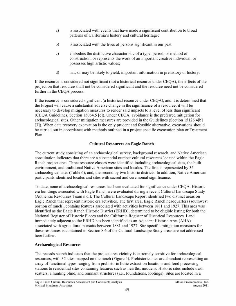
Eagle Ranch Cultural Resources Assessment and Constraints Analysis Michael Brandman Associates
Albion Environmental, Inc. August 2011
49
a) is associated with events that have made a significant contribution to broadpatterns of California’s history and cultural heritage;
b) is associated with the lives of persons significant in our past
c) embodies the distinctive characteristic of a type, period, or method ofconstruction, or represents the work of an important creative individual, orpossesses high artistic values;
d) has, or may be likely to yield, important information in prehistory or history.
If the resource is considered not significant (not a historical resource under CEQA), the effects of the project on that resource shall not be considered significant and the resource need not be considered further in the CEQA process.
If the resource is considered significant (a historical resource under CEQA), and it is determined that the Project will cause a substantial adverse change in the significance of a resource, it will be necessary to develop mitigation measures to render said impacts to a level of less than significant (CEQA Guidelines, Section 15064.5 [c]). Under CEQA, avoidance is the preferred mitigation for archaeological sites. Other mitigation measures are provided in the Guidelines (Section 15126.4[b] [3]). When data recovery excavation is the only prudent and feasible alternative, excavations should be carried out in accordance with methods outlined in a project specific excavation plan or Treatment Plan.
Cultural Resources on Eagle Ranch
The current study consisting of an archaeological survey, background research, and Native American consultation indicates that there are a substantial number cultural resources located within the Eagle Ranch project area. Three resource classes were identified including archaeological sites, the built environment, and traditional Native American sites and locales. The first is represented by 35 archaeological sites (Table 6); and, the second by two historic districts. In addition, Native American participants identified locales and sites with sacred and ceremonial significance.
To date, none of archaeological resources has been evaluated for significance under CEQA. Historic era buildings associated with Eagle Ranch were evaluated during a recent Cultural Landscape Study (Authentic Resources Team n.d.). The Cultural Landscape Report identified two distinct areas on Eagle Ranch that represent historic era activities. The first area, Eagle Ranch headquarters (southwest portion of ranch), contains features associated with activities between 1881 and 1927. This area was identified as the Eagle Ranch Historic District (ERHD), determined to be eligible listing for both the National Register of Historic Places and the California Register of Historical Resources. Land immediately adjacent to the ERHD has been identified as an Adjacent Historic Area (AHA) associated with agricultural pursuits between 1881 and 1927. Site specific mitigation measures for these resources is contained in Section 8.6 of the Cultural Landscape Study areas are not addressed here further.
Archaeological Resources
The records search indicates that the project area vicinity is extremely sensitive for archaeological resources, with 35 sites mapped on the ranch (Figure 4). Prehistoric sites are abundant representing an array of functional types ranging from prehistoric lithic extraction locations and food processing stations to residential sites containing features such as hearths, middens. Historic sites include trash scatters, a hunting blind, and remnant structures (i.e., foundations, footings). Sites are located in a

Eagle Ranch Cultural Resources Assessment and Constraints Analysis Michael Brandman Associates
Albion Environmental, Inc. August 2011
50
variety of environmental zones including upper canyon contexts (benches, terraces, and ridges along upstream canyons), canyon mouths (interface between canyon and valley floor), creek bank terraces (alluvial terraces adjacent to rivers and creeks), and alluvial plain contexts (open lowlands away from major topographic features).
Of the 35 sites, 30 are located in areas of planned development and will therefore require consideration during the CEQA review process (Figure 4 and Table 6). Additional archaeological work is likely to include supplemental identification tasks (Extended Phase I studies), resource evaluations (Phase II evaluations), and possibly mitigation planning and execution.
The identification, evaluation, and mitigation process required under CEQA is described in the following activity flow chart (Figure 5), and described in detail below. These actions will apply only to those resources subject to project impacts.
1. Confirm presence/absence of an archaeological deposit in cases where the nature ofdeposit is unclear. Satisfactory resource identification under CEQA may require ExtendedPhase I subsurface investigations to determine if an archaeological deposit is present. Thepurpose of this effort is to: 1) determine if a subsurface deposit is associated with surfacematerials or features (such as a bedrock milling station with no apparent associatedmaterials); and/or 2) to search for archaeological deposits in areas of high sensitivity wheredeposits may be buried or obscured by sediment deposition, vegetation, or moderndevelopment. Identified cultural deposits will need to be evaluated for significance underCEQA (Phase II Archaeological Evaluations). Methods of excavation for Extended Phase Iidentification will include any combination of standard archaeological techniques, includingmechanical excavation, surface scrapes, auger holes, shovel test pits, rapid recovery units,standard control units, and trenching. If the presence of an archaeological deposit is notconfirmed no further action is required at the location.
The current study has identified nine site areas that will require Extended Phase I investigations. (Table 6). In additional to these areas, it is highly recommended that Extended Phase I studies be conducted in select locations along lower portions of Eagle Creek and Paloma Creek (areas with mapped Holocene age alluvium) to assess the potential for buried land forms that may contain archaeological sites. These areas are depicted in Figure 4.
2. Conduct Phase II Evaluations of archaeological resources. Evaluations will minimallyentail assessment of each resource for significance under CEQA, and if needed, will includean assessment of project impacts and recommendations for mitigation measures. Significanceassessments should focus on deposit content, extent, and integrity, and therefore shouldincorporate an appropriate level of sub-surface investigation. In other words, evaluationsshould not be based solely on examination of surface materials. As part of the Phase IIevaluation, any necessary supplemental DPR resources recordation forms should becompleted (i.e., Archaeological Record; Building, Structure, Object Record; Linear FeatureRecord; Milling Station Record; Artifact Record).

This figure has been redacted because it contains sensitive archaeological site location information.
The location of archaeological sites is confidential and not for public review.

Eagle Ranch Cultural Resources Assessment and Constraints Analysis Michael Brandman Associates
Albion Environmental, Inc. August 2011
52
Table 6. Summary of archaeological resources and proposed actions.
Site Name Site Description
Potential Project Impact
Project Development
Extended Phase I
Phase II Evaluation/Mitigation
Process
New Sites
7-1 Prehistoric-sparse scatter of flaked and ground stone tools
Yes Residential lot No Yes
7-2 Prehistoric-extensive lithic tool and flake scatter, marine shell
Yes Residential lot/roads
No Yes
7-3 Historic?-Rock ring No - No No 8-1 Prehistoric- three bedrock
mortar cups Yes Residential lot Yes Yes
8-2 Prehistoric-two bedrock mortar cups
Yes Residential lot Yes Yes
10-1 Prehistoric-sparse lithic tool/flake scatter w/ burned bone
Yes Land use area/roads No Yes
13-1 Prehistoric-single bedrock mortar cup
Yes Residential lot Yes Yes
16-1 Prehistoric-lithic tool and flake scatter
Yes Residential lot No Yes
20-1 Historic-possible foundations Yes Additional land use Yes Yes 31-1 Prehistoric-extensive scatter of
tools, shell, outcrops, bedrock mortars
Yes Additional land use No Yes
37-1 Prehistoric/Historic-sparse flake/ground stone artifacts, historic debris, rock wall
Yes Additional land use No Yes
Resurvey 1-1
Historic- wells/ditches Yes Additional land use No Yes
Road 1 Prehistoric-sparse lithic scatter Yes Roads/Additional land use
No Yes
Road 2 Historic- trash scatter Yes Roads/Additional land use
No Yes
Road 3 Prehistoric-sparse flaked and battered stone tool scatter
Yes Roads/Additional land use
No Yes
Previously Recorded Sites 1391 Prehistoric-two bedrock mortar
cups Yes Additional land use Yes Yes
2395 Prehistoric-flaked stone tool and debitage scatter near outcrops
Yes Residential lot No Yes
2396 Historic?-Rock Ring No - No No 2397 Prehistoric-flaked and ground
stone tool scatter with shell and fire altered rock, hearth stones
Yes Residential lot No Yes
2400 Prehistoric-core and flake near outcrop, possible quarry
Yes Residential lot No Yes
2401 Prehistoric-flake scatter near outcrops
Yes Residential lot No Yes
2402 Prehistoric-chert core No - No No 2403 Prehistoric-shell midden, flaked
stone tools, flakes No - No No

Eagle Ranch Cultural Resources Assessment and Constraints Analysis Michael Brandman Associates
Albion Environmental, Inc. August 2011
53
Site Name Site Description
Potential Project Impact
Project Development
Extended Phase I
Phase II Evaluation/Mitigation
Process
2405 Prehistoric-flaked stone tool and flake scatter near outcrop
No - No No
2406 Prehistoric-Flaked stone tool and flake scatter
Yes Land use area No Yes
2407 Historic-site of 1904 military exercises
Yes Residential lot Yes Yes
2409 Historic- chimney, artifacts and other structural remains
Yes Residential lot No Yes
2410 Historic- series of possible trimmed foundation stones w/ no artifact association
Yes Residential lot Yes Yes
2411 Historic- ranch site with buildings, trash scatters
Yes Land use area No Yes
2412 Prehistoric-tool and flake scatter near outcrop
Yes Residential lot No Yes
2413 Prehistoric-reported as tool and flake scatter near outcrop, but no tools observed
Yes Residential lot Yes Yes
2415 Prehistoric-flake and tool scatter near outcrop, possible hunting blind. Burial cairn identified by Salinan (Appendix A)
Yes Additional land use No Yes
2417 Prehistoric-shellfish, flaked and ground stone tool scatter. Identified as having ceremonial significance by Salinan (Appendix A)
Yes Land use area No Yes
2419 Prehistoric-flaked stone debitage near outcrop
Yes Additional land use No No
2420 Prehistoric-reported as hearth stones, flaked stone tools and flakes; no artifacts observed
Yes Roads Yes Yes

Eagle Ranch Cultural Resources Assessment and Constraints Analysis Michael Brandman Associates
Albion Environmental, Inc. August 2011
54
Figure 5. Treatment of cultural resources under CEQA.
* CEQA Guidelines Section 15064.5(a) ** PRC 21083.2

Eagle Ranch Cultural Resources Assessment and Constraints Analysis Michael Brandman Associates
Albion Environmental, Inc. August 2011
55
3. Prepare mitigation plan to address impacts that will cause adverse changes to eligiblesites. The mitigation plan should also describe protocols for the treatment of sites discoveredin the course project development. Under CEQA, avoidance is the preferred mitigation forarchaeological sites. Other mitigation measures are provided in Section 15126.4(b)(3) ofCEQA. When data recovery is the only prudent and feasible alternative, a Treatment Planmust be prepared that provides for recovery of scientifically consequential information. TheTreatment Plan must be prepared before data recovery excavations.
The primary purpose of the Treatment Plan is to insure proper and consistent management of cultural resources and to assist project planners in meeting the CEQA requirement to avoid or significantly reduce damage to the environment and cultural resources. In addition, the Treatment Plan summarizes information about known archaeological resources, provides an overview of the various prehistoric and historic contexts, and describes in detail proposed excavation, laboratory, curation, and reporting methodologies. Archaeological Treatment Plans are intended to emphasize research and discovery of resources prior to any project activities.
Eagle Ranch Cultural Resources Assessment and Constraints Analysis Michael Brandman Associates
Albion Environmental, Inc. August 2011
56
REFERENCES CITED
Abrams, D.M. 1968 Little Pico Creek: Beach Salinan, Barnacles and Burials. Unpublished M.A. Thesis.
University of California.
Adam, D. P, and G. J. West 1983 Temperature and Precipitation Estimates through the Last Glacial Cycle from Clear Lake,
California Pollen data. Science 219:168-170.
Adam, D.P., R. Byrne, and E. Luther 1981 A Late Pleistocene and Holocene Pollen Record from Laguna de las Trancas, Northern
Coastal Santa Cruz County, California. Madroño 28:255-272.
Alt, D., and D.W. Hyndman 2000 Roadside Geology of Northern and Central California. Mountain Press Publishing Company,
Missoula, Montana.
Andrefsky, W. 1998 Lithics: Macroscopic Approaches to Analysis. Cambridge University Press, New York.
Antevs, E. 1948 Climatic Changes and Pre-White Man. The Great Basin, with Emphasis on Glacial and
Postglacial Times. University of Utah Bulletin 38(20), Biological Series 10(7):168-191.
1952 Climatic History and the Antiquity of Man. University of California Archaeological Survey Reports 16:23-31, Berkeley.
Arnold, J. 1992 Complex Hunter-Gatherer-Fishers of Prehistoric California: Chiefs, Specialists, and Maritime
Adaptations of the Channel Islands. American Antiquity 57:60-84.
Authentic Resources Team
n.n Cultural Resources Landscape Report. Prepared by Authentic resources Team for Eagle Ranch, LLC. Ventura, CA.
Axelrod, D.I. 1981 Holocene Climatic Changes in Relation to Vegetation Disjunction and Speciation. American
Naturalist 117:847-870.
Baker, B. 1977 Madonna Ranch CA-SLO-372: An Interpretation of an Island Chumash Site. Unpublished
M.A. Thesis, California State University.
Basgall, M.E. 2006 Eligibility Assessments for Eight Prehistoric Archaeological Sites at Camp Roberts and
Camp San Luis Obispo, San Luis Obispo and Monterey Counties, California. Archaeological Research Center, Institute of Archaeology and Cultural Studies, Department of Anthropology, California State University, Sacramento.

Eagle Ranch Cultural Resources Assessment and Constraints Analysis Michael Brandman Associates
Albion Environmental, Inc. August 2011
57
Baumhoff, M.A. 1963 Ecological Determinants of Aboriginal California Populations. University of California
Publications in American Archaeology and Ethnology 49(2).
Binning, J. n.d. A History of Archaeological Research in the Cuyama River valley. Manuscript on file with
the U.S. Forest Service, Goleta.
Blackburn, T.C. 1975 December’s Child. University of California Press, Berkeley.
Bolton, H.E. 1931 Expedition to San Francisco Bay in 1770: Diary of Pedro Fages. Academy of Pacific Coast
History 2(3): 141-159.
Bouey, P.D., and M.E. Basgall 1991 Archaeological Patterns Along the South-Coast, Point Piedras Blancas, San Luis Obispo
County, California: Archaeological Test Evaluation Sites CA-SLO-26, SLO-267, SLO-268, SLO-1226, and SLO-1227. Report on file at the California Department of Transportation, San Luis Obispo.
Breschini, G.S., and T. Haversat 1988a Cultural Resource Inventory and Management Plan for Camp Roberts, San Luis Obispo and
Monterey Counties, California. Submitted to the U.S. Department of the Army Corps of Engineers, Sacramento.
1988b Archaeological Excavations at CA-SLO-7 and CA-SLO-8, Diablo Canyon, San Luis Obispo County, California. Coyote Press Archives of California Prehistory 28, Salinas.
Breschini, G.S., T. Haversat, and R.P. Hampson 1983 A Cultural Resources Overview of the Coast and Coast Valley Study Areas. Report on file at
the Northwest Information Center of the California Archaeological Site Survey, Sonoma State University, Rohnert Park.
Brown, A.K. 1967 The Aboriginal Population of the Santa Barbara Channel. University of California
Archaeological Survey Reports 69:1-99. Berkeley.
Browning, Peter 1992 The Discovery of San Francisco Bay: The Portolá Expedition of 1769-1770. The Diary of
Miguel Costansó. Great West Books, Lafayette, California.
Burch, S.H., and D.L. Durham 1970 Complete Bouguer Gravity and General Geology of the Bradley, San Miguel, Adelaida, and
Paso Robles Quadrangles, California. Geological Survey Professional Paper 646-B. United States Government Printing Office, Washington D. C.
Burcham, L.T. 1957 California Range Land: An Historic-Ecological Study of the Range Resources of California.
California Department of Natural Resources, Division of Forestry, Sacramento.
Campbell, L. 1997 American Indian Languages: The Historical Linguistics of Native America. Oxford
University Press, New York.

Eagle Ranch Cultural Resources Assessment and Constraints Analysis Michael Brandman Associates
Albion Environmental, Inc. August 2011
58
Carpenter, T., Nicholson, D. and Zeanah, D.W. 2007 Archaeological Evaluations of Twelve Prehistoric Properties on Camp San Luis Obispo and
Camp Roberts, San Luis Obispo County, California (Camp San Luis Obispo: CA-SLO-602, SLO-1842, SLO-2023, SLO-2175, and SLO-2209; Camp Roberts: CA-SLO-1180 West, SLO-1180 East, SLO-1835, SLO-1836, SLO-2025, SLO-2176, and SLO-2177). Prepared for Military Department California National Guard, Sacramento, California.
Carter, G.C. 1941 Archaeological Notes on a Midden at Point Sal. American Antiquity 6:214-226.
Chartkoff, J.P. 1989 Exchange Systems in the Archaic of Coastal Southern California. Proceedings of the Society
for California Archaeology 2:167-187.
Christensen, M.N. 1966 Quaternary of the California Coast Ranges. In Geology of Northern California, pp. 305-314,
edited by E.H. Bailey. Bulletin No. 190, California Division of Mines and Geology, San Francisco.
Clemmer, J.S. 1962 Archaeological Notes on a House Floor at Morro Bay. R. E. Schenk Archives of California
Archaeology 62, San Francisco State University, San Francisco.
Codding, B.F. and T.L. Jones 2007 History and Behavioral Ecology During the Middle-Late Transition on the Central California
Coast: Findings from the Coon Creek Site (CA-SLO-9), San Luis Obispo County. Journal of California and Great Basin Anthropology 27:125-151.
Codding, B.F., Porcasi, J.F., and T.L. Jones 2010 Explaining Prehistoric Variation in the Abundance of Large Prey: A Zooarchaeological
Analysis of Deer and Rabbit Hunting Along the Pecho Coast of Central California. Journal of Anthropological Archaeology 29:47-61.
Colten, R. 1993 Prehistoric Subsistence, Specialization, and Economy in a Southern California Chiefdom.
Ph.D. Dissertation, University of California, Los Angeles. Ann Arbor: University Microfilms.
Compton, R. R. 1966 Granitic and Metamorphic Rocks of the Salinan Block, California Coast Ranges. Geology of
Northern California, edited by E.H. Bailey, pp. 227-287. Bulletin No. 190, California Division of Mines and Geology, San Francisco.
Conway, T. 2005 Eagle Ranch Heritage Studies. Vol. 1. Prepared by Heritage Discoveries, Inc. for RRM
Design Group. San Luis Obispo, CA.
Cook, S.F. 1976 The Population of the California Indians 1769-1970. University of California Press, Berkeley.
Cook, S.F., and R.F. Heizer 1965 The Quantitative Approach to the Relation between Population and Settlement Size.
University of the California Archaeological Survey Reports 64:1-97.

Eagle Ranch Cultural Resources Assessment and Constraints Analysis Michael Brandman Associates
Albion Environmental, Inc. August 2011
59
Costanső, M. 1992 Diary of Miguel Costanso. Publications of the Academy of Pacific Coast History, vol. 2, pp.
167-173.
Curry, R.R. 1969 Holocene Climate and Glacial History of the Central Sierra Nevada, California. Geological
Society of America Special Paper 123.
Curtis, F. 1965 The Glen Annie Site (SBA-142): A Case for Sedentary Village Life. University of California
Archaeological Survey Annual Report, 1964-1965:1-18, Los Angeles.
Davis, O.K. 1984 Multiple Thermal Maxima During the Holocene. Science 225:617-619.
Davis, E.L., C.W. Brott, and D.L. Weide 1969 The Western Lithic Co-Tradition. San Diego Museum Papers 6.
Dietz, S.A., W.R. Hildebrandt, and T.L. Jones 1988 Archaeological Investigations at Elk Horn Slough: CA-MNT-229, A Middle Period Site on
the California Coast. Papers in Northern California Anthropology No. 3, Rohnert Park.
Dietz, S.A., and T.L. Jackson 1981 Report of Archaeological Excavations at Nineteen Archaeological Sites for the State 1 Pacific
Grove-Monterey Consolidation Project of the Regional Sewage System. Report prepared for Engineering-Science, Inc., Berkeley.
Dupre, W.R. 1991 Quaternary Geology of the Southern California Coast Ranges. In Quaternary Nonglacial
Geology: Conterminous U.S., pp. 176-184. Edited by R.B. Morrison. The Geology of North America, Vol. K-2, The Geological Society of America, Boulder, Colorado.
Erlandson, J.M. 1991 Shellfish and Seeds as Optimal Resources: Early Holocene Subsistence on the Santa Barbara
Coast. In Hunter-Gatherers of Early Holocene Coastal California, edited by J. Erlandson and R. Colten, pp. 101-112. Perspectives in California Archaeology No. 1, Institute of Archaeology, University of California, Los Angeles.
1994 Early Hunter-Gatherers of the California Coast. New York: Plenum Press.
1997 The Middle Holocene on the Western Santa Barbara Coast. In Archaeology of the Santa Barbara Coast During the Middle Holocene, edited by J. M. Erlandson and M. A. Glassow, pp. 91-110. Perspectives in California Archaeology, Vol. 4. Institute of Archaeology, University of California, Los Angeles.
Farquhar, J., R. Brady, T. Garlinghouse, and J. Ellison 2011 Archaeological Investigations for the Nacimiento Water Project. Prepared for the County of
San Luis Obispo Department of Public Works.
Farrell, N. 2000 Cultural Resources Inventory of the Santa Ysabel Ranch, Paso Robles, California. Prepared
for Weyrich Development, Paso Robles.

Eagle Ranch Cultural Resources Assessment and Constraints Analysis Michael Brandman Associates
Albion Environmental, Inc. August 2011
60
Farris, G.J. 1986 Appendix A: Ethnographic Accounts of the Indians of San Simeon. In The Prehistory of San
Simeon Creek 5,800 B.P. to Missionization. Report prepared for the Department of Parks and Recreation, Sacramento.
Fitzgerald, R.T. 1997a Archaeological Data Recovery at the Salinas River Crossing Site, CA-SLO-1756, San Luis
Obispo County, California. Prepared for the CDWR for the California State Water Project: Coastal Branch Phase II.
1997b Archaeological Data Recovery at the Trout Creek Site, CA-SLO-1644 San Luis Obispo County California. Prepared for the California Department of Water Resources California State Water Project, Costal Branch, Phase II.
1998 Archaeological Data Recovery at CA-SLO-1797, The Cross Creek Site, San Luis Obispo County, California Coastal Branch, Phase II Project. Prepared for the California Department of Water Resources, Sacramento.
2000 Cross Creek: An Early Holocene/Millingstone Site. California State Water Project, Coastal Branch Series Paper Number 12. San Luis Obispo County Archaeological Society, San Luis Obispo.
Fitzgerald, R.T., and T.L. Jones 1999 The Milling Stone Horizon Revisited: New Perspectives from Northern and Central
California. Journal of California and Great Basin Anthropology 21(1):67-93.
Fredrickson, D.A. 1974 Cultural Diversity in Early Central California: A View from the North Coast Ranges. Journal
of California Anthropology 1:41-54.
Fredrickson, D.A. 1998 An Archaeological Evaluation of CA-MNO-566 and -2466, Huntoon Valley, Mono County,
California. Report submitted to Caltrans District 09, Bishop.
Gibson, R.O. 1978 Final Report of Evaluation and Significance of an Indian Site (CA-SLO-834) Atascadero
Wastewater Treatment Facility San Luis Obispo County. Report on file at the Central Coast Information Center, University of California, Santa Barbara.
1979 Preliminary Inventory and Assessment of Indian Cultural Resources at Lodge Hill, Cambria, San Luis Obispo County, California. Prepared for the San Luis Obispo County Engineering Department.
1982 Final Report of Archaeological Monitoring at SLO-98, Intersection of Ocean Blvd. And Seaview Avenue, Shell Beach, San Luis Obispo County, California. Gibson Archaeological Consulting, Paso Robles. Submitted to Southern California Gas Company, Los Angeles.
1980 Preliminary Inventory and Assessment of Indian Cultural Resources at Spanish Oaks (Rancho Santa Margarita), San Luis Obispo County, California. On file with Information Center at University of California Santa Barbara, California.
1983 Ethnography of the Salinan People: A Systems Approach. Masters Thesis, California State University, Hayward.

Eagle Ranch Cultural Resources Assessment and Constraints Analysis Michael Brandman Associates
Albion Environmental, Inc. August 2011
61
1987 Results of Archaeological Subsurface testing at Las Encinas Site 1 (SLO-1199), Santa Cruz Road, Atascadero, California. Prepared for Cuesta Engineering. On file At the Central Coast Information Center, University of California, Santa Barbara
Gibson, R.O. and J.A. Parsons 2003 Inventory of Prehistoric, Historic, Paleontological, and Geologic Resources for the Camp
Roberts/East Salinas River Alignment, Nacimiento Water Supply Pipeline Project, San Luis Obispo County, CA. On file at Environmental Science Associates, Oakland, CA.
Glassow, M.A. 1990 Archaeological Investigations on Vandenberg Air Force Base in Connection with the
Department of Space Transportation Facilities. Vol. 2, Submitted to U.S. Department of Interior, National Park Service, Contract no. CA 8099-2-0004. Copies available from National Technical Information Services, Operation Division, 5285 Port Royal Road, Springfield, Virginia 22161.
1991 Archaeological Investigations on Vandenberg Air Force Base in Connection with the Department of Space Transportation Facilities. Vol. 1, Submitted to U.S. Department of Interior, National Park Service, Contract no. CA 8099-2-0004. Copies available from National Technical Information Services, Operation Division, 5285 Port Royal Road, Springfield, Virginia 22161.
1996 Purisimeňo Chumash Prehistory: Maritime Adaptations along the Southern California Coast. Harcourt and Brace, Orlando.
1997 Middle Holocene Cultural Development in the Central Santa Barbara Channel Region. In Archaeology of the California Coast During the Middle Holocene. Edited by J. M. Erlandson and M. A. Glassow, pp 73-91. Perspectives in California Archaeology, Volume 4, Institute of Archaeology, University of California, Los Angeles.
Glassow, M.A., A. Kennett, D.J. Kennett, J.P. and L.R. Wilcoxon 1994 Confirmation of Middle Holocene Ocean Cooling Inferred from Stable Isotope Analysis of
Prehistoric Shells from Santa Cruz Island, California. In Fourth California Islands Symposium: Update on the Status of Resources, edited by W. L. Halvorson and G. J. Maender, pp. 223-232. Santa Barbara Museum of Natural History.
Glassow, M.A., and L.R. Wilcoxon 1988 Coastal Adaptations Near Point Conception, California, with Particular Regard to Shellfish
Exploitation. American Antiquity 53(1):36-51.
Glassow, M.A., L.R. Wilcoxon, and J. Erlandson 1988 Cultural and Environmental Change During the Early Period of Santa Barbara Channel
Prehistory. In The Archaeology of Hunter-Gatherer Subsistence Economies in Coastal Environments, edited by G. Parkington and G. Bailey. Cambridge University Press, Cambridge.
Glover, Jack 1975 The “Bobbed Wire” IV Bible: An Illustrated Guide to Identification and Classification of
Barbed Wire. Cow Puddle Press, Sunset, Texas.

Eagle Ranch Cultural Resources Assessment and Constraints Analysis Michael Brandman Associates
Albion Environmental, Inc. August 2011
62
Golla, V. 2007 California Archaeology and Prehistory after Moratto: Linguistic Prehistory. In Prehistory of
California: Colonization, Culture, and Continuity, edited by Terry L. Jones and Kathryn Klar, Chapter 6 (in press). Walnut Creek, Altamira Press.
Grant, C. 1978 Chumash: Introduction. In California, edited by R. F. Heizer, W. C. Sturtevant, general
editor, pp.505-508. Handbook of California Indians, Vol. 8. Smithsonian Institute, Washington, D. C.
Graumlich, L.J. 1993 A 1000-year Record of Temperature and Precipitation in the Sierra Nevada. Quaternary
Research 39:249-255.
Greenwood, R. 1972 9000 Years of Prehistory at Diablo Canyon, San Luis Obispo County, California. San Luis
Obispo County Archaeological Society Occasional Paper No. 7, San Luis Obispo.
1978 Obispeňo and Purisimeňo Chumash. In California, edited by R. F. Heizer, W. C. Sturtevant, general editor, pp. 520-523. Handbook of North American Indians. Vol. 8. Smithsonian Institute, Washington, D. C.
Hall, E.R. 1981 The Mammals of North America. Jon Wiley and Sans, Inc. New York
Harrington, J.P. 1942 Cultural Element Distributions, XIX: Central California. University of California
Anthropological Records 7(1):1-46.
Harrison, W.M. 1964 Prehistory of the Santa Barbara Coast, California. Unpublished Ph.D. dissertation,
Department of Anthropology, University of Arizona, Tucson.
Hart, E.W. 1976 Basic Geology of the Santa Margarita Area, San Luis Obispo County, California. Bulletin
No. 199, California Division of Mines and Geology, San Francisco.
Hester, T.R. 1978 Salinan. In California, edited by R. F. Heizer, W. C. Sturtevant, general editor, pp. 509-519.
Handbook of North American Indians, Vol 8. Smithsonian Institute, Washington, D. C.
Heusser, L. 1978 Pollen in Santa Barbara, California: A 12,000 yr. Record. In Geological Society of America
Bulletin 89: 673-678.
Hildebrandt, W.R. 1994 Review of Early Hunter-Gatherers of the California Coast. Journal of California and Great
Basin Anthropology 16(1): 137-141.
Hildebrandt, W.R., and P. Mikkelson 1993 Archaeological Test Excavations at Fourteen Sites Along Highway 101 and 152, Santa Clara
and San Benito Counties, California. Prepared for Caltrans District 4.

Eagle Ranch Cultural Resources Assessment and Constraints Analysis Michael Brandman Associates
Albion Environmental, Inc. August 2011
63
Hoover, R.L., and W.B. Sawyer 1977 Los Osos Junior High School Site 4-SLO-214. San Luis Obispo County Archaeological
Society Occasional Paper 11.
Horne, S.K., and M.A. Glassow 1974 Archaeological Investigations: Sierra Madre Ridge, Los Padres National Forest. Manuscript
prepared for the U.S. Forest Service.
Ingles, L.G. 1965 Mammals of the Pacific States: California, Oregon and Washington. Stanford University
Press, Stanford, California.
Ingram, B.L., and J.R. Southon 1996 Reservoir Ages in Eastern Pacific Coastal and Estuarine Waters. Radiocarbon 38(3):573-582.
Jackson, T.L. and J.E. Ericson 1994 Prehistoric Exchange Systems in California. In Prehistoric Exchange Systems in North
America, edited by T. G. Baugh and J.E. Ericson, pp. 385-415. Plenum Press, New York.
Johnson, D.L. 1977 The Late Quaternary Climate of Coastal California: Evidence for an Ice Age Refugium.
Quaternary Research 8:154-179.
Johnson, J. 1988 Chumash Social Organization: An Ethnohistoric Perspective. Ph.D. Dissertation, Department
of Anthropology, University of California, Santa Barbara.
Jones, D.A. 1992 The Forager-Collector Model and Monterey Bay Prehistory. In Essays On the Prehistory of
Maritime California, edited by T.L. Jones. Center for Archaeological Research at Davis, Publication No. 10.
Jones, D.A., C. Young, and W.R. Hildebrandt 2002 Prehistoric Occupations on Ancient Halcyon Bay/Estuary: Excavations at Sites CA-SLO-832
and CA-SLO-1420, Pismo Beach, California. San Luis Obispo County Archaeological Society Occasional Paper No. 15, San Luis Obispo.
Jones, T.L. 1978 Aboriginal Activity at Elkhorn Sough, California. Senior Thesis, University of California,
Santa Cruz.
1992 Settlement Trends Along the California Coast. In Essays of the Prehistory of Maritime California, edited by Terry L. Jones, pp. 1-38. Center for Archaeological Research at Davis, No. 10, Department of Anthropology, University of California, Davis.
1993 Sur: A Keystone in Central California Cultural History. Pacific Coast Archaeological Society Quarterly 29(1): 1-78.
1995 Transitions in Prehistoric Diet, Mobility, and Exchange, and Social Organization Along California’s Big Sur Coast. Unpublished Ph.D. dissertation, Department of Anthropology, University of California, Davis. University Microfilms, Ann Arbor.
1996 Mortars, Pestles, and Division of Labor in Prehistoric California: A View from Big Sur. American Antiquity 61:243-264.

Eagle Ranch Cultural Resources Assessment and Constraints Analysis Michael Brandman Associates
Albion Environmental, Inc. August 2011
64
2000 Archaeological Evaluations at CA-MNT-237 and CA-MNT-519 Fort Hunter Liggett, Monterey County, California. Prepared for the U.S. Army Corps of Engineers, Sacramento District.
2003 Prehistoric Human Ecology of the Big Sur Coast, California. Contributions of the University of California Archaeological Research Facility, Berkeley.
Jones, T.L., G.M. Brown, L.M. Raab, J.L. McVickar, W.G. Spaulding, D.J. Kennet, A. York, and P.L. Walker 1999 Environmental Imperatives Reconsidered: Demographic Crisis in Western North America
During the Medieval Climatic Anomaly. Current Anthropology 40(2):137-170.
Jones, T.L., K. Davis, G. Farris, S.D. Grantham, B. Rivers, and T. Fung 1994 Toward a Prehistory of Morro Bay: Phase II Archaeological Investigations for the Morro Bay
Highway 41 Widening Project, San Luis Obispo County, California. California Department of Transportation, Sacramento. On file at Central Coast Information Center, University of California, Santa Barbara.
Jones, T.L. and J. Ferneau 2002 Prehistory of San Simeon Reef Archaeological Data Recovery at CA-SLO-179 and –267, San
Luis Obispo County, California. San Luis Obispo County Archaeological Society Occasional Paper No. 16.
Jones, T.L., and J. Haney 1997a Archaeological Evaluation of CA-MNT-521, Fort Hunter Liggett, Monterey County,
California. Garcia and Associates, San Anselmo, California. Prepared for U.S. Army Corps of Engineers, Sacramento, California.
1997b Archaeological Evaluation of CA-MNT-569, Fort Hunter Liggett, Monterey County, California. Garcia and Associates, San Anselmo, California. Prepared for U.S. Army Corps of Engineers, Sacramento, California
Jones, T., and M. Hylkema 1988 Two Proposed Projectile Point Types for the Monterey Bay Area: Año Nuevo Long-stemmed
and Rossi Square-stemmed. Journal of California and Great Basin Anthropology 10(2):163-186.
Jones, T.L. and J. Richman 1995 On Mussels: Mytilus californianus as a Prehistoric Resource. North American Archaeologist
16(1): 33-58.
Jones, T.L, N.E. Stevens, D.A. Jones, R.T. Fitzgerald, M.G. Hylkema 2007 The Central Coast: A Midlatitude Milieu. In California Prehistory: Colonization, Culture,
and Complex, edited by T.L. Jones and K.A. Klar, pp. 125-146. Alta Mira Press, Lanham.
Jones, T.L., and G. Waugh 1995 Central California Coastal Prehistory: A View of Little Pico Creek. Perspectives in
California Archaeology, Vol. 3. Institute of Archaeology, University of California, Los Angeles.
1997 Climatic Consequences or Population Pragmatism? A Middle Holocene Prehistory of the Central California Coast. In Archaeology of the California Coast During the Middle Holocene. Perspectives in California Archaeology, Vol. 4, edited by J. Erlandson and M. Glassow. Institute of Archaeology, University of California, Los Angeles.
Eagle Ranch Cultural Resources Assessment and Constraints Analysis Michael Brandman Associates
Albion Environmental, Inc. August 2011
65
Kennett, D.J., B.L. Ingram, J.M. Erlandson, and P.L. Walker 1997 Evidence for Temporal Fluctuations in Marine Radiocarbon Reservoir Ages in the Santa
Barbara Channel, Southern California. Journal of Archaeological Science 24:1051-1059.
King, C. 1978 Protohistoric and Historic Archeology. In Handbook of North American Indians 8,
California, edited by R.F. Heizer, pp. 58-68. Smithsonian Institution, Washington D.C.
1981 The Evolution of Chumash Society: A Comparative Study of Artifacts Used in Social System Maintenance in the Santa Barbara Channel Region Before A.D. 1804. Unpublished Doctor of Philosophy Dissertation, University of California, Davis.
King, T. 1970 Avila Beach: Descriptive Data and Hypotheses from the Excavation of 1929. Archives of
California Archaeology 1, San Francisco.
Krieger, D.E. 1988 San Luis Obispo County: Looking Backward into the Middle Kingdom. Northridge: Windsor
Publications, Inc.
Kroeber, A.L. 1925 Handbook of the Indians of California. Smithsonian Institute, Bureau of American Ethnology
Bulletin 78. [Reprinted (1976) Dover Publications, Inc., New York.]
1955 Linguistic Time Depth Results So Far and Their Meaning. International Journal of American Linguistics 21:91-104.
La Marche, V.C., Jr. 1974 Paleoclimatic Inferences for Long Tree-Ring Records. Science 183:1043-1048.
1978 Tree-Ring Evidence of Past Climatic Variability. Nature 276:334-338.
Lambert, P.M. 1993 Health in Prehistoric Populations of the Santa Barbara Channel Islands. American Antiquity
58(3):509-522.
Landberg, L.C. 1965 The Chumash Indians of Southern California. Southwestern Museum Papers 19.
Latham, R. G. 1856 On the Languages of Northern, Western, and Central America. Transactions of the
Philological Society, pp. 57-294.
Lathrop, D.W. and R.T. Troike 1984 California Historical Linguistics and Archaeology. Journal of the Steward Anthropological
Society 15(1):99-157.
Lebow, C.M., C. Baloian, D.R. Harro, R.L. McKim, C. Denardo, J. Onken, E. Romanski, and B.A. Price 2001 Final Report of Archaeological Investigations for Reaches 5B and 6 Coastal Branch
Aqueduct, Phase II. Applied Earthworks, Inc., Fresno, California. Submitted to Central Coast Water Authority, Buellton, California. Copies Available from California Department of Water Resources, Sacramento.

Eagle Ranch Cultural Resources Assessment and Constraints Analysis Michael Brandman Associates
Albion Environmental, Inc. August 2011
66
Lee, R. 1969 Chemical Temperature Integration. Journal of Applied Meteorology 8: 423-430.
Leonard, N.N., D. Abrams, D.L. Weide, and M. Susia 1968 Archaeological Salvage of the Pico Creek and Little Pico Creek Sites. Robert E. Schenk
Archives of California Archaeology 4, Treganza Museum, San Francisco State University.
Lewis, L.P., E. H. Hubbard, and A. Pace 1991 Southern Coast Ranges, Annual Field Trip Guide Book, No. 19. South Coast Geological
Society, Inc., Santa Ana, California.
Magurran, A.E. 2004 Measuring Biological Diversity. Blackwell Publishing, Malden.
Marine Research Specialists (MRs) 2003 Nacimiento Water Project, Environmental Impact Report (SCH#2001061022). Prepared for
the County of San Luis Obispo, Department of Planning and Building.
Martz, P.C. 1992 Status Distinctions Reflected in Chumash Mortuary Populations in the Santa Monica
Mountains Region. In Essays on the Prehistory of Maritime California, edited by Terry L. Jones, pp. 145-156. Center for Archaeological Research at Davis, No. 10, Department of Anthropology, University of California, Davis.
Mason, J.A. 1912 The Ethnology of the Salinan Indians. University of California Publications in American
Archaeology and Ethnology 10(4):97-240.
1918 The Language of the Salinan Indians. University of California Publications in Archaeology and Ethnology 14:1-154.
Mehringer, APP., Jr. 1986 Prehistoric Environments. The Great Basin, Handbook of North American Indians, Vol. 11.
edited by WALL. d’Azevedo, pp. 31-50. Smithsonian Institute, Washington, D. C..
Mikkelsen, P., W. Hildebrandt, and D. Jones 1998 Prehistoric Adaptations on the Shores of Morro Bay: A Report on Excavation at Site CA-
SLO-165, Morro Bay, and California. Submitted to California Department of Transportation, District 5, San Luis Obispo.
2000 Prehistoric adaptations on the shores of Morro Bay Estuary: Excavations at Site CA-SLO-165, Morro Bay, California. San Luis Obispo County Archaeological Society Occasional Paper No. 14.
Miller, B.W. 1988 Chumash: A Picture of their World. Sand River Press, Los Osos.
Milliken, R. and J.R. Johnson 2003 Salinan and Northern Chumash Communities of the Early Mission Period. Prepared for
Caltrans Contract No. 06A0148 & 06A0391. Far Western Anthropological Research Group, Inc., Davis, California.
Mithun, M. 1999 The Languages of Native North America. Cambridge University Press, Cambridge.

Eagle Ranch Cultural Resources Assessment and Constraints Analysis Michael Brandman Associates
Albion Environmental, Inc. August 2011
67
Moratto, M.J. 1984 California Archaeology. Academic Press, New York.
Moratto, M.J, and O.K. Davis 1988 Paleoenvironment. Culture Change in the Central Sierra Nevada, 8000 BC – AD 1950: Final
Report of the New Melones Archaeological Project 9. Report submitted to the National Park Service, Washington, D .C.
Moratto, M., T.F. King, and W.B. Woolfenden 1978 Archaeology and California’s Climate. The Journal of California Anthropology 5:147-161.
Morgan, A., L.S. Cummings, and J.L. Rudolph 1991 Paleoenvironmental Change. In Western Chumash Prehistory: Resource use and Settlement
in the Santa Ynez River Valley, edited by C.F. Woodman, J.L. Rudolph, and T.L. Rudolph, pp. 65-101. Ms. on file, Vandenberg Air Force Base.
Moriarity, J.R., and R.P. Burns 1962 A Preliminary Reconnaissance of a Pre-ceramic Site at Avila Beach, San Luis Obispo,
California. San Diego Science Foundation 3.
Nichols, M. J. P. 1984 Old California Uto-Aztecan. Journal of the Steward Anthropological Society 15:22-46.
Norris, R.M. and R.W. Webb 1976 Geology of California. John Wiley and Sons, Inc. New York.
Olson, R.L. 1930 Chumash Prehistory. University of California Publications in American Archaeology and
Ethnology 28(1):1-22, Berkeley.
Origer, T.M. 1987 Temporal control in the Southern North Coast Ranges of California: The Application of
Obsidian Hydration Analysis. Papers in Northern California Anthropology 1, Berkeley.
Orr, P. 1943 The Archaeology of Mescalitan Island and the Customs of the Canaliňo. Santa Barbara
Museum of Natural History, Occasional Papers No. 51-61.
Owen, R.C. 1964 Early Milling Stone Horizon (Oak Grove), Santa Barbara County, California: Radiocarbon
Dates. American Antiquity 30:210-213
Page, B.M. 1966 Geology of the Coast Ranges of California. In Geology of Northern California, pp. 255-276,
edited by E.H. Bailey. Bulletin No. 190, California Division of Mines and Geology, San Francisco.
Parker, J. 2002 A 9,000 Year Old House Floor at CA-SLO-369: Archaeological Mitigation and Monitoring
Report for APN 023-023-012, 611 Warren Road, Cambria. Parker and Associates, P.O. Box 462, Cayucos, California. Prepared for O’Sullivan Construction, 2471 Banbury Road, Cambria.

Eagle Ranch Cultural Resources Assessment and Constraints Analysis Michael Brandman Associates
Albion Environmental, Inc. August 2011
68
Pierce, A.M. 1979 Archaeological Investigations at CA-SLO-177 and Vicinity, Cambria, California.
Unpublished Master’s Thesis, Department of Anthropology, Stanford University.
Pisias, N.G. 1978 Paleoceanography of the Santa Barbara Basin During the Last 8000 Years. Quaternary
Research 11:373-386
Pohorecky, Z.S. 1976 Archaeology of the South Coast Ranges of California. University of Archaeological Research
Facility 34, Berkeley.
Reddell, D. 1970 Harrigan Site Shell Beach. Occasional Papers of the San Luis Obispo County Archaeological
Society 1.
Reinman, F.M. 1961 Archaeological Investigations at Whale Rock Reservoir, Cayucos, California. Manuscript on
file at the Department of Parks and Recreation, Sacramento.
Robinson, S.W. and G. Thompson 1981 Radiocarbon Corrections for Marine Shell Dates with Application to Southern Pacific
Northwest Prehistory. Syesis 14:45-57.
Rock, James T. 1987 A Brief Commentary on Cans. Report created for Cultural Resource Management. Report on
file at the San Diego Office Library
Rogers, D.B. 1929 Prehistoric Man of the Santa Barbara Coast. Santa Barbara.
Scuderi, L.A. 1987 Glacial Variations in the Sierra Nevada, California, as Related to a 1200-year Tree-ring
Chronology. Quaternary Research 27:220-231.
Smith, J.E. 1961 Archaeological Resources at Vaquero Reservoir. University of California, Los Angeles,
Archaeological Survey Annual Report 1960-1961.
Stevens, N.E., R.T. Fitzgerald, N. Farrell, M.A. Giambastiani, J.M. Farquhar, and D. Tinsley 2004 Archaeological Test Excavations at Santa Ysabel Ranch, Paso Robles San Luis Obispo
County, California. Prepared for Weyrich Development, LLC, P.O. Box 7003 Paso Robles, California 93447.
Stine, S.W. 1990 Late Holocene Fluctuations of Mono Lake, Eastern California. Palaeogeography,
Palaeoclimatology, Palaeoecology 78:333-381.
1994 Extreme and Persistent Drought in California and Patagonia during Medieval Time. Nature 369:546-549.

Eagle Ranch Cultural Resources Assessment and Constraints Analysis Michael Brandman Associates
Albion Environmental, Inc. August 2011
69
Swartz, B.K. 1957 Notes on the Excavation of Ca-MNT-315. Ms. on file (E-582 MNT), Regional Information
Center of the California Archaeological Inventory, Rohnert Park. Manuscript No. 454, University of California Archaeological Research Facility, Berkeley.
Tainter, J. 1971 Salvage Excavations at the Fowler Site: Some Aspects of the Social Organization of the
Northern Chumash. Occasional Papers of the San Luis Obispo County Archaeological Society 3.
Timbrook, J. 1984 Chumash Ethnobotany: A Preliminary Report. Journal of Ethnobiology 4: 141-169.
True, D.L., M.A. Baumhoff, and J.E. Hellen 1979 Milling Stone Cultures in Northern California: Berryessa I. Journal of California and Great
Basin Anthropology 1:124-154.
Turner, K. 1987 Aspects of Salinan Grammar. Ph.D. Dissertation, University of California, Berkeley.
Wagner, H.R. 1929 Spanish Voyages to the Northwest Coast of America in the Sixteenth Century. California
Historical Society Special Publications 4.
Wallace, W.J. 1955 A Suggested Chronology for Southern California Coastal Archaeology. Southwestern Journal
of Anthropology 11:214-230.
1962 Archaeological Investigations in the Arroyo Grande Watershed, San Luis Obispo County, California. Archaeological Survey Annual Report 1961-1962. University of California, Los Angeles.
1978 Post Pleistocene Archaeology, 9000-2000 B.C. In California, edited by R.F. Heizer, pp. 25-36. Handbook of North American Indians, vol. 8, W.G. Sturtevant, general editor,Smithsonian Institution, Washington, D.C.
Warren, C.N. 1967 The San Dieguito Complex: A Review and Hypothesis. American Antiquity 32:168-185.
1968 Cultural Tradition and Ecological Adaptations of the Southern California Coast. In Archaic Prehistory in the Western United States, edited by C. Irwin-Williams, pp. 1-14. Eastern New Mexico University Contributions in Anthropology Vol. 1, No. 3.
West, G.J. 1987 Examination of Pollen in Selected Sediments from the Chevron Point Arguella Project, Santa
Barbara County, California. Brienes, West and Schultz Consultants, Davis.
1988 Exploratory Pollen Analysis of Sediments from Elkhorn Slough. In Archaeological Investigation at Elkhorn Slough, CA-MNT-229, A Middle Period Site on the California Coast, by S.A. Dietz, W. Hildebrandt, and T. Jones, pp. 25-56. Papers in Northern California.

Eagle Ranch Cultural Resources Assessment and Constraints Analysis Michael Brandman Associates
Albion Environmental, Inc. August 2011
70
Wickstrom, B.P., J.P. Eidness, T.L. Jackson, and R.T. Fitzgerald 1996 Archaeological Testing of CA-SLO-586 at Santa Margarita, California, for Coastal Branch
Phase II Project. Biosystems, Santa Cruz. On file at the Northwest Information Center of the California Historical Resources Information System, Sonoma State University, Rohnert Park.
Wire, M.V.V. 1961 Alamo Creek Site, San Luis Obispo County, California. University of California, Los
Angeles, Archaeological Survey Annual Report 1960-1961:107-148.
Zeiner, D.C., W.F. Laudenslayer, Jr. and K.E. Mayer 1990 California’s Wildlife, Volume I, Birds, and Volume II, Mammals. Department of Fish and
Game, Sacramento.

APPENDIX A
REDACTED-Contains Confidential Information
SALINAN TRIBE CONSULTATION ANDCHUMASH TRIBAL COUNCIL CONSULTATION

APPENDIX B SITE RECORDS
REDACTED-Contains Confidential Information

City of Atascadero – Eagle Ranch Specific Plan Draft EIR
FirstCarbon Solutions Y:\Publications\Client (PN-JN)\3622\36220005\EIR\3 - DEIR\36220005_Sec99-00 Appendix Dividers.docx
D.2 - Addendum #1: Additional Archaeological Survey for the Eagle Ranch Cultural Resources Assessment and
Constraints Analysis (Draft, November 2011)

MICHAEL BRANDMAN ASSOCIATES ADDENDUM #1: ADDITIONAL ARCHAEOLOGICAL SURVEY FOR THE EAGLE RANCH CULTURAL RESOURCES ASSESSMENT AND CONSTRAINTS ANALYSIS
DRAFT
SAN LUIS OBISPO COUNTY, CALIFORNIA
NOVEMBER 2011
ALBION ENVIRONMENTAL, INC.
MICHAEL BRANDMAN ASSOCIATES ADDENDUM #1: ADDITIONAL ARCHAEOLOGICAL SURVEY FOR THE EAGLE RANCH CULTURAL RESOURCES ASSESSMENT AND CONSTRAINTS ANALYSIS
DRAFT
SAN LUIS OBISPO COUNTY, CALIFORNIA
NOVERMBER 2011
PREPARED FOR:
RANDY CHAFIN MICHAEL BRANDMAN ASSOCIATES
2000 "O" STREET, SUITE 200 SACRAMENTO, CA 95811
PREPARED BY:
JENNIFER FARQUHAR ALBION ENVIRONMENTAL, INC.
1414 SOQUEL AVENUE, SUITE 205 SANTA CRUZ, CALIFORNIA 95062
J2011011.02

Addendum #1: Additional Archaeological Survey for the Albion Environmental, Inc. Eagle Ranch Cultural Resources Assessment and Constraints Analysis Draft November 2011 Michael Brandman Associates i
TABLE OF CONTENTS
Table of Contents .................................................................................................................................... i
List of Figures ......................................................................................................................................... i
Summary of Findings ............................................................................................................................. 1
Project Location and Description ........................................................................................................... 1
Sources Consulted .................................................................................................................................. 3
Archaeological Survey ........................................................................................................................... 3 Methods ............................................................................................................................................. 3 Survey Results and Recommendations ............................................................................................. 5
References Cited ..................................................................................................................................... 6
LIST OF FIGURES
Figure 1. Project location map. ............................................................................................................... 2 Figure 2. Survey area, Eagle Ranch, San Luis Obispo County, California. ........................................... 4

Addendum #1: Additional Archaeological Survey for the Albion Environmental, Inc. Eagle Ranch Cultural Resources Assessment and Constraints Analysis Draft November 2011 Michael Brandman Associates 1
SUMMARY OF FINDINGS
This report documents the results of a cultural resources inventory within the proposed Eagle Ranch development in San Luis Obispo County, California (Figure 1). Albion Environmental, Inc. (Albion) conducted this work in November, 2011.
The current study is part of a larger effort to provide the City of Atascadero and its potential partners with information about the constraints and opportunities posed by archaeological and historical resources located on Eagle Ranch. The larger study, detailed in the report entitled Eagle Ranch Cultural Resources Assessment and Constrains Analysis (Farquhar and Brady 2011) was designed to identify potential significant cultural resources (archaeological sites, traditional cultural locations, and historic structures) that may be impacted by the proposed project, and to determine the need for further technical studies to complete environmental review of under the California Environmental Quality Act (CEQA). The current report serves as an addendum to Farquhar and Brady (2011).
The constraints analysis (Farquhar and Brady 2011) included: 1) archaeological survey of approximately 973 acres slated for development (Survey Areas 1-27); 2) resurvey of 70-acres sample of previous surveyed lands; 3) revisiting previously recorded archaeological sites to assess accuracy of site records; and 4) consultation with representatives of the Northern Chumash Tribal Council and Salinan Tribe to identify traditional cultural sites. Forty-four archaeological sites were identified during this study; sixteen were discovered during the survey, 28 were previously recorded (Conway 2005). Most of the sites (n=35) are prehistoric in age, representing a range of site types including small encampments, large habitation sites, chert quarry locations, tool manufacturing areas, and plant processing locales. Four sites date to historic times and four have mixed temporal components. One is of unknown age. To date, none of the archaeological resources have been evaluated for significance under current CEQA guidelines.
The current effort included survey of a 37-acre parcel located in the eastern portion of the ranch (Survey Area 28). No additional archaeological sites were identified during this effort.
PROJECT LOCATION AND DESCRIPTION
Eagle Ranch is located in northern San Luis Obispo County, situated in the foothills and mountains of the Santa Lucia Range. The property is located southwest of Atascadero, west of U.S. Highway 101 (Figure 1). The main access to the property is the Santa Barbara exit off U.S. Highway 101.
Eagle Ranch occupies a range of environments including rugged upland terrain, hill slopes and canyons, low ridges and knolls, and river terraces. Watercourses on the ranch form part of the headwaters of the Salinas River. The area is considers highly sensitive for prehistoric and historic cultural resources with archaeological sites, structures, and buildings representing over 9000 years of human occupation. Land uses within the study area include agriculture and grazing.
The City of Atascadero proposes to annex Eagle Ranch lands (approximately 3400 acres) for future residential and recreational development. Two prior cultural resources studies were conducted for proposed development including a cultural resources landscape study (Authentic Resources Team

± 0 5 10 15 202.5
Kilometers
0 5 10 15 202.5
Miles
File
nam
e: F
igur
e_1.
ai, J
2011
-011
.02,
Ste
lla D
’Oro
, 22N
ovem
ber2
011
Digital elevation model of California
Albion Environmental, Inc.
Figure 1. Project location map.
Eagle Ranch
San Luis Obispo
Morro Bay
Atascadero
Paso Robles
CA
LIFO
RN
IA

Addendum #1: Additional Archaeological Survey for the Albion Environmental, Inc. Eagle Ranch Cultural Resources Assessment and Constraints Analysis Draft November 2011 Michael Brandman Associates 3
n.d) that addressed above the ground resources, and a cultural resources survey that identified prehistoric and historic-era archaeological resources (Conway 2005).
The current study area includes previously unsurveyed portions of the ranch identified as suitable for development (Figure 2). The following report sections detail sources consulted prior to survey, field methods, and survey results. Pertinent background information including regulatory context, environmental context, and cultural context are contained in Farquhar and Brady (2011), and not reiterated here.
SOURCES CONSULTED
Background research for the current study relied primarily on recent studies conducted at Eagle Ranch, including a cultural resources assessment report prepared for The RRM Group of San Luis Obispo (Conway 2005), and a Cultural Landscape Report prepared for Eagle Ranch LLC (Authentic Resources Team n.d.). Examination of these reports indicates the subject was not previously inventoried for cultural resources.
ARCHAEOLOGICAL SURVEY
Methods
Albion archaeologists Jennifer Farquhar and John Ellison conducted the survey November 1-2, 2011. The effort was led by Ms. Farquhar, an experienced archaeologist with over twenty years of experience working in California. She received her Master’s in Anthropology from the California State University Sacramento in 2003, and has supervised several excavation and inventory survey projects throughout central, southern, and northern California. Representatives of the two consulting Native American tribes, the Salinan Tribe and the Northern Chumash Tribal Council, participated in the survey.
The survey area was covered in controlled transects, traversed on foot in back and forth sweeps with individuals spaced 10 meters apart. Relative positions were routinely checked using compass bearings. Spacing was maintained throughout a range of different topographic situations, irrespective of slope and vegetation coverage. Particular attention was paid to areas of exposed soils, such as dirt roads and rodent burrows.
In addition, the survey area was evaluated for potential to contain buried landforms or cultural deposits. This assessment was made based partly on in-field observations of colluvial and/or alluvial deposits, but also mapping of Holocene age alluvial deposits (Hart 1976). Recent studies have demonstrated that these deposits can be sensitive for older buried landforms and cultural deposits (Rosenthal and Meyers 2004). Indeed, not all Holocene age alluvial deposits are equally sensitive for buried landforms, and sensitively appears to be related to distance to water, proximity to geomorphic contact, and slope of the landform (Rosenthal and Meyer 2004:76). The following sensitivity model was used to assess potential for buried archaeological deposits:
Very Low – pre-latest Pleistocene deposits regardless of the combination of other factors, Low to Moderate – Latest Pleistocene or Holocene deposits with slopes greater than nine
degrees, located more than 200 m (656 ft) from a water source and/or geomorphic contact,

Albion Environmental, Inc.
Figure 2. Survey area, EagleRanch, San Luis ObispoCounty, California.
File name: Figure_2.ai, J2011-011.02, Stella D’Oro, 22November2011
Legend
Albion survey area, November 2011
Proposed lots
Eagle Ranch boundary
Proposed land use area
Rural historic district
Proposed road
Proposed equestrian trail
Existing road
28 ±0 250 500 750 1,000Meters
0 1,000 2,000 3,000 4,000
Feet
28

Addendum #1: Additional Archaeological Survey for the Albion Environmental, Inc. Eagle Ranch Cultural Resources Assessment and Constraints Analysis Draft November 2011 Michael Brandman Associates 5
High – Holocene deposits with slopes less than nine degrees located less than 200 m (656 ft) from a geomorphic contact, and less than 200 m (656 ft) from a water source,
Very High – Holocene deposits with slopes less than nine degrees located less than 200 m (656 ft) from a geomorphic contact, water source, and confluence of two or more watercourses, and/or contains previously identified buried site.
Previously established field protocols for identification, recordation, and reporting were in place for the current effort, and are detailed in Farquhar and Brady (2011).
Survey Results and Recommendations
The survey area is located in the eastern part of Eagle Ranch, composed of terraces, rolling oak woodland, and steep slopes to the north of Paloma Creek. The area is mapped as Monterey Formation, and has low potential for buried landforms or archaeological deposits.
Despite the intensive survey effort, no sites or isolated artifacts were identified within the subject survey area. As such, it is Albion’s judgment that no additional cultural resource investigations will be required in this location during subsequent CEQA review of proposed development at Eagle Ranch.

Addendum #1: Additional Archaeological Survey for the Albion Environmental, Inc. Eagle Ranch Cultural Resources Assessment and Constraints Analysis Draft November 2011 Michael Brandman Associates 6
REFERENCES CITED
Authentic Resources Team n.d. Cultural Resources Landscape Report. Prepared by Authentic resources Team for Eagle Ranch, LLC.
Ventura, California.
Conway, T. 2005 Eagle Ranch Heritage Studies. Vol. 1. Prepared by Heritage Discoveries, Inc. for RRM Design Group.
San Luis Obispo, California.
Farquhar, J., and R. Brady 2011 Eagle Ranch Cultural Resources Assessment and Constraints Analysis. Prepared for Michael
Brandman Associates, Sacramento, CA.
Hart, E.W. 1976 Basic Geology of the Santa Margarita Area, San Luis Obispo County, California. Bulletin No. 199,
California Division of Mines and Geology, San Francisco.
Rosenthal, J. and J. Meyer 2004 A Geoarchaeological Study of the Southern Santa Clara Valley and Surrounding Region. Center for
Archaeological Research at Davis. Publication No. 14.

City of Atascadero – Eagle Ranch Specific Plan Draft EIR
FirstCarbon Solutions Y:\Publications\Client (PN-JN)\3622\36220005\EIR\3 - DEIR\36220005_Sec99-00 Appendix Dividers.docx
D.3 - Addendum #2: Additional Archaeological Survey for the Eagle Ranch Cultural Resources Assessment and
Constraints Analysis (Draft, November 2011)

MICHAEL BRANDMAN ASSOCIATES ADDENDUM #2: ADDITIONAL ARCHAEOLOGICAL SURVEY FOR THE EAGLE RANCH CULTURAL RESOURCES ASSESSMENT AND
CONSTRAINTS ANALYSIS
FINAL
SAN LUIS OBISPO COUNTY, CALIFORNIA
NOVEMBER 2011
ALBION ENVIRONMENTAL, INC.

MICHAEL BRANDMAN ASSOCIATES ADDENDUM #2: ADDITIONAL ARCHAEOLOGICAL SURVEY FOR THE EAGLE RANCH CULTURAL RESOURCES ASSESSMENT AND CONSTRAINTS ANALYSIS
DRAFT
SAN LUIS OBISPO COUNTY, CALIFORNIA
NOVEMBER 2011
PREPARED FOR:
RANDY CHAFIN MICHAEL BRANDMAN ASSOCIATES
2000 "O" STREET, SUITE 200 SACRAMENTO, CA 95811
PREPARED BY:
JENNIFER FARQUHAR ALBION ENVIRONMENTAL, INC.
1414 SOQUEL AVENUE, SUITE 205 SANTA CRUZ, CALIFORNIA 95062
J2011011.03

Addendum #2: Extended Phase I Investigations for the Albion Environmental, Inc. Eagle Ranch Cultural Resources Assessment and Constraints Analysis Report Draft November 2011 Michael Brandman and Associates
i
TABLE OF CONTENTS
List of Figures ......................................................................................................................................... i
List of Tables ........................................................................................................................................... i
Introduction ............................................................................................................................................ 1
Project Location and Description ........................................................................................................... 1
Methods .................................................................................................................................................. 4 Field Methods .................................................................................................................................... 4
CA-SLO-1391 .............................................................................................................................. 4 CA-SLO-2407 .............................................................................................................................. 4 CA-SLO-2413 .............................................................................................................................. 7 CA-SLO-2420 .............................................................................................................................. 7
Laboratory Methods .......................................................................................................................... 8
Site Summaries ....................................................................................................................................... 8 CA-SLO-1391 ................................................................................................................................... 8
Soils ............................................................................................................................................. 8 Cultural Constituents ................................................................................................................. 10 Interpretation .............................................................................................................................. 10
CA-SLO-2420 ................................................................................................................................. 10 Soils ........................................................................................................................................... 10 Cultural Constituents ................................................................................................................. 11 Interpretation .............................................................................................................................. 11
Summary and Conclusion..................................................................................................................... 11
References Cited ................................................................................................................................... 13
LIST OF FIGURES
Figure 1. Project location map. ............................................................................................................... 2 Figure 2. Extended Phase I locations. .REDACTED.............................................................................. 3 Figure 3. CA-SLO-1391. .REDACTED.................................................................................................. 5 Figure 4. CA-SLO-2407 and CA-SLO-2413. REDACTED................................................................... 6 Figure 5. CA-SLO-2420. ...REDACTED................................................................................................ 9
LIST OF TABLES
Table 1. CA-SLO-1391 artifact count by unit and depth. .................................................................... 10 Table 2. CA-SLO-2420 artifact count by unit and depth. .................................................................... 11

Addendum #2: Extended Phase I Investigations for the Albion Environmental, Inc. Eagle Ranch Cultural Resources Assessment and Constraints Analysis Report Draft November 2011 Michael Brandman and Associates 1
INTRODUCTION
This report documents the results of an Extended Phase I study for the proposed Eagle Ranch development in San Luis Obispo County, California (Figure 1). Albion Environmental, Inc. (Albion) conducted this work in October and November, 2011.
The current study is part of a larger effort to provide the City of Atascadero and its potential partners with information about the constraints and opportunities posed by archaeological and historical resources located on Eagle Ranch. The larger study, detailed in the report entitled Eagle Ranch Cultural Resources Assessment and Constrains Analysis (Farquhar and Brady 2011) was designed to identify potential significant cultural resources (archaeological sites, traditional cultural locations, and historic structures) that may be impacted by the proposed project, and to determine the need for further technical studies to complete environmental review of under the California Environmental Quality Act (CEQA). The current report serves as an addendum to Farquhar and Brady (2011).
The constraints analysis (Farquhar and Brady 2011) included: 1) archaeological survey of approximately 973 acres slated for development; 2) resurvey of 70-acres sample of previous surveyed lands; 3) revisiting previously recorded archaeological sites to assess accuracy of site records; and 4) consultation with representatives of the Northern Chumash Tribal Council and Salinan Tribe to identify traditional cultural sites. Forty-four archaeological sites were identified during initial study; sixteen were discovered during the survey, 28 were previously recorded (Conway 2005). Most of the sites (n=35) are prehistoric in age, representing a range of site types including small encampments, large habitation sites, chert quarry locations, tool manufacturing areas, and plant processing locales. Four sites date to historic times and four have mixed temporal components. One is of unknown age.
Of the known sites, 21 are located in areas of planned development and will therefore require further consideration during the CEQA review process (Farquhar and Brady 2011: Figure 4 and Table 6). An additional nine sites were judged as requiring Extended Phase I subsurface investigations to determine if intact cultural deposits are present, requiring further review under CEQA. The current study involves four of these sites including: CA-SLO-1391, SLO-2407, SLO-2413, and SLO-2420 (Figure 2).
For this study, determination of the presence of intact subsurface deposits is based on two criteria: 1) identification of intact soil strata, lacking evidence of redeposition or disturbance; and 2) identification of prehistoric or historic age materials in densities greater than 3 items per 0.12 cubic meters (or 25 items per cubic meter). If no archaeological deposits are encountered, or are found in disturbed contexts, no further action is required. If intact deposits are encountered, Phase II test evaluations will likely be required during subsequent CEQA review.
PROJECT LOCATION AND DESCRIPTION
Eagle Ranch is located in northern San Luis Obispo County, situated in the foothills and mountains of the Santa Lucia Range. The property is located southwest of Atascadero, west of U.S. Highway 101 (Figure 1). The main access to the property is the Santa Barbara exit off U.S. Highway 101.
Eagle Ranch occupies a range of environments including rugged upland terrain, hill slopes and canyons, low ridges and knolls, and river terraces. Watercourses on the ranch form part of the headwaters of the Salinas River. The area is considers highly sensitive for prehistoric and historic

± 0 5 10 15 202.5
Kilometers
0 5 10 15 202.5
Miles
File
nam
e: F
igur
e_1.
ai, J
2011
-011
.03,
Ste
lla D
’Oro
, 21N
ovem
ber2
011
Digital elevation model of California
Albion Environmental, Inc.
Figure 1. Project location map.
Eagle Ranch
San Luis Obispo
Morro Bay
Atascadero
Paso Robles
CA
LIFO
RN
IA

This figure has been redacted because it contains sensitive archaeological site location information.
The location of archaeological sites is confidential and not for public review.

Addendum #2: Extended Phase I Investigations for the Albion Environmental, Inc. Eagle Ranch Cultural Resources Assessment and Constraints Analysis Report Draft November 2011 Michael Brandman and Associates 4
cultural resources with archaeological sites, structures, and buildings representing over 9000 years of human occupation. Land uses within the study area include agriculture and grazing.
The City of Atascadero proposes to annex Eagle Ranch lands (approximately 3400 acres) for future residential and recreational development. Two prior cultural resources studies were conducted for proposed development including a cultural resources landscape study (Authentic Resources Team n.d.) that addressed above the ground resources, and a cultural resources survey that identified prehistoric and historic-era archaeological resources (Conway 2005).
METHODS
Field Methods
CA-SLO-1391
This prehistoric site is situated on a broad elevated terrace adjacent to Los Osos Road (Figure 3). Seasonal drainages are located to the west and east of the site. Vegetation includes introduced grasses, oak, poison oak, and bay. An area of dense chaparral is located immediately west of the site boundary.
The area is situated within the Atascadero Formation, notable for abundant sandstone outcrops. The potential for buried deposits in the vicinity is considered to be generally low; however, colluvial deposits from slopes to the southeast, and alluvial deposits derived from the drainage to the east do have the potential to obscure potential cultural deposits.
This archaeological site was originally recorded by Fenenga (1991) as two bed bedrock mortar features, each containing one mortar cup. No other cultural constituents were identified. An archaeological survey conducted by Albion Environmental on July 18th, 2011 revisited the site location and reconfirmed the cultural remains noted on the original record.
On October 31, 2011, Albion staff archaeologists conducted Extended Phase I excavations in the vicinity of CA-SLO- 1391 (Figure 4). Prior to field work, the study area was intensively surveyed (transects of no greater than 5 m); no cultural materials were noted. Subsurface investigations included manual excavation of three Shovel Test Pits (STP) within the site boundary to identify subsurface constituents and soil stratigraphy (Figure 3). STPs measured 40 cm in diameter, and were excavated in 20 cm increments to a depth ranging between 40 and 60 cmbs. Excavated soil from all units was dry screened through 1/4-inch mesh. All cultural materials were noted, bagged with provenience information, and collected for further processing at the Albion laboratory. Excavation results were documented on appropriate field forms which recorded soil description, identified artifacts, identified disturbances, and recorded other pertinent information. Soil samples were taken from each unit level to assess color and texture. Screening was conducted over a tarp to expedite backfilling and to limit disturbance to habitat. All units were backfilled when excavation was complete.
CA-SLO-2407
This site was originally mapped on the steep southeastern slopes of Tarantula Hill (Conway 2005) (Figure 4). The area is currently covered by dense introduced grasses and sparse oak trees. The area is situated atop a discrete volcanic geological formation; a number of bedrock outcrops extend from the

This figure has been redacted because it contains sensitive archaeological site location information.
The location of archaeological sites is confidential and not for public review.

This figure has been redacted because it contains sensitive archaeological site location information.
The location of archaeological sites is confidential and not for public review.
Addendum #2: Extended Phase I Investigations for the Albion Environmental, Inc. Eagle Ranch Cultural Resources Assessment and Constraints Analysis Report Draft November 2011 Michael Brandman and Associates 7
top of the hill down the southeastern flanks. Santa Barbara road is located at the base of the southeastern slope.
The site was originally recorded as the location of military exercises conducted in 1904 (Conway 2005). While no cultural remains associated with military activity here observed, Conway suggested that this area had “archaeological potential”. Albion revisited the location of this site on July 30th, 2011 and performed an intensive surface survey within the previously recorded site boundary and adjacent areas. During the investigations, Albion covered a 120 meter wide swath (east to west) from the ranch road to the northern edge of the saddle but no historic cultural remains were identified. Multiple areas of ground disturbance, including shallow trenches and berms, and a retention pond were noted during the survey. It is unclear if these earthworks are related to historic military exercises or more recent ranching activities; however, the retention pond may suggest that these features are ranching related.
On November 1, 2011, Albion staff archaeologists revisited the site to conducted Extended Phase I excavations. Prior to field work, the study area was intensively surveyed (transects of no greater than 5 m); no cultural materials were noted. Given the absence of artifacts, the low potential for soil development (site located on steep slopes), it was determined that subsurface excavations were not required, and no further action was taken.
CA-SLO-2413
This site was originally mapped (Conway 2005) on the southeastern slope of Tarantula Hill, just south of CA-SLO-2407 (Figure 4). The steep slopes are currently covered by dense introduced grasses and sparse oak trees. The area is mapped within a discrete volcanic geological formation; a number of bedrock outcrops extend from the top of the hill down the southeastern flanks. Santa Barbara road is located at the base of the southeastern slope.
CA-SLO-2413 was originally recorded by Conway (2005) as consisting of several Franciscan chert outcrops with associated flaking debris. An archaeological survey conducted by Albion revisited the location of this site on July 30th, 2011 and performed an intensive surface survey within the previously recorded site boundary and adjacent areas. No cultural materials were identified. Multiple chert outcrops were noted during the Albion resurvey, but they were of poor quality and did not exhibit flake scars or other evidence of raw material procurement.
On November 1, 2011, Albion staff archaeologists revisited the site to conducted Extended Phase I excavations. Prior to field work, the study area was intensively surveyed (transects of no greater than 5 m); no cultural materials were noted. Given the absence of artifacts, the low potential for soil development (site located on steep slopes), it was determined that subsurface excavations were not required, and no further action was taken.
CA-SLO-2420
This prehistoric site is situated on a saddle between two hills with valleys located to the north and south (Figure 5). Multiple metamorphic bedrock outcrops are found in immediate vicinity. The site is covered with introduced grasses and poison oak. The site is situated within the Franciscan Mélange, marked by rolling hills and seasonal drainages. The potential for buried deposits in the vicinity is considered to be very low.
This site was originally recorded by Conway (2005) and identified as a scatter of hearth stones, chert tools and flakes. An archaeological survey conducted by Albion on July 14th, 2011 revisited the

Addendum #2: Extended Phase I Investigations for the Albion Environmental, Inc. Eagle Ranch Cultural Resources Assessment and Constraints Analysis Report Draft November 2011 Michael Brandman and Associates 8
location of this site; however no cultural remains were identified within the recorded site boundaries or the greater vicinity.
On November 1, 2011, Albion staff archaeologists conducted Extended Phase I excavations in the vicinity of CA-SLO- 2420 to identify potential intact subsurface deposits (Figure 5). Prior to field work, the study area was intensively surveyed (transects of no greater than 5 m); no cultural materials were noted. Subsurface investigations included manual excavation of one standard STP within the recorded site boundary (north side of the maintained dirt road) (Figure 5). The STP measured 40 cm in diameter, excavated in 20 cm increments to a depth of 60 cmbs. A shallow Surface Scrape (SS) was excavated on the south side of the road, near a prominent rock outcrop just outside the recorded southwest site boundary. The unit measured 1.0 m X 0.5 m, excavated to bedrock (about 3 cmbs).
Excavated soil from all units was dry screened through 1/4-inch mesh. All cultural materials were noted, bagged with provenience information, and collected for further processing at the Albion laboratory. Excavation results were documented on appropriate field forms which recorded soil description, identified artifacts, identified disturbances, and recorded other pertinent information. Soil samples were taken from each unit level to assess color and texture. Screening was conducted over a tarp to expedite backfilling and to limit disturbance to habitat. All units were backfilled when excavation was complete.
Laboratory Methods
Upon completion of field work, materials were delivered to Albion’s laboratory facility in Santa Cruz, California. Here, artifacts were checked against field records for accuracy of provenience information. Artifacts were first sorted according to location in excavation unit, feature, level, screen size, artifact class, and material. They then were cleaned with clear water and a soft toothbrush. Washing was minimized in order to preserve residues and wear patterns that may be present on the specimens. After initial processing, individual artifacts were each assigned a specimen number, while entire lots of flaked stone debitage and non–artifactual bone and shell from a specific provenience were assigned a single specimen number. Preliminary cataloging data were entered into an Access 2007 computer database. All specimens were placed in 4.0 mm thick plastic bags and labeled with computer generated, acid free/non–stick labels, packaged in cardboard bin–part boxes, and stored in archive boxes for curation.
SITE SUMMARIES
CA-SLO-1391
Soils
According to the USDA Soil Survey, the site is underlain by Millsholm –Dibble soils, a complex composed of 20% Dibble clay loam, and 30 % Millsholm clay loam soil. The soil complex is described as moderately deep , well-drained , and formed in materials weathered from sandstone and shale (USDA 1979). A typical pedon of the complex has a shallow A horizon (0-18 cmbs); soils are a pale brown (10 YR 6/3) clay loam. The underlying B horizon is a light yellowish brown (10 YR 6/4) clay loam extending to about 23 cmbs. Hard shale lies below.
Soils encountered during the study were fairly homogenous, characterized by a dark yellowish sandy loam. Bedrock was encountered at 52 cmbs in STP # 1, and at 85 cmbs in an auger placed at the bottom of STP #3.

This figure has been redacted because it contains sensitive archaeological site location information.
The location of archaeological sites is confidential and not for public review.
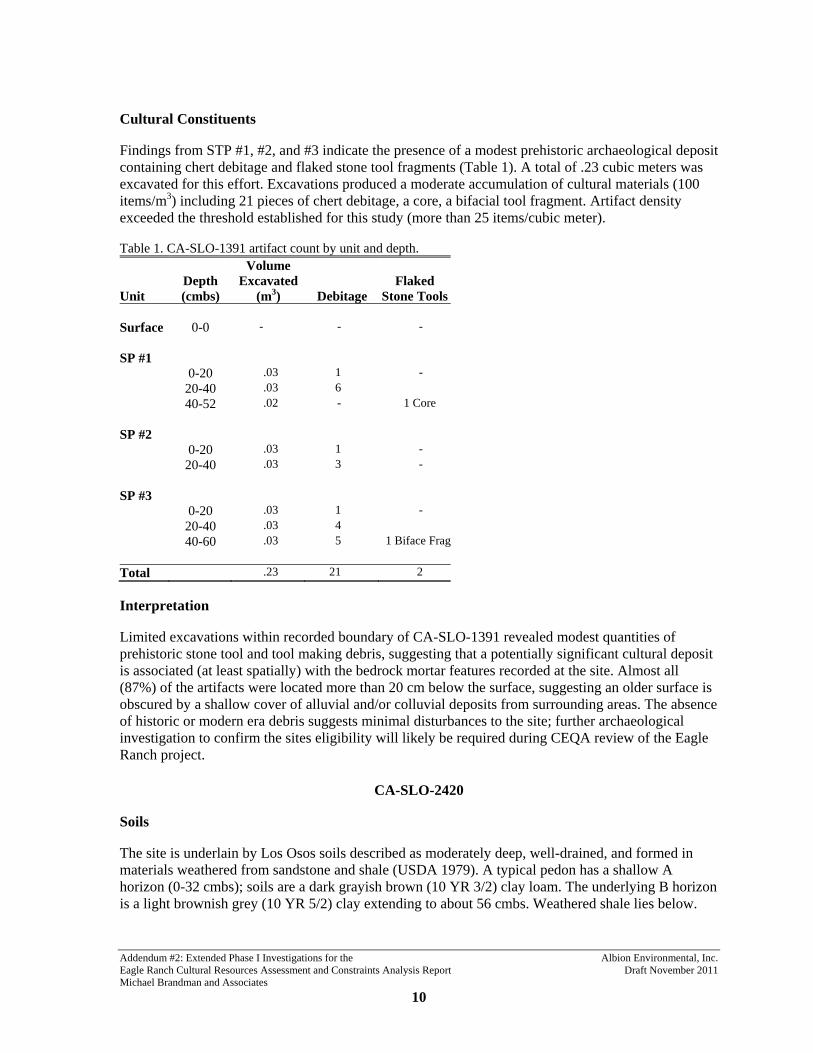
Addendum #2: Extended Phase I Investigations for the Albion Environmental, Inc. Eagle Ranch Cultural Resources Assessment and Constraints Analysis Report Draft November 2011 Michael Brandman and Associates 10
Cultural Constituents
Findings from STP #1, #2, and #3 indicate the presence of a modest prehistoric archaeological deposit containing chert debitage and flaked stone tool fragments (Table 1). A total of .23 cubic meters was excavated for this effort. Excavations produced a moderate accumulation of cultural materials (100 items/m3) including 21 pieces of chert debitage, a core, a bifacial tool fragment. Artifact density exceeded the threshold established for this study (more than 25 items/cubic meter).
Table 1. CA-SLO-1391 artifact count by unit and depth.
Unit Depth (cmbs)
Volume Excavated
(m3) Debitage Flaked
Stone Tools Surface 0-0 - - - SP #1 0-20 .03 1 - 20-40 .03 6 40-52 .02 - 1 Core SP #2 0-20 .03 1 - 20-40 .03 3 - SP #3 0-20 .03 1 - 20-40 .03 4 40-60 .03 5 1 Biface Frag Total .23 21 2
Interpretation
Limited excavations within recorded boundary of CA-SLO-1391 revealed modest quantities of prehistoric stone tool and tool making debris, suggesting that a potentially significant cultural deposit is associated (at least spatially) with the bedrock mortar features recorded at the site. Almost all (87%) of the artifacts were located more than 20 cm below the surface, suggesting an older surface is obscured by a shallow cover of alluvial and/or colluvial deposits from surrounding areas. The absence of historic or modern era debris suggests minimal disturbances to the site; further archaeological investigation to confirm the sites eligibility will likely be required during CEQA review of the Eagle Ranch project.
CA-SLO-2420
Soils
The site is underlain by Los Osos soils described as moderately deep, well-drained, and formed in materials weathered from sandstone and shale (USDA 1979). A typical pedon has a shallow A horizon (0-32 cmbs); soils are a dark grayish brown (10 YR 3/2) clay loam. The underlying B horizon is a light brownish grey (10 YR 5/2) clay extending to about 56 cmbs. Weathered shale lies below.

Addendum #2: Extended Phase I Investigations for the Albion Environmental, Inc. Eagle Ranch Cultural Resources Assessment and Constraints Analysis Report Draft November 2011 Michael Brandman and Associates 11
Soils encountered during the study were fairly homogenous, characterized by a dark yellowish brown sandy loam. Bedrock was encountered at 60 cmbs in STP # 1, and at 3 cmbs in SS #1.
Cultural Constituents
Excavations produced a very sparse accumulation of cultural materials (25 items/m3) limited to two chert flakes (Table 2). Artifact density does not exceed the threshold established for this study (more than 25 items/cubic meter).
Table 2. CA-SLO-2420 artifact count by unit and depth.
Unit Depth (cmbs)
Volume Excavated
(m3) Debitage Flaked
Stone Tools Surface 0-0 - - - STP #1 0-20 .03 1 - 20-40 .03 1 40-60 .03 - - SS #1 0-3 .02 - - Total .08 2 -
Interpretation
Limited excavations within recorded boundary revealed negligible evidence of a cultural deposit, limited to two chert flakes. This, in conjunction with the lack of surface artifacts or features, seems to indicate that the area does not likely constitute a significant an archaeological resource. As such, no further work is likely to be required during subsequent CEQA review of the Eagle Ranch project.
SUMMARY AND CONCLUSION
An Extended Phase I study was undertaken by Albion to determine if previously unidentified intact subsurface cultural deposits were located at four locations at Eagle Ranch. This determination was based on two criteria: 1) identification of intact soil strata, lacking evidence of redeposition or disturbance; and, 2) identification of prehistoric or historic age materials in densities greater than 25 items per cubic meter.
The Extended Phase I study indicates that significant quantities of cultural materials likely associated with bedrock mortar features at CA-SLO-1391. While no artifacts were observed on the surface, a modest stone tool/debris assemblage was noted between 20 and 60 cmbs. The absence of historic or modern era debris suggests minimal disturbances to the site; further archaeological investigation to confirm the sites eligibility will likely be required during CEQA review of the Eagle Ranch project.

Addendum #2: Extended Phase I Investigations for the Albion Environmental, Inc. Eagle Ranch Cultural Resources Assessment and Constraints Analysis Report Draft November 2011 Michael Brandman and Associates 12
Evidence for potentially significant, intact archaeological deposits was not encountered at CA-SLO-2407, SLO-2413, or SLO-2420. It is Albion’s judgment that no further work will be required at these locations during subsequent CEQA review of the proposed development at Eagle Ranch.

Addendum #2: Extended Phase I Investigations for the Albion Environmental, Inc. Eagle Ranch Cultural Resources Assessment and Constraints Analysis Report Draft November 2011 Michael Brandman and Associates 13
REFERENCES CITED
Authentic Resources Team n.d. Cultural Resources Landscape Report. Prepared by Authentic resources Team for Eagle Ranch, LLC.
Ventura, California.
Conway, T. 2005 Eagle Ranch Heritage Studies. Vol. 1. Prepared by Heritage Discoveries, Inc. for RRM Design Group.
San Luis Obispo, California.
Farquhar, J., and R. Brady 2011 Eagle Ranch Cultural Resources Assessment and Constraints Analysis. Prepared for Michael
Brandman Associates, Sacramento, California.
Fenenga, G. 1991 Site record for CA-SLO-1391. On file at the CHRIS Central Coast Information Center, University of
California, Santa Barbara.
Hart, E.W. 1976 Basic Geology of the Santa Margarita Area, San Luis Obispo County, California. Bulletin No. 199,
California Division of Mines and Geology, San Francisco.
Rosenthal, J. and J. Meyer 2004 A Geoarchaeological Study of the Southern Santa Clara Valley and Surrounding Region. Center for
Archaeological Research at Davis. Publication No. 14.
US Department of Agriculture (USDA) 1979 Soil Survey of San Luis Obispo County, California (Paso Robles Area).

THIS PAGE INTENTIONALLY LEFT BLANK

City of Atascadero – Eagle Ranch Specific Plan Draft EIR
FirstCarbon Solutions Y:\Publications\Client (PN-JN)\3622\36220005\EIR\3 - DEIR\36220005_Sec99-00 Appendix Dividers.docx
D.4 - Addendum #3: Additional Archaeological Survey for the Eagle Ranch Cultural Resources Assessment and
Constraints Analysis (Final, July 2013)
MICHAEL BRANDMAN ASSOCIATES ADDENDUM #3: ADDITIONAL ARCHAEOLOGICAL SURVEY FOR THE
EAGLE RANCH CULTURAL RESOURCES ASSESSMENT AND
CONSTRAINTS ANALYSIS
FINAL
SAN LUIS OBISPO COUNTY, CALIFORNIA
JULY 2013
ALBION ENVIRONMENTAL, INC.

MICHAEL BRANDMAN ASSOCIATES ADDENDUM #3: ADDITIONAL ARCHAEOLOGICAL SURVEY FOR THE EAGLE RANCH CULTURAL RESOURCES ASSESSMENT AND CONSTRAINTS ANALYSIS
DRAFT
SAN LUIS OBISPO COUNTY, CALIFORNIA
JULY 2013
PREPARED FOR:
MICHAEL BRANDMAN ASSOCIATES 2000 "O" STREET, SUITE 200
SACRAMENTO, CA 95811
PREPARED BY:
DUSTIN MCKENZIE ALBION ENVIRONMENTAL, INC.
1414 SOQUEL AVENUE, SUITE 205 SANTA CRUZ, CALIFORNIA 95062
J2013-002.01

Addendum #3: Additional Archaeological Survey for the Albion Environmental, Inc. Eagle Ranch Cultural Resources Assessment and Constraints Analysis Draft July 2013 Michael Brandman Associates
i
TABLE OF CONTENTS
Table of Contents .................................................................................................................................... i
List of Figures ......................................................................................................................................... i
List of Tables ........................................................................................................................................... i
Appendix ................................................................................................................................................. i
Summary of Findings ............................................................................................................................. 1
Project Location and Description ........................................................................................................... 1
Sources Consulted .................................................................................................................................. 3
Archaeological Survey and Site Record Updates ................................................................................... 3 Methods ............................................................................................................................................. 3 Survey and Site Record Update Results ............................................................................................ 6
LIST OF FIGURES
Figure 1. Project location map. ............................................................................................................... 2 Figure 2. Survey areas, Eagle Ranch, San Luis Obispo County, California. REDACTED ................... 4 Figure 3. Treatment of cultural resources under CEQA. ...................................................................... 15
LIST OF TABLES
Table 1. Summary of archaeological survey (June 2013). ..................................................................... 5 Table 2. Newly recorded archaeological sites. ....................................................................................... 6 Table 3. Newly recorded isolates. .......................................................................................................... 7 Table 4. Summary of archaeological resources and proposed actions. .................................................. 7
APPENDIX
Appendix A Site Records REDACTED

Addendum #3: Additional Archaeological Survey for the Albion Environmental, Inc. Eagle Ranch Cultural Resources Assessment and Constraints Analysis Draft July 2013 Michael Brandman Associates 1
SUMMARY OF FINDINGS
This report documents the results of a cultural resources inventory within the proposed Eagle Ranch development in San Luis Obispo County, California (Figure 1). Albion Environmental, Inc. (Albion) conducted the current investigation in June 2013.
The current study is part of a larger effort to provide the City of Atascadero and its potential partners with information about the constraints and opportunities posed by archaeological and historical resources located on Eagle Ranch. The larger study, detailed in the report entitled Eagle Ranch Cultural Resources Assessment and Constrains Analysis (Farquhar and Brady 2011) was designed to identify potential significant cultural resources (archaeological sites, traditional cultural locations, and historic structures) that may be impacted by the proposed project, and to determine the need for further technical studies to complete environmental review of under the California Environmental Quality Act (CEQA). The current report serves as an addendum to Farquhar and Brady (2011).
The constraints analysis (Farquhar and Brady 2011) included: 1) archaeological survey of approximately 973 acres slated for development (Survey Areas 1-27); 2) resurvey of 70-acres sample of previous surveyed lands; 3) revisiting previously recorded archaeological sites to assess accuracy of site records; and 4) consultation with representatives of the Northern Chumash Tribal Council and Salinan Tribe to identify traditional cultural sites. Forty-four archaeological sites were identified during this study; sixteen were discovered during the survey, 28 were previously recorded (Conway 2005). Most of the sites (n=35) are prehistoric in age, representing a range of site types including small encampments, large habitation sites, chert quarry locations, tool manufacturing areas, and plant processing locales. Four sites date to historic times and four have mixed temporal components. One is of unknown age. To date, none of the archaeological resources have been evaluated for significance under current CEQA guidelines. An additional 37-acre parcel is located in the eastern portion of the ranch (Survey Area 47). No additional archaeological sites were identified during this effort (Farquhar 2011).
The current survey involves an additional 300 acres of Eagle Ranch. Two new prehistoric archaeological sites were identified and recorded during this investigation. One of the newly recorded sites is a chert quarry and the other represents a small encampment containing flaked stone and ground stone artifacts. In addition, the previously recorded site, CA-SLO-1391, was revisited and the boundaries were expanded based on the identification of a new locus within survey area 51. Four isolated prehistoric artifacts were also noted during the current archaeological investigation.
PROJECT LOCATION AND DESCRIPTION
Eagle Ranch is located in northern San Luis Obispo County, situated in the foothills and mountains of the Santa Lucia Range. The property is located southwest of Atascadero, west of U.S. Highway 101 (Figure 1). The main access to the property is the Santa Barbara exit off U.S. Highway 101.
Eagle Ranch occupies a range of environments including rugged upland terrain, hill slopes and canyons, low ridges and knolls, and river terraces. Watercourses on the ranch form part of the headwaters of the Salinas River. The area is considers highly sensitive for prehistoric and historic

± 0 5 10 15 202.5
Kilometers
0 5 10 15 202.5
Miles
File
nam
e: F
igur
e_1.
ai, J
2013
-002
.01,
Ste
lla D
’Oro
, 17J
une2
013
Digital elevation model of California
Albion Environmental, Inc.
Figure 1. Project location map.
Eagle Ranch
San Luis Obispo
Morro Bay
Atascadero
Paso Robles
CA
LIFO
RN
IA

Addendum #3: Additional Archaeological Survey for the Albion Environmental, Inc. Eagle Ranch Cultural Resources Assessment and Constraints Analysis Draft July 2013 Michael Brandman Associates 3
cultural resources with archaeological sites, structures, and buildings representing over 9000 years of human occupation. Land uses within the study area include agriculture and grazing.
The City of Atascadero proposes to annex Eagle Ranch lands (approximately 3400 acres) for future residential and recreational development. Two prior cultural resources studies were conducted for proposed development including a cultural resources landscape study (Authentic Resources Team n.d) that addressed above the ground resources, and a cultural resources survey that identified prehistoric and historic-era archaeological resources (Conway 2005).
The current study area includes previously unsurveyed portions of the ranch identified as suitable for development (Figure 2). The following report sections detail sources consulted prior to survey, field methods, and survey results. Pertinent background information including regulatory context, environmental context, and cultural context are contained in Farquhar and Brady (2011), and not reiterated here.
SOURCES CONSULTED
Background research for the current study relied primarily on recent studies conducted at Eagle Ranch, including a cultural resources assessment report prepared for The RRM Group of San Luis Obispo (Conway 2005), and a Cultural Landscape Report prepared for Eagle Ranch LLC (Authentic Resources Team n.d.). Examination of these reports indicates the subject was not previously inventoried for cultural resources.
ARCHAEOLOGICAL SURVEY AND SITE RECORD UPDATES
Methods
Approximately 300 acres of Eagle Ranch was subject to systematic archaeological survey in June 2013. The current investigation included 33 separate areas located throughout the property in a variety of environmental settings (Figure 2). Survey areas were numbered sequentially (48-80), continuing the numbering system implemented by Conway (2005) and used in Brady and Farquhar 2011 and Farquhar 2011.The survey sampling strategy was approached with the goal of examining previously unsurveyed areas identified for development (i.e., residential lots, land use areas) as to aid in planning and for CEQA purposes. Representatives of the two consulting Native American tribes, the Salinan Tribe and the Northern Chumash Tribal Council participated throughout the survey and rerecording efforts.
Survey areas were covered in controlled transects, traversed on foot in back and forth sweeps with individuals spaced 10 meters apart. Relative positions were routinely checked using compass bearings. Spacing was maintained throughout a range of different topographic situations, irrespective of slope and vegetation coverage. Particular attention was paid to areas of exposed soils, such as dirt roads and rodent burrows.

This figure has been redacted because it contains sensitive archaeological site location information.
The location of archaeological sites is confidential and not for public review.

Addendum #3: Additional Archaeological Survey for the Albion Environmental, Inc. Eagle Ranch Cultural Resources Assessment and Constraints Analysis Draft July 2013 Michael Brandman Associates 5
Table 1. Summary of archaeological survey (June 2013).
Survey Area Total
Acreage Acres
Surveyed New Sites
New Isolate Finds
Area 48 51.9 51.9 - - Area 49 4.2 4.2 - 1 Area 50 5.5 5.5 - - Area 51 9.2 9.2 - - Area 52 11.4 11.4 1 - Area 53 1.6 1.6 - - Area 54 1.4 1.4 - - Area 55 1.6 1.6 - - Area 56 2.3 2.3 - - Area 57 4.9 4.9 - - Area 58 1.2 1.2 - - Area 59 1.0 1.0 - - Area 60 3.0 3.0 - - Area 61 1.1 1.1 - - Area 62 23.4 23.4 - 1 Area 63 2.0 2.0 - - Area 64 .4 .4 - - Area 65 .1 .1 - - Area 66 3.4 3.4 - - Area 67 7.1 7.1 - - Area 68 3.7 3.7 - 2 Area 69 6.8 6.8 - - Area 70 1.0 1.0 - - Area 71 1.1 1.1 - - Area 72 .1 .1 - - Area 73 29.9 29.9 - - Area 74 .4 .4 - - Area 75 20.6 20.6 - - Area 76 18.4 18.4 - - Area 77 .1 .1 - - Area 78 15.4 15.4 - - Area 79 15.9 15.9 1 - Area 80 11.3 11.3 - -
Total 261.4 261.4 2 4 In addition, each survey parcel was evaluated for potential to contain buried landforms or cultural deposits. This assessment was made based partly on in-field observations of colluvial and/or alluvial deposits, but also mapping of Holocene age alluvial deposits (Hart 1976). Recent studies have demonstrated that these deposits can be sensitive for older buried landforms and cultural deposits (Rosenthal and Meyers 2004). Indeed, not all Holocene age alluvial deposits are equally sensitive for buried landforms, and sensitively appears to be related to distance to water, proximity to geomorphic contact, and slope of the landform (Rosenthal and Meyer 2004:76). The following sensitivity model was used to assess potential for buried archaeological deposits:
Very Low—pre-latest Pleistocene deposits regardless of the combination of other factors, Low to Moderate—Latest Pleistocene or Holocene deposits with slopes greater than nine
degrees, located more than 200 m (656 ft) from a water source and/or geomorphic contact,

Addendum #3: Additional Archaeological Survey for the Albion Environmental, Inc. Eagle Ranch Cultural Resources Assessment and Constraints Analysis Draft July 2013 Michael Brandman Associates 6
High—Holocene deposits with slopes less than nine degrees located less than 200 m (656 ft) from a geomorphic contact, and less than 200 m (656 ft) from a water source,
Very High—Holocene deposits with slopes less than nine degrees located less than 200 m (656 ft) from a geomorphic contact, water source, and confluence of two or more watercourses, and/or contains previously identified buried site.
Once an artifact was encountered, surveyors halted temporarily while the area immediately adjacent to the find was inspected for additional materials. An isolate was determined to be 1–2 artifacts lacking other associated materials in the immediate vicinity; more than two items were considered a site. When a site was encountered its surface was carefully inspected, crewmembers pin-flagging all surface artifacts and features. Having established site characteristics and boundaries, crew then completed California Department of Parks and Recreation (DPR) primary site record forms, took site overview photographs, and took UTM coordinates using a Trimble Global Positioning System (GPS) device. Isolates were numbered consecutively within each survey area during the survey (e.g., ISO 7-1 through ISO 7-2). Artifacts at identified sites were not collected.
Upon completion of the field work, all notes, maps, and site records were returned to Albion for processing. Graphics were produced on ArcView 9.3 software. Once all site records and maps are completed, copies will be submitted to the Central Coast Information Center at University of California, Santa Barbara.
Albion Archaeologists John Ellison and Dustin McKenzie directed the survey between June 9–11, assisted by Albion Staff Archaeologists, Richard Taylor, Lindsay Kiel, and Roshanne Bakhtiary. Mr. Ellison is a qualified archaeologist with over ten years of experience conducting archaeological investigations in Central California. Mr. McKenzie is registered professional archaeologist who received his Masters in Anthropology from the University of California, Santa Barbara in 2007. He has supervised excavations and inventory survey projects throughout Central, Southern, and Northern California.
Survey and Site Record Update Results
Two new archaeological sites were identified and recorded during the current effort (Table 2). In addition, one previously recorded resource was revisited (Table 4). Four isolated finds were also identified (Table 3), three of which may be associated with larger archaeological deposits located nearby.
All previously unknown sites were mapped and recorded during the inventory using DPR Primary Records. Work at the previously recorded archaeological site included updating the DPR Primary Record. The purpose of the work is to provide project planners with a realistic understanding of the types of resources that need to be addressed during future environmental review processes.
Table 2. Newly recorded archaeological sites.
Resource ID
Within Project Area
Proposed Development
SurveyArea Site Description
Site 52-1 Yes Residential lots/roads 52 Prehistoric-sparse scatter of flaked and ground stone artifacts
Site 79-1 Yes Residential lots/roads 79 Prehistoric-chert quarry with flakes and assayed cobble

Addendum #3: Additional Archaeological Survey for the Albion Environmental, Inc. Eagle Ranch Cultural Resources Assessment and Constraints Analysis Draft July 2013 Michael Brandman Associates 7
Table 3. Newly recorded isolates.
Resource ID
Within Project Area
Proposed Development
Survey Area Description
Iso-49-1 Yes Residential lots/roads 49 Handstone Iso-62-1 Yes Residential lots 62 Projectile point Iso-68-1 Yes Residential lots/roads 68 Flake Iso-68-2 Yes Residential lots 68 Flake
Table 4. Summary of archaeological resources and proposed actions.
Site Name Site Description
Potential Project Impact
Project Development
Extended Phase I
Phase II Evaluation/ Mitigation
Process
New Sites
52-1 Prehistoric-sparse scatter of flaked and ground stone tools
Yes Residential lot No Yes
79-1 Prehistoric-chert quarry Yes Residential lot No Yes
Previously Recorded Sites
1391 Prehistoric-three bedrock mortar features and flake scatter
Yes Residential lot Yes Yes
The following discussion examines each survey area separately, describing landforms, survey results, and potential for buried deposits. Site records for resources are contained in Appendix A.
Survey Area 48
Survey Area 48 is a 51.9-acre area located in the northwest portion of the ranch. Topography in this area is variable and consists of multiple ridges separated by steep seasonal drainages that exceed 40° in some areas. Vegetation is typical of oak grasslands; however, there is dense chaparral near the northwestern survey area boundary. The unit over lies the Atascadero Formation and the potential for buried deposits is low to moderate. No archaeological resources were identified during survey.
Survey Area 49
This 4.2-acre area is situated on a steep north facing slope extending from a prominent ridge in the northwest portion of Eagle Ranch. Vegetation communities vary within this survey area. The upper slopes in the southern survey area are dominated by typical oak woodland species while dense chaparral blankets the lower slopes. The chaparral significantly reduced ground surface visibility in this area. The parcel is situated within the Atascadero Formation (low potential for buried deposits). One isolated ground stone artifact, a hand stone, was identified during the current survey effort.
Survey Area 50
Area 50 is a 5.5-acre survey unit located along a prominent ridge in the west-central portion of Eagle Ranch. Vegetation in this area is typical of local oak woodlands. The parcel is situated within the

Addendum #3: Additional Archaeological Survey for the Albion Environmental, Inc. Eagle Ranch Cultural Resources Assessment and Constraints Analysis Draft July 2013 Michael Brandman Associates 8
Atascadero Formation and there is low potential for buried archaeological deposits. No archaeological deposits were identified.
Survey Area 51
Comprising 9.2-acres, this survey unit is marked by gentle rolling hills and north facing slopes in the north-central part of Eagle Ranch. The area is mapped as Atascadero Formation, with low potential for buried archaeological sites. However, flat alluvial terraces in the northwest potion of the survey unit may have increased potential of containing buried cultural deposits. Vegetation is dominated by grass and oak woodland species although the western margin of the survey unit contains dense chaparral. During the current survey effort, the previously recorded prehistoric site CA-SLO-1391, was found to extend into the boundaries of this survey unit (Table 4). Identified site components in this unit include a bedrock milling feature with seven milling surfaces and a spares lithic scatter.
Survey Area 52
Survey Area 52 is an 11.4-acre area located in the north central portion of Eagle Ranch. Topography here is comprised of rolling hills and a flat terrace adjacent to a seasonal drainage that bisects the survey area. The Monterey Formation is the main geological unit in this area but deposits of older alluvium (Pleistocene age) have been identified in a nearby stream. The potential for buried deposits is low to moderate. Vegetation is typical of oak grassland and riparian habitats. One new prehistoric site (Site 52-1) was identified during the current survey (Tables 2 and 4). This site consists of a sparse lithic scatter with two ground stone fragments.
Survey Area 53
Located in north central portion of Eagle Ranch, area 53 includes 1.6-acres of open grassland on an east facing slope. Geology in the area is dominated by the Monterey Formation and the overall potential for buried deposits is low. No archaeological resources were identified.
Survey Area 54
This 1.4-acre parcel is located near the base of an east trending ridge in the north central portion of the Ranch. Plant communities in the area are typical local oak woodlands. Geology in the area is dominated by the Monterey Formation and the overall potential for buried deposits is low. No archaeological resources were identified.
Survey Area 55
This area consists of 1.6-acres of gently sloping terrain situated in the north-central portion of Eagle Ranch. The area is mapped as Monterey Formation, with older alluvium occurring along the stream courses nearby. The area has low to moderate potential for buried archaeological sites. Vegetation is typical of local oak grasslands. No sites or isolates were identified.
Survey Area 56
Survey Area 56 is an approximately 2.3-acre area located in the north central portion of the ranch. The rolling hills and valleys in this unit are associated with the Monterey Formation making the potential for buried deposits is low to moderate. Vegetation is typical of oak grassland habitats. No archaeological resources were identified during current survey efforts.

Addendum #3: Additional Archaeological Survey for the Albion Environmental, Inc. Eagle Ranch Cultural Resources Assessment and Constraints Analysis Draft July 2013 Michael Brandman Associates 9
Survey Area 57
This area consists of 4.9-acres of gently sloping terrain situated in the north-central portion of Eagle Ranch. The area is mapped as Monterey Formation, with older alluvium occurring along the stream courses nearby. The area has low to moderate potential for buried archaeological sites. Vegetation is dominated by grass species; however, a steep east facing slope in the central portion of the parcel contains dense areas of poison oak and oak trees. No sites or isolates were identified.
Survey Area 58
Survey Area 58 comprises 1.2-acres of rolling hills and ridge tops situated in the north-eastern part of Eagle Ranch. The area is mapped as Monterey Formation, and has low potential for buried archaeological sites. Vegetation is dominated by grass species with sparse oak trees. No archaeological resources were identified during survey.
Survey Area 59
This is a 1-acre area on a northeast facing slope in the northeastern portion of Eagle Ranch. The vegetation communities are typical of local oak woodlands with sparse California grey pine. The area is mapped as Monterey Formation, and has low potential for buried archaeological sites. No archaeological resources were identified during survey.
Survey Area 60
Area 60 is a 3-acre survey unit in the northeastern portion of Eagle Ranch. The unit is located on an east trending ridge which terminates into a seasonal drainage along the southeastern boundary. Vegetation in this area is comprised of oak grasslands with sparse California grey pine. No archaeological resources were identified in this unit.
Survey Area 61
Encompassing 1.1-acres, this survey unit is located at the northern termination of a terrace found within the northeastern portion of the ranch. A seasonal drainage meanders north of the survey unit boundary. The terrace portion of the unit is dominated by open grassland while oak and poison oak line the slopes leading into the drainage. Previously recorded archaeological site CA-SLO-2409 is approximately 100 meters to the southwest. However, no new archaeological resources were identified during the current survey effort.
Survey Area 62
This 23.4-acre area is located in the west-central portion of Eagle Ranch. It consists of rolling hills with a small area of flat terrace located in the northeastern portion of the survey unit. Vegetation in the area is consistent with local oak grasslands. Dense grass cover significantly reduced ground visibility during the current survey. The area is mapped as Monterey Formation, with older alluvium occurring along the stream course. The area has low to moderate potential for buried archaeological sites. A single isolated projectile point was identified within five meters the boundary of the survey area (Table 3).

Addendum #3: Additional Archaeological Survey for the Albion Environmental, Inc. Eagle Ranch Cultural Resources Assessment and Constraints Analysis Draft July 2013 Michael Brandman Associates
10
Survey Area 63
Survey Area 63 encompasses 2-acre of rolling hills in the eastern portion of Eagle Ranch. A small spring fed creek is located along the southern boundary of the survey area. The area is covered by dense grass that reduced surface visibility during archaeological reconnaissance. Other plant species noted include sparse oak trees and dense poison oak along the drainage. No archaeological resources were identified.
Survey Area 64
This .4-acre survey area is situated along a steep, south facing slope of a prominent ridge in the south eastern portion of Eagle Ranch. Vegetation noted in this area is typical of oak grasslands. Recent cattle grazing provided good ground surface visibility during the current survey. No archaeological resources were identified in this unit.
Survey Area 65
Survey Area 65 is a small parcel (.1-acre) located on a steep south facing hill slope covered by grasses. Recent cattle grazing provided good ground surface visibility during the current survey. The area is mapped as Monterey Formation, and has low potential for buried landforms or archaeological deposits. No sites or isolates were identified.
Survey Area 66
This area is located in the southern portion of the project area and encompasses about 3.4-acres of rolling hills and steep hill slopes dominated by oak woodland plant species. The area is mapped as Monterey Formation, and has low potential for buried landforms or archaeological deposits. No sites or isolates were identified.
Survey Area 67
Area 67 is 7.1-acres of rolling hills and oak grassland within the south-central portion of Eagle Ranch. Recent cattle grazing provided good ground surface visibility during the current survey. The unit cuts across several geologic features (Monterey, Atascadero, and Franciscan formations, older alluvium deposits), none of which are likely to conceal buried landforms or archaeological deposits. Previously recorded archaeological site CA-SLO-2413 is located approximately 40 meters northwest of this survey area. No sites or isolates were identified during the current survey effort.
Survey Area 68
Area 68 encompasses 3.7 acres, situated in the southeastern portion of the ranch. The area includes moderate hill slopes with typical oak woodland plant species south of Paloma Creek. The area is mapped as Monterey Formation with older alluvium (Pleistocene age) deposits along Paloma Creek. Potential for buried sites or landforms is low to moderate. Two isolated chert flakes (ISO 68-1 and ISO 68-2) were identified during the current survey. These artifacts may be associated with one of three previously recorded sites located adjacent to this survey area.
Survey Area 69
This survey area includes 6.8-acres located in the south of Eagle Ranch. Terrain is best characterized as rolling hills with oak woodland plant communities. A tributary to Paloma Creek is situated near the

Addendum #3: Additional Archaeological Survey for the Albion Environmental, Inc. Eagle Ranch Cultural Resources Assessment and Constraints Analysis Draft July 2013 Michael Brandman Associates 11
southern boundary of the unit. The local geologic context is complex, with the parcel lying over both the Monterey formation and the Franciscan Mélange. One prehistoric habitation site (31-1) was recorded near the western boundary of this survey unit during a pervious archaeology investigation conducted by Albion Environmental. No sites or isolated artifacts were identified during the current survey effort.
Survey Area 70
Survey Area 70 is located in the south-central portion of Eagle Ranch along a steep north facing slope that extends into a small valley. This 1-acre area is covered by dense shrubbery including poison oak, elder berry, coffee berry, and mountain mahogany. No archaeological resources were identified during survey.
Survey Area 71
Situated on a southeast facing slope above a small valley, this survey unit consists of 1.1-acres in the south-central portion of Eagle Ranch. The area is mapped as Monterey Formation. The area has low potential for buried archaeological sites. Vegetation is dominated by grass species. No sites or isolates were identified.
Survey Area 72
Area 72 is a .1-acre parcel located on a north facing slope in the south central portion of Eagle Ranch. The survey area contains areas of thick grass on the lower slope and dense poison oak and oak trees on the upper slope. This survey unit is located near the contact between the Monterey and Atascadero formations and has low potential for buried archaeological sites. No archaeological resources were noted during survey.
Survey Area 73
Area 73 is approximately 30-acres of varied terrain including rolling hills, steep slopes, and ridge tops associated with the Atascadero and Monterey formations. Potential for buried landforms and sites is very low. Vegetation is predominately oak-grassland with dense growth of poison oak and other shrubs on north facing slopes. Thick vegetation made ground surface visibility very poor in areas of this survey area. No archaeological resources were identified during current survey efforts.
Survey Area 74
Comprising .4-acres, area 74 is located in the south central portion of Eagle Ranch. The area is characterized as a steep north facing slope with dense poison oak and grasses that reduced ground surface visibility during the current survey. Area 74 is located near the contact between the Monterey and Atascadero formations and has low potential for buried archaeological sites. No archaeological resources were located during the current survey.
Survey Area 75
Survey Area 75 is a 20.6-acre parcel located northeast of the historic structures associated with Eagle Ranch. The terrain in this survey unit is typified by rolling hills and ridge tops with oak woodland plant communities. Area 75 overlies both the Franciscan Mélange and Monterey formation so the potential for buried deposits is low. A previously recorded prehistoric archaeological site, CA-SLO-

Addendum #3: Additional Archaeological Survey for the Albion Environmental, Inc. Eagle Ranch Cultural Resources Assessment and Constraints Analysis Draft July 2013 Michael Brandman Associates 12
2406, is located near the southern boundary of this unit. No new archaeological resources were identified during the current investigation.
Survey Area 76
Area 76 consists of 18.4-acres of rolling hills and valleys in the central portion of Eagle Ranch. Vegetation in the area is typical of local oak grasslands. The grass in this area was notably dense which made ground surface visibility very poor during the current survey. The parcel is situated within the Atascadero Formation, notable for abundant sandstone outcrops. The potential for buried deposits is very low. No sites or isolates were identified; however, visibility was poor due to heavy vegetation
Survey Area 77
Survey Area 77 is a .1-acre parcel located on a flat ridge top in the south-central portion of Eagle Ranch. Vegetation in the area is dominated by grass species. The parcel is situated within the Atascadero Formation and the potential for buried deposits is very low. No sites or isolates were identified.
Survey Area 78
Survey Area 78 is an 18.4-acre area consisting of steep slopes and a prominent ridge top located in the central portion of Eagle Ranch. Steep slopes over 40° and vertical bedrock outcrops were encountered along a south facing slope in the northern portion of the survey area. An earthen dam and reservoir were noted at the base of this slope. The parcel is situated within the Atascadero Formation and the potential for buried deposits is very low. Vegetation is typical of oak grassland habitats. No sites or isolates were identified.
Survey Area 79
This survey unit is 15.9-acres of gently rolling terrain and east facing slopes northwest of Eagle Ranch. Two geologic units, the Atascadero Formation and Monterey Formation, are mapped in this area. Both of these formations provide low potential for buried archaeological sites. Vegetation is dominated by grass species. One new archaeological site (79-1) was identified and recorded during the current survey (Table 2). This site consists of a Franciscan chert outcrop with evidence of quarrying activates, flakes, and one assayed cobble.
Survey Area 80
Survey Area 80 is an 11.3-acre area on a south facing slope and adjacent valley. The area contains a small spring and associated earthen dam near the southwestern boundary of the survey area. Vegetation communities are typical of local oak grasslands. The parcel is situated within the Atascadero Formation, notable for abundant sandstone outcrops. The potential for buried deposits is low. No archaeological resources were identified during the current survey effort.

Addendum #3: Additional Archaeological Survey for the Albion Environmental, Inc. Eagle Ranch Cultural Resources Assessment and Constraints Analysis Draft July 2013 Michael Brandman Associates 13
SUMMARY AND RECOMMENDATIONS
State Regulations and Cultural Resources
Proposed development of Eagle Ranch, either permitted through San Luis Obispo County or the City of Atascadero, will require review of cultural resources under the California Environmental Quality Act (CEQA). Cultural resources are defined as any tangible evidence of past human activity, regardless of significance, found in association with a geologic location. Cultural resources include tangible properties possessing intangible cultural values. Cultural resources included in, or eligible for the California Register of Historical Resources (CRHR) are considered significant, and are referred to as historical resources.
The CEQA Process
In accordance with the California Environmental Quality Act, cultural resources encountered during the Project shall be evaluated to determine if the resource is a historical resource, meeting the established criteria for inclusion in the California Register of Historical Resources (CEQA Guidelines, Section 15064.5 [a]). Sites determined not eligible are further assessed to determine if they meet the definition of a “Unique Archaeological Resource” under Section 21083.2 of the Public Resources Code. Cultural resource evaluations also assess potential impacts that a project may impose on identified historical resources or unique archaeological resources. Significance and impact assessments typically focus on deposit content, extent, and integrity, and therefore incorporate an appropriate level of sub-surface investigation. Evaluation of newly discovered sites depends largely on size of the deposit, and varies widely in level of effort required.
Evaluation of archaeological resources will be accomplished using criteria set forth in Section 15064.5 (a) (3) of the Guidelines. This statute states that a site is eligible for listing in the California Register of Historical Resources if the resource meets one of the following criteria:
a) is associated with events that have made a significant contribution to broad patterns of California’s history and cultural heritage;
b) is associated with the lives of persons significant in our past;
c) embodies the distinctive characteristic of a type, period, or method of construction, or represents the work of an important creative individual, or possesses high artistic values; and
d) has, or may be likely to yield, important information in prehistory or history.
If the resource is considered not significant (not a historical resource under CEQA), the effects of the project on that resource shall not be considered significant and the resource need not be considered further in the CEQA process.
If the resource is considered significant (a historical resource under CEQA), and it is determined that the Project will cause a substantial adverse change in the significance of a resource, it will be necessary to develop mitigation measures to render said impacts to a level of less than significant (CEQA Guidelines, Section 15064.5 [c]). Under CEQA, avoidance is the preferred mitigation for

Addendum #3: Additional Archaeological Survey for the Albion Environmental, Inc. Eagle Ranch Cultural Resources Assessment and Constraints Analysis Draft July 2013 Michael Brandman Associates 14
archaeological sites. Other mitigation measures are provided in the Guidelines (Section 15126.4[b] [3]). When data recovery excavation is the only prudent and feasible alternative, excavations should be carried out in accordance with methods outlined in a project specific excavation plan or Treatment Plan.
Cultural Resources on Eagle Ranch
The current survey supports previous findings indicating a substantial number of cultural resources located within the Eagle Ranch project area. The three archaeological resources identified during the current effort represent prehistoric sites.
To date, none of the archaeological resources has been evaluated for significance under CEQA. Historic era buildings associated with Eagle Ranch were evaluated during a recent Cultural Landscape Study (Authentic Resources Team n.d.). The Cultural Landscape Report identified two distinct areas on Eagle Ranch that represent historic era activities. The first area, Eagle Ranch headquarters (southwest portion of ranch), contains features associated with activities between 1881 and 1927. This area was identified as the Eagle Ranch Historic District (ERHD), determined to be eligible listing for both the National Register of Historic Places and the California Register of Historical Resources Land immediately adjacent to the ERHD has been identified as an Adjacent Historic Area (AHA) associated with agricultural pursuits between 1881 and 1927. Site-specific mitigation measures for these resources is contained in Section 8.6 of the Cultural Landscape Study areas are not addressed here further.
Archaeological Resources
Prehistoric sites identified during the current investigation represent three functional types including prehistoric lithic extraction locations, food processing stations, and residential sites containing features such as hearths and middens. These sites are located in two environmental zones including upper canyon contexts (benches, terraces, and ridges along upstream canyons) and bank terraces (alluvial terraces adjacent to rivers and creeks).
All three sites identified during the current survey effort are located in areas of planned development and will therefore require consideration during the CEQA review process. Additional archaeological work is likely to include supplemental identification tasks (Extended Phase I studies), resource evaluations (Phase II evaluations), and possibly mitigation planning and execution.
The identification, evaluation, and mitigation process required under CEQA is described in the following activity flow chart (Figure 3), and described in detail below. These actions will apply only to those resources subject to project impacts.
1. Confirm presence/absence of an archaeological deposit in cases where the nature of deposit is unclear. Satisfactory resource identification under CEQA may require Extended Phase I subsurface investigations to determine if an archaeological deposit is present. The purpose of this effort is to: 1) determine if a subsurface deposit is associated with surface materials or features (such as a bedrock milling station with no apparent associated materials); and/or 2) to search for archaeological deposits in areas of high sensitivity where deposits may be buried or obscured by sediment deposition, vegetation, or modern development. Identified cultural deposits will need to be evaluated for significance under CEQA (Phase II Archaeological Evaluations). Methods of excavation for Extended Phase I identification will include any combination of standard archaeological techniques, including mechanical excavation, surface scrapes, auger holes, shovel test pits, rapid recovery units,

Addendum #3: Additional Archaeological Survey for the Albion Environmental, Inc. Eagle Ranch Cultural Resources Assessment and Constraints Analysis Draft July 2013 Michael Brandman Associates 15
Figure 3. Treatment of cultural resources under CEQA.
* CEQA Guidelines Section 15064.5(a) ** PRC 21083.2

Addendum #3: Additional Archaeological Survey for the Albion Environmental, Inc. Eagle Ranch Cultural Resources Assessment and Constraints Analysis Draft July 2013 Michael Brandman Associates 16
standard control units, and trenching. If the presence of an archaeological deposit is not confirmed no further action is required at the location.
It is highly recommended that Extended Phase I studies be conducted in select locations along lower portions of Eagle Creek and Paloma Creek (areas with mapped Holocene age alluvium) to assess the potential for buried land forms that may contain archaeological sites.
2. Conduct Phase II Evaluations of archaeological resources. Evaluations will minimally entail assessment of each resource for significance under CEQA, and if needed, will include an assessment of project impacts and recommendations for mitigation measures. Significance assessments should focus on deposit content, extent, and integrity, and therefore should incorporate an appropriate level of sub-surface investigation. In other words, evaluations should not be based solely on examination of surface materials. As part of the Phase II evaluation, any necessary supplemental DPR resources recordation forms should be completed (i.e., Archaeological Record; Building, Structure, Object Record; Linear Feature Record; Milling Station Record; Artifact Record).
3. Prepare mitigation plan to address impacts that will cause adverse changes to eligible sites. The mitigation plan should also describe protocols for the treatment of sites discovered in the course project development. Under CEQA, avoidance is the preferred mitigation for archaeological sites. Other mitigation measures are provided in Section 15126.4(b)(3) of CEQA. When data recovery is the only prudent and feasible alternative, a Treatment Plan must be prepared that provides for recovery of scientifically consequential information. The Treatment Plan must be prepared before data recovery excavations.
The primary purpose of the Treatment Plan is to insure proper and consistent management of cultural resources and to assist project planners in meeting the CEQA requirement to avoid or significantly reduce damage to the environment and cultural resources. In addition, the Treatment Plan summarizes information about known archaeological resources, provides an overview of the various prehistoric and historic contexts, and describes in detail proposed excavation, laboratory, curation, and reporting methodologies. Archaeological Treatment Plans are intended to emphasize research and discovery of resources prior to any project activities.

Addendum #3: Additional Archaeological Survey for the Albion Environmental, Inc. Eagle Ranch Cultural Resources Assessment and Constraints Analysis Draft July 2013 Michael Brandman Associates 17
REFERENCES CITED
Authentic Resources Team n.d. Cultural Resources Landscape Report. Prepared by Authentic resources Team for Eagle Ranch, LLC.
Ventura, California.
Conway, T. 2005 Eagle Ranch Heritage Studies. Vol. 1. Prepared by Heritage Discoveries, Inc. for RRM Design Group.
San Luis Obispo, California.
Farquhar, J. 2011 Addendum #1 to the Eagle Ranch Cultural Resources Assessment and Constraints Analysis. Prepared
for Michael Brandman Associates, Sacramento, California.
Farquhar, J., and R. Brady 2011 Eagle Ranch Cultural Resources Assessment and Constraints Analysis. Prepared for Michael
Brandman Associates, Sacramento, CA.
Hart, E.W. 1976 Basic Geology of the Santa Margarita Area, San Luis Obispo County, California. Bulletin No. 199,
California Division of Mines and Geology, San Francisco.
Rosenthal, J. and J. Meyer 2004 A Geoarchaeological Study of the Southern Santa Clara Valley and Surrounding Region. Center for
Archaeological Research at Davis. Publication No. 14.

APPENDIX A
SITE RECORDSREDACTED
Contains Confidential Information

City of Atascadero – Eagle Ranch Specific Plan Draft EIR
FirstCarbon Solutions Y:\Publications\Client (PN-JN)\3622\36220005\EIR\3 - DEIR\36220005_Sec99-00 Appendix Dividers.docx
D.5 - Cultural Landscape Report

THIS PAGE INTENTIONALLY LEFT BLANK
Cultural Landscape Report
San Luis Obispo County
THE EAGLE RANCH
Produced For: Eagle Ranch, LLC P. O. Box 25010
Ventura, California 93022
By
AUTHENTIC RESOURCES TEAM 807 Poli Street
Ventura, California 93022

2
Table of Contents 1 INTRODUCTION ....................................................................................................................... 5
1.1 INTRODUCTION AND PROJECT DESCRIPTION ..................................................................................... 5 1.2 THE EXISTING SETTING .................................................................................................................... 6 1.3 METHODS OF RESEARCH ................................................................................................................... 7 1.4 ACKNOWLEDGEMENTS...................................................................................................................... 8
2 HISTORIC SIGNIFICANCE DEFINITIONS & CATAGORIES .............................................. 8
2.1 DEFINITION OF A CULTURAL LANDSCAPE ......................................................................................... 8 2.2 DEFINITION OF HISTORICAL RESOURCES ........................................................................................ 10 2.3 CEQA AND UNDESIGNATED PROPERTIES ....................................................................................... 11
2.4.1 National Register of Historic Places ..................................................................................... 11 2.4.2 California Register of Historical Resources ......................................................................... 12
2.5 INTEGRITY CRITERIA ...................................................................................................................... 12 2.6 PROPERTIES LESS THAN 50 YEARS OF AGE .................................................................................... 13 2.7 SAN LUIS OBISPO COUNTY ............................................................................................................. 13 2.8 THRESHOLDS OF IMPACT UNDER CEQA ......................................................................................... 14
3 HISTORICAL CONTEXT ....................................................................................................... 14
3.1 EXPLANATION OF A HISTORICAL CONTEXT .................................................................................... 14 3.2 INTRODUCTION ............................................................................................................................... 15 3.3 GEOGRAPHICAL SUMMARY ............................................................................................................. 16
3.3.1 Location ................................................................................................................................ 16 3.3.2 Topography and Hydrology .................................................................................................. 16 3.3.3. Climate ................................................................................................................................. 17 3.3.4 Geology and Soil Conditions ................................................................................................ 17 3.3.5 Flora and Fauna .................................................................................................................... 18
4 HUMAN HABITATION CONTEXT SUMMARY ................................................................... 19
4.1 THE EARLIEST HABITATION ............................................................................................................ 19 4.2 THE SALINAN AND CHUMASH ERA (6500 BC – 1769) .................................................................... 20 4.3 THE SALINAN INDIANS .................................................................................................................... 20 4.4 THE CHUMASH INDIANS .................................................................................................................. 21 4.5 SALINAN VS. CHUMASH HABITATION OF EAGLE RANCH ................................................................ 22 4.6 EUROPEAN EXPLORATION AND SPANISH COLONIZATION OF CALIFORNIA (1542 – 1772) ............... 23 4.7 THE MISSION PERIOD (1772 – 1834) ............................................................................................... 24 4.8 THE RANCHO PERIOD (1834 – 1864) ............................................................................................... 25 4.9 EARLY LAND OWNERSHIP OF EAGLE RANCH (1864 – 1876) ........................................................... 26 4.10 EARLIEST DEVELOPMENT OF EAGLE RANCH (1876 – 1881) ....................................................... 27 4.11 BARON JOHN HENRY VON SCHRODER ERA (1881 – 1919) ........................................................ 28 4.12 CONCURRENT FOUNDING OF THE CITY OF ATASCADERO (1913 – 1915) .................................... 32 4.13 FREDRICK F. PEABODY ERA (1919 – 1927) ................................................................................ 34 4.14 KATHLEEN HALE PEABODY GIRARD/FRANCIS PRICE, JR. ERA (1927 – 1964) ............................ 37 4.15 THE SMITH FAMILY ERA (1964 – 2008) ..................................................................................... 38 4.16 EAGLE RANCH LLC ERA (2000 – PRESENT) .............................................................................. 39
5 PHYSICAL DESCRIPTIONS/BUILT ENVIRONMENT ........................................................ 40
5.1 DESCRIPTION OF THE EAGLE RANCH HEADQUARTERS ................................................................... 40

3
5.2 ORIGINAL FOREMAN’S HOUSE ........................................................................................................ 40 5.3 THE MILK HOUSE ........................................................................................................................... 44 5.4 THE TEA HOUSE ............................................................................................................................. 45 5.5 THE STONE HOUSE ......................................................................................................................... 45 5.6 EXISTING MAIN RESIDENCE ............................................................................................................ 45 5.7 THE TOWER HOUSE ........................................................................................................................ 46 5.8 THE GROTTO ................................................................................................................................... 47 5.9 THE MAIN BARN (AUTO/CARRIAGE BARN) ................................................................................... 48 5.10 THE HORSE/ DAIRY STABLE AND TACK ROOM (AND SILO FOUNDATION).................................. 49 5.11 THE VEHICLE MAINTENANCE GARAGE ...................................................................................... 50 5.12 THE BUNK HOUSE & MACHINE SHOP ........................................................................................ 50 5.13 THE RANCH COMMISSARY HOUSE ............................................................................................. 50 5.14 THE GRANARY ........................................................................................................................... 51 5.15 THE POTATO HOUSE AND CELLAR ............................................................................................. 51 5.16 THE ICE/PUMP HOUSE AND THE BRICK OVEN ............................................................................ 52 5.17 THE OLD COW BARN ................................................................................................................. 53 5.18 THE SHOW BARN ....................................................................................................................... 53 5.19 CONTEMPORARY RANCH MANAGEMENT HOUSING ................................................................... 55
6 CULTURAL LANDSCAPE ASSESSMENT............................................................................. 57
6.1 HISTORIC VERNACULAR LANDSCAPE ............................................................................................. 57 6.2 RURAL HISTORIC DISTRICT ASSESSMENT ....................................................................................... 57 6.3 LANDSCAPE ASSESSMENT ............................................................................................................... 58 6.4 PROCESSES ...................................................................................................................................... 58
6.4.1 Land uses and activities ........................................................................................................ 58 6.4.2 Patterns of Spatial Organization ........................................................................................... 59 6.4.3 Response to the Natural Environment .................................................................................. 60 6.4.4 Cultural Traditions ................................................................................................................ 61
6.5 COMPONENTS ................................................................................................................................. 62 6.5.6 Circulation Networks ............................................................................................................ 62 6.5.7 Boundary Demarcations ....................................................................................................... 62 6.5.7 Vegetation Related to Land Use ........................................................................................... 63 6.5.8 Buildings, Structures, and Objects ........................................................................................ 63 6.5.9 Clusters ................................................................................................................................. 63 6.5.10 Archaeological Sites ........................................................................................................ 63 6.5.11 Small Scale Elements ....................................................................................................... 64
6.6 EAGLE RANCH RURAL HISTORIC DEFINITION ................................................................................. 64 6.7 EAGLE RANCH ADJACENT HISTORIC AREA DEFINITION ................................................................. 65 6.8 TREATMENT PLAN .......................................................................................................................... 65
7 HISTORIC SIGNIFICANCE ASSESSMENT .......................................................................... 66
7.1 SIGNIFICANCE INTRODUCTION ........................................................................................................ 66 7.2 NATIONAL AND STATE HISTORICAL ASSESSMENT .......................................................................... 67
7.2.1 Resource Category ................................................................................................................ 67 7.2.2 Criteria Evaluation ................................................................................................................ 67 7.2.3 Integrity Assessment ............................................................................................................. 70
8 IMPACT ASSESSMENTS/MITIGATION RECOMENDATIONS .......................................... 71
8.1 INTRODUCTION ............................................................................................................................... 71 8.2 MITIGATIONS FOR CONTRIBUTING STRUCTURES ............................................................................ 71 8.3 MITIGATIONS FOR ARCHAEOLOGICAL RESOURCES ......................................................................... 72 8.4 CEQA DEFINITIONS OF ARCHAEOLOGICAL RESOURCES ................................................................ 72
8.4.1 Archaeological “Historic Resource” Definition ................................................................... 73

4
8.4.2 Definition of a “Unique” Archaeological Resource ............................................................. 73 8.4.3 Summary of Archaeological Significance ............................................................................ 76
8.5 METHODS OF MITIGATION .............................................................................................................. 76 8.5.1 Preservation in Place as Mitigation ...................................................................................... 76 8.5.2 Excavation as Mitigation ...................................................................................................... 76 8.5.3 Discovery of Human Remains .............................................................................................. 77 8.5.4 Indirect/Accidental Impact Mitigations ................................................................................ 78 8.5.5 Limitations on Mitigations ................................................................................................... 78
8.6 SITE SPECIFIC MITIGATION ............................................................................................................. 80
9 CONCLUSION ......................................................................................................................... 81
9.1 EAGLE RANCH RURAL HISTORIC DISTRICT ........................................................................ 81 9.2 ADJACENT HISTORIC AREA .................................................................................................... 82 9.3 ARCHAEOLOGICAL RESOURCES ........................................................................................... 82 9.4 CLOSING STATEMENT .............................................................................................................. 82
10 BIBLIOGRAPHY / RESOURCES ............................................................................................ 83

5
1 INTRODUCTION
1.1 Introduction and Project Description This report was prepared for Eagle Ranch, LLC for the purpose of evaluating the potential historic significance of above ground resources located on the Eagle Ranch, whose physical address is 5450 Santa Barbara Road, San Luis Obispo County, California. This report is part of the fulfillment of a Memorandum of Agreement (MOA) between the City of Atascadero and the County of San Luis Obispo regarding the City’s Sphere of Influence that was entered into and outlined on June 24, 2003.1 This agreement is a process requirement of the Local Agency Formation Commission (LAFCO) as one of the several decision making government entities in California with the responsibility to decide boundary issues pertaining to city and county (non-incorporated) lands, including spheres of influence, and issues about the annexation of county lands into a city or special district. LAFCO was established in 1963 in California; however, the current legal authority and mandate are defined by the Cortese-Knox-Hertzberg Local Government Act of 2000.2 The Cortese/Knox/Hertzberg Act requires the Local Agency Formation Commission (LAFCO) to update the Spheres of Influence for all applicable jurisdictions in the County every five years. Within this Memorandum of Agreement (MOA), Eagle Ranch was identified as including approximately 400 (original Atascadero) Colony lots, most of which have been certified as legal by the County.3 This MOA also identified Eagle Ranch as part of the Sphere of Influence of the County of San Luis Obispo and the City of Atascadero, and outlined how the area could be developed. Attachment Exhibit A of the MOA defined the Sphere of Influence boundary “for the orderly and logical growth for the City of Atascadero and represents an appropriate 20-year growth boundary” in the form of a map that delineated both city boundaries and the Urban Reserve Line. Attachment Exhibit B of the MOA, entitled Development Standards and Zoning Requirements, set forth the agreement and guidelines necessary for development within the proposed Sphere of Influence. This Exhibit B contained ten agreement/guidelines, and they addressed the issues of 1) Intent., 2) Interagency Cooperation., 3)Interim Development., 4) City/County Cooperation., 5) Constraints Analysis., 6) Agriculture and Open Space., 7) Land Uses., 8) General Plan Amendment., 9) Zoning Requirements/Specific Plan., 10) Process and Timing of Actions. This report is part of the fulfillment of Agreement/Guideline Item 5, in that a Constraints Analysis report would be required to study and identify cultural resources (among other resources) and that the Constraints Analysis would be used in the preparation of a Specific Plan. It was also required in the Agreement/Guideline Item 5, that the Constraints Analysis and the Specific Plan would be completed prior to the preparation of the formal CEQA documentation.4 The MOA further stated in Agreement/Guideline Item 3) Interim Development, that the Eagle Ranch Sphere of Influence area included several parcels not under the Williamson Act Contracts that could be developed with single-family homes. Conversely, in this same Item 3, it was stated that “the property
1 Church, David. Memorandum of Agreement Between the City of Atascadero and the County of San Luis Obispo Regarding the City’s Sphere of Influence. Local Agency Formation Commission LAFCO. San Luis Obispo County, California. June 24, 2003 2 Staff. Local Agency Formation Commission. Http://en.wikipedia.org/wiki/Local_Agency_Formation_Commission 3 RRM Design Group. Certified Lots List, Submissions by Intake Date. San Luis Obispo, California. 2002
4 Church, David. Memorandum of Agreement Between the City of Atascadero and the County of San Luis Obispo Regarding the City’s Sphere of Influence. Local Agency Formation Commission LAFCO. San Luis Obispo County, California. June 24, 2003

6
within the SOI, and a significant number of acres outside the SOI, are presently under contract for the Williamson Act. However, the property owner of the land in the proposed SOI has filed for non-renewal and the contracts will be terminated on January 1, 2009.”5 6 After review of the above mentioned Memorandum of Agreement and by examination of the history and development of Eagle Ranch which forms the context statement, it was determined that the format of a Cultural Landscape report would best fulfill the requirement of the Agreement/Guidelines, Item 5), Constraints Analysis with regards to cultural resources. The scope of work was to prepare a cultural landscape report by developing a context statement within which the identified resources could then be clearly assigned a level of significance. At the conclusion of those identifications, appropriate mitigations as outlined by the California Environmental Quality Act would be applied. This examination would be within the context of the requirements of Section 15064.5 of Title 14 of the California Administrative Code and the criteria set out by the National Register of Historic Places and the California Register of Historic Resources. This report fulfills the first and second portion of a two-part inquiry that the California Environmental Quality Act (CEQA) requires of project impacts subject to CEQA review. Research methodology included collection and review of existing documents, background information, and archival photography; additional research applicable to fully develop a context statement; a review of the facilities/architectural services records for the above ground resources, assembling historic drawings, photographs, and maps that are both historic and current, identifying the existing conditions of the exterior and potential resources, a review and analysis of the proposed plans as it relates to the identified resources, crafting language vis-à-vis the Secretary of the Interior’s Standards for mitigating above and below ground resources, the organization of the information for a context statement, and a determination and identifying of appropriate mitigations per impact, per resource and a summarization of such for the inclusion of the recommendation portion of the report. As part of the requirements of the Constraints Analysis, Heritage Discoveries, Inc., prepared a preliminary archaeological evaluation and site record to identify potential archaeological resources for the property in October of 2005 that was commissioned by RRM Design Group of San Luis Obispo, the firm contracted by Eagle Ranch, LLC to guide the potential design development and creation of an Eagle Ranch Specific Plan. This report will build upon those findings of the Heritage Discoveries, Inc. report and expand the historical context with a focus on the above ground resources and the necessary CEQA mitigations analysis as it relates to those resources for possible impacts to those resources. 1.2 The Existing Setting The subject property is a large cattle ranch located in the mountainous area of the northern portion of San Luis Obispo County, California. It is west of Highway 101, twelve miles inland from the Pacific Ocean immediately southwest of the City of Atascadero, and lies on the north side of the Cuesta Ridge. The property that currently constitutes Eagle Ranch is owned by Eagle Ranch LLC. According to Document No. 2000-041904 recorded on July 26, 2000, there are 98 individual assessor parcel numbers for the Eagle Ranch. However, the concentration of the existing above ground potential historic resources are located at
5 Church, David. Memorandum of Agreement Between the City of Atascadero and the County of San Luis Obispo Regarding the City’s Sphere of Influence. Local Agency Formation Commission LAFCO. San Luis Obispo County, California. June 24, 2003 6 Heinsohn, Frank, P., Eagle Ranch Trust Notices of Nonrenewal of Land Conservation Contracts. San Luis Obispo County, Department of Planning and Building, San Luis Obispo, California October 14, 1999

7
the physical address of 5450 Santa Barbara Road, San Luis Obispo County, California, contained within the parcel number #070-021-002.7 1.3 Methods of Research In June of 2008, Cynthia Thompson of Authentic Resources Team joined two members of Eagle Ranch, LLC, in a meeting with RRM Design Group, Inc. in their San Luis Obispo offices. RRM Design Group, Inc. is the organization responsible for preparing the Eagle Ranch Specific Plan in accordance with the Memorandum of Agreement outlined above. After a review of the preliminary archaeological report completed by Heritage Discoveries, Inc., a site visit in the form of a reconnaissance of the property was conducted. The purpose of this site visit was to document photographically the existing conditions to serve as a basis for comparison for archival photography from the 1890s of Eagle Ranch supplied by the California Historical Society in San Francisco, California. This photography documents the Baron von Schroder era of the ranch. Additional archival photography was included in the baseline comparison study of the landscape from the 1923 booklet entitled Eagle Ranch that was published by Frederick Forrest Peabody, and documents his contributions to the property. During this initial site visit, a larger context was formulated that examined the evolution of the ranch property and its built environment to determine the approximate location of potential archaeological resources as identified by the Heritage Discoveries, Inc. report. Concurrently, this site visit identified the existing potential above ground resources. Background research was conducted through the library of Atascadero, the Atascadero Historical Society, the Atascadero Planning Department, and the San Luis Obispo County Recorder’s office. In August of 2008, a second site visit was conducted to execute extensive, detailed current photography of the existing built environment in order to provide an accurate record of the physical conditions and spatial relationships of each structure to each other in determining the presence, or lack thereof, of a Rural Historic District. Additional background research was conducted with oral interviews of Jim Wilkins, grandson of Meredith Gates, who was the acting superintendent of Eagle Ranch for nearly 50 years. Mr. Wilkins’s personal archive of newspapers, documents, inventories, maps, and photographs were made available for the purpose of this report. Further research was conducted through the Atascadero Historical Society archives that shed light on the Frederick Forrest Peabody and Kathleen Hale Girard eras of ownership. Additional research was conducted through extensive reference to Eagle Ranch through the works of historical biographies and histories of San Luis Obispo County in the personal library of Cynthia Thompson that includes the works of Myron Angel (History of San Luis Obispo County by Thompson & West, 1883), Yda Addis Storke (A Memorial and Biographical History of the Counties of Santa Barbara, San Luis Obispo, and Ventura, Illustrated; by The Lewis Publishing Company, 1891), Benjamin Brooks (History of Santa Barbara, San Luis Obispo, and Ventura Counties, California, Illustrated; by The Lewis Publishing Company, 1917), Annie Morrison (Pioneers of San Luis Obispo County & Environs, 1917, reprinted in 2002 by the Friends of the Adobes, Inc.), A. L. Kroeber (Handbook of the Indians by California Book Limited, 1953), Fr. Zephyrin Engelhardt, O. F. M. (The Missions and Missionaries of California by Mission Santa Barbara, Volumes I-IV, 1929) and numerous other noted historians of the early 20th Century. Internet research included the Los Angeles Public Library Pro Quest Historical Newspapers, and numerous sites that supported and revealed the history in the areas of agriculture, cattle ranching, pre-history and history documentation of Native Americans, as well as geographical cultural development of San Luis Obispo County. The significance evaluation and assessment process was guided by National Register Bulletins #15 How to Apply the National Register Criteria for Evaluation, #30 Guidelines for Evaluation and Documenting Rural Historic Districts, #38 Guidelines for Evaluating and Documenting Traditional Cultural Properties; and Technical Preservation Series Brief #36 Protecting Cultural Landscapes – Planning, Treatment, and Management of Historic Landscapes. Environmental applications and mitigations were assessed and guided by direct application of the California Environmental Quality
7 Grant Deed. Document #2000-041904, Grantor(s) Jeffrey Petit Smith, Marilyn S. Cassidy, Barbara Smith Stupay, Gregory Hobson Smith; Grantee Eagle Ranch, LLC. County Recorder’s Office, San Luis Obispo, California. July 26, 2000

8
Act, Section 15064 and CEQA Appendix K, as well as Public Resources Code Sections 5097, 21084, and 21083. Environmental case law was examined and applied through the 11th edition of the Guide to CEQA. Background research was also conducted at the following repositories: San Luis Obispo County Historical Museum South County Historical Society San Luis Obispo City/County Library Atascadero Public Library California State Archives, Sacramento Bancroft Library, University of California Berkeley. 1.4 Acknowledgements The property owners of Eagle Ranch, LLC, gave complete access to the study area and shared all archival information they had at hand. Planner, John Knight of the RRM Design Group, Inc. in San Luis Obispo, was extremely helpful is supplying research mapping. Jim Wilkins, President of the Atascadero Historical Society and grandson of Meredith Gates, was very supportive in sharing his personal archives and in identifying historic uses of the existing built environment of Eagle Ranch. The Atascadero Historical Society was very generous in researching their archives for applicable information that shed light on the formation of the original Atascadero Colony lots and the Frederick Peabody/Kathleen Hale Girard era of the ranch. The City of Atascadero Planning Department and the San Luis Obispo County Recorder’s office were supportive and patient in researching their online archives for applicable information. The thesis of Eagle Ranch prepared by Douglas Gates was critical in establishing a basis for the geographical evolution of the ranch as it relates to human habitation, and provided a basis for the condensed social history of Baron von Schroder, Frederick Forrest Peabody, and Kathleen Hale Girard, and their contributing influences that established the existing built environment of Eagle Ranch. 2 HISTORIC SIGNIFICANCE DEFINITIONS & CATAGORIES 2.1 Definition of a Cultural Landscape A Cultural Landscape Report (CLR) is the primary report that documents the history, significance and treatment of a cultural landscape. A CLR evaluates the history and integrity of the landscape including any changes to its geographical context, features, materials, and use. A CLR will contain historic research and the establishment of a historic context with which to determine periods of historic significance. A CLR will include an inventory and documentation of existing conditions, which will guide the preservation plan and treatment programs. A CLR will examine historic and current photography in order to read the landscape over time. A site analysis will be provided by evaluating the integrity and historic significance.8 A detailed definition of the terms, historic significance, historic resource, and integrity are given below. A Treatment Plan is the final step of the CLR, as it relates to CEQA and the long and short-term objectives of a proposed project. The four primary treatments identified in the Secretary of the Interior’s Standards for the Treatment of Historic Properties are: Preservation: Is defined as the act or process of applying measures necessary to sustain the existing form, integrity, and materials of an historic property. Work, including preliminary measures to protect and stabilize the property, generally focuses upon the ongoing maintenance and repair of historic materials and
8 Birnbaum, Charles, A. ASLA. Protecting Cultural Landscapes – Planning, Treatment, and Management of Historic Landscapes. National Park Service Preservation Brief #36

9
features rather than extensive replacement and new construction. New additions are not within the scope of this treatment; however, the limited and sensitive upgrading of mechanical, electrical and plumbing systems and other code-required work to make properties functional is appropriate within a preservation project. Rehabilitation: Is defined as the act or process of making possible a compatible use for a property through repair, alterations, and additions while preserving those portions or features which convey its historical or cultural values. Restoration: Is defined as the act or process of accurately depicting the form, features, and character of a property as it appeared at a particular period of time by means of the removal of features from other periods in its history and reconstruction of missing features from the restoration period. The limited and sensitive upgrading of mechanical, electrical and plumbing systems and other code-required work to make properties functional is appropriate within a restoration project. Reconstruction: Is defined as the act or process of depicting, by means of new construction, the form, features, and detailing of a non-surviving site, landscape, building, structure, or object for the purpose of replicating its appearance at a specific period of time and in its historic location. Utilizing the Secretary of the Interior’s Standards for the Treatment of Historic Properties, establishes an overall historic preservation approach, and selecting a treatment is based on many factors. These factors include management and interpretation objectives for the property as a whole, the period(s) of significance, integrity, as well as the condition of individual landscape features.9 The National Park Service defines a Cultural Landscape in Preservation Brief #36 Protecting Cultural Landscapes – Planning, Treatment, and Management of Historic Landscapes.10 A cultural landscape is defined as “a geographic area, including both cultural and natural resources and the wildlife or domestic animals therein, associated with a historic event, activity, or person; or exhibiting other cultural or aesthetic values.” There are four general types of cultural landscapes, which are not mutually exclusive: historic sites, historic designed landscapes, historic vernacular landscapes, and ethnographic landscapes. Each category is individually defined below: Historic Landscape: A landscape that was consciously designed or laid out by a landscape architect, master gardener, architect, or horticulturist according to design principles, or an amateur gardener working in a recognized style or tradition. The landscape may be associated with a significant person(s), trend, or event in landscape architecture; or illustrate an important development in the theory and practice of landscape architecture. Aesthetic values play a significant role in designed landscapes. Examples include parks, campuses, and estates. Historic Vernacular Landscape: A landscape that evolved through uses by the people whose activities or occupancy shaped that landscape. Through social or cultural attitudes of an individual, family or a community, the landscape reflects the physical, biological, and cultural character of those everyday lives. Function plays a significant role in vernacular landscapes. They can be a single property, such as a farm, or a collection of properties such as a district of historic farms along a river valley. Examples include rural villages, industrial complexes, and agricultural landscapes. Historic Site: A landscape significant for its association with a historic event, activity, or person. Examples include battlefields and president’s house properties. Ethnographic Landscape: A landscape containing a variety of natural and cultural resources that associated people define as heritage resources. Examples are contemporary settlements, religious sacred sites and
9 Ibid, pages 10-12 10 Ibid, page 1, 2

10
massive geological structures. Small plant communities, animals, subsistence and ceremonial grounds are often components. A subset landscape type within the definition of a Historic Vernacular Landscape is the Rural Historic District. National Register Bulletin #30, Guidelines for Evaluating and Documenting Rural Historic Landscapes, states that a rural historic landscape is one of the categories of a property (type) that qualifies as a historic site or district. For the purposes of identifying eligibility for the National Register, a rural historic landscape is defined as “a geographical area that historically has been used by people, or shaped or modified by human activity, occupancy, or intervention, and that possesses a significant concentration, linkage, or continuity of areas of land use, vegetation, buildings and structures, roads and waterways, and natural features.”11 Rural landscapes commonly reflect the day-to-day occupational activities of people engaged in traditional work such as mining, fishing, and various types of agriculture. Most Rural Historic Districts are extensive in acreage and contain a number of buildings, sites, and structures—such as a ranch or farming community—and are classified as historic districts. Large acreage and a proportionately small number of buildings and structures differentiate rural historic landscapes from other kinds of historic properties. A Rural Historic District is distinct from a designed landscape, and is not the work of a professional designer, or developed according to academic or professional design standards, theories, or philosophies of landscape architecture. This National Register Bulletin #30 gives guidelines in identifying a Rural Historic District by examining the evidence of human use or activity through eleven landscape characteristics:
1) Land uses and activities. 2) Patterns of spatial organization. 3) Response to the natural environment. 4) Cultural Traditions. 5) Circulation networks. 6) Boundary demarcations. 7) Vegetation related to land use. 8) Buildings, structures, and objects. 9) Clusters. 10) Archaeological sites. 11) Small-scale elements.
Part of the identification process outlined in this bulletin in addition to examining the eleven landscape characteristics above are: developing a historic context, conducting historic research, and surveying and documenting the existing conditions of the landscape. Evaluation of National Register eligibility is attained by: defining the significance, assessing the historic integrity, and selecting boundaries.12 2.2 Definition of Historical Resources A building, or group of buildings, are considered historically significant, and therefore an “historic resource” under CEQA, if it/they fall unto one of three categories defined by Section 21084.1 of the Public Resources Code of the State of California. Mandatory historical resources are sites listed in or eligible for listing in the California Register of Historical Resources. Presumptive historical resources include sites officially designated on a local register or sites found significant by the State Historic Preservation Officer (SHPO) under Section 5024.1(j) of the Public Resources Code. Discretionary historical resources are those resources that are not listed but determined to be eligible under the criteria for the California Register of Historical Resources. Properties designated by local municipalities can also be considered historical resources. A review of properties that are potentially affected by a project for historic eligibility is also required under CEQA. Properties formally determined eligible for listing in the National Register of
11 U. S. Department of the Interior, National Park Service. National Register Bulletin #30 – Guidelines for Evaluating and Documenting Rural Historic Landscapes. 12 Ibid, page 3

11
Historic Places are automatically listed in the California Register of Historical Resources.13 The subject property has not been designated through any government action to date, but does appear to meet the criteria for listing as a local resource in the California Register of Historical Resources (CRHR) and the National Register of Historical Places (NRHP) as per this historic context statement and evaluation below. Therefore, the property(s) is treated under the category of a discretionary resource under CEQA. 2.3 CEQA and Undesignated Properties Under the California Environmental Quality Act, Section 15064., Determining the Significance of the Environmental Effects Caused by a Project §§(D) (4), the fact that a resource is not listed in, or determined to be eligible for listing in the California Register of Historical resources, not included in a local register of historical resources (pursuant to section 5020.1(k) of the Public Resources Code), or identified in an historical resources survey (meeting the criteria in section 5024.1(g) of the Public Resources Code) does not preclude a lead agency from determining that the resource may be an historical resource as defined in Public Resources Code sections 5020.1 (j) or 5024.1. In State CEQA Guidelines, Section 15064.5 §§(3) it says “Generally, a resource shall be considered by the lead agency to be “historically significant” if the resource meets the criteria for listing on the California Register of Historical Resources (Public Resources Code §§5024.1, Title 14 CCR, Section 4852)” and then proceeds to outline the process for determining historic eligibility as outlined above in the criteria for the National Register of Historic Places (NRHP) and the California Register of Historic Resources (CRHR). 2.4 Levels of Designation A property may be designated as historic by National, State, and local authorities. In order for a building to qualify for listing in the National Register or the California Register, it must meet one or more identified criteria of significance. The property must also retain sufficient architectural integrity to continue to evoke the sense of place and time with which it is historically associated. 2.4.1 National Register of Historic Places The National Register of Historic Places is “an authoritative guide to be used by federal, state, and local governments, private groups, and citizens to identify the nation’s cultural resources and to indicate what properties should be considered for protection from destruction or impairment.” The National Park Service administers the National Register program. Listing in the National Register assists in preservation of historic properties through: recognition that a property is of significance to the nation, the state, or the community; consideration in the planning for federal or federally assisted projects; eligibility for federal tax benefits; consideration in the decision to issue a surface coal mining permit; and qualification for Federal assistance for historic preservation, when funds are available. To be eligible for listing and/or listed in the National Register, a resource must possess significance in American history and culture, architecture, or archaeology. Listing in the National Register is primarily honorary and does not in and of itself provide protection of an historic resource. Federal regulations explicitly provide that National Register listing of private property “does not prohibit under federal law or regulation any actions which may otherwise be taken by the property owner with respect to the property.” The primary effect of listing in the National Register on private owners of historic buildings is the availability of financial and tax incentives. In addition, for projects that receive Federal funding, a clearance process must be completed in accordance with Section 106 of the National Historic Preservation Act. Furthermore, state and local regulations may apply to properties listed in the National Register. The criteria for listing in the National Register follow the standards for determining the significance of properties. Sites, districts, structures, or landscapes of potential significance are eligible for nomination. In addition to meeting any or all of the criteria listed below, properties nominated must also possess integrity of location, design, setting, feeling, workmanship, association, and materials: 13 See California Public Resources Code 5024.1

12
A. Associated with events that have made a significant contribution to the broad
patterns of our history
B. Associated with the lives of persons significant in our past
C. Embody the distinctive characteristics of a type, period, or method of construction or that represent the work of a master, or that possess high artistic values, or that represent a significant and distinguishable entity whose components may lack individual distinction
D. Yield, or may be likely to yield, information important in prehistory or history
2.4.2 California Register of Historical Resources The California Register is an authoritative guide in California used by State and local agencies, private groups, and citizens to identify the State’s historical resources and to indicate what properties are to be protected, to the extent prudent and feasible, from substantial adverse change. The criteria for eligibility for listing in the California Register are based upon National Register criteria. The specific criteria language of the CRHR is as follows: An historical resource must be significant at the local, state, or national level, under one or more of the following four criteria:
1. It is associated with events that have made a significant contribution to the broad patterns of local or regional history, or the cultural heritage of California or the United States, or,
2. It is associated with the lives of persons important to local, California, or national history, or, 3. It embodies the distinctive characteristics of a type, period, region, or method or construction,
or represents the work of a master, or possess high artistic values, or 4. It has yielded, or has the potential to yield, information important to the prehistory or history
of the local area, California, or the nation. The California Register consists of resources that are listed automatically and those that must be nominated through an application and public hearing process. The California Register automatically includes the following: California properties listed in the National Register of Historic Places (Category 1 in the State
Inventory of Historical Resources) and those formally Determined Eligible for listing in the National Register of Historic Places (Category 2 in the State Inventory).
California Registered Historical Landmarks from No.770 onward. Those California Points of Historical Interest that have been evaluated by the Office of Historic
Preservation (OHP) and have been recommended to the State Historical Resources Commission for inclusion in the California Register.
Other resources which may be nominated for listing in the California Register include: Historical resources with a significance rating of Category 3 through 5 in the State Inventory.
(Categories 3 and 4 refer to potential eligibility for the National Register, while Category 5 indicates a property with local significance.)
Individual historical resources. Historical resources contributing to historic districts. Historical resources designated or listed as a local landmark.
2.5 Integrity Criteria For a property to be eligible for listing in the California Register of Historic Resources it must retain sufficient integrity or, according to the National Register of Historic Places guidelines, the “essential physical features” of a property must be present for it to convey its significance.” The seven elements of

13
integrity are location, design, setting, materials, workmanship, feeling, and association. The Office of Historic Preservation guidelines indicate that design, workmanship, feeling, and materials are the most critical integrity elements for historical buildings and structures, particularly when the eligibility is based upon architectural merit for Criterion C of the NRHP and/or criterion 3 of the CRHR. However, when a property appears to be significant for its association with an event, historical pattern, or person(s), ideally it might retain some of all seven aspects of integrity, however, integrity of design and workmanship might not be as important to the significance and would not be relevant if the property were a site. A basic integrity test for a property associated with an important event or person is whether a historical contemporary would recognize the property, as it exists today. For archaeological sites that are eligible under Criterion A of the NRHP or Criterion 1 of the CRHR (events/patterns) and/or Criterion B of the NRHP or Criterion 2 of the CRHR (persons), the seven aspects of integrity can be applied in much the same way as they are to buildings, structures, or objects. It is important to note, however, that the site must have demonstrated its ability to convey its significance, as opposed to sites eligible under Criterion D of the NRHP and/or Criterion 4 of the CRHR where only the potential to yield information is required.14 15 The seven aspects of integrity are specifically applied to historic resources as follows: One) Location (the property has not been moved, it is the place where the historic property was
constructed or the place where the historic event occurred; Two) Design (the combination of elements that create the form, plan, and the style of a
property; Three) Setting (the physical environment of a historic property); Four) Materials (the physical elements that were combined or deposited during a particular
period of time and in a particular pattern of configuration to form a historic property); Five) Workmanship (the physical evidence of the crafts of a particular culture or people during
any given period of history or prehistory); Six) Feeling (the property’s expression of a particular period of time and place); and Seven) Association (the direct link between a significant event or person and the property). 2.6 Properties Less Than 50 Years of Age The minimum age criterion for the National Register of Historic Places (NRHP) and the California Register of Historical Resources (CRHR) is 50 years old. Properties less than 50 years old may be eligible for listing on the NRHP if they can be considered as “exceptional as outlined by National Register Bulletin #22 “Guidelines for Evaluating and Nominating Properties that Have Achieved Significance with the Last Fifty Years”. In terms of the California Register of Historic Places a property less than 50 years old may be eligible “if it can be demonstrated that sufficient time has passed to understand its historical importance.” (Chapter 11, Title 14, §4842(d) (2). 2.7 San Luis Obispo County The San Luis Obispo County General Plan, Framework for Planning (Inland), Chapter 7 – Combining Designations, sets out purpose goals under the following guidelines: H – HISTORIC SITE Purpose: One) To enhance and perpetuate the use of structures, sites, and areas, which are:
a. Reminders of past eras, events, and persons important to local, state or national history; or
14 U.S. Department of the Interior. National Register Bulletin #15. How to Apply the National Register Criteria for Evaluation; Chapter VIII How to Evaluate the Integrity of Property. 15 California Register Technical Assistance Series #7

14
b. Representative of past architectural styles; or c. Are area landmarks in the history of architecture which are unique and irreplaceable assets to
the county; or d. Are features, which provide present and future generations with examples of the physical
surrounding in which past generations lived. Two) To promote the development and maintenance of appropriate settings and environments
for such structures. Three) To promote the enhancement of property values, the stabilization of neighborhoods,
communities and rural areas of the county and the promotion of tourism. Four) To promote the enrichment of human life in its educational and cultural dimensions. General Objectives: The Land Use Ordinance should provide detailed criteria for the review of projects proposed in the Historic Area combining designation to achieve the following objectives: One) A discretionary land use permit should be required for the construction, alteration, or
repair of any structure with an Historic designation. Two) A project should not be approved if the project would adversely affect the character or
setting of the historic area. Three) Projects within or near the Historic designation should be designed with consideration for
the architectural style, design, arrangement, exterior finishes and other features characteristic of the historic site.
These goals and objectives are reinforced under the San Luis Obispo County Municipal Code, Title 22, Land Use Ordinance. The Purpose criteria are based upon language used for the National Register of Historic Places and the California Register of Historical Resources. The General Objectives are based upon language found in the California Environmental Quality Act with regards to the identification of the significance of impacts to historic resources and the mitigations of those impacts to less than significant. The subject property is currently not part of the city limits of the City of Atascadero. Therefore, the local evaluation would be based upon the San Luis Obispo County criteria and guidelines. 2.8 Thresholds of Impact under CEQA The Public Resources Code outlines and defines how to determine if the result of a proposed project will be potentially significant, less than significant, or no impact on the environment. If the project is found to be potentially significant, thereby creating an adverse effect on the environment (or historic resource as outlined and identified above), mitigated measures must be explored to reduce the impact to the resource. State CEQA Guidelines, Section 15064.5 Determining the Significance of Impacts to Archaeological and Historical Resources, §§(4) (b) (1) states “a project that may cause a substantial change in the significance of an historical resource is a project that may have a significant effect on the environment.” It defines the level of change to a historic resource as “substantial adverse change in the significance” if the proposed project would mean “physical demolition, destruction, relocation, or alteration of the resource or its immediate surroundings such that the significance of an historical resource would be materially impaired.” 3 HISTORICAL CONTEXT 3.1 Explanation of a Historical Context In order to understand the significance of historic resources, it is necessary to examine those resources within a series of contexts. By placing built resources in the appropriate historic, social, and architectural

15
context, the relationship between an areas physical environment and its broader history can be established. For this reason, historic properties must be considered in relation to important historic events and periods of development of Eagle Ranch as a whole. A historic context statement analyzes the historical development of a community or specific area according to guidelines written by the National Park Service and specified in the National Bulletin 16A. The Bulletin describes an historic context as follows:
“Historic context is information about historic trends and properties grouped by an important theme in pre-history or history of a community, state, or the nation during a particular period of time. Because historic contexts are organized by theme, place, and time, they link historic properties to important historic trends. In this way, they provide a framework for determining the significance of a property.16
A historic context statement is linked with tangible built resources through the concept of a “property type,” a grouping of individual properties based on shared physical or associative characteristics. It should identify the various historical factors that shaped the development of the area. It may include, but need not be limited to: Historical activities or events Historic personages Building types, architectural styles, and materials Patterns of physical development An historic context statement is not a comprehensive history of an area. Rather, it is intended to highlight trends and patterns critical to the understanding of the building environment. It provides a framework for the continuing process of identifying historic, architectural, and cultural decision-makers to evaluate the relative significance and integrity of individual properties. 3.2 Introduction For CEQA requirements and purposes, this historic context statement is a revision and condensation of an excellent thesis prepared by Douglas J. Gates in July of 1983 entitled A Geography and History of Eagle Ranch, California, that was presented to the Faculty of California Polytechnic State University, San Luis Obispo, San Luis Obispo County, California.17 Various other resources and documents were referred to and are listed in the Bibliography and Resources portion of this report. This report will also build upon the Eagle Ranch Heritage Studies, Volumes I and II, conducted by Heritage Discoveries, Inc. in October of 2005.18 This study was done as part of a Phase One Surface Survey and Historic Study required in preparation for the CEQA process to preliminarily identify potential archaeological, cultural, and built historic resources. Volume I of this study contain a brief context statement, a brief description and pictorial of the potential built historic sites (resources), with a major focus on the potential archaeological resources. Volume II of this study records the potential historic resources on Form(s) 523 of the Department of Parks and Recreation (DPR). This preliminary archaeological report is part of the requirements of the Constraints Analysis, Item 5, of the Memorandum
16 National Register Bulletin 16A. How to Complete the National Register Registration Form. Washington D. C.: National Park Service, U. S. Department of the Interior, 1997. 17 Gates, Douglas J. A Geography and History of Eagle Ranch, California. A Thesis Presented to the Faculty of California Polytechnic State University San Luis Obispo. In Partial Fulfillment of the Requirements for the Degree Master of Arts in Education. July, 1983 18 Conway, Thor. Eagle Ranch Heritage Studies, Volume I and Volume II. Heritage Discoveries, Inc. San Luis Obispo, San Luis Obispo County, California. October 7, 2005

16
of Agreement mentioned above and is a foundational element in the creation of a Specific Plan for Eagle Ranch. This context statement is organized by chronological periods of development. It provides a narrative overview of the history of Eagle Ranch from its earliest known habitation to the present day. This narrative will illustrate how the geography and topographical qualities of the area determined the use of the land. This examination will illustrate how the different periods of influence and significance of human habitation produced the built environment. Broad historical themes and the associated property types that came into existence through the various landowners will be explored through this context. 3.3 Geographical Summary It is appropriate in constructing a historic context for a body of potential historic resources to examine and summarize the geography of the Eagle Ranch area, as identification of location; topography, hydrology, climate, geology, soils, flora and fauna influence human habitation. This geo-political interdependence was expressed by Immanuel Kant in the 18th century when he taught “history and geography were two parts of a whole: one being a description of the world and its inhabitants in the order of time, the other a description of them in the order of space.”19 The geological features and attributes are what drew the earliest inhabitants, and influenced the uses of the land for subsequent generations. 3.3.1 Location Eagle Ranch is at a mid latitude on the continent of North America, with specific coordinates being latitude 35o25’ N and longitude 120o40’ E. It lies in the foothills and mountains of the southern portion of the Santa Lucia Range at the head of the Salinas River Valley. The subject property is nearly 5 miles northwest of Cuesta Pass that has served as a major route for north-south traffic. The larger portion of this highly irregularly shaped property, which measures approximately 5 miles east to west and 3.4 miles north to south, is situated within Township 29 South, Range 12 East, Mount Diablo Base and Meridian. The remainder of the property lies on lands, which were part of the Mexican Land Grant entitled Rancho La Asuncion, and borders two other land grants, Rancho Santa Margarita and Rancho Atascadero. However, the actual development of Eagle Ranch was never an outgrowth of the establishment of any particular Mexican rancho. Contemporarily and politically, the ranch is located in San Luis Obispo County on the central coast of the state of California, United States of America. It is approximately 10 miles north of San Luis Obispo, which is the county seat. The northern border of the ranch is adjacent to the outskirts of the expanding community of Atascadero, while the eastern boundary is about 2 miles northwest of the town of Santa Margarita. The southern and western parts of the ranch are within the boundaries of the Los Padres National Forest. The eastern border is within one quarter to one half miles from the El Camino Real, which today is U. S. Highway 101. This thoroughfare passes the ranch approximately one mile south of the Santa Barbara Road exit. The northwestern tip of the ranch touches the road between Atascadero and Morro Bay, which is State Route 41 where Atascadero Creek meets the road. The main access to the property is from U. S. Highway 101 off the Santa Barbara Road exit. 3.3.2 Topography and Hydrology The Santa Lucia Mountains are not as massive as the Sierra Nevada Mountain Range; however, their topography is very steep and rugged in many places. The four largest mountain peaks that dominate this area are Frog Pond Mountain, Cerro Alto, Eagle Peak, and Hale Peak. There are several lower summits that are unnamed. All of the streams and creeks of Eagle Ranch are tributaries of the Salinas River, which flows north and enters the Pacific Ocean at Monterey Bay. The southwestern portion is known as the potrero, which is Spanish for “pasture”. This area forms a hilly basin into which the headwaters of the
19 Allan Nevins, The Gateway to History. Quadrangle Books, Chicago, Illinois. 1963

17
west fork of the Atascadero Creek flow and is the location of the magnificent waterfalls. Hale Creek is within the area called Kathleen Valley and is in the southern extension of the ranch. This terrain is steep with only a small amount of usable land. Eagle Creek is the third tributary and the headquarters of the ranch, which constitutes the mass of the above ground structures, is located. It is easy to understand why this particular location would be where the headquarters were placed as this valley consists of flat to gently sloping hills and it is the central portion of the property. The northeast part of the ranch is less precipitous as one moves out of the mountains toward the city of Atascadero. The southwest, south, and southeast border of the property is extremely irregular, and the reason for this is that the founder of the ranch made an effort to obtain those few areas that were relatively flat and potentially economically exploitable. This irregularity of topography made the property only minimally productive for agricultural purposes, although well supplied with water sources. 3.3.3. Climate The main elements that influence California’s climate are the Pacific Ocean and topography. On the coastal side of the mountain ranges a Mediterranean climate prevails with freezes rare and fog common during summer months. The eastern side of the mountainous regions varies greatly as the moisture-laden clouds give up their precipitation in passing over the ranges. Eagle Ranch has varying climates at different points. The western portion that lies closest to the mountains and the coast has the largest amount of rainfall close to 40 inches a year, while the eastern boundary area just five miles further inland has a yearly precipitation average of 20 inches. Certain areas of the ranch can reach summer temperatures in excess of 100 F, with wintertime lows occasionally reaching into the teens and creating severe frost. This area (as well as the rest of California) is subject to periodic drought. An examination of just a 30-year period of annual precipitation at Eagle Ranch shows a wide variation of total amount of rainfall in inches from very low to very high. The growing season at the ranch ranges between 225 and 275 days, which is substantially less than the coastal community of Morro Bay, which averages 350 frost free days annually.20 This location, topography, and microclimates combine to make the cultivation of agricultural enterprises uneven and unpredictable. 3.3.4 Geology and Soil Conditions Topographic features are determined by geology, which is the process that shapes the Earth’s materials, including soil conditions. The geologic history of the coast mountain ranges is complex because of the movement of the numerous faults that weave their way across the area. The San Andreas Fault is the largest and is 30 miles east of Eagle Ranch. Like the meeting of two currents of water, the coastal ranges mark the meeting place of the North American and Pacific Plates. This geology results in landforms that are characterized by folding, tilting and over thrusting of strata that produces many different kinds of soil conditions. This activity has resulted in several different types of land formations that have been identified in a report conducted in 1972 entitled “Oceanic Crust and Mantle Fragment in Subduction Complex Near San Luis Obispo, California.”21 The Toro Formation of the western and south central portions of the Eagle Ranch provides the most common rocks found on the ranch. The sandstone it has produced is coarse-grained and contains volcanic debris that includes chert, quartz and micas. The Atascadero Formation is in the northwest and southeast portion of the ranch and contains sandstone, mudstone, siltstone and limestone. The Franciscan mélange is just that, a mappable body of rock characterized by a lack of continuous bedding and the inclusion of fragments of rock of all sizes that are contained in a fine-grained deformed matrix.22 This mélange is located to the north of Eagle Peak in the northwestern part of the ranch and the
20 University of California, Cooperative Extension, San Luis Obispo County, “Climate of San Luis Obispo County,”, copies, n. d. , page 6 21 Page, B. M. Oceanic Crust and Mantle Fragment in Subduction Complex Near San Luis Obispo, California. Geological Society of America Bulletin. Divisions of Mines and Geology. California 1972 22 http://en.wikipedia.org/wiki/Melange (Franciscan). Accessed: December 2, 2008

18
Naciamento fault lies within this area. It is a mixture of sandstone, shale, greenstone, and thin-bedded chert. The Monterey Formation is found in the north central portion of the ranch, is entirely of marine origin containing abundant fossils and is made up of fine-grained sedimentary rocks. Volcanic rocks and evidence of landslides are found at various locations on the ranch. All of these different land formations play a part in the development of soil conditions, which determine how human inhabitants utilize land. An extensive analysis of the different soil types found in the various areas of Eagle Ranch was constructed in the thesis prepared in 1983 by Douglas Gates.23 This was a compilation of two surveys conducted by the two agencies of the United States Department of Agriculture that have jurisdiction over the area. The different types of soils produced by all this geologic activity were categorized by system called Land Capability Classification24 This classification table contains two general divisions: (1) land suited for cultivation and other uses, and (2) land limited in use and generally not suited for cultivation. Each of these divisions has four classes. The hazards and limitation in use increase as the class number increases. Class I has few hazards or limitations, whereas, Class VIII has a great many. A variety of all the soil classes and types were represented on the ranch, however, the majority precluded extensive cultivated agriculture. The potentially significant acreage was best suited to rangeland, with the best of agricultural success limited to the potrero, in the immediate vicinity of the residence, and in Kathleen Valley. 3.3.5 Flora and Fauna In prehistoric times, plants and animals responded gradually to the evolving environment. With the arrival of human beings, changes began more rapidly. Early native populations did not have a profound effect upon the flora of California in comparison with the colonization of Alta California by the Spanish beginning in 1769. When the Spanish first arrived, the rangeland areas were covered with a mixture of annual grasses and perennial bunch grasses, along with various kinds of oak trees. As the European population grew, annual plants and crops were introduced, oak trees were displaced for the planting of crops and used for firewood and building construction, and non-native plant species of both ornamental and agricultural use were introduced. In comparison to other parts of California, Eagle Ranch has not experienced pronounced changes in its native flora. As discussed, the topography and soil conditions precluded agriculture from major portions of the ranch; therefore, no extreme clearing of land has taken place. The number of cattle on the ranch has been well within the capacity of the available grazing land. Ornamental plant species have been planted at various locations, especially concentrated in the vicinity of the residence. There are a variety of introduced trees that include black walnut, cypress, redwood, locust, magnolia, and eucalyptus. The thesis prepared by Douglas Gates in 1983 identified four vegetation families which predominate at Eagle Ranch: woodland, woodland-grass, chaparral and chamise chaparral. This report also identified two other vegetation types that correspond to the woodland-grass communities and the two areas were described as cultivated and urban, one being located on the potrero and the other in the vicinity of the residence. Because of the various creeks located on the ranch, a riparian woodland exists, which is the interface between land and a stream. Typically streams will be lined with deciduous trees, shrubs and herbs, containing species of cottonwoods, sycamore, and willows. The fauna, or the typical collection of animals found in a specific time or place, are determined by flora, which is determined by climate and topography. The fauna found in the Eagle Ranch region are those common to woodland-grass, chaparral and riparian woodland plant communities. Beginning at the top of the food chain there are a number of large herbivorous and carnivorous mammals, which exist or did exist in this area. The largest concentration of herbivorous animal on the ranch today is the mule deer. These are found in large numbers because of the prohibition on the taking of game on the ranch since the 1920s.
23 Gates, Douglas J. A Geography and History of Eagle Ranch, California. A Thesis Presented to the Faculty of California Polytechnic State University San Luis Obispo. In Partial Fulfillment of the Requirements for the Degree Master of Arts in Education. July, 1983 24 Soil Conservation Service, United States Department of Agriculture, Paso Robles District. 1960

19
Fossil remains indicate that Tule elk and pronghorn antelope were present. Introduced herbivores are the grazing cattle and other livestock. Preying on these herbivores was the abundant number of grizzly bears. This type of bear was so predominant at the time of the Spanish colonization of California that they were a major source of food for both Indian and European populations and resulted in the image of the animal representing the state on its flag. This bear was still present as late as the end of the 19th century, having been mentioned in newspaper accounts of this period.25 The black bear is another large carnivore, which is still seen, but infrequently. The predominant beast of prey today is the mountain lion. Other, smaller hunting animals include the coyote, gray fox, and bobcat. Moving down the food chain are a number of animals that are plentiful on the ranch which include opossums, moles, shrews, bats, cottontail, brush, and jack rabbits, chipmunks, squirrels, rats, gophers, raccoons, weasels, badgers, and skunks. Some of the most common species of birds found on the ranch are turkey vultures, red-tailed and sparrow hawks, mountain and California quail, mourning doves, western blue birds, crows, roadrunners, barn and screech owls, hummingbirds, and woodpeckers, to name just a few, with various migratory birds being seen at specific times during the year. Reptiles are represented by several varieties of lizards and snakes which include the western fence, sagebrush, coast horned, and foothill alligator lizards. Whip snakes, king, garter, gopher, and western rattlesnakes are included amongst this group. Amphibians are found primarily in the riparian woodland areas and include salamanders, toads, frogs, and others. So called “civilized man”, since his arrival in California, has accelerated changes in the population and make up of faunal communities. He has introduced non-native species and made others extinct. Eagle Ranch is somewhat unusual in that many areas on the property have remained in an essentially wild state. The location, topography, hydrology, climate, geology, soils, flora and fauna, and the isolation and a long- time prohibition on hunting have helped to make this region relatively native. It is all of these conditions combined that set the stage for human habitation on Eagle Ranch and explain how and why the land was used in the ways that it has been and why certain types of resources, both below and above ground are present. 4 HUMAN HABITATION CONTEXT SUMMARY 4.1 The Earliest Habitation There is still a great deal of speculation about how the first inhabitants of the North American continent arrived and its timing is still the subject of controversy among archaeologists and anthropologists. There were two land bridges between Siberia and Alaska and it is probable that the Asian forbearers of Native Americans came to the “New World” nearly 40,000 years ago, but the archaeological evidence is inconclusive.26 Conclusive archaeological evidence places human history in California about 10,000 to 11,000 years ago.27 What is known is that the early Native Californians were a very adaptive culture. They were a nomadic people that relied on large game animals and this is evidenced in the tools they fashioned out of existing natural material, such as projectile points (arrows), scrapers, and choppers. The percentage of stone tools related to the processing of plants, (such as mills and mullers and bowls), increased between 6,000 and
25 Staff. Raid by Bears. San Luis Obispo Tribune. August 7, 1880, page 1, column 5 26 Driver, E. Harold. Indians of North America. University of Chicago Press. Chicago. 1969 27 Spencer, Robert, F. The Native Americans. Harper and Row. New York, New York. 1977

20
3,000 B.C. Agriculture was not well developed by these early inhabitants, as the natural bounty of the land was sufficient to support a substantial population as hunters and gatherers. It is significant to note that Native Californians did not develop the advanced cultures of agricultural based civilizations similar in nature to the Mayan, Aztecs, and Incas of South America. Part of this development was due to the natural isolation geographically. The Pacific Ocean on the west, the Sierra Nevadas on the east, and the deserts to the south were natural barriers to emigration and immigration. The climate of California was mild and provided plentiful food sources. Additionally, their lack of interest in gold is likely the main reason the Indians to the north were of little interest to the earliest Spanish explorers, who had annihilated the cultures of Mexico, Guatemala, and Peru.28 But, the evidence of their existence is found in the archaeological remains that tell the story of their social orders and lifestyles. It is more than likely that the primary group of Native Americans in the area of Eagle Ranch was Salinan and that the land was used for hunting and gathering.29 4.2 The Salinan and Chumash Era (6500 BC – 1769) Scholars believe what is now San Luis Obispo County had a sparse Native American population. Most of this area’s Native American people gradually migrated into the County during the 7,500 years between 6500 BC and 1000 AD from the Santa Barbara Channel, home to the Chumash Tribe. Between 1500 BC and 1700 BC, two different tribes established permanent villages in San Luis Obispo County: the Salinans in the north, and the Chumash in the south. The two tribes traded with each other and with tribes further inland. Both tribes met in the area that was later to become the Santa Margarita Valley. Near the current Santa Margarita Ranch house is a registered archaeological site containing “lithic scatter” (crude stone tools). Another site of similar age is just off the Santa Margarita Ranch along El Camino Real. The scatter areas and their stone artifacts indicate Native Americans may have lived in this area around 6,500 years ago.30 4.3 The Salinan Indians This group of Native Americans was so named because of the concentration of their people chose the land areas adjacent to the Salinas River as their homeland. The name Salinan is a Spanish name, as these inhabitants had no group name for themselves. Their language was one of three groups that made up the California Hoken Stock. It consisted of three dialects, the people on the coast spoke the Playano dialect, those near the Mission San Antonio spoke the Antoniano version and those in the vicinity of Mission San Miguel spoke Migueleno. Again, these were Spanish names attributed to language varieties.31 There is very little known of Salinan culture prior to European encounters. What is definitively known is that their concentration was primarily in the area now known as San Luis Obispo County. Historically, it has been theorized that the Salinan Indians inhabited the area north of the Cuesta Grade and the Chumash lived south of the Grade and along the coast. However, archaeological evidence, literally, unearthed in the last twenty-five years suggests that the Chumash possibly inhabited parts of the northern territory. There is very little documentation by the earliest of explorers. Juan Rodriquez Cabrillo in 1542 was the first European to sight their territory and Don Sebastiano Vizcaino in 1602 reported seeing the Tule rafts, but did not make contact with them. It was not until Gaspar de Portola led the expedition in 1769 that actual contact was made. The diary kept by Father Crespi during the journey describes several encounters with the Salinans and most of what is known is protracted from mission records. It is generally accepted
28 Hayes, Derek. Historical Atlas of California with Original Maps. University of California Press. Berkeley California. 2007, Page 8 29 Ibid. Page8 30 http://www.santamargaritahistoricalsociety.org/pages/settlers.html. Accessed December 4, 2008 31 Taylor, Pierce, Suzanne. The Salinan People. Salina Tribal Council. San Luis Obispo, CA 2007. Pg. 91

21
that there were approximately 3,000 Salinans in the area of San Luis Obispo at the time of European contact.32 The Salinan way of life has been documented of recent times through the Salinan Tribal Council, and the evidence of their utilities for living is evidenced in archaeology. It appears they were a peaceful people and shared generously with the first European visitors. They did not have a war-oriented society and their weapons were for hunting food. Evidence shows they were an omnivorous society. Their use of the California grizzly bears was scarce due to their ferocity as well as the supernatural powers assigned to them.33 They hunted deer and antelope, as well as reptiles and various species of insects those that traveled to the coast consumed fish. Their diet was made up of acorns as a staple food, wild berries, fruits, edible roots, wild onions, garlic, seeds and nuts. The artifacts used in the preparation of their diet are the remnants that illustrate their use of the open fire pit, and culinary utilities such as bowls, pedestals, mills, and mortars were used to grind various kinds of food. They utilized sandstone and chert, and obsidian to fashion these instruments. Permanent villages with conical shelters of willow and grass were built along the major rivers and streams. The structures of these villages were perishable, but what is known is that they were constructed of tule. They shared the tradition of a partially subterranean sweathouse with their Chumash neighbors to the south.34 They did not develop agricultural food systems that needed plowing and irrigation, but lived off the land in a spirit of utilizing and taking only what they needed. All archaeological current evidence points to a simple, stone age-like existence by the Salinans as the first inhabitants of Eagle Ranch. 4.4 The Chumash Indians When Spaniard Jean Rodriquez Cabrillo arrived in California in 1542, the Chumash were one of California’s largest tribes, numbering as many as 22,000 people and ranged from Malibu Canyon in the south to San Luis Obispo and Morro Bay in the north. The Chumash were one of the most complex and highly organized California tribes. They had at least six regional groups, all speaking the same language and sharing the same culture and political structure. Their invention and use of the plank canoe, their complex village and religious life, their extraordinary craftsmanship, and distinct language (a version of the Hokan language) made the Chumash unique. Chumash rock paintings (pictographs) are believed to have depicted concepts or ideas. The pictographs are probably semi-abstract representations of supernatural beings such as the Sky Coyote. Five basic designs are repeated including symbols for fertility, water, and rain. Remote caves contain the most complex paintings. Examples of Chumash pictographs can be found in the Carrisa Plains, east of Santa Margarita. Santa Margarita Valley is an area where the Chumash and Salinans may have lived in relatively close contact. In the Valley, tribes found abundant wildlife and plant life, including deer, bear, rabbit as well as an ample supply of the important acorn. The Salinas River, Santa Margarita Creek and numerous springs provided water. The tribes engaged in regular trade with each other – the Chumash bringing shell ornaments, soapstones and wooden items to trade with the Salinans. The Valley may have also been a meeting place where the Chumash and Salinans traded with a third tribe, the Yokuts from further inland. The Chumash traded for pottery and obsidian tool stones while the Salinans traded for with the Yokuts for salt, obsidian, hides and freshwater fish.
32 Heizer, Robert, F. Handbook of North American Indians, California Volume 8. Smithsonian Institution. Washington D.C. 1978. Page 120 33 Ibid. Page 121 34 Ibid. Page 122

22
4.5 Salinan vs. Chumash Habitation of Eagle Ranch There is a noticeable divergence of thought between the research provided by the Douglas Gates thesis prepared in 1983 and the Heritage Discoveries, Inc. conducted in 2005 as to whether the Salinan or Chumash Indians were the primary first inhabitants of Eagle Ranch. Evidence of aboriginal habitations in the vicinity of Eagle Ranch was recorded by modern historians as early as 1891 by Yda Addis Storke in her monumental history of the central coast entitled A Memorial and Biographical History of the Counties of Santa Barbara, San Luis Obispo, and Ventura, California. On page 484, under the biography of Eagle Ranch early owner and then ranch supervisor for Baron von Schroder, Ms. Storke describes the many “relics” found on the property. 35 Douglas Gates bases his theory that the Salinans were the first property inhabitants on writings of Alfred L. Kroeber in his book Handbook of the Indians, published in 1925 and re-published in 1953. Kroeber described Salinan habitation as extending as far south as the headwaters of the Salinas River, or to the Santa Margarita Divide.36 Gates then refers to Robert Gibson’s detailed study of mission baptism, confirmation, marriage, and death records that drew a boundary to the north of Kroeber’s.37 Gates acknowledges that Gibson’s findings were so new at the time that he decided to stay with the more traditional Kroeber position until further study was completed. However, twenty-five years have now passed since Gibson’s first findings and further studies have been explored. As recently as 2003, social and linguistic geography of the Salinan and Northern Chumash was conducted that concluded the Chumash were concentrated around the Santa Margarita area during the mission period, but by the middle to late nineteenth century, this area was then occupied by Salinans.38 Roberta Greenwood of Greenwood and Associates locates the northernmost Stishni Chumash influence as far up the coast as San Simeon. Here, material remains of Chumash design have been uncovered by archaeologists, including quartz crystals, line sinkers, painted rocks, burials, and petroglyph sites “attributed to the Chumash.”39 Heritage Discoveries, Inc. identifies three Chumash Rancherias (villages) located near Santa Margarita that are mentioned in the mission books from San Luis Obispo Mission. In this study, the villages are named as Chetpu, Chotnegle and Topomo and they are concentrated in the Santa Margarita area. This study then goes on to list villages north of the Santa Margarita region, from Atascadero to Paso Robles and they are listed as Lehuege, Satoyo, Sososquiquia (La Assumption), and Chmonimo and are confirmed by baptism records of the missions. Of particular relevance to Eagle Ranch is the village of Chmimu, which may be closest to the Eagle Creek area. According to mission records, forty-four people were baptized from this village. The Heritage Discoveries, Inc. study acknowledged that no explicit clue about the village of Chmimu’s location was ever provided in any mission register entry. The Milliken and Johnson report on social and linguistic geography suggests that it may have been located in the Toro Creek watershed at the northern end
35 Storke, Yda Addis. A Memorial and Biographical History of the Counties of Santa Barbara, San Luis Obispo and Ventura, California. Lewis Publishing Company, Chicago, Illinois 1891. Page 484 36 Kroeber, Alfred Louis. Handbook of Indians of California. California Book Company, Berkeley, California. 1953. Page 546 37 Gibson, Robert, O. Ethnogeography of Northern Salinan: A Preliminary Analysis. A paper presented to the San Luis Obispo County Archaeological Society. San Luis Obispo, California. February 16, 1983. 38 Milliken, Randal, and Johnson Salinan and Northern Chumash Communities of the Early Mission Period. Prepared for California Department of Transportation. 2003 39 Anderson, John, Dr. The Chumash Indian Council of San Luis Obispo County (Southern California). Commentary written 1/2/1999. Page 1. www.angelfire.com Accessed December 5, 2008

23
of the region. Heritage Discoveries, Inc. then offers a possible candidate archaeological site in the area southwest of one of the existing barns of Eagle Ranch.40 Because of the nomadic nature of Native American life, particularly in California, it is difficult to draw sharp boundaries between Chumash and Salinan territories. Archaeological evidence of trade and intermarriage between both groups has blurred the lines of distinction. Although it is generally felt that the Salinans stayed north of the Santa Margarita Divide, with the Chumash to the south, this theory has yet to be confirmed. Whether or not this is conclusive proof of both Chumash and Salinan habitation of Eagle Ranch cannot be firmly established until more in-depth archaeological studies have been performed and will be addressed in the CEQA mitigations portion of this report. 4.6 European Exploration and Spanish Colonization of California (1542 – 1772) The Salinans were among the first California natives to be impacted by Europeans. Of course, Spanish exploration began with Christopher Columbus in 1492 when he discovered the West Indies. In 1518, Hernando Cortez sailed with a fleet and army for the invasion and conquest of Mexico. In 1536 Cortez discovered Lower (Baja) California and felt it was a large island, a presumption that prevailed for many years. In 1542, a Portuguese navigator, Juan Rodriquez Cabrillo, discovered the bay of San Diego; the first exploration of what is the beginning of Upper (Alta) California. In the same year, Cabrillo sailed northward up the coast of California and entered the bay of San Luis Obispo, which he called the bay of Toda Santos, or All Saint’s Bay. Recorded history reveals that he explored as far north as Monterey. Sir Frances Drake sailed all the distance from England in order to claim California for the English crown, naming the country Nova Albion (Latin for New England) and this name appears on many maps of this era.41 In 1602 Do Gaspar de Zuniga, Viceroy of Mexico sent Sebastian Vizcayno on another mission of exploration of the Upper coast of California, reaching as far as San Francisco. 42 To place this early exploration of California in context with settlement of North America, the voyage of Vizcayno preceded by three years the first settlement of Virginia by the colonists under Sir Walter Raleigh and Captain John Smith; eighteen years before the Puritans landed on Plymouth Rock; twenty-one years before the Dutch settled on Manhattan Island New York, and seventy-eight years before Penn made his celebrated treaty with the Indians and laid the foundation of Philadelphia.43 It would not be until 167 years later that Spain would once again turn her attention to the actual settlement of Upper California. In 1697 a license was granted to the Society of the Order of Jesus, the Jesuits, to enter the peninsula of (Lower-Baja) California. However, in 1759, King Charles III of Spain was very progressive, but very suspicious of the politically ambitious Jesuits, and demanded their expulsion from all of his dominions. He replaced them with the Franciscans and ordered them to begin the settlement of Upper-Alta California. In 1769, King Charles III committed Don Gaspar de Portola as the emissary of this quest. He had at his assistance Father Junipero Serra as Father Presidente, who would organize the creation of mission settlements throughout the new territory.44 The Spanish government created a unique system of colonization from other foreign explorers. European colonists consisted primarily of actual citizens from the original countries that would travel the great distances over ocean and land to stake a claim in the new worlds. The Spanish, by contrast, would send
40 Conway, Thor. Eagle Ranch Heritage Studies, Volume I and Volume II. Heritage Discoveries, Inc. San Luis Obispo, San Luis Obispo County, California. October 7, 2005. Volume I, page 13 41 Hayes, Derek. Historical Atlas of California with Original Maps. University of California Press. Berkeley California. 2007. Pages 12,13 42 Angel, Myron. History of San Luis Obispo County with Illustrations. Facsimile Reprint 1979. Fresno Valley Publishers, California. Pages 12 - 15 43 Hayes, Derek. Historical Atlas of California with Original Maps. University of California Press. Berkeley California. 2007. page 16 44 Ibid. Page19

24
relatively small representatives of the mother country in the form of soldiers and religious clergy to the new territory and would then begin “colonization” by converting the indigenous people to Catholicism and teach them the agrarian ways of civilization, planting crops and orchards, irrigation, and husbandry of animals. This eventually destroyed the nomadic existence of the Native Americans in California that subsisted off the bounty of the land and took only what they needed.45 During the Spanish era, the absolute ownership of Alta California was vested in the Crown. Under the plan for colonization there were to be three components: missions, pueblos, and presidios. The missions were mandated to occupy and make the land fruitful for the benefit of the Native Californians, in theory. The pueblos, San Jose and Los Angeles, were designated as planned communities entitled to foursquare leagues, with one league equaling 2 3/5 miles each. California’s four presidios (San Diego, Monterey, Santa Barbara, and San Francisco) were designed as military posts but functioned as pueblos with commanders empowered to grant house lots to citizens. In reality, these lots were really just grazing rights as all land belonged to Spain.46 The first mission to be founded was that of San Diego on July 16, 1769 and was formally named San Diego de Alcala by Father Serra for Saint Didacus of Alcala. The subject property area of Eagle Ranch was between the sphere of influence of two missions. The first of these was mission San Luis Obispo de Tolosa on September 1, 1772 by Father Serra and named in honor of Saint Louis, Bishop of Toulouse. The second mission was named San Miguel Arcangel by Father Fermin Lasuen in honor of Saint Michael of the Archangel and officially founded July 25, 1797. 4.7 The Mission Period (1772 – 1834) The Mission Period was significant in the development of California as it represented the first organized cultural communities of European influence within the area. For better or for worse, it transformed the adjacent Native American population from their nomadic lifestyles of interacting directly with the earth to the equivalent of modern day settlers whose existence was centralized and interdependent around an urban society. Implemented by Spanish exploration of Alta California in 1769, the cultural system they established was secularized by the Mexican revolt of Spanish domination begun in the 1820s and finalized by 1834. Mission San Luis Obispo de Tolosa was the fifth mission founded by Father Serra. This mission is located approximately 16 miles south of Eagle Ranch. Its location was determined by the proliferation of grizzly bears offering abundant food, and thus was first named by Portola’s soldiers as La Canada de los Osos (Valley of the Bears). This mission also has the distinction of creating the prototype of the mission barrel roof tiles for protection from fire. This was one of the most prosperous missions because of its ample food supply and its sphere of influence was widespread. Principal architect of the mission’s prosperity was Father Luis Antonio Martinez, who served as head of the establishment for 34 years. He was banished in 1830 because of a dispute with the then current authorities, however, he had seen that secularization of the missions was evident long before this occasion and had deliberately begun to let the mission property go into disrepair. By 1845 the sale of the mission brought only $510. In 1859, what was left of the mission was returned to the Church. In 1868, the buildings were remodeled to look like a current parish with a wooden cupola. In 1934, the structure was finally returned to its former grace and dignity.47 The Mission San Miguel Arcangel was the sixteenth of the California chain and was founded by Father Fermin Lasuen. This mission is located approximately 27 miles north of Eagle Ranch. It was created primarily to fill the long gap between Mission San Luis Obispo de Tolosa and Mission San Antonia de
45 Krell, Dorothy. The California Missions. Sunset Books, Menlo Park, California. 1979. Page 54 46 Gates, Douglas J. A Geography and History of Eagle Ranch, California. A Thesis Presented to the Faculty of California Polytechnic State University San Luis Obispo. In Partial Fulfillment of the Requirements for the Degree Master of Arts in Education. July, 1983. Page 55 47 Krell, Paul, C. The California Missions, A Pictorial History. Sunset Books. Menlo Park, California 1964, 1979. Pages 127-137

25
Padua. Today, this mission is known for the decorations of the interiors created by the Spanish artist Estevan Munras in 1820, which still survive. The present church was begun in 1816 and completed in 1818. It was the last of the missions to be secularized in 1834. The property was sold in 1845 and occupied by various businesses and individuals. Although nearly all mission properties were returned to the Church in 1859, this mission was not reactivated until 1878. Finally, in 1928, it was returned to the Franciscan Order for use as a parish church and a monastery.48 The legacy to Eagle Ranch of these two missions was the eventual division, bequest, and creation of land grants of their surrounding properties by the Mexican government. 4.8 The Rancho Period (1834 – 1864) After Mexico achieved independence from Spain in 1822, concepts of individual land ownership changed substantially. In 1824 the Mexican Congress established colonization regulations, which included provisions for the distribution of land. By 1828, the Mexican governors in both Baja and Alta California were given the authority to grant title to individuals for up to eleven square leagues (approximately 47,700 acres). When the dismantling of the mission system formally began in 1834, requests for land grants began in earnest as the missions had controlled some of the more desirable parcels of California real estate. This ushered in the period known in California history as the Rancho Period, from 1834 to 1864. This era is romantically referred to as the “Day of the Dons”; however, a class of citizens called Californios dominated it. This group included both descendants of European settlers from Spain and Mexico as well as other European cultures, along with local Native Americans. They are defined by the fact that they adopted Spanish culture, converted to Christianity, learned to speak primarily Spanish, acquired land, married into Spanish and Mexican families, and were the foremost beneficiaries of Mexican land grants. The California Rancho society produced the largest cowhide and tallow business in North America. The extraordinary wealth of this class was only enhanced by the discovery of gold in California in 1848 as they supplied beef to the thousands of prospectors immigrating to the area. The Californios were known for their extravagant lifestyles and fiestas. Many of their original homes of adobe remain in the state today as evidence of this past. The demise of this era began with the United States government investigating the validity of land grants, as many of the original agreements were vague in nature and legal proof was expensive and time-consuming, leaving a large financial burden of debt. The final disintegration of this society came with the severe drought of 1863-1864 that killed hundreds of thousands of cattle and left the Californios little choice but to sell their land in order to survive.49 The Gold Rush of 1848-49 and eventual statehood in 1850 that brought the resulting flood of settlers radically changed the concept of land tenure in California. The Treaty of Guadalupe Hidalgo of February 2, 1848, which brought an end to hostilities between Mexico and the United States, promised to respect the property rights of Mexicans and others, holding grants in the ceded territories. However, the new arrivals were unhappy with the idea of vast tracts of the best land being held by a few Californios. The vague descriptions of property boundaries that the Californios held was challenged in the United States Supreme Court with the outcome stating that claims held imperfect would become public lands.50 The Rancho Period formally came to an end in stages of various means of land acquisition that the United States government provided to individuals. Once land became “public” as a result of the inability of “legal” proof of ownership, there were several ways in which this land could pass into private ownership. Most notably, the Homestead Act of 1862 allowed an individual to acquire 160 acres and after five years of
48 Ibid, page. 254. 49 Wikipedia.com Californio Accessed November 15, 2008 50 Bean, Walton. California, An Interpretive History. New York, Mc Graw-Hill Book Company, 1978. Page 135

26
residence and cultivation, the settler would be entitled to a certificate or patent from the United States.51 The government devised other means of individuals obtaining federal property, some of which were land script, cash sales through public auction, development of timber, stone and mineral properties, and eventual grants to the railroad corporations. The first formal acquisition of land within the area that would become Eagle Ranch is during the Rancho Period of the state of California, although the area purchased was not formally part of any particular Rancho, but bordered or was part of three of the significant land grants at that time. However, Eagle Ranch did not come into existence as a separate Mexican land grant rancho, unto itself. 4.9 Early Land Ownership of Eagle Ranch (1864 – 1876) Prior to the actual foundation and settlement of Eagle Ranch, several portions of the land were part of or bordered three land grant ranchos, Rancho La Asuncion, Rancho Santa Margarita, and Rancho Atascadero. The northern portion of the ranch is part of the former Rancho La Asuncion that was a grant of eleven square leagues of land (approximately 39,224 acres) from Mexican governor Pio Pico to Pedro Estrada on June 19, 1845. Although the Land Commission affirmed Estrada’s grant in 1854, a patent was not issued until 1866 and the prolonged litigation, along with great losses of cattle from the drought of 1863 and 64, caused economic hardships. Estrada’s use of the land during this time was the grazing of hundreds of cattle and horses, but with few other improvements. He sold the rancho to Martin Murphy for $13,000 on September 20, 1864.52 The southeast portion was originally part of Rancho Santa Margarita. This land was granted to Joaquin Estrada, Pedro’s brother, on September 28, 1841. Like his brother, Joaquin received an affirmation of title to the rancho through the Land Commission in 1854, but did not obtain a patent until 1861. He appears to be the more prosperous of the Estrada’s and served many public offices as justice of the peace, mayor, county recorder, and a member of the Board of Supervisors. His lavish lifestyle of entertaining and the cost of litigation to gain title to his land forced him to sell his rancho to Martin Murphy for $45,000 in 1861.53 The northeast portion of what was to become Eagle Ranch was part of Rancho Atascadero. This land was granted to Trifon Garcia by Mexican Governor, Juan Alvarado, in 1842. The Land Commission confirmed the grant in 1855 and the property passed through several partnerships with Joaquin Estrada finally obtaining title. However, this land also was sold by Estrada to Martin Murphy in 1864 for $2,600.00.54 By the mid 1860s, Martin Murphy had acquired Ranchos Atascadero, Asuncion, and Santa Margarita, controlling over 70,000 acres of the Salinas Valley, which in total became known as the Santa Margarita Ranch. Santa Margarita Ranch was a cattle ranch and was supervised by Martin’s son, Patrick Washington Murphy. In 1883, Martin Murphy used the vehicle of a gift deed and divided his property among his sons and daughters. Bernard Murphy and Patrick W. Murphy received the lands that would become part of Eagle Ranch.55 However, it is important to note that there is no record of development by any members of the Murphy family on the portions of the land that came to be known as Eagle Ranch.
51 Robinson, William, Wilcox. Land in California. University of California Press. Berkeley, California, 1948. Page 168 52 Staff. Death of Pedro Estrada. Paso Robles Record. Paso Robles, California. February 6, 1897. Page 1, column 4 53 Storke, Yda Addis. A Memorial and Biographical History of the Counties of Santa Barbara, San Luis Obispo and Ventura, California. Lewis Publishing Company, Chicago, Illinois 1891. Page 672 54 Deed Book A, Page 656. San Luis Obispo County Recorder’s Office. San Luis Obispo, Ca. 55 Angel, Myron. History of San Luis Obispo, California. Thompson and West. Oakland, CA. 1883. Page 32

27
4.10 Earliest Development of Eagle Ranch (1876 – 1881) The earliest mention of structures on the property now known as Eagle Ranch is that of a log cabin in the potrero area that was built by a Mexican family named Siqueiro.56 Mario Siqueiro deeded one half of the southwest section 3 and one half of the northwest quarter of section 10 in Township 29 South, Range 12 East, a total of 160 acres, to Albert F. Benton in October of 1876.57 Very little is known about the Siqueiro family. However, Albert Benton would have a long association with the property and its eventual first true developer, Baron John Henry von Schroder. As early as Myron Angel’s History of San Luis Obispo, California, published in 1883 by Thompson & West, it is recorded that the earliest non-Native American inhabitant of Eagle Ranch, the Mexican Siqueiro family, had used “the secluded pasturage without cultivation or improvement.”58 The chain of title charted and detailed in the Gates thesis confirms the transaction above. The land in Section 3 and Section 10 is identified as United States Government Lots. There appears to be no record of whom Mario Siqueiro purchased the land from. The earliest transactions date to the conveyance of the land from the Mexican government to Pedro Estrada in 1845, and then the patent granted to him in 1866. The table(s) identified as Rancho La Asuncion are listed in two sections. The first is the portion of Rancho La Asuncion added by J. H. von Schroder and the second is the portion of Rancho La Asuncion added by Frederick F. Peabody. Both tables show that Pedro Estrada deeded the land to Martin Murphy in 1864, prior to the patent date. However, there is no clear evidence that Mario Siqueiro purchased his land from Martin Murphy. This confusion regarding lot 3 is noted by Gates as he states that “apparently Siqueiro did not have a patent on the land as Frederic Hyde recorded a patent on lot 3, November 18, 1893, and the Baron recorded on lot 4 the same day. There is no deed showing the property going from either Benton or Hyde to von Schroder, yet the parcels are obviously in the Baron’s possession as his residence is constructed there. An explanation offered in the Gates thesis is that deeds, at that time, were laboriously copied by hand and occasionally errors were made, especially in lengthy documents with complex land descriptions.59 Albert Frederick Benton was born in Germany in 1848 and immigrated to the United States as a child with his family in 1854. As an adult, in 1869 he moved to San Luis Obispo County and purchased land east of Paso Robles. In the same year, he married Hannah Murton of Santa Clara County and eventually became the father of four children. The first extant structure on the property today is a portion of the original house Benton built after purchasing the property from Siqueiro and is the northern area of the existing superintendent’s house, commonly called, The Ranch House. During Mr. Benton’s ownership of what became Eagle Ranch, the land was in a wild state.60 Bears regularly attacked his effort of raising cattle and pigs and early newspaper reports tell of a bear that was killed weighing 1,000 pounds.61 In the same year there was a devastating fire that consumed a large area of what became Eagle Ranch; however, the house was spared by the quick efforts of Mrs. Benton and her sister as reported in the press of the time.62 The article about the fire printed in the San Luis Obispo Tribune mentioned the abundance of wildlife that fled
56 Staff. The Late Fire. San Luis Obispo Tribune. San Luis Obispo, CA. September 27, 1879. Page 1, column 5 57 Deed Book 1, page 239. County Recorder’s Office, San Luis Obispo County, California 58 Angel, Myron. History of San Luis Obispo, California. Thompson and West. Oakland, CA. 1883. Page 368 59 Gates, Douglas J. A Geography and History of Eagle Ranch, California. A Thesis Presented to the Faculty of California Polytechnic State University San Luis Obispo. In Partial Fulfillment of the Requirements for the Degree Master of Arts in Education. July, 1983. Page 184 60 Storke, Yda Addis. A Memorial and Biographical History of the Counties of Santa Barbara, San Luis Obispo and Ventura, California. Lewis Publishing Company, Chicago, Illinois 1891. Page 483-484 61 Staff. Bear Hunt. San Luis Obispo Tribune. San Luis Obispo County, CA. November 22, 1879. Page 1, columns 3,4. 62 Staff. The Late Fire. San Luis Obispo Tribune. San Luis Obispo, CA. September 27, 1879. Page 1, column 5

28
the fire that included quails, rabbits, rats, deer, foxes and coyotes. Albert Benton struggled to maintain his ranch holdings against this wildlife that viewed his ranching efforts as a source of food. However, it was just this attribute of primitive wilderness that attracted a young German soldier of fortune to the land. In 1881, a man named Baron John Henry von Schroder was vacationing at the nearby Paso Robles Hot Springs and learned of the abundance of game on the ranch. Having the commonality of the German homeland between himself and Benton, the Baron spent several months on the property and resolved to own this land. 4.11 Baron John Henry von Schroder Era (1881 – 1919) Baron John Henry von Schroder was born April 25, 1852 in the Prussian state of Hamburg. He was the grandson of J. Henry Schroder who founded the J. Henry Schroder Banking Corporation in 1804. This institution still exists today and is one of the largest financial corporations in the world. The young von Schroder entered the Prussian army at age eighteen in 1870 and served in the Franco Prussian War earning several decorations. He retired from the Army in 1880 and two years later was awarded the “Iron Cross” for his years of distinguished service.63 He wished to be known for his own accomplishments beyond his famous family and so embarked upon a voyage to the South Seas post retirement to seek his personal fortune. He arrived in San Francisco in January of 1881 and met Mary Ellen Donahue, daughter of Peter Donahue, the Californian industrialist. This union proved to be the foundation for his future investment of the improvements of Eagle Ranch. Peter Donahue came to San Francisco from Scotland with his brothers in 1849 and established the Union Iron Works, which became the base of the Donahue financial industrial empire. The Union Iron Works was the premier producer of mining, railroad, agricultural and locomotive machinery in California and eventually entered the ship building business, which was absorbed by Bethlehem Shipbuilding Corporation in 1905. Union Iron Works used many kinds of power for manufacture and added a gas works, the San Francisco Gas Company, which became the forerunner of Pacific Gas and Electric Company.64 As Mary Ellen Donahue’s father, Peter Donahue insisted that von Schroder become a landowner and “good American” prior to the marriage. Therefore, an interest beyond just the hunting potential of the land of Eagle Ranch was behind the purchase made by the Baron from Albert Benton. He retained Benton after the purchase of the ranch as his superintendent and charged him with the fulfillment of his instructions for the development of the property as he left for San Francisco for his marriage. The marriage took place in New York on November 29, 1883 and was attended by both the wealthy and the famous of society at that time.65 Therefore, the year 1883 was the beginning of the primary built environment of Eagle Ranch due to the impending marriage of Baron John Henry von Schroder. Construction on the residence began in early 1883. A knoll situated in the middle of the first valley and located approximately 100 yards southeast of Benton’s old cabin was leveled in order to accommodate the structure. The residence house was a mixture of styles architecturally. It contained ten rooms and a wide veranda all on the ground floor. The deep overhang of the Mediterranean style veranda, along with its three roof vents, and the awnings over many of the windows was more than likely to offer shade during the extreme temperatures in summer. The rooflines were steep as if to accommodate a colder climate that would have snow. The exterior decorative influence suggested northern or eastern Europe with its towers that had a slightly onion shaped roof spires. The bottom of the knoll was completely surrounded by a stone wall and driveway, giving the appearance of a moat. The approach to the house was accessed through the driveway
63Storke, Yda Addis. A Memorial and Biographical History of the Counties of Santa Barbara, San Luis Obispo and Ventura, California. Lewis Publishing Company, Chicago, Illinois 1891. Page 484 64 Wikipedia.com Peter Donahue and Pacific Gas and Electric Company. 2008. Accessed November 3, 2008 65 Staff. Schroder-Donahue. San Luis Obispo Tribune. San Luis Obispo, CA. December 7, 1883. Page 7, column 2

29
on the west side of the knoll and stairs led down from the residence to the driveway on two sides. The stonewall below the driveway had concave alcoves for seating and viewing the surrounding landscape. It was an impressive and eclectic home that probably appeared rather like a German resort rising out of the chaparral of the California landscape. It is possible, but undocumented, that part of the influence of the Euro-Germanic elements of the residence could have been inspired by the childhood home of John Henry von Schroder from the expansive von Schroder estate at Kleiner Schwanzer Mecklenburg, Germany. Additional buildings were added at the same time period to create a highly functioning agricultural complex. Close examination of photographs of the property that were included in an album entitled 1890, Eagle Ranch Souvenir, San Luis Obispo County, from the California Historical Society66 reveal the improvements made to the property under the direction of the Baron. A stone house, probably used for cooling perishables, was constructed approximately 50 yards northwest of the residence and the rear was located east of the stream that flows through the property. Barely visible through the trees on the northwest side of the bottom of the knoll is the large barn. There is an open area next to this barn, which contains the second barn, the bunkhouse, the granary, and the icehouse hidden by trees. In the northern corner of this open area is a cow barn. Across the open area to the east is a small structure referred to as the wagon shed and next to that is the brooder house with the chicken coop adjacent to the east of that structure. Heading southeast, back towards the residence, is the paint house and a wood shed. Just southeast of those structures the milk house and the superintendent’s house are located. In this photograph, it appears that Benton’s original simple cottage has now been elongated by the addition of an L-wing. Most of these structures are extant on the property today. One of the most uniquely constructed features of the living complex was completed in the late 1880s. About 100 yards directly south of the base of the knoll of the residence, the Baron cut a grotto out of the solid rock. It measures approximately 24 feet wide, 12 feet high and 48 feet deep. It was described in 1891 as “smoothly floored and wainscoted a yard high with wide shelving to receive vases of antique pottery and flowers, with bright matting, lounging and easy chairs of cool rattan and other means of luxurious delectation.”67 Benton’s instructions from the Baron did not stop with the structures. Elaborate gardens and landscaping were built and the first crops were planted. The first cultivated fields were approximately one quarter of a mile to the south of the residence at the base of Eagle Peak, as the area in the immediate vicinity of the house was one of the few places on the ranch suitable for cultivation. Vegetables, fruit trees, and grape vines were planted and are evident in the early 1890 photographs outlined above. Water was ingeniously supplied by drilling a tunnel into a nearby mountainside at an elevation sufficient to produce the desired pressure. The mouth of the tunnel was walled up and the excavation itself became the underground reservoir.68 Additionally, during 1883, the Baron had a crescent shaped pond constructed in a natural land depression on the potrero. The pool, which measured “150 feet in length by 30 feet in width at the top, and 18 feet at the bottom and six feet in depth”, was designated for the propagation of carp, a delicacy among German nobility.69 The Baron instructed Benton to invest nearly $1,000.00 to engineer a road grade to provide access to the potrero, which was three miles in length and went over the ridge between the south and east forks of the Atascadero Creek.70 This was to provide access for the cultivation of a prune orchard. Concurrently, the Baron made improvement along Atascadero Creek, especially at the falls, in the forms of picnic benches and tables for outdoor recreation. However, this area is outside of the proposed Eagle
66 Unknown photographer. 1890 Eagle Ranch Souvenir San Luis Obispo County. California Historical Society photography archives. Acquired August 2007 67Storke, Yda Addis. A Memorial and Biographical History of the Counties of Santa Barbara, San Luis Obispo and Ventura, California. Lewis Publishing Company, Chicago, Illinois 1891. Page 484 68 Gates, Douglas J. A Geography and History of Eagle Ranch, California. A Thesis Presented to the Faculty of California Polytechnic State University San Luis Obispo. In Partial Fulfillment of the Requirements for the Degree Master of Arts in Education. July, 1983. Page 86 69 Angel, Myron. History of San Luis Obispo, California. Thompson and West. Oakland, CA. 1883. Page 368 70 Angel, Myron. History of San Luis Obispo, California. Thompson and West. Oakland, CA. 1883. Page 368

30
Ranch Specific Plan and not within the context statement as this area is part of the proposed Eagle Ranch proposed Conservation Easement.
A description of the ranch residence and surrounding area is given in great detail in an 1891 biographical sketch: “The grounds are enclosed by a well-grown cypress hedge at the base of the knoll. Within this circle of cypress about eight or ten feet is a low stone wall, above which on the bank, is another hedge of cypress; while between the wall and the outer hedge is a fine graveled walk, --a charming promenade quite concealed by cypress. The sloping grounds around the residence are laid out in unique style. On the southeastern and northeastern sides do miniature forests of thickly set cypress, forming an impenetrable mass of interlacing branches, impress the mind with a sense of seclusion and distance as if in the heart of a forest. The residence faces the northwest. The foregrounds are laid out in rose-gardens, greensward, graveled walks and beds of flowers, at once graceful, simple and harmonious. In brief, the principal characteristic of the residence is its suggestiveness of tranquility in retirement.”
It appears that in the late 1880s the last piece of new construction to the property was the building of a tower immediately to the rear of the residence. There was a furnace room in the basement and two bedrooms to the rear of the house. The tower has gothic Victorian influences and it may have served as a formal carriage house. This structure is also extant on the property today. The Baron had created a forest-like retreat for himself and his bride and obviously brought the influences in both architecture and landscape from his native homeland of Germany. Baron von Schroder chose a name for his estate, which would be in keeping with his regal bearing. A pair of eagles had established a nest on the steep cliffs near the falls on Atascadero Creek. It was reported the Baron climbed the incline and captured a young eaglet, which he raised and took to San Francisco as a symbol for his ranch. From that time the property was known as Eagle Ranch.71 By the late 1880s the Baron’s use of the ranch was more infrequent as he and the Baroness had begun their family and the ranch’s remoteness made it a less desirable place for a family to reside. The couple eventually had three children, one son named John Heimrich Freiherr von Schroder, and two daughters, Janet and Edith, all born between 1885 and 1891. They also had a choice of several residences in more urban areas. They maintained a home in San Francisco on Rincon Hill that was destroyed in the 1906 earthquake. The Baron had also purchased the Rafael Hotel in San Rafael, in Marin County, which the family frequented. Additionally, they made regular trips to Europe to the Baron’s estate in north Germany. Due to these factors, the Baron relied heavily upon his superintendent, Albert Benton, to oversee any matters necessary to the improvements or operation of the ranch. This period of productivity and construction on the ranch came to an end during the decade between 1895 and 1905 and was marked by economic reversals, scandalous escapades, and questionable business ventures. The Baron began acquiring large parcels of land outside of Eagle Ranch as well as adding parcels to the property. The two most significant purchases were the Naciamento Ranch and portions of Rancho Atascadero. This northeastern part of Eagle Ranch on Rancho Atascadero came to be called Eaglet Ranch, because of its relatively small size and proximity to Eagle Ranch. A footnote of California military history is connected with the Baron’s purchase of the Naciamento Ranch. In 1902, the United States government investigated the feasibility of building a military base in San Luis Obispo County. The Baron was eager for the military to invest in his property as noted in the local paper of that year.72 However, the government decided to forgo construction of the facility at that location. The military’s interest in locating training grounds for volunteers and future enlistees was precipitated upon the
71 Gates, Douglas J. A Geography and History of Eagle Ranch, California. A Thesis Presented to the Faculty of California Polytechnic State University San Luis Obispo. In Partial Fulfillment of the Requirements for the Degree Master of Arts in Education. July, 1983. Page 94 72 Staff. “San Miguel Items”. Paso Robles Record. February 1, 1902, page 3, column 3
31
weaknesses revealed during the Spanish American War. Although the United States was victorious, the high death rate was blamed upon lack of preparation and training of its forces. Congress passed the Army Reorganization Bill of 1902 to correct these training deficiencies; and in 1903, it passed the Dick Act that created the National Guard. In 1904, Congress set aside one million dollars in the Army Appropriations Bill to create encampments for training.73 Military authorities felt a foreign power would target the West Coast and San Francisco in particular. Therefore, a mobilization point needed to be placed somewhere in the central coast area of California. The Santa Margarita Ranch, the Naciamento Ranch, and the Henry Ranch were considered, however, J. H. Henry manipulated the final selection of his ranch (Rancho del Encinal) as the site of the first encampment. Therefore, the military’s interest in the Baron’s Naciamento Ranch was a preliminary investigation as part of that process. This first training encampment was called Camp Atascadero, and was the location of the first joint maneuvers of the United States Army and California’s National Guard, and lasted from 1904 to 1912. Parts of the Baron’s land holdings were involved in the training maneuvers of Camp Atascadero. Tarantula Hill was used as a practice location for skirmishes to take control of a “command territory”, and Eagle Ranch Road and Eagle Ranch Gate were utilized as access points. The actual central location of the camp was in the heart of what is now the business district of the City of Atascadero, as the city would not come into being until 1913-14. Ironically, Rancho Naciamento would eventually become the location for Camp Roberts, and play a pivotal role in the training of troops for World War II and the Korean War, but that would not take place until nearly the middle of the 20th Century.74 During this period the Baron embarked on reckless spending with his wife’s fortune to the extent that before she left on a prolonged European tour, she had given power of attorney to her lawyer, preventing the baron from disposing of any of the Baroness’ property in her absence. During 1899 and 1900, the Baron was involved in a scandal, which would have a devastating effect upon his reputation. His joint ownership of the Hotel Rafael would suffer from his poor management and perceived notorious behavior with female guests. This was reported in the local newspaper and the Baron sued for libel, but lost the case, which was very publically recorded in the daily newspapers. It was a great blow to the Baron. Concurrent with this time period, the Baron went through many lawsuits and foreclosures on properties owned, even selling the Naciamento Rancho for a substantial loss. However, the Baron maintained ownership of Eagle Ranch during this time and afterward, the ranch became somewhat of a retreat for him, it appears from interviews of contemporaries of the Baron’s children that the family continued to maintain a privileged lifestyle with servants. Newspaper reports indicate that the visits were more frequent and of longer duration. The Baron would often come with his family, but would also be seen on occasion to arrive by himself. Monetary woes had curtailed any plans for significant improvements at Eagle Ranch; however, he strove to maintain the residence and immediate grounds. Judging from newspaper accounts, the only agriculture on the ranch was the growing of hay, with production reported at 140 tons in 1898.75 Sometime during 1905 or 1906, George L. Ross replaced Albert Benton as superintendent of the ranch, but no reason was ever given for the change. Ross remained in this capacity until 1918.76 This relatively sedate life of the Baron’s was abruptly changed by events in Europe on August 14, 1914 with Germany’s declaration of war and the demand from the Kaiser that loyal subjects of the fatherland were expected to return to serve in its defense. With great difficulty because of American sentiment towards subjects of Germany, the Baron made his way back to his homeland. He served in the German army at the age of 64 as a major and received another Iron Cross for heroism on the Russian Front. In June
73 Lowe, Dorothy. Camp Atascadero – First Joint Maneuvers-United States Army and California’s National Guard, 1904-1912. In Words From Yesterday and Today. Wilkins Printing, San Luis Obispo County, California 2004. Pages 27, 28, 32, 33, 34, 38, 39, 43 74 Ibid. pages 27, 28, 32, 33, 34, 38, 39, 43 75 Staff. Local Occurrences. Paso Robles Record. Paso Robles, CA August 1898. Page 3, column 3 76 Staff. Local News Items. Paso Robles Record. Paso Robles, CA August 1906. Page 3, column1

32
of 1914, the Baroness left for Germany with her two daughters, Janet and Edith, and it was to be the last they would ever see of Eagle Ranch. Prior to leaving the United States, the Baron had formed a corporation to hold all of his domestic assets, entitled the von Schroder Investment Company.77 Only his son, Heine, stayed in the United States. Heine was left behind to deal with the financial debt his father had incurred, even attempting to lease Eagle Ranch to ease overhead, along with management of the von Schroder Investment Company. The end of ownership of the Eagle Ranch by Baron John Henry von Schroder came with the entry of the United States into war on April 6, 1917, and the subsequent passage of the Trading with the Enemy Act on October 6, 1917. This had ominous overtones for the von Schroder Investment Company. The intention of this act was to “make it impossible for money and property in this country to inure to the advantage of the enemy.”78 This act created the Office of the Alien Property Custodian whose powers included “seizure of property as being that of an enemy alien, must, whether right or wrong, be deemed conclusive.”79 The government had already frozen the cash assets of the von Schroder Investment Company which created problems at the ranch, as there was no money for maintenance and compensation for workers. The von Schroder era in the history of Eagle Ranch came to a close on July 8, 1919 at a meeting of the Committee on Sales held at the office of the Alien Property Custodian in Washington, D. C. 4.12 Concurrent Founding of the City of Atascadero (1913 – 1915) It is important to mention at this juncture in the context statement the brief historical background and concurrent founding of the City of Atascadero and the establishment of the Atascadero Colony Subdivision Lots just prior to Baron John Henry von Schroder’s loss of Eagle Ranch in 1919. The City of Atascadero is a community located halfway between Los Angeles and San Francisco on Highway 101, about 225 miles from each city. Atascadero is situated within an oak forest off Highway 101 twenty miles north of San Luis Obispo and 10 miles south of Paso Robles. Nearby CA Highways 41 and 46 provide easy access to the Pacific Coast and the Central Valley of California. Atascadero is a Spanish name which, loosely translated, means “a place of much water,” and was originally home to the Salinas Indians. As previously mentioned, in the half century between 1769 and 1823 the Spanish Franciscans established 21 missions along the California coast, including the nearby missions San Miguel Archangel, and San Luis Obispo de Tolosa. In 1821, Mexico won its independence from Spain, and California became a Mexican province. Therefore, the place name of Atascadero is Spanish in its origin. The settling of Atascadero began with the Franciscan clergy who managed the 60,000-acre Rancho Asuncion until 1833, when the Mexican government secularized the mission lands. Governor Rio Pico then granted Pedro Estrada nearly 40,000 acres, part of which would eventually be a portion of the 23,000-acre Rancho Atascadero. Patrick Washington Murphy held ownership of 61,000 acres, at one time. Eventually, J.H. Henry became the owner of the Atascadero Rancho. Edward Gardner Lewis, a successful magazine publisher from the East, founded the community of Atascadero in 1913 as a utopian, planned colony. He had previously created such a community, at University City, Missouri, and went on to establish a third city, Palos Verdes Estates after the City of Atascadero. After purchasing the Atascadero Ranch in 1912, Lewis put together a group of investors from across the country, paid J.H. Henry $37.50 an acre, and celebrated acquisition of the Rancho on July 4, 1913. Lewis created the Colony Holding Corporation and in 1914 legally subdivided and mapped what became known as the Atascadero Subdivision Colony Lots.80
77 United States, Alien Property Custodian, Bureau of Investigation, Case File 578, Washington, D. C., March 1918 78 Trading with the Enemy Act. Wikipedia.com. Accessed November 18, 2008 79 Ibid 80 Staff. City of Atascadero/History website. www.atascadero.org. Accessed November 18, 2008

33
Edward Gardner Lewis was born in Hartford, Connecticut on March 4, 1869. Within his lifetime, he would found the three American cities of University City, Missouri, Atascadero, California, and Palos Verdes Estates, California. He was a natural born salesman and became a magazine publisher. Through his magazine, Women’s National Weekly, he attained the largest circulation of any publication in the world during the early 1900s; and used this venue to establish the American Woman’s League. He was an early proponent of women gaining a formal education and the Woman’s League was actually a social phenomenon leading to the creation of the People’s University and the Art Institute at University City. He organized more than 100 of the leading periodicals of the nation at that time into the Woman’s Republic.81 Financial disputes and troubles with the United States Post Office in Missouri over issues regarding suspected mail fraud led Lewis and his wife, Mabel Gertrude Lewis, to travel to California to create another American dream city. The principle of Utopian communities, intentional communities created to perfect American society, has its earliest roots in the eastern settlement of the American continent as evidenced by the Pilgrims and the Puritans. However, this social vein had become institutionalized by the 1840s with various groups, struggling under the pressures of urbanization and industrialization. These groups challenged the traditional norms and social conservatism of American society. History assigns the greatest concentration of these movements to the period between 1800 and 1890. Often these communal societies were based upon economic, political, religious, scientific, and/or technological ideologies. Secular Utopian communities were common at the end of the nineteenth century and were based upon Edward Bellamy’s novel Looking Backward: 2000-1887, published in 1888. At the turn of the 20th century, social reform proliferated with the dawning of a new century, and a wave of “awakening” created new cities and towns based upon these principles. These principles are evident in the writings of Charles Fletcher Lummis in his promotion of California as the land of sunshine, and the Golden State became a favorite relocation site. Utopian communities waned in the 1920s and 30s. However, in the aftermath of World War II, these societies flourished once again in the United States, crowning with the counterculture of the 1960s and 70s with the establishment of communes.82 It was into this atmosphere of “awakening” in the early years of the 20th century that E. G. Lewis founded the Atascadero Colony. Although the Federal Government had established Camp Atascadero in 1904 and primarily used the area for military training, they refused to purchase the entire 23,000 acres of the Henry Ranch that Jason Henry required. E. G. Lewis bought the ranch for approximately $850,000 on June 6, 1913. By April of 1914, he had created a subdivision map of the Atascadero Colony that showed blocks, lots, and roads, setting land aside for parks, public open space, and a civic center; as well as laying the foundation for all city services. He promoted the new community through his publications and by 1915 a tent city had been established for new landowners. The Plat Map of the Atascadero Colony was ten miles long by seven miles wide and was twice the size of New York City proper (Manhattan Island). Lewis went on to establish and build the Administration Building, the Mercantile, the Grammar School, The Federated Church, a high school, a community hospital, and a cemetery. He also established the nearby community of Garden Farms on a portion of the Santa Margarita Rancho, and the Cloisters, which was a beach resort in the Morro Bay area. One of the earliest buildings constructed in Atascadero was the Printery Building, from which Lewis published the Woman’s National Magazine, the Woman’s National Weekly, and the Illustrated Review. The Printery was the largest rotogravure press complex west of the Mississippi River, and the Illustrated Review was the forerunner of “Life Magazine” in that it was long on pictures and short on text. This visionary magazine carried the current news of the day, but also promoted the idealistic lifestyle mantra of Atascadero. Its pages were full of the bounteous rewards of the land of Atascadero and contained dozens of pictures of the types of homes and lots available. The underlying message was consistent in that Atascadero was the land of “milk and honey” where the American Dream could be
81 Allan, L.W. Atascadero-The Vision of One – The Work of Many. Mike Lucas/The Miracle Book Company. Atascadero, California. 2008. Page10-13. 82 Utopian Communities. U. S. History Encyclopedia. Answers.com. www.answers.com/topic/utopian-communities. Accessed: January 12, 2009

34
realized, and that the Atascadero Colony lots were specifically laid out to fulfill that dream of living in the country with the services of a city close at hand.83 A map of the Atascadero Colony dated July 1, 1914 illustrates how many lots of the Colony had been sold by that time. (See Archive Maps). This map shows almost all of the west central lots on the eastern border of Eagle Ranch had been purchased by private individuals for potential future development by this time, as all of the Colony lots were intended for private development as part of the City of Atascadero.84 By the end of 1924, E. G. Lewis had been forced into bankruptcy and the Colony Holding Company emerged under the management of Oscar L. Willett. Although Lewis eventually lost control of the Atascadero Colony, the City of Atascadero endured to the point that on June 6, 1979, the city was incorporated. A city motto was created that gave credit to the man who had envisioned its future – “Vision of one – work of many.”85 4.13 Fredrick F. Peabody Era (1919 – 1927) The Committee on Sales at the office of the Alien Property Custodian in Washington, D. C. held on July 8, 1919 offered the Baron von Schroder property of Eagle Ranch for sale. A man named Frederick Forrest Peabody made an offer of $130,000.00 for the ranch and the committee accepted his offer with the recording of the deed on July 13, 1919. Frederick Forrest Peabody was born on July 6, 1859 in Northfield, Vermont. He attended public schools and completed his basic education at 17 years of age in 1876. Deciding to join business pursuits in lieu of a higher education, he joined the firm of Coon & Van Volkenberg, which was a manufacturer of collar and cuffs and based in Troy, New York. Rising from a position of clerk, three and one half years later, he became a partner in a new firm, Coon, Reynolds & Company, eventually becoming Coon & Co. in 1882. The firm consolidated again in 1889 under the name of George B. Cluett & Co. with Peabody becoming one of the seven partners. After several retirements of top executives, the business became Cluett, Peabody & Co. in 1896. In time, Peabody became president and remained in that position for 10 years when he resigned and became Chairman of the Board. His complete retirement came in 1919 and was the year he purchased Eagle Ranch. The Arrow Company was a division of Cluett Peabody & Co, USA, and began operations in the US in 1851 and soon established itself as a leader in men’s fashion. In 1905, the company hired a commercial fashion illustrator name J. C. Leyendecker to create a new image for the Arrow brand. His creation was the Arrow Collar Man. At the time, men’s clothing featured collars that were detached from the shirt for easy laundering. Frederick Peabody expanded the Arrow line to 400 different models. The iconic Arrow Collar Man was used in hundreds of advertisements, and although completely fiction, the “man” received as much as 17,000 fan letters a day. By the end of World War I, Arrow’s sales exceeded $32 million a year and the company employed 6000 workers. This shrewd marketing genius and Peabody’s natural business abilities, combined to make him a multi-millionaire. Today, Arrow remains America’s best-loved shirt brand and is synonymous with elegance and class. For 150 years the Arrow shirt has been crafted from the finest fabrics and designed with attention to the smallest detail.86 87 88 On January 10, 1882, Frederick Forrest Peabody married Sarah Blanch Griffith and over the course of their marriage they produced five children, Helen, Rachel, Josephine, Frederick, and Ruth. Between his
83 Allan, L.W. Atascadero-The Vision of One – The Work of Many. Mike Lucas/The Miracle Book Company. Atascadero, California. 2008. Pages 29 – 47. 84 Ibid. page 21 85 Ibid. pages 72, 143 86 Staff. Arrow. USA. 1851 to Today. www.arrowshirt.com/heritage.aspx. Accessed November 19, 2008 87 Wikipedia.com The Arrow Collar Man. Accessed November 19, 2008 88 National Cyclopedia of American Biography. Peabody, Frederick Forrest. Vol. XXXVI, p. 498

35
marriage and the building of his business empire, he belonged to many prestigious organizations. He developed his interest in golf by holding memberships in country clubs in Santa Barbara, Albany, and Chicago. His appreciation of life in California led him to establish a winter home in Santa Barbara. After he retired in 1919, Santa Barbara became his primary residence. His purchase of Eagle Ranch in the same year was the first endeavor of his retirement and he stated his “intent was to build a castle that would blend with the Old Spanish legend of California.”89 Peabody’s stated plans for Eagle Ranch changed with his involvement with a young Englishwoman and led to the breakup of his marriage. Kathleen Burke met Frederick F. Peabody during World War I when she visited the United States to raise funds for the Red Cross. She was the daughter of Thomas Francis Burke, former president of the London and Northwestern Railroad. She led a life of activism and served as Director of the Scottish Woman’s Hospital, was the first woman permitted by France to enter Verdun during the siege, was the first woman to enter in the trenches of the war, called a human dynamo by President Theodore Roosevelt, served in Serbia, France, and Russia and became the most decorated woman of the war. King George of England named her a Commander of the British Empire and she was the first woman of that distinction. She was the first woman to speak before the New York Stock Exchange to solicit donations and it produced $890,000 for the Red Cross. The couple was married on April 5, 1920 in the Andrews Hotel in San Luis Obispo.90 The new Mrs. Peabody was very enthusiastic about the ranch and was probably instrumental in influencing her husband not to build a castle on the property. The Peabody’s decided to use the Baron’s residence as their home on the ranch. In 1923 Frederick Peabody published a booklet entitled Eagle Ranch, describing in great detail the improvements he and his wife had made. This booklet contains numerous photographs, which give insight into the changes to existing structures, added new buildings, and generally all other improvements. From the photographs in the booklet, the residence of the Baron was remodeled. The small towers on the roof were removed, the larger tower at the rear of the residence was reworked, and the surrounding grounds of the residence were enhanced and reconfigured. The landscaping came to resemble an English garden that was undoubtedly the influence of Kathleen. Peabody modified the water supply system, creating a network of pipes that would irrigate and feed the different areas of the ranch for multiple reasons and purposes. An open reservoir nearly one-quarter mile to the northwest of the residence was constructed with a 12,000,000-gallon capacity. An enormous bed of tulips between the residence and the superintendent’s home annually produced a literal sea of flowers. 91 Additions and expansions of the original Baron’s buildings can be evidenced in the booklet photographs. A silo was constructed and located between the Baron’s bunkhouse and carriage barn. An elaborate show barn was built to the north of the residence, and the two existing barns were modified and enlarged to provide garage space for automobiles. The Baron had used the scattered productive soil areas of the ranch for agriculture. The booklet reveals that Peabody planned to clear this land in order to “furnish a bountiful supply of food for additional livestock.”92 However, several acres were maintained for agricultural purposes to supply the ranch with fruits and vegetables. Frederick Peabody used the ranch to fulfill his retirement occupation and avocation of gentleman farmer specializing in purebred cattle ranching. A Los Angeles Times article published in 1923 stated, “Eagle Ranch is one of the recently established pure-bred stock farms that is contributing its share of quality stock. The owner, F. F. Peabody, selected
89 Staff. Baron’s Ranch on Sale Today. San Francisco Examiner. June 11, 1919. San Francisco California. Page 13, column 5 90 Staff. Peabody Weds Miss Burke. San Luis Obispo Daily Telegram. April 5, 1920. Page 1, column 5 91 Peabody, Frederick, Forrest. Eagle Ranch. Privately published. Atascadero California 1923. 92 Ibid.

36
this big 5,000 acre ranch with one purpose in view, namely, the production of high-quality beef; and, in the short time that he has owned Eagle Ranch, he has accomplished much of which he can well be proud.”93 This article in the LA Times documents a movement in the 1920s among range men and breeders of cattle to explore means of producing a higher quality beef through the raising of pure-bred stock. Peabody chose Aberdeen Angus as the pure-breed with which to conduct his experiments. Even though Aberdeen Angus cattle was introduced into the United States as early as 1873, and the American Aberdeen Angus Association was formed in 1883, Peabody was a pioneer of those efforts at a time when more sophisticated technology in irrigation and seeding grasses on the ranges precipitated experimentation. 94 The article devotes all of two full sized pages to Peabody’s efforts in “pampering” the breed for increased high quality beef production, and calls them innovative for the time. The article examined in detail the rotation method of seeding grasses and the concentration and contracting of pasture land to facilitate close observation of the stock with less labor. The article details the experiments in irrigation conducted by Peabody. By boring tunnels in the mountains and placing wind-mills in proper locations, water was supplied to each of the eight large individual pastures of the ranch to reduce energy expended by the stock to find refreshment. It goes on to say that Peabody laid three miles of three and four-inch pipe, and created a 12,000,000 gallon reservoir driven by a specially crafted electric pump that could produce at a rate of 146 gallons per minute.95 Peabody settled upon the Aberdeen Angus after studying what type of cattle would produce the best beef. His prize bull, Proud Eric of Aberlour, originally came from the country that produced the best of the breed, Scotland. His theory was that by concentrating his cattle stock in more defined and refined grasslands, thereby reducing the amount of land the cattle used to graze, would increase the amount of high quality beef that would otherwise be lost to muscle and bone through wandering for miles for food. In the booklet entitled Eagle Ranch, he revealed that the care of his cattle was reduced to an exact science, and that the prizewinners were housed in huge barns with all the up-to-date equipment and conveniences. Connecting to each stall is an outer corral, so that each bovine aristocrat has the equivalent of a two-room suite at a hotel.96 The large show barn Peabody constructed at the northwestern portion of the ranch is the physical evidence of his pampered approach to stockbreeding and still stands today. It appears that Peabody’s ambition of breeding at Eagle Ranch “the finest cattle to be found anywhere in the United States”97 was not as successful as he had anticipated for there is a lack of subsequent reports in the press after the publication of his booklet. One speculation is that he may have realized the topography and soil conditions, which existed at Eagle Ranch, precluded a large cattle operation, another is that he took on an endeavor that he lacked experience in, and another could be that he lost interest.98 Both Frederick and Kathleen Peabody divided their time between Santa Barbara and Eagle Ranch. They were very active in civic affairs. Frederick served on the Santa Barbara Board of Education and donated the money to build the football stadium at Santa Barbara High School. Kathleen applied her fund-raising abilities to help the Boy and Girl Scout organizations in Santa Barbara. At Eagle Ranch, Kathleen effectively made the property a game reserve by convincing her husband to forbid hunting of any kind.99
93 Lymans, Robert, T. “Doddy” Breeder Makes Interesting Range Experiments. Los Angeles Times, Los Angeles, California. June 3, 1923. 94 Lymans, Robert, T. “Doddy” Breeder Makes Interesting Range Experiments. Los Angeles Times ProQuest Historical Newspapers. Los Angeles, California. June 23, 1923. Page 1, column 3 95 Ibid. Page 2, column 1 96 Peabody, Frederick, Forrest. Eagle Ranch. Privately published. Atascadero California 1923. 97 Ibid. 98 Gates, Douglas J. A Geography and History of Eagle Ranch, California. A Thesis Presented to the Faculty of California Polytechnic State University San Luis Obispo. In Partial Fulfillment of the Requirements for the Degree Master of Arts in Education. July, 1983. Page 152 99 Ibid. page 153

37
From the days of Baron von Schroder, to Fredrick Forest Peabody through the Smith Family Era, the expansion of ranch acreage was a goal achieved by various owners through the acquisition of additional land. On November 15, 1920, Peabody purchased 1242.05 acres from the Colony Holding Company (Colony of Atascadero). The parcel, located to the northeast, substantially increased the acreage of the ranch to 4421.62, thus increasing the amount of grazing land for cattle. Frederick Peabody explains the reason for this in the 1923 booklet by saying “the ranch comprises an area of five thousand acres, which is approximately eight square miles, but the shape is so irregular that the boundary lines measure twenty-two miles, a sufficient extent to encompass a square area four times as great. The irregularity of shape is due to the inclusion in the ranch holding of the most desirable portion of the territory, and the exclusion of portions too rocky to be fertile, or too steep to be utilized. These latter remain a part of the United Stated Forest Reserve. Unavoidably, there is some non-productive land in the ranch domain. Between the canyon of the Atascadero Creek, which is included in the ranch, the valley where the ranch buildings are situated, there is a mountain rising two thousand three hundred feet above sea level that has such a thin coating of soil on its rocky sides that only sage brush and stunted trees can cling there.”100 This underscores, once again, how topography and soil conditions dictate human and animal habitation. As previously outlined, the city of nearby Atascadero was established in 1914 by E. G. Lewis as a colony for experimental living. The addition of the acres acquired from the Colony Holding Company by Peabody included several mapped parcels and lots of land surveyed for the purpose of future expansion of what became the City of Atascadero, but were not developed as such at the time of the their purchase. 4.14 Kathleen Hale Peabody Girard/Francis Price, Jr. Era (1927 – 1964) On February 23, 1927 Frederick Forrest Peabody died and Kathleen became the direct heir of his sizable estate that included Eagle Ranch. Technically, Kathleen became owner of the ranch when Frederick deeded it to her in 1925.101 After Frederick’s passing, Kathleen traveled in Europe for almost two years. She married a World War I acquaintance, John Reginald Mc Lean on March 2, 1929. On a return journey from their honeymoon, a car accident took the life of John Mc Lean and Kathleen returned to Europe to convalesce. During this time the Stock Market crashed and she was spared complete ruination by the shrewd work of financial advisors led by her attorney Francis Price. Bravely, she married again on December 16, 1930 to another wartime acquaintance, Girard van Barkaloo Hale. Girard Hale was a renowned artist, and the social ties of both Kathleen and Girard kept them in Europe a great deal of the time, making infrequent visits to Eagle Ranch of short durations more the norm than the exception. They adopted the French town of Maille that the Nazis had destroyed during World War II through Kathleen’s continued philanthropic pursuits. The Hales had Maille completely rebuilt and continued their support by sending supplies in later years. They also became good friends with Prince Rainier of Monaco and were honored guests when the Prince and Grace Kelly were married in 1956. Prince Rainier appointed Girard American Consul General to the Principality of Monaco. However, the Hale’s frequent absences from Eagle Ranch began the slow decline of the property from its zenith of development in 1923. After the death of Frederick Peabody, the focus of the ranch was general maintenance. Agriculture was limited to growing hay and alfalfa to provide cattle with food and the average number of bovine livestock averaged 150. Meredith Gates was hired as superintendent of the ranch around 1943 and created many innovations in order to make the maintenance efforts stretch within the financial constraints. Gates decided to experiment with a perennial grass that is highly drought resistant and able to survive without irrigation for the purposes of providing an additional food source for the cattle. This type of grass is called Harding Grass, and in February of 1945 the San Luis Obispo Tribune reported that Eagle Ranch had the distinction of containing the largest planting of Harding Grass in the county.102 Gates was also an early advocate of the use of control burning to improve and expand rangeland. Meredith
100 Peabody, Frederick, Forrest. Eagle Ranch. Privately published. Atascadero California 1923. 101 Deeds, Official Records. Book 27, page 417. San Luis Obispo County Recorder’s Office, San Luis Obispo, California 102 Staff. Hale Ranch Producing Grass Seed. The Tribune of San Luis Obispo. San Luis Obispo County, California February 13, 1945. Page 1, photocaption text.

38
Gates served as the ranch superintendent for over 50 years and was a strong leader for range improvement, fire control and water conservation. He was the first to plant Harding grass for improved pasture use and seed production. Gates accrued much recognition over the years for his high level of involvement in the community of ranching and was awarded San Luis Obispo County Cattleman of the year in 1972, the California Range Man of the Year in 1978. His activities in brush range improvement led to his serving as President of the San Luis Obispo County Range Improvement Association and he was the first Chairman of the Range Improvement Advisor Committee to the State Board of Forestry.103 Therefore, despite the lack of direct involvement by Kathleen Peabody Hale in Eagle Ranch during the 1940s and 1950s, she had left the care of the property to an able steward.
As the later half of the 1950s progressed, the health of both Girard and Kathleen Burke Peabody Hale declined. Girard Hale suffered from ailments caused by advancing age and died in a New York Hospital on October 30, 1958. Concurrently, Kathleen suffered a stroke and was unaware of Girard’s illness and passing. She succumbed less than a month later on November 27, 1958.104 Kathleen had no children or descendants and left Eagle Ranch to Francis Price, Jr., son of the attorney who had preserved her financial state during the stock market crash of 1929. She left the ranch to Price on the condition that he maintain it for wildlife. Mr. Price, Jr. fulfilled her wish and although the ranch continued to be a carefully maintained sanctuary, the 5,000 acres did comprise a working ranch with a herd of Hereford cattle and under the continued operations of Meredith Gates as superintendent as Price retained his services after Kathleen’s passing. 105 4.15 The Smith Family Era (1964 – 2008) In 1964, Francis Price, Jr. decided to sell Eagle Ranch and the new owner was Mrs. Fred W. Smith. In the same year, Mrs. Smith gave the ranch to her daughter, Helen Margaret Smith. The Tribune newspaper that announced the sale simply described the recipient of the ranch as “a Claremont music professor”. However, she was also a member of the Smith-Hobson family, a multi-generational family of landholders and cattle ranching in the State of California whose lineage could be traced to William Dewey Hobson of Ventura, California. W. D. Hobson is credited with being the “father of Ventura County” for his successful efforts 1873 to assist Ventura County in separating legally from Santa Barbara County. The Smith-Hobson family has been involved in cattle ranching and agricultural operations for six generations, as far back as the 1870s when William Dewey Hobson entered the occupations of both cattleman and builder. Mr. Hobson became actively interested in the packing and retail meat business in Ventura, eventually admitting his sons, Abram L. Hobson and William Arthur Hobson, to a partnership in the business. In 1881, he sold the entire business to his sons, who carried on the enterprise through successive generations.106 Helen Margaret Smith continued to maintain Eagle Ranch as a wildlife sanctuary. She also enjoyed the ranch as a retreat for herself and family members. In 1972, the Smith Family built the Eagle Ranch dam to create a reservoir for additional irrigated pastures. The only new structures on the property constructed under the Smith ownership are the current residence on the knoll and a second superintendent’s home. On March 1, 1983, the main residence on the knoll built by Baron von Schroeder was completely destroyed by fire. The cause of the conflagration was suspected to be a lightening strike that came in a break from
103 Staff. Meredith Gates. Obituary. San Luis Obispo Tribune. San Luis Obispo, California. October, 2004. Page 1, columns 1-3 104Gates, Douglas J. A Geography and History of Eagle Ranch, California. A Thesis Presented to the Faculty of California Polytechnic State University San Luis Obispo. In Partial Fulfillment of the Requirements for the Degree Master of Arts in Education. July, 1983. Page 164 105 Staff. New Owner Buys Eagle Ranch. San Luis Obispo Tribune. San Luis Obispo, California. July 1964. Page 1, column 2 106 Sheridan, Edwin, M. History of Ventura County, Volume II – Biographical Sketches. The S. J. Clarke Publishing Company. Chicago, Illinois. 1926. Page 1
39
on-going storms. The damp winter weather was probably responsible in protecting the rest of the buildings of the ranch complex, as only the main residence burnt to the ground.107 Helen Smith built a modest ranch style home on the original site of the residence and made no effort to replicate the original structure in 1985. This building remains in place today. Meredith Gates continued to live in the original superintendent’s home until his retirement in the mid 1990s. In 1992, a second, modern home was constructed on a hill east of the original complex of structures as a replacement for the original superintendent’s quarters. Having no children of her own, Helen M. Smith placed the property in a trust with her nieces and nephews as beneficiaries. The assets of this trust were distributed to the heirs in 2000. 4.16 Eagle Ranch LLC Era (2000 – Present) In order to define a future for Eagle Ranch, the heirs of Helen M. Smith created a limited liability company entitled Eagle Ranch LLC. The heirs continued to acquire parcels of adjacent land, which included Atascadero Colony Lots, in order to control the future residential development within and around the ranch borders. They facilitated a trade with the Forest Service for Eagle Peak, which until then was never a part of the ranch. The next era for Eagle Ranch is envisioned by the heirs of Helen M. Smith as one of permanent conservation, adaptive reuse and restoration of buildings, continued viable agricultural operations and compatible residential development. By taking a broad future viewpoint spelled out in a specific plan, they hope to both protect the property from inappropriate development and ensure the viability of the property for the future. In January of 2008 Eagle Ranch LLC hosted a meeting for neighbors, community members and city staff for the City of Atascadero to reveal their development proposal for the ranch. The proposal included plans to place a 3,000-acre conservation easement on the current 6,545 acres that now constitute Eagle Ranch. The remaining acres would be annexed into the city of Atascadero to make way for a housing development that could include several other amenities that might involve a hotel and small village center. 108 The 2002 General Plan of the City of Atascadero identified portions of this area for future expansion. Presently, a part of Eagle Ranch that is planned for development includes the 452 Atascadero Colony lots subdivided by E. G. Lewis in 1914. From the founding of the city, these lots were created with the focused intent of Atascadero expansion. The Eagle Ranch LLC development proposal is slated to contain low density, contribute to a low impact and will also be both compatible with the ranch’s existing use, cattle ranching, while remaining environmentally sensitive. Individual homes being planned will be built with natural materials and would include native landscaping. As opposed to following the original Lewis subdivision lots, the owners intend to use the concept of cluster development that would honor Atascadero’s rural landscape, and reduce environmental impacts.
107 Staff. Eagle Ranch - $500,000 Loss to Historic Ranch House. Atascadero News, Et Cetera supplement. Atascadero. California March 4, 1983. Pages 1-3 108 Holland, Ellen. Owners Host Meeting on Eagle Ranch Development. Atascadero News. Atascadero, California. January 23, 2008. Pages 1, 2

40
5 PHYSICAL DESCRIPTIONS/BUILT ENVIRONMENT 5.1 Description of the Eagle Ranch Headquarters The existing built environment of Eagle Ranch Headquarters currently is a combination of structures constructed by various owners and inhabitants of the property dating back to the late 1870s. These are comprised of the original home of Albert Benton, the original ranch complex of buildings constructed under the leadership of Baron von Schroder, the additions, modifications and new construction supervised by Frederick Forrest Peabody, and the modern residential structures commissioned by the Smith family that include the replacement of the main residence on the knoll after the fire of 1983 and the new foreman’s house. These will be indentified and described according to geographical placement on the property and historical timeline. 5.2 Original Foreman’s House The northwest portion of this structure is assumed to be the original Albert F. Benton home that possibly could have been constructed as early as 1876. In a biographical sketch by Yda Addis Storke written in 1891 identifies the year 1876 as the one in which Mr. Benton acquired possession of his portion of Eagle Ranch from Maria Siqueiro. This portion of the existing structure was a simple, farm cottage with a pyramid pitched roof. At some point in time during the Baron von Schroder era, the original cottage was enlarged by the addition of an east/west directional wing that made the current structure an L-shape. Careful examination of photographs obtained from the California Historical Society and labeled as part of an Eagle Ranch photo album in 1890, reveal that the wing addition and the L-shape configuration existed at that time. The building is located at the entrance to the farm complex on the north side of the road. The south elevation is that of the added wing to the original Benton cottage. The foundation is stone mixed with concrete patching and faced by a vertical wood skirt. There is an elevated porch that runs three quarters of the length of this elevation. The porch is faced with a wood skirt and is capped by wood plank. Two sets of stairs, each containing three steps that include the porch is placed at the west and east ends of the porch. There is a low, horizontal wood railing that runs the length of the porch and is attached to simple wood columns that support an arbor trellis that is attached above the windows on the body of the house. Moving from the west end of the porch to the east end on the primary façade, there is a single double hung wood framed window; an entry door that is wood trimmed with the door containing two recessed panels and a large single pane vertical light; a double window that contains two double hung single wood framed windows, a smaller horizontal wood framed window that contains two double hung single wood framed windows elevated to be above kitchen sink height, and another matching door at the east end to that of the west end door. The length of this wing is covered with a medium pitched roof with a gable end on the east elevation. This roof is clad with red shingles that are in need of repair. Historic photos show that at one time there was a stovepipe projecting from this roof and a bell that was elevated above the east gable end. Moving clockwise around the exterior of the house, the west elevation is clad in wood siding and contains a double hung single wood trimmed window that provides the west light into the interior living area. Historic photos reveal that two thirds of this portion of the west elevation once contained a door and a covered porch, however, those elements no longer exists. The northwest portion of this west elevation contains the original Benton home, which projects westerly from the wing area. The west elevation of this portion of the Benton home has a double wood trimmed window with two single double hung windows. This exterior is also clad in wood siding. The roof of both sections of this elevation also is clad with the red shingles. The elbow of the L-shape portion of the roof of the wing is semi-pyramidal with no gable end. This wing roof dies into the square shaped, pyramidal roof of the original Benton cottage and is also clad in the red shingles. The north elevation is sited upon a raised foundation covered in a wood skirt and is clad in horizontal wood siding. This elevation contains three single double hung wood trimmed windows. There is a brick
41
chimney between two of the windows. There is also an entrance to a basement area that is covered in metal siding. The roof is medium pitched and forms the north end of the pyramidal shape. On the east elevation of this structure in the northeast corner is an attached screened porch, whose height is approximately two feet below the roofline of the east elevation. This screened porch also sites upon the raised foundation that is covered with a wood skirt. The wood cladding on this portion of the structure is vertical wood that forms a wainscot on both the exterior and interior and is approximately four feet in height. On both the north and east elevations of this screened porch are square shaped, wood trimmed screens, three on the north elevation, six on the east elevation, and two on the south elevation of the porch, along with a wood framed screened door that leads to the exterior. It is unknown at what time the porch was added to the original cottage. The roof of the cottage is a shed roof that projects at a right angle from the east façade and then bends earthward at a slight degree. The porch then makes a right angle following the elbow of the footprint and this area is unenclosed. The siding in this area is horizontal wood shiplap. There are three wood trimmed windows of varying sizes and at the right angle there is a wood framed door. The porch then continues to run in an east/west direction following the footprint with approximately two thirds of the area becoming, once again, a screened enclosure that empties out from the kitchen. The remaining portion of the porch is unenclosed with a double wood framed set of windows that are double hung. The roof that covers this east portion of the porch is the north sloping pitch of the roof and is clad with the same red shingles. There is another basement access below this second porch that is covered with various pieces of wood. There are steps leading down to ground level from the northwest corner of the screened area of this second screened porch. The east elevation of the house is clad in horizontal wood siding. There is a single double hung window in the center of the façade and a small rectangular vent at the apex of the gable ends. The edges of the roof on this elevation are very deteriorated. There is sheeting on the ridgeline of the gable to cover over where the bell once was affixed. There are several entry doors on this structure that allow access to the interior. For the purpose of continuity, the interior description will begin with the Living Room. The interior living room of the superintendent’s quarters is accessed from the front door on the west side of the front porch. It is a square shaped room with hardwood flooring. On the north wall is a brick faced fireplace with a simple straight mantel. On both the west and east sides of the fireplace are wood framed doors that enter into the northern interior rooms. On the east wall of this room is a wood framed doorway with a paneled door that leads into the kitchen. On the south wall of this room is the entry door in the southeast corner and approximately three feet west of this door is the single double hung window. Underneath this window is a boxed air conditioner. On the west wall of this room is another window placed centrally and is wood framed. Beneath this window is a gas radiator that in appearance dates to the 1930s or 1940s. The entire floor in this room has simple square cut baseboards. The walls are covered in a brown paper that is peeling in several locations. The ceiling is covered in an off white paper with several tears and a large amount of water stains. The general condition of the room and its surfaces is fair to poor. The door that is west of the fireplace gives access to what appears to be the interior of the original Benton cottage. A hallway divides this area, with rooms on either side. For purposes of identification, this room will be called Bedroom #1. It is slightly rectangular in footprint. The room that is accessed by this west door from the living room is rectangular in shape and from the closet on the north wall of the room, appears to be used as a bedroom. There is a set of single double hung windows trimmed in wood on the west wall with another radiator beneath this window that probably dates from the 1930s or 1940s. The north wall of this room in the northwest corner contains the entry door into a bathroom. Directly adjacent east of this door is the closet. On the east wall of this room is the entry door from the central hallway. All of the doors are trimmed in wood with no decoration. The floor of the room is faced with baseboard. The floors are wood planked and the walls are covered in patterned wallpaper that is missing in several places. The ceiling is covered in an off white paper with several tears and a large amount of water stains. The general condition of the room and its surfaces is fair to poor. The bathroom north of this bedroom is square in footprint. For purposes for identification, this room will be called Bathroom #1. There is a single opening for two horizontal windows on the west wall. There is a
42
wainscot that travels around this room that is approximately 4 ½ feet in height. On the west wall are bathroom fixtures consisting of a toilet, a sink that is wall hung and a freestanding bathtub. All of these fixtures appear to be manufactured in the 1930s or 1940s. There is a small radiator on the south wall adjacent to the south entry door from the bedroom. Electrical outlets and switches are run through surface conduit. On the north wall in the northeast corner is the door that enters into the original living room of this structure. All of the windows, doors, and baseboard are wood trimmed. The general condition of the room and its surfaces is fair to poor. What appears to be the original living room of the home is accessed through the north door of the bathroom. The room is slightly rectangular in footprint. On the west wall is an entry door that is boarded up with plywood. North of this door is a single double hung window. On the north wall of this room are two windows, each single double hung wood framed. Beneath the window that is in the northeast corner of the room contains another boxed air conditioner. On the east wall of this room in the center of the wall is an interior entry door into another bedroom. All of the windows, doors, and baseboards of this room are wood trimmed consistent with the entirety of the structure. There is a picture rail approximately 18 inches below the ceiling height. There is a single light bulb that hangs from cording in the northeast corner of the room. The walls are covered in pink wallpaper and the ceiling has the same paper covering consistent with the house. The wallpaper and ceiling are torn in several areas. The condition of the room and its surfaces is fair to poor. The room that is accessed by the door on the east wall of the living room is also rectangular in footprint. For purposes of identification, this room will be called Bedroom #2. The entire room is covered with small repetitive floral pattern wallpaper. The floors are wood plank. In the southwest corner of this room are three doors. The door in the southwest corner is the door from the living room. The door on the southwest corner is the entry door to the hallway and the door adjacent to that is access to the closet. In the northeast corner of the room is a single double hung window. On the east wall of this room is another single double hung windows with another vintage radiator beneath it. South of this window is a door that leads to the exterior screened porch. All of the windows, doors, and baseboards are trimmed in wood. There is a single light blub that hangs from cording in the northeast corner of this room. The condition of this room and its surfaces is fair. For purposes of identification, this area will be called the Hallway. As previously described, the hallway is accessed from the door of the above room that is in the southeast corner. The footprint of the hallway is a long rectangular space. On the west side of the hallway are built in linen closets and drawers. On the east wall of the hallway is the doorway that gives access to another bathroom. At the south end of the hallway is a door that gives access to another bedroom. All of the walls in the hallway are covered with vertical floral printed wallpaper. The ceiling is covered in the same off white paper. The floors of the hallway are the consistent wood planks. The condition of this area and its surfaces is fair. The bathroom that is accessed through the hallway on the east wall is a narrow rectangle in footprint. For purposes of identification, this room will be called Bathroom #2. On the north, east, and south walls of the bathroom is another wainscot that is approximately 4 ½ feet in height. Above the wainscot on the east wall is a vertical shaped window opening. The room contains the same fixtures as the previously described bathroom, namely a freestanding tub, a wall hung sink, a toilet and a small radiator. All of the fixtures appear to have been manufactured in the 1930s or 1940s. The floor is wood plank. There is a single light bulb that hangs from cording in the middle of the ceiling. The walls are covered in a beige colored paper. All of the doors, windows, and baseboards are wood trimmed. The condition of this room and its surfaces is fair to poor. At the south end of the hallway is the door that gives access to a bedroom. For purposes of identification, this room will be called Bedroom #3. This room is rectangular in shape. In the northwest corner of this room is a doorway with a door that gives access to the bedroom first described on the west side of the house? On the south wall of this room is a wall heater that appears to have been manufactured in the 1950s. The southwest corner of this room contains the box for the living room fireplace and, therefore, the footprint in this area has an indented right angle wall line. The southeast corner of this room on the south wall contains the door that enters back into the living room area. On the east wall of this room is a door in

43
the southeast corner that gives access to the open porch. On the east wall of this room is a double set of single double hung windows. On the north wall of this room is a closet. All of the doors, windows, and baseboards are wood trimmed. The floor is wood planked. This room has pinkish color wallpaper that is missing in several areas. There is a single light fixture that appears to be an outdoor light hanging from the center of the ceiling. The ceiling is also covered in the off white paper and is torn in several places. The condition of this room and its surfaces is fair to poor. Re-entering the living room from Bedroom #3, in the northeast corner of this room is a doorway that enters into the formal Family Dining room. This room was used primarily by the family of the superintendent as a private dining room, separate from the employee dining room. This room is slightly rectangular in footprint. On the north wall in the northwest corner is a door that leads to the exterior porch. On this same wall is a single double hung window. Beneath this window is another radiator of the same vintage described in the other rooms. On the east wall is the doorway that leads into the kitchen. On the south wall is a double set of single double hung windows. The floors are wood plank. All of the windows, doors, and baseboards are wood trimmed. The ceiling is covered in the off white paper, but is badly torn and missing in several places. There is a hanging chandelier in the center of the room that is simply three large round light bulbs placed in brass leaf arms. The paper on the walls is brown and badly torn in several places. The condition of this room and its surfaces is fair to poor. East of the Family Dining Room is the kitchen. This is a large square shaped footprint. On the north wall in the northwest corner are built in cabinets that project into the corner of the room. Adjacent to these cabinets on the north wall is a door that leads out into the exterior enclosed screened porch. East of this door is a wall length set of built in cabinets that also contain the counter top drain board area along with a large rectangular sink. Above the sink is a double set of single double hung windows with a single surface attached light fixture and a single light bulb. Above the west end of the countertop is a single square cabinet and a brass towel bar beneath it. On the east wall of the kitchen are over the continuing countertop are attached cabinets typical of a kitchen. Beneath these cabinets are horizontal sliding wood doors that allow service of food directly from the kitchen into the room east of the kitchen. The countertop makes a right angle and is continued in an L-shape configuration. Beneath the attached cabinets are under counter cabinets. At the south end of the countertop are cooler shelving cabinets that have the traditional open racks to allow basement venting for perishables. Adjacent south of these cooler shelves is what appears to be the top portion of a Hoosier cabinet, with upper enclosed cabinets and doors and two bins for dry ingredients, along with a revolving spice rack and canisters still in place. All of the hardware on the cabinets, shelves and drawers of this room appear to be original to the construction era. Adjacent to the Hoosier cabinet is the door that leads into the Employee Dining Room. On the south wall in the southeast corner is the doorway that leads to the front porch. In the middle of the south wall is a large double set of single double hung windows. Beneath these windows is white porcelain electric stove that appears to have been manufactured in the late 1950s. West of this stove is framing that appears to have once been a food preparation area. In the southwest corner of the south wall is a slender water heater. On the west wall of the kitchen is a very large cast iron stove that contains two ovens and six burner areas. It is ornately decorated and bears the seal of “The Great Majestic” on both of the oven doors. There is a cast iron shelf above the burner area with a stovepipe that runs to the ceiling. Research suggests that the stove may have been manufactured between 1885 and 1910.109 There is a wainscot that runs the entire length of the room. The area behind the Majestic stove is covered in faux brick wallpaper. Above the stove is a large pyramid shaped hood that is suspended from the ceiling. There is a single light bulb with a triangular shade hanging from the center of the ceiling. The entire room is white in color in a combination of paint and papers. The floor is comprised of square panels of wood, simulating tile. All of the doors, windows, and baseboards are trimmed in wood. The condition of the kitchen, including the cabinets, appliances, and surfaces is fair to poor. Directly east of the kitchen is the Employee Dining Room. The employees, giving separate dining facilities from the superintendent’s family members, yet, adjacent to the kitchen for serving purposes, used this room. The room is rectangular in footprint. The west wall of this room, in the northwest corner,
109 Staff. The Great Majestic No. 645 Cook Stove. Pioneer Museum, Fredericksburg, Virginia

44
contains built in cabinets with shelving for serving tableware. Directly beneath these cabinets are the wood framed horizontal sliding doors that provide pass-through serving access to this room. Below these sliding doors are built in drawers for linens and flatware. On the north wall of this room is a door that leads to the exterior and is outside of the screened porch area on the exterior. This allows private access into the room for employees, separate from the living quarters of the house. In the northeast corner of this wall is a single double hung window. On the east wall of this room is a doorway that leads into a small bedroom. On the south wall of this room is a double set of single double hung windows. In the southeast corner of this south wall is a door that leads to the south elevation front porch. The floors are wood plank. All of the doors, windows, and baseboards are trimmed in wood. The condition of the Employee Dining Room and its surfaces is fair to poor. East of the Employee Dining Room is a small bedroom that contains a small bathroom. For purposes of identification, this room will be called the Caretaker’s Room. This room was used as a caretakers living quarters. This room is rectangular in shape. On the west wall there is the entry door from the Employee Dining Room in the southwest corner. The west wall, north of this door is plain and unornamented. The north wall contains a single double hung window that looks out onto the north porch and has a radiator under the bottom sill that is consistent with the vintage of radiators found in the rest of the house. On the east wall is a single double hung window. The floor of this room is wood plank. All of the doors, windows, and baseboards are trimmed in wood. On the south wall in the southeast corner is a closet. West of the closet is the door entry into the small bathroom. The condition of this room and its surfaces is fair to poor. The Caretaker’s Bathroom is a very small, rectangular shaped room. The east, south, and west walls of the room have a wainscot approximately 4 12 feet in height. Above the wainscot on the south wall is a horizontal window that is a double framed sliding opening. There are the basic three fixtures in this bathroom that appear in all the other bathrooms of the house, namely, a toilet, wall mounted sink and free standing tub. All of the doors, windows, and baseboards in this room are trimmed in wood. The condition of this room and its surfaces is poor. 5.3 The Milk House The structure that is immediately north of the Superintendent’s residence and sited in the elbow of the north elevation is called the Milk House. This building is square in footprint and constructed of wood framing. The exterior cladding is vertical wood siding. The roof is medium pitched with two gable ends and is covered in the same red shingles as the Superintendent’s residence. There are small triangular shaped wood bracket vents at the underside of the eaves at each gable end. As the purpose of this structure was the storage of milk and milk by-products, the walls are of a greater thickness for insulation. The south elevation contains the entry door on the west side, and this wall also has two single double hung windows east of the door. The west elevation has a single double hung window at its midpoint. The east elevation has two windows. The north end opening is a single double hung window and the south end opening is a square, nearly horizontal single window. The interior of this structure is clad in horizontal wood siding. The interior main area is an L-shape with a large shelf attached to the east wall. The eastern part of the L- shape of the room has a large freezer unit. There is an interior door that leads into a small room for additional storage. The flooring is wood plank. All of the doors, windows, and baseboards in this structure are trimmed in wood. The condition of this structure is fair to poor. Within the same vicinity of the Superintendent’s Residence and the Milk House were structures that are no longer extant. These were the Paint House that was located at the northwest corner of the residence, the wood shed located directly north of the north elevation of the residence, a wagon shed northwest of the residence, and running in a west-east direction were the Brooder and Chicken Houses. Since these structures no longer exist, their description is unnecessary for the purposes of this report in identifying existing historic resources. However, there maybe archival information and photographs available upon research that would assist in reconstruction if that were desired. However, for CEQA purposes, it is not required.
45
5.4 The Tea House East of the Superintendent’s Residence at the southeast corner is the Tea House. This structure is essentially an enclosed gazebo that is square in footprint. All of the walls of this building are cross diagonal lattice with a large opening on the west elevation. The roof is a triangular pyramid shape and is clad in the same red shingles at the residence. The structure was designed for outdoor dining and/or used as a simple retreat area. This structure appears on the 1925 Pipeline Map commissioned by Frederick Peabody; however, the style of the construction suggests that it was part of the original buildings erected by Baron von Schroder. 5.5 The Stone House The entry road to the complex of structures that comprises Eagle Ranch forks in two directions when it reaches the Superintendent’s Residence. One of the roads leads south to the Main Residence and the other leads west to the ranch/farm structures. On the road south to the Main Residence is the Stone House. On a 1925 pipeline sketch blueprint, this building is called out as a storehouse. The footprint of the original structure is square, but a later addition to the west side of the building gives it a rectangular footprint. The original portion of the building is literally natural shaped rough stone uses a natural gravel and dirt adhesive for mortar. The roof is medium pitched with two gable ends and the ridgeline runs in a north/south direction. The later wood-framed attachment is clad in vertical wood siding and has a shed roof. The entry to the structure is a narrow door on the north elevation and is wood trimmed. Under the north gable end at the ridgeline is an opening that serves as a vent. On the south elevation of the stone house is a six over six double hung window with a matching vent at the apex of the gable end. The wood-framed addition on the south elevation has a small square three over three double-hung window. The interior of the room is used primarily for storage and maintains its historic use. The condition of this structure and its surfaces is fair to poor. 5.6 Existing Main Residence The existing Main Residence is a replacement structure that was constructed after the fire in 1983 completely destroyed the original residence built by Baron von Schroeder in the 1880s. This structure is less than 50 years old and is not of exceptional architectural design or construction in order to meet the threshold of historic significance required of properties less than 50 years of age. However, it is an existing structure on the subject property, and therefore, a brief description will follow. The approach to the residence remains original in design and footprint and is part of the influence of Baron von Schroeder’s development of the property and will be described as part of the requirements of CEQA and historic resource evaluation. The approach to the Main Residence follows the southward road from the Stone House. In the northwest corner of the knoll upon which the Residence sites, is the pair of gates that signals entry into the Main Residence area. These gates are wood framed and have a cross beam ranch design and date from the era of the Peabodys. Inside the gates is access to the circular road that runs completely around the knoll. On the left hand side of the road as you enter the gates is the bottom of the knoll that is landscaped with a small rock wall that increases in size as one traverses the hillside. In the center of the bottom of the knoll is the base of the staircase that runs up to the grassy area directly in front of the residence. On either side of these stairs are trees of varying kinds and dense, overgrown landscape. Photography from the Eagle Ranch photo album of 1890 reveals that this area was once beautifully adorned with vegetation of all kinds and well maintained. As you continue up the west side of the roadway, the road forks. The road to the east becomes a circular driveway that leads to the entry of the Main Residence. The road to the west continues to encircle the residence and gives access to the Tower House at the back of the Main Residence and access to the Grotto that is southeast of the house. The circular driveway that leads to the house is bordered on the right by a short stonewall, with the opposite side defined by a stone curb that borders the grassy area in front of the house. The stonewall that continues around the rear of the house becomes steeper in height and continues completely around the house to rejoin at the front of the knoll. The circular driveway leading to

46
the house is punctuated at the mid point of the circle by an imposing stone stairway leading to the resident at the top of the knoll. On either side of the opening of the staircase are large stone newels capped by hollow figurines that are lions. These lions appear in photographs as early as the 1890s. Running up the middle of the stone stairs are two sets of metal handrails. The road to the west that encircles the knoll on the west edge is supported and bordered by the stonewall that attains a height of approximately 6 feet. There are two concave alcoves that provide seating areas along this stonewall and one of them is documented in a 1890s photograph of the Baron and his children. The existing Main Residence is a low hung ranch style house with construction typical of the 1980s. It is basically square in shape with the exception of a south projecting room at the rear of the structure. The roof provides shaded areas on the north and east elevation through the construction of deep eaves that extend over an exterior concrete porch also found on both those elevations. The primary façade is north facing and is punctuated by a central door and two sidelights. On either side of these sidelights are horizontal aluminum framed windows. At the northeast corner is a screened in patio that is attached to the house. On the east elevation behind the patio is a set of aluminum framed sliding glass doors. This façade also contains two windows, one is horizontal and is double aluminum framed sliding, and the other is a smaller aluminum framed opening. The south elevation contains another sliding glass door entry at the elbow of the extended room and the south façade of this extension has one small vertical window and one larger horizontal double window, both aluminum framed. The west elevation has four horizontal double windows that are aluminum framed. There are vents that run the length of the foundation. The northwest corner of this elevation contains the fireplace that is ornamented with a stone finish. The entire cladding for this structure is pale yellow stucco. On the north, east, and west elevations from the ground to the roofline is badly stained a black color due to moisture. The roof above the west elevation holds a very visible air conditioning unit. To the rear of the existing Main Residence, in the southeast corner is a free standing garage that has a double wide single metal garage door. There is an interior/exterior access door on the north elevation of this structure and a double wide horizontal aluminum framed window on the west elevation. At the rear of the garage on the west elevation is a stone staircase that appears to be part of the original design by the Baron. The interior of both the Main Residence and the garage was not accessed due to their poor condition and because of their lack of historic significance. 5.7 The Tower House The Tower House is an original structure built under the auspices of Baron von Schroeder and was the last structure commissioned under his influence. It sits on the southern edge of the midpoint of the outer circular driveway. It is the most ornately designed in its exterior character defining elements and has a decidedly Victorian Gothic stylistic composition. Because of the design, it is felt that the purpose was for the storage of formal carriages on the first floor and living quarters for caretakers or footmen on the second floor. The Tower House is slightly rectangular in its footprint and is two stories in height. The entire exterior is clad in horizontal wood shiplap. It is currently punctuated by literally hundreds of holes from woodpeckers. The roof appears flat from the ground but is slightly pyramidal in shape and has a small overhanging eave on all elevations. The north façade is the primary elevation and is designed to have a sense of presence and arrival. The first floor of this façade contains a gothic arched shaped double set of doors. These carriage doors are clad in vertical wood plank with ornamental crossties that also serve as supports for the extremely elaborate forged iron hinges. The two door handles are also crafted in this style to match the hinges. Above the doors are two transom lights that have square shaped muntins. The top of the arch above the transoms have a triple routed design of wood trim that caps the doorway. East of these carriage doors is a single window that is highly gothic in design. It consists of a small rectangular opening that has a pointed arch transom with three lights. The outer trim of this window resembles that of a nave in a religious structure. There are two square plinths at the base with the triple routed design or wood trim replicating that of the main door.

47
There are three-second story windows. They are grouped together as a triptych and are single double hung openings. The entire opening replicates the wood trim design of the first floor window and is capped by individual Mosque like arches over each of the individual windows. The east façade replicated that ornate window décor. On the first floor are two separate pairs of single double hung windows and a set of four joined windows on the second level. At the first floor there are remnants of a balcony with a ornately designed set of rails and balustrades that is attached to the rear southeast corner of the building and runs along the east side, stopping approximately three feet from the primary façade. Beneath this balcony, a very deteriorated shoot descends to the basement level. The south elevation contains a single window that is double hung and is less ornamented than the other openings, as it is the more utilitarian side of the structure. There is a brick chimney on this elevation that extends above the roofline. The west elevation contains two windows that are also less ornamented than those on the north and east elevations and serve more utilitarian purposes. This elevation also has a covered arbor that suggests an area for parking either a car of another carriage. Steps on this elevation lead from the circular driveway down to the ground level. At the ground level, a long rectangular structure runs from the west to the east, with the east end extending almost double the width of the Tower House. This appears to be an area for storage and the processing of fuel as the shoot from underneath the first floor balcony empties out into this room. There is a hearth opening at the bottom of the brick chimney. The entire structure is wood clad in board and battens and is unfinished on the interior. There is a door that is on the north side of the interior that leads to the boiler room, which contains many different types of boilers from various eras of technology. 5.8 The Grotto Southeast, across an open field area is the Grotto. Although technically, the Grotto was originally a natural cave in the hillside, the Baron conducted further excavations to enhance its entertaining qualities and provide for a cool gathering place during the hot summer months. The Grotto is probably one of the areas of the ranch that have provided the aura of mystique that surround its history. The grotto is best described in Yda Addis Storke’s Pen Pictures from the Garden of the World – A Memorial and Biographical History of the Counties of Santa Barbara, San Luis Obispo, and Ventura, California published in 1891. In her biographical sketch of Eagle Ranch she states. “In the rear of the residence and about a hundred yards distant, in the point of a rocky spur from the mountain base, is a grotto, cut into the solid rocks about twenty-four feet wide, twelve feet high and forty-eight feet deep, and opening toward the valley and residence. It is smoothly floored and wainscoted a yard high, with wide shelving to receive vases of antique pottery and of flowers, with bright matting, lounging and easy chairs of cool rattan and other means of luxurious delectation. A grove of choice forest trees from two hemispheres occupies the little space between the grotto and the residence, while a fountain plays in front of the grotto at the entrance of the grove.” 110 Although currently in great disrepair and in an advanced state of deterioration, the Grotto would easily be recognized by Ms. Storke today. The entrance to the Grotto is bordered by a circular stonewall of approximately 2 feet in height. In the center of this enclosure is a stone pit ring that has been used for BBQs and is probably the remnants of the fountain she mentions above. A tall rock wall lines the west side of the opening and the east side was also a rock wall that has since collapsed. The interior of the Grotto has the remnants of the top shelving of the wainscot and the rear south wall is intact and original with the stone
110Storke, Yda Addis. A Memorial and Biographical History of the Counties of Santa Barbara, San Luis Obispo and Ventura, California. Lewis Publishing Company, Chicago, Illinois 1891

48
shelf and vertical wood wainscot. In the center of the ceiling hangs a rather ornate chandelier with floral designs and at the rear of the ceiling the remnants of a gas light fixture still hang. The interior area has various pieces of miscellaneous furniture that include a rattan end table that is Victorian in design, a refrigerator that probably dates from the 1970s, and another refrigerator with a monitor top that dates from the 1920s. The condition of the Grotto including the exterior patio area with the stone walls and the interior area with the remnant wainscot is fair. 5.9 The Main Barn (Auto/Carriage Barn) Returning northward from the residence area, past the stone house and west of the Superintendent’s Residence is the area that contains the ranch utility buildings. These buildings are arranged in an elongated semi-circular fashion around a wide-open court-like area that is unpaved. The first structure to the southeast of this area is an original Main Barn first constructed under the direction of the Baron and adapted and added to by Frederick Peabody for the use of his automobiles. It has the classic features of a barn constructed in the late nineteenth century and is rectangular in footprint in an east/west direction. For purposes of identification within this report, it is called the Auto/Carriage Barn. The primary elevation faces northwest. The entire structure is clad in vertical wood board and batten. The building is the traditional two stories in height. The northwest elevation contains three openings. There is a central opening whose height extends into the bottom portion of the second story. The closure for this opening is a simple pair of metal gates that have horizontal bars. Adjacent east and west of the central opening are the large doors whose closure is achieved by sliding wood doors. The second story façade has a square three over three light windows that is trimmed in wood. Above the central opening at the apex of the gable end is a flat vertically sliding door that allows access to the upper storage areas. It is felt that the original structure is the central bar and did not have the first story projections as these were added by Frederick Peabody to accommodate his automobiles. The east addition has been removed in recent years. The west addition remains intact. This west elevation has five garage door openings, two doors apiece, with cross bar designs in wood trim. The southwest corner of this elevation is nearly two stories in height and has large double doors. This wing has a separate gable end roof. The entire roof is clad in fluted red metal that is a recent addition. The south elevation has a central double door opening with two side doors. The central interior portion of this structure consists of a cathedral like space that rises two stories and is braced by triangular framing. On either side of this central space are large bays that are delineated by wood framed walls. The east bay wall is comprised of solid vertical wood plank boards with a wainscot that divides the upper portion of the wall. There are stalls behind this wall that are separated by horizontal wood plank boards. Each individual stall has a square opening that is covered by a removal door. The west wall is comprised of vertical wood planking that runs from floor to ceiling without a division of space and the planks are separated by approximately 6 inches apiece. At the time of the inspection, the central interior portion contained only bales of hay. The east bay wall was completed closed with the exception of the farthest southeast area and within this stall were various farm implements and vehicles that appear to date from the earlier part of the 20th century. The west bay was open the contained various farm implements, as well. The interior of the west addition constructed during the Peabody era is currently a long rectangular space that is only divided by a few wood columns that define each space for a vehicle. The space is open and there are now stalls that are enclosed. Currently the space contains stacks of wood and various farm and recreational vehicles. The condition and surfaces of the Auto/Carriage Barn is fair to poor.
49
5.10 The Horse/ Dairy Stable and Tack Room (and Silo Foundation) An Eagle Ranch Inventory conducted in August 1926 during the Peabody era identifies the structure that is west of the Auto/Carriage Barn as The Horse and Dairy Stable, whose interior includes a room called the Tack Room. At the northeast exterior corner is the remains of the silo constructed by Frederick F. Peabody that consists of only the Silo Foundation. This Silo was constructed during the Peabody Era (1919-1927) and is prominently featured in the 1923 Eagle Ranch booklet by Frederick Forest Peabody. However, eventually, it fell into an advanced state of deterioration (as indicated by photographs in the 1970s), and was demolished for safety reasons. The Horse/Dairy Stable structure has a large rectangular footprint and sits in an east/west direction. The entire exterior structural material is wood board and batten. The roof is clad in red metal sheeting. The east façade faces the Auto/Carriage Barn and is separated by a dirt road that is lined with the original walnut trees and called out as Walnut Lane on the pipeline map of 1926. The roof has a steep pitch at the ridgeline of the gable end and descends on either side in a low wide span. The central portion of this elevation contains a large double barn door that reaches the height of the second story and opens into the storage area for hay. Above the barn doors is a rectangular vent. The south portion of this elevation has a sliding wood door. The north portion of this façade also contains a sliding wood door that gives access to the currently open covered area that houses vehicles and equipment. Above the sliding door is a large vertical rectangular window that has 15 panes of divided light, and is trimmed in wood. The north elevation is currently devoid of an outer wall, creating an open portico for the storage of vehicles and farm equipment that encompasses several eras. Archival photography reveals that originally, the same board enclosed this elevation and battens wood walls, and had a central sliding wood door with square openings trimmed in wood on either side. There is also architectural evidence of the silo that was constructed during the Peabody era on the northeast corner of this structure, as the round cement foundation footprint is still visible. From this archival photograph, it can also be determined that originally there was a rectangular framed opening in the roof above the central door, however, the current roofing has eliminated this feature. The interior wall of this open area is clad with vertical wood planks that are supported by horizontal wood boards. The interior ceiling of this open area is wood sheeting with wood rafters. Electrical knob and tub runs the length of the ceiling and two light bulbs are suspended from electrical cording. The flooring is poured cement and metal columns secured in cement foundation blocks support the eaves. At the time of the sight visit, there were two wagons of early 20th century vintage and a boat. The board encloses the western portion of this elevation and batten walls and a framed square opening provides light into the interior. Access to the interior is through a large opening in the back wall of the portico. The interior is a large open space that is divided into stalls on the west and south sides of the building. Immediately west of the exterior opening is a framed stall with a crosshatched door attached to the south side of the stall. Immediately south of this stall is a walkway that is created by an open space between the west wall of the structure and the open, wood framed stalls. Each stall has a bin for feed for the livestock and there are four stalls on the east side of the walkway. On the west wall are three multilight windows that begin at the second story level. On the walls beneath these windows are various wood projections that serve as support for tack. At the midpoint of the windows is a wood railing supported by brackets from which a metal railing runs along the entire west and south walls and dies into the central portion of the building. This railing is operated through a system of pulleys and its purpose is to deliver bales of hay to the central portion of the building. In the southwest corner of the interior is an enclosed tack room, whose walls run to the ceiling. The interior walls on the north and east of the tack room are clad in horizontal bead board that runs from floor to ceiling. There is a wood shelf that is attached on the north wall that runs from the entry door on the east to the west wall. Above this shelf is an enclosed glass case that has two doors each with a central glass pane and within this case are several pieces of bridle bits. Below this shelf are wooden pegs that extend beyond the shelf and hold various pieces of tack. On the east wall there are two rows of wooden pegs with various pieces of tack. The west wall is clad in horizontal wood plank.

50
Approximately 3 ½ feet above the floor are several sawhorse extensions upon which various saddles are placed. The south wall contains the same construction and extensions upon which several more saddles are placed. In the southwest corner is a window that is wood trimmed and has several divided light panes. The east wall has two rows of pegs extending from a backboard upon which various bits and bridles are hung. The door to this room is angled at approximately 45 degrees. On the south side of the interior of the building outside of the tack room is a walkway that extends to the east exterior door. On the north side of this walkway are seven wood framed stalls for livestock. The large central portion of the structure is an open area for the delivery and storage of hay and feed. The ceiling extends to the second story level and is completely open. The rafters are exposed and are covered with horizontal wood boards. The framing is that of triangular trusses. The exterior west elevation is also clad in vertical board and batten. The window openings previously described on the interior are framed in wood. The exterior south elevation is clad in the board and batten. On the west end of the elevation is the rectangular window described in the tack room. On the east portion of the elevation are three wood framed openings that are closed over with wood board and batten. The condition and surfaces of the Horse/Dairy Stable and Tack Room is fair to poor. 5.11 The Vehicle Maintenance Garage This structure is sited directly south of the Horse/Dairy Barn. This structure does not appear in the archival Eagle Ranch Photo Album of 1890, nor is it mentioned in the Peabody Inventory of 1926. However, it does appear in candid photography taken in the 1970s. For purposes of identification within this report, it is called the Vehicle Maintenance Garage. The building has a rectangular footprint in an east/west direction. The roof is medium pitched with gable ends and is clad in red metal sheeting. Both the east and west end of the structure are enclosed with vertical wood siding. The north and south sides of the building are open with and supported with vertical wood beams that are attached to the inner ceiling by inverted triangular wood paneled supports and are secured in cement foundation squares. There are four columns on both the north and south side of the structure are set widely apart in order to provide easy access to storage or mechanical maintenance for various kinds of vehicles and they provide five bays. The fifth bay located at the west end of the building contains metal corral fencing. The condition of this structure and all its surfaces is good to fair. 5.12 The Bunk House & Machine Shop Moving in a northwestern direction along the open central area of the Utility Buildings was a structure called the Bunkhouse. This structure no longer exists. Briefly, this building had a rectangular footprint that ran in a south/north direction. It had a steep single gable, was clad in board and batten and was two stories in height. The 1926 Peabody Inventory describes the function of this structure and it was multi-purposed. It housed the Blacksmith Shop, Machine Shop, Carpenter Shop, Harness Room, Bunk House Lounge, and Bunk House Rooms (living accommodations). Archival photography from the 1890 Eagle Ranch Album reveals that it was constructed during the Baron von Schroeder era and that it was adapted by the Peabody era. The reason for this brief description despite the fact that it is no longer extant is to shed light upon the next existing structure. This building was demolished in the late 1990s. 5.13 The Ranch Commissary House The Ranch Commissary House was originally attached to the Bunk House on the north elevation. It is now a freestanding structure due to the demolition of the Bunk House. This building appears on the Eagle Ranch Photo Album of 1890, the Eagle Ranch booklet published by Frederick Peabody in 1923, and on the Peabody Inventory of 1926. The building is rectangular in footprint and one story in height. The roof is medium pitched and clad in red metal sheeting. All elevations of this structure are clad in the vertical board and batten. The east elevation

51
retains its original configuration and a door entry asymmetrically placed at the south portion, a rectangular vertical single double hung window south of the door, and two separate vertical single double hung windows north of the door that are separated. The north elevation has a centrally placed vertical rectangle window that is single double hung and is trimmed in wood. Above the window at the apex of the gable and is a circular wood trimmed vent. The west elevation has no openings, however, a vertical boxed frame that is approximately 6 feet in height and spans the spacing between two battens is attached to this side, indicating a possible extension of the structure at one time for storage and/or shelving. The condition of this structure and its surfaces is poor. 5.14 The Granary The Granary appears in the Eagle Ranch Photo Album of 1890, the Eagle Ranch booklet published by Frederick Peabody in 1923, and on the Peabody Inventory of 1926. The Granary is a freestanding building that is closely sited at the northeast corner of the Ranch Commissary House. It is a narrow building whose footprint is rectangular and has a medium pitched roof currently clad in what appears to be red shingles that are greatly deteriorated. The entire structure is clad in vertical board and batten, and it is two stories in height. On the east elevation and centrally placed on the first floor level is a wide single door that is clad in narrow vertical wood plank. The door is attached to the structure by two circular metal hinges at the top. The north elevation has an entry door that is rectangular in shape and trimmed in wood at the first floor level and is placed on the east portion of the façade. The second story of this elevation has a vertical rectangular single double hung window that has four divided light panes. This window is also trimmed in wood. The west elevation on the first floor has remnants of what was a staircase that lead to the second floor of this elevation. At the second floor, placed at the eave of the roofline are two square window openings that are trimmed in wood. Between these windows at what was the landing of the staircase is the opening of the entry door that is trimmed in wood. The interior of the building could not be accessed due to the habitation of a very large hive of bees. However, the Peabody Inventory of 1926 states that the first floor was used for the storage of sacks of grain and seed. This inventory reveals by the contents listed for the second floor that this was an area used for living quarter, as well as storage. The inventory goes on to state that there was a small structure called the Poison House, which contained various types of poisons and insecticides, and another called the Back of the Granary that was a lean-to used for storage. The condition of this structure and its surfaces is poor. 5.15 The Potato House and Cellar The first archival reference to this structure is in the Peabody Inventory of 1926. The building does appear on the Eagle Ranch Pipeline map of 1925, but it is unlabeled and unnamed. The inventory of 1926 identifies it as “The Potato House and Potato Cellar”. This structure is unique in that is has two footprints. The first footprint is circular and is set in an excavated area below ground level and serves as the primary foundation. It is located west of the Commissary and the Granary. The circular foundation is approximately 5 feet in height from the bottom of the excavation and is constructed from red bricks with greatly deteriorating mortar. At the center of the circular foundation that is exposed on the northeast elevation is a vertical wood framed opening that allows access to the interior. The entire interior is lined with open wood shelving that provides four levels of storage. Currently there are miscellaneous pieces of farm implements that are very rusted with age. The ceiling of this area is exposed rafter beams and wood planking. The two additional openings to this room are the long rectangular vents that have a hinged door on the bottom of the east and west elevation. The inventory of 1926 reveals that this space was used for the cool storage of potatoes and potato sacks. The condition of this portion of the structure and its surfaces is fair to poor. The above ground portion of The Potato House is a wood framed structure and is square in footprint. All elevations are clad in board and batten. The roof is medium pitched and is clad in the red metal sheeting

52
and there are gable ends at the south and north. On the north elevation, on the west portion, is a rectangular entry doorway that is open and is wood trimmed. On the east portion of the north elevation is a vertical rectangular window that is single double hung with four divided light panes and also wood trimmed. At the apex of this elevation is a small rectangular vent trimmed in wood. The west elevation has no opening except the afore-mentioned vent for cooling the cellar. The south elevation has no openings, with the exception of what appears to be another vertical vent; however, it is enclosed in a box of wood strips. The east elevation has no openings with the exception of the afore-mentioned cooling vent of the foundation. The east and west elevations have fascia boards that are attached to the end rafter tails. The interior of the above ground portion of the Potato House is an open floor plan with only an open closet that has no doors along the east interior wall. The flooring is wood plank and the ceiling is an exposed rafter with inverted trusses. The interior is littered with miscellaneous pieces of furniture from various eras and suggests that this was used as living quarters and storage. The inventory of 1926 calls this room the Store Room. The condition of this portion of the Potato House is fair to poor. 5.16 The Ice/Pump House and the Brick Oven Northwest of the complex of buildings that include the Commissary, the Granary, and the Potato House and Cellar of a distance of approximately 50 yards is the structure that is identified as the Ice House. This building appears on the Pipeline Map of 1925; however, it is not identified as the Ice House on the Peabody Inventory of 1926 and is referred to as the Pump House. The Eagle Ranch 1890 Photo Album cannot clearly reveal its presence as large oak trees in the photograph obscure this area. There are two structures in this area that are clustered closely together. One of them is the Ice/Pump House and the other is the Brick Oven. The Ice House has an L-shaped footprint and is a small structure compared to the adjacent afore-mentioned complex of buildings. The roof is clad in the red metal sheeting and is of a gable end and wing plan, with the primary larger portion running east to west with two gable ends and the secondary portion running north and south with one gable end and the southern portion joining the primary portion. The entire structure is a wood framed building and is clad in horizontal wood board siding. The east elevation of the primary portion has a vertical rectangular door that is trimmed in wood. The northern portion of this elevation contains the north-facing wing. A single board trim separates one section from the other. On the wing portion at the north end are an enclosed power box and an electrical meter that is attached through metal pipe conduit. At several points on this area electrical wires are attached and enter the interior. On the northern elevation of the wing portion is a large vertical rectangular window opening whose pane is missing. This opening is trimmed in wood. On the north facing elevation of the primary portion is a small vertical rectangular window trimmed in wood. On the west elevation of the wing portion are electrical wires attached to the bottom of the surface fascia, but lie on the ground at their ends. The north elevation of the primary portion is enclosed. The south elevation of the primary portion contains another large vertical rectangular window opening whose pane is missing. Access to the interior of this building was limited because of the severe diagonal tilt of the structure. By utilizing the open windows on both the north and south elevation the interior was revealed to be consisting of two rooms in the east portion that includes the primary and wing areas. In the primary room area the interior is clad in horizontal wood boards with knob and tube wiring strung from the walls and ceiling. The floor is dirt. On the west wall of this room is a door opening with a wood recessed paneled door that lead to the west room of the structure. Access to this room was considered unsafe. The second room in the wing portion is identical in construction. There are pulleys suspended from both room ceilings. There are two deteriorated freezers on the west wall of this room. On the east wall of this room are tree electrical boxes labeled respectively, “Residence”, “Ranch House”, and “Barn”. The condition of this structure and its surfaces is poor. The Brick Oven is not identified as such on either the 1925 Pipeline Map or the Peabody Inventory of 1926. However, on the 1925 Pipeline Map it is clearly drawn in its current location. This structure is

53
severely deteriorated. It is rectangular in footprint and consists of two levels of essentially brick “boxes”, both levels having an interior opening that contains cast iron tubs. A photograph from the 1970s reveals that is was covered by a wood framed covering that had two open gable ends with a shingled roof, and was supported by six wood beams. It was passed on in an oral history of Meredith Gates that he felt these were used as scalding vats for the swine on the ranch; however, there is no documentation to confirm this. The condition and surfaces of the Brick Oven is poor. 5.17 The Old Cow Barn This structure is located northeast of the cluster of buildings that include the Commissary, the Granary, the Potato House and Cellar, and the Ice House/Brick Oven. It is identified on the 1925 Pipeline Map and the Peabody Inventory of 1926 as The Old Cow Barn. This building was part of the original structures constructed during the time of Baron von Schroeder. The access to the structure is along a dirt road that leads from the central area of the complex, and traverses over a creek via a wood plank bridge. The building is rectangular in footprint. The roof is of medium pitch with gable ends and is clad in grey metal sheeting. The entire building is primarily clad in wood board and batten. The east elevation contains a central wood sliding door similar to all of the other barns. On the south and north portions of this façade are square multi-light divided windows that are wood trimmed. Above the central portion of the sliding door is a horizontal rectangular opening that currently is covered by a full sheet of plywood and a vertical piece of grey metal sheeting similar to the roof covering. The south elevation contains 10 visible windows openings, all trimmed in wood. Two of the window openings at the west portion of this elevation have been boarded up. There are eight of these window openings that still contain their divided, multi-light panes. There is an attachment shed in the southeast corner of this elevation that the height of the roof eaves and is covered in the grey metal sheeting. This shed connects to a large circular, metal granary bin. This bin is clad in metal sheets and is rimmed. The roof of this bin is circular and pyramidal in shape with ribbed sections and is capped by a circular, pyramidal cone shaped finial. At the west portion of the elevation of the Old Cow Barn, is a double door entry that has a simple swing latch. The west elevation of this structure contains a square multi-light window with panes still in place and what appears to be additional windows that have been covered over with wood board and batten sections. There is a wood beam that divides the first floor area of the exterior at the roofline eave of the gable ends. The north elevation replicates the south elevation with the exception of there being only two windows of the same above description that are still in place as all others on this elevation have been boarded up. At the northeast corner of the exterior elevation is a metal framed, wood paneled, elevated stock chute that leads into a metal framed corral adjacent to the north elevation of this structure. This stock chute is on the west side of the dirt road that leads to the Show Barn. The interior of the Old Cow Barn is a large, rectangular open space. The interior roof support is triangular trusses. On the north side of the interior at the roofline is a half floor made of screen wire that is utilized for hay storage and miscellaneous farm related items. Wood columns support this flooring. The interior is unfinished in its surfaces and is filled with freestanding and attached shelving at various points, along with saddles, bits, antlers, mechanical tools, and farm vehicles and machinery. This structure is now used as the Work Shop for the ranch. Originally, the lower floor of the Bunk House served this purpose; however, demolition of that structure facilitated the transfer of purpose to the Old Cow Barn. The condition of this building and its surfaces, including the grain bin, is fair. 5.18 The Show Barn This structure is located in the northeast portion of the complex of buildings that comprise the above ground buildings of Eagle Ranch. It is separated from the main complex of structures by nearly a quarter mile. It is identified in the Eagle Ranch booklet of 1923 as the Pure-Bred Stock Barn in a photograph. On the 1925 Pipeline Map it is identified as the New Stock Barn, and on the Peabody Inventory of 1926 it is called the Fancy Stock Barn. The purpose for its construction by Frederick F. Peabody was the housing, feed, and care of his prize breeding pure bred Aberdeen-Angus cattle. The Eagle Ranch booklet of 1923 shed light on the design and purpose of the structure stating “The care of these cattle is reduced to an exact

54
science at Eagle Ranch. The prizewinners are housed in (a) huge barn with all up-to-date equipment and conveniences. Connecting with each stall is an outer corral, so that each bovine aristocrat has the equivalent of a two room suite at a hotel.”111 The main body shape of the structure is rectangular in footprint. There are outer corrals that connect to the main building on both the south and north elevations and run the entire length of both elevations, these also being rectangular in footprint. The main building is nearly three stories in height and has a deeply pitched roof that is clad in the fluted grey metal sheeting. At the ridgeline of the roof are three cylindrical air vents that rise in chimney-like fashion at a height of approximately 4 feet. Beneath the eaves and rafter tails of the roofline on both the south and north elevation are six wood framed horizontal window openings that run the length of the elevation. Presently, three of them on the north elevation are open and three of them are boarded over. On the south elevation, all six of the windows are boarded over. The shed roofs of the outer corrals are attached below these windows and are medium pitched. The entire building is primarily clad in wood board and batten. The primary east elevation is massive in its presence. At the apex of the gable end is an elongated triangular wench with a pulley system used for loading hay and feed into the interior. Below this wench that extends approximately 4 feet from the exterior surface is a vertical wood double door that is almost 1-½ stories in height. This door retains remnants of its original design. Both of the doors are wood trimmed, contained a six pane multi-light vertical window on the upper portion, with the lower portion being comprised of vertical bead board, ornamented with a cross hatch wood plank. This lower decorative element is currently missing on the south door. Originally, the exterior elevation area below these doors was comprised of a centrally placed sliding wood door that was ornamented in a similar cross hatched fashion as the doors above. Presently, the existing door entry is a set of double doors that are clad in wood board and batten and closed by means of a metal cross latch. Originally, on the south and north portions of the lower elevation contained matching horizontal multi-paned divided light windows that were trimmed in wood. Currently, these openings have been boarded over with ground to top of window wide wooden planks. The facades of both the south and north outer corrals on the east elevation retain the original board and batten cladding beneath the roofline. Under each of the outer corral overhangs are horizontal board fencing that replicates the original design from the 1923 photograph and is approximately 5 feet in height from ground level. The north elevation comprises the outer north corral. Triangular trusses that are attached to the north elevation of the main building support the roof overhang. From the roofline, seven wood columns support the overhang. The north elevation of the main building in the outer corral area has five long horizontal rectangular window openings with multi-pane divided lights. Between the second and third, and fourth and fifth windows are doors with horizontal transoms that lean outward and provided access to the outer corral for the livestock. Along the entire elevation, with the exception of the exit/entry doors, are feed bins that are separated by wood framing between the stalls. The flooring of the outer corrals is a combination of cement and wood framed elevated platforms that extend approximately 10 feet northward beyond the columns that support the overhang. Northwest of the north elevation is a metal cylindrical grain bin that is identical to that found at the Old Cow Barn, but smaller in size. The west elevation appears to retain more of the original character defining elements than the east elevation. The design is identical to the east elevation with the upper vertical doors in place as they appeared in the 1923 photograph. The exception is that in this area there is no wench at the apex of the gable end of the roof. The lower portion retains the railing for the sliding central door; however, the original door with the crosshatch detailing is no longer present and has been boarded over with simple board and batten. The window openings on the south and north portion of the lower level appear to be original in design as illustrated in the 1923 photograph, that being the horizontal openings with multi-paned divided lighted trimmed in wood. The west elevation roof overhangs replicate those of the east elevation. There is a metal gate that extends from this elevation and continues in a metal bar fencing that has watering
111 Peabody, Frederick, Forrest. Eagle Ranch. Privately published. Atascadero California 1923.

55
troughs. The south facing fencing of the lower outer corral of the west elevation extends the full length of the original corral area. Directly west of the west elevation at a distance of about 5 feet is the circular concrete footprint of what appears to be the remains of a circular feed bin or silo. The south exterior elevation replicates the basic design of the north outer corral area. The exception to this design is that there are three sets of double door exit/entry openings with the above transoms for the livestock. There are single long horizontal windows with the multi-paned divided lights at either end of the elevation and there are two double sets of the same type of windows between the exit/entry doors. As on the north elevation, there is a feed bin that runs the length of the elevation from east to west, but there are no large square frames that divide the feeding areas. The flooring of this outer corral area is natural earth. Wooden posts additionally fence in this outer corral, but the crossbeams are either missing or greatly deteriorated. There is an opening in the outer corral that is framed by metal piping and the gate of this area is open. This opening is in the southeast corner of the corral. The interior of the Show Barn is a large open space that is cathedral in massing. The interior is unfinished with all structural elements exposed. The apex of the ridgeline of the roof is supported by triangular trusses that extend the length of the interior of the roof and placed one-third the distance beneath the gable to the eaves. The interior roof is constructed of vertical rafters with horizontal board planks the length of the roof. The interior east wall reveals the structural elements of the upper vertical doors and the lower, single wall construction of the lower portion that no longer has elements of the original horizontal windows shown in the 1923 photograph. Support beams in horizontal sections divide the interior south wall. The uppermost section contains the remnant openings of the original windows that are not boarded up. The central section is supported by cross beams between horizontal and vertical structural framing. The lower section of the interior south wall window and door openings described on the exterior of this elevation. Adjacent to the south wall, beneath the window openings are freestanding sections of metal piping that provided hitching posts for the livestock. Along the top pipe railings are the original frames attached to the top railing with the names of the prize livestock indicating their “home” position within the structure. Some of the names are “Belinda of Doonholm”, “Perinthia of French Broad”, and “Bashful Idol of French Broad”, and are, of course, the names of the prize-winning Aberdeen-Angus breeding stock for which this structure was constructed. This railing configuration runs the entire length of the lower south interior wall. The east interior wall retains most of the original construction elements, with the upper portion containing the vertical doors and the lower portion retaining the original window openings. The change on this interior wall is the removal of the original sliding door that is presently boarded up with vertical board planking and is shored up by an interior boxed framing system that precludes access from the exterior. Additionally, there is a bracing system of boards placed at the corner angles of both the southwest and northwest junctures to stabilize the building. The south interior wall replicates the north interior wall and is in a greater state of stability and preservation, retaining the original windows and doors. The flooring of this interior is concrete and is littered with hay. The condition of this structure and all of its surfaces is fair to poor. 5.19 Contemporary Ranch Management Housing There are two other areas on the Eagle Ranch property that contribute to the existing built environment, however, they are not contributing buildings to the periods of significance. These structures are contemporary ranch management housing facilities that have been utilized in recent years after the retirement of former superintendent, Meredith Gates, and his vacating of the original Superintendent’s House. The older residence appears to have been constructed in the early 1950s. It was originally owned by Mr. and Mrs. Guy who purchased it as part of the undeveloped Atascadero Colony Subdivision Lots and served as their residence until 1959. When Francis Price, Jr. inherited Eagle Ranch he acquired this piece of property to expand the boundaries of the ranch. It is located on a hilly rise that is approximately a mile or so west of U. S. Highway 101 off of Santa Barbara Road. It is separate from the main ranch complex of buildings by several hills and valleys and is

56
about three miles east of the heart of the ranch. It consists of two structures, a residence house and a small garage. The house is rectangular in footprint, and has a medium pitched roof with gable ends. The exterior cladding on all elevation is wide wood board siding typical of this period. The primary elevation is the east exterior that contains the entrance. There is an elevation cement foundational porch with steps and are covered in a simple overhang with a shed roof. At the south portion of this elevation is a vertical entry door with a single vertical light in the upper part of the door. North of the entry door is a small square window that is double hung. North of this window at the roofline is a small horizontal aluminum framed sliding window. At the far north portion of the east elevation is a standard size vertical wood framed double hung window. The North elevation is ornamented in a triangular fashion at the gable ends with vertical board siding that has a scalloped edge at the roofline, also typical of this era. On the east portion of this elevation is a triple window with a fixed central single pane, and two sidelights that are double hung. At the west portion of this elevation is a single double hung wood framed window. The west elevation has a cement porch that extends from the foundation westward. This porch is covered by an arbor the length of the elevation. In the center of the elevation is a vertical entry door with a single light in the upper portion of the door. On either side of the door are sets of triple windows that replicate this type of window on the north elevation. On the south elevation is a chimney that is also clad from ground level to above roofline in the same wide wood board horizontal siding. The small garage is approximately 100 feet south of the residence and is rectangular in footprint with a low-pitched roof clad in composition shingles and gable ends. The entire structure is clad in the horizontal wide wood board siding similar to the residence. On the east elevation are two double entry doors that are vertical in shape, trimmed in wood, and ornamented by cross-hatching. The north elevation has no windows openings. The west elevation has a single, vertical double hung window that is wood trimmed. The south elevation also has a centrally placed single, vertical double hung window that is wood trimmed. There are various pens and enclosures gathered about and around the house and garage. The general condition of the residence is good to fair. The general condition of the garage is fair. The more contemporary residence is sited upon a prominent rise northeast of the ranch complex that has been leveled off in order to accommodate its construction. It is located on a southwest/northeast axis in order to provide visibility of the ranch complex. The construction of this residence was in 1992. The house is rectangular in footprint with a medium pitched roof clad in composition shingles. It sits on a raised concrete foundation. The gable ends on the west and east ends are dormer gables that slope to a projecting shed roof below. The primary elevation is southeast facing. At the south portion of the façade is another dormer gable with a sloping shed roof below. Between the dormer gables and centrally placed is a skylight on the southeast facing roof. The entire exterior is clad in horizontal composition board siding. The south portion of the façade is extended to just below the roofline and has three aluminum framed sliding windows, two large vertical openings and a centrally placed square opening. East of the south portion, the elevation becomes and L-shape to create a covered porch that is elevated to the height of the foundation and runs the rest of the length of the structure on this façade. The porch has steps on both ends and a metal railing with balustrades that is painted white. There are entry doors on both ends of the porch that are vertical in shape with sidelights. Between the two doors are two bay windows with central fixed panes and two side lights. The northeast elevation contains four vertical windows that are aluminum framed. The northwest and southeast elevations could not be accessed because of occupancy at the time of the site visit. The condition of this structure and its surfaces is excellent to good.

57
6 CULTURAL LANDSCAPE ASSESSMENT 6.1 Historic Vernacular Landscape Applying the definitions and principles that determine the presence of a cultural landscape outlined in the National Park Service Preservation Brief #36, a specific portion of Eagle Ranch can be considered a Historic Vernacular Landscape. Specifically, it meets the definition of “A landscape that evolved through use by the people whose activities or occupancy shaped that landscape. Through social or cultural attitudes of an individual, family or a community, the landscape reflects the physical, biological, and cultural character of those everyday lives. Function plays a significant role in vernacular landscapes. They can be a single property such as a farm or a collection of properties such as a district of historic farms along a river valley. Examples include rural villages, industrial complexes, and agricultural landscapes.” Based upon this definition, there are two, distinct areas of Eagle Ranch that represent the activities and occupancy that shaped the landscape. The Eagle Ranch Headquarters that contains the buildings, structures, small scale elements, and circulation networks that are representative of the Baron von Schroder Era (1881-1919), and the Frederick Forrest Peabody Era (1919-1927) is the Eagle Ranch Rural Historic District that will be defined and examined below. The second, outer layer of the land immediately surrounding the Eagle Ranch Rural Historic District is the Adjacent Historic Area and has direct historic associations with the Baron von Schroder and Peabody Eras. This surrounding area experienced the most evolution of use by both of those individuals. This Adjacent Historic Area, and its borders, are defined visually in Appendix 6-Current Maps. 6.2 Rural Historic District Assessment More accurately and precisely, Eagle Ranch falls into the specific sub-type of the Historical Vernacular Landscape called a Rural Historic District, as defined in National Register Bulletin #30. For the purposes of identifying eligibility for the National Register, a rural historic landscape is defined as “a geographical area that historically has been used by people, or shaped or modified by human activity, occupancy, or intervention, and that possesses a significant concentration, linkage, or continuity of areas of land use, vegetation, buildings and structures, roads and waterways, and natural features.” The contributing structures that comprise the identified district of Eagle Ranch clearly meet this definition. The district defined at Eagle Ranch has tangible features, called landscape characteristics, which have resulted from historic human use. The Eagle Ranch Rural Historic District has established significance through the exploration of the historic context statement above. The information in this context links this rural farm complex of structures and the immediate surroundings to the complex with important historic trends and themes of agricultural development in San Luis Obispo County, and it is representative of its time and place. Eagle Ranch Rural Historic District retains a very high degree of integrity that represents the periods of significance (Baron von Schroder: 1881-1919, and Peabody: 1919-1927). The spatial organization, concentration of historic characteristics, and the evidence of the historic period of development of the ranch distinguish it from its immediate surroundings. The natural, topographical environment dictated the concentration of the contributing structures to be clustered around the residence and influenced the composition of the larger surrounding area that was inhospitable to human habitation and agricultural development because of its poverty of resources, given the historical contemporary technology at the time. It is also important to state that it is precisely because of the advances of contemporary technology that development of the land beyond the Eagle Ranch Rural Historic District is possible in today’s environment. The natural soil conditions and topography of the landscape would have severely limited development and human habitation to the central farm/ranch complex in perpetuity, were it not for those technological advances.
58
6.3 Landscape Assessment National Register Bulletin #30 continues its direction in determining the presence of a Rural Historic District by providing a classification system of eleven characteristics for reading a rural landscape and for understanding the natural and cultural forces that have shaped it. Landscape characteristics are the tangible evidence of the activities and habits of the people who occupied, developed, used, and shaped the land to serve human needs; they may reflect the beliefs, attitudes, traditions, and values of these people. The first four characteristics are processes that have been instrumental in shaping the land, such as the response of farmers to fertile soil. The remaining seven are physical components that are evident on the land, such as barns or orchards. Many rural properties contain all eleven characteristics, but not all of them do. When historic processes are linked to existing components, the rural landscape can be viewed as a unified whole. Below is an analysis of the potential Eagle Ranch Rural Historic district in the light of the eleven characteristics outlined in this bulletin. The specific portion of Eagle Ranch that meets the eleven characteristics and is being examined below is the Eagle Ranch Headquarters area. 6.4 Processes 6.4.1 Land uses and activities
In the Geographical Summary portion of this report, under the subset of Geology and Soil Conditions, the
Land Capability Classification conducted by the United States Department of Agriculture, a significant conclusion was reached regarding the entire acreage of Eagle Ranch that clearly dictated human habitation for thousands of years. This conclusion was that the majority of the total sum of the land that encompasses Eagle Ranch precluded extensive cultivated agriculture. The potentially significant acreage was best suited to rangeland, and the best of agricultural success was limited to the potrero, in the immediate vicinity of the residence, and in Kathleen Valley. This is evidenced in both pre-history and historical features and artifacts. These prime areas of the entirety of Eagle Ranch limited human occupation for both Native Americans and all of the historic themes represented from the Mexican Rancho era, the Euro-American Ranch era, post statehood, and all the way to the use of the land for modern cattle ranching. With regards to Native American occupation, there appears to be evidence of miscellaneous activities in the Paloma Creek Valley, Shale Rock Valley, Tarantula Hill, and Eagle Creek Valley. This is documented in the Heritage Discoveries, Inc. study in the possible form of quarries and encampments in these areas. However, the primary potential for the largest settlement is in the vicinity of the Eagle Ranch district itself, with the possible village of Chmimu being potentially located in the riparian area along Eagle Creek, just south of the Old Cow Barn. Early documentation shows use of the land by a Mexican family, the Siqueiros, perhaps as early as the 1860s. With Albert Benton’s purchase of the land from Siqueiro, a small residence and agricultural pursuits were developed “as were necessary for his family”. However, Benton did not have the financial means to develop the property to its full potential.
Baron von Schroder’s purchase of the property from Benton, fueled by his wife’s wealth, constituted the foundation of the creation of the Eagle Ranch district, with the construction of the major portion of the significantly contributing structures concentrated around the residence on the knoll. The roads and pathways leading into and throughout the district were constructed for access to the various barns and the Tower for agricultural activity, maintenance and transportation. Lodging and feeding of farmhands is represented in the bunkhouse, original foreman’s house, and commissary. The storage of food and supplies is represented in the granary, milk house, ice/pump house, stone house, potato cellar, and brick oven. These roads and pathways tie together those areas that represent recreation at the grotto, walnut lined roadway, tea house, and pond/reservoir. The Baron’s inventive irrigation system of drilling a tunnel into a nearby mountainside and walling up the excavation to become an underground reservoir sustained human habitation, agriculture and livestock, and made possible the lush ornamental landscaping. The Baron used these facilities to experiment in early vineyards and prune orchard cultivation.

59
Frederick Forrest Peabody made changes to the residence for his convenience, enlarged the Main Barn (Auto/Carriage Barn), added a silo, and built the impressive Show Barn (Fancy Stock Barn) for his prized Aberdeen Angus livestock. He enhanced and enlarged the irrigation system with a (then) sophisticated network of underground piping to reach all areas necessary to ranch operations. Electrically driven pumps were added to provide water for irrigation and stock watering purposes. An open reservoir approximately one quarter mile to the northwest of the residence was constructed, with the 12,000,000 gallon capacity of this structure being quite an engineering feat for that time. The existing barns were modified and enlarged to provide garage space for automobiles. The development of an efficient water system, expansion of acreage for feed grains, and construction of barns was undertaken for the purpose of the realization of Peabody’s dream to “breed at Eagle Ranch the finest cattle to be found anywhere in the United States.” Through the influence of Kathleen Hale Peabody, hunting was forbidden within the confines of Eagle Ranch and it thus, became a game preserve and wildlife sanctuary. After Frederick Forrest Peabody’s passing, the ownership of Kathleen Hale Peabody Girard was focused on maintenance of the ranch, rather than expansion. This was accomplished through the efforts of her capable superintendent, Meredith Gates. Since the ownership of the Price and then Smith’s family, the focus has been continued, on-going maintenance, with a primary purpose of cattle ranching. The threats to the integrity of the Eagle Ranch district are confined primarily to the contributing structures of the district. As noted in the Physical Descriptions portion of this report, the current condition of the structures is fair to poor. Although many of the historic functions and operations of the structures are now obsolete by modern standards, preservation of these structures would ensure a record of the land uses and activities of the Eagle Ranch Rural Historic District for future generations. Therefore, the Eagle Ranch Headquarters area has the characteristic of land uses and activities that define the Eagle Ranch Rural Historic District.
6.4.2 Patterns of Spatial Organization In a continuous theme at Eagle Ranch, the geological properties and soil conditions have dictated the patterns of spatial organization from its earliest habitation. The greatest concentration of usable land is concentrated in the Eagle Creek Valley, which is where the Eagle Ranch Rural Historic District is located. The preliminary archaeological surveys conducted by Heritage Discoveries, Inc. confirm that the highest density of “highly significant prehistoric and historic era archaeological sites” is found in this area.112 Therefore, pathways, then and now, lead to and from this central area of the ranch.
The Mission Period and the de Anza Trail established the El Camino Real, the main road or pathway connecting the missions. Eagle Ranch was not directly affected by this era as it did not have a Mission Asistencia as did the Santa Margarita Ranch, nor was it ever a mission outpost of any kind. However, in later years, the El Camino Real, and its eventual evolution into modern transportation tributaries throughout California, would allow access to the outside world for Eagle Ranch. Eagle Ranch was never formally a Mexican Rancho, but bordered on several sides to three Mexican land grants. The earliest habitation during this era is by the Siqueiro family; however, no record is given of the patterns of spatial organization created by them to further their pursuits. Patterns of spatial organization at Eagle Ranch begin with the ownership of Albert Benton, blossom and develop through the Baron von Schroder era and become fully established during the Peabody era. Beginning with the Baron’s construction of the central complex of buildings that form the district, all roads leading to agricultural areas, the main thoroughfare of El Camino Real, around the district of farm complex
112 Conway, Thor. Eagle Ranch Heritage Studies, Volume I and Volume II. Heritage Discoveries, Inc. San Luis Obispo, San Luis Obispo County, California. October 7, 2005

60
structures, to the potrero and other valleys of the ranch, were centered at the Residence/Agricultural complex. This spatial organization was directly related to land uses and activities, responses to the natural geography of the land, created boundary demarcations through water sources in the form of underground streams and above ground creeks, fences, pasture lands, and created the circulation networks in place on the ranch historically and today. The particular spatial organization of the district was that public access was primarily from El Camino Real (U.S. Highway 101), with a road leading four miles southwest to the district. At the heart of the district was a major intersection, with unpaved roadways leading to the Foreman’s House and ancillary buildings to the north, the farm complex buildings grouped around a central open area directly west, and the Main Residence, Stone House, and Grotto to the southwest. With the exception of the Show Barn added by Peabody in the 1920s, this pattern of spatial organization exists today. Therefore, the Eagle Ranch Headquarters area has the characteristic of patterns of spatial organization that define a Rural Historic District.
6.4.3 Response to the Natural Environment The Eagle Ranch District is a direct response to the natural environment. It lies in the foothills and mountains of the southern portion of the Santa Lucia Mountain Range at the head of the Salinas River Valley. The four largest mountain peaks are Frog Pond Mountain, Cerro Alto, Eagle Peak, and Hale Peak. All the streams and creeks of Eagle Ranch are tributaries of the Salinas River. Atascadero Creek is in the southwestern portion and empties into a basin known as the potrero, however, the majority of this area is being considered as part of the conservation easement program. Hale Creek is within the Kathleen Valley in the southern extension of the ranch and the terrain is steep, with only a small amount of usable land. Eagle Creek is where the headquarters of the ranch are located. The southwest, south, and southeast border of the ranch is extremely irregular and is a direct response by Baron von Schroder to obtain those few areas that were flat and had potential economic return. This topography made the property only minimally productive for agricultural purposes, although well supplied with water.
The climate at Eagle Ranch varies widely, along with precipitation, and the growing season ranges between 225 to 275 days, substantially less than coastal communities, making agricultural enterprise uneven and unpredictable. The geology and soils were analyzed by surveys done by the United States Department of agriculture, with nearly all classes of soils being present at the total ranch area. However, the majority of these soil types precluded extensive cultivated agriculture. The significant amount of the acreage of the total property of Eagle Ranch was best suited to rangeland, and the best agricultural success was limited to the potrero, parts of Kathleen Valley, and the immediate vicinity of the residence, which contains the Eagle Ranch Rural Historic District.
The flora and fauna has been examined in this report. In comparison to other parts of California, Eagle Ranch has not experienced pronounced changes in its native flora, as the topography and soil condition precluded the clearing of land necessary for the development of agriculture. The fauna found in Eagle Ranch are those common to woodland-grass, chaparral and riparian woodland plant communities, providing food sources for herbivores and omnivores. Therefore, the human response to the natural environment of Eagle Ranch in its vast areas of unproductive agricultural acreage has produced large areas of native flora to feed native fauna. The concentration of the physical existing and historic built environment in response to the ecological systems of the ranch is in direct response to the natural environment. Residences and utility buildings were congregated into the central portion of the best usable land. Experimental agricultural activities fanned out

61
from this central area. Ultimately, the poor soil conditions reduced the function of the ranch to its best use, which was rangeland for cattle. Therefore, the Eagle Ranch Headquarters area has a pronounced response to the natural environment, and meets the definition of a Rural Historic District for this element.
6.4.4 Cultural Traditions Prior to the study done by Heritage Discoveries, Inc. in 2005, very little information was available about the archaeology and potential Native American habitation of Eagle Ranch. This study revealed twenty-two potential archaeological and five historic sites, whereas, prior to this investigation, only one prehistoric site had been documented. Further study will be necessary to accurately and thoroughly document Native American cultural traditions related to Eagle Ranch.113 Currently, there is no evidence that directly relates to Mission Period occupation, development, or cultivation, except that the land that eventually became Eagle Ranch was and is two miles north of the Mission Asistencia located at Santa Margarita Ranch. Eagle Ranch was never developed independently as a Mexican land grant or rancho, but bordered three of the defined ranchos in the area, Santa Margarita, Atascadero, and La Asuncion. The first evidence of Mexican families ranging cattle on the ranch lands is documented in the ownership of Maria Siqueiro. The cultural traditions introduced to the land that became Eagle Ranch that has abundant documentation is first affected by the Germanic influence of Albert Benton in 1876. Although Baron von Schroder was attracted to purchase the property because of the abundant wildlife for hunting purposes, the mutual German heritage between Benton and von Schroder formed a working relationship that lasted many years and influenced the land development. Baron von Schroder’s desire to build a private estate was no doubt influenced by the von Schroder estate at Kleiner Schwanzer Mecklenburg in Germany, reflecting his family’s wealth. The construction of the original residence exhibited Euro-Germanic influences in the slightly onion shaped dome of the towers of the house. The circular landscaping still present today surrounding the knoll of the residence is suggestive of a moat. The Baron planted forests of trees reminiscent of those in his native homeland by replacing the native chaparral with stands of pine and redwood. The creation of the grotto has a strong European influence. The crescent shaped pond constructed in a natural depression on the potrero was designed for the propagation of carp, a delicacy among German nobility. Evidence of all of these cultural influences are present at Eagle Ranch today, with the exception of the towers of the original residence. Forrest Frederic Peabody brought his New England sensibility and influence with him to Eagle Ranch. His background as an entrepreneur was evident in his desire to experiment with adapting the ranch to the specialized breeding of Aberdeen Angus cattle. He was the primary designing influence of the engineering of the sophisticated irrigation system to facilitate his experiments. His wife, Kathleen Hale Peabody, coming from Britain’s privileged society, brought her English influences in the remodeling and re-landscaping of the property. She added semi-tropical plantings that gave the grounds the look of a lush English garden. She is said to be the influence for the enormous bed of tulips between the residence and the superintendent’s house that still blooms today. Therefore, the Eagle Ranch Headquarters area has the characteristic of cultural traditions and influences that define a Rural Historic District and are still present.
113 Conway, Thor. Eagle Ranch Heritage Studies, Volume I and Volume II. Heritage Discoveries, Inc. San Luis Obispo, San Luis Obispo County, California. October 7, 2005

62
6.5 Components 6.5.6 Circulation Networks As previously mentioned in the process that is Patterns of Spatial Organization, there are essentially two types of circulation networks. The interior network of roads and pathways connect the land uses and activities within the ranch. The exterior network of U. S. Highway 101 (El Camino Real) provides access to the greater community of San Luis Obispo County. Those networks are articulated and repeated below:
Patterns of spatial organization at Eagle Ranch begin with the ownership of Albert Benton, blossom and develop through the Baron von Schroder era and become fully established during the Peabody era. Beginning with the Baron’s construction of the central complex of buildings that form the district, all roads leading to agricultural areas, the main thoroughfare of El Camino Real, around the district of farm complex structures, to the potrero and other valleys of the ranch, were centered at the Residence/Agricultural complex. The particular spatial organization of the district was that public access was primarily from El Camino Real (U.S. Highway 101), with a road leading four miles southwest to the district. At the heart of the district was a major intersection, with unpaved roadways leading to the Superintendent’s House and ancillary buildings to the north, the farm complex buildings grouped around a central open area directly west, and the Main Residence, Stone House, and Grotto to the southwest. With the exception of the Show Barn added by Peabody in the 1920s, this pattern of spatial organization exists today.
Therefore, the Eagle Ranch Headquarters area has the characteristic of the component of circulation networks that define a Rural Historic District and are still present. 6.5.7 Boundary Demarcations The evolution of the boundary demarcations of the Eagle Ranch Rural Historic District are illustrated in three ways. Areas of property ownership are graphically illustrated in the chronological pictorials in Appendix 6-Current Maps. These cover the Spanish-Mexican Era (pre-1882), the Baron von Schroder era (1881-1919), the Peabody Colony Addition (1922), the Peabody/Hale/Price Era (1919-1964), to the Current Eagle Ranch, LLC (2008). The second boundary demarcation is illustrated in the physical presence of smaller areas having special functions, such as fenced fields or enclosed corrals. The highest concentration of these is within the central complex of the Eagle Ranch Rural Historic District that contains fencing that separates the residence, superintendent’s house and ancillary structures, the ranch/farm utility buildings, and the open field that leads to the Show Barn. The Hale Creek runs through the center of this complex in a southeast/northwest direction and it is a physical boundary that separates the Main Residence and Foreman’s house from the ranch/farm utility buildings (with the exception of the Stone House that is east of the creek). The third boundary demarcation is illustrated in the fences and gates that delineate the entry into Eagle Ranch off of Santa Barbara Road from U. S. Highway 101, and then an additional fence/gate farther in the interior of the property that is the Peabody/Colony line.
Therefore, the Eagle Ranch Headquarters area has the characteristic of the component of boundary demarcations that define a Rural Historic District and are still present.

63
6.5.7 Vegetation Related to Land Use
The principal and predominant vegetation on the entire acreage of Eagle Ranch is oak trees and native grasses, along with chaparral. Eagle Ranch, relative to other parts of California, has not experienced pronounced changes in its native flora. Topography and soil conditions have precluded agriculture from major portions of the ranch so there has not been extensive clearing of land. While there have been cattle on the ranch, their numbers have been small (and continue to be so) and well within the carrying capacity of the available grazing land.
Ornamental plant species have been planted at various locations on the ranch, especially in the vicinity of the residence that include black walnut, cypress, redwood, locust, magnolia, and eucalyptus, along with tulips and roses and served the purpose of decorative landscaping. Orchards and crops have been planted in the form of prune trees, vineyards, alfalfa, Harding grass and others for the production of commercial agriculture and as a food source for livestock. Remnants of all of these types of vegetation are still present at the ranch today, particularly in the confined area of the Eagle Ranch District. Therefore, the Eagle Ranch Headquarters area has the characteristic of the component of vegetation related to land use that define a Rural Historic District and are still present.
6.5.8 Buildings, Structures, and Objects The existing buildings, structures, and objects of the Eagle Ranch Headquarters have been extensively described, along with their functions, in the Physical Description section of this report. The presence of these structures that are representative of the Periods of Significance (Baron von Schroder Era, 1881-1919; and Frederick Forest Peabody Era, 1919-1927) constitute the contributing buildings, structures, and objects of the Eagle Ranch Rural Historic District. Those constructed outside of the Periods of Significance are non-contributing. (Refer, Section 5-Physical Description/Built Environment). Therefore, the Eagle Ranch Headquarters area has the characteristic of the component of buildings, structures, and objects that define a Rural Historic District and are still present.
6.5.9 Clusters The clusters and groupings of buildings, fences, and other features of the Eagle Ranch District have been extensively described, along with their functions, in the historic Context statement, the Physical Description section, and the Characteristic of Patterns of Spatial Organization section of this report. These clusters are the physical evidence of the historic functions, uses, and evolution of the Eagle Ranch District. Because they are clustered together in the most productive area of the ranch acreage and they are linked historically and aesthetically by plan and physical development, they constitute a district, by National Register guidelines as set forth in National Register Bulletin #15.
Therefore, the Eagle Ranch Headquarters area has the characteristic of the component of clusters, and objects that define a Rural Historic District and are still present. 6.5.10 Archaeological Sites As previously mentioned, the Heritage Discoveries, Inc. report identified twenty-two potential archaeological and five historic sites, whereas, prior to this investigation, only one prehistoric site had been documented. These sites are found in the North Hill Site, the Paloma Creek Valley, the Upper Paloma Creek Valley, Shale Rock Valley, Tarantula Hill Area, and Eagle Creek Valley. Their types range from prehistoric to historic, and include mortars, quarries, encampments, and settlements. As this was a preliminary reconnaissance study, further research will be necessary to accurately and thoroughly

64
document Native American cultural traditions, as well as possible historic activities and occupations related to Eagle Ranch. Quite frequently the underground presence of trash dumps and privies have great potential to reveal cultural activities, and locating the possible presence of these types of areas may prove enlightening. Further studies of this type need to be conducted, as well. Therefore, the Eagle Ranch Headquarters area has the characteristic of the component of potential archaeological sites that define a Rural Historic District and are still present.
SPECIAL ARCHAEOLOGICAL NOTE: As will be addressed in the Impact Assessments and Recommendations, the archaeological aspects of the Eagle Ranch Rural Historic District need to be clarified by further research and study as outlined in the Heritage Discoveries, Inc., Table 4-Summary Cultural Resource Management Recommendations. As many potential archaeological sites exists outside of the defined Eagle Ranch Rural Historic District, their relevance, historic significance, and treatment can only be ascertained by the recommended management program.
6.5.11 Small Scale Elements Small scale elements are found throughout the Eagle Ranch District and include fences, gates, corrals, footbridges, and other types of mechanical features that facilitated ranch life. Most of the fencing is composed of barbed or unbarbed wire with either metal or wood posts. The gates vary in type from simple wood framed and wire strung as found in the entry areas to the property, to more ornately designed constructions that are found at the entry to the residence. Corrals are found along the entry road and near the Old Cow Barn. A raised footbridge traverses the Hale Creek, and is embedded with horseshoes for ornamentation. Metal grates are placed over the creek as it passes before the Granary and Ice House area. There is fencing that still encloses the area that once contained the Brodder house and Chicken Coops that were north of the Superintendent’s House. Although the Main Residence today is the 1985 replacement structure, the rock walls and gravel driveway from the Baron’s era is still in place, along with the concrete steps that lead from the lawn. The Grotto retains the beadboard wainscot along the entire interior south wall from the Baron’s era, as well as a chandelier. There is remnant machinery in several of the contributing structures that illustrates the farm/ranch activities of the periods of significance. None of these elements have been recorded and documented in a formal way, or evaluated for their contributing significance to the overall history of Eagle Ranch. However, they are abundantly present and add to the context of historic activities. Therefore, the Eagle Ranch Headquarters area has the characteristic of the component of small-scale elements that define a Rural Historic District and are still present.
6.6 Eagle Ranch Rural Historic Definition In examining the Eagle Ranch District through the guidelines set forth in National Register Bulletin #30, Guidelines for Evaluating and Documenting Rural Historic Landscapes, and analyzing this district for the presence of the eleven characteristics of the rural landscape, it can be concluded that the four processes that shaped the central complex of farm/ranch contributing structures, united by the seven physical components described above constitute the Eagle Ranch Rural Historic District. This district is confined and demarcated by the central core cluster of structures individually documented in the Physical Description section of this report. The Eagle Ranch Rural Historic District is defined as the following: The clusters of the buildings, structures, and objects, along with small scale elements, that are confined within the patterns of spatial organization, circulation networks, and boundary demarcations that immediately surround the clusters; and that illustrate the land use and activities, response to the natural environment and convey the cultural traditions during the Periods of Significance (Baron von Schroder era: 1881-1919, Frederick Forrest Peabody era: 1919-1927) constitute the Eagle Ranch Rural Historic District.

65
The contributing above ground resources within the Eagle Ranch Rural Historic District (ERRHD) include the Original Foreman’s Residence, the Milk House, the Tea House, the Stone House, the Grotto, the Tower House, the Main Barn (Auto/Carriage Barn), the Horse/Dairy Stable/Tack Room and Silo Foundation, the Ranch Commissary House, the Granary, the Potato House and Cellar, the Ice/Pump House and Brick Oven, the Old Cow Barn, and the Show Barn. The non-contributing, extant structures within the Eagle Ranch Rural Historic District include the Existing Main Residence, and The Vehicle Maintenance Garage. 6.7 Eagle Ranch Adjacent Historic Area Definition The Adjacent Historic Area (AHA) is located immediately outside of the Eagle Ranch Rural Historic District (ERRHD). The western border and a portion of the northwest border is the Sphere Of Influence line. The land west and northwest of the SOI line is not planned for future development as it is in the process of being negotiated as part of a conservation easement to a qualified charitable organization. The northeast, east, and southeast border of the AHA is demarcated by what is commonly called “The Bite”. It is the irregular half circle indentation that forms the central west border of the original Atascadero Colony Lots, platted and subdivided by E. G. Lewis in 1914, and the lower three, square former parcels below the bite that are above the SOI line. This land that immediately surrounds the Eagle Ranch Headquarters (The Eagle Ranch Rural Historic District) is most directly associated with the land usage and experimentation in agricultural pursuits during the Periods of Significance (Baron von Schroder 1881-1919; Frederick Forrest Peabody, 1919-1927). The extant structures within the AHA are the Contemporary Foreman’s Residence, and the Guy House and Garage. These structures are not historic or contributing to the ERRHD. Although Frederick Peabody purchased a portion of the Atascadero Colony Lots in order to expand the acreage of Eagle Ranch, no significant development of this land was ever conducted by him. The primary significance of the Peabody Colony Lots acquisition is the original platting and subdividing of lots by E. G. Lewis in 1914 of the City of Atascadero. These lots were intended for the future expansion and development of the City of Atascadero and form part of the original boundaries of the city as envisioned by Lewis. 6.8 Treatment Plan As the final step in a Cultural Landscape Report, a Treatment Plan needs to be recommended based upon one of the four primary treatments identified in the Secretary of the Interior’s Standards for the Treatment of Historic Properties. A finalized Treatment Plan is a separate document unto itself that specifically outlines a detailed strategy with a preservation maintenance plan, acknowledging the Rural Historic District’s ever-changing existence, and the inter-relationship of a type of treatment that supports that maintenance. Performance standards, scheduling and record keeping of maintenance activities on a regular basis can then be planned and factored into a budget. The Eagle Ranch Rural Historic District reaches a significance eligibility for proposed listing on the National Register of Historic Places and/or the California Register of Historical Resources. Budgeting for a treatment plan can be supported by a property owner’s investigation and application for financial incentives for historic preservation. The first step in any of these financial incentive programs is officially determining the property’s eligibility for listing on the NRHP through a three-part application process called a Historic Preservation Certification Application. The federally funded programs available to commercial property owners is the Federal 20% Rehabilitation Tax Credit and Preservation Easements, which reduce the cost of the Rehabilitation Treatment Program. Preservation Easements and property tax abatement are financial incentives that can apply to residential properties. State and local financial incentives can include the Mills Act Property Tax Abatement Program, Community Development Block Grants, State Bonds, Fee Waivers, applications to Certified Local Governments, and Revolving Funds.

66
It is not within the scope of work of this report to craft an in-depth, detailed Treatment Program, or a highly detailed description of each and every preservation financial incentive program. However, this report can be used to reveal the existence of these financial incentive programs for future planning investigation. It is within the scope of work of this report to recommend a Treatment Plan that maybe the most applicable response to the intended contemporary use and need of Eagle Ranch, LLC in the preparation of the fulfillment of the LAFCO Memorandum of Agreement, Agreement/Guideline 5, in anticipation of the completion of a Specific Plan. Of the four primary preservation treatments identified in the Secretary of the Interior’s Standards for the Treatment of Historic Properties, the plan described and entitled Rehabilitation is probably the most appropriate. Rehabilitation is defined as the act or process of making possible a compatible use for a property through repair, alterations, and additions while preserving those portions or features which convey its historical or cultural values. Rehabilitation can and may preserve existing fabric along with introducing some compatible changes, as well as new additions and alterations. A Rehabilitation Plan would allow new uses of the contributing structures of the Eagle Ranch Rural Historic District that would be compatible to new construction and uses. A Rehabilitation Plan enables a property owner to preserve the buildings that tell the story of a property’s historic development, but re-envision their uses as event centers, housing, restaurants, performance theaters, and any number of contemporary uses that would financially support the building’s continued existence. In short, the Secretary of the Interior’s Standards, along with the application of financial incentives for historic preservation, act as a preservation and management tool for cultural landscapes to achieve the goals of preserving the story of human habitation the landscape conveys, while relieving a financial burden for the property owner. 7 HISTORIC SIGNIFICANCE ASSESSMENT 7.1 Significance Introduction Following the instructions as set forth in National Register Bulleting #30 Guidelines for Evaluating and Documenting Rural Historic Landscapes, an examination and discussion of historic significance is necessary at this juncture of this report. The above historic context and physical description is the product of historic research and a survey of the landscape that is Eagle Ranch. This section is part of the fulfillment of the Local Agency Formation Commission (LAFCO) process between the City of Atascadero and the County of San Luis Obispo, and the Memorandum of Agreement, Agreement/Guideline Item 5 that requires a Constraints Analysis that would identify cultural resources (along with other applicable resources necessary for the completion of a Specific Plan). As previously mentioned, the Constraints Analysis and the Specific Plan would be completed prior to the preparation of the formal CEQA documentation. In preparation for the formal CEQA documentation, significance evaluation and assessment will follow the guidelines as set forth in Public Resources Code Section 21084.1 and the California Environmental Quality Act, Section 15064.5
67
7.2 National and State Historical Assessment 7.2.1 Resource Category The assessment or evaluation criteria of the National Register of Historic Places and the California Register of Historical Resources are virtually identical, and language is included in both sets of criteria that are inclusive of locally significant properties that could qualify for inclusion on these registers. However, one of the first steps in identification is defining the category in which the resource can be classified. The five types outlined in National Register Bulletin #15 How to Apply the National Register Criteria for Evaluation114 are: a building, a structure, an object, a site, and a district. Eagle Ranch fits the NRHP’s definition of a district. A district is defined in the bulletin as “possess(ing) a significant concentration, linkage, or continuity of sites, buildings, structures, or objects united historically or aesthetically by plan or physical development.” The identity of a district results from the interrelationship of its resources, which can convey a visual sense of the overall historic environment or an arrangement of historically or functionally related properties. A district can be comprised of both features that lack individual distinction, provided that the grouping achieves significance as a whole within its historic context. Two examples given in this definition that are applicable to Eagle Ranch are 1) estates and/or farms with large acreage and numerous properties, and 2) rural historic districts. A discussion of the applicability of a rural historic district will be discussed below in the Landscape Assessment section of this report. Specifically, the complex of structures that are extant and represent the Baron von Schroder (1881-1919) and Frederick Forrest Peabody (1919-1927) eras lack individual distinction architecturally; however, the grouping that comprises the farm complex achieves significance as a whole within the historic context. The definable geographic boundaries are based upon a shared relationship among the properties that constitute the district. The contributing structures within the Eagle Ranch district are those extant structures that represent the von Schroder/Peabody eras of development outlined above. Specifically, they are: The Original Foreman’s (Benton/Gates) House, The Milk House, The Tea House, The Stone House, The Tower House, The Grotto, The Main Barn (Auto/Carriage Barn), The Horse/Dairy Stable /Tack Room and Silo Foundation, The Ranch Commissary House, The Granary, The Potato House and Cellar, The Ice/Pump House and Brick Oven, The Old Cow Barn, and The Show Barn (Fancy Stock Barn). Non-contributing structures extant on the property are the New Main Residence, The Vehicle Maintenance Garage, and both of the Contemporary Ranch Management Houses, as they were constructed outside of the periods of significance. Landscape features within the defined district, such as the connecting roads, the pond area, the creeks, and certain flora of the property were discussed in the Landscape Assessment section of this report. 7.2.2 Criteria Evaluation Under CEQA, a resource is considered to be “historically significant” if it meets the criteria for listing on the California Register of Historic Resources and/or the National Register of Historic Places. A historical resource must be significant at the local, state, or national level, under one or more of the criteria developed by the National Park Service. The language for both the NRHP and the CRHR is repeated below: “The criteria for listing in the National Register follow the standards for determining the significance of properties. Sites, districts, structures, or landscapes of potential significance are eligible for nomination. In addition to meeting any or all of the criteria listed below, properties nominated must also possess integrity of location, design, setting, feeling, workmanship, association, and materials:
114 National Park Service. How To Apply the National Register Criteria for Evaluation. National Register Bulletin #15. Department of the Interior. 2002

68
A. Associated with events that have made a significant contribution to the broad patterns of our history,
B. Associated with the lives of persons significant in our past,
C. Embody the distinctive characteristics of a type, period, or method of construction or that represent the work of a master, or that possess high artistic values, or that represent a significant and distinguishable entity whose components may lack individual distinction,
D. Yield, or may be likely to yield, information important in prehistory or history”
“The criteria for eligibility for listing in the California Register are based upon National Register criteria. The specific criteria language of the CRHR is as follows: An historical resource must be significant at the local, state, or national level, under one or more of the following four criteria:
1. It is associated with events that have made a significant contribution to the broad patterns of local or regional history, or the cultural heritage of California or the United States, or,
2. It is associated with the lives of persons important to local, California, or national history, or, 3. It embodies the distinctive characteristics of a type, period, region, or method or construction,
or represents the work of a master, or possess high artistic values, or 4. It has yielded, or has the potential to yield, information important to the prehistory or history
of the local area, California, or the nation.” Applying Criterion A of the NRHP and Criterion 1 of the CRHR, Eagle Ranch is eligible for listing under its association with events on a secondary level because of the significant contributions to the broad patterns of California history as it represents the very early agricultural development and experimentation of a remote part of San Luis Obispo County through the efforts of Baron von Schroder and Frederick Forrest Peabody. As early as 1883 in the written works of Myron Angel regarding the history of San Luis Obispo County (and then again in 1891 in the documented history of San Luis Obispo County by Yda Addis Storke), the property under the ownership of Baron von Schroder was recognized as a unique agricultural property with the cultivation of prune orchards, vineyards, and ingenious water systems for irrigation. During the era of Frederick Forrest Peabody, the agricultural experimentation with Aberdeen-Angus cattle and the application and attempt to apply sophisticated production of high-quality beef was part of the on-going pattern of agricultural development of the area. Peabody also conducted experiments in irrigation by modifying the water supply in order to reach various areas of the ranch to increase production in both livestock and crops. Ultimately, the soil conditions of Eagle Ranch proved to be unproductive in these endeavors. However, the remaining structures from both of these eras are the physical evidence of the craft and culture of agriculture during a particular time and place. Therefore, Eagle Ranch would qualify on a secondary level for eligibility under Criterion A of the NRHP and Criterion1 of the CRHR. The significance for Criterion A of the NRHP and Criterion 1 of the CRHR for Eagle Ranch is at the local level, as it represents an aspect of the history of the County of San Luis Obispo. Applying Criterion B of the NRHP and Criterion 2 of the CRHR, Eagle Ranch is eligible for listing under its association with the lives of persons important to local or California history, but only on a secondary level. In this particular case, the eligibility of the Eagle Ranch association with Baron von Schroder and Forrest Frederic Peabody is related to the specific events outlined in the application of Criterion A of the NRHP and Criterion 1 of the CRHR. Namely, the contributions of both men in representing experimental efforts in agriculture and irrigation in an inhospitable and remote part of San Luis Obispo County. Baron von Schroder was undoubtedly a colorful individual in the history of the county, and Eagle Ranch is clearly associated with his adult productive life. However, apart from his agricultural development of the ranch, he cannot be considered historical for his contributions to the community as a whole. Frederick Forrest Peabody’s primary productive adult life is his association with the manufacture and marketing of Arrow Shirts. However, in his particular case, his development of Eagle Ranch and his experiments in livestock,

69
agriculture and irrigation represent a different aspect of his life that are brief, but consequential in a broader context. Even though Aberdeen Angus cattle was introduced into the United States as early as 1873, and the American Aberdeen Angus Association was formed in 1883, the 1920s in California saw a movement among rangemen of cattle breeder’s that focused their efforts on greater beef productivity through the cultivation of pure-bred herds. Peabody was a pioneer of those efforts at that time. 115Peabody’s efforts in “pampering” the breed for increased high quality beef production was innovative for the time. Therefore, Eagle Ranch would qualify on a secondary level for Criterion B of the NRHR and Criterion 2 of the CRHR for its association with Baron von Schroder and Frederick Forrest Peabody as individuals that represent experimental farming techniques in San Luis Obispo County at the local level. Applying Criterion C of the NRHP and Criterion 3 of the CRHR, this criterion is the primary level of significance for the Eagle Ranch Rural Historic District. Eagle Ranch is eligible for listing under this criterion within several aspects of the criterion. First, the complex of structures that comprise the district of Eagle Ranch as outlined above (and inclusive only of those structures that are contributing) qualify as embodying the distinctive characteristics of a type, period, and method of construction, namely, a agricultural farm/ranch complex of the late nineteenth and early 20th Century. The contributing structures are related to one another by their cultural tradition and function, and by the dates of construction that spans the two periods of significance (Baron von Schroder era: 1881 – 1919, and Peabody era: 1919 – 1927). The historic adaptation of the original property by Peabody is significant for the way it illustrates changing tastes, attitudes, and uses over a period of time. Irrigation in the state of California is considered significant as it is directly related to the human habitation of the land, which is primarily a desert. The irrigation system devised by Baron von Schroder and then modified for use by Peabody is eligible as it illustrates the technology of both periods of construction. Additionally, it has been discussed that the portion of Criterion C defined as “a significant and distinguishable entity whose components may lack individual distinction” applies to properties that qualify as a district. The contributing structures that comprise the Eagle Ranch farm complex is eligible under this portion as it has been demonstrated to fulfill the requirements of a historic district. Therefore, Eagle Ranch would qualify on a primary level for Criterion C of the NRHP and Criterion 3 of the CRHR for its representation of a type, period, and method of construction, its historic adaptation of the original property, and for being a significant and distinguishable entity whose components may lack individual distinction. This qualification would be at the local level. Applying Criterion D of the NRHP and Criterion 4 of the CRHR, Eagle Ranch may be eligible for listing under this criterion. This particular criterion of both the NRHP and the CRHR relates primarily to archaeology, however, buildings, objects, and structures, can be eligible for the potential to yield information important in prehistory or history. In order to clarify the conclusions in this particular report with regards to this criterion, direct quotations from National Register Bulletin #15 will be applied. “Certain important research questions about human history can only be answered by the actual physical material of cultural resources. Criterion D encompasses the properties that have the potential to answer, in whole or in part, those types of research questions. Criterion D has two requirements, which must both be met for a property to qualify: 1) The property must have, or have had, information to contribute to our understanding of human history or prehistory, and 2) The information must be considered important.” “Under the first of these requirements, a property is eligible if it has been used as a source of data and contains more, as yet unretrieved data. A property is also eligible if it has not yet yielded information but, through testing or research, is determined a likely source of data.” “Under the second requirement, the information must be carefully evaluated within an appropriate context to determine its importance. Information is considered “important” when it is shown to have a significant
115 Lymans, Robert, T. “Doddy” Breeder Makes Interesting Range Experiments. Los Angeles Times ProQuest Historical Newspapers. Los Angeles, California. June 23, 1923. Pages 1,2, columns 1-5

70
bearing on a research design that addresses such areas as: 1) current data gaps or alternative theories that challenge existing ones or, 2) priority areas identified under a State or Federal agency management plan.” “Archeological Sites- Criterion D most commonly applies to properties that contain or are likely to contain information bearing on an important archeological research question. The property must have characteristics suggesting the likelihood that it possesses configurations of artifacts, soil strata, structural remains, or other natural or cultural features that make it possible to do the following: 1) Test a hypothesis or hypotheses about events, groups, or processes in the past that bear on important
research questions in the social or natural sciences or the humanities; or 2) Corroborate or amplify currently available information suggesting that a hypothesis is either true or
false; or 3) Reconstruct the sequence of archeological cultures for the purpose of identifying and explaining
continuities and discontinuities in the archeological record for a particular area.” As previously mentioned in this report, as early as the writing of Myron Angel in the history of San Luis Obispo County in 1883, “relics” of Native American habitation were found on the property of Eagle Ranch. The Heritage Discoveries, Inc. report identified numerous potential artifacts of Native American human habitation. However, in the section of the Heritage Discoveries, Inc. report entitled General Cultural Resource Management Recommendations, a long list of supplemental studies are necessary to conclusively determine the potential information the artifacts may yield. Under the section in the report entitled Site Specific Planning Recommendations, further documentation, subsurface testing, and more extensive photography are needed. A comprehensive, site-specific planning recommendation table is summarized in Table 4 within this section. Following the two requirements of Criterion D (and Criterion 4) outlined above, the potential information the sites may yield must be considered important. Within the second requirement, the definitive determination of whether or not the village of Chmimu is located at Eagle Ranch would be considered to have a significant bearing on current data gaps and/or alternative theories that challenge existing ones. Therefore, until these further studies are undertaken, it cannot be conclusively decided whether or not Eagle Ranch qualifies under Criterion D of the NRHP and/or Criterion 4 of the CRHR. 7.2.3 Integrity Assessment For a property to be eligible for listing in the California Register of Historical Resources (CRHR) it must retain sufficient integrity or, according to the National Register of Historic Places guidelines, the “essential physical features” of a property must be present for it to convey its significance”. The seven elements of integrity are location, design, setting, materials, workmanship, feeling, and association. The Office of Historic Preservation guidelines indicate that design, workmanship, feeling, and materials are the most critical integrity elements for historical buildings and structures (California Register Technical Assistance Series #7.) The seven aspects of integrity are specifically applied to historic resources as follows:
One) Location (the property has not been moved, it is the place where the historic property was constructed or the place where the historic event occurred);
Two) Design (the combination of elements that create the form, plan, and the style of a property;
Three) Setting (the physical environment of a historic property); Four) Materials (the physical elements that were combined or deposited during a particular
period of time and in a particular pattern of configuration to form a historic property); Five) Workmanship (the physical evidence of the crafts of a particular culture or people during
any given period of history or prehistory); Six) Feeling (the property’s expression of a particular period of time and place); and Seven) Association (the direct link between a significant event or person and the property).

71
Eagle Ranch retains a high degree of the above levels of integrity as defined by California Register Technical Assistance Series #7 and National Register Bulletin #15 in the following aspects: One (location), two (design), three (setting), four (materials), five (workmanship), six (feeling), and seven (association). Therefore, the contributing structures that comprise the district defined as Eagle Ranch meets all seven aspects of integrity as defined by the guidelines above. The Eagle Ranch Rural Historic District would easily meet the test of whether a historic contemporary (i.e., Baron von Schroder or Frederick Forrest Peabody) would recognize the Eagle Ranch Rural Historic District as it exists today, despite the loss of the Main Residence to fire in 1983. 8 IMPACT ASSESSMENTS/MITIGATION RECOMENDATIONS 8.1 Introduction At this point in time, the Eagle Ranch Specific Plan is in the process of development. The property owners of Eagle Ranch, LLC have expressed their intention to avoid residential development within the area defined as the Eagle Ranch Rural Historic District, and favor the Treatment Plan of Rehabilitation of the contributing structures. This Treatment Plan would also apply to the identified Adjacent Historic Area. They are presently in negotiation with a qualified non-profit organization to place a conservation easement on a roughly 3,000 acre portion of the 6,500 acre ranch. As the Specific Plan is not completed, an impact assessment can only be based upon a general concept of future land uses and development areas. 8.2 Mitigations for Contributing Structures Eagle Ranch Rural Historic District The Eagle Ranch Rural Historic District is eligible for listing on the National Register of Historic Places and the California Register of Historical Resources under Criteria A/1 (Events), B/2 (Persons) on a secondary level, Criteria C/3 (Architecture) on a primary level, and possibly D/4 (Archaeology) pending further investigation. Therefore, the contributing structures of the district are considered a historic resource of the state of California and are subject to CEQA review and process. Any proposed new construction project within the confines of the district should follow the preferred mitigation measure under CEQA for that would reduce the impacts to a level of less than significant, which would be the application of the Secretary of the Interior’s Standards for the Treatment of Historic Properties. CEQA Guidelines SS 15126.4, subd. (b) and CEQA Guidelines, SS 15064.5, subd. (b) (3) states that “if a project follows the Secretary of the Interior’s Standards for Treatment and Rehabilitation of Historic Properties, then the impacts on the historical resource shall be considered mitigated to a level of less than significant.” A copy of the Secretary of the Interior’s Standards for the Treatment and Rehabilitation of Historic Properties is included in the attachments of this report. The identified Adjacent Historic Area would be applicable in applying the Secretary of the Interior’s Standards #9 in reference to “the property and its environment”, and Standards #10 in reference to “adjacent or related new construction”. Application of the Secretary of the Interior’s Standards within the Adjacent Historic Area would reduce any potential adverse effects or impacts to less than significant. By adopting the preservation Treatment Plan of Rehabilitation, the existing structures within the Eagle Ranch Rural Historic District can be adaptively re-used for either historic or contemporary uses. Standards #9 and #10 specifically address new additions and related new construction. As part of the proposed Specific Plan is the consideration of a hotel property, these particular Standards address how that might be

72
achieved by following these guidelines, and how new construction that is adjacent to known historic resources can be integrated. Standard #9. New additions, exterior alterations, or related new construction shall not destroy historic materials that characterize the property. The new work shall be differentiated from the old and shall be compatible with the massing, size, scale, and architectural features to protect the historic integrity of the property and its environment. Standard #10. New additions and adjacent or related new construction shall be undertaken in such a manner that if removed in the future, the essential form and integrity of the historic property and its environment would be impaired. 8.3 Mitigations for Archaeological Resources There are three areas within the Eagle Ranch Specific Plan that will be addressing the potential cultural resources of an archaeological nature. The first area is within the defined Eagle Ranch Rural Historic District. All of the above ground historic resources of Eagle Ranch are contained within this defined district. The second area is proposed construction of residential development within the Adjacent Historic Area. It is the intent of the Eagle Ranch Specific Plan to develop residential housing in clusters that will avoid, as much as possible, the disturbance of archaeological resources. Where avoidance is not possible, the guidelines for identification and mitigations outlined below will be applicable. Site Specific Mitigation Recommendations for the area inside of the Eagle Ranch Rural Historic District and the Adjacent Historic Area are found in Section 8.6 Site Specific Mitigation – Eagle Ranch Rural Historic District &The Eagle Ranch Adjacent Historic Area of this report. The third area of potential archaeological resources are outside of both the Eagle Ranch Rural Historic District and the Adjacent Historic Area. The possible and potential archaeological resources within the acreage of the proposed conservation easement will not be impacted as they will be preserved in place, therefore, mitigations in this acreage will not be necessary. It is recommended that a Paleontological Study be conducted as an adjunct to the requirements of the LAFCO Memorandum of Agreement, Agreement/Guideline 5, in preparation of the completion of the Specific Plan and eventual CEQA review. Although presently no residential development is proposed within the confines of the Eagle Ranch Rural Historic District, the rehabilitation of the contributing structures may pose possible disturbance of potential archaeological resources. In the specific areas where rehabilitation construction might take place within the Eagle Ranch Rural Historic District, archaeological resources have to be conclusively identified prior to construction of any kind. The Cultural Resource Management Recommendations outlined in the Heritage Discoveries, Inc. report should be applied to the specific areas that would be impacted in order to definitively identify and determine significance eligibility of the resources in order to be subject to CEQA review and process. 8.4 CEQA Definitions of Archaeological Resources According to CEQA Guidelines Section 15064.5, archaeological findings and sites must meet either one of the four criteria to be eligible to qualify as a “historic resource”, or meet the definition of a “unique archaeological resource” in order to prepare an Initial Study that may lead to the preparation of an Environmental Impact Report (EIR). CEQA relies on California Public Resources Code 21083.2. Archeological Resources, to define a “unique” archaeological resource, mitigations to potential impacts,

73
and the proper treatment of said resources. For clarity, a review of this language is appropriate with regards to archaeological resources in determining significance eligibility, mitigation, and treatment: 8.4.1 Archaeological “Historic Resource” Definition (a) For purposes of this section, the term “historical resources” shall include the following:
(1) A resource listed in, or determined to be eligible by the State Historical Resources Commission, for listing in the California Register of Historical Resources (Pub. Res. Code, § 5024.1, Title 14 CCR, Section 4850 et seq.).
(2) A resource included in a local register of historical resources, as defined in section 5020.1(k) of the Public Resources Code or identified as significant in an historical resource survey meeting the requirements section 5024.1(g) of the Public Resources Code, shall be presumed to be historically or culturally significant. Public agencies must treat any such resource as significant unless the preponderance of evidence demonstrates that it is not historically or culturally significant.
(3) Any object, building, structure, site, area, place, record, or manuscript which a lead agency determines to be historically significant or significant in the architectural, engineering, scientific, economic, agricultural, educational, social, political, military, or cultural annals of California may be considered to be an historical resource, provided the lead agency’s determination is supported by substantial evidence in light of the whole record. Generally, a resource shall be considered by the lead agency to be “historically significant” if the resource meets the criteria for listing on the California Register of Historical Resources (Pub. Res. Code, § 5024.1, Title 14 CCR, Section 4852) including the following:
(A) Is associated with events that have made a significant contribution to the broad patterns of
California’s history and cultural heritage; (B) Is associated with the lives of persons important in our past; (C) Embodies the distinctive characteristics of a type, period, region, or method of construction,
or represents the work of an important creative individual, or possesses high artistic values; or (D) Has yielded, or may be likely to yield, information important in prehistory or history.
8.4.2 Definition of a “Unique” Archaeological Resource
The purpose of this section is to define exactly what is considered a “unique” archaeological resource,
as opposed to an archaeological “historic resource”, per CEQA requirements. Below is a direct quote from California Public Resources Code 21083.2 ARCHAEOLOGICAL RESOURCES. The succinct definition of a “unique” archaeological resource is found below in Subsection (g), (1-3) in bold type. However, for clarity of process and treatment, the entire PRC 21083.2 regarding archaeological resources is quoted. This PRC 21083.2 also includes the proper treatment of preservation in place, the proper methods of excavation as mitigation, and financial limitations on mitigations; all of which are individually explored in later sections of this report. (a) As part of the determination made pursuant to Section 21080.1, the lead agency shall determine
whether the project may have a significant effect on archaeological resources. If the lead agency determines that the project may have a significant effect on unique archaeological resources, the environmental impact report shall address the issue of those resources. An environmental impact report, if otherwise necessary, shall not address the issue of non-unique archaeological resources. A negative declaration shall be issued with respect to a project if, but for the issue of non-unique archaeological resources, the negative declaration would be otherwise issued.
(b) If it can be demonstrated that a project will cause damage to a unique archaeological resource, the lead agency may require reasonable efforts to be made to permit any or all of these resources to be preserved in place or left in an undisturbed state. Examples of that treatment, in no order of preference, may include, but are not limited to, any of the following: (1) Planning construction to avoid archaeological sites. (2) Deeding archaeological sites into permanent conservation easements.

74
(3) Capping or covering archaeological sites with a layer of soil before building on the sites. (4) Planning parks, greenspace, or other open space to incorporate archaeological sites.
(c) To the extent that unique archaeological resources are not preserved in place or not left in an undisturbed state, mitigation measures shall be required as provided in this subdivision. The project applicant shall provide a guarantee to the lead agency to pay one-half the estimated cost of mitigating the significant effects of the project on unique archaeological resources. In determining payment, the lead agency shall give due consideration to the in-kind value of project design or expenditures that are intended to permit any or all archaeological resources or California Native American culturally significant sites to be preserved in place or left in an undisturbed state. When a final decision is made to carry out or approve the project, the lead agency shall, if necessary, reduce the specified mitigation measures to those which can be funded with the money guaranteed by the project applicant plus the money voluntarily guaranteed by any other person or persons for those mitigation purposes. In order to allow time for interested persons to provide the funding guarantee referred to in this subdivision, a final decision State Codes and Regulations Related to CEQA and Historical Resources 1 to carry out or approve a project shall not occur sooner than 60 days after completion of the recommended special environmental impact report required by this section.
(d) Excavation as mitigation shall be restricted to those parts of the unique archaeological resource that would be damaged or destroyed by the project. Excavation as mitigation shall not be required for a unique archaeological resource if the lead agency determines that testing or studies already completed have adequately recovered the scientifically consequential information from and about the resource, if this determination is documented in the environmental impact report.
(e) In no event shall the amount paid by a project applicant for mitigation measures required pursuant to subdivision © exceed the following amounts: (1) An amount equal to one-half of 1 percent of the projected cost of the project for mitigation
measures undertaken within the site boundaries of a commercial or industrial project. (2) An amount equal to three-fourths of 1 percent of the projected cost of the project for
mitigation measures undertaken within the site boundaries of a housing project consisting of a single unit.
(3) If a housing project consists of more than a single unit, an amount equal to three fourths of 1 percent of the projected cost of the project for mitigation measures undertaken within the site boundaries of the project for the first unit plus the sum of the following:
(A) Two hundred dollars ($200) per unit for any of the next 99 units. (B) One hundred fifty dollars ($150) per unit for any of the next 400 units. (C) One hundred dollars ($100) per unit in excess of 500 units.
(f) Unless special or unusual circumstances warrant an exception, the field excavation phase of an approved mitigation plan shall be completed within 90 days after final approval necessary to implement the physical development of the project or, if a phased project, in connection with the phased portion to which the specific mitigation measures are applicable. However, the project applicant may extend that period if he or she so elects. Nothing in this section shall nullify protections for Indian cemeteries under any other provision of law.
Definition of a “Unique Archaeological Resource” (caption, bold type, and underline added)
(g) As used in this section, “unique archaeological resource” means an archaeological artifact, object, or site about which it can be clearly demonstrated that, without merely adding to the current body of knowledge, there is a high probability that it meets any of the following criteria: (1) Contains information needed to answer important scientific research questions and that
there is a demonstrable public interest in that information. (2) Has a special and particular quality such as being the oldest of its type or the best available
example of its type. (3) Is directly associated with a scientifically recognized important prehistoric or historic event
or person. (h) As used in this section, “non-unique archaeological resource” means an archaeological artifact,
object, or site which does not meet the criteria in subdivision (g). A non-unique archaeological

75
resource need be given no further consideration, other than the simple recording of its existence by the lead agency if it so elects.
(i) As part of the objectives, criteria, and procedures required by Section 21082 or as part of conditions imposed for mitigation, a lead agency may make provisions for archaeological sites accidentally discovered during construction. These provisions may include an immediate evaluation of the find. If the find is determined to be a unique archaeological resource, contingency funding and a time allotment sufficient to allow recovering an archaeological sample or to employ one of the avoidance measures may State Codes and Regulations Related to CEQA and Historical Resources 2 be required under the provisions set forth in this section. Construction work may continue on other parts of the building site while archaeological mitigation takes place.
(j) This section does not apply to any project described in subdivision (a) or (b) of Section 21065 if the lead agency elects to comply with all other applicable provisions of this division. This section does not apply to any project described in subdivision © of Section 21065 if the applicant and the lead agency jointly elect to comply with all other applicable provisions of this division.
(k) Any additional costs to any local agency as a result of complying with this section with respect to a project of other than a public agency shall be borne by the project applicant.
(l) Nothing in this section is intended to affect or modify the requirements of Section 21084 or 21084.1.

76
8.4.3 Summary of Archaeological Significance To summarize the above with regards to archaeological resources, it must be determined whether or not the sites identified at Eagle Ranch meet the definition of either a “historic resource” through eligibility of one of the four criteria outlined in CEQA Guidelines Section 15064.5; or, that the contents of the site(s) meet the definition of a “unique” archaeological resource outlined in Public Resources Code 21083.2. Since the determinations of the Heritage Discoveries, Inc. report were preliminary in identifying potential archaeological resources, the methodology outlined to determine significance eligibility in the report under Table 4-Summary Cultural Resource Management Recommendations should be followed where it appears that the project may have a significant effect and impact on the environment where the potential resource is located. If the archaeological site does not meet the requirements of either a “historic resource” or a “unique archaeological resource”, CEQA Guidelines Section 15064.5 § © (4) states: If an archaeological resource is neither a unique archaeological nor an historical resource, the effects of the project on those resources shall not be considered a significant effect on the environment. It shall be sufficient that both the resource and the effect on it are noted in the Initial Study or EIR, if one is prepared to address impacts on other resources, but they need not be considered further in the CEQA process. For summarized clarity, an archaeological resource must be significantly qualified as either a “historic resource” or a “unique resource” in order for the following processes to proceed: Pursuant to Sections 21083.2 and 21084.1, neither an EIR nor a Negative Declaration is required for a project which would impact only non-unique archaeological resources, or archaeological sites that are not considered “historical resources” pursuant to Section 5020.1(j). Furthermore, an EIR that is required as a consequence of other significant environmental effects is not required to address non-unique archaeological resource. 8.5 Methods of Mitigation 8.5.1 Preservation in Place as Mitigation However, in the case that it is demonstrated that a project will have a significant effect that will be adverse to the resource that does qualify as a historic resource, or qualifies as a unique archaeological resource, mitigations are required to reduce the impact to “less than significant”. The California Legislature has outlined in CEQA Guidelines Section 15064.5 and Public Resources Code 21083.2 that the preferred and favored form of mitigation is preservation in place, and offers four proposed methodologies to attain that goal. The Lead Agency is directed to require “reasonable efforts” in applying these methodologies and Public Resources Code 21083.2 § (b), (1), (2), (3), (4) states: (b) If it can be demonstrated that a project will cause damage to a unique archaeological resource, the
lead agency may require reasonable efforts to be made to permit any or all of these resources to be preserved in place or left in an undisturbed state. Examples of that treatment, in no order of preference, may include, but are not limited to, any of the following: (1) Planning construction to avoid archaeological sites. (2) Deeding archaeological sites into permanent conservation easements. (3) Capping or covering archaeological sites with a layer of soil before building on the sites. (4) Planning parks, greenspace, or other open space to incorporate archaeological sites.
8.5.2 Excavation as Mitigation In the case where it is not possible to preserve in place archaeological resources after all “reasonable efforts” have been explored, excavation may be the only feasible alternative or mitigation measure. Section 21083.2 limits excavation to those parts of the site which would otherwise be damaged or destroyed by the project. Excavation is not required if the Lead Agency determines that testing or studies already completed

77
have adequately recovered the scientifically consequential information from and about the resource. This information must be documented in the EIR. Appendix K of CEQA Guidelines (also referred to as Supplementary Document J of the 1992 printing of the CEQA Guidelines) was written to suggest methods for implementing the requirements of Public Resources Code 21083.2 It is worthy of note that this appendix uses the term “important” archaeological resources rather than “unique” archaeological resources in order to use terminology more closely related to accepted scientific usage. The substance of the standards remains consistent with the bill despite the change in label. CEQA Guidelines Appendix K, §V, §§ (A), (B) details the proper steps that need to be taken when an excavation plan is necessary for mitigating the effect of the project on archaeological resources: V. If avoidance of the important (“unique”) archaeological resource is not feasible, the Lead Agency should include an excavation plan for mitigating the effect of the project on the qualities which make the resource “historic” or “unique”: A. If an excavation plan is prepared, it shall: 1. Be a brief summary of the excavation proposed as part of a mitigation plan; 2. Be available for review only on a need-to-know basis; 3. Not include the specific location of any archaeological resources if the plan will be made known to the
general public. B. An excavation plan may: 1. List and briefly discuss the important information the archaeological resources contain or are likely to
contain; 2. Explain how the information should be recovered to be useful in addressing scientifically valid
research questions and other concerns identified in subdivision (a); 3. Explain the methods of analysis and, if feasible, display of excavated materials; 4. Provide for final report preparation and distribution; and 5. Explain the estimated cost of and time required to complete all activities undertaken under the plan. The appendix encourages the preparation of an excavation plan in an EIR as one of several possible mitigation measures for destruction or damage to an archaeological site. The excavation plan is an effort to achieve greater precision in the ways in which any necessary excavation would be carried out. The excavation plan would put a burden on the archaeologist to explain the importance of the site and to demonstrate how the proposed excavation would serve some public interest. 8.5.3 Discovery of Human Remains CEQA Guidelines Appendix K, §VIII, §§ (A), (B), (C) details the proper steps that need to be taken when human remains are discovered as part of the excavation process necessary for mitigating the effect of the project on archaeological resources: A. In the event of discovery or recognition of any human remains in any location other than a dedicated
cemetery, there shall be no further excavation or disturbance of the site or any nearby area reasonably suspected to overlie adjacent human remains until:
1. The coroner of the county in which the remains are discovered has been informed and has
determined that no investigation of the cause of death is required, and 2. If remains are of Native American origin,
a. The descendants from the deceased Native Americans have made a recommendation to the landowner or the person responsible for the excavation work, for means of treating or disposing of, with appropriate dignity, the human remains and any associated grave goods as provided in Public Resources Code Section 5097.98, or,

78
b. The Native American Heritage Commission was unable to identify a descendant or the descendant failed to make a recommendation within 24 hours after being notified by the commission.
B. Where the following conditions occur, the landowner or his authorized representative shall rebury
the Native American human remains and associated grave goods with appropriate dignity on the property in a location not subject to further subsurface disturbance.
1. The Native American Heritage Commission is unable to identify a descendant; 2. The descendant identified fails to make a recommendation; or 3. The landowner or his authorized representative rejects the recommendation of the descendant, and
the mediation by the Native American Heritage Commission fails to provide measures acceptable to the landowner.
C. If the human remains are discovered before the Lead Agency has finished the CEQA process, the
Lead Agency shall work with the Native American Heritage Commission and the applicant to develop an agreement for treating or disposing, with appropriate dignity, of the human remains and any associated grave goods. Action implementing such an agreement is exempt from:
1. The general prohibition on disinterring, disturbing, or removing human remains from any location other than a dedicated cemetery (Health and Safety Code Section 7050.5).
2. The requirements of CEQA and the Coastal Act. 8.5.4 Indirect/Accidental Impact Mitigations CEQA Guidelines Appendix K, §IX, details the proper steps that need to be taken when either “historic” or “unique” archaeological resources are discovered indirectly or accidentally as part of the excavation process necessary for mitigating the effect of the project on archaeological resources: IX. As part of the objectives, criteria, and procedures required by Section 21082 (PRC) or as part of conditions imposed for mitigation, a Lead Agency should make provisions for archaeological sites accidentally discovered during construction. These provisions should include an immediate evaluation of the find. If the find is determined to be an important archaeological resource, contingency funding and a time allotment sufficient to allow recovering an archaeological sample or to employ one of the avoidance measures should be available. Construction work could continue on other parts of the building site while archaeological mitigation takes place. This process would also apply to accidental and/or indirect impacts that may occur through increased population at Eagle Ranch within the Eagle Ranch Rural Historic District or within the Adjacent Historic Area due to development. This would also apply to any potential archaeological resources outside of those defined areas during development. Types of accidental and/or indirect impacts could occur through the creation of foot paths, pocket parks, parks, picnic areas, off-road vehicles, etc. Some means of informing the public of the possible presence of these archaeological resources and a restrictive punitive system of restraining damage to them needs to be developed. 8.5.5 Limitations on Mitigations CEQA Guidelines Appendix K, §VII, §§ (A), (B), (C), (D), (E), (F) gives an expanded and detailed explanation on the special rules that apply to mitigating significant effects on “unique” archaeological resources and the limitations on mitigation, including financial compensation on the part of the project proponent, time constraints on the field excavation phase of the approved mitigation plan, the scope of the excavation, and the necessity (or lack thereof) of the excavation. This section also addresses when, what and to whom the limitations on mitigation do not apply: Special rules apply to mitigating significant effects on important archaeological resources.

79
A. If it is not feasible to revise the project to avoid an important archaeological resource, the Lead Agency shall require the project applicant to guarantee to pay one half of the cost of mitigating the significant effect of the project on important archaeological resources. 1. In determining the payment to be required from the applicant, the Lead Agency shall consider the
in-kind value of project design or expenditures intended to permit any or all important archaeological resources or California Native American culturally significant sites to be undisturbed or preserved in place. a. Consideration of in-kind values does not require a dollar for dollar set-off against the payment
by the project applicant. b. In deciding on an appropriate set-off, the Lead Agency shall consider such factors as whether
the project design or expenditures would provide other benefits to the applicant and whether the design or expenditures required special changes in the project plans.
2. When it decides to carry out or approve the project, the Lead Agency shall, if necessary, reduce the mitigation measures specified in the EIR to those which can be funded with: a. The money guaranteed by the project applicant, and b. Money voluntarily guaranteed by any other person or persons for the mitigation.
3. In order to allow time for interested persons to provide a voluntary funding guarantee, the Lead Agency shall not decide to carry out or approve a project having a significant effect on important archaeological resources until 60 days after completing the final EIR on the project.
4. In no event shall the Lead Agency require the applicant to pay more for mitigation within the site of the project than the following amounts: a. One half of one percent of the projected cost of the project, if the project is a commercial or
industrial project. b. Three fourths of one percent of the projected cost of the project for a housing project
consisting of one unit. c. If a housing project consists of more than one unit, three fourths of one percent of the
projected cost of the first unit plus the sum of the following: (i) $200 per unit for any of the next 99 units, (ii) $150 per unit for any of the next 400 units, (iii) $100 per unit for units in excess of 500.
B. Unless special or unusual circumstances warrant an exception, the field excavation phase of an approved mitigation plan shall be completed within 90 days after the applicant receives the final approval necessary to begin physical development of the project. 1. With a phased project, the mitigation measures shall be completed within 90 days after approval is
granted for the phased portion to which the specific mitigation measures apply. 2. The project applicant can elect to extend the time limits for completing the field excavation phase
of the approved mitigation plan. 3. A mitigation plan shall not authorize violation of any law protecting American Indian cemeteries.
C. Excavation as part of a mitigation plan shall be restricted to those parts of an important archaeological resource that would be damaged or destroyed by the project unless special circumstances require limited excavation of an immediately adjacent area in order to develop important information about the part of the resource that would be destroyed.
D. Excavation as mitigation shall not be required for an important archaeological resource if the Lead Agency determines that testing or studies already completed have adequately recovered the scientifically consequential information from and about the resource, provided that the determination is documented in the EIR.
E. The limitations on mitigation shall not apply to: 1. A public project if the Lead Agency decides to comply with other provisions of CEQA that apply
to mitigation of significant effects, and 2. A private project if the applicant and the Lead Agency jointly elect to comply with other pro-
visions of CEQA that apply to mitigation of significant effects. F. The time and cost limitations described in this section do not apply to surveys and site evaluation
activities intended to determine whether the project location contains archaeological resources, and if so, whether the archaeological resources are important as defined in this appendix.

80
8.6 Site Specific Mitigation Eagle Ranch Rural Historic District & Eagle Ranch Adjacent Historic Area As stated, it is the intent of Eagle Ranch, LLC to draft a Specific Plan that will preserve and maintain the Eagle Ranch Rural Historic District by adopting the preservation Treatment Plan of Rehabilitation that will apply the Secretary of the Interior’s Standards, thereby reducing the impacts to less than significant. The above section, 8.5 Methods of Mitigation, addresses the proper procedure for mitigating archaeological “historic resources” or “unique/important” archaeological resources at any location at Eagle Ranch where development will be proposed. This includes areas within the Eagle Ranch Rural Historic District and the Adjacent Historic Area. Additionally, this includes potential archaeological deposits that are outside of both the Eagle Ranch Rural Historic District and the Adjacent Historic Area. No development is proposed within the potential conservation easement acreage; therefore, no potential impacts and/or adverse effects to the environment are threatened within this acreage. Any new development and/or rehabilitation efforts that may take place within the Eagle Ranch Rural Historic District and within the Adjacent Historic Area could possibly incur the following significant impacts: Possibly disrupt and destroy the ranching and agricultural land use and activities traditionally associated with the ranch. Diminish the integrity of character-defining locations of the area. Disrupt the historic setting and associations by introducing incompatible design elements of the new construction. Disruption, damage, and possible destruction of prehistoric and/or historic archaeological locations. Although the Specific Plan is currently being designed to avoid these impacts as much as possible, the following specific mitigation measures are recommended only within the Eagle Ranch Rural Historic District and the Adjacent Historic Area, as they may greatly minimize and diminish any potential impacts of the above nature: 1). The Eagle Ranch Rural Historic District should be nominated to the National Register of Historic Places as a Rural Historic District. Inclusive of the nomination, it is recommended that the structures that are contributing within the district be documented to the level of a Historic American Building Survey (HABS). Additionally, this measure is being recommended so that the preservation Treatment Plan of Rehabilitation can be facilitated through the exploration and possible application of qualifying financial incentives. These financial incentives for rehabilitation and maintenance should be investigated at the local, State, and Federal (national) level. 2). New construction and/or rehabilitation efforts within the Eagle Ranch Rural Historic District, or the Adjacent Historic area, should follow the same design guidelines found in the Secretary of the Interior’s Standards as it applies to identified historic resources and adjacent/surrounding areas. 3). Historic landscape plant material within the Eagle Ranch Rural Historic District (i.e., tulips, black walnut trees, etc.) should be identified in detail as part of the listing on the National Register of Historic Places and a preservation Treatment Plan of rehabilitation and maintenance should be inclusive of these elements. Additionally, new landscape elements should be compatible with historic landscape elements. 4). The creation of roadways and transportation arteries through the Eagle Ranch Rural Historic District and the Adjacent Historic Area should retain the historic essence of construction by exploring the use of

81
natural elements that replicates the association and feel of the property, as well as following topographical contours of the landscape. 5). New and introduced small-scale elements within the Eagle Ranch Rural Historic District and the Adjacent Historic Area, such as signage and fencing, should be compatible with existing and historic small scale elements. 6). Silhouetting of new construction on hilltops and ridge crests that would be visible within the Eagle Ranch Rural Historic District or within the Adjacent Historic Area should be avoided, as this will maximize the retention of the view-sheds. 7). New residential construction and commercial service construction (i.e., community center, resort lodging, housing etc.) that is within the Adjacent Historic Area should be designed to be compatible with the landscape and reflect the design principles of functional ranch living exhibited within the Eagle Ranch Rural Historic District. 8). Any residential construction and commercial service construction within the Adjacent Historic Area should be designed to be placed on the landscape in clusters (rather than traditional grid plotting) that would maximize the avoidance of impacts to archaeological resources as much as possible, and to provide areas of open space adequate to maintain a rural character. 9). Thematic way-finding within the Eagle Ranch Rural Historic District or within the Adjacent Historic Area in the method of plaques, signage, street names, streetscape lighting, etc. should attempt to integrate and reflect the design principles and history of Eagle Ranch. Place names associated with Eagle Ranch should be retained and integrated into a cohesive, overarching theme. If small-scale open space areas like pocket parks and/or picnic areas are planned within the Eagle Ranch Rural Historic District or within the Adjacent Historic Area, these locations can also be used to reinforce and enhance the sense of place and history of Eagle Ranch. This type of cultural integration can also be applied to community center(s) and/or small service commercial outlets that serve the immediate need of the new community within these defined areas. 9 CONCLUSION 9.1 EAGLE RANCH RURAL HISTORIC DISTRICT The Eagle Ranch Headquarters area that contains the original structures from the Periods of Significance (Baron von Schroder, 1881-1919; Frederick Forrest Peabody, 1919-1927) is now identified historically as the Eagle Ranch Rural Historic District. This district is eligible for listing on both the National Register of Historic Places and the California Register of Historical Resources. Therefore, this district qualifies as a historic resource for purposes of CEQA review. The appropriate treatment plan for this district is the application of the Secretary of the Interior’s Standards for the Treatment of Historic Properties, which would reduce any potential adverse effects or impacts to less than significant. The contributing above ground resources to the Eagle Ranch Rural Historic District include the extant Original Foreman’s Residence, the Milk House, the Tea House, the Stone House, the Grotto, the Tower House, the Main Barn (Auto/Carriage Barn), the Horse/Dairy Stable/Tack Room and Silo Foundation, the Ranch Commissary House, the Granary, the Potato House and Cellar, the Ice/Pump House and Brick Oven, the Old Cow Barn, and the Show Barn. The non-contributing, extant structures within the Eagle Ranch Rural Historic District include the Existing Main Residence, and the Vehicle Maintenance Garage.

82
The Site Specific Mitigations outlined in Section 8.6 above are recommended for application in this defined area. 9.2 ADJACENT HISTORIC AREA Land immediately surrounding the Eagle Ranch Rural Historic District has been identified historically as the Adjacent Historic Area (AHA). This land that immediately surrounds the Eagle Ranch Headquarters (The Eagle Ranch Rural Historic District) is most directly associated with the land usage and experimentation in agricultural pursuits during the Periods of Significance (Baron von Schroder 1881-1919; Frederick Forrest Peabody, 1919-1927). This area is currently within one Assessor’s parcel #070-021-001, and includes 394.25 acres of the 417.27 acre assessor’s parcel, excluding the 23.02 acre triangular lot on the south east corner. This is the area that would be applicable in applying the Secretary of the Interior’s Standards #9 in reference to “the property and its environment”, and Standards #10 in reference to “adjacent or related new construction”. Application of the Secretary of the Interior’s Standards within the Adjacent Historic Area would reduce any potential adverse effects or impacts to less than significant. The extant structures within the AHA are the Current Foreman’s House, and the Guy House and Garage. The Site Specific Mitigations outlined in Section 8.6 above are recommended for application in this defined area. 9.3 ARCHAEOLOGICAL RESOURCES Potential archaeological resources should only be further investigated in the specific situation where proposed development may take place. Only in the case where further investigation reveals that the archaeological deposits are either “unique/important” or “historic resources” should mitigation measures be applied. In the case where the archaeological deposits are revealed to be neither “unique/important” nor “historic resources”, it is only necessary to note the resource and the effects upon it in the Initial Study or the EIR. In the situation where further investigation reveals the archaeological deposits to be either “unique/important” or “historic resources”, the mitigation measures to be explored will be “reasonable efforts” to provide preservation in place. In the case where reasonable efforts reveal that preservation in place is not possible, then an excavation plan shall be prepared and documented in the EIR. The guidelines and mitigations put forth in CEQA Guideline Appendix K shall be applied in the circumstances of the following situations: The discovery of human remains. Indirect and/or accidental impact. The financial burden of mitigations upon the project proponent shall follow the guidelines as set forth in CEQA Guideline Appendix K, Limitations on Mitigations. 9.4 CLOSING STATEMENT This Cultural Landscape Report fulfills a portion of the LAFCO Memorandum of Agreement by identifying above ground historic resources as outlined in the need for a Constraints Analysis per Agreement/Guideline Item 5. It is part of the environmental requirements for drafting a specific plan of development that identifies historic resources and the possible impacts and/or mitigations necessary to lessen those impacts to less than significant. These identified resources will then be analyzed in the environmental impact review, which will be followed by public comment and review of the draft EIR. After this public process, a final Environmental Impact Report will be crafted and a final Specific Plan, which will also be reviewed through public hearings at the Atascadero Planning Commission and City Council meetings before authorizing the area’s annexation into the city of Atascadero.

83
10 BIBLIOGRAPHY / RESOURCES Allan, L.W. Atascadero-The Vision of One – The Work of Many. Mike Lucas/The Miracle Book Company. Atascadero, California. 2008. Allan Nevins, The Gateway to History. Quadrangle Books, Chicago, Illinois. 1963 Anderson, John, Dr. The Chumash Indian Council of San Luis Obispo County (Southern California). Commentary written 1/2/1999. Page 1. www.angelfire.com Accessed December 5, 2008 Angel, Myron. History of San Luis Obispo County with Illustrations. Original publishers: Thompson & West, Oakland California. 1883. Facsimile Reprint 1979. Fresno Valley Publishers, California. Bean, Walton. California, An Interpretive History. New York, Mc Graw-Hill Book Company, 1978. California Environmental Quality Act (CEQA) Guidelines § 15064.5 and §15126.4 and Appendix K, § VIII, §§ (A), (B), (C), (D), (E), and (F). California Public Resources Code § 5024.1, Title 14, CCR, Section 4850.1 California Public Resources Code 21083.2 Archaeological Resources, §§ (a through i). Church, David. Memorandum of Agreement Between the City of Atascadero and the County of San Luis Obispo Regarding the City’s Sphere of Influence. Local Agency Formation Commission LAFCO. San Luis Obispo County, California. June 24, 2003 Conway, Thor. Eagle Ranch Heritage Studies, Volume I and Volume II. Heritage Discoveries, Inc. San Luis Obispo, San Luis Obispo County, California. October 7, 2005 Deed Book 1, page 239. County Recorder’s Office, San Luis Obispo County, California Deed Book A, Page 656. San Luis Obispo County Recorder’s Office. San Luis Obispo, Ca. Deeds, Official Records. Book 27, page 417. San Luis Obispo County Recorder’s Office, San Luis Obispo, California Driver, E. Harold. Indians of North America. University of Chicago Press. Chicago. 1969 Gates, Douglas J. A Geography and History of Eagle Ranch, California. A Thesis Presented to the Faculty of California Polytechnic State University San Luis Obispo. In

84
Partial Fulfillment of the Requirements for the Degree Master of Arts in Education. July, 1983 Grand Deed. Document #2000-041904, Grantor(s) Jeffrey Petit Smith, Marilyn S. Cassidy, Barbara Smith Stupay, Gregory Hobson Smith; Grantee Eagle Ranch, LLC. County Recorder’s Office, San Luis Obispo, California. July 26, 2000 Gibson, Robert, O. Ethnogeography of Northern Salinan: A Preliminary Analysis. A paper presented to the San Luis Obispo County Archaeological Society. San Luis Obispo, California. February 16, 1983. Hayes, Derek. Historical Atlas of California with Original Maps. University of California Press. Berkeley California. 2007 Heinsohn, Frank, P., Eagle Ranch Trust Notices of Nonrenewal of Land Conservation Contracts. San Luis Obispo County, Department of Planning and Building. San Luis Obispo, California October 14, 1999 Heizer, Robert, F. Handbook of North American Indians, California Volume 8. Smithsonian Institution. Washington D.C. 1978. Holland, Ellen. Owners Host Meeting on Eagle Ranch Development. Atascadero News. Atascadero, California. January 23, 2008. Krell, Dorothy and Paul, C. The California Missions, A Pictorial History. Sunset Books. Menlo Park, California 1964, 1979. Kroeber, Alfred, Louis. Handbook of Indians of California. California Book Company, Berkeley, California. 1953. Lowe, Dorothy. Camp Atascadero – First Joint Maneuvers-United States Army and California’s National Guard, 1904-1912. In Words From Yesterday and Today. Wilkins Printing, San Luis Obispo County, California 2004. Lymans, Robert, T. “Doddy” Breeder Makes Interesting Range Experiments. Los Angeles Times, Los Angeles, California. Melange. Wikipedia.com http://en.wikipedia.org/wiki/Melange (Franciscan). Accessed: December 2, 2008 Milliken, Randal, and Johnson Salinan and Northern Chumash Comunities of the Early Mission Period. Prepared for California Department of Transportation. 2003 National Cyclopedia of American Biography. Peabody, Frederick Forrest. Vol. XXXVI

85
Office of Historic Preservation, Department of Parks and Recreation. How To Nominate A Resource to the California Register of Historical Resources. Technical Assistance Series #7. Sacramento, California. 1997 Page, B. M. Oceanic Crust and Mantle Fragment in Subduction Complex Near San Luis Obispo, California. Geological Society of America Bulletin. Divisions of Mines and Geology. California 1972 Peabody, Frederick, Forrest. Eagle Ranch. Privately published. Atascadero California 1923. RRM Design Group. Certified Lots List, Submissions by Intake Date. San Luis Obispo, California 2002 Robinson, William, Wilcox. Land in California. University of California Press. Berkeley, California, 1948. Santa Margarita Historical Society. http://www.santamargaritahistoricalsociety.org/pages/settlers.html. Accessed December 4, 2008 Sheridan, Edwin, M. History of Ventura County, Volume II – Biographical Sketches. The S. J. Clarke Publishing Company. Chicago, Illinois. 1926. Soil Conservation Service, United States Department of Agriculture, Paso Robles District. 1960 Spencer, Robert, F. The Native Americans. Harper and Row. New York, New York. 1977 Staff. Local Agency Formation Commission. Http://en.wikipedia.org/wiki/Local_Agency_Formation_Commission Accessed November 21, 2008 Staff. Raid by Bears. San Luis Obispo Tribune. August 7, 1880, page 1, column 5 Staff. Death of Pedro Estrada. Paso Robles Record. Paso Robles, California. February 6, 1897. Page 1, column 4 Staff. The Late Fire. San Luis Obispo Tribune. San Luis Obispo, CA. September 27, 1879. Page 1, column 5 Staff. Bear Hunt. San Luis Obispo Tribune. San Luis Obispo County, CA. November 22, 1879. Page 1, columns 3,4. Staff. Schroder-Donahue. San Luis Obispo Tribune. San Luis Obispo, CA. December 7, 1883. Page 7, column 2

86
Staff. “San Miguel Items”. Paso Robles Record. February 1, 1902, page 3, column 3 Staff. Local Occurrences. Paso Robles Record. Paso Robles, CA August 1898. Page 3, column 3 Staff. Local News Items. Paso Robles Record. Paso Robles, CA August 1906. Page 3, column1 Staff. City of Atascadero/History website. www.atascadero.org. Accessed November 18, 2008 Staff. Arrow. USA. 1851 to Today. www.arrowshirt.com/heritage.aspx. Accessed November 19, 2008 Staff. Peabody Weds Miss Burke. San Luis Obispo Daily Telegram. April 5, 1920. Page 1, column 5 Staff. Hale Ranch Producing Grass Seed. The Tribune of San Luis Obispo. San Luis Obispo County, California February 13, 1945. Page 1, photo caption text. Staff. Meredith Gates. Obituary. San Luis Obispo Tribune. San Luis Obispo, California. October, 2004. Page 1, columns 1-3 Staff. New Owner Buys Eagle Ranch. San Luis Obispo Tribune. San Luis Obispo, California. July 1964. Page 1, column 2 Staff. Eagle Ranch - $500,000 Loss to Historic Ranch House. Atascadero News, Et Cetera supplement. Atascadero. California March 4, 1983. Pages 1-3 Staff. The Great Majestic No. 645 Cook Stove. Pioneer Museum, Fredericksburg, Virginia Storke, Yda Addis. A Memorial and Biographical History of the Counties of Santa Barbara, San Luis Obispo and Ventura, California. Lewis Publishing Company, Chicago, Illinois 1891. Taylor, Pierce, Suzanne. The Salinan People. Salina Tribal Council. San Luis Obispo, CA 2007. Trading with the Enemy Act. Wikipedia.com. Accessed November 18, 2008 United States, Alien Property Custodian, Bureau of Investigation, Case File 578, Washington, D. C., March 1918

87
University of California, Cooperative Extension, San Luis Obispo County, “Climate of San Luis Obispo County” Unknown photographer. 1890 Eagle Ranch Souvenir San Luis Obispo County. California Historical Society photography archives. Acquired August 2007 Utopian Communities. U. S. History Encyclopedia. Answers.com. www.answers.com/topic/utopian-communities. Accessed: January 12, 2009 U. S. Department of the Interior. National Park Service. How To Apply the National Register Criteria for Evaluation. National Register Bulletin #15. 2002 U.S. Department of the Interior National Park Service. How to Apply the National Register Criteria for Evaluation; Chapter VIII How to Evaluate the Integrity of a Property. National Register Bulletin #15. 2002 U. S. Department of the Interior, National Park Service. How to Complete the National Register Registration Form. National Register Bulletin 16A. Washington D. C. 1997. U. S. Department of the Interior, National Park Service. Guidelines for Evaluating and Documenting Rural Historic Landscapes. National Register Bulletin #30. Washington D. C. U. S. Department of the Interior, Nation Park Service. Protecting Cultural Landscapes – Planning, Treatment and Management of Historic Landscapes. Preservation Brief #36. Washington D. C. 1994 U. S. Department of the Interior, National Park Service. Secretary of the Interior’s Standards for the Treatment of Historic Properties. Washington D. C. 1995 Wikipedia.com Californio Accessed November 15, 2008 Wikipedia.com Peter Donahue and Pacific Gas and Electric Company. 2008. Accessed November 3, 2008 Wikipedia.com The Arrow Collar Man. Accessed November 19, 2008

THIS PAGE INTENTIONALLY LEFT BLANK