
Appendix 3.2.4
168
Appendix 3.2.4 Effects of the constructed countermeasure works (evaluations)
-
Upload
khangminh22 -
Category
Documents
-
view
0 -
download
0
Transcript of Appendix 3.2.4

Appendix 3.2.4
Effects of the constructed countermeasure works
(evaluations)

JICA Technical cooperation project: Landslide adviser for Mauritius (Final Report) Appendix 3.2.4
1
Effects of the constructed countermeasure works (evaluations)
Existing slope countermeasures were found only in two sites of the total 18, and it was judged that those countermeasures were insufficient by MPI and JET.
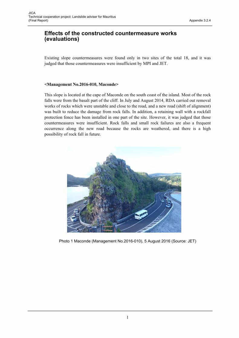
<Management No.2016-010, Maconde>
This slope is located at the cape of Maconde on the south coast of the island. Most of the rock falls were from the basalt part of the cliff. In July and August 2014, RDA carried out removal works of rocks which were unstable and close to the road, and a new road (shift of alignment) was built to reduce the damage from rock falls. In addition, a retaining wall with a rockfall protection fence has been installed in one part of the site. However, it was judged that those countermeasures were insufficient. Rock falls and small rock failures are also a frequent occurrence along the new road because the rocks are weathered, and there is a high possibility of rock fall in future.
Photo 1 Maconde (Management No.2016-010), 5 August 2016 (Source: JET)

JICA Technical cooperation project: Landslide adviser for Mauritius (Final Report) Appendix 3.2.4
2
<Management No. 2016-018, Hermitage>
This site is situated in the vicinity of Grand River North West. As an existing countermeasure, a boundary wall was constructed by the land developer, but it had been already collapsed in 2012. In the future, a retaining wall should be installed there as a permanent countermeasure for the slope.
Photo 2 Hermitage (Management No.2016-018), 2012 and 2016 (source: JET)
Existing retaining wall after the collapse, 2012 The existing retaining wall which collapsed was already removed, 2016

Appendix 3.2.5
Procedure for elaborating a slope map in QGIS


JAPAN INTERNATIONAL COOPERATION AGENCY (JICA) MINISTRY OF PUBLIC INFRASTRUCTURE AND LAND TRANSPORT (MPI)
TECHNICAL COOPERATION PROJECT:LANDSLIDE ADVISER FOR MAURITIUS
Procedure for elaborating a slope map in QGIS
September 2017
KOKUSAI KOGYO CO., LTD.

Contents
Page
1. What is GIS ............................................................................................. 1 2. How to install QGIS ................................................................................ 2 3. Creating a slope map in QGIS ................................................................ 3 4. Create contour lines in QGIS .................................................................. 4 5. Add vector data in QGIS. ........................................................................ 13 6. Exporting a map in QGIS ........................................................................ 15

1
1. What is GIS
A GIS (geographic information system) is a computer system for capturing, storing, checking,
and displaying data related to positions on the Earth’s surface. A GIS can show many
different kinds of data on one map. This enables people to more easily see, analyze, and
understand patterns and relationships. (National Geographic)
Illustration of GIS (Source: USGAO)
A GIS basically uses 2 kinds of data, vector data and raster data. They are described as
follows:
a) Vector data:
Vector data is comprised by vertices and paths. There are three basic symbol types for
vector data, points, lines and polygons. Vector points are simply XY coordinates (latitude
and longitude), that are used when features are too small to be represented as polygons.
Vector lines connect vertices (vector points) with paths and represent features that are
linear in nature. Vector polygons are formed when a set of vertices are joined in a
particular order and closed, and represent features with a two-dimensional area.
Vector point Vector line Vector polygon

2
b) Raster data:
Raster data is made up of pixels (also referred to as grid cells), which are usually
regularly-spaced and square. Rasters often have a value or class associated to each
pixel. They are useful for storing data that varies continuously as in an aerial photograph,
an elevation surface or a satellite image.
There are several types of GIS software, both proprietary and open source. In this manual
we will use QGIS, previously known as Quantum GIS.
QGIS is a free open source geographic information system software. It runs on Linux, Unix, Mac OSX, Windows and Android and supports numerous vector, raster, and database
formats and functionalities. In this manual, you will learn how to install QGIS, create a slope
map from a digital elevation model (hereinafter, DEM), establish the ranks of the slope
gradient intervals, save a project and export a map.
2. How to install QGIS
Search for the word QGIS in google and press the button download, or access the following
link:
http://qgis.org/en/site/forusers/index.html
Once there, select the button “Get the installer”
Now, select the installer for your operating system in the category “latest release”. As for the
22nd of March 2017, the latest version is 2.18 (Las Palmas). The download may take a few
minutes as the installer weighs around 385MB.
Launch the startup installer and press “next”, “agree”, and “install” in order to follow to the
3
next stage. It is not necessary to install the North Carolina Data Set, South Dakota Data Set,
and Alaska Data Set.
Once the installation is complete, the following icons must appear in your desktop
Some of the icons may be hidden inside a folder named “QGIS 2.X.Y”.
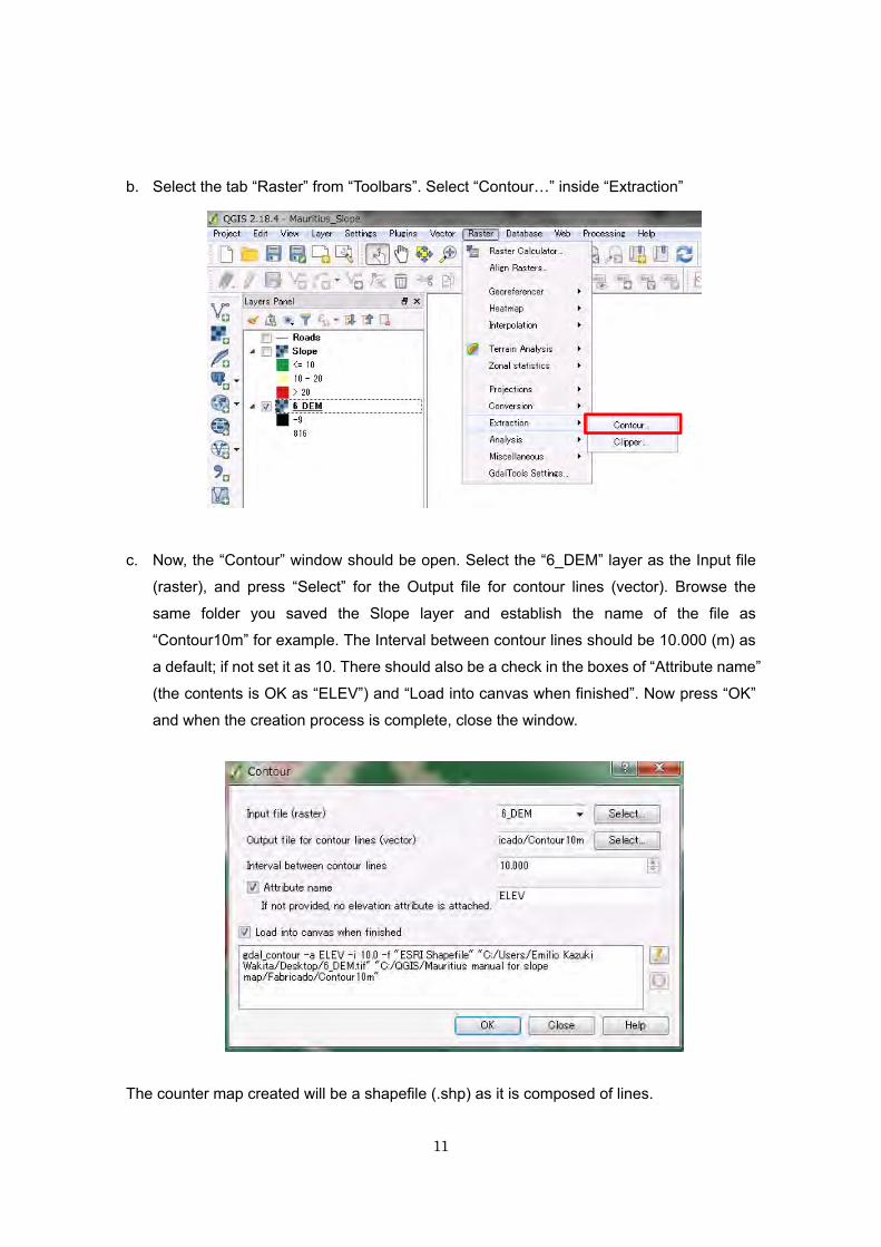
3. Creating a slope map in QGIS
During this manual, we will only use one of the applications of QGIS. Open “QGIS Desktop
2.X.Y” (depending on the version you downloaded) by double clicking its icon in your
desktop or selecting it in all your programs.
First of all, in order to help the software locate and access easily the data we are going to
use and produce, create a file named QGIS in your local disk “C:”, and copy the folder
“Manual for Mauritius” into it; inside this folder there is a DEM file named “6_DEM.tif”. This
DEM is a raster data digital model of Mauritius’s terrain’s surface and its mesh area is
10mx10m.
The following figure shows the basic elements of the QGIS interface.
Basic elements of the QGIS interface

4
a. To add data into the software, drag the folder and drop it into the “Map canvas” window.
You can also add data from the “Side Toolbar”, although you would have to know what
type of GIS data (vector or raster) you are going to add. In this case we are going to add
a DEM raster, so we have to click on “Add Raster Layer”, browse the folder where
we have saved the target data; select the data we want to add and press “Open”. Once
added the file “6_DEM.tif”, our current interface should look as below. If you want to see
the hole layer in the exact space of the “Map canvas”, right click on the DEM layer in the
“Layers list” and press
b. We can see the silhouette of the island of Mauritius in monochromatic colors from black
to white, where black is 0m AMSL, and white is 567 m AMSL. Here you might ask
yourself: Why is the maximum value 567 m if Mauritius’s highest peak, Piton de la Petite
Rivière Noire, has 828 m height? The reason is that QGIS automatically omits the
highest and lowest height values (the 2% of the data of each end) and rounds out with
the next value. Therefore, it is necessary to manually set the software so we can browse
all the real height values. For this, right click the DEM file in the “Layer List” and select
properties.

5
Select the tab “Style” in the left, and click the triangle Load min/max values. The option
selected by default should be “Cumulative count cut” and its values are established as 2
– 98 %. Change the values to 0 – 100 % and set the “Accuracy” as “Actual (slower)”.
Then press “Load”. You should have noticed the minimum and maximum values have
changed to -9 and 816 respectively. Once confirmed the minimum and maximum
values have changed, press the button “Apply”, in the lower right side of the window.
Layer property window
The reason why the maximum value is 816 m, is that the data mesh area is 10mx10m,
so the maximum altitude does not have to be the maximum value in the raster data. On
the other hand, there are negative values (up to -9 m) which might mean part of the
1
2
3 4
5
6

6
surface of the added data is beneath sea level, but this fact does not influence in the
creation of the slope map.
c. Once we have calibrated our raster data, we will proceed to make the slope map.
Search for the tab “Raster” in your “Toolbar”, put your mouse on top of “Analysis” and
select “DEM (Terrain Models)…”.
In the “DEM (Terrain models)” window:
Select where you want to save and how you want to name (in this case we will name
the file as “slope” the file we are about to create. It is recommended to create a new
folder where you will save the files generated during this manual. In mode, select
“Slope”. Check the box for “Slope expressed as percent (instead of as degrees), and
press OK. Close the windows that notify the completion of the task by pressing OK and
close the “DEM (Terrain models)” window.
The new file generated will also have a “.tif” extension. This means it is also a raster file,
which contains slope value data instead of height.

7
d. A new layer named “slope” has been added in your “Map canvas” and “Layer list”. The
new slope map is represented in a continuous percentage range (as we established
before) from 0 to 53.6335 in a black to white gradient. In order to classify our slopes for
landslides, we will classify all the slopes in 3 classes; 0 – 10 %, 10 – 20 %, > 20 %,
differentiated by colors.
As in step b, select “Properties”, but this time for the new layer “slope”. First, select
“Style” in the left tab. Second, select “Singleband pseudocolor” in “Render type”. Third,
select “Discrete” for the category “Interpolation”. Fourth, establish a range of colors
other than black and white; posteriorly we will change the color for each category
manually. Fifth, select “Quantile” in “Mode”; 5 classes with their respective colors will
appear in the window beneath. Check the figure below to see the steps we have carried
out until this moment.

8
To separate the slope gradients in the categories of the classification criteria we
explained beneath (0 – 10 %, 10 – 20 %, > 20 %), we have to erase two of the current
categories. Erase two random categories by selecting them and pressing on the red
minus button one by one.
1 2
3
4
5

9
When you have three categories left, set each category’s value, by pressing the
number in the column value. Set the value of the first category as 10, and its label column will change to <=10; this means all the places with slope inclination equal or
less than 10% are included in this category. Also, set the color of this category as white.
The value of the other two categories will be 20 (for the areas with an inclination
between 10 – 20 %), and inf (for the areas with an inclination beneath 20 %). Establish their colors as yellow and red respectively.
Once you have finished the classification, press the button “Apply” and close the
window by pressing “OK”. Your current “map canvas” should look like the image below.

10
The base for our slope map is now complete. Now we will continue creating and inserting
other features before exporting the map into a final format, but before we will save the
project just in case.
For saving the current project, go to the “Project” tab in the “Toolbars”, and press “Save as”.
Name the map as you like, browse the location where you want to save the project and
press “Save”. Now the project is saved. The extension of the file saved is “.qgs”
Now, whenever you want or need to close the application you shall press the save icon before. Whenever you want to continue working on the current project, you can open the
project you just save by double clicking it, or selecting the project in the “Open” function of
the tab “Project” of “Toolbars”. Please note that the current project opens the layers from the
same location we saved the initially, so if you move the location of the base layers, the
program will not be able to find them and show them on screen.
For further information on how the gradient values are calculated check the link below: http://desktop.arcgis.com/en/arcmap/10.3/tools/spatial-analyst-toolbox/how-slope-works.htm
4. Create contour lines in QGIS
In this chapter we will continue working on the same project as chapter 3. For making the
contour line, the base data is also the DEM raster. In this exercise we will create 10 m unit
contour lines.
a. As we will not be using the slope map we created before we will deactivate that layer.
Layer deactivation is useful in situations where you have to manage many types of
layers but at one moment you only need to use some of them. In order to deactivate a
layer you should click on the check on the left side of the layer in the “Layers Panel”.
Whenever you want to visualize that layer again, click on the check box. For this
exercise make sure the “Slope” layer is inactive and the “6_DEM” is active.
11
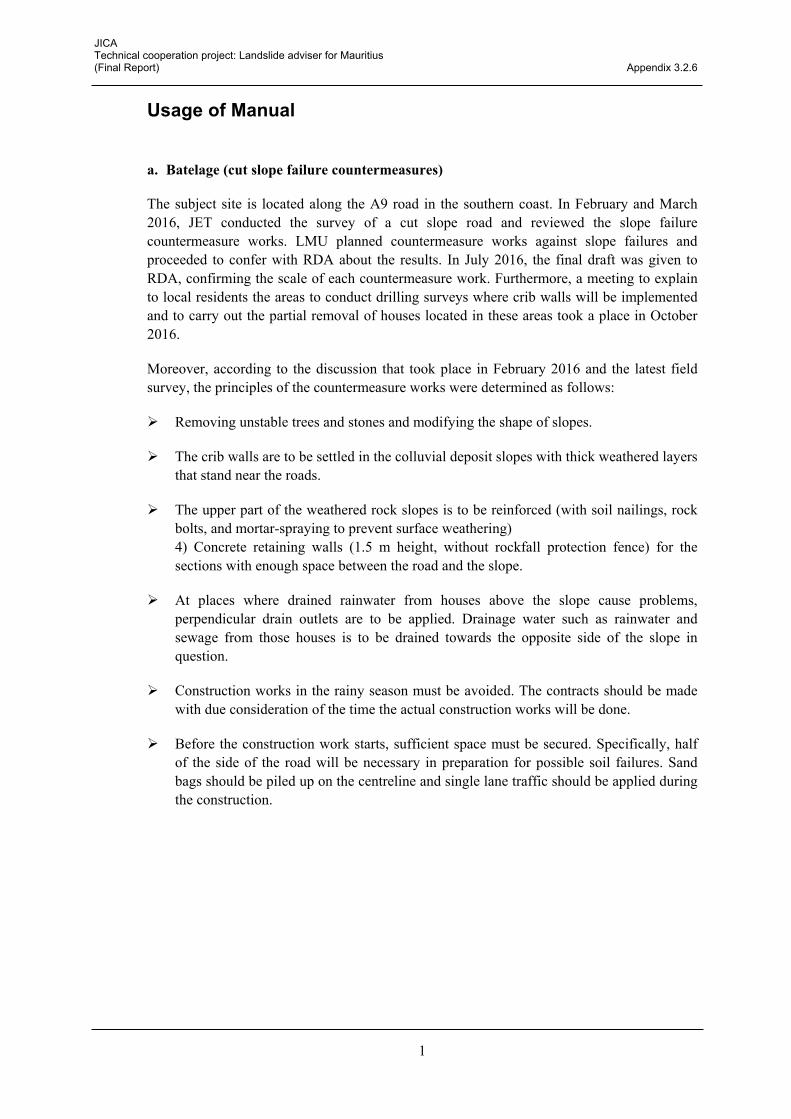
b. Select the tab “Raster” from “Toolbars”. Select “Contour…” inside “Extraction”
c. Now, the “Contour” window should be open. Select the “6_DEM” layer as the Input file
(raster), and press “Select” for the Output file for contour lines (vector). Browse the
same folder you saved the Slope layer and establish the name of the file as
“Contour10m” for example. The Interval between contour lines should be 10.000 (m) as
a default; if not set it as 10. There should also be a check in the boxes of “Attribute name”
(the contents is OK as “ELEV”) and “Load into canvas when finished”. Now press “OK”
and when the creation process is complete, close the window.
The counter map created will be a shapefile (.shp) as it is composed of lines.

12
Your map current “Map canvas” should be similar to the image below. The color of the
contour lines has been set randomly by the application, but in order to differentiate from the
other layers, establish its color as blue. To change the color of a layer, right click the target
layer and press the option “Properties”. Press the tab “Style”, and choose the color you like
from the color palette in the tab “Color”.
Save the project with the current status.

13
5. Add vector data in QGIS.
A risk map does not make sense and cannot be created if the natural factors do not affect
social factors. In this exercise, as a case of example we will learn to add a vector file of
roads in Mauritius. It is common to overlap data of roads and houses with slope inclination
layers to evaluate sites in risk of landslides.
a. In this stage, the DEM data is no longer necessary so you can deactivate it as we have
done in Chapter 4.
b. Go to the folder “Manual for Mauritius” drag the file “Roads.shp” and drop it into the
“Map canvas”. The reason why there are multiple files named road with different
terminations is that each file contains different kind of information of the layer; such as
georeference, color, etc. Although we only dragged one file into the application all the
folders are active, so you should not erase or move any of them and treat them as a
package.
c. Change the color of the road layer to grey as you have learnt in the previous chapter.

14
In this zoom up, we can distinguish slope areas with 0 – 10 % (white), 10 – 20 % (yellow),
and > 20 % (red) inclination, roads (in grey), and 10 m unit contour lines (blue).
d. We will also add a boundary map of the districts of Mauritius. Add the file
“Districtboundary.shp”, the same way as step b. This file is a polygon, so you must have
noticed that all the data you had has been covered and cannot be seen. Now we will
have to transparent the fill of the polygons. Note that the latest files we have added into
the application are overlaying the old ones, but this can be changed by dragging the
layers in the position you want them to be. Obviously, if we put an opaque layer on top,
we won’t be able to see the layers below.
In the case of this image, the slope map is in the base and is overlayed by the contour
lines, the roads and the district boundary lines respectively.
e. Go to the “Properties” of the “Districtboundary” layer. Select the tab “Style”, press
“Simple fill” beneath, and in the tab for “Symbol layer type”, select “Outline: Simple line”.
We will set the color of the outline as black, and for “Pen style” choose “Dash Line”.
Once you have selected all the items as above, press “Apply”, and close the window
with “OK”.

15
Your map should look like below once you have zoomed to layer. Because it has a lot of
detail in relation with the display size, it is necessary to zoom in to see the different features.
Save the project and follow to the next chapter.
1 2
3
4
5
67

16
6. Exporting a map in QGIS In order to print a map we will use the composer tool.
a. The composer tool is opened pressing “Ctrl” + “P”, or “New Print Composer” in the
“Project” tab of “Toolbars”. Press “OK” when the “Composer Title” window pops up. A
new window named Composer must have popped up. This is the window where we will
be working for editing the map we want to export and print.
b. The size of the map we will be exporting is A4 by default, so we will be using this format
during the exercise. If you want to check or change the format of the map to be exported,
select or edit another format in the tab “Composition”.

17
c. Now, we will insert a window where we can see the map we have been working with by
pressing the icon “Add new map” ( ) located in the toolbar in the left side of the
window. Click and drag the mouse to extend a window (a map viewer) which will reflect
the layers we have been working with. You may want to open a window leaving some
space in the right side for example, in order to insert the title, the legend, the scale, etc.
The image that appears in the map reflects the area that is visualized in the “Map
canvas” of the project editor.
In the example beneath, a random area of the Island of Mauritius is visualized so it is
necessary to set the area we want to focus on.
d. In this exercise we will make the slope map for the district of Port Louis, so go back to
the project editor window and zoom into the area of Port Louis district so we can see it in
full extent.

18
Go back to the composer window and press the tab “Item properties” in the right side,
scroll down and press “Set to map canvas extent”. This tool will actualize the content of
your map viewer to the current section you are visualizing in the project editor window.
Repeat the process of zooming in to the target area in the project editor window and
“Set to map canvas extent” as many times as necessary until you consider your map
viewer has an optimal size of Port Louis. Note that for this map all the layers except for
the DEM data are activated.
e. The next step, will be adding another map viewer in the same paper, but this time with
the whole extent of the Island of Mauritius. You may want to add this map in the upper
left side of the paper but this must be a personal decision as it is an esthetic preference.
The result of this stage should be like the image below. (The map viewer of Mauritius is
in the upper left corner)
f. To add a scale bar press the icon “Add new scalebar” in the toolbar in the left. Press and drag the scalebar wherever you want. In this example it will be inserted in the

19
lower right part of the page. Make sure the scalebar you just inserted is selected and
active. Now go to the “Item properties” tab of the right side and in the tab for “Main
properties” > “Map”, choose “Map 0” which is the first map viewer we inserted, i.e. the
zoom up of Port Louis. Leave the “Style” as “Single Box”. In the tab for “Units”, set
“Meters” for “Scalebar units”, “1000.000000” in “Label unit multiplier”, and “km” in “Label
for units”. In the tab for “Segments”, set “left 2”, “right 2”, and 1000 units in “Fixed width”.
The above is only a suggestion, so each person can edit and display the scalebar as
they consider better.
g. To insert a north arrow, press the icon “Add image” in the toolbar in the left side of the composer window. Press and drag wherever you want to set the north arrow. Press

20
“Item properties” and open the tab “Search directories”. Chose the symbol you most like
as a north arrow. For this exercise I have chosen the one below.
h. Now insert the letter N beneath the arrow, so that we know the arrow is pointing to the
north. To do this, press the icon “Add new label” in the toolbar in the left side of the composer window. Press and drag the mouse beneath the north arrow. Now insert N, or
North in the “Main properties” tab, and set the “Font” as you like in the “Appearance” tab.
i. To insert the legend, press the icon “Add new legend” in the toolbar in the left side of the composer window. Click and drag the mouse wherever you want to set the legend.

21
During this exercise the DEM layer is not visible so we can delete it from the legend. To
do this, access the “Item properties” tab, uncheck the box “Auto update” in the “Legend
items” tab, select the DEM layer and delete it pressing the icon.
Also, the labels of the legend items are linked to the name of the layers in the project
editor window. If you want to change the name label of an item in the legend, you can
go back to the project editor window right click the target layer, press “Properties”,
“General” and change the “Layer name”. Once you do so, it shall appear actualized in
the legend of the Composer window.
j. To end, press the icon “Add new label” , click and drag the mouse wherever you want to insert the title for the map. In the tab of “Item properties”, “Main properties”, you

22
can name the map as “Slope Map of the District of Port Louis, Island of Mauritius”, for
example. You can also edit the font as you wish in the “Appearance” tab.
Once you completed all the steps above, your map should look like the image below.
k. Now, we will finish by saving this composition. And learning how to export it in a pdf
format. To save the composition so we can open it whenever we want, press “Composer”

23
in the upper left part of the application and “Save as template”. Browse where you want
to save the template, choose a name and press “Save”. The extension of the saved
template will be “.qpt”. In order to print the map, you may print it directly pressing the
“print” icon , or export it into another format, like pdf, and print it through another document reader. To export in pdf format, press “Composer” in the upper left part of the
application and “Export as PDF”.
With this, you have learnt an easy and free way to make a slope map with QGIS.


Appendix 3.2.6
Usage of Manual

JICA Technical cooperation project: Landslide adviser for Mauritius (Final Report) Appendix 3.2.6
1
Usage of Manual
a. Batelage (cut slope failure countermeasures)
The subject site is located along the A9 road in the southern coast. In February and March 2016, JET conducted the survey of a cut slope road and reviewed the slope failure countermeasure works. LMU planned countermeasure works against slope failures and proceeded to confer with RDA about the results. In July 2016, the final draft was given to RDA, confirming the scale of each countermeasure work. Furthermore, a meeting to explain to local residents the areas to conduct drilling surveys where crib walls will be implemented and to carry out the partial removal of houses located in these areas took a place in October 2016.
Moreover, according to the discussion that took place in February 2016 and the latest field survey, the principles of the countermeasure works were determined as follows:
Removing unstable trees and stones and modifying the shape of slopes.
The crib walls are to be settled in the colluvial deposit slopes with thick weathered layers that stand near the roads.
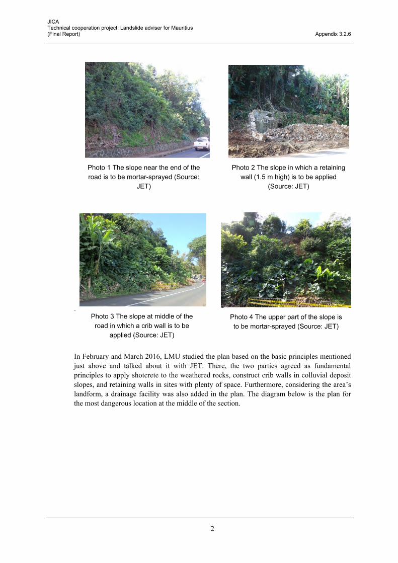
The upper part of the weathered rock slopes is to be reinforced (with soil nailings, rock bolts, and mortar-spraying to prevent surface weathering) 4) Concrete retaining walls (1.5 m height, without rockfall protection fence) for the sections with enough space between the road and the slope.
At places where drained rainwater from houses above the slope cause problems, perpendicular drain outlets are to be applied. Drainage water such as rainwater and sewage from those houses is to be drained towards the opposite side of the slope in question.
Construction works in the rainy season must be avoided. The contracts should be made with due consideration of the time the actual construction works will be done.
Before the construction work starts, sufficient space must be secured. Specifically, half of the side of the road will be necessary in preparation for possible soil failures. Sand bags should be piled up on the centreline and single lane traffic should be applied during the construction.
JICA Technical cooperation project: Landslide adviser for Mauritius (Final Report) Appendix 3.2.6
2
.
In February and March 2016, LMU studied the plan based on the basic principles mentioned just above and talked about it with JET. There, the two parties agreed as fundamental principles to apply shotcrete to the weathered rocks, construct crib walls in colluvial deposit slopes, and retaining walls in sites with plenty of space. Furthermore, considering the area’s landform, a drainage facility was also added in the plan. The diagram below is the plan for the most dangerous location at the middle of the section.
Photo 3 The slope at middle of the road in which a crib wall is to be
applied (Source: JET)
Photo 1 The slope near the end of the road is to be mortar-sprayed (Source:
JET)
Photo 2 The slope in which a retaining wall (1.5 m high) is to be applied
(Source: JET)
Photo 4 The upper part of the slope is to be mortar-sprayed (Source: JET)

JICA Technical cooperation project: Landslide adviser for Mauritius (Final Report) Appendix 3.2.6
3
Figure 1 Diagram of the starting point of the countermeasure works (below: crib wall works, beneath: shotcrete works) (● in the diagram shows sites of drilling survey) (Source: JET)
In July 2016, JET and LMU made an inspection of the site before establishing the order for the implementation of planned slope countermeasure works. JET and LMU gave an explanation of the plan for several local contractors and determined where to conduct boring surveys as well as how deep these boring surveys should be.
Drilling surveys will be conducted at five locations where talus has deposited at the end of the slope. The basic depth for drilling surveys is five meters, however, the survey may be stopped if 1m bedrock (strong weathered rock) is confirmed. In addition, the standard penetration test (SPT) was determined to be conducted for each 1 m depth of each drilling survey.
Excavations for constructing gutters between the side of the road and the bottom of the slope are being carried out before implementing countermeasure works. As the slope behind the gutter excavation is unstable and small soil failures may occur. JET proposed the two following methods of construction, with which LMU and the local contractors agreed.
Adoption of cast-in-place concrete:
Cast-in-place concrete will be used instead of precast concrete to make the gutters. This implies shortening of the overall work time, decreasing the risk of possible slope failures from behind.
Adoption of the span method (every 5 m):
The width of the excavation to be done at one time was defined as less than 5 m. JET also proposed the span method, which consists of placing the gutter shortly after the excavation works are carried out.
JICA Technical cooperation project: Landslide adviser for Mauritius (Final Report) Appendix 3.2.6
4
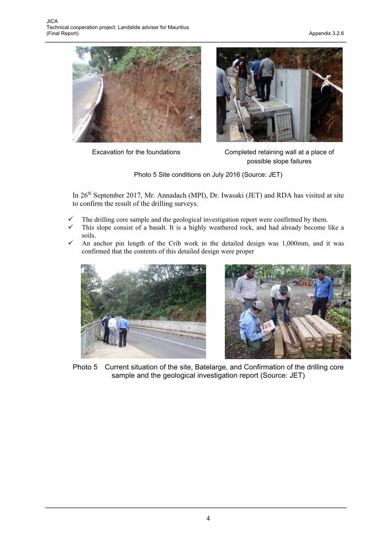
Photo 5 Site conditions on July 2016 (Source: JET)
In 26th September 2017, Mr. Annadach (MPI), Dr. Iwasaki (JET) and RDA has visited at site to confirm the result of the drilling surveys.
The drilling core sample and the geological investigation report were confirmed by them. This slope consist of a basalt. It is a highly weathered rock, and had already become like a
soils. An anchor pin length of the Crib work in the detailed design was 1,000mm, and it was
confirmed that the contents of this detailed design were proper
Photo 5 Current situation of the site, Batelarge, and Confirmation of the drilling core sample and the geological investigation report (Source: JET)
Excavation for the foundations Completed retaining wall at a place of possible slope failures

JICA Technical cooperation project: Landslide adviser for Mauritius (Final Report) Appendix 3.2.6
5
Figure 2 Detailed design of the countermeasure works (crib wall works, shotcrete works), Batelarge (Source: MPI)
JICA Technical cooperation project: Landslide adviser for Mauritius (Final Report) Appendix 3.2.6
6
b. Signal Mountain (rockfalls and debris flows countermeasures)
The road, where countermeasures are intended and is especially used by MoESD and the agency of communications, lies beside Signal Mountain (323 m high) in the south-western part of Port Louis City. The road is managed by MoESD. Although ordinary cars are prohibited to drive this road, pedestrians and joggers use the road on a daily basis. Cars of telecom companies regularly use it as well.
Rockfalls, subsidence of earth-filled road shoulders (here in after, road settlement), and debris flows have occurred in this area. The accidents happened in the interval between the points of 70 m and 300 m height, which extends to approximately 3 km. MoESD requested LMU to investigate the causes and make a countermeasure plan.
It was found that slopes that were likely to cause rockfalls were all along the road. Sites with road settlement were often found as well. Also, streams with possible risk of producing debris flows were conspicuous every 100 m to 200 m. Small waterways and a couple of badly constructed culverts were also observed.
JET classified the rockfalls into type A, B, C, and D and assumed countermeasure works for each type of rockfall.
Table 1 Rockfall types seen in the Signal Mountain Road (Source: JET)
Type Topographic condition of road side slope and types of rockfallA Angle from 20 degree to 30 degree. Rolling stones B Angle from 30 degree to 40 degree. Bouncing and rolling stones C Angle over 40 degree and overhanging cliffs. Falling, bouncing and rolling stones D Cliff with a long distance to the road. Rockfalls
As the subject interval is 3 km long, it was decided that the surveys and countermeasure works will be carried out according to its urgency, as shown in the Table 3.2.6.
Table 2 State of emergency for survey and countermeasure works (Source: JET)
State of emergency
Damage and road condition Survey and countermeasure works
A (Urgent)
Erosion of culvert, improper construction, risk of debris flow
Urgent survey and design of countermeasure works (culvert and drainage channel)
B (Moderate)
Rockfall, necessity of a new culvert, improper surface water management
Rockfall inventory, rockfall countermeasure works and new culvert construction, humps for diversion of surface water
C (Not urgent)
Settlement of shoulder slope, filling section, cracks on the road surface caused by improper construction
After section “A” and “B”
JET proposed to LMU the rockfall protection fence, which is the most effective countermeasure work and can be built along longer distances than any other countermeasure works. JET made Table 3.2.7 for LMU as a proposition. The plan for the rockfall protection fence in Type A (slope angle of 20-30 degrees with 1.5 m fence height) and Type B (slope angle of more than 30 degrees with 2 m fence height) was made according to this table.

JICA Technical cooperation project: Landslide adviser for Mauritius (Final Report) Appendix 3.2.6
7
Table 3 Rockfall fence index (Source: JET)
Galvanizedfence
Foundation
Material ClearanceEmbedded
lengthMaterial
Embeddedlength
Material Clearance Material Interval Material
Type-A θ>30 2.0m H200*100*5.5*8 3.0m 1.0m H175*175*7.5*11 1.0m
Plate
4.5t*65*980
1.5m
3*7G/0φ18
Ew=1.0*106N/mm
2
Tb=157kNTy=118kN
300mmφ3.250*50mm
0.5*0.5*1.0
Type-B 30>θ>20 1.5m H200*100*5.5*8 3.0m 1.0m H150*150*7.0*10 1.0m
Plate
- 4.5t*65*980
- 4.5t*65*680
1.5m
3*7G/0φ18
Ew=1.0*106N/mm
2
Tb=157kNTy=118kN
300mmφ3.250*50mm
0.5*0.5*1.0
Type-C 20>θ 1.0m H200*100*5.5*8 3.0m 1.0m H150*150*7.0*10 1.0m
Plate
- 4.5t*65*980
1.5m
3*7G/0φ18
Ew=1.0*106N/mm
2
Tb=157kNTy=118kN
300mmφ3.250*50mm
0.5*0.5*1.0
Ew: Elastic coefficientTb: Breaking strengthTy: Yield strength
High tensile cableSlopangle
Fenceheight
Intermediate post End post Spacer
Figure 2 An example of rockfall protection fence planned by LMU (Type A, 1.5 m high) (Source: MPI)

JICA Technical cooperation project: Landslide adviser for Mauritius (Final Report) Appendix 3.2.6
8
Figure 3 Port Louis City (upper right:northeast) and Signal Mountain (lower left:southwest) (Source: Google)
In July 2016, JET and LMU conducted a preparation survey in-between the interval of 2.0 km to 3.0 km (the ending point) of Signal Mountain. The aim of this operation was to make an inventory of rock falls.
The slope in the road at 2.7 km was determined as a model location of the survey, because the site was a typical example of a dangerous slope. There, unstable rocks with a diameter of more than 1 m were identified, their locations were measured by GPS, their sizes were measured and each one was marked with painting.
Whether the rock is to be removed or stabilised on the spot was decided as follows:
A: Removal A’: Stabilisation by concrete B: Stabilisation by net and/or bar
Photo 7 Panoramic view of the slope (from the starting point) (Source: JET)
Photo 8 Unstable rocks (Source: JET)

JICA Technical cooperation project: Landslide adviser for Mauritius (Final Report) Appendix 3.2.6
9
Photo 9 Specification of unstable rocks, evaluation, and numbering (Source: JET)
Figure 3 An example of the rockfall inventory (Upper left: survey location map, lower right: inventory) (Source: MPI)
In October 2016, instructions on how to carry out rockfall surveys and how to make rockfall inventories were given to the Special Mobile Force (SMF), which is to sign a contract for the rockfall survey For this, JET created a manual to conduct rockfall surveys. The contents of the manual are as follows:

JICA Technical cooperation project: Landslide adviser for Mauritius (Final Report) Appendix 3.2.6
10
Survey location
Classification
Survey tools
The rocks to investigate
Way to make the rockfall inventory
Contents of the rockfall inventory
Safety of the survey
Inventory format
Participants in the training included: 15 members from SMF; 4 members from Group Intervention Police Mauritius; 1 member from LMU; and 2 members from JET. After LMU and JET explained the general purpose, every participant except four in charge of safety management and orientation were led to the slope. The participants were given explanations about the survey with a provisional Rockfall Inventory manual that JET had made especially for Mauritius.
The comprehensive protocol for measures against rockfalls, according to which works will be carried out, was already submitted to NDRRMC in September 2016. As a tentative safety measure for pedestrians, we requested NDRRMC to set hazard signs and information boards.
Figure 4 Rock fall inventory manual (Source: JET)
Photo 10 Explanation session (Source: JET)
Photo11 Field work (Marking the rocks) (Source: JET)

JICA Technical cooperation project: Landslide adviser for Mauritius (Final Report) Appendix 3.2.6
11
c. Maconde (rockfall countermeasures)
The measures against rockfalls in Maconde were one of the highest priorities for LMU. In July, 2016, JET and LMU made a field survey and devised a general course of action.
In October, 2016, LMU and JET discussed regarding the countermeasure works, preparation for order placement, and the order of process. Moreover, the existing survey plan report written by the Government of Mauritius and the cost estimate by a Japanese manufacturer for rockfall prevention nets were reviewed to assess cost efficiency. Thus, the Japanese rockfall prevention net was more cost-efficient; therefore, both parties agreed to use it from then on.
WA・EA section:Plus net (Toff coated)
Other sections:Chain link net (Toff coated)
Toff coating is a high dust-proof coating technology that Japanese rockfall prevention net manufacturers produce. The metallic net can be left without maintenance for more than twenty years even by the seashore. From now on, an approximate estimate construction costs and specifications for constructions are to be made based on the utilization of this metallic net.
施工事例 (Georgia, 2016)ロックネット工法による対策のイメージ
Photo 12 Tentative measure plan for Maconde (Source: JET)
Photo 13 Real instance of a rockfall net (Source: JET)

JICA Technical cooperation project: Landslide adviser for Mauritius (Final Report) Appendix 3.2.6
12
Photo 14 Scope of measurement and construction method in Maconde rockfall (Source: JET)
In November 2016, principles of countermeasure works and approximate construction costs were reviewed. As the site is located by the sea, there were concerns that the countermeasure works might be affected by the sea wind. LMU considered using Toff coating, a rockfall prevention net with salt-damage free resin coating made in Japan. The Japanese net is durable enough, even in a salty environment, for more than 40 years and has no need of maintenance for over 20 years. The proposition and cost estimate of TOKYO ROPE MFG. CO., LTD., a Japanese material manufacturer, was studied, and the effect and cost of the prevention net were considered. Making a conclusion was left to LMU to aim for an early notice for bidding.
JICA Technical cooperation project: Landslide adviser for Mauritius (Final Report) Appendix 3.2.6
13
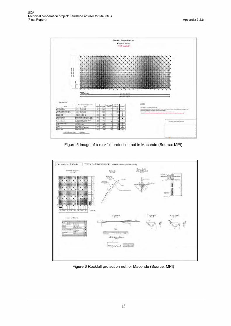
Figure 5 Image of a rockfall protection net in Maconde (Source: MPI)
Figure 6 Rockfall protection net for Maconde (Source: MPI)

JICA Technical cooperation project: Landslide adviser for Mauritius (Final Report) Appendix 3.2.6
14
In 26th September 2017, Confirmation of the detailed design of the countermeasure for rockfall in Maconde by Mr. Annadach (MPI), Mr. Damonsin (MPI), RDA and Dr. Iwasaki (JET). All of the tip of the cape should be covered with a lock net. On the other hand, in the area (Safe zone) with the existing netting fence, the lock net is
constructed only in the upper part of the cliff. About the area without safe zone, a road alignment is moved for 1 traffic lane by the sea side,
and a safe zone is built newly. When a road is built newly in the sea area, as a high-wave countermeasure, the road surface
should be built more highly than the present height approximately 2m.
Figure 7 All of the tip of the cape should be covered with a lock net, Maconde
Figure 8 Relocation of a road alignment
d. Hermitage (slope failure and rockfall countermeasures
The target construction site of housing sits by a slope with a slope angle more than 11 degrees (gradient 20 %). The angle is in non-conformity with the PPG prescription. Slope failures and rockfalls could happen, and the moats of some nearby houses were in a dangerous state as well. After the Municipal Office issued a statement concerning the risk, the construction works have been stopped until October 2016.
Safe Zone
Safe Zone
既存のネッティング範囲
追加のネッティング範囲
Relocation of a road alignment
In the area (Safe zone) with the existing netting fence, the lock net is constructed only in the upper part of the cliff.

JICA Technical cooperation project: Landslide adviser for Mauritius (Final Report) Appendix 3.2.6
15
The Municipal Office requested LMU to review countermeasure works. In October 2016, LMU explained to JET the survey results and countermeasure works plan.
While no measures inside the slope will be taken, concrete retaining walls, rockfall protection fences, and drainage facilities were planned for the protection of roads and houses below the slope.
JET approved the plan of LMU except for some small correction suggestions. From now on, LMU will submit the plan to the Municipal Office, after which the Municipal Office will make preparations for actual countermeasure works.
Figure 9 Tentative plan for Hermitage (slope failures and rockfalls) (Source: MPI)
JICA Technical cooperation project: Landslide adviser for Mauritius (Final Report) Appendix 3.2.6
16
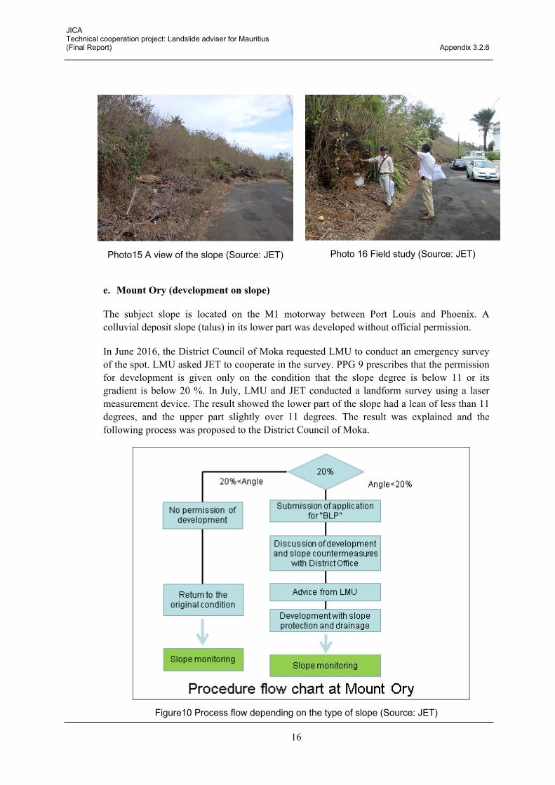
e. Mount Ory (development on slope)
The subject slope is located on the M1 motorway between Port Louis and Phoenix. A colluvial deposit slope (talus) in its lower part was developed without official permission.
In June 2016, the District Council of Moka requested LMU to conduct an emergency survey of the spot. LMU asked JET to cooperate in the survey. PPG 9 prescribes that the permission for development is given only on the condition that the slope degree is below 11 or its gradient is below 20 %. In July, LMU and JET conducted a landform survey using a laser measurement device. The result showed the lower part of the slope had a lean of less than 11 degrees, and the upper part slightly over 11 degrees. The result was explained and the following process was proposed to the District Council of Moka.
Figure10 Process flow depending on the type of slope (Source: JET)
Photo15 A view of the slope (Source: JET) Photo 16 Field study (Source: JET)

JICA Technical cooperation project: Landslide adviser for Mauritius (Final Report) Appendix 3.2.6
17
In August 2016, LMU, with the assistance of JET, conducted a field survey and made the report.
The report was based on the previous field survey result. By defining the boundary of 20 % slope gradient, the report was intended to assist the District Council of Moka, in accordance with the PPG, in making the decision of whether or not to give developmental permission.
e.1.1 Clearing works, Terracing and Earthworks carried out on land at Mount Ory
With reference to the above subject, MPI/LMU conducted a site survey on 8 August 2016. The observations are as follows:
Slope angle of the estimated original ground surface is 14.2 % at the lower part and 21.5 % on the mountain side.
The steep mountain slope behind the site poses risk of steep slope failure and/or rock fall disaster.
Therefore, the recommendation of the PPG 9 should be followed.
Photo 17 Investigation spot. Part of the place is already under construction (Source: JET)
Figure 11 Cross-section of investigation location (Source: JET)
Estimated original ground surface
(Road) Slope angle: 14.2%
Slope angle: 21.5%
Height: 7.8m
Height: 12.8m
Distance: 55.9m
Distance: 59.6

JICA Technical cooperation project: Landslide adviser for Mauritius (Final Report) Appendix 3.2.6
18
f. Mount Ory, Moka (development on slope)
The District Council of Moka requested MPI/LMU to do on-site investigation for the ‘Application for the use of the slope’. In March 2016, JET along with LMU and the District Council of Moka carried out a field survey. The results are as follows:
Presumed angle at the foot of this slope will be more than 20 %.
A landslide might happen on the valley side of the slope (approximately 30 m length, 20 m width, 5 m depth)
There is an almost vertical slope very close to the target land, which is also likely to cause rockfalls.
In conclusion, development in this land is not safe.
Photo 18 The investigation spot in Mount Ory Moka (Source: JET)
Figure 11 Cross sectional diagram of the investigation spot (Source: JET)

JICA Technical cooperation project: Landslide adviser for Mauritius (Final Report) Appendix 3.2.6
19
g. Ruisseau Creole (rockfall countermeasure)
The subject slope is facing the southern coast. Behind the nearby houses there are woods and sugar cane fields. Also, there were several huge boulders with a diameter of less than one meter on the premises of those houses. These rocks were pyroclastic rocks or solidified molten lava. Some of them were originally lying there and others were dumped from the sugar cane field into the backyard.
As this location was requested by the District Office of Savanne to be investigated in February 2016, LMU and JET carried out a joint survey in May. After that, the following principles were determined:
Removal of unstable rocks. Bigger ones should be broken into small pieces beforehand.
Unmovable rocks should be fixed or netted on the spot.
A house upon the hill might need to be relocated.
Unnecessary removal of trees must be refrained.
In July 2016, LMU and JET performed a measurement survey together. Under the supervision of JET, unstable rocks were identified and each rock was measured for countermeasure consideration. Approximately thirty rocks were coloured as follows:
Red spray: removal
Blue spray: stabilisation
Some of the rocks were carried away as they were, while others were so big that they had to be broken into smaller pieces before being removed out of the site. When the rocks were dropped down, due attention was paid to the houses below.
To fix and stabilise unstable rocks, reinforced concrete foundation will be used. When foundation space is hard to secure, such rocks will be covered with rockfall prevention nets.
LMU will continue studying appropriate types of countermeasure works in accordance with the survey results.
Photo 19 Consideration of measures (blue spray: stabilisation) (Source: JET)

JICA Technical cooperation project: Landslide adviser for Mauritius (Final Report) Appendix 3.2.6
20
Photo 20 Consideration of measures (red spray: removal) (Source: JET)
h. Camp Garreau, Flacq (slope failure countermeasure)
Two houses in Camp Garreau, Flacq, had a scarp with a slope failure behind them. A resident living there called the local government, MoESD, and consequently, the local government requested LMU to perform a survey. LMU and JET visited the site in August 2016, and studied the measures to be applied.
The survey result suggested the failure was triggered by surface erosion caused by the river, domestic wastewater drainage and rainwater. LMU is planning to lead the District Council and MoESD for the following measures.
h.1 Survey result by LMU and JET
A river behind the houses scraped the lower part of the scarp, causing the surface failure.
Domestic wastewater drainage from the nearby houses and rainwater were also the cause of surface erosion.
Though the two houses are obviously exposed to slope failure risk, the cost of countermeasure works are likely to be expensive. Therefore, MPI and LMU recommended the relocation of those houses from the target area.

JICA Technical cooperation project: Landslide adviser for Mauritius (Final Report) Appendix 3.2.6
21
Figure 12 Cross-section of the investigation spot. Houses sit near the scarp (Source: JET)
Photo 21 The investigation spot. Two houses sit near the scarp (Source: JET)
Photo 22 Domestic wastewater drainage, a likely cause of scarp erosion (Source: JET)
i. Kewal Nagar Belle Rive (river erosion and slope failure countermeasure)
JET has performed on-site investigation of this location twice in January 2016, and with these two survey results, more detailed plans for countermeasure works were designed this time.
LMU and JET proposed the principles for the next measures and gave advice about what survey items are needed to be carried for the construction of countermeasure works.
Erosion
River
Risk of the slope failure
House
45 degrees H=11m
2m
Drainage from a house
Rainwater flowing down the cliff from the road
Drainage from a house

JICA Technical cooperation project: Landslide adviser for Mauritius (Final Report) Appendix 3.2.6
22
Considering the performability of the measures at the site, technical standards, and availability of the necessary materials, LMU decided to mainly employ Gabions to prevent erosion.
LMU explained the detailed structure of Gabions that are normally used in Japan to plan countermeasure works.
Figure13 Cross-section of the investigation site with a house sitting next to the scarp (Source: JET)
Photo 23 Current condition of the slope failure site (Source: JET)
In March 2016, another field survey was performed to review again the countermeasure works that LMU had planned. Though LMU had planned to construct the structure of the countermeasure works from the mean river water level, JET proposed that it will be sufficient to construct from the middle of the slope, judging from the status of the ground, grade of erosion, and speed of the river flow. JET advised that individual measures are needed to be taken for the locations with risk of causing small failures.
According to JET’s advice, LMU added minor corrections to their countermeasure works plan. The revised fundamental plan for the countermeasure works was changed as follows:
Leaf trees, especially bamboo that grows naturally, are advisable
Robust slope protection measures against river erosion must be constructed in areas beneath the middle of the river bank.
House
Erosion
River
Risk of slope failure

JICA Technical cooperation project: Landslide adviser for Mauritius (Final Report) Appendix 3.2.6
23
Foundation cannot be placed on the border just above the water line. It should be placed in the middle of the river bank. In order to do that, weathered rocks should be scraped away.
During the construction of the countermeasure works, thick bushes should not be harmed.
Continuous instruction should be given to residents concerning domestic wastewater drainage.
Figure 14 Example of gabion according to a Japanese standard (Source: JET)
Gabion
1000X500
Geotextiles
Surface gradient 1:0.3 - 1:1.0
H=3.5m
Over 1.0m
(Riverbed) (Prevention material of soil draw-out)
For example, H=3.5m seven gabions

JICA Technical cooperation project: Landslide adviser for Mauritius (Final Report) Appendix 3.2.6
24
j. Coromandel (Rockfall countermeasure)
In March 2016, LMU requested JET to carry out a field survey of a steep slope in the Coromandel region. The situation was described below.
Following a land owner’s submission of an application to build a house to the District office, LMU was asked to carry out a survey as the subject location was beside a steep slope.
The plot has a steep slope of more than 30 degrees in gradient. The house was supposed to be built on a flat part of the land. (Figure 3.2.17).
There were a lot of unstable rocks on the slope which were likely to fall. (Photo 3.2.32).
When it rains, rainwater comes down from the road located above the plot.
Figure 15 Cross-section of the site (Source: JET)
Photo 24 Unstable boulders on the steep slope (Source: JET)
Road
Road
Existing Masonry wall
Ditch
Ditch
Existing Masonry wall H=11m
30.5°
Area of the land use application
Unstable big boulders
Surface water flow

JICA Technical cooperation project: Landslide adviser for Mauritius (Final Report) Appendix 3.2.6
25
After the survey, LMU and JET recommended the measures written below:
Removal of the stones: all the unstable rocks on the slope are recommended to be removed or rolled down the slope.
Retaining wall: a retaining wall with rockfall pockets is recommended to be placed.
Drainage: a drain is recommended to be installed.
No slope excavations or drillings are recommended to be carried out.
Figure 16 Cross section of the recommendation for countermeasure works (Source: JET)
k. Pilot Bel Air (cut slope failure countermeasure)
Following a field survey in February 2016 and a discussion and Technical meeting in March, the following measures were chosen. MPI staff explained measures two, three and four to the concerned residents.
As the slope is inside a private plot of land, MPI cannot carry out countermeasure works.
Advise residents living above the slope to cut down unstable trees so that they do not swing down due to the wind.
Advise residents living above the slope to cover their plot with stones or lawn to prevent surface soil failure.
Water should not be drained towards the slope as it is done currently.
Road
Road
Existing Masonry wall
Ditch
Ditch
Existing Masonry wall
Removal work
Never cut the slope!
Pocket for fallen rocks
New protective RC retaining wall
Indicative distance for safe excavation of foundation
h
New Drainage
New Drainage

JICA Technical cooperation project: Landslide adviser for Mauritius (Final Report) Appendix 3.2.6
26
Photo 25 Cut-earth slope failure (Source: JET)

JICA Technical cooperation project: Landslide adviser for Mauritius (Final Report) Appendix 3.2.6
27
l. Vallée Pitot (filled-land failure)
In February 2016, LMU and JET conducted a field survey. Damage was observed in nearby houses caused by inundation, failure of a retaining wall on the filled land, and road cave-in.
The reasons were a flash flood that flowed from the slope into the backside of the house, and the earth pressure produced by a flawed earth-filled road that pushed out a simple concrete retaining wall of a mosque that is located down the slope. The main cause was a defect in the drainage facility and the weakness of the retaining wall.
Following the discussion in February 2016, JET and LMU performed a plain land measurement, studying the damage area, and the scope of countermeasure works. The countermeasure works chosen to be carried out were as follows:
(Upper part) drainage in the house below the slope.
Water catchment basin.
Drainage (mountain side of the road).
Concrete retaining wall (LMU one structure. Masonry retaining wall was also proposed for its easiness to construct).
Reinforced earth-fill and its drainage.
In addition, both parties recognised the importance of managing water of the slopes as a general issue in the whole Vallée Pitot region. Therefore, hydrographic surveying of the entire slope, including catchment basin and drainages areas, and the planning of the entire waterway system are needed and are recognised as long-term challenges.
Photo 26 Failure of earth-filled road (Source: JET)

JICA Technical cooperation project: Landslide adviser for Mauritius (Final Report) Appendix 3.2.6
28
Photo 27 Failure of the concrete retaining wall of the mosque located down the slope (Source: JET)
Figure 17 Sketch of the disaster location and planned countermeasure works (Source: JET)

JICA Technical cooperation project: Landslide adviser for Mauritius (Final Report) Appendix 3.2.6
29
m. Long Mountain (bank slope failure behind house)
MoESD requested LMU to perform a survey on a location where damage to housing occurred. LMU and JET conducted the survey on 8 July 2016. The subject slope failure happened due to foundation washout caused by river bank erosion in the lower part of the house. As a result of the survey carried out by LMU and JET, it was concluded that the damage was minimal and it was happening in a narrow area. Therefore, reinforcement of the foundation will be sufficient as a measure. LMU will hand out a report on this case to MoESD.
Figure 18 Slope failure at Long Mountain (Form a platform and utilize stones and a concrete retaining wall) (Source: JET)
Photo 28 Slope behind the house (Source: JET)
Photo 29 Part of the concrete below the foundation was scraped (Source: JET)


Appendix 3.2.7
Support for preparing the materials for inspection, countermeasures
and public awareness materials by MPI


JICA Technical cooperation project: Landslide adviser for Mauritius (Final Report) Appendix 3.2.7
1
Support for preparing the materials for inspection, countermeasures and public awareness materials by MPI Using manual, JET shall support the MPI in preparing the materials, organising the existing materials of the MPI, etc., to disseminate the information and knowledge regarding the countermeasures for slope failures, rockfalls and debris flows to the local residents and relevant organisations.
a. Support for creating the document of Signal Mountain Road rockfalls
a.1 NDRRMC’s meeting about Signal Mountain Road slope failures
a.1.1 Objectives
Traffic issues may occur in the subject road as there is risk of rockfall disasters and culvert collapses. NDRRMC served as chairperson at the meeting in which MoESD, the road manager; MPI, an investigational institute of rockfalls; SMF, in charge of guarding the road; and the Municipal Council of Port Louis, have attended. The aim of the meeting was to discuss appropriate countermeasures for the potential disasters of this road.
Date:10 to 11 AM, 11 July 2016
Place:Headquarters of NDRRMC
Attendant: Mr. Servansing from Director General of NDRRMC; staff from NDRRMC, staff from MPI/LMU, staff from Municipal Council of Port Louis, and Mr. Tsukamoto from JET.
Topic for discussion:
- Mr. Servansing from DG of NDRRMC moderated the meeting. The topic for discussion was the rockfalls at Signal Mountain Road. MPI explained the rockfalls situations, slope risks, culvert collapses, and the structural measures under consideration. As non-structures measures that can be taken, NDRRMC proposed notifying road users of the risk and establishing a contact network in case of emergency. NDRRMC also proposed the following measures to be taken in the future.
- Measurement and survey: aerial photos taken by planes and drones, elaboration of a large-scale map, and rockfall surveys.
- Non-Structural Measures: Notification to pedestrians by displaying danger signs.
- Structural measures: LMU to conduct a survey.
- LMU is going to make a protocol of the measures on the subjects above. LMU has requested the support of JET to make the documents of the protocol.

JICA Technical cooperation project: Landslide adviser for Mauritius (Final Report) Appendix 3.2.7
2
Photo 1 NDRRMC’s meeting about Signal Mountain Road slope failure (Source: JET)
a.2 Support for planning the protocol about measures against rockfalls
The protocol against rockfalls was made as an urgent measure was needed before the rainy season between November 2016 and March 2017. The outline of the protocol was first made in 26 July 2016. MPI/LMU and JET held a meeting to discuss and formulate the protocol. Its outline is as follows.
<Non-structural measures>
Road chainage setting
- Currently, chainages are placed every 500 meters along the subject road. Additionally, distance signs are to be drawn with chalk every 50 meters.
Rockfall signs and posts
- The locations of where to set signs and posts warning of rockfalls were decided. Rockfall signs are basically set every 500 m, and posts are set at the start and the end
Photo 2 Existing chainage (Source: JET)
Photo 3 Drawing additional distance signs on the road (Source: JET)

JICA Technical cooperation project: Landslide adviser for Mauritius (Final Report) Appendix 3.2.7
3
of the road.
- Written warning can be added to the posts, such as “Caution Rockfalls”, “Do not walk along the edge of the road”, or “Closed during rain”
- Rockfall sign posts at the start and the end of the road.
- As well as indicating dangerous places in a map, should show method and place to evacuate emergency contact number
Photo 4 Examples of rockfall signs (left: Mauritius, right: Japan) (Source: JET)
As emergent non-structural measures, it was determined that the placement of information board and rock fall warning sign precede any other measures would be prioritised. Following is its sentences.
Figure 1 Tentative contents of the rockfall information board (Source JET)
ROCK FALL NOTICE Risk of rockfalls exist Rockfalls are unpredictable and may occur at any time Entrance is prohibited when there is wild fire, reported anomalies, strong wind and/or the
Mauritius Meteorological Service forecasts heavy rainfall in this region Do not stop beneath the cut slopes Do not climb the mountain slopes If you observe any anomalies, such as rockfalls, subsidence of the ground and slope failures,
please kindly inform NDRRMC… (hotline to be prepared) Consider the risks before using this track

JICA Technical cooperation project: Landslide adviser for Mauritius (Final Report) Appendix 3.2.7
4
Photo 5 Planned place for the installation of an information board (starting point) (Source: JET)
Establishing Emergency Warning System
- Time setting for warning and evacuation depending on the amount of rain
- Formulating a concrete warning and evacuation plan. Access will be prohibited for the time being.
Regular check
- Everyday check for rockfalls
Survey for rockfall inventory
- Perform a field survey to make a rockfall inventory. Structural measures or fixture of unstable rocks are considered based on the survey results
Drafting a detailed landform map
- A rockfall hazard map and a large-scale landform map should be made, according to the result of the rockfall inventory, in order to plan countermeasure works.
<Structural measures> Planning of structural measures
- Preliminary measurement and survey
- General planning and cost estimation
- Detailed planning and precise cost estimation
- Budgetary provision
Implementation of structural countermeasure works
- Bid announcement and bidding
- Implementation of this year’s urgent countermeasure works

JICA Technical cooperation project: Landslide adviser for Mauritius (Final Report) Appendix 3.2.7
5
- Implementation of remaining urgent countermeasure works
<Main location of structural measures>
Checking drainage facilities
- JET examined the existing surface drainage facilities (Box Culverts) for any damage, and considered the necessity of reparation or installation of new facilities.
Examining places that need rockfall protection nets and fences
- JET examined some locations for the placement of rockfall protection nets and fences.
b. Maconde: Support for drafting documents on measures against rockfalls
JET supported the drafting of the protocol on structural measures against rockfalls in the Maconde region. The general plan JET made with a Japanese company is as follows.
Photo 6 An example of a damaged drainage (Source: JET)
Photo 7 An example of an intact drainage (Source: JET)
Photo 8 Planned location for a rockfall protection net on the side of
the mountain (Source: JET)
Photo 9 Planned location for a rockfall protection net at the top of the hill (Source: JET)

JICA Technical cooperation project: Landslide adviser for Mauritius (Final Report) Appendix 3.2.7
6
Figure 2 Plan against rockfalls in Maconde region (Source: JET)

JICA Technical cooperation project: Landslide adviser for Mauritius (Final Report) Appendix 3.2.7
7
c. Batelage: Support for drafting documents on measures against road cut slopes
JET, LMU and RDA performed a field survey together on the situation of road slopes, cut slope failures, and drainage from houses above the scarp. As a result of the survey, JET suggested the principles for countermeasure works, based on which LMU considered a draft countermeasure works plan and elaborated design drawings.
The principles for selecting countermeasure works are as follows:
Figure 3 Principles of countermeasures at Batelage (Source: JET)
To begin with, cut down unstable trees, put the unstable slope in order, and remove unstable rocks.
Apply crib wall to weathered or colluvial deposit slopes where the slope is close to the edge of the road.
Strengthen the weathered part of the rock slope by soil nailing, rock bolts and shotcrete on the upper part of the slope
Construct concrete retaining walls (1.2 m height, without rockfall protection fence) for the sections with sufficient space between the road and the slope.
Build gutters where rainwater drainage from houses above the slope is causing problems. Drain rainwater and sewage towards the opposite side of the slope.
Explain to residents about the partial removal of houses located above the slope within the countermeasure construction area.
JICA Technical cooperation project: Landslide adviser for Mauritius (Final Report) Appendix 3.2.7
8
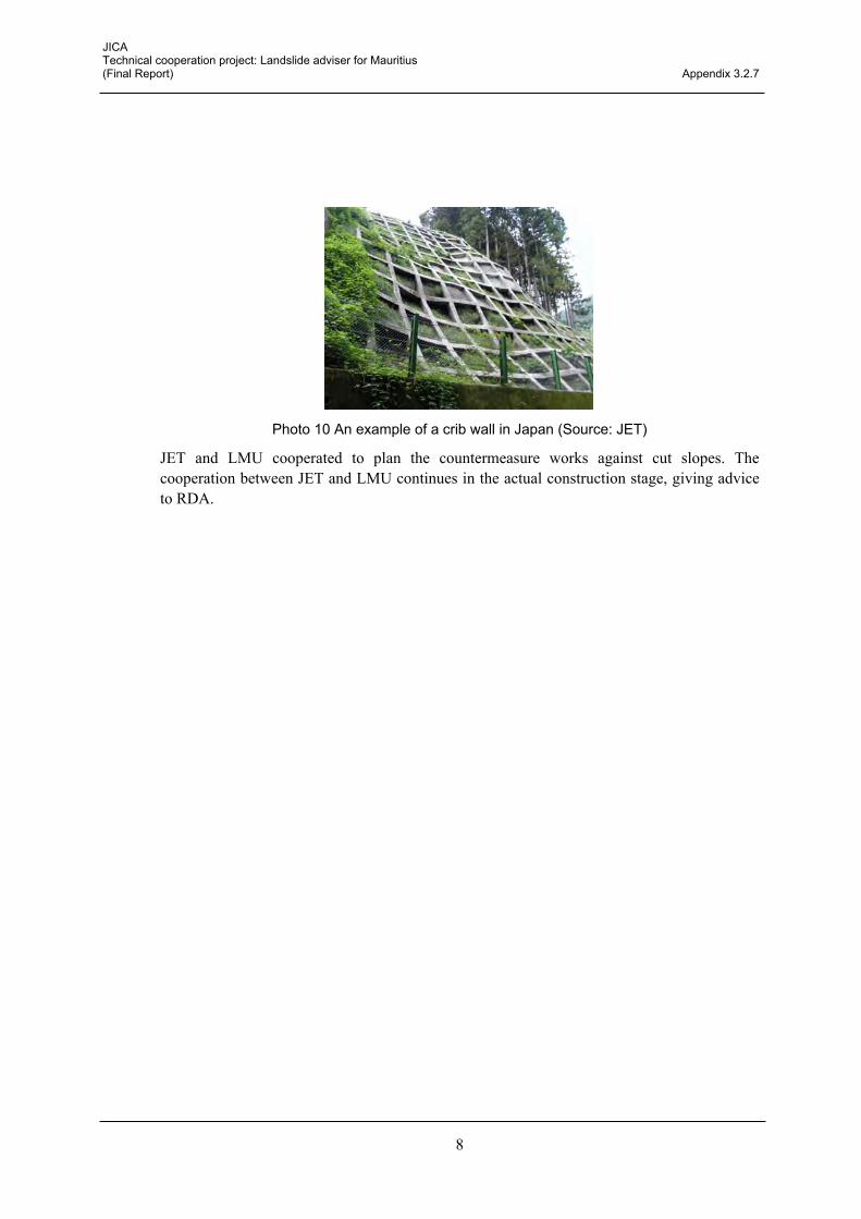
Photo 10 An example of a crib wall in Japan (Source: JET)
JET and LMU cooperated to plan the countermeasure works against cut slopes. The cooperation between JET and LMU continues in the actual construction stage, giving advice to RDA.

Appendix 3.3.1
Current monitoring system


JICA Technical cooperation project: Landslide adviser for Mauritius (Final Report) Appendix 3.3.1
1
Current monitoring system In the Previous Project, landslide monitoring has been implemented at three sites, Chitrakoot, Vallée Pitot and Quatre Soeurs, and the MPI started monitoring the landslides at several sites additionally. Subsequently, JET and C/P have confirmed the current situation of landslide monitoring and the monitoring system.
Landslide monitoring is currently carried out by MPI in three sites, Chitrakoot, Vallée Pitot, and Quatre Soeurs. In addition, landslide monitoring with extensometers in La Butte and Vallée pitot was installed in 2015. The measurement items installed in each site and the condition of the monitoring equipment are shown below.
Table 1 Measurement items and the condition of the monitoring equipment (Source: JET)
Site name Monitorind equipment Manegement No. Current condition
Chitrakoot
Piezometer BH-C1 Not measuring (breakdown of Equipment)
Inclinometer BH-C2
Continuous measurement Piezometer BH-C3 Strain Gauges BH-C4 Strain Gauges BH-C5
Inclinometer BH-C6 Not measuring (breakdown of Equipment)
Piezometer BH-11
Continuous measurement
Extensometer E-C1 Extensometer E-1 Extensometer E-2 Extensometer E-5 Rain Gauge R-C1
Quatre Soeurs
Strain Gauges BH-Q1 Not measuring (The relocation of all houses is planned as a landslide countermeasure)
Strain Gauges BH-Q2 Piezometer BH-5 Extensometer (laser) E-Q1 Extensometer (laser) E-Q2 Rain Gauge R-Q1 Continuous measurement
Vallée Pitot Extensometer E-V1 Continuous measurement Extensometer E-V2
Table 2 Measurement items and the condition of the additional monitoring equipment
installed by MPI, 2015 (Source: JET)
Site name Monitorind equipment Manegement No. Current condition
Vallée Pitot
Extensometer E-V3 Continuous measurement Piezometer BV-1 Continuous measurement Piezometer BV-2 Continuous measurement
BV-3 Continuous measurement Extensometer E-V2 Continuous measurement
La Butte Extensometer E-B1 Continuous measurement Extensometer E-B2 Continuous measurement

JICA Technical cooperation project: Landslide adviser for Mauritius (Final Report) Appendix 3.3.1
2
Boreholes Piezometer BH-C1 Extensometer E-C1
Inclinometer BH-C2 Extensometer E-1 Piezometer BH-C3 Extensometer E-2 Strain Gauges BH-C4 Extensometer E-5 Strain Gauges BH-C5 Inclinometer BH-C6 Rain Gauge R-C1
Figure 1 Location map of the monitoring equipment - Chitrakoot (Source: JET)
Boreholes Strain Gauges BH-Q1 Extensometer (laser) E-Q1 Strain Gauges BH-Q2 Extensometer (laser) E-Q2 Piezometer BH-5 (existing) Groundwater level BH-2 (existing) Rain Gauge R-Q1 Groundwater level BH-3 (existing) Groundwater level BH-4 (existing)
- One rain gauge is installed out of the map
Figure 2 Location map of the monitoring equipment - Quatre Soeurs (Source: JET)

JICA Technical cooperation project: Landslide adviser for Mauritius (Final Report) Appendix 3.3.1
3
Extensometer E-V1 Extensometer E-V2
Figure 3 Location map of the monitoring equipment - Vallée Pitot (Source: JET)
Extensometer E-V3 Piezometer BV-1 Piezometer BV-2 BV-3 Extensometer E-V2
Figure 4 Additional monitoring equipment installed by MPI, 2015 - Vallée Pitot (Source: JET)

JICA Technical cooperation project: Landslide adviser for Mauritius (Final Report) Appendix 3.3.1
4
Extensometer E-B1 Extensometer E-B2
Figure 5 Location map of the monitoring equipment - La Butte (Source: JET)

Appendix 3.3.2
Proposed remote monitoring system


JICA Technical cooperation project: Landslide adviser for Mauritius (Final Report) Appendix 3.3.2
1
Proposed remote monitoring system
a. Overview of the recommended remote monitoring system
The assumptions for studying the landslide remote monitoring system are as follows:
There are three sites to install/implement the remote monitoring system;
Sites to be monitored are Chitrakoot, Vallée Pitot and La Butte; and
The implementation flow of the remote monitoring system is shown in the figure below.
Figure 1 Implementation flow of the remote monitoring system (Source: JET)
Figure 2 Image of the remote monitoring system (Source: JET)
PHASE-1 Procurement
PHASE-2 Installation
PHASE-3 Operation and Maintenance

JICA Technical cooperation project: Landslide adviser for Mauritius (Final Report) Appendix 3.3.2
2
b. PHASE-1: Procurement
<Listing of the procurement item>
The data logger and transfer unit is normally installed beside the sensor and/or in a stable area against landslides. To properly decide the installation point of the data logger and transfer unit, and establish the amount of work for the preparation of the tender document, conditions of the communication signal should be checked. All the equipment should be installed in the inside of the protection fence for security.
The tentative deployment plan is shown in Figure below.
Figure 3 Deployment Plan in Chitrakoot (Source: JET)

JICA Technical cooperation project: Landslide adviser for Mauritius (Final Report) Appendix 3.3.2
3
Figure 4 Deployment Plan in Vallée Pitot (Source: JET)
Figure 5 Deployment Plan in La Butte (Source: JET)
JICA Technical cooperation project: Landslide adviser for Mauritius (Final Report) Appendix 3.3.2
4
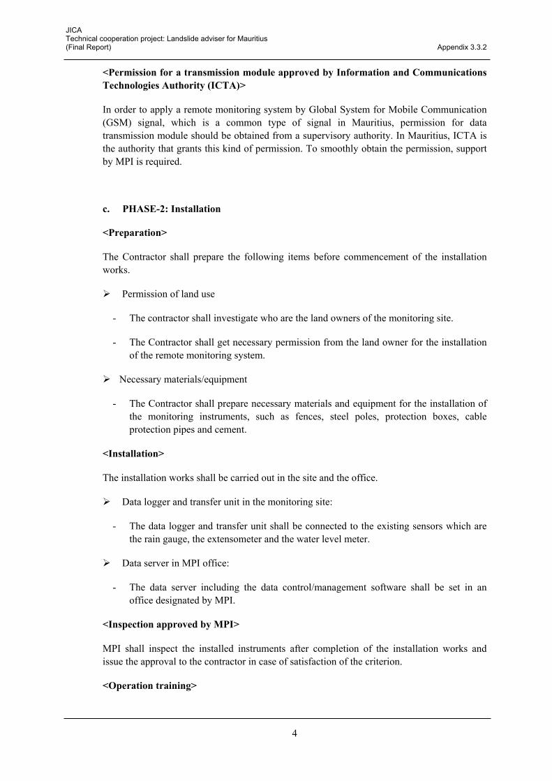
<Permission for a transmission module approved by Information and Communications Technologies Authority (ICTA)>
In order to apply a remote monitoring system by Global System for Mobile Communication (GSM) signal, which is a common type of signal in Mauritius, permission for data transmission module should be obtained from a supervisory authority. In Mauritius, ICTA is the authority that grants this kind of permission. To smoothly obtain the permission, support by MPI is required.
c. PHASE-2: Installation
<Preparation>
The Contractor shall prepare the following items before commencement of the installation works.
Permission of land use
- The contractor shall investigate who are the land owners of the monitoring site.
- The Contractor shall get necessary permission from the land owner for the installation of the remote monitoring system.
Necessary materials/equipment
- The Contractor shall prepare necessary materials and equipment for the installation of the monitoring instruments, such as fences, steel poles, protection boxes, cable protection pipes and cement.
<Installation>
The installation works shall be carried out in the site and the office.
Data logger and transfer unit in the monitoring site:
- The data logger and transfer unit shall be connected to the existing sensors which are the rain gauge, the extensometer and the water level meter.
Data server in MPI office:
- The data server including the data control/management software shall be set in an office designated by MPI.
<Inspection approved by MPI>
MPI shall inspect the installed instruments after completion of the installation works and issue the approval to the contractor in case of satisfaction of the criterion.
<Operation training>

JICA Technical cooperation project: Landslide adviser for Mauritius (Final Report) Appendix 3.3.2
5
The contractor shall provide the operation training to MPI at the handover of the procured and installed item. The threshold for early warning designated by MPI shall be set during the training.
d. PHASE-3: Operation and Maintenance
<Monitoring>
Data conditions shall be checked, especially data transfer stability. Daily data check shall be carried out by the Contractor during one month after the completion of the installation works.
<Maintenance>
Visual check and clean up every month shall be carried out by the contractor during 1 year after the completion of the installation works; and
If something wrong happens under ordinary use, the contractor shall repair the issue as a warranty during 1 year after the completion of the installation works.


Appendix 3.4.1
Early warningevacuation system in Chitrakoot & Vallée Pitot

JICA Technical cooperation project: Landslide adviser for Mauritius (Final Report) Appendix 3.4.1
1
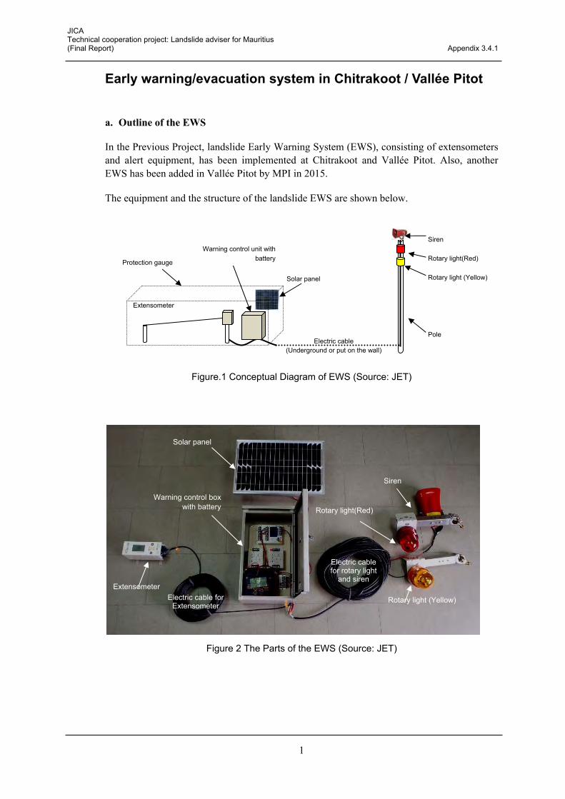
Early warning/evacuation system in Chitrakoot / Vallée Pitot
a. Outline of the EWS
In the Previous Project, landslide Early Warning System (EWS), consisting of extensometers and alert equipment, has been implemented at Chitrakoot and Vallée Pitot. Also, another EWS has been added in Vallée Pitot by MPI in 2015.
The equipment and the structure of the landslide EWS are shown below.
Figure.1 Conceptual Diagram of EWS (Source: JET)
Figure 2 The Parts of the EWS (Source: JET)
Electric cable for rotary light
and siren
Warning control box with battery
Extensometer
Solar panel
Rotary light (Yellow)
Siren
Rotary light(Red)
Electric cable for Extensometer
Siren
Rotary light(Red)
Rotary light (Yellow)
Pole
Extensometer
Electric cable (Underground or put on the wall)
Warning control unit with batteryProtection gauge
Solar panel

JICA Technical cooperation project: Landslide adviser for Mauritius (Final Report) Appendix 3.4.1
2
Table 1 Quantity of the parts for the EWS (Source: JET)
Location Name Quantity Remarks
Chitrakoot
Siren 1
Previous Project by JICA, 2014
Rotary light (red) 1 Rotary light (yellow) 1 Warning control box 1 Solar panel 1
Vallée Pitot
Siren 1
Previous Project by JICA, 2014
Rotary light (red) 1 Rotary light (yellow) 1 Warning control box 1 Solar panel 1
Vallée Pitot
Siren 1
Other project by MPI, 2015
Rotary light (red) 1 Rotary light (yellow) 1 Warning control box 1 Solar panel 1
b. Confirmation of the current conditions
The alarm is connected to the extensometers in two active landslides, Chitrakoot and Vallée Pitot. The alarm consists of rotary lights and a siren: the yellow rotary light operates during the warning stage, and the red rotary light and siren operates during the evacuation stage. The EWS operates appropriately now.
Connected extensometer: Chitrakoot: E5, Vallée Pitot: EV-1 and EV-3
Table 2 Threshold for activation of the alarm (Source: JET)
Alarm Stage Threshold (for Extensometer) Yellow rotary light Warning stage 10 mm/day
Red rotary light and siren Evacuation stage 20 mm/day

JICA Technical cooperation project: Landslide adviser for Mauritius (Final Report) Appendix 3.4.1
3
Chitrakoot: E5
Figure 1 EWS in Chitrakoot (Source: JET)
Vallée Pitot: EV-1
Figure 2 EWS in Vallée Pitot (Source: JET)

JICA Technical cooperation project: Landslide adviser for Mauritius (Final Report) Appendix 3.4.1
4
Vallée Pitot: EV-3
Figure 3 Additional EWS in Vallée Pitot (Source: JET)
E-V3
Alarm Extensometer Electric cable

Appendix 3.4.2
Simple setting manual for EWS


JICA Technical cooperation project: Landslide adviser for Mauritius (Final Report) Appendix 3.4.2
1
Simple setting manual for EWS 1 Operation of Alert system (cancellation of warninig)
The following operation must be carried out by MPI to avoid this malfunction. A) The case that the following operation should be carried out.
Case 1: The case that warning devices (siren & Rotary light) worked because displacement reached the threshold. This case is right warning announcement.
Case 2: The case that a warning device (siren & rotary light) worked when the cable which connected Warning control unit (NetAL-1) and extensometer (SLG-10E) was taken off.
B) Operation
Step 1 : To stop a warning The power supply of the warning device is turned off, and the warning stops (Fig.1).
Fig.1 Step 2 : Reset of the displacement for Extensometer (SLG-10E) As an operation of the extensometer, when the display button is pressed for a long period of time (2 seconds), the screen for selecting the various setting is displayed. If "Reset displacement" is selected in the "Instrument settings", the displacement rate can be reset. (Fig.2)
Fig.2
Yes
No
Yellow light switch Red light switch
OFF OFF
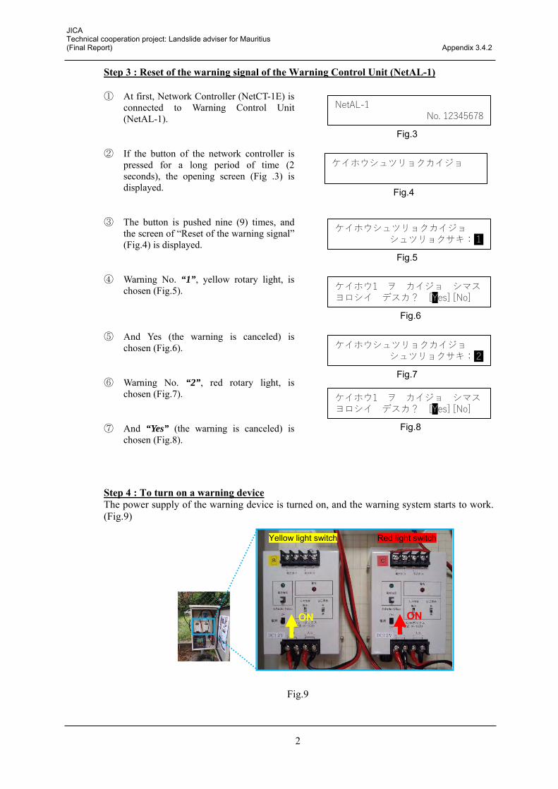
JICA Technical cooperation project: Landslide adviser for Mauritius (Final Report) Appendix 3.4.2
2
Step 3 : Reset of the warning signal of the Warning Control Unit (NetAL-1) ① At first, Network Controller (NetCT-1E) is
connected to Warning Control Unit (NetAL-1).
② If the button of the network controller is pressed for a long period of time (2 seconds), the opening screen (Fig .3) is displayed.
③ The button is pushed nine (9) times, and the screen of “Reset of the warning signal” (Fig.4) is displayed.
④ Warning No. “1”, yellow rotary light, is chosen (Fig.5).
⑤ And Yes (the warning is canceled) is chosen (Fig.6).
⑥ Warning No. “2”, red rotary light, is chosen (Fig.7).
⑦ And “Yes” (the warning is canceled) is chosen (Fig.8).
Step 4 : To turn on a warning device The power supply of the warning device is turned on, and the warning system starts to work. (Fig.9)
Fig.9
Yellow light switch Red light switch
ON ON
NetAL-1 No. 12345678
Fig.3
ケイホウシュツリョクカイジョ
Fig.4
ケイホウシュツリョクカイジョ シュツリョクサキ:1
Fig.5
ケイホウ1 ヲ カイジョ シマス ヨロシイ デスカ? [Yes] [No]
Fig.6
ケイホウ1 ヲ カイジョ シマス ヨロシイ デスカ? [Yes] [No]
Fig.8
ケイホウシュツリョクカイジョ シュツリョクサキ:2
Fig.7
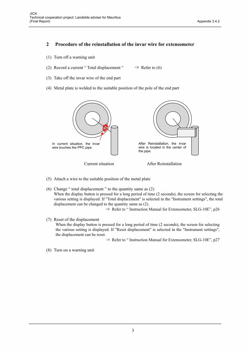
JICA Technical cooperation project: Landslide adviser for Mauritius (Final Report) Appendix 3.4.2
3
2 Procedure of the reinstallation of the invar wire for extensometer
(1) Turn off a warning unit
(2) Record a current “ Total displacement “ ⇒ Refer to (6)
(3) Take off the invar wire of the end part
(4) Metal plate is welded to the suitable position of the pole of the end part
Current situation After Reinstallation
(5) Attach a wire to the suitable position of the metal plate
(6) Change “ total displacement ” to the quantity same as (2) When the display button is pressed for a long period of time (2 seconds), the screen for selecting the various setting is displayed. If "Total displacement" is selected in the "Instrument settings", the total displacement can be changed to the quantity same as (2).
⇒ Refer to “ Instruction Manual for Extensometer, SLG-10E”, p26
(7) Reset of the displacement When the display button is pressed for a long period of time (2 seconds), the screen for selecting the various setting is displayed. If "Reset displacement" is selected in the "Instrument settings", the displacement can be reset.
⇒ Refer to “ Instruction Manual for Extensometer, SLG-10E”, p27
(8) Turn on a warning unit
In current situation, the invar wire touches the PPC pipe.
After Reinstallation, the invar wire is located in the center of the pipe.


Appendix 3.4.3
Automatic rainfall monitoring system (AWS of MMS)


JICA Technical cooperation project: Landslide adviser for Mauritius (Final Report) Appendix 3.4.3
1
Automatic rainfall monitoring system (AWS of MMS) An automatic rainfall monitoring system is necessary for the Early Warning System (EWS) of the slope disaster. However, it is not easy to install an automatic rainfall monitoring system that covers the entire island of Mauritius. Therefore, MPI suggested the use of Automatic Weather System (AWS) of Mauritius Meteorological Service (MMS). In response to the request from MPI, MMS installed AWS in Chitrakoot in December, 2016 (refer to appendix3.4.2). JET proposes that the AWS of MMS covers the entire island. In addition, the use of a weather radar, installed by a different JICA project, shall be expected in the future.
Figure.1 AWS (Automatic Weather System) of MMS (Mauritius Meteorological Service) behind the Chitrakoot government school (Source: JET)

Appendix 3.5.1
Questionnaire survey results


Questionnaire survey on handbook
1. Outline of the questionnaire survey Conducted period: April – May 2016 Purpose: to seek the views and comments from the related stakeholders as well as
obtaining suggestions to improve the handbook Procedure method: printed survey was despatched to 41 stakeholders
2. List of stakeholders to despatch the survey Name of the stakeholder 1 Government Information Service 2 Mauritius Police Force 3 National Development Unit 4 Mauritius Meteorological Services 5 Ministry of Environment, Sustainable Development, and Disaster and Beach Management 6 National Disaster Risk Reduction and Management Centre 7 Ministry of Housing and Lands 8 Ministry of Local Government 9 City Council of Port Louis 10 Municipal Council of Beau Bassin 11 Municipal Council of Curepipe 12 Municipal Council of Quatre Bornes 13 Municipal Council of Vacoas Phoenix 14 District Council of Riviere du Rempart 15 District Council of Pamplemousses 16 District Council of Moka 17 District Council of Flacq 18 District Council of Grand Port 19 District Council of Savanne 20 District Council of Black River 21 Mauritius Fire and Rescue Service 22 Ministry of Health and Quality of Life 23 Ministry of Education & Human Resources, Tertiary Education, and Scientific Research 24 Ministry of Finance and Economic Development 25 Ministry of Civil Service and Administrative Reforms 26 Ministry of Gender Equality, Child Development & Family Welfare 27 Ministry of Social Security, National Solidarity & Reform Institutions 28 Ministry of Social Integration and Economic Empowerment 29 Ministry of Technology, Communication and Innovation 30 Ministry of Energy and Public Utilities 31 Water Resources Unit 32 Waste Water Management Authority 33 Central Electricity Board 34 Central Water Authority 35 Mauritius Broadcasting Cooperation 36 National Transport Authority

Questionnaire survey on handbook
37 Road Development Authority 38 University of Mauritius 39 Mauritius Red Cross Society 40 St. John Ambulance 41 United Nations Development Programme
3. Results 24 stakeholders responded
0123456789
10
Poor Acceptable Good Very Good Excellent
3
109
2
How would you rate the adequacy of using this handbook as a sensitisation material for the public in general?
0
2
4
6
8
10
12
Poor Acceptable Good Very Good Excellent
8
12
4
How would you rate the relevance of the information provided in the handbook?
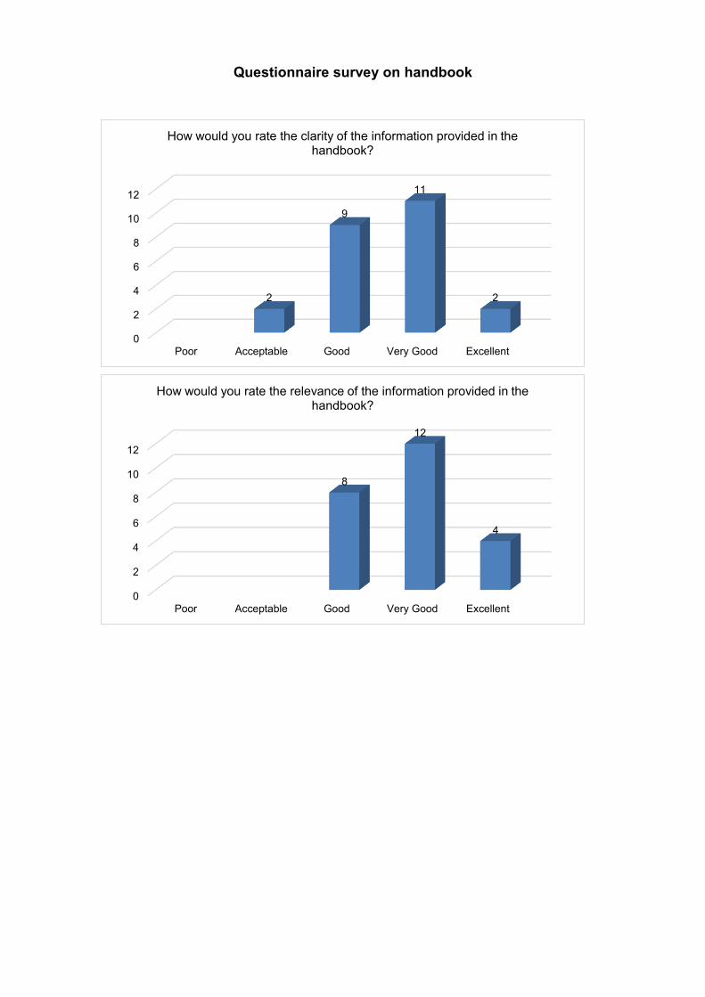
Questionnaire survey on handbook
0
2
4
6
8
10
12
Poor Acceptable Good Very Good Excellent
2
9
11
2
How would you rate the clarity of the information provided in the handbook?
0
2
4
6
8
10
12
Poor Acceptable Good Very Good Excellent
8
12
4
How would you rate the relevance of the information provided in the handbook?

Questionnaire survey on handbook
4. Comments and suggestions <Positive comments in general> The Manual is child friendly
Has enough information for general public These elements B6 impact on presentation and final product
<Comments for specific section to be improved> Section 3 (page 7): JET may wish to refine Table 1 in conjunction with section 2.3.1
and Table 2.3.11 of the "Project of Landslide Management in the Republic of Mauritius - Final Report";
Section 4 (page 8): Label "landslide block" on diagram Section 4 (page 9): In paragraph 4, human activities, example may have been given
as landslide treatment at terre rouge verdun link road where start of landslides occurred as a result of re-profiling of mountain slopes to provide a …
Section 4 (pp. 8-9): It is important to stress that, landslides may occur as a result of a combination of more than one factor
Section 6 (page 12): relating to PPG should be amended with the proper cover page of PPG 9, and the appropriate name of PPG 9: "Developments on sloping sites and landslide hazard areas"
Section 6 and 7 (pp. 12-14): More detailed information is to be made available Section 7.2 (page 13): It may be better to characterise the pros and cons, rather
than, quantify them by assigning a percentage
02468
10121416
Poor Acceptable Good Very Good Excellent
1
6
16
11
14
7
2
How would you rate your understanding of the causes and occurrence of landslides?
Before After

Questionnaire survey on handbook
Section 7.3 (page 14): development has to be made for disaster prevention Section 8 (page 18): figure 2 is not clear enough. Information missing. Few
wordings could be added to better explain the flow chart. Too congested. Section 8 (page 18): JET should update and review criteria for Termination stage,
which is not in conformity with the recommendations of the "Project of Landslides Management in the Republic of Mauritius - Final Report";
Section 2.2, 4, 5, and 8: It is understood that the updated handbook will incorporate the other types of landslides like rockfall, debris flow, creep and slope failure with necessary amendments brought among others, to sections
<Comments in general to be improved> Simplification:
- The contents are quite clear except for a few terms which need to be simplified further.
- The document appears to be a bit bulky and requires further simplification - Less literature recommended, more simple illustrations - Improvements on the clarity of the provided information may be explored with
use of diagrams/illustrations - Some pages look too crammed with information, which hinders
comprehension and ease of reading - A handbook for the younger ones with more cartoon and less technical
explanation Creole version:
- consider having one version in Creole language - To have a Creole version of the handbook - A Creole version of the handbook should be made to sensitize people with low
literacy. A quite complex French language is being used in the handbook. - Contents should be also circulated in Creole language - Consider a simplifies version in Creole so as to reach a greater number of people
Accuracy: - Avoid printing formatting mistakes. Twice pages 9 and 10 to avoid
misunderstanding
- Publication must be more rigorously scrutinised for language mistakes, especially for the French version.
- Layout could be improved, along with special attention as regards to proof reading

Questionnaire survey on handbook
- There is a need to proofread the contents of the documents for typographical and grammatical inconsistencies.
Contents: - The information provided should be made more user friendly - It may not be easily read/understood by the general public.
Other: - Improve quality of maps - Increase the size of the photos showing cracks/deformation to create more
impact on awareness
- It may be more appropriate to restyle the title of the handbook to "The Landslide Preparedness Handbook or Learning to Live with Landslides" to suit the content thereto
- It may be more convenient to use "prevention and mitigation" in tandem throughout the handbook rather than "prevention" only
- The item countermeasure works to be more explicit for information of the public
- The handbook contains more info on Chitrakoot. Understanding of landslide prone areas at other listed places would add to knowledge.
- There is still a bit of confusion about rainfall data collection at different warning stages
- The information/illustrations are well explicit for any person, though not conversant with the issue of landslide to understand same clearly.
- In the local context, it is important to consider the pervasive influence of "culture and belief" on the perception of natural disasters. Moreover, people can be indifferent to the sensitisation material, unless they have experienced an even of the like.
<Suggestions to add the contents> Evacuation Centre:
- The location for refugee centres of hazardous sites should be identified and included in the booklet. The new protocol that mandates the power of the police to force evacuation should be inserted as a clause in the booklet
- Evacuee Centres in Landslide prone areas and to be included in the handbook
Institutional framework: - To include provision of the NDRRMC legislation which now renders non-

Questionnaire survey on handbook
compliance to evacuation order by police as an offence - To mention national coordination at the level of NEOC during emergency - The role of the community response team, especially at Quatre Soeurs - The role of the NDRRMC committee
Other: - A "what NOT to do" list could be included - Practical safety precautions to be taken by inhabitants of areas likely to be
affected by landslides, e.g, use of helmets; to move towards assembly points; specific type of building foundation etc.
- List of contact details (fire, utility, LA, disaster centre) to be inserted to inform of disaster. Hotline and contact person
- To include that prior to engaging in any development, owners have to make themselves informed on hazards present within the area they intend to do so
- Separate pamphlet for technical information and warning system may be considered
- Losses due to landslide (directs and indirects) - consider including information with respect to recent landslide occurrences in
nearby regions, giving indications on possible causes and the extent/seriousness of their effects. These should be reported with statistical evidence/pictured and which may have a greater impact on the awareness of the public in general, promoting awareness, amongst others
- Course of action during and after a landslide disaster - Psychological preparedness
<Comments beyond the handbook> Presentation and audio visual should be targeted to some specific groups, eg, mass,
students, senior citizens
Community participation is essential to target the public and response mechanism during a landslide event
Dissemination process has to be done well. For instance, handbook could be distributed at primary and secondary schools and a special class could be made to sensitise. Students could be means to sensitise parents and relatives
The people residing at the listed landslide prone areas must be sensitised first

Questionnaire survey 2 on handbook
1. Outline of the questionnaire survey Conducted period: 01 - 24 March 2017 Purpose: to seek the views and comments on the revised handbook from the
related stakeholders Procedure method: printed survey was distributed to approximately 40 participants
in the seminar held on 1 March 2017
2. Results 6 stakeholders responded
0
1
2
3
4
Poor Acceptable Good Very good Excellent
0 0
1
4
1
How would you rate clarity of the content?
0
1
2
3
4
Poor Acceptable Good Very good Excellent
0 0
1
4
1
How would you rate usefulness of the handbook?

Questionnaire survey 2 on handbook
3. Comments and suggestions <Handbook for general public> There should include a preface section/ or message section from an appropriate
individual or team
Must provide a list of emergency shelters A section to describe the terms used in slope disaster preparedness and
management A section on why there is a need to prepare a slope disaster plan A section on how to prepare your children and protecting animals (pet owners)
0
1
2
3
4
Poor Acceptable Good Very good Excellent
0 0
2
3
1
How easy do you find to understand slope disaster?
0
1
2
3
4
5
Yes No Don't know No answer
5
0 0
1
Do you think that the handbook with the different contents is needed for the stakeholders?

Questionnaire survey 2 on handbook
before, during and after a slope disaster A complete section on recovering from a slope disaster, including psychological
issues Slope disaster preparedness for people with disabilities Planning for evacuation Emergency sheltering characteristics To enhance the reading and presentation of the handbook, possible use of a colour
code may be appropriate More information regarding consideration and specifications would be a good
guidance
Security issue should be added to avoid vandalism

Appendix 3.5.2
Sensitisation materials


Prepare Yourself for Slope Disasters
December 2017
SLOPE DISASTERPREPAREDNESS
HANDBOOK
THE
Ministry of Public Infrastructure and Land Transport
in collaboration with
Japan International Cooperation Agency (JICA)
30
11
17
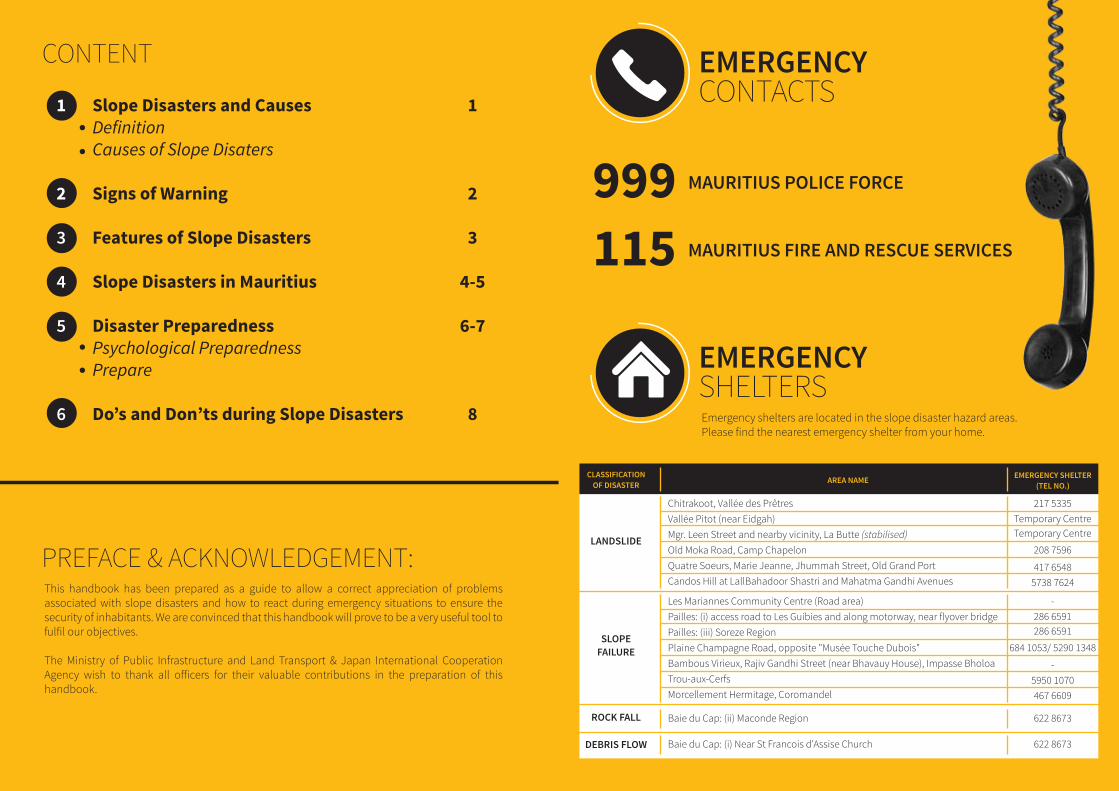
This handbook has been prepared as a guide to allow a correct appreciation of problems associated with slope disasters and how to react during emergency situations to ensure the security of inhabitants. We are convinced that this handbook will prove to be a very useful tool to fulfil our objectives.
The Ministry of Public Infrastructure and Land Transport & Japan International Cooperation Agency wish to thank all o�icers for their valuable contributions in the preparation of this handbook.
MAURITIUS POLICE FORCE999MAURITIUS FIRE AND RESCUE SERVICES115
EMERGENCYCONTACTS
EMERGENCYSHELTERSEmergency shelters are located in the slope disaster hazard areas.Please find the nearest emergency shelter from your home.
Slope Disasters and CausesDefinitionCauses of Slope Disaters
Signs of Warning
Features of Slope Disasters
Slope Disasters in Mauritius
Disaster PreparednessPsychological PreparednessPrepare
Do’s and Don’ts during Slope Disasters
1
2
3
4-5
6-7
8
1
2
3
4
5
6
CONTENT
AREA NAME EMERGENCY SHELTER(TEL NO.)
CLASSIFICATIONOF DISASTER
LANDSLIDE
Chitrakoot, Vallée des PrêtresVallée Pitot (near Eidgah)Mgr. Leen Street and nearby vicinity, La Butte (stabilised)Old Moka Road, Camp ChapelonQuatre Soeurs, Marie Jeanne, Jhummah Street, Old Grand PortCandos Hill at LallBahadoor Shastri and Mahatma Gandhi Avenues
217 5335Temporary CentreTemporary Centre
208 7596
417 65485738 7624
SLOPEFAILURE
ROCK FALL
Les Mariannes Community Centre (Road area)Pailles: (i) access road to Les Guibies and along motorway, near flyover bridgePailles: (iii) Soreze RegionPlaine Champagne Road, opposite "Musée Touche Dubois"Bambous Virieux, Rajiv Gandhi Street (near Bhavauy House), Impasse BholoaTrou-aux-CerfsMorcellement Hermitage, Coromandel
Baie du Cap: (ii) Maconde Region
-286 6591286 6591
684 1053/ 5290 1348
-5950 1070467 6609
622 8673
DEBRIS FLOW Baie du Cap: (i) Near St Francois d'Assise Church 622 8673
PREFACE & ACKNOWLEDGEMENT:

1
“Slope disasters” are defined as the movement of a mass of rock, debris or earth down a slope, and categorised as four types.
LANDSLIDEA phenomenon where the soil mass on one or more failure surfaces deep in the ground gradually shi�s downward.
SLOPE FAILURESlope failure mass detaches from a steep slope/cli� along a surface with little or no shear displacement. It moves quickly on a small scale and the inclination angle is relatively high.
ROCK FALLA phenomenon where foliated rocks and gravel start to fall down a slope.
DEBRIS FLOWA phenomenon where soil and boulders are liquefied by surface water or groundwater and tend to flow downward rapidly through a mountain torrent.
LANDSLIDESlope inclination, geological features, stratum,groundwater and continuous heavy rainfall.
SLOPE FAILUREIntense and heavy rainfall in a short period of time.
DEBRIS FLOWIncrease of surface water due to heavy rainfall.
ROCK FALLRainfall, strong wind, erosion, growth of roots.
CAUSES OF SLOPE DISASTERSThere are several factors/triggers which provoke the slope disasters. Slope disasters may occur asa result of a combination of more than one factor/trigger. Human activities are the common causeof all types of slope disasters.
1
DEFINITION
Slope Disasters and Causes

2
Slope disasters have signs of warning before they actually occur.
NEW CRACKS• Cracks on ground, retaining wall, paved roads, and walls and floors of houses.
CHANGE OF WATER VOLUME AND QUALITY• Rapid increase, decrease or drying up of water.• Sudden muddiness of spring water, mountain stream and groundwater.• Groundwater from the earth.
UNUSUAL SMELLS• Earthly smell, burning and woody smell.
UNUSUAL SOUNDS• Breaking of tree roots.• Rubbing of tree branches.• Rumbling of the mountain.
OTHERS• Breaking down of rocks into smaller pieces.• Loosening or tensioning of electric cables.• Changing the shape of the building (i.e. unable to close the door).• Falling of small rocks from the slope.• Swelling up/ cave-in of ground.
2
? ?
SIGNS OF WARNING

3
Features of Slope Disasters3
The following scenes are common characteristics which can be observed in the slope disaster areas. Necessary precautions should be taken if you find these characteristics as illustrated below:
LANDSLIDE AREAS
SLOPE FAILURE AREAS
ROCK FALL AREAS
DEBRIS FLOW AREAS
Tilted Poles Deformation in the Steps Deformation of the House Bent Road
Slope Collapsedfrom the Top
Crack on the Road Fence Damaged bySlope Failure
Slope covered by loose Soilis prone to Slope Failure
Unstable Boulders Rock Constituting Cli� Fallen Rocks
Large Volume of Fill Stacked Big Boulders
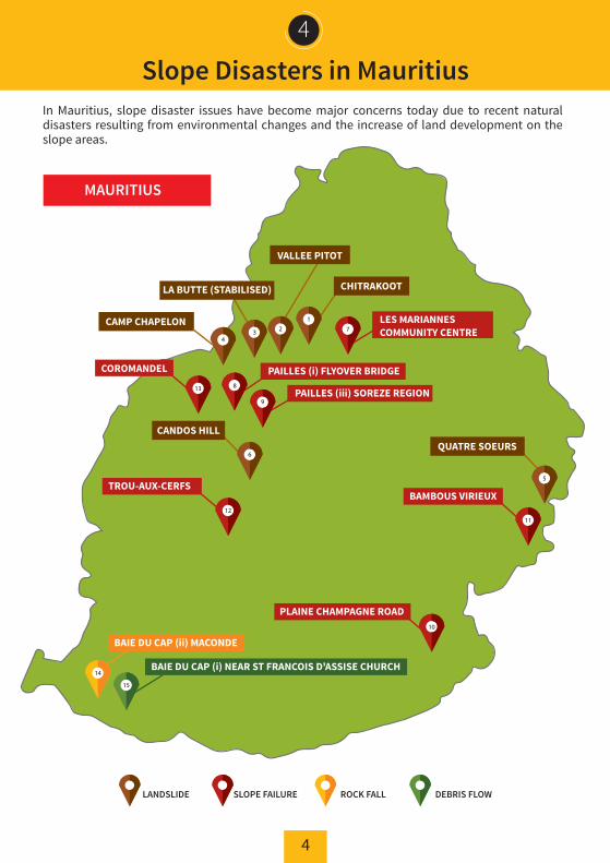
4
4
In Mauritius, slope disaster issues have become major concerns today due to recent natural disasters resulting from environmental changes and the increase of land development on the slope areas.
Slope Disasters in Mauritius
MAURITIUS
CHITRAKOOT
QUATRE SOEURS
LES MARIANNESCOMMUNITY CENTRE
PAILLES (i) FLYOVER BRIDGE
PAILLES (iii) SOREZE REGION
PLAINE CHAMPAGNE ROAD
BAMBOUS VIRIEUXTROU-AUX-CERFS
BAIE DU CAP (ii) MACONDE
BAIE DU CAP (i) NEAR ST FRANCOIS D'ASSISE CHURCH
COROMANDEL
CANDOS HILL
VALLEE PITOT
LA BUTTE (STABILISED)
CAMP CHAPELON
DEBRIS FLOWLANDSLIDE ROCK FALLSLOPE FAILURE
4
15
6
11
123 7
9
12
14
10
5
813

5
4
LIST OF SLOPE DISASTER HAZARD AREAS IN MAURITIUS
AREA NAMENo.DISTRICT COUNCIL/
MUNICIPALITYCLASSIFICATION
OF DISASTER
LANDSLIDE
Chitrakoot, Vallée des PretresVallée Pitot (near Eidgah)Mgr. Leen Street and nearby vicinity, La Butte (stabilised)Old Moka Road, Camp ChapelonQuatre Soeurs, Marie Jeanne, Jhummah Street, Old Grand PortCandos Hill at LallBahadoor Shastri and Mahatma Gandhi Avenues
Municipality of Port LouisMunicipality of Port LouisMunicipality of Port LouisMunicipality of Port LouisGrand Port District CouncilMunicipality of Quatre Bornes
Municipality of Port LouisMunicipality of Port LouisBlack River District CouncilGrand Port District CouncilMunicipality of Curepipe
123456
SLOPEFAILURE
ROCK FALL
Pailles: (i) access road to Les Guibies and along motorway, near flyover bridgePailles: (iii) Soreze RegionPlaine Champagne Road, opposite "Musée Touche Dubois"Bambous Virieux, Rajiv Gandhi Street (near Bhavauy House), Impasse BholoaTrou-aux-CerfsMorcellement Hermitage, Coromandel
DEBRIS FLOWBaie du Cap: (ii) Maconde Region Savanne District Council
Baie du Cap: (i) Near St Francois d'Assise Church Savanne District Council
14
15
7
89
10111213
Pamplemousses/ Rivière duRempart District CouncilLes Mariannes Community Centre (Road area)
Municipality ofBeau Bassin - Rose Hill
Source: JICA final report: The Project of Landslide Management in the Republic of Mauritius (March 2015)
Landslide Damage (Vallée Pitot) Landslide Damage (Quatre Soeurs) Slope Failure(Batelage)
Rock Fall (Baie du Cap) Rock Fall (Maconde)Debris Flow (Baie du Cap)
Slope Disasters in Mauritius
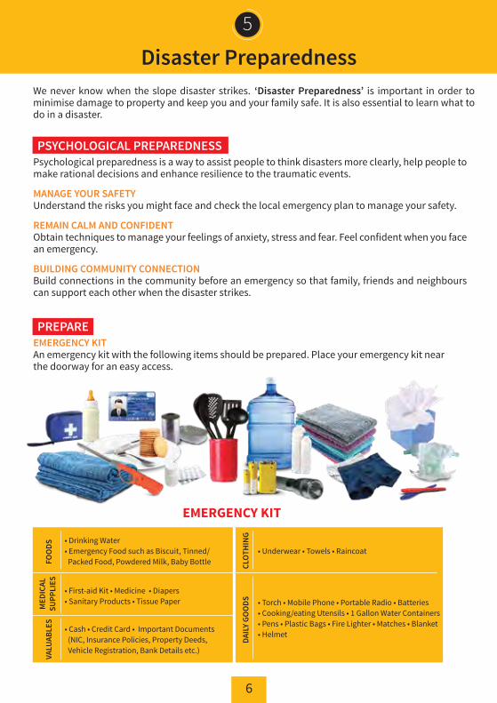
6
Disaster Preparedness5
We never know when the slope disaster strikes. ‘Disaster Preparedness’ is important in order to minimise damage to property and keep you and your family safe. It is also essential to learn what to do in a disaster.
Psychological preparedness is a way to assist people to think disasters more clearly, help people to make rational decisions and enhance resilience to the traumatic events.
MANAGE YOUR SAFETYUnderstand the risks you might face and check the local emergency plan to manage your safety.
REMAIN CALM AND CONFIDENTObtain techniques to manage your feelings of anxiety, stress and fear. Feel confident when you face an emergency.
BUILDING COMMUNITY CONNECTIONBuild connections in the community before an emergency so that family, friends and neighbours can support each other when the disaster strikes.
PSYCHOLOGICAL PREPAREDNESS
EMERGENCY KITAn emergency kit with the following items should be prepared. Place your emergency kit near the doorway for an easy access.
PREPARE
EMERGENCY KIT
FOO
DS
CLOT
HIN
G
• Drinking Water• Emergency Food such as Biscuit, Tinned/ Packed Food, Powdered Milk, Baby Bottle
• Underwear • Towels • Raincoat
MED
ICAL
SUPP
LIES
• First-aid Kit • Medicine • Diapers• Sanitary Products • Tissue Paper
VALU
ABLE
S
• Cash • Credit Card • Important Documents (NIC, Insurance Policies, Property Deeds, Vehicle Registration, Bank Details etc.)
DAIL
Y GO
ODS • Torch • Mobile Phone • Portable Radio • Batteries
• Cooking/eating Utensils • 1 Gallon Water Containers • Pens • Plastic Bags • Fire Lighter • Matches • Blanket • Helmet
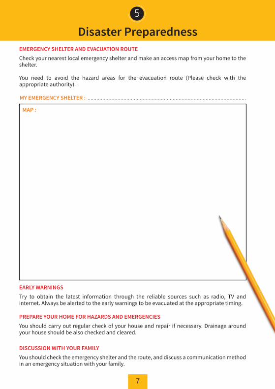
7
5
EMERGENCY SHELTER AND EVACUATION ROUTECheck your nearest local emergency shelter and make an access map from your home to the shelter.
You need to avoid the hazard areas for the evacuation route (Please check with the appropriate authority).
EARLY WARNINGSTry to obtain the latest information through the reliable sources such as radio, TV and internet. Always be alerted to the early warnings to be evacuated at the appropriate timing.
PREPARE YOUR HOME FOR HAZARDS AND EMERGENCIESYou should carry out regular check of your house and repair if necessary. Drainage around your house should be also checked and cleared.
DISCUSSION WITH YOUR FAMILY You should check the emergency shelter and the route, and discuss a communication method in an emergency situation with your family.
MY EMERGENCY SHELTER :
MAP :
..........................................................................................................
Disaster Preparedness

8
6
SUSPECTING IMMINENT DANGER
DON’T PUT YOURSELF AT RISK!
Slope disasters can occur in many areas. Always be prepared and stay informed of anychanges in and around your home.
BE AWARE• Listen for unusual sounds such as tree cracking or boulders knocking together as these might indicate the cause of slope disasters. • If you are near a stream or channel, be alert for any sudden increase or decrease in water flow, or changes of water colour from clear to muddy.
EVACUATION• If you suspect imminent danger, evacuate immediately and contact your local district authority, fire or police department.
• Listen to local radio for warnings. Also, get information from your neighbours or friends for any potential dangers.
BE AWARE
EVACUATION
Do’s and Don’ts during Slope Disasters
• Inform neighbours who may not be aware of potential threats and evacuate together.
DO’S
DON’TS

(pour mieux se préparer)
Décembre 2017
PREPARATION AUX MOUVEMENTS
DE TERRAIN
MANUEL DE
Ministère des Infrastructures publiques
et du Transport routier en collaboration avec
L'Agence japonaise de coopération internationale (JICA)
30
11
17

Ce manuel sert de guide visant à une meilleure compréhension des problèmes liés aux mouvements de terrain afin de préparer les habitants à mieux se protéger en cas de sinistre. Nous sommes convaincus que ce manuel s’avérera un outil vraiment utile pour atteindre nos objectifs.
Le Ministère des Infrastructures publiques et du Transport routier et L'Agence japonaise de coopération internationale tiennent à remercier tous les o�iciers pour leur précieuse contribution à la préparation de ce manuel.
999MAURITIUS FIRE AND RESCUE SERVICES115
CONTACT (NUMEROS)D’URGENCE
ABRIS D’URGENCELes abris d’urgence sont situés dans les zones à risque.Veuillez repérer l’abri d'urgence le plus proche de votre maison.
MOUVEMENTS DE TERRAIN ET LEURS CAUSES DéfinitionCauses des mouvements de terrain
Signes précurseurs
Caractéristiques des mouvements de terrain
Mouvements de terrain à Maurice
Préparation aux catastrophesPréparation psychologique Se préparaer
En cas de catastrophesA faire et à ne pas faire
1
2
3
4-5
6-7
8
1
2
3
4
5
6
CONTENU
NOM DE LA REGION ABRIS D’URGENCE(TEL)
CLASSIFICATION DES CATASTROPHES
GLISSEMENT DE TERRAIN
Chitrakoot, Vallée des Prêtres
Vallée Pitot (à proximité de Eidgah)
Rue Mgr. Leen et dans la région de La Butte (stabilisée)
Old Moka Road, Camp Chapelon
Quatre Soeurs, Marie Jeanne, Rue Jhummah, Vieux Grand Port
Colline Candos aux Avenues LallBahadoor Shastri et Mahatma Gandhi
217 5335
Centre provisoire
Centre provisoire
208 7596
417 6548
5738 7624
AFFAISSEMENT
EBOULEMENT (ROCHES)
Centre communautaire Les Mariannes (zone des routes)
Pailles: (i) Chemin d’accès à Les Guibies et au long de l’autoroute à proximité de la passerelle
Pailles: (iii) Région de Sorèze
Route Plaine Champagne, vis-a-vis de "Musée Touche Dubois"
Bambous Virieux, Rue Rajiv Gandhi (à proximité de Bhavauy House), Impasse Bholoa
Trou-aux-Cerfs
Morcellement Hermitage, Coromandel
Baie du Cap: (ii) Région de Macondé
-286 6591
286 6591
684 1053/ 5290 1348
-5950 1070
467 6609
622 8673
COULEE DE DEBRIS Baie du Cap: (i) à proximité de l’église St François d'Assise 622 8673
PREFACE / REMERCIEMENTS:
MAURITIUS POLICE FORCE

1
“Les mouvements de terrain” sont définis comme le mouvement d'une masse rocheuse, de débris ou de terre le long d’une pente et sont classés selon quatre types.
GLISSEMENT DE TERRAIN Un phénomène où la masse de terre, sur une ou plusieurs surfaces de défaillance profondes dans le sol, se déplace graduellement vers le bas.
L’AFFAISSEMENTLa masse cédée de la pente se détache d'une pente raide / falaise le long d'une surface avec peu ou pas de déplacement en cisaillement. Cela se déplace rapidement sur une petite échelle et l'angle d'inclinaison est relativement élevée.
EBOULEMENT (ROCHES) Un phénomène où les roches feuilletées et le gravier commencent à tomber le long d’une pente.
COULEE DE DEBRISUn phénomène où la terre et les rochers sont liquéfiés par les eaux de surface ou les eaux souterraines et ont tendance à s'écouler rapidement à travers un torrent de montagne.
GLISSEMENT DE TERRAINInclinaison de la pente, caractéristiques géologiques, strate et eaux souterraines, etc.
AFFAISSEMENT PluviométrieDes précipitations intenses et fortes dans un court laps de temps.
COULEE DE DEBRISAugmentation des eaux de surface due à de fortes précipitations.
EBOULEMENT (ROCHES) Précipitations, vents forts, érosion, croissance des racines.
CAUSES DES MOUVEMENTS DE TERRAINSIl existe plusieurs facteurs déclenchants qui provoquent les mouvements de terrain. Ces mouvements peuvent survenir en raison d'une combinaison de plusieurs facteurs déclenchants. Les mouvements de terrain sont issus de phénomènes naturels et peuvent aussi être favorisés par l’activité humaine.
1
DEFINITION
Les mouvements de terrain et leurs causes

2
Les mouvements de terrain sont précédés de signes précurseurs notamment :
NOUVELLES FISSURES • Fissures sur le sol, les murs de soutènement, les routes pavées, les murs et planchers des maisons.
CHANGEMENT DE VOLUME ET DE QUALITE DE L'EAU• Augmentation rapide, diminution ou assèchement de l'eau.• L'eau de source, ruisseau de montagne et eaux souterraines deviennent soudainement boueuses.• Remontée des eaux souterraines de la terre.
ODEURS INHABITUELLES• Odeur de la terre, de feu et de bois.
BRUITS INHABITUELS• Craquements d’arbres• Frottement des branches d'arbres.• Grondement de la montagne.
AUTRES• Cassure des roches en petits morceaux.• Desserrage ou tension des câbles électriques.• Modifications dans les constructions (Ex : les portes ). • Chute de petites roches de la pente.• Gonflement /affaissement du sol.
2
? ?
SIGNES PRECURSEURS

3
Caractéristiques de mouvements de terrain3
Les scènes suivantes sont des manifestations communes qu’on peut observer dans les zones avec mouvements de terrains. Des précautions nécessaires doivent être prises si vous constatez ces signes précurseurs:
REGIONS DE GLISSEMENT DE TERRAIN
REGIONS D’EFFONDREMENT DE PENTES
REGIONS DE EBOULEMENT DE ROCHES
REGIONS DE COULEE DE DEBRIS
Poteaux inclinés Déformation des marches d’escalier
Déformation de la maison Rues courbées
E�ondrement de la pente Fissures sur la route Clôture endommagée par a�aissement de la pente
Pente couverte par le sol mou sujette à un é�ondrement
de la pente
Rochers instables Roche constituant une falaise Chute de pierres
Grand volume de remplissage Gros rochers empilés

4
4
À Maurice, les problèmes liés aux mouvements de terrain sont aujourd'hui devenus des préoccu-pations majeures en raison des catastrophes naturelles récentes résultant des changements environnementaux et du développement accru sur les versants.
Catastrophes dues aux mouvements de terrain à Maurice
MAURICE
CHITRAKOOT
QUATRE SOEURS
CENTRE COMMUNAUTAIRELES MARIANNES
PAILLES (i) PASSERELLE
PAILLES (iii) REGION DE SOREZE
ROUTE PLAINE CHAMPAGNE
BAMBOUS VIRIEUXTROU-AUX-CERFS
BAIE DU CAP (ii) MACONDE
A PROXIMITE DE L’EGLISE ST FRANCOIS D'ASSISE
COROMANDEL
COLLINE CANDOS
VALLEE PITOT
LA BUTTE (STABILISEE)
CAMP CHAPELON
COULEE DE DEBRISGLISSEMENT DE TERRAIN EBOULEMENT (ROCHES)
AFFAISSEMENT
4
15
6
11
123 7
9
12
14
10
5
813

5
4
LISTE DES ZONES A RISQUE DE CATASTROPHES A MAURICE
NOM DE LA REGIONNo.CONSEIL DE DISTRCT/ CONSEIL MUNICIPAL
CLASSIFICATION DES CATASTROPHES
GLISSEMENT DE TERRAIN
Chitrakoot, Vallée des PretresVallée Pitot (à proximité de Eidgah)Rue Mgr. Leen et dans la région de La ButteOld Moka Road, Camp ChapelonQuatre Soeurs, Marie Jeanne, Rue Jhummah, Vieux Grand PortColline Candos aux Avenues LallBahadoor Shastri et Mahatma Gandhi
Municipalité de Port LouisMunicipalité de Port LouisMunicipalité de Port LouisMunicipalité de Port LouisConseil de District de Grand PortMunicipalité de Quatre Bornes
Municipalité de Port LouisMunicipalité de Port LouisConseil de District de Riviere NoireConseil de District de Grand Port Municipalité de Curepipe
123456
AFFAISSEMENT
EBOULEMENT(ROCHES)
Pailles: (i) Chemin d’accès à Les Guibies et au long de l’autoroute à proximité de la passerellePailles: (iii) Région de Sorèze Chemin Plaine Champagne, vis-a-vis de "Musée Touche Dubois"Bambous Virieux, Rue Rajiv Gandhi (à proximité de Bhavauy House), Impasse BholoaTrou-aux-CerfsMorcellement Hermitage, Coromandel
COULEE DEDEBRIS
Baie du Cap: (ii) Région de Macondé Conseil de District de Savanne
Baie du Cap: (i) à proximité de l’église St François d'Assise Conseil de District de Savanne
14
15
89
10111213
Conseil de District de Pamplemousses/Rivière du Rempart
Centre communautaire Les Mariannes (zone des routes)
Municipalité de Beau Bassin - Rose Hill
Source: Raport final de JICA:The Project of Landslide Management in the Republic of Mauritius (March 2015)
7
Dégâts de glissement de terrain (Vallée Pitot) Dégâts de glissement de terrain (Quatre Soeurs) A�aissement (Batelage)
Eboulement de roches (Baie du Cap) Eboulement - roches (Macondé)Coulée de débris (Baie du Cap)
Catastrophes dues aux mouvements de terrain à Maurice

6
Préparation aux catastrophes5
Nous ignorons quand une catasphone peut survenir. La ‘préparation aux catastrophes' est impor-tante afin de minimiser les dégâts de propriété et d’assurer votre sécurité et celle de votre famille. Il est également essentiel d'apprendre comment agir face à une catastrophe.
La préparation psychologique est un moyen d'aider les gens à réfléchir plus clairement aux catastrophes, à les encourager à prendre des décisions rationnelles et à renforcer la résilience face aux événements traumatisants. SE METTRE EN SECURITEComprenez les risques que vous pourriez rencontrer et disposez d'un plan d'urgence pour gérer votre sécurité. RESTER CALMESe renseigner sur les techniques de gestion des émotions telles que l’anxiété, le stress et la peur. Ne cédez pas à la panique lorsque vous faites face à une urgence. ETABLIR DES LIENS AU SEIN DE LA COMMUNAUTEEtablissez des contacts au sein de la communauté avant qu’une urgence ne survienne afin que la famille, les amis et les voisins puissent se soutenir mutuellement lors de la catastrophe.
PREPARATION PSYCHOLOGIQUE
KIT D'URGENCEUn kit d'urgence avec les items sousmentionnés doit être préparé. Placez votre kit d'urgence près de la porte pour un accès facile.
PREPARER
KIT D'URGENCE
NOUR
RITU
RE
VETE
MEN
TS• De l'eau potable• Aliments d'urgence tels que biscuit, boîtes de conserve /aliments emballés, lait en poudre, biberon de bébé
• Sous-vêtements • Serviettes • Imperméable
FOUR
NITU
RES
MED
ICAL
ES
• Trousse de premiers secours • Médicaments • Couches • Produits sanitaires • Papier toilette
OBJ
ETS
DEVA
LEUR
• Argent Liquide• Carte de crédit • Documents importants (NIC, Polices d'Assurance, Acte de Propriété, Enregistrement de Véhicule, Détails de la Banque, etc.) PR
ODU
ITS
DU Q
UOTI
DIEN
• Torche • Téléphone portable • Radio portable • Batteries • Ustensiles de cuisine • 1 gallon d’eau • Stylos • Sacs en plastique • Briquet pour feu • Allumettes • Couverture • Casque

7
5
ABRI D'URGENCE ET ROUTE D'EVACUATION Repérez l’abri d'urgence local le plus proche et établissez l’itinéraire de votre domicile jusqu’à l'abri. Vous devez éviter les zones dangereuses pour l'itinéraire d'évacuation (veuillez vérifier avec l'autorité compétente).
SIGNAUX D’ALERTE Essayez d'obtenir les dernières informations grâce aux sources fiables telles que la radio, la télévision et Internet. Soyez toujours attentif(s) aux avertissements afin d’évacuer au moment approprié.
PREPAREZ VOTRE MAISON AUX RISQUES ET URGENCES Vous devez e�ectuer un contrôle régulier de votre maison et faire les réparations si nécessaire. Les décharges d’eau autour de votre maison doivent également être vérifiées et dégagées. COMMUNIQUEZ AVEC VOTRE FAMILLEVous devez vérifier l'abri d'urgence et l'itinéraire et discuter d'une méthode de communication en cas d'urgence avec votre famille.
MON ABRI D'URGENCE :
CARTE :
..........................................................................................................
Préparation aux catastrophes

8
6
RESTEZ EN ALERTE COMME SI VOUS DEVRIEZ TOUJOURS FAIRE FACE A UN DANGER IMMINENT
NE VOUS EXPOSEZ PAS AU DANGER!
Les mouvements de terrain peuvent survenir dans de nombreuses régions. Soyez toujours préparé(s) et restez informé(s) de tout changement dans votre maison et aux alentours.
ETRE ATTENTIF • Restez à l’écoute des bruits inhabituels tels que des craquements d'arbres ou des rochers s‘entrechoquant, car cela pourrait indiquer des mouvements de terrain. • Si vous êtes près d'une étendue d’eau ou d'un canal, soyez attentif à toute augmentation soudaine ou diminution de la circulation d'eau, ou des changements de couleur d'eau de clair(e) à boueux(se).
EVACUATION• Si vous soupçonnez un danger imminent, évacuez immédiatement et contactezl'autorité de votre district local, les pompiers ou la police.
• Ecoutez la radio locale pour les avertissements. Obtenez aussi des informations auprès de vos voisins ou amis concernant tout danger potentiel.
ALERTE
EVACUATION
MOUVEMENTS DE TERRAIN: A FAIRE ET A NE PAS FAIRE
• Informez les voisins qui ne connaissent peut-être pas les menaces potentielles et évacuez ensemble.
A FAIRE
A NE PAS FAIRE

GLISMAN TERINEnn fénomenn kot later finn sédé ek koumans glisser.
ENN LAMAS KI DESANNKan later détasé dépi enn lapante/falaise dépi enn sirfas ki déplaser doucemen. Li bouz pli vite lor enn lapante ki assez haute.
ROS KI DEGRIGOLEEnn fénomenn kot bann ros koumans dégringolé lor enn lapante.
MOUVMAN DEBRIKan later ek ros vinn liquid avek délo sirfas ou délo souterin dessan kan éna gro lapli.
KI ETE MOUVMAN TERIN ?
Décembre 2017
POU FAIRE FACE A BANN
MOUVMAN TERIN
GUIDE PRATIK
Ministère des Infrastructures publiques et du Transport routier
avek kolaborasion
Japan International Cooperation Agency (JICA)
MAURITIUS POLICE FORCE(LAPOLIS)
999
MAURITIUS FIRE AND RESCUE SERVICES(PONPIÉ)
115
CONTACT (NUMERO)D’URGENCE

KUMA FAIRE FAS A BANNES CATASTROFS
PANDAN BANNES CATASTROFS
- Prepare enn boite de secours- Rode enn plas en sécurité ki pli près avek ou- Faire enn plan pou ou évakué pli vite - Prepare enn laliste bann kontact dan ou lendroit pou aide ou prochain
- Pa paniké!
- Pa mett ou lavi an danzé!- Ecoute bann warning/conseils lor radio ek television
- Si ou pansé ena danzé pé vini ou bizin sauvé
BOITE DE SECOURS
EVACUATION
ALERTE
REGIONS GLISSEMENT TERIN
Poto ki versé Lakaz ki déformé
REGIONS KOT LAPANT GRAINER
Lapant ki grainer Baraz ki endomageravek lapant ki dessan
REGIONS KOT ROS INN DEGRINGOLER
Enn falez avek rosRos ki péna lasize
REGIONS KOT DEBRIS DESSAN
Gros remplissage Gros ros antasé

Appendix 3.5.3
Distribution plan of sensitisation materials


【DISTRIBUTION PLAN】
Handbook (ENGLISH) Handbook (FRENCH) Leaflet (CREOLE)Ministry of Public Infrastructure and Land Transport (MPI) 5 5 5Ministry of Social Security, National Solidarity and Environment and SustainableDevelopment 5 5 5
Ministry of Housing and Lands 5 5 5Ministry of Education, Human Resources, Tertiary Education and ScientificResearch 5 5 -
Ministry of Home Affairs, External Communications and National DevelopmentUnit 5 5 5
Ministry of Youth and Sports 5 5 5Ministry of Gender Equality, Child Development and Family Welfare 5 5 5Ministry of Local Government and Outer Islands 5 5 5City Council of Port Louis 5 5 5District Council of Black River 5 5 5District Council of Fracq 5 5 5District Council of Pamplemousses 5 5 5District Council of Moka 5 5 5District Council of Riviere du Rempart 5 5 5District Council of Savanne 5 5 5District Council of Grand Port 5 5 5Municipal Council of Vacoas-Phoenix 5 5 5Municipal Council of Beau Bassin/Rose Hill 5 5 5Municipal Council of Quatre Bornes 5 5 5Municipal Council of Corepipe 5 5 5The Mauritius Police Force 5 5 5Mauritius Fire and Rescue Services 5 5 5
Primary School (state and private aided, private unaided: 307 schools) 310(1 copy each)
310(1 copy each) -
Secondary School (state and private: 175 schools) 350(2 copies each)
175(1 copy each) -
Youth Centre (25 centres) 125(5 copies each) - -
Citizens Advice Bureau (36 bureaus) - 110(3 copies each) -
Social Welfare Centre (59 centres) - 180(3 copies each) -
Women Centre (16 centres) - 50(3 copies each) -
Public (15 prone areas) - - 1,800National Library of Mauritius 5 5 5Workshop (6 December) 60 60 60JICA 15 15 15
975 1,015 1,985
Organisation No to be provided


Appendix 3.6.1
Memorandum issued by MPI


Appendix 3.6.2
Programmes and attendance lists
for kick-off workshop, working
session, seminar and
workshop/seminar


Workshop on Sendai Disaster Risk Reduction Framework and
Promotion of Mainstreaming Disaster Risk Reduction and Reinforcement of Quick Response Capacity
Date: Wednesday 10 February 2016
Time : From 09:00 am – 16:00 pm
Venue: Flying Dodo, Bagatelle
Agenda
[Opening] (Moderator : MPI)
08:30 – 09:00 Welcome of guests
09:00 – 09:10 Introduction for Opening Seminar (JICA Madagascar)
09:10 – 09:20 Opening Remarks by Mr. Nishimoto, Chief Representative of JICA Madagascar
09:20 – 09:30 Opening Remarks by Hon Minister of Public Infrastructure
[Lecture 1] (Moderator : MPI)
09:30 – 10:15 Lecture from Dr. Baba on Sendai Disaster Risk Reduction Framework and Promotion of Mainstreaming Disaster Risk Reduction
10:15 – 10:30 Question and Answer session
10:30 – 11:00 Photo session & Point of Press with the Minister / Coffee Break
[Sharing the actual situation] (Moderator : MPI)
11:00 – 11:30 Presentation from MPI on DRR activities in Mauritius
11:30 – 11:45 Presentation from MEPATE/CPGU/BNGRC of Madagascar on DRR activities in Madagascar
11:45 – 12:00 Presentation from JICA Experts Team attached to MPI
12:00 – 12:30 Question and Answer, Free discussion session
12:30 – 13:30 Lunch
[Lecture 2] (Moderator : JICA)
13:30 – 14:30 Lecture/WS for reinforcement of response capacity (Dr. Baba)
14:30 – 15:00 Question and Answer
15:00 – 15:15 Coffee Break
15:15 – 15:45 Wrap-up Session (De-briefing from the participants)
15:45 – 15:55 Closing remarks by the Permanent Secretary, MPI
END

Date: Monday 13 June 2016Time: 13.00 - 15.00Venue: Le Labourdonnais Hotel, Port Louis
No. Name Organisation Designation1 Nandcoomar Bodha Ministry of Public Infrastructure and Land Transport (MPI) Minister2 E. Kissoon- Luckputtya MPI Deputy Permanent Secretary (DPS)3 R. Bhooghawon MPI OIC- Eng CME4 R. Jewon MPI, Civil Engineering Section Director5 D. Chinasamy Landslide Management Unit (LMU), MPI Lead Engineer6 S.P Anadachee LMU, MPI Engineer/ Senior Engineer7 M. Gobin LMU, MPI Engineer/ Senior Engineer8 T.R. Damonsing LMU, MPI Engineer/ Senior Engineer9 S. M. Ramdowar LMU, MPI Engineer/ Senior Engineer10 M. K. Mosaheb LMU, MPI Engineer/ Senior Engineer11 O.K. Dabideen Prime Minister's Office Per. Secretary12 D. Bahadoor Ministry of Housing and Lands Ag. SDCO13 C. Charitar Ministry of Finance and Economic Development L. Analyst14 C. Moosudihee Ministry of Education Ag. SCE15 G. H. Laine Ministry of Local Government and Outer Islands Permanent Secretary16 J. T. Reetoo Ministry of Foreign Affairs First Secretary17 R. S. Sonea Ministry of Energy and Public Utilities DPS18 HCH How Fok Cheung Ministry of Health and Quality Life Senior Chief Executive19 B. Boyramboli Ministry of Social Integration Permanent Secretary20 N. Caunhye Attorney General Office Senior Counsel
21 R. BhugwantMinistry of Social Security, National Solidarity and ReformInstitutions
Ag. Permanent Secretary
22 S. RamburnMinistry of Social Security, National Solidarity and ReformInstitutions
PSSD
23 A. AseriahMinistry of Social Security, National Solidarity and ReformInstitutions
Ag Assistant Commissioner
24 O. JadooMinistry of Environment, Sustainable Development, andDisaster and Beach Management
Permanent Secretary
25 K. Servansing National Disaster Risk Reduction and Management Centre AG26 M. Boodhun Ministry of Gender Equality Room secretary27 Hebrard Central Electricity Board General Manager28 C. Dabeed Central Electricity Board TED Manager29 L. Pallen Mauritius Fire and Rescue Service CFO30 C. Matadeen Central Water Authority Ag. DGM (Technical)31 M. S. Jewon Traffic Management and Road Safety Unit Director32 N. R. Khadun National Transport Authority Deputy Commissioner33 D. Seebaluck MLQB HPID34 F. Shamtally Mauritius Research Council Researcher35 S. Luchoomun Civil Service Director of Human Resource Management36 L. Juggoo Water Resources Unit Director37 S. Zaedally Water Resources Unit Senior Executive Officer38 A. K. Bissessur Water Resources Unit Engineer/ Senior Engineer39 R. Mungra Mauritius Meteorological Services Director40 N. Jowaheer Wastewater Management Authority Deputy General Manager41 Z. Alimohamed Road Development Authority OIC42 K. Jhugroo Police DCP43 M. Chatturdharry University Technology of Mauritius Ag. Regitrar44 J. Mulloo City Council of Port Louis Chief Executive45 G. V. Ramriporto District Council of Moka/ Curepipe Civil Engineer46 M. Seeparsad Municipal Council of Quatre Bornes Chief Executive47 G. Rughoo Municipal Council Vacoas/ Phoenix Acting Deputy Chief Executive48 S. Lalloo Municipal Council Vacoas/ Phoenix Civil Engineer49 P. Balloo District Council Riviere Du Rempart Head of Public Infrastructure50 H. Ramhul District Council Riviere Du Rempart Ag, Assistant Chief Executive51 R Gaupollen District Council Pamplemousses Chief Executive52 V. Thakoor District Council of Flacq Chief Executive53 S. Teeluck District Council of Grand Port Chief Executive54 M.K. Bhoyrag District Council of Black River Civil Engineer55 F.S. Keovisan District Council of Black River Chief Executive56 M. Discour Agence Francaise de Developpement Director57 Ayumi Takahashi JICA Madagascar Adjointe au Representant Resident58 Kensuke Ichikawa JICA Expert Team Chief Adviser59 Nirvana Neehaul JICA Expert Team Project Coordinator60 Ayaka Tamai JICA Expert Team Intern
WORKING SESSION ON LANDSLIDE MANAGEMENT

PROGRAMME FOR THE WORKING SESSION ON
LANDSLIDE MANAGEMENT 13.00 – 13.05 Welcome Address by Mr. R. Jewon, Director, Civil Engineering Section, Ministry of Public Infrastructure and Land Transport. 13.05 – 13.10 Address by Mr. K. Ichikawa, Chief Adviser, JICA Expert Team. 13.10 – 13.25 Address by Hon. Nandcoomar Bodha,
Minister of Public Infrastructure and Land Transport. 13. 25 –13.40 Coffee/Tea Break
13.40- 13.45 Presentation of participants/stakeholders
13.45- 13.55 Presentation on History of JICA Expert Team’s Intervention on Landslide Disaster Issues and Status of Current “Landslide Adviser for Mauritius” Project., Mr. K. Ichikawa, Chief Adviser, JICA Expert Team.
13.55- 14.10 Presentation on the Landslide Management Unit in Mauritius - Roles and
Responsibilities of All Relevant Stakeholders. Mr. D.Chinasamy, Lead Engineer, Landslide Management Unit, Ministry of Public Infrastructure and Land Transport.
14.10- 15 .00 Question and Answer/ Discussion Session

First seminar on slope disasters
Date: Wednesday 01 March 2017
Time: 9.00-15.35
Venue: Le Meridien Hotel, Point aux Piments
Attendance list
No. Name Organisation Designation
1 Hon. Nandcoomar Bodha Ministry of Public Infrastructure and Land Transport (MPI) Minister
2 S.K. Seechurn MPI Ag Head Public Infrastructure
3 V. Ramtohul MPI Assistant Permanent Secretary
4 M. R. Jewon MPI Director of Civil Engineering Section
5 D. Chinasamy MPI Lead Engineer
6 M. R. Mosaheb MPI Engineer/ Senior Engineer
7 Damonsing Jerry Robin MPI Engineer/ Senior Engineer
8 M. Gobin MPI Engineer/ Senior Engineer
9 Sumedha Ramprosand Ministry of Finance Analyst/ S. Analyst
10 R. Soborun Ministry of Housing and Lands Ag Principal Planner
11 D. Cyparsade Ministry of Local Government Technical enforcement Officer
12 Deonath Shibnauth Ministry of Agro Industry & Food Security- Forestry Services Chief Forest Conservation and Enforcement Officer
13 N. Nawjee Forestry Services Divisional Forest Officer
14 I Auliar Ministry of Environment and Sustainable Development Environment Officer
15 Ravi Shanker Mungra National Disaster Risk Reduction and Management Centre Chief Inspector
16 A. Moniaruch Mauritius Meteorological Services
17 Hromesh Gopaul Wastewater Management Authority Senior Engineer
18 B. Thorul CIW
19 M. Seebaruth Special Mobile Force Superintendent
20 K. Gooljar Central Electricity Board Engineer
21 K. Joyram Central Water Authority Executive Engineer
22 F. Lallmahomed Traffic Management and Road Safety Unit Engineer/ Senior Engineer
23 Dr Kumar Dookhitram University of Technology, Mauritius Lecturer
24 N. Bheekharry Mauritius Fire and Rescue Services Station Officer
25 R. K. Seetohul Mauritius Fire and Rescue Services Station Officer
26 R. Kowal Municipal Council of Beaubassin Rosehill Civil Engineer
27 J. Unuth Municipal council of Beau Bassin Rosehill Trainee Engineer
28 S. Jeetun Municipal Council of Curepipe HPID
29 N. Khadaroo Municipal Council of Curepipe Senior Building Inspector
30 K. D. Appadu Municipal Council of Quatre Bornes Chief Inspector
310 B. J. Banjhu District Council of Pamplemousses Planning and development officer
32 Radha Ramdhun District Council of Pamplemousses SWF
33 P. Balloo District Council of Riviere du Rempart Head of Public Infrastructure
34 K. Domah District council of Flaq Head of Public Infrastructure
35 Mehreen Sheik Dioumone Planning and Development Officer
36 M. Nepaul European Comission Project Manager
37 K. Ichikawa JICA Expert Team (JET) Chief Adviser
38 T. Iwasaki JET JICA Expert
39 Haruka Yoshida JET JICA Expert
40 C. Keshav Bhuckory JET Project Coordinator

Technical Cooperation Project: Landslide Adviser for Mauritius
FIRST SEMINAR
Date: Wednesday 1 March 2017 Venue: Le Meridien, Pointe Aux Piments Organised by: Ministry of Public Infrastructure and Land Transport (MPI) in
collaboration with JICA Expert Team (JET) Time Agenda Presenter
9.00-9.30 Registration/ Welcome coffee
9.40-9.50 Opening speech MPI and JET 9.50-10.10 Presentation on slope failure and landslide Civil Engineering Section/MPI 10.10-10.30 Presentation on rockfall and debris flow Civil Engineering Section/MPI 10.30-10.50 Manuals Usage and Explanations Mr. Iwasaki, JET
10.50-11.10 Coffee/tea break
11.10-11.30 Countermeasure works in Chitrakoot Civil Engineering Section/MPI 11.30-11.50 PPG, relocation and land acquisition issue Mr. Bhuckory, JET 11.50-12.10 Emergency response NDRRMC 12.10-12.30 Slope disaster handbook Ms. Yoshida, JET
12.30-13.30 Lunch
13.30-14.10 Discussion: Current slope disaster issues in the Local Authorities
Chaired by MPI and JET
14.10-14.30 Coffee/tea break
14.30-14.40 Current status of the project Mr. Ichikawa, JET 14.40-14.50 Speech Minister for MPI 14.50-15.10 Organisational structure of LMU MPI Head Office 15.10-15.30 Q & A, open discussion 15.30-15.35 Closing speech Mr. Jewon, MPI

SN Surname Name Title Organisation Designation
1 BUNDHOOA Geaneshwar Mr Ministry of Public Infrastructure (MPI) DPS2 MAWAH Parmanand Mr MPI DPS3 ARLANDA Jean Christian Laval Mr MPI APS
4 PARBHUNATH Telkraj Mr MPI Director of Civil EngineeringSection
5 CHINASAMY Deevarajen Mr MPI Lead Engineer6 ABEELUCK Charun Mr MPI Eng/Senior Eng7 ANADACHEE S. P. Mr MPI Eng/Senior Eng8 CHUKOWRY Trisnah Devi Ms MPI Eng/Senior Eng9 GOBIN Mukteshwar Mr MPI Eng/Senior Eng
10 KOWAL Ramsewar Mr MPI Eng/Senior Eng11 MOSAHEB Mohammad Khalid Mr MPI Eng/Senior Eng12 GOODASAHIB Muhammad Irfaan Mr MPI Technical Officer13 RAMCHURN Visham Mr MPI Technical Officer14 MAHADEO Ritisha Ms MPI Technical Officer15 NOHUR RABAH … Mr MPI Trainee Engineer16 RAMDHANY Ajay Mr Ministry of Finance and Economic Development Lead Analyst
17 RUMZAN-MAUDARBACCUS Raziana Mrs Ministry of Finance and Economic Development
18 CYPARSADE Dhinesh Mr Ministry of Local Government and Outer Islands Technical EnforcementOfficer
19 NEETHALIA Vikash Mr Ministry of Foreign Affairs, Regional Integrationand International Trade First Secretary
20 NG WONG HING Kelvyn Mr Ministry of Education and Human Resources,Tertiary Education and Scientific Research Director
21 MORABY Bibi Mehroon MrsMinistry of Social Security, National Solidarityand Environment and Sustainable Development(Environment Department)
Environment Officer
22 BISSESUR Heman Mr National Disaster Risk Reduction andManagement Centre (NDRRMC) Communication officer
23 HEERAH Vipin Mr NDRRMC Police Officer24 OOCHIT Rushmee Ms NDRRMC STM Intern25 SUNNASSY Venoo Mr NDRRMC Coordinator, CMLCSP26 CYPARSADE Smreetee Mrs NDRRMC Disaster Monitoring Officer
27 CYPARSADE Cecily Mrs Ministry of Agro Industry & Food Security Assistant Conservator ofForests (ACF)
28 DESVAUX Danielle Dominique Mrs Ministry of Housing and Lands (MHL) Senior Surveyor29 JUGROOP Davis Jason Mr MHL Development Control Officer
30 SOBORUN Rugnishsingh Mr MHL Ag Principal Town andCountry Planning Officer
31 SUNASSEE Nevin Mr MHL Housing Development Officer
32 JEERAKUN Veeraj Mr City Council of Port Louis Civil Engineer33 JOOMRATTY Mohammad Fouad Mr District Council of Black River Senior Inspector of Works34 DOMAH Kaleem Mr District Council of Flacq Head Public Infrastructure35 RAMPERGOSS Chandan Mr District of Council of Pamplemousses Trainee Engineer Civil
36 SOOKUN Aumrajsingh Mr District Council of Moka Head, Public InfrastructureDept
37 LANGUR Navindranath Mr District Council of Riviere du Rempart Chief Health Inspector
38 BHOYRAG Mahesh Kumar Mr District Council of Savanne Ag Head of PublicInfrastructure Dept
39 MONEBHURRUN Vidianand Mr District Council of Grand Port Inspector of Works40 RAJCOOMAR Dushil Sharma Mr Municipal Council of Vacoas/Phoenix Trainee Engineer41 APPADU Karamcharan Dass Mr Municipal Council of Quatre Bornes Chief Inspector of Works42 MUDALLI Dharmarajan Mr Municipal Council of Curepipe Ag Principal Health Inspector43 BOONEEADY Prithiviraj Dr Mauritius Meteorological Services Divisional Meteorologist44 UJOODHA Hemlata Mrs Traffic Management and Road Safety Unit Eng/Senior Eng45 ZEADALLY Salim Ali Mr Water Resources Unit Senior Hydrological Officer
Workshop on Landslide Management
Wednesday 06 December 2017

46 HANRADHUN Vedprakash Mr Special Mobile Force (SMF) Corporal47 GANGARAM Sunil Roy Mr SMF - Mauritius Police Force Police Constable48 KHADOOA Rishi Mr SMF - Mauritius Police Force Police Sergeant49 JALEEM Kushal Mr Road Development Authority (RDA) Ag Manager50 BHOLAH Hurrydeo Mr National Development Unit (NDU) Chief Project Manager51 BUSGEETH Sewraj Mr Central Water Authority52 NARAYYA Devanand Mr Mauritius Fire and Rescue Service Senior Station Officer53 DUSORUTH Tajkumar Mr Wastewater Management Authority Eng/Senior Eng54 ANTOINE Karen Ms Government Information Services (GIS) Senior Information Officer
55 NOWBUTH Manta Devi Ms University of Mauritius Associate Professor, CivilEngineering Dept
56 RUGHOOPUTH Reshma Mrs University of Mauritius Head of department, CivilEngineering Department
57 DOOKHITRAM Kumar Dr University of Technology Mauritius Lecturer
58 GOODARY Rajeshwar Dr University of Mascareignes Lecturer of Universite desMascareignes
59 AMMERALLY-NISTAR Sadna Mrs Association Francaise de Development (AFD) Chargee de Mission
60 KATO Yoshiharu Mr Embassy of Japan in Mauritius Ambassador Extraordinaryand Plenipotentiary
61 GOMAKUBO Junji Mr Embassy of Japan in Mauritius Counsellor
62 IMAMURA Ryo Mr JICA Headquarters Country Officer (AfricaDepartment)
63 MURAKAMI Hironobu Mr JICA Madagascar Resident Representative64 ICHIKAWA Kensuke Mr JICA Expert Team Chief Advisor
65 IWASAKI Tomoharu Mr JICA Expert Team Advisor for Construction andMaintenance
66 YOSHIDA Haruka Ms JICA Expert Team Adviser for OrganisationEnhancement
67 BHUCKORY Chetan Keshav Mr JICA Expert Team Project Coordinator

DRAFT
LIST OF GUESTS – One-day Workshop on Landslide Management Wednesday 06 December 2017
Workshop Opening Ceremony
Information Section, Government Information Service, Prime Minister’s Office
2
Ministry of Finance and Economic Development 1 Ministry of Housing and Lands 1 Ministry of Foreign Affairs, Regional Integration and International Trade
1
Ministry of Education and Human Resources, Tertiary Education and Scientific Research
1
Ministry of Environment, Sustainable Development
2 (Director & PS)
National Disaster Risk Reduction and Management Centre (NDRRMC)
1 (Director)
Ministry of Local Government and Outer Islands 1 Waste Water Management Authority
1 (Director)
Mauritius Meteorological Service (MMS)
1 (Director)
Traffic Management and Road Safety Unit
1 (Director)
Water Resource Unit
1 (Director)
Forestry Department
1 (Conservator of Forest)
Special Mobile Force
1 (Ag Commanding Officer)
Police Department
1 (CP)
Road Development Authority (RDA)
2 (OIC & DGM)
National Development Unit 1 Central Water Authority
1 (General Manager)
Fire services
1 (Chief Fire Officer)
Staff of MPI
12 Mr J. M. Simonet, Senior Chief Executive Mr S. Ragen, Permanent Secretary Mrs M. Nathoo, Permanent Secretary Mrs Z. Auladin Auckburally, Deputy

Workshop Opening Ceremony
Permanent Secretary Mrs Z. Gaungoo, Assistant Permanent Secretary Mr V. Joysuree, Assistant Permanent Secretary Mr R. Emrith, Assistant Permanent Secretary Mr C. Arlanda, Assistant Permanent Secretary Dr J. Lallchand, Senior Adviser Mr Daniel Simpson, Adviser Mr P. Goburdhone, Adviser Mr Daniel Raymond, Road Safety Adviser
Members of the Press 20 Total 55

Workshop on Landslide Management
Organised by the
MINISTRY OF PUBLIC INFRASTRUCTURE AND LAND TRANSPORT (PI Division)
in collaboration with
Japan International Cooperation Agency (JICA)
Date: Wednesday 06 December 2017 Venue: Intercontinental Resort, Balaclava Fort, Balaclava
MC: Mr T. Parbhunath, Director, Civil Engineering and Mr K. Ichikawa, Chief Adviser, JET

Programme
09 00 hrs – 09 30 hrs Registration/Welcome coffee 09 30 hrs – 09 35 hrs Address by Mr Parbhunath, Director, Civil Engineering & Mr Ichikawa, JICA Expert Team (JET) 09 35 hrs – 09 40 hrs Speech by Mr Murakami, Chief
Representative of JICA Madagascar 09 40 hrs – 09 45 hrs Keynote Address by Hon. Nandcoomar
Bodha, Minister of Public Infrastructure and Land Transport
09 45 hrs – 09 50 hrs Handing over ceremony and group photo
with His Excellency Mr Kato, the Ambassador of Japan
09 50 hrs – 10 10 hrs Coffee/Tea break Workshop starts Presentations by Engineer/Senior
Engineers of Landslide Management Unit:
10 10 hrs – 10 30 hrs Debris flow at Batelage and Rock Fall
at Signal Mountain by Mr S. P. Anadachee
10 30 hrs – 10 45 hrs Countermeasure works in Chitrakoot
and monitoring at Vallée Pitôt by Mr M. K. Mosaheb
10 45 hrs – 11 00 hrs Slope stability at Quatre Soeurs, and
Ruisseau des Créoles and Rock Fall at Macondé by Mr J. R. Damonsing
11 00 hrs – 11 15 hrs General Assessment by of the
Landslide Management Unit by Mr M. Gobin
11 15 hrs – 11 35 hrs Manuals Usage and Explanations by Dr T. Iwasaki, JET
11 35 hrs – 11 50 hrs Proposed Organisational structure of
Geotechnical Engineering Office by Mr G. Bundhooa, Deputy Permanent Secretary, MPILT(PI Division)
11 50 hrs – 13 10 hrs Lunch
13 10 hrs – 13 30 hrs Role of Land Use Planning in Landslide
Management, Relocation and Land Acquisition Issue by Mr R. Soborun, Acting Principal Town and Country Planning Officer and Mrs D.Desvaux, Senior Surveyor, Ministry of Housing and Lands
13 30 hrs – 13 50 hrs Emergency response by Mr H. Bissessur,
Coordinator for Community Mobilisation and Local Community Support, Natural Disaster Risk Reduction and Management Centre
13 50 hrs – 14 10 hrs Slope disaster by Mr M. Bhoyrag, Ag. Head,
Public Infrastructure Division of the District Council of Savanne
14 10 hrs – 14 30 hrs Sensitization materials and activities by
Ms. H. Yoshida, JET 14 30 hrs – 15 00 hrs Coffee/Tea break 15 00 hrs – 15 30 hrs Q & A, Open discussion
15 30 hrs – 15 35 hrs Closing speech by Mr T. Parbhunath, Director, Civil Engineering


Appendix 3.6.3
Media coverage for
workshop/seminar


2017/12/18 [VIDEO] Comprendre et mieux gérer le glissement de terrain | Mauritius Broadcasting Corporation
http://mbc.intnet.mu/article/video-comprendre-et-mieux-g%C3%A9rer-le-glissement-de-terrain 1/3
Monday, December 18, 2017 Last Update: 5:50 AM
RSS FeedSearch SearchHome
[VIDEO] Comprendre et mieux gérer leglissement de t errainDec 06, 2017 | Posted by n.martin | 0
Le ministère des Infrastructures Publiques en collaboration avec l'agence japonaise
de coopération internationale, la JICA, organise un atelier de travail à Balaclava avec les différents partenaires
sur la préparation aux catastrophes, les mouvements de terrain et leurs causes, et aussi comment
se préparer pour mieux gérer un glissement de terrain a Maurice. Maurice bénéficie actuellement de l'expertise
de JICA pour une meilleure compréhension de ce problème.

2017/12/18 [VIDEO] Comprendre et mieux gérer le glissement de terrain | Mauritius Broadcasting Corporation
http://mbc.intnet.mu/article/video-comprendre-et-mieux-g%C3%A9rer-le-glissement-de-terrain 2/3
Tweet
0 Comments mbcradio.tv Login1
Share⤤ Sort by Best
LOG IN WITH OR SIGN UP WITH DISQUS
Name
Start the discussion…
?
Be the first to comment.
Subscribe✉ Add Disqus to your site Add Disqus Addd Privacy🔒
Recommend
Popular Comments Tags
Coin Jardin - Décembre 17, 2017Dec 17, 2017 |0
0:00 / 2:12
Like 0

2017/12/18 [VIDEO] Comprendre et mieux gérer le glissement de terrain | Mauritius Broadcasting Corporation
http://mbc.intnet.mu/article/video-comprendre-et-mieux-g%C3%A9rer-le-glissement-de-terrain 3/3
Zanfan Arc en Ciel - Décembre 17, 2017Dec 17, 2017 |0
Tohar Rashi - December 17, 2017Dec 17, 2017 |0
Copyright © 2017 - Powered by ICT Dept - Mauritius BroadcastingCorporation. All rights reserved.
Scroll To Top
HomeFAQTerms & ConditionsSite mapAdvertiseContact Us