Thesis Appendix
483
D. A. Lenton March 2013 THE UNIVERSITY OF READING Structuring Ethnicity: Ethnic Identities & Diasporic Communities in the Architecture of Later Medieval Córdoba, Spain, 10 th to 16 th Centuries Volume 2 D. A. Lenton Ph.D Dept. of Archaeology MARCH 2013 Appendix A
Transcript of Thesis Appendix
D. A. Lenton March 2013
THE UNIVERSITY OF READING
Structuring Ethnicity: Ethnic Identities & Diasporic Communities in the Architecture of Later Medieval Córdoba, Spain, 10th to 16th Centuries
Volume 2
D. A. Lenton
Ph.D
Dept. of Archaeology
MARCH 2013
Appendix A

Survey Recorder: D. A. Lenton Survey Archive
APPENDIX A
Page 1/2
Contents
Survey Reference
Building/ Structure Name Report Pages (No.)
Addenda Pages (No.)
DB101 Casa Andalusí 12 1 DB102 Sinagoga 12 1
DB103 Mezquita 13 1
DB104 Posada del Potro 11 2
DB105 Archivo Municipal 8 1
DB106 Abolafia 8 1
DB107 Puente Romano 7 1
DB108 Calahorra 12 3
DB109 Alcázar 10 1
DB110 Baños Árabes 11 1
DB111 Not Used
DB112 Puerta de Almodóvar 8 1
DB113 Casa del Indiano 8 1
DB114 Convento de Santa Clara 9 0
DB115 Convento de Santa Marta 8 0
DB116 Not Used
DB117 Molino del Martos 9 1
DB118 Torre de la Malmuerta 8 2
DB119 Casa Santiago 8 1
DB120 Alminar de San Juan 8 1
DB121 Casa de las Bulas 7 1
DB122 Hospital de la Caridad 9 0
DB123 Palacio de los Páez 9 0
DB124 Not Used
DB125 Palacio de Viana 8 0
DB126 Iglesia de la Magdalena 9 0
DB127 Iglesia de San Nicolás 9 1
DB128 Iglesia de San Lorenzo 12 2
DB129 Iglesia Convento San Pablo 9 0

Survey Recorder: D. A. Lenton Survey Archive
APPENDIX A
Page 2/2
Survey Reference
Building/ Structure Name Report Pages (No.)
Addenda Pages (No.)
DB130 Iglesia de San Agustín 8 0
DB131 Iglesia de Santa Marina 8 0
DB132 Iglesia de San Pedro 9 1
DB133 Iglesia de Santiago 9 1
DB134 Iglesia de San Andrés 8 0
DB135 Iglesia de San Miguel 8 0
DB136 Iglesia de San Francisco 7 0
DB137 Capilla de San Bartolomé 9 1
DB138 Casa de los Luna 8 1
DB139 Puerta de Sevilla 7 1
DB140 Puerta del Rincón 8 1
DB141 Muralla del Marrubial 9 1
DB142 Puerta del Puente 8 0
DB143 Arco de Portillo 8 1
DB144 Torre de Belén 8 1
DB145 Casa del Carpio 8 3
DB146 Palacio de Orive 8 1
DB147 Hospital de San Sebastián 9 1
DB148 Casa de las Campañas 8 2
DB149 Palacio de los Aguayo 7 0
DB150 Palacio Episcopal 8 0
DB151 Not Used
DB152 Convento de Santa Isabel 8 0
DB153 Not Used
DB154 Not Used
DB155 Not Used
DB156 Not Used
DB157 Casa Mudéjar 9 0
DB158 Muralla de los Mártires 8 1
Drawing Conventions 1

Survey Recorder: D. A. Lenton Survey & Archive Reference: Date of Survey: 27-Oct-08 DB101
LEVEL 3 SURVEY – ANALYTIC RECORD
Page 1/12
Contents
1.0 Identification of Building or Structure
2.0 Summary of Building Type and Historical Usage
3.0 Description of Building & Materials
4.0 Supplementary Information
5.0 Photographic Record
6.0 Drawing Record – Addendum Attached 1 Page
7.0 Bibliography

Survey Recorder: D. A. Lenton Survey & Archive Reference: Date of Survey: 27-Oct-08 DB101
LEVEL 3 SURVEY – ANALYTIC RECORD
Page 2/12
1.0 Identification of Building or Structure
1.1
Building Short Name
Casa Andalusí
1.2 Variant Names The Andalusí House
1.3 Address No.12 Calle de los Judios, Córdoba, Spain
1.4 Location Co-ordinates Northing 37.880°
Easting -4.784°
1.5 Statutory & Non-statutory
Designations
Within the designated area of the Córdoba
UNESCO World Heritage Site No. 313
(1984/1994).
1.6 Survey Assessment &
Archaeological Value
Preservation is Medium (2). It has many
surviving medieval walls, although the
building has been subject to modern
renovation at second storey height.
Legibility is Medium (2). Many of its walls
have no coverings but the front elevation and
some internal walls are rendered and plastered.
Accessibility is High (3). The building is
publically accessible.
Stratigraphical Complexity is Medium (2).
First inspection indicated that the structure’s
phases spanned at least 2 periods.
Archaeological Value is Medium (2-2.5).
1.7 Primary Building Technique Fired brick; large; hand-moulded; rectangular;
regular coursing; thick mortar.

Survey Recorder: D. A. Lenton Survey & Archive Reference: Date of Survey: 27-Oct-08 DB101
LEVEL 3 SURVEY – ANALYTIC RECORD
Page 3/12
2.0 Summary of Building Type and Historical Usage
2.1 Moorish period residential Courtyard house of earliest proposed date 12th
century (Daroca Bruño et al. 2003: 120; Ayuntamiento de Córdoba n.d.). It is
currently a museum and tourist attraction.
2.2 The building is located on a narrow street running north-south in the Juderia
area in the parish of Santa Maria north-west of the Mezquita.
2.3 The sole (east) entrance is via an ersatz medieval timber single leaf door
directly from the street to an entrance vestibule. The building has two storeys
above ground plus roof space and one split-level Cellar below ground.
3.0 Description of Building & Materials
3.1 Foundations and external walls are of local hand-moulded, clay brickwork
construction. External brickwork walls are visible to roof height at the rear
(west) and form an alleyway against the Medina’s western perimeter wall.
3.2 East external walls are rendered with sand and cement plaster and are
painted.
3.3 The building is entered from the via a single leaf timber front door in the east
elevation. The lintel above the doorway is likely to be a modern alteration.
The doorway opens to a vestibule. An arched doorway in the west wall of the
vestibule opens into the Courtyard. This doorway is offset from the front
door so that the Courtyard is not visible from the front entrance door.
3.4 The brickwork walls on the ground floor appear to be consistent with 12th
century dates. The ground floor plan is a common form known in Córdoba
during the Caliphal and Taifal periods (Murillo Redondo 2003: 174-7). The
stone columns on the ground floor and brickwork walls from ground to first
floor may also date to the Moorish period subject to modern period repairs.
The Cellar construction is ante-quem to the ground floor.
3.5 Courtyard arches are of brickwork above carved stone columns with floral
shaped capitals. These stone columns may be reused and of Roman or
Visigothic date. The brickwork arches and the timber framing on the ground
floor and the first floor are of modern construction.

Survey Recorder: D. A. Lenton Survey & Archive Reference: Date of Survey: 27-Oct-08 DB101
LEVEL 3 SURVEY – ANALYTIC RECORD
Page 4/12
3.6 The largest room (Room A 4.31 by 7.21 metres) is located to the west of the
Courtyard and a secondary room (Room B 5.93 by 2.42 metres) is located to
the north of the Courtyard. Both rooms have external doors leading to the
passageways to the rear of the building. Smaller rooms (Room C 3.57 by
3.29 metres & Room D 2.74 by 3.05 metres) occur via doorways to the east
of the Courtyard. Internal walls are decorated with modern plasterwork and
ceramic tiling.
3.7 Ceilings are modern timber joisted and boarded.
3.8 Courtyard and room floors are modern ceramic tiled.
3.9 Stone steps lead from the north-west corner of the Courtyard down to the
Cellar. The Cellar is split-level and entirely of brickwork construction with a
barrel-vault ceiling and stone steps to the lower level. There is a well or
sump sunk into the lower level floor of the Cellar next to the remains of a
mosaic floor. The arrangement of the split-level Cellar has the appearance of
a Mikvek, a Jewish ritual bath, and it complies with all the physical
requirements of the Torah, the Halachah (Kadish 1996: 101-2). Two light
wells open in the south wall of the upper-level of the Cellar allowing light in
from the Courtyard. The structure of the Cellar, the sump and the mosaic
floor are most likely to have been contemporary with the 12th-century floor
plan of the house. Although they may have been inserted later, the
arrangement was probably maintained throughout the Reconquista period.
3.10 Roofs are of modern timber framed construction with ceramic roof tiles.
4.0 Supplementary Information
4.1 Casa Andalusí is a house that complies with a construction and spatial
grammar characteristic of areas of the Islamic world and the Mediterranean
which are charged with seasonal and daily temperature differences. The main
room of the house is a large rectangular space and is usually located to the
north or south of the Courtyard. In some houses are two rooms, invariably
located opposite each other and with their doors respectively facing south
and north (Murillo Redondo 2003: 176).

Survey Recorder: D. A. Lenton Survey & Archive Reference: Date of Survey: 27-Oct-08 DB101
LEVEL 3 SURVEY – ANALYTIC RECORD
Page 5/12
4.2 The rooms of the Islamic house do not have a preset function but they
contain significant divisions of social accessibility both public and private.
The rooms may be used interchangeably to eat, sleep and entertain. The
storage of foods and utensils are generally thought to have been in open wall
cupboards, while sitting and eating probably occurred on carpets, rugs, mats
and cushions arranged on the floor. The rooms open onto the courtyard
usually through a door arranged in the centre of the wall. (Murillo Redondo
2003: 176).
4.3 In a few cases a vestibule existed, which created a transitional space between
the entrance and the courtyard (Murillo Redondo 2003: 176).
4.4 Perhaps the only unit in the Islamic house clearly differentiated by
functionality is the latrine. In all cases, discretion and privacy appears to
have been required by isolating it as much as possible from the rest of the
house. They were usually in a corner of the courtyard or in the vestibule
(Murillo Redondo 2003: 176). Another condition for the location of latrines
is proximity to the street in order to ensure an evacuation as short and direct
as possible to septic tanks or sewers located there (Murillo Redondo 2003:
177).
4.4 There are no identifiable kitchen areas in the excavated in this Córdoban
house form. Combustion structures have been identified consisting of a clay
cake arranged on the ground, usually in a corner of the courtyard or in a
small space to the side. This suggests that food preparation took place either
in the courtyards or other multi-functional spaces of the house using stoves
(Murillo Redondo 2003: 177).

Survey Recorder: D. A. Lenton Survey & Archive Reference: Date of Survey: 27-Oct-08 DB101
LEVEL 3 SURVEY – ANALYTIC RECORD
Page 6/12
5.0 Photographic Record
5.1 General External Views of the Building in its Setting
Fig. 101a: Aerial view of the building structure in its neighbourhood
North at top (Google Inc. n.d.)
Fig. 101b.: Aerial view of the building structure in close-up.
North at top (Google Inc. n.d.)

Survey Recorder: D. A. Lenton Survey & Archive Reference: Date of Survey: 27-Oct-08 DB101
LEVEL 3 SURVEY – ANALYTIC RECORD
Page 7/12
Fig. 101c: East aspect viewed from the
south.
Fig. 101e: Front (east) entrance door
Fig. 101d: East aspect viewed from the
north.
Fig. 101f: Alleyway at rear (west)
viewed from the north

Survey Recorder: D. A. Lenton Survey & Archive Reference: Date of Survey: 27-Oct-08 DB101
LEVEL 3 SURVEY – ANALYTIC RECORD
Page 8/12
5.2 Interior, Principal Rooms and Circulation Areas
Looking East Looking South
Looking West Looking North-West
Looking North Looking North

Survey Recorder: D. A. Lenton Survey & Archive Reference: Date of Survey: 27-Oct-08 DB101
LEVEL 3 SURVEY – ANALYTIC RECORD
Page 9/12
Fig. 101g Ground Floor Courtyard
Looking East Looking South-East
Looking North-West
Fig. 101h: Room A

Survey Recorder: D. A. Lenton Survey & Archive Reference: Date of Survey: 27-Oct-08 DB101
LEVEL 3 SURVEY – ANALYTIC RECORD
Page 10/12
Looking East Looking West
Fig. 101i Room B
Looking East Looking West
Looking South
Fig. 101j Cellar
Survey Recorder: D. A. Lenton Survey & Archive Reference: Date of Survey: 27-Oct-08 DB101
LEVEL 3 SURVEY – ANALYTIC RECORD
Page 11/12
6.0 Drawing Record
Addendum
Drawing No. 101.1
1 Page A4 Size

Survey Recorder: D. A. Lenton Survey & Archive Reference: Date of Survey: 27-Oct-08 DB101
LEVEL 3 SURVEY – ANALYTIC RECORD
Page 12/12
7.0 Bibliography
Ayuntamiento de Córdoba n.d.: Córdoba: Oficinas De Información Turística. (ed, Ayuntamiento de Córdoba) Ayuntamiento de Córdoba, Córdoba. Daroca Bruño, F., Yllescas Ortiz, M. & De La Fuente Darder, F. (eds.) 2003: Córdoba: Guía De Arquitectura. Córdoba: Colegio Oficial de Arquitectura de Córdoba. Google Inc. n.d.: Google Earth 6 Web Catalogue http://www.google.co.uk/intl/en_uk/earth/index.html, Mountain View, CA. Kadish, S. 1996. Eden in Albion: A History of the Mikveh in Britain. In: S. Kadish (ed.) Building Jerusalem: Jewish Architecture in Britain, p. 101-154. London: Valentine Mitchell. Murillo Redondo, J. F. 2003. La Qurtuba Islámica: Las Casas. In: J. Fernández (ed.) Guía Archaeológica De Córdoba, p. 171-177. Cordoba: Plurabelle.
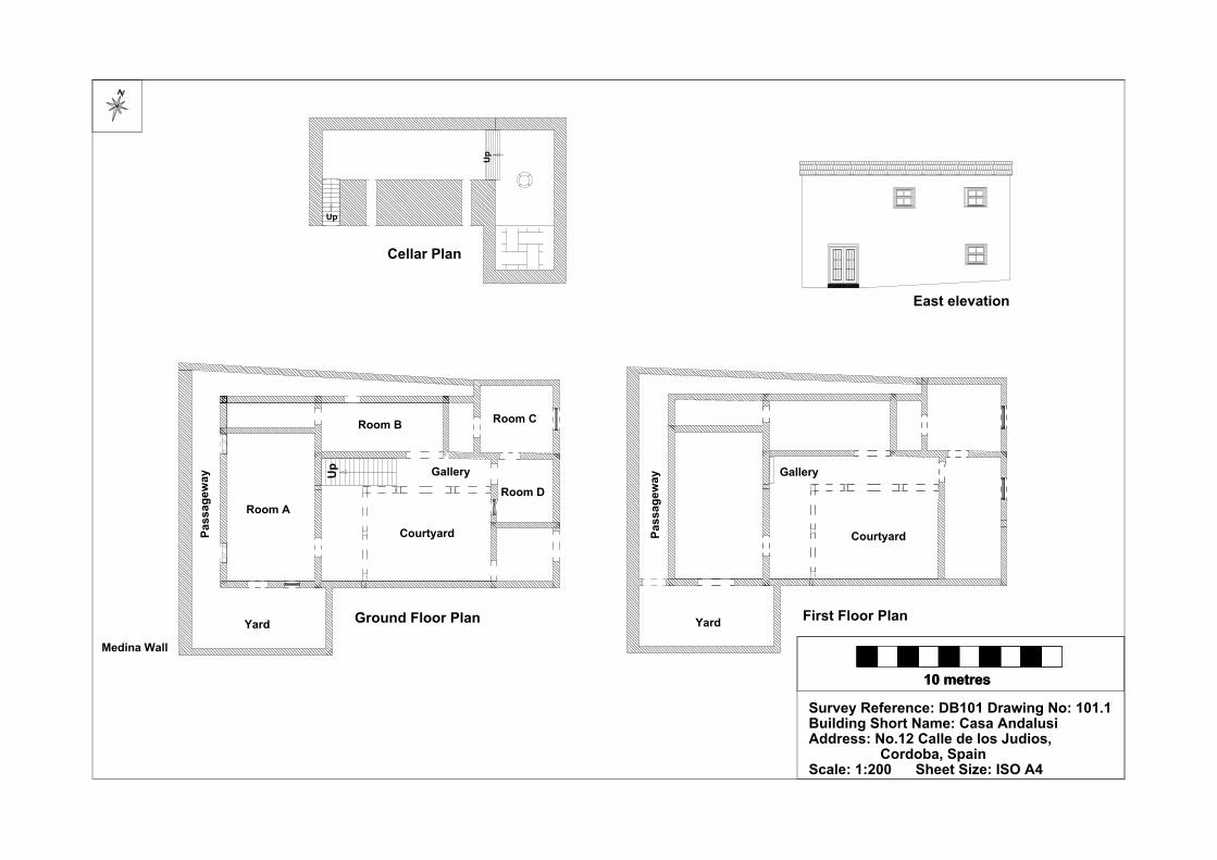
Survey Reference: DB101 Drawing No: 101.1Building Short Name: Casa Andalusi Address: No.12 Calle de los Judios, Cordoba, SpainScale: 1:200 Sheet Size: ISO A4
10 metres10 metres
East elevation
Ground Floor Plan First Floor Plan
Cellar Plan
Courtyard
Room A
Room B
Courtyard
Yard Yard
Pass
agew
ay
Pass
agew
ayUp
Up
Up
GalleryGallery
Room C
Room D
Medina Wall

Survey Recorder: D. A. Lenton Survey & Archive Reference: Date of Survey: 28-Oct-08 DB102
LEVEL 3 SURVEY – ANALYTIC RECORD
Page 1/12
Contents
1.0 Identification of Building or Structure
2.0 Summary of Building Type and Historical Usage
3.0 Description of Building & Materials
4.0 Supplementary Information
5.0 Photographic Record
6.0 Drawing Record – Addendum Attached 1 Page
7.0 Bibliography

Survey Recorder: D. A. Lenton Survey & Archive Reference: Date of Survey: 28-Oct-08 DB102
LEVEL 3 SURVEY – ANALYTIC RECORD
Page 2/12
1.0 Identification of Building or Structure
1.1 Building Short Name Sinagoga
1.2 Variant Names The Synagogue of Isaac Majeb
The Synagogue of Yishaq Moheb
1.3 Address No.10 Calle de los Judios, Córdoba, Spain
1.4 Location Co-ordinates Northing 37.879°Easting -4.783°
1.5 Statutory & Non-statutory
Designations
Within the designated area of the Córdoba
UNESCO World Heritage Site No. 313
(1984/1994).
Bien de Interés Cultural (Nationally Listed as
a Building of Cultural Interest) (Ministerio de
Cultura n.d.).
1.6 Survey Assessment &
Archaeological Value
Preservation is High (3). Two storeys of the
medieval structure are largely intact.
Legibility is High (3). The walls are
unrendered.
Accessibility is High (3). The building is
publically accessible.
Stratigraphical Complexity is Medium (2).
The building spans at least 2 periods –
Reconquista and Imperial.
Archaeological Value is High (2.5-3).
1.7 Primary Building Technique Perimeter walls: Fired clay brickwork; large;
wire cut; rectangular; regular coursing; thick
mortar.
Building walls: Stone; very large; roughly
dressed; part squared; regular coursing; thick
mortar.

Survey Recorder: D. A. Lenton Survey & Archive Reference: Date of Survey: 28-Oct-08 DB102
LEVEL 3 SURVEY – ANALYTIC RECORD
Page 3/12
2.0 Summary of Building Type and Historical Usage
2.1 Reconquista period synagogue possibly retaining elements of an earlier
synagogue of earliest suggested date 12th century (Calvert 1906: 153; Collins
1998: 119). It was rebuilt in the early 14th century (Aguilar Gavilán 1995: 47;
Collins 1998: 119). After 1492 the building became a rabies hospital
dedicated to Santa Quiteria (Daroca Bruño et al. 2003: 119). In 1588 it
became the chapel of the Guild of Shoemakers dedicated to St. Crispin and
St. Crispian (Casal García 2003: 234-5). It is currently a museum and tourist
attraction.
2.2 The building is located on a narrow street running north-south in the Juderia
area in the parish of Santa Maria II north-west of the Mezquita.
2.3 The sole (east) entrance is via timber double leaf door directly from the street
to an entrance courtyard or patio. The building has three storeys above
ground.
3.0 Description of Building & Materials
3.1 Foundations of the perimeter walls are of Andalusían limestone but rise in
local clay brickwork construction. Perimeter brickwork walls are not
rendered but exposed.
3.2 Entrance courtyard walls are of local brickwork construction with brickwork
repairs. The floor is of modern stone tiles.
3.3 There is an entrance lobby (Room A), walled in local brickwork on the east
and south sides. The brickwork is large, handmade, hand-moulded clay in
thick mortar in fairly regular coursing. It is stitched into the stonework of the
north wall and therefore post-dates it. The west wall is of Andalucían
limestone. The foundations of the west and north walls are bonded together
and appear coeval forming an early 14th-century structure with the Prayer
Room (Room B), although the western section of the north wall has been
rebuilt in clay brickwork. The room is entered by a double leaf timber door
in the centre of the south wall. The doorway is has a rounded brickwork arch.
Ceilings are modern timber joisted and boarded. Floor is modern ceramic
tiled. A modern timber staircase leads to the second floor (Room C). The

Survey Recorder: D. A. Lenton Survey & Archive Reference: Date of Survey: 28-Oct-08 DB102
LEVEL 3 SURVEY – ANALYTIC RECORD
Page 4/12
brickwork of the east wall has been subjected to considerable disturbance
and repair suggesting that an antecedent staircase has been removed.
3.4 The north wall adjoins with the main chamber or Prayer Hall (Room B) and
is of Andalucían limestone. A large lintel doorway in the north wall leads to
Room B. The lintel is overlaid with Mudéjar style ataurique plasterwork
indicating that the doorway and north-wall brickwork dates from the
Reconquista period or earlier. There is a smaller round-arch doorway roughly
cut through the eastern section of the north wall, which has been filled in
with roughly hand-moulded or recovered brickwork. This is likely to have
been the Imperial period door to Room B. The infill brickwork is large,
handmade, wire cut clay in thick mortar in regular coursing.
3.5 In Room B, walls are of Andalucían limestone and are decorated internally,
to second storey height, with plasterwork with Mudéjar-style plant motifs
and Hebrew inscriptions dated to 14th century. Also at second storey level,
three internal arched windows open in the south wall on to Room C. Three
plastered panels on the north wall and two on the west wall suggest that there
may be three concealed infilled windows behind. On the east wall of Room B
is a large recess with a rounded arch above.
3.6 The third storey of Room B is of brickwork and may be an Imperial period
extension to the height of the building. Five arched windows open in each of
the four walls at third storey height. The ceiling of Room B is coffered and
was erected in the 18th century (El Grupo Arca 1995).
3.7 Floors of Room B are ceramic tiled.
3.8 Room C is known as the Women’s Gallery (Daroca Bruño et al. 2003: 119)
and is walled in local brickwork on the east and south sides. The brickwork
is large, handmade, wire cut clay in thick mortar in regular coursing. It is a
continuation of the brickwork in Room A. The west and north walls are of
Andalucían limestone and are coeval with the 14th-century Prayer Room
(Room B). There are no doors. The three internal arched windows in the
north wall allow clear views to the ground floor of Room B. Two external
rectangular windows in the south wall look out on to the courtyard.
Survey Recorder: D. A. Lenton Survey & Archive Reference: Date of Survey: 28-Oct-08 DB102
LEVEL 3 SURVEY – ANALYTIC RECORD
Page 5/12
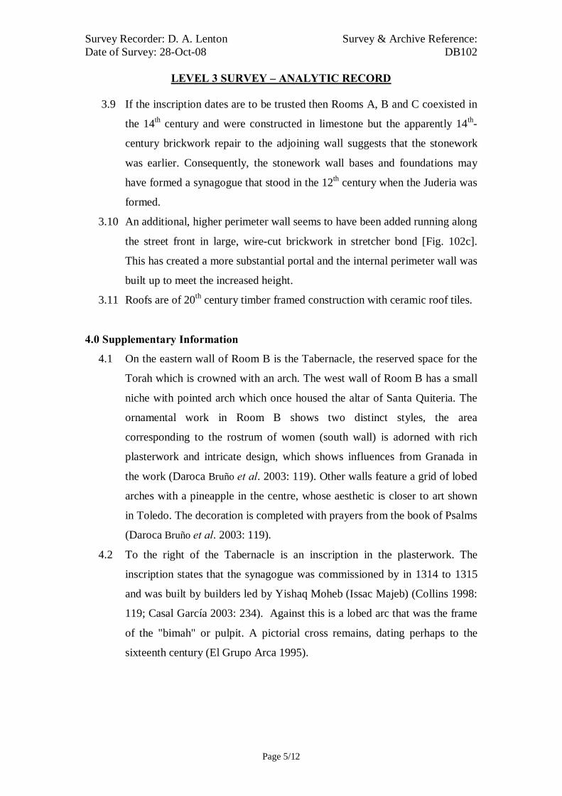
3.9 If the inscription dates are to be trusted then Rooms A, B and C coexisted in
the 14th century and were constructed in limestone but the apparently 14th-
century brickwork repair to the adjoining wall suggests that the stonework
was earlier. Consequently, the stonework wall bases and foundations may
have formed a synagogue that stood in the 12th century when the Juderia was
formed.
3.10 An additional, higher perimeter wall seems to have been added running along
the street front in large, wire-cut brickwork in stretcher bond [Fig. 102c].
This has created a more substantial portal and the internal perimeter wall was
built up to meet the increased height.
3.11 Roofs are of 20th century timber framed construction with ceramic roof tiles.
4.0 Supplementary Information
4.1 On the eastern wall of Room B is the Tabernacle, the reserved space for the
Torah which is crowned with an arch. The west wall of Room B has a small
niche with pointed arch which once housed the altar of Santa Quiteria. The
ornamental work in Room B shows two distinct styles, the area
corresponding to the rostrum of women (south wall) is adorned with rich
plasterwork and intricate design, which shows influences from Granada in
the work (Daroca Bruño et al. 2003: 119). Other walls feature a grid of lobed
arches with a pineapple in the centre, whose aesthetic is closer to art shown
in Toledo. The decoration is completed with prayers from the book of Psalms
(Daroca Bruño et al. 2003: 119).
4.2 To the right of the Tabernacle is an inscription in the plasterwork. The
inscription states that the synagogue was commissioned by in 1314 to 1315
and was built by builders led by Yishaq Moheb (Issac Majeb) (Collins 1998:
119; Casal García 2003: 234). Against this is a lobed arc that was the frame
of the "bimah" or pulpit. A pictorial cross remains, dating perhaps to the
sixteenth century (El Grupo Arca 1995).

Survey Recorder: D. A. Lenton Survey & Archive Reference: Date of Survey: 28-Oct-08 DB102
LEVEL 3 SURVEY – ANALYTIC RECORD
Page 6/12
5.0 Photographic Record
5.1 General External Views of the Building in its Setting
Fig. 102a: Aerial view of the building structure in its neighbourhood
North at top (Google Inc. n.d.)
Fig. 102b.: Aerial view of the building structure in close-up.
North at top (Google Inc. n.d.)

Survey Recorder: D. A. Lenton Survey & Archive Reference: Date of Survey: 28-Oct-08 DB102
LEVEL 3 SURVEY – ANALYTIC RECORD
Page 7/12
Fig. 102c: East aspect viewed from the
south.
Fig. 102e: Entrance patio looking West
Fig. 102d: East aspect viewed from the
north.
Fig. 102f: Entrance patio looking East

Survey Recorder: D. A. Lenton Survey & Archive Reference: Date of Survey: 28-Oct-08 DB102
LEVEL 3 SURVEY – ANALYTIC RECORD
Page 8/12
5.2 Interior, Principal Rooms and Circulation Areas
Looking West Looking North-East
Looking East Looking South West

Survey Recorder: D. A. Lenton Survey & Archive Reference: Date of Survey: 28-Oct-08 DB102
LEVEL 3 SURVEY – ANALYTIC RECORD
Page 9/12
Fig. 102g Room A entrance Hall
Looking West Looking West
Looking West Looking West
Looking East Looking East
Fig. 102h Room B Prayer Hall

Survey Recorder: D. A. Lenton Survey & Archive Reference: Date of Survey: 28-Oct-08 DB102
LEVEL 3 SURVEY – ANALYTIC RECORD
Page 10/12
Looking South East Looking South
Looking South Looking South
Fig. 102i: Room B Prayer Hall

Survey Recorder: D. A. Lenton Survey & Archive Reference: Date of Survey: 28-Oct-08 DB102
LEVEL 3 SURVEY – ANALYTIC RECORD
Page 11/12
6.0 Drawing Record
Addendum
Drawing No. 102.1
1 Page A4 Size

Survey Recorder: D. A. Lenton Survey & Archive Reference: Date of Survey: 28-Oct-08 DB102
LEVEL 3 SURVEY – ANALYTIC RECORD
Page 12/12
7.0 Bibliography
Aguilar Gavilán, E. 1995: Historia De Córdoba. Madrid: Sìlex. Calvert, A. F. 1906: Moorish Remains in Spain : Being a Brief Record of the Arabian Conquest of the Peninsula with a Particular Account of the Mohammedan Architecture and Decoration in Cordova, Seville & Toledo London & New York: John Lane. Casal García, M. T. 2003. La Córdoba Judia: La Sinagoga. In: D. Vaquerizo Gil (ed.) Guía Archaeológica De Córdoba, p. 234-236. Córdoba Plurabelle. Collins, R. 1998: Spain: An Oxford Archaeological Guide. Oxford: Oxford University Press. Daroca Bruño, F., Yllescas Ortiz, M. & De La Fuente Darder, F. (eds.) 2003: Córdoba: Guía De Arquitectura. Córdoba: Colegio Oficial de Arquitectura de Córdoba. El Grupo Arca 1995: Guía Artística De La Provincia De Córdoba. Córdoba: Universidad de Córdoba. Google Inc. n.d.: Google Earth 6 Web Catalogue. http://www.google.co.uk/intl/en_uk/earth/index.html, Mountain View, CA. Ministerio de Cultura n.d.: Bien De Interés Cultural: La Base De Datos De Bienes Inmuebles. http://www.mcu.es/bienes/cargarFiltroBienesInmuebles.do?layout=bienesInmuebles&cache=init&language=es.

10 metres10 metres
Second Floor Plan
South Elevation
Room A
Room B
Room C
Room B Room B
Entrance Courtyard
Ground Floor Plan First Floor PlanSurvey Reference: DB102 Drawing No: 102.1Building Short Name: La SinagogaAddress: No.10 Calle de los Judios, Cordoba, SpainScale: 1:200 Sheet Size: ISO A4
Up

Survey Recorder: D. A. Lenton Survey & Archive Reference: Date of Survey: 31-Oct-08 DB103
LEVEL 1 SURVEY – BASIC RECORD
Page 1/13
Contents
1.0 Identification of Building or Structure
2.0 Summary of Building Type and Historical Usage
3.0 Description of Building & Materials
4.0 Supplementary Information
5.0 Photographic Record
6.0 Drawing Record – Addendum Attached 1 Page
7.0 Bibliography

Survey Recorder: D. A. Lenton Survey & Archive Reference: Date of Survey: 31-Oct-08 DB103
LEVEL 1 SURVEY – BASIC RECORD
Page 2/13
1.0 Identification of Building or Structure
1.1 Building Short Name Mezquita
1.2 Variant Names La Mezquita Aljama, The Great Friday
Mosque, The Cathedral of St. Mary of the
Assumption, La Capilla Mayor
1.3 Address Calle de Torrijos & Calle de Magistral
Gonzales Frances, Córdoba, Spain
1.4 Location Co-ordinates Northing 37.879° Easting -4.780°
1.5 Statutory & Non-statutory
Designations
Within the designated area of the Córdoba
UNESCO World Heritage Site No. 313
(1984/1994).
Bien de Interés Cultural (Nationally Listed as
a Building of Cultural Interest) (Ministerio de
Cultura n.d.).
1.6 Survey Assessment &
Archaeological Value
Preservation is High (3). It has many surviving
medieval walls to second storey height.
Legibility is Low (1). Significant sections of
the medieval structure are obscured.
Accessibility is Low (1). The upper storeys of
the building are unattainable for detailed
measured survey.
Stratigraphical Complexity is High (3). Phases
spanned at least 3 periods.
Archaeological Value is Low (1-2).
1.7 Primary Building Technique Moorish: Stone; very large sized; ashlar
smooth; well squared; regular coursing; thin
mortar.
Reconquista: Stone; very large, rectangular,
ashlar stonework; thin mortar; regular courses.
Early Imperial: Stone; very large; carved
ashlar; thin mortar; regular courses.

Survey Recorder: D. A. Lenton Survey & Archive Reference: Date of Survey: 31-Oct-08 DB103
LEVEL 1 SURVEY – BASIC RECORD
Page 3/13
2.0 Summary of Building Type and Historical Usage
2.1 Caliphal period Friday Mosque of earliest known date 8th century with
additions in the 9th and 10th centuries. It contains a 16th century catholic
cathedral and Bell Tower by the architect Hernán Ruiz (Calvert 1906: -6).
2.2 The building is located on the north bank of the Guadalquivir in the parish of
Santa Maria.
2.3 There are several perimeter doors but the main (north-west) entrance is via
timber double leaf door (Door A) through the cathedral Bell Tower.
3.0 Description of Building & Materials
3.1 Foundations and walls are of Andalusían limestone. Walls are unrendered.
3.2 Door A, the Puerta del Perdón, leads to a large open Courtyard garden the
“Patio de los Naranjos” (Ayuntamiento de Córdoba n.d.).
3.3 To the south-east of the Courtyard lies the 8th-century prayer hall with a
series of aisles running perpendicularly from to the transverse wall. The
Prayer Hall has a mid-10th-century extension to the south-east and a late10th-
century extension to the north-east (Calvert 1906: 34-6).
3.4 The 10th-century transverse wall runs north-west to south east and contains
the Koran niche or mihrab, and also a post-medieval chapel (Barrucand &
Bednorz 1992: 61-4).
3.5 The remains of an 8th-century minaret form the base of an Imperial period
Bell Tower. The Imperial period cathedral, Capilla Mayor de Santa Maria, is
placed centrally within the Prayer Hall (Sordo 1963: 41-6).
3.6 The construction and alteration works carried out during the Reconquista
period were minimal. The Primary Building Technique employed was very
large, rectangular, ashlar stonework in thin mortar and regular course and can
be identified in arcade columns of the Capilla Mayor or Royal Chapel and
the Capilla de Villaviciosa. These chapels were formed within the arcading
of al-Hakim’s 10th-century extension against the south-eastern wall of the
mosque. They were built in an early-Mudéjar style with walls that are
decorated with multi-foil arches supporting a vault.

Survey Recorder: D. A. Lenton Survey & Archive Reference: Date of Survey: 31-Oct-08 DB103
LEVEL 1 SURVEY – BASIC RECORD
Page 4/13
3.7 The Primary Building Technique of the Imperial period was very large,
carved stonework to create the Nave of the cruciform Cathedral in the centre
of the Mezquita. The altar is orientated towards the north-east as are most of
the medieval churches of Córdoba. The structure consists of high pointed
arches in High Gothic/ Isabelline style of the early 16th century with
elaborate fan vaulting above the altar. The arches top slender fluted and rope-
twist columns to a height of approximately 15 metres [Fig. 103n].

Survey Recorder: D. A. Lenton Survey & Archive Reference: Date of Survey: 31-Oct-08 DB103
LEVEL 1 SURVEY – BASIC RECORD
Page 5/13
4.0 Supplementary Information
4.1 The Mosque-Cathedral of Cordoba is a most significant monument of the
western Moslem World. The evolution of the Omeyan style in Spain can be
seen in its different sections, as well as the Gothic, Renaissance and Baroque
styles of the Christian part (Ayuntamiento de Córdoba n.d.). The site which
the Mosque-Cathedral occupies has been used for the worship of different
divinities since ancient times. Under the rule of the Visigoths, the Basilica of
San Vicente occupied this very site, and later, after the Moslems bought part
of the plot of land, a Mosque was built. The basilica was rectangular in shape,
and for a while was shared by Christians and Moslems (Ayuntamiento de
Córdoba n.d.). As the Moslem population increased, the ruler Abderraman I
acquired the whole site and demolished the basilica to make way for the first
Alhama (main) Mosque in the city (Ayuntamiento de Córdoba n.d.). Some of
the original building materials from the Visigothic basilica can still be seen in
the first section of the Mosque built by Abderraman I. The great Mosque is
made up of two distinct areas, the courtyard or sahn, with its porticos (the only
part built by Abd al- Rahman III), where the minaret stands - nowadays,
encased in the Renaissance tower - and the prayer hall, or haram. The area
inside is made up of a forest of columns with a colour scheme of red and white
arches. The five separate areas of the Mosque correspond to each of the five
extensions carried out (Ayuntamiento de Córdoba n.d.).
4.2 The Islamic building was built from the 8th century on a plot next to the
strategically important River Guadalquivir on sites of Roman and Visigothic
date. The Mosque of Cordoba itself is built on Basilica of San Vicente
(Located under the prayer room Rahman I, excavated by D. Félix Hernández
in the 1930s), whose ruins can still be seen in one of the museums in the
mosque (in the south-western corner) (Romeo & Gómez 2005). The mosque
consists of three parts: Patio de los Naranjos (Retains much of its original
appearance), which is accessed by Puerta del Perdón in Mudejar style (1377),
with rows of orange trees and palms, fountains and horseshoe arches that
surround the doors. There rises a partially roofed minaret that was clad in the

Survey Recorder: D. A. Lenton Survey & Archive Reference: Date of Survey: 31-Oct-08 DB103
LEVEL 1 SURVEY – BASIC RECORD
Page 6/13
early 17th century. The total area of the monument is over 22,000 square
meters, with a length of 174 meters long and 128.4 long. The door of Las
Palmas provides access to the mosque: a forest of eight hundred and fifty
columns of marble, jasper and granite on which are supported by three
hundred sixty-five bicolor horseshoe arches. The mihrab, a holy place of the
mosque that marks the southern direction (not towards Mecca) is in marble,
stucco and brightly coloured Byzantine mosaics on gold backgrounds. One
theory for the mirab’s orientation is that this was the will of Rahman to face
toward the river and his native Syria). Today the most accepted theory is that
the main hall of the mosque follows the orientation of the main street (cardo)
of ancient Roman Cordoba (Colonia Patricia), as witnessed in the
Archaeological excavations of the city. After the Christians conquest of
Cordoba, the mosque became used for worship. In the 16th century, when
Islam was permanently expelled from the Iberian peninsula, a Renaissance
cathedral was built by Hernán Ruiz I and his son Hernán Ruiz II, in the heart
of the mosque, altering the original perspective.
4.3 Christian possession of the ensemble took place with very few alterations: a
small focal point around Alhaquen’s skylight, the Villaviciosa and Royal
chapels, and the beginning of the bounding of the ‘infinite’ space with side
chapels. Although the first Gothic nave opened in 1489, changed the
orientation to the east, it showed a deep understanding of the Mosque’s
structure as it achieved a maximum of space with a minimum of work and
maintained the spatial continuity of the ensemble. Located on the northern
face, next to the minaret, is the Puerta del Perdón, a Mudéjar construction
from 1377 in which a large peak arch formed by an alfiz supports a frieze with
three multifoil arches that display mural paintings. The doors leaves, with their
geometrical decoration of Almohade inspiration and Gothic lettering lead to a
vestibule (Daroca Bruño et al. 2003: 89).
4.4 The first discrete Christian action focused on the conversion in 1257 of the
skylit entrance to Alhaquen II’s enlargement in the High Chapel, known as the
Capilla de Villaviciosa, and on the creation in 1258 of the adjoining Capilla
Survey Recorder: D. A. Lenton Survey & Archive Reference: Date of Survey: 31-Oct-08 DB103
LEVEL 1 SURVEY – BASIC RECORD
Page 7/13
Real. The latter, a Mudéjar construction with walls that are decorated with
multi-foil arches that support a vault with bow-shaped ornaments, was not
completed until 1371, the year in which Enrique II added the socles and the
pavement of Granadan influence (Daroca Bruño et al. 2003: 94).
4.5 In 1489, the Villaviciosa Chapel was transformed into the presbytery of the
new Gothic nave, which presents four stretches with transverse peak arches
that support a wooden roof divided into panels (Daroca Bruño et al. 2003: 94).

Survey Recorder: D. A. Lenton Survey & Archive Reference: Date of Survey: 31-Oct-08 DB103
LEVEL 1 SURVEY – BASIC RECORD
Page 8/13
5.0 Photographic Record
5.1 General External Views of the Building in its Setting
Fig. 103a: Aerial view of the building structure in its neighbourhood
North at top (Google Inc. n.d.)
Fig. 103b.: Aerial view of the building structure in close-up.
North at top (Google Inc. n.d.)

Survey Recorder: D. A. Lenton Survey & Archive Reference: Date of Survey: 31-Oct-08 DB103
LEVEL 1 SURVEY – BASIC RECORD
Page 9/13
Fig. 103c: North-west aspect viewed
from the south-west.
Fig. 103e: South-east aspect viewed
from the east
Fig. 103d: South-east aspect viewed
from the south-east.
Fig. 103f: South-east aspect viewed
from the south

Survey Recorder: D. A. Lenton Survey & Archive Reference: Date of Survey: 31-Oct-08 DB103
LEVEL 1 SURVEY – BASIC RECORD
Page 10/13
Fig. 103g: Courtyard from the north-east Fig. 103h: San Estaban Gate from
the north-west
Fig. 103i: Prayer Hall from the south-west Fig. 103j: Prayer Hall from the
south-east

Survey Recorder: D. A. Lenton Survey & Archive Reference: Date of Survey: 31-Oct-08 DB103
LEVEL 1 SURVEY – BASIC RECORD
Page 11/13
Fig. 103k: Capilla Mayor looking north Fig. 103l: Capilla Mayor vault (south)
Fig. 103m: Capilla Mayor multi-foiled arches and vault (southern end)
Fig. 103n. 16th- century Nave

Survey Recorder: D. A. Lenton Survey & Archive Reference: Date of Survey: 31-Oct-08 DB103
LEVEL 1 SURVEY – BASIC RECORD
Page 12/13
6.0 Drawing Record
Addendum
Drawing No. 103.1
1 Page A4 Size

Survey Recorder: D. A. Lenton Survey & Archive Reference: Date of Survey: 31-Oct-08 DB103
LEVEL 1 SURVEY – BASIC RECORD
Page 13/13
7.0 Bibliography
Ayuntamiento de Córdoba n.d.: Córdoba: Oficinas De Información Turística. (ed, Ayuntamiento de Córdoba) Ayuntamiento de Córdoba, Córdoba. Barrucand, M. & Bednorz, A. 1992: Moorish Architecture in Andalusia. Cologne: Benedikt Taschen Verlag. Calvert, A. F. 1906: Moorish Remains in Spain : Being a Brief Record of the Arabian Conquest of the Peninsula with a Particular Account of the Mohammedan Architecture and Decoration in Cordova, Seville & Toledo London & New York: John Lane. Daroca Bruño, F., Yllescas Ortiz, M. & De La Fuente Darder, F. (eds.) 2003: Córdoba: Guía De Arquitectura. Córdoba: Colegio Oficial de Arquitectura de Córdoba. Google Inc. n.d.: Google Earth 6 Web Catalogue http://www.google.co.uk/intl/en_uk/earth/index.html, Mountain View, CA. Ministerio de Cultura n.d.: Bien De Interés Cultural: La Base De Datos De Bienes Inmuebles. http://www.mcu.es/bienes/cargarFiltroBienesInmuebles.do?layout=bienesInmuebles&cache=init&language=es. Romeo, A. & Gómez, S. 2005: Cordobapedia. (eds, A. Romeo & S. Gómez) http://wikanda.cordobapedia.es/, Cordoba. Sordo, E. 1963: Moorish Remains: Cordoba Seville Granada. London: Elek Books.

Line of theMihrab
CapillaMayor
Qibla
San Estaban Gate

Survey Recorder: D. A. Lenton Survey & Archive Reference: Date of Survey: 29-Oct-08 & 27-Oct-10 DB104
LEVEL 3 SURVEY – ANALYTIC RECORD
Page 1/11
Contents
1.0 Identification of Building or Structure
2.0 Summary of Building Type and Historical Usage
3.0 Description of Building & Materials
4.0 Supplementary Information
5.0 Photographic Record
6.0 Drawing Record – Addenda Attached 2 Pages
7.0 Bibliography

Survey Recorder: D. A. Lenton Survey & Archive Reference: Date of Survey: 29-Oct-08 & 27-Oct-10 DB104
LEVEL 3 SURVEY – ANALYTIC RECORD
Page 2/11
1.0 Identification of Building or Structure
1.1 Building Short Name Posada del Potro
1.2 Variant Names The Colt Inn
1.3 Address No.10 Plaza del Potro, Córdoba, Spain
1.4 Location Co-ordinates Northing 37.880°
Easting -4.774°
1.5 Statutory & Non-statutory
Designations
Within the designated area of the Córdoba
UNESCO World Heritage Site No. 313
(1984/1994).
1.6 Survey Assessment &
Archaeological Value
Preservation is High (3). Two storeys of the
medieval structure are largely intact.
Legibility is Medium (2). Most of the walls
are rendered but the East Elevation was
temporarily exposed by restoration works on
28-Oct-08.
Accessibility is High (3). The building is
publically accessible.
Stratigraphical Complexity is Medium (2).
The building spans at least 2 periods –
Reconquista and Imperial.
Archaeological Value is High (2-2.5).
1.7 Primary Building Technique Fired clay brick; large; hand-moulded;
rectangular; regular coursing; thick mortar.

Survey Recorder: D. A. Lenton Survey & Archive Reference: Date of Survey: 29-Oct-08 & 27-Oct-10 DB104
LEVEL 3 SURVEY – ANALYTIC RECORD
Page 3/11
2.0 Summary of Building Type and Historical Usage
2.1 Reconquista period courtyard inn of earliest proposed date 13th century
(Romeo & Gómez 2005). It is currently a cultural centre and tourist
attraction.
2.2 The building is located on a plaza in the parish of San Nicolas in the Potro
area of the city east of the Mezquita.
2.3 The sole (east) entrance is via a timber double leaf door directly from the
street to an entrance hall (Room A). The building has two storeys above
ground plus roof space.
3.0 Description of Building & Materials
3.1 External walls are of local clay brickwork construction. External brickwork
walls were visible to roof height at the front (east) during repair works on
29th October 2008. Brickwork and timber lintels to doors and windows were
visible.
3.2 Other external walls are of brickwork construction and are painted.
3.3 The building is entered from the via a double leaf timber front door (Door A)
in the East Elevation [Fig. 104f]. The northernmost section of the East
Elevation is a later abutment with slightly smaller brickwork stitched into the
earlier southern element. It rises to a lower roof height than the southernmost
section. The entrance doorway opens to a hall (Room A). The entrance
doorway is flanked by vertical lines of discontinuity in the brickwork, where
slightly larger brickwork has been stitched in to the existing construction as
door jambs. This suggests that the present doorway may have replaced an
earlier larger medieval entranceway.
3.4 Also in the East Elevation, there are two ground floor windows, two first
floor windows and a first floor door. The southern ground floor window
(Window A) is an insertion but the break lines around it are very wide
suggesting that a larger opening or doorway was present in the Reconquista
period. The southern first floor window (Window C) is also an insertion but
is considerably smaller than the infilled area around it. The positions of the

Survey Recorder: D. A. Lenton Survey & Archive Reference: Date of Survey: 29-Oct-08 & 27-Oct-10 DB104
LEVEL 3 SURVEY – ANALYTIC RECORD
Page 4/11
break lines suggest that a window or balconied doorway existed in the
Reconquista period.
3.5 The internal brickwork walls on the ground floor are visible but painted.
They constitute the Primary Building Technique and appear to be consistent
with 15th century dates as the ground floor plan is a common form known in
Western Europe 14th and 15th centuries [Drawing 104.1] (e.g. Pevsner 1960:
221; Lancaster 1981: 28-34; Privat 1983; Munby et al. 1992: 301-7; Jurica
1994: 9; Newman & Pevsner 2006: 32; Hugonnet-Berger et al. 2007). A
wide doorway, wide enough for carriages, opens in the west wall of Room A
and leads to a large courtyard. Immediately to the right, there is a water
trough. Either side of the courtyard are two building wings (North Wing and
South Wing) both with two storeys. Stairs from the courtyard lead up to the
first floor timber framed walkways of each wing. These walkways are largely
modern repairs to and replacements of earlier period timbers. At the base of
the stairs to the North Wing is another water trough.
3.6 The northern extension to the East Elevation forms a façade for the North
Wing. This raises the possibility that the North Wing was also a later
addition or a restructuring of a previously existing wing. The matching
Primary Building Technique suggests that this remodelling was reasonably
soon after the first complex plan was constructed. On the ground floor of
each wing there are doorways which open to cellular rooms or stalls with no
windows. On the first floor of each wing there are doorways opening to
cellular rooms, each with a small window.
3.7 At the far west end of the courtyard is a two storey further building (West
Block) with a similar cellular structure. This block abuts the two wings and
appears be to a later addition to the complex.
3.8 Roofs are of modern repairs of Reconquista period timber with modern
ceramic roof tiles.
3.9 Consequently, the South Wing and its East Elevation are the earliest,
Reconquista period, elements of the complex, although the North Wing and
West Block may have existed coevally in some form. The North Wing and

Survey Recorder: D. A. Lenton Survey & Archive Reference: Date of Survey: 29-Oct-08 & 27-Oct-10 DB104
LEVEL 3 SURVEY – ANALYTIC RECORD
Page 5/11
its East Elevation were remodelled or added at a later date but probably still
within the Reconquista period.
3.10 The Primary Building Technique employed in the Imperial period was large,
hand-moulded, rectangular, fired clay brick, in regular coursing in thick
mortar used in repairs and infills to Reconquista period openings. The
Primary Building Technique was visible in the east elevation [Fig. 104f]
around the Door to Room A, the Ground Floor Window to Room A and the
First Floor Windows. The larger Reconquista period doorway was infilled to
form a narrower entrance. The Ground Floor and First Floor Windows were
formed in larger doorway openings and a First Floor balcony inserted. This
brickwork infilling was a skilled activity to achieve true returns around the
doors and windows. Basic timber scaffolding experience would have been
necessary to support (prop) the loading of the walls whilst the larger lintels
were being removed and replaced with smaller ones. The insertion of the
balcony would have been a straight-forward carpentry task once a deck of
scaffolding was in place at First Floor level. These would have been the kind
of small scale insertion works easily carried out by journeyman bricklayers
and carpenters without the need for a master craftsman or designer. The
patron of the Posada would not necessarily have had to engage with the
guilds if jobbing workmen were available. The insertion works left scars in
the façade now visible as stratigraphy, which probably meant that the
elevation was rendered at this time if the patron trying to elevate the status of
the building by the insertion of the balcony.
3.11 The impression given is that of Reconquista commercial entrances for goods
and visitors replaced by Imperial period domestic features. Although Door A
was still large enough to admit carts, it is difficult to see how horses or
carriages would get through this opening. It must therefore have been
restricted to pedestrian traffic and perhaps donkey deliveries. This Imperial
period remodelling suggests a change in use of the building complex. The
stabling around the courtyard would no longer have been able to
accommodate large numbers of visiting horse traders. Although commercial
storage would still have been viable. In the late 15th-century, the horse

Survey Recorder: D. A. Lenton Survey & Archive Reference: Date of Survey: 29-Oct-08 & 27-Oct-10 DB104
LEVEL 3 SURVEY – ANALYTIC RECORD
Page 6/11
market outside in the plaza was greatly reduced in size (Daroca Bruño et al.
2003: 151) and this probably meant fewer visiting horse-traders. The East
Block would have been subject to less commercial traffic. Therefore, the size
reductions in the openings may indicate a greater domestication of this East
Block or perhaps transition into a mixed use chamber block that included
workshop spaces as well as dwelling spaces. The balconied doorway on the
First Floor suggests that this upper-storey room took on a more formal
function. The balcony could have provided a vantage point for the host and
guests to oversee the market below whilst being conspicuously visible.
Withdrawal into the First Floor rooms could have been for formal dining or
confidential trade in an exclusive space. If the horse market trade was on the
decline, it seems likely that the patron was attempting to diversify his/ her
business by the remodelling of the building. The ability to oversee the market
from the balcony may have been useful to a market inspector or dominant
horse merchant. It may also have provided the vehicle for such a middling
merchant to assert his influence in public events when aspiring to a more
elevated position in public life.
4.0 Supplementary Information
4.1 The Posada del Potro is located in the Plaza del Potro and is an inn dated to
the 13th and 14th centuries. It was frequented by Miguel de Cervantes,
Francisco Gómez de Quevedo and Luís de Góngora, who refer to it in their
works an was one of six inns that existed in the square in the late medieval
period (Daroca Bruño et al. 2003: 151). It is located in a neighbourhood of
livestock trading, which was the commercial heart of the city in the earlier
middle ages (Daroca Bruño et al. 2003: 151). A nearby street fair took place
for livestock markets especially foals (Romeo & Gómez 2005). The building
is arranged around a central courtyard with stables, rooms on both ground
and first floors. The building served as a mission inn until 1972 (Romeo &
Gómez 2005).

Survey Recorder: D. A. Lenton Survey & Archive Reference: Date of Survey: 29-Oct-08 & 27-Oct-10 DB104
LEVEL 3 SURVEY – ANALYTIC RECORD
Page 7/11
5.0 Photographic Record
5.1 General External Views of the Building in its Setting
Fig. DB104a: Aerial view of the building structure in its neighbourhood
North at top (Google Inc. n.d.)
Fig. DB104b.: Aerial view of the building structure in close-up.
North at top (Google Inc. n.d.)

Survey Recorder: D. A. Lenton Survey & Archive Reference: Date of Survey: 29-Oct-08 & 27-Oct-10 DB104
LEVEL 3 SURVEY – ANALYTIC RECORD
Page 8/11
Fig. 104c: East aspect viewed from the
north on 27.10.10.
Fig. 104e: East aspect viewed from the
north on 29.10.08.
Fig. 104d: East aspect on 27.10.10
Fig. 104f: East aspect viewed from the
south on 29.10.08.

Survey Recorder: D. A. Lenton Survey & Archive Reference: Date of Survey: 29-Oct-08 & 27-Oct-10 DB104
LEVEL 3 SURVEY – ANALYTIC RECORD
Page 9/11
5.2 Interior, Principal Rooms and Circulation Areas
Looking East 29.10.08 Looking North East 29.10.08
Looking East 27.10.10 Looking South East 27.10.10
Fig. 104g Ground Floor Courtyard

Survey Recorder: D. A. Lenton Survey & Archive Reference: Date of Survey: 29-Oct-08 & 27-Oct-10 DB104
LEVEL 3 SURVEY – ANALYTIC RECORD
Page 10/11
6.0 Drawing Record
Addenda
Drawing Nos. 104.1 & 104.2
2 Pages A4 Size

Survey Recorder: D. A. Lenton Survey & Archive Reference: Date of Survey: 29-Oct-08 & 27-Oct-10 DB104
LEVEL 3 SURVEY – ANALYTIC RECORD
Page 11/11
7.0 Bibliography
Daroca Bruño, F., Yllescas Ortiz, M. & De La Fuente Darder, F. (eds.) 2003: Córdoba: Guía De Arquitectura. Córdoba: Colegio Oficial de Arquitectura de Córdoba. Google Inc. n.d.: Google Earth 6 Web Catalogue http://www.google.co.uk/intl/en_uk/earth/index.html, Mountain View, CA. Hugonnet-Berger, C., Fromaget, B., Reveillon, E. & Francois, B. 2007: Hotel-Dieu De Beaune. Paris: Somogy Editions d'Art. Jurica, J. 1994: Gloucester: A Pictorial History. Chichester: Philimore. Lancaster, J. C. 1981: St. Mary's Hall, Coventry: A Guide to the Building, Its History and Contents. Coventry: City of Coventry. Munby, J., Ashdown, J., Durham, B., Haddon-Reece, D., Henig, M. & Jeuckens, C. 1992: Zacharias's: A 14th-Century Oxford New Inn and the Origins of the Medieval Urban Inn. Oxoniensia 57, p. 245-309. Newman, J. & Pevsner, N. 2006: The Buildings of England: Shropshire. Newhaven: Yale University Press. Pevsner, N. 1960: The Buildings of England: Leicestershire & Rutland. London: Penguin. Privat 1983: Histoire De Colmar. Toulouse: Privat. Romeo, A. & Gómez, S. 2005: Cordobapedia. (eds, A. Romeo & S. Gómez) http://wikanda.cordobapedia.es/, Cordoba.

10 metres10 metresSurvey Reference: DB104 Drawing No: 104.1Building Short Name: Posada del PotroAddress: No.10 Plaza del Potro, Córdoba, SpainScale: 1:200 Sheet Size: ISO A4
Ground Floor Plan
Up
Up
Courtyard
Room A
South Wing
North Wing
Water TroughWater Trough
WestBlock
East Elevation

10 metres10 metresSurvey Reference: DB104 Drawing No: 104.2Building Short Name: Posada del PotroAddress: No.10 Plaza del Potro, Córdoba, SpainScale: 1:200 Sheet Size: ISO A4
First Floor Plan
South Wing
North Wing
Courtyard
Walkways
Room B
WestBlock

Survey Recorder: D. A. Lenton Survey & Archive Reference: Date of Survey: 28-Oct-10 DB105
LEVEL 2 SURVEY – DESCRIPTIVE RECORD
Page 1/8
Contents
1.0 Identification of Building or Structure
2.0 Summary of Building Type and Historical Usage
3.0 Description of Building & Materials
4.0 Supplementary Information
5.0 Photographic Record
6.0 Drawing Record – Addendum Attached 1 Page
7.0 Bibliography

Survey Recorder: D. A. Lenton Survey & Archive Reference: Date of Survey: 28-Oct-10 DB105
LEVEL 2 SURVEY – DESCRIPTIVE RECORD
Page 2/8
1.0 Identification of Building or Structure
1.1
Building Short Name
Archivo Municipal
1.2 Variant Names Municipal Archives
Casa Guzman, House of Guzman
1.3 Address No.6 Plaza del Profesor López Neyra,
Córdoba, Spain
1.4 Location Co-ordinates Northing 37.881° Easting -4.783°
1.5 Statutory & Non-statutory
Designations
Within the designated area of the Córdoba
UNESCO World Heritage Site No. 313
(1984/1994).
Bien de Interés Cultural (Nationally Listed as
a Building of Cultural Interest) (Ministerio de
Cultura n.d.).
1.6 Survey Assessment &
Archaeological Value
Preservation is High (3) as many Imperial
period elements have been retained in the
modern building.
Legibility is Medium (2) as the walls are
partially plastered and rendered.
Accessibility is Medium (2) as the Imperial
period elements are partially obscured by
modern elements.
Stratigraphical Complexity is Low (1) as first
inspection indicated that the structure spanned
only the Imperial period.
Archaeological Value is Medium (2-2.5).
1.7 Primary Building Technique Stone; very large; ashlar; rectangular, regular
coursing; thin mortar.

Survey Recorder: D. A. Lenton Survey & Archive Reference: Date of Survey: 28-Oct-10 DB105
LEVEL 2 SURVEY – DESCRIPTIVE RECORD
Page 3/8
2.0 Summary of Building Type and Historical Usage
2.1 Reconquista period house or palace of earliest suggested date 15th century
with Imperial and Modern period additions. It is currently a Ministry of
Culture office.
2.2 The building is located on a narrow street opposite a plaza in the parish of
Santa Maria north-west of the Mezquita.
2.3 The main (east) entrance is via timber double leaf door (Door A). There are 2
storeys above ground plus roof space.
3.0 Description of Building & Materials
3.1 Foundations and walls are of Andalusían limestone and rise to a height of
8.90m at the highest point. Walls are mostly rendered in sand and cement but
some areas are exposed.
3.2 Door A is headed by a Mudéjar-style alfiz with an heraldic motif – the Hoces
family coat of arms - characteristic of the 15th or 16th century (Daroca Bruño
et al. 2003: 127). In the East elevation on the ground floor there are three
rectangular window openings to the south of Door A and one similar to the
north of Door A. On the First Floor there are three rectangular window
openings to the south of Door A and one similar to the north of Door A with
a balcony plinth (Window A). Above door A on the First Floor there is a
larger window headed by a segmented arch (Window B), which is balconied.
3.3 Door A leads to an entrance hall with rooms off to the north and south, which
leads in turn to a galleried courtyard area. The Courtyard (6.90 by 6.70
metres) is of comparable dimensions to the Casa Andalusí [DB101] and is
encircled by a series of brickwork round-arches atop stonework columns in a
Mudéjar style. It is possible that these arches survive from Reconquista
period or earlier but were evidently employed in the Imperial period
Courtyard. The Ground Floor has a number of rooms off from the Courtyard,
which are also accessible from a long narrow western gallery that may have
once been a rear service passageway. The East Block has lost its medieval
staircase to the First Floor. Its large open Ground Floor and First Floor rooms
would have looked out on to the plaza outside, and provided sufficient space

Survey Recorder: D. A. Lenton Survey & Archive Reference: Date of Survey: 28-Oct-10 DB105
LEVEL 2 SURVEY – DESCRIPTIVE RECORD
Page 4/8
for further service areas and formal dining. Window B would have been
large enough for a host and guest to make a formal appearance overlooking
the plaza.
3.4 Roofs are tiled with 20th century ceramic roof tiles.
4.0 Supplementary Information
4.1 The Municipal Archives are reputed to be the house of the Guzman family,
although the family coat of arms above the entrance belongs to the Hoces
family. The entrance consists of a solid stone gateway with Mudejar-style
alfiz, leading to interior courtyards. Beyond the entrance hall is the courtyard
with rounded arches framed by alfiz and brickwork pillars. The staircase was
built in 1609, and has a cupola above and ornate banisters (Daroca Bruño et
al. 2003: 127).

Survey Recorder: D. A. Lenton Survey & Archive Reference: Date of Survey: 28-Oct-10 DB105
LEVEL 2 SURVEY – DESCRIPTIVE RECORD
Page 5/8
5.0 Photographic Record
5.1 General External Views of the Building in its Setting
Fig. 105a: Aerial view of the building structure in its neighbourhood
North at top (Google Inc. n.d.)
Fig. 105b.: Aerial view of the building structure in close-up.
North at top (Google Inc. n.d.)
Survey Recorder: D. A. Lenton Survey & Archive Reference: Date of Survey: 28-Oct-10 DB105
LEVEL 2 SURVEY – DESCRIPTIVE RECORD
Page 6/8
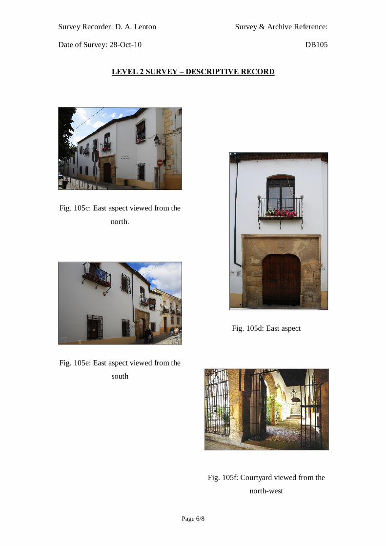
Fig. 105c: East aspect viewed from the
north.
Fig. 105e: East aspect viewed from the
south
Fig. 105d: East aspect
Fig. 105f: Courtyard viewed from the
north-west

Survey Recorder: D. A. Lenton Survey & Archive Reference: Date of Survey: 28-Oct-10 DB105
LEVEL 2 SURVEY – DESCRIPTIVE RECORD
Page 7/8
6.0 Drawing Record
Addendum
Drawing No. 105.1
1 Page A4 Size

Survey Recorder: D. A. Lenton Survey & Archive Reference: Date of Survey: 28-Oct-10 DB105
LEVEL 2 SURVEY – DESCRIPTIVE RECORD
Page 8/8
7.0 Bibliography
Daroca Bruño, F., Yllescas Ortiz, M. & De La Fuente Darder, F. (eds.) 2003: Córdoba: Guía De Arquitectura. Córdoba: Colegio Oficial de Arquitectura de Córdoba. Google Inc. n.d.: Google Earth 6 Web Catalogue http://www.google.co.uk/intl/en_uk/earth/index.html, Mountain View, CA. Ministerio de Cultura n.d.: Bien De Interés Cultural: La Base De Datos De Bienes Inmuebles. http://www.mcu.es/bienes/cargarFiltroBienesInmuebles.do?layout=bienesInmuebles&cache=init&language=es.

10 metres10 metresSurvey Reference: 105 Drawing No: 105.1Building Short Name: Archivo Municipal Address: Plaza del Profesor López Neyra Córdoba, SpainScale: 1:200 Sheet Size: ISO A4
East Elevation
Ground Floor Plan
Door A
Window A
Door A
Window B
Courtyard
Gallery
Gallery
Gallery
EntranceLobby
ChamberBlock

Survey Recorder: D. A. Lenton Survey & Archive Reference: Date of Survey: 29-Oct-10 DB106
LEVEL 1 SURVEY – BASIC RECORD
Page 1/8
Contents
1.0 Identification of Building or Structure
2.0 Summary of Building Type and Historical Usage
3.0 Description of Building & Materials
4.0 Supplementary Information
5.0 Photographic Record
6.0 Drawing Record – Addendum Attached 1 Page
7.0 Bibliography

Survey Recorder: D. A. Lenton Survey & Archive Reference: Date of Survey: 29-Oct-10 DB106
LEVEL 1 SURVEY – BASIC RECORD
Page 2/8
1.0 Identification of Building or Structure
1.1 Building Short Name The Abolafia
1.2 Variant Names El Molino de la Abolafia
El Molino de Kulaib,
The Abolafia Watermill
1.3 Address Ronda de Isasa, Córdoba, Spain
1.4 Location Co-ordinates Northing 37.876°
Easting -4.780°
1.5 Statutory & Non-statutory
Designations
Within the designated area of the Córdoba
UNESCO World Heritage Site No. 313
(1984/1994).
Bien de Interés Cultural (Nationally Listed as
a Building of Cultural Interest) (Ministerio de
Cultura n.d.)
1.6 Survey Assessment &
Archaeological Value
Preservation is Low (1). It retains only one
complete storey with no roof and walls are is a
state of disrepair.
Legibility is Medium (2). Its walls have no
coverings but are partially obscured by
vegetation.
Accessibility is Low (1). The building is
offshore and inaccessible to measured survey.
Stratigraphical Complexity is Medium (2).
First inspection indicated that the structure’s
phases spanned at least 2 periods – Moorish
and Reconquista.
Archaeological Value is Low (1-2).
1.7 Primary Building Technique Stone; large upon very large; dressed; well
squared; regular; thick mortar.

Survey Recorder: D. A. Lenton Survey & Archive Reference: Date of Survey: 29-Oct-10 DB106
LEVEL 1 SURVEY – BASIC RECORD
Page 3/8
2.0 Summary of Building Type and Historical Usage
2.1 Moorish period water mill of earliest suggested date 12th century with
modern reconstructions. It is currently a monumental ruin and tourist
attraction.
2.2 The building is located on the north bank of the River Guadalquivir in the
parish of Santa Maria south-east of the Mezquita.
3.0 Description of Building & Materials
3.1 The earliest elements are visible in the foundations and walls and are of
Andalusían limestone and rise to a height of approximately 12m above the
river bank.
3.2 The building is rectilinear on plan in 2 sections either side of the wheel and
mountings. The northern section has a semi-circular promontory to the east.
Each of the sections is subdivided into rooms with feature evidence of
industrial activity. The southern section has a surviving ogival arched Alfiz
characteristic of the Caliphal and Moorish periods.
4.0 Supplementary Information
4.1 This mill is situated next to the Roman Bridge on the northern bank of the
River Guadalquivir. It was built under Abd al-Rahman II in the 9th century
and remodelled in the 12th century to carry river water up to the Emir's palace
by means of a Ferris wheel and an aqueduct (Daroca Bruño et al. 2003: 108;
Montejo Córdoba 2003: 181). Amongst its remains are a semicircular arch
with an Alfiz and the foot of the aqueduct that transported water to the
nearby gardens of the Alcázar. From the 16th century it was used as a mill
(Montejo Córdoba 2003: 181). Since the 14th century, this water wheel has
appeared on the city's coat of arms. The water wheel was restored in the 20th
century having been dismantled by order of Queen Isabel 'La Católica' who
disliked the noise it produced so close to the royal residence (Ayuntamiento
de Córdoba n.d.; Montejo Córdoba 2003: 181).

Survey Recorder: D. A. Lenton Survey & Archive Reference: Date of Survey: 29-Oct-10 DB106
LEVEL 1 SURVEY – BASIC RECORD
Page 4/8
4.2 The wheel consisted of three elements: the main wooden wheel, 15m in
diameter, which collected water, the support wheel, and the channel for water
uptake (Montejo Córdoba 2003: 181).

Survey Recorder: D. A. Lenton Survey & Archive Reference: Date of Survey: 29-Oct-10 DB106
LEVEL 1 SURVEY – BASIC RECORD
Page 5/8
5.0 Photographic Record
5.1 General External Views of the Building in its Setting
Fig. 106a: Aerial view of the building structure in its neighbourhood
North at top (Google Inc. n.d.)
Fig. 106b.: Aerial view of the building structure in close-up.
North at top (Google Inc. n.d.)

Survey Recorder: D. A. Lenton Survey & Archive Reference: Date of Survey: 29-Oct-10 DB106
LEVEL 1 SURVEY – BASIC RECORD
Page 6/8
Fig. 106c: North aspect viewed from
the west.
Fig. 106e: Ogival arch alfiz
Fig. 106d: West aspect
Fig. 106f: Internal aspect from the
north

Survey Recorder: D. A. Lenton Survey & Archive Reference: Date of Survey: 29-Oct-10 DB106
LEVEL 1 SURVEY – BASIC RECORD
Page 7/8
6.0 Drawing Record
Addendum
Drawing No. 106.1
1 Page A4 Size

Survey Recorder: D. A. Lenton Survey & Archive Reference: Date of Survey: 29-Oct-10 DB106
LEVEL 1 SURVEY – BASIC RECORD
Page 8/8
7.0 Bibliography
Ayuntamiento de Córdoba n.d.: Córdoba: Oficinas De Información Turística (Ed, A. d. Córdoba) Ayuntamiento de Córdoba, Córdoba. Daroca Bruño, F., Yllescas Ortiz, M. & De La Fuente Darder, F. (eds.) 2003: Córdoba: Guía De Arquitectura. Córdoba: Colegio Oficial de Arquitectura de Córdoba. Google Inc. n.d.: Google Earth 6 Web Catalogue. http://www.google.co.uk/intl/en_uk/earth/index.html, Mountain View, CA. Ministerio de Cultura n.d.: Bien De Interés Cultural: La Base De Datos De Bienes Inmuebles. http://www.mcu.es/bienes/cargarFiltroBienesInmuebles.do?layout=bienesInmuebles&cache=init&language=es. Montejo Córdoba, A.-J. 2003. La Qurtuba Islámica: La Abolafia. In: D. Vaquerizo Gil (ed.) Guía Archaeológica De Córdoba, p. 181-182. Cordoba: Plurabelle.
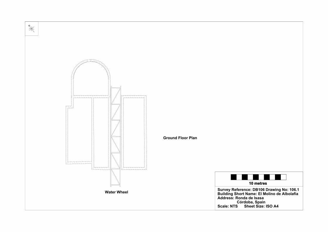
10 metres10 metresSurvey Reference: DB106 Drawing No: 106.1Building Short Name: El Molino de Albolafia Address: Ronda de Isasa Córdoba, SpainScale: NTS Sheet Size: ISO A4
Ground Floor Plan
Water Wheel

Survey Recorder: D. A. Lenton Survey & Archive Reference: Date of Survey: 30-Oct-10 DB107
LEVEL 3 SURVEY – ANALYTIC RECORD
Page 1/7
Contents
1.0 Identification of Building or Structure
2.0 Summary of Building Type and Historical Usage
3.0 Description of Building & Materials
4.0 Supplementary Information
5.0 Photographic Record
6.0 Drawing Record – Addendum Attached 1 Page
7.0 Bibliography

Survey Recorder: D. A. Lenton Survey & Archive Reference: Date of Survey: 30-Oct-10 DB107
LEVEL 3 SURVEY – ANALYTIC RECORD
Page 2/7
1.0 Identification of Building or Structure
1.1 Building Short Name Puente Romano
1.2 Variant Names The Roman Bridge
1.3 Address Ronda de Isasa, Córdoba, Spain
1.4
Location Co-ordinates
Northing 37.877°
Easting -4.778°
1.5 Statutory and non-statutory
designations
Within the designated area of the Córdoba
UNESCO World Heritage Site No. 313
(1984/1994).
Bien de Interés Cultural (Nationally Listed as
a Building of Cultural Interest) (Ministerio de
Cultura n.d.).
1.6 Survey Assessment &
Archaeological Value
Preservation is Medium (2). Its Roman and
Medieval period element have been well
conserved but it has been subject to
considerable modern reconstruction.
Legibility is High (3). Its walls have no
coverings.
Accessibility is High (3). The structure is
publically accessible.
Stratigraphical Complexity is High (3). First
inspection indicated that the structure’s phases
spanned at least 3 periods.
Archaeological Value is High (2.5-3).
1.7 Primary building Technique Stone; very large; dressed; well squared;
regular coursing; thick mortar.

Survey Recorder: D. A. Lenton Survey & Archive Reference: Date of Survey: 30-Oct-10 DB107
LEVEL 3 SURVEY – ANALYTIC RECORD
Page 3/7
2.0 Summary of Building Type and Historical Usage
2.1 Roman period bridge across the River Guadalquivir rebuilt and remodelled in
the Moorish, Reconquista and Modern periods. The earliest proposed date is
1st century. The structure is currently a pedestrian thoroughfare.
2.2 The structure is approached via the Plaza del Triunfo on the north bank due
south of the Mezquita and via the gardens adjacent to La Calahorra on the
south bank.
3.0 Statement of Materials and Dates
3.1 The structure is constructed of Andalucían limestone reinforced by modern
concrete foundations.
3.2 The structure is 292m long between the abutments and 8.1m wide at its
widest point.
3.3 The structure has 16 supporting arches, 12 of which are rounded arches and
may survive from the Moorish period. These rounded arches are likely to
have stemmed from the 10th century or earlier from the deduction that
pointed arches were in widespread use in the Islamic cities by that time and
replaced them as an engineering solution. Arches A, B, C, & D are pointed
arches with associated limestone carved archivolts. These arches can be
safely dated to the 13th century as the high carbon steel tools necessary for
this type of High Gothic carving was not widely available before then
(Geddes 2001: 168-73).
4.0 Supplementary Information
4.1 The bridge underwent reconstruction in the 8th and 9th centuries that gave it
its present appearance, although the contour elevation of the outermost
arches was raised in the 20th century (Daroca Bruño et al. 2003: 83). The
semicircular arches, the horizontal causeway and the upstream cut waters
originate from the Roman period, while the blinding arches on several
openings and the archivolts of the extrados denote its medieval
reconstruction (Daroca Bruño et al. 2003: 83).

Survey Recorder: D. A. Lenton Survey & Archive Reference: Date of Survey: 30-Oct-10 DB107
LEVEL 3 SURVEY – ANALYTIC RECORD
Page 4/7
5.0 Photographic Record
5.1 General External Views of the Building in its Setting
Fig. 107a: Aerial view of the building structure in its neighbourhood
North at top (Google Inc. n.d.)
Fig. 107b.: Aerial view of the building structure in close-up.
North at top (Google Inc. n.d.)
Survey Recorder: D. A. Lenton Survey & Archive Reference: Date of Survey: 30-Oct-10 DB107
LEVEL 3 SURVEY – ANALYTIC RECORD
Page 5/7
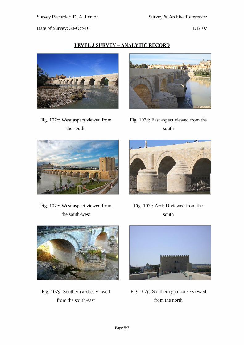
Fig. 107c: West aspect viewed from
the south.
Fig. 107e: West aspect viewed from
the south-west
Fig. 107g: Southern arches viewed
from the south-east
Fig. 107d: East aspect viewed from the
south
Fig. 107f: Arch D viewed from the
south
Fig. 107g: Southern gatehouse viewed
from the north

Survey Recorder: D. A. Lenton Survey & Archive Reference: Date of Survey: 30-Oct-10 DB107
LEVEL 3 SURVEY – ANALYTIC RECORD
Page 6/7
6.0 Drawing Record
Addendum
Drawing No. 107.1
1 Page A4 Size

Survey Recorder: D. A. Lenton Survey & Archive Reference: Date of Survey: 30-Oct-10 DB107
LEVEL 3 SURVEY – ANALYTIC RECORD
Page 7/7
7.0 Bibliography
Daroca Bruño, F., Yllescas Ortiz, M. & De La Fuente Darder, F. (eds.) 2003: Córdoba: Guía De Arquitectura. Córdoba: Colegio Oficial de Arquitectura de Córdoba. Geddes, J. 2001. Iron. In: J. Blair & N. Ramsey (eds.): English Medieval Industries : Craftsmen, Techniques, Products, p. 167-188. London: Hambledon and London. Google Inc. n.d.: Google Earth 6 Web Catalogue http://www.google.co.uk/intl/en_uk/earth/index.html, Mountain View, CA. Ministerio de Cultura n.d.: Bien De Interés Cultural: La Base De Datos De Bienes Inmuebles. http://www.mcu.es/bienes/cargarFiltroBienesInmuebles.do?layout=bienesInmuebles&cache=init&language=es.

East Elevation
River Front
Plan
40 metres
Survey Reference:DB107 Drawing No:107.1Building Short Name: Puente Romano Address: Ronda de Isasa, Córdoba, SpainScale: 1:1250 Sheet Size: ISO A4
La Calahorra
Arch A Arch B Arch C Arch D

Survey Recorder: D. A. Lenton Survey & Archive Reference: Date of Survey: 26-Oct-10 DB108
LEVEL 3 SURVEY – ANALYTIC RECORD
Page 1/12
Contents
1.0 Identification of Building or Structure
2.0 Summary of Building Type and Historical Usage
3.0 Description of Building & Materials
4.0 Supplementary Information
5.0 Photographic Record
6.0 Drawing Record – Addenda Attached 3 Pages
7.0 Bibliography
Survey Recorder: D. A. Lenton Survey & Archive Reference: Date of Survey: 26-Oct-10 DB108
LEVEL 3 SURVEY – ANALYTIC RECORD
Page 2/12
1.0 Identification of Building or Structure
1.1 Building Short Name The Calahorra
1.2 Variant Names El Torre de la Calahorra
The Calahorra Tower
1.3 Address Puente Romano,
Córdoba, Spain
1.4 Location Co-ordinates Northing 37.876°
Easting -4.777°
1.5 Statutory & Non-statutory
Designations
Within the designated area of the Córdoba
UNESCO World Heritage Site No. 313
(1984/1994).
Bien de Interés Cultural (Nationally Listed as
a Building of Cultural Interest) (Ministerio de
Cultura n.d.).
1.6 Survey Assessment &
Archaeological Value
Preservation is High (3). It retains several
storeys, a roof and has been well conserved by
its owners.
Legibility is High (3). Its walls have no
coverings and it is not obscured by vegetation
or other structures.
Accessibility is High (3). There are no major
obstacles or impediments and the majority of
the building is open to the public.
Stratigraphical Complexity is Medium (2).
Archaeological Value is High (2.5-3).
1.7 Primary Building Technique Stone; large upon very large; dressed;
rectangular; regular coursing; thick mortar.

Survey Recorder: D. A. Lenton Survey & Archive Reference: Date of Survey: 26-Oct-10 DB108
LEVEL 3 SURVEY – ANALYTIC RECORD
Page 3/12
2.0 Summary of Building Type and Historical Usage
2.1 Moorish and Reconquista period gate house to the Puente Romano of earliest
proposed date 12th century (Collins 1998: 118; Daroca Bruño et al. 2003:
82). It is currently a museum and tourist attraction.
2.2 The building is located on southern end of the Puente Romano due south of
the Mezquita.
2.3 The sole (north) entrance is via a timber double leaf door directly from the
bridge to an entrance hall (Room A) on an Upper Ground Floor level. The
building has four storeys above ground including a Lower Ground Floor
level plus a fortified roof area.
3.0 Statement of Materials and Dates
3.1 Foundations and external walls are of Andalucían limestone construction.
External walls are visible to roof height and unrendered. The earliest
elements are visible in the foundations [Fig. 108i] and beneath the horseshoe
arch of the Door A [Fig. 108f]. The foundations are of very large undressed
stone blocks in irregular coursing with thick mortar. The foundations have
been subject to several phases of renovation. There is an evident horizontal
discontinuity line above which later more regular and smaller blocks form
the ground floor wall (Fig. 108i). There is no clear dating evidence other than
this stratigraphical relationship.
3.2 The building is entered from the via a double leaf timber front door in the
north elevation (Door A). Door A is headed by a rounded limestone arch.
Above door A are the remains of a stone staircase leading up to a doorway at
First Floor level. The bottom of the staircase is terminated by modern
concrete. Surrounding both doorways is a large slightly pointed horseshoe
arch in limestone on limestone pilasters, which appear consistent with a
Moorish period date as it denotative of the 9th and 10th-century arches of the
Mezquita and Madinat al-Zahra (Fig. 108f). The existence of this Moorish
period archway above the foundations suggests that the foundations
themselves, at least in part, date from the Moorish period. This horseshoe

Survey Recorder: D. A. Lenton Survey & Archive Reference: Date of Survey: 26-Oct-10 DB108
LEVEL 3 SURVEY – ANALYTIC RECORD
Page 4/12
arch has been infilled with large stones to create the entrance at First floor
level, which appears to have lost its staircase leading up from Upper Ground
Floor level and Door A is now visible from the north.
3.3 Above the horseshoe arch an entrance façade rises to Second Floor height
including crenulations around the balconied top, which remains in part. The
façade has been repaired in modern brickwork and concrete. 2 windows open
on to the balcony at Second Floor level both are headed by rounded
limestone arches. Above the window openings are the remains of decorative
crenulations, which are stylistic and likely to date from the late Reconquista
period.
3.4 The east side of the North Elevation has been subject to a rebuilding phase in
smaller stone blocks than the west side. These stone blocks are large (larger
than the hand) in thick mortar in irregular bond. The Second Floor and Roof
levels have also been subject to such rebuilding in similar stone blocks in
thick mortar in irregular bond. The Roof level has stylistic crenulations in
similar stone blocks that are likely to date to the late Reconquista period.
3.5 It is possible that the larger stone blocks on the western side of the North
Elevation, the West, and South Elevations represent a construction phase of
the Reconquista period by Enrique II and the rebuilding to the eastern side
and the Second Floor upwards represent his more decorative later
Reconquista period remodelling. In other words, the eastern tower was
formed later in the period and abutted to the earlier walls of the gatehouse.
This abutment can be identified in the South Elevation [Fig. 108d]. The
North Elevation is pierced by inserted view holes and gargoyles possibly
dating to an Imperial period remodelling.
3.6 There is a curtain wall at a low, Upper Ground Floor level built in limestone
that has been rebuilt in the Modern period. The southern section has areas of
roughly dressed stone repaired with rubble walling in thick mortar that are
distinct from the Primary Building Technique of the Reconquista period.
This curtain wall is therefore likely to date from the Imperial period and
perhaps was related to civil war activities in the mid-15th century.

Survey Recorder: D. A. Lenton Survey & Archive Reference: Date of Survey: 26-Oct-10 DB108
LEVEL 3 SURVEY – ANALYTIC RECORD
Page 5/12
3.7 Door A on the Upper Ground Floor leads in to an entrance hall (Room A)
with interior walls in stonework and a barrel ceiling in brickwork. It is
possible that this barrel ceiling survives from the Moorish period but the
building technique, of large brickwork in thick mortar in stretcher and header
bond, is consistent in construction with the barrel ceiling in the Molino del
Martos [DB117], which has been dated to the Reconquista period
(Ayuntamiento de Córdoba n.d.; Daroca Bruño et al. 2003: 108).
3.8 East and west of Room A are further chambers (Rooms B&C) both with
stonework internal walls and cupola ceilings in brickwork. The cupola
brickwork is in thick mortar and stretcher bond. This decorative brick
probably dates to the later Reconquista period rebuild as it occurs in the
eastern tower.
3.9 The staircase provides access to each of the upper floors including the Roof
level. The First Floor has rectangular rooms with stonework interior walls in
thick mortar and more decorative brickwork cupola ceilings in the same
building technique as the Upper Ground Floor ceiling. It seems likely that the
decorative cupola ceilings are coeval with the later Reconquista, more
decorative rebuilding phase. It would have been possible to insert these
brickwork ceilings into the building without disturbing the stonework of the
upper floors. The Second Floor has rectangular rooms with stonework
interior walls that merge into stonework barrel ceilings in thick mortar in
fairly regular stretcher bond.
4.0 Supplementary Information
4.1 At the south end of the Roman Bridge stands a tower on the foundations of
an earlier Islamic building (Daroca Bruño et al. 2003: 82). Recent
archaeological excavations carried out in the Field of Truth - the site
occupied by the former Posada del Puente, south of the current tower - have
manifested the existence of a large rectangular walled enclosure, built with
formwork walls of mud flanked by towers at the corners, like a fortress,
which would protect access to the bridge. This fortification has been dated to

Survey Recorder: D. A. Lenton Survey & Archive Reference: Date of Survey: 26-Oct-10 DB108
LEVEL 3 SURVEY – ANALYTIC RECORD
Page 6/12
the second half of the twelfth century, in the Almohade period, as a
reinforcement of the defenses around the Alcázar, as strategical location for
the protection of Seville. This is probably the fortification mentioned in the
Christian chronicles (Léon Muños 2003: 212).
4.2 The gatehouse was rebuilt by in the 14th century Enrique II de Trastamara
during the Civil Wars with his brother Pedro I 'The Cruel', and its strategic
position as gateway to the city lent it great importance in military history
(Daroca Bruño et al. 2003: 82). A third tower was added in 1369 (Daroca
Bruño et al. 2003: 82) by Enrique II (Léon Muños 2003: 213), the Spanish
civil war victor, who proceeded to repair the castle fortress making it
freestanding. To this phase belongs the coat of arms of Castile and Leon
narrow slits that open to flank the road. It was used as a prison for nobility
from 1369 (Collins 1998: 118). Polygonal in shape, with hardly any
openings, the two main towers are linked by an archway, which leads to the
inside.
During the second half of the fifteenth century, La Calahorra is packed with
new defensive elements, such as cross and orb pockets designed to put pieces
of artillery of powder. These works must be ascribed to the period of control
of the city by Alfonso de Aguilar, during the civil wars of Castile. Finally,
the barrier or low wall surrounding the south's Calahorra must date from the
early sixteenth century, as reflected in which documents of 1514 in which
Queen Joanna calls this conclusion "the matron and barrier in La Calahorra"
(Ayuntamiento de Córdoba n.d.).
4.3 It was named a Historic-Artistic Monument at the turn of the 20th century,
and nowadays, after various uses, such as a prison or a school, it houses the
Roger Garaudy Museum of the peaceful co-existence between the Jewish,
Christian and Moslem cultures (Ayuntamiento de Córdoba n.d.; Collins
1998: 118).
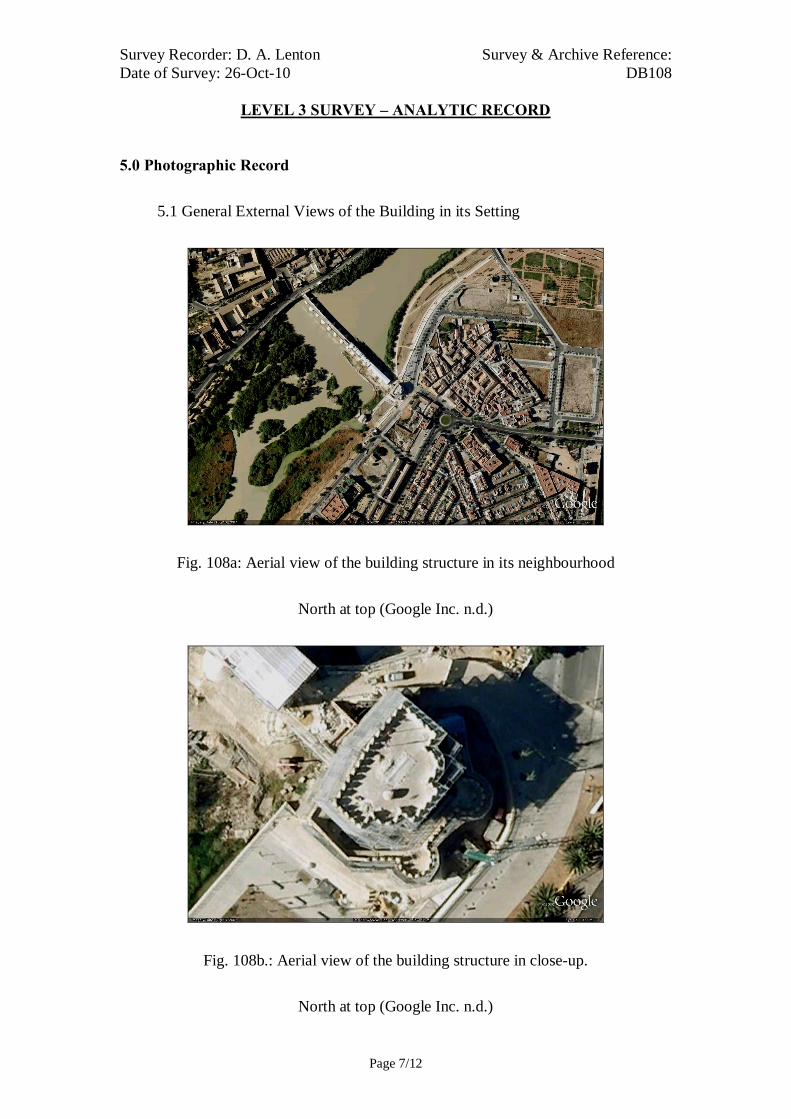
Survey Recorder: D. A. Lenton Survey & Archive Reference: Date of Survey: 26-Oct-10 DB108
LEVEL 3 SURVEY – ANALYTIC RECORD
Page 7/12
5.0 Photographic Record
5.1 General External Views of the Building in its Setting
Fig. 108a: Aerial view of the building structure in its neighbourhood
North at top (Google Inc. n.d.)
Fig. 108b.: Aerial view of the building structure in close-up.
North at top (Google Inc. n.d.)

Survey Recorder: D. A. Lenton Survey & Archive Reference: Date of Survey: 26-Oct-10 DB108
LEVEL 3 SURVEY – ANALYTIC RECORD
Page 8/12
Fig. 108c: North aspect
Fig. 108e: South aspect
Fig. 108g: South aspect from the
south-east
Fig. 108d: South-East aspect
Fig. 108f: North aspect and Door A
Fig. 108h: Roof level looking south
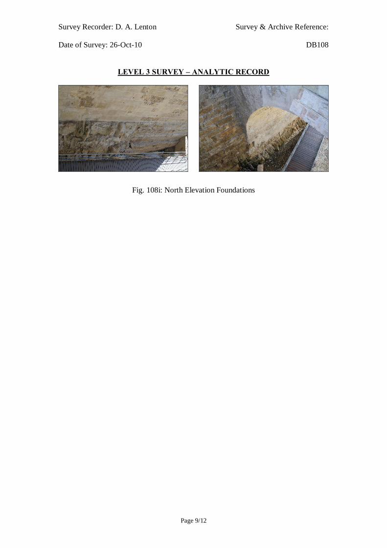
Survey Recorder: D. A. Lenton Survey & Archive Reference: Date of Survey: 26-Oct-10 DB108
LEVEL 3 SURVEY – ANALYTIC RECORD
Page 9/12
Fig. 108i: North Elevation Foundations
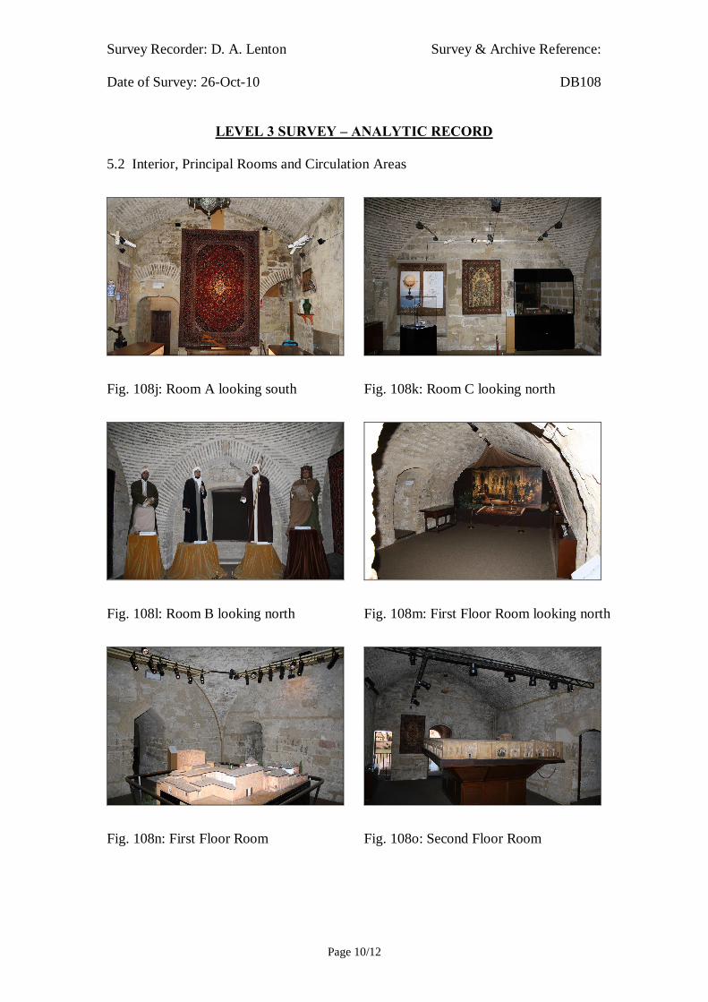
Survey Recorder: D. A. Lenton Survey & Archive Reference: Date of Survey: 26-Oct-10 DB108
LEVEL 3 SURVEY – ANALYTIC RECORD
Page 10/12
5.2 Interior, Principal Rooms and Circulation Areas
Fig. 108j: Room A looking south Fig. 108k: Room C looking north
Fig. 108l: Room B looking north Fig. 108m: First Floor Room looking north
Fig. 108n: First Floor Room Fig. 108o: Second Floor Room

Survey Recorder: D. A. Lenton Survey & Archive Reference: Date of Survey: 26-Oct-10 DB108
LEVEL 3 SURVEY – ANALYTIC RECORD
Page 11/12
6.0 Drawing Record
Addenda
Drawing Nos. 108.1, 108.2 & 108.3
3 Pages A4 Size

Survey Recorder: D. A. Lenton Survey & Archive Reference: Date of Survey: 26-Oct-10 DB108
LEVEL 3 SURVEY – ANALYTIC RECORD
Page 12/12
7.0 Bibliography
Ayuntamiento de Córdoba n.d.: Córdoba: Oficinas De Información Turística. (ed. Ayuntamiento de Córdoba) Ayuntamiento de Córdoba, Córdoba. Collins, R. 1998: Spain: An Oxford Archaeological Guide. Oxford: Oxford University Press. Daroca Bruño, F., Yllescas Ortiz, M. & De La Fuente Darder, F. (eds.) 2003: Córdoba: Guía De Arquitectura. Córdoba: Colegio Oficial de Arquitectura de Córdoba. Google Inc. n.d.: Google Earth 6 Web Catalogue http://www.google.co.uk/intl/en_uk/earth/index.html, Mountain View, CA. Léon Muños, A. 2003. La Córdoba Cristiana: La Fortaleza De La Calahorra. In: J. Fernández (ed.) Guía Archaeológica De Córdoba, p. 211-214. Córdoba: Plurabelle. Ministerio de Cultura n.d.: Bien De Interés Cultural: La Base De Datos De Bienes Inmuebles. http://www.mcu.es/bienes/cargarFiltroBienesInmuebles.do?layout=bienesInmuebles&cache=init&language=es.
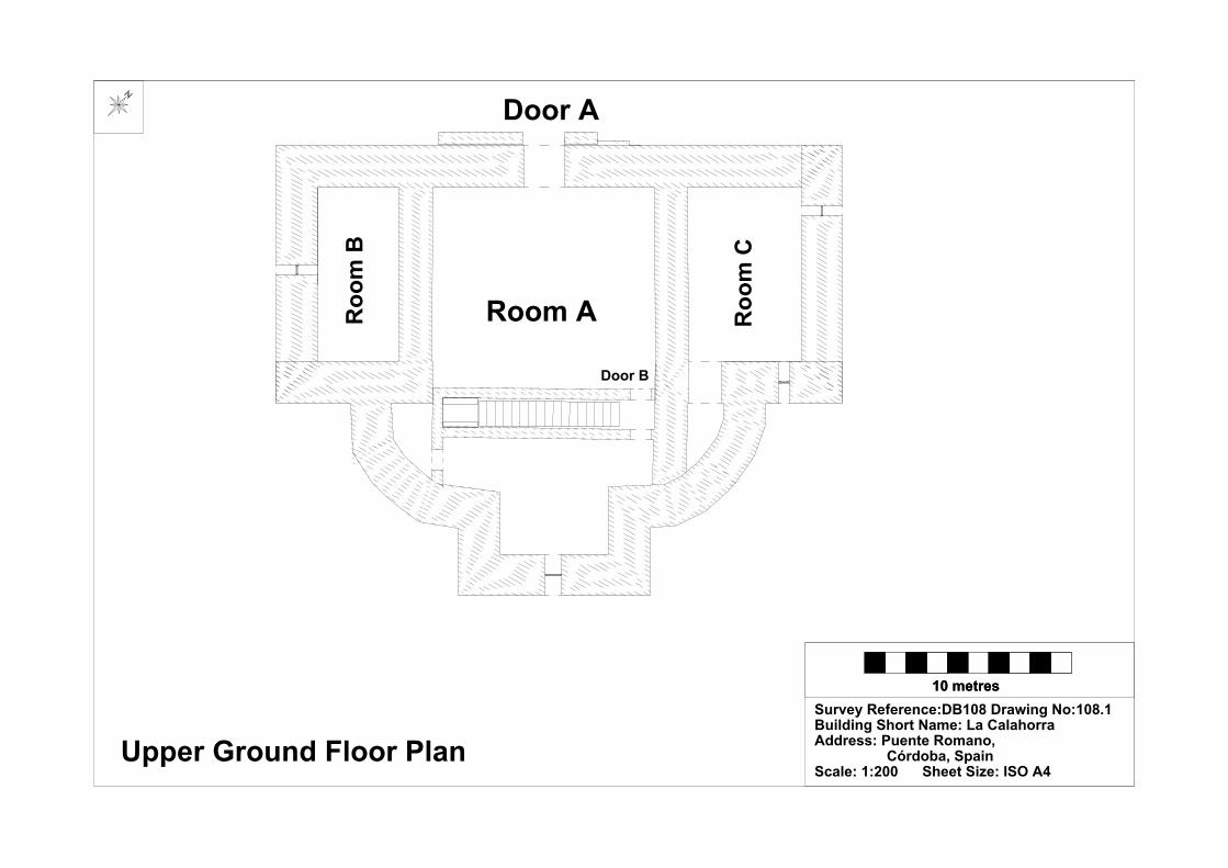
10 metres10 metresSurvey Reference:DB108 Drawing No:108.1Building Short Name: La CalahorraAddress: Puente Romano, Córdoba, SpainScale: 1:200 Sheet Size: ISO A4
Upper Ground Floor Plan
Door A
Room ARoo
m B
Roo
m C
Door B

10 metres10 metresSurvey Reference:DB108 Drawing No:108.2Building Short Name: La CalahorraAddress: Puente Romano, Córdoba, SpainScale: 1:200 Sheet Size: ISO A4
North Elevation

20 metres (approx.)
Survey Reference:DB108 Drawing No:108.3Building Short Name: La CalahorraAddress: Puente Romano, Córdoba, SpainScale: <NTS> Sheet Size: ISO A4
Door A
Room ARoo
m B
Roo
m C
Door B

Survey Recorder: D. A. Lenton Survey & Archive Reference: Date of Survey: 31-Oct-08 DB109
LEVEL 2 SURVEY – DESCRIPTIVE RECORD
Page 1/10
Contents
1.0 Identification of Building or Structure
2.0 Summary of Building Type and Historical Usage
3.0 Description of Building & Materials
4.0 Supplementary Information
5.0 Photographic Record
6.0 Drawing Record – Addendum Attached 1 Page
7.0 Bibliography

Survey Recorder: D. A. Lenton Survey & Archive Reference: Date of Survey: 31-Oct-08 DB109
LEVEL 2 SURVEY – DESCRIPTIVE RECORD
Page 2/10
1.0 Identification of Building or Structure
1.1
Building Short Name
Alcázar
1.2
Variant Names
Moorish Alcázar
Alcázar de los Reyes Cristianos
Castle of the Christian Monarchs
Alcázar Reales
1.3
Address
Campo Santo de los Mártires, Córdoba, Spain
1.4
Location Co-ordinates
Northing 37.876° Easting -4.781°
1.5
Statutory & Non-statutory
Designations
Within the designated area of the Córdoba
UNESCO World Heritage Site No. 313
(1984/1994).
Bien de Interés Cultural (Nationally Listed as
a Building of Cultural Interest) (Ministerio de
Cultura n.d.).
1.6 Survey Assessment &
Archaeological Value
Preservation is Medium (2).
Legibility is Medium (2).
Accessibility is Low (1).
Stratigraphical Complexity is High (3).
Archaeological Value is Medium (2-2.5).
1.7 Primary Building Technique 1200AD: Stone; very large; ashlar;
rectangular; regular coursing; thick mortar.
1400AD: Stone; very large; ashlar;
rectangular; regular coursing; thick mortar.
1600AD: Stone; large bonded with very large;
dressed; rectangular; regular coursing; thick
mortar.
Survey Recorder: D. A. Lenton Survey & Archive Reference: Date of Survey: 31-Oct-08 DB109
LEVEL 2 SURVEY – DESCRIPTIVE RECORD
Page 3/10
2.0 Summary of Building Type and Historical Usage
2.1 Caliphate/ Moorish period fortress of earliest known date late 8th century
with additions in the 10th century (Léon Muños et al. 2003: 144-7). The
surviving remains consist of the Baños Caliphales and excavated foundations
of a fortified keep, the Alcazaba.
2.2 The remains are located within the Castle of the Christian Monarchs on the
plaza Campo Santo de los Mártires in the parish of Santa Maria south-east of
the Mezquita.
2.3 The main (north-west) entrance is via timber double leaf door (Door A)
through an arched vestibule.
3.0 Description of Building & Materials
3.1 Foundations are of Andalusían limestone
3.2 At the corners of the north wall are the towers known as Torre de los Leones
and Torre del Homenaje. The Torre de los Leones employs the Primary
Building Technique of very large rectangular stonework in regular coursing
with thick mortar. It has a gate with a pointed Gothic arch [Fig. 109g] and is
orthogonal on plan. The Torre del Homenaje has an octagonal layout
characteristic of 13th-14th-century Gothic-Mudéjar constructions (Iglesias
Costa 1989: 28; 166; 250) and also employs the Primary Building Technique.
Both towers, at Roof level, have stylistic embrasure crenulations with
pyramidal stone copings that are a recurrent grammatical theme in the
Calahorra [DB108] and the Puerta de Almodóvar [DB112]. These pyramidal
embrasures, atop tower fortifications and gate façades are synonymous with
the early Mudéjar style of architecture, which was used to adorn palaces and
fortifications throughout post-conquest Castile (Cabañero Subiza 1998: 84-
5). These stylistically fortified towers, consequently, can be dated to the
Reconquista period of Córdoba.
3.3 The Primary Building Technique employed during the Imperial period was
large bonded with very large, dressed stonework in regular coursing in thick
mortar and can be identified in the surviving internal wall elements [Fig.
109h]. The walls formed a cellular structure around a large western

Survey Recorder: D. A. Lenton Survey & Archive Reference: Date of Survey: 31-Oct-08 DB109
LEVEL 2 SURVEY – DESCRIPTIVE RECORD
Page 4/10
Courtyard. The foundations of an octagonal tower, the Torre de la
Inquisición, remain at the south-western corner of the complex to abut the
Reconquista period perimeter walls. The walls of this tower are a modern
construction.
4.0 Supplementary Information
4.1 The Alcázar which previously had been Visigoth governor's palace was the
centre of political power, in al-Andalus from the first decades of the 8th
century until the fall of the Caliphate of Cordoba in the early 11th century. It
also played a prominent role until the Castilian conquest in 1236.Today the
Alcázar can only be recognized in the bathrooms located in Plazza del Campo
Santo de los Mártires. However there remain important sections of the North
and East Walls, in the façade of the Palacio Episcopal and the Palacio de
Congresos y Exposiciones facing the Calle Torrijos (Léon Muños et al. 2003:
144).
4.2 After the conquest of the city, Fernando III reserved the south-west corner of
the Alcázar for the establishment of a royal residence. The first nucleus of the
complex building was created in this period and consisted of a rectangular
enclosure built against the city’s south wall. During the reign of Alfonso XI
the Alcázar was extended into grounds located to the south of the ramparts,
then occupied by the Convent of the Augustinian Order which was moved in
1328 to the present Iglesia de San Agustín. This enlargement gave the site its
present square proportions and brought about the disappearance of the wall
that divided it (Daroca Bruño et al. 2003: 105).
4.3 The Alcázar was the residence of the Castilian monarchs in the city until 1482
when it passed over to the Inquisition, which in the following centuries
transformed its interior in order to incorporate 17th-century cells and a church.
After the suppression of the Tribunal of the Inquisition, the Alcázar housed the
city’s gaol (Daroca Bruño et al. 2003: 105).
4.4 Located at the corners of the north wall are the towers known Torre as de los
Leones and Torre del Homenaje, belonging to the first enclosure of the 13th
century. The first of these towers serves as a thoroughfare to the Alcázar by
Survey Recorder: D. A. Lenton Survey & Archive Reference: Date of Survey: 31-Oct-08 DB109
LEVEL 2 SURVEY – DESCRIPTIVE RECORD
Page 5/10
way of a gate with a gothic arch; it has a square layout and on its upper floor
there is a magnificent room covered by an octagonal groined vault. The other
tower has an octagonal layout and a hexagonal upper room with an ogival
vault; next to the room is a covered observatory that was added in the 18th
century (Daroca Bruño et al. 2003: 105)
4.5 The inside is taken up by H-shaped bays that liberate two spaces; the
Mudéjar patio, which contains the remains of the palatial structures that
make up the garden of Islamic influence, and the Old Patio of Arms (Daroca
Bruño et al. 2003: 105). The old chapel, a rectangular nave with a groined
barrel vault and square sanctuary with a dome and a lantern, is the present
Hall of Mosaics. Below it are the baths, Arab in their deign but Christian in
their construction (Daroca Bruño et al. 2003: 105).
4.6 The huge stretch of irrigated land includes an initial phase of Renaissance
gardens with elevated water tanks, following the line of the city ramparts that
no-longer exists, and a lower garden, dominated by the Tower of the
Inquisition, a mid 15th-century construction with a circular floor plan
crowned by an octagon (Daroca Bruño et al. 2003: 105).
4.7 Excavations have revealed that the Moorish period Alcázar was a pisé and
limestone-built complex arranged around a very large, central open area of
approximately 1.5 hectares. Residential areas and government offices were
positioned at the east end of the open area. The Caliphal family cemetery, the
Rawda, was to the south. A fortified keep, the Alcazaba, was positioned in
the south-west corner and the Baños Caliphales to the north-west (Léon
Muños et al. 2003: 146). Each of the four cardinal walls was pierced by two
gates, the positions of which respected the axes of earlier, Roman period
street lines. The largest gate, the Bab al-Sudda, opened in the east end of the
southern wall onto a large open parade ground, the Hassa, along the
waterfront. The Bab al-Sudda possessed a form of platform roof from which
the rulers or governors of the Alcázar were reported to have watched military
parades and public executions that were carried out in the Hassa (Léon
Muños et al. 2003: 146).
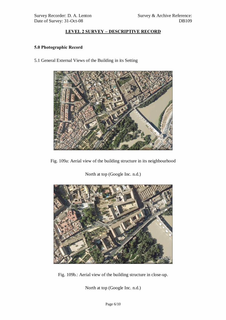
Survey Recorder: D. A. Lenton Survey & Archive Reference: Date of Survey: 31-Oct-08 DB109
LEVEL 2 SURVEY – DESCRIPTIVE RECORD
Page 6/10
5.0 Photographic Record
5.1 General External Views of the Building in its Setting
Fig. 109a: Aerial view of the building structure in its neighbourhood
North at top (Google Inc. n.d.)
Fig. 109b.: Aerial view of the building structure in close-up.
North at top (Google Inc. n.d.)

Survey Recorder: D. A. Lenton Survey & Archive Reference: Date of Survey: 31-Oct-08 DB109
LEVEL 2 SURVEY – DESCRIPTIVE RECORD
Page 7/10
Fig. 109c: North aspect of the Castle of
the Christian Monarchs
Fig. 109e: North-east aspect of the
Castle of the Christian Monarchs
viewed from the north
Fig. 109d: Section of the Alcázar east
wall remaining in the Palacio
Episcopal (Léon Muños et al. 2003:
147).
Fig. 109f: Baños Califales beneath the
Campo Santo de los Mártires
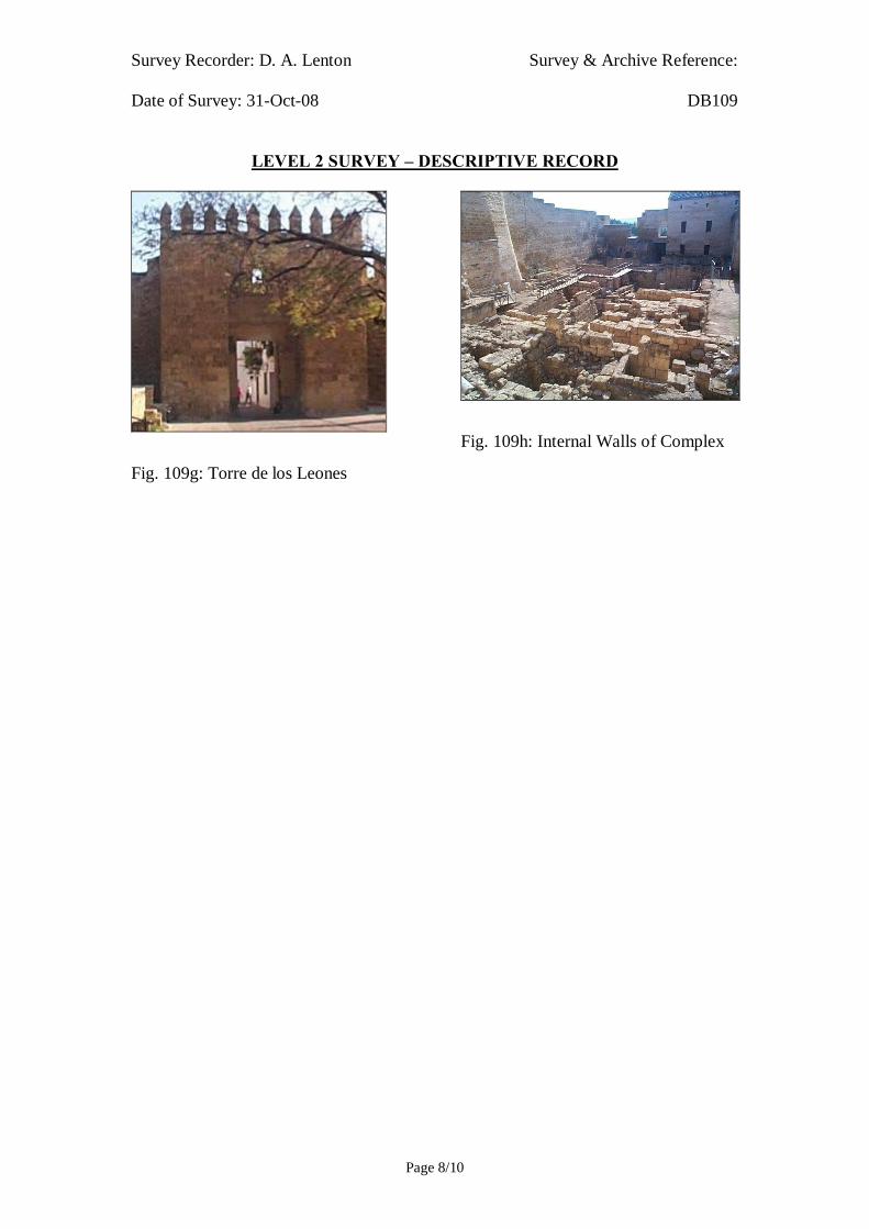
Survey Recorder: D. A. Lenton Survey & Archive Reference: Date of Survey: 31-Oct-08 DB109
LEVEL 2 SURVEY – DESCRIPTIVE RECORD
Page 8/10
Fig. 109g: Torre de los Leones
Fig. 109h: Internal Walls of Complex

Survey Recorder: D. A. Lenton Survey & Archive Reference: Date of Survey: 31-Oct-08 DB109
LEVEL 2 SURVEY – DESCRIPTIVE RECORD
Page 9/10
6.0 Drawing Record
Addendum
Drawing Nos. 109.1
1 Page A4 Size

Survey Recorder: D. A. Lenton Survey & Archive Reference: Date of Survey: 31-Oct-08 DB109
LEVEL 2 SURVEY – DESCRIPTIVE RECORD
Page 10/10
7.0 Bibliography
Cabañero Subiza, B. 1998: La Alijafería. Zaragoza: Cortes de Aragón. Daroca Bruño, F., Yllescas Ortiz, M. & De La Fuente Darder, F. (eds.) 2003: Córdoba: Guía De Arquitectura. Córdoba: Colegio Oficial de Arquitectura de Córdoba. Google Inc. n.d.: Google Earth 6 Web Catalogue http://www.google.co.uk/intl/en_uk/earth/index.html, Mountain View, CA. Iglesias Costa, M. 1989: Arquitectura Sacra: Desde El Period Gótico (Siglo Xiii) Hasta La Actualidad. Zaragoza: Gobierno de Aragon. Léon Muños, A., Monterroso Checa, A. & Garriguet Mata, J.-A. 2003. La Qurtuba Islámica: El Alcázar Andalusí. In: J. Fernández (ed.) Guía Archaeológica De Córdoba, p. 144-147. Córdoba: Plurabelle. Ministerio de Cultura n.d.: Bien De Interés Cultural: La Base De Datos De Bienes Inmuebles. http://www.mcu.es/bienes/cargarFiltroBienesInmuebles.do?layout=bienesInmuebles&cache=init&language=es.
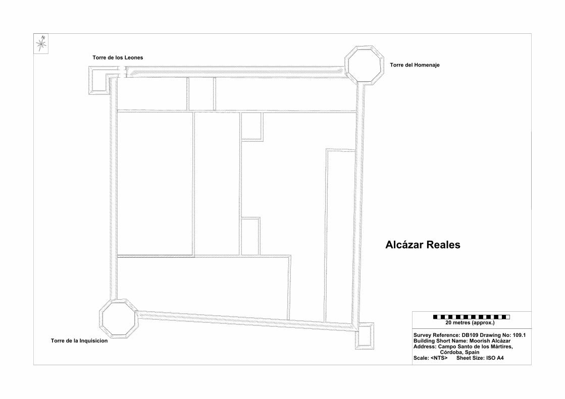
20 metres (approx.)
Survey Reference: DB109 Drawing No: 109.1Building Short Name: Moorish AlcázarAddress: Campo Santo de los Mártires, Córdoba, SpainScale: <NTS> Sheet Size: ISO A4
Alcázar Reales
Torre de los Leones Torre del Homenaje
Torre de la Inquisicion

Survey Recorder: D. A. Lenton Survey & Archive Reference: Date of Survey: 30-Oct-10 DB110
LEVEL 3 SURVEY – ANALYTIC RECORD
Page 1/11
Contents
1.0 Identification of Building or Structure
2.0 Summary of Building Type and Historical Usage
3.0 Description of Building & Materials
4.0 Supplementary Information
5.0 Photographic Record – Addendum Attached 1 Page
6.0 Drawing Record
7.0 Bibliography

Survey Recorder: D. A. Lenton Survey & Archive Reference: Date of Survey: 30-Oct-10 DB110
LEVEL 3 SURVEY – ANALYTIC RECORD
Page 2/11
1.0 Identification of Building or Structure
1.1 Building Short Name Baños Árabes
1.2 Variant Names Baños Árabes de Santa María.
Arab Bath-house of St. Mary.
1.3 Address No. 10 Calle Valázquez Bosco,
Córdoba, Spain
1.4 Location Co-ordinates Northing 37.880°Easting -4.779°
1.5 Statutory & Non-statutory
Designations
Within the designated area of the Córdoba
UNESCO World Heritage Site No. 313
(1984/1994).
Bien de Interés Cultural (Nationally Listed as
a Building of Cultural Interest) (Ministerio de
Cultura n.d.).
1.6 Survey Assessment &
Archaeological Value
Preservation is Medium (2). It has many
surviving medieval walls.
Legibility is Medium (2). Some of its walls
have been rendered and painted.
Accessibility is Medium (2). The majority of
rooms are publically accessible but some are
concealed behind modern building elements.
Stratigraphical Complexity is High (3). Phases
spanned at least 2 or 3 periods.
Archaeological Value is Medium (2-2.5).
1.7 Primary Building Technique Moorish: Stone; very large; rough worked;
part squared; broken rangework; thick mortar.
Reconquista: Fired clay brickwork; large;
hand-moulded; rectangular; regular coursing;
thick mortar.
Imperial: Fired clay brickwork; large; wire
cut; rectangular; regular coursing; thick
mortar.

Survey Recorder: D. A. Lenton Survey & Archive Reference: Date of Survey: 30-Oct-10 DB110
LEVEL 3 SURVEY – ANALYTIC RECORD
Page 3/11
2.0 Summary of Building Type and Historical Usage
2.1 Moorish period Hammam bathhouse of earliest proposed date 10th century
(Daroca Bruño et al. 2003: 134). It is currently a museum and tourist
attraction.
2.2 The building is located on a narrow street running north-south in the parish
of Santa Maria due north of the Mezquita.
2.3 The sole (east) entrance is via a timber double leaf door directly from the
street to an entrance vestibule. The building has two storeys above ground
plus roof space. The second storey and roof space are of modern construction
and in use as a private house entered via Calle Céspedes.
3.0 Statement of Materials and Dates
3.1 External walls and foundations are of local clay brickwork construction.
External brickwork walls are rendered with sand and cement to roof height
abut patches of brickwork are visible through the render.
3.2 The building is entered from the street via a double leaf timber front door in
the east elevation. The east elevation is a brickwork façade at ground floor
level. The façade has been constructed in front of the Moorish period
stonework suggesting that it is likely to date from the Reconquista period or
later. The doorway opens to brickwork steps leading down to a Courtyard at
a lower ground floor level approximately 1 metre below the later built up
street level. This entrance has been inserted in the east wall of the hammam
and appears to have been part of a Reconquista period remodelling. A
western entrance to the hammam from Calle Valázquez Bosco is now
enclosed and concealed by the modern house.
3.3 The Courtyard has been subject to some remodelling. Repairs to the
stonework arches have been made in clay brickwork in the same building
technique as the east façade, which probably dates it to the Reconquista
period (Daroca Bruño et al. 2003: 134). The courtyard has been subject to
modern restoration imitating the style of hammans known elsewhere in Spain
(e.g. the Aljibe de San Miguel at Ronda). The courtyard plan is rectangular

Survey Recorder: D. A. Lenton Survey & Archive Reference: Date of Survey: 30-Oct-10 DB110
LEVEL 3 SURVEY – ANALYTIC RECORD
Page 4/11
(9.10 by 8.36 metres internally) arranged around reused marble columns with
foliate capitals can be stylistically dated to 10th century or earlier. One of the
column capitals is of Visigothic date but all the others are Caliphate
ataurique (plaster foliage) work (Collins 1998: 119). In the south-west corner
of the Courtyard on the south wall, brickwork and a painted horseshoe arch
survive, which can be stylistically dated to the Caliphal period. Similar
arches are visible in the 3 other corners on the north and south walls, which
may be of similar Caliphal dates (Ayuntamiento de Córdoba n.d.; Rodriguez
2006). The horseshoe arches of the north, south and west walls of the
Courtyard have been infilled with brickwork and stonework. On the north
wall there is an infilled arch with a doorway (Door B) inserted. In the east
wall there are 2 doorways leading into the adjacent chamber (Room A). The
largest doorway (Door A) is central. The other doorway (Door C) is infilled
with brickwork. The overall result was to create a garden courtyard entrance
to the hot room (Room A).
3.4 Room A (3.41 by 8.30 metres internally) is constructed with Andalucían
limestone stonework walls, and has a stonework barrel roof to a height of
3.35 metres with rectangular roof lights now infilled. There are 2 doorways
in the east wall infilled with brickwork and a doorway in each of the north
and south walls now infilled. These doorways led to the furnace areas and
changing rooms to the east of Room A (Daroca Bruño et al. 2003: 134). In
the centre of the east wall, there is a brickwork pointed arch leading to a
tunnel exceeding 10 metres long. At the southern end of the west wall there
are 2 lantern sockets.
3.5 The floors in both the courtyard and Room A are raised to a higher level than
the arch and doorway bases indicating that they date to a later period.
4.0 Supplementary Information
4.1 The Arab baths of Santa Maria were baths for public use which constitute one
of the few preserved examples of a once popular and abundant type of
building in Muslim Cordoba, which survived into the Reconquista and

Survey Recorder: D. A. Lenton Survey & Archive Reference: Date of Survey: 30-Oct-10 DB110
LEVEL 3 SURVEY – ANALYTIC RECORD
Page 5/11
Imperial periods. They were built during the Caliphate and rebuilt in the 14th
century in Mudéjar style (Daroca Bruño et al. 2003: 134). It was declared
Bienes de Interés Cultural on 30 April 2001 (Ayuntamiento de Córdoba n.d.;
Rodriguez 2006).

Survey Recorder: D. A. Lenton Survey & Archive Reference: Date of Survey: 30-Oct-10 DB110
LEVEL 3 SURVEY – ANALYTIC RECORD
Page 6/11
5.0 Photographic Record
5.1 General External Views of the Building in its Setting
Fig. DB110a: Aerial view of the building structure in its neighbourhood
North at top (Google Inc. n.d.)
Fig. DB110b.: Aerial view of the building structure in close-up.
North at top (Google Inc. n.d.)
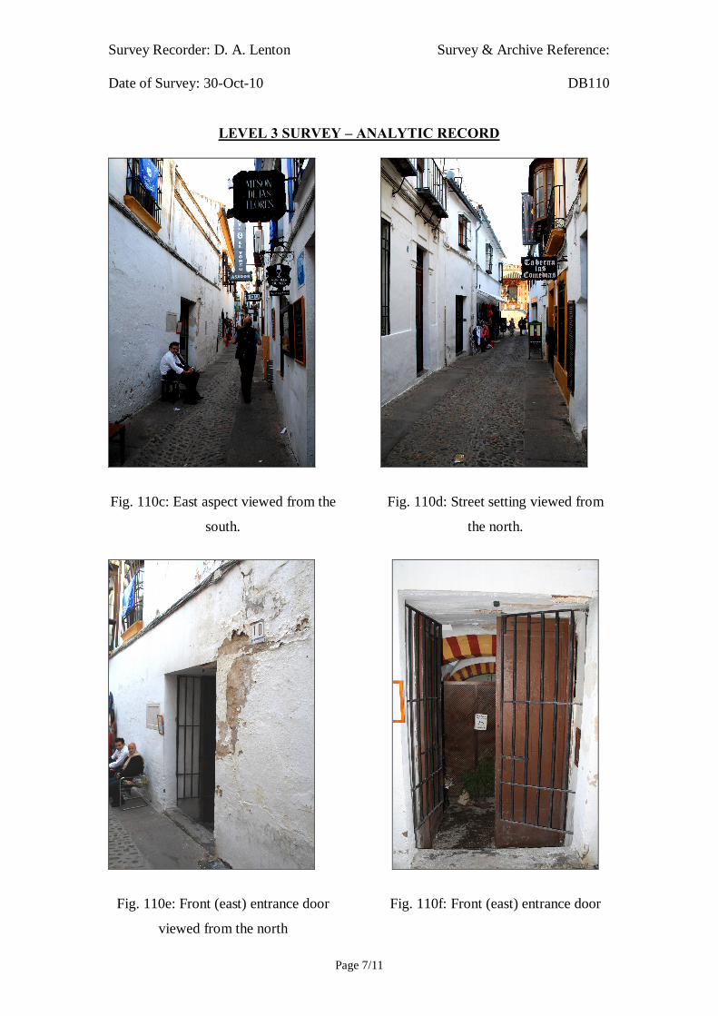
Survey Recorder: D. A. Lenton Survey & Archive Reference: Date of Survey: 30-Oct-10 DB110
LEVEL 3 SURVEY – ANALYTIC RECORD
Page 7/11
Fig. 110c: East aspect viewed from the
south.
Fig. 110e: Front (east) entrance door
viewed from the north
Fig. 110d: Street setting viewed from
the north.
Fig. 110f: Front (east) entrance door

Survey Recorder: D. A. Lenton Survey & Archive Reference: Date of Survey: 30-Oct-10 DB110
LEVEL 3 SURVEY – ANALYTIC RECORD
Page 8/11
5.2 Interior, Principal Rooms and Circulation Areas
Looking East Looking North
Looking North-East Marble column Capital
Limestone horseshoe arch in Infilled arched doorway from
South-West Corner of the Courtyard Room A into Courtyard
Fig. 110g Lower Ground Floor Courtyard

Survey Recorder: D. A. Lenton Survey & Archive Reference: Date of Survey: 30-Oct-10 DB110
LEVEL 3 SURVEY – ANALYTIC RECORD
Page 9/11
Looking North Looking South
Looking East Looking West
Tunnel Looking East Lantern Socket South-East Corner
Fig. 110h: Room A

Survey Recorder: D. A. Lenton Survey & Archive Reference: Date of Survey: 30-Oct-10 DB110
LEVEL 3 SURVEY – ANALYTIC RECORD
Page 10/11
6.0 Drawing Record
Addendum
Drawing No. 110.1
1 Page A4 Size
Survey Recorder: D. A. Lenton Survey & Archive Reference: Date of Survey: 30-Oct-10 DB110
LEVEL 3 SURVEY – ANALYTIC RECORD
Page 11/11
7.0 Bibliography
Ayuntamiento de Córdoba n.d.: Córdoba: Oficinas De Información Turística. (ed. A. d. Córdoba) Ayuntamiento de Córdoba, Córdoba. Collins, R. 1998: Spain: An Oxford Archaeological Guide. Oxford: Oxford University Press. Daroca Bruño, F., Yllescas Ortiz, M. & De La Fuente Darder, F. (eds.) 2003: Córdoba: Guía De Arquitectura. Córdoba: Colegio Oficial de Arquitectura de Córdoba. Google Inc. n.d.: Google Earth 6 Web Catalogue http://www.google.co.uk/intl/en_uk/earth/index.html, Mountain View, CA. Ministerio de Cultura n.d.: Bien De Interés Cultural: La Base De Datos De Bienes Inmuebles. http://www.mcu.es/bienes/cargarFiltroBienesInmuebles.do?layout=bienesInmuebles&cache=init&language=es. Rodriguez, A. 2006: El Dueño Pone a La Venta Los Baños Árabes De Santa María, Del Siglo Xi. In Diario Córdoba 14.02.06.Grupo Zeta, Córdoba.
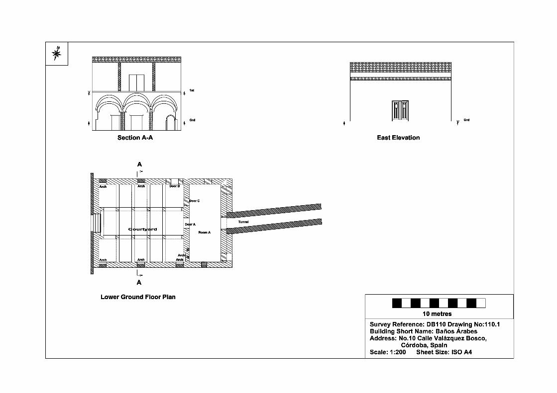
Survey Recorder: D. A. Lenton Survey & Archive Reference: Date of Survey: 31-Oct-10 DB112
LEVEL 2 SURVEY – DESCRIPTIVE RECORD
Page 1/8
Contents
1.0 Identification of Building or Structure
2.0 Summary of Building Type and Historical Usage
3.0 Description of Building & Materials
4.0 Supplementary Information
5.0 Photographic Record
6.0 Drawing Record – Addendum Attached 1 Page
7.0 Bibliography

Survey Recorder: D. A. Lenton Survey & Archive Reference: Date of Survey: 31-Oct-10 DB112
LEVEL 2 SURVEY – DESCRIPTIVE RECORD
Page 2/8
1.0 Identification of Building or Structure
1.1 Building Short Name Puerta de Almodóvar
1.2 Variant Names Almodóvar Gate, Bad al-Yawz, Walnut Gate
1.3 Address Calle Cairuán - Calle Ferndez Ruano,
Córdoba, Spain
1.4 Location Co-ordinates Northing 37.880° Easting -4.784°
1.5 Statutory & Non-statutory
Designations
Within the designated area of the Córdoba
UNESCO World Heritage Site No. 313
(1984/1994). Bien de Interés Cultural
(Nationally Listed as a Building of Cultural
Interest) (Ministerio de Cultura n.d.).
1.6 Survey Assessment &
Archaeological Value
Preservation is Medium (2). Its Medieval
period elements have been well conserved but
it subject to some modern reconstruction.
Legibility is Medium (2). Its walls have no
coverings but post-medieval renovations
obscures parts of the medieval structure.
Accessibility is Medium (2). The structure is
publically accessible but partly obscured by
later buildings.
Stratigraphical Complexity is High (3). First
inspection indicated that the structure’s phases
spanned at least 3 periods.
Archaeological Value is Medium (2-2.5).
1.7 Primary Building Technique 1200AD Gate: Stone; large; dressed;
rectangular; regular coursing; thick mortar.
1200AD Walls: Stone; large; undressed;
shaped; regular coursing; thick mortar.
1400AD Gate: Stone; very large; dressed;
rectangular; regular coursing; thick mortar.
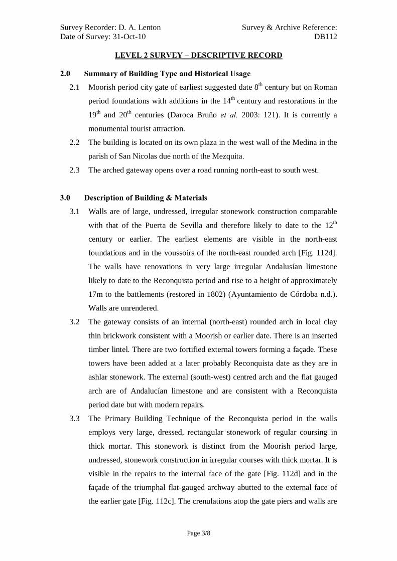
Survey Recorder: D. A. Lenton Survey & Archive Reference: Date of Survey: 31-Oct-10 DB112
LEVEL 2 SURVEY – DESCRIPTIVE RECORD
Page 3/8
2.0 Summary of Building Type and Historical Usage
2.1 Moorish period city gate of earliest suggested date 8th century but on Roman
period foundations with additions in the 14th century and restorations in the
19th and 20th centuries (Daroca Bruño et al. 2003: 121). It is currently a
monumental tourist attraction.
2.2 The building is located on its own plaza in the west wall of the Medina in the
parish of San Nicolas due north of the Mezquita.
2.3 The arched gateway opens over a road running north-east to south west.
3.0 Description of Building & Materials
3.1 Walls are of large, undressed, irregular stonework construction comparable
with that of the Puerta de Sevilla and therefore likely to date to the 12th
century or earlier. The earliest elements are visible in the north-east
foundations and in the voussoirs of the north-east rounded arch [Fig. 112d].
The walls have renovations in very large irregular Andalusían limestone
likely to date to the Reconquista period and rise to a height of approximately
17m to the battlements (restored in 1802) (Ayuntamiento de Córdoba n.d.).
Walls are unrendered.
3.2 The gateway consists of an internal (north-east) rounded arch in local clay
thin brickwork consistent with a Moorish or earlier date. There is an inserted
timber lintel. There are two fortified external towers forming a façade. These
towers have been added at a later probably Reconquista date as they are in
ashlar stonework. The external (south-west) centred arch and the flat gauged
arch are of Andalucían limestone and are consistent with a Reconquista
period date but with modern repairs.
3.3 The Primary Building Technique of the Reconquista period in the walls
employs very large, dressed, rectangular stonework of regular coursing in
thick mortar. This stonework is distinct from the Moorish period large,
undressed, stonework construction in irregular courses with thick mortar. It is
visible in the repairs to the internal face of the gate [Fig. 112d] and in the
façade of the triumphal flat-gauged archway abutted to the external face of
the earlier gate [Fig. 112c]. The crenulations atop the gate piers and walls are

Survey Recorder: D. A. Lenton Survey & Archive Reference: Date of Survey: 31-Oct-10 DB112
LEVEL 2 SURVEY – DESCRIPTIVE RECORD
Page 4/8
of the same Mudéjar pyramidal form as those of La Calahorra [DB108]. The
Reconquista period works therefore can be reasonably dated to the stylistic
and somewhat triumphal building programme of Enrique II from 1369.
4.0 Supplementary Information
4.1 In Calle Cairuán, close to the Castle of the Christian Monarchs, stands the
Almodóvar Gate. This is only surviving gateway into the city of the nine
gates built by Abd al-Rahman I, when it was known as Bad al-Yawz. In the
14th century it was rebuilt and became the entrance to the Jewish Quarter
(Léon Muños 2003: 232). The restoration work in 1802 preserved the
battlements and the walkway in their 14th century form (Ayuntamiento de
Córdoba n.d.; Daroca Bruño et al. 2003: 121).
4.2 A stretch of rampart to the south of the gate, the Murallas del Cairuán, has
been conserved running approximately 312 metres towards the Alcázar.
These ramparts, heavily reformed in the 14th century were restored in 1960
with the addition of the moat. At the same time the gate known as La Luna
was opened at the southern end (Daroca Bruño et al. 2003: 121).

Survey Recorder: D. A. Lenton Survey & Archive Reference: Date of Survey: 31-Oct-10 DB112
LEVEL 2 SURVEY – DESCRIPTIVE RECORD
Page 5/8
5.1 General External Views of the Building in its Setting
Fig. 112a: Aerial view of the building structure in its neighbourhood
North at top (Google Inc. n.d.)
Fig. 112b.: Aerial view of the building structure in close-up.
North at top (Google Inc. n.d.)

Survey Recorder: D. A. Lenton Survey & Archive Reference: Date of Survey: 31-Oct-10 DB112
LEVEL 2 SURVEY – DESCRIPTIVE RECORD
Page 6/8
Fig. 112c: South-west aspect
Fig. 112e: North-east aspect
Fig. 112d: North-east aspect
Fig. 112f: South-west aspect viewed
from the west

Survey Recorder: D. A. Lenton Survey & Archive Reference: Date of Survey: 31-Oct-10 DB112
LEVEL 2 SURVEY – DESCRIPTIVE RECORD
Page 7/8
6.0 Drawing Record
Addendum
Drawing No. 112.1
1 Page A4 Size

Survey Recorder: D. A. Lenton Survey & Archive Reference: Date of Survey: 31-Oct-10 DB112
LEVEL 2 SURVEY – DESCRIPTIVE RECORD
Page 8/8
7.0 Bibliography
Ayuntamiento de Córdoba n.d.: Córdoba: Oficinas De Información Turística. (ed. Ayuntamiento de Córdoba) Ayuntamiento de Córdoba, Córdoba. Daroca Bruño, F., Yllescas Ortiz, M. & De La Fuente Darder, F. (eds.) 2003: Córdoba: Guía De Arquitectura. Córdoba: Colegio Oficial de Arquitectura de Córdoba. Google Inc. n.d.: Google Earth 6 Web Catalogue http://www.google.co.uk/intl/en_uk/earth/index.html, Mountain View, CA. Léon Muños, A. 2003. La Córdoba Judía. In: J. Fernández (Ed.) Guía Archaeológica De Córdoba, p. 231-234. Córdoba: Plurabelle. Ministerio de Cultura n.d.: Bien De Interés Cultural: La Base De Datos De Bienes Inmuebles. http://www.mcu.es/bienes/cargarFiltroBienesInmuebles.do?layout=bienesInmuebles&cache=init&language=es.

10 metres
Survey Reference:DB112 Drawing No:112.1Building Short Name: Puerta de Almodóvar Address: Calle Ferndez Ruano, Córdoba, SpainScale: 1:200 Sheet Size: ISO A4
Ground Plan

Survey Recorder: D. A. Lenton Survey & Archive Reference: Date of Survey: 02-Nov-10 DB113
LEVEL 2 SURVEY – DESCRIPTIVE RECORD
Page 1/8
Contents
1.0 Identification of Building or Structure
2.0 Summary of Building Type and Historical Usage
3.0 Description of Building & Materials
4.0 Supplementary Information
5.0 Photographic Record
6.0 Drawing Record – Addendum Attached 1 Page
7.0 Bibliography

Survey Recorder: D. A. Lenton Survey & Archive Reference: Date of Survey: 02-Nov-10 DB113
LEVEL 2 SURVEY – DESCRIPTIVE RECORD
Page 2/8
1.0 Identification of Building or Structure
1.1
Building Short Name
Casa del Indiano
1.2
Variant Names
House of the Indian
1.3
Address
Plaza de Angel Torres, Córdoba, Spain
1.4
Location Co-ordinates
Northing 37.881° Easting -4.782°
1.5
Statutory & Non-statutory
Designations
Within the designated area of the Córdoba
UNESCO World Heritage Site No. 313
(1984/1994).
1.6 Survey Assessment &
Archaeological Value
Preservation is Low (1) as only the northern
façade of the complex survives.
Legibility is Medium (2) as the walls are
partially rendered.
Accessibility is High (3) as the structure is
publically accessible.
Stratigraphical Complexity is Low (1) as first
inspection indicated that the structure spanned
only the Imperial period.
Archaeological Value is Low (1-2).
1.7 Primary Building Technique Stone; very large; ashlar; rectangular, regular
coursing; thin mortar.

Survey Recorder: D. A. Lenton Survey & Archive Reference: Date of Survey: 02-Nov-10 DB113
LEVEL 2 SURVEY – DESCRIPTIVE RECORD
Page 3/8
2.0 Summary of Building Type and Historical Usage
2.1 Imperial period house of earliest known date late 15th century (Daroca Bruño
et al. 2003: 127). The façade survives 2 storeys above ground level. The rest
of the building is a modern construction. It is currently a private apartment
block.
2.2 The building is located on a plaza in the parish of Santa Maria due north of
the Mezquita.
2.3 The main (north) entrance is via timber double leaf door (Door A).
3.0 Description of Building & Materials
3.1 Foundations and walls of the façade are of Andalusían limestone and rise to a
height of 8.00 metres above ground level. Walls are mostly rendered but
some areas are exposed.
3.2 Door A is a double leaf timber door headed by a decorated stone lintel in a
Gothic Mudéjar stonework style with clamped voussoirs and interlaced arch
motifs of the late 15th century (Daroca Bruño et al. 2003: 127). The jambs are
decorated with interlaced diamond grid panels comparable with later
medieval sebka panels at the Alhambra in Granada and the Giralda at Seville.
3.3 There is one window on the ground floor with two highly decorative cross-
linked poly-lobed pointed arches in a Mudéjar style. There are two
balconetted windows on the first floor both with two rounded arches with
highly decorative Gothic tracery at the top and plant motifs in a Mudéjar
style dating to the late 15th century (Daroca Bruño et al. 2003: 127). Although
these windows were subject to restoration in the early 20th century (Vargas
González 2003: 225).
3.4 Roofs are of modern construction and tiled with 20th century ceramic roof
tiles.

Survey Recorder: D. A. Lenton Survey & Archive Reference: Date of Survey: 02-Nov-10 DB113
LEVEL 2 SURVEY – DESCRIPTIVE RECORD
Page 4/8
4.0 Supplementary Information
4.1 The once house of the Ceas family (Daroca Bruño et al. 2003: 127), it was
acquired in the eighteenth century by Don Juan Cosme after making his
fortune in America, hence the popular name of the Indian House. Only the
frontage remains of the medieval construction which opens on to the Plaza
Angel Torres. It contains a decorated lintel under balconies, all in the
Mudéjar style. The building was restored in the 20th century (Ayuntamiento
de Córdoba n.d.).

Survey Recorder: D. A. Lenton Survey & Archive Reference: Date of Survey: 02-Nov-10 DB113
LEVEL 2 SURVEY – DESCRIPTIVE RECORD
Page 5/8
5.0 Photographic Record
5.1 General External Views of the Building in its Setting
Fig. 113a: Aerial view of the building structure in its neighbourhood
North at top (Google Inc. n.d.)
Fig. 113b.: Aerial view of the building structure in close-up.
North at top (Google Inc. n.d.)

Survey Recorder: D. A. Lenton Survey & Archive Reference: Date of Survey: 02-Nov-10 DB113
LEVEL 2 SURVEY – DESCRIPTIVE RECORD
Page 6/8
Fig. 113c: North aspect
Fig. 113e: North aspect Window B
Fig. 113d: North aspect Window A
Fig. 113f: South aspect

Survey Recorder: D. A. Lenton Survey & Archive Reference: Date of Survey: 02-Nov-10 DB113
LEVEL 2 SURVEY – DESCRIPTIVE RECORD
Page 7/8
6.0 Drawing Record
Addendum
Drawing No. 113.1
1 Page A4 Size

Survey Recorder: D. A. Lenton Survey & Archive Reference: Date of Survey: 02-Nov-10 DB113
LEVEL 2 SURVEY – DESCRIPTIVE RECORD
Page 8/8
7.0 Bibliography
Ayuntamiento de Córdoba n.d.: Córdoba: Oficinas De Información Turística. (ed. Ayuntamiento de Córdoba) Ayuntamiento de Córdoba, Córdoba. Daroca Bruño, F., Yllescas Ortiz, M. & De La Fuente Darder, F. (eds.) 2003: Córdoba: Guía De Arquitectura. Córdoba: Colegio Oficial de Arquitectura de Córdoba. Google Inc. n.d.: Google Earth 6 Web Catalogue http://www.google.co.uk/intl/en_uk/earth/index.html, Mountain View, CA. Vargas González, A. 2003. La Córdoba Cristiana: La Arquitectura Civil. In: J. Fernández (ed.) Guía Archaeológica De Córdoba, p. 225-227. Cordoba: Plurabelle.

10 metres10 metresSurvey Reference: DB113 Drawing No: 113.1Building Short Name: Casa del IndianoAddress: Plaza de Angel Torres, Córdoba, SpainScale: 1:200 Sheet Size: ISO A4
Ground Floor Plan
North Elevation
Door A Window A
First Floor Plan
Window B Window C

Survey Recorder: D. A. Lenton Survey & Archive Reference: Date of Survey: 30-Oct-10 DB114
LEVEL 1 SURVEY – BASIC RECORD
Page 1/9
Contents
1.0 Identification of Building or Structure
2.0 Summary of Building Type and Historical Usage
3.0 Description of Building & Materials
4.0 Supplementary Information
5.0 Photographic Record
6.0 Drawing Record
7.0 Bibliography
Survey Recorder: D. A. Lenton Survey & Archive Reference: Date of Survey: 30-Oct-10 DB114
LEVEL 1 SURVEY – BASIC RECORD
Page 2/9
1.0 Identification of Building or Structure
1.1 Building Short Name Convento de Santa Clara
1.2 Variant Names Convent of Santa Clara
1.3 Address Calle Osio, Córdoba, Spain
1.4 Location Co-ordinates Northing 37.880°Easting -4.778°
1.5 Statutory & Non-statutory
Designations
Within the designated area of the Córdoba
UNESCO World Heritage Site No. 313
(1984/1994).
Bien de Interés Cultural (Nationally Listed as
a Building of Cultural Interest) (Ministerio de
Cultura n.d.)
1.6 Survey Assessment &
Archaeological Value
Preservation is Medium (2). It has many
surviving medieval walls to second storey
height, although the walls and floors have
suffered from considerable degradation.
Legibility is High (3) as its walls have no
coverings.
Accessibility is Low (1). the greater part of the
complex is unsafe to enter.
Stratigraphical Complexity is Medium (2).
First inspection indicated that the structure’s
phases spanned at least 2 periods.
Archaeological Value is Low (1-2).
1.7 Primary building Technique 1200: Stone; very large; dressed; well squared;
regular coursing; thin mortar.
1400: Stone; very large; dressed; rectangular;
regular coursing; thin mortar.

Survey Recorder: D. A. Lenton Survey & Archive Reference: Date of Survey: 30-Oct-10 DB114
LEVEL 1 SURVEY – BASIC RECORD
Page 3/9
2.0 Summary of Building Type and Historical Usage
2.1 Reconquista period convent retaining the minaret of a Moorish period
mosque of earliest known date 10th century (Fuertes Romero et al. 2003:
150). It is currently a museum and tourist attraction.
2.2 The building is located on the corner of two narrow streets running north-
west to south east and north-east to south-west in the parish of Santa Maria
north-east of the Mezquita.
2.3 The main (north-west) entrance is via timber double leaf door directly from
the street to an entrance courtyard. The building has three storeys above
ground.
3.0 Description of Building & Materials
3.1 Foundations and walls are of Andalusían limestone with repairs in local clay
brickwork. Perimeter brickwork walls are not rendered but exposed.
3.2 The building is rectangular and consists of at least 2 separate phases in
addition to a Moorish period minaret. The lower body of the minaret of a
mosque survives that can be reasonably dated from the tenth to twelfth
centuries because of its slenderness and near-square plan (Barrucand &
Bednorz 1992: 153). Primary Building Technique is visible in the base of the
minaret up to a height of approximately 4.0 metres. Foundations and walls
the minaret are of Andalucían limestone 4.5 metres by 5.1 metres on plan.
Its staircase is arranged around a central square pier and forms part of the
walls of the courtyard apparent in the north-west and south-east arcades, with
a series of three openings, and a door access from the street. It is
characterized by lintel voussoirs on blind horseshoe arches comparable with
10th century arches at Madinat al-Zahra (Barrucand & Bednorz 1992: 61-6).
The only light to enter the staircase of the minaret is constituted by a narrow
open slits on two fronts. It is accessed from the south-east through a gate of
just 1m wide (Fuertes Romero et al. 2003: 150).
3.3 The eastern element bonds into and contains the minaret and is arranged
around a central courtyard with rounded arch galleries in clay brickwork.
These arches are set up on stone columns in a classical or Visigothic style.

Survey Recorder: D. A. Lenton Survey & Archive Reference: Date of Survey: 30-Oct-10 DB114
LEVEL 1 SURVEY – BASIC RECORD
Page 4/9
This eastern element has no contemporary windows but there is a horseshoe-
arched door in the south-eastern façade (infilled). The south-eastern and
north-eastern façades are of very large, rectangular, limestone in regular
coursing and thin mortar. This Primary Building Technique is very similar to
that of the Moorish period although it is clearly bonded into the face of the
minaret [Fig. 114i] and is therefore likely to date from the Reconquista
period.
3.4 The north-eastern façade is in large squared stones in stretcher and header
bond. This façade houses the main (north-east) entrance door. It has a
limestone surround with pilasters and ashlar stone segmented arch decorated
in heraldic motifs in a Plateresque style and Mannerist proportions
characteristic of the 16th century. The north-eastern façade itself, therefore,
appears to date from the Imperial period although the main body of the
eastern element is probably of the Reconquista period reusing architectural
features of the Moorish and early medieval periods.
4.0 Supplementary Information
4.1 Excavations in the interior have documented its division into three naves
stopped by rows of five columns including the remains of the mihrab and the
arched panels of qibla wall (Fuertes Romero et al. 2003: 150)

Survey Recorder: D. A. Lenton Survey & Archive Reference: Date of Survey: 30-Oct-10 DB114
LEVEL 1 SURVEY – BASIC RECORD
Page 5/9
5.0 Photographic Record
5.1 General External Views of the Building in its Setting
Fig. 114a: Aerial view of the building structure in its neighbourhood
North at top (Google Inc. n.d.)
Fig. 114b.: Aerial view of the building structure in close-up.
North at top (Google Inc. n.d.)

Survey Recorder: D. A. Lenton Survey & Archive Reference: Date of Survey: 30-Oct-10 DB114
LEVEL 1 SURVEY – BASIC RECORD
Page 6/9
Fig. 114c: North-east aspect from north.
Fig. 114e: North-east aspect
Fig. 114g: South-west aspect viewed
from the west
Fig. 114d: South-west aspect south-west
Fig. 114f: North-west aspect from north
Fig 114h: Minaret from the west

Survey Recorder: D. A. Lenton Survey & Archive Reference: Date of Survey: 30-Oct-10 DB114
LEVEL 1 SURVEY – BASIC RECORD
Page 7/9
Fig. 114i South-east aspect viewed from
the north

Survey Recorder: D. A. Lenton Survey & Archive Reference: Date of Survey: 30-Oct-10 DB114
LEVEL 1 SURVEY – BASIC RECORD
Page 8/9
6.0 Drawing Record
No site drawings made

Survey Recorder: D. A. Lenton Survey & Archive Reference: Date of Survey: 30-Oct-10 DB114
LEVEL 1 SURVEY – BASIC RECORD
Page 9/9
7.0 Bibliography
Barrucand, M. & Bednorz, A. 1992: Moorish Architecture in Andalusia. Cologne: Benedikt Taschen Verlag. Fuertes Romero, R.-M., López Guerrero, R., Rodríguez Sánchez, M. & Valdivieso Ramos, A. 2003. La Qurtuba Islámica: Las Mezquitas. In: J. Fernández (ed.) Guía Archaeológica De Córdoba, p. 148-150. Córdoba: Plurabelle. Google Inc. n.d.: Google Earth 6 Web Catalogue http://www.google.co.uk/intl/en_uk/earth/index.html, Mountain View, CA. Ministerio de Cultura n.d.: Bien De Interés Cultural: La Base De Datos De Bienes Inmuebles. http://www.mcu.es/bienes/cargarFiltroBienesInmuebles.do?layout=bienesInmuebles&cache=init&language=es.

Survey Recorder: D. A. Lenton Survey & Archive Reference: Date of Survey: 02-Nov-10 DB115
LEVEL 1 SURVEY – BASIC RECORD
Page 1/8
Contents
1.0 Identification of Building or Structure
2.0 Summary of Building Type and Historical Usage
3.0 Description of Building & Materials
4.0 Supplementary Information
5.0 Photographic Record
6.0 Drawing Record
7.0 Bibliography

Survey Recorder: D. A. Lenton Survey & Archive Reference: Date of Survey: 02-Nov-10 DB115
LEVEL 1 SURVEY – BASIC RECORD
Page 2/8
1.0 Identification of Building or Structure
1.1
Building Short Name
Convento de Santa Marta
1.2 Variant Names Convent of Santa Marta, Casa del Agua,
Houses of the Water
1.3 Address Calle Santa Marta- Calle de Conde Arenales,
Córdoba, Spain
1.4 Location Co-ordinates Northing 37.887°Easting -4.775°
1.5 Statutory & Non-statutory
Designations
Within the designated area of the Córdoba
UNESCO World Heritage Site No. 313
(1984/1994).
Bien de Interés Cultural (Nationally Listed as
a Building of Cultural Interest) (Ministerio de
Cultura n.d.).
1.6 Survey Assessment &
Archaeological Value
Preservation has been graded as Medium (2)
as it has many surviving medieval walls to
second storey height.
Legibility has been graded as Low (1) as its
walls are largely rendered.
Accessibility has been graded as Low (1) as
the greater part of the complex is in use by the
convent’s order.
Stratigraphical Complexity has been graded as
Low (1) as first inspection indicated that the
structure’s phases spanned only the Imperial
period.
Archaeological Value has therefore been
graded as Low (1-2).
1.7 Primary Building Technique Stone; very large, dressed, rectangular, regular
coursing, thick mortar.

Survey Recorder: D. A. Lenton Survey & Archive Reference: Date of Survey: 02-Nov-10 DB115
LEVEL 1 SURVEY – BASIC RECORD
Page 3/8
2.0 Summary of Building Type and Historical Usage
2.1 Reconquista period palatial residence of earliest known date early 15th
century (Daroca Bruño et al. 2003: 172). It is currently a convent.
2.2 The building is located on a plaza bearing its name in the parish of San
Andrés north-east of the Mezquita.
2.3 The main (north-west) entrance is via timber double leaf door directly from
the street to an entrance courtyard or patio.
3.0 Description of Building & Materials
3.1 Foundations and walls are of Andalusían limestone with repairs in local clay
brickwork. Perimeter walls are rendered but partially exposed.
3.2 The main entrance is in local clay brickwork with a stone lintel over leading
to an entrance courtyard through a Baroque loggia consisting of four arches
(Daroca Bruño et al. 2003: 172).
3.3 An early 16th-century portico shelters a doorway by Hernán Ruiz I in Gothic
and Renaissance styles.
3.4 The late 15th-16th century church has a single rectangular nave covered by
groined vaults and a main chapel in a star-shaped plan with Toledan
influence. Both high and low choirs have original Mudéjar coffered ceilings
(Daroca Bruño et al. 2003: 172).
3.5 The Primary Building Technique was very large, dressed, rectangular
limestonework in regular coursing in thick mortar visible in exposed areas of
the perimeter walls. The complex contains a small single-nave church with
late Gothic groined vaults and a portico in Isabeline style that date the church
to the late 15th- early 16th centuries. Two of the courtyards have galleries
with low pointed arches decorated in Mudéjar plastersque of the earlier 15th-
century. These courtyards are considerably larger than those of the 12th-
century Casa Andalusí [DB101] (exceeding 150 square metres) and are
encircled by large rooms and second-storey galleries.
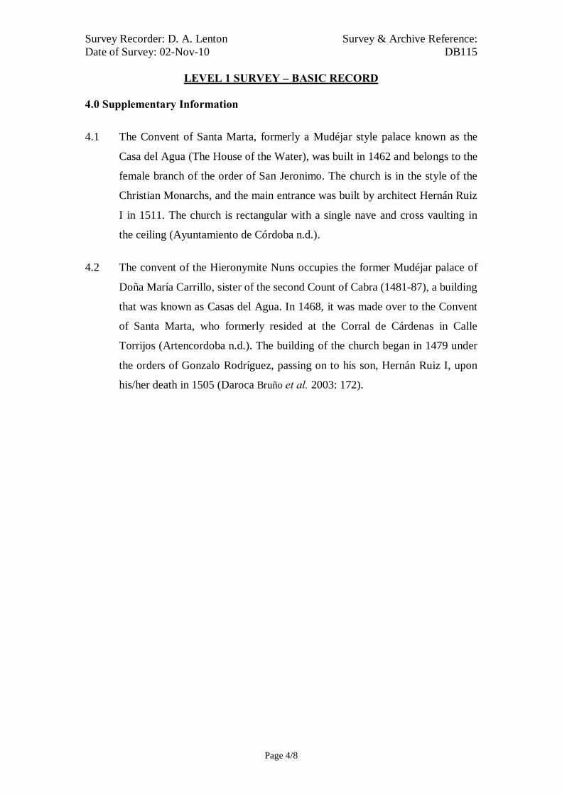
Survey Recorder: D. A. Lenton Survey & Archive Reference: Date of Survey: 02-Nov-10 DB115
LEVEL 1 SURVEY – BASIC RECORD
Page 4/8
4.0 Supplementary Information
4.1 The Convent of Santa Marta, formerly a Mudéjar style palace known as the
Casa del Agua (The House of the Water), was built in 1462 and belongs to the
female branch of the order of San Jeronimo. The church is in the style of the
Christian Monarchs, and the main entrance was built by architect Hernán Ruiz
I in 1511. The church is rectangular with a single nave and cross vaulting in
the ceiling (Ayuntamiento de Córdoba n.d.).
4.2 The convent of the Hieronymite Nuns occupies the former Mudéjar palace of
Doña María Carrillo, sister of the second Count of Cabra (1481-87), a building
that was known as Casas del Agua. In 1468, it was made over to the Convent
of Santa Marta, who formerly resided at the Corral de Cárdenas in Calle
Torrijos (Artencordoba n.d.). The building of the church began in 1479 under
the orders of Gonzalo Rodríguez, passing on to his son, Hernán Ruiz I, upon
his/her death in 1505 (Daroca Bruño et al. 2003: 172).
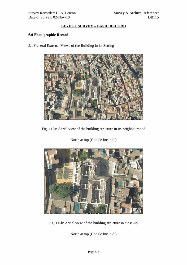
Survey Recorder: D. A. Lenton Survey & Archive Reference: Date of Survey: 02-Nov-10 DB115
LEVEL 1 SURVEY – BASIC RECORD
Page 5/8
5.0 Photographic Record
5.1 General External Views of the Building in its Setting
Fig. 115a: Aerial view of the building structure in its neighbourhood
North at top (Google Inc. n.d.)
Fig. 115b: Aerial view of the building structure in close-up.
North at top (Google Inc. n.d.)

Survey Recorder: D. A. Lenton Survey & Archive Reference: Date of Survey: 02-Nov-10 DB115
LEVEL 1 SURVEY – BASIC RECORD
Page 6/8
Fig. 115c: East aspect viewed from the
south.
Fig. 115e: East doorway viewed from
the south.
Fig. 115d: East aspect viewed from the
north
Fig. 115f: East doorway

Survey Recorder: D. A. Lenton Survey & Archive Reference: Date of Survey: 02-Nov-10 DB115
LEVEL 1 SURVEY – BASIC RECORD
Page 7/8
6.0 Drawing Record
No site drawings made

Survey Recorder: D. A. Lenton Survey & Archive Reference: Date of Survey: 02-Nov-10 DB115
LEVEL 1 SURVEY – BASIC RECORD
Page 8/8
7.0 Bibliography
Artencordoba n.d.: Otros Monumentos. Vol. 2011 http://translate.googleusercontent.com/translate_c?hl=en&prev=/search%3Fq%3DCorral%2Bde%2BC%25C3%25A1rdenas%2Bcordoba%26hl%3Den%26client%3Dfirefox-a%26hs%3DGmG%26rlz%3D1R1GGGL_en-GB___GB364%26prmd%3Divnsob&rurl=translate.google.co.uk&sl=es&u=http://www.artencordoba.com/OTROS-MONUMENTOS/Otros-Monumentos-Cordoba-Hospital-San-Sebastian.html&usg=ALkJrhivyBtzFRnNNLYbydn1rOcKp67MoQ. Accessed 6th June 2011, Cordoba. Ayuntamiento de Córdoba n.d.: Córdoba: Oficinas De Información Turística. (ed. Ayuntamiento de Córdoba) Ayuntamiento de Córdoba, Córdoba. Daroca Bruño, F., Yllescas Ortiz, M. & De La Fuente Darder, F. (eds.) 2003: Córdoba: Guía De Arquitectura. Córdoba: Colegio Oficial de Arquitectura de Córdoba. Google Inc. n.d.: Google Earth 6 Web Catalogue http://www.google.co.uk/intl/en_uk/earth/index.html, Mountain View, CA. Ministerio de Cultura n.d.: Bien De Interés Cultural: La Base De Datos De Bienes Inmuebles. http://www.mcu.es/bienes/cargarFiltroBienesInmuebles.do?layout=bienesInmuebles&cache=init&language=es.

Survey Recorder: D. A. Lenton Survey & Archive Reference: Date of Survey: 30-Oct-10 DB117
LEVEL 3 SURVEY – ANALYTIC RECORD
Page 1/9
Contents
1.0 Identification of Building or Structure
2.0 Summary of Building Type and Historical Usage
3.0 Description of Building & Materials
4.0 Supplementary Information
5.0 Photographic Record
6.0 Drawing Record – Addendum Attached 1 Page
7.0 Bibliography

Survey Recorder: D. A. Lenton Survey & Archive Reference: Date of Survey: 30-Oct-10 DB117
LEVEL 3 SURVEY – ANALYTIC RECORD
Page 2/9
1.0 Identification of Building or Structure
1.1 Building Short Name Molino del Martos
1.2 Variant Names The Martyrs’ Mill
1.3 Address Ronda de los Martires, Córdoba, Spain
1.4 Location Co-ordinates Northing 37.880°
Easting -4.769°
1.5 Statutory & Non-statutory
Designations
Within the designated area of the Córdoba
UNESCO World Heritage Site No. 313
(1984/1994).
Bien de Interés Cultural (Nationally Listed as
a Building of Cultural Interest) (Ministerio de
Cultura n.d.).
1.6 Survey Assessment &
Archaeological Value
Preservation is High (3). It has many surviving
medieval walls to roof height, although the
building has been subject to modern repair.
Legibility is High (3). Its walls have no
coverings.
Accessibility is High (3). The building is
publically accessible.
Stratigraphical Complexity is Medium (2).
First inspection indicated that the structure’s
phases spanned at least 2 periods.
Archaeological Value is High (2.5-3).
1.7 Primary Building Technique Moorish: Stone; very large; dressed;
rectangular; regular coursing; thick mortar.
Reconquista: Stone; very large; dressed;
rectangular; regular coursing; thick mortar.

Survey Recorder: D. A. Lenton Survey & Archive Reference: Date of Survey: 30-Oct-10 DB117
LEVEL 3 SURVEY – ANALYTIC RECORD
Page 3/9
2.0 Summary of Building Type and Historical Usage
2.1 Moorish period watermill of earliest proposed date 12th century. It is
currently a museum and tourist attraction.
2.2 The building is located on the river front in the parish of Santiago due east of
the Mezquita.
2.3 The east entrance (Door A) is via a timber double leaf door in a stonework
rounded archway. The west entrance (Door B) is via a double leaf timber
door with a stonework lintel doorway. The mill building has 1 storey above
ground plus a modern exhibition hall above it on the first floor.
3.0 Statement of Materials and Dates
3.1 Foundations and external walls are of Andalucían stonework construction.
3.2 The building is entered from the waterfront via the modern exhibition hall
and down a flight of limestone steps at the northern end of the building to the
Milling Hall or Stone room (Room A).
3.3 The Primary Building Technique employed was very large, dressed, well
squared stonework construction in regular courses with thick mortar. The
Primary Building Technique is in limestone, and is the recurrent technical
grammar of the Moorish period civil and industrial buildings. It is visible in
the base of the foundations and walls [Fig.117e]. The earliest elements are
visible in the foundations of the building and the external walls up to
approximately 1 metre, where there is a horizontal break line. There is a
rounded arch doorway (Door D), truncated by a later wall and doorway,
infilled with large stonework blocks, which characteristically dates from the
Moorish period [Drawing 117.1].
3.4 The walls of Room A are of Andalucían limestone construction up to a
height of 1.62m. A barrel roof of local brickwork construction sits on the
walls and rises to an apex of 4.55m. The barrel roof is of a size and form
developed in the Renaissance period in Europe and is likely to date from the
15th or 16th century. The floors are also of limestone and are partly covered
with modern stone slabs. There is a modern waterwheel on the east wall in

Survey Recorder: D. A. Lenton Survey & Archive Reference: Date of Survey: 30-Oct-10 DB117
LEVEL 3 SURVEY – ANALYTIC RECORD
Page 4/9
the setting of an earlier, possibly Reconquista period wheel. Along the west
wall there are a series of brickwork settings for 8 grindstones now lost.
3.5 There are further rooms to the south of Room A of a similar construction.
Rooms B and D hold limestone settings for grindstones.
4.0 Supplementary Information
4.1 This mill dates from the 12th century when it formed part of a dam. In 1237
King Alfonso X granted it to the Order of the Knights of Calatrava, in whose
hands it remained until the 19th century. Around 1550, the old mill building
was replaced with a building that could accommodate a larger number of
millstones and a sluice gate. It contained three fuller's mills, a grinding
chamber and a jetty. It was the main grinding mill for cereals in the city.
Nowadays, it houses the River Information Centre (Ayuntamiento de Córdoba
n.d.; Daroca Bruño et al. 2003: 108).
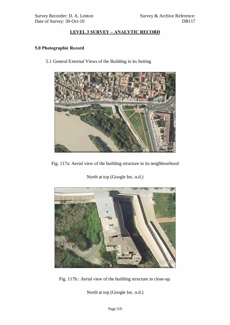
Survey Recorder: D. A. Lenton Survey & Archive Reference: Date of Survey: 30-Oct-10 DB117
LEVEL 3 SURVEY – ANALYTIC RECORD
Page 5/9
5.0 Photographic Record
5.1 General External Views of the Building in its Setting
Fig. 117a: Aerial view of the building structure in its neighbourhood
North at top (Google Inc. n.d.)
Fig. 117b.: Aerial view of the building structure in close-up.
North at top (Google Inc. n.d.)

Survey Recorder: D. A. Lenton Survey & Archive Reference: Date of Survey: 30-Oct-10 DB117
LEVEL 3 SURVEY – ANALYTIC RECORD
Page 6/9
Fig. 117c: East aspect viewed from the
north.
Fig. 117e: East entrance door with
Door C (right) and infilled Door D
(left)
Fig. 117d: East aspect viewed from the
south.
Fig. 117f: East aspect

Survey Recorder: D. A. Lenton Survey & Archive Reference: Date of Survey: 30-Oct-10 DB117
LEVEL 3 SURVEY – ANALYTIC RECORD
Page 7/9
5.2 Interior, Principal Rooms and Circulation Areas
Fig. 117g: Room A Looking South Fig. 117h: Room A Looking North
Fig. 117i: Door C from the North Fig. 117j: Room B Looking West
Fig. 117k: Room C Looking East Fig. 117l: Room D Looking North

Survey Recorder: D. A. Lenton Survey & Archive Reference: Date of Survey: 30-Oct-10 DB117
LEVEL 3 SURVEY – ANALYTIC RECORD
Page 8/9
6.0 Drawing Record
Addendum
Drawing No. 117.1
1 Page A4 Size

Survey Recorder: D. A. Lenton Survey & Archive Reference: Date of Survey: 30-Oct-10 DB117
LEVEL 3 SURVEY – ANALYTIC RECORD
Page 9/9
7.0 Bibliography
Ayuntamiento de Córdoba n.d.: Córdoba: Oficinas De Información Turística. (ed. Ayuntamiento de Córdoba) Ayuntamiento de Córdoba, Córdoba. Daroca Bruño, F., Yllescas Ortiz, M. & De La Fuente Darder, F. (eds.) 2003: Córdoba: Guía De Arquitectura. Córdoba: Colegio Oficial de Arquitectura de Córdoba. Google Inc. n.d.: Google Earth 6 Web Catalogue http://www.google.co.uk/intl/en_uk/earth/index.html, Mountain View, CA. Ministerio de Cultura n.d.: Bien De Interés Cultural: La Base De Datos De Bienes Inmuebles. http://www.mcu.es/bienes/cargarFiltroBienesInmuebles.do?layout=bienesInmuebles&cache=init&language=es.

10 metres10 metresSurvey Reference: DB117 Drawing No:117.1Building Short Name: Molino del Martos Address: Ronda de los Martires, Córdoba, SpainScale: 1:200 Sheet Size: ISO A4
Ground Floor Plan
Door A
Door B
Door CRoom A
Room B
Room CRoom D
River Wall
Wheel
Grinding Stones
Gate Post
Door D

Survey Recorder: D. A. Lenton Survey & Archive Reference: Date of Survey: 30-Oct-10 DB118
LEVEL 2 SURVEY – DESCRIPTIVE RECORD
Page 1/8
Contents
1.0 Identification of Building or Structure
2.0 Summary of Building Type and Historical Usage
3.0 Description of Building & Materials
4.0 Supplementary Information
5.0 Photographic Record
6.0 Drawing Record – Addenda Attached 2 Pages
7.0 Bibliography

Survey Recorder: D. A. Lenton Survey & Archive Reference: Date of Survey: 30-Oct-10 DB118
LEVEL 2 SURVEY – DESCRIPTIVE RECORD
Page 2/8
1.0 Identification of Building or Structure
1.1
Building Short Name
Torre de la Malmuerta
1.2
Variant Names
The Tower of She Who Died Badly
1.3
Address
Avenida de las Ollerías,
Córdoba, Spain
1.4
Location Co-ordinates
Northing 37.891°Easting -4.777°
1.5
Statutory & Non-statutory
Designations
Within the designated area of the Córdoba
UNESCO World Heritage Site No. 313
(1984/1994).
Bien de Interés Cultural (Nationally Listed as
a Building of Cultural Interest) (Ministerio de
Cultura n.d.).
1.6 Survey Assessment &
Archaeological Value
Preservation is Medium (2). Its Medieval
period elements have been well conserved but
it has been subject to some modern
reconstruction.
Legibility is High (3). Its walls have no
coverings. the structure is publically accessible
Accessibility is High (3). the structure is
publically accessible.
Stratigraphical Complexity is Low (1).
Archaeological Value is Medium (2-2.5).
1.7 Primary Building Technique Stone; very large; dressed; rectangular; regular
coursing; thick mortar.

Survey Recorder: D. A. Lenton Survey & Archive Reference: Date of Survey: 30-Oct-10 DB118
LEVEL 2 SURVEY – DESCRIPTIVE RECORD
Page 3/8
2.0 Summary of Building Type and Historical Usage
2.1 Imperial period bastion to the city walls on the site of Moorish period wall
foundations of an earliest proposed date 12th century (Daroca Bruño et al.
2003: 189). It is currently a monumental ruin and tourist attraction.
2.2 The building is located on a plaza next to a major thoroughfare in the parish
of Santa Marina north-east of the Mezquita and would have formed part of
the northern wall of the Axerquía.
2.3 The sole (east) entrance is via a timber single leaf door directly on the First
Floor at the top of a flight of stone steps. The building has two storeys above
ground plus a roof area.
3.0 Statement of Materials and Dates
3.1 Foundations and external walls are of Andalucían limestone construction.
External walls are visible to roof height and are not rendered.
3.2 The structure comprises an octagonal tower to the north to a height of
21.10m joined to a section of the city wall running 13.66m north to south to a
height of 11.46m. There is an archway through the wall to a height of 7.70m.
This opening is headed by a rounded arch in stonework. There are mountings
for a gate (absent) on either side of the inside of this archway.
3.3 The building is entered from the via a single leaf timber front door on the
First Floor level at the top of a stone staircase. The doorway is headed with a
rounded stonework arch.
3.4 The foundations have been subject to continuous repair but may date from
the Moorish period. The stonework walls appear to be consistent with 15th
century dates.

Survey Recorder: D. A. Lenton Survey & Archive Reference: Date of Survey: 30-Oct-10 DB118
LEVEL 2 SURVEY – DESCRIPTIVE RECORD
Page 4/8
4.0 Supplementary Information
4.1 Near the Plaza de Colón, the tower called la Malmuerta (literally 'she who has
died badly') is wrapped in myth and legend. According to popular tales, the
tower was so named after the death of a noble Córdoban lady at the hands of
her deranged, jealous husband (Ayuntamiento de Córdoba n.d.).
4.2 This tower was built in the 15th century on top of a previous Islamic building.
It is joined to the city walls by a rounded arch, under which there is an
inscription giving details of its construction. On the inside, various staircases
lead to the walkway and, above that, to the only room in the building, which
has a vaulted ceiling and window slits to let the air in (Ayuntamiento de
Córdoba n.d.).

Survey Recorder: D. A. Lenton Survey & Archive Reference: Date of Survey: 30-Oct-10 DB118
LEVEL 2 SURVEY – DESCRIPTIVE RECORD
Page 5/8
5.0 Photographic Record
5.1 General External Views of the Building in its Setting
Fig. 118a: Aerial view of the building structure in its neighbourhood
North at top (Google Inc. n.d.)
Fig. 118b.: Aerial view of the building structure in close-up.
North at top (Google Inc. n.d.)

Survey Recorder: D. A. Lenton Survey & Archive Reference: Date of Survey: 30-Oct-10 DB118
LEVEL 2 SURVEY – DESCRIPTIVE RECORD
Page 6/8
Fig. 118c: West aspect viewed from
the south.
Fig. 118e: South aspect viewed from
the south-west
Fig. 118d: East aspect viewed from the
south-east
Fig. 118f: East aspect

Survey Recorder: D. A. Lenton Survey & Archive Reference: Date of Survey: 30-Oct-10 DB118
LEVEL 2 SURVEY – DESCRIPTIVE RECORD
Page 7/8
6.0 Drawing Record
Addendum
Drawing Nos. 118.1, 118.2
2 Pages A4 Size

Survey Recorder: D. A. Lenton Survey & Archive Reference: Date of Survey: 30-Oct-10 DB118
LEVEL 2 SURVEY – DESCRIPTIVE RECORD
Page 8/8
7.0 Bibliography
Ayuntamiento de Córdoba n.d.: Córdoba: Oficinas De Información Turística. (ed. Ayuntamiento de Córdoba) Ayuntamiento de Córdoba, Córdoba. Daroca Bruño, F., Yllescas Ortiz, M. & De La Fuente Darder, F. (eds.) 2003: Córdoba: Guía De Arquitectura. Córdoba: Colegio Oficial de Arquitectura de Córdoba. Google Inc. n.d.: Google Earth 6 Web Catalogue http://www.google.co.uk/intl/en_uk/earth/index.html, Mountain View, CA. Ministerio de Cultura n.d.: Bien De Interés Cultural: La Base De Datos De Bienes Inmuebles. http://www.mcu.es/bienes/cargarFiltroBienesInmuebles.do?layout=bienesInmuebles&cache=init&language=es.

10 metres10 metresSurvey Reference:DB118 Drawing No:118.1Building Short Name: MalmuertaAddress: Avenida de las Ollerías, Córdoba, SpainScale: 1:200 Sheet Size: ISO A4
Ground Floor Plan

10 metres10 metresSurvey Reference: DB118 Drawing No:118.1Building Short Name: MalmuertaAddress: Avenida de las Ollerías, Córdoba, SpainScale: 1:200 Sheet Size: ISO A4
East Elevation
Survey Recorder: D. A. Lenton Survey & Archive Reference: Date of Survey: 26-Oct-10 DB119
LEVEL 1 SURVEY – BASIC RECORD
Page 1/8
Contents
1.0 Identification of Building or Structure
2.0 Summary of Building Type and Historical Usage
3.0 Description of Building & Materials
4.0 Supplementary Information
5.0 Photographic Record
6.0 Drawing Record – Addendum Attached 1 Page
7.0 Bibliography

Survey Recorder: D. A. Lenton Survey & Archive Reference: Date of Survey: 26-Oct-10 DB119
LEVEL 1 SURVEY – BASIC RECORD
Page 2/8
1.0 Identification of Building or Structure
1.1 Building Short Name Casa Santiago
1.2 Variant Names Casa de los Caballeros de Santiago
Encomienda de los Caballeros de Santiago
House of the Knights of St. James
1.3 Address Calle Agustín Moreno, Córdoba, Spain
1.4 Location Co-ordinates Northing 37.882° Easting -4.769°
1.5 Statutory and non-statutory
designations
Within the designated area of the Córdoba
UNESCO World Heritage Site No. 313
(1984/1994).
Bien de Interés Cultural (Nationally Listed as
a Building of Cultural Interest) (Ministerio de
Cultura n.d.).
1.6 Survey Assessment &
Archaeological Value
Preservation is Medium (2). It has many
surviving medieval walls, although the
building has been subject to modern repair and
addition.
Legibility is Low (1). The walls of the
building have been rendered.
Accessibility is Low (2). Large parts of the
building are obscured by modern usage.
Stratigraphical Complexity is Medium (2).
First inspection indicated that the structure’s
phases spanned at least 2 periods –
Reconquista and Imperial.
Archaeological Value is Low (1-2).
1.7 Primary Building Technique 1400AD: Fired brick; large; hand-moulded;
rectangular; regular coursing; thick mortar.
1600AD: Fired brick; large; hand-moulded;
rectangular; regular coursing; thin mortar.

Survey Recorder: D. A. Lenton Survey & Archive Reference: Date of Survey: 26-Oct-10 DB119
LEVEL 1 SURVEY – BASIC RECORD
Page 3/8
2.0 Summary of Building Type and Historical Usage
2.1 Reconquista period domestic dwelling of earliest known date late 13th
century with additions in later centuries built on the foundations of a Moorish
period house (Daroca Bruño et al. 2003: 158). It is currently a private school.
2.2 The building is located on a plaza, the Plaza de los Condes de Valdegranas,
on a main thoroughfare in the parish of Santiago north-east of the Mezquita.
2.3 The (north) entrances (Doors A&B) are via two stonework portals from the
plaza.
3.0 Description of Building & Materials
3.1 Walls are of clay brickwork. Walls are mainly rendered but some columns
are exposed. This Primary Building Technique is visible in the arcading of
the Courtyard B.
3.2 The north entrances (Doors A&B) have brickwork surrounds with pilasters
and ashlar stone segmented arches decorated in heraldic motifs in a
Plateresque style characteristic of the 16th century. They both carry heraldic
motifs/ coats of arms of the Valdegranas family, who occupied the house
during the Imperial period. The north-western façade itself, therefore,
appears to date from the Imperial period.
3.3 Two courtyards are partially preserved, west (Courtyard A) and east
(Courtyard B) with a former Chapter House between. Courtyard B has
arcading with one round arch very stilted in the centre and two lobed or
foiled arches either side in a Reconquista period Mudéjar style. The chapter
house has a round arch entrance with the coat of arms of the Order of the
Knights of Santiago above it.
3.4 Roofs are tiled with 20th century ceramic roof tiles.

Survey Recorder: D. A. Lenton Survey & Archive Reference: Date of Survey: 26-Oct-10 DB119
LEVEL 1 SURVEY – BASIC RECORD
Page 4/8
4.0 Supplementary Information
4.1 In 1254, Alfonso X the Wise awarded a number of small farms to the
Knights of Santiago and an accommodation block next to a mosque, now the
Church of Santiago. In 1260 the Order of Santiago transformed the mosque
into a Christian church of Gothic-Mudéjar. In 1360, the Knights of the Order
of Santiago began to rebuild the complex in Mudéjar style. It is not known
when it passed into civilian hands but it became owned by the Counts of
Valdelagrana. In 1960 it became a school, after the great work of restoration
of Don Victor Escribano Ucelay (Instituto Andaluz del Patrimonio Histórico
n.d.).

Survey Recorder: D. A. Lenton Survey & Archive Reference: Date of Survey: 26-Oct-10 DB119
LEVEL 1 SURVEY – BASIC RECORD
Page 5/8
5.0 Photographic Record
5.1 General External Views of the Building in its Setting
Fig. 119a: Aerial view of the building structure in its neighbourhood
North at top (Google Inc. n.d.)
Fig. 119b.: Aerial view of the building structure in close-up.
North at top (Google Inc. n.d.)

Survey Recorder: D. A. Lenton Survey & Archive Reference: Date of Survey: 26-Oct-10 DB119
LEVEL 1 SURVEY – BASIC RECORD
Page 6/8
Fig. 119c: North aspect.
Fig. 119d: Courtyard.

Survey Recorder: D. A. Lenton Survey & Archive Reference: Date of Survey: 26-Oct-10 DB119
LEVEL 1 SURVEY – BASIC RECORD
Page 7/8
6.0 Drawing Record
Addendum
Drawing No. 119.1
1 Page A4 Size

Survey Recorder: D. A. Lenton Survey & Archive Reference: Date of Survey: 26-Oct-10 DB119
LEVEL 1 SURVEY – BASIC RECORD
Page 8/8
7.0 Bibliography
Daroca Bruño, F., Yllescas Ortiz, M. & De La Fuente Darder, F. (eds.) 2003: Córdoba: Guía De Arquitectura. Córdoba: Colegio Oficial de Arquitectura de Córdoba. Google Inc. n.d.: Google Earth 6 Web Catalogue http://www.google.co.uk/intl/en_uk/earth/index.html, Mountain View, CA. Instituto Andaluz del Patrimonio Histórico n.d.: Base Del Datos Del Patrimonio Inmueble De Andalucia. http://www.iaph.es/patrimonio-inmueble-andalucia/resumen.do?id=i927&ids=140210008 Ministerio de Cultura n.d.: Bien De Interés Cultural: La Base De Datos De Bienes Inmuebles. http://www.mcu.es/bienes/cargarFiltroBienesInmuebles.do?layout=bienesInmuebles&cache=init&language=es.

20 metres (approx.)
Survey Reference: DB119 Drawing No: 119.1Building Short Name: Casa SantiagoAddress: Calle Agustín Moreno, Córdoba, SpainScale: <NTS> Sheet Size: ISO A4
Ground Floor Plan
CourtyardA Courtyard
B
ChapterHouse
Door A Door B

Survey Recorder: D. A. Lenton Survey & Archive Reference: Date of Survey: 30-Oct-10 DB120
LEVEL 3 SURVEY – ANALYTIC RECORD
Page 1/8
Contents
1.0 Identification of Building or Structure
2.0 Summary of Building Type and Historical Usage
3.0 Description of Building & Materials
4.0 Supplementary Information
5.0 Photographic Record
6.0 Drawing Record – Addendum Attached 1 Page
7.0 Bibliography
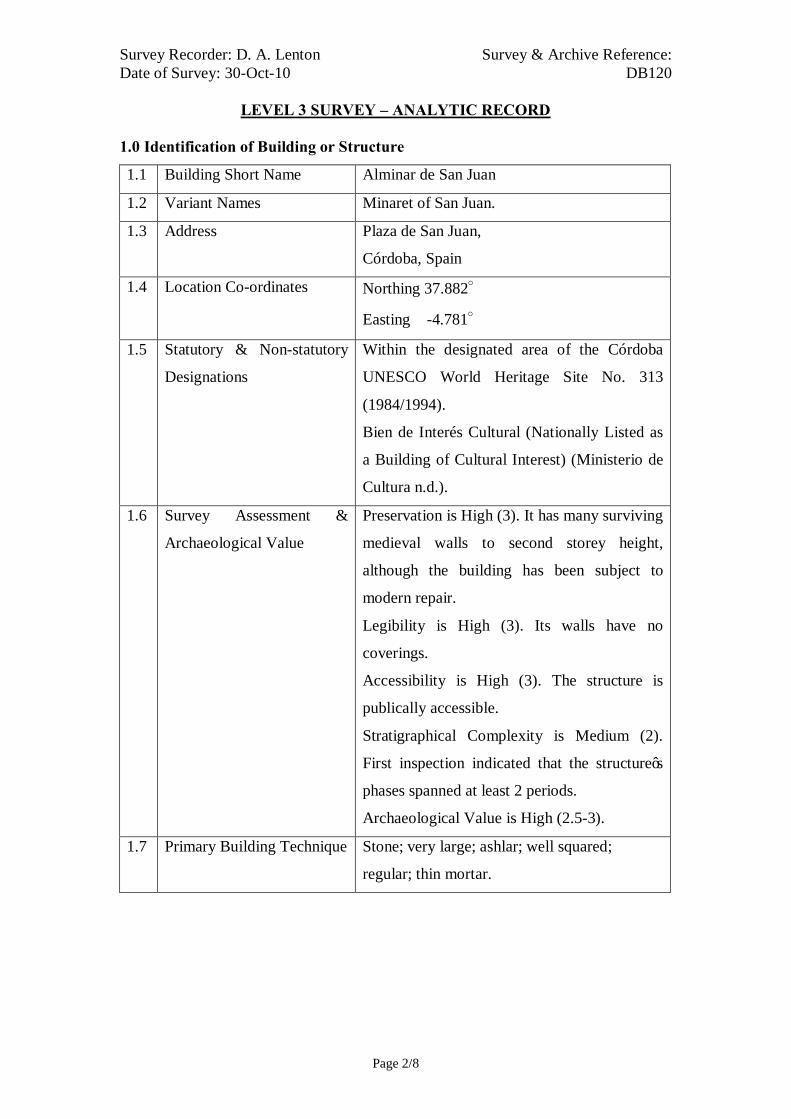
Survey Recorder: D. A. Lenton Survey & Archive Reference: Date of Survey: 30-Oct-10 DB120
LEVEL 3 SURVEY – ANALYTIC RECORD
Page 2/8
1.0 Identification of Building or Structure
1.1 Building Short Name Alminar de San Juan
1.2 Variant Names Minaret of San Juan.
1.3 Address Plaza de San Juan,
Córdoba, Spain
1.4 Location Co-ordinates Northing 37.882°
Easting -4.781°
1.5 Statutory & Non-statutory
Designations
Within the designated area of the Córdoba
UNESCO World Heritage Site No. 313
(1984/1994).
Bien de Interés Cultural (Nationally Listed as
a Building of Cultural Interest) (Ministerio de
Cultura n.d.).
1.6 Survey Assessment &
Archaeological Value
Preservation is High (3). It has many surviving
medieval walls to second storey height,
although the building has been subject to
modern repair.
Legibility is High (3). Its walls have no
coverings.
Accessibility is High (3). The structure is
publically accessible.
Stratigraphical Complexity is Medium (2).
First inspection indicated that the structure’s
phases spanned at least 2 periods.
Archaeological Value is High (2.5-3).
1.7 Primary Building Technique Stone; very large; ashlar; well squared;
regular; thin mortar.

Survey Recorder: D. A. Lenton Survey & Archive Reference: Date of Survey: 30-Oct-10 DB120
LEVEL 3 SURVEY – ANALYTIC RECORD
Page 3/8
2.0 Summary of Building Type and Historical Usage
2.1 Caliphal period minaret to a now absent mosque of earliest proposed date
10th century (Daroca Bruño et al. 2003: 129; Fuertes Romero et al. 2003:
149). It is currently a church tower.
2.2 The building is located on a plaza in the parish of San Juan north-west of the
Mezquita.
2.3 The sole (south-east) entrance is via a timber single leaf door directly from
the street. The building has two storeys above ground.
3.0 Statement of Materials and Dates
3.1 The Primary Building Technique is visible in the base of the walls up to a
height of approximately 3 metres where there is a horizontal line of
discontinuity. Above this line very large, dressed, well squared sandstone
stonework in regular course with thin mortar is employed possible imported
from Cadiz or Murcia. Foundations and lower external walls are of
Andalucían limestone ashlar construction in a stretcher and header bond.
External walls are visible to roof height and not rendered.
3.2 The base of the tower (3.41 by 3.67 metres) has ashlar repairs to a height of
2.82m on the South-East elevation likely to date to the Reconquista period.
3.3 The Second Floor level has twin blind horseshoe arches separated by a
marble column on each elevation. These are probably blocked windows
(Collins 1998: 122) in a style characteristic of the Caliphal period. Above
these are the remains of a frieze of opaque horseshoe arches with marble
shafts in a Visigothic style (Daroca Bruño et al. 2003: 129).
3.4 The roof is of modern construction.
3.5 The sole (south-east) entrance is via a timber single leaf door directly from
the street (Door A). Door A leads to a stonework winding staircase around a
central circular pier, which rises to Roof level.

Survey Recorder: D. A. Lenton Survey & Archive Reference: Date of Survey: 30-Oct-10 DB120
LEVEL 3 SURVEY – ANALYTIC RECORD
Page 4/8
4.0 Supplementary Information
4.1 This minaret has survived practically intact since the 10th century and is an
example of Caliphate architecture (Fuertes Romero et al. 2003: 149). With its
connected Mosque it was turned over to the Order of San Juan de los
Caballeros by Fernando III after 1236 and then demolished. The church of San
Juan has been built in its place (Fuertes Romero et al. 2003: 149). It is a
square tower built of solid limestone ashlar blocks, but its decorative features
include the twin horseshoe arches and marble columns (Daroca Bruño et al.
2003: 129). The church was the centre of the parish of San Juan de los
Caballeros until the 18th century. The tower is owned now, along with the
church, by the religious order Esclavas de Jesús (Ayuntamiento de Córdoba
n.d.).

Survey Recorder: D. A. Lenton Survey & Archive Reference: Date of Survey: 30-Oct-10 DB120
LEVEL 3 SURVEY – ANALYTIC RECORD
Page 5/8
5.0 Photographic Record
5.1 General External Views of the Building in its Setting
Fig. 120a: Aerial view of the building structure in its neighbourhood
North at top (Google Inc. n.d.)
Fig. 120b.: Aerial view of the building structure in close-up.
North at top (Google Inc. n.d.)

Survey Recorder: D. A. Lenton Survey & Archive Reference: Date of Survey: 30-Oct-10 DB120
LEVEL 3 SURVEY – ANALYTIC RECORD
Page 6/8
Fig. 120c: North-east aspect
Fig. 120e: North aspect
Fig. 120d: North-east aspect
Fig. 120f: North aspect

Survey Recorder: D. A. Lenton Survey & Archive Reference: Date of Survey: 30-Oct-10 DB120
LEVEL 3 SURVEY – ANALYTIC RECORD
Page 7/8
6.0 Drawing Record
Addendum
Drawing No. 120.1
1 Page A4 Size

Survey Recorder: D. A. Lenton Survey & Archive Reference: Date of Survey: 30-Oct-10 DB120
LEVEL 3 SURVEY – ANALYTIC RECORD
Page 8/8
7.0 Bibliography
Ayuntamiento de Córdoba n.d.: Córdoba: Oficinas De Información Turística, (ed. Ayuntamiento de Córdoba) Ayuntamiento de Córdoba, Córdoba. Collins, R. 1998: Spain: An Oxford Archaeological Guide. Oxford: Oxford University Press. Daroca Bruño, F., Yllescas Ortiz, M. & De La Fuente Darder, F. (eds.) 2003: Córdoba: Guía De Arquitectura. Córdoba: Colegio Oficial de Arquitectura de Córdoba. Fuertes Romero, R.-M., López Guerrero, R., Rodríguez Sánchez, M. & Valdivieso Ramos, A. 2003. "La Qurtuba Islámica: Las Mezquitas", in J. Fernández (ed.) Guía Archaeológica De Córdoba, pp. 148-150. Córdoba: Plurabelle. Google Inc. n.d.: Google Earth 6 Web Catalogue http://www.google.co.uk/intl/en_uk/earth/index.html, Mountain View, CA. Ministerio de Cultura n.d.: Bien De Interés Cultural: La Base De Datos De Bienes Inmuebles, http://www.mcu.es/bienes/cargarFiltroBienesInmuebles.do?layout=bienesInmuebles&cache=init&language=es.

5 Metres

Survey Recorder: D. A. Lenton Survey & Archive Reference: Date of Survey: 28-Oct-10 DB121
LEVEL 1 SURVEY – BASIC RECORD
Page 1/7
Contents
1.0 Identification of Building or Structure
2.0 Summary of Building Type and Historical Usage
3.0 Description of Building & Materials
4.0 Supplementary Information
5.0 Photographic Record
6.0 Drawing Record – Addendum Attached 1 Page
7.0 Bibliography

Survey Recorder: D. A. Lenton Survey & Archive Reference: Date of Survey: 28-Oct-10 DB121
LEVEL 1 SURVEY – BASIC RECORD
Page 2/7
1.0 Identification of Building or Structure
1.1
Building Short Name
Casa de las Bulas
1.2
Variant Names
The House of the Bulls
The Bullfighting Museum
Las Armentas
1.3
Address
Plaza de Maimónides, Córdoba, Spain
1.4
Location Co-ordinates
Northing 37.879497° Easting -4.78780°
1.5
Statutory & Non-statutory
Designations
Within the designated area of the Córdoba
UNESCO World Heritage Site No. 313
(1984/1994).
Bien de Interés Cultural (Nationally Listed as
a Building of Cultural Interest) (Ministerio de
Cultura n.d.).
1.6 Survey Assessment &
Archaeological Value
Preservation is Medium (2) many Imperial
period elements have survived.
Legibility is Low (1) as the walls are mostly
plastered and rendered.
Accessibility is Medium (2) as parts of the
building are obscured by restoration works.
Stratigraphical Complexity is Low (1) as first
inspection indicated that the building spanned
only the Imperial period.
Archaeological Value is Low (1-2).
1.7 Primary Building Technique Stone; very large, ashlar, rectangular; regular
coursing, thin mortar.

Survey Recorder: D. A. Lenton Survey & Archive Reference: Date of Survey: 28-Oct-10 DB121
LEVEL 1 SURVEY – BASIC RECORD
Page 3/7
2.0 Summary of Building Type and Historical Usage
2.1 Reconquista period house of earliest known date 16th century. It is currently a
Bullfighting Museum under reconstruction and closed to the public.
2.2 The building is located on a plaza in the parish of Santa Maria north-west of
the Mezquita.
2.3 The main (south-west) entrance is via timber double leaf door through an
arched vestibule. The building has two storeys above ground plus roof space.
3.0 Description of Building & Materials
3.1 Foundations and walls are of Andalusían limestone and rise to a height of
approximately 8m.
3.2 The main (south-west) entrance (Door A) is via timber double leaf door
through an arched vestibule to a rectangular Courtyard A. The main entrance
doorway has a limestone surround and is headed by a segmented arch in 16th-
century Mannerist proportions. Above the doorway is a First Floor balconied
window with a modern stonework surround.
3.3 The south-eastern façade has a reused or imitation Visigothic style column
set in its wall return. A staircase rises at the north-east side of the vestibule to
First Floor level. Courtyard A and the stairwell have sculpted Mudéjar
columns imitating Visigothic styles headed by rounded brick arches
decorated in geometric Mudéjar plasterwork. These are likely to date from
the earlier Imperial period.
3.4 The eastern wing of the building is arranged around a further Courtyard B
with sculpted Mudéjar columns imitating Visigothic styles headed by
rounded brick arches decorated in geometric Mudéjar plasterwork.
3.5 Roofs are tiled with 20th century ceramic roof tiles.
4.0 Supplementary Information
4.1 The house of the Bulls , also called Las Armentas , is a house located in the
Plaza de Maimonides , which was built in the 16th century (Romeo & Gómez
2005).

Survey Recorder: D. A. Lenton Survey & Archive Reference: Date of Survey: 28-Oct-10 DB121
LEVEL 1 SURVEY – BASIC RECORD
Page 4/7
5.0 Photographic Record
5.1 General External Views of the Building in its Setting
Fig. 121a: Aerial view of the building structure in its neighbourhood
North at top (Google Inc. n.d.)
Fig. 121b.: Aerial view of the building structure in close-up.
North at top (Google Inc. n.d.)

Survey Recorder: D. A. Lenton Survey & Archive Reference: Date of Survey: 28-Oct-10 DB121
LEVEL 1 SURVEY – BASIC RECORD
Page 5/7
Fig. 121c: South-east aspect
Fig. 121e: South-west aspect
Fig. 121g: Western wall stonework
Fig. 121d: South-east aspect
Fig. 121f: South-east aspect – Entrance

Survey Recorder: D. A. Lenton Survey & Archive Reference: Date of Survey: 28-Oct-10 DB121
LEVEL 1 SURVEY – BASIC RECORD
Page 6/7
6.0 Drawing Record
Addendum
Drawing No. 121.1
1 Page A4 Size
Survey Recorder: D. A. Lenton Survey & Archive Reference: Date of Survey: 28-Oct-10 DB121
LEVEL 1 SURVEY – BASIC RECORD
Page 7/7
7.0 Bibliography
Google Inc. n.d.: Google Earth 6 Web Catalogue http://www.google.co.uk/intl/en_uk/earth/index.html, Mountain View, CA. Ministerio de Cultura n.d.: Bien De Interés Cultural: La Base De Datos De Bienes Inmuebles, http://www.mcu.es/bienes/cargarFiltroBienesInmuebles.do?layout=bienesInmuebles&cache=init&language=es. Romeo, A. & Gómez, S. 2005: Cordobapedia, (eds. A. Romeo & S. Gómez) http://wikanda.cordobapedia.es/, Cordoba.

10 metres (approx.)Survey Reference: DB121 Drawing No:121.1Building Short Name: Casa del IndianoAddress: Plaza de Angel Torres, Córdoba, SpainScale: 1:200 Sheet Size: ISO A4
Ground Floor Plan
Courtyard
Courtyard
Door A

Survey Recorder: D. A. Lenton Survey & Archive Reference: Date of Survey: 28-Oct-10 DB122
LEVEL 1 SURVEY – BASIC RECORD
Page 1/9
Contents
1.0 Identification of Building or Structure
2.0 Summary of Building Type and Historical Usage
3.0 Description of Building & Materials
4.0 Supplementary Information
5.0 Photographic Record
6.0 Drawing Record
7.0 Bibliography

Survey Recorder: D. A. Lenton Survey & Archive Reference: Date of Survey: 28-Oct-10 DB122
LEVEL 1 SURVEY – BASIC RECORD
Page 2/9
1.0 Identification of Building or Structure
1.1
Building Short Name
Hospital de la Caridad
1.2
Variant Names
Old Charity Hospital,
Julio Romero de Torres Museum
1.3
Address
Plaza del Potro, Córdoba, Spain
1.4
Location Co-ordinates
Northing 37.881°Easting -4.774°
1.5
Statutory and non-statutory
designations
Within the designated area of the Córdoba
UNESCO World Heritage Site No. 313
(1984/1994).
Bien de Interés Cultural (Nationally Listed as
a Building of Cultural Interest) (Ministerio de
Cultura n.d.).
1.6 Survey Assessment &
Archaeological Value
Preservation is Low (1) as it was substantially
remodelled in the Modern period.
Legibility is Medium (2) as the walls are
partially rendered and plastered.
Accessibility is High (3) as it is publically
accessible.
Stratigraphical Complexity is Medium (1) as
initial inspection indicated that it spanned only
the Imperial period.
Archaeological Value is Low (1-2).
1.7 Primary Building Technique Stone; very large; rectangular; ashlar; regular
courses; thin mortar.

Survey Recorder: D. A. Lenton Survey & Archive Reference: Date of Survey: 28-Oct-10 DB122
LEVEL 1 SURVEY – BASIC RECORD
Page 3/9
2.0 Summary of Building Type and Historical Usage
2.1 Imperial period residential courtyard house or hospital of earliest proposed
date 15th century (Daroca Bruño et al. 2003: 151). It is currently a museum
and tourist attraction.
2.2 The building is located on a plaza in the parish of San Nicolas in the Potro
area of the city east of the Mezquita.
2.3 The sole (east) entrance is via a timber double leaf door directly from the
street to an entrance vestibule. The building has three storeys above ground
plus roof space.
3.0 Statement of Materials and Dates
3.1 Foundations and external walls are of Andalucían limestone ashlar
construction.
3.2 The building is entered from the via a double leaf timber front door in the
west elevation. The doorway is headed by an alfiz with an elliptic arch of
Renaissance date characteristic of the Imperial period but with a modern
period inscription.
3.3 The first floor of the west elevation the entrance doorway is pierced by two
windows. One is bordered by 16th-century Mannerist pilasters and decorated
with geometric motifs.
3.4 The second floor of the west elevation is pierced by a row of five alfiz
windows with very low basket arches and fluted pilasters characteristic of the
Imperial period.
3.5 The northern section of the west elevation is pierced by two rounded arches,
which lead into an open vestibule or portal. From the portal are an entrance
door and two blind rounded arches in the façade. These Mudéjar features sit
on reused or imitation Visigothic columns may have formed an earlier
entrance to a 15th-century phase of building.
3.6 The entrance doorway leads to a vestibule with a gridded timber ceiling
characteristic of the early Imperial period. Through the vestibule are late
Mudéjar buildings arranged around a central courtyard.

Survey Recorder: D. A. Lenton Survey & Archive Reference: Date of Survey: 28-Oct-10 DB122
LEVEL 1 SURVEY – BASIC RECORD
Page 4/9
3.7 Roofs are of modern timber framed construction with ceramic roof tiles
4.0 Supplementary Information
4.1 The buildings first belonged to the Old Charity Hospital, an institution
sponsored by the Catholic Monarchs in the late 15th century and ruled by the
Third Order of San Francisco (Ayuntamiento de Córdoba n.d.). When the
Hospital was built in 1493, the square lost half of its area and passed from its
original square proportions to the current rectangular one. Surviving from the
old Hospital are the chapel, the staircase, the patio and the portal that gave
way to the church (Daroca Bruño et al. 2003: 151).

Survey Recorder: D. A. Lenton Survey & Archive Reference: Date of Survey: 28-Oct-10 DB122
LEVEL 1 SURVEY – BASIC RECORD
Page 5/9
5.0 Photographic Record
5.1 General External Views of the Building in its Setting
Fig. 122a: Aerial view of the building structure in its neighbourhood
North at top (Google Inc. n.d.)
Fig. 122b: Aerial view of the building structure in close-up.
North at top (Google Inc. n.d.)
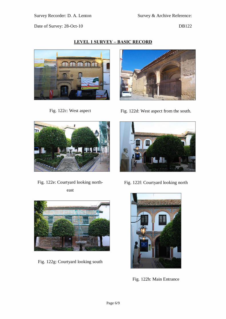
Survey Recorder: D. A. Lenton Survey & Archive Reference: Date of Survey: 28-Oct-10 DB122
LEVEL 1 SURVEY – BASIC RECORD
Page 6/9
Fig. 122c: West aspect
Fig. 122e: Courtyard looking north-
east
Fig. 122g: Courtyard looking south
Fig. 122d: West aspect from the south.
Fig. 122f: Courtyard looking north
Fig. 122h: Main Entrance

Survey Recorder: D. A. Lenton Survey & Archive Reference: Date of Survey: 28-Oct-10 DB122
LEVEL 1 SURVEY – BASIC RECORD
Page 7/9
5.2 Interior, Principal Rooms and Circulation Areas
Gallery Reception Room
Staircase Vestibule

Survey Recorder: D. A. Lenton Survey & Archive Reference: Date of Survey: 28-Oct-10 DB122
LEVEL 1 SURVEY – BASIC RECORD
Page 8/9
6.0 Drawing Record
No site drawing made

Survey Recorder: D. A. Lenton Survey & Archive Reference: Date of Survey: 28-Oct-10 DB122
LEVEL 1 SURVEY – BASIC RECORD
Page 9/9
7.0 Bibliography
Ayuntamiento de Córdoba n.d.: Córdoba: Oficinas De Información Turística, (ed. Ayuntamiento de Córdoba) Ayuntamiento de Córdoba, Córdoba. Daroca Bruño, F., Yllescas Ortiz, M. & De La Fuente Darder, F. (eds.) 2003: Córdoba: Guía De Arquitectura. Córdoba: Colegio Oficial de Arquitectura de Córdoba. Google Inc. n.d.: Google Earth 6 Web Catalogue http://www.google.co.uk/intl/en_uk/earth/index.html, Mountain View, CA. Ministerio de Cultura n.d.: Bien De Interés Cultural: La Base De Datos De Bienes Inmuebles, http://www.mcu.es/bienes/cargarFiltroBienesInmuebles.do?layout=bienesInmuebles&cache=init&language=es.

Survey Recorder: D. A. Lenton Survey & Archive Reference: Date of Survey: 28-Oct-10 DB123
LEVEL 1 SURVEY – BASIC RECORD
Page 1/9
Contents
1.0 Identification of Building or Structure
2.0 Summary of Building Type and Historical Usage
3.0 Description of Building & Materials
4.0 Supplementary Information
5.0 Photographic Record
6.0 Drawing Record
7.0 Bibliography

Survey Recorder: D. A. Lenton Survey & Archive Reference: Date of Survey: 28-Oct-10 DB123
LEVEL 1 SURVEY – BASIC RECORD
Page 2/9
1.0 Identification of Building or Structure
1.1
Building Short Name
Palacio de los Páez de Castillejo
1.2
Variant Names
Palace of the Family Páez de Castillejo,
The Archaeological Museum
1.3
Address
Plaza de Jerónimo Páez, Córdoba, Spain
1.4
Location Co-ordinates
Northing 37.881°Easting -4.777°
1.5
Statutory & Non-statutory
Designations
Within the designated area of the Córdoba
UNESCO World Heritage Site No. 313
(1984/1994).
Bien de Interés Cultural (Nationally Listed as
a Building of Cultural Interest) (Ministerio de
Cultura n.d.).
1.6 Survey Assessment &
Archaeological Value
Preservation is Medium (2) as many medieval
walls survive.
Legibility is Low (1) as the walls are rendered
and plastered.
Accessibility is Medium (2) as the building is
publically open but is too large to fully survey
within the resources of this thesis.
Stratigraphical Complexity is Low (1) as first
inspection indicated that the building spanned
on.ly the Imperial period.
Archaeological Value is Low (1-2).
1.7 Primary Building Technique Stone, very large, rectangular, ashlar, regular
coursing, thin mortar.

Survey Recorder: D. A. Lenton Survey & Archive Reference: Date of Survey: 28-Oct-10 DB123
LEVEL 1 SURVEY – BASIC RECORD
Page 3/9
2.0 Summary of Building Type and Historical Usage
2.1 Imperial period residential courtyard palace on the site of an earlier 14th
century house (Carpio Dueñas 2003: 239). It is currently a museum and
tourist attraction.
2.2 The building is located on its own wide plaza in the Medina area of the city
in the parish of Santa Maria north-east of the Mezquita.
2.3 The main (south-west) entrance is via a timber double leaf door directly from
the street to an entrance vestibule. The building has two storeys above
ground plus roof space.
3.0 Statement of Materials and Dates
3.1 Foundations and external walls are of Andalucían limestone ashlar
construction. External walls are visible to roof height.
3.2 East external walls are not rendered.
3.3 The building is entered from the via a double leaf timber front door in the
south-west elevation. The doorway is framed by limestone carved pilasters
topped with pediments and a tympanum with heraldic designs characteristic
of the Imperial period. The doorway opens to a vestibule which leads on to a
courtyard area.
3.4 At the southern corner of the south-west elevation, a corner window has been
inserted with similar heraldic designs. This suggests that the stonework of the
elevation is of an earlier date.
3.5 The Courtyard is surrounded by elliptic arches of brickwork above carved
marble columns with floral shaped capitals all characteristic of the Imperial
period.
3.6 A gallery off the courtyard contains the exposed remains of a roman period
theatre.
3.7 A large staircase leads off the Courtyard to the upper floor, which has been
dated to the late 15th century (Carpio Dueñas 2003: 240).
3.8 Ceilings are modern timber joisted and boarded.
3.9 Roofs are of modern timber framed construction with ceramic roof tiles
Survey Recorder: D. A. Lenton Survey & Archive Reference: Date of Survey: 28-Oct-10 DB123
LEVEL 1 SURVEY – BASIC RECORD
Page 4/9
4.0 Supplementary Information
4.1 The courtyard plan of the house originates from the 14th century but was
reformed in the early 16th century. The arch that connects the principal patio
to Sala 6 is an example (Carpio Dueñas 2003: 239). The first major
renovation of the building occurred in 1498 with the construction of the
monumental staircase, covered by a wooden cupola unique in the city of
Cordoba. But the most important works were carried out since 1538 under
the supervision of Hernán Ruiz II, which would make the house the first
Renaissance palace in the city (Carpio Dueñas 2003: 240). They included the
façade and doorway influenced by Roman triumphal arches (Daroca Bruño et
al. 2003: 139).

Survey Recorder: D. A. Lenton Survey & Archive Reference: Date of Survey: 28-Oct-10 DB123
LEVEL 1 SURVEY – BASIC RECORD
Page 5/9
5.0 Photographic Record
5.1 General External Views of the Building in its Setting
Fig. 123a: Aerial view of the building structure in its neighbourhood
North at top (Google Inc. n.d.)
Fig. 123b.: Aerial view of the building structure in close-up.
North at top (Google Inc. n.d.)

Survey Recorder: D. A. Lenton Survey & Archive Reference: Date of Survey: 28-Oct-10 DB123
LEVEL 1 SURVEY – BASIC RECORD
Page 6/9
Fig. 123c: South-west aspect viewed
from the south.
Fig. 123e: Main courtyard looking
north.
Fig. 123d: Front (south-west) entrance
door
Fig. 123f: Main courtyard looking
south.

Survey Recorder: D. A. Lenton Survey & Archive Reference: Date of Survey: 28-Oct-10 DB123
LEVEL 1 SURVEY – BASIC RECORD
Page 7/9
5.2 Interior, Principal Rooms and Circulation Areas
Gallery Gallery and Roman period Theatre

Survey Recorder: D. A. Lenton Survey & Archive Reference: Date of Survey: 28-Oct-10 DB123
LEVEL 1 SURVEY – BASIC RECORD
Page 8/9
6.0 Drawing Record
No site drawings made

Survey Recorder: D. A. Lenton Survey & Archive Reference: Date of Survey: 28-Oct-10 DB123
LEVEL 1 SURVEY – BASIC RECORD
Page 9/9
7.0 Bibliography
Carpio Dueñas, J. B. 2003. "El Museo Arqueologico Y El Palacio De Los Paez De Castillejo", in J. Fernández (ed.) Guía Archaeológica De Córdoba, pp. 239-241. Córdoba: Plurabelle. Daroca Bruño, F., Yllescas Ortiz, M. & De La Fuente Darder, F. (eds.) 2003: Córdoba: Guía De Arquitectura. Córdoba: Colegio Oficial de Arquitectura de Córdoba. Google Inc. n.d.: Google Earth 6 Web Catalogue http://www.google.co.uk/intl/en_uk/earth/index.html, Mountain View, CA. Ministerio de Cultura n.d.: Bien De Interés Cultural: La Base De Datos De Bienes Inmuebles, http://www.mcu.es/bienes/cargarFiltroBienesInmuebles.do?layout=bienesInmuebles&cache=init&language=es.

Survey Recorder: D. A. Lenton Survey & Archive Reference: Date of Survey: 28-Oct-10 DB125
LEVEL 1 SURVEY – BASIC RECORD
Page 1/8
Contents
1.0 Identification of Building or Structure
2.0 Summary of Building Type and Historical Usage
3.0 Description of Building & Materials
4.0 Supplementary Information
5.0 Photographic Record
6.0 Drawing Record
7.0 Bibliography
Survey Recorder: D. A. Lenton Survey & Archive Reference: Date of Survey: 28-Oct-10 DB125
LEVEL 1 SURVEY – BASIC RECORD
Page 2/8
1.0 Identification of Building or Structure
1.1
Building Short Name
Palacio de Viana
1.2
Variant Names
Palace of the Viana Family
1.3
Address
Plaza de Don Gome, Córdoba, Spain
1.4
Location Co-ordinates
Northing 37.888° Easting -4.774°
1.5
Statutory & Non-statutory
Designations
Within the designated area of the Córdoba
UNESCO World Heritage Site No. 313
(1984/1994).
Bien de Interés Cultural (Nationally Listed as
a Building of Cultural Interest) (Ministerio de
Cultura n.d.).
1.6 Survey Assessment &
Archaeological Value
Preservation is Medium (2) as many medieval
walls have survived.
Legibility is Low (1) as the walls are mostly
rendered and plastered.
Accessibility is Low (1) as the complex is too
large to be fully surveyed within the resources
of this thesis.
Stratigraphical Complexity is Low (1) as first
inspection indicated that the building spanned
only the Imperial period.
Archaeological Value is Low (1-2).
1.7 Primary Building Technique Stone, very large, rectangular, ashlar, regular
coursing, thin mortar.

Survey Recorder: D. A. Lenton Survey & Archive Reference: Date of Survey: 28-Oct-10 DB125
LEVEL 1 SURVEY – BASIC RECORD
Page 3/8
2.0 Summary of Building Type and Historical Usage
2.1 Imperial period courtyard palace retaining elements of a 14th-century house
with additions in the 16th century. It is currently a museum and art gallery.
2.2 The building is located on an open plaza in the parish of Santa Marina north-
east of the Mezquita.
2.3 The main (west) entrance is via timber double leaf door from the plaza. The
building has 2 storeys above ground plus roof space.
3.0 Description of Building & Materials
3.1 Foundations and walls of the West Elevation are of Andalusían limestone
construction. Walls are mostly rendered in sand and cement and painted.
3.2 The main (west) entrance is via timber double leaf door framed by Herrerian
limestone pilasters and a broken pediment with heraldic motifs characteristic
of the Imperial period. Above the doorway, on the First Floor, are a
balconied doorway with a segmented arch and a further broken pediment
also with heraldic motifs. The balcony is framed with Neo-Classical statues.
3.3 The West Elevation has 2 further balconied doorways on the First floor and
the South Elevation has another.
3.4 The South Elevation is pierced by a double gateway large enough for
carriages to pass through into a courtyard.
3.5 The main entrance opens on to a large Courtyard surrounded by brickwork
arches on stone columns characteristic of the Imperial period. Doorways in
each corner of the Courtyard lead to further courtyards, chambers and
galleries in 16th century Baroque architectural styles.
3.6 Roofs are tiled with 20th century ceramic roof tiles.
4.0 Supplementary Information
4.1 The building dates from the 14th century. Its facade was built by Juan de
Ochoa, a 16th century Renaissance mannerist; it has had numerous
restorations and additions during the 16th century (Daroca Bruño et al. 2003:
185). There have been archaeological finds suggesting that the building was
built on remains of Roman date (Ayuntamiento de Córdoba n.d.).
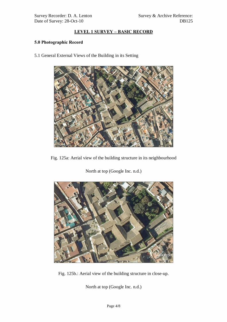
Survey Recorder: D. A. Lenton Survey & Archive Reference: Date of Survey: 28-Oct-10 DB125
LEVEL 1 SURVEY – BASIC RECORD
Page 4/8
5.0 Photographic Record
5.1 General External Views of the Building in its Setting
Fig. 125a: Aerial view of the building structure in its neighbourhood
North at top (Google Inc. n.d.)
Fig. 125b.: Aerial view of the building structure in close-up.
North at top (Google Inc. n.d.)

Survey & Archive Reference: Survey Recorder: D. A. Lenton DB125 Date of Survey: 28-Oct-10
LEVEL 3 SURVEY – ANALYTIC RECORD
Page 5/8
Fig. 125c: North-west aspect
Fig. 125e: Courtyard
Fig. 125f: Courtyard
Fig. 125d: North-west aspect
Fig. 125g: Courtyard

Survey & Archive Reference: Survey Recorder: D. A. Lenton DB125 Date of Survey: 28-Oct-10
LEVEL 3 SURVEY – ANALYTIC RECORD
Page 6/8
5.2 Interior, Principal Rooms and Circulation Areas
Fig. 125h: Room Fig. 125i: Room
Fig. 125j: Room Fig. 125k: Room

Survey & Archive Reference: Survey Recorder: D. A. Lenton DB125 Date of Survey: 28-Oct-10
LEVEL 3 SURVEY – ANALYTIC RECORD
Page 7/8
6.0 Drawing Record
No site drawings made

Survey & Archive Reference: Survey Recorder: D. A. Lenton DB125 Date of Survey: 28-Oct-10
LEVEL 3 SURVEY – ANALYTIC RECORD
Page 8/8
7.0 Bibliography
Ayuntamiento de Córdoba n.d.: Córdoba: Oficinas De Información Turística, (ed. Ayuntamiento de Córdoba) Ayuntamiento de Córdoba, Córdoba. Daroca Bruño, F., Yllescas Ortiz, M. & De La Fuente Darder, F. (eds.) 2003: Córdoba: Guía De Arquitectura. Córdoba: Colegio Oficial de Arquitectura de Córdoba. Google Inc. n.d.: Google Earth 6 Web Catalogue http://www.google.co.uk/intl/en_uk/earth/index.html, Mountain View, CA. Ministerio de Cultura n.d.: Bien De Interés Cultural: La Base De Datos De Bienes Inmuebles, http://www.mcu.es/bienes/cargarFiltroBienesInmuebles.do?layout=bienesInmuebles&cache=init&language=es.

Survey Recorder: D. A. Lenton Survey & Archive Reference: Date of Survey: 03-Nov-10 DB126
LEVEL 1 SURVEY – BASIC RECORD
Page 1/9
Contents
1.0 Identification of Building or Structure
2.0 Summary of Building Type and Historical Usage
3.0 Description of Building & Materials
4.0 Supplementary Information
5.0 Photographic Record
6.0 Drawing Record
7.0 Bibliography
Survey Recorder: D. A. Lenton Survey & Archive Reference: Date of Survey: 03-Nov-10 DB126
LEVEL 1 SURVEY – BASIC RECORD
Page 2/9
1.0 Identification of Building or Structure
1.1
Building Short Name
Iglesia de la Magdalena
1.2
Variant Names
Church of the Magdalena
1.3
Address
Plaza de La Magdalena, Córdoba, Spain
1.4
Location Co-ordinates
Northing 37.885° Easting -4.769°
1.5
Statutory & Non-statutory
Designations
Within the designated area of the Córdoba
UNESCO World Heritage Site No. 313
(1984/1994).
Bien de Interés Cultural (Nationally Listed as
a Building of Cultural Interest) (Ministerio de
Cultura n.d.)
1.6 Survey Assessment &
Archaeological Value
Preservation is High (3). The medieval
structure is intact up to roof level but has been
subject to later repairs and additions.
Legibility is Medium (2). External façades are
unrendered but internal façades are obscured
by modern features.
Accessibility is Low (1). Accessibility is
limited by its modern functions.
Stratigraphical Complexity is Medium (2) as it
spanned 2 periods – Reconquista and Imperial.
Archaeological Value is Low (1-2).
1.7 Primary Building Technique Stone; large; dressed; rectangular; regular
courses; thick mortar.

Survey Recorder: D. A. Lenton Survey & Archive Reference: Date of Survey: 03-Nov-10 DB126
LEVEL 1 SURVEY – BASIC RECORD
Page 3/9
2.0 Summary of Building Type and Historical Usage
2.1 Reconquista period church of earliest known date late 13th century with
additions in the 15th, 16th and 19th centuries. It is currently an exhibition
centre.
2.2 The building is located on its own plaza in the parish of Magdalena north-
east of the Mezquita.
2.3 The main (west) entrance is via timber double leaf door (Door A) through an
arched vestibule.
3.0 Description of Building & Materials
3.1 Foundations and walls are of Andalusían limestone and rise to a height of
approximately 16m above the rectangular 13th-century nave (Daroca Bruño et
al. 2003: 160). The nave has one aisle on either side to the north and south.
There is a single two-storey semi-octagonal apse at the east end with
supporting piers but no buttresses [Fig. 126d]. The apse has two elongated
round-arch windows and the whole structure is characteristic of 13th-14th-
century Castilian churches during the Gothic to Mudéjar transition (Iglesias
Costa 1989: 28; 166; 250).
3.2 The main (west) entrance is a double leaf timber door leading to the nave.
The doorway has a high-pointed limestone arch with archivolts decorated
with diamond point patterns and a frieze of faunal and floral motifs on
limestone pilaster capitals [Fig. 126f]. The tightly undercut and decorated
archivolts and the elaborate rose window at second storey height are
characteristic of High Gothic tool carving of the 13th century (Geddes 2001:
168).
3.3 The northern doorway has a similar High Gothic pointed arch above with
overhanging eaves. Its tightly undercut archivolts are decorated with
medallions and an angel. The southern doorway has a Mudéjar style ogee
arch and dog’s tooth mouldings surrounded by a diamond point alfiz [Fig.
126g]. This style of alfiz built upon designs of the Moorish period but
developed as a Mudéjar characteristic of the early 14th century (Cabañero
Subiza 1998: 84-5).

Survey Recorder: D. A. Lenton Survey & Archive Reference: Date of Survey: 03-Nov-10 DB126
LEVEL 1 SURVEY – BASIC RECORD
Page 4/9
3.4 The polygonal upper section of the limestone Tower is characteristic of the
18th-century Spanish Baroque period.
3.5 Roofs are tiled with 20th century ceramic roof tiles.
3.6 The church has be repaired and rebuilt many times and the relative
stratigraphy is highly complicated. The stones of the apse are the largest
stones of the medieval features and the most finely dressed. They correspond
with the stones of the western façade that scale to roof height and encompass
the 13th-century rose window. The apse and the nave abut each other [Fig.
126h] suggesting that one was built before the other. It is possible that the
nave was built atop an earlier structure and the apse added on later. However,
it seems more likely the apse, with its round-arched Romanesque windows,
was built first and the church therefore consecrated for immediate use as part
of the programme of “Iglesias Fernandinas” in the mid 13th century. There is
no clear evidence to suggest that the nave, aisles, and doorways were built in
anymore than one phase around the turn of the 14th century although the
remains of an earlier mosque may well have been used as building materials.
4.0 Supplementary Information
4.1 The Church of la Magdalena was one of the first churches to be built in the
city and a model for subsequent parish churches in Cordoba. Its style is a
mixture of Romanesque, Gothic and Mudéjar (Ayuntamiento de Córdoba
n.d.). The main entrance is at the west end of the church and is decorated
with a frieze of floral and faunal motifs. It is the oldest doorway of all the
churches of Córdoba dating to around 1300. The southern doorway has a
Mudéjar style ogee arch and dog’s tooth mouldings surrounded by a diamond
point alfiz of the early 14th century. The 18th century tower is made up of
several sections, which taper up to the top (Daroca Bruño et al. 2003: 160).

Survey Recorder: D. A. Lenton Survey & Archive Reference: Date of Survey: 03-Nov-10 DB126
LEVEL 1 SURVEY – BASIC RECORD
Page 5/9
5.0 Photographic Record
5.1 General External Views of the Building in its Setting
Fig. DB126a: Aerial view of the building structure in its neighbourhood
North at top (Google Inc. n.d.)
Fig. DB126b.: Aerial view of the building structure in close-up.
North at top (Google Inc. n.d.)

Survey Recorder: D. A. Lenton Survey & Archive Reference: Date of Survey: 03-Nov-10 DB126
LEVEL 1 SURVEY – BASIC RECORD
Page 6/9
Fig. 126c: North aspect viewed from
the west.
Fig. 126e: North aspect
Fig. 126f: West aspect viewed from the
north.
Fig. 126d: East aspect viewed from the
south
Fig. 126g: South aspect viewed from
the west.

Survey Recorder: D. A. Lenton Survey & Archive Reference: Date of Survey: 03-Nov-10 DB126
LEVEL 1 SURVEY – BASIC RECORD
Page 7/9
Fig. 126h: South aspect.

Survey Recorder: D. A. Lenton Survey & Archive Reference: Date of Survey: 03-Nov-10 DB126
LEVEL 1 SURVEY – BASIC RECORD
Page 8/9
6.0 Drawing Record
No site drawings made

Survey Recorder: D. A. Lenton Survey & Archive Reference: Date of Survey: 03-Nov-10 DB126
LEVEL 1 SURVEY – BASIC RECORD
Page 9/9
7.0 Bibliography
Ayuntamiento de Córdoba n.d.: Córdoba: Oficinas De Información Turística, (ed. Ayuntamiento de Córdoba) Ayuntamiento de Córdoba, Córdoba. Cabañero Subiza, B. 1998: La Alijafería. Zaragoza: Cortes de Aragón. Daroca Bruño, F., Yllescas Ortiz, M. & De La Fuente Darder, F. (eds.) 2003: Córdoba: Guía De Arquitectura. Córdoba: Colegio Oficial de Arquitectura de Córdoba. Geddes, J. 2001. "Iron", in J. Blair & N. Ramsey (eds.): English Medieval Industries : Craftsmen, Techniques, Products, pp. 167-188. London: Hambledon and London. Google Inc. n.d.: Google Earth 6 Web Catalogue http://www.google.co.uk/intl/en_uk/earth/index.html, Mountain View, CA. Iglesias Costa, M. 1989: Arquitectura Sacra: Desde El Period Gótico (Siglo Xiii) Hasta La Actualidad. Zaragoza: Gobierno de Aragon. Ministerio de Cultura n.d.: Bien De Interés Cultural: La Base De Datos De Bienes Inmuebles, http://www.mcu.es/bienes/cargarFiltroBienesInmuebles.do?layout=bienesInmuebles&cache=init&language=es.

Survey Recorder: D. A. Lenton Survey & Archive Reference: Date of Survey: 28-Oct-10 DB127
LEVEL 2 SURVEY – DESCRIPTIVE RECORD
Page 1/9
Contents
1.0 Identification of Building or Structure
2.0 Summary of Building Type and Historical Usage
3.0 Description of Building & Materials
4.0 Supplementary Information
5.0 Photographic Record
6.0 Drawing Record – Addendum Attached 1 Page
7.0 Bibliography

Survey Recorder: D. A. Lenton Survey & Archive Reference: Date of Survey: 28-Oct-10 DB127
LEVEL 2 SURVEY – DESCRIPTIVE RECORD
Page 2/9
1.0 Identification of Building or Structure
1.1 Building Short Name Iglesia de San Nicolás
1.2 Variant Names Iglesia de San Nicolás de la Villa
Church of St. Nicholas in the Town
1.3 Address Plaza de San Nicolas, Córdoba, Spain
1.4 Location Co-ordinates Northing 37.884° Easting -4.782°
1.5 Statutory & Non-statutory
Designations
Within the designated area of the Córdoba
UNESCO World Heritage Site No. 313
(1984/1994). Bien de Interés Cultural
(Nationally Listed as a Building of Cultural
Interest) (Ministerio de Cultura n.d.).
1.6 Survey Assessment &
Archaeological Value
Preservation is Medium (2) Many surviving
medieval walls to second storey height, building
has been subject to Imperial period remodelling.
Legibility is Low (1) Greater part of its wall
surface is rendered and obscured.
Accessibility is Low (1) Parts of the upper
storeys of building unattainable for detailed
survey. Modern structures conceal earlier.
Stratigraphical Complexity is High (3) Phases
spanned three periods – Moorish, Reconquista
and Imperial.
Archaeological Value is Low (1-2).
1.7 Primary Building Technique 1200AD: Stone; very large; ashlar; well squared;
regular; thin mortar.
1400AD: Stone; large bonded with very large;
dressed; rectangular; regular coursing; thick
mortar.
1600AD: Stone; very large; ashlar; well squared;
regular; thin mortar.

Survey Recorder: D. A. Lenton Survey & Archive Reference: Date of Survey: 28-Oct-10 DB127
LEVEL 2 SURVEY – DESCRIPTIVE RECORD
Page 3/9
2.0 Summary of Building Type and Historical Usage
2.1 Reconquista period church of earliest known date 12th century (Fuertes
Romero et al. 2003: 149-150) with additions in the 14th, 15th, 16th and 19th
centuries (Daroca Bruño et al. 2003: 212). It is currently a catholic church.
2.2 The building is located on its own plaza in the parish of San Nicolas de la
Villa due north of the Mezquita.
2.3 The main (south-west) entrance is via timber double leaf door (Door A)
through an arched vestibule.
3.0 Description of Building & Materials
3.1 Foundations and walls are of Andalusían limestone and rise to a height of
approximately 19m above a 13th or 14th century nave (Daroca Bruño et al.
2003: 212). Walls are mostly rendered but some areas have exposed
stonework. The nave has one aisle on either side to the north and south
constructed on high pointed arches that date to the late 13th or early 14th
century. The main medieval west entrance no longer survives. It has been
replaced with an Imperial period bay. However, there is an elaborate rose
window above it at second storey height that is indicative of a 13th-century
Gothic style.
3.2 There is an entrance Vestibule (Room A) with round arches on stone
columns leading to the main entrance (Door A). The Vestibule is a later,
abutment to the main central building. Door A is a double leaf timber door
leading to the nave. The doorway has a rounded limestone arch.
3.3 The nave is lined by stonework arcading to second storey height in an early
Gothic style with high pointed arches on heavy columns with single fluted
piers. The medieval apse has been removed. There is no clear evidence to
suggest that the nave and aisles were built in anymore than one phase around
the end of the 13th century.
3.4 The Chapels to the north of the nave and the rooms to the south are later
additions that abut the medieval Nave. The Bay to the western wall of the
nave is a later abutment and possibly conceals a 13th or 14th century entrance

Survey Recorder: D. A. Lenton Survey & Archive Reference: Date of Survey: 28-Oct-10 DB127
LEVEL 2 SURVEY – DESCRIPTIVE RECORD
Page 4/9
door. This Bay is likely to be a 15th century addition, which may indicate that
Door A was inserted in the 15th century to provide the new main entrance.
3.5 The polygonal limestone Tower stands on the rectangular limestone base of a
former minaret (5.70 by 5.10 metres) from an earlier mosque (now lost). The
base dates from the Moorish period, whereas the Tower is in 15th century
Gothic-Mudejar style. The Belfry is in a Herreian design of the later 16th
century.
3.6 The northern end portal is built in Mannerist proportions with fluted columns
and Christian iconography. It is likely to date from the 16th century.
3.7 Roofs are tiled with 20th century ceramic roof tiles.
4.0 Supplementary Information
4.1 This parish church was started in the 13th century by order of Ferdinand III
and was called “de la Villa” (of the town) to distinguish it from another with
the same name located in the outskirts (Ayuntamiento de Córdoba n.d.). It
has a polygonal tower accredited to Bishop Iñigo Manrique dated to 1496
built on top of a former minaret. The north entrance was built in 1555 by
Hernán Ruiz II (Daroca Bruño et al. 2003: 212). On the inside, there is a 16th
century Baptismal Chapel and the main altarpiece in Baroque style
(Consorcio de Turismo 2010). The belfry is a 18th century addition .

Survey Recorder: D. A. Lenton Survey & Archive Reference: Date of Survey: 28-Oct-10 DB127
LEVEL 2 SURVEY – DESCRIPTIVE RECORD
Page 5/9
5.0 Photographic Record
5.1 General External Views of the Building in its Setting
Fig. 127a: Aerial view of the building structure in its neighbourhood
North at top (Google Inc. n.d.; Daroca Bruño et al. 2003: 212)
Fig. 127b.: Aerial view of the building structure in close-up.
North at top (Google Inc. n.d.)

Survey Recorder: D. A. Lenton Survey & Archive Reference: Date of Survey: 28-Oct-10 DB127
LEVEL 2 SURVEY – DESCRIPTIVE RECORD
Page 6/9
Fig. 127c: North aspect viewed from
the north-west.
Fig. 127e: East aspect viewed from the
south-east
Fig. 127d: East aspect viewed from the
north.
Fig. 127f: South aspect viewed from
the south-east
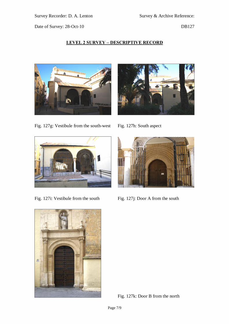
Survey Recorder: D. A. Lenton Survey & Archive Reference: Date of Survey: 28-Oct-10 DB127
LEVEL 2 SURVEY – DESCRIPTIVE RECORD
Page 7/9
Fig. 127g: Vestibule from the south-west Fig. 127h: South aspect
Fig. 127i: Vestibule from the south Fig. 127j: Door A from the south
Fig. 127k: Door B from the north

Survey Recorder: D. A. Lenton Survey & Archive Reference: Date of Survey: 28-Oct-10 DB127
LEVEL 2 SURVEY – DESCRIPTIVE RECORD
Page 8/9
6.0 Drawing Record
Addendum
Drawing No. 127.1
1 Page A4 Size

Survey Recorder: D. A. Lenton Survey & Archive Reference: Date of Survey: 28-Oct-10 DB127
LEVEL 2 SURVEY – DESCRIPTIVE RECORD
Page 9/9
7.0 Bibliography
Ayuntamiento de Córdoba n.d.: Córdoba: Oficinas De Información Turística, (ed. Ayuntamiento de Córdoba) Ayuntamiento de Córdoba, Córdoba. Consorcio de Turismo 2010: Iglesia De San Nicolás De La Villa http://english.turismodecordoba.org/index2.cfm?codigo=0653 Córdoba. Daroca Bruño, F., Yllescas Ortiz, M. & De La Fuente Darder, F. (eds.) 2003: Córdoba: Guía De Arquitectura. Córdoba: Colegio Oficial de Arquitectura de Córdoba. Fuertes Romero, R.-M., López Guerrero, R., Rodríguez Sánchez, M. & Valdivieso Ramos, A. 2003. "La Qurtuba Islámica: Las Mezquitas", in J. Fernández (ed.) Guía Archaeológica De Córdoba, pp. 148-150. Córdoba: Plurabelle. Google Inc. n.d.: Google Earth 6 Web Catalogue http://www.google.co.uk/intl/en_uk/earth/index.html, Mountain View, CA. Ministerio de Cultura n.d.: Bien De Interés Cultural: La Base De Datos De Bienes Inmuebles, http://www.mcu.es/bienes/cargarFiltroBienesInmuebles.do?layout=bienesInmuebles&cache=init&language=es.

10 metres (Approx.)Survey Reference: DB127 Drawing No: 127.1Building Short Name: Iglesia de San NicolasAddress: Plaza de San Nicholas, Córdoba, SpainScale: NTS Sheet Size: ISO A4
Door A
Portico
Nave
Chapel
Chapel
Minaret
Bay
PortalDoor B

Survey Recorder: D. A. Lenton Survey & Archive Reference: Date of Survey: 30-Oct-10 DB128
LEVEL 2 SURVEY – DESCRIPTIVE RECORD
Page 1/12
Contents
1.0 Identification of Building or Structure
2.0 Summary of Building Type and Historical Usage
3.0 Description of Building & Materials
4.0 Supplementary Information
5.0 Photographic Record
6.0 Drawing Record – Addenda Attached 2 Pages
7.0 Bibliography

Survey Recorder: D. A. Lenton Survey & Archive Reference: Date of Survey: 30-Oct-10 DB128
LEVEL 2 SURVEY – DESCRIPTIVE RECORD
Page 2/12
1.0 Identification of Building or Structure
1.1 Building Short Name Iglesia de San Lorenzo
1.2 Variant Names Iglesia de San Lorenzo Mártir
Church of St. Lawrence the Martyr
1.3 Address Plaza de San Lorenzo, Córdoba, Spain
1.4 Location Co-ordinates Northing 37.888° Easting -4.769°
1.5 Statutory & Non-statutory
Designations
Within the designated area of the Córdoba
UNESCO World Heritage Site No. 313
(1984/1994).
Bien de Interés Cultural (Nationally Listed as
a Building of Cultural Interest) (Ministerio de
Cultura n.d.).
1.6 Survey Assessment &
Archaeological Value
Preservation is High (3). Many surviving
medieval walls to second storey height,
although building subject to modern repair.
Legibility is High (3). Walls have no
coverings.
Accessibility is Medium (2). Some parts of the
upper storeys of the building are unattainable
for detailed survey.
Stratigraphical Complexity is High (3).
Phases spanned 3 periods- Moorish,
Reconquista and Imperial.
Archaeological Value is Medium (2-2.5).
1.7 Primary Building Technique 1200AD: Stone; very large; ashlar; well
squared; regular; thin mortar.
1400AD: Stone; large bonded with very large;
dressed; rectangular; regular courses; thick
mortar.
1600AD: Stone; very large; ashlar; regular
courses; thick mortar.

Survey Recorder: D. A. Lenton Survey & Archive Reference: Date of Survey: 30-Oct-10 DB128
LEVEL 2 SURVEY – DESCRIPTIVE RECORD
Page 3/12
2.0 Summary of Building Type and Historical Usage
2.1 Reconquista period church incorporating the minaret of a mosque of earliest
known date 10th century with additions in the later Reconquista and Imperial
periods (Daroca Bruño et al. 2003: 179; Fuertes Romero et al. 2003: 150). It
is currently a catholic church.
2.2 The building is located on its own plaza in the parish of San Lorenzo north-
east of the Mezquita.
2.3 The main (south-west) entrance is via timber double leaf door (Door A)
through an arched portico.
3.0 Description of Building & Materials
3.1 Foundations and walls are of Andalusían limestone and rise to a height of
14.18m above the 13th century nave. Walls are not rendered and stonework is
exposed and visible. The nave has one aisle on either side to the north-west
and south-east. There is a single two-storey semi-octagonal apse at the north-
east end with supporting piers but no buttresses [Fig. 126d]. The apse has
two elongated pointed-arch windows and the whole structure is characteristic
of 13th-14th-century Castilian churches during the Gothic to Mudéjar
transition (Iglesias Costa 1989: 28; 166; 250). The stonework of the apse has
the largest and most finely dressed blocks of the external walls [Fig. 128l].
3.2 There is an entrance Portico to the south-west with low pointed arches
leading to the main entrance (Door A). The Portico is a later, abutment to the
main central building and reuses two Roman or Visigothic period marble
columns. This would date the Portico later than the south-west end of the
Nave. The main west entrance (Door A) is a double leaf timber door leading
to the nave. The doorway has a low pointed limestone arch with archivolts
decorated and diamond point chevrons and a frieze of faunal and floral
motifs on limestone pilaster capitals [Fig. 128j]. The tightly undercut and
decorated archivolts and the elaborate rose window above it at second storey
height are characteristic of High Gothic tool carving of the 13th century
(Geddes 2001: 168) but the low pointed arches are a Mudéjar style and
suggest a 14th-century date for construction.

Survey Recorder: D. A. Lenton Survey & Archive Reference: Date of Survey: 30-Oct-10 DB128
LEVEL 2 SURVEY – DESCRIPTIVE RECORD
Page 4/12
3.3 The Chapels to the north and south of the nave are later additions. The
northern Chapel walls stand to a height of 7.00 metres and the southern
Chapel walls stand to a height of 6.31 metres. The low pointed arches above
the doors suggest 14th or 15th-century construction dates. The Chapels’ walls
are of Andalusían limestone. The stonework is dressed and constructed to a
higher quality than is generally achieved in the Reconquista period elements.
3.4 The rectangular limestone Tower stands to a height of approximately 24
metres on the rectangular limestone base of a former minaret (4.76 by 3.62
metres) from an earlier mosque (now lost). The base dates from the Moorish
period, whereas the upper Bell Tower and Belfry are in an Herrerian style,
the official architectural style of the Hapsburgs in the 16th century.
3.5 There are two infilled or blinded round arches in the northern wall of the
North Aisle next to the Tower and another blinded horseshoe arch at the
north end of the south-west façade [Fig. 128m]. These appear to be of
Moorish period date surviving from the earlier mosque. It seems probable
that the external wall of the South Aisle follows the line and orientation of
the qibla traverse wall of the former mosque building, which consequently
orientates the church apse towards the north-east.
3.6 The nave is lined by stonework arcading to second storey height in an early
Gothic style with high pointed arches on heavy columns with single fluted
piers. It seems likely that this arcading predates the Mudéjar south-west
façade but is coeval with the apse end as no abutment is visible.
3.7 It therefore seems probable that the smaller, less finely dressed stonework of
the aisle walls survives from the Moorish period. The apse and nave were the
first Reconquista period constructions enabling the church to be consecrated
for immediate use as part of the “Iglesias Fernandinas”. The south-west
entrance façade, on its unusual axis, would have completed the church
around the turn of the 14th century. The Portico, as a later abutment, probably
dates from the Imperial period.
3.7 Roofs are tiled with 20th century ceramic roof tiles.
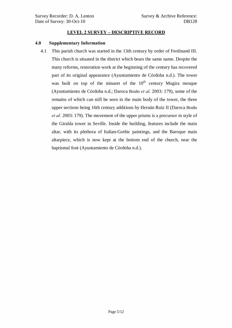
Survey Recorder: D. A. Lenton Survey & Archive Reference: Date of Survey: 30-Oct-10 DB128
LEVEL 2 SURVEY – DESCRIPTIVE RECORD
Page 5/12
4.0 Supplementary Information
4.1 This parish church was started in the 13th century by order of Ferdinand III.
This church is situated in the district which bears the same name. Despite the
many reforms, restoration work at the beginning of the century has recovered
part of its original appearance (Ayuntamiento de Córdoba n.d.). The tower
was built on top of the minaret of the 10th century Mugira mosque
(Ayuntamiento de Córdoba n.d.; Daroca Bruño et al. 2003: 179), some of the
remains of which can still be seen in the main body of the tower, the three
upper sections being 16th century additions by Hernán Ruiz II (Daroca Bruño
et al. 2003: 179). The movement of the upper prisms is a precursor in style of
the Giralda tower in Seville. Inside the building, features include the main
altar, with its plethora of Italian-Gothic paintings, and the Baroque main
altarpiece, which is now kept at the bottom end of the church, near the
baptismal font (Ayuntamiento de Córdoba n.d.).
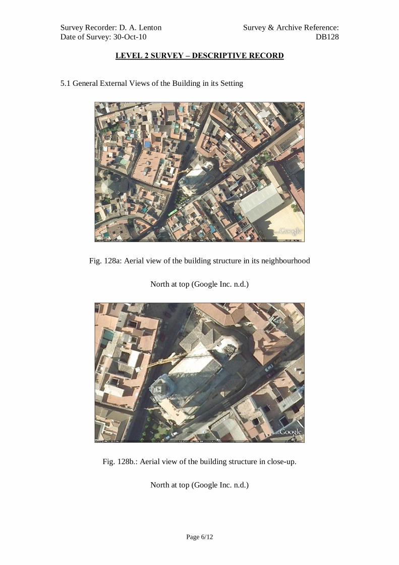
Survey Recorder: D. A. Lenton Survey & Archive Reference: Date of Survey: 30-Oct-10 DB128
LEVEL 2 SURVEY – DESCRIPTIVE RECORD
Page 6/12
5.1 General External Views of the Building in its Setting
Fig. 128a: Aerial view of the building structure in its neighbourhood
North at top (Google Inc. n.d.)
Fig. 128b.: Aerial view of the building structure in close-up.
North at top (Google Inc. n.d.)
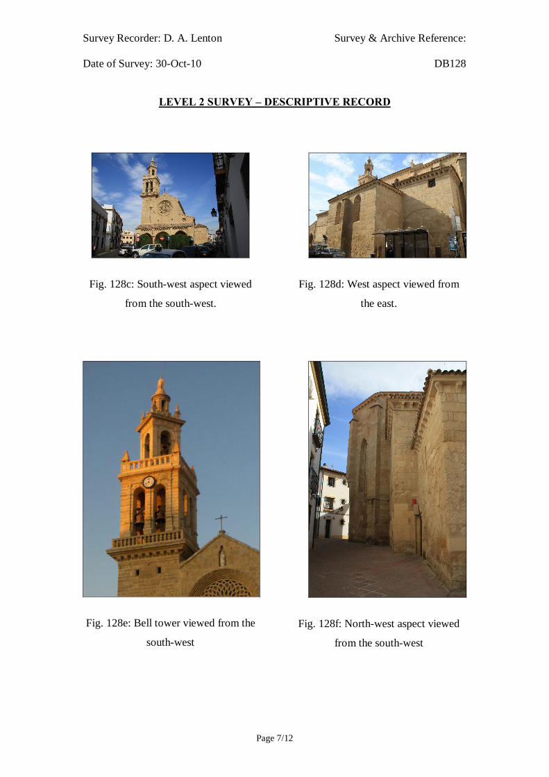
Survey Recorder: D. A. Lenton Survey & Archive Reference: Date of Survey: 30-Oct-10 DB128
LEVEL 2 SURVEY – DESCRIPTIVE RECORD
Page 7/12
Fig. 128c: South-west aspect viewed
from the south-west.
Fig. 128e: Bell tower viewed from the
south-west
Fig. 128d: West aspect viewed from
the east.
Fig. 128f: North-west aspect viewed
from the south-west
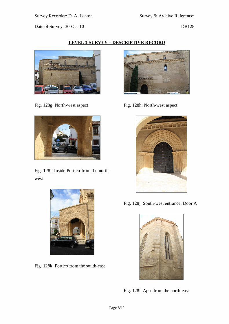
Survey Recorder: D. A. Lenton Survey & Archive Reference: Date of Survey: 30-Oct-10 DB128
LEVEL 2 SURVEY – DESCRIPTIVE RECORD
Page 8/12
Fig. 128g: North-west aspect
Fig. 128i: Inside Portico from the north-
west
Fig. 128k: Portico from the south-east
Fig. 128h: North-west aspect
Fig. 128j: South-west entrance: Door A
Fig. 128l: Apse from the north-east

Survey Recorder: D. A. Lenton Survey & Archive Reference: Date of Survey: 30-Oct-10 DB128
LEVEL 2 SURVEY – DESCRIPTIVE RECORD
Page 9/12
Fig. 128m: blinded horseshoe arch at the
north end of the south-west façade.

Survey Recorder: D. A. Lenton Survey & Archive Reference: Date of Survey: 30-Oct-10 DB128
LEVEL 2 SURVEY – DESCRIPTIVE RECORD
Page 10/12
5.2 Interior, Principal Rooms and Circulation Areas
Fig.128n: The Nave Looking north-east
Fig.128p: The Minaret / Tower from the
east
Fig.128o: The Minaret / Tower from the
south-east
Fig.128q: The Minaret / Tower
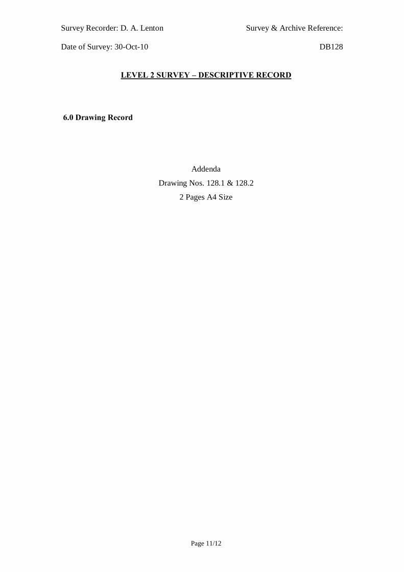
Survey Recorder: D. A. Lenton Survey & Archive Reference: Date of Survey: 30-Oct-10 DB128
LEVEL 2 SURVEY – DESCRIPTIVE RECORD
Page 11/12
6.0 Drawing Record
Addenda
Drawing Nos. 128.1 & 128.2
2 Pages A4 Size

Survey Recorder: D. A. Lenton Survey & Archive Reference: Date of Survey: 30-Oct-10 DB128
LEVEL 2 SURVEY – DESCRIPTIVE RECORD
Page 12/12
7.0 Bibliography
Ayuntamiento de Córdoba n.d.: Córdoba: Oficinas De Información Turística, (ed. Ayuntamiento de Córdoba) Ayuntamiento de Córdoba, Córdoba. Daroca Bruño, F., Yllescas Ortiz, M. & De La Fuente Darder, F. (eds.) 2003: Córdoba: Guía De Arquitectura. Córdoba: Colegio Oficial de Arquitectura de Córdoba. Fuertes Romero, R.-M., López Guerrero, R., Rodríguez Sánchez, M. & Valdivieso Ramos, A. 2003. "La Qurtuba Islámica: Las Mezquitas", in J. Fernández (ed.) Guía Archaeológica De Córdoba, pp. 148-150. Córdoba: Plurabelle. Geddes, J. 2001. "Iron", in J. Blair & N. Ramsey (eds.): English Medieval Industries : Craftsmen, Techniques, Products, pp. 167-188. London: Hambledon and London. Google Inc. n.d.: Google Earth 6 Web Catalogue http://www.google.co.uk/intl/en_uk/earth/index.html, Mountain View, CA. Iglesias Costa, M. 1989: Arquitectura Sacra: Desde El Period Gótico (Siglo Xiii) Hasta La Actualidad. Zaragoza: Gobierno de Aragon. Ministerio de Cultura n.d.: Bien De Interés Cultural: La Base De Datos De Bienes Inmuebles, http://www.mcu.es/bienes/cargarFiltroBienesInmuebles.do?layout=bienesInmuebles&cache=init&language=es.
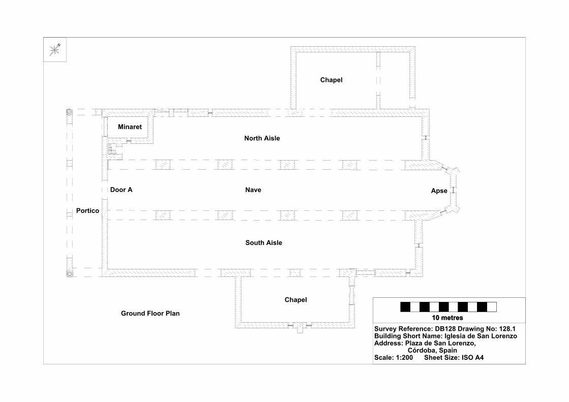
10 metres10 metresSurvey Reference: DB128 Drawing No: 128.1Building Short Name: Iglesia de San LorenzoAddress: Plaza de San Lorenzo, Córdoba, SpainScale: 1:200 Sheet Size: ISO A4
Ground Floor Plan
Portico
Door A
Minaret
Nave
Chapel
Chapel
Apse
North Aisle
South Aisle

10 metres10 metresSurvey Reference: DB128 Drawing No: 128.2Building Short Name: Iglesia de San LorenzoAddress: Plaza de San Lorenzo, Córdoba, SpainScale: 1:200 Sheet Size: ISO A4
South West Elevation

Survey Recorder: D. A. Lenton Survey & Archive Reference: Date of Survey: 29-Oct-10 DB129
LEVEL 1 SURVEY – BASIC RECORD
Page 1/9
Contents
1.0 Identification of Building or Structure
2.0 Summary of Building Type and Historical Usage
3.0 Description of Building & Materials
4.0 Supplementary Information
5.0 Photographic Record
6.0 Drawing Record
7.0 Bibliography

Survey Recorder: D. A. Lenton Survey & Archive Reference: Date of Survey: 29-Oct-10 DB129
LEVEL 1 SURVEY – BASIC RECORD
Page 2/9
1.0 Identification of Building or Structure
1.1
Building Short Name
Iglesia Convento de San Pablo
1.2 Variant Names Monastic Church of San Pablo
1.3 Address Calle Capitulares, Córdoba, Spain
1.4
Location Co-ordinates
Northing 37.885°Easting -4.775°
1.5
Statutory & Non-statutory
Designations
Within the designated area of the Córdoba
UNESCO World Heritage Site No. 313
(1984/1994).
Bien de Interés Cultural (Nationally Listed as
a Building of Cultural Interest) (Ministerio de
Cultura n.d.).
1.6 Survey Assessment &
Archaeological Value
Preservation is High (3). The medieval
structure is intact up to roof level.
Legibility is Medium (2). The walls are
unrendered.
Accessibility is Low (1). The medieval
structure is largely obscured by later buildings.
Stratigraphical Complexity is Medium (2).
The building spans at least 2 periods –
Reconquista and Imperial.
Archaeological Value is Low (1-2).
1.7 Primary Building Technique 1400AD: Stone; large bonded with very large;
dressed; rectangular; regular coursing; thick
mortar.
1600AD: Stone; very large; ashlar;
rectangular; regular coursing; thick mortar.

Survey Recorder: D. A. Lenton Survey & Archive Reference: Date of Survey: 29-Oct-10 DB129
LEVEL 1 SURVEY – BASIC RECORD
Page 3/9
2.0 Summary of Building Type and Historical Usage
2.1 Reconquista period church of earliest known date late 13th century with
additions in the later Reconquista and Imperial periods (Daroca Bruño et al.
2003: 174). It is currently a catholic church.
2.2 The building is located on its own plaza in the parish of San Pablo north-east
of the Mezquita.
2.3 The main (west) entrance is via timber double leaf door from the plaza.
3.0 Description of Building & Materials
3.1 The plaza has an Andalucían limestone gateway from the street sculptured in
Baroque styles of the Imperial period. Foundations and walls of the building
are of Andalusían limestone and rise to a height of approximately 20m above
the 13th century nave. Walls are not rendered and stonework is exposed and
visible. The nave has one aisle on either side to the north and south
constructed on high pointed arches [Fig. 129f] that date to the late 13th or
early 14th century.
3.2 The main medieval west entrance no longer survives. It has been replaced
with an Imperial period portal in Mannerist proportions It has a The entrance
is via timber double leaf door with a rounded arch and framed by carved
limestone pilasters and headed by a limestone alfiz in an Imperial period
Mannerist style. Above the doorway is a Mannerist broken pediment with
Christian iconography - an inset statue. Above the pediment is an elaborate
rose window [Fig. 129d] above it at third storey height that is indicative of a
13th-century Gothic style.
3.3 There is a single two-storey semi-octagonal apse at the east end with
supporting piers but no buttresses. The apse structure is characteristic of 13th-
14th-century Castilian churches during the Gothic to Mudéjar transition
(Iglesias Costa 1989: 28; 166; 250).
3.4 The north and south aisle doorways are also built with high-pointed
limestone arch with archivolts on limestone pilaster capitals. The tightly
undercut and decorated archivolts are characteristic of High Gothic tool
carving of the 13th century (Geddes 2001: 168).

Survey Recorder: D. A. Lenton Survey & Archive Reference: Date of Survey: 29-Oct-10 DB129
LEVEL 1 SURVEY – BASIC RECORD
Page 4/9
3.5 The nave is lined by stonework arcading to third storey height in an early
Gothic style with high pointed arches on heavy columns with single fluted
piers. Above the Nave at the western end, there is a limestone ogee arch in a
Mudéjar style likely to date to the late 13th or early 14th century. There is no
clear evidence to suggest that the apse, nave, aisles, and doorways were built
in anymore than one phase around the end of the 13th century.
3.6. Roofs are tiled with 20th century ceramic roof tiles.
4.0 Supplementary Information
4.1 In front of Cordoba Town Hall stands the church of San Pablo. It was built
between the 13th and 14th centuries, but was heavily reformed in the 18th.
The main façade opens out onto Calle Capitulares and the main entrance has
spiralling columns known as Salomonica. The tower has one of the three best
preserved bell-towers in the whole of Spain. Past the plaza at the entrance,
the main door can be seen, which is in a Mannerist style and leads to the
church itself, which is divided into three naves. The features on the inside are
the decorative ceilings in Mudéjar style, the main altarpiece, the vaulted
building or qubba (possibly remains of an Almohade palace over which the
church was built) and the well-known image of Nuestra Señora de las
Angustias (Our Lady of Sorrows), a 17th century work by Juan de Mesa
(Ayuntamiento de Córdoba n.d.).

Survey Recorder: D. A. Lenton Survey & Archive Reference: Date of Survey: 29-Oct-10 DB129
LEVEL 1 SURVEY – BASIC RECORD
Page 5/9
5.0 Photographic Record
5.1 General External Views of the Building in its Setting
Fig. DB129a: Aerial view of the building structure in its neighbourhood
North at top (Google Inc. n.d.)
Fig. DB129b.: Aerial view of the building structure in close-up.
North at top (Google Inc. n.d.)

Survey Recorder: D. A. Lenton Survey & Archive Reference: Date of Survey: 29-Oct-10 DB129
LEVEL 1 SURVEY – BASIC RECORD
Page 6/9
Fig. 129c: West Gate
Fig. 129e: East Gate
Fig. 129d: West aspect
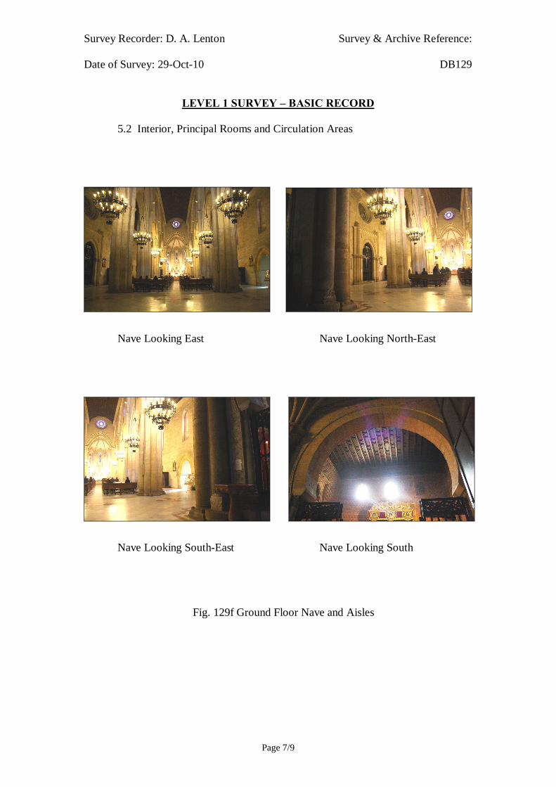
Survey Recorder: D. A. Lenton Survey & Archive Reference: Date of Survey: 29-Oct-10 DB129
LEVEL 1 SURVEY – BASIC RECORD
Page 7/9
5.2 Interior, Principal Rooms and Circulation Areas
Nave Looking East Nave Looking North-East
Nave Looking South-East Nave Looking South
Fig. 129f Ground Floor Nave and Aisles

Survey Recorder: D. A. Lenton Survey & Archive Reference: Date of Survey: 29-Oct-10 DB129
LEVEL 1 SURVEY – BASIC RECORD
Page 8/9
6.0 Drawing Record
No site drawings made

Survey Recorder: D. A. Lenton Survey & Archive Reference: Date of Survey: 29-Oct-10 DB129
LEVEL 1 SURVEY – BASIC RECORD
Page 9/9
7.0 Bibliography
Ayuntamiento de Córdoba n.d.: Córdoba: Oficinas De Información Turística, (ed. Ayuntamiento de Córdoba) Ayuntamiento de Córdoba, Córdoba. Daroca Bruño, F., Yllescas Ortiz, M. & De La Fuente Darder, F. (eds.) 2003: Córdoba: Guía De Arquitectura. Córdoba: Colegio Oficial de Arquitectura de Córdoba. Geddes, J. 2001. "Iron", in J. Blair & N. Ramsey (eds.): English Medieval Industries : Craftsmen, Techniques, Products, pp. 167-188. London: Hambledon and London. Google Inc. n.d.: Google Earth 6 Web Catalogue http://www.google.co.uk/intl/en_uk/earth/index.html, Mountain View, CA. Iglesias Costa, M. 1989: Arquitectura Sacra: Desde El Period Gótico (Siglo Xiii) Hasta La Actualidad. Zaragoza: Gobierno de Aragon. Ministerio de Cultura n.d.: Bien De Interés Cultural: La Base De Datos De Bienes Inmuebles, http://www.mcu.es/bienes/cargarFiltroBienesInmuebles.do?layout=bienesInmuebles&cache=init&language=es.
Survey Recorder: D. A. Lenton Survey & Archive Reference: Date of Survey: 25-Oct-10 DB130
LEVEL 1 SURVEY – BASIC RECORD
Page 1/8
Contents
1.0 Identification of Building or Structure
2.0 Summary of Building Type and Historical Usage
3.0 Description of Building & Materials
4.0 Supplementary Information
5.0 Photographic Record
6.0 Drawing Record
7.0 Bibliography

Survey Recorder: D. A. Lenton Survey & Archive Reference: Date of Survey: 25-Oct-10 DB130
LEVEL 1 SURVEY – BASIC RECORD
Page 2/8
1.0 Identification of Building or Structure
1.1
Building Short Name
Iglesia de San Agustín
1.2 Variant Names Church of San Agustín
1.3 Address Plaza de San Agustín, Córdoba, Spain
1.4
Location Co-ordinates
Northing 37.889°Easting -4.772°
1.5
Statutory and non-statutory
designations
Within the designated area of the Córdoba
UNESCO World Heritage Site No. 313
(1984/1994).
Bien de Interés Cultural (Nationally Listed as
a Building of Cultural Interest) (Ministerio de
Cultura n.d.)
1.6 Survey Assessment &
Archaeological Value
Preservation is Medium (2). The medieval
structure is partially intact up to roof level.
Legibility is Low (1). The walls are rendered.
Accessibility is Low (1). The medieval
structure is obscured by later buildings.
Stratigraphical Complexity is Medium (2).
The building spans at least 2 periods –
Reconquista and Imperial.
Archaeological Value is Low (1-2).
1.7 Primary Building Technique 1400AD: Stone; large bonded with very large;
dressed; well squared; regular; thick mortar.

Survey Recorder: D. A. Lenton Survey & Archive Reference: Date of Survey: 25-Oct-10 DB130
LEVEL 1 SURVEY – BASIC RECORD
Page 3/8
2.0 Summary of Building Type and Historical Usage
2.1 Reconquista period church of earliest known date 14th century with additions
in the later Reconquista and Imperial periods (Daroca Bruño et al. 2003:
184). It is currently a catholic church.
2.2 The building is located on its own plaza in the parish of Santa Marina north-
east of the Mezquita.
2.3 The main (south-west) entrance is via timber double leaf door from the plaza.
3.0 Description of Building & Materials
3.1 Foundations and walls are of Andalusían limestone and rise to a height of
approximately 24m above the 14th century nave. Walls are rendered in sand
and cement and the stonework is not visible.
3.2 The main (south-west) entrance is via timber double leaf late Renaissance
door with a tympanum and basket handle arches characteristic of the 15th
century through a Baroque façade characteristic of the 17th century (Daroca
Bruño et al. 2003: 183).
3.3 There is a single two-storey semi-octagonal apse at the east end with
supporting piers but no buttresses. The apse structure is characteristic of 13th-
14th-century Castilian churches during the Gothic to Mudéjar transition
(Iglesias Costa 1989: 28; 166; 250). The nave has one aisle on either side to
the north and south. The medieval nave and aisles are separated by
rectangular columns but heavily concealed by plasterwork of the Imperial
period.
3.4 The square limestone Tower and the choir date to the late 16th century
(Daroca Bruño et al. 2003: 184).
3.5 Roofs are tiled with 20th century ceramic roof tiles.

Survey Recorder: D. A. Lenton Survey & Archive Reference: Date of Survey: 25-Oct-10 DB130
LEVEL 1 SURVEY – BASIC RECORD
Page 4/8
4.0 Supplementary Information
4.1 This church, near the church of San Lorenzo, dates back to 1328 in its
original form, but as in many of the Fernandine churches, the medieval
structure has been almost completely hidden by Baroque additions. The
main entrance is a later feature from the 16th and 17th centuries, resulting in
a series of arches and Corinthian columns with a split pediment above. The
interior, divided into three naves and a transept. Murals and frescoes were
discovered during the restoration to the building between 2007 and 2009 by
the Andalusian Government (Ayuntamiento de Córdoba n.d.).

Survey Recorder: D. A. Lenton Survey & Archive Reference: Date of Survey: 25-Oct-10 DB130
LEVEL 1 SURVEY – BASIC RECORD
Page 5/8
5.0 Photographic Record
5.1 General Views of the Building in its Setting
Fig. DB130a: Aerial view of the building structure in its neighbourhood
North at top (Google Inc. n.d.)
Fig. DB130b.: Aerial view of the building structure in close-up.
North at top (Google Inc. n.d.)

Survey Recorder: D. A. Lenton Survey & Archive Reference: Date of Survey: 25-Oct-10 DB130
LEVEL 1 SURVEY – BASIC RECORD
Page 6/8
Fig. 130c: West aspect
Fig. 130e: Nave and North Aisle
looking east
Fig. 130d: West aspect and Plaza
viewed from the south-west.
Fig. 130f: Nave looking east

Survey Recorder: D. A. Lenton Survey & Archive Reference: Date of Survey: 25-Oct-10 DB130
LEVEL 1 SURVEY – BASIC RECORD
Page 7/8
6.0 Drawing Record
No site drawings made

Survey Recorder: D. A. Lenton Survey & Archive Reference: Date of Survey: 25-Oct-10 DB130
LEVEL 1 SURVEY – BASIC RECORD
Page 8/8
7.0 Bibliography
Ayuntamiento de Córdoba n.d.: Córdoba: Oficinas De Información Turística, (ed. Ayuntamiento de Córdoba) Ayuntamiento de Córdoba, Córdoba. Daroca Bruño, F., Yllescas Ortiz, M. & De La Fuente Darder, F. (eds.) 2003: Córdoba: Guía De Arquitectura. Córdoba: Colegio Oficial de Arquitectura de Córdoba. Google Inc. n.d.: Google Earth 6 Web Catalogue http://www.google.co.uk/intl/en_uk/earth/index.html, Mountain View, CA. Iglesias Costa, M. 1989: Arquitectura Sacra: Desde El Period Gótico (Siglo Xiii) Hasta La Actualidad. Zaragoza: Gobierno de Aragon. Ministerio de Cultura n.d.: Bien De Interés Cultural: La Base De Datos De Bienes Inmuebles, http://www.mcu.es/bienes/cargarFiltroBienesInmuebles.do?layout=bienesInmuebles&cache=init&language=es.

Survey Recorder: D. A. Lenton Survey & Archive Reference: Date of Survey: 26-Oct-10 DB131
LEVEL 1 SURVEY – BASIC RECORD
Page 1/8
Contents
1.0 Identification of Building or Structure
2.0 Summary of Building Type and Historical Usage
3.0 Description of Building & Materials
4.0 Supplementary Information
5.0 Photographic Record
6.0 Drawing Record
7.0 Bibliography

Survey Recorder: D. A. Lenton Survey & Archive Reference: Date of Survey: 26-Oct-10 DB131
LEVEL 1 SURVEY – BASIC RECORD
Page 2/8
1.0 Identification of Building or Structure
1.1 Building Short Name Iglesia de Santa Marina
1.2 Variant Names Iglesia de Santa Marina de Aguas Santas
Church of Santa Marina de Aguas Santas
1.3 Address Campo del Conde de Priego de Mayo,
Córdoba, Spain
1.4
Location Co-ordinates
Northing 37.889°Easting -4.774°
1.5
Statutory & Non-statutory
Designations
Within the designated area of the Córdoba
UNESCO World Heritage Site No. 313
(1984/1994).
Bien de Interés Cultural (Nationally Listed as
a Building of Cultural Interest) (Ministerio de
Cultura n.d.)
1.6 Survey Assessment &
Archaeological Value
Preservation is High (3). The medieval
structure is intact up to roof level.
Legibility is Medium (2). Most of the walls
are unrendered.
Accessibility is Low (1). The building is
insufficiently accessible to enable internal
hand survey.
Stratigraphical Complexity is Medium (2).
The building spans at least 2 periods –
Reconquista and Imperial.
Archaeological Value is Low (1-2).
1.7 Primary Building Technique 1400AD: Stone; large bonded with very large;
dressed; rectangular; regular coursing; thick
mortar.

Survey Recorder: D. A. Lenton Survey & Archive Reference: Date of Survey: 26-Oct-10 DB131
LEVEL 1 SURVEY – BASIC RECORD
Page 3/8
2.0 Summary of Building Type and Historical Usage
2.1 Reconquista period church of earliest known date 13th century with additions
in the later Reconquista and Imperial periods (Daroca Bruño et al. 2003:
187). It is currently a catholic church.
2.2 The building is located on its own plaza in the parish of Santa Marina north-
east of the Mezquita.
2.3 The main (south-west) entrance is via timber double leaf door from the plaza.
3.0 Description of Building & Materials
3.1 Foundations and walls are of Andalusían limestone and rise to a height of
approximately 19m above the 13th - 14th century nave. Walls are not rendered
and the stonework is visible.
3.2 The main (south-west) entrance is via timber double leaf door headed by a
low pointed arch in a 13th or 14th-century Gothic-Mudéjar transition style.
Above is an elaborate rose window [Fig. 131c] at second storey height that is
indicative of a 13th-century Gothic style.
3.3 There is a three-storey semi-octagonal apse at the north-east end of the nave
with supporting piers but no buttresses. The apse structure is characteristic of
13th-14th-century Castilian churches during the Gothic to Mudéjar transition
(Iglesias Costa 1989: 28; 166; 250). The nave has one aisle on either side to
the north-west and south-east. The nave and aisles are separated by prismatic
columns but heavily concealed by plasterwork of the Imperial period. Each
aisle has a two-storey semi-octagonal apse added and abutted to its north-east
end in a similar 14th-century Mudéjar style to the primary apse. The primary
apse, nave and aisles appear to have been constructed in a single phase
around the end of the 13th century, whereas the church was clearly appended
with the two additional apes sometime during the 14th century.
3.4 The square limestone Tower dates to the late 16th century (Daroca Bruño et
al. 2003: 187).
3.5 Roofs are tiled with 20th century ceramic roof tiles.
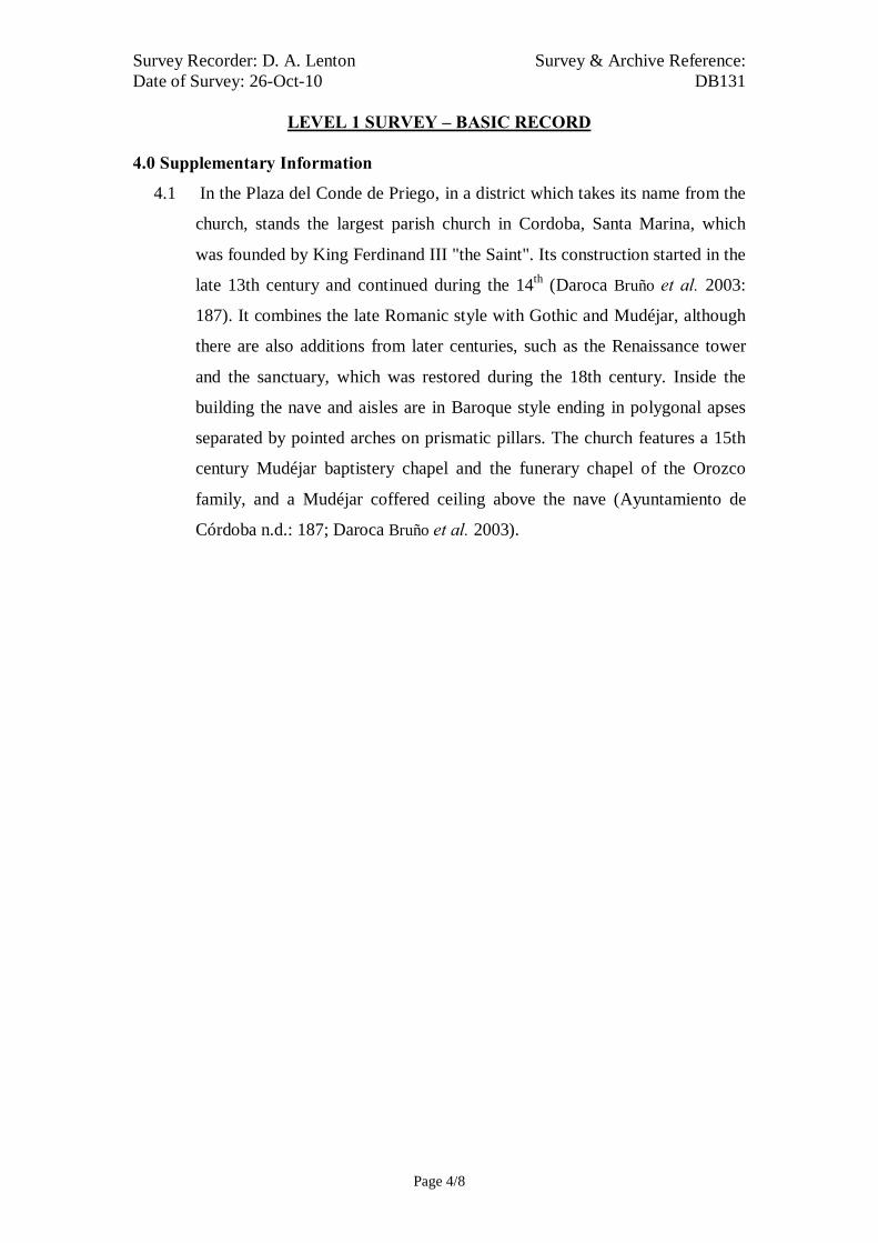
Survey Recorder: D. A. Lenton Survey & Archive Reference: Date of Survey: 26-Oct-10 DB131
LEVEL 1 SURVEY – BASIC RECORD
Page 4/8
4.0 Supplementary Information
4.1 In the Plaza del Conde de Priego, in a district which takes its name from the
church, stands the largest parish church in Cordoba, Santa Marina, which
was founded by King Ferdinand III "the Saint". Its construction started in the
late 13th century and continued during the 14th (Daroca Bruño et al. 2003:
187). It combines the late Romanic style with Gothic and Mudéjar, although
there are also additions from later centuries, such as the Renaissance tower
and the sanctuary, which was restored during the 18th century. Inside the
building the nave and aisles are in Baroque style ending in polygonal apses
separated by pointed arches on prismatic pillars. The church features a 15th
century Mudéjar baptistery chapel and the funerary chapel of the Orozco
family, and a Mudéjar coffered ceiling above the nave (Ayuntamiento de
Córdoba n.d.: 187; Daroca Bruño et al. 2003).
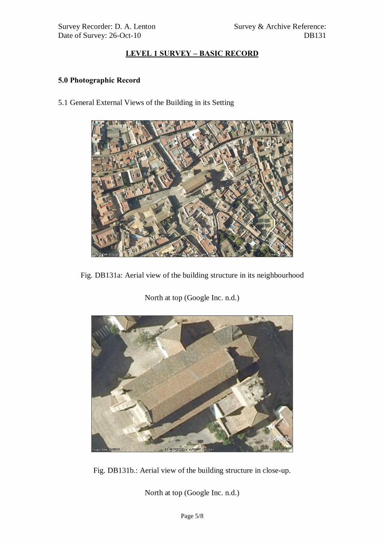
Survey Recorder: D. A. Lenton Survey & Archive Reference: Date of Survey: 26-Oct-10 DB131
LEVEL 1 SURVEY – BASIC RECORD
Page 5/8
5.0 Photographic Record
5.1 General External Views of the Building in its Setting
Fig. DB131a: Aerial view of the building structure in its neighbourhood
North at top (Google Inc. n.d.)
Fig. DB131b.: Aerial view of the building structure in close-up.
North at top (Google Inc. n.d.)

Survey Recorder: D. A. Lenton Survey & Archive Reference: Date of Survey: 26-Oct-10 DB131
LEVEL 1 SURVEY – BASIC RECORD
Page 6/8
Fig. 131c: South-West aspect
Fig. 131e: North-East aspect
Fig. 131g: North-East aspect
Fig. 131d: South-West aspect
Fig. 131f: North aspect
Fig. 131h: Bell Tower

Survey Recorder: D. A. Lenton Survey & Archive Reference: Date of Survey: 26-Oct-10 DB131
LEVEL 1 SURVEY – BASIC RECORD
Page 7/8
6.0 Drawing Record
No site drawings made

Survey Recorder: D. A. Lenton Survey & Archive Reference: Date of Survey: 26-Oct-10 DB131
LEVEL 1 SURVEY – BASIC RECORD
Page 8/8
7.0 Bibliography
Ayuntamiento de Córdoba n.d.: Córdoba: Oficinas De Información Turística, (ed. Ayuntamiento de Córdoba) Ayuntamiento de Córdoba, Córdoba. Daroca Bruño, F., Yllescas Ortiz, M. & De La Fuente Darder, F. (eds.) 2003: Córdoba: Guía De Arquitectura. Córdoba: Colegio Oficial de Arquitectura de Córdoba. Google Inc. n.d.: Google Earth 6 Web Catalogue http://www.google.co.uk/intl/en_uk/earth/index.html, Mountain View, CA. Iglesias Costa, M. 1989: Arquitectura Sacra: Desde El Period Gótico (Siglo Xiii) Hasta La Actualidad. Zaragoza: Gobierno de Aragon. Ministerio de Cultura n.d.: Bien De Interés Cultural: La Base De Datos De Bienes Inmuebles, http://www.mcu.es/bienes/cargarFiltroBienesInmuebles.do?layout=bienesInmuebles&cache=init&language=es.

Survey Recorder: D. A. Lenton Survey & Archive Reference: Date of Survey: 31-Oct-10 DB132
LEVEL 2 SURVEY – DESCRIPTIVE RECORD
Page 1/9
Contents
1.0 Identification of Building or Structure
2.0 Summary of Building Type and Historical Usage
3.0 Description of Building & Materials
4.0 Supplementary Information
5.0 Photographic Record
6.0 Drawing Record – Addendum Attached 1 Page
7.0 Bibliography

Survey Recorder: D. A. Lenton Survey & Archive Reference: Date of Survey: 31-Oct-10 DB132
LEVEL 2 SURVEY – DESCRIPTIVE RECORD
Page 2/9
1.0 Identification of Building or Structure
1.1
Building Short Name
Iglesia de San Pedro
1.2 Variant Names Iglesia de San Pedro de Alcántara
Church of St. Peter the Apostle
1.3 Address Plaza de San Pedro, Córdoba, Spain
1.4 Location Co-ordinates Northing 37.882° Easting -4.772°
1.5 Statutory & Non-statutory
Designations
Within the designated area of the Córdoba
UNESCO World Heritage Site No. 313
(1984/1994).
Bien de Interés Cultural (Nationally Listed as
a Building of Cultural Interest) (Ministerio de
Cultura n.d.).
1.6 Survey Assessment &
Archaeological Value
Preservation is High (3). It has many surviving
medieval walls to third storey height, although
the building has been subject to modern repair.
Legibility is Medium (2). Its walls are partially
rendered.
Accessibility is Low (2). The upper storeys of
the building are unattainable for detailed
measured survey.
Stratigraphical Complexity is Medium (2).
First inspection indicated that the structure’s
phases spanned 2 periods- Reconquista and
Imperial.
Archaeological Value is Medium (2-2.5).
1.7 Primary Building Technique 1400AD: Stone; large bonded with very large;
dressed; rectangular; regular coursing; thick
mortar.
1600AD: Stone; very large; ashlar;
rectangular; regular coursing; thick mortar.
Survey Recorder: D. A. Lenton Survey & Archive Reference: Date of Survey: 31-Oct-10 DB132
LEVEL 2 SURVEY – DESCRIPTIVE RECORD
Page 3/9
2.0 Summary of Building Type and Historical Usage
2.1 Reconquista period church of earliest known date late 13th century with
additions in the 16th, 17th and 19th centuries (Daroca Bruño et al. 2003: 166).
It is currently a catholic church.
2.2 The building is located on its own plaza in the parish of San Pedro north east
of the Mezquita.
2.3 The main (west) entrance is via timber double leaf door (Door A) through an
arched vestibule.
3.0 Description of Building & Materials
3.1 Foundations and walls are of Andalusían limestone and rise to a height of
17.62m above the nave. Many walls are unrendered and stonework is
exposed and visible. The nave has one aisle on either side to the north and
south constructed on high pointed arches that date to the late 13th or early
14th century.
3.2 The main medieval west entrance no longer survives. It has been replaced
with an Imperial period portal in 16th-century Mannerist proportions
comprising pilasters and a pediment at second storey level. However, there is
an elaborate rose window [Fig. 132g] above it at third storey height that is
indicative of a 13th-century Gothic style. The north and south aisle doorways
(Doors B & C) [Drawing 132.1 & Fig. 132h] are also built with high-pointed
limestone arch with archivolts on limestone pilaster capitals. The tightly
undercut and decorated archivolts are characteristic of High Gothic tool
carving of the 13th century (Geddes 2001: 168).
3.3 There is a single three-storey semi-octagonal apse at the east end with
supporting piers but no buttresses [Drawing 132.1 & Fig. 132d]. The apse
has three elongated round-arch windows and the whole structure is
characteristic of 13th-14th-century Castilian churches during the Gothic to
Mudéjar transition (Iglesias Costa 1989: 28; 166; 250).
3.4 The nave is lined by stonework arcading to third storey height in an early
Gothic style with high pointed arches on heavy columns with single fluted
piers [Fig. 132g]. The apse and the nave abut each other suggesting that one

Survey Recorder: D. A. Lenton Survey & Archive Reference: Date of Survey: 31-Oct-10 DB132
LEVEL 2 SURVEY – DESCRIPTIVE RECORD
Page 4/9
was built before the other. It seems likely the apse was built first and the
church therefore consecrated for immediate use as part of the programme of
“Iglesias Fernandinas” in the mid 13th century. There is no clear evidence to
suggest that the nave, aisles, and doorways were built in anymore than one
phase around the end of the 13th century.
3.5 The rectangular limestone Tower is purported to stand on a rectangular
limestone base of medieval date (Daroca Bruño et al. 2003: 166) but there is
no evidence present to support this. The Tower Belfry is in a later 16th-
century Herrerian design from the Imperial period.
3.6 The eastern façade encloses the Apse with a series of arches in similar
proportions to the Herrerian Belfy and also likely to date from the later 16th
century.
3.7 Roofs are tiled with 20th century ceramic roof tiles.
4.0 Supplementary Information
4.1 This parish church was started in the late 13th century by order of Ferdinand
III. Two Medieval doorways have survived to this day as well as the first
section of the tower (Daroca Bruño et al. 2003: 166). Changes were made by
the architect Hernán Ruiz II in the 16th century, when the main façade was
built, and by Juan de Ochoa, who built the sacristy in the 16th century (Daroca
Bruño et al. 2003: 166). In the 17th century, plasterwork was added to the
original ceilings. The most notable feature on the inside is the main altarpiece,
made in the 18th century by Félix Morales Negrete, and the altarpiece in the
Chapel of the Martyrs, by Alonso Gómez de Sandoval (Ayuntamiento de
Córdoba n.d.; Daroca Bruño et al. 2003: 166).

Survey Recorder: D. A. Lenton Survey & Archive Reference: Date of Survey: 31-Oct-10 DB132
LEVEL 2 SURVEY – DESCRIPTIVE RECORD
Page 5/9
5.0 Photographic Record
5.1 General External Views of the Building in its Setting
Fig. 132a: Aerial view of the building structure in its neighbourhood
North at top (Google Inc. n.d.)
Fig. 132b.: Aerial view of the building structure in close-up.
North at top (Google Inc. n.d.)

Survey Recorder: D. A. Lenton Survey & Archive Reference: Date of Survey: 31-Oct-10 DB132
LEVEL 2 SURVEY – DESCRIPTIVE RECORD
Page 6/9
Fig. 132c: West aspect
Fig. 132e: North aspect
Fig. 132d: East aspect
Fig. 132f: South aspect
Fig. 132g: West aspect & Door A Fig. 132h: Door C

Survey Recorder: D. A. Lenton Survey & Archive Reference: Date of Survey: 31-Oct-10 DB132
LEVEL 2 SURVEY – DESCRIPTIVE RECORD
Page 7/9
5.2 Interior, Principal Rooms and Circulation Areas
Looking East Looking North East
South Aisle Looking East Looking North East
Fig. 132i Nave and Aisles

Survey Recorder: D. A. Lenton Survey & Archive Reference: Date of Survey: 31-Oct-10 DB132
LEVEL 2 SURVEY – DESCRIPTIVE RECORD
Page 8/9
6.0 Drawing Record
Addendum
Drawing No. 132.1
1 Page A4 Size
Survey Recorder: D. A. Lenton Survey & Archive Reference: Date of Survey: 31-Oct-10 DB132
LEVEL 2 SURVEY – DESCRIPTIVE RECORD
Page 9/9
7.0 Bibliography
Ayuntamiento de Córdoba n.d.: Córdoba: Oficinas De Información Turística, (ed. Ayuntamiento de Córdoba) Ayuntamiento de Córdoba, Córdoba. Daroca Bruño, F., Yllescas Ortiz, M. & De La Fuente Darder, F. (eds.) 2003: Córdoba: Guía De Arquitectura. Córdoba: Colegio Oficial de Arquitectura de Córdoba. Geddes, J. 2001. "Iron", in J. Blair & N. Ramsey (eds.): English Medieval Industries : Craftsmen, Techniques, Products, pp. 167-188. London: Hambledon and London. Google Inc. n.d.: Google Earth 6 Web Catalogue http://www.google.co.uk/intl/en_uk/earth/index.html, Mountain View, CA. Iglesias Costa, M. 1989: Arquitectura Sacra: Desde El Period Gótico (Siglo Xiii) Hasta La Actualidad. Zaragoza: Gobierno de Aragon. Ministerio de Cultura n.d.: Bien De Interés Cultural: La Base De Datos De Bienes Inmuebles, http://www.mcu.es/bienes/cargarFiltroBienesInmuebles.do?layout=bienesInmuebles&cache=init&language=es.

20 metres (approx.)
Survey Reference:DB132 Drawing No:132.1Building Short Name: Iglesia San PedroAddress: Plaza de San Pedro, Córdoba, SpainScale: 1:500 Sheet Size: ISO A4
Ground Floor Plan
West Elevation East Elevation
Tower
Door A Nave
Door B
Door C
Chapel

Survey Recorder: D. A. Lenton Survey & Archive Reference: Date of Survey: 23-Oct-10 DB133
LEVEL 2 SURVEY – DESCRIPTIVE RECORD
Page 1/9
Contents
1.0 Identification of Building or Structure
2.0 Summary of Building Type and Historical Usage
3.0 Description of Building & Materials
4.0 Supplementary Information
5.0 Photographic Record
6.0 Drawing Record – Addendum Attached 1 Page
7.0 Bibliography

Survey Recorder: D. A. Lenton Survey & Archive Reference: Date of Survey: 23-Oct-10 DB133
LEVEL 2 SURVEY – DESCRIPTIVE RECORD
Page 2/9
1.0 Identification of Building or Structure
1.1 Building Short Name Iglesia de Santiago
1.2 Variant Names Church of St. James
1.3 Address Calle Agustín Moreno, Córdoba, Spain
1.4 Location Co-ordinates Northing 37.881° Easting -4.769°
1.5 Statutory and non-statutory
designations
Within the designated area of the Córdoba
UNESCO World Heritage Site No. 313
(1984/1994).
Bien de Interés Cultural (Nationally Listed as
a Building of Cultural Interest) (Ministerio de
Cultura n.d.).
1.6 Survey Assessment &
Archaeological Value
Preservation is Medium (2). It has many
surviving medieval walls to second storey
height, although the building has been subject
to modern repair and addition.
Legibility is Medium (2). The walls of the
building have been partially rendered.
Accessibility is Medium (2). Large parts of the
building are obscured by modern elements.
Stratigraphical Complexity is Medium (2).
First inspection indicated that the structure’s
phases spanned at least 2 periods – Moorish
and Reconquista.
Archaeological Value is Medium (2-2.5).
1.7 Primary Building Technique 1200AD: Stone; very large; ashlar; well
squared; regular; thin mortar.
1400AD: Stone; large bonded with very large;
ashlar; rectangular; regular coursing; thin
mortar.
Survey Recorder: D. A. Lenton Survey & Archive Reference: Date of Survey: 23-Oct-10 DB133
LEVEL 2 SURVEY – DESCRIPTIVE RECORD
Page 3/9
2.0 Summary of Building Type and Historical Usage
2.1 Reconquista period church of earliest known date late 12th century with
additions in the 13th, 15th, 16th, 19th and 20th centuries. It is currently a
catholic church.
2.2 The building is located on a main thoroughfare in the parish of Santiago
north-east of the Mezquita.
2.3 The main (west) entrance (Door A) is via timber double leaf door from a
narrow side street (Calle Ronquillo Riceño) running north to south.
3.0 Description of Building & Materials
3.1 Foundations and walls are of Andalusían limestone and rise to a height of
19.1m above the 13th century nave. Walls are partly rendered but some areas
are exposed. The nave has one aisle on either side to the north and south. The
medieval arcading has been removed and replaced with 19th-century rounded
arches atop cruciform columns and covered by coffered wooden ceilings
(Daroca Bruño et al. 2003: 156). The South Aisle retains its High Gothic
ribbed vaulting.
3.2 The main (west) entrance is via timber double leaf door. The doorway has a
high-pointed limestone arch with archivolts decorated with diamond point
patterns and a frieze with floral motifs on limestone pilaster capitals [Fig.
133e]. The tightly undercut and decorated archivolts and the elaborate rose
window at second storey height are characteristic of High Gothic tool
carving of the 13th century (Geddes 2001: 168).
3.3 There is a single three-storey semi-octagonal apse at the east end with ribbed
vaulting and supporting piers but no buttresses in a 13th or 14th century style
(Daroca Bruño et al. 2003: 156) [Drawing 133.1]. The whole structure of the
apse is characteristic of 13th-14th-century Castilian churches during the
Gothic to Mudéjar transition (Iglesias Costa 1989: 28; 166; 250). There is no
clear evidence to suggest that the nave, aisles, and doorways were built in
anymore than one phase around the end of the 13th century.

Survey Recorder: D. A. Lenton Survey & Archive Reference: Date of Survey: 23-Oct-10 DB133
LEVEL 2 SURVEY – DESCRIPTIVE RECORD
Page 4/9
3.4 The minaret/ Bell Tower (3.73 by 2.99 metres) is in a Baroque style of the
Imperial period but is founded on the base of a minaret of the Moorish period
(Collins 1998: 122).
3.5 Roofs are tiled with 20th century ceramic roof tiles.
4.0 Supplementary Information
4.1 Like most of the Fernandine churches, this one was built on the site of a
former Omeyan mosque of which the minaret has survived to this day,
converted into a Christian tower (Fuertes Romero et al. 2003: 149; Daroca
Bruño et al. 2003: 156). Many of its original architectural features were
subject to restoration work carried out on the building in the 19th century
(Daroca Bruño et al. 2003: 156). The main body of the church, rectangular in
shape, is divided into a nave and two aisles. Among the many artistic works
is the image of Cristo de las Penas (Christ of Grief), an anonymous work
from the 15th century (Ayuntamiento de Córdoba n.d.).
4.2 The north doorway opens on to Calle Agustín Moreno by way of a portico of
rounded arches built in the 19th century. In 1981 the church suffered a
collapse and was restored in 1987 (Daroca Bruño et al. 2003: 156).
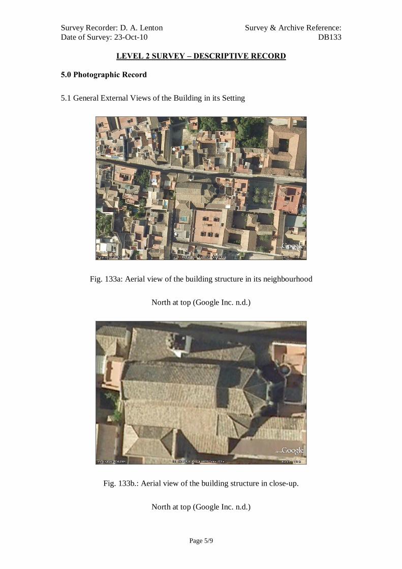
Survey Recorder: D. A. Lenton Survey & Archive Reference: Date of Survey: 23-Oct-10 DB133
LEVEL 2 SURVEY – DESCRIPTIVE RECORD
Page 5/9
5.0 Photographic Record
5.1 General External Views of the Building in its Setting
Fig. 133a: Aerial view of the building structure in its neighbourhood
North at top (Google Inc. n.d.)
Fig. 133b.: Aerial view of the building structure in close-up.
North at top (Google Inc. n.d.)

Survey Recorder: D. A. Lenton Survey & Archive Reference: Date of Survey: 23-Oct-10 DB133
LEVEL 2 SURVEY – DESCRIPTIVE RECORD
Page 6/9
Fig. 133c: North aspect viewed from
the west.
Fig. 133e: West aspect viewed from
the south.
Fig. 133d: North aspect viewed from
the north-west.
Fig. 133f: North aspect viewed from
the east

Survey Recorder: D. A. Lenton Survey & Archive Reference: Date of Survey: 23-Oct-10 DB133
LEVEL 2 SURVEY – DESCRIPTIVE RECORD
Page 7/9
Fig. 133g: North Entrance Fig. 133h: West aspect from the south
Fig. 133i: North Entrance Fig. 133j: West aspect from the north

Survey Recorder: D. A. Lenton Survey & Archive Reference: Date of Survey: 23-Oct-10 DB133
LEVEL 2 SURVEY – DESCRIPTIVE RECORD
Page 8/9
6.0 Drawing Record
Addendum
Drawing No. 133.1
1 Page A4 Size

Survey Recorder: D. A. Lenton Survey & Archive Reference: Date of Survey: 23-Oct-10 DB133
LEVEL 2 SURVEY – DESCRIPTIVE RECORD
Page 9/9
7.0 Bibliography
Ayuntamiento de Córdoba n.d.: Córdoba: Oficinas De Información Turística, (ed. Ayuntamiento de Córdoba) Ayuntamiento de Córdoba, Córdoba. Collins, R. 1998: Spain: An Oxford Archaeological Guide. Oxford: Oxford University Press. Daroca Bruño, F., Yllescas Ortiz, M. & De La Fuente Darder, F. (eds.) 2003: Córdoba: Guía De Arquitectura. Córdoba: Colegio Oficial de Arquitectura de Córdoba. Fuertes Romero, R.-M., López Guerrero, R., Rodríguez Sánchez, M. & Valdivieso Ramos, A. 2003. "La Qurtuba Islámica: Las Mezquitas", in J. Fernández (ed.) Guía Archaeológica De Córdoba, pp. 148-150. Córdoba: Plurabelle. Geddes, J. 2001. "Iron", in J. Blair & N. Ramsey (eds.): English Medieval Industries : Craftsmen, Techniques, Products, pp. 167-188. London: Hambledon and London. Google Inc. n.d.: Google Earth 6 Web Catalogue http://www.google.co.uk/intl/en_uk/earth/index.html, Mountain View, CA. Iglesias Costa, M. 1989: Arquitectura Sacra: Desde El Period Gótico (Siglo Xiii) Hasta La Actualidad. Zaragoza: Gobierno de Aragon. Ministerio de Cultura n.d.: Bien De Interés Cultural: La Base De Datos De Bienes Inmuebles, http://www.mcu.es/bienes/cargarFiltroBienesInmuebles.do?layout=bienesInmuebles&cache=init&language=es.

10 metres10 metresSurvey Reference:DB133 Drawing No:133.1Building Short Name: Iglesia de SantiagoAddress: Calle Agustín Moreno, Córdoba, SpainScale: 1:200 Sheet Size: ISO A4
BellTower
Nave
North Aisle
South Aisle
Door A
Ground Floor Plan

Survey Recorder: D. A. Lenton Survey & Archive Reference: Date of Survey: 22-Oct-10 DB134
LEVEL 1 SURVEY – BASIC RECORD
Page 1/8
Contents
1.0 Identification of Building or Structure
2.0 Summary of Building Type and Historical Usage
3.0 Description of Building & Materials
4.0 Supplementary Information
5.0 Photographic Record
6.0 Drawing Record
7.0 Bibliography

Survey Recorder: D. A. Lenton Survey & Archive Reference: Date of Survey: 22-Oct-10 DB134
LEVEL 1 SURVEY – BASIC RECORD
Page 2/8
1.0 Identification of Building or Structure
1.1
Building Short Name
Iglesia de San Andrés
1.2 Variant Names Church of San Andrés
1.3 Address Plaza de San Andrés-Realejo, Córdoba, Spain
1.4
Location Co-ordinates
Northing 37.886°Easting -4.773°
1.5
Statutory & Non-statutory
Designations
Within the designated area of the Córdoba
UNESCO World Heritage Site No. 313
(1984/1994).
Bien de Interés Cultural (Nationally Listed as
a Building of Cultural Interest) (Ministerio de
Cultura n.d.)
1.6 Survey Assessment &
Archaeological Value
Preservation is Medium (2). Elements of the
medieval structure is intact up to roof level.
Legibility is Medium (2). Many of the walls
are rendered.
Accessibility is Low (1). The greater part of
the building is poorly lit or inaccessible to
hand survey.
Stratigraphical Complexity is Medium (2).
The building spans at least 2 periods –
Reconquista and Imperial.
Archaeological Value is Low (1-2).
1.7 Primary Building Technique 1400AD: Stone; large bonded with very large;
dressed; rectangular; regular coursing; thick
mortar.

Survey Recorder: D. A. Lenton Survey & Archive Reference: Date of Survey: 22-Oct-10 DB134
LEVEL 1 SURVEY – BASIC RECORD
Page 3/8
2.0 Summary of Building Type and Historical Usage
2.1 Reconquista period church of earliest known date early 13th century (Daroca
Bruño et al. 2003: 176).
2.2 The building is located on a plaza in the parish of San Andrés north-east of
the Mezquita.
2.3 The west entrance is via timber double leaf door directly from the street.
3.0 Description of Building & Materials
3.1 Foundations of the perimeter walls are of Andalusían limestone but rise in
local clay brickwork construction. Perimeter brickwork walls are not
rendered but exposed.
3.2 The west entrance was constructed with a slightly pointed splayed arch set on
slender columns with sculptural decoration. It has been dated to 1489
(Daroca Bruño et al. 2003: 176).
3.3 The central apse of the Fernandian church is polygonal in shape with gothic
ogives now hidden by 18th-century groined arches. It is a two-storey semi-
octagonal apse at the east end of the nave with supporting piers but no
buttresses. The apse structure is characteristic of 13th-14th-century Castilian
churches during the Gothic to Mudéjar transition (Iglesias Costa 1989: 28;
166; 250). The medieval nave has one aisle on either side to the north and
south. The nave and aisles are separated by prismatic columns but heavily
concealed by plasterwork characteristic of the Imperial period. The medieval
apse and nave abut each other implying that were constructed separately. The
nave and aisles are of the same building technique and bonded together
suggesting that they were constructed in a single phase. It is possible that the
apse was constructed first and the was church consecrated for Christian use
as part of the 13th-century “Iglesias Fernandinas” programme and that the
nave and aisles were built on the foundations of a former mosque’s qibla.
This would explain the medieval church’s north-east orientation.
3.4 The main body of the church was re-orientated and remodelled in a Baroque
style in the 18th century (Daroca Bruño et al. 2003: 176).

Survey Recorder: D. A. Lenton Survey & Archive Reference: Date of Survey: 22-Oct-10 DB134
LEVEL 1 SURVEY – BASIC RECORD
Page 4/8
4.0 Supplementary Information
4.1 This parish was consecrated in the 13th century, after the reconquest of the
city, on the site where a visigothic church devoted to St. Zoilo had been. The
building was finished in 1489, the date established by the early main portal,
nowadays the side entrance. In the 16th century, the tower was erected and in
the 18th century, under Bishop Marcelino Siuri, a new church was built,
changing the orientation of the old one and maintaining the portal and eastern
end. Inside are altar pieces of the 16th and 18th centuries (Ayuntamiento de
Córdoba n.d.).

Survey Recorder: D. A. Lenton Survey & Archive Reference: Date of Survey: 22-Oct-10 DB134
LEVEL 1 SURVEY – BASIC RECORD
Page 5/8
5.0 Photographic Record
5.1 General External Views of the Building in its Setting
Fig. DB134a: Aerial view of the building structure in its neighbourhood
North at top (Google Inc. n.d.)
Fig. DB134b.: Aerial view of the building structure in close-up.
North at top (Google Inc. n.d.)

Survey Recorder: D. A. Lenton Survey & Archive Reference: Date of Survey: 22-Oct-10 DB134
LEVEL 1 SURVEY – BASIC RECORD
Page 6/8
Fig. 134c: West aspect viewed from
the north-west.
Fig. 134e: North aspect viewed from
the north-west
Fig. 134g: West Portal
Fig. 134d: West aspect viewed from
the north-west.
Fig. 134f: North aspect
Fig. 134h: Nave. Looking south.

Survey Recorder: D. A. Lenton Survey & Archive Reference: Date of Survey: 22-Oct-10 DB134
LEVEL 1 SURVEY – BASIC RECORD
Page 7/8
6.0 Drawing Record
No site drawings made

Survey Recorder: D. A. Lenton Survey & Archive Reference: Date of Survey: 22-Oct-10 DB134
LEVEL 1 SURVEY – BASIC RECORD
Page 8/8
7.0 Bibliography
Ayuntamiento de Córdoba n.d.: Córdoba: Oficinas De Información Turística, (ed. Ayuntamiento de Córdoba) Ayuntamiento de Córdoba, Córdoba. Daroca Bruño, F., Yllescas Ortiz, M. & De La Fuente Darder, F. (eds.) 2003: Córdoba: Guía De Arquitectura. Córdoba: Colegio Oficial de Arquitectura de Córdoba. Google Inc. n.d.: Google Earth 6 Web Catalogue http://www.google.co.uk/intl/en_uk/earth/index.html, Mountain View, CA. Iglesias Costa, M. 1989: Arquitectura Sacra: Desde El Period Gótico (Siglo Xiii) Hasta La Actualidad. Zaragoza: Gobierno de Aragon. Ministerio de Cultura n.d.: Bien De Interés Cultural: La Base De Datos De Bienes Inmuebles, http://www.mcu.es/bienes/cargarFiltroBienesInmuebles.do?layout=bienesInmuebles&cache=init&language=es.

Survey Recorder: D. A. Lenton Survey & Archive Reference: Date of Survey: 21-Oct-10 DB135
LEVEL 1 SURVEY – BASIC RECORD
Page 1/8
Contents
1.0 Identification of Building or Structure
2.0 Summary of Building Type and Historical Usage
3.0 Description of Building & Materials
4.0 Supplementary Information
5.0 Photographic Record
6.0 Drawing Record
7.0 Bibliography

Survey Recorder: D. A. Lenton Survey & Archive Reference: Date of Survey: 21-Oct-10 DB135
LEVEL 1 SURVEY – BASIC RECORD
Page 2/8
1.0 Identification of Building or Structure
1.1
Building Short Name
Iglesia de San Miguel
1.2 Variant Names Church of San Miguel
1.3 Address Plaza de San Miguel, Córdoba, Spain
1.4
Location Co-ordinates
Northing 37.886°Easting -4.779°
1.5
Statutory & Non-statutory
Designations
Within the designated area of the Córdoba
UNESCO World Heritage Site No. 313
(1984/1994).
Bien de Interés Cultural (Nationally Listed as
a Building of Cultural Interest) (Ministerio de
Cultura n.d.).
1.6 Survey Assessment &
Archaeological Value
Preservation is High (3). The medieval
structure is intact up to roof level.
Legibility is Medium (2). The walls are
partially rendered.
Accessibility is Low (1). The greater part of
the building is poorly lit or inaccessible to
survey.
Stratigraphical Complexity is Medium (2).
The building spans at least 2 periods –
Reconquista and Imperial.
Archaeological Value is Low (1-2).
1.7 Primary Building Technique 1400AD: Stone; large bonded with very large;
dressed; rectangular; regular coursing; thick
mortar.
Survey Recorder: D. A. Lenton Survey & Archive Reference: Date of Survey: 21-Oct-10 DB135
LEVEL 1 SURVEY – BASIC RECORD
Page 3/8
2.0 Summary of Building Type and Historical Usage
2.1 Reconquista period church of earliest known date early 13th century (Daroca
Bruño et al. 2003: 200).
2.2 The building is located on a plaza in the parish of San Andrés north-east of
the Mezquita.
2.3 The main (south-west) entrance is via timber double leaf door directly from
the street.
3.0 Description of Building & Materials
3.1 Foundations and walls are of Andalusían limestone and rise to a height of
approximately 20m above the 13th - 14th century nave. Walls are not rendered
and the stonework is visible.
3.2 The main (south-west) entrance is via timber double leaf door headed by a
low pointed arch in a 13th or 14th-century Gothic-Mudéjar transition style.
Above is an elaborate rose window [Fig. 135f] at second storey height that is
indicative of a 13th-century Gothic style.
3.3 There is a three-storey semi-octagonal apse at the north-east end of the nave
with supporting piers but no buttresses. The apse structure is characteristic of
13th-14th-century Castilian churches during the Gothic to Mudéjar transition
(Iglesias Costa 1989: 28; 166; 250). The nave has one aisle on either side to
the north-west and south-east. The nave and aisles are separated by prismatic
columns supporting high pointed Gothic arches. Each aisle has a two-storey
semi-octagonal apse added and abutted to its north-east end in a similar 14th-
century Mudéjar style to the primary apse. The nave and aisles appear to
have been constructed in a single phase around the end of the 13th century,
whereas the church was clearly appended with the two additional apes
sometime during the 14th century.
3.4 The primary apse and nave abut each other implying that were constructed
separately. The nave and aisles are of the same building technique and
bonded together suggesting that they were constructed in a single phase. It is
possible that the apse was constructed first and the was church consecrated
for Christian use as part of the 13th-century “Iglesias Fernandinas”

Survey Recorder: D. A. Lenton Survey & Archive Reference: Date of Survey: 21-Oct-10 DB135
LEVEL 1 SURVEY – BASIC RECORD
Page 4/8
programme and that the nave and aisles were built on the foundations of a
former mosque’s qibla. This would explain the medieval church’s north-east
orientation. The South Door has a Moorish period horseshoe arch [Fig. 135g]
in Caliphal style striped stonework that supports this hypothesis.
4.0 Supplementary Information
4.1 This is a parish church from the period of Fernando III built on the site of an
old mosque. The interior has three naves, the central on covered by a
coffered ceiling and three polygonal apses with ribbed vaults. The north one
was reformed in 1761. The vestry was built in 1602 and the tower in 1749.
On the south aisle is the Capilla de los Vargos with its octagonal ribbed
dome, a Mudéjar work from the 15th century, which is entered by way of a
pointed horseshoe arch with saw tooth mouldings (Daroca Bruño et al. 2003:
200).

Survey Recorder: D. A. Lenton Survey & Archive Reference: Date of Survey: 21-Oct-10 DB135
LEVEL 1 SURVEY – BASIC RECORD
Page 5/8
5.0 Photographic Record
5.1 General External Views of the Building in its Setting
Fig. DB135a: Aerial view of the building structure in its neighbourhood
North at top (Google Inc. n.d.)
Fig. DB135b.: Aerial view of the building structure in close-up.
North at top (Google Inc. n.d.)

Survey Recorder: D. A. Lenton Survey & Archive Reference: Date of Survey: 21-Oct-10 DB135
LEVEL 1 SURVEY – BASIC RECORD
Page 6/8
Fig. 135c: West aspect
Fig. 135e: West door.
Fig. 135g: South aspect door
Fig. 135d: West aspect viewed from
the north-west.
Fig. 135f: West aspect rose window
Fig. 135h: Nave. Looking east.
Survey Recorder: D. A. Lenton Survey & Archive Reference: Date of Survey: 21-Oct-10 DB135
LEVEL 1 SURVEY – BASIC RECORD
Page 7/8
6.0 Drawing Record
No site drawings made

Survey Recorder: D. A. Lenton Survey & Archive Reference: Date of Survey: 21-Oct-10 DB135
LEVEL 1 SURVEY – BASIC RECORD
Page 8/8
7.0 Bibliography
Daroca Bruño, F., Yllescas Ortiz, M. & De La Fuente Darder, F. (eds.) 2003: Córdoba: Guía De Arquitectura. Córdoba: Colegio Oficial de Arquitectura de Córdoba. Google Inc. n.d.: Google Earth 6 Web Catalogue http://www.google.co.uk/intl/en_uk/earth/index.html, Mountain View, CA. Iglesias Costa, M. 1989: Arquitectura Sacra: Desde El Period Gótico (Siglo Xiii) Hasta La Actualidad. Zaragoza: Gobierno de Aragon. Ministerio de Cultura n.d.: Bien De Interés Cultural: La Base De Datos De Bienes Inmuebles, http://www.mcu.es/bienes/cargarFiltroBienesInmuebles.do?layout=bienesInmuebles&cache=init&language=es.

Survey Recorder: D. A. Lenton Survey & Archive Reference: Date of Survey: 21-Oct-10 DB136
LEVEL 1 SURVEY – BASIC RECORD
Page 1/7
Contents
1.0 Identification of Building or Structure
2.0 Summary of Building Type and Historical Usage
3.0 Description of Building & Materials
4.0 Supplementary Information
5.0 Photographic Record
6.0 Drawing Record
7.0 Bibliography
Survey Recorder: D. A. Lenton Survey & Archive Reference: Date of Survey: 21-Oct-10 DB136
LEVEL 1 SURVEY – BASIC RECORD
Page 2/7
1.0 Identification of Building or Structure
1.1 Building Short Name Iglesia de San Francisco
1.2 Variant Names Iglesia de San Francisco y San Eulogio de la
Axerquía
Convento de San Pedro el Real
Church of San Francisco
1.3 Address Calle San Fernando, Córdoba, Spain
1.4
Location Co-ordinates
Northing 37.881°Easting -4.775°
1.5
Statutory & Non-statutory
Designations
Within the designated area of the Córdoba
UNESCO World Heritage Site No. 313
(1984/1994).
Bien de Interés Cultural (Nationally Listed as
a Building of Cultural Interest) (Ministerio de
Cultura n.d.)
1.6 Survey Assessment &
Archaeological Value
Preservation is High (3). The medieval
structure is intact up to roof level.
Legibility is Low (1). The walls are rendered.
Accessibility is Low (1). The greater part of
the building is inaccessible to survey.
Stratigraphical Complexity is Medium (2).
The building spans at least 2 periods –
Reconquista and Imperial.
Archaeological Value is Low (1-2).
1.7 Primary Building Technique 1400AD: Stone; large bonded with very large;
dressed; rectangular; regular coursing; thick
mortar.
Survey Recorder: D. A. Lenton Survey & Archive Reference: Date of Survey: 21-Oct-10 DB136
LEVEL 1 SURVEY – BASIC RECORD
Page 3/7
2.0 Summary of Building Type and Historical Usage
2.1 Reconquista period church of earliest known date early 13th century (Daroca
Bruño et al. 2003: 149).
2.2 The building is located on a plaza in the parish of San Nicolás de la Axerquía
east of the Mezquita.
2.3 The west entrance is via timber double leaf door directly from the street.
3.0 Description of Building & Materials
3.1 Foundations of the perimeter walls are of Andalusían limestone. Perimeter
brickwork walls are not rendered but exposed. Little is visible of the
Reconquista period structure but the church is laid out in the Roman
cruciform plan with a Choir ahead of the transept towards the north-east.
3.2 There is a two-storey semi-octagonal apse at the east end of the transept with
supporting piers but no buttresses. The apse structure is characteristic of 13th-
14th-century Castilian churches during the Gothic to Mudéjar transition (c.f.
Iglesias Costa 1989: 28; 166; 250). The medieval nave has been removed and
there is no visible evidence for medieval aisles.
3.3 The nave was constructed in the Baroque style in the 18th century.
4.0 Supplementary Information
4.1 The Franciscan convent of San Pedro was founded in the 13th century and
dissolved in 1812. Only the church remains. The façade is of grey marble in
1731. The church is laid out in a Latin cross configuration with a single 18th-
century nave, a high choir and a sanctuary with three polygonal apses(Daroca
Bruño et al. 2003: 149). The nave is covered by a groined barrel vault, whilst
the transept has an oval dome set on squinches. The central apse is covered
by a barrel vault with arch ribs. Two 17th-century bays remain on 13th-
century cloister foundations with 2 storeys of semicircular arches set on
columns with Tuscan capitals. The 18th-century bell gable, located in a
corner, has a serlian arch.

Survey Recorder: D. A. Lenton Survey & Archive Reference: Date of Survey: 21-Oct-10 DB136
LEVEL 1 SURVEY – BASIC RECORD
Page 4/7
5.0 Photographic Record
5.1 General External Views of the Building in its Setting
Fig. DB136a: Aerial view of the building structure in its neighbourhood
North at top (Google Inc. n.d.)
Fig. DB136b.: Aerial view of the building structure in close-up.
North at top (Google Inc. n.d.)

Survey Recorder: D. A. Lenton Survey & Archive Reference: Date of Survey: 21-Oct-10 DB136
LEVEL 1 SURVEY – BASIC RECORD
Page 5/7
Fig. 136c: West aspect
Fig. 136e: Nave. Looking east.
Fig. 136d: West aspect
Fig. 136f: Nave. Looking west.

Survey Recorder: D. A. Lenton Survey & Archive Reference: Date of Survey: 21-Oct-10 DB136
LEVEL 1 SURVEY – BASIC RECORD
Page 6/7
6.0 Drawing Record
No site drawings made

Survey Recorder: D. A. Lenton Survey & Archive Reference: Date of Survey: 21-Oct-10 DB136
LEVEL 1 SURVEY – BASIC RECORD
Page 7/7
7.0 Bibliography
Daroca Bruño, F., Yllescas Ortiz, M. & De La Fuente Darder, F. (eds.) 2003: Córdoba: Guía De Arquitectura. Córdoba: Colegio Oficial de Arquitectura de Córdoba. Google Inc. n.d.: Google Earth 6 Web Catalogue http://www.google.co.uk/intl/en_uk/earth/index.html, Mountain View, CA. Iglesias Costa, M. 1989: Arquitectura Sacra: Desde El Period Gótico (Siglo Xiii) Hasta La Actualidad. Zaragoza: Gobierno de Aragon. Ministerio de Cultura n.d.: Bien De Interés Cultural: La Base De Datos De Bienes Inmuebles, http://www.mcu.es/bienes/cargarFiltroBienesInmuebles.do?layout=bienesInmuebles&cache=init&language=es.

Survey Recorder: D. A. Lenton Survey & Archive Reference: Date of Survey: 04-Nov-10 DB137
LEVEL 3 SURVEY – ANALYTIC RECORD
Page 1/9
Contents
1.0 Identification of Building or Structure
2.0 Summary of Building Type and Historical Usage
3.0 Description of Building & Materials
4.0 Supplementary Information
5.0 Photographic Record
6.0 Drawing Record – Addendum Attached 1 Page
7.0 Bibliography

Survey Recorder: D. A. Lenton Survey & Archive Reference: Date of Survey: 04-Nov-10 DB137
LEVEL 3 SURVEY – ANALYTIC RECORD
Page 2/9
1.0 Identification of Building or Structure
1.1
Building Short Name
Capilla de San Bartolomé
1.2 Variant Names Chapel of San Bartolomé, Chapel of the
Hospital of Cardinal Salazar
1.3 Address Plaza del Cardenal Salazar,
Córdoba, Spain
1.4
Location Co-ordinates
Northing 37.879°Easting -4.782°
1.5
Statutory & Non-statutory
Designations
Within the designated area of the Córdoba
UNESCO World Heritage Site No. 313
(1984/1994).
Bien de Interés Cultural (Nationally Listed as
a Building of Cultural Interest) (Ministerio de
Cultura n.d.).
1.6 Survey Assessment &
Archaeological Value
Preservation is High (3). The medieval
structure is intact up to roof level.
Legibility is Medium (2). The walls are
partially rendered.
Accessibility is High (3). The building is
publically accessible.
Stratigraphical Complexity is Medium (2).
The building spans at least 2 periods –
Reconquista and Imperial.
Archaeological Value is High (2.5-3).
1.7 Primary Building Technique 1400AD: Stone; large bonded with very large;
dressed; rectangular; regular coursing; thick
mortar.

Survey Recorder: D. A. Lenton Survey & Archive Reference: Date of Survey: 04-Nov-10 DB137
LEVEL 3 SURVEY – ANALYTIC RECORD
Page 3/9
2.0 Summary of Building Type and Historical Usage
2.1 Reconquista period Chapel and Courtyard of earliest proposed date 13th
century. It is currently a museum and tourist attraction.
2.2 The building is located on a narrow street running north-east to south-west in
the parish of Santa Maria north-west of the Mezquita.
2.3 The sole (east) entrance is via a pointed-arched gate directly from the street
to the Courtyard.
3.0 Statement of Materials and Dates
3.1 Foundations and external walls are of Andalucían limestone construction.
Perimeter walls are high (approximately 6 metres) and partially rendered in
cement and sand plaster and are painted.
3.2 The complex is entered via a double width doorway (Door A) with a modern
iron gate. There is a (reused) high pointed arch (Door A) [Drawing 137.1 &
Fig. 137d] heading the doorway with archivolts and an alfiz all in limestone
and characteristic of a 13th to 14th-century Mudéjar style,
3.3 Door A leads into the rectangular Courtyard (12.77m x 7.39m) including a
portico Gallery on the south side. The portico incorporates two reused fluted
marble columns with foliated capital of Visigothic appearance.
3.4 At the east end of the Courtyard, there are stone steps up to a centred arch,
characteristic of the 15th / 16th century, opening onto a small recess or 19th-
century Side Chapel containing a restored Baroque shrine. In the north wall
there are three rounded arches, now infilled with brickwork that may have
been a portico to the north side of the complex now lost.
3.5 The portico Gallery encompasses the main entrance to the Chapel (Door B)
[Fig. 137h], which is a double leaf timber door through a high pointed arch
carved with chevrons and an alfiz with marble pilasters in a 14th-century
Mudéjar style (Iglesias Costa 1989: 28; 166; 250).
3.6 The interior of the Chapel is made up of a single rectangular nave (9.0m x
5.0m) a crossed vaulted ceiling [Fig. 137] characteristic of the 13th – 14th
century. There is a raised tiled plinth at the east end with a recessed altar set
in the east wall with a rounded arch in limestone ashlar.

Survey Recorder: D. A. Lenton Survey & Archive Reference: Date of Survey: 04-Nov-10 DB137
LEVEL 3 SURVEY – ANALYTIC RECORD
Page 4/9
3.7 The Chapel and its courtyard complex are orientated along a south-west to
north-east axis. This suggests that the lost church and any possible lost
mosque also lay on this orientation.
4.0 Supplementary Information
4.1 This chapel, once the parish church of San Bartolomé, now forms part of the
Faculty of Philosophy and Arts, the former Cardinal Salazar hospital, and is
an example of Mudéjar architecture. It was commissioned by Domingo
Muñoz in the 13th century (Calvert 1906: 153). It became attached to the
newly established parish church of San Bartolomé (now lost) after a violent
assault on the Juderia in 1391 (Daroca Bruño et al. 2003: 124). In the
Baroque period, it was incorporated into the hospital, and then restored in the
19th century. There are traces of former murals behind the altar. The last
restoration work was carried out in the 1970s, but recently work has started
to recover the 19th century side chapel with its Baroque altarpiece
(Ayuntamiento de Córdoba n.d.).
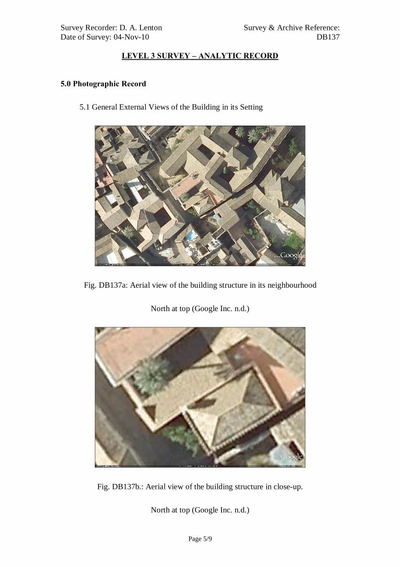
Survey Recorder: D. A. Lenton Survey & Archive Reference: Date of Survey: 04-Nov-10 DB137
LEVEL 3 SURVEY – ANALYTIC RECORD
Page 5/9
5.0 Photographic Record
5.1 General External Views of the Building in its Setting
Fig. DB137a: Aerial view of the building structure in its neighbourhood
North at top (Google Inc. n.d.)
Fig. DB137b.: Aerial view of the building structure in close-up.
North at top (Google Inc. n.d.)

Survey Recorder: D. A. Lenton Survey & Archive Reference: Date of Survey: 04-Nov-10 DB137
LEVEL 3 SURVEY – ANALYTIC RECORD
Page 6/9
Fig. 137c: South-west aspect viewed
from the west.
Fig. 137e: Courtyard viewed from the
south-west
Fig. 137d: South-west entrance
Fig. 137f: Courtyard viewed from the
south
Fig. 137g: Courtyard viewed from the
north

Survey Recorder: D. A. Lenton Survey & Archive Reference: Date of Survey: 04-Nov-10 DB137
LEVEL 3 SURVEY – ANALYTIC RECORD
Page 7/9
5.2 Interior, Principal Rooms and Circulation Areas
Looking East Looking North-east
Looking North Looking North
Looking North Looking South-west
Fig. 137h Chapel

Survey Recorder: D. A. Lenton Survey & Archive Reference: Date of Survey: 04-Nov-10 DB137
LEVEL 3 SURVEY – ANALYTIC RECORD
Page 8/9
6.0 Drawing Record
Addendum
Drawing No. 137.1
1 Page A4 Size

Survey Recorder: D. A. Lenton Survey & Archive Reference: Date of Survey: 04-Nov-10 DB137
LEVEL 3 SURVEY – ANALYTIC RECORD
Page 9/9
7.0 Bibliography
Ayuntamiento de Córdoba n.d.: Córdoba: Oficinas De Información Turística, (ed. Ayuntamiento de Córdoba) Ayuntamiento de Córdoba, Córdoba. Calvert, A. F. 1906: Moorish Remains in Spain : Being a Brief Record of the Arabian Conquest of the Peninsula with a Particular Account of the Mohammedan Architecture and Decoration in Cordova, Seville & Toledo London & New York: John Lane. Daroca Bruño, F., Yllescas Ortiz, M. & De La Fuente Darder, F. (eds.) 2003: Córdoba: Guía De Arquitectura. Córdoba: Colegio Oficial de Arquitectura de Córdoba. Google Inc. n.d.: Google Earth 6 Web Catalogue http://www.google.co.uk/intl/en_uk/earth/index.html, Mountain View, CA. Iglesias Costa, M. 1989: Arquitectura Sacra: Desde El Period Gótico (Siglo Xiii) Hasta La Actualidad. Zaragoza: Gobierno de Aragon. Ministerio de Cultura n.d.: Bien De Interés Cultural: La Base De Datos De Bienes Inmuebles, http://www.mcu.es/bienes/cargarFiltroBienesInmuebles.do?layout=bienesInmuebles&cache=init&language=es.

10 metres10 metresSurvey Reference: DB137 Drawing No: 137.1Building Short Name: Capilla San BartoloméAddress: Plaza del Cardenal Salazar, Córdoba, SpainScale: 1:200 Sheet Size: ISO A4
A
A
Ground Floor Plan Section A-A
Courtyard
Chapel
Door A
GalleryDoor B
Altar
SideChapel

Survey Recorder: D. A. Lenton Survey & Archive Reference: Date of Survey: 28-Oct-10 DB138
LEVEL 2 SURVEY – DESCRIPTIVE RECORD
Page 1/8
Contents
1.0 Identification of Building or Structure
2.0 Summary of Building Type and Historical Usage
3.0 Description of Building & Materials
4.0 Supplementary Information
5.0 Photographic Record
6.0 Drawing Record – Addendum Attached 1 Page
7.0 Bibliography
Survey Recorder: D. A. Lenton Survey & Archive Reference: Date of Survey: 28-Oct-10 DB138
LEVEL 2 SURVEY – DESCRIPTIVE RECORD
Page 2/8
1.0 Identification of Building or Structure
1.1 Building Short Name Casa de los Luna
1.2 Variant Names House of the Luna Family
1.3 Address Plaza de San Andrés, Córdoba, Spain
1.4 Location Co-ordinates Northing 37.886° Easting -4.773°
1.5
Statutory & Non-statutory
Designations
Within the designated area of the Córdoba
UNESCO World Heritage Site No. 313
(1984/1994).
Bien de Interés Cultural (Nationally Listed as
a Building of Cultural Interest) (Ministerio de
Cultura n.d.)
1.6 Survey Assessment &
Archaeological Value
Preservation is High (3). Two storeys of the
medieval structure are intact.
Legibility is Medium (2). The walls are
partially rendered.
Accessibility is Medium (2). The interior of
the building is obscured by later remodelling.
Stratigraphical Complexity is Low (2). The
building spans one period - Imperial.
Archaeological Value is Medium (2-2.5).
1.7 Primary Building Technique Stone; very large; ashlar; rectangular; regular;
thick mortar.

Survey Recorder: D. A. Lenton Survey & Archive Reference: Date of Survey: 28-Oct-10 DB138
LEVEL 2 SURVEY – DESCRIPTIVE RECORD
Page 3/8
2.0 Summary of Building Type and Historical Usage
2.1 Early Imperial period house or palace of earliest suggested date mid-16th
century with Late Imperial and Modern period additions. It is currently a
Ministry of Culture office and art gallery.
2.2 The building is located on its own plaza in the parish of San Andrés north-
east of the Mezquita.
2.3 The main (north) entrance is via timber double leaf door (Door A). There are
3 storeys above ground plus roof space.
3.0 Description of Building & Materials
3.1 Foundations and walls are of Andalusían limestone ashlar and rise to a height
of 11.43m at the highest point. Walls are mostly not rendered and ashlar
stones are exposed.
3.2 The main entrance (Door A) is in the North Elevation on the ground floor
and leads into the mid-16th century Imperial period part of the building. Door
A is a double leaf timber doorway in Herrerian proportions with an ashlar
stone lintel decorated in heraldic motifs in a Plateresque style characteristic
of the 16th century.
3.3 The first floor of the north elevation above Door A is pierced by a
rectangular window (Window A) bordered by pilasters and a balconet with
decorative stone with heraldic motifs all in a Plateresque style characteristic
of the 16th century. A host and guest would have been able to make a visible
appearance and address from this window to the plaza below but would not
have been able to step out.
3.4 The third floor is a Late-Imperial period addition with industrial brickwork
pierced by 2 sets of rectangular double loggia window openings each
separated by a marble column.
3.5 The eastern end of the north elevation has a rectangular window on both
ground and first floor levels, which are coeval with the surrounding
stonework. At the eastern corner, a rectangular corner window has been
inserted in ashlar at both first and second floor levels (Windows B&C). This
suggests that they are of a later date. These are of mimicked design to the

Survey Recorder: D. A. Lenton Survey & Archive Reference: Date of Survey: 28-Oct-10 DB138
LEVEL 2 SURVEY – DESCRIPTIVE RECORD
Page 4/8
Plateresque Window A & Door A and are therefore likely to be of a 19th
century revivalist style.
3.6 The northern block is the largest element of the Early Imperial period
building and would have been sufficient to provide an open space on the
First Floor for formal dining as well as service rooms on the Ground Floor.
The small Courtyard to the south is accessible via galleries and is comparable
in size to those of the Archivo Municipal [DB105] and the Casa de las Bulas
[DB121].
3.7 Roofs are tiled with 20th century ceramic roof tiles.
4.0 Supplementary Information
4.1 The House of the Luna family is an example of an Andalusian aristocratic
mansion in Plateresque style. The most striking feature is the stone façade,
which is attributed to the architect Hernán Ruiz I and built for Hernán Pérez de
Oliva, a famous humanist of the 16th century (Daroca Bruño et al. 2003: 33). It
was later enlarged by the addition of an extra floor, with double loggia-style
windows. The main entrance gate, framed by mouldings and pilasters on the
door posts, features original terminations in the form of stone balls on the ends
and relief work depicting garlands on the lintel, with the coat of arms of the
Luna family above. There is a double right-angled balcony on one corner,
spanning over two floors with a central column and framed with decorative
stone mouldings. The interior and rear were reformed in the mid-20th century
(Daroca Bruño et al. 2003: 175).

Survey Recorder: D. A. Lenton Survey & Archive Reference: Date of Survey: 28-Oct-10 DB138
LEVEL 2 SURVEY – DESCRIPTIVE RECORD
Page 5/8
5.0 Photographic Record
5.1 General External Views of the Building in its Setting
Fig. DB138a: Aerial view of the building structure in its neighbourhood
North at top (Google Inc. n.d.)
Fig. DB138b.: Aerial view of the building structure in close-up.
North at top (Google Inc. n.d.)

Survey Recorder: D. A. Lenton Survey & Archive Reference: Date of Survey: 28-Oct-10 DB138
LEVEL 2 SURVEY – DESCRIPTIVE RECORD
Page 6/8
Fig. 138c: North aspect viewed from
the north-east.
Fig. 138e: East aspect
Fig. 138d: North aspect
Fig. 138f: North aspect
Survey Recorder: D. A. Lenton Survey & Archive Reference: Date of Survey: 28-Oct-10 DB138
LEVEL 2 SURVEY – DESCRIPTIVE RECORD
Page 7/8
6.0 Drawing Record
Addendum
Drawing No. DB138.1
1 Page A4 Size

Survey Recorder: D. A. Lenton Survey & Archive Reference: Date of Survey: 28-Oct-10 DB138
LEVEL 2 SURVEY – DESCRIPTIVE RECORD
Page 8/8
7.0 Bibliography
Daroca Bruño, F., Yllescas Ortiz, M. & De La Fuente Darder, F. (eds.) 2003: Córdoba: Guía De Arquitectura. Córdoba: Colegio Oficial de Arquitectura de Córdoba. Google Inc. n.d.: Google Earth 6 Web Catalogue http://www.google.co.uk/intl/en_uk/earth/index.html, Mountain View, CA. Ministerio de Cultura n.d.: Bien De Interés Cultural: La Base De Datos De Bienes Inmuebles, http://www.mcu.es/bienes/cargarFiltroBienesInmuebles.do?layout=bienesInmuebles&cache=init&language=es.

10 metresSurvey Reference: DB138 Drawing No: 138.1Building Short Name: Casa de los Luna,Address: No.3 Plaza de San Andrés, Córdoba, SpainScale: 1:200 Sheet Size: ISO A4
Window AWindow C
Window B
Door A
Ground Floor Plan
Door A
Courtyard
North Elevation

Survey Recorder: D. A. Lenton Survey & Archive Reference: Date of Survey: 31-Oct-10 DB139
LEVEL 2 SURVEY – DESCRIPTIVE RECORD
Page 1/7
Contents
1.0 Identification of Building or Structure
2.0 Summary of Building Type and Historical Usage
3.0 Description of Building & Materials
4.0 Supplementary Information
5.0 Photographic Record
6.0 Drawing Record – Addendum Attached 1 Page
7.0 Bibliography
Survey Recorder: D. A. Lenton Survey & Archive Reference: Date of Survey: 31-Oct-10 DB139
LEVEL 2 SURVEY – DESCRIPTIVE RECORD
Page 2/7
1.0 Identification of Building or Structure
1.1 Building Short Name Puerta de Sevilla
1.2 Variant Names Seville Gate
1.3 Address Avenida Conde de Vallellano-Calle San
Bartolomé, Córdoba, Spain
1.4 Location Co-ordinates Northing 37.875° Easting -4.785°
1.5 Statutory and non-statutory
designations
Within the designated area of the Córdoba
UNESCO World Heritage Site No. 313
(1984/1994). Bien de Interés Cultural
(Nationally Listed as a Building of Cultural
Interest) (Ministerio de Cultura n.d.).
1.6 Survey Assessment &
Archaeological Value
Preservation is Medium (2). Its Medieval
period elements have been well conserved but
it has been subject to some modern
reconstruction.
Legibility is High (3). its walls have no
coverings.
Accessibility is Medium (2). The structure is
publically accessible but partially obscured by
later buildings.
Stratigraphical Complexity is Medium (2).
First inspection indicated that the structure’s
phases spanned 2 periods – Moorish and
Reconquista.
Archaeological Value is Medium (2).
1.7 Primary Building Technique 1200AD: Stone; large upon very large;
dressed; rectangular; regular coursing; thick
mortar. 1400AD: Stone; very large; dressed;
rectangular; regular coursing; thick mortar.

Survey Recorder: D. A. Lenton Survey & Archive Reference: Date of Survey: 31-Oct-10 DB139
LEVEL 2 SURVEY – DESCRIPTIVE RECORD
Page 3/7
2.0 Summary of Building Type and Historical Usage
2.1 Moorish period gate in the city perimeter wall of earliest known date 10th
century (Daroca Bruño et al. 2003: 107). It is currently a monumental ruin
and tourist attraction.
2.2 The building is located on its own plaza in the parish of Santa Maria south-
west of the Mezquita.
3.0 Description of Building & Materials
3.1 Foundations and walls are of large bonded with very large Andalusían
limestone blocks that formed a 10th-century aqueduct (Daroca Bruño et al.
2003: 107). Walls are unrendered and possibly face over a mud brick pisé
spine. The remaining length of wall is approximately 91 metres long to its
extremities.
3.2 Walls are repaired with very large limestone blocks that date to the
Reconquista period and include modern repairs (Daroca Bruño et al. 2003:
107).
3.3 The gateway is toward the northern end of the wall and comprises two
openings: one with a horseshoe arch that is denotative of the Moorish period
and one with a rounded limestone arch likely to date from the Moorish
period or earlier (Fig. 139c).
3.4 A hexagonal limestone corner bastion stands approximate 49 metres south of
the gate. The stonework is entirely in very large, dressed, rectangular, stone
blocks in regular coursing with thick mortar. Its shape, form and composition
are in a highly decorative style of the Reconquista period and probably date
from the later 14th-century post-civil war consolidation works of Enrique II.
4.0 Supplementary Information
4.1 The ramparts that move away towards the river are Christian works from the
14th century, although they were almost entirely reconstructed in 1958 by
José Rebollo (Daroca Bruño et al. 2003: 107).
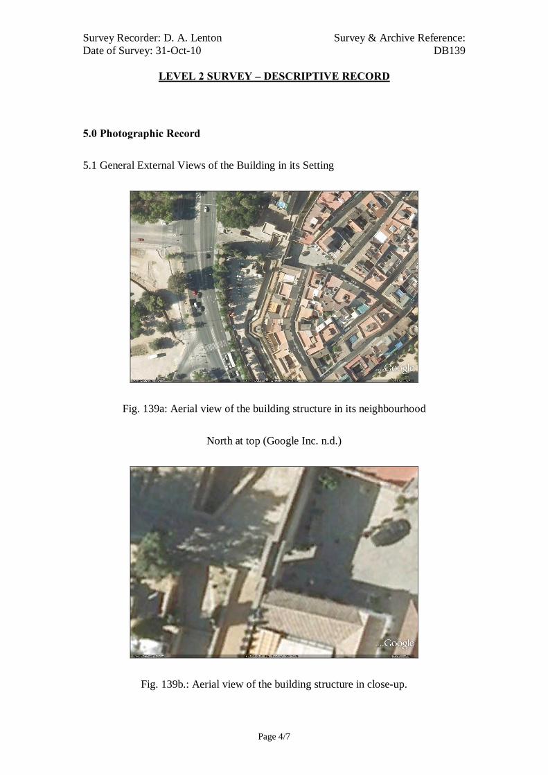
Survey Recorder: D. A. Lenton Survey & Archive Reference: Date of Survey: 31-Oct-10 DB139
LEVEL 2 SURVEY – DESCRIPTIVE RECORD
Page 4/7
5.0 Photographic Record
5.1 General External Views of the Building in its Setting
Fig. 139a: Aerial view of the building structure in its neighbourhood
North at top (Google Inc. n.d.)
Fig. 139b.: Aerial view of the building structure in close-up.

Survey Recorder: D. A. Lenton Survey & Archive Reference: Date of Survey: 31-Oct-10 DB139
LEVEL 2 SURVEY – DESCRIPTIVE RECORD
Page 5/7
North at top (Google Inc. n.d.)
Fig. 139c: West aspect from the north.
Fig. 139d: East aspect from the south.

Survey Recorder: D. A. Lenton Survey & Archive Reference: Date of Survey: 31-Oct-10 DB139
LEVEL 2 SURVEY – DESCRIPTIVE RECORD
Page 6/7
6.0 Drawing Record
Addendum
Drawing No. 139.1
1 Page A4 Size

Survey Recorder: D. A. Lenton Survey & Archive Reference: Date of Survey: 31-Oct-10 DB139
LEVEL 2 SURVEY – DESCRIPTIVE RECORD
Page 7/7
7.0 Bibliography
Daroca Bruño, F., Yllescas Ortiz, M. & De La Fuente Darder, F. (eds.) 2003: Córdoba: Guía De Arquitectura. Córdoba: Colegio Oficial de Arquitectura de Córdoba. Google Inc. n.d.: Google Earth 6 Web Catalogue http://www.google.co.uk/intl/en_uk/earth/index.html, Mountain View, CA. Ministerio de Cultura n.d.: Bien De Interés Cultural: La Base De Datos De Bienes Inmuebles, http://www.mcu.es/bienes/cargarFiltroBienesInmuebles.do?layout=bienesInmuebles&cache=init&language=es.

20 metres
Survey Reference:DB139 Drawing No:139.1Building Short Name: Puerta de Sevilla Address: Avenida Conde de Vallellano, Córdoba, SpainScale: <NTS> Sheet Size: ISO A4

Survey Recorder: D. A. Lenton Survey & Archive Reference: Date of Survey: 20-Oct-10 DB140
LEVEL 3 SURVEY – ANALYTIC RECORD
Page 1/8
Contents
1.0 Identification of Building or Structure
2.0 Summary of Building Type and Historical Usage
3.0 Description of Building & Materials
4.0 Supplementary Information
5.0 Photographic Record
6.0 Drawing Record – Addendum Attached 1 Page
7.0 Bibliography
Survey Recorder: D. A. Lenton Survey & Archive Reference: Date of Survey: 20-Oct-10 DB140
LEVEL 3 SURVEY – ANALYTIC RECORD
Page 2/8
1.0 Identification of Building or Structure
1.1 Building Short Name Puerta del Rincón
1.2 Variant Names Torre de la Puerta del Rincón
Tower of the Corner Gate.
1.3 Address Calle Alfaros-Calle Isabel Losa,
Córdoba, Spain
1.4 Location Co-ordinates Northing 37.888°
Easting -4.776°
1.5 Statutory & Non-statutory
Designations
Within the designated area of the Córdoba
UNESCO World Heritage Site No. 313
(1984/1994).
Bien de Interés Cultural (Nationally Listed as
a Building of Cultural Interest) (Ministerio de
Cultura n.d.).
1.6 Survey Assessment &
Archaeological Value
Preservation is Medium (2). Its Medieval
period elements have been well conserved but
it has been subject to some modern
reconstruction.
Legibility is High (3). Its walls have no
coverings.
Accessibility is High (3). The structure is
publically accessible.
Stratigraphical Complexity is High (3). First
inspection indicated that the structure’s phases
spanned at least 3 periods.
Archaeological Value is High (2.5-3).
1.7 Primary Building Technique 1200AD: Stone; very large; dressed;
rectangular; regular coursing; thick mortar.
1400AD: Stone; very large; dressed;
rectangular; regular coursing; thick mortar.

Survey Recorder: D. A. Lenton Survey & Archive Reference: Date of Survey: 20-Oct-10 DB140
LEVEL 3 SURVEY – ANALYTIC RECORD
Page 3/8
2.0 Summary of Building Type and Historical Usage
2.1 Moorish period section of the Medina wall of earliest proposed date 12th
century (Daroca Bruño et al. 2003: 194). It is currently a monumental ruin
and tourist attraction.
2.2 The building is located in the parish of Santa Marina north-east of the
Mezquita.
3.0 Statement of Materials and Dates
3.1 Foundations are of Andalucían limestone construction. The foundations are
of regular stone blocks and are visible above ground level.
3.2 The spine of the wall is not exposed but is likely to be of similar pisé
construction to that at Muralla del Marrubial faced in limestone to a
maximum height of 16.45 metres. The walls have later renovations above 3
metres so that the medieval height cannot be determined but their
construction is comparable with that of the remaining walls of the Moorish
period Alcázar [DB109 Fig. 109d] and therefore likely to date to the 10th
century or earlier. The earliest elements are visible in the foundations and
walls below 3 metres in height, which are of limestone construction. The
foundations are of regular stone blocks and are visible above ground level.
The structure forms the north-east corner of the Medina wall and comprises a
large hexagonal bastion of 7.20 metres diameter [Fig. 140d]. Although
subject to later remodelling and repair, the construction of the lower section
of this bastion appears consistent with the 10th-century date and stands 10.84
metres high above the modern street level. The bastion itself has a horizontal
break line at 10.96 metres above ground level. Above this line, the building
technique employed is similar: very large, dressed, rectangular, stone blocks
in regular coursing with thick mortar. However, this upper stage has a
diminished radius and a truncated north-eastern face suggesting that it was
rebuilt after partial demolition and is likely to date from one of the
Reconquista rebuilding phases.

Survey Recorder: D. A. Lenton Survey & Archive Reference: Date of Survey: 20-Oct-10 DB140
LEVEL 3 SURVEY – ANALYTIC RECORD
Page 4/8
3.3 The structural elements above the horizontal lines of discontinuity (at around
3 metres) are likely to date from later than the Moorish period. The building
technique comprises large bonded with very large, dressed, rectangular, stone
blocks in regular coursing with thick mortar. It is reasonable to surmise that
these survive from Reconquista period rebuilding works associated with the
mid 13th-century defence of the city and the mid 14th-century civil war. A
horizontal line of 8 joint mortises are visible along a horizontal break line in
the western return wall. The repairs above this line are of lower quality in a
mix of large stonework, stone rubble and irregular brickwork in patches.
Much of the brickwork forms arch and roof shapes that were clearly part of
later buildings abutted to the main structure. This may indicate that these
stem from a much later date in the Imperial period.
4.0 Supplementary Information
4.1 This medieval tower lies at the junction between the streets Calle Alfaros and
Calle Isabel Losa forming part of the remains of the city walls which
surrounded the old Medina. Just like the Portillo Arch, it was built to create a
passageway between the districts of the Medina and the Axerquía, and is
made up of an archway and some fairly solid defensive walls (Ayuntamiento
de Córdoba n.d.).
4.2 This fortified tower of the north-eastern bend of the Roman ramparts was
prolonged in the Caliphal period and became the Torre de la Puerta del
Rincón in the Almohade expansion during the 12th century. It has a
polygonal layout and curtain ramparts. The offset between the Medina and
the Axerquía corresponds to the ground floor of the Convento del Cister
(Daroca Bruño et al. 2003: 194)
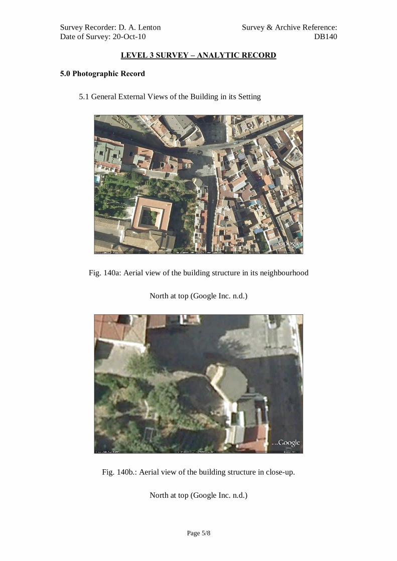
Survey Recorder: D. A. Lenton Survey & Archive Reference: Date of Survey: 20-Oct-10 DB140
LEVEL 3 SURVEY – ANALYTIC RECORD
Page 5/8
5.0 Photographic Record
5.1 General External Views of the Building in its Setting
Fig. 140a: Aerial view of the building structure in its neighbourhood
North at top (Google Inc. n.d.)
Fig. 140b.: Aerial view of the building structure in close-up.
North at top (Google Inc. n.d.)

Survey Recorder: D. A. Lenton Survey & Archive Reference: Date of Survey: 20-Oct-10 DB140
LEVEL 3 SURVEY – ANALYTIC RECORD
Page 6/8
Fig. 140c: North aspect viewed from
the north-east.
Fig. 140e: North aspect
Fig. 140d: East aspect viewed from the
east.
Fig. 140f: East aspect

Survey Recorder: D. A. Lenton Survey & Archive Reference: Date of Survey: 20-Oct-10 DB140
LEVEL 3 SURVEY – ANALYTIC RECORD
Page 7/8
6.0 Drawing Record
Addendum
Drawing No. 140.1
1 Page A4 Size

Survey Recorder: D. A. Lenton Survey & Archive Reference: Date of Survey: 20-Oct-10 DB140
LEVEL 3 SURVEY – ANALYTIC RECORD
Page 8/8
7.0 Bibliography
Ayuntamiento de Córdoba n.d.: Córdoba: Oficinas De Información Turística, (ed. Ayuntamiento de Córdoba) Ayuntamiento de Córdoba, Córdoba. Daroca Bruño, F., Yllescas Ortiz, M. & De La Fuente Darder, F. (eds.) 2003: Córdoba: Guía De Arquitectura. Córdoba: Colegio Oficial de Arquitectura de Córdoba. Google Inc. n.d.: Google Earth 6 Web Catalogue http://www.google.co.uk/intl/en_uk/earth/index.html, Mountain View, CA. Ministerio de Cultura n.d.: Bien De Interés Cultural: La Base De Datos De Bienes Inmuebles, http://www.mcu.es/bienes/cargarFiltroBienesInmuebles.do?layout=bienesInmuebles&cache=init&language=es.

10 metres10 metresSurvey Reference:DB140 Drawing No:140.1Building Short Name: Puerta del RincónAddress: Calle Alfaros-Calle Isabel Losa, Córdoba, SpainScale: 1:200 Sheet Size: ISO A4
Ground Plan
North Elevation
Tower
Survey Recorder: D. A. Lenton Survey & Archive Reference: Date of Survey: 06-Nov-08 DB141
LEVEL 2 SURVEY – DESCRIPTIVE RECORD
Page 1/9
Contents
1.0 Identification of Building or Structure
2.0 Summary of Building Type and Historical Usage
3.0 Description of Building & Materials
4.0 Supplementary Information
5.0 Photographic Record
6.0 Drawing Record – Addendum Attached 1 Page
7.0 Research Questions & Interpretations
8.0 Bibliography

Survey Recorder: D. A. Lenton Survey & Archive Reference: Date of Survey: 06-Nov-08 DB141
LEVEL 2 SURVEY – DESCRIPTIVE RECORD
Page 2/9
1.0 Identification of Building or Structure
1.1
Building Short Name
Muralla del Marrubial
1.2 Variant Names Old Town Walls of Marrubial
1.3 Address Ronda del Marrubial, Córdoba, Spain
1.4 Location Co-ordinates Northing 37.891°Easting -4.766°
1.5 Statutory & Non-statutory
Designations
Within the designated area of the Córdoba
UNESCO World Heritage Site No. 313
(1984/1994).
1.6 Survey Assessment &
Archaeological Value
Preservation is Medium (2). Its Medieval
period elements have been well conserved but
it has been subject to some modern repair.
Legibility is High (3). Its walls have no
coverings.
Accessibility is Medium (2). The structure is
publically accessible but too large to be fully
recorded with the limits of this research.
Stratigraphical Complexity is High (3). First
inspection indicated that the structure’s phases
spanned at least 3 periods.
Archaeological Value is Medium (2-2.5).
1.7 Primary Building Technique 1200AD: Mud brick; large; pisé; shaped;
regular coursing; no mortar.
1400AD: Stone; large; undressed; rectangular;
regular coursing; thick mortar.
1600AD:
Survey Recorder: D. A. Lenton Survey & Archive Reference: Date of Survey: 06-Nov-08 DB141
LEVEL 2 SURVEY – DESCRIPTIVE RECORD
Page 3/9
2.0 Summary of Building Type and Historical Usage
2.1 Moorish, Reconquista and Imperial period town perimeter wall on of earliest
proposed date 12th century (Aguilar Gavilán 1995: 39; Moreno Romero
2003: 184). It is currently a monumental ruin and tourist attraction.
2.2 The structure is located on the inside pavement of a wide carriageway in the
parish of San Lorenzo north-east of the Mezquita.
2.3 The structure is a maximum of 5.70m high above ground level.
3.0 Statement of Materials and Dates
3.1 Foundations and walls are of pisé clay. The foundations repairs are of regular
stone blocks and are visible to 1.20m above ground level. This remaining
section of the wall runs from north-west to south-east for 370 metres and is
generally 1.90 metres wide with external buttresses extruding 4.0 metres.
This Primary Building Technique corresponds with that of the Muralla de los
Mártires, and is therefore recurrent in the later Moorish period walls. It is
fundamentally different from the earlier Moorish period civil constructions in
stone.
3.2 Six construction lifts, including the foundations, are visible (Fig 141e). The
first lift above the foundations is of pisé clay with scaffolding or cladding
mortises and has been repaired in places with modern clay brickwork. The
upper lifts are of pisé clay with scaffolding or cladding mortises to a height
of 5.70m above ground level and have been repaired in places with modern
clay brickwork.
3.3 The pisé and scaffolding mortises are all of the same construction phase.
They appear to be consistent with 12th century dates as they are comparable
in construction to other so-called “austere” fortified walls of the Almohade
regime in Murcia, Niebla (see Barrucand & Bednorz 1992: 146; 158),
Marrakesh, and Rabat (Grabar 1995: 218).
3.4 Internal angles of the buttresses have been repaired in places with
Andalucían limestone in large rectangular blocks in thick mortar and regular
coursing [Fig. 141i]. Although these blocks are smaller than the stones of the

Survey Recorder: D. A. Lenton Survey & Archive Reference: Date of Survey: 06-Nov-08 DB141
LEVEL 2 SURVEY – DESCRIPTIVE RECORD
Page 4/9
Calahorra [DB108] and undressed they are consistent with the mortar,
coursing and proportions. Consequently, these are likely to be 13th or 14th-
century repairs. Similar stone block repairs occur along the lower section or
upper foundations of the walls [Fig. 141d]. Pisé components have been
chopped out in straight vertical sections and straight horizontal planes, and
replaced with regular stone masonry coursing. This suggests that an
organised survey and maintenance programme was conducted during the
Reconquista period.
4.0 Supplementary Information
4.1 Remains of the city’s Caliphal expansion around the Axerquía, were fortified
during the Almoravide period (Aguilar Gavilán 1995: 39) following a rather
uneven design that may possibly be attributed to the reuse of existing
structures (Roman aqueduct at northern end) as well as the presence of
natural irregularities (troughs with streams in the eastern sector) (Daroca
Bruño et al. 2003: 181). Built with pisé masonry (rammed earth), the
ramparts have fortified towers that are attached along its perimeter’ they
probably had battlements and according to recent restorations, an outer fosse
(ditch). The stretch of remaining walls has 14 fortified towers and a length of
nearly 400 metres (Daroca Bruño et al. 2003: 181).

Survey Recorder: D. A. Lenton Survey & Archive Reference: Date of Survey: 06-Nov-08 DB141
LEVEL 2 SURVEY – DESCRIPTIVE RECORD
Page 5/9
5.0 Photographic Record
5.1 General External Views of the Building in its Setting
Fig. 141a: Aerial view of the building structure in its neighbourhood
North at top (Google Inc. n.d.)
Fig. 141b.: Aerial view of the building structure in close-up.
North at top (Google Inc. n.d.)

Survey Recorder: D. A. Lenton Survey & Archive Reference: Date of Survey: 06-Nov-08 DB141
LEVEL 2 SURVEY – DESCRIPTIVE RECORD
Page 6/9
Fig. 141c: North aspect from the south-
east
Fig. 141e: North aspect from the south-
east
Fig. 141g: Bastion north aspect
Fig. 141d: North aspect from the north-
east
Fig. 141f: North aspect from the north-
east
Fig. 141h: Bastion north-west aspect

Survey Recorder: D. A. Lenton Survey & Archive Reference: Date of Survey: 06-Nov-08 DB141
LEVEL 2 SURVEY – DESCRIPTIVE RECORD
Page 7/9
Fig. 141i: Bastion south-east aspect

Survey Recorder: D. A. Lenton Survey & Archive Reference: Date of Survey: 06-Nov-08 DB141
LEVEL 2 SURVEY – DESCRIPTIVE RECORD
Page 8/9
6.0 Drawing Record
Addendum
Drawing No. 141.1
1 Page A4 Size

Survey Recorder: D. A. Lenton Survey & Archive Reference: Date of Survey: 06-Nov-08 DB141
LEVEL 2 SURVEY – DESCRIPTIVE RECORD
Page 9/9
7.0 Bibliography
Aguilar Gavilán, E. 1995: Historia De Córdoba. Madrid: Sìlex. Barrucand, M. & Bednorz, A. 1992: Moorish Architecture in Andalusia. Cologne: Benedikt Taschen Verlag. Daroca Bruño, F., Yllescas Ortiz, M. & De La Fuente Darder, F. (eds.) 2003: Córdoba: Guía De Arquitectura. Córdoba: Colegio Oficial de Arquitectura de Córdoba. Google Inc. n.d.: Google Earth 6 Web Catalogue http://www.google.co.uk/intl/en_uk/earth/index.html, Mountain View, CA. Grabar, O. 1995. "The Architecture of Power: Palaces, Citadels and Fortifications", in G. Michell (ed.) Architecture of the Islamic World: Its History and Social Meaning, pp. 48-79. London: Thames & Hudson. Moreno Romero, L. E. 2003. "La Qurtuba Islámica: La Etapa Tardoislámica: La Córdoba Almohade", in J. Fernández (ed.) Guía Archaeológica De Córdoba, pp. 184-186. Cordoba: Plurabelle.

10 metres10 metresSurvey Reference:DB141 Drawing No:141.1Building Short Name: Muralla del Marrubial Address: Ronda del Marrubial, Córdoba, SpainScale: 1:200 Sheet Size: ISO A4
Ground Plan
North East Elevation

Survey Recorder: D. A. Lenton Survey & Archive Reference: Date of Survey: 27-Oct-10 DB142
LEVEL 1 SURVEY – BASIC RECORD
Page 1/8
Contents
1.0 Identification of Building or Structure
2.0 Summary of Building Type and Historical Usage
3.0 Description of Building & Materials
4.0 Supplementary Information
5.0 Photographic Record
6.0 Drawing Record
7.0 Bibliography

Survey Recorder: D. A. Lenton Survey & Archive Reference: Date of Survey: 27-Oct-10 DB142
LEVEL 1 SURVEY – BASIC RECORD
Page 2/8
1.0 Identification of Building or Structure
1.1
Building Short Name
Puerta del Puente
1.2
Variant Names
Arco del Puente, Algeciras Gate, The Gate of
the Bridge
1.3
Address
Plaza del Triunfo, Córdoba, Spain
1.4
Location Co-ordinates
Northing 37.887°Easting -4.779°
1.5
Statutory & Non-statutory
Designations
Within the designated area of the Córdoba
UNESCO World Heritage Site No. 313
(1984/1994).
Bien de Interés Cultural (Nationally Listed as
a Building of Cultural Interest) (Ministerio de
Cultura n.d.).
1.6 Survey Assessment &
Archaeological Value
Preservation is Medium (2). The medieval
structure remains intact but has been subject to
modern restoration.
Legibility is High (3). The stonework and
piers are unrendered.
Accessibility is Low (1). The structure was
obscured by restoration works at the time of
survey.
Stratigraphical Complexity is Low (1). On
first inspection, the structure appeared to have
been constructed in one phase.
Archaeological Value is Low (1-2).
1.7 Primary Building Technique Stone; very large; dressed; rectangular; regular
coursing; thin mortar.

Survey Recorder: D. A. Lenton Survey & Archive Reference: Date of Survey: 27-Oct-10 DB142
LEVEL 1 SURVEY – BASIC RECORD
Page 3/8
2.0 Summary of Building Type and Historical Usage
2.1 Imperial period triumphal arched gateway built on the site/ foundations of a
Moorish period gate of earliest known date 12th century (Daroca Bruño et al.
2003: 84). It is currently a tourist attraction.
2.2 The building is located on a plaza on the north bank of the Guadalquivir
between the Puente Romano and the Mezquita.
3.0 Description of Building & Materials
3.1 Foundations and walls are of Andalusían limestone and ashlar.
3.2 The gate has a square headed linteled opening flanked by two pairs of Doric
columns on a bas that supports an entablature with a cornice. The gate is
crowned with an unfinished semicircular pediment that bears the royal coat
of arms of Filipe II (Daroca Bruño et al. 2003: 84).
3.3 The Primary Building Technique employed was very, rectangular, ashlar
stone in regular coursing in thin mortar. The gate has a square headed
linteled opening flanked by two pairs of fluted columns on a bas that
supports an entablature with a cornice. The gate is crowned with an
unfinished semicircular pediment that bears the royal coat of arms of Filipe II
[Fig. . The structure uses the proportions and sculptural techniques of the
early Mannerist architectural style of the second half of the 16th century. It
appears to reference the so-called Doric proportions of the Palazzo Te in
Mantua, which was designed by the Mannerist architect Giulio Romano. The
structure has been generally attributed to the architect Hernán Ruiz III
(Daroca Bruño et al. 2003: 84).
4.0 Supplementary Information
4.1 This gate originally formed part of the city walls, but from the Christian
conquest onwards it became a gateway, known then as the Algeciras Gate,
where the road leading south out of Cordoba started from. In the 14th Century,
Hernán Ruiz III redesigned the gate to mark the visit of Philip II to the city,

Survey Recorder: D. A. Lenton Survey & Archive Reference: Date of Survey: 27-Oct-10 DB142
LEVEL 1 SURVEY – BASIC RECORD
Page 4/8
and gave it the grand, monumental style which survives to this day. It is made
up of three sections, with fluted columns at each end, and the centre opening
topped with a lintel and a curved pediment. At the turn of the 20th century, the
surrounding buildings were cleared away and the ground was lowered to
restore it to its original height (Ayuntamiento de Córdoba n.d.).
4.2 The gate was rebuilt by Hernán Ruiz III in 1575, inspired by the works of his
father, Hernán Ruiz II. In 1928 its internal face was built. With the repetition
of the outer design on the inner face, the ensemble acquired the aspect of a
triumphal arch.

Survey Recorder: D. A. Lenton Survey & Archive Reference: Date of Survey: 27-Oct-10 DB142
LEVEL 1 SURVEY – BASIC RECORD
Page 5/8
5.0 Photographic Record
5.1 General External Views of the Building in its Setting
Fig. 142a: Aerial view of the building structure in its neighbourhood
North at top (Google Inc. n.d.)
Fig. 142b.: Aerial view of the building structure in close-up.
North at top (Google Inc. n.d.)

Survey Recorder: D. A. Lenton Survey & Archive Reference: Date of Survey: 27-Oct-10 DB142
LEVEL 1 SURVEY – BASIC RECORD
Page 6/8
Fig. 142c: North aspect
Fig. 142e: North aspect
Fig. 142g: North aspect
Fig. 142d: South aspect
Fig. 142f: North aspect
Fig. 142h: South aspect

Survey Recorder: D. A. Lenton Survey & Archive Reference: Date of Survey: 27-Oct-10 DB142
LEVEL 1 SURVEY – BASIC RECORD
Page 7/8
6.0 Drawing Record
No site drawings made

Survey Recorder: D. A. Lenton Survey & Archive Reference: Date of Survey: 27-Oct-10 DB142
LEVEL 1 SURVEY – BASIC RECORD
Page 8/8
7.0 Bibliography
Ayuntamiento de Córdoba n.d.: Córdoba: Oficinas De Información Turística, (ed. Ayuntamiento de Córdoba) Ayuntamiento de Córdoba, Córdoba. Daroca Bruño, F., Yllescas Ortiz, M. & De La Fuente Darder, F. (eds.) 2003: Córdoba: Guía De Arquitectura. Córdoba: Colegio Oficial de Arquitectura de Córdoba. Google Inc. n.d.: Google Earth 6 Web Catalogue http://www.google.co.uk/intl/en_uk/earth/index.html, Mountain View, CA. Ministerio de Cultura n.d.: Bien De Interés Cultural: La Base De Datos De Bienes Inmuebles, http://www.mcu.es/bienes/cargarFiltroBienesInmuebles.do?layout=bienesInmuebles&cache=init&language=es.

Survey Recorder: D. A. Lenton Survey & Archive Reference: Date of Survey: 07-Nov-10 DB143
LEVEL 3 SURVEY – ANALYTIC RECORD
Page 1/8
Contents
1.0 Identification of Building or Structure
2.0 Summary of Building Type and Historical Usage
3.0 Description of Building & Materials
4.0 Supplementary Information
5.0 Photographic Record
6.0 Drawing Record – Addendum Attached 1 Page
7.0 Bibliography
Survey Recorder: D. A. Lenton Survey & Archive Reference: Date of Survey: 07-Nov-10 DB143
LEVEL 3 SURVEY – ANALYTIC RECORD
Page 2/8
1.0 Identification of Building or Structure
1.1 Building Short Name Arco de Portillo
1.2 Variant Names The Portillo Arch. The Portillo Gate. The
Corvache Gate. The Arc of San Francisco.
1.3 Address Calle de Portillo, Córdoba, Spain
1.4
Location Co-ordinates
Northing 37.881°Easting -4.776°
1.5
Statutory & Non-statutory
Designations
Within the designated area of the Córdoba
UNESCO World Heritage Site No. 313
(1984/1994).
1.6 Survey Assessment &
Archaeological Value
Preservation is Medium (2). The medieval
structure is intact up to First Floor level.
Legibility is High (3). The walls are
unrendered.
Accessibility is Medium (2). The building is
partly accessible but in a ruinous state.
Stratigraphical Complexity is Medium (2).
The building spans at least 2 periods –
Reconquista and Imperial.
Archaeological Value is Medium (2-2.5).
1.7 Primary Building Technique 1200AD wall: Stone; very large; dressed;
rectangular; regular coursing; thick mortar.
1400AD arch: Stone; very large; dressed;
rectangular; regular coursing; thin mortar.
1600AD Brick; large; hand-moulded;
rectangular; irregular coursing; thick mortar.

Survey Recorder: D. A. Lenton Survey & Archive Reference: Date of Survey: 07-Nov-10 DB143
LEVEL 3 SURVEY – ANALYTIC RECORD
Page 3/8
2.0 Summary of Building Type and Historical Usage
2.1 Reconquista period arched gateway through the Moorish period Medina wall.
The arch has an earliest proposed date of 13th century (Daroca Bruño et al.
2003: 148). It is currently a monumental ruin and tourist attraction.
2.2 The building is located on a narrow street running east-west of Calle San
Fernando in the parish of Santa Maria I due east of the Mezquita.
2.3 The main (east) entrance is via a timber double leaf door directly from the
street to a vestibule. The building has two storeys above ground plus roof
space.
3.0 Statement of Materials and Dates
3.1 External walls on the ground floor are of Andalusían limestone - the Primary
Building Technique of Stone; very large; dressed; rectangular; regular
coursing; thick mortar. Local clay brickwork is visible on the first floor to
roof height. Foundations and lower stonework are of similar construction and
proportions to the stonework of the Alcázar [DB150] and may have survived
from the Moorish period. The arch is high pointed in a Gothic-Mudéjar style
with no archivolts or decorations but similar in proportion and Primary
Building Technique to the pointed arches of the Puente Romano [DB107]. It
is likely to date to the Reconquista period.
3.2 East external walls at first floor level are rendered with sand and cement
plaster and are painted although in a state of disrepair and brickwork is
visible.
3.3 The building has a vestibule that was probably a guard or gate-keeper’s
chamber, and is entered from the via a double leaf timber door in the east
elevation. There is also a smaller doorway in the westernmost wall of the
vestibule. The ashlar stone segmental arch above the main vestibule door is
in a Renaissance style. It has been inserted into the Moorish period
stonework, which probably dates it and the door below to the late 16th
century.

Survey Recorder: D. A. Lenton Survey & Archive Reference: Date of Survey: 07-Nov-10 DB143
LEVEL 3 SURVEY – ANALYTIC RECORD
Page 4/8
3.4 The stonework walls on the ground floor appear to be consistent with 12th
century dates with ashlar stone arches and jambs consistent with Reconquista
period styles.
3.5 The First Floor structure is entirely of clay brickwork and is clearly distinct
from the Primary Building Technique of earlier periods. It begins at a
horizontal break line 5.90 metres above ground level. The bricks are large
and laid in irregular course in thick mortar. There are a number of areas of
infill repairs. The stonework would have to have been removed and made
good in one deliberate action to create a horizontal platform for the
brickwork to stand on. The windows are rectangular and linteled in a post-
medieval or Renaissance style. It seems likely that this First Floor structure is
coeval with the late 16th-century door arch below.
3.6 Roofs are of modern timber framed construction with ceramic roof tiles
4.0 Supplementary Information
4.1 The gate is an archway in the Calle San Fernando, which was popularly
known as Calle de la Feria (The Street of the Fair) because it was here that
the Hospital del Amparo (Hospital of the Guild of Protection) held their
annual celebrations (Ayuntamiento de Córdoba n.d.). It was opened in the
13th century to connect the old Medina to the walled area known as the
Axerquia (Daroca Bruño et al. 2003: 148).
4.2 The Arco de Portillo opened in the late fourteenth century, is located on San
Fernando Street, opposite the Church of San Francisco. It joins the parish of
Santa Maria in the Medina and the district of San Nicolas de la Ajerquía.
Its role was to facilitate the transition from the upper town (Medina) with
lower town (Ajerquía). Also called "Arc of San Francisco" or "Portillo's
Corbache" it is a low decorated single door, with a horseshoe arch in a
masonry wall. It was reformed in 1703 widening the bottom. It was also
called gate of the Merchants, by the number of merchants who were posted
nearby.

Survey Recorder: D. A. Lenton Survey & Archive Reference: Date of Survey: 07-Nov-10 DB143
LEVEL 3 SURVEY – ANALYTIC RECORD
Page 5/8
5.0 Photographic Record
5.1 General External Views of the Building in its Setting
Fig. 143a: Aerial view of the building structure in its neighbourhood
North at top (Google Inc. n.d.)
Fig. 143b.: Aerial view of the building structure in close-up.
North at top (Google Inc. n.d.)
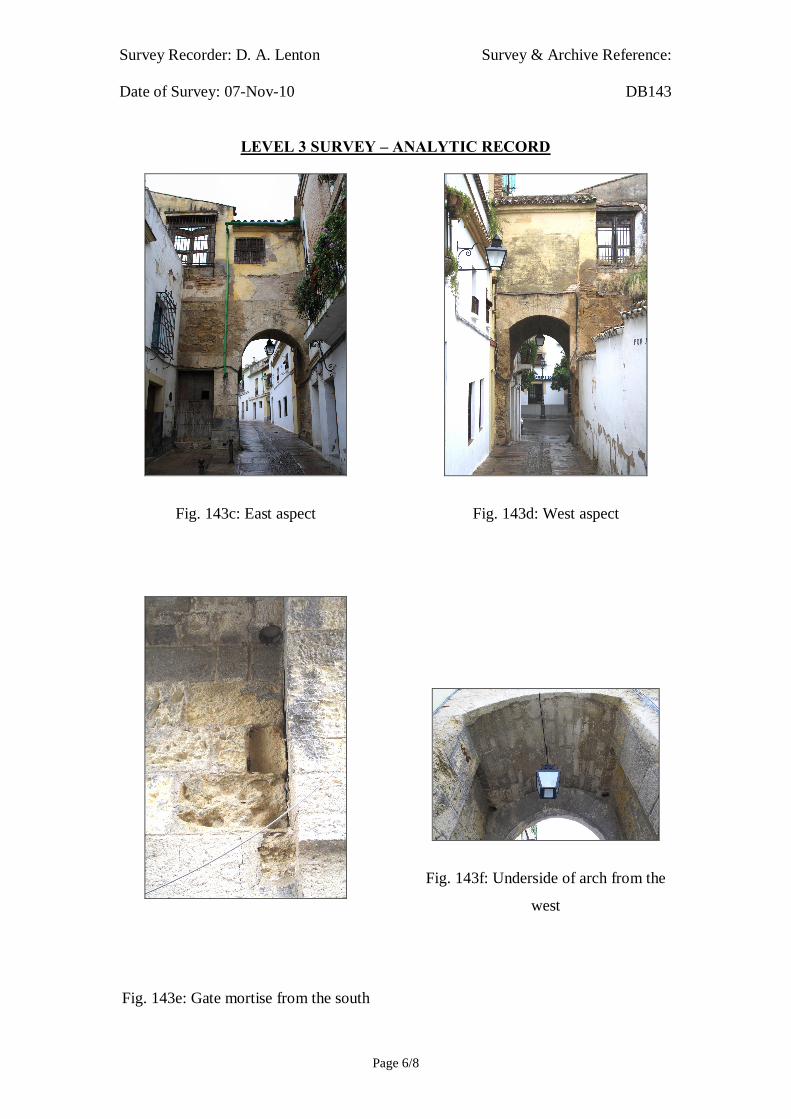
Survey Recorder: D. A. Lenton Survey & Archive Reference: Date of Survey: 07-Nov-10 DB143
LEVEL 3 SURVEY – ANALYTIC RECORD
Page 6/8
Fig. 143c: East aspect
Fig. 143d: West aspect
Fig. 143f: Underside of arch from the
west
Fig. 143e: Gate mortise from the south

Survey Recorder: D. A. Lenton Survey & Archive Reference: Date of Survey: 07-Nov-10 DB143
LEVEL 3 SURVEY – ANALYTIC RECORD
Page 7/8
6.0 Drawing Record
Addendum
Drawing No. 143.1
1 Page A4 Size

Survey Recorder: D. A. Lenton Survey & Archive Reference: Date of Survey: 07-Nov-10 DB143
LEVEL 3 SURVEY – ANALYTIC RECORD
Page 8/8
7.0 Bibliography
Ayuntamiento de Córdoba n.d.: Córdoba: Oficinas De Información Turística, (ed. Ayuntamiento de Córdoba) Ayuntamiento de Córdoba, Córdoba. Daroca Bruño, F., Yllescas Ortiz, M. & De La Fuente Darder, F. (eds.) 2003: Córdoba: Guía De Arquitectura. Córdoba: Colegio Oficial de Arquitectura de Córdoba. Google Inc. n.d.: Google Earth 6 Web Catalogue http://www.google.co.uk/intl/en_uk/earth/index.html, Mountain View, CA.


Survey Recorder: D. A. Lenton Survey & Archive Reference: Date of Survey: 26-Oct-08 DB144
LEVEL 2 SURVEY – DESCRIPTIVE RECORD
Page 1/8
Contents
1.0 Identification of Building or Structure
2.0 Summary of Building Type and Historical Usage
3.0 Description of Building & Materials
4.0 Supplementary Information
5.0 Photographic Record
6.0 Drawing Record – Addendum Attached 1 Page
7.0 Bibliography

Survey Recorder: D. A. Lenton Survey & Archive Reference: Date of Survey: 26-Oct-08 DB144
LEVEL 2 SURVEY – DESCRIPTIVE RECORD
Page 2/8
1.0 Identification of Building or Structure
1.1
Building Short Name
Torre de Belén
1.2 Variant Names Tower of the Nativity
1.3 Address Calle de san Basilio, Córdoba, Spain
1.4 Location Co-ordinates Northing 37.877°Easting -4.783°
1.5 Statutory & Non-statutory
Designations
Within the designated area of the Córdoba
UNESCO World Heritage Site No. 313
(1984/1994).
1.6 Survey Assessment &
Archaeological Value
Preservation is Medium (2). Its Medieval
period elements have been well conserved but
it has been subject to some modern repair.
Legibility is High (3). Its walls have no
coverings.
Accessibility is High (3). The structure is
publically accessible.
Stratigraphical Complexity is Medium (2).
First inspection indicated that the structure’s
phases spanned at least 2 periods – Moorish
and Reconquista.
Archaeological Value is Medium (2-2.5).
1.7 Primary Building Technique Stone; large upon very large; dressed;
rectangular; regular coursing; thick mortar

Survey Recorder: D. A. Lenton Survey & Archive Reference: Date of Survey: 26-Oct-08 DB144
LEVEL 2 SURVEY – DESCRIPTIVE RECORD
Page 3/8
2.0 Summary of Building Type and Historical Usage
2.1 Moorish or Reconquista period gate tower to town perimeter wall of earliest
proposed date 12th century (Daroca Bruño et al. 2003: 106). It is currently a
monumental tourist attraction.
2.2 The structure is located on a small paved plaza in the parish of Santa Maria
south-west of the Mezquita.
2.3 The structure stands a maximum of 11.46m high above ground level.
3.0 Statement of Materials and Dates
3.1 Foundations and external walls are of Andalucían limestone construction.
External walls are visible to roof height and unrendered. The earliest
elements are visible in the foundations [Fig. 144g] beneath the horseshoe
arch of Door A [Fig. 144h]. The foundations are of very large undressed
stone blocks in regular bonded coursing. The foundations have been subject
to modern renovation. There are no evident horizontal discontinuity lines
suggesting that the medieval construction was of a single phase (Fig. 144d).
However, an alfiz has been cut into the stonework above Door A that post-
dates the horseshoe arch. Another door, Door B, has been infilled.
3.2 On the First Floor there are three window openings with rounded arches that
may suggest a construction date earlier then the 13th century. The top three
stonework courses of the tower are a modern repair.
3.3 The tower is situated on the outer side of the town’s perimeter wall, which is
of pisé construction. Foundations and walls are of pisé clay. The foundations
are visible to 0.50m above ground level. This remaining section of the wall
extends south-west from the Medina wall for 154 metres and is generally
1.20 and appears that it would have return to the Medina wall. This Primary
Building Technique corresponds with that of the Muralla de los Mártires, and
is therefore recurrent in the later Moorish period walls. It is fundamentally
different from the earlier Moorish period civil constructions in stone.

Survey Recorder: D. A. Lenton Survey & Archive Reference: Date of Survey: 26-Oct-08 DB144
LEVEL 2 SURVEY – DESCRIPTIVE RECORD
Page 4/8
4.0 Supplementary Information
4.1 This gate is to the fortified enclosure known as the Castillo de la Juderia, or
Castle of the Jewry. The tower’s masonry may be from the Christian period
but its elbowed gate layout and its horseshoe arches bear a resemblance to
Almohade works (Daroca Bruño et al. 2003: 106).

Survey Recorder: D. A. Lenton Survey & Archive Reference: Date of Survey: 26-Oct-08 DB144
LEVEL 2 SURVEY – DESCRIPTIVE RECORD
Page 5/8
5.0 Photographic Record
5.1 General External Views of the Building in its Setting
Fig. 144a: Aerial view of the building structure in its neighbourhood
North at top (Google Inc. n.d.)
Fig. 144b.: Aerial view of the building structure in close-up.
North at top (Google Inc. n.d.)

Survey Recorder: D. A. Lenton Survey & Archive Reference: Date of Survey: 26-Oct-08 DB144
LEVEL 2 SURVEY – DESCRIPTIVE RECORD
Page 6/8
Fig. 144c: South-west aspect from the
west
Fig. 144e: South-west aspect
Fig. 144g: Door A from the west
Fig. 144d: South-west aspect
Fig. 144f: North-west aspect from the
west
Fig. 144h: Door A

Survey Recorder: D. A. Lenton Survey & Archive Reference: Date of Survey: 26-Oct-08 DB144
LEVEL 2 SURVEY – DESCRIPTIVE RECORD
Page 7/8
6.0 Drawing Record
Addendum
Drawing No. 144.1
1 Page A4 Size

Survey Recorder: D. A. Lenton Survey & Archive Reference: Date of Survey: 26-Oct-08 DB144
LEVEL 2 SURVEY – DESCRIPTIVE RECORD
Page 8/8
7.0 Bibliography
Daroca Bruño, F., Yllescas Ortiz, M. & De La Fuente Darder, F. (eds.) 2003: Córdoba: Guía De Arquitectura. Córdoba: Colegio Oficial de Arquitectura de Córdoba. Google Inc. n.d.: Google Earth 6 Web Catalogue http://www.google.co.uk/intl/en_uk/earth/index.html, Mountain View, CA.
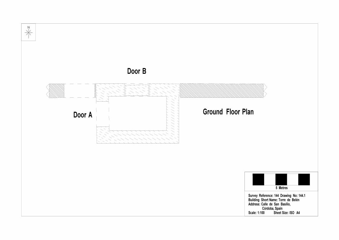

Survey Recorder: D. A. Lenton Survey & Archive Reference: Date of Survey: 30-Oct-09 DB145
LEVEL 2 SURVEY – DESCRIPTIVE RECORD
Page 1/8
Contents
1.0 Identification of Building or Structure
2.0 Summary of Building Type and Historical Usage
3.0 Description of Building & Materials
4.0 Supplementary Information
5.0 Photographic Record
6.0 Drawing Record – Addenda Attached 3 Pages
7.0 Bibliography

Survey Recorder: D. A. Lenton Survey & Archive Reference: Date of Survey: 30-Oct-09 DB145
LEVEL 2 SURVEY – DESCRIPTIVE RECORD
Page 2/8
1.0 Identification of Building or Structure
1.1
Building Short Name
Casa del Carpio
1.2
Variant Names
Casa de los Marqueses del Carpio
Palace of the Marquises of Carpio
1.3
Address
Calle San Fernando,
Córdoba, Spain
1.4
Location Co-ordinates
Northing 37.880°Easting -4.776°
1.5
Statutory & Non-statutory
Designations
Within the designated area of the Córdoba
UNESCO World Heritage Site No. 313
(1984/1994).
Bien de Interés Cultural (Nationally Listed as
a Building of Cultural Interest) (Ministerio de
Cultura n.d.).
1.6 Survey Assessment &
Archaeological Value
Preservation is Medium (2). Two storeys of
the medieval structure are partially intact.
Legibility is Medium (2). The walls are
partially rendered.
Accessibility is Medium (2). Elements of the
building are obstructed by modern structures.
Stratigraphical Complexity is Low (1). First
inspection indicated that the building spanned
one period.
Archaeological Value is Low (1-2).
1.7 Primary Building Technique Stone; very large; ashlar; rectangular; regular;
thick mortar.
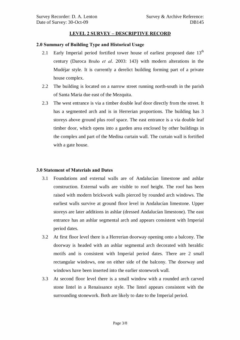
Survey Recorder: D. A. Lenton Survey & Archive Reference: Date of Survey: 30-Oct-09 DB145
LEVEL 2 SURVEY – DESCRIPTIVE RECORD
Page 3/8
2.0 Summary of Building Type and Historical Usage
2.1 Early Imperial period fortified tower house of earliest proposed date 13th
century (Daroca Bruño et al. 2003: 143) with modern alterations in the
Mudéjar style. It is currently a derelict building forming part of a private
house complex.
2.2 The building is located on a narrow street running north-south in the parish
of Santa Maria due east of the Mezquita.
2.3 The west entrance is via a timber double leaf door directly from the street. It
has a segmented arch and is in Herrerian proportions. The building has 3
storeys above ground plus roof space. The east entrance is a via double leaf
timber door, which opens into a garden area enclosed by other buildings in
the complex and part of the Medina curtain wall. The curtain wall is fortified
with a gate house.
3.0 Statement of Materials and Dates
3.1 Foundations and external walls are of Andalucían limestone and ashlar
construction. External walls are visible to roof height. The roof has been
raised with modern brickwork walls pierced by rounded arch windows. The
earliest walls survive at ground floor level in Andalucían limestone. Upper
storeys are later additions in ashlar (dressed Andalucían limestone). The east
entrance has an ashlar segmental arch and appears consistent with Imperial
period dates.
3.2 At first floor level there is a Herrerian doorway opening onto a balcony. The
doorway is headed with an ashlar segmental arch decorated with heraldic
motifs and is consistent with Imperial period dates. There are 2 small
rectangular windows, one on either side of the balcony. The doorway and
windows have been inserted into the earlier stonework wall.
3.3 At second floor level there is a small window with a rounded arch carved
stone lintel in a Renaissance style. The lintel appears consistent with the
surrounding stonework. Both are likely to date to the Imperial period.

Survey Recorder: D. A. Lenton Survey & Archive Reference: Date of Survey: 30-Oct-09 DB145
LEVEL 2 SURVEY – DESCRIPTIVE RECORD
Page 4/8
3.4 The east elevation has been subject to modern remodelling in the Mudéjar
style.
3.5 The roof is of modern construction with ceramic roof tiles.
3.6 The gate house and wall to the east of the house are built upon Andalucían
limestone foundations and walls likely to date from the Moorish and earlier
periods. The superstructure is of ashlar limestone, some of which may
survive from the Islamic periods. The gateway has a rounded arch with
squared headers in a Renaissance style which probably dates from the 16th
century. Above the arch and atop the upper storeys of the gatehouse tower
are stylised Baroque battlements likely to date to the Imperial period.
4.0 Supplementary Information
4.1 The 15th century palace of the Méndez de Sotomayor family was one of the
first grand noble houses in the city, and dates back to 1236, when King
Fernando III granted the family the task of defending and watching over the
city walls after the city of Cordoba was captured (Daroca Bruño et al. 2003:
143). The building incorporated into its structure one of the watchtowers and
part of the 15th century city walls. Inside, there is a courtyard in neo-Arabic
style and the ruins of a Roman house in the cellars (Ayuntamiento de Córdoba
n.d.; Daroca Bruño et al. 2003: 143).
4.2 Diego López de Haro y Sotomayor obtained the title of Marques del Carpio in
1559. In 1933 the house was remodelled by the architect Casto Fernández-
Shaw (Ayuntamiento de Córdoba n.d.; Daroca Bruño et al. 2003).

Survey Recorder: D. A. Lenton Survey & Archive Reference: Date of Survey: 30-Oct-09 DB145
LEVEL 2 SURVEY – DESCRIPTIVE RECORD
Page 5/8
5.0 Photographic Record
5.1 General External Views of the Building in its Setting
Fig. 145a: Aerial view of the building structure in its neighbourhood
North at top (Google Inc. n.d.)
Fig. 145b.: Aerial view of the building structure in close-up.
North at top (Google Inc. n.d.)

Survey Recorder: D. A. Lenton Survey & Archive Reference: Date of Survey: 30-Oct-09 DB145
LEVEL 2 SURVEY – DESCRIPTIVE RECORD
Page 6/8
Fig. 145c: East aspect from the south.
Fig. 145e: East aspect
Fig. 145d: East aspect
Fig. 145f: West aspect from the south
Survey Recorder: D. A. Lenton Survey & Archive Reference: Date of Survey: 30-Oct-09 DB145
LEVEL 2 SURVEY – DESCRIPTIVE RECORD
Page 7/8
6.0 Drawing Record
Addenda
Drawing Nos. 145.1, 145.2, 145.3
3 Pages A4 Size

Survey Recorder: D. A. Lenton Survey & Archive Reference: Date of Survey: 30-Oct-09 DB145
LEVEL 2 SURVEY – DESCRIPTIVE RECORD
Page 8/8
7.0 Bibliography
Ayuntamiento de Córdoba n.d.: Córdoba: Oficinas De Información Turística, (ed. Ayuntamiento de Córdoba) Ayuntamiento de Córdoba, Córdoba. Daroca Bruño, F., Yllescas Ortiz, M. & De La Fuente Darder, F. (eds.) 2003: Córdoba: Guía De Arquitectura. Córdoba: Colegio Oficial de Arquitectura de Córdoba. Google Inc. n.d.: Google Earth 6 Web Catalogue http://www.google.co.uk/intl/en_uk/earth/index.html, Mountain View, CA. Ministerio de Cultura n.d.: Bien De Interés Cultural: La Base De Datos De Bienes Inmuebles, http://www.mcu.es/bienes/cargarFiltroBienesInmuebles.do?layout=bienesInmuebles&cache=init&language=es.

10 metres10 metresSurvey Reference: DB145 Drawing No: 145.1Building Short Name: Casa del CarpioAddress: Calle San Fernando, Córdoba, SpainScale: 1:200 Sheet Size: ISO A4
Ground Floor Plan
Boundary of Estate
Boundary of Estate
Modern Wing
Gatehouse Tower
Arched Gateway
Fortified House
Door A
Door B
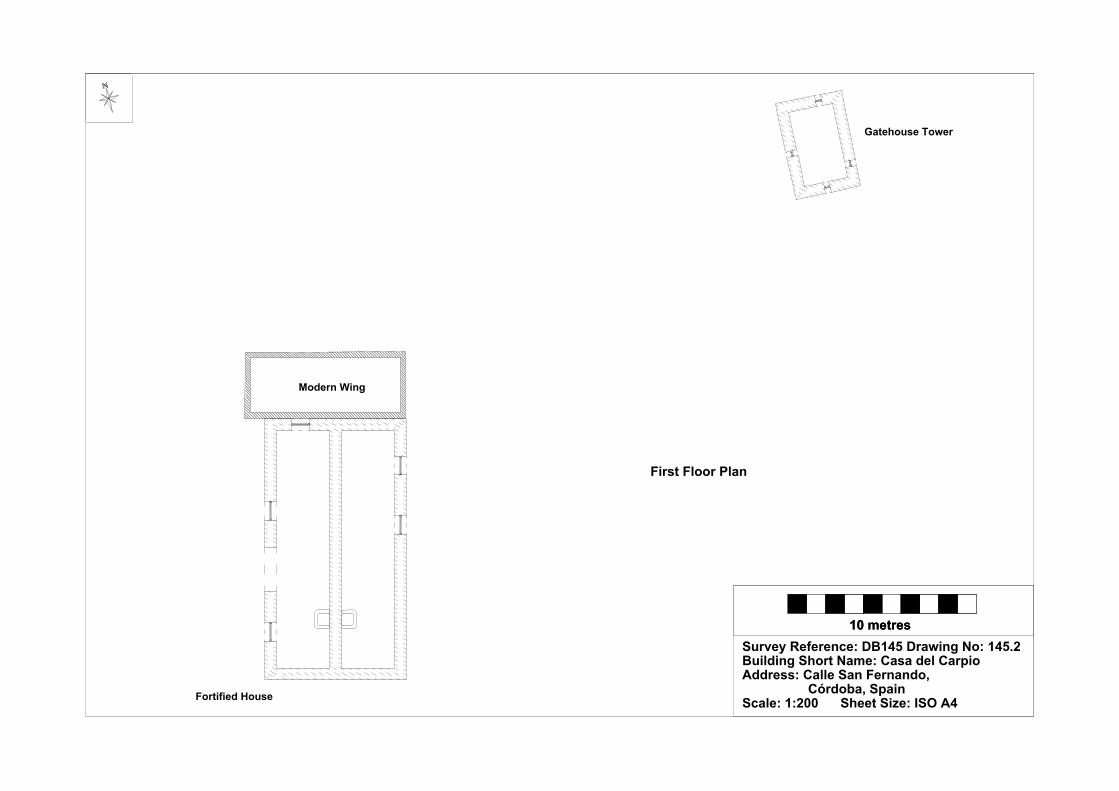
10 metres10 metresSurvey Reference: DB145 Drawing No: 145.2Building Short Name: Casa del CarpioAddress: Calle San Fernando, Córdoba, SpainScale: 1:200 Sheet Size: ISO A4
First Floor Plan
Fortified House
Modern Wing
Gatehouse Tower

10 metres10 metresSurvey Reference: DB145 Drawing No: 145.3Building Short Name: Casa del CarpioAddress: Calle San Fernando, Córdoba, SpainScale: 1:200 Sheet Size: ISO A4
West Elevation East Elevation

Survey Recorder: D. A. Lenton Survey & Archive Reference: Date of Survey: 28-Oct-09 DB146
LEVEL 2 SURVEY – DESCRIPTIVE RECORD
Page 1/8
Contents
1.0 Identification of Building or Structure
2.0 Summary of Building Type and Historical Usage
3.0 Description of Building & Materials
4.0 Supplementary Information
5.0 Photographic Record
6.0 Drawing Record – Addenda Attached Pages
7.0 Bibliography

Survey Recorder: D. A. Lenton Survey & Archive Reference: Date of Survey: 28-Oct-09 DB146
LEVEL 2 SURVEY – DESCRIPTIVE RECORD
Page 2/8
1.0 Identification of Building or Structure
1.1
Building Short Name
Palacio de Orive
1.2
Variant Names
Palacio de los Villalones, Palace of the
Villalones Family, Palace of Orive
1.3
Address
Plaza de Orive-Calle Villalones,
Córdoba, Spain
1.4
Location Co-ordinates
Northing 37.885° Easting -4.774°
1.5
Statutory & Non-statutory
Designations
Within the designated area of the Córdoba
UNESCO World Heritage Site No. 313
(1984/1994).
Bien de Interés Cultural (Nationally Listed as
a Building of Cultural Interest) (Ministerio de
Cultura n.d.).
1.6 Survey Assessment &
Archaeological Value
Preservation is Medium (2). One storey of the
medieval structure is intact.
Legibility is Medium (2). The walls are
partially rendered.
Accessibility is Medium (3). Many elements
are obscured.
Stratigraphical Complexity is Low (1). First
inspection indicated that the building spanned
one period.
Archaeological Value is Medium (2-2.5).
1.7 Primary Building Technique Stone; very large; ashlar; rectangular; regular;
thick mortar.
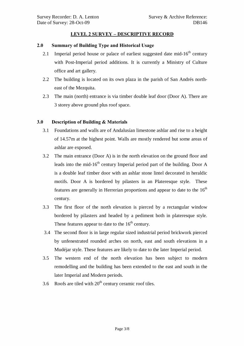
Survey Recorder: D. A. Lenton Survey & Archive Reference: Date of Survey: 28-Oct-09 DB146
LEVEL 2 SURVEY – DESCRIPTIVE RECORD
Page 3/8
2.0 Summary of Building Type and Historical Usage
2.1 Imperial period house or palace of earliest suggested date mid-16th century
with Post-Imperial period additions. It is currently a Ministry of Culture
office and art gallery.
2.2 The building is located on its own plaza in the parish of San Andrés north-
east of the Mezquita.
2.3 The main (north) entrance is via timber double leaf door (Door A). There are
3 storey above ground plus roof space.
3.0 Description of Building & Materials
3.1 Foundations and walls are of Andalusían limestone ashlar and rise to a height
of 14.57m at the highest point. Walls are mostly rendered but some areas of
ashlar are exposed.
3.2 The main entrance (Door A) is in the north elevation on the ground floor and
leads into the mid-16th century Imperial period part of the building. Door A
is a double leaf timber door with an ashlar stone lintel decorated in heraldic
motifs. Door A is bordered by pilasters in an Plateresque style. These
features are generally in Herrerian proportions and appear to date to the 16th
century.
3.3 The first floor of the north elevation is pierced by a rectangular window
bordered by pilasters and headed by a pediment both in plateresque style.
These features appear to date to the 16th century.
3.4 The second floor is in large regular sized industrial period brickwork pierced
by unfenestrated rounded arches on north, east and south elevations in a
Mudéjar style. These features are likely to date to the later Imperial period.
3.5 The western end of the north elevation has been subject to modern
remodelling and the building has been extended to the east and south in the
later Imperial and Modern periods.
3.6 Roofs are tiled with 20th century ceramic roof tiles.

Survey Recorder: D. A. Lenton Survey & Archive Reference: Date of Survey: 28-Oct-09 DB146
LEVEL 2 SURVEY – DESCRIPTIVE RECORD
Page 4/8
4.0 Supplementary Information
4.1 This building is an example of Córdoban domestic architecture of the
Renaissance period. It was built by architect Hernán Ruiz II in 1560, and the
most striking feature is the entrance with its decorative lintels and arches
(Daroca Bruño et al. 2003: 174). Nowadays, the building houses the Town
Hall's Department of Culture and several rooms are now used as temporary
exhibition halls for contemporary artists.

Survey Recorder: D. A. Lenton Survey & Archive Reference: Date of Survey: 28-Oct-09 DB146
LEVEL 2 SURVEY – DESCRIPTIVE RECORD
Page 5/8
5.0 Photographic Record
5.1 General External Views of the Building in its Setting
Fig. 146a: Aerial view of the building structure in its neighbourhood
North at top (Google Inc. n.d.)
Fig. 146b.: Aerial view of the building structure in close-up.
North at top (Google Inc. n.d.)

Survey Recorder: D. A. Lenton Survey & Archive Reference: Date of Survey: 28-Oct-09 DB146
LEVEL 2 SURVEY – DESCRIPTIVE RECORD
Page 6/8
Fig. 146c: North aspect viewed from
the north-west.
Fig. 146d: South aspect viewed from
the south-west.
Fig. 146e: West aspect viewed from
the south-west
Fig. 146g: North aspect
Fig. 146f: West aspect viewed from the
north-east
Fig. 146h: East aspect viewed from the
north

Survey Recorder: D. A. Lenton Survey & Archive Reference: Date of Survey: 28-Oct-09 DB146
LEVEL 2 SURVEY – DESCRIPTIVE RECORD
Page 7/8
6.0 Drawing Record
Addenda
Drawing Nos. 146.1 & 146.2
2 Pages A4 Size

Survey Recorder: D. A. Lenton Survey & Archive Reference: Date of Survey: 28-Oct-09 DB146
LEVEL 2 SURVEY – DESCRIPTIVE RECORD
Page 8/8
7.0 Bibliography
Daroca Bruño, F., Yllescas Ortiz, M. & De La Fuente Darder, F. (eds.) 2003: Córdoba: Guía De Arquitectura. Córdoba: Colegio Oficial de Arquitectura de Córdoba. Google Inc. n.d.: Google Earth 6 Web Catalogue http://www.google.co.uk/intl/en_uk/earth/index.html, Mountain View, CA. Ministerio de Cultura n.d.: Bien De Interés Cultural: La Base De Datos De Bienes Inmuebles, http://www.mcu.es/bienes/cargarFiltroBienesInmuebles.do?layout=bienesInmuebles&cache=init&language=es.

10 metres (approx.)Survey Reference: DB146 Drawing No: 146.1Building Short Name: Palacio de Orive Address: No.2 Plaza de Orive, Córdoba, SpainScale: 1:200 Sheet Size: ISO A4
Ground Floor Plan
Door A
Courtyard
Courtyard
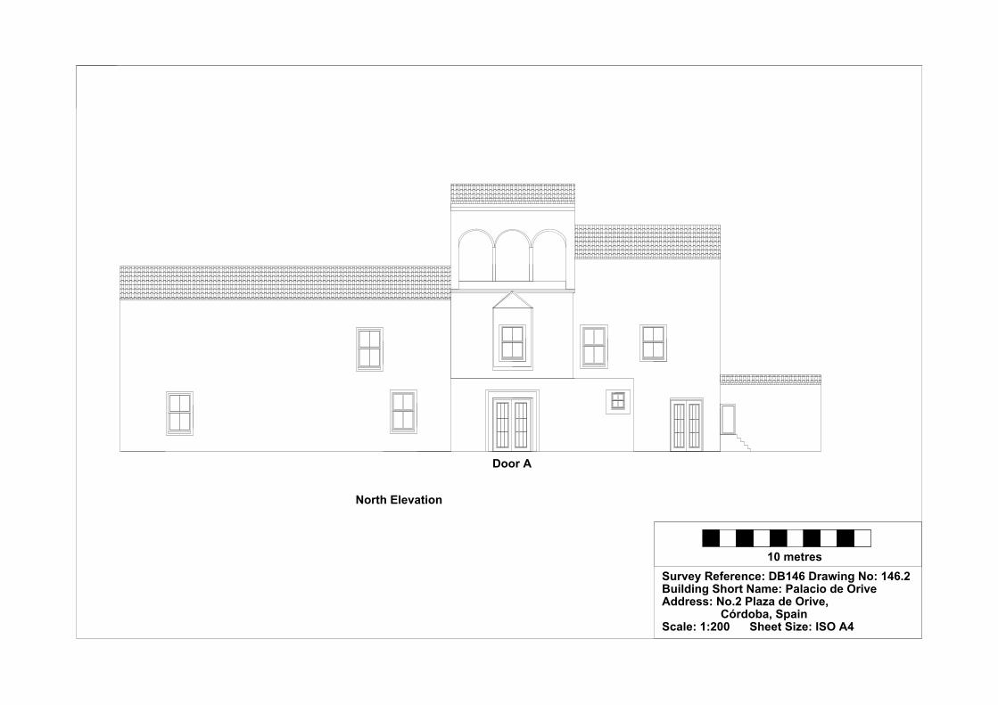
10 metresSurvey Reference: DB146 Drawing No: 146.2Building Short Name: Palacio de Orive Address: No.2 Plaza de Orive, Córdoba, SpainScale: 1:200 Sheet Size: ISO A4
North Elevation
Door A

Survey Recorder: D. A. Lenton Survey & Archive Reference: Date of Survey: 31-Oct-09 DB147
LEVEL 2 SURVEY – DESCRIPTIVE RECORD
Page 1/9
Contents
1.0 Identification of Building or Structure
2.0 Summary of Building Type and Historical Usage
3.0 Description of Building & Materials
4.0 Supplementary Information
5.0 Photographic Record
6.0 Drawing Record – Addendum Attached 1 Page
7.0 Bibliography

Survey Recorder: D. A. Lenton Survey & Archive Reference: Date of Survey: 31-Oct-09 DB147
LEVEL 2 SURVEY – DESCRIPTIVE RECORD
Page 2/9
1.0 Identification of Building or Structure
1.1
Building Short Name
Hospital de San Sebastián
1.2
Variant Names
Palace of Congresses and Exhibitions,
Hospital of San Sebastián
1.3
Address
Calle Torrijos, Córdoba, Spain
1.4
Location Co-ordinates
Northing 37.878° Easting -4.780°
1.5
Statutory & Non-statutory
Designations
Within the designated area of the Córdoba
UNESCO World Heritage Site No. 313
(1984/1994).
Bien de Interés Cultural (Nationally Listed as
a Building of Cultural Interest) (Ministerio de
Cultura n.d.).
1.6 Survey Assessment &
Archaeological Value
Preservation is High (3). Many of the Early
Imperial elements survive.
Legibility is Low (1). The walls are mainly
rendered and plastered.
Accessibility is Medium (2). The building is
generally accessible but many elements are
obscured by modern features.
Stratigraphical Complexity is Medium (2).
The building spanned the Imperial period but
retained elements of the Moorish period.
Archaeological Value is Medium (2-2.5).
1.7 Primary Building Technique Stone; very large; ashlar; rectangular; regular;
thin mortar.

Survey Recorder: D. A. Lenton Survey & Archive Reference: Date of Survey: 31-Oct-09 DB147
LEVEL 2 SURVEY – DESCRIPTIVE RECORD
Page 3/9
2.0 Summary of Building Type and Historical Usage
2.1 Imperial period hospital of earliest known date early 16th century (Daroca
Bruño et al. 2003: 100). It is currently a gallery and exhibition centre.
2.2 The building is located opposite the south-west façade of the Mezquita in the
parish of Santa Maria.
2.3 There are two entrances. The entrance at the southern end of the north-east
façade is via a high double leaf timber door (Door A) into an entrance
vestibule. The entrance at the northern end of the north-east façade is via a
high timber double leaf door (Door B) into Room B, which was formerly
used as an infirmary (Daroca Bruño et al. 2003: 100).
3.0 Description of Building & Materials
3.1 Foundations and walls are of Andalusían limestone and rise to a height of
approximately 15m. Walls are partially unrendered with some areas exposed.
3.2 Door A is headed by a modern limestone lintel over stone jambs with
brickwork repairs. It leads to rectangular entrance Vestibule (Room A
10.48m x 5.99m). A further doorway (Door C) is headed by a rounded arch
in ashlar, which leads on to the Courtyard.
3.3 Door B is headed by a limestone trefoil arch over limestone jambs that
pierces the massive roof height limestone portal built by to Hernán I in 1514
in a Humanist Gothic style (Daroca Bruño et al. 2003: 100). Door B leads on
to a rectangular room (Room B).
3.4 The central Courtyard includes Mudéjar style Galleries with rounded arches
on the ground floor and sectioned arches on the upper floor all in brickwork
on limestone plinths. These has been heavily restored in the 20th century.
3.5 Along the southern Gallery, Door D has a rounded arch and opens on to the
remaining rampart wall of the former Alcázar (Daroca Bruño et al. 2003:
100).
3.6 Off the north Gallery lies the Chapel with a single nave covered by 2 groined
vaults.
3.7 Roofs are tiled with 20th century ceramic roof tiles.

Survey Recorder: D. A. Lenton Survey & Archive Reference: Date of Survey: 31-Oct-09 DB147
LEVEL 2 SURVEY – DESCRIPTIVE RECORD
Page 4/9
4.0 Supplementary Information
4.1 The present-day Palacio de Congresos y Exposiciones , formerly the Hospital
of San Sebastian, was built on top of the ruins of the Alcázar between 1513
and 1516. The building is arranged around Mudéjar-style cloisters (Daroca
Bruño et al. 2003: 100). It has a Chapel in flamboyant Gothic style, with ornate
Plateresque decorative work, which was built by Hernán Ruiz I, who also built
the façade in 1514 (Ayuntamiento de Córdoba n.d.).

Survey Recorder: D. A. Lenton Survey & Archive Reference: Date of Survey: 31-Oct-09 DB147
LEVEL 2 SURVEY – DESCRIPTIVE RECORD
Page 5/9
5.0 Photographic Record
5.1 General External Views of the Building in its Setting
Fig. 147a: Aerial view of the building structure in its neighbourhood
North at top (Google Inc. n.d.)
Fig. 147b.: Aerial view of the building structure in close-up.
North at top (Google Inc. n.d.)

Survey Recorder: D. A. Lenton Survey & Archive Reference: Date of Survey: 31-Oct-09 DB147
LEVEL 2 SURVEY – DESCRIPTIVE RECORD
Page 6/9
Fig. 147c: East aspect viewed from the
north.
Fig. 147e: East entrance
Fig. 147d: East aspect viewed from the
south.
Fig. 147f: East entrance

Survey Recorder: D. A. Lenton Survey & Archive Reference: Date of Survey: 31-Oct-09 DB147
LEVEL 2 SURVEY – DESCRIPTIVE RECORD
Page 7/9
Fig. 147g: Courtyard from the east Fig. 147h: Courtyard from the north
Fig. 147i: Courtyard from the north-west Fig. 147j: Courtyard from the south-east
Fig. 147k: Door D from the north-west

Survey Recorder: D. A. Lenton Survey & Archive Reference: Date of Survey: 31-Oct-09 DB147
LEVEL 2 SURVEY – DESCRIPTIVE RECORD
Page 8/9
6.0 Drawing Record
Addendum
Drawing No. 147.1
1 Page A4 Size
Survey Recorder: D. A. Lenton Survey & Archive Reference: Date of Survey: 31-Oct-09 DB147
LEVEL 2 SURVEY – DESCRIPTIVE RECORD
Page 9/9
7.0 Bibliography
Ayuntamiento de Córdoba n.d.: Córdoba: Oficinas De Información Turística, (ed. Ayuntamiento de Córdoba) Ayuntamiento de Córdoba, Córdoba. Daroca Bruño, F., Yllescas Ortiz, M. & De La Fuente Darder, F. (eds.) 2003: Córdoba: Guía De Arquitectura. Córdoba: Colegio Oficial de Arquitectura de Córdoba. Google Inc. n.d.: Google Earth 6 Web Catalogue http://www.google.co.uk/intl/en_uk/earth/index.html, Mountain View, CA. Ministerio de Cultura n.d.: Bien De Interés Cultural: La Base De Datos De Bienes Inmuebles, http://www.mcu.es/bienes/cargarFiltroBienesInmuebles.do?layout=bienesInmuebles&cache=init&language=es.

Survey Reference:DB147 Drawing No:147.1Building Short Name: Hospital San SebastiánAddress: Calle Torrijos, Córdoba, SpainScale: <1:500> Sheet Size: ISO A4
20 metres
Ground Floor Plan
Courtyard
Galleries
Galleries
RoomA
Hall
Chapel
Door A
Door B
First Floor Plan
Courtyard
Galleries
Galleries
Chapel
Remains of Alcázar Wall
Door C
Door D Door E
Remains of Alcázar Wall
Door F

Survey Recorder: D. A. Lenton Survey & Archive Reference: Date of Survey: 30-Oct-10 DB148
LEVEL 1 SURVEY – BASIC RECORD
Page 1/8
Contents
1.0 Identification of Building or Structure
2.0 Summary of Building Type and Historical Usage
3.0 Description of Building & Materials
4.0 Supplementary Information
5.0 Photographic Record
6.0 Drawing Record – Addenda Attached 2 Pages
7.0 Bibliography

Survey Recorder: D. A. Lenton Survey & Archive Reference: Date of Survey: 30-Oct-10 DB148
LEVEL 1 SURVEY – BASIC RECORD
Page 2/8
1.0 Identification of Building or Structure
1.1
Building Short Name
Casa de las Campañas
1.2
Variant Names
The House of the Bells
1.3
Address
Calle Siete Revueltas, Córdoba, Spain
1.4
Location Co-ordinates
Northing 37.882°Easting -4.769°
1.5
Statutory & Non-statutory
Designations
Within the designated area of the Córdoba
UNESCO World Heritage Site No. 313
(1984/1994).
Bien de Interés Cultural (Nationally Listed as
a Building of Cultural Interest) (Ministerio de
Cultura n.d.).
1.6 Survey Assessment &
Archaeological Value
Preservation is Low (1). Few Imperial period
elements survive.
Legibility is Low (1). Walls are mostly
plastered and rendered.
Accessibility is Medium (2). The Medieval
and Imperial elements are partially obscured
by modern features.
Stratigraphical Complexity is Low (1). The
building spanned only the Imperial period.
Archaeological Value is Low (1-2).
1.7 Primary Building Technique Stone; very large; ashlar; rectangular, regular
coursing; thin mortar.
Survey Recorder: D. A. Lenton Survey & Archive Reference: Date of Survey: 30-Oct-10 DB148
LEVEL 1 SURVEY – BASIC RECORD
Page 3/8
2.0 Summary of Building Type and Historical Usage
2.1 Imperial period residential courtyard house of earliest proposed date 15th
century (Daroca Bruño et al. 2003: 157). It is currently a private apartment
block.
2.2 The building is located on a small plaza in the parish of Santiago due east of
the Mezquita.
2.3 There are 2 entrances; one to the south via a timber double leaf door directly
from the plaza to an entrance vestibule, and one to the east into the courtyard.
The building has two storeys above ground plus roof space.
3.0 Statement of Materials and Dates
3.1 Perimeter walls are of local clay brickwork construction.
3.2 Perimeter walls are rendered with sand and cement plaster and are painted.
3.3 The building is entered from the via a double leaf timber front door (Door A)
in the south elevation. The doorway leads through a vestibule, which has
been subject to modern remodelling, and then into a large courtyard. The
main building is on the east side of the courtyard.
3.4 The external walls of the main building are of limestone construction. Marble
columns (Columns A & B), possibly of early medieval date, support one of a
series of arched doorways (Arch A) in the east external wall (Wall A). These
arches have been subject to modern remodelling.
3.5 A secondary external wall (Wall B) has a rounded arched doorway (Arch B)
with elaborately foliated plasterwork decoration in the 15th century Nazarid
Mudéjar style. 2 further rounded arch doorways of modern construction open
in this wall. Walls on the ground floor appear to be consistent with 15th
century dates.
3.6 The ground and first floors have been subject to considerable modern
remodelling to create apartment blocks. No dating evidence is visible.
3.7 Ceilings are modern timber joisted and boarded.
3.8 Roofs are of modern timber framed construction with ceramic roof tiles

Survey Recorder: D. A. Lenton Survey & Archive Reference: Date of Survey: 30-Oct-10 DB148
LEVEL 1 SURVEY – BASIC RECORD
Page 4/8
4.0 Supplementary Information
4.1 Casa de la Campañas features the remains of an ancestral home belonging to
the Duke of Alba, later converted into a block of flats. The house was
sometime used as a bell foundry, hence its name. The remaining walls
comprise a gallery with arches decorated with carved apricots in foliated
Nazarite plasterwork (Daroca Bruño et al. 2003: 157). The gallery has carved
timber ceiling with hexagon and octagon motifs brightly painted roofed by 2
transerves arches with scalloped soffits in the Almohade tradition. The rest of
the building is probably 16th century and is hidden behind modern plaster and
decoration (Romeo & Gómez 2005).
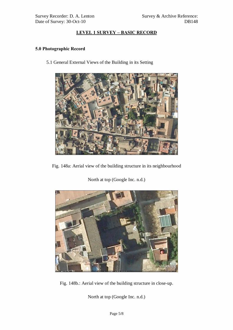
Survey Recorder: D. A. Lenton Survey & Archive Reference: Date of Survey: 30-Oct-10 DB148
LEVEL 1 SURVEY – BASIC RECORD
Page 5/8
5.0 Photographic Record
5.1 General External Views of the Building in its Setting
Fig. 148a: Aerial view of the building structure in its neighbourhood
North at top (Google Inc. n.d.)
Fig. 148b.: Aerial view of the building structure in close-up.
North at top (Google Inc. n.d.)
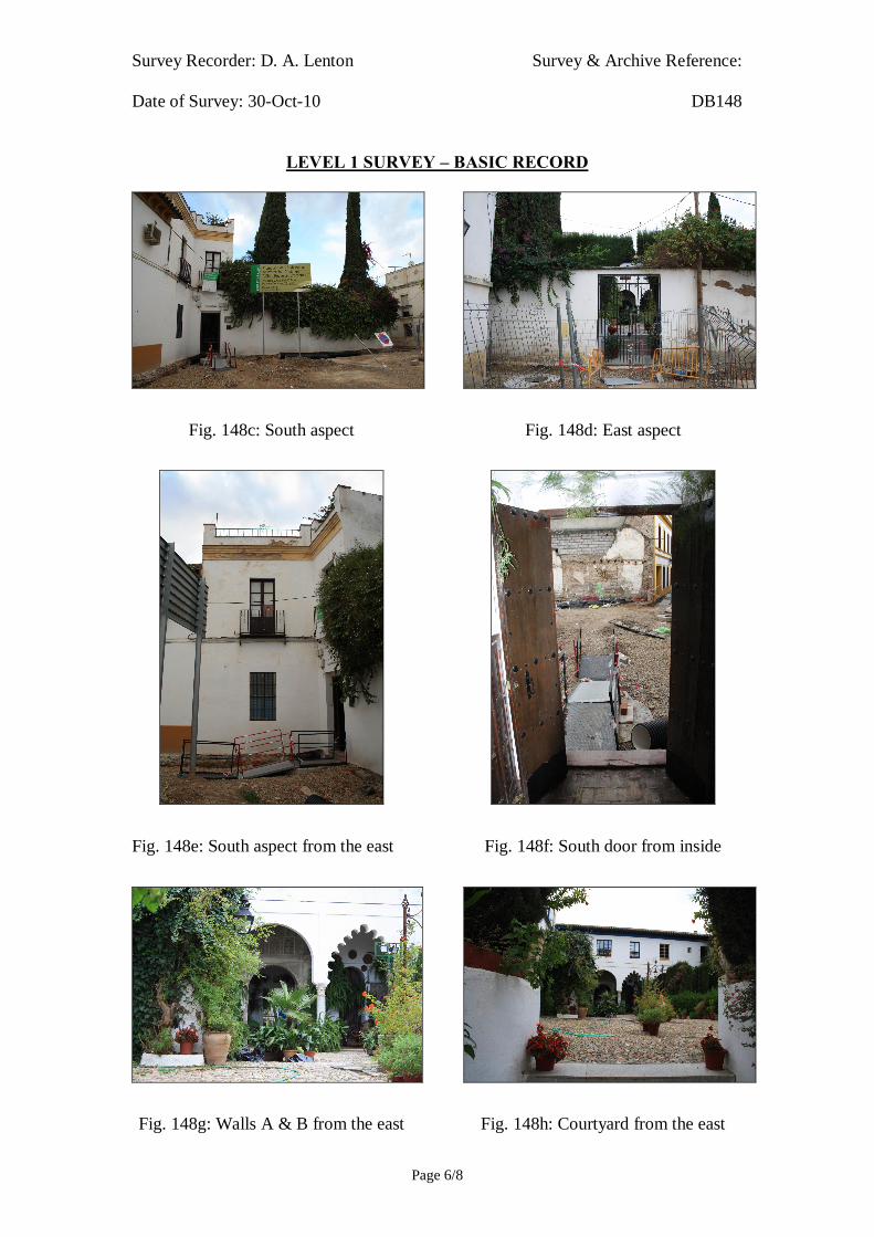
Survey Recorder: D. A. Lenton Survey & Archive Reference: Date of Survey: 30-Oct-10 DB148
LEVEL 1 SURVEY – BASIC RECORD
Page 6/8
Fig. 148c: South aspect
Fig. 148e: South aspect from the east
Fig. 148g: Walls A & B from the east
Fig. 148d: East aspect
Fig. 148f: South door from inside
Fig. 148h: Courtyard from the east

Survey Recorder: D. A. Lenton Survey & Archive Reference: Date of Survey: 30-Oct-10 DB148
LEVEL 1 SURVEY – BASIC RECORD
Page 7/8
6.0 Drawing Record
Addenda
Drawing Nos. 148.1 & 148.2
2 Pages A4 Size

Survey Recorder: D. A. Lenton Survey & Archive Reference: Date of Survey: 30-Oct-10 DB148
LEVEL 1 SURVEY – BASIC RECORD
Page 8/8
7.0 Bibliography
Daroca Bruño, F., Yllescas Ortiz, M. & De La Fuente Darder, F. (eds.) 2003: Córdoba: Guía De Arquitectura. Córdoba: Colegio Oficial de Arquitectura de Córdoba. Google Inc. n.d.: Google Earth 6 Web Catalogue http://www.google.co.uk/intl/en_uk/earth/index.html, Mountain View, CA. Ministerio de Cultura n.d.: Bien De Interés Cultural: La Base De Datos De Bienes Inmuebles, http://www.mcu.es/bienes/cargarFiltroBienesInmuebles.do?layout=bienesInmuebles&cache=init&language=es. Romeo, A. & Gómez, S. 2005: Cordobapedia, (eds. A. Romeo & S. Gómez) http://wikanda.cordobapedia.es/, Cordoba.
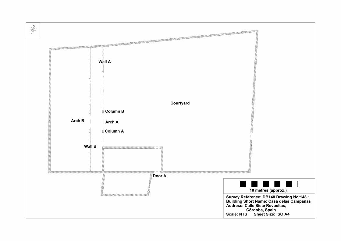
10 metres (approx.)Survey Reference: DB148 Drawing No:148.1Building Short Name: Casa delas CampañasAddress: Calle Siete Revueltas, Córdoba, SpainScale: NTS Sheet Size: ISO A4
Door A
Courtyard
Arch A
Column A
Column B
Wall A
Wall B
Arch B
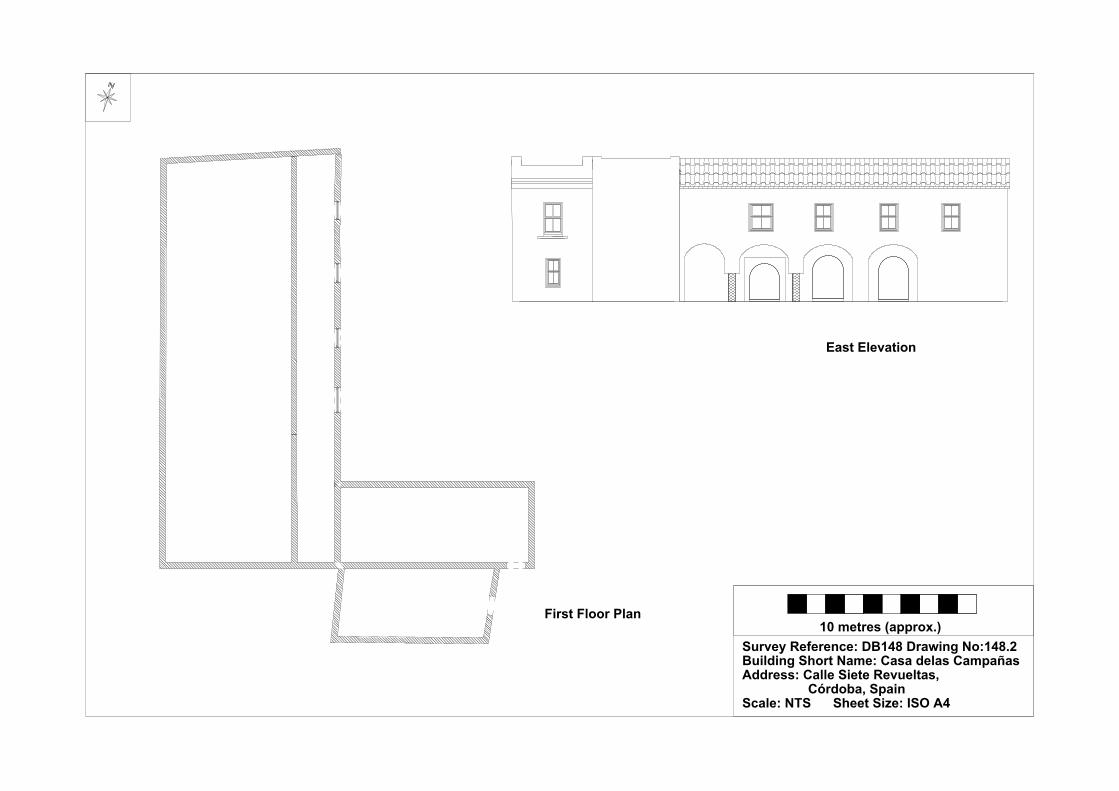
10 metres (approx.)Survey Reference: DB148 Drawing No:148.2Building Short Name: Casa delas CampañasAddress: Calle Siete Revueltas, Córdoba, SpainScale: NTS Sheet Size: ISO A4
First Floor Plan
East Elevation

Survey Recorder: D. A. Lenton Survey & Archive Reference: Date of Survey: 29-Oct-09 DB149
LEVEL 1 SURVEY – BASIC RECORD
Page 1/7
Contents
1.0 Identification of Building or Structure
2.0 Summary of Building Type and Historical Usage
3.0 Description of Building & Materials
4.0 Supplementary Information
5.0 Photographic Record
6.0 Drawing Record
7.0 Bibliography

Survey Recorder: D. A. Lenton Survey & Archive Reference: Date of Survey: 29-Oct-09 DB149
LEVEL 1 SURVEY – BASIC RECORD
Page 2/7
1.0 Identification of Building or Structure
1.1
Building Short Name
Palacio de los Aguayo
1.2
Variant Names
Palace of the Aguayo Family
1.3
Address
Plaza de los Aguayo, Córdoba, Spain
1.4
Location Co-ordinates
Northing 37.883°Easting -4.771°
1.5
Statutory & Non-statutory
Designations
Within the designated area of the Córdoba
UNESCO World Heritage Site No. 313
(1984/1994).
Bien de Interés Cultural (Nationally Listed as
a Building of Cultural Interest) (Ministerio de
Cultura n.d.).
1.6 Survey Assessment &
Archaeological Value
Preservation is Low (1). Very few Early
Imperial elements survive.
Legibility is Low (1). The walls are rendered
and plastered.
Accessibility is Low (1). Ealry Imperial
elements are obscured by Modern ones.
Stratigraphical Complexity is Low (1). First
inspection indicated that the building spanned
only the Imperial period.
Archaeological Value is Low (1-2).
1.7 Primary Building Technique Undetermined.

Survey Recorder: D. A. Lenton Survey & Archive Reference: Date of Survey: 29-Oct-09 DB149
LEVEL 1 SURVEY – BASIC RECORD
Page 3/7
2.0 Summary of Building Type and Historical Usage
2.1 Imperial period house or palace of earliest known date early 16th century
(Ayuntamiento de Córdoba n.d.). The house was the ancestral home of the
Aguayo family but is currently used as a school.
2.2 The building is located on its own plaza in the parish of San Pedro to the
north-east of the Mezquita.
2.3 The sole (south) entrance is via timber double leaf door directly from the
street. The building has two storeys above ground plus roof space.
3.0 Description of Building & Materials
3.1 Foundations and walls are of Andalusían limestone. Walls are rendered in
sand and cement and painted.
3.2 The portal to the entrance door of the South Elevation [Fig. 149c] is in
Herrerian proportions of the 16th century. It is decorated with medallions of
laurel leaves and the coat of arms of the Aguayo family (Ayuntamiento de
Córdoba n.d.). The South Elevation door and windows look out onto a small
plaza opposite the north elevation of the Iglesia de San Pedro [DB132]. The
South Elevation door and windows look out onto a small plaza opposite the
north elevation of the Iglesia de San Pedro [DB132]. The South Wing backs
on to a Courtyard in the centre of the Modern period structures.
3.3 The roof is of modern clay tiles.
4.0 Supplementary Information
4.1 The features inside are the magnificent black and red marble staircase and a
large garden. It is now School of the Familia Sagrada, known popularly as the
Las Francesas (the French Women) (Ayuntamiento de Córdoba n.d.).

Survey Recorder: D. A. Lenton Survey & Archive Reference: Date of Survey: 29-Oct-09 DB149
LEVEL 1 SURVEY – BASIC RECORD
Page 4/7
5.0 Photographic Record
5.1 General External Views of the Building in its Setting
Fig. 149a: Aerial view of the building structure in its neighbourhood
North at top (Google Inc. n.d.)
Fig. 149b.: Aerial view of the building structure in close-up.
North at top (Google Inc. n.d.)

Survey Recorder: D. A. Lenton Survey & Archive Reference: Date of Survey: 29-Oct-09 DB149
LEVEL 1 SURVEY – BASIC RECORD
Page 5/7
Fig. 149c: South aspect
Fig. 149d: South aspect and Plaza
Fig. 2.44e: South entrance

Survey Recorder: D. A. Lenton Survey & Archive Reference: Date of Survey: 29-Oct-09 DB149
LEVEL 1 SURVEY – BASIC RECORD
Page 6/7
6.0 Drawing Record
No site drawings made

Survey Recorder: D. A. Lenton Survey & Archive Reference: Date of Survey: 29-Oct-09 DB149
LEVEL 1 SURVEY – BASIC RECORD
Page 7/7
7.0 Bibliography
Ayuntamiento de Córdoba n.d.: Córdoba: Oficinas De Información Turística, (ed. Ayuntamiento de Córdoba) http://www.turismodecordoba.org/index2.cfm. Accessed 29th Oct 2010., Córdoba. Google Inc. n.d.: Google Earth 6 Web Catalogue http://www.google.co.uk/intl/en_uk/earth/index.html, Mountain View, CA. Ministerio de Cultura n.d.: Bien De Interés Cultural: La Base De Datos De Bienes Inmuebles, http://www.mcu.es/bienes/cargarFiltroBienesInmuebles.do?layout=bienesInmuebles&cache=init&language=es.

Survey Recorder: D. A. Lenton Survey & Archive Reference: Date of Survey: 31-Oct-09 DB150
LEVEL 1 SURVEY – BASIC RECORD
Page 1/8
Contents
1.0 Identification of Building or Structure
2.0 Summary of Building Type and Historical Usage
3.0 Description of Building & Materials
4.0 Supplementary Information
5.0 Photographic Record
6.0 Drawing Record
7.0 Bibliography

Survey Recorder: D. A. Lenton Survey & Archive Reference: Date of Survey: 31-Oct-09 DB150
LEVEL 1 SURVEY – BASIC RECORD
Page 2/8
1.0 Identification of Building or Structure
1.1
Building Short Name
Palacio Episcopal
1.2 Variant Names Episcopal Palace
1.3 Address Calle Torrijos, Córdoba, Spain
1.4 Location Co-ordinates Northing 37.877° Easting -4.779°
1.5
Statutory & Non-statutory
Designations
Within the designated area of the Córdoba
UNESCO World Heritage Site No. 313
(1984/1994).
Bien de Interés Cultural (Nationally Listed as
a Building of Cultural Interest) (Ministerio de
Cultura n.d.).
1.6 Survey Assessment &
Archaeological Value
Preservation is Low (1). Many of the Early
Imperial period walls survive but the palace
was largely restructured after a fire in the 18th
century.
Legibility is Medium (2). Walls are mainly
unrendered.
Accessibility is Medium (2). Many of the
Early Imperial elements are obscured my
Modern ones and the complex is too large to
be fully surveyed within the resources of this
thesis.
Stratigraphical Complexity is Medium (2).
First inspection indicated that the complex
spanned the Imperial period but retained some
Moorish period elements.
Archaeological Value is Low (1-2).
1.7 Primary Building Technique Stone, very large, rectangular, ashlar, regular
coursing, thin mortar.

Survey Recorder: D. A. Lenton Survey & Archive Reference: Date of Survey: 31-Oct-09 DB150
LEVEL 1 SURVEY – BASIC RECORD
Page 3/8
2.0 Summary of Building Type and Historical Usage
2.1 Imperial period Episcopal palace incorporating the remains of the Moorish
period Alcázar ramparts and towers (Daroca Bruño et al. 2003: 101). It is
currently a museum and tourist attraction.
2.2 The building is located opposite the south-western façade of the Mezquita.
2.3 The main (east) entrance is via timber double leaf door directly from the
street.
3.0 Description of Building & Materials
3.1 Foundations and walls are of Andalusían limestone and rise to a height of
approximately 18m to the eaves. Towers rise approximately 25m above
ground level and are characteristic of the transition between Herrerian and
Renaissance styles in the 16th century. Walls are unrendered and ashlars are
visible to roof height.
3.2 The building is arranged around a large 3 floor courtyard. There is a large
black marble staircase covered with an ovoid vault with polychromatic
plasterwork, rises from its western gallery (Daroca Bruño et al. 2003: 101).
3.3 Next to the staircase is the chapel, with its single nave covered by a groined
barrel vault, the transept with a vault set on squinches and a flat sanctuary.
To the south, an enormous courtyard is closed off to the street by a narrow
corridor, possibly a work of 18th-century architect Ventura Rodriguez
(Daroca Bruño et al. 2003: 101).
3.4 Roofs are tiled with 20th century ceramic roof tiles.

Survey Recorder: D. A. Lenton Survey & Archive Reference: Date of Survey: 31-Oct-09 DB150
LEVEL 1 SURVEY – BASIC RECORD
Page 4/8
4.0 Supplementary Information
4.1 The Bishop's Palace was built on the site of the Alcázar. The ramparts with
their towers were incorporated into the palace’s Renaissance façade (Daroca
Bruño et al. 2003: 101). The first major reform of the palace was in the 15th
century, with Gothic-style pointed and ogee arches (Ayuntamiento de Córdoba
n.d.). The main doorway was erected in the 17th century. The Renaissance
construction suffered a great fire in 1745 and its main spaces were rebuilt
afterwards.(Daroca Bruño et al. 2003: 101).

Survey Recorder: D. A. Lenton Survey & Archive Reference: Date of Survey: 31-Oct-09 DB150
LEVEL 1 SURVEY – BASIC RECORD
Page 5/8
5.0 Photographic Record
5.1 General External Views of the Building in its Setting
Fig. 150a: Aerial view of the building structure in its neighbourhood
North at top (Google Inc. n.d.)
Fig. 150b: Aerial view of the building structure in close-up.
North at top (Google Inc. n.d.)

Survey Recorder: D. A. Lenton Survey & Archive Reference: Date of Survey: 31-Oct-09 DB150
LEVEL 1 SURVEY – BASIC RECORD
Page 6/8
Fig. 150c: East aspect viewed from the
south.
Fig. 150e: South aspect viewed from the east.
Fig. 150g: East aspect
Fig. 150d: East aspect viewed from the east.
Fig. 150f: East aspect
Fig. 150h: Section of the Alcázar east wall remaining in the Palacio Episcopal (Léon Muños et al. 2003: 147).

Survey Recorder: D. A. Lenton Survey & Archive Reference: Date of Survey: 31-Oct-09 DB150
LEVEL 1 SURVEY – BASIC RECORD
Page 7/8
6.0 Drawing Record
No site drawings made

Survey Recorder: D. A. Lenton Survey & Archive Reference: Date of Survey: 31-Oct-09 DB150
LEVEL 1 SURVEY – BASIC RECORD
Page 8/8
7.0 Bibliography
Ayuntamiento de Córdoba n.d.: Córdoba: Oficinas De Información Turística, (ed. Ayuntamiento de Córdoba) http://www.turismodecordoba.org/index2.cfm. Accessed 29th Oct 2010., Córdoba. Daroca Bruño, F., Yllescas Ortiz, M. & De La Fuente Darder, F. (eds.) 2003: Córdoba: Guía De Arquitectura. Córdoba: Colegio Oficial de Arquitectura de Córdoba. Google Inc. n.d.: Google Earth 6 Web Catalogue http://www.google.co.uk/intl/en_uk/earth/index.html, Mountain View, CA. Léon Muños, A., Monterroso Checa, A. & Garriguet Mata, J.-A. 2003. "La Qurtuba Islámica: El Alcázar Andalusí", in J. Fernández (ed.) Guía Archaeológica De Córdoba, pp. 144-147. Córdoba: Plurabelle. Ministerio de Cultura n.d.: Bien De Interés Cultural: La Base De Datos De Bienes Inmuebles, http://www.mcu.es/bienes/cargarFiltroBienesInmuebles.do?layout=bienesInmuebles&cache=init&language=es.

Survey Recorder: D. A. Lenton Survey & Archive Reference: Date of Survey: 25-Oct-09 DB152
LEVEL 1 SURVEY – BASIC RECORD
Page 1/8
Contents
1.0 Identification of Building or Structure
2.0 Summary of Building Type and Historical Usage
3.0 Description of Building & Materials
4.0 Supplementary Information
5.0 Photographic Record
6.0 Drawing Record
7.0 Bibliography

Survey Recorder: D. A. Lenton Survey & Archive Reference: Date of Survey: 25-Oct-09 DB152
LEVEL 1 SURVEY – BASIC RECORD
Page 2/8
1.0 Identification of Building or Structure
1.1
Building Short Name
Convento de Santa Isabel de los Ángeles
1.2 Variant Names Convent of Santa Isabel de los Ángeles
Hermitage of the Visitación de la Virgen
1.3 Address Calle De Santa Isabel, Córdoba, Spain
1.4 Location Co-ordinates Northing 37.889°Easting -4.774°
1.5 Statutory & Non-statutory
Designations
Within the designated area of the Córdoba
UNESCO World Heritage Site No. 313
(1984/1994).
Bien de Interés Cultural (Nationally Listed as
a Building of Cultural Interest) (Ministerio de
Cultura n.d.).
1.6 Survey Assessment &
Archaeological Value
Preservation is Medium (2). Its Medieval
period elements have been well conserved but
it has been subject to some modern repair.
Legibility is Low (1). Its walls are almost
entirely covered in render and plaster.
Accessibility is Low (1). The structure is not
publically accessible.
Stratigraphical Complexity is Low (1). First
inspection indicated that the structure’s phases
spanned the Imperial period.
Archaeological Value is Low (1-2).
1.7 Primary Building Technique Convent walls: Stone; large upon very large.
Church walls: Stone; large upon very large;
dressed; rectangular; regular coursing; thick
mortar.

Survey Recorder: D. A. Lenton Survey & Archive Reference: Date of Survey: 25-Oct-09 DB152
LEVEL 1 SURVEY – BASIC RECORD
Page 3/8
2.0 Summary of Building Type and Historical Usage
2.1 Reconquista and Imperial period convent of the Order of Santa Clara of
earliest proposed date early 14th century (Daroca Bruño et al. 2003: 186) on
the site of a former mosque (Ayuntamiento de Córdoba n.d.). It is currently a
convent.
2.2 The building is located on the east side of a wide plaza (Calle del Conde de
Priego) opposite the Iglesia de Santa Marina [DB131] in the parish of Santa
Marina north-east of the Mezquita.
2.3 The (south-east) entrance is via timber double leaf door directly from the
street (Calle de Santa Isabel). The building has two storeys above ground and
a private church within its compound.
3.0 Description of Building & Materials
3.1 Foundations and perimeter walls are of Andalusían limestone. Perimeter
walls are rendered. The walls are pierced by small squared windows above
head height along the Ground Floor and also along the First Floor. In the
south-west wall along the plaza, First Floor and Ground Floor windows
correspond on the same vertical plane suggesting a cellular structure to the
building.
3.2 The south-east entrance door has carved stone pilasters and a carved stone
broken pediment with Imperial period heraldic motifs in a Baroque style.
There is a larger entrance door in the adjacent wall to the north-east that is
large enough to admit carriages. It also bears pilasters, in ashlar stonework,
topped by a carved stone broken pediment with Imperial period heraldic
motifs in a Baroque style. Both doorways open on to a large courtyard,
which is galleried with rounded arches. A further doorway leads to the
interior of the complex. It also bears pilasters, in ashlar stonework, topped by
a carved stone broken pediment with Imperial period heraldic motifs in a
Baroque style.
3.3 The Primary Building Technique of the early Imperial period was very large,
dressed, rectangular limestone work in regular coursing in thick mortar
visible in exposed areas of the perimeter walls and church [Fig. 152e]. The

Survey Recorder: D. A. Lenton Survey & Archive Reference: Date of Survey: 25-Oct-09 DB152
LEVEL 1 SURVEY – BASIC RECORD
Page 4/8
church retains a doorway in a late 16th-century Mannerist style with a broken
pediment and Christian iconography in bas relief. The complex retains a
courtyard with brickwork walls, columns and galleries with low-pointed
Mudéjar arches.
4.0 Supplementary Information
4.1 This convent was founded at the end of the 15th century by Doña Marina de
Villaseca. The inside of the convent is organised around a cloister that consists
of reused materials (Daroca Bruño et al. 2003: 186).
4.2 A late 17th century doorway leads to the entrance courtyard with two galleries
that open onto the convent quarters. The doorway has a 17th century façade
featuring the coat of arms of the Villaseca family (Daroca Bruño et al. 2003:
186).
4.3 In the 16th-century, Don Luis Gómez de Figueroa built the church to
accommodate the vault of the Villaseca family. The church’s Mannerist
doorway dates to 1576. The inside has a rectangular floor plan with a barrel
vault of 1833. In the sanctuary is the main chapel with Mannerist influences
and a flat vault that was begun by Juan de Ochoa in 1583 and completed by
Sebastián Vidal and Bernabé Gómez del Rio in 1660. A groin vault dating
from the 16th century covers the choir (Daroca Bruño et al. 2003: 186).

Survey Recorder: D. A. Lenton Survey & Archive Reference: Date of Survey: 25-Oct-09 DB152
LEVEL 1 SURVEY – BASIC RECORD
Page 5/8
5.0 Photographic Record
5.1 General External Views of the Building in its Setting
Fig. 152a: Aerial view of the building structure in its neighbourhood
North at top (Google Inc. n.d.)
Fig. 152b.: Aerial view of the building structure in close-up.
North at top (Google Inc. n.d.)

Survey Recorder: D. A. Lenton Survey & Archive Reference: Date of Survey: 25-Oct-09 DB152
LEVEL 1 SURVEY – BASIC RECORD
Page 6/8
Fig 152c: South-east entrance viewed
from the south-east.
Fig 152e: North-east aspect viewed
from the north.
Fig 152d: North-east aspect viewed
from the north-east.
Fig 152f: North aspect viewed from the
north
Fig 152g: North aspect viewed from
the south-west.

Survey Recorder: D. A. Lenton Survey & Archive Reference: Date of Survey: 25-Oct-09 DB152
LEVEL 1 SURVEY – BASIC RECORD
Page 7/8
6.0 Drawing Record
No site drawings made

Survey Recorder: D. A. Lenton Survey & Archive Reference: Date of Survey: 25-Oct-09 DB152
LEVEL 1 SURVEY – BASIC RECORD
Page 8/8
7.0 Bibliography
Ayuntamiento de Córdoba n.d.: Córdoba: Oficinas De Información Turística, (ed. Ayuntamiento de Córdoba) Ayuntamiento de Córdoba, Córdoba. Daroca Bruño, F., Yllescas Ortiz, M. & De La Fuente Darder, F. (eds.) 2003: Córdoba: Guía De Arquitectura. Córdoba: Colegio Oficial de Arquitectura de Córdoba. Google Inc. n.d.: Google Earth 6 Web Catalogue http://www.google.co.uk/intl/en_uk/earth/index.html, Mountain View, CA. Ministerio de Cultura n.d.: Bien De Interés Cultural: La Base De Datos De Bienes Inmuebles, http://www.mcu.es/bienes/cargarFiltroBienesInmuebles.do?layout=bienesInmuebles&cache=init&language=es.

Survey Recorder: D. A. Lenton Survey & Archive Reference: Date of Survey: 04-Nov-10 DB157
LEVEL 1 SURVEY – BASIC RECORD
Page 1/9
Contents
1.0 Identification of Building or Structure
2.0 Summary of Building Type and Historical Usage
3.0 Description of Building & Materials
4.0 Supplementary Information
5.0 Photographic Record
6.0 Drawing Record
7.0 Bibliography
Survey Recorder: D. A. Lenton Survey & Archive Reference: Date of Survey: 04-Nov-10 DB157
LEVEL 1 SURVEY – BASIC RECORD
Page 2/9
1.0 Identification of Building or Structure
1.1
Building Short Name
Casa Mudéjar
1.2
Variant Names
Mudéjar House
1.3
Address
Calle Samuel De Los Santos, Córdoba, Spain
1.4
Location Co-ordinates
Northing 37.881° Easting -4.779°
1.5
Statutory & Non-statutory
Designations
Within the designated area of the Córdoba
UNESCO World Heritage Site No. 313
(1984/1994).
Bien de Interés Cultural (Nationally Listed as
a Building of Cultural Interest) (Ministerio de
Cultura n.d.).
1.6 Survey Assessment &
Archaeological Value
Preservation is Low (2). The complex has
been largely reconstructed.
Legibility is Low (1). Walls are mostly
rendered.
Accessibility is Medium (2). Some Early
Imperial period elements are visible.
Stratigraphical Complexity is Low (1). The
complex spanned the Imperial period with
possible surviving 14th-century elements.
Archaeological Value is Low (1-2).
1.7 Primary Building Technique Stone; very large; ashlar; rectangular, regular
coursing; thin mortar.

Survey Recorder: D. A. Lenton Survey & Archive Reference: Date of Survey: 04-Nov-10 DB157
LEVEL 1 SURVEY – BASIC RECORD
Page 3/9
2.0 Summary of Building Type and Historical Usage
2.1 Imperial period house of earliest proposed date late 14th century with
additions in the 15th, 16th and 19th centuries. It is currently a museum.
2.2 The building is located in the parish of Santa Maria due north of the
Mezquita.
2.3 The main (south-west) entrance is via timber double leaf door through a
segmented arch.
3.0 Description of Building & Materials
3.1 Foundations and walls are of Andalucían limestone construction. Walls are
partially rendered but some areas are exposed.
3.2 The complex has been substantially restored and reconstructed in the 21st
century. It is a conglomeration of several houses dating from the 14th to the
16th century.
3.3 The complex is arranged around four courtyards with galleries formed by
brickwork rounded arches standing on stonework columns that are decorated
in Imperial period Mudéjar plasterwork.
3.4 The south-west entrance has a portal in very large rectangular stonework in
thin mortar with a segmented arch in Herrerian proportions of the 16th
century.
4.0 Supplementary Information
4.1 This Example of late medieval manor house with Mudejar influences in its
organization and decoration. It was the first headquarters of the
Archaeological Museum. Located at the bottom of the street named after the
archaeologist Samuel de los Santos, the facade is occupied entirely by a cover
that opens to a covered walkway in turn. The main courtyard contains a
fountain and central greenery, highlighting the front end wall which a
colonnade of Moorish influence which is accessed by a room covered by a
coffered ceiling (Oficinas de Información Turistica de Cordoba n.d.).

Survey Recorder: D. A. Lenton Survey & Archive Reference: Date of Survey: 04-Nov-10 DB157
LEVEL 1 SURVEY – BASIC RECORD
Page 4/9
4.2 Results from the addition of seven different houses and four courtyards,
residential cluster linked by galleries, passages and stairways. The building
could date to the fourteenth century, although most of the buildings belong to
the 15th and 16th centuries. The plot has an area of 950 m2. The house, with
two floors, is organized around four courtyards. (Ayuntamiento de Córdoba
n.d.).

Survey Recorder: D. A. Lenton Survey & Archive Reference: Date of Survey: 04-Nov-10 DB157
LEVEL 1 SURVEY – BASIC RECORD
Page 5/9
5.0 Photographic Record
5.1 General External Views of the Building in its Setting
Fig. 157a: Aerial view of the building structure in its neighbourhood
North at top (Google Inc. n.d.)
Fig. 157b: Aerial view of the building structure in close-up.
North at top (Google Inc. n.d.)

Survey Recorder: D. A. Lenton Survey & Archive Reference: Date of Survey: 04-Nov-10 DB157
LEVEL 1 SURVEY – BASIC RECORD
Page 6/9
Fig. 157c: South-west aspect
Fig. 157e: South-west entrance
Fig. 157d: South-west aspect.

Survey Recorder: D. A. Lenton Survey & Archive Reference: Date of Survey: 04-Nov-10 DB157
LEVEL 1 SURVEY – BASIC RECORD
Page 7/9
5.2 Interior, Principal Rooms and Circulation Areas
Fig. 157f Courtyard Areas

Survey Recorder: D. A. Lenton Survey & Archive Reference: Date of Survey: 04-Nov-10 DB157
LEVEL 1 SURVEY – BASIC RECORD
Page 8/9
6.0 Drawing Record
No Site Drawings

Survey Recorder: D. A. Lenton Survey & Archive Reference: Date of Survey: 04-Nov-10 DB157
LEVEL 1 SURVEY – BASIC RECORD
Page 9/9
7.0 Bibliography
Ayuntamiento de Córdoba n.d.: Rehabilitación Y Adaptación De La Casa Mudéjar Para Casa Árabe E Ieam, http://www.gmucordoba.es/documentos/Gerencia_de_Urbanismo/Presentacion/Pagina_Principal/POSTER_CONGRESO_CASA_MUDEJAR.pdf Accessed 31-10-10. Google Inc. n.d.: Google Earth 6 Web Catalogue http://www.google.co.uk/intl/en_uk/earth/index.html, Mountain View, CA. Ministerio de Cultura n.d.: Bien De Interés Cultural: La Base De Datos De Bienes Inmuebles, http://www.mcu.es/bienes/cargarFiltroBienesInmuebles.do?layout=bienesInmuebles&cache=init&language=es. Oficinas de Información Turistica de Cordoba n.d.: Casa Mudéjar <http://www.turismodecordoba.org/index2.cfm?codigo=0715> Accessed 30-10-10.

Survey Recorder: D. A. Lenton Survey & Archive Reference: Date of Survey: 26-Oct-10 DB158
LEVEL 3 SURVEY – ANALYTIC RECORD
Page 1/8
Contents
1.0 Identification of Building or Structure
2.0 Summary of Building Type and Historical Usage
3.0 Description of Building & Materials
4.0 Supplementary Information
5.0 Photographic Record
6.0 Drawing Record – Addendum Attached 1 Page
7.0 Bibliography

Survey Recorder: D. A. Lenton Survey & Archive Reference: Date of Survey: 26-Oct-10 DB158
LEVEL 3 SURVEY – ANALYTIC RECORD
Page 2/8
1.0 Identification of Building or Structure
1.1
Building Short Name
Muralla de los Mártires
1.2 Variant Names Old Town Walls on the Ronda de los Mártires
1.3 Address Ronda de los Mártires, Córdoba, Spain
1.4 Location Co-ordinates Northing 37.881° Easting -4.767°
1.5 Statutory & Non-statutory
Designations
Within the designated area of the Córdoba
UNESCO World Heritage Site No. 313
(1984/1994).
1.6 Survey Assessment &
Archaeological Value
Preservation is Medium (2). Its Medieval
period elements have been well conserved but
it has been subject to some modern
reconstruction.
Legibility is High (3). Its walls have no
coverings.
Accessibility is High (3). The structure is
publically accessible.
Stratigraphical Complexity is High (3). First
inspection indicated that the structure’s phases
spanned at least 3 periods.
Archaeological Value is High (2.5-3).
1.7 Primary Building Technique 1200AD: Mud brick; large; pisé; shaped;
regular coursing; no mortar.
1400AD: Stone; large; undressed; rectangular;
regular coursing; thick mortar.

Survey Recorder: D. A. Lenton Survey & Archive Reference: Date of Survey: 26-Oct-10 DB158
LEVEL 3 SURVEY – ANALYTIC RECORD
Page 3/8
2.0 Summary of Building Type and Historical Usage
2.1 Moorish, Reconquista and Imperial period town perimeter wall on of earliest
proposed date 12th century (Moreno Romero 2003: 184). It is currently a
monumental ruin and tourist attraction.
2.2 The structure is located on the inside pavement of a wide carriageway corner
and runs north-south in the parish of Santiago due east of the Mezquita.
2.3 The structure is 4.97m high above ground level at Section A.
3.0 Statement of Materials and Dates
3.1 Foundations and walls are of pisé clay. This remaining section of the wall
runs from north to south for 33.77 metres and is generally 1.24 metres, which
is considerably narrower than the Muralla del Marrubial (1.90 metres).
3.2 Six construction lifts, including the foundations, are visible (Fig. 158d). The
first lift above the foundations is of pisé clay with scaffolding or cladding
mortises and has been repaired in places with large stonework. The upper
lifts are of pisé clay with scaffolding or cladding mortises to a height of
4.97m above ground level and have been repaired in places with clay
brickwork and small stonework.
3.3 The pisé and scaffolding mortises are all of the same construction phase.
They appear to be consistent with 12th century dates as they are comparable
in construction to the Muralla del Marrubial and other so-called “austere”
fortified walls of the Almohade regime in Murcia, Niebla (see Barrucand &
Bednorz 1992: 146; 158), Marrakesh, and Rabat (Grabar 1995: 218).
3.4 Foundations repairs are of Andalucían limestone construction. The
foundations are of large, regular, undressed stone blocks in thick mortar and
are visible to 0.55m above ground level [Fig. 158f]. Although these blocks
are slightly smaller than the Reconquista period stones of the Muralla del
Marrubial [DB141] they are consistent with the mortar, coursing and
proportions. Consequently, these are likely to be 13th or 14th-century repairs.
This suggests that an organised survey and maintenance programme was
conducted during the Reconquista period.

Survey Recorder: D. A. Lenton Survey & Archive Reference: Date of Survey: 26-Oct-10 DB158
LEVEL 3 SURVEY – ANALYTIC RECORD
Page 4/8
3.5 Three construction lift repairs are visible at Section A. The first is of small
regular stone blocks to a height of 2.18m above ground level and has been
further repaired with modern clay brickwork. The second repair lift is of
rubble stonework to a height of 4.36m above ground level and has been
further repaired with modern clay brickwork. The thirds repair lift is founded
on two courses of clay bricks with further modern repairs, and is of rubble
stonework construction to a height of 4.97m above ground level.
3.6 There is a double leaf timber front door towards the northernmost end of the
structure. The rear arch above the doorway and the brickwork jambs are
likely to be modern alterations. The brick infilled four-centred arch above
may have originated in the Imperial period.
4.0 Supplementary Information
4.1 None.

Survey Recorder: D. A. Lenton Survey & Archive Reference: Date of Survey: 26-Oct-10 DB158
LEVEL 3 SURVEY – ANALYTIC RECORD
Page 5/8
5.0 Photographic Record
5.1 General External Views of the Building in its Setting
Fig. 158a: Aerial view of the building structure in its neighbourhood
North at top (Google Inc. n.d.)
Fig. 158b.: Aerial view of the building structure in close-up.
North at top (Google Inc. n.d.)

Survey Recorder: D. A. Lenton Survey & Archive Reference: Date of Survey: 26-Oct-10 DB158
LEVEL 3 SURVEY – ANALYTIC RECORD
Page 6/8
Fig. 158c: West aspect
Fig. 158e: South aspect from the west
Fig. 158g: South aspect
Fig. 158d: East aspect
Fig. 158f: East aspect from the south
Fig. 158h: Door in east aspect

Survey Recorder: D. A. Lenton Survey & Archive Reference: Date of Survey: 26-Oct-10 DB158
LEVEL 3 SURVEY – ANALYTIC RECORD
Page 7/8
6.0 Drawing Record
Addendum
Drawing No. 158.1
1 Page A4 Size

Survey Recorder: D. A. Lenton Survey & Archive Reference: Date of Survey: 26-Oct-10 DB158
LEVEL 3 SURVEY – ANALYTIC RECORD
Page 8/8
7.0 Bibliography
Barrucand, M. & Bednorz, A. 1992: Moorish Architecture in Andalusia. Cologne: Benedikt Taschen Verlag. Google Inc. n.d.: Google Earth 6 Web Catalogue http://www.google.co.uk/intl/en_uk/earth/index.html, Mountain View, CA. Grabar, O. 1995. "The Architecture of Power: Palaces, Citadels and Fortifications", in G. Michell (ed.) Architecture of the Islamic World: Its History and Social Meaning, pp. 48-79. London: Thames & Hudson. Moreno Romero, L. E. 2003. "La Qurtuba Islámica: La Etapa Tardoislámica: La Córdoba Almohade", in J. Fernández (ed.) Guía Archaeológica De Córdoba, pp. 184-186. Cordoba: Plurabelle.

10 metres10 metresSurvey Reference:DB158 Drawing No:158.1Building Short Name: Murralla delos MartiresAddress: Ronda de los Martires, Córdoba, SpainScale: 1:200 Sheet Size: ISO A4
Plan
East Elevation Section A-A
A
A

Drawing Conventions==Direction of Geographical North
Stonework Wall
Brickwork Wall
Brickwork Infill
Doorway Openings in Walls
Window Openings in Walls
Plans
Steps & Staircases
Mosaic Floor Tiles
Wells
Timber Walkways
Elevations
Stonework Wall in Section
Brickwork Wall in Section
Roof TilesCircular Marble Columns
Marble ColumnsDoor or Gate Mortise
Windows
Doors
Grd1st2nd
Ground or Floor Level
Arches
Wall Socket (Lanterns)
Chimneys
Tiled Floor
Stone Step
Void
Plans