5_ssr.pdf - State Water Resources Control Board
168
STATE OF CALIFORNIA REGIONAL WATER QUALITY CONTROL BOARD SAN FRANCISCO BAY REGION STAFF SUMMARY REPORT (Brian Wines) MEETING DATE: July 11, 2018 ITEM: 5 SUBJECT: East Bay Regional Park District, Regional Maintenance Activities, Alameda and Contra Costa Counties – Reissuance of Waste Discharge Requirements and Water Quality Certification CHRONOLOGY: July 2004 – Waste Discharge Requirements and Water Quality Certification (WDRs) issued for Regional Maintenance Activities July 2011 – WDRs reissued for Regional Maintenance Activities DISCUSSION: The Revised Tentative Order (Appendix A) would reissue WDRs to the East Bay Regional Park District to implement routine maintenance activities. The District conducts routine maintenance activities on land it owns and/or manages in Alameda and Contra Costa counties. Land owned and/or managed by the District currently includes 66 regional parks covering a total area of more than 122,890 acres (about 192 square miles). Routine maintenance activities may occur in several watersheds within Alameda and Contra Costa counties that drain to San Francisco Bay, San Pablo Bay, and Suisun Bay. The Revised Tentative Order would apply to the portions of these watersheds that are located within the jurisdiction of this Regional Water Board. The District conducts routine maintenance activities in streams, creeks, channels, catchment basins, seeps, springs, ponds, lakes, and beaches. Maintenance activities that would be covered under the Revised Tentative Order would include culvert replacement, maintenance of existing structures, maintenance of existing road or trail crossings of creeks, bank stabilization, maintenance dredging, and beach replenishment. The purpose of the maintenance activities is to protect water quality and quantity, to reduce erosion, to maintain and enhance natural resources, and to provide safe access for the public and emergency vehicles. The Revised Tentative Order would authorize routine maintenance activities through the summer of 2023, and would allow the Executive Officer to extend the authorization, at the District’s request, for up to an additional two years, through 2025. No comments were received on the tentative order circulated for public comment on June 21, 2018. In addition to making minor editorial and formatting changes, Board staff revised the tentative order to allow the Executive Officer to extend the authorization for up to two years. This revision would ensure a smooth transition for future orders, including allowing time for the District to obtain related renewed approvals, such as
-
Upload
khangminh22 -
Category
Documents
-
view
0 -
download
0
Transcript of 5_ssr.pdf - State Water Resources Control Board

STATE OF CALIFORNIA REGIONAL WATER QUALITY CONTROL BOARD SAN FRANCISCO BAY REGION STAFF SUMMARY REPORT (Brian Wines) MEETING DATE: July 11, 2018 ITEM: 5 SUBJECT: East Bay Regional Park District, Regional Maintenance Activities,
Alameda and Contra Costa Counties – Reissuance of Waste Discharge Requirements and Water Quality Certification
CHRONOLOGY: July 2004 – Waste Discharge Requirements and Water Quality
Certification (WDRs) issued for Regional Maintenance Activities July 2011 – WDRs reissued for Regional Maintenance Activities
DISCUSSION: The Revised Tentative Order (Appendix A) would reissue WDRs to the East
Bay Regional Park District to implement routine maintenance activities. The District conducts routine maintenance activities on land it owns and/or manages in Alameda and Contra Costa counties. Land owned and/or managed by the District currently includes 66 regional parks covering a total area of more than 122,890 acres (about 192 square miles). Routine maintenance activities may occur in several watersheds within Alameda and Contra Costa counties that drain to San Francisco Bay, San Pablo Bay, and Suisun Bay. The Revised Tentative Order would apply to the portions of these watersheds that are located within the jurisdiction of this Regional Water Board.
The District conducts routine maintenance activities in streams, creeks, channels, catchment basins, seeps, springs, ponds, lakes, and beaches. Maintenance activities that would be covered under the Revised Tentative Order would include culvert replacement, maintenance of existing structures, maintenance of existing road or trail crossings of creeks, bank stabilization, maintenance dredging, and beach replenishment. The purpose of the maintenance activities is to protect water quality and quantity, to reduce erosion, to maintain and enhance natural resources, and to provide safe access for the public and emergency vehicles. The Revised Tentative Order would authorize routine maintenance activities through the summer of 2023, and would allow the Executive Officer to extend the authorization, at the District’s request, for up to an additional two years, through 2025.
No comments were received on the tentative order circulated for public comment on June 21, 2018. In addition to making minor editorial and formatting changes, Board staff revised the tentative order to allow the Executive Officer to extend the authorization for up to two years. This revision would ensure a smooth transition for future orders, including allowing time for the District to obtain related renewed approvals, such as
from other State and federal agencies. This extension language is consistent with the approach the Board took in its recent issuance of an order authorizing stream maintenance activities in Marin County.
CIWQS Place Number: 833812
RECOMMEN- DATION: Adoption of the Revised Tentative Order APPENDIX A: Revised Tentative Order


Appendix A
Revised Tentative Order
East Bay Regional Park District, Regional Maintenance Activities, Alameda and Contra Costa Counties
Reissuance of Waste Discharge Requirements and Water Quality Certification

CALIFORNIA REGIONAL WATER QUALITY CONTROL BOARD SAN FRANCISCO BAY REGION
REVISED TENTATIVE ORDER No. R2-2018-00XX
WASTE DISCHARGE REQUIREMENTS and WATER QUALITY CERTIFICATION for:
EAST BAY REGIONAL PARK DISTRICT REGIONAL MAINTENANCE ACTIVITIES ALAMEDA AND CONTRA COSTA COUNTIES The California Regional Water Quality Control Board, San Francisco Bay Region, hereinafter the Regional Water Board, finds that:
1. The East Bay Regional Park District (hereinafter Discharger) proposes to conduct routine maintenance activities on land owned and/or managed by the Discharger within Alameda and Contra Costa counties. Land owned and/or managed by the Discharger currently is located on 66 regional parks, covering a total area of more than 122,890 acres. The Discharger conducts routine maintenance activities in streams, creeks, channels, catchment basins, seeps, springs, ponds, lakes, and beaches. Maintenance activities may involve culvert replacement, maintenance of existing structures, maintenance of existing road or trail crossings of creeks, bank stabilization, maintenance dredging, and beach replenishment. The purpose of the maintenance activities is to protect water quality and quantity, to reduce erosion, to maintain and enhance natural resources, and to provide safe access for the public and emergency vehicles. Obtaining timely regulatory agency approval for identified maintenance needs is critical, especially in heavy rainfall years.
2. Routine maintenance activities may occur in several watersheds within Alameda and Contra
Costa counties including the Alameda, Alhambra, Claremont, Garrity, Rheem, Kirker, Mount Diablo, Pinole, San Pablo, San Leandro, San Lorenzo, Walnut, and Wildcat creek watersheds that drain to San Francisco Bay, San Pablo Bay, and Suisun Bay. Maps of the 102 creeks, lakes, reservoirs, and major ponds where routine maintenance activities could occur are contained in Appendix C of Attachment A. This Order applies to the portions of these watersheds that are located within the jurisdiction of the Regional Water Board.
3. The Discharger developed the document referred to as The East Bay Regional Park District
Routine Maintenance and Restoration Activities in Various Waterbodies in Alameda and Contra Costa Counties, California in the San Francisco Bay Region (Attachment A). This document describes maintenance activities, impact avoidance measures, Best Management Practices (BMPs), and habitat restoration measures.
4. The need for specific maintenance activities covered by this Order is normally the result of
stormwater-related erosion, channel down-cutting, and sedimentation problems resulting from high stream flow events. Generally, between 30 and 60 maintenance projects covered by this Order are anticipated to be completed annually. Routine maintenance activities are summarized in Attachment A and consist of the following main categories:
Vegetation management for stream flow measuring stations, for water control facilities, and for public health, safety, and benefit.
Planting of riparian vegetation.

East Bay Regional Park District Order No. R2-2018-00XX
2
Sediment and debris removal from siltation basins, managed ponds, and marinas. Management of large woody debris, herbaceous vegetation, fallen trees, rubbish, garbage,
and debris, as needed to maintain bank stability and minimize flood threats, while maintaining habitat for fish, amphibians, and other species that rely on aquatic habitat.
Restoration activities, including removal of non-native, invasive vegetation, and restoration of marsh, lentic, and lotic water bodies.
Repair or replacement of small areas of damaged or failed rock riprap, gabions1, geocells, sacked concrete, concrete walls, or cribwall bank revetments in order to maintain bank stability.
Bank stabilization using biotechnical bank stabilization techniques on creek banks that were not previously armored.
Routine maintenance or replacement of culverts in stream channels associated with park trails and access roads, including limited culvert replacement with in-kind structures, along with the installation of energy dissipaters, headwalls, and tailwalls on existing or replacement culverts.2
Maintenance of swim beaches using sand recapture or replenishment. Maintenance of existing bridges and installation of clear span bridges. Maintenance and repair of existing piers and docks. Maintenance of existing stream fords and installation of articulated concrete blocks for
small stream crossings. 5. The issuance of Waste Discharge Requirements (WDRs) and Water Quality Certification
(WQC) serves to govern the Discharger’s various maintenance activities for the purpose of alleviating local flood damage problems, protecting fish and wildlife, and addressing public safety concerns in an environmentally responsible manner. In 2004, the Regional Water Board issued WDRs and WQC (Order No. R2-2004-0057) to the Discharger for regional maintenance activities. In 2011, the Regional Water Board updated the 2004 WDRs and WQC in Order No. R2-2011-0050. This Order updates the 2011 WDRs and WQC for consistency with the current Water Quality Control Plan for the San Francisco Bay Basin, consistency with current Regional Water Board reporting requirements, and consistency with other WDRs and WQC that have been issued by the Regional Water Board for multi-year maintenance programs.
6. The majority of the Discharger’s routine maintenance activities consist of improving existing
conditions and enhancing habitat for aquatic species with such activities as cattail removal from choked out water bodies, removing and replacing dysfunctional culverts, and removing stream obstructions and barriers. Overall, the majority of the maintenance activities authorized under this Order will improve existing conditions or result in a net environmental benefit. However, some maintenance activities will have temporary and/or permanent impacts on waters of the State. To provide mitigation for these impacts, the list of proposed maintenance projects that the Discharger prepares in advance (see provisions E.15 and E.31) for each year of covered activities shall be accompanied by proposed mitigation projects that are sufficient to provide compensation for the predicted temporary and permanent impacts associated with covered maintenance projects (see the discussion of Proposed Restoration Activities in The East Bay Regional Park District Routine Maintenance and Restoration Activities in Various Waterbodies
1 Gabions may not be replaced in kind but are to be replaced with biotechnical bank stabilization methods. 2 The replacement of other forms of stream crossings with culverts or the installation of new culverts is not authorized by this Order.

East Bay Regional Park District Order No. R2-2018-00XX
3
in Alameda and Contra Costa Counties, California in the San Francisco Bay Region in Attachment A). Land owned or managed by the Discharger includes tidal wetlands, lentic water bodies, and stream habitat. Many of these waterbodies are within the current distributional range of the California red-legged frog, California tiger salamander, California Ridgway’s rail, salt marsh harvest mouse, and/or Western pond turtle and can be enhanced to provide additional permanent habitat for these special status species, as well as a variety of other aquatic species. Each year’s proposed list of maintenance activities shall be accompanied by proposals to restore and/or create sufficient aquatic habitat to compensate for the small-scale temporary and/or permanent, cumulative impacts associated with the various routine maintenance projects. Impacts and mitigation projects associated with individual projects shall be tracked in units of acreage and/or linear feet, as appropriate for the impacted waterbody and proposed mitigation project(s), as well as the type of water of the State to be impacted. Mitigation projects shall be implemented on property owned or managed by the Discharger. Attachment D presents typical mitigation ratios for common projects to be implemented under this Order.
7. If excess mitigation credits are accrued, the Discharger, subject to the Regional Water Board’s
Executive Officer’s approval, may make credits available to itself and other public entities to be used as compensatory mitigation for loss of functions and values of waters of the State associated with other projects located within watersheds in Alameda or Contra Costa counties and within the jurisdictional boundary of the Regional Water Board. Subject to the Executive Officer’s approval, the Discharger may accept payment of an in-lieu fee or may allow public entities to use excess mitigation credits documented from previous years as compensatory mitigation.
8. On September 23, 2016, the Discharger received a Final Lake and Streambed Alteration
Agreement (Notification No 1600-2016-0269-R3) from the California Department of Fish and Wildlife (CDFW) for routine maintenance activities subject to State Fish and Game Code section 1601.
9. Between September 1 and 15, 2010, the U.S. Army Corps of Engineers (Corps) provided public
notice of its intent to issue a Regional General Permit (File No. 28902S) to the Discharger authorizing various routine maintenance activities.
10. The Corps (File No. 28902S) has determined that the proposed activities associated with the
Discharger’s routine maintenance activities appear to be covered under the U.S. Army Corps of Engineers Proposed Procedures for Permitting Projects that will Not Adversely Affect Selected Listed Species in California (NLAA) consultation with the National Marine Fisheries Service (NMFS) (dated July 17, 2013). Federally-listed species that occur on land managed by the Discharger are listed in Attachment E to this Order. Any proposed projects that do not fit the NLAA will require a separate NMFS authorization before work may be performed on those sites.
11. The Corps (File No. 28902S) has determined that the proposed activities associated with the
Discharger’s routine maintenance activities will not adversely impact any Essential Fish Habitat (EFH) designated under the Magnuson-Stevens Fishery Conservation and Management Act. Any proposed projects that may adversely impact EFH will require a separate section 7 authorization in consultation with NMFS before work may be performed on those sites.
East Bay Regional Park District Order No. R2-2018-00XX
4
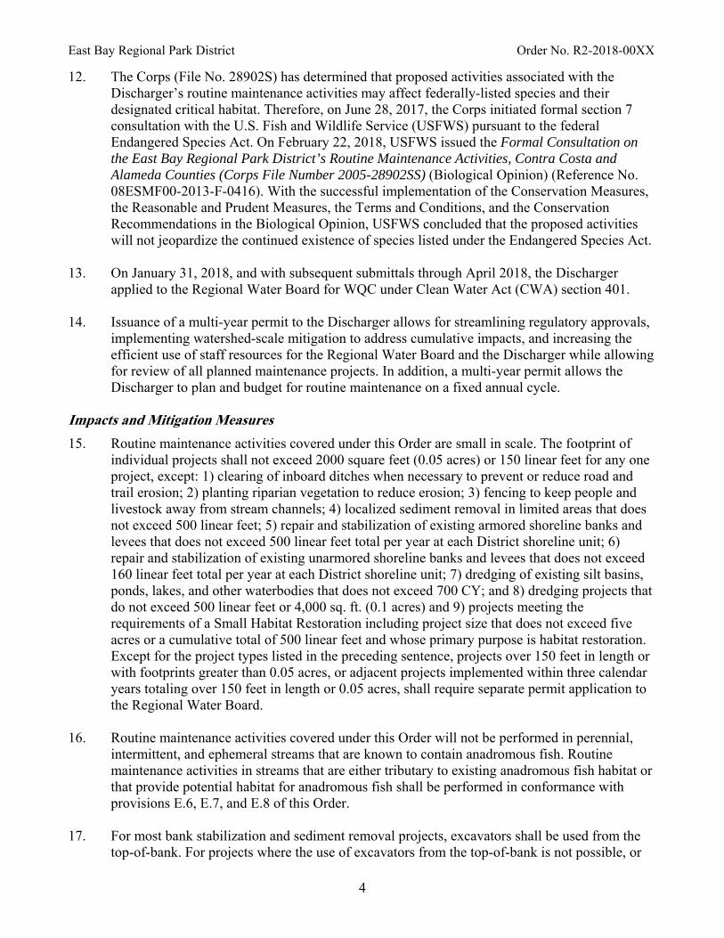
12. The Corps (File No. 28902S) has determined that proposed activities associated with the Discharger’s routine maintenance activities may affect federally-listed species and their designated critical habitat. Therefore, on June 28, 2017, the Corps initiated formal section 7 consultation with the U.S. Fish and Wildlife Service (USFWS) pursuant to the federal Endangered Species Act. On February 22, 2018, USFWS issued the Formal Consultation on the East Bay Regional Park District’s Routine Maintenance Activities, Contra Costa and Alameda Counties (Corps File Number 2005-28902SS) (Biological Opinion) (Reference No. 08ESMF00-2013-F-0416). With the successful implementation of the Conservation Measures, the Reasonable and Prudent Measures, the Terms and Conditions, and the Conservation Recommendations in the Biological Opinion, USFWS concluded that the proposed activities will not jeopardize the continued existence of species listed under the Endangered Species Act.
13. On January 31, 2018, and with subsequent submittals through April 2018, the Discharger
applied to the Regional Water Board for WQC under Clean Water Act (CWA) section 401. 14. Issuance of a multi-year permit to the Discharger allows for streamlining regulatory approvals,
implementing watershed-scale mitigation to address cumulative impacts, and increasing the efficient use of staff resources for the Regional Water Board and the Discharger while allowing for review of all planned maintenance projects. In addition, a multi-year permit allows the Discharger to plan and budget for routine maintenance on a fixed annual cycle.
Impacts and Mitigation Measures
15. Routine maintenance activities covered under this Order are small in scale. The footprint of individual projects shall not exceed 2000 square feet (0.05 acres) or 150 linear feet for any one project, except: 1) clearing of inboard ditches when necessary to prevent or reduce road and trail erosion; 2) planting riparian vegetation to reduce erosion; 3) fencing to keep people and livestock away from stream channels; 4) localized sediment removal in limited areas that does not exceed 500 linear feet; 5) repair and stabilization of existing armored shoreline banks and levees that does not exceed 500 linear feet total per year at each District shoreline unit; 6) repair and stabilization of existing unarmored shoreline banks and levees that does not exceed 160 linear feet total per year at each District shoreline unit; 7) dredging of existing silt basins, ponds, lakes, and other waterbodies that does not exceed 700 CY; and 8) dredging projects that do not exceed 500 linear feet or 4,000 sq. ft. (0.1 acres) and 9) projects meeting the requirements of a Small Habitat Restoration including project size that does not exceed five acres or a cumulative total of 500 linear feet and whose primary purpose is habitat restoration. Except for the project types listed in the preceding sentence, projects over 150 feet in length or with footprints greater than 0.05 acres, or adjacent projects implemented within three calendar years totaling over 150 feet in length or 0.05 acres, shall require separate permit application to the Regional Water Board.
16. Routine maintenance activities covered under this Order will not be performed in perennial,
intermittent, and ephemeral streams that are known to contain anadromous fish. Routine maintenance activities in streams that are either tributary to existing anadromous fish habitat or that provide potential habitat for anadromous fish shall be performed in conformance with provisions E.6, E.7, and E.8 of this Order.
17. For most bank stabilization and sediment removal projects, excavators shall be used from the
top-of-bank. For projects where the use of excavators from the top-of-bank is not possible, or
East Bay Regional Park District Order No. R2-2018-00XX
5
would cause major vegetation impacts, equipment may be used within the channel when it is dry naturally or flows are bypassed. With the exception of material used to construct cofferdams for temporary channel dewatering, no temporary fills may be placed in natural stream channels.
18. If repair activities affect the active channel, the work area shall be isolated from flowing stream
segments using cofferdams and restored to pre-project conditions after maintenance is complete. Cofferdams shall be constructed of materials that will not introduce sediment to the stream channel and can be completely removed following completion of the maintenance activity (see the discussion of Project Specific Best Management Practices (BMPs) and Thresholds in The East Bay Regional Park District Routine Maintenance and Restoration Activities in Various Waterbodies in Alameda and Contra Costa Counties, California in the San Francisco Bay Region in Attachment A to this Order).
19. Vegetation management techniques include removal using small hand tools and hand-held
equipment, mechanical removal using heavy equipment like a flail mower attached to an excavator, and spot chemical control on tree stumps and along access roads.
20. Where possible, staging will occur on adjacent access roads or previously disturbed areas. Soil
and rip-rap will be staged in areas that have been previously disturbed (i.e., service road, turn-outs).
21. The East Bay Regional Park District Routine Maintenance and Restoration Activities in
Various Waterbodies in Alameda and Contra Costa Counties in the San Francisco Bay Region (Attachment A) includes planning guidelines or principles to determine how, where, and when routine maintenance activities should occur. These principles should be used in the development of each year’s maintenance work plan, prior to any work. These principles consider the natural function of the system, provide an understanding of local physical constraints, identify sensitive habitats, consider watershed processes, determine when action is needed, identify maintenance activities needed, and strive to recognize and implement solutions to minimize the on-going need for maintenance activities.
22. Most routine maintenance activities under this Order will be conducted in a manner that results
in no net loss of waters of the State, including streams and wetlands. However, some waters of the State, including wetlands, creeks, tidal marshes, basins, lakes, and stock ponds, will be temporarily and/or permanently impacted, and will require appropriate mitigation, consistent with the State’s “no net loss” policy. All mitigation activities shall occur within the Discharger’s jurisdiction, as described in Finding 2. Impacts and mitigations associated with individual projects shall be accounted for by acreage, linear feet, and type of water of the State impacted and shall be reported annually to the Regional Water Board.
California Wetlands Portal
23. It has been determined through regional, State, and national studies that tracking of mitigation/restoration projects must be improved to better assess the performance of these projects, following monitoring periods that last several years. In addition, to effectively carry out the State’s “no net loss” wetland policy, the State needs to closely track both wetland losses and mitigation/restoration project success. Therefore, this Order requires that the Discharger use the California Wetlands Form to provide project information related to impacts and mitigation/restoration measures (see provisions E.31 and E.32 of this Order). An electronic
East Bay Regional Park District Order No. R2-2018-00XX
6
copy of the form and instructions can be downloaded at: http://www.waterboards.ca.gov/sanfranciscobay/certs.shtml Project information concerning impacts and mitigation/restoration will be made available at the web link: www.ecoatlas.org/regions/ecoregion/bay-delta/projects.
Regulatory Framework
24. The Water Quality Control Plan for the San Francisco Bay Basin (Basin Plan) is the Regional Water Board's master water quality control planning document. It designates beneficial uses and water quality objectives for waters of the State, including surface waters and groundwater. It also includes implementation plans to achieve water quality objectives. The Basin Plan was duly adopted by the Regional Water Board and approved by the State Water Resources Control Board (State Water Board), Office of Administrative Law, and U.S. EPA, where required.
25. The Basin Plan lists the following existing and potential beneficial uses for surface waters in
Alameda and Contra Costa counties within the jurisdiction of the Regional Water Board. The Discharger conducts maintenance activities on an estimated 102 creeks, lakes, reservoirs, and major ponds, including the Alameda, Alhambra, Claremont, Garrity, Rheem, Kirker, Mount Diablo, Pinole, San Pablo, San Leandro, San Lorenzo, Walnut, and Wildcat creek watersheds that drain to San Francisco Bay, San Pablo Bay, and Suisun Bay (see Attachment D to this Order), with the following designated beneficial uses:
a. Agricultural Supply (AGR) b. Cold Freshwater Habitat (COLD) c. Freshwater Replenishment (FRSH) d. Groundwater Recharge (GWR) e. Fish Migration (MIGR) f. Municipal and Domestic Supply (MUN) g. Navigation (NAV) h. Preservation of Rare and Endangered Species (RARE) i. Water Contact Recreation (REC-1) j. Non-contact Water Recreation (REC-2) k. Fish Spawning (SPWN) l. Warm Freshwater Habitat (WARM) m. Wildlife Habitat (WILD)
Sediment management, vegetation management, culvert repair or replacement, and bank stabilization activities could temporarily impact beneficial uses of waters of the State for:
a. Warm Freshwater Habitat (WARM) b. Cold Freshwater Habitat (COLD) c. Wildlife Habitat (WILD) d. Preservation of Rare and Endangered Species (RARE) e. Fish Migration (MIGR) f. Fish Spawning (SPWN)
26. The Basin Plan lists the following existing and potential beneficial uses for portions of the
shoreline of San Francisco Bay in Alameda and Contra Costa counties within the jurisdiction of the Regional Water Board. The Discharger may conduct maintenance activities at the following shoreline parks, Bay Point Wetlands, Brooks Island, Carquinez Strait Shoreline, Coyote Hills, Crown Beach, Eastshore State Park, Hayward Shoreline, Lone Tree Point, Martin Luther King

East Bay Regional Park District Order No. R2-2018-00XX
7
Jr. Shoreline, Martinez Shoreline, Miller/Knox, Oyster Bay, Point Isabel, Point Pinole, and, San Pablo Bay Shoreline, with the following designated beneficial uses:
a. Commercial and Sport Fishing (COMM) b. Estuarine habitat (EST) c. Marine habitat (MAR) d. Industrial Service Supply (IND) e. Fish Migration (MIGR) f. Navigation (NAV) g. Preservation of Rare and Endangered Species (RARE) h. Water Contact Recreation (REC-1) i. Non-contact Water Recreation (REC-2) j. Fish Spawning (SPWN) k. Shellfish harvesting (SHELL)3 l. Wildlife Habitat (WILD)
Sediment management, vegetation management, and bank stabilization activities could temporarily impact beneficial uses of waters of the State for:
a. Commercial and Sport Fishing (COMM) b. Estuarine habitat (EST) c. Marine habitat. (MAR) d. Fish Migration (MIGR) e. Navigation (NAV) f. Rare, Threatened, or Endangered Species (RARE) g. Water Contact Recreation (REC-1) h. Non-contact Water Recreation (REC-2) i. Fish Spawning (SPWN) j. Wildlife Habitat (WILD) k. Shellfish harvesting (SHELL)
27. The following groundwater basins, which underlie, at least in part, land under the control of the
Discharger, support the existing and potential beneficial uses listed below: Castro Valley Groundwater Basin, Niles Cone Sub-Basin, Santa Clara Valley Groundwater Basin, East Bay Plain Sub-Basin, Livermore Valley Groundwater Basin, Sunol Valley Groundwater Basin, Pittsburg Plain Groundwater Basin, Clayton Valley Groundwater Basin, Ygnacio Valley Groundwater Basin, San Ramon Valley Groundwater Basin, and Arroyo del Hambre Valley Groundwater Basin.
a. Agricultural Supply (AGR) b. Industrial Service Supply (IND) c. Industrial Process Supply (PROC) d. Municipal and Domestic Supply (MUN)
28. The following water bodies that could be affected by routine maintenance activities covered by this Order are identified as impaired on the federal CWA section 303(d) list for the pollutants listed:
3 Shellfish collection observations have occurred and could potentially occur on a limited basis at all San Francisco Bay shoreline parks (Hayward Shoreline, Oyster Bay, Martin Luther King Jr. Shoreline, Crown Beach, Eastshore State Park, Pt. Isabel, Miller/Knox, Point Pinole, Carquinez Strait Shoreline, Brooks Island, and Martinez Shoreline).

East Bay Regional Park District Order No. R2-2018-00XX
8
Impaired Water Body Pollutant
Creeks
Alameda Creek Diazinon
Arroyo De La Laguna Diazinon
Arroyo Del Valle Diazinon
Arroyo Las Positas Diazinon and Nutrient/Eutrophication
Arroyo Mocho Diazinon and Temperature (water)
Baxter Creek Trash
Cerrito Creek Trash
Codornices Creek Temperature (water) and Trash
Damon Slough Trash
Grayson Creek Trash
Kirker Creek Pyrethroids, Toxicity, and Trash
Mount Diablo Creek Diazinon and Toxicity
Pine Creek Diazinon
Pinole Creek Diazinon
Rodeo Creek Diazinon
San Leandro Creek (Lower) Diazinon and Trash
San Lorenzo Creek Diazinon
San Pablo Creek Diazinon and Trash
Sausal Creek Trash
Strawberry Creek Trash
Walnut Creek Diazinon
Wildcat Creek Diazinon
Beaches
Crown Beach Indicator Bacteria
Keller Beach Indicator Bacteria
Lakes and Reservoirs
Del Valle Reservoir Mercury and PCBs
Lafayette Reservoir Mercury and PCBs
Lake Chabot Chlordane, DDT, Dieldrin, Mercury, PCBs
San Pablo Reservoir Chlordane, Dieldrin, Heptachlor Epoxide, Mercury, PCBs, and Toxaphene
29. Central San Francisco Bay, which is a receiving water body for some of the creeks listed above,
is identified as impaired on the CWA Section 303(d) list and is listed as impaired for

East Bay Regional Park District Order No. R2-2018-00XX
9
Chlordane, DDT, Dieldrin, Dioxin Compounds, Furan Compounds, Invasive Species, Mercury, PCBs, Selenium, and Trash.
30. Lower San Francisco Bay, which is a receiving water body for some of the creeks listed above,
is identified as impaired on the CWA section 303(d) list and is listed as impaired for Chlordane, DDT, Diazinon, Dieldrin, Dioxin Compounds, Invasive Species, Furan Compounds, Mercury, and PCBs.
31. San Leandro Bay, which is a receiving water body for some of the creeks listed above, is
identified as impaired on the CWA section 303(d) list and is listed as impaired for Chlordane, DDT, Dieldrin, Dioxin Compounds, Furan Compounds, Invasive Species, Lead (sediment), Mercury, PAHs, Pesticides, and Zinc.
32. San Pablo Bay, which is a receiving water body for some of the creeks listed above, is
identified as impaired on the CWA section 303(d) list and is listed as impaired for Chlordane, DDT, Dieldrin, Dioxin Compounds, Furan Compounds, Invasive Species, Mercury, PCBs, and Selenium.
33. Carquinez Strait, which is a receiving water body for some of the creeks listed above, is
identified as impaired on the CWA section 303(d) list and is listed as impaired for Chlordane, DDT, Dieldrin, Dioxin Compounds, Furan Compounds, Invasive Species, Mercury, PCBs, and Selenium.
34. Suisun Bay, which is a receiving water body for some of the creeks listed above, is identified as
impaired on the CWA section 303(d) list and is listed as impaired for Chlordane, DDT, Dieldrin, Dioxin Compounds, Furan Compounds, Invasive Species, Mercury, PCBs, and Selenium.
35. The Discharger has certified in filings with the Alameda County Clerk on March 4, 2011, and
the Contra Costa County Clerk on March 8, 2011, that the proposed maintenance activities are categorically exempt from the California Environmental Quality Act (CEQA) Guidelines.
The action to adopt WDRs and WQC for the regional maintenance activities is exempt from the provisions of CEQA, in accordance with the following:
Section 15301 for the operation, repair maintenance, or minor alteration of existing structures, facilities, mechanical equipment, or topographical features involving negligible or no expansion of use;
Section 15302 for the replacement or reconstruction of existing structures and facilities on the same site having substantially the same purpose and capacity;
Section 15303 for new construction of limited to small new facilities including installation of small, new equipment and facilities in small structures and conversion of the use of small existing structures;
Section 15304 for minor alterations in the condition of the land, water, and/or vegetation, which do not involve removal of healthy, mature, scenic trees, except for forestry or agricultural purposes. This includes grading on land with a slope of less 10 percent, except in a waterway, wetland, officially-designated scenic area, or officially- mapped areas of severe geological hazard. This also includes new gardening, landscaping, minor trenching and filling, maintenance dredging and filling of earth into previously excavated land with compatible material;

East Bay Regional Park District Order No. R2-2018-00XX
10
Section 15311 for the construction or placement of minor structures accessory to existing facilities; and
Section 15333 for small habitat restoration projects of less than 5 acres.
36. The goals of the California Wetlands Conservation Policy (Governor’s Executive Order W-59-93, signed August 23, 1993) include ensuring no “overall loss”, and achieving a “long-term net gain in the quantity, quality, and permanence of wetlands acreage and values…”.
37. Senate Concurrent Resolution No. 28 states that, “It is the intent of the legislature to preserve,
protect, restore, and enhance California’s wetlands and multiple resources which depend on them for the benefit of the people of the State.”
38. Section 13142.5 of the California Water Code (CWC) requires that “Highest priority shall be
given to improving or eliminating discharges that adversely affect … Wetlands, estuaries, and other biologically sensitive areas.”
39. Pursuant to CWC section 13260, the Discharger shall timely pay all fees associated with this
Order. The fee amount for this Order shall be in accordance with the current fee schedule, per California Code of Regulations (CCR), Division 3, Chapter 9, Article 1, section 2200(a)(3). The fee payment shall indicate the Order number, the CIWQS Place ID No. 833812, the Regulatory Measure ID no. 412258, and the applicable year.
40. The Regional Water Board has notified the Discharger and interested parties of its intent to
issue WDRs and WQC for the District’s routine maintenance activities.
41. The Regional Water Board, in a public meeting, heard and considered all comments pertaining to this Order.
IT IS HEREBY ORDERED that the East Bay Regional Park District (Discharger), in order to meet the provisions contained in Division 7 of the California Water Code and regulations adopted thereunder, shall comply with the following:
A. Discharge Prohibitions
1. The direct or indirect discharge of wastes, as defined in CWC section 13050(d), within or outside of the active project site, to surface waters or surface water drainage courses is prohibited, except as authorized in this Order.
2. The discharge shall not cause degradation of water quality and beneficial uses. 3. Excavated sediment shall remain within designated disposal areas at all times. The designated
disposal areas are: (a) any offsite, authorized temporary or permanent location maintained in compliance with federal and State regulations, (b) any onsite, authorized temporary or permanent location, provided material will be isolated and contained to prevent impacts to waters of the State and their beneficial uses, or (c) a permitted landfill. Sediment may be re-used by the Discharger or offered to other parties for re-use if such re-use is consistent with the screening levels contained in the Regional Water Board’s May 2000 staff report, Beneficial Reuse of Dredged Materials: Sediment Screening and Testing Guidelines.
East Bay Regional Park District Order No. R2-2018-00XX
11
4. The discharge of sediment and runoff/decant water that exceeds effluent limits, from excavated materials disposed of at any temporary or permanent disposal site, to waters of the State is prohibited.
5. Any maintenance or dredge and disposal activity subject to these requirements shall not cause a
condition of pollution or nuisance as defined in CWC section 13050 (l) and (m). 6. Groundwater beneficial uses shall not be degraded as a result of routine maintenance activities. 7. No debris, soil, silt, sand, cement, concrete, or washings thereof, or other construction related
materials or wastes, oil or petroleum products or other organic or earthen material shall be allowed to enter into or be placed where it may be washed by rainfall or runoff into waters of the State. When operations are completed, any excess material shall be removed from the work area and any areas adjacent to the work area where such material may be washed into waters of the State.
8. Project-related discharges shall not cause a violation of any water quality standard for receiving waters adopted by the Regional Water Board or State Water Board as required by the CWA and regulations adopted thereunder. If more stringent water quality standards are promulgated or approved pursuant to CWA section 303, or amendments thereto, the Regional Water Board may revise or modify this Order in accordance with the more stringent standards. Pond dewatering discharges, accumulated groundwater or stormwater removed during dewatering of excavations, and diverted pond and stormwater flows shall not be discharged to waters of the U.S. without meeting the receiving water objectives in the Basin Plan.
B. Discharge Specifications
1. Appropriate soil erosion control measures shall be undertaken and maintained to prevent discharge of sediment to surface waters or surface water drainage courses.
2. In accordance with CWC section 13260, the Discharger shall file with the Regional Water
Board a report of any material change in the character, location, or quantity of this waste discharge. Any proposed material change in the discharge requires approval by the Regional Water Board after a hearing under CWC section 13263.
3. A responsible representative of the Discharger shall immediately, and in no case no more than
24 hours, notify Regional Water Board staff by telephone whenever an adverse condition occurs as a result of this discharge. An adverse condition includes, but is not limited to, a violation or threatened violation of the requirements of this Order, significant spill of petroleum products or toxic chemicals, or damage to control facilities that could affect compliance. Pursuant to CWC section 13267(b), a written notification of the adverse condition shall be submitted to the Regional Water Board within five days of occurrence. The written notification shall identify the adverse condition, describe the actions necessary to remedy the condition, and specify a timetable, subject to the modifications of the Regional Water Board, for the remedial actions.

East Bay Regional Park District Order No. R2-2018-00XX
12
C. Effluent Limitations
Excavated material effluent (decant water) discharged from any permanent or temporary disposal site located on the project site or off the site shall not exceed the following numeric and narrative limits at any time:
1. Numeric Limits:
a. pH: 6.5 – 8.5
b. Settleable Matter: < 1.0 ml/l-hour 2. Narrative Limits:
a. Waters shall not contain suspended material in concentrations that cause nuisance or adversely affect beneficial uses; and,
b. All water shall be free from dissolved sulfide concentrations above natural background levels.
D. Receiving Water Limitations
1. Work in and around the stream channel or Bay shoreline shall not cause the following conditions to exist in waters of the State at any place:
a. Waters shall not contain floating material, including solids, liquids, foams, and scum, in concentrations that cause nuisance or adversely affect beneficial uses;
b. Waters shall not contain oils, greases, waxes, or other materials in concentrations that result in a visible film or coating on the surface of the water or on objects in the water, that cause nuisance, or that otherwise adversely affect beneficial uses;
c. Waters shall not contain biostimulatory substances in concentrations that promote aquatic growth to the extent that such growth cause nuisance or adversely affect beneficial uses;
d. Waters shall be maintained free of toxic substances in concentrations that are toxic to, or that produce detrimental physiological responses in human, plant, animal, or aquatic life;
e. There shall be no alteration of temperature, turbidity, or apparent color beyond present natural background levels;
f. Dissolved oxygen, with the beneficial use designations listed in D.1.g.a. below, shall not be reduced below the listed minimums in the receiving water from the point of discharge;
g. Routine maintenance activities shall not cause the following limits to be exceeded in waters of the State at any point:
a. Dissolved Oxygen: 5.0 (WARM) or 7.0 (COLD) mg/l minimum. When natural factors cause lesser concentrations, then this discharge shall not cause further reduction in the concentration of dissolved oxygen.

East Bay Regional Park District Order No. R2-2018-00XX
13
b. Dissolved Sulfide: All water shall be free from dissolved sulfide concentrations above natural background levels. Concentrations of only a few hundredths of a milligram per liter can cause a noticeable odor or be toxic to aquatic life. Violation of the sulfide objective will reflect violation of dissolved oxygen objectives as sulfides cannot exist to a significant degree in an oxygenated environment.
c. pH: A variation of natural ambient pH by more than 0.5 pH units.
d. Toxicity: All waters shall be maintained free of toxic substances in concentrations that are lethal to or that produce other detrimental responses in aquatic organisms.
e. Un-ionized Ammonia:
0.025 mg/L as N, annual median; and 0.16 mg/L as N, maximum.
f. Salinity: The project shall not increase total dissolved solids or salinity to adversely affect beneficial uses.
g. Turbidity Waters shall be free of changes in turbidity that cause nuisance or adversely affect beneficial uses. Increases from normal background light penetration or turbidity relatable to waste discharge shall not be greater than 10 percent in areas where natural turbidity is greater than 50 NTU, or greater than 5 NTU where natural turbidity is less than 50 NTU.
2. The discharge shall not cause a violation of any particular water quality standard for receiving
waters adopted by the Regional Water Board or the State Water Board as required by the CWA and regulations adopted thereunder. If more stringent applicable water quality standards are promulgated or approved pursuant to CWA section 303, or amendments thereto, the Regional Water Board will revise and modify this Order in accordance with such more stringent standards.
3. Groundwater shall not be degraded as a result of maintenance activities or sediment disposal. E. Provisions
General Water Quality
1. The Discharger shall comply with all the Prohibitions, Receiving Water Limitations, and Provisions of this Order immediately upon adoption of this Order or as provided below. Requirements prescribed by this Order supersede the requirements prescribed by Order No. R2-2011-0050.
2. The Discharger shall be restricted to maintenance activities summarized in Attachment A that
would be eligible for coverage under the following Corps Nationwide Permits (NWPs) for the purpose of this Order:
East Bay Regional Park District Order No. R2-2018-00XX
14
NWP 3, Maintenance NWP 13, Bank Stabilization NWP 14, Linear Transportation Projects NWP 18, Minor Discharges NWP 19, Minor Dredging NWP 27, Aquatic Habitat Restoration, Establishment, and Enhancement Activities NWP 28, Modification of Existing Marinas NWP 31, Maintenance of Existing Flood Control Facilities NWP 37, Emergency Watershed Protection and Rehabilitation NWP 40, Agricultural Activities NWP 42, Recreational NWP 45, Repair of Upland Damaged by Discrete Events
3. The Discharger shall submit separate WQC applications for projects that do not meet the
criteria for the routine maintenance activities summarized in Attachment A or would not qualify for the Corps NWPs listed in Provision E.2. At a minimum, the Discharger shall submit separate WQC applications for any single project with fill impacts to a water body or wetland of greater than 2000 square feet (0.05 acre). The Discharger shall also submit separate WQC applications for any single channel project that would impact more than 150 linear feet for any one project, with the following exceptions: 1) clearing of inboard ditches when necessary to prevent or reduce diversion potential to road and trail systems; 2) planting riparian vegetation to reduce erosion; 3) fencing to keep people and livestock away from stream channels; 4) localized sediment removal in limited areas that does not exceed 500 linear feet; 5) repair and stabilization of existing armored shoreline banks and levees that does not exceed 500 linear feet total or 12,500 sq. ft. (0.287 acres) per year at each District shoreline unit; 6) repair and stabilization of existing unarmored shoreline banks and levees that does not exceed 160 linear feet total or 4,000 sq. ft. (0.092 acres) per year at each District shoreline unit; 7) dredging of existing silt basins, ponds, lakes, and other waterbodies that does not exceed 700 CY; and 8) dredging projects that do not exceed 500 linear feet or 4,000 sq. ft. (0.1 acres). Except for the project types listed in the preceding sentence, projects over 150 feet in length or with footprints greater than 0.05 acres, or adjacent projects implemented within three calendar years totaling over 150 feet in length or 0.05 acres, shall require separate WQC applications to the Regional Water Board.
4. The Discharger shall submit by June 1st of each year an Annual Notification of Proposed
Projects, specifying planned routine maintenance activities that will occur in the following year. The Annual Notification of Proposed Projects shall indicate project location, scope, purpose and need; the amount of fill of waters of the State, including wetlands; and any associated mitigation.
5. For compensatory mitigation for Project impacts to waters of the State, including onsite
restoration and offsite mitigation, the Annual Notification of Proposed Projects shall include a description of all proposed mitigation projects, along with the rationale for the proposed amount of acres and/or linear feet of mitigation to compensate for the predicted temporary and permanent impacts resulting from the proposed maintenance projects. The description of proposed mitigation projects shall include mitigation project designs, monitoring and maintenance protocols, and interim and final performance criteria for assessing the successful implementation of mitigation projects. Monitoring and maintenance protocols shall be

East Bay Regional Park District Order No. R2-2018-00XX
15
implemented for a minimum of five years for wetland, tidal, and open water mitigation projects and a minimum of 10 years for riparian mitigation projects. Onsite performance criteria will be used to establish that habitats at impacted sites have recovered to near pre-impact levels (e.g., percent cover of disturbed surfaces with vegetation, percent survival of replanted riparian vegetation). Offsite performance criteria shall be used to establish that the mitigation projects successfully created or enhanced habitat (e.g., geomorphic stability of channels and/or berms, percent survival of planted riparian vegetation, percent cover of planted vegetation, sufficient ponding to support breeding of listed amphibians).
6. For routine maintenance activities impacting watercourses that are known to support or have
the potential to support threatened and/or endangered species, a qualified biologist shall conduct a pre-construction survey. If any threatened and/or endangered species are located during the pre-construction survey at the project site, the Discharger shall conduct the maintenance project in a manner that is consistent with the requirements of the U.S. Army Corps of Engineers Proposed Procedures for Permitting Projects that will Not Adversely Affect Selected Listed Species in California (NLAA) consultation with NMFS (dated July 17, 2013).
7. Under this Order, routine maintenance activities conducted in perennial or intermittent streams
known to contain anadromous fish need to comply with the NLAA. Federally-listed species that occur on land managed by the Discharger are listed in Attachment E to this Order. Any proposed projects that do not fit the NLAA will require a separate NMFS authorization before work may be performed on those sites.
8. The Corps (File No. 28902S) has determined the proposed activities associated with the Discharger’s routine maintenance activities may affect federally-listed species and their designated critical habitat. Therefore, on June 28, 2017, the Corps initiated formal section 7 consultation with USFWS pursuant to the federal Endangered Species Act. On February 22, 2018, USFWS issued the Formal Consultation on the East Bay Regional Park District’s Routine Maintenance Activities, Contra Costa and Alameda Counties (Corps File Number 2005-28902SS) (Biological Opinion) (Reference No. 08ESMF00-2013-F-0416). The Discharger shall fully implement the Conservation Measures, the Reasonable and Prudent Measures, the Terms and Conditions, and the Conservation Recommendations in the Biological Opinion to ensure that the proposed activities do not jeopardize the continued existence of species listed under the Endangered Species Act.
9. The Discharger shall follow the procedures and protocols in the Fishnet 4C Manual4 when
removing large woody debris from stream channels for maintenance purposes. Large woody debris shall not be removed or be managed in a channel if it potentially functions as habitat for salmonids or other threatened and endangered species. If the large woody debris poses a credible risk of blocking a culvert, bridge, or otherwise obstructing flow or causing structural damage, it may be relocated, repositioned, and or cabled to a stream bank in a manner to protect existing habitat. For channels that do not provide potential salmonid, or threatened and endangered species habitat that relies on large woody debris, large woody debris can be
4 Fishnet 4C, MFG, Inc., Prunuske Chatham, Inc., Pacific Watershed Associates ( 2004) Guidelines For Protecting Aquatic Habitat and Salmon Fisheries for County Road Maintenance, prepared for Fishnet 4C Counties, California Department of Fish and Wildlife, National Marine Fisheries Service, and the California Resources Agency
East Bay Regional Park District Order No. R2-2018-00XX
16
immediately removed or relocated to a more suitable location if the large woody debris is posing a significant and imminent threat of structural damage.
10. The Discharger shall immediately report all dead or stressed fish or amphibians that are found
within 1,000 feet of work activity or discharge authorized by this Order. The Discharger shall immediately assign a qualified biologist to investigate the cause of the problem, to define an acceptable corrective action plan, and to determine if the cause is related to maintenance activities. Work shall be halted if the investigation determines that the problem was caused by work activity or discharge authorized by this Order. A copy of the qualified biologist’s investigation report shall be submitted to the Regional Water Board within 30 days of the discovery of dead or stressed fish or amphibians within 1,000 feet of work activity or discharge authorized by this Order.
11. The Discharger shall implement bioengineering methods as the preferred methodology for bank
stabilization projects. Repairs that require alternative structural reinforcement, such as placement of rock rip-rap, shall be filled with native soil and local plant materials and mulch, unless these materials would contribute to further erosion and sedimentation. A rationale for each instance of using an alternate, more hardened bank stabilization method must be stated and discussed in the Annual Notification of Proposed Projects (see Provision E.33), and more hardened bank stabilization methods shall not be implemented without the approval of the Executive Officer.
12. Routine maintenance activities shall not result in direct or cumulative significant impacts to
water quality or beneficial uses of waters of the State. 13. The Discharger shall implement all applicable BMPs described in Attachment A. Changes to
bank repair methods shall be proposed in the Annual Notification of Proposed Projects package, or equivalent document, and approved in writing by the Executive Officer before implementation.
14. The Discharger shall comply with all applicable items of the Self-Monitoring Program (SMP)
(Attachment B).
Wetland/Waters of the State Mitigation
15. Most routine maintenance activities under this Order will be conducted in a manner that results in no net loss of wetlands/waters of the State, but some maintenance activities may have impacts that require mitigation consistent with the State’s “no net loss” policy. The Discharger shall maintain records of all wetland/waters of the State losses and gains associated with each individual routine maintenance activity project. The total acreage, linear feet, and type of wetland/waters of the State impacted and the total acres, linear feet, and type of wetland/water of the State created, and total credits available from prior years and the current year shall be reported in the Annual Post-Maintenance Reports (see Provision E.34). In addition, the number, location, and nature of restoration sites, including pre-construction and post-construction photographs of restored sites, shall be submitted as part of the Annual Post-Maintenance Reports.
16. Land owned or managed by the Discharger includes tidal wetlands, lentic water bodies, and
stream habitat. Many of these waterbodies are within the current distributional range of the
East Bay Regional Park District Order No. R2-2018-00XX
17
California red-legged frog, California tiger salamander, foothill yellow-legged frog, California Ridgway’s rail, salt marsh harvest mouse, and/or Western pond turtle and can be enhanced to provide additional permanent habitat for these special status species, as well as a variety of other aquatic species. Restoring and/or creating permanent aquatic habitat will be implemented by the Discharger to provide compensatory mitigation for the temporary and permanent cumulative impacts associated with the various routine maintenance projects (see the discussion of Proposed Restoration Activities in The East Bay Regional Park District Routine Maintenance and Restoration Activities in Various Waterbodies in Alameda and Contra Costa Counties, California in the San Francisco Bay Region in Attachment A). At a minimum, the Discharger shall implement sufficient compensatory mitigation in each year to compensate for the temporary and permanent impacts associated with each year’s proposed maintenance projects.
17. The Discharger shall evaluate the anticipated impacts for which mitigation is required at each
of the proposed project sites that are included in the Annual Notification of Proposed Projects (see Provision E.33). For each project included in the Annual Notification of Proposed Projects, the Discharger shall describe onsite mitigation (e.g., stabilization of disturbed surfaces, re-vegetation of disturbed surfaces, planting of riparian vegetation) and the amount of any offsite mitigation that is proposed for the individual project (since many mitigation sites will be consolidated mitigation sites compensating for the impacts of multiple small projects, the appropriateness of each year’s proposed mitigation shall be evaluated with respect to net impacts and net mitigation). The amount of proposed mitigation for each project type shall be based on the mitigation ratios in Attachment D. Where ranges of mitigation ratios are presented in Attachment D, the factors that may be used in selecting project appropriate mitigation ratios from that range include the following: anticipated temporal loss of habitat associated with the interval between impacts at the project site and functioning of restored habitat at the mitigation site (longer recovery times, such as tree re-growth versus grass re-growth, require more mitigation); the distance between the impact site and the mitigation site (greater distances require more mitigation); differences in habitat type between the impacted site and mitigation site (greater differences require more mitigation); any uncertainties associated with the mitigation site (greater uncertainty requires more mitigation); and the permanence of the impact (permanent impacts require more mitigation than temporary impacts). Although most of the projects authorized by this Order are anticipated to have only temporary impacts, some projects may also have small areas of permanent impacts. The proposed mitigation in the Annual Notification of Proposed Projects is subject to review and approval by the Executive Officer.
18. Regional Water Board staff shall review the Annual Notification of Proposed Projects and
Annual Post-Maintenance Reports to assess the adequacy of the mitigation provided in each year for the impacts that occurred in that year. If staff determines that the Discharger has not completed sufficient mitigation, the Discharger shall be informed of the deficit and shall address it in the following year’s Annual Notification of Proposed Projects. If the Executive Officer determines that the Discharger has provided excess mitigation, the Discharger will be allowed to accrue excess mitigation credit for use as described in the following provision.
19. If excess mitigation credits are accrued, the Discharger, subject to Executive Officer approval,
may make credits available to itself and other public entities to be used as compensatory mitigation for loss of functions and values of waters of the State associated with other projects located within watersheds in Alameda or Contra Costa counties and within the jurisdictional boundary of the Regional Water Board. Subject to the Executive Officer’s approval, the
East Bay Regional Park District Order No. R2-2018-00XX
18
Discharger may accept payment of an in-lieu fee or may allow public entities to use excess mitigation credits documented from previous years as compensatory mitigation.
Sediment Management
20. The Discharger may temporarily stockpile excavated sediment prior to disposal or reuse, provided that appropriate State and federal regulations are met and BMPs are implemented to protect water quality and beneficial uses. The excavated sediment may be stockpiled onsite so that it can be loaded into trucks for offsite disposal within three working days. The excavated sediment may also be temporarily stockpiled at an offsite location so that runoff, sediment, or decant water from the excavated materials will not contact waters of the State.
21. The Discharger shall ultimately dispose of dewatered material at an appropriate upland sediment disposal site or at an approved reuse site in accordance with applicable State and federal regulations, including applicable provisions of this Order.
22. Sediment may be re-used by the Discharger or offered to other parties for re-use, if such re-use is consistent with the screening levels contained in the Regional Water Board’s May 2000 staff report, Beneficial Reuse of Dredged Materials: Sediment Screening and Testing Guidelines, including proper characterization of chemical constituents in the sediment through laboratory analytical testing.
23. Where possible, staging shall occur on adjacent access roads or previously disturbed areas. Soil and rip-rap shall be staged in areas that have been previously disturbed (i.e., service road, turn-outs).
24. If repair activities affect the active channel, the work area shall be isolated from flowing stream segments using cofferdams and restored to pre-project conditions as soon as maintenance is complete. Instream diversion techniques and instream isolation techniques are specified in Attachment A. All stream diversions shall be carefully maintained and monitored. Upon completion of work in diverted channels, the stream diversion shall be removed and flow shall be returned to the original stream channel or through any replacement culvert installed as part of the maintenance project.
25. The Discharger shall divert any flow around the active maintenance site in a non-erosive manner, in accordance with Project Specific Best Management Practices (BMPs) and Thresholds in The East Bay Regional Park District Routine Maintenance and Restoration Activities in Various Waterbodies in Alameda and Contra Costa Counties, California in the San Francisco Bay Region (Attachment A).
26. Only dewatering equipment shall operate in standing or flowing water. Work may be performed in the stream channel if no water is flowing or if flow has been diverted in accordance with provisions E.24 and E.25 above.
27. Non ground-disturbing work may be conducted in the channel zone, but outside the low-flow
channel, at any time. This includes pruning and removing select non-native invasive plant species, maintaining channel access roads for drainage and accessibility, conducting minor repairs of culverts, and repairing fences (along either side of access roads, including the upper portion of streambanks where access is from the service road). These maintenance activities
East Bay Regional Park District Order No. R2-2018-00XX
19
may be conducted at any time, provided there is no discharge of waste that may cause an adverse impact to water quality or beneficial uses. Planting of riparian vegetation may be done at any time provided there is no erosion and sedimentation that may cause an adverse impact to water quality or beneficial uses.
28. Temporary road crossings that are primarily for emergency use, such as for the passage of heavy equipment for fire suppression, shall be graded carefully to preclude the discharge of sediment, soil, or rock into flowing or standing water. Any rock and gravel being graded shall not be removed from the streambed.
Waste Management
29. The Discharge of any hazardous, designated or non-hazardous waste as defined in 27 CCR, Division 2, Subdivision 1, Chapter 2 shall be conducted in accordance with applicable State and federal regulations.
30. The Discharger shall remove and relocate any wastes that are discharged in violation of this Order. Waste shall be disposed of at a location in compliance with federal and State regulations and in such a way as to prevent impacts to waters of the State and their beneficial uses.
Monitoring and Reporting
31. To support annual program implementation, the Discharger will submit the following documents and reports annually to the Regional Water Board:
a) Annual Notification of Proposed Projects, b) Annual Post-Maintenance Reports, and c) Any other self-monitoring reports required or deemed necessary by the Executive Officer. The Discharger is required to submit the above reports by uploading them to the California Wetlands Portal website at http://www.californiawetlands.net/tracker/ba/list or via email. To upload the reports, go to the above link, click on your project, click on Files & Links, and follow the steps. When any report is uploaded to the California Wetlands Portal, the Discharger shall notify the Regional Water Board staff case manager that the report has been uploaded
32. The Discharger is required to use the California Wetlands form to report net habitat losses and net gains as part of the Annual Post-Maintenance Report, as specified in Provision E.34. Habitat losses and gains shall be reported for each completed individual maintenance project, and the location of each project shall be reported in the Annual Post-Maintenance Report. Tracking of individual maintenance projects will be used to identify areas of ongoing instability. The completed California Wetlands form shall be submitted electronically to [email protected] and in hard copy to both: 1) the Regional Water Board (see the address on the letterhead), attention California Wetlands Portal; and 2) to the San Francisco Estuary Institute, 4911 Central Avenue, Richmond, CA 94804, to the attention of California Wetlands Portal.
33. The Annual Notification of Proposed Projects, prepared in conformance with the SMP in
Attachment B to this Order, for the following year’s proposed projects shall be submitted by June 1 of each year.
34. The Discharger shall file Annual Post-Maintenance Reports, prepared in conformance with the SMP in Attachment B to this Order, with the Regional Water Board by February 15 of each

East Bay Regional Park District Order No. R2-2018-00XX
20
year. The Annual Post-Maintenance Reports shall include descriptions of work performed, any unanticipated field conditions, and changes to planned projects or performance of mitigation measures, as well as before and after photographs of each project site. Compensatory mitigation (restoration) activities shall be reported in the Annual Post-Maintenance Reports, which shall include the number, location, and nature of mitigation sites, as well as pre-construction and post-construction photographs of mitigation sites. The Discharger shall maintain records of all wetland/waters of the State losses and gains associated with each individual routine maintenance activity project. The total acreage, linear feet, and type of wetland/waters of the State impacted and the total acres, linear feet, and type of wetland/water of the State enhanced and created, and total credits available from prior years and the current year shall be reported in the Annual Post-Maintenance Reports. In addition, photographs of mitigation sites that have not yet attained their performance criteria must be submitted as part of the Annual Post-Maintenance Reports. Each restoration site shall be monitored in subsequent annual reports until the restoration site meets its performance criteria (see Attachment A).
35. The following activities are exempt from annual notification requirements and may occur any time at the discretion of the Discharger: maintenance of existing access roads located along the top-of-bank where there will be no impact on waters of the State; maintenance of cross-slope drains across roads, on inboard ditches that run parallel to roads where all work is above the level of top-of-bank of the adjacent stream, and there is no impact to waters of the State; and removal of debris (trash, shopping carts, etc.) accumulations using hand labor and not involving the removal of vegetation or large woody debris.
36. After five years of routine maintenance activities, the Discharger and Regional Water Board will conduct a review in 2023 and consider reissuing WDRs and WQC for an additional five years. The review will include an assessment of routine maintenance activities conducted to date, BMPs, and overall program coordination and communication between the Discharger and regulatory agencies.
Records Provisions
37. The Discharger shall maintain records of all routine maintenance activities, natural resources in the program area, permitting requirements, and mitigation efforts.
38. The Executive Officer may request that data be provided to the Regional Water Board at times
outside of the reporting requirements specified in this Order. 39. The Discharger shall retain records of all reports required by this Order, and records of all
information used to complete the application for this Order, for a period of at least ten years. This period may be extended by request of the Executive Officer at any time.
General Provisions
40. This Order does not authorize commission of any act causing injury to the property of another or of the public; does not convey any property rights; does not remove liability under federal, State or local laws, regulations or rules of other programs and agencies nor does this Order authorize the discharge of waste without appropriate permits from other agencies or organizations

East Bay Regional Park District Order No. R2-2018-00XX
21
41. Capital improvement projects and emergency maintenance activities and procedures are not covered in this Order.
42. The Discharger shall comply with all necessary approvals and/or permits for routine maintenance activities from applicable government agencies, including, but not limited to: CDFW, Corps, USFWS, NMFS, and local agencies. The Discharger shall submit copies of such approvals and/or permits to the Executive Officer prior to routine maintenance implementation.
43. The Discharger shall implement the routine maintenance activities in accordance with BMPs described in Attachment A and the findings herein and shall comply with all applicable water quality standards.
44. Any change to routine maintenance activities that would have a significant or material effect on the findings, conclusions, or conditions of this Order shall be submitted to the Executive Officer for review and written approval.
45. Routine maintenance activities shall occur only when there is no surface flow or the channel has been dewatered during the construction period of April 15 to October 31 of any year. Routine maintenance activities shall occur beginning June 15 for streams that are tributary to streams that support anadromy. However, routine maintenance activities conducted in tidal emergent wetlands shall be performed between September 1 and January 31 to avoid potential impacts to nesting California Ridgway’s rails. Routine maintenance activities along creeks or in seasonal wetlands planned to start after October15 shall only be started if no rain is forecast with greater than 20 percent chance of precipitation and the project can be completed before the next forecast rain event.
46. These WDRs and WQC are subject to modification or revocation upon administrative or judicial review, including review and amendment pursuant to CWC section 13330 and 23 CCR section 3867.
47. This WQC is not intended and shall not be construed to apply to any discharge from any activity involving a hydroelectric facility requiring a Federal Energy Regulatory Commission (FERC) license or an amendment to a FERC license unless the pertinent certification application was filed pursuant to 23 CCR section 3855, Subdivision (b) and the application specifically identified that a FERC license or amendment to a FERC license for a hydroelectric facility was being sought.
48. The Regional Water Board may add to or modify the conditions of this Order, as appropriate, to implement any new or revised water quality standard and implementation plans adopted or approved pursuant to the CWC or CWA section 303 and/or any new or revised TMDL requirements.
49. The Discharger shall maintain a copy of this Order and all relevant plans and BMPs at routine maintenance work sites so as to be available at all times to site operating personnel.
50. The Discharger shall correct any and all problems that arise from routine maintenance activities, including a failure to meet the conditions of this Order that results in an unauthorized release of pollutants, including sediment.
East Bay Regional Park District Order No. R2-2018-00XX
22
51. The Discharger shall permit the Regional Water Board staff or its authorized representative, upon presentation of credentials:
a. Entry on to the premises on which maintenance activities are planned or underway, wastes are located, or in which records are kept;
b. Access to copy any records required to be kept under the terms and conditions of this Order;
c. Access to inspect any treatment equipment, monitoring equipment or monitoring method required by this Order; and
d. Access to sample any discharge or surface water covered by this Order.
52. In the event of any violation or threatened violation of the conditions of this Order, the violation or threatened violation shall be subject to any remedies, penalties, process or sanctions as provided for under applicable State or federal law. For the purposes of CWA section 401(d), the applicability of any State law authorizing remedies, penalties, process or sanctions constitutes a limitation necessary to assure compliance with the water quality standards and other pertinent requirements incorporated into this Order. In response to a suspected violation of any condition of this Order, the Regional Water Board may require the Discharger to furnish, under penalty of perjury, any technical or monitoring reports the Regional Water Board deems appropriate, provided that the burden, including costs, of the reports shall bear a reasonable relationship to the need for the reports and the benefits to be obtained from the reports. In response to any violation of the conditions of this Order, the Regional Water Board may add to or modify the conditions of this Order as appropriate to ensure compliance.
53. Rescission of Previous Order. The WDRs prescribed by this Order supersede those prescribed by Order No. R2-2011-0050 for the Discharger. Order No. R2-2011-0050 is hereby rescinded, except for purposes of enforcement.
54. This Order is not transferable.
55. The authorization for activities covered by this Order expires in the summer of 2023 when the CWA section 404 authorization from the Corps expires. The authorization may be extended by the Executive Officer for up to two years beyond this date upon the Discharger’s request and the Executive Officer’s finding that the Discharger is in compliance with the Order. The Discharger must file a Report of Waste Discharge, in accordance with CWC section 13260 et seq., not later than 180 days in advance of such date as application for reissuance of WDRs. Mitigation reporting, accounting, and post-maintenance report requirements that extend beyond the term of this Order are not subject to the expiration date outlined above and remain in full effect and are enforceable.
I, Bruce H. Wolfe, Executive Officer, do hereby certify that the foregoing is a full, complete and correct copy of an Order adopted by the California Regional Water Quality Control Board, San Francisco Bay Region on July 11, 2018.
_________________ Bruce H. Wolfe Executive Officer

East Bay Regional Park District Order No. R2-2018-00XX
23
Attachments:
A: The East Bay Regional Park District Routine Maintenance and Restoration Activities in Various Waterbodies in Alameda and Contra Costa Counties, California in the San Francisco Bay Region
B: Self-Monitoring Program C: Federally-Listed Species that Occur Within East Bay Regional Park District Property D: Mitigation Ratios

East Bay Regional Park District
Regional Maintenance Activities Alameda and Contra Costa Counties
ATTACHMENT A
The East Bay Regional Park District Routine
Maintenance and Restoration Activities in Various Waterbodies in Alameda and Contra Costa Counties,
California, in the San Francisco Bay Region
The East Bay Regional Park District Routine Maintenance and Restoration Activities in Various Waterbodies in
Alameda and Contra Costa Counties, California in the San Francisco Bay Region
Prepared by Steven Bobzien and Courtney Wilson
East Bay Regional Park District 2950 Peralta Oaks Court
Oakland, California 94605 January 4, 2018


Cover Photos: © Steven Bobzien, East Bay Regional Park District
Table of Contents
Project Description and Affected Waterbodies .................................................................1
Proposed Activities ...............................................................................................................2
General Avoidance and Minimization Measures ..............................................................16
Project Specific Best Management Practices (BMPs) and Thresholds ...........................20
Species Specific Conservation Measures ...........................................................................24
Proposed Restoration Activities ..........................................................................................26
Summary of Project Impacts ..............................................................................................29
Monitoring and Reporting ..................................................................................................30
Other Regulatory Permits and Supporting Documents ...................................................31
Appendices ............................................................................................................................33
A. District Map
B. Table 1: S.F. Bay Region 2 Routine Maintenance Projects Anticipated Range of Impacts
C. Waterbody Atlas for East Bay Regional Park District
D. Preliminary Jurisdictional Determination Sheets


1 Including one potential Regional Park pending land transfer Prepared by Steven Bobzien and Courtney Wilson, East Bay Regional Park District January 4, 2018 Page | 1
The East Bay Regional Park District Routine Maintenance and Restoration Activities in Various Waterbodies in
Alameda and Contra Costa Counties, California Project Description and Affected Waterbodies:
The East Bay Regional Park District (“District”) currently manages 661 regional parks,
recreation areas, wilderness lands, shorelines, preserves, and land bank areas, as well as 43
distinct trail segments, which encompass approximately 122,890 acres in Alameda and Contra
Costa Counties, California (see Appendix map). The District’s mission is to acquire, preserve,
protect, and operate regional parklands in perpetuity for public use, while conserving these lands
for natural resources. Over 90 percent of District lands are protected and operated as natural
parklands. This includes parklands along the shorelines of San Francisco, San Pablo, Suisun
Bays and the Delta Region, and inland areas of the coastal and transverse ranges of the East Bay.
Within various waterbodies and adjacent upland habitats, the District performs routine
maintenance activities designed to maintain existing facilities and structures, improve watersheds
and coastal shoreline conditions.
District parklands encompass the shorelines of San Francisco Bay, San Pablo Bay, Suisun Bay,
the Delta Region, and inland areas of the coastal and transverse ranges of the East Bay.
Throughout the District habitats are often delineated by elevation change (ranging from sea level
to 3817 feet) and influenced by the coast and transverse ranges, creating mesic cismontane
conditions in the west and xeric transmontane rain shadow effect in portions of eastern Alameda
and Contra Costa Counties. A Mediterranean climate consisting of winter rain and summer dry
periods influences the mosaic of vegetation types and ecotonal communities within the District.
The District’s natural parklands are characterized by a diversity of ecotones consisting of
estuarine, saline-brackish-fresh water emergent wetlands, diked bay lands, willow woodlands,
redwood forest, montane hardwood-conifer forest, mixed evergreen forest, eucalyptus forest,
coastal oak woodland, valley oak woodland, blue oak woodland, blue oak-gray pine woodland,
valley foothill riparian woodland, California sycamore-cottonwood riparian woodland, mixed
chaparral, California sagebrush scrub, annual grassland, perennial grassland, lentic and lotic
habitats.

Page | 2
Within the District, 56 parkland units are located within San Francisco Regional Water Quality
Control Board Region 2. Approximately 97,290 acres or 80 percent of the District’s acreage is in
Region 2. Currently, the District contains 398 fresh water ponds, six fresh water lakes, 102
streams (i.e. ephemeral, intermittent, and perennial) with hundreds of tributaries and
interconnected drainages, and approximately 49 miles of bay-delta tidal shoreline (See Appendix
Waterbody Atlas). Within the District, 78 percent of ponds are located in Region 2. The lentic
waterbodies vary in size and depth, from small rock depressions or ponds less than one square
meter and few centimeters deep, to larger waterbodies covering several square kilometers with
depths greater than ten meters. Most lentic waterbodies are man-made ponds consisting of
constructed earthen dams within stream channels or graded inland depressions creating upland
waterbodies. Approximately 88 percent of the major streams within various District parklands
are located in Region 2. Lotic habitat consists of very small ephemeral and seasonal drainages to
intermittent and larger volume perennial streams. In addition, approximately 82 percent of bay-
delta tidal shoreline in the District is located in Region 2. The bay delta shoreline areas are a
complex of tidal and diked, muted tidal wetlands with varied transitional upland ecotones.
Proposed Activities:
The District conducts routine maintenance activities in streams, catch basins, seeps, springs,
ponds, lakes, beaches, tidal marshes, and shoreline levees. The purpose of these activities is to
maintain existing facilities, protect water quality, to reduce erosion, provide public and
emergency access, and maintain natural resources that support a variety of listed, special status,
and other native species. A variety of routine maintenance activities will occur in several
watersheds, including: Alameda, Alhambra, Claremont, Garrity, Rheem, Kirker, Marsh, Mount
Diablo, Pinole, San Pablo, San Leandro, San Lorenzo, Walnut and Wildcat Creeks, San
Francisco Bay, San Pablo Bay, and Suisun Bay. Covered routine maintenance activities include
replacement of culverts, replacement and upgrade of culverts with new head and tail walls,
installation of new culverts with new head/tail walls, installation of culvert energy dissipaters,
installation of articulated armored stream ford crossings, maintenance of existing articulated
fords, installation of natural rock fords, vegetation and debris removal from streams and
drainages, bank stabilization, removal of sediment- debris from existing culverts, maintenance of
clear span bridges, installation of clear-span bridges, repair and maintenance of existing spring

Page | 3
boxes, routine dredging of silt basins, ponds and lakes; maintenance of existing shoreline
facilities, docks, fishing piers, boat launches, marsh board walks and overlooks; removal of
hazardous man-made structures and vessels from various waterbodies; re-construction of earthen
pond dams and spillways; stream, pond, and tidal wetland restoration.
Thirteen years of data on the effects of these routine maintenance projects were collected and
used to determine the minimum and maximum range of impact to land cover for each activity
type. The overall area (acres) of disturbance or impact to aquatic and adjacent terrestrial habitat
for each activity type in the San Francisco Bay Region 2 is included in the Appendix Table 1 and
in the following project descriptions.
Culvert Repair, Replacement and Maintenance:
Existing degraded culverts will be replaced with same-size culverts, or if existing culverts are
inadequate to convey peak flows, culverts of a larger size (diameter). Culverts will be installed
to match the natural channel grade.
Mechanized equipment, including excavator, backhoe, ten-wheel dump truck, water truck, and
soil compactors, will access the project sites and operate mostly on existing roads, trails, or
levees and avoid wetted channels or other waterbodies. These activities, including the potential
effects to upland, riparian, or wetland vegetation, will have temporary disturbance impacts
ranging from 0.0001 acres to 0.018 acres (mean per culvert = 0.007 acres) with no permanent
effects being anticipated. Removal of riparian and upland vegetation will be minimized; the
work typically only requires the removal of lateral limbs to provide access. Project duration
ranges from one to seven days. Within Region 2, the expected frequency of this activity type is
approximately four to five culverts per year. The total anticipated effect for five years ranges
from 0.0018 – 0.40 acres of temporary impact to aquatic and terrestrial habitats. Overall, total
anticipated effect for ten years ranges from 0.0035 – 0.80 acres of temporary impact to aquatic
and terrestrial habitats.

Page | 4
Replacement Upgrade of Existing Culverts:
Existing degraded culverts will be replaced with same-size culverts, or if existing culverts are
inadequate to convey peak flows, culverts of a larger size (diameter and/or length). This work
includes the installation of new rock head and/or tail walls to stabilize the streambank and
prevent head cutting and/or down cutting of stream channels. Culverts will be installed at
existing channel grade.
Mechanized equipment, including excavator, backhoe, ten-wheel dump truck, water truck, and
soil compactors, will access the project sites and operate mostly on existing roads and levees
avoiding wetted channels or waterbodies. These activities, including the potential effects to
upland, riparian, or wetland vegetation will have temporary disturbance impacts ranging from
0.0001 acres to 0.018 acres (mean per culvert = 0.007 acres). Permanent effects to waterbodies
and adjacent uplands are minimal and range from 0.0001 acres to 0.018 acres (mean per culvert
= 0.007 acres). Removal of riparian and upland vegetation will be minimized; the work
typically only requires the removal of lateral limbs to provide access. Project duration ranges
from one to seven days. Within Region 2, the expected frequency of this activity type is
approximately seven to nine culverts per year. The total anticipated effect for five years ranges
from 0.0035 – 0.79 acres of temporary impact and 0.0035 – 0.79 acres of permanent impact to
aquatic and terrestrial habitats. Overall, total anticipated effect for ten years ranges from 0.007 –
1.58 acres of temporary impact and 0.007 – 1.58 acres of permanent impact to aquatic and
terrestrial habitats.
Maintenance of Sediment-Debris from Culverts:
During and/or prior to high winter flows, accumulated sediment and debris will be removed from
culverts using equipment operated from the top of banks and levees, or by hand crews to
maintain flow and prevent flooding. Some mechanized equipment may be required, and could
include backhoe, ten-wheel dump truck, or four wheel drive truck. This equipment will access
the project sites and operate mostly on existing roads, trails, or levees and completely avoid
wetted channels or other waterbodies. Woody debris that does not block flow will be left in
place to provide habitat for fish and wildlife. These activities will have minimal temporary
effect to drainages and adjacent uplands ranging from 0.0001 acres to 0.043 acres (mean per

Page | 5
culvert clearing = 0.007 acres) with no permanent effects being anticipated. Project duration
ranges from one half day to one day. Within Region 2, the expected frequency of this activity
type is approximately four to five culverts per year. The total anticipated effect for five years
ranges from 0.0018 – 0.95 acres of temporary impact to aquatic and terrestrial habitats. Overall,
total anticipated effect for ten years ranges from 0.0035 – 1.9 acres of temporary impact to
aquatic and terrestrial habitats.
Installation of New Culvert Head and Tailwalls:
At locations with existing culverts the installation of new rock head and/or tail walls will be used
to stabilize the streambank and prevent head and/or down cutting. These rock structures will be
installed in the channel bed and bank.
Mechanized equipment, including excavator, backhoe, ten-wheel dump truck, water truck, and
soil compactors, will access the project sites and operate mostly on existing roads and levees
avoiding wetted channels or waterbodies. These activities, including the potential effects to
upland, riparian, or wetland vegetation, will have temporary disturbance impacts ranging from
0.002 acres to 0.005 acres (mean per culvert = 0.0038 acres). Permanent effects to waterbodies
and adjacent uplands are minimal and range from 0.002 acres to 0.005 acres (mean per culvert =
0.0038 acres). Removal of riparian and upland vegetation will be minimized; the work typically
only requires the removal of lateral limbs to provide access. Project duration ranges from one to
four days. Within Region 2, the expected frequency of this activity type is approximately two to
three head and/or tailwalls per year. The total anticipated effect for five years ranges from 0.018
– 0.066 acres of temporary impact and 0.018 – 0.066 acres of permanent impact to aquatic and
terrestrial habitats. Overall, total anticipated effect for ten years ranges from 0.035 – 0.13 acres
of temporary impact and 0.035 – 0.13 acres of permanent impact to aquatic and terrestrial
habitats.
Installation of Energy Dissipaters:
Energy dissipaters will be installed to prevent erosion associated with flow discharge from
existing culverts. These structures consist of drain to rip-rap size rock and are similar to or an
extension of a culvert tail-wall structure. Energy dissipaters are very effective in reducing
channel erosion and down cutting.
Page | 6
Mechanized equipment, including excavator, backhoe and ten-wheel dump truck, will access the
project sites and operate mostly on existing roads and levees, avoiding wetted channels or
waterbodies. These activities, including the potential effects to upland, riparian, or wetland
vegetation, will have temporary disturbance impacts ranging from 0.001 acres to 0.01 acres
(mean per culvert = 0.0046 acres). Permanent effects to waterbodies and adjacent uplands are
minimal and range from 0.001 acres to 0.01 acres (mean per culvert = 0.0046 acres). Removal
of riparian and upland vegetation will be minimized; the work typically includes the loss of bank
or shoreline vegetation. Project duration ranges from one to three days. Within Region 2, the
expected frequency of this activity type is approximately one to two energy dissipaters per year.
The total anticipated effect for five years ranges from 0.0044 – 0.088 acres of temporary impact
and 0.0044 – 0.088 acres of permanent impact to aquatic and terrestrial habitats. Overall, total
anticipated effect for ten years ranges from 0.0088 – 0.18 acres of temporary impact and 0.0088
– 0.18 acres of permanent impact to aquatic and terrestrial habitats.
Installation of Armored or Natural Rock Ford-Stream Crossings:
Armored concrete pre-cast, open-cell, interlocking blocks will be laid within road crossings
and/or trails and on top of the streambed and drainages. These fords will be installed in select
locations to replace existing culverts and at natural drainage crossings to provide stability and
minimize channel bed erosion. Ford crossings will be installed at the ground surface of the
channel banks and bed. The armored crossings are designed and installed to maintain or improve
flow and reduce erosion.
Hand tools are used for most of these construction activities. Some mechanized equipment may
be required and could include the use of an excavator, backhoe, ten-wheel dump truck, water
truck, and soil compactors. This equipment will access the project sites and operate mostly on
existing roads, trails, or levees and completely avoid wetted channels or other waterbodies. Ford
crossings are approximately 10 to 12 feet wide and equivalent to the width of the corresponding
road or trail crossing. The length of the crossing from bank to bank and the total area of the
crossing vary based on the width of the channel. These activities, including the potential effects
to upland, riparian, or wetland vegetation, will have a temporary disturbance ranging from 0.004
acres to 0.009 acres per project (mean per ford crossing = 0.0058 acres). Permanent effects to
waterbodies and adjacent uplands range from 0.004 acres to 0.009 acres per project (mean per

Page | 7
ford crossing = 0.0058 acres). Project duration ranges from two to five days. Within Region 2,
the expected frequency of this activity type is approximately two to three crossings per year. The
total anticipated effect for five years ranges from 0.035 – 0.12 acres of temporary impact and
0.035 – 0.12 acres of permanent impact to aquatic and terrestrial habitats. Overall, total
anticipated effect for ten years ranges from 0.070 – 0.24 acres of temporary impact and 0.070 –
0.24 acres of permanent impact to aquatic and terrestrial habitats.
Maintenance of Existing Ford Crossings:
The repairs made to existing armored or natural rock fords will help maintain road and/or trail
crossings within streambed and drainages. These fords have been installed in select locations to
replace existing culverts and at drainage crossings to provide stability and minimize channel bed
erosion. Armored and rock ford crossings are installed at surface level and are designed to
maintain flow in the channel bed and reduce erosion.
Hand tools are used for most of the construction activities. Some mechanized equipment may be
required and could include the use of an excavator, backhoe, ten-wheel dump truck, water truck,
and soil compactors. This equipment will access the project sites and operate mostly on existing
roads, trails, or levees and completely avoid wetted channels or other waterbodies. Ford crossing
dimensions are equivalent to the width of corresponding road or trail crossings. The length of
the crossing from bank to bank and the total area of the crossing vary based on the width of the
channel. These activities, including the potential effects to upland, riparian, or wetland
vegetation, will have a temporary disturbance impact ranging from 0.005 acres to 0.01 acres per
project (mean per ford crossing = 0.0063 acres). Permanent effects to waterbodies and adjacent
uplands should be minimal and have an un-measurable effect. Project duration ranges from two
to five days. Within Region 2, the expected frequency of this activity type is approximately one
crossing per year. The total anticipated effect for five years ranges from 0.022 – 0.044 acres of
temporary impact to aquatic and terrestrial habitats. Overall, total anticipated effect for ten years
ranges from 0.044 – 0.088 acres of temporary impact to aquatic and terrestrial habitats.
Maintenance and Installation of Clear Span Bridges:
Clear-span bridges will be installed to replace existing culverts and natural (unarmored) stream
crossings. Bridge concrete footings and abutments will be poured in place from above the top of
Page | 8
the bank and will not have contact with channel flow. Each bridge span will be lowered into
place by a crane operated from above the bank or tidal channel.
Other mechanized equipment, including excavator, backhoe, and ten-wheel dump truck, will
access the project sites and operate mostly on existing roads and levees avoiding wetted channels
or waterbodies. These activities, including the potential effects to upland, riparian, or wetland
vegetation, will have temporary disturbance impacts ranging from 0.0001 acres to 0.01 acres per
project (mean per clear-span bridge = 0.0042 acres) with no permanent effects to aquatic habitat
being anticipated. Permanent effects to upland habitat are minimal and range from 0.0001 acres
to 0.01 acres per project (mean per clear-span bridge = 0.0042 acres). Project duration ranges
from one to 20 days. Within Region 2, the expected frequency of this activity type is
approximately one bridge per year. The total anticipated effect for five years ranges from
0.00044 – 0.044 acres of temporary impact to aquatic habitats. Overall, total anticipated effect
for ten years ranges from 0.00088 – 0.088 acres of temporary impact to aquatic habitat.
Streambank, Shoreline, and Levee Stabilization:
Bank and levee stabilization methods will be used in locations where bank or shoreline erosion
has resulted in: (1) the release of sediment exceeding that generated by natural processes; (2)
unstable road, trail, pathway, or levee structures; (3) erosion around a culvert or bridge
abutments; and (4) major environmental or structural damage. Stabilization methods include the
installation of log crib walls, replacing existing rip-rap, extending rip-rap sections, upland and
riparian vegetation planting, and other bio-engineering techniques.
Mechanized equipment, including excavator, backhoe, ten-wheel dump truck, and soil
compactors, will operate mostly on existing roads and levees avoiding wetted channels or
waterbodies. These activities, including the potential effects to upland, riparian, or wetland
vegetation, will have temporary disturbance impacts ranging from 0.0001 acres to 0.09 acres per
project (mean per bank stabilization = 0.021 acres). Permanent effects to waterbodies and
adjacent uplands range from 0.0001 acres to 0.09 acres per project (mean per bank stabilization =
0.021 acres). Project duration ranges from one to eight days. Within Region 2, the expected
frequency of this activity type is approximately three to four stabilization projects per year. The
total anticipated effect for five years ranges from 0.0012 – 1.48 acres of temporary impact and
Page | 9
0.0012 – 1.48 acres of permanent impact to aquatic and terrestrial habitats. Overall, total
anticipated effect for ten years ranges from 0.0025 – 2.95 acres of temporary impact and 0.0025
– 2.95 acres of permanent impact to aquatic and terrestrial habitats.
Maintenance and Installation of Spring Boxes:
Spring box repairs include the maintenance of existing wood, metal, and slotted vertically placed
collector pipe located to collect water in a seep or spring. The placement of new spring boxes
mostly consists of installing slotted vertical collector pipe within these waterbody types. Spring
box maintenance and development may also include the installation or repair of above or
underground pipelines for conveying water from these water sources to alternative locations,
including water tanks or troughs in conjunction with improving the distribution of livestock.
Whenever possible, pipelines will be installed in existing roads and trails. All troughs will have
escape ramps for wildlife.
Mechanized equipment, including excavator, backhoe, ten-wheel dump truck, and small trucks,
will operate mostly on existing roads, trails, levees, and disturbed areas. Cross country access
will be minimized to avoid sensitive habitats and will be mostly restricted to open grasslands.
These activities, including the potential effects to upland, riparian, or wetland vegetation, will
have temporary disturbance impacts ranging from 0.0001 acres to 0.0016 acres per project (mean
per spring box = 0.0006 acres). Permanent effects to waterbodies and adjacent uplands range
from 0.005 acres to 0.01 acres per project (mean per spring box = 0.0006 acres). Project
duration ranges from one to seven days. Within Region 2, the expected frequency of this activity
type is approximately four spring boxes per year. The total anticipated effect for five years
ranges from 0.0016 – 0.032 acres of temporary impact and 0.080 – 0.20 acres of permanent
impact to aquatic and terrestrial habitats. Overall, total anticipated effect for ten years ranges
from 0.0032 – 0.064 acres of temporary impact and 0.16 – 0.40 acres of permanent impact to
aquatic and terrestrial habitats.
Maintenance Dredging of Silt Basins, Ponds, and Lakes:
Maintenance dredging would occur in silt basins, ponds, lakes, and muted tidal wetlands to
restore silt capacity and open water habitat for listed and/or aquatic species. Sediment removal
may also incorporate design features to improve flow to and from receiving waters.

Page | 10
Mechanized equipment including excavator, backhoe, ten-wheel dump truck, and small trucks,
will operate mostly on existing roads, trails, levees, and disturbed areas. Cross country access
will be minimized to avoid sensitive habitats and will be mostly restricted to open grasslands.
These activities, including the potential effects to upland, riparian, or wetland vegetation, have
temporary disturbance impacts ranging from 0.014 acres to 0.03 acres per project (mean per
dredging = 0.026 acres). Project duration ranges from one to seven days. Within Region 2, the
expected frequency of this activity type is approximately seven to eight dredging projects per
year. The total anticipated effect for five years ranges from 0.44 – 1.17 acres of temporary
impact to aquatic habitats. Overall, total anticipated effect for ten years ranges from 0.87– 2.34
acres of temporary impact to aquatic habitat.
Maintenance of Existing Recreational-Shoreline Facilities:
Maintenance to existing recreational facilities would include repairs and/or replacement of
docks, fishing piers, boat launches, marsh boardwalks and overlooks. The maintenance and
replacement of these structures will preserve public access and ensure public safety. Non-toxic
materials will be used in all repairs and replacement structures.
Mechanized equipment, including excavator, backhoe, crane, and ten-wheel dump truck, will
access the project sites and operate mostly on existing roads and levees avoiding wetted channels
or waterbodies. Small water craft could also be used in open water to provide access and conduct
repairs. These activities, including the potential effects to upland, riparian, or wetland
vegetation, will have temporary disturbance impacts ranging from 0.005 acres to 0.02 acres per
project (mean per shoreline facility = 0.01 acres). Permanent effects to waterbodies and adjacent
uplands range from 0.005 acres to 0.02 acres per project (mean per shoreline facility = 0.01
acres). Project duration ranges from five to twenty days. Within Region 2, the expected
frequency of this activity type is approximately one to two shoreline projects per year. The total
anticipated effect for five years ranges from 0.022 – 0.18 acres of temporary impact and 0.022 –
0.18 acres of permanent impact to aquatic and terrestrial habitats. Overall, total anticipated effect
for ten years ranges from 0.044 – 0.35 acres of temporary impact and 0.044 – 0.35 acres of
permanent impact to aquatic and terrestrial habitats.
Page | 11
Removal of Hazardous Man-made Structures:
Abandoned structures acting as a barrier to fish and wildlife movements or hazards to public
safety will be removed from various waterbodies including streams, ponds, lakes, tidal channels
estuaries, and bay waters. If possible, structures will be removed in their entirety. Excavated
and disturbed areas will be restored following removal of objects.
Mechanized equipment, including excavator, backhoe, crane, ten-wheel dump truck, four wheel
drive trucks, and all-terrain vehicles (ATV’s), will access the project sites and operate mostly on
existing roads and levees avoiding wetted channels or waterbodies. Various water craft could
also be used in open water to provide access and remove objects. These activities, including the
potential effects to upland, riparian, or wetland vegetation, will have minimal temporary
disturbance impacts and un-measurable permanent effects to waterbodies and adjacent uplands.
Project duration ranges from one half day to ten days. This activity type will be conducted as
needed. Overall, for a five and ten year period, this activity is anticipated to have minimal
adverse effect to various waterbodies and adjacent uplands.
Removal of Vessels:
Abandoned vessels acting as a barrier to fish and wildlife movements or hazards to navigation or
public safety will be removed from various waterbodies including streams, ponds, lakes, tidal
channels, estuaries, and bay waters. If possible, structures will be removed in their entirety.
Excavated and disturbed areas will be restored following removal of objects.
Mechanized equipment, including excavator, backhoe, crane, ten-wheel dump truck, four wheel
drive trucks, and ATV’s, will access the project sites and operate mostly on existing roads and
levees avoiding wetted channels or waterbodies. Various water craft would be used in open
water to provide access and remove objects. These activities, including the potential effects to
upland, riparian, or wetland vegetation, will have minimal temporary disturbance impacts and
un- measurable permanent effects to waterbodies and adjacent uplands. Project duration ranges
from one half day to ten days. This activity type will be conducted as needed. Overall, for a five
and ten year period, this activity is anticipated to have a minimal adverse effect to various
waterbodies and adjacent uplands.

Page | 12
Lentic, Lotic, and Tidal Restoration:
The District will restore various water-based ecosystems, including lentic, lotic, and tidal habitat.
Restoration activities will focus on enhancement and/or creation of these aquatic ecosystems,
with the primary objective to promote the conservation and recovery of state and federally listed
species.
Lentic Waterbody (Pond) Restoration
Pond restoration activities would include the repair, maintenance, and restoration of man-made
lentic waterbodies. These ponds provide water for livestock and support a variety of taxa
including California tiger salamander and California red-legged frog. Projects will be designed
to enhance aquatic habitat for wildlife, reduce erosion and sedimentation to receiving waters, and
improve livestock water availability and grazing distribution. Activities could include the re-
construction of failed ponds, removal of sediments or de-siltation, and minor modifications of
existing ponds to restore the original capacity and inundation period, repair and/or replacement
of structural components such as spillways, overflow discharge pipes, earthen dam and
embankment stabilization; removal of man-made obstructions or debris, control of noxious
weeds, establishment of native vegetation, and control of non-native predators such as bullfrogs
(Rana catesbeiana), predatory centrarchids, catfish, and Gambusia spp. Exotic predator control
may involve the de-watering or draining of the pond.
Mechanized equipment, including excavator, backhoe, ten-wheel dump truck, four wheel drive
trucks, soil compacters, and ATV’s, will access the project sites and typically operate on existing
roads and earthen dam levees avoiding wetted channels. The implementation of these activities
will mostly be temporary effects to upland, riparian, or wetland vegetation and will have minimal
permanent impact. The size of these waterbodies is highly variable. Project duration ranges from
four to twenty days. Overall, for a five year period, the total anticipated lentic restoration
projects range between six to 20 pond sites within the distributional range of these species.
Subsequent to the initial five year period, six to 20 additional pond sites will be identified for
potential restoration.
Page | 13
Stream (Lotic Waterbody) Restoration
Stream restoration activities would involve the enhancement or restoration of ephemeral,
intermittent, or perennial streams and riparian corridors to improve habitat characteristics for
listed and other native species. These activities will incorporate hydrologic, hydraulic,
biological, and geomorphic processes. The restoration projects are designed to enhance stream
function, promote dynamic equilibrium, reduce erosion, improve water quality to receiving
waters, and improve aquatic habitat characteristics and/or riparian vegetative structure within the
restored stream reach sites.
Installation of in-stream structures to stabilize and protect degraded streambanks could include
using boulder riprap, boulder wing deflectors, rock weirs, root wad deflectors, log cribbing, live
vegetated crib walls, tree or native material revetment, brush mattresses, and native re-
vegetation. Modification could include, but not be limited to, changes in gradient, sinuosity,
channel slope and type, cross-section and flood plain profile, and bankside vegetation. To the
extent practicable, invasive noxious weeds will be controlled or removed. Appropriate native
vegetation will be used for riparian restoration or for replanting exposed banks in a way that will
replicate the existing biological conditions to stream reach corridor sites that support listed
species.
Mechanized equipment, including excavator, backhoe, crane, ten-wheel dump truck, four wheel
drive trucks, soil compactors, and ATV’s, will access the project sites and operate mostly on
existing roads, trails, and levees avoiding wetted channels or waterbodies. The implementation
of these activities will result in mostly temporary effects to upland, riparian, wetland vegetation,
stream substrate and bank, but will have minimal permanent impact. The size of these
waterbodies is highly variable and project duration ranges from four to sixty days. Overall, for a
five year period, the total anticipated lotic restoration projects range between four to six stream
reach sites within the distributional range of these species. Subsequent to the initial five year
period, two to four additional stream reach sites will be identified for potential restoration.
Tidal Emergent Wetland Restoration
Wetland restoration activities would involve restoration and enhancement efforts to improve the
habitat quality of tidal emergent wetlands or shorelines. This may include various restoration

Page | 14
activities in tidal flats and wetlands, diked baylands, and adjacent transitional upland habitats.
These tidal wetland ecosystems provide habitat for giant garter snake, Ridgway’s rail, and salt
marsh harvest mouse.
Modifications could include, but not be limited to, changes in tidal action, flood plain profile,
and vegetation types in degraded wetland areas. To the extent practicable, this will include the
control of non-native species and predators in tidal wetlands and/or adjacent transitional upland
habitats. Invasive noxious plant species will be controlled or removed. Target species would
include, but not be limited to, iceplant (Carpobrotus edulis) and its hybrids, birdsfoot trefoil
(Lotus corniculatus), broadleaf pepperweed (Lepidium latifolium), and Mediterranean saltwort
(Salsola soda). Exposed wetland areas will be replanted with the appropriate native vegetation
and species composition and density will be determined using reference sites of other functional
wetlands with similar profiles dominated by native vegetation types. Non-native predator
management will mostly focus on feral cats (Felis silvestris catus), non-native red fox (Vulpes
vulpes), Norway rat (Rattus norvegicus), and black rat (Rattus rattus) removal and control to
reduce predation events to giant garter snake, Ridgway’s rail, and salt marsh harvest mouse.
Mechanized equipment, including excavator, backhoe, crane, ten-wheel dump truck, four wheel
drive trucks, soil compactors, and ATV’s, will access the project sites and operate mostly on
existing roads and levees avoiding wetted channels or waterbodies. The implementation of these
activities will result in mostly temporary effects to upland and wetland vegetation, or tidal
substrate, and will have minimal permanent impact. The size of these waterbodies is highly
variable and project duration can range from a few days to several weeks. The anticipated tidal
wetland restoration projects may include, but not be limited to, the removal of non-native
vegetation, the removal of man-made debris or hazardous materials, and the re-establishment of
native tidal and high marsh vegetation to enhance habitat conditions for giant garter snake,
Ridgway’s rail, and the salt marsh harvest mouse. Overall, for a five year period, the total
anticipated tidal restoration projects range between two to four sites within the distributional
range of these species. Subsequent to the initial five year period, additional tidal wetland sites
will be identified for potential restoration.
The District’s covered routine maintenance activities would result in the repair, maintenance, and
restoration of suitable aquatic habitat, riparian habitat, tidal shoreline, and upland habitat for state
Page | 15
and federally-listed species, resulting in net environmental benefits to listed species as well as
non-listed native species. The proposed conservation practices are designed to control erosion,
reduce sedimentation, restore native vegetation, restore pond habitat, improve the quality of
stream and riparian habitat, and maintain tidal wetlands. All of these actions would benefit listed
species and their habitats in the long-term.
However, the routine maintenance project activities could potentially result in adverse effects to
state and federally listed species. As discussed, this includes temporary and permanent effects to
natural land cover, affecting aquatic habitat and adjacent terrestrial uplands. To quantify effect,
the minimum and maximum range of impact and the mean for each routine maintenance project
type was identified to determine potential temporary and permanent impacts associated with each
project type for a five period.
Direct impacts are defined as ground-disturbing activities or projects that remove habitat for
covered species or directly affect an individual species. Direct impacts can be either permanent
or temporary. Examples of activities resulting in permanent wetland impacts include installing
hardscape (i.e. rip-rap along shoreline or stream channels), placing new culverts or fords in a
channel, constructing a new bridge over a channel, or reducing wetland complexity (e.g.,
removing pools). Temporary impacts are defined as any impact on vegetation or habitat that does
not result in permanent habitat removal. Temporary impacts that affect natural land cover are
limited in duration, and most sites return to their preexisting conditions within a year. However,
woody vegetation often requires two years of regrowth to establish comparable cover. This
extended temporary impact is limited to a few activities, a small fraction of project sites, and not
likely to adversely affect listed species. Examples of temporary impacts include removal of
wetland, riparian, or terrestrial vegetation to the extent that natural land cover habitat is affected
and other actions that temporarily reduce stream or wetland function and habitat value (e.g.,
dewatering). Actual wetland impacts may be somewhat lower than those calculated because of
flexibility in implementing avoidance measures (e.g., building clear-span bridges to avoid
streams, building in sites where no riparian vegetation exists). Considering that the vast majority
of covered projects involve the maintenance of existing structures, most of the effects are
anticipated to be temporary impacts to aquatic and adjacent terrestrial habitats.

Page | 16
To avoid and minimize adverse impacts to listed species, aquatic resources, and affected habitat,
the District will implement the General Avoidance and Minimization Measures, Project Specific
Best Management Practices (BMPs) and Thresholds, and Species Specific Conservation
Measures listed below.
General Avoidance and Minimization Measures
1. Project activities will be restricted to the minimum area necessary. Prior to start of
work, project boundaries and access routes will be clearly demarcated to prevent
work vehicles from straying into adjacent habitat.
2. An approved biological monitor will remain on-site during all construction activities
that may result in take of federally and state listed species. The approved biological
monitor(s) will be given the authority to stop any work that may result in the take of
listed species.
3. Preconstruction surveys for listed species will be performed immediately prior to
groundbreaking activities. Surveys will be conducted by approved biologists. If at
any point, construction activities cease for more than five consecutive days,
additional preconstruction surveys will be conducted prior to the resumption of work.
4. Prior to the start of each work day, an approved biologist will check under
construction equipment, project vehicles, and their tires to ensure no listed species are
utilizing the equipment as temporary shelter.
5. All trash and debris within the work area will be placed in containers with secure lids
before the end of each work day in order to reduce the likelihood of entering nearby
waterbodies and attracting predators to the site. Containers will be emptied as
necessary to prevent trash overflow onto the site and all rubbish will be disposed of at
an appropriate off-site location.
6. The District will ensure that the spread or introduction of invasive exotic plant
species will be avoided to the maximum extent possible. When feasible, invasive
exotic plants in the project areas will be removed.
7. If herbicides are needed, they will be used according to their label instructions.
Page | 17
8. When necessary to avoid and minimize disturbance and maintain down stream flow,
water will be temporarily diverted around the work area using sand bag coffer-dams,
hoses, and pumps.
9. If a work site is to be temporarily de-watered by pumping, intakes will be completely
screened with wire mesh not larger than 2.5 millimeters or 3/32 inch. Water will be
released or pumped downstream at an appropriate rate to maintain downstream flows
during construction. Upon completion of construction activities, any barriers to flow
will be removed in a manner that would allow flow to resume with the least
disturbance to the substrate.
10. Pumps will be placed in a perforated intake basin to allow water to be drawn into the
pump to protect and ensure aquatic organisms are not pulled into the pump.
11. An approved biologist will permanently remove, from within the project area, any
individuals of exotic species, such as bullfrogs, crayfish, and centrarchid fishes, to the
maximum extent possible. The applicant will have the responsibility to ensure that
their activities are in compliance with the California Fish and Game Code.
12. Whenever feasible, the District will implement the Best Management Practices
(BMPs) identified in the California’s Salmonid Stream Habitat Restoration Manual
and the Federal Interagency Stream Corridor Restoration Manual.
13. All District projects are reviewed by qualified Stewardship staff who will work
directly with Operations staff to identify project specific BMPs and develop the
appropriate protective guidelines for each project. An approved biologist familiar
with sensitive species will closely monitor each project.
14. No routine maintenance activity will be conducted that substantially disrupts the
movements of aquatic indigenous life.
15. Work within listed species habitat (lentic and lotic waterbodies) will be performed
only between August 1 and October 31 or under dry site conditions and minimize
adverse impacts to fish and wildlife resources and their habitats. However, debris
removal from culverts immediately necessary to prevent flooding would be conducted
at any time.
Page | 18
16. Work within tidal emergent wetlands, the San Francisco Bay and/or the Delta would
be conducted between August 1 and January 31.
17. Work within non-listed species habitat (lentic and lotic waterbodies) will be
performed between April 15 and October 31. However, debris removal from culverts
immediately necessary to prevent flooding would be conducted at any time.
18. To the maximum extent feasible, debris removal during winter and spring to unclog
culverts, etc. will be performed by hand crews or by the use of trucks with winches,
and/or by backhoes operated from the top of the bank.
19. As much as possible, the District will avoid the removal of large woody riparian
vegetation and remove only the minimum necessary to complete the project.
20. Woody debris, which does not cause a problem of bank instability, flooding, or
culvert blockage, will be left in place to provide in-stream cover and habitat for
aquatic species.
21. To the extent possible, the District will avoid the use of heavy mechanized equipment
in waterways, streams, ponds, and lakes.
22. To the extent possible, no heavy mechanized equipment will operate in standing or
flowing water and disturbance in stream channels will be minimized as much as
possible.
23. The District will avoid using heavy equipment in areas where hand tools or light
equipment are capable of performing the task.
24. Whenever feasible, the District will use rubber-tired vehicles as opposed to track
mounted equipment to avoid soil compaction and disturbance.
25. New concrete will not be placed or poured on-site in a location that may come into
contact with any natural waterbodies.
26. Any concrete pouring will be isolated from all natural waterbodies through
appropriate wrapping or water barrier implements.
27. Prior to work, all equipment will be inspected for fuel, oil, and hydraulic leaks and
will be repaired if necessary.

Page | 19
28. At the work site, fueling of equipment and vehicles will only occur in upland areas
and, where feasible, at a minimum of 100 feet from open water.
29. Vehicles will be parked on pavement, existing roads, and previously disturbed areas
to the maximum extent feasible.
30. To avoid and minimize disturbance, the District will plant riparian vegetation by hand
or with a rubber-tired backhoe from above the top of bank.
31. Erosion control materials that use plastic or synthetic mono-filament netting will not
be used within the action area in order to prevent listed species from becoming
entangled, trapped or injured. This includes products that use photodegradable or
biodegradable synthetic netting, which can take a full calendar year or more to
decompose. Acceptable materials include natural fibers such as jute, coconut, twine
or other similar fibers.
Project Specific Best Management Practices (BMPs) and Thresholds
Culvert Repair, Maintenance, Replacement, Upgrade, and Installation:
1. Whenever feasible, the District will replace old metal-galvanized culverts with
modern plastic culverts. This will minimize the need for follow up maintenance and
stream disturbance.
2. Whenever feasible, the District will install replacement culverts large enough to
accommodate anticipated 25-year frequency storm events. This will minimize the
need for follow up maintenance and stream disturbance.
3. Replacement of culverts will be installed at the existing grade to maintain natural
stream gradient and minimize under cutting and erosion.
4. Whenever feasible, the District will remove culverts to restore and enhance the
natural stream corridor and riparian vegetation.

Page | 20
5. Whenever feasible, the District will remove culverts and replace them with clear-span
bridges or armored articulated fords. This will re-establish typical stream flow and
reduce erosion.
6. To stabilize culverts, the District will construct headwalls or discharge end splash
pads, and will install armoring with porous materials or use other techniques that
allow plant growth and avoid the permanent elimination of stream habitat.
Maintenance of Sediment-Debris from Culverts:
1. Whenever feasible, debris will be removed from culverts using equipment operated
from the top of banks and levees, or by hand crews.
2. Woody debris that does not block flow will be left in place to provide habitat for fish
and wildlife.
3. The clearing of culverts consisting of the targeted removal woody debris, sediments,
and man-made objects etc. that demands immediate action to prevent flooding,
property damage, or maintain access to essential public services would be conducted
at any time.
4. Targeted and localized sediment removal will occur in limited areas that will not
exceed 500 linear feet.
5. Threshold for non-reportable sediment-debris removal from culverts: Projects less
than 140 sq ft. (0.003 acres) removing less than 10 CY would be non-reportable.
Debris removal immediately necessary to prevent flooding, property damage, and
minimize erosion will be conducted at any time. During winter and spring work will
be performed by hand crews, by the use of trucks with winches, and/or by backhoes
operated from top of the bank. Woody debris which does not cause a problem of bank
instability, flooding, or culvert blockage will be left in place to provide instream
cover and habitat for aquatic species.
Installation of New Culvert Head and Tailwalls and Energy Dissipaters:
1. New rock head, tail walls and/or energy dissipaters will be installed to stabilize the
streambank and prevent head and/or down cutting.
Natural stream crossings (fords):

Page | 21
1. Natural stream crossings are annually evaluated District-wide to determine the need
for maintenance.
2. Minimal grading or debris removal will be performed to make the crossing passable.
3. Stream gravel and sediments will be left within the dry portion of the stream channel
rather than moved to upland areas.
4. Natural crossings (which require less intensive maintenance) will be preferred and
used where feasible.
Bank Stabilization and Erosion Control:
1. Whenever feasible the District will use bio-engineering techniques, such as planting
riparian woody vegetation and installing willow waddles and mattresses, log crib-
walls, log and stump deflectors, or vortex weirs to stabilize banks and reduce erosion.
2. Where appropriate jute netting or other erosion control fabrics will be used to provide
protection until adequate plant growth can provide permanent protection.
3. Where appropriate broadcast and/or hydro-seeding (native mix) and planting of
willow, maple, alder, and other native riparian woody vegetation will be carried out to
stabilize banks and prevent erosion.
4. The District will request the use of more hardened bank stabilization techniques, if
the use of bio-engineered techniques is considered infeasible at a project site.
5. When maintaining shoreline levees and armored embankments, work will be done
during low tide to the greatest extent possible to minimize potential for sediment
discharge to bay water.
6. Repair and stabilization of existing armored shoreline banks and levees will not
exceed 500 linear feet total or 12,500 sq ft. (assuming 25 ft. width) per year at each
District shoreline unit.

Page | 22
7. Repair and stabilization of existing unarmored shoreline banks and levees will not
exceed 160 linear feet total or 4,000 sq ft. (assuming 25 ft. width) per year at each
District shoreline unit.
Routine Maintenance Dredging of Ponds, Lakes and Silt Basins:
1. When feasible the work will be performed in dry conditions and above water level.
Otherwise, floating open water turbidity curtains will be used to contain sediment.
2. Other erosion, sediment, and turbidity control measures and procedures may be
implemented to contain sediments, minimize siltation, and prevent downstream
turbidity.
3. Whenever feasible dredging will be done with an excavator from the top of bank.
4. All removed dredged sediments will be disposed of in the appropriate upland
location(s).
5. Removal of riparian vegetation will be minimized during dredging operations.
6. To properly maintain existing silt basins, ponds, lakes, and other waterbodies,
dredging of these basins will be limited to 600-700 CY of material as recommended
by the Wildcat Creek Sediment Study, Hayward Shoreline Study, and Big Break
Study. Dredging projects will not exceed 500 linear feet or 4,000 sq ft. (0.1 acres).
Maintenance of Existing Recreational Shoreline Facilities:
1. Whenever feasible, floating docks and gangways will utilize light transmitting
materials or construction to reduce overwater shading.
2. Materials used in pile replacement and repair may include wood piles, pile wrap
composed of polyvinyl chloride (PVC), wood pile stubs, or cylindrical steel
connectors. After installation, divers attach a high density polyethylene wrap around
the pile to protect the pile from physical damage, reduce ongoing exposure of
chemically treated wood surface to the environment, protect the piles from boring
marine organisms, and prolong the useful life of the pile.

Page | 23
Proposed restoration and enhancement:
While conducting routine maintenance, the District will incorporate an adaptive management
strategy to improve existing conditions. Overall, implementing the above conservation
measures reduces adverse effects to District lands and nearby waterbodies. The District will
also restore and enhance existing ponds, streams, and other waterbodies and will focus on the
enhancement and/or creation of these aquatic ecosystems, with the primary objective to
promote the conservation and recovery of listed species. Restoration and enhancement will
include, but not be limited to:
Stream and pond restoration and creation for special status species and other
aquatic species
Removing instream man-made structures to restore the natural stream conditions
Planting native riparian and wetland vegetation to improve water quality
Controlling and removing non-native invasive species (i.e. bullfrogs, exotic fish,
Chinese mitten crab etc.)
Identifying and removing instream barriers to fish and other aquatic species
Installing nest boxes for riparian bird species (i.e. wood ducks, tree swallows, and
flycatchers)
Removing non-native invasive vegetation to improve wetland and/or riparian
habitat conditions
Implement streambank bioengineering practices to reduce erosion and stabilize
streambanks
Aquatic Restoration and Enhancement:
1. The preconstruction project list submitted by June 1st each year will include detailed
descriptions and designs of proposed restoration projects for the upcoming year.
2. All restoration activities will have either: permanent beneficial effects to state and
federally listed species; or at most, no permanent adverse effects (e.g. permanent
effects to hydrology, water quality, or temperature in listed species habitat will be
neutral to the species) to state and federally listed species.
Pond Restoration and Enhancement:

Page | 24
1. General pond restoration dredging will occur during dry site conditions, recognizing
that certain sites conditions and/or years may require dewatering of ponds prior to
dredging activities.
2. Stock ponds will only be dredged when dry and after determining that no California
red-legged frogs and/or California tiger salamanders are present.
3. Wherever feasible, dredged ponds and earthen dams will be reconfigured to enhance
the habitat for aquatic species.
Species Specific Conservation Measures
Alameda striped racer and giant garter snake
1. Within potentially suitable Alameda striped racer habitat, construction activities will
occur between June 15 - October 31, when the striped racers are more active, capable
of escaping, and less likely to be impacted.
2. Disturbance activities in known or potential giant garter snake habitat or within 200
feet of habitat will be performed only between May 1 and October 1 to avoid
potential impacts to this species.
3. No plastic mono-filament erosion control matting will be used for erosion control in
Alameda striped racer or giant garter snake habitat.
California red-legged frog and California tiger salamander
1. Work within California red-legged frog habitat (lentic and lotic waterbodies) will be
performed only between August 31 and October 31 or under dry site conditions and
will minimize potential adverse impacts to aquatic habitats.
2. Work within California tiger salamander aquatic habitat will be performed only
between August 31 and October 31 or under dry site conditions and will minimize
potential adverse impacts to aquatic habitats.
Foothill yellow-legged frog and western pond turtle
1. Work within foothill yellow-legged frog aquatic habitat will be performed only

Page | 25
between August 1 and October 31 or under dry site conditions and will minimize
potential adverse impacts to aquatic habitats
2. Work within western pond turtle frog aquatic habitat will be performed only between
August 1 and October 31 or under dry site conditions and will minimize potential
adverse impacts to aquatic habitats
Shoreline species: California Ridgway’s rail, California black rail, western snowy plover,
California least tern, and salt marsh harvest mouse
1. Disturbance activities in known or potential Ridgway’s rail, California black rail,
western snowy plover, and/or California least tern habitat will be performed only
during the non-nesting season between September 1 and January 31 to avoid potential
impacts to these species.
2. To the extent possible, tidal and muted tidal pickleweed habitat will be avoided in
known or potential salt marsh harvest mouse habitat.
3. No plastic mono-filament erosion control matting will be used for erosion control in
salt marsh harvest mouse habitat.
Fairy and tadpole shrimp
1. Work within 250 feet of fairy and/or tadpole shrimp habitat will be performed only
between August 1 and October 31 and under dry site conditions to minimize
potential adverse impacts to aquatic habitats.
Delta smelt, longfin smelt, green sturgeon, salmonids (i.e., steelhead and chinook salmon)
1. Disturbance activities in known or potential delta smelt habitat will be performed
only between August 1 and November 30 to avoid potential impacts to this species
2. Disturbance activities in known or potential longfin smelt habitat will be performed
only between November 1 and January 31 to avoid potential impacts to this species
3. Disturbance activities in known or potential green sturgeon habitat will be performed
only between July 1 and September 30 to avoid potential impacts to this species
Page | 26
4. Disturbance activities in known or potential salmonid habitat will be performed only
between June 15 and October 15 to avoid potential impacts to this species
Proposed Restoration Activities
The District will restore various water-based ecosystems, including lentic, lotic, and tidal habitat.
Restoration activities will focus on enhancement and/or creation of these aquatic ecosystems,
with the primary objective to promote the conservation and recovery of listed species. Restoring
and/or creating permanent aquatic habitat will compensate for the small-scale temporary and
permanent cumulative impacts associated with the various routine maintenance projects.
Lentic Waterbody (Pond) Restoration
Pond restoration activities would include the repair, maintenance, and restoration of man-made
lentic waterbodies. These ponds provide water for livestock and support a variety of taxa
including California tiger salamander and California red-legged frog. Projects will be designed
to enhance aquatic habitat for wildlife, reduce erosion and sedimentation to receiving waters, and
improve livestock water availability and grazing distribution. Activities could include the re-
construction of failed ponds, removal of sediments or de-siltation, and minor modifications of
existing ponds to restore the original capacity and inundation period, repair and/or replacement
of structural components such as spillways, overflow discharge pipes, earthen dam and
embankment stabilization; removal of man-made obstructions or debris, control of noxious
weeds, establishment of native vegetation, and control of non-native predators such as bullfrogs
(Rana catesbeiana), predatory centrarchids, catfish, and Gambusia spp. Exotic predator control
may involve the de-watering or draining of the pond.
Mechanized equipment, including excavator, backhoe, ten-wheel dump truck, four wheel drive
trucks, soil compacters, and ATV’s, will access the project sites and typically operate on existing
roads and earthen dam levees avoiding wetted channels. The implementation of these activities
will mostly be temporary effects to upland, riparian, or wetland vegetation and will have minimal
permanent impact. The size of these waterbodies is highly variable. Project duration ranges from
Page | 27
four to twenty days. Overall, for a five year period, the total anticipated lentic restoration
projects range between six to 20 pond sites within the distributional range of these species.
Subsequent to the initial five year period, six to 20 additional pond sites will be identified for
potential restoration.
Stream (Lotic Waterbody) Restoration
Stream restoration activities would involve the enhancement or restoration of ephemeral,
intermittent, or perennial streams and riparian corridors to improve habitat characteristics for
listed and other native species. These activities will incorporate hydrologic, hydraulic,
biological, and geomorphic processes. The restoration projects are designed to enhance stream
function, promote dynamic equilibrium, reduce erosion, improve water quality to receiving
waters, and improve aquatic habitat characteristics and/or riparian vegetative structure within the
restored stream reach sites.
Installation of in-stream structures to stabilize and protect degraded streambanks could include
using boulder riprap, boulder wing deflectors, rock weirs, root wad deflectors, log cribbing, live
vegetated crib walls, tree or native material revetment, brush mattresses, and native re-
vegetation. Modification could include, but not be limited to, changes in gradient, sinuosity,
channel slope and type, cross-section and flood plain profile, and bankside vegetation. To the
extent practicable, invasive noxious weeds will be controlled or removed. Appropriate native
vegetation will be used for riparian restoration or for replanting exposed banks in a way that will
replicate the existing biological conditions to of stream reach corridor sites that support listed
species.
Mechanized equipment, including excavator, backhoe, crane, ten-wheel dump truck, four wheel
drive trucks, soil compactors, and ATV’s, will access the project sites and operate mostly on
existing roads, trails, and levees avoiding wetted channels or waterbodies. The implementation
of these activities will result in mostly temporary effects to upland, riparian, wetland vegetation,
stream substrate and bank, but will have minimal permanent impact. The size of these
waterbodies is highly variable and project duration ranges from four to sixty days. Overall, for a
five year period, the total anticipated lotic restoration projects range between four to six stream

Page | 28
reach sites within the distributional range of these species. Subsequent to the initial five year
period, two to four additional stream reach sites will be identified for potential restoration.
Tidal Emergent Wetland Restoration
Wetland restoration activities would involve restoration and enhancement efforts to improve the
habitat quality of tidal emergent wetlands or shorelines. This may include various restoration
activities in tidal flats and wetlands, diked baylands, and adjacent transitional upland habitats.
These tidal wetland ecosystems provide habitat for giant garter snake, Ridgway’s rail, and salt
marsh harvest mouse.
Modifications could include, but not be limited to, changes in tidal action, flood plain profile,
and vegetation types in degraded wetland areas. To the extent practicable, this will include the
control of non-native species and predators in tidal wetlands and/or adjacent transitional upland
habitats. Invasive noxious plant species will be controlled or removed. Target species would
include, but not be limited to, iceplant (Carpobrotus edulis) and its hybrids, birdsfoot trefoil
(Lotus corniculatus), broadleaf pepperweed (Lepidium latifolium), and Mediterranean saltwort
(Salsola soda). Exposed wetland areas will be replanted with the appropriate native vegetation
and species composition and density will be determined using reference sites of other functional
wetlands with similar profiles dominated by native vegetation types. Non-native predator
management will mostly focus on feral cats (Felis silvestris catus), non-native red fox (Vulpes
vulpes), Norway rat (Rattus norvegicus), and black rat (Rattus rattus) removal and control to
reduce predation events to giant garter snake, Ridgway’s rail, and salt marsh harvest mouse.
Mechanized equipment, including excavator, backhoe, crane, ten-wheel dump truck, four wheel
drive trucks, soil compactors, and ATV’s, will access the project sites and operate mostly on
existing roads and levees avoiding wetted channels or waterbodies. The implementation of these
activities will result in mostly temporary effects to upland and wetland vegetation, or tidal
substrate, and will have minimal permanent impact. The size of these waterbodies is highly
variable and project duration can range from a few days to several weeks. The anticipated tidal
wetland restoration projects may include, but not be limited to, the removal of non-native
vegetation, the removal of man-made debris or hazardous materials, and the re-establishment of
native tidal and high marsh vegetation to enhance habitat conditions for giant garter snake,
Page | 29
Ridgway’s rail, and the salt marsh harvest mouse. Overall, for a five year period, the total
anticipated tidal restoration projects range between two to four sites within the distributional
range of these species. Subsequent to the initial five year period, additional tidal wetland sites
will be identified for potential restoration.
Summary of Project Impacts
The District’s covered activities and routine maintenance projects include the replacement of
existing structures and facilities, minor improvement projects, and the restoration of various
waterbodies to enhance habitat for listed species. The covered activities consist of minor
construction and the maintenance of existing structures or facilities that are mostly small in scale.
The footprint of individual projects, except for restoration activities, is extremely small and
typically does not exceed 2000 square feet or 0.05 acres. As previously described above, the
majority of affected waterbodies occur within San Francisco Regional Water Quality Control
Board Region 2. Consequently, the anticipated range of cumulative impacts (temporary and
permanent) for a five year period is estimated to range from 0.752 acres to 8.77 acres of impact
(Appendix Table 1).
Monitoring and Reporting
A detailed annual preconstruction report of the proposed maintenance activities to be performed
each year will be prepared and submitted by June 1st each year. The report will contain
preliminary jurisdictional determinations for each of the proposed projects illustrating ordinary
high water channel width, depth of streambed to ordinary high water, depth of streambed to top
of bank, width at top of bank, stream type and stream gradient, high tide line elevation, high tide
line to substrate, and extent of project activity in waters of the U.S. and waters of the State in
relation to the dimensions of each proposed project (see Appendix project specific illustrations).
Additionally, the tabular report will include the following for each project:
1. Project location
2. Clear project description-scope
3. Amount of wetland fill or fill of other waters
4. Amount of temporary and permanent impacts
5. Avoidance and minimization measures and best management practices
Page | 30
6. Detailed descriptions, designs, and performance criteria of proposed restoration projects
for the upcoming year.
By February 15 of each year, the District will submit an annual report describing the activities
performed the previous year and the resulting habitat disturbance. This report will include a
description of the work performed, specifically noting any changes to proposed projects from
what was outlined in the preconstruction project list. At a minimum, the annual report will
include the following information for that year:
1. A description of activities/projects completed and their location;
2. The amount of wetland fill and/or other waters fill, temporary and permanent impacts
associated with each project;
3. A description of the amount, type, and location of habitat restored or enhanced; Acreage
of listed species habitat that was restored or enhanced and whether the permanent effects
from the restoration to species habitat types will be beneficial or neutral; each listed
species covered under the biological opinion will be addressed to insure species habitat
disturbance can be tracked.
4. Pre and post-construction photographs for restoration projects will be submitted in the
annual report until the restoration site meets its performance criteria.
After five years, the District will submit a summary report including the extent of permanent and
temporary impacts to waters of the state and aquatic resources associated with the completed
routine maintenance and restoration activities.
Other Regulatory Permits and Supporting Documents
U.S. Army Corps of Engineers Regional General Permit (File Number 28902S) authorizes the
District to conduct various routine maintenance activities.
U.S. Army Corps of Engineers (File Number 28902S) has determined that the District’s
proposed routine maintenance activities appear to be covered under the U.S. Army Corps of
Engineers Proposed Procedures for Permitting Projects that will Not Adversely Affect Selected
Listed Species in California (NLAA) consultation with the National Marine Fisheries Service
(NMFS).
Page | 31
The Army Corps of Engineers’ (File Number 28902S) has determined that the proposed
activities associated with the Discharger’s routine maintenance activities will not adversely
impact any Essential Fish Habitat (EFH) designated under the Magnuson-Stevens Fishery
Conservation and Management Act. Any proposed projects that may adversely impact EFH will
require a separate Section 7 authorization in consultation with the National Marine Fisheries
Service (NMFS) before work may be performed on those sites.
U.S. Army Corps of Engineers (File Number 28902S) has determined that the proposed project
may affect federally-listed species and their designated critical habitat. Therefore, on June 28,
2017, the Corps initiated formal section 7 consultation with U.S. Fish and Wildlife Service
pursuant to the Endangered Species Act (ESA) of 1973, as amended (16 U.S.C. §1531 et seq.)
and the implementing regulations 50 C.F.R. §§ 402.13 and 402.14.
The East Bay Regional Park District prepared a Biological Assessment titled East Bay Regional
Park District Biological Assessment on the Effects of Routine Maintenance Activities on Fifteen
Federally Listed Species – Steven Bobzien and Courtney Wilson, East Bay Regional Park
District, May 23, 2017
California Department of Fish and Wildlife Routine Maintenance Agreement - Streambed
Alteration Agreement (Notification Number: 1600-2016-0269-R3), September 22, 2016
Bay Conservation and Development Commission, in progress
Page | 32
Appendix
District Map
Table 1: S.F. Bay Region 2 Routine Maintenance Projects Anticipated Range of Impacts
Waterbody Atlas for East Bay Regional Park District
Preliminary Jurisdictional Determination Sheets

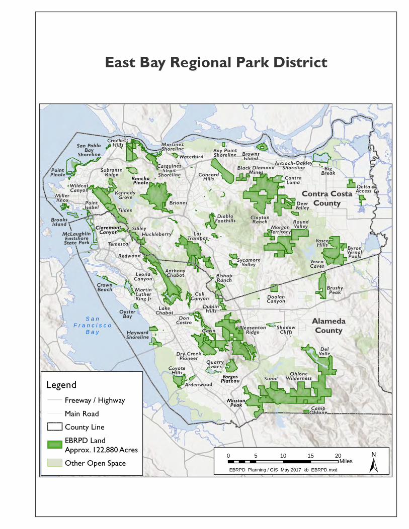
ClaytonRanch
VascoHills ByronVernalPools
DeltaAccessRanchoPinole
DeerValley
DoolanCanyon
VargasPlateau
CampOhlone
ConcordHills
AnthonyChabot
Antioch-OakleyShoreline
Ardenwood
Bay PointShoreline
BigBreak
BishopRanch
Black DiamondMines
Briones
BrooksIsland
BrownsIsland
BrushyPeak
CarquinezStraitShoreline
ClaremontCanyon
ContraLoma
CoyoteHills
CrockettHills
CrownBeach CullCanyon
DelValle
DiabloFoothills
DonCastro
Dry CreekPioneer
DublinHills
McLaughlinEastshoreState Park
GarinHaywardShoreline
Huckleberry
KennedyGrove
LakeChabot
LasTrampas
LeonaCanyonMartinLutherKing Jr
MartinezShoreline
MillerKnox
MissionPeak
MorganTerritory
OhloneWilderness
OysterBayPleasantonRidge
PointIsabel
PointPinole
QuarryLakes
Redwood
RoundValley
San PabloBayShoreline
ShadowCliffs
Sibley
SobranteRidge
Sunol
SycamoreValley
Temescal
Tilden
VascoCaves
Waterbird
WildcatCanyon
Sources: Esri, USGS, NGA, NASA, CGIAR, N Robinson, NCEAS, NLS,
OS, NMA, Geodatastyrelsen, Rijkswaterstaat, GSA, Geoland, FEMA,Intermap and the GIS user community
S a nF r a n c i s c o
B a yAlamedaCounty
Contra CostaCounty
0 5 10 15 20Miles
EBRPD Planning / GIS May 2017 kb EBRPD.mxd
East Bay Regional Park District
Legend
Other Open Space
Freeway / HighwayMain RoadCounty LineEBRPD LandApprox. 122,880 Acres


Project Type
Minimum Temporary Impact
(acres)
Maximum Temporary Impact
(acres)
Minimum Permanent Impact
(acres)
Maximum Permanent Impact
(acres)
Replacing Same Size Culverts 0.00176 0.396 0 0
Upgrade Culvert 0.00352 0.792 0.00352 0.792Install New Culverts 0.00528 0.2376 0.03432 0.26796
Clearing Culverts 0.00176 0.946 0 0
Culvert Head‐Tailwalls 0.0176 0.066 0.0176 0.066
Install Energy Dissipaters 0.0044 0.088 0.0044 0.088
Installation of New Armored Fords 0.0352 0.1188 0.0352 0.1188
Maintenance of Existing Armored Fords 0.022 0.044 0 0
Maintenance and Installation of Bridges 0.00044 0.044 0 0
Streambank, Shoreline, and Levee Stabilization 0.00123 1.476 0.00123 1.476
Maintenance and Installation of Springboxes 0.0016 0.032 0.08 0.2
Maintenance Dredging of Waterbodies 0.4368 1.17 0 0
Maintenance of Shoreline Facilities 0.022 0.176 0.022 0.176
Removal of Hazardous Structures 0 0 0 0
Removal of Vessels 0 0 0 0
Estimated Range of Impacts for Five (5) Years 0.55359 5.5864 0.19827 3.18476
Table 1: Region 2 ‐ S.F. Bay Routine Maintenance Projects Anticipated (5 years) Range of Impacts


for East Bay Regional Park DistrictWaterbody Atlas
Prepared by Planning, Stewardship, & GIS ServicesMarch 2011
ANTHONYCHABOT
p01
ANTIOCHSHORELINE
p02
ARDENWOODp03
BAYPOINT
SHORELINEp04
BIG BREAKp02
BISHOPRANCH
p05
BLACKDIAMOND
MINESp06
BRIONESp07BROOKS
ISLANDp25
BROWNSISLAND
p08
BRUSHYPEAKp 09
BYRONVERNALPOOLS
p42
CARQUINEZSTRAIT
p11
CARQUINEZSTRAIT
p10
CLAYTONRANCH
p06
CONTRALOMA
p06
COYOTEHILLS
p03
CROCKETTHILLS
p11
CULLCANYON
p14
DELVALLE
p15
DELTAACCESS
p16
DIABLO FOOTHILLS
p 17
DONCASTRO
p14
DOOLANCANYON
p39
DRYCREEK
PIONEERp19
DUBLINHILLS
p05
EASTSHORESTATE PARK
p18
GARINp19
GARINp19
HAYWARD SHORELINE
p20
HUCKLE-BERRY
p21
KENNEDYGROVE
p22
LAKECHABOT
p23
LASTRAMPAS
p24
LEONACANYON
p01MLK JR. p 27
MARTINEZSHORELINE
p10
MILLER/KNOX
p25
FIVECANYONS
p19
MORGANTERRITORY
p28
OHLONEWILDERNESS
p29
PLEASANTONRIDGE
p30
POINTISABEL
p18
POINTPINOLE
p31
QUARRYLAKES
p32
RANCHOPINOLE
p11
REDWOODp33
ROUNDVALLEY
p34
OYSTERBAYp27
SANPABLO BAYSHORELINE
p35
SHADOWCLIFFS
p36
SIBLEYp21
MISSION PEAK/MONUMENT PEAK
p26
SOBRANTERIDGE
p22
SUNOLp37
SYCAMOREVALLEY p 38
TASSAJARACREEK
p39
TEMESCALp12
TILDENp40
VARGASPLATEAU
p41
VASCOCAVES
p 42
WATERBIRDp43
WILDCATCANYON
p44
CROWNBEACH
p13
CLAREMONTCANYON
p12
0 5 10 Miles
RW
QC
B S
an F
rancisco Bay Region
RW
QC
B C
entral Valley Region
A l a m e d aA l a m e d a
C o u n t yC o u n t y
C o n t r a C o s t aC o n t r a C o s t a
C o u n t yC o u n t y
Map Index
PARK INDEX Anthony Chabot...................................01 Antioch Shoreline ................................02 Ardenwood...........................................03 Bay Point Shoreline .............................04 Big Break .............................................02 Bishop Ranch.......................................05 Black Diamond Mines .........................06 Briones .................................................07 Brooks Island .......................................25 Browns Island ......................................08 Brushy Peak .........................................09 Byron Vernal Pools..............................42 Camp Ohlone .......................................29 Carquinez Strait Shoreline (Map 1).....11 Carquinez Strait Shoreline (Map 2).....10 Castle Rock ..........................................17 Claremont Canyon ...............................12 Clayton Ranch......................................06 Contra Loma ........................................06 Coyote Hills .........................................03 Crockett Hills .......................................11 Crown Beach........................................13 Cull Canyon .........................................14 Del Valle ..............................................15 Delta Access ........................................16 Diablo Foothills ...................................17 Don Castro ...........................................14 Doolan Canyon ....................................39 Dublin Hills..........................................05 Eastshore State Park.............................18 Five Canyons .......................................19 Garin ....................................................19 Hayward Shoreline ..............................20 Huckleberry .........................................21
Kennedy Grove....................................22 Lake Chabot.........................................23 Las Trampas.........................................24 Leona Canyon/Heights ........................01 Lone Tree Point ...................................35 Martin Luther King Jr. Shore ..............27 Martinez Shoreline ..............................10 Miller/Knox .........................................25 Mission Peak/Monument Peak ............26 Morgan Territory .................................28 Ohlone Wilderness ..............................29 Oyster Bay ...........................................27 Pleasanton Ridge .................................30 Point Isabel ..........................................18 Point Pinole..........................................31 Quarry Lakes .......................................32 Rancho Pinole......................................11 Redwood ..............................................33 Roberts .................................................33 Round Valley .......................................34 San Pablo Bay Shoreline .....................35 Shadow Cliffs ......................................36 Sibley ...................................................21 Sobrante Ridge ....................................22 Sunol ....................................................37 Sycamore Valley Open Space .............38 Tassajara Creek....................................39 Temescal ..............................................12 Tilden...................................................40 Vargas Plateau .....................................41 Vasco Caves.........................................42 Waterbird .............................................43 Wildcat Canyon ...................................44
DATA SOURCES: Contra Costa County Department of Conservation and Development Creek and Drainage GIS Data, Oakland Museum of California Creek and Watershed GIS Data for Pleasanton, Dublin, and Western Alameda County, USGS National Hydrography Dataset, The Regional Water Quality Control Board Jusridictional Boundary, and EBRPD GIS Data.
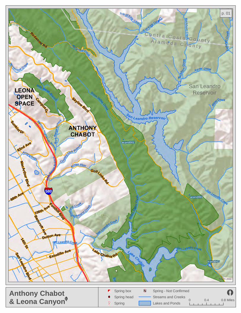
Calla
han C
reek
Arroyo Viejo
Arroyo Viejo
San Leandro Creek
Rifle
Rang
e Bran
ch
Horses h oe Creek
Miller Creek
B u ckhor
n Cr
eek
San Leandro Creek
C o untry
Club B ranch
Trib of Kin
g CanyonTrib of King Canyon
Elmhu
rst Creek
Rifle
Rang
e Bra
nch
Buckho rn Cree k
Kaiser Creek
Gras
s Vall
ey Cr
eek
Grass Valley Creek
San Leandro Cree k
Rifle Range Branch
Melrose Highlands Branch
Elm hurst Creek
Redwood Creek
San Leandro Creek
Estudillo Canal
Estudillo Ave
98th Ave
Dutton Ave14th St
Foothill BlvdBancroft Ave
San Leandro Blvd106th Ave
Golf Links Rd
Campus Dr
Lake Chabot Rd
82nd Ave
Redwood Rd
Skyline Blvd
MacArthur Blvd
Sunkist Dr
acpnd002
acpnd001
lcpnd001
580
Anthony Chabot& Leona Canyon
March 2011
0 0.4 0.8 Miles
Spring - Not Confirmed
Lakes and Ponds
Spring box
Spring head
Spring
San LeandroReservoir
CC oo nn tt rr aa CC oo ss tt aa CC oo uu nn tt yyAA ll aa mm ee dd aa CC oo uu nn tt yy
San Leandro Reservoir
Lake Chabot
Streams and Creeks
p. 01
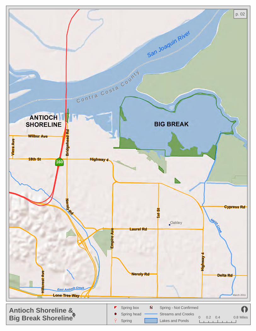
Lone Tree Way
Highway 4
Laurel Rd
High
w ay 4
Empir
e Ave
Hillc
rest A
ve
Cypress Rd
18th St
Neroly Rd
Wilbur Ave
Bridg
e hea
d Rd
Delta Rd
Viera
A ve
1 st S
t
Nerol y Rd
160
East Antioch Creek
Marsh Creek
Antioch Shoreline & Big Break Shoreline
March 2011
0 0.4 0.80.2 Miles
Spring - Not Confirmed
Streams and Creeks
Lakes and Ponds
Spring box
Spring head
Spring
CC oo nn tt rr aa CC oo ss tt aa CCoo
uu
nntt yy
San Joaquin River
p. 02

Ardenwood Creek
Coyote Hills Slough
Crandall Creek
Ardenwood Creek
Ardenw
ood Creek
Patterson Creek
Alameda Creek
Arroyo las Positas
Patterso n Creek
Thornton Ave
Fremont Blvd
Jarvis
Ave
Newark Blvd
Cedar Blvd
Deco
to Rd
Quarry Rd
Alvarado Blvd
Ardenwood BlvdPaseo Padre Pkwy
Union
C ity
Blvd
84
880
Ardenwood& Coyote Hills
March 2011
0 0.3 0.6 Miles
Spring - Not Confirmed
Streams and Creeks
Lakes and Ponds
Spring box
Spring head
Spring
ARDENWOOD
COYOTEHILLS
p. 03

Bail e
y RdEvora Rd
Willow Pass Rd
Leland Rd
Lawlor Ravine
Willow Creek
4
Bay Point WetlandsMarch 2011
0 0.25 0.5 Miles
Spring - Not Confirmed
Streams and Creeks
Lakes and Ponds
Spring box
Spring head
Spring
SuisunBay
p. 04

Coyote Creek
Hollis Cre e k
Norris Creek
Oak Creek
Trib of S outh San Ramon
South San Ramon Creek
Norris Cree k
San Lorenzo Creek
Trib o f Oak
Oak Creek
Koop man Can y on
San Catani o Creek
Dublin Creek
Watson Canyon Creek
Clark Canyon
Oak C reek
Trib of Oak
Ed en Cre
ek
Trib of Big Canyon
Martin Canyon
Trib of Clark Canyon
Big Canyon
dhsprg001dhsprg002
dhsbox001dhsbox002
Bollinger Canyon Rd
Montevideo Dr
Davona Dr
San Ramon Valley Blvd
Silve
rgate
Dr
680
580
brpnd002
brpnd001
Bishop Ranch& Dublin Hills
March 2011
0 0.25 0.5 Miles
Spring - Not Confirmed
Streams and Creeks
Lakes and Ponds
Spring box
Spring head
Spring
CCoo
nntt rr aa
CCoo ss tt aa CC oo uu nn tt yy
AAll aa
mmee
dd aa CC oo uu nn tt yy
p. 05

cnsbox001
bdsprg001
bdsprg002
bdsprg003
bdsprg004
bdpnd012bdpnd018
bdpnd011 bdpnd009bdpnd033 bdpnd010
bdpnd032bdpnd030
bdpnd031 bdpnd029
cnpnd006cnpnd005
clpnd004
clpnd002bdpnd017
bdpnd013 clpnd003 clpnd001bdpnd034
bdpnd026bdpnd027
bdpnd028 bdpnd025
bdpnd008bdpnd035bdpnd007
bdpnd020bdpnd006
bdpnd024 bdpnd022bdpnd004 bdpnd003
bdpnd005 bdpnd023 bdpnd001
bdpnd002
bdpnd015
cnpnd002
cnpnd003
cnpnd004cnpnd001
bdpnd016
bdpnd021
bdpnd019
bdpnd014
Los Meda
no
s Was
teway
Kirker C
reek
Trib of Sand
Trib of
Kirke
r
Irish CanyonLo
ng Can yo
n Creek
Trib of K ir kerWest Antioch Cree k
Briones Creek
Trib of K irke
r
Trib of W
est
An
tioch
Homest ea d Cre
ek
Trib o f
Kirker
Trib
of
Ki rker
Horse Cr e ek
Trib of Sand
Trib of Donner
M y Creek
Sand Creek
Markley Canyon
Marsh Creek
Wi ld Oat Canyon
Mt Diablo Creek
Trib of Brio nes
Deer Creek
Do nner Creek
Russelmann Creek
Trib o f Mt Diab
lo
D onner Cr eek
Kir ker Creek
Goethels Ca nyon
Oil Can yon Creek
Kirker Creek
Mark
ley Ca
nyon
Mt Dia
blo C reek
Trib of W
est An tio
ch
Irish Canyon
Dunn Creek
Black Diamond Mines, Clayton Ranch, & Contra Loma
March 2011
0 0.5 10.25 Miles
Spring - Not Confirmed
Streams and Creeks
Lakes and Ponds
Spring box
Spring head
Spring
ContraLomaReservoir
MunicipalReservoir
RW
QCB
Cent
ral Va
lley Region
RWQC
B Sa
n Fran
cisco
Bay Region
p. 06

BRIONES
brsprg001
brsbox001
brsprg002
brsbox002
brsprg003
brsprg004
bnpnd001bnpnd031
bnpnd005bnpnd002
bnpnd022bnpnd006
bnpnd003bnpnd004
bnpnd007bnpnd018
bnpnd019bnpnd011
bnpnd017bnpnd012
bnpnd023bnpnd008bnpnd020
bnpnd009bnpnd021
bnpnd013 bnpnd014bnpnd016
bnpnd015
bnpnd024
Alhambra Creek
Forest Hills Creek
Happy Valley Creek
Sind
icich Cre ek
Trib of Lafayette
Lafayette Creek
Trib of Bea r
Lauterwasser Creek
Murde rers Creek
Tri b of Murderers
Old Jon
as Cre ek
Overh
ill Cre
ek
Ru ssel Creek
Reliez Creek
Trib of Alhambra
Bear Creek
Las Tr ampas Creek
Trib of Bear
Trib of Pinole
Trib of Bear
Strentzel Cree k
Gray son Creek
Cascad
e C
reek
San Pablo C reek
Las Trampas Creek
Trib
of San Pablo
Trib of Reliez
Trib of Tin House
Trib of P inole
Reliez Creek
Perei
ra Creek
Trib of S
in d icich
Costa Creek
Miner Creek
Pinole Creek
Tarry Creek
Trib of Reliez
Arroyo Del Hambre
Spring Wate r Cree k
Vaca Creek
BrionesMarch 2011
0 0.5 10.25 Miles
Spring - Not Confirmed
Streams and Creeks
Lakes and Ponds
Spring box
Spring head
Spring
BrionesReservoir
LafayetteReservoir
p. 07
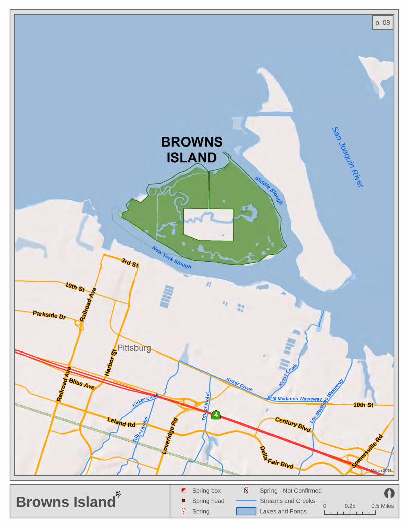
Trib o
f Kirk
er Lo
s Medan
os Wast
eway
Kirker Creek
Trib
of Ki
rker
Kirker CreekLos Medanos Wasteway
Kirker
Creek
Somersvill
e Rd
10th St
Harb
or St
10th St
Bliss Ave
Delta Fair Blvd
Love
ridge
Rd Century BlvdLeland Rd
3rd St
Railro
ad Av
e
Railro
ad Av
e
Parkside Dr
4
Browns IslandMarch 2011
0 0.25 0.5 Miles
Spring - Not Confirmed
Streams and Creeks
Lakes and Ponds
Spring box
Spring head
Spring
New York Slough
San Joaquin RiverMiddle Slough
p. 08
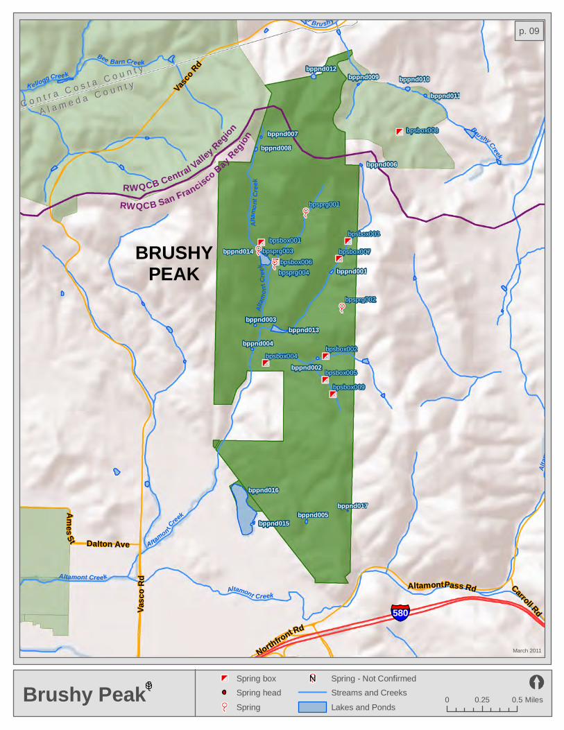
Dalton Ave
Altamont Pass Rd
Ames St
Northfront Rd
Carroll RdVas c
o Rd
Vasco
Rd
bpsbox001
bpsbox002
bpsbox003
bpsprg001
bpsbox004
bpsprg002
bpsprg003
bpsbox005
bpsbox006
bpsbox007
bpsprg004
bpsbox008
bpsbox009
bppnd012bppnd009 bppnd010
bppnd011
bppnd007bppnd008
bppnd006
bppnd001
bppnd003
bppnd004
bppnd002
bppnd005
bppnd016
bppnd015
bppnd013
bppnd014
bppnd017
Altam
o nt C
reek
Altam
ont C
reek
Brushy Creek
Al tamon t Cree
k
K ellogg Creek
Altamont Creek
Altamont Creek
Bee Barn Cre ek
Altam
ont C
reek
Trib of Bru shy
580
Brushy PeakMarch 2011
0 0.25 0.5 Miles
Spring - Not Confirmed
Streams and Creeks
Lakes and Ponds
Spring box
Spring head
Spring
CC oo nn tt rr aa CC oo ss tt aa CC oo uu nn tt yy
AA ll aa mm ee dd aa CC oo uu nn tt yy
BRUSHYPEAK
RWQCB Central Valley Regi
on
RWQCB San Francisco Bay Region
p. 09

Alhambra Creek
Trib of Rodeo
Alhambra Creek
Nancy Boyd Creek
Franklin CreekRodeo Creek
Franklin Creek
Trib of Frankli
n
Dutra Cree k
Trib of Fra
nklin
Franklin Creek
Trib of Frazer
Fraze
r C
reek
Trib of Fra
nkl in
Franklin C r eek
Trib o f Alhambra
Merle Creek
Trib of Rodeo
Frazer Creek
Trib of Rodeo
Bren
kle
Creek
Trib of Franklin
McHarry Creek
Alhambra Creek
Franklin Creek
McEwen Creek
Bull Valley Creek
cspnd007
mspnd001
cspnd004
cspnd006
cspnd008
cspnd018cspnd016cspnd017
cspnd002cspnd003
cspnd020
cspnd010
cspnd009
cspnd005
cspnd015
cspnd001
cspnd019
Marinavista
Alhambra AveCourt St Pacheco Blvd
Berrellesa St
Alhambra Ave
Franklin Canyon Rd
680
4
Carquinez Strait Shoreline& Martinez Shoreline
March 2011
0 0.25 0.5 Miles
Spring - Not Confirmed
Streams and Creeks
Lakes and Ponds
Spring box
Spring head
Spring
CarquinezStrait
MountWanda
MARTINEZSHORELINE
Muir LandTrust
CARQUINEZSTRAIT
SHORELINE
p. 10
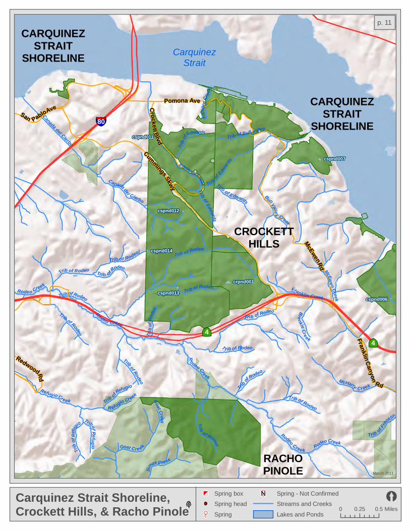
Franklin Creek
Trib of Rodeo
Trib
of Edwards
Rodeo Creek
Elkho
r n Cr
eek
Trib of E dwards
Bull Vall e y Creek
Rodeo Creek
Trib of Bull Valley
Trib of Edwards
E dwards Creek
Goat CreekTrib of Refugi oTrib of Rodeo
Tri b of Edw
ards
Canada del Cierbo
Trib of Rodeo
T r ib o f Rodeo
Trib of Rodeo
McEwen Creek
Trib
of Refugio
R efugio Creek
Trib
of Ro
deo
Trib of Fran
klinTrib
of Rodeo
Trib o
f Refu
gio
Canada del Cierbo
Simas C reek
Trib of Rodeo
Brenkle Creek
Trib of Rodeo
Goat Cre ek
Rodeo Creek
Trib of Rodeo
R
odeo Cre ek
Trib of Rodeo
Trib of Rodeo
Trib of Rodeo
Rodeo Creek
McHarry C reekRefugio Cr eek
Trib of Rodeo
cspnd011
cspnd007
cspnd012
cspnd014
crpnd001
cspnd013cspnd006
44
80
Pomona Ave
Franklin Canyon Rd
Cummings Skwy
Redwood Rd
San Pablo Ave Crockett Blvd
McEwen Rd
Carquinez Strait Shoreline,Crockett Hills, & Racho Pinole
March 2011
0 0.25 0.5 Miles
Spring - Not Confirmed
Streams and Creeks
Lakes and Ponds
Spring box
Spring head
Spring
CarquinezStrait
CROCKETTHILLS
CARQUINEZSTRAIT
SHORELINE
CARQUINEZSTRAIT
SHORELINE
RACHOPINOLE
p. 11

24
13
24
Temescal Creek
Harwood (Claremont
) Cree
k
Teme
scal
Cree
k
Temescal Cre e k
Rockridge Branch
Teme
scal Creek
S Fork El T
oyonal Cre ekTemescal Creek
Strawberry Cre ek
North Fork Str
awb erry Creek
Trib of San Pablo
Trib of
Wag
ner
Trib of San Pablo
Trib of San Pablo
Trib of San Pablo
Shephard CreekGlen Echo (C em etery) C r e ek
Trib of San Pablo
Har woo
d (Cl
aremo
nt) Creek
Broa
dway Branch
Wildcat Creek
Temescal Creek
Trib of
San Pa
blo
Siesta Vall ey Creek
Vicente C
reek (Grandview) srpnd005srpnd004srpnd002
srpnd003
Moraga Ave
Ashby Ave
Broadway Ter
Alcatraz Ave
Howe St
Skyline Blvd
Ashby Ave
40th St
51st St
Bancroft Way
Chabot Rd
Dwight WayDurant Ave
Cedar St
Colle
ge Av
e
Teleg
raph
Ave
Piedmont Ave
Fish Ranch Rd
Mountain Blvd
Snake Rd
Claremont Canyon& Temescal
March 2011
0 0.25 0.5 Miles
Spring - Not Confirmed
Streams and Creeks
Lakes and Ponds
Spring box
Spring head
Spring
LakeTemescal
CLAREMONTCANYON
CC oo nn tt rr aa CC oo ss tt aa CC
oouu
nntt yy
AA ll aa mm ee dd aa CC oo uu nn tt yy
TEMESCAL
p. 12

cbpnd001
Mecartney Rd
5th Ave
Atlantic Ave
Oak S
t
Pacific Ave
13th Ave
Const itution Way
7th St
Embarcadero
Webs
t er St
Park
St
1st St
Robert Davey Jr Dr
Islan
d Dr
International Blvd
Otis Dr
State Hwy 61
8th St
Encinal Ave
Central Ave
Broad
way
Webs
ter St
Tube
8th St
Sea View Pkwy
880
Crown BeachMarch 2011
0 0.25 0.5 Miles
Spring - Not Confirmed
Streams and Creeks
Lakes and Ponds
Spring box
Spring head
Spring
San Francisco Bay
p. 13
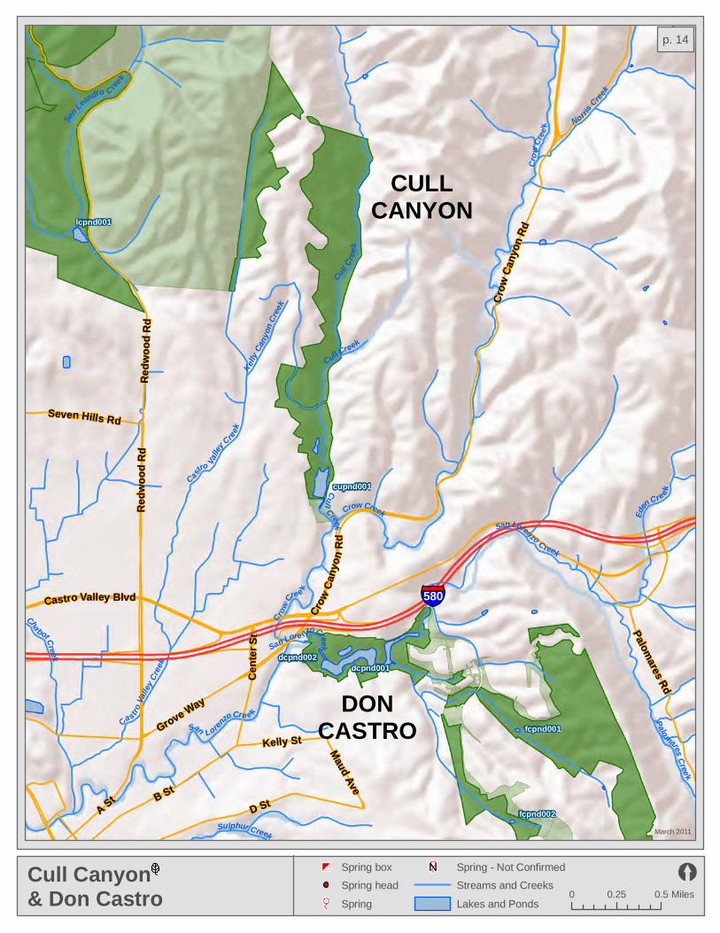
Kelly Ca
nyon
Cree
k
Crow Creek
Cha bot Creek
Cull Creek
San Loren
zo Cre e k
Castro Va
lley Cr
eek
Eden Cre ek
Cast
ro Valley
Creek
San Lore nzo Creek
San Lea
ndro C ree
k
San Lorenzo Creek
Sulphur Creek
Crow
Cree
k
Cull Creek
Crow Cre e k
Norris
Creek
Palomares Cree k
Cull Cr
eek
Hollis Creek
lcpnd001
dcpnd001dcpnd002
fcpnd001
fcpnd002
cupnd001
580
Crow
Cany
on Rd
Grove Way
Redw
ood R
d
D St
Castro Valley Blvd
A St
Seven Hills Rd
B St
Palomares Rd
Kelly St
Crow
Cany
on Rd
Redw
ood R
d
Cen te
r St
Maud Ave
Cull Canyon& Don Castro
March 2011
0 0.25 0.5 Miles
Spring - Not Confirmed
Streams and Creeks
Lakes and Ponds
Spring box
Spring head
Spring
CULLCANYON
DONCASTRO
p. 14

La Costa Creek
Arroyo Del Valle
Dry Creek
Williams Gulch
Arroyo Moch o
Arroyo MochoDry Creek
Dry Creek
San Antonio Creek
Arroyo Del Valle
Arroyo D
el Valle
dvpnd020dvpnd019 dvpnd014
dvpnd015
dvpnd016
dvpnd025dvpnd007
dvpnd023dvpnd008dvpnd024dvpnd022dvpnd013
dvpnd012dvpnd017 dvpnd009
dvpnd006 dvpnd021dvpnd011dvpnd010dvpnd018 dvpnd005
dvpnd004
dvpnd001dvpnd003dvpnd002
ohpnd013ohpnd001ohpnd002 ohpnd004ohsprg001
ohsprg002
Wetmore Rd
Mines Rd
Del ValleMarch 2011
0 0.5 1 Miles
Spring - Not Confirmed
Streams and Creeks
Lakes and Ponds
Spring box
Spring head
Spring
DELVALLE
p. 15
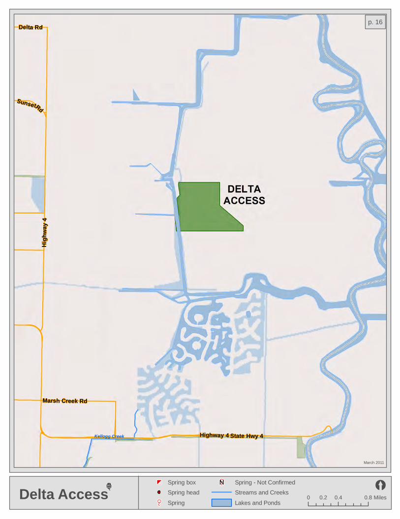
Highway 4
High
way 4
Sunset Rd
Marsh Creek Rd
Delta Rd
State Hwy 4Kellogg Creek
Delta Access
March 2011
0 0.4 0.80.2 Miles
Spring - Not Confirmed
Streams and Creeks
Lakes and Ponds
Spring box
Spring head
Spring
p. 16
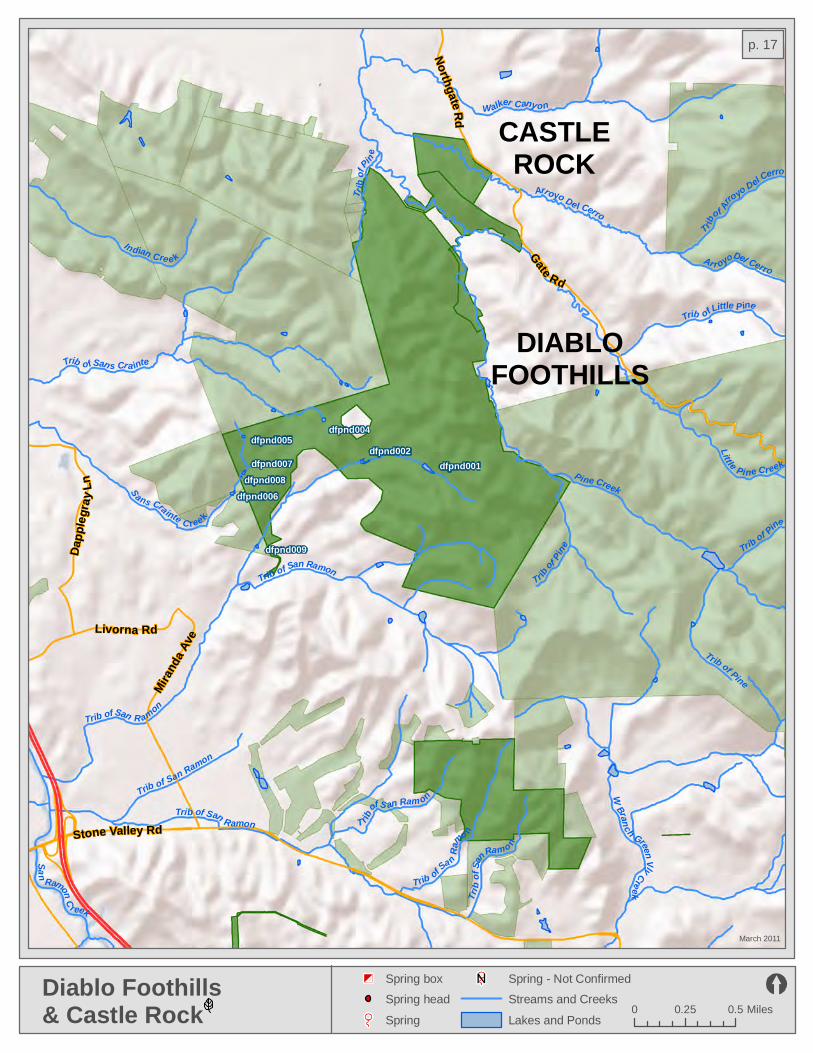
Stone Valley Rd
Northgate Rd
Gate Rd
Livorna Rd
Dapp
legray
Ln
Mirand
a Ave
dfpnd004dfpnd005
dfpnd002dfpnd007
dfpnd008dfpnd006
dfpnd001
dfpnd009
Trib
of Pin
e
Trib of San Ramon
Indian Cre e k
Sans Crainte C ree k
Trib of San R amon
Trib of Sans Cra inte
Trib of San Ramon
Pine CreekTri
b of S
an Ramo n
Trib of San Ramon
T rib
of S an Ram on
Tr ib
of Pine Trib of Pine
Trib of Sa
n Ra
mo n
Arroyo De l Cerro
Arr oyo Del Cerro
Little Pine Creek
Trib
of Arroyo Del C
erro
Trib of Pine
W Branch Green Vly Creek
San
Ramon C r eek
Trib of Little Pine
Walker Canyon
Diablo Foothills & Castle Rock
March 2011
0 0.25 0.5 Miles
Spring - Not Confirmed
Streams and Creeks
Lakes and Ponds
Spring box
Spring head
Spring
DIABLOFOOTHILLS
CASTLEROCK
p. 17
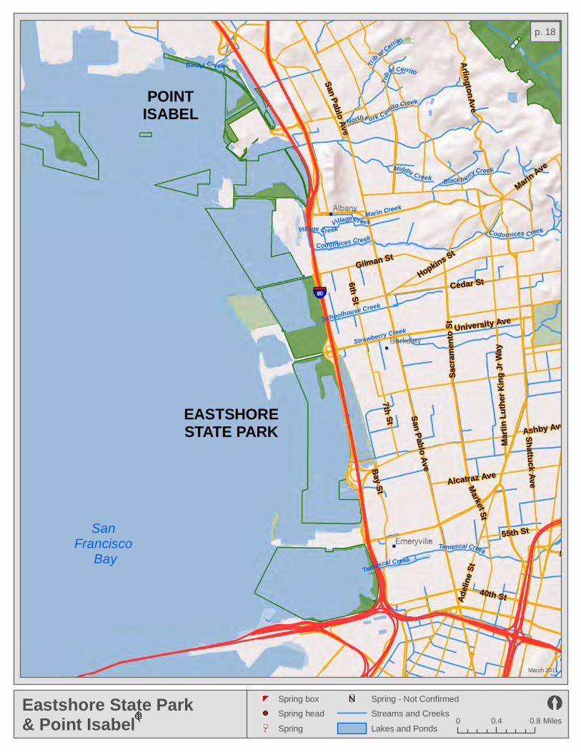
Trib of Cerrito
Black berry Creek
Temescal CreekBr
oa
dway Branch
Codornices Creek
Middle Creek
Codornices Creek
Glen Echo Cree
k
V illage Creek
Trib of Cerrito
North F ork Cerrito Creek
Village Creek
Strawberry Creek
Baxt e r Creek
Temescal Creek
Harwoo d (Cl
aremo
nt) Creek
Marin Creek
Schoolhouse Creek
Marti
n Luth
er Ki
ng Jr
Way
San Pablo Ave
40th St
7th St San Pablo Ave
Alcatraz Ave
University Ave
Adeli
ne St
55th St
Gilman St
Broa
dway
Bay St
Sacra
mento
St
Hopkins St
Cedar St
Market St
Ashby Ave
6th St
Shattuck Ave
51st St
Marin Ave
Arlington Ave
Eastshore State Park& Point Isabel
March 2011
0 0.4 0.8 Miles
Spring - Not Confirmed
Streams and Creeks
Lakes and Ponds
Spring box
Spring head
Spring
San Francisco
Bay
EASTSHORESTATE PARK
POINTISABEL
p. 18

Dry Cree k
Palomares Creek
Dry Creek
Palomares Creek
Palomares Creek
Dry Creek
Head
Cany
on Cre
ek
Sinbad Creek
Sulphur Creek
Ward Creek, N. Fk.
Zeile Creek
Ward Creek
Devaney Canyon Cree k
dcpnd001
fcpnd001
fcpnd002
gdpnd017
gdpnd021
gdpnd008
gdpnd009
gdpnd010gdpnd014
gdpnd011gdpnd012
gdpnd016
prpnd019prpnd018
prpnd020
prpnd017
gdpnd006
gdpnd007gdpnd015
gdpnd003gdpnd004
gdpnd005
gdpnd013
gdpnd002
gdpnd018gdpnd019
gdpnd020
gdpnd023gdpnd024
gdpnd027
gdpnd025gdpnd026
gdpnd022
prpnd023
gdpnd001
gdsprg006
gdsprg001
gdsprg002gdsprg003
gdsprg004
gdsprg005
gdsbox001 gdsbox002
gdsbox003
prsbox002
Mission Blvd
Palomares Rd
Whipple Rd
Garin/Dry Creek& Five Canyons
March 2011
0 0.4 0.8 Miles
Spring - Not Confirmed
Streams and Creeks
Lakes and Ponds
Spring box
Spring head
Spring
FIVECANYONS
GARIN
GARIN
DRY CREEK/PIONEER
p. 19

Sulphur Creek
Sulphur Creek
Johnson Landing Canal
Hayward Landing Canal
San Lorenzo Creek
Hayward Landing Canal
Bockman Channel
Winton Ave
Depot Rd
Industrial Blvd
Claw
iter R
d
Bockman RdHesperian Blvd
A St
Cabot Blvd
Grant Ave
Hayward ShorelineMarch 2011
0 0.25 0.5 Miles
Spring - Not Confirmed
Streams and Creeks
Lakes and Ponds
Spring box
Spring head
Spring
San Francisco
Bay
p. 20

Moraga AveMountain Blvd
Park Blvd
Broadw
ay
Grizzly Peak Blvd
Skyline Blvd
Snake Rd
Moraga Way
Fish Ranch Rd
Pinehurst Rd
srpnd005srpnd004srpnd002
srpnd003
srpnd001
Temescal Creek
Teme
scal
Cree
k
Temescal Cre ek
Brookside Cre e k
Trib of San Pablo
San P
ablo C
r eek G
loriett
a
Overh
il l Creek
Indian
G ulch
(Tres
tle Gl
e
Temescal Creek
Trib o f Moraga
Trib of Moraga
Sausal Creek
Shephard Creek
Redwood Creek
Indian Creek
San Leandro C reek
Tr ib of San Pablo
Trib of Red wood
Siesta Valley Creek
Trib of San Pablo
Trib of San Pablo
San Leandro Creek
Trib
of S
an Pabl o
Brooks
ide Creek
San Pablo Cr eek
Mo raga Creek
San Pablo Cree k
24
Huckleberry & Sibley
March 2011
0 0.25 0.5 Miles
Spring - Not Confirmed
Streams and Creeks
Lakes and Ponds
Spring box
Spring head
Spring
SIBLEY
HUCKLEBERRY
SIBLEY
CC oo nntt rr
aa CC
ooss
tt
aa CC
oouu
nnttyy
AAll aa
mmee
ddaa
CC
oouu
nnttyy
p. 21
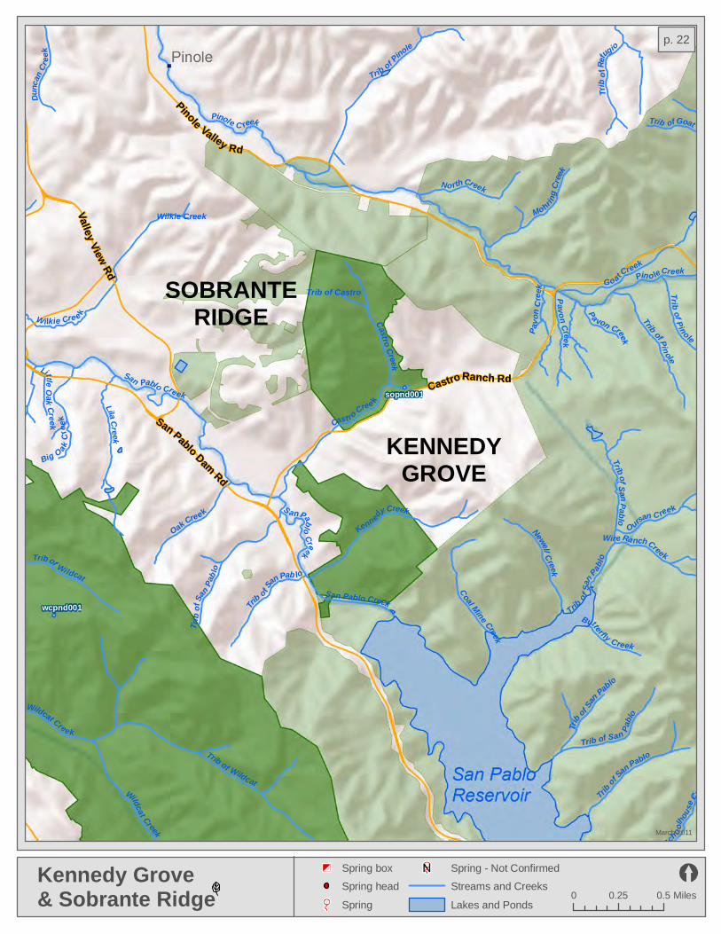
Trib of San Pablo
sopnd001
wcpnd001
Dunc
an Cr
eek
Kennedy Creek
Cast ro Cree k
Trib o f S
an Pab lo
Lila Creek
Newell Creek
Wilkie Creek
Goat Creek
Little Oak Creek
Butterfly Creek
S an Pablo Creek
Coal Mine Creek
Wilkie Cre e k
Pavo
n Cree
kTrib of Castro
San Pablo CreekTrib
of Sa
n Pabl o
Trib of Sa
n Pablo
Big Oak Cr
eek
Scho olh
ouse
Creek
Pa von Creek
Trib of Goat
Wire Ranch Creek
Trib of Pinole
Trib
of Sa
n Pab lo
Wildcat Creek
Oursan Creek
Trib of Wildcat
Castro Creek
Mohring
Creek
Pavon Creek
Trib
of Re
fugio
Trib of Pinole
Trib of S an Pablo
Trib of Wildcat
Oak CreekNo rth Creek
Wildcat Creek
Trib of San Pablo
Pino le Creek
Trib of Pinole
Pinole C reek
San Pablo Creek
San Pablo Dam Rd
Pinole Valley Rd
Valley View Rd
Castro Ranch Rd
Kennedy Grove& Sobrante Ridge
March 2011
0 0.25 0.5 Miles
Spring - Not Confirmed
Streams and Creeks
Lakes and Ponds
Spring box
Spring head
Spring
KENNEDYGROVE
SOBRANTERIDGE
p. 22

San Leandro Creek
Estudillo Cana l
Castro
Valle
y C
reek
Arro yo Vi
ejo
Estudillo Canal
Grass Va lley Creek
San Leandro Creek
Elmhurst
C reek
San
Leandro Cre
ek
Gras
s Vall
ey Cr
eek
San Leandro Creek
San Leandro Creek
Mille
r Cree
k
acpnd001
lcpnd001
Benedict Dr
Foothill Blvd Redw
o od R
dLake Chabot Rd
150th Ave
14th St
Seven Hills Rd
Fairmont Dr
Golf Links Rd
Skyline Blvd
580
Lake ChabotMarch 2011
0 0.25 0.5 Miles
Spring - Not Confirmed
Streams and Creeks
Lakes and Ponds
Spring box
Spring head
Spring
Upper San Leandro
ReservoirSan Leandro
Reservoir
LAKECHABOT
Lake Chabot
p. 23

Danville Blvd
Bollinger Canyon Rd
Crow Canyon Rd
Stone Valley Rd
ltsprg001
ltsbox002
ltpnd004
ltpnd001
ltpnd002ltpnd005ltpnd003
Trib of San Ramo n
Trib of S an Ramon
Trib of San Ramon
Trib of San
Ramo
n
Trib of San R
am on
Tice Creek
Gree
n Va ll
ey C r
eek
Trib
o f Sa
n Ramo n
Trib of Green Valley
Bol linger Creek
Green Valley Creek
Mille r Creek
Trib of S an Ram on
Bolinas Creek
Trib of Tice
Trib of Las Trampa s
San Ramon Creek
Trib of San Ramon
Crow Cre
ek
Buckhor n Cr eek
Kaiser Creek
Tr ib of San Ramon
San Ram on Creek
Bolling er Creek
Cull Cree
k
Trib
of Las Trampas
Kaiser Cr eek
Trib of San RamonLas Trampas Cree k
San Catanio Cree k
Grizzly Creek
Las TrampasMarch 2011
0 0.5 1 Miles
Spring - Not Confirmed
Streams and Creeks
Lakes and Ponds
Spring box
Spring head
Spring
San LeandroReservoir CC
oonn
tt rr aa CCoo ss tt aa CC
oouu
nn tt yy
AA
ll aamm
eedd aa CC oo uu
nntt yy
p. 24

2nd S
t
Richmon
d Pkwy
Barrett AveBarrett Ave
Ohio Ave Carlson Blvd
23rd
S t
Harb
our W
a y
Castr
o StRegatta Blvd
Cutting Blvd Cutting BlvdPotrero Ave
MacDonald Ave
580
mkpnd001
Miller/Knox& Brooks Island
March 2011
0 0.25 0.5 Miles
Spring - Not Confirmed
Streams and Creeks
Lakes and Ponds
Spring box
Spring head
Spring
San Francisco
Bay
p. 25

Agua Fria Creek
Alameda Creek
Canada de l Aliso
Toroges Creek
Mission Creek
Mission Creek
Agua Caliente Creek
Leyden Creek
Mission Creek
Sherid
an Creek
Pirate Creek
Tributary to Agua Fria Cr
Welch Creek
T ributary to Agua Fria C r
Unnamed CreekAgua Fria Creek
Unnamed Creek
Trib u tary to Agua Fria Cr
Scott Creek
mppnd001
mppnd002
mppnd005mppnd009mppnd006
mppnd004
mppnd003
snpnd017
mppnd012
mppnd010
mppnd011
mppnd008mppnd007
Warm Springs Blvd
Miss
ion B l
vd
Paseo Padre Pkwy
262
680
Mission PeakMarch 2011
0 0.25 0.5 Miles
Spring - Not Confirmed
Streams and Creeks
Lakes and Ponds
Spring box
Spring head
Spring
AA
ll aa mm ee dd aa CC oo uu nn tt yy
p. 26

54th Avenue Cree
k
A rroyo Viejo
Arroyo Viejo
Lion CreekSeminary Creek
East Creek
Pe ralta Creek
Stonehu
rst Cr
eek
Damon Slough
Elmhurst Creek
San Leand r o Cree k
66th Ave
High St
Marina Blvd
14th St
State Hwy 185Isl
and D
r
Davis St
Coliseum Way
San Leandro St
San Leandro St
Ron Cowan Pkwy Ron Cohen Pkwy
Doolittle Dr
Maitland Dr
14th
Hegenberger Expy14th
John Glenn Dr
Williams St
73rd Ave
Holly
St
Seminary Ave
Doolittle Dr
Santa Clara Ave
98th Ave
98th A
ve
Airpo
rt Dr
Hege
nberg
er Rd
Harbo
r Bay
Pkwy
Edgewater Dr
880
MLK Jr. Shoreline & Oyster Bay
March 2011
0 0.25 0.5 Miles
Spring - Not Confirmed
Streams and Creeks
Lakes and Ponds
Spring box
Spring head
Spring
San Francisco
Bay
San Leandro
Bay
p. 27
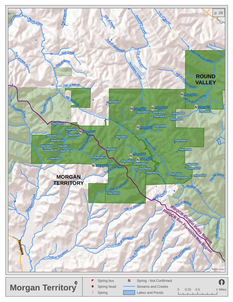
mtsprg001
mtsprg002
mtsprg003
mtsprg004 mtsprg005
mtsprg006
mtsprg007
mtsprg008
rvsprg001
mtpnd001
rvpnd003mtpnd002 mtpnd028mtpnd003
mtpnd006mtpnd005
mtpnd021 mtpnd004mtpnd019
mtpnd020mtpnd015 mtpnd027mtpnd016 mtpnd007
mtpnd017mtpnd023mtpnd029 mtpnd013 mtpnd008mtpnd018
mtpnd014mtpnd022mtpnd012
mtpnd011 mtpnd024mtpnd025
mtpnd010 mtpnd026mtpnd009
mtpnd032
mtpnd030mtpnd031
MORGANTERRITORY
ROUNDVALLEY
Tassajara
Marsh C ree
k
T rib of Round Vall e y
Tr ib o f Tassajara
Trib of Sycamore
Trib of Marsh
Trib of Round Valley
Tri b of Mallory
Trib of Tassajara
Trib
of Tassajara
Trib of Clark Canyon
Trib o
f Mars
h
Trib of Marsh
Fig Pig Gulch
Trib of
Tass
ajara
Trib of Sycamore
Curry
Can yo n
Trib
of Ma
llory
Ma llory Creek
Marsh Creek
Trib of Round Valley
Salt Creek
Jer em
iah
Cr
eek
Trib o f Caye
tano
Marsh Creek
Trib of Marsh
Trib of Marsh
Trib
of Tas
sajar
a
Tass ajara Creek
Sycamore Creek
Tas
saj
ara C
reek
Marsh Creek
Trib of Tassaj a ra
Sycamore Creek
Trib of Tassajara
T rib of Tassa jara
Morgan Territory
March 2011
0 0.5 10.25 Miles
Spring - Not Confirmed
Streams and Creeks
Lakes and Ponds
Spring box
Spring head
Spring
RWQCB Central Valley Region
RWQCB San Francisco Bay Region
p. 28

Alameda C ree k
Alameda Creek
La Costa Creek
Arroyo Del Valle
Whitlock C
ree
k
San Antonio
C reek
W illiams Gulc h
India
n Cree
k
Whitl ock Creek
Trout Creek
Alameda Creek
Indian Creek
Whitlo
c k Creek
Valpe Creek
Murrieta Creek
Indian Creek
Shafe r Creek
San Antonio Creek
L a Costa Creek
ohpnd047 ohpnd055ohpnd056
ohpnd035ohpnd057
ohpnd058ohpnd031
ohpnd046ohpnd032
snpnd008ohpnd033 ohpnd034
ohpnd039 ohpnd027ohpnd048ohpnd026
ohpnd052ohpnd049
ohpnd038ohpnd028
ohpnd050 ohpnd029ohpnd051
ohpnd059ohpnd030
ohpnd013ohpnd001ohpnd002 ohpnd004
ohpnd005ohpnd003
ohpnd006
ohpnd011ohpnd042
ohpnd014ohpnd036 ohpnd010 ohpnd008
ohpnd007 ohpnd009ohpnd012
ohpnd018ohpnd040
ohpnd015ohpnd017 ohpnd044
ohpnd043ohpnd016ohpnd019
ohpnd020 ohpnd021ohpnd041ohpnd024ohpnd023
ohpnd022 ohpnd054ohpnd053
ohpnd037ohpnd025
cosbox001
cosbox002
ohsbox001 ohsbox002
ohsbox003
ohsbox004ohsbox005
ohsprg001ohsprg002
Ohlone Wilderness& Camp Ohlone
March 2011
0 0.5 1 Miles
Spring - Not Confirmed
Streams and Creeks
Lakes and Ponds
Spring box
Spring head
Spring
p. 29
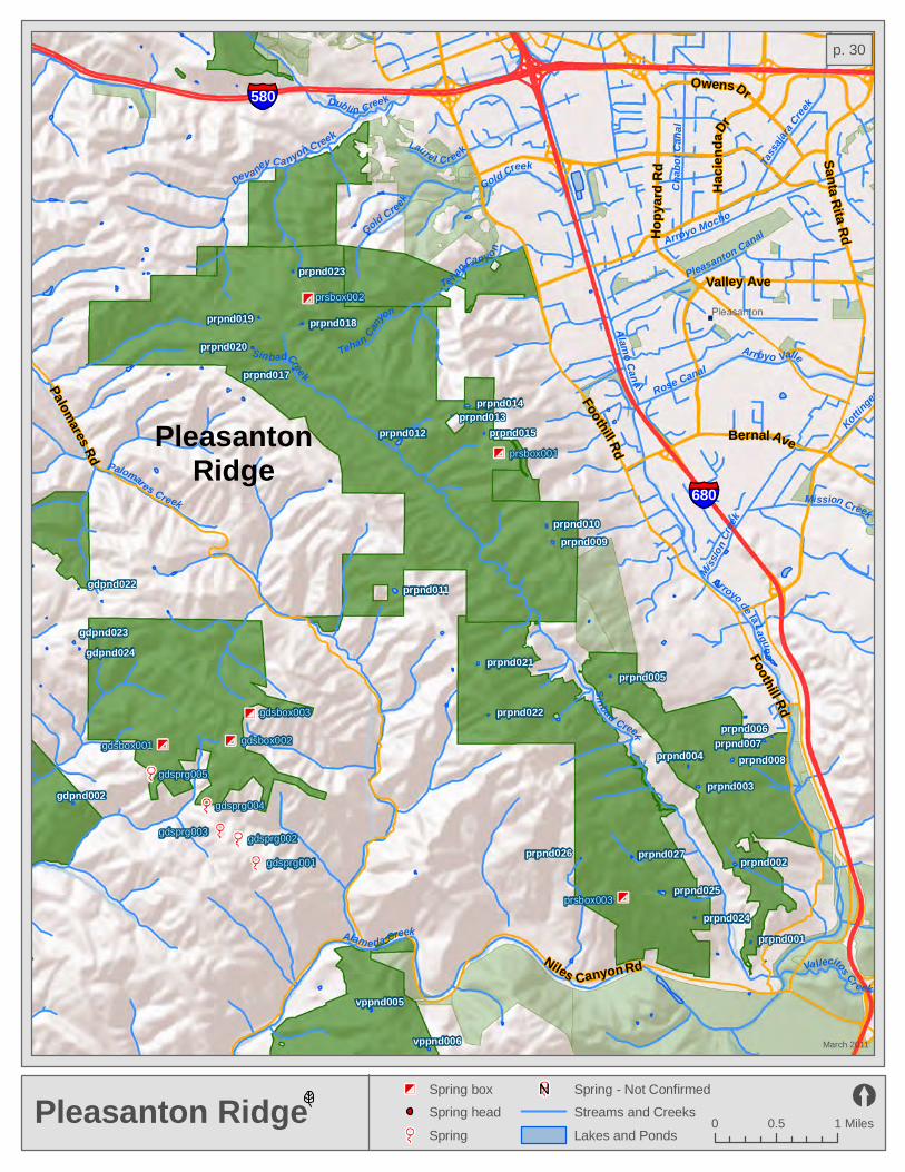
Laurel Creek
Dubli n Cree k
Devaney Canyon C reek
Palomares Creek
Alameda Creek
Pleasanton Canal
Mission Creek
Mi ssio
n Cree
k
Rose Canal
Va llecitos Cr eek
Te han Canyo n
Arroyo Valle
Tassa
jara Cree
k
Cha b
o t C a
n al
Gold Creek
Sinbad Creek
Arroyo Mocho
Alamo Cana l
Sinbad Creek
Arroyo de la Lagun a
Tehan Canyo
n
Martin Canyon
Gold Creek
Kottinger
Creek
gdsprg001
gdsprg002gdsprg003
gdsprg004
gdsprg005
gdsbox001gdsbox002
gdsbox003
prsbox002
prsbox001
prsbox003
prpnd019 prpnd018prpnd020
prpnd017
prpnd014prpnd013
prpnd015
prpnd010prpnd009
prpnd011
prpnd021prpnd005
prpnd006prpnd007
prpnd008prpnd004
prpnd003gdpnd002
prpnd002
prpnd024prpnd001
vppnd005
vppnd006
prpnd012
prpnd022
prpnd026
prpnd025
prpnd023
gdpnd023gdpnd024
gdpnd022
prpnd027
Santa Rita Rd
Bernal Ave
Hopy
a rd Rd Hacie
nda D
r
Foothill Rd
Niles Canyon Rd
Owens Dr
Valley Ave
Foothill Rd
Palomares Rd
580
680
Pleasanton RidgeMarch 2011
0 0.5 1 Miles
Spring - Not Confirmed
Streams and Creeks
Lakes and Ponds
Spring box
Spring head
Spring
PleasantonRidge
p. 30

Hilltop Dr
San P
ablo
Ave
Blume
Dr
San Pabl
o Ave
Gian
t Rd
Robert Miller Dr
Rumrill Blvd
Shamrock DrGiant Hwy
Richmond Pkwy
Brookside Dr
Parr Blvd
San Pa
blo Av
e
3rd St
Atlas Rd
80
Garrity Creek
Rheem Creek
San Pablo CreekSan Pablo Creek
pppnd001
Point PinoleMarch 2011
0 0.25 0.5 Miles
Spring - Not Confirmed
Streams and Creeks
Lakes and Ponds
Spring box
Spring head
Spring
San PabloBay
p. 31

Mission Blvd
Mowry
Ave
Thornton
Ave
Peralta Blvd
Stevenson Blvd
Blacow Rd
Paseo Padre Pkwy
Deco
to Rd
Fremont Blvd
Niles Blvd Niles Cany
on Rd
Alameda Creek
Morris
on
Creek
Morrison Creek
Ala meda Creek
Miss ion
Creek880
Quarry LakesMarch 2011
0 0.25 0.5 Miles
Spring - Not Confirmed
Streams and Creeks
Lakes and Ponds
Spring box
Spring head
Spring
RainbowLakeAlameda Creek
HorseshoeLake
Lago Los Osos
ShinnPond Kaiser
PondWillowSlough
p. 32

Peral ta Creek
Lio
n Creek C
h imes Creek
L ion C
reek
Moraga Creek
L ion Creek
Trib of Moraga
Grass Valley Creek
Horseshoe Creek
Rimer Creek
Trib o
f Moraga
Rifle Range Branch
Laguna Cre
ek
Palo Seco Creek
San Leandro Creek
San Leandro Creek
Lion Creek
Moraga
CreekSe
mina
ry Cre
ek
Indian Creek
Redwood Creek
Redwoo d Creek
Buell
St
Redw
ood R
d
Skyline Blvd
Canyon Rd
Skylin e Blvd
Moraga Way
Joaquin Miller Rd
High St
Cany
on Rd
Skyli
ne Bl
vd
Pinehurst Rd
13
580
Redwood & RobertsMarch 2011
0 0.25 0.5 Miles
Spring - Not Confirmed
Streams and Creeks
Lakes and Ponds
Spring box
Spring head
Spring
Upper San Leandro
Reservoir
REDWOOD
ROBERTS
CCoo
nntt rr
aa CC
ooss
tt aa
CC oo uu nn tt yy
AA
ll aamm
eedd
aa CC
oo uu nn tt yy
p. 33

rvpnd001
rvpnd003mtpnd028
mtpnd003mtpnd006
mtpnd005
mtpnd004
mtpnd007
mtpnd008
rvpnd002
mtsprg008
rvsprg001
rvsprg002
mtsprg005
Savan
nah C
reek
Trib o f Ma rsh
Trib of Dry
Eagle Creek
M a rsh Cre
ek
Trib of Marsh
Trib of Round Valley
Trib of Br ione sMariposa Creek
Kell ogg
Creek
Trib of Marsh
Trib of Dry
Trib o
f Kello
gg
Kit Fox Creek
Trib of D r y
Adobe Cr eek
Trib of Round Valley
Trib of Round Valley
Trib of Round Valley
Trib of M ars h
Roun
d Va l
ley Cr
eek
Marsh Creek Trib of
Adob
e
Trib o f Round Valley
Brion es Cr ee k
Trib of M
arsh
Sycamore Creek
Briones C reek
Ma rsh
Cre ek
Marsh Creek
MORGANTERRITORY
ROUNDVALLEY
Brion
es Va
lley R
d
Marsh Creek Rd
Deer Valley
Rd
Round Valley
March 2011
0 0.4 0.80.2 Miles
Spring - Not Confirmed
Streams and Creeks
Lakes and Ponds
Spring box
Spring head
Spring
Los VaquerosReservoir
MarshCreek
ReservoirCowellRanch
Los Vaqueros Reservoir
p. 34

Garrity Creek
Trib of P
in o leTrib of Refugio
Refugio Creek
Rodeo Creek
Trib of Pinole
Pinole
C reek
Faria Creek
Duncan Creek
Ohlone CreekTrib of Pinole
Trib of Pin
ole
Refugio Creek
San Pab
lo Ave
San Pablo Ave
Parker Ave
Appian Wa y
Shamrock Dr
San Pa
blo Av
e
Fitzge
rald DrRichmond Pkwy
Willow Ave
San Pablo Ave
Shawn Dr
Willow Ave
4
80
San Pablo Bay Shoreline& Lone Tree Point
March 2011
0 0.25 0.5 Miles
Spring - Not Confirmed
Streams and Creeks
Lakes and Ponds
Spring box
Spring head
Spring
San PabloBay
p. 35

Arroyo Del Valle
Kottinger Creek
Mission Creek
Kottinger Creek
Arroyo las PositasArroyo la s Positas
Sycamore Creek
Arroyo Valle
Arroyo Mocho
scsbox001
Stanley Blvd
Vineyard AveVineyard Ave
Kitty
Hawk
Rd
Vineyard Ave
Old Vineyard Ave
Isab e
l Ave
Kitty Hawk Rd
Airway Blvd
580
Shadow CliffsMarch 2011
0 0.25 0.5 Miles
Spring - Not Confirmed
Streams and Creeks
Lakes and Ponds
Spring box
Spring head
Spring
ShadowCliffsLake
p. 36

Calav
eras Cr e
ek
Alameda Creek
Mission Creek
Apperson Cre ek
Ind ian Creek
Alameda Creek
Leyden Creek
Alamed a Creek
Welch Creek
Pirate Creek
Pirate Creek
La Cos ta Cree k
S cott C
reek
San Antonio Creek
Indian Jo e Cre ek
Apperson Creek
Alam
eda Creek
Alameda Creek
snpnd012
snpnd017
ohpnd047
ohpnd031snpnd003
snpnd002 ohpnd032snpnd008snpnd013 snpnd001
ohpnd033
snpnd015snpnd016
snpnd010 ohpnd048snpnd007mppnd012
ohpnd052ohpnd049mppnd010 snpnd006
snpnd014snpnd011
mppnd011 snpnd004snpnd005
ohpnd050
mppnd008 mppnd007
snsbox003
snsprg001
snsprg002
snsbox004
snsbox005
snsprg003
snsprg004
snsprg005
snsprg006
snsbox002
snsbox001
Calaveras Rd
680
SunolMarch 2011
0 0.5 1 Miles
Spring - Not Confirmed
Streams and Creeks
Lakes and Ponds
Spring box
Spring head
Spring
San AntonioReservoir
SUNOL
CalaverasReservoir
AA ll aa mm ee dd aa CC oo uu nn tt yy
p. 37
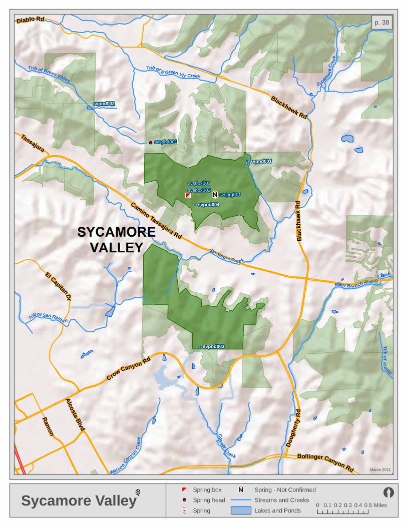
svsphd001
svsbox001
svsbox002svsprg001
svpnd002
svpnd001
svpnd004
svpnd003
Trib of E Green Vly Creek
Sycamore Cre ek
West Branch Alam o Creek
Trib of Green Valley
Trib of San Ramo n
Watson Canyon Cr
eek
S ycam
ore C
reek
Coy ote Cr eek
Trib of Alamo
Ramon
Crow Canyon Rd
Camino Tassajara Rd
El Capitan Dr
Doug
herty
Rd
Alcosta Blvd
Bollinger Canyon Rd
Diablo Rd
Tassajara
Blackhawk Rd
Blac
khaw
k Rd
Sycamore ValleyMarch 2011
0 0.1 0.2 0.3 0.4 0.5 Miles
Spring - Not Confirmed
Streams and Creeks
Lakes and Ponds
Spring box
Spring head
Spring
p. 38
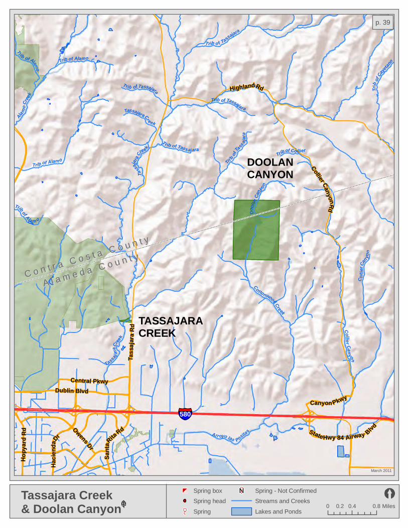
580
Sant
a Rita Rd
Hopy
a rd R
d
Hacie
nda D
r
Dublin Blvd
Highland Rd
Canyon Pkwy
Central Pkwy
Owens Dr
Tass
ajara
Rd
Collier Canyon Rd
State Hwy 84 Airway Blvd
DOOLANCANYON
TASSAJARACREEK
Alamo
Creek
Col li
er Ca
n yon
Tr ib o f Tassajara
Trib of Alam o
Trib of Tassajara
Trib of Ala m o
Tassajar a Cr eek
Trib of CollierTrib of Tassajara
Tassajara
Cre
ek
Trib of Alamo
Trib
of Ca
yetano
Trib of Tassajara
Doola
n Cany on
Tri
b of Ta ssa j
ara
Trib of Alamo
Cottonwood Creek
Arr oyo las Positas
Ta
ssajar
a Cree k
Collier Can yon
Tassajara Creek& Doolan Canyon
March 2011
0 0.4 0.80.2 Miles
Spring - Not Confirmed
Streams and Creeks
Lakes and Ponds
Spring box
Spring head
Spring
CC oo nn tt rr aa CC oo ss tt aa CC oo uu nn tt yy
AA ll aa mm ee dd aa CC oo uu nn tt yy
p. 39

Blackberry Creek
Codornices Cree k
Trib of
San P
ablo
Leasrot Creek
Schoolhouse Cree
k
Wildcat Creek
Baby B ott
le Cre e
k
Strawberry Creek
Strawberry Cree k
Baden
Creek
North
Fork S trawberry Cre
Trib of San Pablo
Trib o f Inspiration
Trib of Wildcat
Wild cat Creek
Trib of Wildcat
Trib of San Pabl o
Spring Creek
Tr i b of Wildcat Insp iratio n Creek
Wildcat Creek
Sather Cre
ek
Barn
Creek
Marin Creek
Siesta Val ley Creek
Wagne
r Creek
Cerrito Creek
Trib of
N For
k Cerr
ito
Harwood (Claremont) Creek
Trib of San Pablo
tipnd001tipnd002
tipnd003tipnd004
Shattuck AveUniversity Ave
Sacramento S tHopkins St
Marti
n Lut
her K
ing Jr
Way
Grizzly Peak Blvd
Solano Ave
Spru
ce St
Marin Ave
San Pablo Dam Rd
Oxfo
rd St
Arlington Ave
TildenMarch 2011
0 0.25 0.5 Miles
Spring - Not Confirmed
Streams and Creeks
Lakes and Ponds
Spring box
Spring head
Spring
Lake Anza
San LeandroReservoirTILDEN
CC oo nn tt rr aa CC oo ss tt aa CC
oouu
nntt yy
AA ll aa mm ee dd aa CC oo uu nn tt yy
p. 40
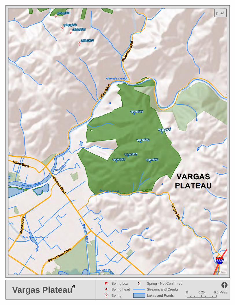
Niles Blv
d
Niles Blvd
Tule Pond wetlands
Alameda Creek
Alameda Creek
Morrison C reek
Morrison Creek
A lameda Cree
k
Mission Creek
Mission Blvd
Mowr
y Ave
Stevenson Blvd
Vargas Rd
Palom
ares R
dgdsprg001
gdsprg002
gdsprg003
gdsprg004
680
vppnd005
vppnd006
vppnd003
vppnd002vppnd001vppnd004
Vargas PlateauMarch 2011
0 0.25 0.5 Miles
Spring - Not Confirmed
Streams and Creeks
Lakes and Ponds
Spring box
Spring head
Spring
p. 41

vcpnd014
vcpnd013
vcpnd012
vcpnd011
vcpnd007
vcpnd008 vcpnd010vcpnd006
vcpnd009
vcpnd004
vcpnd002vcpnd001 vcpnd003
vcpnd005
Camino Diablo Rd
Vasco Rd
Vasco
Rd
BYRONVERNALPOOLS
VASCOCAVES
Eagle Cre
ek
Trib of Frisk
Brushy C reek
Tr ib of Brushy
Hors eshoe Creek
Trib of Bru shy
Trib of Br ushy
Frisk Creek
Buck
eye C
anyo
n
Trib of Frisk
Mariposa CreekTri
b of Brush
y
Eagle Creek
Trib o
f Brus
hy
K e l logg Cr e ek
Kit
Fox Cree k
Trib of B
rushy
Brus
hy Creek
Frisk
Cre
e k
Kellogg Creek
Brushy Creek
Vasco Caves& Byron Vernal Pools
March 2011
0 0.4 0.80.2 Miles
Spring - Not Confirmed
Streams and Creeks
Lakes and Ponds
Spring box
Spring head
Spring
Los VaquerosReservoir
CC oo nn tt rr aa CC oo ss tt aa CC oo uu nn tt yy
AA ll aa mm ee dd aa CC oo uu nn tt yy
p. 42

Marinavista
Alhambra Ave
Pacheco Blvd
Berrellesa St
mspnd001
Alhambra Creek
Merle Creek
Alhambra Creek
680
Howe Rd
Peyton Slough
Peyton Creek
Alhambra Creek
Pacheco Blvd
Arthu
r Rd
WaterbirdMarch 2011
0 0.25 0.5 Miles
Spring - Not Confirmed
Streams and Creeks
Lakes and Ponds
Spring box
Spring head
Spring
SuisunBay
PachecoMarsh Pacheco Creek
Point EdithWetlands
Pacheco Creek
p. 43

sopnd001
wcpnd001
tipnd001tipnd002
tipnd004
tipnd003
App ian Creek
Trib o f Cerrito
Wilki e Creek
Trib of Baxter
Wildcat CreekKennedy Creek
Big Oak C
re ek
Trib
of
San Pablo
Tri
b of Cerrito
Trib of Baxter
La Colina Creek
Wildcat Creek
Gree
nridg
e Cree
k
Trib of Baxter
Rheem Creek
Baxter Creek
Trib of Baxter
San Pablo Creek
Clark Cr eek
Lila C reek
Trib of Wildcat
Castro Creek
Trib of S an
Pa blo
San Pab l o Cree k
Trib
of Wildcat
Oak Creek
Trib of Wi ldcat
San Pab l o Creek
Wildcat Creek
San Pablo Creek
Trib
of Wildcat
Little Oak Creek
Trib of Cerrito
80
580
80
Cutting Blvd
Manila Ave
Carlson Blvd
San Pablo Dam Rd
Moeser Ln
Richmond St
Castr
o Ranch Rd
Amador St
Navellier St
San Pablo Dam Rd
San Pablo Ave
Valley View Rd
Potrero Ave
Arlington Blvd
Wildcat CanyonMarch 2011
0 0.25 0.5 Miles
Spring - Not Confirmed
Streams and Creeks
Lakes and Ponds
Spring box
Spring head
Spring
WILDCATCANYON
p. 44
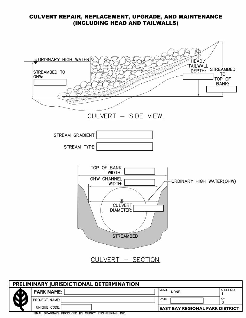

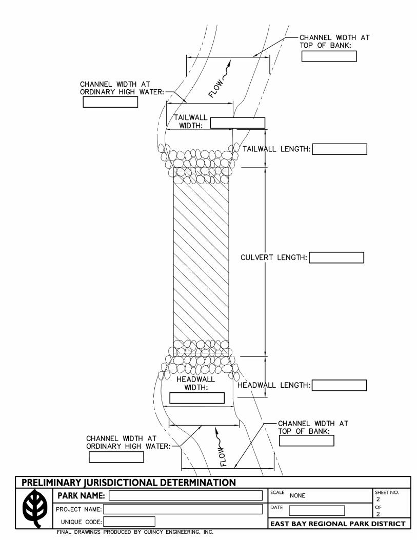


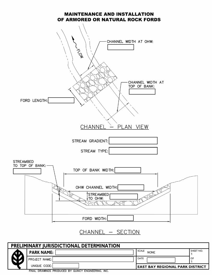


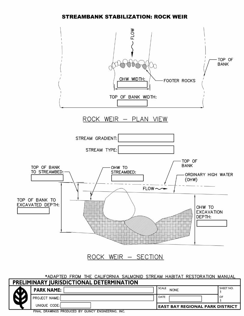


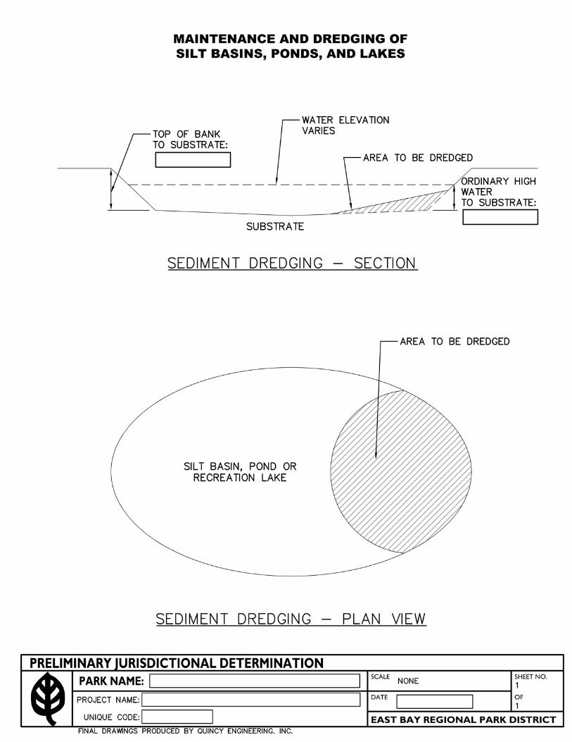


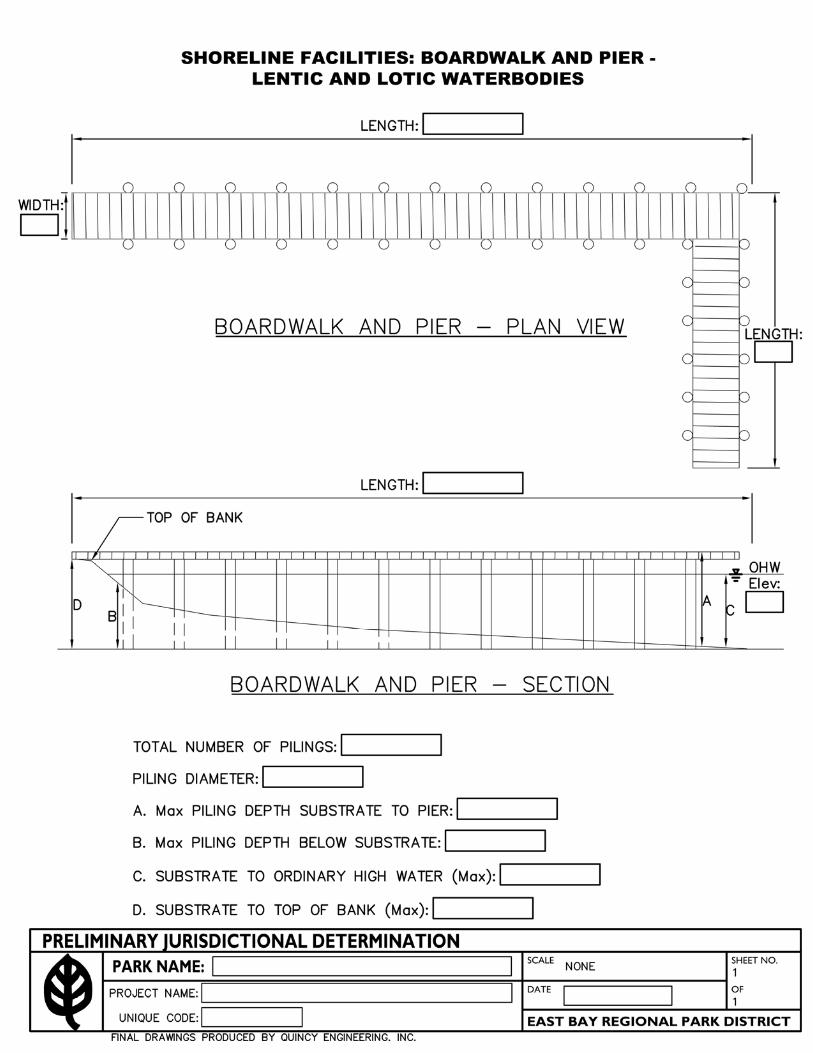

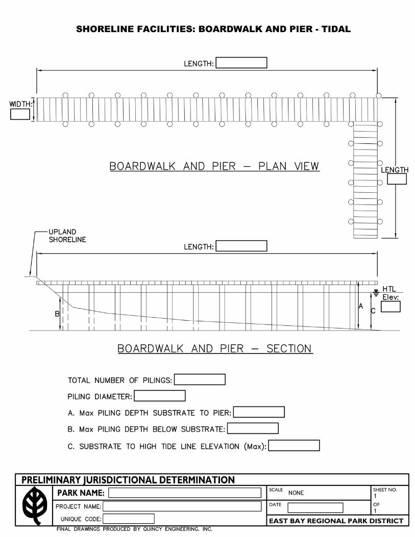


East Bay Regional Park District
Regional Maintenance Activities Alameda and Contra Costa Counties
ATTACHMENT B
California Regional Water Quality Control Plan
San Francisco Bay Region Self-Monitoring Program

CALIFORNIA REGIONAL WATER QUALITY CONTROL PLAN SAN FRANCISCO BAY REGION SELF-MONITORING PROGRAM
for East Bay Regional Park District Regional Maintenance Activities
I. GeneralA. BasisReporting responsibilities of the East Bay Regional Park District as " Discharger" arespecified in Sections 13225(a), 13267(b), 13268, 13383, 13387(b) of the CaliforniaWater Code and this Board's Resolution No. 73-167.
B. PurposeThe principal purposes of a monitoring program by a discharger, also referred to as aSelf-Monitoring Program, are to document compliance with discharge requirements andprohibitions established by this Board and to facilitate self-policing by the discharger inthe prevention and abatement of pollution arising from maintenance activities.
C. Monitoring MethodsMonitoring of impact and mitigation sites shall be consistent with standard protocols forassessing percent coverage by plants, survival of plants, stability of banks, stability ofberms, geomorphic stability of channels. Monitoring reports shall be signed by either anindividual or a position having responsibility for the overall operation of the regulatedactivity (e.g., authorized agent, field supervisor, or project manager).
II. Specifications for MonitoringThe Discharger is required to perform monitoring in accordance with the followingconditions and requirements:
A. Standard ObservationsAs appropriate, the following observations shall be recorded annually for each impactand mitigation site, until the appropriate performance criteria are attained (For some sites,such as sedimentation ponds or beach replenishment, these observations are notnecessary).
1. Impact Sites:a. Percent coverage by vegetation relative to pre-impact vegetation.b. Percent survival of planted shrubs and trees.c. Stability of impacted creek bed and banks (e.g., slumping, undercutting,
headcuts, knickpoints, incision, etc.).d. Stability of culvert inlets and outlets, including adjacent natural creek channels.e. Pre-construction and post-construction photographsf. Annual post-construction photographs for all sites that have not attained theirperformance criteria.
1

2. Mitigation Sites: a. Percent coverage by vegetation relative to pre-restoration/enhancement
vegetation. b. Percent survival of planted shrubs and trees. c. Stability of impacted creek bed and banks (e.g., slumping, undercutting, headcuts,
knickpoints, incision, etc.). d. Stability of berms supporting mitigation ponds. e. Duration and depth of ponding during breeding seasons for listed amphibians at
pond restoration or enhancement sites. f. Pre-construction and post-construction photographs g. Annual post-construction photographs for all sites that have not attained their
performance criteria. h. Any observations of use of mitigation sites by California red-legged frog,
California tiger salamander, California clapper rail, salt marsh harvest mouse, Western pond turtle, or any other special status aquatic species.
B. Records to be maintained 1. Written reports, maintenance records, field notes, photographs and other records shall be maintained by the Discharger for a minimum of five years. Records shall include notes and observations for each site as follows:
a. Identification of each impact or mitigation site. b. The dimensions (square feet and/or linear feet) of impacted waters of the State at
each impact site c. The dimensions (square feet and/or linear feet) of enhanced or restored waters of
the State at each mitigation site d. Date and time of monitoring event. e. Observations made of vegetation (percent coverage, percent survival, etc.) f. Observations of channel and/or berm stability (e.g., slumping, undercutting,
headcuts, knickpoints, incision, etc.) g. Depth and duration of ponding. h. Any records of species observed using the site i. Site photographs j. Map or maps of each site showing the areas in which work was performed at each
site and the locations and directions at which photographs were taken.
2. Written reports, maintenance records, field notes, photographs and other records shall be made accessible to Regional Water Board staff upon request.
III. Reports to be filed with the Board A. Reports and the letter transmitting reports shall be signed by the general manager
or assistant general manager(s) of the Discharger, or by a duly authorized representative of that person.
2
B. Annual Notification of Proposed Projects 1. The Annual Notification of Proposed Projects for the following year’s proposed
projects shall be submitted by June 1st of each year.
2. The Annual Notification of Proposed Projects shall include: a. All routine maintenance activities planned for the following year, including the
Nationwide Permit (NWP) that would have authorized each project; b. Individual project locations, scope, purpose and need; c. The amount of fill of waters of the State, including wetlands, for each project, in
square feet and/or linear feet as appropriate. For culvert replacement or rehabilitation projects, the length of existing and replacement culverts shall also be reported. 1:
d. Descriptions of all on-site mitigation (e.g., stabilization of disturbed surfaces, re-vegetation of disturbed surfaces, planting of riparian vegetation, etc) for that year’s projects.
e. Descriptions of the off-site mitigation projects proposed for that year’s projects (Since many mitigation sites will be consolidated mitigation sites compensate for impacts of multiple small projects, the appropriateness of each year’s proposed mitigation shall be evaluated with respect to net impacts and net mitigation).
f. Performance criteria for on-site restoration that can be used to establish that habitats at impacted sites have recovered to near pre-impact levels (e.g., percent cover of disturbed surfaces with vegetation, percent survival of replanted riparian vegetation, etc.).
g. Performance criteria for off-site mitigation that can be used to establish that the mitigation projects have successfully created or enhanced habitat (e.g., geomorphic stability of channels and/or berms, percent survival of planted riparian vegetation, percent cover of planted vegetation, sufficient ponding to support breeding of listed amphibians, etc.).
C. Annual Post-Maintenance Reports 1. Following the end of the year, the discharger shall prepare and submit by February
15th of each year, a detailed report (annual report) on all completed routine maintenance projects and mitigation sites implemented during the previous year.
2. The annual report shall contain: a. Information regarding the various maintenance projects' locations, length and width
of impact areas. At culvert sites, the report shall include the length of the existing and replacement culverts. This information may be submitted in a tabular format with supporting text.
b. Information regarding the various mitigation projects' locations, length and width of impact areas. For each mitigation site, the annual report shall describe the type of mitigation habitat that was restored and/or enhanced. This information may be submitted in a tabular format with supporting text.
1 Due to the relatively small footprint of most projects and the similar nature of many projects, the notification and post-maintenance reports may be organized as a large table. This table should be augmented with explanatory text for any unusual impact or mitigation sites.
3

4
c. At bank stabilization sites, the project report shall include a description of the bio-engineering bank stabilization methods used at the site. If bio-engineering bank stabilization was not implemented, the annual report shall include a rationale for selecting an alternate bank stabilization method.
d. A list of all BMPs applied to the various maintenance projects completed within each preceding year as part of the required annual report described above.
e. A description of any unanticipated field conditions that affected the implementation of maintenance or mitigation projects.
f. Any changes to planned maintenance projects or mitigation projects, as they were described in the Annual Notification of Proposed Projects.
g. All of the Standard Observations specified in Section II.A of this SMP.
h. Discussions of each site’s progress toward meeting its performance criteria, including any recommendations for maintenance necessary to help attain the performance criteria and summaries of maintenance activities that have been performed in the prior year. If necessary, contingency measures for all mitigation projects shall be discussed. The discharger shall also identify any special approaches or conditions utilized to complete the maintenance and mitigation projects.
i. A current account of impacts and mitigation restoration, including: a summary of losses of wetlands/waters of the State associated with each individual routine maintenance activity project, including the total acreage, linear feet, and type of wetland/waters of the State impacted; a summary of the gains of wetlands/waters of the State associated with each mitigation site including the total acreage, linear feet, and type of wetland/waters of the State enhanced or restored; and a summary of net increase (or decrease) in the total acres, linear feet, and type of wetland/water of the State created in the previous year. This information will be used to determine whether or not the Discharger has created excess mitigation credits for use by the Discharger as mitigation for future maintenance projects, or as otherwise allowed by the Provisions of the Order.
j. If any impact or mitigation sites have attained their performance criteria, the Annual Report will present the basis for determining that such sites have met their performance criteria. Upon receiving concurrence from the Executive Officer of the Regional Board, these sites may be removed from annual monitoring and reporting requirements.
East Bay Regional Park District
Regional Maintenance Activities Alameda and Contra Costa Counties
ATTACHMENT C
Federally Listed Species that Occur Within East Bay Regional Park District Property

Federally listed species that occur within East Bay Regional Park District and potentially occur at various project sites that are covered under the U.S. Fish and Wildlife Service and NOAA - National Marine Fisheries Service programmatic consultation (November 16, 2006).
Longhorn fairy shrimp (Branchinecta /ongiantenna) Vernal pool fairy shrimp (Branchinecta lynchi) Vernal pool tadpole shrimp (Lepidurus packardi) Delta smelt (Hypomesus transpacificus) Chinook salmon (Oncorhynchus tshawytscha) Steelhead (Oncorhynchus mykiss) California tiger salamander (Ambystoma ca/iforniense) California red-legged frog (Rana draytonii) formally (Rana aurora draytonii) Giant garter snake (Thamnophis gigas) California clapper rail (Ra//us longirostris obsoletus) Salt marsh harvest mouse (Reithrodontomys raviventris) Contra Costa goldfields (Lasthenia conjugens) Soft bird-beak (Cordylanthus mol/is ssp. mo//is)
These thirteen covered species could potentially occ�r at various proposed routine
maintenance project sites within the East Bay Regional Park District. To assess potential
effects on federally listed we are providing a quantitative and qualitative analysis of all
the East Bay Regional Park District's (District) routine maintenance projects conducted
under our U.S. Army Corps of Engineer's General permits Numbers 23394S and
28902S. This includes evaluating potential impacts of routine maintenance projects to
federally listed species and potential effects to critical habitat. From 1998-2009 the
District worked on a total 247 projects in a variety of wetlands throughout our
parklands. One hundred twenty three of these projects had no permanent impact or
wetland loss and 124 projects had some permanent impact resulting in wetland loss per
project ranging from <0.000 I acres to 0.09 acres, for an overall cumulative total of
1.016 acres of permanent wetland loss. To compensate for this wetland loss the
District created and/or restored > 2.58 acres of lentic water habitat.
Steven Bobzien, Ecological Services Coordinator East Bay Regional Park District June 2010
1
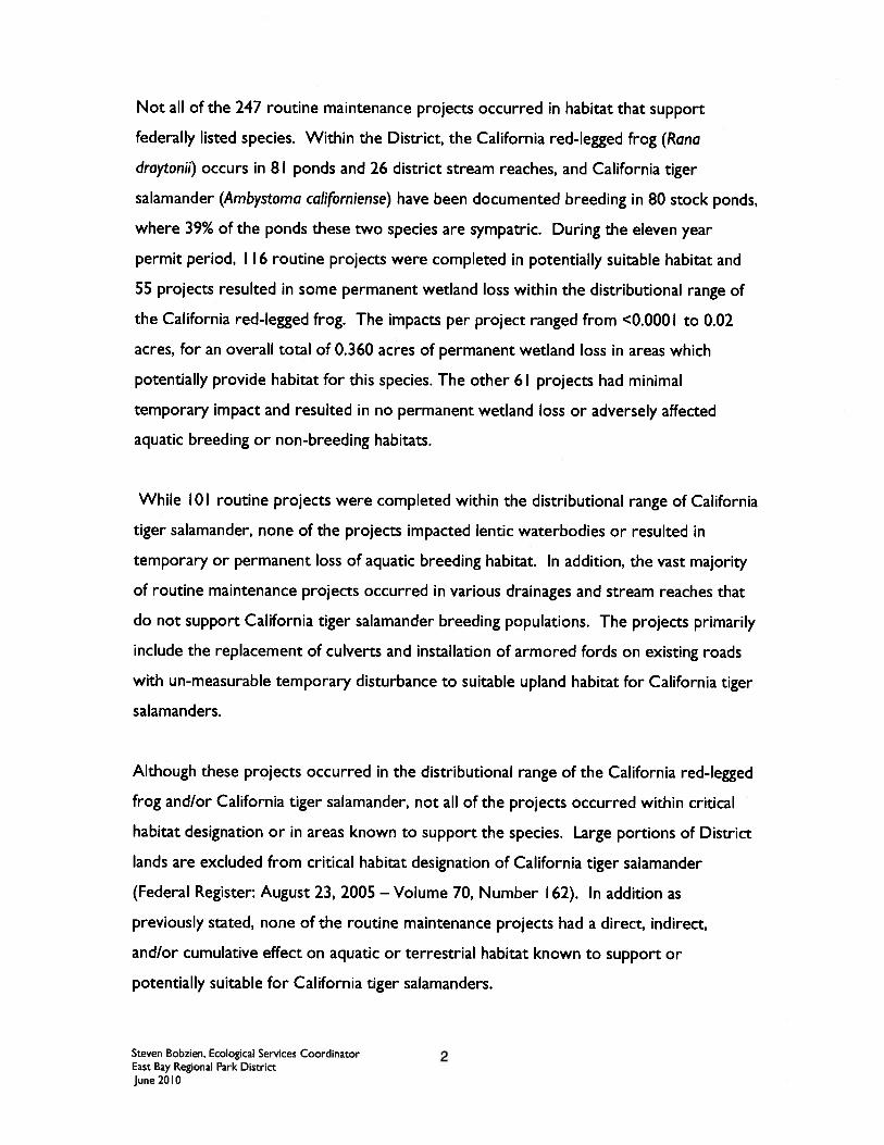

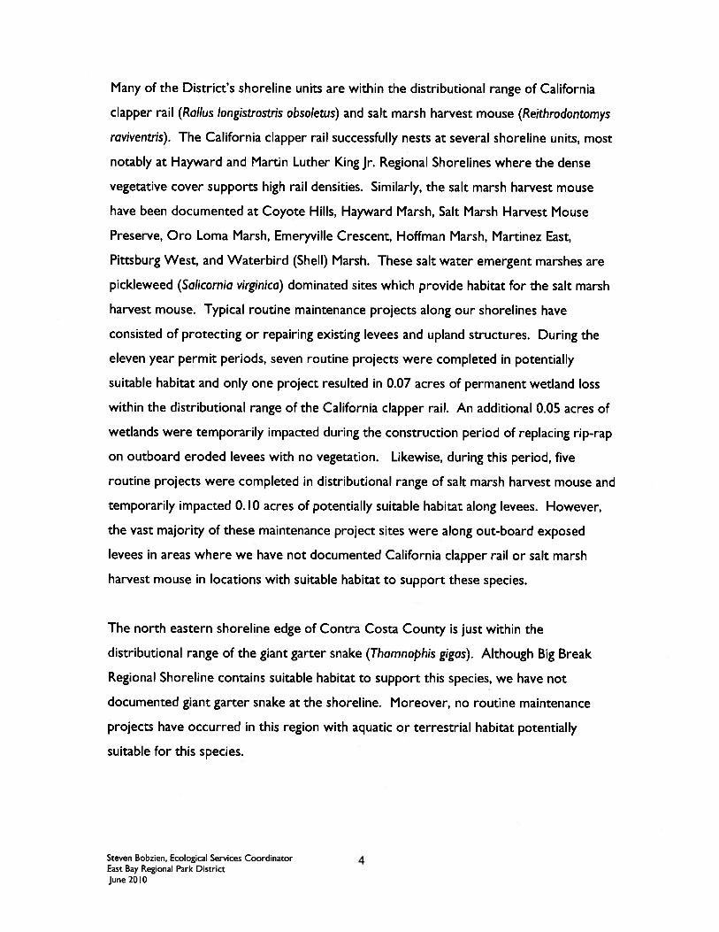


East Bay Regional Park District
Regional Maintenance Activities Alameda and Contra Costa Counties
ATTACHMENT D
Mitigation Ratios for
East Bay Regional Park District Regional Maintenance Activities

ATTACHMENT D
MITIGATION RATIOS FOR EBRPD ROUTINE MAINTENANCE ACTIVITIES
ACTIVITY IMPACT TYPE
MITIGATION RATIO (LF or Acre basis, as appropriate for the impacted water body)
Culverts Replacement of Existing Culverts (replacement culverts with same length as prior culvert and equal or larger diameter).
Temporary
Temporary Impacts: Revegetation of disturbed surfaces with appropriate native seed mixes, shrubs, and/or trees.
Temporary Impacts: 1:1 for restoration of vegetation in temporary impact areas.
Constructing new Head & Tail Walls for culverts (may include replacement culvert with same length as prior culvert and equal or larger diameter).
Temporary and Permanent
Temporary Impacts: Revegetation of disturbed surfaces with appropriate native seed mixes, shrubs, and/or trees. Permanent Impacts: Restoration: Restore lentic, lotic or tidal waters Enhancement: removal of non‐native vegetation from lentic, lotic or tidal waters, and successful revegetation with appropriate native species.
Temporary Impacts: 1:1 for restoration of vegetation in temporary impact areas. Permanent Impacts: 1.5:1 to 2.5:1 for Restoration 4:1 to 7:1 for Enhancement
Routine Maintenance of Existing Culvert (sediment and debris removal)
Temporary Temporary Impacts: Revegetation of disturbed surfaces with appropriate native seed mixes, shrubs, and/or trees
Temporary Impacts: 1:1 for restoration of vegetation in temporary impact areas
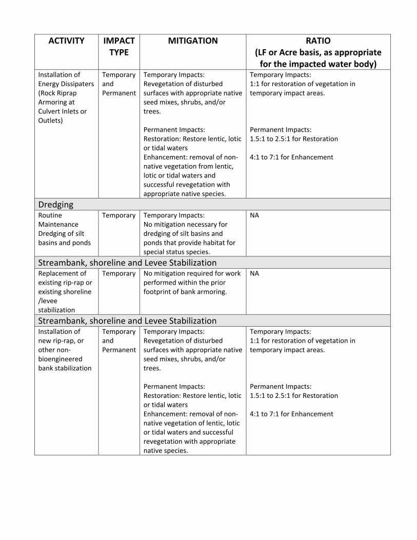
ACTIVITY IMPACT TYPE
MITIGATION RATIO (LF or Acre basis, as appropriate for the impacted water body)
Installation of Energy Dissipaters (Rock Riprap Armoring at Culvert Inlets or Outlets)
Temporary and Permanent
Temporary Impacts: Revegetation of disturbed surfaces with appropriate native seed mixes, shrubs, and/or trees. Permanent Impacts: Restoration: Restore lentic, lotic or tidal waters Enhancement: removal of non‐native vegetation from lentic, lotic or tidal waters and successful revegetation with appropriate native species.
Temporary Impacts: 1:1 for restoration of vegetation in temporary impact areas. Permanent Impacts: 1.5:1 to 2.5:1 for Restoration 4:1 to 7:1 for Enhancement
Dredging Routine Maintenance Dredging of silt basins and ponds
Temporary
Temporary Impacts: No mitigation necessary for dredging of silt basins and ponds that provide habitat for special status species.
NA
Streambank, shoreline and Levee Stabilization Replacement of existing rip‐rap or existing shoreline /levee stabilization
Temporary
No mitigation required for work performed within the prior footprint of bank armoring.
NA
Streambank, shoreline and Levee Stabilization Installation of new rip‐rap, or other non‐bioengineered bank stabilization
Temporary and Permanent
Temporary Impacts: Revegetation of disturbed surfaces with appropriate native seed mixes, shrubs, and/or trees. Permanent Impacts: Restoration: Restore lentic, lotic or tidal waters Enhancement: removal of non‐native vegetation of lentic, lotic or tidal waters and successful revegetation with appropriate native species.
Temporary Impacts: 1:1 for restoration of vegetation in temporary impact areas. Permanent Impacts: 1.5:1 to 2.5:1 for Restoration 4:1 to 7:1 for Enhancement
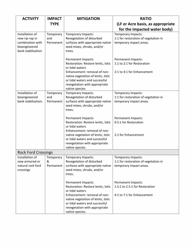
ACTIVITY IMPACT TYPE
MITIGATION RATIO (LF or Acre basis, as appropriate for the impacted water body)
Installation of new rip‐rap in combination with bioengineered bank stabilization
Temporary and Permanent
Temporary Impacts: Revegetation of disturbed surfaces with appropriate native seed mixes, shrubs, and/or trees. Permanent Impacts: Restoration: Restore lentic, lotic or tidal waters Enhancement: removal of non‐native vegetation of lentic, lotic or tidal waters and successful revegetation with appropriate native species.
Temporary Impacts: 1:1 for restoration of vegetation in temporary impact areas. Permanent Impacts: 1:1 to 2:1 for Restoration 2:1 to 4:1 for Enhancement
Installation of bioengineered bank stabilization.
Temporary and Permanent
Temporary Impacts: Revegetation of disturbed surfaces with appropriate native seed mixes, shrubs, and/or trees. Permanent Impacts: Restoration: Restore lentic, lotic or tidal waters Enhancement: removal of non‐native vegetation of lentic, lotic or tidal waters and successful revegetation with appropriate native species.
Temporary Impacts: 1:1 for restoration of vegetation in temporary impact areas. Permanent Impacts: 0.5:1 for Restoration 2:1 for Enhancement
Rock Ford Crossings Installation of new armored or natural rock ford crossings
Temporary & Permanent
Temporary Impacts: Revegetation of disturbed surfaces with appropriate native seed mixes, shrubs, and/or trees. Permanent Impacts: Restoration: Restore lentic, lotic or tidal waters Enhancement: removal of non‐native vegetation of lentic, lotic or tidal waters and successful revegetation with appropriate native species.
Temporary Impacts: 1:1 for restoration of vegetation in temporary impact areas. Permanent Impacts: 1.5:1 to 2.5:1 for Restoration 4:1 to 7:1 for Enhancement
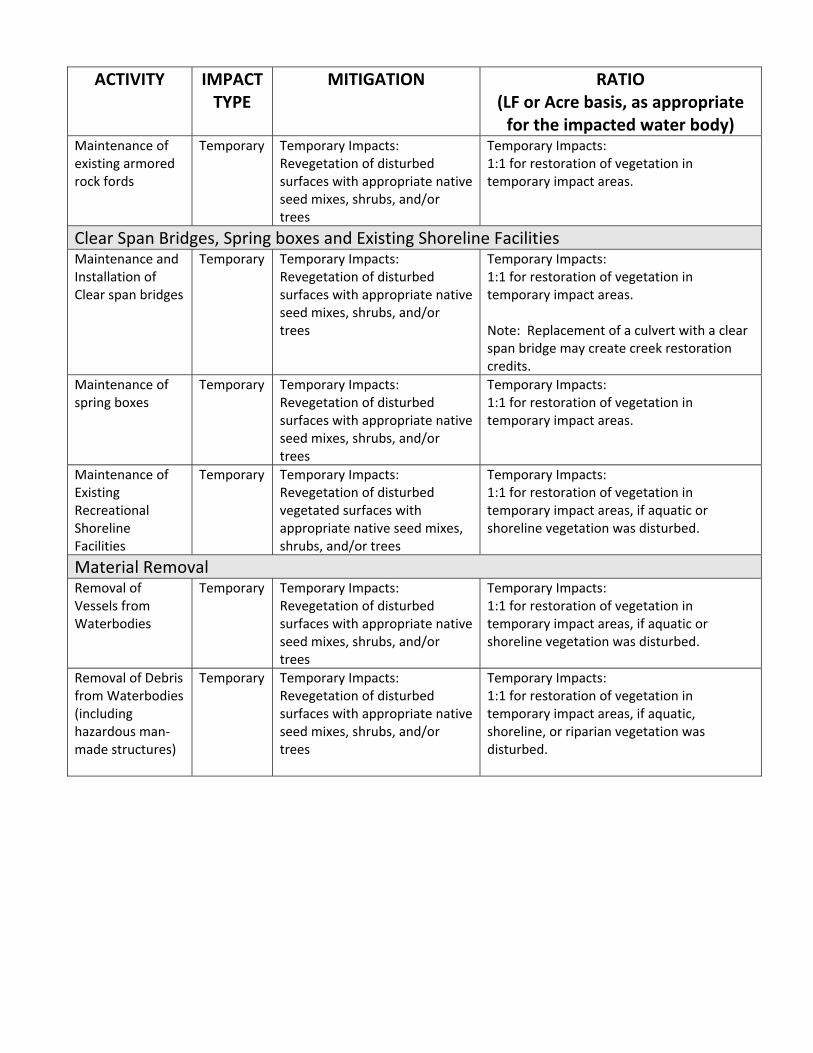
ACTIVITY IMPACT TYPE
MITIGATION RATIO (LF or Acre basis, as appropriate for the impacted water body)
Maintenance of existing armored rock fords
Temporary
Temporary Impacts: Revegetation of disturbed surfaces with appropriate native seed mixes, shrubs, and/or trees
Temporary Impacts: 1:1 for restoration of vegetation in temporary impact areas.
Clear Span Bridges, Spring boxes and Existing Shoreline Facilities Maintenance and Installation of Clear span bridges
Temporary
Temporary Impacts: Revegetation of disturbed surfaces with appropriate native seed mixes, shrubs, and/or trees
Temporary Impacts: 1:1 for restoration of vegetation in temporary impact areas. Note: Replacement of a culvert with a clear span bridge may create creek restoration credits.
Maintenance of spring boxes
Temporary Temporary Impacts: Revegetation of disturbed surfaces with appropriate native seed mixes, shrubs, and/or trees
Temporary Impacts: 1:1 for restoration of vegetation in temporary impact areas.
Maintenance of Existing Recreational Shoreline Facilities
Temporary Temporary Impacts: Revegetation of disturbed vegetated surfaces with appropriate native seed mixes, shrubs, and/or trees
Temporary Impacts: 1:1 for restoration of vegetation in temporary impact areas, if aquatic or shoreline vegetation was disturbed.
Material Removal Removal of Vessels from Waterbodies
Temporary Temporary Impacts: Revegetation of disturbed surfaces with appropriate native seed mixes, shrubs, and/or trees
Temporary Impacts: 1:1 for restoration of vegetation in temporary impact areas, if aquatic or shoreline vegetation was disturbed.
Removal of Debris from Waterbodies (including hazardous man‐made structures)
Temporary Temporary Impacts: Revegetation of disturbed surfaces with appropriate native seed mixes, shrubs, and/or trees
Temporary Impacts: 1:1 for restoration of vegetation in temporary impact areas, if aquatic, shoreline, or riparian vegetation was disturbed.