Pre-feasibility Report - State Water Resources Control Board
202
Delivering sustainable solutions in a more competitive world Prepared for: Chevron Pre-feasibility Report Avila Tank Farm Avila Beach, California RATIFIED April 2014 www.erm.com
-
Upload
khangminh22 -
Category
Documents
-
view
0 -
download
0
Transcript of Pre-feasibility Report - State Water Resources Control Board

Delivering sustainable solutions in a more competitive world
Prepared for: Chevron
Pre-feasibility Report Avila Tank Farm Avila Beach, California
RATIFIED April 2014
www.erm.com

Chevron
Pre-feasibility Report Avila Tank Farm Avila Beach, California
January 2013
Project No. 0159841
Jennifer Holder, Ph.D. Partner
George Weber, M.E.S.M. Senior Scientist
Environmental Resources Management 1180 Eugenia Place, Suite 204 Carpinteria, California 93013 T: 805-684-0241 F: 805-684-1978
i
TABLE OF CONTENTS
LIST OF FIGURES IV
LIST OF TABLES VI
LIST OF ACRONYMS VII
1.0 INTRODUCTION 1
1.1 PRE-FEASIBILITY STUDY REPORT OBJECTIVES 1
1.2 PROJECT FRAMEWORK AND PROCESS 2
1.3 DOCUMENT ORGANIZATION 5
2.0 SITE OVERVIEW 1
2.1 SITE SETTING 1 2.1.1 Site Geology 1 2.1.2 Site Hydrogeology 2 2.1.3 Surface Water 4 2.1.4 Ecological Habitat 5 2.1.5 Current Land Use 6
2.2 OPERATIONAL HISTORY 7
2.3 SITE INVESTIGATION HISTORY 9 2.3.1 Summary of Risk Assessment Activities 11
3.0 OVERVIEW OF THE SITE CONCEPTUAL MODEL 1
3.1 SOIL AND BEDROCK 2
3.2 GROUNDWATER 4 3.2.1 Light Non-Aqueous Phase Liquid 4 3.2.2 Dissolved Phase 5
3.3 VADOSE ZONE SOIL GAS 7
3.4 SUMMARY 8
4.0 RISK MANAGEMENT APPROACH 1
ii
4.1 PRIMARY REMEDIATION 1
4.2 PRE-FS LAND USE EVALUATIONS 4 4.2.1 Development Scenario 4 4.2.3 Pre-FS Land Use Evaluations Summary 6
4.3 HUMAN HEALTH RISK APPROACH 6
4.4 ECOLOGICAL RISK APPROACH 9
4.5 RISK MANAGEMENT APPROACH FOR OTHER RESOURCES 11
5.0 HUMAN HEALTH AND ECOLOGICAL RISK MANAGEMENT EVALUATIONS1
5.1 DEVELOPMENT SCENARIO 1 5.1.1 Human Health Risk Findings and Recommendations 1 5.1.2 Ecological Risk Findings and Recommendations 9
5.2 OPEN SPACE ASSESSMENT 12 5.2.1 Human Health Risk Findings and Recommendations 12 5.2.2 Ecological Risk Findings and Recommendations 13
6.0 PRELIMINARY DEVELOPMENT AND SELECTION OF APPLICABLE OR RELEVANT REGULATORYAND APPROPRIATE REQUIREMENTS 1
7.0 OTHER RISK MANAGEMENT CONCERNS 1
7.1 WATER QUALITY 1 7.1.1 LNAPL on Groundwater 1 7.1.2 Cliff Area 2 7.1.3 Surface Water Hydrology and Stormwater 3
7.2 METHANE 4
7.3 ASPHALT 5
7.4 COASTAL EROSION 5
8.0 RISK MANAGEMENT TOOLS 1
8.1 DEVELOPMENT OF HUMAN HEALTH RISK-BASED SOIL CONCENTRATIONS 1
8.2 DEVELOPMENT OF CLIFF SPRINGS ACTION LEVELS 3
iii
8.3 DEVELOPMENT OF NOTIFICATION THRESHOLDS FOR THE INTERTIDAL AREA 4
9.0 PRELIMINARY REMEDIAL ACTION OBJECTIVES 1
10.0 RISK MANAGEMENT SUMMARY 1
10.1 SOILS 1
10.2 INDOOR AIR IMPACTED BY VOCS IN SOIL VAPOR 2
10.3 WATER QUALITY 3
10.4 METHANE IN SOIL 3
10.5 ASPHALT 3
10.6 SEA CLIFF EROSION 3
10.7 SUMMARY 4
11.0 REFERENCES 1
APPENDIX A — CHRONOLOGICAL LIST OF ATCAT EVENTS AND DELIVERABLES
APPENDIX B — RATIFIED ATCAT MEETINGS AND CONFERENCE CALL MINUTES
APPENDIX C — EVALUATION OF THE TPH PROFILE IN SHALLOW SOIL
APPENDIX D — ECOLOGICAL EVALUATION IN SUPPORT OF PRE-FS
APPENDIX E — FINAL HUMAN HEALTH RISK ASSESSMENT
APPENDIX F — CLIFF SPRINGS ACTION LEVEL MEMO
APPENDIX G — SITE GEOLOGY AND BORING LOGS
APPENDIX H — ANALYSIS OF BACKGROUND METALS FORMER AVILA TANK FARM ADDENDUM NO. 2
APPENDIX I — 2012 AND 2013 WETLAND CHARACTERIZATIONS.
APPENDIX J — SITE CONCEPTUAL MODEL – FINAL REPORT
APPENDIX K — INTERTIDAL ZONE ASSESSMENT ACTIVITIES
APPENDIX L —NOTIFICATION PLAN FOR THE INTERTIDAL
APPENDIX M — SUPPLEMENTAL SOIL GAS REPORT

iv
LIST OF FIGURES
(Figures immediately follow the text)
1-1 Document Roadmap
2-1 Avila Tank Farm Site Location
2-2 Site Geology
2-3 Site Hydrology and Stormwater Management System
2-4 Habitat Map
2-5 Site Plan – Historical Operations
2-6 Sample Locations
2-7 2007 Conceptual Development Plan
3-1 Distribution of TPH in Soil and Bedrock at All Depths
3-2 Distribution of Metals in Soil
3-3 Distribution of LNAPL
3-4 Distribution of VOCs in Soil Gas
3-5 Distribution of Methane in Soil Gas
4-1 Distribution of Non-Asphaltic TPH in Soil from 0-10 ft bgs
4-2 Primary Remediation Scenario
4-3 Avila Point 2012 Vision Plan
4-4 HHEAs based on 2012 Vision Plan
4-5 Area Addressed in the Ecological Evaluation for the Development Scenario
5-1 Terrestrial Exposure to Non-Asphaltic TPH – Development Scenario
5-2 Terrestrial Exposure to Lead – Development Scenario
v
5-3 Terrestrial Exposure to Hot Spot Metals – Development Scenario
5-4 Wetland Sediment Exposure to Lead – Development Scenario
5-5 Exposure to Soil Gas in Burrows – Development Scenario
5-6 Terrestrial Exposure to Non-Asphaltic TPH – Open Space Assessment
5-7 Terrestrial Exposure to Lead – Open Space Assessment
5-8 Terrestrial Exposure to Hot Spot Metals – Open Space Assessment
5-9 Wetland Sediment Exposure to Lead – Open Space Assessment
5-10 Exposure to Soil Gas in Burrows – Open Space Assessment
10-1 Summary of Risk Management Recommendations
vi
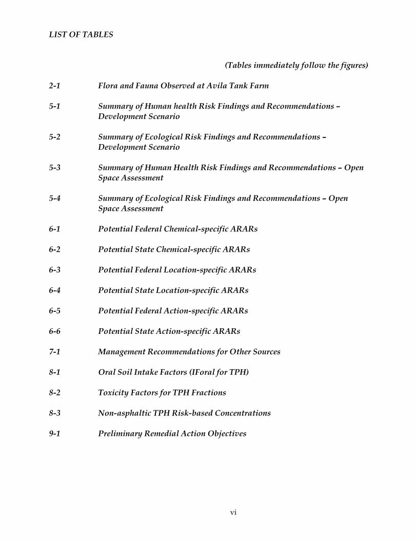
LIST OF TABLES
(Tables immediately follow the figures)
2-1 Flora and Fauna Observed at Avila Tank Farm
5-1 Summary of Human health Risk Findings and Recommendations – Development Scenario
5-2 Summary of Ecological Risk Findings and Recommendations – Development Scenario
5-3 Summary of Human Health Risk Findings and Recommendations – Open Space Assessment
5-4 Summary of Ecological Risk Findings and Recommendations – Open Space Assessment
6-1 Potential Federal Chemical-specific ARARs
6-2 Potential State Chemical-specific ARARs
6-3 Potential Federal Location-specific ARARs
6-4 Potential State Location-specific ARARs
6-5 Potential Federal Action-specific ARARs
6-6 Potential State Action-specific ARARs
7-1 Management Recommendations for Other Sources
8-1 Oral Soil Intake Factors (IForal for TPH)
8-2 Toxicity Factors for TPH Fractions
8-3 Non-asphaltic TPH Risk-based Concentrations
9-1 Preliminary Remedial Action Objectives
vii
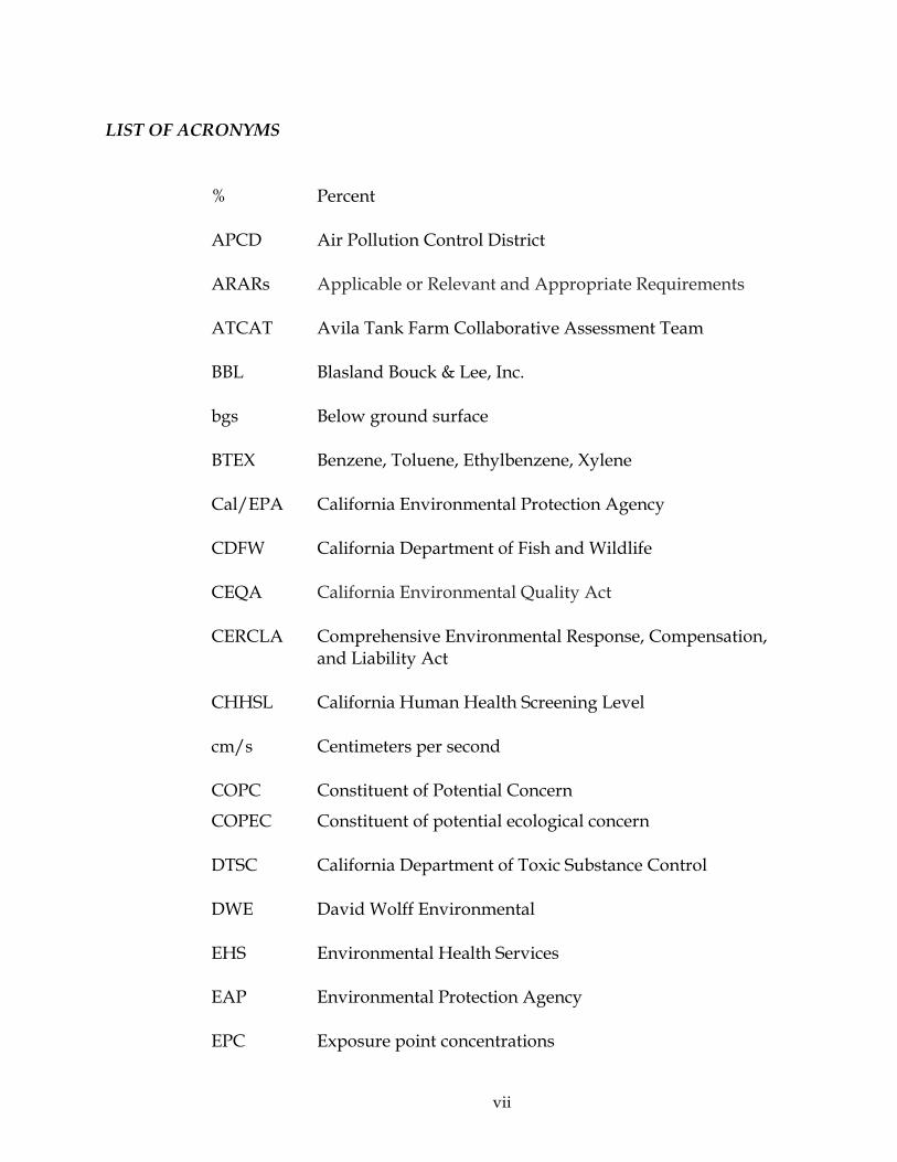
LIST OF ACRONYMS
% Percent
APCD Air Pollution Control District
ARARs Applicable or Relevant and Appropriate Requirements
ATCAT Avila Tank Farm Collaborative Assessment Team
BBL Blasland Bouck & Lee, Inc.
bgs Below ground surface
BTEX Benzene, Toluene, Ethylbenzene, Xylene
Cal/EPA California Environmental Protection Agency
CDFW California Department of Fish and Wildlife
CEQA California Environmental Quality Act
CERCLA Comprehensive Environmental Response, Compensation, and Liability Act
CHHSL California Human Health Screening Level
cm/s Centimeters per second
COPC Constituent of Potential Concern
COPEC Constituent of potential ecological concern
DTSC California Department of Toxic Substance Control
DWE David Wolff Environmental
EHS Environmental Health Services
EAP Environmental Protection Agency
EPC Exposure point concentrations

viii
ERWG Eco Risk Working Group
FS Feasibility Study
HHRA Human health risk assessment
HHRWG Human Health Risk Working Group
HI Hazard index
HQ Hazard quotient
HBFD Huntington Beach Fire Department
IEA Initial Evaluation Area
ILCR Incremental lifetime cancer risk
JES Jordan Environmental Services
LARWQCB Los Angeles Regional Water Quality Control Board
LCP Local Coastal Plan
LEL Lower explosive limit
LOAEL Lowest observable adverse effects level
LNAPL Light Non-Aqueous Phase Liquid
MCL Maximum Contaminant Level
mg/kg Milligram per kilogram
NCP National Contingency Plan
NOAEL No observable adverse effects level
PAH Polycyclic aromatic hydrocarbons
pERA Predictive ecological risk assessment
Pre-FS Pre-feasibility Report
ix
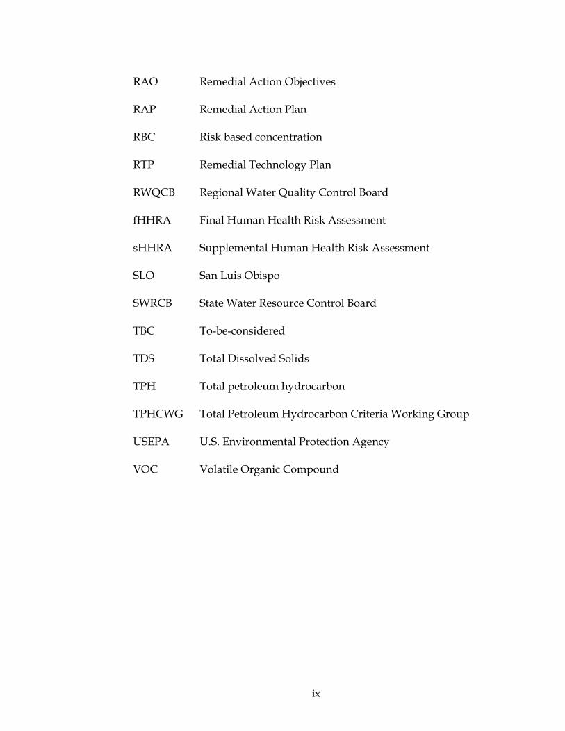
RAO Remedial Action Objectives
RAP Remedial Action Plan
RBC Risk based concentration
RTP Remedial Technology Plan
RWQCB Regional Water Quality Control Board
fHHRA Final Human Health Risk Assessment
sHHRA Supplemental Human Health Risk Assessment
SLO San Luis Obispo
SWRCB State Water Resource Control Board
TBC To-be-considered
TDS Total Dissolved Solids
TPH Total petroleum hydrocarbon
TPHCWG Total Petroleum Hydrocarbon Criteria Working Group
USEPA U.S. Environmental Protection Agency
VOC Volatile Organic Compound

ERM 1-1 CHEVRON/0159841 -JANUARY 2013
1.0 INTRODUCTION
The Pre-feasibility Study Report (Pre-FS Report) summarizes potentially unacceptable risks to human and ecological receptors at the former Unocal Avila Tank Farm (herein referenced to as the “site”) that have been identified as requiring further evaluation in the Feasibility Study (FS). Unacceptable human health risks are defined as risks that exceed local, state, or federal regulatory risk thresholds for specific receptors and uses. Unacceptable ecological risks are those that have been identified in the conservative, screening-level ecological risk assessment of being of a sufficient magnitude, and location that there is the potential for adverse effects. The Pre-FS also considers regulatory requirements, guidelines and resource concerns as potential drivers for remediation. These risks have been identified by the Avila Tank Farm Collaborative Assessment Team (ATCAT) as requiring physical or administrative remediation (i.e., management). The recommendations for this report are based on the future uses of the site which may include visitor-serving, commercial and recreational components.
This report summarizes efforts by members of the ATCAT and various subcommittees, the Human Health Risk Working Group (HHRWG) and Ecological Risk Working Group (ERWG), to evaluate site areas or features that present potentially unacceptable risk to human or ecological receptors, groundwater quality, or other environmental conditions within the context of the proposed future site use. These recommendations will serve as the foundation for the FS and subsequent Remedial Action Plan (RAP). Risk managers for this project include the Chevron project team, the Regional Water Quality Control Board for environmental and remediation issues, and San Luis Obispo County Environmental Health Services for concerns related to the property development.
1.1 PRE-FEASIBILITY STUDY REPORT OBJECTIVES
The objective of the Pre-FS is to provide risk management recommendations that support a proposed future use of the site. These
ERM 1-2 CHEVRON/0159841 -JANUARY 2013
recommendations identify conditions that, without remediation, would result in unacceptable risks to anticipated receptors, non-compliance with regulation or statute, or an unacceptable condition relative to Chevron’s goal of mitigating potential impacts associated with legacy operations, and that consequently will be addressed in the FS.
The Pre-FS will identify the primary issues that will require evaluation in the FS including:
• Potentially unacceptable risks to human receptors;
• Potentially unacceptable risks to ecological receptors; and
• Regulatory requirements, guidelines and resource concerns that are potential remedial drivers and require further evaluation in the FS.
In addition, the Pre-FS will prepare preliminary remedial action objectives (RAOs) for use in the FS.
The Pre-FS will cover many of the topics that are generally included in the first sections of an FS. By addressing these issues in a preparatory document, the ATCAT can confirm that the FS is focused on the appropriate remedial drivers. The Pre-FS will focus on the issues identified in the main part of the site, but exclude the cliff area which is currently under evaluation, including ongoing soil vapor extraction and dual-phase extraction pilot tests. A separate FS for the cliff area may be planned based on the outcome of these pilot tests.
1.2 PROJECT FRAMEWORK AND PROCESS
The site is owned by Union Oil Company of California (Union Oil). The site was developed and operated by Union Oil primarily as a petroleum storage and transfer station. A tank farm, pump house, small refinery, a truck loading station, laboratory, heater house and other miscellaneous structures were present on the property at one time or another. Chevron acquired the site in 2005 when it purchased Union Oil and Chevron personnel now manage the site activities. The site has been decommissioned and is not actively used by Chevron, although maintenance, monitoring and remediation field activities do occur.
Characterization studies have been ongoing at the site since 1997. In 2000, Union Oil entered into a voluntary agreement with the Regional Water Quality Control Board (RWQCB) to establish a Remediation Technology Panel (RTP). The RTP consisted of three independent experts with
ERM 1-3 CHEVRON/0159841 -JANUARY 2013
expertise in characterization and remediation of petroleum-impacted sites. These experts were enlisted to help identify site characterization data gaps. Their general finding was that there was no indication of significant offsite migration of contaminants in groundwater at the site toward inhabited areas in the town of Avila, although there was some uncertainty as to the migration of contaminants in groundwater at the southern boundary of the site. In 2003, separate but concurrent with the RTP process, Union Oil entered a voluntary cooperative process to evaluate potential human health and ecological risks with a number of the stakeholders with interest in the Avila Tank Farm site. This group then became the ATCAT.
The primary role of the ATCAT is to guide the assessment, including evaluation of potential human and ecological risks. The ATCAT provides a forum for early and collaborative input from the agencies and parties engaged at the site, leading to a consensus regarding onsite issues and their management. This group includes representatives of the RWQCB, the California Department of Fish and Wildlife (CDFW), the San Luis Obispo (SLO) County Environmental Health Services (EHS), SLO County Planning Department, the SLO County Air Pollution Control District (APCD), and Chevron and their consultants (Padre Associates, Inc. [Padre]; Avocet Environmental [Avocet]; ERM-West, Inc. [ERM]; McDaniel Lambert; RRM Design Group [RRM]; and Strategic Initiatives).
The ATCAT has been divided into smaller technical working groups. The HHRWG is composed of staff from Chevron, the SLO County EHS (including consultant Teri Copeland), APCD, the RWQCB, and McDaniel Lambert. The ERWG is composed of staff from Chevron, the RWQCB, CDFW, and ERM. The roles of the HHRWG and ERWG are to evaluate the potential human health and ecological risks, respectively, posed by shallow soils, surface water, groundwater and soil gas at the site and to provide risk management recommendations to the ATCAT.
Recent assessment efforts have focused on additional site characterization, including further investigation of volatile hydrocarbon detections in groundwater and soil gas in the cliff area south of the former pump house (Padre 2012a), additional evaluation of light nonaqueous phase liquid (LNAPL) mobility and recovery (Padre 2012b), continued groundwater monitoring (Padre 2012c) and monitoring in the tidal area adjacent to the southern edge of the site (Padre 2012d). Additional assessment of soil gas in specific areas of the site was also preformed based on a request from SLO County EHS (Padre 2012e). For the site assessment activities, the RWQCB is the lead agency and the ATCAT has provided support in reviewing, commenting and ratifying many of these studies.

ERM 1-4 CHEVRON/0159841 -JANUARY 2013
Chevron has identified a future use for the site consistent with good environmental stewardship, local planning, and management of impacts resulting from its former industrial use. It is anticipated that future utilization of the site will consist primarily of visitor serving and commercial uses. To reach this objective, elements associated with remedial actions necessary to make the site ready for development, and elements associated with the development proposal itself, will need to go through the appropriate permitting process. The County of San Luis Obispo will be the lead agency associated with the permitting aspects of both the remediation and the permitting aspects of this project with other agencies having related permits (e.g. Coastal Commission, APCD, etc.).
Although the site is not listed on the National Priorities List, and is currently being addressed on a voluntary basis, the overall framework for the investigation and remediation is modeled on the federal Comprehensive Environmental Response, Compensation, and Liability Act (CERCLA) process. The CERCLA process includes site investigation and risk assessments as part of the remedial investigation and an analysis of remedial alternatives in an FS. The CERCLA process provides a comprehensive framework to present and evaluate environmental assessment data and conclusions. While the environmental framework is based on the CERCLA process, it departs in certain key areas including: the voluntary nature of the investigation and remediation, the collaborative nature of the process, and the focus on public notification through the California Environmental Quality Act (CEQA)-driven environmental analysis.
Figure 1-1 summarizes documents that will support the process. As can be seen in Figure 1-1, the site investigations and the risk assessments feed into the Pre-FS. The Pre-FS is a document that will inform the FS and will be submitted to the ATCAT for ratification. The FS will present remediation alternatives and recommended actions, and the RAP will provide detailed information on the recommended actions. The application package to the County, submitted in 2012 to initiate selection of the CEQA consultant, will be supplemented with the RAP and the amendments to the Local Coastal Plan (LCP), County General Plan and the Specific Plan, which will provide information for the CEQA process. The design phase will focus on the detailed final remedial design plans and specifications. The final documents will include the closure documents and the other documents associated with post-closure activities.
ERM 1-5 CHEVRON/0159841 -JANUARY 2013
1.3 DOCUMENT ORGANIZATION
As described above, the Pre-FS provides risk management recommendations that support a proposed future use of the site. It serves as the foundation for the FS and includes much of the information that is normally found in the first few sections of an FS. To achieve this objective, the Pre-FS summarizes in the first few sections of the report the site history, setting and our current understanding of the site conceptual model. This information is the foundation for the next series of sections, which present the different potential remedial drivers that will be addressed in the FS including: the human health and ecological risk drivers, the preliminary list of Applicable or Relevant and Appropriate Requirements (ARARs), and other risk management concerns. Following these sections, a discussion of potential risk management tools and preliminary RAOs are presented; these are important foundational elements in the FS.
As summarized in the Pre-FS, many of the evaluations and recommendations for the proposed land uses were developed by the ATCAT. Consequently, it documents the collaborative and open process that was used to develop these recommendations. To this end, the report is a compendium and focuses on the “big picture.” However, it is recognized that detailed rationale and documentation are required to support the recommendations; therefore, this information is presented in a series of appendices to this report.
The organization of the Pre-FS and the purpose of each section are as follows.
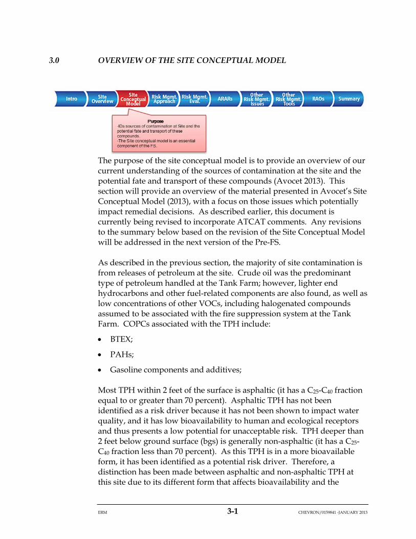
• Section 1.0 – Introduction: Presents objectives of the report and an overview of the process.
• Section 2.0 – Site Overview: Presents a summary of the site setting and operational and site investigation history. This will provide: (1) important information regarding features relevant to the investigation and risk assessment, and (2) context to data used in evaluations and the findings of different studies important to the FS.
• Section 3.0 – Overview of the Site Conceptual Model: Summarizes the current understanding of the sources of contamination and the fate and transport of these compounds at the site. The site conceptual model is an essential component of the FS.

ERM 1-6 CHEVRON/0159841 -JANUARY 2013
• Section 4.0 – Risk Management Approach: Provides an overview of the proposed development plan and associated open space assessment and the approaches used to identify human health and ecological risk drivers requiring further evaluation in the FS. The risk management approach for other resources is also discussed in this section.
• Section 5.0 – Human Health and Ecological Risk Management Evaluations: Presents the findings of the risk management evaluations. Identifies specific risk-related issues that require further evaluation in the FS.
• Section 6.0 – Preliminary Development and Selection of ARARs: Summarizes the preliminary development and selection of ARARs for the project. ARARs are an essential component of the FS.
• Section 7.0 – Other Risk Management Concerns: Evaluates water quality, potential sea cliff erosion, and migration of methane as potential remediation drivers to be evaluated further in the FS.
• Section 8.0 – Risk Management Tools: Presents preliminary risk-based protective concentrations and action levels for specific receptors. These tools may be useful in the FS and during remediation.
• Section 9.0 – Preliminary RAOs: Presents the RAOs that will form the basis for the FS. These will be used to evaluate the protectiveness of the proposed actions at the site and is an essential component of the FS.
• Section 10.0 – Summary: Summarizes the findings of the Pre-FS which will form the basis of the FS.
• Section 11.0 – References: Lists the references used in the report.
Appendices can be found on the attached CD as follows:
• Appendix A – Chronological summary of relevant events.
• Appendix B – Ratified meeting and conference call minutes from the ATCAT.
• Appendix C – Evaluation of the Total Petroleum Hydrocarbon (TPH) Profile in Shallow Soil and Additional Soil Sampling Former Unocal Avila Tank Farm: evaluates the distribution and form (non-asphaltic or asphalt) of TPH profile in shallow soils. This appendix also presents the results of the additional soil sampling conducted in 2007.
ERM 1-7 CHEVRON/0159841 -JANUARY 2013
• Appendix D – Ecological Evaluation in Support of Pre-FS: presents evaluations conducted after the predictive ecological risk assessment (pERA to support the recommendations of the Pre-FS.
• Appendix E – Final HHRA: presents the results of the human health risk evaluations conducted to support the 2012 development scenario.
• Appendix F – Cliff Springs Action Level Memo: prepared at the request of the RWQCB to provide “action level” water quality criteria for use in cliff spring water monitoring. Ratified by the ATCAT, April 2008.
• Appendix G – Site Geology and Boring Logs: presents a soil geology map and available boring logs used to evaluate soil conditions for Pre-FS risk management recommendations.
• Appendix H – Analysis of Background Metals Former Avila Tank Farm Addendum No. 2: presents additional background comparisons performed subsequent to 2005.
• Appendix I – 2012 Wetland Characterizations.
• Appendix J – Draft Site Conceptual Model report: presents our current understanding of the sources of contamination at the site and the potential for fate and transport of these compounds. The Draft report and Response to Comments documents are provided in this appendix. The Draft is currently being revised to reflect the response to comments and was not ready to include in the Draft Pre-FS. The revised document will be included in the next version of the Pre-FS.
• Appendix K - Intertidal Zone Assessment Activities: summarizes the activities completed between May and August 2012 in the intertidal zone at the southern boundary of the site.
• Appendix L - Notification Plan for the Intertidal Zone: presents conservative notification thresholds to screen water, sediment and air monitoring data collected in the intertidal area.
• Appendix M - Supplemental Soil Gas Report: presents the supplemental soil gas assessment data collected at the site by Padre in 2012.
ERM 2-1 CHEVRON/0159841 -JANUARY 2013
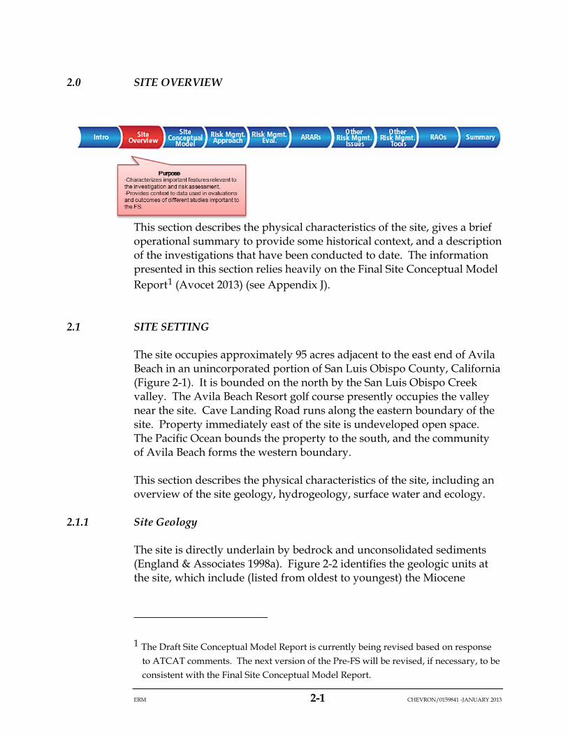
2.0 SITE OVERVIEW
This section describes the physical characteristics of the site, gives a brief operational summary to provide some historical context, and a description of the investigations that have been conducted to date. The information presented in this section relies heavily on the Final Site Conceptual Model Report1 (Avocet 2013) (see Appendix J).
2.1 SITE SETTING
The site occupies approximately 95 acres adjacent to the east end of Avila Beach in an unincorporated portion of San Luis Obispo County, California (Figure 2-1). It is bounded on the north by the San Luis Obispo Creek valley. The Avila Beach Resort golf course presently occupies the valley near the site. Cave Landing Road runs along the eastern boundary of the site. Property immediately east of the site is undeveloped open space. The Pacific Ocean bounds the property to the south, and the community of Avila Beach forms the western boundary.
This section describes the physical characteristics of the site, including an overview of the site geology, hydrogeology, surface water and ecology.
2.1.1 Site Geology
The site is directly underlain by bedrock and unconsolidated sediments (England & Associates 1998a). Figure 2-2 identifies the geologic units at the site, which include (listed from oldest to youngest) the Miocene
1 The Draft Site Conceptual Model Report is currently being revised based on response to ATCAT comments. The next version of the Pre-FS will be revised, if necessary, to be consistent with the Final Site Conceptual Model Report.
ERM 2-2 CHEVRON/0159841 -JANUARY 2013
Obispo Formation and the Pliocene Gragg Member of the Pismo Formation (which locally contains naturally occurring hydrocarbons). Fracturing of the consolidated units is a function of age and hardness of the units. For instance, in the Obispo Formation, the hard silicified (brittle) units are more pervasively fractured than the friable (softer) units, and in general, the older Obispo Formation is more pervasively fractured than the softer and younger Pismo Formation.
Unconsolidated surficial sediments, consisting of admixtures of gravel, sand, silt, and clay, fill the north-south and east-west drainages in the central part of the site, mantle the terraces bordering the cliffs on the south, and occur in the northeast corner of the site where the floodplain of San Luis Obispo Creek encroaches upon the site.
Cliff erosion is an important consideration at the site as contaminants associated with the tanks that had been located on the cliff terrace (i.e., Tanks No. 55612 and No. 201104) are located within this potential erosion area. An analysis performed in 2008 (URS 2008) established a setback for building construction (Figure 2-2). This line has been used as a conservative evaluation of potential cliff erosion over the next 75 years. A supplemental analysis is being prepared to refine this estimate for remediation planning.
2.1.2 Site Hydrogeology
Groundwater recharge occurs primarily in the higher elevations of the site through vertical fractures in the Pismo Formation and through infiltration into the unconsolidated sediments (colluvium and alluvium). Depth to groundwater at the site is variable and depends on the season, year and area of the site. Depths to groundwater in the range of 15 to 75 feet are most common at the site. Exceptions include the higher elevations, where depths may be greater, and lower elevations, where, during extremely wet seasons, groundwater discharges at ground surface.
In response to heavy rains, water levels in some areas of the site rise several feet within a very short period of time. In years of average or above-average rainfall, groundwater flows naturally from the ground, forming seeps and/or springs in several areas of the site. Once flow is initiated, the springs may flow for several weeks at progressively declining rates (England Geosystem 2001a). The historical locations of the springs located on the cliff face are shown on Figure 2-2. Rock falls in 2010 covered cliff spring monitoring location F. Groundwater may also be
ERM 2-3 CHEVRON/0159841 -JANUARY 2013
in communication with the interstitial water and tide pool water at the intertidal zone adjacent to the cliffs (Figure 2-2).
The Pismo and Obispo formations consist of consolidated but generally porous rocks that are substantially fractured. Groundwater occurs in these formations in both primary (intergranular) and secondary (fracture) porosity, but the following lines of evidence indicate that both formations are dominated by fracture permeability and that the intergranular pore spaces provide little additional permeability:
• Observations during drilling that most wells reported no groundwater until a fracture was encountered, and once encountered, groundwater levels rose by an average of 18 feet (England & Associates 1998b);
• Monitoring wells drilled on site that were dry, despite being drilled below the water table (as interpolated from nearby wells), likely because they did not intersect any fractures. This indicates that, absent fracturing, water is not capable of flowing through the intergranular pore spaces to the well, even though the rock was water-saturated (England Geosystem 2001b); and
• Monitoring wells with locally anomalous water levels and low yield, indicating poor hydraulic communication with recharge areas and near-by wells (Padre 2012a).
Groundwater quality is considered poor, based on general mineral analyses. Iron, manganese, chloride, sulfate, and total dissolved solids (TDS) concentrations frequently exceed drinking water standards (England Geosystem 2001b). High sulfate levels in groundwater are reported to be supportive of natural attenuation processes in the hydrostratigraphic units at the site (RTP 2004).
The Pismo and Obispo formations are low yielding aquifers with relatively low hydraulic conductivities between approximately 7.6x10⁻⁵ centimeters per second (cm/s) to 2.0x10⁻⁴ cm/s, and low storativities (1.3x10⁻³ to 5.5x10⁻²) (England Geosystem 2001b).
Given the poor quality and low well yield, it is unlikely that groundwater at the site will be utilized as a source of drinking water. Chevron plans land use restrictions to exclude installation of wells for drinking and irrigation in areas affected by operations. For these reasons, groundwater was not evaluated as a source of drinking water in the sHHRA (McDaniel Lambert 2011) and a drinking water deed restriction is anticipated to be
ERM 2-4 CHEVRON/0159841 -JANUARY 2013
part of the requirements for the future development applicable to any area that is previous impacted by operations.
2.1.3 Surface Water
There are no permanent, natural surface water bodies at the site. Commensurate with the industrial uses at the site, stormwater within the operational areas was managed in a stormwater management system. Stormwater in former operation areas is currently managed under the State General Industrial Permit, Wastewater Discharge Identification No. 3 40S013327. Under the conditions of the current permit, stormwater is sampled at least twice per year during the first hour of a storm event.
A detailed description of the stormwater system at the site can be found in the Site Conceptual Model Report, Appendix J (Avocet 2013). In summary, one catchment (Catchment D) encompasses the former operations area of the site (Figure 2-3). It covers approximately 32 acres and includes most of the stormwater management infrastructure at the site. The entire catchment drains to a single pond on the southwestern cliff, which is referred to as the Lower Drainage Basin. Stormwater from the first two storm events is held in the Upper Drainage Basin and Lower Drainage Basin until testing demonstrates that the water meets the discharge standards of the General Industrial Storm Water Permit. Detained stormwater is discharged from the Lower Drainage Basin via an outfall to the ocean. Subsequent storm events are allowed to discharge without detention.
The existing stormwater infrastructure is at least 15 years old. This includes the outfall serving Catchment D, which is being undermined by cliff erosion. Stormwater has been monitored since 1997. Storm water samples were analyzed for only oil and grease, TSS, pH, and conductivity, and none were above discharge limits in any of those monitoring events. Based on those data, it does not appear that site COPCs are dissolved by or transported by stormwater.
Associated with the features of the stormwater management system and other site infrastructure are a number of wetlands. Seven wetlands were identified onsite (Figure 2-4) in the most recent wetland characterizations (Padre 2012f; WRA 2014). The wetlands have not yet gone through the verification process with the appropriate agencies. The majority of the wetlands identified within the Avila Tank Farm are located at former aboveground storage tank sites that were historically excavated to facilitate their construction (Wetlands W3-W6). Several of these former
ERM 2-5 CHEVRON/0159841 -JANUARY 2013
tank locations are in depressions that pond water. Other identified wetland features are located at current stormwater detention basins (W1 and W2). The wetland feature on the northern section of the Avila Tank Farm is located within an alluvial plain. This wetland (W7) pools water from surface water drainage off of the surrounding steep hillsides and is largely retained due to the road crossing and culvert associated with Avila Beach Drive. Water pools here intermittently and for short durations during rain events before it drains out into the road crossing culvert.
2.1.4 Ecological Habitat
Historical site operations have substantially reconfigured the surface of the property. As described above, the extensive network of berms constructed around the petroleum storage tanks to prevent a release in the event of reservoir or tank failure has resulted in the creation of closed depressions, some of which have been characterized, at least in part, as wetlands. Additionally, construction of operating facilities in the north central portion of the site (i.e., the refinery area) and other site-related activities in the center of the site have resulted in little natural habitat remaining in this area.
The site also supports native plant communities and wildlife habitat within a mosaic of disturbed and developed areas associated with the former tank farm facilities (Figure 2-4). Ecological surveys conducted between 2003 and 2005 (JES 2003; DWE 2004; DWE 2005) included specific identification of plant, invertebrate, amphibian, avian and mammalian species (including notation of special-status species) that were either observed or have potential to occur onsite. The dominant species observed or expected onsite (as described in these surveys) are summarized below. Additionally, a wetland characterization was completed in 2012 (Padre 2012f), which updates the earlier wetland characterizations conducted at the site (JES 2003; DWE 2004). A modification to the boundary of wetland W7 (first defined in Padre 2012f) was performed by WRA in December 2013 (WRA 2014), based on revisions to wetland vegetation classifications.
The most significant habitat types at the site include coastal live oak woodland, coastal scrub and disturbed areas of ruderal vegetation and non-native grasslands (Figure 2-4). The southern edge of the site also includes bluffs and cliffs adjacent to the shoreline. The coast live oak woodland is found mainly on the north slope of the property and consists of a closed canopy with an understory of predominantly poison oak. Other understory species include mugwort, miner’s lettuce and
ERM 2-6 CHEVRON/0159841 -JANUARY 2013
periwinkle. The coastal scrub exists primarily on west and south facing slopes and consists of common coastal scrub species such as coyote brush, toyon, and California sagebrush. The non-native grasslands within the disturbed areas consist largely of introduced grasses such as rye, wild oats and red brome and are interspersed with native species such as California poppy and buttercup (JES 2003).
Table 2-1 lists the flora and fauna identified at the site during one or more of the surveys. Only one special-status or sensitive plant species was observed onsite (Well’s manzanita). Surveys conducted in 2004 and 2005 also identified areas onsite with appropriate soil types that could support some additional special-status plants (Figure 2-4). No special-status soil invertebrates were observed or are expected onsite. For reptiles, only the western fence lizard and the special-status silvery legless lizard were observed in the terrestrial habitat of the site. The legless lizard requires a sandy soil habitat that is only present onsite in one small area (Figure 2-4).
Avian species observed in the terrestrial habitat at the site include, but are not limited to, California quail, red-winged blackbird, house wren, and western scrub jay. Several raptors were observed hunting over the site, including the peregrine falcon, red-shouldered hawk and turkey vulture. Although, several other special-status birds were identified by JES (2003) as having high potential to occur onsite (e.g., Allen’s hummingbird, loggerhead shrike, black-chinned sparrow), based on the supplemental survey (DWE 2004), only the Allen’s hummingbird was identified as having potential to occur, given distributions and habitat preferences. No other special-status birds are expected to be present onsite for a significant portion of time (DWE 2004). Terrestrial mammals observed onsite include the black-tailed deer, California ground squirrel, Botta’s pocket gopher, woodrat, and brush rabbit. No special-status mammals were observed onsite during the survey, but five species were identified as having high potential to occur (i.e., the pallid bat, Townsend’s western big-eared bat, the fringed myotis, the ring-tailed cat and the San Diego desert woodrat). Based on the refined surveys conducted in 2004 (DWE 2004), only the ring-tailed cat was identified as having any real potential to occur. The oak woodland area of the site is the only suitable habitat and its habitat preference is moist riparian area (DWE 2004). Thus, it is unlikely that this species would use large areas of the site.
2.1.5 Current Land Use
The site encompasses approximately 95 acres and is bordered by the community of Avila Beach to the west, the San Luis Creek and a golf

ERM 2-7 CHEVRON/0159841 -JANUARY 2013
course to the north, open space to the east, and the Pacific Ocean to the south (see Figure 2-1). The site is currently zoned industrial and access to the site is restricted. Activities onsite focus on maintenance, monitoring, and site investigation.
2.2 OPERATIONAL HISTORY
Information from this section is summarized from the Site Conceptual Model Report (Avocet 2013). The property was acquired by Union Oil in 1906, and between 1906 and 1910 Union Oil constructed a network of pipelines, storage tanks, and a small refinery at the site. In 1997, the facility was formally decommissioned, and in 1998-1999, the petroleum storage tanks were removed and known pipelines were cleaned. A few surface structures (pump house, lab, fire water tanks, etc.) and most of the subsurface structures (sumps, pipelines) remain in-place at the site. Chevron acquired the Tank Farm, together with other Union Oil assets, in 2005.
Based upon storage capacity and available records (England & Associates 1998a), the site handled the following materials in approximately these proportions (based on storage capacity):
• 78 percent: crude oil (San Joaquin Valley, San Ardo, Orcutt);
• 5 percent: bulk refined products (gasoline and diesel fuel);
• 12 percent: gas oil; and
• 5 percent: tank slops (miscellaneous mixtures of petroleum and water).
Former industrial (petroleum-related) operation areas (e.g., buildings, tanks, appurtenances) occupy approximately 40 percent (38 acres) of the site. As seen in Figure 2-5, these are located primarily towards the interior and southwest margin of the property. The facility had the following principal components:
• Pipelines: Three pipeline corridors served the Tank Farm. Multiple pipelines are located within each corridor. Approximately 11,000 feet of known steel pipeline, ranging from 2 to 10 inches in diameter and buried approximately 4 feet below grade, connected the various operations on the property.
1. The Front Street Corridor, which connected the Tank Farm to the pier;
ERM 2-8 CHEVRON/0159841 -JANUARY 2013
2. The Eastern Corridor, which connected the facility to the Santa Maria and Orcutt oil fields; and
3. The Northern Corridor, which connected the Tank Farm to the San Luis Obispo Tank Farm and, ultimately, to the Central Valley oil fields.
Most of the on-site pipelines remain in place. Union Oil sold the pipelines within the Eastern and Northern pipeline corridors to Tosco in 1997. Via subsequent acquisitions, the current owner is Phillips 66. The sale included the pipelines, aboveground manifolds, and easements. The pipeline system owned by Union Oil was cleaned and flushed in 2004. These pipelines are not currently active but are still present. The remediation activities will include verification that the entire system has been emptied of petroleum products.
• Storage Tanks: Tanks were built with riveted or welded steel plate on concrete foundations and coated with lead-based paint to prevent corrosion. The number of tanks changed over the years. There are 27 locations at which tanks were sited, but the maximum number of tanks in operation at any one time appears to have been 21 (circa 1940s-1950s). Fuel products for local wholesale or retail distribution were managed in dedicated tanks, pipelines, and pumps. All tanks were dismantled by or before 1998-1999 except those currently used to store water.
• Main Pump House and Laboratory: The main pump house is the point through which most of the petroleum products handled onsite moved. The pump house also included boilers and heat exchangers to heat the oil to lower the viscosity for pumping; however, in the 1930s the boiler house was decommissioned. Around that time, the laboratory moved from the refinery to the decommissioned boiler pump house. The structure to the north of the main pump house was most recently used as a storeroom and petroleum laboratory.
• Truck-Loading Rack: The loading rack was constructed near the main pump house and laboratory in 1936 and was used to dispense bulk refined products to trucks for delivery to Central Coast marketing outlets. The loading rack operated through 1994 when shipping of fuel products from the Union Oil pier was discontinued.
• Refinery: The refinery was built between 1906 and 1910. It used a simple heat distillation process to separate crude oil into few generic fractions (e.g., gasoline, kerosene, and distillate). These were raw
ERM 2-9 CHEVRON/0159841 -JANUARY 2013
products shipped elsewhere for finishing into marketable products. A portion of the refinery was destroyed in a fire about 1926. The boilers were fueled with bunker oil, which would deposit an obsidian-like residue on the refractory (refractory glass) that was periodically removed during maintenance. Fragments of this glass occur in the former refinery area, and tests of the material indicate elevated concentrations of nickel and vanadium with negligible leachability (England & Associates 2000a). The refinery was largely obsolete by the 1940s but was kept in service to support the war effort. It was dismantled around 1947.
2.3 SITE INVESTIGATION HISTORY
Site characterization efforts have been ongoing since 1997 and are described in numerous documents. The discussion presented herein was presented in the Site Conceptual Model Report (Avocet 2013). Studies completed prior to 2000 were undertaken to investigate the site geology and hydrogeology, and to assess the nature and extent of contamination. The overarching objective of the initial studies was to determine whether any identified contamination presented a threat to the adjacent community or the developing Project Avila remediation plan. It was subsequently determined that the pipeline was the source of Avila Beach contamination. During that time, however, the property boundary was established with the regulatory community as an important point of compliance.
In 2000, Union Oil entered into a voluntary agreement with the California RWQCB to establish a RTP. The RTP consisted of three independent experts with expertise in characterization and remediation of petroleum-impacted sites. These experts were enlisted to help identify site characterization data gaps.
The data gaps identified by the RTP (2000, 2002) were primarily focused on further characterizing the extents of dissolved- and free-phase impacts to groundwater and the fate and transport processes affecting the migration of these contaminants. Those data gaps were addressed by England Geosystem (2001a-2001c, 2002a-2002f, and 2003a). The culmination of this work was an RTP document titled Assessment of Off-Site Migration of Hydrocarbons at the Avila Beach Tank Farm Site (RTP 2004).
ERM 2-10 CHEVRON/0159841 -JANUARY 2013
In 2003, separate but concurrent with the RTP process, Union Oil entered a voluntary cooperative process to evaluate potential human health and ecological risks with a number of the stakeholders with interest in the Avila Tank Farm site (the ATCAT). The ATCAT developed a separate list of data gaps focused primarily on shallow soil, sediment, and surface water in the recently identified wetlands; evaluating the potential for impacts in non-industrial areas of the site; and background metals. These data gaps were addressed in reports prepared by England Geosystem (2003b) and Avocet (2004a, 2005, 2008a, and 2008b).
Subsequent assessment efforts have focused on refining the site characterization, including further investigation of volatile hydrocarbon detections in groundwater and soil gas in the cliff area south of the former pump house (Padre 2012a), additional evaluation of LNAPL mobility and recovery (Padre 2012b), and continued groundwater monitoring (Padre 2012c).
Figure 2-6 depicts the distribution of borings, monitoring wells, soil vapor sample locations and miscellaneous sampling points at the site. Collectively, these assessments have included the following:
• Excavation and sampling of 26 exploratory trenches;
• Drilling and sampling of 369 borings with the completion of:
o 103 borings as groundwater monitoring wells (68 single wells, 13 dual-nested wells, and 9 combination groundwater/multi-depth soil gas probe wells), and
o 70 borings as dual-nested multi-depth soil vapor probes;
• Over 13,200 feet of cumulative drilling and soil sampling;
• Analysis of over 1,750 soil samples for one or more of a wide variety of COPCs, including TPH; benzene, toluene, ethyl benzene, and total xylenes (collectively referred to as BTEX); polynuclear aromatic hydrocarbons (PAHs); volatile organic compounds (VOCs); metals; polychlorinated biphenyls; pesticides; and herbicides;
• Analysis of over 355 soil vapor samples for TPH/BTEX, VOCs, and/or fixed gases;
• Groundwater monitoring since 1997 resulting in more than 45 sampling events from some wells; and
• Tide pool and interstitial water, sediment and air in the intertidal zone area (see Appendix K).

ERM 2-11 CHEVRON/0159841 -JANUARY 2013
It should be noted that this document will not address potential future actions at the cliff area and intertidal area as a soil vapor extraction and dual phase extraction pilot test is under way. A separate FS for the Cliff Area may be planned pending the outcome of these tests this summer.
2.3.1 Summary of Risk Assessment Activities
In 2003, the ATCAT was convened to evaluate the potential impacts to human and ecological health from petroleum and other chemicals at the site. The following sections provide a brief overview of the risk assessments that have been conducted to date at the site.
2.3.1.1 Overview of Human Health Risk Assessments
A number of HHRAs have been conducted at the Site, starting with the Baseline HHRA prepared by McDaniel Lambert, Inc., that was reviewed, and ratified in 2005 by the ATCAT. The 2005 Baseline HHRA evaluated the potential health risks to current (nearby residents and recreators/trespassers) and future site users from residual chemicals in soil, soil gas, and groundwater (using data collected through 2004), although no development plan(s) for the site had been proposed at the time.
Since completion of the 2005 Baseline HHRA, Chevron, in conjunction with the ATCAT, has conducted additional studies to better characterize residual contamination at the site (Avocet 2008a and b). In addition, a series of community meetings took place in Avila in 2007, during which various use concepts were discussed with residents and other interested parties. Subsequently, a local community group presented a conceptual mixed-use development plan (2007 conceptual development plan) which included a wellness resort hotel, worker housing, restaurant and other commercial components. A supplemental HHRA (sHHRA) (McDaniel Lambert 2011) was conducted that evaluated the potential for unacceptable risks assuming exposures as defined by the 2007 conceptual development plan. The sHHRA focused on potential risks to receptors in each of the development areas (or exposure areas) identified in the 2007 conceptual development plan. A total of 17 exposure areas were identified (A through N, Open Space and Native Gardens).
In 2012, an Addendum to the sHHRA was submitted to address the slight modifications between the 2007 community plan and the 2012 vision plan, as well as supplemental soil and soil gas data. Upon receipt of the Addendum, SLO County EHS requested that a Final HHRA (fHHRA) be
ERM 2-12 CHEVRON/0159841 -JANUARY 2013
prepared to integrate the sHHRA and the Addendum results, as well as to address some changes in risk methodologies since commencement of the sHHRA in 2007. The fHHRA was finalized in 2013 and is included in Appendix E. The findings of the fHHRA form the basis for the human health risk management recommendations presented in Section 5.
2.3.1.2 Overview of Ecological Risk Assessments
A pERA for the upland area of the site was conducted in 2004 (BBL 2004). The primary objective of the pERA was to provide a screening-level evaluation of potential terrestrial ecological risks associated with the Avila Tank Farm site using the existing site data and site characterization reports. A separate screening-level risk evaluation of on-site wetlands was conducted later as an addendum to the pERA (ARCADIS BBL 2007).
The pERA generally followed the California Department of Toxic Substances Control (DTSC) “Guidance for Ecological Risk Assessment at Hazardous Waste Sites and Permitted Facilities Part A: Overview” (DTSC, 1996). The pERA consisted of four basic components: problem formulation, exposure assessment, effects assessment, and risk characterization. Due to the conservatism of the evaluation, any determinations of risk were not considered definitive conclusions, but, rather, were interpreted as conservative estimates of potential risk.
The pERA included a two tier analysis. Tier 1 included a site assessment using the most conservative exposure and effects assumptions. The results of Tier 1 were used to focus the Tier 2 assessment. The Tier 2 assessment used refined exposure estimates and a range of effects criteria to evaluate site-wide risks. Those compounds that demonstrated site-wide risk were evaluated spatially (i.e., on an individual sample-specific location basis).
The constituent of potential ecological concern (COPEC) screening process for the pERA included three steps: (1) sample coverage and detection limits; (2) comparison of site metals data to background concentrations; and (3) evaluation of frequency of detection. Based on the screening process outlined above, the primary COPECs evaluated through Tier 2 included six metals, PAHs, TPH, and ten VOCs.
The ecological conceptual site model for the site was developed based on historical/current site activities and the biological surveys conducted at the site (JES 2003, DWE 2004 and 2005). For the purposes of the pERA, current conditions were evaluated and it was assumed that the entire site
ERM 2-13 CHEVRON/0159841 -JANUARY 2013
provided, or could provide, suitable ecological habitat in the future. Complete pathways that were quantitatively evaluated for terrestrial receptors included: terrestrial plants and soil invertebrates and site soil through direct contact; herbivorous, insectivorous, and carnivorous birds and mammals through ingestion of impacted plant or prey tissue; and burrowing mammals through inhalation (VOCs only). Complete pathways that were evaluated for wetland receptors included: wetland plants and sediment invertebrates through direct sediment contact; as well as herbivorous, insectivorous, and carnivorous birds and omnivorous mammals through ingestion of impacted plant or prey tissue.
The pERA for the upland area of the site concluded that terrestrial plants and invertebrates were the receptors most likely to be impacted by exposure to petroleum, and wildlife was the most likely to be impacted by exposure to lead and, to a lesser extent, mercury (BBL 2004). In general, potential risk to wetland plants, invertebrates and wildlife through exposure to petroleum (either as TPH or PAHs) was concluded to be de minimus, but it was concluded that there was the potential for risk from exposure to lead and mercury. While the pERA identified the potential for risk based on current site conditions, the screening-level framework was utilized to ensure that conservative estimates were developed. The final conclusions recognized the importance of risk managers evaluating the pERA results in the context of the future plans for the site and deciding whether the existing data are sufficient to manage these risks.
An update to the original pERA using data collected since 2004 is presented in Appendix D. The findings of the updated ecological risk assessment form the basis for the ecological risk management recommendations presented in Section 5.
ERM 3-1 CHEVRON/0159841 -JANUARY 2013
3.0 OVERVIEW OF THE SITE CONCEPTUAL MODEL
The purpose of the site conceptual model is to provide an overview of our current understanding of the sources of contamination at the site and the potential fate and transport of these compounds (Avocet 2013). This section will provide an overview of the material presented in Avocet’s Site Conceptual Model (2013), with a focus on those issues which potentially impact remedial decisions. As described earlier, this document is currently being revised to incorporate ATCAT comments. Any revisions to the summary below based on the revision of the Site Conceptual Model will be addressed in the next version of the Pre-FS.
As described in the previous section, the majority of site contamination is from releases of petroleum at the site. Crude oil was the predominant type of petroleum handled at the Tank Farm; however, lighter end hydrocarbons and other fuel-related components are also found, as well as low concentrations of other VOCs, including halogenated compounds assumed to be associated with the fire suppression system at the Tank Farm. COPCs associated with the TPH include:
• BTEX;
• PAHs;
• Gasoline components and additives;
Most TPH within 2 feet of the surface is asphaltic (it has a C25-C40 fraction equal to or greater than 70 percent). Asphaltic TPH has not been identified as a risk driver because it has not been shown to impact water quality, and it has low bioavailability to human and ecological receptors and thus presents a low potential for unacceptable risk. TPH deeper than 2 feet below ground surface (bgs) is generally non-asphaltic (it has a C25-C40 fraction less than 70 percent). As this TPH is in a more bioavailable form, it has been identified as a potential risk driver. Therefore, a distinction has been made between asphaltic and non-asphaltic TPH at this site due to its different form that affects bioavailability and the
ERM 3-2 CHEVRON/0159841 -JANUARY 2013
potential for toxicity. Appendix C presents a detailed discussion of the categorization of the two types of TPH.
Metals are also found onsite. While most are within the range of naturally occurring background, there are concentrations of anthropomorphic metals associated with refractory glass from the former refinery (lead, vanadium and nickel), or with the paint used on the tanks (lead). Avocet and BBL (2004) and Appendix H present the evaluation of background metals at the Avila Tank Farm site.
Methane, which is associated with the anaerobic breakdown of petroleum, has also been identified as a driver at the site. In particular, the area around the truck-loading rack and pump house where most of the fuel-related materials were released shows signs of robust natural attenuation. Consequently, significant concentrations of methane are also observed in this area. Methane poses different potential hazards at the site based on its concentration. Methane is highly flammable at concentrations greater than the lower explosive limit (LEL) of 5 percent. At higher concentrations, methane can also act as an asphyxiant as it displaces oxygen in the air and can cause symptoms of oxygen deprivation. The available oxygen should be a minimum of 18 percent or oxygen deprivation will occur2. Methane is not toxic below the lower explosive limit of 5 percent (50,000 parts per million).
The following sections provide a summary of the nature, occurrence, and mobility of site contaminants in the following media at the site:
• Soil and bedrock;
• Groundwater; and
• Vadose zone soil gas.
3.1 SOIL AND BEDROCK
Impacts to soil/bedrock are primarily from hydrocarbons associated with crude oil and refined petroleum products (gasoline, diesel fuel, gas oil, distillate, reduced crude, etc.) produced or handled at the site. Identifying site-related TPH greater than 100 milligrams per kilogram (mg/kg) is
2 http://www.ebsinfo.com/Tech-pdf-files/MSDS-Methane.pdf
ERM 3-3 CHEVRON/0159841 -JANUARY 2013
complicated by the occurrence of natural bituminous material in the Pismo Formation (this TPH ranged in concentration from 10 to 2,000 mg/kg, with most reported concentrations being in the range of 30 to several hundred mg/kg).
As described above, two different forms of hydrocarbons are present in shallow soils at the site: asphaltic and non-asphaltic TPH. Generally, surface soils (less than or equal to 2.5 feet bgs) exhibiting no visual or olfactory evidence of hydrocarbon contamination, including soils in non-operations areas, commonly contain detectable concentrations of TPH with a chemical composition consistent with the degraded asphalt; this material has a different composition than the TPH in soils at greater depth. Asphaltic TPH is generally found in the slopes surrounding the former operation areas at the Tank Farm where they were periodically coated with an asphaltic material to control weed growth and erosion. This asphalt degrades into a fine powder and is dispersed by wind and rain (Applied Geochemical Strategies 2004). The second form of hydrocarbon is non-asphaltic TPH. This is found generally at depths greater than 2.5 ft bgs and is composed of liquid petroleum released from tanks, pipelines, etc., in the course of site operations.
Non-asphaltic TPH concentrations greater than 1,000 mg/kg are most prevalent in the north-south and east-west colluvium-filled valleys, which are also the primary pipeline corridors (Figure 3-1). The highest concentrations (greater than 10,000 mg/kg) generally occur along the pipelines. Most of the soil containing TPH concentrations greater than 1,000 mg/kg occurs in the upper 40 to 50 feet of the site, with much of that in the upper 10 to 20 feet.
The highest concentrations of C4-C10 (low molecular weight) TPH (greater than 1,000 mg/kg) occur beneath and south of the truck-loading rack, beneath former Tank Nos. 55614 and 201104 (southern cliffs), below the west end of the central pipeline corridor (east and northeast of the pump house), south of the former refinery, and beneath the pipeline corridors in the central part of the Avila facility. The majority of the C4-C10 TPH occurs within unconsolidated sediments (colluvium or terrace deposits) at depths of less than 20 feet bgs (Figure 3-1).
Several metals (copper, lead, nickel, vanadium, and zinc) were detected at concentrations above background levels in surface soils across the site and were identified as potential human health or ecological risk drivers (Avocet and BBL 2004; BBL 2004; McDaniel Lambert 2011; Appendices D,
ERM 3-4 CHEVRON/0159841 -JANUARY 2013
E and H). Arsenic was found to be consistent with background (Avocet and BBL, 2004).
• Lead is associated with paint used on the tanks and is generally located within the tank rings or with the refractory glass (Figure 3-2). The lead contamination in these areas appears to be localized with little migration potential based on the fact that elevated concentrations of lead in groundwater and surface water have not been detected.
• Copper, nickel, vanadium and zinc: Refractory glass left from the former refinery operation (Figure 3-2) has been shown to contain metals elevated above background and have been identified as risk drivers to human and ecological receptors.
No evidence exists of soil impacts extending beyond the property boundaries.
3.2 GROUNDWATER
Contamination of groundwater at the site consists of both LNAPL and dissolved constituents. These are described in more detail below.
3.2.1 Light Non-Aqueous Phase Liquid
LNAPL is defined as any liquid petroleum hydrocarbon with a specific gravity less than water. The LNAPL at most of the site exhibits properties commonly associated with crude oil, the commodity handled in the greatest volume at the site (England Geosystem, 2002b). Historically, up to 43 well casings have contained discernible accumulations of LNAPL at thicknesses ranging from sheen (a thin film) to 31.85 feet (B-163 in the former refinery area). Of these 43 wells, 18 routinely contain a measurable (greater than 0.01 feet) thickness of LNAPL. Figure 3-3, which depicts the locations of wells containing LNAPL in November 2011, illustrates that measurable thicknesses of LNAPL are limited to areas very close to the central distribution facilities at the site, areas southwest of these facilities, and areas near distribution pipelines. All wells containing LNAPL are surrounded by downgradient wells that are free of LNAPL except in the cliff area, which is the subject of ongoing evaluations (Padre 2012a and Appendix K).
Several lines of evidence support the conclusion that the LNAPL in bedrock is restricted almost entirely to the secondary porosity created by the fractures (see Avocet 2013 for a full discussion). Empirical evidence
ERM 3-5 CHEVRON/0159841 -JANUARY 2013
also suggests that the fractures are not laterally extensive or widely interconnected due to the general absence of LNAPL at large distances from source areas (RTP 2004). What is likely, however, is that the greater portion of the LNAPL is found in the colluvium for the following reason. The intergranular pore space of fine-grained soils such as the colluvium is expected to be an order of magnitude or greater than the fracture porosity of the bedrock units.
3.2.2 Dissolved Phase
Presently, the groundwater monitoring network consists of 94 onsite wells and 3 offsite wells (Figure 2-6). Groundwater monitoring has been performed regularly since the third quarter of 1997, resulting in more than 45 monitoring events for some wells. Groundwater samples are routinely tested for one or more of the following: TPH, BTEX, VOCs, metals, and PAHs. The primary COPCs in groundwater at the site are related to crude and refined petroleum, including fuel additives.
The majority of dissolved-phase TPH is associated with mid- to high-molecular-weight petroleum hydrocarbons (C10-C40), which occur in groundwater around the margin of the LNAPL area, in the vicinity of the former refinery, former pump house, and appurtenant fuel pipelines.
There are two localized areas of lighter-end (C4-C10) petroleum-hydrocarbon-impacted groundwater at the truck-loading rack and the southwest cliff area adjacent to former Tanks Nos. 55614 and 201104. Other VOCs have also been detected locally:
• Fire extinguishing agents/fire retardants – south of the former refinery;
• Fuel components/additives – south of the former refinery, near the truck-loading rack, and beneath former Tank No. 10622 (south-southeast of the main pump house);
• Chlorinated solvents – south of the former refinery.
PAH compounds are rarely detected in groundwater samples and, when present, they are detected at very low concentrations. Metals concentrations in groundwater are locally elevated. The Pismo and Obispo formations were deposited in a marine environment that provides a ready source of soluble minerals under the correct geochemical conditions, and is consistent with the elevated TDS concentrations observed in groundwater samples.
ERM 3-6 CHEVRON/0159841 -JANUARY 2013
• Arsenic: Has been detected in about 10 percent of the water samples tested. Since the detection limit equals the Maximum Contaminant Level (MCL), all samples with detectable arsenic exceed the MCL. However, arsenic occurs naturally at the site in the Obispo Formation.
• Lead: Elevated concentrations of lead have been detected at Monitoring Well B-230. The use of Tank No. 201104 (which occupied the tank ring within which B-230 is located) for gasoline storage suggests that the elevated lead concentrations may be associated with leaded gasoline.
• Nickel: Has been detected in about 60 percent of the water samples tested and has exceeded the MCL in about 17 percent of the samples. Nickel has been associated with the presence of refractory glass in the former refinery area. However, given its limited occurrence at the site, and the fact that the nickel is tightly bound in the glass, makes the refractory material an unlikely source for the nickel in groundwater.
The east, west, and north limits of dissolved-phase TPH impacts to groundwater are well defined, since sentinel groundwater monitoring wells in those directions have never detected significant concentrations (nondetect to 297 µg/L) of constituents attributable to historical site operations. However, the localized groundwater impact associated with former Tanks Nos. 55614 and 201104 are too near the cliff face to establish sentinel wells. In the case of Tank No. 55614, the cliff springs D and F have historically acted as sentinel monitoring points and have never detected significant concentrations (nondetect to 1,030 µg/L) of dissolved-phase petroleum hydrocarbons associated with historical site operations. Former Tank No. 201104 lacks a cliff spring sentinel monitoring point. Recent inspection and sampling at the base of the cliff have found detectable concentrations of light petroleum compounds in tide pools confined to a 300-foot-square area. A recent study has been released and further assessment is being planned for this area (Appendix K).
The consistency of water quality data for monitoring wells located downgradient of secondary contaminant sources suggests that the dissolved-phase plume is stable (with the exception of the intertidal zone at the base of the cliff, which as noted above is being assessed further). A study of natural attenuation processes at the Avila site indicates that plume stability (e.g., the observation that dissolved contaminants do not extend much beyond the areas of LNAPL occurrence) is likely the result of natural attenuation via sulfate reduction/biodegradation. The RTP concluded that these processes should continue to constrain the migration of dissolved contaminants (RTP 2004). Testing has shown that anaerobic
ERM 3-7 CHEVRON/0159841 -JANUARY 2013
biodegradation of petroleum hydrocarbons is occurring at the pump station, most likely as a result of sulfate-reducing and methanogenic respiration (England Geosystem 2002c). As the bedrock at the Avila site provides an abundant source of sulfate, contaminant attenuation should continue to stabilize the dissolved-phase plume in the future.
3.3 VADOSE ZONE SOIL GAS
Prior to 2007, soil gas sampling was limited to collections from nine multidepth soil vapor probes (SP-1 to SP-9) initially installed to characterize the composition, concentrations, and flux of soil gas (England Geosystem 2002e) (Figure 2-6). Samples typically were analyzed for fixed gases, C1-C5 hydrocarbons, and limited samples for BTEX and hydrogen sulfide.
In 2007, in consultation with the ATCAT, a comprehensive soil gas study of the Tank Farm was performed that involved the collection and analysis of 206 soil gas samples from 70 dual-nested (5 and 15 feet) soil gas probes (SV-1 to SV-70) (Avocet 2008b). The samples were analyzed for VOCs (EPA Method TO-15) and methane and other fixed gases. Multiple VOCs were detected, including fuel-related VOCs (e.g., BTEX and fuel additives), solvent-related VOCs (e.g., tetrachloroethene and methylene chloride), fire extinguishing agent VOCs (e.g., bromodichloromethane, chloroform, and carbon tetrachloride), and fixed gases (e.g., oxygen, carbon dioxide, and methane). Additional soil gas samples were collected in 2012 in support of the fHHRA based on a data request from SLO County EHS (Appendix M).
The results of these studies indicated that the dominant detected VOCs were fuel-related (hexane and cyclohexane – 73 percent on average), with lesser amounts of acetone (10 percent), heptane (6 percent), tert-butyl alcohol (3 percent), benzene and 2,2,4-trimethylpentane (2 percent each), and 2-butanone and chloroform (1 percent each). The highest concentrations of VOCs were detected in samples from probes situated south of the former refinery and surrounding the truck-loading rack (Figure 3-4). Other areas of elevated VOCs in soil gas include beneath former Tank No. 201104 on the cliff terrace, near the geographic center of the site (SV-26), and in the eastern part of the site near the manifold connecting the eastern and northern pipeline corridors.
In shallow soil, methane concentrations greater than 2.5 percent (i.e., half of the methane LEL) (Avocet 2008b) were detected in the area south of the
ERM 3-8 CHEVRON/0159841 -JANUARY 2013
refinery and extending to south of the truck-loading rack (Figure 3-5). The distribution of methane exceeding concentrations of 2.5 percent is greater in deeper soil, extending south from the former refinery area to the truck-loading rack and southeast to the former tank locations along the cliffs. Elevated methane concentrations are considered an indirect evidence of anaerobic hydrocarbon biodegradation.
The lateral distribution of VOCs in soil gas was not significantly different in shallow (5 feet bgs) versus deep (15 feet bgs) probes, although concentrations were about an order of magnitude greater in the deeper samples, suggesting a soil gas attenuation factor of about 0.1 between 15 and 5 feet bgs. Attenuation may include some degradation or breakdown of products but is primarily mixing with atmospheric air. The extent of VOC in soil gas has been delineated and has been shown to not extend offsite.
3.4 SUMMARY
In summary, historical activities at the Avila Tank Farm have led to contamination of soil, groundwater and soil gas. Crude oil was the predominant type of petroleum handled at the site; however, lighter end hydrocarbons and fuel-related components are also found.
• Soil: Impacts to soil/bedrock are primarily from hydrocarbons associated with crude oil and refined petroleum products (gasoline, diesel fuel, gas oil, distillate, reduced crude, etc.) produced or handled at the site. There are also some small areas of metal contamination in soils associated with the refractory glass from the refinery and lead paint from tanks in tank rings. No evidence exists of soil impacts extending beyond the property boundaries.
• Groundwater: Contamination of groundwater at the site consists of both LNAPL and dissolved constituents. LNAPL is limited to areas very close to the central distribution facilities at the site, areas southwest of these facilities, areas near distribution pipelines and in the cliff area. Most wells containing LNAPL are surrounded by downgradient wells that are free of LNAPL. Recent sampling in two cliff area wells and inspection and sampling at the base of the cliff have found detectable concentrations of light petroleum compounds in tide pools confined to a 300-foot-square area.
The majority of dissolved-phase TPH is associated with mid- to high-molecular-weight petroleum hydrocarbons (C10-C40), and is distributed

ERM 3-9 CHEVRON/0159841 -JANUARY 2013
in the vicinity of the former refinery, former pump house, and appurtenant fuel pipelines. There are two localized areas of lighter-end (C4-C10) petroleum-hydrocarbon-impacted groundwater at the truck-loading rack and the southwest cliff area adjacent to former Tanks Nos. 55614 and 201104. The east, west, and north limits of dissolved-phase TPH impacts to groundwater are well defined; however, the southern limits are less well-defined. Recent inspection and sampling at the base of the cliff have found detectable levels of petroleum compounds in intertidal water in a small area. Further assessment is being conducted in this area.
• Soil gas: The dominant detected VOCs in soil gas are fuel-related with the highest concentrations of VOCs were detected in samples from probes situated south of the former refinery and surrounding the truck-loading rack (Figure 3-4). The extent of VOCs in soil gas has been delineated and has been shown to not extend offsite.
ERM 4-1 CHEVRON/0159841 -JANUARY 2013
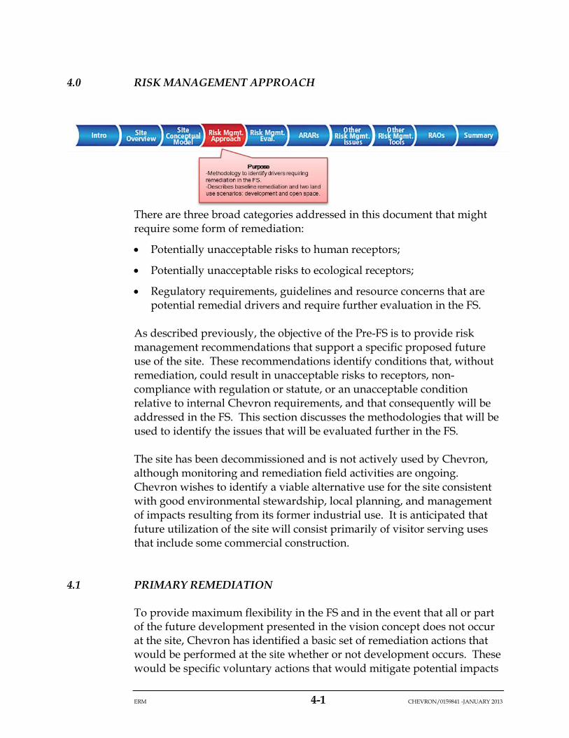
4.0 RISK MANAGEMENT APPROACH
There are three broad categories addressed in this document that might require some form of remediation:
• Potentially unacceptable risks to human receptors;
• Potentially unacceptable risks to ecological receptors;
• Regulatory requirements, guidelines and resource concerns that are potential remedial drivers and require further evaluation in the FS.
As described previously, the objective of the Pre-FS is to provide risk management recommendations that support a specific proposed future use of the site. These recommendations identify conditions that, without remediation, could result in unacceptable risks to receptors, non-compliance with regulation or statute, or an unacceptable condition relative to internal Chevron requirements, and that consequently will be addressed in the FS. This section discusses the methodologies that will be used to identify the issues that will be evaluated further in the FS.
The site has been decommissioned and is not actively used by Chevron, although monitoring and remediation field activities are ongoing. Chevron wishes to identify a viable alternative use for the site consistent with good environmental stewardship, local planning, and management of impacts resulting from its former industrial use. It is anticipated that future utilization of the site will consist primarily of visitor serving uses that include some commercial construction.
4.1 PRIMARY REMEDIATION
To provide maximum flexibility in the FS and in the event that all or part of the future development presented in the vision concept does not occur at the site, Chevron has identified a basic set of remediation actions that would be performed at the site whether or not development occurs. These would be specific voluntary actions that would mitigate potential impacts
ERM 4-2 CHEVRON/0159841 -JANUARY 2013
associated with legacy operations at the site. The term “voluntary” is used here to define actions that Chevron may undertake under their own volition and without a regulatory order. It is understood that any actions, whether voluntary or under an order, will be reviewed and approved by the appropriate agencies.
Conceptually, the primary remediation is likely to include the following components and will significantly mitigate human and ecological exposure to contamination at the site:
• Removal or mitigation of TPH source material in the pump house and loading rack area.
• Removal of the pipelines within excavations and potential cliff retreat zone.
• In other areas, removal or grout in-place of pipelines greater than 4 inches in diameter.
• Removal of all surface buildings and appurtenances (e.g., manifolds, tanks).
• Removal of concrete pads.
• Removal of some or all remaining water tanks owned by Chevron.
• Removal of refractory glass.
• Removal of lead impacted soil from former tank rings.
• Replacement of original stormwater pipes with gravity-drained open channel or designed stormwater system.
• Mitigation of cliff area impacts.
• Provide a minimum 4 feet of separation between the soil surface and non-asphaltic TPH impacted soils greater than 1,000 mg/kg (see Figure 4-1).
The proposal to provide a minimum of 4 feet of separation between the ground surface and concentrations of non-asphaltic TPH greater than 1,000 mg/kg is based on a business decision by Chevron to minimize the potential for future property issues. While there are no regulatory cleanup levels for the non-asphaltic TPH mixture that is present, in the absence of conducting exhaustive studies at the site, the 1,000 mg/kg benchmark for non-asphaltic TPH distributed between 0 and 4 feet bgs is considered an appropriate threshold for soil management for a number of reasons. First, the proposed benchmark has been found to be conservatively protective of human health and the environment through
ERM 4-3 CHEVRON/0159841 -JANUARY 2013
the risk assessments conducted by Chevron for this project. It is also consistent with guidelines used by regulatory agencies across California (SWRCB 1989; LARWQCB 1996; City of Santa Fe Springs 2000; HBFD 2004; City of Torrance 2010).
It is recognized that the TPH concentration selected as a remedial goal will have a soil excavation/capping volume associated with it. As it is premature to conclude at this point that the 1,000 mg/kg soil management benchmark would result in significant additional soil volume for removal or capping, it is recommended that this concern be addressed in the FS, where volume estimates and grading plans will be more fully developed. At that point, if significant additional action is required due to the 1,000 mg/kg threshold, than discussion regarding modification of this threshold can be initiated.
The use of the 1,000 mg/kg non-asphaltic TPH concentration as a protective benchmark for soil management in shallow soils is specifically being proposed for the Avila Tank Farm Site and may not be relevant for use at other sites. Conversely, criteria used at other nearby sites are not considered relevant for this site. For example, the 100 mg/kg criterion that was used at an adjacent remediation project completed in 2000 in the town of Avila is not considered relevant for the Former Avila Tank Farm Site. This value (100 mg/kg) was not a risk-based cleanup value, but rather was based on the concentration in soil that was acceptable to financial institutions for residential property transfer at that time. As such, this value is not appropriate for the Avila Tank Farm Site.
With respect to pipeline removal, the final decision on what pipelines will be removed and which will be grouted has not been finalized. This will be evaluated further during the FS. Soils around Chevron pipelines are well characterized and further evaluation of potential TPH contamination along the pipelines is not considered necessary for the purposes of the FS. It is recognized that the Philips pipeline (which crosses the site from north to south) is less well characterized in locations along steeply, vegetated slopes. Since this pipeline does not belong to Chevron, and its final disposition is unknown, additional characterization is not necessary for the purposes of the FS. Therefore, uncertainty related to the level of characterization of TPH around the pipelines is considered to be limited, and adequate for the purposes of the FS.
Chevron is planning on evaluating the components of the primary remediation in the FS. Therefore, it is unknown at this point exactly how each component will be addressed and what the site conditions will be after the primary remediation is complete. However, it is likely that many
ERM 4-4 CHEVRON/0159841 -JANUARY 2013
of the risk drivers identified in the risk assessments based on current site conditions (see Appendices D and E) would be ameliorated through the primary remediation (highlighted in Figure 4-2). As the primary remediation is planned whether development occurs or not, future site conditions after the primary remediation will be the basis for exposure to human and ecological receptors. Potential changes in land use (e.g., development) and concomitant changes in exposure will be based on the new conditions post-primary remediation. As it is premature to predict what those conditions might be at this point, the Pre-FS will identify issues specific to exposure of human and ecological receptors that should be taken into account during the development of the primary remediation alternatives3. Also, any potential risk drivers that are not addressed through the primary remediation will be identified.
4.2 PRE-FS LAND USE EVALUATIONS
The Pre-FS focuses on evaluating risk management recommendations associated with the proposed future land use which assumes development. To provide maximum flexibility moving forward, an open space assessment will also be conducted within the context of the development scenario. These are described below.
4.2.1 Development Scenario
A series of community meetings took place in Avila in 2007 during which various use concepts were discussed with residents and other interested parties. Subsequently, a local community group presented a conceptual mixed-use development plan (see Figure 2-7). In 2012, the general community plan was revised into an updated vision concept for the site (Figure 4-3). It is understood that Chevron or subsequent developers will submit their own plan to San Luis Obispo County for approval. However, potential future plans are expected to be generally consistent with the vision plan in regard to development areas and the categories of use. It is recognized that based on the proposed future vision for the site, the need for further action above and beyond the primary remediation may be
3 As a point of clarity, all risk assessments (human and ecological) conducted to date,
including those summarized in Appendices D and E and used as the basis of the risk management evaluations presented in this report, are based on current site conditions and do not assume any of the primary remediation activities have occurred.
ERM 4-5 CHEVRON/0159841 -JANUARY 2013
required in some areas of the site to support the intended future use. Likewise, changes to the vision may also require revisions to the human and ecological risk assessments which are based on a specific development scenario.
Therefore, a generalization of the vision concept (Figure 4-4) provides a reasonable approximation of future development on the site and identifies the location and nature of potential future human occupation. Human Health Exposure Areas (HHEAs) were specifically created to delineate the proposed development areas and land uses based on the vision concept.
It is anticipated that each HHEA will include some type of commercial development or activity; as such, they define the areas where human activities (other than recreational use) and associated structures will occur. The opposite is true for ecological exposures, where areas occupied by buildings and infrastructure are not defined as habitat. Within a HHEA, it is assumed that buildings, associated infrastructure, and managed landscaping will render the area unsuitable as ecological habitat. Conversely, it is assumed that the area outside of the HHEAs will be open areas that will provide potential ecological habitat to wildlife, as well as recreational opportunities to human receptors. The HHEAs are labeled alphabetically and form a unit of spatial evaluation employed in this report; with respect to the evaluation of human health risks, these HHEAs are the key exposure areas.
4.2.1.1 Open Space Assessment
To provide maximum flexibility in the FS, it is recognized that some or all of the aspects of the development plan may not transpire. Therefore an open space assessment was conducted in the Pre-FS that assumes that the primary remediation will occur, but that the boundaries of developed areas may be subject to change. This assessment made the following assumptions: (1) human use would be limited to recreational–type exposures throughout the site; and, (2) any portion of the site could be potential ecological habitat. It is recognized, however, that if development does not occur at the site, additional evaluations may be necessary if the above assumptions are not valid, including further data collection and/or risk assessment.
To capture qualitatively site conditions post-primary remediation, it was assumed that within the areas impacted by the primary remediation (see Figure 4-2), site conditions will change sufficiently that risk drivers identified within those areas would be mitigated to risk levels that are
ERM 4-6 CHEVRON/0159841 -JANUARY 2013
accepted by the responsible agencies. To ensure that this assumption is valid, any specific aspects of risk identified within the primary remediation areas (i.e., the quantitative risk evaluations based on current site-wide conditions) will be identified in this assessment to ensure that the appropriate concerns are recognized and evaluated in the FS. Additionally, any potential risk drivers identified outside of the area of the primary remediation that might potentially cause an unacceptable risk when portions of the site are used as open space will also be identified.
4.2.3 Pre-FS Land Use Evaluations Summary
Environmental risk management (including remediation), permitting and future redevelopment will require approval by the current property owner (Union Oil), and all applicable regulatory bodies (e.g., County of San Luis Obispo, Coastal Commission, and the RWQCB). It is assumed that remediation required at the site will be dependent on the future land uses and contaminant types, concentrations, and locations. Given that Chevron agrees that the 2012 vision concept may be used to define development areas and categories of use for the site, the risk management evaluation presented herein is a reasonable approximation of potential future land use. As long as the final, approved development plan is consistent with the uses identified in the vision concept shown in this document, the risk assessments and associated risk management recommendations will remain applicable. If the approved development plan is modified from the plan shown in this document to include additional uses or significant changes in uses from one location to another, or development does not occur at the site and the primary remediation plan is significantly different from that presented here, potential human health and ecological risks associated with the modifications may need to be reassessed. Additionally, changes to the site conditions (e.g., changes to soil conditions due to earthquakes or significant erosion) may also prompt reassessment of potential risks.
4.3 HUMAN HEALTH RISK APPROACH
The human health risk conclusions and associated risk management recommendations presented in Section 5.0 are based on the results of the fHHRA (McDaniel Lambert 2013; Appendix E) coupled with the planned primary remediation. The fHHRA evaluated the potential cancer risks and noncancer hazards from chemicals currently found at the Avila Tank Farm to future site users identified from the 2012 vision plan(as discussed in Section 2.2.1 and presented in Appendix E). The fHHRA incorporated
ERM 4-7 CHEVRON/0159841 -JANUARY 2013
the modifications in the development plan (see Table 4-1), as well as supplemental soil and soil gas data. In some cases HHEAs coalesced (e.g., HHEAs B and C), were slightly modified in size (e.g., HHEA L), or were eliminated (e.g., HHEA H). The fHHRA focused on potential risks to human receptors in each of these 16 HHEAs, or exposure areas.
Although the Site is currently zoned industrial, potential human populations that could be exposed to residual contamination at the site based on the aforementioned uses and evaluated in the fHHRA are as follows:
• Development scenario: short-term resident (adult and child), indoor and outdoor commercial employees (adults), intrusive utility worker (adult), and recreational open space user (adult and child).
• Site-wide, open space: a site-wide evaluation which includes a recreational user (adult and child) and offsite resident (adult and child).
The specifics regarding construction and placement of buildings remain undetermined; therefore, the Addendum includes the evaluation of “default” commercial structures, as defined by current guidance (Cal/EPA 2005a, b and 2011), as well as the smaller bungalows proposed in some areas. Health risks presented for each exposure area in the fHHRA follow the risk assessment methodology used in the development of the sHHRA, which was a collaborative process involving the ATCAT and specifically the HHRWG subcommittee. A summary of the methodology can be found in Appendix E.
The fHHRA evaluated potential health risks from soil using different exposure point concentrations (EPCs), depending on the exposure scenario and/or COPC sample size. Per California Environmental Protection Agency (Cal/EPA) and USEPA guidance (Cal/EPA 2005a; USEPA 2002), COPC concentrations in surface soils (0 to 2 feet bgs) and in subsurface soils that may be brought to the surface (0 to 10 feet bgs) were used to determine the EPC, depending on the exposure scenario. Potential health risks and associated uncertainties to future site users, as defined in the 2012 vision plan, were identified in terms of the incremental lifetime cancer risk (ILCR) and the noncarcinogenic hazard index (HI). Lead was compared to the California Human Health Screening Levels (CHHSLs) and the Childhood Lead Prevention Program threshold of 1,000 mg/kg for areas where children may be present.

ERM 4-8 CHEVRON/0159841 -JANUARY 2013
In the Pre-FS, the human health risk findings from the fHHRA were further evaluated to identify risk drivers requiring assessment in the FS, recognizing that the primary remediation would change site conditions in the future regardless of whether or not development occurs. Considering that risk management recommendations might differ depending on the type of exposure (i.e., short-term residential versus commercial), the proposed land use and potential exposures at each HHEA, along with the calculated risks, were compared to a range of acceptable levels to determine whether further evaluation in the FS is warranted. The USEPA acceptable risk management range is 1 in 1,000,000 (1E-6) to 1 in 10,000 (1E-4; USEPA 1990 1991). Based on these risk ranges, the Pre-FS identified areas requiring risk management in the FS when potential short-term residential and recreational risks exceeded the low end of the USEPA range (greater than 1E-6), and/or commercial risks exceeded 1E-5. Additionally, noncancer HIs greater than 1 were identified as requiring risk management in the FS.
The Pre-FS identified potential risks from lead exposure based on the approach used in the fHHRA: comparison of lead soil EPCs to the CHHSLs for lead in soil (Cal/EPA 2009) and the Childhood Lead Prevention Program threshold of 1,000 mg/kg for areas where children may be present. The lead CHSSLs are based on changes in child (residential) and fetal (commercial pregnant worker) blood lead levels of 1 micrograms per deciliter (µg/dL) which correspond to 80 mg/kg lead in soil for residential use and 320 mg/kg for commercial use. As discussed in the fHHRA (Appendix E), for the exposures associated with the 2102 vision plan, commercial CHHSLs applied to both the short-term hotel residents and indoor and outdoor workers. Residential CHHSLs were used to evaluate potential risk from lead in soil to recreational users. Therefore, soil lead concentrations above 320 mg/kg in HHEAs with proposed short-term residential or commercial exposure scenarios, and above 80 mg/kg for recreational exposures, were identified as posing unacceptable risk requiring risk management in the FS.
Section 5.0 summarizes the results of the fHHRA for each of the exposure areas in terms of the ILCR and the noncarcinogenic HI, based on current environmental conditions at the site. These findings were then compared to the conceptual plan for the primary remediation scenario to identify specific recommendations to ensure that the primary remediation will be adequately protective based on human health exposures. For exposure areas where risk levels exceed the thresholds identified above based on current site conditions, a description of the primary risk drivers and associated risk management recommendations within the context of the
ERM 4-9 CHEVRON/0159841 -JANUARY 2013
primary remediation are provided in Section 5.0. Additionally, Section 5.0 presents the recommendations based on an evaluation of potential risks to human health assuming that only the primary remediation is conducted (the open space assessment).
4.4 ECOLOGICAL RISK APPROACH
As with the human health approach, the ecological risk assessment in the Pre-FS assumed that the primary remediation will change current site conditions as discussed in Section 4.1. Appendix D presents the results of an updated ecological risk screening based on current conditions (all data collected up through 2012). This forms the basis of the evaluation of potential ecological risks based on current site conditions and habitat.
The findings from Appendix D, with the overlay of the primary remediation, will be the basis for developing recommendations. For the development scenario, it is assumed that ecological receptors will be exposed to contaminants only in areas of the site that fall outside of HHEAs, as the areas within will be developed and managed and will not provide appropriate habitat for wildlife at the site. Additionally, the primary remediation may have changed site conditions outside the areas of the HHEAs in such a way that risk drivers currently identified within those areas would no longer be an issue after the primary remediation is completed. To ensure that this assumption is valid, any specific aspects of risk identified within the primary remediation areas but outside the HHEAs will be identified in the development scenario to ensure that the appropriate issues are recognized and evaluated in the FS. Figure 4-5 illustrates the area where wildlife is assumed to be exposed in the development scenario.
For the open space assessment, it is assumed that the area outside of the primary remediation footprint will be consistent with current conditions, but the area within the remediation footprint will be changed in such a way that concentrations will decrease or exposure will be reduced. Thus the current risks identified in Appendix D, will be evaluated within the context of the primary remediation (Figure 4-2), and exposure of ecological receptors to contaminants at the site will be assumed to occur outside the areas of the remediation. To ensure that the primary remediation is adequately protective, any specific aspects of ecological risk identified within the primary remediation areas will also be identified to ensure that the appropriate issues are recognized and evaluated in the FS.
ERM 4-10 CHEVRON/0159841 -JANUARY 2013
Appendix D evaluated the risk drivers identified in the pERA (BBL 2004) using the most current data. As previously noted however, this report does not include an assessment of the intertidal zone area. As in the pERA, receptor groups include plants, soil invertebrates, birds and mammals. The specific risk drivers identified in the updated pERA as described in Appendix D are:
• Potential risks associated with exposure to TPH in shallow soils (defined as 0 to 6 feet bgs). However, as described in Appendix D, only non-asphaltic TPH in shallow soils required further evaluation in the Pre-FS;
• Exposure to lead in shallow soils and wetland sediments;
• Exposure to “hot-spot metals,” which include copper, nickel, vanadium and zinc in shallow soils (0 to 6 feet bgs); and
• Exposure to VOCs in soil vapor (0 to 6 feet bgs).
The potential for unacceptable ecological risk requiring risk management was determined by comparing exposure to effects levels as defined in the pERA (BBL 2004; ARCADIS BBL 2007) and Appendix D. This was generally done using a hazard quotient (HQ) approach. With a HQ, if the quotient of estimated exposure over an effect level is greater than one (i.e. HQ>1), then it is assumed that there is potential for unacceptable risk. Depending on the magnitude of the HQ and the size of the area of the exceedance, potential risk management recommendations could result.
The pERA and the supplemental ecological risk evaluation (Appendix D) utilized two definitions of “effects levels” in evaluating potential risk. Literature-based “no observable adverse effects level” (NOAEL) concentrations were generally used as an initial risk screen and represent an exposure concentration that does not result in an adverse effect. NOAELs are favored as initial screening benchmarks because they represent a “safe level” value, supported by scientifically based evidence below which deleterious effects to receptors are not expected to occur. Therefore, when the exposure concentration for a given compound does not exceed the NOAEL, it is concluded that that compound is not present at a concentration high enough to result in unacceptable risk.
While NOAELs are appropriately conservative for a screening analysis, they may be too conservative for the development of remedial recommendations, because the exceedance of a NOAEL does not necessarily mean that unacceptable risks will result. The “lowest observed adverse effects level” (LOAEL) concentration is a better
ERM 4-11 CHEVRON/0159841 -JANUARY 2013
indicator of when there is a potential for adverse effects because it is defined as the lowest exposure concentration that may cause a deleterious effect on a receptor. LOAELs are favored as benchmarks for determining if a compound is a potential risk driver requiring further evaluation in the FS, because LOAELs represent a known concentration that can cause a deleterious effect on a receptor’s physiology or behavior.
4.5 RISK MANAGEMENT APPROACH FOR OTHER RESOURCES
The Pre-FS also considers actions that may need to be taken to satisfy regulatory requirements or guidance. Key among these is State Water Resources Control Board (SWRCB) Resolution 68-16 that requires maintenance of groundwater quality. In this regard, it is anticipated that the RWQCB will require consideration of liquid petroleum on groundwater and dissolved constituents within groundwater. Additionally, stormwater runoff controls may be necessary to ensure that contaminants do not entrain in soil and run offsite.
This Pre-FS focuses on evaluating surface and shallow soil issues pertaining to human and ecological risk management. Additionally, site resources such as groundwater or erosion considerations that are not necessarily applicable to the spatial boundaries of the HHEAs are evaluated on a site-wide basis. The approaches used in evaluating human health risk, ecological risk and other resources are summarized in the following sections.
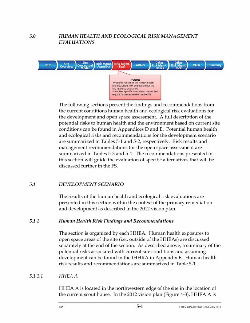
ERM 5-1 CHEVRON/0159841 -JANUARY 2013
5.0 HUMAN HEALTH AND ECOLOGICAL RISK MANAGEMENT EVALUATIONS
The following sections present the findings and recommendations from the current conditions human health and ecological risk evaluations for the development and open space assessment. A full description of the potential risks to human health and the environment based on current site conditions can be found in Appendices D and E. Potential human health and ecological risks and recommendations for the development scenario are summarized in Tables 5-1 and 5-2, respectively. Risk results and management recommendations for the open space assessment are summarized in Tables 5-3 and 5-4. The recommendations presented in this section will guide the evaluation of specific alternatives that will be discussed further in the FS.
5.1 DEVELOPMENT SCENARIO
The results of the human health and ecological risk evaluations are presented in this section within the context of the primary remediation and development as described in the 2012 vision plan.
5.1.1 Human Health Risk Findings and Recommendations
The section is organized by each HHEA. Human health exposures to open space areas of the site (i.e., outside of the HHEAs) are discussed separately at the end of the section. As described above, a summary of the potential risks associated with current site conditions and assuming development can be found in the fHHRA in Appendix E. Human health risk results and recommendations are summarized in Table 5-1.
5.1.1.1 HHEA A
HHEA A is located in the northwestern edge of the site in the location of the current scout house. In the 2012 vision plan (Figure 4-3), HHEA A is
ERM 5-2 CHEVRON/0159841 -JANUARY 2013
defined as an area of possible development, but specifics have yet to be determined. In the fHHRA, it was assumed that this area would contain a default commercial building with overnight lodging and that potential receptors could include: short-term resident adult or child, indoor employee, outdoor employee and intrusive utility worker. Estimated cancer risks based on existing site conditions ranged from 2E-8 to 2E-7 and noncancer hazards range from 0.002 to 0.008 (see Table 5-1). EPCs for lead were below the commercial CHHSL. As the total ILCRs are below the risk management thresholds described in Section 4.3 (1E-6 for short-term residential use and 1E-5 for commercial use), the noncancer hazards are below 1, and lead concentrations are below the commercial CHHSL, no further evaluation of HHEA A is required from a human health perspective in the FS.
5.1.1.2 HHEA C
HHEA B as defined in the 2007 conceptual development plan was incorporated in the revised HHEA C in 2012. HHEA C is a large area located in the western part of the site, near the town of Avila. The 2012 vision plan for HHEA C identifies hotel bungalows and other default commercial buildings with overnight lodging. Receptors evaluated in HHEA C included: bungalow short-term resident adult and child, bungalow indoor employee, outdoor employee, default building short-term resident adult and child, default building indoor employee and intrusive utility worker.
In HHEA C, the cancer risks based on existing site conditions ranged from 5E-8 (intrusive utility workers) to 2E-6 (indoor employees) and all ILCRs were below their applicable thresholds. Noncancer hazards range from 0.006 to 0.04, and the lead soil EPCs did not exceed the commercial CHHSL (Table 5-1). As all risks were below their respective thresholds, no further evaluation in the FS is required from a human health perspective for HHEA C.
5.1.1.3 HHEA D
In HHEA D, the 2012 vision plan envisions part of a wellness center (spa, fitness center, pool) in this area. Receptors evaluated in the fHHRA included: bungalow short-term resident adult and child, bungalow indoor employee, outdoor employee, default building short-term resident adult and child, default building indoor employee and the intrusive utility worker.
ERM 5-3 CHEVRON/0159841 -JANUARY 2013
The cancer risks based on existing site conditions ranged from 9E-8 to 9E-7 and noncancer hazards ranged from 0.02 to 0.4; these values all were below their respective thresholds. In contrast, the EPC for lead for all receptors (maximum concentration) exceeded the commercial CHHSL and the Childhood Lead Prevention Program threshold of 1,000 mg/kg.
An area within HHEA D currently is slated for further action as part of the primary remediation (Figure 4-2). This is the area identified as having metals associated with the refractory glass from the former refinery, which also is the area of elevated lead within HHEA D. Therefore, it is recommended that the FS confirm that the primary remediation will address all of the lead issues within HHEA D through removal of the refractory glass.
5.1.1.4 HHEA E
HHEA E is located in the center of the site. Like HHEA D, the 2012 vision plan locates a portion of the wellness center in this area. Receptors evaluated in HHEA E included: bungalow short-term resident adult and child, bungalow indoor employee, outdoor employee, default building short-term resident adult and child, default building indoor employee and intrusive utility worker.
In HHEA E, the cancer risks based on existing site conditions range from 1E-6 (intrusive utility workers) to 2E-4 (bungalow short-term residents). Risks greater than 1E-6 were driven by benzene in indoor air. The noncancer hazards ranged from 0.08 to 0.8, and the lead soil EPC for the intrusive utility worker (maximum concentration) exceeded the commercial CHHSL. The primary remediation has identified an area within HHEA E where TPH source material near the pump house and loading rack area will be removed. Thus much of the source material driving the potential risks in the area will be removed as part of the primary remediation. Therefore, it is recommended that the FS further evaluate HHEA E and confirm that the primary remediation will address the unacceptable risk issues associated with indoor air and contact with lead in soil within HHEA E. It is also recommended that the FS evaluate potential mitigation by reducing exposure to VOCs in indoor air resulting from subsurface vapor intrusion.
5.1.1.5 HHEA G
Based on the development plan, a community amphitheater (open air) and associated support structures are planned for HHEA G. The fHHRA
ERM 5-4 CHEVRON/0159841 -JANUARY 2013
evaluated commercial exposures in this area, specifically, default building indoor employees, outdoor employees, and intrusive utility workers.
In HHEA G, the cancer risks based on existing site conditions range from 6E-8 to 2E-7 and the noncancer hazards range from 0.02 to 0.09. Lead EPC for all receptors (maximum concentration) does not exceed the commercial CHHSL. As the risks are below thresholds, no further evaluation in the FS is required from a human health perspective for HHEA G.
5.1.1.6 HHEA Ia
HHEA Ia is located in the center of the site and has hotel bungalows and other default commercial buildings with overnight lodging planned. Receptors evaluated included: bungalow short-term resident adult and child, bungalow indoor employee, outdoor employee, default building short-term resident adult and child, default building indoor employee and intrusive utility worker.
In Exposure Area Ia, the cancer risks based on existing site conditions range from 5E-8 to 6E-7 and the noncancer hazards range from 0.004 to 0.04. The lead soil EPC for short-term residents and indoor and outdoor employees was below the commercial CHHSL, while the EPC for the intrusive worker (maximum concentration) exceeds this threshold (Table 5-1).
Based on the health evaluations presented in the fHHRA, and assuming short-term residential and commercial development in HHEA Ia, the only unacceptable risks are to the intrusive utility worker from lead. An area within HHEA Ia currently is slated for further action as part of the primary remediation (Figure 4-2). This is the area identified as having metals associated with the former tank bottoms. Therefore, it is recommended that the FS confirm that the primary remediation will address the lead issues within HHEA Ia through removal of lead impacted soils in the former tank rings.
5.1.1.7 HHEA Ib
HHEA Ib is in the eastern side of the Site. The 2012 vision plan has identified this area with resort back-of-house activities. The fHHRA assumed that there would be hotel bungalows and other default commercial buildings with overnight lodging planned. Human exposure scenarios evaluated included: bungalow short-term resident adult and
ERM 5-5 CHEVRON/0159841 -JANUARY 2013
child, bungalow indoor employee, outdoor employee, default building short-term resident adult and child, default building indoor employee and intrusive utility worker.
In Exposure Area Ib, the cancer risks based on existing site conditions range from 1E-7 to 2E-4 and noncancer hazards range from 0.08 to 0.5. Cancer risks exceed thresholds for receptors spending time indoors (short-term residents and indoor employees), and are driven by inhalation of chloroform in indoor air (Table 5-1). The lead EPC for all receptors (maximum concentration) is below the commercial CHHSL.
The primary remediation proposed in this area will target non-asphaltic petroleum in shallow soils in the southern portion of the HHEA (Figure 4-5). Therefore it is recommended that the FS confirm that the primary remediation will adequately address the unacceptable risk issues associated with indoor air. It is also recommended that the FS evaluate potential mitigation by reducing exposure to VOCs in indoor air resulting from subsurface vapor intrusion.
5.1.1.8 HHEA J
HHEA J is located in the center of the site and is slated for guest rooms in the 2012 vision plan (Figure 4-3). The fHHRA assumed that there would be hotel bungalows and other default commercial buildings with overnight lodging planned. Receptors evaluated included: bungalow short-term resident adult and child, bungalow indoor employee, outdoor employee, default building short-term resident adult and child, default building indoor employee and intrusive utility worker.
In HHEA J, the cancer risks based on existing site conditions ranged from 1E-7 to 2E-4 and noncancer hazards ranged from 0.08 to 0.5 for short-term residents and commercial workers, with the intrusive utility worker noncancer hazard at 0.7. Cancer risks exceed thresholds for receptors spending time indoors, and are driven by the inhalation of chloroform and benzene in indoor air. Lead concentrations are below thresholds, except for the intrusive utility worker.
Primary remediation activities planned in HHEA J include reducing exposure to non-asphaltic petroleum in shallow soils and excavating lead-impacted soils in former tank rings. It is recommended that the FS confirm that the primary remediation will adequately address the unacceptable risk issues associated with indoor air and exposure to lead. It is also recommended that the FS evaluate potential mitigation by

ERM 5-6 CHEVRON/0159841 -JANUARY 2013
reducing exposure to VOCs in indoor air resulting from subsurface vapor intrusion.
5.1.1.9 HHEA K
HHEA K is located on the southern edge of the site, near the point. The 2012 vision plan indicates that this area will contain public areas of the resort, including restaurants and meeting rooms. The fHHRA assumed that there would be default commercial buildings with overnight lodging. Receptors evaluated included: default building short-term resident adult and child, default building indoor employee, outdoor employee, and intrusive utility worker.
In HHEA K, the cancer risks based on existing site conditions range from 2E-8 to 7E-6 with the short-term resident risk above the 1E-6 threshold, but all commercial risks below the 1E-5 threshold. Short-term resident cancer risks are driven by inhalation of chloroform in indoor air. Noncancer hazards range from 0.009 to 0.04. The soil lead EPC for all receptors (maximum concentration) was below the commercial CHHSL.
There is no significant primary remediation planned for HHEA K except for the small area of non-asphaltic TPH found in one area. Because unacceptable risks were identified for short-term residents via inhalation of indoor air, it is recommended that potential mitigation by reducing exposure to VOCs in indoor air resulting from subsurface vapor intrusion in HHEA K be conducted in the FS.
5.1.1.10 HHEA L
HHEA L is located on the southeastern part of the site. The 2012 vision plan has family cottages envisioned in this area. The fHHRA evaluated this HHEA assuming hotel bungalows and other default commercial buildings with overnight lodging planned. Receptors evaluated included: bungalow short-term resident adult and child, bungalow indoor employee, outdoor employee, default building short-term resident adult and child, default building indoor employee and intrusive utility worker.
In HHEA L, the cancer risks based on existing site conditions range from 8E-8 to 4E-7 and noncancer hazards range from 0.01 to 0.5. The lead soil EPC for short-term residents and indoor and outdoor employees was below the commercial CHHSL, while the EPC for the intrusive worker (maximum concentration) exceeds this threshold (Table 5-1).

ERM 5-7 CHEVRON/0159841 -JANUARY 2013
Based on the health evaluations presented in the fHHRA, and assuming short-term residential and commercial development in HHEA L, the only risk above a threshold is to the intrusive utility worker from lead. An area within HHEA L currently is slated for further action as part of the primary remediation (Figure 4-2). This is the area identified as having metals associated with the former tank bottoms. Therefore, it is recommended that the FS confirm that the primary remediation will address the lead issues within HHEA L through removal of lead impacted soils in the former tank rings.
5.1.1.11 HHEA M
HHEA M is located on the northeastern side of the site and is currently identified as being part of the area where a parking lot will be located. In the fHHRA it was assumed that there also might be a default commercial building with overnight lodging in the area. Receptors evaluated included: default building short-term resident adult and child, default building indoor employee, outdoor employee, and intrusive utility worker.
In HHEA M, the cancer risks based on existing site conditions range from 5E-8 to 5E-7 and noncancer hazards range from 0.006 to 0.1. The lead soil EPC for all receptors (maximum concentration) did not exceed the commercial CHHSL. As the risks are below thresholds, no further evaluation in the FS is required from a human health perspective for HHEA M.
5.1.1.12 HHEA N
HHEA N is located on the northeastern side of the site and is currently identified as being part of the area where a parking lot will be located. In the fHHRA it was assumed that there also might be a default commercial building with overnight lodging in the area. Receptors evaluated included: default building short-term resident adult and child, default building indoor employee, outdoor employee, and intrusive utility worker.
In HHEA N, the cancer risks based on existing site conditions range from 3E-8 to 1E-7 and noncancer hazards range from 0.004 to 0.04. The lead soil EPC for all receptors (maximum concentration) did not exceed the commercial CHHSL. As the risks are considered acceptable, no further evaluation in the FS is required from a human health perspective for HHEA N.
ERM 5-8 CHEVRON/0159841 -JANUARY 2013
5.1.1.13 HHEA O
As with HHEAs M and N, HHEA O is located on the northeastern side of the site and is currently identified as being part of the area where a parking lot will be located. In the Addendum, it was assumed that there also might be a default commercial building with overnight lodging in the area. Receptors evaluated included: default building short-term resident adult and child, default building indoor employee, outdoor employee, and intrusive utility worker.
In HHEA O, the cancer risks based on existing site conditions range from 8E-8 to 3E-7 and noncancer hazards range from 0.006 to 0.05. The lead soil EPC for all receptors (maximum concentration) did not exceed the commercial CHHSL. As the risks are below thresholds, no further evaluation in the FS is required from a human health perspective for HHEA O.
5.1.1.14 Development Plan Open Space Exposure Scenario
In the development scenario, human use of areas outside of the HHEAs includes recreational use of the open space (Figure 4-4). In the fHHRA the receptors evaluated included: recreational adult and child and outdoor employee.
In this area, the outdoor employee cancer risk based on existing site conditions is 7E-7, which is below the commercial risk threshold. The recreational user cancer risk is 2E-6. This cancer risk above the 1E-6 threshold is driven by dermal contact with and ingestion of dibenzo(a,h)anthracene in surface soil. Noncancer hazards range from 0.01 to 0.2. The lead soil EPC did not exceed the applicable CHHSLs.
Based on the health evaluation in the fHHRA, the recreational cancer risk exceeds the threshold due to dibenzo(a,h)anthracene found in Open Space immediately adjacent to HHEA. E. The primary remediation has identified an area within HHEA E where TPH source material near the pump house and loading rack area will be removed. Thus the source material driving the potential recreational risk in Open Space could be removed as part of the primary remediation for HHEA E. Therefore, it is recommended that the FS further evaluate Open Space and confirm that the primary remediation will address the unacceptable risk issues associated with dibenzo(a,h)anthracene in soil within Open Space near HHEA E.

ERM 5-9 CHEVRON/0159841 -JANUARY 2013
5.1.1.15 Kitchen and Native Herb Garden
The conceptual development plan identified a kitchen/native herb garden in the open area below HHEA C. Thus an additional human health exposure scenario was evaluated, the cultivation of produce in this area. Health effects were evaluated for outdoor employee exposure to soil in the kitchen/native herb garden and restaurant visitor consumption of produce grown in the garden. Cancer risk based on existing site conditions to outdoor employees exposed to soil in the kitchen/native herb garden is estimated to be 7E-8. The noncancer hazard is 0.01. Cancer risk to restaurant visitors from the consumption of produce grown in kitchen/native herb garden is estimated to be 3E-8, and noncancer hazards are very low, ranging from 0.002 for an adult to 0.005 for a child.
As these risks are below the acceptable thresholds, no further evaluation in the FS is required from a human health perspective for the kitchen/native herb garden.
5.1.1.16 Drainage Area
The drainage area is a swath of land outside of the HHEAs that will be managed as part of the stormwater drainage on the site (Figure 4-4). Receptors evaluated included the outdoor employee and the intrusive utility worker.
In the drainage area, the outdoor employee and intrusive utility worker cancer risks based on existing site conditions are 1E-6 and 2E-7, respectively. The noncancer hazards are 0.06 and 0.2. The lead soil EPC (maximum concentration) did not exceed the commercial CHHSL. Based on the risk findings, no further evaluation is recommended for the open space areas outside of the HHEAs in the FS.
5.1.2 Ecological Risk Findings and Recommendations
For the development scenario, it is assumed that ecological receptors will be exposed to contaminants only in areas of the site that fall outside of HHEAs, as the areas within will be developed and managed and will not provide appropriate habitat for wildlife at the site. Additionally, the primary remediation is likely to change site conditions outside the areas of the HHEAs in such a way that risk drivers currently identified within those areas would no longer be an issue after the primary remediation is completed. To ensure that this assumption is valid, any specific aspects of risk identified within the primary remediation areas but outside the
ERM 5-10 CHEVRON/0159841 -JANUARY 2013
HHEAs will be discussed to ensure that the appropriate issues are recognized and evaluated in the FS. Figure 4-5 illustrates the area where wildlife is assumed to be exposed in the development scenario.
Based on a risk evaluation of current conditions (as described in Appendix D), the following COPECs and receptors were identified as requiring further evaluation in the Pre-FS:
• Soil:
o Non-asphaltic TPH: plants and soil invertebrates;
o Lead: plants, birds and mammals; and
o Hot spot metals (copper, nickel, vanadium and zinc): plants, birds and mammals.
• Sediment:
o Lead: plants, soil invertebrates, birds and mammals.
• Soil Gas:
o Benzene: mammals;
o Chloroform: mammals; and
o Hexane: mammals.
As previously discussed, this report does not include the intertidal zone area, which is still being evaluated. A discussion of potentially unacceptable ecological risks for the development scenario follows by media.
5.1.2.1 Soil
As discussed in Appendix D, potentially unacceptable risks based on current conditions in soil were identified for non-asphaltic TPH, lead and hotspot metals. Assuming that exposure will be reduced when the site is developed due to developed areas associated with the HHEAs and changed conditions through implementation of the primary remediation, potential future ecological risks for each set of COPECs is as follows (Table 5-2).
Non-Asphaltic TPH: Figure 5-1 presents the evaluation of current conditions for non-asphaltic TPH as presented in Appendix D with an overlay of the development plan HHEAs and the primary remediation footprint. As can be seen in Figure 5-1, some samples of asphaltic TPH are

ERM 5-11 CHEVRON/0159841 -JANUARY 2013
outside of the impacted areas in locations where ecological receptors are expected to be found. However, as discussed in Appendix D, asphaltic TPH has limited bioavailability as is not expected to pose unacceptable risk.
All areas of non-asphaltic TPH in shallow soils are within the boundaries of either the HHEAs, where exposure to ecological receptors is expected to be minimal, or in areas outside of HHEAs but within the primary remediation footprint. It is assumed that exposure to ecological receptors is possible after development in the areas outside of the HHEAs; therefore, it is recommended that the FS confirm that the primary remediation will address the non-asphaltic TPH in the areas outside of the HHEAs, mainly in the cliff area.
Lead: As discussed in Appendix D, elevated lead concentrations are generally found associated with former tank rings at the site. As can be seen in Figure 5-2, all locations with elevated lead concentrations posing a potential risk to ecological receptors (plants, birds and mammals) are within the HHEAs. Therefore, exposure to ecological receptors under the development scenario is expected to be minimal, and no further action in the FS is recommended (Table 5-2).
Hot Spot Metals: Elevated concentrations of copper, nickel, vanadium and zinc are commonly co-located at the site and are termed “hot spot metals” as they are found in association with the area of refractory glass on the northern side of the site. These concentrations were identified as posing potential risk to plants, birds and mammals under current conditions (Appendix D). As can be seen in Figure 5-3, these locations are within the primary remediation area, or within HHEA D. As it is assumed that exposure to ecological receptors is possible after development in the areas outside of the HHEAs but contained within the primary remediation, it is recommended that the FS confirm that the primary remediation will address the hot spot metals associated with the refractory glass in the area above HHEA D (Table 5-2).
5.1.2.2 Wetland Sediment
As discussed in Appendix D, potentially unacceptable risks based on conditions in wetlands currently identified onsite were evaluated. Only exposure to lead was identified as requiring further evaluation in the Pre-FS. Figure 5-4 presents the locations where elevated lead was identified in current wetland sediments. As can be seen, all of these locations are within the HHEAs. Therefore, exposure to ecological receptors under the
ERM 5-12 CHEVRON/0159841 -JANUARY 2013
development scenario is expected to be minimal, and no further action in the FS is recommended (Table 5-2).
5.1.2.3 Soil Gas
Exposure to burrowing mammals to VOCs in soil gas was evaluated in Appendix D. Benzene, chloroform, and hexane were identified as COPECs in soil gas. As can be seen in Figure 5-5, areas with elevated VOCs in soil gas are within the development footprint at the site and also with the primary remediation areas. Due to this, exposure to ecological receptors under the development scenario is expected to be minimal, and no further action in the FS is recommended (Table 5-2).
5.2 OPEN SPACE ASSESSMENT
For the open space assessment, it is assumed that the area outside of the primary remediation footprint will be consistent with current conditions, but the area within the remediation footprint will be changed in such a way that concentrations will decrease or exposure will be reduced (Figure 4-2). Future land use for the open space assessment is assumed to not include any commercial development. This assessment can be used in conjunction with the findings of the development scenario to identify potential risks in specific areas if the development plan changes. Specific exposure assumptions and the evaluation of potential risk for human and ecological receptors are discussed below.
5.2.1 Human Health Risk Findings and Recommendations
In the open space assessment, the sHHRA and Addendum (Appendix E) assumed that the future land use if the site is not developed would include recreational use of the site; thus, it re-evaluated potential health risks for offsite residential receptors and onsite recreational users, in case no development occurs. It is important to note that under this setting, while the primary remediation still would be conducted, the quantitative risk estimates presented below are based on current conditions at the site.
As presented in Table 5-3, in the open space assessment the offsite resident risk is 9E-07 and the child noncancer hazard is 0.02. The site-wide recreational user cancer risk is 8E-7 when exposure to soil up to 10 feet bgs is assumed. The recreational user cancer risk is 4E-7 based on the more likely soil exposure horizon of 0 to 2 feet bgs. The recreational user noncancer hazards for the child range from 0.2 (0 to 2 feet bgs) to 0.9 (0 to

ERM 5-13 CHEVRON/0159841 -JANUARY 2013
10 feet bgs). The lead soil EPC did not exceed the residential CHSSL. As the risks are below thresholds, no further evaluation in the FS is required from a human health perspective for the open space assessment.
5.2.2 Ecological Risk Findings and Recommendations
As described above, for the open space assessment it is assumed that the area outside of the primary remediation footprint will be consistent with current conditions, but the area within the remediation footprint will be changed in such a way that concentrations will decrease, or exposure will be reduced. Thus the current risks identified in Appendix D will be evaluated within the context of the primary remediation (Figure 4-2), and exposure of ecological receptors to contaminants at the site will be assumed to occur outside the areas of the remediation footprint. To ensure that the primary remediation is adequately protective, any specific aspects of ecological risk identified within the primary remediation areas will be discussed to ensure that the appropriate issues are recognized and evaluated in the FS.
As described in Section 5.1.2, COPECs identified in Appendix D as requiring further evaluation in the Pre-FS for soil (non-asphaltic TPH, lead and hot spot metals), wetland sediment (lead) and soil gas (benzene, chloroform and hexane) will be discussed further below and summarized in Table 5-4.
5.2.2.1 Soil
Non-Asphaltic TPH: Figure 5-6 presents the evaluation of current conditions for non-asphaltic TPH as presented in Appendix D, with an overlay of the primary remediation areas. As can be seen in Figure 5-6, all areas of non-asphaltic TPH in shallow soils are within the primary remediation areas. While it is assumed that the primary remediation will mitigate exposure to ecological receptors, it is recommended that the FS confirm that the alternatives evaluated for the primary remediation adequately mitigate exposure to non-asphaltic TPH to ecological receptors.
Lead: As discussed in Appendix D, elevated lead concentrations are generally found associated with former tank rings at the site. As can be seen in Figure 5-7, all locations with elevated lead concentrations posing a potential risk to ecological receptors (plants, birds and mammals) are within the primary remediation footprint. Therefore, it is recommended that the FS confirm that the alternatives evaluated for the primary
ERM 5-14 CHEVRON/0159841 -JANUARY 2013
remediation adequately mitigate exposure to ecological receptors where lead is elevated (Table 5-4).
Hot Spot Metals: Elevated concentrations of hot spot metals are within the primary remediation area, with the exception of one location to the south (S-8) (Figure 5-8). It is likely that the detected concentrations in this location are also associated with refractory glass, as it is in close proximity to the refractory glass remediation area. Therefore, it is recommended that the FS confirm that the primary remediation will adequately address the hot spot metals associated with the refractory glass in this area (Table 5-4).
5.2.2.2 Wetland Sediment
As discussed in Appendix D, only exposure to lead in wetland sediments for plants, sediment invertebrates, birds and mammals was identified as a COPEC requiring further evaluation in the Pre-FS. Figure 5-9 presents the locations where elevated lead was identified in current wetland sediments. As can be seen, all of these locations are within the primary remediation footprint. Therefore, it is recommended that the FS confirm that the primary remediation will adequately address the lead associated with the wetlands (Table 5-4).
5.2.2.3 Soil Gas
Exposure to burrowing mammals to VOCs (benzene, chloroform, and hexane) in soil gas was evaluated in Appendix D. As can be seen in Figure 5-10, areas with elevated VOCs in soil gas are within the primary remediation areas. Due to this, exposure to ecological receptors is expected to be minimal. Therefore, it is recommended that the FS confirm that the primary remediation will adequately address the soil gas concerns (Table 5-4).

ERM 6-1 CHEVRON/0159841 -JANUARY 2013
6.0 PRELIMINARY DEVELOPMENT AND SELECTION OF APPLICABLE OR RELEVANT REGULATORYAND APPROPRIATE REQUIREMENTS
The following section presents an overview of the ARARs. Identification of ARARs is a site-specific determination involving a two-part analysis: first, a determination of whether a given requirement is applicable; then if it is not applicable, whether it is relevant and appropriate.
Applicable requirements are those cleanup standards, standards of control, and other substantive environmental protection requirements, criteria, or limitations promulgated under federal or state law that specifically address the situation at a CERCLA site. The requirement is applicable if the jurisdictional prerequisites of the standard show a direct correspondence when objectively compared to the conditions at the site. If the requirement is not legally applicable, then the requirement is evaluated to determine whether it is relevant and appropriate.
Relevant and appropriate requirements are those cleanup standards, standards of control, and other substantive environmental protection requirements, criteria, or limitations promulgated under federal or state law that, while not applicable, address problems or situations sufficiently similar to the circumstances of the proposed response action and are well suited to the conditions of the site (USEPA 1988).
A requirement must be substantive in order to constitute an ARAR for activities conducted onsite. Procedural or administrative requirements such as permits and reporting requirements are not ARARs.
In addition to ARARs, the National Contingency Plan (NCP) provides that where ARARs do not exist, agency advisories, criteria, or guidance are "to-be-considered" (TBC) useful "in helping to determine what is protective at a site or how to carry out certain actions or requirements" (55 Federal Register 8745). The NCP preamble states, however, that provisions in the TBC category "should not be required as cleanup standards because they

ERM 6-2 CHEVRON/0159841 -JANUARY 2013
are, by definition, generally neither promulgated nor enforceable, so they do not have the same status under CERCLA as do ARARs."
Requirements of ARARs and TBCs are generally divided into three categories as follows:
1. Chemical-Specific – Health- or risk-based numerical values or methodologies, which are used to develop site-specific numeric limits for the amount of a particular contaminant that may be left in or discharged to the environment.
2. Performance-, Design-, or Action-Specific – Technology- or action-based requirements or limitation on actions taken with respect to a hazardous waste.
3. Location-Specific - Restrictions placed on the concentration of a hazardous substance or the conduct of activities solely because they occur in special locations (e.g., wetland).
The protectiveness of a remedial action is typically gauged against how effectively it meets ARARs through various types of evaluation. ARARs must be attained for constituents of concern that remain onsite at the completion of the remedial action, but it has been USEPA’s policy that implementation of remedial action also comply with ARARs to protect public health and the environment.
A preliminary list of the chemical, action and location-specific ARARs are presented in Tables 6-1 through 6-6. These preliminary ARARs will be further evaluated and refined in the FS.
ERM 7-1 CHEVRON/0159841 -JANUARY 2013
7.0 OTHER RISK MANAGEMENT CONCERNS
While the identification of human health and ecological risks requiring further evaluation are a significant component of the FS, other issues also require further evaluation and may reflect the ARARs described in Section 6.0 and Tables 6-1 through 6-6. These issues include water quality at the site, the presence of methane in soil gas, the presence of asphaltic material in surface soils, and the potential for coastal erosion. The following sections provide an overview of these issues and recommendations for the FS and are also summarized in Table 7-1.
7.1 WATER QUALITY
The main water quality issues that require further evaluation in the FS include the LNAPL on groundwater, the cliff area, and surface water hydrology and stormwater management. These are discussed more fully below.
7.1.1 LNAPL on Groundwater
In general, remedial actions related to water quality are not expected to be driven by human health or ecological risks. Previous work approved by the regulatory agencies has shown that groundwater, in general, is not a significant transport mechanism for site contaminants, and is therefore an unlikely exposure route for human or ecological receptors. The one exception may be the cliff area and the intertidal zone (see Section 7.1.2).
As described in Sections 2.0 and 3.0, groundwater at the site has been impacted by past industrial activities. The predominant contaminant is dissolved TPH, although other constituents include BTEX (from gasoline and diesel products that were shipped into the site for distribution throughout the Central Coast), VOCs and metals. Groundwater impacts are widely distributed across the site and are associated with storage and transmission infrastructure of the facility. TPH also occurs as LNAPL. Figure 3-3 shows the locations of wells that have had observations of

ERM 7-2 CHEVRON/0159841 -JANUARY 2013
LNAPL during monitoring. Groundwater monitoring began in 1997 and has continued uninterrupted to the present day. The RWQCB has jurisdiction over groundwater issues at the site, and mandates the frequency of monitoring and selection of sample analyses through a voluntary monitoring and reporting program that was submitted 10 February 2005 and was approved on 8 March 2005.
Because of the conditions at the site, it is recognized that SWRCB Resolution No. 92-49 may be applicable. SWRCB Resolution No. 92-49 recognizes that, in some cases, attainment of water quality objectives cannot reasonably be achieved and allows establishment of a containment zone within which removal of the pollutant mass to the extent practicable may be required. Resolution 92-49 is relevant to evaluating appropriate remedial technologies. The resolution provides guidance on investigation, cleanup, and abatement activities. In particular, it provides direction on appropriate cleanup levels, allowable non-background water quality objectives (CCR Title 2 §2550.4) and institutional controls such as containment zones. It is recommended that management of groundwater quality issues be addressed in the FS.
7.1.2 Cliff Area
The one area of the site where the RTP was unable to reach a definitive conclusion concerning the potential for dissolved chemical migration was across the cliff face on the southwest edge of the site. Because of this, the RTP recommended additional monitoring; this was ongoing until 2010 due to a rock fall, but was reinitiated in 2012. Although TPH, and on rare occasions PAHs, have been detected in samples from the cliff springs, the source of these constituents is unclear (petroleum or biological material).
Sheen was discovered in a small tide pool below the cliff area in May 2012. Additionally, ATCAT members noted “gasoline” type odors at a specific location near the cliff during this Site visit. Analysis of water collected from the tidal pool where the sheen was observed indicated the presence of VOCs, including BTEX, naphthalene, and gasoline-range total petroleum hydrocarbons. Additional water and sediment samples have been collected and ambient air monitoring is ongoing.
The source(s) of the sheen and odor has not yet been identified. However, the types and proportions of VOCs detected in the 8 May 2012 tidal sample appear to be similar to impacts detected in groundwater collected from groundwater monitoring wells B-230 and B-231, located at the top of the cliff at the Avila Tank Farm in an area where tank 201104 was
ERM 7-3 CHEVRON/0159841 -JANUARY 2013
historically located. Additional water and sediment monitoring is being conducted in the tidal area to better characterize the frequency that constituents are detected and the size of the area impacted (Padre 2012a and d).
Since May 2012, water (either surface water from tidal pools when the bedrock is exposed, or interstitial water when the bedrock is covered by sand), sediment and air have been sampled during minus tide events. To aid in the interpretation of these monitoring data, the ATCAT has requested the development of thresholds that can be used to easily and quickly screen the monitoring data from the intertidal area so that, if detected concentrations exceed conservative thresholds, the agencies will be notified. Chevron is currently finalizing these notification thresholds.
Besides the monitoring in the intertidal area, an Interim Remedial Action Plan (Avocet 2013) has been approved and Chevron is currently implementing this plan to remove mass, potentially control vapor migration, and evaluate the potential remedial options for the possible source area on the cliff above the intertidal area. This evaluation of potential remedial options is ongoing and is not dependent on the outcome of the intertidal monitoring. This information, along with the newly collected site characterization data on the cliff area, will be used to identify potential remedial actions that will be discussed in the FS4.
7.1.3 Surface Water Hydrology and Stormwater
Stormwater at the site currently meets all permit requirements. However, while remedial actions related to water quality may not be required from a human health or ecological perspective, there may be regulatory requirements that need to be addressed in the FS.
As described in the “Results of Wetland Surface Water and Sediment Sampling” by Avocet (2005), surface water at the Avila Tank Farm is a seasonal condition and the upper and lower drainage basins, which are the storage units for the stormwater system, are managed to maintain capacity to temporarily retain water from storm events. The water in the basins is tested before it is released to the ocean pursuant to a RWQCB stormwater permit. The water in the basins is tested and released as soon
4 Depending on timing, an evaluation of remedial alternatives for the cliff area will either
be integrated into the FS for the site or into its own FS.
ERM 7-4 CHEVRON/0159841 -JANUARY 2013
as possible following a storm event to ensure that sufficient capacity is available for future events. In general, the drainage basins (e.g., upper and lower) begin to fill in late November or December in response to seasonal precipitation, begin to dry up in March, and are completely dry by May or June.
Currently stormwater at the site meets permit requirements. However, if site conditions were to change, stormwater would need to be addressed to confirm that contaminants entrained in soils are not running offsite. Additional concerns have also been raised that: (1) retention of water in the interior of the site should be avoided to prevent a change in the site hydrology, and (2) that surface flow over the side of the cliff should be avoided to mitigate cliff erosion. For these reasons, it is recommended that surface water hydrology and stormwater management be evaluated in the FS.
7.2 METHANE
Methane has been detected in soil gas at the site, but was not identified as a risk driver in the risk assessments because methane is practically inert and has no demonstrated physiological or toxicological effects. The major hazards associated with methane are: (1) at very high concentrations it can act as an asphyxiant by causing oxygen deprivation, and (2) at lower concentrations it presents an explosion hazard. Both the fHHRA and the updated ecological screening evaluation assessed potential risks from methane based on current conditions (see Appendices D and E). Asphyxiation due to oxygen deprivation is only relevant to burrowing mammals and based on evaluations in the ecological risk screen (see Appendix D) was not found to be a relevant concern at the site. Therefore, based on the risk evaluations, the explosion hazard was identified as the main driver.
The risks from methane are best evaluated using the LEL as an action level. A LEL represents a vapor mix proportion that, when exceeded, presents a possible combustion hazard. Therefore, the LEL concept only applies to enclosed structures where soil gas can accumulate. Soil vapor in open space (no enclosed structures) that exceeds the LEL is only relevant if there is an expectation that enclosed structures will be built in the future in the general proximity of the LEL exceedance. To evaluate this concern, in each exposure area where methane was detected in soil gas, the exposure was evaluated by comparing the maximum concentration detected at 5 or 15 feet bgs to the LEL of 5 percent.
ERM 7-5 CHEVRON/0159841 -JANUARY 2013
Additionally, Figure 3-5 was used to identify locations where modeled methane isopleths predict an exceedance of the LEL.
Methane in soil gas exceeded the LEL of 5 percent in HHEAs D (at 15 ft) and E (at 5 ft). Additionally, HHEAs C, G and J are predicted to have methane concentrations above the LEL based on the modeled isopleths in Figure 3-5. The Pre-FS recommendation is that management alternatives for methane in soil gas in areas where closed structures are planned be evaluated further in the FS.
7.3 ASPHALT
During the operation of the Tank Farm, slopes surrounding the operations areas were sprayed with oil to control weeds and erosion. Asphaltic TPH was identified in samples throughout the site. This solid, asphaltic material has degraded in some areas, while in other areas it may still be intact and may present a barrier to plant growth. It is recommended that the condition and extent of asphalt in ecological habitat areas be evaluated and, if areas of asphalt outside of the development areas are posing a barrier to plant growth, the extent of asphalt should be confirmed and the asphaltic barrier removed or broken up. This will be discussed further in the FS.
7.4 COASTAL EROSION
A geotechnical evaluation has been conducted to support the development plan (URS 2008). The evaluation assessed current geological conditions at the site (including historic landslides, faults, and the potential for coastal erosion) within the context of the proposed development. Based on the results of this preliminary evaluation, it was noted that significant coastal erosion along the western bluffs of the site could potentially reach areas with subsurface petroleum within 75 years and a development set-back line was recommended (Figure 2-2). While this preliminary evaluation is very conservative, this evaluation is currently being updated to incorporate new information, including potential impacts from sea level rise, and refine the erosion potential to support remediation planning. The potential for TPH in soils or impacted groundwater in this area to be eroded onto the beach and potentially into the ocean should be evaluated further in the FS. This evaluation of coastal erosion will be independent of the on-going cliff area groundwater

ERM 7-6 CHEVRON/0159841 -JANUARY 2013
remediation planning efforts currently underway. These activities are planned for a separate FS.
ERM 8-1 CHEVRON/0159841 -JANUARY 2013
8.0 RISK MANAGEMENT TOOLS
The objective of this section is to present tools that can be used to manage potential risks in the future as areas are remediated for development. Based on the evaluations presented in Sections 5.0, 6.0 and 7.0, it was concluded that three types of risk management tools would be useful: (1) the development of risk-based protective concentrations that can be used to confirm that agency approved protectiveness were achieved by remedial actions, (2) the development of action levels that could trigger a potential action based on monitoring results of the cliff springs, and (3) the development of notification levels for the intertidal zone sampling.
8.1 DEVELOPMENT OF HUMAN HEALTH RISK-BASED SOIL CONCENTRATIONS
As discussed in Section 4.0, while there are no regulatory cleanup levels for the form of non-asphaltic TPH found at the site, Chevron is using a threshold value of 1,000 mg/kg for non-asphaltic TPH in the primary remediation to identify locations where exposure will be reduced by a minimum of 4 feet of separation between the soil surface and non-asphaltic TPH impacted soils as a business measure to limit future property issues at the site and not based on a human health standard. However, due to the extensive spatial coverage of TPH contamination in site soil, risk-based concentrations (RBCs) in soil protective of human health may be useful risk management tools for the FS. RBCs may be useful for defining the extent of an area already identified as requiring some type of mitigation, or for deciding if new areas require mitigation if unexpected conditions are encountered during development. To this end, RBCs protective of human health at the site based on exposure to non-asphaltic TPH in soil were developed.
ERM 8-2 CHEVRON/0159841 -JANUARY 2013
Although the Cal/EPA interim guidance, “Evaluating Human Health Risk from Total Petroleum Hydrocarbons” (Cal/EPA 2009)5 has been rescinded and focused on forward risk evaluations, it can be used to derive risk-based remediation goals for non-asphaltic TPH. This guidance follows a process widely used over the last decade to evaluate TPH, specifically that described by the Total Petroleum Hydrocarbon Criteria Working Group (TPHCWG 1999). Consistent with both the Cal/EPA and TPHCWG, the RBC for TPH is based on the noncarcinogenic health effects of the mixture. Potentially carcinogenic compounds in TPH (e.g., benzene, naphthalene, and polycyclic aromatic hydrocarbons) were addressed via separate evaluations in the fHHRA (Appendix E).
The noncancer-based RBCs were calculated using a target HQ equal to 1.0, which is the point of departure for the USEPA. While the relative site-specific concentrations of each carbon range can be used to derive a weighted total TPH clean-up goal, determining the hydrocarbon fractions in a specific location might require additional sampling and analysis. Although non-asphaltic TPH in soil at the site is dominated by higher molecular weight hydrocarbons (Appendix C), TPH in the C4-C10 range has been detected; therefore, the RBCs derived here consider that lower molecular petroleum hydrocarbons may be present. With respect to the aliphatic and aromatic fractions, Cal/EPA guidance recommends assuming a 50:50 split for sites where no site-specific information is available (Cal/EPA 2009). As demonstrated in the 2005 Baseline HHRA, the median fraction percentages for non-asphaltic TPH at the site are 26 percent aliphatic and 15 percent aromatic (McDaniel Lambert 2005). These values were used to calculate risks associated with exposure to TPH in soil in both the Baseline HHRA and the fHHRA, as well as the development of these RBCs. The remaining portion of petroleum hydrocarbons in soil is either asphaltene or nitrogen, sulfur, and oxygen compounds, and was not evaluated in the risk assessments, as these fractions are not typically considered major drivers for human risk.
The following equation was used to calculate receptor-specific soil RBCs for non-asphaltic TPH:
RBC = HI/((%ar*[(IFo/RfDo)+(IFd/RfDo)+(IFi/RfDi)])+(%al*[(IFo/RfDo) +(IFd/RfDo)+(IFi/RfDi)]))
5 Although this guidance document has been rescinded, the basic methodology was
deemed sound and was used for this site.
ERM 8-3 CHEVRON/0159841 -JANUARY 2013
where:
RBC = risk-based soil concentration (mg/kg soil)
HI = target hazard index (1.0)
%ar = aromatic contribution (as a ratio)
%al = aliphatic contribution (as a ratio)
IFo = oral intake factor
IFd = dermal intake factor
IFi = inhalation intake factor
RfDo = fraction-specific oral reference dose
RfDi = fraction-specific inhalation reference dose
Intake factors for the oral, dermal, and inhalation routes of exposure are the same as those used in the fHHRA. In the fHHRA, the soil ingestion intake factors for short-term residents include a site-specific assumption regarding the fraction of soil ingested from the contaminated source (FI). While the agencies agreed to this site-specific adjustment for the residential exposure scenarios specific to the development plan, the RBCs should be protective of default exposure assumptions. Therefore, the short-term resident oral intake factors have been revised to include an FI of one, as shown in Table 8-1.
Carbon range- and fraction-specific toxicity factors recommended by Cal/EPA (2009) are shown in Table 8-2. In order to be conservative, the lowest value of the three carbon ranges was selected as the representative aliphatic and aromatic oral or inhalation toxicity factor. The RBCs for potential future receptors are shown in Table 8-3.
8.2 DEVELOPMENT OF CLIFF SPRINGS ACTION LEVELS
Monitoring of the cliff springs was recommended by the RTP to ensure that there was not migration off on the southwestern edge of the site. Due to this potential, ongoing monitoring of the cliff springs is required. Action levels have been developed as a risk management tool for both human and ecological receptors that can be used to interpret monitoring data and to identify when monitoring results need to be evaluated further. A detailed discussion of the cliff spring action levels can be found in Appendix F. Restrictive covenants will be recorded on land deeds to
ERM 8-4 CHEVRON/0159841 -JANUARY 2013
ensure groundwater will not be utilized in the future. Chevron will work with the RWQCB to identify the areas where covenants are required.
8.3 DEVELOPMENT OF NOTIFICATION THRESHOLDS FOR THE INTERTIDAL AREA
Notification thresholds have been developed that will be used to screen the water, sediment and air monitoring data being collected since May 2012 in the intertidal area located south of former Tank 201104. The purpose of the thresholds will be to notify the agencies in the event that an exceedance of the notification thresholds has occurred. Notification thresholds were developed for the organic compounds detected in surface water, sediment or air in the intertidal area, or in groundwater from the cliff area monitoring wells B-230 and B-231. Lead was also included. Appendix L presents the Notification Plan Memorandum that includes an overview of the methodology and process, and the notification thresholds developed.
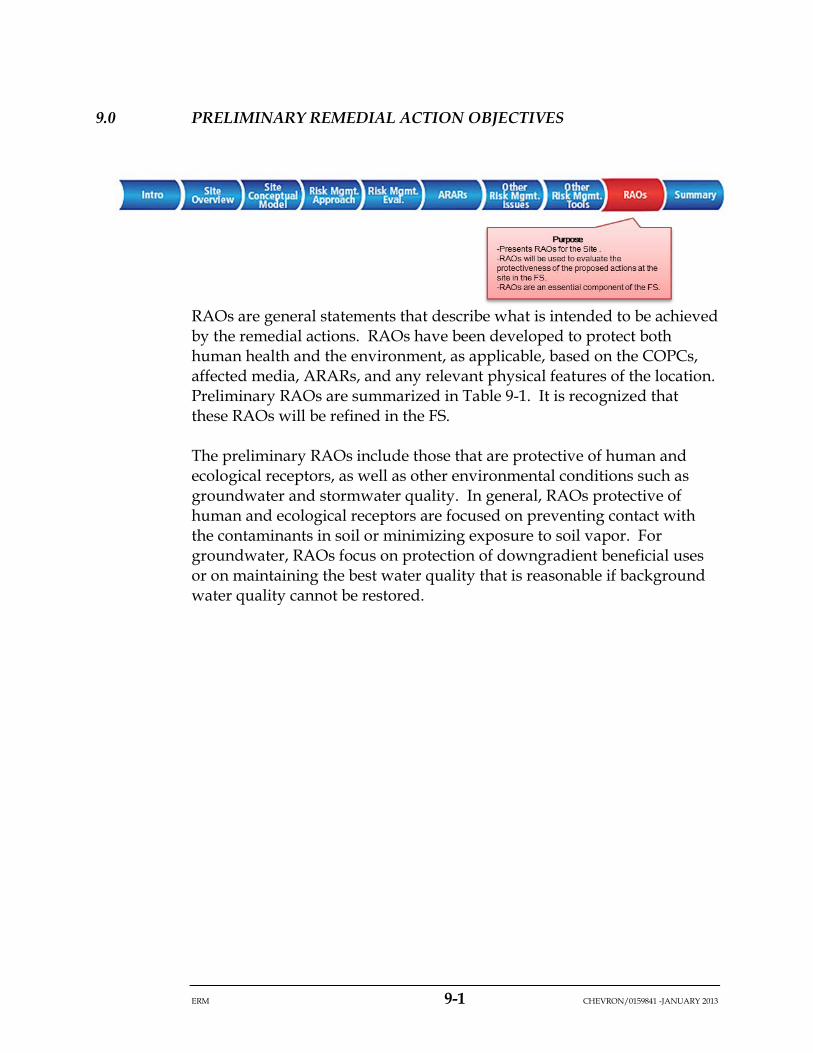
ERM 9-1 CHEVRON/0159841 -JANUARY 2013
9.0 PRELIMINARY REMEDIAL ACTION OBJECTIVES
RAOs are general statements that describe what is intended to be achieved by the remedial actions. RAOs have been developed to protect both human health and the environment, as applicable, based on the COPCs, affected media, ARARs, and any relevant physical features of the location. Preliminary RAOs are summarized in Table 9-1. It is recognized that these RAOs will be refined in the FS.
The preliminary RAOs include those that are protective of human and ecological receptors, as well as other environmental conditions such as groundwater and stormwater quality. In general, RAOs protective of human and ecological receptors are focused on preventing contact with the contaminants in soil or minimizing exposure to soil vapor. For groundwater, RAOs focus on protection of downgradient beneficial uses or on maintaining the best water quality that is reasonable if background water quality cannot be restored.

ERM 10-1 CHEVRON/0159841 -JANUARY 2013
10.0 RISK MANAGEMENT SUMMARY
This section summarizes the risk management recommendations for the Avila Tank Farm Site. These recommendations identify issues requiring further evaluation in the FS to address potential human health and ecological risks, and other resource issues, within the context of a multi-use development at the site. The issues will be summarized broadly here, as it is recognized that there are nuances which are discussed in detail in Section 5.0.
In general, three classes of risk drivers requiring further evaluation in the FS were identified. Some of these risk drivers will be addressed in the primary remediation; however, for completeness, they will all be presented here. Risk management recommendations are intentionally designed to be general in scope to provide maximum flexibility in the FS. However, a list of potential remedial measures is presented below to provide examples of possible remedial action alternatives that could be used to address site issues. This is by no means an exhaustive list of remedial options, nor is it designed to limit options proposed in the FS. Rather it is a list of examples to provide context to the general recommendations. The risk drivers, the recommendations and potential options that could be evaluated further in the FS are discussed below and a summary of the potential recommendations is presented in Figure 10-1. These recommendations address the Development Scenario.
10.1 SOILS
Potential risk issues, both human health and ecological, in soils include:
• Lead-impacted soils and sediments in tank rings in HHEAs E, Ia, J, and L.
• Metals, including lead in refractory glass, in HHEA D and adjacent area.
ERM 10-2 CHEVRON/0159841 -JANUARY 2013
• Mitigate exposure to non-asphaltic TPH greater than 1,000 mg/kg between 0 and 4 feet bgs). It is recommended that the FS evaluate the options that are available for reducing exposure and ensuring that at least 4 feet of separation will exist between receptors and the contaminated soil.
• Address impacted soil along the cliff area6.
Remedial options could include:
• An engineered cap, or addition of fill to break the exposure pathway;
• Excavation or scraping and offsite disposal of contaminated soil or sediment could be conducted.
10.2 INDOOR AIR IMPACTED BY VOCS IN SOIL VAPOR
A number of HHEAs (E, Ib, J, and K) were identified as having potentially impacted soil gas from VOCs which could present a human health risk from vapor inhalation.
It is recommended that if VOCs in soil gas pose a potentially unacceptable indoor air risk to human receptors in development areas, then potential mitigation by reducing exposure to VOCs in indoor air resulting from subsurface vapor intrusion should be evaluated in the FS.
Prior to implementing remedial actions to mitigate soil gas exposure in indoor air, additional sampling may be useful to confirm risk in specific locations where structures will be erected, or additional modeling may be needed if the shape of structures change from that which is described in the current development plan. This will result in better delineation of areas with potentially unacceptable risks and confirm the need for mitigation. If mitigation is required remedial options could include:
• Soil vapor extraction to lower soil gas VOC concentrations; and/or
• Vapor intrusion engineering controls.
6 It is recognized that activities associated with the cliff area near the historical location of Tank 201104 are ongoing and that depending on timing, an evaluation of remedial alternatives for the cliff area will either be integrated into the current FS for the site or into its own FS.

ERM 10-3 CHEVRON/0159841 -JANUARY 2013
10.3 WATER QUALITY
The following water quality concerns have been identified and will be discussed in more detail in the FS:
• Containment of contaminated groundwater on the southwest side of the site7;
• LNAPL on groundwater; and
• Stormwater management.
10.4 METHANE IN SOIL
There are a few locations on the site where methane in soil gas are measured or expected to be above the LEL (specifically in HHEAs C, D E, G and J) and could represent a combustion hazard if methane were to collect in an enclosed structure. It is recommended that management alternatives for the control of methane be evaluated in the FS.
10.5 ASPHALT
It is recommended that the condition and extent of asphalt in ecological habitat areas be evaluated after development. If habitat areas outside of developed areas have asphalt that poses a barrier to plant growth, the extent of asphalt should be confirmed and the asphaltic barrier removed or broken up. Options that could be evaluated further might include:
• Asphalt could be broken up and left in place; or
• Asphalt could be broken up, removed and disposed of offsite.
10.6 SEA CLIFF EROSION
The potential for sea cliff erosion was identified as a resource issue at the Avila Tank Farm. A study is currently in progress that will better define the erosion potential along the sea cliff. It is recommended that the
7 Depending on timing, an evaluation of remedial alternatives for the cliff area will either be integrated into the current FS for the site or into its own FS.
ERM 10-4 CHEVRON/0159841 -JANUARY 2013
findings of the new study and the potential impact to soil contamination along the entire shoreline of the site be further evaluated and discussed in the FS.
10.7 SUMMARY
The objective of the Pre-FS is to provide risk management recommendations that support a proposed future use of the site. These recommendations identify conditions that, without remediation, would result in unacceptable risks to receptors, non-compliance with regulation or statute, or an unacceptable condition relative to Chevron’s goal of mitigating potential impacts associated with legacy operations, and that consequently will be addressed in the FS.
The Pre-FS covers many of the topics that are generally included in the first sections of an FS. By addressing these issues in a preparatory document, the ATCAT can confirm that the FS is focused on the appropriate remedial drivers.
An overview of the site setting, investigation history and site conceptual model are included in the Pre-FS to provide context to the proposed risk management recommendations. Issues to be evaluated further in the FS are discussed within the context of the proposed primary remediation and development scenario. Within the context of the proposed development scenario, an assessment of open space was also conducted to provide maximum flexibility in the FS and in the event that all or part of the future development presented in the vision concept does not occur at the site. In the primary remediation, Chevron has identified a basic set of remediation actions that they would intend to perform at the site whether or not development occurs. These would be specific voluntary actions, subject to approval of the agencies that would mitigate potential impacts associated with legacy operations at the site.
Risk issues requiring further evaluation in the FS included lead, localized hotspot metals and TPH in soils as well as VOCs in indoor air (infiltration by soil vapor). Other site issues included water quality concerns, methane concentrations in soil gas, sprayed asphalt presenting a barrier to plant growth, and the potential for sea cliff erosion. A preliminary identification of ARARs and RAOs also was conducted, recognizing that they will be further refined within the FS.
ERM 10-5 CHEVRON/0159841 -JANUARY 2013
The findings and recommendations presented in the Pre-FS are intentionally left broad in scope, so that they may easily transition into an evaluation of remedial alternatives in the FS. The FS will then define the best remedial action to address the issues identified here. This could be achieved using any number of engineering or institutional remedial options. However, should the development plan be altered such that development footprints change significantly in either land use or in geographic extent, then additional evaluations may be warranted to address the changes in potential risk or risk management recommendations that might arise as a result.
ERM 11-1 CHEVRON/0159841 -JANUARY 2013
11.0 REFERENCES
Applied Geochemical Strategies. 2004. Characterization of TPH Containing Soils and Asphalt from Unocal’s Former Avila Tank Farm, Version 2.0. 8 October 2004.
ARCADIS BBL. 2007. Addendum to the Predictive Ecological Risk Assessment, an Assessment of On-site Wetlands, UNOCAL Avila Tank Farm, San Luis Obispo County, California. Prepared for Chevron Corporation. November.
Avocet Environmental, Inc. (Avocet). 2004. Results of Wetland Surface Water and Sediment Sampling, Unocal Avila Tank Farm, Avila Beach, California. Draft report dated 10 May 2004.
Avocet. 2005. Additional Shallow Soil Characterization in Support of Risk Assessment, Unocal Avila Tank Farm, Avila Beach, California. Draft report dated April 2005.
Avocet. 2008a. Additional Soil Sampling and Evaluation of the TPH Profile in Shallow Soil, Former Unocal Avila Tank Farm, Avila Beach, California. Draft report dated 7 March 2008.
Avocet. 2008b. Soil Gas Investigation Report, Former Unocal Avila Tank Farm, 10 Rafael Street, Avila Beach, California. 21 August 2008.
Avocet. 2012. Site Conceptual Model. Final April 2013.
Avocet Environmental, Inc. and Blasland, Bouck & Lee. (BBL) 2004. Analysis of Background. Unocal Avila Tank Farm, Avila Beach, California. September.
BBL. 2004. Predictive Ecological Risk Assessment, Unocal Avila Tank Farm, San Luis Obispo County, California. Prepared for Union Oil Company of California Corporation. December.
California Environmental Protection Agency (Cal/EPA). 2005a. Guidance for the Evaluation and Mitigation of Subsurface Vapor Intrusion to Indoor Air. Interim Final. California Department of Toxic Substances Control (DTSC). February.

ERM 11-2 CHEVRON/0159841 -JANUARY 2013
Cal/EPA. 2005b. Human-Exposure-Based Screening Numbers Developed to Aid Estimation of Cleanup Costs for Contaminated Soil. External Review Draft. Office of Environmental Health Hazard Assessment. January.
Cal/EPA. 2009. Revised California Human Health Screening Levels for Lead. September 2009.
Cal/EPA. 2011. Guidance for the Evaluation and Mitigation of Subsurface Vapor Intrusion to Indoor Air. Final. California Department of Toxic Substances Control (DTSC). October.
California Environmental Protection Agency Department of Toxic Substances Control (DTSC). 1996. Guidance for Ecological Risk Assessment at Hazardous Waste Sites and Permitted Facilities. July.
City of Santa Fe Springs. 2000. Soil Assessment and Remediation Guidelines for Commercial/Industrial Sites.
City of Torrance. 2010. Crude Oil Production Site Cleanup. Accessed on April 5, 2010. http://www.torrnet.com/TFD/7372.htm.
David Wolff Environmental (DWE). 2004. Unocal Former Avila Terminal Ecological Evaluation Supplement I. Prepared for Chevron Corporation. July. October.
DWE. 2005. UNOCAL Former Avila Terminal Ecological Evaluation Supplement II. Prepared for Chevron Corporation. July.
England & Associates. 1998a. Site Characterization (Volumes 1, 2 and 3). Unocal Avila Station, Avila Beach, California. February.
England & Associates. 1998b, Well Screen Evaluation Report, Unocal Avila Station, Avila Beach, California. 12 November 1998.
England & Associates. 2000a. Refractory Glass Characterization, Unocal Avila Pump Station, Avila Beach, California. 9 March 2000.
England Geosystems, Inc. 2001a. Revised Sampling and Analysis Plan, Seeps and Springs, Unocal Avila Pump Station, Avila Beach, California. 21 December 2001.
ERM 11-3 CHEVRON/0159841 -JANUARY 2013
England Geosystem, Inc. 2001b. Final Report Constant-Rate Aquifer Test Report, Unocal Avila Pump Station, Avila Beach, California. 13 June 2001.
England Geosystem, Inc. 2001c. Spring Water Monitoring Results, Unocal Avila Pump Station, Avila Beach, California. 6 June 2001.
England Geosystem, Inc. 2002a. Ground Water Monitoring Report, Fourth Quarter 2001, Including Spring Sampling (RTP Recommendation 5B), Unocal Avila Station, Avila Beach, California. January 2002.
England Geosystem, Inc. 2002b. Final Supplemental Site Characterization, Unocal Avila Pump Station, Avila Beach, California. 30 April 2002.
England Geosystem, Inc. 2002c. Ground Water Natural Attenuation Monitoring Report, RTP Recommendation No. 9, Unocal Avila Station, Avila Beach, California. 16 May 2002.
England Geosystem, Inc. 2002d. Soil Gas Monitoring Report, Unocal Avila Pump Station, Avila Beach, California. 22 July 2002.
England Geosystem, Inc. 2002e. Soil Gas Monitoring Report – September 2002, Unocal Avila Pump Station, Avila Beach, California. 27 November 2002.
England Geosystem, Inc. 2002f. Ground Water Natural Attenuation Monitoring Report, RTP Recommendation No. 9, Unocal Avila Station, Avila Beach, California. 17 December 2002.
England Geosystem, Inc. 2003a. Ground Water Monitoring Report, First Quarter 2003, Unocal Avila Station, Avila Beach, California. 20 April 2003.
England Geosystems, Inc. 2003b. Shallow Soil Characterization. Unocal Avila Terminal, Avila Beach, California. November.
Huntington Beach Fire Department (HBFD). 2004. Soil Cleanup Standard. City Specification No. 431-92.
Jordan Environmental Services (JES). 2003. Ecological Evaluation. May
Los Angeles Regional Water Quality Control Board (LARWQB). 1996. Interim Site Assessment and Cleanup Guidebook.

ERM 11-4 CHEVRON/0159841 -JANUARY 2013
McDaniel Lambert, Inc. 2005. Baseline Human Health Risk Assessment for the Avila Tank Farm Property. Version 2.0. February 28, 2005.
McDaniel Lambert, Inc. 2011. Supplemental Human Health Risk Assessment for the Avila Tank Farm. Vers. 3.0. Prepared for the ATCAT.
McDaniel Lambert, Inc. 2012. Human Health Risk Assessment for the Avila Tank Farm Property in Support of the Community Development Plan.
McDaniel Lambert, Inc. 2013. Final Human Health Risk Assessment for the Avila Tank Farm Property in Support of the Community Development Plan.
Padre Associates, Inc. (Padre). 2012a, Report of Findings, Supplemental Cliff Area Characterization, Former Union Oil Company of California Avila Terminal, Avila Beach, San Luis Obispo County, California. January 2012.
Padre. 2012b. Report of Findings, LNAPL Recovery and Mobility Pilot Test, Former Unocal Avila Tank Farm, 10 San Rafael Street, Avila Beach, San Luis Obispo County, California. January 2012.
Padre. 2012c. Report of Findings, Second Semi-Annual 2011 Groundwater Monitoring Event, Former Union Oil Company of California Terminal, Avila Beach, San Luis Obispo County, California. January 2012.
Padre 2012d. Report of Findings, Intertidal Zone Assessment Activities South of Former Tank 201104. Former Union Oil Company of California Terminal, 10 San Rafael Street. Avila Beach, San Luis Obispo County, California. December 2012.
Padre 2012e. Report of Findings. Supplemental Soil Gas Assessment. Former Union Oil Company of California Terminal, 10 San Rafael Street. Avila Beach, San Luis Obispo County, California. August 2012.
Padre. 2012f. Wetland Delineation, For the Former Avila Tank Farm, Avila Beach, San Luis Obispo County, California, APN 076-181-047 and 076-181-058. 26 March 2012.
Remediation Technology Panel (RTP). 2000. Identification of Data Gaps and Recommendations for Future Characterization Needs at the Avila
ERM 11-5 CHEVRON/0159841 -JANUARY 2013
Beach Tank Farm Site. Prepared by CONCUR based on the proceedings of the Remediation Technology Panel. Report dated 22 March 2000.
RTP. 2002. Data Gaps Characterization Memorandum for the Avila Beach Tank Farm. Prepared by CONCUR based on the proceedings of the Remediation Technology Panel. 16 January 2002.
RTP. 2004. Assessment of Off-site Migration of Hydrocarbons at the Avila Beach Tank Farm Site. Prepared by David Huntley, Ph.D. San Diego State University; Paul C. Johnson, Ph.D. Arizona State University; Kent Udell, Ph.D., University of California Berkeley.
State Water Resource Control Board (SWRCB). 1989. Leaking Underground Fuel Tank Field Manual. Guidelines for Site Assessment, Cleanup and Underground Storage Closure.
URS. 2008. Preliminary Engineering Geology and Geotechnical Investigation, Avila Tank Farm, Avila Beach, California. October 13, 2008.
U.S. Environmental Protection Agency (USEPA). 1988. Laboratory Data Validation, Functional Guidelines for Evaluating Organic Analyses. Hazardous Site Evaluation Division, Washington D.C.
USEPA. 1990. National Oil and Hazardous Substances Pollution Contingency Plan, Final Rule, Federal Register, Vol. 55, No. 46, Rules and Regulations, March 8.
USEPA. 1991. Risk Assessment Guidance for Superfund (RAGS), Vol. I, Human Health Evaluation Manual, Part C, Risk Evaluation of Remedial Alternatives, Interim Final. Office of Emergency and Remedial Response. EPA 9285, 7‐01C.
USEPA. 2002. Supplemental Guidance for Developing Soil Screening Levels at Superfund Sites. December. OSWER 9355.4-24.
WRA. 2014. Revised Wetland Boundary, Avila Tank Farm. Technical Memorandum drafted for RRM on behalf of Chevron. January

Figures
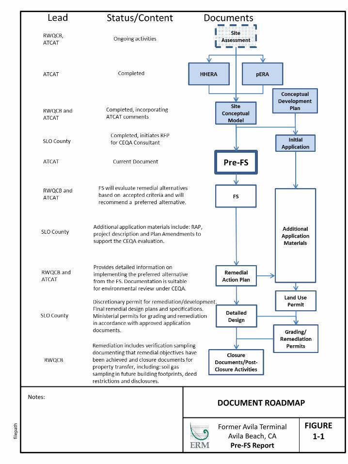
FIGURE 1-1
DOCUMENT ROADMAP Notes:
Former Avila Terminal Avila Beach, CA Pre-FS Report
filep
ath
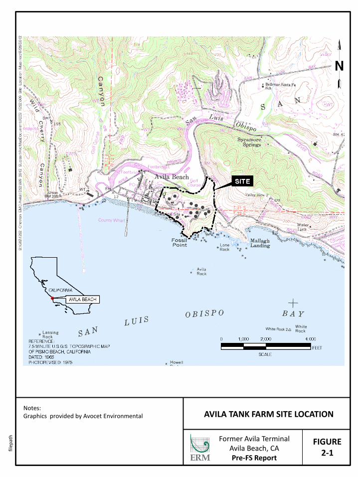
FIGURE 2-1
AVILA TANK FARM SITE LOCATION Notes: Graphics provided by Avocet Environmental Former Avila Terminal
Avila Beach, CA Pre-FS Report
filep
ath
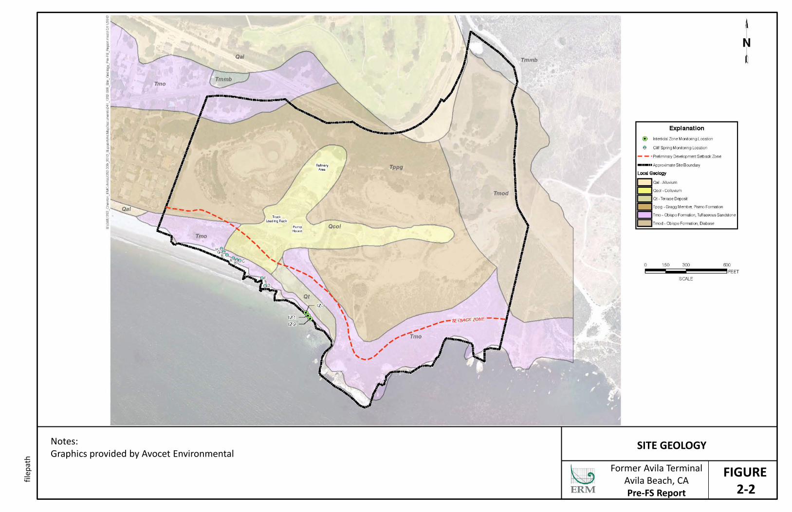
FIGURE 2-2
SITE GEOLOGY Notes: Graphics provided by Avocet Environmental Former Avila Terminal
Avila Beach, CA Pre-FS Report
filep
ath
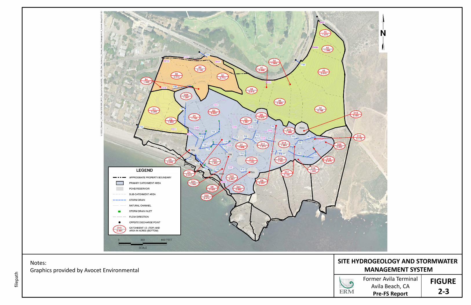
FIGURE 2-3
SITE HYDROGEOLOGY AND STORMWATER MANAGEMENT SYSTEM
Notes: Graphics provided by Avocet Environmental Former Avila Terminal
Avila Beach, CA Pre-FS Report
filep
ath

FIGURE 2-4
HABITAT MAP FOR AVILA TANK FARM Notes: Graphics provided by Avocet Environmental Former Avila Terminal
Avila Beach, CA Pre-FS Report
filep
ath
FIGURE 2-5
SITE PLAN – HISTORICAL OPERATIONS Notes: Graphics provided by Avocet Environmental Former Avila Terminal
Avila Beach, CA Pre-FS Report
filep
ath
FIGURE 2-6
SAMPLE LOCATIONS Notes: Graphics provided by Avocet Environmental Former Avila Terminal
Avila Beach, CA Pre-FS Report
filep
ath
FIGURE 2-7
2007 CONCEPTUAL DEVELOPMENT PLAN Notes: Graphics provided by Avocet Environmental Former Avila Terminal
Avila Beach, CA Pre-FS Report
filep
ath
FIGURE 3-1
DISTRIBUTION OF TPH IN SOIL AND BEDROCK AT ALL DEPTHS
Notes: Graphics provided by Avocet Environmental Former Avila Terminal
Avila Beach, CA Pre-FS Report
filep
ath
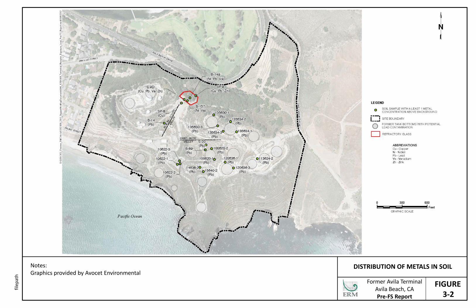
FIGURE 3-2
DISTRIBUTION OF METALS IN SOIL Notes: Graphics provided by Avocet Environmental Former Avila Terminal
Avila Beach, CA Pre-FS Report
filep
ath
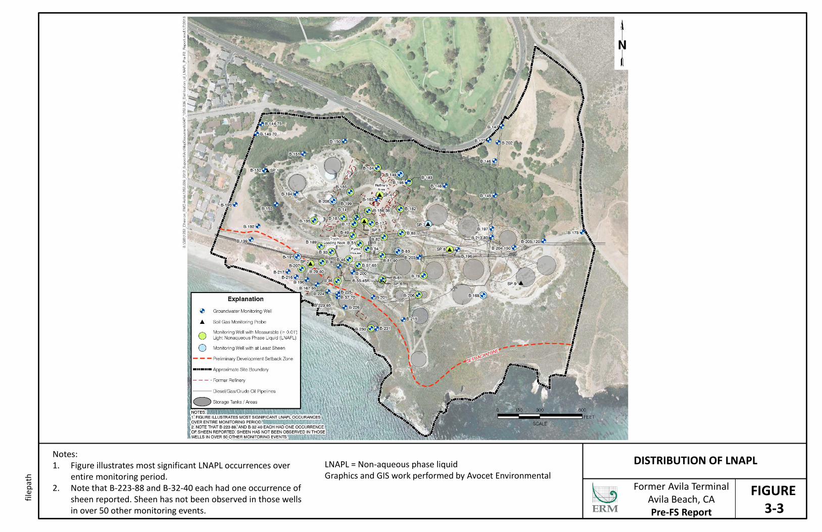
FIGURE 3-3
DISTRIBUTION OF LNAPL Notes: 1. Figure illustrates most significant LNAPL occurrences over
entire monitoring period. 2. Note that B-223-88 and B-32-40 each had one occurrence of
sheen reported. Sheen has not been observed in those wells in over 50 other monitoring events.
Former Avila Terminal Avila Beach, CA Pre-FS Report
filep
ath
LNAPL = Non-aqueous phase liquid Graphics and GIS work performed by Avocet Environmental
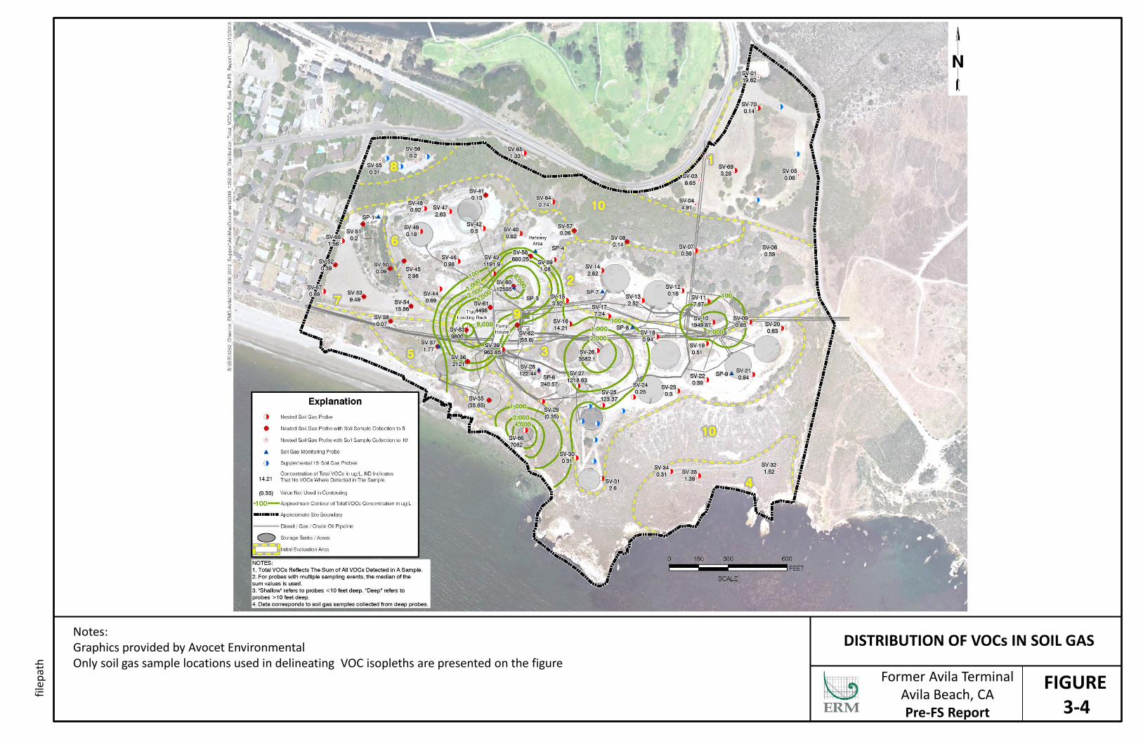
FIGURE 3-4
DISTRIBUTION OF VOCs IN SOIL GAS Notes: Graphics provided by Avocet Environmental Only soil gas sample locations used in delineating VOC isopleths are presented on the figure
Former Avila Terminal Avila Beach, CA Pre-FS Report
filep
ath

FIGURE 3-5
DISTRIBUTION OF METHANE IN SOIL GAS Notes: Graphics provided by Avocet Environmental Only soil gas sample locations used in delineating methane isopleths are presented on the figure
Former Avila Terminal Avila Beach, CA Pre-FS Report
filep
ath
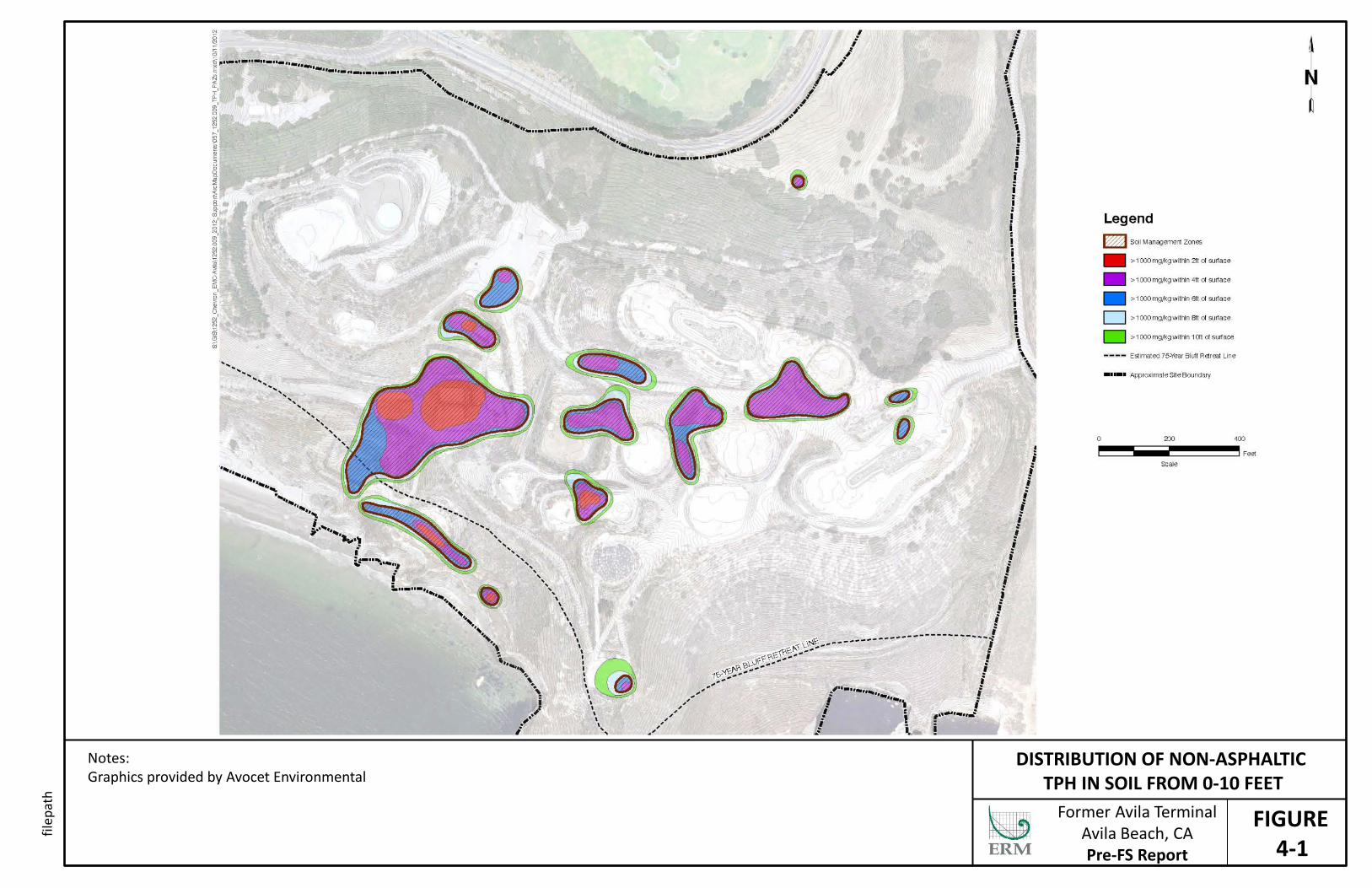
FIGURE 4-1
DISTRIBUTION OF NON-ASPHALTIC TPH IN SOIL FROM 0-10 FEET
Notes: Graphics provided by Avocet Environmental
Former Avila Terminal Avila Beach, CA Pre-FS Report
filep
ath
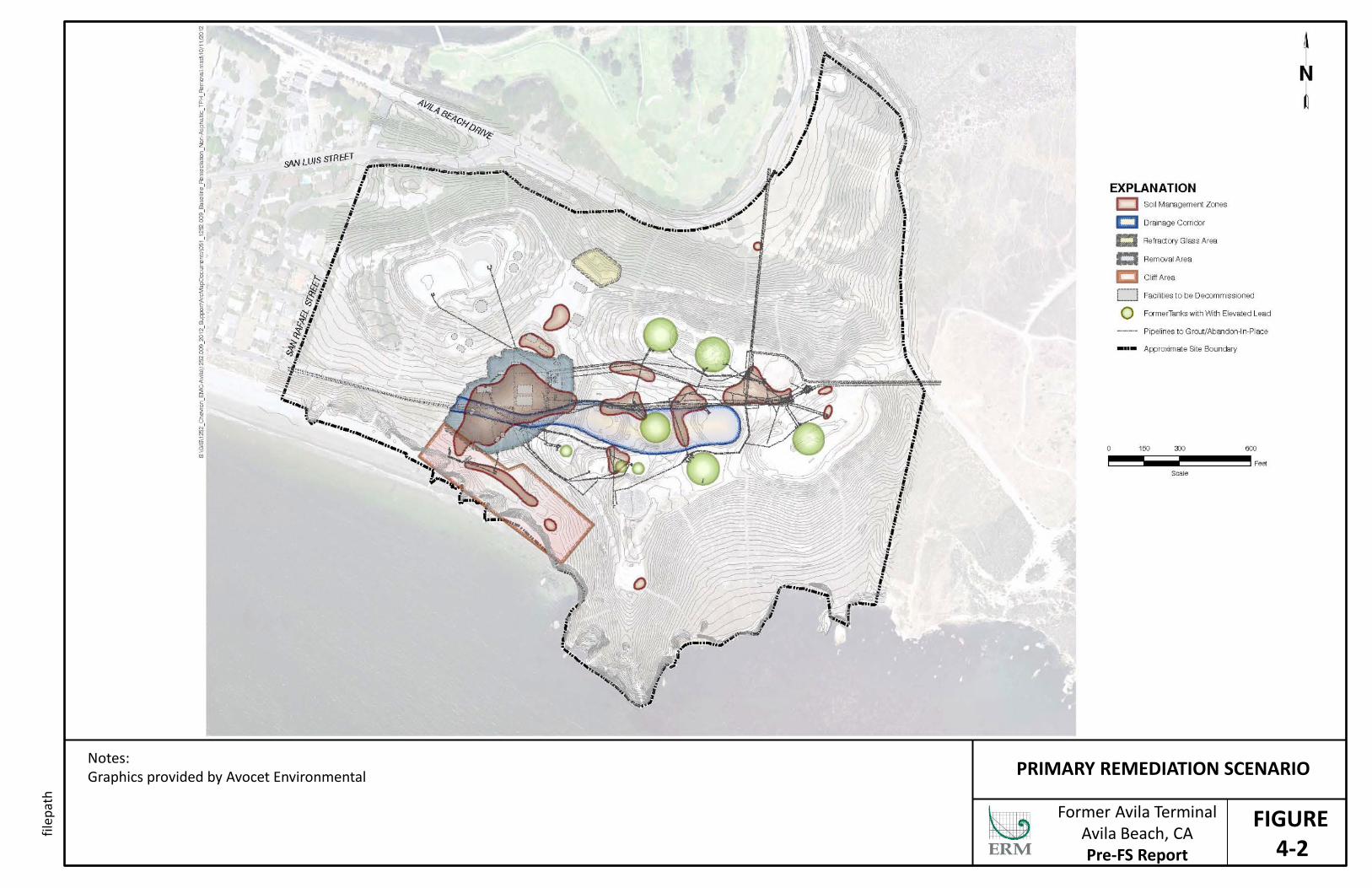
FIGURE 4-2
PRIMARY REMEDIATION SCENARIO Notes: Graphics provided by Avocet Environmental
Former Avila Terminal Avila Beach, CA Pre-FS Report
filep
ath
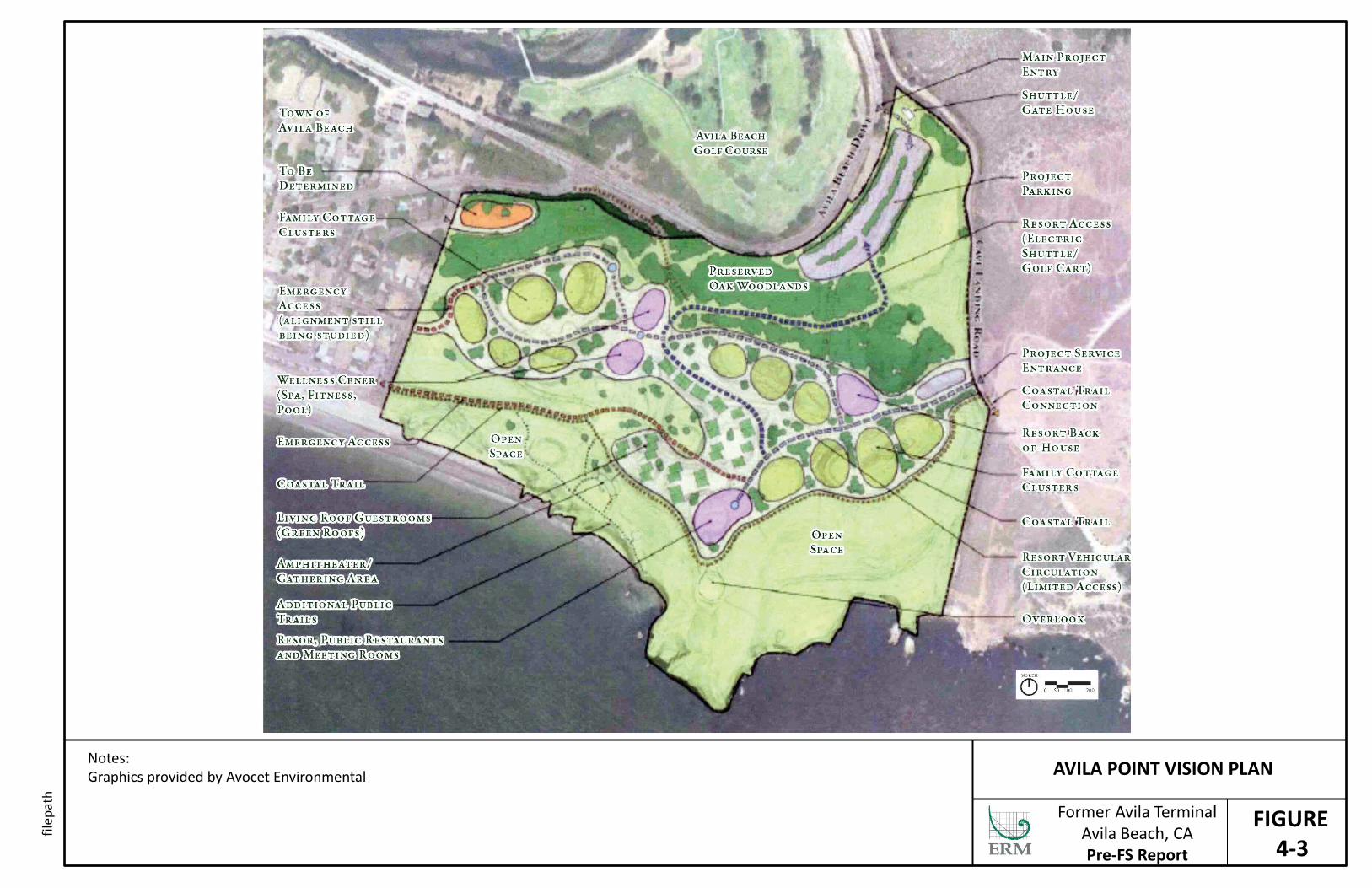
FIGURE 4-3
AVILA POINT VISION PLAN Notes: Graphics provided by Avocet Environmental
Former Avila Terminal Avila Beach, CA Pre-FS Report
filep
ath
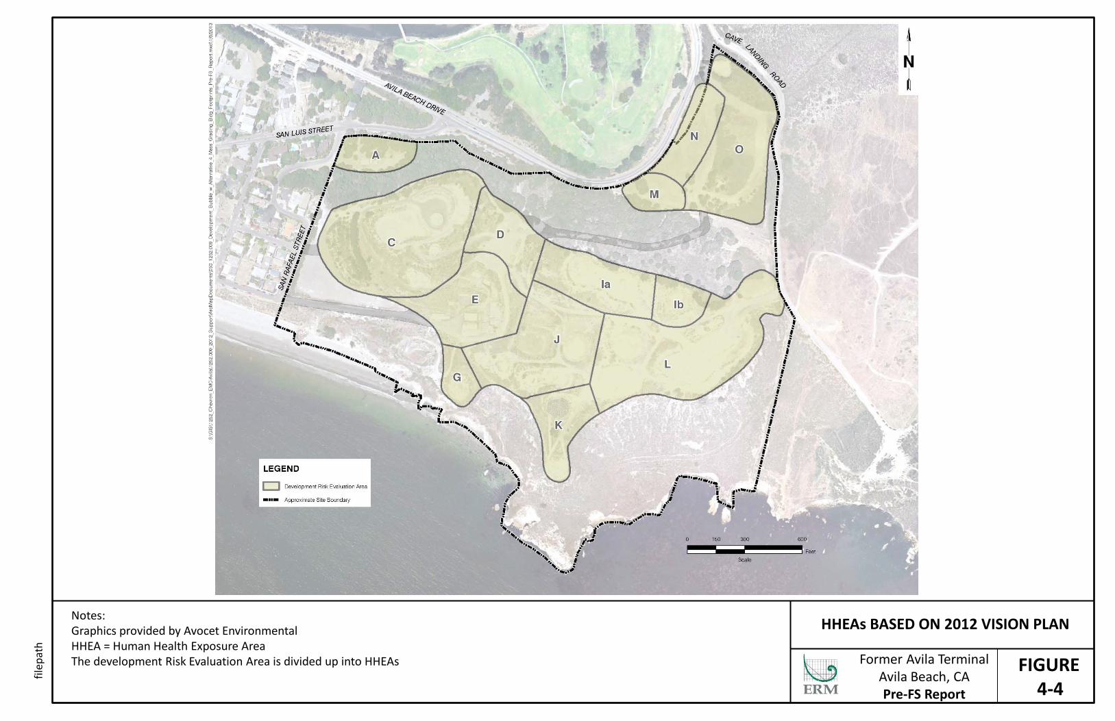
FIGURE 4-4
HHEAs BASED ON 2012 VISION PLAN Notes: Graphics provided by Avocet Environmental HHEA = Human Health Exposure Area The development Risk Evaluation Area is divided up into HHEAs
Former Avila Terminal Avila Beach, CA Pre-FS Report
filep
ath
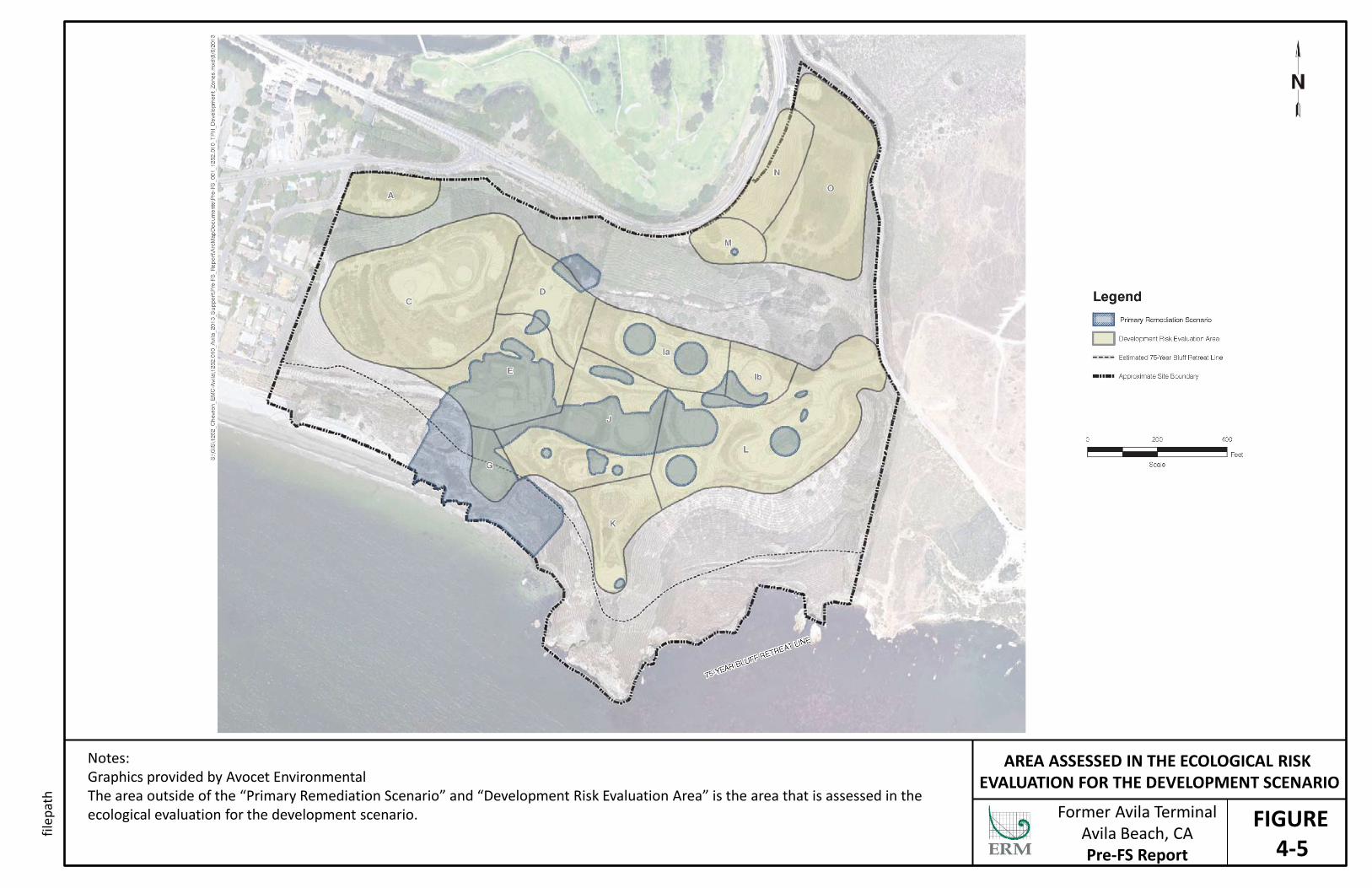
FIGURE 4-5
AREA ASSESSED IN THE ECOLOGICAL RISK EVALUATION FOR THE DEVELOPMENT SCENARIO
Notes: Graphics provided by Avocet Environmental The area outside of the “Primary Remediation Scenario” and “Development Risk Evaluation Area” is the area that is assessed in the ecological evaluation for the development scenario. Former Avila Terminal
Avila Beach, CA Pre-FS Report
filep
ath

FIGURE 5-1
NON-ASPHALTIC TPH IN DEVELOPMENT SCENARIO SOILS
Notes: Graphics provided by Avocet Environmental The area outside of the “Primary Remediation” and “Development Risk Evaluation Area” is the area that is assessed in the ecological evaluation for the development scenario. Former Avila Terminal
Avila Beach, CA Pre-FS Report
filep
ath

FIGURE 5-2
LEAD IN DEVELOPMENT SCENARIO SOILS Notes: Graphics provided by Avocet Environmental The area outside of the “Primary Remediation” and “Development Risk Evaluation Area” is the area that is assessed in the ecological evaluation for the development scenario. Former Avila Terminal
Avila Beach, CA Pre-FS Report
filep
ath
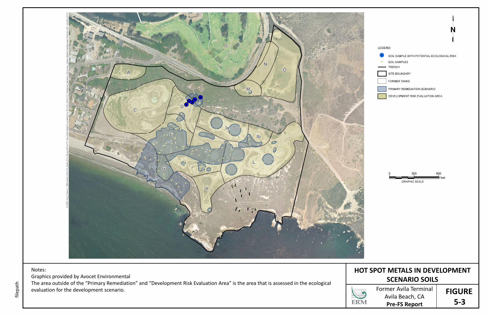
FIGURE 5-3
HOT SPOT METALS IN DEVELOPMENT SCENARIO SOILS
Notes: Graphics provided by Avocet Environmental The area outside of the “Primary Remediation” and “Development Risk Evaluation Area” is the area that is assessed in the ecological evaluation for the development scenario. Former Avila Terminal
Avila Beach, CA Pre-FS Report
filep
ath
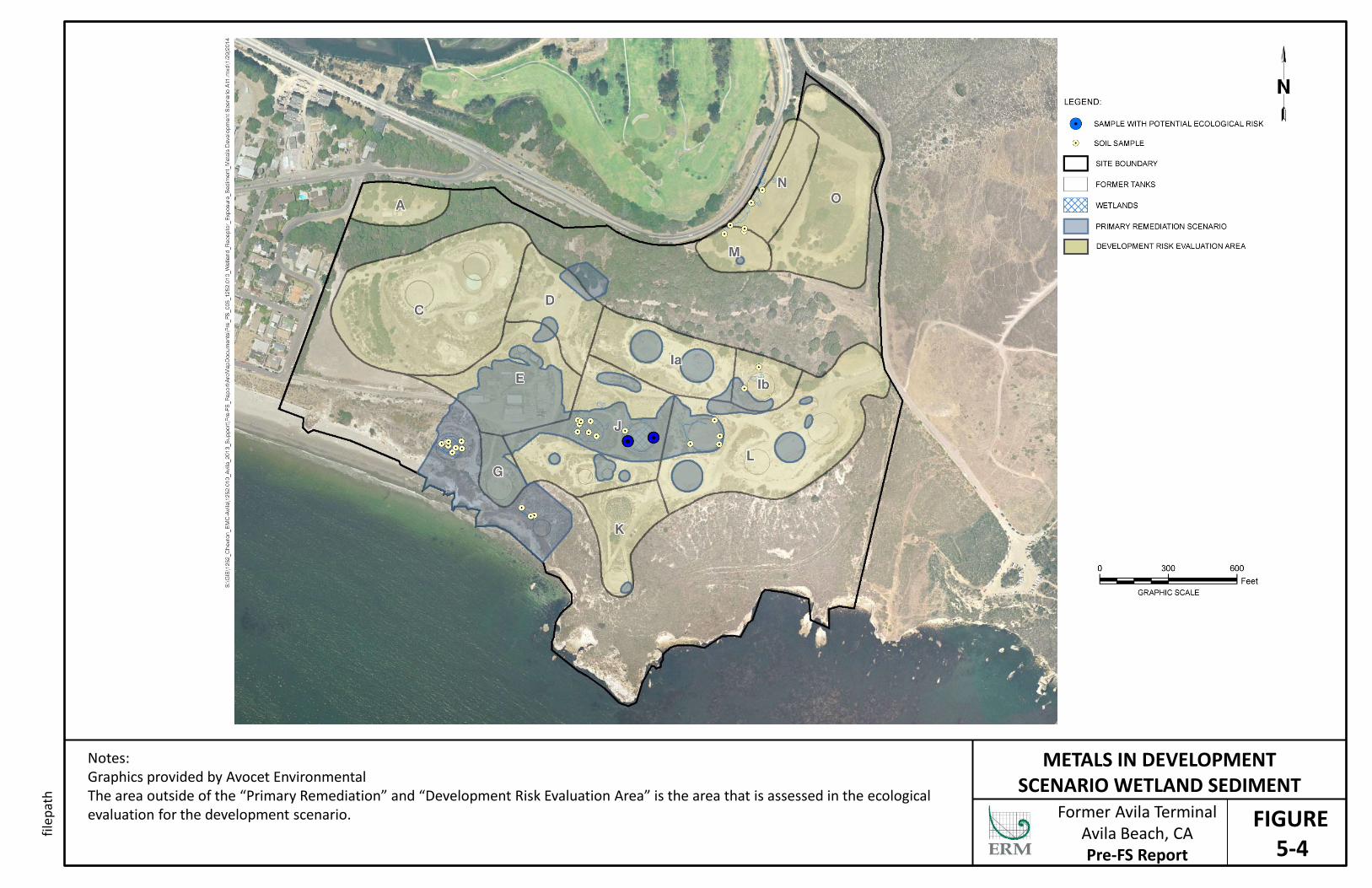
FIGURE 5-4
METALS IN DEVELOPMENT SCENARIO WETLAND SEDIMENT
Notes: Graphics provided by Avocet Environmental The area outside of the “Primary Remediation” and “Development Risk Evaluation Area” is the area that is assessed in the ecological evaluation for the development scenario. Former Avila Terminal
Avila Beach, CA Pre-FS Report
filep
ath
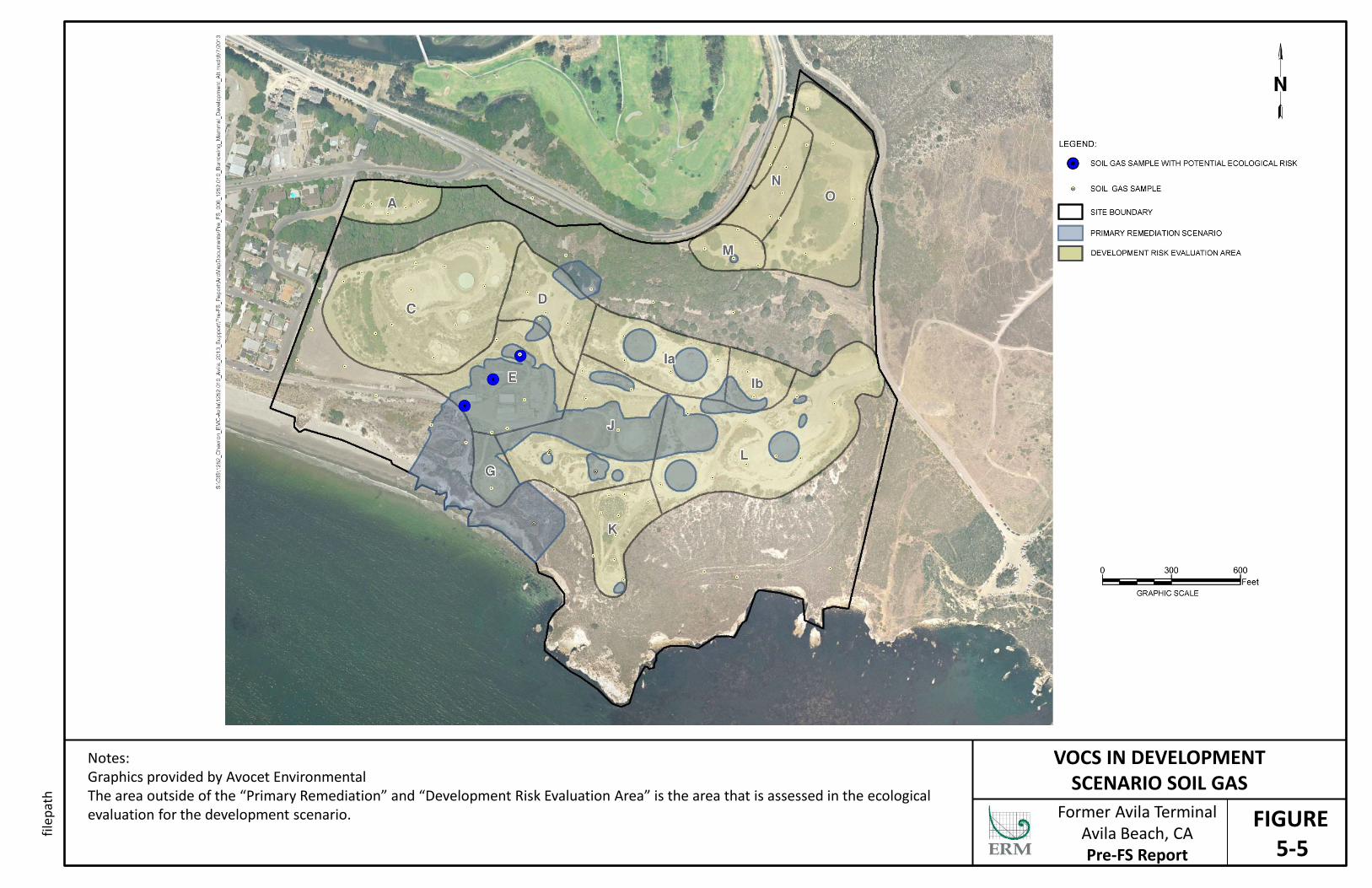
FIGURE 5-5
VOCS IN DEVELOPMENT SCENARIO SOIL GAS
Notes: Graphics provided by Avocet Environmental The area outside of the “Primary Remediation” and “Development Risk Evaluation Area” is the area that is assessed in the ecological evaluation for the development scenario. Former Avila Terminal
Avila Beach, CA Pre-FS Report
filep
ath
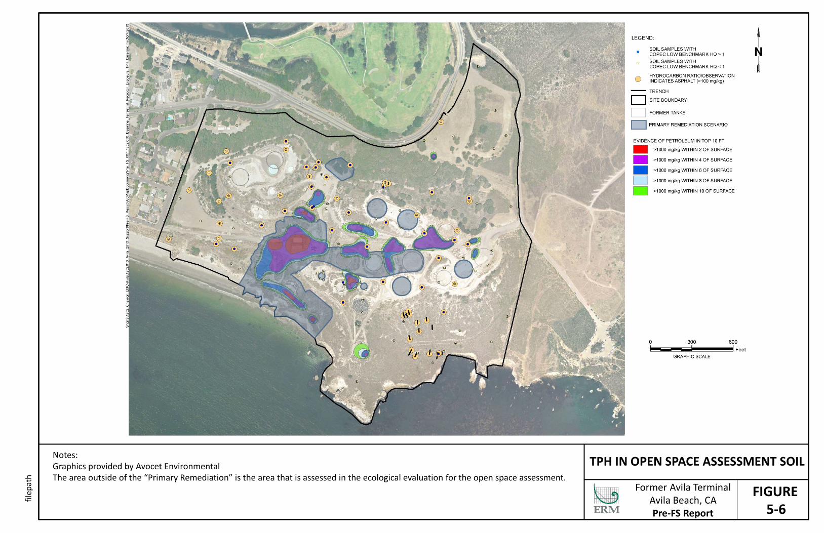
FIGURE 5-6
TPH IN OPEN SPACE ASSESSMENT SOIL Notes: Graphics provided by Avocet Environmental The area outside of the “Primary Remediation” is the area that is assessed in the ecological evaluation for the open space assessment.
Former Avila Terminal Avila Beach, CA Pre-FS Report
filep
ath

FIGURE 5-7
LEAD IN OPEN SPACE ASSESSMENT SOIL Notes: Graphics provided by Avocet Environmental The area outside of the “Primary Remediation” is the area that is assessed in the ecological evaluation for the open space assessment.
Former Avila Terminal Avila Beach, CA Pre-FS Report
filep
ath
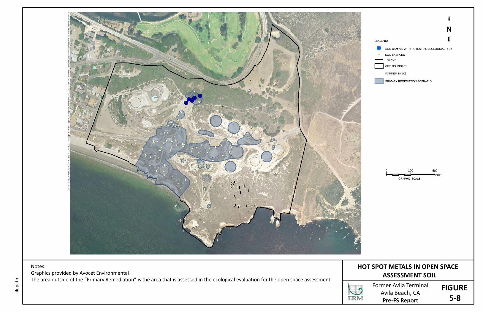
FIGURE 5-8
HOT SPOT METALS IN OPEN SPACE ASSESSMENT SOIL
Notes: Graphics provided by Avocet Environmental The area outside of the “Primary Remediation” is the area that is assessed in the ecological evaluation for the open space assessment.
Former Avila Terminal Avila Beach, CA Pre-FS Report
filep
ath
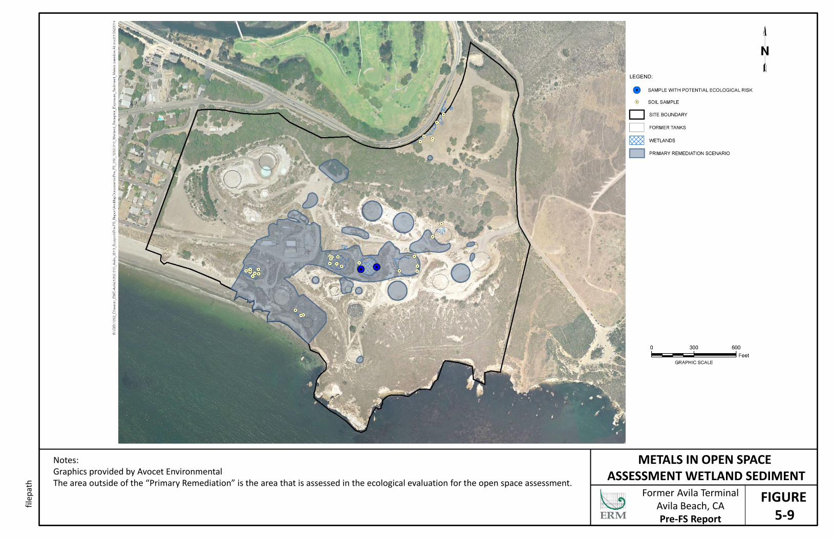
FIGURE 5-9
METALS IN OPEN SPACE ASSESSMENT WETLAND SEDIMENT
Notes: Graphics provided by Avocet Environmental The area outside of the “Primary Remediation” is the area that is assessed in the ecological evaluation for the open space assessment.
Former Avila Terminal Avila Beach, CA Pre-FS Report
filep
ath
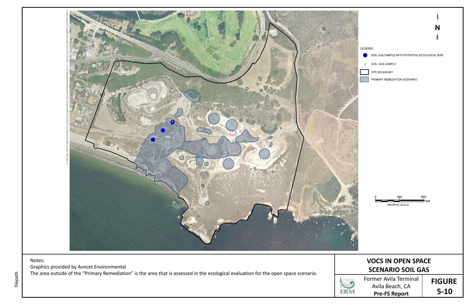
FIGURE 5-10
VOCS IN OPEN SPACE SCENARIO SOIL GAS
Notes: Graphics provided by Avocet Environmental The area outside of the “Primary Remediation” is the area that is assessed in the ecological evaluation for the open space scenario.
Former Avila Terminal Avila Beach, CA Pre-FS Report
filep
ath

FIGURE 10-1
SUMMARY OF RISK MANAGEMENT RECOMMENDATIONS
Notes: Graphics provided by Avocet Environmental
Former Avila Terminal Avila Beach, CA Pre-FS Report
filep
ath

Tables
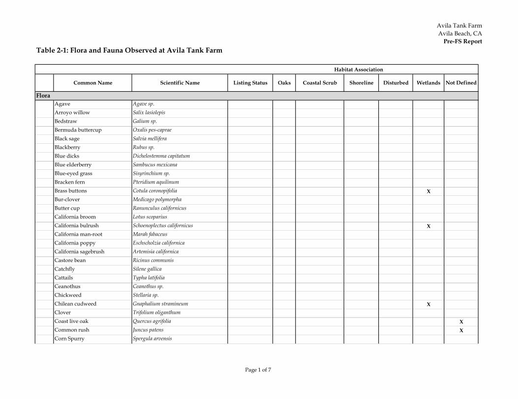
Avila Tank FarmAvila Beach, CA
Pre-FS Report
Page 1 of 7
Table 2-1: Flora and Fauna Observed at Avila Tank Farm
Common Name Scientific Name Listing Status Oaks Coastal Scrub Shoreline Disturbed Wetlands Not Defined
FloraAgave Agave sp.Arroyo willow Salix lasiolepisBedstraw Galium sp.Bermuda buttercup Oxalis pes-capraeBlack sage Salvia melliferaBlackberry Rubus sp.Blue dicks Dichelostemma capitatumBlue elderberry Sambucus mexicanaBlue-eyed grass Sisyrinchium sp.Bracken fern Pteridium aquilinumBrass buttons Cotula coronopifolia XBur-clover Medicago polymorphaButter cup Ranunculus californicusCalifornia broom Lotus scopariusCalifornia bulrush Schoenoplectus californicus XCalifornia man-root Marah fabaceusCalifornia poppy Eschscholzia californicaCalifornia sagebrush Artemisia californicaCastore bean Ricinus communisCatchfly Silene gallicaCattails Typha latifoliaCeanothus Ceanothus sp.Chickweed Stellaria sp.Chilean cudweed Gnaphalium stramineum XClover Trifolium oliganthumCoast live oak Quercus agrifolia XCommon rush Juncus patens XCorn Spurry Spergula arvensis
Habitat Association

Avila Tank FarmAvila Beach, CA
Pre-FS Report
Page 2 of 7
Table 2-1: Flora and Fauna Observed at Avila Tank Farm
Common Name Scientific Name Listing Status Oaks Coastal Scrub Shoreline Disturbed Wetlands Not Defined
Habitat Association
Coyote brush Baccharis pilularis XCreeping spikerush Eleocharis macrostachyaCurly dock Rumex crispus XEverlasting cudweed Gnaphalium luteo-album XFennel Foeniculum vulgareFescue Vulpia microstachysFoxtail barley Hordeum murinum ssp. leporinumGeranium Geranium sp.Giant rye grass Leymus condensatusGoldenbush Isocoma menziesii XGoldentop grass Lamarckia aureaHedge nettle Stachys bullataHyssop loosestrife Lythrum hyssopifoliaIce plant Conicosia pugioniformisIris Iris dougalsianaItalian thistle Carduus pycnocepalusLupine Lupinus nanusMilk thistle Silybum marianumMiner's lettuce Claytonia perfoliataMiniature lupine Lupinus bicolorMontery pine Pinus radiataMorning-glory Calystegia macrostegia ssp. cyclostegiaMugwort Artemisia douglasianaMyoporum Myoporum laetumNarrow leaved cattail Typha angustifolia XNarrow-leaved plantain Planago lanceolata XNasturtium Tropaeolum majusNut sedge Cyperus esculentusOats Avena sp.Ox-tongue Picris echioides X
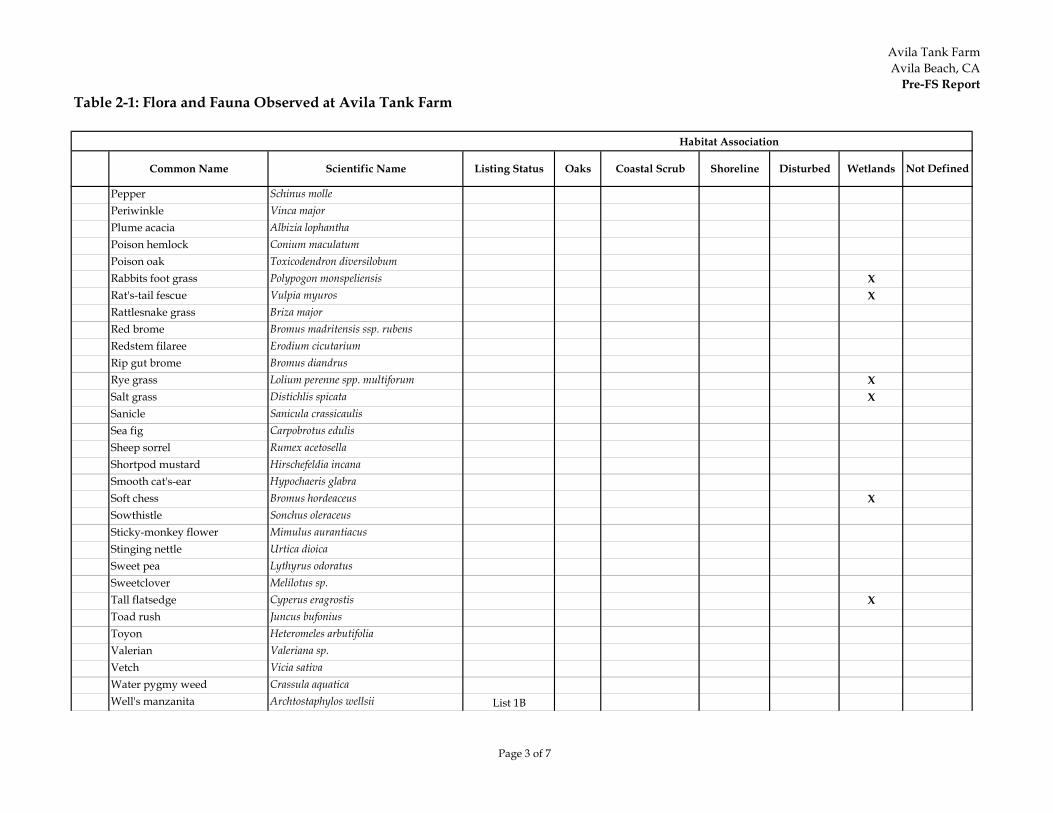
Avila Tank FarmAvila Beach, CA
Pre-FS Report
Page 3 of 7
Table 2-1: Flora and Fauna Observed at Avila Tank Farm
Common Name Scientific Name Listing Status Oaks Coastal Scrub Shoreline Disturbed Wetlands Not Defined
Habitat Association
Pepper Schinus mollePeriwinkle Vinca majorPlume acacia Albizia lophanthaPoison hemlock Conium maculatumPoison oak Toxicodendron diversilobumRabbits foot grass Polypogon monspeliensis XRat's-tail fescue Vulpia myuros XRattlesnake grass Briza majorRed brome Bromus madritensis ssp. rubensRedstem filaree Erodium cicutariumRip gut brome Bromus diandrusRye grass Lolium perenne spp. multiforum XSalt grass Distichlis spicata XSanicle Sanicula crassicaulisSea fig Carpobrotus edulisSheep sorrel Rumex acetosellaShortpod mustard Hirschefeldia incanaSmooth cat's-ear Hypochaeris glabraSoft chess Bromus hordeaceus XSowthistle Sonchus oleraceusSticky-monkey flower Mimulus aurantiacusStinging nettle Urtica dioicaSweet pea Lythyrus odoratusSweetclover Melilotus sp.Tall flatsedge Cyperus eragrostis XToad rush Juncus bufoniusToyon Heteromeles arbutifoliaValerian Valeriana sp.Vetch Vicia sativaWater pygmy weed Crassula aquaticaWell's manzanita Archtostaphylos wellsii List 1B
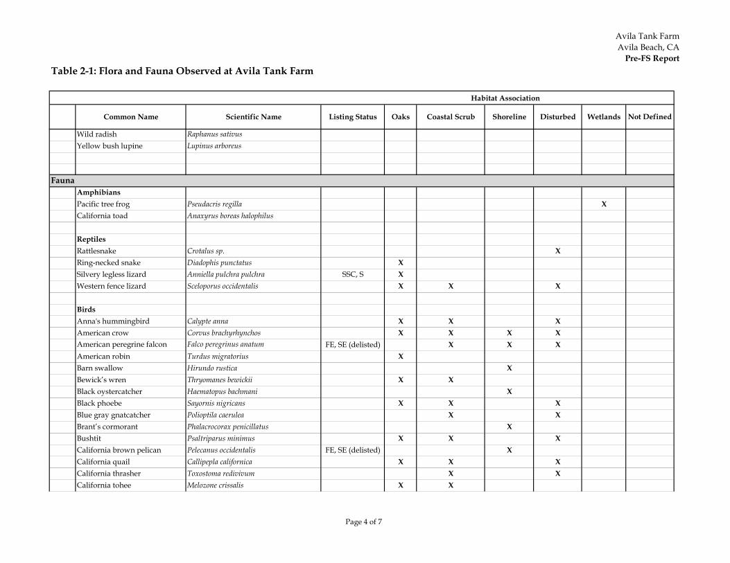
Avila Tank FarmAvila Beach, CA
Pre-FS Report
Page 4 of 7
Table 2-1: Flora and Fauna Observed at Avila Tank Farm
Common Name Scientific Name Listing Status Oaks Coastal Scrub Shoreline Disturbed Wetlands Not Defined
Habitat Association
Wild radish Raphanus sativusYellow bush lupine Lupinus arboreus
FaunaAmphibiansPacific tree frog Pseudacris regilla XCalifornia toad Anaxyrus boreas halophilus
ReptilesRattlesnake Crotalus sp. XRing-necked snake Diadophis punctatus XSilvery legless lizard Anniella pulchra pulchra SSC, S XWestern fence lizard Sceloporus occidentalis X X X
BirdsAnna's hummingbird Calypte anna X X XAmerican crow Corvus brachyrhynchos X X X XAmerican peregrine falcon Falco peregrinus anatum FE, SE (delisted) X X XAmerican robin Turdus migratorius XBarn swallow Hirundo rustica XBewick’s wren Thryomanes bewickii X XBlack oystercatcher Haematopus bachmani XBlack phoebe Sayornis nigricans X X XBlue gray gnatcatcher Polioptila caerulea X XBrant’s cormorant Phalacrocorax penicillatus XBushtit Psaltriparus minimus X X XCalifornia brown pelican Pelecanus occidentalis FE, SE (delisted) XCalifornia quail Callipepla californica X X XCalifornia thrasher Toxostoma redivivum X XCalifornia tohee Melozone crissalis X X
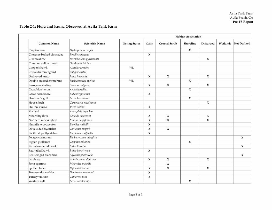
Avila Tank FarmAvila Beach, CA
Pre-FS Report
Page 5 of 7
Table 2-1: Flora and Fauna Observed at Avila Tank Farm
Common Name Scientific Name Listing Status Oaks Coastal Scrub Shoreline Disturbed Wetlands Not Defined
Habitat Association
Caspian tern Hydroprogne caspia XChestnut-backed chickadee Poecile rufescens XCliff swallow Petrochelidon pyrrhonota XCommon yellowthroat Geothlypis trichasCooper's hawk Accipter cooperii WLCosta's hummingbird Calypte costaeDark-eyed junco Junco hyemalis X X XDouble-crested cormorant Phalacrocorax auritus WL XEuropean starling Sturnus vulgaris X X XGreat blue heron Ardea herodias XGreat-horned owl Bubo virginianus XHeerman’s gull Larus heermanni XHouse finch Carpodacus mexicanus XHutton’s vireo Vireo huttoni XMallard Anas platyrhynchosMourning dove Zenaida macroura X X XNorthern mockingbird Mimus polyglottos X X XNuttail's woodpecker Picoides nuttallii XOlive-sided flycatcher Contopus cooperi X XPacific slope flycatcher Empidonax difficilis XPelagic cormorant Phalacrocorax pelagicus XPigeon guillemot Cepphus columba XRed-shouldered hawk Buteo lineatus XRed-tailed hawk Buteo jamaicensis XRed-winged blackbird Agelaius phoeniceus XScrub jay Aphelocoma californica X X XSong sparrow Melospiza melodia XSpotted tohee Pipilo maculatus X X XTownsend's warbler Dendroica townsendi XTurkey vulture Cathartes aura XWestern gull Larus occidentalis X
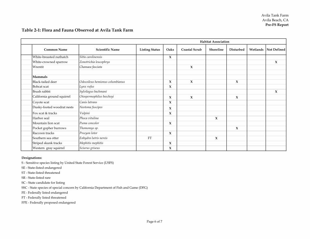
Avila Tank FarmAvila Beach, CA
Pre-FS Report
Page 6 of 7
Table 2-1: Flora and Fauna Observed at Avila Tank Farm
Common Name Scientific Name Listing Status Oaks Coastal Scrub Shoreline Disturbed Wetlands Not Defined
Habitat Association
White-breasted nuthatch Sitta carolinensis XWhite-crowned sparrow Zonotrichia leucophrys XWrentit Chamaea fasciata X
MammalsBlack-tailed deer Odocoileus hemionus columbianus X X XBobcat scat Lynx rufus XBrush rabbit Sylvilagus bachmani XCalifornia ground squirrel Otospermophilus beecheyi X X XCoyote scat Canis latrans XDusky-footed woodrat nests Neotoma fuscipes XFox scat & tracks Vulpini XHarbor seal Phoca vitulina XMountain lion scat Puma concolor XPocket gopher burrows Thomomys sp. XRaccoon tracks Procyon lotor XSouthern sea otter Enhydra lutris nereis FT XStriped skunk tracks Mephitis mephitis XWestern gray squirrel Sciurus griseus X
Designations:S - Sensitive species listing by United State Forest Service (USFS)SE - State-listed endangered ST - State-listed threatenedSR - State-listed rare SC - State candidate for listing SSC - State species of special concern by California Department of Fish and Game (DFG)FE - Federally listed endangered FT - Federally listed threatened FPE - Federally proposed endangered
Avila Tank FarmAvila Beach, CA
Pre-FS Report
Page 7 of 7
Table 2-1: Flora and Fauna Observed at Avila Tank Farm
Common Name Scientific Name Listing Status Oaks Coastal Scrub Shoreline Disturbed Wetlands Not Defined
Habitat Association
FPT - Federally proposed threatened List 1B - Rare, threatened or endangered by California Native Plant Society (CNPS)WL - Watch list by California Department of Fish and Game (DFG)
Sources:Listed species provided by David Wolff Environmental 2004 and 2005; Jordan Environmental 2003Current listing status provided by DFG, CNDD; websites: http://www.dfg.ca.gov/biogeodata/cnddb/pdfs/TEAnimals.pdfhttp://www.dfg.ca.gov/biogeodata/cnddb/pdfs/SPAnimals.pdfhttp://www.dfg.ca.gov/biogeodata/cnddb/pdfs/TEPlants.pdf
Avila Tank FarmAvila Beach, CA
Pre-FS Report
Page 1 of 6
Table 5-1: Summary of Human Health Risk Findings and Recommendations - Development Scenario
ReceptorIncremental
Lifetime Cancer Risk (ILCR)
Hazard Index (HI)
Exceeds Lead
CHHSL?Findings Recommendations for FS
Exposure Area ADefault Bldg. Short-term Res Adult 2E-07 0.003 NoDefault Bldg. Short-term Res Child NA 0.008 NoDefault Bldg. Indoor Employee 8E-08 0.002 NoOutdoor Employee 1E-07 0.008 NoIntrusive Utility Worker 2E-08 0.007 NoExposure Area CBungalow Short-term Resident Adult 2E-06 0.008 NoBungalow Short-term Resident Child NA 0.02 NoBungalow Indoor Employee 1E-06 0.02 NoDefault Bldg. Short-term Res Adult 7E-07 0.006 NoDefault Bldg. Short-term Res Child NA 0.02 NoDefault Bldg. Indoor Employee 6E-07 0.01 NoOutdoor Employee 1E-07 0.04 NoIntrusive Utility Worker 5E-08 0.03 NoExposure Area DBungalow Short-term Resident Adult 9E-07 0.02 YesBungalow Short-term Resident Child NA 0.1 YesBungalow Indoor Employee 7E-07 0.1 YesDefault Bldg. Short-term Res Adult 5E-07 0.02 YesDefault Bldg. Short-term Res Child NA 0.1 YesDefault Bldg. Indoor Employee 3E-07 0.1 YesOutdoor Employee 2E-07 0.3 YesIntrusive Utility Worker 9E-08 0.4 Yes
Risk below thresholds.No risk management
recommendations for human health issues in FS.
Risk below thresholds.No risk management
recommendations for human health issues in FS.
Risk below thresholds, except for lead for all
receptors.
Confirm that baseline remediation will sufficiently mitigate lead in
soil by removal of refractory glass. Evaluate further in FS.
Avila Tank FarmAvila Beach, CA
Pre-FS Report
Page 2 of 6
Table 5-1: Summary of Human Health Risk Findings and Recommendations - Development Scenario
ReceptorIncremental
Lifetime Cancer Risk (ILCR)
Hazard Index (HI)
Exceeds Lead
CHHSL?Findings Recommendations for FS
Exposure Area EBungalow Short-term Resident Adult 2E-04 0.2 NoBungalow Short-term Resident Child NA 0.2 NoBungalow Indoor Employee 2E-04 0.5 NoDefault Bldg. Short-term Res Adult 9E-05 0.08 NoDefault Bldg. Short-term Res Child NA 0.1 NoDefault Bldg. Indoor Employee 8E-05 0.2 NoOutdoor Employee 1E-06 0.1 NoIntrusive Utility Worker 1E-06 0.8 YesExposure Area GDefault Bldg. Indoor Employee 2E-07 0.02 NoOutdoor Employee 2E-07 0.09 NoIntrusive Utility Worker 6E-08 0.08 NoExposure Area IaBungalow Short-term Resident Adult 6E-07 0.004 NoBungalow Short-term Resident Child NA 0.01 NoBungalow Indoor Employee 4E-07 0.008 NoDefault Bldg. Short-term Res Adult 4E-07 0.004 NoDefault Bldg. Short-term Res Child NA 0.01 NoDefault Bldg. Indoor Employee 2E-07 0.007 NoOutdoor Employee 3E-07 0.02 NoIntrusive Utility Worker 5E-08 0.04 Yes
Risk below thresholds, except for intrusive utility worker exposure to lead.
Confirm that baseline remediation will sufficiently mitigate lead in soil by removal of lead-impacted soil in former tank rings. Evaluate
further in FS.
No risk management recommendations for human
health issues in FS.
Risks above thresholds for cancer risks for short-term
residents, and indoor employees; exposure to lead for intrusive utility worker
is also above thresholds.
Confirm that baseline remediation will sufficiently mitigate soil risks
(lead and TPH). Also evaluate potential mitigation by reducing exposure to VOCs in indoor air resulting from subsurface vapor intrusion. Evaluate further in FS.
Risk below thresholds.
Avila Tank FarmAvila Beach, CA
Pre-FS Report
Page 3 of 6
Table 5-1: Summary of Human Health Risk Findings and Recommendations - Development Scenario
ReceptorIncremental
Lifetime Cancer Risk (ILCR)
Hazard Index (HI)
Exceeds Lead
CHHSL?Findings Recommendations for FS
Exposure Area IbBungalow Short-term Resident Adult 2E-04 0.2 NoBungalow Short-term Resident Child NA 0.2 NoBungalow Indoor Employee 2E-04 0.5 NoDefault Bldg. Short-term Res Adult 1E-04 0.08 NoDefault Bldg. Short-term Res Child NA 0.1 NoDefault Bldg. Indoor Employee 1E-04 0.2 NoOutdoor Employee 7E-07 0.1 NoIntrusive Utility Worker 1E-07 0.3 NoExposure Area JBungalow Short-term Resident Adult 2E-04 0.2 NoBungalow Short-term Resident Child NA 0.2 NoBungalow Indoor Employee 2E-04 0.5 NoDefault Bldg. Short-term Res Adult 1E-04 0.08 NoDefault Bldg. Short-term Res Child NA 0.1 NoDefault Bldg. Indoor Employee 9E-05 0.2 NoOutdoor Employee 1E-06 0.1 NoIntrusive Utility Worker 1E-07 0.7 YesExposure Area KDefault Bldg. Short-term Res Adult 7E-06 0.009 NoDefault Bldg. Short-term Res Child NA 0.02 NoDefault Bldg. Indoor Employee 6E-06 0.02 NoOutdoor Employee 2E-07 0.04 NoIntrusive Utility Worker 2E-08 0.04 No
Cancer risks above thresholds for short-term
residents, and indoor employees.
Confirm that baseline remediation will sufficiently mitigate vapor
intrusion risks and evaluate potential mitigation by reducing exposure to VOCs in indoor air resulting from subsurface vapor intrusion. Evaluate further in FS.
Risk below thresholds Mitigate vapor intrusion into indoor air. Evaluate further in FS.
Risks above thresholds for short-term residents, and
indoor employees; noncancer hazard and
exposure to lead for intrusive utility workers are
also above thresholds.
Confirm that baseline remediation will sufficiently mitigate soil risks
(lead and TPH). Also evaluate potential mitigation by reducing exposure to VOCs in indoor air resulting from subsurface vapor intrusion. Evaluate further in FS.
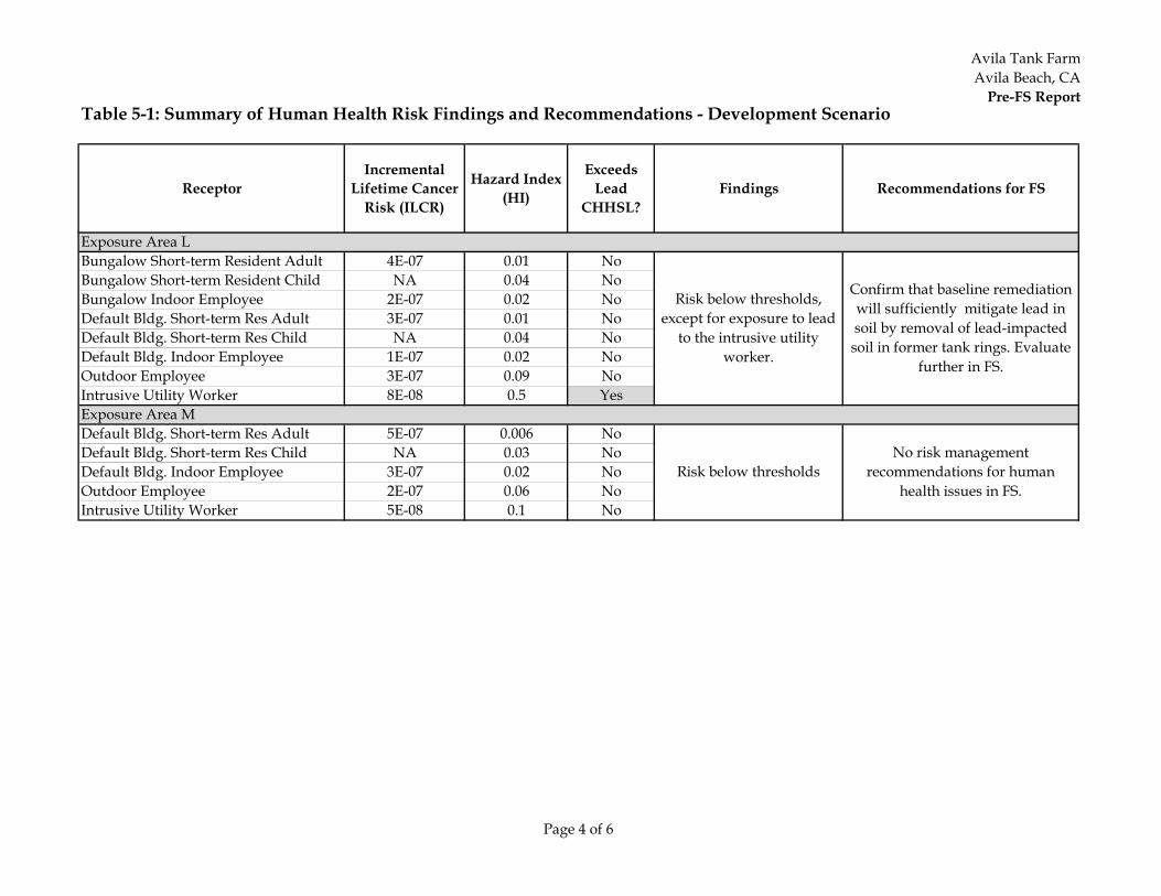
Avila Tank FarmAvila Beach, CA
Pre-FS Report
Page 4 of 6
Table 5-1: Summary of Human Health Risk Findings and Recommendations - Development Scenario
ReceptorIncremental
Lifetime Cancer Risk (ILCR)
Hazard Index (HI)
Exceeds Lead
CHHSL?Findings Recommendations for FS
Exposure Area LBungalow Short-term Resident Adult 4E-07 0.01 NoBungalow Short-term Resident Child NA 0.04 NoBungalow Indoor Employee 2E-07 0.02 NoDefault Bldg. Short-term Res Adult 3E-07 0.01 NoDefault Bldg. Short-term Res Child NA 0.04 NoDefault Bldg. Indoor Employee 1E-07 0.02 NoOutdoor Employee 3E-07 0.09 NoIntrusive Utility Worker 8E-08 0.5 YesExposure Area MDefault Bldg. Short-term Res Adult 5E-07 0.006 NoDefault Bldg. Short-term Res Child NA 0.03 NoDefault Bldg. Indoor Employee 3E-07 0.02 NoOutdoor Employee 2E-07 0.06 NoIntrusive Utility Worker 5E-08 0.1 No
Risk below thresholdsNo risk management
recommendations for human health issues in FS.
Risk below thresholds, except for exposure to lead
to the intrusive utility worker.
Confirm that baseline remediation will sufficiently mitigate lead in soil by removal of lead-impacted soil in former tank rings. Evaluate
further in FS.
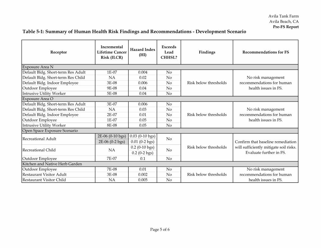
Avila Tank FarmAvila Beach, CA
Pre-FS Report
Page 5 of 6
Table 5-1: Summary of Human Health Risk Findings and Recommendations - Development Scenario
ReceptorIncremental
Lifetime Cancer Risk (ILCR)
Hazard Index (HI)
Exceeds Lead
CHHSL?Findings Recommendations for FS
Exposure Area NDefault Bldg. Short-term Res Adult 1E-07 0.004 NoDefault Bldg. Short-term Res Child NA 0.02 NoDefault Bldg. Indoor Employee 3E-08 0.006 NoOutdoor Employee 9E-08 0.04 NoIntrusive Utility Worker 5E-08 0.04 NoExposure Area ODefault Bldg. Short-term Res Adult 3E-07 0.006 NoDefault Bldg. Short-term Res Child NA 0.03 NoDefault Bldg. Indoor Employee 2E-07 0.01 NoOutdoor Employee 1E-07 0.05 NoIntrusive Utility Worker 8E-08 0.05 NoOpen Space Exposure Scenario
2E-06 (0-10 bgs) 0.03 (0-10 bgs)2E-06 (0-2 bgs) 0.01 (0-2 bgs)
0.2 (0-10 bgs) 0.2 (0-2 bgs)
Outdoor Employee 7E-07 0.1 NoKitchen and Native Herb GardenOutdoor Employee 7E-08 0.01 NoRestaurant Visitor Adult 3E-08 0.002 NoRestaurant Visitor Child NA 0.005 No
Recreational Adult No
Risk below thresholdsConfirm that baseline remediation will sufficiently mitigate soil risks.
Evaluate further in FS.Recreational Child NA No
Risk below thresholdsNo risk management
recommendations for human health issues in FS.
Risk below thresholdsNo risk management
recommendations for human health issues in FS.
Risk below thresholdsNo risk management
recommendations for human health issues in FS.
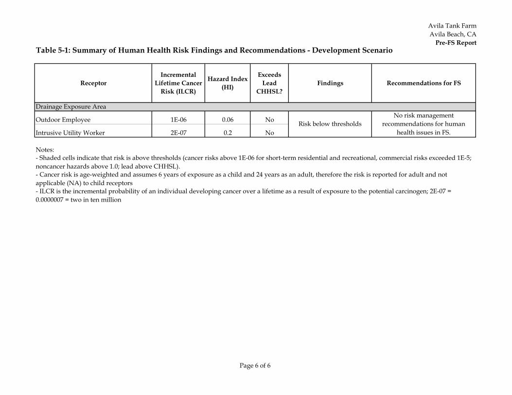
Avila Tank FarmAvila Beach, CA
Pre-FS Report
Page 6 of 6
Table 5-1: Summary of Human Health Risk Findings and Recommendations - Development Scenario
ReceptorIncremental
Lifetime Cancer Risk (ILCR)
Hazard Index (HI)
Exceeds Lead
CHHSL?Findings Recommendations for FS
Drainage Exposure Area
Outdoor Employee 1E-06 0.06 No
Intrusive Utility Worker 2E-07 0.2 No
Notes:
- Cancer risk is age-weighted and assumes 6 years of exposure as a child and 24 years as an adult, therefore the risk is reported for adult and not applicable (NA) to child receptors- ILCR is the incremental probability of an individual developing cancer over a lifetime as a result of exposure to the potential carcinogen; 2E-07 = 0.0000007 = two in ten million
Risk below thresholdsNo risk management
recommendations for human health issues in FS.
- Shaded cells indicate that risk is above thresholds (cancer risks above 1E-06 for short-term residential and recreational, commercial risks exceeded 1E-5; noncancer hazards above 1.0; lead above CHHSL).
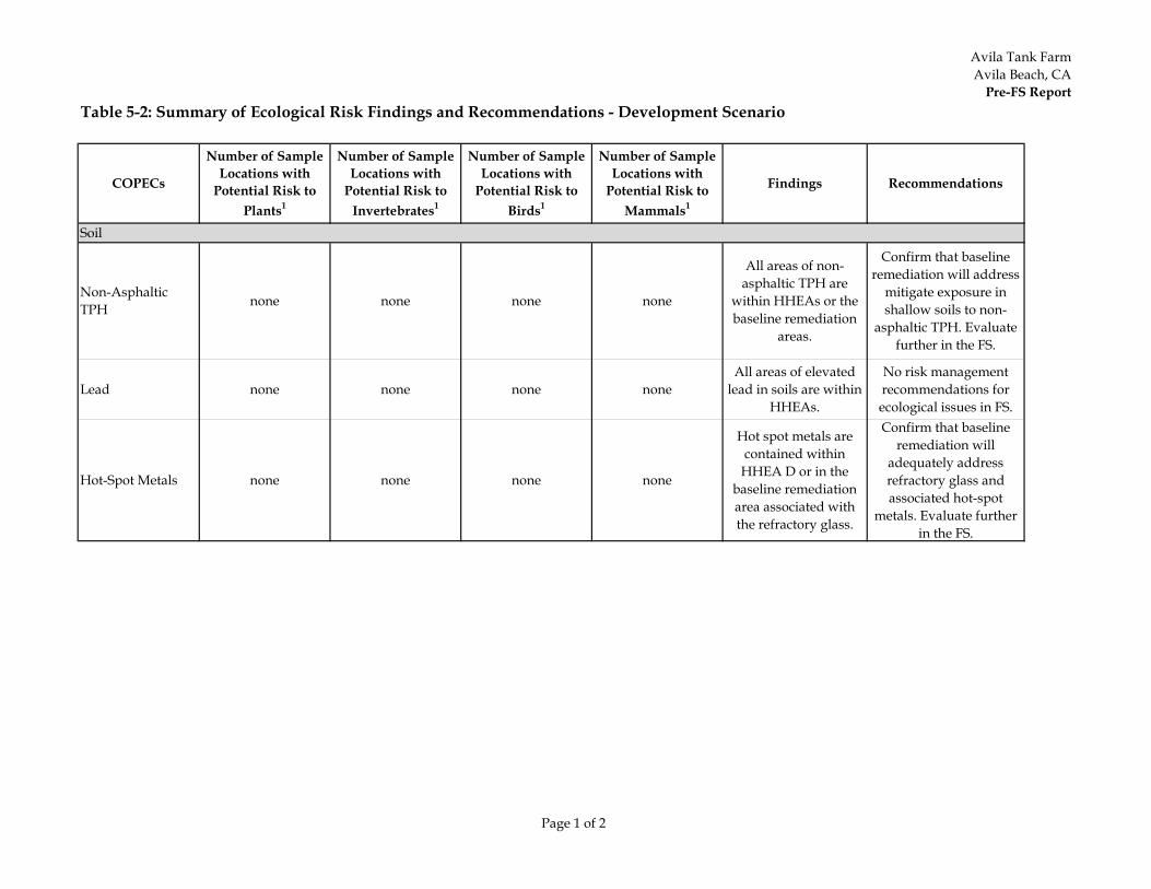
Avila Tank FarmAvila Beach, CA
Pre-FS Report
Page 1 of 2
Table 5-2: Summary of Ecological Risk Findings and Recommendations - Development Scenario
COPECs
Number of Sample Locations with
Potential Risk to Plants1
Number of Sample Locations with
Potential Risk to Invertebrates1
Number of Sample Locations with
Potential Risk to Birds1
Number of Sample Locations with
Potential Risk to Mammals1
Findings Recommendations
Soil
Non-Asphaltic TPH none none none none
All areas of non-asphaltic TPH are
within HHEAs or the baseline remediation
areas.
Confirm that baseline remediation will address
mitigate exposure in shallow soils to non-
asphaltic TPH. Evaluate further in the FS.
Lead none none none noneAll areas of elevated
lead in soils are within HHEAs.
No risk management recommendations for ecological issues in FS.
Hot-Spot Metals none none none none
Hot spot metals are contained within
HHEA D or in the baseline remediation area associated with the refractory glass.
Confirm that baseline remediation will
adequately address refractory glass and associated hot-spot
metals. Evaluate further in the FS.
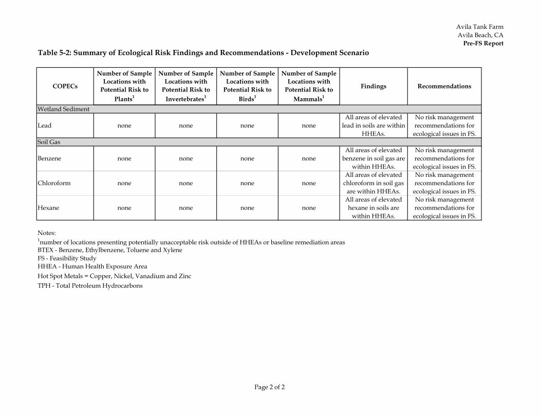
Avila Tank FarmAvila Beach, CA
Pre-FS Report
Page 2 of 2
Table 5-2: Summary of Ecological Risk Findings and Recommendations - Development Scenario
COPECs
Number of Sample Locations with
Potential Risk to Plants1
Number of Sample Locations with
Potential Risk to Invertebrates1
Number of Sample Locations with
Potential Risk to Birds1
Number of Sample Locations with
Potential Risk to Mammals1
Findings Recommendations
Wetland Sediment
Lead none none none noneAll areas of elevated
lead in soils are within HHEAs.
No risk management recommendations for ecological issues in FS.
Soil Gas
Benzene none none none noneAll areas of elevated
benzene in soil gas are within HHEAs.
No risk management recommendations for ecological issues in FS.
Chloroform none none none noneAll areas of elevated
chloroform in soil gas are within HHEAs.
No risk management recommendations for ecological issues in FS.
Hexane none none none noneAll areas of elevated hexane in soils are
within HHEAs.
No risk management recommendations for ecological issues in FS.
Notes:
FS - Feasibility Study
Hot Spot Metals = Copper, Nickel, Vanadium and ZincTPH - Total Petroleum Hydrocarbons
1number of locations presenting potentially unacceptable risk outside of HHEAs or baseline remediation areas
HHEA - Human Health Exposure Area
BTEX - Benzene, Ethylbenzene, Toluene and Xylene
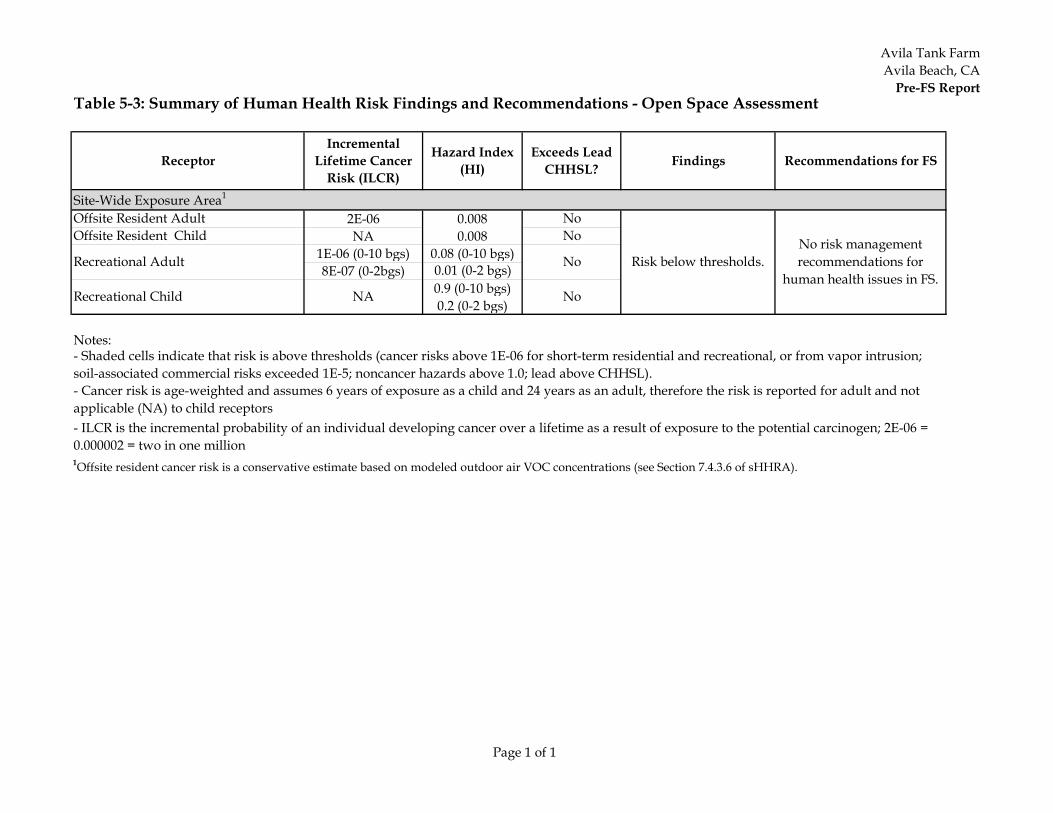
Avila Tank FarmAvila Beach, CA
Pre-FS Report
Page 1 of 1
Table 5-3: Summary of Human Health Risk Findings and Recommendations - Open Space Assessment
ReceptorIncremental
Lifetime Cancer Risk (ILCR)
Hazard Index (HI)
Exceeds Lead CHHSL? Findings Recommendations for FS
Site-Wide Exposure Area1
Offsite Resident Adult 2E-06 0.008 NoOffsite Resident Child NA 0.008 No
1E-06 (0-10 bgs) 0.08 (0-10 bgs) 8E-07 (0-2bgs) 0.01 (0-2 bgs)
0.9 (0-10 bgs)0.2 (0-2 bgs)
Notes:
1Offsite resident cancer risk is a conservative estimate based on modeled outdoor air VOC concentrations (see Section 7.4.3.6 of sHHRA).
- Shaded cells indicate that risk is above thresholds (cancer risks above 1E-06 for short-term residential and recreational, or from vapor intrusion; soil-associated commercial risks exceeded 1E-5; noncancer hazards above 1.0; lead above CHHSL).- Cancer risk is age-weighted and assumes 6 years of exposure as a child and 24 years as an adult, therefore the risk is reported for adult and not applicable (NA) to child receptors- ILCR is the incremental probability of an individual developing cancer over a lifetime as a result of exposure to the potential carcinogen; 2E-06 = 0.000002 = two in one million
Recreational Adult
Recreational Child NA
No
No
Risk below thresholds.No risk management recommendations for
human health issues in FS.
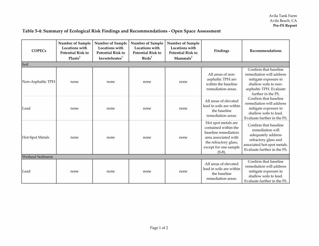
Avila Tank FarmAvila Beach, CA
Pre-FS Report
Page 1 of 2
Table 5-4: Summary of Ecological Risk Findings and Recommendations - Open Space Assessment
COPECs
Number of Sample Locations with
Potential Risk to Plants1
Number of Sample Locations with
Potential Risk to Invertebrates1
Number of Sample Locations with
Potential Risk to Birds1
Number of Sample Locations with
Potential Risk to Mammals1
Findings Recommendations
Soil
Non-Asphaltic TPH none none none none
All areas of non-asphaltic TPH are
within the baseline remediation areas.
Confirm that baseline remediation will address
mitigate exposure in shallow soils to non-
asphaltic TPH. Evaluate further in the FS.
Lead none none none none
All areas of elevated lead in soils are within
the baseline remediation areas.
Confirm that baseline remediation will address
mitigate exposure in shallow soils to lead.
Evaluate further in the FS.
Hot-Spot Metals none none none none
Hot spot metals are contained within the baseline remediation area associated with the refractory glass,
except for one sample (S-8).
Confirm that baseline remediation will
adequately address refractory glass and
associated hot-spot metals. Evaluate further in the FS.
Wetland Sediment
Lead none none none none
All areas of elevated lead in soils are within
the baseline remediation areas.
Confirm that baseline remediation will address
mitigate exposure in shallow soils to lead.
Evaluate further in the FS.
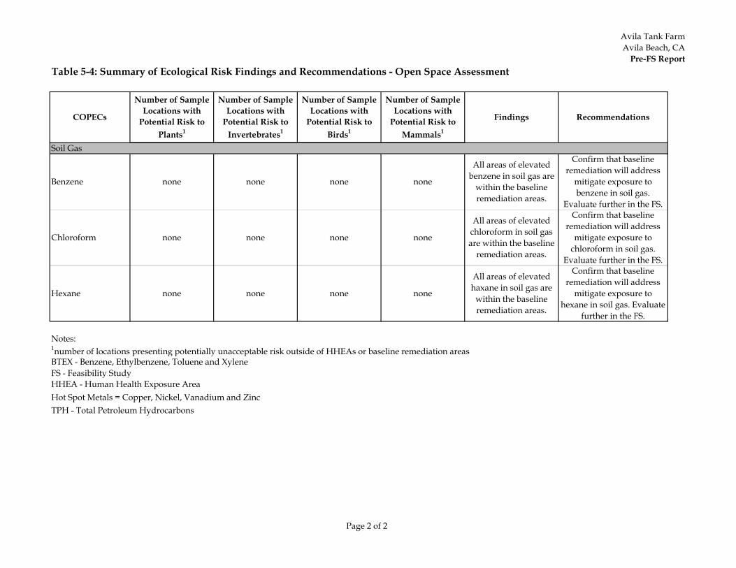
Avila Tank FarmAvila Beach, CA
Pre-FS Report
Page 2 of 2
Table 5-4: Summary of Ecological Risk Findings and Recommendations - Open Space Assessment
COPECs
Number of Sample Locations with
Potential Risk to Plants1
Number of Sample Locations with
Potential Risk to Invertebrates1
Number of Sample Locations with
Potential Risk to Birds1
Number of Sample Locations with
Potential Risk to Mammals1
Findings Recommendations
Soil Gas
Benzene none none none none
All areas of elevated benzene in soil gas are
within the baseline remediation areas.
Confirm that baseline remediation will address
mitigate exposure to benzene in soil gas.
Evaluate further in the FS.
Chloroform none none none none
All areas of elevated chloroform in soil gas are within the baseline
remediation areas.
Confirm that baseline remediation will address
mitigate exposure to chloroform in soil gas.
Evaluate further in the FS.
Hexane none none none none
All areas of elevated haxane in soil gas are
within the baseline remediation areas.
Confirm that baseline remediation will address
mitigate exposure to hexane in soil gas. Evaluate
further in the FS.
Notes:
FS - Feasibility Study
Hot Spot Metals = Copper, Nickel, Vanadium and ZincTPH - Total Petroleum Hydrocarbons
1number of locations presenting potentially unacceptable risk outside of HHEAs or baseline remediation areasBTEX - Benzene, Ethylbenzene, Toluene and Xylene
HHEA - Human Health Exposure Area
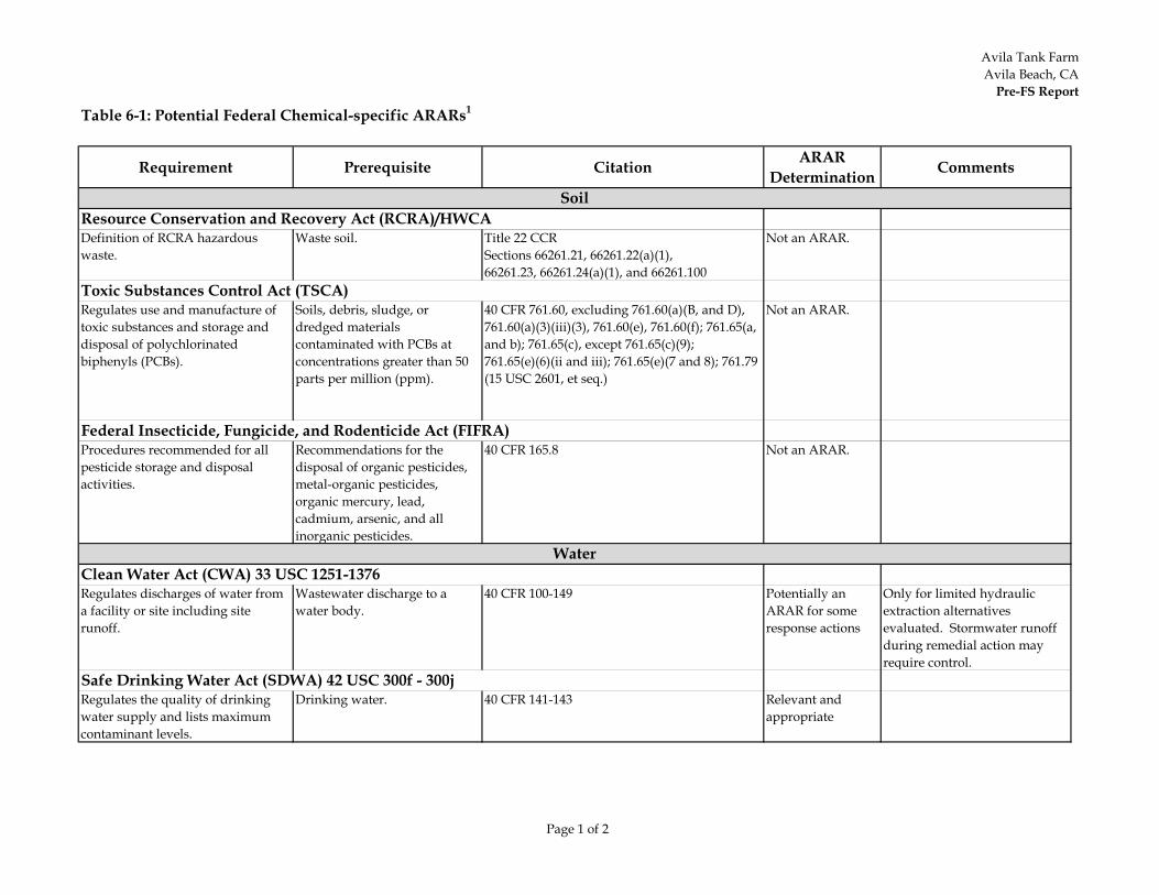
Avila Tank FarmAvila Beach, CA
Pre-FS Report
Page 1 of 2
Table 6-1: Potential Federal Chemical-specific ARARs1
Requirement Prerequisite Citation ARAR Determination Comments
Definition of RCRA hazardous waste.
Waste soil. Title 22 CCRSections 66261.21, 66261.22(a)(1),66261.23, 66261.24(a)(1), and 66261.100
Not an ARAR.
Regulates use and manufacture of toxic substances and storage and disposal of polychlorinated biphenyls (PCBs).
Soils, debris, sludge, or dredged materials contaminated with PCBs at concentrations greater than 50 parts per million (ppm).
40 CFR 761.60, excluding 761.60(a)(B, and D), 761.60(a)(3)(iii)(3), 761.60(e), 761.60(f); 761.65(a, and b); 761.65(c), except 761.65(c)(9); 761.65(e)(6)(ii and iii); 761.65(e)(7 and 8); 761.79 (15 USC 2601, et seq.)
Not an ARAR.
Procedures recommended for all pesticide storage and disposal activities.
Recommendations for the disposal of organic pesticides, metal-organic pesticides, organic mercury, lead, cadmium, arsenic, and all inorganic pesticides.
40 CFR 165.8 Not an ARAR.
Regulates discharges of water from a facility or site including site runoff.
Wastewater discharge to a water body.
40 CFR 100-149 Potentially an ARAR for some response actions
Only for limited hydraulic extraction alternatives evaluated. Stormwater runoff during remedial action may require control.
Regulates the quality of drinking water supply and lists maximum contaminant levels.
Drinking water. 40 CFR 141-143 Relevant and appropriate
Clean Water Act (CWA) 33 USC 1251-1376
Safe Drinking Water Act (SDWA) 42 USC 300f - 300j
Soil
Water
Resource Conservation and Recovery Act (RCRA)/HWCA
Toxic Substances Control Act (TSCA)
Federal Insecticide, Fungicide, and Rodenticide Act (FIFRA)
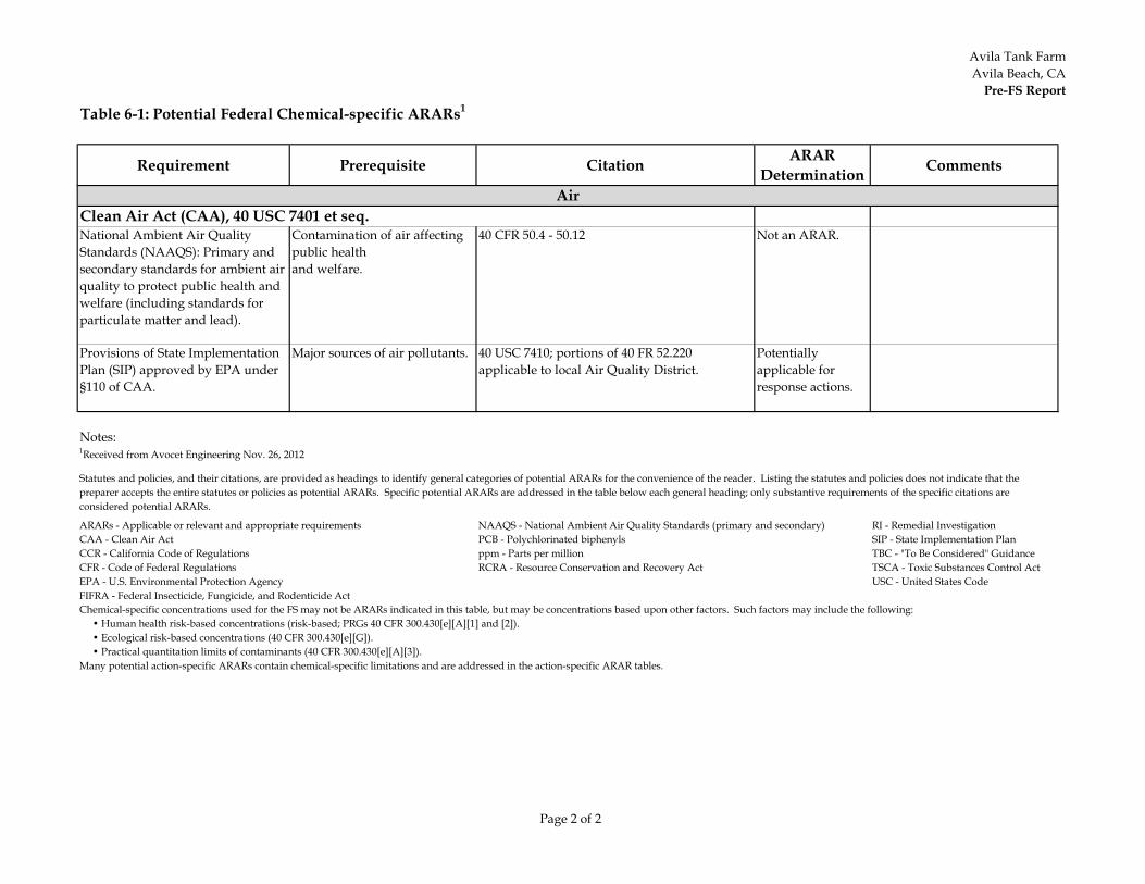
Avila Tank FarmAvila Beach, CA
Pre-FS Report
Page 2 of 2
Table 6-1: Potential Federal Chemical-specific ARARs1
Requirement Prerequisite Citation ARAR Determination Comments
National Ambient Air Quality Standards (NAAQS): Primary and secondary standards for ambient air quality to protect public health and welfare (including standards for particulate matter and lead).
Contamination of air affecting public healthand welfare.
40 CFR 50.4 - 50.12 Not an ARAR.
Provisions of State Implementation Plan (SIP) approved by EPA under §110 of CAA.
Major sources of air pollutants. 40 USC 7410; portions of 40 FR 52.220applicable to local Air Quality District.
Potentially applicable for response actions.
Notes:1Received from Avocet Engineering Nov. 26, 2012
RI - Remedial InvestigationSIP - State Implementation PlanTBC - "To Be Considered" GuidanceTSCA - Toxic Substances Control ActUSC - United States Code
Chemical-specific concentrations used for the FS may not be ARARs indicated in this table, but may be concentrations based upon other factors. Such factors may include the following: • Human health risk-based concentrations (risk-based; PRGs 40 CFR 300.430[e][A][1] and [2]). • Ecological risk-based concentrations (40 CFR 300.430[e][G]). • Practical quantitation limits of contaminants (40 CFR 300.430[e][A][3]).Many potential action-specific ARARs contain chemical-specific limitations and are addressed in the action-specific ARAR tables.
Air
Statutes and policies, and their citations, are provided as headings to identify general categories of potential ARARs for the convenience of the reader. Listing the statutes and policies does not indicate that the preparer accepts the entire statutes or policies as potential ARARs. Specific potential ARARs are addressed in the table below each general heading; only substantive requirements of the specific citations are considered potential ARARs.
ARARs - Applicable or relevant and appropriate requirementsCAA - Clean Air ActCCR - California Code of RegulationsCFR - Code of Federal RegulationsEPA - U.S. Environmental Protection AgencyFIFRA - Federal Insecticide, Fungicide, and Rodenticide Act
NAAQS - National Ambient Air Quality Standards (primary and secondary)PCB - Polychlorinated biphenylsppm - Parts per millionRCRA - Resource Conservation and Recovery Act
Clean Air Act (CAA), 40 USC 7401 et seq.
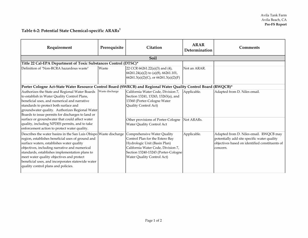
Avila Tank FarmAvila Beach, CA
Pre-FS Report
Page 1 of 2
Table 6-2: Potential State Chemical-specific ARARs1
Requirement Prerequisite Citation ARAR Determination Comments
Definition of "Non-RCRA hazardous waste" Waste 22 CCR 66261.22(a)(3) and (4), 66261.24(a)(2) to (a)(8), 66261.101, 66261.3(a)(2)(C), or 66261.3(a)(2)(F)
Not an ARAR.
California Water Code, Division 7, Section 13241, 13243, 13263(a), and 13360 (Porter-Cologne Water Quality Control Act)
Applicable. Adapted from D. Niles email.
Other provisions of Porter-Cologne Water Quality Control Act
Not ARARs.
Describes the water basins in the San Luis Obispo region, establishes beneficial uses of ground and surface waters, establishes water quality objectives, including narrative and numerical standards, establishes implementation plans to meet water quality objectives and protect beneficial uses, and incorporates statewide water quality control plans and policies.
Waste discharge Comprehensive Water Quality Control Plan for the Estero Bay Hydrologic Unit (Basin Plan) California Water Code, Division 7, Section 13240-13243 (Porter-Cologne Water Quality Control Act)
Applicable. Adapted from D. Niles email. RWQCB may potentially add site specific water quality objectives based on identified constituents of concern.
Soil
Porter Cologne Act-State Water Resource Control Board (SWRCB) and Regional Water Quality Control Board (RWQCB)*Authorizes the State and Regional Water Boards to establish in Water Quality Control Plans, beneficial uses, and numerical and narrative standards to protect both surface and groundwater quality. Authorizes Regional Water Boards to issue permits for discharges to land or surface or groundwater that could affect water quality, including NPDES permits, and to take enforcement action to protect water quality.
Waste discharge
Title 22 Cal-EPA Department of Toxic Substances Control (DTSC)*
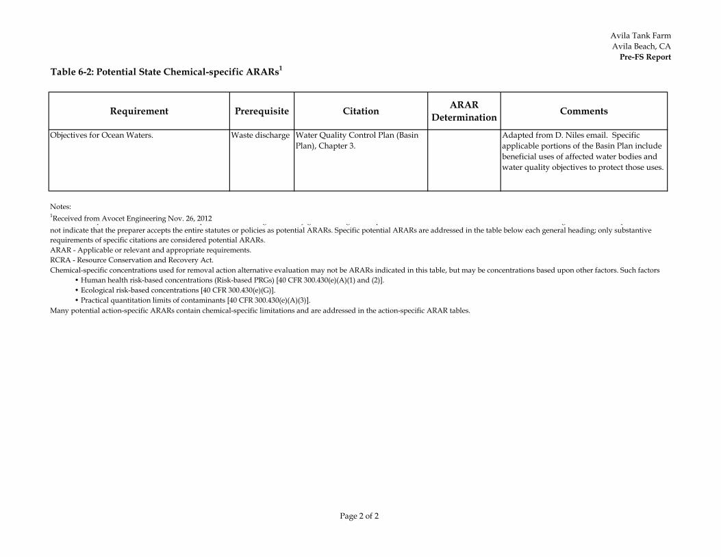
Avila Tank FarmAvila Beach, CA
Pre-FS Report
Page 2 of 2
Table 6-2: Potential State Chemical-specific ARARs1
Requirement Prerequisite Citation ARAR Determination Comments
Objectives for Ocean Waters. Waste discharge Water Quality Control Plan (Basin Plan), Chapter 3.
Adapted from D. Niles email. Specific applicable portions of the Basin Plan include beneficial uses of affected water bodies and water quality objectives to protect those uses.
Notes:1Received from Avocet Engineering Nov. 26, 2012 p p g y g g p g p not indicate that the preparer accepts the entire statutes or policies as potential ARARs. Specific potential ARARs are addressed in the table below each general heading; only substantive requirements of specific citations are considered potential ARARs.
Many potential action-specific ARARs contain chemical-specific limitations and are addressed in the action-specific ARAR tables.
ARAR - Applicable or relevant and appropriate requirements.RCRA - Resource Conservation and Recovery Act.Chemical-specific concentrations used for removal action alternative evaluation may not be ARARs indicated in this table, but may be concentrations based upon other factors. Such factors
• Human health risk-based concentrations (Risk-based PRGs) [40 CFR 300.430(e)(A)(1) and (2)]. • Ecological risk-based concentrations [40 CFR 300.430(e)(G)]. • Practical quantitation limits of contaminants [40 CFR 300.430(e)(A)(3)].
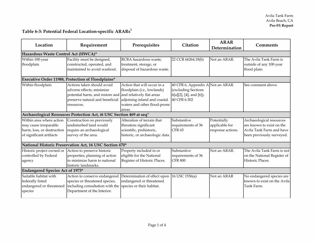
Avila Tank FarmAvila Beach, CA
Pre-FS Report
Page 1 of 4
Table 6-3: Potential Federal Location-specific ARARs1
Location Requirement Prerequisites Citation ARAR Determination Comments
Hazardous Waste Control Act (HWCA)*Within 100-year floodplain
Facility must be designed, constructed, operated, and maintained to avoid washout.
RCRA hazardous waste; treatment, storage, or disposal of hazardous waste.
22 CCR 66264.18(b) Not an ARAR. The Avila Tank Farm is outside of any 100-year flood plain.
Within floodplain Actions taken should avoid adverse effects, minimize potential harm, and restore and preserve natural and beneficial resources.
Action that will occur in a floodplain (i.e., lowlands) and relatively flat areas adjoining inland and coastal waters and other flood-prone areas.
40 CFR 6, Appendix A (excluding Sections 6[a][2], [4], and [6]); 40 CFR 6.302
Not an ARAR. See comment above.
Within area where action may cause irreparable harm, loss, or destruction of significant artifacts
Construction on previously undisturbed land would require an archaeological survey of the area.
Alteration of terrain that threatens significant scientific, prehistoric, historic, or archaeologic data.
Substantive requirements of 36 CFR 65
Potentially applicable for response actions.
Archaeological resources are known to exist on the Avila Tank Farm and have been previously surveyed.
Historic project owned orcontrolled by Federal agency
Action to preserve historic properties; planning of action to minimize harm to national historic landmarks.
Property included in or eligible for the National Register of Historic Places.
Substantive requirements of 36 CFR 800
Not an ARAR. The Avila Tank Farm is not on the National Register of Historic Places.
Suitable habitat with federally listed endangered or threatened species
Action to conserve endangered species or threatened species, including consultation with the Department of the Interior.
Determination of effect upon endangered or threatened species or their habitat.
16 USC 1536(a) Not an ARAR No endangered species are known to exist on the Avila Tank Farm.
Executive Order 11988, Protection of Floodplains*
Archaeological Resources Protection Act, i6 USC Section 469 at seq°
National Historic Preservation Act, 16 USC Section 470*
Endangered Species Act of 1973*
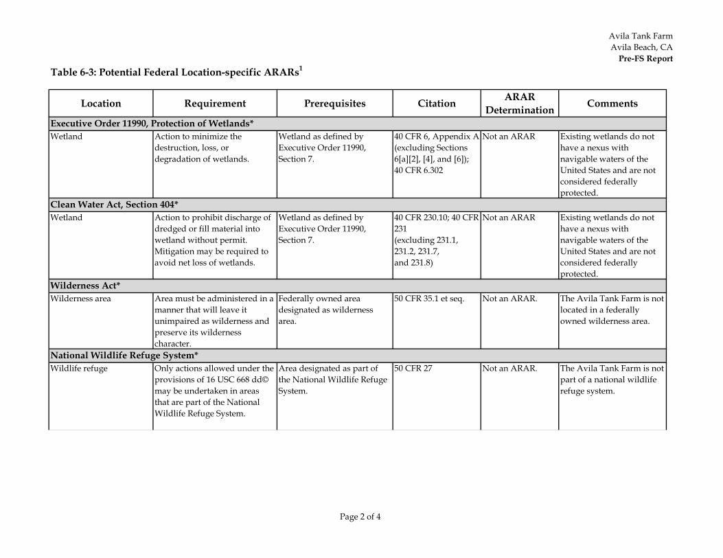
Avila Tank FarmAvila Beach, CA
Pre-FS Report
Page 2 of 4
Table 6-3: Potential Federal Location-specific ARARs1
Location Requirement Prerequisites Citation ARAR Determination Comments
Wetland Action to minimize the destruction, loss, or degradation of wetlands.
Wetland as defined by Executive Order 11990, Section 7.
40 CFR 6, Appendix A (excluding Sections 6[a][2], [4], and [6]); 40 CFR 6.302
Not an ARAR Existing wetlands do not have a nexus with navigable waters of the United States and are not considered federally protected.
Wetland Action to prohibit discharge of dredged or fill material into wetland without permit. Mitigation may be required to avoid net loss of wetlands.
Wetland as defined by Executive Order 11990, Section 7.
40 CFR 230.10; 40 CFR 231(excluding 231.1, 231.2, 231.7, and 231.8)
Not an ARAR Existing wetlands do not have a nexus with navigable waters of the United States and are not considered federally protected.
Wilderness area Area must be administered in a manner that will leave it unimpaired as wilderness and preserve its wilderness character.
Federally owned area designated as wilderness area.
50 CFR 35.1 et seq. Not an ARAR. The Avila Tank Farm is not located in a federally owned wilderness area.
Wildlife refuge Only actions allowed under the provisions of 16 USC 668 dd© may be undertaken in areas that are part of the National Wildlife Refuge System.
Area designated as part of the National Wildlife Refuge System.
50 CFR 27 Not an ARAR. The Avila Tank Farm is not part of a national wildlife refuge system.
Executive Order 11990, Protection of Wetlands*
Clean Water Act, Section 404*
Wilderness Act*
National Wildlife Refuge System*
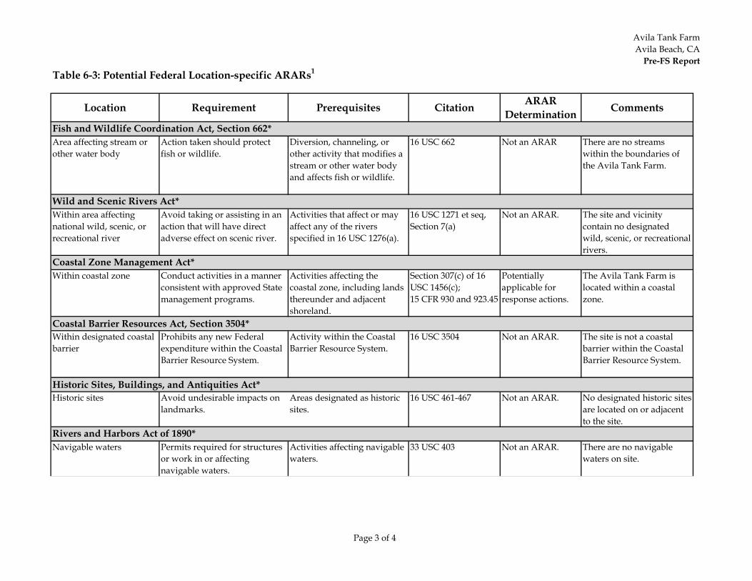
Avila Tank FarmAvila Beach, CA
Pre-FS Report
Page 3 of 4
Table 6-3: Potential Federal Location-specific ARARs1
Location Requirement Prerequisites Citation ARAR Determination Comments
Area affecting stream or other water body
Action taken should protect fish or wildlife.
Diversion, channeling, or other activity that modifies a stream or other water body and affects fish or wildlife.
16 USC 662 Not an ARAR There are no streams within the boundaries of the Avila Tank Farm.
Within area affecting national wild, scenic, or recreational river
Avoid taking or assisting in an action that will have direct adverse effect on scenic river.
Activities that affect or may affect any of the rivers specified in 16 USC 1276(a).
16 USC 1271 et seq, Section 7(a)
Not an ARAR. The site and vicinity contain no designated wild, scenic, or recreational rivers.
Within coastal zone Conduct activities in a manner consistent with approved State management programs.
Activities affecting the coastal zone, including lands thereunder and adjacent shoreland.
Section 307(c) of 16 USC 1456(c);15 CFR 930 and 923.45
Potentially applicable for response actions.
The Avila Tank Farm is located within a coastal zone.
Coastal Barrier Resources Act, Section 3504*Within designated coastal barrier
Prohibits any new Federal expenditure within the Coastal Barrier Resource System.
Activity within the Coastal Barrier Resource System.
16 USC 3504 Not an ARAR. The site is not a coastal barrier within the Coastal Barrier Resource System.
Historic Sites, Buildings, and Antiquities Act*Historic sites Avoid undesirable impacts on
landmarks.Areas designated as historic sites.
16 USC 461-467 Not an ARAR. No designated historic sites are located on or adjacent to the site.
Navigable waters Permits required for structures or work in or affecting navigable waters.
Activities affecting navigable waters.
33 USC 403 Not an ARAR. There are no navigable waters on site.
Rivers and Harbors Act of 1890*
Coastal Zone Management Act*
Wild and Scenic Rivers Act*
Fish and Wildlife Coordination Act, Section 662*
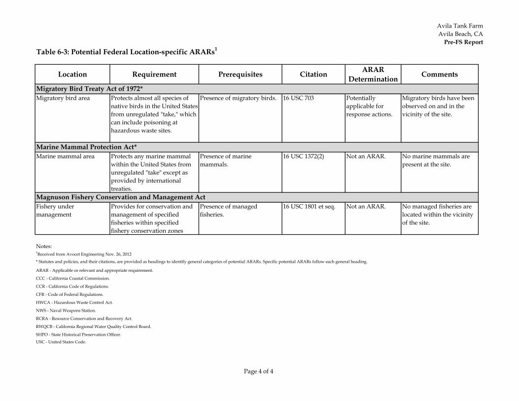
Avila Tank FarmAvila Beach, CA
Pre-FS Report
Page 4 of 4
Table 6-3: Potential Federal Location-specific ARARs1
Location Requirement Prerequisites Citation ARAR Determination Comments
Migratory bird area Protects almost all species of native birds in the United States from unregulated "take," which can include poisoning at hazardous waste sites.
Presence of migratory birds. 16 USC 703 Potentially applicable for response actions.
Migratory birds have been observed on and in the vicinity of the site.
Marine mammal area Protects any marine mammal within the United States from unregulated "take" except as provided by international treaties.
Presence of marine mammals.
16 USC 1372(2) Not an ARAR. No marine mammals are present at the site.
Fishery under management
Provides for conservation and management of specified fisheries within specified fishery conservation zones
Presence of managed fisheries.
16 USC 1801 et seq. Not an ARAR. No managed fisheries are located within the vicinity of the site.
Notes:1Received from Avocet Engineering Nov. 26, 2012
* Statutes and policies, and their citations, are provided as headings to identify general categories of potential ARARs. Specific potential ARARs follow each general heading.
ARAR - Applicable or relevant and appropriate requirement.
CCC - California Coastal Commission.
Migratory Bird Treaty Act of 1972*
Marine Mammal Protection Act*
Magnuson Fishery Conservation and Management Act
SHPO - State Historical Preservation Officer.
USC - United States Code.
CCR - California Code of Regulations.
CFR - Code of Federal Regulations.
HWCA - Hazardous Waste Control Act.
NWS - Naval Weapons Station.
RCRA - Resource Conservation and Recovery Act.
RWQCB - California Regional Water Quality Control Board.
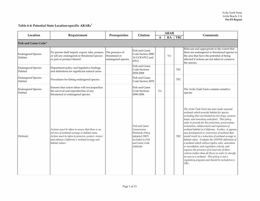
Avila Tank FarmAvila Beach, CA
Pre-FS Report
Page 1 of 13
Table 6-4: Potential State Location-specific ARARs1
A RA TBC
Endangered SpeciesHabitat
No person shall import, export, take, possess, or sell any endangered or threatened species or part or product thereof.
The presence of threatened or endangered species.
Fish and Game Code Section 2080 14 CCR 670.2 and 670.5
Yes
Relevant and appropriate to the extent that there are endangered or threatened species in the area that have the potential of being affected if actions are not taken to conserve the species.
Endangered SpeciesHabitat
Department policy and legislative findings and definitions for significant natural areas.
Fish and Game Code Sections 2050-2068
TBC
Endangered SpeciesHabitat Procedures for listing endangered species. Fish and Game
Code Section 2070 TBC
Endangered SpeciesHabitat
Ensures that action taken will not jeopardize the survival and reproduction of any threatened or endangered species.
Fish and Game Code Sections 2090-2096
Yes The Avila Tank Farm contains sensitive species
Wetlands
Actions must be taken to assure that there is no net loss of wetlands acreage or habitat value. Action must be taken to preserve, protect, restore and enhance California's wetland acreage and habitat values.
Fish and Game Commission Wetlands Policy (adopted 1987) included in Fish and Game Code Addenda
TBC
The Avila Tank Farm has man-made seasonal wetlands which provide habitat for species including (but not limited to) tree frogs, western toads, and transitory waterfowl. This policy seeks to provide for the protection, preservation, restoration, enhancement and expansion of wetland habitat in California. Further, it opposes any development or conversion of wetland that would result in a reduction of wetland acreage or habitat value. It adopts the USFWS definition of a wetland which utilizes hydric soils, saturation or inundation, and vegetation criteria, and requires the presence of at least one of these criteria (rather than all three) in order to classify an area as a wetland. This policy is not a regulatory program and should be included as a TBC.
Fish and Game Code*
Location Requirement Prerequisites Citation ARAR Comments
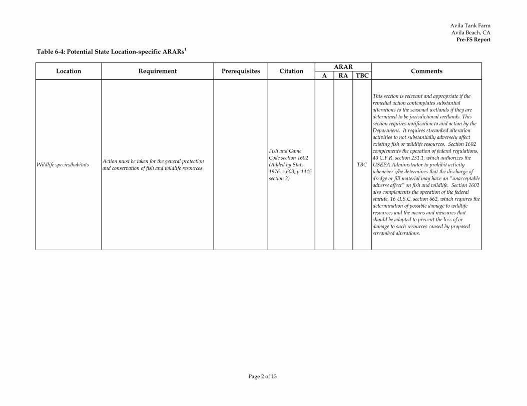
Avila Tank FarmAvila Beach, CA
Pre-FS Report
Page 2 of 13
Table 6-4: Potential State Location-specific ARARs1
A RA TBCLocation Requirement Prerequisites Citation ARAR Comments
Wildlife species/habitats Action must be taken for the general protection and conservation of fish and wildlife resources
Fish and Game Code section 1602 (Added by Stats. 1976, c.603, p.1445 section 2)
TBC
This section is relevant and appropriate if the remedial action contemplates substantial alterations to the seasonal wetlands if they are determined to be jurisdictional wetlands. This section requires notification to and action by the Department. It requires streambed alteration activities to not substantially adversely affect existing fish or wildlife resources. Section 1602 complements the operation of federal regulations, 40 C.F.R. section 231.1, which authorizes the USEPA Administrator to prohibit activity whenever s/he determines that the discharge of dredge or fill material may have an “unacceptable adverse affect” on fish and wildlife. Section 1602 also complements the operation of the federal statute, 16 U.S.C. section 662, which requires the determination of possible damage to wildlife resources and the means and measures that should be adopted to prevent the loss of or damage to such resources caused by proposed streambed alterations.
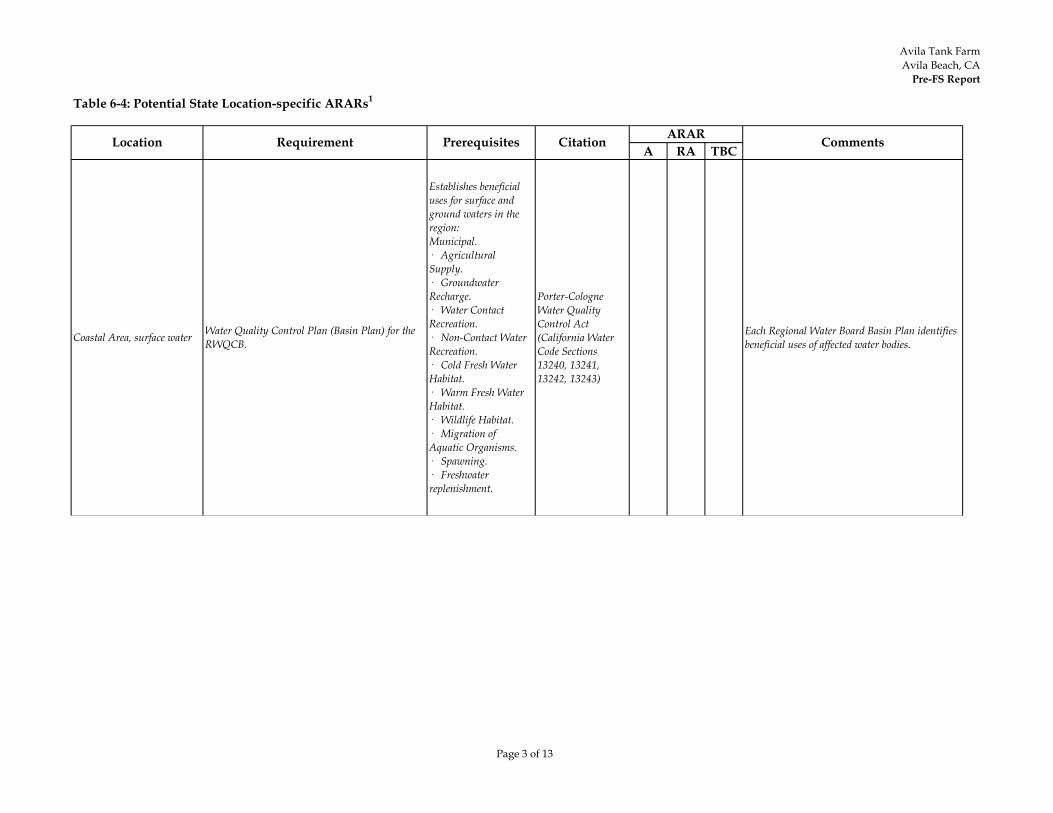
Avila Tank FarmAvila Beach, CA
Pre-FS Report
Page 3 of 13
Table 6-4: Potential State Location-specific ARARs1
A RA TBCLocation Requirement Prerequisites Citation ARAR Comments
Coastal Area, surface water Water Quality Control Plan (Basin Plan) for the RWQCB.
Establishes beneficial uses for surface and ground waters in the region:Municipal.· Agricultural Supply.· Groundwater Recharge.· Water Contact Recreation.· Non-Contact Water Recreation.· Cold Fresh Water Habitat.· Warm Fresh Water Habitat.· Wildlife Habitat.· Migration of Aquatic Organisms.· Spawning.· Freshwater replenishment.
Porter-Cologne Water Quality Control Act (California Water Code Sections 13240, 13241, 13242, 13243)
Each Regional Water Board Basin Plan identifies beneficial uses of affected water bodies.
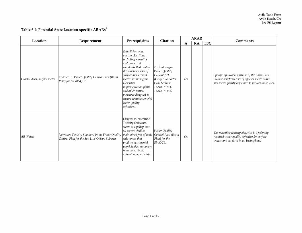
Avila Tank FarmAvila Beach, CA
Pre-FS Report
Page 4 of 13
Table 6-4: Potential State Location-specific ARARs1
A RA TBCLocation Requirement Prerequisites Citation ARAR Comments
Coastal Area, surface water Chapter III. Water Quality Control Plan (Basin Plan) for the RWQCB.
Establishes water quality objectives, including narrative and numerical standards that protect the beneficial uses of surface and ground waters in the region. Describes implementation plans and other control measures designed to ensure compliance with water quality objectives.
Porter-Cologne Water Quality Control Act (California Water Code Sections 13240, 13241, 13242, 13243)
YesSpecific applicable portions of the Basin Plan include beneficial uses of affected water bodies and water quality objectives to protect those uses.
All Waters Narrative Toxicity Standard in the Water Quality Control Plan for the San Luis Obispo Subarea.
Chapter V. Narrative Toxicity Objective, states as a policy that all waters shall be maintained free of toxic substances that produce detrimental physiological responses in human, plant, animal, or aquatic life.
Water Quality Control Plan (Basin Plan) for the RWQCB.
YesThe narrative toxicity objective is a federally required water quality objective for surface waters and set forth in all basin plans.
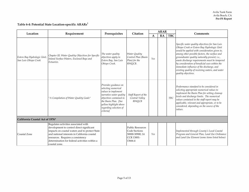
Avila Tank FarmAvila Beach, CA
Pre-FS Report
Page 5 of 13
Table 6-4: Potential State Location-specific ARARs1
A RA TBCLocation Requirement Prerequisites Citation ARAR Comments
Estero Bay Hydrologic Unit, San Luis Obispo Creek
Chapter III. Water Quality Objectives for Specific Inland Surface Waters, Enclosed Bays and Estuaries.
The water quality objectives apply to Estero Bay, San Luis Obispo Creek.
Water Quality Control Plan (Basin Plan) for the RWQCB.
Yes
Specific water quality objectives for San Luis Obispo Creek or Estero Bay Hydrologic Unit would be applied with consideration given to, among other possible factors, the surface and groundwater quality naturally present; i.e., waste discharge requirements must be tempered by consideration of beneficial uses within the immediate influence of the discharge, and existing quality of receiving waters, and water quality objectives.
"A Compilation of Water Quality Goals"
Provides guidance on selecting numerical values to implement narrative water quality objectives contained in the Basin Plan. [See yellow highlight above regarding selection of criteria]
Staff Report of the Central Valley
RWQCBTBC
Performance standard to be considered in selecting appropriate numerical values to implement the Basin Plan for setting cleanup levels and discharge limits. The numerical values contained in the staff report may be applicable, relevant and appropriate, or to be considered, depending on the source of the values.
Coastal Zone
Regulates activities associated with development to control direct significant impacts on coastal waters and to protect State and national interests in California coastal resources. Requires a consistency determination for federal activities within a coastal zone.
Public Resources Code Sections 30000-30900; 14 CCR 13001-13666.4
YesImplemented through County’s Local Coastal Program and General Plan, Land Use Ordinance and Land Use Element (some items listed below)
California Coastal Act of 1976*
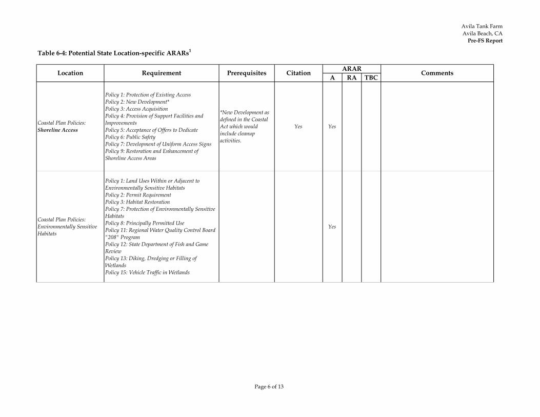
Avila Tank FarmAvila Beach, CA
Pre-FS Report
Page 6 of 13
Table 6-4: Potential State Location-specific ARARs1
A RA TBCLocation Requirement Prerequisites Citation ARAR Comments
Coastal Plan Policies: Shoreline Access
Policy 1: Protection of Existing AccessPolicy 2: New Development*Policy 3: Access AcquisitionPolicy 4: Provision of Support Facilities and ImprovementsPolicy 5: Acceptance of Offers to DedicatePolicy 6: Public SafetyPolicy 7: Development of Uniform Access SignsPolicy 9: Restoration and Enhancement of Shoreline Access Areas
*New Development as defined in the Coastal Act which would include cleanup activities.
Yes Yes
Coastal Plan Policies: Environmentally Sensitive Habitats
Policy 1: Land Uses Within or Adjacent to Environmentally Sensitive HabitatsPolicy 2: Permit RequirementPolicy 3: Habitat RestorationPolicy 7: Protection of Environmentally Sensitive HabitatsPolicy 8: Principally Permitted UsePolicy 11: Regional Water Quality Control Board "208" ProgramPolicy 12: State Department of Fish and Game ReviewPolicy 13: Diking, Dredging or Filling of WetlandsPolicy 15: Vehicle Traffic in Wetlands
Yes

Avila Tank FarmAvila Beach, CA
Pre-FS Report
Page 7 of 13
Table 6-4: Potential State Location-specific ARARs1
A RA TBCLocation Requirement Prerequisites Citation ARAR Comments
Coastal Plan Policies: Environmentally Sensitive Habitats(continued)
Policy 16: Adjacent DevelopmentPolicy 17: Wetland BufferPolicy 18: Wetland Buffers Less than 100 FeetPolicy 19: Open Space Easement for WetlandsPolicy 20: Coastal Streams and Riparian VegetationPolicy 21: Development in or Adjacent to a Coastal StreamPolicy 22: Fish and Game Review of Streambed AlterationsPolicy 23: County and State Review of Coastal Stream ProjectsPolicy 25: Streambed AlterationsPolicy 26: Riparian VegetationPolicy 27: Stream Diversion StructuresPolicy 28: Buffer Zone for Riparian HabitatsPolicy 29: Protection of Terrestrial HabitatsPolicy 30: Protection of Native VegetationPolicy 31: Design of Trails In and Adjoining Sensitive HabitatsPolicy 34: Rare and Endangered Species SurveyPolicy 35: Protection of VegetationPolicy 39: Siting of Shoreline StructuresPolicy 40: Shoreline Access Consistent with Habitat ProtectionPolicy 41: Habitat Signs
Yes
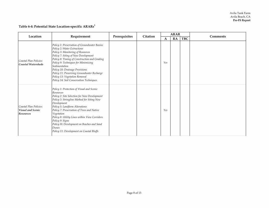
Avila Tank FarmAvila Beach, CA
Pre-FS Report
Page 8 of 13
Table 6-4: Potential State Location-specific ARARs1
A RA TBCLocation Requirement Prerequisites Citation ARAR Comments
Coastal Plan Policies: Coastal Watersheds
Policy 1: Preservation of Groundwater BasinsPolicy 2: Water ExtractionsPolicy 3: Monitoring of ResourcesPolicy 7: Siting of New DevelopmentPolicy 8: Timing of Construction and GradingPolicy 9: Techniques for Minimizing SedimentationPolicy 10: Drainage ProvisionsPolicy 11: Preserving Groundwater RechargePolicy 13: Vegetation RemovalPolicy 14: Soil Conservation Techniques
Yes
Coastal Plan Policies: Visual and Scenic Resources
Policy 1: Protection of Visual and Scenic ResourcesPolicy 2: Site Selection for New DevelopmentPolicy 3: Stringline Method for Siting New DevelopmentPolicy 5: Landform AlterationsPolicy 7: Preservation of Trees and Native VegetationPolicy 8: Utility Lines within View CorridorsPolicy 9: SignsPolicy l0: Development on Beaches and Sand DunesPolicy 11: Development on Coastal Bluffs
Yes
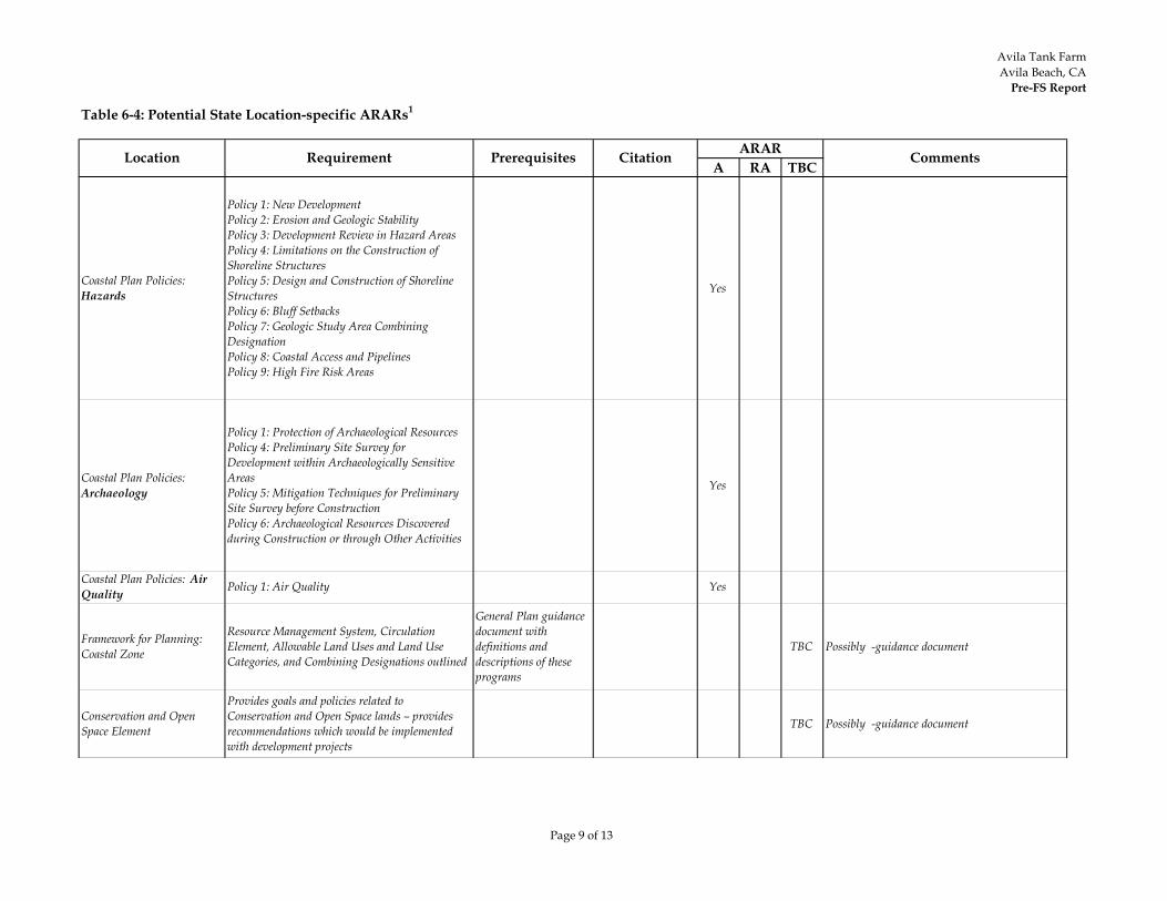
Avila Tank FarmAvila Beach, CA
Pre-FS Report
Page 9 of 13
Table 6-4: Potential State Location-specific ARARs1
A RA TBCLocation Requirement Prerequisites Citation ARAR Comments
Coastal Plan Policies: Hazards
Policy 1: New DevelopmentPolicy 2: Erosion and Geologic StabilityPolicy 3: Development Review in Hazard AreasPolicy 4: Limitations on the Construction of Shoreline StructuresPolicy 5: Design and Construction of Shoreline StructuresPolicy 6: Bluff SetbacksPolicy 7: Geologic Study Area Combining DesignationPolicy 8: Coastal Access and PipelinesPolicy 9: High Fire Risk Areas
Yes
Coastal Plan Policies: Archaeology
Policy 1: Protection of Archaeological ResourcesPolicy 4: Preliminary Site Survey for Development within Archaeologically Sensitive AreasPolicy 5: Mitigation Techniques for Preliminary Site Survey before ConstructionPolicy 6: Archaeological Resources Discovered during Construction or through Other Activities
Yes
Framework for Planning: Coastal Zone
Resource Management System, Circulation Element, Allowable Land Uses and Land Use Categories, and Combining Designations outlined
General Plan guidance document with definitions and descriptions of these programs
TBC Possibly -guidance document
Conservation and Open Space Element
Provides goals and policies related to Conservation and Open Space lands – provides recommendations which would be implemented with development projects
TBC Possibly -guidance document
Coastal Plan Policies: Air Quality Policy 1: Air Quality Yes
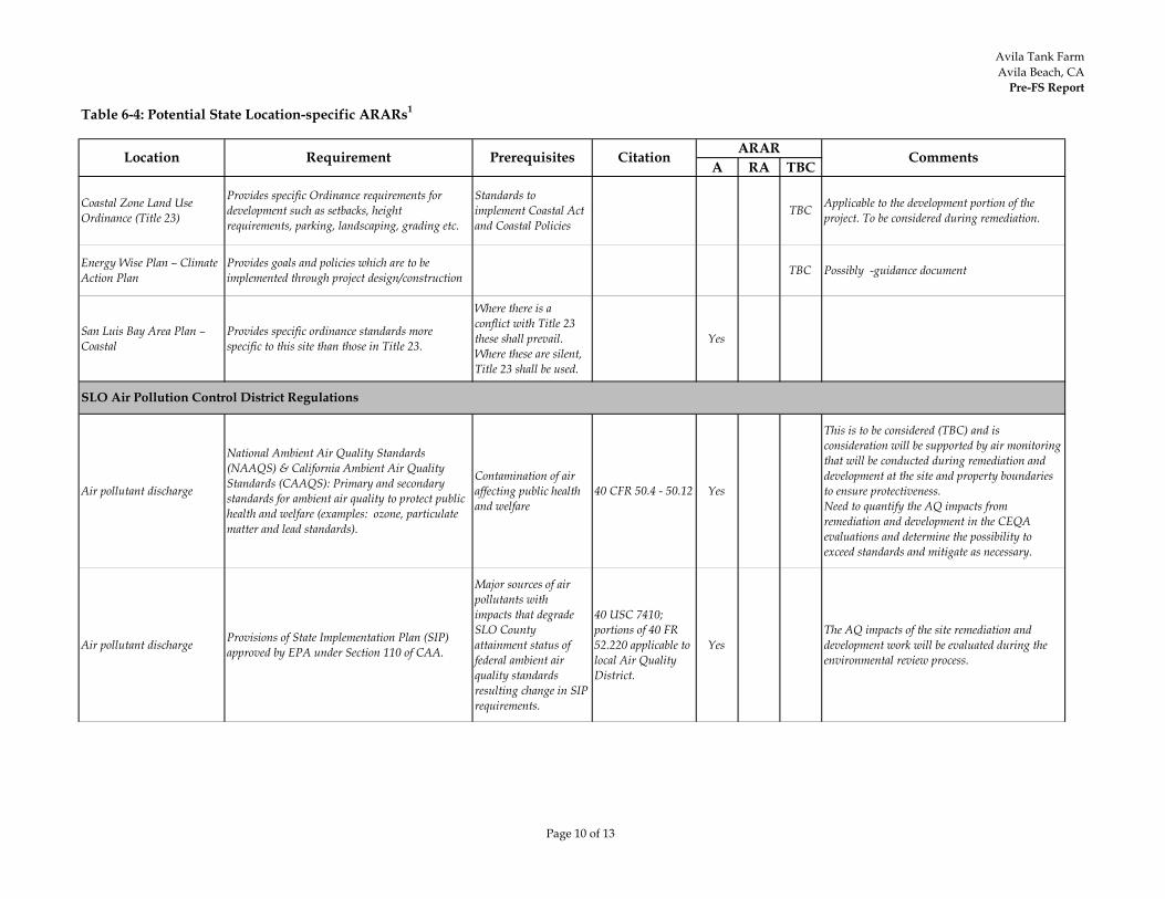
Avila Tank FarmAvila Beach, CA
Pre-FS Report
Page 10 of 13
Table 6-4: Potential State Location-specific ARARs1
A RA TBCLocation Requirement Prerequisites Citation ARAR Comments
Coastal Zone Land Use Ordinance (Title 23)
Provides specific Ordinance requirements for development such as setbacks, height requirements, parking, landscaping, grading etc.
Standards to implement Coastal Act and Coastal Policies
TBC Applicable to the development portion of the project. To be considered during remediation.
Energy Wise Plan – Climate Action Plan
Provides goals and policies which are to be implemented through project design/construction TBC Possibly -guidance document
San Luis Bay Area Plan – Coastal
Provides specific ordinance standards more specific to this site than those in Title 23.
Where there is a conflict with Title 23 these shall prevail. Where these are silent, Title 23 shall be used.
Yes
Air pollutant discharge
National Ambient Air Quality Standards (NAAQS) & California Ambient Air Quality Standards (CAAQS): Primary and secondary standards for ambient air quality to protect public health and welfare (examples: ozone, particulate matter and lead standards).
Contamination of air affecting public health and welfare
40 CFR 50.4 - 50.12 Yes
This is to be considered (TBC) and is consideration will be supported by air monitoring that will be conducted during remediation and development at the site and property boundaries to ensure protectiveness.Need to quantify the AQ impacts from remediation and development in the CEQA evaluations and determine the possibility to exceed standards and mitigate as necessary.
Air pollutant discharge Provisions of State Implementation Plan (SIP) approved by EPA under Section 110 of CAA.
Major sources of air pollutants with impacts that degrade SLO County attainment status of federal ambient air quality standards resulting change in SIP requirements.
40 USC 7410; portions of 40 FR 52.220 applicable to local Air Quality District.
YesThe AQ impacts of the site remediation and development work will be evaluated during the environmental review process.
SLO Air Pollution Control District Regulations
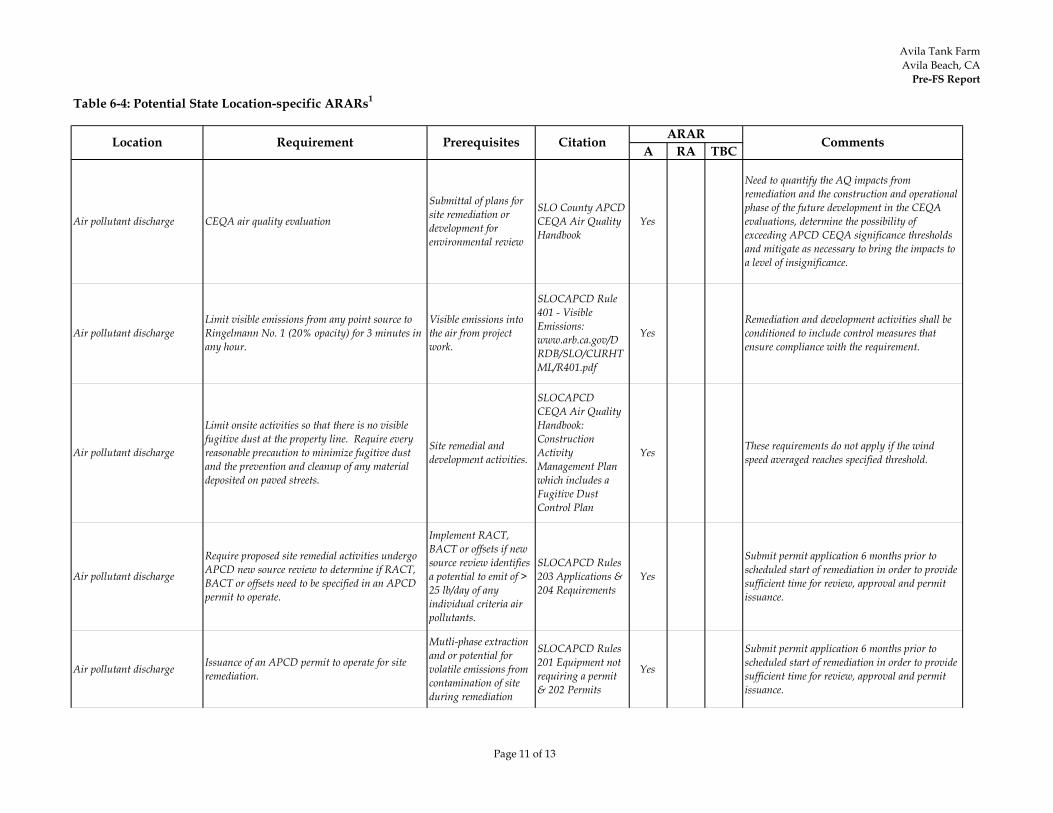
Avila Tank FarmAvila Beach, CA
Pre-FS Report
Page 11 of 13
Table 6-4: Potential State Location-specific ARARs1
A RA TBCLocation Requirement Prerequisites Citation ARAR Comments
Air pollutant discharge CEQA air quality evaluation
Submittal of plans for site remediation or development for environmental review
SLO County APCD CEQA Air Quality Handbook
Yes
Need to quantify the AQ impacts from remediation and the construction and operational phase of the future development in the CEQA evaluations, determine the possibility of exceeding APCD CEQA significance thresholds and mitigate as necessary to bring the impacts to a level of insignificance.
Air pollutant dischargeLimit visible emissions from any point source to Ringelmann No. 1 (20% opacity) for 3 minutes in any hour.
Visible emissions into the air from project work.
SLOCAPCD Rule 401 - Visible Emissions: www.arb.ca.gov/DRDB/SLO/CURHTML/R401.pdf
YesRemediation and development activities shall be conditioned to include control measures that ensure compliance with the requirement.
Air pollutant discharge
Limit onsite activities so that there is no visible fugitive dust at the property line. Require every reasonable precaution to minimize fugitive dust and the prevention and cleanup of any material deposited on paved streets.
Site remedial and development activities.
SLOCAPCD CEQA Air Quality Handbook: Construction Activity Management Plan which includes a Fugitive Dust Control Plan
Yes These requirements do not apply if the wind speed averaged reaches specified threshold.
Air pollutant discharge
Require proposed site remedial activities undergo APCD new source review to determine if RACT, BACT or offsets need to be specified in an APCD permit to operate.
Implement RACT, BACT or offsets if new source review identifies a potential to emit of > 25 lb/day of any individual criteria air pollutants.
SLOCAPCD Rules 203 Applications & 204 Requirements
Yes
Submit permit application 6 months prior to scheduled start of remediation in order to provide sufficient time for review, approval and permit issuance.
Air pollutant discharge Issuance of an APCD permit to operate for site remediation.
Mutli-phase extraction and or potential for volatile emissions from contamination of site during remediation
SLOCAPCD Rules 201 Equipment not requiring a permit & 202 Permits
Yes
Submit permit application 6 months prior to scheduled start of remediation in order to provide sufficient time for review, approval and permit issuance.
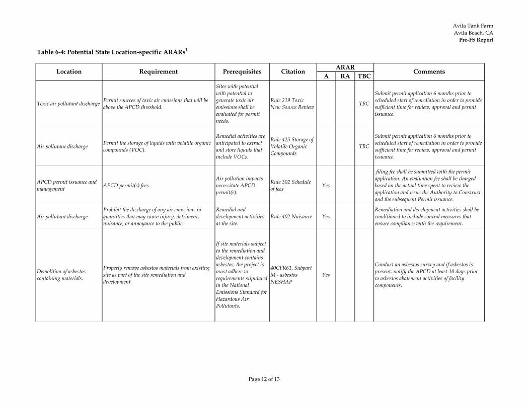
Avila Tank FarmAvila Beach, CA
Pre-FS Report
Page 12 of 13
Table 6-4: Potential State Location-specific ARARs1
A RA TBCLocation Requirement Prerequisites Citation ARAR Comments
Toxic air pollutant discharge Permit sources of toxic air emissions that will be above the APCD threshold.
Sites with potential with potential to generate toxic air emissions shall be evaluated for permit needs.
Rule 219 Toxic New Source Review TBC
Submit permit application 6 months prior to scheduled start of remediation in order to provide sufficient time for review, approval and permit issuance.
Air pollutant discharge Permit the storage of liquids with volatile organic compounds (VOC).
Remedial activities are anticipated to extract and store liquids that include VOCs.
Rule 425 Storage of Volatile Organic Compounds
TBC
Submit permit application 6 months prior to scheduled start of remediation in order to provide sufficient time for review, approval and permit issuance.
APCD permit issuance and management APCD permit(s) fees.
Air pollution impacts necessitate APCD permit(s).
Rule 302 Schedule of fees Yes
filing fee shall be submitted with the permit application. An evaluation fee shall be charged based on the actual time spent to review the application and issue the Authority to Construct and the subsequent Permit issuance.
Air pollutant dischargeProhibit the discharge of any air emissions in quantities that may cause injury, detriment, nuisance, or annoyance to the public.
Remedial and development activities at the site.
Rule 402 Nuisance YesRemediation and development activities shall be conditioned to include control measures that ensure compliance with the requirement.
Demolition of asbestos containing materials.
Properly remove asbestos materials from existing site as part of the site remediation and development.
If site materials subject to the remediation and development contains asbestos, the project is must adhere to requirements stipulated in the National Emissions Standard for Hazardous Air Pollutants.
40CFR61, Subpart M - asbestos NESHAP
Yes
Conduct an asbestos survey and if asbestos is present, notify the APCD at least 10 days prior to asbestos abatement activities of facility components.
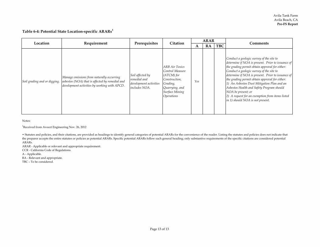
Avila Tank FarmAvila Beach, CA
Pre-FS Report
Page 13 of 13
Table 6-4: Potential State Location-specific ARARs1
A RA TBCLocation Requirement Prerequisites Citation ARAR Comments
Soil grading and or digging.Manage emissions from naturally occurring asbestos (NOA) that is affected by remedial and development activities by working with APCD.
Soil affected by remedial and development activities includes NOA.
ARB Air Toxics Control Measure (ATCM) for Construction, Grading, Quarrying, and Surface Mining Operations
Yes
Conduct a geologic survey of the site to determine if NOA is present. Prior to issuance of the grading permit obtain approval for either:Conduct a geologic survey of the site to determine if NOA is present. Prior to issuance of the grading permit obtain approval for either:1) An Asbestos Dust Mitigation Plan and an Asbestos Health and Safety Program should NOA be present; or2) A request for an exemption from items listed in 1) should NOA is not present.
Notes:1Received from Avocet Engineering Nov. 26, 2012
• Statutes and policies, and their citations, are provided as headings to identify general categories of potential ARARs for the convenience of the reader. Listing the statutes and policies does not indicate that the preparer accepts the entire statutes or policies as potential ARARs. Specific potential ARARs follow each general heading; only substantive requirements of the specific citations are considered potential ARARs.ARAR - Applicable or relevant and appropriate requirement.CCR - California Code of Regulations.A - Applicable.RA - Relevant and appropriate.TBC – To be considered.

Avila Tank FarmAvila Beach, CA
Pre-FS Report
Page 1 of 8
Table 6-5: Potential Federal Action-specific ARARs1
A RA TBC
Onsite waste generation
Person who generates waste shall determine if that waste is a hazardous waste.
Generator of hazardous waste in California.
22 CCR 66262.10(a), 66262.11, Yes
Applicable for any operation where hazardous waste is generated such as excavation activities. Not an ARAR. No RCRA hazardous waste is known to be present in site soils. Applicable to the extent that management creates a hazardous waste.
Hazardous wasteaccumulation
Generator may accumulate waste on-site for 90 days or less or must comply with requirements for operating a storage facility.
Accumulate hazardous waste.
22 CCR Section 66262.34 Yes
Accumulation of hazardous wastes onsite for longer than 90 days would be subject to RCRA requirements for storage facilities. Not an ARAR. No RCRA hazardous waste is known to be present in site soils.
Recordkeeping Generator must keep records. Generate hazardous waste.
22 CCR Section 66262.40 Yes
Applicable if hazardous wastes are accumulated for longer than 90 days. Not an ARAR. No RCRA hazardous waste is known to be present in site soils.
Actions Included in Potential Alternatives: Capping, Excavation, Wetland Mitigation, Long-Term Monitoring, and Institutional
Action Requirement Prerequisites Citation ARAR Comments
Resource Conservation and Recovery Act (RCRA) 42 USC 6901 et seq.*

Avila Tank FarmAvila Beach, CA
Pre-FS Report
Page 2 of 8
Table 6-5: Potential Federal Action-specific ARARs1
A RA TBC
Actions Included in Potential Alternatives: Capping, Excavation, Wetland Mitigation, Long-Term Monitoring, and Institutional
Action Requirement Prerequisites Citation ARAR Comments
Container storage
Containers of RCRA hazardous waste must be:- Maintained in good condition.- Compatible with hazardous waste to be stored.- Closed during storage except to add or remove waste.
Storage of RCRA hazardous waste not meeting small quantity generator criteria held for a temporary period greater than 90 days before treatment, disposal or storage elsewhere, in a container.
22 CCR 66264.171, 172, 173 Yes
Applicable if hazardous wastes are accumulated for longer than 90 days. Not an ARAR. No RCRA hazardous waste is known to be present in site soils.
Inspect container storage areas weekly for deterioration. 22 CCR 66264.174 Yes See comment above.
Place containers on a sloped, crack-free base, and protect from contact with accumulated liquid. Provide containment system with a capacity of 10 percent of the volume of containers of free liquids. Remove spilled or leaked waste in a timely manner to prevent overflow of the containment system.
22 CCR 66264.175(a) and (b) Yes See comment above.
Keep containers of ignitable or reactive waste at least 50 feet from the facility property line.
22 CCR 66264.176 Yes See comment above.
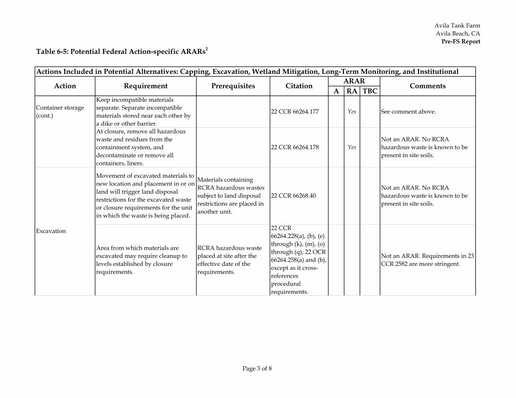
Avila Tank FarmAvila Beach, CA
Pre-FS Report
Page 3 of 8
Table 6-5: Potential Federal Action-specific ARARs1
A RA TBC
Actions Included in Potential Alternatives: Capping, Excavation, Wetland Mitigation, Long-Term Monitoring, and Institutional
Action Requirement Prerequisites Citation ARAR Comments
Container storage(cont.)
Keep incompatible materials separate. Separate incompatible materials stored near each other by a dike or other barrier.
22 CCR 66264.177 Yes See comment above.
At closure, remove all hazardous waste and residues from the containment system, and decontaminate or remove all containers, liners.
22 CCR 66264.178 YesNot an ARAR. No RCRA hazardous waste is known to be present in site soils.
Movement of excavated materials to new location and placement in or on land will trigger land disposal restrictions for the excavated waste or closure requirements for the unit in which the waste is being placed.
Materials containing RCRA hazardous wastes subject to land disposal restrictions are placed in another unit.
22 CCR 66268.40Not an ARAR. No RCRA hazardous waste is known to be present in site soils.
Area from which materials are excavated may require cleanup to levels established by closure requirements.
RCRA hazardous waste placed at site after the effective date of the requirements.
22 CCR 66264.228(a), (b), (e) through (k), (m), (o) through (q); 22 OCR 66264.258(a) and (b), except as it cross-references procedural requirements.
Not an ARAR. Requirements in 23 CCR 2582 are more stringent.
Excavation
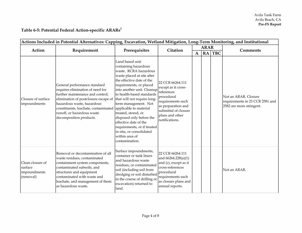
Avila Tank FarmAvila Beach, CA
Pre-FS Report
Page 4 of 8
Table 6-5: Potential Federal Action-specific ARARs1
A RA TBC
Actions Included in Potential Alternatives: Capping, Excavation, Wetland Mitigation, Long-Term Monitoring, and Institutional
Action Requirement Prerequisites Citation ARAR Comments
Closure of surfaceimpoundments
General performance standard requires elimination of need for further maintenance and control; elimination of postclosure escape of hazardous waste, hazardous constituents, leachate, contaminated runoff, or hazardous waste decomposition products.
Land based unit containing hazardous waste. RCRA hazardous waste placed at site after the effective date of the requirements, or placed into another unit. Cleanup to health-based standards that will not require long-term management. Not applicable to material treated, stored, or disposed only before the effective date of the requirements, or if treated in situ, or consolidated within area of contamination.
22 CCR 66264.111 except as it cross-references procedural requirements such as preparation and submittal of closure plans and other notifications.
Not an ARAR. Closure requirements in 23 CCR 2581 and 2582 are more stringent.
Clean closure of surfaceimpoundments (removal)
Removal or decontamination of all waste residues, contaminated containment system components, contaminated subsoils, and structures and equipment contaminated with waste and leachate, and management of them as hazardous waste.
Surface impoundments, container or tank liners and hazardous waste residues, or contaminated soil (including soil from dredging or soil disturbed in the course of drilling or excavation) returned to land.
22 CCR 66264.111 and 66264.228(a)(1) and (c), except as it cross-references procedural requirements such as closure plans and annual reports.
Not an ARAR.

Avila Tank FarmAvila Beach, CA
Pre-FS Report
Page 5 of 8
Table 6-5: Potential Federal Action-specific ARARs1
A RA TBC
Actions Included in Potential Alternatives: Capping, Excavation, Wetland Mitigation, Long-Term Monitoring, and Institutional
Action Requirement Prerequisites Citation ARAR Comments
Closure of surfaceimpoundments with waste in place (capping)
Requirements include eliminating free liquids, stabilizing remaining waste to support a cover and covering the surface impoundment. The cover should be constructed to prevent downward entry of water for 100 years, function with minimum maintenance, promote drainage and eliminate erosion, accommodate settling and shear forces, have a permeability less than or equal to permeability of subsoils present.
Surface impoundment containing hazardous waste.
22 CCR 66264.228(a)(2), (b) and (d) through (r) except as it cross references procedural requirements such as closure plans and annual reports.
Not an ARAR. No surface impoundments storing hazardous waste existed at the site.
Treatment when waste will be land disposed
Treatment of waste subject to ban on land disposal must attain levels achievable by best demonstrated available treatment technologies (BDAT) for each hazardous constituent in each listed waste, if residual is to be land disposed.
Placement of RCRA hazardous waste in a landfill, surface impoundment, waste pile, injection well, land treatment facility, salt dome formation, or underground mine or cave.
22 CCR 66268.40 and 42
Not an ARAR. No RCRA hazardous waste is known to be present in site soils.
Placement of waste in land disposal unit
Attain land disposal treatment standards before putting waste into landfill in order to comply with land ban restrictions.
22 CCR 66268.40Not an ARAR. No RCRA hazardous waste is known to be present in site soils.
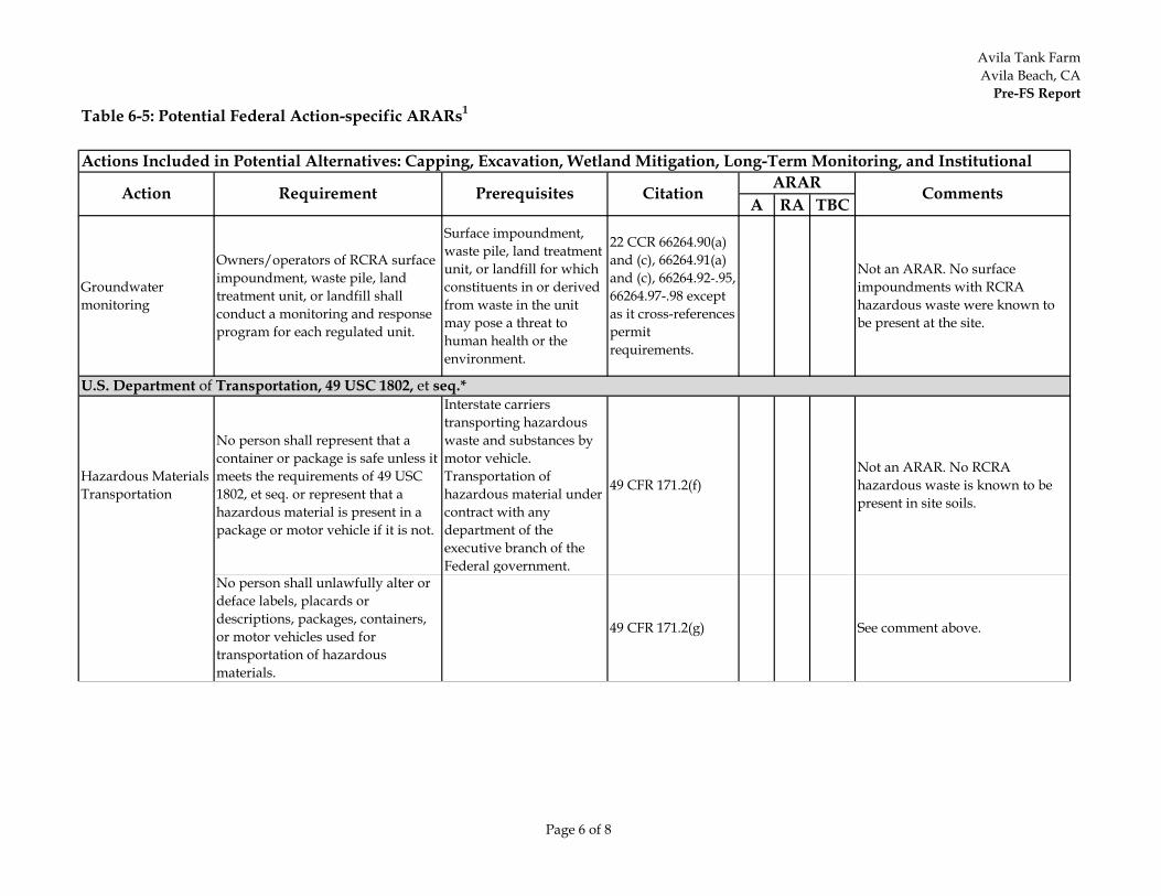
Avila Tank FarmAvila Beach, CA
Pre-FS Report
Page 6 of 8
Table 6-5: Potential Federal Action-specific ARARs1
A RA TBC
Actions Included in Potential Alternatives: Capping, Excavation, Wetland Mitigation, Long-Term Monitoring, and Institutional
Action Requirement Prerequisites Citation ARAR Comments
Groundwater monitoring
Owners/operators of RCRA surface impoundment, waste pile, land treatment unit, or landfill shall conduct a monitoring and response program for each regulated unit.
Surface impoundment, waste pile, land treatment unit, or landfill for which constituents in or derived from waste in the unit may pose a threat to human health or the environment.
22 CCR 66264.90(a) and (c), 66264.91(a) and (c), 66264.92-.95, 66264.97-.98 except as it cross-references permit requirements.
Not an ARAR. No surface impoundments with RCRA hazardous waste were known to be present at the site.
Hazardous MaterialsTransportation
No person shall represent that a container or package is safe unless it meets the requirements of 49 USC 1802, et seq. or represent that a hazardous material is present in a package or motor vehicle if it is not.
Interstate carriers transporting hazardous waste and substances by motor vehicle. Transportation of hazardous material under contract with any department of the executive branch of the Federal government.
49 CFR 171.2(f)Not an ARAR. No RCRA hazardous waste is known to be present in site soils.
No person shall unlawfully alter or deface labels, placards or descriptions, packages, containers, or motor vehicles used for transportation of hazardous materials.
49 CFR 171.2(g) See comment above.
U.S. Department of Transportation, 49 USC 1802, et seq.*
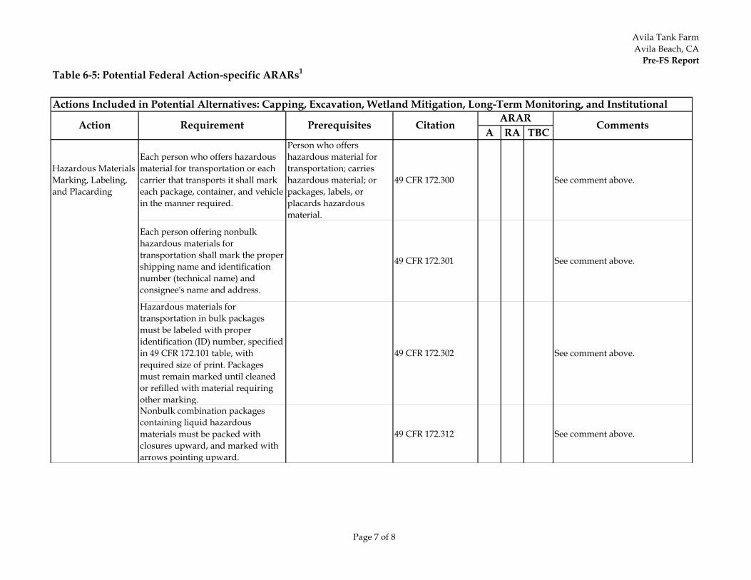
Avila Tank FarmAvila Beach, CA
Pre-FS Report
Page 7 of 8
Table 6-5: Potential Federal Action-specific ARARs1
A RA TBC
Actions Included in Potential Alternatives: Capping, Excavation, Wetland Mitigation, Long-Term Monitoring, and Institutional
Action Requirement Prerequisites Citation ARAR Comments
Hazardous MaterialsMarking, Labeling, and Placarding
Each person who offers hazardous material for transportation or each carrier that transports it shall mark each package, container, and vehicle in the manner required.
Person who offers hazardous material for transportation; carries hazardous material; or packages, labels, or placards hazardous material.
49 CFR 172.300 See comment above.
Each person offering nonbulk hazardous materials for transportation shall mark the proper shipping name and identification number (technical name) and consignee's name and address.
49 CFR 172.301 See comment above.
Hazardous materials for transportation in bulk packages must be labeled with proper identification (ID) number, specified in 49 CFR 172.101 table, with required size of print. Packages must remain marked until cleaned or refilled with material requiring other marking.
49 CFR 172.302 See comment above.
Nonbulk combination packages containing liquid hazardous materials must be packed with closures upward, and marked with arrows pointing upward.
49 CFR 172.312 See comment above.
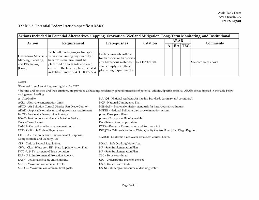
Avila Tank FarmAvila Beach, CA
Pre-FS Report
Page 8 of 8
Table 6-5: Potential Federal Action-specific ARARs1
A RA TBC
Actions Included in Potential Alternatives: Capping, Excavation, Wetland Mitigation, Long-Term Monitoring, and Institutional
Action Requirement Prerequisites Citation ARAR Comments
Hazardous MaterialsMarking, Labeling, and Placarding(Cont.)
Each bulk packaging or transport vehicle containing any quantity of hazardous material must be placarded on each side and each end with the type of placards listed in Tables 1 and 2 of 49 CFR 172.504.
Each person who offers for transport or transports any hazardous materials shall comply with these placarding requirements.
49 CFR 172.504 See comment above.
Notes:1Received from Avocet Engineering Nov. 26, 2012
DOT - U.S. Department of Transportation. TBC - To be considered.
LAER - Lowest achievable emission rate. USC - United States Code.MCLs - Maximum contaminant levels. USDW - Underground source of drinking water.
UIC - Underground injection control.EPA - U.S. Environmental Protection Agency.
MCLGs - Maximum contaminant level goals.
SDWA - Safe Drinking Water Act.CFR - Code of Federal Regulations. SIP - State Implementation Plan.CWA - Clean Water Act. SIP - State Implementation Plan.SIP - State Implementation Plan.
CAMU - Correction action management unit. RCRA - Resource Conservation and Recovery Act.CCR - California Code of Regulations. RWQCB - California Regional Water Quality Control Board, San Diego Region.
CERCLA - Comprehensive Environmental Response, Compensation, and Liability Act. SWRCB - California State Water Resources Control Board.
BACT - Best available control technology. ppm - Parts per million.BDAT - Best demonstrated available technologies. ppmw - Parts per million by weight.CAA - Clean Air Act. RA - Relevant and appropriate.
ACLs - Alternate concentration limits. NCP - National Contingency PlanAPCD - Air Pollution Control District (San Diego County). NESHAPs - National emission standards for hazardous air pollutants.ARAR - Applicable or relevant and appropriate requirement. NPDES - National Pollutant discharge elimination system.
A - Applicable. NAAQS - National Ambient Air Quality Standards (primary and secondary).
* Statutes and policies, and their citations, are provided as headings to identify general categories of potential ARARs. Specific potential ARARs are addressed in the table below each general heading.
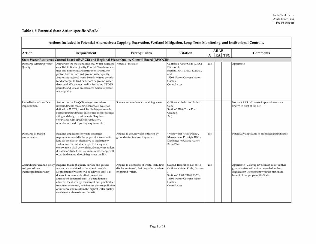
Avila Tank FarmAvila Beach, CA
Pre-FS Report
Page 1 of 18
Table 6-6: Potential State Action-specific ARARs1
A RA TBC
Discharge Affecting Water Quality
Authorizes the State and Regional Water Boards to establish in Water Quality Control Plans beneficial uses and numerical and narrative standards to protect both surface and ground water quality. Authorizes regional water boards to issue permits for discharges to land or surface or ground water that could affect water quality, including NPDES permits, and to take enforcement action to protect water quality.
Waters of the state. California Water Code (CWC), Division 7,Section 13241, 13243, 13263(a), and13360 (Porter-Cologne Water QualityControl Act)
Yes Applicable
Remediation of a surface impoundment
Authorizes the RWQCB to regulate surface impoundments containing hazardous waste as defined in 22 CCR, prohibits discharges to such surface impoundments unless they meet specifiedsiting and design requirements. Requires compliance with specific investigation, remediation, and reporting requirements.
Surface impoundment containing waste. California Health and Safety CodeSection 25208 (Toxic Pits CleanupAct)
Not an ARAR. No waste impoundments are known to exist at the site.
Discharge of treated groundwater
Requires applicants for waste discharge requirements and discharge permits to evaluate land disposal as an alternative to discharge to surface waters. All discharges to the aquatic environment shall be considered temporary unless it is demonstrated that no undesirable change will occur in the natural receiving water quality.
Applies to groundwater extracted by groundwater treatment system.
"Wastewater Reuse Policy", Management Principle III.C – Discharge to Surface Waters, Basin Plan
Yes Potentially applicable to produced groundwater.
Groundwater cleanup policy and procedures (Nondegradation Policy)
Requires that high quality surface and ground waters be maintained to the extent possible. Degradation of waters will be allowed only if it does not unreasonably affect present and anticipated beneficial uses. If degradation is allowed, the discharge must meet best practicable treatment or control, which must prevent pollution or nuisance and result in the highest water quality consistent with maximum benefit.
Applies to discharges of waste, including discharges to soil, that may affect surface or ground waters.
SWRCB Resolution No. 68-16California Water Code, Division 7,Sections 13000, 13140, 13263, 13304 (Porter-Cologne Water QualityControl Act)
Yes Applicable. Cleanup levels must be set so that groundwaters will not be degraded, unless degradation is consistent with the maximum benefit of the people of the State.
State Water Resources Control Board (SWRCB) and Regional Water Quality Control Board (RWQCB)*
Actions Included in Potential Alternatives: Capping, Excavation, Wetland Mitigation, Long-Term Monitoring, and Institutional Controls.
Action Requirement Prerequisites Citation ARAR Comments
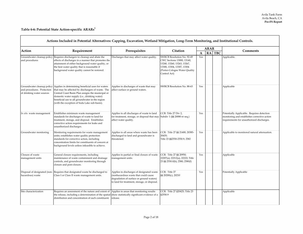
Avila Tank FarmAvila Beach, CA
Pre-FS Report
Page 2 of 18
Table 6-6: Potential State Action-specific ARARs1
A RA TBC
Actions Included in Potential Alternatives: Capping, Excavation, Wetland Mitigation, Long-Term Monitoring, and Institutional Controls.
Action Requirement Prerequisites Citation ARAR Comments
Groundwater cleanup policy and procedures
Requires dischargers to cleanup and abate the effects of discharges in a manner that promotes the attainment of either background water quality, or the best water quality that is reasonable if background water quality cannot be restored.
Discharges that may affect water quality. SWRCB Resolution No. 92-49CWC Sections 13000, 13140, 13240, 13260, 13263, 13267, 13300, 13304, 13307, 13304 (Porter-Cologne Water Quality Control Act)
Yes Applicable.
Groundwater cleanup policy and procedures. Protection of drinking water sources
Applies in determining beneficial uses for waters that may be affected by dischargers of waste. The Central Coast Basin Plan assigns the municipal or domestic water supply (i.e., drinking water) beneficial use to all groundwater in the region (with the exception of Soda Lake sub-basin).
Applies to discharges of waste that may affect surface or ground waters.
SWRCB Resolution No. 88-63 Yes Applicable
In situ waste management Establishes minimum waste management standards for discharges of waste to land for treatment, storage, and disposal. Establishes corrective action requirements for leaks and unauthorized discharges.
Applies to all discharges of waste to land for treatment, storage, or disposal that may affect water quality.
CCR: Title 27 Div 2, Subdiv 1 (§§ 20080 et seq.)
Yes Potentially Applicable. Requires detection monitoring and establishes corrective action requirements for unauthorized discharges.
Groundwater monitoring Monitoring requirements for waste management units; establishes water quality protection standards for corrective action, including concentration limits for constituents of concern at background levels unless infeasible to achieve.
Applies to all areas where waste has been discharged to land and groundwater is threatened.
CCR: Title 27 §§ 21400, 20385-20435;Title 23 §§2550-2550.9, 2582
Yes Applicable to monitored natural attenuation.
Closure of waste management units
General closure requirements, including maintenance of waste containment and drainage controls, and groundwater monitoring through closure and post-closure.
Applies to partial or final closure of waste management units.
CCR: Title 27 §§ 20950; 22207(a); 22212(a), 22222; Title 23 §§ 2550.0(b); 2580; 2580(f)
Yes Applicable
Disposal of designated (non-hazardous) waste
Requires that designated waste be discharged to Class I or Class II waste management units.
Applies to discharges of designated waste (nonhazardous waste that could cause degradation of surface or ground waters) to land for treatment, storage, or disposal.
CCR: Title 27 §§ 20200(c), 20210
Yes Potentially Applicable
Site characterization Requires an assessment of the nature and extent of the release, including a determination of the spatial distribution and concentration of each constituent.
Applies to areas that monitoring results show statistically significant evidence of a release.
CCR: Title 27 §20425; Title 23 §2550.9
Applicable
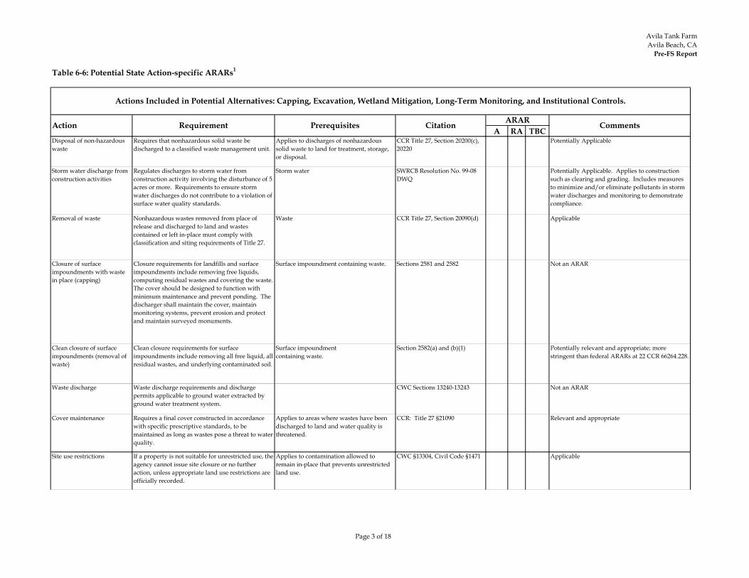
Avila Tank FarmAvila Beach, CA
Pre-FS Report
Page 3 of 18
Table 6-6: Potential State Action-specific ARARs1
A RA TBC
Actions Included in Potential Alternatives: Capping, Excavation, Wetland Mitigation, Long-Term Monitoring, and Institutional Controls.
Action Requirement Prerequisites Citation ARAR Comments
Disposal of non-hazardous waste
Requires that nonhazardous solid waste be discharged to a classified waste management unit.
Applies to discharges of nonhazardous solid waste to land for treatment, storage, or disposal.
CCR Title 27, Section 20200(c), 20220
Potentially Applicable
Storm water discharge from construction activities
Regulates discharges to storm water from construction activity involving the disturbance of 5 acres or more. Requirements to ensure storm water discharges do not contribute to a violation of surface water quality standards.
Storm water SWRCB Resolution No. 99-08 DWQ
Potentially Applicable. Applies to construction such as clearing and grading. Includes measures to minimize and/or eliminate pollutants in storm water discharges and monitoring to demonstrate compliance.
Removal of waste Nonhazardous wastes removed from place of release and discharged to land and wastes contained or left in-place must comply with classification and siting requirements of Title 27.
Waste CCR Title 27, Section 20090(d) Applicable
Closure of surface impoundments with waste in place (capping)
Closure requirements for landfills and surface impoundments include removing free liquids, computing residual wastes and covering the waste. The cover should be designed to function with minimum maintenance and prevent ponding. The discharger shall maintain the cover, maintain monitoring systems, prevent erosion and protect and maintain surveyed monuments.
Surface impoundment containing waste. Sections 2581 and 2582 Not an ARAR
Clean closure of surface impoundments (removal of waste)
Clean closure requirements for surface impoundments include removing all free liquid, all residual wastes, and underlying contaminated soil.
Surface impoundmentcontaining waste.
Section 2582(a) and (b)(1) Potentially relevant and appropriate; more stringent than federal ARARs at 22 CCR 66264.228.
Waste discharge Waste discharge requirements and discharge permits applicable to ground water extracted by ground water treatment system.
CWC Sections 13240-13243 Not an ARAR
Cover maintenance Requires a final cover constructed in accordance with specific prescriptive standards, to be maintained as long as wastes pose a threat to water quality.
Applies to areas where wastes have been discharged to land and water quality is threatened.
CCR: Title 27 §21090 Relevant and appropriate
Site use restrictions If a property is not suitable for unrestricted use, the agency cannot issue site closure or no further action, unless appropriate land use restrictions are officially recorded.
Applies to contamination allowed to remain in-place that prevents unrestricted land use.
CWC §13304, Civil Code §1471 Applicable
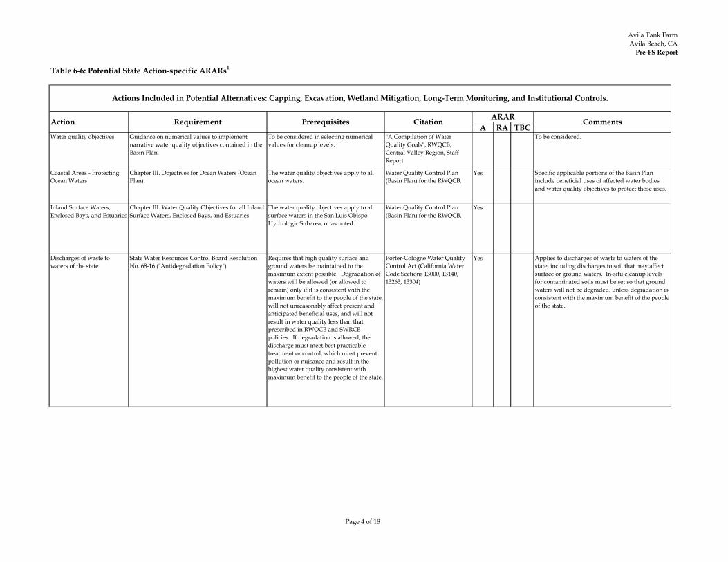
Avila Tank FarmAvila Beach, CA
Pre-FS Report
Page 4 of 18
Table 6-6: Potential State Action-specific ARARs1
A RA TBC
Actions Included in Potential Alternatives: Capping, Excavation, Wetland Mitigation, Long-Term Monitoring, and Institutional Controls.
Action Requirement Prerequisites Citation ARAR Comments
Water quality objectives Guidance on numerical values to implement narrative water quality objectives contained in the Basin Plan.
To be considered in selecting numerical values for cleanup levels.
"A Compilation of Water Quality Goals", RWQCB, Central Valley Region, Staff Report
To be considered.
Coastal Areas - Protecting Ocean Waters
Chapter III. Objectives for Ocean Waters (Ocean Plan).
The water quality objectives apply to all ocean waters.
Water Quality Control Plan (Basin Plan) for the RWQCB.
Yes Specific applicable portions of the Basin Plan include beneficial uses of affected water bodies and water quality objectives to protect those uses.
Inland Surface Waters, Enclosed Bays, and Estuaries
Chapter III. Water Quality Objectives for all Inland Surface Waters, Enclosed Bays, and Estuaries
The water quality objectives apply to all surface waters in the San Luis Obispo Hydrologic Subarea, or as noted.
Water Quality Control Plan (Basin Plan) for the RWQCB.
Yes
Discharges of waste to waters of the state
State Water Resources Control Board Resolution No. 68-16 ("Antidegradation Policy")
Requires that high quality surface and ground waters be maintained to the maximum extent possible. Degradation of waters will be allowed (or allowed to remain) only if it is consistent with the maximum benefit to the people of the state, will not unreasonably affect present and anticipated beneficial uses, and will not result in water quality less than that prescribed in RWQCB and SWRCB policies. If degradation is allowed, the discharge must meet best practicable treatment or control, which must prevent pollution or nuisance and result in the highest water quality consistent with maximum benefit to the people of the state.
Porter-Cologne Water Quality Control Act (California Water Code Sections 13000, 13140, 13263, 13304)
Yes Applies to discharges of waste to waters of the state, including discharges to soil that may affect surface or ground waters. In-situ cleanup levels for contaminated soils must be set so that ground waters will not be degraded, unless degradation is consistent with the maximum benefit of the people of the state.
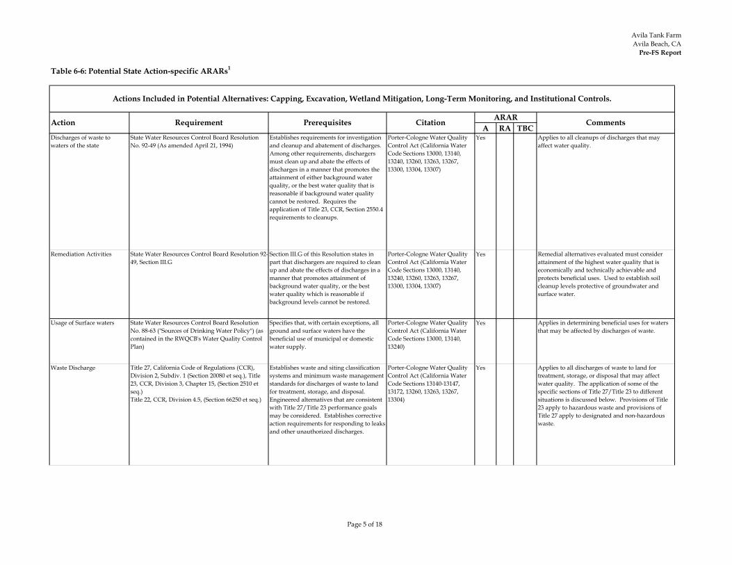
Avila Tank FarmAvila Beach, CA
Pre-FS Report
Page 5 of 18
Table 6-6: Potential State Action-specific ARARs1
A RA TBC
Actions Included in Potential Alternatives: Capping, Excavation, Wetland Mitigation, Long-Term Monitoring, and Institutional Controls.
Action Requirement Prerequisites Citation ARAR Comments
Discharges of waste to waters of the state
State Water Resources Control Board Resolution No. 92-49 (As amended April 21, 1994)
Establishes requirements for investigation and cleanup and abatement of discharges. Among other requirements, dischargers must clean up and abate the effects of discharges in a manner that promotes the attainment of either background water quality, or the best water quality that is reasonable if background water quality cannot be restored. Requires the application of Title 23, CCR, Section 2550.4 requirements to cleanups.
Porter-Cologne Water Quality Control Act (California Water Code Sections 13000, 13140, 13240, 13260, 13263, 13267, 13300, 13304, 13307)
Yes Applies to all cleanups of discharges that may affect water quality.
Remediation Activities State Water Resources Control Board Resolution 92-49, Section III.G
Section III.G of this Resolution states in part that dischargers are required to clean up and abate the effects of discharges in a manner that promotes attainment of background water quality, or the best water quality which is reasonable if background levels cannot be restored.
Porter-Cologne Water Quality Control Act (California Water Code Sections 13000, 13140, 13240, 13260, 13263, 13267, 13300, 13304, 13307)
Yes Remedial alternatives evaluated must consider attainment of the highest water quality that is economically and technically achievable and protects beneficial uses. Used to establish soil cleanup levels protective of groundwater and surface water.
Usage of Surface waters State Water Resources Control Board Resolution No. 88-63 ("Sources of Drinking Water Policy") (as contained in the RWQCB's Water Quality Control Plan)
Specifies that, with certain exceptions, all ground and surface waters have the beneficial use of municipal or domestic water supply.
Porter-Cologne Water Quality Control Act (California Water Code Sections 13000, 13140, 13240)
Yes Applies in determining beneficial uses for waters that may be affected by discharges of waste.
Waste Discharge Title 27, California Code of Regulations (CCR), Division 2, Subdiv. 1 (Section 20080 et seq.), Title 23, CCR, Division 3, Chapter 15, (Section 2510 et seq.)Title 22, CCR, Division 4.5, (Section 66250 et seq.)
Establishes waste and siting classification systems and minimum waste management standards for discharges of waste to land for treatment, storage, and disposal. Engineered alternatives that are consistent with Title 27/Title 23 performance goals may be considered. Establishes corrective action requirements for responding to leaks and other unauthorized discharges.
Porter-Cologne Water Quality Control Act (California Water Code Sections 13140-13147, 13172, 13260, 13263, 13267, 13304)
Yes Applies to all discharges of waste to land for treatment, storage, or disposal that may affect water quality. The application of some of the specific sections of Title 27/Title 23 to different situations is discussed below. Provisions of Title 23 apply to hazardous waste and provisions of Title 27 apply to designated and non-hazardous waste.
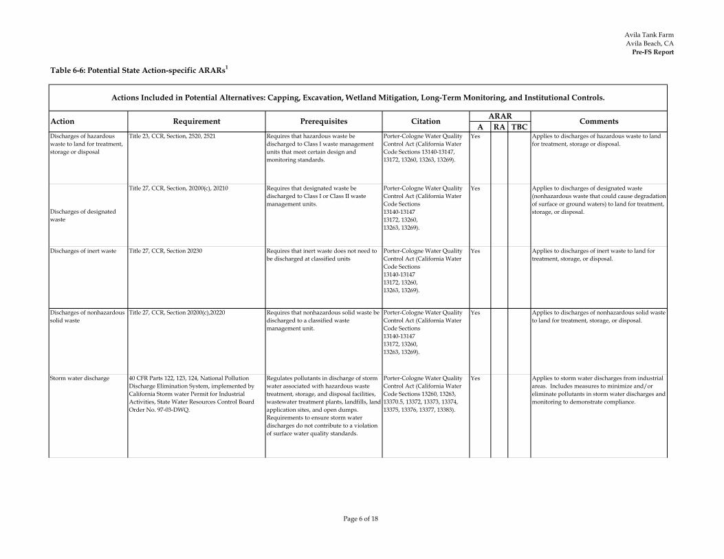
Avila Tank FarmAvila Beach, CA
Pre-FS Report
Page 6 of 18
Table 6-6: Potential State Action-specific ARARs1
A RA TBC
Actions Included in Potential Alternatives: Capping, Excavation, Wetland Mitigation, Long-Term Monitoring, and Institutional Controls.
Action Requirement Prerequisites Citation ARAR Comments
Discharges of hazardous waste to land for treatment, storage or disposal
Title 23, CCR, Section, 2520, 2521 Requires that hazardous waste be discharged to Class I waste management units that meet certain design and monitoring standards.
Porter-Cologne Water Quality Control Act (California Water Code Sections 13140-13147, 13172, 13260, 13263, 13269).
Yes Applies to discharges of hazardous waste to land for treatment, storage or disposal.
Discharges of designated waste
Title 27, CCR, Section, 20200(c), 20210 Requires that designated waste be discharged to Class I or Class II waste management units.
Porter-Cologne Water Quality Control Act (California Water Code Sections 13140-1314713172, 13260,13263, 13269).
Yes Applies to discharges of designated waste (nonhazardous waste that could cause degradation of surface or ground waters) to land for treatment, storage, or disposal.
Discharges of inert waste Title 27, CCR, Section 20230 Requires that inert waste does not need to be discharged at classified units
Porter-Cologne Water Quality Control Act (California Water Code Sections 13140-1314713172, 13260,13263, 13269).
Yes Applies to discharges of inert waste to land for treatment, storage, or disposal.
Discharges of nonhazardous solid waste
Title 27, CCR, Section 20200(c),20220 Requires that nonhazardous solid waste be discharged to a classified waste management unit.
Porter-Cologne Water Quality Control Act (California Water Code Sections13140-1314713172, 13260,13263, 13269).
Yes Applies to discharges of nonhazardous solid waste to land for treatment, storage, or disposal.
Storm water discharge 40 CFR Parts 122, 123, 124, National Pollution Discharge Elimination System, implemented by California Storm water Permit for Industrial Activities, State Water Resources Control Board Order No. 97-03-DWQ.
Regulates pollutants in discharge of storm water associated with hazardous waste treatment, storage, and disposal facilities, wastewater treatment plants, landfills, land application sites, and open dumps. Requirements to ensure storm water discharges do not contribute to a violation of surface water quality standards.
Porter-Cologne Water Quality Control Act (California Water Code Sections 13260, 13263, 13370.5, 13372, 13373, 13374, 13375, 13376, 13377, 13383).
Yes Applies to storm water discharges from industrial areas. Includes measures to minimize and/or eliminate pollutants in storm water discharges and monitoring to demonstrate compliance.
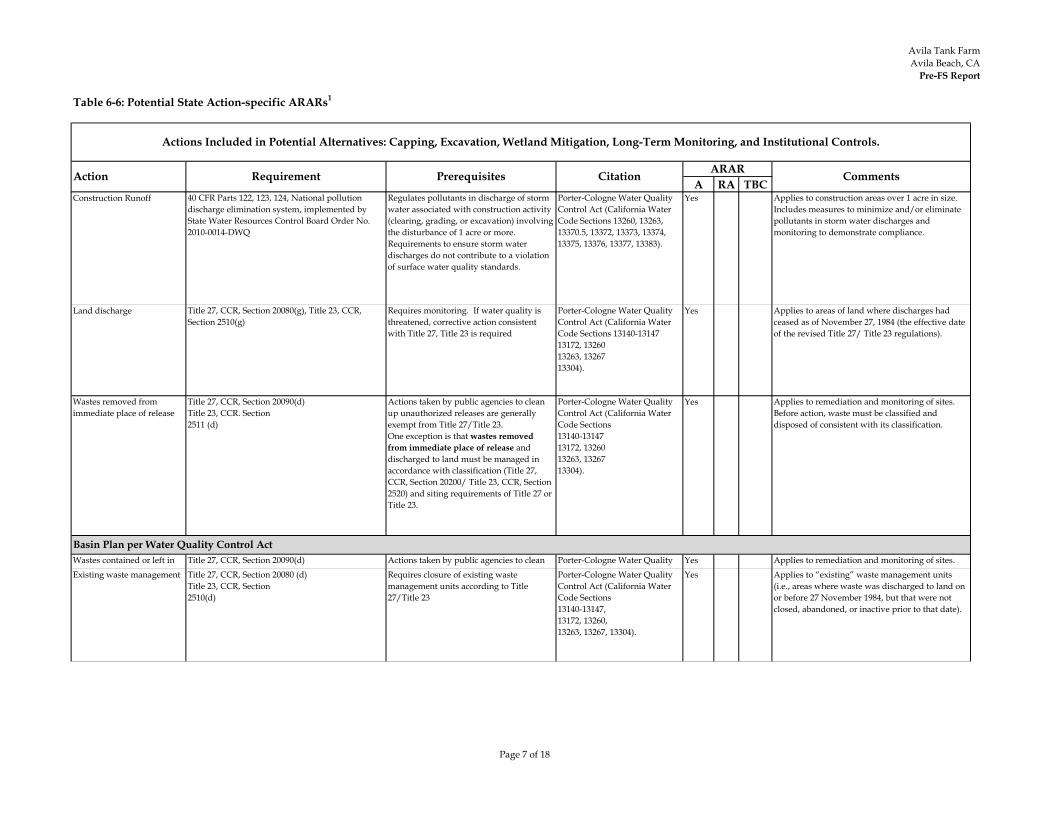
Avila Tank FarmAvila Beach, CA
Pre-FS Report
Page 7 of 18
Table 6-6: Potential State Action-specific ARARs1
A RA TBC
Actions Included in Potential Alternatives: Capping, Excavation, Wetland Mitigation, Long-Term Monitoring, and Institutional Controls.
Action Requirement Prerequisites Citation ARAR Comments
Construction Runoff 40 CFR Parts 122, 123, 124, National pollution discharge elimination system, implemented by State Water Resources Control Board Order No. 2010-0014-DWQ
Regulates pollutants in discharge of storm water associated with construction activity (clearing, grading, or excavation) involving the disturbance of 1 acre or more. Requirements to ensure storm water discharges do not contribute to a violation of surface water quality standards.
Porter-Cologne Water Quality Control Act (California Water Code Sections 13260, 13263, 13370.5, 13372, 13373, 13374, 13375, 13376, 13377, 13383).
Yes Applies to construction areas over 1 acre in size. Includes measures to minimize and/or eliminate pollutants in storm water discharges and monitoring to demonstrate compliance.
Land discharge Title 27, CCR, Section 20080(g), Title 23, CCR, Section 2510(g)
Requires monitoring. If water quality is threatened, corrective action consistent with Title 27, Title 23 is required
Porter-Cologne Water Quality Control Act (California Water Code Sections 13140-1314713172, 1326013263, 1326713304).
Yes Applies to areas of land where discharges had ceased as of November 27, 1984 (the effective date of the revised Title 27/ Title 23 regulations).
Wastes removed from immediate place of release
Title 27, CCR, Section 20090(d)Title 23, CCR. Section 2511 (d)
Actions taken by public agencies to clean up unauthorized releases are generally exempt from Title 27/Title 23. One exception is that wastes removed from immediate place of release and discharged to land must be managed in accordance with classification (Title 27, CCR, Section 20200/ Title 23, CCR, Section 2520) and siting requirements of Title 27 or Title 23.
Porter-Cologne Water Quality Control Act (California Water Code Sections 13140-1314713172, 1326013263, 1326713304).
Yes Applies to remediation and monitoring of sites. Before action, waste must be classified and disposed of consistent with its classification.
Wastes contained or left in l
Title 27, CCR, Section 20090(d)l
Actions taken by public agencies to clean h d l ll
Porter-Cologne Water Quality l ( l f
Yes Applies to remediation and monitoring of sites.
Existing waste management Title 27, CCR, Section 20080 (d)Title 23, CCR, Section 2510(d)
Requires closure of existing waste management units according to Title 27/Title 23
Porter-Cologne Water Quality Control Act (California Water Code Sections13140-13147,13172, 13260,13263, 13267, 13304).
Yes Applies to “existing” waste management units (i.e., areas where waste was discharged to land on or before 27 November 1984, but that were not closed, abandoned, or inactive prior to that date).
Basin Plan per Water Quality Control Act
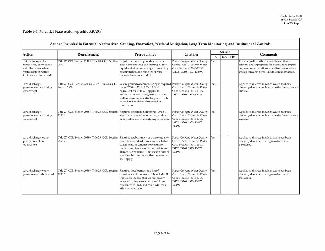
Avila Tank FarmAvila Beach, CA
Pre-FS Report
Page 8 of 18
Table 6-6: Potential State Action-specific ARARs1
A RA TBC
Actions Included in Potential Alternatives: Capping, Excavation, Wetland Mitigation, Long-Term Monitoring, and Institutional Controls.
Action Requirement Prerequisites Citation ARAR Comments
Natural topographic depressions, excavations, and diked areas where wastes containing free liquids were discharged.
Title 27, CCR, Section 21400, Title 23, CCR, Section 2582.
Requires surface impoundments to be closed by removing and treating all free liquid and either removing all remaining contamination or closing the surface impoundment as a landfill.
Porter-Cologne Water Quality Control Act (California Water Code Sections 13140-13147, 13172, 13260, 1323, 13269).
Yes If water quality is threatened, this section is relevant and appropriate for natural topographic depressions, excavations, and diked areas where wastes containing free liquids were discharged.
Land discharge, groundwater monitoring requirement
Title 27, CCR, Sections 20385-20435 Title 23, CCR, Section 2550.
Where groundwater monitoring is required under 2510 or 2511 of Ch. 15 (and equivalent for Title 27), applies to authorized waste management units as well as unauthorized discharges of waste to land and to closed abandoned or inactive units.
Porter-Cologne Water Quality Control Act (California Water Code Sections 13140-13147, 13172, 13260, 1323, 13269).
Yes Applies to all areas in which waste has been discharged to land to determine the threat to water quality.
Land discharge, groundwater monitoring requirement
Title 27, CCR, Section 20385, Title 23, CCR, Section 2550.1
Requires detection monitoring. Once a significant release has occurred, evaluation or corrective action monitoring is required.
Porter-Cologne Water Quality Control Act (California Water Code Sections 13140-13147, 13172, 13260, 1323, 13267, 13269).
Yes Applies to all areas in which waste has been discharged to land to determine the threat to water quality.
Land discharge, water quality protection requirement
Title 27, CCR, Section 20390, Title 23, CCR, Section 2550.2
Requires establishment of a water quality protection standard consisting of a list of constituents of concern, concentration limits, compliance monitoring points and all monitoring points. This section further specifies the time period that the standard shall apply.
Porter-Cologne Water Quality Control Act (California Water Code Sections 13140-13147, 13172, 13260, 1323, 13267, 13269).
Yes Applies to all areas in which waste has been discharged to land where groundwater is threatened.
Land discharge where groundwater is threatened
Title 27, CCR, Section 20395, Title 23, CCR, Section 2550.3
Requires development of a list of constituents of concern which include all waste constituents that are reasonably expected to be present in the soil from discharges to land, and could adversely affect water quality.
Porter-Cologne Water Quality Control Act (California Water Code Sections 13140-13147, 13172, 13260, 1323, 13267, 13269).
Yes Applies to all areas in which waste has been discharged to land where groundwater is threatened.
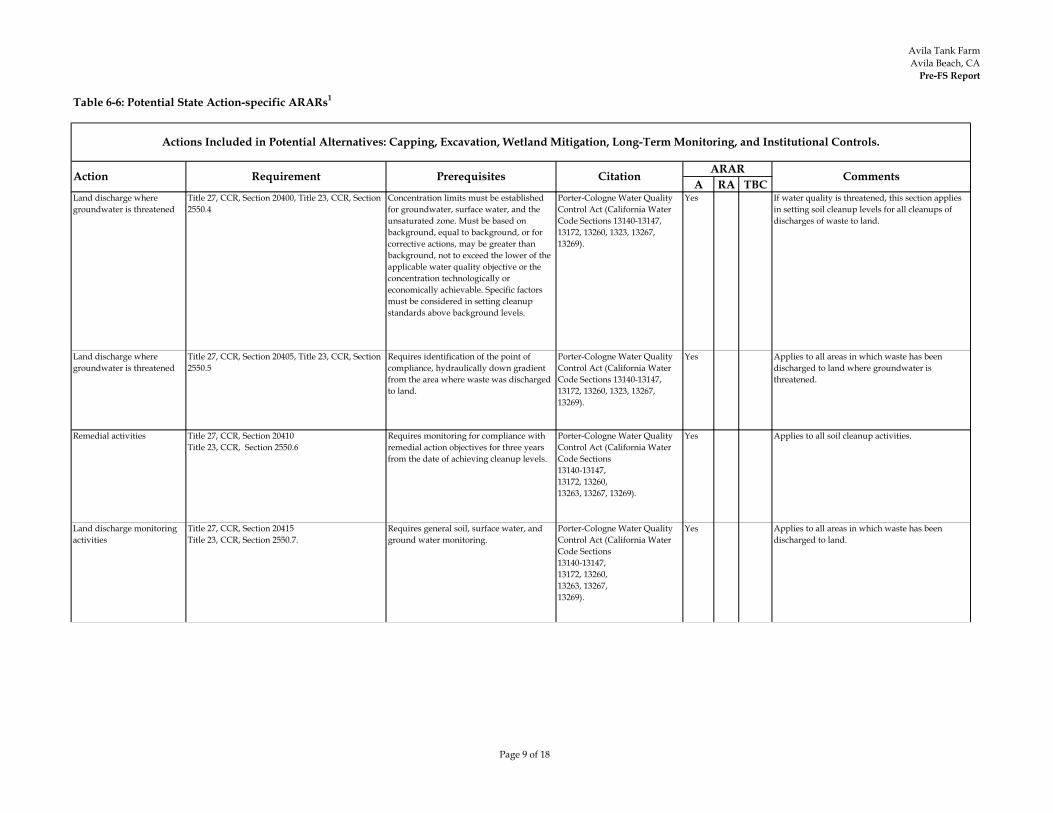
Avila Tank FarmAvila Beach, CA
Pre-FS Report
Page 9 of 18
Table 6-6: Potential State Action-specific ARARs1
A RA TBC
Actions Included in Potential Alternatives: Capping, Excavation, Wetland Mitigation, Long-Term Monitoring, and Institutional Controls.
Action Requirement Prerequisites Citation ARAR Comments
Land discharge where groundwater is threatened
Title 27, CCR, Section 20400, Title 23, CCR, Section 2550.4
Concentration limits must be established for groundwater, surface water, and the unsaturated zone. Must be based on background, equal to background, or for corrective actions, may be greater than background, not to exceed the lower of the applicable water quality objective or the concentration technologically or economically achievable. Specific factors must be considered in setting cleanup standards above background levels.
Porter-Cologne Water Quality Control Act (California Water Code Sections 13140-13147, 13172, 13260, 1323, 13267, 13269).
Yes If water quality is threatened, this section applies in setting soil cleanup levels for all cleanups of discharges of waste to land.
Land discharge where groundwater is threatened
Title 27, CCR, Section 20405, Title 23, CCR, Section 2550.5
Requires identification of the point of compliance, hydraulically down gradient from the area where waste was discharged to land.
Porter-Cologne Water Quality Control Act (California Water Code Sections 13140-13147, 13172, 13260, 1323, 13267, 13269).
Yes Applies to all areas in which waste has been discharged to land where groundwater is threatened.
Remedial activities Title 27, CCR, Section 20410Title 23, CCR, Section 2550.6
Requires monitoring for compliance with remedial action objectives for three years from the date of achieving cleanup levels.
Porter-Cologne Water Quality Control Act (California Water Code Sections13140-13147,13172, 13260,13263, 13267, 13269).
Yes Applies to all soil cleanup activities.
Land discharge monitoring activities
Title 27, CCR, Section 20415Title 23, CCR, Section 2550.7.
Requires general soil, surface water, and ground water monitoring.
Porter-Cologne Water Quality Control Act (California Water Code Sections13140-13147,13172, 13260, 13263, 13267,13269).
Yes Applies to all areas in which waste has been discharged to land.
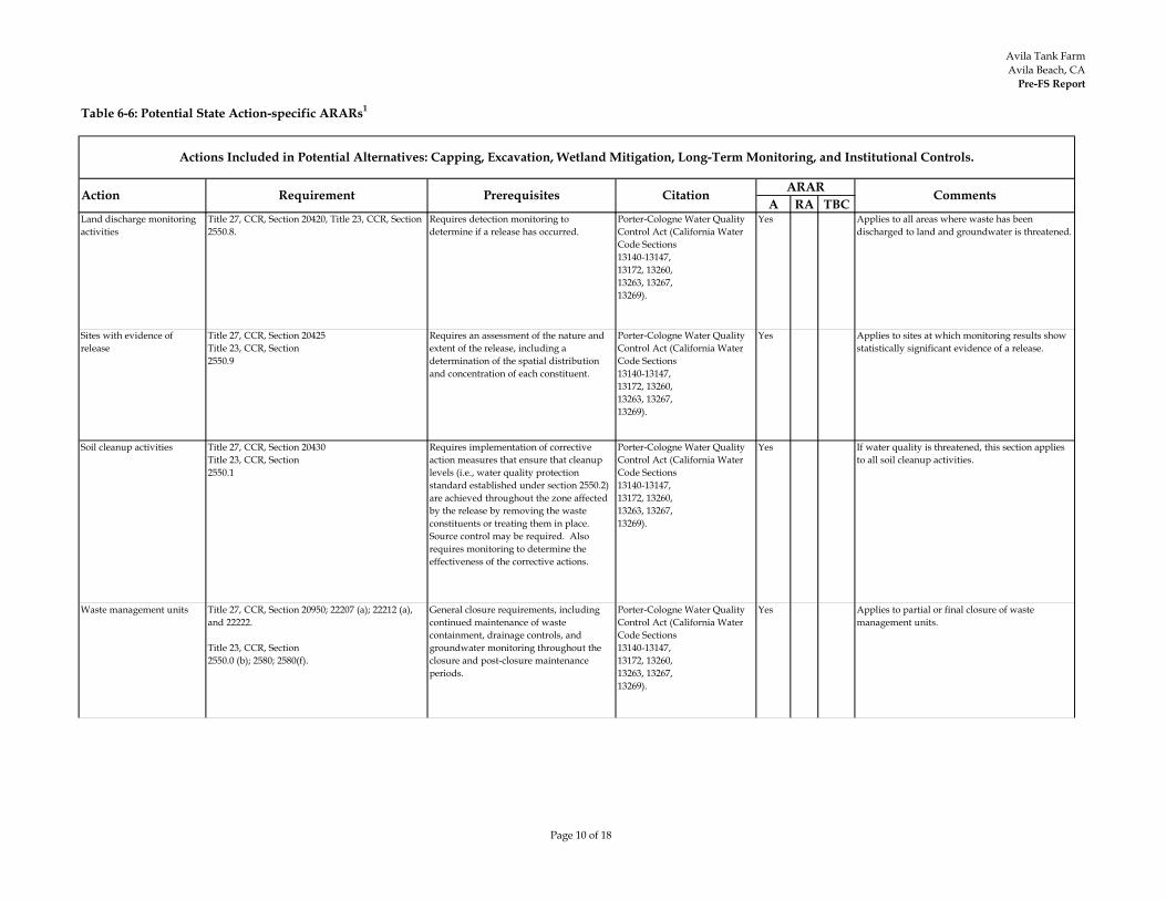
Avila Tank FarmAvila Beach, CA
Pre-FS Report
Page 10 of 18
Table 6-6: Potential State Action-specific ARARs1
A RA TBC
Actions Included in Potential Alternatives: Capping, Excavation, Wetland Mitigation, Long-Term Monitoring, and Institutional Controls.
Action Requirement Prerequisites Citation ARAR Comments
Land discharge monitoring activities
Title 27, CCR, Section 20420, Title 23, CCR, Section 2550.8.
Requires detection monitoring to determine if a release has occurred.
Porter-Cologne Water Quality Control Act (California Water Code Sections13140-13147,13172, 13260, 13263, 13267,13269).
Yes Applies to all areas where waste has been discharged to land and groundwater is threatened.
Sites with evidence of release
Title 27, CCR, Section 20425Title 23, CCR, Section2550.9
Requires an assessment of the nature and extent of the release, including a determination of the spatial distribution and concentration of each constituent.
Porter-Cologne Water Quality Control Act (California Water Code Sections13140-13147,13172, 13260, 13263, 13267,13269).
Yes Applies to sites at which monitoring results show statistically significant evidence of a release.
Soil cleanup activities Title 27, CCR, Section 20430Title 23, CCR, Section 2550.1
Requires implementation of corrective action measures that ensure that cleanup levels (i.e., water quality protection standard established under section 2550.2) are achieved throughout the zone affected by the release by removing the waste constituents or treating them in place. Source control may be required. Also requires monitoring to determine the effectiveness of the corrective actions.
Porter-Cologne Water Quality Control Act (California Water Code Sections13140-13147,13172, 13260, 13263, 13267,13269).
Yes If water quality is threatened, this section applies to all soil cleanup activities.
Waste management units Title 27, CCR, Section 20950; 22207 (a); 22212 (a), and 22222.
Title 23, CCR, Section 2550.0 (b); 2580; 2580(f).
General closure requirements, including continued maintenance of waste containment, drainage controls, and groundwater monitoring throughout the closure and post-closure maintenance periods.
Porter-Cologne Water Quality Control Act (California Water Code Sections13140-13147,13172, 13260, 13263, 13267,13269).
Yes Applies to partial or final closure of waste management units.

Avila Tank FarmAvila Beach, CA
Pre-FS Report
Page 11 of 18
Table 6-6: Potential State Action-specific ARARs1
A RA TBC
Actions Included in Potential Alternatives: Capping, Excavation, Wetland Mitigation, Long-Term Monitoring, and Institutional Controls.
Action Requirement Prerequisites Citation ARAR Comments
Waste management units Title 27 CCR Section 20950 (a)(2)(B) (2) Performance Standards -The performance standards applicable to closure of a Unit and, for Units that are not clean-closed, to post-closure maintenance at the Unit are as follows:(B) Unit Clean-Closed - for Units that are clean-closed, the goal of closure is to physically remove all waste and contaminated materials from the Unit and from its underlying and surrounding environs, such that the waste in the Unit no longer poses a threat to water quality. Successful completion of clean-closure eliminates the need for any post-closure maintenance period and removes the Unit from being subject to the SWRCB-promulgated requirements of this subdivision.
Porter-Cologne Water Quality Control Act (California Water Code Sections13140-13147,13172, 13260, 13263, 13267,13269).
Yes Applicable to excavated soil to determine partial or final closure of waste management units.
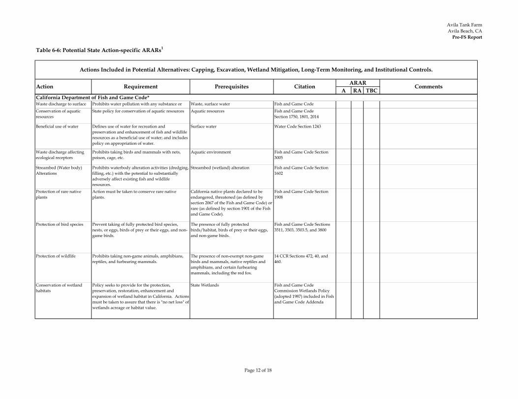
Avila Tank FarmAvila Beach, CA
Pre-FS Report
Page 12 of 18
Table 6-6: Potential State Action-specific ARARs1
A RA TBC
Actions Included in Potential Alternatives: Capping, Excavation, Wetland Mitigation, Long-Term Monitoring, and Institutional Controls.
Action Requirement Prerequisites Citation ARAR Comments
Waste discharge to surface
Prohibits water pollution with any substance or
Waste, surface water Fish and Game Code Conservation of aquatic
resourcesState policy for conservation of aquatic resources Aquatic resources Fish and Game Code
Section 1750, 1801, 2014
Beneficial use of water Defines use of water for recreation and preservation and enhancement of fish and wildlife resources as a beneficial use of water; and includes policy on appropriation of water.
Surface water Water Code Section 1243
Waste discharge affecting ecological receptors
Prohibits taking birds and mammals with nets, poison, cage, etc.
Aquatic environment Fish and Game Code Section 3005
Streambed (Water body) Alterations
Prohibits waterbody alteration activities (dredging, filling, etc.) with the potential to substantially adversely affect existing fish and wildlife resources.
Streambed (wetland) alteration Fish and Game Code Section 1602
Protection of rare native plants
Action must be taken to conserve rare native plants.
California native plants declared to be endangered, threatened (as defined by section 2067 of the Fish and Game Code) or rare (as defined by section 1901 of the Fish and Game Code).
Fish and Game Code Section 1908
Protection of bird species Prevent taking of fully protected bird species, nests, or eggs, birds of prey or their eggs, and non-game birds.
The presence of fully protected birds/habitat, birds of prey or their eggs, and non-game birds.
Fish and Game Code Sections 3511, 3503, 3503.5, and 3800
Protection of wildlife Prohibits taking non-game animals, amphibians, reptiles, and furbearing mammals.
The presence of non-exempt non-game birds and mammals, native reptiles and amphibians, and certain furbearing mammals, including the red fox.
14 CCR Sections 472, 40, and 460.
Conservation of wetland habitats
Policy seeks to provide for the protection, preservation, restoration, enhancement and expansion of wetland habitat in California. Actions must be taken to assure that there is "no net loss" of wetlands acreage or habitat value.
State Wetlands Fish and Game Code Commission Wetlands Policy (adopted 1987) included in Fish and Game Code Addenda
California Department of Fish and Game Code*
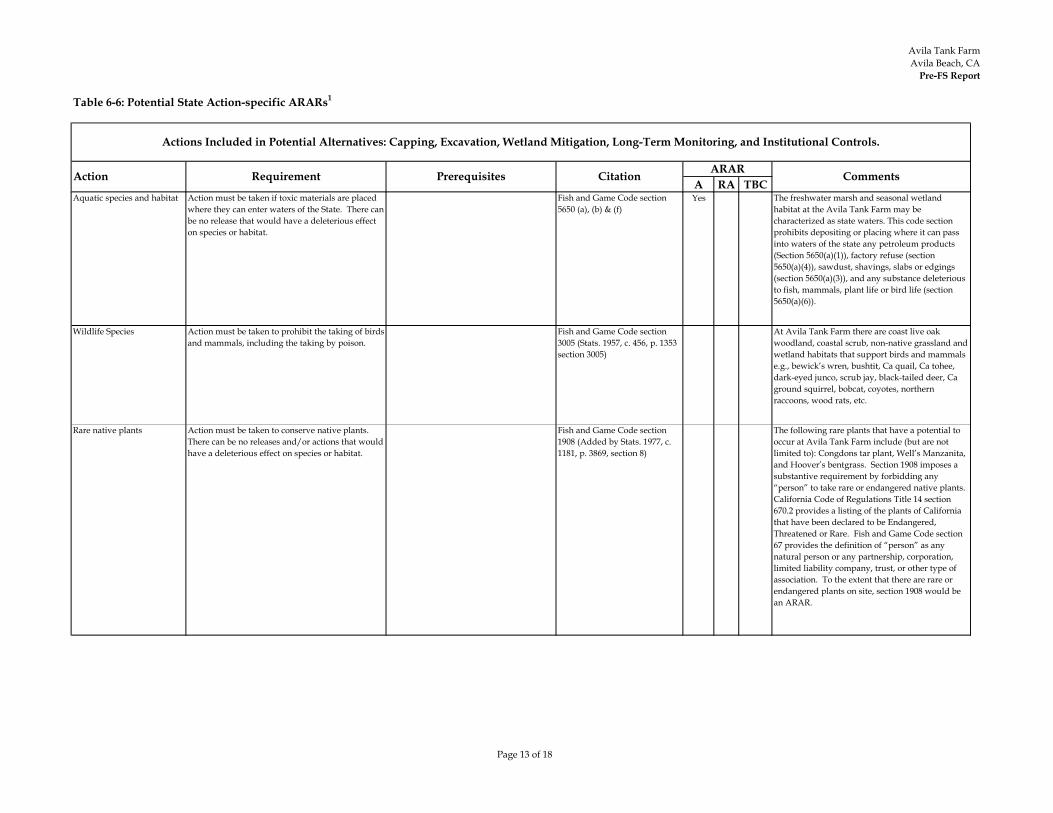
Avila Tank FarmAvila Beach, CA
Pre-FS Report
Page 13 of 18
Table 6-6: Potential State Action-specific ARARs1
A RA TBC
Actions Included in Potential Alternatives: Capping, Excavation, Wetland Mitigation, Long-Term Monitoring, and Institutional Controls.
Action Requirement Prerequisites Citation ARAR Comments
Aquatic species and habitat Action must be taken if toxic materials are placed where they can enter waters of the State. There can be no release that would have a deleterious effect on species or habitat.
Fish and Game Code section 5650 (a), (b) & (f)
Yes The freshwater marsh and seasonal wetland habitat at the Avila Tank Farm may be characterized as state waters. This code section prohibits depositing or placing where it can pass into waters of the state any petroleum products (Section 5650(a)(1)), factory refuse (section 5650(a)(4)), sawdust, shavings, slabs or edgings (section 5650(a)(3)), and any substance deleterious to fish, mammals, plant life or bird life (section 5650(a)(6)).
Wildlife Species Action must be taken to prohibit the taking of birds and mammals, including the taking by poison.
Fish and Game Code section 3005 (Stats. 1957, c. 456, p. 1353 section 3005)
At Avila Tank Farm there are coast live oak woodland, coastal scrub, non-native grassland and wetland habitats that support birds and mammals e.g., bewick’s wren, bushtit, Ca quail, Ca tohee, dark-eyed junco, scrub jay, black-tailed deer, Ca ground squirrel, bobcat, coyotes, northern raccoons, wood rats, etc.
Rare native plants Action must be taken to conserve native plants. There can be no releases and/or actions that would have a deleterious effect on species or habitat.
Fish and Game Code section 1908 (Added by Stats. 1977, c. 1181, p. 3869, section 8)
The following rare plants that have a potential to occur at Avila Tank Farm include (but are not limited to): Congdons tar plant, Well’s Manzanita, and Hoover’s bentgrass. Section 1908 imposes a substantive requirement by forbidding any “person” to take rare or endangered native plants. California Code of Regulations Title 14 section 670.2 provides a listing of the plants of California that have been declared to be Endangered, Threatened or Rare. Fish and Game Code section 67 provides the definition of “person” as any natural person or any partnership, corporation, limited liability company, trust, or other type of association. To the extent that there are rare or endangered plants on site, section 1908 would be an ARAR.

Avila Tank FarmAvila Beach, CA
Pre-FS Report
Page 14 of 18
Table 6-6: Potential State Action-specific ARARs1
A RA TBC
Actions Included in Potential Alternatives: Capping, Excavation, Wetland Mitigation, Long-Term Monitoring, and Institutional Controls.
Action Requirement Prerequisites Citation ARAR Comments
Endangered Species Action must be taken to conserve endangered species. There can be no releases and/or actions that would have a deleterious effect on species or habitat.
Fish and Game Code section 2080 (Added by Stats. 1984, c. 1240, section 2).
State listed species that have a potential to occur at Avila Tank Farm include (but are not limited to): California horned lizard (species of special concern [SSC]); and silvery legless lizard (SSC).This section prohibits the take, possession, purchase or selling within the state, any species (including rare native plant species), or any product thereof, that the commission determines to be an endangered or threatened species, or the attempt of any of these acts. This section is relevant and appropriate to the extent that there are endangered or threatened species in the area which have the potential of being affected if appropriate take avoidance measures are not implemented. This section prohibits releases and/or actions that would take species or their habitat.
Fully protected bird species/habitat
Action must be taken to prevent the taking of fully protected birds.
Fish and Game Code section 3511 (Added by Stats.1970, c. 1036, p. 1848 section 4)
This should be considered relevant and appropriate to the extent that such fully protected birds and/or their habitat are located on or near the site.The American Peregrine Falcon and California Brown Pelican do occur near the Avila Tank Farm.This section provides that it is unlawful to take or possess any of the following fully protected birds:(a). American Peregrine Falcon(b). Brown Pelican(c). California Black Rail(d). California Clapper Rail(e). California Condor(f). California Least Tern(g). Golden Eagle(h). Greater Sandhill Crane(i). Light-footed Clapper Rail(j). Southern Bald Eagle(k). Trumpeter Swan(l). White-tailed Kite(m). Yuma Clapper Rail
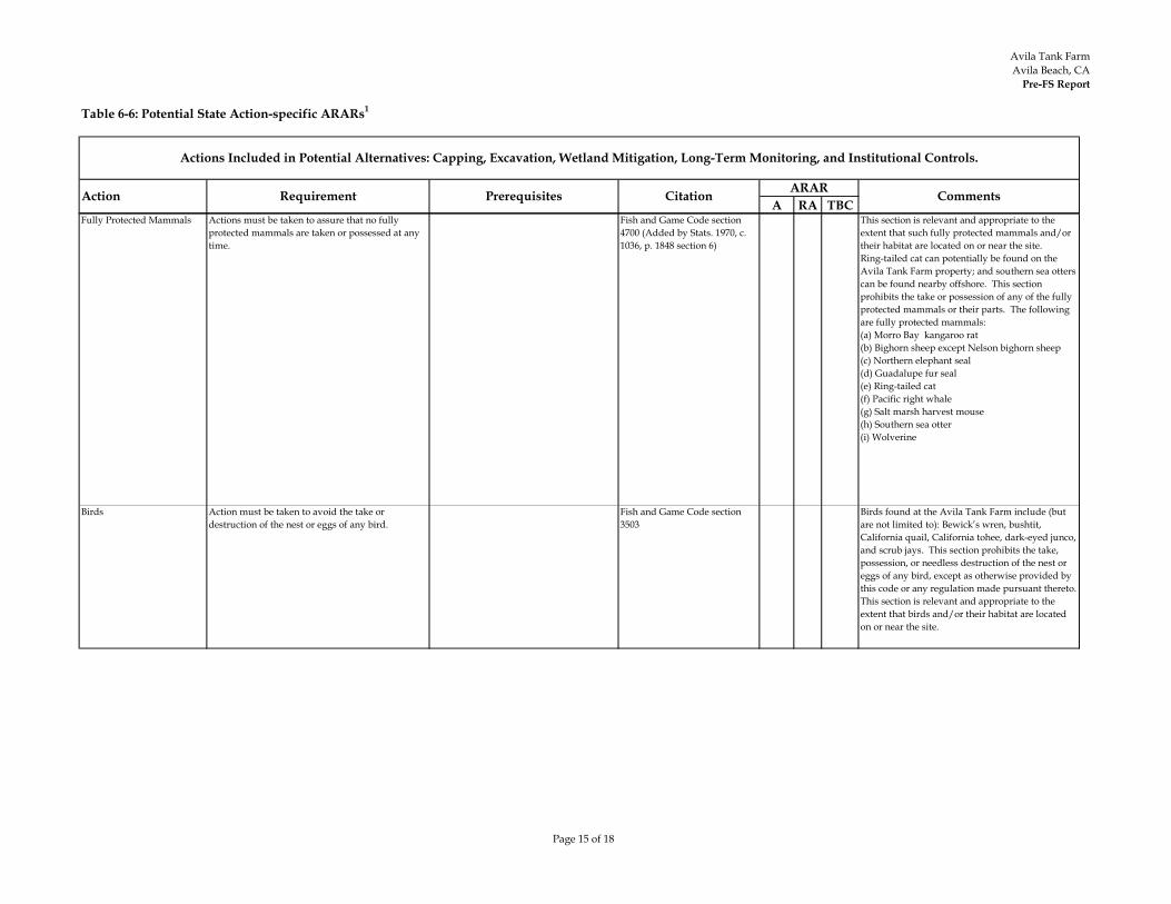
Avila Tank FarmAvila Beach, CA
Pre-FS Report
Page 15 of 18
Table 6-6: Potential State Action-specific ARARs1
A RA TBC
Actions Included in Potential Alternatives: Capping, Excavation, Wetland Mitigation, Long-Term Monitoring, and Institutional Controls.
Action Requirement Prerequisites Citation ARAR Comments
Fully Protected Mammals Actions must be taken to assure that no fully protected mammals are taken or possessed at any time.
Fish and Game Code section 4700 (Added by Stats. 1970, c. 1036, p. 1848 section 6)
This section is relevant and appropriate to the extent that such fully protected mammals and/or their habitat are located on or near the site.Ring-tailed cat can potentially be found on the Avila Tank Farm property; and southern sea otters can be found nearby offshore. This section prohibits the take or possession of any of the fully protected mammals or their parts. The following are fully protected mammals:(a) Morro Bay kangaroo rat(b) Bighorn sheep except Nelson bighorn sheep(c) Northern elephant seal(d) Guadalupe fur seal(e) Ring-tailed cat(f) Pacific right whale(g) Salt marsh harvest mouse(h) Southern sea otter(i) Wolverine
Birds Action must be taken to avoid the take or destruction of the nest or eggs of any bird.
Fish and Game Code section 3503
Birds found at the Avila Tank Farm include (but are not limited to): Bewick’s wren, bushtit, California quail, California tohee, dark-eyed junco, and scrub jays. This section prohibits the take, possession, or needless destruction of the nest or eggs of any bird, except as otherwise provided by this code or any regulation made pursuant thereto. This section is relevant and appropriate to the extent that birds and/or their habitat are located on or near the site.

Avila Tank FarmAvila Beach, CA
Pre-FS Report
Page 16 of 18
Table 6-6: Potential State Action-specific ARARs1
A RA TBC
Actions Included in Potential Alternatives: Capping, Excavation, Wetland Mitigation, Long-Term Monitoring, and Institutional Controls.
Action Requirement Prerequisites Citation ARAR Comments
Birds of Prey Action must be taken to prevent the take, possession, or destruction of any birds-of prey or their eggs.
Fish and Game Code section 3503.5 (Added by Stats. 1985, c. 1334, section 6)
Cooper’s Hawks, Peregurine falcons, and Great-horned owls may be found at Avila Tank Farm. This section prohibits the take, possession, or destruction of any birds in the orders of Falconiformes or Strigiformes (birds-of-prey) or to take, possess, or destroy the nest or eggs of any such bird except as otherwise provided by this code or any regulation adopted pursuant thereto. This section is relevant and appropriate to the extent that such species and/or their eggs are located on or near the site.
Migratory Birds Action must be taken to prevent the take or possession of any migratory nongame birds.
Fish and Game Code section 3513
Migratory birds that have a potential to occur at this site include (but are not limited to): Transitory waterfowl, merlins, loggerhead shrikes and pallid bats. This section makes it unlawful to take or possess any migratory nongame bird as designated in the Migratory Bird Treaty Act or any part of such migratory nongame bird except as provided by rules and regulations adopted by the Secretary of the Interior under provisions of the Migratory Bird Treaty Act. This section is relevant and appropriate to the extent that migratory nongame birds and their habitat are located on or near the site.
Specially Protected Mountain Lion
Action must be taken to avoid injuring, taking, possessing or transporting any mountain lion.
Fish and Game Code sections 4800 et. seq.
Mountain lions could potentially pass through Avila Tank Farm. Mountain lions are specially protected mammals in California. It is unlawful to take, injure, possess, transport, or sell any mountain lion or any part or product thereof. Violation of this section is a misdemeanor.
Discharge of surface water runoff
California Toxics Rule (CTR) 40 CFR Part 131 Water quality standards: USEPA adopted water quality criteria that apply in California, called the California Toxics Rule (CTR). The CTR establishes water quality standards that apply to NPDES discharges when certain conditions are met.
Clean Water Act – National Pollutant Discharge Elimination System (NPDES) Program
Yes The CTR is an ARAR for the sites/areas that pose a threat to surface water quality. The CTR establishes criteria for surface water quality; therefore, it is an ARAR for discharge of surface water run off potentially polluted from up gradient sources.
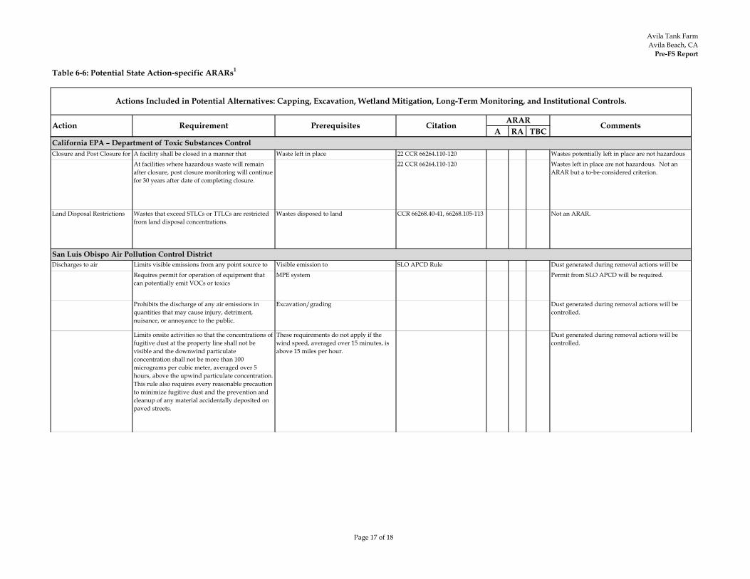
Avila Tank FarmAvila Beach, CA
Pre-FS Report
Page 17 of 18
Table 6-6: Potential State Action-specific ARARs1
A RA TBC
Actions Included in Potential Alternatives: Capping, Excavation, Wetland Mitigation, Long-Term Monitoring, and Institutional Controls.
Action Requirement Prerequisites Citation ARAR Comments
Closure and Post Closure for l
A facility shall be closed in a manner that h d f f h d
Waste left in place 22 CCR 66264.110-120 Wastes potentially left in place are not hazardous d l b At facilities where hazardous waste will remain
after closure, post closure monitoring will continue for 30 years after date of completing closure.
22 CCR 66264.110-120 Wastes left in place are not hazardous. Not an ARAR but a to-be-considered criterion.
Land Disposal Restrictions Wastes that exceed STLCs or TTLCs are restricted from land disposal concentrations.
Wastes disposed to land CCR 66268.40-41, 66268.105-113 Not an ARAR.
Discharges to air Limits visible emissions from any point source to l ( ) f
Visible emission toh
SLO APCD Rule Dust generated during removal actions will be ll dRequires permit for operation of equipment that
can potentially emit VOCs or toxicsMPE system Permit from SLO APCD will be required.
Prohibits the discharge of any air emissions in quantities that may cause injury, detriment, nuisance, or annoyance to the public.
Excavation/grading Dust generated during removal actions will be controlled.
Limits onsite activities so that the concentrations of fugitive dust at the property line shall not be visible and the downwind particulate concentration shall not be more than 100 micrograms per cubic meter, averaged over 5 hours, above the upwind particulate concentration. This rule also requires every reasonable precaution to minimize fugitive dust and the prevention and cleanup of any material accidentally deposited on paved streets.
These requirements do not apply if the wind speed, averaged over 15 minutes, is above 15 miles per hour.
Dust generated during removal actions will be controlled.
California EPA – Department of Toxic Substances Control
San Luis Obispo Air Pollution Control District
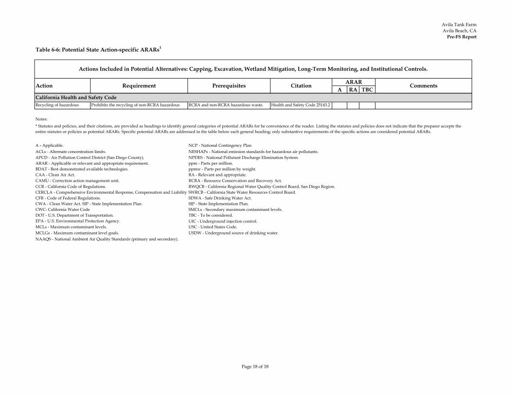
Avila Tank FarmAvila Beach, CA
Pre-FS Report
Page 18 of 18
Table 6-6: Potential State Action-specific ARARs1
A RA TBC
Actions Included in Potential Alternatives: Capping, Excavation, Wetland Mitigation, Long-Term Monitoring, and Institutional Controls.
Action Requirement Prerequisites Citation ARAR Comments
Recycling of hazardous Prohibits the recycling of non-RCRA hazardous f d d l
RCRA and non-RCRA hazardous waste. Health and Safety Code 25143.2
Notes:
UIC - Underground injection control.
NAAQS - National Ambient Air Quality Standards (primary and secondary).MCLGs - Maximum contaminant level goals. USDW - Underground source of drinking water.
CWC- California Water Code SMCLs - Secondary maximum contaminant levels.DOT - U.S. Department of Transportation. TBC - To be considered.EPA - U.S. Environmental Protection Agency.
USC - United States Code.MCLs - Maximum contaminant levels.
SIP - State Implementation Plan.CFR - Code of Federal Regulations. SDWA - Safe Drinking Water Act.CWA - Clean Water Act. SIP - State Implementation Plan.
CAMU - Correction action management unit. RCRA - Resource Conservation and Recovery Act.CCR - California Code of Regulations. RWQCB - California Regional Water Quality Control Board, San Diego Region.CERCLA - Comprehensive Environmental Response, Compensation and Liability SWRCB - California State Water Resources Control Board.
ARAR - Applicable or relevant and appropriate requirement. ppm - Parts per million.BDAT - Best demonstrated available technologies. ppmw - Parts per million by weight.CAA - Clean Air Act. RA - Relevant and appropriate.
APCD - Air Pollution Control District (San Diego County). NPDES - National Pollutant Discharge Elimination System.
California Health and Safety Code
* Statutes and policies, and their citations, are provided as headings to identify general categories of potential ARARs for he convenience of the reader. Listing the statutes and policies does not indicate that the preparer accepts the entire statutes or policies as potential ARARs. Specific potential ARARs are addressed in the table below each general heading; only substantive requirements of the specific actions are considered potential ARARs.
A - Applicable. NCP - National Contingency PlanACLs - Alternate concentration limits. NESHAPs - National emission standards for hazardous air pollutants.
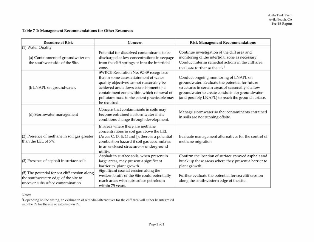
Avila Tank FarmAvila Beach, CA
Pre-FS Report
Page 1 of 1
Table 7-1: Management Recommendations for Other Resources
Concern Risk Management Recommendations
(a) Containment of groundwater on the southwest side of the Site.
Potential for dissolved contaminants to be discharged at low concentrations in seepage from the cliff springs or into the intertidal zone.
Continue investigation of the cliff area and monitoring of the intertidal zone as necessary. Conduct interim remedial actions in the cliff area. Evaluate further in the FS.1
(b LNAPL on groundwater.
SWRCB Resolution No. 92-49 recognizes that in some cases attainment of water quality objectives cannot reasonably be achieved and allows establishment of a containment zone within which removal of pollutant mass to the extent practicable may be required.
Conduct ongoing monitoring of LNAPL on groundwater. Evaluate the potential for future structures in certain areas of seasonally shallow groundwater to create conduits for groundwater (and possibly LNAPL) to reach the ground surface.
(d) Stormwater managementConcern that contaminants in soils may become entrained in stormwater if site conditions change through development.
Manage stormwater so that contaminants entrained in soils are not running offsite.
In areas where there are methane concentrations in soil gas above the LEL (Areas C, D, E, G and J), there is a potential combustion hazard if soil gas accumulates in an enclosed structure or underground utility.
Evaluate management alternatives for the control of methane migration.
Asphalt in surface soils, when present in large areas, may present a significant barrier to plant growth.
Confirm the location of surface sprayed asphalt and break up these areas where they present a barrier to plant growth.
Significant coastal erosion along the western bluffs of the Site could potentially reach areas with subsurface petroleum within 75 years.
Further evaluate the potential for sea cliff erosion along the southwestern edge of the site.
Notes: 1Depending on the timing, an evaluation of remedial alternatives for the cliff area will either be integrated into the FS for the site or into its own FS.
Resource at Risk(1) Water Quality
(2) Presence of methane in soil gas greater than the LEL of 5%.
(3) Presence of asphalt in surface soils
(5) The potential for sea cliff erosion along the southwestern edge of the site to uncover subsurface contamination
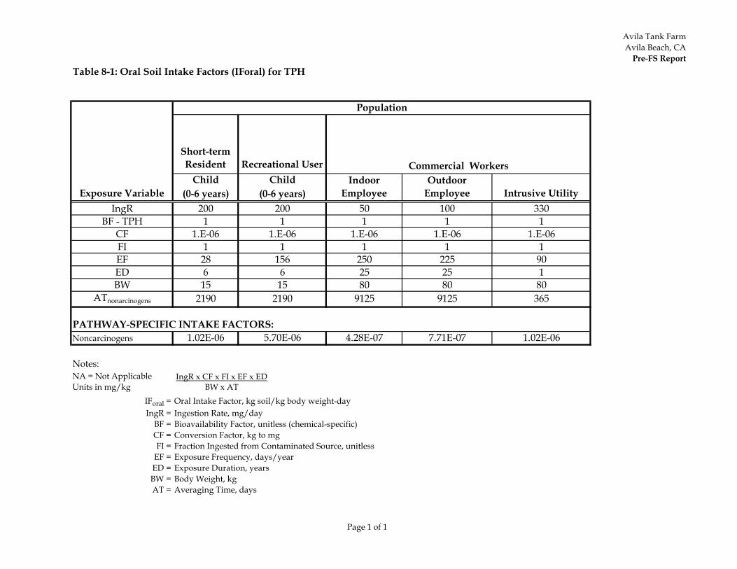
Avila Tank FarmAvila Beach, CA
Pre-FS Report
Page 1 of 1
Table 8-1: Oral Soil Intake Factors (IForal) for TPH
Short-term Resident Recreational User
Child Child(0-6 years) (0-6 years)
IngR 200 200 50 100 330BF - TPH 1 1 1 1 1
CF 1.E-06 1.E-06 1.E-06 1.E-06 1.E-06FI 1 1 1 1 1EF 28 156 250 225 90ED 6 6 25 25 1BW 15 15 80 80 80
ATnonarcinogens 2190 2190 9125 9125 365
PATHWAY-SPECIFIC INTAKE FACTORS:Noncarcinogens 1.02E-06 5.70E-06 4.28E-07 7.71E-07 1.02E-06
Notes:NA = Not ApplicableUnits in mg/kg
IForal = Oral Intake Factor, kg soil/kg body weight-dayIngR = Ingestion Rate, mg/day
BF = Bioavailability Factor, unitless (chemical-specific)CF = Conversion Factor, kg to mgFI = Fraction Ingested from Contaminated Source, unitless
EF = Exposure Frequency, days/yearED = Exposure Duration, yearsBW = Body Weight, kgAT = Averaging Time, days
Population
Exposure Variable
Commercial WorkersIndoor
EmployeeOutdoor
Employee Intrusive Utility
IngR x CF x FI x EF x ED BW x AT

Avila Tank FarmAvila Beach, CA
Pre-FS Report
Page 1 of 1
Table 8-2: Toxicity Factors for TPH Fractions
Carbon RangeOral Reference Dose
(mg/kg-day)Inhalation Reference
Dose (mg/kg-day)
C5-C8 0.04 0.2C9-C18 0.1 0.086C19-32 2 Not developed
Selected Value 0.04 0.086
C6-C8C9-C16 0.03a 0.014C17-32 0.03 Not developed
Selected Value 0.03 0.014
Notes:
Aliphatic Fraction
Aromatic FractionEvaluate individual COPCs
aCal/EPA (2009) recommend oral reference dose for this carbon range if naphthalenes and methylnaphthalenes are evaluated individually.
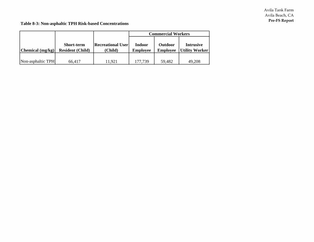
Avila Tank FarmAvila Beach, CA
Pre-FS ReportTable 8-3: Non-asphaltic TPH Risk-based Concentrations
Indoor Employee
Outdoor Employee
Intrusive Utility Worker
Non-asphaltic TPH 66,417 11,921 177,739 59,482 49,208
Chemical (mg/kg)Short-term
Resident (Child)Recreational User
(Child)
Commercial Workers
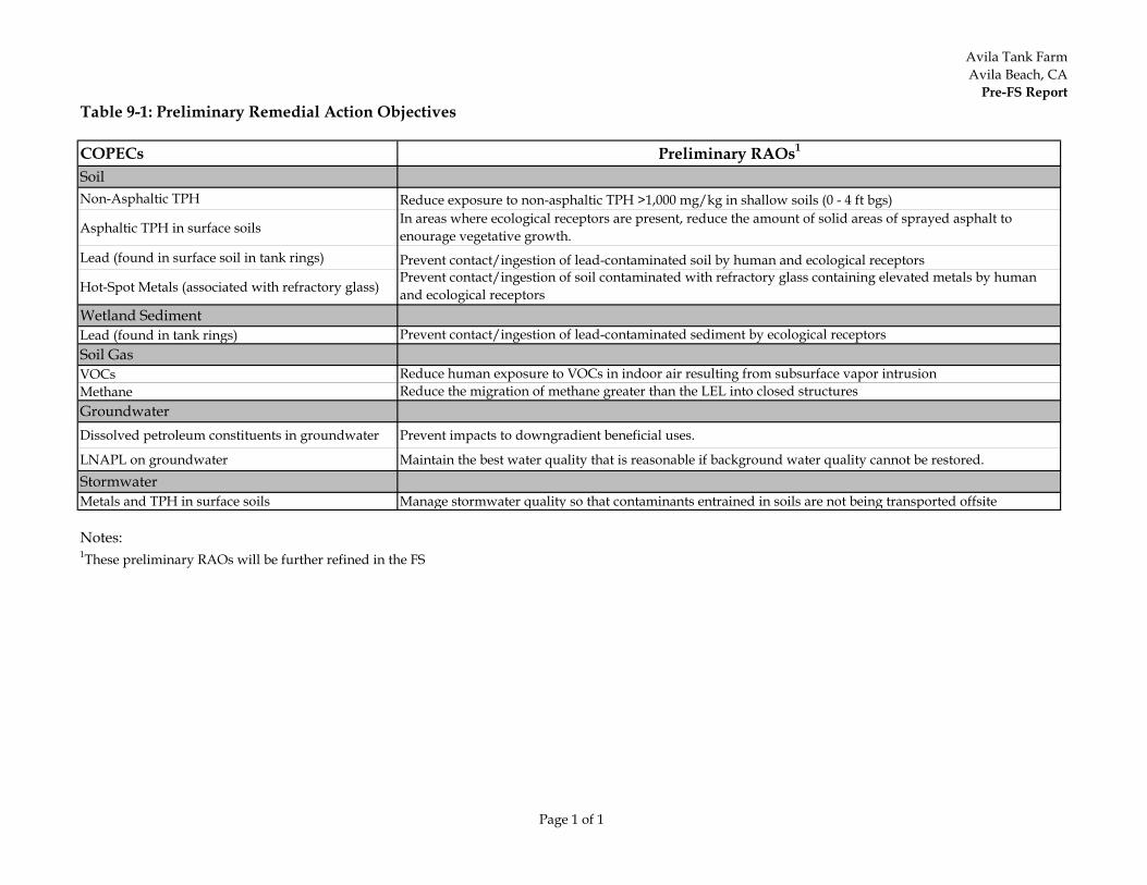
Avila Tank FarmAvila Beach, CA
Pre-FS Report
Page 1 of 1
Table 9-1: Preliminary Remedial Action Objectives
COPECs Preliminary RAOs1
SoilNon-Asphaltic TPH Reduce exposure to non-asphaltic TPH >1,000 mg/kg in shallow soils (0 - 4 ft bgs)
Asphaltic TPH in surface soilsIn areas where ecological receptors are present, reduce the amount of solid areas of sprayed asphalt to enourage vegetative growth.
Lead (found in surface soil in tank rings) Prevent contact/ingestion of lead-contaminated soil by human and ecological receptors
Hot-Spot Metals (associated with refractory glass)Prevent contact/ingestion of soil contaminated with refractory glass containing elevated metals by human and ecological receptors
Wetland SedimentLead (found in tank rings) Prevent contact/ingestion of lead-contaminated sediment by ecological receptorsSoil Gas VOCs Reduce human exposure to VOCs in indoor air resulting from subsurface vapor intrusionMethane Reduce the migration of methane greater than the LEL into closed structuresGroundwaterDissolved petroleum constituents in groundwater Prevent impacts to downgradient beneficial uses.
LNAPL on groundwater Maintain the best water quality that is reasonable if background water quality cannot be restored.StormwaterMetals and TPH in surface soils Manage stormwater quality so that contaminants entrained in soils are not being transported offsite
Notes:1These preliminary RAOs will be further refined in the FS
Appendix A Chronological List of ATCAT Events and Deliverables
Appendix B Ratified ATCAT Meetings and Conference Call Minutes
Appendix C Evaluation of the TPH Profile in Shallow Soil
Appendix D Ecological Evaluation in Support of Pre-FS
Appendix E Supplemental Human Health Risk Assessment and Addendum
Appendix F Cliff Springs Action Level Memo

Appendix G Site Geology and Boring Logs

Appendix H Analysis of Background Metals Former Avila Tank Farm Addendum No. 2
Appendix I 2012 Wetland Characterizations
Appendix J Site Conceptual Model – Draft Report and Response to Comments
Appendix K Intertidal Zone Assessment Activities
Appendix L Notification Plan for the Intertidal Area

Appendix M Supplemental Soil Gas Report