VLF SUR RPT FRIPP PRICE & MCARTHUR TWPS - Geology Ontario
50
42Ae6SWM66 2.5655 FRIPP 010 REPORT ON THE VLF SURVEY FRIPP, PRICE AND MCARTHUR TVIPS. DISTRICT OF TIMISKAMING PORCUPINE MINING DIVISION NTS 42/A/6 RECEIVED ^ a 7 196* MINING LANDS SECTION Toronto, Ontario R. Zinn, B.Se.
-
Upload
khangminh22 -
Category
Documents
-
view
0 -
download
0
Transcript of VLF SUR RPT FRIPP PRICE & MCARTHUR TWPS - Geology Ontario

42Ae6SWM66 2.5655 FRIPP 010
REPORT ON THE VLF SURVEY
FRIPP, PRICE AND MCARTHUR TVIPS.
DISTRICT OF TIMISKAMING
PORCUPINE MINING DIVISION
NTS 42/A/6
RECEIVED^ a 7 196*
MINING LANDS SECTION
Toronto, Ontario R. Zinn, B.Se.
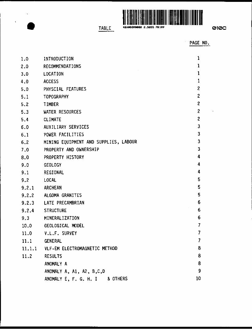
TABLE 42A*6SW**88 Z . 5655 FRIPP 010C
PAGE NO.
I.0 INTRODUCTION l
2.0 RECOMMENDATIONS l
3.0 LOCATION l
4.0 ACCESS l
5.0 PHYSCIAL FEATURES 2
5.1 TOPOGRAPHY 2
5.2 TIMBER 2
5.3 WATER RESOURCES 2
5.4 CLIMATE 2
6.0 AUXILIARY SERVICES 3
6.1 POWER FACILITIES 3
6.2 MINING EQUIPMENT AND SUPPLIES, LABOUR 3
7.0 PROPERTY AND OWNERSHIP 3
8.0 PROPERTY HISTORY 4
9.0 GEOLOGY 4
9.1 REGIONAL 4
9.2 LOCAL 5
9.2.1 ARCHEAN 5
9.2.2 ALGOMA GRANITES 5
9.2.3 LATE PRECAMBRIAN 6
9.2.4 STRUCTURE 6
9.3 MINERALIZATION 6
10.0 GEOLOGICAL MODEL 7
11.0 V.L.F. SURVEY 7
11.1 GENERAL 7
II.1.1 VLF-EM ELECTROMAGNETIC METHOD 8
11.2 RESULTS 8
ANOMALY A 8
ANOMALY A, Al, A2, B,C,D 9
ANOMALY E, F. G. H. I 4 OTHERS 10

APPENDIX I
VLF EM16 SPECIFICATIONS
FIGURES (in text)
1. LOCATION MAP2. PROPERTY3. REGIONAL GEOLOGY
4. LOCAL GEOLOGY
TABLES (in text)
1. BORDIN CLAIMS LIST
2. NORTHGATE CLAIMS LIST3. STRATIGRAPHIC UNITS
MAPS (in pocket)
MAP NO.
1. EAST SHEET VLF-EM SURVEY, RAW DATA, PROFILES, CONDUCTOR INTERPRETATION S CLAIM LOCATION2. CENTRAL SHEET " " "
3. WEST SHEET " " "3. WEST SHEET. FRASER FILTER INTERPRETATION OF RESULTS OF MAY 3 VLF-EM SURVEY.
NOTE: ONLY AREA OF MAP 3 WAS APPRAISED BY FRASER FILTER TECHNIQUE AS ANEXPERIMENT. STRENGTH OF ANOMALIES WAS FOUND TO BE SUFFICIENT THAT
NO BENEFIT WAS ACHIEVED BY FILTERING ALL DATA.

i.o INTRODUCTION
During the spring of 1983 Northgate Exploration personnel completed a V.L.F. Survey over the main grid (approximately 95 miles and 5,000 readings) in Fripp Twp.
The transmitting station used was Cutler, Maine (17.8kHz) which coupled less than 20 0 from the line director.
This survey compliments a Magnetometer Survey completed in 1981 by A. Mcparland and covered by Dr. Gerald Harper's report of April 1982,
2.0 RECOMMENDATIONS
The results of the surveys to date indicate that the following steps should be taken:
A. Drop the twelve eastern most claims (624158-624169 incl). There appears to be no justification for retaining them.
B. The property should be mapped in detail.
C. In conjunction with the mapping, soil geochemistry should cover anomalies A, B, C, D, G, H and I as these are considered to have the best potential for volcanogenic massive sulphide mineralization. Small pods of massive sulphides have been trenched on anomaly A some of which gave good copper values.
D. Upon completion of the mapping and geochemistry, the geophysics should be filtered and reassessed by a geophysicist to pinpoint drill targets.
3.0 LOCATION
The Fripp Option property, consisting of a narrow group of mining claims, stretches from Price Township in the"north southeastwards to MacArthur Town ship. The mid-point of the group lies in the northeastern quadrant of Fripp Township and is 17 miles S.SW. of Timmins and approximately 260 air miles north of Toronto (Figure 1).
4.0 ACCESS
Major forest access routes, extending due south from Timmins (Pine Street) into the general area of the property are excellent and although gravel, are well maintained and plowed during the winter months.
Within the claim block itself there are numerous connecting dirt and logging roads, however, they are not maintained and may become impassable during the winter and early spring.
4.0 WCCESS - continued
Access to the northernmost claims is poor with the possibility of an old lumber road existing three quarters of a mile to the west. This route has still to be investigated.
The lack of sufficiently large lakes or rivers prohibits the use of fixed wing aircraft as an alternate source of transportation.
Water transport is also prohibitive, since most of the lakes and streams are not suitable for continuous navigation.
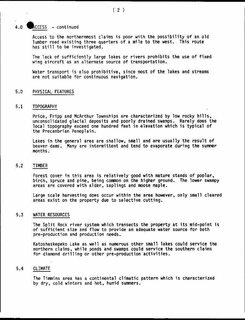
5.0 PHYSICAL FEATURES
5.1 TOPOGRAPHY
Price, Fripp and McArthur Townships are characterized by low rocky hills, unconsolidated glacial deposits and poorly drained swamps. Rarely does the local topography exceed one hundred feet in elevation which is typical of the Precambrian Peneplain.
Lakes in the general area are shallow, small and are usually the result of beaver dams. Many are intermittent and tend to evaporate during the summer months.
5.2 TIMBER
Forest cover in this area is relatively good with mature stands of poplar, birch, spruce and pine, being common on the higher ground. The lower swampy areas are covered with alder, saplings and moose maple.
Large scale harvesting does occur within the area however, only small cleared areas exist on the property due to selective cutting.
5.3 WATER RESOURCES
The Split Rock river system which transects the property at its mid-point is of sufficient size and flow to provide an adequate water source for both pre-production and production needs.
Katoshaskepeko Lake as well as numerous other small lakes could service the northern claims, while ponds and swamps could service the southern claims for diamond drilling or other pre-production activities.
5.4 CLIMATE
The Timmins area has a continental climatic pattern which is characterized by dry, cold winters and hot, humid summers.

5.4 WLIMATE - continued
Winter, which can begin as early as mid-October and continue until mid-May, experiences temperatures as low as -40 0C over extended periods and snow cover to five feet in forested areas.
The summer months on the other hand, have warm to hot temperatures which are sometimes accompanied by uncomfortable humidity.
Both spring and fall months have pleasant sunny days, but cool nights. These seasons however, can be marred by freezing temperatures, frost and snow.
6.0 AUXILIARY SERVICES
6.1 POWER FACILITIES
With no major industries in the area an immediate source of electrical power is not available. However, with the installation of a substation an adequate supply can be obtained from the power line located four miles to the east.
This line runs south from Abitibi Canyon to Sudbury and supplies Timmins with most of its electrical needs. The capacity of the line is now 500,000 volts.
6.2 MINING EQUIPMENT AND SUPPLIES, LABOUR
Timmins is a well established mining centre with many suppliers maintaining warehouses in the district.
Likewise mining contractors and experienced miners are available in the district.
7.0 PROPERTY AND OWNERSHIP (Table 1)
The Fripp Option property as originally presented, consisted of a block of 74 unpatented mining claims, distributed in Price, Fripp and McArthur Townships. All claims were staked by Dennis Bordin of Timmins in the spring of 1981 and were in good standing.
Northgate Exploration Limited expanded this group in two phases, by staking an additional 75 claims. The first phase protected the blocks' eastern boundary and to form one contiguous group with Westfield's claims in McArthur Township. The second phase extended part of the boundary southwards in Fripp Township to adjoin and partially surround five leased claims currently held by Hollinger- Argus, and containing a mineral deposit of approximately 165,000 tons averaging 35S copper.
The Fripp Option property now consists of 149 mining claims or about 6,000 acres (Figure 2).

8.o PROPERTY HISTORYThe entire area including the Bordin Property was prospected for gold pre- World War II and numerous showings were discovered.
Post-World War II further attempts were made in search of base and precious metals within the belt and again with the exception of the Texmont Discovery (1951) no economic deposits were found.
The following is a brief outline of recorded work over the Bordin claims as found in the assessment files (M.N.R.):
1952 McCoshen-Sandrelli Geophysical Report.Assays and pits. Assays were discouraging.
1961 to Hollinger Gold Mines Ltd. Geophysical Report,1965 EM and Magnetometer Surveys.
1966 Acme Oil and Gas, Conducted airborne geophysical surveys EM and Magnetometer, several weak anomalies.
1970 Hollinger Gold Mines Ltd., 4 Diamond Drill holes totalling 1117 feet.
1971 Texas Gulf Sulphur, Ground based magnetometer and EM Surveys,outlined two iron formations and a diabase dyke, no further work.
1975 Lionel Beaulieu, Five small pits, no sampling.
1981 Northgate Exploration Ltd,, Detailed study of trenches, resample. Assays were generally discouraging.Magnetometer Survey on 400' spaced lines outlined iron formation dykes and an ultramafic intrusion (talc).
1982 Magnetometer Survey over the 39 claims southwest extension.Possible continuation of copper zone at base of ultramafic flow on Hollinger ground interpreted.
9.0 GEOLOGY
9.1 REGIONAL (Figure 3)
All the rocks which underlie this area are of early Precambrian Age (Archean) and have been capped by a mantle of Pleistocene and Recent unconsolidated deposits.
The Archean rocks consist of two cycles of volcanism in which each cycle contains a basal ultramafic sequence of flows. Mafic metavolcanics overlie this unit and generally contain massive, as well as, pillowed flows. These in turn are overlain by an upper unit of intermediate to felsic metavolcanics consisting of massive flows but more commonly tuffs, lapilli tuffs and breccia.

9.1 ^FftinNAi - continued
It is within this upper unit that intercalated sedimentary beds occur including siltstones, greywackes and iron formation.
The lower metavolcanic unit has been intruded by both felsic and mafic magmas which have formed small domes of quartz-feldspar porphyry in the felsic volcanics and gabbroic sills in the mafic volcanics respectively.
A pre-tectonic age has been affixed to the gabbro while the porphyry is syntectonic and may be part of a feeder system for the felsic rocks.
Large emplacements of granitic magma late in the tectonic cycle formed the Adams Batholith and the poly-phase Peterlong Lake complex.
Numerous diabase dykes transect the area and are middle to late Precambrian in age.
Table 3 is a geologic time scale and a stratigraphic column for this area.
The Archean volcano-sedimentary series has been compressed and warped about the granitic domes in Adam and Giekie Townships. The Bordin - N.G.X. prop erty lies on the western flank of this structure.
Numerous north to northwesterly faults traverse or follow the trend of the disturbed and enfolded volcanic inliers.
9.2 LOCAL
A large proportion of the Bordin Property has been previously mapped by Hollinger Gold Mines Limited in 1961 and further in 1965. Unfortunately there are no published geologic maps for Fripp Township so this description is based on Hoi linger's work.
The rocks that underlie this claim group are entirely Archean in age and are overlain by a thin mantle of Pleistocene and Recent sediments.
9.2.1 ARCHEAN (Figure 4)
Andesites and fine grained hornblendite and hornblende schists constitute the major rock types on the claims. These rocks are characteristically fine grained, massive and schistose and constitute the mafic volcanic sequence of the first volcanic cycle as described under the regional geology section.
Coarse grained hornblende schists and feldspathic hornblende schists are metamorphic equivalents and are found as distinguishable units. These rocks are mineralogically similar to the andesites, but lack such features as relict pillows.
Tuffs, tuffaceous sediments, greywackes, chert and iron formation constitute the sedimentary rocks on a local scale. In general beds are quite thin and are intercalated with the andesite and hornblende schists.

9.2.1^RCHEAN - Continued
Paragneisses, being the metamorphosed equivalents of the above rock types were found to be more common towards the south end of the claim group. These rocks are difficult to distinguish due to partial granitization. Quartz rich sediments suffer the greater change with the grade of metamorphism in the meso-range.
Serpentinized ultramafic rocks outcrop on the shore of Katoshaskepeko Lake and are the northern extension of similar rocks to the south which form the base of the second volcanic cycle.
9.2.2 ALGOMA GRANITES
Aplitic and medium grained granites are exposed on the property with the medium grained varieties being most common in the southern claims. These occur as dykes and as irregular masses which cross-cut all other rock types.
9.2.3 LATE PRECAMBRIAN
Diabase dykes occur thoughout the property and generally have northerly trends; however, an easterly dyke underlies the Split Rock River.
9.2.4 STRUCTURE
From previous mapping the volcanic and sedimentary rocks strike in a north westerly direction and have steep northeasterly dips. Pillow top determinations have confirmed this while northeast of Katoshaskepeko Lake tops indicate southwesterly dips suggesting that a synclinal fold axis trends southeasterly beneath the lake.
Very few faults have been recognized in outcrop and these have had small displacements. Lineaments from the aerial photos suggest major displacements masked in the warping evident in the margins of the granitic masses.
9.3 MINERALIZATION
Base metal mineralization has been reported from this area for numerous years, but as yet, no major accumulations of economic significance have been outlined.
Mineralization consists of chalcopyrite, bornite, sphalerite, pyrite and pyrrhotite as disseminations, veinlets or as massive concentrations within the iron formation and adjacent pyroclastic rocks.
The source of the minerals is volcanogenic; however some remobilization has occurred due to the intrusion of the granites. The full extent of this remobilization has not been fully determined.
Assays have been quite spectacular from some pits, while from most others, assays have shown low metal values.

10.0 GEOLOGICAL MODELThe volcano-sedimentary sequence that underlies Price, Fripp, and McArthur Townships forms a portion of an Archean volcanic pile within the Abitibi greenstone belt.
This type of rock succession is the host of numerous mineral deposits that vary from gold bearing quartz veins, to accumulations of massive sulphides commonly containing copper, lead, zinc and precious metals.
These deposits, although occurring at any stratigraphic level within the pile, are commonly associated with coarse felsic pyroclastics adjacent to a volcanic vent. A variation on this is the reworking or transport of these sulphide rich muds prior to solidification.
In the case of the Bordin Property the sulphide mineralization apparently has a volcanogenic origin, however, the sulphide ions were transported from the vent in solution and were deposited as a constituent of a chemical sediment in a reducing environment.
Unlike the more proximal massive sulphide, deposits there is not a thermal alteration halo; however, the increase of the metal content either laterally or vertically can be used as an indicator.
This deposit type would be the kind most likely to occur on the Bordin Property. It appears that the claims overlie a more distal section of the volcanic stratigraphy which is evidenced by larger proportions of intercalated sediments, the thinning of the felsic volcanics and a larger accumulated of basic volcanics.
This geological setting has been further modified in this area by the intrusion of the Adams Batholith to the northeast and the Peterlong Lake complex to the southwest.
Such intrusions have elevated the metamorphic grade regionally while on a local scale small dykes and masses have invaded the rocks (Figure 4).
In regards to these thermal events it would seem that the mono-mineralic mineralization in pit number one is a direct result of the remobilization of sulphides by heating. If this is the case, then these intrusions have produced at least one high grade pocket within rocks which perhaps originally had a relatively low overall metal content.
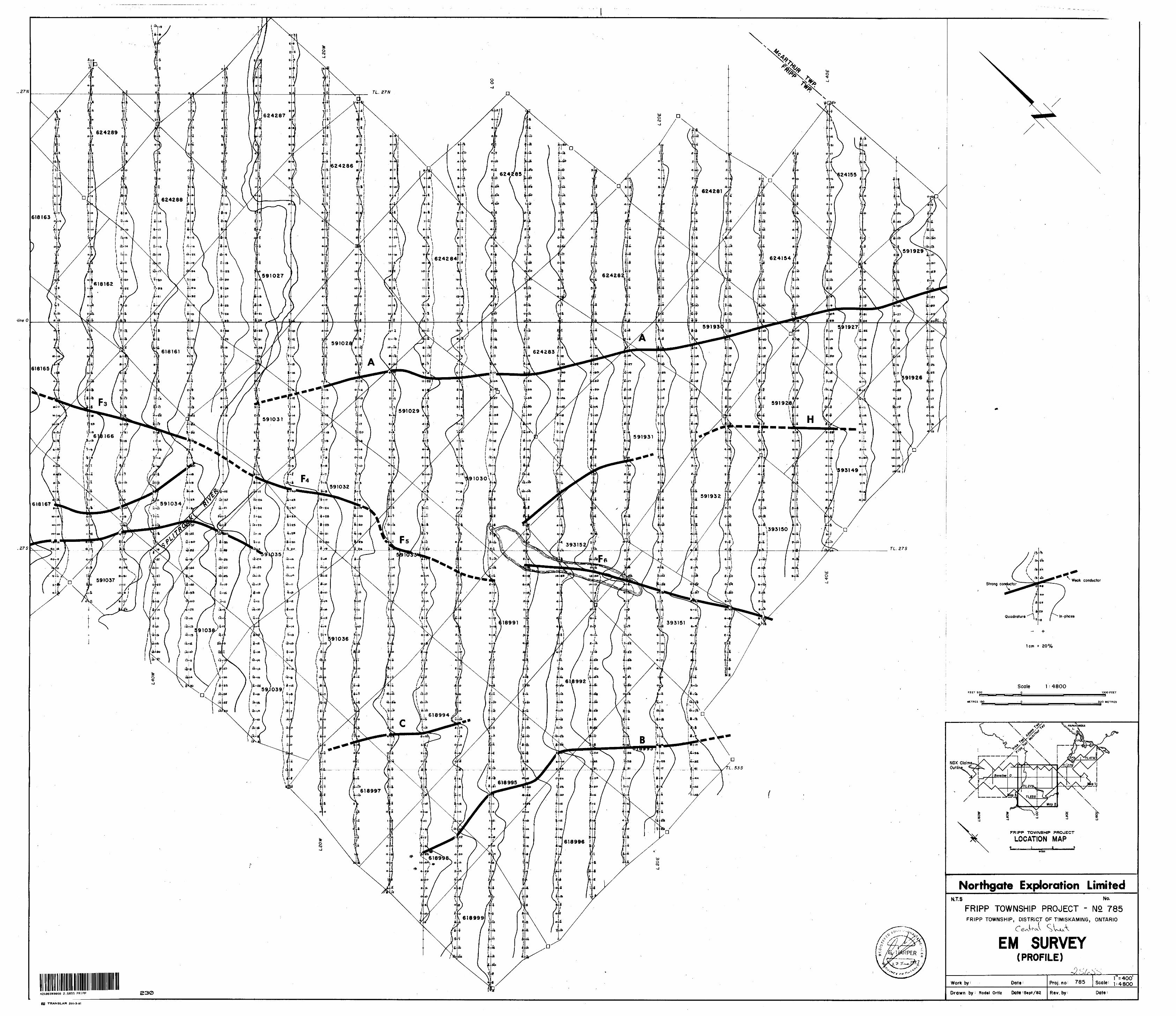
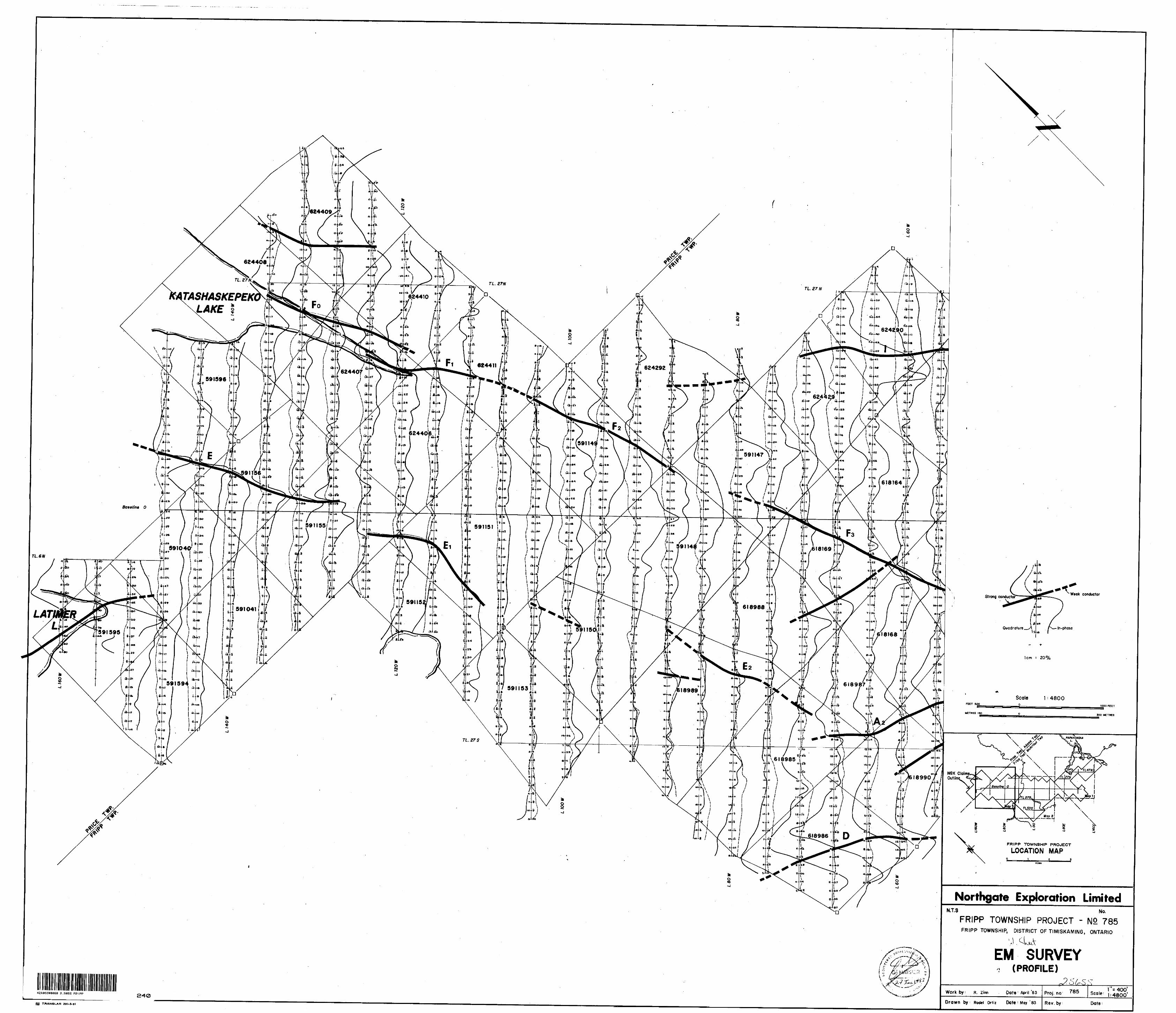
11.0 V.L.F. SURVEY
11.1 GENERAL
This survey covers 95 miles of grid on 110 claims in Price, Fripp and McArthur Townships previously surveyed by magnetometer in 1981. The grid is oriented with the base line southwest-northeast and the cross lines northeast-southwest. Approximately 5000 readings were taken using 17.8 KHZ, Cutler Maine as the transmitting station.

( 8 )
ll.l.^LF-EM ELECTROMAGNETIC METHOD
The VLF-EM method employs as a source one of the numerous submarine communication transmitters in the 15 to 25 kHz band located throughout the world. At the surface of the earth these radio waves propagate pre dominantly in a single mode along the earth-air interface. This mode is known as the 'surface wave'. Over flat homogeneous ground in the absence of vertical conductive discontinuities the magnetic field component of this ratio is horizontal and perpendicular to its direction of propagation.
Where no-horizontal structures such as faults, contacts and conductors give rise to change in ground conductivity, secondary modes are generated which produce a vertical component of the magnetic field. This produces an elliptical polarization of the toal field in a plane perpendicular to the direction of propagation.
Commercial VLF instruments enable detection of disturbing structures by measuring the tilt angle of the major axis of the polarization ellipse. On flat homogeneous ground the tilt angle will be zero, but in the vicinity of conducting disturbances it will acquire a finite value. Direction of tilt indicates directions of the disturbing structure. Ability to deduce such parameters as depth, depth extent, dip, and width of anomalous structures is minimal.
Fortunately, this does not seriously affect location points where VLF-EM profiles cross the upper limit of dipping structures which can be identified as areas of greatest change in tilt angle per unit of distance.
The transmitting station used during the survey was Cutler, Maine transmitting at 17.8 kHz.
The data is read as a dip angle and a vertical quadrature where the dip angle is a percentage of the incline from the horizontal, i.e. (100 x tan 0), where 9 is the tilt angle of the major axis of the polarization ellipse in degrees, and the vertical quadrature is the out-of-phase amplitude of the polarization ellipse.
The data is presented as profiles with positive to the right, negative to the left. See appendix I for the instrument specifications.
.11.2 RESULTS
The VLF Survey shows two distinct trends, northwest and north-south. Dips appear to be southeast. There are nine distinct anomalies and a number of smaller or one line anomalies. The major anomalies are described as follows:
ANOMALY A
This anomaly extends from Line 96E to Line 32W immediately north of the metasedimentary iron formation that runs sub-parallel to the base line.

11.2 ANOMALY A -continued
The anomaly crosses the base line at approximately 32W.
The anomaly is moderately strong to weak and undoubtably reflects the sulphide associated with the metasediments.
ANOMALY A l
This anomaly is located on Line 92E to 76E just south of the base line parallel to anomaly A.
It also is associated with the metasediments.
ANOMALY A 2
This anomaly is located on Lines 40W at 19S to Line 68W at 26S.
It appears to be a faulted offset of anomaly A as it is located north of a magnetic high with the same trend as anomaly A. The A and A 2 are separated by a north-south trending topographic low and the Split Rock R.
ANOMALY B
This anomaly is located on Line 24E at 48S to Line 00 at 56S.
It is located between the weak magnetic highs in an area interpreted as being underlain by intermediate to felsic colcanics.
ANOMALY C
This anomaly runs from Line 4W at 48S to Line 16W at 49S.
Like anomaly B it is located in intermediate to felsic volcanics between two weak magnetic highs.
It may be a fault offset extension of anomaly B.
ANOMALY D
This anomaly is located between Lines 56W and 76W about 46S on the north flank of a very weak (200 ) magnetic high.
The area is interpreted to be intermediate volcanics on the flank of a granite intrusive.

10
11.2 ^ftMQMAi v E, El. E2
These anomalies are located on a trend from Line SOW at 17S to Line 148W at 8N.
The anomalies correspond to a prominent narrow magnetic high interpreted as an olivine diabase.
ANOMALY F, 0,1.2.3.4.5,6.7
This set of strong to intermittent weak conductors extends across the entire property from Katoshaskepeko L. south past the small lake on Lines 0,4,8,16,20E at the 275 Tieline.
Correlation with the magnetometer data indicates a fault with little movement, and a diabase dyke or other mafic unit implaced along a fault in the north.
ANOMALY G
This anomaly is located in the extreme northeast corner of the property on Line 120W to Line 136W.
The magnetics indicate an area underlain by intermediate volcanics north of a mafic unit.
ANOMALY H
This anomaly is located on Lines 40E at 32E at about 12S
It is in an area of intermediate to felsic volcanics between two distinct magnetic highs.
ANOMALY I
This anomaly is located between Lines SOW and 72W at approximately 20N.
It is immediately south of a magnetic high (mafic intrusion?) in an area of intermediate to felsic volcanics.
OTHERS
In addition to the above anomalies there are a large number of weak, intermittant and one line anomalies.
These anomalies are attributed to terrain and overburden effects.

Certificate
I Ronald Allan Zinn hereby declare that :
1. I ara a graduate of the University of Waterloo in 19?8 with a B.Se. {'Jarth Sciences)
2. I rcride at 202 f 71^ Don Mills Road, Don Mills Ont.
3. I have practiced Geology scince graduation,first with Essex Minerals Ltd. until nNov. 19?8, th-n v;ith I.!.P.H.Consul ting Ltd.until Oct. 1980, and scince then v/ith Northgate Exploration Ltd,
\ t I have worked in Alaska,British Columbia,Saskatchewan, Mani t ob a, Ontar i o, Queb ec, and Gr e enland.
5. I am a member in good standing of the Geological Association of Canada and of the Prospectors and Developers Association.
R.A.Zinn B.Se.

VLF Electromagnetic Unit
Pioneered and patented exclusively by Geonics Limited, the VLF method of electromagnetic surveying has been proven to be a major advance in exploration geophysical instrumentation.
Since the beginning of 1965 a large number of mining companies have found the EM16 system to meet the need for a simple, light and effective exploration tool for mining geophysics.
The VLF method uses the military and time standard VLF transmissions as primary field. Only a receiver is then used to measure the secondary fields radiating from the local con ductive targets. This allows a very light, one-man instrument to do the job. Because of the almost uniform primary field, good response from deeper targets is obtained.
The EM16 system provides the in-phase and quadrature components of the secondary field with the polarities indicated.
Interpretation technique has been highly developed particularly to differentiate deeper targets from the many surface indications.
Principle of OperationThe VLF transmitters have verticalantennas. The magnetic signal component is then horizontal and concentric around the transmitter location.
. 4
SpecificationsSource of primary field
Transmitting stations used
Operating frequency range
Parameters measured
Method of reading
Scale range
Readability
VLF transmitting stations.
Any desired station frequency can be supplied with the instrument m the form of plug-in tuning units. Two tuning units can be plugged in at one time. A switch selects either station.
About 15-25 kHz.
(1) The vertical in-phase component (tangent of the tilt angle of the polarization ellipsoid).(2) The vertical out-of-phase (quadra ture) component (the short axis of the polarization ellipsoid compared to the long axis).
In-phase from a mechanical inclino meter and quadrature from a calibrated dial. Nulling by audio tone.
Reading time 10-40 seconds depending on signal strength.
Operating temperature range 40 to 50* C.
Operating controls '
Power Supply
Dimensions
Weight
Instrument supplied with
In-phase
1-54,.
150*ft; quadrature 40%. Shipping weight
ON-OFF switch, battery testing push button, station selector, switch, volume control, quadrature, dial 40%, inclinometer dial
6 size AA (penlight) alkaline cells. Life about 200 hours.
42 x 14 x 9 cm (16 x 5.5 x 3.5 in.)
1.6kg(3.5lbs.)
Monotonlc speaker, carrying case, manual of operation, 3 station selector plug-in tuning units (additional fre quencies are optional), set of batteries.
4.5kg(10lbs.)
! IMITFD Designers A manufacturers Luvn i CL/ of geophysical instruments
subsidiary ofDeering Milliken Inc. x
2 Thorncliffe Park Drive, Toronto/Ontario/Canada M4H1H2 Tel: 425-1824 Cables: Geonics

Courtesy ol Newloundland A Labrador Corp. Ltd.
Areas of VUF SignalsCoverage shown only tor well-known stations. Other reliable, fully operational stations exist. For Ml Information
regarding VLF signals in your area consult Geonics Limited. Extensive field experience has proved that the circles of coverage shown are very conservative and are actually much larger In extent.
M16 Profile over Lockport Mine Property, Newfoundland
dditional case histories on request.
-L L
vertical coil
horizontal coil
fi?
"l' T 1 "! 110 - O * 10
Ration Selector wo tuning units can be plugged i at one lime. A switch selects ilher station.
Receiving Coils Vertical receiving coil circuit in instrument picks up any vertical signal present. Horizontal receiv ing coil circuit, after automatic 90" signal phase shift, feeds signal into quadrature dial in series with the receiving coil.
In-Phase Dialshows the tilt-angle of the instru ment for minimum signal. This angle is the measure of the vertical in-phase signal expressed In percentage when compared to the horizontal Held.
Quadrature DialIs calibrated in percentage mark- Ings and nulls the vertical quad rature signal In the vertical coll circuit.
ly selecting a suitable transmitter station as a source, the
M16 user can survey with the most suitable primary field
[azimuth.
f he EM 16 has two receiving coils, one for the pick-up of the
horizontal (primary) field and the other for detecting any
[anomalous vertical secondary field. The coils are thus ortho-
Igonal, and are mounted inside the instrument "handle".
BrHThe actual measurement is done by first tilting the coil
assembly to minimize the signal in the vertical (signal) coil and
then further sharpening the null by using the reference signal
lo buck out the remaining signal. This is done by a calibrated
['quadrature" dial.
The tangent of the tilt angle is the measure of the vertical in-phase component and the quadrature reading is the signal at right angles to the total field. All readings are obtained in -
per centages and do not depend on the absolute amplitude of the primary signals present.
The "null" condition of the measurement is detected by the drop in the audio signal emitted from the patented resonance
loudspeaker. A Jack is provided for'those preferring the use of an earphone instead.
The power for the instrument is from 6 penlight cells. A battery tester is provided.
Oct/73

FRIPP TWR CLAIMS
Figure l
LOCATION MAP
FRIPP TWP. CLAIMS

l 1!'
LEGEND
1 Northgote Exploration Limited
2 Bordin- Northgate Option
3 Argentex
4 Amax
5 Texas Gulf
6 WestField Minerals
7 MaHagami Lake Mines Ltd
8 Lacana
Figure 2*
FRIPP TOWNSHIP AREA .
COMPANY HOLDINGS
Scale? T-1 mile

LEGEND
l r/ ,. j Greywacke, Siltstone
l i.F. ] Iron Forrnafion
j ^ l Felsic Intrusive*
j jj Felsic. Volcanics
f 4 j MoFic Volcanics
~~ U lframofic Volcanics
Gabbro
Figure: 3**
FRIPP TOWNSHIP AREA
REGIONAL GEOLOGY

LEGEND
j .^f"1'\ Quartz Diabase
Granite Breccia
Hornblende Schisf
Hornblende Schist (Andesife)
Hollinger Diamond Drill Hole
Figure ' 4i* .
HOLLINGtR GOLD MINES LTQ
Pit 1, Bordin Property, Fripp Twp,Onh
LOCAL GEOLOGY AND DRILL HOLE LOCATIONS
Scale, l'* 400'

TABLE l
ceTc
Claims Bordin Property: Price,.Fripp and HcArthur Townships
PriceTownship^
Claim Number
P-591040 P-591041 P-591155 P-591156 P-591594 P-591595 P-591596
l
l
Fripp Township
Claim Humber
P-618161 P-618162 P-618i63 P-618164 P-618165 P-618166 P-618167 P-618168
. P-618169 P-619315 P-619316 P-618985 P-618986 P-618987 P-618988 P-618989 P-618990 P-618991 P-618992 P-618993 P-618994 P-618995 P-618996 P-618997 P-618998 P-618999 P-591027 P-591028 P-591029 P-591030 P-591031 P-591032 P-591033 P-591034 P-591035 P-591036
Recorder
Dennis Bordinii nii 11n nn . nn uu n
claims
Recorder
Dennis Bordinn Dii Hn nn nH itH Hn itn nn nH tin nn iiIt M
II II
II II
II II
II II
II II
II II
tl - It
II II
tl It
II H
II H
II II
II H
II II
II It
II tl
11 II
II II
II II
II II
II H
II li
TransferredTo N6X
XXXXXXX
TransferredTo N6X
XXXXXXXXXXXXXXXXX.xxxxxxxxxxxxxxxxxxx
Anniversary Date
June 6* 1982II II M
II II
n liHM
June 7, 1982II It M
June 6, 1982
Anniversary Date
May 2, 1982II
II
nH II
May 3, 1982 H n n
May 19* 1982 •i n uMay 9, 1982n it u
n nH uH ' nn N
uH.n
May 6, 1982
n nw"
May 7, 1982II || ||
II II .11
Hay 8, 1982nun
May 26, 1982
M H nn-n M
May 27, 1982D II II
II N II
May 28, 1982 May 29, 1982
u n n

TABLE 2
NORTHGATE CLAIMS: PRICE. FRIPP AND MCARTHUR TOWNSHIPS
PRICE TOWNSHIP
Claim Number
P-624406 P-624407 P-624408 P-624409 P-624410 P-624411SUB TOTAL : 6 CLAIMS
Recorder
Gabriel SutherlandM
II
II
II
Transferred to NGX
X X X X X X
Anniversary Date
August 23, 1982
August 24, 1982 H
FRIPP TOWNSHIP
Claim Number
P-624154P-624155P-624281P-624282P-624823P-524284P-624285P-624286P-624287P-624288 .P-624289P-624290P-624291P-624292P-624293P-624294P-624295P-624296P-624297P-624298P-624299P-624303P-624304P-628041P-628042P-628043P-628044P-628045P-622582P-622291P-622292P-622293P-622294
Recorder
Nolan Boa nRichard McAllister
H
II
II
II
II
H
II
II
II
II
M
II
II
II
II
II
II
II
tl
II
II
II
II
Henry Gonzalez
Transferred to NGX
X X X X X X X X X X X X X X X X X X X X X X X X X X X•x x x x x x
Anniversary Date
August 16, 1982
August 17, 1982M
August 18, 1982II
H
September 9, 198II
September 10, 19cH
II
September 12, 198
September 13,H
September 11 , 19^ HSeptember 9, 19;
H
II

T&R1 F 2 (CONTINUED)
r.iaim Number
P-624096P-624097P-624098P-624099P-624100P-624101P-624102P-624103P-624104P-624105P-624106P-624107P-624108P-624109P-624110P-624111P-624113P-624113P-628036P-628037
SUB TOTAL: 53 CLAIMS
MCARTHUR TOVJNSHIP
Claim Number
P-624156 P-624157 P-624158 P-624159 P-624160P-624161P-624612P-624163P-624164P-624165P-624166P-624167P-624168P-624169P-628038P-628039
SUB TOTAL: 16 CLAIMS
Recorder
Henry Gonzalez
M
II
II
II
II
11
tl
II
II
II
II
II
II
II
II
Transferred to HGX
X X X X X XXXXXXXXXXXX X X X
Anniversary Date
September 10, 1982 H M ti tt
September 11, 1982 nn M n
September 12, 1981 tia H n
September 13, 1982
II
II
II
Recorder
No!an Boa
Henry Gonzalez
Transferred to NGX
XXXXXXXXXXXXXXXX
Anniversary Date
August 16, 1982 n
August 17, 1982 iiM
iiII
August 18, 1982w wH
N
August 20, 1982 September 21, 198
TOTAL 75 CLAIMS

"
i *Claii^!umber
P*91037, P-591038j P-5910391 P-591147
\ P -5911481 P-591149" P-591150
P-591151J P-591152l P-591153
P-591926- P-5919271 . P-591928" P-591929
P-5919301 P-591931i P-591932
P-5919361 P- 3931 491 P- 3931 50 -
P-393151a P- 3931 52
* McArthur Township
i Claim Number
P-619317a P-6193181 P-591933
P-591934a P-591935l P-591937* P-591938
P-591939I . P-591940
- 2 -
Recorder
Dennis Bordinn nH n
II M
n . n
n n
n n
n ' li
li li
n li
li 'n
n n
li li
li li
li li
li li
n ' li
li n
II ' H
II II
M II
II II
Sub-total 58 claims
Recorder
Dennis BordinH nH nII II
H nH nn nn ' nH n
TransferredTo. NGX
XXXXXXXXXXXXXXXXXXXxxx
TransferredTo NGX
XXXXXXXXX
iSub-total 9 claims
Total 74 claims
Anniversary Date
May 28, 1982May 29, 1982
D ti KMay 31, 1982
It II It
II II
tt It
l* II
II M
II
II
H
II
tt II
June 11, 1982n H it
II II II
June 13, 1982
June 27, 1982 n H Hn H
D n
li n
Anniversary Date
May 19, 1982H n n
June 13* 1982n n M
June 14, 1982M II II
II
H
II
II
JL

42A06SW0e68 a .5655 FRIPP 900
1983 11 09
134
2.5655
Mining RecorderMinistry of Natural Resources60 Wilson AvenueTimmins, OntarioP4N 2S7
Dear Sir:
RE: Geophysical (Electromagnetic) survey on mining claims P 393149 et al 1n the Townships of Fripp, Price and McArthur
The Geophysical (Electromagnetic) survey assessment work credits as listed with my Notice of Intent dated October 12, 1983 have been approved as of the above date.
Please Inform the recorded holder of these mining claims and so Indicate on your records.
Yours very truly,
E.F. AndersonDirectorLand Management Branch
Whitney Block, Room 6643 Queen's Park Toronto, Ontario M7A 1W3 Phone:(416)965-1380
S. Hurst:me
cc: Northgate Exploration Limited Suite 3140 P.O. Box 143 l First Canadian Place Toronto, Ontario M5X 1C7
cc: Resident Geologist Timmins, Ontario

Ministry of Natural - Resources
Ontario
Technical Assessment Work Credits Date
1983 10 12
Pile
2.5655Mining Recorder's Report of Wor^o. 134
Recorded Holder
NORTHGATE EXPLORATION LIMITEDTownship or Area
FRIPP PRICE MCARTHURType of survey and number of
Assessment days credit per claim
GeophysicalElectrnmagnatir 20
Magn.t omAtAr
Radiomatrie
Inriuearl pnlari7atinn
Other
Section 77 (19) See "Mining Claims Assessed"
Renlngiral
Genrhemiral
days
days
days
days
days
column
days
riayi
Man days D Airborne LJ
j . m
Special provision 03 Ground U9
O Credits have been reduced becausecoverage of claims.
of partial
LJ Credits have been reduced because of correctionsto work dates and figures of applicant.
Mining Claims Assessed
P 618161 to 169 Inclusive619315-316618985 to 999 incl.591027 to 039 1ncl.591147 to 153 1ncl.591926 to 932 Incl.591936393149 to 152 1ncl.624154-155624281 to 292 incl.591040-041591155-56591594-95624406-07-09-10-11619317-18591933-34-35-37-38-39-40624156-57-58 .624162 to 168 Incl628038-39
Special credits under section 77 (16) for the following mining claims
15 days
P 591596 624408 624159 624169
10 days
P 624160-61
No credits have been allowed for the following mining claims
LJ not sufficiently covered by the survey D Insufficient technical data filed
The Mining Recorder may reduce the above credits if necessary in order that the total number of approved assessment days recorded on each claim does not exceed the maximum allowed as follows: Geophysical — 80; Geological — 40; Geochemical — 40; Section 77(19)—60:XfB IS3SS)

NOflWrGATE EXPLORATION LIMITEDSUITE 3140, P. O. BOX 143. 1 FIRST CANADIAN PLACE. TORONTO. CANADA M5X 1C7 - TELEPHONE (416) 362-6683 ' TELEX 06-217766
October 19, 1983
S. HurstLand Management BranchWhitney Block, Room 6611Queen's ParkToronto, Ontario M7A 1W3
Dear Sir:
With respect to your letter of October 12th, 1983, your file 2.5655, I wish to apply the following: to 591596, 624408, 624159, 624169, 5 days each and to 624160-61, 10 days each. These 40 days are from a credit of 243 days we have ref. your file 2.4766 {EXPENDITURES, ASSAYING) leaving us a credit of 203 days.
Thank you for your attention in this matter.
Yours truly
NORTH6ATE EXPLORATION LIMITED
Ronald A. Zirfn Geoloaist
OCT 2 ' 1983
MINING
RAZ:sd

Ministry ofNaturalResources
rio Mov 3
1,983 10 12
Your file: 134
Our file: 2.5655
Mining RecorderMinistry of Natural Resources60 Wilson AvenueTimmins, OntarioP4N 2S7
Dear Sir:
Enclosed are two copies of a Notice of Intent with statements listing a reduced rate of assessment work credits to be allowed for a technical survey. Please forward one copy to the recorded holder of the claims and retain the other. In approximately fifteen days from the above date, a final letter of approval of these credits will be sent to you. On receipt of the approval letter, you may then change the work entries on the claim record sheets.
For further information, if required, please contact Mr. F.W. Matthews at 416/965-1380.
Yours very truly,
Anderson Hreetor Land Management Branch
Whitney Block, Room 6450Queen's ParkToronto, OntarioM7A 1W3Phone: 416/965-1316
S. Hurst:sc
Ends:
cc: Northgate Exploration LimitedToronto, Ontario Attn: Mr. R. Zinn.
cc: Mr. G.H. FergusonMining S Lands CommissionerToronto, Ontario
845

Ministry ofNaturalResources
Notice of Intent
for Technical ReportsOntario
1983 10 12
2.5655
An examination of your survey report indicates that the requirements of The Ontario Mining Act have not been fully met to warrant maximum assessment work credits. This notice is merely a warning that you will not be allowed the number of assessment work days credits that you expected and also that in approximately 15 days from the above date, the mining recorder will be authorized to change the entries on his record sheets to agree with the enclosed statement. Please note that until such time as the recorder actually changes the entry on the record sheet, the status of the claim remains unchanged.
If you are of the opinion that these changes by the mining recorder will jeopardize your claims, you may during the next fifteen days apply to the Mining and Lands Commissioner for an extension of time. Abstracts should be sent with your application.
If the reduced rate of credits does not jeopardize the status of the claims then you need not seek relief from the Mining and Lands Commissioner and this Notice of Intent may be disregarded.
If your survey was submitted and assessed under the "Special Provision-Performance and Coverage" method and you are of the opinion that a re-appraisal under the "Man-days" method would result in the approval of a greater number of days credit per claim, you may, within the said fifteen day period, submit assessment work breakdowns listing the employees names, addresses and the dates and hours they worked. The new work breakdowns should be submitted direct to the Lands Management Branch, Toronto. The report will be re-assessed and a new statement of credits based on actual days worked will be issued.
846 (82/6)

.Ministry of Natural
rcesOntario
^^rc
Report of Work(Geophysical, Geological, Geochemical and Expenditures)
July Sft
The Mining ActP.Instructions: - Please type or print.
— If number of mining claims traversed exceeds space on this form, attach a list.
Note: - Only days credits calculated In the "Expenditures" section may be entered In the "Expend. Days Cr." columns.
- Do not use shaded areas below.Type of Survey(s) ' - . Township 0
V.L.F./E.M. 16 GEOPHYSICAL FRIPP P]
NORTHGATE EXPLORATION LIMITED
r Area -
EiiCE MCARTHUR
T835Survey Company Survey Oates (llnecuttlng to office)
NORTHGATE EXPLORATION LIMITED D^vlMo3 ! Y?.3 1 D?? l MO/ 1 Y?.3Name and Address of Author (of Qeo-Technlcal report)
R. Zinn. B.Sc.. //202-715 Don Mills Rd.. Don Mills. Ontario M3C 1S4
Total Mllw of line Cut N/A
Special Provisions Credits RequestedInstructions
For first survey:. Enter 40 days, (This
includes li ne cutting)
For each additional survey: using the same grid:
Enter 20 days (for each)
Qaophytlcal
- Electromagnetic
- Magnetometer
- fladiometrlc
- Other
Oeologlcal
Geochemical
Day* per Claim
20
Man Days
Mining Claims Traversed (List in numer cal sequence)
Instruction*
Complete reverse side and enter total (s) here
Qeophyilcal
- Electromagnetic
- Magnetometer
- Radiometric
- Other
Geological
Geochemical
Dayi parClaim
Airborne Credits
Note: Special provisions credits do not apply E lectromaBrl to Airborne Surveys.
Magnetomet
Radiometric
Expenditures (excludes power stripping)
Days per Claim
etlc
er
Type of Work Performed
'erformed on Clalm(s)
Calculation of Expenditure Day* Credits Total Expenditures
|S * 15
Total Days Credits
*
Instructions Total Days Credits may be apportioned at the claim holder's choice. Enter number of days credits per claim selected In columns at right.
Report CompletedDate of Report Recorded Holder or Agent (Signature)
Certification Verifying Report of Work
ee attache
G LANDS SECTION
Totel number of mining claims covered by this report of work.For Office Use Only
Oete Approved as necoroea Regional/Branch Director
l hereby certify that l have a personal and intimate knowledge of the facts set forth in the Report of Work annexed hereto, having performed the work or witnessed same during and/or after its completion and the annexed report is true. - - "tt end Postal Address of Parson CertifyingR. Zinn, B.Sc., NORTHGATE EXPLORATIONS LIMITED, l 1st Canadian Place, Ste. 3140
P.O. Box 143, Toronto, Ontario M5X 1C7 Oete Certified I Cart If led by (Signature)

PRlfcMKWNSHIP~^p——Claim Number
P - 591040 P - 591041 P - 591155 P - 591156 P - 591594 P - 591595 P - 591596
MCARTHUR TOWNSHIPClaim Number
P - 619317 P - 619318 P - 591933 P - 591934 P - 591935 P - 591937 P - 591938 P - 591939 P - 591940
Sub-total 13 Claims
Sub - total 25 Claims
PRICE TOWNSHIP
Claim Number
P P P P P P
624406624407624408624409624410624411
MCARTHUR TOWNSHIPClaim Number
P P P P P P P P P P P P P P P P
624156624157624158624159624160624161624162624163624164624165624166624167624168624169628038628039

FRI1 rOWNSHIP FRIPP TOWNSHIP
Claim Number
P - 618161 P - 618162 P - 618163 P - 618164 P - 618165 P - 618166 P - 618167 P - 618168 P - 618169 P - 619315 P - 619316 P - 618985 P - 618986 P- 618987 P - 618988 P - 618989 P - 618990 P - 618991 P - 618992 P - 618993 P - 618994 P - 618995 P - 618996 P - 618997 P - 618998 P - 618999 P - 591027 P - 591028 P - 591029 P - 591030 P - 591031 P - 591032 P - 591033 P - 591034 P - 591035 P - 591036 P - 591037 P - 591038 P - 591039 P - 591147 P - 591148 P - 591149 P - 591150 P - 591151 P - 591152 P - 591153 P - 591926 P - 591927 P - 591928 P - 591929 P - 591930
Claim Number
P PP P PP P
P P P P P P P P P P P P P P
591931591932591936393149393150393151393152
624154624155624281624282624283624284624285624286624287624288624289624290624291624292
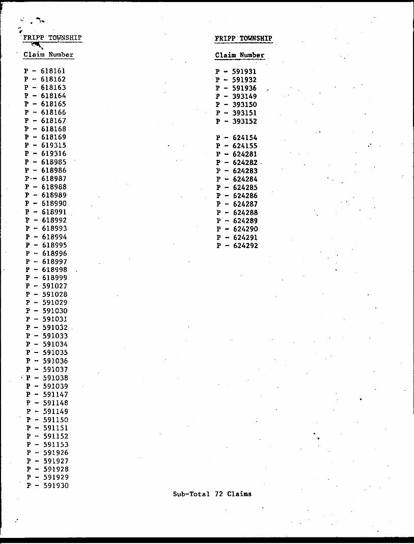
Sub-Total 72 Claims
Ministryof GeotechnicalfSSicu RePort
Ontario ^ Approval
File
Mining Lands Comments
To: Geophysics
Comments
p'proved [~] With to tee again with corrections
DTo: Geology - ExpendituresComments
Approved Q Wish to set again with correctionsDate Signature
DTo: Geochemistry
Comments
[^Approved [~1 Wish to see again with correctionsDate Sienature
j JTo: Mining Lands Section, Room 6462, Whitney Block. {Tel: 5-1380)
1603(61/10)

1983 07 07
f134 P393149
2.5655
Mr. William L. GoodMining RecorderMinistry of Natural Resources60 Wilson AvenueTimmins, OntarioP4N 2S7
Dear Sir:
We have recilved reports and maps for a Geophysical (Electromagnetic) survey submitted under Special Provisions (credit for Performance and Coverage) on Mining Claims P393149 et al 1n the Townships of Fripp, Price and McArthur.
This material will be examined and assessed and a statement of assessment work credits will be Issued.
Yours very truly,
E.F. AndersonDirectorLand Management Branch
Whitney Block, Room 6450Queen's ParkToronto, OntarioM7A 1W3Phone:(416) 965-1380
A. Barr:mc
cc: Northfate Exploration Limited Suite 3140 P.O. Box 143 1 First Canadian Place Toronto, Ontario M5X 1C7 Attention: 6. Harper
cc: R. Z1nn Suite 202715 Don Mills Road Don Mills, Ontario M3C 1S4

Ontario
Ministry of Natural Resources
GEOPHYSICAL - GEOLOGICAL - GEOCHEMICAL TECHNICAL DATA STATEMENT
File.
C TO BE ATTACHED AS AN APPENDIX TO TECHNICAL REPORT FACTS SHOWN HERE NEED NOT BE REPEATED IN REPORT
ECHNICAL REPORT MUST CONTAIN INTERPRETATION, CONCLUSIONS ETC.
Type of Survey(s). Township or Area. Claim Holder(s)—
ELECTROMAGNETIC VLFFRIPP. PRICE.MCARTHUR
NORTH6ATE EXPLORATION LIMITED
Survey Company N ORTHGATE EXPLORTION LIMITED
Author of Report RONALD ZINN, B.Se.Address of A..thnr # 202, 715 DON MILLS RD.. DON MILLS. ONT.Covering Dates of Survey AUGUST 81
Total Miles of Line r.nt 95(linecutting to office)
APRIL 83
SPECIAL PROVISIONS CREDITS REQUESTED
ENTER 40 days (includes line cutting) for first survey.ENTER 20 days for each additional survey using same grid.
Geophysical—Electromagnetic.—Magnetometer-——Radiometric———Other——————.
DAYS per claim
20
Geological.Geochemical.
AIRBORNE CREDITS (Special provision credits do not apply to airborne lurveyi)
Magnetometer Electromagnetic
DATE:
(enter days per claim)
SIGNATURE:AwJjapeTReport or Agent
Res. Geol.. .Qualifications.Previous Surveys
File No. Type Date Claim Holder
MINING CLAIMS TRAVERSED List numerically
{prefix) (number)
l
TOTAL CLAIMS.
837 (5/791

GEOPHYSICAL TECHNICAL DATA
GROUND SURVEYS - If more than one survey, specify data for each type of survey
Number of Stations ___5015——-———^-————-————.Number of Readings 5016 Station interval 100'_______________________ Line spacing AflO'^——— Profile *™le lcm : 20ft__________________________________________
Contour interval .
S
uEz;
si gj
O
z2H < Mdi <
Q W O Da z
Y~ H
InstrumentAccuracy — Scale constant.
a, Diurnal correction method.
Base Station check-in interval (hours). Base Station location and value ___
Instrument GEONICS EM 16Coil configuration HORIZONTAL LOOP
Coil separation AS PER GRID______________^^________^^___^__.^_____
Accuracy ——rJUa_____________________________________—-^-———^—-———.—.— Method: ffi Fixed transmitter CD Shoot back CD In line CD Parallel line
17.8 KHz Cutler. Maine(specify V.L.F. sUtion)
Parameters m--.™! TILT ANGLE OF POLARIZATION ELLIPSE
Instrument.Scale constantCorrections made.
Base station value and location.
Elevation accuracy.
Instrument ——————————.———————————————————————————————-————— Method D Time Domain CD Frequency Domain
- On time ___________________________ Frequency —————- Off timp ________________________ Range.
- Delay— Integration time.
Power.Electrode array — Electrode spacing

VA/V Resources ivaeopnysicai, geological, Geochemical and Expenditures) S\
f]IST / ^
S ~^* i^\T 3fit*{l U& '" The Mining Act/ ^*J f-"T/ . D
exceeds space on this form, attach a list. Note: — Only days credits calculated in the
Expenditures" section may be entered the "Expend. Days Cr." columns.
Do not use shaded areas below.Type* of Survey (s) --. P-^VJi-^X
V.Ijeflf'/E.M. 16 GEOPHYSIpA^r? (j^-^~~^\\\\Cielm HcMSerM \V\\ ' ''' 'l-(l*i '''m
NORTHGATE EXPLORATION LlHTTEfr: ' " ^J?O)Survey Company \ \ \' —r-er'rp VJ u~'~ ~~
NORTHGATE EXPLORATION LlJl\fej|^ U~~ ^ - — ~'~"
(Township or Area
FRIPP PRICE MCARTHURT835
Survey Date* (llnecuttlng to office)20, 03, 83| 28, 04 83
Day | Mo. | Yr. j Day | Mo. l Yr.
Total Miles of line Cut N/A
Name and Address of Author (of Gao-Technical report!
R. Zinn, B.Sc., #202-715 Don Mills Rd.. Don Mills. Ontario M3C 1S4Special Provisions Credits RequestedInstructions
For first survey:Enter 40 days. (This Includes line cutting)
For each additional survey: using the same grid:
Enter 20 days (for each)
Geophysical
- Electromagnetic
. - Magnetometer
- Radiometric
- Other
Geological
Geochemical
Days par Claim
20
Man DaysInstructions
Complete reverse side and enter total (s) here
Geophysical
- Electromagnetic
- Magnetometer
- Radiometric
- Other
Geological
Geochemical
Days per Claim
Airborne Credits
Note: Special provisions credits do not apply to Airborne Surveys.
Electromagnetic
Magnetometer
Radiometric
Days per Claim
Expenditures (excludes power stripping)Type of Work Performed
Performed on Claim(s)
Calculation of Expenditure Days Credits
Total Expenditures
S -5-15
Total Days Credits
B
Instructions Total Days Credits may be apportioned et the claim holder's choice. Enter number of days credits per claim selected in columns at right.
Report CompletedDate of Report Recorded Holder or Agent (Signature)
Certification Verifying Report of Work
Mining Claims Traversed (List in numerical sequence)Mining Claim
Prefix
Plilisrv;?!?'
: *--7':Vi:' !-t^ ".•-..'•^v.'-'.C-
-i^bS•••' "-y'lt }.i.Jj ;.;-yi'-.i'
' ??-'*v"-V" 't'^•f'-^-ffr-'•itf i^ff,-.'•f l", f- , t-
.' r,- -f '--:~- .*^*y'^•'••••.^ -.-jVijiv . J :- ..s
fs®^!S|*•-/ ;.;^! :-;-.'.'-v.v'.i,v.!;\* 1 i.-'ii";-?!;.
x^;. :.'5":' ;.f~'W';*-
S-%::':-/' ;;:.r ^ - ; J
'•"5"'^';'"'!';
•'•*4-,*: .i' rv.#.;.;- f*!
*' 'i f "' ' :
f ir {j j t'-'-' .' ,'*i -- - : .- -' :-s. -.. -*^--"v " *,,',.V l! -"-*i
*fcl|JV,v;V?.r-f'V';'//-, 1,-*''-^.-•'- '*V ^. * '-''
' v ' ''', *\'y-*.
SIS?i;;tv''.";/
Number
See attachecSheets
"
•t — .— .i
— — ̂
Expand. Days Cr.
,
•4^ ifi
1~~-
Minlng ClaimPrefix
y.f.T-iff.*'f**^•'i^-l
m*m^' 4,;.,^"i'i-'-K**i-.-•^•i^. -V-* t?i' * v- - i'
^'^'ty&W*
~"^}-fr
^ft •;.- ;V*ii-^v-'- ',1^'w1 :U-.:'."VWi • V-'W.*N*-,i'-" "."Sri;,"-•^*iiVi?^;"?"•-. •"'.'•V'v :
..^ V. riv/? j;i-- V ':*. ' ^
.•,'.;-J--.-'-'. ;.-: •1.:-^):.:*#2W
•/.S' -vi.' -" -* '* - , '
'. , ' - ; ? : "'"
••"'V^S;:
Mi*. ^:-'4'/*.-*
•: • •"\'^f?Jf: --;-^-: -#3?v*^.v^Vir*' e - -'- - ? ^ 1''- :?^;i*;:̂ mi.-i?.-*-V/n/;^-
'^•V^^-.,
' .f.','--''- :"1-/•-, .'.^^t*"' r'.^*--v"-.
•;.- - ' s.-'f' T.
Nombtr
t
1
.
Expend. Days Cr.
For Office Use OnlyTotal Days Cr. Recorded
Date Recorded ,
Date Approved as Recordedv 1
Total nUVnber of mining claims covered by this 110 report of work.
. f ' ..Mining'Recptdjr.-" -*--- -f '
Regional/Branch Director " f*ijk',fW Vf!fiN\; ftfCF/tpv
l hereby certify that l have a personal and intimate knowledge of the facts set forth in the Report of Work annexed hereto, having performed the work or witnessed same during and/or after its completion and the annexed report is true.
ie and Postal Address of Person CertifyingR. Zinn, B.Sc., NORTHGATE EXPLORATIONS LIMITED, l 1st Canadian Place, Ste. 3140
P.O. Box 143, Toronto, Ontario M5X 1C7Date Certified ^ i S .-A .
Certified by (Signature)

PRICE TOWNSHIPPRICE TOWNSHIP
Claim Number
P - 591040 P - 591041 P - 591155 P - 591156 P - 591594 P - 591595 P - 591596
Claim Number
P - 624406 P - 624407 P - 624408 P - 624409 P - 624410 P - 624411
Sub-total 13 Claims
MCARTHUR TOWNSHIPClaim Number
P P P P P P P P P
619317619318591933591934591935591937591938591939591940
MCARTHUR TOWNSHIPClaim Number
P - 624156 P - 624157 P - 624158 P - 624159 P - 624160 P - 624161 P - 624162 P - 624163 P - 624164 P - 624165 P - 624166 P - 624167 P - 624168 P - 624169 P - 628038 P - 628039
Sub - total 25 Claims
FRIPP TOWNSHIP FRIPP TOWNSHIP
Claim Number
P - 618161 P - 618162 P - 618163 P - 618164 P - 618165 P - 618166 P - 618167 P - 618168 P - 618169 P - 619315 P - 619316 P - 618985 P - 618986 P-- 618987 P - 618988 P - 618989 P - 618990 P - 618991 P - 618992 P - 618993 P - 618994 P - 618995 P - 618996 P - 618997 P - 618998 P - 618999 P - 591027 P - 591028 P - 591029 P - 591030 P - 591031 P - 591032 P - 591033 P - 591034 P - 591035 P - 591036 P - 591037
- P - 591038 P - 591039 P - 591147 P - 591148 P - 591149 P - 591150 P - 591151 P - 591152 P - 591153 P - 591926 P - 591927 P - 591928 P - 591929 P - 591930
Claim Number
P - 591931 P - 591932 P - 591936 P - 393149 P - 393150 P - 393151 P - 393152
P - 624154 P - 624155 P - 624281 P - 624282 P - 624283 P - 624284 P - 624285 P - 624286 P - 624287 P - 624288 P - 624289 P - 624290 P - 624291 P - 624292
Sub-Total 72 Claims

SELF POTENTIAL Instrument—-^——^——-^——^———————————————-^———————— Range.Survey Method ̂ -—.—^——^——-——-——^-—————————-———^——.—-.—.——-—
Corrections made.
RADIOMETRIC Instrument^——Values measured.Energy windows (levels)—^——^—^————————-—————————.^.——————Height of instrument-^——^——-—.—^—-——^-——.————————Background Count.Size of detector——————^———-————-——.—-.^^..——.——.—--——-—-.^—-Overburden —^—--^—.^——^——.^—^^————^.—————-^-^.^.^.^—-—.^—^-..—.—.
(type, depth - include outcrop map)
OTHERS (SEISMIC, DRILL WELL LOGGING ETC.) Type of survey^.^^.^.^-^.^^^^^—^.^^^.-.^-^Instrument —————————————————————————Accuracy———-—^-^——————-—^——^——^—Parameters measured.
Additional information {for understanding results).
AIRBORNE SURVEYS Type of survey(s) ————Instrument(s) ——————
{specify for each type of survey) Accuracy-^——^—————-————
(specify for each type of survey) Aircraft used-^———————--—————————.—^——^——.^————.Sensor altitude.Navigation and flight path recovery method.
Aircraft altitude————^——————————,--.^——^—.—.———— Line SparingMiles flown over total area-—————^————..—-^—————^^——Over claims only.
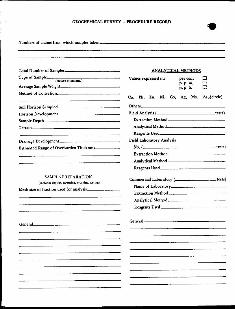
GEOCHEMICAL SURVEY - PROCEDURE RECORD
Numbers of claims from which samples taken.
Total Number of Samples. Type of Sample.
(Nature of Material)
Average Sample Weight——————— Method of Collection————————
Soil Horizon Sampled. Horizon Development. Sample Depth———— Terrain————————
Drainage Development———————————— Estimated Range of Overburden Thickness.
ANALYTICAL METHODS
Values expressed in: per cent p. p. m. p. p. b.
D Da
Cu, Pb,
Others—
Zn, Ni, Co, Ag, Mo, As.-(circle)
Field Analysis (.Extraction Method. Analytical Method. Reagents Used——
Field Laboratory AnalysisNo.(——^——————
SAMPLE PREPARATION(Includes drying, tcreening, crushing, ajhing)
Mesh size of fraction used for analysis^———
Extraction Method. Analytical Method . Reagents Used——
Commercial Laboratory (. Name of Laboratory— Extraction Method—— Analytical Method—— Reagents Used———^
.tests)
.tests)
.tests)
GeneraLGeneral.

NOMGATE EXPLORATION LIMITEDSUITE 3140. R O. BOX 143. 1 FIRST CANADIAN PLACE, TORONTO. CANADA M6X 1C7 . TELEPHONE (416) 382-6683 * TELEX 06-217766
June 27, 1983
Mr. E. F. AndersonDirectorLand Management BranchMinistry of Natural ResourcesWhitney Block, Room 6450Queen's ParkToronto, Ontario M7A 1W3
Re: Report on the VLF Survey Fripp, Price and McArthur Twps. —————District of Timiskaming, Porcupine Mining Division, NTS 42/A/6
Dear Sir:
Herewith enclosed Report on the VLF Survey on 110 Claims in Fripp, Price and McArthur Townships.
The Green form Report of Work was previously submitted to the Porcupine Mining Division, Mining Recorder on May 9th 1983, see copy attached.
Yours truly
NORTHGATE EXPLORATION LIMITED
Harper, Ph. D. Chief Geologist
c.c. Timmins Mining Recorder R. Zinn
RECEIVED•'""27863
UNDS SKTION
GH:sdend. MNR Form #837 - completed
Maps 4 X2 - signed VLF Survey Report X2

r~TOWNSHIP-' i - -
Claim Numbfcr
P - 618161*^ P - P - P -P - 6181651 P - 618166*^ P - 6181671^ P - 618168*^ P - 618169^ P - 619315v/ P - 619316-/, P - 618985*^ P - 618986^ P— 618987V P - 618988^0 P - 618989*0 P - 618990*^ P - 618991*V
- 618992V- 618993X- 618994*^- 618995^
. - 618996-/ ' - 618997V- 618998V- 618999*/- 591027*/- 591028V
E" - 591029V — eoinon''- 591030- 591031- 591032
y x- 591033- 591034*^- 591035**/
591037,591038^591039V591147O591148V,591149*^591150^591151*
591153V 591926^. 591927V 591928V,
- 591929- 591930^
FRIPP TOWNSHIP
Claim Number
P - 591931*^ P - 591932\X P - 591936*^. P - 393149V P - 393150*0 P - 393151*^ P - 393152*^
P - 624154*^ P - 624155*O P - 624281*;. P - 624282*^. P - 624283*0 P - 624284V P - 624285*V P - 624286*V P - 624287*^, P - 624288^^ P - 624289*f^ P - 624290V P - 624291 P - 624292*^
Sub-Total 72 Claims

i'RICE TOWNSHIP-*4
Claim Number
P - 591040*^ P - 591041^P - 591155V, P - 591156*0 P - 591594*/ P - 59159^1P - 59 1596 'H
Sub-total 13 Claims
MCARTHUR TOWNSHIPClaim Number
P - 619317*/P - 619318*^ P - 591933*^ P - 591934^, P - 591935"^P - 591937*^P - 591938*', P - 591939*/- P - 591940*^
riMuc, luwnonxr
Claim Number
P - 624406*^- P - 624407^P - 624408 V P - 624409*C P - 624410*^ P - 624411-^
MCARTHUR TOWNSHIPClaim Number
P - 624156^P - 624157^ P - 624158*7/ P - 624159 n P - 624160*^"P - 624161 faP - 624162 yV P - 624163 TV P - 624164^P - 624165*^P - 624166*^P - 624167*^,P - 624168*^,P - 624169 'M P - 628038^P - 628039^
Sub - total 25 Claims

5M --
4M
l-
PRICE TWP. M. 301
624291 '624290
618164 618163 624289622865 1622862 622915 1622916 22917
P P P IP 624288
622920 J6229I9 {6229I87 " ~' ~ " ~ (618130 '618129
618166 618161 '391^27-624286,
--^- ̂ j IP IP i i. 618131 '
5W028 ' l U— - 591031 i L 1624284,6242851
591038 ' 59t035'59l032eJl 591029 L- — ~1- - -J—— Ah-— — -Je24283 |624282 '.62/^281
'P tP 'P
391039 59l036j59l03V-\59JOJ10 ~ " " ~~
591932 591928
1 &I899B 1618996|J93I50|393I499
Ip IP IP
618999'618996 ' 6*^993 !-P | P ' P ' P
-p -p "p'" K "p" ' '"'•562Z9I l l l562292 1 -—5 62290 1562289 1 6 ' 9516
622292 622/91 622582 ~ ~ —— r~ ~~'^- — j. - - -
P T p
I 622 2931 6222941 824096 l 562293 1562294 1 5*2295 562296
j P ' P ~ P
6240996240981624097)562300 [562299 562298
I""——l^— —— l — __ __ '™"~ ^T- ^^"^"- ^*r "^
410O 1*24101 824102^S—'——-f —"—-l^U.'-l"j5*"01 ! 562302l56 2303l562304'393l4l
l/^l P| P ID (D to -^~— — -j--
'662311 1562312
- , x[624112 24113)62293
(649877- ' l W
62804SLI628043 51070
82804.1/1624304^24303
P
IM
BPZU 08
MUSGROVE TWP. M.304
42A&6SW096B 2.5655 FRIPP200
O
48*11' 27'
THE TOWNSHIP
FRIPPDISTRICT OF
TIMISKAMING
PORCUPINEMINING DIVISION
SCALE: 1-INCH 40 CHAINS
DISPOSITION OF CROWN LANDS
PATENT, SURFACE AND MINING RIGHTS ___ t
H , SURFACE RIGHTS ONLY ______,. -e
H , MINING RIGHTS ONLY________ Q
LEASE, SURFACE AND MINING RIGHTS-...^. H
" , SURFACE RIGHTS ONLY________ H
" , MINING RIGHTS ONLY________ 0
LICENCE OF OCCUPATION _____________ If
ROADSIMPROVED ROADS
KING'S HIGHWAYS
RAILWAYS
POWER LINES MARSH OR MUSKEG
MINES CANCELLED
NOTES
400* surface rights reservation along the shores of all lakes and rivers.
Areas withdrawn from staking under Section43 of the Mining Act(R.S.O. 1970.)
Order N? File Date Disposition
JUL20
Minis'jyoM-lalural ResourcesTOROUTO
PLAN NO.
ONTARIO
MINISTRY OF NATURAL RESOURCESSURVEYS AND MAPPING BRANCH

Ogden Twp. (M.305)
618894 l 618887 .618888 818889—r — r~~
p . D \' j P i r̂m i P
IB896 '618893.818892
~ —p T- "p — p —p J— ~p t — -p — p -p —
6221^4,6222361123
622V85i622BB4 622883.P.I R i ~ P~ , P
611313 611312 6113)1
V i/8(1273 61127 2 ,6l69O 76 11916 6(8917
. .611271 l 6(8908 . .. ,,p-VH-7H-T-r-P~^
T-P—r~rn591594(59(041 |59II55 1624404,6244
Fripp Twp. (M.28I)
CD C\J
Q.5:I-
E o "a
42A06SWe068 2.5655 FRIPP 210
THE TOWNSHIP OF
PRICEDISTRICT OF
COCHRANE
PORCUPINE MINING DIVISION
SCALE: MNCH — 4O CHAINS
DISPOSITION OF CROWN LANDS
PATENT, SURFACE AND MINING RIGHTS ___" , SURFACE RIGHTS ONLY ... _ ......" , MINING RIGHTS ONLY ,. _______ .
LEASE, SURFACE AND MINING RIGHTS......, SURFACE RIGHTS ONLY , MINING RIGHTS ONLY
LICENCE OF OCCUPATION
ROADSIMPROVED ROADSKING'S HIGHWAYSRAILWAYSPOWER LINESMARSH OR MUSKEGMINESCANCELLED C.
NOTES40G' surface rights reservation along the shores of all lakes and rivers.
Areas withdrawn from staking under Section 43 of the Mining Act ( R .S.O. 1970).
Order N- F ile Date Disposition
of ^'^al Resources
SAND AND GRAVELQUARRY PERMIT
This township lies within the Municipality of the CITY of TIMMINS.
PLAN NO
ONTARIO
MINISTRY OF NATURAL RESOURCESSURVEYS AND MAPPING BRANCH

624166
HOPKINS
LAKE
FRIPP TOWNSHIP PROJECT
LOCATION MAP
Northgate Exploration LimitedN.T.S No.
FRIPP TOWNSHIP PROJECT - NQ 785FRIPP TOWNSHIP, DISTRICT OF TIMISKAMING. ONTARIO
EM SURVEY(PROFILE)
Drawn by: Rod*i Ortiz Dote'Sept/82
27N
'fine O
.275
Strong conductorWeak conductor
Quadrature In-phase
- 4-
Tem s 20 0Xo
FEET 500
Scaleo
: 48001000 FEET
METRES ISO 300 METRES
PAPAXOMOCA L.
NGX Claims,^! Out lin
- _
FRIPP TOWNSHIP PROJECT
LOCATION MAPmi 1*1
Northgate Exploration LimitedN.T.3 No.
FRIPP TOWNSHIP PROJECT - NO 785FRIPP TOWNSHIP, DISTRICT OF TIMISKAMING, ONTARIO
EM SURVEY(PROFILE)
Work by: Data
Drawn by : Rodel Ortiz Data-Sept/82
Proj. no ; 785r s 400*
Scale- 1:4800
Rev. by Date:
TRAN SLAR 200-3-81
TASHASKEPEK LAKE l
624429s y **.
Scale 1 '4800
618985B \ l 01.
FRIPP TOWNSHIP PROJECT
LOCATION MAP
Northgate Exploration LimitedN.T.S No.
FRIPP TOWNSHIP PROJECT - N2 785FRIPP TOWNSHIP, DISTRICT OF TIMISKAMING, ONTARIO
EM SURVEYo (PROFILE)
Drown by - Rodei Ortiz Date : May 83TRANS LA R ZOO-3-81

TL.6N
TASHASKEPEKO LAKE
Scale :4800
MfTHES 150
NGX C laims Outline
/
FRIPP TOWNSHIP PROJECT
LOCATION MAP
Northgate Exploration LimitedN.T.S No
FRIPP TOWNSHIP PROJECT - N2 785FRIPP TOWNSHIP, DISTRICT OF TIMISKAMING, ONTARIO
EM SURVEY(FRASER FILTER)
Work by Dote42AW5SK9068 2.56S5 FRIPP S50
Dra^n by Dote
Proj no 7^5] = 400
Scale i. 4800'
Rev. by DoteTRANSLAR 200-3-81