1999 SOTHMAN PROP RPT INCLUDING PROSP ...
52
41P14NW2003 2.20288 SOTHMAN 010 1999 SOTHMAN PROPERTY REPORT including Prospecting Traverses and VLF - EM 16 Geophysical Survey in Sothman Twp (M-1121) # Nursey Twp.(G-2282) Latitude : 47 deg 53 ' North Longitude : 81 deg 18 ' West Porcupine Mining Division NTS sheet 41 P/14 2 S January 26 1 2000 By: David V. Jones, HBScF
-
Upload
khangminh22 -
Category
Documents
-
view
8 -
download
0
Transcript of 1999 SOTHMAN PROP RPT INCLUDING PROSP ...

41P14NW2003 2.20288 SOTHMAN 010
1999 SOTHMAN PROPERTY REPORT
including
Prospecting Traverses
and
VLF - EM 16 Geophysical Survey
in
Sothman Twp (M-1121) # Nursey Twp.(G-2282)Latitude : 47 deg 53 ' NorthLongitude : 81 deg 18 ' WestPorcupine Mining Division
NTS sheet 41 P/14
2 S
January 26 1 2000 By: David V. Jones, HBScF

41P14NW2003 2.20288 SOTHMAN
Table of Contents010C
Cover Page ..................................................................................................... lTable of Contents .............................................................................................. 2Location& Access ............................................................................................ 3Property Description k Access ............................................................................ 3General Geology .............................................................................................. 6Previous Exploration Work ................................................................................. 6Work Program:
A) Grid Layout ..................................................................................... 7B) VLF-EM16 Geophysical Survey ............................................................. 9
VLF-EM16 Results A Interpretation ........................................................ 9VLF-EM16- Recommendations ............................................................. 10
C) Prospecting Program ........................................................................... 11Prospecting Results *fe Recommendations .................................................. 11
References ....................................................................................................... 14Statement of Qualifications .................................................................................. 14
List of Figures
Figure l Sothman Property - partial claim map .......................................................... 4Figure 2 Sothman Property - General Location map .................................................... 5Figure 3 Grid Layout A Work Areas ...................................................................... 8Figure 4 VLF Profile - Grid A (north section) .................................... REAR POCKETFigures VLF Profile - Grid A (south section) ..................................... REAR POCKETFigured VLF Profile - Grid B ....................................................... REARPOCKETFigure? VLF Profile-GridC ....................................................... REARPOCKETFigure 8 VLF Profile - Grid D ....................................................... REARPOCKETFigure 9 Figure 10 : Figure 11 : excluded from report
List of Tables
Table A : Claim Summary .................................................................................... 3Table B : Historical Assessment Work ...................................................................... 6Table C : Prospecting Assays ................................................................................ 12
List of Appendices
Appendix A : Claim maps of entire townshipsAppendix B : VLF-EM 16 Operating ProceduresAppendix C : Figures 12 to 29 - Prospecting Traverses - Grids A to D

Location A Access ;
The Sothman Property is situated in Sothman Twp. (claim map sheet Ml 121) and Nursey Twp. (claim map sheet G 2282 ) of the Porcupine Mining District. A partial copy of the property claim map is shown in Figure l, while the full township claim maps are in Appendix A. Figure 2 depicts the location on a regional scale map. The claims are covered by NTS map sheet 41 P/14 and the center of the block is located at latitude 47deg 53' N and longitude Sldeg 18' W.
The Sothman Property is approximately 50 kilometres south of Timmins and can be accessed by a main logging road ("Pine St. South Road") that originates from the city and cuts through the centre of the claims. A series of smaller bush roads wind through other sections of the claims where one road starts just east of Sinclair Lake and runs northward up to Eddleston Lake. Another small road runs from the main road starting west of Bardwell Lake and heads westward to the shore of Sinclair Lake .
Property Description A Ownership
The Sothman Property prospect consists of 14 claims and covers a large block of land encompassing 154 claim units or 2,464 hectares. The following table summarizes the entire claim block along with recording dates and present expiry dates.
Table A : Claim Summary
Township
SothmanSothmanSothmanSothmanSothmanSothmanNursey
Sothman & NurseySothman
Sothman *fe NurseySothmanSothmanSothmanSothman
Total
Claim Number
12229111222912122291312229141222916122291712229181222920122292112229221228162122816312281641228165
14 claims
Number of Units
1558161616151668416121
154 units
Recording Date
June 24, 1998June 24, 1998June 24, 1998June 24, 1998June 24, 1998June 24, 1998Sept 23, 1998June 24, 1998Sept 23, 1998June 24, 1998Nov 19,1997Novl9,1997Nov 19,1997Nov 19, 1997
Expiry Date(as of April/99)
June 24, 2000June 24, 2000June 24, 2000June 24, 2000June 24, 2000June 24, 2000Sept 23, 2000June 24, 2000Sept 23, 2000June 24, 2000Nov 19, 2000Nov 19, 2000Nov 19, 2000Nov 19, 2000
All claims are registered as follows:
a) David V. Jones - 50 "/o Box 1513South Porcupine, Ont. PON l HO
b) J. Kevin Filo - 5007o 535 Bartleman St. Timmins, Ont. P4N4X2

Jfc.-
\Main logging road to Timmins
approx. 50 KM
V. S : , \v.,^: ' ~—^-^r—•'"-.:j;
\ —* l ^ r^*^ *^i ' ^i ̂ -^^,~,
^^^^^•'T r*.____._ ^-— t Z7——.— *_ -w
SOTHMAN PROPERTYclaim* L228I62- 4 units
1228163- 16 unils1228164- 12 uniis
Total 14 claims -154 units (6.160 acres) 1228155- iumt122291) - 15 units
1222912- 5 umls 1 22291 8 - 1 5 units1222913- 8 units 1222920- 16 units1222914 - 16 units 1222921- 6 units1222916-16 units 1222922-1222917 - 16 units

CROTHERS fl MbBRlbt. H
.NOHTHRUM, HOB\IN I/GOUI
Figure 2 - Sothman Property - General Location Map

General Geology :
A detailed report of the area is given in the 1953 ODM annual report (vol 62,part 6), while a general overview can be seen on OGS map 2205-Timmins-Kirkland Lake. This report shows that the property is underlain by an intercalated suite of ultramafic to felsic volcanics. A thin layer of early Proterozoic sedimentary rocks (Cobalt series) overlaying the Archean rocks on some portions of the property. References from past exploration data suggest this sedimentary layer is in the order of 100 feet thick.
Faulting or major zones of structural deformation have been mapped on the property. The two major fault zones on this prospect are the Eldest Fault and the Sinclair Fault; these faults trend in a southwest to northeast direction. Substantial cross faulting has displaced these early deformation zones and considerable alteration and favourable structure has resulted (talc-chlorite schists, green carbonates, feldspar porphyries, heavy sulphide mineralization and carbonatization). Speculation has also been raised as to whether the area represents the western extension of the major regional structure, the Kirkland-Larder Lake Break.
Fold structures are also present; the axis of these structures generally trend east-west and the property is located at the nose of a major regional anticlinal fold structure, where the nose is situated west of Bardwell Lake.
The property also lies on the west side of a large felsic volcanic dome structure known as the Halliday Dome, which covers a large area spanning over several townships, and is host to several base metal and gold occurrences. In 1991, the OGS regional airborne electromagnetic and total intensity magnetic "Shining Tree" survey was flown over the property which allowed further geophysical interpretation of the geological structures in the area.
Previous Exploration Work
Table B lists all the documented historical assessment work that was on file at the Porcupine District Resident Geologists Office, for the area covered by the Sothman Property.
Table B; Historical Assessment Work on Area Covered by Sothman Property
Assessment File #T-265
T-2288
T-267
T- 1809
T-2919
T-3362
T-1931
T-2685
Year St Company1948 -1951: Miami General
1970's: A. Decker
1953 - 54: Dominion Gulf
1951: Wrights Hargroves
1987: Dome Exploration
1989 to 1993: Falconbridge
1957: Queenston
1965: Monpre Mining
Type of Work Done- mag St self potential surveys - drilling- stripping Si trenching - 4 x-ray drill holes- geology + mag survey - drilling- mag survey - drilling- HLEM ground survey - drilling- ground geochem -airborne Mag, VLF, EM, Resist.
- drilling-drilling
-geology (prospectus) -drilling

T-2289
T-2232
T-2121
T-269
T-2293
T-229
T-2183
1970: Canex Aerial
1966: PCE Exploration
1951: Preston East Dome
1973: Dowa Mining
1983: Johns Manville 1989: Quote Resources
1974: Ecstall Mining
1961: Empire Expl
-mag, EM, IP -geology -drilling- Mag, EM, - drilling- prospecting, - stripping, trenching - drilling- geology survey - EM(veritcal loop) - trenching , stripping Se drilling- geological mapping - trenching - magnetometer, and IP survey - drilling- magnetometer and
horizontal loop - drilling- drilling
Work Program;
A) Grid Layout
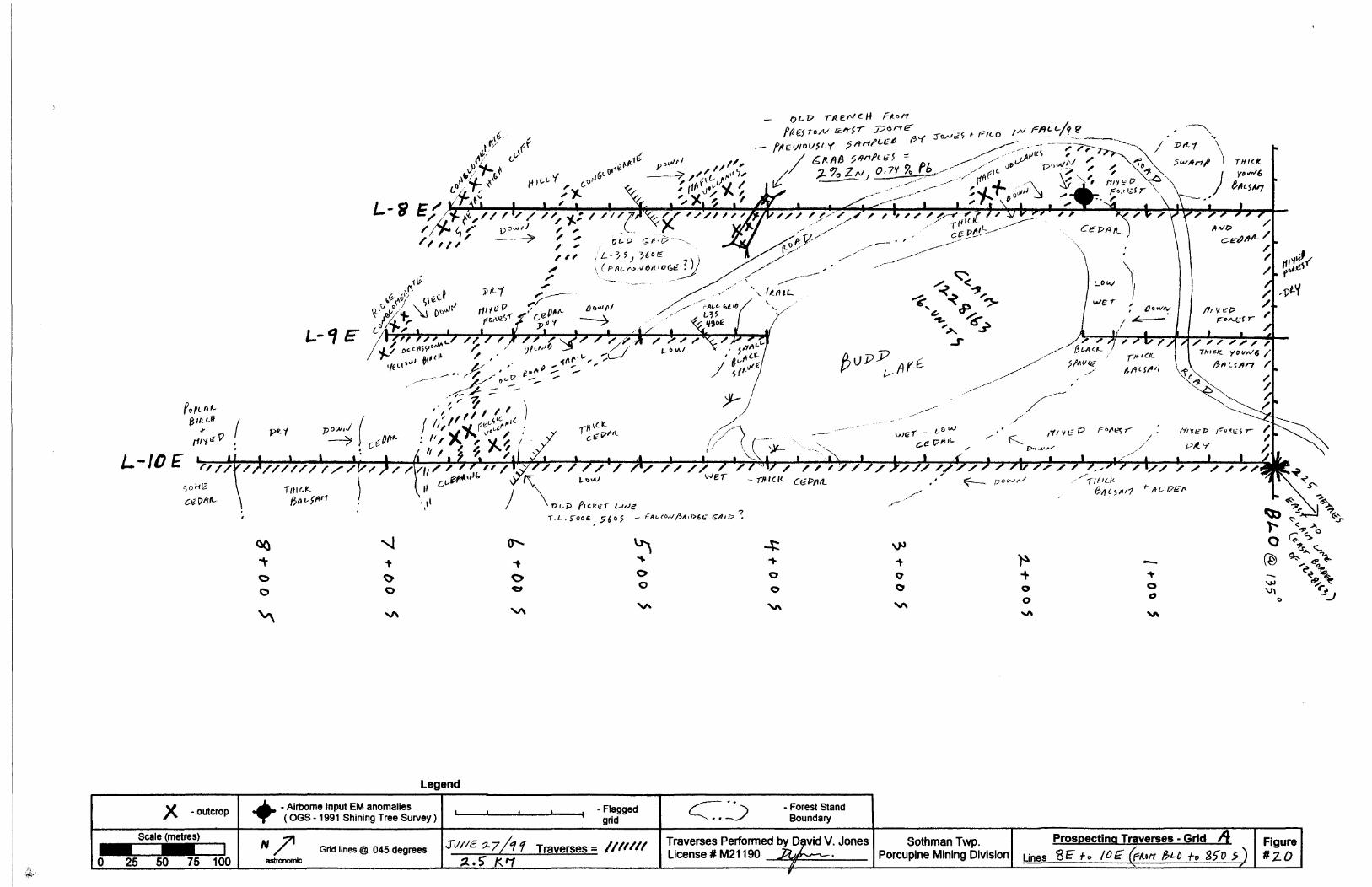
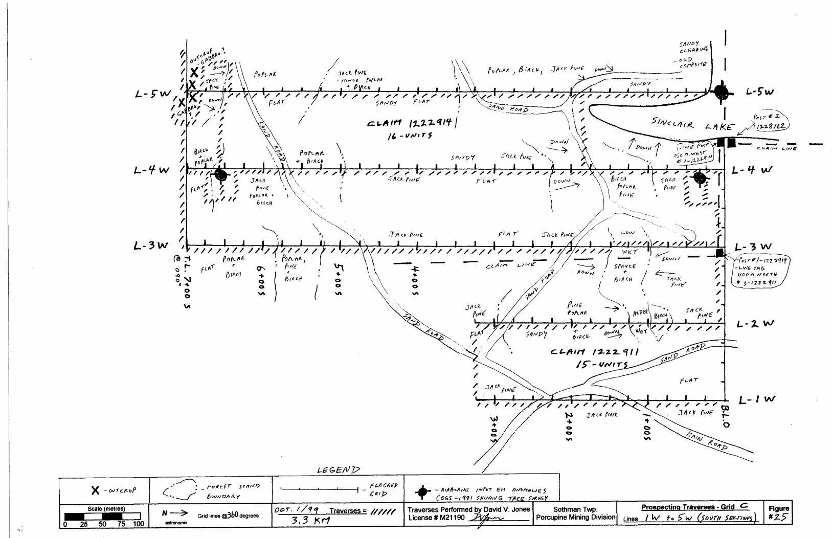
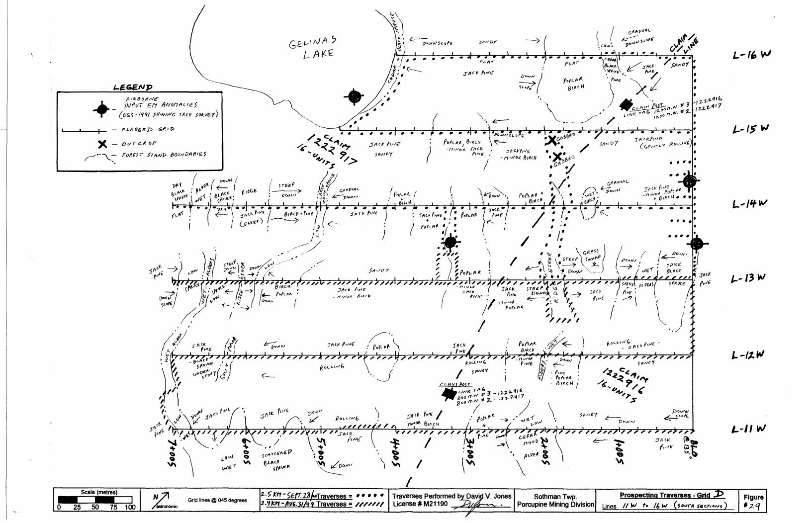
Four separate grid layouts were set up (grids A to D ) with their general location being shown on Figure 3. Total size of each grid is as follows:
Grid A (north) = 12.8 kilometresGrid A (south) = 9.8 kilometres
Grid B = 5.5 kilometresGrid C = 8.8 kilometresGrid D = 9.2 kilometres
Total of all grids = 46. l kilometres
Grid orientation was designed to provide coverage with lines being run perpendicular to the interpreted strike of the geology found in that particular section and/or as dictated by the location of the VLF transmitter station (ie. maintain survey direction at right angle to the transmitter). Details of each grid can be viewed on either the Prospecting Traverses or the VLF profiles found in this report.
Specific locations of each grid was intended to cover areas that hosted airborne EM anomalies (from OGS - 1991 Shining Tree Airborne Survey) that appeal' to be located in or proximal to the magnetic low (possible felsic volcanics) areas of the airborne survey.
All grids were established as compass and flagged lines with 100 metre spaced lines and 25 metre stations. Topographic control was maintained with tie-ins to any lakes or creeks that were proximal to each grid.
Both grids were then used for a VLF -EM 16 geophysical survey and a prospecting survey.

1222920 16 units©
\
. 1227833 10 units
3 - LAYOUT

B) VLF-EM16 Geophysical Survey
The survey was completed in its entirety by the author of this report,David V. JonesP.O. Box 1513
South Porcupine, Ont.PON l HO
Geophysical field work commenced on May 23/99 and finished on Oct 30/99.
The survey was completed using a Geonics VLF-EM 16 instrument, where the transmitter station Cutler, Maine was used (NAA - 24.0 Khz). The VLF readings were taken with the instrument operator facing at approximately 015 degrees, which resulted in the transmitter station being perpendicular to the instrument. Tlie in-phase and quadrature of the vertical magnetic field were measured as a percentage of the horizontal primary field. An in-phase sensitivity of plus or minus I5007o and a quad-phase of plus or minus 4Q07o was used with a resolution of plus or minus l 07o. Appendix B outlines the operating procedures for the instrument.
Data was manually plotted on Figures 4 to 8 at a scale of l :2,500.
A total of 42.3kilometres VLF surveying was completed on all the blocks combined.
VLF-EM16 Results A Interpretation
All grids on the Sothman Property resulted in the delineation of several VLF anomalies, and a discussion of each anomaly is presented as follows:
Grid A (north) - Figure 4
Anomaly A - strong anomaly that covers at least 200 metres of strike length (from L8E to L10E), and may extend further east A west, however grid coverage was not present on lines 7E A HE. The anomaly is coincident with a magnetic high A low contact on the OGS airborne, and is most likely representing a geological contact, however a conductor caused by disseminated mineralization cannot be ruled out at this stage.
Anomaly B - a single line, weak anomaly that is adjacent to Budd Lake. A "lone" airborne input EM anomaly is proximal to the north of this VLF anomaly and may be related. Strike may extend to the east into Budd Lake, however no geophysical coverage was done there.
Anomaly C - a strong anomaly covering at least 200 metres of strike length. Closely coincident with the geological contact shown on OGS map 1953-3 between the Huronian conglomerates and the volcanics and may represent this structure. However, proximity to airborne EM anomalies at L8E, 125S and L6E, 100N may also suggest a possible bedrock conductor.
Anomaly D - weak anomalies just beginning to be traced at edge of grid. Strike length is unknown since grid was not extended to the east.
Anomalies E. F. A G - all coincident with airborne EM conductors, resulting in a good probability of being bedrock conductors. Historical drilling in this area by Dowa Mining intersected zones of graphite which most likely is causing the anomalies, but sphalerite and chalcopyrite was also noted in the logs.
10
Grid A (south) - Figure 5
Anomaly H - a strong anomaly covering at least 300 metres of strike length and is coincident with a single airborne EM conductor on L17E, 300S, suggesting possible conductor of bedrock origin.
Anomaly I - a weak anomaly striking for 200metres and running west out of the grid. Conductive overburden or a weak bedrock conductor could be possible sources.
Grid B - Figure 6
Anomaly K - a strong anomaly striking for over 600 metres and running east off the grid. This anomaly is coincident with a string of three adjoining airborne EM conductors on lines 6W, 4W Se 2W, suggesting a high probability of being a conductor of bedrock origin.
Grid C - Figure 7
Anomaly L &M - strike length of both anomalies are separated by a 150 metre north-south offset which may suggest that they are the same anomaly that is faulted at L5W. These anomalies cover a combined strike of over 900 metres (running off the grid both to the east and west), and are partially coincident with an airborne EM conductor at L6W, 400S.
Anomaly N - a strong but short anomaly on L4W that is proximal and possibly related to the airborne EM conductor that is in Sinclair Lake at L5W, BLO. There seems to be a good possibility that this anomaly will continue to strike west into Sinclair Lake to this EM conductor, suggesting a possible conductor of bedrock origin.
Grid D - Figure 8
Anomaly O - a strong anomaly running for at least 300 metres and off the grid to both the east and west. It is also coincident with the contact of the gabbro intrusion and mafic volcanics (as shown on OGS map 1953-3), and may be representing this structure.
Anomaly P - comprising of three weak single line anomalies that may be one continuous anomaly that is faulted at LI 2 W, 200S. and runs off the grid to the west and east. It is coincident with a pair of airborne EM conductors at line 13 W, BLO suggesting a possible bedrock conductor.
Anomaly Q - a series of strong parallel anomalies striking for over 900 metres. They are also coincident with the contact of a gabbro intrusion and felsic volcanics (as shown on OGS map 1953-3) and may be representing this structure.
VLF-EM16 - Recommendations
Since the VLF survey was successful in delineating several strong anomalies on all grids, and it also confirmed the presence of previously delineated airborne Input EM anomalies, it is recommended to follow up on the property with further geophysics such as an Induced Polarization survey. The VLF anomalies may represent possible bedrock conductors or structural features that would be more accurately defined with the IP survey. The IP survey would also provide better coverage for delineating anomalies that represent disseminated sulphide conductors which could have easily been missed by previous EM surveys on the claims.

11
Depending on the results of such future geophysics it would be highly recommended to test any resultant anomalies with diamond drilling.
C) Prospecting Program
In an effort to find untested mineralization, possibly related to the areas exhibiting airborne input EM conductors, VLF anomalies, or areas of interpreted felsic volcanics, a detailed program of prospecting was completed on the Sothman Property. Prospecting traverses were completed over all the grids with several compass traverses being completed in-between grid lines (in areas of geophysical anomalies or known outcrop and mineralization).
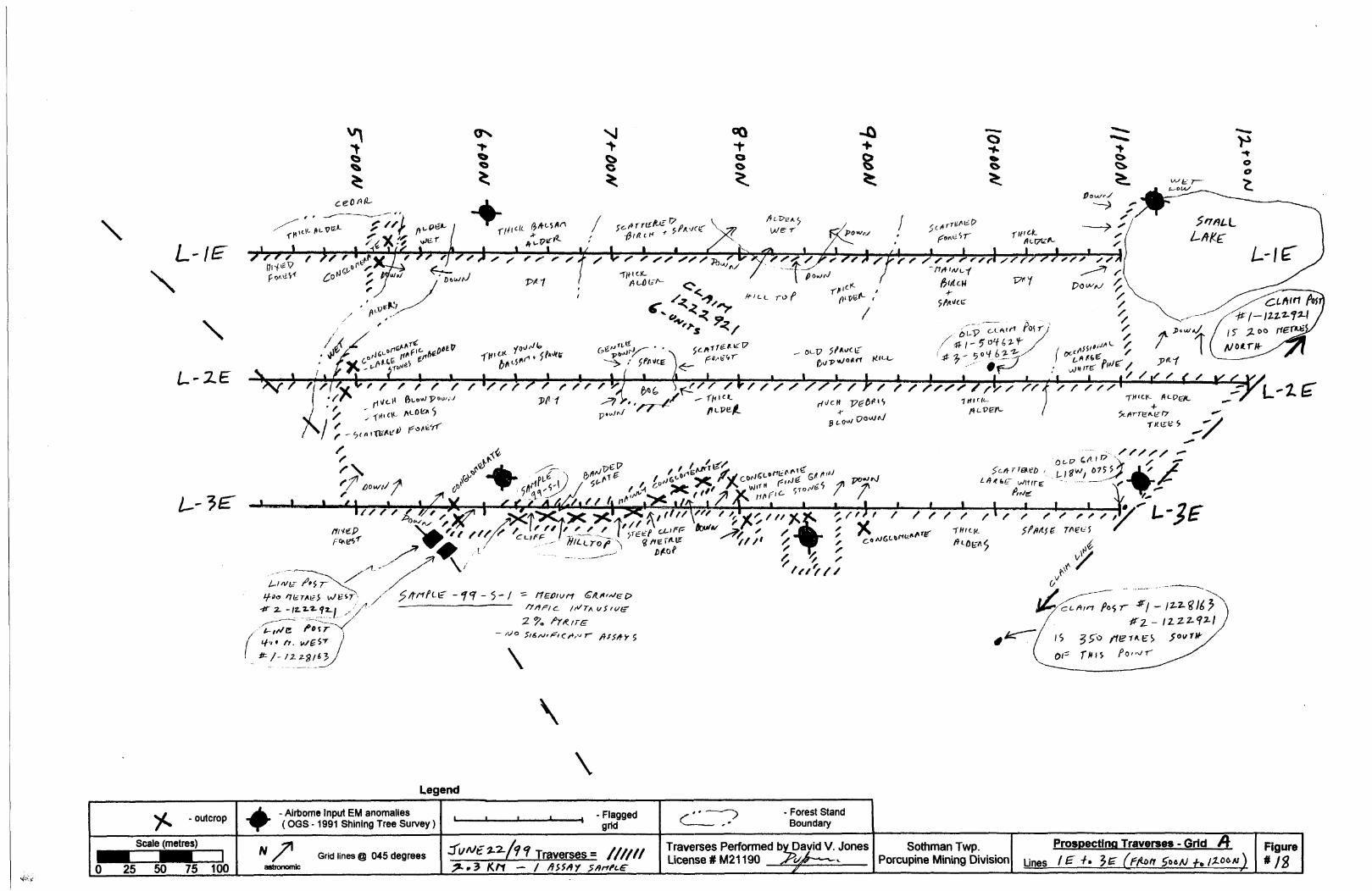
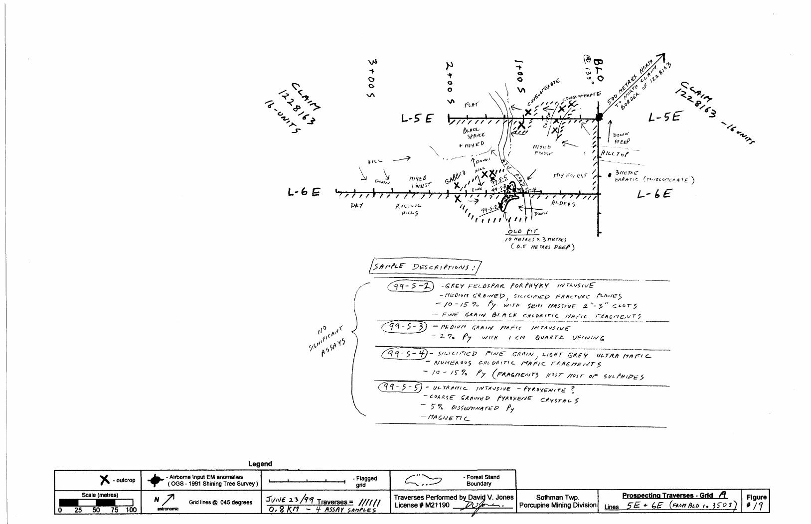
Prospecting Results A Recommendations
A total 51.5 kilometres of traverses were completed with traverse dates and observations being plotted on Figures 12 to 29, at a scale of l: 2,500.
Although much of the property is covered with overburden, and has little outcrop, the prospecting was successful in finding some areas of interest. Four areas with mineralization were found and are depicted in Figures 12, 16, 18, A 19. From these areas a total of 11 samples were collected and assayed, with results shown in Table C. Sample descriptions were given by co-applicant J. Kevin Filo (P. Geo) and are written on each corresponding Figure that covers the area where they were found.
From the samples taken, only one returned a significant value. Sample 99-S-20 gave 690 ppb Au, and was taken from an old trench found near L16E, 900S (grid A). Follow up work would be recommended in this area as there is no historical data on these old trenches and further mineralization may be found with the aid of an IP survey which could possibly trace the weak mineralization that was in the sample (407o cubic pyrite). Also, power stripping around the trench would give more information on the structure that is hosting the Au, but since the area is not near any roads, it was not within the budget of this program to proceed with this idea.
Also, due to the historical gold and base metal showings that are documented around the Budd Lake area, it would still be prudent to prospect in areas of the property that were not covered by this survey, in hopes of finding more mineralization, as was done in this survey. It has been shown from historical data along with this recent sampling, that the Sothman Property does contain suitable geology to host significant assays that warrant further exploration on the claims.

ITS Intertek Testing ServicesChimitec Bondar Clegg....................................................,................,............................................c?c?
Rapport Lab Geochimie Geochemical Lab Report
i CLIENT: j REPORT:
SAMPLENUMBER
99-S-199-S-299-8-399-S-499-8-5
99-8-1099-8-1199-S-1299-S-1399-8-14
MR .KEVIN FILO T99-57290.0 ( COMPLETE )
ELEMENT AuJO lil Pd 1111 Afl lil Pb 1111 Mo Ifl Co ii|l HUNITS PPB HiippB K1*" B"* lffippH mi"* lil"*
233322 332223 222323- 33232. 232223 33323
lil 3 lliiN.2 Iiii 3 HI -O ill 40 li *77 ill iil|o.9 111 46 l|ii 3 ill 76 H *510 11 liiO llil 4 lil 3 iil 26 ill ̂9 1111 |l|h.2 H 6 11 7 li 81 li ̂III 5 |||fc.2 lil 2 i|l -0 i||i 28 III *5
v^xoo: 0:0:0:0: iv'iov'x'v vivivivi :: : : : : : : : : : ; : : : : : :o::-o:o:
111 *1 |||K2 ffi *2 |||i 1 i|i|| 16 |||ii *5*5 III |||h.2 JUI ^ Illl •O iil; 88 1||| K5
i||| 6 iii|||o.6 i|| 3 Iii -ci lil: 54 HI ^^ illi |||x.2 lil ̂ H| <1 lil 19 HI; ^*5 li I1IM Hi *2 H "1 ill M Illi **
ill iiii 111 lil ill illi1111 SSffi? 1???: Us mm mm
S :?:?:? ?:?:?:?: ffi??:'? ffi:?:??, ffi?.??? ?:?;?ffii! ill ill ill ill ill lil23m ill ill iii iil ill: ; : ; : o'x x'o:oxo tto'io'iv: SvXv'x :o:o:o:o xo/'x'o::: x :-x: xoxox: 0:0:0:0: o:-:o:o:-: ttoxox :o:o:o:oi x x".: o:o::xo: iv'iv'ivlv1 0:0:0:0: :::::: : : i:: ; :::: o'x"::::o':: :
xo! loi; 322232 3-3233 33232 32333. 332222 2 o:-: o'x'vx'^i 2232222 3222 i 23233 32333.;i 23 322323 223232 3322 23 'Zt+t^. 33323 3232 23 323822: 223322 323i: W: vxoxo: :o:o:o:o oxoo o:-: :o:o:o:o 0:0:0:0: :-:o:-: x Xv :o:o:o:o o:: : : : ::o::: : : :o'x
o vi:: ::i : io"i : i : io" o': : : : : : :o::: : : : ;y: :: i : v: : : :o":o:o'x: oxoxo: xoY: x xo 0:0:0:0: x-xox-:- oxo
•:-:ox-x-: :o:o:o:o -;ox-:ox :o:o: :-:-:-:-:-:-:-:- 0:0:0:0: x-xoxo 0:0:
Ills lil llil isxoxoio' v^'ivx'vi i:™:::?:: 3222vX.v:vX : : oio:o': : : oxoxo: :o:o:
:v:v"x:iv 'iv':':-:':-:-: :o:o:o:o oxo
lil li! Illi 110:0:0:0: ^xoxo xo:o:o:: 0:0-::-:o:-.o:-.- o.-.v.-.v. 0:0:0:0: :o:-x 0:0:0:0: .v.v.v.v :-:-:.:-:.:.:-:- o:-:.;. .•.-.-.-,-.-.v •.•.•.•.v.-.;. .v.;oxo: xov•.••v.-.-.v. .-.•.-.•.•.-.•.- XOXOX- Oy-', .•.v.-.v.-.- -.•.-.-.•.•.v. .-.-.v.;.;.;.: v.y.-XvXo:-:- o:o:-:-:o: : 0:0: 0:0 -:o;o
:oxovo ;:o:;:o:o: :!o:oS;:: ::i::o:::: : : : : : : : : : : : : : : : : : : : : : : :::: : : : :v: o:|:x::: iyiv:
ill iiii iiii 11:vX::xX: 0:0:0:0: :o:-:o:o:; ivX;
xoloxo v:o:vX:: xoxox: o:o::
: ovvXvS ioioiviv; iv'Sx-:::: 0:0:0:0:
: vi 5: :i ::o i i:i 0:0:0 ::
i iii iii;i :::::::::::o':: : : : : : ::: :::: : i::: :::o:oxv' oxoxo: : :;::::o:::o: I:::;:-:::!:::::
i ;|;|i Illlo iv'iv'xo:- 0:0:0:0:
2: 23233 332223
v 0:0:0:0: : : : : :o:o:: : :
o Svivioi ioioioio
; 322323 232232i^ioi^io ^^
Illl Illl
ivivi:x':i : 0:0:0:0:
jjjijSjjg: I;:;;;:;::;;;; x^^ij 'iJifR W&22 ;i;i;i;i;i;i;i;i
: : :xo : : : :: : ;::o:o:::: v:::o:::o: x'fivvX- ::jx:x:x:: x-x-x-x- •:: : : xo:o: :o:o:::::o ^v'xvl-x ::: ::v:::::v :x:x:xo: :o:o:o:o
DATE RECEIVED: 25- JU
i|ii sb iiiiiiiiii Mn iiii u iiiii vIH|PPM IIIIII PPM illlPPM mpPN0:0:0:0: :::o:o:::o:o::: : :o: oxoxo:: :o:o:::::o:o: "r-X'XOX : ; :v:o: : :o: ::o:: :o: : x: x:::Xv' xioxoxo:
Illl *5 iiiiii||l296 11 9 IHl'IIOiiiii ^ iiiiii 265 iii 8 iiiii siIii ̂ ||||i 418 HI 17 Iii 36ilii ^ iiiiii tn iiii 13 iiiimliil x5 iii||ii| 772 i|li136 |||||103
: : : : : : :o:o:: o:o:oxo:o: : : : :: : : :o:o: :xo: oxoxoxvX'X'x'x" ::o: : : : : ::o:o:::o:: : : : oxoxo: ox 0:0:0:0
illi *S lilll 270 11 18 ||l|i 37iiiliil ^ Illliil 476 iiiii 23 Illl 45lil ̂ liiiiiii 20 iiii 6 iiHi *|i|| 4 Illlii 180 ii 4 iii| 42Illl ^ lililli 256 i||| 29 IIHI 36
xoxox: ::o:o:o:o:o:o:o :o: 0:0:0: v:::v:v:vX: 0:0:0:0: :o:o:o:o:o:o:o: -xoi-x-x- :-:o:-:-:o:':-:':Xvxo-:-:- oxo:ox-xoxo x-xox-x ^^vi-xoxv 0:0:0:0: : ; :o:o: : :o:o:o:o: vv'x:x:x o:o:o:ox: : :
:i;i;:;|:;i;i :o:o:o:o::i;i;i;:o: ^j^ ^SwSSS
oxoxo: :::o:o:o:o::: : : : ::: : : 0:0:0:0:: xS-x-Xv:;::-:-XvXv -xo-Xvxoxv.v x-xo.-x-: x-v-i-x-x-x -:-:-:-:-:-:-:-: :o:o:o:o::.v.o:-. v :ox-.-.-:- .x.v.v.v.x. v:;::: : : : :v: o:o: o:oio:::o:o o: ::o:o:o :o:o:o:o:o:
:i:::i:i:i:::: : : ::: ::i:::;:;:::i:::;:i:;:;:;: : : : : : !:: : x::v' :;:::oi;:o:o:;:0:0:0:0: :o:o:::::o:oxox :o:o:o:o: vX-Sv:;:;
Illl lililli lin iiiiiill Illili lil 1111;i;ii;i;i;i iiiiioii- ioiiili WU-•'.•'.•'.•'.•'.-y.-: xoxvX':1 :-:^-:-:': vXvXv:- :o:o:oxox :o-:-:vXv vx^vx-xv:':':-:- x-:-x-xo: vX-x-iv/x-0:0:0:0: :o:o:o:o:o:o:o: ox-x-Xv x-XvX-xo: xo:-:-: 1 :-:- 0:0:0:0x0:0:0 :ox;X;X;: iwxo'xox
oxoxo: :o:::;:;:o:;:o:o:o: v:o:oxv oioioioivi::::::i : : :::: : : : : : : : ; ! :x:::x:x:x:i:x viwivi? iv/XvXox v:vx:::: : : :::::::: : :x:::x:x;x :: :x:::x:: ;x : xoxoxox•xoxox xoxoxoxvX;: iv:"::: :Xv: vr: :v;v:vX: •••••:-'-xo: :o:o:o:o:oxox -x-x-x-x- :-;-:oxo:-:o:••/••x-Xv o:-:oxo:':':o:-:o :o:oxox o:oxo:':':o•i-'-I-'-X-'-' X-IOXv/XvX-X -X-X-X-X- XOXvXvX'•'•'•'.•-.•'•'•'.- -X'/x-X'/i-XvX' :-XvX-:-x vivXv/Xv •:-x-i-:-x-: xoxvx^vXvX -xyXyX; v^ivXvSv
•'.•'.•'.•'•'.•'•:\ :o:o:o:o:o:o:o: :ovo:ox v:v:::::o:::o •:-:-:-x-:-:': :o:o:o:o:o:':-:o: 0:0x0:0 :xv:o:o'xv:::o:::o:o : :: :Xv:v:v:y:;:v :o: 0:0:0: ox o: 0:0:;:;
vXvv:':': : : ::o:; :o:':o:o:o: -x-x-x-x: XvXv:v:v:
o:::o:;;v: : oioSiivS?:? iv1 :':':-:':'!': o:o:o:: :o:o
o: : :o:o: : : xoxorXvro:^:: vX:Xv:':' :v:: : : : : :o:v:::
oxoxo: ^^xoxoxwio iivlvivl': :i:::::::::i : i:i : : : : ;:o:o:o:o ::ox:xo:::oxo:: :v:::v:o:: i : : ::v:::::vX::: •:-:-:-:-:-:-:-: :o: 0:0:0: 0:0:0: :o:o:v'::x 0:0x0:0:0 •:::::':':-:-:': x-x-xo:-:vxvx 0x0:0:0 x-x-xo:-:;:;:•XvXvi-: :o:-:v:v:-:-:v:vX vx-xox- :o:oxo:ox :;vXv:v: :v:v:v:vx::::"x': ox-Xv'x- x 0:0:0: ox•lv x':":':-: x-iox-x-x-xox ::v'x:x:x' ::: 0:0:0 x o:
111 iilllll 111 Illl
1-99 DATE MINTED: 1-A
Illl u lil;; Al ii|ii c*biiiHFoui tehiy:-1 - DTT ^b^f^- BTTjPPfliv.rm PTW;:;: rVI Slv??*?::::: ""'
232323 v::v:iv:o: i; ^vi-i-i::-:-::::
HiiNa lip .82 ||lp.03jjjJiQQ |1|P.84 iilio.79i||c20 liio.91 li|2.07i6 x20 |iii2.13 2p3.54iiko Iiiiii. 77 iliib.46x-XvX-x oxyX-:-:; ^XwXvx: xWxox v:v:v:y:; :"::o'oioi:iv
lltl^ lii|1.40 |j|||1.07111^20 1112.62 I|||l. 68iiiiii li 0.12 iHiiO.OBIii:x20 lii;:;2.23 liijiUsl .24111^20 liiz.61 liill.74111 ill 1110:0:0X0 X;X;Xy : :: •OX'X-XOX .•.v.-.y.v. v.;.:-v.;.y OX-X-XOX-i-XvXv/: -x-x-Xv:- /x-x-x-:-:-:-: 0:0:0:0:: 0:0:0x0 xoxoxox
:;;oi;::::i;i;: 3^3223 WwQ
x':':-:-:::-:': ivivioi:':' : :x;:::'t::;: ::;x
:':y:'o::io Sivxo'-' : : xoxoxo:
:::-:::::y:;:;: ox;:v:;:v :: ::xv:oxo:
332322 332322 32^323•:v:v:':: :-i : io:: : : : ::v::: ow-x-x-x' x-xoxx.: :o:oxo':' :-:-:-:-:-:o:-:o:Xvx':-:':': ivSy:': ::' : :xv':::|x;X;:ivx'x'x': •:-: : : ::':': :x: x-xvx-x-x•x-XvX1 / : o: o: 0:0: -x-xvXvX-;.;.;.;.;.v/.; .:.v.;.;.;.v. v.v.v-X.v.;
o: ::oi;i;iv i-iiixoxv' i^iv'Sv':?:::oioioiv :: : : : : ; : :v:::: : :x::: : :::x:x-::::o:::o:o x::v:v:v'; Xoxoxox: :::v:: : : :o: ;:o:o:o::: : X'Xwiwxoioioiv :'xv ::o: :x oxoxo:"
•oxoivi viv": i : :o :::o':::o:: :o:::oxoxo x- -:o: xox-X-x-x •••'-•-'•'•'•'- y- ov .;.vo:o:o:o:-:-xo:-:-: •'.•: xo :oxo:oxo:
0:0x0:0 :o ox 0:0:0:0x0
0:0:0x0 o:v:o:: xoxox-io: :o::xo:o: o: o: -x.: vi vi vi vi o?
Illi i|| liil/o'lvX io"i : i : i:': : : : :::::::::: : : : : : : : i:
0:0x0 vi vi o': ' :::: : : : ::: :::: : : : : ; :
;i;i;i;ii gig^ Wm3j-
::v:::v:o: : :o:o:o: ;:o:o.:;xo:o:-:-:-:-:-:-:-:-\ -.••.••••.••••'- -x-x-xoxo•.v.v.v.v vX-Xv X-X'XvXO: •/I-XvX-:- X-XvX -lOX^XOX'
XvX;X;X :: : : :o:o: ::vx::v:: :::v
N.-99 PAGE 1
lil K i|iii|i| PCT |||!igigSiliv:;: iSiii-i-:-:liikoi Hi|ii|o.o3 i||0^08 0.03 |Hiililo.02 iiiio.or o.i3 HIo:o:::o::x:: :o:v':o:o
llii-04 iiii|iiio.i2 iiiiiiiio.re liil•'.•'.-'•'.•'.•'.•'.'.•'.•: x-X'/Xv
lilio.15 111vX'X-XvX x-:-X'X-:-
xoxoxo:: oxoxo':
:o:o:o:o:o oxoxo:
•xo'xoxo: xoioxo xoxoxo:- o;o :-:-:-:-:xoxotox- :xoxox oxox-xo: :o:o;o:o :oxo:oxo oxox-:-: 0:0x0:0:-: xox-xoxoxoxo:- 0:0:0:0: 0:0:0:0:0: :o:o:o:o.
oxoxox": xoxox: :oxoxo:o 0:0x0:-: oxo:o:ox :o:o:o:-:-
•xoxoxo: :o:o:o:o•xoxoxo: :o:o:o:oXOXOXOy -XOI-XO:
xoxoxot; oxoxo:
•xoxoxo: xoxox: xoxoxo:' oxox-:-: •xoxoxo: xoxox- x-x-xoxo oxoxo:•xoxoxo: x-xoxoxoxoxo:- v-xoxo:
oivioioi:':' o:::v:::v:
Iii iiiimm111 illillil Iii
lil0:0:0:0:0: xoxox:
0:0:0:0:0: : oxoxo
iiii lilmmx-x-xoxo -:-:-;-:-:':-:-: : 0:0: 0:0:0 0:0:-: ox
: 0x0:0x0 0:0:0:0::: oxoxox x o:oxo
oxoxox": :o:o:j:o::
PROJECT: OF 1
Y IHI•PM m?W&8-9 li
2 lil2 iiii7 ill
u iix-xoxo oxoxo:lOXOXv
16 ill5 lil•••••:o'--o:
xl s;^i;
3 ill2 illmm.;.v.v.;.v
v.v.v.;.;-.v.v-vo:
:jS:j:S:|:j
•xoioS:ox-x-x-:
xo^iiisi:
•:o::ro':::: :
lil•:o:o:-;o: :o:o:o:o 0:0:0:0:
xoxox;
;igxg:g;:;:;i::|:|io:|
2122232oxoxo:XOIOXO0:0:0:0:oioxoSoxoxo:v.v.xo;-
: oxoxov.v-X-X-v'io'io'S:
iog;H;;;
:|:|:|:|;o:|:f
silmmvxoxo:xoxox: •: 0x0:0:
iiiiio'i-iv'i-iv'
•xoxox
xoxox;
III
NONE
L* mif* HIoioxoxx -xoxo
70 ill9 ill7 lil
oxoxo:
is ill18 II
:o:o:o:oB li19 ii^ lili7 illw |ii
•x-X;Xo: •xoxoxXOXOX;V.V.V.V.
llilS&sii
IIIKv'iv'io'
xS^iS
32332SoSSi|:S:o:gx
oxiSS:
oxoxo::;:gH;:g:|:^:;i;::i;i;XOXOX;
liloxoxo::v:o':v:::::o:o:o:ommoxoxo:
oxoxo:
•ioxoxoxoxo:xoxox. oxoxo: oxoxx:
oxoxo:xoxox-
ilii•:o:o:ox
xo:oxo
Se |l|i TfMHi ^^'i: M*T TB BHIij rtl
W^2
18 iio.137 ilo.055 ll".04
20 iii0.09^ 1||0.19
•xoxox :o:o:o:oioxoioi:
4 li 0.305 iiio.OB4 ilN.01^ 1|0.134 iiiO.08
xox-xo:oxo:o:" 0:0:0:0:
iivi;i;i;i;i;:ioi:!:xoi:
0:0:0:0:yoxox;
:-:o:o:":o 0:0:0:0:
:io::i:i:xo':o:ox
IIIsi-iiiiiixivigijigo'io'io'i": i
:o::xo:o
Sio'Siv"
2i'3232i:!vi:-:i:x::xoxox'
0:0x0:-:v.v.;.;.v..;.;.;.;.;.;.;.;v.x.:ox-
wX;o:ooiioioi|:oxoiox
So'iv'x'o'
IIISv'So'lv'
•ioi-l-i-S:
::o:::::x':i:i
111
|||i;Hi323223
HI111illillili?iijj?
i||:illsliilmm•xoxox
11;m•:-.;.;.;.v.: . •XOXvXxoxoo:
igSjivi;
:::x':::xo::ii^vSji
v?Sviv':o'iv/'io'^i•;;;v:;:;v:^; •i-So'io'Soxoxo:0:0:0:0: :o:o:o:oS:i:io:ioi:io'iffio'::
i:ioi-ivx":mi:i:ivi::o::::x^ioioivvW-%?:
illi-xio'ioi':
Illlixoxoxo'io'iolo:•xoxoxXOOXOT
iiSioSi:
:ioioi:;:i:i
Illl
i:::o:o:liITS - Oumtoc - BonUr Oca, 13224 HuifcswM, \u-4'Or, P.Quebec, I9P 3X6, (819) (25-4)171

ITS Intertek Testing ServicesChimitec Bondar Clegg
Rapport Lab Geochimie Geochemical Lab Report
i CLIENT: FILO - JONES
i REPORT: T99-57370.0 ( COMPLETE ) DATE RECEIVED: Z1-SEP-99
PROJECT: NONE
DATE PRINTED: 29-SEP-99 PAGE 1 OF 1
99-5-20 690 bil::: 26 lil; 71 l|!:251 lIiO.5 11! 43 1815.65 ttttxIO ::|l603 :::lS:No 'ml 2 |lpiil.90 338 sift;; S; <1
ITS - Chimitec - Bondar Clegg, 1322-B Harricana, Val-d'Or, P.Quebec, I9P 3X6, (819) 825-0178

14
References
1954, Ontario Department of Mines 62nd annual report, vol. LXII, part 6, Geology of Sothman Township, E.M. Abraham..
1991, OGS Airborne electromagnetic and total intensity magnetic survey, Shining Tree area, scale 1:20,000 Maps 81405 SL 81406.
Map 2205, Timmins-Kirkland Lake, Geological Compilation Series, scale l inch to 200 miles
Statement of Qualifications
I , David V. Jones of P.O. Box 1513, South Porcupine, Ontario, certify that :
l . I have been actively practicing in the mining exploration business as a Contractor *fe Prospector since 1 983, including performing geophysical surveys and prospecting such as that outlined in this report,
2. I have a 50*^ interest in the property mentioned in this report,
3. I am a graduate of Lakehead University with an Honours Bachelor of Science in Forestry degree (1981).
Respectfully submitted by
David V. Jones, Hon.B.Sc.For. Prospector - Exploration Contractor
Date of report completion : Jan 26/2000

Appendix A ;
Claim maps of Sothman A Nursey Townships

Semple Twp.- M. 1100
d'l^VV-^i'.'s K 'wi&'fy&r^^.
V-^^ P
1222922W; ( j f /. J
1,1222920
W4^\\ f fCN l
v\ tt ' r .,. _-o ^ -"'
VtM.Mf^ ^Cl'i B^ltB
J M, ' i"* i" li'* * 2 ne
Kemp Twp.-M.966
oCT)
^id.
O•o"o X
THE TOWNSHIP OF
SOTHMANDISTRICT OF
SUDBURY
PORCUPINE MINING DIVISION
LEGEND.
PATENTED LANDCROWN LAND SALELEASESLOCATED LANDLICENSE OF OCCUPATION
MINING RIGHTS ONLY
SUBFACE BIGHTS ONLYROADSMPROVtO ROADSKINO'S HIGHWAYS
RAILWAYSTOWEB LINES
MARSH OA MUSKEGMINESCANCELLED
c.s. QLac
LOM ft OS ft O
NOTES
400' turfote rjgMs reservation Olc-ng ItK
(hore* oV all tdkes ond fivers.
Flooding Right* -LO 7191 Fi 6 No. 1162 veil 4
-'- wrthdia'.vn fryin slaking utijw S*;tkin 42 ijf ItmMinttiqActl R.S.O. 1S70J
Dispssition
KT '-'Vsf 14 di'p^f nf ~fe *l:ffftr Tnn* *,7'A!
R3W.SMI I82M' Se-JT-l S T: OPT.-I v 4r iv.v.-fir^Kf.rt ir;rPS '.V.P-Jii.fc iEPT oa.-.li MR O
Meties 800 1G03
PLAN NO M-II2I
U\ l
MINISTRY OF NATURAl RESOURCESSURVEYS ANR MAPPJNO BRANCH

REFERENCESAREAS WITHDRAWN FROM DISPQSTrON
H.R.O.-MINING RIGHTS ONLY S:R.O.-SURFACE RIGHTS ONLY
. N.+3,-MINING AND SURFACE RiqKTS
Oncriptidn OnWrNo, Otti Oli*MMo* Fill
3) rill UK "*M
THE INFORMATION THAT APPEARS ON t HB (OP
FWW VARIOUS sotiRcea,W*0 ACCURACY 8 MOT QUARAMTEtD. THOSE WimiNO :TO STAKE WNNC CLAIMS SHOULD CONSULT WITH THS MlMNO R6CORDWMUMTHY of NOMjHERNDEVELOPWgffT AND MINES.
ON THE STATUS OF THE LANDS SHOW HEREOH,
MOHER
Sl/tK i tt 41/tu 4M Slx;?m .JM , . M/1M
V/Zd
BURROWS
UGENO
HIGHWAY AND ROUTE N&OTHER ROADSTRAILS '
SURVEYED LINESTOWNSHIPS, BASE L WES. ETC,LOTS, MINMG CLAIMS, PARCELS, ETC 7
LOTUNES PARCEL BOUNDARY MINmO CLAIMS ETC.
RAIL WAY AND RIGHT OF WAYuTn.irYi.WESNON-PERENNIAL STREAM
FLOODING OR FLOODMG RIGHTS
suspiyniONQN COWPOSITE PLANRESERVATIONS ' IUwI!SR**!!!l!WORCWAJL SHORELINE ...^-.-.•:,,.MARSH Oft MUSKEfi CJC ^~^
DISPOSITION O? CROWN LAND
TYPE OF DOCUMENT
PATENT SURFACE A MINMO RIGHTS
" , SURFAC5 MOHT5 ONtV
SYMg
LEASE, SURFACE * MINWG RK3HT8* . SURFACE miSHTS ONLY
11 , MINMO RIGHTS ONLY
LICENCE OF OCCUPATION '
OHDER.IN.COUNC11 ' ' 'RESERVATION
CANCELLED, .SAND*CRAVEL . .-ANUUStHtKMIIS l-'JKCOYlMtKeiA. lOJ-tSM, UJIVO3I CiMMOTT aiNINCniClinjNrOKKA'ATBrWXICXtTIMUYV i*H
. R.S
Metres800 1600
NURSEY T WM H R AMHmiTMWf BI*TdlCf
GOGAMAMINING BrVIIIO"
PORCUPINELMO TITUt/llfillTUt bl*IIIBN
SUDBURY
MmiSlryafNatural M*ni(*nt*htReaoorcea
Ontario
to i
0-229*.

Appendix B :
VLF-EM 16 Operating Procedures

Page l
EM16 SPECIFICATIONS
MEASURED QUANTITY
SENSITIVITY
RESOLUTION
OUTPUT
OPERATING FREQUENCY
OPERATOR CONTROLS
POWER SUPPLY
DIMENSIONS
WEIGHT
In-phase and quad-phase components of vertical magnetic field as a percentage of horizontal primary field, (i.e. tangent of the tilt angle and ellipticity) .
In-phase :
Quad-phase : 401
11
Nulling by audio tone. In-phase indication from mechanical inclino meter and quad-phase from a graduated dial.
15-25 kHz VLF Radio Band. Station selection done by means of plug-in units.
On/Off switch, battery test push button, station selector switch, audio volume control, quadrature dial, inclinometer1 .
6 disposable 'AA' cells.
42 x 14 x 9cm
Instrument: 1.6 kg Shipping : 4.5 kg
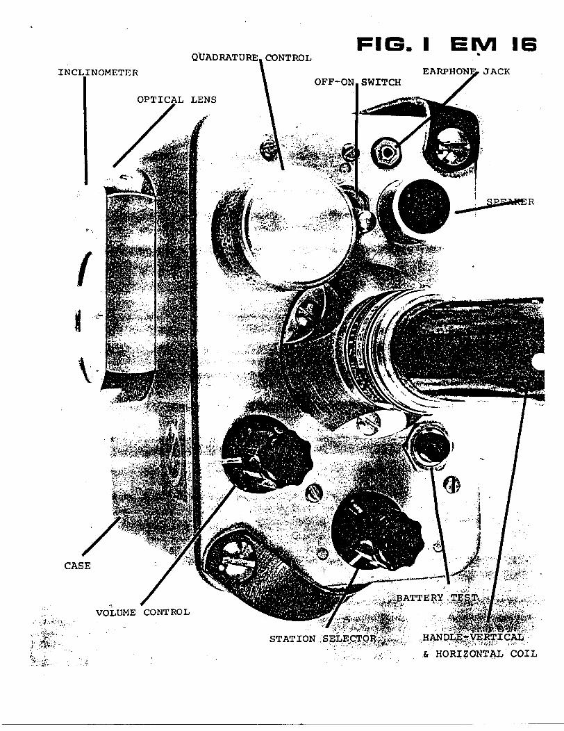
QUADRATURE. CONTROL
INCLINOMETER
FIG. l EIVI 16k
EARPHONE, JACK
CASE
VOLUME CONTROL
STATION
S HORIZONTAL COIL

Page 19
FIELD PROCEDURE
Orientation s Taking a Reading
The direction of the survey lines should be selected approxi mately along the lines of the primary magnetic field, at right angles to the direction to the station being used. Before starting the survey, the instrument can be used to orient one self in that respect. By turning the instrument sideways, the signal is minimum when the instrument is pointing towards the station, thus indicating that the magnetic field is at right angles to the receiving coil inside the handle.(Fig.11).
To take a reading, first orient the reference coil (in the lower end of the handle) along the magnetic lines.(Fig.12) Swing the instrument back and forth for minimum sound intensity in the speaker. Use the volume control to set the sound level for comfortable listening. Then use your left hand to adjust the quadrature component dial on the front left corner of the instrument to further minimize the sound. After finding the minimum signal strength on both adjustments, read the inclino meter by looking into the small lens. Also, mark down the quadrature reading.
While travelling to the next location you can, if you wish, keep the instrument in operating position. If fast changes in the readings occur, you might take extra stations to pinpoint accurately the details of anomaly.
The dials inside the inclinometer are calibrated in positive and negative percentages. If the instrument is facing 180O from the original direction of travel, the polarities of the readings will be reversed. Therefore, in the same area take the readings always facing in the same direction even whe"n travelling in opposite way along the lines.
The lower end of the handle, will as a rule, point towards the conductor. (Figs. 13 S. 14) The instrument is so calibrated that when approaching the conductor, the angles are positive in the in-phase component. Turn always in the same direction for readings and mark all this on your notes, maps, etc.
THE INCLINOMETER DIALS
The right-hand scale is the in-phase percentage!ie. Hs/Hp as a percentage). This percentage is in fact the tangent of the dip angle. To compute the dip angle simply take the arc tangent of the percentage reading divided by 100. See the conversion graph on the following page.
The left-hand scale' is the secant of the slope of the ground surface. You can use it to "calculate" your distance to the next station along the slope of the terrain.
(1) Open both eyes.
(2) Aim the hairline along the slope to the next station to about your eye level height above ground.
(3) Read on the left scale directly the distance necessary to measure along the slope to advance 100 (ft) horizon- tally.
We feel that this will make your reconnaissance work easier. The outside scale on the inclinometer is calibrated in degrees just in case you have use for it.

And Survey Lines
Conductor Behind

Appendix c:
Prospecting Traverses - Grids A to D
(Figures 12 to 29 )

- fJO AfSflVf
i^^p^ b^A^^
L L,
^-^^"^
\,4\
^—~ ——
fa*I
/V; ,/ ,C* /-C.I*
—— — — -^ ̂ ^^^^^^HZ:^ —— /7f ntfite,^ ——
^ rt (ifcK^r"-^ ^
^^
fi^^ uN
tN
Scale (metres)^HSBEI
O 25 50 75 100 astronomic
Traverses Performed by David V. Jones License # M21190
Sothman Twp. Porcupine Mining Division
Prospecting -AW Figure

^ rfiyerP \ "•^ /^o/ttJ r \V \ j f ' t S i
ff^firrt-HzD jfAtfcE -r pff-'U tfll - r HICK, flt-ptfp-^ fa
tt i i i t tV^ 'XXXXXxxXXJ'xx xx xx x"x xx xx x
~ 7H/CK. /J^LjA'T f
\ wta-*w^̂
- ^ \v / Sc*'7 fe^P (Sv -^ ''Jv-V —— l —— li.A—i —— l ., . .....i.™.
i- ^Ji ''S X X\/ X X X 'X•''L. ^ \ THICK. flt-Defi 1?
X*" /^ .^-X ^v t' -i, iff K 'X" ^^\- fa* 7" 3x iB^- w
' / w s, ,' r. ' . ^
J^/ - ^.cc,^ 6
wcu T""'^ C"- 1
— 1 ——— 1 ——— f ——— 1 ——— L -.4. ——— 1
" f A , f J to^i'SP J ftiyisl? ropLfit. 4- frmtiL/
1 t' * t 1 l -- 1- i i i ix 'x xVxxx x x 'x xxxx xxxix x x xx
i JHien. PflLf
'' ^ *"***r*fi
^ "^0 '*S^^ ^J^- X"*^
"^A ^p (Ixjpwotrl -T x- JHlClt-
a f o - ;
r
/.o/vg Xkit-t-****- j ^t^^
1 l 1 1' 1 1 1 1 1/1 1X x xx x x 'xxxxxxx* kx x x x x/xx1 x x x x x xx'x/x xx x
P/*/ 5-r
'/(g -i/00 ^.ui/L-jr tf 2- - 'Z2 tf/^Tl
C//- ItlZll/^t 1 - 119-3 f 6 f
lillfleH y foflfilt .X, 7
V ri t ', i if 'X" X/ X X x x x J- x \x x xxxxxfxxxxxV ^/HfW f /Vt
'f X^'
x,
^ s /i/ y &P fefl E f 7- ulx
-A - -^^TTeAt o vi/*/ ' r^- -^ AEpf^* vifftfti*4
"L \ ^
^ \^^ wwp x/We ( - THIC.H. rf L PEA f
t 'i i i V l 1 t
/f r r*: /d ri? 1 yfrttcn- . l MGft ftHi
' 6 I""'^P
ff' yEP WH* e
\ \ t ' 1 f '
y -fa-patf ^ r \jfi1
e,** r 1t f i i
x'xxxxx xxJxXxxxx xi' x x x x x
l/i^Da^ f r of
ffPY
N. TH'CK. ft/H-tAl f- ftLoeX-\ ^(ir// SV A 7 revi t- d VJHl-re l
• ".1 1 1 1 1 1
^x* /X XX x/ x xx xx x x* X x x lx x x x' XX X'xxx>)x x xxxxVxxxx- ^**X *^la'
^^J-
xj 0^^li o? ^
VN ^
. \** \r^
^^ \
-Voo
V/N
y fi( fil'J 0 l/Jf* t T if fi^/l *J(-lc)
(
v rs- f
u*JOe* f r c* y ^^PI*JG t S
——— 1 ———— 1 ———— 1 ———— 1 ——x x x /x x xx x^
j' x^*^p'X*
f ?CflJ7ljrf^lS \ftftl ' ^ ~- -wr
* w/r/^ TtJiCK. UA/fiiztf ^At/fjfi i. of SfiL-^^n y- /jt-pc'/jt
xx/*" xx xyxxx^ - otp ff/uee f
# "p u/ c x a KILL f
l ^X
//'fC^ V 'jf/JrTt^t
i X -J ——— ) ——— 1 ——— JL ——— 1 —— x.
' * x3'""- J '"~r x J^xPt-"/' r ox y ,
^ J- THICK 6^f^vriPe^irofiy
-J ——— t ——— \ ——— 1 ——— 1 ——— ,XXXXXX Xx X^X
xx
.X xx
X X^ x
.x' x
t 1 t 1 i
/xx'x x x x xx xx7*J CJC fift^^n 4 AI--P&H. X
\SnS0(ZAfrOf/ X Xxx
f
p y /'/i wet-""l-me
xx
L-tte
-^ \M x Y* -~. ^a•v ^ X — ^0 o
o SVr* X/N
^
0ov^
* r0 *o O^*^ (Si
^JTO
Legend
X nuirrnn .^^* ' Airborne Input EM anomalies * oulcrop ^T ( OGS - 1 991 Shining Tree Survey )
Scale (metres) -^j
0 25 50 75 100 a*™***
, -Flaggedgrid
5ef*i . 2. /?^ TraverSes = ///7//3/^ ^c/^
^- *' "X-^-j -Forest Stand ^ — N^. . . — -^ Boundary
Traverses Performed by David V. Jones License #M2 11 90. ttfl- — u -
Sothman Twp. Porcupine Mining Division
Prosoectina Traverses - Grid /^ FigureLines /3^ f* /^ ^ I/^P/T BLO /0 /y oo 5 ) # /3

V /
7^ L
.rt**
^^^X— xUL.J-
\ ( }^r-^ ,j 4i; 6fe'" '! Jj 1 j* i J,Cx S
/M . .Vxxx x x/ x
A^f"J VX*~P /^y fc'X f^ ^'^ f(flrru(rf y^
x 6/ %/J /- jywt //S WPi flfj ,
/yX fxJXx"""'
/f. 0 lA/ ,
^— i —— t — .r,. ..fi — -i-J-
V. X-V j-^A^c ., vVET A
i (S/frt^i J V1 . l( 1 1 1 \ 1 1 1XXXW"'''XX;XX XXXX 'V XX XXXX X X
** y "— X \ r
\1^I*"" PO 'VfJ . .rt ^' f(*IS/ 7 /i Jc *- '/" b
J ———— 1 ———— 1 ————— 1 ———— 1 ————— 1 l ——— 1 ————— 1 ————
xv X
Tf G. f X
4-^7^x x'xX^XXxX
— - — - — ~~ .IfiJE TA& '65^ ^ Z- -
J ——— L.
'7 S'' S 7/i /S ix xxx /x x V
t 1 \
. //(jf ri. ^f\ rj l * ^
1
1 1 J
^//? cff ^ wye? fFa* fe- j y- ^
1 ' * l ' L *'x x/xx x/xx'xxxxx/xxxx
"" x
""~"~ /^ fatten * S?'* e0 f / THK-K-rUf-SV , j^nc.^T- ' g fi Lf/trt
1 /f f 1 1/1 1
2.-
x x x x x X X X XXX X'Xx-XXXX
// /S/ S// XX X//X/X X/ X
r / y
L-^OE
Legend
\^ - outcrop
Scale (metres)
0 25 50 75 100
^^k. - Airborne Input EM anomalies "^^ ( DOS - 1991 Shining Tree Survey )
Af X3'n x Grid lines @ 045 degreesastronomic
i i . , . - Flaggedgrid
s&i*' s/ 7 7 Traverses s ////t/•Z..^ KI-I
, . ——y . Forest Stand (- -v- . -^ Boundary
Traverses Performed by David V. JonesLicense # M2 1 1 90 J^y^O-^ .
x
Sothman Twp. Porcupine Mining Division
Prospecting Traverses - Grid A Figure

L-/4F
L-tJ
JrttfcS -1 fi/ V e P
X l I
x x Ax x x x ' x x x x ^ /i s f s s s s s s
l———l———l———\———l———LA——l———l———l———l—— i———Lx ss s s s s* s s s s J s s s y s s s s s \s s rr s f s s s /
L-/86" f l i j t 11-.- 'f t T l ' fx x/ X X X XX XXX XX XX XX XXXX XX X X XI XX /- X X /^
i il i f l i ' t it t li f //XXX X*X XXX X X XX X X/ X XXX X" xx XX 'xxx x x Xxx.
g0\A
OO 4- 0 0
0
Legend
V - outcrop - Airborne Input EM anomalies ( OGS - 1 991 Shining Tree Survey )
- Flagged grid
- Forest Stand Boundary
Scale (metres)
0 25 50 75 100
N fastronomic
Grid lines @ 045 degrees 5EPT- V /f f Traverses = ////X Traverses Performed bDavid V. Jones License #M2 11 90
Sothman Twp. Porcupine Mining Division
Prospecting Traverses - Grid ALines /^ /o 20 e facri 7^00 f. /^*-o
Figure•/r

1-oO
yOJ
' A l
\ Ax\ X
X
L-/4F -4-
p•h ooV*
" lit t
"**.^ o
* * *v? O o^ O 0
K ^ ^
X* x frfitH 1 P"™ f** ^ it s * ', WITH c.irPAfl-
r .tUL^JL-lT,— .~iZ —— U— , ,. i —— 1 —— t.
X'-*\
o "o \ M^ -f- 1-^ O v O 0 0 \ O
v^\^v v*
/ l A- ~ f \ jj fitftrP f R/LCY THICK \
,,.jj —— ' 1 P'^\ ——— i —— J ——— t —— 1 ——— lu, — 1 ——— 1 ——— li\
X X X X x- x- X *-
x v;
, fi. ecu A/ 6 ^ 0'L p'^fO'^'l' pfc 'r
i——i——i——i——J——l——ij——t——T^ ' ' \ s s s s s s s As ' i———U——L7 "" - ^1 ------ -..----——.- — —.j————-—-l -- --.. T ,,————---^——— f------- X" X XX1 X X X" X x- ^ ' X x r wTx X X X X X
x
x l flu m f:O. f
t t i H——L t Xi i^ ^.
o * J
~ 2- Y 9*
79-5-2.1 -
Legend
\f - outcrop - Airborne Input EM anomalies (OGS -1991 Shining Tree Survey)
- Flagged grid
- Forest Stand Boundary
Scale (metres)ZZMML:O 25 50 75 100
Ghd lines @ 045 degreesastronoftnc
/g/y Traverses = ///X// Traverses Performed by David V. Jones License # M21190
Sothman Twp. Porcupine Mining Division
Prospecting Traverses - Grid ALines /^ t" /5^~ (f**n 7*oo5 10 /3
Figure

f
Legend
- outcrop - Airborne Input EM anomalies (OGS -1991 Shining Tree Survey)
- Flagged grid
- Forest Stand Boundary
Scale (metres)
25 50 75 100Grid lines @ 045 degrees -r 50/f f Traverses ^ ///X//
astronomic
Traverses Performed by David V. Jones License # M21190
Sothman Twp. Porcupine Mining Division
Prospecting Traverses - GridLines l F +Q 5"^ 6=^0/7
Figure*I7
\
\
L-
\L-2.E
yi *' ''
J————l———JXxxx X x!x r x x x x xxx
/fLPC/t
l 1 l——U———l———l
\
\Legend
- outcrop - Airborne Input EM anomalies (OGS -1991 Shining Tree Survey)
- Flagged grid
- Forest Stand Boundary
Scale (metres)
25 50 75 100Grid lines© 045 degrees Traverses s
3Stfoncxnic KAt -XTraverses Performed bvDayid V. Jones License #M21190
Sothman Twp. Porcupine Mining Division
Prospecting Traverses - Grid XfLines /f -f*
Figure
^ ^n '
L-6E
rJ 0 ,*.''
vito o\A
PA/
C o,r
p g; c ft t
E Z "- ?"
rf A ri c. f r A (s f~~ y- V0
pC-Hi-Ofl-iTKL
/TOS
/o/xexe/i/6- P f
77
Legend
outcrop - Airborne Input EM anomalies(OGS -1991 Shining Tree Survey)
- Flagged grid
- Forest Stand Boundary
Scale (metres)
O 25 50 75 100Grid lines @ 045 degrees 3.3 /y f
astronomicTraverses = /////7 Traverses Performed byJDavi^ V. Jones
License #M21190Sothman Twp.
Porcupine Mining DivisionProspecting Traverses - Grid /?
LinesFigure
L-9 E
L-/^^ l
'"" ;V^V o";^l l x ' r \ i ^~ y^ ^iq ^___ ^ i \ ^^^^a______i^^^^^^
xx "~~"AX x v x y* ix x xx x x x
-TifP/f/L ) \ \ '""'S' ^; \ ^r0fifl-'
X XX j* X XX X',X
XXX X'/ X X XX x xx -i/- x xx/XX XX XX XX- T*'CK
NA
- outcrop
Legend
- Airborne Input EM anomalies (OGS -1991 Shining Tree Survey)
- Flagged grid
- Forest Stand Boundary
Scale (metres)
25 50 75 100Grid lines @ 045 degrees Traverses s
astronomic
Traverses Performed by David V. Jones License #M21190
by David V.J3jifr*~*—*—^.
Sothman Twp. Porcupine Mining Division
Prospecting Traverses - Grid /rLines 8^ f Q
Figure

f'"S"
XX X 'XV S KV X XX X XX X xV xyxx x /xV/H' ? ^ ^
-•——e ^ ( -^. . ""'jfl.yN l————U——I——r-44——AM———r"4——l-Lj———l————l———l————l———1~——U.——l———l————l——
X/ Xx X X 'x /x X 7 XXX X X'/XXXX XXXXx 'x r */ x x x/J /x X x x x xx X )]r
'"' ' xii-—i\ J jl——t l——l——l——l—M yx'x x ' ^ ^^ '\ L- CI PT x'xxx x/xxxxvxxx^xxx f**'' ' o*~^ ~^ *- * c
v V . ! , V .^ .-V^ ^ ^/^ti* ^'J- .^/'^ A -'" ^'//^
•V o o
i-ne
Legend
- outcrop - Airborne Input EM anomalies (OQS -1991 Shining Tree Survey) - Flagged
grid- Forest Stand
BoundaryScale (metres)
25 5^75 100H
MironofTHCGrid lines @ 045 degrees Traverses a //X/// Traverses Performed by David V. Jones
License #M21190Sothman Twp.
Porcupine Mining DivisionProspecting Traverses - Grid /i
Lines bt ** Its (piton frt-o tFigure

f .f///* /x x Xx'xxV'X X XXXX'XTVX X X X X/ XALP K f— \.
rv/t^f X fHic-k. /((.rt
/xxx/ ''X X X/ XXX
OfliM 4
o//y/o
poi/JI^
J 2.-/Z
^ je'. ;
-
\ * Lt~l 2-
\
t'"'/ ft\7~'7Ys X^V^ V xxx x x x* x
r .j ("i
f C A0**^ ' ^^frei^*! Xji.o/'c- .^t
(^'"") Xw"'^;.)
/
\
Legend
V - outcrop - Airborne Input EM anomalies (OGS -1991 Shining Tree Survey)
- Flagged grid
- Forest Stand Boundary
Scale fhetres)
O 25 50 75 100Grid lines @ 045 degrees Traverses =
astrooomic
Traverses Performed by David V. Jones License # M21190
Sothman Twp. Porcupine Mining Division
Prospecting Traverses - Grid ALines H~E t*
Figure

**\o w
oSJ
i ) \ \ \ \ t i i t i i f""" \\ \———LI——J———L.—l ? 3fr X x U . W'/x'xx xj-txVx xx xxx J- x^ /XxxxxVx;pxx-lx,xXx'x "*K*'"
(D
l/"ir'k""
\i
X \ i', r i . ... y K i i i it ii i -^ i t i \ * t \ i i y'X X X X X X X XX X X X X y XX X* X X X X X X x x 'x X XX XXX X X x! X -'. ]x X X XX' X1 X ^X X X XX x/
X,
//
' \'x \ x
'S,
\ - l""'" , jl \ . i i' t t Vi/' ' ' f ^^^f x/^!? ^c - x x x x x* x x x x '-/^ x, J^ x
Jt \ * X j5 ,^ . t. .
x x
x X
x x x x x x 'x...A./ t 7 i___i__i__s__t V S/&**-/ ' ' x'xxx^xxxx
x *' 7 ; 'y 7 s' t , - l 'f ^ x ^ l ss sf * .i 1 sOt^ f •pOiA'*^ ^ T\o i/v/ j X l ^ ^ l - l *f \ ^ S jS '/ i Q f t-fin. t f/fA-t-" ^ l ^ ^ow/ /^, .^ l ^-——^ /XV ;' ——x y \7^6 ^ . sofjd- O^^^^^G fci ^
f* ; t ^ i^ i x i ; i x i i t l i Ay i t ' . S l . l ' JT Xr^Xx ( 1 x'X X X XX X X X X X X x xfx x ^^XX^LX X x XyX X x 'W/ X X X X x? X X VX x/ x x xx x/i x x x^ x x xxx
'; -t-
's s s
L-5" W
nerfl.es fount 3.10
#00 fi. fOl/Tff ^/-
TREE fvMerJ_____J i , pLAae f
*,Scale (metres)
O 25 50 75 100Grid lines @ 3 60 degrees
sstronoiTiic
J i/i y x/ /f ty Traverses = /////f// Traverses Performed by David V. Jones License # M21190 ^V^——--
Sothman Twp. Porcupine Mining Division
Prospecting Traverses - Grid Lines V- vJ y- tt 7 u\/_^____
Figure

Oo4.
o o•KVA
o •W
ooH-
O O
1*. e Hij l t l—1,11——t lx xx/XX ** x x x 'X/x x xx-x- k- xx x xx x x xX^
\ l 0,^M J'. /^/yep \ Aft. A d. -'
i__A i /i
st/;
/
O^n-Y e 0'"'*fiWfS, W"-4-?
cH*"T U-lSrtf H-wrf
——l———————U—————l——————U——————l——X x X .X X XX Xi/X X X
' f off ̂ r l- x x ^
\ l lx xx x x xx-x
/ ixxxxxx'x,XX'
j/Kft r0'^'^ -J ^^ a ^
) l \ * ,/ X X ^-x -TW^ ^^"^/?mtw f /"o/U*. \ pt-* r -, ifttie-ftf/Gr ' ^ ^ '"r t- i ' ^ ' "^
l_____l ' )_____l_____l_____\ i \_____l_____li \_____t X .-^^ X \ l l_____l____l_____l____lxxx xxx X^^lx xx^x x V x xx xx xVx x x x x x x / x x™^X X X/X X Ix XX X X X X X x'y
fofLflK. ( y0^(yC ^ , I^OCL.V^ x XX' f?'X^^
x x xxxx x
x x xx /xxx* xx x/ x/x x x x x x ^^ /i/461* (
xx x x x xx x xxxxxx/
X X X XX^ X. X X, X XiXX^jXXXXXXXXXX V , iX X t X XiX X tX X |X
i.-
L -2. w/
l-o
INPUT gnCOG s - 7 f y/ - SHIMMY T*.ee
Scale (metres)
25 50 75 TOO astronomicGrid lines @ 3 feO degrees
Traverses = X///// Traverses Performed byDavid V. Jones License # M21190 J?,j
Sothman Twp. Porcupine Mining Division
Prospecting Traverses - GridLines O -ho 3 */ .^^^
Figure
s s ss s s s s ss ss /* x r//s s s s ssss^ssss '
L-3 WX/X / //x XV / /xx/x'x x x1,/rse
lxAxlxx'^'xxU
X -wrtf~oP
Scale (metres)
0 25 50 75 100
•' ; foAt(r- irni-T?
^'r^ /^ ^Ol/VDArty
^ ^ Grid lines ©3^0 degrees
, . , , . fLACteP' ^'P
^e-r. //f? Traverses s /y/x/x3,3 K^
jf^, - flif.6ofi.fje: in/fur en A^frAt^^^ ^J to&s -ittt ffiiMrtG rtee WeY
Traverses Performed by David V. Jones License #M21190 7^/^^
Sothman Twp. Porcupine Mining Division
Prosoectina Traverses - Grid ^Lines / IV f o 5" w (foi/r/t Sec-riMi )
Figure*zy

L-/OIA/ l l—li—l'XXX L V X X L-/0 w/L \f X X XX X XX
X X^*A X x x x x
5-xx x x x xxx xxxxxx/'/xxx/x/x
'X/XX/XX
X/ X/ X /X XX XX XXX X X X///X' XX/f X Xx X X X'XXX/XXX
l-Z GEM J?
Scale (metres)
O 25 50 75 100
Prospecting Traverses - GridTraverses = ///////f Traverses Performed by Davjd V. Jones Sothman Twp.Grid lines @360 degrees Porcupine Mining Division

if- MI rf
T7\ T
i i * i i"s ' s. ' ' ' x
i i i i xlx ' xr x
fSffsSSfff*''' f s f ' s riss ' s ~f' s s /f s s ~ ' ' S s~ f s ' S s S S s x s s s s S x
l l' t f s t* s '
XX x x x xL-IW
or •Vo o
•Vo O
O
*.
LE G EM J?
en
Scale (metres)
0 25 50 75 100Grid lines @?60degrees
astronomic
•2-? A f Traverses g /////X/,8 Kff
Traverses Performed b David V. Jones License # M21 190
Sothman Twp. Porcupine Mining Division
Prospecting Traverses - GridLines l w f-*
Figure

////X /f "-
' j - '
S W P Efi fi von fi i- 1 e. f O6S-ii1i
0
Scale (metres)
25 50 75 100Grid lines @0*5 degrees
Astronomic
3,\ K^r- ; g/? f Traverses s3.2. KO- Traverses s //////x
Traverses Performed License # M21190
David V. Jones Sothman Twp. Porcupine Mining Division
Prospecting Traverses - GridLines 5/rcr/w/j)
Figure
/M*i 9 .*s , -'
xxxi/xxxxxx x
Scale (metres)IZZHE
O 25 50 75 100 /astronGrid lines @ 045 degrees
astronomic Traverses s //w/vyTraverses Performed by David V. Jones License # M21190
___—-—--^___ ^
Sothman Twp. Porcupine Mining Division
Prospecting Traverses - GridLines t f W *0 /^ ^
Figure

and MinesDeclaration of Assessment Work Performed on Mining LandMining Act, Subsection 66(2) and 66(3), R.S.O.1990
transaction i
Assessment Files Research Imaging
ubsections 65(2) and 66(3) of the Mining Act. Under section B of the Mining Act. this ment work and correspond with the mining land holder. Questions about this collection iment and Mines. 3rd Floor, 933 Ramsey Lake Road, Sudbury, Ontario, P3E 6B5.
41P14NW2003 2.20288 SOTHMAN
Instructions: - For work performed on Crown Lands before recording a claim, use form 0240. - Please type or print in ink.
1. Recorded holder(s) (Attach a list if necessary)-' O
Name
Address~PfrtS't? l/, J~Qsvjsr5
fio}C /^O
tevri /W"'""^ /W/tfoName
J-. AftrVM/ /^(^Address /j
. -r'W^t PY^^T^
2. Type
Client Number
Telephone Number
Fax Number ^
Client Number
Telephone Number 7*5^-^2-6^-5 ?7V
Fax Number
of work performed: Check (S) and report on only ONE of the following groups for this declaration.
-9??Y
Geotechnical: prospecting, surveys, assays and work under section 18 (regs) D Physical: drilling stripping,
trenching and associated assays D Rehabilitation
Work Type g^""' i
- t/
Oates Work From Performed
fi i Z^ 405^e^r?A/^ y- StfSAYS'-F- t^f7 /b
b*\ 0 5" ^7 TODay | Month | Year
Global Positioning System Data (if available) Township/Area f0
M w G-Plan Numbw ft" 1(1-1
J~2,(, O t 2-000 Day | Month | Year
THflftfJ -r Nvve y r Pi,
* Z-2.^t^
Office UseCommodity
Total S Value of Work Claimed
NTS Reference
Mining Division
Resident Geologist District
fit Loor\
rfau-u /*x
c
^KJL^
*C^-')trf
Please remember to: - obtain a work permit from the Ministry of Natural Resources as requ'- provide proper notice to surface rights holders before starting work;- complete and attach a Statement of Costs, form 0212;
. t - provide a map showing contiguous mining lands that are linked for a- include two copies of your technical report.
-' ' L^^^^NTj
3. Person or companies who prepared the technical report (Attach a list if necessary)Name — -. -
- Jjfrtffp (f, ^ToAstnAddress //f/y^- /H rftoi/erName
Address
Name
Addressl
Telephone Number
Fax Number
Telephone Number
Fax Number
Telephone Number
Fax Number
4. Certification by Recorded Holder or Agent(/- ~ , do hereby certify that I have personal knowledge of the facts set forth in
(Print Name)this Declaration of Assessment Work having completion and, to the best of my knowledge
caused the work to be performed or witnessed the same during or after its , the annexed report is true.
Signature of Recorded Holder or Agent ~D /0^/-6^K——— T.
Agent's Address s Telephone Number
Date ^r/7/v/ i?/***Fax Number
0241(0397)
Mf 9T/. 3V)
PORCUPINE MINING DIVISION

5. WorK lo uti icouiu'cd and distributed, worx can omy oeland where work was performed, at the time work was performed. A map showing the contiguous link must accompany thisform. -
Mining Claim Number. Or if work was done on other eligible mining land, show In this
column the location number Indicated on the claim map.
eg
eg
eg
1
2
3
4
5
6
CP8
9
10
11
12
13
14
15
TB 7827
1234567
1234568
/z. -z.^ li i .1 2. -2.1- ^ f 2^ *
17-7-1- If f ,
/7~^2- f f (y -
I2*T~ 2^ f/ 7 .
l 2- 2- t- 1 Z- 1 '
/ZZ-Q /U '
/2-2~* U f '
111-1) LS '
Column Totals
Number of Claim Units. For other mining land, list hectares.
16 ha
12
2
/^5~
/^
/e/tr
t,
It
/^
1
itm/^
Value of work performed on this claim or other mining land.
526,826
0
\ 8,892
7#o
7So
/5~60
Z}?o
7BO•2-^V-O
^2- f 0
^7^
2-0 O
'5, too
Value of work applied to this claim.
N/A
S24.000
S 4,000
-~
—
—
-~
—
1 1 Hill B ^^
—
"
/Z, ^oo
Value of work assigned to other mining claims.
S24,000
0
0
7#o780
f f t 0
2^? y-o7f 0
-z^^ YO—
2-5"?o
•2.Q O
f--, ——————————— l—1-o.---——— ̂ -r- —— ; — * — ' ——
'r-' ''
/', ?/ 0
Bank. Value of work to be distributed at a future date
S2.825
0
(4,892
2. goo
C'-~
1*
Z, t*o
I.. L/ ., do hereby certify that the above work credits are eligible unde(Print Full Name)
subsection 7 (1) of the Assessment Work Regulation 6/96 for assignment to contiguous claims or for application to the claim where the work was done.Signature of Recorded Holder or Agent Authorized in Writing Date
-72-04
6. Instructions for cutting back credits that are not approved.
Some of the credits claimed in this declaration may be cut back. Please check (S) in the boxes below to show how you wish to prioritize the deletion of credits:
D 1. Credits are to be cut back from the Bank first, followed by option 2 or 3 or 4 as indicated.D 2. Credits are to be cut back starting with the claims listed last, working backwards; orO 3. Credits are to be cut back equally over all claims listed in this declaration; orD 4. Credits are to be cut back as prioritized on the attached appendix or as follows (describe):
Note: If you have not indicated how your credits are to be deleted, credits will be cut back from the Bank first, followed by option number 2 if necessary.
For Office Use Only————————————-—————Received Stamp
PORCUPINE MINING DIVISION
Deemed Approved Date
Date Approved
Date Notification Sent
Total Value of Credit Approved
Approved for Recording by Mining Recorder (Signature)
MAY K lGEOSCIENCE ASSESSMENT
OFFICE_____

Ontariowi nai Ivs and Minesf tatAement of c?!!s ,,for Assessment Credit
Transaction Number (office us*)
Personal information collected on this form to obtained under the authority of subsection 6 (1) of the Assessment Work Regulation 6/96. Under section 8 of the Mining Act, this information is a public record. This information will be used to review the assessment work and correspond with the mining land holder. Questions about this collection should be directed to a Provincial Mining Recorder, Ministry of Northern Development and Mines. 3rd Floor. 933 Ramsey Lake Road, Sudbury, Ontario, P3E 6B5.
Work TypeUnits of work
Depending on the type of work, list the number of hours/days worked, metres of drilling, kilometres of grid line, number of samples, etc.
Cost Per Unit of work
Total Cost
G Kip
it, f o //f
j 2-0t**?*, 3,
PA 1f/ tf\Jt-1l f" X?
Associated Costs (e.g. supplies, mobilization and demobilization).
Transportation Coste
Pft?} if?
Food and Lodging Costs
MAY 1 0 ?nnnTotal Va
/JTX i o o
Calculations of Filing Discounts:
1. Work filed within two years of performance is claimed at 100*56 of the above Total Value of Assessment Work.2. If work is filed after two years and up to five years after performance, it can only be claimed at 5Qyi of the Total
Value of Assessment Work. If this situation applies to your claims, use the calculation below:
TOTAL VALUE OF ASSESSMENT WORK x 0.50 = Total S value of worked claimed.
Note:- Work older than 5 years is not eligible for credit.- A recorded holder may be required to verify expenditures claimed in this statement of costs within 45 days of a
request for verification and/or correction/clarification. If verification and/or correction/clarification is not made, the Minister may reject all or part of the assessment work submitted.
Certification verifying coste:
? (X , do hereby certify, that the amounts shown are as accurate as may reasonably
lands indicated on the accompanying
l am authorized to make this certification.
(please print fun name)be determined and the costs were incurred while conducting assessment work on the lands indicated on the accompanying
Declaration of Work form as.(recorded hoktor. agent, or data company portion with signing authority)
0212(03/97)
PORCUPINE MINING DIVISION
Date

Ministry of Ministers duNorthern Development Developpement du Nordand Mines et des Mines Ontario
Geoscience Assessment Office 933 Ramsey Lake Road
May 23, 2000 6th FloorSudbury, Ontario
JOHN KEVIN FILO P3E6B5535 BAETLEMAN STREETTIMMINS, Ontario Telephone: (888) 415-9845P4N-4X2 Fax: (877)670-1555
Visit our website at: www.gov.on.ca/MNDM/MINES/LANDS/mlsmnpge.htm
Dear Sir or Madam: Submission Number: 2.20288
Status Subject: Transaction Number(s): W0060.00226 Approval
We have reviewed your Assessment Work submission with the above noted Transaction Number(s). The attached summary page(s) indicate the results of the review. WE RECOMMEND YOU READ THIS SUMMARY FOR THE DETAILS PERTAINING TO YOUR ASSESSMENT WORK.
If the status for a transaction is a 45 Day Notice, the summary will outline the reasons for the notice, and any steps you can take to remedy deficiencies. The 90-day deemed approval provision, subsection 6(7) of the Assessment Work Regulation, will no longer be in effect for assessment work which has received a 45 Day Notice. Allowable changes to your credit distribution can be made by contacting the Geoscience Assessment Office within this 45 Day period, otherwise assessment credit will be cut back and distributed as outlined in Section #6 of the Declaration of Assessment work form.
Please note any revisions must be submitted in DUPLICATE to the Geoscience Assessment Office, by the' response date on the summary.
If you have any questions regarding this correspondence, please contact BRUCE GATES by e-mail at [email protected] or by telephone at (705) 670-5856.
Yours sincerely,
ORIGINAL SIGNED BYSteve B. BeneteauActing Supervisor, Geoscience Assessment OfficeMining Lands Section
Correspondence ID: 14894 Copy for: Assessment Library
Work Report Assessment Results
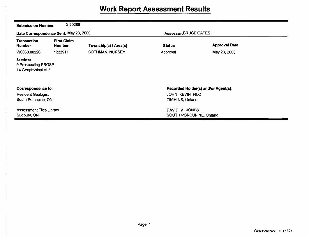
Submission Number: 2.20288
Date Correspondence Sent: May 23, 2000 Assessor:BRUCE GATES
Transaction NumberW0060.00226
Section:9 Prospecting PROSP 14 Geophysical VLF
First Claim Number1222911
Township(s) l Area(s)SOTHMAN, NURSEY
StatusApproval
Approval Date
May 23, 2000
Correspondence to:Resident Geologist South Porcupine, ON
Assessment Files Library Sudbury, ON
Recorded Holder(s) and/or Agent(s):JOHN KEVIN FILO TIMMINS, Ontario
DAVID V. JONESSOUTH PORCUPINE, Ontario
Page: 1Correspondence ID: 14894

Semple Twp.- M.IIOO
(f'
f
-w
,-^s
ro O
lci S
O)
.., JL^^rsi' "" ''•'" ^y h-.,,.\_VLM -JIM
,- \ .^^ \k r ) lip^&L
^D \- (?* S ^\^~*-Htf' /j i * t' -, j -*"^^y/ '^, x-
Kemp Twp.-M.966
O en
Q.3
oT3
O X
THE TOWNSHIP OF
SOTHMANDISTRICT OF
SUDBURY
PORCUP NE MINING DIVISION
SCALF:MNCH^O CHAINS
l EGENP
f*lENTCO LAND C*OWN LANG
LOMTCO L t NOLICENSE OF OKUPA1IO1MININ6 K*3HT5 ONLY
BIGHTS ONLV
C 5.
l~0. MHOs*o
IMPROVED MLWOS
POWER LIMES MAAStH Oft UUSKEC MINES CANCtLLl.0
NOTES400'
7131
G wrtf-drj^r (icrri sfcking unde" Ecctior 4' MtiinjAJ.;RSO 197C;
yae^p t-is, nat?
R2 '\i.ite J asiid Site BLlfcr Zant ^1^ l
FS *W*1 KiB17 2^-8 S.ft.7. T.* IV N H Gnvrl Hra^r.T: JC3' CR tV-3,;r,g,i ^FSTfj-v'XI '^ B T
PLAN NO M-II2I
DMA K II)
MINfSTRY OF NATURAl RF5OURCBSi *ND MiFPING bH"Mi^l
41P14NW2003 2.20288 SOTHMAN 200

10 + 00 M
8+00 fit
3+00}
Instrument: Geonics VLF EM -16 Transmitter Station: Cutler, Maine
(NAA- 24khz) Vertical Scale: 1 cm-10%
ff+OD 5
VLF Anomal
Anomaly Reference (see report)
Vertical Quadrature
Vertical inphase
- Survey direction A grid orientaion- Instrument orientation ^ 015 degrees
Scale (metres) ZZMBB
O 25 50 75 100
Field survey: May-Oct/99Plotting: January/2000
by David V. Jones
Figure** H" VLF "EM16 Surve
Sothman Twp. Grid A ~
41P14NW2003 2,20288 SOTHMAN 210

Instrument: Geonics VLF EM -16 Transmitter Station: Cutler, Maine
(NAA-24khz) Vertical Scale: 1 011=100Xo
s? o?Q^-t-
Oo?o
-li
Cross Over \
rf 10
VLF Anomal
'Anomaly Reference (see report)
Vertical InpriaseA Vertical
Quadrature
- Survey direction 8^ grid orientaion- Instrument orientation = 015 degrees
Scale (metres)
25 50 75 100\i
K *
Field survey: May-Oct/99Plotting: January/2000
by David V. Jones
Figure #VLF -EM 16 Survey
Sothman Twp.Grid A-
41P14NW2003 2.20288 SOTHMAN
/3*0os
220

i *V^ 04.O 010
Instrument. Geonics VLF EM-16 Transmitter Station: Cutler, Maine
(NAA - 24khz) Vertical Scale: 1 cm=^Q%
VLF Anomal
Anomaly Reference (see report)
Vertical Quadrature
"/o
Vertical Inphase
- Survey direction S grid orientaion- Instrument orientation ^ 015 degrees
Scale (metres)
O 25 50 75 100
Field survey: May-Oct/99Plotting: January/2000
by David V. Jones
VLF-EM16 Survey Sothman Twp.
Grid- B
41P14NW2003 2.20238

/
Instrument: Geonics VLF EM -16 Transmitter Station; Cutler, Maine
(NAA - 24khz) Vertical Scale: 1 cm='\Q% 7+00 iJ
Anomaly Reference
(see report)
Vertical Quadrature
Vertical Inphase"/o
Survey direction S gnd orientaion Instrument orientation = 015 degrees
Scale (metres)
O 25 50 75 100
Field survey: May-Oct/99Plotting; January/2000
by David V. Jones
Figure # 7 VLF-EM 16 Survey
Sothman Twp. Grid -
3+00?
6+005
TL. 7+00 S
41P14NW2003 2.20288 SOTHMAN240

Instrument: Geonics VLF EM -16 Transmitter Station: Cutler, Maine
(NAA-24khz) Vertical Scale: 1 cm^100Xo
Anomaly Reference (see report)
, -- 1 it ii V 'v*.' \ i\ \ \
Vertical Quadrature
Vertical Inphase'/o
- Survey direction S grid orientaion- Instrument orientation = 015 degrees
Scale (metres)
O 25 50 75 100
Field survey: May-Oct/99Plotting: January/2000
by David V. Jones
VLF-EM16 Survey Sothman Twp.
Grid-JD
41P14NW2003 2.202B8 SOTHMAN 250