SUMMARY RPT EXPL ROBERTSON TWP PROJ
26
l l l l l l l l l l l l l l l l l l l 42A02NE0016 2.M150 ROBERTSON 010 SUMMARY REPORT ON EXPLORATION ROBERTSON TOWNSHIP PROJECT ROBERTSON TOWNSHIP, ONTARIO LARDER LAKE MINING DIVISION KENNETH GUY - 7 , S Tt B NOVEMBER 1991
-
Upload
khangminh22 -
Category
Documents
-
view
4 -
download
0
Transcript of SUMMARY RPT EXPL ROBERTSON TWP PROJ
l l l l l l l l l l l l l l l l l l l
42A02NE0016 2.M150 ROBERTSON010
SUMMARY REPORT ON EXPLORATION ROBERTSON TOWNSHIP PROJECT
ROBERTSON TOWNSHIP, ONTARIO LARDER LAKE MINING DIVISION
KENNETH GUY- 7 , S Tt B
NOVEMBER 1991

1111111111111111111
Illllllll Illlllllll 1 llllll Illlllllllllll42Ae2NE0ai6 2.M45* ROBERTSON
TABLK OF CO
SUMMARY
RECOMMENDATIONS
INTRODUCTION
LOCATION AND ACCESS
PROPERTY
REGIONAL GEOLOGY
PREVIOUS WORK
1991 EXPLORATION PROGRAMGeophysicsGeochemistry Geology
EXPENDITURES
FIGURES
FIGURE 1 LOCATION MAP - ONTARIO After Page 1
FIGURE 2 CLAIM MAP After Page 2
FIGURE 3 COMPILATION MAP - ROB 1 After Page 3
FIGURE 4 VLF-EM SURVEY PLAN Back Pocket
FIGURE 5 MAGNETIC SURVEY PLAN Back Pocket
FIGURE 6 HUMUS GEOCHEMICAL SURVEY PLAN Back Pocket
FIGURE 7 GEOLOGICAL SURVEY PLAN Back Pocket
APPENDIX
APPENDIX 1 ASSAY CERTIFICATES
IIIPAGE
-1-
-1-
-2-
-2-
-2-
-3-
-3-
-4--4--5- -5-
-7-
w^m
010C

l l l l l l l l l l l l l l l l l l l
-1-SUMMARY
The TOTAL Energold, Robertson property lies along strike from a recently discovered massive sulphide occurrence actively being exploration by Queenston Mining Corporation.
Very little mineral exploration has been conducted in the area with the Queenston project representing the most comprehensive exploration yet performed. No prior work has been conducted on the TOTAL Energold property. Work to date by TOTAL Energold has consisted of reconnaissance style geophysical surveys (VLF-EM and magnetic), geochemical survey (Au, Cu, Zn in humus) and a geological survey. Results have been inconclusive.
The geophysical surveys outlined a probable bedrock source of conductivity within a linear magnetic low. Geochemical surveys failed to enhance the target, and no outcrop was located in the vicinity to determine the geological environment hosting the conductivity.
Geological mapping and prospecting did not locate any exposure of felsic volcanic or sediments as suggested by the Queenston project. No significant alteration to suggest hydrothermal activity or proximity to a volcanic centre were located.
RECOMMENDATIONS
All claims are in good standing until January 1993 with sufficient assessment available to renew most of the claims for an additional year at that time.
Due to the inconclusive results obtained on the TOTAL Energold Robertson Property it is recommended that the project be placed on standby pending results of the Queenston work and other competitors presently operating in the area. Should additional favourable results be forthcoming from the area an Induced Polarization survey is recommended for the property in order to locate less conductive sulphides, i.e. sphalerite, or less concentrated quantities of conductivity.

o 100kmFigure 1
LEGEND
GRANITIC ROCKS
GREENSTONE
ROBERTSON PROPERTY
TOTAL Energold CorporationABITIBI BELT GEOLOGY
TIMMINS DISTRICT PROJECTS

111
-2-
INTRODUCTION
The Robertson township property was acquired in February 1991. The property liesalong strike from a recently discovered massive sulphide occurrence actively being drilled
1
1
1
1
1
1
by Queenston Mining Corporation.
This report details the results of an exploration program conducted on the propertyduring the month of October, 1991. The exploration program consisted of:
1) Geophysical surveys - VLF-EM and magnetometer2) Geochemical survey - humus3) Geological survey
LOCATION AND ACCESS
The property lies in the northeast portion of Robertson township with the eastproperty boundary corresponding to the eastern township line with Sheba township. Theproperty is located in the Larder Lake Mining Division, District of Timiskaming,approximately 55 kilometres southeast of Timmins, Figure 1.
Access is via float plane from South Porcupine to an unnamed lake located in the
1
1
1
1
1
1
1
1
1
1
western portion of the claim block, Figure 3.
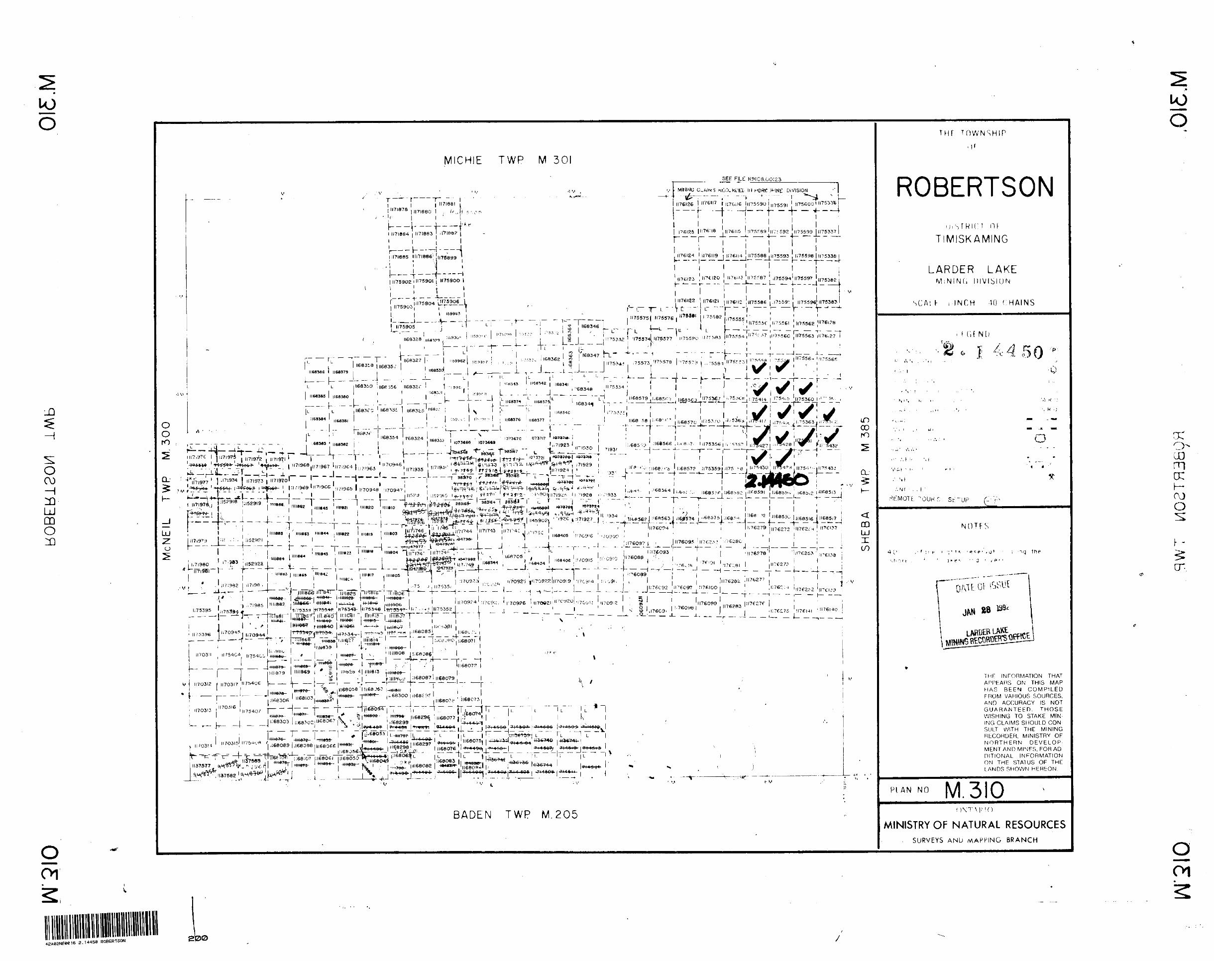
PROPERTY
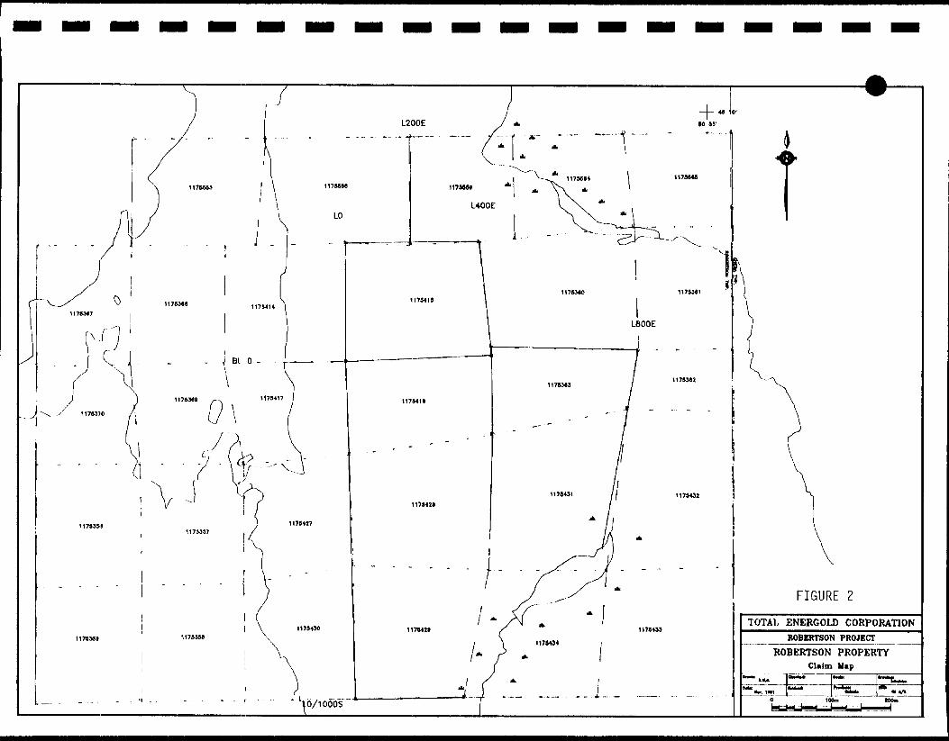
The property consists of 29 contiguous claims, Figure 2, in Robertson township asfollows:
CLAIM NUMBERS
1175356-1175363
1175367-1175370
1175414-1175417
1175427-1175434
1175553
1175558, 1175559
1175564, 1175565
TOTAL
TOTAL
8
4
4
8
1
2
2
29
The property is owned 10007o by TOTAL Energold, subject to a 3 0Xo NetSmelter Return to a local prospecting syndicate.
L200E
LO
Vo/ioobs
1175*28
FIGURE 2
TOTAL ENERGOLD CORPORATION ROBERTSON PROJECT
ROBERTSON PROPERTY Claim Map

l l l l l l l l l l l l l l l l l ll
-3-
RRGIONAI. GEOLOGY
The property lies in the Abitibi greenstone belt of northeastern Ontario, Figure l. The geological database for the area is extremely limited with only regional scale geological mapping having been conducted, Figure 3. The data available suggests the area is underlain by mainly basaltic rocks with minor felsic volcanics and mafic intrusives. No data is available on the TOTAL Energold property.
PREVIOUS WORK
No previous work has been conducted on the TOTAL Energold claim group. Very little work has been conducted in the area due to the very poor access and limited outcrop.
The recent work by Queenston represents the most intense exploration effort in the area.
Government work in the area has been limited to the release of an airborne electromagnetic survey in 1975. The only conductive feature detected in Robertson township is the anomaly on the Queenston property.

4 4
4 4
X
444444444444444*444^4444*4444444444444*44444\
*4 4V4*4*4\*4 4 .*4*4*4*4***4*4*4***4*^*4 4 4***4*4*4*4 44*4***4***4\*4****V****4*4*4*4A
t * 4 4 4 4 * 4*44 **44 44* 4+1+4*44 *4444444* 444*444*444* 44444444444444*44*44444*444444*4444444*444444
X'X'X^X'X'X'X\^XK\X'X^x\-x*X'X*x*xwxv
, .4 + 444 + 4 4 4 44 44 4 4 4 4 4 4 * ^. , \44*4*4444444*4444*4**t*. 44*4***4*4*44444**4****\
. 44444*44+44444444444 + 44 \h*44444444444444*44444444\
44444444444444444 + 44444
\4 444444444444 + 444444 + 4 , •444444444444444444444' 4444444444444444 + 4444 444444444 + 44+4 + 44444
4 *44**4t*4*-44*444444*4*444*444444*4*444,.,, .--...-.,......,....,-444 + 4 + 4- 4444 + 4444444 -l - 1-1 t 4444444*444**444444444 44444 * 'j* *44 44444444 O * p i 44 4 444 4444 44 444444 4 + 444]
444+44*44*44444*44 r,, f - i * * * **4444444444444***4/ 444444 H t 4 4+44 4444441- 1.'., J*44*44444*444444444444/4444444U^ 444444444C f^'444-4 + 44 + 44 + 4444 + 444444/
4444 + 4 H- 4S 15-1* 44444**44 - -O* 44*4*** 444*4**4444444/
44 + 44+444 + 44 4^4 4 + 4 */ . i*4444*4*44*44f4444 */ j^* 4 4444444444f4*4 4X '
4-1444^y4444444 * *l-^|* 44*4*4**444444444 V .
444444 4.4 4 * * 4 4 4 4
44 + 44 444444
4++++I+4444444
t + 4 + 4444
,' ,,..- . oc^SSf*1i .";; C i' ---^-.v. ̂ ^csInput Anomoly.J , QUEENSTO -*" "**
^*"" w DISCOVERY
S!v-' /' --'
/:Input Anomoly
'1.45XCU, 0.47XZn / 30.9ft 0.93J5CU. 5.17J!Zn / 1 4.3ft
\
'N.-V'-"-VOLCANICS\ ^ , .MM WV ̂ ,^ l MAfIC TO^-^i
--. —— •*-""* T""™ ."T?!Se VOUCANICS^f^f 4 444 + 44444 + 4*4454444444444444444 * *^r^r-TT~V- * fJ-T"T4 4*4*4444 * 444*444444444444C44444444444444444**44444k444*444444 44-4*44444*4444*4444444444444444*4**4*4*4 t. 44*4*44*444
5|4444444444444444*4*4444444444444444444*444 4 444 + 444444 14 4 4 4 4 4 4 4 4 4 444 4 *.*.*.*.*444 4 4 44444 44 4 4 4 4 4 4 44 + 44 4! 4 44 4 4 4 4 4
C \4 444444444 t 44444444444
4444
*444***4*4*44**444444**4444*4444 + 4444 + 4444 + 4444*4 + 4 + 44 + 444 4* 44 + + 4 + 44 + + 44 + + 4 + + 444444 + 1*
Figure 3144 4 4444 + 44* * * * 4 **44444\4*444*444
4*4*44444444\44444444
4"4**444444** +V* 4***444^***4-4*44
4+4*44444*4** +V* 4 + + + 444J444 + 4 V+ + + + + + + + + + + + + 4^* 4****4?*44 44 \44*4444*4444444444444444 '•V-*-*-* 4 *-*-4 --4— 4- *- -4 -* —4— f\f "* -* -N^- 4- * J* -* -4— — — — — — — — — ~-
\* ******4*4**44*T***4*4i;44N 4 .*/****, 4 **. 4 .*****,*//**,*,.*.*.*.^ '1 \444444444* *4 4T^
V 4444'
ROBERTSON 1WP."BADFM" fv7p~
4 4T* 4 4
FAVOURABLE MAFIC/FELSIC VOLCANIC CONTACTMAGNETIC CONTOUR (MAFIC VDLC. CM/TUNE)
MAGNETIC CONTOUR
i
TOTAL ENERGOLD CORPORATIONROBERTSON PROJECT
ROBERTSON PROPERTY
^5 J "Vi
2 KM

l l l l l l l l l l l I ll l l l l l
-4-
1991 KXP1.ORATION PROGRAM
The property was acquired following the announcement by Queenston Mining of the intersection for 1.450Xo copper over 9.4 metres. The Queeston work indicates bedded sulphides, pyrite and sphalerite, with chalcopyrite stringers. Grade is as high as 807o Cu over 1.5 metres and 1007o Zn over 3 metres. The intersections are hosted in a well laminated cherty sediment or tuff unit with local iron oxides/silicates and talc-chlorite schists. Felsic volcanics are reported along strike.
The geophysical response is reported to be very weak due to the siliceous and sphalerite rich nature of the mineralization. Induced Polarization has not been conducted but is likely to be more successful at outlining the mineralization.
Geophysics
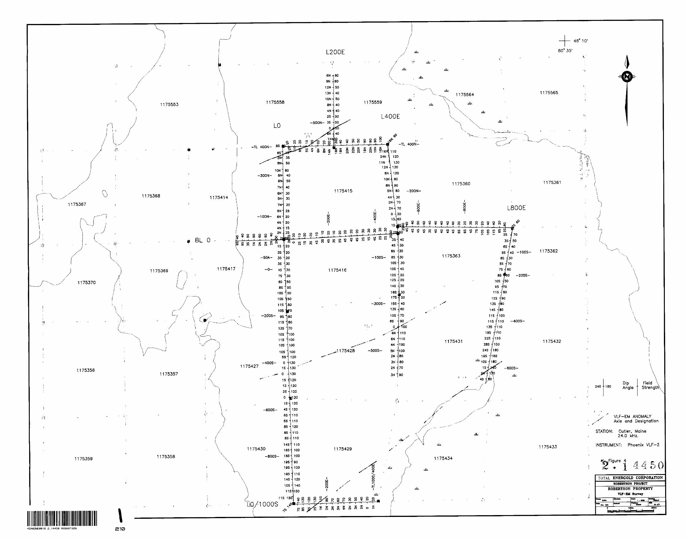
A flagged grid was established along the claim lines as shown on the maps, Figures 4 through 7. A reconnaissance VLF-EM survey was conducted on this grid utilizing a Phoenix VLF-2 instrument. The transmitting station utilized was Cutler, Maine. Readings were taken on both section lines and tie lines at 25 metre intervals. Dip angle and field strength were recorded and the results are plotted on Figure 4. The purpose of the VLF-EM survey is to detect conductivity caused by a concentration of sulphide mineralization. The high frequency of the VI,F method however makes it very susceptible to sources with a much lower conductivity such as clays and overburden troughs therefore follow-up with a more discriminating geophysical method is advised.
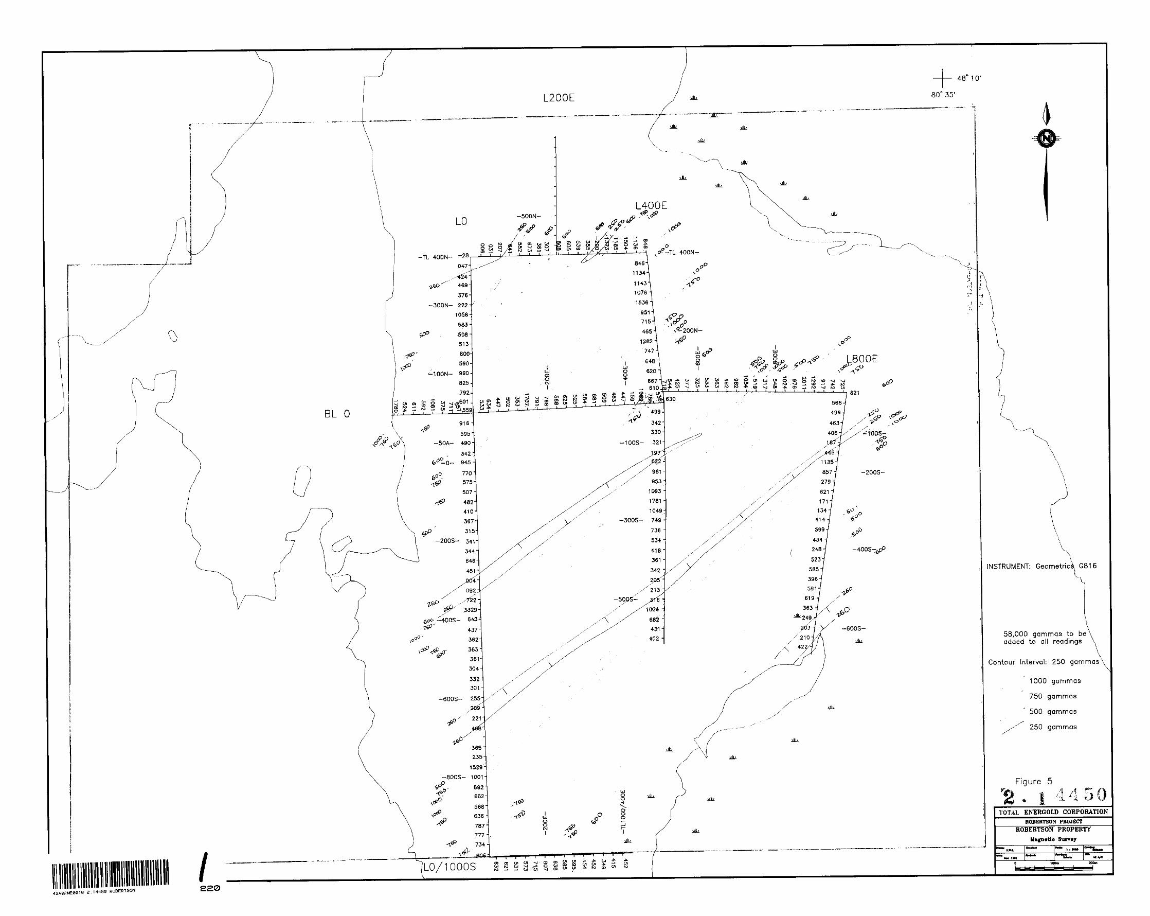
The magnetic survey was conducted over the same grid utilizing a Geometric G816 proton magnetometer measuring the strength of the total magnetic field. Readings were taken eveiy 25 metres along section lines and tie lines. The purpose of the magnetic survey is to aid in bedrock interpretation of both stratigraphy and structure thereby assisting in identification or discrimination of potential targets for additional follow-up. The magnetic data is plotted and contoured on Figure 5.
The VLF-EM survey detected 3 conductive trends labelled A,B, and C on Figure 4. Conductor "A" represents the highest potential for bedrock related conductivity. The conductor lies on a probable contact as suggested by the magnetic data, magnetic high (Fe Tholeiite basalts) to the south and magnetic low (Mg Tholeiites?, more felsic volcanics or sediments?) to the north.
Conductor "B" lies in the central portion of the grid. The conductor is weak and of a doubtful nature on LO but appears to represent a bedrock response on L400E. This conductor lies in a magnetic low with highs to the north and south.
Conductor "C" at the south end of the grid is of a doubtful nature and is probably an overburden response.

l l l l l ll ll l l l l l l l
-5-
rlu- magnetic survey detected a number of linear magnetic highs, Figure 5, striking 055" ;icToss the property. The magnetic highs probably represent iron rich basalt flows or possible gabbroic sills, intercalated with magnesium rich volcanic flows with possible interflow or felsic volcanic intervals. The two higher priority VLF anomalies, A and B, both lie in the linear magnetic lows.
Geochemistry
A reconnaissance Humus geochemical survey was conducted over selected portions of the grid, Figure 6. The portions covered included a traverse over VLF anomaly "A", a cross-section through an area of large magnetic contrast likely representative of varying volcanic sequences and in the vicinity of altered frost heave at L400E/50N.
Samples were analyzed for Au, Cu and Zn at Swastika Laboratories Ltd. at Swastika, Ontario.
Results are plotted on Figure 6. The results were negative with no significantly anomalous results in Au, Cu or Zn.
Geology
The grid lines, various other claims lines and the shoreline of the lake were mapped and prospected, Figure 7. Outcrop was mainly located in the vicinity of a regional topographic high in the central portion of the grid and along the southern edge of the lake. Rock types located were as follows:
Mafic Volcanics - V7
Dark green colour, Fe Tholeiite?, predominates with the occasional lighter coloured, Mg Tholeiite?, variety. Flow textures are common with interlaminated flow breccias, amygdules and occasional pillows. The iron tholeiites were commonly coarser grained and more massive textures. The only alteration observed was in frost heave at L400E/175N where the rock was sericitic and iron carbonatized with slight py to 50Xo local concentrations.
Tuff - V9
Fine-grained well laminated Interflow material with occasional flow breccia, fine to medium-grained with no alteration in the observed exposures.
Gabbro - 15
l Massive, homogenous texture, coarse-grained and a dark green colour. A coarse, massive flow or a gabbroic sill are the likely origins of the rock.
l
l
l l
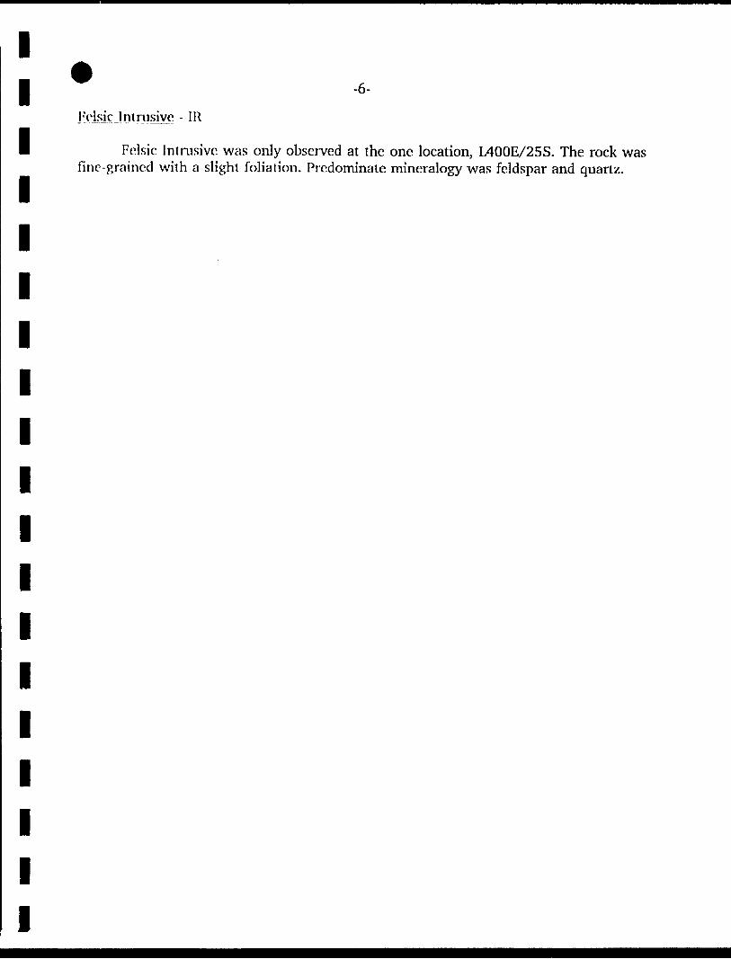
E'dsic Intrusive - IR
l Felsic Intrusive was only observed at the one location, L400E/25S. The rock was fine-grained with a slight foliation. Predominate mineralogy was feldspar and quartz.
l
l
l
l
l
l
l
l
l
l
l
l
l
l
l
l l l l l l l l l l l l l l l l l l l
-7-
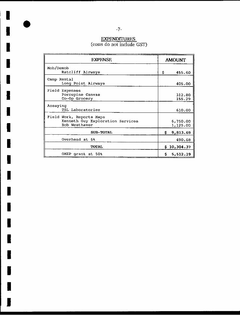
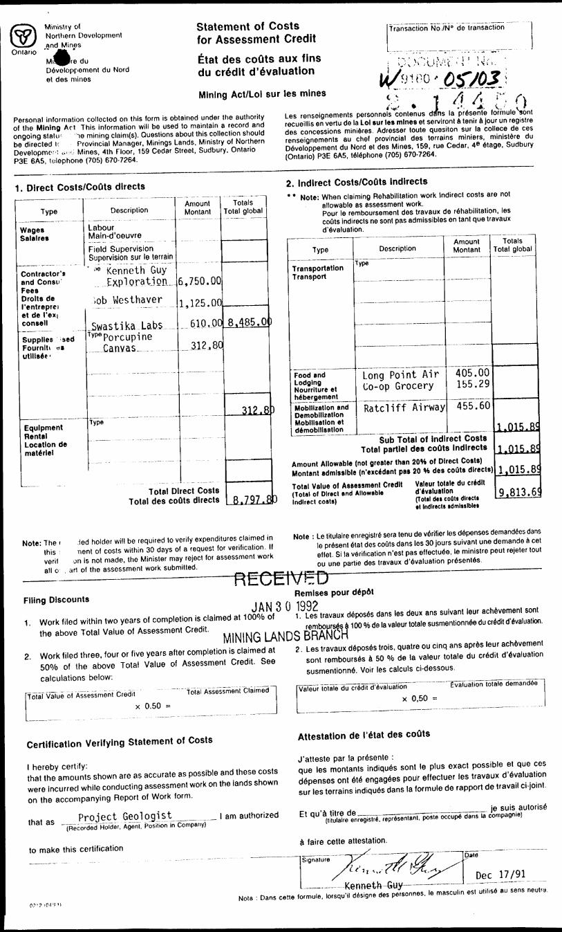
EXPENDITIJRES(costs do not include GST)
EXPENSE
Mob /Demob Ratcliff Airways
Camp Rental Long Point Airways
Field Expenses Porcupine Canvas Co-Op Grocery
Assaying TSL Laboratories
Field Work, Reports Maps Kenneth Guy Exploration Services Bob Westhaver
SUB-TOTAL
Overhead at 5*fc
TOTAL
OMEP grant at BO'S,
AMOUNT
S 455.60
405.00
312.80 155.29
610.00
6,750.00 1,125.00
$ 9,813.69
490.68
$ 10,304.37
S 5,512.19

APPENDIX I
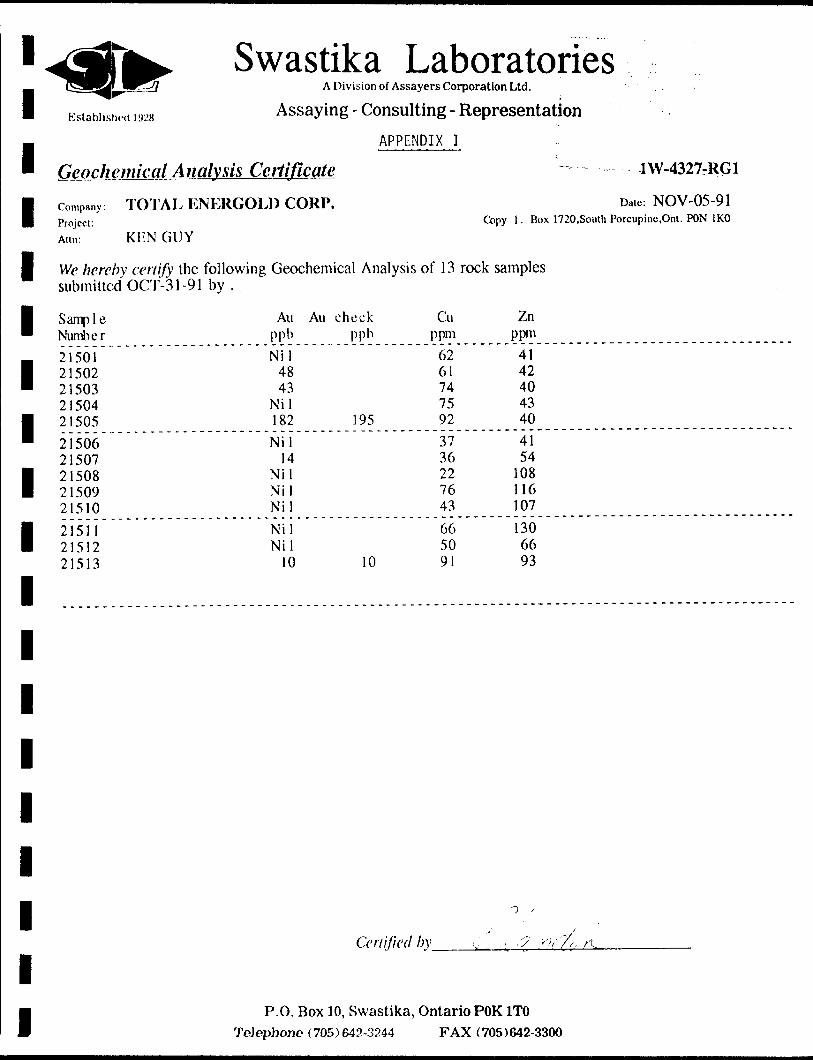
Established ] y*X
' Geochemical Am... - .- . . . .., . , ... .
Swastika LaboratoriesA Division of Assayers Corporation Ltd.
Assaying - Consulting - Representation
APPENDIX I
ilvsis Certificate
1 company TOTAL ENERGOLD CORP. Project:Aim: KEN GUY
1 We hereby certify the submitted OCT-3 1-91
1 Sample Number
m 2 1501 1 21502 " 21503
21504 | 21505
' 2150623507
121508 2150921510
1 21511 2151221513
1
1
1
1
1
1
1
1
1
following Geochemical Analysisby.
Au Au check ppb ppb
Nil 48 43
Nil182 195
Nil14
Nil NilNil
Nil Nil
10 10
Certified i
P.O. Box 10, Swastika, ToJophone (705)642-3244
1W-4327-RG1
Date: NOV-05-91
Copy 1 . Box 1720,South Porcupine.Ont. PON 1KO
of 13 rock
Cu ppm
62 637475 92
373622 7643
66 5091
by i.
samples
Zn ppm
41 42 4043 40
4154
108 116107
130 6693
t .J w7f . /t
Ontario POK 1TO FAX (705)642-3300

l l l l l l l l l l l l l l l l l l l
Established 1928
SwastikaA Division of Assayers Corporation Ltd.
Assaying - Consulting - Representation
APPENDIX I
Geochemical Analysis Certificate
TOTAL ENERGOLD CORP.
KEN GUY
TiTiTir;; Oifice
i 2 199f
Company: Project:Ann:
Date: NOV-05-91 Copy 1 . Box 1720,South Porcupine.Ont.PON 1KO
We hereby certify the following Geochemical Analysis of 30 HUMUS samples submitted OCT-31-91 by .
Sample NumberLO/225N LO/250N LO/275N LO/ SOON LO/325NLO/350N LO 1 362. 5N LO/375N LO/400N L4E/50NL4E/62.5N L4E/75N L4E/87.5N L4E/100N L4E/100SL4E/125S L4E/150S L4E/175S L4E/200S L4E/225SL4E/250S L4E/275S L4E/300S L4E/325S L4E/350SL4E/375S L4E/387.5S L4E/400S L4E/412.5SL4E/425S
Au ppbNil
3 Nil Nil NilNil Nil
3 5
NilNil Nil Nil Nil NilNil Nil Nil Nil Nil
3 Nil Nil Nil NilNil Nil
5 Nil Nil
Cu Ppm41 24 27 20 1722 27 23 16 2831 11 12 36 2411 22 18 32 333925 16 18 2620 32 19 13 19
Zn ppm112 116 103 90 9065 69 41 81
155156 42 93 161 9232 129 100 304 196231 75 38 66 4596 153 86 8873
Certified by
P.O. Box 10, Swastika, Ontario POK1TO Telephone (705) 642-3244 FAX (705)642-3300

l
Ope r.ilinf*, M:imial
Mnitr.l U . li in1'oilablr 1'intim M:i|;iirUunclrr
2. Cycle the magnetometer a lew limes by drpresslnr, the HEAD
buUon--relcasing--and walling (or a reading each cycle.
3. Observe measurement readings. F.ach reading should repeat
lo il gamma. (A slow sliill may occur over several minutes
due lo n diurnal change In the earth's Held.)
4. Place Ihc suspected article al the distance Irom the sensor
expected daring actual survey operation.
0. Cycle magnetometer scvcial times and note the readings.
C. llcmovo the aillclo and repeal ntcna 2 and H lo check (or diurnal
shllls In the earth's licld. ' LI a diurnal shllt Is present, repeal
entire lest.
7. It H H; icaillnr.fi obtained In ntrp 5 differ by more linn 11 r.nnima
(lone count) hum those obtained In steps 3 and G, then the
article la magnetic.
li" T 11 r. Ain'ici.r, is mom.Y MAGNETIC, on ir Tiin si;nsoit is
INSIDE On NlvAH A nUILOINU OH VEII1CLK. TIIC I'HOIOM Plti:-
CF.SS1ON SIGMA1, WILL DE LOST, GIVING COMPLETELY EIUIATIC
HEADINGS AND LOSS OF iJ COUNT HEPEATA1ML1TY.
The iiiap,ncluinclcr should nol Ix; operated Ui areas lhal are known
sources of radio frequency energy, power line noise (transformers),
in buildings or near highly magnetic objects. 'Ihc sensor should
always bc placed on the staff above the ground.-or in the "backpack".
The sensor will NOT opcralc properly when placed dircclly on the
ground. *
1.3 SPECIFICATIONS
Sensitivity;
Hinge:
Tuning:
Oi:tdlcnt 'I'olci'iincc:
Sampling Hale:
*1 gamma throughout range
20,000 lo 00,000 gammas (worldwide)
Multi-position switch with slpnal ampli
tude Indicator light on display
r.xcccds 800 p.ammas/Il
Manual luir.hhuUon, one rcadlnn each
C seconds.
i
-2-
-——— ~——(|
Paramotr^Peosured
equoncy Selection, Front Panel
Frequency Selection, Internal
Detection And Filtering
Meter Display
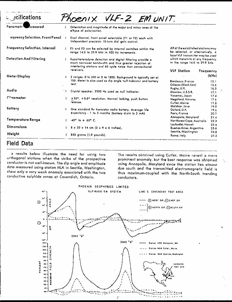
: Orientation and magnitude of the ma|or and minor axes of the ellipse of polarization.
: Duo! channel, front panel selectable (FI or F2) each with independent precision 10-turn dial gain control.
I FI ond F2 con be selected by internal switches within the range 14.0 to 29.9 kHz in 100 Hz Increments.
! Superheterodyne detection ond digital filtering provide a much narrower bandwidth and thus greater rejection of interfering stations and 60 cycle noise than conventional receivers.
! 2 ranges: O lo 300 or O lo 1000. Background Is typically set at
All of the established stations may be selected, or alternatively, o local VIF transmitter may be used which transmits at any frequency in the range 14.0 to 29.9 kHz.
VLF Station Frequency
Audio
(""nometer
Battery
Temperature Range
Dimensions
Weight
100. Meter Is also used as dip angle null indicator ond batterylest.
' : Crystal speaker. 2500 Hz used os null Indicator.
5 -f 90", +0.5 0 resolution. Normal locking, push buttonrelease.
J One standard 9v transistor radio battery. Average lifeexpectancy - 1 to 3 months (battery drain is 3 mA)
5 -40 0 to if 60" C.
: 8 x 22 x 14 cm (3 x 9 x 6 Inches).
! 850 grams (1.9 pounds).
Bordeaux, FranceOdessa (Black Sea)Rugby, U.K.Moscow, U. S.S. R.Yosomai, JapanHegalond, NorwayCutler, MaineMalobor, JavaOxford, U.K.Paris, FranceAnnapolis, MarylandNorlhweslCope, AustraliaLaulualei, HawaiiBuenos Aires, ArgentinaSeattle, WashingtonRome, Italy
15.115.616.017.117.417.617.819.019.620.721.422.323.423.624.827.2
Field Data9 results below Illustrate the need for using two
orthogonal stations when the strike of the prospective conductor is not well-known. The dip angle and amplitude data measured using station NLK in Seattle, Washington, show only a very weak anomaly associated with the two conductive sulphide zones ot Cavendish, Ontario.
Tho results obtained using Cutler, Maine roveot a more prominent anomaly, but the best response was obtained using Annapolis, Maryland since the station lies almost due south and the transmitted electromagnetic field is thus maximum-coupled with the North-South trending conductors.
PHOENIX GEOPHYSICS LIMITED
VLF-RADIO EM SYSTEM LINE C CAVENDISH TEST AREA
0WC3T OiPj0t*ST DIP
0 NORTH OIP.0SOUTH DIP
Stolion NSS Anncpolil ,Ud
- - - Stoiion NAA Cuill', Mulni
. . . . Slglion NIK SfOllll, WoiSMlIon

Ministry ofNorthern Development
i MinesOntario
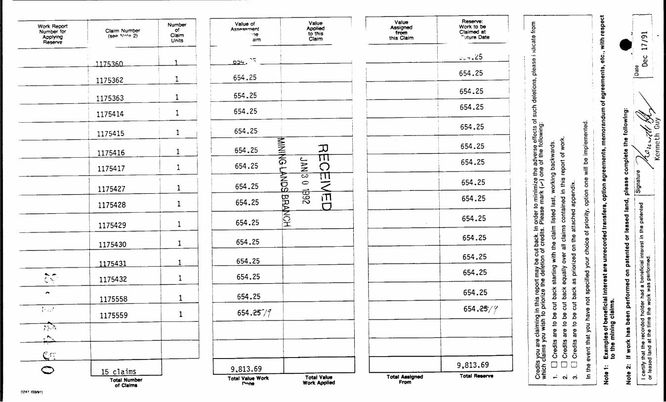
Report of Work Conducted After Recording Claim
Mining Act
Personal Information collected on this form Is obtained under the authority of the Mi this collection should be directed to the Provincial Manager, Mining Lands, Mini Sudbury, Ontario, P3E 6A5, telephone (705) 670-7264.
Instructions: - Please type or print and submit in duplicate.- Refer to the Mining Act and Regulations for req
Recorder.- A separate copy of this form must be completed for each Work Group.- Technical reports and maps must accompany this form in duplicate.- A sketch, showing the claims the work is assigned to, must accompany this form.
42Ae2NE*ai6 2.M450 ROBERTSON 900
Recorded Holder(s)
Energgld CorporationAddress
Suite 1500 - 7QOV! Render St., ^ .,^_Mining Division "Ttownship/Area
Larder Uke...... .^_^.^^...L....EQbertSflrLf-Dates
Work Performed
Work P e
?,J99L .Check One Work Group Only)
IG8
Client No.
202600Telephone No.
604-681-9501M or G Plan No.
M310
November 15. 1991
We.
Geotechnical Survey
Physical Work, Including Drilling
Rehabilitation
Other Authorized Work
Assays
Ass Res-
from
irvey
3
d
n
..Geo logi cal rgmekm nnv.yp
JAN 3
^ — MINING LAN]
Type
l Geophysical Surveys
Total As, t Work Claimed on the Attached Statement of Costs S 9,813^69
Note: Tine Minister may reject for assessment work credit all or part of the assessment work submitted if the recorded holder cannot verify expenditures claimed in the statement of costs within 30 days of a request for verification.
Persons and Survey Company Who Performed the Work (Give Name and Address of Author of Report) Name
Kenneth Guy Exploration Services
Bob Westhaver
Address
Box 6045 PMS, South Porcupine, Ontario RON 1KO
414 Murdoch, Timmins, Ontario P4N 5V1
(attach a If necessary)
Certification of beneficial Interest See Note No. 1 on reverse side
l certify that at the time the work was performed, the claims covered in this work report were recorded in the current holder's name or held under a beneficial interest by the current recorded holder.
Date
Dec 17/91Recorded or Agent (Signature)
x^
Certification of Work Reportr'l certify that l have a personal knowledge of the facts set forth in this Work report, having perform&d the work or witnessed same during and/or after Its completion and annexed report is true. __ _______________________
hame aruTAddresVof Person~CertTfying~ ~ ~
j(fcineth Guy^ Box^6045 PMS^ South Porcupine. Ontario PON 1KO~~'~" ""•' "" ~~ " ""~ " 'Date " " ~ " " " " "Tele, ine No
705 ?35-8271 December 17, 1991Certified By (Slgnatur
— W
For Oh ce Use Only"Total Vi luirCrTRecoTdecT
0241 ( Oi'SMt
Date Recorded
Deemed Approval DateM , J O t /a/ ^ - f J112--
Mining Recorder ^S* -if
^^Z^^tC^Date Approved i
Date Notice for Amendments Sent
Received Stamp ' - - ; - '. i .'
OK: |991
. i x^j , y * -— -- — — ------ - - — — ---' •-.,v. f u'*-ia.-r^
0 1—1
en o . — i
3 (A
f*
- '•' l''*
t— i
-v|
en
en
en
10 i—*
'
t̂—"
-vi
en
en
en CO t-*
"' -vi
en -F* eo
ro ~
vj
en -Fi
eo i-" t-"
vj
en CO
0 1-"
H-1 en
ro -
i-j •vi
en -Fi
ro CO ~
^ en
ro t—"
^ -vi
en -Fi
l—"
I-1
I-*
•vj
en -Fi
H-1 en ~
t~* vj en -F*
H-1 en t-*
i—*
en -fi
l— i
-Fi
-
i—*
vj en
eo
en
eo i—"
h-* -vi
en
eo
en
ro i—"
— i Ml
1
vi Tt --
|||?
-Q TO
— -
lg
fz l c
•o 3
CO
I
9. w
2.3
H
If
| li ^— it
10 4 CO
h-" eo en
10
en Sen
en -f
it ro
en
en en t ro
en
en en t ro
en
en en -P*
ro
en
en
en -Fi
ro en HON
en
en
-f* ro
en vw m 33
en S ro
en 5QW
[ 08
ME
en
en -fi
ro
en
fVC
){s
1 *J
\
wr
Oren U
l
c ro en IMIIM
Inir'
i
y
en
en
-fi ro
en
en
en
-F* ro
en
en en •fi
ro
en
en en ro
en
a u
j ji01
. 3"
5": 3{
Value
*m
i-*
eo en
vo
en 1
en
en * ro en
en -Fi
* ro
en
en
en -F*
a ro
en
en ro
en
en
en 4* * ro
en
en
en -fi
e ro
en
en
en * ro
en
en
en a ro
en
en
en t ro en
en
en 4 ro
en
en
en -Fi
t ro
en
en
en -F*
t ro
en
en
en
-p* t ro
en
c 4 re
en
pi 3
. C
g
3-i
jj
IIP
Cred
its y
ou a
re c
laim
ing
in th
is re
port
may
be
cut b
ack.
In o
rder
to m
inim
ize th
e ad
vers
e ef
fect
s of
suc
h de
letio
ns, p
leas
e i i
dica
te fr
om
which
cla
ims
you
wish
to p
rioriz
e th
e de
letio
n of
cre
dits
. Pl
ease
mar
k (^
) on
e of
the
follo
wing
:
1. D
Cre
dits
are
to b
e cu
t bac
k st
artin
g wi
th th
e cla
im li
sted
last
, wo
rkin
g ba
ckwa
rds.
2. D
Cre
dits
are
to b
e cu
t bac
k eq
ually
ove
r all
claim
s co
ntai
ned
in th
is re
port
of w
ork.
3. D
Cre
dits
are
to b
e cu
t ba
ck a
s pr
ioriz
ed o
n th
e at
tach
ed a
ppen
dix.
In th
e ev
ent t
hat y
ou h
ave
not s
pecif
ied
your
cho
ice o
f prio
rity,
opt
ion
one
will
be im
plem
ente
d.
Note
1:
Exam
ples
of b
enef
icia
l Int
eres
t are
unr
ecor
ded
trans
fers
, opt
ion
agre
emen
ts, m
emor
andu
m o
f agr
eem
ents
, etc
., w
ith re
spec
t to
the
min
ing
clai
ms.
Note
2:
If w
ork
has
been
per
form
ed o
n pa
tent
ed o
r le
ased
land
, pl
ease
com
plet
e th
e fo
llow
ing:
l cer
tify
that
the
rec
orde
d ho
lder
had
a b
enef
icia
l int
eres
t in
the
pate
nted
Si
gnat
ure
or le
asod
land
at t
he ti
me
the
wor
k wa
s pe
rform
ed.
Kenneth
Guy
DateDec
17/91
Ontario
MirYvsUy o(Northern Developmentnnd Mines
•-
re duDeveloppemont du Nord et des mines
Statement of Costs for Assessment Credit
Irtat des coQts aux fins du credit devaluation
Mining Act/Loi sur les mines
Transaction No./N 0 de transaction
;XK':UMc'^' N,v :
Personal information collected on this form is obtained under the authority
of the Mining Act This information will be used to maintain a record and
ongoing stalu ie mining claim(s). Questions about this collection should
be directed le Provincial Manager, Minings Lands, Ministry of Northern
Development ...: Mines, 4th Floor, 159 Cedar Street, Sudbury, Ontario
P3E 6A5, telephone (705) 670-7264.
f)f**' * l .' JL {.i tLes renseignements personnels contenus dans la pr6sente formuleSont
recuoillis en vertu de la Lo) sur les mines et serviront a tenir a jour un registre
des concessions minieres. Adresser toute quesiton sur la collece de ces
renseignements au chef provincial des terrains miniers, ministere du
Developpement du Nord et des Mines, 159, rue Cedar, 4e etage, Sudbury
(Ontario) P3E 6A5, telephone (705) 670-7264.
1. Direct Costs/CoOts directs
Type
Wages Salalres
Contractor's and Const) Fees Drolls de I'cntreprei et de l'ex t consell
Supplies ; Fournlti r)\ ullllset'
Equipment Rental Location de materiel
's1
sed
e
Description
Labour Main-d'oeuvre
Field Supervision Supervision sur le terrain
' lX) Kenneth Guy Exploration^
iob Westhaver
.Swastika Labs ^ Type Porcupine _ Canvas, ......^
Type
Total DI Total des cot
Amount Montant
6,750.00
1,125.00
510.00
^312,80
•-•- - - —
rect Costs its directs
Totals Total global
8,485.0
312.8
8,797.8
2. Indirect Costs/CoQts Indlrects* * Note: When claiming Rehabilitation work Indirect costs are not
allowable as assessment work.Pour le remboufsement des travaux de rehabilitation, les couts indirects ne sont pas admissibles en (ant que travaux devaluation.
Type
Transportation Transport
Food and Lodging Nourriture et hebergementMobilization and Demobilization Mobilisation et demobilisation
Description
Type
Long Point Air Co-op Grocery
Rate! if f Airway
Amount Montan!
— —— - — --
405.00 155.29
455.60
Sub Total of Indirect Costs Total partlel des coOts Indlrects
Amount Allowable (not greater than 20H of Direct Costs)
Montan! admissible (n'excedant pas 20 H des couts directs)
Total Value of Assessment Credit Valeur totale du credit (Total of Direct and Allowable devaluationlnHlr*M tA*la\ fTntal fiat rftftt* rilr*ctft
Totals Total global
UUL&-UfiliiSS
1,015.85
9,813.6?tt Indirect! idmlwlblet
Note: The i Jed holder will be required to verify expenditures claimed in
this nent of costs within 30 days of a request for verification. If
veril on is not made, the Minister may reject for assessment work
all o , art of the assessment work submitted.
Note : Le titulaire enregistr6 sera tenu de verifier les depenses demandees dans
le present etat des couts dans les 30 jours suivant une demande a cet
effet. Si la verification n'est pas effectuee, le ministre peut rejeter tout
ou une partie des travaux devaluation presentes.
DECEIVEDRemises pour dep6t
JAN 3 O 1992Work filed within two years of completion is claimed at 10007o of 1. Les travaux deposes dans les deux ans suivant leur acnevement sont
the above Total Value of Assessment Credit. rembours6s 6 100 ty de la valeur totale susmentionnee du credit devaluation.
MINING LANDS BRANCHWork filed three, four or five years after completion is claimed at 2 . Les travaux deposes trois, quatre ou cinq ans apres leur achevement
5007o of the above Total Value of Assessment Credit. See sont rembourses a 50 o/o de la valeur totale du credit devaluation
calculations below: susmentionne. Voir les calculs ci-dessous.
Filing Discounts
1 .
2.
Totaf Value of Assessment Credit total Assessment Claimed
x 0.50 ~
Valeur totale du credit devaluation
x 0,50
Evaluation lotale demanded
Certification Verifying Statement of Costs
l hereby certify:that the amounts shown are as accurate as possible and these costs
Attestation de I'etat des couts
J'atteste par la presente :que les montants indiqu6s sont le plus exact possible et que ces
were incurred while conducting assessment work on the lands shown depenses ont ete engagees pour effectuer les travaux devaluation
on the accompanying Report of Work form. sur les terrains indiques dans la formule de rapport de travail ci-joinl.
that as Project Geologist ^ l am authorized Et qu'a litre de^.^,———————————-——- . |e suis autorise
- (Recorded Holder, Ag^nT, Polition in Company] (titulaire enregistre, representant, poste occupe dans la compagme)
a faire cette attestation.
Signature" ^^-
^ Dec 17/91—— —— - —
p? , ? | OJ ,01) Nota : Dans cette formule, lorsqu'il designs des personnes, le masculin est utilise au sens neutra.
to make this certification
ntario
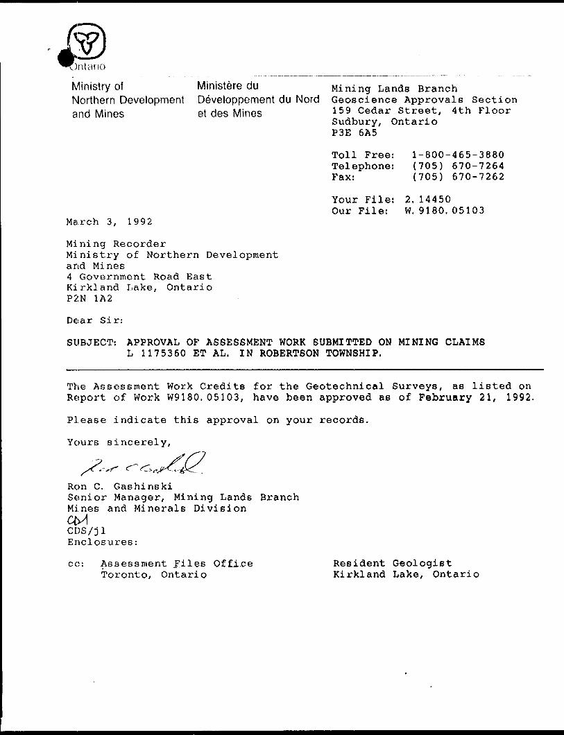
Ministry of Ministere duNorthern Development Developpement du Nordand Mines et des Mines
Mining Lands Branch Geoscience Approvals Section 159 Cedar Street, 4th Floor Sudbury, Ontario P3E 6A5
Toll Free: Telephone: Fax:
Your File: Our File:
1-800-465-3880 (705) 670-7264 (705) 670-7262
2. 14450W. 9180. 05103
March 3, 1992
Mining RecorderMinistry of Northern Developmentand Mines4 Government Road EastKirkland Lake, OntarioP2N 1A2
Dear Sir:
SUBJECT: APPROVAL OF ASSESSMENT WORK SUBMITTED ON MINING CLAIMS L 1175360 ET AL. IN ROBERTSON TOWNSHIP.
The Assessment Work Credits for the Geotechnical Surveys, as listed on Report of Work W9180. 05103, have been approved as of February 21, 1992.
Please indicate this approval on your records.
Yours sincerely,
Ron C. GashinskiSenior Manager, Mining Lands BranchMines and Minerals Division
CDS/jl Enclosures:
cc: Assessment Files Office Toronto, Ontario
Resident Geologist Kirkland Lake, Ontario
10o
H
OCO
LJ OD O
O01
42A02NE0C16 2.14450 ROBERTSON
MICHIE TWP M. 301
;- _______ SEE FILE R9I08.00I23______
MINING CLAIMS KtJXhrED IH HtiRCJMNE DIVISION
l ] j II7I9BI i
l"71678 11171680 l , (v , \1 : ' V l l ' \
l 1171684 j 1171863 117166? |
1 l '.—— l———\---\HI7I885 MI7I886 1175899 '
11175902 i H7590I
I-.__ J- - l 1175905
1175900t
'^^^75^Q6_
l 1159965t-
l 1176126 1"^II7 f 117GII6 lll?559O l 1,7559, ' 1I75GOO 'i _ i i _ i— ^, i!! ^L. j-f— -f--i i
l .176125 |H761I6 j H76115 | 1I?5E89 'll'.T 592 j 1175599 | H75337|~~ i ~ s ~" i~~ i "~ i "~ i iii 1.1176,24 l 1176119 t 1176114 1175588 ,,l 75593 1175596 l IH5336 lL- — -- — -i- —— u~ — J.-—L. —— -^-
'H76I23 j 1176120 | Il7bll3 1175^87 II75594 1 1175597 ||7f- *- — *~ - -- - — -— — - U — 4~- - -4 -
l l j j l l
11176122 j H76I2I |||76ll2 .1175566 i H75S9r . 1175596 1175383 - --- —— - - ——— r- ——\--l^-
Ooro
Q. 3:
L ' L
1168366 l 1168379
L
l—— —— -
1168385 l 1168380
r— -i ~1168359 1||6R156
IIG8i27
f- —— ,- - T L- -p- - ——j l S N66346
v l 1168347
j N75575) 1175576 i"7"" i ;75S^ J 1I75555 '̂
L ^-^ "f'75332 l H755741 117:5577 H755PC ;l r -~
I17555E .1175561 ' H75562 '"76126
,II75563 | M76I27
l (
833 d
±.^ L ^H6634I
L -iT- —— -j.
_ i l_ _ — . ^..J' ' -
iica;uM j '
- ,l~ea .7 .
L. . . J. .. J.-t 'L | L 'L•' i 1- II6B374 i 1168375,
1166346
1168 34^A
168383
1168381
1168382
•:M'. ^ '- W- - H: '- ! i 1168376
iT.1168354 ' 1,68324
II6B577 i
l l"
117 , 974L — — j— —'
1373670 ' 1073717
. '.171923 J | r|q— f" 983*7 " L ^ ̂ ̂ ̂
?- 31166579^685^"! Il695^ijji7536 7 ''^.-^^j. '175414^ ' lU 5^ "l^S^qj '^' ^'- ,---,—.—.-"T'-T- yiwiy-T-^^-^-y
'ST /,,C
.1166 S
1. l I I7I968 |II7I967 'll7i964 | 1|7 , 9'6i
j :, 6e5
l 116657? {1753591 1175 J-8591 1175 Mn~ ~"
UJzo
__ ___-T - -t 'I92Q --T r11685 :
LO00ro
O.
.1685,
twa
--IMI88S i 1111063
TMII8IS
i 117(9^9
1171980
1145902.v
6/5
IIII8841111043 i 1111*23
-j -- -IMI004 TI
1175395 ',|75S94
' U52928
ii7)98 ,
,,7,965 1111882
i
116574
1176095 ' 1I762.1-.
, 66 1168517
IIIIHB
r' '1171749 j I l6aw^
- r "Ti 'l70923 'IV C ;'i'^
i|I1709?.2||I7O9I9 ' 'l
II .0910
- — -- -|— —— —— i .^6089
III 7tO93 1176278
COUJxCO
uiiooa '
1111067 f444tft40 l W+e*!
tt7S54emiBT*r
. I7O9?'1 11709;:, ' M7O926 l 1I70C2I i t 1 170912
0 lg MI7609I
1^6097 M76IOO |——— -L- -J^--^
1 1176099
l l|ji -tOiOI i l
1168065 f 1 1 BO s, :. i
I t o^oo j .li?eL75 '1176141 M176I40 j
I703H
INI869 r -
W j 1170312 l 1170317 H754CJ6 }^- ——
. l M168072
uj Jj.66̂ 67,!11^8^ i ^^
II7O3I3
II7O3U
(137577
1170316l u ) |Qjl7 ^ j
M754O7l |;||rt
l j 1^68303 SiGQ^OC 1 ^^^06?""" T ——~ "~™ T J
r
^168054
i i!683OO l i|68cfl l
^-- ..l--
II7O3I5lltH076 ttnaaa
r. ! 11680? J j
raw766296 l 1166077 | j..'? l
'* U |, 166089 11166086 |,ee06E
L i "L l 1" HT l "1 603 711 ^ Q f. [Jj^ASm^A
168297I168O76
r, - —i1I66O75 -7I4S-O4
BADEN TWP M.205
rur TOWNSHIP
ROBERTSON
N * N
N f
'jisrmrr OF T MISKAMING
LARDER LAKEMiNINU DIVISION
l i- i INCH 40 (HAINS
I'.f-NlJ'fo
445
o
SETUP
NOTFS
g the
l
"DMt w &SMJAN M l*'
THE INFORMATION THAT APPEARS ON THIS MAP HAS BtEN COMPILED FROM VARIOUS SOURCES. AND ACCURACY IS NOT GUARANTEED. THOSE WISHING TO STAKE MIN ING CLAIMS SHOULD CON SULT WITH THE MINING RECORDER. MINISTRY OF NORTHERN DEVELOP MENT AND MINES. FOR AD DITIONAL INFORMATION ON THE STATUS OF THE LANDS SHOWN HCREON.
PI AN NO M.3IOMINISTRY OF NATURAL RESOURCES
- SURVEYS A NU MAPPING BRANCH
220
k) O
o- uo mu:COo
h-B:o*..
g01
48 1 O'
L200E illli80' 35'
\.llly
vlll/ \l\\i
1175553 1175558
LO
-TL 4-OON-
8
ft 3 8Ffe iJr-
bN -
9N -
12N -13N-
lONi-
8N*
4N |
2S -
-SOON- 3S -
pji ' J j^W- M ^14N
I/) Z •y "-ir — '
eu 6050
40
50
40
40
50
5C"^•So40
^5
1175559
L4^f^1
tz zzz 25?z T
illli
AtlU
JJJU.
^
1175565
Jli
tl
-TL 400N-
1175360
1175368
1175367L800E
1175369-200S-
1175356
1175359
42AC2NEC016 2 . 14450 ROBERTSON
\210
5 S S S S
? o o o o 2 in (O tD tO ^
6N -M10
4N -J100
5N -J100 2N -l 80
3N H 80
2N J 70
-800S- 16SH 100
8 S X*
1175361
1175362
1175432
1175357
24S - -160
sVLF-EM ANOMALY Axis and Designation
1175433
STATION: Cutler, Maine 24.0 kHz.
INSTRUMENT: Phoenix VLF-2
1175358
TOTAL ENERGOLD CORPORATIONROBERTSON PROJECT
ROBERTSON PROPERTY VLP-EU Surrey
*v*
INSTRUMENT: Geometric^ G816
58,000 gammas to be added to all readings
Contour Interval: 250 gammas
1000 gammas
750 gammas
500 gammas
250 gammas
Figure 5
3TOTAL ENERGOLD CORPORATION______ROBERTSON PROJECT—^^^——
ROBERTSON PROPERTYMagnetic Survey
*"*U~
H V
42A02NE8016

48 1 O'
L200E
\tb/
-vlil/.
L400E
-TL 400N-
-200N-
N-l 36/161 N \ 12/93 N-n 1/42 N 131/156
J————l————l————l————l————l————L l
17/9020/9027/10324/11641/112
800 35*
lLU O O 00 L800E
-100S-
-200S-
-400S-
\230
41/112 Au ppb
Cu/Zn ppm
Figure 6
TOTAL ENERGOU) CORPORATIONROBERTSON PROJECT
ROBERTSON PROPERTY Hiram* Gaoohvmloftl Survey

l . l .1 . l -l L..l. -li i J - J- -l ——1-- -l -- L---1
TOTAL ENERGOLD C ORPORATIONBOBERTSON PROJECT
ROBERTSON PROPERTYGeological Survey