GEOPH RPT BOUZAN LK PROP - Geology Ontario
59
l l l l l l l l l l l l l l l l l l l 52KI3NW0812 2.10989 FAULKENHAM LAKE 010 CP.OPI 1Y SI CAL REPORT ON KOUZAN LAKH PROPERTY HEYSON TOWNSHIP RED LAKH, ONTARIO [•OR NORAMCO EXPLORATION INC. Prepared by: a.C Grant C.E.T., F.G.A.C, February, 1988 -'
-
Upload
khangminh22 -
Category
Documents
-
view
5 -
download
0
Transcript of GEOPH RPT BOUZAN LK PROP - Geology Ontario

l l l l l l l l l l l l l l l l l l l
52KI3NW0812 2.10989 FAULKENHAM LAKE 010
CP.OPI 1Y SI CAL REPORT
ON
KOUZAN LAKH PROPERTYHEYSON TOWNSHIP RED LAKH, ONTARIO
[•OR
NORAMCO EXPLORATION INC.
Prepared by:a.C Grant C.E.T., F.G.A.C,February, 1988
-'

l l l l l l l l l l l l l l l l l l l
52K13NW8012 2.1*909 FAULKENHAM LAKE 010G
TABLE OF CONTENTS
Page INTRODUCTION. . . . . . . . . . . . . . . . . . . . . . l
PERSONNEL . . . . . . . . . . . . . . . . . . . . . . , l
PROF'ERTY LOCATION AND ACCESS . . . . . . . . . . . . . 2
BOUZAN LAKE CLAIM GROUP . . . . . . . . . . . . . . . . 3
L1NECUTTING . . . . , . . . . . . . . . . , . . . . . . 3
GEOPHYSICAL PROGRAM . . . . . . . . . . , . . . . . . . 3
ELECTROMAGNETIC SURVEY . . . . . , . . . . . . . . . . k
MAGNETIC AND GRADIENT SURVEYS . . . . . . . . . . . . . 6
MAGNETIC PROCEDURE . . . . . . . . . . . . . . . . . . 6
BASE MAPS . . . . . . . . . . . . . . . . . . . . . . . 8
SURVEY RESULTS . . . . . , . . . . . . . . . . , . . . 9
CONCLUSIONS . . . . . . . . . . . . . . . . , . . . . . l l
RECOMMENDATIONS . . . . . . . . . . . . . . , . , . . . I 2
LIST OP FIGURES
P pure l Location Mapl' gure 2 Bou7an Lke Property Location MapF gure 3 Claim Location MapF gure k G r i d Sket ch-Flcyson Twp.F gure 5 Location of Vi.F' Transmitter Stations
APPF'NDICES
Appendix A Omni Plus SystemAppendix B EDA Omni IV SystemAppendix C Crone CEM Unit

l l l l l l l l l l l l l l l l l l l
.INTRODUCT.1QN
Noramco Explorations Inc. holds a group of 137 contiguous,
unpatontod mining claims in Heyson Township, Bouzan Lake A rea, Red
Lake in Northwestern, Ontario.
This report will deal with the results of electromagnetic,
magnetic and gradient surveys which were completed over the entire
block during the months of August, September, and October, 1987.
These surveys were completed by tlxsics Exploration of Timmins
for Norarnco with 1he aim of locating and outlining favourable
structure which would be suitable for gold deposition.
The people directly involved with the surveys were:
Mike Mickey . . . . . . . . North Bay, Ontario
Steve Anderson . . . . . . Timmins, Ontario
Han Rifou . . . . . . . . .
John Granl . . . . . . . .

l l l l l l l l l l l l l l l l l l l
PROPERTY LOCATION AND...ACCES.S
The "Bouzan Lake Property" consists of 137 contiguous,
unpatented mining claims situated such that 127 of the group are
located in the south half of Heyson Township, k o f the group are
located in the southeast corner of Baird Township, 2 of the group are
located in Byshe Township and k o f the group are located just south
of the southeast corner of Heyson Township (refer to fig. 2,3 of this
report for actual block shape and location). Ail of the group is
siluatod in the Red Lake Mining Division, Red Lake, in Northwestern
On t a r i o.
More specifically, the group is situated such that the western
edge butts up against Falkenham Lake with the northeastern edge of
ihe group running just south of SuJly Lake {fig.3).
The east edge of the group extends l /k m ile past the Heyson,
Byshe Township line. The south boundary of the group sits on the
south boundary of Heyson twp.
Access to the east section of the group is ideal as highway 105
cuts across the group as it travels north from the TransCanada to Red
Lake Towns i 1 e.
A swamp buggy road now provides access to the Boyden Lake area.
A third access route would be by truck to Madsen and into
Falkenham Lake, where boat access would provide transport to the
northwest corner of the group (refer to fig.2 of this report).
- 2 -

l l l l l l l l l l l l l l l l l l l
MANITOBA
QUEBEC
LAKE SUPEfMORV
EXSKS EXPLORATION LTD.
mw^WOPERTY
TITLE: LOCATION MAPDaU: Feb. (988Drawn:
Sctlti r*l25 mlktFta. l
NTS;Job No.EE-53

i i i i i i i i i i i i i i i i i i i
F^p/g^
r Ti^'^fw v y ' /x60 ^ r C'yvv Scty-- •y^^^.^p-'w/,^,*) L/:.^ '•A,^^' •A^k^i^
EXSiCS EXPLORATION LTD,PA l*i WM, PU-7XISi** O. Hilling M4t, TtMriM M.*i
CLIENT: NORAMCO EXPLORATION INC.PROPERTY: BOUZAN LAKE PROPERTY
BOUZAN LAKE PROPERTY LOCATION MAP

EXSICS EXPLORATION LTD.M. Ira ttM, NN-7Xt Suit* O. IWOnfv Mfe TfcMfe* M.
: TK-MMSI
CLIENT: NORAMCO EXPLORATION INC.PROPERTY: BOUZAN LAKE PROPERTYTITLE: HEYSON TWP.
CLAIM LOCATION MAP

l l l l I l
l l l l l l l
BOgZAN.. LAKH CLAI M. GROUP
The 137 mining claims that make up the property have been
displayed in Fig. 3 of this report. As stated earlier, all of the
claims are located in the Red Lake Mining Division.
LINECUIT.ING
Alquesl Exploration Limited of Timmins, was contracted to
establish 2^0 krn of grid lines over the property.
This was first done by establishing a series of baselines and
tielines across the grid at an azimuth of 080 degrees, which
represented the expected strike of the geology. Once these baselinesB
and tjeiines were established, crosslines where then turned off at
l 100 meter intervals and then cut and chained at 25 meter intervals to
the north and south boundary of the group.
CHQPLIYSICAL^PROGRAMB
This program consisted of a two directional, very low frequency,
l VLP Dip survey, magnetic and gradient surveys, as well as a low pass
filtering survey, known as Fraser Filtering, over the best V IA- D ip
Angle results.

ll These surveys worn chosen because of the expected complicated
structure, as weJJ as expected shallow overburden across the area,
l It should be noted here that both the VLF survey as well as the
m magnetic/gradient surveys are ideal tools when trying to map or
outline geo log i ea J structure. The purpose of the second VLF'
l
l
l
l
l
direction was to check for cross structure should it exist.
F.LHCTROMAGNJiT IC. SURVHY
^ The electromagnetic survey consisted of a two directional, VI,F
* [Vi p Angle Survey using two transmitting stations, one transmitting at
B 120 degrees to the grid, and the second transmitting at 250 degrees
to the grid,
l The stations chosen were Cutler, Maine, at 2^,0 kHz and Seattle,
Washington, at 24.8 kHz {refer to fig. 5 for station location with
respect to the cut grid).
H The VLF readings recorded at each station was the dip angle of
the resultant field, technically the angle in degrees, from the
l horizontal of the major axis of the polarization ellipse. This is
the easiest measurement to make since it is not dependent on changes
l in signal strength. The dip angle measurement detects a conductor
m f rom a considerable distance; several hundred feet.
Direct plotting of the dip angle often does not clearly define
l the shape or position of the conductor. If strong regional effects
occur the conductor may not produce a cross-over and may be defined
l only by a sharp variation in dip angles, known as a deflection.

•on Noiivaa-wx
-^NOiONIHSVM 31X1V3S

l l l l l l l l l l l l l l l l l l l
One method to overcome this defect in the measurement is o
treatment of the dip angle data by means of a low pass filtering,
developed by D.C. Fraser and described in Geophysics Vol. 3,^, and 6,
December 1969.
This Fraser Filtering creates high positive values over shallow,
buried conductors and lower positive values over deeper conductors.
It should be noted here that the VI,F survey can be affected by
lake shores, creeks, swamp to outcrop contacts, powerlines, faults
and shear xones as well as electrically charged, conductive material
i e. su J ph i des,
During the geophysical program completed during August to
October, 1987, the filtering was done on the VLF dip angle
measurements recorded on the Cutler, Maine station of 2^.0 kHz.
This contoured filtered map can be found, along with the 2
directional VI,F dip angle maps in the back pocket of this report.
The unit used throughout the survey was the Omni Plus System
manufactured by F.DA Instruments of Toronto.
Specifications for the Omni Plus System can be found as
Appendix A of this report.
In all, a total of 2 kQ km of VLF surveys were completed over the
entire grid.

l
l
l
l
l
l
l
l
l
l
l
These surveys consisted of a total f i e 3 d magnetic survey as weLJ
l as a vertical Rrad i ont survey.
These surveys were run s itrm l tanoous l y over the grid, again using
" the F-DA Omni Plus System.
MAGJVJETJLCL^
before starting the Mag/Gradient survey, a fixed base station
was established on the grid. This was done using an EDA Omni IV base
station magnetometer with a recording interval of 30 seconds. This
means the base unit would record and store a reading every 30 seconds
throughout the survey period. This was set up to record any changes
in the earth's diurnal, as well as to record any magnetic
interference ie. storms, sun spots, etc, should they occur during the
survey period.
A reference level of 60,000 gammas was programmed into the base
station as well as the field unit. This synchronization is important
l as the two units, the field and base units, would be hooked together
at the end of each survey day and the data collected by each unit
l would merge with each other on a time basis.
M The data dumped by the two units would then be the corrected
data which was then plotted.
l This procedure was then repeated throughout the survey time
until the complete grid was read.
o

ll
.
*
l
l
W
H
l
B
m
l
l l l l l l
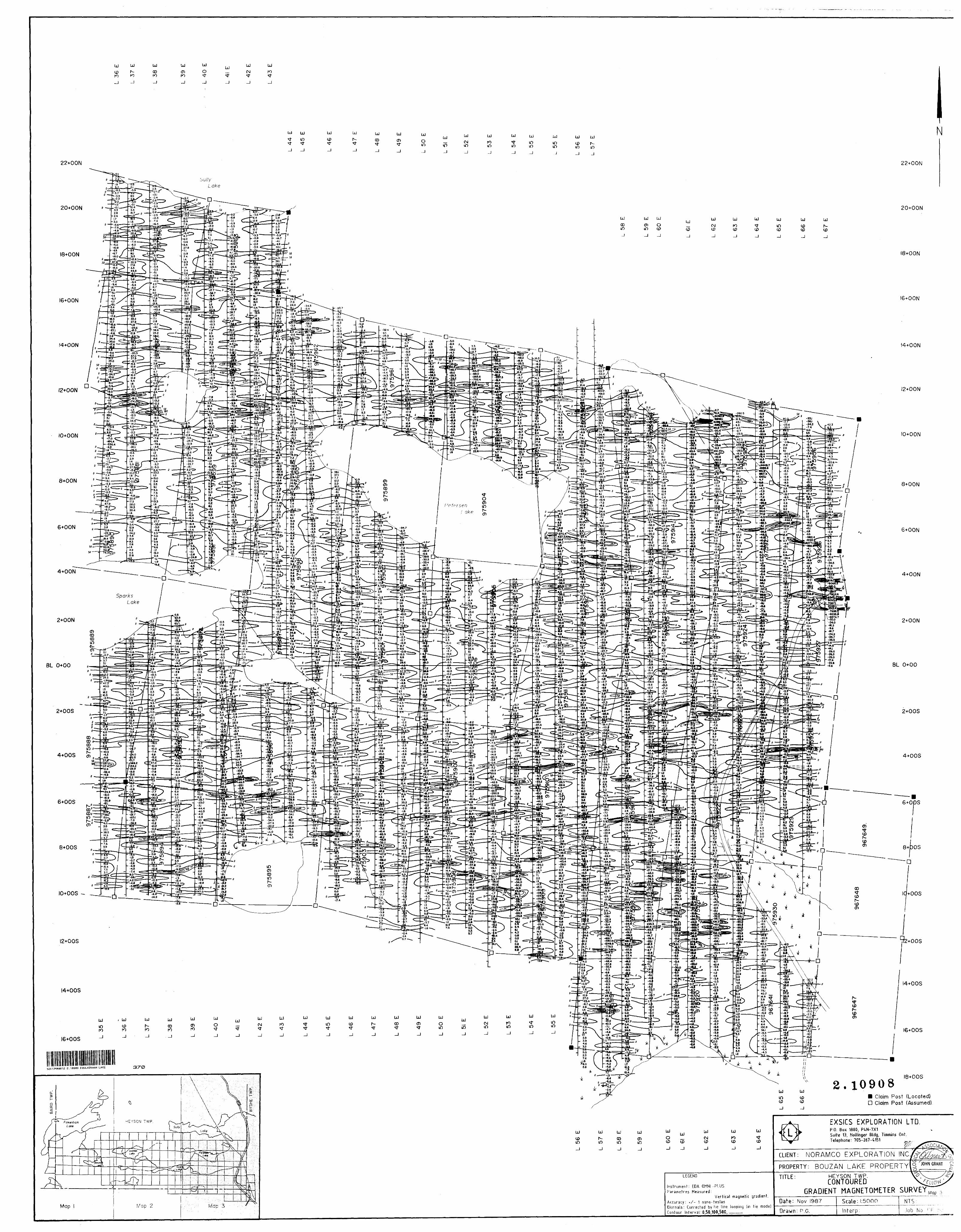
9The gradient data does not need to be corrected. It is the
difference in intensity divided by the distance between two fixed
sensor heads at the midpoint of the sensor head spacing. In our
case, the fixed distance was l meter.
The purpose of the gradient survey was to resolve composite or
complex anomalies into their individual constituents, thus removing
automatically, the regional magnetic gradient to better define the
shallower anomalies.
Also, because the measurements are made almost simultaneously
and very closely spaced compared to the source of magnetic storm
effects and diurnal variations so that such effects on the two
readings are near identical, and therefore, removed on the resultant
K tored dal a.
The gradient value, as stated earlier, is recorded and stored at
the same lime as Ihe total field magnetic data.
The corrected data for the magnetic survey was then plotted on
base maps and contoured at O, 250, 500, 750, 1000, and 1250 gamma
intervals whore ever possible. For ease in plotting, a background of
60,000 gammas has been removed from each reading.
The gradient data was plotted directly onto another set of base
maps and contoured at O, 50, 100, and 500 gamma intervals where ever
poss i bJ e.
Specifications for the EDA Omni IV can be found as Appendix B of
this repor t.

ll BASK MAPS
Due to the size of the grid surveyed, the base map has been
l divided into 3 sections (refer to fig. 4).
The scale for the base maps was 1:5000 or l cm to 50 meters.
Therefore, this report wi11 have the following base maps in the
B back pocke t:
VI.F DIP ANGLE, Maps 1,2,3
l Cutler, Maine 24.0 kHz
VI.F DIP ANGI.F. Maps 1,2,3
B Seattle, Washington 24.8 kHz
M V I.F" CONTOURED FRASER FILTF.R Maps 1,2,3
Cut ler , Ma i ne 24.0 kliz
l TOTAL FIELD MAGNETIC Maps 3,2,3
Con toured
l VERTICAL GRADIENT Maps 1,2,3
l
l
l
l
l
l
l
l
l
TOTAL MAPS: l 5
- 8 -

STATION -25m LINES -100m
EXSICS EXPLORATION LTD.P.O. Box 1180, PIN-7X1Suit* 13. Hollingtr Bid}. Tlaabit (Xif.Tiltphon*: 705-2i7-t1S1
CLIENT: NORAMCO EXPLORATION INC.PROPERTY: BQUZAN LAKE PROPERTYTITLE: HEYSON TWP.
GRID SKETCH Fig. 4

l
l
l
l
l
l
l
l suRVHY RESULTS
The surveys were successful in outJinJng numerous structural
l xories which, at this lime, are of unknown composition. One must keep
in mine! that the VI,F survey, although a good tooJ for mapping buried
geological structure, is also affected by creeks, lakeshore?, swamp
l to outcrop contacts as well as electrically charged or anomalous
a rea s ,
l Therefore, some of the VI,F trends on the survey grid do relate
to creek systems, as well as the lake systems.
B The most predominant structural strike as well as the most
B visibly evident areas are those EM features south of the Jakes, Here
the structure is striking between 100 and 110 degrees. For the
l majority of this section of the grid the structure is basically sim
ple. The southeast and east section of the grid becomes quite complex
B and somewhat spotty which may be, in part, due to the powerJine along
M the highway as well as a more complicated geological environment.
As you progress north of the Jake and creek system, the
l structural trends appear to strike between 80 and 95 degrees and do
not appear to have the strike consistency as the southern section.
That section of the grid, nortJi of Boyden Lake appears to be the
most complicated. Here, both VLF frequencies appear to relate to
parallel structure as well as several cross structures.
This is most evident in the magnetic contours as they appear to
be spotty and irregular in strike direction and length.
- 9

l l
Therefore, generally speaking, the correlation between the two
f VLF responses as woll as the magnetics support the above
g interpretation in so far as the property is underlain by east-west to
nor thwest - soul heas t striking structure. Also evident are several
l areas of unconformity. These areas show several major cross
structures striking north northeast.
There also appears to be several areas of iron formations though
riot always consistent in concentrations and strike lengths.
From the results, we can see that the Cutler, Maine frequency
reacted best to the structure as the transmitting direction pretty
much parallels the strike of the area.
However, the second station was useful in locating some of the
cross structure and in tying in or extending VLF structure already
noted by Cutler, Maine's frequency.
When receiving the VLF data for the entire grid, one is best to
use 1he VLF Fraser Filter data as it is much more consistent in
strike direction and length as well as widths of the zones mapped.
This fraser filter map, coupled with the magnetic map, is the
best suited in selecting areas for further follow-up.
l
*
B
l
m
M
l
l l l l l l

ll The magnetics over the grid generally [support the VLF structures
note d.
l There appears to be two distinct magnetic trends, possibly iron
^ format i ons.
^ The first most evident, strikes into and north of Bouzan Lake
l wliich most probably relates to an iron formation of unknown
composition. The zones thicken and thin along its strike length.
l This feature also has associated lows on its north and south flank.
The second most predominant mag trend strikes across the
m s outheast section of the grid. Again, this structure may relate to
tt an iron formal ion although somewhat more concentrated in spots along
it's strike length.
l There also appears to be two parallel, northeast striking,
structures running off of the main trend. These zones are evident
l striking across lines fc800MH to 6600ME from 800MS to the baseline.
m There also appears to be a third north-northeast striking
magnetic feature running between the west shore of Boyden Lake and
M the smaller lake to the west. This structure is somewhat irregular
and spotty but, appears to be regular in strike pattern.
l
l
l
l
l
l
l
- 10 -

ll CQNCUJ SIONS
Therefore, generally speaking, the correlation between the two
g Vi,F responses as we] l as the magnetics support the above
^ interpretation in so far as the property is underlain by east-west to
* northwest southeast striking structure. Also evident are several
B areas of unconformity. These areas show several major cross
structures striking north-northeast,
l There also appears to be several areas of iron formations though
not always consistent in concentrations and strike lengths.
M Prom the results, we can see that the Cutler, Maine frequency
B reacted best to the structure as the transmitting direction pretty
much parallels the strike of the area.
l However, the second station was useful in locating some of the
cross structure and in tying in or extending VLF structure already
m noted by Cutler, Maine's frequency.
M When receiving the VLF data for the entire grid, one is best to
use the VLF Fraser Filter data as it is much more consistent in
l strike direction and length as well as widths of the zones mapped.
This fraser filter map, coupled with the magnetic map, is the
l best suited in selecting areas for further follow-up.
l
l
l
l
l
l

l l l l
l
l
l
l
RKCQMMKNDATIjpNS
As has been stated, Iho VI,F survey is easily affected by several
sources not all those being sulphide zones.
Therefore, I would recommend some other form of EM follow-up
which would eliminate overburden and geological noise zones.
IP is one definite recommendation as it is highly effective but,
very cos t l y .
l A second suggestion would be to do a vertical loop survey and/or
a horizontal shortback survey over specific targets. This could be
l easily done using the Crone CRM units which are extremely versatile
tm e specially in this area.
The survey is relatively cheap to run, is not affected by hilly
l terrain, or chaining errors, and the collected data can be
interpreted quickly 1o determine strike, dip, depth and a
l conductivity value.
. The shallow overburden in the area makes this survey procedure
attractive and effective.
fl Specifications for the CUM units can be found under Appendix C
of t h i s repor t .
l Finally, drilling and overburden stripping may also explain a
large number of the FM responses.
B Due to the nature of the surveys completed, little other
B interpretation can be done at this time as to giving a much more
definite explanation for some of the VI, F zones.
- 12

l l l l l l l l l l l l l l l l l l l
31 is safe to assumo that a portion of the zones do correlate to
known creek and lake areas which most definitely leaves a large
number of responses open to speculation. These zones should be the
targets considered for future work.
Respectfully submitted,
3.C. Grant, C.B.T., F.G.A.C.
13

l l l l l l l l l l l l l l l l l l l
CERTIFICATE OF QUALIFICATIONS
I, John Char l os Grant do hereby certify:
l . that I arn a geophysicist and reside at Lot 2Martineau Avenue, Kamiskotia Lake, Timmins, Ontario.
2. 1ha1 l am a Fellow of the Geological Association of Canada.
3. that I am a member of the Certified Engineering Technologist Association.
it. t hat l graduated for Cambrian College of Applied Arts and Technology, Sudbury Campus in 1975 with an Honour's diploma in Geology Technology.
.5. that I have practised my profession continuously for 12 years.
6, thai my report on the Bouzan Lake Property, Heyson Township for Noramco Exploration Inc., is based on work carried out under my supervision.
k. I hold no specific or special interest in the described property. l have been retained as a Consulting Geophysicist for "the property".
Dated this 19th day of February, 1988 at Timmins, Ontario.
John C. Grant, C.E.T., F.G.

APPENDIX A

l l l l l l l l l l l l l l l l l
Four Magnetometers in OneSelf Correcting for Diurnal variationsReduced Instrumentation Requirements2507o weight ReductionUser Friendly Keypad operationUniversal Computer InterfaceComprehensive Software Packages

"It""""!"'!*!i! i i i II Illiill 11. l Hill li lil III li li iiii iiiiiiiHiiiiiiiiiili! i
pecificationsIjynamic Range,......................... 18,000 to 110,000 gammas. Roll-over display featurem ' suppresses first significant digit upon exceeding 100,000 l gammas.Tuning Method ......................... Tuning value Is calculated accurately utilizing a specially
developed tuning algorithm Automatic Fine Tuning.................,. ± 15070 relative to ambient field strength of last storedm valueDisplay Resolution....................... 0.1 gamma
(recessing Sensitivity.................... ± 0.02 gamma atistical Error Resolution................ 0.01 gamma bsolute Accuracy ...................... ± 1 gamma at 50,000 gammas at 230 C
± 2 gamma over total temperature range
Itandard Memory Capacity Total Field or Gradient.................. 1,200 data blocks or sets of readings Tie-Line Points ........................ 100 data blocks or sets of readingsBase Station.......................... 5,000 data blocks or sets of readings
I isplay ................................ custom-designed, rliggedized liquid crystal display with an operating temperature range from -40"C to * 55 0 C. The display contains six numeric digits, decimal point, battery status monitor, signal decay rate and signal amplitude
• monitor and function descriptors.•s 232 Serial I/O interface ................ 2400 baud, 8 data bits, 2 stop bits, no parityGradient Tolerance ........... .......... 6,000 gammas per meter (field proven)Test Mode ............................. A. Diagnostic testing (data and programmable memory)
( B. Self Test (hardware) nsor........,........,............,. optimized miniature design. Magnetic cleanliness is
consistent with the specified absolute accuracy. Gradient sensors........................ 0.5 meter sensor separation (standard), normalized to
m gammas/meter, optional 1.0 meter sensor separationl available. Horizontal sensors optional."ensor Cable ........................... Remains flexible In temperature range specified, includes
strain-relief connector
Cycling Time (Base Station Mode) .......... Programmable from 5 seconds up to 60 minutes In 1 second increments
perating Environmental Range........... -400 C to + 55 0 C; D-100% relative humidity; weatherproofPower Supply .......................... Non-magnetic rechargeable sealed lead-acid battery
• cartridge or belt; rechargeable NiCad or Disposable battery cartridge or belt; or 12V DC power source option for base station operation.
Battery Cartridge/Belt Life................ 2,000 to 5,000 readings, for sealed lead acid power supply,
t depending upon ambient temperature and rate of readings
eights and Dimensions instrument Console Only... ........... 2.8 kg, 238 x 150 x 250mm
I NiCad or Alkaline Battery Cartridge ....... 1.2 kg, 235 x 105 x 90mm NiCad or Alkaline Battery Belt............ 1.2 kg, 540 x 100 x 40mmLead-Acid Battery Cartridge ............. 1.8 kg, 235 x 105 x 90mmLead-Acid Battery Belt.................. 1.8 kg, 540 x 100 x 40mm
• sensor .... ........................ 1.2kg, 56mm diameter x 200mm ^instruments me.m Gradient Sensor a Thornciiffe Park Drive
(O.smseparation-standard) ............ 2.1 kg, 56mm diameter x 790mmm Gradient Sensor Telex: oe 25222 EDA TOR B (1.0 m separation-optional) ............ 2.2 kg, 56mm diameter x 1300mmibndard System Complement ............ instrument console; sensor; 3-meter cable, aluminum
sectional sensor staff, power supply, harness assembly, , n .. .nnorattnnc mani lal E D A Instruments Inc.
• operations manual. sisi ward RoadBase Station option.................... standard system plus 30 meter cable wheat Ridge. ColoradoGradiometer option ................... standard system plus 0.5 meter sensor isosi 022 9112
__ ____ _ _____ Printed In Canada

APPENDIX B

iiiiitiiiiiii pi itnmtnti bm tntmtti
Major Benefits of the OMNI PLUS9 Combined VLF/Magnetometer/cradiometer
11111
syscem 9 No Orientation Requiredt Three VLF Magnetic Parameters Recorded* Automatic Calculation of Fraser Filter0 calculation of Ellipticity* Automatic Correction of Primary Field
variations9 Measurement of VLF Electric Field
1
J -^^—-1^^—-

(SpecificationsDynamic Range . .
iTuning Method
\utomatic Fine Tuning
)isplay Resolution Processing Sensitivity Statistical Error Resolution Absolute Accuracy
Standard Memory Capacity Total Field or Gradient Tie-Line Points Base Station .
i Display
lUs 232 Serial I/O interface Gradient Tolerance pest Mode
tensor
jradient Sensors
3nsor Cable
Cycling Time (Base Station Mode)
Operating Environmental Range ower Supply
I l
l
'attery Cartridge/Belt Life
'eights and Dimensionsinstrument console OnlyNiCad or Alkaline Battery Cartridge
I NiCad or Alkaline Battery Belt Lead-Acid Battery Cartridge . Lead-Add Battery Belt. .
—Sensor•Gradient Sensor li (0.5 m separation-standard)
Gradient Sensor
t (1.0 m separation-optional) ndard System complement
l
l
ase Station Option radiometer Option
. 18,000 to 110,000 gammas. Roll-over display feature suppresses first significant digit upon exceeding 100,000 gammas.Tuning value Is calculated accurately utilizing a specially developed tuning algorithm ± I507o relative to ambient field strength of last stored value
. 0.1 gamma
. ± 0.02 gamma 0.01 gamma± 1 gamma at 50,000 gammas at 230C ± 2 gamma over total temperature range
1,200 data blocks or sets of readings100 data blocks or sets of readings5,000 data blocks or sets of readingsCustom-designed, ruggedized liquid crystal display with anoperating temperature range from -40"C to 4 55 0 C. Thedisplay contains six numeric digits, decimal point, batterystatus monitor, signal decay rate and signal amplitudemonitor and function descriptors.2400 baud, 8 data bits, 2 stop bits, no parity6,000 gammas per meter (field proven)A. Diagnostic testing (data and programmable memory)B. self Test (hardware)Optimized miniature design. Magnetic cleanliness Isconsistent with the specified absolute accuracy.0.5 meter sensor separation (standard), normalized togammas/meter. Optional 1.0 meter sensor separationavailable. Horizontal sensors optional.Remains flexible in temperature range specified, Includesstrain-relief connectorProgrammable from 5 seconds up to 60 minutes In 1second increments-400C to 4- 550C; D-100% relative humidity; weatherproofNon-magnetic rechargeable sealed lead-acid batterycartridge or belt; rechargeable NiCad or Disposable batterycartridge or belt; or 12V DC power source option for basestation operation.2,000 to 5,000 readings, for sealed lead acid power supply,depending upon ambient temperature and rate ofreadings
. 2.8 kg, 238 x 150 x 250mm
. .1.2kg, 235 x 105 x 90mm1.2kg, 540 x 100 x 40mm1.8 kg, 235 x 105 x 90mm
. 1.8kg, 540 x 100 x 40mm.1.2 kg, 56mm diameter x 200mm
. 2.1 kg, 56mm diameter x 790mm
. 2.2 kg, 56mm diameter x 1300mm . instrument console; sensor; 3-meter cable, aluminum sectional sensor staff, power supply, harness assembly, operations manual, standard system plus 30 meter cable Standard system plus 0.5 meter sensor
E D A Instruments Inc. a Thorncliffe Park Drive Toronto. Ont.irlo C.1I1.1C1.1IVWH1H1 Telex: OG 23222 EDA TOR C.ible: instruments Toronto (416)4257800
inU.SA.EDAinstriimentslnc. 5151 Ward RO.KI Whe.it Ridge, Colorado USA 80033 1303)0229112
Printed In canada

APPENDIX C

CRONE GEOPHYSICS LIMITEDCEM
— The Shootback EM Method is a simple field method that does not require accurate survey lines. It retains its effectiveness even in rugged terrain areas. The method has been in use since 1957 and has located many mineral deposits. Interpretative model study curves are available.
— The equipment is flexible, it can be used with the Shootback, Vertical Loop or Horizontal Loop, {in phase only), EM Methods with coil separations up to 200 meters, (600').
— The equipment is rugged, reliable and easy to operate.
l l l
Instrurnent Sales, Rental and Repair ServicesContract Survey ServicesConsulting ServicesComputer Plotting and Processing Services
l l l
HEAD OFFICE: 3607 Wolfedale Rd.MISS1SSAUGA, Ontario CANADA L5C 1V8 PHONE: (416) 270-0096 TELEX: 06 961260

l l l l l l l l l l l l l l l l l l l
SPECIFICATIONS*
The complete GEM instrument consists of two identical coils both capable of receiving and transmitting alternating magnetic fields at three fixed frequencies. Battery supply is contained in an aluminum box mounted on a magnesium packframe.
Standard Frequencies: 390, 1830 and 5010 Hz (others available upon request).Field tilt measurement by visual null on field strength meter and audio null through crystal earphones.Inclinometer range of 2000, accuracy ± 0.5 degrees.Receiver gain control: Linear calibrated 10 turn pot.Field strength measurements from meter.Operating range of coils: Up to 200 meters (600').Battery Supply: 3 of 6 volt lantern batteries, Eveready #731 weight per battery;
1.3 Kg (2.8 Ib).audio battery supply; l of 9 volt, Eveready #216
Normal operational lifetime of battery supply—3 to 6 weeks.Coil dimension and weight: Diameter of 56'cm (22"); 3.8 Kg (8.3 Ib).Complete unit shipped in two wooden shipping boxes:Dimensions and weight of one empty box: 31 x 61 x 77 cm (12" x 24" x 30"),
13 Kg (29 Ib).Weight of one shipping box complete with coil, packframe, batteries and earphones: 23 Kg (51 Ib). Shipping weight of complete unit (2 boxes): 46 Kg (102 Ib).
OPTIONAL EXTRAS- Recharge battery supply and audio pack — 3 of 6 volt Gel cells- Clip on battery pack (two of 9 volt Eveready #216) for use of coil as a visual receiver only (Vertical loop surveys).- Plug in battery supply and audio pack for use of coil as audio and visual receiver only (Vertical loop surveys).- Canvas knapsack for carrying coil with above options.Note that the CEM coil is used as a receiver with the Crone VEM — large Vertical Loop system with a range of 800 meters, (2600').
" Specifications subject to change without notice.

Ontario
Ministry ofNorthern Developmentand Mines 52K13NW0012 2.18909 FAULKENHAM LAKE 300
Ministere duDeveloppement du Nord et des Mines
April 11, 1988 Your File: W8802-047 Our File: 2.10909
Mining RecorderMinistry of Northern Development and MinesP.O. Box 324Red Lake, OntarioPOV 2MO
Dear Madam:
RE: Notice of Intent dated March 24, 1988Geophysical (Electromagnetic and Magnetometer) Survey submitted on Mining Claims KRL 904405 et al
___in the Townships of Heyson, Bysche and Baird
The assessment work credits, as listed with the above-mentioned Notice of Intent, have been approved as of the above date.
Please inform the recorded holder of these mining claims and so indicate on your records.
Yours sincerely,
APR ^ ?t '980
L.!W. R. Cowan, ManagerMining Lands SectionMines and Minerals Division
Whitney Block, Room 6610 Queen's Park Toronto, Ontario M7A 1W3
Telephone: (416) 965-4888
Enclosure: Technical Assessment Work Credits
i V E. D
cc: Mr. G.H. FergusonMining b Lands CommissionerToronto, Ontario
Canadian Industrial Minerals Corp. 1275 Main Street West North Bay, Ontario P1B 2W7
Resident Geologist Red Lake, Ontario

Ministry olNorthern Developmentand Mines
Technical Assessment Work Credits
•'Ontario March 24, 1988
File2.10909
Mining Recorder's Report o iWork "0-W8802- 047
Recorded HolderCanadian Industrial Minerals Corp.
Township or AreaHeyson, Bysche and Baird Townships
Type of survey and number of Assessment days credit per claim
GeophysicalElectromagnetic riays
20
Ipd'iced polfri'fltiOn . days
Section 77 (19) See "Mining Claims Assessed" column
Geological Hays
Geochemical days
Man days | | Airborne [~|
Special provision [~] Ground Q
l l Credits have been reduced because of partial coverage of claims.
f~1 Credits have been reduced because of corrections to work dates and figures of applicant.
Mining Claims Assessed
KRL 904405-06 904408 to 411 inclusive 904415 to 419 inclusive 967646 975551 to 557 inclusive 975560 to 576 inclusive 975579 to 600 inclusive 975881 to 883 inclusive 975885 to 888 inclusive 975890-91-93-94 975896 to 898 inclusive 975900 to 903 inclusive 975905 to 929 inclusive 975956 to 972 inclusive
Special credits under section 77 (16) for the following mining claims
10 days Magnetometer 10 days Electromagnetic
KRL 904407-14-20 975559-77-78 975884-89-92
5 days Magnetomter 5 days Electromagnetic
KRL 904413 975558 975895-99 975904-30
No credits have been allowed for the following mining claimsnot sufficiently covered by the survey
KRL 904412967647-48-49
[~| insufficient technical data filed
The Mining Recorder may reduce the above credits if necessary in order that the total number of approved assessment days recorded on each claim does not exceed the maximum allowed as follows: Geophysical - 80; Geologocal - 40; Geochemical - 40; Section 77(19) -60.
628 (65/12)

Northern Development"
Ontario4 ines
LReport of Work(Geophysical, Geologicajr Geochemical and
f iRType of Survey(s)
A ov.tClaim Holde
Pvrr(s) A
..-5-v
Instructions: — Please type or print.— If number of mining claims traversed
exceeds space on this form, attach a l ist. Note: — Only days credits calculated in the
"Expenditures" section may be entered in the "Expend. Days Cr." columns.
— Do not use shaded areas below.Township or Area
C f
rospector's Licehce No.
dress
Survey ComparrV/^
rj
Ms* n S1 - A/orVK&aq for&Arn^ T5 1 P. l ' 2107
Name and Address of Author (of Geo-Technical report)
Date of Survey (from 81 to)2- 0) C.P, 81 l /*5 i d t:7 -^Da/ l Mo. l Yr. l Day | Mo. | Vr. 2i 7 O
Total Miles of line Cut
Credits Requested per Each Claim in Columns at rightSpecial Provisions
For first survey:Enter 40 days. (This includes line cutting)
For each additional survey: using the same grid:
Enter 20 days (for each)
Man Days
Complete r and enter to
Geophysical
- Electromagnetic
- Magnetometer
- Radiometric
- Other
Geological
Geochemical
Note: Special provisions Electromagnetic credits do not applyto Airborne Surveys, Magnetometer
Radiometric
Expenditures (excludes power stripping)
Days per Claim
O
Days perClaim
Type of Work Performed
Performed on Oeim(s)
Calculation of Expenditure Days Credits
Total ExpendituresTotal
Days Credits
4- 15 s
InstructionsTotal Days Credits may be apportioned at the claim holder's choice. Enter number of days credits per claim (elected In columns at right.
Date Recorded Holder or Agent (Signature)
Certification Verifying Report of Work
Mining Claims Traversed (List in numerical sequence)
Total number of mining claims covered by this report of work.
l hereby certify that l have a personal and intimate knowledge of the facts set forth in the Report of Work annexed hereto, having performed the work or witnessed same during and/or after its completion end the annexed report is true.
Name and Postal Address of Person Certifying
l r: '.JP, ^ l irtifiedtoDate Certified Ce y '(Signature)

BOUZAN LAKE CLAIMS CONTINUED
975577975578975579975580975581975582975583975584 975585*975586975587
975589975590975591975592975593975594975595975596975597975598975599975600975881
975882 9 f O t! B o975884975885 9758B&975887975888975889975890975891975892975893975894975895 97589G975897975898975899975900975901975902975903975904975905975906
975907975908975909975910975911975912975913975914975915 9759lG 975917 975918*975919975920975921975922
975925975926975927975928975929975930975956
975957975958975959975960975961975963975963975964975965975966975967975968975969975970975971975972

FIGURE 2 BOUZAN LAKE PROPERTY
3ZOO m*t
CLAIM MAP
After claim maps G.1773, Faulkenham Lake, M.2148,
Byshe Twp., M.2138, Baird Twp. and G.3736, Heyson Twp., Ministry of Natural Resources, Ontario

/I ^'or ~ V ——"~ --— — h T
OF THE\
sg l IPS. l^t l,^ i^s^r
, --x
^."""""
ITHk^i- - - -I^^-r— - -^-1*^^-45M&W . .^h-_-u^^i"-:__--ci:'ji.C^^7^7.i77^!|^^^,!M?,tfajL?
TRIM LINE

l
l
l
l
l
l
l
l
l
l
l
Ministry of Geophysical-Geological-Geochemical Northern Development Technical Data Statementand Mines 1 '' ; -' •••^V t'^*™'J '.'-'' s :-!J W^*rt^**y*f*fo "W™ Vi , ^i:'J}iHH.:.; WW.;.^..
Ontario.;.-...,,.., ' '•'•'•H \^-'.''-- ' -\ :-^f^Y--..' ' ""•••'. File ————
TO BE ATTACHED AS AN APPENDIX TO TECHNICAL REPORTFACTS SHOWN HERE NEED NOT BE REPEATED IN REPORT ' '
TECHNICAL REPORT MUST CONTAIN INTERPRETATION, CONCLUSIONS ETC.
r W-1*.'"*. Si*lil!
Type of Survey(s) MAGNETIC i GRADIENT, 2DIRECTIONAL'VLF-Township or Area HEYSON^ BAIRD, BYSHE TOWNSHIPSClaim Hnldgr(s) NORAMCO EXPLORATION INC. -
1275 MAIN ST. W. NORTH BAY, ; .Survey Company F.XSTPp p.XpT.QRATTON j LIMITED . -
Author nf Report JOHN C. GRANT ______^
Address of Author P.O. BOX 1 880, T IMMINS, OHTARIQCovering Dates of Survey JUNE 10 ,1987-JAN. 3 0 f 198R
(linecutting to office)' .. ; -i- ;
Total Miles of Line Cut______240 ki
SPECIAL PROVISIONS CREDITS REQUESTED
ENTER 40 days (includes line cutting) for first survey.ENTER 20 days for each additional survey using same grid.
per claimGeophysical ?; —Electromagnetic. # f Q
-Radiometric-Other-——.Geological.Geochemical.
(enter dayi per claim) ' '
l AIRBORNE CREDITS (Special proviiion credit* do not a
Magnetometer____Electromagnetic
l
l
,; FF.R, in f 1Qflfl SI^NATUPIf-' 33^'"^'^ . fT-^t^jrt^eportorAgery^
Res. Geol.. .Qualifications.Previous Surveys
File No. Type Date Claim Holder
; MINING CLAIMS TRAVERSED
M J
o.....
l
l 837 (85/12)

l
l
GEOPHYSICAL TECHNICAL DATA
nR(—*MD SURVEYS — If more than one survey, specify data for each type of survey, ;
Number of Stations. 9600MAG/GRADIENT,38, 400
.Number of Readings VT.P, T o?nn./_______
l
Station interval VLF, 25meter iMAG/GRAD, ? ?'t Smeter *''ne sparing tr 100 meter Profile srale l cm to 20 dfigrpjAs _________v ' : ; - ; - ;J V. ^ ;V.'..^..l-'..'.:1'-'.. '..'. -'.' Contour interval O, 250. 500. 750 r 1000, GAMMAR____;____________
CJ
l
Instrument. EDA. OMNT PLUS MAGj VLF COMBINATION— Scale constant ACCURATE TO THE DF.PTMAT,; POINT
method F IXED' BASE STATION
Base Station check-in interval (hours) BASE STATION READINGS TAKEN AT 30 SEC, INTERVALS Base Station location and value , L Q+QQ/ BL/ 60,000 gammas ____—————
l
l
l
l
l
l
l
dh-4
l
Instrument EDA INSTRUMENTS, OMNI PT.UR
O
l
THEORETTC.AT.T.Y INFIITE
Coil configuration COILS AT RTflHT ANfiT.F.p TN THE UNIT Coil separation Accuracy ——— Method:
i ] DEGREEE Fixed transmitter D Shoot back p,, D In line D Parallel line
CUTLER. MAINE. 24.0khz. SEATTLE.WARHTNfiTON. l A^RTrh*(specify V.L.F. it* t ion)
Parameters measured DIP ANGLE OF THE RESULTANT E FTP.T.n
Instrument.Scale constantCorrections made.
Base station value and location,
Instrument ————————— Method D Time Domain Parameters — On time ———
- Off time ——.— Delay time ___— Integration time.
Power.Electrode array— Electrode spacing . Type of electrode
D Frequency Domain ^ Frequency ..'. i -';'- ' -^^ ^ aPge '-^.!,i;- : ,'.:
•'.•^VV-'-:.

l l l SELF POTENTIAL
Instrument_______________________________________ Range.l Survey Method ______________________________——~——.^-——^——
Corrections made.l
l
lEnergy windows (levels)———————-—--—-—-—-—-™.—.-—---™...,..^...^^.-^——
B Height of instrument_________________'.__________Background Count,
RADIOMETRICInstrument.Values measured.
Size of detector. Overburden __
lOTHERS (SEISMIC, DRILL WELL LOGGING ETC.)
g Type of survey———————————————————————
(type, depth — include outcrop map)
Instrument.l Accuracy.
lParameters measured.
Additional information (for understanding results).
l AIRBORNE SURVEYSType of survey(s) ———————————————————————————————
I lnstrument(s) ———————————————————.————————— (specify for each type of survey)
Accuracy.
l(specify for each type of survey)
Aircraft used—————————————————————————————————
Sensor altitude.l Navigation and flight path recovery method.
l Aircraft altitude_______________________________Line Sparing Miles flown over total area_______________________.-.Over claims only.

EXSICS EXPLORATION LTD. ra BM mi. NISU)t O. Holflnpr
CLIENT: NORAMCO EXPLORATION INC.PROPERTY: BOUZAN LAKE PROPERTYTITIE:;:' H^SON^TWP.t^.^^jrv^y^--?,-.-- ,---^CLAIM^^"''"''" ••-^ v'"^^-'---"

Dome Twp.
ah •o "6m
869830^69829
13082 03,255
_,4i^iKRL iKRL
999277 99987* 999303" 999MZ
"" "~ ~"~~
999305 l 999304 k" ___L-'l. 11*7^7 NSRTTwY ^J^v
W?L~ ""/RfciT" —l;
\— - ti 6F THE: m ff r f t ,
TO W N.S.HI P./i*'
, ^—— i-—-f—4-.—^^
-^5 M 4M
52KI3NW0012 2.10909 FAULKENHAM LAKE 200
aSh-
0)x:(Ox 0)
THE TOWNSHIP OF
HEYSONDISTRICT OFKENORA
PATRICIA PORTION
RED LAKEMINING DIVISION
SCALE: 1-INCH 40 CHAINS
LEGEND
PATENTED LANDCROWN LAND SALELEASESLOCATED LANDLICENSE OF OCCUPATIONMINING RIGHTS ONLYSURFACE RIGHTS ONLYROADSIMPROVED ROADSKING'S HIGHWAYSRAILWAYSPOWER LINESMARSH OR MUSKEGMINESCANCELLED PATENTED S.R.O.
^ ^ f -^ •.BCW,-—-^'-i*L\^t'
AREAS W ITHDRAWN FROM D ISPOS1Ti0fi*.t
M.R.O. - MINING RIGHTSONLY ^
S.R.O.-SURF ACE RIGHTSONLV V
M.+ S. - MINING AND SURFACE RIGHTS
Description Order No. D*u Dnpocition Fit*
IRF105) W.5B/75 15/10/75 S.R.O. IT6O54
RED LAKE MINING DIVISION
NOV 18 1987
RED LAKE, ONTARIO
Ontario
Ministry of , Natural
Resources
Ministry of Northern Develop/par^ and Mines ^ :
AUGUST.1986i
G-3736

CORPORATION OF THEFairlie^ TWD.XM 2 l 5'TOWNSHIP
RtD L AftE l-^9
RgdLoke j
©/IZ9S5/ 12876
52K13NW0CM2 2.10969 FAULKENHAM LAKE 210V',
\^s
THF TOWNSHIP
BAIRlDISTRICT OF
'* ri KENORA•PATRICIA
' * . .. .'.'. ^
Vi J^.'S'
\ M INING DIVISION ^^' ' ' - . * - . p
SCALE-.MNCH'^ 40 CHAINS
LEGEND
VPATENTED LAND V CROWN LAND SALE i
LEASESLOCATED LAND ~ LICENSE OF OCCUPATION MINING RIGHTS ONLtV SURFACE RIGHTS ONtY ^ ROADS ,
v IMPROVED ROADS ^ ^
KING'S HIGHWAYS, ''RAILWAYS ^ . ^*. "' v POWER LINES" v
^ MARSH.OR MUSKEGMINES - y^
CANCELLED ^" .ir
,-V x NOJES ,4001 turfoce rights reservotioff the shores of all 4oke,a ond^rivert.———j.———— - ——————————^ , ^
Area* withdrawn frqm staking urxJ*K Section 43 of the Mining AcM * *.o i970 r. ^ \ x
C.4. ^5 Fil* v ,pat* Diipoftitiofi. . ' - * . *- # ~
W.10/76 128430 i 15/1/76 -. S.II O*
fc^ . .. . *'V fr i
RED LAKE.MINING DIVISION
: , NOVlft 1987RED UKE, OMAR10
NO. M 2I38ONTARIO
MINISTRY OF NATURAL RESOURCES-C ,
SURVEYS AND MAPPING BRANCH

CM O O en M. oT
O.
ME
DIC
INE
ST
ON
E LA
KE
G
-182
3tn o0
o
H)
H)
Q
O m
o
m
m T; m
ID 1*1 O'
4k tn
en
o CD
UJ
Oi
.f*
BY
SH
EFO
R
STAT
US
REF
ER T
O
o o to~
Wo
AREA
SO
UTH
OF
BYSH
E a
WIL
LAN
S T
WPS
. 6-
1887
mi
CD-
31 c l ^ -^ OJ
DO Z
SO)
w ^
o 5
5*o
g a
03
^?
3 0 3-
O) 3
Q.
5 K
Z
MO
^
oW
^
N.
y,
ISi
en
Qm
S
m z i- o
m
*^H
o .
m H
.O I H O x
Z
D a* o m
o z o m m
55 0 = S
^
-o*
mO 3)
O ?s o o c o
o s
n p
o 5 l s s " ii
m
: >
.
w
~ f"
*2
w -
S i
5-n
m
±
3
335
T
l T1
3 fi"
2O
Z
O
1 s
TH
Z
-t
in
5 en
co
gr-
3)
r-
w
n
o
m
m
O
S5
zw
z
Q
O O x
D
O
o c S
m Z
H
CO •D
O
CO o 30 O
I1 en
m O Z
C s m Z
H
S
O
3)
oen
I z
O
>
C
c/)
X
m
CI
C i-
~
3)
—
en
s-en O Z O
o o o 3J
O
z o 3) m Z
C
3)
2)
iD x n X -( o •n
O c
oC
O5
Cen
O
O
C
K5
Si
r <
y
m
m
l l
en cr-
-*
31
O
O
-" Z
Ky e
n m
E X
o2!
Z
T) j—
z .
z CI
O e
n m
m enw
m li T)
tf
l3j
m SP
f-
w n
O I
3! i
m I
JU
^
3)
^
0 S
V)
Q
31
O C
H m Z o
SO m C3 r* 50
O
3D m
o
33
CO
CO
0
0
SE
CD o CO o
O1
o a- l
enP
Z
3,2
* -^
.o z C/
l C
3) n
m en
n m X
H
en O
Z
r
-2 3) b o en
DD m
> CA H
X
D •n 33
O en -a
O C/3 -H O Z
m
~n
m 3D m
z
o
m
w

23-OON
22+OON
2OOGN
18+OON
16+QGN
TL 15+QON
14+OON
12+OON
10+OON
8+OON
(N(N-J
BL 7 +OON
\i\
7ix
V
—i
ir
ifiJL.\\ \\
\\
i
*~~~-
-~— — —i
^ jf^\\\\
r92-5.35.2
-1.8•-3. Q'-i;-m-16-26V
9Q "3 ^-29J .-21.0/1 — Z 1• 26 1.2
-4.0•41-1085.9
-^894j.2-138
-16 i ^-1/0 .
H ^ C '- J7-4 7 -'iuS-22
3.6-4.8
8 .'. i 410"St"~^1?| -27.6
\
15 Z-ID . L ^
131 - -10.8 \
9.2 ! -t q ^U l28 l
* -0.3 tt 112 ® \ ,
-30 in .'iiil?*'
•21.7-19.9-15.814.6
-6.6-7.6-6.85.1
-6.6-8.0
17 /J 8^2 0 5 \^ (.5.9
\~^ ^i^.
-1.7^0.0^ 9 c;*-H t \i "^ ' ~~" *- ' "*
1 9 ^L i? 615 '^
^-04 \.-33 \vs^- ^**fl. S
78 6.XN15.3 \0) -
fc/^
135 Sr
-8.0 Kt ^ U A
z
4-4--I-\ a.^
.-B. 3-4 1
-3.0-169-19.416.9
42.040.7-7.6^24.0
-27*
O ro
^CM
5
CD
—J
CM
-l
O) CM
-J
mCsJ
5^
CMro
.j
CM CM
-J
^(vi
H + OOI
BL 7+OON
A+OON
2+OOS
52KI3NW0012 2.10989 FAULKENHAM LAKE S30
VERTICAL ttUADRATURE
\ (percent)
VERTICALINPHASEIpercenN LEGEND
INSTRUMENT: E D.A O MNI-PI.US TRANSMITTER STATION: N AA, Cutler Maine FREQUENCY: 2 4.0KHzPARAMETRES MEASURED: Inphase/Oip Angle (Vo) OPERATOR: M . HICKEY VERTICAL SCALE: 1cm, 2 O Ve
-Jro ..J
oUJ
CM
-J
2,109080 Claim Post (Locatedj G Claim F^ost (Assumed)
P O Box 1880, P4N-7X1 Suifre 13, Hollinger Bldg, Timmins Oo
705-267-41S1
CLIENT: NORAMCO EXPLORATION INC,
^PROPERTY; BOUZAN LAKE PROPERTYTITLE: HEYSON TWP.
VLF - DIP ANGLEMap 1
Date Nov !98
D:-jwn L .Rrum- jj-im. .mn1 -mm. .HIM' irn i ii jih mn MMMI; n i MHP. -. i n i. .i Wu j. -i

\
26+OON
UJ CO-J
u ro
UJ UJin
UJ
CD
UJ UJ
00
UJ
enLU o
LU
-J
UJ CVJ
-l
UJ
ro.j
UJin
UJ
CO
UJ UJ
CO
utO)
LU
oCM
LU LU
OJ CM
-J
LU
roCO-J
LUsfrCM
LU LU
LO CM CM
J -J
CM
.J
LU
CO CM
-J
LU
enCM
-J
LiJ
o ro.J
LU
...j
•j..'
rO
LU
LO
LU
26-* DON
24+OON
22+OON
2OOON
18+OON
16+OON
14+OON
12+OON
IOOON
8+OON
BL 7+OON
6+OON
4+OON
2+OON
0+00
2+OOS
4+OOS
24-*OON
22+OON
20+OON
16+OON
14+OON
12+OON
10+OON
8+OON
6+OON
4+OON
2+OON
BL 0+00
2+OOS
4+OOS
6+OOS
8+OOS
10+OOS
52K13NW0ei2 5 .18909 FAULKENHAM LAKE
VtRtlCALaUADRATURE(perttnt)
VERTICAtINPI1ASE(perctnl)
PRWB.E SCALE: k**2QV.
LEGEND
INSTRUMENT: E .D.A. OMNI-PLUSTRANSMITTER STATION: NAA. C utler MaineFREQUENCY: 2 4.0 KHzPARAMETRES MEASURED Inphase/Dip Angl* (Vo)OPERATOR: M . HICKEYVERTICAL SCALE: 1 cm, 20Vo
LU
CO CM
LU
CD CM
LU
O ro
LU
ro
UJ
CM ro-J
LU
ro ro
LU
ro
LUin ro
2. 10908B Claim Post (Localeel) Q Claim Post (Assumed)
EXSICS EXPLORATIONP.O. Box 1880, PUJ-7X1Suite 13, Hollinger Bldg, Timmins OPTelephone: 705-267-4151
VLF - DIP ANGLE

r-5?—O
Pe/erse/7Lo/ce
BL 0+00 BL 0*00
6+OOS .
52K13N*aB12 2 .189*9 FAULKENHAM LAKE
VERT K.QUADRATURE
\ IpcrccnM
INSTRUMENTED A OMNI-PLUSTRANSMITTER STATION: NAA, Cutler MaineFREQUENCY: 24.0 KHzPARAMETRES MEASURED: Inphase/Dip Angle (V.)OPERATOR: M. MICKEYVERTICAL SCALE: 1cm, 20Vo
16+OOS
0908 18+OOS
B Claim Post (Located) D Claim Post (Assumed).
EXSICS EXPLORATION LTD,P.O. Box 1880, P4N-7X1Suite 13, Hollinger Bldg, Timmins Ont.Telephone: 705-267-^151
CLIENT: NORAMCO EXPLORATION
PROPERTY: B OUZAN LAKE PROPERTYHEYSON TWP.
VLF - DIP ANGLEMop 3
Date: Nov 1987
Drawn: p.G,
Scale: 1:5000
Interp:
NTS:Job No. EE-53

26+OON
UJ
CMut ro
UJSI in
LU
tP
UJr-
UJ
ooUJ
enLU
OLU
LU
N
UJ
roUJ LU
(O
UJ
CD
UJ LU
go-l
LU O)
-J
LU
OCM
-J
UJ
CM
LU
CM CM
UJ
roCM
UJ
CM
LU LU
lO CM
CD CM
-J
Ul Ul
CM00 CM
UJO1)CM
UJ
Oro
u ro
UJ
CMro
LUro ro
UJ
ro
UJin to
UJ
O) ro
26+OON
24+OON
22+OON
20+OON
18+OON
16+OON
14+OON
12+OON
tO+OON
8+OON
J4+OON- , N
22+OON
20+OON
18+OON
16+OON
14+OON
12+OON
10+OON
8+OON
BL 7+OON
6+OON 6+OON
4+OON 4+OON
2+OON2+OON
0+00BL 0+00
2+OOS2+OOS
4+OOS 4+OOS
6+OOS
8+OOS
10+OOS
52KI3N*e015 2 .10989 FAULKENHAM LAKE
^
LEGEND
INSTRUMENT':E.D A OMNI-PLUS TRANSMITTER STATION:UM, C utler Ma.ne FREdUENCY U O KHz VALUES f/i rfffftf; Inphase/Dip Angle i 0/*) OPERATOR: M . MICKEYCONTOUR INTERVAL: 0 ,10,20,30,40,B'J.........
UJ
00 CM
UJ
CD CM
UJ
O ro
UJ
io
UJ
CMro
LU
ro ro
UJ
ro
UJ
in ro
2. 10908B Claim Post (Located) D Claim Post (Assumed)
EXSICS EXPLORATION LTD,P.O. Box 1880, P4N-7X1Suite 13, Hollinger Bldg, Timmins Ont.Telephone: 705-267-4151
CLOT: NORAMCO EXPLORATION INC.(g ^JOHN'GRANT
PROPERTY: BOUZAN LAKE PROPERTYHEYSON TWP. .
CONTOURED FRASER FILTERED VLF
Dare- Nov I987Drawn: P.G.
Scale: 1:5000
inferp
LNTS -....

-J*
18* C
IG+OON
.. 15+OON
14+GON
12+OON
0+OON
8+OON
B L, 7+OON
?2-K)ON
20+OON
I8+OON
16+OON
14+OON
12+OON
iO+OON
8+OON
BL 7+OON
6+OON
4+OON
.j
2+OON
0+00
2+OOSD
52K13NWeel2 2.10989 FAULKENHAM LAKE S70
"-/' ti
LEGEND
INSTRUMENT: E .D.A. OMfll-PLUSTRANSMITTER STATION: NAA, Cutler MaineFREaUENCY: 2 4 O KHzWU/fS FILTERED: I nphase/Dip Angle (Vo)OPERATOR: M . MICKEYCONTOUR INTERVAL: 0 ,10,20,30,40,50,. .
ro-J
OUJ
LJcsj
2. 10908V Claim Post (Located) D Claim Post (Assumed)
EXSICS EXPLORATION LTDP.O. Box 1880, P4N-7X1Suite 13, Hollinger Bldg, Timmins On tTelephone: 705-267-4151
CLIENT: NO^AMCO EXPLORATION
PROPERTY BOUZAN LAKEITLE: HEYSON TWP.
CONTOURED - FRASER-.?6^ t Scale. i:5000
Drawn. L.R. C.G. ; Interp:'M i J
j job No. EE-53

u UJ LiJN
2 + OON
20 + OON
uO) CD
UJ
CD
18+ooN
6 + OON
4 + OON
12 + OON
10 + OON
8+OON
OON
4 + OON
52K13NW98I2 2.18909 FAULKENHAM LAKE
2. 10908Post (1.
laim Post (Assumed,
FXSICS EXPLORATION LTDt-- 1 l; ux 1bHU, ^t.N ''XI
Hollinger Bldg
LLicNT
PROPERT
INSTRUMENT: E DA OMNI-PLUS TRANSMITTER STATION: NAA, Cutler MaineFREdUENCY.'U.Q K Hz
Angle ( 0XoOPERATOR :M. MICKEYCONTOUR INTERVAL: 0 ,10,20.30,^0,50,
CONTOURED FRASER FILTERED VLF
2+OON
BL 0+00
2+OOS
4+OOS

O d*ro w-J -J
500
CVJ
-J
U)OJ
*in
5K)
5CM
-l
D23+OON
22+OON
23+OON
22+OON
20+OON 20+OON
18+OON 18+OON
16+OON
15+OON 14+OON
12+OON
10+OON
8+OON
BL 7+OON
Holden Lake
- BL 7+OON
X K \ 7X* N} .. 15 A . 8 \g - 7V
X . ic l -in \i .o
N
2+OOS
S2K13NW00I2 2.10909 FAULKENHAM LAKE 230
VERTICAL aUAORATURC
V (pert mf l
VERTICALWPHAStIptreenH
PROFILE SCALE: tem*20V.
LEGEND
INSTRUMENT: E D A. OMNI-PLUSTRANSMITTER STATION: Seatle. NLKFREaUENCY:2^8 KHzPARAMETRES MEASURED: Inphase/Oip Angle l*/.)OPERATOR: M . HICKEYVERTICAL SCALE: lcm^ 1 0Vo
ro-j
o-l
u
-J
LU W-J
2,10908M Claim Post (Located) Q Claim Post (Assumed)
EXSICS EXPLORATION LTD.P.O. Box 1880. P4N-7X1Suite 13, Hollinger Bldg, Timmins Ont.Telephone: 70S-267-H51
CLIENT: NORAMCO EXPLORATION INPROPERTY: BOUZAN LAKE PROPER!TITLE: HEYSON TWP.
VLF - DIP ANGLEMap
Date: Nov 1987
Drawn: L.R.Scale: 1:5000interp:
NTS:Job No. EE-53

26+OON
UJ CM
UJro
LU UJ lO
UJ CD
UJ LU 00-J
UJ O)-J
UJ
oUl Ul
CM
UJro
UJ ui in
u UJ 00
Ul CD
UJ
O CM
U
CM
UJCM CM
-J
UJro CM-j
UJ^d-(M
LU UlinOJ CM
-l -l
LJ LU
CMCD CM
LU
enCM
UJ
o ro
LU
rO
LU
CM ro
LU
ro ro
LU
ro
LU
in ro
LUCDro
26+OON
24+OON
Sully Lake
BL 7+00N
•24+00N N
22+OON
20+OON
(8+OON
16+OON
14+OON
12+OON
10+OON
8-*-OON
6+OON
4+OON
2+OON
BL 0+00
2+OOS2+OOS
4+OOS 4+OOS
6+OOS
8+OOS
10+OOS
52K13NW®ai2 2 .169C9 FAULKENHAM LAKE
VERTICALQUADRATUREIpirtmM
VERTICALMPHASE(percent)
PROFU SCALE: km-ZOV.
LEGEND
INSTRUMENT: E .D.A OMNI-PLUSTRANSMITTER STATION: S eatlc. NLKFREaUENCY:2^8 KHzPARAMETRES MEASURED: Inphase/Dip Angle l/.JOPERATOR: M . MICKEYVERTICAL SCALE: 1 cm^ 1 0Vo
UJCOCM
UJ
enCM
UJ
o ro ro
UJ CMro.j
UJro ro
ui
ro
LUin ro
2.10908B Claim Post (Located) D Claim Post (Assumed)
EXSICS EXPLORATION LTDP.O. Box 1880. P4N-7X1Suite 13, Hollinger Bldg, Timmins Ont.Telephone: 705-267-4151
CLIENT: NORAMCO EXPLORATION
PROPERTY: B OUZAN LAKE
TITLE: HEYSON TWP.
VLF - DIP ANGLEMa
Date: Nov I987
Drawn: P .G.Scale: 1 :5000
Interp:
NTS:Job No.EE-5:

~l
UJ UJin
UJ CO^—l
UJr-
UJOD
UJ CT)
UJ
Om
UJ
inUJ CVJin
ur-o in
UJ
m
LUinm
UJinin
UJcoin
u
m
22+OON
20+OONUJ 00in
u(Tt
UJ
OCD.J
UJ
co -J
UJ
CMCO
u
CO
UJ
CO-J
UJinCD
UJCO CO
-J
u NCO-J
R •f;
OON
12 + OON
10+OON
8+OON
6+OON
4+OON
2+OON
Petersenoke
- -12 X- - -14 \ A 2
S2KI3NWM12 2 .109*9 FAULKENHAM LAKE
VERTICALQUADRATUREIperctnM
INSTRUMENT: E.G.A OMNI-PLUSTRANSMITTER STATION:Seatle, NLKFREaUENCY:2V8 KHzPARAMETRES MEASURED: Inphase/Oip Angle (V.)OPERATOR: M HICKEYVERTICAL SCALE: 1cm: 10
BL 0+00
2+OOS
I6+OOS
2.10COCO
-l
B Claim Post (Located) D Claim Post (Assumed)
UJ UJ UJLJ
CM ro sfrCO CO CO CO
-J -J -J -J
A
t!^CLIENT : iN
PROPERTY
TITLE:
Date: MOV
EXSICS EXPLORATION LTD,P.O. Box I860, P4N-7X1 Suite 13, Hollinger Bldg, Timmins OnK Telephone: 705-267-4151 lT X^^T^V
\r\d r\ \fir r\ r v D i n D A T in M i M /^ /cy^^^r^S cNiUKAIVIUU cArLUnAIIUIM IINL'I.^ y^ /f**ijitr " ————————————————————————————— [o^JOHN GRANT ——
- ROUZAN i AKF PROPFRTY\o,e ————— )jLJ v^ vy ^ r~\ 1 ^ 1 — t—\ I NI — i 1 \ W 1 1 — . 1 \ 1 1 \ TO \ S ri
HEYSON TWP. ^^To^^^
VLF - DIP ANGLEMap 3
1987 Scale: !:5000 NTS:Drawn: P. G. Interp: Job No. FE--53

oro -l
(M
-J
00 CM CM
CD CM
in CM CM ro
CMCM CM
Drso
23+OON
22+OON
20+OON
zso
18+OON
6+OON
TL 15+OON
4+OON
12+OON
10 + OON
8+OON
BL 7+OON
N
23+OON
22+OON
20+OON
18+OON
16+OON
14+OON
12+OON
10+OON
8+OON
BL 7+OON
6+OON
4+OON
2+OON
0+00
rao
2+OOSa
K)
-l
UJCM
U CM-J
52K13NWe0l2 2 .10989 FAULKENHAM LAKE 320
2. 10908B Claim Post (Located) Q Claim Post (Assumed)
LEGEND
Instrument: EDA OMNI IVParametres Measured: Earth's total magnetic field,
Accuracy: */- 1 nano-teslasDiurnals: Corrected by base station recorder.Contour Interval: 0,250.500.750,1000.1250........
EXSICS EXPLORATION LTD.P.p. Box 1880, P4N-7X1Suit* 13. Hollinger Btdg, Timmins Ont.Telephone: 705-267-4151
CLIENT: NORAMCO EXPLORATION INC o JOHN GRANT
PROPERTY: BOUZAN LAKE PROPERTYTITLE: HEYSON TWP.
CONTOURED MAGNETOMETER SURVEY Map 1
Date: Nov I987 Scale: !:5000Drawn: L.R. C.G. P.O. j jnterp:
NTS:
Job No. EE-53

CM
UJro
UJ
inUJ
-J
UJ UJ CO
-J
UJ
enUJ
LU LU OJ
-J
UJ
roUJ LU
in -j
LU O)
LU
-J
LU 00
LU
enUJ
oLU
-J
LU
CM CM
-J
LU
roCM
-J
LU
sfCM
LU LU
inCM
CD (M
-J -J
LU
CM
™l
LU
00OvJ
-J
LU
(D CM
-J
LU
O K)
LU
ro
LUCMro-j
UJ
ro ro
26+OON
ro .-J
Luif) ro
uCO ro-J
26+OON
24+OON
22+OON
20+OON
18+OON
16+OON
14+OON
12+OON
iO+OON
8+OON
BL 7+OON
6+OON
4+OON
2+OON
0+00
2+OOS
4+OOS
BoydenLake
U260 f 274
m -\O' 312t-we
289
L348 [J70
J 378^
389 n 372 ID 396^-353^ U '
287 -2631^-
272 CD 279
24+OON N
22+OON
20+OON
18+OON
16+OON
14+OON
12+OON
10+OON
8+OON
6+OON
4+OON
2+OON
BL 0+00
2+OOS
4+OOS
6+OOS
8+OOS
10+005
52K13NW0012 2 .10909 FAULKENHAM LAKE
LU
CO CM
UJ
en CM
LU
Oro
UJLU
CMro .J
LU
ro ro
LU
ro
LUin ro
2. 10908m C laim Post (Located) D Claim Post (Assumed)
LEGEND
instrument: EDA OMNI-PLUS Paramefres Measured: E arth's ratal magnetic field.
Vertical magnetic gradient. Accuracy: */- 1 n ano-testas Diurnals: C orrected b v tie line looping (in tie mode) Contour Interval: 0,2^0,500,750,10&0, .
EXSICS EXPLORATION LTDP.O. Box 18BO,Suite 13, Hollinger B ldg, T immins O nt.Telephone 705-267-Wl
CLIENT: NORAMCO EXPLORATION INC.
PROPERTY: BOUZAN LAKE PROPERTY
TITLE: HEYSON TWP.
CONTOURED MAGNETOMETER SUR
r Map 2Date' Nov I987 ] Scale: !:5000
Drawn : f3 .G. i infprp 'NTS:
Job No F E--53

179 H 187
219-i 175 ^
! ?9200
Petersenl oke
O 766 J -Z75 9—^^ ,2
25?,-212
141-145
122 J-WO
1631
BL 0+00 BL 0+00
52K13NWaai2 2 .18989 FAULKENHAM LAKE
Instrument: tCA Parametres M
Accuracy: *v- :Qiurnals: Corrfci.rect :) s^t st^hon reorder.Contour Interval' 0 .2S0.500.750.100... Drawn: p.G.
16+OOS
B Claim D Claim
18+OOS
Post (Located) Post (Assumed).
EXSICS EXPLORATION LTD.P.O. Box 1880, P 4N-7X1Suite 13, Hollinger Bldg, T immins Ont.Telephone: 7 05-267-U51
CLIENT: NORAMCO EXPLORATION INC
PROPERTY: BOUZAN LAKE PROPERTYHEYSON TWP.
CONTOURED - MAGNETOMETER SURVEY
Date: Nov I987 Scale : i:5000
Interp:
NTS:
Job No, EE

Oro
s00 (S)
CM
inOJ
^(M
roOJ
-j
5CM
•JO+OON
18+OON
16+OON
TL 15 + OON
4+OON
12+OON
10+OON
8+OON
BL 7^-OON
N
iS+OON
16+OON
14+OON
12+OON
10+OON
8+OON
BL 7-vOON
e+ooN
4 + OON
0 + 00
^^J"
.j
LEGEND
instrument: EDA OMNI IV Parametres Measured:
Vertical magnetic gradient. Accuracy: t/- 1 nano-Us-as Oiurnals: Corrected by b ase s tation recorder. Contour Interval: 0.1D.20.3D.60.100.700.300.6D0.100D.........
2. 10908oim s o
LLIK.NT. NORAMCO EXPLORA 1'iON IN':
PRC..PERTY BOU2AN LAKE PF-fOf-'- R l YT l T i "~ LJ C" V ' ' T ' - ! " '- -' i' i '\ l ] ' f ' H r T v-' !- ' ! - -'" '
CONTOURED \ GRADIENT MAGNETOMETER SURVEY M ap
No^ 1987
, L. R, C.G. P.G.

u(M
UJ
roLU
-J
UJ lO-l
UJ UJ
.J
UJ
CO
UJ UJ
oUJ u
CM
UJ
roUJ UJ
inUJ
IDUJ LU
CD
LU
0}
-l
UJ
OUJ UJ
CN (N
LU
roC\J
-J26+OON
LU*frCVJ
UJ UJ
inOJ
Ci)CM
LU
CNJ
UJCD CM
-J -l -I ,J
UJ
enCM
-J
UJ
O ro
ufo..J
LJ
CMU
ro ro.j
LU^ ro
UJ
IDro-j
LU
tD ro
26+QON
24+OON
22+OON
20+OON
18+OON
16+OON
14+OON
12+OON
10+OON
8+OON
BL 7+OON
6+OON
4+OON
2+OON
0+00
2-^OOS
4+OOS
K a
OT^—^
i* *5^?T9
L3KJ^ Bfr^*
:l-l } - B ^
24+OON N
22+OON
ZO^OON
16+OON
14+OON
10+OON
8+OON
6+OON
4+OON
2+OON
BL 0+00
2+OOS
4+OOS
G+OOS
8+OOS
10+003
52K13NW0012 2.10909 FAULKENHAM LAKE
LU
00CM
UJ
(^ CM-J
LU
Oro-i
ufo -J
LU CMro-j
LUroro
LU sfro -J
LU10 ro
2. 10908l Claim Post (Located) D Claim Post (Assumed)
LEGEND
Instrument: FHA OMNi IV Parametrcs Measured:
Vertical magnetic gruc.&nt. Accuracy: t/- 1 nano-leslas Diurnals: Corrected by base station recorder. Contour Interval: 0 ,50.100,500,....,_
EXSICS EXPLORATION uP.O. Box 18BO, PtN-7X1Suite 13, Hollinger Bldg, Timmins Ont.Telephone: 705-267-4151
•r r* ! U,
CLIENT: NORAMCO EXPLORATION INC.
PROPERTY: BOUZAN LAKFI PROPERTYHEYSON TWP
CONTOURED GRADIENT MAGNETOMETER SURVEY
Oate- Nov 1987"T
Drawn: P.G.Scale: 1:5000
interp:
"V
~1~Job No r.E
LJ
COro
LL)
ro
ut00ro
UJo^ ro.j
UJ
O^.j
ui
.j
ui(M
Ulro
LJ Ulin
uiCO
UI LJ
CDUIen
LJom..j
ui ip
LJ
(N tO
UJ
TO LO
UJ
inuiin m
UJ
in inLJCO
uih- m
N
22+OON 22+OON
20+OON
uiODm
UJ
O)in
uiO CO.J
UI
CO
-J
LJ
(M CO
UJ
roCO
LJ
CO
LJ
CO
LJCO CO
-J
LJ
NCO
18+OON
16+OON
14+OON
12+OON
10+OON
8+OON
6+OON
4+OON
2+OON
BL 0+00
2.19989 FAULKENHAM LAKE
2+OOS
4+OOS
OOS
14+OOS
16+OOS
1090818+OOS
B Claim Post (Located) D Claim Post (Assumed)
EDA OMNI -PLUSMeasured:
Vertical magnetic gradient. Accuracy: */- l nano-teslasOiurnals: Corrected by Me line looping [in tie mode) Contour interval: 0 .50,100.500,..,
EXSICS EXPLORATION LTDP.O. Box 1880. P4N-7X1Suite 13, Hollinger Bldg, Timmins Ont.Telephone: 705-267-U51
CLIENT: NORAMCO EXPLORATION
PROPERTY: BOUZAN LAKE PROPERTYlS
TITLE: HEYSON TWP.CONTOURED
GRADIENT MAGNETOMETER SURVEY Mop
Date: Nov I987
Drawn: p.G.
Scale: :50OO
Interp:
NTS;Job No