Uplift and active tectonics of southern Albania inferred from incision of alluvial terraces
12
Uplift and active tectonics of southern Albania inferred from incision of alluvial terraces J. Carcaillet a, ⁎, J.L. Mugnier a,b , R. Koçi c , F. Jouanne b a Laboratoire de Géodynamique des Chaînes Alpines UMR 5025, Grenoble. CNRS, Université Joseph Fourier. Maison des Géosciences, 1381 rue de la Piscine, 38400 Saint Martin d'Hères, France b Laboratoire de Géodynamique des Chaînes Alpines, Chambéry. Université de Savoie, Bâtiment de Chablais, Campus Scientifique, 73376 Le Bourget du Lac Cedex, France c Institute of Geosciences of the Polytechnic University, Tirana, Albania abstract article info Article history: Received 3 March 2008 Available online xxxx Keywords: Albania Albanides Alluvial terraces Incision rate Neotectonics Paleoclimate Surface exposure age In situ produced 10 Be 14 C Uplift In Albania, the Osum and Vjoje rivers cross the active graben system and the active frontal thrust system of the Albanides. The effects of climatic and geodynamic forcing on the development of these two rivers were investigated by the means of field mapping, topographic surveying and absolute exposure-age dating. We established the chronology of terraces abandonment from the compilation of new dating ( 14 C and in situ produced 10 Be) and previously published data. We identified nine fluvial terraces units developed since Marine Isotope Stage 6 up to historic times. From this reconstituted history, we quantified the vertical uplift on a time scale shorter than the glacial climatic cycle. Regional bulging produces an overall increase of the incision rate from the west to the east that reaches a maximum value of 2.8 m/ka in the hinterland. Local pulses of incision are generated by activation of normal faults. The most active faults have a SW–NE trend and a vertical slip rate ranging from 1.8 to 2.2 m/ka. This study outlines the geodynamic control in the development of rivers flowing through the Albanides on the scale of 10 3 –10 5 ka. © 2009 University of Washington. All rights reserved. Introduction In a tectonically active setting characterised by long-term uplift, Pazzaglia et al. (1998) suggest that the river incision rate equals the long-term uplift rate. Locally, rise or attenuation of the incision rate can also be interpreted as the consequence of vertical motion of the active faults. Nonetheless, the river-bed morphology can also strongly depend on climate (Bridgland and Westaway, 2008). In the Medi- terranean basin, river response of glacial–interglacial climatic changes has been the subject of numerous studies (see review in Macklin et al., 2002), which outline the upstream control in continental interiors and downstream control in coastal plains and continental margins (e.g., Blum and Tornqvist, 2000). This dichotomy makes it difficult to establish general rules for terrace correlation, and the “great unifying generalisation” of terrace abandonment linked to glacial–interglacial transitions is probably an oversimplification. Recent modelling of river erosion gives clues for understanding the processes behind this dichotomy: although a fluvial system can take a thousand years to respond to a perturbation (Hancock and Anderson, 2002), the abandonment of fill terraces can be synchronous (Becel, 2004), due to the diffusion characteristics of the transport-limited processes that control the incision of fill terraces when water discharge increases (Whipple and Tucker, 2002). We studied two rivers of the southern Albanides in order to quantify the geodynamic control on the incision of alluvial terraces. We selected the Osum and the Vjoje (Voidomatis in Greece) rivers, which flow from northwestern Greece and southern Albania across the active Dinaro–Hellenic alpine fold belt to the west. The present- day geodynamic deformation results from SW dipping of the foreland domain (the Adriatic Sea). This tilt leads to an overall shortening of the western part of the Albanides (Fig. 1a), whereas normal faults produce ∼ E–W trending extension in the hinterland (Roure et al., 2004). From mapping and dating of terrace abandonment, we recon- structed both spatial and temporal variations of incision rates along the Osum and the Vjoje rivers. These reconstructions allow a quantification of the fluvial evolution at a higher resolution than a glacial–interglacial cycle (on the scale of 10 3 /10 5 years), and therefore an estimation of the effect of geodynamic uplift on river incision. We identified nine preserved terraces units developed since Marine Isotope Stage 6 (MIS 6) up to historic time. Uplift seems to produce two distinct effects: an overall increase of the incision rate from west to east related to regional bulging, and local pulses of increasing incision generated by activation of normal faults. Quaternary Research xxx (2009) xxx–xxx ⁎ Corresponding author. Fax: +33 4 76 51 40 58. E-mail address: [email protected] (J. Carcaillet). YQRES-02968; No. of pages: 12; 4C: 0033-5894/$ – see front matter © 2009 University of Washington. All rights reserved. doi:10.1016/j.yqres.2009.01.002 Contents lists available at ScienceDirect Quaternary Research journal homepage: www.elsevier.com/locate/yqres ARTICLE IN PRESS Please cite this article as: Carcaillet, J., et al., Uplift and active tectonics of southern Albania inferred from incision of alluvial terraces, Quaternary Research (2009), doi:10.1016/j.yqres.2009.01.002
-
Upload
independent -
Category
Documents
-
view
1 -
download
0
Transcript of Uplift and active tectonics of southern Albania inferred from incision of alluvial terraces

Uplift and active tectonics of southern Albania inferred from incision ofalluvial terraces
J. Carcaillet a,⁎, J.L. Mugnier a,b, R. Koçi c, F. Jouanne b
a Laboratoire de Géodynamique des Chaînes Alpines UMR 5025, Grenoble. CNRS, Université Joseph Fourier. Maison des Géosciences, 1381 rue de la Piscine,38400 Saint Martin d'Hères, Franceb Laboratoire de Géodynamique des Chaînes Alpines, Chambéry. Université de Savoie, Bâtiment de Chablais, Campus Scientifique, 73376 Le Bourget du Lac Cedex, Francec Institute of Geosciences of the Polytechnic University, Tirana, Albania
a b s t r a c ta r t i c l e i n f o
Article history:Received 3 March 2008Available online xxxx
Keywords:AlbaniaAlbanidesAlluvial terracesIncision rateNeotectonicsPaleoclimateSurface exposure ageIn situ produced 10Be14CUplift
In Albania, the Osum and Vjoje rivers cross the active graben system and the active frontal thrust system ofthe Albanides. The effects of climatic and geodynamic forcing on the development of these two rivers wereinvestigated by the means of field mapping, topographic surveying and absolute exposure-age dating. Weestablished the chronology of terraces abandonment from the compilation of new dating (14C and in situproduced 10Be) and previously published data. We identified nine fluvial terraces units developed sinceMarine Isotope Stage 6 up to historic times. From this reconstituted history, we quantified the vertical uplifton a time scale shorter than the glacial climatic cycle. Regional bulging produces an overall increase of theincision rate from the west to the east that reaches a maximum value of 2.8 m/ka in the hinterland. Localpulses of incision are generated by activation of normal faults. The most active faults have a SW–NE trend anda vertical slip rate ranging from 1.8 to 2.2 m/ka. This study outlines the geodynamic control in thedevelopment of rivers flowing through the Albanides on the scale of 103–105ka.
© 2009 University of Washington. All rights reserved.
Introduction
In a tectonically active setting characterised by long-term uplift,Pazzaglia et al. (1998) suggest that the river incision rate equals thelong-term uplift rate. Locally, rise or attenuation of the incision ratecan also be interpreted as the consequence of vertical motion of theactive faults. Nonetheless, the river-bed morphology can also stronglydepend on climate (Bridgland and Westaway, 2008). In the Medi-terranean basin, river response of glacial–interglacial climatic changeshas been the subject of numerous studies (see review in Macklin et al.,2002), which outline the upstream control in continental interiors anddownstream control in coastal plains and continental margins (e.g.,Blum and Tornqvist, 2000). This dichotomy makes it difficult toestablish general rules for terrace correlation, and the “great unifyinggeneralisation” of terrace abandonment linked to glacial–interglacialtransitions is probably an oversimplification. Recentmodelling of rivererosion gives clues for understanding the processes behind thisdichotomy: although a fluvial system can take a thousand years torespond to a perturbation (Hancock and Anderson, 2002), theabandonment of fill terraces can be synchronous (Becel, 2004), due
to the diffusion characteristics of the transport-limited processes thatcontrol the incision of fill terraces when water discharge increases(Whipple and Tucker, 2002).
We studied two rivers of the southern Albanides in order toquantify the geodynamic control on the incision of alluvial terraces.We selected the Osum and the Vjoje (Voidomatis in Greece) rivers,which flow from northwestern Greece and southern Albania acrossthe active Dinaro–Hellenic alpine fold belt to the west. The present-day geodynamic deformation results from SW dipping of theforeland domain (the Adriatic Sea). This tilt leads to an overallshortening of the western part of the Albanides (Fig. 1a), whereasnormal faults produce ∼E–W trending extension in the hinterland(Roure et al., 2004).
From mapping and dating of terrace abandonment, we recon-structed both spatial and temporal variations of incision rates alongthe Osum and the Vjoje rivers. These reconstructions allow aquantification of the fluvial evolution at a higher resolution than aglacial–interglacial cycle (on the scale of 103/105 years), and thereforean estimation of the effect of geodynamic uplift on river incision. Weidentified nine preserved terraces units developed since MarineIsotope Stage 6 (MIS 6) up to historic time. Uplift seems to producetwo distinct effects: an overall increase of the incision rate from westto east related to regional bulging, and local pulses of increasingincision generated by activation of normal faults.
Quaternary Research xxx (2009) xxx–xxx
⁎ Corresponding author. Fax: +33 4 76 51 40 58.E-mail address: [email protected] (J. Carcaillet).
YQRES-02968; No. of pages: 12; 4C:
0033-5894/$ – see front matter © 2009 University of Washington. All rights reserved.doi:10.1016/j.yqres.2009.01.002
Contents lists available at ScienceDirect
Quaternary Research
j ourna l homepage: www.e lsev ie r.com/ locate /yqres
ARTICLE IN PRESS
Please cite this article as: Carcaillet, J., et al., Uplift and active tectonics of southern Albania inferred from incision of alluvial terraces,Quaternary Research (2009), doi:10.1016/j.yqres.2009.01.002

2 J. Carcaillet et al. / Quaternary Research xxx (2009) xxx–xxx
ARTICLE IN PRESS
Please cite this article as: Carcaillet, J., et al., Uplift and active tectonics of southern Albania inferred from incision of alluvial terraces,Quaternary Research (2009), doi:10.1016/j.yqres.2009.01.002

Geological setting
The Dinaro–Hellenic Alpine fold belt constitutes a segment of thewide Circum-Mediterranean Peri-Tethyan thrust belt. The Albanianfoothills have been thrust westwards over the Adriatic foredeepduring the Alpine orogeny (Roure et al., 2004). This geodynamicsetting produces contrasting relief with a flexural basin filled withPlio-Quaternary deposits and forming a flat costal plain in the foreland(periadriatic basin), a thin-skinned fold and thrust belt in themidland,and a large basin and range zone in the hinterland, resulting fromsynorogenic Neogene–Quaternary grabens that crosscut the thrustsystem (Figs. 1A and B).
We concentrate our study on a zone located between two majortransverse structures that cut the area: the Vlore–Elbasani–Dibratransfer zone in the central part of Albania (Roure et al., 2004), and theprolongation of the Keffalinia strike-slip transform zone at thenorthwestern border of Greece (Baker et al., 1997).
The area is still tectonically active and produces permanentmicroseismicity and frequent earthquakes reaching intensities of IX.The neotectonics (Fig.1A) are controlled by NE–SW compressive stressin the western part connected to subduction of the Apulian litho-sphere and extensional stress in the internal zones (De Mets et al.,
1990, Robertson and Shallo, 2000; Kilias et al., 2001; Niewland et al.,2001; Goldsworthy et al., 2002; Roure et al., 2004). The majorextension direction varies from E–W close to the Ohrid and Prespalakes to NW–SE at the southern end of the Ersekë basins. On theregional scale the Albanides are governed by long-term uplift (Aliaj,1997).
The Vjoje and the Osum rivers constitute two of the six main riversof Albania. The catchments of the Osum (2.2×10³ km2) and the Vjoje(6.7×10³ km2) are rather small and close to each other; therefore,their climatic settings are comparable. Both rivers drain ophiolites ofthe Mirdita zone, flysch deposits of the Krasta-Cukali zone, carbonaterocks of the Ionian zone and Quaternary sediments of the Periadriaticbasin (Aubouin and Ndojaj, 1964; Roure et al., 2004) (Fig. 1B).
The source of the Osum is located in nearby Vithkuq (District ofKorçë) at an elevation of 1100 m. The river flows over 160 km andconnects with the Devoll River in the flat plain down to the city ofBerat (Fig. 1A). This confluence forms the Seman River, which flowsfor 80 km toward the Adriatic Sea near the Karavatsas lagoon. TheSeman River and its tributaries form the longest drainage system ofAlbania (281 km length). Terraces of the upper Osum are cutterraces formed in Pliocene lake sediments (Aliaj et al., 2000). Theterrace sediments are composed of limestone, flint stone, igneous
Figure 1. (A) Neotectonic map of the Southern Albania and North-western Greece. Areas locatedwithin 200m above Sea level are in light grey. Dark grey stars indicate published data(Lewin et al., 1991; Hamlin et al., 2000; Woodward et al., 2001) and white stars indicate data computed in the present study. Fault types are described in the picture caption and theoverall current tectonic deformation is represented by black arrows. (B) Simplified lithological map of the studied areamodified from Roure et al. (2004) for the southern Albania andfrom Dercourt (1964) for the northern Greece. Synthetic cross sections of Figures 3B (A–B) and 6 (C–D) are represented in B.
Figure 2.Depth profiles of the 10Be concentration along Parasport (A), Quafzezi (B) and Gremçit (C). The depth-production best fits are in solid lines. Inherited 10Be concentrations arethe dashed grey zone. Details of the exposures ages calculations are in Table 1. Dashed lines on photograph localized the sampling profiles.
3J. Carcaillet et al. / Quaternary Research xxx (2009) xxx–xxx
ARTICLE IN PRESS
Please cite this article as: Carcaillet, J., et al., Uplift and active tectonics of southern Albania inferred from incision of alluvial terraces,Quaternary Research (2009), doi:10.1016/j.yqres.2009.01.002

rocks (mainly ultrabasite), radiolarites, and flysch fragments. Most ofthe deposited materials presumably originated from the Krasta-CukaliandMirdita zone formations. From the base to the top, the terraces areformed by a thick layer (N10 m) of pebbles of variable size, and aresupported by fairly homogeneous fine sand matrix (see photograph,Fig. 2). The pebble size decreases upward while the granulometry ofthe matrix increases. The sequence is covered by a ∼0.5-m mixedhorizon composed of sand andorganicmaterials. In themiddle section,the Osum flows in a deep and narrow gorge that is not favourable forthe formation of cut terraces, but rather indicates strong incision. Inthe lower part of the Osum,most of the terraces are fill terraces, exceptfor two of them that have been interpreted as strath terraces (seebelow). The fill terraces are rather uniform and composed of largecarbonate rock and small quartz pebbles, joined by a fine sand matrixwith locally occurring large clay lenses corresponding to paleo-deposition of material during the river flow.
The Vjoje River originates in the Vikos National Park in Greece atan elevation of 1600 m, and it flows northwest for 272 km to theAdriatic Sea to the north of the Nartës lagoon. The Vjoje flows in anatypical catchment in the Mediterranean zone. Its upper part wasglaciated during the last glacial maximum (LGM), as suggested bywell-preserved glacial features (Lewin et al., 1991). In the middlepart, the river flows over flysch deposits until it incises deep andnarrow transverse (E–W) gorges along the frontal active trust, andthen meanders on the costal plain to the Adriatic Sea in the west.Most of the studied terraces are located immediately at the end ofthe gorge, but several terrace levels have been also documented inthe lower section of the river (Prifti, 1981). Terraces are organized asthose of the Osum with a thick layer of heterogeneous sedimentscoming from upward geological formations (Fig. 1B), and a thinorganic deposit on the top. A notable difference between the Vjojeand Osum river terraces is that the fraction of limestone clastsseems to be more important in the Vjoje terraces and that glacialmaterials locally appears (Lewin et al., 1991).
Methods
Terrace thicknesses and elevations above the present-day river bedhave been measured using a laser range distancemeter. Terrace agecontrol was obtained from data previously published by Lewin et al.(1991), Hamlin et al. (2000) and Woodward et al. (2001) as well asfrom in situ produced 10Be and radiocarbon (14C) dating performedspecifically for this study. This implies that the age of the terraceabandonment is contemporaneous to the age of deposition of thehighest terrace layer. Thus we dated organic residues and quartz-richpebbles collected into layers developed during the ultimate floodingevent and considered the value as the age of abandonment of thealluvial terrace.
Cosmonuclide (in situ produced 10Be) age determinations havebeen done on siliceous-rich pebbles collected along depth profilesof three terraces of the upper Osum (Fig. 2, Table 1). Sample siteswere selected to minimize post-depositional processes; we thusselected surfaces where terraces did not show evidence of strongdisturbances (erosion or settling). Material was sampled alongdepth profiles in order to estimate 10Be inherited from priorexposure. The deepest sample was thus collected deep enough toevaluate the geological blank. Beryllium oxide targets wereextracted following the chemical procedure of Brown et al. (1991).Because there are no recordings of the thickness and duration ofsnow cover for the time of interest (i.e., the last ∼50 ka),corrections for recurrent snow cover were impossible. The calcu-lated exposure ages are thus minimum estimates (Lal, 1991). Table 1presents exposure ages of terraces that we considered assimilatedas the minimum age of terrace abandonment. In the following, theinterpretation is based on ages corrected to the geomagnetic effect(intensity-corrected ages), and dates are given in 10Be-ka in order to
allow straightforward correction for future refinements in produc-tion rate histories.
Six 14C ages have been determined from organic residues collectedfrom clay lenses or fine sediment horizons. 14C ages lower than ∼21.514C ka BPwere calibrated using the CALIB programversion 5.0 (Stuiveret al., 2005), based on the IntCal04 data set (Reimer et al., 2004) andreported as intercept ages with two sigma (95%). Calibrated ages (calka BP) are given as a time interval linked to the related probability(Table 2). 14C ages older than ∼21.5 ka were corrected using thepolynomial of Bard et al. (2004) and are labelled in italics and followedby ka BP (Table 2). The previously published conventional 14C ages(Lewin et al., 1991 and Woodward et al., 2001) were calibratedfollowing the same procedure.
Results
Terrace dating
The upper terrace is located on the left bank of the Osum at theParasport locality. The surface is placed at 70 m above the present dayriverbed and shows aweak dip of ∼10° to the N–NW that could be theconsequence of the tectonic tilt induced by the West Ersekë normalfault (Fig. 1A). The samples come from an escarpment formed by theincision of a tributary of the Osum.We assume a negligible lateral 10Beproduction because the escarpment is still active. 10Be concentrationsmeasured in three surface samples (Fig. 2A, Par-0, -BIS -TER) range from2.37±0.22×10⁵ to 2.79±0.25×10⁵ atoms per gram of quartz (at/g.).Samples collected at depth allow drawing of an exponential curveassimilated to the evolution of production with depth. Because thelower sample (Par-390) has been collected at 390 cmdepth,weconsiderthe measured concentration (i.e. 0.49±0.13×10⁵ at/g) as the inherited10Be concentration (i.e., geological blank). We thus corrected thesurface concentrations to this inherited concentration. The best fitbetween the theoretical depth production and our results correspondto a weighted averaged minimum age of 18.75±1.41 10Be-ka andzero erosion.
Two other terraces have been sampled at ∼ 2 km to the south fromParasport at ∼29 (Quafzezi) and ∼50 m (Gremçit) above the present-day river bed.
Three surface and subsurface samples (Fig. 2B, Quaf-0, -BIS and -10respectively) have been collected along the northern edge of Quafzezi.10Be concentrations range from3.95±0.27×10⁵ to 4.93±0.74×10⁵ at/g.Because the terraces are actually used for agriculture, we assimilatethe upper 20 cm as the plowing depth and consider the sub-surfacesample as equivalent to the surface samples. Quartz-rich materialsbeing scarce, we only determined one 10Be concentration at depth(Quaf-175, 3.01±0.31×10⁵ at/g). At the considered depth and for adensity of 2 g/cm3, post-depositional in situ production remainssignificant and represents ∼11% of the surface production. A mean-ingful proportion of the measured concentration of Quaf-175 can thusbe regarded as inherited from prior exposure. Therefore, weconsidered a post-depositional production of 0.47×10⁵ at/g corre-sponding 11% of the weighted averaged concentration of surfaceconcentrations and an inherited concentration of 2.54×10⁵ at/g. Therecognition of this inheritance allows calculating a minimum age ofterrace abandonment at 19.80±1.56 10Be-ka.
Two quartz pebbles were sampled on the surface of Gremçit(Fig. 2C, Grem-0,-BIS). 10Be concentrations of surface samples are6.34±0.55×10⁵ at/g and 6.12±0.55×10⁵ at/g respectively and depthsamples are consistent with a theoretical depth production con-sidering zero erosion. Taking into account the measured concentra-tion of the deepest sample (Grem-410, 0.69±0.13×10⁵ at/g) as thegeological blank, the data set yields a minimum age of 52.59±3.2010Be-ka.
In addition, we sampled five organic residues embedded interraces of the downstream section of the Osum (District of Berat)
4 J. Carcaillet et al. / Quaternary Research xxx (2009) xxx–xxx
ARTICLE IN PRESS
Please cite this article as: Carcaillet, J., et al., Uplift and active tectonics of southern Albania inferred from incision of alluvial terraces,Quaternary Research (2009), doi:10.1016/j.yqres.2009.01.002

Table 1In situ produced 10Be dating and sampled terraces locations
Topographic setting Geomagnetic correction (%) (c)
Samples Materials Latitude (North) Longitude (East) Elevation (m) Elevation/riverbed (m)
Depth (cm) Surface P0 (a) Geomorphicfactor (b)
Value (%) Uncertainty (%) Correctedproductionrate (d)
10Be concentration(105 at/g) (e)
Correctedage (ka)
Parasport 40°52.36 20°72.00 970 70Par-0 Quartz 0 10.72 0.998 4.5 8.3 11.18 2.37±0.22 16.86±2.31Par-0-BIS Quartz 0 2.79±0.25 20.66±2.76Par-0-TER Quartz 0 2.66±0.46 19.50±3.90Par-40 Quartz 40 1.70±0.20 18.16±2.76
Weighted average 18.75±1.41Par-390 Radiolarite 390 Geological
blank0.49±0.13
Quafzezi 40°52.97 20°69.00 850 29Quaf-0 Quartz 0 9.74 0.922 2.7 7.9 9.22 3.95±0.27 15.30±1.84Quaf-0-BIS Quartz 0 4.93±0.74 26.04±4.69Quaf-10 Quartz 10 4.29±0.34 21.75±2.77
Weighted average 19.80±1.56Quaf-175 Flint 175 Geological
blank andpost-depositionalproduction ⁎
3.01±0.31
Gremçit 40°55.67 20°73.83 890 50Grem-0 Quartz 0 10.06 0.922 10.5 8.6 10.25 6.34±0.55 55.81±5.48Grem-0-BIS Quartz 0 6.12±0.55 53.63±5.43Grem-86 Flint 86 2.24±0.25 46.30±5.56
Weighted average 52.59±3.20Grem-410 Sandstone 410 Geological
blank0.69±0.13
(a) Surface production rates computed from amodern 10Be production rate of 5.1±0.3 at∙g−1 SiO2.yr−1 (Stone, 2000) and depth-production includes contribution of neutrons, slow and fast muons (Braucher et al., 2003) and a density of 2 g/cm3
(Brocard et al., 2003). (b) The geomorphic scaling factor has been calculated following themethod of Dunne et al. (1999). (c) Geomagnetic correction and associated uncertainties are calculated from Pigati and Lifton (2004). (d) Time integratedgeomagnetic intensity production rates (at.g−1 SiO2∙yr−1). (e) 10Be concentrations were calibrated against NIST Standard Reference Material 4325 using its certified 10Be/9Be ratio of 3.06×10⁻¹¹. The 10Be concentrations were processed frommeasurements calibrated against non-NIST standards, we normalized the measured 10Be concentrations using a factor of 1.142±0.039 (Middleton et al., 1993). Analytical uncertainties are based on counting statistics, a conservative estimate of3% instrumental variability and a 50% uncertainty in the chemical blank correction. (f) Uncertainties on minimum exposure ages are calculated by propagating the analytical uncertainties on the measured 10Be concentrations, a 6% uncertaintyon surface production rate (Stone, 2000) and the uncertainties associated with the geomagnetic correction (Pigati and Lifton, 2004). ⁎ For Quafzezi, we estimated the geological blank (i.e., inherited 10Be concentration) as ∼89% of the 10Beconcentration measured for Quaf-175 (see text for detail).
5J.Carcaillet
etal./
Quaternary
Researchxxx
(2009)xxx–xxx
ARTICLE
INPRESS
Pleasecite
thisarticle
as:Carcaillet,
J.,et
al.,Uplift
andactive
tectonicsof
southernAlbania
inferredfrom
incisionof
alluvialterraces,
Quaternary
Research(2009),doi:10.1016/j.yqres.2009.01.002

Table 2Ages determined from various techniques and sampled terraces locations
Samples Topographic setting Elevation (m) Ages (ka) Reference
Sample Materials Elevationabovethe river (m)
Latitude (N) Longitude (E) Elevation (m) Top terrace abovethe river (m)
Base terrace abovethe river (m)
Top gravel abovethe river (m)
Methods Lab code 14C Ages (ka BP) Calibratedinterval Cal kaBP (probability)
Ages (ka) (a)
OSUMA17 Organic residue 17 40°45.08 20°28.78 349 19 12.5 17.5 14C Poz-10576 9.99±0.05 11.26–11.65 (0,96) 11.45±0.19 This studyA16 Organic residue 25 40°63.94 20°05.53 133 29 19 28 14C Poz-10575 29.90±1.30 – 34.47±1.50 This studyA83 Organic residue 14.8 40°68.83 20°02.31 98 18.5 14.3 17.2 14C Poz-13850 37.00±0.70 – 42.15±0.80 This studyA18 Organic residue 56 40°55.97 20°14.00 282 62 55 60 14C Poz-10578 45.30±1.60 – 50.70±1.79 This studyA14 Organic residue 33.8 40°64.03 20.05.75 139 35 27 33.5 14C Poz-10574 49.00±2.50 – 54.40±2.78 This study
VJOJEA28 Organic residue – 40°33.69 19°99.78 150 – – – 14C Poz-8824 0.71±0.03 0.64–0.69 (0,88) 0.67±0.03 This studyKipi Silt – 39°86⁎ 20°78⁎ 830 56 33 – TL VOI26 – – N150 Lewin
et al., 1991Klitonia Charcoal – 36°96⁎ 20°69⁎ 430 4.5 4.5 – 14C OxA-192 0.80±0.10 0.63–0.93 (0.95) 0.67±0.15 Lewin
et al., 1991Klitonia Charcoal – 36°96⁎ 20°69⁎ 430 4.5 4.5 – 14C OxA-191 1.00±0.05 0.79±0.99 (0.97) 0.89±0.10 Lewin
et al., 1991Vikos Sediment – 39°95⁎ 20°69⁎ 600 9.7 8.3 – TL VOI24 – – 19.60±3.00 Lewin
et al., 1991Klitonia old Deer tooth – 39°97⁎ 20°66⁎ 400 12.4 – – ESR – – – 24.30±2.60 Lewin
et al., 1991Klitonia old Deer tooth – 39°97⁎ 20°66⁎ 400 12.4 – – ESR – – – 25.00±0.50 Lewin
et al., 1991Klitonia old Deer tooth – 39°97⁎ 20°66⁎ 400 12.4 – – ESR – – – 26.00±1.90 Lewin
et al., 1991Klitonia old Sediment – 39°97⁎ 20°66⁎ 400 12.4 – – TL VOI23 – – 28.00±7.10 Lewin
et al., 1991Boila Charcoal ∼10.8 39°97⁎ 20°66⁎ 410 10.8 10 – 14C OxA-5246 13.81±0.13 16.00–16.93 (1.00) 16.46±0.47 Woodward
et al., 2001Boila Charcoal ∼10.3 39°97⁎ 20°66⁎ 410 10.8 10 – 14C Beta-
10916213.96±0.26 15.87–17.54 (1.00) 16.71±0.83 Woodward
et al., 2001Boila Charcoal ∼10.5 39°97⁎ 20°66⁎ 410 10.8 10 – 14C Beta-
10918714.31±0.20 16.50–17.91 (1.00) 17.21±0.70 Woodward
et al., 2001Boila Calcite cement ∼8.2 39°97⁎ 20°66⁎ 410 10.8 – – U series – – – 24.00± 2.00 Hamlin
et al., 2000Boila Calcite cement ∼8.2 39°97⁎ 20°66⁎ 410 10.8 – – U series – – – 25.00± 2.00 Hamlin
et al., 2000
The sample location followed by ⁎ are estimated. (a) 14C ages higher than the InCal04 calibration (Reimer et al., 2004) interval have been corrected following the Bard polynomial (Bard et al., 2004) and are in italics (ka BP). 14C ages previouslypublished by Lewin et al. (1991) and Woodward et al., (2001) have been calibrated using IntCal04.
6J.Carcaillet
etal./
Quaternary
Researchxxx
(2009)xxx–xxx
ARTICLE
INPRESS
Pleasecite
thisarticle
as:Carcaillet,
J.,et
al.,Uplift
andactive
tectonicsof
southernAlbania
inferredfrom
incisionof
alluvialterraces,
Quaternary
Research(2009),doi:10.1016/j.yqres.2009.01.002

and one from the Vjoje River (Memeliaj, District of Tepelena). Sampleswere collected from clay lenses or fine-grained sediment horizons thatare located close to the top of the terrace, and above the top of theconglomeratic material (sample elevations and positions are sum-marized in Table 2). The collected organic residues were thusdeposited during the ultimate phase of river alluviation. We deducethat the 14C ages deduced from the organicmaterials are equal or closeto ages of the terrace abandonment. Likewise, the ages previouslypublished by Lewin et al. (1991) and Woodward et al. (2001) arecompiled in Table 2.
Discussion
Climatic control of terrace formation and correlation of terraces levels
In a mountainous area, terrace formation has been assigned tochanges in sediment supply and/or water discharge produced byclimatic fluctuations (Hancock and Anderson, 2002) while theinfluence of sea level change is considered to be small. Fill andstrath terraces are developed when sediment supply is, respectively,larger than or balanced with the transport capacity, whereas incisionoccurs when sediment supply is smaller than the transport capacity.Fluvial terraces of the Albanides follow these characteristics becausethey were developed at a distance of more than 80 km from theAdriatic Sea, and therefore the climatic control is much moreimportant than eustatic variations. Because the climate of theMediterranean domain strongly depends on the one of the Atlanticdomain (Asioli et al., 2001; Rahmstorf, 2002), precipitation regimesin the Albanides depend on temperature variations induced bychanges in Atlantic circulation. Therefore, episodes of alluviation canbe related to periods of cooling, while incision is more intensiveduring warm and humid periods.
We correlate ages of terrace abandonment deduced from ourdating and previously published data (Lewin et al., 1991; Hamlin et al.,2000, Woodward et al., 2001) with climate periods. The reconstructedtiming coupled with our field investigation gives a detailed picture ofriver development in response to climate oscillations. This allows us tocorrelate terrace levels on both the individual river-basin scale andbetween the two river drainage systems. We identified nine terraceunits formed since the late Pleistocene. These terraces units arelabelled according to their topographic position from the highest (T1)to the present-day riverbed (Figs. 3A–C).
In the lower Osum, terraces of T1 and T2 units are highly elevatedin the topography and are strongly degraded (Fig. 3B). The loss of theinitial flat surface produced by erosive processes and evidence ofanthropogenic activity prevented us from collecting samples for insitu produced 10Be age determinations. Nevertheless, in the upperVjoje basin one thick (N23 m) terrace relict was described close to thelocality of Kipi. Thermoluminescence (TL) dating of silts gave an age ofterrace abandonment older than 150 ka (Lewin et al., 1991). Theposition of T1 and T2 above the Kipi unit suggests that they were mostlikely developed during the pre-Würm glaciation (Prifti, 1981, 1984).The Kipi units, previously described in the Vjoje, could thuscorrespond to the lower of these two distinct episodes of alluviation.During MIS 6, two strong sea-surface cooling episodes were identifiedin the Mediterranean from foraminifera records (Kallel et al., 2000)and likewise connected to overall cooling of the North Atlantic(Moreno, 2000). Several terrace formations have been identified inSpanish and Libyan rivers (Fuller et al., 1998; Rowan et al., 2000)between ∼138–157 and ∼179–183 ka. We thus presume that T1 andT2 correspond to these alluviation episodes.
In the Osum drainage, many other terraces were mapped at anintermediate topographical level and were dated between ∼54 kaand ∼42 ka (Table 2). In the upper basin, Gremçit (52.6±3.2 10Be-ka)can be related to terraces of the lower basin dated at 50.7±1.8 cal kaBP (A18) and 54.4±2.8 cal ka BP (A14). The close agreement of the
ages suggests the existence of a wide and continuous T3 unit fromthe upper to the lower basin. A younger strath terrace (T4), dated at42.2±0.8 cal ka BP (A83), has been found only in the lower Osum,close to Vodica. The T3 and T4 units were deposited during the firsthalf of the MIS 3 and correspond to alluviation phases previouslydescribed in the northern Mediterranean around ∼50 ka and ∼ 40 ka(Macklin et al., 2002).
In the lower Osum, two superimposed terrace units were mappedclose to the locality of Vertop and Fushe. The lower one (T5), dated at34.5±1.5 cal ka BP (A16), corresponds to the ultimate alluviation phaseof MIS 3 and was probably produced during Heinrich event 3. After abreak of sedimentation accompanied by lateral erosion and develop-ment of strath surfaces, a new filling (T6) took place above T5.However, the absence of organic residues or quartz-rich pebblesprohibits direct dating. This upper unit could correspond to the Aristiunit described in the upper Vjoje (Lewin et al., 1991).
The Aristi unit reachesmore than 30 km in length and constitutes amajor alluvial unit deposited by an aggrading and a low-sinuositystream. The age of the Aristi unit was estimated from ESR (ElectronSpin Resonance) determination of a red deer tooth at 24.3±2.6, 25.0±0.5 and 26.0±1.9 ka whereas TL dating of sediment gives an age of28.0±7.1 ka. Moreover, the Aristi unit forms the base of the Boilarockshelter (Woodward et al., 2001). Uranium-series determination incalcite cement located two meters beneath the top surface gave agesof 24.0±2.0 ka and 25.0±2.0 ka (Hamlin et al., 2000). These ages agreewith those (∼25 ka) deduced from four samples used for 14C dating oforganic residues collected in the most extended terraces of the Devollriver, which is located a few kilometres to the north of the Osum(Mugnier et al., 2006). This extended alluviation thus takes place atleast along 3 rivers of the southern part of the Albanides and can beconnected to Heinrich event 2.
Along the lower Osum, unit T7 corresponds to strath terraces andindicates a break in the incision of T6. In the upper Osum, T7 has beenidentified and dated at 18.8±1.4 and 19.8±1.6 10Be-ka (Parasport andQuafzezi terraces). Along the Vjoje, a unit called the Vikos unit (Lewinet al.,1991) also indicates a break of sedimentation and is characterisedby a thin sediment cover (few meters) deposited above an erosionalsurface. These sediments were dated at 19.6±3.0 ka (TL). This timeinterval is conformable with 14C ages of slackwater sedimentsdeposited onto the erosional surface observed above the Aristi unitin the Boila Rockshelter (16.5±0.5, 16.7±0.8 and 17.2±0.7 cal ka BP;Woodward et al., 2001). This unit correlates with the end of the LGM,which seems to extend up to ∼15.6 14C ka BP (∼16.9 cal ka BP) in thesouthern part of the Balkan (Lawson et al., 2004). A second post-LGMunit (T8) has only been recognized and dated in the lower Osum at11.45±0.19 cal ka BP (A17). Post-LGM units (T7 and T8) correspond toperiods of terrace development, which have been recorded in manyMediterranean rivers between the intervals 16±3 to 19±1 (corre-sponding to T7) and 12.5±1.5 to 13±2 ka (corresponding to T8)(Macklin et al., 2002).
Placed at an elevation lower than 5 m above the present-day riverbed, T9 constitutes the ultimate abandonment unit. Along theAlbanian section of the Vjoje, abundant evidence for T9 has beenrecognized by Prifty (1981), and we dated one of them (A28) at0.67±0.03 cal ka BP. In the Greek part, T9 (call Klithi unit) was datedat 0.67±1.50 and 0.89±0.10 cal ka BP (Lewin et al., 1991). Thesedimentary facies of T9 shows close similarities with widespread“haugh loams” of Europe and “post-settlement alluvium” of NorthAmerica (Lewin et al., 1991 and references therein). This historicalluviation would thus be the consequence of the deforestation andthe agriculture development, leading to high erodability of upstreamterrains (Knox, 1977).
The proposed chronology and the identification of overallaggradations phases (T1, T2, T3, T5, T6, T8) or lateral incision phases(T4 and T7) are compatible with climatic changes of the northern partof the Mediterranean. The only exception is the last alluviation
7J. Carcaillet et al. / Quaternary Research xxx (2009) xxx–xxx
ARTICLE IN PRESS
Please cite this article as: Carcaillet, J., et al., Uplift and active tectonics of southern Albania inferred from incision of alluvial terraces,Quaternary Research (2009), doi:10.1016/j.yqres.2009.01.002

episode (T9), which would be the consequence of the anthropogenicactivity leading to the rise of erosion of the drainage system.
Temporal variation of the incision rate along the Osum
The contribution of our new dating combined with previouslyavailable data give a detailed picture of the incision–sedimentationpattern in rivers of southern Albania. On the bases of terrace dating,we correlate terraces that developed both along different sections ofthe same river catchment and along the two studied rivers. T3, whichhas been mapped in the lower and the upper part of the Osum,indicate a difference in age of abandonment of ∼3.7 ka; T7, which was
mapped in the Osum and the Vjoje indicates a lag of less than ∼3.3 ka(Table 2). On the river scale, numerical modelling predicts thatincision of fill terraces is synchronous when stable climate periods arelonger than the transient response of the river profile evolution (Becel,2004), but the incision becomes diachronous when the climateperiods are shorter. T7 was developed during a short period ofalluviation (Macklin et al., 2002) and because it shows a thin strathterrace facies, we suspect that this unit is the most diachronous.Therefore we assume the beginning of incision is nearly synchronous(less than 3.3 ka) on the scale of the river catchments, and we use ourcorrelation scheme to estimate the incision rate for terrace remnantsfrom their elevation above the river (Figs. 4 and 5).
Figure 3. (A) Panoramic view of the lower Osum showing the location of terraces units. (B) Cross section through the lower Osum, Upstream of Berat (Fig. 1). The figure illustrates theincised terraces; the numbers refer to the nomenclature proposed in the present study. Ages of abandonment of T1 and T2 correspond to the end of the main periods of alluviation ofMIS 6 (Macklin et al. 2002). From T3 to T9 ages are weighted averages. Note that T8 was not represented because it has not been mapped along this river section. (C) Geomorphologicmap of the lower Osum, upstream of Berat. (D) Incision (m) versus ages of terrace units (ka). Breaks on slope are materialized by the vertical dashed grey lines.
8 J. Carcaillet et al. / Quaternary Research xxx (2009) xxx–xxx
ARTICLE IN PRESS
Please cite this article as: Carcaillet, J., et al., Uplift and active tectonics of southern Albania inferred from incision of alluvial terraces,Quaternary Research (2009), doi:10.1016/j.yqres.2009.01.002
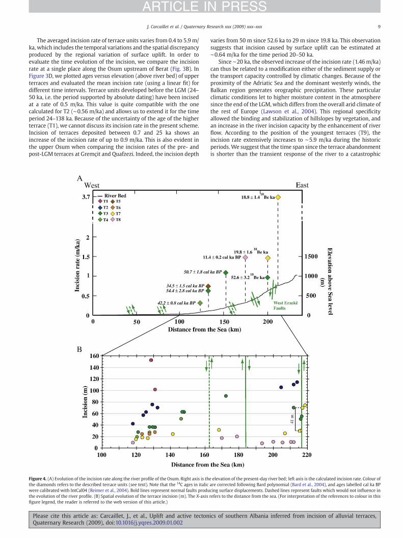
The averaged incision rate of terrace units varies from 0.4 to 5.9 m/ka, which includes the temporal variations and the spatial discrepancyproduced by the regional variation of surface uplift. In order toevaluate the time evolution of the incision, we compare the incisionrate at a single place along the Osum upstream of Berat (Fig. 3B). InFigure 3D, we plotted ages versus elevation (above river bed) of upperterraces and evaluated the mean incision rate (using a linear fit) fordifferent time intervals. Terrace units developed before the LGM (24–50 ka, i.e. the period supported by absolute dating) have been incisedat a rate of 0.5 m/ka. This value is quite compatible with the onecalculated for T2 (∼0.56 m/ka) and allows us to extend it for the timeperiod 24–138 ka. Because of the uncertainty of the age of the higherterrace (T1), we cannot discuss its incision rate in the present scheme.Incision of terraces deposited between 0.7 and 25 ka shows anincrease of the incision rate of up to 0.9 m/ka. This is also evident inthe upper Osum when comparing the incision rates of the pre- andpost-LGM terraces at Gremçit and Quafzezi. Indeed, the incision depth
varies from 50 m since 52.6 ka to 29 m since 19.8 ka. This observationsuggests that incision caused by surface uplift can be estimated at∼0.64 m/ka for the time period 20–50 ka.
Since ∼20 ka, the observed increase of the incision rate (1.46m/ka)can thus be related to a modification either of the sediment supply orthe transport capacity controlled by climatic changes. Because of theproximity of the Adriatic Sea and the dominant westerly winds, theBalkan region generates orographic precipitation. These particularclimatic conditions let to higher moisture content in the atmospheresince the end of the LGM, which differs from the overall arid climate ofthe rest of Europe (Lawson et al., 2004). This regional specificityallowed the binding and stabilization of hillslopes by vegetation, andan increase in the river incision capacity by the enhancement of riverflow. According to the position of the youngest terraces (T9), theincision rate extensively increases to ∼5.9 m/ka during the historicperiods.We suggest that the time span since the terrace abandonmentis shorter than the transient response of the river to a catastrophic
Figure 4. (A) Evolution of the incision rate along the river profile of the Osum. Right axis is the elevation of the present-day river bed; left axis is the calculated incision rate. Colour ofthe diamonds refers to the described terrace units (see text). Note that the 14C ages in italic are corrected following Bard polynomial (Bard et al., 2004), and ages labelled cal ka BPwere calibrated with IntCal04 (Reimer et al., 2004). Bold lines represent normal faults producing surface displacements. Dashed lines represent faults which would not influence inthe evolution of the river profile. (B) Spatial evolution of the terrace incision (m). The X-axis refers to the distance from the sea. (For interpretation of the references to colour in thisfigure legend, the reader is referred to the web version of this article.)
9J. Carcaillet et al. / Quaternary Research xxx (2009) xxx–xxx
ARTICLE IN PRESS
Please cite this article as: Carcaillet, J., et al., Uplift and active tectonics of southern Albania inferred from incision of alluvial terraces,Quaternary Research (2009), doi:10.1016/j.yqres.2009.01.002

flooding event, and that unit T9 expresses the increase of sedimentsupply due to anthropogenic impact rather than a natural increase inthe incision rate.
The temporal evolution of river incision thus agrees with theresults of the numerical modelling of Hancock and Anderson (2002).We therefore consider that the uplift rate equals the incision rate onlyfor long periods of time that exclude the late anthropogenicdisruption.
Spatial variations of the incision and uplift rates
In the present study, the deconvolution of climatic control onriver incision and terrace formation is a simple issue because
periods of alluviation are widely spaced in time and are related tooutstanding climatic periods. Because rivers cut across the maingeological structures, they are located at key locations to evaluatethe regional changes of incision produced by geodynamic surfaceuplift.
The geodynamic context of the Dinaro–Hellenic belt produces amulti-scale effect on the incision regime: the overall incision iscontrolled by regional surface uplift while local variations areproduced by active faulting. Along the Osum (Fig. 4A), the incisionrate regularly increases from 0.35 to 3.75 m/ka. However, local pulsesof incision overprint the overall trend. It is particularly evident in thevicinity of theWest Ersekë normal fault, which shows an offset of 41mbetween the top surfaces of post-LGM terraces (Parasport and
Figure 5. (A) Terraces levels mapped in the upper section of the Vjoje River (modified from Lewin et al., 1991). Dotted lines are interpolations suggested by Lewin et al., (1991). Colourof the diamonds refers to the described terrace units (see text). White star represents the Boila rock shelter. Bold lines represent normal faults producing surfaces displacements.Dashed lines represent faults that do not influence the evolution of the river profile. The ages followed by ⁎ are weighted averaged. Note that the incision rate of T2 (0.4 m/ka) is notrepresented because the sole remnant terrace is placed upstream at 22 km from the Konitsa basin. (B) Evolution of the incision (m) of terraces mapped by Lewin et al. (1991). The X-axis refers to the distance from the Adriatic Sea. (For interpretation of the references to colour in this figure legend, the reader is referred to the web version of this article.)
10 J. Carcaillet et al. / Quaternary Research xxx (2009) xxx–xxx
ARTICLE IN PRESS
Please cite this article as: Carcaillet, J., et al., Uplift and active tectonics of southern Albania inferred from incision of alluvial terraces,Quaternary Research (2009), doi:10.1016/j.yqres.2009.01.002

Quafzezi terraces, ∼19.3 ka) located on both sides of the fault. Wesuggest that this offset was produced by the vertical motion duringthe active faulting, leading to a displacement of 2.2 m/ka. Thedisplacement, observed since 19.3±1.1 ka, is compatible to currentextensional deformation deduced from GPS measurements. The WestErsekë fault seems to be the sole active fault since the last ∼19 ka.Assuming a constant vertical shift of the West Ersekë fault (2.2 m/ka)for the last 50 ka and a long-term incision rate of the hangingwall (eastern block of the fault, 0.64 m/ka), the uplift of the west sideof the extensional basin and range system would thus reach 2.8 m/ka(Fig. 6).
Along the Vjoje (Figs. 5A, B), available dated terraces are locatedin narrow sections in the upper catchment, and the informationabout the spatial evolution of the incision rate is thus limited. Oneremnant of the T2 terrace (Kipi) mapped upstream of the Vikosgorges allows an estimation of the incision rate of ∼0.4 m/ka for thelast 138 ka. The most extended terrace (T6, 25.0±0.5 ka) indicates anincision rate of ∼0.5 m/ka in the Konista Basin and the lower Vikosgorge (Fig. 5A). In the middle section of the Vikos gorge, the surfacesof T6 terraces show an abrupt offset of 15 m. This can be connectedto the vertical motion of the Papigo fault (Fig. 5B) that corresponds toan active tectonic feature defined by Waters (1993). Because terracesof the T7 unit are placed on both sides of the Papigo fault and showlow and similar incision rates (∼0.6 m/ka), we suggest that the faulthas not been subject to significant displacements since the abandon-ment of T7. Taking into account a difference of ∼8 ka between theages of T6 and T7, the vertical motion along the Papigo fault reachesa rate of ∼1.8 m/ka between ∼25.0 and 16.8 ka. Other active faultssuch as the Konista fault (Waters, 1993), which delimits thesoutheast edge of the Konista basin, and the Vikos fault, which islocated in the upper part of the gorge, do not affect the topographyof the terraces. This suggests that they have been inactive since atleast ∼25 ka (Fig. 5B).
Conclusions
From dating and field investigations, we constrained the temporalevolution of alluvial terraces of two rivers in the southern Albania. Thedevelopment of the youngest Holocene terrace unit is not climaticallydriven but is rather the consequence of human occupation of thecatchment in historic times. Indeed, the settling of the humanpopulation led to deforestation and development of agriculture,producing an increase in soil erosion. This young terrace unit can beflooded during catastrophic precipitation and discharge events, andits sediments can potentially be remobilized. For the other terraces,ages of terrace units correlate with well-identified cold and dryclimate periods that confirm the relation between terrace develop-ment and climatic changes. The two highest and oldest terrace units
correspond to two periods of noticeable alleviation, which have beenidentified in rivers of the Mediterranean basin during MIS 6.Nonetheless, the first half of the Würm glaciation is characterizedby the absence of deposits for nearly 80 ka. We mapped and dated 6terrace units that have been formed during the second half of theWürm between ∼52 to ∼11 ka. A drastic rise of the incision rate occurssince the LGM and highlights the short-term response of incisionevolution to climate change.
We also showed that the diachronism of the terrace abandonmentis rather small (less than a few ka). The comparison of terracesdeposited during the same climatic period thus allows the quantifica-tion of incision produced by surface uplift. Consequently, we identifiedmulti-scale responses to the regional uplift. A regional bulginggenerates a steady increase of incision along the Osum from thewest to the east, with rates reaching 2.8 m/ka in the hinterland. In theinternal Albanides, the uplift decreases towards the south and reachesa value of less than 0.5 m/ka in the area of the Vikos National Park. Weidentified local increases in incision rate caused by active normalfaulting, which allow us to estimate vertical displacements: 2.2 m/kafor the West Ersekë fault for the last ∼19 ka, and 1.8 m/ka for thePapigo fault between ∼25.0 and ∼17 ka. These estimations givequantitative information on the mid-term evolution on both theregional uplift and the local activation of normal faults, over a scale of103–104 yr.
The studied rivers do not cross all the neotectonic features of theAlbanides, but our study outlines the importance of SW–NE trendingactive normal faulting in the southern part of Albania. This result is inagreement with the NW–SE extension deduced from the GPSnetwork.
Acknowledgments
Financial support was provided by the “Science for Peace” NATOprogramme. 10Be samples were prepared in the new laboratory ofLGCA (INSU/OSUG). We warmly thank the staff of the AMS-Tandetronfacility at Gif/Yvette (INSU-CNRS, France) for technical assistanceduring 10Be measurements and the staff of the Poznań RadiocarbonLaboratory (Poland) for 14C measurements. Matthias Bernet isacknowledged for improvement of the language. We thank L.Owen, E. Bozkurt and the anonymous reviewer for their constructivereviews.
References
Aliaj, Sh., 1997. Alpine geological evolution of Albania. Albanian Journal of Natural andTechnology Sciences 3, 69–81.
Aliaj, S.H., Sulstarova, E., Muço, B., Koçiu, S., 2000. Seismotectonic Map of Albania inscale1:500000. Archive of Seismological Institute, Tirana (in Albanian).
Figure 6. Simplified structural cross-section through the southern Albanides. Structures of the western part are adapted from Roure et al., 2004, middle and eastern part are adaptedfrom Kilias et al. (2001) and from the Geological Map of Albania (1:200000, 1983). The neotectonic framework is modified from Aliaj et al. (2000). Values indicate surface uplift (m/ka) calculated in the present study.
11J. Carcaillet et al. / Quaternary Research xxx (2009) xxx–xxx
ARTICLE IN PRESS
Please cite this article as: Carcaillet, J., et al., Uplift and active tectonics of southern Albania inferred from incision of alluvial terraces,Quaternary Research (2009), doi:10.1016/j.yqres.2009.01.002

Asioli, A., Trincardi, F., Lowe, J.J., Ariztegui, D., Langone, L., Oldfield, F., 2001. Sub-millennial scale climatic oscillations in the central Adriatic during the Lateglacial:palaeoceanographic implications. Quaternary Science Review 20 (11), 1201–1221.
Aubouin, J., Ndojaj, I., 1964. Regard sur la géologie de l'Albanie et sa place dans lagéologie des Dinarides. Bulletin de la Société Géologique de France 6, 539–625.
Baker, C., Hatzfeld, D., Lyon-Caen, H., Papadimitriou, E., Rigo, A.,1997. Earthquakemechanismsof the Adriatic Sea and Western Greece: implications for the oceanic subduction-continental collision transition. Geophysical Journal International 131, 559–594.
Bard, E., Rostek, F., Ménot-Combes, G., 2004. Radiocarbon calibration beyond 20,000 14Cyr BP by means of planktonic foraminifera of the Iberian Margin. QuaternaryResearch 61, 204–214.
Becel, D., 2004. Modélisation numérique de l'érosion et de la sédimentation le long de larivière Pilcomayo (Bolivie), PhD thesis, Grenoble University, 276 p.
Blum, M.D., Tornqvist, T.E., 2000. Fluvial responses to climate and sea-level change: areview and look forward. Sedimentology 47, 2–48.
Braucher, R., Brown, E.T., Bourlès, D.L., Colin, F., 2003. In situ produced 10Bemeasurements at great depths: implications for production rates by fast muons.Earth and Planetary Science Letters 211, 251–258.
Bridgland, D., Westaway, R., 2008. Climatically controlled river terrace staircases: aworldwide quaternary phenomenon. Geomorphology 98, 285–315.
Brocard, G.Y., Van der Beek, P.A., Bourlès, D.L., Siame, L.L., Mugnier, J.L., 2003. Long-termfluvial incision rates and post-glacial river relaxation time in the French WesternAlps from 10Be dating of alluvial terraces with assessment of inheritance, soil deve-lopment andwind ablation effects. Earth and Planetary Science Letters 209,197–214.
Brown, E.T., Edmond, J.M., Raisbeck, G.M., Yiou, F., Kurtz, M.D., Brook, E.J., 1991.Examination of surface exposure ages of moraines in Arena Valley, Antarctica, usingin situ produced 10Be and 26Al. Geochimica Cosmochimica Acta 55, 2269–2283.
De Mets, C., Gordon, R.G., Argus, D.F., Stein, S., 1990. Current plate motions. GeophysicalJournal International 101, 425–478.
Dercourt, J., 1964. Contribution à l'étude géologique d'un secteur du Péloponnèseseptemtrional. PhD thesis, Paris University, 418 pp.
Dunne, J., Elmore, D., Muzikar, P., 1999. Scaling factors for the rates of production ofcosmogenic nuclides for geometric shielding and attenuation at depth on slopedsurfaces. Geomorphology 27 (1–2), 3–11.
Fuller, I.C., Macklin, M.G., Lewin, J., Passmore, D.G., Wintle, A.G., 1998. River response tohigh-frequency climate oscillations in southern Europe over the Past 200 k.y.Geology 26 (3), 275–278.
Geological map of Albania in scale 1:200000, 1983. Republika Popullore Socialiste EShqiperise. Archive of Seismological Institute, Tirana.
Goldsworthy, M., Jackson, J., Haines, J., 2002. The continuity of active fault systems inGreece. Geophysical Journal International 148 (3), 596–618.
Hamlin, R.H.B.,Woodward, J.C., Black, S.,Macklin,M.G., 2000. Sediment fingerprinting asa tool for interpreting long-term river activity: the Voidomatis basin, NWGreece. In:Foster, I.D.L. (Ed.), Tracers in Geomorphology. Wiley, Chichester, pp. 473–501.
Hancock, G.S., Anderson, R.S., 2002. Numerical modeling of fluvial strath-terraceformation in response to oscillating climate. The Geological Society of AmericaBulletin 114 (9), 1131–1142.
Kallel, N., Duplessy, J.C., Labeyrie, L., Fontugne, M., Paterne, M., Montacer, M., 2000.Mediterranean pluvial periods and sapropel formation over the last 200 000 years.Paleogeography Paleoclimatology Paleoecology 157, 45–58.
Kilias, A., Tranos, M., Mountrakis, D., Shallo, M., Marto, A., Turku, I., 2001. Geometry andkinematics of deformation in the Albanian orogenic belt during the Tertiary. Journalof Geodynamics 31 (2), 169–187.
Knox, J.C., 1977. Human impacts on Wisconsin stream channels. Annals of theAssociation of American Geographer 76, 323–342.
Lal, D., 1991. Cosmic ray labeling of erosion surfaces: in situ nuclide production rates anderosion models. Earth and Planetary Science Letters 104, 424–439.
Lawson, I., Frogley, M., Bryant, C., Preece, R., Tzedakis, P., 2004. The Lateglacial andHolocene environmental history of the Ionnina basin, north-west Greece.Quaternary Science Reviews 23 (14–15), 1599–1625.
Lewin, J., Macklin, M.G., Woodward, J.C., 1991. Late Quaternary fluvial sedimentation inthe Voidomatis basin, Epirus, Northwest Greece. Quaternary Research 35, 103–115.
Macklin, M.G., Fuller, I.C., Lewin, J., Maas, G.S., Passmore, D.G., Rose, J., Woodward, J.C.,Black, S., Hamlin, R.H.B., Rowa, J.S., 2002. Correlation of fluvial sequences in theMediterranean basin over last 200 ka and their relationship to climate change.Quaternary Science Reviews 21, 1633–1641.
Middleton, R., Brown, L., Dezfouly-Arjomandy, B., Klein, J., 1993. On 10Be standards andthe half-life of 10Be. Nuclear Instruments and Methods in Physics Research 82 (3),399–403.
Moreno, E., 2000. Propriétés magnétiques des sédiments de la Marge du Portugal:Traceurs des variations climatiques et océanographiques en Atlantique Nord depuis340 000 ans. PhD thesis, Aix-Marseille III University, 177 pp.
Mugnier, J.L., Carcaillet, J., Chabreyrou, J., Koçi, R., Jouanne, F., 2006. Tectonic, eustatic,and climatic controls of terrace development: the example of the Albanian terraces.NATO annual report, Sciences for Peace Program. 67pp.
Niewland, D.A., Oudemayer, B.C., Valbona, U., 2001. The tectonic development ofAlbania: explanation and prediction of structural styles. Marine and PetroleumGeology 18, 161–177.
Pazzaglia, F.J., Gardner, T.W., Merritts, D.J., 1998. Bedrock fluvial incision andlongitudinal profile development over geologic time scales determined by fluvialterraces. In: Wohl, E., Tinkler, K. (Eds.), Bedrock Channels. American GeophysicalUnion. Geophysical Monograph Series 107, Washington, pp. 207–235.
Pigati, J.S., Lifton, N.A., 2004. Geomagnetic effects on time-integrated cosmogenicnuclide production with emphasis on in situ 14C and 10Be. Earth and PlanetaryScience Letters 226 (1–2), 193–205.
Prifti, K., 1981. Les dépôts Quaternaires de la vallée du cours supérieur de la Vjosa.Permbledhje Studimesh 2, 43–61 (in Albanian).
Prifti, K., 1984. Gjeomorfologjia dhe depozitimet kuaternare të rrjedhjes së mesme tëlumit Devoll. Buletini I Shkencave Gjeologjike 2, 43–59 (in Albanian).
Rahmstorf, S., 2002. Ocean circulation and climate during the past 120 000 years.Nature 419, 207–214.
Reimer, P.J., Baillie, M.G.L., Bard, E., Bayliss, A., Beck, J.W., Bertrand, C.J.H., Blackwell, P.G.,Buck, C.E., Burr, G.S., Cutler, K.B., Damon, P.E., Edwards, R.L., Fairbanks, R.G.,Friedrich, M., Guilderson, T.P., Hogg, A.G., Hughen, K.A., Kromer, B., McCormac, G.,Manning, S., Bronk Ramsey, C., Reimer, R.W., Remmele, S., Southon, J.R., Stuiver, M.,Talamo, S., Taylor, F.W., Van der Plicht, J., Weyhenmeyer, C.E., 2004. IntCal04terrestrial radiocarbon age calibration, 0–26 cal kyr BP. Radiocarbon 46 (3),1029–1058.
Robertson, A., Shallo, M., 2000. Mesozoic-Tertiary tectonic evolution of Albania in itsregional Eastern Mediterranean context. Tectonophysics 316 (3), 197–254.
Roure, F., Nazaj, Sh., Mushka, K., Fili, I., Cadet, J.P., Bonneau, M., 2004. Kinematicevolution and petroleum systems — an appraisal of the Outer Albanides. In: McClay, K.R. (Ed.), Thrust Tectonics and Hydrocarbon Systems, 82. AAPG memoir, pp.474–493.
Rowan, J.S., Black, S., Macklin, M.G., Tabner, B.J., Dore, J., 2000. Quaternary environ-mental change in Cyrenaica evidenced by U-Th, ESR and OSL of costal alluvial fansequence. Libyan Studies 31, 5–16.
Stone, J.O., 2000. Air pressure and cosmogenic isotope production. Journal ofGeophysical Research 105 (B10), 23,753–23,759.
Stuiver, M., Reimer, P.J., Reimer, R.W. 2005. CALIB 5.0. [WWW program anddocumentation].
Waters, D., 1993. The tectonic evolution of Epirus, N.W. Greece. PhD thesis, Cambridgeuniversity, 216 p.
Whipple, K.X., Tucker, G.E., 2002. Implications of sediment-flux dependent riverincision models for landscape evolution. Journal of Geophysical Research 107(B2),2039(Art. No) doi: 10.1029/2000JB000044.
Woodward, J.C., Hamlin, R.B.H., Macklin, M.G., Karkanas, P., Kotjabopoulou, E., 2001.Quantitative sourcing of slackwater deposits at Boila rockshelter: a record of late-glacial flooding and palaeolithic settlement in the Pindus Mountains, NorthernGreece. Geoarchaeology 16 (5), 501–536.
12 J. Carcaillet et al. / Quaternary Research xxx (2009) xxx–xxx
ARTICLE IN PRESS
Please cite this article as: Carcaillet, J., et al., Uplift and active tectonics of southern Albania inferred from incision of alluvial terraces,Quaternary Research (2009), doi:10.1016/j.yqres.2009.01.002