Physico-Chemical Assessment of Euphrates River between Heet and Ramadi Cities, Iraq
Upload
independentCategory
view
1download
0
ARTICLE IN PRESS
1040-6182/$ - se
doi:10.1016/j.qu
�CorrespondE-mail addr
1Also at: Sc
University, New2Present addr
9JT, UK.
Quaternary International 186 (2008) 132–163
Late Cenozoic surface uplift revealed by incision by the River Euphratesat Birecik, southeast Turkey
Tuncer Demira, Ali Seyrekb, Rob Westawayc,�,1, David Bridglandd, Anthony Beckd,2
aDepartment of Geography, Harran University, 63300 S- anlıurfa, TurkeybDepartment of Soil Science, Harran University, 63300 S- anlıurfa, Turkey
cFaculty of Mathematics and Computing, The Open University, Eldon House, Gosforth, Newcastle-upon-Tyne NE3 3PW, UKdDepartment of Geography, Durham University, South Road, Durham DH1 3LE, UK
Available online 24 August 2007
Abstract
Incision by the River Euphrates has created a dramatic erosional landscape in the northern Arabian Platform in SE Turkey. We obtain
accurate heights of its terrace deposits in the Birecik area using differential GPS, and summarise evidence regarding heights of Late
Miocene basalt flows and low-altitude wetland sediments. We thus estimate �600m of uplift since the early Late Miocene (�9Ma),
represented by �270m of fluvial incision, the difference reflecting downstream channel-lengthening as the coastline has retreated to the
Persian Gulf, �1400 km away. The oldest recognised sediments, inset below this level, form a thick aggradation between �100 and
�130m above the present level of the Euphrates. We estimate that this accumulated during �5–3Ma when uplift rates were low, such
that aggradation was necessary to maintain a downstream channel gradient in response to the coastal retreat. Palaeolithic artefacts have
been reported locally in Euphrates deposits up to �80m above present river level, which we tentatively date to �1.8Ma. The Euphrates
subsequently incised to within �10m of its present level before aggrading �45m higher in the late Early Pleistocene. The final �55m of
incision reflects the increase in uplift rates observed worldwide in the early Middle Pleistocene, following the Mid-Pleistocene Revolution.
r 2007 Elsevier Ltd and INQUA. All rights reserved.
1. Introduction
With a �2800 km length, the Euphrates is the longestriver in SW Asia. From the Anatolian plateau of NETurkey, it flows SW into the Arabian Platform, reachingwithin �150 km of the Mediterranean Sea near the Turkey-Syria border (Fig. 1). However, it then turns east, flowingfor �1400 km across Syria and Iraq to the Persian Gulf.
The landscape of the northern Arabian Platform hasexperienced hundreds of metres of fluvial incision (e.g.,Huntington, 1902; Arger et al., 2000). However, untilrecently no absolute dating existed for any of theEuphrates terrace deposits older than the latest Pleistocene.A scheme, developed decades ago by archaeologists, hasbeen widely used to date these terraces and the Palaeolithic
e front matter r 2007 Elsevier Ltd and INQUA. All rights re
aint.2007.08.010
ing author. Tel.: +44191 3844502.
ess: [email protected] (R. Westaway).
hool of Civil Engineering and Geosciences, Newcastle
castle-upon-Tyne NE1 7RU, UK.
ess: School of Computing, University of Leeds, Leeds LS2
artefacts within them, including in the Birecik area (Fig. 2).However, recent isotopic dating in Syria of basalt flowscapping Euphrates terraces (Demir et al., 2007a) suggeststhat this scheme has dramatically underestimated the ageof this fluvial succession, and thus the duration of humanoccupation of the region. Most of the Euphrates valley hasnow been flooded by damming. One locality where itremains more-or-less in its natural state is Birecik, in theextreme south of Turkey, the present study area. There isno local Pliocene/Quaternary basalt, so no absolute datingis possible. However, we use dating evidence from otherlocalities to quantify the incision history in this area. Wethen use this incision to estimate surface uplift, which wemodel using a physics-based technique.
2. Background information
2.1. The River Euphrates and its deposits
Before any damming, the Euphrates had a meandischarge of �1000m3 s�1. Typical peak flow of many
served.

ARTICLE IN PRESS
Fig. 1. Regional map showing the location of the study area in relation to the rivers Tigris and Euphrates and the active strike-slip faults (simplified from
Westaway, 2004) bounding the Arabian (AR), African (AF), Turkish (TR), and Eurasian (EU) plates. DSFZ, EAFZ and NAFZ denote the Dead Sea
Fault Zone (left-lateral), East Anatolian Fault Zone (left-lateral), and North Anatolian Fault Zone (right-lateral), respectively. Lake Hazar occupies a
pull-apart basin on the EAFZ. Note right-lateral offsets of the rivers Euphrates and Peri across the NAFZ and left-lateral offsets of the rivers Euphrates
and Murat across the EAFZ. Mountain ranges forming as a result of distributed shortening along the DSFZ are labelled thus: L.M., the Lebanon
Mountains; C.R., the Syrian Coastal Range (Jebel Nusayriyah); A.M., the Amanos Mountains. K.V. denotes the Karasu Valley. The suture of the
Neotethys Ocean runs E-W through Bitlis and C- elikhan, then WSW to a point south of Goksun, then SSW to the coast just west of Osmaniye. 1, 2, 3 and
4 indicate the Euphrates in the Middle Miocene, Late Miocene, Pliocene, and Pleistocene, respectively. A and B denote concentrations of stacked fluvial
sediment attributable to the ancestral Euphrates; C denotes the latest Miocene–Pliocene deposits of the ancestral River Ceyhan (variously known as the
Kuransa or Kadirli or Erzin Formations). Placenames in Syria that are highlighted are where basalt flows have been dated to determine the incision history
of the Euphrates (Demir et al., 2007a). G.Antep is an abbreviation for Gaziantep.
T. Demir et al. / Quaternary International 186 (2008) 132–163 133
thousands of cubic metres per second occurred in latespring, caused by nival melting in the Anatolian plateau,with low flow, in some years barely �100m3 s�1, in theautumn (e.g., Ionides, 1937). Around Birecik, these
variations affected the river-level by up to �10m, resultingin overbank deposition (Fig. 3). At low stage the riverformed a braided-channel system, the braid-bars beingflooded at high stage, with continual re-working of

ARTICLE IN PRESS
Fig. 2. Map of the Euphrates terraces in the vicinity of Birecik. Inset shows transverse terrace profiles along section lines A and B. Adapted fromMinzoni-
Deroche and Sanlaville (1988, Figs. 2 and 3), showing our tentative MIS assignments. Gulkaya is also known as Humeyli. Guzelkoy is also known as
Tayba. Tıcar is also known as Tıcarteketas-koy or Acıkgozler Mezrası. Locations of some of our field photographs are also indicated.
T. Demir et al. / Quaternary International 186 (2008) 132–163134
sediment. The construction of dams upstream has funda-mentally altered the regime. About half the naturaldischarge is now diverted for irrigation within SE Turkey,the government guaranteeing that the flow entering Syriawill not fall below 500m3 s�1 (e.g., Kolars and Mitchell,1991). The river-water is now also sediment-free, theformer sediment load being trapped behind the damsupstream.
The Birecik Dam, �10 km upstream of Birecik, wasconstructed during 1996–2000. It rises from the formerriver-level of 340m a.s.l. and floods the valley to anominal level of 385m. Some 20 km downstream, nearthe Syrian border, the smaller Kargamıs- Dam floodsthe valley to a nominal level of 340m a.s.l. The naturalriver-level beneath this dam was 328m a.s.l., indicating amean gradient of �0.6m km�1 below the Birecik Dam.These engineering projects are well-documented elsewhere(e.g., EIE, 1984; Naderer and Scharler, 1998; Ertunc- ,1999; Binquet and Tekirdaglıoglu, 2000; Riedmuller et al.,2002).
As the valley-floor downstream of Birecik has beenflooded, we use the natural river-gradient profile, notedabove, to determine heights above river-level of terracedeposits. The succession immediately upstream of theBirecik Dam (Fig. 3) was studied by Kuzucuoglu et al.(2004) before the area was flooded. Test boreholes andexcavations for the dam have also provided informationregarding the local disposition of Euphrates gravel (Fig. 4),vast quantities of which had to be excavated so the damcould be sited on relatively impermeable bedrock.For comparison, Fig. 5 illustrates an indepen-
dent interpretation of the Euphrates deposits at Jarablus(Fig. 1), just inside Syria, �25 km south of Birecik. Thefour terraces recognised reach 4, 12, 35 and 60m abovepresent river-level (cf. Fig. 2). Farther downstream, theShireen area (�25–45 km below the Syrian border; Fig. 1),has been studied by Demir et al. (2007a, b, c); terracesurfaces �8, �15, �40 and �70m above low-stage river-level were recognised, the last-mentioned deposit appar-ently �45m thick.

ARTICLE IN PRESS
Fig. 3. Schematic transverse profile of the Euphrates terraces in the area that is now flooded, upstream of the Birecik Dam, according to Kuzucuoglu et al.
(2004), based on their Fig. 4. The original diagram was not fully labelled or explained, but appears to show the oldest terrace as consisting of fluvial gravel
(A), overlain by silt (B), then fluvial cobbles (C), then more silt (D) and finally a palaeosol (E). The second-oldest terrace consists of fluvial sand (G)
overlain by cobbles (H). This sand is underlain by fluvial gravel (F), but it is unclear from the description by Kuzucuoglu et al. (2004) whether they think
this gravel formed the basal part of the younger ‘‘high terrace’’ or is equivalent to gravel A, forming the basal part of the succession of the older ‘‘high
terrace’’, which was later inset by the younger ‘‘high terrace’’. Our interpreted ages are indicated. See text for discussion.
Fig. 4. Cross-section across the Euphrates valley at the point where the Birecik Dam is now located, showing the disposition of fluvial deposits revealed in
test boreholes prior to the construction of the dam. Tentative age assignments, from the present study, are provided. Note the great thickness of the ‘‘high
gravel’’, which we interpret as a consequence of uplift in the early Early Pleistocene followed by subsidence in the late Early Pleistocene. Adapted from
part of EIE tecnical drawing B-Y J 04, included as part of EIE (1984).
T. Demir et al. / Quaternary International 186 (2008) 132–163 135
2.2. Tectonic setting
Eastern Turkey forms the modern boundary zonebetween the African, Arabian, Eurasian, and Turkishplates (Fig. 1). Westward motion of the Turkish plate
relative to Arabia is being accommodated by left-lateralslip on the East Anatolian Fault Zone. A promontory ofthe African plate persists northward into central-southernTurkey, bounded relative to Arabia by the left-lateral DeadSea Fault Zone (Fig. 1). This geometry of strike-slip

ARTICLE IN PRESS
Fig. 5. Transverse profile across the Euphrates terrace sequence at Jarablus, immediately south of the Turkey-Syria border. Adapted from Ponikarov et al.
(1966, Fig. 33). Our tentative MIS assignments are indicated. Note the coarser gravel of terrace IV, which we infer equivalent to the feather edge of the
Bayındır gravel in the Birecik area.
T. Demir et al. / Quaternary International 186 (2008) 132–163136
faulting dates from �4Ma (e.g., Westaway, 2003, 2004a;Westaway et al., 2006a; Seyrek et al., 2007); previously,although some strike-slip faulting was active (e.g., West-away and Arger, 2001), this region accommodated north-ward (or northwestward) convergence between the Africanand Arabian plates and Eurasia. Active reverse-faulting(and active folding of anticlines over blind reverse-faults)was indeed widespread in eastern Turkey (e.g. Rigo deRighi and Cortesini, 1964). Many such structures arethought to have been active from the Late Eocene onward,when the continental collision began. Beforehand, theconvergence between Africa and Eurasia was insteadaccommodated by northward subduction of the SouthernNeotethys Ocean beneath Anatolia (e.g., Aktas- andRobertson, 1984). The suture of this ocean, separatingthe Arabian Platform to the south from the Anatolianmetamorphic terrane to the north (Fig. 1), is the principalgeological boundary in the region.
Superimposed onto these effects of plate motions hasbeen regional uplift. As Arger et al. (2000) noted, since theMiddle Miocene this has amounted to �1000m near theNeotethys suture and �500m or more in the ArabianPlatform interior. Recent studies (e.g., Arger et al., 2000;Demir et al., 2004, 2007a; Westaway et al., 2007) indicatethat this uplift has had nothing directly to do with theplate-motions, and seems instead to be the local manifesta-tion of the systematic increase in relief that has developedwithin the continents during the Late Cenozoic, apparentlydue to coupling between surface processes (such as erosion)and induced flow in the lower continental crust (see below).Late Cenozoic regional uplift has been even more dramaticwithin eastern Anatolia, where Early Miocene marinesediments can now be found �2 km or more above sea-level (e.g., Westaway and Arger, 2001).
Across much of the northern Arabian Platform, thetransition from a marine depocentre to a subaerial land-
scape post-dated the deposition of Late Oligocene to EarlyMiocene (Chattian-Aquitanian) hard marine limestone,known in SE Turkey as the Fırat Formation (e.g., Ulu,1996a, b), and was marked by basaltic-andesite volcanismin the Burdigalian-Langhian (�19–16Ma; Arger et al.,2000; Tatar et al., 2004). In some localities, notably aroundKahramanmaras-, fluvial gravels deposited around this time(A in Fig. 1) interbed with shallow marine deposits andlava flows, indicating the effect of cyclic changes in sea-level during emergence of the land surface (e.g., Karig andKozlu, 1990; Derman, 1999). The Fırat Formation overlieslate Middle Eocene–Early Oligocene (Upper Lutetian-Stampian) clayey limestone of the Gaziantep Formation(e.g., Ulu, 1996a, b), which forms most bedrock outcrop inthe Birecik area.This Middle Miocene uplift created a north–south land-
bridge in the area between Gaziantep and Aleppo (Fig. 1),disrupting the former west–east Tethyan Seaway thatlinked the Mediterranean Sea and Indian Ocean. Farthereast, a vast embayment occupied much of eastern Syria,Iraq, and SW Iran, known as the Mesopotamian Basin(e.g., James and Wynd, 1965; Ponikarov et al., 1967), andformed a depocentre for marine then littoral and terrestrialsediment as it, too, uplifted above sea-level. The modernRiver Euphrates flows along this former embayment,which now forms the Arabian Platform uplands of NESyria and western Iraq (Fig. 1).One mid-Cenozoic anticline forms the Karadag uplands�35 km north of Birecik (Fig. 1). Local mid-Cenozoicdeformation is also apparent �55 km south of Birecikaround Shireen in northern Syria (Demir et al., 2007b, c;Fig. 1). However, no significant localised deformationis evident at Birecik. Likewise, as Fig. 1 indicates, theactive faulting at the NW margin of the Arabian platepasses 4100 km west and north of Birecik, leaving thepresent study region unaffected. We thus do not expect

ARTICLE IN PRESST. Demir et al. / Quaternary International 186 (2008) 132–163 137
abrupt variations in incision by the Euphrates, due toactive faulting, within the �20 km reach that we havestudied.
2.3. Previous dating scheme
Decades ago, a dating scheme was established for theEuphrates in SE Turkey and Syria, based on comparisonwith heights of fluvial and marine terraces along theMediterranean coast of Syria, where some absolute age-control exists (e.g., Besanc-on and Sanlaville, 1981;Minzoni-Deroche and Sanlaville, 1988; Copeland, 2004;Sanlaville, 2004). The absolute age control now availablefor the Euphrates terraces in Syria, through Ar–Ar datingof capping basalt flows (Demir et al., 2007a; Fig. 1), hasnecessitated major revision of this scheme.
The existing scheme designates six Euphrates terraces,known (by increasing age and height) as Qf0 to QfV.An older terrace, QfVI, was also identified at one locality:It Dagı, SW of Birecik (Fig. 2). According to Sanlaville(2004), terrace Qf0 was assigned to marine oxygen isotopestage (MIS) 2–1, terrace QfI to MIS6 and/or 4, QfII toMIS8, QfIII to MIS14 and/or 12, QfIV to MIS16, andQfV to MIS18 or earlier. Demir et al. (2007a) inferred,on the contrary, that the four terraces recognised inthe Shireen area (see above), which are Qf0, QfI, QfIIand QfIII, probably date from MIS2, 6, 12 and 22.However, in NE Syria, between Raqqa and Deir ez-Zor,where rates of regional uplift are much lower (Demiret al., 2007a), the Ar–Ar dating indicates that terraceQfI dates from MIS12 and terrace QfII from MIS22;terraces QfIII and QfIV occur at a range of levels,representing the early Early Pleistocene and Late Pliocene,and terrace QfV is probably Early-Mid Pliocene (Demiret al., 2007a). This evidence suggests an increase in ratesof incision in the Late Pliocene (�3.1Ma), when theriver cut down from �110m to �45m above its presentlevel, This was followed by renewed incision starting at�2Ma, when it cut down to �30m below its present level.It then aggraded to �15m above its present level in thelate Early Pleistocene, before incision resumed in theearly Middle Pleistocene. The Euphrates terrace stair-case is thus far more ancient than was previously thought,which has significant implications for the crustal stabilityand the record of human occupation revealed by thePalaeolithic artefacts, as Demir et al. (2007a) discussed(see also below).
2.4. Climatic triggering of river terrace development
The role of climatic fluctuation in triggering variations influvial activity, particularly alternations between incisionand sedimentation, has long been recognised (e.g. Zeuner,1945; Wymer, 1968; Bourdier, 1968, 1974; Antoine, 1994;Bridgland, 1994, 2000) and has been regarded as thedriving force behind terrace generation in areas remotefrom coastlines, where sea-level fluctuation seems unlikely
to be influential (e.g., Tyracek, 1983; Bull and Kneupfer,1987; Green and McGregor, 1987; Bull, 1991; Starkel,2003). The Euphrates terrace deposits evidently thus reflectchanges in hydrology on Milankovitch or longer time-scales, superimposed onto the effects of regional uplift. Byanalogy with other fluvial sequences in the region (e.g.,Collier et al., 2000; Demir et al., 2004; Westaway et al.,2006a), it is considered that aggradation of these depositsoccurred primarily at times of cold climate, when thereduction of vegetation cover in upstream parts of thecatchment would have brought about increased influxes ofsediment into the system and relatively low ratios ofdischarge to sediment load, as the rainfall during such coldstages is believed to have been relatively low. Conversely,during temperate episodes, increased vegetation coverwould have restricted mass-movement into the fluvialsystem and the associated higher rainfall would be expectedto result in a higher ratio of discharge to sediment load.Such conditions would have enabled the river to incise, inresponse to the regional uplift, by which means progres-sively lower valley-floors (terraces) would have formed.This mechanism for terrace formation, by cyclic climatictriggering in response to background uplift, has beenwidely advocated in recent years in areas rich inpalaeoenvironmental and dating evidence, such as NWEurope (e.g., Maddy, 1997; Bridgland, 2000; Westaway,2002b; Bridgland and Westaway, in press). Marine base-level control is seen as unimportant, excepting very close tocoastlines (e.g., Rose et al., 1999; Macklin et al., 2002; cf.Kiden and Tornqvist, 1998).
3. Techniques
We shall identify Euphrates gravels using clast litholo-gical analysis. For height control, the most detailedavailable maps were Harita Genel Komutanlıgı (HGK)1:100,000 sheets S-anlı Urfa-N39 and Suruc--O39, with 50mcontours and some additional 25m contours. This altitude-resolution is inadequate for our purposes, necessitating useof additional information, from the Shuttle Radar Topo-graphic Mission (SRTM) radar altimetry and fromdifferential GPS survey. We shall obtain overall age-control for the incision by the Euphrates using the limiteddating evidence from Late Miocene basalt flows andterrestrial sediments in the Birecik area and by comparisonwith the much better-dated Tigris terrace staircase atDiyarbakır (Bridgland et al., 2007; Westaway et al., 2007;Fig. 1). We shall use the Universal Transverse Mercatorsystem to express co-ordinates of localities, either ten-digitfixes (to the nearest metre) from a handheld GPS receiver,or lower-precision fixes from available maps.
3.1. Topographic control
SRTM data has been used to generate a base-map with5m contour intervals to facilitate field mapping and displayof results, paired with a Landsat image to facilitate location
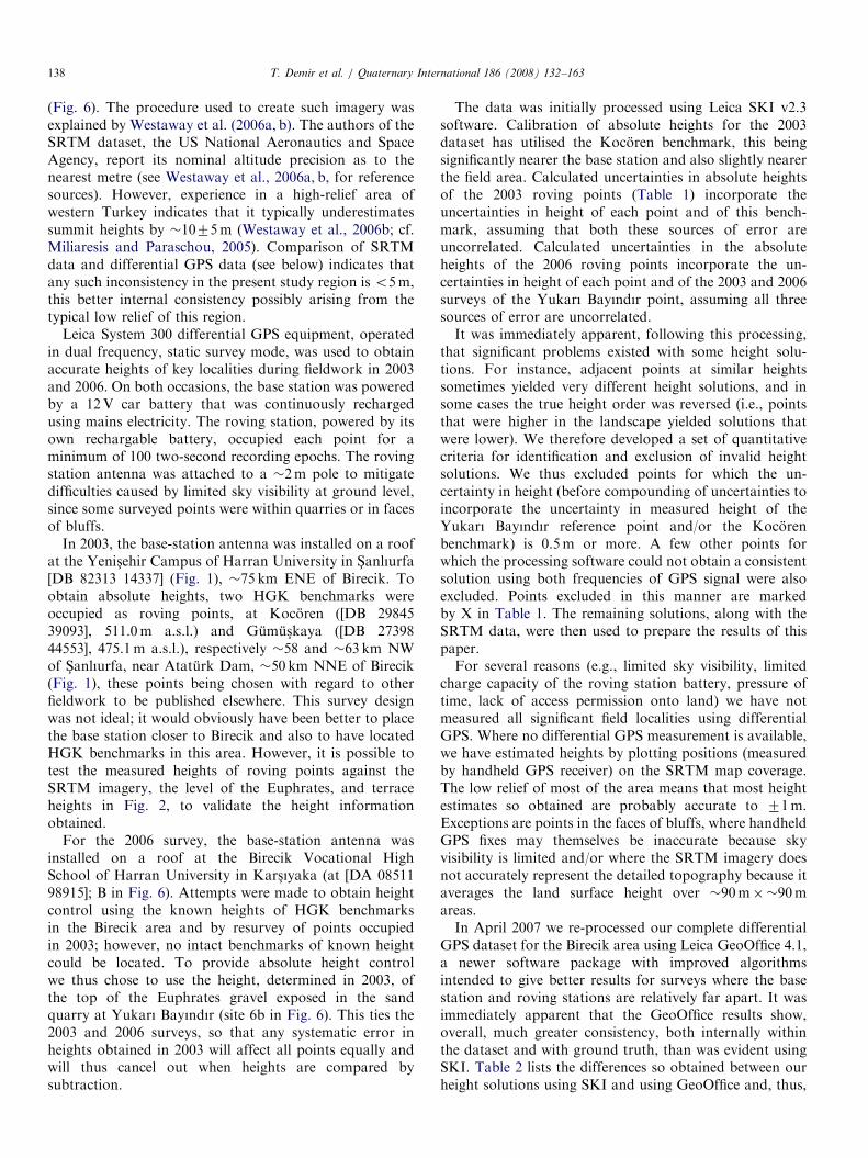
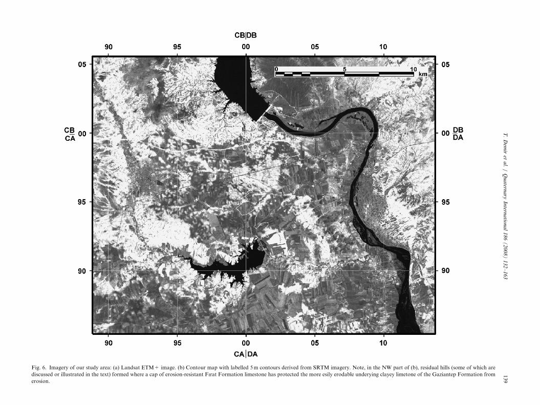
ARTICLE IN PRESST. Demir et al. / Quaternary International 186 (2008) 132–163138
(Fig. 6). The procedure used to create such imagery wasexplained by Westaway et al. (2006a, b). The authors of theSRTM dataset, the US National Aeronautics and SpaceAgency, report its nominal altitude precision as to thenearest metre (see Westaway et al., 2006a, b, for referencesources). However, experience in a high-relief area ofwestern Turkey indicates that it typically underestimatessummit heights by �1075m (Westaway et al., 2006b; cf.Miliaresis and Paraschou, 2005). Comparison of SRTMdata and differential GPS data (see below) indicates thatany such inconsistency in the present study region is o5m,this better internal consistency possibly arising from thetypical low relief of this region.
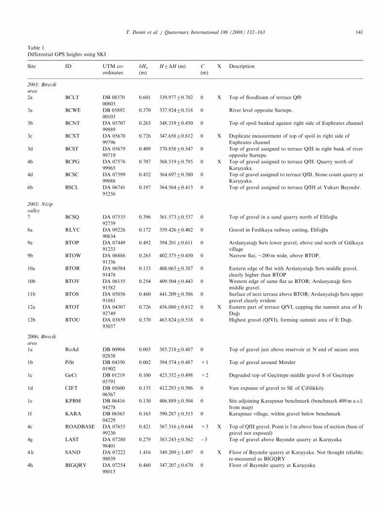
Leica System 300 differential GPS equipment, operatedin dual frequency, static survey mode, was used to obtainaccurate heights of key localities during fieldwork in 2003and 2006. On both occasions, the base station was poweredby a 12V car battery that was continuously rechargedusing mains electricity. The roving station, powered by itsown rechargable battery, occupied each point for aminimum of 100 two-second recording epochs. The rovingstation antenna was attached to a �2m pole to mitigatedifficulties caused by limited sky visibility at ground level,since some surveyed points were within quarries or in facesof bluffs.
In 2003, the base-station antenna was installed on a roofat the Yenis-ehir Campus of Harran University in S-anlıurfa[DB 82313 14337] (Fig. 1), �75 km ENE of Birecik. Toobtain absolute heights, two HGK benchmarks wereoccupied as roving points, at Kocoren ([DB 2984539093], 511.0m a.s.l.) and Gumus-kaya ([DB 2739844553], 475.1m a.s.l.), respectively �58 and �63 km NWof S-anlıurfa, near Ataturk Dam, �50 km NNE of Birecik(Fig. 1), these points being chosen with regard to otherfieldwork to be published elsewhere. This survey designwas not ideal; it would obviously have been better to placethe base station closer to Birecik and also to have locatedHGK benchmarks in this area. However, it is possible totest the measured heights of roving points against theSRTM imagery, the level of the Euphrates, and terraceheights in Fig. 2, to validate the height informationobtained.
For the 2006 survey, the base-station antenna wasinstalled on a roof at the Birecik Vocational HighSchool of Harran University in Kars-ıyaka (at [DA 0851198915]; B in Fig. 6). Attempts were made to obtain heightcontrol using the known heights of HGK benchmarksin the Birecik area and by resurvey of points occupiedin 2003; however, no intact benchmarks of known heightcould be located. To provide absolute height controlwe thus chose to use the height, determined in 2003, ofthe top of the Euphrates gravel exposed in the sandquarry at Yukarı Bayındır (site 6b in Fig. 6). This ties the2003 and 2006 surveys, so that any systematic error inheights obtained in 2003 will affect all points equally andwill thus cancel out when heights are compared bysubtraction.
The data was initially processed using Leica SKI v2.3software. Calibration of absolute heights for the 2003dataset has utilised the Kocoren benchmark, this beingsignificantly nearer the base station and also slightly nearerthe field area. Calculated uncertainties in absolute heightsof the 2003 roving points (Table 1) incorporate theuncertainties in height of each point and of this bench-mark, assuming that both these sources of error areuncorrelated. Calculated uncertainties in the absoluteheights of the 2006 roving points incorporate the un-certainties in height of each point and of the 2003 and 2006surveys of the Yukarı Bayındır point, assuming all threesources of error are uncorrelated.It was immediately apparent, following this processing,
that significant problems existed with some height solu-tions. For instance, adjacent points at similar heightssometimes yielded very different height solutions, and insome cases the true height order was reversed (i.e., pointsthat were higher in the landscape yielded solutions thatwere lower). We therefore developed a set of quantitativecriteria for identification and exclusion of invalid heightsolutions. We thus excluded points for which the un-certainty in height (before compounding of uncertainties toincorporate the uncertainty in measured height of theYukarı Bayındır reference point and/or the Kocorenbenchmark) is 0.5m or more. A few other points forwhich the processing software could not obtain a consistentsolution using both frequencies of GPS signal were alsoexcluded. Points excluded in this manner are markedby X in Table 1. The remaining solutions, along with theSRTM data, were then used to prepare the results of thispaper.For several reasons (e.g., limited sky visibility, limited
charge capacity of the roving station battery, pressure oftime, lack of access permission onto land) we have notmeasured all significant field localities using differentialGPS. Where no differential GPS measurement is available,we have estimated heights by plotting positions (measuredby handheld GPS receiver) on the SRTM map coverage.The low relief of most of the area means that most heightestimates so obtained are probably accurate to 71m.Exceptions are points in the faces of bluffs, where handheldGPS fixes may themselves be inaccurate because skyvisibility is limited and/or where the SRTM imagery doesnot accurately represent the detailed topography because itaverages the land surface height over �90m��90mareas.In April 2007 we re-processed our complete differential
GPS dataset for the Birecik area using Leica GeoOffice 4.1,a newer software package with improved algorithmsintended to give better results for surveys where the basestation and roving stations are relatively far apart. It wasimmediately apparent that the GeoOffice results show,overall, much greater consistency, both internally withinthe dataset and with ground truth, than was evident usingSKI. Table 2 lists the differences so obtained between ourheight solutions using SKI and using GeoOffice and, thus,
ARTIC
LEIN
PRES
S
Fig. 6. Imagery of our study area: (a) Landsat ETM+ image. (b) Contour map with labelled 5m contours derived from SRTM imagery. Note, in the NW part of (b), residual hills (some of which are
discussed or illustrated in the text) formed where a cap of erosion-resistant Fırat Formation limestone has protected the more esily erodable underying clayey limetone of the Gaziantep Formation from
erosion.
T.
Dem
iret
al.
/Q
ua
ternary
Intern
atio
na
l1
86
(2
00
8)
13
2–
16
3139
ARTICLE IN PRESS
Fig.6.(C
on
tin
ued)
T. Demir et al. / Quaternary International 186 (2008) 132–163140
ARTICLE IN PRESS
Table 1
Differential GPS heights using SKI
Site ID UTM co-
ordinates
dHo
(m)
H7DH (m) C
(m)
X Description
2003; Birecik
area
2a BCLT DB 08370
00803
0.601 339.97770.702 0 X Top of floodloam of terrace Qf0
3a BCWE DB 05892
00103
0.370 337.92470.518 0 River level opposite Surtepe.
3b BCNT DA 05707
99889
0.265 348.31970.450 0 Top of spoil banked against right side of Euphrates channel
3c BCXT DA 05670
99796
0.726 347.65870.812 0 X Duplicate measurement of top of spoil in right side of
Euphrates channel
3d BCST DA 05679
99719
0.409 370.85870.547 0 Top of gravel assigned to terrace QfII in right bank of river
opposite Surtepe.
4b BCPG DA 07576
99965
0.707 368.51970.795 0 X Top of gravel assigned to terrace QfII. Quarry north of
Kars-ıyaka.
4d BCSC DA 07599
99088
0.452 364.69770.580 0 Top of gravel assigned to terrace QfII. Stone count quarry at
Kars-ıyaka.
6b BSCL DA 06741
95256
0.197 364.56470.413 0 Top of gravel assigned to terrace QfIII at Yukarı Bayındır.
2003; Nizip
valley
7 BCSQ DA 07535
92739
0.396 361.57370.537 0 Top of gravel in a sand quarry north of Elifoglu
8a RLYC DA 09226
90634
0.172 359.42670.402 0 Gravel in Feslikaya railway cutting, Elifoglu
9a BTOP DA 07449
91233
0.492 394.20170.611 0 Arslanyatagı Sırtı lower gravel, above and north of Gulkaya
village
9b BTOW DA 06886
91336
0.265 402.37570.450 0 Narrow flat, �200m wide, above BTOP.
10a BTOR DA 06584
91478
0.133 408.06570.387 0 Eastern edge of flat with Arslanyatagı Sırtı middle gravel,
clearly higher than BTOP
10b BTOV DA 06155
91582
0.254 409.50470.443 0 Western edge of same flat as BTOR; Arslanyatagı Sırtı
middle gravel.
11b BTOS DA 05056
91881
0.460 441.20970.586 0 Surface of next terrace above BTOR; Arslanyatagı Sırtı upper
gravel clearly evident
12a BTOT DA 04307
92749
0.726 456.08070.812 0 X Eastern part of terrace QfVI, capping the summit area of It
Dagı
12b BTOU DA 03859
93037
0.370 463.82470.518 0 Highest gravel (QfVI), forming summit area of It Dagı.
2006; Birecik
area
1a RoAd DB 00904
02838
0.003 385.21870.487 0 Top of gravel just above reservoir at N end of secure area
1b PiSt DB 04350
01902
0.002 394.57470.487 +1 Top of gravel around Meteler
1c GeCt DB 01219
03791
0.100 425.35270.498 +2 Degraded top of Gec- ittepe middle gravel S of Gec- ittepe
1d CIFT DB 05600
06567
0.135 412.29370.506 0 Vast expanse of gravel to SE of C- iftlikkoy
1e KPBM DB 06416
04278
0.130 406.88970.504 0 Site adjoining Karapınar benchmark (benchmark 409m a.s.l.
from map)
1f KARA DB 06565
04229
0.165 390.28770.515 0 Karapınar village, within gravel below benchmark
4c ROADBASE DA 07655
99230
0.421 367.31670.644 +3 X Top of QfII gravel. Point is 5m above base of section (base of
gravel not exposed)
4g LAST DA 07280
98401
0.279 383.24370.562 �3 Top of gravel above Bayındır quarry at Kars-ıyaka
4 h SAND DA 07222
98039
1.416 349.20971.497 0 X Floor of Bayındır quarry at Kars-ıyaka. Not thought reliable;
re-measured as BIGQRY
4h BIGQRY DA 07254
98015
0.460 347.20770.670 0 Floor of Bayındır quarry at Kars-ıyaka
T. Demir et al. / Quaternary International 186 (2008) 132–163 141

ARTICLE IN PRESS
Table 1 (continued )
Site ID UTM co-
ordinates
dHo
(m)
H7DH (m) C
(m)
X Description
4l QRYS DA 07207
97792
0.492 355.80770.692 +3 X Top of gravel at SE corner of Bayındır quarry. Point is 5m
above quarry floor.
4i Bilgbase DA 07292
98881
0.453 380.51870.666 0 Gravel east of Bilgin site; 3m below top, with thin palaeosol
then 2m of spoil.
4j Thick DA 07460
98854
0.151 361.62070.510 0 Top of gravel exposure where being infilled for factory
development; 5m above base
4k Top DA 07526
99144
0.183 365.43370.521 0 Top of gravel at its highest point within construction area
5a Bilg DA 06902
93814
0.753 401.76870.897 +1 X Top of Bilgin gravel. Not considered reliable, so repeated as
bilgin2.
5a Bilgin2 DA 06894
98807
0.387 389.76370.622 +2 Top of Bilgin gravel.
5c WtWr DA 07063
98483
0.244 388.92470.545 0 Top of gravel by Birecik water tower
5d Dutlu CA 96672
97081
0.167 492.29870.515 0 Euphrates gravel at Dutlu
6b YKBR DA 06740
95214
0.258 364.56470.487 0 Top of gravel, Yukarı Bayındır sand quarry
2006; Nizip
valley
8c Oglu DA 10051
88932
0.270 349.20970.557 +3 Top of gravel (Elifoglu lower gravel) in large abandoned
quarry SE of Elifoglu
8d Quar2 DA 08865
88660
0.803 375.08270.939 +3 X Top of Elifoglu upper gravel in small abandoned quarry SW
of Elifoglu
9a NIZP DA 07438
91253
0.587 399.04070.763 0 X Re-measurement of site BTOP from 2003
9b NIZQ DA 06730
91422
0.603 389.41170.775 0 X Re-measurement of site BTOW from 2003. Narrow terrace
flat with gravel.
10d Flat DA 05877
89298
1.909 400.29271.970 0 X Wide terrace flat in Tilmagara upper gravel, south of
Tilmagara
10e Random DA 06359
89865
0.812 403.61170.947 +2 X Top of Tilmagara lower gravel on Elifoglu-Tilmagara road.
Gravel is �6m thick.
10f TILS2 DA 05764
89768
0.436 407.73670.654 +1 Top of Tilmagara lower gravel in canal cut bluff overlooking
Tilmagara
10g Cemg2 DA 05689
89227
0.941 426.87571.059 0 X Cemented Tilmagara upper gravel south of Tilmagara.
10h Tilf2 DA 05146
89219
1.261 441.53171.352 �5 X In limestone brash above westernmost exposure of Tilmagara
upper gravel
12b ITDG DA 03871
93046
0.537 464.55370.725 +2 X Re-measurement of summit of It Dagı (QfVI)
14a QF5T DA 00282
89669
0.633 475.04270.799 0 X Top of limestone fan gravel at SW edge of Hancagız Dam
quarry
14b HANC DA 01380
90439
0.499 425.83070.698 0 X Base of limestone fan gravel south of Hancagız Dam
14c QUAF DA 01017
90224
0.597 460.40770.771 0 X Base of section in limestone gravel in Hancagız Dam quarry.
13b TOP2R DA 02866
87547
1.218 459.01071.312 +1 X Top of Euphrates gravel at Yılmazlar
13b TOP8RR DA 02866
87547
0.888 452.32071.013 +1 X Top of Euphrates gravel at Yılmazlar; re-measurement
2006, Other
locality
BsLt CB 91951
09538
0.191 763.13070.523 0 X Basalt overlying Fırat Formation limestone at Ozyurt
dHo is the uncertainty in height of each point from its own differential GPS fix. H7DH is the height of the point and its uncertainty after compounding of
errors as explained in the text. C is the correction (to be added to H) to obtain the height of the feature being measured. X denotes the points that were
excluded from the dataset following this procesing using SKI, for reasons discussed in the text.
T. Demir et al. / Quaternary International 186 (2008) 132–163142

ARTICLE IN PRESS
Table 2
Comparison of height solutions using SKI and GeoOffice
Point ID Solution using GeoOffice Solution using SKI Comparison
Type DHG (m) HG (m) R Amb DHS (m) HS (m) R X DHG�DHS (m)
31 August 2003
BCLT Float L3 �230.766171.7750 354.7445 R N �245.533570.6006 339.9771 X 14.767471.8739
BCWE Float L3 �247.310070.3478 338.2006 N �247.587070.3697 337.9236 0.277070.5076
BCNT Float L3 �236.961370.3344 348.5492 N �237.191570.2647 348.3190 0.230270.4265
BCST Code L3 �215.438570.3034 370.0721 N �214.653170.4085 370.8575 �0.785470.5088
BCXT Float L3 �235.085272.7764 350.4254 N �237.853070.7258 347.6576 X 2.767872.8697
BCPG Phase L3 �218.344670.0148 367.1660 N �216.991570.7066 368.5191 X �1.353170.7068
BCSC Code L3 �218.754470.4225 366.7562 N �220.813270.4518 364.6974 2.058870.6186
BSCL Float L3 �220.742270.2376 364.7684 N �220.946570.1970 364.5641 0.204370.3086
RLYC Float L3 �225.896570.2213 359.6141 N �226.084870.1715 359.4258 0.188370.2800
BTOP Phase L3 �190.790770.0171 394.7199 N �191.310170.4915 394.2005 0.519470.4918
BTOR Float L3 �177.100270.2835 408.4104 N �177.445970.1332 408.0647 0.345770.3132
BTOS Phase L3 �144.610370.0154 440.6303 N �144.031270.4599 441.2094 �0.579170.4602
BTOT Phase L3 �129.358370.0346 456.1522 N �129.430170.7256 456.0804 � 0.071870.7264
BTOU Phase L3 �122.679870.0188 462.8307 N �121.686870.3698 463.8237 �0.993070.3703
BTOV Phase L3 �175.612770.0079 409.8979 N �176.006470.2535 409.5042 0.393770.2536
BTOW Code L3 �182.663270.4426 402.8474 N �183.135970.2648 402.3747 0.472770.5158
BCSQ Phase L3 �225.823870.0147 359.6868 N �223.937970.3958 361.5727 �1.885970.3961
22 August 2006
bilg Phase L1+L2 48.494870.0082 391.8135 N 58.449670.7530 401.7683 R X �9.954870.7530
WtWr Phase L1+L2 48.333870.0031 391.6525 N 45.605670.2438 388.9243 2.728270.2438
dutlu Phase L1+L2 148.712670.0029 492.0313 N 148.979270.1670 492.2979 �0.266670.1670
BsLt Phase L3 422.048770.0058 765.3675 N 419.811470.1906 763.1302 2.237370.1907
GeCt Phase L1+L2 81.470270.0033 424.7889 N 82.032970.1001 425.3516 �0.562770.1002
RoAd Phase L1+L2 41.894570.0041 385.2132 Y 41.899170.0033 385.2178 �0.004670.0053
PiSt Phase L1+L2 51.248970.0024 394.5676 N 51.255670.0022 394.5743 �0.006770.0033
CIFT Phase L1+L2 67.301970.0029 410.6206 N 68.974170.1351 412.2928 �1.672270.1351
KARA Phase L1+L2 47.650970.0038 390.9696 N 46.968370.1654 390.2870 0.682670.1654
KPBM Phase L1+L2 62.623470.0022 405.9421 N 63.570470.1296 406.8891 �0.947070.1296
YKBR Phase L1+L2 20.874970.0033 364.1936 N 21.245470.2582 364.5641 �0.370570.2582
LAST Phase L1+L2 38.283970.0035 381.6026 N 39.924570.2793 383.2432 �1.640670.2793
1 September 2006
NIZP Phase L1+L2 51.532570.0049 394.8512 N 55.721670.5870 399.0403 R X �4.189170.5870
NIZQ Phase L1+L2 59.016470.0058 402.3351 N 46.092770.6031 389.4114 R X 12.923770.6031
ITDG Phase L1+L2 119.190270.0040 462.5090 N 121.234070.5366 464.5528 X �2.043870.5366
SAND Code L1+L2 8.421870.1037 351.7405 N 5.890471.4155 349.2091 X 2.531471.4193
QRYS Float L1+L2 13.247970.0431 356.5666 N 12.488270.4915 355.8069 X 0.759770.4934
HANC Code L1+L2 83.512770.0465 426.8314 N 82.511170.4990 425.8298 X 1.001670.5012
QF5T Phase L1+L2 125.354970.0046 468.6737 N 131.723570.6334 475.0423 R X �6.368670.6334
7 September 2006
bilgin2 Float L1+L2 46.596170.0242 389.9148 N 46.444670.3866 389.7633 0.151570.3874
bilgbase Float L1+L2 30.273570.0309 373.5922 N 37.199270.4534 380.5179 R �6.925770.4545
thick Float L1+L2 18.946270.0239 362.2649 N 18.301370.1511 361.6200 0.644970.1530
top Float L1+L2 23.242470.0274 366.5611 N 22.114770.1829 365.4334 1.127770.1849
ROADBASE Float L1+L2 15.121870.0531 358.4405 Y 23.997670.4213 367.3163 R X �8.875870.4246
BIGQRY Float L1+L2 7.656670.0483 350.9753 N 3.888570.4601 347.2072 R 3.768170.4626
oglu Float L1+L2 5.205670.0291 348.5243 N 5.890170.2702 349.2088 �0.684570.2718
quar2 Float L1+L2 25.187370.0395 368.5060 N 31.763570.8026 375.0822 R X �6.576270.8036
random Float L1+L2 68.548970.0482 411.8676 N 60.292470.8123 403.6111 R X 8.256570.8137
TILS2 Phase L1+L2 62.107770.0040 405.4264 N 64.417370.4355 407.7360 �2.309670.4355
flat Float L1+L2 74.787170.0435 418.1058 N 56.973171.9088 400.2918 R X 17.814071.9093
cemg2 Float L1+L2 71.742070.0751 415.0607 N 83.556070.9407 426.8747 R X �11.814070.9437
tilf2 Phase L1+L2 79.662170.0048 422.9808 N 98.212271.2612 441.5309 R X �18.550171.2612
TOP2R Float L1+L2 109.478870.0685 452.7975 N 115.691171.2177 459.0098 R X �6.212371.2196
TOP8RR Phase L1+L2 111.598270.0048 454.9169 N 109.001070.8884 452.3197 X 2.597270.8884
8 September 2006
QUAF Float L1+L2 109.280470.0372 452.5992 N 117.088570.5968 460.4073 R X �7.808170.5980
For each solution DH is the calculated difference in height between the roving station and the reference station; subscripts G and S denote solutions using
GeoOffice and SKI. H indicates the estimated height of each point a.s.l. Values of HS are from Table 1, calculated as explained in the main text. Values of
HG are estimated as HS+DHG�DHS. Type indicates the type of solution obtained using GeoOffice. Phase indicates that the processing software was able
to resolve all ambiguities in the phase of both frequencies of GPS signals recorded at both stations; this is preferred. Float means that the software has
attempted to use the phase data of the GPS signals but has not resolved all phase ambiguities. If distances between roving station and reference station are
tens of kilometres, the ability of the software to obtain a Phase solution as opposed to a Float solution is not considered critical. Code means that the
processing software has only used the coded information transmitted by the satellites (orbital position, time of transmission, etc.) and not the phase of the
signals; this is likely to be the least reliable type of solution. L1+L2 means that the solution attempted to resolve any phase ambiguities using a
predetermined model for propagation through the ionosphere of both frequencies of GPS signal. L3 means that the solution used the consistency between
these two sets of signals to infer the properties of the ionosphere. The processing was set to determine an L3-type solution if the base station and roving
station were 415 km apart, as is recommended. For solutions using SKI, Amb expresses whether the software was able to resolve all ambiguities in the
phase of both frequencies of GPS signals recorded at both stations (Y ¼ Yes; N ¼ No). X denotes whether a solution using SKI was excluded as invalid in
Table 1. R denotes whether a solution was rejected because of inconsistency with SRTM or other ground truth data. See text for discussion.
T. Demir et al. / Quaternary International 186 (2008) 132–163 143
ARTICLE IN PRESS
Table 4
Clast lithological analysis 2
Lithology Number Percentage Provenance
Limestone 87 90.6 Arabian platform
Chert 9 9.4 Arabian platform/Neotethys suture
Total 96 100.0
The sample was collected from [DA 00999 90219] (site 14c in Fig. 6,
adjoining the locality in Fig. 14b), in deposits assigned by Minzoni-
Deroche and Sanlaville (1988) to their Euphrates terrace QfV (Fig. 2) but
regarded by us as part of the alluvial fan deposit that we call the Hancagız
gravel (Fig. 16). This sample is undersized according to Bridgland’s (1986)
criteria; however, it seemed pointless to those who collected it (A.S. and
R.W.) spending time in the field counting hundreds more clasts of
limestone just to make up the numbers. Time was thus spent instead
searching exposures for any evidence of lithologies of Anatolian
provenance, but none was found.
Table 3
Clast lithological analysis 1
Lithology Number Percentage Provenance
Limestone 79 28.9 Arabian platform
Amphibolite 43 15.8 Anatolia
Chert 40 14.7 Arabian platform/Neotethys
suture
Basalt 33 12.1 Arabian platform
Granite 24 8.8 Anatolia
Orthoquartzite 18 6.6 Anatolia
Metaquartzite 14 5.1 Anatolia
Calcschist 12 4.4 Anatolia
Quartz 5 1.8 Anatolia
Hard mudstone 3 1.1 Neotethys suture
Ultramafic 2 0.7 Neotethys suture
Total 273 100.0
The sample was collected from [DA 07606 99058] (Fig. 10a, in deposits
assigned by Minzoni-Deroche and Sanlaville (1988) to their Euphrates
terrace QfII (Fig. 2) but regarded by us as the basal part of the thick
Bayındır gravel, being located below the �+29m eroded facet within this
deposit in Fig. 16. Granite includes ‘felsite’ and clasts of igneous rock that
are too weathered to classify. Amphibolite includes amphibolite schist.
T. Demir et al. / Quaternary International 186 (2008) 132–163144
taking into account the SRTM evidence and ground truth,deduces a preferred set of height solutions.
Inspection of Table 2 confirms that most SKI solutionsthought to be unreliable on the basis of large uncertaintieswere, indeed, unreliable. However, there were two points(for sites 4 h and 4i in Fig. 6b and Tables 1 and 2) whereSKI produced what appeared to be tightly constrainedsolutions that turned out to be unreliable. These twoinstances will be discussed individually, but for the rest ofour dataset we retain the original solutions using SKI,which differ from the solutions using GeoOffice by nomore than one or two metres; the conclusions of our studyare thus unaffected.
3.2. Clast lithological analysis
To establish the typical composition of Euphrates gravelin this area, we undertook clast lithological analysis (atsites 4d and 14c in Fig. 6). As recommended by Bridgland(1986), clasts in the 16–32mm size range were analysed, therecommended count for each sample being 4250.
Site 4d was in a quarry section at Kars-ıyaka, in depositspreviously assigned to Euphrates terrace QfII (see below).This gravel has the characteristic dark grey colour typicalfor the Euphrates, due to the presence of dark-colouredlithologies (basalt, amphibolite, etc.) both in clasts andin the coarse sandy matrix. A high proportion (56%) ofthe clasts analysed were indeed of Anatolian provenance(Table 3). Previous work in the Birecik area (e.g., Minzoni-Deroche and Sanlaville, 1988), has used clasts derived fromAnatolia, or ‘‘calloutis tauriques’’, as a criterion forrecognising gravels deposited by the Euphrates, rather thanmaterial of local provenance. We shall do likewise.
Site 14c was in the cemented Hancagız gravel, previouslyconsidered part of Euphrates terrace QfV (e.g., Minzoni-Deroche and Sanlaville, 1988; Sanlaville, 2004). However, thesample (Table 4) contains only limestone and chert; it thuslacks clasts that are demonstrably not of local provenance.
4. Key localities
Our study region (Fig. 6) roughly matches thatinvestigated by Minzoni-Deroche and Sanlaville (1988)(Fig. 2). The Euphrates locally flows southward, but justupstream of Birecik its course bends eastward for �8 km.Upstream of this bend, the terrace deposits lie east of theriver, with its right bank abutting Gaziantep Formationbedrock. This area is now flooded by the Birecik Dam, sowe will summarise previous work (Figs. 3 and 4).Conversely, downstream of this bend, the terrace depositslie west of the river, its left bank abutting the limestonebedrock. Deposits attributable to the Euphrates from theirpolymict lithology are found locally up to �10 km west ofthe modern river.
We divide this region (Fig. 6) into two areas: its northernpart around Birecik, and its southern part adjoining thevalley of the Nizip, a right-bank tributary that joins the
Euphrates �10 km south of Birecik near Elifoglu. As thisreach of the Euphrates has migrated eastward, the Niziphas extended downstream, incising through the Euphratessuccession (and thereby providing good exposures) as wellas creating its own terrace staircase. This pattern ofexposure means that the early part of the Euphrates recordis clearer along the Nizip than around Birecik. Conversely,the later part of the record is clearer around Birecik, due toextensive quarrying. We thus deduce a composite fluvialsuccession using data from both areas.
4.1. The Birecik area
Fig. 4 illustrates the Euphrates deposits along the axis ofthe Birecik Dam. It shows a low fluvial deposit, or

ARTICLE IN PRESS
Fig. 7. Field photographs in the vicinity of Gec- ittepe: (a) closeup view
looking eastward at a section through the upper part of the Gec- ittepe
lower gravel, exposed at [DB 00904 02838] (site 1a in Fig. 6), just above the
surface of the Birecik reservoir. This characteristic polymict gravel,
deposited by the Euphrates, is overlain by �0.5m of red silt with clasts of
local limestone (emplaced by slope processes) then �0.5m of road metal
(also formed of polymict Euphrates gravel) that used to support the road
to the original location of the village of Gec- ittepe or Tilobur, which is now
flooded. In the background (behind the security fence that surrounds the
Birecik Dam) can be seen part of what we call the Meteler gravel of the
Euphrates, which rises �10m higher and against which the Gec- ittepe
lower gravel is inset. (b) View SSW from [DB 00535 04172] (site 1i in Fig.
6), at the western edge of the modern location of Gec- ittepe, looking across
the flooded Euphrates valley. In the right centre of the view, on the near
side of the reservoir, a Euphrates terrace flat, presumably equivalent to
our Gec- ittepe lower gravel, can be seen to rise just above the maximum
reservoir level, which is 385m a.s.l. In the left centre of the view, across the
reservoir is an isolated hill, rising to 571m a.s.l., formed in the relatively
lithified uppermost part of the Gaziantep Formation; to the left of it is a
smaller hill, reaching �510m a.s.l.. To the left of that is a flat, at �485m
a.s.l., located at [CB 997 007] (point 1j in Fig. 6), marking the most
westerly point where the Euphrates can plausibly have flowed in the
relatively recent geological past. The Roman city of Zeugma, in the
modern village of Belkis or Kavunlu, lies beneath the reservoir on the left
of the view. Farther to the right are some residual hills, formed in the hard
marine limestone of the Fırat Formation, which overlies the Gaziantep
Formation. (c) View northward from the same place as (b). On the right is
the hill Tilmahmut Tepe, rising to �465m a.s.l. and capped by the highest
Euphrates gravel recognised locally. On the left, across the reservoir,
residual hills in Fırat Formation limestone constrict the Euphrates valley.
T. Demir et al. / Quaternary International 186 (2008) 132–163 145
‘‘alluvium’’, covering an area �1 km wide, west of the river,and much higher-level fluvial deposits opposite. Thesehigher-level deposits reach thicknesses of �30m or more,and are found locally up to �445m a.s.l., or �105m abovethe pre-dam river level. Large-scale maps prepared for thedam construction indicate flats in the upper surface of thesedeposits at �406, �420 and �430m a.s.l. (�66, �80 and�90m above river level), which may represent individualriver terraces.
Fig. 3 illustrates the Euphrates deposits upstream ofBirecik Dam, from Kuzucuoglu et al. (2004). The originalauthors did not say on what evidence it was based; it seemsto interpret more of the same dataset as was used toprepare Fig. 4. This high-level gravel has been depicted asforming two distinct terraces, the upper surfaces of which(in gravel) reach 51 and 60m above the river, or �391 and�400m a.s.l. Allowing for cover of the higher of thegravels by loam, these heights are consistent with the flatsevident in the pre-dam surveying.
The land around Birecik Dam is now closed to thepublic, but Euphrates gravels crop out extensively east ofthe valley, both upstream and downstream of this site.About 1.5 km upstream of the dam, where the road to theoriginal (now flooded) site of the village of Gec- ittepeplunges beneath the reservoir surface (site 1a in Fig. 6), thetop of a cemented Euphrates gravel (which we call the Gec-ittepe lower gravel) crops out at 385m a.s.l., �45m abovethe pre-dam river level (Fig. 7a). In August 2006 thereservoir reached �3m below the top of this gravel(Fig. 7b); in August 2003, when the water-level was lower,�6m of the gravel was exposed, its base being below thewater-level. About 3.5 km farther downstream, aroundMeteler, is an extensive flat, formed in more Euphratesgravel; we measured its top at �396m a.s.l. at site 1b(Fig. 6), or �58m above the present river level. East of thissite is a terrace bluff, across which the land surface dropsabruptly to �360m a.s.l. Although no fresh sections wereevident, it seemed that this bluff is formed withinEuphrates gravel, suggesting that the deposit beneath site1b is at least �35m thick. We infer that the gravels at sites1a and 1b are equivalent to the ‘‘50m’’ and ‘‘60m’’ terracegravels of Kuzucuoglu et al. (2004) (Fig. 3).
Higher-level Euphrates gravels are also evident nearby;they appear much more degraded that those mentionedabove, suggesting considerably greater age. About 0.5 kmsouth of the modern location of Gec- ittepe (site 1c inFig. 6), the highest gravel that we have observed in thisarea, our Gec- ittepe middle gravel, which appears o10mthick, forms a degraded flat that, we estimate, reaches�427m a.s.l. or �87m above the present river. Thedocumentation for the Birecik Dam (EIE drawing B-Y J02, included as part of EIE, 1984) shows this flat reachingslightly higher, to �430m a.s.l., �100m farther northeast.This document shows another flat, �500m farther north(ca. [DB 011 043]; site 1 g in Fig. 6), at 444m a.s.l., �104mabove the modern river, capped by gravel, which we callthe Gec- ittepe upper gravel. Drawing B-Y J 05 also shows
ARTICLE IN PRESS
Fig. 8. Field photographs of deposits assigned to Euphrates terrace Qf0 in
an active quarry near Saraykoy: (a) the south face of the quarry, showing
�1m of dark grey Euphrates gravel overlain by �4m of yellow sand and
loam. (b) Closeup view of the contact between the gravel and sand,
showing stratification in both. This view also illustrates that the
characteristic dark overall colour of the Euphrates gravel arises from a
combination of dark-coloured clasts (of igneous and metamorphic
lithologies, though light-coloured clasts, such as limestone, are also
present) and dark-coloured fines forming the matrix.
T. Demir et al. / Quaternary International 186 (2008) 132–163146
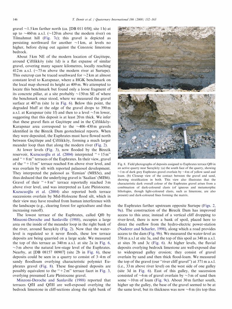
gravel �1.5 km farther north (ca. [DB 011 058]; site 1 h) atup to �460m a.s.l. (�120m above the modern river) onTilmahmut hill (Fig. 7c); this gravel is depicted aspersisting northward for another �1 km, at levels nohigher, before dying out against the Cenozoic limestonebedrock.
About 5 km NE of the modern location of Gec- ittepe,around C- iftlikkoy (site 1d) is a flat expanse of similargravel, covering many square kilometres, locally reaching412m a.s.l. (�75m above the modern river at Surtepe).This outcrop can be traced southward for �2 km at almostconstant level to Karapınar, where a HGK benchmark onthe local map showed its height as 409m. We attempted tolocate this benchmark but found only a loose fragment ofits concrete pillar, at a site probably �150m SE of wherethe benchmark once stood, where we measured the gravelsurface at 407m (site 1e in Fig. 6). Below this point, thedegraded bluff at the edge of the gravel drops to 390ma.s.l. at Karapınar (site 1f) and then to a level �5m lower,suggesting that this deposit is at least 20m thick. We inferthat these gravel flats at Gec- ittepe and in the C- iftlikkoy-Karapınar area correspond to the �406–430m gravelsidentified in the Birecik Dam geotechnical reports. Whenthey were deposited, the Euphrates must have flowed northbetween Gec- ittepe and C- iftlikkoy, forming a much largermeander loop than that along the modern river (Fig. 2).
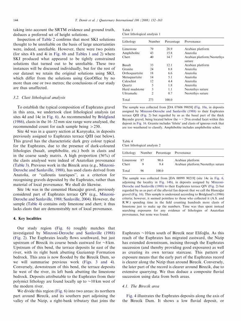
At lower levels (Fig. 3), now flooded by the Birecikreservoir, Kuzucuoglu et al. (2004) interpreted ‘‘+15m’’and ‘‘+8m’’ terraces of the Euphrates. In their view, gravelof the ‘‘+15m’’ terrace reached 8m above river level, andwas overlain by silt with reported palaeosol development.They interpreted the paleosol as ‘Eemian’ (MIS5e), andthus deduced that the underlying gravel is ‘Saalian’ (MIS6).Gravel of their ‘‘+8m’’ terrace reportedly reached 3mabove river level, and was interpreted as Late Pleistocene.Kuzucuoglu et al. (2004) also reported both terracesuccessions overlain by Mid-Holocene flood silt, which intheir view may have resulted from human interference withthe landscape (e.g., clearing forest for agriculture and thusincreasing runoff).
The lowest terrace of the Euphrates, called Qf0 byMinzoni-Deroche and Sanlaville (1988), occupies a largearea on the inside of the meander loop in the right bank ofthe river, around Saraykoy (Fig. 2). Now that the water-level is regulated so it never floods, these low terracedeposits are being quarried on a large scale. We measuredthe top of this terrace as 340m a.s.l. at site 2a in Fig. 6,�3m above the natural low-stage level of the Euphrates.Nearby, at [DB 08157 00907] (site 2b in Fig. 6), thesedeposits could be seen in a quarry to consist of 3–4m ofsandy floodloam overlying characteristic polymict Eu-phrates gravel (Fig. 8). These fine-grained deposits arepossibly equivalent to the ‘‘+2m’’ terrace facet in Fig. 3,overlying presumed Late Pleistocene gravel.
Minzoni-Deroche and Sanlaville (1988) reported thatterraces QfII and QfIII are well-exposed overlying thebedrock limestone in cliff-sections along the right bank of
the Euphrates farther upstream opposite Surtepe (Figs. 2,9a). The construction of the Birecik Dam has improvedaccess to this area; instead of a vertical cliff dropping toriver-level, there is now a bank of spoil, placed here todirect the outflow from the hydro-electric power-station(Naderer and Scharler, 1998), along which a road providesaccess to the dam (Fig. 9b). We measured the water-level as338m a.s.l at site 3a, and the top of this spoil as 348m a.s.l.at sites 3b and 3c (Fig. 6). At higher levels, the fluvialdeposits overlying bedrock limestone are well-exposed dueto widespread gulley erosion; they consist of graveloverlain by sand and then thick flood-loam. We measuredthe top of the gravel (our ‘‘river cliff gravel’’) at 371m a.s.l.(i.e., 33m above river level) on the west side of one gulley(site 3d in Fig. 6). East of this gulley, the successionconsisted of �6m of gravel overlain by �3m of sand thensome �10m of loam (Fig. 9c). About 30m farther south,higher up the gulley, the base of the gravel seemed to be atthe same level, but its thickness was now �8m (its top thus

ARTICLE IN PRESS
Fig. 9. Field photographs of the deposits assigned to Euphrates terrace
QfII upstream of Birecik: (a) view southward across the Euphrates from
Surtepe, at [DB 06608 01437] (site 3e in Fig. 6), looking at the section
through terrace QfII exposed in its right bank, �800m away. Light-
coloured Oligocene marine limestone of the Gaziantep Formation is
overlain by fluvial gravel (not clearly visible) then by sand and thick loam,
which has typically weathered to a profile sloping riverward at �301, such
that the terrace bluff in it is significantly degraded. The fresh appearance
of the limestone in this bluff is due to recent excavation for the
construction of an access road to Birecik Dam. (b) View looking westward
up the Euphrates from [DA 05679 99719] (site 3d in Fig. 6), on the gravel
of terrace QfII that we have measured at 371m a.s.l. or 33m above the
natural level of the river. To the left of the view, the degraded land surface
in floodloam overlying this gravel, rising �10–15m higher where still
intact, is evident. In the centre of the view, the top of the QfII gravel,
locally devoid of loam, can be followed upstream at an apparently
constant level. Farther to the right, the vast accumulation of spoil, tipped
against the terrace bluff during construction of the Birecik Dam, is
evident. The dam itself is visible in the top right-hand corner of the view.
(c) View towards N601E, looking downstream from the same place as (b).
The view is across a tributary gulley, now partly infilled with spoil. On the
far side, overlying the Oligocene limestone, can be seen a succession
through terrace QfII consisting of �6m of dark grey Euphrates gravel,
then �3m of yellow sand, then 4�10m of beige-coloured loam. On the
left of the view is the undisturbed natural landscape, whereas on the right
fresh sections through the gravel, sand and lower part of the loam are
evident in a newly opened quarry.
T. Demir et al. / Quaternary International 186 (2008) 132–163 147
locally �2m higher than at the measurement point), beingoverlain by �1m of sand then, again, �10m of loam. Wecould see no evidence for more than one fluvial successionin this area, in contrast with the two indicated in Fig. 2.
Moving downstream across the Birecik meander-loop,the fluvial deposits that Minzoni-Deroche and Sanlaville(1988) assigned to their terrace QfII are bounded by a SE-trending bluff where the land surface drops to the muchlower level of terrace QfI (Fig. 2), evidently equivalent tothe ‘‘+15m’’ terrace of Kuzucuoglu et al. (2004).Approaching the main Birecik-Gaziantep road atKars-ıyaka, the deposits exposed in this bluff have beenintensively quarried. By 2003, all these workings wereabandoned, it now being presumably easier to extractgravel from terrace Qf0 instead (see above). The mostnortherly quarry investigated in 2003 was at [DB 0764500041] (site 4a in Fig. 6). An estimated 9m of polymictEuphrates gravel was exposed, including clasts of locallimestone up to �1m in diameter. Large-scale cross-bedding was evident, which, along with clear clast-imbrication, indicated palaeoflow to the SSE. About100m farther SE, a similar exposure was evident in anotherquarry (site 4b in Fig. 6), where we estimate the top of thegravel at �365m a.s.l. (�29m above the natural level ofthe Euphrates at Birecik) using the SRTM imagery. A thirdquarry at [DA 07654 99386] (site 4c in Fig. 6) exposed�8m of well-stratified fluvial gravel. The lower �5m wassandy, with clasts up to �5 cm; the upper �3m was muchcoarser, with clasts of local limestone up to �50 cm. Afourth abandoned quarry at the northern edge ofKars-ıyaka (site 4d in Fig. 6), �200m east of the mainterrace-bluff, just north of the main road, was the site ofour clast analysis in Table 3. Here, too, �8m of gravel wasexposed (Fig. 10a), its top measured at 565m a.s.l., againwell-stratified and with coarser/finer interbeds, but theeastward dip suggests deposition during lateral accretionrather than by cross-bedding.The mapping by Minzoni-Deroche and Sanlaville (1988)
depicts terrace QfIII to the west of these localities (Fig. 2).We thus looked along the main road, between Kars-ıyakaand Gunaltı, for evidence. At [BA 07050 28857] (site 5a inFig. 6), north of this road, a tractor showroom (BilginTesisleri) forecourt had been excavated below ground level.Fresh sections at its edges exposed �3m of weathered andpartly cemented Euphrates gravel, its top estimated at 392ma.s.l. (�56m above the Euphrates at Birecik), capped by�1.5m of reddish-brown silt (Fig. 10b). The silt containedmany carbonate nodules, these being most concentratednear its base. The local geological map (Ulu, 1996a) shows‘‘old alluvium’’ of the Euphrates for another �3 km west ofthis point (to ca. [BA 042 983], site 5b in Fig. 6, nearGunaltı), where the land surface is �400m a.s.l. Minzoni-Deroche and Sanlaville (1988) did not map it so far west,and we have likewise not observed fluvial sediment in thatarea. However, we have identified an extensive spread ofEuphrates gravel much farther west and much higher, at492m a.s.l. (�156m above the Euphrates at Birecik),around Dutlu (site 5d in Fig. 6). This gravel seems to bebanked against the limestone bedrock, which rises evenhigher farther west (Fig. 6) and forms the western limit ofevidence of the presence of the Euphrates in this study area.
ARTICLE IN PRESS
Fig. 10. Euphrates deposits around Birecik: (a) view towards N351W,
looking at gravel assigned to terrace QfII at the Kars-ıyaka stone count
site, [DA 07606 99058] (site 4d in Fig. 6). Height of section illustrated is
�8m, the top of this gravel being at 369m a.s.l. or �29m above the
present level of the Euphrates. The section comprises alternations of thin
coarse gravel beds with thicker fine gravel beds with occasional larger
clasts. The stone count was made on gravel from the coarse interbed
visible roughly halfway up the section. The foresets illustrated are
interpreted as indicating lateral accretion, from east to west. (b) Part of
the section exposed in the Bilgin gravel, at [DA 06902 98814] (adjoining
site 5a in Fig. 6). A thickness of �3m of gravel is illustrated, along with
the �1.5m of overlying brown silt with carbonate nodules. The gravel
contains a combination of relatively small polymict clasts and large clasts
of local limestone. (c) View westward from [DA 07460 98854] (site 4j in
Fig. 6), showing work in progress in September 2006 to infill a disused
gravel quarry to create a level land surface for future industrial
development. Bedrock limestone is exposed in the floor of the quarry,
and in the vertical face the basal �5m of Euphrates gravel (of the same
facies depicted in (a) and (b), as well as in Fig. 11b) is visible.
T. Demir et al. / Quaternary International 186 (2008) 132–163148
Gravel equivalent to that at site 5a was observed to alsocrop out �500m farther south, around the Birecik watertower, where its flat top was measured at 389m a.s.l. (site5c in Fig. 6; �53m above the Euphrates) and its thicknesswas no more than �2m. However, about �100m farthereast, its thickness exposed in abandoned quarries is �6m,whereas west of the water tower the gravel could be seen to
die out. Its feather edge was clearly visble, because—whereunprotected by gravel—the Cenozoic limestone has beenexposed to chemical weathering, lowering the land surface.South of the main Gaziantep-S-anlıurfa road, the large,
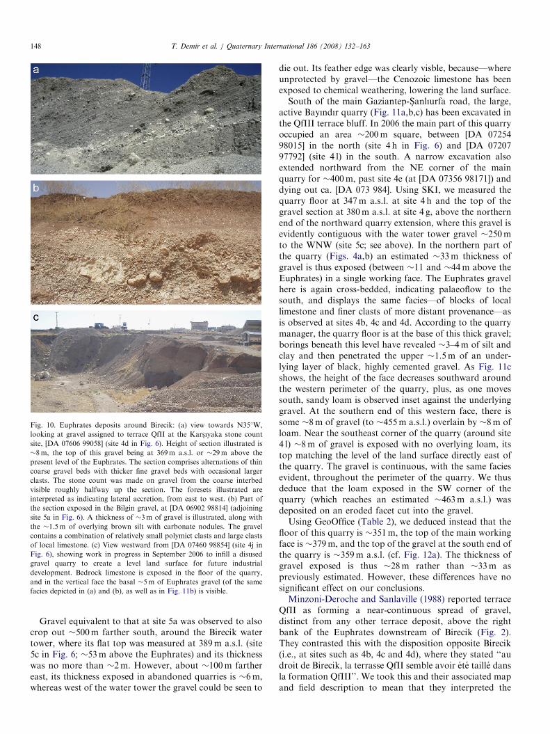
active Bayındır quarry (Fig. 11a,b,c) has been excavated inthe QfIII terrace bluff. In 2006 the main part of this quarryoccupied an area �200m square, between [DA 0725498015] in the north (site 4 h in Fig. 6) and [DA 0720797792] (site 4 l) in the south. A narrow excavation alsoextended northward from the NE corner of the mainquarry for �400m, past site 4e (at [DA 07356 98171]) anddying out ca. [DA 073 984]. Using SKI, we measured thequarry floor at 347m a.s.l. at site 4 h and the top of thegravel section at 380m a.s.l. at site 4 g, above the northernend of the northward quarry extension, where this gravel isevidently contiguous with the water tower gravel �250mto the WNW (site 5c; see above). In the northern part ofthe quarry (Figs. 4a,b) an estimated �33m thickness ofgravel is thus exposed (between �11 and �44m above theEuphrates) in a single working face. The Euphrates gravelhere is again cross-bedded, indicating palaeoflow to thesouth, and displays the same facies—of blocks of locallimestone and finer clasts of more distant provenance—asis observed at sites 4b, 4c and 4d. According to the quarrymanager, the quarry floor is at the base of this thick gravel;borings beneath this level have revealed �3–4m of silt andclay and then penetrated the upper �1.5m of an under-lying layer of black, highly cemented gravel. As Fig. 11cshows, the height of the face decreases southward aroundthe western perimeter of the quarry, plus, as one movessouth, sandy loam is observed inset against the underlyinggravel. At the southern end of this western face, there issome �8m of gravel (to �455m a.s.l.) overlain by �8m ofloam. Near the southeast corner of the quarry (around site4 l) �8m of gravel is exposed with no overlying loam, itstop matching the level of the land surface directly east ofthe quarry. The gravel is continuous, with the same faciesevident, throughout the perimeter of the quarry. We thusdeduce that the loam exposed in the SW corner of thequarry (which reaches an estimated �463m a.s.l.) wasdeposited on an eroded facet cut into the gravel.Using GeoOffice (Table 2), we deduced instead that the
floor of this quarry is �351m, the top of the main workingface is �379m, and the top of the gravel at the south end ofthe quarry is �359m a.s.l. (cf. Fig. 12a). The thickness ofgravel exposed is thus �28m rather than �33m aspreviously estimated. However, these differences have nosignificant effect on our conclusions.Minzoni-Deroche and Sanlaville (1988) reported terrace
QfII as forming a near-continuous spread of gravel,distinct from any other terrace deposit, above the rightbank of the Euphrates downstream of Birecik (Fig. 2).They contrasted this with the disposition opposite Birecik(i.e., at sites such as 4b, 4c and 4d), where they stated ‘‘audroit de Birecik, la terrasse QfII semble avoir ete taille dansla formation QfIII’’. We took this and their associated mapand field description to mean that they interpreted the

ARTICLE IN PRESS
Fig. 11. Field photographs SW of Birecik: (a) view northward across the Bayındır quarry, from [DA 07207 97792] (site 4 l in Fig. 6), showing the �30m
high working face cut into a subhorizontal flat. (b) Closeup view of this face, at [DA 07254 98015] (site 4 h in Fig. 6), showing large-scale cross-bedding (as
in Fig. 10a) and mixing of small dark clasts of diverse provenance with much larger clasts of local limestone. DB and AS provide scale. (c) View westward,
looking at the western face of the Bayındır quarry from the same place as (a) (the right-hand part of this image overlaps with the left-hand part of (a)).
Note the gradual right–left (i.e., N–S) decrease in the height of the face, also that on the left the section indicates roughly equal thicknesses of loam and
underlying gravel, the loam tapering to the right, dying out just to the right of the quarry access road (d) View eastward across the disused sand quarry at
Yukarı Bayındır, site 6b in Fig. 6, showing the worked face through �3m of yellow fluvial sand and the undisturbed top of the underlying characteristic
grey (unweathered), polymict Euphrates gravel, which Minzoni-Deroche and Sanlaville (1988) assigned to terrace QfIII. The top of this gravel is at 365m
a.s.l., �31m above the present level of the Euphrates.
T. Demir et al. / Quaternary International 186 (2008) 132–163 149
fluvial gravel at these sites as inset against older gravel oftheir terrace QfIII. Our initial impression, on the contrary,was that-given the similarity in gravel facies represented-this group of sites adjoining the terrace QfIII bluff in factrepresents the basal part of the thick QfIII gravel, not ayounger gravel. To verify this, in 2006 we undertook adetailed traverse across the bluff between sites 5a and 4c inFig. 6. At this time, work was in progress to infillabandoned quarries and make fresh excavations, to levelthe land surface for construction of a new industrialestate (Fig. 10c); as a result, many fresh temporary sec-tions (including those at sites 4i, 4j and 4k in Fig. 6) werevisible, which were not available to Minzoni-Deroche andSanlaville (1988).
Fig. 12 summarises our interpretation of this area basedon heights measured using SKI. We can see no basis forinterpreting any stratigraphic contacts within the deposit ofpoorly sorted, cross-bedded Euphrates gravel. We thusconsider that it represents a single aggradation whereverobserved, and name it the Bayındır gravel after theBayındır quarry section in Fig. 11b. The Euphratesevidently incised to within �10m of its present level, fromthe evidence at site 4 g, then aggraded to �56m above itspresent level, from the evidence at site 5a. The lowerheights above the present river of the top of this thickgravel elsewhere, �44m at site 4 g, �30m at sites 4b, 4d,and 4k, and �20m at site 4 l, are thus interpreted asstraths, or erosional facets, cut into this gravel during thesubsequent incision by the Euphrates to its present level.The gravel at site 3d (which we do not regard as a remnantof the older aggradation) reaches a similar height to the
middle group of straths, and may represent depositionduring the corresponding climate cycle.The main modification to the scheme in Fig. 12b,
following the re-processing of the differential GPS datausing GeoOffice (Table 2), was the adjustment of the top ofthe gravel at site 4i from �384 to �377m a.s.l. This makesthe estimated height of the top of the ‘‘upper eroded facet’’of the Bayındır gravel in Fig. 12b much closer to its(revised) height of 379m a.s.l. in Fig. 12a, thus improvingthe overall consistency of the dataset.Minzoni-Deroche and Sanlaville (1988) showed the bluff
of their terrace QfIII as persisting southward for �4 kmfrom Birecik to Yukarı Bayındır (Fig. 2). East of the lattervillage, at [BA 07044 95028] (site 6a in Fig. 6), the railwayfrom Gaziantep towards the Syrian border cuts through aspur within fluvial gravel (assigned to terrace QfIII) in acutting o5m deep, then continues southward over thesurface of other deposits, which Minzoni-Deroche andSanlaville (1988) assigned to terrace QfII. The deposits oftheir terrace QfIII are more clearly visible �400m fartherWNW, in a disused quarry, where this Euphrates gravel isexposed following the removal of �3m of sand. Wemeasured the top of this gravel (site 6b in Fig. 6; Fig. 11d)as 365m a.s.l. (�31m above river level). Our impressionhas been that it forms part of the depositional surface of alarge expanse of gravel (i.e., not another strath within theQfIII gravel), which is cut out farther south by similargravel at a lower level (which Minzoni-Deroche andSanlaville, 1988, assigned to terrace QfII). We obtainedthree differential GPS measurements of these QfII depositsfarther south. First, at site 7 in Fig. 6, we measured its top

ARTICLE IN PRESS
Fig. 12. Detailed cross-sections west of Birecik, not to horizontal scale, illustrating the disposition of the deposits that we assign to our Bayındır gravel: (a)
section extending roughly southeastward for �1 km from the Birecik water tower to the active Bayındır quarry. (b) Section extending roughly
northeastward for �0.6 km from the Birecik water tower to the gravels exposed in the disused quarry workings north of Kars-ıyaka. In both illustrations,
vertical bars indicate the range of height of exposued sections; dashes indicate where the base of the sediments have not been observed. Note that in (a) a
�30m section is exposed in the Bayındır quarry, whereas in (b) no more than �10m of gravel is exposed in any locality. However, the overall thickness of
gravel illustrated along both cross-sections is 440m. See text for discussion.
T. Demir et al. / Quaternary International 186 (2008) 132–163150
at 362m a.s.l. (�29m above river level) in another disusedsand quarry, where it has been exposed following removalof �2m of overlying sand. Second, �2.5 km farther south(site 8a in Fig. 6), we meaured at 359m a.s.l. (�27m aboveriver level) the top of �1.5m of fluvial gravel exposed in arailway cutting at Feslikaya, just south of the viaductacross the Nizip valley. Third, �2 km farther SSE, in alarge abandoned quarry SE of Elifoglu (site 8c in Fig. 6),we estimated the top of the gravel, locally 43m thick, at�352m a.s.l. (�21m above river level).
This evidence suggests that further modifications to theMinzoni-Deroche and Sanlaville (1988) terrace scheme arenecessary. As already noted, some sites that they assignedto terrace QfII now appear to be eroded facets cut intotheir terrace QfIII gravel. The remaining gravels that theygrouped as terrace QfII now appear to form at least twodistinct levels. The lower of these, at �21m above theEuphrates, is represented by site 8c, our Elifoglu lowergravel. The higher grouping may itself possibly beresolvable into two facets, �31–35m and �28m above

ARTICLE IN PRESST. Demir et al. / Quaternary International 186 (2008) 132–163 151
the Euphrates: the former at sites 3d (+33–35m) and 6b(+31m); and the latter at sites 7 (+29m) and 8a (+27m).These two apparent levels are difficult to resolve, becausetheir altitudes are so similar and because the gravelsoverlap in height, each being thicker than their verticalseparation. Resolution is only possible, if at all, where whatappear to be distinct terrace flats, a few metres apart inheight, are juxtaposed (as at Yukarı Bayındır).
4.2. The Nizip Valley
The lowest Euphrates terrace deposits adjoining thelower Nizip were discussed above. We do not consider theterraces of the Nizip, interpreted by Minzoni-Deroche andSanlaville (1988) in Fig. 2, but instead now examine thehigher-level Euphrates deposits exposed by the incision bythe Nizip.
Immediately west of the railway-cutting exposure ofterrace QfII (site 8a in Fig. 6) the land surface rises to a flatin the Oligocene limestone, for instance around [BA 0889190802] (site 8b). This limestone surface is covered bypebbles of metamorphic lithologies, evidently transportedby the Euphrates, forming what we call the Kotukoygravel; it is thus a highly degraded remnant of an olderterrace (part of terrace QfIII of Minzoni-Deroche andSanlaville, 1988). We estimated in the field that its surfaceis �15m above the railway track and, thus, �13m abovethe top of the QfII fluvial gravel at site 8a. The SRTMimagery suggests that the flat is �375m a.s.l. (�43m abovethe Euphrates), or �16m above this QfII gravel, inreasonable agreement. About 2 km farther south (ca. [DA08865 88660]; site 8d in Fig. 6), a �3m thick exposure ofcemented Euphrates gravel (our Elifoglu upper gravel),with cross-bedding indicating palaeoflow towards the SE,was observed in another abandoned quarry. The top of thisgravel was estimated from the SRTM data as �376m a.s.l.or �45m above the modern river.
About 2 km west of Feslikaya, up the Nizip valley, is thevillage of Gulkaya. The road from here to Guzelkoy climbsWNW up the Arslanyatagı Sırtı spur, forming theinterfluve between the Nizip and Euphrates, reaching thesummit of the hill It Dagı after another �4 km. Minzoni-Deroche and Sanlaville (1988) reported each of theirterraces QfVI to QfIII along this section (Fig. 2), whichindeed arguably provides the best overall exposure of theseolder Euphrates deposits in the region. North of Gulkaya,they interpreted the lowest flat on this spur as another partof their terrace QfIII. Polymict Euphrates gravel, ourArslanyatagı Sırtı lower gravel, is locally abundant acrossthe land surface, some in situ, some of it dug out of fieldsand piled up along roadsides to facilitate cultivation. Wemeasured the top of the in situ gravel (site 9a in Fig. 6) as394m a.s.l., or �61m above the Euphrates. We also notedanother narrow flat, �200m wide, �600m farther west(site 9b in Fig. 6), at 402m a.s.l. We found clasts ofEuphrates provenance covering this land surface, whichmay thus indicate an additional terrace.
Farther west, Minzoni-Deroche and Sanlaville (1988)reported another flat, �500m wide, part of their terraceQfIV. We measured its eastern end at 408m a.s.l. (site 10a)and its western end, where Euphrates gravel (our Arsla-nyatagı Sırtı middle gravel) is abundant, at 410m (site10b), or 77m above the river.Immediately west of site 10b, Minzoni-Deroche and
Sanlaville (1988) depicted the land surface rising to theirterrace QfV, which they interpreted across an area of�1 km2 (Fig. 2). They also interpreted land surfacesassigned to terrace QfV farther west on both sides of theNizip, rising westward for distances of up to �15 km. Wefound clear exposures of Euphrates gravel (our Arslanya-tagı Sırtı upper gravel) within a smaller area, �300m wide(E-W), between [BA 05362 91806] (site 11a in Fig. 6) andsite 11b, at 441m a.s.l., or �108m above the river. West ofthis outrop, the land surface is dissected by gulley erosion,indicating that the limestone bedrock has been more easilyerodable than the cap of gravel, and suggesting that thisterrace is significantly older than those at lower levels,where such dissection is much less obvious. Minzoni-Deroche and Sanlaville (1988) reported an adjacent spreadof QfV gravel farther west, north of the Nizip aroundAltındagı, at up to 432m a.s.l. (site 11c in Fig. 6; ca. [BA040 920]), where gravel was also confirmed by Ulu (1996b).West of this area of gulley erosion, the land surface rises
again. Gravel is again evident starting around site 12a,within the area mapped as terrace QfVI by Minzoni-Deroche and Sanlaville (1988), at [DA 04307 92749],�455m a.s.l., its surface rising gently westward for �500mto the gravel-capped summit area of It Dagı. We measuredthe height here as 464m a.s.l. and noted that away fromthis point the gravel rises �1m higher, to an estimated�132m above the Euphrates. We do not know if the ItDagı spot height of 463m a.s.l. in Fig. 2 is for the highestpoint.West of It Dagı, the base of the It Dagı gravel can be
observed, overlying marine limestone, at an estimated levelof �430m a.s.l., indicating that this gravel is 430m thick.Chemical weathering of the limestone where unprotectedby basalt has evidently created a topographic inversion inthis area, like west of Birecik (site 5c; see above). This effectis much more noticeable around It Dagı, suggesting a muchgreater age of the gravel in this locality. Farther west, theland surface in the interfluve north of the Nizip drops to�420m a.s.l. (Fig. 6). Minzoni-Deroche and Sanlaville(1988) reported no fluvial deposits in this area; we alsofound none.South of the Nizip, Minzoni-Deroche and Sanlaville
(1988) reported two flats of their terrace QfIV at 407 and417m a.s.l., located SE of Tilmagara (ca. [BA 07 90], site10c; and ca. [BA 06 89], site 10d). The lower of these isevidently equivalent to the Euphrates gravel north of theNizip (around sites 10a and 10b) and appears to form thestratotype adopted by Minzoni-Deroche and Sanlaville(1988) for their terrace QfIV or Tilmagara gravel. Thisdeposit (our Tilmagara lower gravel; Fig. 13a) is well-

ARTICLE IN PRESS
Fig. 13. Field photographs of Euphrates deposits adjoining the Nizip
valley: (a) view southward from [DA 07858 90857], site 9c in Fig. 6,
showing cemented cross-bedded Euphrates gravel (part of our Tilmagara
lower gravel) capping the bluff on the south side of the Nizip valley,
overlying Cenozoic marine limestone. The gravel depicted is �8m thick
and reaches �405m a.s.l., �45m above the local level of the River Nizip
and �73m above the Euphrates. (b) View NNE showing the Tilmagara
canal cutting gravel at [DA 05850 89716], just east of site 10f in Fig. 6. A
thickness of �1m of polymict Euphrates gravel is overlain, on the left of
the view, by �1.5m of loam, and on the right by a similar thickness of
coarse slope gravel comprising clasts of local limestone. (c) View eastward
from [DA 05686 89238], adjoining site 10 g in Fig. 6, showing an exposure
of the uppermost �2m thickness of the cemented Tilmagara upper gravel,
which likewise contains polymict clasts indicating deposition by the
Euphrates. A.S. provides scale.
T. Demir et al. / Quaternary International 186 (2008) 132–163152
exposed at the top of the bluff south of the Nizip valley(Fig. 13a) and along the road between Elifoglu andTilmagara, for instance around [BA 06359 89865] (site10e in Fig. 6), where it is �6m thick, reaching �409m a.s.l(�78m above the modern Euphrates). What appears to bethe western feather edge of the same deposit is observed�500–600m farther west, in an irrigation canal cutting. Atthe western end of this section (site 10f), the gravel is only�0.5m thick, its top again �409m a.s.l. Around [BA 0585089716], �100m farther east, it is41m thick and is overlainby �1.5m of loam (Fig. 13b).
The upper tread of terrace QfIV is evident as a spread ofcemented Euphrates gravel, our Tilmagara upper gravel, its
top reaching �415m a.s.l. (�84m above the Euphrates),most clearly exposed along gulleys leading into the modernNizip valley. These deposits are also evident, ca. [BA 0568489216], where they are at least �4m thick (site 10 g inFig. 6; Fig. 13c) and �500m farther west at [BA 0523188997] (site 10 h), where they are only �2m thick.West of Tilmagara, Minzoni-Deroche and Sanlaville
(1988) depicted a vast area south of the Nizip as formingtheir Euphrates terrace QfV (Fig. 2). In the east, theyshowed this terrace at up to 442m a.s.l., forming thesummit area of Akbenek Tepe (site 11d in Fig. 6; ca. [BA040 895]). However, over only a small part of this area wasEuphrates gravel mapped by Ulu (1996b); his map showedgravel no farther west of site 11e in Fig. 6, at ca. [BA 050885], on Kayabas-ı Sırtı, where it would be �430m a.s.l. Wehave not examined the vicinity of site 11d, but found noEuphrates gravel around site 11e. Like in this area, thefluvial gravel attributable to Euphrates terrace QfV northof the Nizip is much less extensive, in our view, thanMinzoni-Deroche and Sanlaville (1988) depicted. Forinstance, a clear subhorizontal land surface extends eastand south of the Euphrates gravel at sites 11a and 11b, butwe found no gravel on it elsewhere (e.g., only limestonebedrock was evident between [BA 05658 91579] and [BA05654 91213], sites 11f and 11 g in Fig. 6). At manylocalities on both sides of the Nizip we noted chert clastswithin angular brash, formed of local limestone. This chertis evidently derived from the local limestone, not trans-ported by the Euphrates.Farther west, Ulu (1996b) reported gravel at two
localities within this area of supposed QfV terrace depositssouth of the Nizip. The first, (ca. [BA 030 870]; site 13a inFig. 6, reaching �460m a.s.l.), located east of Tıcar andwest of Yılmazlar, was mapped by him as a �500m wideoutcrop in an interfluve between two tributaries of theNizip. We can confirm gravel of Euphrates provenance justwest of Yılmazlar (site 13b; [BA 02866 87547]; �455ma.s.l., �124m above the modern River Euphrates), whichwe call the Yılmazlar gravel. The second, much larger,outcrop was �2 km wide (E-W) and �1.5 km long (N-S),overlooking the south side of the Nizip valley where it isnow flooded by the Hancagız Reservoir. According to bothMinzoni-Deroche and Sanlaville (1988) and Ulu (1996b)this outcrop extends west–east from ca. [BA 003 895] at�465m a.s.l. (site 14a in Fig. 6) to ca. [BA 020 905 at�455m a.s.l. (site 14b in Fig. 6). The Nizip is locally�380m a.s.l.; thus this gravel rises �80m above it, or�133m above the Euphrates. Sanlaville (2004) describedthis gravel as comprising mainly limestone clasts, alongwith chert, rotten clasts of basalt, and metamorphiclithologies derived from Anatolia, in a sandy or clayeymatrix, regarding it as a deposit of the Euphrates.We inspected this deposit carefully, both where it is
exposed in the south side of the Nizip valley (Fig. 14a) andin sections (for instance at [BA 00999 90219], site 14c;Fig. 14b; and [BA 01028 89848], site 14d) in the largedisused quarry farther south. In contrast to the description
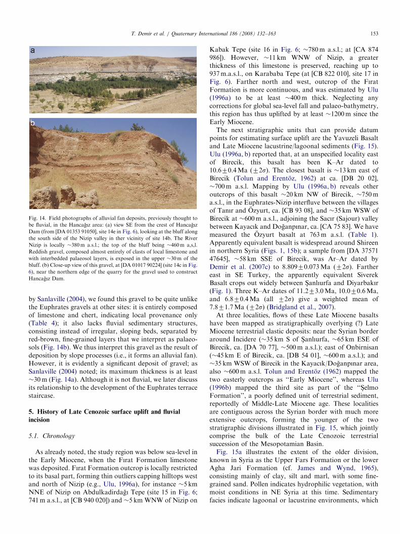
ARTICLE IN PRESS
Fig. 14. Field photographs of alluvial fan deposits, previously thought to
be fluvial, in the Hancagız area: (a) view SE from the crest of Hancagız
Dam (from [DA 01353 91050], site 14e in Fig. 6), looking at the bluff along
the south side of the Nizip valley in ther vicinity of site 14b. The River
Nizip is locally �380m a.s.l.; the top of the bluff being �460m a,s,l.
Reddish gravel, composed almost entirely of clasts of local limestone and
with interbedded palaeosol layers, is exposed in the upper �30m of the
bluff. (b) Close-up view of this gravel, at [DA 01017 90224] (site 14c in Fig.
6), near the northern edge of the quarry for the gravel used to construct
Hancagız Dam.
T. Demir et al. / Quaternary International 186 (2008) 132–163 153
by Sanlaville (2004), we found this gravel to be quite unlikethe Euphrates gravels at other sites: it is entirely composedof limestone and chert, indicating local provenance only(Table 4); it also lacks fluvial sedimentary structures,consisting instead of irregular, sloping beds, separated byred-brown, fine-grained layers that we interpret as palaeo-sols (Fig. 14b). We thus interpret this gravel as the result ofdeposition by slope processes (i.e., it forms an alluvial fan).However, it is evidently a significant deposit of gravel; asSanlaville (2004) noted; its maximum thickness is at least�30m (Fig. 14a). Although it is not fluvial, we later discussits relationship to the development of the Euphrates terracestaircase.
5. History of Late Cenozoic surface uplift and fluvial
incision
5.1. Chronology
As already noted, the study region was below sea-level inthe Early Miocene, when the Fırat Formation limestonewas deposited. Fırat Formation outcrop is locally restrictedto its basal part, forming thin outliers capping hilltops westand north of Nizip (e.g., Ulu, 1996a), for instance �5 kmNNE of Nizip on Abdulkadirdagı Tepe (site 15 in Fig. 6;741m a.s.l., at [CB 940 020]) and �5 km WNW of Nizip on
Kabak Tepe (site 16 in Fig. 6; �780m a.s.l.; at [CA 874986]). However, �11 km WNW of Nizip, a greaterthickness of this limestone is preserved, reaching up to937m.a.s.l., on Karababa Tepe (at [CB 822 010], site 17 inFig. 6). Farther north and west, outcrop of the FıratFormation is more continuous, and was estimated by Ulu(1996a) to be at least �400m thick. Neglecting anycorrections for global sea-level fall and palaeo-bathymetry,this region has thus uplifted by at least �1200m since theEarly Miocene.The next stratigraphic units that can provide datum
points for estimating surface uplift are the Yavuzeli Basaltand Late Miocene lacustrine/lagoonal sediments (Fig. 15).Ulu (1996a, b) reported that, at an unspecified locality eastof Birecik, this basalt has been K–Ar dated to10.670.4Ma (72s). The closest basalt is �13 km east ofBirecik (Tolun and Erentoz, 1962) at ca. [DB 20 02],�700m a.s.l. Mapping by Ulu (1996a, b) reveals otheroutcrops of this basalt �20 km NW of Birecik, �750ma.s.l., in the Euphrates-Nizip interfluve between the villagesof Tanır and Ozyurt, ca. [CB 93 08], and �35 km WSW ofBirecik at �600m a.s.l., adjoining the Sacır (Sajour) valleybetween Kayacık and Doganpınar, ca. [CA 75 83]. We havemeasured the Ozyurt basalt at 763m a.s.l. (Table 1).Apparently equivalent basalt is widespread around Shireenin northern Syria (Figs. 1, 15b); a sample from [DA 3757147645], �58 km SSE of Birecik, was Ar–Ar dated byDemir et al. (2007c) to 8.80970.073Ma (72s). Farthereast in SE Turkey, the apparently equivalent SiverekBasalt crops out widely between S-anlıurfa and Diyarbakır(Fig. 1). Three K–Ar dates of 11.273.0Ma, 10.070.6Ma,and 6.870.4Ma (all 72s) give a weighted mean of7.871.7Ma (72s) (Bridgland et al., 2007).At three localities, flows of these Late Miocene basalts
have been mapped as stratigraphically overlying (?) LateMiocene terrestrial clastic deposits: near the Syrian borderaround Incidere (�35 km S of S-anlıurfa, �65 km ESE ofBirecik, ca. [DA 70 77], �500m a.s.l.); east of Onbirnisan(�45 km E of Birecik, ca. [DB 54 01], �600m a.s.l.); and�35 km WSW of Birecik in the Kayacık/Doganpınar area,also �600m a.s.l. Tolun and Erentoz (1962) mapped thetwo easterly outcrops as ‘‘Early Miocene’’, whereas Ulu(1996b) mapped the third site as part of the ‘‘S-elmoFormation’’, a poorly defined unit of terrestrial sediment,reportedly of Middle-Late Miocene age. These localitiesare contiguous across the Syrian border with much moreextensive outcrops, forming the younger of the twostratigraphic divisions illustrated in Fig. 15, which jointlycomprise the bulk of the Late Cenozoic terrestrialsuccession of the Mesopotamian Basin.Fig. 15a illustrates the extent of the older division,
known in Syria as the Upper Fars Formation or the lowerAgha Jari Formation (cf. James and Wynd, 1965),consisting mainly of clay, silt and marl, with some fine-grained sand. Pollen indicates hydrophilic vegetation, withmoist conditions in NE Syria at this time. Sedimentaryfacies indicate lagoonal or lacustrine environments, which

ARTICLE IN PRESS
Fig. 15. Maps of Late Cenozoic sediments in NE Syria, adapted from Figs. 29 and 30 of Ponikarov et al. (1967). Ponikarov et al. (1967) adopted old
stratigraphic nomenclature for the Mesopotamian Basin, which had recently been updated by James and Wynd (1965). (a) Shows the distribution of what
Ponikarov et al. (1967) called the Upper Fars Formation. James and Wynd (1965) renamed it as the Agha Jari Formation (lower part), assigning it a
probable early Late Miocene age. (b) Shows the distribution of what Ponikarov et al. (1967) called the Bakhtyari Formation. James and Wynd (1965) re-
defined the lower (relatively fine-grained) part of these deposits as the Lahbari Member of the Agha Jari Formation, keeping the name Bahktyari
Formation for the relatively coarse upper part. James and Wynd (1965) considered the Bahktyari Formation (sensu stricto) to be (? Late) Pliocene. There
was an error in the original diagram for (b), at * north of the Jebel Abd al’Aziz mountains, where the 50m isopach ends with no indication of how this
contour might continue. Note that the sediments in (b) form a distinct outcrops that are isolated from each other. Similar environments, and thus
depositional facies, may thus have existed in different places at different times.
T. Demir et al. / Quaternary International 186 (2008) 132–163154

ARTICLE IN PRESST. Demir et al. / Quaternary International 186 (2008) 132–163 155
can be inferred to have been near contemporaneous sea-level as these rocks overlie Middle Miocene littoral andshallow-marine deposits. The literature (e.g., Ponikarovet al., 1967) also reports a substantial content of tuff,possibly indicating synchroneity with part of the volumi-nous Siverek/Yavuzeli volcanism. The younger division(Fig. 15b), known as the upper part (or Lakhbari Member)of the Agha Jari Formation (cf. James and Wynd, 1965),reportedly consists of typically buff-coloured sand and claywith occasional beds of marl and limestone, but withinterbedded basalt flows and beds of gravel (which areabsent from the older division). In most of the successionthe gravel beds are fine-grained and thin, but they coarsenupward and predominate in the upper part of thesuccession. The clasts in these gravels include quartz,schist and granite, evidently transported from Anatolia bythe ancestral Tigris and Euphrates systems.
Deposits in western Iran considered equivalent to thelower part of this younger division have yielded Hipparion
remains (e.g., James and Wynd, 1965), indicating an age noolder than �10Ma. Probably the best estimate for theyoung age bound of these deposits adjoining the Euphratesvalley just south of the Turkey-Syria border (�80 km S ofBirecik) is �9Ma, from the Demir et al. (2007c) date forthe Shireen basalt. From the �600m a.s.l. heights of thesesediments at Onbirnisan and in the Kayacık/Doganpınararea we estimate that they attained a similar altitudearound Birecik. Taking the altitude of the contempora-neous depocentre as just above sea-level, and neglectingany subsequent global sea-level fall, we thus tentativelyestimate �600m of uplift in the Birecik area since �9Ma.This has been associated with only �270m of fluvialincision, the �330m difference being the effect of down-stream lengthening of the Euphrates channel as thecoastline has retreated from somewhere not far south ofBirecik to its modern location �1400 km to the southeast.For comparison, Demir et al. (2007b, c) estimated �450mof uplift, associated with no more than �170m of fluvialincision (a difference of �280m) in the Shireen area since�9Ma, whereas Westaway et al. (2007) estimated �620mof uplift, associated with �200m of fluvial incision(a difference of �420m) by the River Tigris at Diyarbakır(Fig. 1) since �8Ma.
The next oldest sedimentary evidence is provided by thehighest gravels documented in the present study area,notably the Euphrates deposits at Tilmahmut (site 1 h inFig. 6), Dutlu (site 5d), It Dagı (site 12a) and Yılmazlar(site 13b), respectively �120, �156, �132, and �124mabove the modern level of the river, and the slope depositssouth of the Nizip valley (the Hancagız gravel; site 14c andvicinity), which reach a similar level to the Euphratesdeposits at It Dagı and Yılmazlar. We infer that the uppersurfaces of each of these deposits are roughly contempora-neous. The Dutlu gravel evidently lay at the westernmargin of the Euphrates valley; its higher altitude maypossibly be explicable as the isostatic response to thesubsequent erosion from nearby localities of a greater
thickness of the rock column than elsewhere, or maypossibly reflect minor folding of the crust. Tilmahmutinstead adjoined the eastern margin of the valley, at a pointwhere it has remained constricted between residual outliersof Fırat Formation limestone (Fig. 7b).Table 5 indicates our proposed correlation scheme for
the Euphrates terrace staircase around Birecik. For theyoungest terraces, hitherto designated QfI and Qf0, wenote that Kuzucuoglu et al. (2004) measured gravels thatreach 8 and 3m above the present river-level (Fig. 3), andwhich apparently date from MIS 6 and 2. We call these theTil-Til and Horum Hoyuk gravels after sites studied byKuzucuoglu et al. (2004). Work on these low terraces isnow difficult, as they are only exposed around Saraykoy(Fig. 8). Farther downstream, they are flooded by theKargamıs- reservoir, whereas upstream of Saraykoy theyhave been obliterated by construction work (cf. Fig. 9b)and flooded by the Birecik reservoir. We consider terracesQfVI and QfV of Minzoni-Deroche and Sanlaville (1988)to be broadly equivalent to the two oldest groupings ofdeposits in Table 5; we also resolve the deposits assigned totheir terrace QfIV into our two next-oldest groupings.However, for their terraces QfIII and QfII there is nosimple mapping into our new scheme. In general, the uppersurface of their terrace QfIII equates to our ArslanyatagıSırtı lower gravel and/or Meteler gravel and its lateralequivalents. However, Minzoni-Deroche and Sanlaville(1988) also included some younger deposits at lower levels,such as our Yukarı Bayındır and Kotukoy gravels, withintheir terrace QfIII, and grouped within terrace QfII somelandforms that we regard as straths cut into gravel that isstratigraphically below—and thus older than—that atMeteler. Finally, excluding these erosional landforms, weconsider that the deposits that Minzoni-Deroche andSanlaville (1988) grouped as terrace QfII can be resolvedinto at least two levels, �20 and �30m above the presentRiver Euphrates. Table 5 thus does not include theirterrace numbers; given all the problems identified with theirscheme, we recommend that it should be abandoned infavour of a conventional scheme based on terracestratotypes (the localities we have discussed, after whichmost terraces are named).It can be seen from Table 5 that the overall sequence is
composite; the record appears to be incomplete in eachlocality. We infer that some apparent ‘gaps’ might be filledin by more detailed investigation in future. For example,we have not examined every possible locality where acounterpart to the Arslanyatagı Sırtı upper gravel might bepresent south of the Nizip valley (e.g., around sites 11d and11e in Fig. 6, north and east of Yılmazlar). In principle, theareas north and west of Birecik are easier to interpret thanthose farther south, because recognition of the deepincision followed by aggradation of the Bayındır gravelprovides a unique point of reference within the succession;thus, we can correlate the Meteler gravel on the left side ofthe modern Euphrates valley with the Bilgin gravel on itsright side. In the south, there is no such point of reference;

ARTICLE IN PRESS
Table 5
Correlation of fluvial deposits
Age South of the Nizip North of the Nizip West of Birecik North of Birecik
MIS 2 2a; Saraykoy gravel [3/339] Fig. 3; Horum Hoyuk gravel
[3/343]
MIS 6 NM Fig. 3; Til-Til gravel [8/348]
MIS 12 8c; Elifoglu lower gravel [21/
352]
4l; eroded facet SW of Bayındır
quarry [21/355]
MIS 14 8a; Feslikaya railway cutting
gravel [27/359]
7; sand quarry gravel [29/
362]
6b; Yukarı Bayındır gravel [31/
365]
3d; river cliff gravel [33/371;
35/373]
4b, 4d, 4k; eroded facets N of
Kars-ıyaka [29/365]
MIS 16 8b; Kotukoy gravel [43/375] 4g; eroded facet above Bayındır
quarry [44/380]
1a; Gec- ittepe lower gravel
[45/385]
8d; Elifoglu upper gravel [45/
376]
4i, eroded facet N of Kars-ıyaka
[48/384]
MIS 22 9a; Arslanyatagı Sırtı lower
gravel [61/394]
5a; Bilgin gravel [56/392] 1b; Meteler gravel [58/396]
5c; water tower gravel [53/389]
MIS 64 10e; Tilmagara lower gravel
[78/409]
10b; Arslanyatajı Sırtı
middle gravel [77/410]
1d; C- iftlikkoy gravel [75/412]
10f; Tilmagara canal cutting
gravel [78/409]
1e; Karapınar gravel [72/409]
MIS 68 10g, 10h; Tilmagara upper
gravel [84/415]
1c; Gec- ittepe middle gravel
[87/427]
4�2 Ma 11a; Arslanyatagı Sırtı upper
gravel [108/441]
1g; Gec- ittepe upper gravel
[104/444]
4�3 Ma 13b; Yılmazlar gravel
(eroded facet?) [124/455]
12a; It Dagı gravel (eroded
facet?) [132/464]
5d; Dutlu gravel [156/492] 1h; Tilmahmut gravel
(eroded facet?) [120/460]
Sites are grouped into four sub-areas. For each site, the estimated height of the top of the deposit above local present-day river level, followed by the height
a.s.l. (both in metres) is given. NM indicates that deposits are present in the sub-area in the specified height range, but their heights have not been
measured by us. Locality numbers relate to Fig. 6; inferred chronology relates to the uplift-modelling solution in Fig. 17. The Arslanyatagı Sırtı lower
gravel is shown at the younger of two possible ages, discussed in the text, placing it equivalent to the Bilgin gravel and correlated counterparts. Before this
time, the Euphrates incised some 45m lower, followed by aggradation of the thick deposit that we call the Bayındır gravel, the top of which corresponds to
the Bilgin gravel and its correlative counterparts. See text for discussion.
T. Demir et al. / Quaternary International 186 (2008) 132–163156
erosion accompanying the most recent �50–60m of fluvialincision seems to have removed any local counterpart ofthe Bayındır gravel. This means that we do not knowwhether the Arslanyatagı Sırtı lower gravel repesents thefeather edge of such an aggradation (i.e., it is equivalent tothe Bilgin gravel farther north), or whether it pre-dates thedeep incision that preceded the aggradation of the Bayındırgravel.
The data now available also reveals an earlier relativelydeep incision by the Euphrates, to within �100m of itsmodern level, which created the bedrock surface on whichthe �30m thick It Dagı and Hancagız gravels aggraded.We presume these two gravels mark equivalent spans oftime; the former represents deposition by the Euphratesand the latter, slope processes shedding material into thecontemporaneous Euphrates valley from the west. We inferthat the relatively hard limestone clasts of the Hancagızgravel are derived from the Fırat Formation, and thus
envisage that, at this time, much more of the landscape wascovered by this limestone than is now the case, theHancagız area having presumably adjoined one or moresuch residual outliers. It follows that one should expectdeposition by the Euphrates and by alluvial fans to haveinterfingered within this palaeo-valley. We have notobserved evidence of this; future, more detailed workmay identify such evidence, although it is also possible thatit has instead been entirely obliterated by the youngincision by the River Nizip, creating the apparent separa-tion between alluvial fan deposits in the Hancagız area andEuphrates deposits in the It Dagı area shown schematicallyin Fig. 16.
5.2. Uplift modelling
We now model this uplift history, using the technique ofWestaway (2001; Westaway et al., 2002) that has been

ARTICLE IN PRESS
Fig. 16. Idealised transverse profile through the terrace staircase of the Euphrates in the Birecik area, showing the disposition of fluvial deposits by height
above present river level. Holocene flood deposits that overlie the terraces assigned to MIS 6 and 2 (cf. Kuzucuoglu et al., 2004) are omitted, and other
details mentioned in the text are also approximated schematically. Points to the right of the break of section A–B are upstream of Birecik Dam, from our
own observations and Kuzucuoglu et al., (2004); gravels higher and older than those depicted are omitted, their stratigraphic relationships being essentially
the same as those farther downstream, shown at the left-hand end of the profile (also in Table 5). See text for discussion.
T. Demir et al. / Quaternary International 186 (2008) 132–163 157
applied to many other fluvial sequences worldwide. Thistechnique is based on the assumption that the observedsurface uplift is the isostatic consequence of net inflow oflower-crust to beneath the study region, induced by surfaceprocesses. Detailed explanations have been provided else-where (e.g., Westaway, 2001, 2002a, b, 2004b; Westaway etal., 2002) and so are not repeated here. Specifically, thistechnique assumes that the observed uplift is the netisostatic response to repeated cycles of loading andunloading of the crust, for instance by ice-sheets orfluctuations in eustatic sea-level. In general, increases inrates of erosion caused by global climate change can alsoinduce net inward lower-crustal flow (e.g., Westaway,2002c). Both mechanisms will in general occur together andtheir individual contributions can be difficult to resolve(Westaway, 2002a). However, as has been noted before(e.g., Westaway et al., 2004, 2006b), in the easternMediterranean region it is likely that the observed upliftis primarily the isostatic response to increased rates oferosion. Nonetheless, tests (e.g., Westaway, 2002a; West-away et al., 2004, 2006b) have established that very similaruplift responses can result from both mechanisms wherebysurface processes are coupled to induced lower-crustal flow(i.e., from cyclic surface loading or from increased rates oferosion). The chosen technique is simpler to implement,requires fewer model parameters to be specified, and canhandle multiple phases of lower-crustal flow forcing(LCFF), and is thus used here as an approximation.
The parameters to be specified are the magnitude DTe
and start time to of each phase of LCFF, the geothermalgradient u and thermal diffusivity k of the lower-crust, andWi, a measure of the thickness of this mobile layer. Wejustify the use of fluvial incision as a proxy for regionaluplift because the available evidence indicates that theEuphrates terraces are subparallel to each other and to themodern river gradient (cf. Westaway et al., 2002).However, incision by the Euphrates cannot be converteddirectly to uplift, due to the significant downstreamlengthening of its channel as the coastline has retreated.
There is no absolute age-control, other than that thewhole Euphrates succession below the �+270m level mustpost-date the Late Miocene sediments and basalts (as-signed a nominal age of �9Ma). Our interpretation isinstead guided by experience of the uplift history in theRiver Tigris around Diyarbakır (Bridgland et al., 2007;Westaway et al., in press), where age control is provided bymagnetostratigraphic and isotopic dating of basalts thatcap fluvial gravels. At Diyarbakır, an inflection is occurredin the uplift history in the late Early Pleistocene, when theriver stood �70m above its present level. We suggest thatin the Birecik area the uppermost parts of the thickBayındır gravel, +55–60m, notably the Bilgin and Metelergravels (Table 5), mark the Euphrates equivalent of thisevent. We thus tentatively date the tops of these gravels toMIS22. Below this level, in the Tigris, four younger gravelshave been recognised, at +46, +32, +24 and +1m,assigned to MIS16, 14, 12 and 2, respectively. In theEuphrates around Birecik, five distinct gravels are recog-nised (see Table 5 and above), �45, �35, �21, �8 and�3m above the present river (with possibly another at�28m). The two lowest have been assigned to MIS6 and 2(Kuzucuoglu et al., 2004); the older three match closely thelevels of the Tigris gravels assigned to MIS 16, 14 and 12,and can thus reasonably be assigned the same set of ages.At higher levels, above the Early Pleistocene inflection,
three terraces are recognised in the Tigris at Diyarbakır: at�+200m, probably marking (Westaway et al., in press)the total incision since the early Late Miocene (thus,equivalent to the +270m level estimated at Birecik); at+150m, probably indicating the incision since the MiddlePliocene (�3Ma); and at +115m, probably indicating theincision since the latest Pliocene (�2Ma). Around Birecik,we recognise four Euphrates gravels that clearly pre-datethe Bayındır gravel, at +132, +108, +87, and +77m(Table 5). We tentatively correlate the first two with theirslightly higher counterparts at Diyarbakır, and regard theother two as younger, early Early Pleistocene, terraces thatare not (yet) recognised in the Tigris.

ARTICLE IN PRESST. Demir et al. / Quaternary International 186 (2008) 132–163158
Before this incision can be modelled it must be convertedto uplift, which means addressing the channel-lengtheningcorrection. Earlier discussion estimated the total magni-tude of this correction for the Birecik area as �330m. Tomaintain consistency with the Westaway et al. (2007)analysis of the Tigris, we apply the most recent 70m of ituniformly over 3.1–1.2Ma. We thus apply the initial 260mof the correction uniformly over 9.0–3.1Ma. Like otherstudies (e.g., Westaway et al., 2002), we assume that theglobal ice-volume was the same in the Middle Pliocene asat present, consistent with the view that the East Antarcticice-sheet has been stable on this timescale, as is generallyaccepted (e.g., Denton et al., 1993; Sugden et al., 1995). Wethus assume that the global sea-level was the same in theMiddle Pliocene (and Late Miocene) as at present.
Fig. 17 shows our uplift-modelling solution. It requiresseven phases of LCFF, starrting at 18.0, 9.0, 6.0, 3.1, 2.0,1.2 and 0.9Ma. The first of these is included to produce theobserved uplift between the top of the Early Miocenemarine deposits of the Fırat Formation and the fluvial
Fig. 17. Modelling solution for the uplift history at Birecik. Incision is measure
uplift assuming a 70m channel lengthening correction, applied at a uniform ra
9.0–3.1Ma. Black numbers are inferred ages of terrace deposits (expressed as
background are heights of deposits above the present river, after Table 5 and Fi
on the following parameter values: Wi ¼ 6 km, u ¼ 10 1Ckm�1, k ¼ 1.2
to3 ¼ 6.0Ma, DTe3 ¼ �2.5 1C, to4 ¼ 3.1Ma, DTe4 ¼ �0.85 1C, to5 ¼ 2.0Ma
DTe7 ¼ �1.9 1C. This solution predicts net uplift by 56m since 800 ka (MIS 2
since 9Ma, and 1198m since 18Ma. The maximum predicted uplift rate was 0
0.253mma�1 around 8850 ka during the phase starting at 9Ma, 0.262mma�1
2950ka during the phase starting at 3.1Ma, 0.254mma�1 around 1850ka durin
phase starting at 870ka. (a) Uplift history since 10Ma. (b) Enlargement of the p
Variation of uplift rate since 10Ma.
deposits of the Agha Jari/S-elmo Formation with a nominalage of 9Ma. The second and third phases are introduced tomatch the observed incision followed by aggradation of thethick It Dagı and Hancagız gravels. The later of thesephases is assigned a nominal timing of 6.0Ma, beingpresumably caused by increased rates of erosion during theMessinian salinity crisis. Significant incision is widelyobserved along rivers that flow into the MediterraneanSea and Black Sea (following its near-contemporaneousPontian regression; e.g., Kvasov, 1983; Clauzon et al.,2005) around this time (e.g., Westaway, 2006; Bridglandand Westaway, in press), presumably caused by increasederosion accompanying aridification, possibly becausereduced vegetation cover caused increased slope instability.Increased erosion at this time is evident from the significantincreases in the sedimentation rate observed at �6Ma inorbitally tuned sedimentary records (e.g., Vasiliev et al.,2004), and by a significant erosional unconformity in otherregions adjoining the Black Sea (e.g., Karlov, 1961;Clauzon et al., 2005) and Mediterranean Sea (e.g., Ryan,
d to a height 2m above the present level of the Euphrates. It is converted to
te over 3.1–1.2Ma, preceded by a 260m correction applied uniformly over
either numerical ages or MIS stage numbers); white numbers on a black
g. 16. Model prediction uses the technique of Westaway et al. (2002), based
mm2 s�1, to1 ¼ 18Ma, DTe1 ¼ �7.0 1C, to2 ¼ 9.0Ma, DTe2 ¼ �2.5 1C,
, DTe5 ¼ �2.3 1C, to6 ¼ 1.2Ma, DTe6 ¼+2.65 1C, to7 ¼ 0.87Ma and
2/20), 136m since 2.0Ma, 199m since 3.1Ma, 407m since 6.0Ma, 599m
.704mma�1 around 17825ka during the phase of LCFF starting at 18Ma,
around 5850ka during the phase starting at 6Ma, 0.103mma�1 around
g the phase starting at 2.0Ma and 0.114mma�1 around 675ka during the
art of (a) since 3.5Ma. (c) Enlargement of the part of (a) since 1.4Ma. (d)

ARTICLE IN PRESST. Demir et al. / Quaternary International 186 (2008) 132–163 159
1978). Significant incision is also documented at this timealong the River Orontes in western Syria, where it cutdown through the Messinian Homs basalt in the areaaround Rastan (Bridgland et al., 2003; Fig. 1). A similareffect can be expected in the Euphrates, which flowedthrough the region affected by this Messinian aridification.
A further reason why this 6.0Ma phase of LCFF isrequired to model the Euphrates at Birecik arises from thedisposition of the fluvial sediments. As Fig. 17 illustrates,the modelling solution with this phase of LCFF predictsthat the Euphrates incised to the level of the base of the ItDagı gravel around 5Ma, cutting to within �100m of itspresent level, before this �30m thickness of gravelaggraded during �5–3Ma. This aggradation was possibleeven though the region was uplifting, because the con-temporaneous uplift is predicted to have been slow, and wasoutpaced by the change in height required to maintain theEuphrates’ channel gradient given the dramatic down-stream channel-lengthening that was occurring. In contrast,if there were no 6.0Ma phase of LCFF, the magnitude ofthe 9.0Ma phase would have to be increased, to achieve thecorrect overall uplift, which would require much moreincision during the late Late Miocene than is indicated bythe observed thickness of the It Dagı gravel.
The remaining phases of LCFF are essentially the sameas in previous modelling of uplift in NE Syria (Demir et al.,2007a) and at Diyarbakır (Westaway et al., in press). Thephases at �3.1, �2.0 and �0.9Ma relate to well-documented global events when climate deterioration canbe expected to have induced further phases of erosion, atthe end of the Middle Pliocene climatic optimum, in thelatest Pliocene (the Tiglian C of NW Europe), and at theend of the Early Pleistocene (the ‘‘Mid-PleistoceneRevolution’’). The deep incision to the base of the Bayındırgravel is explained, like in these earlier studies and in theinvestigation by Bridgland and Westaway (in press), in anad hoc way by a phase of LCFF starting at 1.2Ma with theopposite sign. Unlike the earlier (latest Miocene/earliestPliocene) incision to the base of the It Dagı gravel, onecannot explain this Early Pleistocene incision by plausiblevariations in the downstream length of the Euphrateschannel. The distribution of this effect along the length ofthe Euphrates in Syria and western Iraq instead suggestsinstead that it relates to crustal properties, not to variationsin channel length, as Demir et al. (2007a) have discussed.Work in preparation by one of us (R.W.) provides aphysical explanation for this effect, but discussion of it isbeyond the scope of this study. In the meantime,annotations on Figs. 2, 3, 4 and 16 indicate our suggestedage assignments for many Euphrates terrace deposits,consistent with the uplift-modelling solution in Fig. 17.
The above solution is consistent with Wi ¼ 6.0 km (seeFig. 17 caption). An alternative uplift-modelling solution(not illustrated) would be possible with a slightly thinnermobile layer, with Wi ¼ 5.5 km.This reduction would causethe uplift response to ‘strike’ more quickly following thestart of each phase of LCFF. The difference would be
sufficient to adjust the preferred match in the early MiddlePleistocene, now correlating the �45m terrace with MIS18and the �35m terrace with MIS16, in which case the�28m terrace (which is resolved with difficulty from its�35m counterpart) could fit MIS 14.
5.3. Regional correlation of Euphrates terrace deposits
This analysis indicates that the most distinctive Eu-phrates deposit (which thus provides a basis for regionalcorrelation) is the �45m-thick stacked Bayındır gravel,dated to ca. MIS36-22. At Birecik, this deposit, formerlyknown as terrace QfIII (see above) or the AdayoluFormation, is found between �10 and �56m above thepresent river level. Its counterpart at Shireen, �55 kmdownstream, is �25–70m above the river (Demir et al.,2007a, b, c). However, between Raqqa and Deir ez-Zor(Fig. 1), the corresponding gravel aggradation (hithertolocally known as terrace QfII, not QfIII) is found between�30–35m below present river level and �10–15m above it(Demir et al., 2007a).This evidence (supported by the terrace heights at
Jarablus; Fig. 4) suggests that the regional uplift sinceMIS22 has increased downstream between Birecik andShireen, before decreasing to much lower values betweenRaqqa and Deir ez-Zor. Part of this downstream taperingin uplift is evident around Raqqa where (as Demir et al.,2007a, noted) each of the Euphrates terraces is somewhathigher than farther downstream. However, much of thetapering, as well as the transition from a downstreamincrease to a downstream decrease in post-MIS22 uplift,must occur in the reach where the Lake Assad reservoir(Fig. 1) is now located. Due to the flooding of this area, nodetailed work on terrace correlation has been carried out; itis thus impossible to confirm the suggested regional trendusing local evidence.The uplift modelling solution in Fig. 17 imples that
Euphrates terrace IV at Jarablus (at +40m; Fig. 4) andterrace QfII at Shireen (at +45m; Demir et al., 2007a, b, c)date from MIS14. The possible adjustent to the solution(discussed above) would place this clearly identifiableterrace in MIS16 instead. Although the precise age of thisterrace thus cannot be resolved (and so remains anobjective for future research), it would now seem to beeither one or two climate cycles older than the MIS12 agetentatively suggested by Demir et al. (2007a, b, c).The suggested downstream increase in post-MIS22 uplift
through the study region may also explain the otherprincipal uncertainty remaining in our terrace scheme(Table 5), the stratigraphic position of the ArslanyatagıSırtı lower gravel. In Fig. 17, this has been plotted with twopossible ages, depending on whether it pre-dates theBayındır gravel or is a downstream counterpart of thetop of the Bayındır gravel at a slightly higher level abovethe Euphrates (see above); at this stage we tentativelyfavour the latter interpretation. We note, in addition, thatfor our proposed terrace correlation in Table 5, the inferred
ARTICLE IN PRESST. Demir et al. / Quaternary International 186 (2008) 132–163160
downstream increase in post-MIS22 uplift has beensufficient to cancel the modern downstream gradient ofthe river, so some correlated terraces have become back-tilted (i.e., their heights a.s.l. increase downstream),whereas others are subhorizontal.
Other regional patterns are also evident. Regarding thegeomorphology, in general the Euphrates terraces aremuch more degraded in the Birecik area than betweenRaqqa and Deir ez-Zor (evident from comparing fieldphotos in this paper with those by Demir et al., 2007a).This is presumably due to the downstream increase inaridity. Regarding the sedimentology, many studies (e.g.,Ponikarov et al., 1967; Tyracek, 1987) have previouslynoted that the Euphrates terrace deposits become system-atically finer-grained downstream, reflecting progressiveabrasion of far-travelled clasts. This effect is strikinglyevident for the Bayındır gravel, which (as noted above) inthe Birecik area contains large blocks of local limestoneand is poorly sorted and cross-bedded. In contrast, thecorrelative deposits in the Raqqa-Deir ez-Zor area (seeFigs. 8b,c of Demir et al., 2007a) contain no large clasts,are much better-sorted, and typically show regular bed-ding. As Minzoni-Deroche and Sanlaville (1988) noted,during aggradation of this gravel the Euphrates must haveentrained these large blocks from the channel margins inthe Birecik area; it was thus an extremely high-energy riverat this time. However, we have not identified any climaticor hydrological factor, apparently unique to this era, thatcould have caused the development of this particularsedimentary facies.
5.4. Crustal properties
The physical properties of the underlying crust, indicatedby this modelling, are similar to those previously deducedfor NE Syria and the Diyarbakır area (Demir et al., 2007a;Westaway et al., in press). The rheological implications,discussed by Demir et al. (2007a), are thus supported bythe present work, and so are not repeated here. The surfaceheat flow in the Birecik area is low, �50mWm�2 (Tezcan,1995), as is typical throughout the northern ArabianPlatform (e.g., Medaris and Syada, 1999). The crust islocally �40 km thick, but is known from seismic reflectionstudies (e.g., Nasir and Safarjalani, 2000; al-Mishwat andNasir, 2004) to have a basal layer of mafic underplating atleast �10 km thick. The 6 km value of Wi estimated fromthe uplift modelling (Fig. 17) indicates that the mobilelower crust in this region is no more than �7 km thick. LikeWestaway et al. (2007), we thus infer that the local �40 kmthickness of crust consists of an upper brittle layer maybe�22 km thick, with a �7 km mobile layer and an �11 kmmafic basal layer.
5.5. Chronology of human occupation
Previous studies of the Euphrates succession aroundBirecik and in the Shireen area (e.g., Minzoni-Deroche and
Sanlaville, 1988; Copeland, 2004; Sanlaville, 2004) havereached the following conclusions. First, no artefacts havebeen reported in deposits of terraces QfVI or QfV. Second,a few flake and core artefacts (but no handaxes) have beenrecovered from deposits of terrace QfIV in localitiesadjoining the Nizip valley and the Sajour (Sacır) valley innorthernmost Syria. Third, handaxes have been reported inlocalities hitherto assigned to terrace QfIII, with ‘Levallois-like’ artefacts in some localities hitherto assigned to terraceQfII.The dating indicated in Fig. 17 means that artefacts
found in situ within deposits of terrace QfIV date from ca.1.9–1.8Ma, near the Pliocene–Pleistocene boundary. It isgenerally accepted that the earliest human presence outsideAfrica, represented by ‘Olduvan’ or ‘pebble culture’ or‘Mode 1’ or non-handaxe artefact assemblages, occurredaround 2Ma (e.g., Dennell, 2004). A notable site of thistype is Dmanisi in Georgia, for which Ar–Ar datingindicates an age of �1.8Ma (e.g., Gabunia and Vekua,1995; Gabunia et al., 2000; de Lumley et al., 2002).Another is Longgupo cave in the Three Gorges reach of theRiver Yangtze in China, which has been dated to theReunion 1 subchron (just over 2.0Ma) using magnetos-tratigraphy and to �1.8Ma using the ESR technique ontooth enamel (e.g., Li et al., 2001). Demir et al. (2007a)have recently deduced from Ar–Ar dating of basalt flowscapping terrace deposits that the earliest evidence of ahuman presence in the Euphrates in NE Syria, likewisecharacterised by non-handaxe assemblages (known inSyria as ‘Khattabian’), also dates from around this time.Our new age model for the Birecik area is likewiseconsistent with initial human dispersal out of Africaaround this time.Earlier discussion indicated that the previous classifica-
tions of Euphrates terraces QfIII and QfII represent, in ourview, conflations of depositional and erosional fluviallandforms with a wide range of overlapping ages. It isthus not possible to draw any meaningful conclusionsabout the absolute age of any particular artefact reportedin existing publications within either grouping; it isparticularly unfortunate that in this literature, compositeartefact assemblages have been grouped on the basis of theexisting terrace scheme, without reporting where eachartefact came from. It will require a lot of work to sort thisout; in the meantime, we have collected many artefacts(evidently derived from the basal part of the Bayındırgravel) from talus within quarries at sites 4c, 4d and 4e inFig. 6. These artefacts (which will be documented in futurework) include many handaxes (such as that in Fig. 18). Thechronology in Fig. 17 suggests that the deposits that haveyielded these artefacts probably date from �1.2 to 1.0Ma.For comparison, other mid to late Early Pleistocene sites
that have yielded handaxes, classified as ‘Mode 2’ or‘Acheulian’ artefacts, are also known in the Middle Easternregion, notably ‘Ubeidiya in the Jordan valley (e.g., Bar-Yosef and Goren-Inbar, 1993; Belmaker et al., 2002),which from associated biostratigraphic evidence may be as

ARTICLE IN PRESS
Fig. 18. Photograph of a highly abraded ovate handaxe found by one of
us (R.W.) during fieldwork in 2003, at the Kars-ıyaka stone count site ([DA
07606 99058]; site 4d in Fig. 6), in talus derived from the gravel section
depicted in Fig. 10a. Scale is provided by the grid; each small square is
2mm across.
T. Demir et al. / Quaternary International 186 (2008) 132–163 161
old as �1.4Ma (e.g., Tchernov, 1986, 1987), not muchyounger than the first documented evidence of handaxe-usewithin Africa at �1.6Ma (e.g., Balter and Gibbons, 2000).Demir et al. (2007a) noted that many handaxe sites in theEuphrates in NE Syria occur in deposits equivalent to theupper part of the Bayındır gravel in the Birecik area, andwhich can thus now be dated to �1.0–0.9Ma. As notedabove, in NE Syria, the base of this aggradation is belowthe modern river-level and thus inaccessible. By analogywith the evidence now available from Birecik, we infer thathandaxes were in use in Syria when the basal part of thisdeposit aggraded.
6. Conclusions
The River Euphrates in SE Turkey has produced adramatic erosional landscape indicative of �270m ofincision since the early Late Miocene (�9Ma). We estimate�600m of surface uplift on this timescale, the differencerelative to the observed fluvial incision reflecting down-stream lengthening of the Euphrates channel as thecoastline has retreated from somewhere nearby to itsmodern position on the Persian Gulf, �1400 km away. Theoldest recognised deposits of the Euphrates, inset belowthis level, form a thick aggradation between �100 and�130m above present river-level. We estimate that this
deposit, comprising the fluvial It Dagı gravel, of Euphratesprovenance, and the associated Hancagız alluvial fangravel, accumulated during �5–3Ma when uplift rateswere low, such that aggradation was necessary to maintainthe downstream channel gradient in response to the coastalretreat. Palaeolithic artefacts have been reported locally inEuphrates deposits (the Tilmagara gravels) up to �80mabove present river level, which we tentatively date to�1.8Ma. The Euphrates subsequently incised to within�10m of its present level before aggrading �45m higher inthe late Early Pleistocene. The final �55m of incisionreflects the increase in uplift rates observed worldwide inthe early Middle Pleistocene, presumably caused by fastererosion induced by climate-change at the Mid-PleistoceneRevolution.
Acknowledgements
We thank the personnel at the Harran UniversityVocational High School (Meslek Yuksekokulu) in Birecikfor their assistance in siting our differential GPS basestation. Many other people helped us by providing localinformation or permitting access to their property; especialthanks are due to the manager of the Boz Ins-aat Bayındırquarry. The two anaonymous reviewers are also thankedfor their thoughtful and constructive comments.
References
Aktas-, G., Robertson, A.H.F., 1984. The Maden complex, SE Turkey:
evolution of a Neotethyan active margin. In: Dixon, J.E., Robertson,
A.H.F. (Eds.), The Geological Evolution of the eastern Mediterra-
nean. Geological Society, London, Special Publications, vol. 17,
pp. 375–402.
al-Mishwat, A.T., Nasir, S.J., 2004. Composition of the lower crust of the
Arabian Plate; a xenolith perspective. Lithos 72, 45–72.
Antoine, P., 1994. The Somme Valley terrace system (northern France);
a model of river response to Quaternary climatic variations since
800 000BP. Terra Nova 6, 453–464.
Arger, J., Mitchell, J., Westaway, R., 2000. Neogene and Quaternary
volcanism of south-eastern Turkey. In: Bozkurt, E., Winchester, J.A.,
Piper, J.D.A. (Eds.), Tectonics and Magmatism of Turkey and the
Surrounding Area. Geological Society, London, Special Publications,
vol. 173, pp. 459–487.
Balter, M., Gibbons, A., 2000. A glimpse of humans’ first journey out of
Africa. Science 288, 948–950.
Bar-Yosef, O., Goren-Inbar, N., 1993. The lithic assemblage of ‘Ubeidiya,
a Lower Paleolithic site in the Jordan valley. The Institute of
Archaeology, vol. 34. The Hebrew University of Jerusalem, Jerusalem,
Israel.
Belmaker, M., Tchernov, E., Condemi, S., Bar-Yosef, O., 2002. New
evidence of Hominid presence in the Lower Pleistocene of the southern
levant. Journal of Human Evolution 43, 43–56.
Besanc-on, J., Sanlaville, P., 1981. Aperc-u geomorphologique sur la vallee
de l’Euphrate Syrien. Paleorient 7 (2), 5–18.
Binquet, J., Tekirdaglıoglu, E., 2000. L’amenagement hydroelectrique de
Birecik en Turquie. Travaux 765, 57–66.
Bourdier, F., 1968. Les caracteristiques pedologiques des glaciations
quaternaires de la Bievre-Valloire. Excursions Sous-Commission
INQUA pour la stratigraphie du Quaternaire europeen, 9–10 May
1968, 12pp.

ARTICLE IN PRESST. Demir et al. / Quaternary International 186 (2008) 132–163162
Bourdier, F. (Ed.), 1974. Quaternaire et Paleolithique des Bassins de la
Somme et de la Base-Seine. Bulletin de l’Association Franc-aise pour
l’etude du Quaternaire 40–41, 273.
Bridgland, D.R., 1986. Clast Lithological Analysis. Technical Guide 3.
The Quaternary Research Association, Cambridge, 207pp.
Bridgland, D.R., 1994. Quaternary of the Thames. Chapman & Hall,
London, 441pp.
Bridgland, D.R., 2000. River terrace systems in north-west Europe: an
archive of environmental change, uplift and early human occupation.
Quaternary Science Reviews 19, 1293–1303.
Bridgland, D.R., Westaway, R., in press. Preservation patterns of Late
Cenozoic fluvial deposits and their implications: results from IGCP
449. Quaternary International, in press.
Bridgland, D.R., Philip, G., Westaway, R., White, M., 2003. A long
Quaternary terrace sequence in the Orontes River valley, Syria: a
record of uplift and of human occupation. Current Science (New
Delhi) 84, 1080–1089.
Bridgland, D.R., Demir, T., Seyrek, A., Pringle, M., Westaway, R., Beck,
A.R., Rowbotham, G., Yurtmen, S., 2007. Dating Quaternary
volcanism and incision by the River Tigris at Diyarbakır, SE Turkey.
Journal of Quaternary Science 22, 387–393.
Bull, W.B., 1991. Geomorphic Responses to Climatic Change. Oxford
University Press, 326pp.
Bull, W.B., Kneupfer, P.L.K., 1987. Adjustments by the Charwell River,
New Zealand, to uplift and climatic changes. Geomorphology 1,
15–32.
Clauzon, G., Suc, J.-P., Popescu, S.-M., Marunteanu, M., Rubino, J.-L.,
Marinescu, F., Melinte, M.C., 2005. Influence of Mediterranean sea-
level changes on the Dacic Basin (eastern Paratethys) during the late
Neogene: the Mediterranean Lago Mare facies deciphered. Basin
Research 17, 437–462.
Collier, R.E.L., Leeder, M.R., Trout, M., Ferentinos, G., Lyberis, E.,
Papatheodorou, G., 2000. High sediment yields and cool, wet winters:
test of last glacial paleoclimates in the northern Mediterranean.
Geology 28, 999–1002.
Copeland, L., 2004. The Paleolithic of the Euphrates Valley in Syria.
British Archaeological Reports, International Series 1263, 19–114.
Demir, T., Yes-ilnacar, I., Westaway, R., 2004. River terrace sequences in
Turkey: sources of evidence for lateral variations in regional uplift.
Proceedings of the Geologists’ Association 115, 289–311.
Demir, T., Westaway, R., Bridgland, D., Pringle, M., Yurtmen, S., Beck,
A., Rowbotham, G., 2007a. Ar–Ar dating of Late Cenozoic basaltic
volcanism in northern Syria: implications for the history of incision by
the River Euphrates and uplift of the northern Arabian Platform.
Tectonics 26, TC3012 30pp., doi:10.1029/2006TC001959 (published
online).
Demir, T., Pringle, M., Yurtmen, S., Westaway, R., Bridgland, D., Beck,
A., Challis, K., Rowbotham, G., 2007b. Reply to interactive comment
by J. Vandenberghe on ‘‘Location of the Euphrates River in the Late
Miocene; dating of terrace gravel at Shireen, Syria’’ by Demir, T.,
Pringle, M., Yurtmen, S., Westaway, R., Bridgland, D., Beck, A.,
Challis, K., Rowbotham, G. eEarth Discussions 1, S149–S161
(published online).
Demir, T., Pringle, M., Yurtmen, S., Westaway, R., Bridgland, D., Beck,
A., Challis, K., Rowbotham, G., 2007c. Location of the Euphrates
River in the Late Miocene; dating of terrace gravel at Shireen, Syria.
eEarth 2, 27–34 (published online).
Dennell, R., 2004. Hominid dispersals and Asian biogeography during the
Lower and early Middle Pleistocene, c. 2.0–0.5 Mya. Asian Perspec-
tives 43 (2), 205–226.
Denton, G.H., Sugden, D.E., Marchant, D.R., Hall, B.L., Wilch, T.L.,
1993. East Antarctic ice sheet sensitivity to Pliocene climatic change
from a Dry Valleys perspective. Geografiska Annaler 75A, 155–204.
Derman, A.S., 1999. Braided river deposits related to progressive Miocene
surface uplift in Kahraman Maras- area, SE Turkey. Geological
Journal 34, 159–174.
EIE, 1984. Birecik Barajı ve Hidroelektrik Santralı Yapılabilirlik Raporu.
Elektrik Is-leri Etud Idaresi Genel Mudurlugu (General Directorate of
Electrical Power Resources, Survey and Development Administra-
tion), Ankara.
Ertunc- , A., 1999. The geological problems of the large dams constructed
on the Euphrates River (Turkey). Engineering Geology 51, 167–182.
Gabunia, L., Vekua, A., 1995. A Plio-Pleistocene hominid from Dmanisi,
east Georgia. Nature 373, 509–512.
Gabunia, L., Vekua, A., Lorkidpanidze, D., Swisher, C.C., Ferring, R.,
Justus, A., Nioradze, M., Tvalchrelidze, M., Anton, S.C., Bosinski, G.,
Joris, O., de Lumley, M.A., Masuradze, G., Mouskhelishvili, A., 2000.
Earliest Pleistocene hominid cranial remains from Dmanisi, Republic
of Georgia: taxonomy, geological setting, and age. Science 288,
1019–1025.
Green, C.P., McGregor, D.F.W., 1987. River terraces: a stratigraphical
record of environmental change. In: Gardiner, V. (Ed.), International
Geomorphology 1986 Part 1. Wiley, Chichester, pp. 977–987.
Huntington, E., 1902. The valley of the upper Euphrates River and its
people. Bulletin of the American Geographical Society 34, 301–318
and 384–393.
Ionides, M.G., 1937. The Regime of the Rivers Euphrates and Tigris. E. &
FN Spon, London.
James, G.A., Wynd, J.G., 1965. Stratigraphic nomenclature of Iranian Oil
Consortium Agreement Area. Bulletin of the American Association of
Petroleum Geologists 49, 2182–2245.
Karig, D.E., Kozlu, H., 1990. Late Palaeogene–Neogene evolution of the
triple junction near Maras-, south-central Turkey. Journal of the
Geological Society, London 147, 1023–1034.
Karlov, N.N., 1961. The armored structural relief of the Pliocene
desert in the Black Sea depression. Doklady of the Academy of
Sciences of the USSR, Earth Sciences, English Translation 139,
796–798 (Russian original: Doklady Akademii Nauk SSSR 139,
1428–1431).
Kiden, P., Tornqvist, T.E., 1998. Can river terrace flights be used to
quantify Quaternary tectonic uplift rates? Journal of Quaternary
Science 13, 573–574.
Kolars, J.F., Mitchell, W.A., 1991. The Euphrates River and the
Southeast Anatolia Development Project. South Illinois University
Press, Carbondale, IL.
Kuzucuoglu, C., Fontugne, M., Mouralis, D., 2004. Holocene terraces in
the Middle Euphrates valley between Halfeti and Karkemish
(Gaziantep, Turkey). Quaternaire 15, 195–206.
Kvasov, D.D., 1983. Causes of the marked regression of the Black and
Caspian Seas about five million years ago. Oceanology, English
Translation 23, 331–335.
Li, J., Xie, S., Kuang, M., 2001. Geomorphic evolution of the Yangtze
Gorges and the time of their formation. Geomorphology 41, 125–135.
de Lumley, H., Lordkipanidze, D., Feraud, G., Garcia, T., Perrenoud, C.,
Falgueres, C., Gagnepain, J., Saos, T., Voinchet, P., 2002. Datation
par la methode 40Ar/39Ar de la couche de cendres volcaniques (couche
VI) de Dmanissi (Georgie) qui a livre des restes d’hominides fossiles de
1,81Ma. Comptes Rendus Palevol 1, 181–189.
Macklin, M.G., Fuller, I.C., Lewin, J., Maas, G.S., Passmore, D.G., Rose,
J., Woodward, J.C., Black, S., Hamblin, R.H.B., Rowan, J.S., 2002.
Correlation of fluvial sequences in the Mediterranean basin over the
last 200 ka and their relationship to climate change. Quaternary
Science Reviews 21, 1633–1641.
Maddy, D., 1997. Uplift-driven valley incision and river terrace formation
in southern England. Journal of Quaternary Science 12, 539–545.
Medaris Jr., L.G., Syada, G., 1999. Pyroxenite xenoliths from Al Ashaer
Volcano, Syria; constraints on the thermal state of the subcontinental
Arabian lithosphere. International Geology Review 41, 895–905.
Miliaresis, G., Paraschou, C., 2005. Vertical accuracy of the SRTM
DTED level 1 of Crete. International Journal of Applied Earth
Observation and Geoinformation 7, 49–59.
Minzoni-Deroche, A., Sanlaville, P., 1988. Le Paleolithique Inferieur de la
region de Gaziantep. Paleorient 14, 87–98.
Naderer, R., Scharler, G., 1998. Birecik Dam & HEPP downstream river
arrangement. Computational Methods in Water Resources 12,
527–534.

ARTICLE IN PRESST. Demir et al. / Quaternary International 186 (2008) 132–163 163
Nasir, S., Safarjalani, A., 2000. Lithospheric petrology beneath the
northern part of the Arabian Plate in Syria; evidence from xenoliths in
alkali basalts. Journal of African Earth Sciences 30, 149–168.
Ponikarov, V.P., Kazmin, V.G., Mikhailov, I.A., Razvaliayev, A.V.,
Krasheninnikov, V.A., Kozlov, V.V., Soulidi-Kondratiyev, E.D.,
Faradzhev, V.A., 1966. The geological map of Syria, scale
1:1,000,000: Explanatory notes. Vsesojuznoje Exportno-Importnoje
Objedinenije ‘‘Technoexport,’’ Moscow, and Ministry of Industry,
Syrian Arab Republic, Damascus.
Ponikarov, V.P., Kazmin, V.G., Mikhailov, I.A., Razvaliayev, A.V.,
Krasheninnikov, V.A., Kozlov, V.V., Soulidi-Kondratiyev, E.D.,
Mikhailov, K.Y., Kulakov, V.V., Faradzhev, V.A., Mirzayev, K.M.,
1967. The Geology of Syria. Explanatory notes on the geological map
of Syria, scale 1:500,000. Part I, Stratigraphy, Igneous Rocks and
Tectonics. Vsesojuznoje Exportno-Importnoje Objedinenije ‘‘Tech-
noexport,’’ Moscow, and Ministry of Industry, Syrian Arab Republic,
Damascus.
Riedmuller, G., Steidl, A., Polsler, P., Seren, S., 2002. Site investigation
for the final design of the Birecik Dam. Felsbau, Fachzeitschrift fuer
Geomechanik und Ingenieurgeologie im Bauwesen und Bergbau 20
(4), 40–46.
Rigo de Righi, M., Cortesini, A., 1964. Gravity tectonics in Foothills
Structure Belt of southeast Turkey. American Association of
Petroleum Geologists Bulletin 48, 1911–1937.
Rose, J., Meng, Xingmin, Watson, C., 1999. Palaeoclimate and
palaeoenvironmental responses in the western Mediterranean over
the last 140 ka; evidence from Mallorca, Spain. Journal of the
Geological Society, London 156, 435–448.
Ryan, W.B.F., 1978. Messinian badlands on the southeastern margin of
the Mediterranean Sea. Marine Geology 27, 349–363.
Sanlaville, P., 2004. Les terraces Pleistocenes de la vallee de l’Euphrate en
Syrie et dans l’extreme sud de la Turquie: British Archaeological
Reports. International Series 1263, 115–133.
Seyrek, A., Demir, T., Pringle, M., Yurtmen, S., Westaway, R., Beck, A.,
Rowbotham, G., 2007. Kinematics of the Amanos Fault, southern
Turkey, from Ar–Ar dating of offset Pleistocene basalt flows:
transpression between the African and Arabian plates. In: Cunning-
ham, D., Mann, P. (Eds.), Tectonics of Strike-slip Restraining and
Releasing Bends. Geological Society, London, Special Publications,
290, pp. 255–284.
Sugden, D.E., Marchant, D.R., Potter Jr., N., Souchez, R.A., Denton,
G.H., Swisher III, C.C., Tison, J.-L., 1995. Preservation of Miocene
glacier ice in East Antarctica. Nature 376, 412–414.
Starkel, L., 2003. Climatically controlled terraces in uplifting mountain
areas. Quaternary Science Reviews 22, 2189–2198.
Tatar, O., Piper, J.D.A., Gursoy, H., Heimann, A., Koc-bulut, F., 2004.
Neotectonic deformation in the transition zone between the Dead Sea
Transform and the East Anatolian Fault Zone, southern Turkey: a
palaeomagnetic study of the Karasu Rift volcanism. Tectonophysics
385, 17–43.
Tchernov, E., 1986. The rodents and lagomorphs from ‘Ubeidiya Forma-
tion: systematics, paleontology and biogeography. In: Tchernov, E.
(Ed.), Les Mammiferes du Pleistocene Inferieur de la Vallee du
Jourdain a Oubeidiyeh. Association Paleorient, Paris, pp. 235–350.
Tchernov, E., 1987. The age of the ‘Ubeidiya Formation, an early
Hominid site in the Jordan Valley. Israel Jornal of Earth Sciences 36,
3–36.
Tezcan, A.K., 1995. Geothermal explorations and heat flow in Turkey. In:
Gupta, M.L., Yamano, M. (Eds.), Terrestrial Heat Flow and Geothermal
Energy in Asia. Science Publishers, Lebanon, New Hampshire.
Tolun, N., Erentoz, C., 1962. Hatay sheet of the Geological Map of
Turkey, 1:500,000 scale. General Directorate of Mineral Research and
Exploration, Ankara.
Tyracek, J., 1983. River terraces—important paleoclimatic indicator. In:
Billards, O., Conchon, O., Shotton, F.W. (Eds.), Quaternary glaciations in
the Northern Hemisphere. IGCP Project 73-1-24. Report No. 9. Unesco
International Geological Correlation Programme, Paris, pp. 34–41.
Tyracek, J., 1987. Terraces of the Euphrates River. Sbornık geologickych
Ved, Antropozoikum 18, 185–202.
Ulu, U., 1996a. Geological map, 1:100,000 scale, and accompanying 11
page explanatory booket, of the Urfa-K25 quadrangle. General
Directorate of Mineral Research and Exploration, Ankara.
Ulu, U., 1996b. Geological map, 1:100,000 scale, and accompanying 9
page explanatory booket, of the Suruc--L25 quadrangle. General
Directorate of Mineral Research and Exploration, Ankara.
Vasiliev, I., Krijgsman, W., Langereis, C.G., Panaiotu, C.E., Matenco, L.,
Bertotti, G., 2004. Towards an astrochronological framework for the
eastern Paratethys Mio-Pliocene sedimentary sequences of the Focsani
Basin (Romania). Earth and Planetary Science Letters 227, 231–247.
Westaway, R., 2001. Flow in the lower continental crust as a mechanism
for the Quaternary uplift of the Rhenish Massif, north-west Europe.
In: Maddy, D., Macklin, M., Woodward, J. (Eds.), River Basin
Sediment Systems: Archives of Environmental Change. Balkema,
Rotterdam, pp. 87–167.
Westaway, R., 2002a. Geomorphological consequences of weak lower
continental crust, and its significance for studies of uplift, land-
scape evolution, and the interpretation of river terrace sequences.
Netherlands Journal of Geosciences 81, 283–304.
Westaway, R., 2002b. Long-term river terrace sequences: evidence for
global increases in surface uplift rates in the Late Pliocene and early
Middle Pleistocene caused by flow in the lower continental crust
induced by surface processes. Netherlands Journal of Geosciences 81,
305–328.
Westaway, R., 2002c. The Quaternary evolution of the Gulf of Corinth,
central Greece: coupling between surface processes and flow in the
lower continental crust. Tectonophysics 348, 269–318.
Westaway, R., 2003. Kinematics of the Middle East and Eastern
Mediterranean updated. Turkish Journal of Earth Sciences 12, 5–46.
Westaway, R., 2004. Kinematic consistency between the Dead Sea Fault
Zone and the Neogene and Quaternary left-lateral faulting in SE
Turkey. Tectonophysics 391, 203–237.
Westaway, R., 2006. Late Cenozoic extension in southwest Bulgaria: a
synthesis. In: Robertson, A.H.F., Mountrakis, D. (Eds.), Tectonic
Development of the Eastern Mediterranean Region. Geological
Society, London, Special Publications, vol. 260, pp. 557–590.
Westaway, R., Arger, J., 2001. Kinematics of the Malatya-Ovacık Fault
Zone. Geodinamica Acta 14, 103–131.
Westaway, R., Maddy, D., Bridgland, D., 2002. Flow in the lower
continental crust as a mechanism for the Quaternary uplift of south-
east England: constraints from the Thames terrace record. Quaternary
Science Reviews 21, 559–603.
Westaway, R., Pringle, M., Yurtmen, S., Demir, T., Bridgland, D.,
Rowbotham, G., Maddy, D., 2004. Pliocene and Quaternary regional
uplift in western Turkey: the Gediz river terrace staircase and the
volcanism at Kula. Tectonophysics 391, 121–169.
Westaway, R., Demir, T., Seyrek, A., Beck, A., 2006a. Kinematics of
active left-lateral faulting in southeast Turkey from offset Pleistocene
river gorges: improved constraint on the rate and history of relative
motion between the Turkish and Arabian plates. Journal of the
Geological Society, London 163, 149–164.
Westaway, R., Guillou, H., Yurtmen, S., Beck, A., Bridgland, D., Demir,
T., Scaillet, S., Rowbotham, G., 2006b. Late Cenozoic uplift of
western Turkey: improved dating of the Kula Quaternary volcanic
field and numerical modelling of the Gediz river terrace staircase.
Global and Planetary Change 51, 131–171.
Westaway, R., Guillou, H., Seyrek, A., Demir, T., Bridgland, D., Scaillet,
S., Beck, A., in press. Late Cenozoic surface uplift, basaltic volcanism,
and incision by the River Tigris around Diyarbakır, SE Turkey.
International Journal of Earth Sciences.
Wymer, J.J., 1968. Lower Palaeolithic Archaeology in Britain as
Represented by the Thames Valley. John Baker, London, 429pp.
Zeuner, F.W., 1945. The Pleistocene Period: Its Climate, Chronology and
Faunal Successions, first ed. Ray Society, Publication No. 130,
London, 322pp.
Copyright © 2022 FDOKUMEN