Late Cenozoic uplift of the Amanos Mountains and incision of the Middle Ceyhan river gorge, southern...
35
Late Cenozoic uplift of the Amanos Mountains and incision of the Middle Ceyhan river gorge, southern Turkey; Ar–Ar dating of the Düziçi basalt Ali Seyrek a , Tuncer Demir b , Malcolm Pringle c,1 , Sema Yurtmen d,2 , Rob Westaway e, ⁎ , David Bridgland f , Anthony Beck f,3 , George Rowbotham g a Department of Soil Science, Harran University, 63300 Şanlıurfa, Turkey b Department of Geography, Harran University, 63300 Şanlıurfa, Turkey c Scottish Universities' Environmental Research Centre, Rankine Avenue, East Kilbride, Glasgow G75 0QF, UK d Department of Geology, Çukurova University, 01330 Adana, Turkey e Faculty of Mathematics and Computing, The Open University, Eldon House, Gosforth, Newcastle-upon-Tyne NE3 3PW, UK f Department of Geography, Durham University, South Road, Durham DH1 3LE, UK g School of Earth Sciences and Geography, Keele University, Keele, Staffordshire ST5 5BG, UK Received 11 July 2006; received in revised form 19 August 2007; accepted 20 August 2007 Available online 4 September 2007 Abstract Using the Ar–Ar technique, we have obtained the first numerical dates for the Pleistocene volcanism along the valley of the River Ceyhan in the Düziçi area of southern Turkey, in the western foothills of the Amanos Mountains. Our six dates indicate a single abrupt episode of volcanism at ∼ 270 ka. We have identified a staircase of 7 fluvial terraces, at altitudes of up to ∼ 230 m above the present level of the Ceyhan. Using the disposition of the basalt as an age constraint, we assign these terraces to cold-climate stages between marine oxygen isotope stages 16 and 2, indicating rates of fluvial incision, equated to surface uplift, that increase upstream through the western foothills of this mountain range at between 0.25 and 0.4 mm a − 1 . Extrapolation of these uplift rates into the axis of the range suggests that the entire ∼ 2300 m of present-day relief has developed since the Mid-Pliocene, a view that we confirm using numerical modelling. Since ∼ 3.7 Ma the Amanos Mountains have formed a transpressive stepover along the northern part of the Dead Sea Fault Zone, where crustal shortening is required by the geometry. Using a physics-based technique, we have modelled the overall isostatic response to the combination of processes occurring, including crustal thickening caused by the shortening, erosion caused by orographic precipitation, and the resulting outward flow of mobile lower-crustal material, in order to predict the resulting history of surface uplift. This modelling suggests that the effective viscosity of the lower crust in this region is in the range ∼ 1–2×10 19 Pa s, consistent with a Moho temperature of ∼ 590±10 °C, the latter value being in agreement with heat flow data. This modelling shows that the nature of the active crustal deformation is now understood, to first order at least, in this key locality within the boundary zone between the African and Arabian plates, the structure and geomorphology of which have been fundamentally misunderstood in the past. © 2007 Elsevier B.V. All rights reserved. Keywords: Turkey; Amanos Mountains; Ar–Ar; Pleistocene; Fluvial terraces; Uplift Available online at www.sciencedirect.com Geomorphology 97 (2008) 321 – 355 www.elsevier.com/locate/geomorph ⁎ Corresponding author. Also at: School of Civil Engineering and Geosciences, Newcastle University, Newcastle-upon-Tyne NE1 7RU, UK. E-mail address: [email protected] (R. Westaway). 1 Present address: Laboratory for Noble Gas Geochronology, Department of Earth, Atmospheric, and Planetary Sciences, Massachusetts Institute of Technology, 77 Massachusetts Avenue, Building 54-1013, Cambridge, MA 02139-4307, USA. 2 Present address: 41 Kingsway East, Westlands, Newcastle-under-Lyme, Staffordshire, ST5 5PY, UK. 3 Present address: School of Computing, University of Leeds, Leeds LS2 9JT, UK. 0169-555X/$ - see front matter © 2007 Elsevier B.V. All rights reserved. doi:10.1016/j.geomorph.2007.08.014
-
Upload
independent -
Category
Documents
-
view
0 -
download
0
Transcript of Late Cenozoic uplift of the Amanos Mountains and incision of the Middle Ceyhan river gorge, southern...

Available online at www.sciencedirect.com
2008) 321–355www.elsevier.com/locate/geomorph
Geomorphology 97 (
Late Cenozoic uplift of the Amanos Mountains and incision of theMiddle Ceyhan river gorge, southern Turkey;
Ar–Ar dating of the Düziçi basalt
Ali Seyrek a, Tuncer Demir b, Malcolm Pringle c,1, Sema Yurtmen d,2, Rob Westaway e,⁎,David Bridgland f, Anthony Beck f,3, George Rowbotham g
a Department of Soil Science, Harran University, 63300 Şanlıurfa, Turkeyb Department of Geography, Harran University, 63300 Şanlıurfa, Turkey
c Scottish Universities' Environmental Research Centre, Rankine Avenue, East Kilbride, Glasgow G75 0QF, UKd Department of Geology, Çukurova University, 01330 Adana, Turkey
e Faculty of Mathematics and Computing, The Open University, Eldon House, Gosforth, Newcastle-upon-Tyne NE3 3PW, UKf Department of Geography, Durham University, South Road, Durham DH1 3LE, UK
g School of Earth Sciences and Geography, Keele University, Keele, Staffordshire ST5 5BG, UK
Received 11 July 2006; received in revised form 19 August 2007; accepted 20 August 2007Available online 4 September 2007
Abstract
Using the Ar–Ar technique, we have obtained the first numerical dates for the Pleistocene volcanism along the valley of the RiverCeyhan in the Düziçi area of southern Turkey, in the western foothills of the Amanos Mountains. Our six dates indicate a single abruptepisode of volcanism at∼270 ka.We have identified a staircase of 7 fluvial terraces, at altitudes of up to∼230m above the present levelof the Ceyhan. Using the disposition of the basalt as an age constraint, we assign these terraces to cold-climate stages between marineoxygen isotope stages 16 and 2, indicating rates of fluvial incision, equated to surface uplift, that increase upstream through the westernfoothills of thismountain range at between 0.25 and 0.4mma−1. Extrapolation of these uplift rates into the axis of the range suggests thatthe entire∼2300mof present-day relief has developed since theMid-Pliocene, a view that we confirm using numerical modelling. Since∼3.7Ma the AmanosMountains have formed a transpressive stepover along the northern part of the Dead Sea Fault Zone, where crustalshortening is required by the geometry. Using a physics-based technique, we have modelled the overall isostatic response to thecombination of processes occurring, including crustal thickening caused by the shortening, erosion caused by orographic precipitation,and the resulting outward flow of mobile lower-crustal material, in order to predict the resulting history of surface uplift. This modellingsuggests that the effective viscosity of the lower crust in this region is in the range∼1–2×10¹⁹ Pa s, consistent with aMoho temperatureof ∼590±10 °C, the latter value being in agreement with heat flow data. This modelling shows that the nature of the active crustaldeformation is now understood, to first order at least, in this key locality within the boundary zone between the African and Arabianplates, the structure and geomorphology of which have been fundamentally misunderstood in the past.© 2007 Elsevier B.V. All rights reserved.
Keywords: Turkey; Amanos Mountains; Ar–Ar; Pleistocene; Fluvial terraces; Uplift
⁎ Corresponding author. Also at: School of Civil Engineering and Geosciences, Newcastle University, Newcastle-upon-Tyne NE1 7RU, UK.E-mail address: [email protected] (R. Westaway).
1 Present address: Laboratory for Noble Gas Geochronology, Department of Earth, Atmospheric, and Planetary Sciences, Massachusetts Institute ofTechnology, 77 Massachusetts Avenue, Building 54-1013, Cambridge, MA 02139-4307, USA.2 Present address: 41 Kingsway East, Westlands, Newcastle-under-Lyme, Staffordshire, ST5 5PY, UK.3 Present address: School of Computing, University of Leeds, Leeds LS2 9JT, UK.
0169-555X/$ - see front matter © 2007 Elsevier B.V. All rights reserved.doi:10.1016/j.geomorph.2007.08.014

322 A. Seyrek et al. / Geomorphology 97 (2008) 321–355
1. Introduction
The documentation of vertical crustal motion,separating regional uplift from local components causedby active faulting, is important within Earth science,relating (for instance) to the understanding of feedbackmechanisms between crustal deformation and climate.Use of dated long-timescale river terrace staircases isemerging as an important method for investigating thistopic, given that fluvial incision can often serve as aproxy for surface uplift (e.g., Bridgland and Westaway,in press). K–Ar or Ar–Ar dating of basalt flows that capfluvial terrace deposits is a robust technique for datingriver terraces that has been widely used in volcanicregions worldwide, for instance, in the French MassifCentral (e.g., Pastre, 2004), the Colorado Plateau of thewestern USA (e.g., Pederson et al., 2002), and in Turkey(e.g., Westaway et al., 2004, 2006b; Bridgland et al.,2007) and adjoining parts of Syria (Demir et al., 2007).It is applied here to the terraces of the River Ceyhanwithin the Amanos Mountains in southern Turkey; thesemountains form part of the boundary zone between theAfrican and Arabian plates (Fig. 1).
The Ceyhan (Fig. 2) is the largest river flowing to theMediterranean coast of Turkey, with a ∼300 km lengthand a 20,670 km2 catchment. In its natural state it was amajor source of sediment; Russell (1954) described thedramatic seasonal coastal progradation around its mouthnear Karataş (Fig. 1), resulting from sediment transportedeach spring by the peak discharge following nival meltingupstream. Çetin et al. (1999) estimated that this processtypically increased the land area by ∼7.5 ha annually.Since the Aslantaş Dam (Figs. 2 and 3) was completed in1984, the river downstream of it has become virtuallysediment-free, with coastal erosion around its mouth nowa significant problem (e.g., Çetin et al., 1999). The UnitedNations database (http://www.fao.org/ag/agl/aglw/sedi-ment/) reports the annual sediment load of the Ceyhanas 5.5 million tonnes, a value presumably representativeof its pre-dam state. Assuming a sediment density of2000 kg m−3, this indicates a spatial average erosion rateof ∼0.13 mm a−1 throughout the Ceyhan catchment.
A major factor governing this erosion rate is highrainfall, due to orographic precipitation as moist air fromthe Mediterranean Sea flows eastward over the AmanosMountains (Figs. 1 and 2). Annual rainfall is∼1000 mmin their western foothills (e.g., Yüce, 2001), andapproaches ∼1500 mm at higher altitudes, makingthis one of the wettest parts of Turkey. The high rainfallresults in profuse vegetation, restricting outcrop expo-sure and thus making stratigraphic relationships difficultto determine.
The Upper Ceyhan (Fig. 2) can be regarded as the∼120 km reach within the Taurus Mountains, upstreamof Kahramanmaraş. The Middle Ceyhan is thus the∼80 km reach through the Amanos Mountains toCevdetiye (Fig. 3); the ∼100 km long Lower Ceyhancrosses the Cilician Plain (Fig. 2). The construction ofdams (Fig. 2) means that the ∼15 km reach between theAslantaş Dam and Cevdetiye (Fig. 3) is the only part ofthe Middle Ceyhan where the natural valley remainsintact.
The Ceyhan–Osmaniye volcanic field is a zone ofQuaternary basaltic volcanism, ∼60 km long (NE–SW)and ∼15 km wide, adjoining the Middle and LowerCeyhan (Figs. 2 and 3). Basalt flanks the Middle Ceyhanin the Düziçi area (e.g., Bilgin and Ercan, 1981; Argeret al., 2000), in the western foothills of the AmanosMountains (Fig. 3). We will use its disposition, cappingterraces of the Ceyhan, to constrain local surface uplift.This analysis will be based on our own fieldwork, sup-plemented by unpublished documents prepared by theDevlet Su İşleri (DSİ) Genel Müdürlüğü (GeneralDirectorate of State Water Works), which show thebasalt and fluvial sediments in the vicinity of theAslantaş Dam before this dam was built. Recentinvestigations of other parts of this volcanic field,farther west (and thus excluded from the present study),include those by Parlak et al. (1997), Polat et al. (1997),Yurtmen et al. (2000) and Gürsoy et al. (2003).
The aims of the present study are thus to describe thegeomorphology of the study region in relation to itsgeology, to discuss the disposition of Pleistocene basaltflows within the landscape, to date these basalts, andthus to use their heights to determine uplift rates, en-abling modelling of the regional geomorphic develop-ment using a quantitative, physics-based technique, toprovide a first-order indication of the combination ofprocesses responsible for the dramatic uplift and fluvialincision that are evident. We thus show that the Amanosmountain range (Fig. 1), now ∼2300 m high, is veryyoung; having developed since the Mid-Pliocene inwhat was formerly a lowland area. Moreover, we showvia the modelling that this topographic development isentirely consistent with the combination of processesknown independently to be occurring in the region:erosion, and crustal thickening caused by activetranspression along the northern Dead Sea Fault Zone(DSFZ), the boundary between the African and Arabianplates. Other aspects of our work, not directly relevant tothe geomorphology, including discussion of bedrockgeology, palaeomagnetic data and geochemical analy-ses, as well as full documentation of our Ar–Ar dating,are provided in the online supplement.

Fig. 1. Map (adapted from Fig. 2 of Westaway, 2004, which lists original sources of information) of fault segments of the boundaries between theAfrican, Arabian, and Turkish plates in southern Turkey and western Syria, in relation to GPS points from McClusky et al. (2000). The Anatoliancrustal province is unshaded where offshore; its southern limit, at the northern margin of the Arabian Platform, marks the suture of the SouthernNeotethys Ocean. The two symbols for GPS points represent points located within towns (which are named in Fig. 3), and point GAZI, which isnamed after Gaziantep but located some distance away from this city.
323A. Seyrek et al. / Geomorphology 97 (2008) 321–355

324 A. Seyrek et al. / Geomorphology 97 (2008) 321–355

325A. Seyrek et al. / Geomorphology 97 (2008) 321–355
2. Regional background
We now review background details, concerning thegeology of the study region and its active crustaldeformation, required to demonstrate relationships be-tween structure and geomorphology and to enableestimation of parameter values required for the quantita-tive analysis of the landscape evolution to be presentedlater (in Section 6).
2.1. Regional geology
The study area (Fig. 4) overlies the suture of theSouthern Neotethys Ocean, which formerly separatedthe Arabian Platform and Anatolia (Figs. 2 and 3). Thissuture locally follows the WNW flank of the AmanosMountains, which thus form the WNW margin of theArabian Platform (Figs. 1 and 2). This mountain range isan asymmetric anticline, with a SSW–NNE-trendingaxis located near its ESE flank (Fig. 5). This ESE range-front escarpment, at the WNW margin of the KarasuValley, is bounded by the Amanos Fault, the principalactive strand of the northern DSFZ (Figs. 2, 5c,d).About 15 km farther east, the eastern margin of theKarasu Valley, at the western margin of the Kurd Daghrange, is bounded by the East Hatay Fault, the othermajor active strand of the northern DSFZ (Fig. 2).Westaway (2003, 2004) first suggested that this part ofthe DSFZ is strongly transpressive, rather than being aleft-lateral transform fault zone as was previouslythought. Although it is clear from stratigraphic relations(Fig. 5c) that some of the folding within the AmanosMountains is ancient, Seyrek et al. (2007) suggested thatmuch of it, along with the present topographic relief, hasresulted from distributed crustal shortening accompa-nying the present phase of transpression. Prior to thiswork, this mountain range was thought to be ancient andunrelated to the active crustal deformation (e.g.,Schwan, 1971, 1972 p. 158; Brinkmann, 1976, p. 89).
Fig. 2. More detailed map of the Amanos Mountains and their immediate sulocations of Figs. 3, 4 and 5a–c. Grey shading indicates, schematically, lowlaleftward step on the Misis–Kyrenia Fault Zone. The southward continuatiowhereas its northward continuation is called the Narlı Plain or Aksu Plain, naKahramanmaraş (abbreviated to K.Maraş), having flowed westward acrossconsidered active during the present phase of slip on the DSFZ are shown (semeasure the total slip on left-lateral faults, as explained in the text. B.D. and Uthe Amanos Mountains (2246 and 2268 m a.s.l., respectively). A, B, S, M anCeyhan. Except for the upper ∼30 km of the Kısık Gorge, which has not bedownstream of the next dam. White numbers 1–4 beside fine dotted lines denPleistocene / early Middle Pleistocene course through the Gates of Issos, afterSkelton (1969). 3 is prior to 1935, and 4 from 1935 to the present day. 5 marksin the present study region, dated to MIS 9b. 6 marks the earlier palaeo-cabandoned after MIS 16. D marks the approximate position of the shoreline
Erosion along the principal anticline axis within theAmanos Mountains has exhumed Late Proterozoic rocks,overlain by Palaeozoic and Mesozoic sediments (Fig. 5c,d). In the Late Cretaceous (Maastrichtian; ∼70 Ma; e.g.,Dilek and Delaloye, 1992) the Hatay ophiolite wasobducted onto the Arabian Platform, including theAmanosMountains. The relatively undeformed Cenozoiccover within and west of the Amanos Mountains(Figs. 4, 5a) is generally known as the ‘İskenderunBasin’ succession (e.g., Karig and Kozlu, 1990). Initially,during the Cenozoic, convergence between the ArabianPlatform and Anatolia was accommodated by northwardsubduction, causing the progressive destruction of theSouthern Neotethys Ocean. In eastern Turkey, this oceanseems to have closed in the Eocene, but in the presentstudy region, closure was later, in the Miocene, beingfollowed by north–south shortening within the continen-tal crust of the Arabian Platform and Anatolia (e.g.,Robertson et al., 2004). The subduction involvedaccretion of ocean-floor sediment against the southernmargin of Anatolia; later, during the (?) Middle to LateMiocene, this material became thrust onto the leadingmargin of Arabia (Robertson et al., 2004). Most localoutcrop dates from these phases of deformation, collec-tively forming the Misis–Andırın subduction–accretioncomplex (Fig. 3).
It is thought that this phase of crustal shorteningended at ∼7 Ma (Robertson et al., 2004). The modernregime of left-lateral strike-slip faulting, involvingthroughgoing fault linkage between the DSFZ and theTurkey–Africa plate boundary in the SW and the EastAnatolian Fault Zone (EAFZ: the boundary between theTurkish and Arabian plates) in the northeast, is thoughtto have developed around 4 Ma (e.g., Westaway, 2003,2004; Westaway et al., 2006a; Seyrek et al., 2007; seealso below). During ∼7–4 Ma, an earlier phase ofstrike-slip faulting occurred but with a different overallgeometry, although the details have yet to be fullyestablished (e.g., Westaway and Arger, 2001; Westaway,
rroundings, modified from Fig. 2 of Seyrek et al. (2007), showing thends forming linear valleys along the DSFZ and the disturbed zone at an of the Karasu Valley, south of Kırıkhan, is called the Amik Basin,med after the River Aksu (illustrated), which joins the Ceyhan west ofthe northern margin of the Arabian Platform. Only left-lateral faultse Fig. 1 for other faults). J, K, L and M denote piercing points used to.Z. denote Beşikdüldülü and Uluziyaret, two of the highest summits ind K denote the Aslantaş, Berke, Sır, Menzelet, and Kandil dams on theen flooded, the upstream end of each reservoir is only a short distanceote successive positions of the mouth of the Ceyhan. 1 is for the EarlyArger et al. (2000). 2 is during antiquity (c. the first century A.D.), afterthe inferred palaeo-course of the Middle Ceyhan prior to the volcanismourse through locality c in Fig. 4, which is inferred to have becomeduring glacial maxima, after Aksu et al. (1992b).

Fig. 3. Map of the study region, adapted from part of Fig. 2 of Parlak et al. (1997); see Fig. 2 for location. Numbers denote basalt outcrops within theQuaternary Ceyhan–Osmaniye volcanic field: 1–5 denote, respectively, 1, the Atalan basalt; 2, the Karagedik basalt; 3, the hypothetical Karatepebasalt; 4, the Pınarözü/Aslantaş Dam basalt; 5, the Küçük Gertepe basalt; 6, the Büyük Gertepe basalt; 7, the Üçtepeler basalt; 8, the Karataş Tepebasalt; 9, the Toprakkale basalt; 10, the Delihalil Tepe / Hama Tepe basalt; and 11, the Botaş basalt. A.R. denotes the Aslantaş Reservoir. The lowerpart of the Middle Ceyhan flows SSW from Aslantaş Reservoir to Cevdetiye. The Lower Ceyhan flows WNW from there to the vicinity of theAnazarbos ruins, then SSW to Ceyhan town, then SW to the coast near Karataş. Note that Parlak et al. (1997) depicted active left-lateral faultingrunning SW–NE along the Akarsu valley past Osmaniye, consistent with the concept that the Karataş–Osmaniye Fault Zone links through to theEAFZ (see Fig. 1 and the main text). However, this apparent faulting appears to have been interpreted from satellite imagery; others (e.g., Yurtmenet al., 2002) have noted that the high relief in the Amanos Mountains can easily result in scarps, unrelated to active faulting, being misinterpreted.
326 A. Seyrek et al. / Geomorphology 97 (2008) 321–355
2006a). Dramatic regional uplift, superimposed ontothis horizontal motion, is revealed by the presence ofMiocene deep-water marine sediments (such as turbi-dites), now many hundreds of metres above sea-level(e.g., Robertson et al., 2004; Satur et al., 2005).
2.2. Stacked deposition by the Ceyhan system
The Misis–Andırın complex is overlain by a stackedsuccession of partly-lithified fluvial gravel with siltyinterbeds, known as the Kadirli Formation, of inferred (?)

327A. Seyrek et al. / Geomorphology 97 (2008) 321–355

328 A. Seyrek et al. / Geomorphology 97 (2008) 321–355

329A. Seyrek et al. / Geomorphology 97 (2008) 321–355
Late Miocene or Pliocene age (e.g., Robertson et al.,2004). These deposits locally reach thicknesses of manyhundreds of metres; they are gently-dipping but typicallyunaffected by the thrusting observed in the older part ofthe succession. Farther south, bordering İskenderun Gulf(theNE corner of theMediterranean Sea; Fig. 3), the ErzinFormation is considered a lateral equivalent of thesedeposits (e.g., Kozlu, 1987). Schiettecatte (1971) calledthese stacked fluvial gravels in both areas the KuransaFormation, and estimated their maximum thickness as∼2000 m. Borehole and seismic reflection evidence nowindicates that İskenderunGulf is indeed underlain by up to∼2000 m of lithologically equivalent sediments (Aksuet al., 2005). They overlie, and thus post-date, the reflectorformed in the erosional landscape that marks theMessinian salinity crisis.
Schiettecatte (1971) also noted that west of the lowerMiddle Ceyhan north of Cevdetiye (Fig. 3), the NWmargin of outcrop of the Kadirli Formation gravels istruncated by a NW-dipping reverse fault, along which therocks of the Karataş Formation (Fig. 3) have beenupthrown against these younger rocks. Along the MiddleCeyhan gorge itself, the basalts of the Ceyhan–Osmaniyevolcanic field (Figs. 3 and 4) are inset into these stackedfluvial deposits, indicating a considerably younger age.
Using shallow seismic reflection profiling, Aksuet al. (1992a,b) identified rhythmic sedimentation withinthis fluvial succession beneath İskenderun Gulf. Theysuggested that each unconformity within this successionmarked the marine transgression during the warminglimb at the start of each interglacial marine highstand,bounding the body of fluvial sediment deposited duringthe preceding lowstand; they traced this pattern back tomarine oxygen isotope stage (MIS) 15. Each climatecycle is thus marked by a typical thickness of ∼50±10 m of sediment within an area with dimensions∼20 km NW–SE by ∼60 km NE–SW, thus indicatingdeposition of ∼60 km3 of sediment per climate cycle.
Prior to this span of time, the River Ceyhan reachedİskenderun Gulf along a course through what is now theGates of Issos dry valley (Arger et al., 2000; 1 in Fig. 2;Fig. 3; see also below). Although much farther west (4 inFig. 2), the modern course of the Ceyhan also leads into
Fig. 4. Landsat image (a) and topographic map (b) of the present study regionlocations of basalt flows (shaded light grey) and settlements (shaded dark grewhere sample 03TR48 was collected; and o (circa [BB 665 370]) marks the SaAslantaş Reservoir. ⁎ symbols denote the summits of Kara Tepe (638 m a.s.l.station); Tozaklık Dağı (∼1550 m; in the Amanos Mountains, SSE of Şekerd(∼220 m) to the north of Sarpınağzı. Long dashes line indicates, schematicadashes indicate the apparent palaeo-course through locality c. Abbreviations dAy, Aynışlar; D, the Aslantaş Dam; K, Karatepe village; Kd, Karanıdere; KŞekerdere. See Westaway et al. (2006a) for details of data sources and prepa
İskenderun Gulf, as does its pre-1935 course, whichreached the sea near Yumurtalık (3 in Fig. 2). In contrast,c. 2000 years ago, the Ceyhan mouth is thought to havebeen west of Karataş (2 in Fig. 2), but the minimalthickness of sediment offshore of this point (e.g., Aksuet al., 1992b) indicates that it did not flow this far west formuch of the Middle-Late Pleistocene. The sedimentvolume beneath İskenderun Gulf thus requires a spatialaverage erosion rate throughout the Ceyhan catchment ofonly ∼0.03 mm a−1, much less that the rate indicated bythe historical pre-dam sediment load. One possibleexplanation for this difference is agriculture has madethe modern sediment load much greater than that duringPleistocene cold stages. Another is that much of thesediment transported during Pleistocene cold stages hasbecome dispersed within the easternMediterranean basin.
2.3. Active crustal deformation
Inmodern regional kinematic models, such as those byWestaway (2003, 2004), the study region is regarded asthe northern ‘promontory’ of the African plate, betweenthe Turkish and Arabian plates (Fig. 2). Westaway et al.(2006a) suggested, from observations between Gölbaşıand Türkoğlu (Fig. 1), that this modern geometry offaulting developed at 3.73±0.05 Ma. Farther south, therelative motion between the African and Arabian plates istaken up on N20°E-striking left-lateral faults within theKarasu Valley (Figs. 2, 5c,d). The Seyrek et al. (2007)scheme for interpreting for this locality, based on Ar–Ardating of offset Pleistocene basalt flows, includes left-lateral slip rates of 2.89±0.05 mm a−1 (±2σ) on theAmanos Fault and 2.68±0.54 mm a−1 (±2σ) on thesubparallel East Hatay Fault farther east, making theoverall left-lateral slip rate 5.57±0.54 mm a−1 (±2σ).Since this geometry of strike-slip faulting developed, anestimated 11 km of slip on the Amanos Fault and (at K inFig. 2) ∼10 km of slip on the East Hatay Fault haveoccurred. It is inferred that both these faults came intobeing, and the associated deformation in the AmanosMountains began, at the ∼3.7 Ma start of this phase ofplate motion; beforehand, the northern part of the Africa–Arabia plate boundary was located farther east (Fig. 1).
(the latter with 20 m contour interval, based on SRTM data), showingy). Localities a to l, n, p and q mark sites described in the text; m marksbun Suyu– Ceyhan confluence, now flooded by the upstream end of the; NWof Karatepe village), Ziyaret Tepe (784 m a.s.l.; north of Mamureere); and Karayüce Tepe (230 m) and the more northerly Gölyeri Tepelly, the course of the River Ceyhan before the basalt eruptions. Shorterenote: Ab, Abacılar; As, Aslantaş (a famous Hittite archaeological site);g, Karagedik; M, Mağaraönü; Res., the Aslantaş Reservoir; and, Ş,ration technique for this imagery.

330 A. Seyrek et al. / Geomorphology 97 (2008) 321–355

Table 1Marine terraces at Samandağı
Number H (m) Interpretation MIS t (ka) V (mm a−1)
0 2.5 ‘Flandrian’ 1 7I 7 ‘Tyrrhenian III’ 5a 80 0.15II 15 ‘Tyrrhenian II’ 5e 125 0.12III 35–40 ‘Tyrrhenian I’ 7e 230 0.15–0.17IV 60 ‘Milazzian’ 9e 330 0.18V 82 ‘Sicilian’ 11 405 0.20VI 110–140 ‘Calabrian’ 25 950 0.12–0.15
Terrace numbers, heights above present sea-level (H), and interpreta-tions are from Erol (1963). Estimated MIS stages, numerical ages (t)and time-averaged uplift rates (V) are from this study. Calculationsassume the same global sea-level as at present during all interglacials,except for a value of −5 m assumed during MIS 5a.
331A. Seyrek et al. / Geomorphology 97 (2008) 321–355
These slip rate estimates and other evidence from farthersouth on the DSFZ are consistent with a preferred Eulervector of 0.434±0.012°Ma−1 about 31.1°N, 26.7°E. TheAmanos Fault is misaligned to the tangential direction tothis pole by∼52° in the transpressive sense. Its geometrythus requires significant fault-normal distributed crustalshortening, taken up by crustal thickening and folding, inthe adjacent Amanos Mountains. The vertical slip on theAmanos Fault is estimated as ∼0.15 mm a−1 (Seyreket al., 2007), a minor component that contributes to theuplift of the Amanos Mountains. This fault passes end-onnear Türkoğlu, near the northern end of these mountains,into the NE-trending Gölbaşı–Türkoğlu Fault (Fig. 2),which is usually regarded as the SWend of the EAFZ andhas slipped by 19 km during the present phase of defor-mation (Westaway et al., 2006a).
The onshore part of the boundary between the Turkishand African plates is regarded in these modern schemes asthe SSW–NNE-trending Yakapınar–Göksun Fault Zone(YGFZ) (Figs. 2 and 3). GPS studies (McClusky et al.,2000) indicate that this is slipping at∼2 mm a−1, its mostrecent significant activity having involved the magnitude6.2 Ceyhan earthquake of 27 June 1998 (e.g., Aktar et al.,2000). This fault system passes offshore near Karataş,
Fig. 5. Illustrations of the structure and geomorphology of the Amanos Mounthe range adjoining the present study region, adapted from cross-section III inalong c. 36.7°N, adapted from cross-section II in Plate II of Tolun and Pamir (ending at Saylak (c. [BA 685 563] in the Karasu Valley, adapted from crossstratigraphic succession are highlighted. Alternative possible ages for the Aphotograph looking WNWat the eastern escarpment of the range from [BA 6in (c). The village in the centre of the view (recognisable from light-coloured bescarpment. The Amanos Fault runs SSW–NNE across the view (A–B), beinthe minor component of downthrow to the ESE that accompanies the predomat ∼400 m a.s.l., is located on an inlier of Late Proterozoic slate of the EğriPalaeozoic succession, the summit level at ∼1200 m a.s.l. being in Triassic limview, is Kaya Tepe (1262 m a.s.l.; c. [BA 638 559]). The same stratigraphic sby Pleistocene basalt and by the pediment of young alluvium that occupies
linking end-on into the Misis–Kyrenia fault zone (Figs. 1and 2), which comes ashore again in the Kyrenia (Girne)mountain range of northern Cyprus. At its NNE end, theYGFZ is thought to link end-on into the Sürgü Fault (Fig.2), which merges with the EAFZ near Çelikhan (Fig. 1).At Derbent (J in Fig. 2), an ancient thrust fault is offsetleft-laterally across the Sürgü Fault by∼4 km (Westaway,2003, 2004), providing an indication of the total slip onthis structure.
McKenzie (1976) first noted that the fault zoneshown in Fig. 3 NW of İskenderun Gulf, subsequentlytermed the Karataş–Osmaniye Fault Zone (KOFZ), isaligned with the Gölbaşı–Türkoğlu Fault to the NE(Fig. 1). He thus suggested that the EAFZ continues SW,through the Amanos Mountains, to this coastal area.Westaway and Arger (1996) thus envisaged an in-linenortheastward continuation of the KOFZ, which theycalled the Düziçi Fault, running NE of Osmaniye up theAkarsu valley, then along the mountain range-front SEof Düziçi town, then across the Amanos Mountains toTürkoğlu (Fig. 1). This concept was justified mainlyfrom the geomorphology, notably from the form of theAkarsu valley, lineations near Toprakkale that wereinterpreted as NE-trending fault scarps, and apparentleft-lateral offsets of the margins of the Toprakkale andDelihalil Tepe basalts (9 and 10 in Fig. 3).
In 1999, two of us (SYand RW) undertook extensivefieldwork to verify these tentative deductions. This workreached the following conclusions (previously sum-marised by Yurtmen and Westaway, 2001). First, theconstruction of an irrigation canal through the Toprak-kale area revealed that the features regarded by West-away and Arger (1996) as NE-trending fault scarps werein fact river terrace bluffs. Second, the apparent left-lateral offsets of basalt margins in this area are erosionalcontacts and/or places where the edges of the basalt arebanked against pre-existing fault-related topography. Inparticular, careful NW–SE traverses across the Toprak-kale and Delihalil Tepe basalts, across the lines of the
tains; see Fig. 2 for locations. (a) WNW–ESE profile across the part ofPlate II of Tolun and Pamir (1975). (b) West-east profile farther south1975). (c) WNW–ESE profile across the southern Amanos Mountains,-section V in Plate I of Atan (1969). Major unconformities within therılık formation are from Atan (1969) and Schwan (1971). (d) Field
8988 54191], ∼2 km N of Guzelce, along a line ∼2 km S of the profileuildings) is Söğütalan (c. [BA 662 556]),∼3 km away at the foot of theg recognisable by a fault-line bluff a few tens of metres high, caused byinant left-lateral slip. Mapping by Atan (1969) indicates that Söğütalan,bucak Formation; behind it the escarpment passes upward through theestone of the Küreci Formation. The highest summit, on the left of the
uccession is found east of the Amanos Fault in the subsurface, overlainthe foreground in the view, as illustrated in (c).

332 A. Seyrek et al. / Geomorphology 97 (2008) 321–355
fault strands mapped in the area (Fig. 3), indicated noevidence for any left-lateral offset (or other sense of faultoffset) within these basalts.
Farther SW, the Botaş basalt (11 in Fig. 3) was K–Ardated by Arger et al. (2000) to 630±180 ka (±2σ) andwas shown by Gürsoy et al. (2003) to be reverse-magnetised. An age for it late in the Matuyama chron
(∼800 ka) can thus be deduced. This basalt does notreach the main strand of the KOFZ but covers its SEstrand, the Yumurtalık fault (Fig. 3), indicating that thelatter has not been active since the Early Pleistocene.
Furthermore, McClusky et al. (2000) showed from aregional GPS survey (utilising survey points illustratedin Fig. 1) that there is no evidence for active slip on the

333A. Seyrek et al. / Geomorphology 97 (2008) 321–355
KOFZ. The subsequent realisation by Westaway (2003,2004) that the northern DSFZ is strongly transpressiveeliminates any geometrical requirement for active left-lateral slip along the line of the KOFZ or Düziçi Fault,contrary to what had been deduced previously, based onthe assumption that the active left-lateral faults in thisregion are all transform faults. The argument by Gürsoyet al. (2003) that the KOFZ must be active to account forvertical-axis rotations measured palaeomagnetically inthe Ceyhan–Osmaniye basalts is not compelling, asthese measurements can readily be explained differently(see the online supplement). In other recent interpret-ations, such as that by Robertson et al. (2004), and insome older schemes (e.g., Kelling et al., 1987), theKOFZ is regarded as a reverse-fault zone associatedwith the development of the mid-Cenozoic subduction–accretion complex; its along-strike continuation northand east of Osmaniye thus trends SSW–NNE along theNeotethys suture, not SW–NE across the AmanosMountains (Fig. 3). However, it is impossible, as yet,to determine whether the KOFZ and/or Düziçi Faultwere active at a later stage (but before the modern phaseof deformation, starting at ∼4 Ma), or whether theconcept of left-lateral slip on these structures at anystage is spurious, resulting from the fortuitous alignmentof the SW EAFZ with the Neotethys suture betweenOsmaniye and Karataş (cf. Seyrek et al., 2007).
2.4. Vertical crustal motions
Previous published work on vertical crustal motionwithin the Ceyhan catchment has been extremelylimited. Erinç (1982, p. 551) mentioned that along theKısık Boğaz gorge of the Upper Ceyhan (Fig. 2) there isa high terrace ∼400–500 m above the present riverlevel. This terrace is warped, being highest midwayalong this gorge, indicating some local differentialuplift; however, its age is unknown. Hill and Eissenstat(1997) mentioned a staircase of four fluvial terraces,
Fig. 6. Landscape photographs in the vicinity of Aslantaş Reservoir. (a) View N33490] (adjoining locality n in Fig. 4). The skyline is formed by the core ofBeşikdüldülü (B.D. in Fig. 2), 2246 m a.s.l., to the left of which is the Berkattribute to the Ceyhan. Behind it, the Sabun Suyu tributary has incised belowthe modern course of the Ceyhan near the upstream end of Aslantaş Reservoidam, looking across the reservoir to the bluffs on the far side formed by the160 m a.s.l., the normal water level being 146 m a.s.l., with designed maximalocation of basalt sample 03TR46 (collected at ∼175 m a.s.l. at the downslop(at an estimated ∼180 m a.s.l.), at locality b in Fig. 4. Top of basalt overloreservoir from [BB 57801 30310], providing a closer view of the basalt-cappedthe Ceyhan valley over the SW end of the Aslantaş Dam. On the right is whdepicted in Fig. 7, at∼200 m a.s.l., or∼120 m above the pre-dam river level,quarried to construct the dam.
apparently also in the same reach of the river, butprovided no details of heights or locations.
A tentative estimate can bemade of the uplift rate at thesouthern end of the Amanos Mountains at Samandağı(Fig. 2), using the staircase ofmarine terraces documentedby Erol (1963). This dataset can be matched to thesequence of interglacial marine highstands to indicate anuplift rate between 0.1 and 0.2mma−1 since the late EarlyPleistocene (Table 1; cf. Demir et al., 2004). In westernSyria, uplift rates of ∼0.1 mm a−1 have been demon-strated on a similar timescale in the upper reaches of theRiver Orontes around Homs (Bridgland et al., 2003), andare also evident frommarine terraces around Latakia (e.g.,Sanlaville et al., 1979; Fig. 2). Middle-Late Pleistoceneuplift rates of ∼0.1 mm a−1 are also thought to charac-terise much of southern Turkey (Demir et al., 2004). Atthe start of this work, we thus anticipated similar upliftrates along the Middle Ceyhan, and were thereforeinitially surprised when the evidence indicated muchfaster uplift, at rates of ∼0.25–0.4 mm a− 1, asdocumented in Section 4.
3. Past investigations
3.1. Disposition of Pleistocene basalt
Quaternary basalt has been reported in the study area atsix localities (Fig. 4): on the east side of the MiddleCeyhan valley around Düziçi, Karagedik, Cevdetiye, andPınarözü, and on its west side around and downstream ofAslantaş Dam. The extensive basalt west of Düziçi (1 inFig. 3) has flowed northward down tributary valleys(notably that of the Sabun SuyuRiver; Fig. 4) towards, butnot reaching, the present course of the Ceyhan (Fig. 6a).By ‘damming’ these tributaries it has created an extensivealluvial plain around Düziçi, known as Uluyol Düzü. Wecall this basalt the Atalan flow unit, after a village locatednear it (c. [BB 650 270]; Fig. 4). This basalt appears tohave originated from two necks, located southeast
E from the bluff at the northern limit of the Atalan basalt at [BB 65572the Amanos mountain range, the largest mountain on the right beinge gorge. In the foreground is a terrace flat at ∼185 m a.s.l., which wethe level of this terrace, as it flows from right to left to a confluence withr. (b) View northward from [BB 57868 28271], from the SWend of thePınarözü basalt. The crest of the dam, where thisw photo was taken, isand minima of 157 and 130 m a.s.l. Vertical line marks the approximatee limit of this basalt) and the adjacent fluvial gravel, beneath the basaltoking this site is at ∼230 m a.s.l. (c) View looking S20°E across thebluffs seen in (b). (d) View SE from [BB 57605 28593], looking downat remains of the more southerly outcrop of the Aslantaş Dam basaltpartly buried beneath slope deposits. Most of this outcrop of basalt was

Fig. 7. Map of the vicinity of the Aslantaş Dam, showing the disposition of basalt and fluvial terrace deposits before this dam was constructed.Simplified from 1:1000 scale geological mapping that was originally presented as DSİ documents 42101 and 42102 (drafted by S. Körükoğlu in 1970and used with permission). Cross-section A–A' is located at the axis of the dam. However, it shows the dam longer and higher than was actually built;the maximum water level in the reservoir was subsequently reduced from 171 m a.s.l. to 157 m to avoid flooding the Hittite archaeological site atAslantaş, providing a rare instance of concern for the environment affecting dam construction within Turkey.
334 A. Seyrek et al. / Geomorphology 97 (2008) 321–355

Fig. 8. Cross-sections across the Ceyhan valley in the vicinity of the Aslantaş Dam, showing the disposition of basalt and fluvial terrace depositsbefore this dam was constructed. Simplified from 1:1,000 scale geological mapping that was originally presented as DSİ document 42103 (drafted byS. Körükoğlu in 1970 and used with permission). (a) Part of cross-section A–A' (Fig. 7), located at the axis of the dam. This profile thus has gentleconcave-north (i.e., concave-upstream curvature, reflecting the design of the dam. (b) Cross-section C–C' (Fig. 7), crossing the river ∼250 mupstream of the dam. Note the profile of the buried channel of the Ceyhan beneath the deposits now forming terrace 1. See text for discussion.
335A. Seyrek et al. / Geomorphology 97 (2008) 321–355
(locality p in.Fig. 4, circa [BB 670 255]) and northwest(locality q, circa [BB 637 286]) of Atalan.
The second flow unit (2 in Fig. 3), which we call theKaragedik basalt, appears to have erupted near Aynışlar(at Büyükgöz Tepe, circa [BB 6225 2220]; this hill,presumed to be a neck, reaching 371 m a.s.l.) and to haveflowed westward down the Karanı tributary valleytowards Karagedik (Fig. 4). On reaching the Ceyhan,this flow unit spread upstream for∼1 kmand downstreamfor ∼3 km, its downstream end adjoining the village ofKaranıdere. Subsequently, the Ceyhan has incised aroundthewesternmargin of this flow unit and the Karanı aroundits eastern margin, these two rivers joining at the southernend of this flow unit. Farther downstream, basalt (5 inFig. 3) from the Küçük Gertepe neck has reached thepresent level of the Ceyhan valley floor at Cevdetiye.
Following Tolun and Erentöz (1962), several studieshave reported basalt in the right side of the Ceyhanvalley, extending downstream of where the AslantaşDam is now located almost to the Karagedik basalt (3 inFig. 3). However, Bilgin and Ercan (1981) reported nobasalt in this area, a view that is supported by our ownfield investigations.
The remaining basalt (4 in Fig. 3; Fig. 6b,c) abuts theleft flank of the Ceyhan gorge west of Hıdırlı, formingbasalt-capped cliffs around the farmstead of Pınarözü,just upstream of the Aslantaş Dam. Outliers of basalt are
also present in the right flank of the valley, continuing toa point ∼100 m downstream of the western end of thedam and ∼300 m west of the river, c. [BB 579 282](Figs. 6d and 7). The disposition of this Aslantaş Dambasalt suggests that it is part of the Pınarözü flow unit(Fig. 6b,c). DSİ survey work reveals that the base of thisbasalt is at a typical level of ∼195–200 m a.s.l.; at thepoint where this flow unit dies out, its top and base are210 and 203 m a.s.l (Figs. 7 and 8a).
3.2. Disposition of Ceyhan sediments
The DSİ survey work (Figs. 7 and 8) is hitherto theonly investigation of the Ceyhan terraces in our studyarea; these fluvial deposits had to be excavated to buildthe dam directly on bedrock. The crest of the dam is160 m a.s.l.; the natural level of the River Ceyhan at thedam was 82 m a.s.l; the base of the deposits of its lowestterrace being 65 m a.s.l. These data indicate the extent towhich the local landscape has been submerged.
Seyrek et al. (2007) noted that the Middle Ceyhangorge cuts through the highest part of the AmanosMountains: the summit of Uluziyaret reaches 2268 m a.s.l. NW of Türkoğlu and that of Beşikdüldülu reaches2246 m NW of Bahçe, flanking the Berke gorge of theCeyhan (Figs. 2 and 6a). The Berke gorge is ∼1200 mdeep (pre-dam river level ∼300 m; land surface

336 A. Seyrek et al. / Geomorphology 97 (2008) 321–355
adjoining the gorge ∼1500 m a.s.l.), one of the mostdramatic river gorges in Turkey. It can be presumed thatthe river system that deposited the sediments of theKadirli Formation, during the (?) latest Miocene orPliocene, flowed SW across what are now the northern
Amanos Mountains, which thus did not yet exist,consistent with the suggestion by Seyrek et al. (2007)that the uplift of this mountain range post-dates the∼3.7 Ma start of the present phase of crustaldeformation. These mountains may thus have been

337A. Seyrek et al. / Geomorphology 97 (2008) 321–355
covered by similar stacked fluvial sediments, whichhave since been lost to erosion. The present relief maytherefore underestimate the vertical crustal motion sincethe Early Pliocene. Even so, it suggests a time-averagedlocal uplift rate of at least ∼0.5 mm a−1 (∼2 km since∼3.7 Ma), implying that the present Berke Gorge (with∼1200 m of incision) may have begun to form asrecently as the latest Pliocene. However, prior to thepresent study no information existed to address whetherthe young part of this fluvial record supports such rapidincision.
4. Field investigations of basalt and fluvial deposits
4.1. The Aslantaş Dam area
The DSİ survey work at the Aslantaş Dam siterevealed deposits assigned to two Ceyhan terraces(Figs. 7 and 8b). Sand and gravel of terrace 1 werewidely observed to reach ∼5 m above presentriver level, being overlain by up to ∼10 m of fine-grained temperate-stage floodplain deposits. Depositsof terrace 2, now inundated, were reported on the leftbank, ∼100–500 m upstream of the dam, reaching∼120 m a.s.l. or ∼35 m above present tiver level, witha maximum thickness of ∼10 m (Fig. 8b).
About 600 m downstream of the dam, at c. [BB 583284], this survey work revealed more deposits of Ceyhanterrace 2, reaching ∼120 m a.s.l. or ∼40 m above riverlevel, again east of the river (Fig. 7). This area has sincebeen severely disturbed by construction work, but wecould confirm this fluvial gravel (notably, at [BB 5860628027]; locality a in Fig. 4). Opposite this locality(c. [BB 5790 2805]; Fig. 7), the DSİ survey revealedfluvial sand and gravel of Ceyhan terrace 3, which were∼5 m thick, reaching ∼170 m a.s.l., ∼90 m above thepresent river, on the inside of an incised meander loop.The northern end of this deposit was reported ∼150 msouth of, and∼30 m lower than, the base of the AslantaşDam basalt (Figs. 6d and 7).
Fig. 9. Photographs of fluvial gravel in the vicinity of Aslantaş Reservoir. (afluvial gravel with sand interbeds at [BB 59394 28736] (locality c in Fig. 4), rof Aslantaş Dam. (b) Exposure in a small disused roadside quarry at localcomprising coarse (clast size ∼10 cm), well-stratified gravel in a sandy matrcoarse fluvial gravel, with a polymict lithology, including granitic clasts, asunrecognizable), exposed in a disused quarry at [BB 65555 33504], in the bluof section is∼2 m. Clast imbrication is downslope, suggesting possible disturperiod of in situ weathering (see above). Top of gravel is at an estimated∼185is locally∼5 m thick, between∼200 and∼205 m a.s.l. The gravel overlies Mat ∼60° to the WNW) and appears to be banked against the bluff at the mar
The DSİ survey work did not reveal any fluvialdeposits beneath the Pınarözü basalt east of the Ceyhan(Fig. 6b, c). However, at [BB 57793 30316] (b in Fig. 4),we noted a thin layer (∼20 cm thick) of fluvial gravel,with clasts including arkose, chert and quartzite, and withclast imbrication indicating southward palaeo-flow (i.e.,subparallel to the modern Ceyhan). Beyond its westernlimit the overlying basalt appears to cascade down a bluff,before itself dying out a short distance away at [BB 5774430321] (where basalt sample 03TR46 was collected), at alevel∼5m lower. This fluvial gravel thus appears to haveformed a low terrace at the time of basalt eruption. Weestimate the height where basalt sample 03TR46 wascollected as ∼175 m a.s.l. and that of the gravel that isoverlain by this basalt as∼180 m a.s.l. At the crest of theadjacent bluff (Fig. 6b,c) the top of the Pınarözü basalt is∼230 m a.s.l. This basalt thus overlaps in height with theAslantaş Dam basalt on the opposite side of the valley(Figs. 6d and 7).
Much higher-level fluvial gravel was observed in aroadcut along one of the service roads for the dam, at [BB59394 28736] (Fig. 9a; c in Fig. 4). At this site, ∼1 kmeast of the dam, ∼20 m of cross-bedded fluvial gravelwith interbedded sand was observed (base not exposed),reaching ∼310 m a.s.l. or ∼230 m above the local riverlevel. The top of this deposit forms a subhorizontal flatextending ∼200 m farther back from the river. On theopposite side of the Ceyhan, similar gravel was observedat∼290m a.s.l. in a section along another service road (at[BB 56808 28238]; e in Fig. 4; Fig. 9b). Fartherdownstream, an extensive spread of lower-level Ceyhangravel was observed west of the river, reaching ∼140 ma.s.l., nearKaratepe (e.g., at [BB 56398 26314; f in Fig. 4).
Farther east, a ∼1 m thickness of characteristicpolymict Ceyhan gravel was observed at ∼270 m a.s.l.(at [BB 63024 28320; d in Fig. 4) in a gulley, capped bythe western extremity of the Atalan basalt. This gravel iswell-stratified, with clast imbrication consistent withpalaeoflow towards the west. We thus infer that, at thetime when this gravel was deposited, the Ceyhan flowed
) View looking N30°E at part of the ∼20 m thick roadcut exposure ofeaching ∼310 m a.s.l. on the left side of the Ceyhan valley ∼1 km eastity e in Fig. 4, at [BB 56808 28238], west of the dam. The section,ix, is ∼5 m thick, reaching an estimated ∼290 m a.s.l. (c) Weatheredwell as ‘ghost clasts’ (i.e., clasts that have weathered in situ are nowff at the northern limit of the Atalan basalt (locality n in Fig. 4). Heightbance by slope processes, although if so this must have preceded a longm a.s.l., the same height as the adjacent terrace flat in Fig. 6d; the basaltiocene marine sandstone of the Aslantaş Formation (which locally dipsgin of the basalt.

338 A. Seyrek et al. / Geomorphology 97 (2008) 321–355
through the col west of Hidirli (Fig. 4) into the modernCeyhan valley in the vicinity ofAslantaşDam (course 5 inFig. 2). The absence of evidence of necks in either thePınarözü or Aslantaş Dam areas suggests the possibility
Fig. 10. (a) View SE from [BB 58346 23438], looking across the dissected lathe northern end of the Karagedik basalt. The upper surface of the basalt is ewhere basalt sample 03TR22 was collected. (b) View west from a localityshowing the ∼10 m thickness of basalt at the northern end of the Karagedik fand has since been incised by ∼140 m. (c) View NW from [BB 56014 1969Ceyhan terrace 4 and then across the Karanı river valley to the southern tip ofRight of the centre of the field of view, at an azimuth of N15°W, is one of thebasalt cascading over a terrace bluff (in this case, interpreted to be of the terrgravels and sands with fine (?) lacustrine interbeds, the dip of bedding surfacprograding into a temporary lake that formed in the Ceyhan valley, upstream
that this basalt reached the Ceyhan valley by flowingwestward along such a palaeo-valley, making its probablesource the neck at locality q in Fig. 4. Pervasive outcrop ofyoung colluvial deposits in the col west ofHidirli prevents
ndscape formed in the up to ∼8 m thickness of Ceyhan gravel cappingxposed in the gulley in the bottom right of the view, close to the pointadjoining the viewpoint in (a), looking down into the Ceyhan valley,low unit, which is underlain by Ceyhan gravel (not visible in this view)6], at ∼150 m a.s.l., looking across the surface of what we interpret asthe Karagedik basalt flow unit, capping the Ceyhan–Karanı interfluve.‘steps’ in the surface of this basalt, which we interpret as caused by theace 4). (d) View northward from [BB 58572 23442], looking at fluviales being ∼15° towards the SE. We interpret these deposits as foresets,of the point where it was dammed by the Karagedik basalt.

Fig. 10 (continued ).
339A. Seyrek et al. / Geomorphology 97 (2008) 321–355
observation of any in situ basalt or fluvial deposits thatmay be present. The higher-level gravel at locality c(Figs. 4 and 9b) appears to occupy another col betweenthe modern Sabun Suyu and Ceyhan valleys, suggestingan earlier palaeo-course of the Ceyhan.
4.2. The Gümüş/Sabun Suyu area
The northern extremity of the Atalan basalt, at∼200ma.s.l., flanking the Sabun Suyu valley east of Gümüş nearthe farmstead of Abacılar (locality n in Fig. 4; Fig. 6a) is∼4 km south of the modern course of the Ceyhan(through locality o). However, it lies along the line of anypotential SW palaeo-course between the downstream endof Berke gorge and the Hidirli area (see Section 4.1 above,also Fig. 4). We thus investigated this area for geo-morphological and sedimentary evidence of formercourses of the Ceyhan. Below the extremity of this basaltis an extensive terrace flat, at ∼185 m a.s.l (Fig. 6a),which seems to be at the same level as characteristicCeyhan gravel that is exposed in the bluff below themargin of the basalt (Fig. 9c). We thus tentatively inferthat, for a time after the basalt eruption, the Ceyhan
continued to flow through this locality. However, aCeyhan palaeo-course in this locality could have loopednorthward, past Gümüş, joining the present course of theCeyhan near its modern confluence with the Sabun Suyu(locality o in Fig. 4). This modern course, directedwestward from the outlet of Berke gorge (Fig. 2),evidently developed later.
4.3. The Karagedik area
The Ceyhan descends southward between ∼70 and∼65 m a.s.l between the northern and southern ends ofthe Karagedik basalt, between ∼5 and ∼9 km down-stream of the Aslantaş Dam. The upper surface of thebasalt is at its highest, 239 m a.s.l., at Kulfalı Tepe, c.[BB 568 229], in line with the inflow of basalt into theCeyhan valley. Excluding this local high, where thebasalt is evidently tens of metres thick, the top of thebasalt slopes gently downstream, from 221 m a.s.l. inthe north at Deveyolağı Tepe (c. [BB 578 233]) to 184 ma.s.l. on Göztaşı Sırtı (c. [BB 564 215]), in the interfluvebetween the Ceyhan and Karanı rivers. At the northernend of the basalt outcrop, at [BB 58339 23400] (where
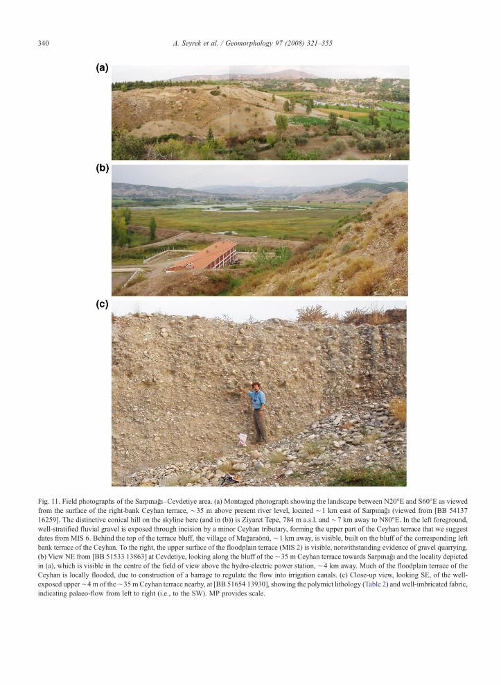
Fig. 11. Field photographs of the Sarpınağı–Cevdetiye area. (a) Montaged photograph showing the landscape between N20°E and S60°E as viewedfrom the surface of the right-bank Ceyhan terrace, ∼35 m above present river level, located ∼1 km east of Sarpınağı (viewed from [BB 5413716259]. The distinctive conical hill on the skyline here (and in (b)) is Ziyaret Tepe, 784 m a.s.l. and ∼7 km away to N80°E. In the left foreground,well-stratified fluvial gravel is exposed through incision by a minor Ceyhan tributary, forming the upper part of the Ceyhan terrace that we suggestdates from MIS 6. Behind the top of the terrace bluff, the village of Mağaraönü, ∼1 km away, is visible, built on the bluff of the corresponding leftbank terrace of the Ceyhan. To the right, the upper surface of the floodplain terrace (MIS 2) is visible, notwithstanding evidence of gravel quarrying.(b) View NE from [BB 51533 13863] at Cevdetiye, looking along the bluff of the ∼35 m Ceyhan terrace towards Sarpınağı and the locality depictedin (a), which is visible in the centre of the field of view above the hydro-electric power station, ∼4 km away. Much of the floodplain terrace of theCeyhan is locally flooded, due to construction of a barrage to regulate the flow into irrigation canals. (c) Close-up view, looking SE, of the well-exposed upper∼4 m of the∼35 m Ceyhan terrace nearby, at [BB 51654 13930], showing the polymict lithology (Table 2) and well-imbricated fabric,indicating palaeo-flow from left to right (i.e., to the SW). MP provides scale.
340 A. Seyrek et al. / Geomorphology 97 (2008) 321–355

Table 2Clast lithological analysis of the Cevdetiye gravel
Constituent Count Percentage Provenance
Limestone 78 32.0 AmanosMountains a
Orthoquartzite 57 23.4 AmanosMountains b
Chert 27 11.1 Neotethys suture c
Basalt 23 9.4 LocalGneiss 18 7.4 AnatoliaVein quartz/metaquartzite 10 4.1 AnatoliaOphiolitic
(mafic/ultramafic)9 3.7 Neotethys suture c
Amphibolite 8 3.3 AnatoliaSandstone 4 1.6 LocalCalcschist 3 1.2 AnatoliaGranitic 3 1.2 AnatoliaMarble 2 0.8 AnatoliaMudstone 2 0.8 LocalTotal 244 100
Analysis of a sample of clasts in the 16–32 mm size range, collected at[BB 51654 13930], the locality depicted in Fig. 11c. The analyticalprocedure followed Bridgland (1986). Our investigation of thegeomorphology places the studied deposit within Terrace 2 of theCeyhan, tentatively dated to MIS 6. Overall, we interpret 67–82% ofthe clasts as originating within the Amanos Mountains, including the11% listed as of local provenance, with the remaining 18% comingfrom Anatolia.a Presumed to be mainly from the Mesozoic succession of the
Amanos Mountains. Clasts of Mesozoic or Cenozoic limesone fromthe Arabian Platform interior could also have entered the Ceyhansystem via its Aksu tributary (Fig. 2).b Possibly from the Arılık Formation (Triassic) or the Eğrek
Formation (Palaeozoic) (Fig. 5c).c It is not possible to tell from the lithology of these clasts whether
they originated from outcrop of the ophiolite suite within the AmanosMountains or in localities farther upstream, such as the Kısık Boğazıgorge of the Upper Ceyhan (Fig. 2).
341A. Seyrek et al. / Geomorphology 97 (2008) 321–355
sample 03TR22 was collected), the basalt is only∼10 mthick (Fig. 10a,b), its base (at ∼195 m a.s.l.) beingobserved to overlie polymict fluvial gravel. Near itssouthern tip, the basalt again tapers to a thickness ofb10 m. Near Karanıdere (e.g., at [BB 55592 20468],where sample 03TR43 was collected) the base of thebasalt reaches as low as ∼145 m a.s.l., again locallyoverlying polymict fluvial gravel. Ceyhan Terrace 1 canbe traced continuously along this reach of the river,∼10 m above present river level; the loamy depositsforming its upper part are intensively cultivated.
Regarding the remaining samples that have been dated,03TR41 came from the unweathered upper part of thebasalt section SWof Karagedik (at [BB 57377 21580]; gin Fig. 4), overlooking the Karanı tributary gorge.Samples 03TR24 and 03TR25 came from the westernmargin of the Karagedik flow unit, adjoining the Ceyhan,where many basalt masses with dimensions of many
metres, and which appear possibly to be in situ, given thelimited exposure caused by the pervasive vegetation, areapparent. Sample 03TR24 came from one such massbetween the level of the Karagedik ‘plateau’ and themodern river, whereas 03TR25 came from another at thepresent river level. However, our dating (Section 5.1)indicates that all the basalt in this area erupted during ashort span of time, circa 270 ka, implying that theseexamples are from large blocks of basalt that have fallendown the valley side from the cliffs above.
Near the southern tip of this basalt, there are severalvantage points from which the Ceyhan terrace staircasecan readily be viewed: for instance, looking SSW downthe valley from [BB 55520 20392], at the southern tip ofthe basalt; or looking NW from [BB 56014 19696] (h inFig. 4), towards the basalt from south of the Karanı–Ceyhan confluence (Fig. 10c). Like at Aslantaş Dam,three terraces younger than the basalt are evident. Thesurface of terrace 3 forms a flat ∼10–15 m below thebase of the basalt near [BB 55520 20392], and its fluvialgravel can also be observed elsewhere, for instance in aroadcut at [BB 55613 19668], at ∼125–130 m a.s.l.Terrace 2 forms another flat roughly halfway betweenthe surfaces of terraces 1 and 3, which is particularlyclear east of the Ceyhan both upstream and downstreamof the Karanı confluence, at ∼100–105 m a.s.l. Gravelof Ceyhan terrace 4 is also evident south of the Karanıconfluence, forming a flat at ∼150 m a.s.l., for instanceat [BB 55903 15622] (Fig. 10c).
At the northern end of the basalt, the morphology ismuch less clear. The only place where any river terraceolder than the floodplain terrace could be identified wasaround [BB 58251 23784], ∼125 m a.s.l., where adegraded terrace remnant is apparent, possibly equivalentto the terrace 3 elsewhere. At higher levels, between thispoint and the top of the basalt bluff, there is instead astacked succession of fluvial gravel, tens of metres thick,with apparent lacustrine interbeds, notably around [BB58572 23442] (Fig. 10d; i in Fig. 4). It is presumed thatthis succession was deposited after the basalt eruption,while the Ceyhan was temporarily dammed, before it wasable to reincise around the western margin of the basaltand re-establish its downstream gradient.
Also evident in the southern part of the basalt outcropare ‘steps’ in the basalt surface, where it is presumed tohave cascaded over pre-existing river terrace bluffs (cf.Westaway et al., 2004, 2006b). An example is nearKaranıdere, c. [BB 558 207], where the basalt steps downto its lowest level, corresponding to gravel at∼145m a.s.l.(Fig. 10c). A second is evident∼1.3 km farther NE, c. [BB568 214]; above it, the base of the basalt can be observed at∼175–180 m, for instance at [BB 57189 21476].

342 A. Seyrek et al. / Geomorphology 97 (2008) 321–355
Although we did not observe any fluvial gravel at either ofthese two ‘stepped’ levels, we presume the higher of themto be roughly contemporaneous with the ∼195 m a.s.l.gravel beneath the northern end of the basalt, thusindicating Terrace 5 of the Ceyhan. A notable observationin the vicinity of [BB 57189 21476] was the presence ofthin, polymict fluvial gravel, overlying the basalt,suggesting that the Ceyhan flowed across this basalttemporarily, before its modern course became entrenchedwest of the basalt. Much thicker (up to ∼8 m) fluvialgravel was also observed overlying the northern end of theKaragedik basalt, at up to ∼220 m a.s.l., in roadcut andquarry sections such as at [BB 58431 22469], [BB 5848223065] and [BB 58346 23438] (Fig. 10a).
4.4. The Sarpınağzı/Cevdetiye area
The Ceyhan passes out of the Amanos Mountainsand into the Cilician Plain between Sarpınağzı (Fig. 11a)and Cevdetiye (Fig. 11b,c); at Cevdetiye, the river thusbegins to flow WNW instead of SSW (Fig. 2). ThisWNW course is thought to be very young; until theearly Middle Pleistocene the river continued SSW intoİskenderun Gulf (Arger et al., 2000; course 1 in Fig. 2;see also Section 4.5 below).
At Cevdetiye, there is a prominent fluvial terrace inthe left bank of the Ceyhan, well-exposed around [BB51654 13930] (j in Fig. 4; Fig. 11b). Its polymict fluvialgravel has clast size ranging up to large cobbles, with
Table 3Ar–Ar dates for Düziçi basalts
Sample Locality UTMCo-ordinates
Weighted plateauage (ka) (±2σ)
MS
03TR22 Karagedik- north BB 58339 23400 295.4±12.7(±4.3%)
0.6
03TR24 Karagedik- scree BB 56897 23471 280.9±20.5(±7.3%)
1.1
03TR25 Karagedik- river BB 56954 23574 257.4±16.6(±6.4%)
0.2
03TR41 Karagedik- south BB 57297 21836 287.3±32.6(±11.4%)
0.2
03TR43 Karanıdere BB 55592 20468 266.8±14.2(±5.3%)
1.0
03TR46 Pınarözü BB 57744 30321 269.3±15.0(±5.6%)
0.3
All samples were of basaltic groundmass, separated as described in the text. Tonline supplement, the weighted plateau age being considered definitive. MSage, a measure of the scatter between individual age estimates for different hethese steps that were used for each weighted plateau age determination.
extremely diverse clast lithology (Table 2) indicative oftransport by a river with a large catchment, and withstrong clast imbrication indicating palaeoflow towardsthe SW (Fig. 11c). The gneiss, vein quartz, metaquartz-ite, amphibolite, calcschist, granitic and marble clasts(Table 2) probably came from the upper reaches of theCeyhan system, ∼150–200 km farther NNE (Fig. 2),these being lithologies characteristic of eastern Anatolia(north of the Neotethys suture) but not the AmanosMountains or Arabian Platform. The upper surface ofthis terrace is estimated as ∼90 m a.s.l., ∼35 m abovethe present level of the river; its gravel is best exposed atthe locality studied between ∼6 and ∼10 m below thisupper surface (Fig. 11c). Around [BB 50991 13770], atthe NW edge of Cevdetiye (k in Fig. 4), basalt from theKüçük Gertepe neck (located circa [BB 500 113]) cropsout in situ barely ∼5 m above the present level of theCeyhan, indicating an extremely young age.
East of Sarpınağzı (around [BB 54137 16259]; l inFig. 4; ∼4 km downstream of the southern tip of theKaragedik basalt), what appears to be the same terraceis well-developed on the inside of a meander loop inthe right bank of the Ceyhan. Its top is at an esti-mated ∼95 m a.s.l., ∼35 m above the local river level(Fig. 11a).
As Fig. 3 shows, the lower Middle Ceyhan gorge isinset into the stacked fluvial gravels of the KadirliFormation. About 2 km west of Sarpınağzı, outcrop ofthese deposits is truncated by the reverse fault,
WD n/N Total fusionage (ka) (±2σ)
Normal isochronage (ka) (±2σ)
Inverse isochronage (ka) (±2σ)
3 7/12 290.7±16.3(±5.6%)
269.1±37.1(±13.8%)
268.9±36.9(±13.7%)
3 7/10 266.3±21.4(±8.0%)
294.0±55.0(±18.7%)
296.3±53.9(±18.2%)
5 6/10 260.7±19.0(±7.3%)
261.0±46.8(±17.9%)
261.6±46.5(±17.8%)
7 7/10 267.7±60.1(±22.5%)
288.0±90.9(±31.6%)
288.1±88.8(±30.8%)
9 8/10 253.0±17.4(±6.9%)
271.8±19.5(±7.2%)
273.7±19.1(±7.0%)
5 7/10 271.0±19.3(±7.1%)
279.1±36.3(±13.0%)
279.0±36.0(±12.9%)
he four age determinations for each of the samples are explained in theWD is the mean squared weighted deviation for the weighted plateauating steps. N is the total of heating steps measured; n is the number of

Fig. 12. Ar–Ar age spectra derived from step-heating of our samples. Horizontal bars indicate the heating steps included in the calculation of eachweighted plateau age (Table 3), considered to be the definitive age determinations. For each sample three other possible age determinations are alsoprovided (Table 3). tF is the total fusion age, derived from the overall 40Ar/39 K ratio for each sample. tN is the ‘normal’ isochron age, obtained byusing the data for all heating steps to construct a 40Ar/36Ar versus 39Ar/36Ar isochron graph. tI is the ‘inverse’ isochron age, obtained by using the samedata to construct a 36Ar/40Ar versus 36Ar/39Ar isochron graph. Full documentation of these age determinations and the underlying data are provided inthe online supplement.
343A. Seyrek et al. / Geomorphology 97 (2008) 321–355
mentioned above, across which the Karataş Formationhas been thrust onto the Kadirli Formation. The line ofhills west of the Ceyhan gorge and north of Sarpınağzı,such as Karayüce Tepe (230 m a.s.l.) and Gölyeri Tepe(∼220 m a.s.l.) (Fig. 4b), are within this outlier of theKadirli Formation, the lower land farther west, in thehanging-wall of this reverse fault, being in the moreeasily erodable rocks of the Karataş Formation.
Despite the clear presence in the lower Middle Ceyhanof clasts of Anatolian provenance, the stone count inTable 2 suggests stongly that this river's sediment loadconsists predominantly of material eroded within theAmanos Mountans. In principle, such a preponderance ofclasts from relatively nearby sources could result fromprogressive abrasion of far-travelled clasts during pro-longed fluvial transport, reducing their typical size to

344 A. Seyrek et al. / Geomorphology 97 (2008) 321–355
below that which has been analysed. We consider thispossibility unlikely, becausemany clasts in the 16–32mmsize fraction analysed have indeed originated fromAnatolia; a more likely explanation is the relatively highrate of local erosion within the Amanos Mountains (seealso Section 6.1 below).
4.5. The Gates of Issos
About 15 km SSWof Cevdetiye (c. [BB 455 015]), a∼80 m deep dry valley (floor ∼80 m and flanks∼160 m a.s.l.) leads from the modern Ceyhancatchment into İskenderun Gulf (Fig. 3). Arger et al.(2000) interpreted this as marking the former course ofthe river (course 1 in Fig. 2), abandoned after it wasdiverted farther west. Arger et al. (2000) dated basaltcapping the eastern flank of this gorge to 1.20±0.23 Maand other basalt in its floor to 0.61±0.10 Ma. A time-averaged incision rate of ∼0.14 mm a−1 during ∼1.2–0.6 Ma is thus indicated.
5. Chronology of landscape development
5.1. Ar–Ar dating of basalt
Preparation for Ar–Ar dating involved initial screen-ing by inspection of hand specimens and petrographic thinsections. Sampleswere then crushed,washed in deionizedwater and dilute hydrochloric acid, sieved to a 60–80 μmsize fraction, and phenocrysts and xenocrysts wereremoved by magnetic separation and hand picking.Following irradiation, argon isotopes were measured inthe microcrystalline groundmass at the Laboratory forNoble Gas Geochronology, Massachusetts Institute ofTechnology, using procedures essentially the same asthose described by Singer and Pringle (1996) and Harfordet al. (2002). Results of this dating are summarised inTable 3 and illustrated in Fig. 12, and are fullydocumented in the online supplement.
For all samples, the four different methods of Ar–Arage determination yield concordant ages, indicating noevidence for systematic error from any of these datingmethods. All six weighted plateau Ar–Ar dates (Table 3)are well-constrained, with ±1σ errors ranging from ∼2%to∼6%. The mean squared weighted deviation (MSWD),a measure of the internal consistency of the step-heatingsplits that contribute to each date, isb1 for four of the datesand ∼1 for the other two. The six weighted plateau datesinclude one from Pınarözü (sample 03TR46), of 269±15 ka (±2σ), and five from the Karagedik area (samples03TR22, 24, 25, 41 and 43). Sample 03TR22, from thenorthern end of the basalt-capped Karagedik ‘plateau’,
yielded a date of 295±13 ka (±2σ). Sample 03TR43, fromthe southern end of the plateau, yielded a date of 267±14ka (±2σ). Sample 03TR41, fromyounger flow exposedin the eastern plateau margin, yielded a date of 287±33 ka(±2σ). The error margins of these three dates overlap,indicating no significant variation in age of the basaltexposed in different parts of this plateau. Furthermore, thisage-span overlaps with that of the Pınarözü sample,indicating no significant difference in age between theKaragedik and Pınarözü/Aslantaş Dam basalt flows.
Sample 03TR24, from partway down the valley side,below the Karagedik plateau, yielded a date of 281±21 ka(±2σ); 03TR25, from the left bank of the Ceyhan, yielded257±17 ka (±2σ). As already noted, these samples weredated to test the possibility that they came from youngerflows inset below the Karagedik basalt, this beingimpossible to resolve in the field due to vegetation. Theerror margins of these two dates overlap with each otherand with the dates from the Karagedik plateau, indicatinginstead that samples 03TR24 and 25 came from blocks ofKaragedik basalt that had fallen down the valley side.Since we can resolve no significant difference in agebetween any of our six dated samples, we obtain our bestestimate of the age for this volcanism as the weightedmean of all six dates, 278±7 ka (±2σ), towards the end ofMIS 9 (circa MIS 9b).
5.2. Correlation of Ceyhan terraces, and rates of upliftand fluvial incision
It was obvious in the field that the basalt at Pınarözü ishigher above present river level than that at Karagedik,∼10 km farther downstream. The dating establishes thatthe ages of the two basalts are indistinguishable, thusindicating (given that both basalts reached the contem-poraneous Ceyhan valley floor) faster time-averagedincision around Aslantaş Dam than at Karagedik. Earlierdiscussion indicated deposits assigned to three Ceyhanterraces, younger than the basalt, in both localities. Thissuggests that the fluvial gravels forming these terracesaggraded during cold-climate stages in MIS 8, 6 and 2,preceded by the eruption of the Karagedik and Pınarözübasalts in MIS 9b.
We report no dating for the Atalan basalt; however, asnoted previously (Section 4.1), we suspect that the part ofit that erupted from neck q in Fig. 4 represents the sameflow unit as at Pınarözü and can thus be presumed to havethe same age. The lowest points reached by the basalt atPınarözü and Abacılar (localities b and n in Fig. 4) canthus provide an indication of the palaeo-Ceyhan valleymorphology. These points are∼12.5 km apart (measuredalong the palaeo-valley) and ∼25 m different in height

Table 4Ceyhan terrace correlation scheme
Name Height (m a.s.l.) MIS Age (ka) Incision a (m) Incision rate a (mm a−1)
Sarpınağzı (river level ∼60 m a.s.l.)Terrace 1 ∼65 2 15 5 ∼0.3Terrace 2 ∼95 6 140 35 0.25
Karagedik- south (river level ∼70 m a.s.l.)Terrace 1 ∼75–80 2 15 5–10 ∼0.3Terrace 2 ∼100–105 6 140 30–35 0.21–0.25Terrace 3 ∼125–130 8 240 55–60 0.23–0.25Gravel beneath basalt ∼145 9b 270 75 0.28Terrace 4 ∼150–155 10 340 80–85 0.24–0.25Terrace 5 (inferred b) ∼175–180 12 425 105–110 0.25–0.26
Karagedik- north (river level ∼75 m a.s.l.)Terrace 1 ∼80–85 2 15 5–10 ∼0.3Terrace 2Terrace 3 (remnant c) ∼120–125 8 240 N45–50 N0.2Terrace 4Terrace 5 ∼195 12 425 120 0.28
Karatepe (river level ∼78 m a.s.l.)Terrace 1 ∼85 2 15 7 ∼0.3Terrace 2Terrace 3 ∼140 8 240 62 0.26
Aslantaş Dam/Pınarözü (river level ∼82–85 m a.s.l.)Terrace 1 ∼87–92 2 15 ∼5–10 ∼0.3Terrace 2 ∼120 6 140 40 0.29Terrace 3 ∼170 8 240 88 0.37Base of basalt (locality b d) ∼175 9b 270 90 0.33Gravel beneath basalt ∼180 9b 270 95 0.35Terrace 4Terrace 5 (locality d e) ∼270 12 425 176 0.41Terrace 6 (locality e e) ∼290 14 540 210 0.39Terrace 7 (locality c e) ∼310 16 640 230 0.36
Gümüş/Sabun Suyu area (notional river level ∼102 m a.s.l.)Terrace 3 (locality n d) ∼185 8 240 83 0.35Base of basalt (locality n d) ∼200 9b 270 98 0.36Terrace 4Terrace 5 (locality d e) ∼270 14 540 176 0.41
Sources of height data are discussed in the text. Incision is calculated from height by subtracting the height of the present river level at each site. Time-averaged incision rate is calculated as incision divided by age.a Estimates of incision include “notional” amounts of incision for deposits related to the pre-basalt Ceyhan palaeo-course. Both observed incision
and this “notional” incision represent direct proxies for surface uplift. See also note d.b As noted in the text, no fluvial gravel was observed at the limited number of sites near the southern end of the Karagedik basalt where its base is
at ∼180 m a.s.l.c As noted in the text, the deposits assigned to Ceyhan terrace 3 near the northern end of the Karagedik basalt were degraded,; their upper surface
may be below the original level of this terrace.d The reference level of 102 m a.s.l. adopted for locality n is based on calculation for the pre-basalt Ceyhan palaeo-course, assuming a notional
palaeo-channel-gradient of 1.6m km−1, as discussed in the text. It is significantly below the∼120m a.s.l. level of the Ceyhan at its modern Sabun Suyuconfluence (locality o in Fig. 4). An alternative calculation for the 185 m a.s.l. gravel would indicate only ∼65 m of incision relative to this modernreference level. However, to convert this incision to uplift would require a “channel lengthening correction” to take account of the fact that the moderncourse of the Ceyhan is longer than the palaeo-course (∼14.5 km against∼12.5 km), plus the extra∼3.5 km of channel length between localities n ando. To make the calculation internally consistent would require the magnitude of this correction to be ∼18 m, indicating ∼83 m of uplift since thedeposition of this sediment, as in the alternative calculation.e Deposits assigned to Ceyhan terraces 5 and 6 in the Aslantaş Dam/Pınarözü area are projected into the modern valley to a river level of 80 m a.s.l.
from localities c and e in Fig. 4. For the Ceyhan gravel assigned to terrace 5, from the pre-basalt palaeo-course, uplift is estimated relative to a notionalreference level of 94 m a.s.l., based on a notional palaeo-channel-gradient of 1.6 m km−1, as discussed in the text.
345A. Seyrek et al. / Geomorphology 97 (2008) 321–355

346 A. Seyrek et al. / Geomorphology 97 (2008) 321–355
(∼175 m against ∼200 m a.s.l.), indicating an apparentdownstream gradient of ∼2 m km−1.
The mean gradient of the modern Ceyhan can beestimated from its ∼22 m fall (from ∼82 to ∼60 m a.s.l.)between Aslantaş Dam and Sarpınağzı, a straight-linedistance of ∼13.5 km, and is ∼1.6 m km−1. We interpretthe difference between this value and the ∼2 m km−1
gradient projection, above, to reflect a continued increasein rates of uplift and incision, upstream of Aslantaş Dam.We thus determine a reference level (above which toestimate the “notional” incision, had the Ceyhan continuedto follow its palaeo-course) of 102m a.s.l. at locality n (i.e.,82 m+12.5 km× 1.6 m km−1). We likewise estimate thereference level at locality d as ∼94 m a.s.l. (i.e., 82 m+7.5 km×1.6 m km−1), this point being∼7.5 km upstream(along the Ceyhan palaeo-course) of Pınarözü.
The resulting Ceyhan terrace scheme (Table 4)supports an upstream increase in the incision rate from∼0.25 mm a−1 at Cevdetiye and Sarpınağzı to∼0.3 mma−1 around Karagedik, ∼0.35 mm a−1 around AslantaşDam and Pınarözü, and ∼0.4 mm a−1 at locality d eastof Hidirli. It suggests that the Ceyhan palaeo-coursethrough locality c (Figs. 4 and 9a) was abandoned afterMIS 16, this being the oldest Pleistocene depositattributable to the Ceyhan that we have recognized.Although the data currently available do not yet permitprecise estimates of uplift rates farther upstream,extrapolation of the pattern indicated would give anincision rate of ∼0.5 mm a−1 at the downstream end ofBerke Gorge, ∼20 km upstream of the Aslantaş Dam(Fig. 2), consistent with the earlier estimate (fromSection 3.2), time-averaged since the Mid-Pliocene.
The data thus support a west–east increase in rates ofuplift and incision, between the western margin and thecore of the Amanos Mountains, consistent with theantiformal structure (Fig. 5a,b,c). Such a lateral variationis also consistent with the observed typical westwardmigration of the Ceyhan channel (Figs. 2 and 4; Sections4.1 and 4.2), evidently reflecting ‘uniclinal shifting’ (cf.Wooldridge, 1938) of the river. For instance, the diversionassociated with the volcanism in MIS 9b evidentlyinvolved awestward ‘shift’ of the outlet fromBerkeGorgeinto the pre-existing valley of the River Keşiş (Fig. 2).Other apparent dry valleys may reflect similar drainageadjustments, but have not yet been investigated. Examplesare evident in Fig. 4 east of Aynışlar (∼330 m a.s.l.)between the modern Sabun Suyu and Karanı catchmentsand south of Aynışlar (∼290 m a.s.l.), between the modernAkarsu and Karanı catchments. The latter may reflectwestward adjustment of the NW-trending part of the courseof the Akarsu, adjusting its confluence with the Ceyhanfrom near Karagedik to near Cevdetiye (Fig. 4). Such an
adjustment would, likewise, be consistent with a westwarddecrease in uplift rates.
6. Numerical modelling of surface uplift
Seyrek et al. (2007) have suggested that the surfaceuplift within the AmanosMountains is being sustained bythe transpression along the northern DSFZ. We will nowtest this suggestion by physics-based numerical model-ling, after Westaway (2002). Before presenting themodelling results, we first summarise the evidence thatprovides input to this modelling. Previous work by others(e.g., Meigs et al., 2003) has investigated the interactionbetween distributed crustal shortening, surface processes,and the development of topography within transpressivestepovers on strike-slip fault zones. However, the presentanalysis is the first time that anyone has attempted tocompare such observational estimates with predictions ofa quantitative physical model.
6.1. Input parameters
First, we use the Bouguer gravity anomaly map byAteş et al. (1999) to assess the isostatic equilibriumwithinthe Amanos Mountains. The data reduction procedure forthis map utilised a crustal density ρc=2400 kg m−3 forboth Bouguer corrections and terrain corrections. The rawdata remain confidential; however, the many measure-ments used (∼62,000, on average one per ∼13 km2 ofland area) suggests that many measurements were madewithin the Amanos Mountains.
If topography within thickened continental crust isunderlain by a lower-crustal ‘root’ or ‘keel’, as forconventional Airy isostasy, then one expects a largenegative Bouguer gravity anomaly, because the mantlelithosphere and asthenosphere have higher densities(ρm=∼3300 kg m−3; ρa=∼3100 kg m−3) than thelower-crustal root. This effect is observed in the highplateau of NE Turkey, but not within the AmanosMountains. In the Arabian Platform, east of the northernAmanos Mountains, the Bouguer anomaly is∼−60 mgal (Ateş et al., 1999). In the northern AmanosMountains, this anomaly is greater, being ∼−40 mgal(Ateş et al., 1999). In the southern Amanos Mountains itlocally exceeds ∼+80 mgal (Ateş et al., 1999), but thiseffect may well be due to the presence of high-densityoceanic crust, forming the Hatay ophiolite (see above).However, if the N2 km of topography were underlain bysufficient lower-crustal root to maintain Airy isostasy,the Bouguer anomaly would be c. −120 mgal.
Khair et al. (1993) noted that in the LebanonMountains farther south (Fig. 1), where summits exceed
347A. Seyrek et al. / Geomorphology 97 (2008) 321–355
3000 m a.s.l., the Bouguer anomaly is likewise notconsistent with a lower-crustal root; they deducedinstead that, to a first approximation, the Moho is flatbeneath these mountains. Modern kinematic models(after Westaway, 2003, 2004, and Seyrek et al., 2007),regard the Lebanon and Amanos mountain ranges asclose analogies, having largely developed throughtranspression accompanying left-lateral slip on theDSFZ. Such analogies have emerged following recentstudies in Lebanon and western Syria, such as byWestaway (2003, 2004) and Gomez et al. (2003, 2006).This interpretation differs radically from the previousview, which was that the deformation of the AmanosMountains (Fig. 5) was ancient, possibly related to theCretaceous obduction of the Hatay ophiolite (e.g.,Schwan, 1971, 1972; Brinkmann, 1976).
The tangential direction to the Westaway (2003, 2004)Euler pole for the DSFZ, measured at İslahiye (37.05°N,36.6°E; Fig. 2) is N33°W. The Amanos Fault strikesN20°E; thus, it is locally misaligned by an angle, θ, of 53°in the transpressive sense. The Seyrek et al. (2007) Eulervector predicts relative motion between the Arabian andAfrican plates at İslahiye of 8.5 mm a−1 towards N33°W.The expected rate of left-lateral slip taken up in this areaon N20°E-striking faults is thus 8.5 mm a−1× cos(53°) or5.1 mm a−1. Seyrek et al. (2007) estimated the left-lateralslip rate on theAmanos Fault as∼3mma−1; they inferredthat the remaining∼2.1 mm a−1 of left-lateral slip occurson the East Hatay Fault, bounding the east side of theKarasu Valley (Fig. 2). We take the timing of the start ofthis deformation as 3.73±0.05 Ma, from Westaway et al.(2006a).
Westaway (1995) determined the spatial averagestrain rate Es for the distributed shortening along atranspressive stepover as:
Es ¼ V sin hð Þ2H
ð1Þ
where V is the local relative plate velocity and H is thewidth of the mountain range forming the stepover. Weestimate the present-day value of H across the northernAmanos Mountains as ∼45 km, measured alongN70°W–S70°E through Osmaniye (Fig. 2). Taking Vas 8.5 mm a−1 (see above) and θ=53°, and noting that∼60%, not half (as was assumed in Westaway's, 1995,analysis), of the shortening strain seems to be taken upin the Amanos Mountains, with this value of H oneobtains Es=∼0.09 Ma−1. Deformation since ∼3.7 Mawould thus result in ∼17 km of shortening, making theinitial width of the mountain range ∼62 km instead of∼45 km. Taking this change of shape into account, we
adopt 0.08 Ma−1 as the time-averaged shortening strainrate in this locality.
Tezcan (1995) reported the surface heat flow, qs, asincreasing northward along the Amanos Mountainsfrom ∼60 mW m−2 to ∼100 mW m−2. It is thussignificantly higher than in the Arabian Platforminterior, where qs is typically no greater than ∼50 mWm−2 (Tezcan, 1995). As has been noted previously (e.g.,Stüwe et al., 1994; Westaway, 2002), erosion willperturb the thermal state of the crust; by causing eachgeotherm to advect upwards relative to the erodingland surface it will increase qs. To estimate thepotential importance of this effect, we use the solutionfrom Westaway, 2002, equation B5) for the steady-state temperature T at depth z in crust where the Mohoat depth zm is maintained at a constant temperature T1,and where the Earth's surface (at 0 °C) is eroding atrate U:
T ¼ T11� exp �Uz=jð Þ1� exp �Uzm=jð Þ ; ð2Þ
where κ (∼1 mm2 s− 1) is the thermal diffusivity of thecrust. Differentiating Eq. (2) gives:
dTdz
¼ UT1=jð Þ exp �Uz=jð Þ1� exp �Uzm=jð Þ ; ð3Þ
so the surface heat flow, or k×dT / dz (z=0), with k thethermal conductivity of the crust, is:
qs ¼ kUT1=jð Þ 11� exp �Uzm=jð Þ : ð4Þ
Eq. (4) can be approximated using first-order power-series expansions as:
qsikT1zm
1þ Uzm= 2jð Þð Þ provided PeuUzm= 2jð Þbb1ð Þ;ð5Þ
facilitating comparison with the value qs=kT1 / zm thatwould apply in the absence of erosion. With zm=30 km,it is thus evident that U=0.2 mm a−1 would increase thesurface heat flow by ∼10% whereas U=0.4 mm a−1
would increase it by ∼20%.Spatially averaged across the Ceyhan catchment, as
already noted there is a mismatch between the∼0.13 mm a−1 erosion rate estimate from the historicalsediment load and the ∼0.03 mm a−1 lower bound fromthe Pleistocene deposition beneath İskenderun Gulf.Clast lithological analysis (Table 2) indicates that
348 A. Seyrek et al. / Geomorphology 97 (2008) 321–355
erosion of the Amanos Mountains has provided theprincipal sediment source for the Middle Ceyhan gravel,and thus for the Pleistocene fluvial deposits beneathİskenderun Gulf. The part of these mountains drained bythe Ceyhan (Fig. 2) is ∼40 km wide (WNW–ESE) and∼90 km long (NNE–SSW), thus ∼3600 km2 in area. Ifonly this area, rather than the whole catchment, isassumed to contribute then the above erosion rateestimates adjust to ∼0.2 and ∼0.7 mm a−1.
U=0.2 mm a−1 is thus a reasonable lower bound to thespatial average erosion rate in the northern AmanosMountains, from analysis of sediment fluxes. Currentlyno data exist on long-timescale erosion rates in thismountain range. However, Boztuğ et al. (2005) haveobtained apatite fission-track erosion rates of ∼0.4–0.5 mm a−1 for the Late Cenozoic in the Kaçkar mountainrange of NE Turkey. These mountains, adjoining the SEBlack Sea, experience high orographic precipitation, butare much higher than for the Amanos Mountains(∼4000 m instead of ∼2300 m). Thus ∼0.4 mm a−1
can be regarded as a reasonable a priori upper bound tothe erosion rate in the Amanos Mountains.
As in other studies of this type (e.g., Westaway, 2002;Westaway et al., 2004) it is important to estimate theMoho temperature Tm, because this determines theeffective viscosity ηe for the lower crust and thusgoverns how readily this layer can flow in response toloads of a given magnitude (cf. Westaway, 1998). Thesimplest possible calculation assumes a steady-stategeotherm with radiogenic heating at shallow depths(i.e., the perturbations caused by the sedimentation andassociated erosion are for the time being neglected). Inmany regions, the surface heat flow varies linearly withthe radioactive heat production Y(z=0)=Yo in surfacerocks (e.g., Lachenbruch, 1970). This can result ifradiogenic heat production is constant, at Yo, across adepth range D and zero at greater depths where the basalheat flow is qo. Simple algebra indicates that:
q zð Þ ¼ q0 þ Y0 D� zð Þ 0 V z VD; ð6Þsuch that the surface heat flow qs is given by:
qs ¼ q0 þ Y0D: ð7Þ
It follows that:
T zð Þ ¼ q0z
kþ Y0Dz
k� Y0z2
2k0 V z VD; ð8Þ
and that the temperature at depth D is TD where:
TD ¼ q0Dk
þ D2Y02k
; ð9Þ
the two terms being the contributions from basal heatflow and from radiogenic heating.
In the absence of detailed information we select thefollowing values for crustal properties: the Moho depth,zm, is 30 km; the upper crust consists of granitic basementwith Yo=4 μW m−3 down to a depth D=10 km; and thesurface heat flow qs is roughly double the basal compo-nent qo (cf. Westaway et al., 2006b). If, in the absence oferosion, qs=90 mW m−2, with qo=45 mW m−2, thenTD=260 °C, making Tm=620 °C. Conversely, if qs were80 mW m−2, with qo=40 mW m−2, then TD=240 °C,making Tm=560 °C. Moho temperatures of this orderthus seem a priori reasonable for this region.
As already discussed, the absence of a negativeBouguer anomaly indicates that the Amanos Mountainshave no lower-crustal root. However, the small(∼20 mgal) positive Bouguer anomaly indicates thatthe high-density mantle lithosphere is thicker beneaththis mountain range than beneath its immediatesurroundings to the east. This effect can be investigatedas a first approximation using the standard slab formula;a slab of thickness h with a density constant Δρcontributes a gravity anomaly Δg where Δg=2πGΔρh,G being the universal gravitational constant. No dataexist (such as from seismic refraction profiling) that candirectly constrain any Moho relief beneath the AmanosMountains. However, two end-member possibilities canbe considered. The first is that the Moho is flat, themantle lithosphere thickening within a mantle litho-sphere root. In this case, Δρ=ρm−ρa=200 kg m−3,such that a 20 mgal gravity anomaly implies a mantlelithosphere root ∼2360 m thick. The second end-member possibility is that the base of the lithosphere isflat, the mantle lithosphere thickening being accommo-dated by upwarping of the Moho In this case, Δρ=ρm−ρc=900 kg m−3, such that a 20 mgal gravity anomalyimplies upwarping of the Moho by ∼530 m.
The high value of θ, noted above, only applies tolocalities adjoining the N20°E-striking Amanos Fault.Farther south, where the faulting strikes N–S, θ is muchless, and the strain rate for distributed shortening iscorrespondingly smaller. For instance, at the latitude ofSamandağı (36.07°N), the Seyrek et al. (2007) kine-matic model predicts θ=29° and V=7.9 mm a−1. Thesame reasoning as before thus gives an estimatedshortening strain rate of ∼0.05 Ma−1, roughly halfthat expected farther north. The uplift rate aroundSamandağı (Table 1) is likewise about half that indicatedalong the Middle Ceyhan gorge, consistent with theassumption underlying the present modelling that theshortening strain rate is the principal factor determiningrates of surface uplift.

Fig. 13. First set of modelling solutions, calculated assuming a step change in the erosion rate from Uo=−0.02 mm a−1 to U=0.2 mm a−1 within theAmanos Mountains, with no such corresponding change (i.e., Uo=−0.02 mm a−1; U=−0.02 mm a−1) in the adjoining crust of Anatolia. For each setof input parameters six solutions are run, for different values of ηe, the effective viscosity of the lower crust, which equate (given the calibration used,fromWestaway, 1998) to values of the Moho temperature, Tm, as follows: M1, ηe=10
19 Pa s, Tm=603 °C; M2, ηe=1.2×10¹⁹ Pa s, Tm=598 °C; M3,
ηe=1.5×10¹⁹ Pa s, Tm=591 °C; M4, ηe=2×10
19 Pa s, Tm=582 °C; M5, ηe=2.5×10¹⁹ Pa s, Tm=575 °C; and M6, ηe=3×10
19 Pa s, Tm=570 °C.See main text for values of other model parameters; see Westaway (2002) for full documentation of the method. Observational evidence, forcomparison with predictions, is labelled as follows. A is the 2200 m of uplift along the axis of the AmanosMountains, inferred since∼4Ma given theargument in the main text that the present-day land surface in this area was close to sea-level at this time. E is the uplift estimated assuming that theaxis of the mountain range has eroded at the rate assumed in the modelling; it is thus 2200 m+4 Ma×0.2 mm a−1 or 3000 m. B is the uplift indicatedby the ∼1200 m of fluvial entrenchment along the Berke gorge, which has developed over an unknown span of time since the Mid-Pliocene. Cindicates the uplift, at rates of ∼0.25–0.4 mm a−1, observed on a range of timescales since the mid Middle Pleistocene, at sites in the lower MiddleCeyhan discussed in the text. (a) and (b) Predictions of uplift and uplift rate assuming that the Moho remains flat beneath the study region. (c) and (d).Predictions of uplift and uplift rate assuming that the base of the lithosphere remains flat beneath the study region, such that the Moho becomesupwarped in response to the thickening of the mantle lithosphere that is assumed.
349A. Seyrek et al. / Geomorphology 97 (2008) 321–355
6.2. Modelling strategy
Our modelling will thus consider four configurations,representing each of the above isostatic assumptions andend-member spatial average erosion rates (0.2 and0.4 mm a−1). Modelling will utilise the techniquedeveloped by Westaway (2002), as subsequentlyamended (cf. Westaway et al., 2006b; Westaway, 2007;Westaway and Bridgland, in press). This techniqueallows calculation of the vertical crustal motion resultingfrom combinations of distributed strain and surfaceprocesses, taking into account the lower-crustal flowinduced by the variations in depth (and thus, pressure) ofthe base of the upper-crustal brittle layer. The lower crust
is treated as a linear isoviscous fluid with effectiveviscosity (with meaning as defined by Westaway, 1998)ηe. Different values of ηe correspond to different Mohotemperatures Tm, given that in the actual crust theviscosity will decrease with temperature and thus withdepth. As in previous studies, the Westaway (1998)calibration relates Tm and ηe. For each set of inputparameters, six solutions will be run, as follows: M1,ηe=10
19 Pa s, Tm=603 °C; M2, ηe=1.2×10¹⁹ Pa s,
Tm=598 °C; M3, ηe=1.5×10¹⁹ Pa s, Tm=591 °C; M4,
ηe=2×10¹⁹ Pa s, Tm=582 °C; M5, ηe=2.5×10
19 Pa s,Tm=575 °C; and M6, ηe=3×10
19 Pa s, Tm=570 °C.This range is appropriate given the thermal state of thecrust in the study region, as discussed earlier.

Fig. 14. Second set of modelling solutions, calculated assuming the same method as for Fig. 13 but with a step change in the erosion rate from Uo=−0.04 mm a−1 to U=0.4 mm a−1 within the Amanos Mountains, with no such corresponding change (i.e.,Uo=−0.04 mm a−1; U=−0.04 mm a−1) inthe adjoining crust of Anatolia. Comparison is with the same set of observational evidence indicators as in Fig. 13, except measure E has beenadjusted to 2200 m+4 Ma×0.4 mm a−1 or 3800 m, given the higher erosion rate now assumed. (a) and (b) Predictions of uplift and uplift rateassuming that the Moho remains flat beneath the study region. (c) and (d). Predictions of uplift and uplift rate assuming that the base of the lithosphereremains flat beneath the study region, such that the Moho becomes upwarped in response to the thickening of the mantle lithosphere that is assumed.
350 A. Seyrek et al. / Geomorphology 97 (2008) 321–355
Following Seyrek et al. (2007), we assume that theAmanos Fault did not exist before 3.7 Ma, when the AF-AR relative motion was taken up farther east (Fig. 1). It isassumed that the ancestral River Ceyhan flowed acrosswhat are now the Amanos Mountains, depositing theKadirli Formation, with a nominal sedimentation rateUo. At 3.7 Ma, the Amanos Fault came into being, andthe Amanos Mountains began to experience transpres-sion, accompanied by surface uplift and erosion, at aspatial average rate U. The change in deformation rateplaced the crust in a thermal non-steady state. For eachsubsequent time step, the computer program calculatesthe change in depth of the base of the brittle layer, beingtaken – as in previous studies – as the temperaturethreshold of 300 °C. Taking account of the difference inpressure, at the base of this layer, between the AmanosMountains and their surroundings, the flux of lower crustinward to beneath the mountains or outward to beneaththeir surroundings in each model time step is thencalculated, enabling the conditions at the start of the nexttime step to be determined.
The Amanos Mountains are represented as a modelregion of initial width Le=60 km, this value decreasingover time in response to the crustal shortening. Thismodelregion is connected to another model region with zerostrain rate andwith sedimentation rateUomaintained overtime, schematically representing the crust of Anatolia(Fig. 1). By making this model region very largecompared with the model Amanos Mountains, inwardor outward fluxes of lower crust have a minimal effect onits crustal thickness, reducing any risk of numericalartefacts that may arise from such crustal thicknessvariations. Components of lower-crustal flow in otherdirections, parallel to the strike of the Amanos Mountainsor towards or away from the Karasu Valley, are neglected.As noted earlier, some of the material eroded within theCeyhan catchment during the Pleistocene has accumulat-ed within İskenderun Gulf. However, previous discussionsuggested that this is only a small proportion of the totalmass flux. Thus, no attempt is made to model any localcomponent of lower-crustal flow induced by this sedimentloading, most likely outward from beneath İskenderun

351A. Seyrek et al. / Geomorphology 97 (2008) 321–355
Gulf, in order to create the accommodation space for thesediment that has accumulated there.
As Westaway (2006b) noted, in general it is a prioriunclear whether transpressive stepovers on strike-slipfault zones are dominated by thickening of the uppercrust caused by the crustal shortening, which would actto force lower crust out from beneath the stepover; or byerosion, which would act to draw lower crust in. Thisissue is important; as Westaway (2006b) showed, it hasa significant effect on the local stress field. Despite thesubstantial erosion rates indicated, the set of parametervalues deduced above requires all plausible solutions forthe Amanos Mountains to be dominated by crustalshortening, the sense of lower-crustal flow thus beingoutward, caused by the pressure at the base of the brittlelayer being higher beneath this mountain range thanbeneath its surroundings.
6.3. Results and discussion
Inspection of Figs. 13 and 14 indicates that, at thestart of each model run, the model crust is observed tothicken at a rate equal to the crustal thickness of 30 kmmultiplied by the 0.08 Ma−1 strain rate, giving a rate of2.4 mm a−1. As in previous studies of this type, theuplift values and uplift rates depicted are for markersthat are not themselves eroding. In each case the meanaltitude of the eroding land surface will vary at a rate thatis less than the uplift rate shown by an amount equal toU. Initially, there is no outward lower-crustal flow,because there is no difference in pressure at the base ofthe brittle layer relative to the surroundings. Subse-quently, as the model crust thickens, lower crust isdriven out at an increasing rate, causing the rate ofsurface uplift to decrease over time. The more mobilethe lower crust is assumed to be, the more rapidly thisrate begins to decrease. It can indeed be seen that, for themore mobile solutions considered, the outflow of lowercrust can ultimately exceed the effect of crustalshortening, leading to the prediction of crustal thinningfollowing the initial crustal thickening. It is expectedthat the ultimate behaviour of each solution would be toreach a mass-flux steady-state in which the increase inmass of each part of the model crust caused by theimposed shortening strain is balanced by the loss ofmass through erosion and through outward lower-crustalflow; however, such conditions have not been investi-gated in this study (cf. Morley and Westaway, 2006).Comparison of the different solutions also indicates that,other factors being equal, the lower the erosion rate thefaster is the decrease over time in uplift rate. This isbecause the faster the erosion is, the shallower is the
base of the brittle upper crust and, thus, the smaller is thepressure difference available to drive lower-crust outfrom beneath the eroding mountain range.
We use the following observational evidence to testthe solutions: first, the 0.4–0.3 mm a−1 Middle-LatePleistocene uplift rate and the uplift by ∼90 m since∼270 ka and ∼40 m since 140 ka at Pınarözü. Second,is the 0.25 mm a−1 Late Pleistocene uplift rate and the∼35 m of uplift since ∼140 ka at Sarpınağzı. Third, the∼2300 m maximum altitude of the Amanos Mountainsprovides a rough lower bound to the uplift that hasoccurred, given that the ancestral River Ceyhan flowedacross this mountain range and must have been near sea-level as the region adjoins the palaeo-coastline. The∼1200 m of incision of the Berke Gorge is alsoillustrated, so its age may tentatively be deduced.
Figs. 13 and 14 indicate that the best fit to the Middle-Late Pleistocene data from the Middle Ceyhan gorge isprovided by solution M4, indicating ηe=2×10
19 Pa sand Tm=582 °C. However, this solution seriously over-predicts the topography, indicating surface uplift by∼6 km since the start of each model run. Thus, allowingfor the predicted erosion, by ∼0.8 km in Fig. 13(∼0.2 mm a−1 ×4 million years) and by ∼1.6 km inFig. 14 (∼0.4 mm a−1 ×4 million years), a mountainrange ∼4.5–5 km high, not ∼2.3 km high, would beexpected. Conversely, the solutions that best account forthe observed topography, M1 (ηe = 10
19 Pa s,Tm=603 °C) and M2 (ηe=1.2×10
19 Pa s, Tm=598 °C)correspond to states for which the maximum topographyhas been exceeded, with subsidence – not uplift –predicted at the present day. The over-prediction of theobserved topography (allowing for predicted erosion) is∼3.0 km in Fig. 13a (∼6.1 km against ∼3.1 km) and∼2.1 km in Fig. 14a (∼6.0 km against ∼3.9 km).However, the difference, in terms of crustal conditions,between these solutions is not great, corresponding to avariation in the temperature difference between theEarth's surface and the Moho of no more than∼3%, lessthan the limit of resolution by the available data. Suchextreme sensitivity of this type of modelling to crustalparameters has been noted before (e.g., Westaway,2002); limitations in observational evidence indeedconstitute a major obstacle to making improvements inthe modelling technique (Westaway, 2007).
This mismatch can be reduced by increasing themodel erosion rate. A solution with U=0.6 mm a−1 andwith no Moho topography could account for the LatePleistocene uplift data in terms of ηe=1.7×10
19 Pa s(Tm=587 °C) and predicts a total of ∼5.9 km of surfaceuplift, compared with the associated ∼4.7 km sum ofthe observed topography plus the ∼2.4 km of predicted

352 A. Seyrek et al. / Geomorphology 97 (2008) 321–355
erosion (∼0.6 mm a−1 ×4 million years). However, themismatch remains, and it is not clear that so mucherosion is plausible on this timescale in this region (say,to exhume the Palaeozoic sequence forming the summitarea of mountains such as Uluziyaret), given therepresentative thicknesses and dispositions of thevarious younger stratigraphic units illustrated in Fig. 5.
We thus conclude that the mismatch identified resultsfrom some deficiency in the underlying model. The mostproblematic assumptions made are that the erosion rateand strain rate for distributed deformation have notvaried, either spatially or over time.Work on other DSFZtranspressive stepovers (e.g., Walley, 1998; Westaway,2003, 2004; Gomez et al., 2006) has suggested that theshortening strain rate increases towards the major left-lateral faults, thus accounting for the overall landscapemorphology. Seyrek et al. (2007) indeed inferred this inthe Amanos Mountains. Likewise, one may expect fastererosion in the parts of the range with greatest rainfall andsteepest relief; the possibility of time-dependent erosionrates in each part of the model region, as the localtopography changes, thus becomes evident. A relatedissue is whether the deformation is truly distributed orreverse faults identified within the Amanos Mountains(Fig. 5) are active and take up some of the requiredcrustal shortening, making the strain rate in theirsurroundings less than predicted. Strain partitioninglike this has been identified within transpressive step-overs along the right-lateral San Andreas fault system inCalifornia following large reverse-faulting earthquakes(e.g., San Fernando, 1971; Loma Prieta, 1989; North-ridge, 1994). Further work is required to establish thisissue, and to thus resolve (for instance) whether thelateral variations in uplift rates observed in the Ceyhanterraces relate entirely to gradual variations in regionaluplift rates, or in part to localised reverse faulting. As wasnoted earlier, there is evidence of reverse-faultingoffsetting the Kadirli Formation deposits near theMiddleCeyhan gorge, but it is unclear whether this processremains active in this area. Resolution of this issue mustawait more detailed fieldwork, beyond the scope of thisstudy.
One may thus hypothesise that when the left-lateralslip on the Amanos Fault began, at ∼3.7 Ma, the upliftin the adjoining Amanos Mountains was much morelocalised than at present, close to this fault. As the landin this area rose, the erosion rate increased and, by actingto reduce the local excess depth of the base of the brittleupper crust, helped to stabilise the topography. Like-wise, rather than being highly dispersed, the outflow oflower-crust from beneath this initial narrow upliftingregion may have largely accumulated beneath neigh-
bouring regions, such as the present western foothills ofthe Amanos Mountains, contributing to crustal thicken-ing and thus surface uplift there. The present modellingtakes no account of such possible complexities andthus provides at best a very crude representation of whathas been occurring. However, it indicates the essentialphysics and thus enables first-order estimates to be madeof the main parameters that govern the local state ofisostatic equilibrium.
7. Conclusions
We have used the Ar–Ar technique to obtain the firstnumerical dates for the Pleistocene volcanism along thevalley of the River Ceyhan in the Düziçi area, in thewestern foothills of the Amanos Mountains. Our sixdates indicate a single abrupt episode of volcanism at c.270 ka. In part through our own fieldwork and in part byutilising old documents relating to the damming of theCeyhan, we have identified a staircase of 7 fluvialterraces, at altitudes of up to∼230 m above present riverlevel. Using the disposition of the dated basalt as an ageconstraint, we assign these terraces to cold-climatestages between MIS 16 and 2, indicating rates of fluvialincision, equated to surface uplift, of between 0.25 and0.4 mm a−1. Since ∼3.7 Ma the Amanos Mountainshave formed a transpressive stepover along the northernpart of the Dead Sea Fault Zone, where crustalshortening is required by the geometry. Using aphysics-based technique, we have modelled the overallisostatic response to the combination of processesoccurring, including crustal thickening caused by theshortening, erosion caused by orographic precipitation,and the resulting outward flow of mobile lower-crustalmaterial, in order to predict the resulting history ofsurface uplift. This modelling suggests that the effectiveviscosity of the lower crust in this region is in the range∼1–2×10¹⁹ Pa s, consistent with a Moho temperatureof ∼590±10 °C, the latter value being in agreementwith heat flow data. This modelling neglects many localdetails (e.g., lateral and temporal variations in strainrates and erosion rates) and thus only provides a crudesummary of the complexity of the processes that areoccurring. However, it indicates that the nature of theactive crustal deformation is now understood, to firstorder at least, in this key locality within the boundaryzone between the African and Arabian plates.
Acknowledgments
This work was supported in part by HÜBAK (HarranUniversity Scientific Research Council) grant 428

353A. Seyrek et al. / Geomorphology 97 (2008) 321–355
(A.S.). We thank the personnel at the DSİ regionalheadquarters in Adana and Kahramanmaraş for grantingaccess to, and permission to publish, their documentsrelating to the construction of the Aslantaş Dam. We arealso grateful to the manager of the Aslantaş hydro-electric power station, now operated by EÜAŞ (theTurkish state electricity generation company), for hishospitality and for fieldwork permission. Bill Olszewskihelped with documentation of the Ar–Ar dating results.We also thank both anonymous reviewers for theirthoughtful and constructive comments. This studycontributes to IGCP 518 ‘Fluvial sequences as evidencefor landscape and climatic evolution in the LateCenozoic’.
Appendix A. Supplementary data
Supplementary data associated with this articlecan be found, in the online version, at doi:10.1016/j.geomorph.2007.08.014.
References
Aksu, A.E., Calon, T.J., Piper, D.J.W., Turgut, S., Izdar, E., 1992b.Architecture of late orogenic Quaternary basins in northeasternMediterranean Sea. Tectonophysics 210, 191–213.
Aksu, A.E., Uluğ, A., Piper, D.J.W., Konuk, Y.T., Turgut, S., 1992a.Quaternary sedimentary history of Adana, Cilicia and Iskenderunbasins; Northeast Mediterranean Sea. Marine Geology 104, 55–71.
Aksu, A.E., Calon, T.J., Hall, J., Yaşar, D., 2005. Origin and evolutionof the Neogene İskenderun Basin, northeastern Mediterranean Sea.Marine Geology 221, 161–187.
Aktar, M., Ergin, M., Özalaybey, S., Tapırdamaz, C., Yörük, A.,Biçmen, F., 2000. A lower-crustal event in the northeasternMediterranean; the 1998 Adana earthquake (Mw=6.2) and itsaftershocks. Geophysical Research Letters 27, 2361–2364.
Arger, J., Mitchell, J., Westaway, R., 2000. Neogene and Quaternaryvolcanism of south-eastern Turkey. In: Bozkurt, E., Winchester, J.A.,Piper, J.D.A. (Eds.), Tectonics and Magmatism of Turkey and theSurrounding Area. Geological Society, London Special Publication,vol. 173, pp. 459–487.
Atan, O., 1969. Eğribucak - Karacören (Hassa) - Ceylânlı - Dazevleri(Kırıkhan) arasındaki Amanos Dağlarının jeolojisi. Report no. 139,General Directorate of Mineral Research and Exploration, Ankara,85 pp.
Ateş, A., Kearey, P., Tufan, S., 1999. New gravity andmagnetic anomalymaps of Turkey. Geophysical Journal International 136, 499–502.
Bilgin, A.Z., Ercan, T., 1981. Petrology of the Quaternary basalts ofthe Ceyhan–Osmaniye area. Bulletin of the Geological Society ofTurkey 24, 21–30 (in Turkish with English summary).
Boztuğ, D., Jonckheere, R., Enkelmann, E., Ratschbacher, L., Wagner,G., 2005. Geodynamic implications of rapid denudation of thegranitoids at about 50 and 20 Ma in the eastern Pontides, Turkey;apatite fission-track results. Geochimica et Cosmochimica Acta 69(10), 300 [abstract].
Bridgland, D.R., 1986. Clast lithological analysis. Technical Guide,vol. 3. The Quaternary Research Association, Cambridge. 207 pp.
Bridgland, D.R., Westaway, R., in press. Climatically controlledriver terrace staircases: A worldwide Quaternary phenomenon.Geomorphology.
Bridgland, D.R., Philip, G., Westaway, R., White, M., 2003. A longQuaternary terrace sequence in the Orontes River valley, Syria: arecord of uplift and of human occupation. Current Science (NewDelhi) 84, 1080–1089.
Bridgland, D.R., Demir, T., Seyrek, A., Pringle, M., Westaway, R.,Beck, A.R., Rowbotham, G., Yurtmen, S., 2007. Dating Quaternaryvolcanism and incision by the River Tigris at Diyarbakır, SETurkey. Journal of Quaternary Science 22, 387–393.
Brinkmann, R., 1976. Geology of Turkey. Elsevier, Amsterdam. 158 pp.Çetin, H., Bal, Y., Demirkol, C., 1999. Engineering and environmental
effects of coastline changes in Turkey, northeastern Mediterranean.Environmental & Engineering Geoscience 5, 315–330.
Demir, T., Yeşilnacar, İ., Westaway, R., 2004. River terrace sequencesin Turkey: sources of evidence for lateral variations in regionaluplift. Proceedings of the Geologists' Association 115, 289–311.
Demir, T., Westaway, R., Bridgland, D., Pringle, M., Yurtmen, S., Beck,A., Rowbotham, G., 2007. Ar–Ar dating of Late Cenozoic basalticvolcanism in northern Syria: implications for the history of incisionby the River Euphrates and uplift of the northern Arabian Platform.Tectonics 26. doi:10.1029/2006TC001959 (TC301, 320 pp., pub-lished online).
Dilek, Y., Delaloye, M., 1992. Structure of the Kizildağ ophiolite, aslow-spread Cretaceous ridge segment north of the ArabianPromontory. Geology 20, 19–22.
Erinç, S., 1982. Jeomorfoloji I. İstanbul Üniversitesi, EdebiyatFakültesi Yayınları, No: 2931, İstanbul [İstanbul University,Faculty of Literature, Publication no: 2931], pp. 711.
Erol, O. 1963. Asi Nehri deltasının jeomorfolojisi ve dördüncü zamandenizakarsu şekilleri (Die Geomorphologie des Orontes-deltas undder anschliessenden pleistozänen Strand-und Fluss-terrassen,Provinz Hatay, Türkei). İstanbul Universitesi Dil ve Tarih-Coğrafya Fakültesi Yayınları [Publications of the Faculty ofLanguage and History-Geography of İstanbul University] 148, 1–110(in Turkish and German).
Gomez, F., Meghraoui, M., Darkal, A.N., Hiajzi, F., Mouty, M.,Suleiman, Y., Sbeinati, R., Darawcheh, R., al-Ghazzi, M.,Barazangi, M., 2003. Holocene faulting and earthquake recur-rence along the Serghaya branch of the Dead Sea fault system inSyria and Lebanon. Geophysical Journal International 153,658–674.
Gomez, F., Khawlie, M., Tabet, C., Darkal, A.N., Khair, K., Barazangi,M., 2006. Late Cenozoic uplift along the northern Dead Seatransform in Syria and Lebanon. Earth and Planetary ScienceLetters 241, 913–931.
Gürsoy, H., Tatar, O., Piper, J.D.A., Heimann, A., Mesci, L., 2003.Neotectonic deformation linking the East Anatolian and Karataş–Osmaniye intracontinental transform fault zones in the Gulfof İskenderun, southern Turkey, deduced from paleomagneticstudy of the Ceyhan–Osmaniye volcanics. Tectonics 22 (6), 1067.doi:10.1029/2003TC001524 (13 pp., published online).
Harford, C.L., Pringle, M.S., Sparks, R.S.J., Young, S.R., 2002. Thevolcanic evolution of Montserrat using 40Ar/39Ar geochronology.In: Druitt, T.H., Kojkelaar, B.P. (Eds.), The Eruption of theSoufrière Hills Volcano, Montserrat, from 1995 to 1999. Memoir,vol. 21. Geological Society, London, pp. 93–113.
Hill, C.L., Eissenstat, C., 1997. Geomorphic response to late Cenozoictectonic and climate change within the Ceyhan River drainage, SETurkey. Geological Society of America, 1997 annual meeting.Abstracts with Programs, vol. 29 (6). 345 abstract.

354 A. Seyrek et al. / Geomorphology 97 (2008) 321–355
Karig, D.E., Kozlu, H., 1990. Late Palaeogene–Neogene evolution ofthe triple junction region near Maras, south-central Turkey. Journalof the Geological Society, London 147, 1023–1034.
Kelling, G., Gokcen, S.L., Floyd, P.A., Gokcen, N., 1987. Neogenetectonics and plate convergence in the eastern Mediterranean; newdata from southern Turkey. Geology 15, 425–429.
Khair, K., Khawlie,M.,Haddad, F., Barazangi,M., Seber,D., Chaimov, T.,1993. Bouguer gravity and crustal structure of the Dead Sea transformfault and adjacent mountain belts in Lebanon. Geology 21, 739–742.
Kozlu, H., 1987. Structural development and stratigraphy of Misis–Andırın region. Proceedings of the Seventh Turkish PetroleumCongress, Ankara, pp. 104–116. in Turkish with Englishabstract.
Lachenbruch, A.H., 1970. Crustal temperature and heat production:Implications of the linear heat flow relation. Journal of GeophysicalResearch 75, 3291–3300.
McClusky, S., et al., 2000. Global positioning system constraints onplate kinematics and dynamics in the eastern Mediterranean andCaucasus. Journal of Geophysical Research 105, 5695–5719.
McKenzie, D., 1976. The East Anatolian Fault; a major structure ineastern Turkey. Earth and Planetary Science Letters 29, 189–193.
Meigs, A., Yule, D., Blythe, A., Burbank, D., 2003. Implications ofdistributed crustal deformation for exhumation in a portion of atranspressional plate boundary, Western Transverse Ranges,southern California. Quaternary International 101–102, 169–177.
Morley, C.K., Westaway, R., 2006. Subsidence in the super-deepPattani and Malay basins of Southeast Asia: a coupled modelincorporating lower-crustal flow in response to post-rift sediment-loading. Basin Research 18, 51–84.
Parlak, O., Kozlu, H., Demirkol, C., Delaloye, M., 1997. Intraconti-nental Plio-Quaternary volcanism along the African–Anatolianplate boundary, southern Turkey. Ofioliti 22, 111–117.
Pastre, J.-F., 2004. The Perrier Plateau: a Plio-Pleistocene long fluvialrecord in the River Allier basin,Massif Central, France. Quaternaire15, 87–101.
Pederson, J.L.K., Sharp, W.D., McIntosh, W., 2002. Differentialincision of the Grand Canyon related to Quaternary faulting;constraints from U-series and Ar/Ar dating. Geology 30, 739–742.
Polat, A., Kerrich, R., Casey, J.F., 1997. Geochemistry of Quaternarybasalts erupted along the east Anatolian and Dead Sea fault zones ofsouthern Turkey: implications for mantle sources. Lithos 40, 55–68.
Robertson, A., Ünlügenç, Ü.C., İnan, N., Taşlı, K., 2004. The Misis–Andırın Complex: a Mid-Tertiary melange related to late-stagesubduction of the Southern Neotethys in S Turkey. Journal ofAsian Earth Sciences 22, 413–453.
Russell, R.J., 1954. Alluvial morphology of Anatolian rivers. Annalsof the Association of American Geographers 44, 363–391.
Sanlaville, P., Copeland, L., Hours, F., Besançon, J., 1979. Quaternaireet Préhistoire du Nahr el Kébir septentrional: Les Debuts del'Occupation Humaine dans la Syrie du nord et au Levant.Collection de la Maison de l'Orient Mediterranéen, No. 9; SérieGéographique et Préhistorique no. 1. Editions du Centre Nationalde la Recherche Scientifique, Paris, 161 pp. including a 10 pp.English summary.
Satur, N., Kelling, G., Cronin, B.T., Hurst, A., Gurbuz, K., 2005.Sedimentary architecture of a canyon-style fairway feeding a deep-water clastic system, the Miocene Cingoz Formation, southernTurkey; significance for reservoir characterisation and modelling.Sedimentary Geology 173, 91–119.
Schiettecatte, J.P., 1971. Geology of the Misis Mountains. In:Campbell, A.S. (Ed.), Geology and History of Turkey. PetroleumExploration Society of Libya, Tripoli, pp. 305–312.
Schwan, W., 1971. Geology and tectonics of the central AmanosMountains. In: Campbell, A.S. (Ed.), Geology andHistory of Turkey.Petroleum Exploration Society of Libya, Tripoli, pp. 283–303.
Schwan, W., 1972. Ergebnisse neuer geologischer Forschungen imAmanosgebirge (Süd-Türkei). Geotektonische Forschungen [Stutt-gart] 42, 130–160.
Seyrek, A., Demir, T., Pringle, M., Yurtmen, S., Westaway, R., Beck,A., Rowbotham, G., 2007. Kinematics of the Amanos Fault,southern Turkey, from Ar–Ar dating of offset Pleistocene basaltflows: transpression between the African and Arabian plates. In:Cunningham, D., Mann, P. (Eds.), Tectonics of Strike-slipRestraining and Releasing Bends. Special Publication, vol. 290.Geological Society, London, pp. 255–284.
Singer, B.S., Pringle, M.S., 1996. Age and duration of the Matuyama–Brunhes geomagnetic polarity reversal from 40Ar/39Ar incrementalheating analysis of lavas. Earth and Planetary Science Letters 139,47–61.
Skelton, R.A. (Ed.), 1969. Reissue of: Geographia, first published inVenice, 1511, based on original work attributed to ClaudiusPtolemaeus of Alexandria in the second century A.D. Series 5, vol. I.Theatrum Orbis Terrarum, Amsterdam.
Stüwe, K., White, L., Brown, R., 1994. The influence of erodingtopography on steady-state isotherms. Application to fission trackanalysis. Earth and Planetary Science Letters 124, 63–74.
Tezcan, A.K., 1995. Geothermal explorations and heat flow in Turkey.In: Gupta, M.L., Yamano, M. (Eds.), Terrestrial Heat Flow andGeothermal Energy in Asia. Science Publishers, Lebanon, NewHampshire, pp. 23–42.
Tolun, N., Erentöz, C., 1962. Hatay sheet of the Geological Map ofTurkey, 1:500,000 scale. General Directorate of Mineral Researchand Exploration, Ankara.
Tolun, N., Pamir, H.N., 1975. Explanatory booklet for the Hatay sheetof the Geological Map of Turkey, 1:500,000 scale. GeneralDirectorate of Mineral Research and Exploration, Ankara, 99 pp.
Walley, C.D., 1998. Some outstanding issues in the geology ofLebanon and their importance in the tectonic evolution of theLevantine region. Tectonophysics 298, 37–62.
Westaway, R., 1995. Deformation around stepovers in strike-slip faultzones. Journal of Structural Geology 17, 831–847.
Westaway, R., 1998. Dependence of active normal fault dips on lower-crustal flow regimes. Journal of the Geological Society, London 155,233–253.
Westaway, R., 2002. The Quaternary evolution of the Gulf of Corinth,central Greece: coupling between surface processes and flow in thelower continental crust. Tectonophysics 348, 269–318.
Westaway, R., 2003. Kinematics of the Middle East and EasternMediterranean updated. Turkish Journal of Earth Sciences 12, 5–46.
Westaway, R., 2004. Kinematic consistency between the Dead SeaFault Zone and the Neogene and Quaternary left-lateral faulting inSE Turkey. Tectonophysics 391, 203–237.
Westaway, R., 2006a. Late Cenozoic extension in southwestBulgaria: a synthesis. In: Robertson, A.H.F., Mountrakis, D.(Eds.), Tectonic Development of the Eastern MediterraneanRegion. Special Publication, vol. 260. Geological Society,London, pp. 557–590.
Westaway, R., 2006b. Investigation of coupling between surfaceprocesses and induced flow in the lower continental crust as a causeof intraplate seismicity. Earth Surface Processes and Landforms 31,1480–1509.
Westaway, R., 2007. Improved modelling of the Quaternary evolutionof the Gulf of Corinth, incorporating erosion and sedimentationcoupled by lower-crustal flow. Tectonophysics 440, 67–84.

355A. Seyrek et al. / Geomorphology 97 (2008) 321–355
Westaway, R., Arger, J., 1996. The Gölbaşı basin, southeasternTurkey: A complex discontinuity in a major strike-slip fault zone.Journal of the Geological Society, London 153, 729–743.
Westaway, R., Arger, J., 2001. Kinematics of the Malatya–OvacıkFault Zone. Geodinamica Acta 14, 103–131.
Westaway, R., Bridgland, D., in press. Late Cenozoic uplift of southernItaly deduced from fluvial andmarine sediments: coupling betweensurface processes and lower-crustal flow Quaternary International.
Westaway, R., Pringle, M., Yurtmen, S., Demir, T., Bridgland, D.,Rowbotham, G., Maddy, D., 2004. Pliocene and Quaternaryregional uplift in western Turkey: the Gediz river terrace staircaseand the volcanism at Kula. Tectonophysics 391, 121–169.
Westaway, R., Demir, T., Seyrek, A., Beck, A., 2006a. Kinematics ofactive left-lateral faulting in southeast Turkey from offsetPleistocene river gorges: improved constraint on the rate andhistory of relative motion between the Turkish and Arabian plates.Journal of the Geological Society, London 163, 149–164.
Westaway, R., Guillou, H., Yurtmen, S., Beck, A., Bridgland, D.,Demir, T., Scaillet, S., Rowbotham, G., 2006b. Late Cenozoicuplift of western Turkey: Improved dating of the Kula Quaternaryvolcanic field and numerical modelling of the Gediz river terracestaircase. Global and Planetary Change 51, 131–171.
Wooldridge, S.W., 1938. The glaciation of the London Basin, and theevolution of the lower Thames drainage system. Quarterly Journalof the Geological Society of London 94, 627–664.
Yüce, G., 2001. Hydrologic characteristics of Hatay–Erzin (Yeşilkent)plain and Burnaz spring. Jeoloji Mühendisliği 25 (2), 21–46 (inTurkish with English summary).
Yurtmen, S., Westaway, R., 2001. Intraplate alkaline volcanism to thenorth of İskenderun Gulf. Field Excursion Guide Book, FourthInternational Turkish Geology Symposium. Çukurova University.28 pp.
Yurtmen, S., Rowbotham, G., İşler, F., Floyd, P., 2000. Petrogenesis ofQuaternary alkali volcanics, Ceyhan — Turkey. In: Bozkurt, E.,Winchester, J.A., Piper, J.D.A (Eds.), Tectonics and Magmatism ofTurkey and the Surrounding Area. Special Publication, vol. 173.Geological Society, London, pp. 489–512.
Yurtmen, S., Guillou, H., Westaway, R., Rowbotham, G., Tatar, O.,2002. Rate of strike-slip motion on the Amanos Fault (KarasuValley, southern Turkey) constrained by K–Ar dating andgeochemical analysis of Quaternary basalts. Tectonophysics 344,207–246.