The Corinth Gulf Soft Soil Array (CORSSA) to study site effects
Tectonophysics 229 (1994) 201-209
P.A.
Episodic uplift deduced from Holocene shorelines in the Perachora Peninsula, Corinth area, Greece
Pirazzoli a, S.C. Stiros b, M. Arnold ‘, J. Laborel d, F. Laborel-Deguen d, S. Papageorgiou e
’ CNRS, Laboratoire de Gkographie Physique, 1 Place Aristide Briand, 92190 Meudon-Bellevue, France b Institute of Geology and Mineral Exploration, 70 Messoghion St., 11527Atherq Greece
’ CNRS-CEA, Centre des Faibles Radioactiuit&, Avenue de la Terrasse, 91198 Gif-sur-Yvette, France d Laboratoire de Biologie Marine et d’Ecologie du Benthos, Dkpartement des Sciences de la Mer, Luminy, Case 901,
13288 Marseille Ceder 9, France e Department of Archaeology, University of Thessaloniki, Thessaloniki, Macedonia, Greece
(Received March 25, 1993; revised version accepted July 7, 1993)
Abstract
Four raised shorelines, between + 1.1 m and +3.5 m, have been identified at two localities on the Perachora Peninsula and were dated by AMS 14C to between 6400 and 1500 calibrated years ago. Uplift movements seem to have occurred in increments of 0.8 k 0.3 m, with a return period of about 1600 years. The last uplift coincided with a regional tectonic paroxysm, which has already been documented in several areas of the eastern Mediterranean. The average uplift rate was probably faster during the Holocene than the average since the Last Interglacial period. No important vertical displacement occurred in this area at the time of (or after) the 1981 earthquake, but a new episode of coseismic uplift may be in preparation.
1. Introduction insufficient material for radiocarbon estimates of their age with the dating techniques existing at
The occurrence of Holocene emerged shore- that time. Near the same place, limestone under- lines on the Perachora Peninsula (Fig. 1) has cuts were reported at + 1.0, + 2.0 and + 3.0 m by been known since Imperatori (1962) briefly re- Jackson et al. (19821, while an “uplift of about 1.5 ported the existence, along the south coast, of a m during historical times” was recognized by belt of Lithophaga holes, tilted between +3.5 Mariolakos et al. (1981-1982). and +l m. Two radiometric dates obtained by Vita-Finzi
On April 24, 1978 one of us (P.A.P.) had the and King (1985) from Notirzu ims shells collected opportunity to observe Lithophaga holes and a near Vouliagmeni, suggest that there has been series of notches reaching up to about +3.5 m emergence by more than 1.7 m since 7100 4 1300 below the lighthouse near Heraion. A few shells or 6890 & 90 yr B.P. (Vita Finzi, 1992). still in growth position inside their holes were On February 24, 25 and March 4, 1981, three collected from fossil shorelines, but there was major earthquakes of magnitudes A4, 6.7, 6.4 and
0040-1951/94/$07.00 0 1994 Elsevier Science B.V. All rights reserved SSDI 0040-1951(93)E0173-R

202 PA Pirazzoli et al. / Tectonophysics 229 (1994) 201-209
I 23
I Gulf of Corinth
HERAION Voullagmenl PERACHORA 38MM
I LOUTRAKI I
Fig. 1. Location map.
6.4, respectively, occurred in the easternmost part of the Gulf of Corinth (Jackson et al., 1982). Deformation in several areas of the eastern Corinth Gulf was ascribed to these earthquakes (Mariolakos et al., 1981-1982; Jackson et al., 1982; Vita-Finzi and Ring, 1985). In particular, submergence by 0.3-0.5 m was claimed to have occurred near Heraion since 1981 by Vita-Finzi and Ring (1985).
In December 1985, two of us (S.C.S. and S.P.) found, during a survey on Holocene coastal changes in a wider area, no evidence of a sub- merged ancient mole in the ancient harbour at Heraion, the existence of which had been claimed by Blackman (1966); they also failed to find two items reported by Fossey (1969): the quasi-sub- merged remains of an ancient road west of the entrance of the small canal connecting Vouliag- meni Lake with the sea, and the possible sub- merged foundations of a circular building in the eastern part of the Lake (Stiros and Papageor- giou, 1989). On the basis of geodetic data, Stiros (1986, 1988) and Mariolakos and Stiros (1987) showed that the 1981 earthquakes were associ-
ated with subsidence at the hanging wall of the Perachora fault(s) but without any significant mo- tion in the western part of the Isthmus area.
Finally, Prof. R. Tomlinson informed us that the 1981 earthquakes were possibly associated with uplift of the Heraion coast by a few centime- tres, and that remains of an approximately 4300 yr old settlement are partly submerged in the Vouliagmeni Lake close to the 20th-century canal now connecting the lake with the open sea. De- spite the lack of information on the level of the lake in Antiquity, a reasonable explanation for the submergence is that, at least during certain periods, the lake level was different from the sea level.
The present authors carried out a new survey of the area in 1992, with special attention to two sites on Perachora Peninsula, Heraion and My- lokopi, where ancient raised shorelines were identified, measured, sampled and subsequently analysed and dated. This paper is based on new results obtained at these two sites.
2. Methods
The identification of former positions of an- cient sea-level stands was based on: (1) erosional marks, such as tidal notches (which on massive- limestone microtidal coasts clearly define the for- mer mid-littoral zone) (Pirazzoli, 1986a) or borer shell holes (the upper limit of which can be a very precise sea-level indicator) (Stiros et al., 1992); (2) in-situ bioconstructions left by organisms such as vermetids (Laborel, 1986) barnacles (Pirazzoli et al., 1985) etc.; and (3) consolidated beach deposits (beachrock). Elevations were measured by reference to to the present-day counterpart, or to the water level, which was subsequently cor- rected after comparison with the sea levels recorded at the Possidonia tide-gauge station. Astronomical tidal range is negligible at Possido- nia, and sea level depends mainly from meteoro- logical changes (wind, air pressure). As Lithophaga and Vermetus triqueter can live at considerable depths below sea level, their sam- pling elevations correspond to minimum values
for the height of the former sea level; Chthamalus

PA Pirazzoli et al. / Tectonophysics 229 (1994) 201-209 203
Table 1 List of sea-level indicators dated in the Perachora area (localities Heraion and Mylokopi)
Sample Identification Altitude Age 14C b (No.) (ml a (yr B.P. f o)
Calibrated date ’ (yr)
Heraion 92PEl (Chthamalus) 1.4 * 0.1 1990 + 100 190- 440 A.D. 92PE3 (Lithophaga) 3.1 5820 f 60 4440-4320 B.C. 92PE5 (Lithophaga) 2.2 4120 + 60 2440-2260 B.C.
My~kopi 92PE6 (Chthamalus) 1.1 -): 0.3 620 + 130 1450-1830 A.D. 92PE7 (V. triqueter 1 0.8 1865 + 55 400- 540 A.D. 92PE8 ( Lithophaga) 3.0 4705+ 50 3170-3010 B.C.
a Above the present counterpart. b Without reservoir age correction. c Using a 1~ standard deviation and AR = - 80 + 25.
barnacles, on the other hand, can live only in the upper part of the mid-littoral zone, though their vertical range is so irregular, in site exposed to wave splash, that it is often difficult to compare the upper limit of fossil shells to that of the corresponding live population.
Six samples of shells collected in growth posi- tion were analysed for radiocarbon dating, using the accelerator mass spectrography @MS) equip- ment at Gif-sur-Yvette (Arnold et al., 1989). For each sample, a fragment of about 100 mg of shell was detached from the surrounding rock, cleaned
+ 3.2
.6
.7
.I
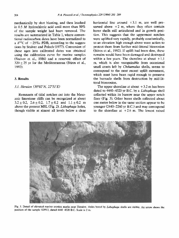
Fig. 2. Erosional marks at Cape Melagkasi, west of Hiraeon, correspond to four raised shorelines. Scale is 2 m, looking northwestwards.
204 P.A. Pirazzoli et al. / Tectonophysics 229 (1994) 201-209
mechanically by shot blasting, and then leached in 0.5 M hydrochloric acid until more than 50% of the sample weight had been removed. The results are summarized in Table 1, where conven- tional radiocarbon dates have been normalized to a 613C of -25%0 PDB, according to the sugges- tions by Stuiver and Polach (1977). Conversion of these ages into calibrated dates was obtained using the calibration curve for marine samples (Stuiver et al., 1986) and a reservoir effect of 320 k 25 yr for the Mediterranean (Stiros et al., 1992).
3. Results
3.1. Heraion (38”02’N, 22”51 ‘E)
Remnants of tidal notches cut into the Meso- zoic limestone cliffs can be recognized at about 3.2 & 0.2, 2.6 k 0.2, 1.7 f 0.2 and 1.1 k 0.2 m above the present MSL (Fig. 2). Lithophaga holes, though visible at almost all levels below a clear
horizontal line around +3.1 m, are well pre- served above +2 m, where they often contain borer shells still articulated and in growth posi- tion. This suggests that the uppermost notches were uplifted very rapidly, probably coseismically, to an elevation high enough above wave action to protect them from further mid-littoral bioerosion (Stiros et al., 1992). If uplift had been slow, these remains would have been damaged and destroyed within a few years. The shoreline at about + 1.1 m, which is also recognizable from occasional small crusts left by Chthamafus shells, seems to correspond to the most recent uplift movement, which must have been rapid enough to preserve the barnacle shells from destruction by mid-lit- toral bioerosion.
The upper shoreline at about + 3.2 m has been dated to 4440-4320 yr B.C. by a Lithophaga shell collected within its burrow near the upper notch floor (Fig. 3). Other borer shells collected about one metre below in the same section appear to be younger (2440-2260 yr B.C.) and may correspond to the shoreline at +2.6 m. The lowest raised
Fig. 3. Detail of elevated marine erosion marks near Heraion. Holes bored by Lithophaga shells are visible. An arrow shows the position of the sample 92PE3, dated 4440-4320 B.C. Scale is 2 m.
P.A. Pirazzoli et al. / Tectonophysics 229 (1994) 201-209 205
level, at + 1.1 m, has been dated to 190-440 A.D. by analysis of Chthamalus shells, suggesting that the last uplift movement in this area dates from that period.
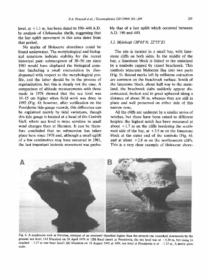
No marks of Holocene shorelines could be found underwater. The morphological and biolog- ical zonations indicate stability for the recent historical past: submergence of 30-50 cm since 1981 would have displaced the biological zona- tion (including a small encrustation by Den- dropoma) with respect to the morphological pro- file, and the latter should be in the process of regularization, but this is clearly not the case. A comparison of altitude measurements with those made in 1978 showed that the sea level was lo-15 cm higher when field work was done in 1992 (Fig. 4); however, after verification on the Possidonia tide-gauge records, this difference can be explained mainly by tidal variations, though this tide gauge is located at a head of the Corinth Gulf, where sea level is more sensitive to small wind changes than at Heraion. It can be there- fore concluded that no submersion has taken place here since 1978 and, although a small uplift of a few centimetres may have occurred in 1981, the last important tectonic movement was proba-
bly that of a fast uplift which occurred between A.D. 190 and 440.
3.2. Mylokopi (38”03’N, 22”55’E)
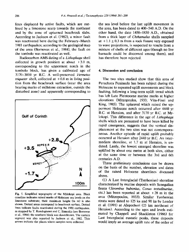
The site is located in a small bay, with lime- stone cliffs on both sides. In the middle of the bay, a limestone block is linked to the mainland by a tombolo capped by raised beachrock. This tombolo separates Mylocopi Bay into two parts (Fig. 5). Round marks left by millstone extraction are common on the beachrock surface. South of the limestone block, about half way to the main- land, the beachrock slabs suddenly appear dis- connected, broken and in great upheaval along a distance of about 30 m, whereas they are still in place and well preserved on either side of this narrow zone.
All the cliffs are undercut by a similar series of notches, but these have been raised to different heights: the highest notch has been measured at about + 1.7 m on the cliffs bordering the south- west side of the bay, at +3.5 m on the limestone block at the outer end of the tombolo (Fig. 6), and at about +2.8 m on the northeastern cliffs. This is a very clear example of Holocene shore-
Fig. 4. A mushroom rock at Heraion, remnant of an erosional shoreline higher than the present one reworked downwards by the
present sea level. (A) Situation on 24 April 1978 at 15H (local time); at Possidonia, the sea level was at - 1.30 m, but rising (it
reached - 1.17 m one hour later). (B) Situation on 18 August 1992 at 10H; sea level at Possidonia is at - 1.23 m. A metre gives scale.
206 PA Pirazzoli et al. / Tectonophysics 229 (1994) 201-209
lines displaced by active faults, which are out- lined by a limestone scarp towards the northeast and by the zone of upturned beachrock slabs. According to Jackson et al. (1982), a minor fault was reactivated here during the February-March 1981 earthquakes; according to the geological map of the area (Bornovas et al., 19841, the fault on the tombolo was reactivated as well.
Radiocarbon AMS dating of a Lithophaga shell collected in growth position at about +3.0 m, corresponding to the uppermost notch in the tombolo block, has given a calibrated age of 3170-3010 yr B.C. A well-preserved Vermetus triqueter shell, collected at +0.8 m in living posi- tion from the beachrock surface (near the area bearing marks of millstone extraction, outside the disturbed zone> and apparently corresponding to
Gulf of Corinth
1 OOm
Fig. 5. Simplified topography of the Myiokopi area. Thick coastline indicates raised marks of Holocene sea levels on the limestone substrate; their maximum height (in m) is also shown. Dotted areas correspond to beachrock surface. Dotted lines indicate faults reactivated during the 1981 earthquakes, as mapped by T. Rondogianni and C. Simeakis (see Rornovas et al., 1984); the southern block was downthrown. The eastern segment was also reported by Jackson et al., 1982. Thin arrows indicate the places where samples were collected.
the sea level before the last uplift movement in the area, has been dated to 400-540 A.D. On the other hand, the date 1450-1830 A.D., obtained from a thick layer of Chthamalus shells sampled at + 1.1 + 0.3 m from a rock fissure very exposed to wave projections, is suspected to results from a mixture of shells of different ages (though no live barnacle could be discerned among them), and has therefore been rejected.
4. Discussion and conclusion
The two sites studied show that this area of Perachora Peninsula has been subject during the Holocene to repeated uplift movements and block faulting, following a long-term uplift trend which has left Late Pleistocene marine marks at higher elevations (Mitzopoulos, 1933; Vita-Finzi and King, 1985). The upheaval which raised the up- permost Holocene notch occurred after 4440 yr B.C. at Heraion, and after 3170 yr B.C. at My- lokopi. This difference in the age of Lithophaga shells which are presumed to have been killed by rapid emergence, suggests that the vertical dis- placement at the two sites was not contempora- neous. Another episode of rapid uplift probably occurred at Heraion after 2440 yr B.C. An inter- mediate shoreline, at 1.7 m at Heraion, is un- dated. Lastly, the lowest emerged shoreline was uplifted by about one metre at both sites, either at the same time or between the 3rd and 6th centuries A.D.
Three preliminary conclusions can be drawn on the basis of the number, elevation and dates of the raised Holocene shorelines discussed above.
(1) A Last Interglacial (Tyrrhenian) shoreline characterized by marine deposits with Senegalian fauna (Strombus bubonius, Conus testudinariw, etc.) has been reported at about +28 m in the area (Mitzopoulos, 1933). Similar Tyrrhenian strata were dated to 125 ka and 90 ka by Leeder et al. (1991) at Alepochori (25 km northeast of Heraion). According to the ages and levels esti- mated by Chappell and Shackleton (1986) for Last Interglacial eustatic peaks, these deposits would imply an average uplift rate of the order of

PA. Pirazzoli et al. / Tectonophysics 229 (1994) 201-209 207
0.2 mm/ yr since 125 ka (if they corresponded to oxygen isotope stage 5e) and of 0.3 mm/ yr since 100 ka (if they corresponded to stage 5~). At these rates, uplift in the last 6400 yr would have been only 1.3 or 2.0 m, respectively. Either the Holocene eustatic sea-level peak was regionally l-2 m higher than at present or, more probably, the local uplift rate accelerated during the Holocene. It is only if the Senegalian fauna be- longed to oxygen isotope stage 5a that the aver- age uplift rate could have remained stable (at about 0.5 mm/yr) during the last 81 ka; but in-situ deposits with such fauna are rare in the Mediterranean at stage 5a. It seems likely, there- fore, that uplift movements have been faster dur- ing the Holocene than during the Late Pleis- tocene. In the Corinth area this could stem from reversals in the sense of movements, like those reported from Crete or Rhodes (Pirazzoli et al., 1982, 1989).
(2) The dates obtained for the last episode of uplift correspond to a period of high seismic activity, from approximately the middle of the 4th
century A.D. to the mid-6th century A.D., re- ported from several regions in the eastern Mediterranean. During this period, paroxysmic vertical displacements occurred in many areas, including the southern Hellenic arc, Turkey, Cyprus, the Lebanon, etc. (Pirazzoli, 1986b; Pi- razzoli et al., 1991).
(3) Although large 04 > 6.0) earthquakes fre- quently strike the area, there is no evidence that any of the shocks known from instrumental and historical seismicity studies (Papazachos and Comninakis, 1982; Papazachos and Papazachou, 1989) were associated with important uplift. This was also true for the 1981 earthquakes, which were associated with about 1 m coastal subsi- dence near Alepochori (Fig. 1; Jackson et al., 1982) and only with minor uplift further north (Stiros, 1986). One possible explanation is that the return period of great earthquakes accompa- nied by coseismic uplift is of the order of about 1600 yr in the Heraion area, which is of the same order as the recurrence interval of fault reactiva- tion along the southern coast of the Gulf of
Fig. 6. Limestone block at the outer limit of the Mylokopi tombolo, showing a series of raised shoreline marks reaching + 3.5 m. In the foreground: raised beachrock.
208 PA Pirazzoli et al. / Tectonophysics 229 (1994) 201-209
Corinth proposed by Mouyaris et al. (1992). In both places, vertical displacements seem to have been unidirectional, without any evidence of up and down movements. As the last uplift in the Heraion area took place some 1500 yr ago, during a period of major regional tectonic paroxysm, a new great earthquake, accompanied by coseismic vertical uplift, might be expected in the near future.
Acknowledgements
Information provided by Professor R. Tomlin- son and constructive suggestions by two anony- mous referees are greatly appreciated. Ms. M. Delahaye and one of the referees kindly im- proved the English.
This is a contribution to the Commission of European Communities EPOCH Project “Climate Change, Sea Level Rise and Associated Impacts in Europe”, to the Active Tectonics- DE8661704 Programme of IGME, to the task group “Paleoseismicity of the Late Holocene” of the Inter-Union Commission on the Lithosphere, to the IGCP Projects 274 “Coastal evolution in the Quaternary” and 367 “Late Quaternary coastal records of rapid change” and to the activi- ties of the INQUA Commissions “Neotectonics”, “Shorelines” and “Holocene”.
References
Arnold, M., Bard, E., Maurice, P., Valladas, H. and Duplessy, J.C., 1989. i4C dating with the Gif-sur-Yvette Tandetron accelerator: status report and study of isotopic fractiona- tions in the sputter ion source. Radiocarbon, 31(3): 284- 291.
Blackman, D.J., 1966. The harbour at Perachora. Ann. Brit. Sch. Athens, 61: 191-194.
Bornovas, J., Gaitanakis, P. and Spiridopoulos, A., 1984. Geological Map of Greece, 1: 50000, Perachora sheet. IGME.
Chappell, J. and Shackleton, N.J., 1986. Oxygen isotopes and sea level. Nature, 324: 137-140.
Fossey, J., 1969. The Prehistoric settlement by Lake Voulia- meni, Perachora. Ann. Brit. Sch. Athens, 64: 53-69.
Imperatori, L., 1962. Livelli quaternari nel Golfo di Corinto e nel Sud del Peloponneso. Quaternaria, 5: 131-133.
Jackson, J.A., Gagnepain, J., Houseman, G., King, G.C.P., Papadimitriou, P., Soufleris, C. and Virieux, J., 1982. Seis- micity, normal faulting, and the geomorphological devel- opment of the Gulf of Corinth (Greece): the Corinth earthquakes of February and March 1981. Earth Planet. Sci. L&t., 57: 377-397.
Laborel, J., 1986. Vermetid gastropods as sea-level indicators. In: 0. van de Plassche (Editor), Sea Level Research - A Manual for the Collection and Evaluation of Data. Geo- Books, Norwich, pp. 281-310.
Leeder, M.R., Seger, M.J. and Stark, C.P., 1991. Sedimenta- tion and tectonic geomorphology adjacent to major active and inactive normal faults, southern Greece. J. Geol. Sot. London, 148: 331-343.
Mariolakos, I. and Stiros, S.C., 1987. Quaternary deformation of the Isthmus and Gulf of Corinthos (Greece). Geology, 15: 225-228.
Mariolakos, I., Papanikolaou, D., Symeonidis, N., Lekkas, S., Karotsieris, Z. and Sideris, C., 1981-1982. The deforma- tion of the area around the eastern Korinthian Gulf, affected by the earthquakes of February-March 1981. International Symposium on the Hellenic Arc and Trench (H.E.A.T.), Proc. vol. 1, Athens, pp. 400-420.
Mitzopoulos, M.K., 1933. Le Quaternaire marin (Tyrrhtnien) dans la presqu’ile de Perachora. Praktika Akad. Athens, 8: 286-292.
Mouyaris, N., Papastamatiou, D. and Vita-Finzi, C., 1992. The Helice Fault? Terra Nova, 4: 124-129.
Papazachos, V. and Comninakis, P., 1982. A catalogue of earthquakes in Greece and the surrounding area for the period 1901-1980. Univ. Thessaloniki, Geophys. Lab., Publ. 5.
Papazachos, V. and Papazachou, K., 1989. Earthquakes in Greece (in Greek). Zitis, Thessaloniki, 356 pp.
Pirazzoli, P.A., 1986a. Marine notches. In: 0. van de Plassche (Editor), Sea Level Research - A Manual for the Collec- tion and Evaluation of Data. GeoBooks, Norwich, pp. 361-400.
Pirazzoli, P.A., 1986b. The Early Byzantine tectonic parox- ysm. Z. Geomorphol., Suppl., 62: 31-49.
Pirazzoli, P.A., Thommeret, J., Thommeret, Y., Laborel, J. and Montaggioni, L.F., 1982. Crustal block movements from Holocene shorelines: Crete and Antikythira (Greece). Tectonophysics, 86: 27-43.
Pirazzoli, P.A., Delibrias, G., Kawana, T. and Yamaguchi, T., 1985. The use of barnacles to measure and date relative sea-level changes in the Ryukyu Islands, Japan. Palaeo- geogr. Palaeoclimatol., Palaeoecol., 49: 161-174.
Pirazzoli, P.A., Montaggioni, L.F., Saliege, J.F., Segonzac, G., Thommeret, Y. and Vergnaud-Grazzini, C., 1989. Crustal block movements from Holocene shorelines: Rhodes Is- land (Greece). Tectonophysics, 170: 89-114.
Pirazzoli, P.A., Laborel, J., Salibge, J.F., Erol, O., Kayan, I. and Person, A., 1991. Holocene raised shorelines on the Hatay coasts (Turkey): palaeoecological and tectonic im- plications. Mar. Geol., 96: 295-311.

P.A. Pirurzoli et al. / Tectonophysics 229 (1994) 201-209 209
Stiros, SC, 1986. Geodetically controlled taphrogenesis in back-arc environments: three examples from central and northern Greece. Tectonophysi~s, 130: 281-288.
Stiros, S.C., 1988. Model for the N. Peloponnesian (C. Greece) uplift. J. Geodyn., 9: 199-214.
Stiros, SC. and Papageorgiou, S, 1989. Upper Holocene sea- level changes and some jmpl~cations for the active tecton- ics of Central Greece (in Greek, with English abstract). Bull. Geol. Sot. Greece, 23: 259-269
Stiros, S.C., Arnold, M., Pirazzoli, P.A., Laborel, J., Laborel, F. and Papageorgiou, S., X992. Historical coseismic uplift on Euboea Island, Greece. Earth Planet. Sci. Lett., 108: 109-I 17.
Stuiver, M. and Polach, H.A., 1977. Discussion: reporting of 14C data. Radiocarbon, 19(3f: 355-363.
Stuiver, M., Pearson, G.W. and Braziunas, T., 1986. Radiocar- bon age calibration of marine samples back to 9000 cal. yr B.P. Radiocarbon, 2812B): 980-1021.
Vita-Fin+ C., 1992. Radiocarbon dating of late Quaternary fault segments and systems. J. Geol. Sot. London, 149: 257-260.
Vita-Finzi, C. and King, G.C.P., 1985. The seismicity, geomor- phology and structural evolution of the Corinth area of Greece. Philos. Trans. R. Sot. London, Ser. A. 314: 379- 407.
Copyright © 2022 FDOKUMEN