Buddhist Structures and Secular Themes in Zeami’s Narrative Style

(2006) 1–22www.elsevier.com/locate/tecto
Tectonophysics 422
Secular crustal deformation and interplate coupling of the JapaneseIslands as deduced from continuous GPS array, 1996–2001
Gamal El-Fiky a,⁎, Teruyuki Kato b
a Construction Engineering and Utilities Department, Faculty of Eng., Zagazig Univ., El-Zagazig, Egyptb Earthquake Research Institute, University of Tokyo, Tokyo, Japan
Received 23 September 2005; received in revised form 31 March 2006; accepted 25 April 2006Available online 10 July 2006
Abstract
Data from the nation-wide GPS continuous tracking network that has been operated by the Geographical Survey Institute ofJapan since April 1996 were used to study crustal deformation in the Japanese Islands. We first extracted site coordinate from dailySINEX files for the period from April 1, 1996 to February 24, 2001. Since raw time series of station coordinates include coseismicand postseismic displacements as well as seasonal variation, we model each time series as a combination of linear andtrigonometric functions and jumps for episodic events. Estimated velocities were converted into a kinematic reference frame [Heki,K., 1996. Horizontal and vertical crustal movements from three-dimensional very long baseline interferometry kinematic referenceframe: implication for reversal timescale revision. J. Geophys. Res., 101: 3187–3198.] to discuss the crustal deformation relative tothe stable interior of the Eurasian plate. A Least-Squares Prediction technique has been used to segregate the signal and noise inhorizontal as well as vertical velocities. Estimated horizontal signals (horizontal displacement rates) were then differentiated inspace to calculate principal components of strain. Dilatations, maximum shear strains, and principal axes of strain clearly portraytectonic environments of the Japanese Islands. On the other hand, the interseismic vertical deformation field of the Japanese islandsis derived for the same GPS data interval. The GPS vertical velocities are combined with 31 year tide gage records to estimateabsolute vertical velocity. The results of vertical deformation show that (1) the existence of clear uplift of about 6 mm/yr in Shikokuand Kii Peninsula, whereas pattern of subsidence is observed in the coast of Kyushu district. This might reflect strong couplingbetween the Philippine Sea plate and overriding plate at the Nankai Trough and weak coupling off Kyushu, (2) no clear verticaldeformation pattern exists along the Pacific coast of northeastern Japan. This might be due to the long distance between the plateboundary (Japan trench) and overriding plate where GPS sites are located, (3) significant uplift is observed in the southwestern partof Hokkaido and in northeastern Tohoku along the Japan Sea coast. This is possibly due to the viscoelastic rebound of the 1983Japan Sea (Mw 7.7) and the 1993 Hokkaido–Nansei–Oki (Mw 7.8) earthquakes and/or associated with distributed compression ofincipient subduction there. We then estimate the elastic deformation of the Japanese Islands caused by interseismic loading of thePacific and Philippine Sea subduction plates. The elastic models account for most of the observed horizontal velocity field if thesubduction movement of the Philippine Sea Plate is 100% locked and if that of the Pacific Plate is 70% locked. However, the bestfit for vertical velocity ranges from 80% to 100% coupling factor in southwestern Japan and only 50% in northeastern Japan. Sincehorizontal data does not permit the separation of rigid plate motion and interplate coupling because horizontal velocities include
⁎ Corresponding author.E-mail address: [email protected] (G. El-Fiky).
0040-1951/$ - see front matter © 2006 Elsevier B.V. All rights reserved.doi:10.1016/j.tecto.2006.04.021

2 G. El-Fiky, T. Kato / Tectonophysics 422 (2006) 1–22
both contributions, we used the vertical velocities to discriminate between them. So, we can say there is strong interplate coupling(80%–100%) over the Nankaido subduction zone, whereas it is about 50% only over the Kurile–Japan trench.© 2006 Elsevier B.V. All rights reserved.
Keywords: Crustal deformation; Interplate coupling; Continuous GPS array; Japanese Islands
1. Introduction
The Japanese Islands are located at a complex plateboundary. The convergence of four plates including theEurasian (EUR) or Amurian (AMR), the Pacific (PAC),the Philippine Sea (PHS) plate, and North American(NAM) or the Okhotsk (OKH) predominates (Fig. 1).The oceanic PAC is descending beneath the continentalNAM (or OKH) at the Kurile–Japan trench, and oceanicPHS plate is descending beneath the EUR at the Suruga–Nankai Trough and beneath NAM (or OKH) plate along
Fig. 1. Major plate boundaries in and near the Japanese Islands. EUR or AOkhotsk plate, PHS: Philippine Sea plate, and PAC: Pacific plate. Source regdata are shown. Arrows indicate the relative plate motion directions.
the Sagami Trough. Relative motion among these platesaccumulates tectonic stress in the lithosphere and causesobservable crustal deformation. The occurrence of largeearthquake along plate boundaries and crustal faults re-leases such tectonic stress. Consequently, study ofcrustal deformation is a key to understand the physicalprocess in the crust as well as to forecast crustal activity.Dense arrays of continuous GPS tracking networksprovide us with an ideal tool for monitoring crustaldeformation. In Japan, the Geographical Survey Institute(GSI) started to establish the dense GPS array of
MR: Eurasian or Amurain plate, NAM or OHK: North American orions of recent conspicuous earthquakes which might affect on the GPS
Fig. 2. An example of the time series at site number 950155 (39.93°E, 40.58°N). (a) Uncorrected time series of E–W component. (b) Annual changeof E–W component. (c) Difference between uncorrected time series and annual change of E–W component. (d), (e), and (f) are same but for verticalcomponent.
3G. El-Fiky, T. Kato / Tectonophysics 422 (2006) 1–22
continuous tracking network in the Kanto–Tokai regionin 1992 and has further expanded it to cover the entirenation. The GSI has been operating in 610 sites, forcontinuous monitoring of the daily site coordinates sinceApril 1996. The number of sites increased to 1200 by2004, with average site intervals of about 20 km (e.g.,Miyazaki et al., 1998; Sagiya et al., 2000). The array isnow considered one of the most fundamental infra-structures for monitoring crustal activity in Japan.Details of the operation and analysis of this GPS arrayare described in Tada et al. (1997), Miyazaki et al.(1997), and Sagiya (2004a).
In the present study, we try to delineate the horizontalcrustal strains as well as the interseismic vertical defor-mation field of the Japanese Islands, using data for aboutfive years from the GPS array. For this purpose, we firstextracted site coordinate from daily SINEX files for theperiod from April 1, 1996 to February, 24, 2001, andestimated site velocities bymodelling each time series as acombination of step functions, trigonometric functions,and a linear function. A Least-Squares Prediction (LSP)technique has been used to segregate the signal and noisein horizontal as well as vertical velocities. Estimatedvelocities are converted to a kinematic reference frame(Heki, 1996) to discuss the crustal deformation relative tothe stable interior of the Eurasian plate. Finally, estimated
horizontal signals (horizontal displacement rates) weredifferentiated in space to calculate principal componentsof strain.
One problem in employing only the horizontal velocitycomponents as data for crustal deformations studies is thatit is difficult to segregate rigid plate motions from inter-plate coupling strain. This is because horizontal velocitiesinclude both effects (Aoki and Scholz, 2003). So, rigidplatemotions could bemapped into the interplate coupling.This problem can be solved by using vertical velocities toseparate between the rigid plate motions and interplatecoupling. On the other hand, the repeatability of horizontalcomponents of GPS coordinates is highly precise com-pared with that of their vertical components. So, verticalcomponent has rarely been used in scientific discussions.Here, we try to estimate the interseismic vertical velocityfield for Japanese Islands using GSI's GPS array databetween 1996 and 2001. The estimated GPS vertical vel-cities are combinedwith 31 year tide gage records to obtainabsolute vertical velocity.
Finally, we investigate the origin of the GPS defor-mation in the Japanese Islands by comparing velocityfields determined from GPS data with those calculatedfrom the elastic dislocation models involving interplatemotion at the subduction zones in northeastern andsouthwestern Japan. We then show that most of this GPS
4 G. El-Fiky, T. Kato / Tectonophysics 422 (2006) 1–22
velocity field can indeed be accounted for by full elasticcoupling along the Philippine thrust zones and only 50%coupling for the Pacific locked zone. We compare theGPS-derived strain with those obtained from seismo-logical and geological data and show that they are qua-litatively similar but that the GPS deformation is muchlarger that the other two.
2. Time series and horizontal velocity field
Processing of the data of GSI's GPS array with the IGSprecise orbit yields daily coordinates of all stations. Weused daily GPS data from April 1, 1996 to February 24,2001. The period spans about 5 years, which give rea-sonably reliable displacement vectors (e.g., Miyazaki etal., 1997; Kato et al., 1998). Here, the horizontal andvertical velocities are calculated by a least-squareapproach following the procedure described in Sagiya etal. (2000). They modelled time series as a linearcombination of constant, linear term, trigonometricfunction, and jumps for episodic events. So, the followingfunction is fitted to the three components of the GPS dataof each station separately.
dðtÞ ¼ A1 þ A2⁎t þ A3⁎Sinð2ktÞ þ A4⁎Cosð2ktÞþ HðtÞ: ð1Þ
where, A1, A2, A3, and A4 are constants. The first twoterms on the right side indicate the linear trend with time t,the next two terms (trigonometric function) are thesinusoidal annual variation where A3 and A4 are theamplitudes of the annual change, and the last term, H(t),represents the coseismic steps or jumps for episodicevents. Here, jumps for episodic events are estimated as asum of Heaviside functions
Pmk¼1 en;kHðt−tnkÞ, where n
is number of GPS sites, en,k is the magnitude of the k-thstep which occurred at tn
k. These jumps or steps of relativecoordinates in time series might be associated withearthquakes, volcanic activity, and GPS antenna andreplacements. We should note that the second term in theabove equation, A2, represents the displacement of eachcomponent to be estimated.
After fitting the above equation to the three com-ponents of the GPS data, we estimated the displacementrate components for all stations by solving least-squaresproblems. Fig. 2 shows an example of the time seriesobtained at the 950155 site (139.93°E, 40.58°N). Fig. 2aand d represent the time series of raw data of E–Wcomponent, and vertical component, respectively. (b)and (e) show E–W and vertical components of annualvariation, respectively. The amplitude of estimatedannual variation ranges up to 5 mm among the GPS
sites. (c) and (f) are E–W and vertical components ofcorrected time series (difference between uncorrectedtime series and annual variation), respectively. Finally,the estimated velocities are converted into a kinematicreference frame (Heki, 1996) to discuss the crustaldeformation relative to the stable interior of the Eurasianplate. Fig. 3 shows the horizontal component of thevelocity vectors relative to the stable part of the Eurasianplate with 95% confidence error ellipses. Coseismiccrustal deformation associated with large earthquakeswhich occurred during the observation period, wereestimated as formulated in Eq. (1), e.g., the 1996 Hyu-ganada earthquakes (MJMA 6.6 on October 19 andMJMA
6.6 on December 3) southeast off Kyushu (Nishimura etal., 1998), the 1997 Kagoshimaken–Hokuseibu earth-quakes (MJMA 6.3 of March 26 and MJMA 6.2 on May13), and the 2000 Tottori earthquake (Mw 7.3). Inaddition, several artificial steps caused by replacementsof GPS antennas and receivers were found and removed.We tried to remove abrupt displacements resulting fromcoseismic and volcanic events in the time series, how-ever, it is difficult to remove postseismic deformationbecause it strongly couples with annual variations.
After removing the annual variation from originaltime series of GPS data, the standard deviation of thevelocities ranges from 0.11 to 0.42 mm/yr for horizontalcomponents and from 0.16 to 1.38 mm/yr for verticalcomponents. Since most of the coordinate time series arewell approximated by fitting method mentioned above,we may consider that the horizontal components ofvelocity shown in Fig. 3 are representative of presentsecular deformation of the Japanese islands.
The main characteristics of the horizontal velocityfield shown in Fig. 3 are; (1) a westward motion of thenortheastern part of Japan. The magnitude of the velocityis about 35 mm/yr on the Pacific coast and decreasesgradually to less than 10 mm/yr to the west along theJapan Sea coast. This may be due to the subduction of thePacific plate at the plate interface along the Japan Trench.This deformation might be also due to the eastwardmotion of China continental block (El-Fiky and Kato,1999b; Ito et al., 2000). (2) A northwestward movementof the southwestern part of Japan (except for Kyushu).The velocity is also about 35 mm/yr on the Pacific coastof the southwestern Japan and decreases to less than10mm/yr inland toward the west. This is attributed to theeffects of the subducting Philippine Sea plate under theJapanese Islands along the Nankai Trough (Sagiya,1995; Ito, 2004). (3) A trenchward movement of south-ern Kyushu and the Ryukyu Islands to the southeast. Thisis attributed to the backarc opening process at the Oki-nawa Trough (Tada, 1984; Sagiya et al., 2000). (4)

5G. El-Fiky, T. Kato / Tectonophysics 422 (2006) 1–22
Chugoku district (western Japan), which has beenassumed to be a part of the EUR (e.g., Seno et al.,1996), is moving eastward relative to the EURwith a rateof about 10 mm/yr. This suggests that the Chugokudistrict is on another plate, which could be the Amurianplate (e.g., Cook et al., 1986; Wei and Seno, 1998), or aseparate plate moving eastward by ∼10 mm/yr relativeto EUR (e.g., Zonenshain and Savostin, 1981). On theother hand, the estimated GPS velocity vectors areparallel to the Pacific subduction vector in northernJapan (83 mm/yr in 296°) with respect to NorthAmerican plate (e.g., DeMets et al., 1994) and to thePhilippine Sea plate subduction vector in southwesternJapan (48 mm/yr in 310°, with respect to Eurasian plate,Seno et al., 1993).
Fig. 3. Yearly averaged velocity vectors with error ellipses (1σ) obtained fromperiod April 1996 to February 2001.
3. Estimation of crustal strains
3.1. Least-squares prediction technique
It is well known that the estimated velocity fielddepends on the assumption of fixed point or the referenceframe used in the analysis. Therefore, estimation of crustalstrain, which is independent of fixed point or referenceframe, is important to understand the physical processes inthe crust in the study area. There are a variety of methodsto delineate crustal strains (e.g., Tsuboi, 1932; Frank,1966; Bibby, 1975; Rikitake, 1976; Savage, 1978;Brunner et al., 1981; Dermanis, 1981). However, all ofthese studies use a discrete approachwhere the areawithina particular triangle or block is assumed to have uniform
the continuous GPS observation network in the Japanese Islands for the
6 G. El-Fiky, T. Kato / Tectonophysics 422 (2006) 1–22
infinitesimal strains. The reality is such that the landdeforms rather continuously except where/when a faultdisplaces the land surface. Thus, a more appropriatetechnique to represent crustal strains in a continuousmanner may have to be used. Some researchers have usedalgebraic polynomials of specified degree to describecrustal strains (e.g., Dermanis et al., 1981; Kato andNakajima, 1989). Also, recently, Shen et al. (1996) usedan assumed distances decaying constant to relate theobserved displacement rate with the strain rate tensor.However, such purely mathematical approach couldsometimes yield spurious results. We would rather usesome physical information included in data itself. One ofrelevant techniques is the Least-Squares Prediction (LSP)whereby tectonic signal in the data is extracted by thestatistical analysis of data (El-Fiky et al., 1997; El-Fikyand Kato, 1999a). LSP technique was first developed byMoritz (1962) for gravity data and was applied to crustaldeformation data by El-Fiky et al. (1997) and El-Fiky andKato (1999a). The method segregates signal (rate of hori-zontal movement in the present case) and noise in the data
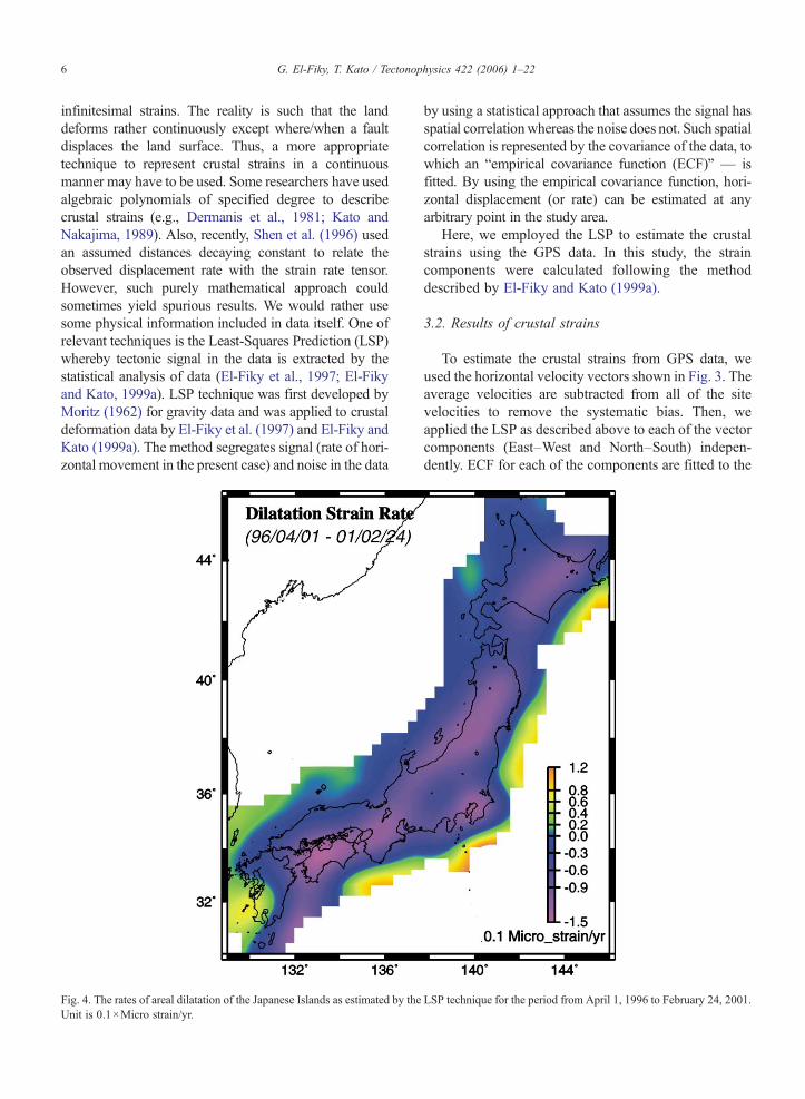
Fig. 4. The rates of areal dilatation of the Japanese Islands as estimated by theUnit is 0.1×Micro strain/yr.
by using a statistical approach that assumes the signal hasspatial correlationwhereas the noise does not. Such spatialcorrelation is represented by the covariance of the data, towhich an “empirical covariance function (ECF)” — isfitted. By using the empirical covariance function, hori-zontal displacement (or rate) can be estimated at anyarbitrary point in the study area.
Here, we employed the LSP to estimate the crustalstrains using the GPS data. In this study, the straincomponents were calculated following the methoddescribed by El-Fiky and Kato (1999a).
3.2. Results of crustal strains
To estimate the crustal strains from GPS data, weused the horizontal velocity vectors shown in Fig. 3. Theaverage velocities are subtracted from all of the sitevelocities to remove the systematic bias. Then, weapplied the LSP as described above to each of the vectorcomponents (East–West and North–South) indepen-dently. ECF for each of the components are fitted to the
LSP technique for the period from April 1, 1996 to February 24, 2001.

7G. El-Fiky, T. Kato / Tectonophysics 422 (2006) 1–22
data. After that, ECFs are used to reconstruct displace-ment vectors (signal) at grid points (8 km×8 km) meshcovering the Japanese Islands. Then estimated velocitiesat grid points are differentiated in space to obtain rate ofcrustal strains in this data period. The rates of strainparameters were estimated in this analysis as follows(El-Fiky and Kato, 1999a):
Rate of maximum shear strain
Fig. 5. Distribution of the maximum shea2001. Unit is 0.1×Micro strain/yr. Epice
γmax={(exx−eyy)2+γxy2 }0.5
Rate of principal axes of strain
ε1=0.5 (Δ+γmax) Rate of principal axes of strain ε2=0.5 (Δ−γmax) Direction of ε1 θ=0.5 tan−1 {γxy / (exx−eyy)}Where Δ is the rate of dilatation strain (Δ=exx+eyy);γxy is the rate of shear strain {γxy=0.5 (eyx+exy)}; θ isthe direction ε1 of measured from x-axis anticlockwise;and eyx and exy are the rates of linear strains components.
r strain rates in the Japanese Islandsnters of shallow earthquakes (d≤40
Here we have to note that dilatation strain rate isdominant affected by subducting plate (if the directionof subducting plate is perpendicular to trench axis). Onthe other hand, the maximum shear strain rate is domi-nant affected by earthquake. Figs. 46 are the thusestimated rates of dilatational strains, rates of maximumshear strains, and rates of principal axes of strains,respectively.
3.3. Discussion
Since the coordinate time series are well approxi-mated by Eq. (1), the coseismic crustal deformation areestimated and removed from the present GPS data, andthe estimated strains are almost the same for the abovementioned four intervals, we may think that the crustalstrains shown in Figs. 46 are representative of a present
as estimated by LSP for the period from April 1, 1996 to February 24,km) determined by NEIC are also plotted.

Fig. 6. Magnitude and orientation of rates of principal strains axes in the Japanese Islands as estimated by LSP for the period from April 1, 1996 toFebruary 24, 2001.
8 G. El-Fiky, T. Kato / Tectonophysics 422 (2006) 1–22
secular deformation of the Japanese Islands. Though thestrains in these figures are estimated from a relativelyshort interval of data (5 years), they may well portraycharacteristics of the tectonic deformation in theJapanese Islands.
The dilatational strain rates shown in Fig. 4 indicatethat the Japanese Islands are under a compressional strainregime. This may be due to the subducting Pacific platefrom the east and Philippine Sea plate from the southeast(Fig. 1). The deformation might be also due to theeastward extraction of China continental block by thecollision of India toward north (e.g., Kato et al., 1998).Rapid compressional strain (>0.12 Micro strain/yr) isfound in the central and eastern Hokkaido, centralTohoku, the Japan Sea coast of Tohoku, and all overthe Shikoku district. The rapid compressional strain alongthe Japan Sea coast is an important issue derived from the
present GPS array. This might support the incipientsubduction and the new plate boundary in this region assuggested by several researchers (e.g., Nakamura, 1983;Seno et al., 1996). On the other hand, widespread com-pressional strain in Fig. 4 is somewhat different from dataobtained by conventional surveys. Ishikawa and Hashi-moto (1999) analysed the strains in the Japanese Islandsby the triangulation data for the last 100 years and showedthat the dilatational strain is positive in most of Tokokuand Kyushu districts, which significantly differ from thepresent results. The present study shows that only thesouthwestern parts of Kyushu are dilating positively. Thediscrepancy in the Tohoku district may have to be ex-amined carefully because many interplate earthquakeshave occurred in this region during the past 100 years andmay have affected strains in the area. Although none of thelarge interplate earthquakes have occurred in the Tohoku

Fig. 7. Distribution of tidal stations of Geographical Survey Institute (GSI) used in this study.
9G. El-Fiky, T. Kato / Tectonophysics 422 (2006) 1–22
area during the study period, significant postseismic de-formation may have occurred. This may be significant inthe northern part of the area after the Sanriku earthquakeof 1994 (Mb 7.5) (Heki et al., 1997; Kato et al., 1998; El-Fiky and Kato, 1999b).
Maximumshear strain rates (Fig. 5) show some patchesof rapid strain. They are found in eastern Hokkaido,southern Tohoku, southern Kanto, Shikoku, and north-eastern Kyushu. All of these areas coincide with seis-mically active regions. To compare the maximum shearstrains with seismicity, epicentres of shallow earthquakes(<40 km) are plotted in Fig. 5. Eastern Hokkaido is an areawhere a couple of large offshore earthquakes occurred;1993 Kushiro earthquake and 1994 Hokkaido–Toho–Okiearthquake (e.g., Tsuji et al., 1995). A wide area in thesouthern part of Tohoku has high maximum shear. Themaximum shear strain area coincides with the area ofactive seismicity in the central Tohoku district. It alsoincludes the focal areas of large earthquakes such as 1962(M 6.5), 1970 (M 6.2), and 1998 (MJMA 6.1), and lies near
the source region of the Narugo earthquake (MJMA 5.9) ofAugust 11, 1996. South Kanto is the region where thePhilippine Sea plate converges with the North American(or Okhotsk) plate and seismic and volcanic activities arevery high. On the other hand, the strain rates in this regionmight be partly attributed to the silent earthquake off Bosopeninsula in May 1996, which was followed by a numberof small earthquakes (Sagiya, 2004b). High maximumshear in the Shikoku region may be due to the obliquesubduction along the Nankai Trough (e.g., El-Fiky et al.,1999), eastward motion of the Amurain plate (Heki et al.,1999), and/or N–S oriented extension in Kyushuassociated with expansion of the Okinawa Trough(Tada, 1984; Kato et al., 1998). Finally, maximum shearstrain in northeastern Kyushu is most prominent. Asmentioned earlier, the coseismic deformation associatedwith large earthquakes such as the Hyuganada earth-quakes of October 19th (MJMA 6.6) and December 3rd(MJMA 6.3), 1996, which occurred off the Pacific coast ofKyushu (Fig. 1) are estimated and removed. Thus, the

Table 1Tide gage locations with their velocities
Site Location Velocity(Vt
i) mm/yrVelocity(Vg
i) mm/yrCi
(mm/yr)Longitude Latitude
ABU 139.62 35.13 −1.56 −2.10 0.54AKU 130.28 31.72 2.10 −0.61 2.71ASA 140.83 40.84 2.12 3.33 −1.21HOS 131.47 32.02 −0.78 −4.14 3.36KAI 135.07 34.27 −1.44 −1.88 0.42KAR 129.85 33.48 0.80 5.70 −4.91KAS 138.57 37.40 5.34 9.00 −3.66KAT 140.27 35.17 −0.64 1.45 −2.09KUR 133.40 33.41 4.89 3.31 1.58MIK 136.17 36.23 −0.85 5.98 −6.83NEZ 139.51 38.23 −2.12 6.56 −8.68OGI 138.47 38.06 0.24 2.40 −2.16OGA 139.78 39.97 4.27 9.47 −5.20ONI 136.87 34.82 4.09 3.82 0.27OSH 140.60 43.29 2.22 3.89 −1.67SOM 140.84 38.03 −4.46 −2.53 −1.93WAJ 136.89 37.38 1.57 8.35 −6.78
Average −2.13
10 G. El-Fiky, T. Kato / Tectonophysics 422 (2006) 1–22
rates of high maximum shear of strains in northeasternKyushu may be due to postseismic effect of theseearthquakes. The slow thrust slip event of May 1997following the above Hyuganada earthquakes, also, mighthave contributed to this high strain rate as suggested byHirose et al. (1999) and Ozawa et al. (2001).
Fig. 6 shows rates and directions of principal strainaxes. NW–SE compression is predominant in the south-western Japan. This may be due to the compressionalforce acting at the convergent plate boundary between thePhilippine Sea plate and the continental plate (e.g., Tabeiet al., 1996). The northeastern Japan exhibits east–westcompressional strains due to the Pacific plate convergingtoward west, whose directions are consistent with theresults obtained from old triangulation data by Shen-Tuand Holt (1996), and El-Fiky and Kato (1999a), but therates are about two to three times larger relative to theirresult. In the Kyushu Island, even though the east–westcompressional strain is predominant, a north–southextension is also evident in northern par of Kyushu.Tada (1984) used the conventional surveys and hypoth-esized that Kyushu area is under the extensional force dueto the rifting at the Beppu–Shimabara Graben in thenorthern Kyushu. The present GPS data is consistent withthe conventional strain data in this region.
4. Vertical deformation
It is well known that repeatability of vertical com-ponents of GPS coordinates is much poorer compared
with that of their horizontal components. So, verticalcomponents of GPS data have been neglected in manyscientific discussions. Here, we try to estimate the inter-seismic vertical velocity field for Japanese Islands usingGSI's GPS array data. We investigate and discuss crustaldeformation of the Japanese Islands in terms of verticalvelocity.
After removing the annual variation from originaltime series of GPS data, we estimated the vertical ratefor all stations by solving least-squares problems asmentioned above. Although these procedures allow usto obtain a vertical velocity field, it does not reflect theabsolute vertical velocity field because the GPS data weused are processed relative to Tsukuba site (140.0875°E,36.10568°N). On the other hand, tidal gage data canrepresent absolute vertical velocity if they corrected forthe different sources of errors including the eustaticchange of sea level. Thus, the GPS vertical velocity fieldis linked with tidal gage data to obtain absolute verticalvelocities.
First we need to obtain vertical velocities at each tidegage. The sea level observations in the Japanese Islandsstarted in the beginning of the 20th century and are stillbeing continued. The locations of tidal stations used inthis study are shown in Fig. 7. Raw tidal data containvarious effects such as ocean tides, ocean currents,atmospheric pressure, eustatic change of sea level, andvertical crustal deformation. In order to estimate thelinear trend of vertical movements at the 17 tidal stationsused in this study for the period from 1970 to 2001 fromrecords, we used the method introduced by Kato andTsumura (1979). By this method we can removeseasonal or annual variations, such as atmosphericpressure and ocean tides, using the yearly mean sea leveldata. Then, the yearly mean sea level is decomposed intoocean current effects and the vertical crustal deforma-tion. It should be noted that, although the eustaticchange of sea level has been estimated to be about 2.0±0.9 mm/yr by many studies (e.g., Barnett, 1984;Douglas, 1991; Savage and Thatcher, 1992; Peltierand Tushingham, 1998), the present method does notintroduce any correction for it. To solve the problem, theeustatic correction is assumed to be 1.8 mm/yr(Douglas, 1991) in the present analysis. The verticalvelocities at the tidal stations used in the present arelisted in Table 1. Since velocities obtained from tidegage data represent absolute velocities, the estimatedGPS vertical velocities relative to Tsukuba must beadjusted to the tide gage reference frame. First, we selecta GPS site which is collocated with the tidal gage ornearest to each tide gage. Then the obtained GPSvertical velocities are adjusted to the tide gage velocities
11G. El-Fiky, T. Kato / Tectonophysics 422 (2006) 1–22
by giving the fowling correction (Aoki and Scholz,2003):
C ¼ 1n
Xni¼1
ðV it−V
igÞ ð2Þ
where,C is the correctionwhich should be added to all theGPS estimated velocities, n is the number of tidal stations,Vt
i the velocity of i-th tidal gage, andVgi the velocity of the
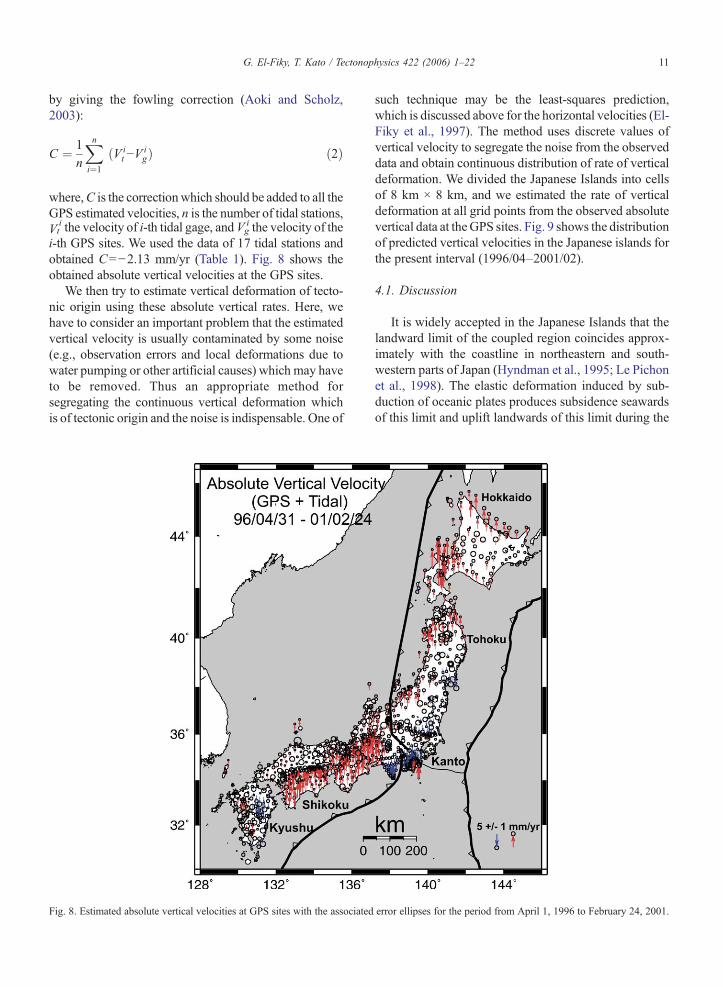
i-th GPS sites. We used the data of 17 tidal stations andobtained C=−2.13 mm/yr (Table 1). Fig. 8 shows theobtained absolute vertical velocities at the GPS sites.
We then try to estimate vertical deformation of tecto-nic origin using these absolute vertical rates. Here, wehave to consider an important problem that the estimatedvertical velocity is usually contaminated by some noise(e.g., observation errors and local deformations due towater pumping or other artificial causes) which may haveto be removed. Thus an appropriate method forsegregating the continuous vertical deformation whichis of tectonic origin and the noise is indispensable. One of
Fig. 8. Estimated absolute vertical velocities at GPS sites with the associated
such technique may be the least-squares prediction,which is discussed above for the horizontal velocities (El-Fiky et al., 1997). The method uses discrete values ofvertical velocity to segregate the noise from the observeddata and obtain continuous distribution of rate of verticaldeformation. We divided the Japanese Islands into cellsof 8 km × 8 km, and we estimated the rate of verticaldeformation at all grid points from the observed absolutevertical data at theGPS sites. Fig. 9 shows the distributionof predicted vertical velocities in the Japanese islands forthe present interval (1996/04–2001/02).
4.1. Discussion
It is widely accepted in the Japanese Islands that thelandward limit of the coupled region coincides approx-imately with the coastline in northeastern and south-western parts of Japan (Hyndman et al., 1995; Le Pichonet al., 1998). The elastic deformation induced by sub-duction of oceanic plates produces subsidence seawardsof this limit and uplift landwards of this limit during the
error ellipses for the period from April 1, 1996 to February 24, 2001.

Fig. 9. Distribution of rates of vertical crustal movements as estimated by LSP in the Japanese Islands from the period from April 1, 1996 to February24, 2001.
12 G. El-Fiky, T. Kato / Tectonophysics 422 (2006) 1–22
interseismic interval. Thus, the coastline is supposed tocoincide with the change from subsidence to uplift.
Fig. 9 shows the distribution of estimated verticalvelocities in the Japanese islands. Although this figure isestimated from only five years of GPS data, it showsclearly some characteristics of vertical tectonic defor-mation pattern in the Japanese Island. The strikingcharacteristics of this velocity field are; (1) a clear upliftpattern of up to 6 mm/yr along the Shikoku district andKii Peninsula parallel to the plate boundary in this area.This is attributed to the strong interplate coupling be-tween the overriding plate and the subducting PhilippineSea plate at Nankai Trough. (2) A clear subsidencepattern of up to 7 mm/yr in Tokai area approximatelyparallel to the Suruga Trough. The direction of this tilt isapproximately parallel to the direction of the movementof the Izu block relative to the Eurasian plate (Fig. 3).The vertical deformation in this region may be due to the
subduction along the Suruga Trough. (3) Distribution ofthe vertical deformation in northeastern part of JapaneseIslands does not show a clear evidence for interplatecoupling along the Kurile–Japan Trench. This might bedue to the Japan Trench plate boundary being too farocean-ward from the GPS sites or might be due to aweak coupling between the Pacific plate and overridingplate at the Japan Kurile–Japan Trench. (4) Most of theKyushu district is subsiding and no clear uplift area isseen along its Pacific coast. This indicates a weak or nointerplate coupling between the EUR and PHS there.This is expected from the absence of great earthquakesin this area (e.g., Shiono et al., 1980). (5) A clear upliftarea of up to 6 mm/yr in the northern part of the JapanSea coast of Tohoku district. This might be related toincipient subduction and the formation of a new plateboundary in this region. This subduction is representedby earthquakes such as the 1964 Niigata earthquake (Mw
13G. El-Fiky, T. Kato / Tectonophysics 422 (2006) 1–22
7.5), the 1983 Japan Sea earthquake (Mw 7.7), and the1993 Hokkaido Nansei–Oki earthquake (Mw 7.8)(Kobayashi, 1983; Nakamura, 1983; Seno et al., 1996).The convergence rate of the plate boundary along the westside of northeastern Japan is less than 20 mm/yr (Seno etal., 1996), about one-fourth of that of the east side at theJapan Trench. However, this convergence may causeremarkable deformation at the GPS sites because the plateboundary in the Japan Sea is much closer to the land thanthe Japan Trench. (6) Another uplifted area of up to 8 mm/yr is observed along southwestern part of Hokkaidodistrict. This uplift is consistent with uplift determinedfrom leveling observations in 1993 and 1998 (GSI, 1999).Thismay due to the abovementioned incipient subductionin the Japan Sea or might indicate the long-termpostseismic vertical deformation of the 1993 Hokkaido–Nansei–Oki (Mw 7.8) earthquake.
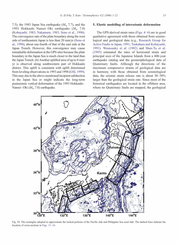
Fig. 10. The rectangles adopted to approximate the locked portions of the Plocation of cross-sections in Figs. 13–16.
5. Elastic modelling of interseismic deformation
The GPS-derived strain rates (Figs. 46) are in goodqualitative agreement with those obtained from seismo-logical and geological data (e.g., Research Group forActive Faults in Japan, 1991; Tsukahara and Kobayashi,1991). Wesnousky et al. (1982) and Shen-Tu et al.(1995) estimated the rates of horizontal strain andprincipal axes of the Japanese Islands from a 400-yearearthquake catalog and the geomorphological data ofQuaternary faults. Although the directions of themaximum compressive strains of geological data arein harmony with those obtained from seismologicaldata, the seismic strain release rate is about 30–50%larger than the geological strain rate. Since most of thehistorical earthquakes are located in the offshore area,where no Quaternary faults are mapped, the geological
acific slab and Philippine Sea used slab. The dashed lines indicate the

Fig. 11. Simplified geometries adopted for the Philippine Sea slab inTonankai and Nankai (top). Black lines correspond to locked zone,grey lines to the transition zone. Same for the Pacific slab (bottom).
14 G. El-Fiky, T. Kato / Tectonophysics 422 (2006) 1–22
strain rates may underestimate the strain rate. Therefore,considering the possible unmapped faults, and theuncertainties in the fault slip rates, the differencebetween the seismic strain rate and the geological strainrate may not be significant.
The principal axes of deformation estimated in thepresent study are in agreement with those of seismologicaland geological data. However, we have a considerabledifference in the rates; the present GPS-derived strain rateis generally one order of magnitude higher than long-termstrain rate estimated from seismological and geologicaldata. This difference may be due to aseismic strain re-sulting from pure folding and/or aseismic slip (Wes-nousky et al., 1982; Kaizuka and Imaizumi, 1984; Shen-Tu et al., 1995). Since both the seismic and geologicalstrains rates are small compared with the GPS-derivedstrain rates, only the aseismic strain due to pure foldingwould account for part of the difference between the GPSand seismic/geological strain rates. However, Quaternaryfolding does not seem to be a pervasive feature in Japan(e.g., Research Group for Active Faults in Japan, 1991;Shen-Tu et al., 1995). Therefore, this difference should beexplained by the non-permanent elastic strain present inthe geodetic data transmitted from the subduction zones(e.g., Wesnousky et al., 1982; Hashimoto and Jackson,1993; Shen-Tu et al., 1995; Le Pichon et al., 1998). Herewe try to investigate this interpretation using the dis-location model for crustal deformation data in the Japa-nese Islands. We use the above five-year solution for thevelocities of GPS stations of the Japanese arrays (hori-zontal and vertical) to estimate elastic deformation causedby interseismic loading of the Pacific and the Philippinesubduction plans.
In the simplest tectonic model, elastic strain accumu-lation along a subduction zone in interseismic period isassumed to result from a constant rate of elastic strainbuild-up produced by the locking of the thrust zone, thiselastic deformation being instantaneously released duringthe earthquakes. The locked thrust surface can then betreated as an edge dislocation in an elastic half-space witha constant back-slip (normal-slip) rate during the inter-seismic phase (Savage, 1983). If the back-slip vectorestimated by this model is equal to the subduction vector,full coupling is realized and no aseismic slip is allowed. Asmaller back-slip rate implies weaker coupling and largeraseismic slip.
Although the issue of permanent deformation buildup is still being debated, the approximation of purelyelastic behavior of the subduction system during theinterseismic period is a reasonable approach, and thedifferences with the deformation estimated by morecomplex model do not exceed a few perdent (e.g.,
Cohen, 1994; Mazzotti et al., 2000). We thus follow theelastic back-slip dislocation approach of Savage (1983).We ignored viscoelasticity and used a purely elasticmodel in the present analysis. The downdip extent of thelocked zone can be obtained from modelling the largeamount of deformation that occurs during great earth-quakes and approximately coincides with the maximumextent of interplate thrust events. In southwest Japan,Hyndman et al. (1995) have determined the geometry ofthe locked thrust plane based on the analysis of theNankaido and Tonankai great earthquakes. They showedthat the downdip extent of the locked zone is thermallycontrolled. In northern Japan, Shen-Tu and Holt (1996)have determined the geometry of the locked zone basedon the locations of interplate seismicity (Byrne et al.,1988; Hasegawa et al., 1994; Kawakatsu and Seno,1993).
The geometries of the thrust planes we use in thisstudy are shown in Figs. 10 and 11. The NankaidoTrough dislocation surface strikes N 60°E, with a lockedsection down to 20 km depth and a transition zone to30 km (with a dip of 7°–12°). The downdip widths ofthe two portions are 150 and 45 km, respectively. In theTonankai region, the subduction is steeper. The lockedzone extends to a depth of 23 km but is only 115 km inwidth and the transition zone extends to 38 km and is40 km in width (Fig. 11) (Hyndman et al., 1995). Eventhough the previous studies and the pattern of crustaldeformation discussed above indicate a very weakcoupling off the Kyushu region, we selected the faultshown in Fig. 10 which extends from 20 km to 57 km indepth (Yamasaki and Seno, 2005). We ignored centralJapan (Kanto–Tokai region) in our elastic modelling

15G. El-Fiky, T. Kato / Tectonophysics 422 (2006) 1–22
due to the complexities related to the Izu–Bonincollision. We calculated the subduction velocity fromthe predicted Eurasian/Philippine Sea rotation polegiven by Seno et al. (1993). It ranges from 50 mm/yrtoward N312°W off Kyushu to 43 mm/yr towardN310°W off Kii peninsula.
For the Pacific slab, we adopt the geometry proposedby Shen-Tu et al. (1995) on the basis of the interplateseismicity (Yoshii, 1979; Byrne et al., 1988; Hasegawa et
Fig. 12. Elastic modelling of northeastern and southwestern Japan thrust zoneFig. 10. Computations were performed for 100% and 70% for Philippine Se
al., 1994; Kawakatsu and Seno, 1993). The downdipextent of the coupled zone is 200 km with a transitionzone 40 km long. The Japan Trench subduction planestrikes about N 20°E based on the bathymetric data. Themaximum depth of the locked part of the plane is about55 km and the transition extends down to 75 km depth,with a dip of 13.5°–30°. For the subduction velocity innortheast Japan we define the slip and its direction oneach subduction thrust plane using the NUVEL-1A
s with an approximation of the locked portions by rectangles shown ina slab and for Pacific slab respectively.

16 G. El-Fiky, T. Kato / Tectonophysics 422 (2006) 1–22
Pacific/North American plate motion Euler vector(DeMets et al., 1994). It ranges from 83 mm/yr towardN296°Woff south Tohoku to 82 mm/yr toward N298°Woff Hokkaido. Recently several kinematic and geodeticresearches have shown that northeastern Japan belongseither to the North American plate or Okhotsk plate (e.g.,DeMets, 1992; Yoshioka et al., 1993, Shen-Tu et al.,1995; Seno et al., 1996). Both models predict essentiallythe same plate motion velocity along the Japan Trench(Seno et al., 1996). We used three sets of rectangularplanes, one for Hokkaido, one for northern part ofTohoku, and third one is for the southern part of Tohoku,as shown in Fig. 10. This is to fit its azimuthal variationand because of the expected variation in coupling alongthe length of the plate interface. The expected variation isin part due to the postseismic effect of the 1994 Sanriku–Oki earthquake.
Panels A and B of Fig. 12 show the horizontal velocityof the modelling for the Pacific slab and Philippine Seaslab, respectively. The coupling factor used in this figureis 70% for the Pacific slab and 100% for the PhilippineSea slab. In the southern part of Japan, the elastic effect isnot significant in the northern part of Shikoku district andKii peninsula, north of the Medium Tectonic Line (MTL)(Fig. 11b). As seen in this figure, both the estimateddirections and magnitudes for the predicted horizontal
Fig. 13. Elastic modelling of southwestern Japan thrust zones, (a) is for Tonvelocity (dots with 2σ error bars) is plotted with respect to the distance to the tcoupling factor.
velocity agree closely with the observed values. Fig. 13shows the elastic modelling along cross-sections ofNankaido (Shikoku) and Tonankai (Kii peninsula) thrustzones (see Fig. 10 for location) in southwestern part ofJapan. The variation of the magnitudes of the horizontalvelocity is plotted with respect to the distance to theNankai Trough (Fig. 13). Computed curves along cross-sections in this figure are for 100%, 80%, and 60%coupling factor. To see how well the predicated velocitiesfit the observed velocities, total variability is calculatedusing variance and residual variance as given below:
Total variance ðTVÞ¼ 1
N
XðXi−X̄ Þ2; Residual Variance ðRVÞ
¼ 1N
XðXi−XieÞ2
Where Xi denote the observed velocity of point i (i=1, 2,…N), X̄ is the average of the observed velocities, Xie is theestimated (predicted) velocities of point i.
Then : % Variability ¼ 1−RVTV
� �� 100
100% variability here means that the fitting line lieson the observation. The best fit for horizontal velocity is
ankai, and (b) is for Nankaido. The magnitude of observed horizontalrench. Computed curves along cross-sections for 100%, 80%, and 60%
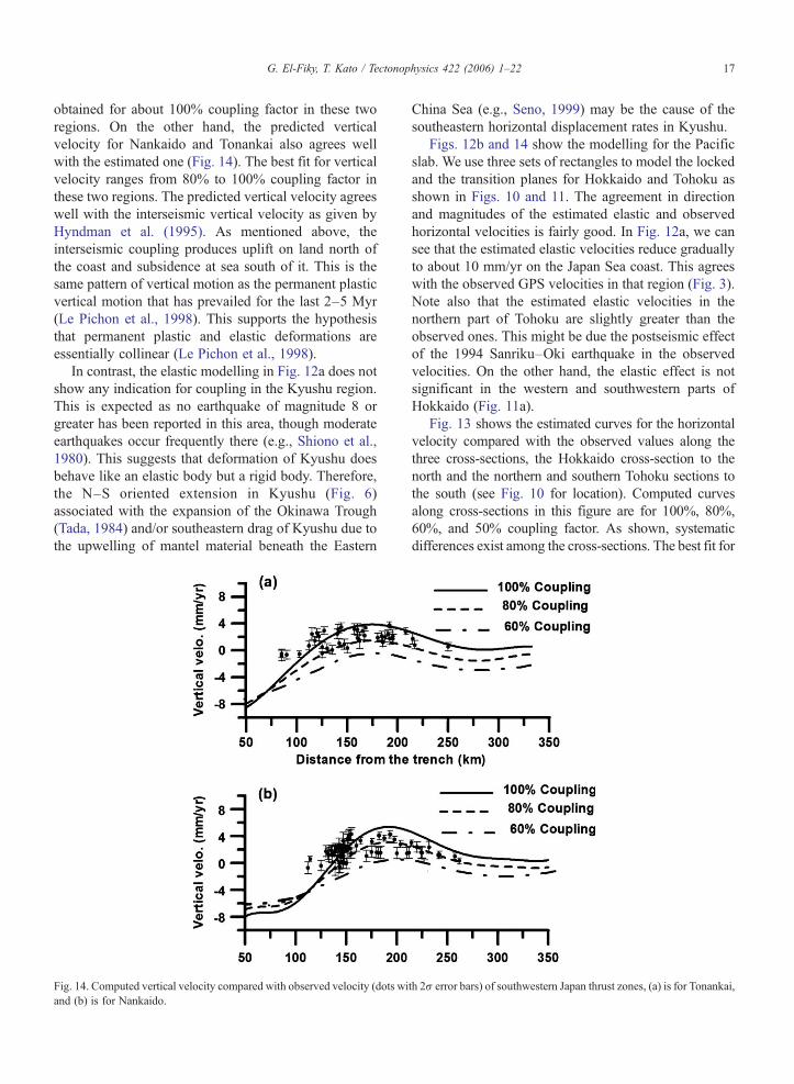
17G. El-Fiky, T. Kato / Tectonophysics 422 (2006) 1–22
obtained for about 100% coupling factor in these tworegions. On the other hand, the predicted verticalvelocity for Nankaido and Tonankai also agrees wellwith the estimated one (Fig. 14). The best fit for verticalvelocity ranges from 80% to 100% coupling factor inthese two regions. The predicted vertical velocity agreeswell with the interseismic vertical velocity as given byHyndman et al. (1995). As mentioned above, theinterseismic coupling produces uplift on land north ofthe coast and subsidence at sea south of it. This is thesame pattern of vertical motion as the permanent plasticvertical motion that has prevailed for the last 2–5 Myr(Le Pichon et al., 1998). This supports the hypothesisthat permanent plastic and elastic deformations areessentially collinear (Le Pichon et al., 1998).
In contrast, the elastic modelling in Fig. 12a does notshow any indication for coupling in the Kyushu region.This is expected as no earthquake of magnitude 8 orgreater has been reported in this area, though moderateearthquakes occur frequently there (e.g., Shiono et al.,1980). This suggests that deformation of Kyushu doesbehave like an elastic body but a rigid body. Therefore,the N–S oriented extension in Kyushu (Fig. 6)associated with the expansion of the Okinawa Trough(Tada, 1984) and/or southeastern drag of Kyushu due tothe upwelling of mantel material beneath the Eastern
Fig. 14. Computed vertical velocity compared with observed velocity (dots wiand (b) is for Nankaido.
China Sea (e.g., Seno, 1999) may be the cause of thesoutheastern horizontal displacement rates in Kyushu.
Figs. 12b and 14 show the modelling for the Pacificslab. We use three sets of rectangles to model the lockedand the transition planes for Hokkaido and Tohoku asshown in Figs. 10 and 11. The agreement in directionand magnitudes of the estimated elastic and observedhorizontal velocities is fairly good. In Fig. 12a, we cansee that the estimated elastic velocities reduce graduallyto about 10 mm/yr on the Japan Sea coast. This agreeswith the observed GPS velocities in that region (Fig. 3).Note also that the estimated elastic velocities in thenorthern part of Tohoku are slightly greater than theobserved ones. This might be due the postseismic effectof the 1994 Sanriku–Oki earthquake in the observedvelocities. On the other hand, the elastic effect is notsignificant in the western and southwestern parts ofHokkaido (Fig. 11a).
Fig. 13 shows the estimated curves for the horizontalvelocity compared with the observed values along thethree cross-sections, the Hokkaido cross-section to thenorth and the northern and southern Tohoku sections tothe south (see Fig. 10 for location). Computed curvesalong cross-sections in this figure are for 100%, 80%,60%, and 50% coupling factor. As shown, systematicdifferences exist among the cross-sections. The best fit for
th 2σ error bars) of southwestern Japan thrust zones, (a) is for Tonankai,

18 G. El-Fiky, T. Kato / Tectonophysics 422 (2006) 1–22
horizontal velocity is obtained for about 70%, 50%, and80% coupling factor in Hokkaido, northern Tohoku, andsouthern Tohoku, respectively. The relatively low inter-plate coupling in the northern Tohoku might be due to thepostseismic effect of the 1994 Sanriku–Oki earthquake.This is consistent with the results of Nishimura et al.(2004). They studied the temporal change of interplatecoupling in northeastern Japan using the GPS array for theperiod from 1995 April to 2002 March. They pointed outthat after-slip of the 1994 Sanriku–Oki earthquakeoccurred over the coseismic rupture area and its downdipextension on the plate boundary and continued only in thedowndip extension and decayed with time. They also
Fig. 15. Elastic modelling of northeastern Japan thrust zones, (a) is for the hvelocity of northern cross-section (39°N–41°N), (c) is for the horizontal velcross-sections for 100%, 80%, 60%, and 50% coupling factor. Dots indicate
showed that weak coupling was recovered in thecoseismic rupture area 3.3 yr after the earthquake. Onthe other hand, the predicted vertical velocity forHokkaido and Tohoku does not recover the observedonewell (Fig. 15). The best fit for vertical velocity in thesetwo regions is obtained for about 50% coupling factor.
As stated above, the observed horizontal velocities inboth northeast and southwest Japan are consistent withthose predicted by elastic back-slip model (Fig. 12). Inaddition, the vertical velocities in southwest Japan agreewell with the model (Fig. 14). However, in the northeastJapan the observed vertical velocities deviate from that ofthe elastic model (Fig. 16). Heki (2004) discussed this
orizontal velocity of Hokkaido cross-section, (b) is for the horizontalocity of southern cross-section (37°N–41°N). Computed curves alongthe observed velocities and bars represent 2σ uncertainty.
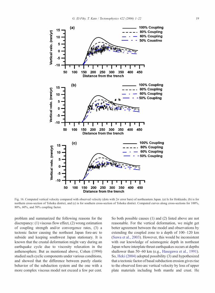
Fig. 16. Computed vertical velocity compared with observed velocity (dots with 2σ error bars) of northeastern Japan. (a) Is for Hokkaido, (b) is fornorthern cross-section of Tohoku district, and (c) is for southern cross-section of Tohoku district. Computed curves along cross-sections for 100%,80%, 60%, and 50% coupling factor.
19G. El-Fiky, T. Kato / Tectonophysics 422 (2006) 1–22
problem and summarized the following reasons for thediscrepancy: (1) viscous flow effect, (2) wrong estimationof coupling strength and/or convergence rates, (3) atectonic factor causing the northeast Japan fore-arc tosubside and keeping southwest Japan stationary. It isknown that the crustal deformation might vary during anearthquake cycle due to viscosity relaxation in theasthenosphere. But as mentioned above, Cohen (1994)studied such cyclic components under various conditions,and showed that the difference between purely elasticbehavior of the subduction system and the one with amore complex viscous model not exceed a few per cent.
So both possible causes (1) and (2) listed above are notreasonable. For the vertical deformation, we might getbetter agreement between the model and observations byextending the coupled zone to a depth of 100–120 km(Suwa et al., 2003). However, this would be inconsistentwith our knowledge of seismogenic depth in northeastJapan where interplate thrust earthquakes occurs at depthsshallower than 50–60 km (e.g., Hasegawa et al., 1991).So, Heki (2004) adopted possibility (3) and hypothesizedthat a tectonic factor of basal subduction erosion gives riseto the observed fore-arc vertical velocity by loss of upperplate materials including both mantle and crust. He

20 G. El-Fiky, T. Kato / Tectonophysics 422 (2006) 1–22
estimated the basal subduction erosion rate to be 15 mm/yr down to a slab depth of 90 kmwhich is somewhat fasterthan the geological average.
Aoki and Scholz (2003) used the GPS data to studyvertical velocity in the Japanese Islands and theypointed out that horizontal data does not permit theseparation of rigid plate motion and interplate couplingbecause horizontal displacements contain both effects.Therefore rigid plate motion could be mapped into theinterplate coupling leading to a misunderstanding of itsspatial distribution. This problem can be avoided byusing the vertical velocities to discriminate between therigid plate motions and interplate coupling. That is whywe used both horizontal and vertical velocities in thisstudy. The obtained results in this study confirmed theabove conclusion of Aoki and Scholz (2003). That is theestimated coupling factor from horizontal velocity isusually higher than the one obtained from the verticalvelocity. Based on this and summing up the presentstudy, we can say there is strong interplate coupling(80%–100%) in the Nankaido and Tonankai regions,where it is only 50% in Kurile–Japan Trench.
Similar results of low seismic coupling along the Japanand Kurile trenches have been obtained from 100 years ofgeodetic and leveling data (Hashimoto and Jackson,1993; Shen-Tu andHolt, 1996; El-Fiky andKato, 1999b).In contrast, Le Pichon et al. (1998) estimated the couplingfactor using 1 yr (1995) of the GPS data to about 80% fornortheastern Japan. Since they used the horizontalvelocity only for studying the coupling in northeasternJapanwhichmight include the contributions of both of therigid plate motion and interplate coupling as mentionedabove, their estimated value seems to be overestimated.For the Nankai subduction, the obtained results here areconsistent with previous results on the basis of analysis ofGPS, long-term geodetic and leveling data (Savage andThatcher, 1992; Hyndman et al., 1995; Ozawa et al.,1999; El-Fiky et al., 1999).
6. Conclusion
Data from the nation-wide GPS continuous trackingnetwork of Japan for the period from April 1, 1996 toFebruary 24, 2001 has been used to study secular crustaldeformation in the Japanese Islands. We first model eachtime series of the GPS components as a linear com-bination of linear function, trigonometric function, andjumps for episodic events. Estimated velocities afterfitting are converted into a kinematic reference frame(Heki, 1996) to allow discussion of crustal deformationrelative to the stable interior of the Eurasian plate. Weused Least-Squares Prediction technique to segregate
the signal and noise in horizontal as well as verticalvelocity. Then, the estimated horizontal signals (hori-zontal displacement rates) were differentiated in spaceto calculate principal components of strain. Calculatedstrains seem to portray the tectonic environments of theJapanese Islands; (1) dilatational strains show that theJapanese Islands are under the compressive strainregime induced by the subducting Pacific and PhilippineSea plates, (2) maximum shear strains show a goodagreement with recent crustal activities, and (3)principal axes of the strains indicate that the JapaneseIslands are under the influence from the convergingoceanic plates. The secular vertical deformation field ofthe Japanese islands was also derived for the same ofGPS data. We combined the GPS vertical velocities with31 year tide gage data to obtain absolute verticalvelocity. The estimated pattern of vertical velocityshows the following. (1) A clear uplift pattern of about6 mm/yr in the Shikoku district and Kii Peninsula,whereas subsidence pattern is seen in the coast ofKyushu district. This is consistent with the strongcoupling between the Philippine Sea plate and overrid-ing plate at the Nankai Trough and weak coupling offKyushu. (2) No clear uplift pattern is seen along thePacific coast of northeastern part of Japan. This might bedue to the plate boundary is too far seaward from theGPS sites or might be due to weak coupling there. (3)Significant uplift is observed in southwestern Hokkaidoand in northeastern Japan along the Japan Sea coast ofTohoku district. This uplift might be due to the long-term postseismic rebound of the 1983 Japan Sea (Mw
7.7) and the 1993 Hokkaido–Nansei–Oki (Mw 7.8)earthquakes and/or associated with the convergenceplate of incipient subduction there. Finally, we investi-gate the origin of the present GPS deformation in theJapanese Islands by comparing velocity fields deter-mined from GPS data with those calculated from theelastic dislocation models involving interplate motion atthe subduction zones in southwestern and northeasternJapan. Since horizontal data does not permit theseparation of rigid plate motion and interplate couplingbecause horizontal velocities include both effects, weused the vertical velocities to discriminate betweenthem. We then showed that most of the GPS velocityfield can indeed be accounted for by full elastic couplingalong Philippine locked thrust zone and only 50%coupling for the Pacific locked zone.
Acknowledgments
We are grateful to the staff of the GeographicalSurvey Institute for providing the GPS data. We thank
21G. El-Fiky, T. Kato / Tectonophysics 422 (2006) 1–22
Yosuke Aoki of Earthquake Research Institute, TokyoUniversity for his help and useful discussion. Commentsof Mike Sandiford, David Verdonck, and an anonymousreviewer were invaluable to improve the manuscript.The GMT software package was used to plot somefigures in this paper.
References
Aoki, Y., Scholz, C.H., 2003. Vertical deformation of the JapaneseIslands, 1996–1999. JGR 108, 10–11 (ETG).
Barnett, T.P., 1984. The estimation of “global” sea level change: aproblem of uniqueness. J. Geophys. Res. 89, 7980–7988.
Bibby, H.M., 1975. Crustal strain from triangulation in Malborough,New Zealand. Tectonophysics 29, 529–540.
Brunner, F.K., Coleman, R., Hirsch, B., 1981. A comparison ofcomputation methods for crustal strains from geodetic measure-ments. Tectonophysics 29, 281–298.
Byrne, D.E., Davis, D.M., Sykes, L.R., 1988. Local and maximum sizeof thrust earthquakes and mechanics of the shallow regionsubduction zones. Tectonics 7, 833–857.
Cohen, S.C., 1994. Evaluation of the importance of model features forcyclic deformation due to dip-slip faulting. Geophys. J. Int. 119,831–841.
Cook, D.B., Fujita, K., McMullen, C.A., 1986. Present-day plateinteractions in northeast Asia: North American, Eurasian, andOkhotsk plates. J. Geodyn. 6, 33–51.
DeMets, C.A., 1992. Test of present day plate geometries for NorthEast Asia and Japan. J. Geophys. Res. 134, 17627–17635.
DeMets, C., Gordon, R.G., Argus, D.F., Stein, S., 1994. Effect of recentrevisions to the geomagnetic reversal time scale on estimates ofcurrent plate motions. Geophys. Res. Lett. 21, 2191–2194.
Dermanis, A., 1981. Geodetic satiability of crustal deformationparameters. Quatern. Geod. 2 (2), 159–169.
Dermanis, A., Livieratos, E., Rossikopulos, D., Vlachos, D., 1981.Geodetic prediction of crustal deformation at the seismic area ofVolvi. Proc. Intern. Symp. Geodetic Networks and Computations,Munich.
Douglas, B.C., 1991. Global sea level rise. J. Geophys. Res. 96,6981–6992.
El-Fiky, G.S., Kato, T., 1999a. Continuous distribution of thehorizontal strain in the Tohoku district, Japan, deduced fromleast squares prediction. J. Geodyn. 27, 213–236.
El-Fiky, G.S., Kato, T., 1999b. Interplate coupling in the Tohokudistrict, Japan, deduced from geodetic data inversion. J. Geophys.Res. 104, 20361–20377.
El-Fiky, G.S., Kato, T., Fujii, Y., 1997. Distribution of the verticalcrustal movement rates in the Tohoku district, Japan, predicted byleast-squares collocation. J. Geod. 71, 432–442.
El-Fiky, G.S., Kato, T., Oware, E.N., 1999. Crustal deformation andinterplate coupling in the Shikoku district, Japan, as seen fromcontinuous GPS Observation. J. Tectonophys. 314, 387–399.
Frank, F.C., 1966. Deduction of earth strains from survey data. Bull.Seismol. Soc. Am. 56 (1), 35–42.
Geographical Survey Institute (GSI), 1999. Crustal movements in theHokkaido district. Report of the Coordinating Committee forEarthquake Prediction, vol. 61, pp. 13–16.
Hasegawa, A., Zhao, D., Hori, S., Yamamoto, A., Horiuchi, S., 1991.Deep structure of the northeastern Japan arc and its relationship toseismic and volcanic activity. Nature 352, 683–689.
Hasgawa, A., Horiuchi, S., Umino, N., 1994. Seismic structure of thenortheastern Japan convergent margin: a synthesis. J. Geophys.Res. 99, 22295–22311.
Hashimoto, M., Jackson, D., 1993. Plate tectonics and crustaldeformation around the Japanese Islands. J. Geophys. Res. 134,16149–16166.
Heki, K., 1996. Horizontal and vertical crustal movements from three-dimensional very long baseline interferometry kinematic referenceframe: Implication for reversal timescale revision. J. Geophys. Res.101, 3187–3198.
Heki, K., 2004. Space geodetic observation of deep basal subductionerosion in northeastern Japan. Earth Planet. Sci. Lett. 219, 13–20.
Heki, K., Miyazaki, S., Tsuji, H., 1997. Silent fault slip following aninterplate thrust earthquake at the Japan Trench. Nature 386,595–598.
Heki, K., Miyazaki, S., Takahashi, H., Kasahara, M., Kimata, F.,Miura, S., Vasilenko, N., Ivashchenko, A., An, Ki-Dok, 1999. TheAmurian Plate motion and current plate kinematics in eastern Asia.J. Geophys. Res. 104, 29,147–29,155.
Hirose, H., Hirahara, K., Kimata, F., Fujii, N., Miyazaki, S., 1999. Aslow thrust slip event following the two 1996 Hyuganadaearthquakes beneath the Bungo Channel, southwest Japan.Geophys. Res. Lett. 26, 3237–3240.
Hyndman, R.D., Wang, K., Yamano, M., 1995. Thermal constraints onthe seismogenic portion of the southwestern Japan subductionthrust. J. Geophys. Res. 134, 15 373–15 392.
Ishikawa, N., Hashimoto, M., 1999. Average horizontal strain rates inthe Japan during interseismic period deduced from geodeticsurveys (part 2). Zishin 52, 299–315 (in Japanese).
Ito, T., 2004. Spatiotemporal distribution of interplate coupling insouthwest Japan from inversion of geodetic data. J. Geophys. Res.109, B02315–B02335.
Ito, T., Yoshioka, S., Miyazaki, S., 2000. Interplate coupling innortheast Japan deduced from inversion analysis of GPS data.Earth Planet. Sci. Lett. 176, 117–130.
Kaizuka, S., Imaizumi, T., 1984. Horizontal strain rates of the JapaneseIslands estimated from Quaternary fault data. Geogr. Rep. TokyoMetrop. Univ. 19, 43–65.
Kato, T., Nakajima, K., 1989. Regional crustal movements in Japan bygeodesy and space techniques. J. Geod. Soc. Jpn. 35, 171–185.
Kato, T., Tsumura, K., 1979. Vertical land movement in Japan asdeduced from tidal record (1951–1978). Bull. Earthq. Res. Inst.54, 559–628 (in Japanese).
Kato, T., El-Fiky, G.S., Oware, E.N., Miyazaki, S., 1998. Crustalstrains in the Japanese Islands as deduced from dense GPS array.Geophys. Res. Lett. 25, 3445–3448.
Kawakatsu, H., Seno, T., 1993. Triple seismic zone and the regionalvariation of seismic along the northern Honshu arc. J. Geophys.Res. 88, 4215–4230.
Kobayashi, Y., 1983. The initiation of plate subduction. Earth Monit.5, 510–524 (in Japanese).
Le Pichon, X., Mazzotti, S., Henry, P., Hashimoto, M., 1998.Deformation of the Japanese Islands and seismic coupling: aninterpretation based on GSI permanent GPS observations.Geophys. J. Int. 134, 501–514.
Mazzotti, S., Le Pichon, X., Henry, P., 2000. Full interseismic lockingof the Nankai and Japan–west Kurile subduction zones: ananalysis of uniform elastic strain accumulation in Japan con-strained by permanent GPS. J. Geophys. Res. 105, 13159–13177.
Miyazaki, S., Saito, T., Sasaki, M., Hatanaka, Y., Iimura, Y., 1997.Expansion of GSI's nationwide GPS array. Bull. Geogr. Surv. Inst.43, 23–34.

22 G. El-Fiky, T. Kato / Tectonophysics 422 (2006) 1–22
Miyazaki, S., Tada, T., Sagiya, T., Dong, D., Johnson, J., 1998.Regional crustal deformation of Japan derived by Japanese GPSarray. Eos Trans, AGU 79, F186.
Moritz, H., 1962. Interpolation and Prediction of Gravity and theirAccuracy. Rep, vol. 24. Inst. Geod. Phot. Cart. Ohio State Univ,Columbus, USA.
Nakamura, K., 1983. Possible nascent trench along the Eastern JapanSea as the convergent boundary between Eurasian and NorthAmerican plates. Bull. Earthq. Res. Inst. Univ. Tokyo 58, 711–722(in Japanese).
Nishimura, T., Miura, S., Tachibana, K., Hashimoto, K., Sato, T., Hori,S., Murakami, E., Kono, T., Nida, K., Mishina, M., Hirasawa, T.,Miyazaki, S., 1998. Source model of the co-and post-seismicdeformation associated with the 1994 far off Sanriku earthquake(M7.5) inferred from strain and GPS measurements. TohokuGeophys. J. (Sci. Rep. Tohoku Univ., Ser 5) 35, 15–32.
Nishimura, T., Hirasawa, T., Miyazaki, S., Sagiya, T., Tada, T., Miura,S., Tanaka, K., 2004. Temporal change of interplate coupling innortheastern Japan during 1995–2002 estimated from continuousGPS observations. Goephys. J. Int. 901–916.
Ozawa, S., Tabei, T., Miyazaki, S., 1999. Interplate coupling along theNankai Trough off southwest Japan derived from GPS measure-ments. Geophys. Res. Lett. 26, 927–930.
Ozawa, S., Murakami, M., Tada, T., 2001. Time-dependent inversionstudy of the slow thrust event in the Nankai Trough subductionzone, southwestern Japan. J. Geophys. Res. 106, 787–802.
Peltier, W.R., Tushingham, A.M., 1998. Global sea level rise and thegreenhouse effect: might they be connected? Science 244,806–810.
Research Group for Active Faults, 1991. Active Faults in Japan: SheetMaps and Inventories. University of Tokyo Press, Tokyo. (inJapanese).
Rikitake, T., 1976. Earthquake Prediction. Elsevier, p. 357.Sagiya, T., 1995. Crustal deformation cycle and interplate coupling in
Shikoku. Southwest Japan, Ph. D. Thesis, Univ. of Tokyo, 164pp.Sagiya, T., 2004a. A decade of GEONET: 1994–2003—the
continuous GPS observation in Japan and its impact on earthquakestudies. EPS 56 xxix-xli.
Sagiya, T., 2004b. Interplate coupling in the Kanto district, centralJapan, and the Boso Peninsula silent earthquake in May 1996. PureAppl. Geophys. 161, 2327–2342.
Sagiya, T., Miyazaki, S., Tada, T., 2000. Continuous GPS array andpresent-day crustal deformation of Japan. Pure Appl. Geophys.157, 2303–2322.
Savage, J.C., 1978. Strain patterns and strain accumulation along platemargins. In: Mueller, I. (Ed.), In Application of Geodesy toGeodynamics. Rep., vol. 280. Dept. of Geodetic Sci., Ohio stateUniv., pp. 93–97.
Savage, J.C., 1983. A dislocation model of strain accumulation andrelease at a subduction zone. J. Geophys. Res. 134, 4984–4996.
Savage, J.C., Thatcher, W., 1992. Interseismic deformation at theNankai Trough, Japan. Subduction zone. J. Geophys Res. 97,11,117–11,135.
Seno, T., 1999. Syntheses of the regional stress fields of the Japaneseislands. Island Arc 8, 66–79.
Seno, T., Stein, S., Gripp, A.E., 1993. A model for the motion of thePhilippine Sea plate consistent with Nuvel-1 and geological data. J.Geophys. Res. 98, 17941–17948.
Seno, T., Sakurai, T., Stein, S., 1996. Can the Okhotsk plate bediscriminated from the North American plate? J. Geophys. Res.101, 27957–27980.
Shen, Z., Jachson, D.D., Ge, B.X., 1996. Crustal deformation acrossand beyond the Los Angeles Basin from geodetic measurements. J.Geophys. Res. 101, 27957–27980.
Shen-Tu, B., Holt, W.E., 1996. Interseismic horizontal deformation innorthern Honshu and its relationship with the subduction of thePacific plate in the Japan Trench. Geophys. Res. Lett. 23,3103–3106.
Shen-Tu, B., Holt, W.E., Haines, A.J., 1995. Intraplate deformationin the Japanese Island: a kinematic study of intraplatedeformation at a convergent plate margin. J. Geophys. Res.100, 24275–24293.
Shiono, K., Mikumo, T., Ishikawa, Y., 1980. Tectonics of the Kyushu–Ryukyu arc as evidenced from seismicity and focal mechanism ofshallow to intermediate-depth earthquakes. J. Phys. Earth 28,17–43.
Suwa,Y., Miura, S., Hasegawa, A., Sato, T., Tachibana, K., 2003. Inter-plate coupling beneath the NE Japan arc inferred from 3dimensional crustal deformation. Paper presented at the Sympo-sium JSG01, 23rd General Assembly of the International Union ofGeodesy and Geophysics, Sapporo, 8 July 2003.
Tabei, T., Ozawa, T., Date, Y., 1996. Crustal deformation at the Nankaisubduction zone, southwest Japan, derived from GPS measure-ments. Geophy. Res. Lett. 23, 3059–3062.
Tada, T., 1984. Spreading of the Okinawa Trough and its relation to thecrustal deformation in Kyushu. Zishin 37, 407–415 (in Japanese).
Tada, T., Sagiya, T., Miyazaki, S., 1997. The deforming JapaneseIslands as viewed with GPS. Kagaku 67, 917–927 (in Japanese).
Tsuboi, C., 1932. Investigation on the deformation of the earth crustconnected with the Tango Earthquake of 1927. Bull. Earthq. Res.Inst. Univ. Tokyo 10 (2).
Tsuji, H., Hatanaka, Y., Sagiya, T., Hashimoto, M., 1995. Coseismiccrustal deformation from the 1994 Hokkaido–Toho–Oki earth-quake monitored by a nationwide continuous GPS array in Japan.Geophys. Res. Lett. 22, 1669–1672.
Tsukahara, H., Kobayashi, Y., 1991. Crustal stress in the central andwestern parts of Honshu, Japan. J. Seismol. Soc. Jpn. 44, 221–231(in Japanese).
Wei, D., Seno, T., 1998. Determination of the Amurian plate motion inmantle dynamics and plate interactions in East Asia. In: Flower,M., et al. (Ed.), Geodyn. Series, vol. 27, pp. 337–346.
Wesnousky, S.G., Scholz, H., Shimazaki, K., 1982. Deformation of anisland arc: Rates of moment release and crustal shortening inintraplate Japan determined from seismicity and Quaternary faultdata. J. Geophys. Res. 87, 6829–8652.
Yamasaki, T., Seno, T., 2005. High strain rate zone in central Honshuresulting from the viscosity heterogeneities in the crust and mantle.Earth Planet. Sci. Lett. 232, 13–27.
Yoshii, T., 1979. A detailed cross-section of the deep seismic zonebeneath northeastern Honshu, Japan. Tectonophysics 55, 349–360.
Yoshioka, S., Yabuki, T., Sagiya, T., Tada, T., Matsu'ura, M., 1993.Interplate coupling and relative plate motion in the Tokai district,central Japan, deduced from geodetic data inversion using ABIC.Geophys. J. Int. 133, 607–621.
Zonenshain, L.P., Savostin, A., 1981. Geodynamics of the Bikal Riftzone and plate tectonics of Asia. Tectonophysics 76, 1–45.
Copyright © 2022 FDOKUMEN