
Evidence of large prehistoric offshore earthquakes deduced from uplifted Holocene marine terraces in...
14
Evidence of large prehistoric offshore earthquakes deduced from uplifted Holocene marine terraces in Pangasinan Province, Luzon Island, Philippines Noelynna T. Ramos ⁎, Hiroyuki Tsutsumi Department of Geophysics, Graduate School of Science, Kyoto University, Kyoto 606-8502, Japan abstract article info Article history: Received 19 March 2010 Received in revised form 23 June 2010 Accepted 25 August 2010 Available online 6 September 2010 Keywords: Uplifted coral reefs Coseismic uplift Offshore fault Dislocation modeling Manila trench Philippines Uplifted Holocene marine terraces in Pangasinan Province, westernmost Luzon Island, Philippines are reported here for the first time as geomorphic evidence of large prehistoric offshore earthquakes. We recognized up to three Holocene terrace steps. Elevations of shoreline angles are TI: 1 to 5 m, TII: 2 to 7 m, and TIII: 4 to 11 m above mean sea level (amsl). The lateral variation in the elevation of terrace steps indicates differential uplift along the coast. The staircase topography, characterized by horizontal abrasion platforms, meter-scale terrace risers, and wave-cut notches, suggests that these geomorphic features were formed by large coseismic uplift events. Terrace morphology and radiocarbon ages further suggest that at least three coseismic coastal uplift events have occurred since the culmination of the post-glacial sea level rise ~6000 years ago. We interpret TIII to be the Holocene transgressive surface (~6000 yBP) and estimated a maximum uplift rate of 1.7 mm/yr which is almost the same as the Late Pleistocene uplift rate of 1.3 mm/yr. We infer that proximity to offshore seismic sources has contributed to the deformation pattern of Holocene terraces and variation in the number of terrace steps. Uplift patterns of marine terraces also suggest that the magnitude and location of prehistoric earthquakes may have varied between individual coseismic uplift events. We conducted simple elastic dislocation modeling to evaluate the source parameters of the causative faults. Our preliminary models show that a landward-dipping offshore reverse fault located at the base of a steep slope separating the fore arc basin and continental shelf could be responsible for coastal uplift along the western Pangasinan peninsula. © 2010 Elsevier B.V. All rights reserved. 1. Introduction Emergent Holocene marine terraces are often regarded as geomorphic markers of past earthquakes along rapidly uplifting coastlines (Lajoie, 1986). The relationship between uplifted coastal terraces and great earthquakes has been well-documented for many parts of the world, particularly along active plate boundaries in the western Pacific(Ota and Yamaguchi, 2004). Raised marine platforms in staircase-like fashion, as observed in Japan (Maemoku, 1992), Taiwan (Yamaguchi and Ota, 2004), Papua New Guinea (Chappell, 1974; Ota et al., 1993), and New Zealand (Berryman et al., 1989; Wilson et al., 2006) have been attributed to episodic coseismic uplift events resulting from offshore and onshore thrust faulting. South of Taiwan, the Philippine Mobile Belt overrides the Philippine Sea plate along the Philippine trench and the Sunda block along the Manila trench (Fig. 1A). However, the distribution of Holocene terraces and its relation to offshore earthquakes are poorly known. The Pangasinan peninsula represents the westernmost coastline of Luzon Island facing the Manila trench. More than 400 years of historical record along this convergent margin show very few earthquakes of magnitude 7 or greater, and no historic coseismic uplift or subsidence event has been documented (Bautista and Oike, 2000). Thus, the seismic potential of the Manila trench and related offshore active structures were poorly understood. The growing interest and concern on giant megathrust earthquakes and associated tsunamis after the devastating 2004 Sumatra–Andaman earthquake led to our study of coastal geomorphic features along the Manila trench. In this paper, we present the first detailed and systematic mapping of uplifted Holocene coral reefs along the western Pangasinan coast east of the Manila trench. We also discuss preliminary seismotectonic interpretations based on geomorphic evidence and simple fault modeling. 2. Tectonic and geologic setting The complex active tectonic and geologic setting of the Philippines is attributed to plate interactions along surrounding subduction zones (Fig. 1A). The Sunda block subducts eastward along the Manila trench, Negros–Sulu trench system, and Cotabato trench while the Philippine Sea plate subducts westward beneath the Philippine Mobile Belt along the Philippine trench. Shear partitioning along these oppositely-dipping subduction zones has led to the formation of the Philippine fault system (Aurelio, 2000), a left-lateral strike-slip fault zone that extends for more Tectonophysics 495 (2010) 145–158 ⁎ Corresponding author. Tel.: + 81 75 753 3945. E-mail addresses: [email protected] (N.T. Ramos), [email protected] (H. Tsutsumi). 0040-1951/$ – see front matter © 2010 Elsevier B.V. All rights reserved. doi:10.1016/j.tecto.2010.08.007 Contents lists available at ScienceDirect Tectonophysics journal homepage: www.elsevier.com/locate/tecto
-
Upload
up-diliman -
Category
Documents
-
view
4 -
download
0
Transcript of Evidence of large prehistoric offshore earthquakes deduced from uplifted Holocene marine terraces in...
Tectonophysics 495 (2010) 145–158
Contents lists available at ScienceDirect
Tectonophysics
j ourna l homepage: www.e lsev ie r.com/ locate / tecto
Evidence of large prehistoric offshore earthquakes deduced from uplifted Holocenemarine terraces in Pangasinan Province, Luzon Island, Philippines
Noelynna T. Ramos ⁎, Hiroyuki TsutsumiDepartment of Geophysics, Graduate School of Science, Kyoto University, Kyoto 606-8502, Japan
⁎ Corresponding author. Tel.: +81 75 753 3945.E-mail addresses: [email protected] (N.T. Ra
[email protected] (H. Tsutsumi).
0040-1951/$ – see front matter © 2010 Elsevier B.V. Aldoi:10.1016/j.tecto.2010.08.007
a b s t r a c t
a r t i c l e i n f oArticle history:Received 19 March 2010Received in revised form 23 June 2010Accepted 25 August 2010Available online 6 September 2010
Keywords:Uplifted coral reefsCoseismic upliftOffshore faultDislocation modelingManila trenchPhilippines
Uplifted Holocene marine terraces in Pangasinan Province, westernmost Luzon Island, Philippines arereported here for the first time as geomorphic evidence of large prehistoric offshore earthquakes. Werecognized up to three Holocene terrace steps. Elevations of shoreline angles are TI: 1 to 5 m, TII: 2 to 7 m, andTIII: 4 to 11 m above mean sea level (amsl). The lateral variation in the elevation of terrace steps indicatesdifferential uplift along the coast. The staircase topography, characterized by horizontal abrasion platforms,meter-scale terrace risers, and wave-cut notches, suggests that these geomorphic features were formed bylarge coseismic uplift events. Terrace morphology and radiocarbon ages further suggest that at least threecoseismic coastal uplift events have occurred since the culmination of the post-glacial sea level rise~6000 years ago. We interpret TIII to be the Holocene transgressive surface (~6000 yBP) and estimated amaximum uplift rate of 1.7 mm/yr which is almost the same as the Late Pleistocene uplift rate of 1.3 mm/yr.We infer that proximity to offshore seismic sources has contributed to the deformation pattern of Holoceneterraces and variation in the number of terrace steps. Uplift patterns of marine terraces also suggest that themagnitude and location of prehistoric earthquakes may have varied between individual coseismic upliftevents. We conducted simple elastic dislocation modeling to evaluate the source parameters of the causativefaults. Our preliminary models show that a landward-dipping offshore reverse fault located at the base of asteep slope separating the fore arc basin and continental shelf could be responsible for coastal uplift along thewestern Pangasinan peninsula.
mos),
l rights reserved.
© 2010 Elsevier B.V. All rights reserved.
1. Introduction
Emergent Holocene marine terraces are often regarded asgeomorphic markers of past earthquakes along rapidly upliftingcoastlines (Lajoie, 1986). The relationship between uplifted coastalterraces and great earthquakes has been well-documented for manyparts of the world, particularly along active plate boundaries in thewestern Pacific (Ota and Yamaguchi, 2004). Raised marine platformsin staircase-like fashion, as observed in Japan (Maemoku, 1992),Taiwan (Yamaguchi and Ota, 2004), Papua New Guinea (Chappell,1974; Ota et al., 1993), and New Zealand (Berryman et al., 1989;Wilson et al., 2006) have been attributed to episodic coseismic upliftevents resulting from offshore and onshore thrust faulting. South ofTaiwan, the Philippine Mobile Belt overrides the Philippine Sea platealong the Philippine trench and the Sunda block along the Manilatrench (Fig. 1A). However, the distribution of Holocene terraces andits relation to offshore earthquakes are poorly known.
The Pangasinan peninsula represents the westernmost coastline ofLuzon Island facing theManila trench. More than 400 years of historical
record along this convergent margin show very few earthquakes ofmagnitude 7 or greater, and no historic coseismic uplift or subsidenceeventhas beendocumented (Bautista andOike, 2000). Thus, the seismicpotential of the Manila trench and related offshore active structureswere poorly understood. The growing interest and concern on giantmegathrust earthquakes and associated tsunamis after the devastating2004 Sumatra–Andaman earthquake led to our study of coastalgeomorphic features along the Manila trench. In this paper, we presentthe first detailed and systematic mapping of uplifted Holocene coralreefs along the western Pangasinan coast east of the Manila trench. Wealso discuss preliminary seismotectonic interpretations based ongeomorphic evidence and simple fault modeling.
2. Tectonic and geologic setting
The complex active tectonic and geologic setting of the Philippines isattributed to plate interactions along surrounding subduction zones(Fig. 1A). The Sunda block subducts eastward along the Manila trench,Negros–Sulu trench system, and Cotabato trench while the PhilippineSea plate subducts westward beneath the Philippine Mobile Belt alongthe Philippine trench. Shear partitioning along these oppositely-dippingsubduction zones has led to the formation of the Philippine fault system(Aurelio, 2000), a left-lateral strike-slip fault zone that extends formore

Fig. 1. Seismotectonic setting of western Pangasinan, Philippines. A) Map of tectonic elements in and around the archipelago. EUR: Eurasia; SUN: Sunda block; PMB: PhilippineMobile Belt; PSP: Philippine Sea plate; PFS: Philippine Fault system; LUZ/SUN: rotation pole of Luzon block with respect to SUN. Arrows are GPS vectors relative to SUN while lettersnext to GPS vectors are GPS station names from the Geodynamics of South and South-East Asia (GEODYSSEA) project: L-LAOA (Laoag); V-VIRA (Virac); P-PUER (Puerto Princesa); I-ILOI(Iloilo); S-SURI (Surigao); Z-ZAMB (Zamboanga); D-DAVA (Davao). The convergence rate between SUN and PMB along the Manila trench is also shown with the LUZ/SUN rotation pole(Rangin et al., 1999). Numbers on bathymetric contour lines are in meters. The rectangle shows the location of Fig. 1B. B) Map showing the Manila trench and large magnitudeearthquakes west of Luzon Island. The rectangle shows the location of Fig. 2B. SF: San Fernando tide gauge station;WBF:Western Boundary fault. Seismicity (1897–2008) andmain traceof the Philippine fault system are from the Philippine Institute of Volcanology and Seismology (PHIVOLCS) (PHIVOLCS–DOST, 2000), focal mechanism solutions (NM6) are from theGlobal CMT Catalog (1976–2008), and bathymetry data are from the National Geophysical Data Center (NGDC) (Amante and Eakins, 2009).
146 N.T. Ramos, H. Tsutsumi / Tectonophysics 495 (2010) 145–158
than 1200 km and consists of several segments running from LuzonIsland southward to Mindanao Island (Allen, 1962; Ringenbach et al.,1993). The Philippine fault system has produced several MN7 earth-quakes in the last century (Bautista and Oike, 2000).
The Manila trench runs parallel to the coasts of western LuzonIsland from its southern terminus at 13°N northward to the southerntip of Taiwan at 21°N (Fig. 1A). This tectonic boundary serves as thelocus of convergence between the Sunda block and the PhilippineMobile Belt. GPS vectors obtained from the GEODYSSEA project revealthe northwestward motion of northern Luzon relative to the Sundablock and convergence rate between the twomicro plates is estimatedat 52 to 98 mm/yr (Rangin et al., 1999). Despite fast convergencerates, large magnitude earthquakes are noticeably fewer along theManila trench as compared to the Philippine trench (Fig. 1A).
The western Pangasinan peninsula provides a suitable area forcoastal deformation studies not only because of its proximity to theManila trench, but also because raised coral platforms are extensiveand well-preserved along the coast. The peninsula is characterized bylandforms that rarely exceed 150 m in elevation and bordered by low-lying coastlines. Underlying lithologic units are interbedded marl,sandstone, siltstone, and claystone, dated at Pliocene based onholoplankton assemblage (Janssen, 2007). Early to Late Pleistocenestratigraphic units overlying the interbedded sedimentary depositsinclude the Bolinao Limestone, Zaragosa Mudstone, and Limestone
Conglomerate (De Ocampo, 1983). Fringing the coastlines areQuaternary deposits which include uplifted coral platforms andunconsolidated fluvial and beach sediments (Bureau of Mines,1974). The Western Boundary fault, which was originally identifiedby offshore seismic reflection surveys, traverses the western Panga-sinan peninsula (Hayes and Lewis, 1984) (Fig. 1B). Onshore andoffshore segments of the Western Boundary fault run from Ilocos SurProvince southward to Zambales Province.
3. Paleo-sea levels and coastal geomorphic features inthe Philippines
For the past decade, emerged coral reef terraces and wave-cutnotches have been studied to reconstruct paleo-sea level fluctuations inthe Philippines (Maeda and Siringan, 2004). Maeda et al. (2004)reported two mid-Holocene high stands in Samar, Palawan and Boholprovinces occurring between 7200 yBP and 2400 yBP (Fig. 1A). InPalawan, the Holocene paleo-sea level reached a maximum of 1.5 mabovemean sea level (amsl). In Bohol, Omura et al. (2004) and Ringor etal. (2004) dated the Pleistocene coral terraces while Berdin et al. (2004)investigated the emerged tidal notches. The mid-Holocene high standsin both Palawan (0.3 to 1.5 m) and Bohol (0.3 to 0.6 m) are comparableto the mid-Holocene high stand (~2 m) recorded on tectonically stableislands innorthernHawaii (GrossmanandFletcher, 1998). This suggests
147N.T. Ramos, H. Tsutsumi / Tectonophysics 495 (2010) 145–158
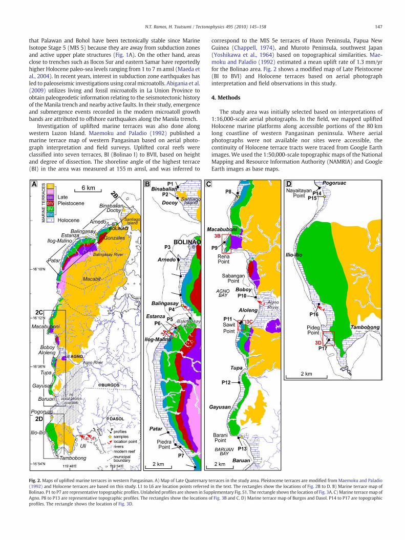
that Palawan and Bohol have been tectonically stable since MarineIsotope Stage 5 (MIS 5) because they are away from subduction zonesand active upper plate structures (Fig. 1A). On the other hand, areasclose to trenches such as Ilocos Sur and eastern Samar have reportedlyhigher Holocene paleo-sea levels ranging from 1 to 7 m amsl (Maeda etal., 2004). In recent years, interest in subduction zone earthquakes hasled to paleoseismic investigations using coralmicroatolls. Abigania et al.(2009) utilizes living and fossil microatolls in La Union Province toobtain paleogeodetic information relating to the seismotectonic historyof the Manila trench and nearby active faults. In their study, emergenceand submergence events recorded in the modern microatoll growthbands are attributed to offshore earthquakes along the Manila trench.
Investigation of uplifted marine terraces was also done alongwestern Luzon Island. Maemoku and Paladio (1992) published amarine terrace map of western Pangasinan based on aerial photo-graph interpretation and field surveys. Uplifted coral reefs wereclassified into seven terraces, BI (Bolinao I) to BVII, based on heightand degree of dissection. The shoreline angle of the highest terrace(BI) in the area was measured at 155 m amsl, and was inferred to
Fig. 2. Maps of uplifted marine terraces in western Pangasinan. A) Map of Late Quaternary t(1992) and Holocene terraces are based on this study. L1 to L6 are location points referredBolinao. P1 to P7 are representative topographic profiles. Unlabeled profiles are shown in SupAgno. P8 to P13 are representative topographic profiles. The rectangles show the locations oprofiles. The rectangle shows the location of Fig. 3D.
correspond to the MIS 5e terraces of Huon Peninsula, Papua NewGuinea (Chappell, 1974), and Muroto Peninsula, southwest Japan(Yoshikawa et al., 1964) based on topographical similarities. Mae-moku and Paladio (1992) estimated a mean uplift rate of 1.3 mm/yrfor the Bolinao area. Fig. 2 shows a modified map of Late Pleistocene(BI to BVI) and Holocene terraces based on aerial photographinterpretation and field observations in this study.
4. Methods
The study area was initially selected based on interpretations of1:16,000-scale aerial photographs. In the field, we mapped upliftedHolocene marine platforms along accessible portions of the 80 kmlong coastline of western Pangasinan peninsula. Where aerialphotographs were not available nor sites were accessible, thecontinuity of Holocene terrace tracts were traced from Google Earthimages. We used the 1:50,000-scale topographic maps of the NationalMapping and Resource Information Authority (NAMRIA) and GoogleEarth images as base maps.
erraces in the study area. Pleistocene terraces are modified from Maemoku and Paladioin the text. The rectangles show the locations of Fig. 2B to D. B) Marine terrace map ofplementary Fig. S1. The rectangle shows the location of Fig. 3A. C)Marine terrace map off Fig. 3B and C. D) Marine terrace map of Burgos and Dasol. P14 to P17 are topographic

148 N.T. Ramos, H. Tsutsumi / Tectonophysics 495 (2010) 145–158
We took 26 topographic profiles normal to the coastline tomeasurethe elevation of shoreline angles using a TruPulse200 laser rangefinderwith a vertical accuracy of ±0.1 m. Where wave-cut notches are notobserved, the inner edge of the platform defines the shoreline angle.Measurements were corrected for tide fluctuations using data fromthe nearest tide gauge station at San Fernando, La Union Province(National Mapping and Resource Information Authority (NAMRIA),2008, 2009) (Fig. 1B). Tidal range during our survey period was 0.1 to0.8 m and mean sea level is 0.3 m. Heights of shoreline angles areexpressed in m amsl.
Fossil coral samples are mostly Porites and were obtained eitherfrom terrace surfaces that cut the transgressive Holocene reefcomplex (attached coral) or from the sand cover. When samplingon sand-covered terraces, we carefully selected coral samples basedon occurrence in groups or patches (in situ) and growth position(upright). Samples were chipped off from the outer rims of the coraland were visually examined for the presence of calcite. Coral sampleswith no evidence of recrystallization were then crushed into cm-scalefragments, and sonicated and dried to remove organic contaminants.To further check for recrystallization, samples were subjected to XRDanalyses. Radiocarbon dating was done on a compact NEC acceleratormass spectrometer (AMS:NEC1.5SDH) at Paleo-Lab, Japan. Radiocar-bon ages are reported in yBP throughout the paper. Table 1 showscalibrated ages in 2-sigma (95%) age range probability calibrated withthe Marine04 calibration curve (Hughen et al., 2004).
5. Uplifted Holocene coral reefs in western Pangasinan
Holocene marine terraces will be described from north to south asBolinao, Agno, Burgos, and Dasol regions (municipalities) (Fig. 2). Atleast two and sometimes three terrace steps are recognized within11 m amsl and their elevations vary laterally along the coastline.Terrace steps are referred to as TI to TIII, from the lowest to highest,respectively. However, TI and TII are too narrow (b10 m wide) to beindividually shown on the geomorphic map and not all three terracesteps are continuous throughout the coast. Fig. 3 shows semi-detailedgeomorphic maps of marine terraces at representative sites. Topo-graphic profiles presented in this paper, labeled P1 to P17, are shownin Figs. 4 to 6 along with selected photographs. Profiles not discussedin the text are shown as supplementary material (Fig. S1).
5.1. Bolinao region
Marine terrace treads are cut by several northwestward flowingstreams and the Balingasay River. The Holocene terraces and themodern reef platform are wide in this region. The shoreline iscomposed of sandy beaches and patches of uplifted coral platforms,the latter most notable in Docoy (Santiago Island), Arnedo, and Patar(Fig. 2B). Sample topographic profiles are shown in Fig. 4.
In Bolinao, the shoreline angle for each terrace varies laterally, TI: 1to 4 m amsl, TII: 2 to 5 m amsl, and TIII: 5 to 7 m amsl (Fig. 4A). TI islowest at 1.4 m amsl in Binabalian, Santiago Island (Fig. 4A, P1), whilereaching 3.7 m amsl in Patar to the south (Fig. 4A and C, P7). TIappears throughout the Bolinao coast and is recognized in the field as
Table 1Radiocarbon ages.
Sample no.a Locality Elevation (m amsl) Terrace δ13C ‰ Ra
BOL1216-02 Balingasay 3.4 II −0.87±0.12 20BOL0403-01 Ilog-Malino 2.3 I −2.62±0.14 17AGN1219-02 Macabuboni 2.6 I −0.28±0.11 53AGN0404-01 Baruan 5.3 III −1.15±0.19 58BUR0321-01 Ilio-Ilio 2.1 I −1.22±0.14 52DAS0404-04 Tambobong 4.2 II −1.36±0.16 60
a All coral samples were obtained from exposed Porites heads.b Marine04 radiocarbon age calibration (Hughen et al., 2004).
rocky and sand-covered surfaces. Thickness of the sand cover mayonly be of centimeter scale since we can still see protrusions of thecorals on the terraces. We assumed that sand was thin enough so thatwe did not correct for elevations of terraces and shoreline angles.Rocky abrasion platforms are characterized by highly perforatedsurfaces with abundant attached corals that are mostly recrystallized.Sand-covered TI surface is widest in Balingasay and Ilog-Malinoreaching up to 200 m wide (Fig. 3A; Fig. 4A, P4 and P6) whereasnarrow (~2 m to 30 m) rocky platforms are prominent in Docoy,Arnedo and Patar (Piedra Point) (Fig. 4A, P2, P3, and P7; Fig. 4B and C).In Ilog-Malino, isolated patches of eroded Porites microatolls werefound within the sandy terrace cover (2.3 m amsl). The age obtainedfrom the coral is 1780±15 yBP (Fig. 4A, P6; Figs. 2B and 7A, L1).
TII is usually narrow (b40 m) but wide exposures are observed inBalingasay and Estanza (Fig. 4A, P4 and P5). Terrace risers separatingTI and TII are easily recognized in Docoy, Arnedo, and Patar where therocky coral reef platforms are exposed, but become degraded wheresand cover is abundant. The height of terrace risers separating TI fromTII varies from 1 to 2 m (Fig. 4A). TII follows a similar trend to TI in thatheight increases to the south. TII surface is lowest in Binabalian at2.4 m amsl (Fig. 4A, P1) and the shoreline angle reaches up to 4.6 mamsl in Patar (Fig. 4A and C, P7). In Balingasay, an eroded Poritesmicroatoll was found on the TII shoreline angle (3.4 m amsl) near awave-cut notch (Fig. 4A, P4). A sample obtained from the coral's outerrim yielded an age of 2000±20 yBP (Fig. 4A, P4; Figs. 2B and 7B, L2).
TIII occurs as wide sand-covered horizontal platforms that aresometimes difficult to trace due to degraded terrace risers separatingTIII from TII. Where observed, vertical separation between TII and TIIIranges from 1 to 2 m. Rocky platforms are prominent at Piedra Pointwhere TIII is highest at 6.4 m amsl (Fig. 4A and C, P7). Width of TIIIsurface ranges from 4 m in Docoy to 50 m in Estanza (Fig. 4A). InEstanza, this surface is associated with a sea cave (Fig. 4A, P5). Nodatable materials were found on TIII.
5.2. Agno region
The Agno coastline is characterized by steep cliffs along theheadlands, and three terrace steps were recognized in Macabuboni,Aloleng, Tupa, and Baruan (Fig. 2C). The Holocene terraces, as well asthe Late Pleistocene terraces, are cut by several westward flowingstreams, the largest of which is the Agno River. From eighttopographic profiles, the shoreline angles measured are TI: 1 to 5 mamsl, TII: 2 to 7 m amsl, and TIII: 6 to 11 m amsl (Fig. 5A). All threeterrace steps are well preserved in Macabuboni and Aloleng (Fig. 2C;Fig. 5, P9 and P11).
TI is observed in all topographic profiles. Terraces are usuallyexposed as rocky abrasion platforms and prominent along Rena Point inMacabuboni (Fig. 3B), Sawit Point in Aloleng (Fig. 3C), and Barani Pointin Gayusan (Fig. 2C). TI surfaces are narrow, ranging in width from 5 to16 m. TI is highest at 4.7 m amsl at Rena Point and appears as narrow(b5 m) platforms fringing the TII fore cliff (Fig. 3B; Fig. 5A and B, P9).North of this area, TI surface is characterized by a gentle seaward-sloping surface of cemented coral shingle with a few small truncatedcoral heads. A sample obtained from an eroded Porites coral headwithin
diocarbon age (yBP±1σ) Calibrated ageb (cal. years±2σ) Occurrence
00±20 300–459 AD Sand cover80±15 578–675 AD Sand cover75±25 3896–3704 BC Erosional surface25±25 4344–4234 BC Sand cover40±20 3706–3608 BC Erosional surface60±20 4612–4451 BC Sand cover
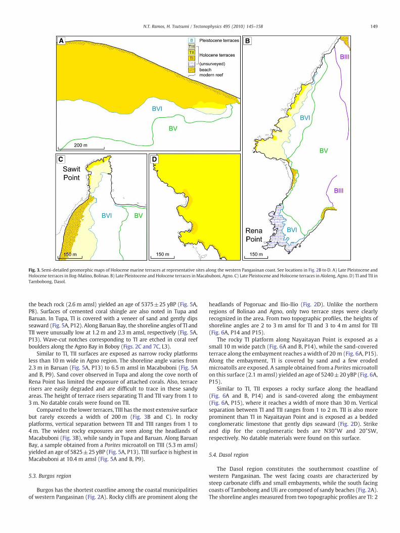
Fig. 3. Semi-detailed geomorphic maps of Holocene marine terraces at representative sites along the western Pangasinan coast. See locations in Fig. 2B to D. A) Late Pleistocene andHolocene terraces in Ilog-Malino, Bolinao. B) Late Pleistocene and Holocene terraces in Macabuboni, Agno. C) Late Pleistocene and Holocene terraces in Aloleng, Agno. D) TI and TII inTambobong, Dasol.
149N.T. Ramos, H. Tsutsumi / Tectonophysics 495 (2010) 145–158
the beach rock (2.6 m amsl) yielded an age of 5375±25 yBP (Fig. 5A,P8). Surfaces of cemented coral shingle are also noted in Tupa andBaruan. In Tupa, TI is covered with a veneer of sand and gently dipsseaward (Fig. 5A, P12). Along Baruan Bay, the shoreline angles of TI andTII were unusually low at 1.2 m and 2.3 m amsl, respectively (Fig. 5A,P13). Wave-cut notches corresponding to TI are etched in coral reefboulders along the Agno Bay in Boboy (Figs. 2C and 7C, L3).
Similar to TI, TII surfaces are exposed as narrow rocky platformsless than 10 m wide in Agno region. The shoreline angle varies from2.3 m in Baruan (Fig. 5A, P13) to 6.5 m amsl in Macabuboni (Fig. 5Aand B, P9). Sand cover observed in Tupa and along the cove north ofRena Point has limited the exposure of attached corals. Also, terracerisers are easily degraded and are difficult to trace in these sandyareas. The height of terrace risers separating TI and TII vary from 1 to3 m. No datable corals were found on TII.
Compared to the lower terraces, TIII has themost extensive surfacebut rarely exceeds a width of 200 m (Fig. 3B and C). In rockyplatforms, vertical separation between TII and TIII ranges from 1 to4 m. The widest rocky exposures are seen along the headlands ofMacabuboni (Fig. 3B), while sandy in Tupa and Baruan. Along BaruanBay, a sample obtained from a Porites microatoll on TIII (5.3 m amsl)yielded an age of 5825±25 yBP (Fig. 5A, P13). TIII surface is highest inMacabuboni at 10.4 m amsl (Fig. 5A and B, P9).
5.3. Burgos region
Burgos has the shortest coastline among the coastal municipalitiesof western Pangasinan (Fig. 2A). Rocky cliffs are prominent along the
headlands of Pogoruac and Ilio-Ilio (Fig. 2D). Unlike the northernregions of Bolinao and Agno, only two terrace steps were clearlyrecognized in the area. From two topographic profiles, the heights ofshoreline angles are 2 to 3 m amsl for TI and 3 to 4 m amsl for TII(Fig. 6A, P14 and P15).
The rocky TI platform along Nayaitayan Point is exposed as asmall 10 m wide patch (Fig. 6A and B, P14), while the sand-coveredterrace along the embayment reaches a width of 20 m (Fig. 6A, P15).Along the embayment, TI is covered by sand and a few erodedmicroatolls are exposed. A sample obtained from a Poritesmicroatollon this surface (2.1 m amsl) yielded an age of 5240±20 yBP (Fig. 6A,P15).
Similar to TI, TII exposes a rocky surface along the headland(Fig. 6A and B, P14) and is sand-covered along the embayment(Fig. 6A, P15), where it reaches a width of more than 30 m. Verticalseparation between TI and TII ranges from 1 to 2 m. TII is also moreprominent than TI in Nayaitayan Point and is exposed as a beddedconglomeratic limestone that gently dips seaward (Fig. 2D). Strikeand dip for the conglomeratic beds are N30°W and 20°SW,respectively. No datable materials were found on this surface.
5.4. Dasol region
The Dasol region constitutes the southernmost coastline ofwestern Pangasinan. The west facing coasts are characterized bysteep carbonate cliffs and small embayments, while the south facingcoasts of Tambobong and Uli are composed of sandy beaches (Fig. 2A).The shoreline angles measured from two topographic profiles are TI: 2
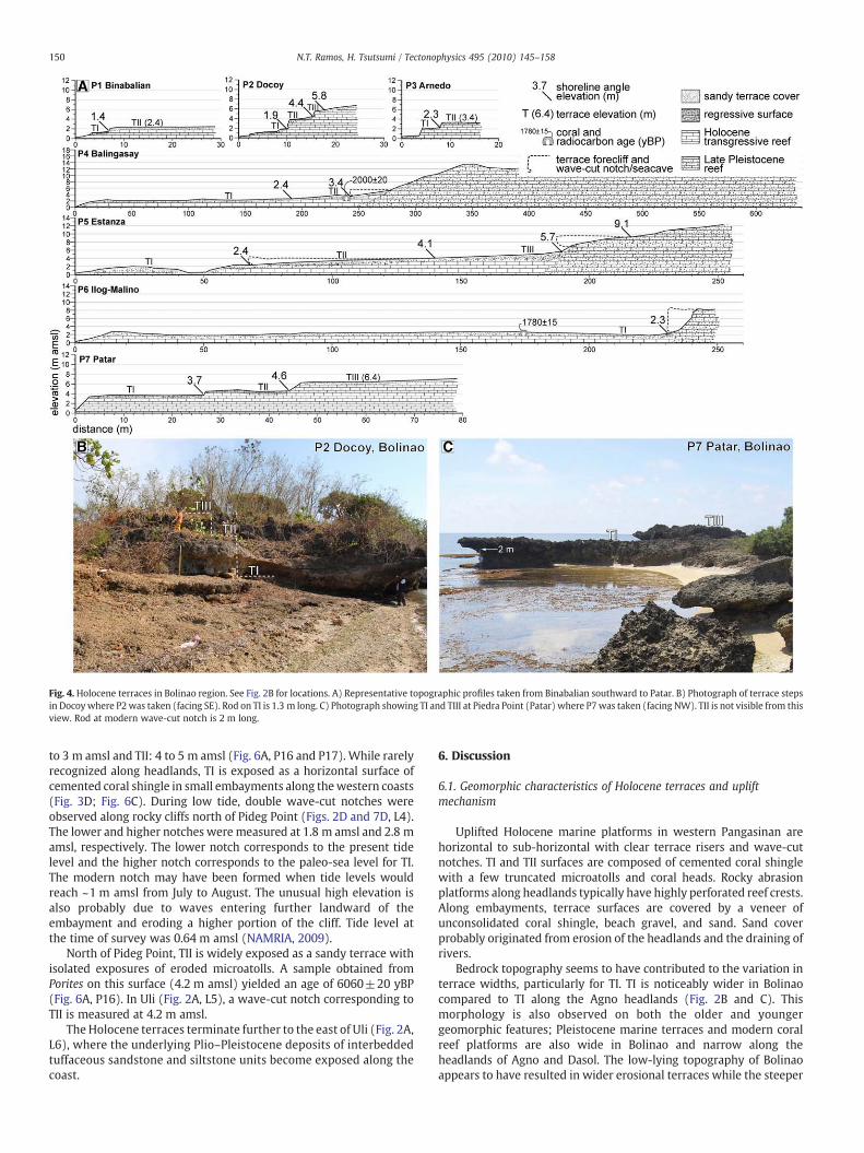
Fig. 4. Holocene terraces in Bolinao region. See Fig. 2B for locations. A) Representative topographic profiles taken from Binabalian southward to Patar. B) Photograph of terrace stepsin Docoywhere P2was taken (facing SE). Rod on TI is 1.3 m long. C) Photograph showing TI and TIII at Piedra Point (Patar) where P7was taken (facing NW). TII is not visible from thisview. Rod at modern wave-cut notch is 2 m long.
150 N.T. Ramos, H. Tsutsumi / Tectonophysics 495 (2010) 145–158
to 3 m amsl and TII: 4 to 5 m amsl (Fig. 6A, P16 and P17). While rarelyrecognized along headlands, TI is exposed as a horizontal surface ofcemented coral shingle in small embayments along thewestern coasts(Fig. 3D; Fig. 6C). During low tide, double wave-cut notches wereobserved along rocky cliffs north of Pideg Point (Figs. 2D and 7D, L4).The lower and higher notches were measured at 1.8 m amsl and 2.8 mamsl, respectively. The lower notch corresponds to the present tidelevel and the higher notch corresponds to the paleo-sea level for TI.The modern notch may have been formed when tide levels wouldreach ~1 m amsl from July to August. The unusual high elevation isalso probably due to waves entering further landward of theembayment and eroding a higher portion of the cliff. Tide level atthe time of survey was 0.64 m amsl (NAMRIA, 2009).
North of Pideg Point, TII is widely exposed as a sandy terrace withisolated exposures of eroded microatolls. A sample obtained fromPorites on this surface (4.2 m amsl) yielded an age of 6060±20 yBP(Fig. 6A, P16). In Uli (Fig. 2A, L5), a wave-cut notch corresponding toTII is measured at 4.2 m amsl.
The Holocene terraces terminate further to the east of Uli (Fig. 2A,L6), where the underlying Plio–Pleistocene deposits of interbeddedtuffaceous sandstone and siltstone units become exposed along thecoast.
6. Discussion
6.1. Geomorphic characteristics of Holocene terraces and upliftmechanism
Uplifted Holocene marine platforms in western Pangasinan arehorizontal to sub-horizontal with clear terrace risers and wave-cutnotches. TI and TII surfaces are composed of cemented coral shinglewith a few truncated microatolls and coral heads. Rocky abrasionplatforms along headlands typically have highly perforated reef crests.Along embayments, terrace surfaces are covered by a veneer ofunconsolidated coral shingle, beach gravel, and sand. Sand coverprobably originated from erosion of the headlands and the draining ofrivers.
Bedrock topography seems to have contributed to the variation interrace widths, particularly for TI. TI is noticeably wider in Bolinaocompared to TI along the Agno headlands (Fig. 2B and C). Thismorphology is also observed on both the older and youngergeomorphic features; Pleistocene marine terraces and modern coralreef platforms are also wide in Bolinao and narrow along theheadlands of Agno and Dasol. The low-lying topography of Bolinaoappears to have resulted in wider erosional terraces while the steeper

Fig. 5.Holocene terraces in Agno region. See Fig. 2C for locations. A) Representative topographic profiles taken fromMacabuboni southward to Baruan. B) Photograph of terrace stepsat Rena Point (Macabuboni) where P9 was taken (facing N). TI to TIII are highest in this locality. C) Photograph showing TI and TII at Sawit Point (Aloleng) where P11 was taken(facing S). TIII is on the other side of the cove from where the photograph was taken. Rod at modern wave-cut notch is 4 m long.
151N.T. Ramos, H. Tsutsumi / Tectonophysics 495 (2010) 145–158
and more resistant cliffs along Agno only allowed the formation ofnarrow terraces. We did not recognize any change in bedrocklithology since underlying rocks were rarely exposed along the coast.
Dating of the terraces was limited due to scarcity of datablematerials on the terrace surfaces. Fresh in situ corals were rarelyexposed on erosional platforms and with sandy terrace cover. Threecoral samples taken from TI, two samples from TII, and one samplefrom TIII yielded radiocarbon ages ranging from 6060±20 yBP to1780±15 yBP. Four out of six coral samples yielded ages between~6000 yBP and 5000 yBP (Table 1). It is apparent that most of thesampled corals represent fragments of the transgressive reef complexthat grew upward during the post-glacial sea level rise up to~6000 years ago, and were later exposed as erosional surfaces(Chappell, 1974; Ota et al., 1993; Ota and Chappell, 1996).
Because regressive surfaces were carved onto the older transgres-sive reef, inconsistencies arise regarding ages obtained for the lowerterraces, particularly for TI (Table 1). Radiocarbon ages of coralsobtained from the TI surfaces are inconsistent because 1) inclusions ofolder coral debris may be present on the TI terrace surface, 2) TIsurface eroded and eventually exposed the older transgressive coralreef as observed in Huon Peninsula (Ota and Chappell, 1996), and 3)new corals may have grown in pools or lagoons at the base of theterrace riser during the formation of TI surface, thus, resulting toyounger ages.
Uplifted Holocene marine terraces have been observed along theworld's active subduction zones and most have been associated withepisodic coseismic uplift events. The staircase topography and meter-scale separation between terrace platforms are best explained bylarge coseismic uplift events, because these terrace risers are too largescale (1 to 4 m) to have been formed by eustatic sea level changes inthe past ~6000 years (Berryman et al., 1989; Ota et al., 1993). Our fieldobservations suggest a similar mechanism for the formation ofHolocene terraces in western Pangasinan. Shallow indentations
(retreat points) of the uplifted wave-cut notches may also suggestshorter sea level still stands due to a series of coseismic uplift events(Maeda et al., 2004). We also did not recognize either seaward-sloping platforms containing abundant coral reef formations thatwould indicate gradual interseismic emergence (Ota and Chappell,1996), or geomorphic evidence of aseismic uplift such as coast-parallel variations of terrace slope (Wilson et al., 2007). North of thestudy area, coseismic uplift is also suggested to account for theformation of Holocene terraces in Ilocos Sur Province (Maeda et al.,2004). Though the timing of individual prehistoric earthquakes maynot be well constrained with available radiocarbon ages, at least threecoseismic uplift events during the past ~6000 years can be inferredfrom geomorphic data. Radiocarbon ages 2000±20 yBP and 1780±15 yBP probably constrain the oldest age for TII and TI, respectively.However, these few data are insufficient to conclude that these agesrepresent the timing of uplift events.
6.2. Deformation pattern and its tectonic implications
Fig. 8 shows the deformation pattern of the Holocene marineterraces in western Pangasinan. Terraces are highest along headlandsclosest to the Manila trench axis (Fig. 8B), particularly at Rena Point inMacabuboni, Agno and Piedra Point in Patar, Bolinao (Fig. 8A). FromRena Point, shoreline angles decrease toward the northeast toBinabalian, Bolinao and also toward the south to Tambobong, Dasol.A shore-parallel plot of shoreline angles shows a fairly consistentuplift pattern for TI to TIII (Fig. 8B), suggesting that a similardeformation occurred during each uplift event. However, we alsoinfer that prehistoric earthquakes may have varied between individ-ual uplift events since the height of terrace risers (1 to 4 m) variesbetween terrace steps. Differential uplift is also apparent with thelateral variation in shoreline angle elevations. The unusually lowelevation of TI (1.2 m amsl) and TII (2.3 m amsl) in Baruan, Agno
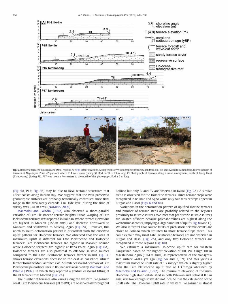
Fig. 6.Holocene terraces in Burgos and Dasol regions. See Fig. 2D for locations. A) Representative topographic profiles taken from Ilio-Ilio southward to Tambobong. B) Photograph ofterraces at Nayaitayan Point (Pogoruac) where P14 was taken (facing S). Rod on TI is 1.3 m long. C) Photograph of terraces along a small embayment south of Pideg Point(Tambobong) (facing SE). P17 was taken a few meters to the north of this photograph. Rod is 3 m long.
152 N.T. Ramos, H. Tsutsumi / Tectonophysics 495 (2010) 145–158
(Fig. 5A, P13; Fig. 8B) may be due to local tectonic structures thataffect coasts along Baruan Bay. We suggest that the well-preservedgeomorphic surfaces are probably tectonically controlled since tidalrange in the area rarely exceeds 1 m. Tide level during the time ofsurvey was 0.41 m amsl (NAMRIA, 2009).
Maemoku and Paladio (1992) also observed a shore-parallelvariation of Late Pleistocene terrace heights. Broad warping of LatePleistocene terraces was reported in Bolinao, where terrace elevationsare highest in Macabit (155 m amsl) and decrease northward toGonzales and southward to Aloleng, Agno (Fig. 2A). However, thisnorth to south deformation pattern is discordant with the observeduplift pattern for Holocene terraces. We observed that the area ofmaximum uplift is different for Late Pleistocene and Holoceneterraces: Late Pleistocene terraces are highest in Macabit, Bolinaowhile Holocene terraces are highest at Rena Point, Agno (Fig. 8A).Holocene terraces are also proximal to offshore seismic sourcescompared to the Late Pleistocene terraces farther inland. Fig. 8Cshows terrace elevations decrease to the east as coastlines situatefarther from theManila trench axis. A similar eastwarddecrease of LatePleistocene paleoshorelines in Bolinaowas observed byMaemoku andPaladio (1992), in which they reported a gradual eastward tilting ofthe BI terrace from Macabit (Fig. 2A).
The number of terraces also varies along the western Pangasinancoast. Late Pleistocene terraces (BI to BVI) are observed all throughout
Bolinao but only BI and BV are observed in Dasol (Fig. 2A). A similartrend is observed for the Holocene terraces. Three terrace steps wererecognized in Bolinao and Agnowhile only two terrace steps appear inBurgos and Dasol (Figs. 6 and 8B).
Variations in the deformation pattern of uplifted marine terracesand number of terrace steps are probably related to the region'sproximity to seismic sources.We infer that prehistoric seismic sourcesare located offshore because paleoshorelines are highest along thewesternmost coasts, implying a larger amount of uplift (Fig. 8B and C).We also interpret that source faults of prehistoric seismic events arecloser to Bolinao which resulted to more terrace steps there. Thiscould explain why most Late Pleistocene terraces are not observed inBurgos and Dasol (Fig. 2A), and only two Holocene terraces arerecognized in these regions (Fig. 8B).
We estimate a maximum Holocene uplift rate for westernPangasinan based on the highest elevation of TIII. We assign TIII inMacabuboni, Agno (10.4 m amsl) as representative of the transgres-sive surface ~6000 yrs ago (Fig. 5A and B, P9) and this yields amaximum Holocene uplift rate of 1.7 mm/yr, which is slightly higherthan the Late Pleistocene uplift rate of 1.3 mm/yr obtained byMaemoku and Paladio (1992). The minimum elevation of the mid-Holocene high stand established in both Palawan and Bohol at 0.3 mamsl was low enough so we did not include it in the calculation of theuplift rate. The Holocene uplift rate in western Pangasinan is almost
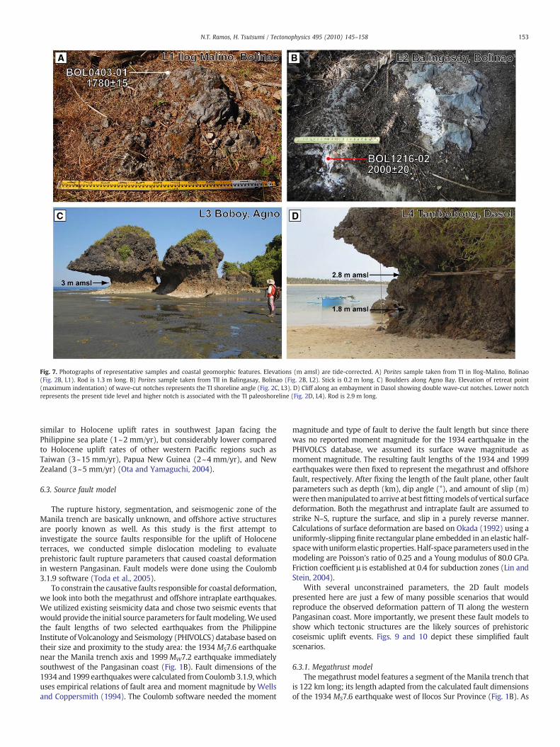
Fig. 7. Photographs of representative samples and coastal geomorphic features. Elevations (m amsl) are tide-corrected. A) Porites sample taken from TI in Ilog-Malino, Bolinao(Fig. 2B, L1). Rod is 1.3 m long. B) Porites sample taken from TII in Balingasay, Bolinao (Fig. 2B, L2). Stick is 0.2 m long. C) Boulders along Agno Bay. Elevation of retreat point(maximum indentation) of wave-cut notches represents the TI shoreline angle (Fig. 2C, L3). D) Cliff along an embayment in Dasol showing double wave-cut notches. Lower notchrepresents the present tide level and higher notch is associated with the TI paleoshoreline (Fig. 2D, L4). Rod is 2.9 m long.
153N.T. Ramos, H. Tsutsumi / Tectonophysics 495 (2010) 145–158
similar to Holocene uplift rates in southwest Japan facing thePhilippine sea plate (1~2 mm/yr), but considerably lower comparedto Holocene uplift rates of other western Pacific regions such asTaiwan (3~15 mm/yr), Papua New Guinea (2~4 mm/yr), and NewZealand (3~5 mm/yr) (Ota and Yamaguchi, 2004).
6.3. Source fault model
The rupture history, segmentation, and seismogenic zone of theManila trench are basically unknown, and offshore active structuresare poorly known as well. As this study is the first attempt toinvestigate the source faults responsible for the uplift of Holoceneterraces, we conducted simple dislocation modeling to evaluateprehistoric fault rupture parameters that caused coastal deformationin western Pangasinan. Fault models were done using the Coulomb3.1.9 software (Toda et al., 2005).
To constrain the causative faults responsible for coastal deformation,we look into both the megathrust and offshore intraplate earthquakes.We utilized existing seismicity data and chose two seismic events thatwould provide the initial source parameters for faultmodeling.Weusedthe fault lengths of two selected earthquakes from the PhilippineInstitute of Volcanology and Seismology (PHIVOLCS) database based ontheir size and proximity to the study area: the 1934 MS7.6 earthquakenear the Manila trench axis and 1999MW7.2 earthquake immediatelysouthwest of the Pangasinan coast (Fig. 1B). Fault dimensions of the1934 and 1999 earthquakeswere calculated fromCoulomb 3.1.9, whichuses empirical relations of fault area and moment magnitude by Wellsand Coppersmith (1994). The Coulomb software needed the moment
magnitude and type of fault to derive the fault length but since therewas no reported moment magnitude for the 1934 earthquake in thePHIVOLCS database, we assumed its surface wave magnitude asmoment magnitude. The resulting fault lengths of the 1934 and 1999earthquakes were then fixed to represent the megathrust and offshorefault, respectively. After fixing the length of the fault plane, other faultparameters such as depth (km), dip angle (°), and amount of slip (m)were thenmanipulated to arrive at bestfittingmodels of vertical surfacedeformation. Both the megathrust and intraplate fault are assumed tostrike N–S, rupture the surface, and slip in a purely reverse manner.Calculations of surface deformation are based on Okada (1992) using auniformly-slipping finite rectangular plane embedded in an elastic half-spacewithuniformelastic properties.Half-space parameters used in themodeling are Poisson's ratio of 0.25 and a Young modulus of 80.0 GPa.Friction coefficient μ is established at 0.4 for subduction zones (Lin andStein, 2004).
With several unconstrained parameters, the 2D fault modelspresented here are just a few of many possible scenarios that wouldreproduce the observed deformation pattern of TI along the westernPangasinan coast. More importantly, we present these fault models toshow which tectonic structures are the likely sources of prehistoriccoseismic uplift events. Figs. 9 and 10 depict these simplified faultscenarios.
6.3.1. Megathrust modelThe megathrust model features a segment of the Manila trench that
is 122 km long; its length adapted from the calculated fault dimensionsof the 1934 MS7.6 earthquake west of Ilocos Sur Province (Fig. 1B). As
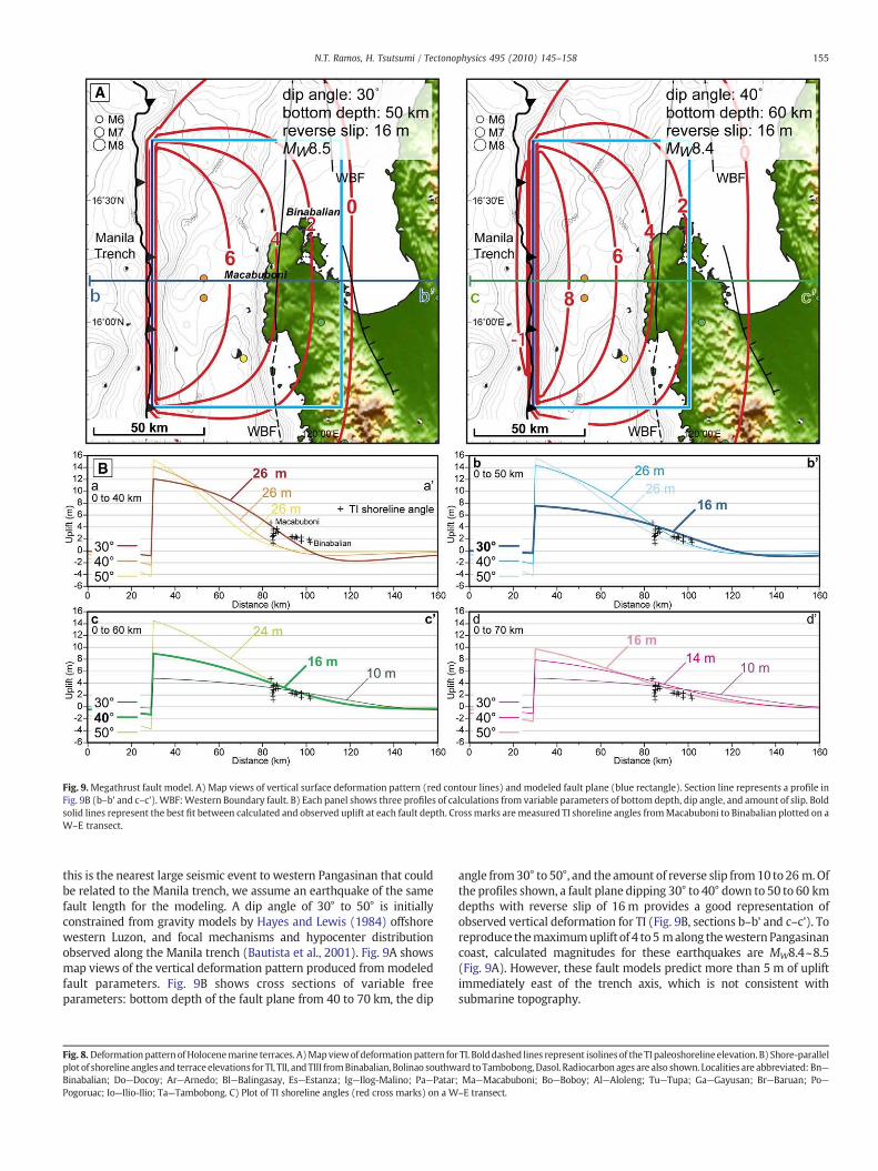
Fig. 9.Megathrust fault model. A) Map views of vertical surface deformation pattern (red contour lines) andmodeled fault plane (blue rectangle). Section line represents a profile inFig. 9B (b–b' and c–c'). WBF:Western Boundary fault. B) Each panel shows three profiles of calculations from variable parameters of bottom depth, dip angle, and amount of slip. Boldsolid lines represent the best fit between calculated and observed uplift at each fault depth. Cross marks aremeasured TI shoreline angles fromMacabuboni to Binabalian plotted on aW–E transect.
155N.T. Ramos, H. Tsutsumi / Tectonophysics 495 (2010) 145–158
this is the nearest large seismic event to western Pangasinan that couldbe related to the Manila trench, we assume an earthquake of the samefault length for the modeling. A dip angle of 30° to 50° is initiallyconstrained from gravity models by Hayes and Lewis (1984) offshorewestern Luzon, and focal mechanisms and hypocenter distributionobserved along the Manila trench (Bautista et al., 2001). Fig. 9A showsmap views of the vertical deformation pattern produced frommodeledfault parameters. Fig. 9B shows cross sections of variable freeparameters: bottom depth of the fault plane from 40 to 70 km, the dip
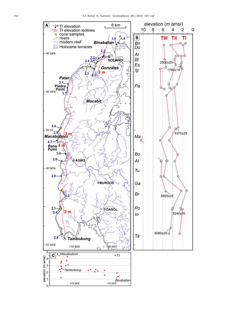
Fig. 8. Deformation patternofHolocenemarine terraces. A)Mapviewof deformation pattern forplot of shoreline angles and terraceelevations for TI, TII, andTIII fromBinabalian, Bolinao southwBinabalian; Do—Docoy; Ar—Arnedo; Bl—Balingasay, Es—Estanza; Ig—Ilog-Malino; Pa—PatarPogoruac; Io—Ilio-Ilio; Ta—Tambobong. C) Plot of TI shoreline angles (red cross marks) on a W
angle from30° to 50°, and the amount of reverse slip from10 to26 m.Ofthe profiles shown, a fault plane dipping 30° to 40° down to 50 to 60 kmdepths with reverse slip of 16 m provides a good representation ofobserved vertical deformation for TI (Fig. 9B, sections b–b' and c–c'). Toreproduce themaximumuplift of 4 to5 malong thewestern Pangasinancoast, calculated magnitudes for these earthquakes are MW8.4~8.5(Fig. 9A). However, these fault models predict more than 5 m of upliftimmediately east of the trench axis, which is not consistent withsubmarine topography.
TI. Bolddashed lines represent isolinesof the TI paleoshoreline elevation. B) Shore-parallelard toTambobong, Dasol. Radiocarbonages are also shown. Localities are abbreviated: Bn—; Ma—Macabuboni; Bo—Boboy; Al—Aloleng; Tu—Tupa; Ga—Gayusan; Br—Baruan; Po—–E transect.
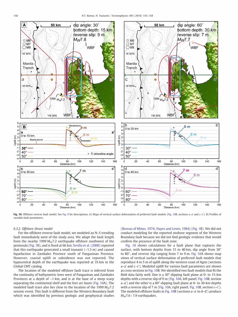
Fig. 10. Offshore reverse fault model. See Fig. 9 for descriptions. A) Maps of vertical surface deformation of preferred fault models (Fig. 10B, sections a–a' and c–c'). B) Profiles ofvariable fault parameters.
156 N.T. Ramos, H. Tsutsumi / Tectonophysics 495 (2010) 145–158
6.3.2. Offshore thrust modelFor the offshore reverse fault model, we modeled an N–S trending
fault immediately west of the study area. We adapt the fault lengthfrom the nearby 1999MW7.2 earthquake offshore southwest of thepeninsula (Fig. 1B), and is fixed at 66 km. Sevilla et al. (2000) reportedthat this earthquake generated a small tsunami (~1.5 m) and causedliquefaction in Zambales Province south of Pangasinan Province.However, coastal uplift or subsidence was not reported. Thehypocentral depth of the earthquake was reported at 35 km in theGlobal CMT catalog.
The location of the modeled offshore fault trace is inferred fromthe continuity of bathymetric lows west of Pangasinan and ZambalesProvinces at a depth of ~1 km, and is at the base of a steep scarpseparating the continental shelf and the fore arc basin (Fig. 10A). Themodeled fault trace also lies close to the location of the 1999MW7.2seismic event. This fault is different from the Western Boundary faultwhich was identified by previous geologic and geophysical studies
(Bureau of Mines, 1974; Hayes and Lewis, 1984) (Fig. 1B). We did notconduct modeling for the reported onshore segment of the WesternBoundary fault because we did not find geologic evidence that wouldconfirm the presence of the fault zone.
Fig. 10 shows calculations for a fault plane that ruptures thesurface, with bottom depths from 15 to 40 km, dip angle from 30°to 80°, and reverse slip ranging from 7 to 9 m. Fig. 10A shows mapviews of vertical surface deformation of preferred fault models thatreproduce 4 to 5 m of uplift along the western coast of Agno (sectionsa–a' and c–c'). Modeled uplift for various fault parameters are shownas cross sections in Fig. 10B.We identified two fault models that fit thefield data fairly well. One is a 30°-dipping fault plane at 0- to 15-kmdepths with a reverse slip of 9 m (Fig. 10A, left panel; Fig. 10B, sectiona–a') and the other is a 60°-dipping fault plane at 0- to 30-km depthswith a reverse slip of 7 m (Fig. 10A, right panel; Fig. 10B, section c–c').The modeled offshore faults in Fig. 10B (sections a–a' to d–d') produceMW7.6~7.9 earthquakes.

157N.T. Ramos, H. Tsutsumi / Tectonophysics 495 (2010) 145–158
It is apparent from the fault models that initial source parameters(MS7.6 and MW7.2) were not enough to produce the observed coastaluplift in western Pangasinan. The modeled fault always produced anearthquake with a magnitude larger than the reference fault, since wealways have to increase the slip amount to reproduce the maximumuplift of TI (4 to 5 m) at Rena Point in Agno. Even the fault modeling ofaMW8.5 megathrust earthquake with a fault length of ~500 kmwouldrequire ~15 m of slip (which then equals to a MW9.0 earthquake) toreproduce the deformation pattern of TI. Such fault length also resultsin a more elongate (north–south) uplift pattern where a widerportion of the coast gets uplifted by 4 to 5 m, and this is not consistentwith the observed TI deformation. Though these fault models cannotconstrain the earthquake magnitude and rupture area of the sourcefault, we can infer that offshore historical earthquakes throughout the400-yr seismic record were not large enough to produce maximumcoastal uplift of 4 to 5 m in western Pangasinan.
Simple fault models show that a megathrust rupture is an unlikelymechanism to produce the deformation pattern of TI. The maximumuplift of 4 to 5 m is difficult to achieve and often requires a largeamount of reverse slip. Even the 2004 MW9.2 Aceh–Andamanearthquake was only able to uplift the coast by 0.3 to 1.5 m (Meltzneret al., 2006; Rajendran et al., 2008). A few examples of historicalmegathrust earthquakes that have coseismically uplifted the coast at alarge scale are the 1964MW9.1 Alaska earthquake (1 to 3 m) (Plafker,1969) and the 1960MW9.5 Chile earthquake (4 to 6 m) (Plafker,1972). The megathrust model also shows surface deformation that isdiscordant with the submarine topography west of the Pangasinanpeninsula. Geomorphic data are also inconsistent with this mecha-nism as height and separation of each Holocene terrace are too largeto be produced by a megathrust earthquake (Ota et al., 1993; Ota andYamaguchi, 2004). Geodetic data and paleogeodetic informationrecorded in coral microatolls reveal that postseismic relaxation andinterseismic recovery compensates the total uplift produced by amegathrust earthquake, where net uplift rarely exceeds 1 m after theseismic cycle (Meltzner et al., 2006; Subarya et al., 2006; Chlieh et al.,2007; Natawidjaja et al., 2007). However, this study cannot discussthe effects of interseismic and postseismic deformation in bothmegathrust and offshore reverse fault scenarios since there is nogeodetic data in the region at present.
Flights of terraces are often preserved with permanent deforma-tion achieved from upper plate faulting rather than subduction zoneearthquakes. Therefore, we suggest that an offshore reverse fault is amore probable tectonic structure responsible for coseismic uplift ofthe western Pangasinan coast on the order of several meters. Similaroffshore upper plate structures have been inferred as causative faultsfor the uplift of Holocene terraces in eastern North Island, NewZealand (Berryman et al., 1989), Cape Muroto in southwest Japan(Maemoku, 1992), and eastern Taiwan (Lallemand et al., 1999;Yamaguchi and Ota, 2004). Many of these potentially active structuresare high-angle reverse faults that splay from the subductionmegathrust. One direct observation of the megathrust—splay faultrelationship is the 8 m thrust displacement on Montague Islandresulting from the 1964 MW9.1 Alaska earthquake (Plafker, 1972).Recent findings from offshore investigations and tsunami modelingalong the Nankai trough have drawn preliminary scenarios on howsplay faults behave with the megathrust (Cummins et al., 2001).
7. Conclusions
We recognized up to three Holocene marine terraces along thewestern Pangasinan peninsula east of the Manila trench. Terraceelevations vary laterally along the coast and shoreline anglesmeasured are TI: 1 to 5 m, TII: 2 to 7 m, and TIII: 4 to 11 m amsl.With the exception of unusually low TI (1.2 m amsl) and TII (2.3 mamsl) in Baruan, Agno, shoreline angles were lowest (1.4 m amsl) inBinabalian, Bolinao (TI) and highest (10.4 m amsl) in Macabuboni,
Agno (TIII). The number of Holocene terrace steps also varies fromnorth to south.We recognized three terrace steps in Bolinao and Agno,but only two in Burgos and Dasol.
Uplifted abrasion platforms are horizontal to sub-horizontal andcomposed of cemented coral shingle and eroded coral heads. Meter-scale terrace risers (1 to 4 m) separate the terrace steps and raisedwave-cut notches are sometimes preserved at the base of the forecliff. Radiocarbon ages show that erosional surfaces (TI and TII) werecarved onto the Holocene transgressive reef (TIII), evidenced byvariable ages obtained for similar terrace surfaces. Geomorphic datasuggest that large coseismic uplift events were responsible inproducing the staircase topography of marine terraces. We inferfrom terrace morphology and radiocarbon age data that at least threecoseismic coastal uplift events occurred in the past ~6000 years. Weestimated a maximum Holocene uplift rate of 1.7 mm/yr based on theassumption that TIII (10.4 m amsl) represents the Holocene trans-gressive surface associated to themaximum sea level rise ~6000 yearsago. The Holocene uplift rate is almost similar to the Late Pleistoceneuplift rate of 1.3 mm/yr.
We suggest that seismic sources are offshore based on thedeformation pattern of Holocene terraces. The westernmost headlandof the peninsula (Macabuboni, Agno) facing the Manila trenchappears to have experienced the largest amount of uplift (4 to 5 m),and shoreline angles gradually decrease eastward the peninsula.Proximity to offshore seismic sources could also explain the formationof more Late Pleistocene and Holocene terraces in Bolinao and Agnocompared to the southern regions of Burgos and Dasol. The upliftpattern of marine terraces further suggests that prehistoric earth-quakes may have varied between individual uplift events.
Despite limitations in geodetic and geophysical data, we didsimple dislocation modeling to evaluate the causative faults that arelikely responsible for coastal uplift of western Pangasinan. Faultparameters were varied to produce simple fault models that bestrepresent the deformation pattern of TI. Preliminary fault modelsshow that a megathrust rupture is not a plausible scenario for theobserved coastal deformation. Rather, the causative fault responsiblefor meter-scale uplift along the coast is more likely an offshoreintraplate reverse fault. Two offshore reverse fault scenarios arepreferred based on fit between calculated and observed TI paleoshore-line elevations, and reproduction of 4 to 5 m of maximum uplift alongthe western tip of Agno. One is a 30°-dipping fault plane at 0- to 15-km depths with a reverse slip of 9 m, and the other is a 60°-dippingfault plane at 0- to 30-km depths with a reverse slip of 7 m. The bestfitting offshore reverse fault models produceMW7.7~7.8 earthquakes.It is apparent from the fault models that historical earthquakesoffshore western Luzon Island were not large enough to produce 4 to5 m of coastal uplift. It is also important to note from these simplefault models that aside from the Manila trench megathrust, offshoreintraplate faults capable of producing large to great earthquakespossibly exist around the South China Sea and pose threats to coastalcommunities in the Philippines and nearby countries.
Supplementarymaterials related to this article can be found onlineat doi:10.1016/j.tecto.2010.08.007.
Acknowledgements
NTR was supported by the Japanese Government (Monbukaga-kusho) Scholarship. This research was funded by a grant to HT fromthe Ministry of Education, Culture, Sports, Science, and Technology ofJapan. Jeffrey S. Perez, William D. Tamayo, Leo T. Armada, Jenielyn S.Padrones, Bryan Raymond G. Ramos, National Institute of GeologicalSciences and RushurgentWorking Group–Tectonics and Geodynamicsat the University of the Philippines, Department of Science andTechnology–Philippine Institute of Volcanology and Seismology, andlocal government units of Pangasinan Province are thanked for theirfield assistance, logistic support, and discussions. Fernando P.

158 N.T. Ramos, H. Tsutsumi / Tectonophysics 495 (2010) 145–158
Siringan, Janneli Lea A. Soria, Maria Isabel T. Abigania, and Joan M.Reotita provided assistance in data acquisition and suggestions incarrying out the surveys. Hironobu Kan of Okayama Universityidentified the coral samples. AMS analyses were conducted byPaleo-Lab Co. Ltd. Japan, while XRD analyses were done by NorimasaShimobayashi of Kyoto University. Shinji Toda at the DisasterPrevention Research Institute, Kyoto University is thanked fordiscussions regarding the Coulomb software and fault modeling.Comments by Yoko Ota and Aron J. Meltzner on an earlier draft, andreviews by Mian Liu, J. Bruce H. Shyu and an anonymous reviewergreatly improved this manuscript.
References
Abigania, M.I.T., Siringan, F.P., Besana-Ostman, G.M., Yokoyama, Y., 2009. Paleoseismi-city and Relative Vertical Deformations in La Union, Philippines: Insights fromHolocene Coral Microatolls. Proc. Symp. 6th Annual Meeting AOGS. Asia OceaniaGeosciences Society, Suntec, Singapore, p. 295.
Allen, C.R., 1962. Circum-Pacific faulting in Philippines-Taiwan region. J. Geophys. Res.67 (12), 4795–4812. doi:10.1029/JZ067i012p04795.
Amante, C., Eakins, B.W., 2009. ETOPO1 1 Arc-minute global relief model: procedures,data sources and analysis. NOAA Technical Memorandum NESDIS NGDC-24 , Natl.Geophys. Data Cent., Boulder, Colo, pp. 1–19.
Aurelio, M., 2000. Shear partitioning in the Philippines: constraints from PhilippineFault and global positioning system data. Isl. Arc 9, 584–597. doi:10.1111/j.1440-1738.2000.00304.x.
Bautista, M.L.P., Oike, K., 2000. Estimation of the magnitudes and epicenters ofPhilippine historical earthquakes. Tectonophysics 317 (1–2), 137–169.doi:10.1016/S0040-1951(99)00272-3.
Bautista, B.C., Bautista, M.L.P., Oike, K., Wu, F.T., Punongbayan, R.S., 2001. A new insighton the geometry of subducting slabs in northern Luzon, Philippines. Tectonophy-sics 339 (3–4), 279–310. doi:10.1016/S0040-1951(01)00120-2.
Berdin, R.D., Siringan, F.P., Maeda, Y., 2004. Holocene sea-level highstand and itsimplications for the vertical stability of Panglao Island, southwest Bohol,Philippines. Quatern. Int. 115, 27–37. doi:10.1016/S1040-6182(03)00094-6.
Berryman, K.R., Ota, Y., Hull, A.G., 1989. Holocene paleoseismicity in the fold and thrustbelt of the Hikurangi subduction zone, eastern North Island, New Zealand.Tectonophysics 163 (3–4), 185–195. doi:10.1016/0040-1951(89)90256-4.
Bureau of Mines, 1974. The geology and mineral resources of Pangasinan province,Report No. 75. Bureau of Mines, Manila, Philippines, pp. 1–28.
Chappell, J., 1974. Geology of coral terraces, Huon Peninsula, New Guinea: a study ofquaternary tectonic movements and sea-level changes. Geol. Soc. Am. Bull. 85 (4),553–570. doi:10.1130/0016-7606(1974) 85b553:GOCTHPN2.0.CO;2.
Chlieh,M., Avouac, J.P., Hjorleifsdottir, V., Song, T.R.A., Ji, C., Sieh, K., Sladen, A., Hebert, H.,Prawirodirdjo, L., Bock, Y., Galetzka, J., 2007. Coseismic slip and afterslip of the greatM-w 9.15 Sumatra-Andaman earthquake of 2004. Bull. Seism. Soc. Amer. 97 (1),S152–S173. doi:10.1785/0120050631.
Cummins, P.R., Hori, T., Kaneda, Y., 2001. Splay fault and megathrust earthquake slip inthe Nankai Trough. Earth Planets Space 53 (4), 243–248.
De Ocampo, R.S.P., 1983. Plio–Pleistocene geology of Bolinao, Pangasinan and vicinities,Report No. 2. National Museum, Manila, Philippines, pp. 1–26.
Grossman, E.E., Fletcher, C.H., 1998. Sea level higher than present 3500 years ago onthe northern main Hawaiian Islands. Geology 26 (4), 363–366. doi:10.1130/0091-7613(1998) 026b0363:SLHTPYN2.3.CO;2.
Hayes, D.E., Lewis, S.D., 1984. A geophysical study of the Manila Trench, Luzon,Philippines. 1. Crustal structure, gravity, and regional tectonic evolution. J.Geophys. Res. 89 (NB11), 9171–9195. doi:10.1029/JB089iB11p09171.
Hughen, K.A., Baillie, M.G.L., Bard, E., Beck, J.W., Bertrand, C.J.H., Blackwell, P.G., Buck, C.E.,Burr, G.S., Cutler, K.B., Damon, P.E., Edwards, R.L., Fairbanks, R.G., Friedrich, M.,Guilderson, T.P., Kromer, B., McCormac, G., Manning, S., Ramsey, C.B., Reimer, P.J.,Reimer, R.W., Remmele, S., Southon, J.R., Stuiver, M., Talamo, S., Taylor, F.W., van derPlicht, J., Weyhenmeyer, C.E., 2004. Marine04 marine radiocarbon age calibration,0–26 cal kyr BP. Radiocarbon 46 (3), 1059–1086.
Janssen, A.W., 2007. Holoplanktonic Mollusca (Gastropoda: Pterotracheoidea, Janthi-noidea, Thecosomata and Gymnosomata) from the Pliocene of Pangasinan (Luzon,Philippines). Scr. Geol. 135, 29–177.
Lajoie, K.R., 1986. Coastal Tectonics. In: Wallace, R.E. (Ed.), Active Tectonics: Impact onSociety. National Academic Press, Washington, D.C., pp. 95–124.
Lallemand, S., Liu, C.S., Dominguez, S., Schnurle, P., Malavieille, J., 1999. Trench-parallelstretching and folding of forearc basins and lateral migration of the accretionarywedge in the southern Ryukyus: a case of strain partition caused by obliqueconvergence. Tectonics 18 (2), 231–247. doi:10.1029/1998TC900011.
Lin, J., Stein, R.S., 2004. Stress triggering in thrust and subduction earthquakesand stress interaction between the southern San Andreas and nearby thrust andstrike-slip faults. J. Geophys. Res. - Sol. Ea 109 (B2), B02303. doi:10.1029/2003JB002607.
Maeda, Y., Siringan, F.P., 2004. Atlas of Holocene notches and the coral reef terraces ofthe Philippine Islands (I). Nat. Hum. Activities 8, 97–175.
Maeda, Y., Siringan, F., Omura, A., Berdin, R., Hosono, Y., Atsumi, S., Nakamura, T., 2004.Higher-than-present Holocene mean sea levels in Ilocos, Palawan and Samar,Philippines. Quatern. Int. 115, 15–26. doi:10.1016/S1040-6182(03)00093-4.
Maemoku, H., 1992. Holocene tectonic movements in the southern part of the outerzone of southwest Japan. Quaternary Res. (Daiyonki Kenkyu) 31 (5), 285–296 (inJapanese with English abstract).
Maemoku, H., Paladio, J., 1992. Raised coral reefs at Bolinao, northwestern Luzon, Islandof the Philippines. Geog. Sci. (Chiri Kagaku) 47 (4), 183–189.
Meltzner, A.J., Sieh, K., Abrams, M., Agnew, D.C., Hudnut, K.W., Avouac, J.P., Natawidjaja,D.H., 2006. Uplift and subsidence associated with the great Aceh–Andamanearthquake of 2004. J. Geophys. Res. - Sol. Ea 111 (B2), B02407. doi:10.1029/2005JB003891.
Natawidjaja, D.H., Sieh, K., Galetzka, J., Suwargadi, B.W., Cheng, H., Edwards, R.L., Chlieh,M., 2007. Interseismic deformation above the Sunda Megathrust recorded in coralmicroatolls of the Mentawai islands, West Sumatra. J. Geophys. Res. - Sol. Ea 112(B2), B02404. doi:10.1029/2006JB004450.
National Mapping and Resource Information Authority (NAMRIA), 2008. Tide andcurrent tables Philippines 2008. Oceanographic Survey Division, Coast andGeodetic Survey Department, Manila, Philippines.
National Mapping and Resource Information Authority (NAMRIA), 2009. Tide andcurrent tables Philippines 2009. Oceanographic Survey Division, Coast andGeodetic Survey Department, Manila, Philippines.
Okada, Y., 1992. Internal deformation due to shear and tensile faults in a half-space.Bull. Seism. Soc. Amer. 82 (2), 1018–1040.
Omura, A., Maeda, Y., Kawana, T., Siringan, F.P., Berdin, R.D., 2004. U-series dates ofPleistocene corals and their implications to the paleo-sea levels and the verticaldisplacement in the Central Philippines. Quatern. Int. 115, 3–13. doi:10.1016/S1040-6182(03)00092-2.
Ota, Y., Chappell, J., 1996. Late Quaternary coseismic uplift events on the HuonPeninsula, Papua New Guinea, deduced from coral terrace data. J. Geophys. Res. -Sol. Ea 101 (B3), 6071–6082. doi:10.1029/95JB02245.
Ota, Y., Yamaguchi, M., 2004. Holocene coastal uplift in the western Pacific Rim in thecontext of late Quaternary uplift. Quatern. Int. 120, 105–117. doi:10.1016/j.quaint.2004.01.010.
Ota, Y., Chappell, J., Kelley, R., Yonekura, N., Matsumoto, E., Nishimura, T., Head, J., 1993.Holocene coral reef terraces and coseismic uplift of Huon Peninsula, Papua NewGuinea. Quaternary Res. 40 (2), 177–188. doi:10.1006/qres.1993.1070.
PHIVOLCS–DOST, 2000. Distribution of active faults and trenches in the Philippines.PHIVOLCS–DOST, Quezon City, Philippines.
Plafker, G., 1969. Tectonics of theMarch27, 1964, Alaskaearthquake,U.S.Geological SurveyProfessional Paper 543-I. U.S. Geological Survey, Washington, D.C., USA. I1-I74 pp.
Plafker, G., 1972. Alaskan earthquake of 1964 and Chilean earthquake of 1960:implications for arc tectonics. J. Geophys. Res. - Sol. Ea. 77 (5), 901–925.doi:10.1029/JB077i005p00901.
Rajendran, K., Rajendran, C.P., Earnest, A., Prasad, G.V.R., Dutta, K., Ray, D.K., Anu, R.,2008. Age estimates of coastal terraces in the Andaman and Nicobar Islands andtheir tectonic implications. Tectonophysics 455 (1–4), 53–60. doi:10.1016/j.tecto.2008.05.004.
Rangin, C., Le Pichon, X., Mazzotti, S., Pubellier, M., Chamot-Rooke, N., Aurelio, M.,Walpersdorf, A., Quebral, R., 1999. Plate convergence measured by GPS across theSundaland/Philippine sea plate deformed boundary: the Philippines and easternIndonesia. Geophys. J. Int. 139 (2), 296–316. doi:10.1046/j.1365-246x.1999.00969.x.
Ringenbach, J.C., Pinet, N., Stephan, J.F., Delteil, J., 1993. Structural variety and tectonicevolution of strike-slip basins related to the Philippine Fault System, northernLuzon, Philippines. Tectonics 12 (1), 187–203. doi:10.1029/92TC01968.
Ringor, C.L., Omura, A., Maeda, Y., 2004. Last Interglacial sea level changes deduced fromcoral reef terraces in southwest Bohol, central Philippines. Quaternary Res.(Daiyonki Kenkyu) 43 (6), 401–416.
Sevilla, W.I.G., Paladio-Melosantos, M.L., Lanuza, A.G., 2000. Damage evaluation andimpact assessment of the 12 December 1999. Hermana Mayor Island (Philippines)earthquake. DOST–PHIVOLCS, Quezon City, Philippines, pp. 81–102.
Subarya, C., Chlieh, M., Prawirodirdjo, L., Avouac, J.P., Bock, Y., Sieh, K., Meltzner, A.J.,Natawidjaja, D.H., McCaffrey, R., 2006. Plate-boundary deformation associated withthe great Sumatra–Andaman earthquake. Nature 440 (7080), 46–51. doi:10.1038/nature04522.
Toda, S., Stein, R.S., Richards-Dinger, K., Bozkurt, S.B., 2005. Forecasting the evolution ofseismicity in southern California: animations built on earthquake stress transfer.J. Geophys. Res. - Sol. Ea 110 (B5), B05S16. doi:10.1029/2004JB003415.
Wells, D.L., Coppersmith, K.J., 1994. New empirical relationships among magnitude,rupture length, rupture width, rupture area, and surface displacement. Bull. Seism.Soc. Amer. 84 (4), 974–1002.
Wilson, K., Berryman, K., Litchfield, N., Little, T., 2006. A revision of mid-late Holocenemarine terrace distribution and chronology at the Pakarae River mouth, NorthIsland, New Zealand. New Zeal. J. Geol. Geop. 49, 477–489.
Wilson, K., Berryman, K., Cochran, U., Little, T., 2007. Holocene coastal evolution anduplift mechanisms of the northeastern Raukumara Peninsula, North Island, NewZealand. Quat. Sci. Rev. 26 (7–8), 1106–1128. doi:10.1016/j.quascirev.2007.01.005.
Yamaguchi, M., Ota, Y., 2004. Tectonic interpretations of Holocene marine terraces,east coast of Coastal Range, Taiwan. Quatern. Int. 115, 71–81. doi:10.1016/S1040-6182(03)00097-1.
Yoshikawa, T., Kaizuka, S., Ota, Y., 1964. Mode of crustal movement in the lateQuaternary on the southeast coast of Shikoku, southwestern Japan. Geogr. Rev. Jpn37, 627–648 (in Japanese with English abstract).