A Quaternary uplift record for the Auckland region, North Island, New Zealand, based on marine and...
12
A Quaternary uplift record for the Auckland region, North Island, New Zealand, based on marine and fluvial terraces L. Claessens a,b, ⁎, A. Veldkamp a , E.M. ten Broeke a , H. Vloemans a a Land Dynamics Group, Department of Environmental Sciences, Wageningen University, P.O. Box 47, 6700AAWageningen, The Netherlands b International Potato Center (CIP), Sub-Saharan Africa Regional Office, P.O. Box 25171, 00603 Nairobi, Kenya abstract article info Article history: Accepted 20 February 2009 Available online 16 March 2009 Keywords: uplift tephrochronology fluvial terrace marine terrace New Zealand Marine and fluvial terrace sequences near the Waitakere Ranges on the North Island of New Zealand have been surveyed, yielding an inventory of 13 fluvial and 12 marine terrace levels. Based on sparse tephra age control and correlation with the global palaeoclimatic record, rates of regional Quaternary uplift have been reconstructed. Between 1000 ka and 345 ka the time-averaged uplift rate was 0.072 mm a -1 , between 345 ka and 50 ka it increased to 0.278 mm a -1 , accelerating to 0.42 mm a -1 since 50 ka. The fluvial terrace sequence did not yield clear sedimentary records or other datable material. However, although others have disputed the existence of marine terraces in this study region, a pattern of accelerating regional uplift, superimposed onto glacio-eustatic sea-level changes, is substantiated as the only possible mechanism for maintaining the considerable relief and the active denudation processes inland. The observed uplift is similar to that in other regions where the uplift has been attributed to coupling between surface processes and lower-crustal flow, making this a likely mechanism in the North Island of New Zealand. Regarding the fluvial terrace sequence, the proposed general model is of an actively incising river, carving out on average one strath terrace every ~16,000 years. The incision phases are reactivated by sea-level lowering and interrupted by net aggradation events due to landslides triggered by cyclones and/or fires within the catchment; volcanic ash falls also cause transient increases in sediment supply. © 2009 Elsevier B.V. All rights reserved. 1. Introduction Both fluvial and marine terraces signify long timescale uplift (e.g., Bridgland et al., 2007; Bridgland and Westaway, 2007). Fluvial terraces are known to register both glacial and interglacial conditions while coastal terraces register interglacial sea-level high stands. Fluvial terraces are often studied to record the response of a river to climatic, crustal and eustatic processes, causing changes in sediment supply, and to base level change. Two separate factors are required for the formation of aggradational fluvial terraces: (1) uplift to provide the impetus for fluvial incision and (2) climatic fluctuation, which drives the fluvial activity leading to terrace formation (Bridgland et al., 2004). Sea-level change, itself caused by climate change, is only of direct influence to river terrace formation in areas close to the coast and where the continental shelf is narrow (Schumm, 1993; Veldkamp and Tebbens, 2001). The relative height of fluvial terraces above the modern river profile is commonly used to calculate incision rates that are used as a proxy for uplift rates, either assuming a time-invariant river profile (e.g., Molnar et al., 1994) or using a reconstructed river profile (Lavé and Avouac, 2000). If terraces are present in a tilted, faulted, or folded setting, they can also be used to deduct history and rates of local crustal deformation (Rockwell et al., 1984; Lavé and Avouac, 2000; Veldkamp et al., 2007). When age and (relative) heights of terrace levels above the floodplain are known, minimum regional uplift rates can be calculated. Marine terrace sequences in different parts of the world have been correlated with marine oxygen isotope variations (typically derived from Ocean Drilling Program borehole records) to reveal Quaternary sea-level changes and rates of uplift. Interglacial and interstadial highstands have been estimated from dated exposed terraces. Examples include Barbados (e.g., Bender et al., 1979), Timor (e.g., Chappell and Veeh, 1978), New Zealand (e.g., Pillans, 1983) and Sumba (e.g., Pirazzoli et al., 1991), but the most detailed record is based on an extensive flight of coral terraces in the Huon Peninsula, Papua New Guinea, widely regarded as a global reference (e.g., Chappell, 1983; Chappell et al., 1996). Middle and Late Pleistocene coral reef terraces rise to ~1000 m above sea-level and record the history of glacio- eustatic sea-level oscillations superimposed on a history of rapid uplift since ~300 ka. Another example is the preservation of barrier shorelines located in the Coorong Coastal Plain (southern Australia) which preserves the most complete Middle Pleistocene to Holocene sea-level highstand record in Australia, and represents one of the Global and Planetary Change 68 (2009) 383–394 ⁎ Corresponding author. International Potato Center (CIP), Sub-Saharan Africa Regional Office, P.O. Box 25171, 00603 Nairobi, Kenya. Tel.: +254 20 422 3612; fax: +254 20 422 3001. E-mail address: [email protected] (L. Claessens). 0921-8181/$ – see front matter © 2009 Elsevier B.V. All rights reserved. doi:10.1016/j.gloplacha.2009.03.001 Contents lists available at ScienceDirect Global and Planetary Change journal homepage: www.elsevier.com/locate/gloplacha
-
Upload
independent -
Category
Documents
-
view
0 -
download
0
Transcript of A Quaternary uplift record for the Auckland region, North Island, New Zealand, based on marine and...

Global and Planetary Change 68 (2009) 383–394
Contents lists available at ScienceDirect
Global and Planetary Change
j ourna l homepage: www.e lsev ie r.com/ locate /g lop lacha
A Quaternary uplift record for the Auckland region, North Island, New Zealand, basedon marine and fluvial terraces
L. Claessens a,b,⁎, A. Veldkamp a, E.M. ten Broeke a, H. Vloemans a
a Land Dynamics Group, Department of Environmental Sciences, Wageningen University, P.O. Box 47, 6700AA Wageningen, The Netherlandsb International Potato Center (CIP), Sub-Saharan Africa Regional Office, P.O. Box 25171, 00603 Nairobi, Kenya
⁎ Corresponding author. International Potato CentRegional Office, P.O. Box 25171, 00603 Nairobi, Kenyfax: +254 20 422 3001.
E-mail address: [email protected] (L. Claessens).
0921-8181/$ – see front matter © 2009 Elsevier B.V. Adoi:10.1016/j.gloplacha.2009.03.001
a b s t r a c t
a r t i c l e i n f oArticle history:Accepted 20 February 2009Available online 16 March 2009
Keywords:uplifttephrochronologyfluvial terracemarine terraceNew Zealand
Marine and fluvial terrace sequences near the Waitakere Ranges on the North Island of New Zealand havebeen surveyed, yielding an inventory of 13 fluvial and 12 marine terrace levels. Based on sparse tephra agecontrol and correlation with the global palaeoclimatic record, rates of regional Quaternary uplift have beenreconstructed. Between 1000 ka and 345 ka the time-averaged uplift rate was 0.072 mm a−1, between 345 kaand 50 ka it increased to 0.278 mm a−1, accelerating to 0.42 mm a−1 since 50 ka. The fluvial terrace sequencedid not yield clear sedimentary records or other datable material. However, although others have disputedthe existence of marine terraces in this study region, a pattern of accelerating regional uplift, superimposedonto glacio-eustatic sea-level changes, is substantiated as the only possible mechanism for maintaining theconsiderable relief and the active denudation processes inland. The observed uplift is similar to that in otherregions where the uplift has been attributed to coupling between surface processes and lower-crustal flow,making this a likely mechanism in the North Island of New Zealand. Regarding the fluvial terrace sequence,the proposed general model is of an actively incising river, carving out on average one strath terrace every~16,000 years. The incision phases are reactivated by sea-level lowering and interrupted by net aggradationevents due to landslides triggered by cyclones and/or fires within the catchment; volcanic ash falls also causetransient increases in sediment supply.
© 2009 Elsevier B.V. All rights reserved.
1. Introduction
Both fluvial and marine terraces signify long timescale uplift (e.g.,Bridgland et al., 2007; Bridgland and Westaway, 2007). Fluvialterraces are known to register both glacial and interglacial conditionswhile coastal terraces register interglacial sea-level high stands.Fluvial terraces are often studied to record the response of a river toclimatic, crustal and eustatic processes, causing changes in sedimentsupply, and to base level change. Two separate factors are required forthe formation of aggradational fluvial terraces: (1) uplift to providethe impetus for fluvial incision and (2) climatic fluctuation, whichdrives the fluvial activity leading to terrace formation (Bridgland et al.,2004). Sea-level change, itself caused by climate change, is only ofdirect influence to river terrace formation in areas close to the coastand where the continental shelf is narrow (Schumm, 1993; Veldkampand Tebbens, 2001). The relative height of fluvial terraces above themodern river profile is commonly used to calculate incision rates thatare used as a proxy for uplift rates, either assuming a time-invariant
er (CIP), Sub-Saharan Africaa. Tel.: +254 20 422 3612;
ll rights reserved.
river profile (e.g., Molnar et al., 1994) or using a reconstructed riverprofile (Lavé and Avouac, 2000). If terraces are present in a tilted,faulted, or folded setting, they can also be used to deduct history andrates of local crustal deformation (Rockwell et al., 1984; Lavé andAvouac, 2000; Veldkamp et al., 2007). When age and (relative)heights of terrace levels above the floodplain are known, minimumregional uplift rates can be calculated.
Marine terrace sequences in different parts of the world have beencorrelated with marine oxygen isotope variations (typically derivedfrom Ocean Drilling Program borehole records) to reveal Quaternarysea-level changes and rates of uplift. Interglacial and interstadialhighstands have been estimated from dated exposed terraces.Examples include Barbados (e.g., Bender et al., 1979), Timor (e.g.,Chappell and Veeh,1978), New Zealand (e.g., Pillans,1983) and Sumba(e.g., Pirazzoli et al., 1991), but the most detailed record is based on anextensive flight of coral terraces in the Huon Peninsula, Papua NewGuinea, widely regarded as a global reference (e.g., Chappell, 1983;Chappell et al., 1996). Middle and Late Pleistocene coral reef terracesrise to ~1000 m above sea-level and record the history of glacio-eustatic sea-level oscillations superimposed on a history of rapid upliftsince ~300 ka. Another example is the preservation of barriershorelines located in the Coorong Coastal Plain (southern Australia)which preserves the most complete Middle Pleistocene to Holocenesea-level highstand record in Australia, and represents one of the

Table 1Summary of river terrace datasets for New Zealand.
River/Region(North/South Island)
No. of riverterraces/sets
Age of highestterrace
Reference
(ka)
Huangarua (NI)1 4–7 460 Formento-Trigilioet al. (2002)
Waipaoa (NI)2 4 90–140 Berryman et al. (2000);Eden et al. (2001);Marden et al. (2008)
Manawatu (NI)3 4 N45 Fair (1968)5 Kamp (1992)3 18 Marden and Neall (1990)
Wanganui (NI)4 20 Campbell (1973)Rangitikei (NI)5 3 18 Pillans et al. (1993)
11 N245 Milne (1973)360–370 Pillans (1994)
Wairarapa (NI)6 4 85 Vucetich et al. (1996)9 N300 Vella et al. (1988)
Waiohine (NI)7 6 20 Lensen and Vella (1971)Kaipara (NI)8 3 Late Pleistocene? Hayward (1983)Hawke Bay (NI)9 3 55 Litchfield (2008)Charwell (SI) 11 53 Bull (1991)
Numbers 1–9 refer to locations in Fig. 1.
384 L. Claessens et al. / Global and Planetary Change 68 (2009) 383–394
longest Pleistocene highstand records globally (Murray-Wallace,2002). However, because marine terrace sequences mainly recordthe highest interglacial sea-levels, they usually have fewer terracelevels than related fluvial terrace staircases. Most marine terraceshave not been formed during one highstand only but have a history ofintermittent development alternating with submergence (Veldkamp,1994). Consequently, many marine terraces remain submerged belowthe current interglacial high sea level. Fluvial terraces not only register
Fig. 1. The North Island of New Zealand with the location of the study area (Fig. 2), structuTables 1 and 2.
base-level highstands but also register changes in sediment supply, afactor not relevant to the formation of marine terraces (Pillans, 1994;Bridgland et al., 2004).
1.1. Terrace research in New Zealand
Suites of fluvial terraces stepping down towards the modernfloodplain characterize many rivers in New Zealand and in recentdecades they have been studied intensively for their potential linkwith climate change (e.g., Formento-Trigilio et al., 2002). Riversystems and their terrace sequences have been analysed both on theNorth Island (e.g. Vella et al., 1988; Neall, 1992; Heerdegen andSheperd, 1992; Formento-Trigilio et al., 2002) and the South Island(e.g. Bull, 1991; Eden et al., 2001) (Table 1 and Fig. 1). Since the NorthIsland has a history of large volcanic eruptions spanning the entireQuaternary, widespread tephra layers preserved in river terraces haveoften been used as stratigraphic markers (Campbell, 1973; Mardenand Neall, 1990; Pillans et al., 1993; Vucetich et al., 1996; Berrymanet al., 2000; Eden et al., 2001; Litchfield, 2008).
The study of coastal terraces in New Zealand dates back more than150 years (see review by Gage, 1953). Following the development ofplate tectonic theory in recent decades, the introduction of new datingtechniques and the publication of the above-mentioned sea-levelcurve for Papua NewGuinea (Chappell, 1975), many studies have beenundertaken on marine terrace sequences throughout New Zealand.Many coastal terrace sequences in New Zealand are covered by tephralayers, produced by numerous volcanic eruptions from the centralNorth Island. In this context, fission track dating of volcanic glass hasbecome a common technique for dating coastal terraces or marinestrata in general (Milne, 1973; Chappell, 1975; Pillans, 1990; Shaneet al., 1996a; Lowe et al., 2001; Alloway et al., 2004; Litchfield, 2008).Marine terraces in New Zealand have been studied mainly in locationswith softer lithologies and moderate to high uplift rates, such as
ral features, sedimentary basins and localities (1–9, a–k) mentioned in the text and in

Table 2Previous analyses of marine terraces.
Area No. of terraces/presence
Highestterrace
Upliftrate
Reference
(m) (mm a−1)
Awhitua 7 165–180 – Barter (1976)Aucklandb 8 150–180 – Ballance (1968)
6 – 0.30 Chappell (1975)South Kaiparac 6 167 – Brothers (1954)North Kaiparad 6 105 – Richardson (1985)Aupouri–Karikarie 8 167–183 0.35 Goldie (1975)
0.35 Ricketts (1975)0.21 Hicks (1975)
Waitakere–Aucklandf 8 167–183 – Searle (1944)‘Presence’ – – Hayward (1983)
Waitemata–Helensvilleg 8 167 – Clark (1948)North Capeh 5–6 116–182 0.30 Leitch (1966)Ahipara–Doubtless Bayi ‘Presence’ – – Isaac (1996)Hauraki Gulfj ‘Presence’ – – Isaac et al. (1994)Firth of Thamesk ‘Presence’ – – Edbrooke (2001)
This table lists examples of previous research on marine terraces and inferred upliftrates for the Auckland–Northland region. Letters a–k refer to localities in Fig. 1.
385L. Claessens et al. / Global and Planetary Change 68 (2009) 383–394
the Wanganui Basin (Fig. 1) and the east coast of the North Island andthe northern South Island (Williams, 1982; Berryman, 1993; Hespet al., 1999). The flight of coastal terraces in the South Taranaki–Wanganui region (SW North Island) has one of the best-constrainedLate Pleistocene coastal terrace chronologies in New Zealand, withtephra markers used for terrace age estimation (Pillans, 1983). Asummary of methods and results of Pleistocenemarine terrace studiesundertaken in New Zealand prior to 1990 is given by Pillans (1990).More recent research, also covering the new focus on Holocenemarine terraces and coastal deposits as evidence for shorter-termcrustal deformation, is summarized by Hesp et al. (1999).
Fig. 2. Study area with location of the Waitakere Ranges (Fig. 3), the River Kumeu andlocalities mentioned in the text and in Tables 1 and 2.
1.2. Terraces in the Auckland–Northland region
During recent decades, several researchers have described coastalterraces and deduced uplift rates along the east and west coasts of theAuckland and Northland regions (Table 2, Fig. 1). However, beforegoing into detail about our study area, we give a short overview ofprevious related research and the issues which complicate theinterpretation of marine terraces in this region. Debate persists as towhether marine wave-cut platforms or comparable marine erosionlevels are preserved and whether the apparent coastal terracemorphology can be interpreted as such (B. Alloway, pers. comm.).Recent fieldwork has revealed the inadequacy of some earlierdefinitions and revision is under way (Kermode, 1992; McMahon,1994). There are indeed three significant issues regarding marineterraces and the reconstruction of uplift rates. First, for New Zealand ingeneral, the formation of terraces is initially erosional (in contrast, forinstance, with the constructional coral terraces in New Guinea) andtheir survival after uplift is controlled by subaerial erosional anddepositional processes, and in part by subsequent marine cliffdevelopment (Pillans, 1990). Therefore, extensive preservation ofmarine terraces can be expected in ‘favourable’ areas, whereas inother places only small isolated remnants remain. Second, if marineterrace surfaces are preserved, they are often overlain by or interfingerwith volcanic, terrestrial, marine or estuarine deposits. Almost nodirect evidence such as wave-cut surfaces (such as, uplifted ‘abrasionplateaus’, bored surfaces, or shell material) are preserved or exposed.Third, there is no evidence for (convergent) localized crustaldeformation (with associated volcanism and displacement of oldersediments across faults) since the Early Miocene for the region ingeneral, indicating that only regional uplift has occurred since then(e.g. Isaac et al., 1994).
2. The study area
2.1. The Te Henga–Muriwai coastal section
The coastal section for this study is situated along the Te Henga–Goldie Bush Walkway, administered by the New Zealand Departmentof Conservation, between Te Henga and Muriwai in the northernfoothills of the Waitakere Ranges, West Auckland (Figs. 2 and 3). Thegeological parent materials of the Waitakere Ranges mainly consist ofEarly Miocene volcanic rocks deposited on the flanks of the Manukauvolcanic chain (22–16 Ma, Isaac et al., 1994; Fig. 3). The mainlyoffshore Manukau volcanic centre (Fig. 3) was a predominantlysubmarine stratovolcano that was periodically emergent, and only inits final phases produced significant terrestrial flows and pyroclastics,at least on its eastern flanks, which now form the Waitakere Ranges(Hayward, 1993). In the study area, rocks of the Waitakere Group(Manukau Subgroup; Hayward, 1976; Fig. 3) include a submarineeruptive facies comprising lava flows, pillow lavas and hyaloclastitebreccia (Waiatarua Formation), local channel-fill volcaniclastic con-glomerate and sandstone (Tirikohua Formation) and coarse volcani-clastic breccia and conglomerate, locally interbedded withvolcaniclastic sandstone and (rarely) siltstone (Piha Formation). ThePiha Formation volcaniclastics are interpreted as debris-flow lagdeposits that accumulated on the bathyal slopes of the Manukauvolcano (Isaac et al., 1994). They grade into a more distal, fine-grainedfacies of planar-bedded, volcaniclastic grit, sandstone and siltstone(Nihotupu Formation), which overlies and interfingers with sand-stone and mudstone turbidites of the Waitemata Group (Ballance,1976) to the east (Edbrooke, 2001).
Starting in the Middle Miocene (15Ma), an 8million year period ofrelative quiescence followed and the Manukau volcano and the newlands to the west were denuded to a peneplain (Kermode, 1992).Crustal deformation resumed during the Late Miocene and Pliocene(7–2Ma BP), resulting in block faulting and uplift in the Auckland area(Hayward, 1983). Extension in the Pliocene–Quaternary led to thedevelopment of a “basin and range” topography, probably involvingreactivation of deep-seated Cretaceous faults (Kamp, 1988). A vestigeof this topography, prior to Quaternary sedimentation, is seen inthe north-trending residual fault scarp (Schofield, 1967) east of theline from Muriwai to Parakai (Fig. 2). This fault marks an importantboundary between the footwall Waitakere Volcanics in the east and
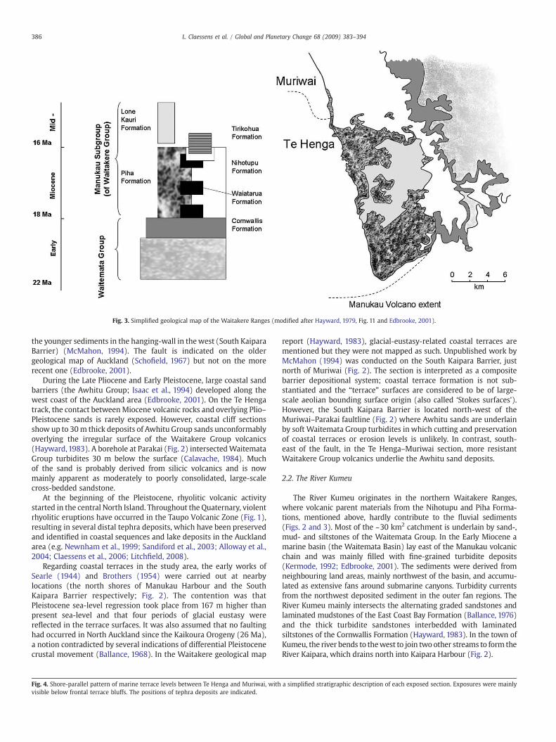
Fig. 3. Simplified geological map of the Waitakere Ranges (modified after Hayward, 1979, Fig. 11 and Edbrooke, 2001).
386 L. Claessens et al. / Global and Planetary Change 68 (2009) 383–394
the younger sediments in the hanging-wall in thewest (South KaiparaBarrier) (McMahon, 1994). The fault is indicated on the oldergeological map of Auckland (Schofield, 1967) but not on the morerecent one (Edbrooke, 2001).
During the Late Pliocene and Early Pleistocene, large coastal sandbarriers (the Awhitu Group; Isaac et al., 1994) developed along thewest coast of the Auckland area (Edbrooke, 2001). On the Te Hengatrack, the contact betweenMiocene volcanic rocks and overlying Plio–Pleistocene sands is rarely exposed. However, coastal cliff sectionsshow up to 30m thick deposits of Awhitu Group sands unconformablyoverlying the irregular surface of the Waitakere Group volcanics(Hayward,1983). A borehole at Parakai (Fig. 2) intersectedWaitemataGroup turbidites 30 m below the surface (Calavache, 1984). Muchof the sand is probably derived from silicic volcanics and is nowmainly apparent as moderately to poorly consolidated, large-scalecross-bedded sandstone.
At the beginning of the Pleistocene, rhyolitic volcanic activitystarted in the central North Island. Throughout the Quaternary, violentrhyolitic eruptions have occurred in the Taupo Volcanic Zone (Fig. 1),resulting in several distal tephra deposits, which have been preservedand identified in coastal sequences and lake deposits in the Aucklandarea (e.g. Newnham et al., 1999; Sandiford et al., 2003; Alloway et al.,2004; Claessens et al., 2006; Litchfield, 2008).
Regarding coastal terraces in the study area, the early works ofSearle (1944) and Brothers (1954) were carried out at nearbylocations (the north shores of Manukau Harbour and the SouthKaipara Barrier respectively; Fig. 2). The contention was thatPleistocene sea-level regression took place from 167 m higher thanpresent sea-level and that four periods of glacial eustasy werereflected in the terrace surfaces. It was also assumed that no faultinghad occurred in North Auckland since the Kaikoura Orogeny (26 Ma),a notion contradicted by several indications of differential Pleistocenecrustal movement (Ballance, 1968). In the Waitakere geological map
Fig. 4. Shore-parallel pattern of marine terrace levels between Te Henga and Muriwai, withvisible below frontal terrace bluffs. The positions of tephra deposits are indicated.
report (Hayward, 1983), glacial-eustasy-related coastal terraces arementioned but they were not mapped as such. Unpublished work byMcMahon (1994) was conducted on the South Kaipara Barrier, justnorth of Muriwai (Fig. 2). The section is interpreted as a compositebarrier depositional system; coastal terrace formation is not sub-stantiated and the “terrace” surfaces are considered to be of large-scale aeolian bounding surface origin (also called ‘Stokes surfaces’).However, the South Kaipara Barrier is located north-west of theMuriwai–Parakai faultline (Fig. 2) where Awhitu sands are underlainby soft Waitemata Group turbidites in which cutting and preservationof coastal terraces or erosion levels is unlikely. In contrast, south-east of the fault, in the Te Henga–Muriwai section, more resistantWaitakere Group volcanics underlie the Awhitu sand deposits.
2.2. The River Kumeu
The River Kumeu originates in the northern Waitakere Ranges,where volcanic parent materials from the Nihotupu and Piha Forma-tions, mentioned above, hardly contribute to the fluvial sediments(Figs. 2 and 3). Most of the ~30 km2 catchment is underlain by sand-,mud- and siltstones of the Waitemata Group. In the Early Miocene amarine basin (the Waitemata Basin) lay east of the Manukau volcanicchain and was mainly filled with fine-grained turbidite deposits(Kermode, 1992; Edbrooke, 2001). The sediments were derived fromneighbouring land areas, mainly northwest of the basin, and accumu-lated as extensive fans around submarine canyons. Turbidity currentsfrom the northwest deposited sediment in the outer fan regions. TheRiver Kumeu mainly intersects the alternating graded sandstones andlaminated mudstones of the East Coast Bay Formation (Ballance, 1976)and the thick turbidite sandstones interbedded with laminatedsiltstones of the Cornwallis Formation (Hayward, 1983). In the town ofKumeu, the river bends to thewest to join two other streams to form theRiver Kaipara, which drains north into Kaipara Harbour (Fig. 2).
a simplified stratigraphic description of each exposed section. Exposures were mainly

387L. Claessens et al. / Global and Planetary Change 68 (2009) 383–394
388 L. Claessens et al. / Global and Planetary Change 68 (2009) 383–394
Three groups of Kumeu terraces are mentioned and mapped on the1:50000 Waitakere geological map (Sheet Q11; Hayward, 1983). Theyare described as poorly exposed, highly weathered, mostly silt and clayand often impossible to distinguish from weathered exposures of theLower Miocene parent rocks. The deposits underlie a number ofsurfaces which roughly parallel modern stream profiles. They havebeen divided into groups of terraces lying 35 m, 15–25 m and 2–8 mabove local stream level, and have been inferred to relate to marinebase levels at these altitudes (Hayward, 1983). However, on the morerecent 1:250000 geological map of the Auckland area (Edbrooke,2001), the terraces aremapped as a combined alluvium/colluviumunit.
3. Methodology
3.1. Terrace level mapping, stratigraphic descriptions and altitudemeasurements
Based on aerial photography, digital elevation models, earliermapping (Hayward,1983; Edbrooke, 2001) and intensivefield surveys,
Fig. 5. Field photographs from coastal terrace sections: a) Overview looking south towards Tcoordinate system used is the New Zealand Geodetic Datum 1949, NZGD49). b) Wave-cutN 6478507). c) Jarosite andmangrove root remnants (encircled) (E 2638202, N 6482308). d)part of a terrace bluff is visible, characterized by an upward slope towards the next higherN 6481591). e) View of part of the exposed sediments of the T12 marine terrace body. The lodetect, its internal structure ismainly horizontally bedded. The upper half represents awhitetext, is correlated to the Potaka tephra. The distorted but abrupt boundary between the tw(E 2638334, N 6481680). f) Overview of coastal terrace levels looking west at the end o(For interpretation of the references to color in this figure legend, the reader is referred to
fluvial- and marine terraces were localized and mapped in the Kumeuvalley and along the Te Henga–Muriwai coastal section. Due to poorexposure of obvious fluvial terrace deposits and wave-cut marineterrace surfaces (see, also, the Discussion), subplanarmorphology andfrontal bluffs, forming stair-like landforms, were the principal fieldcriteria to identify and map terrace remnants. Positioning andbarometric altitude measurements were performed using a calibratedGPS receiver. For fluvial terraces, the altitude of the top of a (mostlyweathered) terrace remnant was taken as the reference because,usually, no recognizable sediments were found.
Although awave-cut platform is often the most readily identifiablepalaeo sea-level feature, the height of the maximal strandline(intersection of platform and the base of a fossil sea cliff) is themost useful field datum and recommended for reporting the age of amarine terrace (Pillans,1990). The surface expression of a strandline istypically the base of a terrace bluff (the rising slope bordering thesubplanar terrace landform). Strandlines were located and mapped inthe field, including reference altitudes for each marine terrace level.Relative terrace height rather than absolute height has long been
e Henga, the arrow points to the location of Potaka tephra (E 2638252, N 6481787; themarine terrace surface with Awhitu sand cover bed seen from Muriwai (E 2638829,Subplanar morphology of a T10marine terrace remnant. Towards the far right the lowerterrace remnant. The strandline is chosen at the base of the terrace bluff (E 2638266,wer half consists of moderately consolidated red-brown sandstone. Although difficult totephra layer (or ignimbrite) which, based on electron probe analysis asmentioned in theo bodies is characterized by hard layers of concentrated iron and manganese oxides
f the Te Henga–Goldie Bush Walkway near Constable Road (E 2639140, N 6482697).the web version of this article.)

389L. Claessens et al. / Global and Planetary Change 68 (2009) 383–394
regarded as vital for interpreting terrace ages and reconstructing upliftscenarios (e.g. Chappell, 1975).
For later correlation of terrace remnants and because tephralayers were present in exposures within both marine- and fluvialterraces, detailed stratigraphic descriptions of 38 marine terrace and19 fluvial terrace sections were made (ten Broeke, 2002; Vloemans,2004).
3.2. Tephrochronology
Tephra layers found on top of the marine terraces were dated bycorrelating them with known dated tephras, based on their miner-alogical or geochemical composition. This provided us with a simpleframework for uplift reconstruction (Vella et al., 1988; Marden andNeall, 1990; Pillans, 1990; Newnham and Lowe, 1991; Pillans, 1994;Eden and Froggatt, 1996; Naish et al., 1996; Shane et al., 1996a; Loweet al.,1999; Lowe et al., 2001; Sandiford et al., 2002; Shane andHoverd,2002; Alloway et al., 2004; Newnham et al., 2004; Litchfield, 2008;Marden et al., 2008). In New Zealand, the rhyolitic Taupo and Okatainacaldera volcanoes, within the central Taupo Volcanic Zone, are the twomost frequently active rhyolite centres and their tephra deposits havebeen extensively studied (Wilson,1993; Black et al.,1996; Shane, 2000;Litchfield, 2008). Positive correlations with tephras commonlyrequires multiple criteria (Froggatt and Lowe, 1990). In proximalsettings (b50 km from the vent), tephra beds can usually be identifiedfrom their stratigraphic position, lithology, and ferromagnesianmineral assemblages. In more distal settings, however, these featuresbecome less diagnostic and geochemical fingerprinting must beemployed. Major element compositions of glass shards of rhyolitictephra deposits are often analysedbyelectronmicroprobe. The efficacyof this technique to fingerprint tephra deposits was established byFroggatt (1983) and it has since been widely used (e.g., Lowe, 1988;Shane, 2000). A number of shards per sample are analysed andpopulations of identical composition are expressed as a mean and
Fig. 6. Overview of fluvial terrace levels plotted along the longitudinal profile of the River Kuand Pt. R11 484840). Different symbols refer to localities grouped in the same terrace level
standard deviation. Glass compositions can then be compared withthose from known (and dated) tephra deposits elsewhere. Even so,some tephras may have indistinguishable glass chemistries and thepossibility remains that tephras that yield ages that do not differsignificantly, given their uncertainties, might represent differenteruptive events from the same volcanic centre (Alloway et al., 2004).
4. Results
4.1. Terrace level mapping
Along the Te Henga–Muriwai coastal section, a total of 12 groups(levels) of coastal terrace remnants were found up to 200 m a.s.l.(Figs. 4 and 5). Stratigraphic descriptions of exposures within thesemarine terrace levels are given in Fig. 4. The highest point where avolcanic rock surface underlying an Awhitu sand coverbedwas exposedwas at 108 m a.s.l. No wave-cut platforms crop out but, besides thesubplanar morphology of the Awhitu sand deposits, several indicationsof marine terrace formation and uplift were apparent in the field. First,was the presence of estuarine clay deposits with distinguishablemangrove root imprints and traces of jarosite, produced by oxidationof pyrite (FeS2) in non-calcareous sediment, within exposures up to170 m a.s.l. (Fig. 5c). The formation of pyrite during sedimentation canonly occur in a marine or intertidal environment. Second, were thePleistocene marine Awhitu sand coverbeds, which occur high in thelandscape (up to 200 m, Fig. 5b). These beds have been interpreted asdeposited by wave action (McMahon, 1994), by admixture of marineand freshwater sediment with aeolian dune sand (Hayward, 1983),or indicative of a range of fluvial, estuarine and marine environments(Isaac, 1996), If the depositional environment was indeed (partly)shallow marine/coastal (indicated by the presence of jarosite, seeabove), there has been at least 200 m of uplift since deposition (LatePliocene to Early Pleistocene, Isaac,1996). Third, shallow landsliding is awidespread and highly active process in the Waitakere Ranges
meu. Start of river baseline is at Hunter Road (New Zealand topographic map 260-Q11.

Fig. 7. Schematic cross section of a R2 fluvial terrace (E 2648282, N 6483986; Absolute altitude: 51–52 m; Relative altitude: 5–6 m).
390 L. Claessens et al. / Global and Planetary Change 68 (2009) 383–394
(Hayward, 1983; Claessens et al., 2006, 2007). In the long term,continuedhillslopedenudation by landsliding can only be accomplishedif the potential energy for transport of material is provided by relativebase level lowering. This is in turn caused by local uplift or by global sea-level fluctuations, or a combination of both, forcing graded rivers toincise, undermine hillslopes and in this way triggering headwarderosion processes.
In the Kumeu valley at least 13 sets of fluvial terraces (excludingthe current floodplain) were recognized (Fig. 6). Fluvial sediments,although highly weathered and difficult to distinguish from the in situparent materials, were found up to level 11 (relative altitude, 65–70 m), confirming the fluvial origin of the terrace remnants (seeexample cross section in Fig. 7). The two upper terrace levels (R12 andR13) are only based on planar morphology as observed in the field.
Proposed fluvial terrace levels have been plotted parallel along thebaseline provided by the River Kumeu (Fig. 6). Because we have no
Table 3Electron microprobe analyses.
Tufflocality
Te Henga 1present study
Waiuku 1Auckland
Waiuku 2Auckland
Potaka 1Cape Kidnappers
Potaka 2not reported
SiO2 78.82 (0.54) 78.12 (0.29) 77.72 (0.13) 77.34 (0.52) 78.33 (0.25)Al2O3 12.83 (0.13) 12.41 (0.13) 12.36 (0.13) 12.36 (0.27) 12.38 (0.17)TiO2 0.12 (0.07) 0.14 (0.07) 0.10 (0.03) 0.12 (0.02) 0.09 (0.03)FeOa 1.16 (0.09) 1.14 (0.13) 1.14 (0.11) 1.17 (0.08) 0.90 (0.13)MgO 0.10 (0.03) 0.10 (0.03) 0.07 (0.02) 0.13 (0.01) 0.10 (0.02)CaO 0.92 (0.10) 0.88 (0.14) 0.89 (0.10) 1.00 (0.01) 0.82 (0.12)Na2O 2.21 (0.47) 3.26 (0.20) 3.82 (0.13) 3.82 (0.12) 3.73 (0.14)K2O 3.58 (0.32) 3.71 (0.36) 3.68 (0.22) 3.85 (0.16) 3.65 (0.28)Cl 0.23 (0.04) 0.19 (0.02) 0.19 (0.02) 0.22 (0.02) –
H2Ob 7.49 (1.41) 5.02 (0.66) 7.33 (0.60) 7.02 (1.08) 5.50 (0.80)n 16 15 17 12 18
Analyses by electron microprobe are of glass shards from the Te Henga 1 tephra and itsprobable Waiuku/Potaka tephra correlatives. Analyses are normalised to 100% on avolatile-free basis and are expressed as a mean (±standard deviation) of n analyses inwt.%. The analysis of the Te Henga tuff is from this study; those of the Waiuku 1 andWaiuku 2 tuffs from Alloway et al. (2004), that of the Potaka 1 tuff from Shane et al.(1996a), and that of the Potaka 2 tuff from Shane et al. (1996b).n=number of shards analysed. Analyses were undertaken at the Department ofGeology, University of Toronto, on a CAMEBAX SX-50, that operates at a 15 kV beamcurrent at 10 to 20 nA, beam focused and in scanning mode. Analyst: B. Alloway (IGNS).– No data.
a Total Fe expressed as FeO.b Water by difference (100% minus original analytical total).
independent chronostratigraphical marker in the fluvial terraceswe cannot be certain that the terraces are continuous and parallel tothe current river. Given the spread and localized grouping of theobserved planar terraces it is impossible to correlate them with themarine terrace record.
4.2. Tephrochronology
Three macroscopically different rhyolitic tephra deposits wereexposed at different levels in the Te Henga–Muriwai marine section(Figs. 4 and 5); each of the tephras tends to overlie several marineterraces. We assumed that the lowest level where a tephra is foundhas the closest age relationship with the tephra. For dating purposeswe sampled all exposed tephras for geochemical analysis. Unfortu-nately, only one sample (the 3 m thick Te Henga 1 tephra, altitude143–200 m) out of twelve samples contained sufficient glass shardsfor electron microprobe analysis.
After comparison, this tephra sample (lowest altitude 150 m a.s.l.)has been correlated with the Potaka tephra (Alloway, pers. com.)dated to ~1 Ma (Shane et al., 1996b) (Table 3). The Potaka tephra isone of the farthest traveled ignimbrites known and it has coveredmuch of the North Island (Wilson et al., 1995; Carter et al., 2004). Itwas deposited as a pyroclastic density current (primary emplace-ment), identified at a number of Auckland localities (Alloway andNewnham, 1995) and informally named the Waiuku tephra (Allowayet al., 2004).
Another tephra at a minimum altitude of 44 m a.s.l. can becorrelated with the Rotoehu tephra (~44 ka, Shane and Sandiford,2003; ~55 ka, Newnham et al., 2004; ~43–50 ka, Litchfield andBerryman, 2005). This youngest tephra is not weathered and has adistinct mineralogical composition because it contains a significantamount of Cummingtonite (an amphibole group mineral) which wasconfirmed by a diffractogram (ten Broeke, 2002). The remainingtephra, a 1–2m thick deposit (at 103–123maltitude) can be correlatedwith the Rangitawa (formerly Mt Curl) tephra (~0.345 Ma, Froggattet al., 1986; Shane, 2000).
The three tephra correlations seem plausible as all these tephrashave been previously identified in the Auckland–Northland area andin deep sea cores around New Zealand (e.g. Froggatt et al., 1986;Pillans et al., 1993; Shane, 2000; Newnham et al., 2004; Carter et al.,2004).

Fig. 8. (a) Summary of chronology and correlation of marine terrace levels with the palaeoclimate record from ODP site 677. (b) A general uplift curve using the three tephras astiepoints.
391L. Claessens et al. / Global and Planetary Change 68 (2009) 383–394
In the Kumeu River terrace sequence, one macroscopic tephradeposit was found in fluvial terrace level 2. This sample did notcontain enough glass shards for analysis.
4.3. Correlation with palaeoclimatic record and calculation of uplift rates
Ages and correlations of the marine terrace levels are based onthe occurrence of the three tephra layers as chronostratigraphicmarkers with three tie points (Fig. 8). All the marine terrace levels arecorrelated with odd-numbered MIS stages, corresponding to inter-glacial periods with sea-level highstands. The correlation uses theisotopic record and astronomically tuned timescale for ODP site 677(Shackleton et al., 1990) as recommended by others (Pillans, 1994;Bridgland et al., 2004). Recent 40Ar/39Ar dating and magnetostrati-graphy of volcanic sequences is consistent with this astronomicalchronology (Spell and McDougall, 1992).
The Rangitawa tephra has been previously identified and linked tothe upper part of MIS 10 (Pillans, 1994), also from deep sea cores nearNew Zealand (DSDP site 594, Froggatt et al., 1986, and site SO-36-61,Hesse, 1993). The same holds for the Potaka tephra, which has beenpreviously assigned to MIS 27 (Alloway et al., 1993; Shane, 1994) andthe Rotoehu tephra, which is placed within MIS 3 (Pillans et al., 1993;Pillans,1994; Shane and Sandiford, 2003). Uplift rates between terracelevels were calculated by dividing their altitude difference by their agedifference (taken as the age difference of the corresponding sea-levelhighstands from ODP 677). The uplift rates seem to correspond wellwith those previously calculated for Auckland and the west coast ofNorthland (e.g. Chappell, 1975; Richardson,1985; Gibb,1986; Table 2).The 300 ka gap between T10 and T11 can be attributed to possibledestruction of terrace remnants (probably during MIS 17), because
sea-levels during interglacials have been much higher for the last0.7 Ma (Beu and Edwards, 1984). Consequently, the correlation ofterrace levels and the resulting calculation of uplift rates becomeshighly uncertain from MIS 17 and older. The marine terraces in theSouth Taranaki–Wanganui area, for example, have also been inter-preted and dated only back to MIS 17 (Pillans, 1994).
5. Discussion
The marine terrace surfaces in our study area are overlain byyounger coverbeds and there is direct evidence for marine processesin the form of estuarine deposits and wave-cut surface morphology.Uplift rates have been calculated based on the marine terraces usingthe three tie points provided by the tephras. From 1000 ka to 345 kathe time-averaged uplift rate was 0.072 mm a−1, from 345 ka to 50 kathis rate increased to 0.278 mm a−1, accelerating to 0.42 mm a−1
since 50 ka. The overall tendency is thus an increase in uplift rate since~1 Ma (Fig. 8), a trend which is globally observed (e.g. Bridgland,2000; Maddy et al., 2000; Bridgland and Westaway, 2008). Theobserved amount of regional uplift for the North Island, 150 m since1 Ma, is similar to many other regions where the uplift has beenattributed to coupling between surface processes and lower-crustalflow (e.g., Westaway and Bridgland, 2007; Bridgland and Westaway,2007).
In recent years it has become clear that increases in Quaternaryuplift rates are characteristic in regions of continental crust, represent-ing the isostatic response to increased rates of erosion and/or cyclicloading of the crust by large-magnitude ice sheets (e.g., Westaway,2002a). This effect can be readily explained as a consequence ofcoupling between these surface processes and induced flow in the

392 L. Claessens et al. / Global and Planetary Change 68 (2009) 383–394
lower continental crust (e.g., Westaway, 2002a,b). Although the NorthIsland lies near a plate boundary zone, along which the Pacific plate issubducting below the Australian plate (Fig. 1) and within which thecontinental crust is extending, the observed vertical crustal motionsappear to be controlled by surface processes, although other theories(differences in shallow mantle temperatures, intra-plate stress) arestill under debate (Westaway, 2001; Carter et al., 2004).
The fluvial terrace record from the Kumeu valley appears to registerhigh-frequency changes between incision and aggradation in a rapiduplifting setting. When we assume the river to be in equilibriumwith the uplift rate reconstructed for the coastal terraces, the Kumeuriver has produced on average one terrace every 16,000 years since200 ka, a rather high frequency compared with other fluvial records(Bridgland and Westaway, 2007). It is not unprecedented for high-frequency climate changes to be registered in a fluvial terrace staircase(Maddy et al., 2005), but the fluvial terrace formation in the NorthIsland ofNewZealand appears not to be directly climate driven as is thecase in other parts of the world. First, there have been no majorchanges in the main vegetation type; forest has been the dominantland cover throughout the Quaternary in Northland and Auckland;for instance, Newnham (1999) found there was no substantial lossof forest anywhere in Northland at any time during the Last GlacialMaximum. Relative temperature depressions were probably similar tothose experienced elsewhere in New Zealand, but in the warmerNorth, were not sufficient to eliminate forest. For Auckland, only agenerally more open conifer–hardwood forest canopy and expansionof small trees and scrubduring glacial periods havebeen demonstrated(Newnham and Lowe, 1991; Sandiford et al., 2002, 2003; Shane andSandiford, 2003).
The natural mechanism for the observed (high-magnitude low-frequency) changes in sediment supply is landslides triggered bycyclones (Claessens et al., 2006). The othermain drivers for changes insediment supply have been volcanic eruptions, which have suppliedhuge amounts of ash and have disrupted the vegetation in the process(e.g., Manville and Wilson, 2004). The predominantly clay facies andgravel-poor sedimentology in the preserved Kumeu terraces suggeststhe presence of layers of clayey sediment, often containing reworkedvolcanic ash. Apparently, there have been no periods with significantnet aggradation in this system (the thickest observed sediment layeris b2 m; Fig. 7). In the meantime, the continued incision during theQuaternary, due to the high and increasing uplift rate, has produced astaircase of erosional ‘strath’ terraces.
In this context, the only climate-induced landscape processes wecan propose are changes in the frequency of droughts, leading tomorefrequent forest fires, triggering landslides during the first rainfallevents after each fire (Claessens et al., 2006). Climatic control maythus be attributed to variations in humidity rather than to temperaturechanges (Newnham, 1999; Bridgland et al., 2004). The possible role ofchanging fire regimes is also suggested by the frequent occurrence ofcharcoal in the lower terraces. According to Claessens et al. (2006),large-scale landslide events in theWaitakere Ranges typically occur ontimescales of several thousand years. These mudflow deposits do notmake a clear recognizable fluvial sedimentary record, especially whenthey are weathered.
Another probable reason why the terrace stratigraphy is poorlydeveloped is the relatively rapid uplift regime of the region. Thereconstructed uplift rates are at least three times higher than theorder-of-magnitude commonly associated with terraces in Europe(for NW Europe, uplift rates since the early Middle Pleistocenerange between 0.04 and 0.1 mm a−1; e.g., Westaway, 2001;Westawayet al., 2002; Bridgland and Westaway, 2008). Such fast uplift leadsto the development of strath terraces with only thin layers offluvial sediment, considerably limiting their preservation potential(Veldkamp, 1992).
Given the uncertainties in our altitude measurements and ageestimates we can only propose a semi-quantitative model for the
regional uplift and the resulting fluvial response. The general model isof an actively incising river, carving out strath terraces. The incisionphases are reactivated by sea-level lowering and interrupted byfrequent (every 16,000 years, on average) but comparatively small netaggradation events due to landslides or volcanic ash falls, all leading toa temporarily increased sediment supply.
It is very difficult to link these provisional findings to other similarrecords; we have been unable to track a record in a similar setting inthe literature. We hypothesize that the combination of the climaticsetting and the high uplift rates in the Auckland–Northland regionwillnever lead to the development of a classical terrace sequence with aclear stratigraphy and fundamental climate control. The lack of anobvious and clear terrace record has led to the systematic under-representation of such areas in global terrace literature. We thereforepropose a systematic global analysis of palaeoclimate and uplift rates,in order to identify those areas where we can expect well-developedterrace staircases and others where they will be less conspicuous.
6. Conclusions
A combined coastal/fluvial terrace record demonstrates accelerat-ing Quaternary uplift rates (up to 0.42 mm a−1) for a study areanorthwest of Auckland. The record of marine terrace levels alongthis coastline dates back at least to ~1 Ma. Although some researchershave interpreted the marine surfaces as aeolian ('Stokes surfaces'),evidence is presented that they are essentially erosional coastalterraces with some coverbeds, including tephras. The observedregional uplift, 150 m since 1 Ma, is similar to that observed in manyother regions where the uplift has been attributed to couplingbetween surface processes and lower-crustal flow (e.g., Westawayand Bridgland, 2007; Bridgland and Westaway, 2007). The preservedfluvial record in the Kumeu valley suggests very limited climatecontrol over terrace formation. The proposed controlling mechanismon the aggradation/incision dynamics is the effect of landslides thatmight be related to changes in cyclone frequency or humidity causingdifferent fire regimes. Tephras from the Taupo Volcanic Zone alsoaffect sediment loads (see also Manville and Wilson, 2004). It isconcluded that similar study localities are underrepresented in theliterature as no classic terraces sequences will have developed inregions with similar climatic settings and uplift rates.
Acknowledgments
This research was supported by the Netherlands Organisation forScientific Research (NWO) project 810.62.013. This study contributesto IGCP 518 ‘Fluvial sequences as evidence for landscape and climaticevolution in the Late Cenozoic’. The authors thank the AucklandRegional Council, Te Kawerau a Maki, and Watercare Services Ltd. fortheir support.We thankDavid Lowe (University ofWaikato, Hamilton)and Brent Alloway (IGNS, Taupo) for their support and advice andWillEsler for undertaking the microprobe analyses. The authors wish tothank Pierre Antoine, Colin Murray-Wallace, David Bridgland andRobWestaway for their valuable commentswhich greatly improved anearlier version of this manuscript.
References
Alloway, B.V., Newnham, R.M., 1995. A preliminary assessment of the threat posed bydistal silicic volcanism based in the Middle–Late Quaternary tephrostratigraphicrecord. Geological Society of New Zealand Miscellaneous Publication 81B, 73–83.
Alloway, B.V., Pillans, B.J., Sandhu, A.S., Westgate, J.A., 1993. Revision of the marinechronology in the Wanganui Basin, New Zealand, based on the isothermal plateaufission-track dating of tephra horizons. Sedimentary Geology 82, 299–310.
Alloway, B., Westgate, J., Pillans, B., Pearce, N., Newnham, R., Byrami, M., Aarburg, S.,2004. Stratigraphy, age and correlation of middle Pleistocene silicic tephras in theAuckland region, New Zealand: a prolific distal record of TVZ volcanism. NewZealand Journal of Geology and Geophysics 47, 447–479.
Ballance, P.F., 1968. The physiography of the Auckland district. New Zealand Geographer24, 23–49.
393L. Claessens et al. / Global and Planetary Change 68 (2009) 383–394
Ballance, P.F., 1976. Stratigraphy and bibliography of the Waitemata Group of Auckland.New Zealand Journal of Geology and Geophysics 19, 897–932.
Barter, T.P., 1976. The Kaihu Group (Plio-Quaternary) of the Awhitu Peninsula, south-west Auckland. Unpublished Ph.D. thesis, University of Auckland, New Zealand.
Bender, M.L., Fairbanks, R.G., Taylor, F.W., Matthews, R.K., Goddard, J.G., Broecker, W.S.,1979. Uranium-series dating of the Pleistocene reef tracts of Barbados, West Indies.Geological Society of America Bulletin 90, 577–594.
Berryman, K., 1993. Age, height, and deformation of Holocene marine terraces at MahiaPeninsula, Hikurangi subduction margin, New Zealand. Tectonics 12, 1347–1364.
Berryman, K., Marden, M., Eden, D., Mazengarb, C., Ota, Y., Moriya, I., 2000. Tectonic andpaleoclimatic significance of Quaternary river terraces of the Waipaoa River, eastcoast, North Island, New Zealand. New Zealand Journal of Geology and Geophysics43, 229–245.
Beu, A.G., Edwards, A.R., 1984. NewZealand Pleistocene and late Pliocene glacio-eustaticcycles. Palaeogeography, Palaeoclimatology, Palaeoecology 46, 119–142.
Black, T.M., Shane, P.A.R., Westgate, J.A., Froggatt, P.C., 1996. Chronological andpalaeomagnetic constraints on widespread welded ignimbrites of the Taupovolcanic zone, New Zealand. Bulletin of Volcanology 58, 226–238.
Bridgland, D.T., 2000. River terrace systems in north-west Europe: an archive ofenvironmental change, uplift and early human occupation. Quaternary ScienceReviews 19, 1293–1303.
Bridgland, D., Westaway, R., 2007. Climatically controlled river terrace staircases:a worldwide Quaternary phenomenon. Geomorphology 98, 285–315.
Bridgland, D., Maddy, D., Bates, M., 2004. River terrace sequences: templates forQuaternarygeochronology andmarine-terrestrial correlation. Journal of QuaternaryScience 19, 203–218.
Bridgland, D.R., Keen, D., Westaway, R., 2007. Global correlation of Late Cenozoic fluvialdeposits: a synthesis of data from IGCP 449. Quaternary Science Reviews 26,2694–2700.
Brothers, R.N., 1954. The relative Pleistocene chronology of the South Kaipara District,New Zealand. Transactions of the Royal Society of New Zealand 82, 677–694.
Bull, W.B., 1991. Climate and landscape change in a humid fluvial system. 1991 In: Bull,W.B. (Ed.), Geomorphic Responses to Climatic Change. Oxford University Press,New York, US, pp. 227–269.
Calavache, V.M.L., 1984. Evaluation Report of some Aspects of Parakai Bore No. 1.Geothermal Institute, University of Auckland, New Zealand.
Campbell, I.B., 1973. Late Pleistocene alluvial pumice deposits in the Wanganui Valley.New Zealand Journal of Geology and Geophysics 16, 717–721.
Carter, L., Alloway, B., Shane, P., Westgate, J., 2004. Deep-ocean record of major lateCenozoic rhyolitic eruptions from New Zealand. New Zealand Journal of Geologyand Geophysics 47, 481–500.
Chappell, J., 1975. Upper Quaternary warping and uplift rates in the Bay of Plenty andwest coast, North Island, New Zealand. New Zealand Journal of Geology andGeophysics 18, 129–155.
Chappell, J., 1983. A revised sea-level record for the last 300 000 years from Papua NewGuinea. Search 14, 99–101.
Chappell, J., Veeh, H.H., 1978. Late Quaternary tectonic movements and sea-levelchanges at Timor and Atauro Island. Geological Society of America Bulletin 89,356–368.
Chappell, J., Ota, Y., Berryman, K., 1996. Late Quaternary coseismic uplift history of HuonPeninsula, Papua New Guinea. Quaternary Science Reviews 15, 7–22.
Claessens, L., Lowe, D.J., Hayward, B.W., Schaap, B.F., Schoorl, J.M., Veldkamp, A., 2006.Reconstructing high-magnitude/low-frequency landslide events based on soilredistribution modelling and a Late-Holocene sediment record from New Zealand.Geomorphology 74, 29–49.
Claessens, L., Schoorl, J.M., Veldkamp, A., 2007. Modelling the location of shallowlandslides and their effects on landscape dynamics in large watersheds: anapplication for Northern New Zealand. Geomorphology 87, 17–27.
Clark, R.H., 1948. Evolution of drainage of area between southern shores of KaiparaHarbour and Waitemata Harbour. Unpublished MSc thesis, University of Auckland,New Zealand.
Edbrooke, S.W. (compiler), 2001. Geology of the Auckland area. Institute of Geologicaland Nuclear Sciences 1:250000 geological map 3. 1 sheet + 74p. Institute ofGeological and Nuclear Sciences Limited, Lower Hutt, New Zealand.
Eden, D.N., Froggatt, P.C., 1996. A 6500 year-old history of tephra deposition recorded inthe sediments of Lake Tutira, eastern North Island, New Zealand. QuaternaryInternational 34–36, 55–64.
Eden, D.N., Palmer, A.S., Cronin, S.J., Marden, M., Berryman, K.R., 2001. Dating theculmination of river aggradation at the end of the last glaciation using distal tephracompositions, eastern North Island, New Zealand. Geomorphology 38, 133–151.
Fair, E.E., 1968. Structural, tectonic and climate control of the fluvial geomorphology ofthe Manawatu River west of the Manawatu Gorge, Unpublished MSc thesis, MasseyUniversity, Palmerston North, New Zealand.
Formento-Trigilio, M.L., Burbank, D.W., Nicol, A., Shulmeister, J., Rieser, U., 2002. Riverresponse to an active fold-and-thrust belt in a convergent margin setting, NorthIsland, New Zealand. Geomorphology 49, 125–152.
Froggatt, P.C., 1983. Towards a comprehensive Upper Quaternary tephra and ignimbritestratigraphy of New Zealand using electron microprobe analysis of glass shards.Quaternary Research 19, 188–200.
Froggatt, P.C., Lowe, D.J., 1990. A review of Quaternary silicic and some other tephraformations from New Zealand: their stratigraphy, nomenclature, distribution,volume, and age. New Zealand Journal of Geology and Geophysics 33, 89–109.
Froggatt, P.C., Nelson, C.S., Carter, L., Griggs, G., Black, K.P., 1986. An exceptionally largelate Quaternary eruption from New Zealand. Nature 319, 578–582.
Gage, M., 1953. The study of Quaternary strand-lines in New Zealand. Transactions ofthe Royal Society of New Zealand 81, 27–34.
Gibb, J.G., 1986. A New Zealand regional Holocene eustatic sea-level curve and itsapplication for determination of vertical tectonic movement. Bulletin of the RoyalSociety of New Zealand 24, 377–395.
Goldie, P.J., 1975. Quaternary geology of an area north of Houhora. Unpublished MScthesis, University of Auckland, New Zealand.
Hayward, B.W., 1976. Lower Miocene stratigraphy and structure of the WaitakereRanges and the Waitakere Group (new). New Zealand Journal of Geology andGeophysics 19, 871–895.
Hayward, B.W., 1979. Eruptive History of the Early to Mid Miocene Waitakere VolcanicArc, and Palaeogeography of the Waitemata Basin, Northern New Zealand. Journalof the Royal Society of New Zealand 9, 297–320.
Hayward, B.W., 1983. Sheet Q11 Waitakere. Geological Map of New Zealand 1:50 000.Map (1 sheet) and notes (28 p.). New Zealand Department of Scientific andIndustrial Research, New Zealand.
Hayward, B.W., 1993. The tempestuous 10 million year life of a double arc and intra-arcbasin— New Zealand's Northland Basin in the Early Miocene. In: Ballance, P.F. (Ed.),South Pacific sedimentary basins. Sedimentary basins of the world 2. Elsevier,Amsterdam, pp. 113–142.
Heerdegen, R.G., Sheperd, M.J., 1992. Manawatu landforms — product of tectonism,climate change and process. In: Soons, J.M., Selby, M.J. (Eds.), Landforms of NewZealand. Longman Paul, Auckland, New Zealand.
Hesp, P.A., Shepherd, M.J., Parnell, K., 1999. Coastal geomorphology in New Zealand.1989–99. Progress in Physical Geography 23, 501–524.
Hesse, P.P., 1993. A Quaternary record of the Australian environment from aeolian dustin Tasman Sea sediments. Unpublished PhD thesis, Australian National University,Canberra, Australia.
Hicks, D.L., 1975. Geomorphic development of the southern Aupouri and Karikaripeninsulas, with special reference to sand dunes. UnpublishedMA thesis, Universityof Auckland, New Zealand.
Isaac, M.J. (compiler), 1996. Geology of the Kaitaia area. Institute of Geological andNuclear Sciences 1:250000 geological map 1. 1 sheet + 44p. Institute of Geologicaland Nuclear Sciences Limited, Lower Hutt, New Zealand.
Isaac, M.J., Herzer, R.H., Brook, F.J., Hayward, B.W., 1994. Cretaceous and Cenozoicsedimentary basins of Northland, New Zealand. Institute of Geological and NuclearSciences Monograph 8, 203 p. Lower Hutt, New Zealand.
Kamp, P.J.J., 1988. Tectonic geomorphology of the Hikurangi Margin surface manifesta-tions of different modes of subduction. Zeitschrif für Geomorphologie 69, 55–67.
Kamp, P.J.J., 1992. Landforms of Hawke's Bay and their origin: a plate tectonicinterpretation, In: Soons, J.M., Selby, M.J. (Eds.), Landforms of New Zealand, SecondEdition. Longman Paul, Auckland, New Zealand, pp. 344–366.
Kermode, L., 1992. Geology of the Auckland urban area. Scale 1:50000. Institute ofGeological & Nuclear Sciences geological map 2. 1 sheet + 63 p. Institute ofGeological & Nuclear Sciences Ltd., Lower Hutt, New Zealand.
Lavé, J., Avouac, J.P., 2000. Active folding of fluvial terraces across the Siwaliks Hills,Himalayas of central Nepal. Journal of Geophysical Research 105, 5735–5770.
Leitch, E.C., 1966. The geology of the North Cape area. Unpublished MSc thesis,University of Auckland, New Zealand.
Lensen, G.J., Vella, P., 1971. TheWaiohine river faulted terrace sequence. Royal Society ofNew Zealand Bulletin 9, 117–119.
Litchfield, N.J., 2008. Using fluvial terraces to determine Holocene coastal erosion andLate Pleistocene uplift rates: an example from northwestern Hawke Bay, NewZealand. Geomorphology 99, 369–386.
Litchfield, N.J., Berryman, K.R., 2005. Correlation of fluvial terraces within the HikurangiMargin New Zealand: implications for climate and baselevel controls. Geomor-phology 68, 291–313.
Lowe, D.J., 1988. Late Quaternary volcanism in New Zealand: towards an integratedrecord using distal airfall tephras in lakes and bogs. Journal of Quaternary Science 3,111–120.
Lowe, D.J., Newnham, R.M., Ward, C.M., 1999. Stratigraphy and chronology of a 15 calyr sequence of multi-sourced silicic tephras in a montane peat bog, eastern NorthIsland, New Zealand. New Zealand Journal of Geology and Geophysics 42,565–579.
Lowe, D.J., Tippett, J.M., Kamp, P.J.J., Liddell, I.J., Briggs, R.M., Horrocks, J.L., 2001. Ages onweathered Plio-Pleistocene tephra sequences, western North Island, New Zealand.In: Juvigné, E.T., Raynal, J-P. (Eds.), Tephras: chronology, Archaeology, CDERADéditeur, Goudet. Les Dossiers de l'Archéo-Logis, vol. 1, pp. 45–60.
McMahon, T.J., 1994. The Quaternary geology of the South Kaipara Barrier. UnpublishedMSc thesis, University of Auckland, New Zealand.
Maddy, D., Bridgland, D.R., Green, C.P., 2000. Crustal uplift in southern England:evidence from the river terrace records. Geomorphology 33, 167–182.
Maddy, D., Demir, T., Bridgland, D.R., Veldkamp, A., Stemerdink, C., Van der Schriek, T.,Westaway, R., 2005. A unique obliquity-controlled early Pleistocene river terracerecord from Western Turkey. Quaternary Research 63, 339–346.
Manville, V., Wilson, C.J.N., 2004. The 26.5 ka Oruanui eruption, New Zealand: a reviewof the roles of volcanism and climate in the post-eruptive sedimentary response.New Zealand Journal of Geology and Geophysics 47, 525–547.
Marden, M., Neall, V.E., 1990. Dated Ohakean terraces offset by the Wellington Faultnear Woodville, New Zealand. New Zealand Journal of Geology and Geophysics 33,449–453.
Marden, M., Mazengarb, C., Palmer, A., Berryman, K., Rowan, D., 2008. Last glacialaggradation and postglacial sediment production from the non-glacial Waipaoaand Waimata catchments, Hikurangi Margin, North Island, New Zealand.Geomorphology 99, 404–419.
Milne, J.D.G., 1973. Mount Curl Tephra, a 230.000-year-old marker bed in New Zealandand its implications for Quaternary chronology. New Zealand Journal of Geologyand Geophysics 16, 519–532.

394 L. Claessens et al. / Global and Planetary Change 68 (2009) 383–394
Molnar, P., Brown, E.T., Burchfiel, B.C., Deng, Q., Feng, X., Li, J., Raisbeck, G.M., Shi, J., Wu,Z., Yiou, F., You, H., 1994. Quaternary climate change and the formation of riverterraces across growing anticlines on the north flank of the Tien Shan, China.Journal of Geology 102, 583–602.
Murray-Wallace, C.V., 2002. Pleistocene coastal stratigraphy, sea-level highstands andneotectonism of the southern Australian passive continental margin — a review.Journal of Quaternary Science 17, 469–489.
Naish, T., Kamp, P.J.J., Alloway, B.V., Pillans, B., Wilson, G.S., Westgate, J.A., 1996.Integrated tephrochronology and magnetostratigraphy for cyclothemic marinestrata,Wanganui Basin: implications for the Pliocene–Pleistocene boundary in NewZealand. Quaternary International 34–36, 29–48.
Neall, V.E., 1992. Landforms of Taranaki and theWanganui lowlands. In: Soons, J.M., Selby,M.J. (Eds.), Landforms of New Zealand. Longman Paul, Auckland, New Zealand.
Newnham, R.M., 1999. Environmental change in Northland, New Zealand during the lastglacial and Holocene. Quaternary International 57/58, 61–70.
Newnham, R.M., Lowe, D.J., 1991. Holocene vegetation and volcanic activity, AucklandIsthmus, New Zealand. Journal of Quaternary Science 6, 177–193.
Newnham, R.M., Lowe, D.J., Alloway, B., 1999. Volcanic hazards in Auckland, NewZealand: a preliminary assessment of the threat posed by central North Island silicicvolcanism based on the Quaternary tephrostratigraphical record. Volcanoes in theQuaternary. London Geological Society Special Publication 161, 27–45.
Newnham, R.M., Lowe, D.J., Green, J.D., Turner, G.M., Harper, M.A., McGlone, M.S., Stout,S.L., Horie, S., Froggatt, P.C., 2004. A discontinuous ca. 80 ka record of LateQuaternary environmental change from Lake Omapere, Northland, New Zealand.Palaeogeography, Palaeoclimatology, Palaeoecology 207, 165–198.
Pillans, B., 1983. Upper Quaternary marine terrace chronology and deformation, SouthTaranaki, New Zealand. Geology 11, 292–297.
Pillans, B., 1990. Pleistocene marine terraces in New Zealand: a review. New ZealandJournal of Geology and Geophysics 33, 219–231.
Pillans, B., 1994. Direct marine-terrestrial correlations, Wanganui Basin, New Zealand:the last 1 million years. Quaternary Science Reviews 13, 189–200.
Pillans, B., McGlone, M., Palmer, A., Mildenhall, D., Alloway, B., Berger, G., 1993. The lastglacial maximum in central and southern North Island, New Zealand: a paleoenviron-mental reconstruction using Kawakawa tephra formation as a chronostratigraphicmarker. Palaeogeography, Palaeoclimatology, Palaeoecology 101, 283–304.
Pirazzoli, P.A., Radke, U., Hantoro, W.S., Jouannic, C., Oang, C.T., Causse, C., Borel Best, M.,1991. Quaternary raised coral-reef terraces on Sumba Island, Indonesia. Science252, 1834–1836.
Richardson, R.J.H., 1985. Quaternary geology of the North Kaipara barrier, Northland,New Zealand. New Zealand Journal of Geology and Geophysics 28, 111–127.
Ricketts, B.D., 1975. Quaternary geology of the Parengarenga-Te Kao district.Unpublished MSc thesis, University of Auckland, New Zealand.
Rockwell, T., Keller, E.A., Clark, M.N., Johnson, D.L., 1984. Chronology and rates of faultingof Ventura River terraces, California. Geological Society of America Bulletin 95,1466–1474.
Sandiford, A., Horrocks, M., Newnham, R., Ogden, J., Alloway, B., 2002. Environmentalchange during the last glacial maximum (c. 25000–c. 16500 years BP) at MtRichmond, Auckland Isthmus, New Zealand. Journal of the Royal Society of NewZealand 32, 155–167.
Sandiford, A., Newnham, R., Alloway, B., Ogden, J., 2003. A 28000–7600 cal yr BP pollenrecord of vegetation and climate change from Pukaki Crater, northern New Zealand.Palaeogeography, Palaeoclimatology, Palaeoecology 201, 235–247.
Schofield, J.C., 1967. Geological Map of New Zealand 1:250000. Sheet 3 Auckland.Department of Scientific and Industrial Research, Wellington, New Zealand.
Schumm, S.A., 1993. River response to baselevel change: implications for sequencestratigraphy. Journal of Geology 101, 279–294.
Searle, E.J., 1944. Geology of the SouthernWaitakere Hills RegionWest of Auckland City.Transactions of the Royal Society of New Zealand 74, 49–70.
Shackleton, N.J., Berger, A., Peltier, W.R., 1990. An alternative astronomical calibration ofthe lower Pleistocene timescale based on ODP Site 677. Transactions of the RoyalSociety of Edinburgh. Earth Sciences 81, 251–261.
Shane, P., 1994. A widespread, early Pleistocene tephra (Potaka tephra, 1 Ma) in NewZealand: character, distribution and implications. New Zealand Journal of Geologyand Geophysics 37, 25–35.
Shane, P., 2000. Tephrochronology: a New Zealand case study. Earth-Science Reviews49, 223–259.
Shane, P., Hoverd, J., 2002. Distal record of multi-sourced tephra in Onepoto Basin,Auckland, New Zealand: implications for volcanic chronology, frequency andhazards. Bulletin of Volcanology 64, 441–545.
Shane, P., Sandiford, A., 2003. Paleovegetation of marine isotope stages 4 and 3 inNorthern New Zealand and the age of the widespread Rotoehu tephra. QuaternaryResearch 59, 420–429.
Shane, P., Alloway, B., Black, T., Westgate, J., 1996a. Isothermal plateau fission-track agesof tephra beds in an early–middle Pleistocene marine and terrestrial sequence,Cape Kidnappers, New Zealand. Quaternary International 34–36, 49–53.
Shane, P., Black, T.M., Alloway, B.V., Westgate, J., 1996b. Early to middle Pleistocenetephrochronology of North Island, New Zealand: Implications for volcanism,tectonism, and paleoenvironments. Geological Society of America Bulletin 108,915–925.
Spell, T.L., McDougall, I., 1992. Revisions to the age of the Brunhes–Matuyama boundaryand the Pleistocene geo-magnetic polarity timescale. Geophysical Research Letters19, 1181–1184.
ten Broeke, E.M., 2002. Pleistocene coastal terrace chronology of the south-west coast ofNorthland, New Zealand. Unpublished MSc thesis, Wageningen University, TheNetherlands.
Vella, P., Kaewyana, W., Vucetich, C.G., 1988. Late Quaternary terraces and their coverbeds, north-western Wairarapa, New Zealand, and provisional correlations withoxygen isotope stages. Journal of the Royal Society of New Zealand 18, 309–324.
Veldkamp, A., 1992. A 3-D model of fluvial terrace development in the Allier basin(Limagne. France). Earth Surface Processes and Landforms 17, 487–500.
Veldkamp, A.,1994. Evaluating Quaternaryerosional dynamics at uplifting coastal areas bymodelling marine terrace formation. Zeitschrift für Geomorphologie 38, 223–237.
Veldkamp, A., Tebbens, L.A., 2001. Registration of abrupt climate changes within fluvialsystems: insights from numerical modelling experiments. Global and PlanetaryChange 28, 129–144.
Veldkamp, A., Buis, E., Wijbrans, J.R., Olago, D.O., Boshoven, E.H., Marée, M., van denBerg van Saparoea, R.M., 2007. Late Cenozoic fluvial dynamics of Tana River, Kenya,an uplift dominated record. Quaternary Science Reviews 26, 2897–2912.
Vloemans, H., 2004. A reconstruction of the Late Quaternary tectonic history of theWaitakere Ranges, using the fluvial terrace sequence of the Kumeu River, Northland,New Zealand. Unpublished M.Sc. thesis, Wageningen University, The Netherlands.
Vucetich, C.G., Vella, P., Warnes, P.N., 1996. Antepenultimate glacial to last glacialdeposits in southern Wairarapa, New Zealand. Journal of the Royal Society of NewZealand 26, 469–482.
Westaway, R., 2001. Flow in the lower continental crust as a mechanism for theQuaternary uplift of the Rhenish Massif, north-west Europe. In: Maddy, D., Macklin,M., Woodward, J. (Eds.), River Basin Sediment Systems: Archives of EnvironmentalChange. Balkema, Rotterdam, pp. 71–151.
Westaway, R., 2002a. Geomorphological consequences of weak lower continental crust,and its significance for studies of uplift, landscape evolution, and the interpretationof river terrace sequences. Netherlands Journal of Geosciences 81, 283–304.
Westaway, R., 2002b. The Quaternary evolution of the Gulf of Corinth, central Greece:coupling between surface processes and flow in the lower continental crust.Tectonophysics 348, 269–318.
Westaway, R., Bridgland, D., 2007. Late Cenozoic uplift of southern Italy deduced fromfluvial and marine sediments: Coupling between surface processes and lower-crustal flow. Quaternary International 175, 86–124.
Westaway, R., Maddy, D., Bridgland, D., 2002. Flow in the lower continental crust as amechanism for the Quaternary uplift of south-east England: constraints from theThames record. Quaternary Science Reviews 79, 23–36.
Williams, P.W., 1982. Speleothem dates, Quaternary terraces and uplift rates in NewZealand. Nature 298, 257–260.
Wilson, C.J.N., 1993. Stratigraphy, chronology, styles and dynamics of late Quaternaryeruptions from Taupo volcano, New Zealand. Philosophical Transactions of theRoyal Society, London, Series A 343, 205–306.
Wilson, C.J.N., Houghton, B.F., Kamp, P.J.J., McWilliams, M.O., 1995. An exceptionallywidespread ignimbrite with implications for pyroclastic flow emplacement. Nature378, 605–607.