Age estimates of coastal terraces in the Andaman and Nicobar ...

ARTICLE IN PRESS
1040-6182/$ - se
doi:10.1016/j.qu
�CorrespondE-mail addre
(I. Pulice), robu
(G. Vecchio).
Quaternary International 156 –157 (2006) 133–155
Soil chronosequences on Quaternary marine terraces along thenorthwestern coast of Calabria (Southern Italy)
Fabio Scarcigliaa,�, Iolanda Pulicea, Gaetano Robustellia, Giuseppe Vecchiob
aDipartimento di Scienze della Terra, Universita della Calabria, Via P. Bucci–Cubo 15B, 87036 Arcavacata di Rende (CS), ItalybIstituto Sperimentale per lo Studio e la Difesa del Suolo (ISSDS), 88063 Catanzaro Lido (CZ), Italy
Available online 7 July 2006
Abstract
Two soil chronosequences, representative of four orders of marine terraces from Early to Late Pleistocene, have been studied along the
Tyrrhenian coast of northern Calabria, in Southern Italy. All soil profiles show a high degree of weathering, although the degree of soil
evolution varies according to the age of each terrace. The soils are characterized by reddish to reddish brown colors, clayey textures,
abundant clay coatings, slickensides, Fe–Mn features or calcium carbonate concretions. The dominance of kaolinite and illite among
phyllosilicate clay minerals in all soil horizons, the intense depletion in CaCO3, Na and K, and the severe etching of quartz crystals in the
older soils all record a highly leached pedogenic environment that is progressively more intense from younger to older soils. Despite the
carbonate bedrock, quartz, feldspar and mica minerals also occur, suggesting a partly allochthonous, eolian origin of the parent material.
The major pedogenic features and their formative processes occurred polycyclically on the different orders of marine terraces, and we
interpret the soils to have mainly developed during repeated Quaternary interglacials. Some surface A and Bw horizons show quite
different features, suggesting a clear change in pedogenetic processes and possibly in climate and duration of soil formation. These
horizons have the typical field appearance of volcanic soils with andic properties (brown colors, loamy textures, high porosity, low bulk
density, high water retention, thixotropy). The occurrence of very small volcanic glass fragments and the possible presence of short-range
order aluminosilicate minerals confirmed some pyroclastic supply during soil formation.
r 2006 Elsevier Ltd and INQUA. All rights reserved.
1. Introduction
The northwestern coastal landscape of Calabria, South-ern Italy, has been the object of extensive geomorpholo-gical and stratigraphical investigations (Brancaccio andVallario, 1968; Damiani and Pannuzi, 1979; Carboni et al.,1988; Carobene and Dai Pra, 1990). Carobene and Dai Pra(1990) identified five orders of marine terraces, correlatingthem with the marine oxygen isotope record. In contrast,pedological data are scarce (ARSSA, 2003). This paperaims to fill this gap by focusing on genetic processes in soilsdeveloped on a flight of Quaternary marine terraces. Inparticular, two chronosequences of reddish soils, formedon different orders of coastal terraces, were investigated tocharacterize different stages of soil development, and
e front matter r 2006 Elsevier Ltd and INQUA. All rights re
aint.2006.05.027
ing author. Tel.: +39984 493549; fax: +39 984 493601.
sses: [email protected] (F. Scarciglia), [email protected]
[email protected] (G. Robustelli), [email protected]
evaluate pedogenic change in response to time andchanging climate or environments. The results contributeto the knowledge base of two main topics in the context ofinternational multidisciplinary research: (1) soil chronose-quences (e.g. Garcıa Marcos and Frances Santos, 1997;Vidic and Lobnik, 1997; Huggett, 1998; Birkeland, 1999;Simon et al., 2000) and (2) genesis of Mediterranean redsoils (‘‘Terra Rossa’’) (Colombo and Terribile, 1994;Bellanca et al., 1996; Bronger and Bruhn-Lobin, 1997;Darwish and Zurayk, 1997; Fedoroff, 1997; Yaalon, 1997;Yassoglou et al., 1997; Cremaschi and Trombino, 1998;Durn et al., 1999; Ortiz et al., 2002; Delgado et al., 2003).Furthermore, this paper examines the potential presence ofvolcanic parent material contributing to soil formation insome surface horizons with apparent field propertiestypical of volcanic soils (Andosols, sensu FAO et al.,1998, or Andisols, sensu USDA, 2003). Evidence of somevolcanic inputs in other Andisol-like soils have beenrecently found in southern, coastal or inland areas ofCalabria (Aramini et al., 2003; Scarciglia et al., 2005).
served.

ARTICLE IN PRESSF. Scarciglia et al. / Quaternary International 156 –157 (2006) 133–155134
2. The study area: geology, geomorphology and climate
The study area is situated between the Noce and the Laorivers, along the northwestern coast of Calabria (SouthernItaly), near the boundary with southern Basilicata (Fig. 1).In this area, the ‘‘Carbonate Platform Unit’’ consisting ofdolomite-limestones (Ietto et al., 1992; Perri et al., 2003) isin contact with the ‘‘Internal Units’’ complex, representedby the ‘‘Lower Ophiolite Unit’’ (schists and metarenites ofthe ‘‘Liguride Complex’’, Piluso et al., 2000) and with the‘‘Lagonegro Unit’’ made of carbonate, marls and silici-clastic deposits (Pescatore et al., 1999). As thrust migration
Fig. 1. Geomorphological sketch map of the study area showing the
different orders of marine terraces and the location of the soil profiles
studied.
was locked by the thickening of the colliding continentalcrusts (Late Pliocene-Early Pleistocene), these two mainimbricate units were affected by severe strike-slip tectonics,which modified the previous thrust geometry (Monacoet al., 1998). During the Middle Pleistocene, an extensionalregime (Tortorici et al., 1995) reactivated the pre-existingstructures with different kinematics.Five orders of marine terraces (Figs. 1 and 2) occur on
dolomite-limestone bedrock, and show good morphologi-cal continuity from north to south. The terraces are bothwave-cut and wave-built, with ages spanning from theEarly to Late Pleistocene (Carobene and Dai Pra, 1990)and ranging between 6m and 200ma.s.l. Quaternarycontinental deposits (mainly alluvial fan and slopedeposits) occur on top of the Pleistocene marine terraces.Reddish brown to red soils are widespread on each terracesurface, sometimes buried by or interbedded with slopedeposits and tephra layers.The I order terrace is the most extensive, and has been
interpreted as due to tectonic subsidence of the whole areaduring the Emilian-Sicilian time interval (1.3–0.8Ma;Carobene and Dai Pra, 1990).On the left of the Noce River valley, relics of the I order
marine terrace extend from 100m to 130–140ma.s.l. Thisterrace cuts the carbonate bedrock, but locally marinesediments rest conformably on older fluvial deposits thatfill a paleovalley carved into the bedrock. The I ordermarine terrace is still recognizable to the south, where a flatsurface on Dino Island can be correlated with it.The II order marine terraces (early Middle Pleistocene,
0.8–0.65Ma) extend from 50m to 65ma.s.l. Their age isconstrained by cross-cut relationships between wave-builtterraces and Early Pleistocene marine deposits croppingout along the right bank of the Lao River (Carobene andDai Pra, 1990).The III order terraces (Middle Pleistocene, 0.6–0.5Ma)
are the less visible in the area; on the left of the Noce River,this terrace extends from 30m to 45ma.s.l. It consists of asmall wave-cut platform, locally blanketed by alluvialdeposits that rest unconformably on eroded patches ofmarine sand and gravel.
Fig. 2. General view of the marine terraces of study area (southern
sector): in the foreground, the I, II and IV order of terraces at Grotta del
Prete site are seen.

ARTICLE IN PRESSF. Scarciglia et al. / Quaternary International 156 –157 (2006) 133–155 135
The IV order marine terraces (late Middle Pleistocene)have been dated by U-series methods on the coralCladocora coespitosa. The age ranges from 250 to4350 ka (Carobene et al., 1986); this dating allows theIV order terrace to be tentatively correlated to oxygenisotopic stages (OIS) 7–9. Close to Castrocucco site, thisterrace is carved across slope deposits and is blanketed bybeach gravels; on a geomorphological basis, it can becorrelated to the southern Grotta del Prete marine terrace.
In the Castrocucco and Praia a Mare areas, evidence ofthe Tyrrhenian (OIS 5) sea level highstand are found at6–7m a.s.l.: they consist of a wave-cut platform too smallto be mapped, a sea cave, lithodomus holes and marinenotches correlated to the well-dated marine deposits ofPunta Iudia located at the northern end of the study area(Carobene et al., 1986). The Tyrrhenian strandlines can betentatively correlated with those further south in Calabriadated with isoleucine epimerization (Hearty et al., 1986)and with thermoluminescence methods (Balescu et al.,1997).
The study area is roughly subdivided into two zones, thesouthern sector, characterized by wider terraces (Figs. 1and 2), and the northern sector with narrower marineterraces. In addition to dolomite-limestone rocks, schists,arenites (quartzites) and metarenites crop out in thesouthern sector, whereas carbonate, marls and siliciclasticdeposits (slates, metaquartzites, very-low-grade metaba-sites, rare phyllites) occur in the northern one.
The study area has a typical Mediterranean coastal zoneclimate, with mild, wet winters and dry, hot summers (Csa-
type, sensu Koppen, 1936). Mean monthly temperaturesrange from minima of 6–9 1C (in January or February) tomaxima of 21–24 1C (in July or August), with mean annualvalues around 14–16 1C. Mean annual precipitation variesfrom 750 to 1000mm according to elevation; meanmonthly rainfall ranges between 12 and 16mm (in July)and 136–183mm (in November). The present-day pedocli-mate (sensu USDA, 2003) is characterized by a thermic soiltemperature regime, coupled with a xeric to udic soilmoisture regime (ARSSA, 2003).
3. Methods
Eight soil profiles, representing two soil chronosequences(northern and southern sectors), were selected after ageomorphological and pedological survey. The profilesoccur on the I to the IV order marine terraces. No profileswere sampled either on the youngest terraces (V order) ofboth sectors, or on the III order terraces of the northernsector because the soil cover is completely lacking,probably due to their extremely small extent and possibleerosion. An additional soil profile was excavated andsampled on the I order terraces, where soils show morespatial variability. In synthesis, the soil profiles consideredare the following: P1S (I order), 105ma.s.l. and P2S (IIorder), 59m a.s.l., both at Torre Dino site; P3S (III order),near Scalea, 41ma.s.l.; P4S (IV order), at Grotta del Prete,
17ma.s.l., in the southern zone; P11N and P12N (both ofthe I order), located at Rosaneto (129m a.s.l.) and S.Stefano sites (120ma.s.l.), respectively; P2N (II order),along the right bank of the Noce River, 54ma.s.l.; P4N (IVorder), Castrocucco site, 18m a.s.l., in the northern sector.The soil profiles were described in the field and sampled
for physical, mineralogical, geochemical and micromor-phological analyses. After air-drying and sieving (fine earthfraction, o2mm), particle size distribution, pH(H2O) andpH(NaF), organic carbon, total carbonate, cation ex-change capacity (CEC) and exchangeable bases weredetermined on bulk samples according to the methodsproposed by the Ministero delle Politiche Agricole eForestali (MiPAF, 2000). Undisturbed samples wereimpregnated with a polyester crystic resin for the prepara-tion of thin sections (10 cm� 5 cm� 30 mm), described inoptical microscopy according to FitzPatrick (1984).The clay mineralogy was investigated by X-ray diffrac-
tometry (XRD) on parallel-oriented specimens (Hugheset al., 1994) of the fine clay fraction (o0.2 mm), whereneoformed phyllosilicate clays tend to be concentrated(Wilson, 1999; Tabor et al., 2002; Vitali et al., 2002). APhilips 17/30 instrument with Cu-Ka radiation (40 kW,20mA) was used, applying the following treatments to thesamples: Mg-saturation, air-dried and after ethylene-glycol(EG) solvation, K-saturation, air-dried and after heating to335 and 550 1C (Whitting and Allardice, 1986; Wilson,1987). XRD patterns were interpreted according toBrindley and Brown (1980).The different forms of Fe and Al were determined by
selective extraction techniques (ammonium-oxalate anddithionite-citrate bicarbonate) (MiPAF, 2000) and mea-sured by atomic absorption spectroscopy (AAS), whereasthe total amounts of these elements were detected by X-rayfluorescence spectroscopy (XRFS) with a Philips PW 1480equipment.Scanning electron microscopy (SEM) analyses were
performed, on both sand and silt grains, in order toobserve weathering patterns on primary minerals and toidentify possible volcanic sources as parent materials.Samples were examined with a Stereoscan 360 scanningelectron microscope (Cambridge Instruments), equippedwith an energy-dispersive X-ray analyzer with a Si/Li-SUTW detector (EDAX, Philips Electronics).
4. Results
4.1. Field soil features
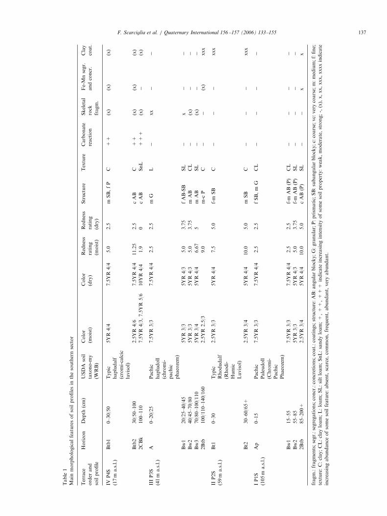
Soil profiles P1S, P2S, P3S and P4S are representative ofthe four orders of terraces sampled in the southern sector,from the oldest and highest (I order) to the youngest andlowest (IV order). The other four profiles belong to thenorthern soil chronosequence, where P11N and P12N aredifferent pedofacies of the I order (the latter close to theinner margin of the terrace, probably influenced by slopeprocesses); P2N and P4N are related to the II and IV order,

ARTICLE IN PRESSF. Scarciglia et al. / Quaternary International 156 –157 (2006) 133–155136
respectively, whereas the soil representative of the III orderis completely lacking. All these soils have many recurrentmorphological features, with some peculiarities (Tables 1and 2): they are well-structured (subangular or angularblocky to prismatic), dominantly clayey-textured andintensely rubified, with prevalent reddish brown colors(2.5YR 3/4–3/6 to 5YR 4/4–4/6). They consist of one ormore argillic (Bt) horizon(s), with common to veryabundant clay coatings stacked on aggregate outer surfacesor within pores; only soil profile P4S shows scarce illuvialclay pedofeatures. Some profiles lack the surface organic-mineral horizon and appear truncated (P2S) (Fig. 3a) and/or buried by slope deposits (P4S) (Fig. 3b) or alluvial fandeposits (P4N). Subvertical desiccation cracks, usually notless than 50–70 cm deep, occur in profiles P11N, P12N,P4N, P2S and in the buried argillic horizon (2Btb) of P3S,where also shiny faces are found; sometimes also slicken-sides have been observed (Btss horizons of P11N andP12N). Reddish brown to black iron–manganese features(mottles, coatings, soft concentrations or concretions),millimeter to centimeter in size, occur mainly in the deepargillic horizons of profiles P1S, P11N, P12N and P4N. Inparticular, in profile P11N the dark Fe–Mn coatingsalternate with whitish to pale yellow, iron-depleted, some-times reticulated, mottles (Fig. 4a). Secondary CaCO3
features are present in profiles P4S and P4N; profile P4Sincludes occasional carbonate rhizoliths, whereas P4Nexhibits large CaCO3 concretions completely filling itsdeep vertical cracks (Fig. 4b).
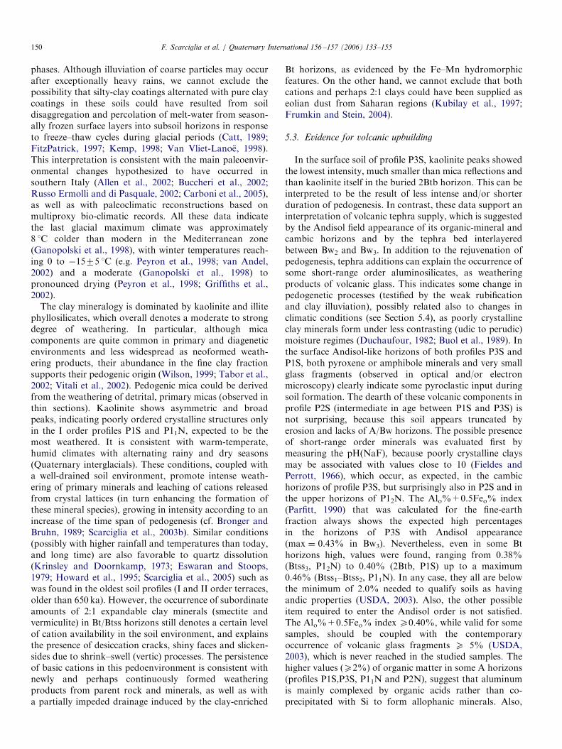
Some surface (A and Bw) horizons of profiles P3S, P1S,P11N have darker brown colors (5–7.5YR 4/3–4/4), sandyloam to clay loam textures, and also have the typical fieldappearance of volcanic soils with andic properties (sensuUSDA, 2003), such as fluffy consistence, powdery aspectwhen dry, slight stickiness and no plasticity, low bulkdensity, high porosity, water retention and weak thixo-tropy (e.g. FAO et al., 1998; Terribile et al., 1999; Cinque etal., 2000). As a whole, these properties are due to thedominance of short-range order (poorly crystalline) alumi-nosilicate minerals (allophane and imogolite) and Fe-hydroxides (ferrihydrite) that originated as typical weath-ering products of volcanic materials (frequently glassfragments) under udic to perudic soil moisture regimes(Duchaufour, 1982; Buol et al., 1989). In profile P3S, alenticular, intensely weathered tephra layer, yellowish incolor, is interbedded between horizons Bw2–Bw3 (Fig. 4c).Another yellowish brown tephra occurs a few meterswest–southwest of and about 50 cm above profile P4N.
All these soils occur on the dolomite-limestone bedrockinto which the marine terraces are carved, although atsome sites the soils developed on marine sediments formingthe depositional terraces. The substratum (possibly, atleast in part, the parent material) is not always exposedat the base of the soil profiles. Specifically, the substratumof profile P3S coincides with the carbonate bedrock(R); profiles P2S (Fig. 3a) and P1S overlie (through anabrupt lower boundary) cemented, rounded beach gravels
(horizons CBk) composed dominantly of dolomite-lime-stone, with subordinate quartzite, schist and metarenite,resting on the carbonate bedrock (P2S includes also somemarine bioclasts and crystals of feldspar); profile P4Sformed on marine sands (2CBk–2Ck) of similar composi-tion (with abundant shell fragments), partly cemented bysecondary calcite (Fig. 3b, c). Profile P11N directly occurson the dolomite-limestone bedrock, whereas the otherprofiles of the northern sector developed on mixedcarbonate, marly and aluminosilicate-rich beach sandsand/or gravels, probably supplied by the Noce River,which drains siliciclastic terrains in its headwaters.Carbonate rock fragments (millimeter to centimeter insize) constitute the scarce to common skeletal fraction(42mm), and are sometimes completely absent. Soilprofiles P4N and P2N include also abundant low-grademetamorphic crystalline rock clasts.The redness rating (RR) was calculated on the basis of
the matrix color in the Munsell notation (Torrent et al.,1980), applying the formula RR ¼ (10–H)�C/V, whereC ¼ chroma, V ¼ value and H represents the hue-relatednumerical value. The RR is higher in the soils of thenorthern sector. No definite trends can be recognized forthe soils from older to younger terraces.
4.2. Particle size and chemical data
The results of physical and chemical analyses (Tables 3and 4) depict a complex and overall similar pedogenicenvironment for the soils studied, although some featuressignificantly differ from the southern to the northernsector.Particle size analysis shows that these soils are high in
clay, higher than 30% except in a few horizons, and oftenexceeding 50%. Clear downward clay increases character-ize most of the profiles, sometimes just excluding thelowermost horizons. An exception to this is profile P3S,where the Bw3 horizon interrupts the downward increasingtrend of clay, as well as P2N, with a discontinuity markedby Bt2 and Bt3.The organic matter content is very low, generally p2%,
but reaches values of 3.4% and 5.2% in the A horizons ofprofiles P11N and P2N.Soil reaction is generally subacid to neutral, with higher
pH(H2O) values, as a whole, in the southern sector. Thesesoils are rarely strongly acid, with the lowest values(4.8–6.0) in profile P11N. The pH(NaF) ranges from 8.2to 10.3; it reaches the highest values (9.8–10.3) in thecambic horizons of profile P3S, in profile P2S and in theupper horizons (Ap-Bt-Btss2) of P12N.Field tests with a 10% HCl solution on the soil matrix
show that carbonates are absent in most profiles. Excep-tions are soils of the IV order marine terraces of bothsectors, with moderate to strong reactions in P4S and weakto strong reactions in P4N. The total CaCO3 resulting fromchemical analysis of the fine-earth fraction has extremelyvariable values: many samples show 0.0%, but elevated
ARTICLE IN PRESS
Table
1
Main
morphologicalfeaturesofsoilprofilesin
thesouthernsector
Terrace
order
and
soilprofile
Horizon
Depth
(cm)
USDA
soil
taxono-m
y
(WRB)
Color
(moist)
Color
(dry)
Redness
rating
(moist)
Redness
rating
(dry)
Structure
Texture
Carbonate
reaction
Skeletal
rock
fragm.
Fe-Mnsegr.
andconcr.
Clay
coat.
IVP4S
(17m
a.s.l.)
Btb1
0–30/50
Typic
hapludalf
(cromi-calcic
luvisol)
5YR
4/4
7.5YR
4/4
5.0
2.5
mSB,fP
C+
+(x)
(x)
(x)
Btb2
30/50–100
2.5YR
4/6
7.5YR
4/4
11.25
2.5
cAB
C+
+(x)
(x)
(x)
2CBk
100–110
7.5YR
4/3,7.5YR
5/6
10YR
4/4
1.9
0cAB
SnL
+++
(x)
�(x)
IIIP3S
(41m
a.s.l.)
A0–20/25
Pachic
hapludoll
(chromi-
pachic
phaeozem)
7.5YR
3/3
7.5YR
4/4
2.5
2.5
mG
L�
xx
��
Bw1
20/25–40/45
5YR
3/3
5YR
4/3
5.0
3.75
fAB-SB
SL
�x
��
Bw2
40/45–70/80
5YR
3/3
5YR
4/3
5.0
3.75
mAB
CL
�(x)
��
Bw3
70/80–100/110
5YR
3/4
5YR
4/4
6.67
5m
AB
SL
�(x)
��
2Btb
100/110–140/160
2.5YR
2.5/3
9.0
m-c
PC
��
(x)
xxx
IIP2S
(59m
a.s.l.)
Bt1
0–30
Typic
Rhodudalf
(Rhodi-
Humic
Luvisol)
2.5YR
3/3
5YR
4/4
7.5
5.0
f-m
SB
C�
��
xxx
Bt2
30–60/65+
2.5YR
3/4
5YR
4/4
10.0
5.0
mSB
C�
��
xxx
IP1S
(105m
a.s.l.)
Ap
0–15
Pachic
Paleudoll
(Chromi-
Pachic
Phaeozem)
7.5YR
3/3
7.5YR
4/4
2.5
2.5
fSB,m
GCL
��
��
Bw1
15–55
7.5YR
3/3
7.5YR
4/4
2.5
2.5
f-m
AB(P)
CL
��
��
Bw2
55–85
5YR
3/3
5YR
4/3
5.0
3.75
f-m
AB(P)
SL
��
��
2Btb
85–200+
2.5YR
3/4
5YR
4/4
10.0
5.0
cAB
(P)
SL
��
xx
fragm.:fragments;segr.:segregations;concr.:concretions;coat.:coatings;structure:AB:angularblocky;G:granular;P:prism
atic;SB:subangularblocky;c:coarse;vc:verycoarse;m:medium;f:fine;
texture:C:clay;CL:clayloam;L:loam;SL:siltloam;SnL:sandyloam;+
,+
+,+
++
indicate
increasingintensity
ofsomesoilproperty:weak,moderate,strong;-,(x),x,xx,xxx,xxxxindicate
increasingabundance
ofsomesoilfeature:absent,scarce,
common,frequent,abundant,veryabundant.
F. Scarciglia et al. / Quaternary International 156 –157 (2006) 133–155 137

ARTICLE IN PRESS
Table
2
Main
morphologicalfeaturesofsoilprofilesin
thenorthernsector
Terrace
order
&soil
profile
Horizon
Depth
(cm)
USDA
soil
taxonomy
(WRB)
Color
(moist)
Color
(dry)
Redness
rating
(moist)
Redness
rating
(dry)
Structure
Texture
Carbonate
reaction
Skeletal
rock
fragm.
Fe-Mnsegr.
andconcr.
Clay
coat.
IVP4N
(18ma.s.l.)
Bt 1
0–35
Typic
hapludalf
(hapli-
chromi
luvisol)
2.5YR
3/4
2.5YR
4/4
10.0
7.5
mSB
SnCL
+�
�x
Bt 2
35–80
10R
3/4
2.5YR
3/4
13.33
10.0
cSB
SnCL
+�
xx
Bt 3
80–110+
10R
3/4
2.5YR
3/4
13.33
10.0
cSB
C+
�x
xxx
IIP2N
(54m
a.s.l.)
A0–20
Typic
hapludalf
(hapli-
chromi
luvisol)
5YR
3/3
7.5YR
4/3
5.0
1.9
cSB
SL
�(x)
��
Bt 1
20–45
2.5YR
3/4
5YR
4/4
10.0
5.0
mSB
SL
�(x)
�x
Bt 2
45–100
10R
3/4
2.5YR
3/4
13.33
10.0
cP
SnCL
�(x)
�x
Bt 3
100–150
2.5YR
3/6
2.5YR
4/4
15.0
7.5
cP
SnCL
�(x)
�xxx
Bt 4
150–200+
10R
3/6
2.5YR
3/6
20.0
15.0
cP
SnC
�x
(x)
xxxx
IP11N
(129m
a.s.l.)
A0–25
Vertic
paleudalf
(chromi-
profondic
luvisol)
7.5YR
3/3
7.5YR
4/3
2.5
1.9
mSB
SCL
��
��
Bw
25–50
7.5YR
3/4
7.5YR
4/4
3.33
2.5
cSB
SC
��
��
Btss 1
50–120/130
5YR
3/4
5YR
4/4
6.67
5.0
cSB
C�
�x
x
Btss 2
120/130–180+
2.5YR
3/3
5YR
4/6
7.5
7.5
cSB,m
PSC
��
xxx
x
IP12N
(120m
a.s.l.)
Ap
0–15
Vertic
paleudalf
(profondi-
vertic
luvisol)
5YR
3/3
7.5YR
4/3
5.0
1.9
mSB
SC
�x
��
Bt
15–40/50
5YR
3/4
7.5YR
4/4
6.67
2.5
cSB
SC
�X
(x)
x
Btss 1
40/50–80
2.5YR
3/4
5YR
4/4
10.0
5.0
cP
C�
�x
x
Btss 2
80–120
2.5YR
3/4
5YR
4/6
10.0
7.5
vcP
C�
�x
xxx
Btss 3
120–160+
10R
3/4
5YR
3.5/4
13.33
6.0
vcP
SC
��
xxxx
fragm.:fragments;segr.:segregations;concr.:concretions;coat.:coatings;structure:AB:angularblocky;P:prism
atic;SB:subangularblocky;c:coarse;vc:verycoarse;m:medium;f:fine;texture:C:
clay;SC:siltyclay;SCL:siltyclayloam;SL:siltloam;SnC:sandyclay;SnCL:sandyclayloam;+
,+
+,+
++
indicate
increasingintensity
ofsomesoilproperty:weak,moderate,strong;�,(x),x,xx,
xxx,xxxxindicate
increasingabundance
ofsomesoilfeature:absent,scarce,
common,frequent,abundant,veryabundant.
F. Scarciglia et al. / Quaternary International 156 –157 (2006) 133–155138

ARTICLE IN PRESS
Fig. 3. (a) Soil profile P2S, truncated at the top; (b) soil profile P4S, buried by slope deposits. The substratum of both soils consists of calcareous marine
sediments, partly cemented by secondary calcite (2CBk–2Ck); (c) a detail of the marine sands deposited on the IV order wave-cut platform and underlying
profile P4S.
Fig. 4. (a) A detail of profile P11N (horizon Btss2), where black Fe–Mn coatings (white arrows) and whitish eluviated mottles (black arrows) alternate; (b)
soil profile P4N: note the CaCO3 concretions completely filling its deep vertical cracks; (c) soil profile P3S, showing a lenticular tephra layer (dashed curve
and white arrow) between horizons Bw2 and Bw3.
F. Scarciglia et al. / Quaternary International 156 –157 (2006) 133–155 139
percentages (1.9–7.8%, with a maximum value of 50% inthe A horizon of profile P3S) occur even where there wasno HCl reaction of the matrix; the overall higher values arein profile P4S (6.7–56.7%).
CEC is low to moderate, ranging between 10.1 and25.6 cmol(+) kg�1. It is well related to the amount of clayin the northern sector and at a lesser extent in the southernone, whereas it is not correlated with the organic mattercontent. The exchangeable bases show high amounts of Caand Mg in all samples, whereas Na and K are much lower,except in profile P4S.
4.3. Soil micromorphology
Micromorphological analysis of thin sections enabled usto distinguish the main primary components of these soils.Very rare to frequent carbonate (mainly dolostone anddolomite-limestone) rock fragments, as well as dolomiteand some calcite crystals occur (Fig. 5a), particularly
abundant in profile P2S. Soil profiles P4N and P2N includealso abundant aluminosilicate, low-grade metamorphicrocks, rich in quartz, chlorite and/or amphibole, epidoteor plagioclase, very frequent slate and metaquartzite,occasional very low-grade metabasite (mafic chemistry)and rare phyllite skeletal grains. Frequent to abundantquartz and feldspar crystals were recognized (Fig. 5a) in allsamples (dominating over carbonate components in mosthorizons), with rare to occasional micas. Occasionalcarbonate and rare cherty shell fragments of marineorganisms occur in horizon Btb2 of profile P4S, wherethey become abundant in the underlying sedimentarylayers (2CBk and 2Ck). In addition, clinopyroxenes andrare amphiboles were identified in the surface horizons(A and Bw horizons) of profiles P1S and P3S. All thesemineral grains show dominant physical breaking patterns,and a wide range of chemical weathering features (solutionpits or lines, clay neogenesis, Fe-oxide staining). The degreeof chemical weathering varies from weak or moderate to

ARTICLE IN PRESS
Table
3
Main
chem
icalandphysicalfeaturesofsoilprofilesin
thesouthernsector
Terrace
order
andsoilprofile
Horizon
Depth
(cm)
Particle
size
distribution
pH
Exchangeable
basescm
ol(+)/kg
Sand%
Silt%
Clay%
H2O
NaF
CaCO
3O.M
.*(g/kg)
CEC**cm
ol(+)/kg
Mg
Ca
KNa
IVP4S
Btb
10–30/50
17.2
37.4
45.4
7.4
9.2
11.5
0.3
23.1
8.6
6.5
0.1
15.7
Btb
230/50–100
25.0
29.6
45.4
7.3
9.2
7.7
1.7
23.9
9.4
6.5
0.1
15.5
2CBk
100–110
60.0
20.0
20.0
7.3
9.3
56.7
1.0
10.7
5.8
6.0
0.1
5.6
IIIP3S
A0–20/25
49.2
29.4
21.4
7.1
9.5
50.0
21.5
23.1
5.0
18.1
0.6
0.1
Bw1
20/25–40/45
22.6
44.0
33.4
7.2
10.2
0.0
14.1
22.3
8.2
17.4
0.8
0.8
Bw2
40/45–70/80
26.4
40.2
33.4
7.0
10.3
2.9
4.7
22.5
7.4
18.7
1.1
2.5
Bw3
70/80–100/
110
22.6
51.4
26.0
7.2
10.0
1.9
3.0
25.6
6.5
24.7
0.2
3.2
2Btb
100/
110–140/160
5.0
31.0
64.0
6.7
—2.9
2.7
22.3
6.0
23.2
0.2
0.3
IIP2S
Bt 1
0–30
9.8
32.8
57.4
7.1
9.8
2.9
15.1
17.8
10.7
15.5
0.7
0.6
Bt 2
30–60/65+
9.0
25.6
65.4
7.1
10.1
1.9
14.1
19.0
11.9
17.7
0.8
0.7
IP1S
Ap
0–15
26.0
38.6
35.4
6.6
9.2
4.8
20.8
11.0
4.5
6.6
0.9
0.3
Bw1
15–55
23.8
40.8
35.4
6.4
8.7
0.0
15.8
11.3
4.5
5.0
0.8
0.7
Bw2
55–85
22.0
36.6
41.4
6.1
9.1
0.0
13.8
11.4
5.3
4.7
0.6
0.7
2Btb
85–200+
20.8
37.2
42.0
6.1
-0.0
3.0
12.1
5.8
4.5
0.6
0.4
*¼
organic
matter;**¼
cationexchangecapacity.
F. Scarciglia et al. / Quaternary International 156 –157 (2006) 133–155140

ARTICLE IN PRESS
Table
4
Main
chem
icalandphysicalfeaturesofsoilprofilesin
thenorthernsector
Terrace
order
andsoilprofile
Horizon
Depth
(cm)
Particle
size
distribution
pH
Exchangeable
basescm
ol(+)/kg
Sand%
Silt%
Clay%
H2O
NaF
CaCO
3%
O.M
.*g/kg
CEC**cm
ol(+
)/kg
Mg
Ca
KNa
IVP4N
Bt 1
0–35
63.0
11.0
26.0
7.2
9.5
6.8
0.7
10.6
1.9
14.8
0.8
5.3
Bt 2
35–80
58.8
13.2
28.0
7.2
9.3
3.9
1.0
11.8
5.3
16.0
0.7
5.0
Bt 3
80–110+
26.0
30.0
44.0
7.2
9.2
0.0
0.7
15.0
7.0
16.0
0.9
4.8
IIP2N
A0–20
22.0
40.0
38.0
6.3
9.1
0.0
33.8
16.8
9.1
12.0
1.8
5.7
Bt 1
20–45
20.6
28.1
51.3
6.2
8.8
2.9
12.1
14.8
7.4
8.2
0.8
6.1
Bt 2
45–100
55.8
14.2
30.0
6.1
8.8
0.0
5.4
10.1
5.7
6.2
0.5
5.3
Bt 3
100–150
51.4
14.6
34.0
6.2
8.8
0.0
3.7
9.3
5.8
6.0
0.4
5.3
Bt 4
150–200+
61.6
2.4
36.0
6.2
8.8
5.8
3.3
10.2
6.2
6.0
0.4
5.1
IP11N
A0–25
15.4
50.6
34.0
6.0
8.2
0.0
52.2
19.2
8.2
12.2
1.7
5.4
Bw
25–50
10.0
44.0
46.0
5.4
8.7
3.9
20.8
19.0
6.2
6.2
1.8
5.2
Btss 1
50–120/130
7.8
34.2
58.0
5.3
8.9
7.8
7.4
16.3
5.8
5.8
1.7
1.1
Btss 2
120/
130–180+
9.8
40.2
50.0
4.8
9.0
0.0
4.4
15.7
5.3
4.2
1.0
1.7
IP12N
Ap
0–15
8.2
45.8
46.0
7.0
9.9
5.9
20.8
22.4
16.8
20.9
0.8
5.6
Bt
15–40/50
6.0
40.0
54.0
7.1
9.8
2.9
13.4
22.9
15.6
19.7
0.6
4.9
Btss 1
40/50–80
5.0
37.0
58.0
7.0
9.8
2.9
5.0
23.4
15.6
18.7
0.6
4.7
Btss 2
80–120
4.2
33.8
62.0
7.1
9.6
0.0
3.7
24.3
17.6
20.0
0.7
4.9
Btss 3
120–160+
4.0
40.0
56.0
7.0
9.6
0.0
2.0
24.1
18.9
19.0
0.6
4.8
*¼
organic
matter;**¼
cationexchangecapacity.
F. Scarciglia et al. / Quaternary International 156 –157 (2006) 133–155 141

ARTICLE IN PRESS
Fig. 5. XPL photomicrographs of: (a) calcite and dolomite mineral grains
surrounding a crystal of feldspar (profile P3S, horizon A); (b) moderately
anisotropic matrix (P2S, Bt2) with some diagonal anisotropic domains
(right bottom side); some laminated clay coatings (white arrows) show
almost sharp extinction bands to grainy appearance.
F. Scarciglia et al. / Quaternary International 156 –157 (2006) 133–155142
very strong. Carbonate components are frequently amongthe most weathered detrital grains, and become rarer in theoldest soils except in profile P2S. Profiles P4S and P4N(pertaining to the IV order of terraces) show the lowestdegree of weathering, as a whole. They also includedifferent forms of secondary calcite precipitation.
Abundant clay coatings occur in the argillic horizons,although they are often difficult to recognize because theyare masked by the opacity of iron-oxides and appearstrongly assimilated into the soil matrix. The coatingsexhibit intensely speckled extinction patterns in crossedpolarized light (XPL). Only rarely do small remnants ofwell-preserved clay coatings or infillings occur; thesefeatures show smooth or broken extinction bands to grainyappearance in XPL. Occasionally, microlaminated silty-clay coatings alternate with pure clay coatings; the coatingsappear fragmented, sometimes merging towards thesurrounding soil matrix, and showing smooth-banded,
fan-shaped or grainy extinction patterns. The matrix isclayey, widely and intensely iron-stained (red to reddish-yellow and yellowish-red in color), moderately to highlyanisotropic, with some irregular to diagonal, right linear(occasionally crossed) anisotropic domains (Fig. 5b).Anisotropic aureoles may surround mineral grains or smallrock fragments. Fe–Mn features consist of dark reddish-brown to reddish-black, generally irregularly shapedsegregations, and more rarely rounded, massive orconcentric-layered concretions. In the organic-mineraland cambic horizons, the matrix is dark reddish-brown toyellowish-brown, with no to very weak to moderate opticalanisotropy (XPL). Occasional strongly anisotropic do-mains occur. Also in some Bw horizons (profiles P1S andP3S), scarce to occasional clay coatings have beenrecognized: they are microlaminated and appear almostfresh, with sharp to slightly smooth, broadened extinctionbands, but are often fragmented. Rarely they show grainyextinction patterns.SEM observations indicate the same physical and/or
chemical weathering patterns identified on sand grains byoptical microscopy, and further enabled identification ofimportant microtextures. Most mineral grains have sub-rounded to rounded shapes, worn and abraded outersurfaces, frequent upturned plates and dish-shaped depres-sions (Fig. 6a). In contrast, frequent subangular outlinesprevail in topsoil horizons of profiles P1S, P3S and P11N.Solution lines and pits increase in soil horizons as terraceage increases. Even quartz mineral grains are severelyweathered in the soils formed on the oldest marine terraces(P1S and P11N, I order; P2S and P2N, II order), withevidence of chemical etching (Fig. 6b, c) and amorphous ormicrocrystalline reprecipitation forms (Fig. 6d). Moreover,SEM-EDS analysis enabled us to identify other primarycomponents not detected in the field or in opticalmicroscopy, such as rare and extremely small glassfragments, about 30–160 mm in size, and with a trachyticchemical composition (62.30 o SiO2 o 64.34%; 10.19 oNa2O+K2O o 11.63%). Three main types of variablyweathered glass fragments were observed in A and Bwhorizons of P1S and P3S surface soils. These fragments arecharacterized by: (1) vesiculated structure with elongatedvacuoles (and sometimes conchoidal fractures), exhibitingvery abundant, rounded and concave etch pits on thesurface (Fig. 7a); (2) fibrous appearance with narrow linearvesicles, severely etched by deep irregular holes (Fig. 7b);(3) blocky structure with cracks affecting the outershell (quenching, i.e. hydromagmatic shrinkage for rapidcooling), very slightly weathered (Fig. 7c). In addition,the pyroxenes found in the same A and Bw horizons ofprofiles P1S and P3S show a Ca–Mg composition (diop-side) rich in Ti.
4.4. Clay mineralogy
All soil horizons of the examined profiles showed amineralogy dominated by kaolinite and mica (possibly

ARTICLE IN PRESS
Fig. 6. SEM images of (a) a rounded quartz grain (profile P3S, horizon A), showing worn, abraded outer surfaces, a dish-shaped depression (black arrow)
and upturned plates (white arrow); deeply etched quartz grains from horizon 2Btb of profile P1S (b) and Btss1 of profile P11N (c); (d) close-up of
microcrystalline quartz overgrowths on a quartz sand grain (profile P2S, horizon Btb1).
Fig. 7. SEM images showing (a, b, c) different types of volcanic glass fragments (profile P3S, horizon Bw3) (see the text for details); (d) open-book
arrangement of kaolinite clay platelets (profile P11N, horizon Btss1).
F. Scarciglia et al. / Quaternary International 156 –157 (2006) 133–155 143
illite) components in the fine clay fraction (o0.2 mm), easilyidentified by the main XRD basal reflections on Mg-saturated specimens (Figs. 8 and 9). Kaolinite peaks persist
in Mg EG-solvated and in K-saturated samples, whereasthey collapse after heating at 550 1C. Although also Fe-richchlorite may dehydroxylate and collapse at 550 1C, the

ARTICLE IN PRESS
10 20 305 15 25 35
Bw1
Bw3
10 20 305 15 25
Mg
35
K
K
K
K
K
I
K
I
I
I
IC
C
C
C
I
V C
Sm
I
IC
IK
C
MgEG
K
C
P3S (Mg)
2Btb
K 335
P4S Btb1
I
V
(a) (b)
Fig. 8. XRD patterns of fine clays from profiles P3S (a) and P4S (b). I: illite; K: kaolinite; V: vermiculite; C: chlorite; Sm: smectite.
10 20 305 15 25
Mg
35
P11N Bw
K
MgEG
10 20 305 15 25
Mg
35
K
MgEG
I
I
I
I
I
K
K
K
K
KI
K
K
K
I
I
I
I
SmV
V Sm
Bt2P2N
K 335
K 550
Fig. 9. XRD patterns of fine clays from profiles P2N (a) and P11N (b). I: illite; K: kaolinite; V: vermiculite; Sm: smectite.
F. Scarciglia et al. / Quaternary International 156 –157 (2006) 133–155144
frequent, contemporary occurrence of the 002 kaolinitereflection at 3.58 A and the 004 chlorite reflection at 3.54 A(when the latter mineral is present, see below) confirms thatkaolinite effectively occurs. Kaolinite shows similar ormore intense peaks than mica in all samples except inprofile P3S (excluding the 2Btb horizon). Mica generally
shows asymmetrical and sometimes broad peaks, indicat-ing possible mixed-layer components. In some samples, the001 reflections tend to expand (and migrate towards low 2yvalues) after EG solvation, whereas they partly contract inK-saturated specimens (P12N, Btss1), indicating possibleillite–smectite intergrades; in horizons Btss1 and Btss2 of

ARTICLE IN PRESSF. Scarciglia et al. / Quaternary International 156 –157 (2006) 133–155 145
profile P11N, significant peak narrowing and intensificationoccurs after K-saturation, suggesting interlayering of illitewith vermiculite. Kaolinite basal reflections are morefrequently sharp and symmetrical, although asymmetricand broad peaks (indicative of disordered crystallinestructures) appear in profiles P1S and P11N (I orderterraces). In P2S also, some kaolinite–smectite mixed layerscan be interpreted from slightly broad 001 reflections ofkaolinite that undergo weak expansion (Mg-EG treatment)and contraction (K treatment). Other diagnostic peakswere detected in some soils (P4S, P12N, P2N, P4N andhorizons Btss1–Btss2 of P11N). The 001 basal reflection at13.92–14.60 A, identified on Mg-saturated samples, con-tracts to the 10 A peak (which grows in intensity) afterK-saturation (vermiculite) or after heating at 335 1C (HIV,i.e. hydroxy-interlayered vermiculite). HIV occurs, to-gether with vermiculite, only in horizons Ap of profileP12N and Bt3–Bt4 of P2N. Small amounts of chlorite maybe present in some horizons of P4S, P12N and P2N, wherepeaks around 14, 4.7 and 3.54 A decrease in intensity butdo not completely disappear after 335 1C treatment. Inparticular, the 003 reflection of chlorite at 4.7 A enables usto easily separate this clay mineral from kaolinite (seeabove). XRD patterns permitted us to recognize smectiteclay minerals, by d-spacings of 14.60 A that expand to 17 Aand contract to 12 A after EG (on Mg-saturated samples)and K treatments, respectively (horizons 2Btb of profileP3S, Bw of P11N, Btss2–Btss3 of P12N, Bt1 of P4N).
SEM-EDS analysis confirmed the main clay mineralogydetected from XRD patterns. Abundant illite, showing notwell-shaped to very irregular platelets, was identified by aSi/Al ratio close to 2, low K content and very small or zeroamount of other basic cations. A chemical compositionwith Si/AlE1 and no other bases, coupled with the pseudo-hexagonal morphology of clay platelets, sometimes ar-ranged in a typical open-book structure, allowed us torecognize kaolinite (Fig. 7d). Some interstratified illite–s-mectite minerals with the typical filamentous shape (e.g.Welton, 1984) were also detected, and different, irregularlyshaped, 2:1 phyllosilicate clays (with Si/Alp2 and variableamounts of different basic cations such as K, Mg, Fe andNa). No evidence of short-range order aluminosilicates wasfound.
4.5. Fe forms and geochemical indices
Some geochemical indices estimating the different Feforms and degree of pedogenetic maturity were calculatedon the basis of major element compositions and results ofselective extraction techniques (Tables 5 and 6). Total ironcontent (Fet) in the fine earth fraction is moderate to quitehigh (3.73–8.10%), with more than half of the sampleshigher than 6%. The amount of Fed, estimating total(crystalline and amorphous) free iron oxides/hydroxides, isrelatively elevated, with higher amounts in profile P2S(3.11–3.29%), the P3S buried soil (3.04%) and the upperhorizons of P2N (3.03–3.45%). Conversely, the ammo-
nium-oxalate extractable forms, estimating the amountsrelated to poorly crystalline components, are always verylow (Feo p0.40%, Alo p0.36% and Sio rarely reaching0.11%). The difference Fet–Fed, which indicates the ironcontent in primary minerals, is extremely variable, rangingbetween 0.78 and 7.20.On the basis of these data, the weathering index
(Fed–Feo)/Fet (Fig. 10a) and the Fed/Fet ratio (Fig. 10b)were calculated. These ratios are based on the fact that freeiron forms (Fed) and crystalline iron forms (Fed–Feo) tendto increase with the degree of pedogenic evolution. Higherrates of both characterize the soils of the I and II orderterraces, with maxima in profile P2N (II), and converselylower values in the lower terrace (III–IV) soils. No definitetrends occur within single profiles, sometimes showing ageneral decrease with depth (P11N—only for the firstindex—and P4S), sometimes an opposite tendency (P2Sand P4N), but more often a discontinuous behavior. Theburied argillic horizons (2Btb) of both profiles P1S and P3Sexhibit higher values than the overlying topsoils. The Feo/Fed ratio gives an indication of the amount of amorphousagainst crystalline iron forms; the ratio is always very low,occasionally reaching approximately 0.1, indicating well-crystallized iron forms.Also an estimation of andic properties (USDA, 2003)
related to possible short-range order minerals was achievedon the basis of the Alo%+0.5Feo% index (Parfitt, 1990) inthe fine-earth fraction (Fig. 11). As a whole, this indexappears very low, with higher values and maxima around0.40% both in rubified argillic (e.g. Btss1–Btss2 of P11N)and organic-mineral or cambic horizons with Andisol-likeappearance (Bw1–Bw3 of P3S).
5. Discussion
5.1. Morphological, physical and chemical soil features
On the basis of the data obtained, all soil profiles studiedare classified as Alfisols or Mollisols (USDA, 2003). Inparticular, they have been classified as follows: P1S andP3S as Pachic Paleudoll and Pachic Hapludoll, respectively(Chromi-Pachic Phaeozems, according to the WRB tax-onomy, FAO et al., 1998); P2S as a Typic Rhodudalf(Rhodi-Humic Luvisol); P4S as a Typic Hapludalf (Cromi-Calcic Luvisol); P11N and P12N as Vertic Paleudalfs(Chromi-Profondic Luvisol and Profondi-Vertic Luvisol,respectively); and P2N and P4N as Typic Hapludalfs(Hapli-Chromi Luvisols). They all show a high degree ofweathering, as a whole, indicated by well-developedhorizonation and aggregate structure, rubification, and avariety of soil features in many horizons (clay coatings,slickensides, iron–manganese segregations and concretions,CaCO3 reprecipitation forms). Also the high percentages ofthe clay fraction, which may represent the main product (asneoformed clay minerals) of intense weathering of primarycomponents, suggest a high degree of pedogenetic matur-ity. Moreover, the downward increase of clay within the

ARTICLE IN PRESS
Table 5
Some geochemical data of the profiles
Terrace order and soil profile Horizon Fet % Fed % Feo % Alt % Ald % Alo % Sio %
IV P4S Btb1 7.61 2.20 0.08 17.46 0.24 0.09 0.04
Btb2 7.69 2.31 0.09 9.37 0.24 0.11 0.05
2CBk 7.93 0.73 0.06 14.14 0.10 0.06 0.02
III P3S A 3.73 0.88 0.02 7.35 0.06 0.07 0.02
Bw1 6.13 1.85 0.13 16.06 0.18 0.26 0.08
Bw2 6.08 1.59 0.18 16.84 0.18 0.23 0.08
Bw3 6.22 1.56 0.21 17.12 0.18 0.32 0.11
2Btb 7.27 2.38 0.14 13.38 0.16 0.21 0.08
II P2S Bt1 5.86 3.29 0.08 11.17 0.19 0.22 0.05
Bt2 5.17 3.11 0.10 11.47 0.17 0.22 0.05
I P1S Ap 5.87 2.98 0.12 10.78 0.24 0.09 0.03
Bw1 7.20 2.86 0.19 13.48 0.23 0.12 0.02
Bw2 6.43 3.23 0.26 11.98 0.24 0.16 0.03
2Btb 4.19 3.04 0.40 11.22 0.29 0.20 0.04
IV P4N Bt1 7.52 1.78 0.10 17.53 0.09 0.11 0.04
Bt2 8.10 2.23 0.09 8.81 0.07 0.09 0.03
Bt3 5.55 2.55 0.11 10.69 0.10 0.13 0.05
II P2N A 4.64 3.03 0.09 11.15 0.25 0.16 0.03
Bt1 7.05 3.45 0.07 14.01 0.28 0.15 0.03
Bt2 3.86 3.08 0.08 7.83 0.21 0.17 0.02
Bt3 7.13 2.46 0.07 8.42 0.16 0.11 0.02
Bt4 8.06 2.78 0.08 10.46 0.17 0.13 0.02
I P11N A 5.78 2.87 0.14 7.80 0.22 0.19 0.03
Bw 7.02 3.17 0.16 14.08 0.26 0.23 0.03
Btss1 7.19 2.73 0.19 12.02 0.21 0.36 0.06
Btss2 6.73 2.56 0.28 9.35 0.16 0.32 0.06
I P12N Ap 4.76 2.64 0.13 11.09 0.18 0.24 0.08
Bt 4.45 2.92 0.11 11.43 0.22 0.21 0.06
Btss1 6.07 2.65 0.12 11.38 0.27 0.27 0.09
Btss2 5.36 2.80 0.17 10.12 0.21 0.24 0.09
Btss3 7.57 2.41 0.24 16.20 0.17 0.26 0.11
F. Scarciglia et al. / Quaternary International 156 –157 (2006) 133–155146
profiles along with abundant clay coatings in the horizonswith higher clay content are all consistent with clayilluviation as a major pedogenetic process. Where thebottom horizons have lower clay amounts, a strongerinfluence of the parent material appears. The lack of acarbonate reaction (10% HCl test) in almost each profiledenotes complete leaching of CaCO3 from the soil matrix.The only exceptions are P4S and P4N, which showed amoderate and weak to strong reaction, respectively. This isconsistent with their younger age, as they represent thesoils of the IV order terraces of both northern and southernsubsectors, where leaching is not yet complete. Thepolygenesis of the parent material, including rocks andminerals different from the carbonate substratum, preventsus from reliably estimating rates of CaCO3 removal, andinstead just provides an indication of the average time spanlonger than 400–500 ka (suggested by the terrace ages) forcomplete leaching in this type of soil environment. It is notsurprising that the total CaCO3 (in the fine-earth fraction)measured in the laboratory shows extremely variablecontent and random distribution, despite the approxi-
mately homogeneous behavior observed with the field test(on the soil matrix only). In fact, this discrepancy is notconflicting with a leached soil matrix, where different kindsof carbonate skeletal grains (dolomite, calcite crystals anddifferent carbonate rocks) and/or concretions are scatteredin the profiles (identified in thin section and sometimes inthe field) are still preserved, and can locally alter the totalCaCO3 content. The average constant amounts of total Caand Mg within soil profiles (data from XRFS, not shown)are always lower than 4% and 2%, respectively, withirregular oversize peaks reaching about 15–22% for Ca (insamples P2N-Bt2 and P3S-A) and 6–10% for Mg (in thesame samples), supporting the prominent influence ofprimary skeletal grains inducing abrupt change (increase)in what is an homogeneous trend overall. Similarconsiderations may explain the pH(H2O) values. Theweakly acid to neutral reaction indicates a moderatelyleached soil environment, as a whole; in particular, the soilsevolved on the oldest terraces (I order) are characterized bythe lower values (up to strongly acidic of P11N), exceptprofile P12N, where soil pH may be balanced by the

ARTICLE IN PRESS
Table 6
Some geochemical and weathering indices of the profiles
Terrace order and soil profile Horizon Fet-Fed Fed/Fet Feo/Fed (Fed–Feo)/Fet Alo%+0.5Feo%
IV P4S Btb1 5.41 0.29 0.04 0.28 0.13
Btb2 5.38 0.30 0.04 0.29 0.15
2CBk 7.20 0.09 0.08 0.08 0.09
III P3S A 2.85 0.24 0.02 0.23 0.08
Bw1 4.28 0.30 0.07 0.28 0.33
Bw2 4.49 0.26 0.11 0.23 0.32
Bw3 4.66 0.25 0.14 0.22 0.43
2Btb 4.89 0.33 0.06 0.31 0.28
II P2S Bt1 2.57 0.56 0.03 0.55 0.26
Bt2 2.06 0.60 0.03 0.58 0.27
I P1S Ap 2.89 0.51 0.04 0.49 0.15
Bw1 4.34 0.40 0.07 0.37 0.22
Bw2 3.20 0.50 0.08 0.46 0.29
2Btb 1.15 0.72 0.13 0.63 0.40
IV P4N Bt1 5.74 0.24 0.06 0.22 0.17
Bt2 5.87 0.27 0.04 0.26 0.13
Bt3 3.00 0.46 0.04 0.44 0.19
II P2N A 2.64 0.43 0.03 0.41 0.21
Bt1 3.60 0.49 0.02 0.48 0.18
Bt2 0.78 0.80 0.02 0.78 0.21
Bt3 4.67 0.34 0.03 0.34 0.14
Bt4 5.28 0.34 0.03 0.33 0.17
I P11N A 2.91 0.50 0.05 0.47 0.26
Bw 3.85 0.45 0.05 0.43 0.32
Btss1 4.46 0.38 0.07 0.35 0.46
Btss2 4.17 0.38 0.11 0.34 0.46
I P12N Ap 2.12 0.55 0.05 0.53 0.30
Bt 1.53 0.66 0.04 0.63 0.26
Btss1 3.42 0.44 0.05 0.42 0.33
Btss2 2.56 0.52 0.06 0.49 0.33
Btss3 5.16 0.32 0.10 0.29 0.38
F. Scarciglia et al. / Quaternary International 156 –157 (2006) 133–155 147
presence of carbonate rock fragments. It is also possiblethat profile P12N may have received additions of Ca tosoils by manure application, since this profile occurs underan olive field (all other profiles occur in uncultivatedcontexts). The overall lower pH values characterizing thenorthern sector, may also be due to a higher supply ofaluminosilicate minerals in this zone, which were probablytransported by the Noce River.
Soil organic matter is very low, as expected by thecompetition between humification and rubification(Schwertmann and Taylor, 1989). Moreover, the commonlack of A horizons (which have higher amounts), coupledwith the dominance at the surface of argillic horizons withabrupt upper boundaries, may be evidence of truncationand erosion. The small amounts of organic matter implythat clay minerals give the major contribution to CEC. Thelow CEC values suggest the dominance of non-expandingclays (namely kaolinite and mica) with other minorcomponents, confirmed by the XRD mineralogical analy-sis. The very small amount of exchangeable Na and K,especially in the southern sector, denotes a highly leached
soil environment, on the whole. The highest Na contentfound in P4S may be presumably ascribed to sea waterspray, due to the closeness of the site to the presentcoastline and its low elevation a.s.l. The high content of Caand Mg in the exchange complex of all samples isconsistent with the mineralogy of the dolomite-limestoneparent rock, and with the high degree of chemicalweathering of carbonate skeletal grains, inducing greatavailability of these bases in the soils. Their smalleroccurrence in profiles P1S and P11N (developed on I ordermarine terraces) points out significant leaching of the soilson the older terraces, as a consequence of a longer time ofexposure. A partly allochthonous origin of these cations aslong-distance windblown dust possibly sourced from theSahara desert cannot be excluded (Kubilay et al., 1997;Frumkin and Stein, 2004).According to the relatively high RR (all hues
2.5YR–5YR, and subordinately 7.5YR) calculated for thesoils, a significant amount of hematite is inferred to occurin these soils (Torrent et al., 1983; Diaz and Torrent, 1989).In addition, the rather elevated content of Fed (as well as

ARTICLE IN PRESS
I P11N
IV P4N
I II P2S
III P3SIV P4SBtb1
Btb2
2CBk
A Bw1
Bw2
Bw3
2Btb1
Bt1Bt2
Bt1Bt2
A Bt1Bt2Bt3Bt4
A BwBtss1
Btss2
ApBw1
Bw2
2Btb
ApBtBtss1
Btss2
Btss3
Bt3
I P11N
II P2N
IV P4N
I P12N
I P1S
II P2S
III P3SIV P4S
Fed/Fet
Southern sector Northernsector
(Fed-Feo)/Fet
Southern sector Northern sector
II P2N
I P1S
1.00
0.80
0.60
0.40
0.20
0.00
1.00
0.80
0.60
0.40
0.20
0.00
(a)
(b)
P12N
Btb1
Btb2
2CBk
A Bw1
Bw2
Bw3
2Btb1
Bt1Bt2
Bt1Bt2
A Bt1Bt2Bt3Bt4
A BwBtss1
Btss2
ApBw1
Bw2
2Btb
ApBtBtss1
Btss2
Btss3
Bt3
Fig. 10. Diagrams reporting (a) the weathering index (Fed–Feo)/Fet and (b) the Fed/Fet ratio (b) for all soil profiles. Terrace and soil age of each subsector
increases from left to right.
I
II P2NIV P4N
I P12NI P1S
II P2S
III P3S
IV P4S
0.00
0.07
0.14
0.21
0.28
0.36
0.43
0.50Southern sector
Alo%+0.5Feo%
Northern sector
P11N
Btb1
Btb2
2CBk
A Bw1
Bw2
Bw3
2Btb1
Bt1Bt2
Bt1Bt2
A Bt1
Bt2Bt3
Bt4
A BwBtss1
Btss2
Ap
Bw1
Bw2
2Btb
Ap
BtBtss1
Btss2
Btss3
Bt3
Fig. 11. Diagram showing the Alo%+0.5Feo% index in the fine-earth
fraction of all soil profiles. Terrace and soil age of each subsector increases
from left to right.
F. Scarciglia et al. / Quaternary International 156 –157 (2006) 133–155148
the total iron and the difference Fet–Fed, allowing ironavailability in the soil environment) account for therubification of most soil horizons. In fact, Fed estimatesthe amount of free iron occurring in oxides/hydroxides(Fed–Feo indicating the crystalline forms, such as hematite
and goethite), whereas Fet–Fed values are an estimation ofthe iron content still present in primary minerals. Thedearth of goethite-dominated horizons can be inferred, assoil horizons with yellowish–brown colors (hue 10YR) arelacking (Torrent et al., 1983).The weathering indices (Fed–Feo)/Fet and Fed/Fet did
not show a very clear trend of increase with terrace (andsoil) age, observed in other soil chronosequences of theMediterranean area (cf. Diaz and Torrent, 1989; Bech etal., 1997; Simon et al., 2000). In any case, Fed is moreelevated in the soils of the I and II order terraces, whereas itis lower on the III and IV order, according to their age. Inparticular, higher mean rates of (Fed–Feo)/Fet and Fedoccur in profiles P2S and P2N (the latter showing theabsolute maximum values, inconsistent with the relativeterrace age), pertaining to the II order. This suggests thatpossible reworking of material affected by previouspedogenetic cycle(s) was inherited by the soils at issue,which underwent further pedogenetic evolution in situ,thus increasing their weathering degree and accumulatingthe amount of crystalline and free iron oxides. Thishypothesis is supported by (i) the highest values of RRsmeasured for the II order soil of each sector; (ii) theparticularly abundant clay percent in profile P2S, alsoshowing (iii) an abrupt lower boundary towards thecemented BC horizon and (iv) being truncated at the top

ARTICLE IN PRESSF. Scarciglia et al. / Quaternary International 156 –157 (2006) 133–155 149
(and therefore recording intense geomorphic dynamics); (v)the irregular trend of the particle size distribution, as wellas (vi) abrupt changes in the (Fed–Feo)/Fet and the Fed/Fetratios within profile P2N, suggesting parent materialdiscontinuities (cf. Bech et al., 1997; Scarciglia et al.,2003b), and (vii) its location towards the mouth of theNoce River, where the fluvial sedimentary supply verylikely could have delivered also some soil sediments(reworked, partly pedogenized material) from the upperreaches of the catchment.
5.2. Evidence for relict soil features
All soil profiles studied are characterized by one or moreargillic horizons. The great abundance of clay coatingsindicates that illuvial processes are of prominent impor-tance in the formation of these soils. Warm and humidclimates characterized by markedly contrasting winter(wet) and summer (dry) precipitation regimes causeseasonal soil moisture availability and water deficits,respectively. These alternating conditions permit claysuspensions to form and be translocated down profile,where subsequent capillary water evaporation allows claycoatings to adhere and stack within soil pores. However,the dominance of grainy extinction patterns observedunder the microscope (XPL) in Bt horizons, indicates thatthese pedofeatures are not fresh, having undergone anintense degeneration of their original internal fabric.Degeneration of the initially strong continuous, parallelorientation of the clay coatings (inducing high opticalanisotropy and consequent sharp extinction bands) occursbecause of internal stress that produces domains with arandom distribution of the coating components (FitzPa-trick, 1984; Kemp, 1998; Scarciglia et al., 2003a, b). Theanisotropic domains of the matrix could be the result of anadvanced degradation and assimilation of old clay coatings(which may be consequently less distinguishable andunderestimated) into the soil matrix itself. As a conse-quence, clay coatings have to be considered as essentiallyrelict features, not related to present-day pedogeneticprocesses and environments. In temperate areas ofmiddle-latitudes such as the Mediterranean basin, claycoatings are considered typical features of past Quaternaryinterglacials (Catt, 1989; Fedoroff, 1997; Scarciglia et al.,2005). Overall warmer and more humid conditions than thepresent with sharper seasonal contrast, that are generallybelieved to be more favorable for clay illuviation, areindicated by high-resolution paleoclimatic data (Orombelli,1997; Felis et al., 2004; NGRIP members, 2004). Despitethe inhomogeneous, complex character of both glacials andinterglacials due to short-term climatic subcycles (SanchezGoni et al., 1999; Kukla et al., 2002; Sangiorgi et al., 2003;Chondrogianni et al., 2004; Klotz et al., 2004), theoccurrence of long-term phases characterized by relativeclimatic and geomorphic stability and overall mild condi-tions is documented well for Quaternary interglacials. Mildinterglacial conditions thus enhanced soil development,
especially when coupled with extensive spreading oftemperate forest landscapes, strong decrease of slopewasting processes and eolian transport/sedimentation,and frozen ground disappearance (e.g. Winograd et al.,1997; Cheddadi et al., 1998; Ortiz et al., 2002; Antoine etal., 2003). The fact that even in mid-latitudes illuvial claypedofeatures are often degenerated, partially disruptedand/or superimposed by cryogenic features due to perma-frost or seasonal ice freezing during glacial periods (Catt,1989; Kemp, 1998; Kuhn, 2003; Scarciglia et al., 2003a)strongly supports the hypothesis that argillic fabrics in theMediterranean area formed mainly during interglacials.Also the development of shiny faces and slickensides isfavored by warm-humid, seasonally contrasting conditionsthat enhanced wetting–drying cycles and consequentshrink–swell dynamics. Since the reddening of a soil matrixrequires similar environmental conditions and someprofiles (P1S and P3S) show weakly rubified and poorlyilluviated younger horizons overlying the reddish argillicones, rubification could also be interpreted as a processthat predominantly occurred during past interglacialperiods (Cremaschi and Trombino, 1998; Simon et al.,2000; Scarciglia et al., 2003b, 2005). In fact, lowertemperatures limit, as a whole, the weathering of primaryminerals (as source of free iron) and the formation ofcrystalline Fe-oxides. Moreover, preferential crystallizationof hematite over goethite indicates unimpeded drainageconditions in warm and humid climates, characterized by amarked seasonal contrast in rainfall, with higher waterdeficit (than goethite) during dry periods (xeric and thermicpedoclimatic regime) (Schwertmann and Taylor, 1989;Huang and Wang, 1997). Prolonged soil moisture avail-ability (high water activity) caused by seasonal ice-meltwater and lower evapotranspiration rates during coolerglacial periods would have promoted goethite formationover hematite and therefore less rubification (Diaz andTorrent, 1989; Scarciglia et al., 2003b). Seasonal water-logging would likely have also induced white/grayish iron-depleted, hydromorphic features (Fedoroff, 1997).Although it is not to be excluded that some rubificationand clay illuviation occurred also during glacial phases(possibly during milder interstadials), mainly soil upbuild-ing due to windblown material seems to have dominatedduring these periods (see Section 5.5).That most soil development of these rubified soils
occurred during interglacial climatic conditions is alsosupported by their frequent stratigraphic alternation (orburial, as for profile P4S) with often very thick, stratifiedslope deposits that lack a pedogenic matrix. In fact, thesedetrital deposits consist of coarse rock clasts that could beof cryogenic and/or thermoclastic origin, produced byfrequent freeze–thaw cycles or thermal changes on bare tosteppe-vegetated slopes under cold periglacial conditions(e.g. Brancaccio, 1968; Boenzi, 1980; Coltorti and Dramis,1995; Garcıa-Ruiz et al., 2001). Scarciglia et al. (2003a, b)suggest that cold periglacial conditions also occurred incoastal areas of south Italy during past Quaternary stadial
ARTICLE IN PRESSF. Scarciglia et al. / Quaternary International 156 –157 (2006) 133–155150
phases. Although illuviation of coarse particles may occurafter exceptionally heavy rains, we cannot exclude thepossibility that silty-clay coatings alternated with pure claycoatings in these soils could have resulted from soildisaggregation and percolation of melt-water from season-ally frozen surface layers into subsoil horizons in responseto freeze–thaw cycles during glacial periods (Catt, 1989;FitzPatrick, 1997; Kemp, 1998; Van Vliet-Lanoe, 1998).This interpretation is consistent with the main paleoenvir-onmental changes hypothesized to have occurred insouthern Italy (Allen et al., 2002; Buccheri et al., 2002;Russo Ermolli and di Pasquale, 2002; Carboni et al., 2005),as well as with paleoclimatic reconstructions based onmultiproxy bio-climatic records. All these data indicatethe last glacial maximum climate was approximately8 1C colder than modern in the Mediterranean zone(Ganopolski et al., 1998), with winter temperatures reach-ing 0 to �1575 1C (e.g. Peyron et al., 1998; van Andel,2002) and a moderate (Ganopolski et al., 1998) topronounced drying (Peyron et al., 1998; Griffiths et al.,2002).
The clay mineralogy is dominated by kaolinite and illitephyllosilicates, which overall denotes a moderate to strongdegree of weathering. In particular, although micacomponents are quite common in primary and diageneticenvironments and less widespread as neoformed weath-ering products, their abundance in the fine clay fractionsupports their pedogenic origin (Wilson, 1999; Tabor et al.,2002; Vitali et al., 2002). Pedogenic mica could be derivedfrom the weathering of detrital, primary micas (observed inthin sections). Kaolinite shows asymmetric and broadpeaks, indicating poorly ordered crystalline structures onlyin the I order profiles P1S and P11N, expected to be themost weathered. It is consistent with warm-temperate,humid climates with alternating rainy and dry seasons(Quaternary interglacials). These conditions, coupled witha well-drained soil environment, promote intense weath-ering of primary minerals and leaching of cations releasedfrom crystal lattices (in turn enhancing the formation ofthese mineral species), growing in intensity according to anincrease of the time span of pedogenesis (cf. Bronger andBruhn, 1989; Scarciglia et al., 2003b). Similar conditions(possibly with higher rainfall and temperatures than today,and long time) are also favorable to quartz dissolution(Krinsley and Doornkamp, 1973; Eswaran and Stoops,1979; Howard et al., 1995; Scarciglia et al., 2005) such aswas found in the oldest soil profiles (I and II order terraces,older than 650 ka). However, the occurrence of subordinateamounts of 2:1 expandable clay minerals (smectite andvermiculite) in Bt/Btss horizons still denotes a certain levelof cation availability in the soil environment, and explainsthe presence of desiccation cracks, shiny faces and slicken-sides due to shrink–swell (vertic) processes. The persistenceof basic cations in this pedoenvironment is consistent withnewly and perhaps continuously formed weatheringproducts from parent rock and minerals, as well as witha partially impeded drainage induced by the clay-enriched
Bt horizons, as evidenced by the Fe–Mn hydromorphicfeatures. On the other hand, we cannot exclude that bothcations and perhaps 2:1 clays could have been supplied aseolian dust from Saharan regions (Kubilay et al., 1997;Frumkin and Stein, 2004).
5.3. Evidence for volcanic upbuilding
In the surface soil of profile P3S, kaolinite peaks showedthe lowest intensity, much smaller than mica reflections andthan kaolinite itself in the buried 2Btb horizon. This can beinterpreted to be the result of less intense and/or shorterduration of pedogenesis. In contrast, these data support aninterpretation of volcanic tephra supply, which is suggestedby the Andisol field appearance of its organic-mineral andcambic horizons and by the tephra bed interlayeredbetween Bw2 and Bw3. In addition to the rejuvenation ofpedogenesis, tephra additions can explain the occurrence ofsome short-range order aluminosilicates, as weatheringproducts of volcanic glass. This indicates some change inpedogenetic processes (testified by the weak rubificationand clay illuviation), possibly related also to changes inclimatic conditions (see Section 5.4), as poorly crystallineclay minerals form under less contrasting (udic to perudic)moisture regimes (Duchaufour, 1982; Buol et al., 1989). Inthe surface Andisol-like horizons of both profiles P3S andP1S, both pyroxene or amphibole minerals and very smallglass fragments (observed in optical and/or electronmicroscopy) clearly indicate some pyroclastic input duringsoil formation. The dearth of these volcanic components inprofile P2S (intermediate in age between P1S and P3S) isnot surprising, because this soil appears truncated byerosion and lacks of A/Bw horizons. The possible presenceof short-range order minerals was evaluated first bymeasuring the pH(NaF), because poorly crystalline claysmay be associated with values close to 10 (Fieldes andPerrott, 1966), which occur, as expected, in the cambichorizons of profile P3S, but surprisingly also in P2S and inthe upper horizons of P12N. The Alo%+0.5Feo% index(Parfitt, 1990) that was calculated for the fine-earthfraction always shows the expected high percentagesin the horizons of P3S with Andisol appearance(max ¼ 0.43% in Bw3). Nevertheless, even in some Bthorizons high, values were found, ranging from 0.38%(Btss3, P12N) to 0.40% (2Btb, P1S) up to a maximum0.46% (Btss1–Btss2, P11N). In any case, they all are belowthe minimum of 2.0% needed to qualify soils as havingandic properties (USDA, 2003). Also, the other possibleitem required to enter the Andisol order is not satisfied.The Alo%+0.5Feo% index X0.40%, while valid for somesamples, should be coupled with the contemporaryoccurrence of volcanic glass fragments X 5% (USDA,2003), which is never reached in the studied samples. Thehigher values (X2%) of organic matter in some A horizons(profiles P1S,P3S, P11N and P2N), suggest that aluminumis mainly complexed by organic acids rather than co-precipitated with Si to form allophanic minerals. Also,

ARTICLE IN PRESSF. Scarciglia et al. / Quaternary International 156 –157 (2006) 133–155 151
mean values of bulk density (1.11 g cm�3) measured in thetopsoils (ARSSA, 2003) are slightly higher than thoseexpected from andic horizons (0.9 g cm�3, FAO et al.,1998). All these results may be explained by a ‘‘mixed’’origin of both the parent materials (carbonate/siliciclasticand pyroclastic) and the corresponding clay-size weath-ering products (phyllosilicate clay and short-range orderminerals). The high rates of the pH(NaF) and the Parfitt’sindex in some reddish argillic horizons suggest (i) theoccurrence of some fine volcanic ash, strongly homoge-nized within the soil matrix by pedogenetic processes(although not detected by our analyses), or more likely(ii) the presence of poorly crystalline iron and aluminumoxides/hydroxides, contributing to rubification, (iii) or ofaluminum-interlayered clay minerals (FAO et al., 1998).The unsuccessful recognition of poorly crystalline alumi-nosilicate minerals by SEM-EDS analyses could be due tothe extremely small size of their particles and their lesseramounts than phyllosilicate minerals. Moreover, theabundance of not well-shaped clay material in soilhorizons, which reduced the chance of identifying clayparticles on a morphological basis, may cause someconfusion between short-range order components andphyllosilicate clays with similar composition (both of themcharacterized by 1pSi/Alp2) (cf. Scarciglia et al., 2005).
5.4. Source and chronology of volcanic inputs
The small volcanic glass fragments (both unvesiculatedand vesiculated) identified in the Andisol-like horizons ofprofiles P1S and P3S very likely represent ash-fall depositsof high-energy eruption(s) that occurred in the peri-Tyrrhenian area. Their composition suggests a LatePleistocene to Holocene emplacement, since in the south-ern Tyrrhenian Sea, trachytic products characterize theexplosive volcanic activityo80 kaBP (Paterne et al., 1988).Moreover, the Ti-rich composition of clinopyroxenes(Joron et al., 1987), along with the location of the studyarea about 120–140 km SE of the Campania magmaticprovince (Phlegrean Fields, Vesuvius and Ischia Island),suggest this domain as the possible volcanic source. Thistephra input led to soil upbuilding and burial of older soilswith more evidence of rubification and clay illuviation.This soil upbuilding produced the Andisol-like horizonsand represents the products of soil formation during theLate Pleistocene and/or Holocene. This explanation isconsistent with the upper stratigraphic position and therelatively weak degree of development of illuvial claypedofeatures within the Andisol-like horizons. A shorterduration of pedogenesis and/or some possible change inclimate and pedoclimate, perhaps towards more humid andless contrasting (udic) seasonal conditions, representadditional environmental evidence supporting the devel-opment of Andisol-like morphology. In addition, as claycoatings show signs of degeneration, they can be related toa non-active process, and tentatively ascribed to late glacialto early (and possible middle) Holocene (cf. Catt, 1989;
Cremaschi and Trombino, 1998; Kuhn, 2003; Scarciglia etal., 2003a, 2005). In the Mediterranean basin, thistransition was actually characterized by a progressivetemperature and moisture increase (Ariztegui et al., 2000;Allen et al., 2002; Griffiths et al., 2002; Carboni et al.,2005), also showing a marked seasonality in the southernTyrrhenian Sea (Carboni et al., 2005), and early Holocenewas wetter than present (Goodfriend, 1999).
5.5. Eolian contributions to Terra Rossa and soil evolution
model
Apart from the question about volcanic inputs in thestudied soils, the abundance of quartz, feldspars and micasin all samples suggests a partly allochthonous origin of theparent material, probably supplied by eolian processes, asalready assessed in many Mediterranean red soils (Jacksonet al., 1982; Bronger and Bruhn-Lobin, 1997; Yaalon,1997; Yassoglou et al., 1997; Delgado et al., 2003). Thishypothesis appears reasonable despite the presence of otherquartz-, feldspar- and mica-bearing (crystalline meta-morphic and siliciclastic) terrains in the study area. Thedirect development of some soil profiles on exclusivelycarbonate bedrock, the abrupt discontinuity between someterraced marine deposits and the overlying soils, oftenlacking of the corresponding marine skeletal clasts (rockgravel and/or marine shells) even in bottom horizons,better support continental eolian inputs after platformwave-shaping and emergence. In addition, the typicalupturned plates (high-energy impact features) and dish-shaped depressions identified on the abraded surfaces ofsand grains, dominated by rounded/subrouded outlines,are diagnostic of eolian processes (Krinsley and Door-nkamp, 1973; Al-Saleh and Khalaf, 1982; Mazzullo et al.,1986). Important erosion and deposition by wind are likelyto have occurred during glacial periods, resulting in profiletruncation and/or upbuilding. During cold stadials, thelowering of sea level enhanced the widening of the deflationarea due to the emergence of the continental shelf (Chiocciet al., 1989), which, coupled with a partial degradation ofthe vegetation cover by decreased temperature, could havepromoted eolian removal, transportation and sedimenta-tion of sand particles (e.g. Bronger and Bruhn-Lobin, 1997;Robustelli et al., 2005). This accords with the above-discussed climatic reconstruction and time constraintsinferred, allowing us to propose the following model forthe evolution of the red soils studied and relatedgeomorphic changes: (i) marine terraces form duringinterglacial sea-level highstands; (ii) once exposed byeustatic lowstand during intervening glacials (and possibletectonic uplift), eolian aggradation occurs on them (andoverall coastal zones), leading to soil upbuilding andpartially inhibiting pedogenic processes; some soil featuresundergo disturbance/degeneration; physical rock degrada-tion and slope processes increase on hillslopes withaggradation of talus deposits, often enhancing surfaceerosion/truncation/colluviation of previously formed soils;

ARTICLE IN PRESSF. Scarciglia et al. / Quaternary International 156 –157 (2006) 133–155152
(iii) major phases of soil development including enhancedweathering of primary minerals, clay illuviation, rubifica-tion and vertic dynamics take place under restoredinterglacial climatic conditions (possibly also during milderinterstadials of cold glacial stages). According to the largetime span comprised between the older and the youngerterrace orders, and the continuously exposed topographicsurfaces (intrinsic to terrace landforms), all the soils (exceptprofiles P4S and P4N, buried by slope and alluvial fandeposits) should have undergone polycyclical and poly-genetic processes according to the number of climaticcycles experienced.
6. Conclusions
The whole set of data obtained from a variety ofapproaches and methods depicts a strong degree ofweathering of the soils sampled. As a whole, a higherdegree of pedogenetic maturity is expressed in the soils onthe oldest terraces, whereas the youngest profiles exhibit alower degree of pedogenetic evolution in both subsectors ofthe study area. Therefore the soil chronosequencesexamined along the northern Tyrrhenian coast of Calabriaseem to be reliable indicators of the degree of soilweathering according to the different ages of the marineterraces, and record the Quaternary climatic and morpho-genetic imprint. Similar soil-forming processes (mainly clayilluviation and rubification) occurred on the differentorders of marine terraces, clearly indicating polycyclicityof certain soil features, and therefore repetition ofanalogous climatic and environmental conditions indifferent periods of the Quaternary. Polycyclical soilfeatures alternate with other ones related to differentgeomorphic events, the most important being sedimentaryaggradation by tephra or slope deposits so that the soils ofthis area represent polygenetic pedosedimentary records.Our results show how the spatial differences among soils ofthe same chronosequence (i.e. pertaining to differentterrace orders), translated into temporal differences(cf. Huggett, 1998), are complicated by morphodynamicprocesses: windblown allochthonous material, pyroclasticinputs, reworked parent rock fragments or soil sediments,erosion and truncation of some horizons in turn inducerejuvenation of soil processes, modifying direction andrates of pedogenetic development through time. Such acomplex history of geomorphic events is recorded by nodefinite or highly discontinuous trends of many soilfeatures within single profiles or within each chronose-quence. This makes them not ideally suited to constructand propose reliable chronofunctions. However, in termsof rates of soil processes, terrace ages permitted us toestimate the time span needed for (i) complete leaching ofCaCO3 from the soil matrix (400–500 ka) despite thepolygenetic origin of the soil parent material, and for(ii) an appreciable etching of quartz grains (approximately4600 ka).
Acknowledgments
We are grateful to all the technicians who helped us withtheir valuable assistance and expertise: Mariano Davoli(SEM-EDS), Ugo Lanzafame (XRD, XRFS) and Fran-cesco Colonnese (thin section lab) from University ofCalabria, and Francesco Zaffina (chemical laboratory,ISSDS, Catanzaro). We also thank Adele Caruso andVittorio Vaccaro (ISSDS, Catanzaro) for their helpfulsupport in the field, Rosanna De Rosa and Paola Donato(University of Calabria) for interesting discussion aboutvolcanic glass provenance, and Eloisa De Vuono (Uni-versity of Calabria) for her precious help in the identifica-tion of parent rocks in thin sections. Many thanks also toDan Muhs (US Geological Survey) and an anonymousreviewer for their suggestions and critical comments, andto Edoardo A.C. Costantini (ISSDS, Firenze) and Peter M.Jacobs (University of Wisconsin-Whitewater, USA) forfurther review and editing work improving the quality ofour manuscript. Financial support to this work was partlysupplied by grant ‘‘Programmi Giovani Ricercatori 2002’’(Young Researcher Projects), University of Calabria (Chiefscientist: Dr. F. Scarciglia).
References
Allen, J.R.M., Watts, W.A., McGee, E., Huntley, B., 2002. Holocene
environmental variability–the record from Lago Grande di Montic-
chio, Italy. Quaternary International 88, 69–80.
Al-Saleh, S., Khalaf, F.I., 1982. Surface textures of quartz grains from
various recent sedimentary environments in Kuwait. Journal of
Sedimentary Petrology 52 (1), 215–225.
Antoine, P., Munaut, A.-V., Limondin-Lozouet, N., Ponel, P., Duperon,
J., Duperon, M., 2003. Response of the Selle River to climatic
modifications during the Lateglacial and Early Holocene (Somme
Basin-Northern France). Quaternary Science Reviews 22, 2061–2076.
Aramini, G., Colloca, C., Corea, A.M., Paone, R., Terribile, F., 2003.
Suoli vulcanici in Calabria? Un approccio integrato, pedologico,
chimico-mineralogico e micromorfologico. Bollettino Societa Italiana
Scienza Suolo 52 (1–2), 605–624.
Ariztegui, D., Asioli, A., Lowe, J.J., Trincardi, F., Vigliotti, L.,
Tamburini, F., Chondrogianni, C., Accorsi, C.A., Bandini Mozzanti,
M., Mercuri, A.M., Van Der Kaars, S., McKenzie, J.A., Oldfield, F.,
2000. Palaeoclimate and the formation of sapropel S1: inferences from
Late Quaternary lacustrine and marine sequences in the central
Mediterranean region. Palaegeography, Palaeoclimatology, Palaeoe-
cology 158, 215–240.
ARSSA (Agenzia Regionale per lo Sviluppo e per i Servizi in Agricoltura),
2003. I suoli della Calabria. Carta dei suoli in scala 1:250000 della
Regione Calabria. Monografia divulgativa. Programma Interregionale
Agricoltura-Qualita—Misura 5, ARSSA, Servizio Agropedologia.
Rubbettino, Italy, 387pp.
Balescu, S., Dumas, B., Gueremy, P., Lamothe, M., Lhenaff, R., Raffy, J.,
1997. Thermoluminescence dating tests of Pleistocene sediments from
uplifted marine shorelines along the southwest coastline of the
Calabrian Peninsula (southern Italy). Palaeogeography, Palaeoclima-
tology, Palaeoecology 130, 25–41.
Bech, J., Rustullet, J., Garrigo, J., Tobıas, F.J., Martınez, R., 1997. The
iron content of some red Mediterranean soils from northeast Spain
and its pedogenic significance. Catena 28, 211–229.
Bellanca, A., Hauser, S., Neri, R., Palombo, B., 1996. Mineralogy and
geochemistry of Terra Rossa soils, western Sicily: insights into heavy

ARTICLE IN PRESSF. Scarciglia et al. / Quaternary International 156 –157 (2006) 133–155 153
metal fractionation and mobility. Science of the Total Environment
193, 57–67.
Birkeland, P., 1999. Soils and Geomorphology, third ed. Oxford
University Press, New York, 430pp.
Boenzi, F., 1980. Some evidence of Quaternary cold periods in Southern
Italy: data and reflections. Geografia Fisica e Dinamica Quaternaria 3,
16–20.
Brancaccio, L., 1968. Genesi e caratteri delle forme costiere nella Penisola
Sorrentina. Bollettino Societa Naturalisti in Napoli 77, 247–274.
Brancaccio, L., Vallario, A., 1968. Osservazioni geomorfologiche nel
tratto di costa compreso tra le foci dei fiumi Noce-Castrocucco e Lao.
Bollettino Societa Naturalisti in Napoli 77, 303–325.
Brindley, G.W., Brown, G., 1980. Crystal structures of clay minerals and
their X-ray identification. Monograph no. 5, Mineralogical Society,
London, 495pp.
Bronger, A., Bruhn, N., 1989. Relict and recent features in tropical
Alfisols from south India. Catena 16 (Suppl.), 107–128.
Bronger, A., Bruhn-Lobin, N., 1997. Paleopedology of Terrae rossae-
Rhodoxeralfs from Quaternary calcarenites in NW Morocco. Catena
28 (3–4), 279–295.
Buccheri, G., Capretto, G., Di Donato, V., Esposito, P., Ferruzza, G.,
Pescatore, T., Russo Ermolli, E., Senatore, M.R., Sprovieri, M.,
Bertoldo, M., Carella, D., Madonna, G., 2002. A high resolution
record of the last deglaciation in the southern Tyrrhenian Sea:
environmental and climatic evolution. Marine Geology 186 (3–4),
447–470.
Buol, S.W., Hole, F.D., McCracken, R.J., 1989. Soil Genesis and
Classification, third ed. Iowa State University Press, Ames, 446pp.
Carboni, M.G., Malatesta, A., Zarlenga, F., 1988. Il Quaternario di Praia
a Mare e Scalea (Calabria settentrionale). Atti del 741 Congresso della
Societa Geologica d’Italia B, 80–85.
Carboni, M.G., Bergamin, L., Di Bella, L., Landini, B., Manfra., L.,
Vesica, P., 2005. Late Quaternary paleoclimatic and paleoenviro-
mental changes in the Tyrrhenian Sea. Quaternary Science Reviews 24
(18–19), 2069–2082.
Carobene, L., Dai Pra, G., 1990. Genesis, chronology and tectonics of the
Quaternary marine terraces of the Tyrrhenian coast of northern
Calabria (Italy). Their correlation with climatic variations. Il
Quaternario 3, 75–94.
Carobene, L., Dai Pra, G., Gewelt, M., 1986. Niveaux marins du
Pleistocene moyen-superieur de la cote tyrrhenienne de la Calabre
(Italie meridionale). Datations 230Th/234U et tectonique recente.
Zeitschrift fur Geomorphologie 62 (Suppl.), 141–158.
Catt, J.A., 1989. Relict properties in soils of the central and north-west
European temperate region. Catena 16 (Suppl.), 41–58.
Cheddadi, R., Mamakowa, K., Guiot, J., de Beaulieu, J.-L., Reille, M.,
Andrieu, V., Granoszewski, W., Peyron, O., 1998. Was the climate of
the Eemian stable? A quantitative climate reconstruction from seven
European pollen records. Palaeogeography, Palaeoclimatology, Pa-
laeoecology 143, 73–85.
Chiocci, F.L., D’Angelo, S., Orlando, L., Pantaleone, A., 1989. Evolution
of the Holocene shelf sedimentation defined by high-resolution seismic
stratigraphy and sequence analysis (Calabro-Tyrrhenian continental
shelf). Memorie della Societa Geologica Italiana 48, 359–380.
Chondrogianni, C., Ariztegui, D., Rolph, T., Juggins, S., Shemesh, A.,
Rietti-Shati, M., Niessen, F., Guilizzoni, P., Lami, A., McKenzie, J.A.,
Oldfield, F., 2004. Millennial to interannual climate variability in the
Mediterranean during the Last Glacial Maximum. Quaternary
International 122, 31–41.
Cinque, A., Robustelli, G., Scarciglia, F., Terribile, F., 2000. The dramatic
cluster of pyroclastic debris flows which occurred on 5th and 6th May
1998 on the Sarno Mountains (Vesuvius region, Southern Italy): a
geomorphological perspective. In: Bromhead, E., Dixon, N., Ibsen,
M.-L. (Eds.), Landslides in Research, Theory and Practice, vol. 1.
Thomas Telford Ltd., London, pp. 273–278.
Colombo, C., Terribile, F., 1994. Weathering relationships between
glauconite, aluminous illite and iron oxides in Terra Rossa of southern
Italy. In: Proceedings of the 15th World Congress of Soil Science,
Acapulco, Mexico, 8a, pp. 49–66.
Coltorti, M., Dramis, F., 1995. The chronology of Upper Pleistocene
stratified slope-waste deposits in Central Italy. Permafrost and
Periglacial Processes 6, 235–242.
Cremaschi, M., Trombino, L., 1998. The palaeoclimatic significance of
paleosols in Southern Fezzan (Libyan Sahara): morphological and
micromorphological aspects. Catena 34, 131–156.
Damiani, A.V., Pannuzi, L., 1979. Terrazzi marini e neotettonica
pleistocenica della costa tirrenica calabro-lucana tra Maratea e
Cetraro. Memorie della Societa Geologica Italiana 19, 597–604.
Darwish, T.M., Zurayk, R.A., 1997. Distribution and nature of Red
Mediterranean soils in Lebanon along an altitudinal sequence. Catena
28, 191–202.
Delgado, R., Martın Garcıa, J.M., Oyonarte, C., Delgado, G., 2003.
Genesis of terrae rossae of the Sierra Gador (Andalusia, Spain).
European Journal of Soil Science 54, 1–16.
Diaz, M.C., Torrent, J., 1989. Mineralogy of iron oxides in two soil
chronosequences of central Spain. Catena 16, 291–299.
Duchaufour, P., 1982. Pedology. George Allen and Unwin, London, 448pp.
Durn, G., Ottner, F., Slovenec, D., 1999. Mineralogical and geochemical
indicators of the polygenetic nature of terra rossa in Istria, Croatia.
Geoderma 91, 125–150.
Eswaran, H., Stoops, G., 1979. Surface textures of quartz in tropical soils.
Soil Science Society of America Journal 43 (2), 420–424.
FAO, ISRIC, ISSS, 1998. world reference base for soil Resources. World
Soil Resources Report 84, FAO (Food and Agriculture Organization
of the United Nations), Rome, 88pp.
Fedoroff, N., 1997. Clay illuviation in Red Mediterranean soils. Catena
28, 171–189.
Felis, T., Lohmann, G., Kuhnert, H., Lorenz, S.J., Scholz, D., Patzold, J.,
Al-Rousan, S.A., Al-Moghrabi, S.M., 2004. Increased seasonality in
Middle East temperatures during the last interglacial period. Nature
429, 164–168.
Fieldes, M., Perrott, K.W., 1966. The nature of allophane in soils: 3.
Rapid field and laboratory test for allophane. New Zealand Journal of
Science 9, 623–629.
FitzPatrick, E.A., 1984. Micromorphology of Soils. Chapman & Hall,
London, 433pp.
FitzPatrick, E.A., 1997. Arctic soils and permafrost. In: Woodin, S.J.,
Marquiss, M. (Eds.), Ecology of Arctic Environments. British
Ecological Society, Special Publication no. 13. Blackwell Science,
Oxford, pp. 1–39.
Frumkin, A., Stein, M., 2004. The Sahara-East Mediterranean dust and
climate connection revealed by strontium and uranium isotopes in a
Jerusalem speleothem. Earth and Planetary Science Letters 217 (3–4),
451–464.
Ganopolski, A., Rahmstorf, S., Petoukhov, V., Claussen, M., 1998.
Simulation of modern and glacial climates with a coupled global model
of intermediate complexity. Nature 391, 351–356.
Garcıa Marcos, J.M., Frances Santos, F., 1997. Relationship between the
characteristics of Mediterranean Red soils and the age of the
geomorphological surfaces in central-western Spain. Catena 28, 231–245.
Garcıa-Ruiz, J.M., Valero-Garces, B., Gonzalez-Samperiz, P., Lorente,
A., Martı-Bono, C., Beguerıa, S., Edwards, L., 2001. Stratified scree in
the central Spanish Pyrenees: palaeoenvironmental implications.
Permafrost and Periglacial Processes 12, 233–242.
Goodfriend, G.A., 1999. Terrestrial stable isotope records of Late
Quaternary paleoclimates in the eastern Mediterranean region.
Quaternary Science Reviews 18, 501–513.
Griffiths, S.J., Sreet-Perrott, F.A., Holmes, J.A., Leng, M.J., Tzedakis, C.,
2002. Chemical and isotopic composition of modern water bodies in
the Lake Kopais Basin, central Greece: analogues for the interpreta-
tion of the lacustrine sedimentary sequence. Sedimentary Geology 148,
79–103.
Hearty, J.P., Miller, G.H., Stearns, C.E., Szabo, B.J., 1986. Aminostrati-
graphy of Quaternary shorelines in the Mediterranean basin.
Geological Society of America Bulletin 97, 850–858.

ARTICLE IN PRESSF. Scarciglia et al. / Quaternary International 156 –157 (2006) 133–155154
Howard, J.L., Amos, D.F., Daniels, W.L., 1995. Micromorphology and
dissolution of quartz sand in some exceptionally ancient soils.
Sedimentary Geology 105, 51–62.
Huang, P.M., Wang, M.K., 1997. Formation chemistry and selected
surface properties of iron oxides. Advances in GeoEcology 30, 241–270.
Huggett, R.J., 1998. Soil chronosequences, soil development, and soil
evolution: a critical review. Catena 32, 155–172.
Hughes, R.E., Moore, D.M., Glass, H.D., 1994. Qualitative and
quantitative analysis of clay minerals in soils. In: Luxmoore, R.J.,
Amonette, J.E., Zelazny, L.W., Bartels, J.M. (Eds.), Quantitative
Methods in Soil Mineralogy. Soil Science Society of America,
Miscellaneous Publication, Madison, WI, USA, pp. 330–359.
Ietto, A., Barillaro, A.M., Calligaro, G., Mancuso, C., 1992. Elementi per
una revisione dei rapporti Appennino-Arco Calabro. Bollettino della
Societa Geologica d’Italia 111, 193–215.
Jackson, M.L., Clayton, R.N., Violante, A., Violante, P., 1982. Eolian
influence on terra rossa soils of Italy traced by quartz oxygen isotopic
ratio. In: Van Olphen, H., Veniale, F. (Eds.), International Clay
Conference 1981, Elsevier, New York; Developments in Sedimentol-
ogy 35, 293–301.
Joron, J.L., Metrich, N., Rosi, M., Santacroce, R., Sbrana, A., 1987.
Chemistry and petrography. In: Santacroce, R. (Ed.), Somma-
Vesuvius. Progetto Finalizzato Geodinamica 8, CNR—Quaderni de
La Ricerca Scientifica 114, Roma, pp. 105–174.
Kemp, R.A., 1998. Role of micromorphology in paleopedological
research. Quaternary International 51–52, 133–141.
Klotz, S., Muller, U., Mosbrugger, V., de Beaulieu, J.-L., Reille, M., 2004.
Eemian to early Wurmian climate dynamics: history and pattern of
changes in Central Europe. Palaeogeography, Palaeoclimatology,
Palaeoecology 211 (1–2), 107–126.
Koppen, W., 1936. Das geographische system der klimate. In: Koppen,
W., Geiger, R. (Eds.), Handbuch der Klimatologie 1. Gebruder
Borntraeger, Berlin.
Krinsley, D.H., Doornkamp, J.C., 1973. Atlas of Quartz Sand Surface
Textures. Cambridge University Press, London.
Kubilay, N.N., Saydam, A.C., Yemenicioglu, S., Kelling, G., Kapur, S.,
Karaman, C., Akc-a, E., 1997. Seasonal chemical and mineralogical
variability of atmospheric particles in the coastal region of the
Northeast Mediterranean. Catena 28 (3–4), 313–328.
Kuhn, P., 2003. Micromorphology and Late glacial/holocene genesis of
luvisols in mecklenburg-vorpommern (NE-Germany). Catena 54 (3),
537–555.
Kukla, G.J., Bender, M.L., de Beaulieu, J.-L., Bond, G., Broecker, W.S.,
Cleveringa, P., Gavin, J.E., Herbert, T.D., Imbrie, J., Jouzel, J.,
Keigwin, L.D., Knudsen, K.-L., McManus, J.F., Merkt, J., Muhs,
D.R., Muller, H., Poore, R.Z., Porter, S.C., Seret, G., Shackleton,
N.J., Turner, C., Tzedakis, P.C., Winograd, I.J., 2002. Last interglacial
climates. Quaternary Research 58, 2–13.
Mazzullo, J., Sims, D., Cunningham, D., 1986. The effect of eolian sorting
and abrasion upon the shapes of fine quartz sand grains. Journal of
Sedimentary Petrology 56 (1), 45–56.
MiPAF (Ministero delle Politiche Agricole e Forestali), 2000. Osservatorio
Nazionale Pedologico e per la Qualita del Suolo, International Society of
Soil Science, Societa Italiana della Scienza del Suolo. Metodi di analisi
chimica del suolo. Franco Angeli Editore, Milano, Italy, fasciculated.
Monaco, C., Tortrici, L., Paltrinieri, W., 1998. Structural evolution of the
Lucanian Apennines, Southern Italy. Journal of Structural Geology
20, 617–638.
NGRIP (North Greenland Ice Core Project) members, 2004. High-
resolution record of Northern Hemisphere climate extending into the
last interglacial period. Nature 431, 147–151.
Orombelli, G., 1997. Recenti progressi nella valutazione del paleoclima.
Le variazioni climatiche negli ultimi 150.000 anni. La Terra nel
Sistema Solare, Ciclo di lezioni 1995/96, Istituto Lombardo, Accade-
mia di Scienze e Lettere, Milano, Italy, pp. 73–97.
Ortiz, I., Simon, M., Dorronsoro, C., Martın, F., Garcıa, I., 2002. Soil
evolution over the Quaternary period in a Mediterranean climate (SE
Spain). Catena 48, 131–148.
Parfitt, R.L., 1990. Allophane in New Zealand. A review. Australian
Journal of Soil Research 28, 343–360.
Paterne, M., Guichard, F., Labeyrie, J., 1988. Explosive activity of the
South Italian volcanoes during the past 80,000 years as determined by
marine tephrochronology. Journal of Volcanology and Geothermal
Research 34, 153–172.
Perri, E., Mastandrea, A., Neri, C., Russo, F., 2003. A micrite-dominated
Norian carbonate platform from Northern Calabria (Southern Italy).
Facies 49, 101–118.
Pescatore, T., Renda, P., Schiattarella, M., Tramutoli, M., 1999.
Stratigraphic and structural relationships between Meso-Cenozoic
Lagonegro basin and coeval carbonate platforms in southern
Apennines, Italy. Tectonophysics 315 (1–4), 269–286.
Peyron, O., Guiot, J., Cheddadi, R., Tarasov., P., Reille, M., de Beaulieu,
J.-L., Bottema, S., Andrieu, V., 1998. Climatic reconstruction in
Europe for 18,000YRB.P. from pollen data. Quaternary Research 49,
183–196.
Piluso, E., Cirrincione, R., Morten, L., 2000. Ophiolites of the Calabrian
Peloritan Arc and their relationships with the crystalline basement
(Catena Costiera and Sila Piccola, Calabria, Southern Italy). Ofioliti
25 (2), 117–140.
Robustelli, G., Muto, F., Scarciglia, F., Spina, V., Critelli, S., 2005.
Eustatic and tectonic control on Late Quaternary alluvial fans along
the Tyrrhenian Sea coast of Calabria (South Italy). Quaternary Science
Reviews 24 (18–19), 2101–2119.
Russo Ermolli, E., di Pasquale, G., 2002. Vegetation dynamics of
southweastern Italy in the last 28000 yr inferred from pollen analysis
of a Tyrrhenian Sea core. Vegetation History and Archaeobotany 11,
211–219.
Sanchez Goni, M.F., Eynaud, F., Turon, J.L., Shackleton, N.J., 1999.
High resolution palynological record off the Iberian margin: direct
land-sea correlation for the Last Interglacial complex. Earth and
Planetary Science Letters 171, 123–137.
Sangiorgi, F., Capotondi, L., Combourieu Nebout, N., Vigliotti, L.,
Brinkhuis, H., Giunta, S., Lotter, A.F., Morigi, C., Negri, A.,
Reichart, G.J., 2003. Holocene seasonal sea-surface temperature
variations in the southern Adriatic Sea inferred from a multiproxy
approach. Journal of Quaternary Science 18 (8), 723–732.
Scarciglia, F., Terribile, F., Colombo, C., 2003a. Micromorphological
evidence of paleoenvironmental changes in Northern Cilento (South
Italy) during the Late Quaternary. Catena 54 (3), 515–536.
Scarciglia, F., Terribile, F., Colombo, C., Cinque, A., 2003b. Late
Quaternary climatic changes in Northern Cilento (South Italy): an
integrated geomorphological and paleopedological study. Quaternary
International 106–107, 141–158.
Scarciglia, F., Le Pera, E., Vecchio, G., Critelli, S., 2005. The interplay of
geomorphic processes and soil development in an upland environment,
Calabria, South Italy. Geomorphology 69 (1–4), 169–190.
Schwertmann, U., Taylor, R.M., 1989. Iron oxides. In: Dixon, J.B., Weed,
S.B. (Eds.), Minerals in Soil Environments, second ed. Soil Science
Society of America, Madison, WI, USA, pp. 379–438.
Simon, M., Sanchez, S., Garcıa, I., 2000. Soil-landscape evolution on a
Mediterranean high mountain. Catena 39, 211–231.
Tabor, N.J., Montanez, I.P., Southard, R.J., 2002. Paleoenvironmental
reconstruction from chemical and isotopic compositions of Permo-
Pennsylvanian pedogenic minerals. Geochimica et Cosmochimica Acta
66 (17), 3093–3107.
Terribile, F., Basile, A., di Gennaro, A., Aronne, G., Buonanno, M., De
Mascellis, R., Vingiani, S., Malucelli, F., 1999. The soils of the
landslides of Sarno and Quindici. In: Terribile F., Adamo, P. (Eds.), .
Cost Action 622, Scientific Program and Guide for the Excursions,
27–30, May,Napoli, Italy, 1999.
Torrent, J., Schwertmann, U., Schulze, D.J., 1980. Iron oxide mineralogy
of some soils of two river terrace sequences in Spain. Geoderma 23,
191–208.
Torrent, J., Schwertmann, U., Fechter, H., Alfarez, F., 1983. Quantitative
relationships between soil color and hematite content. Soil Science 136
(6), 354–358.

ARTICLE IN PRESSF. Scarciglia et al. / Quaternary International 156 –157 (2006) 133–155 155
Tortorici, L., Monaco, C., Tansi, C., Cocina, O., 1995. Recent and active
tectonics in the Calabrian Arc (Southern Italy). Tectonophysics 243,
37–55.
USDA, 2003. Keys to Soil Taxonomy, ninth ed. United States
Department of Agriculture, Soil Survey Staff, Natural Resources
Conservation Service, Washington, D.C, 332pp.
van Andel, T.H., 2002. The climate and landscape of the middle part of
the Weichselian Glaciation in Europe: the stage 3 project. Quaternary
Research 57, 2–8.
Van Vliet-Lanoe, B., 1998. Frost and soils: implications for paleosols,
paleoclimates and stratigraphy. Catena 34, 157–183.
Vidic, N.J., Lobnik, F., 1997. Rates of soil development of the
chronosequence in the Ljubljana Basin, Slovenia. Geoderma 76, 35–64.
Vitali, F., Longstaffe, F.J., McCarthy, P.J., Guy Plint, A., Glen E.
Caldwell, W., 2002. Stable isotopic investigation of clay minerals and
pedogenesis in an interfluve paleosol from the Cenomanian Dunvegan
Formation, N.E. British Columbia, Canada. Chemical Geology 192,
269–287.
Welton, J.E., 1984. SEM Petrology Atlas. American Association of
Petroleum Geologists, Tulsa, OK, USA, 237pp.
Whitting, L.D., Allardice, W.R., 1986. X-ray diffraction techniques.
In: Klute, A. (Ed.), Methods of Soil Analysis, Physical and
Mineralogical methods, second ed. American Society of Agronomy,
Soil Science Society of America, Wisconsin, 1188pp; Agronomy 9(1),
331–362.
Wilson, M.J. (Ed.), 1987. A Handbook of Determinative Methods in Clay
Mineralogy. Blackie and Sons, Glasgow, 308pp.
Wilson, M.J., 1999. The origin and formation of clay minerals in soils:
past, present and future perspective. Clay Minerals 34, 7–25.
Winograd, I.J., Landwehr, J.M., Ludwig, K.R., Coplen, T.B., Riggs,
A.C., 1997. Duration and structure of the past four Interglaciations.
Quaternary Research 48, 141–154.
Yaalon, D.H., 1997. Soils in Mediterranean region: what makes them
different? Catena 28, 157–169.
Yassoglou, N., Kosmas, C., Moustakas, N., 1997. The red soils, their
origin, properties, use and management in Greece. Catena 28, 261–278.
Copyright © 2022 FDOKUMEN