The Red-Chris porphyry copper-gold deposit, northwestern ...
15
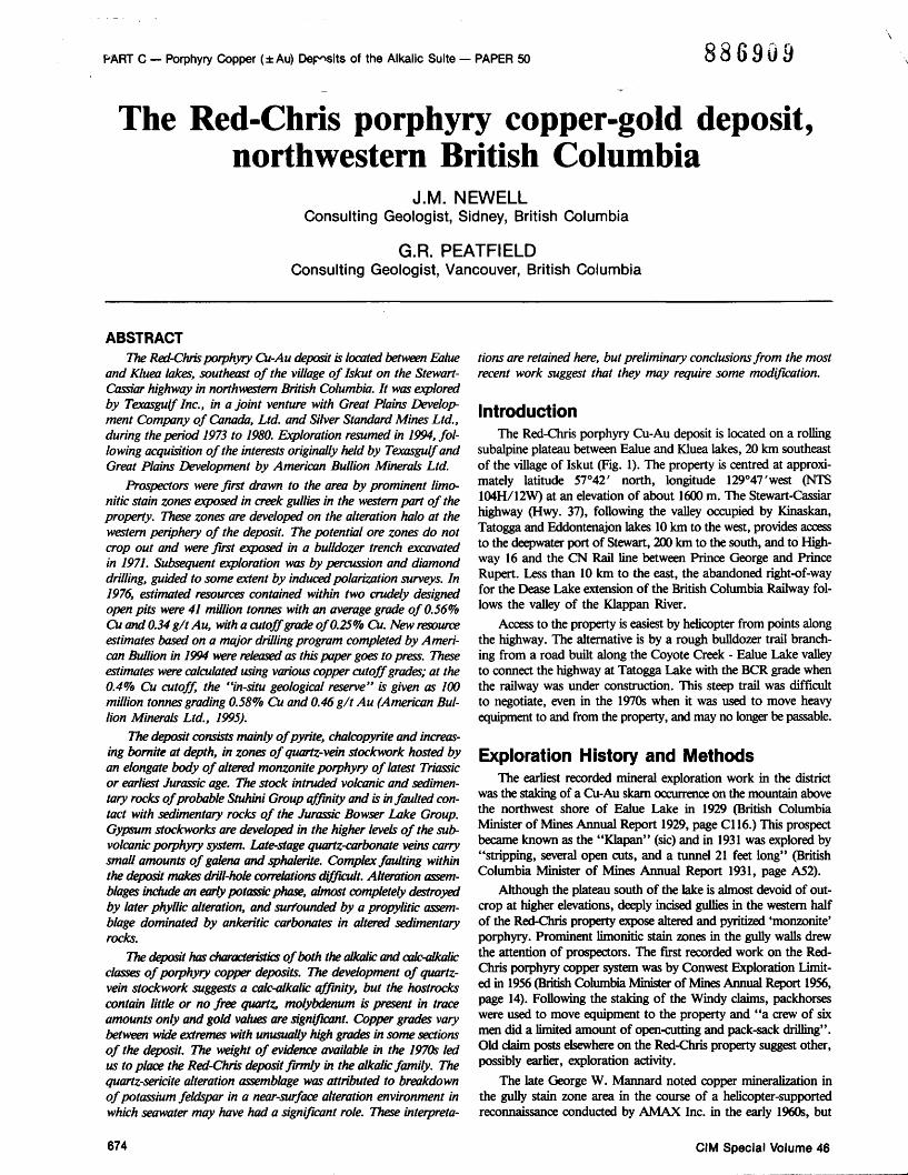
PART C — Porphyry Copper (±Au) Deposits of the Alkalic Suite — PAPER 50 886909 The Red-Chris porphyry copper-gold deposit, northwestern British Columbia J.M. NEWELL Consulting Geologist, Sidney, British Columbia G.R. PEATFIELD Consulting Geologist, Vancouver, British Columbia ABSTRACT The Red-Chris porphyry Cu-Au deposit is located between Ealue and Kluea lakes, southeast of the village oflskut on the Stewart- Cassiar highway in northwestern British Columbia. It was explored by Texasgulf Inc., in a joint venture with Great Plains Develop- ment Company of Canada, Ltd. and Silver Standard Mines Ltd., during the period 1973 to 1980. Exploration resumed in 1994, fol- lowing acquisition of the interests originally held by Texasgulf and Great Plains Development by American Bullion Minerals Ltd. Prospectors were first drawn to the area by prominent limo- nitic stain zones exposed in creek gullies in the western part of the property. These zones are developed on the alteration halo at the western periphery of the deposit. The potential ore zones do not crop out and were first exposed in a bulldozer trench excavated in 1971. Subsequent exploration was by percussion and diamond drilling, guided to some extent by induced polarization surveys. In 1976, estimated resources contained within two crudely designed open pits were 41 million tonnes with an average grade of 0.56% Cu and 0.34 g/t Au, with a cutoff grade of0.25% Cu. New resource estimates based on a major drilling program completed by Ameri- can Bullion in 1994 were released as this paper goes to press. These estimates were calculated using various copper cutoff grades; at the 0.4% Cu cutoff, the "in-situ geological reserve" is given as 100 million tonnes grading 0.58% Cu and 0.46 g/t Au (American Bul- lion Minerals Ltd., 1995). The deposit consists mainly ofpyrite, chalcopyrite and increas- ing bornite at depth, in zones of quartz-vein stockwork hosted by an elongate body of altered monzonite porphyry of latest Triassic or earliest Jurassic age. The stock intruded volcanic and sedimen- tary rocks of probable Stuhini Group affinity and is in faulted con- tact with sedimentary rocks of the Jurassic Bowser Lake Group. Gypsum stockworks are developed in the higher levels of the sub- volcanic porphyry system. Late-stage quartz-carbonate veins carry small amounts of galena and sphalerite. Complex faulting within the deposit makes drill-hole correlations difficult Alteration assem- blages include an early potassic phase, almost completely destroyed by later phyllic alteration, and surrounded by a propylitic assem- blage dominated by ankeritic carbonates in altered sedimentary rocks. The deposit has characteristics of both the alkalic and calc-alkalic classes of porphyry copper deposits. The development of quartz- vein stockwork suggests a calc-alkalic affinity, but the hostrocks contain little or no free quartz, molybdenum is present in trace amounts only and gold values are significant. Copper grades vary between wide extremes with unusually high grades in some sections of the deposit. The weight of evidence available in the 1970s led us to place the Red-Chris deposit firmly in the alkalic family. The quartz-sericite alteration assemblage was attributed to breakdown of potassium feldspar in a near-surface alteration environment in which seawater may have had a significant role. These interpreta- tions are retained here, but preliminary conclusions from the most recent work suggest that they may require some modification. Introduction The Red-Chris porphyry Cu-Au deposit is located on a rolling subalpine plateau between Ealue and Kluea lakes, 20 km southeast of the village of Iskut (Fig. 1). The property is centred at approxi- mately latitude 57°42' north, longitude 129°47'west (NTS 104H/12W) at an elevation of about 1600 m. The Stewart-Cassiar highway (Hwy. 37), following the valley occupied by Kinaskan, Tatogga and Eddontenajon lakes 10 km to the west, provides access to the deepwater port of Stewart, 200 km to the south, and to High- way 16 and the CN Rail line between Prince George and Prince Rupert. Less than 10 km to the east, the abandoned right-of-way for the Dease Lake extension of the British Columbia Railway fol- lows the valley of the Klappan River. Access to the property is easiest by helicopter from points along the highway. The alternative is by a rough bulldozer trail branch- ing from a road built along the Coyote Creek - Ealue Lake valley to connect the highway at Tatogga Lake with the BCR grade when the railway was under construction. This steep trail was difficult to negotiate, even in the 1970s when it was used to move heavy equipment to and from the property, and may no longer be passable. Exploration History and Methods The earliest recorded mineral exploration work in the district was the staking of a Cu-Au skarn occurrence on the mountain above the northwest shore of Ealue Lake in 1929 (British Columbia Minister of Mines Annual Report 1929, page Cl 16.) This prospect became known as the "Klapan" (sic) and in 1931 was explored by "stripping, several open cuts, and a tunnel 21 feet long" (British Columbia Minister of Mines Annual Report 1931, page A52). Although the plateau south of the lake is almost devoid of out- crop at higher elevations, deeply incised gullies in the western half of the Red-Chris property expose altered and pyritized 'monzonite' porphyry. Prominent limonitic stain zones in the gully walls drew the attention of prospectors. The first recorded work on the Red- Chris porphyry copper system was by Conwest Exploration Limit- ed in 1956 (British Columbia Minister of Mines Annual Report 1956, page 14). Following the staking of the Windy claims, packhorses were used to move equipment to the property and "a crew of six men did a limited amount of open-cutting and pack-sack drilling". Old claim posts elsewhere on the Red-Chris property suggest other, possibly earlier, exploration activity. The late George W. Mannard noted copper mineralization in the gully stain zone area in the course of a helicopter-supported reconnaissance conducted by AMAX Inc. in the early 1960s, but 674 CIM Special Volume 46
-
Upload
khangminh22 -
Category
Documents
-
view
1 -
download
0
Transcript of The Red-Chris porphyry copper-gold deposit, northwestern ...
PART C — Porphyry Copper (±Au) Deposits of the Alkalic Suite — PAPER 50 886909
The Red-Chris porphyry copper-gold deposit, northwestern British Columbia
J.M. NEWELL Consulting Geologist, Sidney, British Columbia
G.R. PEATFIELD Consulting Geologist, Vancouver, British Columbia
ABSTRACT The Red-Chris porphyry Cu-Au deposit is located between Ealue
and Kluea lakes, southeast of the village oflskut on the Stewart-Cassiar highway in northwestern British Columbia. It was explored by Texasgulf Inc., in a joint venture with Great Plains Development Company of Canada, Ltd. and Silver Standard Mines Ltd., during the period 1973 to 1980. Exploration resumed in 1994, following acquisition of the interests originally held by Texasgulf and Great Plains Development by American Bullion Minerals Ltd.
Prospectors were first drawn to the area by prominent limo-nitic stain zones exposed in creek gullies in the western part of the property. These zones are developed on the alteration halo at the western periphery of the deposit. The potential ore zones do not crop out and were first exposed in a bulldozer trench excavated in 1971. Subsequent exploration was by percussion and diamond drilling, guided to some extent by induced polarization surveys. In 1976, estimated resources contained within two crudely designed open pits were 41 million tonnes with an average grade of 0.56% Cu and 0.34 g/t Au, with a cutoff grade of0.25% Cu. New resource estimates based on a major drilling program completed by American Bullion in 1994 were released as this paper goes to press. These estimates were calculated using various copper cutoff grades; at the 0.4% Cu cutoff, the "in-situ geological reserve" is given as 100 million tonnes grading 0.58% Cu and 0.46 g/t Au (American Bullion Minerals Ltd., 1995).
The deposit consists mainly ofpyrite, chalcopyrite and increasing bornite at depth, in zones of quartz-vein stockwork hosted by an elongate body of altered monzonite porphyry of latest Triassic or earliest Jurassic age. The stock intruded volcanic and sedimentary rocks of probable Stuhini Group affinity and is in faulted contact with sedimentary rocks of the Jurassic Bowser Lake Group. Gypsum stockworks are developed in the higher levels of the sub-volcanic porphyry system. Late-stage quartz-carbonate veins carry small amounts of galena and sphalerite. Complex faulting within the deposit makes drill-hole correlations difficult Alteration assemblages include an early potassic phase, almost completely destroyed by later phyllic alteration, and surrounded by a propylitic assemblage dominated by ankeritic carbonates in altered sedimentary rocks.
The deposit has characteristics of both the alkalic and calc-alkalic classes of porphyry copper deposits. The development of quartz-vein stockwork suggests a calc-alkalic affinity, but the hostrocks contain little or no free quartz, molybdenum is present in trace amounts only and gold values are significant. Copper grades vary between wide extremes with unusually high grades in some sections of the deposit. The weight of evidence available in the 1970s led us to place the Red-Chris deposit firmly in the alkalic family. The quartz-sericite alteration assemblage was attributed to breakdown of potassium feldspar in a near-surface alteration environment in which seawater may have had a significant role. These interpreta
tions are retained here, but preliminary conclusions from the most recent work suggest that they may require some modification.
Introduction The Red-Chris porphyry Cu-Au deposit is located on a rolling
subalpine plateau between Ealue and Kluea lakes, 20 km southeast of the village of Iskut (Fig. 1). The property is centred at approximately latitude 57°42' north, longitude 129°47'west (NTS 104H/12W) at an elevation of about 1600 m. The Stewart-Cassiar highway (Hwy. 37), following the valley occupied by Kinaskan, Tatogga and Eddontenajon lakes 10 km to the west, provides access to the deepwater port of Stewart, 200 km to the south, and to Highway 16 and the CN Rail line between Prince George and Prince Rupert. Less than 10 km to the east, the abandoned right-of-way for the Dease Lake extension of the British Columbia Railway follows the valley of the Klappan River.
Access to the property is easiest by helicopter from points along the highway. The alternative is by a rough bulldozer trail branching from a road built along the Coyote Creek - Ealue Lake valley to connect the highway at Tatogga Lake with the BCR grade when the railway was under construction. This steep trail was difficult to negotiate, even in the 1970s when it was used to move heavy equipment to and from the property, and may no longer be passable.
Exploration History and Methods The earliest recorded mineral exploration work in the district
was the staking of a Cu-Au skarn occurrence on the mountain above the northwest shore of Ealue Lake in 1929 (British Columbia Minister of Mines Annual Report 1929, page Cl 16.) This prospect became known as the "Klapan" (sic) and in 1931 was explored by "stripping, several open cuts, and a tunnel 21 feet long" (British Columbia Minister of Mines Annual Report 1931, page A52).
Although the plateau south of the lake is almost devoid of outcrop at higher elevations, deeply incised gullies in the western half of the Red-Chris property expose altered and pyritized 'monzonite' porphyry. Prominent limonitic stain zones in the gully walls drew the attention of prospectors. The first recorded work on the Red-Chris porphyry copper system was by Conwest Exploration Limited in 1956 (British Columbia Minister of Mines Annual Report 1956, page 14). Following the staking of the Windy claims, packhorses were used to move equipment to the property and "a crew of six men did a limited amount of open-cutting and pack-sack drilling". Old claim posts elsewhere on the Red-Chris property suggest other, possibly earlier, exploration activity.
The late George W. Mannard noted copper mineralization in the gully stain zone area in the course of a helicopter-supported reconnaissance conducted by AMAX Inc. in the early 1960s, but
674 CIM Special Volume 46
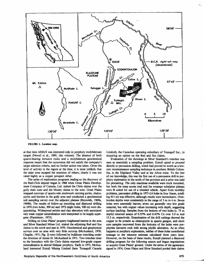
FIGURE 1. Location map.
at that time AMAX was interested only in porphyry molybdenum targets (Newell et al., 1995, this volume). The absence of both quartz-bearing intrusive rocks and a molybdenum geochemical response meant that the occurrence did not satisfy the company's target selection criteria, and no further action was taken. Given the level of activity in the region at the time, it is most unlikely that the stain zone escaped the attention of others; clearly it was not rated highly as a copper prospect either.
The series of exploration programs leading to the discovery of the Red-Chris deposit began in 1968 when Great Plains Development Company of Canada, Ltd. staked the Chris claims over the gully stain zone and the Money claims to the west. Great Plains mapped outcrops of quartz-vein stockwork carrying pyrite, chalco-pyrite and bornite in the gully area and conducted a geochemical soil sampling survey over the adjacent plateau (Reynolds, 1969a, 1969b). The results of follow-up trenching and diamond drilling in 1970 (two holes, 309 m) and 1972 (eight holes, 920 m) were disappointing. Widespread sericite and clay alteration with associated very weak copper mineralization were interpreted to be largely super-gene (Panteleyev, 1973).
Drilling on Great Plains' property heightened interest in the area and Silver Standard Mines Ltd. staked the adjoining Red and Sus claims to the north and east in 1970. Geochemical and geophysical surveys over an area with very little outcrop (McAusland, 1970; Chaplin, 1971; Fig. 2) were followed by bulldozer trenching under the direction of James H. McAusland in 1971. Two trenches close to the boundary with the Chris claims exposed low-grade copper mineralization in altered feldspar porphyry. Early in 1973, McAusland interested Ecstall Mining Limited Cater Texasgulf Canada
Limited), the Canadian operating subsidiary of Texasgulf Inc., in acquiring an option on the Red and Sus claims.
Evaluation of the showings in Silver Standard's trenches was seen as essentially a sampling problem. Ecstall opted to proceed directly to percussion drilling, which had proved its worth as a low-cost reconnaissance sampling technique in southern British Columbia, in the Highland Valley and at the Afton mine. To the best of our knowledge, this was the first use of a percussion drill in porphyry exploration in the north of the province and a price was paid for pioneering. The only machines available were truck mounted, but both the steep access trail and the swampy subalpine plateau were ill suited for use of a wheeled vehicle. Apart from mobility problems, percussion drilling in 1973 (14 holes in four fences, totalling 911 m) was effective, although results were inconclusive. Overburden depths were consistently in the range of 3 m to 4 m. Seven holes were essentially barren; seven cut generally very low grade material, but with copper values increasing with depth, suggesting surface leaching. Samples from the bottom of two holes (c. 75 m depth) returned assays of 0.55% and 0.41% Cu over 3.0 m and 15.2 m, respectively. Examination of the drill cuttings showed the copper to be present as chalcopyrite in quartz gangue, and short core samples recovered from the bottoms of the holes were por-phyritic intrusive rock with strong phyllic alteration. As so often happens in porphyry exploration, neither of these holes contributed tonnage to the resource estimate calculated three years later. However, on the basis of these results, Ecstall planned a diamond drilling program for the following season and began negotiations to acquire Great Plains' ground. Under the terms of the agreement signed in 1974, Great Plains and Silver Standard pooled their claims
Porphyry Deposits of the Northwestern Cordillera of North America 675
SILVER STANDARD TRENCHES
HEAD OF EAST GULLY
EAST ZONE
CAMP
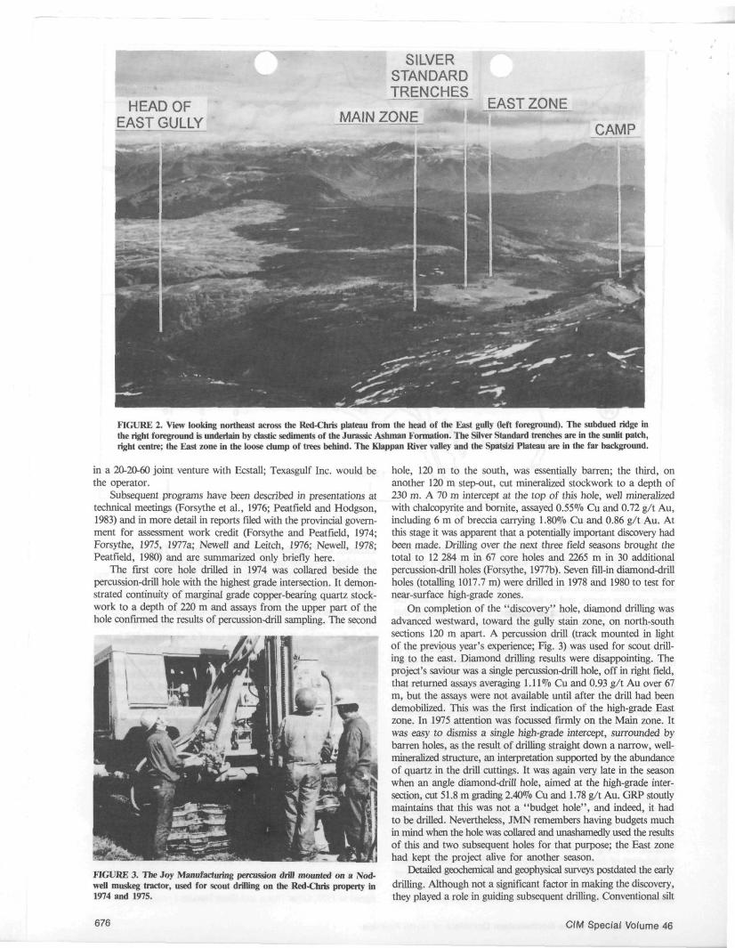
FIGURE 2. View looking northeast across the Red-Chris plateau from the head of the East gully (left foreground). The subdued ridge in the right foreground is underlain by clastic sediments of the Jurassic Ashman Formation. The Silver Standard trenches are in the sunlit patch, right centre; the East zone in the loose dump of trees behind. The Klappan River valley and the Sputsi/i Plateau are in the far background.
in a 20-20-60 joint venture with Ecstall; Texasgulf Inc. would be the operator.
Subsequent programs have been described in presentations at technical meetings (Forsythe et al., 1976; Peatfield and Hodgson, 1983) and in more detail in reports filed with the provincial government for assessment work credit (Forsythe and Peatfield, 1974; Forsythe, 1975, 1977a; Newell and Leitch, 1976; Newell, 1978; Peatfield, 1980) and are summarized only briefly here.
The first core hole drilled in 1974 was collared beside the percussion-drill hole with the highest grade intersection. It demonstrated continuity of marginal grade copper-bearing quartz stock-work to a depth of 220 m and assays from the upper part of the hole confirmed the results of percussion-drill sampling. The second
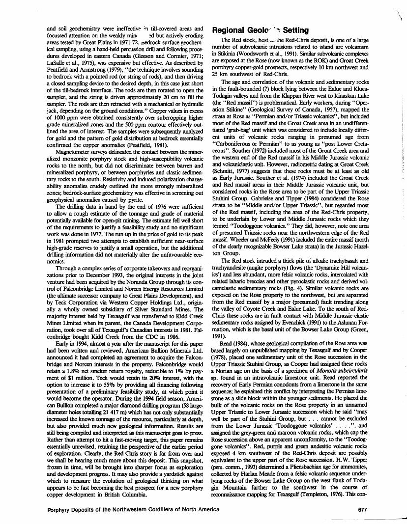
FIGURE 3. The Joy Manufacturing percussion drill mounted on a Nod-well muskeg tractor, used for scout drilling on the Red-Chris property in 1974 and 1975.
hole, 120 m to the south, was essentially barren; the third, on another 120 m step-out, cut mineralized stockwork to a depth of 230 m. A 70 m intercept at the top of this hole, well mineralized with chalcopyrite and bornite, assayed 0.55% Cu and 0.72 g/t Au, including 6 m of breccia carrying 1.80% Cu and 0.86 g/t Au. At this stage it was apparent that a potentially important discovery had been made. Drilling over the next three field seasons brought the total to 12 284 m in 67 core holes and 2265 m in 30 additional percussion-drill holes (Forsythe, 1977b). Seven fill-in diamond-drill holes (totalling 1017.7 m) were drilled in 1978 and 1980 to test for near-surface high-grade zones.
On completion of the "discovery" hole, diamond drilling was advanced westward, toward the gully stain zone, on north-south sections 120 m apart. A percussion drill (track mounted in light of the previous year's experience; Fig. 3) was used for scout drilling to the east. Diamond drilling results were disappointing. The project's saviour was a single percussion-drill hole, off in right field, that returned assays averaging 1.11% Cu and 0.93 g/t Au over 67 m, but the assays were not available until after the drill had been demobilized. This was the first indication of the high-grade East zone. In 1975 attention was focussed firmly on the Main zone. It was easy to dismiss a single high-grade intercept, surrounded by barren holes, as the result of drilling straight down a narrow, well-mineralized structure, an interpretation supported by the abundance of quartz in the drill cuttings. It was again very late in the season when an angle diamond-drill hole, aimed at the high-grade intersection, cut 51.8 m grading 2.40% Cu and 1.78 g/t Au. GRP stoutly maintains that this was not a "budget hole", and indeed, it had to be drilled. Nevertheless, JMN remembers having budgets much in mind when the hole was collared and unashamedly used the results of this and two subsequent holes for that purpose; the East zone had kept the project alive for another season.
Detailed geochemical and geophysical surveys postdated the early drilling. Although not a significant factor in making the discovery, they played a role in guiding subsequent drilling. Conventional silt
676 CIM Special Volume 46
and soil geochemistry were ineffective ;n till-covered areas and focussed attention on the weakly mint 2d but actively eroding areas tested by Great Plains in 1971-72. oedrock-surface geochem-ical sampling, using a hand-held percussion drill and following procedures developed in eastern Canada (Gleeson and Cormier, 1971; LaSalle et al., 1975), was expensive but effective. As described by Peatfield and Armstrong (1979), "the technique involves sounding to bedrock with a pointed rod (or string of rods), and then driving a closed sampling device to the desired depth, in this case just short of the till-bedrock interface. The rods are then rotated to open the sampler, and the string is driven approximately 20 cm to fill the sampler. The rods are then retracted with a mechanical or hydraulic jack, depending on the ground conditions." Copper values in excess of 1000 ppm were obtained consistently over subcropping higher grade mineralized zones and the 500 ppm contour effectively outlined the area of interest. The samples were subsequently analyzed for gold and the pattern of gold distribution at bedrock essentially confirmed the copper anomalies (Peatfield, 1981).
Magnetometer surveys delineated the contact between the mineralized monzonite porphyry stock and high-susceptibility volcanic rocks to the north, but did not discriminate between barren and mineralized porphyry, or between porphyries and clastic sedimentary rocks to the south. Resistivity and induced polarization charge-ability anomalies crudely outlined the more strongly mineralized zones; bedrock-surface geochemistry was effective in screening out geophysical anomalies caused by pyrite.
The drilling data in hand by the end of 1976 were sufficient to allow a rough estimate of the tonnage and grade of material potentially available for open-pit mining. The estimate fell well short of the requirements to justify a feasibility study and no significant work was done in 1977. The run up in the price of gold to its peak in 1981 prompted two attempts to establish sufficient near-surface high-grade reserves to justify a small operation, but the additional drilling information did not materially alter the unfavourable economics.
Through a complex series of corporate takeovers and reorganizations prior to December 1993, the original interests in the joint venture had been acquired by the Noranda Group through its control of Falconbridge Limited and Norcen Energy Resources Limited (the ultimate successor company to Great Plains Development), and by Teck Corporation via Western Copper Holdings Ltd., originally a wholly owned subsidiary of Silver Standard Mines. The majority interest held by Texasgulf was transferred to Kidd Creek Mines Limited when its parent, the Canada Development Corporation, took over all of Texasgulf s Canadian interests in 1981. Falconbridge bought Kidd Creek from the CDC in 1986.
Early in 1994, almost a year after the manuscript for this paper had been written and reviewed, American Bullion Minerals Ltd. announced it had completed an agreement to acquire the Falcon-bridge and Norcen interests in the property. Falconbridge would retain a 1.8% net smelter return royalty, reducible to 1% by payment of $1 million. Teck would retain its 20% interest, with the option to increase it to 55% by providing all financing following presentation of a preliminary feasibility study, at which point it would become the operator. During the 1994 field season, American Bullion completed a major diamond drilling program (58 large-diameter holes totalling 21 417 m) which has not only substantially increased the known tonnage of the resource, particularly at depth, but also provided much new geological information. Results are still being compiled and interpreted as this manuscript goes to press. Rather than attempt to hit a fast-moving target, this paper remains essentially unrevised, retaining the perspective of the earlier period of exploration. Clearly, the Red-Chris story is far from over and we shall be hearing much more about this deposit. This snapshot, frozen in time, will be brought into sharper focus as exploration and development progress. It may also provide a yardstick against which to measure the evolution of geological thinking on what appears to be fast becoming the best prospect for a new porphyry copper development in British Columbia.
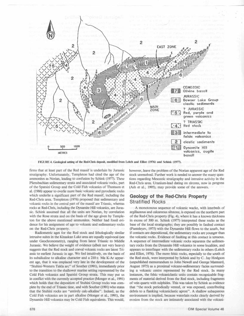
Regional Geolc > Setting The Red stock, host w the Red-Chris deposit, is one of a large
number of subvolcanic intrusions related to island arc volcanism in Stikinia (Woodsworth et al., 1991). Similar subvolcanic complexes are exposed at the Rose (now known as the ROK) and Groat Creek porphyry copper-gold prospects, respectively 10 km northwest and 25 km southwest of Red-Chris.
The age and correlation of the volcanic and sedimentary rocks in the fault-bounded (?) block lying between the Ealue and Kluea-Todagin valleys and from the Klappan River west to Kinaskan Lake (the "Red massif) is problematical. Early workers, during "Operation Stikine" (Geological Survey of Canada, 1957), mapped the strata at Rose as "Permian and/or Triassic volcanics", but included most of the Red massif and the Groat Creek area in an undifferen-tiated 'grab-bag' unit which was considered to include locally different units of volcanic rocks ranging in presumed age from "Carboniferous or Permian" to as young as "post Lower Cretaceous". Souther (1972) included most of the Groat Creek area and the western end of the Red massif in his Middle Jurassic volcanic and volcaniclastic unit. However, radiometric dating at Groat Creek (Schmitt, 1977) suggests that these rocks must be at least as old as Early Jurassic. Souther et al. (1974) included the Groat Creek and Red massif areas in their Middle Jurassic volcanic unit, but considered rocks in the Rose area to be part of the Upper Triassic Stuhini Group. Gabrielse and Tipper (1984) considered the Rose strata to be "Middle and/or Upper Triassic", but regarded most of the Red massif, including the area of the Red-Chris property, to be underlain by Lower and Middle Jurassic rocks which they termed "Toodoggone volcanics." They did, however, note one area of presumed Triassic rocks near the northwestern edge of the Red massif. Wheeler and McFeely (1991) included the entire massif (north of the clearly recognizable Bowser Lake strata) in the Jurassic Hazel-ton Group.
The Red stock intruded a thick pile of alkalic trachybasalt and trachyandesite (augite porphyry) flows (the 'Dynamite Hill volcanics') and less abundant, more felsic volcanic rocks, intercalated with related laharic breccias and other pyroclastic rocks and derived volcaniclastic sedimentary rocks (Fig. 4). Similar volcanic rocks are exposed on the Rose property to the northwest, but are separated from the Red massif by a major (presumed) fault trending along the valley of Coyote Creek and Ealue Lake. To the south of Red-Chris these rocks are in fault contact with Middle Jurassic clastic sedimentary rocks assigned by Evenchick (1991) to the Ashman Formation, which is the basal unit of the Bowser Lake Group (Green, 1991).
Read (1984), whose geological compilation of the Rose area was based largely on unpublished mapping by Texasgulf and by Cooper (1978), placed one sedimentary unit of the Rose succession in the Upper Triassic Stuhini Group, as Cooper had assigned these rocks a Norian age on the basis of a specimen of Monotis subcircularis sp. found in an intravolcanic limestone unit. Read reported the recovery of Early Permian conodonts from a limestone in the same sequence; he explained this conflict by interpreting the Permian limestone as a slide block within the younger sediments. He placed the bulk of the volcanic rocks on the Rose property in an unnamed Upper Triassic to Lower Jurassic succession which he said "may well be part of the Stuhini Group, but . . . cannot be excluded from the Lower Jurassic 'Toodoggone volcanics' . . . .", and assigned the grey-green and maroon volcanic rocks, which cap the Rose succession above an apparent unconformity, to the "Toodoggone volcanics". Red, purple and green andesitic volcanic rocks exposed 4 km southwest of the Red-Chris deposit are possibly equivalent to the upper part of the Rose succession. H.W. Tipper (pers. comm., 1993) determined a Pliensbachian age for ammonites, collected by Harlan Meade from a felsic volcanic sequence underlying rocks of the Bowser Lake Group on the west flank of Todagin Mountain farther to the southwest in the course of reconnaissance mapping for Texasgulf (Templeton, 1976). This con-
Porphyry Deposits of the Northwestern Cordillera of North America 677
METRES
6 i z Bowser Lake Group clastic sediments
. JURASSIC p^5 4 R e d ' p w p l e and
green volcanics
? TRIAS SIC Red stock
in termedia le to felsic volcanics
2 | clast ic sediments
WftWl Oynamite Hill volcanics, augi fe basalt
FIGURE 4. Geological setting of the Red-Chris deposit, modified from Leitch and Elliot (1976) and Schink (1977).
firms that at least part of the Red massif is underlain by Jurassic stratigraphy. Unfortunately, Templeton had cited the age of the ammonites as Norian, leading to confusion by Schink (1977). These Pliensbachian sedimentary strata and associated volcanic rocks, part of the Spatsizi Group and the Cold Fish volcanics of Thomson et al. (1986) appear to overlie more basic volcanic and pyroclastic rocks which underlie a significant part of the Red massif, including the Red-Chris area. Templeton (1976) proposed that sedimentary and volcanic rocks in the central part of the massif are Triassic, whereas rocks at Red-Chris, including the Dynamite Hill volcanics, are Jurassic. Schink assumed that all the units are Norian, by correlation with the Rose strata and on the basis of the age given by Templeton for the above mentioned ammonites. Neither had fossil evidence for his assignment of age to volcanic and sedimentary rocks on the Red-Chris property.
Radiometric ages for the Red stock and lithologically similar intrusive suites in the Kinaskan Lake area are equally equivocal (see under Geochronometry), ranging from latest Triassic to Middle Jurassic. We believe the weight of evidence (albeit not very heavy) suggests that the Red stock and coeval volcanic rocks are latest Triassic to earliest Jurassic in age. We feel intuitively, on the basis of its subalkaline to alkaline character and a 210 ± Ma K-Ar apparent age, that it was emplaced very late in the development of the "Stuhini-Western Takla arc" of Souther (1991), immediately prior to the transition to the shallower marine setting represented by the Cold Fish volcanics and Spatsizi Group strata. This may put us in conflict with the currently accepted practice (Monger et al., 1991) which holds that the deposition of Stuhini Group rocks was complete by the end of Triassic time, and with Souther (1991) who states that the Stuhini rocks are "entirely calc-alkaline". Indeed, as the Cold Fish volcanics are in part alkaline (Monger et al., 1991), the Dynamite Hill volcanics may be Cold Fish equivalents. This would,
however, leave the problem of the Norian apparent age of the Red stock unresolved. Further work is needed to answer the many questions regarding Mesozoic stratigraphy and intrusive activity in the Red-Chris area. Uranium-lead dating on zircons, now in progress (Ash et al., 1995), may provide some of the answers.
Geology of the Red-Chris Property Stratified Rocks
A monotonous sequence of volcanic wacke, with interbeds of argillaceous and calcareous siltstone, is exposed on the northern part of the Red-Chris property (Fig. 4), where it has a known thickness in excess of 300 m. Schink (1977) interpreted these rocks as the base of the local stratigraphy; they are possibly in faulted contact (Panteleyev, 1975) with the Dynamite Hill flows to the south, but if contacts are depositional, the sedimentary rocks are younger than the volcanic rocks. Evidence of faulting at this contact is tenuous. A sequence of intermediate volcanic rocks separates the sedimentary rocks from the Dynamite Hill volcanics in some localities, and appears to interfinger with the sedimentary rocks in others (Leitch and Elliot, 1976). The more felsic rocks, especially to the south of the Red stock, were interpreted by Schink and by C. Jay Hodgson (unpublished memorandum to John Newell and George Mannard, August 1975) as a proximal volcano-sedimentary facies surrounding a volcanic centre represented by the Red stock. In many instances, the felsic volcaniclastic units contain recognizable fragments of material derived from the Red stock, including fragments of vein quartz with sulphides. This was taken by Schink as evidence that "the stock periodically vented, or was exposed, contributing debris to a flanking volcaniclastic apron". A shallow subaqueous environment is implied, because waterlain rocks clearly derived by erosion from the stock are intimately associated with the volcani-
678 CIM Special Volume 46
SECTION 4©« c
^—*»v^ .
STOCK
3 LATE PHASE
joffASsrc BOWSCfi LAXE CROUJ>.
CLASTIC SEDIMENTS
UPPER TftlASSIC - l O w t R JURASSIC ( ? )
~7-~-\ CLASTIC SEDIMENTS
OYKAMnC HILL VOiCAKICS
^2 WAIN PHASE: ESSCNTTIAUY BAflfiEN
\r. C?"| MAIM PHASE: WEAK STOCKWOSK DEVELOPMENT
MAIM PHASE: MODERATE TO STROMC STOCXWORK DEVELOPMENT
■ — ' — OUTUXE Or PIT USED FOR RESOUSCf ESTIMATION
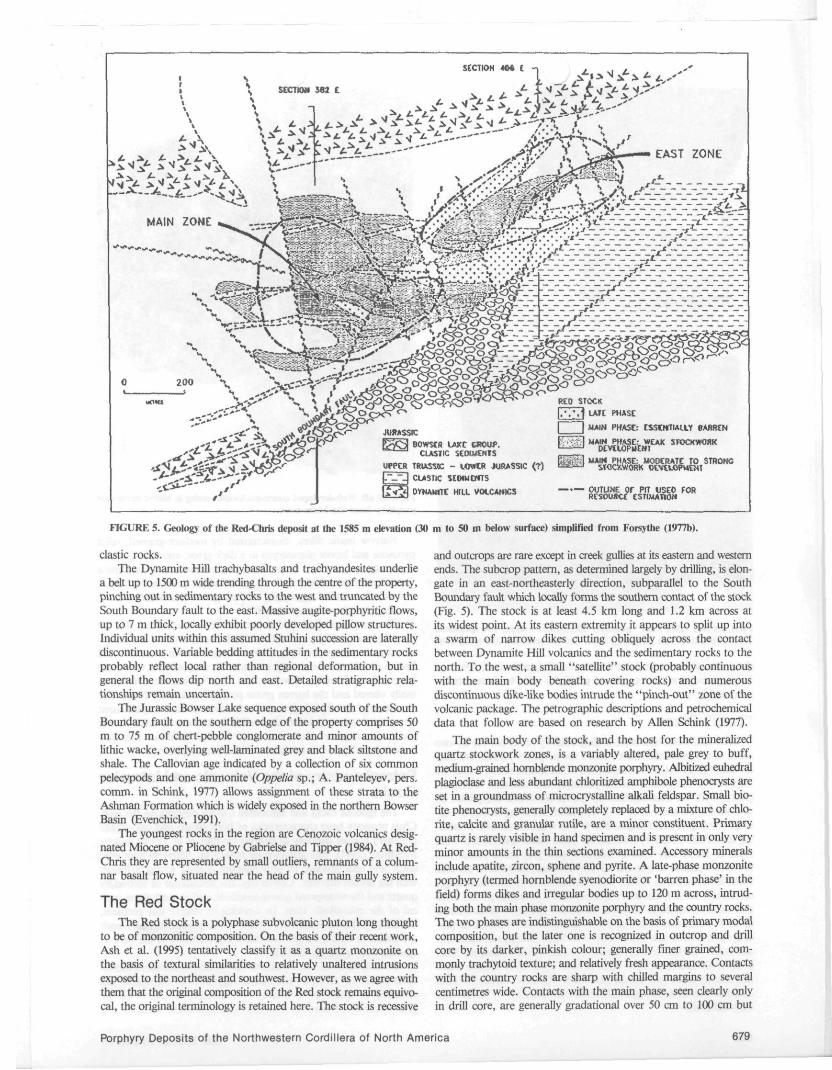
FIGURE 5. Geology of the Red-Chris deposit at the 1585 m elevation (30 m to 50 m below surface) simplified from Forsythe (1977b).
clastic rocks. The Dynamite Hill trachybasalts and trachyandesites underlie
a belt up to 1500 m wide trending through the centre of the property, pinching out in sedimentary rocks to the west and truncated by the South Boundary fault to the east. Massive augite-porphyritic flows, up to 7 m thick, locally exhibit poorly developed pillow structures. Individual units within this assumed Stuhini succession are laterally discontinuous. Variable bedding attitudes in the sedimentary rocks probably reflect local rather than regional deformation, but in general the flows dip north and east. Detailed stratigraphic relationships remain uncertain.
The Jurassic Bowser Lake sequence exposed south of the South Boundary fault on the southern edge of the property comprises 50 m to 75 m of chert-pebble conglomerate and minor amounts of lithic wacke, overlying well-laminated grey and black siltstone and shale. The Callovian age indicated by a collection of six common pelecypods and one ammonite (Oppelia sp.; A. Panteleyev, pers. comm. in Schink, 1977) allows assignment of these strata to the Ashman Formation which is widely exposed in the northern Bowser Basin (Evenchick, 1991).
The youngest rocks in the region are Cenozoic volcanics designated Miocene or Pliocene by Gabrielse and Tipper (1984). At Red-Chris they are represented by small outliers, remnants of a columnar basalt flow, situated near the head of the main gully system.
The Red Stock The Red stock is a polyphase subvolcanic pluton long thought
to be of monzonitic composition. On the basis of their recent work, Ash et al. (1995) tentatively classify it as a quartz monzonite on the basis of textural similarities to relatively unaltered intrusions exposed to the northeast and southwest. However, as we agree with them that the original composition of the Red stock remains equivocal, the original terminology is retained here. The stock is recessive
and outcrops are rare except in creek gullies at its eastern and western ends. The subcrop pattern, as determined largely by drilling, is elongate in an east-northeasterly direction, subparallel to the South Boundary fault which locally forms the southern contact of the stock (Fig. 5). The stock is at least 4.5 km long and 1.2 km across at its widest point. At its eastern extremity it appears to split up into a swarm of narrow dikes cutting obliquely across the contact between Dynamite Hill volcanics and the sedimentary rocks to the north. To the west, a small "satellite" stock (probably continuous with the main body beneath covering rocks) and numerous discontinuous dike-like bodies intrude the "pinch-out" zone of the volcanic package. The petrographic descriptions and petrochemical data that follow are based on research by Allen Schink (1977).
The main body of the stock, and the host for the mineralized quartz stockwork zones, is a variably altered, pale grey to buff, medium-grained hornblende monzonite porphyry. Albitized euhedral plagioclase and less abundant chloritized amphibole phenocrysts are set in a groundmass of microcrystalline alkali feldspar. Small bio-tite phenocrysts, generally completely replaced by a mixture of chlorite, calcite and granular rutile, are a minor constituent. Primary quartz is rarely visible in hand specimen and is present in only very minor amounts in the thin sections examined. Accessory minerals include apatite, zircon, sphene and pyrite. A late-phase monzonite porphyry (termed hornblende syenodiorite or 'barren phase' in the field) forms dikes and irregular bodies up to 120 m across, intruding both the main phase monzonite porphyry and the country rocks. The two phases are indistinguishable on the basis of primary modal composition, but the later one is recognized in outcrop and drill core by its darker, pinkish colour; generally finer grained, commonly trachytoid texture; and relatively fresh appearance. Contacts with the country rocks are sharp with chilled margins to several centimetres wide. Contacts with the main phase, seen clearly only in drill core, are generally gradational over 50 cm to 100 cm but
Porphyry Deposits of the Northwestern Cordillera of North America 679
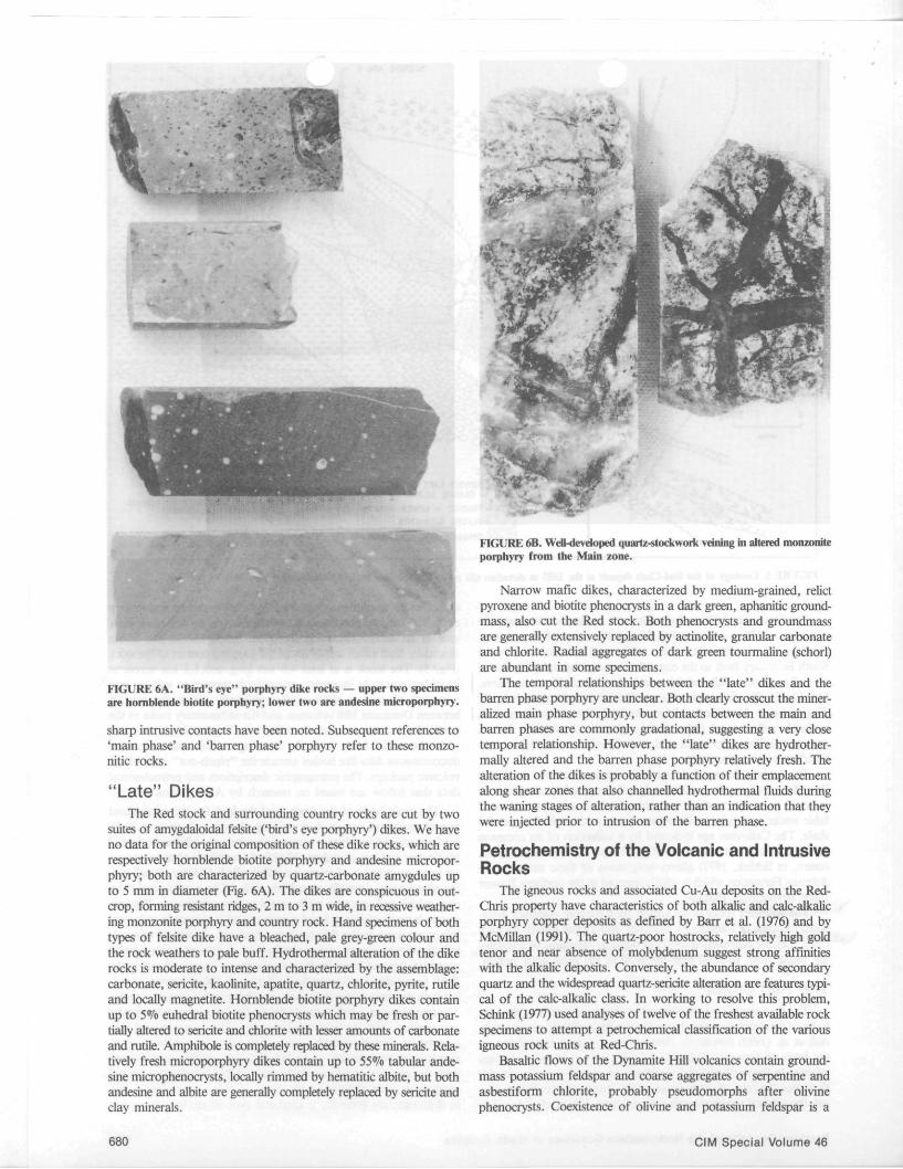
FIGURE 6A. "Bird's eye" porphyry dike rocks — upper two specimens are hornblende biotite porphyry; lower two are andesine microporphyry.
sharp intrusive contacts have been noted. Subsequent references to 'main phase' and 'barren phase' porphyry refer to these monzo-nitic rocks.
"Late" Dikes The Red stock and surrounding country rocks are cut by two
suites of amygdaloidal felsite ('bird's eye porphyry') dikes. We have no data for the original composition of these dike rocks, which are respectively hornblende biotite porphyry and andesine microporphyry; both are characterized by quartz-carbonate amygdules up to 5 mm in diameter (Fig. 6A). The dikes are conspicuous in outcrop, forming resistant ridges, 2 m to 3 m wide, in recessive weathering monzonite porphyry and country rock. Hand specimens of both types of felsite dike have a bleached, pale grey-green colour and the rock weathers to pale buff. Hydrothermal alteration of the dike rocks is moderate to intense and characterized by the assemblage: carbonate, sericite, kaolinite, apatite, quartz, chlorite, pyrite, rutile and locally magnetite. Hornblende biotite porphyry dikes contain up to 5% euhedral biotite phenocrysts which may be fresh or partially altered to sericite and chlorite with lesser amounts of carbonate and rutile. Amphibole is completely replaced by these minerals. Relatively fresh microporphyry dikes contain up to 55% tabular andesine microphenocrysts, locally rimmed by hematitic albite, but both andesine and albite are generally completely replaced by sericite and clay minerals.
680
FIGURE 6B. Weil-developed quartz-stockwork veining in altered monzonite porphyry from the Main zone.
Narrow mafic dikes, characterized by medium-grained, relict pyroxene and biotite phenocrysts in a dark green, aphanitic ground-mass, also cut the Red stock. Both phenocrysts and groundmass are generally extensively replaced by actinolite, granular carbonate and chlorite. Radial aggregates of dark green tourmaline (schorl) are abundant in some specimens.
The temporal relationships between the "late" dikes and the barren phase porphyry are unclear. Both clearly crosscut the mineralized main phase porphyry, but contacts between the main and barren phases are commonly gradational, suggesting a very close temporal relationship. However, the "late" dikes are hydrother-mally altered and the barren phase porphyry relatively fresh. The alteration of the dikes is probably a function of their emplacement along shear zones that also channelled hydrothermal fluids during the waning stages of alteration, rather than an indication that they were injected prior to intrusion of the barren phase.
Petrochemistry of the Volcanic and Intrusive Rocks
The igneous rocks and associated Cu-Au deposits on the Red-Chris property have characteristics of both alkalic and calc-alkalic porphyry copper deposits as defined by Barr et al. (1976) and by McMillan (1991). The quartz-poor hostrocks, relatively high gold tenor and near absence of molybdenum suggest strong affinities with the alkalic deposits. Conversely, the abundance of secondary quartz and the widespread quartz-sericite alteration are features typical of the calc-alkalic class. In working to resolve this problem, Schink (1977) used analyses of twelve of the freshest available rock specimens to attempt a petrochemical classification of the various igneous rock units at Red-Chris.
Basaltic flows of the Dynamite Hill volcanics contain ground-mass potassium feldspar and coarse aggregates of serpentine and asbestiform chlorite, probably pseudomorphs after olivine phenocrysts. Coexistence of olivine and potassium feldspar is a
CIM Special Volume 46
characteristic of alkalic rocks. This el?""'fication is supported by plots of data from two whole-rock a es in the alkaline field on Irvine and Baragar's (1971) normative Ol-Ne-Q diagram. On an alkali-silica diagram the basalt analyses plot in the subalkaline field as defined by Irvine and Baragar, but in the alkaline field as defined by MacDonald (1968) and used by Barr et al. (1976) to characterize the "alkaline suite" porphyry copper deposits.
Five samples of barren phase porphyry are clearly characteristic of the "alkaline suite", with alkali-silica plots comparable to rocks from the Iron Mask, Mount Polley and Copper Mountain deposits in the Quesnel Trough, but they are much less potassic than the strongly silica-undersaturated syenite porphyries associated with the Galore Creek deposit in the Stikine district. One of the three samples of least-altered main phase porphyry also plots well within the alkaline field; the other two would be classified as subalkaline, but all three have probably undergone some degree of silicifi-cation.
Hydrothermal Alteration All rocks comprising the Red stock are hydrothermally altered
to some degree. Alteration extends into the country rocks, at least locally; pyritization and carbonatization of the country rocks are responsible for much of the widespread limonitic staining in the gully area. However, although the basalts show the effects of propylitic alteration, the pyrite content of these rocks decreases to less than 1% within 120 m of the intrusive contact, and basalt outcrops are generally not rusty. Bowser Lake Group rocks are unaffected by hydrothermal alteration.
Schink (1977) recognized two stages of alteration, dominantly within but not restricted to the main phase porphyry. An early, potassic phase, with associated copper-gold mineralization, is overprinted by later, more pervasive phyllic alteration. Early alteration, characterized by the assemblage orthoclase-albite-biotite with chal-copyrite, magnetite and hematite, is preserved in narrow, discontinuous zones invariably carrying higher grade copper-gold mineralization. Peak early stage alteration intensity is toward the core of the stock, grading outward to a peripheral epidote-chlorite-calcite propylitic assemblage in the Dynamite Hill volcanics, and to an iron-magnesium carbonate dominated assemblage with a characteristic red-orange weathering colour where the altered rocks are clastic sediments. The strongly altered intrusive rocks were referred to as "mottled porphyries" in the field. Porphyritic texture is locally preserved, but more often is partly or wholly obliterated by pervasive potassium feldspathization.
Later, phyllic alteration, characterized by quartz-sericite-ankerite-kaolinite and quartz-sericite-pyrite assemblages, reaches peak intensity toward the margins of mineralized zones. Except in the core zones, it is sufficiently intense to obliterate all but traces of the earlier phase. As phyllic alteration intensity increases, both amphibole and plagioclase phenocrysts lose their identity and the rock is characterized by irregular greyish clots of fine-grained pyrite, sericite and carbonate in an intensely altered sericitic groundmass.
The alteration patterns are more or less symmetrically disposed in an elongate zone along the long axis of the Red stock. However, they are modified by local peaks of alteration intensity related to individual, subparallel fracture zones and further complicated by late movements on at least three fault sets.
The barren phase porphyry is only weakly altered and mineralized, with primary textures invariably well preserved. Alteration minerals form a propylite assemblage of chlorite-magnetite-calcite with minor amounts of epidote and rare sericite. A zone of well-developed gypsum veining at high levels in the porphyry system was interpreted by Schink (1977) as a low-temperature phenomenon, possibly resulting from the interaction of hydrothermal fluids and seawater in the waning stages of the mineralizing episode, as suggested at Valley Copper by Osatenko and Jones (1976). There is no evidence that the gypsum represents near-surface hydration of primary anhydrite veining, as is the case at Galore Creek (Allen
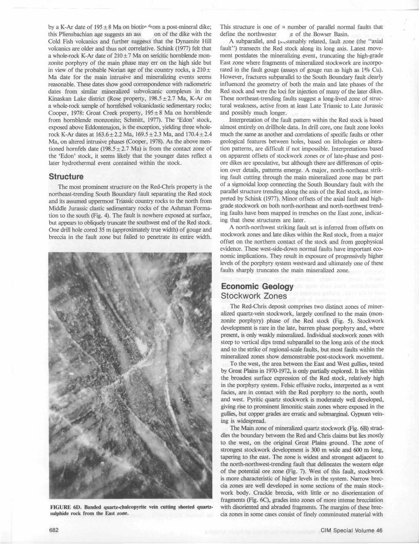
FIGURE 6C. Crackle breccia in altered monzonite porphyry from the Main zone.
et al., 1976); unfortunately we have no oxygen isotope data for Red-Chris, so any assumptions regarding the source of the sulphate remain speculative.
Geochronometry The age of the Red stock appears to be latest Triassic to earli
est Jurassic, but is poorly constrained. A minimum age is provided
Porphyry Deposits of the Northwestern Cordillera of North America 681
by a K-Ar date of 195 ± 8 Ma on biotit^ from a post-mineral dike; this Pliensbachian age suggests an ass on of the dike with the Cold Fish volcanics and further suggests that the Dynamite Hill volcanics are older and thus not correlative. Schink (1977) felt that a whole-rock K-Ar date of 210 ±7 Ma on sericitic hornblende mon-zonite porphyry of the main phase may err on the high side but in view of the probable Norian age of the country rocks, a 210 ± Ma date for the main intrusive and mineralizing events seems reasonable. These dates show good correspondence with radiometric dates from similar mineralized subvolcanic complexes in the Kinaskan Lake district (Rose property, 198.5 ±2.7 Ma, K-Ar on a whole-rock sample of homfelsed volcaniclastic sedimentary rocks; Cooper, 1978: Groat Creek property, 195 ±8 Ma on hornblende from hornblende monzonite; Schmitt, 1977). The 'Edon' stock, exposed above Eddontenajon, is the exception, yielding three whole-rock K-Ar dates at 163.6 ±2.2 Ma, 169.5 ±2.3 Ma, and 170.4 ±2.4 Ma, on altered intrusive phases (Cooper, 1978). As the above mentioned hornfels date (198.5 ±2.7 Ma) is from the contact zone of the 'Edon' stock, it seems likely that the younger dates reflect a later hydrothermal event contained within the stock.
Structure The most prominent structure on the Red-Chris property is the
northeast-trending South Boundary fault separating the Red stock and its assumed uppermost Triassic country rocks to the north from Middle Jurassic clastic sedimentary rocks of the Ashman Formation to the south (Fig. 4). The fault is nowhere exposed at surface, but appears to obliquely truncate the southwest end of the Red stock. One drill hole cored 35 m (approximately true width) of gouge and breccia in the fault zone but failed to penetrate its entire width.
FIGURE 6D. Banded quartz-chalcopyrite vein cutting sheeted quartz-sulphide rock from the East zone.
682
This structure is one of a number of parallel normal faults that define the northwester ,e of the Bowser Basin.
A subparallel, and p^sumably related, fault zone (the "axial fault") transects the Red stock along its long axis. Latest movement postdates the mineralizing event, truncating the high-grade East zone where fragments of mineralized stockwork are incorporated in the fault gouge (assays of gouge run as high as 1% Cu). However, fractures subparallel to the South Boundary fault clearly influenced the geometry of both the main and late phases of the Red stock and were the loci for injection of many of the later dikes. These northeast-trending faults suggest a long-lived zone of structural weakness, active from at least Late Triassic to Late Jurassic and possibly much longer.
Interpretation of the fault pattern within the Red stock is based almost entirely on drillhole data. In drill core, one fault zone looks much the same as another and correlations of specific faults or other geological features between holes, based on lithologies or alteration patterns, are difficult if not impossible. Interpretations based on apparent offsets of stockwork zones or of late-phase and post-ore dikes are speculative, but although there are differences of opinion over details, patterns emerge. A major, north-northeast striking fault cutting through the main mineralized zone may be part of a sigmoidal loop connecting the South Boundary fault with the parallel structure trending along the axis of the Red stock, as interpreted by Schink (1977). Minor offsets of the axial fault and high-grade stockwork on both north-northeast and north-northwest trending faults have been mapped in trenches on the East zone, indicating that these structures are later.
A north-northwest striking fault set is inferred from offsets on stockwork zones and late dikes within the Red stock, from a major offset on the northern contact of the stock and from geophysical evidence. These west-side-down normal faults have important economic implications. They result in exposure of progressively higher levels of the porphyry system westward and ultimately one of these faults sharply truncates the main mineralized zone.
Economic Geology Stockwork Zones
The Red-Chris deposit comprises two distinct zones of mineralized quartz-vein stockwork, largely confined to the main (monzonite porphyry) phase of the Red stock (Fig. 5). Stockwork development is rare in the late, barren phase porphyry and, where present, is only weakly mineralized. Individual stockwork zones with steep to vertical dips trend subparallel to the long axis of the stock and to the strike of regional-scale faults, but most faults within the mineralized zones show demonstrable post-stock work movement.
To the west, the area between the East and West gullies, tested by Great Plains in 1970-1972, is only partially explored. It lies within the broadest surface expression of the Red stock, relatively high in the porphyry system. Felsic effusive rocks, interpreted as a vent facies, are in contact with the Red porphyry to the north, south and west. Pyritic quartz stockwork is moderately well developed, giving rise to prominent limonitic stain zones where exposed in the gullies, but copper grades are erratic and submarginal. Gypsum vein-ing is widespread.
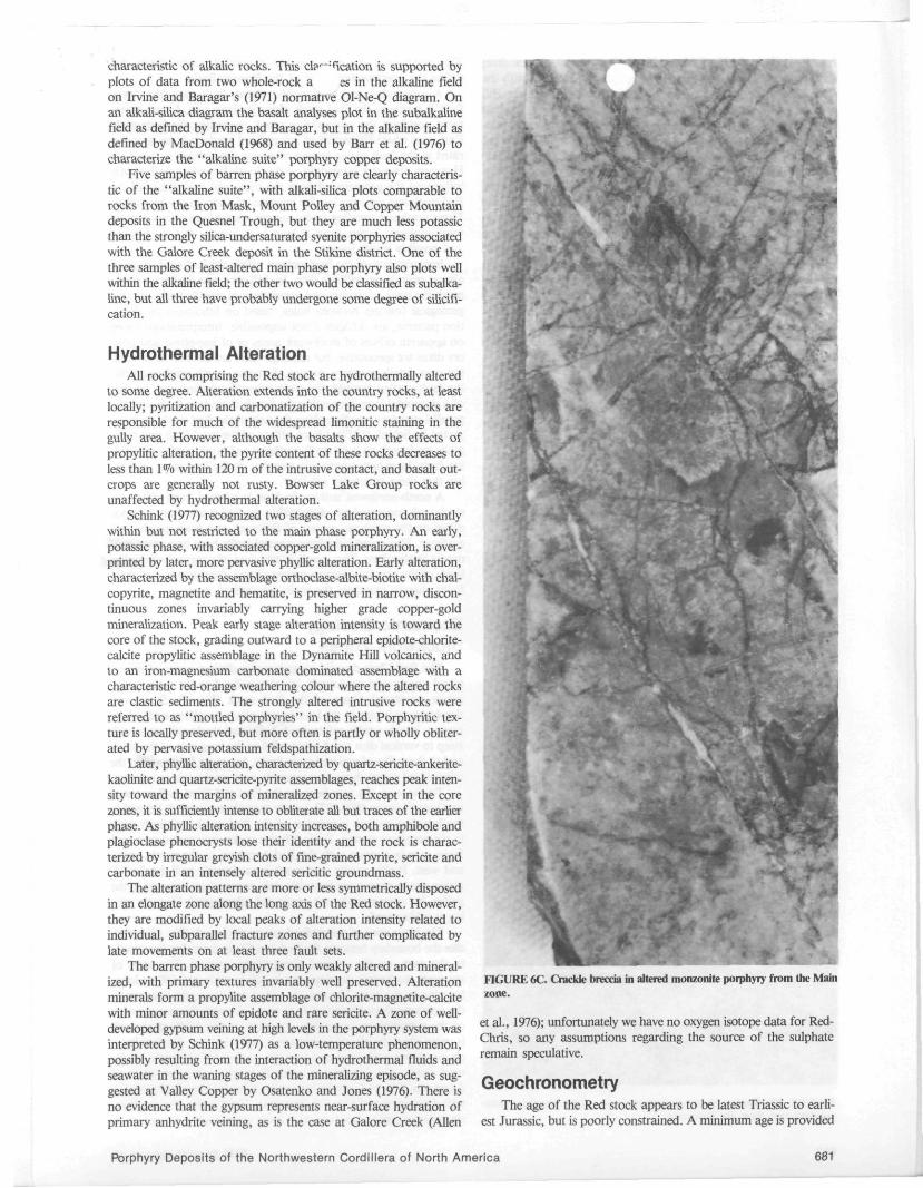
The Main zone of mineralized quartz stockwork (Fig. 6B) straddles the boundary between the Red and Chris claims but lies mostly to the west, on the original Great Plains ground. The zone of strongest stockwork development is 300 m wide and 600 m long, tapering to the east. The zone is widest and strongest adjacent to the north-northwest-trending fault that delineates the western edge of the potential ore zone (Fig. 7). West of this fault, stockwork is more characteristic of higher levels in the system. Narrow breccia zones are well developed in some sections of the main stock-work body. Crackle breccia, with little or no disorientation of fragments (Fig. 6C), grades into zones of more intense brecciation with disoriented and abraded fragments. The margins of these breccia zones in some cases consist of finely comminuted material with
CIM Special Volume 46
only a few subrounded fragments. Veir '' t apophyses of this fine matrix material intrude fractures in the jsing rocks. Fragments of well-mineralized quartz-vein stockwork are common in some breccias, which may also be cut by later stockwork veining. The breccias are interpreted to be the result of sharp pressure release due to episodic volcanic venting during the mineralizing process.
The East zone is a narrow, sharply defined lenticular body of intensely developed quartz-vein stockwork, some 200 m long by 60 m wide, carrying relatively high-grade chalcopyrite mineralization, within a broader envelope of weakly developed, almost barren pyritic stockwork (Fig. 8). The high-grade core is a sheeted quartz-sulphide (dominantly chalcopyrite) zone in which fine (millimetre scale) bands of quartz are interlaminated with parallel bands of pyrite and chalcopyrite (Fig. 6D). Cockscomb texture in the quartz, seen in thin section, suggests repeated episodes of open space filling. Contacts of the sheeted zone with the enclosing stockwork may be sharp and cross-cutting, or gradational through gradually decreasing fracture density. One respected British Columbia consulting geologist interpreted the sheeted zone as a screen of mineralized quartzite of unknown affinity, enclosed within the Red porphyry, a conclusion that provides a measure of the intensity of the fracturing and silicification.
Stockwork Mineralogy Individual stockwork veinlets vary from a millimetre to several
centimetres in thickness, and are commonly 5 mm to 10 mm wide. Cross-cutting relationships demonstrate repeated episodes of fracturing and mineralization. In the strongest stockwork zones, quartz-vein density exceeds 50 to 60 per metre. Stockwork veinlets carry sulphide minerals as narrow centre-fillings, coatings and fillings in fine cross-fractures, and as fine disseminations.
The principal sulphide minerals are pyrite and chalcopyrite. Bor-nite is present locally, especially at depth, but no lateral zoning pattern between chalcopyrite and bornite is recognized. Chalcopyrite is often associated with fine-grained magnetite or, more commonly, hematite after magnetite. Molybdenite, galena and sphalerite occur locally in trace amounts. Chalcocite, covellite, malachite and azurite are present in an extremely thin and discontinuous supergene zone at the bedrock surface, but are of no economic significance. Small clots and discrete grains of chalcopyrite also occur as replacements of amphibole in less altered phases of the porphyry, but copper grade varies more or less directly with the intensity of stockwork veining.
Gold grades reach levels in excess of 3 g/t in the richest section of the East zone and average 0.34 g/t overall (for the material included in the resource estimate, q.v.). Gold generally shows a very close correlation with copper in individual intercepts bounded by faults or barren zones, but Cu:Au ratios vary significantly from hole to hole (see Panteleyev, 1977) and even between discrete sections in a single hole. Schinck (1977), after study of several polished sections, noted two minute (60 /itn) grains of gold in fine-grained chalcopyrite. Unfortunately, he did not state whether the gold was within individual chalcopyrite grains or on grain boundaries. Based on a very few assays, silver grades in the deposit are probably in the range of 1 to 2 g/t.
Based on several hundred geochemical analyses of drill-core samples (3 m assay intervals or 15 m composites), molybdenum values range from 1 ppm to 140 ppm, averaging roughly 20 ppm. There is no obvious correlation of molybdenum with copper or gold.
Quartz-vein stockworks are cut by sulphide veinlets essentially devoid of quartz. These are generally pyritic, but veinlets of massive chalcopyrite locally sweeten the grade. The pyritic veinlets are common in peripheral areas of weak copper mineralization where they are associated with narrow veinlets carrying abundant hematite.
Late, vuggy carbonate veins occur throughout the Red stock. Widely spaced veins of pale pink to white calcite or quartz and calcite are generally barren but may contain coarse aggregates of both pyrite and chalcopyrite, and occasionally galena and sphalerite. Carbonate
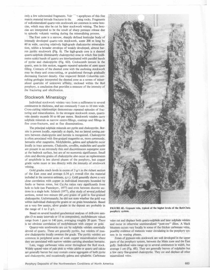
FIGURE 6E. Gypsum vein, typical of the higher levels of the Red-Chris porphyry system.
veins cut and displace both quartz-sulphide and later sulphide veinlets and occur in otherwise unmineralized "post-ore" dikes. A black bitumen occurs very locally in some of the thicker carbonate veins, possibly evidence of meteoric water circulating in the porphyry system in its waning phases.
Zones of gypsum-vein stockwork are well developed in the upper parts of the porphyry system, between the Main zone and the East gully. Individual veins range up to several centimetres in width, but average 1 cm (Fig. 6E). They are generally barren of sulphides but a few carry fine-grained chalcopyrite. They cut and displace all other mineralized veins.
Porphyry Deposits of the Northwestern Cordillera of North America 683
LOOKING EAST
E
I MAIN PHASE - 1 ESSENTIALLY
v * ■ : ■ v s; V- :f;|SP
BARREN
SCATTERED VEINS <0.25% Cu.
WEAK TO MODERATE STOCKWORK 0 .25 - 0.5% Cu.
MODERATE TO STRONG STOCKWORK >0.5% Cu.
BOWSER LAKE GROUP
| | POST-ORE DIKES
LATE PHASE
| f M ^ DYNAMITE HILL VOLCANICS MO
OUTLINE OF PIT USED FOR RESOURCE ESTIMATION
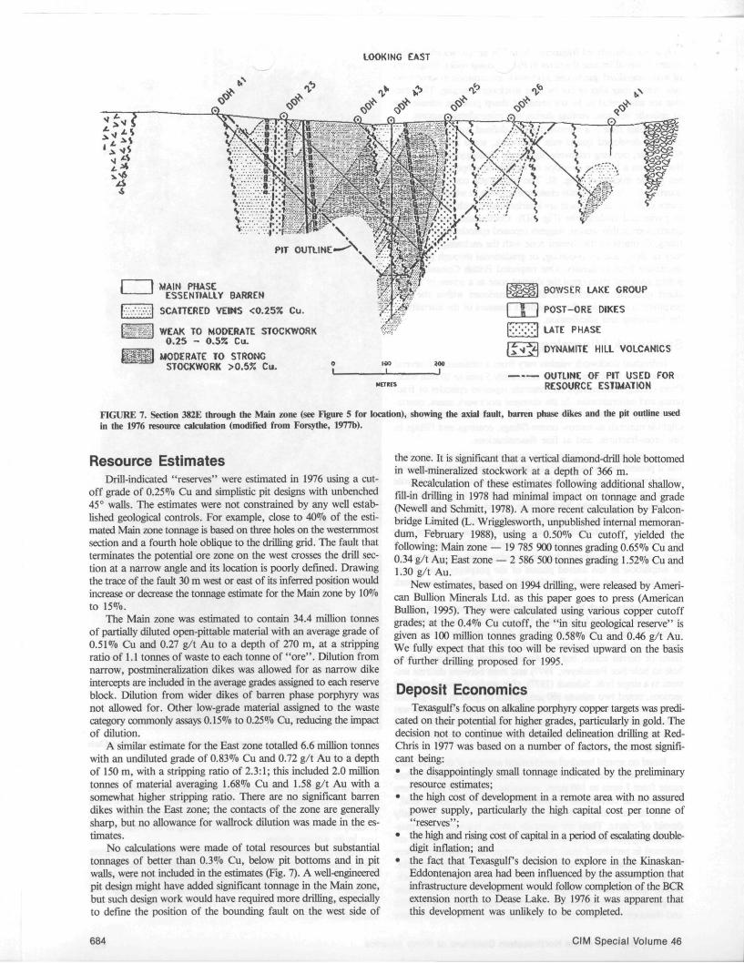
FIGURE 7. Section 382E through the Main zone (see Figure 5 for location), showing the axial fault, barren phase dikes and the pit outline used in the 1976 resource calculation (modified from Forsythe, 1977b).
Resource Estimates Drill-indicated "reserves" were estimated in 1976 using a cut
off grade of 0.25% Cu and simplistic pit designs with unbenched 45° walls. The estimates were not constrained by any well established geological controls. For example, close to 40% of the estimated Main zone tonnage is based on three holes on the westernmost section and a fourth hole oblique to the drilling grid. The fault that terminates the potential ore zone on the west crosses the drill section at a narrow angle and its location is poorly defined. Drawing the trace of the fault 30 m west or east of its inferred position would increase or decrease the tonnage estimate for the Main zone by 10% to 15%.
The Main zone was estimated to contain 34.4 million tonnes of partially diluted open-pittable material with an average grade of 0.51% Cu and 0.27 g/t Au to a depth of 270 m, at a stripping ratio of 1.1 tonnes of waste to each tonne of "ore". Dilution from narrow, postmineralization dikes was allowed for as narrow dike intercepts are included in the average grades assigned to each reserve block. Dilution from wider dikes of barren phase porphyry was not allowed for. Other low-grade material assigned to the waste category commonly assays 0.15% to 0.25% Cu, reducing the impact of dilution.
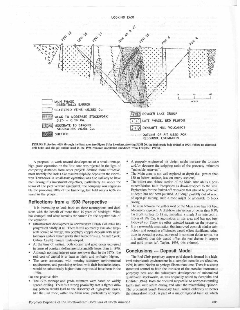
A similar estimate for the East zone totalled 6.6 million tonnes with an undiluted grade of 0.83% Cu and 0.72 g/t Au to a depth of 150 m, with a stripping ratio of 2.3:1; this included 2.0 million tonnes of material averaging 1.68% Cu and 1.58 g/t Au with a somewhat higher stripping ratio. There are no significant barren dikes within the East zone; the contacts of the zone are generally sharp, but no allowance for wallrock dilution was made in the estimates.
No calculations were made of total resources but substantial tonnages of better than 0.3% Cu, below pit bottoms and in pit walls, were not included in the estimates (Fig. 7). A well-engineered pit design might have added significant tonnage in the Main zone, but such design work would have required more drilling, especially to define the position of the bounding fault on the west side of
the zone. It is significant that a vertical diamond-drill hole bottomed in well-mineralized stockwork at a depth of 366 m.
Recalculation of these estimates following additional shallow, fill-in drilling in 1978 had minimal impact on tonnage and grade (Newell and Schmitt, 1978). A more recent calculation by Falcon-bridge Limited (L. Wrigglesworth, unpublished internal memorandum, February 1988), using a 0.50% Cu cutoff, yielded the following: Main zone — 19 785 900 tonnes grading 0.65% Cu and 0.34 g/t Au; East zone — 2 586 500 tonnes grading 1.52% Cu and 1.30 g/t Au.
New estimates, based on 1994 drilling, were released by American Bullion Minerals Ltd. as this paper goes to press (American Bullion, 1995). They were calculated using various copper cutoff grades; at the 0.4% Cu cutoff, the "in situ geological reserve" is given as 100 million tonnes grading 0.58% Cu and 0.46 g/t Au. We fully expect that this too will be revised upward on the basis of further drilling proposed for 1995.
Deposit Economics Texasgulf s focus on alkaline porphyry copper targets was predi
cated on their potential for higher grades, particularly in gold. The decision not to continue with detailed delineation drilling at Red-Chris in 1977 was based on a number of factors, the most significant being: • the disappointingly small tonnage indicated by the preliminary
resource estimates; • the high cost of development in a remote area with no assured
power supply, particularly the high capital cost per tonne of "reserves";
• the high and rising cost of capital in a period of escalating double-digit inflation; and
• the fact that TexasgulPs decision to explore in the Kinaskan-Eddontenajon area had been influenced by the assumption that infrastructure development would follow completion of the BCR extension north to Dease Lake. By 1976 it was apparent that this development was unlikely to be completed.
684 CIM Special Volume 46
LOOKING EAST
□ MAIN PHASE ESSENTIALLY BARREN
SCATTERED VEINS <0.25% Cu.
f " f f : f WEAK TO MODERATE STOCKWORK 0.25 - 0.5% Cu.
MODERATE TO STRONG STOCKWORK >0.5% Cu.
SHEETED
fjygg^l 80WSER LAKE GROUP
[ f ' - f ^ | LATE PHASE, RED PLUTON
|£»1*1 OYNAMITE HILL VOLCAMICS
OUIUME OF PIT USED FOR RESOURCE ESTIMATION
FIGURE 8. Section 406E through the East zone (see Figure 5 for location), showing PDH 20, the high-grade hole drilled in 1974, follow-up diamond-drill holes and the pit outline used in the 1976 resource calculation (modified from Forsythe, 1977b).
A proposal to work toward development of a small-tonnage, high-grade operation on the East zone was rejected in the light of competing demands from other projects deemed more attractive, most notably the Izok Lake massive sulphide deposit in the Northwest Territories. A small-scale operation was also unlikely to have met Texasgulf s investment objectives, particularly as, under the terms of the joint venture agreement, the company was responsible for providing 80% of the financing, but held only a 60% interest in the project.
Reflections from a 1993 Perspective It is interesting to look back on these assumptions and deci
sions with the benefit of more than 15 years of hindsight. What has changed and what remains the same? On the negative side of the equation: • Infrastructure development in northwestern British Columbia has
progressed hardly at all. There is still no readily available large-scale source of energy, and porphyry copper deposits with larger tonnages and/or better grades than Red-Chris (e.g. Schaft Creek, Galore Creek) remain undeveloped.
• At the time of writing, both copper and gold prices expressed in terms of constant dollars are substantially lower than in 1976.
• Although nominal interest rates are lower than in the 1970s, the real cost of capital is at least as high, and probably higher.
• The costs associated with meeting statutory environmental requirements, and permitting reviews, with their inevitable delays, would be substantially higher than they would have been in the 1970s.
On the positive side: • The 1976 tonnage and grade estimates were based on widely
spaced drilling. There is a strong possibility that a tighter drilling pattern would lead to the discovery of high-grade lenses, like the East zone, within the Main zone, particularly at depth.
• A properly engineered pit design might increase the tonnage and/or decrease the stripping ratio of the presently estimated "mineable reserves".
• The Main zone is not well explored at depth (i.e. greater than 150 m below surface, less on many sections).
• The widest and richest section of the Main zone abuts a post-mineralization fault interpreted as down-dropped to the west. Exploration for the faulted-off extension that should be preserved at depth has not been pursued. Although possibly out of reach of open-pit mining, such a zone might be amenable to block caving.
• The area between the gullies west of the Main zone has not been adequately explored. A drill-hole intersection of better than 0.5% Cu from surface to 18 m, including a single 3 m intercept in excess of 1% Cu, is anomalous in this area and has not been followed up. There are other untested targets on the property.
• It is a reasonable assumption that improved open-pit mining technology and operating efficiencies would effect significant reductions in operating costs, expressed in constant dollar terms, but it is unlikely that this would offset the real decline in copper and gold prices (cf. Taylor, 1995, this volume).
Conclusions — Deposit Model The Red-Chris porphyry copper-gold deposit formed in a high-
level subvolcanic environment in a complex oceanic arc (Souther, 1991) in latest Norian to perhaps Sinemurian time. There is a strong structural control to both the intrusion of the crowded monzonite porphyry host and the subsequent development of mineralized quartz-vein stockworks, as was originally noted by Seraphim and Hollister (1976). Both are oriented subparallel to northeast-trending faults that were active during and after the mineralizing episode. The prominent South Boundary fault, which obliquely truncates the mineralized stock, is part of a major regional fault set which
Porphyry Deposits of the Northwestern Cordillera of North America 685
marks the northwestern limit of Bowse'" ke Group outcrop along most of the length of the Red massif, which may in fact have been active during as well as after deposition of Bowser Lake strata.
The deposit has characteristics of both the alkalic and calc-alkalic classes of volcanic porphyry copper deposits. The quartz-poor host-rocks, high gold values and virtual absence of molybdenum are characteristic of the alkalic deposits; the strongly developed quartz-vein stockworks and phyllic alteration are more typical of the calc-alkalic class. The size of Red-Chris is more characteristic of the alkalic deposits but, apart from complications resulting from post-mineral fault movements, grade distribution appears to be less erratic than in many alkalic porphyry copper deposits — as, for example, at Ingerbelle (Copper Mountain). Mineralized zones, as presently known, are entirely within the main phase of the host porphyry. The later barren phase is less strongly altered and contains only a very minor amount of copper. Except at the highest levels of the Red stock, hydrothermal effects within the country rocks are weak, characterized by pyritization and propylitic alteration assemblages. The chemistry of both phases of the crowded monzonite porphyry is similar to that of intrusive rocks at other alkalic porphyry deposits in British Columbia, and we interpret the apparently calc-alkalic features as the result of secondary processes. We believe that the weight of the available evidence prior to the recent drilling placed the Red-Chris deposit in the alkalic class of volcanic porphyry copper deposits.
Schink (1977), basing his conclusions largely on field evidence, proposed a genetic model for the Red-Chris deposit. He linked its "hybrid" characteristics to a preponderance of seawater, as opposed to fresh meteoric water, in the non-magmatic water component of the hydrothermal system. Rocks emplaced at very high levels in the volcanic pile are exposed in the gully area at the western end of the stock, where there is evidence of venting to a surface which was clearly subaqueous and which is presumed to have been submarine. The gypsum-vein stockwork developed in this area is interpreted to be the result of interaction between seawater and hydrothermal fluids. This hypothesis is partially supported by the observation of gypsum as deep as 150 m below surface, apparently not formed as the result of near-surface hydration of primary anhydrite, implying very cool conditions for this stage of alteration (Holland, 1967). The exposure of progressively shallower levels of intrusion to the west is probably the result of west-side-down displacements on a set of late, north-northwest striking normal faults.
We believe that intrusion of the main phase monzonite porphyry into the Red-Chris volcanic pile, and subsequent upward migration of the hydrothermal fluids responsible for the orthoclase-albite-biotite alteration and copper-gold mineralization, were controlled by steep northeast-striking fractures. Quartz, together with copper and iron sulphides, was deposited as the stock cooled, solidified and fractured; the sodium and potassium necessary for the formation of albite, orthoclase and biotite were probably released by the dissociation of alkali chloride complexes (Schink, 1977). Subsequent phyllic alteration occurred in the zone of mixing of hydrothermal and ocean waters. Late in the volcanic cycle, the zone of mixing collapsed inward, resulting in phyllic overprinting of the early alteration assemblage. Barren phase monzonite porphyry was intruded after the 'main alteration event' and is much less strongly altered and mineralized. It seems most likely that the deposit resulted from processes such as postulated by McMillan and Panteleyev (1985) for the convective fluid-flow pattern model for porphyry copper formation. In this model, "thermally driven convective cells are initiated by emplacement of the magma. The permeability of the country rock, enhanced by the intrusive events, is sufficient to allow convective circulation to begin. Convection thoroughly redistributes fluids and concentrates ore and gangue constituents in and near the intrusion".
An economic future for the Red-Chris deposit is probably dependant on the ability to at least double the tonnage of easily mineable higher grade material and back this up with a significantly
686
increased reserve of typ;'~' Main zone grade; both are within the realms of geological p Jity. Early reports are that American Bullion Minerals is enjoying considerable success in moving toward these objectives, however, progress in infrastructure development in this part of British Columbia will remain a critical factor in deposit economics.
A 1994 Update The work completed by American Bullion Minerals Ltd. in the
summer of 1994 has rejuvenated interest in the Red-Chris deposit after almost 15 years of dormancy. Our observations that the deposit was poorly explored at depth, and that a tighter drilling pattern might well lead to discovery of high-grade mineralization within the Main zone, have been more than validated. In summary, not only has the 1994 drilling demonstrated that stockwork mineralization is developed over greater widths below the depth of previous drilling in both zones, it has also shown that grades increase significantly with depth, at least in part due to the presence of increasing amounts of bornite. We hope that further exploration in the area between the gullies west of the Main zone, planned for 1995, will be equally successful.
Changing views on deposit classification are a second, predictable outcome of a fresh look and new data. Relatively few pigeon holes were available for the classification of porphyry copper deposits in the 1970s. Strongly influenced by the high gold content and lack of molybdenum, we favoured a variant of the alkalic porphyry model for the Red-Chris deposit. Research on porphyry copper systems in the intervening years has documented many variations from traditional classifications (Thompson, 1995, this volume), particularly with respect to metal abundances and ratios. Ogryzlo et al. (1995, this volume) speculate that anomalously high gold contents of the Morrison Lake and Hearne Hill deposits in the Babine district of British Columbia may be derived from a primitive alkalic magma, subsequently modified by crustal contamination. Perhaps Red-Chris is also some such hybrid, defying easy classification.
Acknowledgments Memory is fallible and we appreciate Falconbridge Limited, heir
to Texasgulf s data, making the old reports available to us and removing any possibility that the "facts" have become distorted by the passage of time. Falconbridge, Norcen Energy and Teck Corporation are thanked for permission to publish this paper; and also Chris Ash of the British Columbia Geological Survey Branch and the geological team at American Bullion for sharing some of their ideas and information with us. Comprehensive reviews by Harlan Meade and Andr6 Panteleyev led to improvements to the manuscript. John Armitage kindly prepared the maps and sections.
Over the years that Texasgulf Inc. explored the Red-Chris property, many geologists contributed to the synthesis presented here. In 1975, D.W. Coates Enterprises drill crews established a new world record for footage drilled with a single machine in a 28-day period. Core recovery was invariably close to 100% and the core shack was always a busy place, from northern dawn to dusk and beyond. We particularly acknowledge the contributions of Jay Forsythe, project geologist from 1974 through 1976, and Allen Schink; their work is the foundation of this paper. Others who shared space at the logging benches from time to time include Murray Cooper, Peter DeLancey, Doug Donnelly, Terry Elliot, Craig Leitch, Harlan Meade and Rolf Schmitt.
Rick Barclay, Ian Johnson and their crew did all the hard labour in pioneering the bedrock-surface sampling technique that was subsequently used extensively on other properties in the region. Tom and Robin Black at Eddontenajon and later Terrace were most helpful as expeditors. Last but not least, we acknoweldge the contribution of our pilot, Vince Edwards, who provided smooth and, above all, safe helicopter service on this and many other projects throughout British Columbia and Yukon over a 12-year period.
CIM Special Volume 46
REFERENCES
ALLEN, D.G., PANTELEYEV, A. and ^vlSTRONG, A.T., 1976. Galore Creek. In Porphyry Deposits of the Canadian Cordillera. Edited by A. Sutherland Brown. Canadian Institute of Mining and Metallurgy, Special Volume 15, p. 402-414.
AMERICAN BULLION MINERALS LTD. Feb. 1, 1995. Press Release. Red-Chris Reserves, 1 p.
ASH, C.H., FRASER, T.M., BLANCHFLOWER, J.D. and THUR-STON, B.G., 1995. Tatogga Lake project, northwestern British Columbia (104H/11.12). In Geological Fieldwork in British Columbia 1994. Edited by B. Grant and J.M. Newell. British Columbia Ministry of Energy, Mines and Petroleum Resources, Paper 1995-1, p. 343-358.
BARR, D.A., FOX, P.E., NORTHCOTE, K.E. and PRETO, V.A., 1976. The alkaline suite porphyry deposits — A summary. In Porphyry Deposits of the Canadian Cordillera. Edited by A. Sutherland Brown. Canadian Institute of Mining and Metallurgy, Special Volume 15, p. 359-367.
CHAPLIN, R.E., 1971. Geophysical assessment report (induced polarization) on the Red Group, Ealue Lake area, Liard Mining Division, British Columbia. British Columbia Ministry of Energy, Mines and Petroleum Resources, Assessment Report 3202.
COOPER, M.F.J., 1978. Geology of the Rose porphyry copper occurrence, Northwestern British Columbia. Unpublished M.Sc. thesis. Queen's University, Kingston, Ontario, 220 p.
EVENCHICK, C.A., 1991. Jurassic stratigraphy of East Telegraph Creek and West Spatsizi map areas, British Columbia. In Current Research, Part A. Geological Survey of Canada, Paper 91-1A, p. 155-162.
FORSYTHE, J.R., 1975. Report of diamond drilling, percussion drilling and geophysical surveys, Red-Chris property, Ealue Lake area, Liard Mining Division. British Columbia Ministry of Energy, Mines and Petroleum Resources, Assessment Report 5741.
FORSYTHE, J.R., 1977a. Report on geochemical and geophysical surveys, Red-Chris property, Ealue Lake area, Liard Mining Division. British Columbia Ministry of Energy, Mines and Petroleum Resources, Assessment Report 6489.
FORSYTHE, J.R., 1977b. 1976 Summary report, Red-Chris property. Unpublished company report, Texasgulf Inc., 33 p.
FORSYTHE, J.R. and PEATFIELD, G.R., 1974. Report on diamond drilling, percussion drilling and linecutting, Red-Chris property, Liard Mining Division. British Columbia Ministry of Energy, Mines and Petroleum Resources, Assessment Report 5297.
FORSYTHE, J.R., NEWELL, J.M., PEATFIELD, G.R. and SCHINCK, E.A., 1976. The Red-Chris porphyry copper deposit, Ealue Lake, B.C. Abstract with program, 1st Annual District 6 Meeting, Canadian Institute of Mining and Metallurgy, Vancouver, October 1976, p. 8.
GABRIELSE, H. and TIPPER, H.W., 1984. Bedrock geology of Spatsizi map area (104H) British Columbia. Geological Survey of Canada, Open File 1005. Map, scale 1:125 000.
GLEESON, C.F. and CORMIER, R., 1971. Evaluation by geochemistry of geophysical anomalies and geological targets using overburden sampling at depth. In Geochemical Exploration. Edited by R.W. Boyle. Canadian Institute of Mining and Metallurgy, Special Volume 11, p. 159-165.
GREEN, G.M., 1991. Detailed sedimentology of the Bowser Lake Group, northern Bowser Basin, British Columbia. In Current Research, Part A. Geological Survey of Canada, Paper 91-1 A, p. 187-195.
HOLLAND, H.D., 1967. Gangue minerals in hydrothermal deposits. In Geochemistry of Hydrothermal Ore Deposits. Edited by H.L. Barnes. Holt, Rinehart, Winston, Inc., New York, p. 382-436.
IRVINE, T.N. and BARAGAR, W.R.A., 1971. A guide to the chemical classification of the common volcanic rocks. Canadian Journal of Earth Sciences, 8, p. 523-548.
LaSALLE, P., WARREN, B., GILBERT, P., JACOB, H.L. and LaSALLE, Y.R., 1975. Moraine sampling under varved clays in the Rouyn - Val d'Or Area: general results. In Geochemical Exploration 1974. Edited by I.L. Elliot and W.K. Fletcher. Association of Exploration Geochemists, Special Publication No. 2, Elsevier Scientific Publishing Company, p. 595-610.
LEITCH, C.H.B. and ELLIOT, T.M., 1976. Geology and mineralization, Red-Chris property. Unpublished company report, Texasgulf Inc., 28 p.
MacDONALD, G.A., 1968. Composition and origin of Hawaiian lavas. Geological Society of America, Memoir 116, p. 477-522.
McAUSLAND, J.H., 1970. Geochemical report on Central Sus Group, Ealue Lake district, Liard M.D., B.C. British Columbia Ministry of Energy,
Mines and Petroleum ^ purees, Assessment Report 3044. McMILLAN, W.J., 1991. iyry deposits in the Canadian Cordillera.
In Ore Deposits, Tectonics and Metallogeny in the Canadian Cordillera. British Columbia Ministry of Energy, Mines and Petroleum Resources, Paper 199M, p. 253-276.
McMILLAN, W.J. and PANTELEYEV, A., 1985. Porphyry copper deposits. In Ore Deposit Models. Edited by R.G. Roberts and P.A. Sheahan. Geological Association of Canada, Geoscience Canada Reprint Series 3, p. 45-58.
MONGER, J.W.H., WHEELER, J.O., TIPPER, H.W., GABRIELSE, H., HARMS, T., STRUIK, L.C., CAMPBELL, R.B., DODDS, C.J., GEHRELS, G.E. and O'BRIEN, J., 1991. Part B. Cordilleran ter-ranes. In Upper Devonian to Middle Jurassic assemblages. Chapter 8 of Geology of the Cordilleran Orogen in Canada. Edited by H. Gabrielse and C.J. Yorath. Geological Survey of Canada, Geology of Canada, No. 4, p. 281-327 (also Geological Society of America, The Geology of North America, Volume G-2).
NEWELL, J.M., 1978. Report on diamond drilling on Chris 2 and 4 mineral claims, Ealue Lake area, Liard Mining Division. British Columbia Ministry of Energy, Mines and Petroleum Resources, Assessment Report 6872.
NEWELL, J.M. and LEITCH, C.H.B., 1976. Report on diamond drilling, Red-Chris property, Ealue Lake area, Liard Mining Division. British Columbia Ministry of Energy, Mines and Petroleum Resources, Assessment Report 6111.
NEWELL, J.M. and SCHMITT, H.R., 1978. 1978 diamond drilling report, Red-Chris property, Liard Mining Division, B.C. Unpublished company report, Texasgulf Inc.
NEWELL, J.M., CARTER, N.C. and SUTHERLAND BROWN, A., 1995. Porphyry deposits of the northwestern Cordillera: A retrospective. In Porphyry Deposits of the Northwestern Cordillera of North America. Edited by T.G. Schroeter. Canadian Institute of Mining and Metallurgy, Special Volume 46.
OGRYZLO, P.L., DIROM, G.E. and STOTHART, P.G., 1995. Morrison Lake - Hearne Hill copper-gold deposits, Babine region, west-central British Columbia. In Porphyry Deposits of the Northwestern Cordillera of North America. Edited by T.G. Schroeter. Canadian Institute of Mining, Metallurgy and Petroleum, Special Volume 46.
OSATENKO, M.J. and JONES, M.B., 1976. Valley Copper. In Porphyry Deposits of the Canadian Cordillera. Edited by A. Sutherland Brown. Canadian Institute of Mining and Metallurgy, Special Volume 15, p. 130-143.
PANTELEYEV, A., 1973. Chris. In Geology, Exploration and Mining in British Columbia 1972. British Columbia Ministry of Energy, Mines and Petroleum Resources, p. 535-537.
PANTELEYEV, A., 1975. Windy, Red, Chris, Sus. In Geology, Exploration and Mining in British Columbia 1974. British Columbia Ministry of Energy, Mines and Petroleum Resources, p. 340-343.
PANTELEYEV, A., 1977. Chris, Red, Sus, Windy. In Geology in British Columbia 1975. British Columbia Ministry of Energy, Mines and Petroleum Resources, p. G85-G87.
PEATFIELD, G.R., 1980. Report on diamond drilling on the Red 9 mineral claim (part of the Red-Chris property), Liard Mining Division. British Columbia Ministry of Energy, Mines and Petroleum Resources, Assessment Report 8994.
PEATFIELD, G.R., 1981. Gold geochemistry in the search for porphyry copper-gold deposits, Eddontenajon area, northwestern British Columbia. Programme and Abstract (sic), Symposium on Precious Metals in the Northern Cordillera. Association of Exploration Geochemists, Cordilleran Section/Geological Association of Canada, Vancouver, April 1981.
PEATFIELD, G.R. and ARMSTRONG, A.T., 1979. The Red-Chris porphyry copper-gold deposit, northwestern British Columbia — A geochemical case history. In Proceedings of the 7th International Geochemical Exploration Symposium, Golden, Colorado. Association of Exploration Geochemists, p. 479-485.
PEATFIELD, G.R. and HODGSON, C.J., 1983. The Red-Chris porphyry copper-gold deposit, northwestern British Columbia — geology and regional setting. Abstract, Northern Geoscience Forum, Whitehorse, Yukon, December 1983.
READ, P.B., 1984. Geology, Klastline River (104G/16E), Ealue Lake (104H/13W), Cake Hffl (104I/4W) and Stikine Canyon (104J/1E), British Columbia. Geological Survey of Canada, Open File 1080, 1:50 000 compilation map.
REYNOLDS, N., 1969a. Report on geochemical soil sampling survey, Money mineral claims. British Columbia Ministry of Energy, Mines
Porphyry Deposits of the Northwestern Cordillera of North America ftel}2Z4~7££<L
687
and Petroleum Resources, Assessnv*- Report 2164. REYNOLDS, N., 1969b. Report on geolo^ irvey, Money mineral claims.
British Columbia Ministry of Energy, Mines and Petroleum Resources, Assessment Report 2165.
SCHINK, E.A., 1977. Geology of the Red-Chris porphyry copper deposit, northwestern British Columbia. Unpublished M.Sc. thesis, Queen's University, Kingston, Ontario, 211 p.
SCHMITT, H.R., 1977. A Triassic-Jurassic granodiorite monzodiorite pluton southeast of Telegraph Creek, B.C. Unpublished B.Sc. thesis, The University of British Columbia, Vancouver, British Columbia, 91 p.
SERAPHIM, R.H. and HOLLISTER, V.F., 1976. Structural settings. In Porphyry Deposits of the Canadian Cordillera. Edited by A. Sutherland Brown. Canadian Institute of Mining and Metallurgy, Special Volume 15, p. 3043.
SOUTHER, J.G., 1972. Telegraph Creek map-area, British Columbia (Report and Map 11-1971). Geological Survey of Canada, Paper 71-44, 38 p.
SOUTHER, J.G., 1991. Volcanic regimes. Chapter 14 of Geology of the Cordilleran Orogen in Canada. Edited by H. Gabridse and C. J. Yorath. Geological Survey of Canada, Geology of Canada, No. 4, p. 459-490 (also Geological Society of America, The Geology of North America, Volume G-2).
SOUTHER, J.G., BREW, D.A. and OKULITCH, A.V., 1974. Iskut River, British Columbia - Alaska. Geological Survey of Canada, Map 1418A. 1:1 000 000 compilation.
TAYLOR, H.K., 1995. V~+ern Canadian porphyry deposits — economic perspectives, perfor s and prospects. In Porphyry Deposits of the Northwestern Cordintra of North America. Edited by T.G. Schroeter. Canadian Institute of Mining, Metallurgy and Petroleum, Special Volume 46.
TEMPLETON, T.J., 1976. Petrography and geological events of Triassic-Jurassic rocks, northwest British Columbia. Unpublished B.Sc. thesis, University of Western Ontario, London, Ontario, 47 p.
THOMPSON, J.F.H., 1995. Exploration and research related to porphyry deposits. In Porphyry Deposits of the Northwestern Cordillera of North America. Edited by T.G. Schroeter. Canadian Institute of Mining, Metallurgy and Petroleum, Special Volume 46.
THOMSON, R.C., SMITH, P.L. and TIPPER, H.W., 1986. Lower to Middle Jurassic (Pliensbachian to Bajocian) stratigraphy of the northern Spatsizi area, north-central British Columbia. Canadian Journal of Earth Sciences, 23, p. 1963-1973.
WHEELER, J.O. and McFEELY, P. (compilers), 1991. Tectonic assemblage map of the Canadian Cordillera and adjacent parts of the United States of America. Geological Survey of Canada, Map 1712A, scale 1: 2 000 000.
WOODSWORTH, G.J., ANDERSON, R.G. and ARMSTRONG, R.L., 1991. Plutonic regimes. Chapter 15 of Geology of the Cordilleran Orogen in Canada. Edited by H. Gabrielse and C.J. Yorath. Geological Survey of Canada, Geology of Canada, No. 4, p. 493-531 (also Geological Society of America, The Geology of North America, Volume G-2).
688 CIM Special Volume 46