Semantic Uplift of Monitoring Data to Select Policies to Manage Home Area Networks

ARTICLE IN PRESS
1040-6182/$ - se
doi:10.1016/j.qu
�CorrespondE-mail addr
Please cite th
Quaternary In
Quaternary International ] (]]]]) ]]]–]]]
Tectonically induced coastal uplift mechanism of Gokc-eada Island,Northern Aegean Sea, Turkey
H. Koral�, H. Ozturk, N. Hanilc- i
Department of Geological Engineering, Istanbul University, Avcilar 34320, Istanbul, Turkey
Abstract
This paper presents evidence of coastal uplift on Gokc-eada (formerly Imbros) Island, situated in the northern Aegean Sea in proximity
to a deep trough along the seismically active North Anatolian Fault (NAF). The island comprises 2 km thick sedimentary strata
underlain by metamorphic rocks which are similar to those observed 170 km to the north in the Strandzha–Rhodope Mountains. The
sedimentary strata begin at the bottom with Eocene turbidites and limestones, continue upward with Oligocene–Lower Miocene detritial
rocks and andesitic volcanoclastics, and end with loosely consolidated sandstones of the Upper Miocene–Pliocene at the top. The island
at its extreme eastern coast has a peneplain form. However, at its northern part it is mountainous and has steeply inclined coastal cliffs,
uplifted paleo-shore notches, hanging valleys, springs, waterfalls, uncemented slope deposits, travertine formations, and exposed fault
scarps. Field evidence of many coastal morphological, geological and tectonic features together with corresponding seismic reflection
data suggest that the island has experienced a rapid uplift (i.e. vertical displacement) with respect to the Saros Trough along the NAF.
Total uplift is on the order of a few kilometers since the initiation of the NAF during Pliocene (or late Pleistocene as suggested by some
studies), and the yearly rate varies from a few millimeters to a centimeter according to the age assumed for this major fault.
r 2008 Elsevier Ltd and INQUA. All rights reserved.
1. Introduction
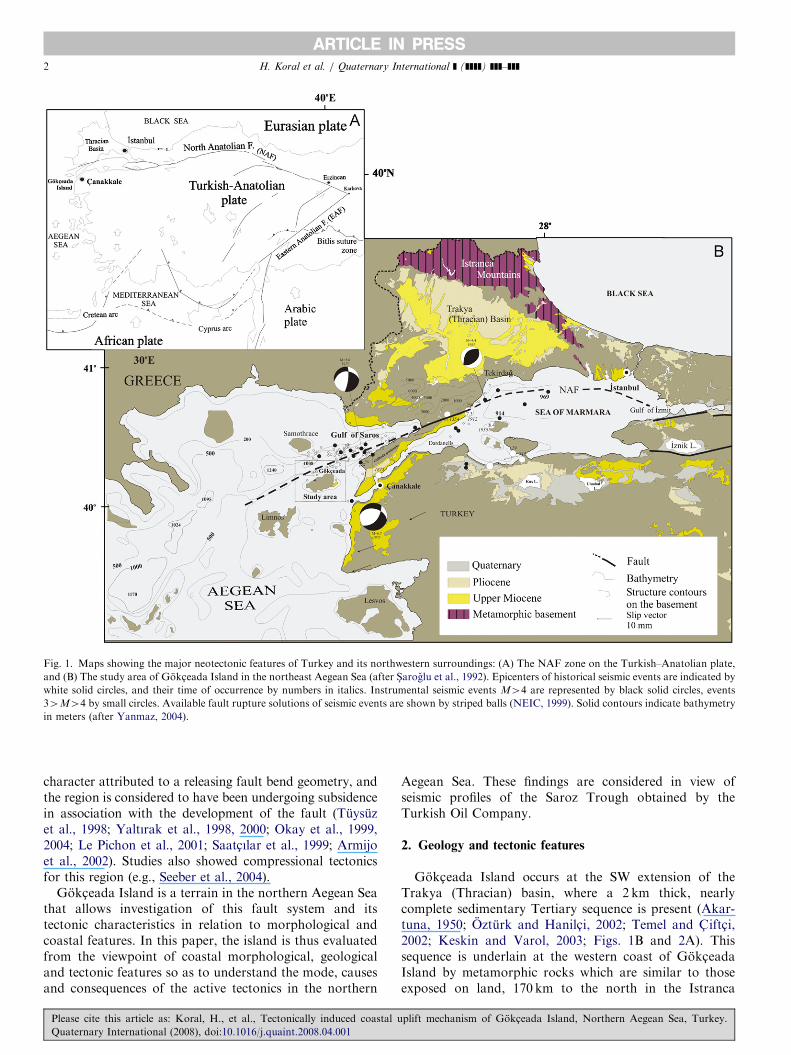
Turkey is located within the tectonically active Alpine-Himalayan orogenic belt which is the youngest mountainrange on Earth. In this complex tectonic setting, thecollision of the Arabian, African and Eurasian plates withthe interlaying Anatolian block has led to the creation ofmountain ranges such as the Caucasus and the Pontides(McKenzie, 1972; Dewey et al., 1973), strike-slip faultzones that accommodate the westward escape of theAnatolian block (S-engor et al., 1985; Barka, 1992), and asubduction zone and associated back-arc spreading to thesouthwestern boundary of the Anatolian block in theMediterranean and the Aegean Seas (Le Pichon andAngelier, 1981) (Fig. 1A). Within this tectonic frame-work, the Anatolian plate moves westward at rates of2–2.25 cma�1, forming a unique example of escapetectonics (S-engor, 1979; Westaway, 1994; Reilinger et al.,1997; Kahle et al., 1998; McClusky et al., 2000). It is
e front matter r 2008 Elsevier Ltd and INQUA. All rights re
aint.2008.04.001
ing author. Tel.: +90212 4737070; fax: +90 212 5911997.
ess: [email protected] (H. Koral).
is article as: Koral, H., et al., Tectonically induced coastal u
ternational (2008), doi:10.1016/j.quaint.2008.04.001
evident from this active tectonic setting that the landscapeof the region would have continuously and intensively beenmodified since its initiation. However, the nature andextent of the tectonic activities which could have led to themodification of morphological and coastal features arerather poorly known (e.g. Bozkurt, 2001; Yılmaz, 2003;Koral, 2006).Gokc-eada Island (formerly known as Imbros) is in
proximity to the western part of the North Anatolian Fault(NAF) zone. Further southwest, this zone extends off-shore to a deep channel known as the North AegeanTrough (e.g., Roussos and Triantafyllos, 1991; S-arogluet al., 1992) (Fig. 1). The NAF, accommodating thewesterly movement of the Anatolian plate since thePliocene (S-engor et al., 1985; Barka, 1992; Armijo et al.,1999; Hubert-Ferrari et al., 2002; Herece and Akay, 2003)or Pleistocene (Le Pichon et al., 2001; S-engor et al., 2005),extends from the Karlıova in eastern Turkey along strike-slip fault morphology into the Sea of Marmara and thenorthern Aegean Sea, where it appears discontinuousand segmented (Fig. 1B). In the Gulf of Saros north ofGokc-eada Island, the NAF exhibits an extensional
served.
plift mechanism of Gokc-eada Island, Northern Aegean Sea, Turkey.
ARTICLE IN PRESS
Fig. 1. Maps showing the major neotectonic features of Turkey and its northwestern surroundings: (A) The NAF zone on the Turkish–Anatolian plate,
and (B) The study area of Gokc-eada Island in the northeast Aegean Sea (after S-aroglu et al., 1992). Epicenters of historical seismic events are indicated by
white solid circles, and their time of occurrence by numbers in italics. Instrumental seismic events M44 are represented by black solid circles, events
34M44 by small circles. Available fault rupture solutions of seismic events are shown by striped balls (NEIC, 1999). Solid contours indicate bathymetry
in meters (after Yanmaz, 2004).
H. Koral et al. / Quaternary International ] (]]]]) ]]]–]]]2
character attributed to a releasing fault bend geometry, andthe region is considered to have been undergoing subsidencein association with the development of the fault (Tuysuzet al., 1998; Yaltırak et al., 1998, 2000; Okay et al., 1999,2004; Le Pichon et al., 2001; Saatc- ılar et al., 1999; Armijoet al., 2002). Studies also showed compressional tectonicsfor this region (e.g., Seeber et al., 2004).
Gokc-eada Island is a terrain in the northern Aegean Seathat allows investigation of this fault system and itstectonic characteristics in relation to morphological andcoastal features. In this paper, the island is thus evaluatedfrom the viewpoint of coastal morphological, geologicaland tectonic features so as to understand the mode, causesand consequences of the active tectonics in the northern
Please cite this article as: Koral, H., et al., Tectonically induced coastal u
Quaternary International (2008), doi:10.1016/j.quaint.2008.04.001
Aegean Sea. These findings are considered in view ofseismic profiles of the Saroz Trough obtained by theTurkish Oil Company.
2. Geology and tectonic features
Gokc-eada Island occurs at the SW extension of theTrakya (Thracian) basin, where a 2 km thick, nearlycomplete sedimentary Tertiary sequence is present (Akar-tuna, 1950; Ozturk and Hanilc- i, 2002; Temel and C- iftc- i,2002; Keskin and Varol, 2003; Figs. 1B and 2A). Thissequence is underlain at the western coast of Gokc-eadaIsland by metamorphic rocks which are similar to thoseexposed on land, 170 km to the north in the Istranca
plift mechanism of Gokc-eada Island, Northern Aegean Sea, Turkey.

ARTICLE IN PRESS
Fig.2.(A
)Generalizedstratigraphic
columnoftheunitsin
theGokc-eadaIsland.(B)Sim
plified
geologicalmapandtectonic
featuresoftheGokc-eadaIsland,superim
posedonthe3-D
morphology
oftheisland(verticalexaggeration1:1).ThefaultsoftheGokc-eadaIslandare
showntogether
withthesteorographic
projectionofslickensideandpaleocurrentdata.Thicklines
indicate
principal
faultsandthin
solidordashed
lines
indicate
secondary
faults.Slickensidedata
representedbycirclesindicate
oblique-slip
onfaultsparallelto
thelongaxisoftheisland.Paleocurrentdata
werederived
from
theim
bricate
pebbleswhichindicate
SW’lyflow
directionsasrepresentedbytriangles.
TheStereonetsare
preparedbyusingStereonet
Program
forWindowsbyRichardsW.Allem
endinger
(version1.2).
H. Koral et al. / Quaternary International ] (]]]]) ]]]–]]] 3
Please cite this article as: Koral, H., et al., Tectonically induced coastal uplift mechanism of Gokc-eada Island, Northern Aegean Sea, Turkey.
Quaternary International (2008), doi:10.1016/j.quaint.2008.04.001

ARTICLE IN PRESS
Fig. 3. (A and B) Outcrop and close-up views of the metamorphics exposed along the northern coast of the island. (C and D) Morphological scarp of the
fault near Tepekoy and a close-up of slickensides on the fault plane. (E) Field view from the Yıldız Cove at the northern shore of the Gokc-eada Island that
displays scarps of two fault planes cutting the volcanics. A fresh-water spring and a historical religious ritual site (indicated by a white arrow) occur on the
fault that extends to West truncating the Oligocene sediments. The fault is noted with a segmented geometry even at the picture scale. Coastal area includes
an alluvial terrace and trace of a paleo-shoreline indicated by a black arrow. (F) Western extension of the same fault. Black continuous lines mark planes
of bedding. Note that although truncation of bedding is obvious, there is only subtle change in their inclinations.
H. Koral et al. / Quaternary International ] (]]]]) ]]]–]]]4
(Strandza–Rhodope) Mountains (Figs. 2B, 3A and B).This sequence shows a descending order of age from thewest coast to the east, and contains Eocene turbiditiesand overlying fossil-rich limestone, Oligocene–Miocenesandstones, conglomerates and volcanics, and UpperMiocene–Pliocene mudstones and conglomerates. Thedepressions are filled with Quaternary alluvium.
The lower part of the sedimentary units which outcropsat Ugurlu, Derekoy and Marmaros regions includesturbidites representing relatively deep basinal conditions(Karaagac- Formation) and limestones formed in shallow,warm and calm marine conditions (Sogucak and CeylanFormations) (Fig. 2B). The overlying clastic sedimentaryunit consists mainly of alternating claystone–marl andsandstone–conglomerates and outcrops in the vicinity of
Please cite this article as: Koral, H., et al., Tectonically induced coastal u
Quaternary International (2008), doi:10.1016/j.quaint.2008.04.001
Yıldız Cove, Kuzulimanı, and Uzumlu (Mezardere,Osmancık and Danis-ment Formations). This unit has athickness reaching up to 1000m and indicates deltaicand fluvial depositional conditions. The occurrence ofPolymesoda convexa Brong. suggests an Oligocene (Stam-pian) age for this unit (Akartuna, 1950), but the age islikely to extend to early Miocene on the basis of correlationwith this unit observed in the Trakya (Thracian) Basin(Siyako et al., 1989). Volcanic rocks on the island occur asveins/vents, intrusion centers or as volcanoclastics inter-layered with the sedimentary strata. They usually consti-tute topographic highs of the island and have an andesiticcomposition. Radiometric age determinations by K/Armethod yield ages of 30.4–34.3million years, suggesting anage of late early Oligocene (Ercan et al., 1995). The clastics
plift mechanism of Gokc-eada Island, Northern Aegean Sea, Turkey.

ARTICLE IN PRESS
Fig. 3. (Continued)
H. Koral et al. / Quaternary International ] (]]]]) ]]]–]]] 5
of the Upper Miocene–Pliocene (Kirazlı Formation) occuralong the southeastern coast of the island near Tuzla Lakeand are gently inclined southerly. The mudstone beds havethicknesses reaching up to 1–2m.
The island contains a set of faults in a NE–SWorientation that runs nearly parallel to the seismicallyactive NAF. The westernmost of this set occurs alongthe northern coast of the island, which has a linear trend(Fig. 2B). Another set of faults occurs along the longer axisand across the island (Fig. 3C and D). It is juxtaposed withalluvial deposits near Kuzulimanı, Gokc-eada and Ugurlu.The fault which delimits the Tuzla Lake depression in thesoutheastern part of the island is commonly referred to asthe Kefalos fault. It separates the Upper Miocene–Pliocenesediments from the Oligocene volcanics and is bounded byalluvial cover. These faults are recognized in the field by the
Please cite this article as: Koral, H., et al., Tectonically induced coastal u
Quaternary International (2008), doi:10.1016/j.quaint.2008.04.001
abrupt disappearance of a lithological unit (or appearanceof a different unit) and by morphological evidence such asfault scarps, waterfalls, emergence of springs, and traver-tine formations. They occur in right-stepping order and arenearly vertical dominantly oblique-slip faults (Fig. 2B).Oblique to these, there are antithetic faults oriented NW.
Such a fault occurs a few km W of the Kuzulimanı andcauses uplift of the Eocene units. Another occurs in thecenter of the island with a prominent dip-slip component(BJ-4 in Fig. 2B).A third set of faults is synthetic to the NE-trending faults
and has no clear cross-cutting relationship. Such a fault ispresent near Kalekoy along the northern shore, exhibitingmorphotectonic features such as truncated and disturbedlayering, springs, hanging valleys and uplifted terraces(Figs. 2B and 3E, F). The other example of this set extends
plift mechanism of Gokc-eada Island, Northern Aegean Sea, Turkey.

ARTICLE IN PRESS
Fig. 3. (Continued)
H. Koral et al. / Quaternary International ] (]]]]) ]]]–]]]6
from the western coast towards the Kuzulimanı andexhibits a normal fault character with a component ofleft-handed strike-slip.
3. Coastal morphotectonic features
Gokc-eada Island has a NE–SW elongated and asym-metric landscape with a long axis of 28 km and a short axisof 12 km. It has a high and rough topography along itsnorthern shore that diminishes towards the south and eastwith a depression in the middle (Fig. 4). The northerncoastline of the island that lies close to the NAF has peaksreaching up to 673m with a steep topography extendinginto the North Aegean Trough. The southern coastline is
Please cite this article as: Koral, H., et al., Tectonically induced coastal u
Quaternary International (2008), doi:10.1016/j.quaint.2008.04.001
smoother with an average altitude of 150m and contains alagoon that is often disturbed by rough sea in the wintermonths. The island has a water division line in a NEorientation asymmetrically proximal to the western coastand the prominent streams drain in NE–SW orientations,often taking a longer and more indirect route to theAegean Sea. There is a depression to the east of the waterdivision line along the long axis of the island (Fig. 4).The island possesses a variety of prominent morpholo-
gical and coastal features such as paleo-coastal notches,hanging valleys, waterfalls, springs and travertine forma-tions (Yalc- ınlar, 1945; Kurter, 1989; Ozturk and Hanilc- i,2002) (Fig. 4). Along the northern coast near MaviCove, a distinct paleo-shore structure is observed at an
plift mechanism of Gokc-eada Island, Northern Aegean Sea, Turkey.

ARTICLE IN PRESS
Fig. 4. Principal morphotectonic features is superimposed on 3-D view of the island, where vertical exaggeration is 3:1. Digital elevation map is adopted
from the NASA World Wind website, 2007 (http://worldwind.arc.nasa.gov).
H. Koral et al. / Quaternary International ] (]]]]) ]]]–]]] 7
elevation of approximately +12m on a steep slope.This paleo-coastal notch has a width of 6m and length of200m (Figs. 5A and B) and it occurs in resistant vol-canics (andesite) at the foot of a steep cliff. It has beenprotected from intense coastal erosion. A stair-case coastalmorphology extends underwater at the marine parknearby.
There are occurrences of prominent waterfalls in thenorthern half of the island on ephemeral creeks flowing tothe north. One of these is located at the northern side of thevillage of S-ahinkaya with a natural pool that has a depth of3m and a diameter of 8m (Figs. 5C and D). This waterfallhas a height of 35m. Another is located at the MarmarosCreek with a height of 12m (Ozturk and Hanilc- i, 2002)
Please cite this article as: Koral, H., et al., Tectonically induced coastal u
Quaternary International (2008), doi:10.1016/j.quaint.2008.04.001
(Fig. 4). Waterfalls with heights of 3–4m are also observedalong a creek near Tepekoy.Hanging valleys occur prominently along the northern
shore (Fig. 4). An example occurs at an elevation of +5mto the north of Tepekoy, where a creek (Kayabag Creek)discharges into the sea. Another occurs between Yıldız andMavi Coves at a height of +3m.Springs are abundant in the north, while few occur in the
south. Three of these are noteworthy. The first is in theMavi Cove with a discharge of 0.2 l/s and emerges 16mabove sea level from the volcanics. The second is located atsea level on the northerly cliff of Tepekoy about 100m westof the hanging valley (Ozturk and Hanilc- i, 2002). The thirddischarges at the Marmaros at an elevation of 3m, and a
plift mechanism of Gokc-eada Island, Northern Aegean Sea, Turkey.

ARTICLE IN PRESSH. Koral et al. / Quaternary International ] (]]]]) ]]]–]]]8
travertine occurrence is associated with it, causing cemen-tation of the colluvial deposits underneath.
4. Seismic profiles
Tectonic features of the island were studied using twoseismic profiles taken off-shore by the Turkish PetroleumCompany along NW–SE orientations from the southwestof the island across the Saros Trough. Each profile showsunconformities and active faults within the sedimentarystrata (Fig. 6). An unconformity is prominent to the westof Gokc-eada Island and overlies tectonically disturbedstrata that fill the trough. The NAF comprises steeplydipping faults and delimits the extreme depression of theGulf of Saros that has a varying width along its path. Theprominent fault enclosing the trough is situated closer tothe western margin. Faults near the eastern margin arecharacterized by smaller dip angles (65–751), and thesefaults cut even the youngest sediments. The roughbathymetry of the depression extends sideways to a flat-lying plain across bending slopes (Fig. 6).
5. Seismicity
The region has hosted strong earthquakes (Ambraseysand Finkel, 1987; Rockwell et al., 1998). Historicalearthquakes such as the 1354 and 1875 events are restrictedto the region (Ambraseys and Finkel, 1987) (Fig. 1). Themost prominent of the recent earthquakes within the regionis the August 7, 1912 Murefte-S-arkoy earthquake(M ¼ 7.5). It occurred to the northeast of the Saros Gulfin the Gelibolu (Gallipoli) Peninsula and affected a70–100 km-long segment of the NAF extending from theMarmara coast towards the gulf. The region is also focusof numerous medium-size shocks, and the 1975 (M ¼ 5.6)event in the Gulf of Saros is an example (Fig. 1). Some ofthese shocks appear near Gokc-eada Island. The ruptureprocesses of the events are invariably oblique slip (Fig. 1).
Fig. 5. (A and B) Paleo wave-cut notches occur at about 12m above the prese
(C and D) A waterfall on a creek, NW of the island. Locations where these v
Please cite this article as: Koral, H., et al., Tectonically induced coastal u
Quaternary International (2008), doi:10.1016/j.quaint.2008.04.001
6. Discussion and conclusions
Gokc-eada Island has distinct morphological featuresthat include steeply inclined coastal cliffs, fault scarps,uplifted wave-cut notches, hanging valleys, springs andwaterfalls. They are evidence of active tectonics, and someindicate a history of uplift in this transtensional tectonicsetting of the NAF.Uplift is evident in uplifted wave-cut notches, uplifted
terraces, hanging valleys and waterfalls. In this regard, thepaleo-shoreline observed about 12m above the sea level isof importance (Fig. 5A). Its occurrence in weathering-resistant andesite suggests that it is protected from harshwave action and erosional processes present along thisnorthern coast as indicated by falling blocks, boulders anddebris from the nearly vertical cliff.The numerous occurrences of uplifted Pleistocene marine
terraces in the southern Marmara Sea indicate a history ofuplift (e.g., Erol and Nuttal, 1975; Bargu, 1990; Yaltırak etal., 2002). There is however no known marine terrace on theisland. The preservation of the paleo-shoreline in theweathering-resistant andesite with uncemented talus depos-its indicates that the uplift of the shoreline was rapid enoughto avoid the harsh erosional effects and that these featuresare very recent. Likewise, the absence of units younger thanthe Upper Miocene–Pliocene even in the deep valleys in thewestern part of the island is interpreted as additionalevidence of uplift. The occurrence of the Upper Miocene–Pliocene in the eastern margin is preserved due to relativeextension arising from the fault geometry (Fig. 2).Further strong support for tectonic uplift is based on the
exposure of the metamorphic basement rocks along thenorthern coast of the island (Fig. 3A and B). There, theexposure of the metamorphic rocks occur at the base of aTertiary sequence that has a thickness more than 6000m inthe center and 2000m in the SW Trakya (Thracian) basin,and more than 3000m in the Gulf of Saros (Hos-gormezand Yalc- ın, 2005) (Fig. 1B). The metamorphic rocks which
nt sea level between Yelkenkaya and Mavi Coves as indicated by arrows;
iews obtained are given in Fig. 4.
plift mechanism of Gokc-eada Island, Northern Aegean Sea, Turkey.

ARTICLE IN PRESS
Fig. 5. (Continued)
Fig. 6. Seismic profile taken off-shore in a NW–SE orientation to the southwest of the Gokc-eada Island in the Saros Trough as indicated by index map.
Southerly extension of the island is marked with respect to the NAF. Faults are indicated by solid or dashed lines and unconformities in the sequence by
dotted lines. Recordings were made with the following parameters: 48 channels, 4 s of record length, 50m of station interval, 25m of shot interval, airgun
source and instrument DFS-IV.
H. Koral et al. / Quaternary International ] (]]]]) ]]]–]]] 9
are lithologically similar to those in the Strandzha massifare reported from the neighboring island of Samothrace(Seymour et al., 1996) and in a location on the westerncoast of the Gallipoli Peninsula facing the Gulf of Saros(Onal, 1984). As these rocks presently lie at a water depth
Please cite this article as: Koral, H., et al., Tectonically induced coastal u
Quaternary International (2008), doi:10.1016/j.quaint.2008.04.001
of more than 1000m in the Saros Trough, a minimum of3500–4000m of vertical displacement must have occurredfor the metamorphic rocks to acquire their present positionon the island (see Figs. 1 and 2). Thus, the island exhibitsone of the greatest uplift values in NW Turkey.
plift mechanism of Gokc-eada Island, Northern Aegean Sea, Turkey.

ARTICLE IN PRESSH. Koral et al. / Quaternary International ] (]]]]) ]]]–]]]10
This uplift may be attributed to the collision tectonics inthe early Tertiary along the intra-Pontid ocean (Okay et al.,1998). However, the occurrence of basement rocks under avery thick sedimentary cover of the Thrace basin (43 km),and their absence on the surface in the central and southernThrace; their exclusive occurrences along the NAF, and
Fig. 7. A simplified tectonic model for the Gokc-eada Island. Movements alon
NW–SE contraction and a horst-graben structure prominent in north of the i
Fig. 8. Simplified sketches for the development of morphotectonic features an
NAF is situated. They explain why morphotectonic features exhibit asymmetr
Please cite this article as: Koral, H., et al., Tectonically induced coastal u
Quaternary International (2008), doi:10.1016/j.quaint.2008.04.001
lack of wide-spread active thrusts in the region all argueagainst the compressional tectonics mechanism as the solecause of the uplift along the intra-Pontid suture. This mayhowever suggests an alternative setting of strike-sliptranspressional fault as a significant parameter in thisprocess (Fig. 7). It is exemplified in the Mediterranean (e.g.
g the faults, while causing extension in NE–SW orientation, has resulted in
sland.
d uplift on the Gokc-eada Island, relative to the Saros Trough where the
ic distribution. See Fig. 2 for geological legend.
plift mechanism of Gokc-eada Island, Northern Aegean Sea, Turkey.

ARTICLE IN PRESSH. Koral et al. / Quaternary International ] (]]]]) ]]]–]]] 11
Brankman and Aydın, 2004) that uplift is possible a varietyof ways along strike-slip faults. This could result eitherthrough folding or reverse-slip along a restraining bend(e.g., Sylvester, 1988).
In the Gokc-eada and this part of the northern AegeanSea, the uplift is affiliated with interaction of various faultsin a strike-slip fault system (Fig. 7). Morphotectonicfeatures, displacement and repetition of units and exposedfield evidence of fault planes are all consistent with NE andNW-trending faults on the island (Figs. 2 and 6). Thesefaults are believed to be the cause of uplift and NE tiltedmorphology of the island (Fig. 8). Lateral movement onthese faults that is supported by fault geometry, displace-ment of units, and fault lineations, while causing a short-ening that led to the observed coastal uplift, are the cause ofNNE-oriented extension that formed the northern AegeanTrough (Fig. 8). The paleo-shore structures and terraceswere uplifted via reverse dip-slip component of displacementon the faults. Likewise, these faults, while causing an overalluplift, resulted in relative extensional morphology such asin the central and Tuzla Lake depressions on the island(Fig. 7). This is consistent with the thrust and normal-slipcomponents in observed in the seismic events of the region(Fig. 1). A proposed recent age of the tectonic activity isimplied by the inclined walls of the Hellenistic structures ofthe Island (Huryılmaz, 2002; Oral Communication, 2005).Quaternary diversion of the drainage system in theMarmara region and the Balkans and formation of manypresent morphological features is consistent with thistectonic effect (Okay and Okay, 2002; Koral, 2006).
The actual rate of uplift is unknown as the initiation ageof uplift is ambiguous. From the field mapping, it isapparent that the uplift postdates the deposition age of theUpper Miocene–Pliocene that is exposed in the E of theisland (Fig. 2) and also observed in the marine sedimentarysequence along the margins of the island (Fig. 6). The upliftappears to be rapid, but the rate would vary greatlyaccording with initiation age for the NAF that is itselfcontroversial. Should the initiation age is assumed to belate Pliocene (e.g., Barka, 1992; Herece and Akay, 2003),the rate of vertical displacement would be on the orderof a few millimeters (1–1.5mm/a). However, if thefaulting commenced in late Pleistocene (e.g., Le Pichonet al., 2001; S-engor et al., 2005; Koral, 2007) the ratewould reach up to the order of centimeters (1–1.5 cm/a).These rates, particularly the latter, are considerably higherthan those previously suggested for the region (e.g.,Yaltırak et al., 2002), but comparable with that suggestedfor a similar tectonic setting in Iskenderun Bay, easternMediterranean (Koral et al., 2001; Yanko-Hombach et al.,2006) and recently within the region (Koral, 2007). Thedifference in rates may be reflection of heterogeneousvertical movements across the orogenic zone; Somelocations may be strongly uplifted compared to others. Inthe future, uplifted terraces, wave notches or other featuresshould be dated to obtain further information on the ratesof uplift.
Please cite this article as: Koral, H., et al., Tectonically induced coastal u
Quaternary International (2008), doi:10.1016/j.quaint.2008.04.001
Acknowledgments
The authors gratefully acknowledge logistic help andcourtesy of Mr. H. Nadi, former governor of Gokc-eadaIsland during the field seasons of 2002 and 2004. The seniorauthor is thankful to the team of the 2004 IstanbulUniversity field camp, Dr. D. Lac- in, Z. Gorucu, C.Kasapc- i, G. Dursun, A.F. Goker and A. Yurdagul, fortheir generous assistance and cooperation in the field. Fieldand logistic support of Fatih Oktay in finding outcrops inthe rough morphology of the western coast is particularlyappreciated. The authors are grateful to A. Guner and K.A.Burkan for being instrumental in obtaining access to theseismic data, to Dr. Y. Gungor for useful discussions onthe morphology of the island and for permission to usehis photo collection and to D. Azaz for preparation of the3-Dmap of the island. This paper has substantially benefitedfrom critical review of Prof. M. Ergin, two anonymousreviewers, editors of the volume, and chief editor of thejournal. The authors extend their kind thanks to theconstructive scientific and editorial guidance.
References
Akartuna, M., 1950. Imroz Adasinda Bazi Jeolojik mus-Ahedeler. Turkiye
Jeoloji Kurumu Bulteni 2/2, 8–18 (in Turkish).
Ambraseys, N.N., Finkel, C.F., 1987. Seismicity of Turkey and
neighbouring regions, 1899–1915. Annales Geophysicae 5B, 701–726.
Armijo, R., Meyer, B., Hubert, A., Barka, A., 1999. Westward
propagation of the North Anatolian Fault into the Northern Aegean;
timing and kinematics. Geology 27, 267–270.
Armijo, R., Meyer, B., Navarro, S., King, G., Barka, A., 2002.
Asymmetric slip partitioning in the Sea of Marmara pull-apart: a clue
to propagation processes of the North Anatolian Fault? Terra Nova
14, 80–86.
Bargu, S., 1990. Kuzey Anadolu Fayi’nin Gazikoy ve Murefte (Tekirdag)
dolaylarında yapısal ozellikleri ye hareket mekanizması. I.U. Muh.
Fak. Yerbilimleri Dergisi 6 (1-2), 77–97 (in Turkish).
Barka, A.A., 1992. The North Anatolian Fault zone. Annales Tectonicae
6, 164–195.
Bozkurt, E., 2001. Neotectonics of Turkey—a synthesis. Geodinamica
Acta 14, 3–30.
Brankman, C.M., Aydın, A., 2004. Uplift and contractional deformation
along a segmented strike-slip fault system: Gargano Promontory,
southern Italy. Journal of Structural Geology 26 (5), 807–824.
Dewey, J.F., Pitman, W.C., Ryan, W.B.F., Bonnin, J., 1973. Plate
tectonics and evolution of the Alpine system. Geological Society of
America Bulletin 84, 3137–3180.
Ercan, T., Satır, M., Steintz, G., Dora, A., Sarıfakıoglu, E., Adis, C.,
Walter, H.J., Yıldırım, T., 1995. Biga Yarimadasi ile Gokc-eada,
Bozcaada ve Tavs-an adalarındaki (KB Anadolu) Tersiyer volkaniz-
masinin ozellikleri. MTA Dergisi 117, 55–86 (in Turkish).
Erol, O., Nuttal, C.P., 1975. Some marine Quaternary deposits in the
Dardanelles area. Cografya Arastirmalari Dergisi 5–6, 59–103.
Herece, E., Akay, E., 2003. Atlas of the North Antolian Fault. General
Directorate of Mineral and Research Exploration of Turkey Publica-
tions, MTA, Ankara, p. 81.
Hos-gormez, H., Yalc- ın, N., 2005. Gas-source rock correlation in Thrace
basin, Turkey. Marine and Petroleum Geology 22, 901–916.
Hubert-Ferrari, A., Armijo, R., King, G., Meyer, B., Barka, A., 2002.
Morphology, displacement, and slip rates along the North Anatolian
Fault, Turkey. Journal of Geophysical Research-Solid Earth 107
(B10), 2235.
plift mechanism of Gokc-eada Island, Northern Aegean Sea, Turkey.

ARTICLE IN PRESSH. Koral et al. / Quaternary International ] (]]]]) ]]]–]]]12
Huryılmaz, H., 2002. Archaeology of Gokc-eada. In: Ozturk, B. (Ed.),
Gokc-eada, pp. 83–91.
Kahle, H.-G., Straub, C., Reilinger, R., McClusky, S., King, R.,
Hurst, K., Veis, G., Kastens, K., Cross, P., 1998. The strain rate field
in the eastern Mediterranean region, estimated by repeated GPS
measurements. Tectonophysics 294, 237–252.
Keskin, Y., Varol, B., 2003. Gokc-eada ve Bozcaada’nın Tersiyer Jeolojisi
(C- anakkale). Turkiye, MTA Dergisi 126, 49–67 (in Turkish).
Koral, H., 2006. Sea-level changes modified the Quaternary coastal lines in
the Marmara region, NW Turkey: what about tectonic movements? In:
Yanko-Hombach, V., Gilbert, A., Panin, N., Dolukhanov, P. (Eds.),
The Black Sea Flood Question: Changes in Coastline, Climate, and
Human Settlement. Springer, Berlin, p. 971.
Koral, H., 2007. Modes, rates and geomorphological consequences of
active tectonics in the marmara region, NW Turkey—a critical
overview based on seismotectonic field observations. Quaternary
International 167–168, 149–161.
Koral, H., Kronfeld, J., Avsar, N., Yanko, V., Vogel, J.C., 2001. Major
recent tectonic uplift in Iskenderun Bay, Turkey. Radiocarbon 43 (2B),
957–963.
Kurter, A., 1989. Gokc-eada Jeomorfolojisi. I.U. Deniz Bilimleri ve
Cografya Enstitusu Bulteni 6, 47–60 (in Turkish).
Le Pichon, X., Angelier, J., 1981. The Aegean sea. Philosophical
Transactions of the Royal Society of London, Series A 300, 357–372.
Le Pichon, X., S-engor, A.M.C., Demirbag, E., Rangin, C., Imren, C.,
Armijo, R., Gorur, N., C- agatay, N., Mercier de Lepinay, B., Meyer,
B., Saatc- ılar, R., Tok, B., 2001. The active main Marmara fault. Earth
and Planetary Science Letters 192, 595–616.
McClusky, S., Balassanian, S., Barka, A., Demir, C., Ergintav, S.,
Georgiev, I., Gurkan, O., Hamburger, M., Hurst, K., Kahle, H.,
Kastens, K., Kekelidze, G., King, R., Kotzev, V., Lenk, O., Mahmoud,
S., Mishin, A., Nadariya, M., Ouzounis, A., Paradissis, D., Peter, Y.,
Prilepin, M., Reilinger, R., S-anli, I., Seeger, H., Tealeb, A., Toksoz,
M.N., Veis, G., 2000. Global positioning system constraints on plate
kinematics and dynamics in the eastern Mediterranean and Caucasus.
Journal of Geophysical Research-Solid Earth 105, 5695–5719.
McKenzie, D.P., 1972. Active tectonics of the Mediterranean region.
Geophysical Journal of the Royal Astronomical Society 30, 109–185.
NASA (National Aeronautics and Space Administration), 2007. World wind:
zooming in on earth from space. /http://worldwind.arc.nasa.govS.NEIC (USGS National Earthquake Information Center), 1999. The
earthquake activities of Marmara Region in between 1990 and 1999.
/http://neic.usgs.gov/y/990817000138/neic_0817_h.htmlS.
Okay, N., Okay, A.I., 2002. Tectonically induced Quaternary drainage
diversion in the northern Aegean. Journal of Geological Society 159,
373–399.
Okay, A.I., Harris, N.B.W., Kelley, S.P., 1998. Exhumation of blue-schists
along a Tethyan suture in Northwest Turkey. Tectonophysics 285
(3–4), 275–299.
Okay, A.I., Demirbag, E., Kurt, H., Okay, N., Kuscu, I., 1999. An active,
deep marine strike-slip basin along the North Anatolian Fault in the
Turkey. Tectonics 18, 129–147.
Okay, A.I., Tuysuz, O., Kaya, S., 2004. From transpression to
transtension: changes in morphology and structure around a bend
on the North Anatolian Fault in the Marmara region. Tectonophysics
391 (1-4), 259–282.
Onal, M., 1984. Gelibolu (C- anakkale) kuzeybatısının jeolojisi. Istanbul
Universitesi, Fen Fakultesi. Unpublished Ph.D. Thesis (in Turkish).
Ozturk H., Hanilc- i, N., 2002.Geology of Gokc-eada and its natural
resources. In: Ozturk, B. (Ed.), Gokc-eada, pp. 127–150.
Reilinger, R.E., McClusky, S.C., Oral, M.B., King, R.W., Toksoz, M.N.,
Barka, A., Kinik, I., Lenk, O., Sanli, I., 1997. Global positioning
system measurements of present-day crustal movements in the
Arabian–Africa–Eurasia plate collision zone. Journal of Geophysical
Research-Solid Earth 102, 9983–9999.
Rockwell, T., Barka, A., Dawson, T., Akyuz, S., Thorup, K., 1998.
Paleoseismology of the Gazikoy–Saros segment of the North Anatolia
fault, northwestern Turkey: comparison of the historical and
Please cite this article as: Koral, H., et al., Tectonically induced coastal u
Quaternary International (2008), doi:10.1016/j.quaint.2008.04.001
paleoseismic records, implications of regional seismic hazard, and
models of earthquake recurrence. Journal of Seismology 5, 433–448.
Roussos, N., Triantafyllos, L., 1991. Structure of the central North
Aegean trough: an active strike-slip deformation zone. Basin Research
3, 39–48.
Saatc- ılar, R., Ergintav, S., Demirbag, E., Inan, S., 1999. Character of
active faulting in the North Aegean Sea. Marine Geology 160,
339–353.
S-aroglu, F., Emre, O., Kuscu, I., 1992. Active Fault Map of Turkey.
General Directorate of Mineral and Research Exploration of Turkey
(MTA), publications, Ankara.
Seeber, L., Emre, O., Cormier, M.-H., Sorlien, C.C., McHugh, Polonia,
A., Ozer, N., C- agatay, N., 2004. Uplift and subsidence from oblique
slip: the Ganos–Marmara bend of the North Anatolian Transform,
Western Turkey. Tectonophysics 391, 258–293.
S-engor, A.M.C., 1979. The North Anatolian transform fault; its age,
offset and tectonic significance. Journal of the Geological Society 136,
269–282.
S-engor, A.M.C., Gorur, N., S-aroglu, F., 1985. Strike-slip faulting and
related basin formation in zones of tectonic escape: Turkey as a case
study. In: Biddle, K.T., Christie-Blick, N. (Eds.), Strike-Slip Deforma-
tion, Basin Formation, and Sedimentation. Special Publication 37.
Society of Economic Paleontologists and Mineralogists, Tulsa, OK,
pp. 227–264.
S-engor, A.M.C., Tuysuz, O., Imren, C., Sakınc- , M., Eyidogan, H., Gorur,
G., Le Pichon, X., Rangin, C., 2005. The North Anatolian Fault: a
new look. Annual Review of Earth and Planetary Sciences 33, 37–112.
Seymour, K.S., Tsikouras, V., Kotopouli, K., Hatzipanayiotou, K.,
Pe-Piper, G., 1996. A window to the operation of microplate tectonics
in the Tethys Ocean: the geochemistry of the Samothrace granite.
Aegean Sea, Mineralogy and Petrology 1, 251–272.
Siyako, M., Burkan, K.A., Okay, A.I., 1989. Biga ve Gelibolu
Yarimadalari’nin Tersiyer jeolojisi ve hidrokarbon olanakları. TPJD
Bulteni 13, 183–199 (in Turkish).
Sylvester, 1988. Strike-slip faults. Geological Society of America Bulletin
1000, 1666–1703.
Temel, O., C- iftc- i, 2002. Gelibolu Yarimadalasi, Gokc-eada ve Bozcaada
Tersiyer c- okellerinin stratigrafisi ve ortamsal ozellikleri. TPJD Bulletin
14–2, 1740 (in Turkish).
Tuysuz, O., Barka, A., Yigitbas-, E., 1998. Geology of the Saros graben and
its implications for the evolution of the North Anatolian Fault in the
Ganos–Saros region, northwestern Turkey. Tectonophysics 293, 105–126.
Westaway, R., 1994. Present-day kinematics of the Middle East and
Eastern Mediterranean. Journal of Geophysical Research 99,
12071–12090.
Yalc- ınlar, I., 1945. C- anakkale Bogazı civarının jeomorfolojisi uzerine
mus-ahedeler. Turk Cografya Dergisi, 7–8 (in Turkish).
Yaltırak, C., Alpar, B., Yuce, H., 1998. Tectonic elements controlling
evolution of the Gulf of Saros (northeastern Aegean Sea, Turkey).
Tectonophysics 300, 227–248.
Yaltırak, C., Sakınc- , M., Oktay, F.Y., 2000. Westward propagation of the
North Anatolian Fault into the northern Aegean: timing and
kinematics, Comment. Geology 28, 187–188.
Yaltırak, C., Sakınc- , M., Aksu, A.E., Hiscott, R.N., Galleb, B.,
Ulgen, U.B., 2002. Late Pleistocene uplift history along the south-
western Marmara Sea determined from raised coastal deposits and
global sea-level variations. Marine Geology 190, 283–305.
Yanko-Hombach, V., Koral., H., Avs-ar, N., Motnenko, I., McGann, M.,
2006. Geomorphological, depositional, and foraminiferal indicators of
late Quaternary tectonic uplift in Iskenderun Bay, Turkey. Geological
Society of America, Special Paper 409, 591–614.
Yanmaz, M.N., 2004. Bathymetric Chart of the SEA of Marmara,
1:250,000 Scale. General Directorate of Mineral and Research
Exploration of Turkey (MTA) publications, Ankara.
Yılmaz, Y., 2003. Seismotectonics and geology of Troia and surrounding
areas, Northwest Anatolia. In: Wagner, G.A., Pernicka, E., Uerpman,
H.P. (Eds.), Troia and the Troad, Scientific Approaches. Springer,
Berlin, pp. 55–76 (Chapter 5).
plift mechanism of Gokc-eada Island, Northern Aegean Sea, Turkey.
Copyright © 2022 FDOKUMEN