RIVER INCISION IN RELATION TO POSTGLACIAL EVENTS IN THE HUMBER RIVER BASIN, ONTARIO
Upload
independentCategory
view
0download
0
Tectonophysics 602 (2013) 316–331
Contents lists available at SciVerse ScienceDirect
Tectonophysics
j ourna l homepage: www.e lsev ie r .com/ locate / tecto
External controls on Quaternary fluvial incision and terrace formation at theSegre River, Southern Pyrenees
Kurt Martin Stange a,⁎, Ronald van Balen a, Jef Vandenberghe a, Jose Luis Peña b, Carlos Sancho b
a Faculty of Earth and Life Science, Dep. Landscape Dynamics and Climate Change, Vrije Universiteit Amsterdam, The Netherlandsb Faculty of Earth Sciences, University of Zaragoza, Spain
⁎ Corresponding author. Tel.: +31 619118067.E-mail addresses: [email protected] (K.M. Stange), r
(R. van Balen), [email protected] (J. [email protected] (C. Sancho).
0040-1951/$ – see front matter © 2012 Elsevier B.V. Allhttp://dx.doi.org/10.1016/j.tecto.2012.10.033
a b s t r a c t
a r t i c l e i n f oArticle history:Received 6 February 2012Received in revised form 17 October 2012Accepted 30 October 2012Available online 8 November 2012
Keywords:Tectonic GeomorphologyFluvial terracesBase level mechanismsPyreneesEbro BasinSegre River
Focusing on climatic- and structural (tectonic) controls, we aim to determine their relative importance for the(Pliocene to Quaternary) fluvial landscape evolution in the Southern Pyrenees foreland. We investigate theSegre River, which is one of the major streams of the Southern Pyrenees that drains the elevated chain towardsthe Ebro foreland basin. Along its course, the Segre River has a flight of fluvial cut-and-fill (and strath-type) ter-races preserved that have been mapped based on DEM's and geomorphological fieldwork. This paper presentsthe first results of our study and reports on the Segre terrace staircase, which is characterized by seven majorQuaternary terrace levels with elevations up to more than 110 m above the modern floodplain. At the upperand middle reaches, the semi-parallel terraces of the Segre River occasionally show anomalies featuring exten-sive gravel thickness and deformation caused by faulting, folding and local subsidence. The longitudinal correla-tions of terrace levels reveal increased vertical terrace spacing in the foreland, which could originate fromenhanced fluvial erosion after the Mid-Pleistocene climate transition in combination with base level loweringcontrolled by the progressive downcutting of the Catalan Coastal Range. Since the Ebro Basin opening (LateMio-cene), the Catalan Coastal Range, which borders the Ebro foreland basin to the Mediterranean Sea, was progres-sively cut down and the exorheic drainage system gradually adjusted to sea level. The Segre longitudinal terraceprofiles and the Ebro gorge morphology at the Catalan Coastal Range indicate a base-level of about 200 m.s.l.at the beginning of (Pleistocene) terrace formation, which implies that the Catalan Coastal Rangemight have func-tioned as a local base-level upstream of the sea outlet, presumably until the Late Pleistocene. Alternatively, a yet un-known tectonic processmight have caused base level lowering and the preservation of terrace staircases at the Ebrodrainage system.
© 2012 Elsevier B.V. All rights reserved.
1. Introduction
River terrace staircases are typical morphological features of fluviallandscapes worldwide (Bridgland and Westaway, 2008) and representpaleo-floodplains that have been abandoned during the long-term ver-tical incision by a river. River terraces are key elements to understandthe timing of fluvial landscape evolution and the causal relationshipswith changing external tectonic parameters and climatic forcing(Vandenberghe, 1995). In general, river terraces are thought to haveformed as a result of climatic changes in combinationwith tectonic uplift(Bridgland, 2000; Houtgast and Van Balen, 2000; Peters and Van Balen,2007; Vandenberghe, 2002; Veldkamp and Tebbens, 2001). It has beenpostulated (Bridgland, 2000) that climate forcing alone can not generateterrace staircases and that their generation andpreservation also requiretectonic uplift. As uplift causes erosion and redistribution of material in
[email protected]), [email protected] (J.L. Peña),
rights reserved.
a fluvial system, it can also trigger isostatic responses through crustal(un)loading (Bridgland, 2000), which in turn may require further inci-sion and fluvial adjustment. Most likely, climate and uplift are coupledthrough feedback mechanisms between isostasy and changes in ratesof erosion (i.e. Bridgland and Westaway, 2008).
Climate influences fluvial systems through variability in temperatureand precipitation that cause changes in vegetation, sediment supply anddischarge (Bridgland, 2000; Vandenberghe, 2002, 2003). Cyclic climaticchanges, like the Pleistocene repetitions of glacials and interglacials,trigger alternation of aggradation periods and incision, which togethergenerate terraces separated by incision scarps. Traditionally, extensiveterrace bodies have been attributed to cold period braided river activity,whereas warm period meandering rivers are basically thought to in-cise (Büdel, 1977). The simplicity of this climate–terrace relation-ship is however complicated by internal dynamics and feedbackmechanisms of fluvial systems, which have been described as 'com-plex response' of river systems to climate change (Bull, 1990;Schumm and Parker, 1973). In particular, the impact of unstable climatetransitions (i.e. glacial–interglacial transitions) is crucial to assess, becauserivers can respond with non-linear and delayed fluvial adjustment to

317K.M. Stange et al. / Tectonophysics 602 (2013) 316–331
external changes in climatic boundary conditions (Vandenberghe, 1995).Maddy et al. (2001) proposed a (climate-driven) terrace evolutionmodelshowing that vertical river incision predominantly occurs during climatetransitions and not during climatically stable glacial and interglacial pe-riods. In their model they distinguish two incision episodes: a minor ero-sion phase during interglacial cooling and a phase of major downcuttingat thewarming limb of glacial–interglacial transitions. However, river en-trenchment also seems largely to be controlled by uplift (i.e. neo-tectonics, flexural isostasy, Maddy et al., 2000; Westaway et al., 2002)and by drainage network base levels (i.e. structural barriers, sea-level).
Absolute dating of terrace deposits, morphological terrace correla-tions and analyses of sedimentological and pedological features havesuccessfully been applied to link climate changes and differential upliftwith the dynamic behaviour of rivers (i.e. Brocard et al., 2003; Petersand van Balen, 2007; Rixhon et al., 2010). In addition, long-distance cor-relations of fluvial system are used to reveal regional patterns of tectonicprocesses and climatic evolution (i.e. Houtgast and Van Balen, 2000;Lewis et al., 2009; Peña, 1983; Peters and van Balen, 2007).
The Pyrenees are a narrow mountain chain where rivers developedextensive terrace staircases that are completest preserved in the northernand the southern foreland basins (Fig. 1). On regional scale the Pyreneeshave strong climatic and morphological contrasts (north–south andeast–west asymmetries), which make them a suitable site to studyexternal controls (climate, tectonics) on the development of drainagesystems and fluvial terrace staircases.
In this paper, we discuss new DEM and field observations on the flu-vial terrace record of the Segre River (south-eastern Pyrenees) with re-gard to terrace staircase development in the Ebro foreland basin and itsexternal forcing. We present amodel for the formation and preservationof the Segre River terrace staircase, which accommodates the effects ofclimate variability superimposed on the ongoing fluvial adjustment toinherited topography, neo-tectonics and base level changes after the
Fig. 1. Geological units, major river systemRegion (modified from Vergés et al., 1995)
endo-exorheic transition of the Ebro Basin (presumably late Miocene,Babault et al., 2006; García-Castellanos et al., 2003).
2. Regional settings
2.1. Geological overview of the Pyrenees
The Pyrenees are a mountain range situated in south-westernEurope, which forms the natural boundary between France and Spain(Fig. 1). With an average width of 80–100 km they stretch over400 km from the Mediterranean Sea to the Bay of Biscay. The centralpart of the Pyrenees, the Axial Zone (Fig. 1), consists of an antiformalstack of heterogeneous, mostly Palaeozoic and Mesozoic lithologies,that are predominantly composed of granite, granodiorite, schist andlimestone. Themost resistant are outcrops of igneous andmetamorphicbasement of Hercynian age that build up the highest summits (e.g. PicoAneto 3404 m) and mainly determine the principle drainage divides(Lynn, 2005). The bounding northern and southern Fault Zones(Fig. 1) are characterized by east–west striking thrust-sheets composedof Mesozoic lithologies, namely limestone, marls, sandstone and con-glomerates. A sharp mountain front borders the Aquitaine ForelandBasin in the north, whereas in the Southern Pyrenees thrust-sheetsare partly buried beneath syn-orogenic deposits resulting in a gradualtransition to the southern Ebro foreland basin.
The Pyrenees were formed as a consequence of under-thrusting ofIberia beneath the European plate (ECORS Pyrenees Team, 1988; Lynn,2005; Muñoz, 1992; Puigdefábregas et al., 1986). The onset of mountainbelt formation took place during the Late Cretaceous (Fitzgerald et al.,1999; Jones et al., 1999; Muñoz, 1992). Important phases of rapid exhu-mation last from Late Eocene to Early Oligocene (AFT, Fitzgerald et al.,1999) and have been diachronic across the chain. Around 30 Ma, tectonicuplift of the Pyrenees abruptly decelerated (Fitzgerald et al., 1999), but in
s and location (inset) of the Pyrenees..
318 K.M. Stange et al. / Tectonophysics 602 (2013) 316–331
the core of the chain exhumationhas been recorded up to 20 Ma (Sinclairet al., 2005). Though subsequently the Pyrenees passed into apost-orogenic state, thermo-chronometric data (AFT, AHe) andmodellingresults from the Pyrenees Axial Zone (Gibson et al., 2007) indicate that ex-humation still continued at rates of~0.03 mm y−1, possibly slowingdown further through time. During Neogene times, the Pyrenees undergopost-collisional extensional deformation related to gravitational spreadingafter the decrease of convergence rates (Chevrot et al., 2011; Vincente, deand Vegas, 2009). In historical times seismic events are known from theSpanish Central Pyrenees (1373 a. D. at Ribagorza, 1923 a. D. at Vielha,Ortuño et al., 2008) and recent studies revealed the existence of activenormal faults in this region (NorthMaladeta Fault, Ortuñoet al., 2008). Ac-tive fault scarps have also been reported from the northern mountainfront (Lourdes fault, Alasset and Meghraoui, 2005).
In the Eastern Pyrenees (Goula et al., 1999; Olivera et al., 2003) faultscarps are frequently related to trans-tensional tectonicmotions causedby the opening of the Valencia trough during Neogene times (Fig. 1,Cloetingh et al., 2005). As a result of the trans-tensional tectonics,NE–SW extending fault zones developed (or were re-activated) andcaused the subsidence of a series of intra-mountain basins in the EasternPyrenees (Gunnel et al., 2009; Juliá, 1984; Lewis et al., 2000; Roca, 1986).Some of these basins remained active also during post-Tortonian times(i.e. Rousillon Basin, Gunnell et al., 2008). The most prominent EasternPyrenees fault zone is the Catalunya Fault that, togetherwith its southernand northern extensions the Segre Fault (Fig. 4) and the Têt Fault respec-tively, crosses the Pyrenees and the Ebro Basin from NE to SW (Fig. 4).The Têt Fault seems to have been reactivated as a left-lateral strike–slipfault during Pliocene times affecting until the Quaternary alluvial de-posits of the Têt River terraces (Carozza and Delcaillau, 1999). Itssouthern equivalent, the Segre Fault, is the main structural controlon the course of the Segre River and points to a similar sinistralstrike–slip motion (Solé Sugrañes, 1978; Souquet et al., 1977).
2.2. Quaternary climate and glaciations
Climate had a strong impact on the shape of the Pyrenees reliefthrough glacial andfluvial erosion. The semi-arid and continental climateof the Southern Pyrenees is the result of an orographic lee-effect causedby the topographic shielding from the moist North Atlantic west-windcirculation, which dominates the northern mountain flank. The differ-ences in climate entail contrasts in annual distribution of temperatures,precipitation rates and vegetation cover. Hence, the colder and wetternorth is covered by mixed forests whereas in the south vegetation isless dense anddominated bypine-woods and shrub forests. Both, precip-itation yields and vegetation cover affect the fluvial systems through dis-charge and sediment supply.
Quaternary glaciations in the Pyrenees were mostly restricted tovalley and cirque glaciers and could not support large ice-caps, becauseof (1) the predominantly arid conditions in Iberia (Southern Pyrenees),(2) the moderate elevations of the chain and (3) the narrowness of theelevated Axial Zone (Calvet, 2004; Lewis et al., 2009). At the southernside, glaciation remained restricted to interior valleys with terminalmoraines not lower than 800 m.s.l. (Pallàs et al., 2006; Sancho et al.,2003, 2004; Turu Michels and Peña, 2006a,b). In the Eastern Pyreneesterminal moraines of valley glaciers (Carol glacier) were found at1200 m.s.l. (Calvet, 1996, 2004) indicating very limited glaciationsoften restricted to cirque glaciers. The maximum glacial extent in theSouthern Pyrenees is reported from the rivers Aragón, Gállego andCinca and has been dated as Saalian (OSL, Garcia-Ruiz et al., 2011;Lewis et al., 2009). As for the Weichselian glaciation, moraine depositsindicate three phases of glacier advances, all pre-dating the NorthernHemisphere LGM. The glacier advances at the Gállego and Cinca(dated at 90–85 ka, 60–56 ka, 36 ka, OSL, Peña et al., 2004) agreewith ages obtained from the Eastern Pyrenees and indicate maximumWeichselian ice extent at 60–50 ka (10Be TCN, Pallàs et al., 2006). Atpresent, glaciers nearly disappeared due to the high elevated position
of the Equilibrium Line Altitude at~3100 m.s.l. compared to themoder-ate mean elevations of about 2000 m.s.l. in the eastern Axial Zone(Babault et al., 2010).
2.3. The drainage system of the Southern Pyrenees
Two large fluvial systems drain the Pyrenees: the Garonne system inthe north and the Ebro system in the south. The Ebro River dischargesthe Southern Pyrenees and the Iberian range, and has a length of930 km with a catchment area of 84.200 km2 (EEA, 1996). From theEocene (Priabonian) to middle Miocene (Coney et al., 1996; Costa etal., 2010; Riba et al., 1983) the Ebro Foreland Basin underwent a longperiod of endorheic drainage, which was characterized by a large lakein the central eastern part of the basin. The endorheic phase was prob-ably prolonged by isostatic rift flank uplift at the Catalan Coastal Range(Fig. 1) in consequence of the Neogene opening of the Valencia troughin the western Mediterranean Sea (García-Castellanos et al., 2003).Modelling results (García-Castellanos et al., 2003) indicate that theEbro drainage connection to theMediterranean Seawas established be-tween 13 and 8.5 Ma when high (Ebro) lake levels facilitated the basincapture by headward escarpment erosion from a river in the coastalplain. Babault et al. (2006), however, disagree with this interpretationand see nomorphological indications that the Ebro Basin opened beforethe Messinian salinity crisis (MSC), which last from 5.96 to 5.32 Ma(Krijgsman et al., 1999). During the MSC, an immense sea level fall ofapproximately 1500 m caused rivers that were connected to theMediterranean Sea (i.e. Rhone, France) to deeply incise their base-ment far inland (Loget et al., 2005). However, recent studies onoff-shore records of the Ebro Delta show that incision only propagat-ed as far as 30 km inland (from the present-day coast line, Urgelés etal., 2010), which in turn would speak for a Ebro Basin opening afterthe MSC sea level drop. Disregarding precise timing of the basinopening, it subsequently must have caused wide-spread incision ofthe molasses and lacustrine sedimentary fill of the Ebro Basin andthe development of a young exorheic drainage system at the SouthernPyrenees foreland.
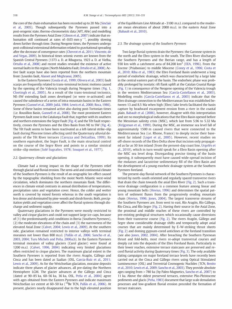
The present-day fluvial network of the Southern Pyrenees is charac-terized by north–south oriented and regularly spaced transverse riversthat drain the chain towards the axial Ebro River (Fig. 2). Such a trans-verse drainage configuration is a common feature among linear andyoung mountain belts (Hovius, 1996) and determines the spatial pat-tern of sediment fluxes from the progressively eroding mountainchain (Hovius, 1996; Jones, 2004). The largest transverse streams ofthe Southern Pyrenees are, from west to east, Río Aragón, Río Gállego,Río Cinca, and Río Segre (Fig. 2). Having their source in the Axial Zone,the proximal and middle reaches of these rivers are controlled bypre-existing geological structures which occasionally cause diversionsfrom their transverse course (Fig. 2). The rivers Aragón, Gállego andSegre show considerable drainage shifts and temporarily adopt axialcourses that are mainly determined by E–W-striking thrust sheets(Fig. 2) and doming gypsum-cored anticlines at the foreland transition(see also Jones, 2002, 2004). After breaching the Southern Pyreneanthrust and fold-belts, most rivers re-adopt transversal courses anddeeply cut into the deposits of the Ebro Foreland Basin. Particularly intheir lower reaches, extensive terrace staircases are preserved and re-cord fluvial activity during Quaternary times (Fig. 3). The only availabledating campaigns on major foreland terrace levels have recently beencarried out at the Cinca and Gállego rivers using Optical StimulatedLuminescence (OSL) and Terrestrial Cosmogenic Nuclides (TCN, Benitoet al., 2010; Lewis et al., 2009; Sancho et al., 2003). They provide absoluteages ranging from >780 ka (by Paleo-Magnetics, Sancho et al., 2007) to11 ka. Above the oldest preserved terraces, extensive Plio-Pleistocenepediments and glacis (Peña, 1983) document that large scale denudationprocesses and low-gradient fluvial erosion preceded the formation ofterrace staircases.
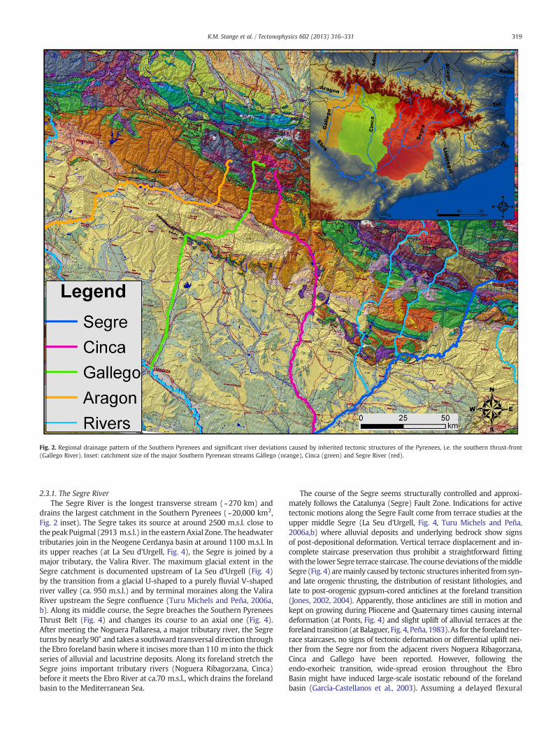
Fig. 2. Regional drainage pattern of the Southern Pyrenees and significant river deviations caused by inherited tectonic structures of the Pyrenees, i.e. the southern thrust-front(Gallego River). Inset: catchment size of the major Southern Pyrenean streams Gállego (orange), Cinca (green) and Segre River (red).
319K.M. Stange et al. / Tectonophysics 602 (2013) 316–331
2.3.1. The Segre RiverThe Segre River is the longest transverse stream (~270 km) and
drains the largest catchment in the Southern Pyrenees (~20,000 km2,Fig. 2 inset). The Segre takes its source at around 2500 m.s.l. close tothe peak Puigmal (2913 m.s.l.) in the eastern Axial Zone. The headwatertributaries join in the Neogene Cerdanya basin at around 1100 m.s.l. Inits upper reaches (at La Seu d'Urgell, Fig. 4), the Segre is joined by amajor tributary, the Valira River. The maximum glacial extent in theSegre catchment is documented upstream of La Seu d'Urgell (Fig. 4)by the transition from a glacial U-shaped to a purely fluvial V-shapedriver valley (ca. 950 m.s.l.) and by terminal moraines along the ValiraRiver upstream the Segre confluence (Turu Michels and Peña, 2006a,b). Along its middle course, the Segre breaches the Southern PyreneesThrust Belt (Fig. 4) and changes its course to an axial one (Fig. 4).After meeting the Noguera Pallaresa, a major tributary river, the Segreturns by nearly 90° and takes a southward transversal direction throughthe Ebro foreland basin where it incises more than 110 m into the thickseries of alluvial and lacustrine deposits. Along its foreland stretch theSegre joins important tributary rivers (Noguera Ribagorzana, Cinca)before it meets the Ebro River at ca.70 m.s.l., which drains the forelandbasin to the Mediterranean Sea.
The course of the Segre seems structurally controlled and approxi-mately follows the Catalunya (Segre) Fault Zone. Indications for activetectonic motions along the Segre Fault come from terrace studies at theupper middle Segre (La Seu d'Urgell, Fig. 4, Turu Michels and Peña,2006a,b) where alluvial deposits and underlying bedrock show signsof post-depositional deformation. Vertical terrace displacement and in-complete staircase preservation thus prohibit a straightforward fittingwith the lower Segre terrace staircase. The coursedeviations of themiddleSegre (Fig. 4) aremainly causedby tectonic structures inherited from syn-and late orogenic thrusting, the distribution of resistant lithologies, andlate to post-orogenic gypsum-cored anticlines at the foreland transition(Jones, 2002, 2004). Apparently, those anticlines are still in motion andkept on growing during Pliocene and Quaternary times causing internaldeformation (at Ponts, Fig. 4) and slight uplift of alluvial terraces at theforeland transition (at Balaguer, Fig. 4, Peña, 1983). As for the foreland ter-race staircases, no signs of tectonic deformation or differential uplift nei-ther from the Segre nor from the adjacent rivers Noguera Ribagorzana,Cinca and Gallego have been reported. However, following theendo-exorheic transition, wide-spread erosion throughout the EbroBasin might have induced large-scale isostatic rebound of the forelandbasin (García-Castellanos et al., 2003). Assuming a delayed flexural
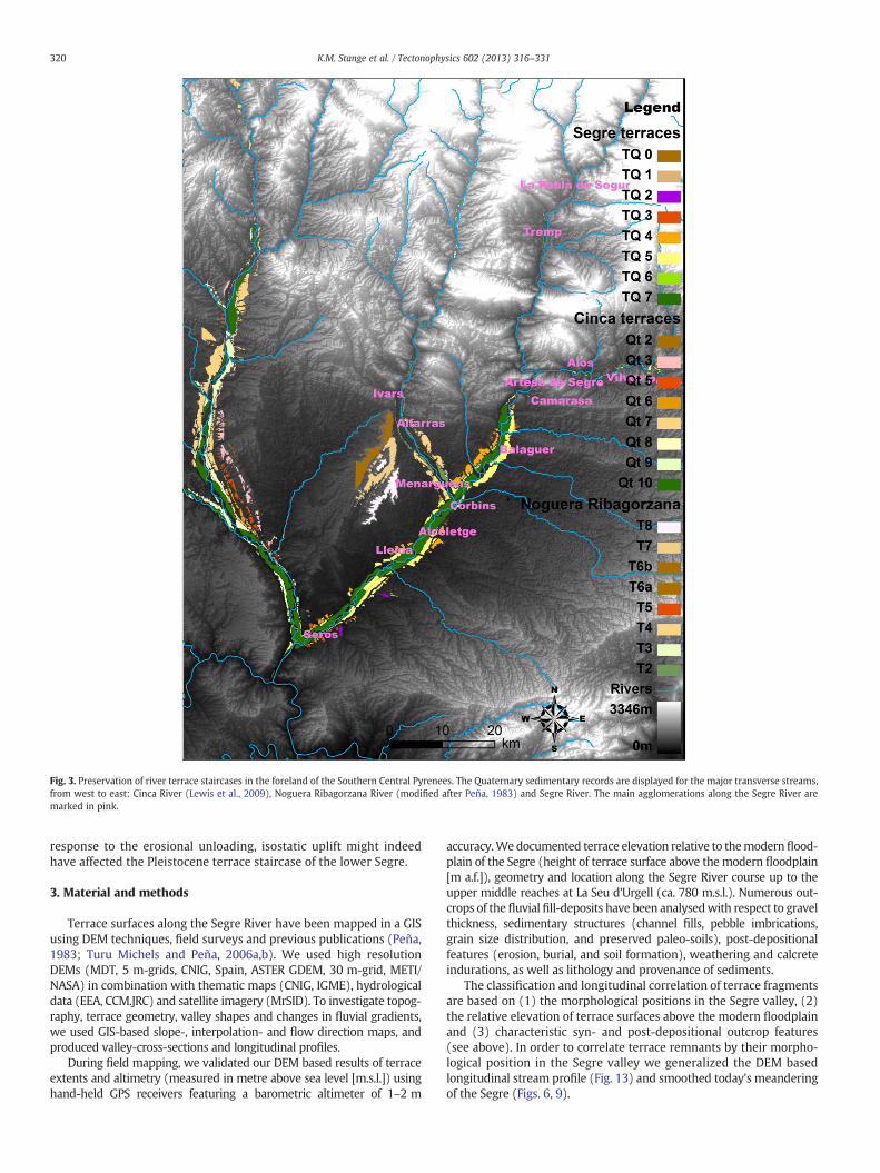
Fig. 3. Preservation of river terrace staircases in the foreland of the Southern Central Pyrenees. The Quaternary sedimentary records are displayed for the major transverse streams,from west to east: Cinca River (Lewis et al., 2009), Noguera Ribagorzana River (modified after Peña, 1983) and Segre River. The main agglomerations along the Segre River aremarked in pink.
320 K.M. Stange et al. / Tectonophysics 602 (2013) 316–331
response to the erosional unloading, isostatic uplift might indeedhave affected the Pleistocene terrace staircase of the lower Segre.
3. Material and methods
Terrace surfaces along the Segre River have been mapped in a GISusing DEM techniques, field surveys and previous publications (Peña,1983; Turu Michels and Peña, 2006a,b). We used high resolutionDEMs (MDT, 5 m-grids, CNIG, Spain, ASTER GDEM, 30 m-grid, METI/NASA) in combination with thematic maps (CNIG, IGME), hydrologicaldata (EEA, CCM.JRC) and satellite imagery (MrSID). To investigate topog-raphy, terrace geometry, valley shapes and changes in fluvial gradients,we used GIS-based slope-, interpolation- and flow direction maps, andproduced valley-cross-sections and longitudinal profiles.
During field mapping, we validated our DEM based results of terraceextents and altimetry (measured in metre above sea level [m.s.l.]) usinghand-held GPS receivers featuring a barometric altimeter of 1–2 m
accuracy.We documented terrace elevation relative to themodernflood-plain of the Segre (height of terrace surface above themodern floodplain[m a.f.]), geometry and location along the Segre River course up to theupper middle reaches at La Seu d'Urgell (ca. 780 m.s.l.). Numerous out-crops of thefluvial fill-deposits have been analysedwith respect to gravelthickness, sedimentary structures (channel fills, pebble imbrications,grain size distribution, and preserved paleo-soils), post-depositionalfeatures (erosion, burial, and soil formation), weathering and calcreteindurations, as well as lithology and provenance of sediments.
The classification and longitudinal correlation of terrace fragmentsare based on (1) the morphological positions in the Segre valley, (2)the relative elevation of terrace surfaces above the modern floodplainand (3) characteristic syn- and post-depositional outcrop features(see above). In order to correlate terrace remnants by their morpho-logical position in the Segre valley we generalized the DEM basedlongitudinal stream profile (Fig. 13) and smoothed today's meanderingof the Segre (Figs. 6, 9).
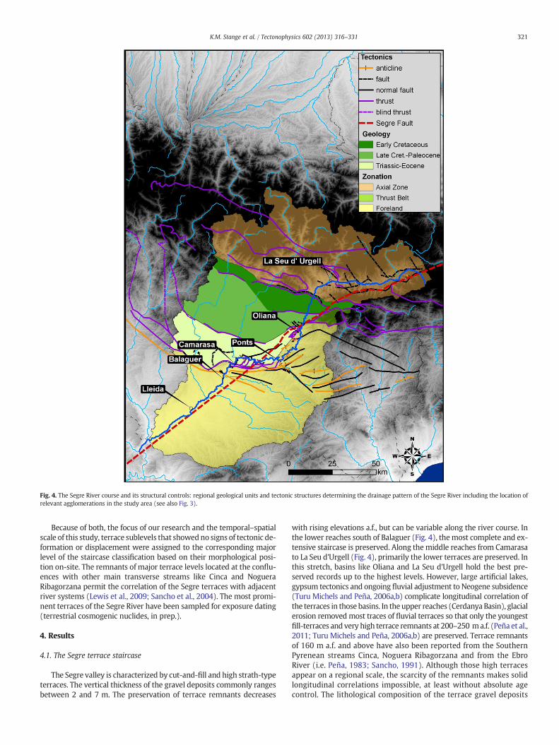
Fig. 4. The Segre River course and its structural controls: regional geological units and tectonic structures determining the drainage pattern of the Segre River including the location ofrelevant agglomerations in the study area (see also Fig. 3).
321K.M. Stange et al. / Tectonophysics 602 (2013) 316–331
Because of both, the focus of our research and the temporal–spatialscale of this study, terrace sublevels that showedno signs of tectonic de-formation or displacement were assigned to the corresponding majorlevel of the staircase classification based on their morphological posi-tion on-site. The remnants of major terrace levels located at the conflu-ences with other main transverse streams like Cinca and NogueraRibagorzana permit the correlation of the Segre terraces with adjacentriver systems (Lewis et al., 2009; Sancho et al., 2004). The most promi-nent terraces of the Segre River have been sampled for exposure dating(terrestrial cosmogenic nuclides, in prep.).
4. Results
4.1. The Segre terrace staircase
The Segre valley is characterized by cut-and-fill and high strath-typeterraces. The vertical thickness of the gravel deposits commonly rangesbetween 2 and 7 m. The preservation of terrace remnants decreases
with rising elevations a.f., but can be variable along the river course. Inthe lower reaches south of Balaguer (Fig. 4), themost complete and ex-tensive staircase is preserved. Along themiddle reaches from Camarasato La Seu d'Urgell (Fig. 4), primarily the lower terraces are preserved. Inthis stretch, basins like Oliana and La Seu d'Urgell hold the best pre-served records up to the highest levels. However, large artificial lakes,gypsum tectonics and ongoing fluvial adjustment to Neogene subsidence(Turu Michels and Peña, 2006a,b) complicate longitudinal correlation ofthe terraces in those basins. In the upper reaches (Cerdanya Basin), glacialerosion removedmost traces of fluvial terraces so that only the youngestfill-terraces and very high terrace remnants at 200–250 ma.f. (Peña et al.,2011; Turu Michels and Peña, 2006a,b) are preserved. Terrace remnantsof 160 m a.f. and above have also been reported from the SouthernPyrenean streams Cinca, Noguera Ribagorzana and from the EbroRiver (i.e. Peña, 1983; Sancho, 1991). Although those high terracesappear on a regional scale, the scarcity of the remnants makes solidlongitudinal correlations impossible, at least without absolute agecontrol. The lithological composition of the terrace gravel deposits
322 K.M. Stange et al. / Tectonophysics 602 (2013) 316–331
is consistent in all levels and is characterized by mainly crystalline andmetamorphic rocks (granite, granodiorite, gneiss, quartzite etc.) origi-nating from the Axial Zone, but also metamorphic and sedimentaryrocks derived from the Pyrenean thrust-belts (mainly quartzite, con-glomerate and sandstone). The uniformity of lithologic compositionconfirms a persistent drainage connection to the Axial Zone, which, asmentioned above, is also indicated by the drainage pattern of theSegre. Moreover, the distinct provenance pattern permits to distinguishthe highest Segre terraces from pediments and alluvial deposits thatoriginate from the southern thrust-front and local tributary rivers.
DEM and fieldwork studies have resulted in a terrace staircase of 7terrace levels, TQ 1 being the oldest and TQ 7 the youngest ones(Figs. 5, 6). In the proposed classification we group terraces in majorlevels that are traceable along the river course and integrate locallyappearing sublevels as they occur, for instance, in the younger levelTQ 5 between Lleida and Torres de Segre (km 205–213, Fig. 6). Terracesat elevations higher than TQ 1 do exist but, given the scarcity of theseremnants, longitudinal correlations are problematic. Therefore, wemerge these terraces into TQ 0 which spans terrace remnants from141 to 125 m a.f. In the upper middle reaches (south-west of La Seud'Urgell at the village of Adrall, Fig. 4), outcrops at 141 m a.f. have agravel thickness of about 3 m and showhigh grades of pebble alterationand oxidation. Close by, but not so prominent, alluvial deposits of theSegre were found at 133 and 125 m a.f. In the lower reaches, terrace out-crops have been found at comparable elevations (~120 m a.f., km 215).These gravel bodies however present a different composition of mainlylimestone and sandstone pebbles. They are therefore attributed to localtributary networks without drainage connection to the Axial Zone.
4.1.1. Terrace level TQ 1The Segre TQ 1 terrace (~113 m a.f.) is present in the lower reaches
at the confluence with the Cinca River (Serós, km 230). It consists offluvial deposits on a few remnant hills where gravels are distributedat the surface only. Though not cropping out in situ, the depositsargue for fluvial activity of the Segre at this or a higher topographiclevel. Undoubtedly, the gravels are of allochthonous origin and showthe typical composition of the Segre terraces indicating provenancefrom the Pyrenean Axial Zone. TQ 1 presents the uppermost fluvial de-posits related to the present-day drainage configuration of the lowerSegre. Near Balaguer (~100 m a.f.) they inter-finger with encrustedfluvial deposits that mainly consist of lime- and sandstones pebblesoriginating from the southernmost thrust-front (Fig. 4). The internalstructure of these deposits shows horizontal planar stratification ofgravels pointing to episodic sheet flow events under semi-arid climaticconditions.
4.1.2. Terrace level TQ 2Terrace TQ 2 is positioned at a height of 88 to 77 m a.f. and can be
clearly correlated along the lower and middle reaches of the Segre.The gravels are preserved in situ on several remnant hills in the lower
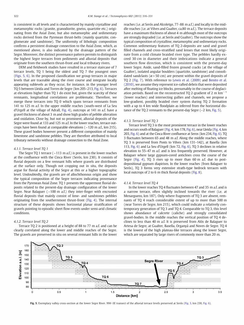
Fig. 5. Exemplary valley cross-section at the lower Segre River. NW–SE transe
reaches (i.e. at Serós and Alcoletge, 77–88 m a.f.) and locally in themid-dle reaches (i.e. at Vilves and Gualter, ca.80 m a.f.). The terrace depositshave amaximum thickness of about 4 m althoughmost of the outcropsare strongly degraded (i.e. at Serós and Gualter). The outcrops show thetypical composition of crystalline, metamorphic and sedimentary rocks.Common sedimentary features of TQ 2-deposits are sand and gravelfilled channels and cross-stratified sand lenses that most likely origi-nate from a cold climate braided river type. The pebbles hardly ex-ceed 30 cm in diameter and their imbrications indicate a generalsouthern flow direction, which is consistent with the present-daylower Segre. Aside, sand-filled frozen ground cracks (at the village ofGualter), isolated angular boulders (quartzite, sandstone) and consoli-dated sandclasts (ø>50 cm) are present within the gravel deposits ofTQ 2 (Fig. 7). With reference to Lewis et al. (2009) and Benito et al.(2010), we assume they represent ice-rafted debris thatwere depositedafter melting of floating ice blocks, presumably in the course of deglaci-ation periods. Based on the reconstructed TQ 2-gradient of 2 m km−1
(lower reaches) and intersecting gullies and channels, we propose alow-gradient, possibly braided river system during TQ 2 formationwith a up to 4 km wide floodplain as inferred from the horizontal dis-tance of the TQ 2 remnants to the present-day Segre (~2 km, Fig. 5).
4.1.3. Terrace level TQ 3Terrace level TQ 3 is the most prominent terrace in the lower reaches
andoccurs south of Balaguer (Fig. 4; km178, Fig. 6), near Lleida (Fig. 4, km203, Fig. 6) and at the Cinca River confluence at Seros (km 234, Fig. 6). TQ3 fluctuates between 65 and 48 m a.f. Along the middle reaches, whereTQ 3 is preserved from Ponts to Vilves (km 131–142), at Basella (km113, Fig. 6) and La Seu d'Urgell (km 72, Fig. 6), TQ 3 declines in relativeelevation to 55–47 m a.f. and is less frequently preserved. However, atBalaguer where large gypsum-cored anticlines cross the course of theSegre (Fig. 4), TQ 3 rises up to more than 60 m a.f. due to post-depositional gypsum diapirism. In the lower reaches (from Balaguer toSerós), TQ 3 forms very extensive strath-type bedrock terraces withlocal outcrops of 2 to 6 m thick fluvial deposits (Fig. 8).
4.1.4. Terrace level TQ 4In the lower reaches TQ 4 fluctuates between 47 and 35 m a.f. and is
a narrow terrace, often slightly inclined towards the river (i.e. atMenarguens, km 187). Only where fragments of TQ 3 are absent, rem-nants of TQ 4 reach considerable extent of up to more than 500 m(near Torres de Segre, km 215), which could indicate a relatively con-temporary generation of TQ 3 and TQ 4. Comparable to TQ 3, this levelshows abundance of calcrete (caliche) and strongly consolidatedgravel-bodies. In the middle reaches the vertical position of TQ 4 de-clines to less than 40 m a.f. It is preserved from Alós de Balaguer toArtesa de Segre, at Gualter, Basella, Organyá and Noves de Segre. TQ 4is the lowest of the high plateau-like terraces along the lower Segre,which are separated by large risers of commonly more than 20 m.
ct of the alluvial terrace levels preserved at Serós (Fig. 3, km 230, Fig. 6).

Fig. 6. Generalized longitudinal profile segment of the present-day Segre River (black solid line) and its Quaternary terraces (coloured squares) from the upper middle reaches at LaSeu d'Urgell (km 67, see also Fig. 4) to the confluence with the Ebro foreland river. The gaps in preserved terrace remnants (black line dashed segments at km 95 and km 120) andthe stream profile perturbations (black solid line, km 162, 169) are due to artificial damming at the Southern Pyrenees thrust-front. The discretely preserved terrace remnants havebeen correlated along the middle and lower reaches of the Segre with locations displayed in distance from source [km] and absolute elevations above sea level [m].
323K.M. Stange et al. / Tectonophysics 602 (2013) 316–331
4.1.5. The lower terrace levels TQ 5, TQ 6 and TQ 7The younger terraces TQ 5, TQ 6 and TQ 7 are confined to the inner
valley of the Segre with a general gravel thickness of about 4 m overbedrock. They represent cut-and-fill type terraces separated by com-parably small erosional scarps of less than 13 m. Unlike most out-crops of the higher plateaus (TQ1 - TQ4), the lower terrace surfacesare often covered by local fan and debris flow deposits, which makethem suitable for agricultural use. These sheets can yield a thicknessof more than 3 m and make longitudinal correlation purely basedon DEM analyses impossible. The relative elevation of terrace groupTQ 5 ranges from 28 to 16 m a.f. Comparable to TQ 3, this level yieldsits maximum relative elevation above the gypsum anticline near
Fig. 7. Terrace outcrop of TQ 2 at Serós (km 230, Fig. 6): calcrete-consolidated and badly s(ø 40 cm). Inset: stratified sand clast (ø 35 cm), probably previously frozen as ice-rafted de
Balaguer (~31 m a.f.). Along the middle reaches, TQ 5 decreases to22–15 m a.f. Here, TQ 5 is well-preserved from Alós de Balaguer toGualter, and in basins like at Oliana. The thickness of the gravel bodiesfluctuates around 4 m. Large sub-angular probably ice rafted boulders(ø>60 cm) have been frequently found in TQ 5. The outcrop sub-surfaceof TQ 5 is often hardened through calcrete indicating phases of evapora-tion after terrace abandonment. Terrace TQ 6 (14–8 m a.f.) is one of thebest preserved levels of the terrace staircase and its remnants can befound almost along the entire river course. In the lower reaches,upstream of the confluence with the Cinca River, TQ 6 consists ofat least two sublevels (10–8 m a.f., 14–10 m a.f.), but the smallscarps are often overprinted by agriculture. Likewise, the lowest
orted fluvial gravels (ca. 2.5 m thick) with sandy channel fill and an angular boulderbris.

Fig. 8. Terrace TQ 3 at Menarguens (km 187, Fig. 6): preserved alluvial remnant of 2 m thick consolidated pebbles and cobbles (inset) on top of a strath-type terrace escarpment cutinto the Tertiary sandstone and a thick rubified Tertiary paleo-soil.
324 K.M. Stange et al. / Tectonophysics 602 (2013) 316–331
and youngest terrace of the Segre, TQ 7 (5–3 m a.f.), might also bedivided in sublevels, particularly in the lower reaches near Torres deSegre. Like in TQ 6, weathering and calcrete indurations of TQ 7 arenegligible.
4.2. Longitudinal correlation of the Segre terraces
The Segre longitudinal terrace profiles (Fig. 6) do not show signs oflarge-scale differential uplift of the Pyrenees relative to the Ebro Basinforeland, because such a scenario would result in a convergence of ter-race levels in downstream direction, which apparently is not the case(Figs. 6, 9). At the uppermiddle reaches, deformation of alluvial depositsand bedrock affects high terrace levels of TQ0 (i.e. near Adrall, Table 1) aswell as lower Quaternary levels (i.e. at La Seu d'Urgell, Turu Michels andPeña, 2006a,b), which could indicate ongoing subsidence related to tec-tonic extension of the Neogene basins at Cerdanya, La Seu d'Urgell andOrganyá (Fig. 4, see also Turu Michels and Peña, 2006a,b). Ongoing sub-sidence could also explain the distinct course changes of the Valira Riverat La Seu d'Urgell and the perturbations of the longitudinal terrace pro-files (i.e. TQ 5, TQ 3; km 60–90, Fig. 9). In this respect, altimetry-basedlongitudinal terrace correlations at the upper middle reaches of theSegre have to be taken with caution, also regarding the terraces thatare affected by gypsum tectonics (see Section 4.3).
The longitudinal profiles of the lower and middle reaches (Fig. 6)show semi-parallel terraces that point to a gradual progressive inci-sion of the Segre throughout the formation of the terrace staircase.However, staircase cross-sections (terrace levels TQ 3–7, Table 1)and terrace profiles (Fig. 9) indicate increased terrace spacing alongthe Segre lower reaches. As it particularly affects the Segre forelandstretch, the most plausible reason to be invoked for the increasedspacing is enhanced incision in the Ebro Basin. Enhanced incisionmight be caused by effective base level lowering of the Ebro drainagesystem, but also general uplift of the Ebro Basin, possibly triggered byflexural rebound through erosional unloading, could alternatively bea mechanism to explain increased vertical terrace spacing in thesouthern Pyrenees foreland. Additional factors contributing to enhancedincision of the lower Segre are: (1) confluenceswithfirst order tributariesat the foreland transition (Noguera Pallaresa, Noguera Ribagorzana, fur-ther downstream Cinca River), which significantly increase the river dis-charge and thus erosive power, and (2) facilitated bedrock incision due topredominant molasses and evaporates in the foreland. Terrace TQ 7seems not to be affected by increased vertical terrace spacing in the fore-land (Table 1). The cause might be that its terrace scarp still connects tothe present-day floodplain, which is not yet abandoned and activelycarved out by the Segre.
4.3. Terrace thickness and height anomalies
Above the anticlines at the foreland transition near Balaguer (km178, Fig. 9) terraces TQ 2, TQ 3 and TQ 5 increase their relative eleva-tion a.f. The anticlines of Barbastro–Balaguer–Ponts (Fig. 4) havecores composed of gypsum (Keuper), which domes through theEbro Basin filling. A gypsum-related uplift of alluvial terraces is alsoreported from terraces TQ 1, TQ 2, TQ 5 and TQ 6 at Artesa de Segreand Ponts (Peña, 1975; Peña, 1983). Therefore, the deformationspoint to ongoing regional-scale gypsum tectonics (anticline growth),also during terrace formation in the Quaternary.
Near the village Camarasa (Fig. 4), terrace deposits (of presumablyTQ 3, km 166, Fig. 9) far exceed the average gravel thickness at theSegre. The outcrop is characterized by a gravel body of 12 m thick-ness, which is covered by 4 m thick over-bank deposits (Fig. 10).Sand lenses (Fig. 10, inset) are deformed by folding and faulting. Asthe local bedrock lithologies include evaporites like gypsum, pre-and syn-sedimentary gypsum karst subsidence could explain both,deformation and increased aggradation of the fluvial gravels. Localsubsidence has also been reported from the Gállego River where itis thought to be triggered by karst dissolution of evaporite bedrock(i.e. gypsum) favoured by high volumes of melt-water and increasedgroundwater flow during deglaciation periods (Benito et al., 2010).With respect to the regional consistent climatic and tectonic condi-tions at the Southern Pyrenees (see Section 2) this scenario couldapply likewise for mentioned Segre terrace near Camarasa.
Nearby the northern inlet of the Oliana depression (Fig. 4, km 107,Figs. 6, 9) gravel thickness exceeds even 20 m (Fig. 11, Mina Trago,inset) but declines downstream from the narrow inlet towards thewidened lower Oliana Basin where gravel bodies are preserved with4 m maximum thickness (‘erosive terraces’, Fig. 11). With respect tothe 20 m thick terrace deposits in the upper basin (Fig. 11, inset)neither interbedded soils could be found nor did outcrops show indi-cations for syn- or post-depositional deformation. The latter is impor-tant since the morphology of the depression (Fig. 11) suggests atectonic basin like at La Seu d'Urgell, but the Oliana Basin is apparentlyinactive. The exposed gravels (Fig. 11, Mina Tragó, inset) are badlysortedwith diameters ofmore than 40 cmup to the terrace's surface in-dicating a short term (or torrential) deposition after passing the nearbynorthern gorge (Fig. 11). One mechanism for the abundant alluvial ag-gradation (e.g. Salcher et al., 2010) might be a cold period sedimentpulse (i.e. related to a phase of glacial out-washes) in combinationwith a decreased stream gradient at the Oliana depression. Alternatively,temporary blocking of the river course (i.e. by landslides and rock-fall atthe Oliana basin outlet) could have had significant impact on sedimen-tation rates (e.g. Baartman et al., 2011) and might have triggered
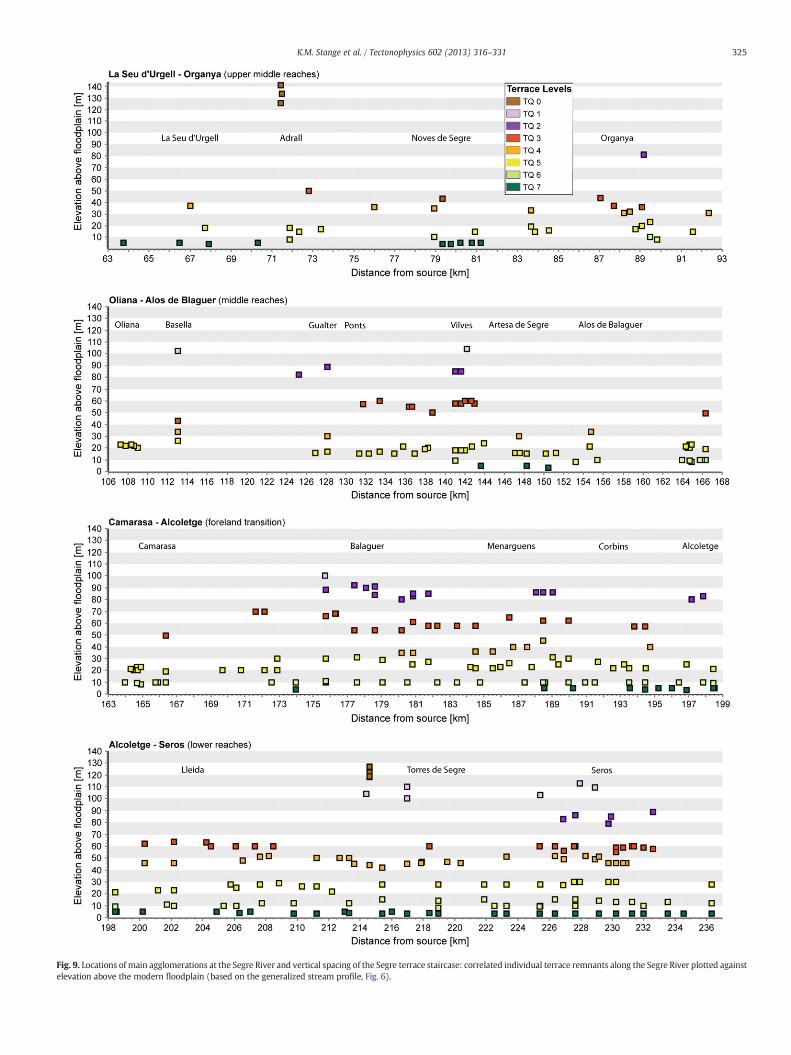
Fig. 9. Locations of main agglomerations at the Segre River and vertical spacing of the Segre terrace staircase: correlated individual terrace remnants along the Segre River plotted againstelevation above the modern floodplain (based on the generalized stream profile, Fig. 6).
325K.M. Stange et al. / Tectonophysics 602 (2013) 316–331
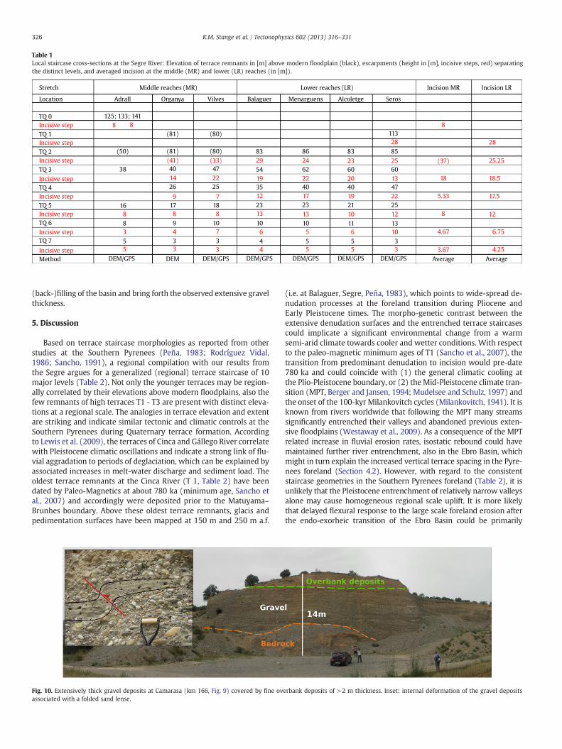
Table 1Local staircase cross-sections at the Segre River: Elevation of terrace remnants in [m] above modern floodplain (black), escarpments (height in [m], incisive steps, red) separatingthe distinct levels, and averaged incision at the middle (MR) and lower (LR) reaches (in [m]).
Method
Incisive step
Incisive step
Incisive step
Incisive step
Incisive step
Incisive step
Incisive step
Incisive step
TQ 7
TQ 6
TQ 5
TQ 4
TQ 3
TQ 2
TQ 1
TQ 0
Stretch
Location Adrall
125; 133; 141
(50)
8 8
38
16
8
8
3
5
5
17
8
9
4
3
3
(81)
(81)
Organya Vilves Balaguer Menarguens Alcoletge Seros
Incision MR Incision LR
83 86
62
40
23
10
5
5
5
6
5
5
54
35
23
10
4
29 24
22
17
13
83
60
40
21
11
23
20
19
10
10
3
3
85
113
60
47
25
13
25
28
8
28
25.25
18.5
17.5
12
6.75
4.25
(37)
18
5.33
8
4.67
3.67
13
22
12
19
12
13
6
4
Middle reaches (MR) Lower reaches (LR)
(41)
40
14
26
9
18
8
10
7
3
3
(80)
(80)
(33)
47
22
25
7
DEM/GPS DEM DEM/GPS DEM/GPS DEM/GPS DEM/GPS DEM/GPS Average Average
326 K.M. Stange et al. / Tectonophysics 602 (2013) 316–331
(back-)filling of the basin and bring forth the observed extensive gravelthickness.
5. Discussion
Based on terrace staircase morphologies as reported from otherstudies at the Southern Pyrenees (Peña, 1983; Rodríguez Vidal,1986; Sancho, 1991), a regional compilation with our results fromthe Segre argues for a generalized (regional) terrace staircase of 10major levels (Table 2). Not only the younger terraces may be region-ally correlated by their elevations above modern floodplains, also thefew remnants of high terraces T1 - T3 are present with distinct eleva-tions at a regional scale. The analogies in terrace elevation and extentare striking and indicate similar tectonic and climatic controls at theSouthern Pyrenees during Quaternary terrace formation. Accordingto Lewis et al. (2009), the terraces of Cinca and Gállego River correlatewith Pleistocene climatic oscillations and indicate a strong link of flu-vial aggradation to periods of deglaciation, which can be explained byassociated increases in melt-water discharge and sediment load. Theoldest terrace remnants at the Cinca River (T 1, Table 2) have beendated by Paleo-Magnetics at about 780 ka (minimum age, Sancho etal., 2007) and accordingly were deposited prior to the Matuyama–Brunhes boundary. Above these oldest terrace remnants, glacis andpedimentation surfaces have been mapped at 150 m and 250 m a.f.
Fig. 10. Extensively thick gravel deposits at Camarasa (km 166, Fig. 9) covered by fine ovassociated with a folded sand lense.
(i.e. at Balaguer, Segre, Peña, 1983), which points to wide-spread de-nudation processes at the foreland transition during Pliocene andEarly Pleistocene times. The morpho-genetic contrast between theextensive denudation surfaces and the entrenched terrace staircasescould implicate a significant environmental change from a warmsemi-arid climate towards cooler and wetter conditions. With respectto the paleo-magnetic minimum ages of T1 (Sancho et al., 2007), thetransition from predominant denudation to incision would pre-date780 ka and could coincide with (1) the general climatic cooling atthe Plio-Pleistocene boundary, or (2) the Mid-Pleistocene climate tran-sition (MPT, Berger and Jansen, 1994; Mudelsee and Schulz, 1997) andthe onset of the 100-kyr Milankovitch cycles (Milankovitch, 1941). It isknown from rivers worldwide that following the MPT many streamssignificantly entrenched their valleys and abandoned previous exten-sive floodplains (Westaway et al., 2009). As a consequence of the MPTrelated increase in fluvial erosion rates, isostatic rebound could havemaintained further river entrenchment, also in the Ebro Basin, whichmight in turn explain the increased vertical terrace spacing in the Pyre-nees foreland (Section 4.2). However, with regard to the consistentstaircase geometries in the Southern Pyrenees foreland (Table 2), it isunlikely that the Pleistocene entrenchment of relatively narrow valleysalone may cause homogeneous regional scale uplift. It is more likelythat delayed flexural response to the large scale foreland erosion afterthe endo-exorheic transition of the Ebro Basin could be primarily
erbank deposits of >2 m thickness. Inset: internal deformation of the gravel deposits
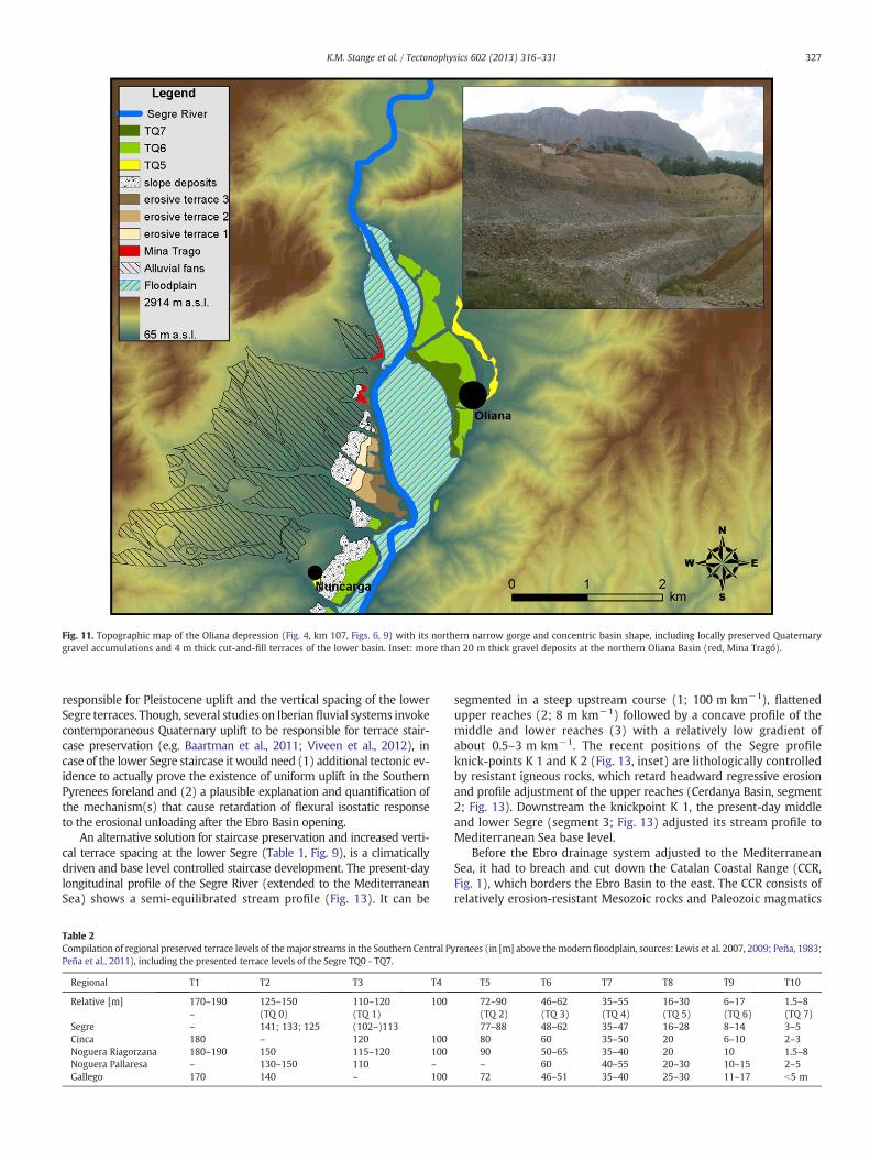
Fig. 11. Topographic map of the Oliana depression (Fig. 4, km 107, Figs. 6, 9) with its northern narrow gorge and concentric basin shape, including locally preserved Quaternarygravel accumulations and 4 m thick cut-and-fill terraces of the lower basin. Inset: more than 20 m thick gravel deposits at the northern Oliana Basin (red, Mina Tragó).
327K.M. Stange et al. / Tectonophysics 602 (2013) 316–331
responsible for Pleistocene uplift and the vertical spacing of the lowerSegre terraces. Though, several studies on Iberianfluvial systems invokecontemporaneous Quaternary uplift to be responsible for terrace stair-case preservation (e.g. Baartman et al., 2011; Viveen et al., 2012), incase of the lower Segre staircase it would need (1) additional tectonic ev-idence to actually prove the existence of uniform uplift in the SouthernPyrenees foreland and (2) a plausible explanation and quantification ofthe mechanism(s) that cause retardation of flexural isostatic responseto the erosional unloading after the Ebro Basin opening.
An alternative solution for staircase preservation and increased verti-cal terrace spacing at the lower Segre (Table 1, Fig. 9), is a climaticallydriven and base level controlled staircase development. The present-daylongitudinal profile of the Segre River (extended to the MediterraneanSea) shows a semi-equilibrated stream profile (Fig. 13). It can be
Table 2Compilation of regional preserved terrace levels of themajor streams in the Southern Central PyPeña et al., 2011), including the presented terrace levels of the Segre TQ0 - TQ7.
Regional T1 T2 T3 T4
Relative [m] 170–190 125–150 110–120 100– (TQ 0) (TQ 1)
Segre – 141; 133; 125 (102–)113Cinca 180 – 120 100Noguera Riagorzana 180–190 150 115–120 100Noguera Pallaresa – 130–150 110 –
Gallego 170 140 – 100
segmented in a steep upstream course (1; 100 m km−1), flattenedupper reaches (2; 8 m km−1) followed by a concave profile of themiddle and lower reaches (3) with a relatively low gradient ofabout 0.5–3 m km−1. The recent positions of the Segre profileknick-points K 1 and K 2 (Fig. 13, inset) are lithologically controlledby resistant igneous rocks, which retard headward regressive erosionand profile adjustment of the upper reaches (Cerdanya Basin, segment2; Fig. 13). Downstream the knickpoint K 1, the present-day middleand lower Segre (segment 3; Fig. 13) adjusted its stream profile toMediterranean Sea base level.
Before the Ebro drainage system adjusted to the MediterraneanSea, it had to breach and cut down the Catalan Coastal Range (CCR,Fig. 1), which borders the Ebro Basin to the east. The CCR consists ofrelatively erosion-resistant Mesozoic rocks and Paleozoic magmatics
renees (in [m] above themodern floodplain, sources: Lewis et al. 2007, 2009; Peña, 1983;
T5 T6 T7 T8 T9 T10
72–90 46–62 35–55 16–30 6–17 1.5–8(TQ 2) (TQ 3) (TQ 4) (TQ 5) (TQ 6) (TQ 7)77–88 48–62 35–47 16–28 8–14 3–580 60 35–50 20 6–10 2–390 50–65 35–40 20 10 1.5–8– 60 40–55 20–30 10–15 2–572 46–51 35–40 25–30 11–17 b5 m

Fig. 12. South to northeast cross-section of the Catalan Coastal Range (CCR) where the Ebro River breaches the chain towards the Mediterranean Sea. The preserved topographiclevels of the inner breach are marked by dashed lines (blue). The latest downcutting of the CCR is represented by the narrow gorge of the present-day Ebro River.
328 K.M. Stange et al. / Tectonophysics 602 (2013) 316–331
(mapa geológico 1:200,000, hojas 34, 35, 41, 42; Instituto Geológico yMinero de España), which are in stark contrast to the sedimentary de-posits (Tertiary) dissected by the major part of the Ebro drainage sys-tem. Timing and amount of CCR downcutting are not yet constrained.It can be expected that, at least during the endo-exorheic transition,the CCR functioned as a local base level upstream the sea outlet anddetermined stream profile gradation of the Ebro River and its tributaryrivers like the Segre. In contrast to the present-day stream profiles(graded to sea level), the longitudinal terrace profiles, representingthe Pleistocene paleo-river gradients, require much higher base levelsup to 180 m.s.l. for the regional T 1 (Table 2) and about 110 m.s.l. forthe Segre TQ 1.
We therefore hypothesize that for the major part of its exorheicevolution, presumably until late Pleistocene times, the Ebro drainagesystem graded to the Catalan Coastal Range as its base level.
A first DEM-based dataset indicates that the morphology of theCCR breach has preserved at least three topographic levels at 600,
Fig. 13. Late Quaternary base level mechanisms: the present-day longitudinal profile of the(small coloured squares) upstream the confluence with the Ebro River. The perturbations ofthe regional DEM. The incision of the Segre since the Ebro Basin opening is interpolated froarrows indicating incision from Late Miocene to Pleistocene, and red arrows incision fromknick-point at the upper middle Segre: stream profile segment and lithological units down
400 and 200 m.s.l. (Fig. 12). The origin of this low-relief topographyis not investigated yet and could be both, the result of (fluvial) erosionor structural controls. Supposing a fluvial development, all topographiclevels rise above the initial base level estimated for the regional forelandterrace staircase (ca. 180 m.s.l. for T 1, sketched dense dotted gradient,Fig. 13), and would therefore pre-date middle Pleistocene staircasedevelopment.
Different to the upper breach morphology (600–200 m.s.l., Fig. 12),the actual passage of the Ebro River is a relatively narrow gorge, whichrecords deep incision for the late-stage downcutting of the CCR. Thesteep hill-slopes at the gorge argue for relatively rapid and continuousincision from ca. 200 m.s.l. down to 20 m.s.l., which would span allestimated base levels of the regional Pleistocene terrace staircase(Table 2).
But what are the triggers behind the accelerated downcutting ofthe CCR gorge during middle and late Pleistocene times? Most likely,a combination of climato-tectonic controls is responsible for the latest
Segre River extended to the Mediterranean Sea (black solid line), with terrace recordsthe present-day stream profile are due to artificial damming and the lower resolution ofm the major profile knickpoint to the topographic levels at the CCR breach, with blackPleistocene to present. Inset: structural controls on the position of the major profile
stream the Cerdanya Basin (transition from segment 2 to 3).
329K.M. Stange et al. / Tectonophysics 602 (2013) 316–331
entrenchment of the Ebro at the CCR breach. In terms of neo-tectonics,Neogene extension of the western Mediterranean margin seems not tohave ceased to date (Carozza and Delcaillau, 1999; Gunnell et al., 2008,Section 2) and might therefore have affected the Catalan Coastal Rangeby progressive isostatic rift-flank uplift (e.g. García-Castellanos et al.,2003). Beyond this potential uplift of the CCR, we assume that thePleistocene climatic conditions after the MPT (i.e. increased dischargeresulting from the contribution of melt-water input from the Pyreneesglaciers) have significantly contributed to enhanced erosion and thedowncutting of the Ebro gorge.
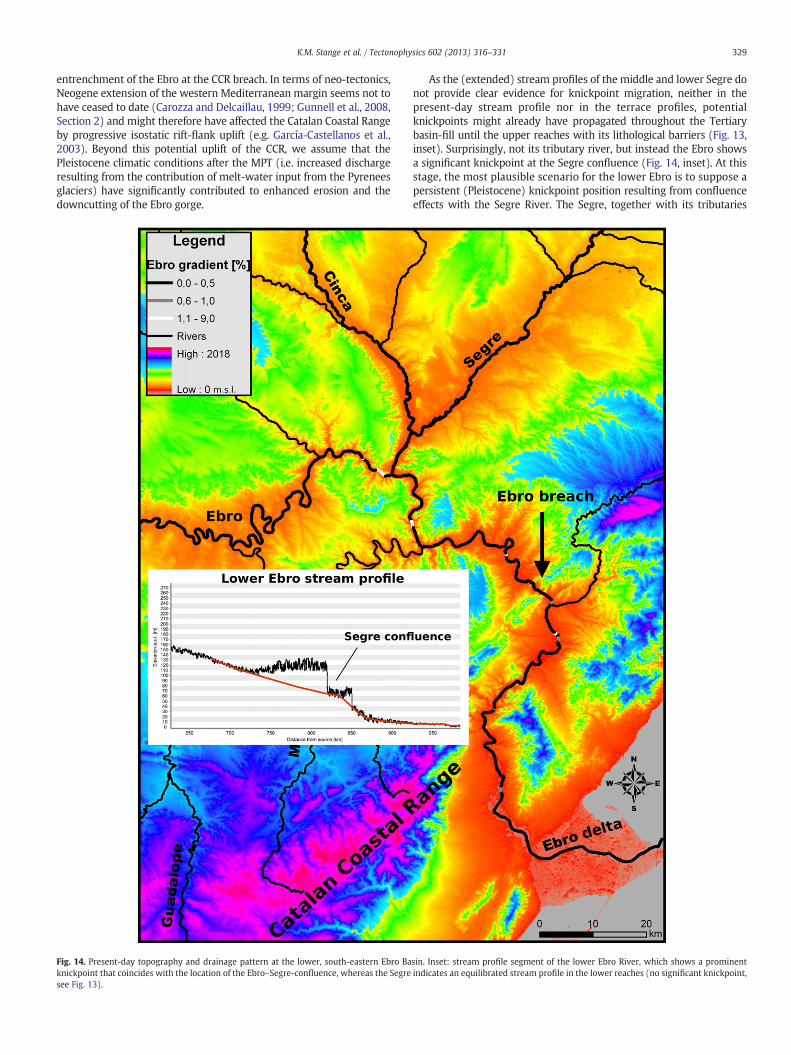
Fig. 14. Present-day topography and drainage pattern at the lower, south-eastern Ebro Baknickpoint that coincides with the location of the Ebro–Segre-confluence, whereas the Segresee Fig. 13).
As the (extended) stream profiles of the middle and lower Segre donot provide clear evidence for knickpoint migration, neither in thepresent-day stream profile nor in the terrace profiles, potentialknickpoints might already have propagated throughout the Tertiarybasin-fill until the upper reaches with its lithological barriers (Fig. 13,inset). Surprisingly, not its tributary river, but instead the Ebro showsa significant knickpoint at the Segre confluence (Fig. 14, inset). At thisstage, the most plausible scenario for the lower Ebro is to suppose apersistent (Pleistocene) knickpoint position resulting from confluenceeffects with the Segre River. The Segre, together with its tributaries
sin. Inset: stream profile segment of the lower Ebro River, which shows a prominentindicates an equilibrated stream profile in the lower reaches (no significant knickpoint,

330 K.M. Stange et al. / Tectonophysics 602 (2013) 316–331
like the Cinca River, discharges major parts of the southern Central andEastern Pyrenees (Fig. 2, inset). Hence, it is likely that during Pleistocenetimes increased melt-water discharges from the Pyrenees glaciers pro-moted accelerated foreland entrenchment of the Segre. Enhanced inci-sion of the Segre might in turn have outpaced profile adjustment of thelower Ebro, which gathered its discharge from the less glaciated IberianRange and south-western Pyrenees (Calvet, 2004).
6. Conclusions
This investigation has demonstrated that the Segre River terracestaircase might result from a combination of external factors involvingclimate variability, flexural isostasy and base level controls.
In this paper we presented the major terrace levels of the Segrestaircase, which reveals conspicuous morphological analogies withother fluvial systems of the Southern Pyrenees foreland. The regionalconsistent terrace altimetry indicates synchronous staircase develop-ment (during middle and late Pleistocene times) under similar climaticand tectonic (“external”) controls along the Southern Pyrenees.
Terrace deformation and extensive gravel aggradation have beenobserved in tectonic basins at the upper middle reaches of the Segreand at the foreland transition. They seem to be related to ongoingNeogene extension (intra-mountain basins) and gypsum-related anti-cline uplift (foreland transition).
A significant paleo-environmental change in the Ebro Basin is in-dicated by the morphological transition from low-gradient denudationsurfaces to deeply entrenched river valleys and terrace formation. Withreference to the oldest fluvial deposits of the Cinca River (Sanchoet al., 2007), this landscape change presumably coincides with theMid-Pleistocene climate transition (MPT) and the onset of 100 kyrMilankovitch climate cycles. Subsequently, the cyclicity of Pleistoceneglacials and interglacials caused an alternation of fluvial aggradationand incision triggering terrace staircase formation.
The increased terrace spacing at the lower Segre River is probablythe result of a combination of climato-tectonic controls. After theendo-exorheic transition, increased fluvial erosion throughout theEbro foreland basin might have triggered large scale isostatic reboundand, given a delayed response to the erosional unloading, could explainthe increased vertical terrace spacing at the lower Segre. An alternativesolution is a climatically driven and base level controlled incision of thelower Segre resulting from enhanced fluvial erosion after the MPT andcontrolled by the downcutting of the Catalan Coastal Range, whichmight have functioned as the base level of the Ebro drainage systemuntil late Pleistocene times.
Reference
Alasset, P.-J., Meghraoui, M., 2005. Active faulting in the western Pyrenees (France):paleoseismic evidence for late Holocene ruptures. Tectonophysics 409, 39–54.
Baartman, J.E.M., Veldkamp, A., Schoorl, J.M., Wallinga, J., Cammeraat, L.H., 2011.Unravelling Late Pleistocene and Holocene landscape dynamics: the UpperGuadalentín Basin, SE Spain. Geomorphology 125, 172–185.
Babault, J., Loget, N., Van Den Driessche, J., Castelltort, S., Bonnet, S., Davy, P., 2006. Didthe Ebro basin connect to the Mediterranean before the Messinian Salinity Crisis?Geomorphology 81, 155–165.
Babault, J., Van Den Driessche, J., Bonnet, S., Castelltort, S., Crave, A., 2010. Origin of thehighly elevated Pyrenean peneplain. Tectonics 24, 1–19 (TC).
Benito, G., Sancho, C., Peña, J.L., Machado, M.J., Rhodes, E.J., 2010. Large-scale karst sub-sidence and accelerated fluvial aggradation during MIS 6 in NE Spain: climatic andpaleohydrological implications. Quaternary Science Reviews 29, 2694–2704.
Berger, W.H., Jansen, E., 1994. Mid-Pleistocene climate shift — the Nansen connection.In: Johannessen, O.M., Muench, R.D., Overland, J.E. (Eds.), The Polar Oceans andTheir Role in Shaping the Global Environment: Am. Geophys. Union. Geophys.Monogr., 85, pp. 295–311.
Bridgland, D.R., 2000. River terrace systems in north-west Europe: an archive of envi-ronmental change, uplift and early human occupation. Quaternary Science Re-views 19, 1293–1303.
Bridgland, D.R., Westaway, R., 2008. Climatically controlled river terrace staircases: aworldwide Quaternary phenomenon. Geomorphology 98, 285–315.
Brocard, G.Y., Van Der Beek, P.A., Bourlès, D.L., Siame, L.L., Mugnier, J.-L., 2003. Long-termfluvial incision rates and postglacial river relaxation time in the FrenchWestern Alps
from 10Be dating of alluvial terraces with assessment of inheritance, soil develop-ment and wind ablation effects. Earth and Planetary Science Letters 209, 197–214.
Büdel, J., 1977. Klima-Geomorphologie. Gebrüder Bornträger, Berlin.Bull, W.B., 1990. Stream-terrace genesis: implications for soil development. Geomor-
phology 3, 351–367.Calvet, M., 1996. Morphogènese d'une montagne Méditerranéenne: les Pyrénées
orientales. In: BRGM (Ed.), Documents du Bureau de Recherches Géologiques etMinières, p. 255.
Calvet, M., 2004. The Quaternary glaciation of the Pyrenees. In: Ehlers, J., Gibbard, P.(Eds.), Quaternary Glaciations — Extent and Chronology, Part I: Europe. Elsevier,Amsterdam, pp. 119–128.
Carozza, J.-M., Delcaillau, B., 1999. Geomorphic record of Quaternary tectonic activityby alluvial terraces: example from the Têt basin (Roussillon, France). Comptes-Rendus de l'Academie des Sciences Paris 329, 735–740.
Chevrot, S., Sylvander, M., Delouis, B., 2011. A preliminary catalog of moment tensorsfor the Pyrenees. Tectonophysics 510, 239–251.
Cloetingh, S., Ziegler, P.A., Beekman, F., Andriessen, P.A.M., Matenco, L., Bada, G., García-Castellanos, D., Hardebol, N., Dezes, P., Sokoutis, D., 2005. Lithospheric memory,state of stress and rheology: neotectonic controls on Europe's intraplate continentaltopography. Quaternary Science Reviews 24, 241–304.
Coney, P.J., Muñoz, A.J., McClay, K.R., Evenchik, C.A., 1996. Syntectonic burial andposttectonic exhumation of the southern Pyrenees foreland fold-thrust belt. Journalof the Geological Society of London 153, 9–16.
Costa, E., Garcés, M., López-Blanco, M., Beamud, E., Gómez-Paccard, M., CruzLarrasoaña, J., 2010. Closing and continentalization of the South Pyrenean fore-land basin (NE Spain): magnetochronological constraints. Basin Research 22,904–917.
ECORS Pyrenees Team, 1988. The ECORS deep reflection survey across the Pyrenees.Nature 331, 508–511.
European Environment Agency (EEA), 1996. http://www.eea.europa.eu/data-and-maps/data/european-river-catchments.
Fitzgerald, P.G., Muñoz, J.A., Coney, P.J., Baldwin, S.L., 1999. Asymmetric exhumationacross the Pyrenean orogen: implications for the tectonic evolution of a collisionalorogen. Earth and Planetary Science Letters 173, 157–170.
García-Castellanos, D., Vergés, J., Gaspar-Escribano, J., Cloetingh, S., 2003. Interplay be-tween tectonics, climate and fluvial transport during the Cenozoic evolution of theEbro Basin (NE Iberia). Journal of Geophysical Research 108, 2347–2364.
Garcia-Ruiz, J.M., Peña, J.L., Martí-Bono, C.E., Gómez-Villar, A., Constante, A., Espinalt,M., 2011. El relieve del Alto Aragón Occidental. Consejo Prot. Naturaleza de Aragón,Zaragoza.
Gibson, M., Sinclair, H.D., Lynn, G.J., Stuart, F.M., 2007. Late- to post-orogenic exhuma-tion of the Central Pyrenees revealed through combined thermochronological dataand modelling. Basin Research 19, 323–334.
Goula, X., Olivera, C., Fleta, J., Grellet, B., Lindo, R., Rivera, L.A., Cisternas, A., Carbon, D.,1999. Present and recent stress regime in the eastern part of the Pyrenees.Tectonophysics 308, 487–502.
Gunnel, Y., Calvet, M., Brichau, S., Carter, A., Aguilar, J.-P., Zeyen, H., 2009. Low long-term erosion rates in high-energy mountain belts: insights from thermo- andbiochronology in the Eastern Pyrenees. Earth and Planetary Science Letters 278,208–218.
Gunnell, Y., Zeyen, H., Calvet, M., 2008. Geophysical evidence of a missing lithosphericroot beneath the Eastern Pyrenees: consequences for post-orogenic uplift and as-sociated geomorphic signatures. Earth and Planetary Science Letters 276, 302–313.
Houtgast, R.F., Van Balen, R.T., 2000. Neotectonics of the Roer Valley Rift System, theNetherlands. Global and Planetary Change 27 (1–4), 131–146.
Hovius, N., 1996. Regular spacing of drainage outlets from linear mountain belts. BasinResearch 8, 29–44.
Jones, S.J., 2002. Transverse rivers draining the Spanish Pyrenees: large-scale patternsof sediment erosion and deposition. In: Jones, S.J., Frostick, L.E. (Eds.), Sedimentflux to basins: causes, controls and consequences: Spec. Publ. Geol. Soc. Lond.,191, pp. 171–185.
Jones, S.J., 2004. Tectonic controls on drainage evolution and development of terminalalluvial fans, southern Pyrenees, Spain. Terra Nova 16 (3), 121–127.
Jones, S.J., Frostick, L.E., Astin, T.R., 1999. Climatic and tectonic controls on fluvial inci-sion and aggradation in the Spanish Pyrenees. Journal of the Geological Society ofLondon 156, 761–769.
Juliá, R., 1984. Sintesis geologica de la Cerdanya, Girona. El Borde MediterraneoEspanol: evolution de1 orogeno betico y geodinamica de las depresiones neogenas.C.S.I.C, Granada, pp. 95–98.
Krijgsman, W., Hiigeni, F.J., Raffi, I., Sierro, F.J., Wilson, D.S., 1999. Chronology, causesand progression of the Messinian salinity crisis. Nature — London 400 (6745),652–655.
Lewis, C.J., Vergés, J., Marzo, M., 2000. High mountains in a zone of extended crust: in-sights into the Neogene–Quaternary topographic development of northeasternIberia. Tectonics 19, 86–102.
Lewis, C.J., McDonald, E.V., Sancho, C., Peña, J.L., Rhodes, E.J., 2009. Climatic implicationsof correlated Upper Pleistocene glacial and fluvial deposits on the Cinca andGállego Rivers (NE Spain) based on OSL dating and soil stratigraphy. Global andPlanetary Change 67, 141–152.
Loget, N., Van Den Driessche, J., Davy, P., 2005. How did the Messinian Salinity Crisisend? Terra Nova 17, 414–419.
Lynn, G.J., 2005.Macrogeomorphology and erosional history of the postorogenic Pyreneanmountain belt, PhD thesis. University of Edinburgh, Earth and Planetary ScienceResearch Institute PhD thesis collection, 1-388.
Maddy, D., Bridgland, D.R., Green, C.P., 2000. Crustal uplift in southern England: evi-dence from river terrace records. Geomorphology 33, 167–181.
331K.M. Stange et al. / Tectonophysics 602 (2013) 316–331
Maddy, D., Bridgland, D., Westaway, R., 2001. Uplift-driven valley incision and climate-controlled river terrace development in the Thames Valley, UK. Quaternary Inter-national 79, 23–36.
Milankovitch, M., 1941. Kanon der Erdbestrahlung und seine Anwendung auf dasEiszeitenproblem. Royal Serbian Sciences Belgrade. Section of Mathematical andNatural Sciences: Special Publication 132, 33, p. 633.
Mudelsee, M., Schulz, M., 1997. The Mid-Pleistocene climate transition: onset of 100 kacycles lags ice volume build-up by 280 ka. Earth and Planetary Science Letters 151,117–123.
Muñoz, J.A., 1992. Evolution of a continental collision belt: ECORS-Pyrenees crustalbalanced cross section. In: Muñoz, J.A., Vergés, J. (Eds.), Thrusting and forelandbasin evolution in the southern Pyrenees. Thrust Tectonics. Chapman & Hall,London, pp. 247–254.
Olivera, C., Fleta, J., Susagna, T., Figueras, S., Goula, X., Roca, A., 2003. Sismicidad ydeformaciones actuales en el nordeste de la peninsula iberica. Fisica de la Tierra15, 111–144 (Barcelona).
Ortuño, M., Queralt, P., Marti, A., Ledo, J., Masana, E., Perea, H., Santanach, P., 2008. TheNorth Maladeta Fault (Spanish Central Pyrenees) as the Vielha 1923 earthquakeseismic source: recent activity revealed by geomorphological and geophysical re-search. Tectonophysics 453, 246–262.
Pallàs, R., Rodés, A., Braucher, R., Carcaillet, J., Ortuno, M., Bordonau, J., Bourlès, D.,Vilaplana, J.M., Masana, E., Santanach, P., 2006. Late Pleistocene and Holocene gla-ciation in the Pyrenees: a critical review and new evidence from 10Be exposureages, south-central Pyrenees. Quaternary Science Reviews 25, 2937–2963.
Peña, J.L., 1975. Los depositos cuaternarios del valle del Segre, entre Tiurana yCamarasa. Ilerda 36, 187–217.
Peña, J.L., 1983. La Conca de Tremp y Sierras Prepirenaicas comprendidas entre los RíosSegre y Noguera Ribagorzana: Estudio geomorfológico, Tesis Doctoral. Instituto deEstudios Ilerdenses, 1-373.
Peña, J.L., Sancho, C., Lewis, C., McDonald, E., Rhodes, E., 2004. Datos cronologicos de lasmorrenas terminales del glaciar del Gállego y su relacion con las terrazas fluvioglaciares(Pirineo de Huesca). In: Peña, J.L., Longares, L.A., Sanchez, M. (Eds.), Geografıa Fisica deAragon, aspectos generales y tematicos. Universidad de Zaragoza e Institución Fernandoel Católico, Zaragoza, pp. 71–84.
Peña, J.L., Turu i Michels, V., Calvet, M., 2011. Les terrasses fluvials del Segre i afluentsprincipals: Descripci d'afloraments i assaig de correlacio. Resums XIII ReunioNacional de Quaternari, Andorra.
Peters, G., Van Balen, R.T., 2007. Pleistocene tectonics inferred from fluvial terraces ofthe northern Upper Rhine Graben, Germany. Tectonophysics 430, 41–65.
Puigdefábregas, C., Muñoz, J.A., Marzo, M., 1986. Thrust belt development in the easternPyrenees and related depositional sequences in the southern foreland basin. In:Allen, P., Homewood, P. (Eds.), Foreland Basins: I.A.S. Spec. Publ., 8, pp. 229–246.
Riba, O., Reguant, S., Villena, J., 1983. Ensayo de síntesis estratigráfica y evolutiva de lacuenca terciaria del Ebro. Libro Jubilár J. M. Ríos. IGME, Madrid, II, pp. 131–159.
Rixhon, G., Braucher, R., Bourlès, D., Siame, L., Bovy, B., Demoulin, A., 2010. Quaternaryriver incision in NE Ardennes (Belgium)—insights from 10Be/26Al dating of riverterraces. Quaternary Geochronology 6 (2), 273–284.
Roca, E., 1986. Estudi geologic de la fossa de la Cerdanya, Tesis doctoral. Univ. de Barcelona.Rodríguez Vidal, J., 1986. Geomorfología de las Sierras Exteriores oscenses y su
piedmonte. Inst. Estudios Altoaragoneses, Huesca, pp. 1–172.Salcher, B.C., Faber, R., Wagreich, M., 2010. Climate as main factor controlling the se-
quence development of two Pleistocene alluvial fans in the Vienna Basin (easternAustria) — a numerical modelling approach. Geomorphology 115, 215–227.
Sancho, C., 1991. Geomorfología de la cuenca baja del río Cinca. Microfichas ColecciónCiencias de la Tierra y del Espacio, Huesca, p. 177.
Sancho, C., Peña, J.L., Lewis, C., McDonald, E., Rhodes, E., 2003. Preliminary dating of glacialand fluvial deposits in the Cinca River Valley (NE Spain): chronological evidences forthe Glacial Maximum in the Pyrenees? In: Zapata, M.B. (Ed.), Quaternary ClimaticChanges and Environmental Crises in the Mediterranean Region. Universidad deAlcalá de Henares, pp. 169–173.
Sancho, C., Peña, J.L., Lewis, C., McDonald, E., Rhodes, E., 2004. Registros fluviales yglaciares cuaternarios en las cuencas de los ríos Cinca y Gállego (Pirineos y depresióndel Ebro). In: Colombo, F., Iesa, C.L., Meléndez, G., Pocoví, A., Sancho, C., Soria, A.R.(Eds.), VI CongresoGeológico de España. Geo-Guías 1. Itinerarios Geológicos por Aragón,pp. 181–205.
Sancho, C., Peña, J.L., Lewis, C., McDonald, E., Rhodes, E., Pueyo, E.L., Gosse, J., 2007.Cronologia del sistema de terrazas cuaternarias en la cuenca del Río Cinca(Pireneos-Depresion del Ebro). Contribuciones al Estudia del Periodo Cuaternario,31–32. XII Reunion Nacional de Cuaternario (AEQUA), Avila.
Schumm, S.A., Parker, R.S., 1973. Implications of complex response of drainage systemsfor Quaternary alluvial stratigraphy. Nature Physical Science 243, 99–100.
Sinclair, H.D., Gibson, M., Naylor, M., Morris, R.G., 2005. Asymmetric growth of the Pyreneesrevealed through measurement and modelling of orogenic fluxes. American Journal ofScience 305 (5), 369–406.
Solé Sugrañes, L., 1978. Alineaciones y fracturas en el sistema Catalan segun lasimagenes Landsat-I. Tecniterrae 22, 6–16.
Souquet, P., Peybernes, B., Bilotte, M., Debroas, E.J., 1977. La chaine alpine des Pyrenees.Geologie Alpine 53, 193–216.
Turu Michels, V., Peña, J.L., 2006a. Ensayo de reconstruccion cuaternaria de los vallesdel Segre y Valira (Andorra-La Seu d'Urgell-Organya, Pireneos Orientales).Geomorfologia y Territorio, Universidad de Santiago de Compostela, IX Reunionde Geomorfologia, pp. 129–148.
Turu Michels, V., Peña, J.L., 2006b. Las terrazas fluviales del sistema Segre-Valira.Andorra-La Seu d'Urgell-Organya, Pireneos Orientales. Geomorfologia yTerritorio, Universidad de Santiago de Compostela, IX Reunion de Geomorfologia,pp. 113–128.
Urgelés, R., Camerlenghi, A., García-Castellanos, D., De Mol, B., Garcés, M., Vergés, J.,Haslam, I., Hardman, M., 2010. New constraints on theMessinian sealevel drawdownfrom 3D seismic data of the Ebro Margin, western Mediterranean. Basin Research 23,123–145.
Vandenberghe, J., 1995. Timescales, climate and river development. Quaternary ScienceReviews 14, 631–638.
Vandenberghe, J., 2002. The relation between climate and river processes, landformsand deposits during the Quaternary. Quaternary International 91, 17–23.
Vandenberghe, J., 2003. Climate forcing of fluvial system development: an evolution ofideas. Quaternary Science Reviews 22, 2053–2060.
Veldkamp, A., Tebbens, L.A., 2001. Registration of abrupt climate changes within fluvialsystems: insights from numerical modelling experiments. Global and PlanetaryChange 28, 129–144.
Vergés, J., Millan, H., Roca, E., Muñoz, J.A., Marzo, M., Cires, J., Den Bezemer, T.,Zoetemeijer, R., Cloetingh, S., 1995. Eastern Pyrenees and related foreland basins:pre-, syn- and post-collisional crustal-scale cross-sections. Marine and PetroleumGeology 12 (8), 893–915.
Vincente, de, J., Vegas, R., 2009. Large-scale distributed deformation controlled topog-raphy along the western Africa–Eurasia limit: tectonic constraints. Tectonophysics474, 124–143.
Viveen, W., Braucher, R., Bourlès, D., Schoorl, J.M., Veldkamp, A., Van Balen, R.T.,Wallinga, J., Fernandez-Mosquera, D., Vidal-Romani, J.R., Sanjuro-Sanchez, J.,2012. A 0.65 Ma chronology and incision rate assessment of the NW IberianMiño River terraces based on 10Be and luminescence dating. Global and PlanetaryChange 94–95, 82–100.
Westaway, R., Maddy, D., Bridgland, D., 2002. Flow in the lower continental crust as amechanism for the Quaternary uplift of south-east England: constraints from theThames terrace record. Quaternary Science Reviews 21, 559–603.
Westaway, R., Bridgland, D., Sinha, R., Demir, T., 2009. Fluvial sequences as evidence forlandscape and climatic evolution in the Late Cenozoic: a synthesis of data fromIGCP 518. Global and Planetary Change 68, 237–253.
Copyright © 2022 FDOKUMEN