SCHOOL OF BUILT ENVIRONMENT D41DD SUSTAINABLE DESIGN AND DEVELOPMENT 2013 DESIGN BRIEF REPORT WEST...
58
SCHOOL OF BUILT ENVIRONMENT D41DD SUSTAINABLE DESIGN AND DEVELOPMENT 2013 DESIGN BRIEF REPORT WEST PORT & CASTLE TERRACE PREPARED BY : MOHD MUZZAMMIL BIN ISMAIL H00164921 GORDOR FREEMAN H00074263 ZHOU ZHENG H00168007 ZHOU YUHANG H00152372
Transcript of SCHOOL OF BUILT ENVIRONMENT D41DD SUSTAINABLE DESIGN AND DEVELOPMENT 2013 DESIGN BRIEF REPORT WEST...

SCHOOL OF BUILT ENVIRONMENT
D41DD SUSTAINABLE DESIGNAND DEVELOPMENT
2013
DESIGN BRIEF REPORT
WEST PORT & CASTLE TERRACE
PREPARED BY :
MOHD MUZZAMMIL BIN ISMAIL H00164921
GORDOR FREEMAN H00074263
ZHOU ZHENG H00168007
ZHOU YUHANG H00152372
II
Table of content
1.0 Vision.......................................................................................................................1
2.0 Introduction............................................................................................................2
2.1 Demography of Old Town Edinburgh .............................................................3
2.2 Topography ......................................................................................................4
3.0 Site Analysis............................................................................................................5
3.1 Location............................................................................................................5
3.2 Climate .............................................................................................................6
3.3 Noise Impact ..................................................................................................12
3.4 Policy..............................................................................................................13
3.5 Existing Land Uses and Building Heights .....................................................15
3.6 Roads and Context within the city .................................................................17
3.7 Urban Design..................................................................................................18
3.8 Transportation ................................................................................................28
3.9 Views..............................................................................................................29
3.10 Boundary of West Port/King’s Stables Road Site........................................30
3.11 Sections of West Port/King’s Stables Road Site ..........................................31
4.0 Development Brief ...............................................................................................32
4.1 Objectives.......................................................................................................32
4.2 Appropriate Land Use ....................................................................................32
4.3 Zoning Diagram .............................................................................................33
4.4 Parking ...........................................................................................................36
4.5 Landscape & Natural Features .......................................................................37
4.6 Walking/Cycling Paths...................................................................................39
4.7 Shadow Effect ................................................................................................41
4.8 Design Principle For New Development Policy ............................................44
5.0 Development Proposal .........................................................................................46
5.1 Description .....................................................................................................46
5.2 Concept Plan ..................................................................................................47
5.3 Technical Plan ................................................................................................48
5.4 Elevation Views .............................................................................................49
5.5 Impact of development...................................................................................51
6.0 Conclusion ............................................................................................................52
7.0 Reference List.......................................................................................................53

West Port/King’s Stables Development Brief
- 1 -
1.0 Vision
As the capital city of Scotland, Edinburgh is the largest settlement in the Lothianarea, an attractive city that contains unique and characteristic architectural stylebuildings, the value of these cultures worth to be protected desperately at all cost.In terms of such a city with unaccountable historical value, where the devotion ofpreservation works meet up with emergent needs for economic growth anddevelopment, mediating between the conflicts would be the key indicator whenproposing a new development; which is also our primary consideration in thisproposal. On one hand the new developments are required to proposed tally withsurrounding environment; on the other hand, developments today are urgent inneed for new design trends, concept and technologies, in order to catch up with themomentum of the world’s development - transform into a modern city in the 21st
century. We believe that the concept above would be the direction for the WestPort/King’s Stables Road redevelopment project to maintain or improveEdinburgh’s competitiveness and effectiveness in this challenging world.
West Port/King’s Stables area (‘the site’) is located at the heart of Edinburgh’scentral business district, connecting with the canals which linked to several majorroutes of the city. There are various mix-use characters around the site; residential,commercial, educational, tourism and retail can be spotted. West Port/King’sStables area is a place with up trending economic potential and ongoingtransforming process into a more modernize area in the city centre. Furthermore,the magnificent history reminds people its essential position in terms of the howinfluential this area is towards the planning of urban Edinburgh, howsoevereconomically, socially and environmentally. The objectives of our proposal is totransform this area into a place with greater impact on the city’s economy, socialand environment interaction respectively by improving its diversification of usewith better attractiveness. In order to achieve our objectives towards this area, theadvantage of the stream of people brought by the most visited mecca for tourists -the Edinburgh Castle, should be turned into good account. Geographically, the siteis at the south of the castle and located at the foot of Castle Rock; at the east of thesite, where the Grassmarket Square attract high volume of population to visit atnights. To make maximum use of this advantage, new forms of development withboth steady preservation of historical monuments and dynamic characteristicsshould be promoted to the site; therefore, a sub-landmark should be built whichcould compromise with both visual inertia and dynamic developing city horizons.We propose to convert the existing Argyle House into a mix-use building withhotel facilities and offices to let, transform the abandoned warehouse into atourist’s information centre surrounded with retailing business occupy the nightclub.

West Port/King’s Stables Development Brief
- 2 -
2.0 Introduction
West Port/King’s Stables site is located in Edinburgh, capital city of Scotland,United Kingdom; right at the heart of the city - central business district. AdjoiningUsher Hall to the west, Edinburgh College of Art to the south, Grassmarket Squareto the east and Edinburgh Castle to the north. Historically, the site was used asoffices building known as Argyle House which was built in 1969 and designed byMichael Laird and Partners (Dictionary of Scottish Architects 2013); north wingof the site was used as a storage area for the lighting and cleaning services of theCouncil. The land and properties are now surplus to Council requirements and willin time be offered for sale on the open market. The site is surrounded by King’sStables Road, Castle Terrace, Lady Lawson Street, West Port and Lady Wynd,with King’s Stables Ln laid through the area.
Map of Edinburgh - 1925 (Source: EdinPhoto)

West Port/King’s Stables Development Brief
- 3 -
2.1 Demography of Old Town Edinburgh
Starts from the Edinburgh Castle and the attractive street - The High Street (or theRoyal Mile), assembled with several ‘closes’ or ‘wynds’, embellished withReformation-era buildings; the Edinburgh Old Town (EdinburghGuide.com2013).
2.1.1 Population
Data abstracted from General Register Office for Scotland (2005) shown that, thearea has 7395 people and 51% of them are male as compared to 48% of Scotland(EdinburghGuide.com 2013).
2.1.2 Housing
The percentage of owner-occupied properties of Old Town Edinburgh (34%) islower than the rest of Scotland (68%), most of the housings are rented properties,both socially rented (32%) and private (31%) (Macleod 2012).
2.1.3 Education
The education level is better than Edinburgh as in Group 2 (Highers, OND, ONC,SVQ level 3 or equivalent), there are 28% in Old Town and 18.6% in Edinburgh;and in Group 4 (Degree or professional qualification) there are 36% in Old Townand 32.5% in Edinburgh (EdinburghGuide.com 2013).

West Port/King’s Stables Development Brief
- 4 -
2.2 Topography
General speaking, Edinburgh is said to built on 7 hills, which are Castle Rock, CaltonHill, Arthur’s Seat, Corstorphine Hill, Blackford Hill, the Braid Hills and East andWest Craiglockhart Hills (State of the Environment Audit, 2008). Edinburgh’s habitatsare widely diversified according to its environmental conditions, which also providedan exceptional scope of flora and fauna flourish within the urban Edinburgh. TheEdinburgh Old Town’s topography has a substantial connection to people’s daily life,such as methods of transportation, climatic conditions and water supply. The differentin altitudes would also be affected by a clinging coastal mist even the areas arerelatively small within a city, some areas are shining with higher altitudes (State of theEnvironment Audit, 2008).
Detailed Contour map of urban Edinburgh
(Source: Edinburgh Skyline Study – Identification & Protection of Key Views, 2006)
West Port/King’sStable Site
West Port/King’s Stables Development Brief
- 5 -
3.0 Site Analysis
3.1 Location
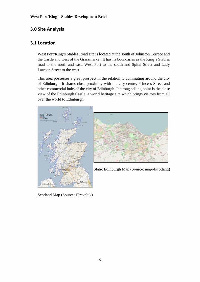
West Port/King’s Stables Road site is located at the south of Johnston Terrace andthe Castle and west of the Grassmarket. It has its boundaries as the King’s Stablesroad to the north and east, West Port to the south and Spital Street and LadyLawson Street to the west.
This area possesses a great prospect in the relation to commuting around the cityof Edinburgh. It shares close proximity with the city centre, Princess Street andother commercial hubs of the city of Edinburgh. It strong selling point is the closeview of the Edinburgh Castle, a world heritage site which brings visitors from allover the world to Edinburgh.
Scotland Map (Source: iTraveluk)
Static Edinburgh Map (Source: mapofscotland)

West Port/King’s Stables Development Brief
- 6 -
The Site A medieval age view of the Grassmarket
(Source: The Grassmarket Mission)
3.2 Climate
3.2.1 Sun Path
Sun path depends on latitude of the place, the site’s latitude is 55.94°, and longitude is 3.19°. The zenith angle of the sun on March 21 &September 21 can be calculated (90-55.94°=34.5) (Sun Position 2013).

West Port/King’s Stables Development Brief
- 7 -
(Source: SunCalc.net)
(Source: SunEarthTools.com)

West Port/King’s Stables Development Brief
- 8 -
(Source: www.edinburgh.climatemps.com)
3.2.2 Temperature
Detail JAN FEB MAC APR MAY JUNE JULY AUG SEP OCT NOV DEC
Average HighTemperature
˚C6 7 9 11 14 17 19 19 16 13 9 7 12
Average LowTemperature
˚C0 0 2 3 6 9 10 10 8 6 2 1 5
AverageTemperature
˚C3 3 5 7 10 13 15 14 12 10 5 4 8
Detail JAN FEB MAC APR MAY JUNE JULY AUG SEP OCT NOV DEC
Average SunlightHours Per Days
7.4 9.3 11.4 14.116.19
17.3 16.5 15.04 12.4 10.1 8.11 7.0
Percentage of Sunny(Cloudy)
%
24 29 31 3536 36 31 31 34 31 24 21
Daylight Hours PerMonth
76 71 69 65 64 64 69 69 66 69 76 79

West Port/King’s Stables Development Brief
- 9 -
Edinburgh annually has a tempered climate, where it rains often and summers are mild rather than hot. Temperature in the summer season(June, July, and August) averagely around 18-19C. When winter season it always cold with average temperatures hovering above the freezingmark in January and regarding t the weather itself is usually often damp.
Base on the weather report by Weather Edinburgh Airport, the average temperature in Edinburgh, Scotland is 8.4°C (48°F). The highestmonthly average high temperature is 18°C (64°F) in July and August. The lowest monthly average low temperature is 1°C (34°F) in Januaryand February. Edinburgh receives an average of 676 mm (26.6 in) of rainfall per year, or 56 mm (2.2 in) per month. On average, there are 1384hours of sunlight per year with an average of 3.8 hours of sunlight per day.
The highest temperature recorded was 23°C on August 14. The lowest temperature recorded was -7°C on January 16. The maximum windspeed recorded was 129.5 km/h on January 3 (Weather Edinburgh Airport, 2012).
3.2.3 Precipitation
Detail JAN FEB MAC APR MAY JUNE JULY AUG SEP OCT NOV DEC
AveragePrecipitation
(mm)57 42 51 41 51 51 57 65 67 65 63 58
No. Wet (Days) 17 15 15 14 14 15 17 16 16 17 17 18 191/366

West Port/King’s Stables Development Brief
- 10 -
3.2.4 Wind
From the table and the diagram (Wind Finder 2012) shown below, it is obvious that the average wind speed does not exceed 20 km/h.According to Beaufort scale this speed is considered as a Moderate breeze, this is an advantage point of the site that gives the designer morefreedom during design process.

West Port/King’s Stables Development Brief
- 11 -
3.2.5 Conclusion
In other term, Edinburgh has a marine west coast climate that is mild with no dry season, warm summers and moderate seasonality. Based onHoldridge Life zones system of bioclimatic classification, this area is close to the cool temperature moist forest biome.
(Source: Climatetemp.info)
DATA VALORAnnual average temperature 8.4 ˚CAnnual average maximum temperature 11.9 ˚CAnnual average minimum temperature 4.8 ˚CAnnual average humidity 82.4Annual average visibility 10.2 KmAnnual average wind speed 15.0 km/h

West Port/King’s Stables Development Brief
- 12 -
3.3 Noise Impact
The average noise level of the selected area is shown on the map below, it isassessed by recording the data in average day and night in an average year and thelevel is measured by Legend. Information can be abstracted from the map thatsince the selected site is located in the heart of Central Business District andsurrounded by several tourist spots, the level of noise is relatively high as compareto other places of the city, which is at the highest level that exceed 80dB (Source:Scottish Noise Mapping).

West Port/King’s Stables Development Brief
- 13 -
3.4 Policy
3.4.1 Policy Index
The site is located in part of Edinburgh Old Town and Edinburgh City itself. Anydevelopment or planning works need to base on the local authority developmentpolicy. Policies related to the proposal of redevelopment of the site are EdinburghLocal Development Plan (Proposed Plan) 2013, Edinburgh and Lothians StructurePlan 2015, Edinburgh Would Heritage Site Management Plan 2005 and EdinburghNew Town & Old Town UNESCO Report 2012. The old town is considered partof the city centre thus an appropriate for mix use activities area where there havevarieties of land use types such as housing, retail and offices.
These policies provided a framework in order for redevelopment of the site areawhich contains and involve the conservation of world heritage site. Edinburgh OldTown has it own personality as a great old heritage recognised by the WorldHeritage UNESCO. All of these policies will be guidance in order to enhance thefuture of the area.
3.4.2 Housing
"The overall requirement is for 70,200 additional houses (for the 2001 – 2015period), 48% of which (33,900 houses) need to be provided for in the EdinburghCouncil area" required by the Structure Plan (2015); at the same time, the LocalDevelopment Plan (2013) also indicates that the urban Edinburgh needs 1,100newunits in order to meet the needs of growing population of Edinburgh. Additionally,the quality of the new housing developments is stated in the Local DevelopmentPlan (2013); in Policy Hou 2 Housing Mix, the council aims to create a diversifiedusage of the communities and their accessibility by providing various types andsizes of dwelling units. As required by the council in Policy Hou 3 Private GreenSpaces in Housing Development, a standard of 10 square meters per flat or 20% oftotal site area should be covered with green space.
According to the Policy Hou 6 Affordable Housing in Local Development Plan(2013), requirement of at least 12 or more units up to 25% of the total units shouldbe consisted if the newly proposed developments contain 20 or more dwellings;besides from the requirements of the density, appropriate and valuablecommunities facilities should also be fulfilled in Policy Hou 10 CommunityFacilities.

West Port/King’s Stables Development Brief
- 14 -
3.4.3 Retail
In the section of Policy Ret 10 Food and Drinks Establishments stated that "Newdevelopments including restaurant, café, pub, or shop selling hot food forconsumption off the premises are under strictly valuation process". Unacceptableactivities, for instance, increase in noise, disturbance, on-street activity oranti-social behaviour which brought by the new developments, might be rejectedas they create intolerable disruption and inconvenience to the surroundingresidents. Proposed developments would be considered the condition that theywere subjected to over-centralize business to the living conditions to thecommunity, which the site would be under the threat of the retail shops atGrassmarket Square.
3.4.4 Hotel
Suitable hotel development is a critical factor that reflect the economic growthwithin a city, especially those hotel developments located in the Central BusinessDistrict, which might be the plan of change in use for the West Port/King’s StablesRoad project. Policy Emp 10 Hotel Development of Local Development Plan(2013) required the proposed hotel development plan to welly connected to theexisting public transport facilities in order to provide high quality touristsaccommodation.
3.4.5 Office
Objectives of promoting, protecting and enhancing the existing jobs andinvestments in Edinburgh, plus maintaining the diversity of jobs available withinEdinburgh, the Local Development Plan (2013), Policy Emp 1 OfficeDevelopment has emphasized which the development of offices in urban area,must be compatible with the connectivity of public transportation in both scale andcharacter. In addition, the newly proposed office development should also becooperating with the surrounding local environment to maintain the priority ofselection of the locations, as matters of business investment options.
3.4.6 Transportation
Within all levels of policies there indicators of the necessaries of the connectionsof existing public transport routes to new proposed developments, for the WestPort/King’s Stables Road area there are also some strict policies to govern thetransport uses.
When accessing the suitability of a proposed development, the significant traveldemand generated by the development would be taken into consideration if the site

West Port/King’s Stables Development Brief
- 15 -
is located in the city centre. Critically on other transport modes except from privatecars; in addition, the impact created by the development’s travel demand on theLocal Transport Strategy objectives and existing roads and public transportnetworks would also be considered as stated in Policy Tra 1&2 Location of MajorTravel Generating Development of Local Development Plan (2013).
Transport Map from Argyle House (Source: Argyle House 2012)
3.5 Existing Land Uses and Building Heights
The West Port/King’s Stables Road area is assembled by various types and usagesbuildings, associated with different and complex townscapes. Major residentialbuildings are located around the site and there are two prior private residentialblocks alongside the West Port. Retails such as bars and restaurants and mainlycentralizing at the Grassmarket Square but there are also few rest on the roadsideof West Port and King’s Stables Road. Besides from the residential andcommercial blocks at the area, there are also some educational facilities near theproposed site. Edinburgh College of Art and Evolution House are located in theblock where Lady Lawson Street and West Port joint.

West Port/King’s Stables Development Brief
- 16 -

West Port/King’s Stables Development Brief
- 17 -
The site is located within the old Edinburgh townshiphence has strong connections with other public locationslike the Princess Street, City centre and Waverley TrainStation. It is has direct access through Public transport toareas like Edinburgh Airport.
3.6 Roads and Context within the city

West Port/King’s Stables Development Brief
- 18 -
3.7 Urban Design
3.7.1 Style and Architecture Form
Many parts of Edinburgh are known throughout the world as there have good quality of astatic value of urban design. For instance Old Townof Edinburgh are instantly recognised.
Cues
VerticalRhythms
It is an environment that bringcharacteristic of Old Town. This displays atradition of high quality workmanship,attention to detail and the use of robustand durable materials.
Bays help interpretation in domestic value.But need to imply on commercial areaprecedent.
The house has no bays. A good contrastwith others buildings. Order, rhythm andsymmetry extend from the elevation of awhole house and group of houses to acomplete terrace or square.

West Port/King’s Stables Development Brief
- 19 -
HorizontalRhythms
This existing mix use building dominanthorizontal run between first floor and secondfloor. These buildings become starting point /nodes in this area.
Skylines
Dormers help interpretation as flats.
Multi storey dwelling were from 16th centuryand 18th century.Influenced by Scottish Baronial Architecturalstyle.

West Port/King’s Stables Development Brief
- 20 -
Windows Windows opening generally modest scale invertical in proportion.
Wall Details
Stonewall had been used in old buildings

West Port/King’s Stables Development Brief
- 21 -
Door &Ground LevelDetails
This shows the aesthetic value of thefrontage on buildings especially the designand color.
Design had been use for structure of itsappearance more related to heritage.
StreetFurniture &Public Realm
Bus shelter and signage usually seentogether painted in similar same colour asrailing.
This is a tradition in Edinburgh for guard railsto be fabricated specially to fit each other.There also adapted to provide security barsfor motorcyclist to parking their motorcycle.
Information signs add to pleasure ofEdinburgh residents and visitors. Streetname usually relate to architecture.
West Port/King’s Stables Development Brief
- 22 -
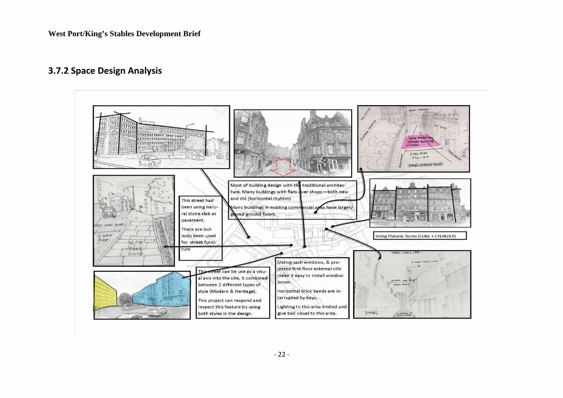
3.7.2 Space Design Analysis

West Port/King’s Stables Development Brief
- 23 -

West Port/King’s Stables Development Brief
- 24 -
3.7.2 Materials
Most of the old town building based on the stone built properties where it can be seen to steeply sloping slated roofs and chimney stones. Thebuilding within the development mostly based on stones, bricks, timber, and glass as similar to adjacent in order to blend in with thesurrounding area.
(King’s Stables Council Storage Building Wall)
From the observation, houses in rows were built influenced by Victorian tenements which remain as major legacy to buildings stocknowadays. Modern office block typically consisted of bare concrete or stone clad concrete structures, (The Old and New Towns of EdinburghWorld Heritage Site Management Plan 2011-2016).
West Port/King’s Stables Development Brief
- 25 -
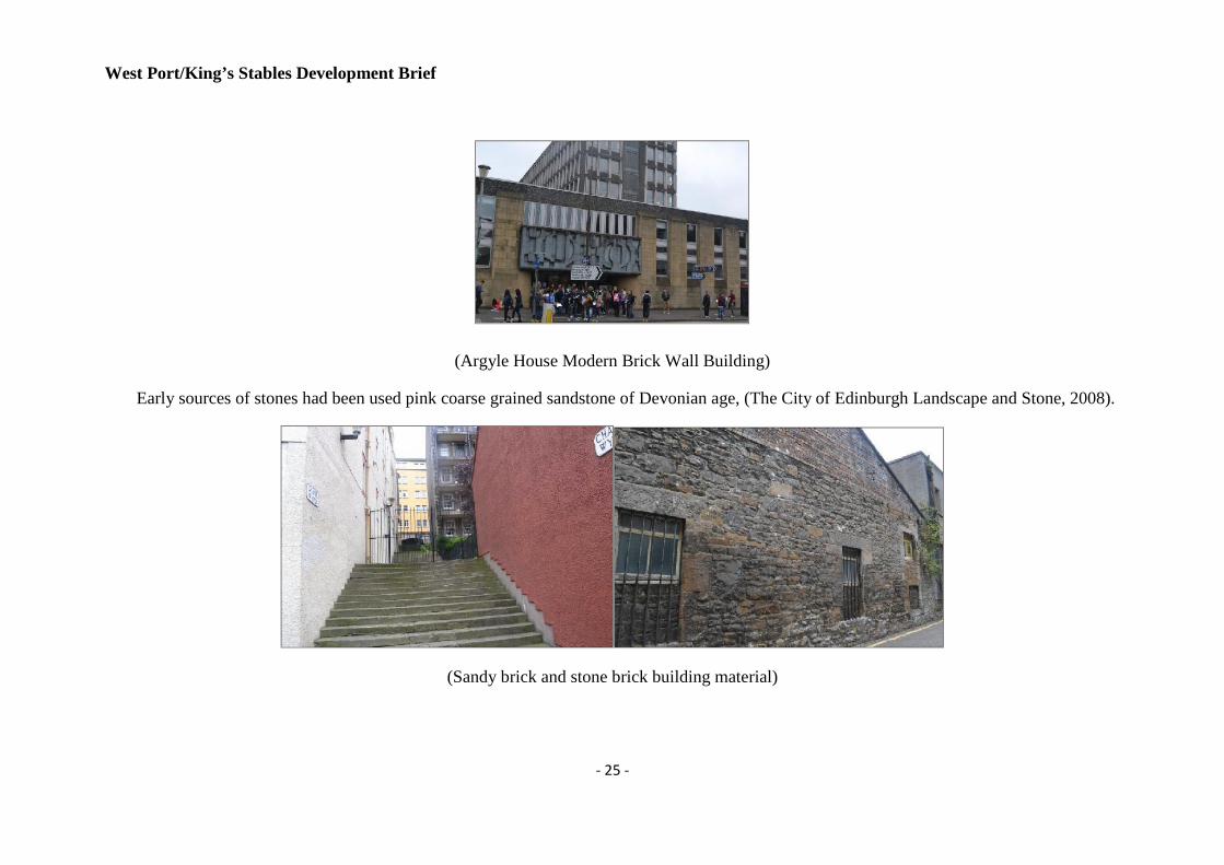
(Argyle House Modern Brick Wall Building)
Early sources of stones had been used pink coarse grained sandstone of Devonian age, (The City of Edinburgh Landscape and Stone, 2008).
(Sandy brick and stone brick building material)

West Port/King’s Stables Development Brief
- 26 -
Construction detail on road throughout Edinburgh Old Town can be seen that using of local stone for footway and carriageway, paving andkerbs. Examples of the traditional and modern stone construction details on the road can be seen at the pictures below.
(Stone material had been used for footway)

West Port/King’s Stables Development Brief
- 27 -
3.8 Transportation
There are plenty of transportation options available near the site as the site islocated in the city centre. Three bus stops can be accessed within 500 meter radioson the West Port, bus services 2 and 35 are available at the bus stops. Besides fromthe bus services on the West Port, there also various buses routes available on thePrinces Street which will take only 10 minutes’ walk from the selected site,moreover, the main train station of Edinburgh - Waverley Station is located 0.8miles away from the King’s Stables Road. Base on the research of thetransportation of the selected site, extra public transportation services are notnecessary at the moment for the proposed development since the location isrelatively convenient with multiple travel options.
Additional information about the transportation of the proposed development iscollected in forms of calculating the travel time needed for people to either driveor taking public transportation services to few important locations; data isobserved and recorded by different travel options in maximum and minimum timeneeded (Source: Google Map).
The data is collected by recording the time needed to travel from the King’sStables Road to Haymarket Station, Waverley Station and the Edinburgh Airportby car and bus respectively. Travel to the nearest destination, the HaymarketStation takes 8 minutes by driving and 19 minutes by buses; to the WaverleyStation costs 6 minutes by driving and 17 minutes by buses; travel to theEdinburgh Airport, people need to drive 26 minutes and 42 minutes by takingbuses.

West Port/King’s Stables Development Brief
- 28 -
3.9 Views
West Port/King’s Stables Development Brief
- 29 -
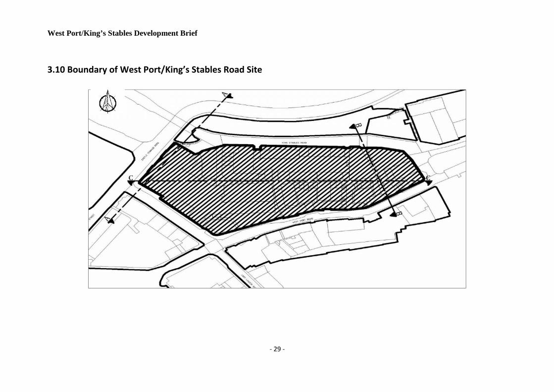
3.10 Boundary of West Port/King’s Stables Road Site

West Port/King’s Stables Development Brief
- 30 -
3.11 Sections of West Port/King’s Stables Road Site

West Port/King’s Stables Development Brief
- 31 -

West Port/King’s Stables Development Brief
- 32 -
4.0 Development Brief
4.1 Objectives
The Development Brief’s Objectives are:
In the prerequisite of protecting the existing landmark of Edinburgh - EdinburghCastle, transform the building into a sub-landmark which prominently promotingEdinburgh’s value of a capital city;
Cooperating with the existing environment, enhance the amenity andharmoniousness of the community to provide a better residential, business andleisure space to the centre of Edinburgh;
Ameliorate the connectivity of the community by attracting the bus servicesoperators to allocate more routes into the area, improve the various transportationmodes i.e. bus, cycling, walking, car, train, etc.
4.2 Appropriate Land Use
The selected site is located in the Central Business District of Edinburgh, thelocation is ideal opportunities for developers to propose their developments withnew horizons which contain multi-usage. Review the general situation of the site,the building types are diversified with historical residential buildings, moderneducational blocks and popular retailing business; therefore the new developmentproposal should consider the impact on the environment in terms of increasing theattractiveness of compactible community.
4.2.1 Residential
In consideration of the private residential buildings around the selected site, theobjective of preserving the historical value of these buildings would be the keyfactor to the development.
4.2.2 Office
The project has a well diversification environment within the area, hence the usageof the offices is to strengthen the economic connectivity to the existing buildings,enhance the area’s integration of administrative and executive role.

West Port/King’s Stables Development Brief
- 33 -
4.2.3 Retail
Generally, retail is the critical factor to inter-link the surrounding buildingsincluding residential and offices, it creates an open space to integrate with theenvironment.
4.2.4 Leisure
Leisure facilities are used to provide an active area to the constant surroundings,conflicts created by leisure facilities need to be minimize in order to corp with theother users harmoniously.
4.3 Zoning Diagram
4.3.1 Noise Zoning
When planning for the allocation of the re-design use of the buildings, noisepollution has been taken into account since the original buildings are remaining atthe same position. The four to five stars hotel will be designed to be at the back ofthe castle, to avoid any interruptions from the tourists and the retailing andcommercial-use shops are facing to the main road/castle.
(Source: Scottish Noise Mapping)

West Port/King’s Stables Development Brief
- 34 -
4.3.2 Sun Path Zoning
According to the sun path of Edinburgh, the orientation of the hotel will have themaximum sun expose as compare to other buildings under redevelopment since thehotel consume more energy than other buildings in the winter.
Sun coverage on site
Summer Sun Coverage
Winter Sun Coverage

West Port/King’s Stables Development Brief
- 35 -
4.3.3 Wind Zoning
The graph below has shown that the accustomed wind blows from southwest tonortheast direction, which would be blocked by the Argyle House’s offices wing,the plan offers the best solution to preserve heat alongside the King’s Stables Lane,generate the environmental friendly effects towards building a green city.
Wind direction on site

West Port/King’s Stables Development Brief
- 36 -
4.4 Parking
The Argyle House has already provided 165 underground parking spaces and 50 atground level at the back of the Argyle House, which is at the King’s Stables Ln.Besides from the provided parking spaces with parking lots, on-road parking isalso available alongside the King’s Stable Road for the nearby residents andtourists and visitors to the Grassmarket Square.
Parking Spaces in Argyle House (Argyle House Edinburgh)

West Port/King’s Stables Development Brief
- 37 -
4.5 Landscape & Natural Features
Natural Landscape
There only hard surface on the
landscape on the site. No green space
located unless on it surrounding only.
On the development proposal there
have been propose to locate the green
and medium landscape on the site.

West Port/King’s Stables Development Brief
- 38 -
4.5.1 Propose Development

West Port/King’s Stables Development Brief
- 39 -
4.6 Walking/Cycling Paths
The boundaries of the site are pedestrian walkways and cycle routes, within the siteare both King’s Stables and Lady Wynd lanes to facilitate the movement ofdwellers, though these two lanes suffices. There currently exists an access to WestPort Street from the King’s Stables lane through the Chapel Wynd and PortsburghSquare. It must be said that this access is gated and normally closed to the public.Pedestrian usage of the King’s Stable road, the King’s Stable and Lady Wyndlanes are generally at a minimum at any time of day. Johnston and Castle Terraceexperiences modest pedestrian movement mostly as a result of tourist activitiesand viewing of the Edinburgh castle. The west port and Lady Lawson Streetsexperiences most pedestrian activities as they serve as the main links road to thecity centre and retailing service are mostly offered on this parts of the site.

West Port/King’s Stables Development Brief
- 40 -

West Port/King’s Stables Development Brief
- 41 -
4.7 Shadow Effect (Source: Google Earth Image)
June (Scenery: 6 AM) June (Scenery: 8 AM)
June (Scenery: 12 PM) June (Scenery: 4 PM)

West Port/King’s Stables Development Brief
- 42 -
March (Scenery: 6 AM) March (Scenery: 8 AM)
March (Scenery: 12 PM) March (Scenery: 4 PM)

West Port/King’s Stables Development Brief
- 43 -
December (Scenery: 6 AM) December (Scenery: 8 AM)
December (Scenery: 12 PM) December (Scenery: 4 PM)

West Port/King’s Stables Development Brief
- 44 -
4.8 Design Principle for New Development Policy
4.8.1 Impact on Setting Policy
Regarding to the West Port and King Stables development proposal, any developmentpropose need to consider on the impact on its surrounding. This includes the impact to thecharacter of the townscape and landscape of the area. Based on Policy Des 4 DevelopmentDesign – Impact on Setting in Edinburgh Local Development Plan 2013, the requirementof the policy are regards to:
height and form
scale and proportions, including the spaces between buildings
position of buildings and other features on the site
materials and detailing
Based on these, any new development proposal will be expected to have similarcharacteristic to the surrounding buildings and the urban grain.
4.8.2 Sustainable Building Policy
On this scope of study about the design development, the development should includebased on sustainable approach where apply low and zero carbon technologies for thebuilding. Implementation and proposal on using such as renewable energy sources likesolar panels, heat pumps and mechanical ventilation and heat recovery will give positiveimpact in significantly lower carbon dioxide emission itself.
Based on the Edinburgh Local Development Plan 2013, there have to create sustainablenot just to the building but encourages on sustainable lifestyle for example, wastemanagement, recycle facilities and so on.
4.8.3 Conservation Policy
This project will be related to the regeneration with the preservation on conservation of thearea. As we know this area are under the heritage conservation listed. Based on theEdinburgh Local Plan and ENESCO report, the proposal of development in the areashould compromise on:
Preserves or enhances the special character or appearance of the conservation area andis consistent with the relevant conservation area character appraisal
Preserves trees, hedges, boundary walls, railings, paving and other features whichcontribute positively to the character of the area and

West Port/King’s Stables Development Brief
- 45 -
Demonstrates high standards of design and utilises materials appropriate to thehistoric environment.
This purpose in order to protect the value of heritage and ecstatic value of Edinburgh’smany conservation areas. Besides, to ensuring that the new development is appropriateand in good quality.
West Port/King’s Stables Development Brief
- 46 -
5.0 Development Proposal
5.1 Description
5.1.1 Castle Terrace Hotel & Argyle View Hotel
As a consideration to minimize the impacts of the transformation of the selected site to thesurrounding residents and environment, we have decided to give up the plan of massivedemolition works and focusing on internal renovation and building surface renewal works.The major task which is also the most critical section of the whole proposal is thetransformation work of the existing Argyle House; after the external renewal and internalrenovation process the building would become the second most attractive landmark in thearea, an alive connection between the modern society and the extraordinary history. Thesouth wing of the Argyle House will transform into a four to five stars hotel and the westwing will remain as offices. The two-floor height section of the Argyle House at the westwill be renovated and used as a local shopping mall to meet the needs from theneighbouring residents and tourists.
Another relatively cheaper hotel will be proposed to be transform from the existingfour-floor height building at the King’s Stables Road, which provides options for touristsat different expenses but sharing the same view of the castle.
5.1.2 Information Center/ Tourism Office, King's Stables Gallery and Art Center
The abandoned two-floors height buildings located at the back of the Argyle House whichis originally used as council warehouse, large renovation works will be carry out totransform it into a tourist information centre, contains a gallery exhibiting the history ofEdinburgh from 17th Century and themed catering and retailing shops.
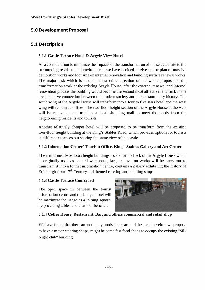
5.1.3 Castle Terrace Courtyard
The open space in between the touristinformation centre and the budget hotel willbe maximize the usage as a joining square,by providing tables and chairs or benches.
5.1.4 Coffee House, Restaurant, Bar, and others commercial and retail shop
We have found that there are not many foods shops around the area, therefore we propose
to have a major catering shops, might be some fast food shops to occupy the existing "Silk
Night club" building.

West Port/King’s Stables Development Brief
- 47 -
5.2 Concept Plan

West Port/King’s Stables Development Brief
- 48 -
5.3 Technical Plan

West Port/King’s Stables Development Brief
- 49 -
5.4 Elevation Views
5.4.1 Existing
View from King’s Stables Road View on top
View of Argyle House Entrance View of King’s Stables Lane

West Port/King’s Stables Development Brief
- 50 -
5.4.2 Proposed
View from King’s Stables Road View on top
View on top View of King’s Stables Lane

West Port/King’s Stables Development Brief
- 51 -
5.5 Impact of development
To be precise and concise with the impact we anticipate the proposed urban design will
have the West Port/King’s Stable site, we have broken down the impact on the site in threethematic areas namely Environmental, Economic and Social impacts.
5.5.1 Environmental Impact:
We perceive that the decision not to demolish Argyle House but refurbish the external
cladding will prevent lots of health hazard to adjoining property owners and immediate
community around the site.
The use of the south-eastern end of Argyle House (which is sun’s path) for a 5 star hotelwill aid to avoid constant use of electric power to illuminate room during all times of the
day as well as providing a sustainable way of ventilating those rooms as the wind blows
from the south to the north.
We propose the redevelopment of the King’s Stable by proposing a 3 star hotel. To keep
the environment sanitized, we propose the contractor endeavours to reduce to the noise
level of construction activities to a minimum during construction. It is admitted this might
affect the site while until construction is done but it is to be ensured that through hoarding
the site, construction has minimal effect on the general environmental taking
environmental impact regulations into account.
The use of the remodelled facilities within the site should generally provide a fill-go-factor
to the site and its environs.
5.5.2 Economic Impact
The redeployment of Argyle House and the King’s Stable as hotels, with a face liftexpressing the medieval architectural design will enhance the image of Edinburgh Castle
as an historic site and play into economic growth and prospects of the site by hosting
visitors to the site.
Proposing the ‘Silk Night Club’ as a café will prove economically viable than the formeras a lot of visitors will be drawn to area with the activities of the Information Centre
Gallery, hotels and people drawn to site.

West Port/King’s Stables Development Brief
- 52 -
The springing up of these facilities within the site will assist in job creation among the
locales of Edinburgh, especially to the old town area itself.
5.5.3 Social Impact
After the change in used to of Argyle House from its current of being an office complex
into a shopping mall and hotel facilities, the otherwise ‘lack of activities’ environmentwitness within and around the site will be a thing of the past. Castle terrace and Spittal
Street will embrace an active life which will involving the constant movement of people
on the street, this will engage and enhance of the tourist activities from that point of view
of the Edinburgh Castle.
The Hotel facilities which will be provided by transformed used of the south wing of
Argyle House and the reconstructed Hotel facility on the King’s Stables plot will serve asmeans of hosting the tourists and visitors to the site. These two facilities will provide a
wonderful viewing experience for its hosts.
The restructuring of the King’s Stables plots in Castle View Hotel and Information CentreGallery will also breathe life to the King’s Stables Road and Lane enhancing the Securityof the site with illumination and activities in the evenings and night.
6.0 Conclusion
Sustainable design cannot be look from the isolated perspective but need to go deeply
through the evaluation process itself. West Port and Castle Terrace have valuable aesthetic
value in term of its heritage, building, location, site, and urban design. This area have
potentially to develop as same with its surrounding areas which is quite outstanding in
economics, physical and social development. This area should be rebranding to pull out its
sense.
This design brief report, promoting attractive, sustainable forms of development to
indicate ways in which the process of providing the area become more responsive and
provide greater certainty to the local communities and Edinburgh City itself. We believe
that, the development on this area can be improve by ensuring plans identify with potential
to meet the requirement of future development demand.

- 53 -
7.0 Reference List
Bentley, I. Alcock, A. Murrain,P. MacGlynn, S & Smith, G. (1985) Responsive Environments: A
Manual For Designers, The Architectural, London.
Ching , D.K.(1943) Architecture Form, Space and Order, 3rd ed., Canada: John Wiley&sons. Inc.
Dictionary of Scottish Architects (2013) DSA Architect Biography Report, [online]
Available at:
http://www.scottisharchitects.org.uk/architect_full.php?id=400344
[Accessed on 20 Oct 2013]
EdinburghGuide.com (2013). Old Town Edinburgh, [online]
Available at:
http://www.edinburghguide.com/oldtownedinburgh
[Accessed on 04 Oct 2013]
EdinPhoto (n.d.) Map of Edinburgh - 1870, [online]
Available at:
http://www.edinphoto.org.uk/1_map/1_map_edinburgh_1870_large.htm
[Accessed on 23 Oct 2013]
EdinPhoto (n.d.) Map of Edinburgh - 1915, [online]
Available at:
http://www.edinphoto.org.uk/1_map/1_map_edinburgh_1915_edinburgh_central_large.htm
[Accessed on 23 Oct 2013]
EdinPhoto (n.d.) Map of Edinburgh - 1925, [online]
Available at:
http://www.edinphoto.org.uk/1_map/1_map_edinburgh_1925_zoom-in.enlarged.htm
[Accessed on 23 Oct 2013]
General Register Office for Scotland (2005). Scotland’s Census 2001 - Output Prospectus, April 2005.
iTraveluk (n.d.) Scotland Map, [online]
Available at:
http://www.itraveluk.co.uk/maps/scotland.html
[Accessed on 23 Oct 2013]
Lothian Bus (2013). Timetable - Tickets - Maps, [online]
Available at:
http://lothianbuses.com/timetables-tickets-maps/timetables
[Accessed on 25 Oct 2013]
- 54 -
Macleod, R. (2012). Old Town demographics - preliminary study, Edinburgh Old Town Development
Trust, 06 Sept 2012.
Map of Scotland (2011) Static Edinburgh Map, [online]
Available at:
http://www.mapofscotland.org/map/edinburgh/mapofedinburgh.html
[Accessed on 23 Oct 2013]
McPgail, C. (1995) Edinburgh Street Manual, Edinburgh Local Council.
Scottish Noise Mapping (2007). The Scottish Government. [online]
Available at:
http://gisapps.aecomgis.com/scottishnoisemapping_p2/default.aspx
[Accessed on 15 Oct 2013]
State of the Environment Audit (2008). Natural Setting - Topography, Edinburgh’s Environment: Stateof the Environment Audit.
The City Of Edinburgh Council (2006) Rural West Edinburgh Local Plan, June 2006.
The City of Edinburgh Council (2010). West Port/King’s Stables Road Development Brief –Final. 13
May.
The City Of Edinburgh Council (2013) Proposed Plan, Edinburgh Local Development Plan, March
2013.
The Grassmarket mission (2012). The History of the Grassmarket. [online]
Available at:
http://www.grassmarketmission.org/about_us/the_grassmarket.htm
[Accessed 5 Oct 2013]
The Identification and protection of key views (2006). Edinburgh Skyline Study, 2006.
The Strategic Development Planning Authority for Edinburgh and South East Scotland (2013)
Strategic Development Plan, Edinburgh, June 2013.

Sun Path
1. Context within the city
(1). Location
West Port/Ling’s Stables site is
at the center of Edinburgh city,
right next to Edinburgh’s
landmark - Edinburgh Castle.
1.1 mile away from Haymarket
and 7.2 mile away from the
airport.
(2). Existing building:
The Argyle House which was built in 1969 and
designed by Michael Laird and Partners.
(3). Surrounding land use
2. Climate(1). Data of climate
(2). Sun path and orientation of wind
Wind Orientation
West Port/King’s Stables Road Site Analysis
3. Transportation(1). Public transportation
There are only two bus services
available around the selected site,
which are 2 and 35; however,
these two services are connecting
with few important destinations.
The public transport services are
relatively convenient.
1 2
3 4

COMMERCIAL
SECTION A-A SECTION B-B SECTION C-C
Key Plan
Location Plan
INFRACULTURE : REBRANDING REGENERATION RECONNECT
BY DEFINING ACTIVE SPACES AS (LIVE. WORK. LEISURE. PLAY) MORE
THAN HUNDRED SQUARE FEET OF DECAYING, UNUSED SPACES CAN BE
RE-IMAGED AS A PERMEABLE- POTENTIAL OF DEVELOPMENT GROWTH.
KING’S STABLES & WEST PORT DESIGN BRIEF PROPOSE DEVELOPMENT
CASTLE VIEW
HOTEL
INFORMATION
CENTER GALLERY
ARGYLE HOUSEOFFICE
ARGLE HOTEL
SHOPPING MALL
TO TRANSFORM THE IMAGE OF THEAREA IN ORDER TO RECONNECT &RE-APPROPRIATE REBRANDING ANDGIVE IMPACT TO ECONOMY.SOCIALINTERACTION AND PHYSICAL TOCREATE A SENSE OF PLACE
WEST PORT AND CASTLE TERRACE CURRENTLY
DISCONNECTS MANY DENSE AND URBAN
DEVELOPMENT