Terrorism—A (Self) Love Story Redirecting the Significance Quest Can End Violence
Upload
khangminh22Category
view
1download
0
EAST AYRSHIRE COUNCIL
PLANNING COMMITTEE: 28 APRIL 2017
15/0676/PPP: LEISURE AND TOURISM DEVELOPMENT INCLUDING: 450 HOLIDAY LODGES; 12 GLAMPING PITCHES; RESTORATION OF CASTLE TO
SHELL CONVERSION TO HOTEL; NEW LEISURE FACILITIES INCLUDING LAKE; INDOOR WATER PARK WITH RETAIL PIZZA AND RESTAURANTS (6,500SQM),
WATER SPORTS BUILDING (600 SQM), INDOOR SPORTS (5,000SQM). SPA (2,000SQM) AND CYCLE STORE. ERECTION OF DISTILLERY (1,552SQM) AND
COMMUNITY HEAT PLANT (476SQM). ERECTION OF PHASED ENABLING DEVELOPMENT, WITH A FIRST PHASE OF 300 RESIDENTIAL DWELLINGS AND ADDITIONAL PHASES OF RESIDENTIAL DWELLINGS THAT WILL ENABLE THE
COMPLETE RESTORATION OF THE CASTLE TO A HOTEL: COMMUNITY FACILITIES AND INFRASTRUCTURE.
AT: LOUDOUN CASTLE, LOUDOUN CASTLE ESTATE
A71 GALSTON ROUNDABOUT, GALSTON, EAST AYRSHIRE
KA4 8PD
BY LOUDOUN WOODS HOMES LTD
Report by Head of Planning and Economic Development, Economy and Skills
Click for Application Details: http://eplanning.east-
ayrshire.gov.uk/online/applicationDetails.do?activeTab=summary&keyVal=NUCXL7GF03N00
EXECUTIVE SUMMARY SHEET
PURPOSE OF REPORT 1. The purpose of this report is to update Members of the Planning Committee on
the progress with this application which was previously called-in by the Scottish Ministers in terms of Section 46 of the Town and Country Planning (Scotland) Act 1997. Members last met on 29 April 2016 and the view of the Planning Committee was conveyed to the Reporters appointed by the Scottish Ministers as representing the position of the Council in the current call-in at that time.
RECOMMENDATION 2. That the Planning Committee agree the recommendation of the Head of
Planning and Economic Development on the following basis:-

1) The Planning Authority cannot at this point in time support the application given the lack of relevant information supporting the principle of development.
2) The Planning Authority therefore maintain their recommendation to
Scottish Ministers that the application be refused planning permission in principle.
3) Should the applicants provide further relevant information as
highlighted within this report, the Planning Authority would welcome the opportunity to reconsider its position.
4) The Head of Planning and Economic Development seeks delegated
authority from the Planning Committee in consultation with the Chief Governance Officer to provide the Reporters appointed by Scottish Ministers with proposed conditions and Head of Terms for a Legal Agreement under Section 75 of the Town and Country Planning (Scotland) Act 1997 (as amended) and to take such other actions as are considered necessary to protect the Council’s position.
CONTRARY DECISION NOTE 3 Should the Committee adopt the view that the application should be supported,
contrary to the recommendation of the Head of Planning and Economic Development, the application would have represented a significant departure from Council Policy. If the application was not the subject of an call-in, it would have thereafter been referred to Council for a decision. However as the application has been called-in, it therefore does not require to be considered by Council.
Michael Keane Head of Planning and Economic Development Note: This document combines key sections of the associated report for quick reference and should not in itself be considered as having been the basis for recommendation preparation or decision making by the Planning Authority.

EAST AYRSHIRE COUNCIL
PLANNING COMMITTEE: 28 APRIL 2017
15/0676/PPP: LEISURE AND TOURISM DEVELOPMENT INCLUDING: 450
HOLIDAY LODGES; 12 GLAMPING PITCHES; RESTORATION OF CASTLE TO SHELL CONVERSION TO HOTEL; NEW LEISURE FACILITIES INCLUDING LAKE; INDOOR WATER PARK WITH RETAIL PIZZA AND RESTAURANTS (6,500SQM),
WATER SPORTS BUILDING (600 SQM), INDOOR SPORTS (5,000SQM). SPA (2,000SQM) AND CYCLE STORE. ERECTION OF DISTILLERY (1,552SQM) AND
COMMUNITY HEAT PLANT (476SQM). ERECTION OF PHASED ENABLING DEVELOPMENT, WITH A FIRST PHASE OF 300 RESIDENTIAL DWELLINGS AND ADDITIONAL PHASES OF RESIDENTIAL DWELLINGS THAT WILL ENABLE THE
COMPLETE RESTORATION OF THE CASTLE TO A HOTEL: COMMUNITY FACILITIES AND INFRASTRUCTURE.
AT: LOUDOUN CASTLE, LOUDOUN CASTLE ESTATE
A71 GALSTON ROUNDABOUT, GALSTON, EAST AYRSHIRE
KA4 8PD
BY LOUDOUN WOODS HOMES LTD
Report by Head of Planning and Economic Development, Economy and Skills
Click for Application Details: http://eplanning.east-
ayrshire.gov.uk/online/applicationDetails.do?activeTab=summary&keyVal=NUCXL7GF03N00
PURPOSE OF REPORT
1. The purpose of this report is to update Members of the Planning Committee on the progress with this application which was previously called-in by the Scottish Ministers in terms of Section 46 of the Town and Country Planning (Scotland) Act 1997. Members last met on 29 April 2016 and the view of the Planning Committee was conveyed to the Reporters appointed by the Scottish Ministers as representing the position of the Council in the current call-in at that time.
2. The proposal represents a Major Development in terms of the Town and Country
Planning (Hierarchy of Development) (Scotland) Regulations 2009.
BACKGROUND Resubmitted Application
3. This planning application before Members was lodged with the Planning Service on 8 September 2015. It replaced an earlier planning application which was
withdrawn by the applicant’s agent ref. 14/0852/PPP and incorporated an updated Environmental Impact Assessment and further clarification on matters as provided by the applicant’s team. This revised application was then subject to a draft Processing Agreement, and then statutory advertisement, neighbour notification and consultation with further discussions taking place with the applicant's agents and the Planning Service as the revised application progressed. Call-In by Scottish Government
4. Following registration of the application, the Scottish Government's Chief Planner had been party to telephone conference calls and meetings as he sought, without commenting on the merits of the application, to facilitate, as far as possible, the progressing of this application.
5. However, following a request by the applicant to the Scottish Government to call-in the application for determination, the Planning Service received a letter dated 17 December 2015 advising that the Scottish Government had decided that the application should be referred to them for a determination. The Notice issued by Scottish Government confirmed that the reason for the application being called-in was:- “……. in view of the potential economic benefit of the proposal and the heritage issues related to the A listed Loudoun Castle and its designed landscape.” On 29 April 2016, the Planning Committee considered the application and agreed the following recommendations which were subsequently conveyed to the Department of Planning and Environmental Appeals (DPEA):- “(i) that at this point in time, the application could not be supported due to the lack of relevant information; (ii) in light of (i) above, that the application for planning permission in principle be recommended to the Reporters appointed by Scottish Ministers for refusal; (iii) should the applicants’ provide further relevant information as detailed within the report, the Planning Authority have the opportunity to reconsider the position; and (iv) that the Planning Committee give Delegated Authority to the Head of Planning and Economic Development in consultation with the Chief Governance Officer, to provide to the Reporters appointed by the Scottish Government, proposed planning conditions and Heads of Terms for a Legal Agreement under Section 75 of the Town and Country Planning (Scotland) Act 1997 (as amended), in the event the Reporters determine the application should be supported and to take such action on behalf of the Council as is required.”
FURTHER PROGRESS
6. The application continues to be subject to a formal assessment process which will be administered by the Department of Planning and Environmental Appeals
(DPEA) and will be the subject of a report by appointed Reporters to Scottish Ministers for their determination.
7. The application has, since Members last consideration, been the subject of a Pre Examination Meeting (PEM) held by the Reporters appointed by Scottish Ministers. This led to a timetable being set out by the Reporters which comprised a number of proposed inquiry and hearing sessions scheduled between 23 August and 2 September 2016. Thereafter following discussions with the applicants they indicated that they wished to lodge Further Environmental Information (FEI) which required these Inquiry and Hearing sessions to be discharged. The Council agreed to a joint motion being presented to the Reporters in this respect. The joint motion was made on 10 June 2016. Following a period of apparent dormancy, a meeting took place with the applicant on 21 December 2016 to progress the application.
8. On 21 December 2016, the applicants outlined their commitment to progress with
the proposed development and handed in documents for the Council’s consideration in relation to castle stabilisation costs, an enabling development report (on housing matters) and thirdly, a draft legal agreement. These matters were subject to consideration by the Council’s project team, with the applicants requesting a further meeting on 24 January 2017 to obtain the Council’s initial comments on the information, and to gauge whether the Council would support the proposed development based upon that information.
9. A meeting took place on 24 January 2017. At that meeting, it was agreed that
further information was required from the applicants before Council Officers could provide a view. It was therefore agreed that there would be further technical meetings between both parties advisers relating to:-
1. Cost estimates regarding the consolidation to the castle; 2. Archaeology relating to the overall Estate; 3. A Development Appraisal (for the housing proposals); and 4. A Conservation Management Plan for the Estate (CMP); and 5. Potential Planning Obligations contained within a legal agreement.
10. A meeting was held between the applicant’s representatives and Council officers, including the Head of Planning and Economic Development on 20 February 2017. At that time, the applicants lead representative confirmed their commitment to the project and emphasised that in the event of planning permission in principle being granted, an early site start was envisaged by their contractors. The Council circulated preliminary queries and comments in the form of a schedule for response by the applicant.
11. Thereafter, technical meetings took place on Tuesday 28th February 2017
(castle archaeology, repairs and costs) and Wednesday 1 March 2017 (development appraisal and market reports on enabling development) between the Council’s representatives and the applicant’s specialist consultants. These meetings were Minuted and the applicants team undertook to review the various points raised and revert with additional information in relation to the following matters:-
Cost: clarification of the scope of works, sequence of works and extent of masonry consolidation Enabling development: means of clarification of build costs, site specific abnormal costs and anticipated land values for extended construction period Archaeology: further details following the LIDAR Survey including mitigation strategy for the wider estate and works in conjunction with the castle stabilisation. Whilst it was the Planning Service’s intention to hold technical meetings in respect of the CMP and the Landscape and Visual Impact Assessment, it was not possible to hold those meetings due to the applicant’s time constraints in submitting the FEI.
12. The Reporters appointed by Scottish Ministers have intimated their intention to
reconvene the matter and call a further PEM on 12 May 2017. Members are therefore being asked for their view on the proposed development in light of the Further Environmental Information, in advance of this meeting in order that officers can present this position at the PEM. FURTHER ENVIRONMENTAL INFORMATION (FEI)
13. The applicant’s lodged Further Environmental Information on 7 March 2017.
14. The applicant’s advise that the Further Environmental Information amends the original proposed development scheme in the following manner:-
4 lodges which were to have been located to the south east of the Castle have been relocated by the applicants to the eastern area of the site which the applicants advise is less sensitive. That area is proposed for woodland plantation with lodge development as per the Parameters Plan. Applicants Reason – to respond to consultation comments and reduce impact on the core woodland areas immediately adjacent to the Castle.
The south eastern corner of the Byresbank Plantation has been designated for lodge development instead of leisure development as per the Parameters Plan. Applicants Reason – to allow for the existing mature broadleaved woodland (including some trees which are protected by Tree Preservation Orders) to be retained where possible.
The existing woodland at North Belvedere is to be removed and replaced with broadleaf planting as per the Parameters Plan. Applicants Reason – to reflect the historical analysis undertaken and the revised landscape strategy.
Woodland within Crow Wood has been removed to reflect the historic northern avenue. No lodges are now proposed in this area as per the Parameters Plan. Applicants Reason – to reflect the historical analysis undertaken and the revised landscape strategy.
A small area of land immediately north of Crow Wood has been re-designated from leisure development to an area of new broadleaf planting as per the Parameters Plan. Applicants Reason – to reflect the historical analysis undertaken and the revised landscape strategy.
The indicative reinforcement planting has been removed from the Parameters Plan. Applicant’s reason – to reflect the revised landscape strategy as the reinforcement planting should be subject to detailed design as part of matters specified in conditions.
The existing and proposed tree belts have been added to the Northern Fields and housing has been omitted from the Alton Strip North as per the Parameters Plan. Applicant’s reason – to reflect the intention to retain the existing shelter belts and reintroduce new woodland in accordance with the revised landscape strategy.
An area of new broadleaf planting and an area of coniferous planting replaced by broadleaf planting is proposed in the east of the site as per the Parameters Plan. Applicant’s reason – to reflect the revised landscape strategy.
The area of each element of the Development has been revised as per the Parameters Plan. Applicant’s reason – size of some areas of the Development has been amendment due to changes to the designations.
Housing density shading has been replaced with a gradation on the Illustrative Layout Plan. Applicant’s reason – to demonstrate the spatial principles for housing density. The housing layouts should be subject to a detailed design as part of matters specified in conditions.
The construction timescale has been extended to 17 years as per the ES Addendum and the “Enabling Development Report”. Applicant’s reason – to reflect the potential extended period of construction of the enabling development.
The anticipated number of construction jobs has increased from 1000 to 1100. The anticipated number of operational jobs has been amended to between 675 and 1000 jobs as per the ES Addendum and the “Enabling Development Report” and the Economic Impact Assessment. Applicants reason – to clarify the anticipated number of jobs generated by the Development following further economic impact assessment.
The indicative location of the lake has been removed from the Parameters Plan. Applicant’s reason – the size and location of the lake should be subject to detailed design as part of the matters specified in conditions.
The indicative location of the pond within the glamping area has been removed from the Parameters Plan. Applicants Reason – the proposed pond is to be located in the proximity of an 800 year old oak tree. It is proposed that this tree is retained during the construction and operation of the Development. To offer assurance that the Development proposal does not envisage removal of this tree, the pond location has been removed from the Parameters Plan.
Possible lodge extension area has been identified on the Parameters Plan. Applicant’s reason – to clarify the parameters for the environmental impact assessment.
A separate designation of proposed planting has been introduced on the Parameters Plan. Applications reason – to avoid any ambiguity regarding

the extent of the Development and to distinguish between areas of proposed planting with lodge development and proposed planting without lodge development.
Details of the car park, energy building, cycle collection buildings and indicative reinforcement planting have all been removed from the Parameters Plan. Applicants reason – these details should all be subject to detailed design as part of the matters specified in conditions.
A rectangular area of existing woodland within the proposed leisure area in Crow Wood has been added to the Parameters Plan: No development or planting is proposed in this area and the area is uncoloured in the Parameters Plan. Applicant’s reason – to demonstrate that no leisure development is intended within this area of woodland.
15. The applicant further advises that the Design Statement provides the broad
design of parameters which could be pursued and implemented in the detailed design as part of approval of matters specified in conditions and through subsequent implementation of the Development.
16. The applicant has also submitted a report from Aventia Consulting Ltd which provides an Economic Impact Analysis of the Project. It is intended by the applicants that in the event of a successful planning determination, this report will serve as the basis for the Economic Strategy moving forward including engagement with local stakeholders.
The Report informs with the following table:- Table (v): estimated Project financials Capital (£m) Revenue (£m – 20 years) Castle 12.923 Leisure (incl. villas) 167.4 880.5 Hotel 4.3 32.1 Distillery 5.1 144.9 Homes 167.0 Total 356.7 1,057.5
This report in summary sets out the following:-
Loudoun Castle is an ambitious and visionary plan which intends to be a step change in economic activity by leveraging the region’s natural and cultural assets and its geographical location, attracting large scale investment and bringing substantial amounts of jobs and new business to the economy.
Loudoun Castle has the potential to be a “game changer” from an economic perspective whilst preserving and adopting for a different purpose, one of Ayrshire’s distinctive historic buildings. Not seeking public funding, the Project has an estimated capital investment of around £345m and estimated aggregate turnover over a 20 year period in excess of £1bn. The potential economic impact of the Project is very significant,
both from a regional and national perspective.
The Project has the potential to be a cornerstone in the delivery of Scotland’s economic strategy, providing a significant opportunity to foster entrepreneurship and innovation and meet the Scottish Government’s 4 areas of : INVESTMENT, INNOVATION, INCLUSIVE GROWTH and, INTERNATIONALISATION.
The Project would be the largest inward economic investment in Ayrshire for decades noting the Ayrshire Growth Deal and investment taking place in Ayrshire’s further and higher education sectors which should help transform the Ayrshire employment picture over time. Loudoun Castle can dovetail with this investment by working proactively with education and training providers locally to leverage the significant economic opportunity generated by the Project and develop a sustainable, upskilled workforce.
The Report provides an industry context as follows:- Tourism / holiday reports – Scotland's tourist industry is significant in Scottish economic terms but heavily dependent on UK domestic tourism and recovering slowly from the recession. There are aspirations for a significantly higher contribution from tourism to the overall economy in Scotland. The holiday park sector contributed about 8% to Scottish tourist GVA (Gross Value Added) and a branded, high value added development on site has the potential to deliver a step-change and represent 15% of the estimated GVA (£250m) for the Scottish holiday resorts sector. A total population of 4 million people is located within a 2 hour drive, including Glasgow and Edinburgh which is comparable with other holiday parks in the UK, while 4.9 million people are located within a 3 hour drive. A premium offer should ensure that the Project can extend its drive-time catchment. Distillery – Scotch whisky is a major contributor to GDP both in Scotland and in the UK accounting for about 80% of Scottish food and drink exports and 25% for the UK. There is significant potential for increase whisky sales in the larger Asian economies and the Project Developer believes that through Loudoun there is scope not only to increase the total number of visitors to whisky distilleries in Scotland overall, but also to target a high level of spend per head at the Loudoun Distillery. Homes – demand in Scotland for new housing stock is expected to grow significantly over the next decade with an increasing mismatch between supply and demand as the rate of new build continues to fall well below identified requirements. Loudoun with its short travel distances from Glasgow, clearly has the potential to contribute to housing provision for Glasgow City Region, as well as contributing to local housing provision in Ayrshire where this is a significant backlog. The scale of development for housing is regional, rather than local significance and marks it out as

one of a small number of housing developments in the pipeline able to make a material contribution to the country’s housing needs.
The estimated range of headline economic benefits is set out by the applicant as:-
1,023 – 2,047 construction jobs 695 – 1,020 total operational jobs 699 – 969 additional jobs for Ayrshire during operation (including
housebuilding) 818-1,114 additional jobs for Scotland during operation £21m - £26m annual GVA for Ayrshire £29m - £35m annual GVA for Scotland
Sustainability – the applicant’s Project Team advise this is key to the ethos of the project from the following preservatives:-
Economic – supporting local educational sector, proactive construction supply chain, adopting a “buy local” strategy, working with local partners to support employability for local people, and; establishing an innovation hub to support new business connected with the leisure sector. Environmental – focussing on low carbon and effective energy and resource management with enhanced access to the restored Loudoun Castle Estate. Social – hosting or supporting a “coHub Community Indicator” as described in the Growth Deal, working to help regenerate Galston, allowing use of the sports facilities or donating staff time to support local health and wellbeing programmes, offering “taster” days to local senior secondary pupils for career development, providing back office or support functions to local community or voluntary organisations, and; targeting employment and training opportunities at disadvantaged sectors of the community.
17. The applicant has further lodged an Enabling Development Case Report by
Rettie & Co. which it advises is private and confidential and is to be treated as such due to the commercially sensitive information contained within the report. This Report is not therefore available to view online on the DPEA website. The Planning Service has had sight of this document and would summarise the report in the following manner:-
This report states that its purpose is to represent an enabling development case to inform the Loudoun Castle Development. This is in respect of the enabling development of residential properties which is proposed to support the conservation of Loudoun Castle. The Report outlines the enabling development policy within Scottish Planning Policy (SPP) and the recognised guidelines and best practice adopted from Historic England’s “Enabling Development and the Conservation of Significant Places”. The Report states that the result of SPP is
that…“the policy context seeks to achieve a development that is at least neutral in terms of impact i.e. at least preserves the character of the building”. Historic England’s guidance and adopted best practice document provides a list of criteria that should be met to make the case for enabling development: Development should provide financial sustainability for the historic listed building Secure long term future and sympathetic use Prevent harmful fragmentation or break up of the site Meet Conservation Deficit to secure the listed building’s future New development signed to enhance special interest, character or setting Minimum necessary development to enable conservation and re-use Should be the “only” means of retaining the listed building – i.e. other uses are less attractive economically and carry further substantial disadvantages Resultant development should be design and sited carefully to preserve or enhance character and setting of the historic asset High quality design and materials Project the listed building and its setting Public benefits outweigh the dis-benefit of breaching other policies Impact, design and quality of the scheme pre-defined and monitored Other forms of support and funding should have been considered – i.e. grant funding Market to be fully tested with development costs, sales values etc. To be proved, audited ad agreed as reasonable Developer profit of 20% on costs seen as agreeable Development should resolve the problems arising from the site rather than the circumstances of the owner or the purchase price paid.
The Report outlines that Conservation Deficit (CD) is the starting point of the Historic England (HE) guidance for enabling development which is when “A development appraisal in such cases produces a negative residual value. If so, enabling development…may be justified, but only sufficient to cover the Conservation Deficit i.e. to bring the residual value
up to zero”. The key characteristic of CD is lack of ability to fund a scheme (rather than owner’s ability for funding), commercial risk is with the developer and accordingly, they have a profit margin, no claw-back if expectations are exceeded, nor exception if performance is worse, it cannot be done once the developer has started to claw-back unexpected costs. The Historic England guidance also states in terms of site cost considerations that; Acquisition costs should be the market value of the operation in its existing conditions Actual purchase price paid by the developer must be disregarded is based upon “hope value” or anticipation of gaining planning contrary to planning policy Where the property is in useable condition, the site value should be the market value as defined by the RICS Appraisal and Valuation Standards (“The Red Book”) which must take account of the structural condition of the property and the planning constraints upon it. There is an allowance for “hope value” in these standards. Break-up value is a potential consideration if subsidiary buildings or extensive land could be sold off and used separately without the need for any planning permission The intrinsic value of such subsidiary buildings cannot be discharged. Either their value should be deducted from the purchase price to arrive at the real price paid for the place for which enabling development is sought, or, if they form part of an overall development scheme (which is desirable if their separate sale would fragment the place), their initial value, the cost of repair and conversion, and their end value should be included in the overall development appraisal.
The Report uses 2 case studies and outlines the case made for enabling development as a way of informing the approach for Loudoun Castle. Details of those processes, consultations with Historic Environment Scotland, the use and interpretation of Historic England Guidance on public benefit, a sales rate analysis, and an outline of agreed profit, together with notes on the enabling development appraisal as a comparative has been outlined.
The Report has also made assumptions based on direct market evidence, consultations with developers and contractors, and analysed development densities and land values from a selection of developments in Ayrshire and the southside of Glasgow. Having done so, the report concludes that the costs associated with the project are viable. It would not be appropriate to further outline the detailed discussions and calculations within this report. However, the Council’s consultants have
reviewed the Report and have provided comments which are more fully set out at paragraph 32 below.
18. The applicant’s solicitor has also submitted a further revised proposed S.75 Legal Agreement proposing planning obligations relating to the following Heads of Terms:-
Bellfield Improvement Interchange Works
3.1 Unless otherwise agreed in writing with the Council, not more than two hundred and fifty Residential Units shall be occupied until the Bellfield Interchange Improvement Works have been completed to the standard required by Transport Scotland. 3.2 The Council shall within three months from a request make all land and/or rights reasonably required within its ownership or its control available to the Developer at nil consideration in order that the Developer may carry out and complete the Bellfield Interchange Improvement Works. 3.3 The Council undertakes within a period three months from a request by the Developer to procure from Transport Scotland all land/and or rights within the ownership or control of Transport Scotland at nil consideration in order that the Developer may carry out and complete the Bellfield Interchange Improvement Works. 3.4 The Developer undertakes to progress all applications for consents, permissions and any other approvals or rights required to enable the completion of the Bellfield Interchange Improvement Works from Transport Scotland. 3.5 Notwithstanding the obligation referred to in Clause 3.1, the Developer and the Council (in consultation with Transport Scotland) may agree in writing that in exchange for the Offsite Road Improvements Sum, the Developer shall be relieved of the obligation to undertake the Bellfield Interchange Improvement Works or to pursue the applications, permissions approvals referred to in Clause 3.4. 3.6 Upon payment of the Offsite Road Improvements Sum, the Council acknowledges that the limitation on the construction of the two hundred and fifty Residential Units shall be discharged. 3.7 The Council undertakes that the Offsite Road Improvement Sum is to be applied and only applied towards improvements to Bellfield Interchange which increase its capacity. Bus Obligations 4.1 The Parties agree that: 4.1.1 the following obligations shall form part of the scheme for the Bus Service as required by Condition [●]; and
4.1.2 the Bus Service Obligation shall apply to the Agreement Subjects and shall be complied with by the Developers until the earlier of: (i) four years from the Occupation of the first Residential Unit; or (ii) completion of the Development. 4.2 There shall be no Commencement of Development in respect of any Housing Phase until a Bus Service Phasing Plan in respect of that Housing Phase has been submitted and approved by the Council. 4.3 No part of the Development in a Housing Phase shall be Occupied unless: 4.3.1 a Route Sponsorship Agreement has been submitted and approved by the Council for that Phase; and 4.3.2 the Bus Service is operational in accordance with the Route Sponsorship Agreement and Bus Service Phasing Plan approved by the Council (or as otherwise agreed between the Council and the Developer in writing).
Maintenance of Woodlands, Landscaping and Common Areas
5.1 The Landowner undertakes that prior to the sale of any part of the
Agreement Subjects to a third party purchaser in good faith and for value, the Landowner shall put in place and submit for Registration in the Land Register of Scotland a Deed of Conditions in terms set out in Part 4 of the Schedule or such other terms as may from time to time be agreed between the Landowner and the Council in writing (declaring that the obligation shall not apply if the whole Agreement Subjects are sold to a single purchaser in a single transaction).
Applicant’s Planning Conditions
19. The applicant’s solicitor has also submitted a list of draft planning conditions to reinforce the acceptability of what is proposed. These draft conditions were submitted during the finalisation of this report. At the time of writing this Report, the draft conditions are being assessed and considered however an initial review of these conditions and the foregoing planning obligations are considered more fully later in the report.
20. Therefore, the DPEA will be advised of the Planning Authorities comments on the draft Planning Conditions following completion of the review.
CONSULTATION AND NOTIFICATION OF THE FURTHER ENVIRONMENTAL INFORMATION (FEI)
21. The applicants issued consultations and neighbour notification together with
public advertisements. Consultations and neighbour notifications were issued on 7 March 2017 and the application was advertised in the Edinburgh Gazette on 7 March 2017 and in the Kilmarnock Standard on 8 March 2017. The applicant has confirmed that the information has been made available for public inspection until 5 April 2017. Further some neighbour notifications were not able to be delivered due to the properties in question either being duplicate addresses or
not having the facility of a postal address. Having re-served the neighbour notification the affected properties have therefore been given the opportunity to respond until 19 April 2017. Should responses be received by the Council or sent to the DPEA, they will be verbally confirmed to Elected Members at the Planning Committee.
22. The following consultation responses at the time of writing this report have been
submitted to the DPEA.
Scottish Natural Heritage (SNH) – advise that their position remains the same as intimated on the original application. i.e while European Protected Species (EPS) licences were likely to be granted, the required surveys and mitigation planning should be completed prior to the consent of full planning permission. SNH further advise it is essential that the applicants demonstrate that they understand the requirements of the licence applications and that they have the ability to fully implement the mitigation/compensation scheme. Galston Community Council – the Community Council gives the application its unanimous support. Transport Scotland – is content to rely on its previous response and does not wish to make further representations in this regard. Scottish Water – has no further comments to make in addition to those provided in their last response in May 2016. As per paragraph 143 in Appendix B, Scottish Water had not replied to the Council when the application was last considered by the Planning Committee so for clarity, Scottish Water has advised:- Drinking Water Protected Areas There are no Scottish Water drinking water catchments or water abstraction sources, which are designated as Drinking Water Protected Areas under the Water Framework Directive, in the area that may be affected by the proposed development. Scottish Water Assets There are multiple properties within the site that are supplied by Scottish Water therefore it is recommended that the location of Scottish Water assets (including water supply and sewer pipes, water and waste treatment works etc.) is confirmed by the developer in the first instance through obtaining detailed plans from our Asset Plan Providers. Details of our Asset Plan Providers are included in Annex 1. All Scottish Water assets potentially affected by the development should be identified, with particular consideration being given to access roads and pipe crossings. If necessary, local Scottish Water personnel may be able to visit the site to offer advice. All of Scottish Water’s processes, standards and policies in relation to dealing with asset conflicts must be complied with.
In the event that asset conflicts are identified then early contact should be made with the Scottish Water Asset Impact Team (AIT). All detailed design proposals relating to the protection of Scottish Water’s assets should be submitted to the AIT for review and written acceptance. Works should not take place on site without prior written acceptance by Scottish Water. Annex 1 includes a list of precautions to be taken when working within the vicinity of Scottish Water assets. This list of precautions is not exhaustive but should be taken into account as the development progresses through the planning and development process. Sustainable Drainage Systems The Sewerage (Scotland) Act 1968 as amended requires Scottish Water to actively progress requests to vest Sustainable Drainage Systems (SUDS) where those assets meet our specification. All new development proposals intended for vesting need to comply with our statutory requirements and associated technical specifications, as set out in Sewers for Scotland 3rd Edition. Guidance on SUDS is available in the Water Assessment and Drainage Guide prepared by the Sustainable Urban Drainage Scottish Working Party (SUDSWP). Connection to Scottish Water’s Network A review of our records indicates that the Developer contacted Scottish Water regarding the proposed development in November 2014 when we advised that a Drainage Impact Assessment and Water Impact Assessment would be required. To date no further correspondence has been received from the developer and these studies are required to understand the effect on the existing Scottish Network and what upgrades would be required to support the proposed development. It is recommended that the developer contacts our Development Operations Team on 0800 389 0379 or via email at [email protected] to continue discussions in relation to the proposed development. It should be noted that granting of planning consent does not guarantee a connection to the Scottish Water network. Once all water and wastewater requirements for the development are understood, connections for any commercial premises will need to be applied for to Scottish Water via an appointed Licence Provider. South Ayrshire Council - having reviewed the additional and supplementary information provided in respect of the above application South Ayrshire Council has no representations or comment to make on their content. Historic Environment Scotland (HES) – provide a comprehensive detailed response to the DPEA. Within this, HES does not object to this proposal, but HES do have comments on the Environmental Statement, on the impacts of the proposal, potential mitigation and potential conditions that might be attached if Ministers are minded to grant consent. HES explain their view is that the
proposals do not raise historic environment issues of national significance and therefore they do not object. However, that decision not to object should not be taken as their support for the proposals. This application should be determined in accordance with national and local policy on development affecting the historic environment, together with related policy guidance. HES advise in summary:- HES consider that the ES both underplays the impact of the proposed development on the Inventory site as a whole and overstates the effect of the landscape proposals in mitigating that impact. The proposed development would have an impact on some areas of deliberately contrived character at Loudoun Castle. The erection of large scale development into these areas would change the character of these parts of the designed landscape, and would have an effect on the understanding, experience and appreciation of the Inventory site. HES has advised that they have not carried out a detailed analysis of the enabling development arguments as set out in the documents as this is a matter for the decision maker, but expect that the ‘minimum necessary’ test as set out in 142 of Scottish Planning Policy should be the basis for decision-making. HES conclude on the Environmental Statement and the principal impacts. Their view is that, based on the information submitted, alongside the very significant potential heritage benefits, there are some significant detrimental impacts. However, on balance, HES do not object to the proposals. That said, HES acknowledge that there remains a lot of detail that can only be agreed at a later stage. HES have advised on the type of information that, for their interests, should be covered in any consent, and HES are content to continue to be involved in discussing the project as it develops. Scottish Environment Protection Agency (SEPA) - advise that they have no additional representations to offer in respect of the revised submissions and they are content to rest on their previous submissions.
23. At the time of writing this report there has been no other consultations responses or representations received on the FEI.
EAST AYRSHIRE’S TECHNICAL ADVICE REPORTS ON THE FEI
24. Following the calling in of the application by Scottish Ministers, the Planning and Economic Development Service commissioned technical advice from specialist consultants relative to the primary issues with the application.
25. The consultants appointed are:-
Ironside Farrar (IF) – in relation to LVIA considerations;
Peter Drummond Architects (PDA) – in relation to heritage and management and repairs/cost issues;
West of Scotland Archaeology Services (WOSAS) – the Council’s retained archology advisers;
David Adamson Partners (DAP) – in relation to the costs associated with the consolidation and stabilisation of the castle
Graham and Sibbald (G&S) - in relation to the assessment of the enabling residential development
26. These technical consultants conclude that the applicants have failed to provide
sufficient information to allow a final view to be taken on the heritage impact, landscape effects, or level of enabling development required. They advise, that, pending submission and appraisal of this further detail there is a high risk to the special interest of the site and/or overall viability of the scheme. The consultants conclusions are more fully set out as follows:-
Landscape and Visual Impact Assessment (LVIA)
27. Ironside Farrar (IF) were commissioned to conduct a review of the LVIA provided within the Environmental Statement Addendum dated March 2017. The audit report provided by Ironside Farrar replaces their previous submission. The purpose of the audit report seeks to determine:-
• the overall adequacy of the assessment; • whether the conclusions are reasonable; and • potential issues relating to the overall acceptability of the development
from a landscape and visual point of view.
28. In the overview of the assessment, the audit report states:-
(i) The LVIA is relatively comprehensive in its coverage of landscape and visual matters, however IF find that the methodology adopted to undertake the assessment of both landscape and visual effects is questionable.
(ii) With regards to landscape effects, the assessment of effects to discrete
parts of the Loudoun Estate landscape without considering the effects on the estate landscape/ GDL (Garden and Designed Landscape) as a whole is a significant omission. The LVIA identifies some significant adverse effects to parts of the estate during the construction phase, although often these do not always relate to a landscape area/ receptor, rather describe an activity (e.g. removal of fairground rides). With regards to operational stage landscape effects, the only significant adverse landscape effects are concluded unrealistically to potentially arise from the construction of the lake.
(iii) IF find the approach taken with the visual assessment to be highly
questionable in some cases, with effects on some receptors and at viewpoints not apparently considering the totality of visual effects arising from the development in combination, instead assessing the effects of elements of the proposals individually and expressing the effect as a range (e.g. Belvedere Plantation). The threshold of significance adopted
for the assessment of visual effects also seems high.
(iv) Adverse effects are apparently offset against beneficial effects, such that the magnitude of effect is lowered below a significant level, for example in the assessments at VP5, VP8, VP10 and the landscape assessment for the north fields residential development. Adverse change seen with beneficial change is a greater level of change than either seen alone, and a judgement should be made as to whether changes are overall adverse, beneficial or neutral.
(v) Overall therefore the LVIA does not fully express or understates the potential landscape and visual effects of the proposals because of the methodology adopted in the assessment, which we do to consider fully complies with GLVIA3 (LI/IEMA Guidelines for Landscape and Visual Impact Assessment 3rd Edition).
29. In respect of Effects on Landscape Character, the audit report states:-
(i) Loudoun Estate is distinctive in the local landscape with its strong pattern of dense woodland and fields, along with those of nearby Lanfine GDL, contrasting with the less robust pattern of fields, hedgerows and small woodlands in the surrounding rural landscape.
(ii) The estate is important to the local valley landscape, where it can be
best appreciated from the southern slopes of the Irvine valley, quite easily recognisable in views from 2 – 3km distant. Owing to screening the estate is less distinct from the valley floor except when quite nearby, when views into the estate are available from adjacent parts of the A71 and parts of Galston.
(iii) The condition of the estate has been degraded in a number of locations
through lack of management, loss of designed landscape elements, defunct theme park features and the encroachment of development along its southern boundary. IF also note that the setting of the estate is affected by a background of industrial features including Whitelee windfarm and electricity transmission towers.
(iv) Despite this the overall pattern of the estate north of the A71 appears
remarkably similar to that seen in 19th Century OS 1st Edition mapping, and the estate landscape makes a noticeable contribution to local landscape character, including elements that have been part of the landscape for many years. The LVIA recognises the value of the estate landscape, attributing a ‘high’ value in ESA 6.271.
(v) Proposals for the estate include a leisure development of 380 lodges
within 26 ha of woodland (ESA Section 2.21) towards the middle of the site. Lodges are stated to have a footprint of approximately 100m2 (ESA Table 2.1), but it is not mentioned that when allowing for necessary road access, hardstandings etc. the overall development footprint per lodge would be substantially greater. There is no attempt in the ESA/ LVIA to
demonstrate the impact that this level of development would have on existing woodland. IF also note that being located within areas of deciduous woodland winter screening would be lessened. Therefore, while the inclusion of a level of lodge development within the woodlands of the estate may be feasible, it is highly uncertain what impact on the woodland may result at the development density proposed.
(vi) Towards the north/north-west of this central area a number of
developments are proposed including a sports centre, spa and retail plaza. Depending upon the design of these facilities it may be possible to integrate these developments in the wooded setting while retaining the overall character of this central part of the site, noting that various built developments partly characterise this area, including a modern agricultural style shed/ workshop, cottages, and the castle itself. Much will depend on the final details of these developments which are not fully described/ illustrated at this stage. Some aspects of the development in this area including improvements to the car park and development within the walled garden would be improvements on existing conditions, notwithstanding any concerns related to heritage matters.
(vii) It is noted in the ESA (Environmental Statement Addendum) Table 1.1
that the lake has been removed from the parameters plan (ESA Figure 2.1), although it is included on the illustrative layout plan ESA Figure 2.2) in the west middle fields, and there appears to be some doubt at this stage as to whether the lake would or would not be constructed. IF assume for a ‘maximum case’ that the lake is included. The applicant’s LVIA finds the lake to be the only feature of the proposals to result in significant adverse effects to landscape character. IF agree that it would not be characteristic of the surrounding landscape and likely to involve considerable earth works to accommodate its construction on a steeply sloping site.
(viii) The residential developments would result in the greatest divergence
from existing landscape character of the estate, GDL and the local landscape. The ESA LVIA attributes a high sensitivity to north fields of the estate, and given the complete change in character resulting from the housing development it is difficult to see on the basis of the currently submitted information how this is not considered to be a significant change at even the local site level for the operational proposals.
(ix) The residential areas would be located on sloping ground, potentially
requiring cut/ fill and platforming contributing to direct landscape impacts. While the development density is quite low (around 20 – 30 dwellings per ha) it is likely to appear distinctly suburban in character taking into account ancillary features likely to accompany such development including roads, car parking, lighting, sheds etc. Given the fundamental alteration in character to a key element of the high sensitivity Loudoun Estate landscape, effects would be significant adverse to the estate, GDL, and also locally to the Lowland River Valley landscape around Galston.

30. The audit report considers the effects on visual amenity and states in
conclusions that:-
(i) The LVIA identifies significant adverse landscape effects only locally within the estate during the construction and operational phases of the proposals, on Core Paths and at some existing properties within the estate.
(ii) During the construction phase, visual effects from the south of the Irvine
Valley for more sensitive receptors (i.e. residents, walkers) are likely to be significant. During the first few years of the project areas of clear felled forestry, new housing, housing under construction and from some locations the lake/ leisure development would be seen high on the valley side to the north of Galston. Notwithstanding concerns regarding loss of trees for the lodge development, works in the middle and lower parts of the estate are less likely to result in significant adverse effects. Significant visual effects would be relatively localised, from open areas or along roads and streets where views are directed toward the proposals, and from some rural properties.
(iii) For the operational development, visual effects would diminish gradually
as new woodland and tree planting becomes established, with the northern township developments benefiting from replanting of the Langley Plantation and East Belvedere. Whether effects would fall below significant 10 years post construction (i.e. +27 years) is uncertain and depends largely on the timing and success of the woodland planting. The visual assessment for the operational phase assumes new woodland at 8.5m, and at this height views to substantial areas of new housing are still likely to be possible, as indicated in the photomontages resulting in significant effects for some sensitive receptors. If woodland attains the height of existing woodland (20m approx.) then many visual effects may fall below significant from the south of the Irvine Valley, however is not certain if or when this may occur.
(iv) The LVIA states simply that effects from lighting would be both significant
and not significant during the construction and operational phase, reducing to not significant as the woodland matures. It is difficult to determine on the basis of the current submission if and when lighting effects would not be significant, but IF note that a housing development of almost 1,000 units, plus a leisure development, is likely to generate some adverse lighting effects that are potentially significant even with the presence of mature woodland.
31. In overall conclusion, the audit report states:-
(i) While landscape and visual effects of the Loudoun Estate proposals would not be extensive, IF consider that they would be significant to the character of the Loudoun estate landscape, the Garden and Designed Landscape, and to the local landscape of the Irvine Valley. It is likely that
significant adverse visual effects would be experienced within approximately 2km of the proposals towards the south in and around Galston, including to some sensitive residential receptors, particularly during the construction phase and while structure planting is establishing. Visual effects for these receptors may fall below significant if/ when broadleaf woodland becomes fully mature and attains the approximate height of existing woodland.
(ii) IF find that the method of assessment used in the LVIA underestimates
the impact of the proposals through the subdivided assessment of effects, such that the combined effects of all aspects of the development on a receptor are not always considered. While effects to constituent parts of the Loudoun Estate/ GDL are assessed, this landscape is not considered as a single receptor and no conclusions drawn on the significance of effect on the estate/ GDL as a whole. At times an unrealistically high significance threshold and the questionable offsetting of adverse with beneficial effects reduces the assessed impact of the proposals.
(iii) IF consider it likely that subject to careful design aspects of the leisure
proposals could be integrated into the existing landscape without fundamental loss of existing landscape character, and that some enhancements to landscape character may result. However, the level of information included in the ESA does not demonstrate that this would be the case, and we have particular concerns about the extent of woodland that may be lost for the lodge aspect of the development.
(iv) The residential enabling development, and to a lesser extent the lake,
would be a fundamental alteration to the pattern of the Loudoun Estate landscape (and that of the GDL). While many of the landscape enhancements are likely to be perceived at a more local level (e.g. tree planting, avenue reinstatements etc.), the township development in particular would be perceived at a wider landscape level, with significant adverse effects to landscape character.
Heritage Management and Conservation Matters 32. Peter Drummond Architects (PDA) has been commissioned to advise on heritage
management and conservation matters in respect of the listed building and the Garden and Designed Landscape.
33. In conclusion, PDA has advised the following:- 34. The Loudoun Castle designed landscape is of national significance. Although
there have been alterations, including the loss of planting, sufficient of the original design intent remains to allow us to interpret and understand the character of the 17th, 18th and 19th century scheme(s). It contains a category A Listed Building – the castle itself – together with other important features such as the listed estate factor’s house and the remains of the exceptional motte and bailey castle at Old Place of Loudoun. It is therefore important that it be properly
assessed and interpreted in order that informed decisions be made regarding its future.
35. The Conservation Management Plan (CMP) substantially responds to the
concerns raised in the PDA April 2016 report presented previously to members regarding the history of the site and the architectural appraisal; whilst PDA are of the view that there are a number of issues around interpretation which might benefit from discussion, these do not detract significantly from the underlying conclusions in these sections and the authors are to be commended for the quality of that work.
36. There are substantive issues around the recognition and management of the
archaeological resource which have not been fully identified or explored in the Prospect Archaeology desk based assessment and, as a consequence, the CMP. The identified need for further evaluation set out at 6.6.2 seems to have been made without full consideration as to whether these might, in fact, either affect the principle of development is some areas or in turn whether they are likely to place further restrictions on any proposed repair or development works.
37. Considerable further work has been undertaken in respect of landscape. The
compartment-by-compartment analysis is helpful. Nevertheless, in considering viewpoints the CMP fails, in PDA’s view, to adequately explore the overall inter-relationship of elements and the extent to which the combine to form an overarching assembly as part of the overarching artistic intent. The treatment of the north fields (E2 and E16) as being suitable for enabling development without adverse impact on the overarching special interest of the designed landscape is therefore not adequately demonstrated at the current time. The LVIA and photomontages, in as such as they relate to heritage management issues, do not support the conclusions reached within the CMP.
38. The density, layout, and form of the proposed housing has an impact on the
anticipated cross-subsidy available for works to the castle. A restriction on development on some or all of the north fields (i.e. parcels E2 and E16) would, realistically, therefore call into question the assumptions made in the applicant’s development appraisal regarding the total number of units and their locations. It is PDA’s view that this could, ultimately, mean that a significantly greater number of units were required to meet the anticipated conservation deficit arising from consolidation of the castle and/or limit the work which could be undertaken, and which in turn would therefore not be a matter appropriate to carry forward to an application for reserved matters or controlled by way of conditions. Archaeology Matters
39. The West of Scotland Archaeology Service (WOSAS) was formed between 12 local councils in 1997 to maintain and update the Historic Environment Record (HER) - the definitive record of known archaeological sites, finds, fieldwork and research for the member councils’ areas. This database is used by qualified and experienced curatorial archaeologists to provide information and historic environment asset management advice to the Planning Departments and other services of the 10 current WOSAS Councils on potential archaeological issues
raised by development proposals.
40. WOSAS has advised that the applicant has failed to adequately identify and address the archaeological management issues arising from the site as a whole. WOSAS highlight the following areas which require to be fully clarified prior to consent being granted:
While new data (a LiDAR survey) have been provided to aid identification of archaeological assets within the wider application area, no fieldwork has taken place that would allow the significance of these assets to be established. Consequently, discussions have yet to take place on how the avoidance of those of greatest significance could be secured (for example through locational re-design where feasible), and on what would be the appropriate level of mitigation of any adverse impacts on them which could not be avoided, should any consent be granted;
The likely extent of sub-surface archaeological remains and the scale of material assemblage (including artefactual evidence) which might be expected to survive within the ruins of Loudoun Castle has yet to be estimated, meaning that the archaeological costs for the works required to stabilise the ruins of Loudoun Castle (and further costs should the building be brought back into use) have yet to be quantified, leaving a substantial and possibly open-ended financial risk;
There is still a lack of a holistic approach to the historic environment issues regarding the assessment of the potential impacts on the nationally important designed landscape, namely that the individual components of the designed landscape have been addressed in isolation and that the impact of the proposals on the integrity of the inter-relationship of those elements to one another has been omitted or down-played leaving questions on the capacity of the designed landscape to accommodate the enabling development;
The remaining un-addressed archaeological issues introduce a high degree of variability to considerations of costs, the scale of enabling development which would be needed, and which could be accommodated within the nationally important designed landscape without compromising its status.
41. Following the technical meeting on archaeological matters and issuing of the
Minutes of same, there has been no further information submitted with respect to archaeology. In the event that further information is forthcoming in relation to the above and if the development proposals are subsequently granted, it will be necessary to make adequate provision in both developer obligations/conditions at the pre-commencement stage and in the overarching development appraisal.
Costs associated with the consolidation and stabilisation of the castle
42. PDA and DAP were commissioned to jointly advise on the proposed
Conservation works and attendant costs, in as much as these inform the
development appraisal and level of enabling housing required. Their report advises:-
Scope of Proposals 43. At the meeting with the applicant’s conservation architect and surveyor on 28th
February, DAP were advised that the £12.8m figure tabled previously and carried through in the subsequent supplementary submission of 7th March 2017 was sufficient only to consolidate the masonry as it is found at present and to clear the site ready for later rebuilding to wallhead level. There was no allowance for replacement of stonework beyond that required to maintain the consolidated masonry in a structurally secure condition. Approximately £2.0M has however, been included for foundation and steelwork for the anticipated hotel development.
44. The Council Project Team had been given the very clear impression at previous meetings, most notably in January 2017, that this was for the complete shell including hitherto missing elements albeit without roof, windows, or doors. It is further observed in passing that the Aventia economic impact report (table (i), section 1.3) appears to indicate only an additional £4.3m capital investment for the creation of the hotel itself, which is very low for the standard of facility indicated by the applicant. This requires clarification.
45. No allowance has been made within the cost plan for the East Bridge, Gatehouse complex, or south terrace/bastion walls.
Procurement
46. The applicant’s conservation architect advised that the procurement strategy was
under discussion but it was anticipated a negotiated route using an experienced (main) contractor, supplemented by additional (sub) contractors as required to meet programming and labour requirements. The surveyor for the applicant confirmed that the current cost plan is based on a single stage competitive tender.
47. DAP indicated at the meeting that they would expect an uplift of circa 10% for such a route, and further research has subsequently indicated that 12% is more realistic. DAP and PDA concurs with this position and note that even a 5-10% range could result in additional costs of £0.64m-£1.28m.
48. It is, of course, open to the applicant to adopt a competitive procurement route however that has potential programming implications as noted below.
Programme
49. The applicant’s conservation architect has advised that making safe and
investigation works would commence within 3-4 months of the granting of consent. Given the potential requirement to obtain statutory consent(s) for enabling operations and repairs, it was suggested that the applicant seek further
advice and/or a view from the planning authority at an early stage.
50. Whilst the applicant’s advisors have indicated that a two year consolidation programme was, in their opinion, technically feasible but extremely challenging given the scale of operations, the potential for delays caused for archaeology, weather, and unforeseen circumstances does not appear to have been recognised. The need for competitive procurement to control costs, as above, could add 6 months to that timescale on its own. 3 years for consolidation was a more likely timescale, which has implications in terms of preliminaries costings.
Sequence of Works
51. The applicant’s sequence of work, as set out in the conservation architect’s email
of 27th March 2017, is incomplete and – even at this early stage – does not seem to fully appreciate the nature of the work ahead; by way of example, the proposal is to “level” the internal collapse debris as a base for internal scaffolding for consolidation works, and it is inferred that this will be built-up to minimise disturbance of the archaeological resource. That overlooks, however, both the uncertain nature of the unconsolidated debris fans (which may consequently be unsuitable as a loadbearing surface) and the very real risk that hitherto low level fabric will require consolidation prior to undertaking any work at visible higher section.
52. Whether this has a cost implication is unclear. It is, however, likely to have a
programming implication.
Scaffolding Restraint and Support 53. There will be a need for preparatory works for the external restraint system was
noted and agreed, particularly on the south and south-eastern sides of the castle where a combination of slopes, yew trees, and archaeological potential is likely to have cost implications. Although discussed at the February 2017 meeting, when it was agreed that the applicant would investigate the items and advise on appropriate additional cost allowances, no such information has been received. The Council’s Project Team are consequently of the view that this carries with it a potentially significant cost and/or programming risk.
Masonry Consolidation Works
54. This falls into three categories:
1. Wallheads, where medium to long term exposure to weather is combined with fire damage/structural failure is likely to have led do weakening of material and a need for rebuild. The applicant has now indicated that an allowance of circa 900mm all round, with additional allowances for localised areas. Based upon additional photographic inspections, that there is likely to be greater downtaking required in areas such as the south-eastern part of the property.
2. Walls generally, where fire together with establishment of invasive vegetation and lack of restraint/bracing from floors is likely to have led to areas of instability. The applicant’s architect advised that surviving thinner cross walls would require downtaking and replacement, however the main longitudinal elements appeared more sound. PDA and DAP advise that this has not been adequately demonstrated; online drone survey’s and the inspections carried out by the Council’s Project Team which indicate apparent deflections in walls, whilst the recent inspection suggested significant areas of localised collapse.
3. Substructure. It was agreed that substructure would require investigation either as part of consolidation works or as part of the hotel proposals, and that this would have potential archaeological implications that required to be explored. The applicants architect undertook to liaise with his consultant archaeologist and engineer with a view to a more detailed response and discussion on appropriate provisional allowances. Advice has been received that this will be assessed as work progresses, which in DAP and PDA’s view carries a significant likelihood that further costs will be incurred.
55. In addition to these items, the applicant’s architect had intimated on 28th
February 2017 that there was no allowance for grouting on the basis that efficacy was open to discussion depending upon circumstance, which was agreed as reasonable. No allowance had been made for wall core stabilisation. It was accordingly recommended that provisional allowances be reviewed regarding the need for further localised downtaking and rebuilding in lieu of grouting and cost implications so arising. The applicant’s architect has since advised that this will be assessed as work progresses, which again carries with it a significant cost risk.
Archaeology
56. The applicant’s conservation architect has indicated that the proposed
archaeological strategy (micro-piling) had not been agreed with his consultant archaeologist. This is covered separately by WOSAS but, for ease of reference, it is not suitable where the nature of the archaeological material is unknown and hence unlikely to be of assistance in a potentially complex, multi-period site.
57. There is further significant potential in the area around the predecessor tower
and range on the southeast of the extant castle, possibly extending to surrounding structures no longer visible above ground level, which may be affected by either the masonry consolidation works or proposed hotel formation (notably structure and servicing). The applicant has failed to provide either a coherent strategy for dealing with these or a commensurate cost.
Conclusions
58. Whilst acknowledging the 10% contingency allowance, the applicant has failed to
adequately demonstrate that the costs are a reasonably accurate pre-assessment of consolidation and repair costings sufficient to support the development appraisal and there is, in DAP and PDA’s view, a high to very-high
risk that costs will rise as the scheme develops and/or is being implemented on-site.
59. By way of example even a 10% increase, for example as a result of either inflation or the proposed procurement route, would – on the basis of the applicant’s own figures – raise costs by £1.28m or thereby.
Housing Market Appraisal 60. Graham and Sibbald were commissioned to provide technical advice with the
objective at this stage being to carry out sufficient analysis to demonstrate the general robustness of the scheme and anticipated quantum of enabling development likely to be required to secure the consolidation of the category A listed castle.
Terms of Reference
61. Following circulation of a draft revised development appraisal on 28th February, a technical review meeting was held on Wednesday 1st March 2017 with representatives of Rettie and Co., acting on behalf of the applicant. This meeting was productive but highlighted a number of significant concerns regarding the material including:
Site acquisition costs in view of an anticipated 17-year development period.
Allowances for abnormal development costs such as mining and archaeology.
Calculation of contingency allowances in response to the nature of this site.
Calculation of build costs in response to the design recommendations set out in the draft conservation management costs.
62. Subsequent to the technical meeting, Minutes of the meeting were circulated and
agreed between the parties, providing guidance as to the information which was not fully provided within the initial development appraisal, and under which the applicant’s advisors would take further client instruction in order to provide additional information.
63. A revised document dated March 2017, prepared by Rettie and Co. on behalf of the applicant, was submitted on 7th March 2017. This provides the applicant’s assessment of the enabling development case informing Loudoun Castle development on behalf of Loudoun Woods Homes Ltd, and seeks to update the previous information provided following the technical meeting.
64. In general there appears to be little change within this subsequent document in comparison with the information provided earlier within the application process.
Graham and Sibbald fully considered this subsequent information and can provide the following preliminary comments.
Policy Context: Enabling Development
65. The report sets the context for the development by providing reference to the
Scottish Planning Policy Paragraphs 137 and 142 and Historic England’s document Enabling Development and The Conservation of Significant Places (2008) which the applicant has adopted to set out the guidelines in adopted best practise for enabling development to support the preservation of historic places.
66. The guidelines set out a number of criteria as the applicant outlines that should
be met to make the case for enabling development summarised as following:
Development should provide financial sustainability for the historic listed building.
Secure long term future and sympathetic use.
Prevent harmful fragmentation or break up of the site that could occur within the legal and planning constraints.
Meet the conservation deficit to secure the future of the listed building.
New development design to enhance special interest, character or setting.
Minimise necessary development to enable conservation and re-use.
Should be ‘only’ means of retaining the listed building – other uses are less attractive economically and carry further substantial disadvantages.
Resulted development should be designed and sighted carefully to preserve or enhance the character and setting of the historic asset.
High quality design and materials.
Protect the listed building and its settings.
Public benefits out way the dis-benefits of breaching other policies.
Impact, design and quality of the scheme predefined and monitored.
Other forms of support and funding (i.e. grant funding) should have been considered but sufficient subsidy be unavailable.
Market to be fully tested with development costs, sales values etc. to be proved, audited and agreed as reasonable.
Developer profit of 20% on costs seen as agreeable.
Development should resolve the problems arising from the site rather the circumstances of the owner or the purchase price.
67. Within the above guidance the points which should be specifically fully
considered within the development appraisal should show that any enabling residential development can demonstrate the above points with particular regard to securing long term future and sympathetic use, the new development designed to enhance special interest, character or setting, minimise necessary development to enable conservation and re-use, high quality design and materials and ensuring the market is fully tested with development costs, sales values etc. to be proved, audited and agreed as reasonable.
68. In order to fully consider the foregoing, the proposed development appraisal must be robust. Unfortunately the information provided by the applicant to date does not provide sufficient information to allow a view to be reached at the current time.
Site Acquisition Costs
69. Within the provided development appraisal, no allowance has been made for
any site acquisition costs by way of the actual purchase of the land, although inference has been made to the fact that this will require to be considered, without any financial proposal provided in this regard. Graham and Sibbald would expect the applicant to provide details of the market value of the current land in its existing condition, giving full disregard to any actual purchase price being paid by the developer or any anticipation of any enhanced value to which gaining planning permission will create. Graham and Sibbald would therefore expect allowance to be made for the value of the existing land for agricultural use in accordance with the current status of the proposed land. These site costs considerations are a key element in assessing the full enabling development case and would require to be provided in order to fully assess the application.
Case Study
70. A considerable amount of guidance to which the applicant has relied upon to
form their views on the requirement for enabling development relates to a previous enabling development undertaken in Edinburgh. This site contains a number of existing buildings which were identified as being of outstanding significance both from architectural and historical perspective, although it is understood that the bulk of the buildings were significantly later. Whilst it dealt with a number of the similar themes to those which are being considered at Loudoun Castle, a direct comparison to a number of the aspects cannot be drawn. The Edinburgh development was situated within one of the most highly desirable development areas in Scotland. It faced a number of differing challenges to that of the Loudoun Castle development though locational supply and demand, the overall scale of development relative to the proposals at Loudoun Castle, and ultimately the overall developer confidence in the respective developments.
71. The level of risk required in each and every development requires to be independently assessed dependent upon a variety of issues and matters facing developer and therefore a direct comparison cannot be drawn independent enabling developments on a general rule however such findings do provide a degree of general interest.
72. The notes and guidance drawn by the applicant from The Edinburgh experience refers entirely to a scheme which differs greatly from the applicant scheme in that a degree of conversion rather than all entirely new build development was considered and given the overall nature of that development to include a degree of conversion and new build to give, the market established contingency minimum of 5% was reduced to a 2.5% design development

contingency which clearly reflected the appropriateness of that scheme, however there is no suggestion that such applies with the Loudoun Castle development whereby circumstances would dictate a reduction from the market normal of 5%, however perhaps the applicant could provide further information on this regard for consideration however based on the information provided to date the contingency would be appear to be understated.
Abnormal and Site Specific Costs
73. One of the other major concerns on this enabling development case is the lack
of any account being given to development abnormal costs or developer’s contributions required for a development of this scale and in particular no account for abnormal costs which have already been highlighted as existing by the other members of the technical team representing the applicant.
74. No account has been taken financially within the appraisal for abnormal mining works, archaeological works or any other standard development abnormal which would be anticipated to be experience and would have a significant financial affect upon the development feasibility and profitability accordingly.
Build Costs
75. In assessing the applicant’s appraisal and assumptions contained within their
enabling development case it would appear that the sales rate applied is within an anticipated acceptable range as would the assumed build and sales rate of 5 units per month, however Graham and Sibbald would anticipate that further economic analysis would have been considered based on the sensitivity required over such a large scale long term development.
76. Build costs which have been assumed within the development appraisal all reflect the rates applied to a standard specification new build house by a mainstream house builder and do not provide any allowance for the additional cost which will be anticipated in order to provide “high quality design and materials” and the design criteria to create ‘new development design to enhance special interest, character or setting’ as outlined in the applicants initial policy context guidance. Graham and Sibbald would therefore expect the applicant to take account of these additional cost items in the overall appraisals to order that this accords with the requirements previously outlined by the other technical members within the applicant’s design team.
77. Graham and Sibbald were advised by the applicant’s professional team that the costs associated with creating the site servicing for each of the developments in include road, pavement, lighting and landscape, water, gas, electricity, telecoms and sewerage have all been based on average new build house rates and have not taken account of the site specific nature of the Loudoun Castle therefore we would expect some technical input to ensure that cost information provided can be delivered as proposed. Given the development is some distance from the main utility services we would anticipate that additional costs may be required and it is essential for the applicant to ensure that full costings
have been considered in this regard.
78. Under section 7 of the applicants report headed Development Densities and Land Values there are various points within the summary that only represent part of the actual position, for example the reference to an East Ayrshire development indicating that the development density is 5.1 units per acre based on the first phase of 21 units of the development. Whilst this may be true of the first phase, the only analysis which can be fully reflective is that of the entire development as the majority of the amenity and public open space for the overall development is contained within phase 1 and therefore reduces the development density within this particular phase. Within figure 7.1 there is a summary table of various developments. These show a development density of approximately 10-12 units per acre in respect of the house sizes built, however the actual required development densities will be very much dependent upon the overall site layout, scheme development and any other constraining items from the abnormal ground conditions which may dictate the overall layout of any particular tranche of the development.
79. Comparator evidence dates to 2013/2014, which is now some 4 years old and does not necessarily reflect the current transactions which have taken place within recent years. Graham and Sibbald would strongly advise the applicant to reconsider their findings in this regard to ensure that the have a fully informed position which is robust and capable of ensuring deliverability of the proposed development.
Land Values / Capital Receipts
80. It would appear that the evidence provided in respect of land transaction relate
only to those of which Rettie and Co or the applicant have personally been involved and do not take account of the larger scale developments or indeed medium scale developments within the local area to which third parties have been involved. The overall assessment to support the enabling development case purely focuses upon additional residential development to support the required enabling costs however totally disregards the other elements of the overall development such as leisure, retail and other proposals to which the other aspects of the overall development relate. Graham and Sibbald would strongly advise that the applicant should be able to demonstrate the profitability or otherwise of the overall mixed use development to ensure the correct balance and unit numbers required of a residential development to relate back to the policy context required for enabling development and the conservation of significant places.
Other Development Activity
81. It would be expected that a development appraisal on a site of this nature to
demonstrate that there was a conservation deficit for the proposed work, i.e. that the proposed leisure development could not fund some or all of the anticipated consolidation work, however Rettie and Co advised that their brief was limited to residential work based on 1025 houses. It is considered that this
additional work would be required to meet Historic England guidance and recognised good practice.
Summary and Recommendations
82. The revised report as currently presented fails to demonstrate:
1. That the applicant has taken account of abnormal costs arising from mining and heritage management issues at this site.
2. That sufficient provision has been made for contingencies on a project of
this scale and nature.
3. That the anticipated capital receipts arising from sale to developers reflect the extended timescale for development or items (1) and (2) above.
As a consequence Graham and Sibbald are of the opinion that there would be an unacceptably high risk that the project would require further enabling development or possibly prove to be unviable.
ASSESSMENT AGAINST THE DEVELOPMENT PLAN 83. For the purposes of this application the development plan comprises the
Adopted East Ayrshire Local Development Plan (2017). The policies within the adopted East Ayrshire Local Development Plan which are relevant for consideration of the application are as follows:-
RES1 and RES13; IND3; TOUR1, TOUR2 and TOUR3; RE1 and RE2; T1, T2
and T4; INF2, INF4, and INF5; WM1, WM3, and WM8; ENV1, ENV2, ENV4,
ENV6, ENV8, ENV9, ENV11, ENV12, and ENV14; OP1 and OP2; RA4. These
policies are all outlined within Appendix A of this report.
On balance the application is considered to be in conformity to the following
policies, subject to detailed information where relevant being provided as
requested by the Council as Planning Authority based on the comments
received from relevant consultees:-
IND3; RE1 and RE2; T1, T2, and T4; INF2, INF4, and INF5; WM1, WM3 and
WM8; ENV1, ENV2, ENV11, ENV12 and ENV14.
Assessment of the application against the remaining policies is provided
below:-
These are policies ENV4, 6, 8 and 9; OP1 and 2; RES 1 and 13; TOUR 1, 2
and 3 and Rural Area 4.
Policy ENV4, Gardens and Designed Landscapes 84. Gardens and Designed Landscapes included in the National Inventory, and
those of regional and local importance, are protected and their enhancement encouraged. Development will not be supported where it will have significant adverse impacts upon (i) its character; (ii) important views to, from and within it and; (iii) important features that contribute to its value and that justify its designation, where applicable.
Where a proposed development will impact on a Garden and Designed Landscape, the developer will be expected to provide a landscape management plan, to identify conservation needs and direct how change can best be accommodated.
A detailed report assessing the adequacy of the Conservation Management Plan prepared by the applicant’s heritage consultants has been undertaken by the Council’s heritage consultants.
They conclude that the applicants have failed to demonstrate that there would not be a significant adverse impact on the Garden and Designed Landscape through its Conservation Management Plan and consider on the basis of the information provided, that the proposals would likely have a significant adverse impact.
In particular they state,
“The assessment of the direct impact on heritage value from potential development within the site, primarily the proposed residential housing in the northern parts of the estate (parcels E2 and E16) has been insufficiently assessed as follows:
The role of the northern fields within the overall composition [of the G&DL] has not been adequately recognised or an alternative convincing design argument presented. The likely impact of the proposed development does not adequately consider features such as parking, fences, signage, lighting, earth movement, service infrastructure, paths and pavements and new roads. The risk of cumulative impact is insufficiently considered, primarily as a result of the compartmentalised nature of the overarching assessment. In reaching this view, we note and concur with the comments made by Ironside Farrar regarding the adequacy of the photomontages submitted as part of the LVIA and are of the view that these are of little practical assistance in determining likely impact on the character and amenity of the G&DL.” They also state, “Given the potentially very significant impact on the G&DL, and on the setting of the listed buildings, we are of the view that
these issues could not be adequately controlled by condition on the basis of the currently submitted information. There is, we suggest, the possibility that development of this scale might be of a nature such as to lower the site below the thresholds, or some of the thresholds for designation. Further detail would be therefore required in order to reach a point where this impact could be assessed and a planning decision made.”
On this basis the proposals are currently considered to be contrary to policy
ENV4 including all of the criteria listed.
Policy ENV 6: Nature Conservation 85. The importance of nature conservation and biodiversity will be fully recognised
in the assessment of development proposals. This will be achieved by ensuring that:
(i) Any development likely to have a significant effect on a Natura 2000 site which is not directly connected with or necessary to its conservation management must be subject to a “Habitats Regulations Appraisal”. Such development will only be approved if the appraisal shows that there will be no adverse effect on the integrity of the site;
(ii) Any development affecting a SSSI will only be permitted where it will not adversely affect the integrity of the area or the qualities for which it has been designated or where any significant adverse effects on the qualities for which it is designated are clearly outweighed by social, environmental or economic benefits of national importance.
(iii) Any development that may adversely impact on areas of local importance for nature conservation, including provisional wildlife sites, local geodiversity sites and local nature reserves, will be expected to demonstrate how any impact can be avoided or mitigated.
(iv) If there is evidence that protected species may be affected by a development, steps must be taken to establish their presence. The planning and design of any development which has the potential to impact on a protected species will require to take into account the level of protection afforded by legislation and any impacts must be fully considered prior to the submission of any planning application.
(v) Any new development must protect, and where appropriate incorporate and/or extend, existing habitat networks, helping to further develop the Central Scotland Green Network in Ayrshire.
Criteria (iii), (iv) and (v) apply.
A significant proportion of the application site is covered by a Provisional Wildlife Site designation although the information used to designate the area is now considerably out of date. The data submitted with the application has enabled this information to be substantially updated for all areas within the application site. There is little doubt that there will be adverse impacts on the Provisional Wildlife Site (PWS). These will be substantially greater during the construction phase rather than when the site is operational and open to visitors. The ancient woodland to the east centred on “Big Wood” remains untouched as will various other woodland areas. This is to be welcomed. A commitment has been given to prepare a detailed habitat management plan for a 20 year period and this is similarly welcomed. It is considered that the proposals meet the requirements of the criterion (iii). The information required to meet criterion (iv) has been submitted as part of the application. The obligations contained within criterion (v) can be incorporated into the habitat management plan and can be supported through the imposition of a condition to any consent.
Policy ENV8
86. The protection and enhancement of East Ayrshire’s landscape character as
identified in the Ayrshire Landscape Character Assessment will be a key
consideration in assessing the appropriateness of development proposals in
the rural area. The Council will require that:
(i) Development proposals are sited and designed to respect the nature and
landscape character of the area and to minimise visual impact. Particular
attention will be paid to size, scale, layout, materials, design, finish and colour.
(ii) Where visual impacts are unavoidable, development proposals include
adequate mitigation measures to minimise such impacts on the landscape.
(iii) Particular features that contribute to the value, quality and character of the
landscape are conserved and enhanced. Development that would result in the
loss of valuable landscape features, to such an extent that character and value
of the landscape, is diminished, will not be supported. Such landscape features
include:
a. Settings of settlements and buildings within the landscape;
b. Skylines, distinctive landform features, landmark hills and prominent views;
c. Woodlands, hedgerows and trees;
d. Field patterns and means of enclosure, including dry stone dykes; and
e. Rights of way and footpaths
Development that would create unacceptable visual intrusion or irreparable
damage to landscape character will not be supported by the Council.
The Council employed consultant landscape architects to assess the
Landscape and Visual Impact Assessment (LVIA) provided by the
applicant. In relation to the effects of the proposals on landscape
character the Council’s landscape architect concluded with reference to
the proposed leisure and tourist facilities, that “…it may be possible to
integrate these developments into the woodland setting whilst retaining
the overall character of this central part of the site…Much will depend on
the final details of these developments which are not fully
described/illustrated at this stage. Some aspects of the development
…would be improvements on existing conditions, notwithstanding any
concerns related to heritage matters.”
With reference to the proposed lake the consultant’s report states, “The
operational phase LVIA finds the lake to be the only feature of the
proposals to result in significant adverse effects to landscape character,
and we agree that it would not be characteristic of the surrounding
landscape…”
However in relation to the impact of the proposed enabling housing
townships the consultants are clear in their view of the impact the
proposals will have on the landscape character of the area. They state,
“The ESA LVIA attributes a high sensitivity to [the] north fields of the
estate, and given the complete change in character resulting from the
housing development it is difficult to comprehend how this is not
considered to be a significant change at even the local site level for the
operational proposals.” They further state, “Given the fundamental
alteration in character to a key element of the high sensitivity Loudoun
Estate landscape, effects would be significantly adverse to the estate,
GDL, and also locally to the Lowland River Valley landscape around
Galston where large scale residential development seen on the upper
slopes of the Irvine Valley would be contrary to existing patterns of
development and therefore uncharacteristic.”
In relation to effects on visual amenity of the proposals the Council’s
consultants conclude, “For the operational development, visual effects
would diminish gradually as new woodland and tree planting becomes
established…Whether effects would fall below significant 10 years post
construction (i.e. +27years) is uncertain and depends largely on the
timing and success of the woodland planting.”
One further point is important in relation to the extent of the impacts. The
consultants conclude, “While landscape and visual effects of the
Loudoun Estate proposals would not be extensive, we consider that they
would be significant to the character of the Loudoun Estate landscape the
Garden and Designed Landscape, and to the local landscape of the Irvine
Valley. It is likely that significant adverse visual effects would be
experienced within approximately 2km of the proposals towards the south
in and around Galston, including to some sensitive residential receptors,
particularly during the construction phase and while structure planting is
establishing. Visual effects for these receptors may fall below significant
if/when broadleaf woodland becomes fully mature and attains the
approximate height of existing woodland.”
Overall and in summary impacts would be significant on landscape
character as a result of the proposed enabling development townships
but these impacts would not be seen over large, extensive areas. In terms
of visual amenity any significant impacts would diminish over time as
structural planting becomes established and grows in height. However
whilst the impact can be mitigated visually the character of the Irvine
Valley around Galston will be fundamentally altered from rural to urban.
Therefore the proposals are considered to be contrary to Policy ENV8 and
in particular criterion (i) as it does not sufficiently respect the nature and
landscape character of the area; criterion (ii) the development is still
considered to be contrary even with further mitigation: and overall in
Policy terms the Development would create unacceptable visual intrusion
and irreparable damage to landscape character.
Policy ENV9
87. The Council will support the retention of individual trees, hedgerows and
woodlands within both settlements and rural areas, where such trees contribute
to the amenity, nature conservation and landscape value of the area. There will
be a presumption against the felling of ancient semi-natural woodlands and
trees protected by Preservation Orders.
The Council will support proposals for woodland and forestry expansion where
they:
(i) are consistent with the Ayrshire and Arran Forestry and Woodland Strategy
and contribute to Ayrshire’s green network;
(ii) take account of the landscape and ecological qualities of the area;
(iii) demonstrate that recreational opportunities have been fully considered;
Proposals that involve the removal of woodland will only be supported where it
would achieve significant and clearly defined public benefits and is in line with
the Scottish Government’s Control of Woodland Policy. Where removal can be
fully justified, compensatory planting will be required to the satisfaction of the
Council and Forestry Commission Scotland and in line with the provisions of the
Ayrshire and Arran Forestry & Woodland Strategy which forms Supplementary
Guidance to this LDP.
Non statutory guidance in the form of The Ayrshire and Arran Forestry and
Woodland Strategy supports policy ENV 9 by providing detailed guidance on
the most appropriate tree species and locations for woodland removal and
creation.
The Council’s landscape consultant states in relation to the impact of the
proposed lodges on existing woodland, that “…there is no attempt to
quantify the amount of woodland clearance required to accommodate
lodges, access roads, lighting and other infrastructure. There is therefore
a great deal of uncertainty regarding the impact of this part of the
proposal on the woodland, and to landscape character and visual
amenity.”
Unless further information such as detailed above is forthcoming from the
applicants it cannot be said that the removal of woodland is “fully justified” and
accordingly the proposals do not at present meet the requirements of the policy.
Policy OP1
88. All development proposals will require to meet the following criteria in so far as
they are relevant, or otherwise demonstrate how their contribution to
sustainable development in the context of the subsequent relevant policies in
the Local Development Plan and Scottish Planning Policy would outweigh any
lack of consistency with the relevant criteria:
(i) Comply with the provisions and principles of the LDP vision and spatial
strategy, all relevant LDP policies and associated supplementary guidance and
non-statutory guidance;
(ii) Be fully compatible with surrounding established uses and have no
unacceptable impacts on the environmental quality of the area;
(iii) Ensure that the size, scale, layout, and design enhances the character and
amenity of the area and creates a clear sense of place;
(iv) Where possible, reuse vacant previously developed land in preference to
greenfield land;
(v) Be of the highest quality design by meeting with the provisions of SPP, the
Scottish Government’s policy statement Designing Streets, the Council’s
Design Guidance and any master plan/design brief prepared for the site;
(vi) Prepare Master Plans/Design Statements in line with Planning Advice
Notes 83 and 68 respectively where requested by the Council and/or where this
is set out as a requirement in Volume 2 of the LDP;
(vii) Be compatible with, and where possible implement, projects shown on the
LDP placemaking maps;
(viii) Ensure that there is no unacceptable loss of safeguarded areas of open
space/green infrastructure and prime quality agricultural land;
(ix) Protect and enhance natural and built heritage designations and link to and
integrate with green infrastructure where possible;
(x) Ensure that there are no unacceptable impacts on the landscape character
or tourism offer of the area;
(xi) Meet with the requirements of all relevant service providers and the
Ayrshire Roads Alliance; and
(xii) Be accessible to all.
Comments on each of the criteria deemed to be relevant is provided
below:-
(i) The LDP vision is to promote and support high quality, sustainable
development.
In terms of sustainable development there is a presumption in favour of
new development if, in general terms, the development is accessible, the
location has the infrastructure and the landscape has the capacity to
accommodate it, it can take advantage, acceptably, of opportunities for
renewable energy, it gives priority to the reuse of brownfield land or
buildings, it responds to the needs of rural areas and in particular those
areas which are most sensitive and require higher levels of protection,
and it has high standards of design making a strong contribution towards
the development of a successful place which is attractive to investment,
and visitors alike.
Whilst some of these requirements are met it is considered that there are
issues over the capacity of the landscape to accept the scale of
development, particularly in relation to the enabling residential
development, and respects fully the sensitive nature of the Garden and
Designed Landscape.
Accordingly, it is not considered that the proposals as currently set out
would meet this aspect of the criterion.
(ii) The principle of leisure and tourism development is recognised in the
adopted plan; there are no significant uses that are incompatible with the
proposals, in principle. In terms of environmental impact it is considered
that these are not so great so as to be unacceptable.
(iii) The scale of enabling development in particular (given the conclusion
of the Council’s landscape architect) is such that it cannot be said that
the proposal ‘enhances the character and amenity of the area’.
(iv) Previously used land has been incorporated into proposed
development; the remainder of the site can be classed as greenfield but
as noted above the site is contained within the allocated adopted local
plan and has been deemed suitable for development in principle.
(v) Whilst it is accepted that much detail has yet to be provided and can
be designed to high standards the current scale and proposed location of
the enabling development in particular cannot feasibly be attributed as
‘highest quality’ design.
(vi) The illustrative layout and parameters plan cannot be regarded as a
master plan that meets the requirements of the Planning Advice Notes.
(vii) The proposals are not incompatible with the current placemaking
plan for Galston.
(viii) There is no unacceptable loss of open space or high quality
agricultural land.
(ix) The impact on the natural heritage of the site is more extensively dealt
with under policy ENV6 above.
(x) The impact on landscape character has been assessed by the
Council’s landscape architect. In particular their report concludes
(paragraph 5.24), “The township development, and to a lesser extent the
lake, would be a fundamental alteration to the pattern of the Loudoun
Estate landscape…the township development in particular would be
perceived at a wider landscape level, with significant adverse effects to
landscape character.”
(xi) Subject to various conditions being attached to any consent the ARA
has no objections to the proposal; all other service providers are similarly
content.
(xii) The township areas would be open to the public. Core paths and
rights of way within the site as proposed will be maintained.
In summary therefore the proposed application, as it stands, would be contrary
to Policy OP1 and in particular criteria (i), (iii), (v), (vi), and (x).
Policy OP2
89. In bringing forward their proposals, developers will require to implement the
relevant enhancement and mitigation measures contained within the
Environmental Report relating to the appropriate site assessments for residential,
business and industrial, retail and other LDP site allocations.
Proposals failing to do this will not be supported by the Council.
In terms of landscape and geology the Environmental Report states that,
“Any development within the site should reflect and fully integrate with the
existing landscape of the area. There should be no large scale loss of any
landscape features which would affect the preservation of the landscape
setting of the Castle and also Galston.” It goes on to state, “Should
development of the site follow these mitigation measures then significant
positive and negative environmental impacts may be experienced as
development in the site will still result in the loss of areas of landscape
quality.”
Notwithstanding these latter comments and acknowledging that
development in the allocated site would always have some negative
impacts it is nevertheless considered that the impact of the proposals on
the landscape and in particular the conclusions of the Council’s landscape
architect (as detailed above in relation to the proposed townships) are so
significant that it make the application, on this matter, to be contrary to
Policy OP2.
Similarly in relation to Gardens and Designed Landscapes the report
concludes, “There should be no detrimental or whole scale loss of any
feature of the Garden and Designed Landscape. Any development should
be carefully sited to ensure that the setting of the Garden and Designed
landscape is not unduly impacted upon by development. However, it is
considered that even if mitigation measures here are incorporated there
will still be significant negative impacts on this resource.” Again whilst this
is accepted in relation to some of the features of the G&DL only rather than
the setting as a whole it is nevertheless concluded overall that the scale of
impact on the Garden and Designed Landscape is so significant that it is
deemed, on this matter as well, to be contrary to Policy OP2.
Policy RES1
90. The Council will encourage and support the residential development of:
(i) Housing Development Opportunity Sites identified for housing purposes on the
LDP maps. Indicative capacities are provided for each housing site within
Volume 2 of the plan. Ancillary, associated uses such as small scale retail for
day to day purchases and leisure, recreational and community facilities at a
neighbourhood scale will also be supported in appropriate locations within new
housing developments where they meet with all relevant LDP policies; and
(ii) Gap, infill or other redevelopment sites within settlement boundaries where
they meet with all other LDP policies and requirements.
All new residential developments must contribute positively to the principles of
good placemaking as set out in overarching policy OP1, the placemaking section
of the LDP and the Council’s Design Guidance. Master plans/design statements
will be required for those sites as indicated in Volume 2 of the LDP. Similarly, all
new housing proposals will require to meet with the requirements of policy OP2
by implementing the mitigation measures set out in the Environmental Report
accompanying this LDP.
Residential developments will require to meet with the Public and Private Open
Space Standards set out in Schedule 8 of the LDP.
Future housing growth areas indicate where future housing sites are likely to be
identified for the period 2025-2035. These will be the subject of future detailed
assessment and formal designations will be finalised in future reviews of the
LDP.
The site is not identified in the adopted local development plan as a
housing development opportunity site. Nor is it a gap, infill or other
redevelopment site within a settlement boundary.
However the policy requires that all new housing (and this would include
enabling development) should meet the requirements of Policies OP1 and
OP2 and if a master plan is requested that it is provided.
As detailed above the proposals do not meet the requirements of Policy
OP1 and 2 nor has a master plan been provided.
As such the proposals as detailed are contrary to policy RES1.
Policy RES13
91. Where a proposal relates to works to a large listed residential or institutional
building located within its own grounds (including by conversion to a sympathetic
alternative use), and where it can be clearly shown that the works are the only
means of preventing the loss of the asset and securing its long term future, an
associated enabling development of new build housing may be considered
acceptable by the Council. Any new development must be the minimum
necessary to bridge any gap in funding and must be designed and sited to
ensure that the character and setting of the historic asset is preserved and
enhanced.
Any permitted enabling residential development will be made the subject of an
appropriate Section 75 obligation regarding the phasing of construction and other
related design and layout matters, through the submission of a detailed business
plan for the overall development.
In all cases the Council will appoint independent accountants to assist in
examining the viability of proposals and their business plans and in any Section
75 Obligation. The Council will require developers to share detailed financial
information to ensure that the terms of this policy are met.
The policy requires that the scale of enabling development must be the
“…minimum necessary to bridge any gap in funding.” The information
provided to date whilst more extensive than the previous submission still
has ‘gaps’ within it to make the judgement in terms of the scale of enabling
development required at the very least questionable. In addition the ESA
links the scale of enabling development not just to the stabilisation of the
castle but, subject to viability, development as a shell in preparation for its
fit out and conversion to a hotel (see Environmental Statement Addendum
Vol.1 paragraph 2.23 to 2.27).
There is insufficient information provided to categorically state that the
figures provided are the “minimum necessary” to enable stabilisation of
the castle never mind fit out to a shell or subsequent conversion to a hotel.
In this respect therefore the proposals are contrary to policy RES13.
If however it is accepted that 1,025 enabling residential units are required
to stabilise the castle, the enabling development, to accord with the policy,
“…must be designed and sited to ensure that the character and setting of
the historic asset is preserved and enhanced.”
The conclusion of the Council’s heritage consultants makes it clear that that
objective has not been achieved. Accordingly the proposal, as it stands, is
contrary to the policy.
Policy TOUR 1
92. The Council will actively support and encourage the appropriate development of
new and the improvement of existing tourism facilities throughout the area where
proposals meet with all other relevant LDP policies.
Particular support will be given to sympathetic development which enhances the
tourism offer of Dean Castle Country Park, Kilmarnock; Loudoun Castle Estate,
Galston; Dumfries House and Estate, Cumnock; Craigengillan Estate,
Dalmellington and Auchinleck Estate by Auchinleck.
Green tourism initiatives relating to the high scenic, landscape quality and nature
conservation interest of the Doon and Irvine Valleys, Loch Doon and Glen Afton
as well as the Muirkirk Uplands and River Nith areas will also be encouraged and
supported, where green tourism initiatives have demonstrated that they will not
have an adverse effect on the integrity of a Natura 2000 site, SSSIs and other
important nature conservation features.
Whilst on the face of it the proposal has the support of this policy as
submitted the proposals do not, as detailed above, “…meet with all other
relevant policies of the local development plan”. It cannot therefore be in
accord with the policy.
It is also, again as detailed above, not sufficiently ‘sympathetic’ to the
landscape and historic character of the area.
Policy TOUR 2
93. Within settlement boundaries, the Council will support the development of new
hotel, guest house, self-catering, camping and caravan sites and huts where they
comply with all relevant LDP policies. The conversion of existing residential or
other properties to these types of tourism accommodation will receive similar
support.
Outwith settlement boundaries, camping and caravan sites will be supported
where they comply with all other relevant LDP policies.
Hotels, guest houses and self-catering units which are proposed outwith
settlement boundaries will require to be accompanied by a business plan or
similar justification and planning conditions will be used to restrict the use of such
properties to tourism.
Whilst the proposed hotel and lodges are in principle in accord with the
policy no business plan has been provided. It would have been expected
that the business plan would have clarified a number of matters relating to
the application but in particular whether the development of the hotel and
its operation was essential or otherwise to the successful operation of the
project as a whole. As it is, whilst the Council has been informed that its
development is crucial to the success of the project this has not been
substantiated through a business plan.
Additionally the potential scale of enabling development that may be
required would have been clarified through a business plan. The scale of
enabling development has been justified to date on the basis of the sums
required to stabilise the castle and restore to wall head height.
However enabling development is also requested in relation to developing
the castle into a ‘shell’ and its fit out for hotel purposes. To date no
detailed information on these costs have been provided. It is considered
that this is a very significant omission.
The applicant has assured the Council that the tourism and leisure
proposals, as opposed to the hotel, do not need the support of enabling
development. However the fact that the application does include enabling
development to support conversion of the castle to a hotel rather than just
stabilisation of the structure does raise the question, if not the answer, as
to the extent of dependency between the tourism and leisure facilities and
the provision of a functioning hotel.
Additionally and most importantly there is no information provided as to
whether cross subsidy of funds from the leisure and tourism development
to enable conservation of the castle is viable.
As it stands the absence of a business plan makes the application contrary to
policy Tour 2.
Policy TOUR 3
94. Developments associated with the use of land in the countryside for sporting,
leisure or recreational activities will be supported by the Council provided that:
(i) There is a demonstrated and justified need for the development to be in a rural
location;
(ii) The proposed new development is accessible by public transport;
(iii) There are no adverse impacts on landscape, natural and/or built heritage
resources;
(iv) There are no adverse impacts arising from increased traffic;
(v) The proposal complies with all other relevant Local Development Plan
policies.
Proposals which do not meet with the criteria above will not receive Council
support.
On the basis of the information and assessment provided above the proposals as
they stand would not meet criteria (iii) and (v).
Policy Rural Area 4
95. The Council will encourage and support the development of the following area for further tourism and recreational development. The Council will be particularly supportive of holiday lodge and hotel development in the area or an appropriate scale of tourism based retail development catering for the needs of visitors to the area.
Subject to the provisions of all other local plan policies or the provisions of any future master plan that may be agreed, the Council will be particularly supportive of sympathetic enabling development which would involve or contribute to the restoration or enhancement of Loudoun Castle itself and of its associated garden and grounds, or which would secure and enhance the function and viability of the Castle Estate as a major tourism destination.
Site Ref Location Area (ha)
366M Loudoun Castle and Estate, Galston
259.80
Notes: (i) The Council will require a master plan approach to be adopted in respect of the future tourism related development of the site. The master plan to be produced will be required to fully reflect and respect the provisions of the
Council’s Supplementary Guidance on design guidance and should be submitted to the Council for formal consideration prior to the lodgement of any associated planning applications with the planning authority. (ii) Any proposed development in the area will be required to fully respect, in terms of its size, scale, siting, design and material finish, the location of the area within the Loudoun Castle Historic Garden and Designed Landscape. (iii) The site is at flood risk from a 1:200 year flood event as shown on SEPA’s Flood Maps. A detailed flood risk assessment will be required to demonstrate that any new development proposal complies with SPP and relevant LDP policy. (iv) The Council will require any developer of site 366M to submit a Transport Assessment in respect of any detailed development proposals for the site, identifying the transport effects of the proposal and the sustainable transport measures to be introduced to cater for the travel needs associated with the development. (v) The Council require the developer of the site to provide the mitigation and/or enhancement measures contained within the Environmental Report for the site. The policy must be read in its entirety together with the notes (which are attached to aid interpretation) and the designation of Loudoun Castle and Estate on the Proposals Map. The principle of hotel and holiday lodge and leisure and tourism development is supported subject to all other (relevant) local plan policies being met and a master plan being approved by the Council. Enabling development is similarly, in principle, supported within the estate, but this must be seen within the context of the desire to see leisure and tourism development as part an approved master plan for the site. The policy must be read in its entirety together with the notes. Simply put the enabling development is to enable not just the castle restoration but must be seen as part of a package to help deliver leisure and tourism development on the estate. The intent of the policy is therefore clear. It envisages tourism and recreational development within the Estate and, in the event that restoration of the castle could affect the viability or delivery of any tourism and leisure or recreational development, enabling development (consistent with the provisions of policy RES13) could form part of the proposals. Enabling development to support restoration of the castle alone would not be sufficient to meet the requirements of the policy, read as a whole; it must be provided as part of an agreed master plan to support leisure and tourism development. This is on the basis that leisure and tourist development could not feasibly operate with a very dangerous structure within the centre of the estate and that costs to stabilise it would be substantial.
Whilst a considerable amount of information has been provided in support of the application, as stated above (see comments under policy OP1 criterion (vi) above) a master plan has not been provided that meets the requirements of PAN 83 and 68. For example, the illustrative planting or restoration scheme does not fully align with the parameters plan. The layout plan is illustrative only. The parameters plan whilst useful does not give the detail required, especially as the site is of national importance in heritage terms. The Parameters Plan at best only provides an indication of what may be the final development layout; it is not a master plan. It cannot therefore meet the requirements of criterion (i). Also the policy requires that the development proposals fully respect “…in terms of its size, scale, siting design and material finish the location of the area within the Loudoun Castle Historic Garden and Designed Landscape”. As detailed above it does not do so. It must therefore also be contrary to criterion (iii). The absence of a master plan and a schedule detailing a programme to deliver the master plan is a very significant omission. The programme to accord with the policy cannot be compartmentalised so that individual elements are achieved separately or in isolation; what is wanted is a comprehensive development with leisure and tourism development being delivered in conjunction with enabling development.
MATERIAL PLANNING CONSIDERATIONS 96. A full detailed assessment of all material planning considerations was set out
within the original report to the Planning Committee as outlined in Appendix B. It is noted that the local development plan is no longer a material consideration on the basis that it now comprises the relevant Local Development Plan for this proposals.
97. Accordingly, this committee report will only consider those material considerations that are relevant to the FEI that was submitted to the DPEA and the Council on 7 March 2017.
Planning Supporting Statement
98. Within this report a detailed outline has been provided as a summary of
supporting documentation lodged by the applicants. This provides an overview of the proposal and supporting documentation on the relevant matters to the application.
99. The purpose of the development is to provide a leisure and tourism development on the site and undertake castle stabilisation restoration works which would be achieved by the creation of an enabling housing development to the north of the application site.
Representations
100. There have been no additional representations submitted on this application to the DPEA at the time of writing this report.
Consultation Responses
101. The consultation responses that have been submitted to the DPEA are outlined
within this report. As previously intimated whilst HES are not objecting to the FEI, this does not mean that they accept the proposals as they currently stand and have set out a number of fundamental issues within their response.
Planning History
102. The planning history of Loudoun Castle Estate is extensive and covers a number
of different matters including works to listed buildings, tourism related development, residential conversions and residential development. The key consents that are particularly relevant to this proposal are:
98/0461/FL: Proposed Change of Use from Various Leisure Uses Buildings and Childrens’ Fairground to Amusement Park which was approved with conditions on 22/03/1999.
99/0723/FL: Proposed Change of Use from Various Uses to Amusement Park including erection of Play Fort which was approved with conditions on 25/01/2002
These consents incorporate a smaller area of the overall estate within which the theme park operated and is less than the area of the application site proposed for this current application. They do however form the primary consents for the Loudoun Castle Theme Park. Other consents granted generally relate to the positioning of rides, creation of a “street”, and formation of childrens' petting farm.
The following applications have been submitted in respect of the current planning application which is the subject of this report:-
15/0015/PREAPP: Pre Application Consultation Notice (PAC) for proposed Leisure and tourism development including holiday lodges, glamping pitches, lake, sports and leisure buildings and facilities, castle restoration and conversion to hotel, distillery, enabling housing (up to 1,025 units) and associated infrastructure and planting which was approved on 12/05/2015.
14/0852/PPP: an application for Planning Permission in Principle for a proposed Leisure & tourism development including; up to 450 holiday lodges, up to 12 glamping pitches, restoration of Castle to shell & conversion to hotel; new leisure facilities including: lake, indoor water park with retail plaza & restaurants (6,500sqm), water sports building (600sqm), indoor sports (5,000sqm), spa (2,000sqm) & cycle store. Erection of distillery (1,552sqm) & community heat plant (476sqm). Erection of enabling development of up to 1,025 dwellings &
community facilities & infrastructure. This application was withdrawn by the applicants on 04/09/2015.
13/0028/EIASCR: An Environmental Impact Assessment Screening Opinion request requested in connection with proposed redevelopment of the castle site and was for the renovation of the castle for hotel use, spa and erection of holiday lodges, retailing/food and beverage facilities, whisky distillery, residential accommodation, care home, supporting tourism uses, landscaping, renewable energy plant and supporting infrastructure. The applicants were advised that an Environmental Impact Assessment was required on 02/04/2013.
13/0031/EIASCR: An Environmental Impact Assessment Screening Opinion request is required in is required in connection with proposed redevelopment of the castle site. This Screening Request was in relation to a proposed 18 hold golf course. The applicants were advised that an Environmental Impact Assessment was required on 02/04/2013.
Scottish Planning Policy (SPP)
103. Scottish Planning Policy was published in June 2014 and states that its purpose
is to set out national planning policies which reflect Scottish Ministers priorities for the operation of the planning system, promoting consistency in the application of policy. The SPP states that the development plan is the statutory basis for decision making and that the planning system should take a positive approach to enabling high-quality development and making efficient use of land to deliver long-term benefits for the public while protecting and enhancing natural and cultural resources. Further, paragraph 142 of SPP states:
““Enabling Development may be acceptable where it can be clearly shown to be the only means of preventing the loss of an asset and securing its long term future. Any development should be the minimum necessary to achieve these aims. The resultant development should be designed and sited carefully to preserve or enhance the character and setting of the historic asset.”
The Conservation (Natural Habitats, &c.) Regulations 1994
104. Noting the current land use of this site and the extensive woodland area it is
considered that this proposal could result in the disturbance of protected species. Appropriate licences may require to be obtained in this regard.
Scottish Government interim guidance to Planning Authorities states that no planning decision may be made until the planning authority can assure itself that a licence may be forthcoming. An application for a licence will fail unless all of 3 tests on acceptability for a licence are satisfied. In summary these tests are:
Test 1: The licence application must demonstrably relate to … the purpose of “preserving public health or public safety or other imperative reasons of
overriding public interest including those of a social or economic nature and beneficial consequences of primary importance for the environment. The applicant’s original supporting statements and FEI outlines how there are clear benefits from a social and economic perspective and national tourist benefits to the proposed development being located in East Ayrshire creating jobs as forecast by the applicant. Whilst the financial viability has to date been referred to by the applicant in the FEI it is still considered that it has not been fully substantiated by the applicant’s agents, assuming that it is, there would appear to be a clear overriding reason on the basis of public interest for such a licence application.
Test 2: “that there is no satisfactory alternative”
With regard to Test 2, it is considered that there is no satisfactory alternative to the granting of a licence and to the consequent disturbance to protected species. The ability to consider alternative locations for the proposed development is restricted given that the location of the development is guided in the first instance by local plan policy and zoning and noting the previous land use within areas of the Estate for the former theme park use. This position has been arrived at noting the advice within the original Scottish Natural Heritage consultation response as detailed this report which advises that whilst the Council must consider its position, the tests are considered to have been met and the issuing of a licence is likely.
Test 3: A licence cannot be issued unless Scottish Government is satisfied that the action proposed “will not be detrimental to the maintenance of the population of the species concerned at a favourable conservation status in their natural range” (Scottish Government will, however, seek the expert advice of Scottish Natural Heritage on this matter).
SNH is the main body to advise on whether the granting of a licence would be “detrimental to the maintenance of the populations of the species concerned at a favourable conservation status in their natural range” and so be capable of meeting Test 3. In its original consultation response SNH has indicated that the proposed development would be not detrimental to the maintenance of the populations of the protected species and that the granting of a licence would be likely.
Summary of Reviews by the Council’s Technical Consultants
105. The Council’s technical consultants have reviewed the FEI and their comments are outlined above.
106. Overall, the assessment of the costs for the consolidation of the castle has been reviewed. It is considered that there is a high risk that these consolidation costs may rise as the project develops with potential impacts on either the level of enabling development required or on deliverability of the proposed scheme.
107. The assessment of the development appraisal raised concerns that there was a high risk that the income from enabling development would be significantly lower than that stated within the applicant’s submission. Similarly it must also be considered that the build rate is over a 17 year period, whereas the castle is proposed to be consolidated over the first 2/3 years, thereby requiring the costs of the consolidation to be front-loaded.
108. In respect of archaeology, WOSAS have advised that the applicant has failed to submit an adequately developed or costed strategy at the current time.
109. With regard to LVIA, the Council’s consultant has criticised both the methodology and the conclusions, identifying a likelihood of greater adverse impact than is stated with the FEI. Historic England (HE): Enabling development and the conservation of significant places document
110. The detail of the Historic England Guidance is reflected within the original
committee report within Appendix B, in so far as this relates to the FEI, the council’s consultants advise that the tests have not been met at the current time.
Economic Development and Economic Benefits
111. The summary of the applicants report provided by Aventia is summarised above
and outlines the economic benefits, jobs and direct and indirect contribution to the economy both locally and nationally.
112. There are therefore a number of anticipated socio-economic effects resulting from the project as proposed. The Report outlines that the tourism/leisure element of the proposal is likely to generate very significant full-time and part-time jobs in an area which the FEI has above average levels of unemployment and therefore a strong supply of existing employees potentially available. A range of full-time and part-time contracts would be available and not purely seasonal in nature. The ESA identifies that training will be an important contribution to other benefits in the local area and across the industry in Scotland.
113. The ESA notes that indirectly, employment within the site would lead to wages and salaries being spent locally and then supporting employment at local services and facilities. The ESA continues to note that the tourism development would be serviced by local companies and suppliers, and indirectly by guests and visitors also using local services and facilities. New residents for the housing would also spend their income within the local community on goods and services. The ESA further advises that such indirect effects can attract inward investment as it can generate improvements in both the quality of life and image of the local area, resulting in a higher level of sustainable economic activity.
Whilst it is noted that the ESA promotes significant economic benefit to East Ayrshire and the local and national economy, this has not been
substantiated through the submission of a Business Plan, as might have been expected for a nationally significant development of this nature.
Tourism Impacts 114. It is noted that the project will provide the direct and indirect benefits of an
economic nature that have been summarised above. The project is considered to have a significant positive effect on the visitor economy at both a national and local level. The project has always stated that tourism is vital to the Scottish economy and was valued in an independent report at £11 billion in 2010. The applicants originally noted that there were trends which affected the future of the domestic tourism industry including changes in leisure time, an ageing population, increases in short-break taking and increased demand for more choice and better quality. Tourism, the ES notes, is a growing industry but so is competition and there is a need for tourism destinations to offer quality experiences in terms of value for time and money.
115. At a national level the tourism development element of the project would increase the supply of high quality short-break provision, support the marketing activities of Visit Scotland to encourage residents to holiday at home, provide a major new visitor attraction, produce a product of national significance and profile and contribute to sustainable tourism by increasing seasonal spread. In terms of the local area, the project would stimulate new marketing opportunities and strategic partnerships, enable and encourage infrastructure improvements, enhance the tourism offered in the local area, become a major employer and utilise local supply chains.
Draft Planning Conditions and Obligations Submitted by the Applicants
116. It is noted that the applicants have recently submitted draft planning conditions
and obligations that they suggest would permit the approval of the current application whilst providing sufficient control over matters of detail as the project moves forward.
117. However, from the initial appraisal and given the lack of specification and supporting information in respect of key aspects of the development proposals, the applicant has failed to demonstrate that these conditions would be sufficient to achieve the necessary level of control.
118. It is the Council’s view that any conditions and obligations would necessarily have to include the following to:
Ensure that the tourism, leisure, and housing developments are commenced simultaneously and/or within an agreed short period of time and progress in tandem, with the castle consolidation completed at an early stage in the overall scheme;
Provide a means by which the development appraisal can be finalised as the detailed design develops in order to ensure that it is the minimum level of

required enabling development necessary to secure the consolidation and conservation of the historic castle together with the GDL.
Recognise that there is an overall and phasing restriction on number, density, and form of the housing together with associated infrastructure within the site boundaries which will be provided in order to mitigate, insofar as is practicable, the impact upon the GDL and ensure that there is a balanced overall approach to the development of the site and in particular delivery of the leisure/tourism aspects.
Set out the scope and nature of the consolidation work being undertaken to the Castle and associated structures including how matters of technical detail will be assessed as the project develops.
Provide a mechanism whereby the proposed restoration of key elements of the GDL, as set out in the CMP and associated documents, can be finalised and incorporated within the overarching development programme.
Safeguard and manage the standing and below ground archaeological resources within both the area of the historic castle and the wider estate.
Ensure that the developer takes all necessary reasonable steps themselves to procure land for necessary infrastructural improvements arising directly from the development including, for example, improvements at the Bellfield Interchange.
An appropriate Planning Monitoring Officer or Officer’s to be appointed by the Council and paid for by the developer in relation to the built and natural heritage management and mitigation works together with agreement of a programme of visits commensurate with the stage and complexity of the works.
However in view of the timing of the recent submission by the applicant further discussion and consideration is required taking account of any responses to the technical issues highlighted previously in this report.
FINANCIAL AND LEGAL IMPLICATIONS
119. The application has been called-in by the Scottish Ministers in terms of Section
46 of the Town and Country Planning (Scotland) Act 1997. They have appointed two Reporters to examine the evidence relating to this application so that they can determine the application.
120. In terms of the Town and Country Planning (Appeals) (Scotland) Regulations 2013, the Reporters are still to consider the process that they will adopt to assist the Scottish Ministers determine the application. Accordingly, there are potential financial implications for the Council in coming to a view on this application because the Council will require to continue its participation in this process in order to put forward its case. That will also lead to further costs being incurred to
the extent it will require to continue to engage expert external advice and engage professional expert witnesses to give evidence on the Council’s behalf.
121. Further, if the Council is considered to have acted unreasonably in putting forward its case, a claim for expenses could be made against it.
122. Legal implications could also arise should the Council be minded to recommend that the application be approved because this may necessitate the Council entering into a Section 75 Agreement under the Town and Country Planning (Scotland) Act 1997. The full extent of a Section 75 Agreement will require to be considered.
CURRENT POSITION 123. The application is considered to be significantly contrary to the Development
Plan. Therefore, given the terms of Section 25 and Section 37 (2) of the Town and Country Planning (Scotland) Act 1997, the application should be refused unless material considerations indicate otherwise.
124. As indicated within this report, there are material considerations relevant to this application. The applicant’s submission of FEI has further outlined their assessment of the proposals including the landscape, heritage, economic and tourism basis.
125. However as highlighted within this report, there continues to be significant unanswered issues, namely:-
Enabling Development
126. Enabling development essentially is development that normally would be refused
planning consent but is allowed exceptionally so that it can enable wider objectives to be met.
127. Three key questions need to be addressed in relation to enabling development namely:- (1) what is the purpose of the enabling development? (2) how much enabling development is needed? and (3) is the scale of enabling development acceptable taking on board that it would not normally be policy compliant?
128. Each is examined in turn below.
Purpose
In relation to the 2017 East Ayrshire Local Development Plan enabling development is to “enable” or assist with the delivery of an agreed master plan for leisure and tourism development at Loudoun Estate. This was on the basis that it was anticipated that the castle would need to be restored if members of the public where to gain access to the estate. It was also anticipated that castle

conservation costs would be significant and that these could prevent a leisure and tourism development from getting off the ground. While the type of enabling development is not identified in the local development plan the consolidation works of the castle would not justify the extent of enabling residential development in itself or at least no consideration has been given to that simple balance. i.e. it is the overall long term economic benefit which provides the justification for the enabling development, not the historic gain. It is also worth noting that if enabling development was purely to assist or cover castle conservation costs, there would have been no need to refer to the leisure and tourism development potential of the Loudoun Estate, simply that the plan supported enabling development to ensure conservation of the castle. To date, no Business Plan for the development as a whole has ever been provided even though it has been requested by the Planning Authority on a number of occasions. The lack of a Business Plan for the Leisure and Tourism Development means that the application fails to clarify whether cross subsidy of funds from the Leisure and Tourism Development to enable consolidation of the castle is viable. The development appraisal does not demonstrate that there is currently a Conservation Deficit for the scheme as a whole or that this could not be met in all or part by the leisure and tourism scheme. Additionally, the lack of a Business Plan makes it very difficult to agree a programme or phasing plan for the development. Given this position and in the context of the local development plan objectives as outlined above, it is considered essential that the leisure and tourism development starts on site at the same time as the enabling development and that there is an agreed ‘long stop’ completion date to ensure that the leisure and tourism development is realised as the key enabler in parallel to the phasing of the residential development. The Council do not wish to see any phased residential development without the implementation of the principal leisure and tourism development as these are the primary justification for any enabling development.
How Much Enabling Development
The starting point for analysis as to the amount of enabling development required must therefore be the leisure and tourism development as a whole and whether it could sustain the costs associated with conserving the castle to an appropriate condition. If the conclusion was that it could not sustain the conservation costs the next stage would be to identify other, external sources of funds. To date no information has been provided as to whether other funding sources to support the conservation of the castle have been investigated. The omission of any information on external funding is another significant concern even on a preliminary basis. The size and condition of the castle is such that calculation of the estimated costs to restore it to an appropriate condition whilst not straight forward is possible. However to date, the estimated conservation costs have not been
agreed. The Council’s consultants have raised a number of significant issues with the applicant’s consultants and although progress has been made since revised estimates were made available in January of this year, agreement is outstanding. In summary and without going into detail it is considered that the costs provided by the applicant’s consultants to conserve the castle and carry out appropriate archaeological investigations under-estimate what the actual costs will be. Details are provided above as well as in the reports prepared by the Council’s Project Team that are referenced in this report and listed as background report. Compounding the above, the Council’s Project Team whilst acknowledging that further information has been provided and progress has been made still have very significant concerns about the applicant’s development and market appraisal for the selected type of enabling development – residential development. Details have again been provided above and the full report is appended to this report. The Council’s Project Team have advised that there is a high risk that the income would be lower than that projected by the applicant.
Assessing the Impact of Enabling Development Given these outstanding issues it has not been possible to agree with a sufficient degree of refinement how many residential units are required to close the deficit for conservation of the castle. It is simply insufficient to state that the impact of a maximum of 1,025 houses should be assessed when it is clearly possible that further enabling residential development will be requested in future to close the conservation gap for conservation of the castle. Similarly it is insufficient to state that the maximum number of enabling residential units may be less when the application requests that 1,025 units are assessed and given that two further options beyond conservation of the castle are detailed (i.e. restoration to a shell and hotel fit out) as part of the application. The information that has been provided to date to cost these two latter options has been very limited and again is insufficient. As such it has not been possible to fully assess the impact of the development on the Garden and Designed Landscape for all 3 castle restoration and stabilisation options. However from the information that has been provided the development of 1,025 residential units in particular would likely have a very significant adverse impact on the Garden and Designed Landscape. The lack of a Business Plan makes it very difficult to agree a programme or phasing plan for the development and consequently whether the local development plan objectives, as detailed above, will be achieved.
THE WAY FORWARD
129. Identification of Loudoun Estate within the Local Development Plan indicates unambiguously the desire of the Council to support leisure and tourism development and, if it can be fully justified, a level of enabling development to help realise it. The Council recognises the very significant economic benefits that can be realised from having a nationally important and successful leisure and tourism facility.
130. It also recognises the importance of partnership working and that to be successful and ensure delivery of the development on time and to budget there needs to be a good working relationship between the applicants and their representatives with the Council and its officers.
131. For these reasons and to help resolve the key issues detailed above exceptionally it has been agreed to incorporate a “way forward” section into this report. It is hoped that it will be used positively by all partners to refine the proposals and develop them to a stage where the Council can consider them positively and thereafter the project can receive significant positive momentum to move forward to implementation and delivery. However, it should not be taken to bind the Council to any particular future outcome. Step 1:- Evidence needs to be provided about the funding and the financial projections for the leisure and tourism development as a whole in accordance with English Heritage Guidance. This information can be held on a confidential basis by the Council. Information should also be provided to determine whether funding from external sources has also been exhausted. The above must also be set in the context of the information provided to date. For example the economic impact assessment report prepared by Aventia Consulting indicates that, at maturity, the leisure and tourism development will be generating approximately £18.4m surplus annually. The financial and business information provided needs to justify why this level of surplus or why the conservation costs of the castle cannot be absorbed as an extraordinary cost that needs to be met by the project during the construction phases. Step 2:- If it can be shown that enabling development is essential to the project there needs to be greater clarity over what the enabling development is for. At present it is not clear.

For example the environmental statement states that, “The works implemented may not necessarily relate to one of the three options listed above [i.e. stabilisation, restoration to a shell and hotel fit out] in their entirety. They may instead represent a combination of the options.” Step 3:- Once it is clear what exactly the enabling development contributions are required for the costs to achieve the desired outcome can be calculated and set against an assessment of income based upon the marketing and development appraisal. From these calculations the scale of enabling development would logically follow. Step 4:- Once the scale of development is known a detailed master plan for the complete development can be prepared. It would highlight the exact locations of the enabling development detailing the roads, lighting and other infrastructure required and would set out phasing and implementation details. Step 5:- The final step would be to assess the impact that delivery of the complete master plan would have on the landscape character of the area as well as all heritage assets and determine whether they can be accommodated without a significantly adverse impact. Whether or not it is concluded that the impact is significantly adverse other material considerations would also need to be assessed.
Assessment of the Current Application
132. In terms of the current application, insufficient information has been provided to
meet the requirements of the initial step in the process. As indicated previously this is a very significant omission. The Council is of the view that the remaining steps cannot logically be undertaken without a clear justification for the need for enabling development to be provided. It provides the justification or otherwise to determine if the other steps require to be taken or not.
133. The applicants are of the view that enabling development is required but the principle for justifying the enabling development has not in the opinion of the Council been provided.
134. In relation to Step 2 it is the Council’s view that there is insufficient clarity over what the enabling development is for.
135. Without prejudice to the outcome of Step 1, on the basis of the information received to date, the Council is of the view that achievement of all three options
cannot be supported by enabling development. This is primarily because the scale of enabling development that would be required cannot be acceptably accommodated on the estate.
136. If the applicants figures are accepted (and to make it clear it is not for the reasons given above) that a sum in the region of c £13m is required to conserve the castle a substantially greater sum will be required to enable the development of the shell and hotel fit out. The applicants consider that 1,025 homes will be needed to cover the conservation costs and whilst it is known that these costs include provision for a steel frame (which would be required for development of the shell) the only conclusion that can be drawn is that a very significant number of additional houses will be required to cover the full shell costs and the hotel fit out costs.
137. The Council is of the view that conservation costs are likely to be higher and income overall will be lower than projected. If this proves to be correct, a significant number of additional homes will be required just to meet the conservation costs never mind the shell and hotel fit out costs.
138. There may, of course other funding options available to overcome this issue but it is considered that these must be included within the details provided under Step 1.
139. All in all, however the Council is of the view that much greater clarity is required on what the enabling development is able to support.
140. In relation to Step 3 although conservation costs for the castle and income projections have yet to be agreed, on the basis of the discussions to date, it is considered that agreement can nevertheless be achieved which would allow a more detailed master plan to be prepared.
141. Whilst it is too early to make a full assessment about potential impact on the landscape and heritage assets the Councils’ heritage consultants have already indicated as part of the work completed in 2016 that the estate has capacity to accept development.
142. It however, unfortunately remains unclear from the information submitted whether the proposals can be achieved along with the Castle being brought back into beneficial use as a hotel, or at least with the Castle being restored to a safe condition for public access, within the context of a masterplan promoting a comprehensive tourism and leisure development within the Estate.
143. Given the nature of these outstanding information requirements and potential impact on both listed building and GDL, the concerns expressed currently cannot reasonably be controlled by conditions and obligations. Whilst further discussions as regards those conditions and obligations are necessary, they may not be capable of ensuring that the final scheme does adequately address areas of concern.
144. As is still noted from the comments received from the Council’s Project Team it is likely that the site can accommodate a significant level of development in particular areas of the estate, whilst avoiding more sensitive areas. It was understood from the pre-FEI meetings that sufficient information would be provided to the Planning Service to fully clarify the gap in information and enable a pragmatic planning approach to be taken. The applicants’ however have not sufficiently justified this to date in order to provide the Council with additional information to suitably verify both the requirement for enabling development and the viability of the scheme without potential further enabling development or external funding.
145. As the Local Development Plan acknowledges, the site has significant potential for tourism and leisure development opportunities. The potential requires to be explored on the basis of comprehensive business, financial and environmental information. In the absence of the information noted above, the Council can only conclude that the development is contrary to the Adopted Local Development Plan, and without sufficient detail to allow the material considerations to be given additional primary weight, it is not able to depart from the planning policy position.
146. The Planning Service therefore continues to be unable to support the application in its current form. Accordingly, the Planning Service considers that should further information and clarification be provided as referred to above then the Planning Service would welcome the opportunity to reconsider matters and revert with an updated position to Members.
RECOMMENDATION
147. That the Planning Committee agree the recommendation of the Head of Planning
and Economic Development on the following basis:- 1) The Planning Authority cannot at this point in time support the application
given the lack of relevant information supporting the principle of development. 2) The Planning Authority therefore maintain their recommendation to Scottish
Ministers that the application be refused planning permission in principle.
3) Should the applicants provide further relevant information as highlighted within this report, the Planning Authority would welcome the opportunity to reconsider its position.
4) The Head of Planning and Economic Development seeks delegated authority
from the Planning Committee in consultation with the Chief Governance Officer to provide the Reporters appointed by Scottish Ministers with proposed conditions and Head of Terms for a Legal Agreement under Section 75 of the Town and Country Planning (Scotland) Act 1997 (as amended) and to take such other actions as are considered necessary to protect the Council’s position.
CONTRARY DECISION NOTE
Should the Committee adopt the view that the application should be supported, contrary to the recommendation of the Head of Planning and Economic Development, the application would have represented a significant departure from Council Policy. If the application was not the subject of an call-in, it would have thereafter been referred to Council for a decision. However as the application has been called-in, it therefore does not require to be considered by Council.
FV/DMCD/MK 19th April 2017
Michael Keane Head of Planning and Economic Development
BACKGROUND PAPERS 1. Further Environmental Information (FEI)
2. Previous planning application and associated paperwork as per the
background papers with that application 3. Consultants reports and associated minutes of meetings. Any person wishing to inspect the background papers listed above should contact Fiona Finlay, Development Management Team Leader on 01563 576798. Implementation Officer: David McDowall, Operations Manager: Development Management and Building Standards
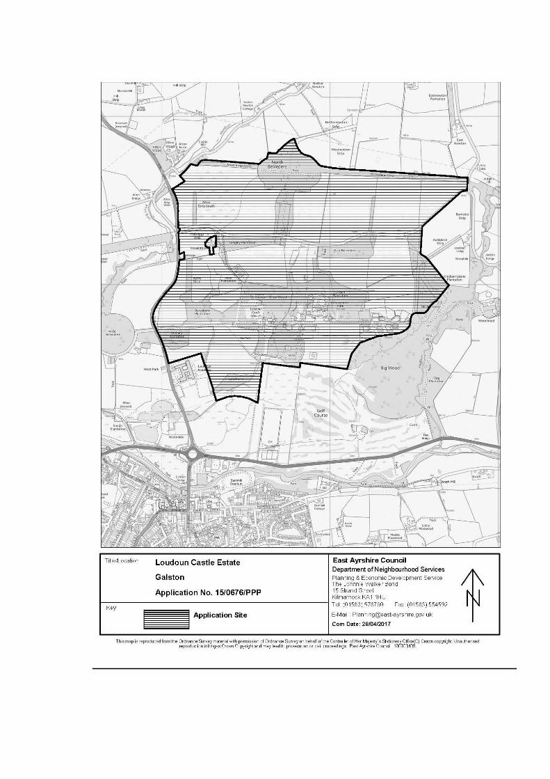
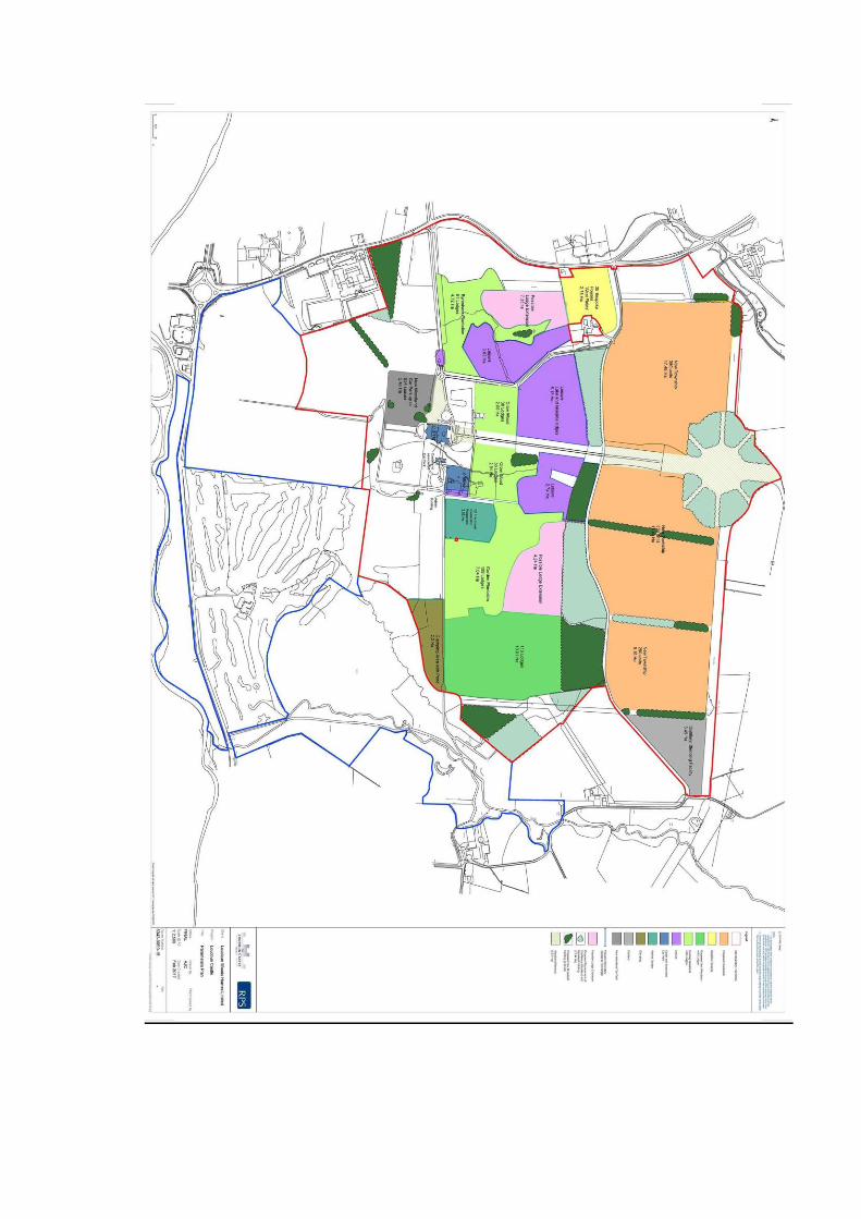

APPENDIX A – LIST OF RELEVANT PLANNING POLICIES WITHIN THE EAST AYRSHIRE LOCAL DEVELOPMENT PLAN 2017

The relevant policies with associated commentary are noted below:- Rural Area 4: The Council will encourage and support the development of the following area for further tourism and recreational development. The Council will be particularly supportive of holiday lodge and hotel development in the area or an appropriate scale of tourism based retail development catering for the needs of visitors to the area. Subject to the provisions of all other local plan policies or the provisions of any future master plan that may be agreed, the Council will be particularly supportive of sympathetic enabling development which would involve or contribute to the restoration or enhancement of Loudoun Castle itself and of its associated garden and grounds, or which would secure and enhance the function and viability of the Castle Estate as a major tourism destination.
Site Ref Location Area (ha)
366M Loudoun Castle and Estate, Galston
259.80
Notes: (i) The Council will require a master plan approach to be adopted in respect of the future tourism related development of the site. The master plan to be produced will be required to fully reflect and respect the provisions of the Council’s Supplementary Guidance on design guidance and should be submitted to the Council for formal consideration prior to the lodgement of any associated planning applications with the planning authority. (ii) Any proposed development in the area will be required to fully respect, in terms of its size, scale, siting, design and material finish, the location of the area within the Loudoun Castle Historic Garden and Designed Landscape. (iii) The site is at flood risk from a 1:200 year flood event as shown on SEPA’s Flood Maps. A detailed flood risk assessment will be required to demonstrate that any new development proposal complies with SPP and relevant LDP policy. (iv) The Council will require any developer of site 366M to submit a Transport Assessment in respect of any detailed development proposals for the site, identifying the transport effects of the proposal and the sustainable transport measures to be introduced to cater for the travel needs associated with the development. (v) The Council require the developer of the site to provide the mitigation and/or enhancement measures contained within the Environmental Report for the site. Policy OP1: Overarching Policy All development proposals will require to meet the following criteria in so far as they are relevant, or otherwise demonstrate how their contribution to sustainable development in the context of the subsequent relevant policies in the Local Development Plan and Scottish Planning Policy would outweigh any lack of consistency with the relevant criteria:
(i) Comply with the provisions and principles of the LDP vision and spatial strategy, all relevant LDP policies and associated supplementary guidance and non-statutory guidance; (ii) Be fully compatible with surrounding established uses and have no unacceptable impacts on the environmental quality of the area; (iii) Ensure that the size, scale, layout, and design enhances the character and amenity of the area and creates a clear sense of place; (iv) Where possible, reuse vacant previously developed land in preference to greenfield land; (v) Be of the highest quality design by meeting with the provisions of SPP, the Scottish Government’s policy statement Designing Streets, the Council’s Design Guidance and any master plan/design brief prepared for the site; (vi) Prepare Master Plans/Design Statements in line with Planning Advice Notes 83 and 68 respectively where requested by the Council and/or where this is set out as a requirement in Volume 2 of the LDP; (vii) Be compatible with, and where possible implement, projects shown on the LDP placemaking maps; (viii) Ensure that there is no unacceptable loss of safeguarded areas of open space/green infrastructure and prime quality agricultural land; (ix) Protect and enhance natural and built heritage designations and link to and integrate with green infrastructure where possible; (x) Ensure that there are no unacceptable impacts on the landscape character or tourism offer of the area; (xi) Meet with the requirements of all relevant service providers and the Ayrshire Roads Alliance; and (xii) Be accessible to all. Policy OP2: Overarching Policy - Implementation of the SEA Environmental Report In bringing forward their proposals, developers will require to implement the relevant enhancement and mitigation measures contained within the Environmental Report relating to the appropriate site assessments for residential, business and industrial, retail and other LDP site allocations. Proposals failing to do this will not be supported by the Council.
Policy RES1: New Housing Development The Council will encourage and support the residential development of: (i) Housing Development Opportunity Sites identified for housing purposes on the LDP maps. Indicative capacities are provided for each housing site within Volume 2 of the plan. Ancillary, associated uses such as small scale retail for day to day purchases and leisure, recreational and community facilities at a neighbourhood scale will also be supported in appropriate locations within new housing developments where they meet with all relevant LDP policies; and (ii) Gap, infill or other redevelopment sites within settlement boundaries where they meet with all other LDP policies and requirements. All new residential developments must contribute positively to the principles of good placemaking as set out in overarching policy OP1, the placemaking section of the LDP and the Council’s Design Guidance. Master plans/design statements will be required for those sites as indicated in Volume 2 of the LDP. Similarly, all new housing proposals will require to meet with the requirements of policy OP2 by implementing the mitigation measures set out in the Environmental Report accompanying this LDP. Residential developments will require to meet with the Public and Private Open Space Standards set out in Schedule 8 of the LDP. Future housing growth areas indicate where future housing sites are likely to be identified for the period 2025-2035. These will be the subject of future detailed assessment and formal designations will be finalised in future reviews of the LDP. Policy RES 13: Enabling Development Where a proposal relates to works to a large listed residential or institutional building located within its own grounds (including by conversion to a sympathetic alternative use), and where it can be clearly shown that the works are the only means of preventing the loss of the asset and securing its long term future, an associated enabling development of new build housing may be considered acceptable by the Council. Any new development must be the minimum necessary to bridge any gap in funding and must be designed and sited to ensure that the character and setting of the historic asset is preserved and enhanced. Any permitted enabling residential development will be made the subject of an appropriate Section 75 obligation regarding the phasing of construction and other related design and layout matters, through the submission of a detailed business plan for the overall development. In all cases the Council will appoint independent accountants to assist in examining the viability of proposals and their business plans and in any Section 75 Obligation. The Council will require developers to share detailed financial information to ensure that the terms of this policy are met.

Policy IND 3: Business and Industrial Development in the Rural Area Outwith settlement boundaries, new business, industrial and commercial development, will be encouraged and supported by the Council only where the proposal relates to one or more of the following types of development: (i) Identified Business and Industrial sites and Miscellaneous Sites, with the potential for business and industrial development as indicated on the Local Development Plan Maps; (ii) Developments relating to and supporting the traditional rural activities of agriculture and forestry where there is a demonstrated site specific locational need; (iii) Sensitive developments relating to recreational, tourism, leisure and sporting sectors; (iv) Rail freight based industrial uses at existing coal disposal points or coal loading facilities within existing and/or former surface coal mines served by rail; (v) Sympathetic farm diversification developments, supported by a 5 year business plan; (vi)Small scale business developments which operate entirely from rural residential properties or community based facilities; (vii) Renewable energy developments within the Rural Area that have been subject to detailed consideration against identified policy criteria. Policy WM1: Sustainable Waste Management All development will require to meet with the aims of the Zero Waste Plan and follow the principles of the Waste Hierarchy, that is, give highest priority to the prevention of waste followed by reuse, recycling, then recovery of other value (e.g. energy) with disposal as the last option. To help achieve these aims, the Council will particularly encourage developers to minimise the use of primary materials and make efficient use of secondary materials. There will be a presumption against the development of major new landfill waste disposal sites within the period of the LDP. Policy WM3: Sustainable Waste Management and New Developments The design of all new developments, including commercial, business, industrial and residential, will be required to make provision for waste separation and collection. This should include, but is not restricted to, waste storage, kerbside collection and mini recycling facilities.
The Council will particularly be supportive of new developments that provide, where appropriate, at-source segregation or separate collections in order to increase the amount and quality of recyclable materials and to minimise the potential for cross-contamination of materials. The Council will require all major and certain more significant local developments to provide Site Waste Management Plans to demonstrate how waste generation will be minimised during the construction and operational phases of the development. Policy WM8: Waste Collection and Mini-Recycling Facilities The Council will encourage and support the development of small scale centralised waste collection and mini recycling facilities such as bottle banks etc. within areas easily accessible to the public, including: • town centre and supermarket car parks; • car parks associated with commercial leisure developments; • industrial estates, retail, commercial, office and business locations; • schools and other educational establishments; and • new housing developments. In the case of proposed new developments of the types detailed above, such facilities should be provided as an integral part of the original design for any development proposal. These facilities should be located in easily accessible locations which do not impede natural surveillance or prejudice the efficient operation of the areas in which they are situated. Proposals to develop larger scale HWRCs to meet the needs of local communities at appropriate locations, in or close to existing centres of population, will also be supported by the Council, subject to meeting all relevant policies. Policy TOUR 1: Tourism Development The Council will actively support and encourage the appropriate development of new and the improvement of existing tourism facilities throughout the area where proposals meet with all other relevant LDP policies. Particular support will be given to sympathetic development which enhances the tourism offer of Dean Castle Country Park, Kilmarnock; Loudoun Castle Estate, Galston; Dumfries House and Estate, Cumnock; Craigengillan Estate, Dalmellington and Auchinleck Estate by Auchinleck. Green tourism initiatives relating to the high scenic, landscape quality and nature conservation interest of the Doon and Irvine Valleys, Loch Doon and Glen Afton as well as the Muirkirk Uplands and River Nith areas will also be encouraged and supported, where green tourism initiatives have demonstrated that they will not have an adverse effect on the integrity of a Natura 2000 site, SSSIs and other important nature conservation features.
Policy TOUR 2: Tourist Accommodation Within settlement boundaries, the Council will support the development of new hotel, guest house, self-catering, camping and caravan sites and huts where they comply with all relevant LDP policies. The conversion of existing residential or other properties to these types of tourism accommodation will receive similar support. Outwith settlement boundaries, camping and caravan sites will be supported where they comply with all other relevant LDP policies. Hotels, guest houses and self-catering units which are proposed outwith settlement boundaries will require to be accompanied by a business plan or similar justification and planning conditions will be used to restrict the use of such properties to tourism. Policy TOUR 3: Rural Sporting, Leisure and Recreational Activities Developments associated with the use of land in the countryside for sporting, leisure or recreational activities will be supported by the Council provided that: (i) There is a demonstrated and justified need for the development to be in a rural location; (ii) The proposed new development is accessible by public transport; (iii) There are no adverse impacts on landscape, natural and/or built heritage resources; (iv) There are no adverse impacts arising from increased traffic; (v) The proposal complies with all other relevant Local Development Plan policies. Proposals which do not meet with the criteria above will not receive Council support. Policy RE1: Renewable Energy Developments Proposals for the generation and utilisation of renewable energy in the form of new build development, infrastructure or retrofit projects will be supported in standalone locations and as integral parts of new and existing developments where it can be demonstrated that there will be no unacceptable significant adverse impacts on all of the relevant Renewable Energy Assessment Criteria set out in Schedule 1 of the LDP, that the scale of the proposal and its relationship with the surrounding area are appropriate and that all relevant policies are met. In this regard, applications for renewable energy proposals should be accompanied by detailed supporting information. Note: This policy applies to all types of renewable energy development proposals other than heat (see Policy RE2), energy from waste (see Policy WM6) and wind energy (see Policies RE 3 and RE 4) Policy RE2: Heat Generation The Local Development Plan will support developments associated with the renewable generation of heat. Where non-renewable generation of heat is proposed, the Council will support these developments only where greenhouse gas emissions
are significantly reduced, form part of a carbon capture development or where the applicant can demonstrate plans for conversion to renewable or low carbon sources of heat in the future. The Council will also be supportive of the provision of energy centres, where appropriate, within new development. All new heat generating developments should, where possible, be located close to potential heat users and the possibility of developing heat networks, including district heat networks, should be investigated. Proposals for new development should ensure that the site can be connected to heat networks, including district heating, which may be developed in the future. This will require developers to safeguard sufficient capacity within the site’s infrastructure to allow pipework to be connected to premises within the site and to the future heat supply/network. Developers should also safeguard sufficient land, where appropriate, for the provision of energy centres to enable subsequent connections to heat networks to be made. Where heat networks are not viable, micro-generation and heat recovery technologies, within or associated with individual properties, will be encouraged by the Council. All proposals will require to meet with the Renewable Energy Assessment Criteria set out in Schedule 1 of the LDP. Thermal treatment plants will also require to meet with SEPA’s Thermal Treatment of Waste Guidelines 2014. Supplementary Guidance on Heat Generation will be produced to support Policy RE 2. This Supplementary Guidance will identify where the opportunities exist for co-locating developments with a high heat demand with sources of heat supply. The Supplementary Guidance will include criteria for decision making. This Supplementary Guidance will include detail on individual heat generating technologies and will set out decision making criteria that apply to those technologies in addition to those in Policy RE 2. Policy T1: Transportation requirements for new development The Council will require developers to ensure that their proposals meet with all the requisite standards of the Ayrshire Roads Alliance and align with the Regional and Local Transport Strategies. Developments which do not meet these standards will not be considered acceptable and will not receive Council support. All new development will require to fully embrace active travel by incorporating new, and providing links to existing footpaths, cycle routes and public transport routes. Developments which maximise the extent to which travel demands are met first through walking, then cycling, then public transport and finally through the use of private cars will be particularly supported. Where considered appropriate, developers will be requested to enter into Section 75 Obligations with the Council with regard to making financial contributions towards the
provision of transportation infrastructure improvements and/or public transport services which may be required as a result of their development. Policy T2: Transport Requirements for New Significant Traffic Generating Uses The Council will not support new significant travel generating uses at locations which would increase reliance on the car and where: (i) Direct links to local facilities via walking and cycling networks are not available or cannot be made available; (ii) Access to local facilities via public transport networks would involve walking more than 400m; or (iii) The Transport Assessment does not identify satisfactory ways of meeting sustainable transport requirements (iv) The potential impact on the performance or safety of the trunk road network and the measures required to mitigate any impact arising from development have not been identified. Where a proposed new development or change of use is likely to generate a significant increase in trip numbers, a Transport Assessment will be required. In certain circumstances, developers may also be required to produce Travel Plans which set out proposals for the delivery of more sustainable transport patterns. Developers may be asked to meet the costs of monitoring any Travel Plans and Transport Assessments during the construction period of the site and for an agreed period following the completion of the development Policy T 4: Development and Protection of Core Paths and Natural Routes The Council will, through its Core Path Plan, and in association with relevant bodies, landowners and tenants, seek to develop a comprehensive local footpath and cycle route network for access and recreational use for local residents. Priority will be given to the development and promotion of new circular routes and footpath links between settlements, especially where these utilise existing disused railway lines, forestry access roads, minor country roads etc. The Council will promote and be particularly supportive of the development of a long distance route from Darvel to Muirkirk which forms part of National Development 8 within National Planning Framework 3. Development of new routes for core paths, footpaths, bridleways or cycle paths should demonstrate to the Council that they will not have an adverse effect on the integrity of a Natura 2000 site.

The Council will not be supportive of development which disrupts or adversely impacts on any existing or potential core path, right of way, bridle path, or footpath used by the general public for recreational or other purposes, particularly where the route concerned forms, or has the potential to form, part of the network of circular routes or footpath links between settlements, actively promoted by the Council. Where such disruption or adverse impact is demonstrated to be unavoidable, the Council will require developers, as an integral part of the proposed development, to provide for the appropriate diversion of the route in question elsewhere within the development site or to put into place appropriate measures to mitigate and overcome the adverse impact expected. Policy INF 2: Installation of Next Generation Broadband for New Developments Developers of new residential or business and industrial developments will be required to install the necessary infrastructure to enable all new premises to be connected to the existing fibre optic network, where available in East Ayrshire, and in accordance with the relevant telecommunications provider’s standards. Developers will be required to ensure that all new premises have a full fibre connection to the network ensuring that next generation broadband speeds of 100 Megabytes per second and above can be provided. Developers are encouraged to have early discussions with the relevant telecommunications provider when formulating their development proposals. Policy INF 4: Green Infrastructure The Council will require development to take a design led approach to delivering green infrastructure. Opportunities for green infrastructure delivery should be incorporated as an integral part of the design of developments to enhance and link to existing open spaces/green infrastructure and create new green infrastructure assets as appropriate. The Council will require new development to meet with the public and private open space standards set out in Schedule 8 and the provisions of the Council’s Design Guidance. The provision of open space/green infrastructure should be a core component of any Master Plan. The Council will produce Design Guidance which will provide guidance for all types of development and will form Supplementary Guidance to the LDP. It sets out key design principles that the Council expects developers to incorporate into their developments including green infrastructure/open space requirements. Policy INF5: Developer Contributions Where a development of 4 or more houses, retail or commercial leisure development either on its own, or in association with existing developments, will place additional demands on facilities, infrastructure or services that would necessitate new facilities or exacerbate deficiencies in existing provision, the Council will require the developer to meet or contribute to the cost of providing or improving such infrastructure, facilities or
services. This could include off-site environmental or other enhancements where issues cannot be addressed within the development site. Contributions will relate to the development concerned, including in nature, scale and kind. Where these cannot be secured by planning conditions or other appropriate means, the Council will expect developers to complete a Section 75 obligation or other legal agreement. Contributions sought under this policy will be waived or reduced only in exceptional circumstances – for example, where a developer demonstrates that an enabling development or a development would have exceptional development costs, overriding economic, social or other benefits, and where there is no adverse impact on essential services or infrastructure. A list of specific projects which support placemaking to be funded by developer contributions can be found in Table 6 of the LDP and the Action Programme. Note: In addition to any contributions made under Policy INF5, developers will require to meet the costs of providing the service infrastructure necessary for their development. The Council will monitor and review, in discussion with stakeholders, including representatives of the development industry, Supplementary Guidance relating to Developer Contributions on an annual basis. Supplementary Guidance on Developer Contributions supports olicy INF5 by providing further detail on: • which projects that developers will require to make contributions towards; • the costs of projects; • how the developer contributions will be calculated, and • how the Council will collect funds. Policy ENV1: Listed Buildings Listed buildings play an important role in defining and enhancing the quality of East Ayrshire’s environment and contribute to the character of local communities. The Council will support: • The retention and preservation of all listed buildings and buildings within conservation areas. • The adaption and re-use of listed buildings and buildings within conservation areas to meet modern requirements, where this can be achieved in a manner sensitive to the character of the building. Proposals for the total or partial demolition of a listed building will only be supported where it can be demonstrated beyond reasonable doubt that every effort has been made to retain the building. Demolition will only be acceptable where it can be evidenced that: (i) the building is not of special interest; or
(ii) the building is incapable of repair; or (iii) the demolition of the building is essential to delivering significant benefits to economic growth or the wider community; or (iv) the repair of the building is not economically viable and that it has been marketed at a price reflecting its location and condition to potential purchasers for a reasonable period. Policy ENV 2: Scheduled Monuments and Archaeological Resources Development that would have an adverse effect on Scheduled Monuments or on their settings shall not be supported unless there are exceptional overriding circumstances. Other archaeological resources should be preserved in situ wherever possible. The developer may be required to supply a archaeological evaluation report prior to the determination of a planning application. Where the case for preservation does not prevail the developer shall be required to make appropriate and satisfactory provision for archaeological excavation, recording, analysis and publication in advance of development. Policy ENV 4: Gardens and Designed Landscapes Gardens and Designed Landscapes included in the National Inventory, and those of regional and local importance, are protected and their enhancement encouraged. Development will not be supported where it will have significant adverse impacts upon (i) its character; (ii) important views to, from and within it and; (iii) important features that contribute to its value and that justify its designation, where applicable. Where a proposed development will impact on a Garden and Designed Landscape, the developer will be expected to provide a landscape management plan, to identify conservation needs and direct how change can best be accommodated. Policy ENV 6: Nature Conservation The importance of nature conservation and biodiversity will be fully recognised in the assessment of development proposals. This will be achieved by ensuring that: (i) Any development likely to have a significant effect on a Natura 2000 site which is not directly connected with or necessary to its conservation management must be subject to a “Habitats Regulations Appraisal”. Such development will only be approved if the appraisal shows that there will be no adverse effect on the integrity of the site; (ii) Any development affecting a SSSI will only be permitted where it will not adversely affect the integrity of the area or the qualities for which it has been designated or where any significant adverse effects on the qualities for which it is designated are clearly outweighed by social, environmental or economic benefits of national importance.
(iii) Any development that may adversely impact on areas of local importance for nature conservation, including provisional wildlife sites, local geodiversity sites and local nature reserves, will be expected to demonstrate how any impact can be avoided or mitigated. (iv) If there is evidence that protected species may be affected by a development, steps must be taken to establish their presence. The planning and design of any development which has the potential to impact on a protected species will require to take into account the level of protection afforded by legislation and any impacts must be fully considered prior to the submission of any planning application. (v) Any new development must protect, and where appropriate incorporate and/or extend, existing habitat networks, helping to further develop the Central Scotland Green Network in Ayrshire. The Council will apply “the precautionary principle” where the impacts of a proposed development on nationally or internationally significant natural heritage resources are uncertain but here is sound evidence indicating that significant irreversible damage could occur. Policy ENV 8: Protecting and Enhancing the Landscape The protection and enhancement of East Ayrshire’s landscape character as identified in the Ayrshire Landscape Character Assessment will be a key consideration in assessing the appropriateness of development proposals in the rural area. The Council will require that: (i) Development proposals are sited and designed to respect the nature and landscape character of the area and to minimise visual impact. Particular attention will be paid to size, scale, layout, materials, design, finish and colour. (ii) Where visual impacts are unavoidable, development proposals include adequate mitigation measures to minimise such impacts on the landscape. (iii) Particular features that contribute to the value, quality and character of the landscape are conserved and enhanced. Development that would result in the loss of valuable landscape features, to such an extent that character and value of the landscape, is diminished, will not be supported. Such landscape features include: a. Settings of settlements and buildings within the landscape; b. Skylines, distinctive landform features, landmark hills and prominent views; c. Woodlands, hedgerows and trees; d. Field patterns and means of enclosure, including dry stone dykes; and e. Rights of way and footpaths Development that would create unacceptable visual intrusion or irreparable damage to landscape character will not be supported by the Council.
Policy ENV 9: Trees, Woodland and Forestry The Council will support the retention of individual trees, hedgerows and woodlands within both settlements and rural areas, where such trees contribute to the amenity, nature conservation and landscape value of the area. There will be a presumption against the felling of ancient semi-natural woodlands and trees protected by Preservation Orders. The Council will support proposals for woodland and forestry expansion where they: (i) are consistent with the Ayrshire and Arran Forestry and Woodland Strategy and contribute to Ayrshire’s green network; (ii) take account of the landscape and ecological qualities of the area; (iii) demonstrate that recreational opportunities have been fully considered; Proposals that involve the removal of woodland will only be supported where it would achieve significant and clearly defined public benefits and is in line with the Scottish Government’s Control of Woodland Policy. Where removal can be fully justified, compensatory planting will be required to the satisfaction of the Council and Forestry Commission Scotland and in line with the provisions of the Ayrshire and Arran Forestry & Woodland Strategy which forms Supplementary Guidance to this LDP. Non statutory guidance in the form of The Ayrshire and Arran Forestry and Woodland Strategy supports policy ENV 9 by providing detailed guidance on the most appropriate tree species and locations for woodland removal and creation. Policy ENV 11: Flood Prevention The Council will take a precautionary approach to flood risk from all sources and will promote flood avoidance in the first instance. Flood storage and conveying capacity will be protected and development will be directed away from functional flood plains and undeveloped areas of medium to high flood risk. The Council will identify and protect existing land uses that provide or have the potential to provide natural flood management. The Council will also encourage new flood management measures, including flood protection schemes, restoring natural features, enhancing flood storage capacity and avoiding the construction of new culverts and the opening of existing culverts. The Flood Risk Framework contained in SPP, summarised in table 7 below and outlined fully in Schedule 7, will be used in the assessment of development proposals. This sets out the type of development that will be appropriate in each category of flood risk and indicates where Flood Risk Assessments are likely to be required. The flood risk categories are shown on SEPA’s flood maps. All FRAs will require to be carried out to the satisfaction of SEPA.
Category of flood risk Appropriate level of development
Requirement for Flood Risk Assessment
Little or no risk (Annual chance of flooding is less than 0.1% or once in 1000 years)
No constraints to development
No
Low to medium risk (Annual chance of flooding 0.1% - 0.5% or once in 1000 to once in 200 years)
Suitable for most development Generally unsuitable for civil infrastructure (hospitals, fire stations, schools, emergency depots, care homes, ground based electrical and telecoms equipment)
Dependent on level of flood risk and nature of proposal. Where flood risk is close to 0.5% or proposal is for essential infrastructure or vulnerable uses, FRA will be required.
Medium to high risk (Annual chance of flooding is greater than 0.5% or greater than once in 200 years)
Generally suitable for residential, institutional, commercial and essential infrastructure development within built up areas, subject to appropriate flood protection measures. Generally unsuitable for any civil infrastructure and most vulnerable uses; Generally unsuitable for any new developments in undeveloped and sparsely developed areas. Water resistant and resilient building materials should be used.
Yes
Surface water flooding All developments should be designed to be free from surface water flooding in rainfall events where the annual probability of occurrence is greater than 0.5%. Mitigation measures should not have an adverse effect on the risk of flooding off site, taking account of rain falling on the site and run-off from adjacent areas
Table 7 The Flood Risk Framework In addition to applying the risk framework, development proposals should: • Take into account the specific characteristics of the site, the proposed development and the surrounding land uses; • Where appropriate, ensure that water resistant and/or resilient construction materials and measures are used; • Minimise impermeable surfaces and incorporate sustainable drainage systems, with adequate maintenance arrangements, to avoid increased surface water flooding;
• Ensure flood protection measures allow a ‘freeboard allowance’, whereby additional height should be added to the predicted level of a flood to make allowances for uncertainties in the predictions. Design, solutions should also include some leeway for the unknown effects of climate change. • Avoid land raising, which will only be acceptable where it has a neutral or better impact on flood risk outside of the raised area. Land raising will only be acceptable in the undeveloped or sparsely developed flood plain when it can be demonstrated that the proposed location is essential for operational reasons and a lower risk location is not available. • Be accompanied by a Drainage Assessment, to the satisfaction of the Council, where drainage is already constrained or problematic. Policy ENV 12: Water, air and light and noise pollution Water In line with the Water Framework Directive, the Council will give priority to maintaining and improving the quality of all water bodies and ground water. There will be a presumption against any development that will have an adverse impact on the water environment in terms of pollution levels and the ecological value of water habitats. Where developments are proposed on or close to existing water bodies, design solutions should explore how best to maintain their water quality and, where possible improve the water bodies through maintaining them as wildlife corridors where biodiversity can be improved. Maintenance access buffer strips of a minimum 6 metres in width should be provided between the development and the adjacent watercourse. The Council will not be supportive of developments which will, or which have the potential to, cause significant adverse impacts on water bodies as a result of morphological changes to water bodies such as engineering activities in the form of culverts or changes to the banks or bed. Development will be required to connect to the public sewerage system, where possible, and manage surface water through sustainable drainage systems (SuDS). Air All developers will be required to ensure that their proposals have minimal adverse impact on air quality. Air quality assessments will be required for any proposed development which the Council considers may significantly impact upon air quality, either on its own or cumulatively. Development that will have a significant adverse impact on air quality will not be supported. Light All development proposals must incorporate design measures which minimise or reduce light pollution. Developers will require to demonstrate that consideration has been given to reducing light pollution, by minimising unnecessary lighting and using the most appropriate forms of lighting to carry out specific tasks. Within the Dark Sky
Park and surrounding area, particular priority is given to minimising light pollution, to maintain the integrity of the designation. Noise All new development must take full account of any Noise Action Plan and Noise Management Areas that are in operation in the area and ensure that significant adverse noise impacts on surrounding properties and uses are avoided. A noise impact assessment may be required in this regard and noise mitigation measures may be required through planning conditions and/or Section 75 Obligations. Policy ENV 13: Contaminated Land In cases where a development is proposed on land which is known or suspected to be contaminated, the Council will require the developer to investigate and identify the nature of the contamination and to detail the remedial measures to be undertaken to treat or remove that contamination, as an integral part of any planning application. In this regard, developers will be required to carry out a Risk Assessment of the development site as detailed in PAN33: Development of Contaminated Land, Annex 1. Where site conditions are appropriate, consideration should be given to both radioactive and non-radioactive sources of contamination. Policy ENV14: Low and Zero Carbon Buildings In order to meet with the requirements of Section 3F of the Town and Country Planning (Scotland) Act 1997 (as amended), development proposals will be required to incorporate low and zero carbon generating technologies to reduce greenhouse gas emissions. Proposals for all new buildings will require to demonstrate that at least 10% of the carbon emissions reduction standard set by the Scottish Building Standards (2010) will be met through the installation and operation of zero carbon generating technologies. This percentage will increase to 15% from the beginning of 2019 and will be reviewed in 2021. These requirements will not apply to: (i) Alterations and extensions to existing buildings; (ii) Change of use or conversion of existing buildings; (iii) Ancillary buildings that are ‘stand-alone’ and have an area of less than 50 sq m; (iv) Buildings which will not be heated or cooled, other than by heating to protect from frost; or (v) Buildings which have an intended life of less than two years. Compliance with this requirement will be demonstrated by the submission of a low carbon development statement.

APPENDIX B – ORIGINAL PLANNING COMMITTEE REPORT

EAST AYRSHIRE COUNCIL
SPECIAL PLANNING COMMITTEE: 29 APRIL 2016
15/0676/PPP: LEISURE AND TOURISM DEVELOPMENT INCLUDING: 450 HOLIDAY LODGES; 12 GLAMPING PITCHES; RESTORATION OF CASTLE TO
SHELL CONVERSION TO HOTEL; NEW LEISURE FACILITIES INCLUDING LAKE; INDOOR WATER PARK WITH RETAIL PIZZA AND RESTAURANTS
(6,500SQM), WATER SPORTS BUILDING (600 SQM), INDOOR SPORTS (5,000SQM). SPA (2,000SQM) AND CYCLE STORE. ERECTION OF DISTILLERY
(1,552SQM) AND COMMUNITY HEAT PLANT (476SQM). ERECTION OF PHASED ENABLING DEVELOPMENT, WITH A FIRST PHASE OF 300
RESIDENTIAL DWELLINGS AND ADDITIONAL PHASES OF RESIDENTIAL DWELLINGS THAT WILL ENABLE THE COMPLETE RESTORATION OF THE CASTLE TO A HOTEL: COMMUNITY FACILITIES AND INFRASTRUCTURE.
AT: LOUDOUN CASTLE, LOUDOUN CASTLE ESTATE
A71 GALSTON ROUNDABOUT, GALSTON, EAST AYRSHIRE
KA4 8PD
BY LOUDOUN WOODS HOMES LTD
Report by Head of Planning and Economic Development, Economy and Skills
Click for Application Details:
http://eplanning.east-ayrshire.gov.uk/online/applicationDetails.do?activeTab=summary&keyVal=NUCXL7
GF03N00
EXECUTIVE SUMMARY SHEET
PURPOSE OF REPORT 1. The purpose of this report is to present an application for planning permission
in principle that is considered to be significantly contrary to the Development Plan, to the Planning Committee, for a view, as the application has been called-in by the Scottish Ministers in terms of Section 46 of the Town and Country Planning (Scotland) Act 1997. Thereafter, the view of the Committee shall be conveyed to the Reporters appointed by the Scottish Ministers as representing the position of the Council in the current call-in.
2. The proposal represents a Major Development in terms of the Town and
Country Planning (Hierarchy of Development) (Scotland) Regulations 2009.

RECOMMENDATION 3. That the Planning Committee agree the recommendation of the Head of
Planning and Economic Development that the application should be referred to Scottish Ministers on the following basis:-
1) The Planning Authority cannot at this point in time support the
application given the lack of relevant information.
2) The Planning Authority therefore recommend that application be refused planning permission in principle.
3) Should the applicants’ provide further relevant information as highlighted within this report, the Planning Authority would wish the opportunity to reconsider its position.
4) Should the Scottish Ministers determine that the application be supported, the Planning Service seek delegated authority to the Head of Planning and Economic Development in consultation with the Chief Governance Officer to provide Scottish Government with proposed conditions and Head of Terms for a Legal Agreement under Section 75 of the Town and Country Planning (Scotland) act 1997 (as amended).
CONTRARY DECISION NOTE
4. Should the Committee adopt the view that the application should be supported,
contrary to the recommendation of the Head of Planning and Economic Development, the application would have represented a significant departure from Council policy. If the application was not the subject of an call-in, it would have thereafter been referred to Council for a decision. However as the application has been called-in, it therefore does not require to be considered by Council.
Michael Keane Head of Planning and Economic Development Note: This document combines key sections of the associated report for quick reference and should not in itself be considered as having been the basis for recommendation preparation or decision making by the Planning Authority.
EAST AYRSHIRE COUNCIL
SPECIAL PLANNING COMMITTEE: 29 APRIL 2016
15/0676/PPP: LEISURE AND TOURISM DEVELOPMENT INCLUDING: 450 HOLIDAY LODGES; 12 GLAMPING PITCHES; RESTORATION OF CASTLE TO
SHELL CONVERSION TO HOTEL; NEW LEISURE FACILITIES INCLUDING LAKE; INDOOR WATER PARK WITH RETAIL PIZZA AND RESTAURANTS
(6,500SQM), WATER SPORTS BUILDING (600 SQM), INDOOR SPORTS (5,000SQM). SPA (2,000SQM) AND CYCLE STORE. ERECTION OF DISTILLERY
(1,552SQM) AND COMMUNITY HEAT PLANT (476SQM). ERECTION OF PHASED ENABLING DEVELOPMENT, WITH A FIRST PHASE OF 300
RESIDENTIAL DWELLINGS AND ADDITIONAL PHASES OF RESIDENTIAL DWELLINGS THAT WILL ENABLE THE COMPLETE RESTORATION OF THE CASTLE TO A HOTEL: COMMUNITY FACILITIES AND INFRASTRUCTURE.
AT: LOUDOUN CASTLE, LOUDOUN CASTLE ESTATE
A71 GALSTON ROUNDABOUT, GALSTON, EAST AYRSHIRE
KA4 8PD
BY LOUDOUN WOODS HOMES LTD
REPORT BY HEAD OF PLANNING AND ECONOMIC DEVELOPMENT, ECONOMY AND SKILLS
PURPOSE OF REPORT 1. The purpose of this report is to present an application for planning permission
in principle that is considered to be significantly contrary to the Development Plan, to the Planning Committee, for a view, as the application has been called-in by the Scottish Ministers in terms of Section 46 of the Town and Country Planning (Scotland) Act 1997. Thereafter, the view of the Committee shall be conveyed to the Reporters appointed by the Scottish Ministers as representing the position of the Council in the current call-in.
2. The proposal represents a Major Development in terms of the Town and
Country Planning (Hierarchy of Development) (Scotland) Regulations 2009.
BACKGROUND
Resubmitted Application
3. This planning application before Members was lodged with the Planning Service on 8 September 2015. It replaced an earlier planning application which was withdrawn by the applicant’s agent ref. 14/0852/PPP and incorporated an updated Environmental Impact Assessment and further
clarification on matters as provided by the applicant’s team. This revised application was then subject to a draft Processing Agreement, and then statutory advertisement, neighbour notification and consultation with further discussions taking place with the applicant's agents and the Planning Service as the revised application progressed.
Discussions
4. Discussions took place following the registration of the planning application as
they continued from those that had taken place prior to the withdrawal of the previous application.
5. The Planning Service in order to set out its clear position to the applicants in
seeking to provide and obtain agreement to move the application forward and present the application to a Planning Committee meeting, issued a Position statement on 3 December 2015, with further clarification being provided on 15 December 2015. The detail of these discussions is highlighted in the conclusions of this report below.
Call-In by Scottish Government
6. Following registration of the application, the Scottish Government's Chief
Planner had been party to telephone conference calls and meetings as he sought, without commenting on the merits of the application, to facilitate, as far as possible, the progressing of this application.
7. However, following a request by the applicant to the Scottish Government to
call-in the application for determination, the Planning Service received a letter dated 17 December 2015 advising that the Scottish Government had decided that the application should be referred to them for a determination. The Notice issued by Scottish Government confirmed that the reason for the application being called-in was:-
“……. in view of the potential economic benefit of the proposal and the heritage issues related to the A listed Loudoun Castle and its designed landscape.”
8. The application is now subject to a formal assessment process which will be
administered by the Department of Planning and Environmental Appeals (DPEA) and will be the subject of a report by appointed Reporters to Scottish Ministers for their determination.
APPLICATION DETAILS
9. Site Description: The application site is located approximately 6.5 kilometres
to the east of Kilmarnock within the Irvine Valley. The A71 and A719 run along the southern and western boundaries of the site. The town of Galston is located beyond the A71 to the south. The site comprises an area of approximately 176 hectares and forms part of the wider 246 hectare Loudoun Castle Estate. Land to the south of the castle is occupied by the
Loudoun Gowf Club, which has been a ‘gowf’ or golf field since the early 16th century. Loudoun Academy which is the local secondary school is located to the west of the estate.
10. The site is currently occupied by the ruins of Loudoun Castle and the
surrounding estate, which includes designed parkland. The Loudoun Castle Estate is a confirmed Garden and Designed Landscape, a Provisional Wildlife Site and includes the A listed Loudoun Castle. The Cottage at Loudoun Castle within the site is also Category B listed and the site is further covered by Tree Preservation Orders for group and individual trees throughout the site. A tree lined avenue forms the approach to the Castle from the A719, with areas of woodland surrounding the castle. To the east of the Castle is an area known as ‘Big Wood’ characterised by a steep sided densely wooded valley. There is a Right of Way through the site leading from the A71 northwards towards the Castle and the main avenue. There is also a Core Path (a route which facilitates access to the outdoors under the Outdoor Access Strategy and Land Reform (Scotland) Act 2003) though the Big Wood known as IV6.
11. A number of buildings are located across the estate, ranging from derelict
buildings to those in a good state of repair and occupied as residential properties. A number of buildings are present that were used in connection with a former theme park at the site and the walled garden accommodated a green/glass-house and various timber structures associated with the former theme park. The coach house has been previously renovated and has been used to accommodate a cafe and function room.
12. The Estate has been subject to a number of different developments and
proposals. The Castle ruins are the remnants of a grand house design in 1804 which incorporated elements of two older castles and the designed parkland was laid out from 1714 prior to modification. The more recent Loudoun Castle was largely destroyed by fire in 1941 but significant sections remain of the external walls. The estate was last formally used as a theme park and opened for this use in 1995. The mechanical rides associated with this theme park are located to the east of the Castle and the theme park included the walled garden and the eastern end of the avenue approach to the castle. The theme park is now closed with some of the rides removed from the site and other rides having been decommissioned or dismantled and lying within the site.
13. The application site and wider Estate is located within the rural area and is
largely bounded by rolling agricultural land on most boundaries with the southern boundary facing towards the A71 beyond which is the town of Galston. The Estate is however located within proximity to a number of settlements with Kilmarnock approximately 6.5 kilometres to the west (9.7 kilometres to the centre of the town), Newmilns 3.2 kilometres to the east, Darvel 6.6 kilometres to the east past Newmilns, and Moscow 3.7 kilometres in a northerly direction. Whitelee Wind Farm boundary comprising 215 wind turbines lies directly to the north of the development site.

14. The Loudoun Castle Estate is served by a central spine avenue running from
the A719 in an approximately eastwards direction towards the Castle. The Estate accommodates other residential properties which are not connected with this application and are therefore outwith the application site. These are located centrally within the estate and are known collectively as Howletburn and also Loudoun Cottage as already highlighted. Howletburn comprises Cloag Cottage, Cottages No.1 and 2. Howletburn is accessed from the access road further north of the main access which lies within the application site. Loudoun Cottage is accessed from the main access and central avenue.
15. Proposed Development: Planning Permission in Principle (PPP) is sought
for the proposed development which comprises a tourism led development, together with stabilisation and subsequent restoration of the castle remains. Residential development is also proposed in order to enable the castle restoration. The purpose of the project is to provide a viable programme of development to secure the future of the Loudoun Castle estate. The project includes the following key components:
Leisure and tourism development, including a lake and
associated indoor and outdoor sports and leisure areas; Holiday accommodation, comprising holiday lodges, fractional
ownership properties and glamping pitches; Castle restoration, including potential conversion to a hotel; Whisky distillery; Community heat plant; Up to 1,025 new dwellings (with a first phased of 300 dwellings); Public open space and landscape planting incorporating formal
and informal areas of open space, retention of existing landscape features, reinstatement of former elements of the historic parkland and new planting areas; and
New access for vehicles, pedestrians and cyclists.
16. Illustrative layout plans are provided although the applicant’s agent indicates that as this is an application for planning permission in principle, no detailed layout or building design details are submitted.
17. The above components can be broken down in more detail to comprise as
follows:-
Leisure and tourism development
18. The project would be a tourism led development, taking the form of a holiday village. This would include serviced holiday accommodation, recreation and sports facilities. A lake would be created as a new feature within the parkland and would form a focal point for the proposed leisure and recreational activities. The holiday village would also incorporate the existing walled garden to the east of the castle. Key components would include:
A new lake in the centre of the site, including water sports area,
lakeside ‘water building’ and spa occupying an area of 10.53 hectares – located on an area of open land in the centre of the project site to the north west of the castle. The site is surrounded by woodland areas to the north, south and east and this element of the proposal would include approximately 18 lakeside lodges. A “beach” and “cliff face” would be created with a water building (approximately 6,500 m2) proposed to the east of the lake and is likely to accommodate a main leisure pool/water park, restaurants/retail plaza and associated leisure uses. A spa building is proposed (approximately 2,000 m2) over two floors including a spa pool, plunge pools and treatment rooms. Both the water building and the spa building are proposed to be built into the hillside created by the earthworks around the lake resulting in the creation of a green roof to the buildings.
19. A water sports building (approximately 600 m2) is proposed adjacent to the
lake. This would include facilities such as boat hire and a restaurant. The building is also likely to service any climbing facilities on the new cliff face.
20. Health and sports club and outdoor activity areas – the applicant’s agent
indicates that this building would occupy approximately 3.92 hectares and include a gym, sports courts and restaurants. It is proposed that the building (approximately 5,000 m2) would incorporate a green (Sedum or grass) roof. An area of land adjacent to the health and sports club would be used for sports and recreational activities and would include a cycle storage/collection building.
21. Lighting would be provided in key areas of the tourism development, in order
to ensure safety of users in accessing key parts of the site. Lighting would be suitable for the level of use of each part of the site and would incorporate low level pathway lighting where possible and lighting near woodland areas within the site would be directed in order to avoid light spillage. Fittings would be selected to reflect light to focus on the areas where light is required and to avoid light straying. All external lighting and lighting to common areas in residential and holiday accommodation areas would be fitted with low energy lamps with movement or daylight sensors to prevent lights being left on unnecessarily.
Holiday Accommodation
22. Holiday accommodation in the form of lakeside and woodland lodges and a
glamping area - In addition to the lakeside lodges, holiday lodges would be located within areas of existing and proposed woodland throughout the central and southern parts of the site. In total, approximately 398 holiday lodges are proposed (including the lakeside lodges). The holiday lodge and wooded areas would occupy approximately 46 hectares.
23. Approximately 52 fractional ownership holiday villa properties (for Members information fractional ownership is essentially partial ownership of a property and with this type of ownership, a property is owned and shared by at least two, and often several, individuals) are proposed within the existing walled garden to the east of the castle. This area of approximately 2 hectares was part of the site of the former theme park. To the south east of the walled garden, a glamping area with twelve pitches (approximately 2.2 hectares) is proposed.
24. All external lighting and lighting to common areas in residential and holiday
accommodation areas would be fitted with low energy lamps with movement or daylight sensors to prevent lights being left on unnecessarily.
Castle Restoration
25. The castle was fire damaged In 1941 and left as a ruin with resultant water
damage and vegetation growth which deteriorated the remaining structure. The approach to restoration of the castle would be phased, based on viability and this is advised by the applicant’s agent as follows:
Stabilisation of the castle ruins: This would be the minimum
level of castle restoration proposed as part of the project. The building would be conserved and stabilised. The works would comprise internal clearance and sorting of fallen masonry, removal of vegetation growing through the castle walls, consolidation of the structure as found and stabilisation as required;
Rebuilding of the castle as a ‘shell’: Subject to viability, the castle would be restored as a ‘shell’. Following stabilisation, this would comprise strengthening the structure, rebuilding the missing external elements and providing a roof and windows;
Redevelopment of the castle as a hotel: Subject to viability and market interest, the castle shell may be developed for use as a hotel. Following creation of the castle shell, this would comprise the provision of floors, partition walls and stairs and hotel fit out.
26. The supporting information provided by the applicants’ agent states that all
three options would result in the castle remains being protected from further damage by vegetation. In the event that the proposed hotel use is taken forward, the hotel (up to approximately 85 bedrooms) is proposed to form part of and contribute to the overall tourism development at the site. The overall height of the restored castle once converted to a hotel would not exceed the height of the existing keep.
27. The applicant’s agent advises that the castle restoration scheme would be
undertaken in accordance with a strategy agreed with the now Historic Environment Scotland (HES) and subject to listed building consents.
Distillery
28. A whisky distillery/blending facility is proposed in the north eastern part of the site. A building of approximately 1,552 m2 is proposed, within a site of approximately 3.76 hectares. The distillery is proposed to be a showcase for Scottish produce.
Residential Development
29. Over an area of approximately 45.32 hectares a total of up to 1,025 dwelling
units are proposed as enabling development to fund the castle works (restoration and use as a hotel, including hotel fit out).
30. This would comprise approximately 990 new dwellings in the northern part of
the project site to be spread across three townships of 290 to 350 dwellings per township. Sheltered housing would be included in groups within the townships and community facilities would be provided within each township such as a small shop, community hall and public house.
31. The applicant’s information states that “Bespoke Housing” (approximately 2.75 hectares) would be built at the rear of the site known as West Fields which is an area to the south of the new townships on the western boundary of the site which would support 35 bespoke houses. These would be individually designed and may include carbon neutral homes and country houses.
32. The supporting documentation states that the proposed township housing
would be designed as a series of communities, with each township having its own identity and the applicants agent envisages that accommodation to be provided would comprise a mix of 2, 3, 4, 5, and 6 bed properties and a mix of flats, terraced, semi-detached, and detached properties with extra care units and 35 bespoke dwellings with building heights generally of 1-2 storeys although larger 5 and 6 bed houses may be proposed as 2.1/2-3 storeys.
33. The submission states that the proposed residential development would be
enabling development. Therefore, the total figure presented of 1,025 dwelling units represents a maximum quantity for assessment. The exact number of dwellings constructed would be the minimum necessary to secure the restoration of the castle and its conversion to a hotel, and would be subject to ongoing viability appraisals brought forward via a Section 75 Planning Obligation. The erection of enabling development would be phased; and each phase of enabling development would include the minimum number of residential dwellings required to enable the staged work to the castle, from stabilisation through to conversion to a hotel. The applicants’ proposed that the initial viability assessments submitted with the application for planning permission in principle would be reviewed after the grant of such permission, following more detailed building surveys and marketing of the castle hotel to developers and operators.
34. The supporting documentation states that the residential element of the project would require street lighting and that a full lighting strategy will be submitted to the local planning authority for agreement prior to the site becoming operational. The lighting strategy would aim to ensure adequate safety and security for residents while minimising energy use and light pollution and creating an attractive environment. All external lighting and lighting to common areas in residential and holiday accommodation areas would be fitted with low energy lamps with movement or daylight sensors to prevent lights being left on unnecessarily.
Public Open Space.
35. Public open space and landscape planting incorporating formal and informal
areas of open space, retention of existing landscape features, reinstatement of former elements of the historic parkland and new planting areas.
Access
36. The site is located close to the junction of the A71 and A719 north of Galston.
The existing main junction to the castle and former theme park is located off the A719 to the north of its junction with the A71.
37. The project would be accessed from the following junctions:
i. Tourism access: The existing junction with the A719. There are
existing ghost island right-turn lanes at this junction, with stacking space for cars turning right into the project site from the A719;
ii. North western residential access: An existing private access road that connects with the A719 in the form of a priority crossroad; and
iii. Emergency access: An existing private access road that connects with an unnamed road to the east of the site in the form of a simple priority T junction.
38. The applicant’s agent advises it is likely that there may be a requirement to
provide a second access route from the A719 to serve the residential component of the project. The requirement and location of the second access route would be determined at the detailed planning stage in consultation with Transport Scotland and Ayrshire Roads Alliance (ARA).
39. An entrance lodge will be provided within the site boundary on the entrance
road from the tourism access.
New woodland car park
40. The applicant’s agent advises that it is anticipated that a woodland car park of approximately 854 spaces will be provided at the site in the location of the car park that previously served the theme park. This existing car park area will also incorporate planting to reinstate the historic shape of the former
woodland blocks around the castle. The design of the tourism element of the project would encourage visitors to park on arrival and to travel within the site on foot and by cycle. Staff parking would be provided, taking into account the measures developed as part of the Travel Plan.
41. Separate parking would be provided for residential dwellings. Parking would
be arranged on the site to suit the housing type and taking into consideration East Ayrshire Council parking standards. Visitor and cycle parking would also be provided. Secure cycle storage for residents would be available in dedicated stores, garages and/or within sheds in rear gardens.
Community heat plant/energy centre
42. An energy centre is proposed to be located to the south of the sports building
of approximately 476 square metres in area.
Lighting
43. The residential element of the project would require street lighting. A full lighting strategy is proposed to be submitted to the local planning authority for agreement prior to the site becoming operational should consent be granted.
44. The lighting strategy would aim to ensure adequate safety and security for
residents while minimising energy use and light pollution and creating an attractive environment.
45. Lighting would be provided in key areas of the tourism development, in order
to ensure safety of users in accessing key parts of the site. Lighting would be suitable for the level of use of each part of the site and would incorporate low level pathway lighting where possible and lighting near woodland areas within the site would be directed in order to avoid light spillage. Fittings would be selected to reflect light to focus on the areas where light is required and to avoid light straying. All external lighting and lighting to common areas in residential and holiday accommodation areas would be fitted with low energy lamps with movement or daylight sensors to prevent lights being left on unnecessarily.
46. The application is accompanied by the following documents:-
Environmental Statement including Non-Technical Summary
47. The Environmental Statement (ES) reports the findings of the Environmental
Impact Assessment (EIA) process following a Screening Opinion issued by the Planning Authority in 2013 that the EIA process had to be undertaken under the Town and Country Planning (Environmental Impact Assessment) (Scotland) Regulations 2011. The ES considers matters such as need and alternatives, ecology and nature conservation, landscape and visual impact, cultural heritage, listed buildings, setting and archaeology, hydrology and
flood risk, traffic, ground conditions, land use and recreation, socio economics, air quality and noise and vibration.
Pre Application Consultation (PAC) Report
48. The PAC process is required for this application as the proposed development
comprises a Major Development in terms of The Town and Country Planning (Hierarchy of Developments) (Scotland) Regulations 2009.
49. The applicants are required to undertake a 12 week consultation period with
the local community and other stakeholders prior to lodging their planning application. The PAC Report is required to be submitted with the planning application in order to outline what consultation was undertaken, the results of this and whether the proposed scheme has been amended as a result of the consultation exercise.
50. The report highlights that the public event was advertised in the Kilmarnock
Standard/Ayrshire Post and Cumnock Chronicle on 5 June 2015 and subsequently held on 12 June at the Coach House within the estate led by 3 members of the design team. 11 display boards were available and 55 attendees from the community were present. 13 people completed the response form.
51. The report notes that the community was of split opinion as to the merits of
the scheme with support for the tourism and leisure development in the creation of jobs. Concerns were expressed regarding the amount of housing, the need for the distillery, impact on the road network, use of back roads for access, impact on local wildlife and trees, coal mine impacts, impact on health and support services, impact on water supplies and guarantees about local jobs for local people.
Design Statement
52. This statement notes that the key aim of this proposal is to restore the castle
to a shell and seek conversion to a hotel, ensuring a sustainable future for the building; to repair and reinstate the historic listed parkland; to create tourism destination of national significance; and to bring economic investment and vitality into the area. The report also states that the Castle and parkland cannot be repaired without the value created by the housing development and maintained by the leisure and tourism development.
53. To enable the works to achieve the restoration of Loudoun Castle and its
phased conversion to a hotel, the proposal seeks the residential development of the land to the north of the Castle and woodland. It would be developed in three small townships, including sheltered housing as well as supporting facilities and infrastructure such as shops, public houses and community centres. Initially, 300 units are proposed at the western part of the proposed residential area, providing sufficient finance to meet the initial £3 million investment made in the Castle’s restoration.
54. The supporting information notes that this proposal will bring large economic benefits to the region. The investment of over £450M will bring much needed jobs to the area and will enhance significantly the existing tourism and leisure offers. The scheme will provide a significant number of new employment opportunities, one thousand of which will be during the construction phase. The remainder will be full or part time jobs within the leisure and tourism element of the development, and the new distillery planned for the north eastern corner.
55. The report looks at the history of the castle estate and possible restoration
and repairs scheme considering the proposed leisure masterplan and how the proposed design has been formed with the various elements of the leisure park and how their design when further developed might appear using designs and layouts which would blend into the exiting site using site levels to screen structures.
56. The report refers to the proposed fractional houses to be located within the
walled garden and advises it is planned to develop approximately 52 two, three and four bedroomed properties that will be available for purchase on a fractional basis. These will be of extremely high quality and design and may benefit from the inclusion of an owner’s only facility featuring a spa, restaurant and retail outlet. Fractional owners will also have the benefit of access to the adjoining holiday resort and its full range of activities, restaurants and retail facilities. The buildings would be modelled upon a traditional local vernacular but using holiday resorts as a model.
57. In terms of the proposed housing, the Design Statement again refers to the
intention to create a series of Communities with groupings of sheltered housing. Each community or township is designed to have its own identity with facilities such as a small shop and community hall. Indicative designs of the properties, being a mix of traditional Ayrshire housing types and contemporary Scottish vernacular housing, are shown. The layouts would be based upon the Scottish Governments “Designing Streets” publication and utilising the Ayrshire vernacular.
Access Statement
58. This statement considers walking, cycling and vehicle access to the site in
addition to accessible access. The statement advises that these matters will be brought forward in detailed designs but that accessible access standards will be provided with a high quality and accessible landscaped to be provided with the intention to keep the use of the car within the tourism development to a minimum through a layout which encourages leaving the car at the woodland car park. Within the residential estate the intention would be to ensure access standards are maintained and not allow the car to dominate the townships streetscape with safe wayfinding throughout the site.
Drainage Impact Assessment (DIA)
59. The DIA supports the following Flood Risk Assessment (FRA) and sets out the strategy for the sustainable management of surface water within the site. In summary, surface water will be collected and discharged via Sustainable Urban Drainage System (SUDs) which will be put up for adoption by Scottish Water where possible, or managed locally within the site. A range of SUDs will be used to collect, convey, treat, attenuate and manage rainfall runoff to mimic the existing runoff regime where possible. Development of the detailed planning application and detailed design will be done with agreement from Scottish Environment Protection Agency (SEPA), the statutory authorities and take into account the regulations and flood risk requirements and drainage mitigation, especially in relation to The Water Environment (Controlled Activities) (Scotland) Regulations 2011 and The Reservoirs (Scotland) Act 2011. The strategy for the sustainable management of foul water within the site has been set out in the report and appendices. In summary, foul water will be collected and discharged via a separate sewer system and discharged to the local Scottish Water sewers under a formal agreement. Scottish Water will adopt the sewers where possible, and these will be designed to meet the requirements of Scottish Water.
Flood Risk Assessment (FRA)
60. The FRA looks at potential sources of flooding such as fluvial, surface water
and from other sources such as springs in the north of the site.
61. The FRA notes the Above Ordnance Datum (AOD) site levels and the location of the River Irvine and other watercourses through the site and considers the creation of the tourism lake at the heart of the development. The FRA notes the controls to be in place from government bodies such as SEPA, and the mitigation required to ensure that the site is not at risk from flooding. The FRA concludes by recommending that lakeside lodges are set at a specific 600mm above the banktop of the lake to take account of unprecedented rainfall and good practice suggestions that finished floor levels generally be 150mm above surrounding ground.
Energy Report
62. The Energy Report considers the energy demand and low and zero carbon
technical options to provide an energy strategy for the site. The report advises that a hierarchical approach has been taken to ensure that energy efficiency is maximised. The report outlines national and local policy on energy, renewable features and sustainability and notes that the resultant strategy is not definitive at this stage until the detailed design is available. It does note that the design team are committed to delivering a design that will target a 15% reduction in carbon emissions through energy efficiency, and use renewable and low carbon technologies, where viable.
Engineer’s Report
63. This report identifies areas of the castle which are imminently at risk of partial collapse and makes recommendations for safe access for enabling works to gain safe access and provide temporary stability and thereafter, enable detailed surveys highlighting a phased approach to conservation and subsequent re-development work. Reference is made within the report to making the structure safe, then the completion of survey work which will mean the provision of suitable temporary access scaffolding to enable close inspection of all parts of the building. Thereafter detailed elevations will illustrate proposals for consolidation and repair and once this has been achieved on site, the report states that it sees the subsequent restoration and development work as being a separate exercise.
Transport Assessment (TA)
64. The TA was agreed with Ayrshire Roads Alliance and Transport Scotland in
terms of its scope and produces the following Framework Travel Plan should be taken in conjunction with the TA, even though it is a separate document. The TA states that the assessments within the TA considers that the proposed development should not have a significant impact on the operation of the local and strategic highway networks, subject to the implementation of proposed mitigation works.
65. The conclusions within the TA state that:- There is an existing footway on the
eastern side of the A719 linking the site to the existing pedestrian network, with all areas of Galston within a reasonable walking distance of the site. It is envisaged that a number of pedestrian routes will be provided within the site in order to enhance pedestrian connectivity, particularly between the different elements of the site. The site is located within a reasonable cycle ride of several nearby settlements, with Galston, Newmilns and Hurlford accessible within 5km of the site. A number of the roads within the vicinity of the site are rural and relatively lightly-trafficked, and as such they could provide a pedestrian and cycle friendly environment.
66. Measures to promote and encourage users of the proposed development to walk, cycle and travel by public transport are detailed in the Framework Travel Plan.
67. Analysis of the study collisions has not revealed any identifiable existing
collision issues associated with the expected movements generated by the proposed development, therefore it is considered that there are no existing road safety issues pertinent to the development of the site. If the proposed access junctions and internal roads of the proposed development are designed with due consideration to road safety, then the proposals should not have a detrimental road safety impact on the local transport network and should not adversely affect the safety of pedestrians and cyclists.
68. Part of the proposed development site accommodated Loudoun Castle Theme Park up until its closure in 2010. It is therefore recognised that the site could reopen without further planning consent as a theme park, with a significant associated level of traffic generation. The traffic generation that could be associated with this consented use has been estimated based on traffic count data from the site, obtained when the theme park was still operational in May 2005. Based on comparison against the projected traffic generation for the proposed development, it is clear that the traffic impact of the proposals can only be partially offset against that associated with the consented theme park use of the site.
69. With respect of the residential elements of the proposed scheme, the majority of the key study junctions would be expected to operate within capacity at 2024 during the worst-case peak hours, with the proposed development fully occupied. In order to ensure that the proposed development provides a nil detriment scenario at Bellfield Interchange, a capacity improvement scheme is proposed at the intersection, which incorporates amendments to the majority of the roundabout approach arms.
70. The proposed development should not have a significant detrimental impact
on the operation of the local and strategic highway networks, subject to the implementation of the proposed mitigation works at Bellfield Interchange.
71. Overall the TA concludes that from the assessments of this TA that the
proposed development would not be expected to have a significant detrimental impact in road safety, traffic and highway terms.
Framework Travel Plan (FTP)
72. The FTP follows on from the Travel Assessment and looks at ensuring a long
term management strategy giving sustainable objectives for positive action with the strategy subject to regular review. It would agree explicit outcomes linked to encouraging sustainable travel with the emphasis upon reducing single occupancy car use.
Repairs Schedule External Fabric and Repair Schedule Internal Fabric reports
73. These reports provide an initial appraisal of individual work items likely to be
required to consolidate external stone masonry but do not extend as far as a full outline repairs scheme. Repair costings for the castle consolidation are not included.
CONSULTATIONS AND ISSUES RAISED
74. East Ayrshire Council Education & Social Services has no objections to the
application.
Further information was requested following this consultation response relative to school capacities etc. in the local catchment area. No response was received to this updated request.
75. The Woodland Trust (WT) objects to planning permission being granted for
this application as it results in loss and damage to ancient woodland. The response notes that a significant area of the development site at Loudoun Castle, Galston is listed in Scottish Natural Heritage's Ancient Woodland Inventory (AWI) and advises that removal of woodland is also contrary to two important pieces of Scottish Government policy; the Scottish Planning Policy (SPP) and the Control of Woodland Removal Policy. The application is contrary to Scottish Planning Policy (SPP) and Control of Woodland Removal Policy noting that ancient woodland is one of the country’s richest terrestrial wildlife habitats, which has evolved over hundreds if not thousands, of years, cannot be recreated or its loss compensated for and it is home to 256 species of conservation concern as listed on the UK Biodiversity Action Plan.
76. East Ayrshire’s Local Plan Policy RES20 is contravened by the proposal
which states that there will be a presumption against residential development in the countryside where the development would result in the loss of land planted for forestry, areas of ancient or semi-natural woodland, mature shelter belts or in the loss of mature trees. The proposal is also contrary to Policy ENV18 which seeks to protect and preserve areas of ancient and semi natural woodland.
77. The WT states its concern at the content of the Non-Technical Summary of
the ES particularly where it states that the loss of woodland habitats would be compensated by new tree planting across several areas of the site. This shows the developer’s lack of consideration for ancient woodland and its huge ecological and cultural value. While planting new trees is a positive action (as long as they are native and suitable for the site's climatatic and soil conditions), it does no(t) dispel the fact that ancient woodland is irreplaceable. Compensation should be an absolute last measure and in no(w) way is able to replicate the important and diverse woodland habitat of ancient woodland.
78. The WT advise they are pleased to note that the current plans have been
amended since the previous planning application and now show that no “niche housing” is proposed for the central area of North Belvedere wood which is classed as 1b Long Established of Plantation Origin. However, housing is proposed for most of the length of the northern edge of the site, which is class 1b LEPO Ancient Woodland. The plans indicate that a distillery will be built in the far north eastern corner and will also be adjacent to the Willowland Strip. There are also several smaller areas of ancient woodland throughout the site which are likely to be negatively affected by disturbance from building work and increased access.
79. Housing development may increase the fragmentation of this ancient semi-
natural woodland by creating or increasing barriers to movement, or impacting on existing movement corridors between ancient woodland fragments, and ancient woods and nearby semi-natural habitats. Species which make use of gardens are primarily generalists or edge species. Most
gardens are unlikely to sustain less-mobile and sensitive ancient woodland species. Development may also provide a source of non-native plants and aid their colonisation, with disturbance caused by light, noise, trampling and other human activity with the cumulative effect being more damaging to ancient woodland than individual effects which should not be considered in isolation.
80. The need for the proposed development has not been demonstrated and nor
has the benefits of this development of housing been shown to outweigh the loss of ancient woodland. Although the implementation of buffer zones around the areas of ancient woodland in close proximity to development would generally be satisfactory protection, the loss of ancient woodland in other areas of the development site is totally unacceptable. The loss of ancient woodland cannot be mitigated, it can only be compensated for; it is important to stress that once the ancient woodland has been lost it cannot be replaced.
Noted.
81. Scotland’s Garden and Landscape Heritage (formerly The Garden History
Society in Scotland which has now merged with the Garden History Society in Scotland Conservation Trust)(SGLH) advise that they appreciate that amendments have been made to the current application, but whilst the consultee supports the principle of restoration of Loudoun Castle and the conservation and enhancement of the designed landscape they wish their earlier comments to be taken into account. To that end they welcome some of the amendments to the current application, particularly the removal of housing from, and restoration of the northern belvedere. However the Body remain concerned about the intensity of development proposed for the core designed landscape and the impact this will have on the character and integrity of the designed landscape. SGLH do not consider these proposals will add value to the landscape and would advise that consideration should be given to relocating at least some of the development to more peripheral locations in the designed landscape. In addition whilst SGLH welcome the strengthening and restoration of the north and south avenues, the overall planting proposals appear somewhat confused, attempting to reinstate the radial structure of the more rigid 18th century layout on both the remnants of a now much modified landscape, and the current proposals.
82. To summarise, whilst SGLH does not wish to object outright to the current
proposals but they advise that they cannot support the application in its current form. They therefore hope that some of these observations can be taken into consideration and an amended layout for the development discussed with the applicant. The SGLH’s previous comments referred to are outlined below:-
83. The SGLH advises that the designed landscape at Loudoun Castle is an
Inventory site, of national importance, which is judged to be of ‘outstanding’ historical and scenic significance. We urge East Ayrshire Council ‘to protect and enhance’ such a valuable asset, as directed by Historic Scotland in
Scottish Environmental Policy 2011. The Trust also respectfully reminds the council of their responsibility to ensure that any change to the site ‘should be managed carefully with the aim of ensuring that the significant elements justifying the designation are protected or enhanced’. (SHEP 3.81)
84. The East Ayrshire Local Plan 2010 makes provisions to safeguard the built
heritage (Strategic Policy ENV1), listed buildings and their setting (Policy ENV 4) and designed landscapes (policy ENV 8). In addition other policies (ENV 15 and ENV 16) aim to protect landscape character.
85. The SGLH notes that the policy for Rural Area 4 Loudoun Castle and Estate
refers to ‘further tourism and recreational development’ and that the Council will support ‘enabling development which would involve or contribute to the restoration of Loudoun Castle itself, and of its associated garden and grounds, or which would enhance the viability of the Castle estate as a major tourist destination.’ While we welcome the opportunity to restore the designed landscape that development will provide, we are concerned that the scale of the project will put too much pressure on a very fragile environment.
86. For example, at the Lakeside Leisure Development, with its watersports,
beach, cliff face, restaurant, retail plaza. Spa building and Watersports Building - the actual experience of enjoying a designed landscape will be lost with so much activity. In addition, the construction of the irregular shaped lake itself with its associated, visually intrusive buildings, is inappropriate in this formal landscape setting. It marks a considerable change to the original landscape design and will intrude on the restored vista.
87. The 450 lodges proposed for construction in the woodland close to the castle
would not be appropriate here as they would adversely impact the ‘exceptional significance’ of this part of the site.
88. Another cause for concern is the amount of housing envisaged: three new
townships of 270 -350 dwellings each in the northern part of the site, niche housing comprising 20 dwellings in a wooded area to the north and 35 bespoke houses in the ‘West Fields’.
89. The SGLH asks the council to consider carefully the visual impact of these
dwellings, which without adequate woodland screening would have an adverse impact on the nationally important designed landscape that lies at the heart of this site.
90. While the SGLH agrees with the principles of the Landscape and Open Space
Strategy (2.38) and welcome the removal of the theme park developments and the intention to restore and repair the eighteenth century landscape, they are concerned that such a level of development cannot be contained within it without harming the significant elements that justified the inclusion of Loudoun Castle in the Inventory trusting that the Council will be able to fulfil its responsibilities in this regard.
Noted.
91. Transport Scotland (TS) advises as follows:-
Response to the Environment Statement
Site Access
92. TS notes from Chapter 10 of the ES that there will be two accesses from the
development site, a tourist access and a residential access both of which would be taken the A719. As the A719 makes up part of the local road network, this is a matter for East Ayrshire Council and we would not make any further comment on this aspect of the proposals.
Environmental Impacts
93. Transportation Impacts are discussed within Chapter 10 of the ES and
identifies that 650 and 754 two-way traffic flows occurring during the AM and PM peak hour periods respectively.
94. The trip distribution gravity model shown in Appendix 10.7 does not include an
assessment of the trunk road network. We have therefore undertaken our own assessment which has assumed that all the traffic assigned to the A71 (West) minus the traffic assigned to “Kilmarnock Local” will travel along the A77 (T).
95. This equates to approximately 250 and 290 two-way vehicle trips during the
AM and PM peak hours respectively on the A77(T). Based on traffic flows obtained from Transport Scotland site JTC00246, this results in a percentage increase in total traffic of 7.46% and 8.15% during the AM and PM peak respectively.
96. TS can confirm that this level of traffic generation does not trigger the need for
any further assessment of environmental impacts associated with generated traffic on the trunk road network or its adjacent receptors.
97. A similar exercise could be carried out for the A76 (T) for development traffic
assigned to the A719 (South). However, we can confirm that we are satisfied that the percentage impact will not trigger the need for a detailed assessment of environmental effects.
Air Quality
98. An Air Quality assessment has been undertaken in Chapter 14 of the ES,
where we note that the Air Quality impacts associated with the development were concluded to be negligible. Based on the development traffic levels identified in chapter 10 and distance from the trunk road network, TS are also satisfied that any Air Quality impacts are also likely to be negligible on the trunk road network.
Noise
99. Based on the information provided, Transport Scotland accepts that the traffic
associated with the proposed development will have a negligible impact on the trunk road network and its adjacent receptors in terms of Noise.
100. Based on the review undertaken, TS can confirm that we are satisfied with the
submitted ES and TS have no objection to the proposed development in terms of environmental impacts at the trunk road network.
101. TS would however request that the following conditions associated with our
TRNPA2 response continue to be attached to any consent that the Council may grant:-
Condition 1: No more than 250 residential units shall be occupied until the alterations to Bellfield Interchange roundabout, generally as illustrated in Local Transport Projects' Drawing No. LTP/1820/T1/03.01, are implemented to the satisfaction of the Planning Authority, after consultation with Transport Scotland TRBO.
Reason - To ensure that the standard of infrastructure modification proposed to the trunk road complies with the current standards, and that the safety and free flow of traffic on the trunk road is not diminished.
Condition 2: No part of the development shall be occupied until a comprehensive Travel Plan that sets out proposals for reducing dependency on the private car has been submitted and approved in writing by the planning authority, after consultation with Transport Scotland, as the Trunk Roads Authority. In particular this Travel Plan shall identify measures to be implemented, the system of management, monitoring, review, reporting and the duration of the plan.
Reason -To be consistent with the requirements of Scottish Planning Policy (SPP) and PAN 75 Planning for Transport.
Response to the planning application
102. No objections provided the following conditions are attached to any
permission that the council may give.
No more than 250 residential units shall be occupied until the alterations to Bellfield Interchange roundabout, generally as illustrated in Local Transport Projects' Drawing No. LTP/1820/T1/03.01, are implemented to the satisfaction of the Planning Authority, after consultation with Transport Scotland TRBO.
REASON - To ensure that the standard of infrastructure modification proposed to the trunk road complies with the current standards, and that the safety and free flow of traffic on the trunk road is not diminished.

No part of the development shall be occupied until a comprehensive Travel Plan that sets out proposals for reducing dependency on the private car has been submitted and approved in writing by the planning authority, after consultation with Transport Scotland, as the Trunk Roads Authority. In particular this Travel Plan shall identify measures to be implemented, the system of management, monitoring, review, reporting and the duration of the plan. REASON - To be consistent with the requirements of Scottish Planning Policy (SPP) and PAN 75 Planning for Transport.
Noted. These matters can be conditioned. Noting also the comments of the Ayrshire Roads Alliance stated further in this report, if consent is to be granted.
Scottish Natural Heritage (SNH) advise as follows:-
Summary
103. This proposal is likely to require a species licence under protected species
legislation for potential disturbance and damage to bat roosts and badger setts. Based on the information currently available to us, it is likely that the tests would be met and a licence would be granted. Please note that this advice is given without prejudice to any later consideration of an application for a licence. SNH would expect the applicant to complete all required surveys and provide a detailed mitigation/compensation plan for bats and badgers prior to applying for full planning permission. SNH have included more detailed advice below which they hope will be found to be useful.
Appraisal of impacts and advice
Bats
104. The castle, gatehouse and ruined cottages provide roosting sites for five
species of bat throughout the year. At least one tree roost is present on the site and it is likely that more will be found as 750 mature trees were identified as having bat roost potential. Foraging habitat on site is high quality with a mix of woodland/grassland/watercourses (see Appendix 5.1 of the ES). The site is considered to be of high value for bats and it is unlikely the development can proceed without causing some degree of disturbance/damage to existing bat roosts.
105. All bats are European Protected Species (EPS) and this means that if you are
minded to approve this application you must satisfy yourself, in line with your statutory duties under the Habitats Regulations 1994 (as amended), that the licensing tests set out in those regulations are likely to be met. If not, you could risk the applicant being unable to make practical use of the planning permission or committing an offence.

106. Five of the six bat species recorded from the site are common and widespread in the local area and across Scotland. The applicant has provided a reasonable outline species protection plan and mitigation/compensation plan. A small number of Leisler’s bats, an uncommon species, were recorded by static detectors and could roost in some of the trees. However, the small numbers recorded indicate there is unlikely to be maternity roost on site and standard mitigation for tree roosting bats would be adequate.
107. Therefore, based on the information currently available to us, it is likely that
the tests would be met and a licence would be granted. SNH advise that this advice is given without prejudice to any later consideration of an application for a licence.
Badgers
108. There are twelve setts within the development area and two are thought to be
active main setts. Foraging habitat on site is of a high quality and is thought to be used by three separate social groups of badgers (see Chapter 5 of ES). It is likely, based on the information provided, that the development cannot proceed without some degree of disturbance/damage to setts and displacement of foraging animals.
109. If you are minded to approve this application, you must satisfy yourself that
the tests for a species licence under the relevant protected species legislation are likely to be met. If not, you could risk the applicant being unable to make practical use of the planning permission or committing an offence.
110. The applicant has not completed a badger survey within the agreed 250 metre
buffer (extending to 1km if evidence of badger activity was found) beyond the development boundary which prevents us from making an assessment of how displaced animals from the development could affect neighbouring social groups. The applicant will be required to complete all surveys and provide a detailed badger protection plan in support of any species licence application.
111. Badgers are considered to be a low value receptor due to being common and
widespread in the local area. It is anticipated there will be flexibility to accommodate badgers on site and scope to provide mitigation/compensation as appropriate.
112. Therefore, based on the information currently available to us, it is likely that
the tests would be met and a licence would be granted. Please note that this advice is given without prejudice to any later consideration of an application for a licence.
Conclusion
113. This proposal is likely to require a species licence under protected species
legislation for potential disturbance and destruction to bat roosts and badger setts. We would expect the applicant to complete all required surveys and
provide a detailed mitigation/compensation plan prior to applying for full planning permission.
Background
114. The application received is for planning permission in principle for a major
leisure and residential development and therefore contains little detail on the design and siting of the development’s attributes. The applicant has engaged in pre-application discussions with SNH and we have responded to a previous submission for planning permission in principle in February 2015.
Noted and this matter is given further consideration within this report where the council’s position and responsibilities under the Habitats Regulations 1994 are addressed. The Council’s position is clearly explained below in the report taking into account the advice from Scottish Natural Heritage.
115. NHS Ayrshire and Arran (NHSA&A) has advised that whilst they have no
objections to the application they are nervous relative to the proposals. The reason for this relates to the fact that when NHSA&A considered this application in isolation, the response from individual services was that there appeared to be sufficient capacity. However when NHSA&A started to look across East Ayrshire and the other major housing applications at Stewarton and Riccarton in Kilmarnock, NHS services are starting to become stretched as is the supporting NHS/Social Care infrastructure.
116. The NHS advise that an example of this would be the existing GP capacity in
Galston. If this development went ahead NHSA&A expect that this Practice would have capacity if supported by another practice in Kilmarnock, which also covers this area. However the Kilmarnock Practice may be unable to provide this support if the housing development at Riccarton goes ahead etc.
117. Therefore whilst there is unlikely to be strong objections the NHS advise that
they probably need to have a conversation around the potential for contributions towards Health. Just as developers are often expected to pay towards Affordable Housing and Education, contributions towards Health from these developers must be considered if we are to continue to deliver appropriate Health and Social Care services.
Noted. No further updated response has been received from the NHS despite requests being made, prior to the call-in from Scottish Government being issued.
For Members background information, the reference to a housing development in Riccarton is understood to relate to a planning application which is being considered by the Planning Service at present ref. 15/0731/PP for a “Residential development with associated open space and infrastructure including the creation of a new
roundabout to access the site from the on ramp of the A71 to the north east of the site” by Springfield Properties PLC. There is no other large scale application in for the Riccarton area of Kilmarnock at present and the proposed scheme equates to some 224 units.
118. East Ayrshire Access Panel North District has advised that the Panel has no
comments to make but may comment at a further date in the process.
Noted it is likely that if planning permission in principle if granted, then the Access Panel would wish to comment or consider the detailed design and layout plans in terms of accessible access to and within the site.
119. East Ayrshire Council Legal Services have verbally advised that legal
implications arising from the application will require to be addressed by appropriate planning conditions and legal agreement if Scottish Ministers consider granting planning permission.
Such matters are further addressed later in this report when considering the legal implications which Members may wish to take into account.
120. East Ayrshire Council Environmental Health Service advises the following
comments for consideration:-
Any system installed in any commercial food premises within the development should be in compliance with DEFRA document “Guidance on the Control of Odour and Noise from Commercial Kitchen Exhaust Systems”., and in addition should be interlocked with the gas supply to cooking facilities to ensure that cooking can only be carried out when the ventilation system is in operation.
Noisy work on the site during construction should be restricted to 7am to 7pm Monday to Friday, 8am – 1pm on a Saturday, and no noisy work on a Sunday.
Predicted noise levels, dust emissions levels, noise impacts and air quality impacts associated with the development, both during the construction phase and subsequent occupation/operation, do not give rise to concerns
All waste arising from the works should be disposed of to the satisfaction of the Waste Management Authority and otherwise than by burning.
All drainage within the development should be completed to the satisfaction of SEPA and/or Scottish Water and should include suitable traps for the collection of grease, oils and other debris prior to the discharge into the main sewer system from any food business within the development.
The applicant has given consideration to all aspects of the development having the potential to impact on the environment surrounding the proposed development, and has provided a satisfactory mitigation strategy for each. Accordingly this Service has no objections to the development being granted
consent. Any unforeseen Statutory Nuisance condition which may arise during the lifetime of the development can be dealt with by this Service using the provisions of the Environmental Protection Act 1990. The specific operation of any facility within the development, including the sports facilities, community heat plant etc. should be the subject of direct discussions with the Environmental Health Service to ensure statutory obligations are complied with.
Whilst noted, points 1 and 5 relative to the food preparation matters are not material planning considerations and would be taken forward as part of any application for a Building Warrant.
The hours of operation condition outlined within point 2 could be recommended to be conditioned to Scottish Government if consent is to be granted. In previous sites Committee has considered an 8am start up time to be acceptable in built up areas or close to residential properties, in general terms, although it is noted that each case is on its individual merits.
Points 3, 4 and 6 are otherwise noted and the disposal of construction waste otherwise than by burning is a matter for the Environmental Health Service to control under their own legislative provisions and would generally be recommended to Members as advisory notes.
121. East Ayrshire Council Contaminated Land Officer advises that having perused
the Alan Wood & Partners Phase 1 Geo – Environmental Assessment Report, undertaken on behalf of Loudoun Woods Homes Ltd (November 2014), the following comments are offered:-
122. The Phase 1 Report (Desk Study) has identified that potential for soil, soil gas
or groundwater contamination, is considered to be a material consideration in the development proposal. Section 5 of the report proposes that, based on the desk study, a Phase 2 (Intrusive) investigation will require to be undertaken in order to assess the risk of exposure to soil contamination (if present) to human or environmental receptors, buildings and services. We would concur that this is a requirement for the safe development of the site.
123. The Phase 2 report and its findings, along with a remediation strategy (if
required) should be provided to the Council for consideration and approval. The provision of this documentation would discharge the first part of the contaminated land condition.
Clarification has been provided by the Contaminated Land Officer relative to the above response and the consultation response for the earlier application ref. 14/0852/PPP which remains relevant. In this respect conditions are requested relative to site investigations and a risk assessment being undertaken on site to identify if remedial measures are required. Thereafter a further condition is requested to ensure that all remedial works that are identified by the site investigation
and risk assessment are undertaken on site with a verification report submitted to and approved in writing by the planning authority. These matters can be conditioned and recommended on this basis to Scottish Government if consent is to be granted.
124. Ayrshire Roads Alliance (ARA) (Transport Assessment) advise that the
proposed development site is situated in a relatively rural location, north of the town of Galston. To ensure a sustainable use of alternative forms of travel and prevent a significant reliance on private car use the following infrastructure improvements will be considered a necessary addition to any consent granted:
Walking and Cycling Connections:
The TA and Framework Travel Plan acknowledge that the rural location and the nature of the Tourism Development will place a fairly heavy emphasis on Private Car usage. However consideration must still be given to both Active Travel and Public Transport for all end users.
Walking and cycling connections must be fully considered between the various elements within the site and between the site and the existing roads infrastructure and the associated existing communities. The Transport Assessment highlights that the Tourism Access is within walking distance of the local facilities within Galston. However with the scale of the development many aspects of the internal design and layout will be a significant distance from external footways. It is imperative that that a Condition is attached to any Consent Granted that the internal layout in relation to footway connections to the A719 and the A71 is fully designed and agreed with ARA Roads prior to any Construction Start.
With regards to the existing pedestrian infrastructure on the A719, the existing footways are adequate from the A71/A719 Roundabout as far north as Loudoun Academy. However the section between Loudoun Academy and the proposed Tourist Access is substandard at present and the eastern footway will require to be upgraded along this length to provide a continuous 2m link.
The footway on the western side of the A719 between the school and the tourist access will not require to be upgraded.
Between the Tourist Access and the proposed Residential Accesses there is no existing footway and this section will require a construction of a 2 metre continuous footway along the east side which will require to be lit.
Pedestrian crossing facilities will require to be installed on the A719 in the vicinity of the existing Bus Stops positioned to the south of the Tourist Access. An additional pedestrian crossing facility will require to be provided somewhere between the proposed residential accesses to allow safe passage to additional bus stops that will require to be installed to satisfy the needs of the Residential Development. These crossing positions will require to be
agreed in detail before any construction work starts. The crossings at both locations will require to be installed as Puffins complete with on-crossing and kerbside detection.
The Start of the existing 30MPH speed limit on the A719 will require to be moved northwards to incorporate the full extent of the footway. This 30MPH extension will be subject to a Traffic Regulation Order which will require to be paid for in full by the Developer.
There is an existing footway along the south side of the A71 with pedestrian crossing facilities to the north of the A71/A719 Roundabout. This would be considered satisfactory to ensure trips from the development can easily access Galston.
Public Transport Services and Infrastructure:
There is existing Bus Stops positioned south of the Residential Access on the A719. These would require to be completely upgraded to include hardstanding, raised kassel boarding kerbs, a shelter and flag with facilities to incorporate full RTPI provision.
The additional Bus Stops to be provided to serve the Residential Development will also require to be kitted out with the Infrastructure above. The location of these stops will require too be agreed with ARA Roads and SPT.
The Travel Plan accompanying the Transport Assessment mentions measures to provide additional bus services within the proposed Tourist and Residential Sites. The services on the A719 are not commercial and are currently supported by SPT. Additionally the indicative road links with separate loops for Residential and Tourism would not be conducive to the provision of a satisfactory bus operation. It will therefore be necessary to provide a circumferential route connecting both the Tourism and Residential parts of the Site. The plans should take account of the proposed future Northern Residential Access also.
The introduction of bus services into the site will require funding support initially as it is unlikely that bus operators would see this route as commercially attractive in the short term.
At present there is limited information available that would assist in the identification of a trigger point for the introduction of bus services or any associated financial contributions. However Bus Penetration and Financial Contributions must be tied to a phasing plan to ensure the future commercial viability of any internal Bus Routes to be agreed.
The proposed internal bus infrastructure and phasing and the initial level of funding to be provided by the Developer to support the amended bus services initially will require to be agreed in full with ARA and SPT prior to any construction start.
The funding to be provided for the supported bus service should be arranged as part of a Section 75 Legal Agreement after full discussions with ARA and SPT accordingly. This will require to be fully in place prior to construction start.
Residential and Tourism Internal Infrastructure:
The Internal Infrastructure with regard to both Residential and Tourism must not be allowed to develop piecemeal as various elements come forward. They must be fully considered and approved as part of an all encompassing Master Plan to ensure that all elements are fit for purpose and futureproof, prior to Full Planning Consent being granted.
The parking associated with both elements must satisfy the criteria of the Roads Development Guide and be approved with full Planning Consent before any Construction will be allowed to commence.
Within the tourism car parking provision, to encourage a more sustainable vehicle usage, the developer will be required to install and maintain 2 No fast electrical vehicle charging points.
Travel Plan Framework:
Whilst the Travel Plan Framework identifies information provision to Staff and Residents, no mention is made regarding Travel Plan information provision for Visitors and Guests. The Travel Plan must be expanded accordingly to ensure that Guests and Visitors are also adequately catered for.
The Travel Plan must continue to be developed throughout all stages and phases of the Developments Construction and on this basis a Travel Plan Coordinator will require to be appointed by the Developer. The Coordinator will be expected to liaise and engage with ARA Roads through all phases and stages of the development ensuring that the plan is relevant throughout the Development’s inception and beyond.
Junction and Network Analysis:
Various forms of information were provided to the Transport Consultant to aid with travel characteristics and trip generation information for the proposed new Residential and Tourist Development.
The industry standard software “TRICS” has been used to determine the likely trip generation rates for the proposed development during the critical peak periods.
The information with regards to Base Network Flows was gathered from Traffic Surveys carried out on Tuesday 19th August 2014 and Tuesday 28th April 2015 respectively.
The traffic survey information was factored to design years of 2019 and 2014 with NRTF mid growth applied to local roads and NRTF high growth applied to trunk roads respectively. There are no Committed Developments in the vicinity of the proposal that would be likely to have a significant impact on the Development.
The distribution of the traffic associated with the proposed development was undertaken utilising a Gravity Model based upon commuting patterns of existing residents in the local area. This method was agreed during scoping and would be considered satisfactory.
All Junctions requested to be considered at Scoping were instructed to be fully analysed by the appropriate industry standard software regardless of the 2 way percentage impact link assessment value.
The general accepted performance indicator with regards to traffic capacity at road junctions is the ratio of Flow to Capacity (RFC).
A given movement reaches capacity as the RFC value approaches 1.0: however a figure of 0.85-0.9 is commonly adopted as a limiting RFC value, to allow for variations in daily traffic demand.
In accordance with the above criteria a full analysis was therefore carried out on the following junctions:
1. Proposed Tourism Site Access. 2. Proposed Residential Site Access 4. A719/A71 Roundabout 6. Hurlford Cross 7. Bellfield Interchange 8. A735/B7072 Mini Roundabout 9. A735/Asda Roundabout.
The results of the junction analysis are as follows:
1. Proposed Tourism Site Access (Priority Junction)- The Picady analysis
indicates that this junction would continue to operate within desirable maximum operational capacity levels at 2024 with full occupation of the proposed development.
2. Proposed residential Site Access (Priority Junction)- The Picady
analysis indicates that this junction would continue to operate within desirable maximum operational capacity levels at 2024 with full occupation of the proposed development.
4. A719/A71 Roundabout (Roundabout)- The Arcady analysis indicates
that this junction would continue to operate within desirable maximum operational capacity levels at 2024 with full occupation of the proposed development.
6. Hurlford Cross (Roundabout)- The Arcady analysis indicates that this junction would operate very slightly over desirable maximum operational capacity levels at 2024 with full occupation of the proposed development, however it would operate well within Maximum Capacity Limits. The 2-way percentage impact on Hurlford Cross is marginally over 10% and full occupancy of the Tourist and Residential Development indicates max RFC values of 89 and 86 percent respectively for the 2 main peak periods. Therefore no Mitigation would be required to be provided by the Developer at this Roundabout.
7. Bellfield Interchange (Roundabout)- The Arcady analysis indicates that
Bellfield Interchange currently experiences some congestion on specific arms during the respective AM and PM peaks which would be exacerbated by future traffic growth and trips associated with the development. The junction was further tested with 250 Residential Units which indicated a marginal impact on the interchange on top of normal growth. Mitigation was discussed with ARA and Transport Scotland in relation to Bellfield Interchange and this proposal was re-modelled which indicted improvements for 2024 with the development trips fully in place against the existing 2024 do nothing figs. The Mitigation discussed is shown on the Local Transport Projects Drawing LTP/1820/T1/03/01/0. This Mitigation would therefore be considered as acceptable before the completion and occupation of the 251st Residential Unit.
8. A735/B7072 (Mini Roundabout)-The Arcady analysis indicates that this
Mini Roundabout will operate marginally over desirable maximum operational capacity levels in 2024 with full occupation of the proposed development. These capacity levels are as a result of queues from the Bellfield Interchange which has Mitigation already discussed. Therefore this mini Roundabout layout would be considered acceptable without further mitigation offered.
9. A735/Asda (Roundabout)- The Arcady analysis indicates that this
roundabout will operate within desirable maximum operational capacity levels in 2024 with full occupation of the proposed development.
In relation to Bellfield Interchange, this Interchange was further analysed against Merge/Diverge capacity criteria for 2024 with full occupation of the proposed development and was found to be compliant with the requirements of the Design Manual for Roads and Bridges (DMRB) Vol 6, TD 22/06.
Accident Data:
A specific assessment of road traffic accident data was requested by ARA to be included as part of the Transport Assessment. Over a 5 year period the records indicated a total of 8 injury accidents when considering the study area in its entirety.
Analysis of the study collisions has not revealed any identifiable existing collision issues associated with the expected movements of the proposed development; therefore it is considered that there are no existing road safety issues pertinent to the development of the site. Additionally none of the accidents identified within the study area are indicated at proposed Development Access Points. Therefore, provided the proposed Access Junctions are designed and constructed in accordance with the relevant Technical Memoranda with due consideration to all Road Safety Issues, then the proposals should not have a detrimental road safety impact on the local Transport Network and should not adversely affect the safety of Pedestrians and Cyclists. On this basis no further mitigation would be required to address possible road safety concerns.
Conclusion
The ARA Roads Transportation Service would have no objection to the proposed Leisure and Tourism Development at Loudoun Castle, Loudoun Estate, Galston (15/0676/PPP) provided the following conditions and advisory notes are attached to the Consent; and these will all require to be provided for in full by the Client at their expense:
1. The Internal layout of the proposed Residential and Tourist
Development in relation to footway connections and links to the A719 and the A71 is fully designed and agreed with ARA Roads in conjunction with a proposed Masterplan layout prior to any Construction start.
2. The existing footway on the east side of the A719 between Loudoun Academy and the proposed Tourist Access is substandard at present and will require to be upgraded to provide a continuous 2 metres link.
3. A footway will require to be provided on the east side of the A719 between the Tourist Access and the proposed position of the northern most proposed residential Access. This will require to be 2 metres in width and will also require to be fully lit.
4. A Puffin pedestrian crossing facility will require to be installed in the vicinity of the existing bus stops on the A719 positioned approximately 140 metres to the south of the Tourist Access. The crossing position will require to be agreed in detail prior to construction start.
5. A further Puffin crossing facility will be required somewhere between the 2 proposed Residential Accesses. This position will also require to be agreed in detail before construction starts.
6. The existing 30MPH Traffic Regulation Order on the A719 will require to be extended northwards to cover the extent of the Northern most proposed Residential Access. This will be required before occupation of the first Residential Unit.
7. The existing Bus stops positioned approximately 140 metres to the south of the proposed Tourist access will require to be substantially upgraded to incorporate hardstanding, raised Kassel boarding kerbs, a shelter and flag with facilities to incorporate full RTPI provision. This upgrade will be required before any element of the Tourist proposal opens to the Public.
8. Additional bus stops to serve the residential element of the development and fully kitted out as above. The position of these will require to be agreed in detail with ARA Roads and SPT prior to construction start and will require to be fully operational prior to the occupation of the first residential property.
9. A proposed circumferential internal bus route will require to be agreed in detail with ARA Roads and SPT prior to Construction Start and taking full cognisance of a proposed Masterplan for the development as a whole.
10. The proposed internal bus infrastructure, phasing provision, and level of additional funding to be provided to support the amended Bus Service initially until a commercially viable service can be run should be agreed in detail with ARA Roads and SPT prior to any construction start.
11. The funding to be provided for the supported Bus Service will require to form part of a Section 75 Legal Agreement which must be fully agreed and in place prior to any construction start.
12. The Internal Infrastructure for the Residential and Tourist Development must be considered and approved as part of a submitted Masterplan before Full Planning Consent is granted.
13. 2 No fast electrical vehicle charging points will require to be installed and maintained within the car parking provision for the Tourism Development to encourage sustainable vehicle usage.
14. The Travel Plan to be provided prior to occupation of the 1st residential property and / also prior to commercial opening of any element of the Tourist facility must also include information for visitors and guests as well as staff and residents.
15. A Travel Plan Coordinator will require to be appointed who will be expected to liaise with ARA Roads from the outset through all aspects and phases of implementation of the development and beyond. The name of the developer contact who will be expected to
take the Travel Plan forward will be provided to ARA Roads before any construction start.
16. A suitable layout for the Tourism Access including all lining and lane widths etc, will be agreed with ARA Roads prior to any construction start.
17. A suitable layout for the southernmost Residential Access including all lining and road widths will be agreed with ARA Roads prior to any construction start.
18. The northern Residential Access will be required to be operational prior to the occupation of the 251st residential property. The position of this access will require to be agreed in detail before any construction start and will require to be fully designed and agreed prior to the occupation of the 200th residential property.
19. The mitigation discussed with ARA Roads and Transport Scotland in relation to Bellfield Interchange and identified within the text of the TA and indicated on Local Transport Projects Drawing: LTP/1820/T1/03/01/0 must be fully delivered before the completion and occupation of the 251st Residential unit. This mitigation would include the proposed substantial widening along the A71 westbound on the approach to the Bellfield Interchange from the Hurlford direction.
Noted and these matters can be recommended to the Scottish Government as conditions or if appropriate subject a legal agreement if permission is to be granted.
125. Ayrshire Roads Alliance (ARA) (Flooding) note in their consultation response
that this proposed development is very detailed however comment as follows particularly as the full design detail it is yet to be completed.
The Flood Risk Assessment (FRA) is a desk study and does not establish Fluvial inundation maps and levels.
The Finished Floor Level’s shall be maintained at a minimum 150mm above ground level and adjacent to the floodplain at a minimum of 500mmm above the 1:200 year + CC (climate change) level; this level and outline require to be determined by a full FRA to allow the layout to be completed.
Discharge from the site will be limited to 6.95ltrs/s/ha, as identified in the Draft DIA and FRA this is because the River Irvine is very sensitive to flooding and we need to mitigate wherever possible the flows into it during storm events, therefore any attenuation should be sized to accommodate the 1:200 year + CC rainfall event for the site and release to the river at the above rates only. This attenuation must be out with the 1:200 year + CC Levels/Fluvial out line and is to be determined in a full FRA.
It is noted that it is proposed that the small watercourses passing through the site are to be culverted, we would require that they be sized to accommodate the 1:200 year storm event. However we are aware that SEPA are very anti the culverting of watercourses and would anticipate they would require compensatory Habitat areas as a minimum if they agree at all.
The Drainage Impact Assessment (DIA) is acceptable in principle but will require amendment to take account of the detailed design, including the 1:200 year + CC flood event route to the attenuation that ensures that no location is put at risk of flooding. This should be the first thing done before any drainage scheme. You need to know how the drainage is going to actually work on the site prior to trying to designing the drainage.
In conclusion it should be conditioned that prior to construction commencing; the following will be required to be submitted and approved.
Full FRA establishing the actual flood risk to the site establishing the outline and level of Fluvial 1:200 year + CC event, Full DIA, establishing the Flood Route of all Pluvial waters for 1:200 year + CC flood event to the Attenuation that does not put any part of the site a risk of flooding other than those intended. Discharge to the River Irvine to be Limited to 6.95ltrs/sec/ha.
Noted and these matters can be recommended in conditions to Scottish Government if consent is to be granted.
126. East Ayrshire Council Business Development Unit advise that Economic
Development is supportive of any endeavour that seeks to create or sustain jobs and to deliver benefits to the East Ayrshire economy. To the extent that the current proposal would deliver against these objectives the application would be welcomed.
Noted.
127. East Ayrshire Leisure Countryside Access Officer advises as follows:-
Current Access Rights The application details the existence of both a linear Public Right of Way and a Core Path route within the development site boundary. The Public Right of Way SK69 and the Core Path IV8 are correctly detailed within the application.
Area wide access rights, as contained within the Land Reform (Scotland) Act 2003, are also currently exercisable across large areas of the application site namely the woodland areas and the agricultural fields prior to the forming of crops. Access rights within the Act are specifically excluded from certain areas within the development site boundary i.e. houses and gardens, farm buildings and their curtilages and visitor attractions where charges have been levied for a period of no fewer than 90 days in the year ending 31st January
2001 and no fewer than 90 days in each year beginning on 1st February 2001.
Planning Policy Context
Scottish Planning Policy (Scottish Government 2014b) states at paragraph 220, in relation to public access, that “Planning should protect, enhance and promote green infrastructure, including open space and green networks, as an integral component of successful placemaking” and at paragraph 270 that the planning system should support development which “provide safe and convenient opportunities for walking and cycling for both active travel and recreation, and facilitate travel by public transport”.
Proposals
The application proposes to retain the current linear Public Right of Way (SK69) and Core Path (IV8) routes within the development site boundary.
Whilst the routes are to be retained it is disappointing to note that they are detailed within the development proposals (Access Statement, Transport & Access Layout, Dwg No (02)005 Rev A as becoming “Major Service & Access Routes” to both the residential development and the leisure development.
This will result in the existing Public Right of Way and Core Path changing in character from being quiet semi-rural routes for walking and cycling to formed roads and footways servicing a sizeable housing and leisure development.
The Transport & Access Layout Dwg No (02)005 Rev A details access routes within the development. The layout of these routes appears to be on the basis of a standard road/footway patterns to service the residential properties and the individual leisure areas i.e. lodges, lake, sports area etc.
It is concerning that the access layout for the development in terms of the leisure masterplan area, housing masterplan area and the overall development proposal fails to identify, even in an indicative form, a network of off road walking and cycling routes to service the development proposals in terms of walking and cycling for both active travel and recreation between external and internal nodes.
The “Loudon Castle: Environmental Statement Chapter 12 Land Use and Recreation” states at paragraph 12:94 that area wide access rights as contained within the Land Reform (Scotland) 2003 will be gradually reduced during the construction of the project. It is concerning that these area wide access rights and there loss is not documented within Table 12.7; Summary of Likely Environmental Effect on Land Use and Recreation. Area wide access rights should be included within this summary table along with evaluation statements and a requirement to provide mitigation for their loss via a formal path network to both service the development internally and provide links to external nodes.
The application’s Access Statement at paragraph 7.5 makes a positive statement in relation to providing improved access namely “a number of pedestrian routes will be provided within the site in order to enhance pedestrian connectivity”. Whilst this is a positive commitment it is limited in its scope relating to pedestrian and on site connectivity only. In turn it is difficult to see how the applicants Framework Travel Plan can be delivered where the current proposed development access network consists of a commitment to provide on-site connected pedestrian routes only.
Recommendations
Given the scale and nature of this application the applicant should produce an Access Action Plan (AAP) for the site. The AAP should detail a network of walking and cycling routes which provide;
• internal linkages between residential, leisure, open space and
woodland areas • external linkages between the development site and external nodes
such as Galston, Loudoun Academy and Loudoun Golf Club • external linkages to wider path networks such as the developing Irvine
Valley Path Network (nearest link SK71 and the Whitelee Access Network (nearest link IV8 then onto IV15).
The AAP should detail an access network which creates routes which can be used for both active travel journeys and recreation. The AAP should include details of networks, route lay-outs, specifications and construction phasing.
Where the Planning Service is of a mind to approve this application the production of an AAP and the delivery of routes within the AAP, on a phased basis attached to development construction phasing, should be the subject of a planning condition attached to any consent. This planning condition should also include a requirement for a S75 agreement covering the delivery of path links to adjacent nodes outwith the development site boundary.
These matters could be recommended in conditions to the Scottish Government if consent is to be granted.
128. The Coal Authority has advised that their response is one of “Material
Consideration”. The Coal Authority further advise that they have reviewed the proposals and confirm that the application site falls within the defined Development High Risk Area; therefore within the application site and surrounding area there are coal mining features and hazards which need to be considered in relation to the determination of this planning application.
The Coal Authority records indicate that there are 7 mine entries and their resultant zones of influence on the site. The site is in the likely zone of influence from 6 coal seams at shallow to 149 metre depth, last worked in 1959 and is in an area of likely historic unrecorded underground coal mine workings at shallow depth. The site is also within the boundary of a site from which coal has been removed by surface mining methods.

The planning application, which is in principle, is supported by a Phase I Geo-Environmental Assessment Report, revised date 21 August 2015 and prepared by Alan Wood & Partners. This report has been informed by an appropriate range of sources of information including; British Geological Survey (BGS) records, historic maps and a Coal Mining Report.
Having reviewed the available coal mining and geological information the Phase I Report concludes that there is a risk to the development from past coal mining activity. The report therefore concludes that intrusive site investigations should be carried out on site in order to establish the exact situation in respect of coal mining legacy issues on the site.
The report states that these intrusive site investigations should include; locating and assessing the condition of the mine entries, establishing the extent of the surface mining on the site and investigating to establish if shallow coal mine workings are present beneath the site. The report identifies that dependent on the findings of these intrusive site investigations appropriate remedial measures will be required for the mine entries and shallow coal mine workings. The report also states that the layout of the development will need to be informed by the findings of the site investigations to ensure that no built development occurs on or within the zone of influence of the mine entries or the high walls of the former surface mine. The report also notes that mine gas monitoring will need to be carried out on site.
The Coal Authority Recommendation to the Local Planning Authority (LPA)
The Coal Authority concurs with the recommendations of the Phase I Geo-Environmental Assessment Report; that coal mining legacy potentially poses a risk to the proposed development and that intrusive site investigation works should be undertaken prior to development in order to establish the exact situation regarding coal mining legacy issues on the site.
The Coal Authority recommends that the LPA impose a Planning Condition should planning permission be granted for the proposed development requiring these site investigation works prior to commencement of development.
In the event that the site investigations confirm the need for remedial works to treat the mine entries and shallow coal mine workings to ensure the safety and stability of the proposed development, this should also be conditioned to ensure that any remedial works identified by the site investigation are undertaken prior to commencement of the development.
A condition should therefore require prior to the submission of the reserved matters:
i. The submission of a scheme of intrusive site investigations for
the mine entries for approval;
ii. The submission of a scheme of intrusive site investigations for the high walls and shallow coal workings for approval;
iii. The undertaking of all these schemes of intrusive site investigations;
iv. As part of the reserved matters application the submission of a report of findings arising from these intrusive site investigations;
v. As part of the reserved matters application the submission of a layout plan which identifies appropriate zones of influence for the mine entries on site, and the definition of suitable ‘no-build’ zones;
vi. As part of the reserved matters a plan indicating ‘no-build’ zones for the high walls;
vii. As part of the reserved matters application the submission of a scheme of treatment for the mine entries on site for approval;
viii. As part of the reserved matters application the submission of a scheme of remedial works for the shallow coal workings for approval; and
A condition should also require prior to the commencement of development:
ix. Implementation of those remedial works.
The Coal Authority therefore has no objection to the proposed development subject to the imposition of a condition or conditions to secure the above.
These matters could be recommended as condition(s) to the Scottish Government if consent is to be granted.
129. Scottish Environment Protection Agency (SEPA) initially SEPA lodged an
objection to the development on flooding grounds. Subsequent to that objection and following further clarification being provided by the applicant’s agent, SEPA request that the following planning condition be attached to the consent which states
• A detailed assessment of flood risk is undertaken and that outputs from
this study are used to inform a finalised site layout that is consistent with Scottish Planning Policy. In the event that the planning authority proposes to grant planning permission contrary to this advice on flood risk, the Town and Country Planning (Notification of Applications) (Scotland) Direction 2009 provides criteria for the referral to the Scottish Ministers of such cases.
SEPA further advise that they would expect East Ayrshire Council to undertake their responsibilities as the Flood Prevention Authority.
SEPA clarify that their most recent response to this planning application (PCS/142586 - 13 October 2015) objected to the planning application on the basis of the proposed location of the Sports Building. They also highlighted the need to ensure that the new townships, lodges and glamping site were all
located so that the flood risk posed by small watercourses on site is effectively mitigated. The applicants agent, SEPA advise they agreed to undertake a detailed assessment of the ditches and watercourse on the site. This assessment was to confirm their capacity and ability to convey flow. Provided this assessment is consistent with our technical requirements (see link below) SEPA advise they are satisfied that that it will confirm the developable extent of the site in line with Scottish Planning Policy.
Their position SEPA advise remains unchanged, namely, that they believe that the Sports Building will have to be moved, they are willing to remove our previous objection subject to the above planning condition being imposed. This condition should enable the granting of planning permission in principle, on the basis of an indicative site plan, whilst retaining the right for SEPA to object at the detailed planning stage in the event that they are dissatisfied with the finalised site layout and/or the overall assessment of flood risk at the site.
SEPA recommend that the applicant takes cognisance of advice contained in a SEPA guidance document titled “Culverting of Watercourses – Position Statement and Supporting Guidance”. Further detailed advice for the applicant is provided in relation to flood risk and regulatory advice.
The matters raised by SEPA can be recommended in conditions to the Scottish Government if consent is to be granted.
130. Strathclyde Passenger Transport (SPT) advise that SPT, as the Regional
Transport Partnership for the west of Scotland, has considered this application in line with the Regional Transport Strategy towards achieving: Improved Connectivity; Access for All; Reduced Emissions; and Attractive, Seamless, Reliable Travel. As such this response focuses on active travel and public transport access.
SPT note that this application differs slightly from the previous application, with 300 residential units being identified as the first phase of development. However, as with their response to the previously withdrawn application, SPT are particularly concerned that the scale and nature of the development in a relatively rural location is likely to result in reliance on travel by private car use. This is of particular concern in relation to the significant level of residential development which is proposed in this application. While it is acknowledged in their response that the proposal for the residential development is as enabling development to fund the redevelopment of Loudoun Castle, SPT consider the level of residential development proposed will inevitably result in a significant reliance on private car use.
SPT note that a Framework Travel Plan covering all aspect of the development proposal has been produced. SPT welcome the measures set out in this framework which aim to encourage travel by a range of travel modes beyond private car, but note that the a target base line mode split of 81% to private vehicle is predicted across all trips associated with the development proposal.
While SPT advise they are supportive of the measures and the mechanisms for delivery for these measures, set out in the Framework Travel Plan, SPT are of the view that further measures are required to encourage sustainable travel behaviour. In addition SPT would suggest that in order to encourage sustainable travel behaviour, conditions are attached covering following:
• Walking and cycling connections; • Public transport strategy (including service provision, infrastructure,
phasing and funding); • Information provision; and • Travel plan.
As is set out within the Framework Travel Plan, an effective time to influence a person’s travel behaviour is at transition point in their lives. As such it is essential sustainable travel options and associated information provision is provided in a manner which complements the delivery of the development and therefore it is essential that the phases of the development is understood in relation to active travel and public transport opportunities.
Walking and cycling connections
The scale of the development site makes it essential that walking and cycling connections within the site and between the site and existing communities. The Transport Assessment (TA) highlights that local facilities within Galston are within a reasonable walk of the entrance to the tourism site access, with footways along the key roads adjacent to the site. However it is also noted that the scale of the development site will result in a many of the aspects of the development being a significant distance from external footways. An internal network of pedestrian routes is essential to enhancing pedestrian connectivity and reducing reliance on private car use. However this should not be restricted to connecting elements of the tourism site. Pedestrian routes between the townships and communities within the residential development are essential as are links from the residential development through the tourism site to Galston. To consider the two aspect of the site in isolation will only serve to reinforce the isolation of the residential site from Galston. We would suggest that further consideration in relation to pedestrian connectivity between the two aspects of the site and pedestrian links between the site and the external footpath network. This should be a condition of any planning consent.
Public transport services and infrastructure
The TA and the Framework Travel Plan acknowledge that the relatively rural location and the nature of the holiday park development are likely to mean that the majority of trips will be by private car. This does not mean that consideration should not be given to active travel and public transport connections for guests and staff.
As noted in the Access Statement the existing bus stops on the A719 situated near the proposed tourism site access and the bus services operating on this road would provide some access by public transport for this aspect of the
development proposal. While these are marked bus stops, they would require to be upgraded to be of a suitable standard to support a development of this scale. Both the north and southbound stops would require to be upgraded with the infrastructure provision at each should include hardstanding, a raised kerb, a flag with information panel, a shelter with an electrical connection/solar panels and on-road markings. Such enhancements to bus stop infrastructure will improve access to and the attractiveness of bus services in the area for those employed in and users of the proposed development, reducing reliance on the private car. As such we would ask that a condition of any consent is the upgrading of the bus stop infrastructure at the north and southbound bus stops situated near the proposed tourism site access on the A719.
It is also noted within the TA that the bus services and stops on the A71 would provide access to the site. While footway provision provides access to these stops, they are around 750 metres from the tourism site entrance and significantly further from the area of residential development. As such are unlikely to be an attractive proposal for users of the development site.
It should be noted that the existing stops on the A719 would be beyond 400 metres from the proposed residential development and therefore as a minimum additional bus stops would be required on the A719 in proximity to the entrance to the residential development. The location of these stops would be required to be agreed by SPT, Ayrshire Roads Alliance and Police Scotland. The infrastructure requirements for these stops are as noted above.
The Framework Travel Plan identifies the potential of the providing permanent residents and staff with some form of discounted travel pass, with a Stagecoach prepay card to provide discounted travel. As far as SPT understands there is no such option available and the only option would be to buy “season tickets” upfront. In addition while Stagecoach is the main bus operator in the area, they are not the only operator. Also Stagecoach services does not operate along the A719, and as discussed bus services above services operating on the A71 are unlikely to be an attractive proposal for people accessing the development site due to the walk distances involved.
The final proposed measure to encourage public transport use as set out in the Framework Travel Plan - meet with bus operators regarding the potential for re-routing or providing additional bus services to better services – needs further consideration.
Firstly the service 332 which operates on the A719 is a not a commercial bus service, but a SPT supported service. There is no scope within the current operations of this service to allow the service to deviate from its exiting route, or for the frequency of this service to be expanded without additional cost. In addition the proposed access and internal road layout for the site would not be conducive to bus operations. While it is acknowledged that the transport and access plans are at this point indicative, it is understood that applicant proposes two distinct road networks, one serving the tourism and leisure development and one serving the residential development. This would result a “dog leg” manoeuvre for any service accessing either aspect of the
development and this is not an attractive proposition in terms of bus operations. In addition suitable bus turning facilities and bus stop locations would have to be identified in the detailed design of the development. While it is noted that there is to be the option to provide a secondary access point to the townships it is not clear at this would be suitable for bus operation or how it would connect to the wider street network within the site
SPT would suggest that in order to future proof the development and provide the opportunity for bus penetration into the development site, a circumferential route connecting both the tourism and residential parts of the site should be identified. This should be designed to a standard to potentially allow two-way bus operation with bus turning facilities and bus stop locations identified. SPT would request that this is a condition of any planning consent.
To introduce a bus service into the site is likely to require funding support as it is unlikely that bus operators would see this route as commercially attractive at the outset. In all likelihood funding support would be required for a minimum of 4 years. This should be used to augment the existing bus network, through the re-routing or extension of an existing service with the view to developing a service pattern which would be considered commercially viable in the longer term and would not require on-going longer term public funding support. It should be noted that should any service which is introduced not be considered commercially viable in the longer term, then it is unlikely that such a service could be continued though public funding support.
There is insufficient phasing information is currently available to assist in the identification of a trigger point for the introduction of bus services or any associated financial contributions. However, to provide the maximum benefit and encourage future commercial operation of a bus service, bus penetration should be tied to the phased development of the site.
SPT would request that should the planning authority be minded to grant consent for this application, that conditions are attached requiring:
• the development of a public transport strategy detailing the frequency
and routing of amended bus services and the provision of infrastructure for the consideration and detailed approval of the Council, in discussion with SPT, covering phasing and funding issues; and
• the recommendations of the public transport strategy be implemented to the satisfaction of the Council in line with the agreed phasing strategy prior to the occupation of dwellings on the site.
Funding for a bus service should be included within the public transport strategy and a sum assured through a legal agreement.
This is to ensure adequate access to public transport and encourage sustainable travel throughout all phases of the development.
SPT would welcome the opportunity to be involved further in the development of proposals for bus access to this site.
Information Provision
The Framework Travel Plan identifies a number of measures for disseminating sustainable travel information to staff and residents. While this is welcomed SPT would suggest that public transport and active travel information provision and marketing should be expanded to include visitors and guests to the site, through the inclusion of travel information within guest welcome packs and on information boards throughout the site.
Travel Plan
While the measures the set out in the Framework Travel Plan are welcome SPT would request that a condition is attached to any consent for this development requiring that a travel plan is developed and implemented for each phase and all users of the development, in line with the Framework Travel Plan, subject to the additional points discussed above. This is to encourage travel by a variety travel modes.
Conclusion
SPT welcomes the opportunity to comment on this application. We remain concerned that the development, particularly the residential aspect of the development is likely to result in reliance on private car use. We ask that, if you are minded to grant consent for this application, conditions are attached covering:
• Walking and cycling connections; • Public transport strategy (including service provision, infrastructure,
phasing and funding); • Information provision; and • Travel plan.
Such matters can be recommended as conditions to Scottish Government if consent is to be granted.
131. Architectural Heritage Society of Scotland (AHSS) maintains its original
objections to the principle (as per the previous application) and the scale of this ‘outline’ development proposal. Given the scale and potential impact of any development involving an A Listed Building, a Historic Designed Landscape, a full EIA should be required before any approval is considered. Much of the information submitted to date is sketchy and speculative.
The applicants have submitted an Environmental Statement having undertaken the Environmental Impact Assessment process under The Town and Country Planning (Environmental Impact Assessment) (Scotland) Regulations 2011. A “full” ES has therefore been submitted by the applicant’s agents.
The Master Plan documents state that the key aim is to “restore” the A Listed Loudoun Castle to a shell and to seek conversion to a Hotel. This is an aim which this Society would generally endorse as it is an important historic and prominent building set in an 18th century Designed Landscape.
The developments proposed, eventually up to 1025 houses, 450 holiday lodges, timeshare residences, tree lodges, a glamping area, a lake, watersports, spa, indoor leisure and retail facilities, a shop, hall and pub for each ‘township’, new access roads and enlarged car-park, a distillery and community heating-plant, would be excessive “enabling development”. This scale of development would overwhelm the Designed Landscape to its permanent detriment.
What is being proposed cannot be described as Enabling Development to save the Castle, Gothic Arch, Estate Buildings and Designed Landscape, but simply as overdevelopment in a Rural Area also designated as a Settlement Protection Area, in an Investment Corridor and Green Network area. Enabling Development is commonly described as the minimum required. RES 8 in the Adopted Local Plan restricts any new build element to the absolute minimum to unlock the development potential of a derelict building, such as Loudoun Castle, and to facilitate its restoration.
East Ayrshire Council will require an evaluation of the development costs required to enable the development to be carried out. No such evaluation has been submitted, even for the initial development phases, as the Castle cannot even be fully surveyed due to its unsafe condition and with internal walls obscured by trees. Three options for the Castle are listed, but the future repairs, in some places rebuild in order for conversion to a hotel, have not, and cannot yet be costed. It is unclear whether the £3 million proposed upfront, will stabilise the Castle ruin, or is simply regarded as a ‘key’ to permitting residential development. It may well be that the Castle’s future is limited to stabilisation, leaving what was called ‘The Windsor of the North’ as a noble ruin, a prominent feature in the upper Irvine Valley. But currently the proposed level of enabling development is unacceptable until this lesser level of remedial work is costed and examined to determine the level of acceptable enabling development on such a sensitive site.
Development on the scale proposed on the valley side would also impact adversely on the setting of Galston. As a Holiday Park, it would not regenerate Galston, as the type of leisure development proposed aims to be self-contained, retaining visitor expenditure within the development, as occurred with the previous Loudoun Theme Park, now closed.
The principles of the Designed Landscape are plantations, some as Belvederes, with open spaces between, all focussing on the Castle at its centre and enhancing its setting. Even though housing is not now proposed within the Spade Plantation to the north, and the lake has been slightly re-sited, the current proposed layout would mainly impact on the paddocks between trees, thus destroying key elements in the design. It is accepted that the many
wooded areas and plantations need management and in some places removal of later commercial spruce planting. But development of the required access and service roads and installation of utilities, such as water, sewerage and power, are all likely to have a detrimental impact on some of the areas of Ancient Woodland which are well over 200 years old. There is no reference to a TPO, which it is understood was designated on the Estate when the Theme Park was developed.
Disturbance to relatively wild areas within the Estate where there is a Wildlife Site and many potential archaeological sites, will also reduce its habitats for deer, squirrel, bats, badgers, rare plants, birds: It will also detract from its tranquil woodland character and amenity already enjoyed by those using Core Paths and Rights of Way.
Comments in respect of wildlife, protected species and core paths and rights of way are offered by Scottish Natural Heritage and the Countryside Access Officer at paragraphs noted above.
The Society accepts that Loudoun Castle Estate is designated in the Local Plan as Site 366M, where the Council will support holiday lodge and tourism development which would involve or contribute to the restoration or enhancement of the Castle and Grounds. However any such development is required to respect in terms of size, scale, siting etc. the location of the area within its Historic Garden and Designed Landscape: The current proposals, which contravene numerous Local and Structure Plan Policies and Government Guidance, would simply swamp the Estate, diminish its historic, environmental and ecological importance, so should be rejected in principle at this stage.
The impact of the proposals on the Estate and the assessment of the application against the Development Plan and Local Development Plan (as a material consideration) are outlinedwithin this report.
132. Moscow and Waterside Community Council object to this application for the
following reasons:-
(1). Traffic Generated:
(i). Our communities are primarily served by means of the A719 which passes through both Moscow & Waterside. The A719 is one of the main routes used by commuters from the Irvine Valley heading north, accessing the A77 and thence the M77 by the northbound slip road near ‘The Eaglesham Road end’. This route is used as it avoids negotiating Hurlford and traffic congestion at the Bellfield Roundabout near Kilmarnock.
This well-used desire-line route seems to have been ignored in traffic modelling, and requires to be examined further. The modelled roads apparently only extend 1 mile north of the application site.
(ii).There appear to be several access/exit points shown on the plans which access the A719 north of the current Main Drive entrance into the Estate. Both

roads shown as serving the proposed housing will require ghost lanes or mini roundabouts on to the A719 on a fast stretch of Loudoun Bank. - The new access proposed to the north is over land affected by previous mining. - The other access to housing, using the private road to Howletburn is a Right of Way. - The existing public road at Alton (U30) is unsuitable for additional traffic, such as for a distillery operation. Neither it nor the A719 north of the Castle entrance have footpaths. Both the Ayrshire Roads Alliance (ARA) and Transport Scotland (TS) have been consulted on this application. A Transport Assessment and Framework Travel Plan were both submitted with this application and the Environmental Statement considered traffic impacts.
The responses from the ARA and TS are considered within this report.
(2).This development would put huge demands on infrastructure; e.g. drainage & water supply. There is no recognition, nor assessment of the impact on local private water supplies.
(3). The proposed housing development, whether in phases or not, is too large. The Designed Landscape has not the capacity to absorb so much development without critical impact.
(4). The effect on Galston’s efforts at rejuvenation has not been considered. Whilst this development has the potential to bring short and long term economic benefit associated with expensive houses, we remind the Council that the Theme Park, despite all the projected advantages did not bring material economic improvement to the Irvine Valley.
(5). This development would put a sudden burden and demand on other local infrastructure and services such as schools and GP access, potentially to the detriment of existing residents and these demands will require integrated and forward planning of these services.
East Ayrshire Council’s Education Service has been consulted on this application and as stated above has no objections to make. The National Health Service (NHS) was also consulted on the proposals and has provided the comments in response as detailed above.
Loudoun Castle Estate is an asset to the area: The Council must ensure that any development is the minimum to ensure the Castle within its historic Designed Landscape is secured, without destroying its character and unique place in Scotland’s history.
The impact of the proposals on the Estate as a Designed Landscape are outlined below within this report.

133. Galston Community Council advise that Galston Community Council have no
objection to the application and are very much in favour of the proposed development.
134. East Renfrewshire Council advise that as a planning authority they have no
comment to make on the proposal. 135. Dumfries and Galloway Council advise that Dumfries and Galloway Council,
as planning authority, has no comment to make on the proposal. 136. South Lanarkshire Council advise that the proposals do not cause any
planning issues at South Lanarkshire. The area engineer has had a look at the scheme and has concluded that the council are not unduly concerned in regards to trip impact on the road network of South Lanarkshire. We therefore have no objections to offer to these proposals.
137. Health and Safety Executive (HSE) have no comments to make as this
development proposal doesn’t appear to fall within any HSE consultation zone.
138. The Scottish Government Culture and Historic Environment Division advise
that on 1 October 2015, Historic Scotland and The Royal Commission on the Ancient and Historical Monuments of Scotland (RCAHMS) ceased to operate and have been replaced by a new organisation, Historic Environment Scotland (HES). This new organisation (which is a Non Departmental Public Body) was established by the Historic Environment Scotland Act 2014. Consultations received by Historic Scotland before 1 October (2015) require a response direct from Scottish Ministers. This letter contains Scottish Ministers’ comments for our historic environment interests in this context. That is world heritage sites, scheduled monuments and their setting, category A listed buildings and their setting and gardens and designed landscapes and battlefields on their respective Inventories. Your Council’s archaeology and conservation advisors will be able to provide advice on matters including impacts on unscheduled archaeology and category B and C listed buildings. Ministers have sought the advice of Historic Environment Scotland on the proposals and on the adequacy of the environmental statement, and that advice is set out in the Annex below. While Ministers do not consider that the application raises such issues of national interest that they would raise a formal objection for their historic environment interests, we would refer you to Historic Environment Scotland’s advice and the concerns they raise and recommend that their offer to discuss mitigation is taken up.
Historic Environment Scotland (previously Historic Scotland) advise as follows:
Annex: Historic Environment Scotland Advice
Having viewed the Environmental Statement (ES), alongside the limited visualisations provided, Historic Environment Scotland welcomes the revisions to the proposals but has some concerns about the potential impacts on Loudoun Castle Inventory Garden and Designed Landscape. We recommend that mitigation measures are explored to lessen this impact and would be happy to discuss the mitigation we have recommended with East Ayrshire Council or the applicant further. However, Historic Environment Scotland does not consider that the proposals raise historic environment issues of national significance.
Background
Historic Scotland was consulted by East Ayrshire Council (via Scottish Government) regarding an Environmental Statement (ES) and associated Planning Permission in Principle application for the above works. The proposal is for a leisure and tourism development including 450 holiday lodges, 12 glamping pitches, restoration of castle shell and conversion to hotel, new leisure facilities including lake, indoor water park with retail plaza and restaurants, water sports building, indoor sports, spa and cycle store. Plus erection of distillery and community heat plant and erection of phased enabling development, first phase of 300 residential dwellings plus additional phases to complete restoration of castle to hotel, plus community facilities and infrastructure. Historic Scotland was previously consulted on a very similar scheme in January 2015. They did not object to the proposed development but identified strong concerns over the level of impact the proposals would have on Loudoun Castle inventory garden and designed landscape (GDL). Historic Scotland had also previously been involved in pre-application discussions regarding the proposals at which they welcomed proposals to consolidate and potentially restore the castle but noted concern about potential levels of impact on the GDL. Historic Scotland continued to provide advice to the applicant and local authority prior to the current application being submitted.
The Environmental Statement
We have undertaken an appraisal of the ES and while we disagree with a number of the conclusions reached and consider that the ES underplays the impact of the proposed development on the designed landscape, we consider that the ES for the current application is an improvement from that submitted with the previous application. We welcome that following advice given by Historic Scotland the ES has assessed the GDL as a historic environment asset in Chapter 7 Cultural Heritage: Historic Buildings and Setting.
We note that the GDL is still assessed in the Landscape and Visual Impact Assessment (LVIA) chapter (Chapter 6); however, as noted in Historic Scotland’s previous responses we consider that the LVIA methodology is not appropriate for assessing impacts on historic environment assets. We are pleased therefore to note that the GDL is now being assessed using a more
appropriate methodology in chapter 7, however we still have some concerns over the methodology used.
Section 7.16 indicates that ‘the significance attached to a particular asset does not always match that expected by its designation’ and the justification for this provided in the Heritage Impact Assessment (HIA, Appendix 7.1) appears to be due to the current condition of the assets. As Historic Scotland have stated in previous responses to the applicant the condition of the site and its integrity are taken into account at designation and regularly reviewed in order to ensure that the site is worthy of inclusion on the Inventory; the condition of the site is therefore not relevant to an assessment of its significance or sensitivity to change. As a designated asset of national importance the GDL is of high significance and highly sensitive to change. We consider that the methodology is still complicated, for example, it is not clear why the separate Scottish Historic Environment Policy (SHEP) criteria for listed buildings and GDLs have been combined to produce a single set of criteria when the assets themselves are assessed separately. We have some concerns over the criteria for determining magnitude of change (Table 7.4), for example, some of the criteria appear to combine both direct and indirect impacts without making this clear and some criteria are extremely specific. In addition while the complete removal of a heritage asset is certainly a high magnitude of impact there is also a high level of impact that, while it may not entirely remove an asset, would result in a greater change to the asset than the ‘appreciable’ change identified in the medium magnitude of impact criteria. Overall the ES concludes that there will be a minor beneficial effect on the Inventory GDL; this appears to be due to the restoration of the crucial missing parts of the designed landscape however we would disagree with this overall assessment. Section 7.197 states that there would be no features of historic importance lost to the project and no notable trees lost. We would disagree with this assessment; the proposed loss of open ground / parkland combined with development within the policy woodlands of the GDL and the change of character in these elements of the GDL would constitute a major impact on the designed landscape. Section 7.175 discusses the castle precinct and concludes that works to this area would improve the setting of the restored castle with moderate beneficial effect. Section 7.176 states that restoration of key landscape features such as the patte d’oie and works to the car park and policy woodlands would enhance the significance of this aspect of the setting. We disagree as we consider that placing a car park to the SW and lodge development in the woodland block to the SE of the castle are not restoration of GDL features but significant development screened by planting. Section 7.171 and the Heritage Impact Assessment (Appendix 7.1) discuss the Earl of Mar’s ‘zones of activity’ at Alloa and justify the proposed development at Loudoun by indicating that ‘the historic use would change but the GDL would be respected as the infill would be in the spirit of the original design’. There is no evidence that the Earl of Mar intended to have ‘zones of
activity’ at Loudoun. We do not consider that it is appropriate to use the design intentions of an early 18th century garden designer for a different designed landscape to justify high levels of development and assess the potential impacts of the proposed development on the existing structure of the GDL without the basis of firm historical evidence. We accept the conclusion that the proposals would be likely to have a significant beneficial direct effect on the category A listed castle; however we disagree with the conclusion that they would have a beneficial effect on the Inventory GDL. As stated in detail below we have concerns over the current level of development proposed within the GDL and we recommend that consideration be given to redesigning or relocating elements of the proposals to minimise the level of impact.
Historic Environment Scotland’s Interest: Category A listed building
We fully support the proposals to carry out work to secure the future of the Category A listed Loudoun Castle; however, we do have strong concerns regarding some of the associated development. If the Council is minded to grant consent at this stage we would expect to be involved in further detailed discussion about the details of the scheme. Our views on the impact of the proposed development on the GDL are set out below. In summary we consider these impacts to be significantly detrimental and there is a need to consider carefully the extent to which the benefit of securing the future of the castle outweighs those detrimental impacts. We understand that the Council will be examining the financial information submitted to ensure that the proposed enabling development would be the minimum necessary to secure the future of the castle. While recognising that the current application is for Planning Permission in principle and therefore does not contain full details of every element of the scheme, we consider that there continues to be a lack of financial information and justification in the application. We welcome that the enabling development is now being considered in phases, but it is unclear from the details in this application how this phased approach will mitigate the concerns raised previously. We are content with the detail of the restoration of the castle as proposed at this stage, but our view as noted in Historic Scotland’s response to the previous application, is that there is scope for more discussion about how to balance the expense of the restoration and the impact of the surrounding development. Given the condition and scale of the castle, we recognise that any consolidation and / or restoration project will be very expensive and we would advocate a reconsideration of the scheme in order to mitigate the impact of the proposed enabling development. For example, given the extent of survival of the central tower, our view is that options for not rebuilding the collapsed parts of the tower are worth considering. We would also question whether there are areas of internal walls that might not be rebuilt and whether looking at more modern, contrasting interventions in place of traditional masonry consolidation might have an impact on the costs.

If the cost of the proposed renovation can be reduced considerably, there would then be an associated reduction in the requirement for housing, which may then provide an opportunity to revisit the location of some of the other aspects of the scheme. We would recommend, for example, that the siting of the car park is amended to retain a green corridor adjacent to the formal South Avenue and reducing the number of holiday lodges in the core woodlands immediately surrounding the castle which would help to reduce the potential adverse impact of the car park and the lodges on the setting of the A listed castle. We would be very happy to discuss the restoration options with all parties if that would be helpful.
Inventory Garden and Designed Landscape
Loudoun Castle is included in the Inventory of Gardens and Designed Landscapes in recognition of its national importance. Laid out in the early 18th century to the designs of the 6th Earl of Mar, the designed landscape has outstanding historical and scenic value. Set in the valley of the River Irvine, the policies make use of the wide valley setting. In the original design, which is clearly shown on General Roy’s map of c. 1750, straight avenues radiated from the Castle and linked a series of belvedere woods, which have been planted to form striking features in the landscape. Together with the North and West Belvedere woods, one of the strongest features of the design which survives today is the principal South Avenue which stretches south from the Castle to the A71 road, which forms the southern boundary of the estate.
The design was in-formalised in the early 19th century when many of the avenues were inter-planted with woodland. Like the Castle, the designed landscape is in poor condition: the woods are unmanaged and in the 20th century much of the parkland was turned over to a golf course, Loudoun Academy and the remains of the theme park and its associated infrastructure (car parking, development of the walled garden, etc.). We accept that the Inventory site is in need of investment and given its condition and scale that it could absorb some carefully designed new development. However, any development should ensure the protection and conservation of the significant surviving elements of the early 18th century design.
There have been a number of revisions to the planning application since Historic Scotland was consulted on the previous application which we welcome. These include the removal of housing from the North Belvedere, which is an important surviving element of the early 18th century design and marks the northern boundary of the Inventory site. This will help to reduce the visual impact of the development in this location. We also welcome the relocation of the proposed spa building and lake off the central N-S axis north of the castle, which Historic Scotland suggested as mitigation in their previous consultation response. This will partially mitigate the impact of the development by both reducing its visual impact and retaining the N-S axis, which is an important structural element of the GDL running through the policies from the North Belvedere, through the castle and down the South Avenue.
However, we have concerns regarding the direct impact the development will have on the Inventory GDL:
ii. Lakeside leisure development – despite the proposed
amendments to the scheme, this large development will continue to have a significant physical and visual impact on the designed landscape. Major earthworks are proposed to create a large lake and a number of large structures. We continue to have significant concerns over the ability of the designed landscape to absorb such a high level of development in this location.
iii. Lodge development – we would like to reiterate Historic Scotland’s concerns that the proposed lodges, especially in the core woodland areas immediately adjacent to the castle will have a significant adverse impact on the designed landscape. Many of these proposed development areas are classified in the ES and its appendices as of exceptional significance and we continue to have significant concerns over the ability of these sensitive areas to absorb this level of development. We would therefore reiterate Historic Scotland’s recommendation that the lodge development should be relocated to less sensitive areas of the site, to reduce the physical and visual impact on the designed landscape.
iv. New housing – Historic Scotland have previously expressed concerns regarding the need to balance the costs of restoring the castle with the detrimental impact of the surrounding development on the GDL. As stated above, if the costs of restoring the castle could be reduced this could reduce the level of enabling development required and potentially present an opportunity to relocate either the lakeside leisure development or some of the lodges to less sensitive areas of the GDL which are currently proposed for housing.
v. South Avenue – this is defined as of exceptional significance in the submitted material, however most of the avenue lies outside the application boundary. Given the importance and fragility of this feature in the Inventory site, we would recommend that its full length be considered in the proposals.
vi. Scope of restoration – the submitted material emphasises the value of the restoration proposals. However, the restoration of the Patte D’oie would only be a partial restoration as much of this area is not in the ownership of the applicant and as noted above most of the crucial South Avenue is outwith the red line application boundary. We therefore consider that the value of the restoration may have been overstated within the assessment.
vii. Retail development – although not included in the current application, we understand that there are plans for a future retail development in the parkland to the south of the castle.
This is assessed in section 7.210 of the submitted ES under cumulative effects and concludes that the retail development ‘would have little impact on the historic landscape itself’. We disagree with this conclusion. Development in this location, set across the South Avenue would have an unacceptable adverse impact on the Inventory GDL and we would be likely to object to any future application for such development.
Given our strong concerns regarding the design of some elements of the current proposals we would recommend that if the Council is minded to grant Planning Permission in Principle that a condition is attached to the consent to ensure that the final layout of the development must be approved by the Council. We would welcome the opportunity to be involved in discussions with the Council regarding the design and layout of the proposals to ensure that the final layout has the least impact possible on the nationally important historic environment assets.
Summary
While we have concerns regarding the assessment of impacts on designated historic environment assets within the ES and we disagree with some of the conclusions reached, particularly in terms of the impact on the Inventory garden and designed landscape, we consider that there is sufficient information to come to a conclusion on the application. We welcome the amendments made to the proposed development, however, we consider that the ES has underestimated the level of impact from the proposed development to the Inventory GDL and we have strong concerns about the level of impacts the proposals will have. Nevertheless, we do not consider that the potential impacts are of such significance as to warrant an objection to this planning application. We would welcome the opportunity to be involved in discussions with the Council regarding the details of the restoration of the A listed castle and the design and layout of the proposals to ensure that the final layout has the least impact possible on the nationally important historic environment assets.
Noted.
139. North Ayrshire Council has not responded to their consultation request at the
time of writing this report. 140. South Ayrshire Council has not responded to their consultation request at the
time of writing this report. 141. West of Scotland Archaeology Service (WOSAS) has not formally responded
to their consultation request at the time of writing this report. An officer from WOSAS has however attended on site with officers and their verbal comments will be reported to Members.
142. Scottish Civic Trust no response to their consultation at the time of writing this
report.
143. Scottish Water no response to their consultation at the time of writing this report.
144. East Ayrshire Council Outdoor Services no response at the time of writing this
report. 145. Newmilns and Greenholm Community Council have not responded to their
consultation at the time of writing this report. 146. Scotland Gas Networks no response at the time of writing this report.
REPRESENTATIONS 147. The application has received letters of representation from 9 separate
objectors objecting to the proposed development (including objections from consultees including The Architectural Heritage Society, Moscow & Waterside Community Council and The Woodland Trust whose comments are outlined above within this report. The points of objection have been grouped under main headings and can be summarised as follows:-
148. This development has been proposed under the auspices of “tourism and
leisure” which was previously operational on site. This was within the boundaries of the theme park and objectors can see no reason why the rest of the Estate needs to be developed ruining attractive countryside containing a diverse range of residential houses and a distillery. It is not acceptable to use a greenbelt site when there are plenty of brownfield sites available that are suitable for development.
Each planning application requires to be determined on its’ individual merits and based against the policies of the Development Plan and any other material considerations. The application site has been allocated within the Development Plan for leisure and tourism use and the planning authority is required to assess the application that has been submitted.
149. The proposed restoration and development at Loudoun Castle comprising 450
holiday lodges, a first phase of 300 houses, with potential for a total of over 1,000 houses, plus glamping pitches, indoor leisure facilities and a distillery, will have a significant adverse impact on the environs of the castle and grounds as well as the surrounding area. Even with the reduced number of houses, this development is totally disproportionate in terms of the environmental impact, and will completely change the nature of this beautiful rural location.
The application proposes a significant scale of development. The applicants are seeking planning permission in principle and detailed designs, layout etc. are all indicative at the present time. The overall design, phasing and layout will be determined at a later stage if planning permission in principle is granted through the further detailed
applications that would be required to address the extent of construction works on site and the detailed impact on the landscape. All artist impressions and indicative designs are not being considered under the auspices of this application albeit the applicants’ description does contain unit numbers in terms of maximum provision on site.
150. The crux of this proposal is the need for enabling development. Until it is
demonstrated and fully costed that the castle can ever be saved and brought back into use again, this is speculative over-development which should be resisted. There cannot be any clear demonstration of the need for this scale of cross subsidising development, particularly when the developers themselves express doubt about the feasibility of doing more than some stabilisation. Given the council’s past experience of development permitted with promises of restoration a Risk Assessment should be carried out event at this early stage, for example, what would happen if even one phase of the housing was to be built but then the company was liquidated with consideration of what legal safeguards should be in place at the start as otherwise this application could be a speculator’s dream.
Despite repeated requests, the Planning Service has not received a detailed Business Plan and full costings from the applicants’ to demonstrate the extent to which the castle can be restored when balanced against the enabling housing proposals.
Should the Members decide to recommend to Scottish Government that planning permission in principle and that an exception to council policy is appropriate however, there are legal matters that can be included in any legal agreement as detailed within this report which would seek to allay fears of works ongoing to provide the enabling housing development without the tourist development on site and the castle restoration.
151. A number of protected species such as badgers and bats, together with other
wildlife including deer and foxes, will have their habitat severely disrupted during the period of the development, and will be adversely affected in the longer term. The site also comprises areas of ancient woodland which would be compromised by the development and would be contrary to the East Ayrshire Local Plan.
Scottish Natural Heritage (SNH) has considered the submitted supporting information in respect of protected species and their comments are outlined within this report. SNH has not raised any objections in respect of protected species and have advised that the granting of a licence would be likely by them to facilitate these works. The Council also has a duty relative to protected species and this is considered further within this report.
152. Concern is expressed by the occupants of Alton Farm at the close proximity of
the first 300 houses in the field known as Alton Park as these houses will be
visible from their front windows. To anyone looking at the plans it appears that the houses are being situated as far as possible from the castle.
The detailed plans that would come forward in a further application if planning permission in principle is granted, would detail the positioning and boundary treatment including structured landscaping for the site and particularly at the residential development. The residential area has been proposed to the northern area of the Estate.
153. The site of the first houses was an open cast coal site in 1983 some 70 feet
deep. The site suffers from poor drainage and subsidence as it has never been reclaimed and poorly filled in. The access road used to take this coal out was never removed as it was buried and it too has now subsided. Occupants of Alton Farm advise that they have never seen anyone boring the site to prove its suitability to build on and they look onto it permanently.
The Coal Authority is a statutory consultee for this planning application. The Coal Authority has responded to their consultation response as detailed within this report advising that in light of the historic use of the site the Coal Authority concurs with the recommendations of the Phase I Geo-Environmental Assessment Report; that coal mining legacy potentially poses a risk to the proposed development and that intrusive site investigation works should be undertaken prior to development in order to establish the exact situation regarding coal mining legacy issues on the site. The Coal Authority has recommended conditions if planning permission in principle is to be granted relative to site investigation works prior to commencement of development and subsequent conditions if the site investigation works show any requirement for remedial works and that these are undertaken prior to commencement of the development.
154. Residents of Alton Farm advise that they have no objections to the leisure and
tourism development or the restoration of the castle, just the fact that it comes at the price of destroying their peaceful country life. As busy dairy farms they are devastated at the thought of living with this housing development which bounds their land for some considerable distance.
The application seeks planning permission in principle (PPP). If PPP was granted then the detailed design, layout, phasing and details concerning landscaping, structural planting and viewpoints would be addressed in future planning applications seeking to discharge the conditions of the PPP approval and the obligations of any legal agreement. The detailed submissions would address the impact from neighbouring properties.
155. There are already many new homes being built in Ayrshire and many are
struggling to find buyers such that residents cannot see the need for such an enormous development other than to fund the castle development.
Whilst the housing market will dictate what houses sell and where, in the particular circumstances of this application the point made is considered to be a material planning consideration. The selling price and number of houses sold will have a bearing on the extent of renovation to the Castle and the length of time such renovation will take. Further, such delay in renovating the Castle could have an adverse effect on the Garden and Designed Landscape.
156. They fear that they will be left looking onto a building site for years which may
or may not be completed.
The completion dates of a development site are controlled by market forces and it is not possible to condition this matter in any planning permission that might be granted.
157. This development will increase traffic on the A719 to the detriment of the
villages noting also the additional access roads onto the A719. Property on the U30 from Woodhead to the A719 is a single track road used on a daily basis by far machinery, local residents walking/cycling and an ever increasing number of vehicles on a daily basis. The U30 is also a first choice diversion if for any reason there are road works/accidents on the A71 between Galston roundabout and Newmilns fire station. Under the plans this road will be the access for the distillery/housing traffic which will make this problem significantly worse.
The proposed development has been the subject of additional purporting reports and surveys including a Transport Assessment which has been considered in detail by both The Ayrshire Roads Alliance and Transport Scotland. Comments from both organisations are outlined at within this report.
No objections have been received from these consultees albeit significant and extensive conditions would likely be recommended in due course to Scottish Ministers should Members choose to adopt the view that PPP should be granted to address road and traffic matters, noting the consultation responses from Transport Scotland and the Ayrshire Roads Alliance.
158. There could be a potential population increase of 1000 plus people which
would put additional pressure on health services, schools and other local facilities.
East Ayrshire Education Service has no objections to the application. The National Health Service (NHS) was consulted on the application and has responded as per their comments within this report. No amplification was provided by the NHS further to their comments stated.
159. Objectors question the financial viability of a restoration project and leisure
development which requires to be supported by the sale of 300 – 1,200 houses to achieve a feasible financial model. Major concerns are expressed
about the outcome, were the majority of the houses to remain unsold, with the risk that a semi-complete development would be left to become derelict. Previous projects in the area, including the earlier Loudoun Castle Theme Park, and the abandoned AllSeasons holiday development /marina between Galston and Hurlford (with a promised 400 jobs) have failed to bring any material benefits to the Irvine Valley, and there is little to suggest that the development under consideration would be any more successful.
Noted.
160. The Planning Committee recently rejected plans for an extension to a much
smaller development at Craig House, on the basis that this was contrary to several planning policies, and particularly Scottish Planning Policy, which states that the planning system should protect and enhance ancient semi-natural woodlands as an important and irreplaceable resource. It would therefore be totally inconsistent and inexplicable for the Loudoun Castle development to be approved.
Each planning application is considered on its individual merits and dependent upon the individual site circumstances.
161. The proposed location of the distillery is where residents of homes in this area
have their water supply and this would cause them significant problems. There does not appear to be any mention of water supply or access to it in the plans and it would appear in the objector’s opinion that the developers do not care about people who are living in the area as long as they are making money. There should be a precautionary approach in respect of private water supply.
The Council’s Environmental Health Service was contacted on the matter of private water supply and has not responded at the time of writing this report.
162. Having attended the exhibition it was stated that there would be significant
investments and this was referred to in the local press as being in the region of £450,000,000. If this is the case then would the investment not be better put into restoring and re-developing the Castle into a 5* hotel and associated lodges within the theme park thereby creating long term employment for local people instead of ruining the countryside with houses. The development seems a smokescreen for building on the green belt as Loudoun Castle will never see the light of day as a hotel.
The Council has to assess the merits of the application before it and not an alternative proposal. Members are also advised that East Ayrshire does not have greenbelt land. Countryside immediately surrounding the settlement of Galston is identified in the local plan as Settlement Protection Area which is defined in the local plan as; “Areas of countryside surrounding existing settlements which the Council considers should be protected from sporadic and inappropriate
development in order to protect the rural settings of the settlement concerned”.
163. The tourism & leisure proposals might have some merit if sited very carefully
without physical and visual damage to the Designed Landscape. The constraints imposed by the latter together with constraints from the former mining activity and presence of known and as yet unexcavated archaeology, in addition to servicing requirements (water, sewage, access) would result in unacceptable damage to this fragile and nationally important landscape.
The Coal Authority, West of Scotland Archaeology Service and Scottish Water and SEPA were all consulted on this application and their comments are highlighted within this report. Members are advised that at the time of writing this report, Scottish Water has not responded to their consultation request. This application is for planning permission in principle of the site and does not grant consent for physical works to take place. Further detailed applications will be required which will address the capacity of the landscape and technical considerations, (that will also inform the capacity of the site along with the considerations on the impact on the Designed Landscape).
164. A previous outline planning consent appeal for holiday lodges at the north of
the estate that was intended as part of the then functioning Theme Park, noted in the decision letter that the Reporter seemed to believe that some of the development would be acceptable in principle (if it continues to be screened by woodland) but that conspicuous development should be avoided on the eastern part of the site which is visible from the south side of the alley and in long views of the Estate from the south east.
Whilst noted, all applications are considered on their individual merit.
165. A phased development of over 1000 houses will inevitably be more visible and
damaging than holiday accommodation (noting that the holiday accommodation would not require gardens with adjacent car parking). The objector asks the council to calculate how much of the Estate would be built over particularly as the main elements of the 18th Century Designed Landscape are the viewpoints and open spaces between plantings.
The application being considered seeks planning permission in principle (PPP) for the permitted uses only, albeit the applicants description seeks upper levels of units as part of this application detailed layouts, viewpoints and capacity assessments would require to be submitted to the planning authority under the auspices of further detailed applications to discharge the conditions of any PPP.
166. Further green-field land will be built over for the new tourism use car park.
This planning application is for planning permission in principle. If approved, it will not grant detailed approval for works to commence on site. Further detailed applications to discharge any conditions of a PPP
will be required to facilitate the detailed design and layout of the site which will require council approval. The Masterplan submitted with this current application indicates that the proposals to date, illustrate that the car park will utilise the existing car park which is to be extended.
167. Car ownership for new homeowners will be high given the location and size of
some of the proposed houses, yet the developer states that “one off street car parking space per house” will be provided when the likelihood is that households will have at least 2 cars.
Any future planning applications to obtain planning permission for the proposed housing units in terms of their design and layout will require detailed consultation with the Roads Authority who will set the parking standards based upon the standards in force at the time of the application. If the applicants are proposing fewer car parking provision that the council standards require then that will require to be justified by the applicants and may not be acceptable.
168. The amount of open land which will be built over with homes, parking, roads,
holiday accommodation and the facilities proposed will destroy the very landscape and Castle setting, on which the concept of Minimum Enabling Development is based.
The impact on the Designed Landscape is considered in detail as part of the assessment of the application against the provisions of the Development Plan and local development plan (as a material consideration) within this report.
169. If residential development is to be accessed through a holiday park, the
amenity and safety of the latter for family holidays in woodland sites would be compromised by conflict from traffic from the residential areas to the north assuming that those homeowners will be allowed access to the proposed spa / hotel facilities. Both the Ayrshire Roads Alliance (ARA) and Transport Scotland (TS) were consulted on this application. Detailed consultation responses are outlined within this report in so far as their responsibilities relate to the local and national road network. Neither organisation has objected in terms of the traffic and road safety implications of this development.
170. New vehicle access points proposed and the one to the north of the existing
entrance from the A719 is shown as using a private track/Right of Way to Howletburn.
Both the Ayrshire Roads Alliance (ARA) and Transport Scotland (TS) were consulted on this application. Detailed consultation responses are outlined within this report in so far as their responsibilities relate to the local and national road network. Neither organisation has objected in terms of the traffic and road safety implications of this development.
171. The main entrance to the townships is shown further north, east of the A719 adjacent to an area previously opencasted.
Both the Ayrshire Roads Alliance (ARA) and Transport Scotland (TS) were consulted on this application. Detailed consultation responses are outlined within this report in so far as their responsibilities relate to the local and national road network. Neither organisation has objected in terms of the traffic and road safety implications of this development.
Noting the objector’s concerns regarding the previous open-casting works at this site, Members are advised that The Coal Authority has been consulted on this application in addition to the council’s Contaminated Land Officer. Comments received are outlined within this report which seek a condition on any approval granted.
172. The A719 is “de-restricted” and traffic is fast downhill. Given existing patterns
of commuting from the Irvine Valley, which access the M77 by way of the A719 and A77 joining the M77 at Junction 6, avoided congestion in Hurlford at the Bellfield Roundabout, will be the natural route residents will choose to travel to Glasgow, East Kilbride etc. The main residential access to any development within the estate clearly needs to be reconsidered.
Both the Ayrshire Roads Alliance (ARA) and Transport Scotland (TS) were consulted on this application. Detailed consultation responses are outlined within this report in so far as their responsibilities relate to the local and national road network.
Neither organisation has objected in terms of the traffic and road safety implications of this development.
173. A third exit from the Estate is shown leading off-plan which is a track north of
the proposed distillery joining the minor country road then the A719 at Alton road end. This narrow rural road is unsuitable for industrial traffic, or as an emergency exit. It is also a short-cut for estate residents. It is proposed that this narrow winding public roads could be used as a walking/cycling route and there are no footways along the east of the A719 down to the main castle drive which is further south.
Both the Ayrshire Roads Alliance (ARA) and Transport Scotland (TS) were consulted on this application. Detailed consultation responses are outlined within this report in so far as their responsibilities relate to the local and national road network.
Neither organisation has objected in terms of the traffic and road safety implications of this development.
174. 1000 or more houses in the countryside comprise a new settlement and there
will be a lack of local services. Car usage would not produce a sustainable community. Local housing need has to be directed to Galston where sites have been identified in the new Local Development Plan for 190 houses, most
of which are on sites which were previously identified but have yet to be developed. Over 20% of these houses would be for affordable housing unlike in this application.
Both the Ayrshire Roads Alliance (ARA) and Transport Scotland (TS) were consulted on this application. Detailed consultation responses are outlined within this report in so far as their responsibilities relate to the local and national road network.
Neither organisation has objected in terms of the traffic and road safety implications of this development.
175. Galston is a core centre and any large development outwith its settlement
boundary will prejudice its regeneration and the council’s placemaking aspirations in the new LDP. The number of houses could allow for 4-5000 plus residents equivalent to Galston’s current population. This aspect of the proposals should be dismissed as unacceptable primarily in terms of sporadic development for which no justification has been submitted in terms of Policy RES2 in the EALP.
This application is considered against the relevant Development Plan policies within this report.
176. The application would contravene Policies SD1, SD4, SD5 in the East
Ayrshire Local Plan as being unsustainable development, outwith a settlement boundary and not on a Development Opportunity Site and without any demonstration of benefit to Galston’s viability and vitality.
This application is considered against the relevant Development Plan policies within this report.
177. The application would contravene Policies SD1, SD3, SD4 and SD5 of the
Ayrshire Joint Structure Plan on which the local plan policies are based. This is in terms of sustainable development, the countryside location and lack of a Business Plan, and lack of demonstrated benefit to Galston.
This application is considered against the relevant Development Plan policies within this report.
178. The application would contravene Policies RES8, RES10, RES17, RES18 and
RES20 of the East Ayrshire Local Plan in terms of being enabling development, a lack of justification that so many houses are needed, the scale of development undermining the identity of the rural area and being inappropriate development in a sensitive location.
This application is considered against the relevant Development Plan policies within this report.
179. The application would contravene Policies ENV1, ENV2, ENV4, ENV8,
ENV11, ENV13, ENV15, ENV16, ENV18, ENV23 AND ENV25 of the East
Ayrshire Local Plan in terms of environmental matters including vehicle and pedestrian conflict, the precautionary principle, contaminated land and air quality relative to the distillery.
This application is considered against the relevant Development Plan policies within this report.
180. Although the Local Development Plan is now a material consideration the
Miscellaneous Development Opportunity designation is secondary to the historic, scenic landscape and habitat importance of this site. There is scant reference to the ecology of the estate and it is understood that this is a Wildlife Site and Tree Preservation Order in force.
Scottish Natural Heritage (SNH) and the council’s Access Officer were consulted and their responses are highlighted within this report in so far as the impacts on wildlife are concerned.
There are Tree Preservation Orders (TPOs) in force for the site and if planning permission in principle was consented then any applications coming forward in future would be required to incorporate wholesale surveys in relation to protected trees and obtain consent with regards to woodland management, if such conditions were imposed by Scottish Government.
For Members information, the entire Loudoun Castle Estate incorporating the application site is not covered by a “blanket Tree preservation order” but there are areas of trees and individual trees which are covered by TPO’s.
181. The Council is committed to directing all new development to Development
Opportunity Sites as identified in the local plan. Whilst Loudoun Estate is primarily identified for tourism, other development would be ancillary but not the major proposal.
The planning application has to be considered on its merits and in terms of the entirety of the proposals which have been put forward by the applicant.
182. There are already questions over the adequacy of the public water supply
locally and the capacity of the Irvine Valley sewer and storm overflows. This matter is raised in respect of compliance of the application with Policies CS2 and CS3 of the East Ayrshire Local Plan.
Scottish Water has been consulted in respect of this application to ascertain their comments relative to the public water and sewage system capacities. Despite a reminder being issued, Scottish Waster has not responded.
Thereafter this application is considered against the relevant Development Plan policies within this report.

183. The application has also received letters of support from 6 separate parties
(including Galston Community Council whose comments are addressed within this report) offering their support to the proposed development. The points of support can be outlined as follows:-
184. The application will be beneficial both economically and strategically.
Kilmarnock and Loudoun has degenerated significantly due to the closure of major industries and area is a whole is fairly deprived in social and economic terms with a deal of unemployment. This project should being jobs to the area and specifically to the community of Galston and also Irvine Valley which is greatly needed. This project is a major step forward in the regeneration of the local area.
Noted.
185. Like most residents in Galston and the Valley towns, residents express their
view that there is an inability to attract suitable industry with employment potential. The only chance appears to be in tourism and leisure which is a benefit due to the attractive nature of the surrounding area, being near the coast and with fast and easy access from Glasgow and the Central Lowlands etc. Furthermore Loudoun is a beautiful example of a formal estate with strong historic connections and already partially prepared for the new proposed development.
Noted.
186. Loudoun Estate has been tried before as a theme park and it could be argued,
enjoyed a fair amount of success employing a surprising number of local people with plentiful customers enjoying pleasant surroundings. Its eventual closure was not the result of lack of effort, planning or popularity and was more likely the victim of world recession, two bad summers and plain bad fortune. A new venture would employ a similar number, enjoy the same pleasant atmosphere and pleasant surroundings except for a longer visit and thereby spread their health, wealth and happiness over a greater area, to the benefit of the towns and the Valley.
Noted.
187. Residents of Howletburn whilst greatly concerned and impacted upon at the
building of houses adjacent to their property, which could encroach on their privacy of thirty years, have discussed these concerns with the Developer and have been assured that the properties they intend to build could only enhance their “neck of the woods”. The Developer has confirmed they will provide adequate natural screening where necessary which as a result of this extensive planting will ensure that Howletburn is buffeted from the development. Residents hope to have further discussions with the developers to ensure that they can have input into the landscaping and outlook when more detailed work is undertaken.
Noted. If planning permission in principle is granted then further detailed applications to address landscaping, detailed tree and woodland management plans and structural planting proposals will require to be lodged with the Planning Authority for approval as part of applications to discharge the conditions of a PPP.
188. The Developer has reassured residents that the West Field will have high
quality bespoke individual houses which residents believe could only hope to gain an increase in the value of their property if bounded by high quality houses.
Whilst noted the impact of a development on property values is not a material planning consideration.
189. Residents believe the West Field will become a superb separate site sitting in
its own semi-private nicely wooded situation on 3 sides and a lovely open outlook south over the more formal part of the estate.
Noted.
190. From the considerable study into the environmental aspects of the project,
residents feel that the Developer has addressed their concerns for the countryside – noting they are surrounded by natural woodland which appears to feature in the development and residents look forward to a brighter future for Loudoun Estate.
Noted.
191. Residents also express their view that significant job creation is important to
the Valley and whilst development does impact on their property and outlook, there are more pluses than minuses in this proposed development.
Noted. The economic development benefits as presented by the applicant are highlighted for Members as a material consideration within this report. The Council’s Business Development team were also consulted on the proposals and responded within this report
ASSESSMENT AGAINST DEVELOPMENT PLAN 192. For the purposes of this application the development plan comprises the
Approved Ayrshire Joint Structure Plan (2007) and the Adopted East Ayrshire Local Plan (2010).
All relevant policies from the Ayrshire Joint Structure Plan and Adopted East Ayrshire Local Plan are listed in Appendix 1 of this report.
The following section of this report provides an assessment of the application against the applicable policies of the Development Plan. It considers the implications of the separate components of the
application and also the application in its entirety and its appropriateness when assessed against these policy provisions.
Strategic Policies and Policy Rural Area 4
193. The starting point for consideration of the application against the Development Plan must be policy Rural Area 4 within the adopted Local Plan. The policy specifically encourages the development of Loudoun Castle and Estate for “further tourism and recreational development” and identifies that holiday lodge accommodation, hotel and tourism based retail development would similarly be supported. Enabling development is also supported. A specific site reference is provided which links the policy to the plan’s proposals map. The proposals map identifies Loudoun Castle and Estate for miscellaneous development and gives it a unique reference – 366M.
194. The detailed wording of policy Rural Area 4 follows from the general support
provided to tourism development in the Ayrshire Structure Plan under policy ECON 12 and in the adopted East Ayrshire Local Plan (2010) under policy TOUR 1 and IND 5. The support is however qualified.
195. In terms of Rural Area 4 it is qualified by the need for the development to meet the “provisions of all other local plan policies” or “the provisions of any future master plan that may be agreed” (see also note (i) attached to the policy) and that the development will respect “in terms of its size, scale, siting, design and material finish the location of the area within the Loudoun Castle Historic Garden and Designed Landscape” (see note (ii)). The submission of a master plan is requested to enable the proposals to be considered in full and to more easily determine whether they meet local plan policies. The policy also states that any tourism retail development must also be of “an appropriate scale…catering for the needs of visitors to the area”.
196. Furthermore enabling development is qualified in that it must be read in the context of the policy as a whole and its various requirements. This would include that it must “involve or contribute to the restoration or enhancement of Loudoun Castle itself and of its associated garden grounds, or which would secure and enhance the function and viability of the castle estate as a major tourism destination.”
197. The general support provided by the Structure Plan and Adopted Local Plan is also qualified. Structure Plan ECON 12 requires that proposals, amongst other matters, “contributes to environmental quality” and adopted Local Plan policy TOUR 1 that the proposals are “appropriate” “sustainable” and “sensitive”. Policy IND 5 whilst supporting development on miscellaneous sites identified on the rural areas map also states that that any development must be of a “high quality of design and sensitive to its rural location in environmental terms.” Policy TOUR 1 and IND 5 must also be seen in the context of wider strategic policies such as SD1 (which requires that proposals have no unacceptable adverse impacts on, in summary, the character and appearance of the location in which it is proposed, local communities and residents, landscape character and quality and natural or built heritage

resources) and SD3 (which requires that development within a rural location is justified).
198. Whilst there is therefore support in principle for the proposals from the Ayrshire Structure Plan and the adopted East Ayrshire Local Plan (2010) this support must be confirmed or otherwise through an assessment against all other relevant policies.
199. To aid comprehension and provide a structure for the policy assessment that follows the tourism with associated leisure development proposals will be determined against the tourism policies of the adopted local plan, the community heat plant against the renewable energy policies, the distillery proposal against the business and industry policies, and the enabling development against the enabling development policy along with nationally recognised enabling development guidance. All of the proposals will also be assessed against the Local Plan’s environmental and built heritage policies as the proposals are entirely contained within the Historic Garden and Designed Landscape within Historic Environment Scotland’s Inventory. Assessment of the Tourism and Associated Leisure Development Proposals
200. The requirements of ECON 12 within the Ayrshire Structure Plan and TOUR 1 within the adopted local plan are summarised in Appendix 1. These policies in principle provide support for the proposed development.
201. Policy TOUR 5 of the adopted Local Plan supports new hotel and self- catering accommodation in rural locations where the proposals meet the requirements detailed within the criteria attached to policy IND6. These criteria require that proposed developments, in summary, are compatible with surrounding land uses, have, after mitigation, no unacceptable adverse impact on landscape quality, have no unacceptable transportation or infrastructure implications, do not use to an unacceptable degree high quality agricultural land and have no adverse impact on natural and built heritage resources.
202. TOUR 5 also requires that proposals for new hotels and self-catering accommodation are accompanied by a business plan and are supported by a section 75 legal agreement.
203. Policy TOUR 6 deals with tourism related commercial developments both within urban and rural areas. Within rural areas the proposals, in summary, need to have a specific need to be located in the countryside, have no adverse impact on visual amenity, landscape character or scenic quality in the area concerned, have no adverse impact on natural or built heritage resources and can be fully justified in terms of infrastructure, the provision of services, access and car parking.
204. In relation to specific locational need by virtue of the type of development proposed and the site allocation in the adopted Local Plan it is considered that the proposals are generally compliant in principle. There are no issues in relation to the loss of good quality agricultural land or compatibility with
neighbouring uses. Similarly it is not considered that there are any natural heritage issues or infrastructural requirements or issues that cannot be met or dealt with through planning conditions.
205. There are however issues in relation to the scale of development proposed and its impact on the landscape and heritage resources.
206. Policy TOUR 5 specifically requests that proposals are supported by a business plan. The request is made to allow the applicants to justify the proposals overall and any specific issues regarding the range and scale of facilities being provided. A business plan also gives the opportunity to set the proposals in a wider economic development context. Despite repeated requests and the applicants confirming that a business plan for the tourism and leisure proposals had been prepared the applicants declined to share their business plan with the Council, even on a confidential basis. On that basis alone the proposal breaches policy TOUR 5.
207. Paragraph 6.15 of Volume 1 of the ES indicates that a detailed assessment has also been carried out of the proposed tourism development as part of the design process. This includes an assessment of the projects impact on the various landscape character areas and visual amenity. Paragraph 6.15 states, in part, “Where potential adverse impacts have been identified, the potential for the design to be adjusted to avoid or reduce the impact has been considered. Mitigation measures to reduce or compensate for remaining adverse landscape and visual impacts have been incorporated into the project.”
208. The applicant through their Environmental Statement concludes that the proposals, taken as a whole and including the various tourism and leisure facilities, will not have a significant environmental impact on the landscape character or visual amenity or on built heritage resources, including the Designed Landscape and Garden, although there is recognition that impacts residually in certain parts of the estate would be moderately adverse.
209. In relation to the tourism and leisure proposals, with the exception of the castle/hotel proposals, the application is clear as to the scale of development and the size of the proposed facilities as evidenced by the description for this development. Maximum heights are provided. Development of the castle, it is stated, will not be beyond the current boundaries and that the height of any new development will not be greater than the highest part of the building currently. Whilst the elevations of the proposed tourism and leisure facilities are not provided, an indication of the scale of the proposals can be gleaned from similar facilities elsewhere. Accordingly it is possible using the illustrated layout to independently assess the possible impact including significance that the tourism and leisure proposals will have on landscape character, the historic designed landscape and garden, and on visual amenity.
210. In order to assist in this process the Planning and Economic Development Service appointed landscape architects (Ironside Farrar Ltd (IF)) to assess the adequacy of the assessment within the ES, whether the conclusions drawn
are reasonable and to identify potential issues relating to the overall acceptability of the development from a landscape and visual point of view.
211. It should be noted that Ironside Farrar’s conclusions refer to the development as a whole and not just the proposed tourism and leisure facilities. On balance it is considered appropriate at this stage of the policy assessment to refer to their conclusions in relation to the overall assessment so that the context for the more detailed comments on the proposed tourism and leisure facilities is fully understood.
212. Where appropriate the reader will be referred back to this section when discussing other elements of the proposals when general landscape and visual issues need to be referred to.
213. In their review of the landscape and visual impact assessment (LVIA) Ironside Farrar conclude:
“We find the LVIA falls short of what might be expected for an EIA where impacts to landscape character and visual amenity are a key concern. The assessment is poorly scoped and fails to identify all relevant receptors. Some effects of the proposals are omitted from the assessment, and effects are not adequately described/ illustrated e.g. at agreed viewpoints. We are not convinced that the assessments relates solely to landscape character and visual amenity, with landscape character sensitivity seemingly confused with that of cultural heritage sensitivity. We do not consider that the assessment complies with the requirements of GLVIA 3rd Edition in a number of key respects.” (emphasis added)
214. Notwithstanding they state; “While not agreeing with some of the detail of the assessment, we agree with the overall conclusion of the LVIA that the proposals would result in significant effects which are both adverse and beneficial. We consider it likely that subject to careful design many aspects of the leisure proposals could be integrated into the existing landscape without fundamental loss of existing landscape character, and that some enhancements to landscape character may result.” (emphasis added)
215. In relation to the proposed holiday lodges they conclude: “Proposals for the estate include a leisure development of 398 lodges within 46ha of woodland (Chapter 2 Section 2.20) towards the centre of the site and a key issue in landscape character terms is the ability to retain the wooded character of this area. As an approximate benchmark we note that Centre Parcs at Whinfell, Cumbria includes 861 lodges across a 105 ha forested site (including leisure, parking and other facilities), a similar density of development to that proposed at Loudoun. Depending upon the design of the lodges, the ability to minimise tree losses, perhaps through the use of less intrusive construction methods, the retention of the essential wooded character of this part of the estate seems plausible but the likely success of
this could only be determined based on a greater level of design detail. The LVIA mentions how such lodges would be constructed in ‘woodland clearings’ but there is no indication as to the amount of tree loss this may involve.”
216. They continue to state: “Within this area a number of developments are proposed including a sports centre, spa and retail plaza. Depending upon the design of these facilities it may be possible to integrate these developments in the wooded setting while retaining the overall character of this central part of the site, noting that various built developments partly characterise this area, including a modern agricultural shed, cottages, and the castle itself. Much will depend on the final details of these developments which are not fully described/ illustrated at this stage. Some aspects of the development in this area including improvements to the car park and development within the walled garden would be improvements on existing conditions, notwithstanding any concerns related to heritage matters.” (emphasis added)
217. However in relation to the proposed lake they importantly advise: “The full implications of constructing the proposed lake do not seem to have been considered. In terms of landscape character the lake would be uncharacteristic of the wider landscape and is likely to appear incongruous on the sloping side of a valley. The extent of works required to realise this feature on a 1:10 slope are not addressed in the LVIA, but it is likely to appear as a clearly manmade feature and involving substantial cut and fill. The creation of an associated ‘rock face’, and potential impacts to nearby trees/ woodland are not addressed. It is likely that it would have a significant adverse effect part of the landscape of the estate/ GDL at a local level, and is likely to be visible from the south of the Irvine Valley, including from parts of Galston.” (emphasis added)
218. Nevertheless on balance and on the basis of the overarching conclusion of the Council’s landscape consultants detailed above on landscape and visual impacts (but excluding an assessment on built heritage resources (which would include the Designed Landscape and Garden) which is provided in a separate section below) and the ability of the landscape to absorb significant development it is considered that the proposals are, in principle and subject to more detailed design considerations, in accordance with policy ECON 12 of the Ayrshire Structure Plan and policies TOUR 1, 5 and 6 and the criteria detailed in IND 6 of the East Ayrshire Local Plan.
219. However the above statement of conformity must be further qualified. Policy TOUR 5 does require the submission of a business plan. The fact that it has not been submitted is a significant omission particularly given the comments detailed below in relation to the proposed distillery and enabling development. In particular it curtails the ability of the applicant to promote the development proposals and provide justification beyond what would normally be found in an ES. The relationship between the proposed hotel and the tourism and leisure facilities is also not fully detailed; although on numerous occasions the
Council has been informed that the provision of a quality hotel was essential to the successful operation of the tourism and leisure facilities as a whole, this has never been substantiated.
220. The lack of a business plan also curtails the ability of the Council to properly assess the wider impact, particularly the economic impact, of the proposals beyond that contained within the ES. The ES does indicate that on completion of the full tourism and leisure development proposals the site would generate up to 675 full time and 325 part time jobs. It is not clear if these figures include jobs within the proposed hotel. There would of course be significant number of construction jobs created and there would be numerous indirect benefits. Again these are not provided in the ES in any great detail but would likely have been included in the business plan. (emphasis added)
221. Whilst on balance it is considered that the tourism and leisure proposals can be supported in planning terms it will require the imposition of a significant number of conditions and obligations to ensure that the issues detailed above are suitably addressed and controlled.
222. Whether the tourism and leisure facilities and hotel are viable commercially, cannot be assessed at the present time. So whilst the potential economic and social benefits of the proposals are promoted and are to a degree relied upon to support and help make the planning case, and rightfully so, no assurance can be given as to whether they will actually be developed. Additionally whilst this is no different in some respects from all other development proposals that come before the Council for determination, the fact that an significant amount of enabling development is proposed on a phased basis to support the hotel only does make it unusual. A business plan (or development appraisal) would have been essential to explore the relationship between the hotel and tourism facilities and the level of dependency between them, if any, and therefore, by extension, provide justification, if any is required, for the proposed enabling development. As it stands however on the basis of the lack of information provided by the applicant, no such link can be made. The applicant has assured the Council that the tourism and leisure proposals, as opposed to the hotel, do not need the support of enabling development. However the fact that the application does include enabling development to support conversion of the castle to a hotel rather than just stabilisation of the structure does raise the question, if not the answer, as to the extent of dependency between the tourism and leisure facilities and the provision of a functioning hotel. This issue is explored further in the section “Assessment of Enabling Development” below. Assessment of the Community Heat Plant
223. The provision of a community heat plant related to the tourism and leisure facilities is, in principle, supported by the Council through the policies of the adopted Local Plan. However, the applicant has not provided any information which details if the plant is to be powered by renewable or non-renewable sources, if carbon capture and storage will be utilised, if the plant will be converted for renewable or low carbon sources of heat in the future if it is to

be powered initially by non-renewable sources, what it will heat and how it will store heat from other compatible heat generating developments and how the network will be built (i.e. where the pipes will be located).
224. Without further details on the source for heat generation and how the infrastructure will be built and what it will heat, it is difficult to determine what the level of impact on the environment will be.
225. As indicated above the adopted East Ayrshire Local Plan under Policy CS 12 positively supports sympathetic renewable energy proposals either as a stand-alone facility or as part of larger developments subject to no significant, unacceptable adverse impact on, in summary, sites of nature conservation interest, the amenity of nearby communities including individual homes, built heritage resources including historic gardens and designed landscapes, landscape character and existing infrastructure.
226. Given the proposed size of the facility (476 sqm) and the size of the development site (176 ha) it is considered that a suitable location can be found to meet the criteria of policy CS 12 and that the proposal can be effectively controlled through appropriately worded conditions. Assessment of the Distillery Proposal
227. The proposals include the development of a distillery extending in terms of floorspace to 1,552 sq. m in size. Its proposed location in the illustrative layout plan is a field of approximately 3.76 ha at the north eastern extremity of the site. Other than stating that the distillery will be a “showcase for Scottish produce” no real detail is provided. Whilst it could be assumed on the basis of the above description that the distillery will be open to members of the public this is not known.
228. In terms of the adopted East Ayrshire Local Plan policy IND 6 is most relevant. Proposed developments require to be justified against 5 criteria. In summary these are as follows, (i) compatibility with surrounding land uses, (ii) impact on amenity and landscape character and quality, (iii) transportation or infrastructure implications, (iv) loss of good quality agricultural land and (v) impact on natural and built heritage resources.
229. It is considered on balance that the development of a distillery for business as well as tourism purposes is, in principle, in accordance with the adopted local plan. However there may be adverse impacts on existing properties in close proximity to the site, in terms of potential smells and noise arising from its operation. The applicant has not provided any information on the level of noise, potential smells that may impact on air quality, and potential levels of light pollution as part of the proposed development. This information is required to determine if the development will have adverse effects on the physical environment and the amenity of an area.
230. In terms of the water environment, no information has been provided with the application that details how the distillery will access water and where it will be
discharged to or if there will be any impacts on groundwater. Although the Environmental Statement details the impacts on hydrology, the results of the assessment are not attributed to the individual parts of the overall development, which makes the impacts difficult to determine and understand.
231. This information on where water is abstracted from and discharged to is required as there are several watercourses running through the site which could be adversely impacted upon by the development. There are also archaeological resources within the area and adjacent to watercourses which could be adversely affected. Without this kind of information it is not possible to determine if the water quality, aquatic habitats for wildlife, archaeological resources or recreational amenity will be adversely affected.
232. Notwithstanding given that the proposed location is illustrative and the scale of the proposal is limited in comparison to the application site as a whole, it is considered that sufficient control could be provided through the imposition of conditions and/or planning obligations. Assessment of the Enabling Development
233. The application description includes “erection of enabling development, with a first phase of 300 residential dwellings and additional phases of residential dwellings that will enable the complete restoration of the castle to a hotel”. On the face of it the total amount of enabling residential development is not limited other than the amount that would be required to complete restoration of the castle and re-use as a hotel is accomplished.
234. However the ES states at paragraph 2.28 that, “A total of up to 1,025 dwelling units are proposed as enabling development to fund the castle works (restoration and use as a hotel, including hotel fit out)” but paragraph 2.33 of the ES states that the “exact number of dwellings constructed would be the minimum necessary to secure the restoration of the castle and its conversion to a hotel, and would be subject to ongoing viability appraisals brought forward via a section 75 obligation. The erection of enabling development would be phased; and each phase of enabling development would include the minimum number of residential dwellings required to enable the staged work to the castle, from stabilisation through to conversion to a hotel.”
235. The illustrative layout plan shows that approximately 990 new dwellings are proposed in the northern part of the site spread across 3 “townships”. Each township would include sheltered housing, and community facilities such as a small shop, community hall and public house. Scale and density of development would vary to suit individual character areas with the majority of dwellings being either three bedroomed semi-detached or two or three bedroomed terraced properties. An additional 35 bespoke housing is proposed at West Fields.
236. Enabling development is not defined in the Glossary of the SPP. The only guidance is contained in paragraph 142 and states:
“Enabling development may be acceptable where it can be clearly shown to be the only means of preventing the loss of the asset and securing its long term future. Any development should be the minimum necessary to achieve these aims. The resultant development should be designed and sited carefully to preserve or enhance the character and setting of the historic asset.”
237. Policy RES 8 as detailed above requires, in summary, that (i) the building to
be saved is listed, (ii) that economic re-use is not financially viable and that assistance is not available elsewhere, (iii) that any adverse effects of the enabling development are outweighed by the benefits, (iv) that restoration respects the architectural character and integrity of the building, (v) all profits from the enabling development are channelled into the building to be saved, (vi) the enabling development does not result in fragmentation of the building and its grounds, (vii) the extent of any enabling development is the “absolute minimum to unlock the development potential of the building and facilitate its restoration, (viii) the enabling development meets other housing policies and does not adversely impact on the viability of other sites, (ix) the enabling development has minimal impact on the setting including any Historic Garden and Designed landscape, (x) the design of the enabling development complements the listed building, and (xi) the enabling is not commenced until the listed building has been stabilised.
238. The policy also states that the Council would require any evaluation submitted to be assessed by independent financial experts/surveyors and that any permitted enabling development would need to be controlled by a s75 agreement based on a submitted business plan. The financial evaluation requires a two fold assessment: of costs to repair or restore the building in question and on the other hand the likely profits that will be generated by the enabling development. . It is essentially a cash flow calculation in order to identify the conservation deficit and hence the level of enabling development required. Typical requirements are identified by the Councils consultants (the information below is extracted from paragraph 5.26 of the report by Peter Drummond Architect (PDA)) and would normally include: “Expenditure Fabric repair costs
a. Landscaping costs b. Other costs (for example new build works) c. Professional Fees d. Purchase costs e. Finance Charges f. Management Costs g. Project contingency h. Inflation (where applicable) i. Profit
Income Revenue income
j. Sales income (including market appraisal) k. Grants (where applicable)
239. Figures should be sufficiently detailed to demonstrate the viability of the scheme and show that the applicant has taken a reasonable approach, as planning agreements will not typically make provision for overage or similar later adjustment.”
240. To date no financial evaluation justifying the extent of enabling development has been provided by the applicant. This is an extremely serious omission which prevents any planning authority from reasonably assessing a proposal with enabling development at its core in accordance with planning policy.
241. The applicant takes the view that no accurate assessment of restoration costs can be made until a detailed examination of the fabric of the castle has been undertaken and that given the size of the castle and its current condition this cannot be completed without the erection of supporting scaffolding, internal clearance of collapsed walls and the sorting of all fallen masonry as well as the removal of all vegetation. The applicants estimate that up to £3m may be required to complete the inspection phase and prepare a detailed report of the works required to stabilise the building structure as it appears at the present time. They have indicated, subject to planning consent being granted, that they are willing to place the £3m up-front to ensure that the works that they feel are required can start immediately. However, the Planning Service would wish to avoid the prospect of only 300 houses being constructed, investigations being carried out on the castle, perhaps some works being carried out to the Castle to make it safe but no other development taking place, which would either bring the Castle back into a beneficial use as a hotel, or at least restore it to a safe condition for public access within the context of a masterplan promoting tourism and leisure within the Estate.
242. The Planning Service does not accept that it is not possible to prepare an
outline elemental cost plan on the basis of the information currently available. Furthermore on the basis of the above there is no estimate, at the present time, of the costs that would need to be met to stabilise the castle structure. Similarly there are no costs assessments or estimates for the other phases of the proposed restoration of the castle – i.e. rebuilding the castle to a wind and watertight “shell” (strengthening the structure, rebuilding missing external elements and proving a roof and windows) and then redevelopment and fit out as a hotel (provision of floors, partition walls and stairs and fit out).
243. Whilst it can be accepted that any assessment of costs will indeed be an
estimate and would unlikely to be precisely accurate it should be noted that the applicants have submitted a detailed engineers report and visual inspection of the condition of building by their architects. The architects report highlights what masonry repair work is required throughout the castle building. Whilst it is accepted that these reports would need to be extended in scope and breadth they could have provided the basis of any repair cost assessment to stabilise the building. Unfortunately the applicants were not willing to develop these further and to make informed estimates of the cost to stabilise the castle building. This lack of information is extremely unfortunate and makes it impossible to conclude that the proposals and information as
submitted on the cost side of the equation meets the requirements of policy RES 8.
244. Additionally there is insufficient information on the revenue or “profits” side of the equation that would be generated by the enabling development. In terms of a market assessment the most rudimentary assessment has been carried out; indeed it is difficult to call it an assessment. Similarly in terms of the likely level of profits to be raised from each residential unit the most basic assessment has been provided. There is no indication or estimate of the actual site development costs for example, simply a reference to ‘The Spons Estimating Cost Guide’ set against average sale cost of houses or plots on the market in Galston and the immediate locale. This is entirely inadequate for a development of this scale and importance to East Ayrshire as well as being site of national importance comprising Category A listed building, other listed buildings and a Garden and Designed Landscape. There is no correlation between the costs to consolidate the castle and the amount of enabling development necessary.
245. If the applicants had followed through and prepared more detailed
assessment of the costs to repair and stabilise the castle and commissioned suitably experienced surveyors with an understanding of local market conditions and development rates then it is entirely possible that a different conclusion could have been reached in relation to the scale of enabling development required and assessment against policy RES 8.
246. SPP and RES 8 require that the scale of enabling development should be the
“minimum necessary” or the “absolute minimum”. As it stands and based on the very limited information provided by the applicant to date it is unfortunately impossible to assess the total amount of enabling development required and whether the requirements of SPP and RES 8 are met.
247. The proposal is therefore contrary to parts (iii), (v), (vii), (viii) and (ix) of policy RES 8 of the adopted East Ayrshire Local Plan.
248. The Council’s consultants similarly concluded,
“It is therefore simply not possible to ascertain with any degree of certainty how much enabling development is required for viability of the scheme. It may be that 1,000 houses are required but it might also be 500 or 2,000. Each of these will have a different impact on the landscape character which must be appraised against the anticipated benefits accruing from the scheme.” (paragraph 5.28, PDA report).
249. Additionally and most importantly no attempt has been made to assess the
impact of the enabling development as required by policy RES 8 on the viability of other identified housing sites in the Irvine Valley or, given the prospective scale of the development, Kilmarnock and the Glasgow corridor.
250. The only conclusion that can be drawn therefore is that the proposal is contrary to parts (iii), (v), (vii), (viii) and (ix) of policy RES 8 of the adopted East Ayrshire Local Plan.
251. Furthermore the applicant proposes to link the enabling development to
restoration of the castle only and that this should be regulated by a legal agreement under s 75 of the Planning Act. In other words whilst the application has been submitted and considered as a whole, the applicant would want the ability to progress with the enabling development and castle stabilisation and restoration/fit out separately and on a phased basis without any other obligation.
252. This proposed approach raises a number of policy issues which must be fully
considered as to its conformity with the adopted Local Plan.
253. The most relevant policy is Rural Area 4 within the adopted East Ayrshire Local Plan (2010). The policy must be read in its entirety together with the notes (which are attached to aid interpretation) and the designation of Loudoun Castle and Estate on the Proposals Map. Additionally to aid understanding of the intent of the policy it must be read in the context of the situation prevailing on the estate at the time of writing.
254. In terms of the examination into the East Ayrshire Local Plan the Council
submitted all documentation in October 2009; DPEA issued their report and recommendations to the Council in June 2010. These were accepted by the Council in August 2010.
255. The wording of the policy reflects the fact that Loudoun Theme park was still open in 2009; it closed after the summer season in 2010. This is why it states that the “Council will encourage and support the development of the following area for further tourism and recreational development”. The site was promoted as a “tourism led” development opportunity by Loudoun Castle Theme Park at that time and through the examination process. The intent of the policy is therefore clear. It envisaged tourism and recreational development within the Estate and, in the event that the restoration of the castle were to affect the viability of a tourism and recreational development, enabling development could be promoted to assist in the further development of the castle. This is reinforced by the miscellaneous allocation on the local plan proposals map and by the first note attached to the policy which requires that a master plan be prepared “in respect of the future tourism related development of the site.” Enabling development was and has always been seen as forming part of a package to secure further tourism and leisure development of the site.
256. Loudoun Castle and Estate is not identified as a housing site.
257. On this basis the applicants proposed approach to enabling development is a
real concern. The proposed approach would allow for example, the construction of 300 houses in the first phase contingent on a detailed report on what work would need to be carried out to stabilise the castle. However, as noted above, the Planning Service would wish to avoid the prospect of only
300 houses being constructed, investigations being carried out on the castle, perhaps some works being carried out to the Castle to make it safe but no other development taking place, which would either bring the Castle back into a beneficial use as a hotel, or at least restore it to a safe condition for public access within the context of a masterplan promoting tourism and leisure within the Estate. It would also allow additional enabling development in a future phase to enable the stabilisation work to be carried out. Potentially therefore a significant number of houses could be developed with some work carried out to stabilise the castle in return but without any obligation to progress the tourism and leisure side of the development despite the application being described and put forward by the applicants’ as a comprehensive tourism and leisure development which includes an element of enabling development to bring back Loudoun Castle into beneficial use as a hotel, as part of a wider tourism and leisure development.
258. Such an approach would not only be inconsistent with the adopted East Ayrshire Local Plan but could also potentially compromise future tourism and leisure development taking place and would compromise the comprehensive redevelopment of the Garden and Designed Landscape.
259. In its negotiations with the applicant, officials of the Council consistently
indicated that appropriately worded planning obligations and/or conditions that link, in a phased way, the entire proposed development is required. It is considered that such an approach in the context of the adopted Local Plan is reasonable and appropriate. However it is accepted that there is scope for discussion as to the terms of any phased works which allows for the development as a whole to proceed but does not allow for picking off the most desirable parts without securing commensurate benefits in terms of the overall development. This approach is detailed further in the Council’s position statement as set out further in this report. Assessment of the Proposals from a Heritage Perspective
260. Details of the heritage designations are provided under Site Description detailed above. In summary the castle and its curtilage (which would include the terrace, bridge and gatehouse) is listed category A as being of national importance. The estate is also listed within the Inventory of Gardens and Designed Landscapes. It was designated on 1 July 1987 and the entire application site lies within the nationally important Garden and Designed Landscape.
261. As detailed above, Ironside Farrar Ltd, Environmental Consultants, were
appointed to assess the impact of the proposals on visual amenity and the landscape. A heritage assessment was also requested which lead to the appointment of Peter Drummond Architects (PDA) as part of the consultancy team. Their reports are referred to in the background papers and can be reproduced if required.
262. In relation to the inclusion of Loudoun Castle and Estate in the Inventory PDA
state,
“A site which meets the criteria for addition to the Inventory is an important element of Scotland's historic environment and landscape which contributes to our culture, enriches the texture and pattern of our landscapes and forms a unique record of social, cultural and economic change through time. Inventory sites are of national importance.
The Inventory designation acclaims its outstanding scenic and historical value and the high regard for its architectural staffage. Some of the estate woodlands are over 250 years old and their relative lack of disturbance provides value. While the planting in the 19th and 20th century has seen intermingling, changing the pure emphasis of some earlier schemes, it ‘populates’ the historic footprint.
The Inventory does not list lost landscapes or those where the condition of the site, and therefore its integrity, is such that its interest has become devalued; its inclusion signifies the site as comprehensible and meaningful today. Similarly, should the site lose its ability to be ‘read’ as a comprehensible designed space displaying the historic design principles of the 17th, 18th and 19th Centuries, this could ultimately affect its status as an inventoried site.”
263. There can be no doubt that the application site and structures within it are of
national importance when viewed from a heritage and conservation perspective. This conclusion must “set the scene” for any evaluation and assessment against the adopted Local Plan.
264. The adopted East Ayrshire Local Plan contains policies designed to ensure
that listed buildings and other structures important to Scotland’s and East Ayrshire’s heritage are suitably protected. The most relevant and applicable policies are ENV1, 4, 6, and 8.
265. ENV1 is a strategic, overarching policy which seeks to protect, preserve and
enhance all built heritage resources including listed buildings and their setting, historic gardens and designed landscapes and sites of archaeological importance.
266. Policy ENV 4 relates to listed buildings. It actively encourages the retention, restoration, renovation and re-use of listed buildings but requires that in so doing close attention is paid to its setting, and retaining features of architectural or historic interest. In particular it states that, “The layout, design, materials, scale, siting and use of any development shall be appropriate to the character and appearance of the listed building and its setting.”
267. Policy ENV 6 refers to scheduled ancient monuments and nationally important archaeological resources and requires that they be “preserved in situ and within an appropriate setting”.
268. Finally policy ENV 8 deals with Historic Gardens and Designed Landscapes and is worded in such a way that its scope extends beyond that of any

designated area. It states, “Development affecting Historic Gardens and Designed Landscapes shall protect, preserve and enhance such places and shall not impact adversely upon their character, upon important views to, from and within them, or upon the site or setting of component features which contribute to their value.” Where development affects an inventory site, as is the case here, a landscape management plan is requested and that applications in principle should be rejected.
269. Before assessing the application against the above policies it is worth noting the conclusions drawn by PDA in their heritage assessment. They state,
• “The Loudoun Castle designed landscape is of national significance. Although there have been alterations, including the loss of planting, sufficient of the original design intent remains to allow us to interpret and understand the character of the 17th, 18th and 19th century scheme(s).
• “The proposed development detailed in the current application
insufficiently assesses the character and significance of the designed landscape and underestimates the interest, benefits and potential of the surviving fabric and historic footprint.
• “There is an unhelpful gap in terms of informative accounts of the
significance of Loudoun Castle and its complex and outstanding historic landscape. The statutory designations require updating to better include the ambitious scope of both the initial 17th and early 18th century Loudoun historic metaphysical designed landscape, and its later early 19th century remodelling. A better understanding of the importance and interest of the Loudoun estate in terms of Ayrshire and Scottish history is required, against which the developer’s proposals can be tested.
• “Whilst acknowledging that parts of the site have already been altered
for theme park use in a way which is unlikely to be acceptable in modern policy terms, this does not generally undermine the key features or special interest of the site and is substantially reversible.
• “We are of the view that careful planting of leisure lodges and
associated facilities including leisure buildings within woodland is likely to be possible, with care, in a way which does not affect the special interest in the site subject to appropriate detailed designs which are controlled by a clear, enforceable set of conditions which consider a range of issues including archaeological mitigation, nature of the planting, and amenities all with a view to protecting both close views and raised vistas from the southern side of the Irvine Valley.
• “The proposed development is of large new buildings, distillery, water
features/loch and residential settlements. The placement of these
features within a historic landscape without historical precedent does not stand up well against the current statement of national and local policy for the protection and management of change in the built and historic environment. The scale, density and extent of the development could obscure and erode beyond reasonable compromise the defining characteristics of the landscape: of parkland, vistas, formality, great house and ancillary structures. They would have a detrimental impact on our ability to experience, understand and appreciate the Inventory site.
• “By redefining the footprint in this fundamental way, the change to rural
function and purpose would be irreversible. The decision on these proposals is ‘make-or-break’ for Loudoun, as the plan-form which is clear in historic maps is still apparent in terms of hard-landscaping but confused by later planting and lack of management. The structure of the avenue and belvedere planting has remained similar since the 18th century but the woodlands have been interplanted over the years. This can be remedied but were these proposals to be advanced it could tip the balance of return too far. Similarly topographical features have been harnessed over the centuries as part of the design – the Old Castle, Loudoun Kirk, the Cessnock Castle landscape, surrounding historic sites and local topographical features. These all provide a tremendous sense of place and connection, making up the historic fabric of Ayrshire. The siting and contribution of these features needs to be properly acknowledged and considered with greater care in any redefinition of the landscape.
• “Similarly, the considerable historical and cultural importance of the
house and its landscape are not fully recognised in the proposals. The architectural importance of Loudoun Castle itself has only been touched upon here but even a cursory stylistic evaluation within the castellated gothic type sets it clearly as a very early example by one of the style’s greatest practitioners.
• “We are of the view that there is scope for the incorporation of medium
to large scale leisure function buildings in or around the currently proposed location to northeast of the current main entrance driveway, however we note that there are current breaks in the tree planting which may afford limited views of these from Galston. Care will be required in the siting and design of these buildings in order to ensure that there is no adverse impact on landscape character.
• “There is concern as to the balance between the impact of the
development on the value of the designed landscape against the alleged enabling benefits of castle restoration. The logical starting point should be determination of the costs for stabilising/ developing the castle which, together with a better understanding of the significance and relative value of the designed landscape, would
more accurately inform and determine what may be considered in terms of enabling development.
• “We are of the view that there is scope for some development within
the designed landscape generally if this is indeed shown to be required to secure the future of the castle and introduce a sustainable new economic use. These would be located away from the central north-south vista, principally comprising the southeastern area south of Loudoun Academy together with the northeastern and northwestern outer fields, away from the key north-south vista and alternating backdrop of pasture land with wooded screen planting.
• “We do not consider it appropriate for the level of this enabling
development to be controlled solely by conditions on the basis of the limited information provided by the applicant to date. Put plainly, it is possible that the number of units required may exceed the landscape capacity and hence it is essential for any decision maker to have a fuller understanding of the quantum required prior to assessing the visual impact and issue of balance.”
270. Given (1) the lack of information relating to the scale of the enabling development required to support restoration of the castle and its fit out for hotel use, (2) the lack of information as to the importance of the hotel to the commercial operation of the site as a tourism and leisure attraction, and (3) the above conclusions the application can only be assessed as being contrary to ENV1, 4, and 8.
271. However given the above conclusion that there is scope for some development
within the designed landscape generally what stands in the way of a more positive policy assessment is the apparent unwillingness of the applicant to supply the needed information. The lack of sufficient information from the applicants with respect to for example repair costs for the castle, enabling development costs, adequate marketing information, and their refusal to submit a business plan which clarifies the relationship between the hotel and the tourism and leisure proposals, reinforces this view.
ASSESSMENT AGAINST MATERIAL CONSIDERATIONS
272. The principle material considerations relevant to the determination of the
application are the consultation responses, the representations received (both objecting to and supporting the development), the impact on the amenity of the area including the built heritage and the Garden and Designed Landscape, the applicants supporting statement(s) and documentation including the Environmental Statement, the planning history of the site, Scottish Planning Policy and The Conservation (Natural Habitats, &c.) Regulations 1994, the Proposed Local Development Plan and Economic Development and Economic Benefits, tourism impacts and the independent consultant reports commissioned by the Planning Service.

Planning Supporting Statement 273. Within this report a detailed outline has been provided as a summary of
supporting documentation lodged by the applicants. This provides an overview of the proposal and supporting documentation on the relevant matters to the application.
274. The purpose of the development is to provide a leisure and tourism
development on the site and undertake castle stabilisation restoration works which would be achieved by the creation of an enabling housing development to the north of the application site.
Representations
275. The letters of objection focus largely on greenfield development, traffic issues,
landscape and heritage concerns, the extent of enabling development and the lack of associated costing and demonstrations that this will save and bring the castle back into use as a financially viable project, protected species matters, community issues and amenity issues.
276. The letters of support focus largely on the economic benefits of the proposals
and the view of residents that the developer has addressed their concerns for the countryside.
Consultation Responses
277. The consultation responses are outlined within this report. Many issues that
have been raised by consultees could be referred to Scottish Government and recommended for inclusion in any PPP consent as conditions or matters which would be relevant as obligations within a Legal Agreement.
278. It is noted that critically there are other matters raised by consultees relevant to
landscape, heritage, viability, economic benefit, the enabling development and how this links into the viability of reinstating/rehabilitating Loudoun Castle, etc. and these are critical matters in the acceptability of this application to secure a sustainable and appropriate development on site.
Planning History
279. The planning history of Loudoun Castle Estate is extensive and covers a
number of different matters including works to listed buildings, tourism related development, residential conversions and residential development. The key consents that are particularly relevant to this proposal are:
280. 98/0461/FL: Proposed Change of Use from Various Leisure Uses Buildings and
Childrens’ Fairground to Amusement Park which was approved with conditions on 22/03/1999.
281. 99/0723/FL: Proposed Change of Use from Various Uses to Amusement Park including erection of Play Fort which was approved with conditions on 25/01/2002
282. These consents incorporate a smaller area of the overall estate within which
the theme park operated and is less than the area of the application site proposed for this current application. They do however form the primary consents for the Loudoun Castle Theme Park. Other consents granted generally relate to the positioning of rides, creation of a “street”, and formation of childrens' petting farm.
283. The following applications have been submitted in respect of the current
planning application which is the subject of this report:- 284. 15/0015/PREAPP: Pre Application Consultation Notice (PAC) for proposed
Leisure and tourism development including holiday lodges, glamping pitches, lake, sports and leisure buildings and facilities, castle restoration and conversion to hotel, distillery, enabling housing (up to 1,025 units) and associated infrastructure and planting which was approved on 12/05/2015.
285. 14/0852/PPP: an application for Planning Permission in Principle for a
proposed Leisure & tourism development including; up to 450 holiday lodges, up to 12 glamping pitches, restoration of Castle to shell & conversion to hotel; new leisure facilities including: lake, indoor water park with retail plaza & restaurants (6,500sqm), water sports building (600sqm), indoor sports (5,000sqm), spa (2,000sqm) & cycle store. Erection of distillery (1,552sqm) & community heat plant (476sqm). Erection of enabling development of up to 1,025 dwellings & community facilities & infrastructure. This application was withdrawn by the applicants on 04/09/2015.
286. 13/0028/EIASCR: An Environmental Impact Assessment Screening Opinion
request requested in connection with proposed redevelopment of the castle site and was for the renovation of the castle for hotel use, spa and erection of holiday lodges, retailing/food and beverage facilities, whisky distillery, residential accommodation, care home, supporting tourism uses, landscaping, renewable energy plant and supporting infrastructure. The applicants were advised that an Environmental Impact Assessment was required on 02/04/2013.
287. 13/0031/EIASCR: An Environmental Impact Assessment Screening Opinion
request is required in is required in connection with proposed redevelopment of the castle site. This Screening Request was in relation to a proposed 18 hold golf course. The applicants were advised that an Environmental Impact Assessment was required on 02/04/2013.
Scottish Planning Policy (SPP)
288. Scottish Planning Policy is referred to in more detail within the assessment
against the Development Plan.
289. In summary and as background information, The Scottish Planning Policy was published in June 2014 and states that its purpose is to set out national planning policies which reflect Scottish Ministers priorities for the operation of the planning system, promoting consistency in the application of policy. The SPP states that the development plan is the statutory basis for decision making and that the planning system should take a positive approach to enabling high-quality development and making efficient use of land to deliver long-term benefits for the public while protecting and enhancing natural and cultural resources.
290. Further, the Adopted East Ayrshire Local Plan (2010) is now over 5 years old
and less weight can be given to this plan; therefore, Scottish Planning Policy’s presumption in favour of sustainable development becomes a material consideration in the assessment of development proposals. Even though the Adopted Local Plan 2010 is now more than 5 years old, the Council is of the view that the policies contained within the Local Plan 2010 are compliant with the principles set out in paragraph 29 of SPP 2014. The principles contained within this paragraph have been considered within the assessment of this report and for the information of the Members are replicated below:
giving due weight to net economic benefit;
responding to economic issues, challenges and opportunities, as outlined in local economic strategies;
supporting good design and the six qualities of successful places;
making efficient use of existing capacities of land, buildings and infrastructure including supporting town centre and regeneration priorities;
supporting delivery of accessible housing, business, retailing and leisure development;
supporting delivery of infrastructure, for example transport, education, energy, digital and water;
supporting climate change mitigation and adaptation including taking account of flood risk;
improving health and well-being by offering opportunities for social interaction and physical activity, including sport and recreation;
having regard to the principles for sustainable land use set out in the Land Use Strategy;
protecting, enhancing and promoting access to cultural heritage, including the historic environment;
protecting, enhancing and promoting access to natural heritage, including green infrastructure, landscape and the wider environment;
reducing waste, facilitating its management and promoting resource recovery; and
avoiding over-development, protecting the amenity of new and existing development and considering the implications of development for water, air and soil quality.
291. In addition, paragraph 142 of SPP states:
““Enabling Development may be acceptable where it can be clearly shown to be the only means of preventing the loss of an asset and securing its long term future. Any development should be the minimum necessary to achieve these aims. The resultant development should be designed and sited carefully to preserve or enhance the character and setting of the historic asset.”
The Conservation (Natural Habitats, &c.) Regulations 1994 292. Noting the current land use of this site and the extensive woodland area it is
considered that this proposal could result in the disturbance of protected species. Appropriate licences may require to be obtained in this regard.
293. Scottish Government interim guidance to planning authorities states that no
planning decision may be made until the planning authority can assure itself that a licence may be forthcoming. An application for a licence will fail unless all of 3 tests on acceptability for a licence are satisfied. In summary these tests are:
Test 1: The licence application must demonstrably relate to … the purpose of “preserving public health or public safety or other imperative reasons of overriding public interest including those of a social or economic nature and beneficial consequences of primary importance for the environment. The applicants supporting statements outlines how there are clear benefits from a social and economic perspective and national tourist benefits to the proposed development being located in East Ayrshire creating jobs as forecasted by the applicant. The consultation response from the Council’s Business Development Unit within this report is also noted. Whilst the financial viability has to date not bene substantiated by the applicants agents, assuming that it is, on this basis there would appear to be a clear overriding reason on the basis of public interest for such a licence application.
Test 2: “that there is no satisfactory alternative”
With regard to Test 2, it is considered that there is no satisfactory alternative to the granting of a licence and to the consequent disturbance to protected species. The ability to consider alternative locations for the proposed development is restricted given that the location of the development is guided in the first instance by local plan policy and zoning and noting the previous land use within areas of the Estate for the former theme park use. This position has been arrived at noting the advice within the Scottish Natural Heritage consultation response as detailed this report which advises that whilst the Council must consider its position, the tests are considered to have been met and the issuing of a licence is likely.
Test 3: A licence cannot be issued unless Scottish Government is satisfied that the action proposed “will not be detrimental to the maintenance of the population of the species concerned at a favourable conservation status in their natural range” (Scottish Government will, however, seek the expert advice of Scottish Natural Heritage on this matter).
SNH is the main body to advise on whether the granting of a licence would be “detrimental to the maintenance of the populations of the species concerned at a favourable conservation status in their natural range” and so be capable of meeting Test 3. In its consultation response SNH has indicated that the proposed development would be not detrimental to the maintenance of the populations of the protected species and that the granting of a licence would be likely as detailed this report.
The Proposed Local Development Plan
294. For clarity, whilst development proposals will continue to be assessed against
the Adopted East Ayrshire Local Plan, the Council at its meeting on 23 September 2015 has now given authority for an appropriate and proportionate degree of weight to be given to the East Ayrshire Local Development Plan 2015 in the determination of planning applications. This is noting that from 27 October 2015, the Adopted East Ayrshire Local Plan (2010) will be 5 years old and less weight can be given to this plan and also noting that Scottish Planning Policy’s presumption in favour of sustainable development becomes a material consideration in the assessment of development proposals.
For ease of Members’ reference, the specific draft local development plan policies which are relevant in the determination of this application before considering the policy implications of the component parts of the application and also the application in its entirety are noted below. These policies are further expanded upon in Appendix 2 of this report:-
Policy No. Rural Area 4, OP1, OP2, RES 13, IND 3, TOUR 1, TOUR 2, TOUR 3, RE1, RE2, T4, INF 2, INF 4, ENV1, ENV 2, ENV 4, ENV 8, ENV 9, ENV 11,ENV 12, ENV 13
295. In review of these draft policies, they are similar to the Adopted Local Plan
policies which have already been assessed above. Therefore, the comments made in the assessment of those local plan policies remain relevant in the consideration of the above proposed Local Development Plan policies. The proposed Local Development Plan policies do not raise any significant new issues to those considered above.
Summary of review by Independent Assessor, Ironside Farrar Ltd (IFL) of the Landscape and Visual Impacts on behalf of the Council
296. [a] Guidance and Methodology
IFL advise that the GLVIA 3rd Edition and the Countryside Agency (2002) Landscape Character Assessment Guidance for England and Wales are cited, and these are the current main source of guidance for LVIA although judging by the applicants’ submission the study area seems to extend no more than 1.5km from the GDL. For a development of this nature, potentially involving almost 1000 homes, IFL would expect an initial study area of around 5km from the proposals to ensure that all receptors potentially significantly affected by the proposals are identified, with the main focus of the assessment likely to be receptors within approximately 3km. IFL advise that noting the applicants LVIA is broadly based upon the GLVIA 3 and they are unclear if/why there has been any deviation as the guidance in GLVIA 3 is generally non-prescriptive and is likely to be applicable to LVIA under most circumstances.
[b] Main Audit findings
Review of Assessment
IFL find the LVIA (the applicant’s Landscape and Visual Impact Assessment) falls short of what might be expected for an EIA where impacts to landscape character and visual amenity are a key concern. The assessment is poorly scoped and fails to identify all relevant receptors. Some effects of the proposals are omitted from the assessment, and effects are not adequately described/ illustrated e.g. at agreed viewpoints. IFL are not convinced that the assessments relates solely to landscape character and visual amenity, with landscape character sensitivity seemingly confused with that of cultural heritage sensitivity. IFL do not consider that the assessment complies with the requirements of GLVIA 3rd Edition (Guidelines for Landscape and Visual Impact Assessment) in a number of key respects.
The LVIA identifies significant adverse long term effects to landscape character towards to the north of the estate, at least in terms of SNH LCAs (Landscape Character Areas), with effects towards the middle and south tending not to be significantly adverse, and potentially beneficial owing to retention/ enhancement of landscape features, restoration, and removal of detracting features offsetting adverse effects of built development. In general this is a reasonable finding, but it is not clear how this does not result in significant adverse effects to some local character areas towards the north of the estate. We are also unsure of the effects considering the estate and GDL (Garden and Designed Landscape) as a whole. Some aspects of the development are not fully described and assessed e.g. lodge developments in the Wood Pasture, full effects of the lake and ‘cliff’.
The assessment of visual effects finds no significant adverse visual effects in the longer term. IFL do not agree with this finding, and also consider that the assessment should have taken into account views available to visual receptors from a wider range of viewpoints.
IFL summarise their views on the likely significant effects on landscape character and visual amenity in the following sections, and highlight issues relevant to the acceptability of the proposals from a landscape and visual point of view.
Effects on Landscape Character
The Loudoun Estate is situated on a sloping site extending from the floor of the Irvine valley (50m AOD approx.) rising to the more elevated Ayrshire Lowlands to the north (150m AOD), but is also close to the upland Plateau Moorlands to the north east.
Loudoun Estate is distinctive in the local landscape with its strong pattern of dense woodland and fields, along with those of nearby Lanfine GDL, contrasting with the less robust pattern of fields, hedgerows and small woodlands in the surrounding rural landscape.
The estate is important to the local valley landscape, where it can be best appreciated from the southern slopes of the Irvine valley, quite easily recognisable in views from 2 – 3km distant. Owing to screening the estate is less distinct from the valley floor except when quite nearby, when views into the estate are available from adjacent parts of the A71 and parts of Galston.
The LVIA highlights that the condition of the estate has been degraded in a number of locations through lack of management, loss designed landscape elements, defunct theme park features and the encroachment of development along its southern boundary. IFL also note that the setting of the estate is affected by a background of industrial features including Whitelee Windfarm (operational) and electricity transmission towers.
Despite this the overall pattern of the estate north of the A71 appears remarkably similar to that seen in the 19th Century OS 1st Edition mapping and the estate landscape makes a noticeable contribution to local landscape character, including elements that have been part of the landscape for many years. On this basis, irrespective of the GDL designation, the landscape character of the estate has both greater sensitivity to the type of development proposed than the assessment of ‘Low’ attributed to most of the estate in the LVIA.
Proposals for the estate include a leisure development of 398 lodges within 46ha of woodland (Chapter 2 Section 2.20 of the EIA) towards the centre of the site and a key issue in landscape character terms is the ability to retain the wooded character of this area. As an approximate benchmark IFL note that Centre Parcs at Whinfell, Cumbria includes 861 lodges across a 105 ha

forested site (including leisure, parking and other facilities), a similar density of development to that proposed at Loudoun. Depending upon the design of the lodges, the ability to minimise tree losses, perhaps through the use of less intrusive construction methods, the retention of the essential wooded character of this part of the estate seems plausible but the likely success of this could only be determined based on a greater level of design detail. The LVIA mentions how such lodges would be constructed in ‘woodland clearings’ but there is no indication as to the amount of tree loss this may involve. Crucially, comparable lodge type leisure developments are often developed within coniferous woodland plantations with year round screening, while at Loudoun many of the lodges are proposed in areas of deciduous woodland providing limited screening during the winter months.
Towards the north/ north-west of this central area a number of developments are proposed including a sports centre, spa and retail plaza. Depending upon the design of these facilities it may be possible to integrate these developments in the wooded setting while retaining the overall character of this central part of the site, noting that various built developments partly characterise this area, including a modern agricultural style shed/ workshop, cottages, and the castle itself. Much will depend on the final details of these developments which are not fully described/ illustrated at this stage. Some aspects of the development in this area including improvements to the car park and development within the walled garden would be improvements on existing conditions, notwithstanding any concerns related to heritage matters.
The full implications of constructing the proposed lake do not seem to have been considered. In terms of landscape character the lake would be uncharacteristic of the wider landscape and is likely to appear incongruous on the sloping side of a valley. The extent of works required to realise this feature on a 1:10 slope are not addressed in the LVIA, but it is likely to appear as a clearly manmade feature and involving substantial cut and fill. The creation of an associated ‘rock face’, and potential impacts to nearby trees/ woodland are not addressed, nor is it clear whether underlying geology would support such a development. It is likely that the lake and associated development would have a significant adverse effect part of the landscape of the estate/ GDL at a local level, and is likely to be visible from the south of the Irvine Valley, including from parts of Galston.
The application refers to a 1st phase of 300 houses and subsequent phases to enable restoration of the hotel. IFL assume therefore that the development would include 300 dwellings as a minimum, and up to approximately 990 dwellings as indicated on the layout plan. The township developments would result in the greatest divergence from existing landscape character, both of the estate, GDL and the local landscape, and it is acknowledged in the LVIA that permanent effects on the Ayrshire Lowlands of the north part of the site would be significant and adverse. A clear pattern of development is present in the landscape currently, with the larger settlements along the Irvine Valley contrasting with the more scatted
but frequent developments of farms and houses of the Ayrshire Lowlands. The townships would fit with neither of these development typologies.
The LVIA asserts that in heritage term these northern fields are countryside and not part of the design. In terms of landscape however we do note the difference in character of these fields to others in the surrounding landscape, being strongly rectilinear and bounded by wooded strips compared to the more irregular and weakly bounded fields of the surrounding landscape. This characteristic of the northerly fields would be largely lost to the irregular pattern of access roads and housing blocks.
The townships of the North Fields would be located on sloping ground, potentially requiring cut/ fill and platforming contributing to direct landscape impacts. While the development density is quite low (around 20 – 30 dwellings per ha) it is likely to appear distinctly suburban character taking into account ancillary features likely to accompany such development including roads, car parking, lighting, sheds etc. This change would often be well screened by existing tree belts both within and outside the estate, but would be seen from the adjacent A719, local roads, nearby Core Paths, upper parts of Galston and in views in from slopes on the south of the Irvine Valley, likely to be perceived as a fundamental alteration to the existing pattern of the estate and GDL. Effects would vary in magnitude depending upon the final scale of the housing development.
Effects on Visual Amenity
Significant adverse effects on visual amenity would be experienced from a small number of residential properties within the estate and from users of Core Paths running through the estate passing close to the housing and leisure sites.
There are views to the estate from more elevated parts of Galston, for example the park on Barwood Road and from a number roads with sloping north-south alignments e.g. Brewland Street where the estate landscape forms a distinctive backdrop to the town. The estate and some of the proposals would be visible from other locations with sensitive receptors, such as users of paths on the southern slopes of the Irvine Valley just south of Galston.
Effects from Galston and the southern slopes of the Irvine valley are likely to be adverse, and because they affect high sensitivity receptors there is the possibility that effects would be significant, although this is difficult to establish through the information provided in the LVIA because of the absence of a comprehensive viewpoint assessment with photographs/ photomontages of sufficient quality. At more distant, elevated locations (3km approximately), the township developments are likely to be readily apparent in the North Fields.
The LVIA does not address the effects of lighting, a potentially intrusive feature of the car park, leisure and housing developments in comparison to the currently unlit valley side.
Overall Conclusion
While not agreeing with some of the detail of the assessment, IFL agree with the overall conclusion of the LVIA that the proposals would result in significant effects which are both adverse and potentially beneficial. IFL consider it likely that subject to careful design many aspects of the leisure proposals could be integrated into the existing landscape without fundamental loss of existing landscape character, and that some enhancements to landscape character may result. However the level of information included in the ES (Environmental Statement) does not demonstrate that this would be the case.
The township development, and to a lesser extent the lake, would be a fundamental alteration to the pattern of the Loudoun Estate landscape (and that of the GDL). While many of the landscape enhancements are likely to be perceived at a more local level (e.g. tree planting, avenue reinstatements etc.), the township development in particular would be perceived at a wider landscape level, and assuming a ‘maximum’ level of development is likely to be significantly adverse to the character of the estate, GDL and the local Irvine Valley landscape, even taking into account other landscape enhancements.
Overall effects on the landscape character of the estate and GDL may potentially not be significantly adverse with a relatively small scale housing development, towards the minimum level of 300 units proposed, if possible to site the development such that the overall pattern of the estate landscape is retained. However the LVIA does not demonstrate that this would be the case, and it is difficult to determine how this might realistically be achieved.
Impact on the amenity of the area including built heritage and the Garden and Designed Landscape
297. The Planning and Economic Service engaged Peter Drummond Architects
(PDA) to undertake an independent and impartial review of the proposed development from a heritage management perspective from which the Planning Service can (i) assess the scheme, (ii) discuss the proposals as required with the applicant, and (iii) prepare for the determination process. This process further considered where, if the current proposals were felt to be inappropriate, development might be accommodated within the designed landscape in a way which was likely to be acceptable in terms of historical and architectural character.
The Review concludes that:-
The Loudoun Castle designed landscape is of national significance. Although there have been alterations, including the loss of planting, sufficient of the

original design intent remains to allow to interpretation and understanding the character of the 17th, 18th and 19th century scheme(s).
The proposed development detailed in the current application insufficiently assess the character and significance of the designed landscape and underestimates the interest, benefits and potential of the surviving fabric and historic footprint.
There is an unhelpful gap in terms of informative accounts of the significance of Loudoun Castle and its complex and outstanding historic landscape. The statutory designations require updating to better include the ambitious scope of both the initial 17th and early 18th century Loudoun historic metaphysical designed landscape, and its later early 19th century remodelling. A better understanding of the importance and interest of the Loudoun estate in terms of Ayrshire and Scottish history is required, against which the developer’s proposals can be tested.
Whilst acknowledging that parts of the site have already been altered for theme park use in a way which is unlikely to be acceptable in modern policy terms, this does not generally undermine the key features or special interest of the site and is substantially reversible.
PDA are of the view that careful siting of leisure lodges and associated facilities including leisure buildings within woodland is likely to be possible, with care, in a way which does not affect the special interest in the site subject to appropriate detailed designs which are controlled by a clear, enforceable set of conditions which consider a range of issues including archaeological mitigation, nature of the planting, and amenities all with a view to protecting both close views and raised vistas from the southern side of the Irvine Valley.
The proposed development is of large new buildings, distillery, water features/loch and residential settlements. The placement of these features within a historic landscape without historical precedent does not stand up well against the current statement of national and local policy for the protection and management of change in the built and historic environment. The scale, density and extent of the development could obscure and erode beyond reasonable compromise the defining characteristics of the landscape: of parkland, vistas, formality, great house and ancillary structures. They would have a detrimental impact on our ability to experience, understand and appreciate the Inventory site.
By redefining the footprint in this fundamental way, the change to rural function and purpose would be irreversible. The decision on these proposals is ‘make-or-break’ for Loudoun, as the plan-form which is clear in historic maps is still apparent in terms of hard-landscaping but confused by later planting and lack of management. The structure of the avenue and belvedere planting has remained similar since the 18th century but the woodlands have been interplanted over the years. This can be remedied but were these proposals to be advanced it could tip the balance of return too far. Similarly topographical features have been harnessed over the centuries as part of the
design – the Old Castle, Loudoun Kirk, the Cessnock Castle landscape, surrounding historic sites and local topographical features. These all provide a tremendous sense of place and connection, making up the historic fabric of Ayrshire. The siting and contribution of these features needs to be properly acknowledged and considered with greater care in any redefinition of the landscape.
Similarly, the considerable historical and cultural importance of the house and its landscape are not fully recognised in the proposals. The architectural importance of Loudoun Castle itself has only been touched upon here but even a cursory stylistic evaluation within the castellated gothic type sets it clearly as a very early example by one of the style’s greatest practitioners.
We are of the view that there is scope for the incorporation of medium to large scale leisure function buildings in or around the currently proposed location to northeast of the current main entrance driveway, however we note that there are current breaks in the tree planting which may afford limited views of these from Galston. Care will be required in the siting and design of these buildings in order to ensure that there is no adverse impact on landscape character.
There is concern as to the balance between the impacts of the development on the value of the designed landscape against the alleged enabling benefits of castle restoration. The logical starting point should be determination of the costs for stabilising/ developing the castle which, together with a better understanding of the significance and relative value of the designed landscape, would more accurately inform and determine what may be considered in terms of enabling development.
PDA are of the view that there is scope for some development within the designed landscape generally if this is indeed shown to be required to secure the future of the castle and introduce a sustainable new economic use. These would be located away from the central north-south vista, principally comprising the southeastern area south of Loudoun Academy together with the northeastern and northwestern outer fields, away from the key north-south vista and alternating backdrop of pasture land with wooded screen planting.
PDA do not consider it appropriate for the level of this enabling development to be controlled solely by conditions on the basis of the limited information provided by the applicant to date. Put plainly, it is possible that the number of units required may exceed the landscape capacity and hence it is essential for any decision maker to have a fuller understanding of the quantum required prior to assessing the visual impact and issue of balance.
Historic England (HE): Enabling development and the conservation of significant places document
298. Whilst this document has been produced by Historic England (the public body
which looks after England’s historic environment), there is no comparable position which has been published by Historic Environment Scotland.
The applicants’ have referred to this policy document in their submission and the Planning Service has no objections to it being utilised in the consideration of this application.
The document was produced by HE because they were concerned by the potential for damage of developments that were contrary to established planning policy, but were being put forward primarily as a way of benefiting significant places, but which destroy more than they save. HE define enabling development as:-
“ development that would be unacceptable in planning terms but for the fact that it would bring public benefits sufficient to justify it being carried out, and which could not otherwise be achieved. The key public benefit to significant places is usually the securing of their long-term future.”
Historic England state the policy as;
Enabling development that would secure the future of a significant place, but contravene other planning policy objective, should be unacceptable unless:
a) it will not materially harm the heritage values of the place or its setting b) it avoids detrimental fragmentation of management of the place c) it will secure the long-term future of the place and where applicable, its
continued use for a sympathetic purpose d) it is necessary to resolve problems arising from the inherent needs of the
place, rather than the circumstances of the present owner, or the purchase price paid
e) sufficient subsidy is not available from any other source f) it is demonstrated that the amount of enabling development is the
minimum necessary to secure the future of the place, and that its form minimises harm to other public interests
g) the public benefit of securing the future of the significant place through such enabling development decisively outweighs the disbenefits of breaching other public policies.
HE believes that if a scheme for enabling development meets all these criteria then planning permission should only be granted for a precisely designed scheme i.e. full not outline planning permission (PPP) amongst other criteria. Historic England further reiterates that where the appearance of enabling development is crucial to its acceptability – as it normally is – then outline (i.e. PPP) applications are not appropriate and that understanding the nature and significance of the place is fundamental to any decision about its future, and needs to develop in parallel with the evolution of proposals.
HE states that full information is necessary to establish need and quantify need, since financial considerations involved are fundamental to the decision. In respect of establishing and quantifying need, the HE document further states that establishing and quantifying need is at the heart of any application for enabling development. Specialist expertise is required to judge whether the extent of works proposed, the costs, the profit levels, and the anticipated
final values are fair and reasonable. Establishing site value should therefore be considered in detail, against a presumption of zero if the place will cost more to repair and convert than it will be worth on completion.
Whilst taking on board the position of HE relative to the requirement for a full and detailed planning application, it is noted in this instance that a PPP application has been submitted and the application therefore requires to be assessed based upon the application’s individual merits. Accepting that this is the current position, it is clear that further detailed and specialised advice has been omitted from the applicants’ submission to enable comprehensive assessment to be arrived at in terms of overall the acceptability of the enabling development proposals.
Economic Development and Economic Benefits 299. The applicant’s Environmental Statement (ES) outlines that there are a
number of possible socio-economic effects resulting from the project as proposed. The Statement outlines that the tourism/leisure element of the proposal is likely to generate up to 675 full-time and 325 part-time jobs in an area which the ES notes has above average levels of unemployment and therefore a strong supply of existing employees potentially available. A range of full-time and part-time contracts would be available and not purely seasonal in nature. The ES identifies that training will be an important contribution to other benefits in the local area and across the industry in Scotland.
The ES notes that indirectly, employment within the site would lead to wages and salaries being spent locally and then supporting employment at local services and facilities. The ES continues to note that the tourism development would be serviced by local companies and suppliers, and indirectly by guests and visitors also using local services and facilities. New residents for the housing would also spend their income within the local community on goods and services. The ES further advises that such indirect effects can attract inward investment as it can generate improvements in both the quality of life and image of the local area, resulting in a higher level of sustainable economic activity.
Whilst it is noted that the ES promotes significant economic benefit to East Ayrshire and the local and national economy, this has not been substantiated through the submission of a Business Plan, as might have been expected for a national significant development of this nature. However the Planning Service noted that the applicants’ have been resistant to the imposition of comprehensive redevelopment conditions within the site. Accordingly, there is no certainty that these benefits will occur.
Tourism Impacts 300. The ES states that given the direct and indirect benefits of an economic
nature that have been summarised above, the project is considered to have a significant effect on the visitor economy and national and local level. The ES states that tourism is vital to the Scottish economy and was valued in an independent report at £11 billion in 2010. The Statement notes that there are trends which affect the future of the domestic tourism industry including changes in leisure time, an ageing population, increases in short-break raking and increased demand for more choice and better quality. Tourism, the ES notes, is a growing industry but so is competition and there is a need for tourism destinations to offer quality experiences in term of value for time and money.
At a national level the tourism development element of the project would increase the supply of high quality short-break provision, support the marketing activities of Visit Scotland to encourage residents to holiday at home, provide a major new visitor attraction, produce a product of national significance and profile and continue to sustainable tourism by increasing seasonal spread. In terms of the local area, the project would stimulate new marking opportunities and strategic partnerships, enable and encourage infrastructure improvements, enhance the tourism offered in the local area, become a major employer and utilise local supply chains.
Noted.
The Council’s Position Statements
301. Prior to the application being call-in by Scottish Ministers, the Council set out
its position in relation to the development proposals on two occasions. These position statements were provided to illustrate that in principle the Planning Service was prepared to support the application subject to appropriate and reasonable conditions and planning obligations which would ensure a proper and sustainable development.
Thursday 3 December 2015 Position Statement no 1 noted that:- It is a matter of agreement between the Planning Service and your clients that the proposed development within the Loudon Castle Estate, if delivered in full, will not only provide a significant economic benefit to local communities within the Irvine Valley but, also East Ayrshire as a whole, and the Council officers still strongly remain of that view. The overarching principle of the proposal is not in dispute. The difference of opinion is primarily in relation to the means by which to secure that desirable outcome and, in this regard only, as to the application of Policy Rural Area 4 and as to the appropriate conditions and/or obligations that require to be stated within an agreement under Section 75 of the Town
and Country Planning (Scotland) Act 1997 (“the Section 75 Agreement” and “the Act” respectively). Reason 1: The first reason for this difference of opinion concerns Rural Area 4 Policy and its supporting text, which states: The Council will encourage and support the development of the following area for further tourism and recreational development [Site Ref:366M Loudoun Castle and Estate]. The Council will be particularly supportive of holiday lodge and hotel development in the area or an appropriate scale of tourism based retail development catering for the needs of visitors to the area. Subject to the provisions of all other local plan policies or the provisions of any future master plan that may be agreed, the Council will be particularly supportive of enabling development which would involve or contribute to the restoration or enhancement of Loudoun Castle itself and of its associated garden and grounds, or which would secure and enhance the function and viability of the Castle Estate as a major tourism destination. Note: 1. The Council will require a master plan approach to be adopted in respect
of the future tourism related development of the site. The master plan to be produced will be required to fully reflect and respect the provisions of the Council’s Supplementary Planning Guidance on master planning and should be submitted to the Council for formal consideration prior to the lodgement of any associated planning applications with the planning authority.
2. Any proposed development in the area will be required to fully respect, in terms of its size, scale, siting, design and material finish, the location of the area within the Loudoun Castle Historic Garden and Designed Landscape.
Further, the Council’s over-arching tourism development strategy is detailed in volume 1, pages 22 and 23 of the East Ayrshire Local Plan (2010) and provides a good indication of what type of development the Council seeks to promote. Paragraph 4.15 states the following (in part): “The prime objective of the local plan insofar as tourism is concerned is to maximise the role that tourism can play in the regeneration of the local economy and to increase visitor numbers based on:
• the areas built and natural heritage based on Dumfries House and Estate, Dean Castle and Country Park, Loudoun Castle and Estate and other historic properties in the area…”
Paragraph 4.16 also states “A schedule of all those Miscellaneous Development Opportunity Sites with potential for tourism, leisure and recreational use is detailed in schedule 2 of the plan…”
Paragraph 4.16 also contains the Tourism Development Strategy which:
“…(vi) encourages and promotes tourism developments based on the areas built and cultural heritage, particularly on the areas association with Robert Burns, to Dumfries House and Estate, Loudoun Castle and Estate and to other buildings or areas of significant historic, architectural or cultural importance.”
Accordingly:
(i) It has always been the Council’s position that Policy Rural 4 requires to be considered in its entirety, together with the notes that aid its interpretation and the over-arching tourism development strategy, in order to ascertain what it is trying to achieve and to guide its application. In that regard, it is clear that the policy envisages tourism and recreational development within the Estate and, in the event that the restoration of the Castle were to be considered to affect the viability of a tourism and recreational development, enabling development could be promoted to assist in the further development of the Castle.
(ii) In taking this approach, any enabling development would require to achieve either bringing the Castle back into a beneficial use as a hotel, or at least to restore the castle to a safe condition for public access, within the context of a master plan promoting tourism and leisure within the entire Estate. Enabling development that did not lead to the achievement at least one of these aims would be of dubious value.
(iii) Further, in the context of the above Local Plan policy and guidance notes, Loudoun Castle and Estate is seen as the location for a comprehensive tourism and leisure development. I point in particular to the requirement for a “master plan” to be adopted in the Notes. It is therefore important that a comprehensive development is achieved, rather than just one element of that development that could potentially compromise the achievement of the other elements.
This understanding is reinforced and reflected by the terms of the application for planning permission, which is in principle for a comprehensive development that is described as a ‘leisure and tourism development including: 450 holiday lodges;12 glamping pitches; restoration of Castle to shell conversion to hotel; new leisure facilities including lake; indoor water park with retail pizza and restaurants (6,500sqm), water sports building (600sqm), indoor sports (5,000sqm), spa (2,000sqm) and cycle store. Erection of distillery (1,552sqm) and community heat plant (476sqm). Erection of phased enabling development, with a first phase of 300 residential dwellings and additional phases of residential dwellings that will enable the complete restoration of the castle to hotel: community facilities and infrastructure’ at Loudoun Castle and Estate.”
Accordingly, the way that the application for planning permission in principle has been put forward is to seek a comprehensive leisure and tourism development which includes an element of enabling development to bring Loudoun Castle back into a beneficial use as a hotel as part of a wider tourism and leisure development . Therefore, contrary to the apparent position adopted by the applicant and those advising them, it is the Council’s position that it is incorrect to look at the proposed enabling development and the works to the Castle in isolation. Instead, the proposed development requires to be looked at as a whole. Further, the Council’s proposed Local Development Plan has entered its examination period and, whilst it cannot yet be defined as the ‘Development Plan’, it does nevertheless form the Council’s most up to date policy position on Loudoun Castle and Estate. In that regard, proposed Rural Policy 4 currently states: The Council will encourage and support the development of the following area for further tourism and recreational development [Site Ref:366M Loudoun Castle and Estate]. The Council will be particularly supportive of holiday lodge and hotel development in the area or an appropriate scale of tourism based retail development catering for the needs of visitors to the area. Subject to the provisions of all other local plan policies or the provisions of any future master plan that may be agreed, the Council will be particularly supportive of sympathetic enabling development which would involve or contribute to the restoration or enhancement of Loudoun Castle itself and of its associated garden and grounds, or which would secure and enhance the function and viability of the Castle Estate as a major tourism destination. Notes: (i) The Council will require a master plan approach to be adopted in respect of the future tourism related development of the site. The master plan to be produced will be required to fully reflect and respect the provisions of the Council’s Supplementary Guidance on design guidance and should be submitted to the Council for formal consideration prior to the lodgement of any associated planning applications with the planning authority. (ii) Any proposed development in the area will be required to fully respect, in terms of its size, scale, siting, design and material finish, the location of the area within the Loudoun Castle Historic Garden and Designed Landscape. (iii) The site is at flood risk from a 1:200 year flood event as shown on SEPA’s Flood Maps. A detailed flood risk assessment will be required to demonstrate that any new development proposal complies with SPP and relevant LDP policy. (iv) The Council will require any developer of site 366M to submit a Transport Assessment in respect of any detailed development proposals for the site, identifying the transport effects of the proposal and the sustainable transport measures to be introduced to cater for the travel needs associated with the development.
(v) The Council require the developer of the site to provide the mitigation and/or enhancement measures contained within the Environmental Report for the site. Whilst there have been various representations in respect of the policy, none have queried the continued requirement for a master plan. In addition, paragraph 5.2.2 of the proposed Local Development Plan identifies Loudoun Castle Estate as a prime tourism development opportunity on a large re-development site close to the M77. Further, Policy TOUR1 states: “the Council will actively support and encourage the appropriate development of new, and the improvement of existing, tourism facilities throughout the area where proposals meet with all other relevant LDP policies. Particular support will be given to sympathetic development which enhances the tourism offer of ....Loudoun Castle Estate, Galston..” Therefore, again, like Rural Policy 4 of the current Local Plan, in the context of the above Local Development Plan policy and guidance notes, Loudoun Castle and Estate is still seen as the location for a comprehensive development. Reason 2: The second reason concerns evidence as to the extent of enabling development in terms of particularly the starting phase. In terms of Scottish Planning Policy, paragraph 142 states that: “Enabling Development may be acceptable where it can be clearly shown to be the only means of preventing the loss of an asset and securing its long term future. Any development should be the minimum necessary to achieve these aims. The resultant development should be designed and sited carefully to preserve or enhance the character and setting of the historic asset.” In other words, any justification for enabling development needs to demonstrate the minimum number of residential houses required to enable the development. If the justification, based upon a proper assessment of the amount of enabling development was submitted, the issue would be whether the Castle and Estate (given the listing of the Castle and the designation of the estate as a designed garden and landscape) could accommodate the type and amount of the development proposed whilst not harming to an unacceptable degree, its intrinsic qualities, and, secondly, how that would fit in with the comprehensive redevelopment of the whole site as discussed above. To date no such justification in detail has been provided, even though the Council has consistently requested that such information be provided. The Council currently cannot therefore be satisfied that the proposed development provides the minimum number of houses necessary and/or that the proposed
300 initial houses of unspecified size is the appropriate figure in terms of the proposed phasing of works envisaged to the Castle. Whilst it acknowledges that there may be a mechanism to alleviate those concerns there is at present nothing concrete upon which to fix as a starting point. Put simply, why is 300 an appropriate figure with which to start? It is accepted that valuations may change and so some mechanism may be appropriate to take that into account, but there is simply no evidence at present to justify the figure of 300. Scottish Planning Policy is clear that planning permission should not be granted unless we are satisfied on this point. The Council in particular wants to avoid the prospect of only 300 houses being constructed, investigations being carried out on the Castle, perhaps some works being carried out to the Castle to make it safe but no other development taking place and the prospect of any such further development being compromised. However, the Council now accepts that, in taking matters forward, the suggested requirement for the tourism and leisure development to be constructed first and then be operational before any residential development takes place is not appropriate. Having regard to the description and terms of the application for planning permission in principle, the Council has always sought to see how the application could be considered in a positive manner on its planning merits (emphasis added for the purposes of this report), having regard to the Act, the East Ayrshire Local Plan (2010), the proposed Local Development Plan, Scottish Planning Policy, Circular 4/1998 (Use of Conditions in Planning Permission) and Circular 3/2012 (Planning Obligations and Good Neighbour Agreements). In doing so, the Council has consistently considered that appropriately worded planning obligations and/or conditions that link, in a phased way, the entire proposed development are required and, to that end, Council Officers have sought to work with you and your clients to achieve that goal. Such an approach is reasonable and appropriate and I would refute any suggestion to the contrary. Where the Council accepts there is scope for discussion is as to the terms of any phased works which allows for the development to proceed but does not allow for picking off of the most desirable parts without securing commensurate benefits in terms of the overall development. The Council has seen the two opinions produced on behalf of the applicants. Whilst there are some, if not many, matters contained within their Opinions that we would not disagree with, our position has moved on and is as stated above. There is no insistence that tourism and leisure all be constructed and/or operational before any enabling development occurs. Further, and importantly, they have not addressed the issue of the appropriateness of comprehensive and phased development. What is appropriate in this case is primarily a matter of planning judgment not law. Therefore, having considered all matters further, I very much hope that there is a way forward whereby the Council could consider a positive

recommendation, subject to appropriate planning obligations contained within a Section 75 Agreement and/or conditions. However, for the purpose of this response, it will only refer to obligations, although it may be conditions could be appropriate. In terms of planning obligations, it is believed that a Section 75 Agreement could be considered in 3 parts. The first part would deal with the proposed development being constructed in a phased way to ensure so far as possible that the development occurs but that also takes into account the concerns expressed above, the second part would deal with proposed enabling development and Castle restoration works and, the third part would deal with other planning obligations including proposed road improvement works. At this stage, it is not proposed to go in to detail about the Heads of Terms that would go into the various parts of the Section 75 Agreement but, would welcome further discussion with you and your clients on the two main matters of concern to the Council – justification of the level of enabling development (and the extent to which that can be dealt with by a rolling programme of enabling development) and the need for comprehensive redevelopment of the site. Applicants’ agents’ response of 8 December 2015
302. The first point made by the Council is that Rural Area 4 of East Ayrshire Local Plan contains a requirement that a "masterplan approach" be adopted to the future tourism related development of the Loudoun Castle and Estate. This is also a requirement of the Council's emerging Local Development Plan. On the basis of this, the Council claims to be entitled to link the enabling development with all aspects of the tourism, leisure and recreational development of the Estate. The need for a masterplan in connection with substantial development is not unusual. It can provide an assurance to the planning authority that one part of an overall development will be designed in such a way that it will accommodate or complement subsequent development so that the end result will be acceptable overall. However, the need for a masterplan before the first phase of a development can be given planning permission would not by itself allow the refusal of an application for planning permission in respect of the first phase unless that was clearly permitted by the relevant policy such that the granting of planning permission for the first phase would not be in accordance with the development plan in the absence of an application which could be granted for the second or subsequent phases. Policy Rural Area 4 contains no such linkage. It might permit refusal of an application for the first phase of the development of the Estate in the absence of a masterplan but the policy does not require that all parts of what is said to be "comprehensive" development must be secured by planning obligation before planning permission can be permitted. The only linkage in terms of Policy, and beyond the need for a masterplan, is that between the restoration of the Castle and the enabling development that will fund it. As has been

made clear in the previous opinion of Roy Martin, QC, the Council are not entitled in effect to render the granting of planning permission for that development conditional upon there being a guarantee that other development will be provided. The second point the Council questions is whether the extent of the residential development of 300 houses is truly necessary to provide the resources to restore the Castle and the suggestion appears to be that the enabling development is not in accordance with policy Rural Area 4. Firstly, it is incorrect to state that the applicant has not provided the necessary evidence so as to demonstrate that the level of enabling development is justified. Information provided by Frances Shaw in this regard was referred to. The information was compiled by Frances Shaw having regard to the policy guidance in the document “Enabling Development and the Conservation of Significant Places” published by English Heritage in September 2008. No comment on this document has been received by the applicant to date. This document explains the basis upon which the first phase of 300 houses is required and justified. Also, the Council completely ignores the terms of the draft section 75 agreement (to which it is noted that, to date, no comments have been received despite being in circulation since the beginning of August), which regulates the first phase of 300 houses and any subsequent housing required to restore the Castle beyond that first phase. Surely the Council are not suggesting that 300 houses are sufficient for the full restoration of the Castle? It is also suggested that "What is appropriate in this case is primarily a matter of planning judgement not law". The applicant’s legal advisers noted that they did not agree. The meaning of planning policy is a matter ultimately for the determination of the courts (see Tesco Stores Limited v Dundee City Council, 2012:SC (UKSC) 278). Policy Rural Area 4 is clear in that it does not provide the Council an opportunity to refuse an application for planning permission which does not guarantee that the tourism, leisure and recreational development generally will definitely be constructed to a particular extent. The Council as the planning authority may not purport to exercise a "planning judgement" in order to refuse an application for planning permission which is in accordance with the development plan or to impose obligations upon a developer which are not justified by policy. On the basis of the above, and for the reasons previously set out by DWF LLP and both Junior and Senior Counsel, the applicant does not accept the position statement of the Council as set out in your email of 3 December. The applicant’s advisers understood from your discussions with Nick Laister that the Council would not be recommending refusal of the planning application. However, it is clear, given your confirmation to Nick Laister at the end of last week that this is the final position of the Council, that there is no point in further discussions as the applicant does not in any way accept the position of the Council and cannot agree to the imposition of obligations which are unreasonable and contrary to policy.
Tuesday 15 December 2015: Position Statement no 2
303. Noted that the applicant’s advisers appear to have misstated matters that are
set out in the position statement, in particular by suggesting the Council has adopted a more extreme position than in fact it has, but have also failed to deal expressly, or at all, with the issue that lies at the heart of the Council’s concern as clearly expressed in that position statement. This was restated for convenience:- This position statement noted that the Council in particular wants to avoid the prospect of only 300 houses being constructed, investigations being carried out on the Castle, perhaps some works being carried out to the Castle to make it safe but no other development taking place and the prospect of any such further development being compromised. Secondly, it was noted that the applicant’s advisers appeared to acknowledge that a master plan is appropriate and supported by policy. Indeed you make explicit reference to a “first phase”. In our view it is both appropriate in principle and in the particular circumstances of this case for such a document to concern itself with phasing. What any master plan should contain is a matter of judgement not law, as is what should be in any particular phase. What should be in a “first phase” is not for you to assert as a given. As noted in the position statement the Council wishes to discuss phasing with you in order to safeguard its concerns and alleviate your own. It is not surprising that the detail which would be found in a masterplan is not included in the policy Rural Area 4. The applicant’s current approach is, with respect, far from constructive in this regard. As to the second point in the applicant’s response, the material that has been provided is a three page letter from Frances Shaw the author of which does not attempt to address the issue as to what is “minimum” level of development required. Instead, it concludes only that “300 dwellings will be capable of supporting the £3M contribution towards the restoration of Loudon Castle”. Notwithstanding this significant defect, in addition no detail is given as to the size of dwellings proposed - a range of dwellings is merely considered and average value assumed. Further, the evidence itself is not in satisfactory form as an appraisal of likely development value. To make it absolutely clear, the Council have adopted no absolute position as you suggest, would prefer not to refuse the application and consider there is still scope to construct an acceptable way forward and invite the applicant’s to reconsider their position as to further discussion. If the reality is that this application is not for comprehensive redevelopment as stated in the application material but, as might appear from recent correspondence, more accurately a particular first phase (i.e. 300 dwellings and initial restoration of the Castle) the applicant’s might reconsider the
supporting material which accompanied the application and indeed its terms so that the Council can focus upon what is in reality being sought. However, if the application is indeed for comprehensive redevelopment then the above request was reiterated. In order that the Council can consider matters further, the applicants’ advisers was offered the opportunity to take instructions on the terms of this email and, confirm the applicant’s position within the next 7 days so that the Head of Planning and Economic Development can then consider the appropriate arrangements for the above application to be considered, in the first instance, by way of a pre-determination hearing before the Council’s Planning Committee.
FINANCIAL AND LEGAL IMPLICATIONS 304. The application has been called-in by the Scottish Ministers in terms of
Section 46 of the Town and Country Planning (Scotland) Act 1997. They have appointed two Reporters to examine the evidence relating to this application so that they can determine the application.
305. In terms of the Town and Country Planning (Appeals) (Scotland) Regulations
2013, the Reporters are still to consider the process that they will adopt to assist the Scottish Ministers determine the application. Accordingly, there are potential financial implications for the Council in coming to a view on this application because the Council will require to participate in this process in order to put forward its case. That may also lead to further costs being incurred to the extent it will require to engage expert external advice and engage professional expert witnesses to give evidence on the Council’s behalf.
306. Further, if the Council is considered to have acted unreasonably in putting
forward its case, a claim for expenses could be made against it. 307. Legal implications could also arise should the Council be minded to
recommend that the application be approved because this may necessitate the Council entering into a Section 75 Agreement under the Town and Country Planning (Scotland) Act 1997. The Section 75 Agreement will require to be considered in three parts. The first part will require to deal with the proposed development (as a whole) in order to ensure that it is constructed in a phased way. The second part will deal with proposed enabling development and Castle restoration works and, the third part will deal with other planning obligations including proposed road improvement works.
CONCLUSIONS 308. As is indicated earlier in this report, the application is considered to be
significantly contrary to the development plan. Therefore, given the terms of Section 25 and Section 37 (2) of the Town and Country Planning (Scotland)
Act 1997, the application should be refused unless material considerations indicate otherwise.
309. As indicated within this report there are material considerations relevant to this
application. The applicant’s submission has outlined their assessment of the proposals including the landscape, heritage, economic and tourism basis. However as highlighted within the material considerations section of this report, there are significant unanswered questions emanating from the lack of sufficient information in relation to the proposed application. In particular, the way that the applicants have put forward the application seeks a comprehensive leisure and tourism development which includes an element of enabling development to bring Loudoun Castle back into a beneficial use as a hotel as part of a wider tourism and leisure development. However, it is not clear from the information submitted whether the proposals can be achieved along with the Castle being brought back into beneficial use as a hotel, or at least with the Castle being restored to a safe condition for public access, within the context of a masterplan promoting a comprehensive tourism and leisure development within the Estate.
310. It is also noted that Scottish Planning Policy acknowledges that enabling
development should be the minimum necessary to achieve the proposed stabilisation, consolidation and refurbishment of the castle. However, wholly inadequate justification has been provided to support this. Accordingly, the Planning Service would have concerns about whether the Castle and Estate (given the national significance of the estate as a designed garden and landscape) could accommodate the type and amount of the enabling development proposed whilst not harming to an unacceptable degree, its intrinsic qualities, and secondly, how that would fit in with the comprehensive re-development of the whole site.
311. As is noted from the comments from IFL and PDA, the site can accommodate
a significant level of development in particular areas of the estate whilst avoiding more sensitive areas. The unwillingness of the applicant to provide the Council with additional information so that the proposals could be appropriately evidenced to enable a detailed policy assessment to be carried out is very much regretted. Additionally, their unwillingness to provide the required information inhibited the Council from reaching a fully supportive position prior to the Ministerial Call-In which suitably respected the site as a nationally important heritage designation.
312. As the Local Plan and proposed Local Development Plan acknowledges, the
site has significant potential for tourism and leisure development opportunities. The potential requires to be explored on the basis of comprehensive business, financial and environmental information. In the absence of the information the Council can only conclude the development is contrary to the Local Plan and Proposed Local Development Plan and without sufficient detail to allow the material considerations to be given additional primary weight which would enable a departure from the planning policy position.
313. The Planning Service would therefore be unable to support the application in its current form. However, the Planning Service considers that should the further information as referred to above, be provided by the applicants’ then the Planning Service will reconsider matters and revert with an updated position to Members. RECOMMENDATION
314. That the Planning Committee agree the recommendation of the Head of Planning and Economic Development that the application should be referred to Scottish Ministers on the following basis:-
1) The Planning Authority cannot at this point in time support the
application given the lack of relevant information.
2) The Planning Authority therefore recommend that application be refused planning permission in principle.
3) Should the applicants’ provide further relevant information as highlighted within this report, the Planning Authority would wish the opportunity to reconsider its position.
4) Should the Scottish Ministers determine that the application be supported, the Planning Service seek delegated authority to the Head of Planning and Economic Development in consultation with the Chief Governance Officer to provide Scottish Government with proposed conditions and Head of Terms for a Legal Agreement under Section 75 of the Town and Country Planning (Scotland) act 1997 (as amended).
CONTRARY DECISION NOTE
318. Should the Committee adopt the view that the application should be supported,
contrary to the recommendation of the Head of Planning and Economic Development, the application would have represented a significant departure from Council policy. If the application was not the subject of an call-in, it would have thereafter been referred to Council for a decision. However as the application has been called-in, it therefore does not require to be considered by Council.
FV/MK 25 APRIL 2016 Michael Keane Head of Planning and Economic Development
BACKGROUND PAPERS
1. Application Form, Plans and technical reports. 2. Statutory Notices and Certificates. 3. Consultation Responses. 4. Letters of representation 5. Adopted East Ayrshire Local Plan (2010) 6. Approved Ayrshire Joint Structure Plan 7. Local development Plan 8. Applicant’s Environmental Statement and supporting documentation and
reports. 10. Environmental Impact Screening Notice 13/0031/EIASCR (proposed golf
course) 11. Pre application consultation report (PAC Report) 13/0001/PREAPP 12. Environmental Impact Screening Notice 13/0028/EIASCR 13. Previous planning application 14/0852/PPP 14. Pre application consultation report (PAC Report) 15/0015/PREAPP 15. Previous planning applications relating to theme park use. 16 Peter Drummond Architects “Loudoun Castle Environmental Impact
Assessment: Audit of Heritage Assessment: Summary Report 17. Ironside Farrar Ltd: “Loudoun Castle EIA: Audit of Landscape and Visual
Impact Assessment” Any person wishing to inspect the background papers listed above should contact Fiona Finlay, Development Management Team Leader on 01563 576798. Implementation Officer: David McDowall, Operations Manager: Development Management and Building Standards
APPENDIX 1 Ayrshire Joint Structure Plan Policy ECON6 “Renewable Energy”: Proposals for the generation an utilisation of renewable energy should be promoted and will conform to the plan both in stand-alone locations and as integral parts of new and existing developments where it can be demonstrated there will be no significant adverse impact, including adverse cumulative impact or infrastructure constraints, and where the design of the development is sensitive to landscape character, biodiversity and cultural heritage. Policy ECON12 “The Tourism Resource”: the three Ayrshire Councils shall, in conjunction with other agencies, promote the development of tourism to increase the range, geographic spread and quality of accommodation, facilities, attractions and supporting infrastructure where it contributes to environmental quality, extends the visitor season, provides further job opportunities, supports communities and encourages rural diversity. Policy ENV1 “Landscape Quality”: The quality of Ayrshire’s landscape and its distinctive local characteristics shall be maintained an enhanced. In providing for new development, particular care shall be taken to conserve those features that contribute to local distinctiveness including: (A) Settings of communities and buildings within the landscape; (B) Patterns of woodland, fields, hedgerows and tree features; (C) Special qualities of rivers, estuaries and coasts; (D) Historic landscapes; and (E) Skylines and hill features, including prominent views. Local Plans shall seek to protect and enhance landscape character and establish criteria for the assessment of future development proposals in the context of the particular local landscape type within which the development is proposed. Policy ENV 6: “Protection of the Built Heritage”: development proposals considered to have an adverse effect on the following heritage resources shall not conform to the structure plan:- (A) Listed buildings of architectural and historic interest; (B) Designated conservation areas; (C) Historic gardens and designed landscapes; and (D) Archaeological locations and landscapes The AJSP further states that Local Plans shall prepare detailed policies to protect and enhance built heritage resources. Policy ENV 7: Natural Heritage Designations states that local plans shall include policies based on the Scottish Executive Model Policy for the protection of all sites of recognised international and national natural heritage importance and that the three Ayrshire Councils shall:
A) recognise international and national natural heritage designations and the statutory protection afforded by them; B) support the identification of additional Local Nature Reserves and continue to work with other stakeholders to implement the Ayrshire Local Biodiversity Action Plan. Policy ENV8: states that: (A) In accordance with policy in SPP& development proposals which would be at significant risk of flooding or which would increase the probability of flooding elsewhere will not be permitted. Local plans will apply the policy in the light of SEPA’s flood risk maps. There will be a presumption against land raising except in exceptional circumstances and in situations where this would not increase the risk of flooding within the area. (B) the three Ayrshire councils shall take into account the need to preserve, enhance and create water storage areas, such as flood meadows, to reduce the risk of flooding in built up areas. East Ayrshire Local Plan 2010 Policy Rural Area 4: Policy SD1: This policy seeks to encourage sustainable development in line with the AJSP and seeks to ensure that all new development contributes positively to the environmental quality of the area and not adversely impacting on stated criteria with development where it does not meet these requirements not receiving council support:- (i) the character and appearance of the particular location in which it is proposed; (ii) the environment and amenity of local communities and residents of the area; (iii) landscape character and quality; and (iv) natural or built heritage resources; Policy SD3: This policy has a general presumption that all new development will be located within those area settlements identified with a settlement boundary on the local plan maps, unless the development has a justified need for a countryside location. Development outwith settlement boundaries for which such a need cannot be justified will not receive the support of the Council. Policy IND5: states that new industrial, commercial and business development outwith settlement boundaries will be encouraged and considered acceptable to the Council only where the proposal relates to: (i) Business and Industrial Development Opportunity Sites and those miscellaneous sites with potential for industrial, commercial or business development, as indicated on the Local Plan Rural Area Map; (ii) sympathetic industrial, commercial and business developments relating to and associated with relating to and associated with supporting the traditional rural activities of agriculture and forestry and which can be clearly demonstrated to have a specific requirement for a rural location;
(iii) sympathetic industrial, commercial and business developments including sensitive recreational, tourism, leisure and sporting developments and developments which support the knowledge based economy and the service sector, and which contribute positively to the diversification of the rural economy and can be clearly demonstrated to have a specific requirement for a rural location; (iv) rail freight based industrial uses at existing coal disposal points currently served by rail; or (v) acceptable business developments in residential properties or their associated outbuildings in accordance with Policy IND 11; or (vi) acceptable business developments in terms of farm diversification in accordance with Policy IND 7. The redevelopment of brownfield sites and existing buildings will be given preference over the development of greenfield sites and the construction of new premises, wherever possible. The Council will ensure that all new business, commercial and industrial development in the rural area is of a high quality of design and sensitive to its rural location in environmental terms. Policy IND6: Outwith settlement boundaries, all proposals for new industrial, commercial and business developments which fall within the categories of development detailed in Policy IND5 (ii) to (vi) above, will require to be justified and will only be supported where: (i) the proposed use is compatible with surrounding land uses; (ii) the development has no unacceptable adverse impact on the landscape quality, character and amenity of the surrounding area which cannot be adequately mitigated through the appropriate provision of screen planting or landscaping; (iii) the development has no unacceptable transportation or infrastructure implications; (iv) there is no unacceptable loss of prime quality and good quality, locally important agricultural land falling within categories 1, 2, 3.1 and 3.2 of the Macauley Land Use Research Institute; and (v) the development has no unacceptable adverse impact on natural and built heritage resources. Developments that do not meet these criteria will not receive Council support and the policy notes that business developments relating to the provision of tourist accommodation are addressed in policy TOUR 5. Policy TOUR1: states that the Council will actively support and encourage the development of appropriate sustainable tourism throughout East Ayrshire. Sensitive tourism developments pertaining to the industrial and cultural heritage and green tourism initiatives relating to the high scenic and landscape quality and nature conservation interest of the Irvine Valley will be particularly supported. Policy TOUR5: states relative to situations outwith settlements that such developments will also be considered acceptable in rural locations where the proposal complies with the criteria relating to the establishment of new business operations in the countryside as detailed in policy IND6. The change of use or conversion of existing residential or other properties to a hotel, guest house or self-catering accommodation will only be supported where: (i) the proposal does not adversely impact on any residential properties in the area; and
(ii) adequate car parking within the site can be provided to the standard of the Council as Roads Authority. The policy further states that all applications for new hotels, guest houses and self-catering accommodation outwith existing settlement boundaries will require to be accompanied by a business plan or similar justification for the development. Applicants will be required to enter into an appropriate Section 75 Agreement with the Council regarding the use and operation of the properties concerned. Relative to the development of new camping and caravan sites outwith settlement boundaries, these will only be considered acceptable if the development accords fully with all of the provisions of policy IND6 and proposals will require a business plan or similar justification for the development and applicants will be required to enter into an appropriate Section 75 Agreement with the Council regarding the use and operation of the sites concerned. Policy TOUR6: The Council will assess all applications for tourism related commercial leisure developments against the relevant policies as contained in the Retailing and Town Centre section of the Local Plan. Commercial leisure developments specifically geared towards rural tourism may be considered acceptable to the Council stating that if a specific development does not beet the criteria then it will not receive council support: (i) there is a demonstrated and fully justified specific need for the development in a rural location; and (ii) there is no adverse impact on the visual amenity, landscape character or scenic quality of the area concerned; and (iii) there is no adverse impact on areas of natural or built heritage resources requiring conservation; and (iv) the proposal can be fully justified in terms of infrastructure, provision of services, access and car parking provision. Policy RES 8: Where a proposal relates to the conversion of a large residential or institutional building located within its own grounds to a sympathetic alternative use, an associated but limited enabling development of new build housing may be considered acceptable by the Council in order to help finance the proposed development. Such an enabling development will only be entertained by the Council where all of the following criteria are met: (i) the existing building to which the enabling development would relate constitutes a listed building or other significant traditional building which is in a derelict or potentially derelict condition and which is, in the opinion of the Council, worthy of retention and reuse; (ii) it can be demonstrated conclusively to the Council that economic conversion or reuse of the building is not otherwise financially viable and that financial assistance is not available from any other source; (iii) it can be demonstrated conclusively to the satisfaction of the Council that any potential adverse effects the proposed new enabling development may have on the character and appearance of the general area within which it is proposed, are outweighed by the benefits of retaining and converting the existing building on the site;
(iv) it can be demonstrated conclusively to the satisfaction of the Council that the restoration and renovation works proposed in relation to the building being converted fully respect and reflect the architectural character and integrity of the property and that all architectural features considered worthy of retention are preserved in situ; (v) all profits from the sale of the enabling development are channelled into the conservation of the building to which the development relates; (vi) the new build element does not result in the division and fragmentation of the building and its grounds insofar as management of the area is concerned; (vii) the extent of any new build element is restricted to the absolute minimum to unlock the development potential of the building and to facilitate its restoration; (viii) the new build element meets the provisions of all other relevant housing policies and does not impact adversely on the viability of housing sites identified / approved for residential purposes in those settlements in closest proximity to the proposed development site; (ix) the proposed enabling development is located and designed so as to have minimum impact on the architectural and historic interest, character and setting of the historic environment, including any designation of the area as an Historic Garden and Designed Landscape; (x) the design of the enabling development complements the style and design of the original building located on the site; and (xi) no work is commenced on any part of the authorised enabling element of the development before the main property to which the enabling development is linked has been stabilised and/or rendered wind and water tight. In order to enable speedy and effective restoration of the main property to which the enabling development is linked, the Council will require, through conditions attached to any issued planning consent, for the property to be stabilised and rendered wind and water tight, to the satisfaction of the Council, within two years of the date of consent being granted for the development. Should this not be achieved, the Council will require the developer to resubmit the proposal and will re-evaluate the development against construction and restoration costs and housing market considerations applicable at that time. The Council will require an evaluation of development costs and the minimum number of houses required to enable the development to be carried out by independent professional financiers / surveyors appointed by the Council but paid for by the applicant. Any permitted enabling residential development will be made the subject of an appropriate Section 75 Agreement regarding the phasing of construction and other related design and layout matters, through the submission of a detailed business plan for the overall development. Policy RES 20: There will be a presumption against residential development in the countryside: (i) in Special Protection Areas, Special Areas of Conservation, Sites of Special Scientific Interest and on other recognised, important areas of known nature conservation, built heritage or natural heritage interest; or (ii) on prime quality or good quality, locally important agricultural land falling within
categories 1, 2, 3.1 and 3.2 of the Macaulay Land Use Research Institute (see Appendix 3); or (iii) where the development would result in the loss of land planted for forestry, areas of ancient or semi-natural woodland, mature shelter belts or in the loss of mature trees; or (iv) where the development would constitute an inappropriate or unacceptable extension of development into the countryside from existing settlement boundaries; or (v) where the development would constitute an extension from those clearly defined groups of houses not delineated by a formal settlement boundary within Settlement Protection Areas as identified on the local plan maps; or (vi) where the development would, in itself, constitute or exacerbate an unacceptable sporadic or ribboning of development along public or private roads in rural locations; or (vii) where the development would contribute to the coalescence of neighbouring communities; or (ix) where, in the opinion of the Council, the development would; • be unduly visually prominent; or • break the skyline when viewed from a public road; or • adversely affect the amenity and appearance of remote areas, wild areas or particularly picturesque locations; or • diminish the landscape quality and character of the area; or (ix) where the development would not meet the service requirements of the Council as Roads Authority or the standards of all appropriate statutory undertakers and other service providers. Policy RES22: The Council will, at all times, seek to protect, preserve and enhance the residential character and amenity of existing residential areas. In this regard, there will be a general presumption against: (i) the establishment of non-residential uses within, or in close proximity to, residential areas and which have potentially detrimental effects on local amenity or which cause unacceptable disturbance to local residents; (ii) the development of locally important areas of recreational or amenity open space which contribute significantly to the character and appearance of the residential area concerned; (iii) the removal of play equipment from areas of recreational open space; (iv) the closure or disruption of existing footpaths which provide important links between housing areas and areas of public open space, local shops and other community facilities, transportation nodes etc.; (v) any development which, by reason of its size, scale, design or material finish, is out of keeping with and detrimental to the character and appearance of the residential area concerned; (vi) any development which, by reason of its size, scale, location or material finish would be unacceptably visually intrusive or which would adversely impact on the amenity or privacy of neighbouring properties. Policy RES 23: requires all housing developers to provide areas of recreational and amenity open space as an integral part of their development proposals and to ensure that the location of all such areas is addressed as a primary consideration in the preparation of any housing layout design. All open space, and particularly those
areas of open space containing play equipment, should be located in accessible positions which are centrally located within the housing layout and open to public view. The provision of public open space in peripheral, backland locations will not be considered acceptable. Developers are also required to ensure that the design of all open space is to the highest possible standards and to make provision for the future maintenance of these areas, once formed, to the satisfaction of the Council. In preparing their proposals, developers should have regard to the interim guidelines in Schedule4. The precise type, size, location and design of the open space will, however, be dependent on the extent of existing open space provision in the vicinity and the recreational and amenity needs of the wider area. Prospective developers are advised to consult fully with the Council’s Head of Leisure Services in this regard, prior to formulating their development proposals. Policy RES 26: All developers of new housing developments should have regard to the private open space guidelines in Schedule 5. These may be relaxed where the Council is satisfied that relaxation is justified. Policy RES 29: Where a development of 4 or more houses, either on its own, or in association with existing developments, will place additional demands on community facilities or infrastructure that would necessitate new facilities or exacerbate deficiencies in existing provision, the council will require the developer to meet or contribute to the cost of providing or improving such infrastructure or facilities. Contributions will relate to the development concerned, including in nature, scale and kind. Where these cannot be secured by planning conditions or other appropriate means, the council will expect developers to complete a section 75 or other legal agreement. Contributions sought under this policy will be waived or reduced only in exceptional circumstances – for example, where a developer demonstrates that a development would have exceptional development costs, would bring particular economic, social or other benefits, or is ‘enabling development’ as defined in the plan. Note: (i) In addition to any contributions made under Policy RES 29, developers will require to meet the costs of providing the service infrastructure necessary for their development (ii) The Council will monitor and review, in discussion with stakeholders, including representatives of the development industry, supplementary planning guidance relating to Developer Contributions on an annual basis Policy RTC10: The Council will require all major retail and commercial leisure developments proposed for locations outwith established town centres, as indicated on the local plan maps, and which create over 2500 sqm of gross retail floorspace to be supported by a formal impact analysis addressing all of the criteria detailed in Policy RTC 6 above. Transport Assessments will also be required where major retail or commercial leisure development proposals have significant transport and traffic implications. The Council may also require retail and leisure developments generating less than 2500 sqm of gross retail floorspace and which are considered by the Council to have a potential significant impact on the vitality and viability of town centres, to be accompanied by an appropriate impact analysis and Transport Assessments, as considered appropriate.
Policy CS5: The Council will, through its Core Path Plan, and in association with relevant bodies, landowners and tenants, seek to develop a comprehensive local footpath and cycle route network for recreational use by local residents. Priority will be given to the development and promotion of new circular routes and footpath links between settlements, especially where these utilise existing disused railway lines, forestry access roads, minor country roads etc. The Council will presume against any development which disrupts, impinges on or prejudices the development of any footpath route which has the potential to contribute to the achievement of this objective. Where such disruption is unavoidable, developers will be required to provide for an alternative re-routing of the affected route around the development concerned. Policy CS12: The Council will positively support and promote the development of sympathetic renewable energy proposals both in stand-alone locations and as integral parts of new and existing developments where it can be demonstrated that there will be no significant, unacceptable adverse impact, including adverse cumulative impact with other existing renewable energy developments or other renewable energy developments which are consented or under construction; (i) on any recognised statutory or non statutory sites of nature conservation interest; (ii) on the amenity of nearby communities or sensitive establishments, including individual or small groups of houses in the countryside that may be adversely affected by reason of noise emission, visual dominance and other nuisance; (iii) on any recognised built heritage resources, including Listed Buildings, Conservation Areas, Scheduled Ancient Monuments, archaeological sites and landscapes and Historic Gardens and Designed Landscapes and their individual settings; (iv) on the visual amenity of the area and the natural landscape setting for the development, particularly within the Sensitive Landscape Character areas as identified on the local plan rural area map; and (v) on existing infrastructure Developers will also be required to demonstrate to the satisfaction of the Council that all energy production will be generated either at, or in as close proximity as possible to, the source of materials used in the generation process and that there will be no unacceptable adverse environmental impact caused by any proposed connections linking the proposed development with the national grid and the surrounding road network. Note: The Council will require all applications for renewable energy developments which fall within the scope of the Environmental Assessment Regulations to be accompanied by an environmental assessment. Policy T9: The Council will not be supportive of any developments which disrupt or adversely impact on any existing or potential rights of way, bridle paths or footpaths used by the general public for recreational or other purposes, particularly where the route concerned forms, or has the potential to form, part of the network of circular routes or footpath links between settlements, actively promoted by the Council. Where such disruption or adverse impact is demonstrated to be unavoidable, the Council will require developers, as an integral part of the proposed development, to provide for the appropriate diversion of the route in question elsewhere within the development site or to put into place appropriate measures to mitigate and overcome the adverse impact experienced.
Policy ENV 1: The Council will seek to protect, preserve and enhance all built heritage resources requiring conservation including Listed Buildings and Conservation Areas, together with their respective settings, Historic Gardens and Designed Landscapes, Scheduled Ancient Monuments and Archaeological and Industrial Archaeological Sites and Landscapes. Policy ENV 2: The Council will seek to protect, preserve and enhance all natural heritage resources requiring conservation including Special Protection Areas, Special Areas for Conservation, Sites of Special Scientific Interest, Confirmed or Provisional Wildlife Sites and Local Nature Reserves. Policy ENV 4: The Council will actively encourage the retention, restoration, renovation and re-use of listed buildings, unlisted buildings in conservation areas and other locally important, especially traditional older properties, throughout the area. Development affecting a listed building or its setting shall preserve the building, or its setting, or any features of special architectural or historic interest which it possesses. The layout, design, materials, scale, siting and use of any development shall be appropriate to the character and appearance of the listed building and its setting. Policy ENV 6: Scheduled Ancient Monuments and other identified nationally important archaeological resources shall be preserved in situ and within an appropriate setting. Developments which have an adverse effect on Scheduled Monuments or the integrity of their settings shall not be permitted unless there are exceptional circumstances. Other archaeological resources shall be preserved in situ wherever feasible. The Council will weigh the significance of any impacts on archaeological resources and their settings against other merits of the development proposals in the determination of planning applications. The developer may be required to supply a report of an archaeological evaluation prior to the determination of the planning application. Where the case for preservation does not prevail, the developer shall be required to make appropriate and satisfactory provision for archaeological excavation, recording, analysis and publication in advance of development. Policy ENV 8: Development affecting Historic Gardens and Designed Landscapes shall protect, preserve and enhance such places and shall not impact adversely upon their character, upon important views to, from and within them, or upon the site or setting of component features which contribute to their value. In instances where a proposed development affects an Historic Garden or Designed Landscape which is included in the ‘Inventory of Historic Gardens and Designed Landscapes in Scotland’ a landscape management plan will require to be submitted as an integral part of any application submitted to the Council for consideration. Applications for planning permission in principle for such developments will not be accepted by the Council. Policy ENV 9: The Council will actively encourage and demand the highest possible standards of design from applicants in the formulation of their development
proposals. All developers will be expected to comply fully with the Council’s existing design guidance documents relating to, and advising on, the particular type of development proposed. Developments which do not meet the required design standards detailed in these documents will require to be fully justified and may not be supported by the Council. Policy ENV 10: The Council will, at its discretion, require developers to accompany their planning applications with formal design statements in line with the provisions of PAN 68: Design Statements. Design statements may be required particularly in the case of the following types of applications and if an applicant fails to produce a design statement on request, or if a submitted statement is considered below standard, the Council may determine to refuse the application it relates to on design grounds.: (i) major developments; (ii) developments affecting listed buildings; and (iii) minor or small scale developments on sensitive sites, such as developments in conservation areas and in the Sensitive Landscape Areas as identified on the local plan maps. Policy ENV 13: The protection and enhancement of areas of nature conservation interest within the Local Plan area will be achieved as follows: (i) development likely to have a significant effect on a Natura 2000 site will be subject to an appropriate assessment. Where an assessment is unable to conclude that a development will not adversely affect the integrity of the site, development will only be permitted where: • there are no alternative solutions; and • there are imperative reasons of overriding public interest. These can be of a social or economic nature except where the site has been designated for a European priority habitat or species. Consent can only be issued in such cases where the reasons for overriding public interest relate to human health, public safety, beneficial consequences of primary importance for the environment or other reasons subject to the opinion of the European Commission, via Scottish Ministers. (ii) development that affects a Site of Special Scientific Interest will only be permitted where an appraisal has demonstrated: • the objectives of the designated area and the overall integrity of the area would not be compromised; or (iii) development likely to adversely affect local nature reserves and provisional wildlife sites and Regionally Important Geological and Geomorphological Sites (RIGS) will be resisted and all sites of recognised nature conservation value will be safeguarded whenever possible. Where development is approved for such sites, the developer will be required to carry out appropriate measures to conserve and manage, as far as possible, the biological or geological interest of the areas concerned and to provide for replacement habitats or features where damage is unavoidable; and (iv) local nature reserves will be designated as considered appropriate after full consultation with and agreement of all interested bodies; The Council will also encourage and support: (v) in accord with Article 10 of the Habitats and Birds Directive and the provisions of the Ayrshire Local Biodiversity Action Plan (LBAP), the management, conservation, enhancement or restoration, as
considered appropriate, of existing landscape features which are of major importance for wild fauna and flora, including linear features such as rivers and existing field boundaries and other features such as ponds and small woods which are essential for the migration, dispersal and exchange of wild species; and (vi) the improvement of public access to all sites of recognised international, national or local natural heritage interest for the purposes of enjoying and learning about the natural heritage of the area, subject to any new accesses not damaging or adversely affecting the integrity of the sites concerned. Policy ENV 18: The Council will actively seek to preserve and supplement existing broadleaf and native tree species throughout East Ayrshire. In particular, the Council will: (i) strongly encourage the protection and positive management of remaining areas of ancient and semi-natural woodland. The retention and positive management of existing hedgerows and any proposals for new hedgerow planting will be supported; (i) protect those individual, groups and areas of trees which contribute significantly to the landscape quality of both the built and rural environment, through the serving of Tree Preservation Orders; (iii) encourage the development of Community Woodlands within, in close proximity to, and forming linkages between, area settlements; (iv) where considered appropriate, encourage tree planting of broadleaf or native species at the approaches to the built up areas and along strategic and tourist route corridors throughout the area; and (v) encourage individual landowners to increase the amount of amenity, particularly broadleaf and native tree species on their land. Policy ENV 21: The Council will ensure that all new development proposals: (i) are free from significant flood risk from any source; (ii) do not themselves materially increase the probability of flooding elsewhere; (iii) do not add to the area of land which requires protection by flood prevention measures; (iv) do not take place on, or affect the ability of functional flood plains to attenuate the affects of flooding by storing flood water; (v) do not compromise major options for future river management; (vi) do not give rise, through the introduction of necessary flood prevention measures, to any deterioration in the ecological status of the particular watercourse or body affected by the development; and (vii) meet all of the relevant provisions of Scottish Planning Policy (SPP), including the requirements of the Risk Framework detailed in the document. Land raising, with compensatory storage, which permanently elevates a site above the functional flood plain of a water course, or elsewhere where flooding is an issue, will not generally be considered appropriate. Developments which do not meet these requirements will not be supported by the Council. However, developments in the undeveloped functional flood plain could be considered acceptable in certain circumstances where a development location is essential for operational reasons and a lower risk location is not achievable, and for some recreational, sporting, amenity and nature conservation uses.
Policy ENV 22: The Council will require any developer wishing to develop land which is located in areas identified as being at ‘medium to high’ flood risk (1:200 or greater annual probability of watercourse flooding) or which has been known to flood in the past, the proposal first having satisfied the provisions of policy ENV 21, to fully investigate the implications of flood risk on their proposals and on adjoining land and property upstream, downstream and directly adjacent to the proposed development. A precautionary approach to new development, to err on the side of caution in decision making where flood risk is an issue, will be pursued by the Council with regard to development in such areas. Developers are expected to incorporate appropriate flood prevention and flood management measures into the design of their proposals so as to remove or mitigate any adverse effects from flooding that may be experienced. In this regard, developers should give consideration to the contribution that sensitively designed Sustainable Drainage Systems (SUDS) can make in offsetting any flood risk posed by their developments and to avoid the culverting of water courses unless there is no possible alternative. In addition, the Council will generally be supportive of measures to open up existing culverts as a means of reducing flood risk. Developers will be expected to enter into agreements with the Council under Section 75 of the Town and Country Planning (Scotland) Act 1997, to provide and finance any necessary flood prevention infrastructure that may be required in association with their proposed developments. Note: The issue of new development in functional flood plains is addressed in policy ENV21 above. Policy ENV 24: The Council will presume against any developments which: (i) have an adverse effect on the water environment by increasing levels of pollution or detrimentally impact upon water quality, aquatic habitats for wildlife or recreational amenity; and (ii) have an adverse effect on groundwater or major aquifers. The Council supports the source control and passive treatment measures recommended by the Scottish Environment Protection Agency in its ‘Guide to Sustainable Urban Drainage’ and will support new developments with innovative methods of surface water disposal and treatment which meet the standards of SEPA and the Water Authority. Where necessary, the Council shall require applicants to submit supplementary drainage information to assist in the determination of planning applications. Policy ENV 25: The Council will require all developers to ensure that their proposals have minimal adverse impact on air quality and will require air quality assessments to be undertaken in respect of any proposed developments which it considers may significantly impact on air quality, as considered appropriate. The Council will also ensure that any new development will have minimum adverse effects on the physical environment and the amenity of an area as a result of light and noise pollution. Appropriate conditions and Section 75 Agreements will be attached to individual planning consents to ensure that environmental impacts caused by air, light and noise pollution are minimised wherever possible.
APPENDIX 2 Rural Area 4: The Council will encourage and support the development of the following area for further tourism and recreational development. The Council will be particularly supportive of holiday lodge and hotel development in the area or an appropriate scale of tourism based retail development catering for the needs of visitors to the area. Subject to the provisions of all other local plan policies or the provisions of any future master plan that may be agreed, the Council will be particularly supportive of sympathetic enabling development which would involve or contribute to the restoration or enhancement of Loudoun Castle itself and of its associated garden and grounds, or which would secure and enhance the function and viability of the Castle Estate as a major tourism destination.
Site Ref Location Area (ha)
366M Loudoun Castle and Estate, Galston
259.80
Notes: (i) The Council will require a master plan approach to be adopted in respect of the future tourism related development of the site. The master plan to be produced will be required to fully reflect and respect the provisions of the Council’s Supplementary Guidance on design guidance and should be submitted to the Council for formal consideration prior to the lodgement of any associated planning applications with the planning authority. (ii) Any proposed development in the area will be required to fully respect, in terms of its size, scale, siting, design and material finish, the location of the area within the Loudoun Castle Historic Garden and Designed Landscape. (iii) The site is at flood risk from a 1:200 year flood event as shown on SEPA’s Flood Maps. A detailed flood risk assessment will be required to demonstrate that any new development proposal complies with SPP and relevant LDP policy. (iv) The Council will require any developer of site 366M to submit a Transport Assessment in respect of any detailed development proposals for the site, identifying the transport effects of the proposal and the sustainable transport measures to be introduced to cater for the travel needs associated with the development. (v) The Council require the developer of the site to provide the mitigation and/or enhancement measures contained within the Environmental Report for the site. OP1: All development proposals will require to: (i) Comply with the provisions and principles of the LDP vision and spatial strategy, all relevant LDP policies and associated supplementary guidance and non-statutory guidance; (ii) Be fully compatible with surrounding established uses and have a positive impact on the environmental quality of the area; (iii) Ensure that the size, scale, layout, and design enhances the character and amenity of the area and creates a clear sense of place; (iv) Where possible, reuse vacant previously developed land in preference to greenfield land;
(v) Be of the highest quality design by meeting with the provisions of SPP, the Scottish Government’s policy statement Designing Streets, the Council’s Design Guidance and any master plan/design brief prepared for the site; (vi) Prepare Master Plans/Design Statements in line with Planning Advice Notes 83 and 68 respectively, where requested by the Council and/or where this is set out as a requirement in volume 2 of the LDP; (vii) Be compatible with, and where possible implement, projects shown on the LDP placemaking maps; (viii) Ensure that there is no unacceptable loss of safeguarded areas of open space/green infrastructure and prime quality agricultural land; (ix) Protect and enhance natural and built heritage designations and link to and integrate with green infrastructure where possible; (x) Ensure that there are no detrimental impacts on the landscape character or tourism offer of the area; (xi) Meet with the requirements of all relevant service providers and the Ayrshire Roads Alliance; and (xii) Be accessible to all. Proposals which do not meet with the above criteria will not be supported by the Council. OP2: In bringing forward their proposals, developers will require to implement the relevant enhancement and mitigation measures contained within the Environmental Report relating to the appropriate site assessments for residential, business and industrial, retail and other LDP site allocations. Proposals failing to do this will not be supported by the Council. RES 13: Where a proposal relates to the conversion of a large listed residential or institutional building located within its own grounds to a sympathetic alternative use, an associated but limited enabling development of new build housing may be considered acceptable by the Council where it can be clearly shown to be the only means of preventing the loss of the asset and securing its long term future. Any new development must be the minimum necessary to bridge any gap in funding and must be designed and sited to ensure that the character and setting of the historic asset is preserved and enhanced. Any permitted enabling residential development will be made the subject of an appropriate Section 75 obligation regarding the phasing of construction and other related design and layout matters, through the submission of a detailed business plan for the overall development. In all cases the Council will appoint independent accountants to assist in examining the viability of proposals and their business plans and in any Section 75 Obligation. The Council will require developers to share detailed financial information to ensure that the terms of this policy are met. IND 3: Outwith settlement boundaries, new business, industrial and commercial development, will be encouraged and supported by the Council only where the proposal relates to one or more of the following types of development: (i) Identified Business and Industrial sites and Miscellaneous Sites, with the potential for business and industrial development as indicated on the Local Development Plan Maps;
(ii) Developments relating to and supporting the traditional rural activities of agriculture and forestry where there is a demonstrated site specific locational need;
(iii) Sensitive developments relating to recreational, tourism, leisure and sporting sectors;
(iv) Rail freight based industrial uses at existing coal disposal points served by rail;
(v) Sympathetic farm diversification developments, supported by a 5 year business plan;
(vi) Small scale business developments which operate entirely from rural residential properties or community based facilities. TOUR 1: The Council will actively support and encourage the appropriate development of new, and the improvement of existing, tourism facilities throughout the area where proposals meet with all other relevant LDP policies. Particular support will be given to sympathetic development which enhances the tourism offer of Dean Castle Country Park, Kilmarnock; Loudoun Castle Estate, Galston; Dumfries House and Estate, Cumnock; Craigengillan Estate, Dalmellington and Auchinleck Estate by Auchinleck. Green tourism initiatives relating to the high scenic, landscape quality and nature conservation interest of the Doon and Irvine Valleys, Loch Doon and Glen Afton as well as the Muirkirk Uplands and River Nith areas will also be encouraged and supported, where green tourism initiatives have demonstrated that they will not have an adverse effect on the integrity of a Natura 2000 site. TOUR 2: Within settlement boundaries, the Council will support the development of new hotel, guest house, self-catering, camping and caravan sites and huts where they comply with all relevant LDP policies. The conversion of existing residential or other properties to these types of tourism accommodation will receive similar support. Outwith settlement boundaries, camping and caravan sites will be supported where they comply with all other relevant LDP policies. Hotels, guest houses and self-catering units which are proposed outwith settlement boundaries will require to be accompanied by a business plan or similar justification and planning conditions will be used to restrict the use of such properties to tourism. TOUR 3: Rural Sporting, Leisure and Recreational Activities Developments associated with the use of land in the countryside for sporting, leisure or recreational activities will be supported by the Council provided that: (i) There is a demonstrated and justified need for the development to be in a rural location; (ii) The proposed new development is accessible by public transport; (iii) There are no adverse impacts on landscape, natural and/or built heritage resources; (iv) There are no adverse impacts arising from increased traffic; (v) The proposal complies with all other relevant Local Development Plan policies. Proposals which do not meet with the criteria above will not receive Council support. RE1: Proposals for the generation and utilisation of renewable energy in the form of new build development, infrastructure or retrofit projects will be supported in
standalone locations and as integral parts of new and existing developments where it can be demonstrated that there will be no unacceptable significant adverse impacts on all of the relevant Renewable Energy Assessment Criteria set out in Schedule 1 of the LDP, that the scale of the proposal and its relationship with the surrounding area are appropriate and that all other relevant LDP policies are met. In this regard, applications for renewable energy proposals should be accompanied by detailed supporting information. Note: Energy from Waste proposals will be assessed against policy WM6 RE2: The Local Development Plan will support developments associated with the renewable generation of heat. Where non-renewable generation of heat is proposed, the Council will support these developments only where greenhouse gas emissions are significantly reduced, form part of a carbon capture development or where the applicant can demonstrate plans for conversion to renewable or low carbon sources of heat in the future. All new heat generating developments should, where possible, be located close to potential heat users and the possibility of developing heat networks should be investigated. Where heat networks are not viable, micro-generation and heat recovery technologies, within or associated with individual properties, will be encouraged by the Council. All proposals will require to meet with the Renewable Energy Assessment Criteria set out in Schedule 1 of the LDP. Thermal treatment plants will also require to meet with SEPA’s Thermal Treatment of Waste Guidelines 2014. Supplementary Guidance on Heat Generation supports Policy RE 2 by setting out further information on: • Heat mapping in East Ayrshire – where opportunities for co-locating developments with a high heat demand with sources of heat supply may or may not exist • Different heat generating technologies and how the Council will assess any applications for this type of development T4: The Council will, through its Core Path Plan, and in association with relevant bodies, landowners and tenants, seek to develop a comprehensive local footpath and cycle route network for access and recreational use for local residents. Priority will be given to the development and promotion of new circular routes and footpath links between settlements, especially where these utilise existing disused railway lines, forestry access roads, minor country roads etc. The Council will promote and be particularly supportive of the development of a long distance route from Darvel to Muirkirk which forms part of National Development 8 within National Planning Framework 3. Development of new routes for core paths, footpaths, bridleways or cycle paths should demonstrate to the Council that they will not have an adverse effect on the integrity of a Natura 2000 site. The Council will not be supportive of development which disrupts or adversely impacts on any existing or potential core path, right of way, bridle path, or footpath used by the general public for recreational or other purposes, particularly where the route concerned forms, or has the potential to form, part of the network of circular routes or footpath links between settlements, actively promoted by the Council.
Where such disruption or adverse impact is demonstrated to be unavoidable, the Council will require developers, as an integral part of the proposed development, to provide for the appropriate diversion of the route in question elsewhere within the
development site or to put into place appropriate measures to mitigate and overcome the adverse impact expected. INF 2: Developers of new residential or business and industrial developments will be required to install the necessary infrastructure to enable all new premises to be connected to the existing fibre optic network, where available in East Ayrshire, and in accordance with the relevant telecommunications provider’s standards. Developers will be required to ensure that all new premises have a full fibre connection to the network ensuring that next generation broadband speeds of 100 Megabytes per second and above can be provided.
Developers are encouraged to have early discussions with the relevant telecommunications provider when formulating their development proposals. INF 4: The Council will require development to take a design led approach to delivering green infrastructure. Opportunities for green infrastructure delivery should be incorporated as an integral part of the design of developments to enhance and link to existing open spaces/green infrastructure and create new green infrastructure assets as appropriate. The Council will require new development to meet with the public and private open space standards set out in Schedule 8 and the provisions of the Council’s Design Guidance. The provision of open space/green infrastructure should be a core component of any Master Plan. The Council will produce Design Guidance which will provide guidance for all types and development and will form Supplementary Guidance to the LDP. It sets out key design principles that the Council expects developers to incorporate into their developments including green infrastructure/open space requirements. ENV1: Listed buildings play an important role in defining and enhancing the quality of East Ayrshire’s environment and contribute to the character of local communities. The Council will support: • The retention and preservation of all listed buildings and buildings within conservation areas. • The adaption and re-use of listed buildings and buildings within conservation areas to meet modern requirements, where this can be achieved in a manner sensitive to the character of the building. Proposals for the total or partial demolition of a listed building will only be supported where it can be demonstrated beyond reasonable doubt that every effort has been made to retain the building. Demolition will only be acceptable where it can be evidenced that: (i) the building is not of special interest; or (ii) the building is incapable of repair; or (iii) the demolition of the building is essential to delivering significant benefits to economic growth or the wider community; or (iv) the repair of the building is not economically viable and that it has been marketed at a price reflecting its location and condition to potential purchasers for a reasonable period. ENV 2: Development that would have an adverse effect on Scheduled Monuments or on their settings shall not be supported unless there are exceptional overriding circumstances.
Other archaeological resources should be preserved in situ wherever possible. The developer may be required to supply a archaeological evaluation report prior to the determination of a planning application. Where the case for preservation does not prevail the developer shall be required to make appropriate and satisfactory provision for archaeological excavation, recording, analysis and publication in advance of development. ENV 4: Gardens and Designed Landscapes included in the National Inventory, and those of regional and local importance, are protected and their enhancement encouraged. Development will not be supported where it will have significant adverse impacts upon (i) its character; (ii) important views to, from and within it and; (iii) important features that contribute to its value and that justify its designation, where applicable. Where a proposed development will impact on a Garden and Designed Landscape, the developer will be expected to provide a landscape management plan, to identify conservation needs and direct how change can best be accommodated. ENV 8: The protection and enhancement of East Ayrshire’s landscape character as identified in the Ayrshire Landscape Character Assessment will be a key consideration in assessing the appropriateness of development proposals in the rural area. The Council will require that: (i) Development proposals are sited and designed to respect the nature and landscape character of the area and to minimise visual impact. Particular attention will be paid to size, scale, layout, materials, design, finish and colour. (ii) Where visual impacts are unavoidable, development proposals include adequate mitigation measures to minimise such impacts on the landscape. (iii) Particular features that contribute to the value, quality and character of the landscape are conserved and enhanced. Development that would result in the loss of valuable landscape features, to such an extent that character and value of the landscape, is diminished, will not be supported. Such landscape features include: a. Settings of settlements and buildings within the landscape; b. Skylines, distinctive landform features, landmark hills and prominent views; c. Woodlands, hedgerows and trees; d. Field patterns and means of enclosure, including dry stone dykes; and e. Rights of way and footpaths Development that would create unacceptable visual intrusion or irreparable damage to landscape character will not be supported by the Council. ENV 9: The Council will support the retention of individual trees, hedgerows and woodlands within both settlements and rural areas, where such trees contribute to the amenity, nature conservation and landscape value of the area. There will a presumption against the felling of ancient semi-natural woodlands and trees protected by Preservation Orders. The Council will support proposals for woodland and forestry expansion where they: (i) are consistent with the Ayrshire and Arran Forestry and Woodland Strategy and contribute to Ayrshire’s green network; (ii) take account of the landscape and ecological qualities of the area; (iii) demonstrate that recreational opportunities have been fully considered; Proposals that involve the removal of woodland will only be supported where it would achieve significant and clearly defined public benefits and is in line with the Scottish
Government’s Control of Woodland Policy. Where removal can be fully justified, compensatory planting will be required to the satisfaction of the Council and Forestry Commission Scotland and in line with the provisions of the Ayrshire and Arran Forestry & Woodland Strategy which forms Supplementary Guidance to this LDP. Non statutory guidance in the form of The Ayrshire and Arran Forestry and Woodland Strategy supports policy ENV 9 by providing detailed guidance on the most appropriate tree species and locations for woodland removal and creation. ENV 11: The Council will take a precautionary approach to flood risk from all sources and will promote flood avoidance in the first instance. Flood storage and conveying capacity will be protected and development will be directed away from functional flood plains and undeveloped areas of medium to high flood risk. The Council will identify and protect existing land uses that provide or have the potential to provide natural flood management. The council will also encourage new flood management measures, including flood protection schemes, restoring natural features, enhancing flood storage capacity and avoiding the construction of new culverts and the opening of existing culverts. The Flood Risk Framework contained in SPP, summarised in the table below and outlined fully in Schedule 7, will be used in the assessment of development proposals. This sets out the type of development that will be appropriate in each category of flood risk and indicates where Flood Risk Assessments are likely to be required. The flood risk categories are shown on SEPA’s flood maps. All FRAs will require to be carried out to the satisfaction of SEPA.
Category of flood risk Appropriate level of development
Requirement for Flood Risk Assessment
Little or no risk (Annual chance of flooding is less than 0.1% or once in 1000 years)
No constraints to development
No
Low to medium risk (Annual chance of flooding 0.1% - 0.5% or once in 1000 to once in 200 years)
Suitable for most development Generally unsuitable for civil infrastructure (hospitals, fire stations, schools, emergency depots, care homes, ground based electrical and telecoms equipment)
Dependent on level of flood risk and nature of proposal. Where flood risk is close to 0.5% or proposal is for essential infrastructure or vulnerable uses, FRA will be required.
Medium to high risk (Annual chance of flooding is greater than 0.5% or greater than once in 200 years)
Generally suitable for residential, institutional, commercial and essential infrastructure development within built up areas, subject to appropriate flood
Yes
protection measures. Generally unsuitable for any civil infrastructure and most vulnerable uses; Generally unsuitable for any new developments in undeveloped and sparsely developed areas. Water resistant and resilient building materials should be used.
Surface water flooding All developments should be designed to be free from surface water flooding in rainfall events where the annual probability of occurrence is greater than 0.5%. Mitigation measures should not have an adverse effect on the risk of flooding off site, taking account of rain falling on the site and run-off from adjacent areas
In addition to applying the risk framework, development proposals should: • Take into account the specific characteristics of the site, the proposed development and the surrounding land uses; • Minimise impermeable surfaces and incorporate sustainable drainage systems, with adequate maintenance arrangements, to avoid increased surface water flooding; • Ensure flood protection measures allow a ‘freeboard allowance’, whereby additional height should be added to the predicted level of a flood to make allowances for uncertainties in the predictions. Design, solutions should also include some leeway for the unknown effects of climate change. • Avoid land raising, which will only be acceptable where it has a neutral or better impact on flood risk outside of the raised area. Land raising will only be acceptable in the undeveloped or sparsely developed flood plain when it can be demonstrated that the proposed location is essential for operational reasons and a lower risk location is not available. • Be accompanied by a Drainage Assessment, to the satisfaction of the Council, where drainage is already constrained or problematic. ENV 12: Water In line with the Water Framework Directive, the Council will give priority to maintaining and improving the quality of all water bodies and ground water. There will be a presumption against any development that will have an adverse impact on the water environment in terms of pollution levels and the ecological value of water habitats.
Where developments are proposed on or close to existing water bodies, design solutions should explore how best to maintain their water quality and, where possible improve the water bodies through maintaining them as wildlife corridors where biodiversity can be improved. The Council will not be supportive of developments which will, or which have the potential to, cause significant adverse impacts on water bodies as a result of morphological changes to water bodies such as engineering activities in the form of culverts or changes to the banks or bed. Air All developers will be required to ensure that their proposals have minimal adverse impact on air quality. Air quality assessments will be required for any proposed development which the Council considers may significantly impact upon air quality, either on its own or cumulatively. Development that will have a significant adverse impact on air quality will not be supported. Light All development proposals must incorporate design measures which minimise or reduce light pollution. Developers will require to demonstrate that consideration has been given to reducing light pollution, by minimising unnecessary lighting and using the most appropriate forms of lighting to carry out specific tasks. Within the Dark Sky Park and surrounding area, particular priority is given to minimising light pollution, to maintain the integrity of the designation. Noise All new development must take full account of any Noise Action Plan and Noise Management Areas that are in operation in the area and ensure that significant adverse noise impacts on surrounding properties and uses are avoided. A noise impact assessment may be required in this regard and noise mitigation measures may be required through planning conditions and/or Section 75 Obligations. ENV 13: In cases where a development is proposed on land which is known or suspected to be contaminated, the Council will require the developer to investigate and identify the nature of the contamination and to detail the remedial measures to be undertaken to treat or remove that contamination, as an integral part of any planning application. In this regard, developers will be required to carry out a Risk Assessment of the development site as detailed in PAN33: Development of Contaminated Land, Annex 1. Where site conditions are appropriate, consideration should be given to both radioactive and non-radioactive sources of contamination.
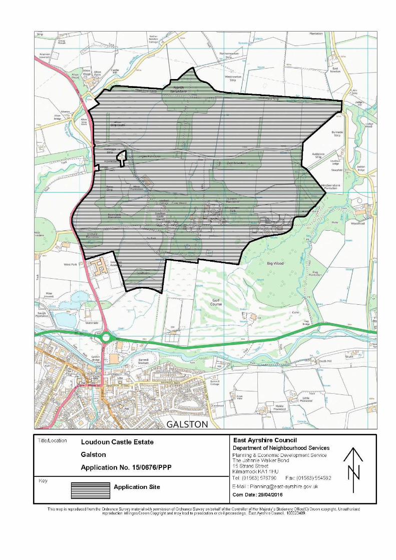
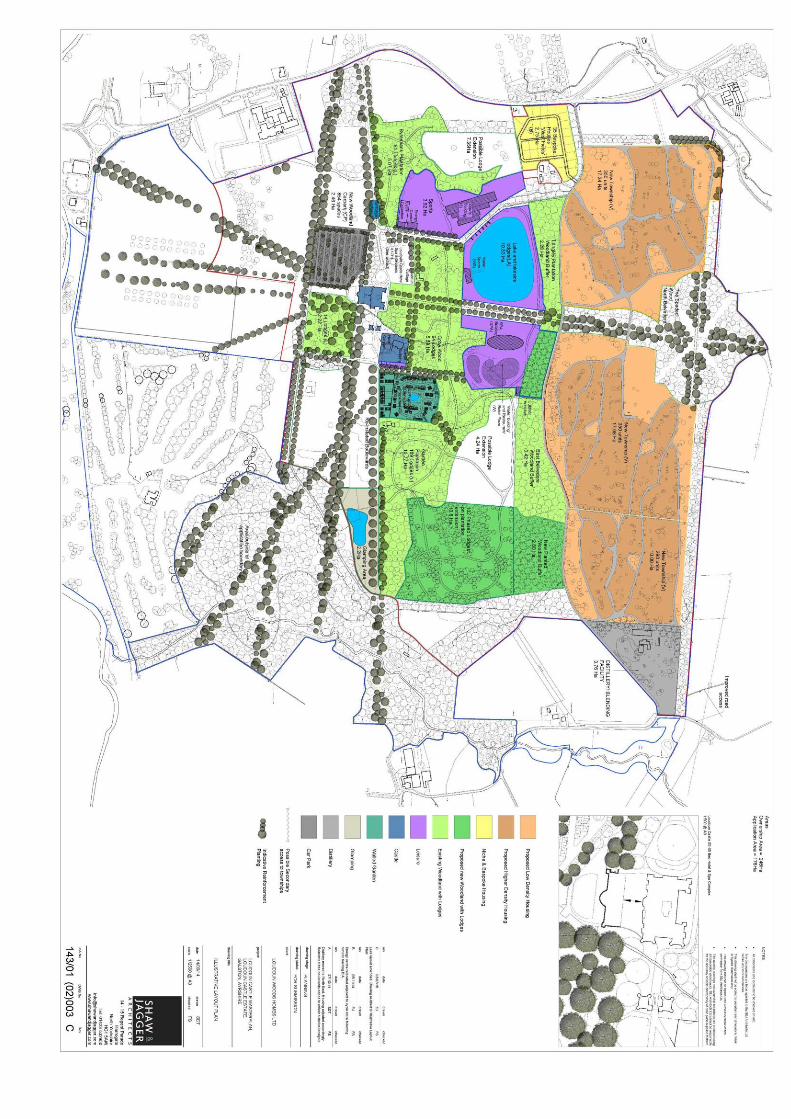
Copyright © 2022 FDOKUMEN