
In situ cosmogenic 10Be production-rate calibration from the Southern Alps, New Zealand

lable at ScienceDirect
Quaternary Geochronology 6 (2011) 273e284
Contents lists avai
Quaternary Geochronology
journal homepage: www.elsevier .com/locate/quageo
Research Paper
Quaternary river incision in NE Ardennes (Belgium)eInsights from 10Be/26Aldating of river terraces
Gilles Rixhon a,b,*, Régis Braucher c, Didier Bourlès c, Lionel Siame c, Benoît Bovy a,b, Alain Demoulin a,b
aDepartment of Physical Geography and Quaternary, University of Liège, Belgiumb Fund for Scientific Research e FNRS, Brussels, BelgiumcCEREGE, Univ. Aix-Marseille III, France
a r t i c l e i n f o
Article history:Received 18 March 2010Received in revised form22 October 2010Accepted 5 November 2010Available online 12 November 2010
Keywords:Cosmogenic nuclidesRiver incisionRiver terrace datingGeomorphologyRhenish shieldArdennes massif
* Corresponding author. Department of PhysicalUniversity of Liège, Allée du 6-Aout, 2, 4000 Liege, Be
E-mail address: [email protected] (G. Rixhon
1871-1014/$ e see front matter � 2010 Elsevier B.V.doi:10.1016/j.quageo.2010.11.001
a b s t r a c t
Although it constitutes a main tool to unravel the regional recent tectonics, the chronology of thePleistocene river incision is still poorly constrained within the uplifted Ardennes massif (WesternEurope). Here, we use in situ produced cosmogenic 10Be and 26Al concentrations from depth profiles interrace sediments of several Ardennian rivers (Meuse, Ourthe and Amblève) in order to date the so-calledYounger Main Terrace (YMT), a key-level in the drainage network evolution. We present the first absolutedating of the YMT in the lower Meuse valley, where we obtained an age of 725 � 120 ka for a terracedeposit buried beneath 3 m of Weichselian loess at Romont. This age is consistent with some previouslypublished estimates based on paleomagnetic data and MIS correlations. However, the ages we obtain forthe same terrace level in Ardennian tributaries of the Meuse are significantly younger: 390 � 35 ka in thelower Ourthe, and only 220 � 31 ka still farther upstream, in the lower Amblève. We thus demonstratethat the post-YMT incision occurred diachronically in NE Ardennes. The w0.5 Ma timespan needed bythe erosion wave to propagate from the lower Meuse towards the Ardennian headwaters contradicts thelong-held statement of a climatically driven incision that would have been synchronous throughoutthe catchments. Finally, we interpret the strong 10Be enrichment displayed by the lower half of the BelleeRoche (lower Amblève) profile as betraying the long-lasting, slow accumulation of the ∼8 m thickterrace deposit in that place.
� 2010 Elsevier B.V. All rights reserved.
1. Introduction
River terraces constitute themain tool to constrain river incision,triggered either by climatic fluctuations or by tectonic activity ata regional scale. In NW Europe, terrace sequences have been largelycorrelated to Quaternary climatic variations (Antoine,1994; Cordieret al., 2006; Bridgland and Westaway, 2008) but, at the same time,have been widely used as an indicator of tectonic uplift (Maddy,1997; Westaway, 2002; Westaway et al., 2006). Recent reviews onthe interfering influences of tectonics, climate and eustatism onriver evolution have been given by Antoine et al. (2000) andBridgland (2000).
While geodetic estimates of the present-day uplift rate of theRhenish shield are surprisingly high (Mälzer et al., 1983; Demoulin,2004), long term rate estimates as well as the timing of uplift sufferfrom largely unverified assumptions. The terrace sequences of the
Geography and Quaternary,lgium. Tel. þ32 43665255.).
All rights reserved.
main rivers crossing themassif (Rhine, Meuse andMosel) have longbeen used to infer tectonic uplift (Brunnacker and Boenigk, 1983;Van Den Berg and Van Hoof, 2001; Westaway, 2002), but the scar-city of reliable chronological data, and especially of absolute ages,remains problematic. Indeed, while uplift rate and amount havebeen derived from river incision since the abandonment of theMainTerrace level of these rivers (Meyer and Stets, 1998; Van Balen et al.,2000), the age of this level relies only on diversely interpretedpaleomagnetic data in the Rhine and Meuse valleys (Felder andBosch, 1989; Van Den Berg, 1996; Boenigk and Frechen, 2006).Moreover, age data for themain intra-massif tributaries of the Rhineand the Meuse are very scarce and limited to the lastw200 ka (e.g.,Cordier et al., 2006).
Within this general context, insufficient chronological con-straints essentially come from the difficulty to obtain numericalages for middle Pleistocene river terraces using conventional datingmethods. To overcome this difficulty, we use here the Cosmic RayExposure (CRE) method, a technique that has drastically progressedduring the last two decades (e.g., Nishiizumi et al., 1989; Gosse andPhillips, 2001; Granger and Muzikar, 2001). Although CRE datinghas been successfully used to determine the age of surficial deposits

G. Rixhon et al. / Quaternary Geochronology 6 (2011) 273e284274
(e.g., glacial deposits, alluvial fans) and has already been applied toterrace material (Brocard et al., 2003; Siame et al., 2004), dating old(several hundreds of ka) river terraces remains highly difficultbecause of the various processes (inheritance, post-depositionalerosion and/or burial) potentially perturbing the cosmogenicnuclide (TCN) production at the terrace site.
In this study, we use a profiling technique to measure the 10Beand 26Al concentrations at depths along five thick gravel depositsequences of the well-preserved Main Terrace levels in the Meusecatchments. Aimed to put constraints on the history of the middlePleistocene uplift/incision episode in the Rhenish shield, the atingof the Main Terrace level in different places from the lower Meusein the Maastricht area through tributary and sub-tributaryupstream towards its Ardennian headwaters. It will thus alsocontribute to enlarge the data set required to explore the spatio-temporal characteristics of the mechanism by which river incisionresponded to combined tectonic and climatic signals.
2. Study area
2.1. Geological setting
Located to the east of the Lower Rhine Embayment (northern-most segment of the European Cenozoic Rift System - ECRS,Fig. 1A), the Ardennes represents the western prolongation of thePaleozoic Rhenish Shield. Encompassing the study area, the NEArdennes is mainly composed of the Caledonian Stavelot massif,whose complex folded and faulted structures emerge from thesurrounding Variscan Ardennes anticlinorium and deform slightlymetamorphosed slates and quartzites. To the northwest, the Dinant
Fig. 1. A. Localization of the study area within the Rhenish shield (western Europe) (B: Belgiurefer respectively to the Amblève and Ourthe rivers. B. Simplified geological map of the stu
synclinorium exposes mainly Upper Devonian psammites andCarboniferous limestones.
As a part of the Rhenish Shield, the Ardennes experienceda moderate late Cenozoic tectonic uplift in response either tocompressive stresses (lithospheric buckling) exerted by the Alpinebelt on its foreland (Ziegler et al.,1995; Ziegler andDezes, 2007) or tomantle upwelling beneath the nearby Eifel area (Ritter et al., 2001).Since the late Oligocene, the NE Ardennes would have been upliftedby 400e500 m (Demoulin, 1995). The uplift rate increased a firsttime at the PlioceneePleistocene transition and again sometime atthe beginning of the middle Pleistocene. This last uplift episoderaised the Ardennes by 100e200 m (Demoulin and Hallot, 2009),inducing a wave of backward erosion within the Ardennian rivernetwork (Demoulin et al., 2009).
2.2. The Younger Main Terrace (YMT)
The study area comprises the lower Meuse reach between Liègeand Maastricht, the main tributary of the Meuse in the north-eastern Ardennes, called the Ourthe (drainage area w3600 km2)and a sub-tributary, the Amblève (drainage area w1100 km2)(Fig. 1B). Although the terrace flight is fairly different between thelower Meuse (23e31 levels according respectively to Juvigne andRenard, 1992 and Van Den Berg and Van Hoof, 2001) and thelower reaches of its two tributaries (19 levels for the Ourthe(Cornet,1995) and 11 levels for the Amblève (Rixhon and Demoulin,2010)), the so-called Main Terrace complex is well-preserved in thethree valleys, where it represents a more or less continuousgeomorphic marker. Mainly composed of extended terraceremnants, this complex consists generally of three closely spaced
m; F: France; D: Germany; NL: Netherlands; LRE: Lower Rhine Embayment. Am and Oudy area and localization of the sampling sites.

G. Rixhon et al. / Quaternary Geochronology 6 (2011) 273e284 275
alluvial levels, whose elevation above the current floodplaindecreases upstream, from w65 m in the lower Meuse to w50 m inthe lower Amblève. Morphologically, it marks a sharp transition inthe transverse profile of the main Ardennian valleys betweena broad, gently sloping Early Pleistocene valley characterized bywide terrace surfaces and a nested narrow Middle Pleistocenevalley with steeper slopes and more confined and scarcer terraces(Meyer and Stets,1998; Van Balen et al., 2000; Houtgast et al., 2002,see Fig. 2). As the youngest level of this Main Terrace complex isdirectly located at the edge of the incised valley (Fig. 2), it is oftenused as a reference level to identify the start of the middle Pleis-tocene uplift/incision episode (Meyer and Stets, 1998; Van Balenet al., 2000).
3. CRE dating of river terraces
3.1. Theoretical background
Inelastic interactions of the primary cosmic ray particles(essentially protons and a particles) reaching the Earth’s environ-ment with nuclei of the atoms constituting the atmosphereproduce a cascade of reactions and of energetic secondary particles(mainly neutrons and muons). The atmospheric cosmogenicnuclide species, such as 14C or 10Be, are the residues of the nuclearreactions induced in the atmosphere by both primary andsecondary particles. Although most of their net energy is lost to theatmosphere, some of the secondary particles reach the Earth’ssurface with enough energy to induce nuclear reactions with lith-ospheric nuclei targets (16O, 27Al, 28Si, 40Ca, 56Fe.) and to producein situ cosmogenic nuclide species. Because interactionwith matterreduces the cosmic ray flux with a characteristic exponentialattenuation length, the cosmogenic nuclide production ratesdecrease approximately exponentially with the mass of overlyingmaterial (Gosse and Phillips, 2001).
In the Earth’s crust, the evolution of an in situ cosmogenicnuclide production rate P(x) as a function of depth (x, expressed in g/cm2) is commonly described by
PðxÞ ¼ P0eð�x=LÞ (1)
where P0 is the surface production rate (in atom/g/yr) and L is theattenuation length (g/cm2). Threemain types of secondary particlesare involved in the in situ production of cosmogenic nuclides: fastnucleons (essentially neutrons), stopping (or negative) muons andfast muons. Each of them has its own effective attenuation length.While the fast neutron attenuation length of 160 g/cm2 is no longerdebated (Lal, 1991; Brown et al., 1995), we used for the muonic
Fig. 2. Cross-section in the lower Ourthe valley at Colonster. Morphologically, the YoungePleistocene valley with wide terrace surfaces (E Ple) and a narrowmiddle Pleistocene valleyHT: Higher Terraces; Fl: present-day floodplain.
attenuation lengths the values proposed by Braucher et al. (2003),i.e., 1500 g/cm2 for stopping muons and 5300 g/cm2 for fast muons.It has been shown that the combined use of the fast nucleon andmuon contributions along a depth profile using a single cosmogenicnuclide allows assessing simultaneously the exposure time and thedenudation rate of a landform (Siame et al., 2004; Braucher et al.,2009).
Assuming that the studied material experienced a single cosmicray exposure episode and that the production and erosion ratesremained constant through time, the in situ-production of 10Be isgiven by the following equation:
Cðx;3;tÞ ¼ Pn3Ln
þ l$e�
xLn
�1� exp
�� t�
3
Lnþ l
���þ Pms
3Lms
þ l$e�
xLms
�1� exp
�� t�
3
Lmsþ l
���þ Pmf
3Lmf
þ l$e
� xLmf
"1� exp
(� t
3
Lmfþ l
!)#þ C0$e
ð�ltÞ ð2Þ
where C(x, 3, t) is the 10Be concentration as a function of depth x (g/cm2), erosion rate 3 (g/cm2/yr) and exposure time t (yr), l is theradioactive decay constant (yr�1), and Pn, Pms and Pmf are the relativeproduction rates due to neutrons, slow muons and fast muonsassuming relative contributions to the total surface production rateof 97.85%, 1.50% and 0.65% respectively. Ln, Lms, and Lmf are theeffective apparent attenuation lengths (g/cm2), for neutrons, slowmuons, and fast muons, respectively (Braucher et al., 2003). Finally,C0 is the number of atoms present at the initiation of the exposurescenario (i.e., inheritance).
3.2. Sampling sites
The search for adequate sampling sites was determined by twomain constraints. Firstly, as we expected that the material to bedated was older than 0.5 Ma, the need for including the muoniccomponent in the analysis required the sampling of depth profilesin deposits deeper than 3m below the surface. Secondly, in order toreduce problems resulting from post-depositional reworking orerosion of the terrace sediments, we selected only well-preservedterrace elements characterized by an extended (>100 m wide)even, horizontal ground surface and we sampled them in theircentral part. From the five sampled sites, three are located in theAmblève valley, one in the lower Ourthe and one in the lowerMeuse (Fig. 1B). Except in the last valley where the sampling sitewas located in a quarry (cf. Romont site), large pits were dug in allplaces. Samples were collected at regular depth intervals (generally
r Main Terrace (YMT) is located at the hinge between a broad, gently sloping Earlywith steeper slopes and more confined and scarcer terraces (M Ple). Pli: Pliocene valley;

G. Rixhon et al. / Quaternary Geochronology 6 (2011) 273e284276
0.5 m), a sample consisting of one large or several smaller quartz orquartzite pebbles originating from the Stavelot massif.
3.2.1. The main terrace at romont (Meuse River)The Romont terrace is located 4 km to the west of the present
Meuse channel, w20 km to the north of the Ardennes margin(Fig. 1.B). The top of the gravel layer is situated at an elevation ofw115 m asl, and 60 m above the Meuse floodplain. According toJuvigne and Renard (1992), the Romont terrace belongs to theHermée e St Pietersberg levels that most authors agree to recog-nize as forming the Main Terrace complex.
Importantly, at Romont, the 5 m thick gravel layer is nowadaysoverlain by 3 m of loess inherited mostly from the last glacialperiod, as witnessed by Weichselian paleosoils (MIS 4e2) anda tephrostratigraphic marker occurring within the loess sequenceclose to the sampled terrace. However, at the same site, Eemianpaleosoils attesting of pre-Weichselian material at the base of thesequence have also been found in a filled paleogully where theloess thickness exceeds 10 m.
This suggests that the Romont area might have been repeatedlycovered by loess during the middle Pleistocene glacials, much or allof a loess accumulation being removed during the followinginterglacial. In any case, the loess shielded for sometime the rivergravels from exposure to the cosmic particles, so that we will haveto consider the 26Al/10Be ratio in order to produce a deposition age.Six samples for 10Be and 26Al concentration measurements havebeen taken from the Romont profile (Fig. 3).
3.2.2. The main terrace at colonster (OurtheRiver)Located in the lower Ourthe, w9 km upstream of the Meuse
confluence in Liège (Fig. 1B), the Colonster terrace has a relative
Fig. 3. Sections in the sampled terraces and Amblève long profile with localization of the s(loam-clay) including some pebbles; 3: fluvial gravel characterized by small-sized elementsby the lack of fine elements (sand to clay); 30 ’’: fluvial gravel with very coarse elements (boulbedrock.
elevation of 55 m above themodern floodplain (or 131 m asl) and isgeometrically correlated with the YMT in the lower Meuse (Cornet,1995). A cross-section of the Ourthe valley at Colonster remarkablyillustrates the terrace location at the hinge between the older broadvalleys and the younger incised one (Fig. 2).
We collected 10 samples from the w4 m thick gravel layercovered by a thin (<1m) alluvial silt/loess cover. The Ourthe gravelsare here much coarser than those of Romont and contain bouldersup to 0.5 m in diameter (Fig. 3).
3.2.3. The main terrace at belleeroche (AmblèveRiver)Cut in Carboniferous limestones, the BelleeRoche terrace
(w153 m asl) is located in the Amblève valley, 2 km upstream ofthe Ourthe-Amblève confluence (Fig. 1.B). Although the morpho-logical hinge between nested valley forms is not well expressed inthis reach of the Amblève, the elevation of the terrace relative tothe floodplain (w53 m), similar to that of the Colonster terrace,and its great extent allow again a correlation with the YMT level(Van Balen et al., 2000; Juvigne et al., 2005; Rixhon and Demoulin,2010).
At BelleeRoche, the river gravels appear at a depth of w0.3 m,immediately beneath the modern soil (Fig. 3). Made of coarsepebbles within a sandy-silty matrix, the alluvial deposit is charac-terized by an unusually great thickness (w8 m) (Fig. 3). As pointedout by Juvigne et al. (2005), this seems unrelated with the karsticnature of the bedrock as no deformation of the river sediments isobserved. We collected here 10 samples.
3.2.4. The terraces at Stavelot and Lodomez (AmblèveRiver)Located in the upstream part of the middle Amblève valley
(more than 50 km from the Ourthe confluence, Fig. 1B) and distant
ampling sites in this river. 1: modern soil; 2 & 2’: loess deposits; 2’’: fluvial fine matrix(pebbles); 3’: fluvial gravel including coarser elements; 3’’: fluvial lenses characterizedders); 4: shale bedrock; 4’: argillite bedrock with fine conglomeratic elements; 4’’: slate

G. Rixhon et al. / Quaternary Geochronology 6 (2011) 273e284 277
from each other byw2.5 km, the Stavelot and Lodomez terraces aresituated within the Stavelot massif (Fig. 1B). With elevations ofw305 m and w307 m asl, the elevations of the Stavelot andLodomez terraces relative to the local floodplain are only ofw25 mand w20 m. Though the relative elevation of the YMT has alsosignificantly decreased in this upstream reach of the valley, thecorrelation of the Stavelot and Lodomez terraces with the YMT levelis problematic not only for altitudinal reasons but also because of (i)the convergence of all terrace levels towards a knickpoint located12 km further upstream in the river profile, (ii) the damped contrastbetween upper broad and lower narrow valleys in this area and (iii)the presence of the Quarreux gorge whose increased gradientcomplicates the correlation between the terraces located down-stream and upstream (Rixhon and Demoulin, 2010). The Stavelotand Lodomez terrace remnants likely belong to the terrace levelimmediately below the YMT.
Six samples have been taken from the 2.7 m thick coarse gravelsof the Stavelot terrace, which are overlain by w0.7 m of alluvialloam (Fig. 3). Nine samples have been taken from the 4.5 m thickLodomez section, which displayed the coarsest observed rivergravels (D50 > 20 cm).
4. Results
4.1. Concentration measurements and profiles
The chemical treatment of the samples and the AMS measure-ments were carried out at the CEREGE laboratory in Aix-en-Pro-vence. Sampleswere prepared for cosmogenic nuclide concentrationmeasurements following chemical procedures adapted from Brownet al. (1991) andMerchel andHerpers (1999). All the data reported inthis study (Table 1) have been measured at ASTER (CEREGE, Aix-en-Provence). After addition in each sample of w100 ml of an in-house3.10�3 g/g 9Be carrier solution prepared from deep-mined phenakite(Merchel et al., 2008), all 10Be concentrations were normalized to10Be/9Be SRM 4325 NIST standard with an assigned value of(2.79 � 0.03)�10�11. This standardization is equivalent to 07KNSTDwithin rounding error. The obtained 26Al/27Al ratios were calibratedagainst the ASTER in-house standard SM-Al-11 with 26Al/27Al ¼(7.401 � 0.064)�10�12, which has been cross-calibrated against theprimary standards certified by a round-robin exercise (Merchel andBremser, 2004) and using a 26Al half-life of (7.17 � 0.17)�105 years(Granger, 2006). 27Al concentrations, naturally present in thesamples, were measured at CEREGE by ICP-OES. Analytical uncer-tainties (reported as 1s) include uncertainties associated with AMScounting statistics, AMS external error (0.5%), chemical blankmeasurement, and, regarding 26Al, 27Al measurement. Long termAMS measurements of chemically processed blank yield ratios onthe order of (3.0 � 1.5)�10�15 for 10Be/9Be and (2.2� 2.0)�10�15 for26Al/27Al (Arnold et al., 2010).
Cosmocalc add-in for excel (Vermeesch, 2007) has been used tocalculate sample thickness scaling (with an attenuation coefficientof 160 g cm�2) and atmospheric pressures. Production rates werescaled following Stone (2000) with a sea level high latitudeproduction rate of (4.5 � 0.3) at/g/yr for 10Be and a half-life of(1.387 � 0.012)�106 years were used for this nuclide (Chmeleffet al., 2010; Korschinek et al., 2010). When measured against 26AlKNSTD10650, the ASTER standard, which is the only available 26Alstandard cross-calibrated against the primary standards certifiedby a round-robin exercise, yields a ratio of 7.554 � 0.104�10�12,2.1% higher than the nominal value (Cronus calculatordocumentation, 2009, page 6). Therefore, the SM-Al-11/07KNSTDstandardization we use here implies a 26Al/10Be production ratio of6.61 � 0.50. This value and its associated uncertainty are directlyderived from the update of the ratio originally determined by
Nishiizumi et al. (1989). They were used in all calculations andmodeling for 26Al.
Plotting the concentrations against sample depth provided the10Be concentration profiles from which we will model the terraceages. A look at the 10Be concentration evolution with depth revealsthat the Colonster and Stavelot profiles agree rather well with theexponential decrease expected from the theory (Fig. 4), althoughthe deepest sample at Stavelot (Be07-40, not used in the modeling)displays a surprisingly high concentration. Its 10Be content isindeed more than three times higher than that of the sample justabove (Table 1). This might be interpreted as a 10Be accumulationprior to deposition (high 10Be inheritance).
However, the lower part of the BelleeRoche profile and, toa lesser extent, that of Lodomez show a similar 10Be enrichment,consistent over several samples at depths > w500e600 g/cm2
(Fig. 4). The inheritance hypothesis that might have explained theBe07-40 anomaly alone is hardly applicable in particular to theBelleeRoche lower profile, displaying a progressive enrichmentwith depth. This feature appears clearly disconnected from theexponential profile followed by the shallower (<3 m depth)samples. Note also that the well expressed exponential curve of theupper part of the profile rules out any perturbation of the latter bykarstic processes in the underlying bedrock.
A similar 10Be concentration anomaly is also observed in theLodomez profile (Table 1). Though much less patent than inBelleeRoche, it might confirm that the phenomenon has more thana local meaning.
In the following modeling, we therefore consider that theconcentration anomalies observed at depth >3 m in the threeAmblève sites require a separate analysis and we calculate theterrace exposure times on the basis of the near-surface samplesthat display the expected exponential concentration decrease withdepth.
4.2. Age determination
We use the Monte Carlo modeling approach developed byBraucher et al. (2009) to estimate four-parameters from the profiledata, namely the terrace exposure time (t), the denudation rate (3),the 10Be inheritance and the material (i.e., alluvial deposit) density(r). As stated by these authors, the modeling procedure is actuallyvery sensitive to density when one wants to determine from a 10Beconcentration depth profile both the exposure time and thedenudation rate affecting alluvial deposits. In the present work,density was hardlymeasurable in the field andwas likely to provideoverestimated results because of the presence of numerousboulder-sized quartzitic clasts in the deposits (especially in theOurthe and Amblève terraces, Fig. 3). As the 10Be distribution withdepth fairly matched the theoretically expected exponential profile,it was therefore preferable to treat density as a free parameter, likeexposure time, denudation rate and inheritance (Braucher et al.,2009). Here, we let the density free to adjust within the range1.8e2.4 g/cm3 with an increment step of 0.1 g/cm3. It was alsoassumed to be constant with depth since no particular fluvialstructure was observed in the alluvial deposits (except very locallyin the Stavelot terrace, Fig. 3).
The results are presented in the Table 2 with their minimum chi-square (c2) value (theminimumvalue among themedians of 100 c2
values issued by the Monte Carlo process for each (t,3) pair deter-mines the solution pair). Theoretically, a unique (t,3) solution isfound but the analytical errors and especially the modelinguncertainty frequently lead to rather large confidence intervals.Indeed, the distributions shown on the top and right sides of theplot of Fig. 5 refer only to the analytical error as propagated by theMonte Carlo procedure, to which we have to add the modeling

Table 1Results of the 10Be/26Al analyses. Shielding factor is 1 for each terrace and the altitude refers to the top of the fluvial deposits.
Sample Lat. (�N) Long. (�E) Altitude(m)
Depth(cm)
Depth(g/cm2)
Stone scalingfactora
Dissolvedquartz (g)
9Be carrierb
(1019 at.)
10Be/9Be [10Be](105 at./g)
[10Be] error(105 at./g)
[27Al]c
(1019 at.)
26Al/27Al [26Al](105 at./g)
[26Al] error(105 at./g)
Romont terrace (Meuse valley)Be08 Ro-01 50.787 5.66 110 310 620 1.134 20.587 2.019 6.67E-13 6.544 0.104 1.043 5.08E-12 25.734 3.019Be08 Ro-02 350 700 21.791 2.042 3.56E-13 3.339 0.080 13.004 2.50E-13 14.896 1.267Be08 Ro-03 450 900 23.371 2.013 2.17E-13 1.869 0.052 1.953 1.10E-12 9.234 0.452Be08 Ro-04 550 1100 21.508 2.115 1.38E-13 1.361 0.131 1.168 8.61E-13 4.677 0.400Be08 Ro-05 650 1300 20.317 2.060 2.58E-13 2.619 0.060 1.676 1.20E-12 9.920 0.493Be08 Ro-06 750 1500 23.404 2.071 2.19E-13 1.937 0.051 1.962 8.38E-13 7.020 0.334
Colonster terrace (Ourthe valley)Be08 Co-10 50.576 5.579 134 450 810 1.160 22.302 1.906 1.54E-13 1.316 0.077 7.156 9.97E-14 3.199 0.365Be08 Co-11 400 720 20.950 2.038 9.33E-14 0.908 0.067 7.418 5.86E-14 2.076 0.165Be08 Co-12 350 630 20.636 2.015 1.52E-13 1.488 0.055 1.305 8.95E-13 5.661 0.467Be08 Co-13 300 540 21.774 2.029 1.59E-13 1.480 0.097 4.522 2.35E-13 4.880 0.263Be08 Co-14 250 450 20.537 2.031 3.13E-13 3.095 0.112 4.970 2.70E-13 6.531 0.658Be08 Co-15 200 360 22.528 2.019 3.16E-13 2.835 0.110 2.182 8.30E-13 8.039 0.648Be08 Co-16 150 270 22.153 2.024 4.71E-13 4.302 0.165 3.214 1.21E-12 17.548 0.773Be08 Co-17 125 225 20.353 2.042 4.84E-13 4.852 0.190 11.552 4.11E-13 23.337 1.002Be08 Co-18 175 315 21.818 2.029 3.98E-13 3.702 0.131 2.119 1.50E-12 14.542 0.665Be08 Co-19 100 180 22.464 2.026 8.76E-13 7.895 0.274 13.040 4.71E-13 27.357 1.148
BelleeRoche terrace (Amblève valley)Be07 BR-20 50.481 5.616 153 600 1380 1.180 46.641 2.040 4.15E-13 1.815 0.037Be07 BR-21 550 1265 45.645 2.051 2.42E-13 1.087 0.031Be07 BR-22 500 1150 43.727 2.040 3.32E-13 1.548 0.037Be07 BR-23 450 1035 44.363 2.043 2.47E-13 1.137 0.033Be07 BR-24 400 920 45.887 2.046 1.56E-13 0.695 0.022Be07 BR-25 300 690 44.548 2.048 1.12E-13 0.514 0.019Be07 BR-26 200 460 46.079 2.041 1.63E-13 0.722 0.025Be07 BR-27 150 345 43.691 2.078 3.00E-13 1.429 0.031Be07 BR-28 100 230 41.630 2.011 4.41E-13 2.131 0.037Be07 BR-29 60 138 42.690 2.050 7.50E-13 3.600 0.061
Stavelot terrace (Amblève valley)Be07 St-40 50.396 5.944 305 300 690 1.363 43.210 2.049 2.57E-13 1.221 0.053Be07 St-41 250 575 44.422 2.056 7.47E-14 0.346 0.016Be07 St-42 200 460 43.329 2.048 9.79E-14 0.463 0.014Be07 St-43 150 345 43.207 2.056 3.13E-13 1.490 0.029Be07 St-44 100 230 41.459 2.055 4.76E-13 2.362 0.112Be07 St-45 50 115 45.287 2.055 9.13E-13 4.143 0.088
Lodomez terrace (Amblève valley)Be07 Lo-50 50.391 5.972 307 450 855 1.365 46.938 2.055 4.12E-13 1.805 0.033Be07 Lo-51 400 760 46.702 2.024 1.98E-13 0.857 0.021Be07 Lo-52 350 665 43.482 2.092 1.11E-13 0.536 0.017Be07 Lo-53 300 570 44.266 2.055 2.13E-13 0.988 0.030Be07 Lo-54 250 475 45.034 2.038 1.06E-13 0.478 0.019Be07 Lo-55 200 380 45.031 2.051 2.31E-13 1.053 0.022Be07 Lo-56 165 313.5 45.593 2.047 3.73E-13 1.676 0.040Be07 Lo-57 100 190 46.220 2.048 6.82E-13 3.020 0.056Be07 Lo-58 50 95 43.482 2.045 1.03E-12 4.836 0.130
a Production rates were scaled following Stone (2000) with a sea level high latitude production rate of (4.5 � 0.3) at/g/yr.b For each sample, addition of w100 ml of an in-house 3.10�3 g/g 9Be carrier solution.c 27Al concentrations, naturally present in the samples (no carrier), were measured by ICP-OES.
G.Rixhon
etal./
Quaternary
Geochronology
6(2011)
273e284
278

Fig. 4. TCN depth profiles with measured (points) and modeled (curve) concentrations. In the first profile (Colonster 10Be), the outlier removed from the modeling is encircled(Be08-Co14). In the last three profiles (Amblève valley terraces), surface exposure modeling was performed on the basis of the five surface samples (above the horizontal line).
G. Rixhon et al. / Quaternary Geochronology 6 (2011) 273e284 279
uncertainty, generally taken as the plot area with c2i � c2min þ 1(Granger, 2006).
In the Amblève valley, the upper part of the 10Be profilesallowed us to provide unequivocal exposure ages for the threeterraces. The best fits assign similar ages of 135 � 6 and 140 � 9 karespectively to the Stavelot and Lodomez terraces. Neither inher-itance (assumed identical for all samples of a profile), nor denu-dation of the alluvial surface is found in these sites. Consequently,both terrace exposure times are very well constrained, as shown
Table 2Modeling results for the Ourthe and Amblève terraces.
Sampled terrace TCN Used Data number Exposure time (ka) Denudatio
Colonster 10Be 9 390 � 35 0.526Al 10 243 � 10 010Be/26Al 19 330 � 30 2
BelleeRoche 10Be 5 222.5 � 31 4Stavelot 10Be 5 135 � 6 0Lodomez 10Be 5 140 � 9.5 0.1
by the very small time range of the 1s confidence interval in the c2
distribution of the time-denudation model plots (Fig. 5). Likewisebased on the five surface samples, the four-parameter adjustmentof the BelleeRoche profile provides an age of 222.5 � 31 ka for theabandonment of the terrace. It also indicates that the BelleeRocheterrace experienced a denudation rate of 4 m/Ma, corroboratingfield observations that, at the sampling place, the terrace was nolonger in pristine condition, with a clear transverse slope indica-tive of post-depositional reworking. Owing to this non-zero
n rate (m/Ma) Inheritance (katoms/g) Density (g/cm3) c2min
(median value)
90 1.86 59.320 1.89 88.42100/0 1.85 259.3920 2.3 47.60 2.3 266.50 1.9 92.4
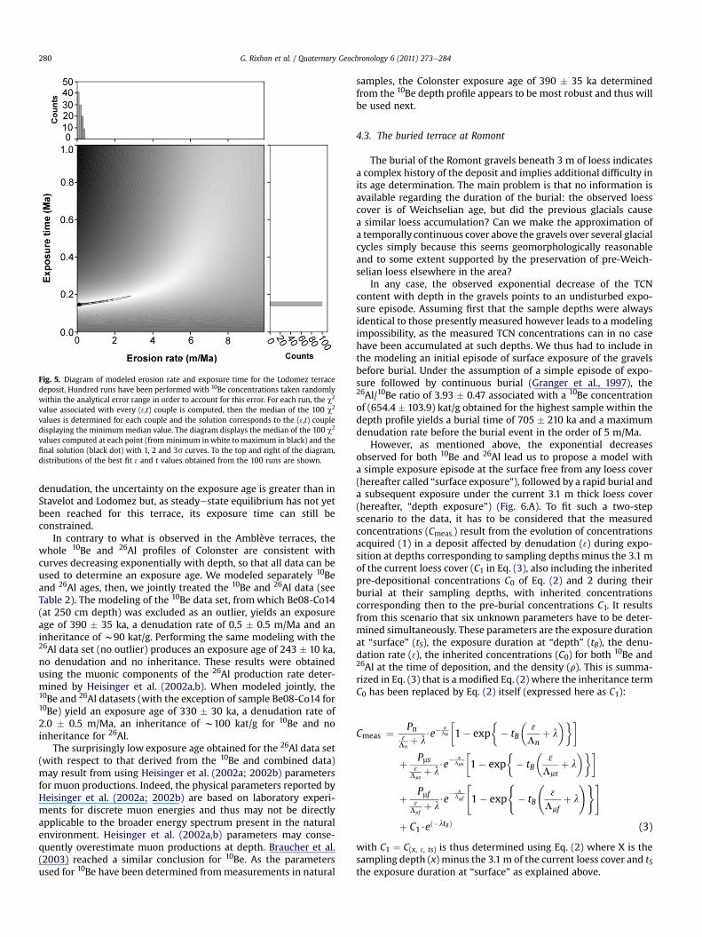
Fig. 5. Diagram of modeled erosion rate and exposure time for the Lodomez terracedeposit. Hundred runs have been performed with 10Be concentrations taken randomlywithin the analytical error range in order to account for this error. For each run, the c2
value associated with every (3,t) couple is computed, then the median of the 100 c2
values is determined for each couple and the solution corresponds to the (3,t) coupledisplaying the minimum median value. The diagram displays the median of the 100 c2
values computed at each point (fromminimum in white to maximum in black) and thefinal solution (black dot) with 1, 2 and 3s curves. To the top and right of the diagram,distributions of the best fit 3 and t values obtained from the 100 runs are shown.
G. Rixhon et al. / Quaternary Geochronology 6 (2011) 273e284280
denudation, the uncertainty on the exposure age is greater than inStavelot and Lodomez but, as steadyestate equilibrium has not yetbeen reached for this terrace, its exposure time can still beconstrained.
In contrary to what is observed in the Amblève terraces, thewhole 10Be and 26Al profiles of Colonster are consistent withcurves decreasing exponentially with depth, so that all data can beused to determine an exposure age. We modeled separately 10Beand 26Al ages, then, we jointly treated the 10Be and 26Al data (seeTable 2). The modeling of the 10Be data set, fromwhich Be08-Co14(at 250 cm depth) was excluded as an outlier, yields an exposureage of 390 � 35 ka, a denudation rate of 0.5 � 0.5 m/Ma and aninheritance of w90 kat/g. Performing the same modeling with the26Al data set (no outlier) produces an exposure age of 243 � 10 ka,no denudation and no inheritance. These results were obtainedusing the muonic components of the 26Al production rate deter-mined by Heisinger et al. (2002a,b). When modeled jointly, the10Be and 26Al datasets (with the exception of sample Be08-Co14 for10Be) yield an exposure age of 330 � 30 ka, a denudation rate of2.0 � 0.5 m/Ma, an inheritance of w100 kat/g for 10Be and noinheritance for 26Al.
The surprisingly low exposure age obtained for the 26Al data set(with respect to that derived from the 10Be and combined data)may result from using Heisinger et al. (2002a; 2002b) parametersfor muon productions. Indeed, the physical parameters reported byHeisinger et al. (2002a; 2002b) are based on laboratory experi-ments for discrete muon energies and thus may not be directlyapplicable to the broader energy spectrum present in the naturalenvironment. Heisinger et al. (2002a,b) parameters may conse-quently overestimate muon productions at depth. Braucher et al.(2003) reached a similar conclusion for 10Be. As the parametersused for 10Be have been determined frommeasurements in natural
samples, the Colonster exposure age of 390 � 35 ka determinedfrom the 10Be depth profile appears to be most robust and thus willbe used next.
4.3. The buried terrace at Romont
The burial of the Romont gravels beneath 3 m of loess indicatesa complex history of the deposit and implies additional difficulty inits age determination. The main problem is that no information isavailable regarding the duration of the burial: the observed loesscover is of Weichselian age, but did the previous glacials causea similar loess accumulation? Can we make the approximation ofa temporally continuous cover above the gravels over several glacialcycles simply because this seems geomorphologically reasonableand to some extent supported by the preservation of pre-Weich-selian loess elsewhere in the area?
In any case, the observed exponential decrease of the TCNcontent with depth in the gravels points to an undisturbed expo-sure episode. Assuming first that the sample depths were alwaysidentical to those presently measured however leads to a modelingimpossibility, as the measured TCN concentrations can in no casehave been accumulated at such depths. We thus had to include inthe modeling an initial episode of surface exposure of the gravelsbefore burial. Under the assumption of a simple episode of expo-sure followed by continuous burial (Granger et al., 1997), the26Al/10Be ratio of 3.93 � 0.47 associated with a 10Be concentrationof (654.4 � 103.9) kat/g obtained for the highest sample within thedepth profile yields a burial time of 705 � 210 ka and a maximumdenudation rate before the burial event in the order of 5 m/Ma.
However, as mentioned above, the exponential decreasesobserved for both 10Be and 26Al lead us to propose a model witha simple exposure episode at the surface free from any loess cover(hereafter called “surface exposure”), followed by a rapid burial anda subsequent exposure under the current 3.1 m thick loess cover(hereafter, “depth exposure”) (Fig. 6.A). To fit such a two-stepscenario to the data, it has to be considered that the measuredconcentrations (Cmeas.) result from the evolution of concentrationsacquired (1) in a deposit affected by denudation (3) during expo-sition at depths corresponding to sampling depths minus the 3.1 mof the current loess cover (C1 in Eq. (3), also including the inheritedpre-depositional concentrations C0 of Eq. (2) and 2 during theirburial at their sampling depths, with inherited concentrationscorresponding then to the pre-burial concentrations C1. It resultsfrom this scenario that six unknown parameters have to be deter-mined simultaneously. These parameters are the exposure durationat “surface” (tS), the exposure duration at “depth” (tB), the denu-dation rate (3), the inherited concentrations (C0) for both 10Be and26Al at the time of deposition, and the density (r). This is summa-rized in Eq. (3) that is a modified Eq. (2) where the inheritance termC0 has been replaced by Eq. (2) itself (expressed here as C1):
Cmeas ¼ Pn3Ln
þ l$e�
xLn
�1� exp
�� tB
�3
Lnþ l
���
þ Pms3
Lmsþ l
$e�x
Lms
�1� exp
�� tB
�3
Lmsþ l
���
þ Pmf3
Lmfþ l
$e� x
Lmf
"1� exp
(� tB
3
Lmfþ l
!)#
þ C1$eð�ltBÞ (3)
with C1 ¼ C(x, 3, ts) is thus determined using Eq. (2) where X is thesampling depth (x) minus the 3.1 m of the current loess cover and tSthe exposure duration at “surface” as explained above.

Fig. 6. A. 10Be and 26Al depth profiles for the Romont terrace. B. Measured and modeled26Al/10Be ratios as a function of depth for the Romont terrace.
G. Rixhon et al. / Quaternary Geochronology 6 (2011) 273e284 281
Assuming that the denudation rate remained constant all alongthe exposure history and that it cannot be higher than 5 m/Ma (asdetermined with the estimation of the burial age from the highestsamplewithin the depth profile), considering also that the 26Al/10Beratios must be lower than 6.61 (Fig. 6B), this model yields exposuredurations at “surface” (tS) of 100 � 15 ka and at “depth” (tB) of625 � 120 ka, no denudation and pre-exposure inherited concen-trations of 257 and 1700 kat/g for 10Be and 26Al, respectively.Despite the stochastic nature of inheritance, the observed expo-nential decrease of both 10Be and 26Al concentrations with depth aswell as the similarity of the 26Al/10Be ratios most likely imply thatthe inherited pre-depositional concentrations may reasonably beconsidered as constant along the profile. Thanks to this modelingprocedure, we set the abandonment of the Romont terrace at725 � 120 ka (in agreement with the burial age range of705 � 210 ka estimated above).
5. Discussion
5.1. Age of the YMT in the lower Meuse
The age assignments of the terrace flight of the Meuse valley inthe Liège-Maastricht area are rather confusing. This results fromgeomorphological reasons, namely the great number of verticallyclosely spaced terrace (sub)-levels and the probability of largemeander cut-off in the area during the middle Pleistocene (Juvigneand Renard, 1992), and also from the diverse interpretations ofthe few available paleomagnetic data (Felder and Bosch, 1989;Juvigne and Renard, 1992; Van Den Berg, 1996; Van Balen et al.,2000; Westaway, 2002).
Felder and Bosch (1989) identified the Meuse “main terrace” inthe Maastricht area as a single level that they called the Sint
Pietersberg (SP) terrace. Based on the assumption of a climaticorigin of the terraces and a comparison with the Marine IsotopicStages (MIS), they suggested an age of w0.7 Ma for this level. Ina more complete reconstruction of a flight of 31 terraces, Van DenBerg (1996) subdivided the SP (or main) terrace in three sublevelsand assigned them respectively to MIS 26, 22 and 20 (respectively,0.96, 0.87 and 0.80 Ma). By contrast, relying on new correlationswith the Meuse terraces in the Liège area, Van Balen et al. (2000)suggested that the oldest SP sublevel, SP1, dates from 0.72 Maand that the terrace just below the main terrace complex datesfrom 0.65 Ma. Recently, still another opinion was given byWestaway (2002), who correlated the three SP sublevels with MIS22, 20 and 18 (i.e., 0.87, 0.80 and 0.72Ma). Considering now the fewpaleomagnetic data collected by Van Den Berg (1996), the mainobservation concerns the presence of reverse and normal polaritieswithin two sections of the SP2 level, while only normal polarity wasfound in SP1 and SP3. If reliable, this suggests that the middle SPsublevel would have formed at the MatuyamaeBrunhes transition(w0.78Ma) and that the YMT (corresponding to the SP3 level in theMaastricht area) would be younger, as suggested by Westaway(2002).
Before discussing the meaning of our TCN age at Romont, weneed to correlate this terrace element with the terrace flight atMaastricht. Based on altitudinal comparison with the SP sublevels5 km downstream, the Romont terrace (base at 109 m asl) mostprobably belongs to SP2 (104.5 m asl). A look upstream towards thesubdivided main terrace complex in the Liège area (Juvigne andRenard, 1992) however provides no firm indication to decidewhether it is better correlatedwith the local equivalentof SP2or SP3.
The TCN age of 725�120 ka at Romont suggests that the terracebelongs to MIS 18. Actually, it indicates that the terrace was aban-doned due to incision around the end of MIS 18 and thus wasaccumulated mainly during this stage. This interpretation not onlysheds doubt about the paleomagnetic data in the Maastricht area,but it also makes SP2 (and thus also SP3) younger than the latestestimate of Westaway (2002) and leads to conclusions very similarto those of Felder and Bosch (1989) and Van Balen et al. (2000),suggesting that the SP2-SP3 succession might have developedwithin a relatively short timespan, perhaps as a complex responseto the starting incision wave of the middle Pleistocene. Finally, thisage assignment is also remarkably consistent with the most recentviews about the Rhine terrace chronology at its passage from theRhenish shield into the Lower Rhine Embayment, where the UT2/3and UT4 terrace levels, corresponding respectively to SP2 and SP3,have also been ascribed to MIS 18 and 16 (Boenigk and Frechen,2006).
5.2. Diachronic post-YMT river incision in the NE Ardennes
The most striking result of this study is undoubtedly theconsiderable age discrepancy of the YMT level within the threeinvestigated valleys. From the geometric correlation andthe geomorphological similarity between the terraces, we actuallyexpected uniform ages at Romont, Colonster and BelleeRoche. Incontrast, while the Romont age of 725 � 120 ka marks the start ofthe post-YMT incision north of the Ardennes massif, a consistentage decrease is observed when going upstream along the lowerMeuse - lower Ourthe - Amblève system. Indeed, the 10Be age ofColonster (390 � 35 ka) is indisputably more recent than that ofRomont and the abandonment of the BelleeRoche terrace around220 ka obviously evidences that the erosion wave reached this partof the drainage network with considerable further delay. Althoughthe Stavelot and Lodomez terraces, located still farther upstream inthe drainage network, probably pertain to the level just below the

G. Rixhon et al. / Quaternary Geochronology 6 (2011) 273e284282
YMT, their very young ages (both around 140 ka) also consistentlyintegrate into this scheme.
Our whole data set thus unequivocally establishes that the post-YMT river incision occurred diachronically in NE Ardennes, theerosion wave needing more than half a million years to propagatefrom the Maastricht area towards the Ardennian headwaters of theMeuse catchment. This contradicts the long-held statement ofa climatically driven, simultaneous incision throughout the catch-ment, which implied that geometrically correlated terrace levelswere assumedly everywhere of the same age, and erroneouslyallowed previous authors to propagate local age informationwithinthe drainage network (e.g., Meyer and Stets, 1998).
However, a main characteristic of the Meuse-Ourthe-Amblèvesystem is that it includes rivers of very different size (the Meusecatchment at Liège represents w20,500 km2 whereas that ofthe Amblève is only of 1070 km2). As the celerity c of a wave oferosion is strongly dependent on the drainage area A (e.g., Whippleand Tucker, 1999), it is thus not surprising to observe delays in thetime of terrace abandonment when comparing smaller subtributaries with the main stem. This is quite different as long as oneremains in the same valley, where A and c diminishes slowly, andthe propagation of an erosionwave along the whole Ardennian partof the Meuse valley (i.e., w180 km from Liège, north of the massif,to Charleville, the entrance point of the Meuse in S Ardennes)occurs probably in only a few ka, as suggested notably by the-sudden and widespread change in mineralogy observed in a singleMeuse terrace level across the Ardennes after the Mosel capture(Pissart et al., 1997). Therefore, whereas most studies dealing withterrace chronology along the main rivers in the massif (namely theMeuse, the Rhine and the Mosel) remain valid, those involvingcomparison of the intra-massif tributaries with the terrace systemof the major rivers should be seriously questioned (e.g., Meyer andStets, 1998; Van Balen et al., 2000; Juvigne et al., 2005).
5.3. 10Be enrichment at the base of the BelleeRoche profile: datingthe time of floodplain formation vs terrace abandonment
At BelleeRoche, the TCN age ofw220 ka may be compared witha paleontological age estimate of a cave deposit situated w12 mabove the base of the YMT. This deposit comprises a basal layer ofgravels of the Amblève overlain by runoff and solifluction products.Based on a rich fauna of macro- andmicromammals, the latter weredated as of w500 � 70 ka (Cordy et al., 1993), thus implyinga slightly older age for the river gravel. Although the two ages areactually not inconsistent, this w300 ka discrepancy deservesparticular consideration, as does also the unusual thickness (w8m)of the BelleeRoche terrace deposit.
While the age of 220 ka derived from the 10Be data is an estimateof the time of the YMT abandonment, we should recall that, in themodeling, we left aside the data points witnessing an anomalousenrichment in 10Be below 3 m depth (Fig. 4). We suggest that thishigh 10Be content at depthwas acquired during a long-lasting phaseof progressive, slow accumulation of river gravel. During the accu-mulation, the upper part of the deposit was constantly renewed,hampering the in situ TCN production, while its deeper part, thoughless exposed to the cosmic rays, was able to store the produced 10Be.The thickness of the constantly reworkedupperpartmaybe inferredfrom the w3 m thickness of the present floodplain of the lowerAmblève. When the deposit grew, its deep 10Be-accumulating partalso progressively thickened. At the final stage, just before theAmblève started to incise its YMT floodplain, the gravel layer belowtheupper3mof transitmaterial hadaccumulated 10Be inproportionto its residence time in the deposit. When incision began, the uppertransit material, which was still devoid of in situ produced 10Be, wasin turn immobilized in the terrace and started to accumulate 10Be
following the usual exponential depth profile. Indeed, the expo-nential part of the BelleeRoche 10Be curve is 3-m deep, corre-sponding to the estimated thickness of the transit material. Themodeling of the lower, non-exponential part of the 10Be profileyields an accumulation rate of w25 m/Ma for the river gravel. Theage of the deepest sample, located at w6 m below the groundsurface, can be estimated to be on the order of 460 ka (240 ka ofprogressive burial plus 220 ka of exposition after the abandonmentof the terrace). However, the YMT deposit at BelleeRoche is esti-mated tobe a good8mthick (Juvigne et al., 2005). Assuming that theaccumulation rate remained constant over the time of formation ofthe whole sequence and taking into account the calculated denu-dation rate of 4 m/Ma, this would provide a total burial time ofw360 ka, indicating that the terrace began to form at least around580 ka, and continued up to its time of abandonment at 220 ka. Weare thus able to distinguish between the time of formation of theterrace beforeMIS 14, consistent with the paleontological age of theplace and also likely identical to that of its geometric equivalent(SP3) at Romont, and the time of its abandonment, which occurredwhen the erosion wave finally reached the lower Amblève,w0.5 Ma ka after it had passed Romont.
6. Conclusion
A main result of our study has been to propose the first absoluteage of the Meuse Main Terrace. As the terrace gravels are buriedbeneath Weichselian loess in the lower Meuse valley at Romont,the use of the highest sample from the studied buried depth profileyields at first glance a burial age of 705 ka with a large associatederror range of 210 ka. Using the whole data set of the depth profile,we were however able to refine the age determination, finallyobtaining an age of 725 � 120 ka that links the Romont level to MIS18. Similar to the age proposed by Felder and Bosch (1989) and VanBalen et al. (2000) on the basis of correlation with the marineisotope stages, this TCN age consequently questions the validity ofthe paleomagnetic data at Maastricht.
As for the ages we obtained for the same Main Terrace level inthe Ardennian valleys, they become younger as they come closer tothe headwaters, leading us to another far-reaching conclusion,namely that the abandonment of this terrace was not climaticallyforced, as generally believed, but occurred diachronically along thedrainage network, over the w0.5 Ma timespan needed bya tectonically induced erosionwave to propagate from the northernmargin of the Ardennes towards the heart of the massif. Thisinterpretation is quite consistent with the finding that, at Bel-leeRoche (and possibly also at Lodomez) in the Amblève valley,a gradual 10Be enrichment in the lower half of the depth profileresulted from a long-lasting accumulation of the terrace gravels.Therefore, if the times when the geometrically correlated Romontand BelleeRoche terraces began to form are fairly consistent, theirtime of abandonment on the other hand is quite different,depending on the passage of the erosion wave.
These conclusions highlight the potential of cosmogenicnuclides for yielding reliable ages of Middle Pleistocene riverterraces. They also underline the need for further such dating inorder to better constrain the uplift/incision history of the Ardennesand the Rhenish shield.
Acknowledgements
The authors thank L. Leanni, M. Arnold and G. Aumaître for theirrespective valuable assistance during chemical treatments and 10Beand 26Al measurements at the ASTER AMS national facility (CER-EGE, Aix-en-Provence) which is supported by the INSU/CNRS, theFrench Ministry of Research and Higher Education, IRD and CEA.

G. Rixhon et al. / Quaternary Geochronology 6 (2011) 273e284 283
We also thank an anonymous reviewer, Greg Balco and John Gossefor their pertinent reviews and constructive suggestions. Theygreatly helped to improve the manuscript.
Editorial handling by: R. Grun
References
Antoine, P., 1994. The Somme valley terrace system (Northern France); a model ofriver response to quaternary climatic variations since 800,000 BP. Terra-Nova6, 453e464.
Antoine, P., Lautridou, J.-P., Laurent, M., 2000. Long-term fluvial archives in NWFrance: response of the Seine and Somme rivers to tectonic movements,climatic variations and sea-level changes. Geomorphology 33, 183e207.
Arnold, M., Merchel, S., Bourles, D.L., Braucher, R., Benedetti, L., Finkel, R.C.,Aumaître, G., Gottdang, A., Klein, M., 2010. The French accelerator mass spec-trometry facility ASTER: improved performance and developments. NuclearInstruments and Methods in Physics Research B: Beam Interactions withMaterials and Atoms 268, 1954e1959.
Boenigk, W., Frechen, M., 2006. The Pliocene and Quaternary fluvial archives of theRhine system. Quaternary Science Reviews 25, 550e574.
Braucher, R., Brown, E.T., Bourles, D.L., Colin, F., 2003. In situ produced 10Bemeasurements at great depths: implications for production rates by fast muons.Earth and Planetary Sciences Letters 211, 251e258.
Braucher, R., Del Castillo, P., Siame, L., Hidy, A.J., Bourles, D.L., 2009. Determinationof both exposure time and denudation rate from an in situ-produced 10Be depthprofile: a mathematical proof of uniqueness. Model sensitivity and applicationsto natural cases. Quaternary Geochronology 4, 56e67.
Bridgland, D.R., 2000. River terrace systems in north-west Europe: an archive ofenvironmental change, uplift and early human occupation. Quaternary ScienceReviews 19, 1293e1303.
Bridgland, D.R., Westaway, R., 2008. Climatically controlled river terrace staircases:a worldwide Quaternary phenomenon. Geomorphology 98, 285e315.
Brocard, G.Y., Van Der Beek, P.A., Bourles, D.L., Siame, L.L., Mugnier, J.-L., 2003. Long-term fluvial incision rates and postglacial river relaxation time in the FrenchWestern Alps from 10Be dating of alluvial terraces with assessment of inheri-tance, soil development and wind ablation effects. Earth and Planetary ScienceLetters 209, 197e214.
Brown, E.T., Edmond, J.M., Raisbeck, G.M., Yiou, F., Kurz, M.D., Brook, E.J., 1991.Examination of surface exposure ages of Antarctic moraines using in situproduced 10Be and 26Al. Geochimica et Cosmochimica Acta 55, 2269e2283.
Brown, E.T., Bourles, D.L., Colin, F., Raisbeck, G.M., Yiou, F., Desgarceaux, S., 1995.Evidence for muon-induced production of 10Be in near-surface rocks from theCongo. Geophysical Research Letters 22 (6), 703e706.
Brunnacker, K., Boenigk, W., 1983. The Rhine valley between the NeuwiedBasin andthe lower Rhenish Embayment. In: Fuchs, K., et al. (Eds.), Plateau Uplift, theRhenish Shield - a Case History. Springer, pp. 62e73.
Chmeleff, J., Von Blanckenburg, F., Kossert, K., Jakob, D., 2010. Determination of the10Be half-life by multicollector ICP-MS and liquid scintillation counting. NuclearInstruments and Methods in Physics Research B: Beam Interactions withMaterials and Atoms 268, 192e199.
Cordier, S., Harmand, D., Frechen, M., Beiner, M., 2006. Fluvial system response tomiddle and upper Pleistocene climate change in the Meurthe and Mosellevalleys (EasternParis Basin and Rhenish massif). Quaternary Science Reviews25, 1460e1474.
Cordy, J.M., Bastin, B., Demaret-Fairon, M., EK, C., Geeraerts, R., Groessens-VanDyck, M.C., Oze, A., Peuchot, R., Quinif, Y., Thorez, J., Ulrix-Closset, M., 1993.La grotte de La Belle-Roche (Sprimont, Province de Liège): un gisement palé-ontologique et archéologique d’exception au Benelux. Bulletin de l’Académieroyale de Belgique, Classe des Sciences 6e (4), 165e186.
Cornet, Y., 1995. L’encaissement des rivières ardennaises au cours du Quaternaire.In: Demoulin, A. (Ed.), L’Ardenne, Essai de Géographie Physique. Départementde Géographie Physique et Quaternaire, Université de Liège, pp. 155e177.
Cronus calculator documentation, 2009. hess.ess.washington.edu/math/docs/al_be_v22/AlBe_changes_v22.pdf.
Demoulin, A., 2004. Reconciling geodetic and geological rates of vertical crustalmotion in intraplate regions. Earth and Planetary Science Letters 221 (1e4),91e101.
Demoulin, A., Hallot, E., Rixhon, G., 2009. Amount and controls of the Quaternarydenudation in the Ardennes massif (western Europe). Earth Surface Processesand Landforms 34, 1487e1496.
Demoulin, A., Hallot, E., 2009. Shape and amount of the Quaternary uplift of thewestern Rhenish shield and the Ardennes (western Europe). Tectonophysics474, 696e708.
Felder W.M. & Bosch P.B., 1989. Geologische kaart van Zuid-Limburg en omgeving1:50.000, Afzettingen van de Meuse. Rijks Geologische Dienst, Heerlen.
Gosse, J.C., Phillips, F.M., 2001. Terrestrial in situ cosmogenic nuclides: theory andapplication. Quaternary Science Reviews 20, 1475e1560.
Granger, D.E., 2006. A review of burial dating methods using 10Be and 26Al: in situproduced cosmogenic nuclides and quantification of geological processes.Geological Society of America Special Paper 415, 1e16.
Granger, D.E., Muzikar, P.F., 2001. Dating sediment burial with in situ producedcosmogenic nuclides: theory, techniques, and limitations. Earth and PlanetaryScience Letters 188, 269e281.
Granger, D.E., Kirchner, J.W., Finkel, R.C., 1997. Quaternary downcutting rate of theNew River, Virginia, measured from differential decay of cosmogenic 26Al and10Be in cave-deposited alluvium. Geology 25 (2), 107e110.
Heisinger, B., Lal, D., Jull, A.J.T., Kubik, P., Ivy-Ochs, S., Neumaier, S., Knie, K.,Lazarev, V., Nolte, E., 2002a. Production of selected cosmogenic radionuclides bymuons; 1. Fast muons. Earth and Planetary Science Letters 200, 345e355.
Heisinger, B., Lal, D., Jull, A.J.T., Kubik, P., Ivy-Ochs, S., Knie, K., Nolte, E., 2002b.Production of selected cosmogenic radionuclides by muons; 2. Capture ofnegative muons. Earth and Planetary Science Letters 200, 357e369.
Houtgast, R.F., Van Balen, R.T., Bouwer, L.M., Brand, G.B.M., Brijker, J.M., 2002. Latequaternary activity of the Feldbiss Fault Zone, Roer valley Rift system, theNetherlands, based on displaced fluvial terrace fragments. Tectonophysics 352,295e315.
Juvigne, E., Renard, F., 1992. Les terrasses de la Meuse de Liège à Maastricht. Annalesde la Société Géologique de Belgique 115 (1), 167e186.
Juvigne, E., Cordy, J.-M., Demoulin, A., Geeraerts, R., Hus, J., Renson, V., 2005. Le sitearchéo-paléontologique de la Belle-Roche (Belgique) dans le cadre de l’évolu-tion géomorphologique de la vallée de l’Amblève inférieure. Geologica Belgica8 (1e2), 121e133.
Korschinek, G., Bergmaier, A., Faestermann, T., Gerstmann, U.C., Knie, K., Rugel, G.,Wallner, A., Dillmann, I., Dollinger, G., Lierse Von Gostomski, C., Kossert, K.,Maiti, M., Poutivtsev, M., Remmert, A., 2010. A new value for the half-life of 10Beby Heavy-Ion Elastic Recoil Detection and liquid scintillation counting. NuclearInstruments and Methods in Physics Research B: Beam Interactions withMaterials and Atoms 268, 187e191.
Lal, D., 1991. Cosmic ray labeling of erosion surfaces: in situ nuclide production ratesand erosion rates. Earth and Planetary Science Letters 104, 424e439.
Maddy, D., 1997. Uplift driven valley incision and river terrace formation in southernEngland. Journal of Quaternary Science 12, 539e545.
Mälzer, H., Hein, G., Zippelt, K., 1983. Height changes in the Rhenish massif:determination and analysis. In: Fuchs, K., et al. (Eds.), Plateau Uplift. Springer,pp. 164e176.
Merchel, S., Herpers, U., 1999. An update on radiochemical separation techniquesfor the determination of long-lived radionuclides via accelerator mass spec-trometry. Radiochimica Acta 84, 215e219.
Merchel, S., Bremser, W., 2004. First international 26Al interlaboratory comparisone PartI. Nuclear Instruments and Methods in Physics Research B: Beam Inter-actions with Materials and Atoms 223e224, 393e400.
Merchel, S., Arnold, M., Aumaître, G., Benedetti, L., Bourles, D.L., Braucher, R.,Alfimov, V., Freeman, S.P.H.T., Steier, P., Wallner, A., 2008. Towards more precise10Be and 36Cl data from measurements at the 10-14 level: influence of samplepreparation. Nuclear Instruments and Methods in Physics Research B: BeamInteractions with Materials and Atoms 266, 4921e4926.
Meyer, W., Stets, J., 1998. Junge Tektonik im Rheinischen Schiefergebirge und ihreQuantifizierung. Zeitschrift der Deutschen Geologischen Gesellschaft 149,359e379.
Nishiizumi, K., Winterer, E.L., Kohl, C.P., Klein, J., Middleton, R., Lal, D., Arnold, J.R.,1989. Cosmic ray production rates of 10Be and 26Al in quartz from glaciallypolished rocks. Journal of Geophysical Research 94, 17907e17915.
Pissart, A., Harmand, D., Krook, L., 1997. L’évolution du cours de la Meuse de Toul àMaastricht depuis le Miocène: corrélations chronologiques et traces de capturede la Meuse lorraine d’après les minéraux denses. Géographie physique etQuaternaire 51, 267e284.
Ritter, J.R.R., Jordan, M., Christensen, U.R., Achauer, U., 2001. A mantle plume belowthe Eifel volcanic fields, Germany. Earth and Planetary Science Letters 186 (1),7e14.
Rixhon, G., Demoulin, A., 2010. Fluvial terraces of the Amblève: a marker of theQuaternary river incision in the NE Ardenne massif (western Europe). Zeits-chrift für Geomorphologie 54 (2), 161e180.
Siame, L., Bellier, O., Braucher, R., Sebrier, M., Cushing, M., Bourles, D., Hamelin, B.,Baroux, E., De Voogd, B., Raisbecck, G., Yiou, F., 2004. Local erosion rates versusactive tectonics: cosmic ray exposure modeling in Provence (south-east France).Earth and Planetary Science Letters 220 (3e4), 345e364.
Stone, J.O., 2000. Air pressure and cosmogenic isotope production. Journal ofGeophysical Research 105, 23753e23759.
Van Balen, R.T., Houtgast, R.F., Van Der Wateren, F.M., Vandenberghe, J.,Bogaart, P.W., 2000. Sediment budget and tectonic evolution of the Meusecatchment in the Ardennes and the Roer valley Rift system. Global PlanetaryChange 27, 113e129.
Van Den Berg, M. W., 1996. Fluvial sequences of the Maas, a 10 Ma record of neo-tectonics and climate change at various timescales. PhD Thesis, UniversiteitWageningen, pp. 181.
Van Den Berg, M., Van Hoof, T., 2001. The Mass terrace sequence at Maastricht, SENetherlands: evidence for 200m of late Neogene and Quaternary surface uplift.In: Maddy, D., Macklin, M., Woodward, J. (Eds.), River Basin Sediments Systems:Archives of Environmental Change. Balkema, Rotterdam, pp. 45e86.
Vermeesch, P., 2007. CosmoCalc: an Excel add-in for cosmogenic nuclide calcula-tions. Geochemistry, Geophysics, and Geosystems 8. doi:10.1029/2006GC001530 Q08003.
Westaway, R., 2002. Long-term river terrace sequences: evidence for globalincreases in surface uplift rates in the late pliocene and early middlepleistocene caused by flow in the lower continental crust induced by surface

G. Rixhon et al. / Quaternary Geochronology 6 (2011) 273e284284
processes. Netherlands Journal of Geosciences / Geologie en Mijnbouw 81(3e4), 305e328.
Westaway, R., Bridgland, D., White, M., 2006. The Quaternary uplift history ofcentral southern England: evidence from the terraces of the SolentRiver systemand nearby raised beaches. Quaternary Science Reviews 25, 2212e2250.
Whipple, K.X., Tucker, G.E., 1999. Dynamics of the stream-power river incisionmodel: implications for height limits of mountain ranges, landscape response
timescales, and research needs. Journal of Geophysical Research 104 (B8),17661e17674.
Ziegler, P.A., Cloething, S., Van Wees, J.-D., 1995. Dynamics of intra-plate compres-sional deformation: the alpine foreland and other examples. Tectonophysics252, 7e59.
Ziegler, P., Dezes, P., 2007. Cenozoic uplift of variscan massifs in the alpine foreland:timing and controlling mechanisms. Global and Planetary Change 58, 237e269.
Copyright © 2022 FDOKUMEN