Fossil Creek Wild and Scenic River Comprehensive River ...
37
Fossil Creek Wild & Scenic River Comprehensive River Management Plan Geology Report Prepared by: Polly Haessig (retired) Physical Scientist/NEPA Specialist/Partnership Coordinator Mogollon Rim Ranger District Coconino National Forest Steven Overby Soil Scientist Forest and Woodlands Ecosystem Program Rocky Mountain Research Station /s/ Steven T. Overby for: Red Rock Ranger District Coconino National Forest Payson Ranger District Tonto National Forest November 2018
-
Upload
khangminh22 -
Category
Documents
-
view
2 -
download
0
Transcript of Fossil Creek Wild and Scenic River Comprehensive River ...

Fossil Creek Wild & Scenic River Comprehensive River Management Plan
Geology Report
Prepared by:
Polly Haessig (retired)
Physical Scientist/NEPA Specialist/Partnership Coordinator
Mogollon Rim Ranger District
Coconino National Forest
Steven Overby
Soil Scientist
Forest and Woodlands Ecosystem Program
Rocky Mountain Research Station
/s/ Steven T. Overby for:
Red Rock Ranger District Coconino National Forest
Payson Ranger District Tonto National Forest
November 2018

USDA NON-DISCRIMINATION POLICY STATEMENT: DR 4300.003 USDA Equal Opportunity Public Notification Policy (June 2, 2015) In accordance with Federal civil rights law and U.S. Department of Agriculture (USDA) civil rights regulations and policies, the USDA, its Agencies, offices, and employees, and institutions participating in or administering USDA programs are prohibited from discriminating based on race, color, national origin, religion, sex, gender identity (including gender expression), sexual orientation, disability, age, marital status, family/parental status, income derived from a public assistance program, political beliefs, or reprisal or retaliation for prior civil rights activity, in any program or activity conducted or funded by USDA (not all bases apply to all programs). Remedies and complaint filing deadlines vary by program or incident.
Persons with disabilities who require alternative means of communication for program information (e.g., Braille, large print, audiotape, American Sign Language, etc.) should contact the responsible Agency or USDA’s TARGET Center at (202) 720-2600 (voice and TTY) or contact USDA through the Federal Relay Service at (800) 877-8339. Additionally, program information may be made available in languages other than English.
To file a program discrimination complaint, complete the USDA Program Discrimination Complaint Form, AD-3027, found online at http://www.ascr.usda.gov/complaint_filing_cust.html and at any USDA office or write a letter addressed to USDA and provide in the letter all of the information requested in the form. To request a copy of the complaint form, call (866) 632-9992. Submit your completed form or letter to USDA by: (1) mail: U.S. Department of Agriculture, Office of the Assistant Secretary for Civil Rights, 1400 Independence Avenue, SW, Washington, D.C. 20250-9410; (2) fax: (202) 690-7442; or (3) email: [email protected].
USDA is an equal opportunity provider, employer and lender.

Fossil Creek Comprehensive River Management Plan, Geology Report
i
Table of Contents Introduction ............................................................................................................................................................1 Relevant Laws, Regulations, and Policy ................................................................................................................1 Required Permits ....................................................................................................................................................1 Land and Resource Management Plan ...................................................................................................................2 Topics and Issues ...................................................................................................................................................2
Purpose and Need ...............................................................................................................................................2 Issues ..................................................................................................................................................................2
Analysis Indicators and Measures ..........................................................................................................................4 Methodology ..........................................................................................................................................................4
Information Sources ...........................................................................................................................................4 Area of Analysis .....................................................................................................................................................4 Summary of Resource ............................................................................................................................................6
Geology ..............................................................................................................................................................6 Affected Environment ............................................................................................................................................6
Bedrock Stratigraphy ..........................................................................................................................................7 Surficial Geology ................................................................................................................................................8 Landslide and Slope Stability Hazards .............................................................................................................11 Faulting and Seismicity ....................................................................................................................................13 Mineral Resource Potential ..............................................................................................................................13 Travertine Formations ......................................................................................................................................14
Summary of Alternatives .....................................................................................................................................17 Programmatic Management Direction ..............................................................................................................17 Summary of Alternatives ..................................................................................................................................18 Monitoring ........................................................................................................................................................19
Adaptive Management Actions ................................................................................................................................20 Environmental Consequences ..............................................................................................................................21
Programmatic Analysis of the Effects of Management Direction on Geology ................................................21 Direct and Indirect Effects of Alternative A -No Action .................................................................................22 Direct and Indirect Effects Common to Action Alternatives ...........................................................................23 Direct and Indirect Effects Unique to Action Alternatives ..............................................................................23 Cumulative Effects Analysis ............................................................................................................................24
Acronyms .............................................................................................................................................................25 References Cited ..................................................................................................................................................26 Appendix I ............................................................................................................................................................29
Federal Law ......................................................................................................................................................29 State and Local Law .........................................................................................................................................31
Appendix II ..........................................................................................................................................................32
List of Tables Table 1. Indicators and measures used in the analysis ...............................................................................................4 Table 2: Summary of programmatic level effects of the CRMP on Geology ORV .................................................21 Table 3. Summary of effects of implementing the alternatives ................................................................................24
List of Figures Figure 1. Fossil Creek Cumulative Effects Boundary 6th code HUC watersheds .....................................................5 Figure 2. Location of Fossil Creek in Arizona’s geological provinces ......................................................................7 Figure 3. Bedrock stratigraphy in the Fossil Creek area (Green 2008) ......................................................................8 Figure 4. Stream channel above Fossil Springs (photo courtesy Cook et al. 2010). ..................................................9 Figure 5. Fossil Springs (photo courtesy of S.T. Overby, 1999) ..............................................................................10 Figure 6. Pleistocene travertine bench above Fossil Springs (photo courtesy of S.T. Overby, 1999) .....................10

Fossil Creek Comprehensive River Management Plan, Geology Report
ii
Figure 7. Fossil Creek and associated canyons ........................................................................................................11 Figure 8. Landslide above Fossil Creek in central Arizona (courtesy of Mike Conway, 2016). ..............................12 Figure 9. Red highlights indicate areas of recent rockfall, rock avalanche, and debris flow activity (coutesy
Stephen Romero, P.E. US Forest Service). ......................................................................................................13 Figure 10. Fossil Creek channel above the diversion dam in 2009 and 2010 showing changes in the channel after a
large flood flow. Channel in August of 2009 with willows and aquatic vegetation. Same channel after flood flows in 2010. Note loss of channel vegetation (Photograph courtesy of Haessig 2010) ................................17

Fossil Creek Comprehensive River Management Plan, Geology Report
1
Introduction This report focuses on the dynamic geologic processes that affect a travertine system within the Fossil Creek Wild and Scenic River (WSR) corridor, and the geologic hazards and mineral potential within the larger watersheds to assist in the establishment of management directions and site-specific improvements for protecting and enhancing river values of Fossil Creek. The National Wild and Scenic Rivers Act created by Congress in 1968 is notable for protecting the special character of designated rivers, and identifying appropriate use and development that does not adversely affect those special characters. The development of a long-range management plan, Fossil Creek Comprehensive River Management Plan (Fossil Creek CRMP), will result in revisions to the Land and Resource Management Plan for both the Coconino and Tonto National Forests.
The presence, extent, and high deposition rate of calcium carbonate that forms travertine in Fossil Creek are the key elements of Fossil Creek’s Geology Outstanding Remarkable Value (ORV). In particular, the formation of travertine dams in certain reaches of Fossil Creek contributes to an extraordinary stream channel morphology, creating a complex aquatic habitat. Impacts due to visitor use to these dams, such as persistent notching and scraping from repeated boat passage or trampling of algae associated with the deposition of travertine on dam crests, may alter the flow of water and indirectly affect travertine deposition, dam formation, and aquatic habitat.
Prior to restoration of full flows in 2005, Fossil Creek was a highly impacted environment for almost 100 years due to the presence of a diversion and transport system for hydro-electric power generating facilities at Irving and Childs. Public recognition of a travertine system at Fossil Creek became evident when small flows were released at the Irving hydroelectric generating facility due to diminished water transport capacity between Irving and Childs hydroelectric facilities. With restoration of full flows, travertine dams began to quickly form. The development of these travertine dams and clear pools create a new and popular recreational opportunity. The Fossil Creek corridor had little in the way of facilities to mitigate the potential impacts of highly concentrated recreational use on the newly forming travertine system of dams and pools. With potential unplanned impacts in mind, the Comprehensive River Management Plan (CRMP) developed site-specific management actions alternative within each alternative to minimize negative consequences from visitor use.
Relevant Laws, Regulations, and Policy Appendix I includes applicable laws, regulations, and policies affecting the geology on the Coconino and Tonto National Forests, the requirements of which are incorporated by reference herein. The desired conditions, standards, guidelines, and objectives provided in the CRMP’s management direction (found in Chapter 3 of the CRMP) would be incorporated into the land and resource management plans for the Coconino and Tonto national forests through a programmatic forest plan amendment1 in alternatives B-F. Additionally, the CRMP would recommend expanding the Fossil Springs Botanical Area to better represent the original intent in designating the area to represent the vegetation community around Fossil Springs.
Required Permits Section 404 of the Clean Water Act (CWA) establishes a program to regulate the discharge of dredged or fill material into waters of the United States, including wetlands. Activities in waters of the United States regulated under this program include fill for development, water resource projects (such as dams and levees), infrastructure development (such as highways and airports) and mining projects. Section 404 requires a permit before dredged or fill material may be discharged into waters of the United States. An example of a project that may occur within the Fossil Creek WSR corridor requiring a 404 permit would be the construction of new bridges or repair of the existing gabion structure.
1 Amendments to the Coconino and Tonto Forest Plans are subject to the provisions set forth at 36 CFR 219, subparts A and B (the 2012 Planning Rule). Additional information about these plan amendments’ consistency with the requirements of the 2012 Planning Rule can be found in Appendix E of this EIS.

Fossil Creek Comprehensive River Management Plan, Geology Report
2
Any construction activities that disturb one or more acres of land would need to be permitted under the Arizona Pollutant Discharge Elimination System (AZPDES) Construction Activity General Permit for Stormwater. AZPDES permits are issued by the Arizona Department of Environmental Quality (see http://www.azdeq.gov/node/524) and would entail development and implementation of a stormwater pollution prevention plan (SWPP) consistent with ADEQ requirements. An example of a construction activity that may need to be permitted under the AZPDES program would be the construction of new parking areas that are an acre or more in size.
Land and Resource Management Plan The plan components provided in the CRMP would provide specific direction for management of the Fossil Creek WSR, and would not substitute for, or repeat, other forest-wide direction. Currently, no specific management direction for Fossil Creek exists in the two forest plans.
Topics and Issues Purpose and Need The purpose of this project is to prepare a comprehensive river management plan for the Fossil Creek WSR to meet the requirements of Section 3(d)(1) of the Wild and Scenic Rivers Act. To meet these requirements, there is a need to develop management direction to provide for the protection or enhancement of Fossil Creek’s river values (water quality, free-flowing condition and its outstandingly remarkable values or ORVs) for the benefit and enjoyment of present and future generations. In accordance with WSRA Section 3(d), “the plan shall address resource protection, development of lands and facilities, user capacities, and other management practices necessary or desirable to achieve the purposes of this Act.” There is a need to amend the Land and Resource Management Plan for the Coconino National Forest (USDA FS 2018) and the Land and Resource Management Plan for the Tonto National Forest (USDA FS 1985, as amended and under revision) to incorporate the management direction provided by the CRMP. Currently, neither plan has sufficient guidance that would protect river values.
Following partial removal of a dam and restoration of full water flows to Fossil Creek in 2005, public use of the river corridor has increased substantially. Recreational use during the summer season grew from an estimated 20,000 visitors in 2006 (Rotert 2013) to approximately 86,000 visitors in 2015 (DeSutter 2015). That same year, over 43,000 additional visitors were turned away because of lack of space in the corridor. This recreational use has essentially been unconstrained, as amenities present in Fossil Creek are limited in their ability to accommodate recreational demands and protect river values. Impacts to water quality, vegetation, wildlife, and heritage resources have been observed in recent years as a result of this unconstrained recreation. An interim management reservation/permit system was implemented in 2016, which limited the number of vehicles accessing the corridor per day. There is a need for a long-term management plan and site-specific actions that protect river values and other biological, physical and social resources while managing recreational access, use, and amenities at levels that strive to meet demand but are consistent with the protection of river values.
Issues Issues serve to identify effects or unintended consequences that may occur from the proposed action and alternatives, giving opportunities during the analysis to reduce adverse effects and compare trade-offs for the decision maker and public to understand. Issues raised during scoping are critical in developing alternatives to the proposed action and informing the effects analysis, but issues may arise at any time during the planning phase of a project. Issues are framed as cause-effect relationships brought about by implementing elements of the project. The following key issues raised in comment letters received in response to the Notice of Intent (NOI) form the basis for modifications of the preliminary alternatives and will help frame the effects analysis in Chapter 3 of this EIS. A crosswalk between the alternatives and key issues is provided in Chapter 2 in table 2-1.

Fossil Creek Comprehensive River Management Plan, Geology Report
3
Recreation Use and Visitor Capacities Recreational use in Fossil Creek may disturb wildlife and fish, damage streamside vegetation, impact travertine deposition and existing travertine structures, increase soil erosion, reduce water quality, damage archeological sites, and compromise contemporary tribal values.
Noise and crowding from high levels of recreational use in Fossil Creek may negatively impact recreation experience.
Recreation Management Restricting swimming, particularly at the Waterfall, may negatively impact the diversity of recreation opportunities Fossil Creek provides and the recreation experience of its visitors by limiting the primary reason many visitors go to Fossil Creek.
Restricting boating (kayaking, rafting) may negatively impact the diversity of recreation opportunities Fossil Creek provides and would limit access to a boating opportunity that is unique in the U.S. due to its travertine and, in Arizona, due to its year-round navigability.
Restricting access to the Fossil Springs area eliminates a popular backcountry recreation opportunity in the wild and scenic river corridor.
Allowing camping in the Fossil Creek corridor, including in the Fossil Springs area, increases the diversity of available recreation opportunities.
Allowing camping may increase impacts to natural and cultural resources and result in additional trash in the Fossil Creek corridor.
Managing entry into the Fossil Creek corridor with a reservation system or similar tool may exclude potential visitors due to technical challenges posed by using the reservation system or financial burden of paying a fee.
Infrastructure Development Additional infrastructure development may reduce the wild character and scenic integrity of Fossil Creek.
Additional infrastructure, such as toilets, trash facilities, improved parking, informational signage, and designated creek access, may reduce the impacts of recreational use on corridor resources and improve visitor behavior.
Motorized Access Increasing motorized access to the Fossil Creek corridor from the Strawberry side would provide an opportunity for motorized recreation in the Fossil Creek area, particularly for those from the Strawberry area who may be unable to hike into Fossil Creek, and may decrease emergency response times for the Gila County Sheriff’s Office and Pine-Strawberry Fire District.
Motorized use in the vicinity of Fossil Creek may increase noise, crowding, trash, invasive species, pollutants, erosion, and siltation into the creek.
Economic and Commercial Opportunities Limiting public use of and/or access to Fossil Creek may negatively impact local economies by reducing visitors who may patronize local businesses.
Commercial activities (e.g. outfitters/guides or concessionaires) in the Fossil Creek corridor may increase local economic opportunity, increase recreation opportunities, and limit impacts of recreation on corridor resources by improving visitor behavior.

Fossil Creek Comprehensive River Management Plan, Geology Report
4
Authorizing commercial activities (e.g. outfitters/guides or concessionaires) in the Fossil Creek corridor may detract from the wild and scenic character of the area and privilege access for those who are able to pay for services.
Analysis Indicators and Measures The following indicators and measures include physical disturbance by visitor use such as kayaking or trampling of travertine dams and structures, potential landslides and rockfall along travel or stream corridors, and potential for mining activities along the stream corridor or the contributing watersheds (Table 1).
Table 1. Indicators and measures used in the analysis Resource Element Resource Indicator Measure Geology Travertine disturbance to relict and contemporary
travertine deposits within the stream corridor. Narrative description of management direction and actions that may affect travertine system of deposition and destruction.
Geology Geologic hazards such as landslide and rockfall Narrative description of programmatic management direction and actions to mitigate hazards due to landslides and rockfall.
Geology Mining exploration or extraction within the Fossil Creek WSR corridor
Protections under the Wild and Scenic Rivers Act
Geology Mining exploration or extraction within the Fossil Creek watersheds
Administrative withdrawals that could affect Fossil Creek ORVs
Methodology The Geology ORV analyzed in this report includes examination of scientific literature (Literature cited section), geologic maps on hazards and mineral resources of the area (Appendix II), and field reconnaissance to determine where travertine dam forming deposition is occurring in the corridor and how management and recreational activities affect these structures.
The effects analysis discusses the different components of management activities (programmatic management direction, design features, monitoring, adaptive management and amendments to both forest plans), the acres disturbed by construction of infrastructure within recreation development areas, the acreage affected by roads and trails, the acres designated for visitor access, and the level of visitor use allowed in the recreation reach of Fossil Creek.
Information Sources • Geochemical literature on calcium carbonate deposition in natural waters
• Kinetics of deposition forming travertine dams and structures in streams
• Regional stratigraphy and geology of Colorado Plateau, Transition Zone, and Basin and Range provenances
• Research specific to Fossil Creek travertine system
• Geologic and mineral maps of central Arizona
• Report of geologic hazards and slope stability
Area of Analysis The analysis of geological resources (travertine), geological hazards and minerals is conducted at two spatial scales, the project area and the watershed (Figure 1).

Fossil Creek Comprehensive River Management Plan, Geology Report
5
Figure 1. Fossil Creek Cumulative Effects Boundary 6th code HUC watersheds
The project area includes the Fossil Creek Wild and Scenic River corridor, which extends one quarter mile on either side of Fossil Creek from the confluence of Sand Rock and Calf Pen Canyons in the Upper Fossil Creek watershed down to the confluence of Fossil creek with the Verde River. The length of this corridor is approximately 17 miles. The project area also includes areas outside of the WSR corridor such as access roads, trailheads and dispersed recreation areas. These areas include the area around Stehr Lake, FR708 (Fossil Creek Road) from the end of the private lands associated with the community of Strawberry on the Tonto NF to a point approximately four miles north of the intersection of FR 708 and FR 502 (Childs Road) on the Coconino National Forest and the Fossil Springs Trailhead and Trail which originates on the Tonto NF. The project area is about 6,370 acres in area. The emphasis on effects to travertine formations within the recreational segment of Fossil Creek WSR corridor are considered on an annual basis. Within each year travertine formations can be negatively affected by physical impacts from visitor use or erosive flood events, yet the rapid depositional potential of travertine within the recreational segment allows repair and reconstruction to also occur. The zone of active travertine dam formation can also be altered from year to year depending on changes in turbulence due to altered channel morphology or addition of large debris with the greatest affect following large flood events.
The watershed scale of analysis includes the entire watershed area of four subwatersheds (sixth code or HUC6 watersheds) listed below. The effect of landslides, rockfall, or other mass wasting events within the watershed scale on the geology resource will be analyzed over a 5-10 year period. Mass wasting events that happen within the river corridor could permanently alter the channel morphology and ultimately travertine dynamics. Mass wasting events within the larger watershed scale may not impact the geology resources, but could alter recreational opportunities if they cause impacts to roads or trails.
• Upper Fossil Creek 25,840 acres

Fossil Creek Comprehensive River Management Plan, Geology Report
6
• Mud Tanks Draw 8,510 acres
• Hardscrabble Creek 25,230 acres
• Lower Fossil Creek 29,810 acres
Summary of Resource
Geology The travertine formations in Fossil Creek are among the largest in North America. The presence, extent, and high deposition rate of calcium carbonate forming travertine in Fossil Creek are the key elements of Fossil Creek’s geology ORV. In particular, the formation of travertine dams in certain reaches of Fossil Creek contributes to an extraordinary stream channel morphology, creating a complex habitat for aquatic plants and animals, and increasing biotic productivity in the Fossil Creek ecosystem (Malusa et al. 2003, Marks et al. 2005). The step-pool stream morphology in the travertine depositing reaches differ significantly from the non-depositing reaches, which are more typical Southwestern stream riffle-pool morphology. The step-pool morphology is punctuated by destructive floods that reset the constructive phase of dam formation. Due to the dynamic nature of dam building destruction, relict formations are present both within the channel corridor and the larger valley basin. Based on these findings, geology is carried forward as an ORV with the same standing as all the other Fossil Creek river values.
Adverse Impact to Geology: The geology ORV would be adversely impacted if public use, development, or administrative use results in new damage to travertine dams and other features that cannot be visibly restored through the natural annual depositing phase of the constructive-destructive cycle.
Degradation of Geology: The geology ORV would be degraded if public use, development, or administrative use alter the natural pattern of formation of travertine dams and other travertine features within the reach of Fossil Creek characterized by travertine deposition.
Protection and Enhancement of Geology: The geology ORV is protected if the natural pattern of formation of travertine dams and other travertine features is present and public use, development, or administrative use do not damage the dynamics of travertine system within Fossil Creek. Opportunities for enhancement include expanding interpretation related to Fossil Creek’s travertine system and educational programming intended to reduce human impacts to travertine, focusing recreational use in areas or at times less likely to impact travertine deposition, or supporting additional research intended to improve the understanding of travertine system dynamics.
Affected Environment One of several Verde River tributaries, Fossil Creek originates in central Arizona forming the boundary between the Coconino and Tonto National Forests. It is located between West Clear Creek and the East Verde River along the Mogollon Rim on the southern margin of the Colorado Plateau (Figure 2.). The Transition Zone, lying between the Colorado Plateau and the Basin and Range, is approximately 62 miles wide comprised of Tertiary volcanic and sedimentary rocks overlying Proterozoic basement and Paleozoic strata to the north (Leighty 1998). Erosion of the dominant flat-lying volcanic and sedimentary geologic units has created the mesa/canyon morphological setting so prominent in this boundary area.

Fossil Creek Comprehensive River Management Plan, Geology Report
7
Figure 2. Location of Fossil Creek in Arizona’s geological provinces
Bedrock Stratigraphy Sedimentary strata of the Fossil Creek WSR corridor and the Fossil Creek watershed are from the Paleozoic era ranging in age from Mississippian (359-323 million years ago) to Permian (299-252 million years ago) and are classified as: limestones, redbeds (mudstone, siltstone, shale, sandstone and conglomerate), and aeolian to coastal dune sandstones. The various sedimentary formations are bounded by regional unconformities, time gaps in the rock record created by erosion. Cenozoic volcanics and sediments including relatively recent Tertiary basalt flows, volcanic ash flow tuffs and older and younger gravel deposits of Paleocene to Miocene age (66-23 Ma) overlay the Paleozoic sedimentary rocks (Twenter 1962). The large gap between the Paleozoic and Cenozoic strata represents the major erosional period known as the Great Unconformity. Surficial deposits include Quaternary age (2.6 Ma-present) travertine deposits, landslide and colluvial deposits and alluvium (Blakey 1990, Cook et al. 2010, Weir et al. 1983, Weir and Beard 1984).
The combined thickness of the Paleozoic and Cenozoic rocks is more than 3,000 feet. To the northwest of Fossil Creek, on the Colorado Plateau, the volcanic rocks are tens to a few hundred feet thick. South of Fossil Springs the volcanic rocks thicken to more than 2,000 feet bounded against an ancestral Mogollon Rim that was cut into the Paleozoic section by erosion before the volcanoes erupted. A basalt flow at an elevation of 1250 ft above the floor of the Fossil Creek canyon has an approximate age of 10 Ma, which provides a minimum age for the formation of the ancestral Mogollon Rim and deposition of the rim gravels. The Paleozoic rocks dip at a low angle toward the north or northeast. The Fossil Creek area is broken into several fault blocks that are high angle normal faults which have displacements from 50 to 400 feet. The strata within the fault blocks dip westerly or southerly. Most of the faults cut both the Paleozoic and Tertiary basalt rocks so that they are relatively young, approximately 10 million years or younger (Weir and Beard 1984). Fossil Springs emanates from the “lower Limestone Aquifer” and the junction of the Fossil Springs Fault zone and the Diamond Rim Fault Zone (Figure 3.).

Fossil Creek Comprehensive River Management Plan, Geology Report
8
Figure 3. Bedrock stratigraphy in the Fossil Creek area (Green 2008)
Surficial Geology The surficial deposits along Fossil Creek were recently mapped by geologists from the Arizona Geologic Survey (Cook et al. 2010). Their report and geologic map are part of a study of five large tributaries into the Verde River: Oak Creek, Wet Beaver Creek, West Clear Creek, Fossil Creek and the East Verde River. The purpose of the study was to provide detailed geologic information to the Arizona Department of Water Resources to delineate subflow zones in the Verde River watershed and to map channel alluvium and over bank floodplain deposits. Subflow is the legal definition defined as “waters which slowly find their way through the sand and gravel constituting the bed of the stream, or the lands under or immediately adjacent to the stream and are themselves a part of the surface stream…water contained within the saturated floodplain Holocene alluvium (AZ Supreme Court legal decision 1931)”.
The bed elevation of Fossil Creek ranges from 4,573 feet above sea level (asl) at the confluence of Calf Pen and Sandrock Canyon to 2,546 feet asl at the Verde River confluence. The total length of the channel is approximately 17 miles. The headwaters of Fossil Creek are bound by Permian and Pennsylvanian sedimentary rocks, which includes the Mississippian Redwall Limestone, Pennsylvanian Naco Formation, Pennsylvanian/Permian Supai Formation, Permian Schnebly Hill Formation, Coconino Sandstone and Permian Kaibab Formation (Blakey 1990). Similar to the canyons to the north such as West Clear Creek, upper Fossil Creek is very narrow, yet is less dramatically incised. Bedrock walls are more gently sloping and slot canyon reaches are uncommon. The canyon bottom and associated Holocene river deposits in the upper canyon rarely exceed 328 ft across. Upstream of Fossil Springs, the channel is dry except during monsoonal and winter storms and a brief spring snow-melt (figure 4).

Fossil Creek Comprehensive River Management Plan, Geology Report
9
Figure 4. Stream channel above Fossil Springs (photo courtesy Cook et al. 2010).
Fossil Springs consists of several vents along a 200 m reach of Fossil Creek, at or near channel level (Feth and Hem 1962). It is the largest concentration of spring-water discharge in the Mogollon Rim region. Perennial flow in Fossil Creek is derived from discharge emanating from Fossil Springs (figure 5). Flow beginning at the springs alters Fossil Creek from an ephemeral to permanent drainage, and creates a more sinuous morphological structure. The most recent terraces of Pleistocene to Holocene age are generally preserved on inside channel bends, yet on the north side of the canyon, an extensive (over 1969 ft across) early to middle Pleistocene river terrace is preserved (figure 6). This is the oldest of the relict terraces within Fossil Creek and the only such terrace in the canyon. This relict travertine dam is located several hundred feet above the current channel signifying that Fossil Creek has been incising into bedrock since the Pleistocene epoch. The smaller more numerous terraces of this age are located closer to the modern creek elevation within the canyon walls. On the photo below, the outline locates the Pleistocene travertine river terrace, as the photo looks north to the junction of Calf Pen and Sandrock Canyon.

Fossil Creek Comprehensive River Management Plan, Geology Report
10
Figure 5. Fossil Springs (photo courtesy of S.T. Overby, 1999)
Figure 6. Pleistocene travertine bench above Fossil Springs (photo courtesy of S.T. Overby, 1999)
From the Fossil Springs diversion dam that was lowered, to the confluence with the Verde River, Fossil Creek is entirely bound by Tertiary basalts. In this stretch some travertine-coated waterfalls with deep plunge pools are encountered. Below the old Irving power plant extensive Holocene to latest Pleistocene river terraces are
Pleistocene travertine river terrace

Fossil Creek Comprehensive River Management Plan, Geology Report
11
preserved in a brief wider section of the canyon. Just downstream, Fossil Creek abruptly narrows at a southward bend on the east side of Ike’s Backbone, a formidable N-S trending basalt ridge separating Fossil Creek from the Verde River. Narrow Pleistocene river terraces are perched on basalt benches along this stretch of Fossil Creek. The canyon bottom remains narrow and extremely large boulders choke the channel, creating numerous rapids. The canyon floor is alternately composed of scoured bedrock, deep pools, or covered by extensive cobble to boulder bars. Hardscrabble Creek joins Fossil Creek from the east, creating a large side canyon. At the confluence with the Verde River, numerous Pleistocene age alluvial deposits are inset into the basalt walls on the south side of the canyon (figure 7).
Figure 7. Fossil Creek and associated canyons
Landslide and Slope Stability Hazards During field visit in 2014, Stephen Romero (PE, USDA Forest Service) noted many jointed, loose rocks and rockfalls including large talus piles from landslides. Landslides or mass wasting describes a wide variety of processes that result in the downward and outward movement of rock, soil, and detritus driven by gravity (figure 8). These materials may move by falling, toppling, sliding, spreading, or flowing down slopes and channels. Numerous Pleistocene age landslides have been documented in the Fossil Creek watershed (Weir and Beard 1984). These range from fast-moving debris flows, rockfall, and slow-moving creep to larger volume rotational landslides and debris avalanches and smaller volume earthflow. Landslides are typically associated with steep

Fossil Creek Comprehensive River Management Plan, Geology Report
12
terrain, but can occur in low relief areas. Landslides are often initiated by heavy rain and rapid snow melt, yet earthquakes, volcanic eruptions, and freeze and thaw cycle can also trigger these events. Channelized debris-flows following intense rainfall are also common in Arizona's mountains and have been correlated with mass wasting events (Krautblatter and Moser 2009). The largest rainfall events typically occur during the “monsoonal” season (July-September), which is also the peak visitor time at Fossil Creek.
Figure 8. Landslide above Fossil Creek in central Arizona (courtesy of Mike Conway, 2016).
Due to landslides and rockfalls, the road (FR 708) that accesses Fossil Creek and the former Irving hydropower generation station from Strawberry, AZ has often been closed (SHB Geotechnical Engineering 1988). A Forest Service gate located approximately 5 miles west of Strawberry serves as a control point just past the Bear Trail (Fossil Springs) trailhead. The section of road (~4 miles) just past the control gate as the road enters into Fossil Creek canyon is at greatest risk from geologic hazards (USDA 2014). Romero (USDA 2014) noted “many jointed, loose rocks along the road” along with rockfalls and large talus piles (figure 9). Little opportunity exists to mitigate these hazards located immediately adjacent to the road.

Fossil Creek Comprehensive River Management Plan, Geology Report
13
Figure 9. Red highlights indicate areas of recent rockfall, rock avalanche, and debris flow activity (coutesy Stephen Romero, P.E. US Forest Service).
Faulting and Seismicity Paleozoic tectonic activity in Arizona consisted of the Kaibab and Defiance uplifts that covered very large areas. Little activity occurred during the Mesozoic era, but by the late Cretaceous to early Tertiary the subduction of the Farallon Plate under North America lifted the Basin and Range and Transition Zone relative to the Colorado Plateau during the Laramide Orogeny (Dickenson et al. 1988). As subduction waned extensional tectonics in central Arizona dominated (Spencer and Reynolds 1989). The Mogollon rim scarp was formed and started to retreat at 30 Ma (Mayer, 1979) as a result of movement along the Diamond Rim Fault. Miocene volcanism along with extensional faulting thinned the Transition Zone crust along with regional subsidence. Tertiary extensional faulting, Diamond Rim and Verde Faults (Geaeorama Inc. 2006), result in the present day geologic structures of Transitions Zone in central Arizona (Reynolds et al. 2001, Green 2008)
The Diamond Rim fault represents the physical break that defines the structural edge of the Colorado Plateau, resulting in the Little Diamond Rim, a prominent ridge just a few miles south of the edge of the much larger Mogollon Rim. The Diamond Rim fault system has resulted in the displacement of large blocks of Paleozoic strata down towards the south in the areas of Fossil Springs, Hardscrabble Mesa, Tonto Natural Bridge, and south of Beaver Valley. This regionally extensive fault system cuts across most of central Arizona greatly influencing the region’s hydrogeology, particularly with regard to Fossil Springs. The offset along the Diamond Rim fault in the vicinity of Fossil Springs is estimated to be 2,000 feet. The interaction between the Diamond Rim Fault with the Fossil Springs Fault may have been instrumental in the formation and evolution of Fossil Springs. (USDI 2008).
Mineral Resource Potential The Fossil Springs Roadless area was investigated for mineral resources in 1980-1981 (Weir et al. 1984) as part of the implementing the Wilderness Act of 1964. The mineral surveys that were undertaken are one part of the

Fossil Creek Comprehensive River Management Plan, Geology Report
14
suitability analysis made for areas under consideration for wilderness designation. The study consisted of general geological reconnaissance, geophysical studies, geochemical analysis and surveys of prospects and mineralized areas. The Roadless Area studied includes Fossil Springs down to just below Irving Powerplant and areas on the south side of Fossil Creek downslope of the FR 708.
The study found that the mineral resources potential of the study area is low. Below Nash Point, they found several mineral prospects within light-gray conglomerate and carbonaceous shale of the Supai Formation that contained discontinuous spotty copper mineralization and coaly layers within the shale that are radioactive. The geochemical studies showed anomalies of copper, barium and beryllium from the upper reaches of Calf Pen Canyon. The anomalies indicate possible barite vein deposits. Barite is a nonmetallic mineral that is the principal source of barium. Another suite of geochemical anomalies consisted of chromium, nickel and cobalt which suggest the presence of ultramafic rocks at depth. These samples were from about one mile upstream of Fossil Springs. The findings concluded that though there have been mineral prospects and geochemical anomalies, the mineral resources are not proven or in sufficient quantities for mining or development. Oil and gas potential of the area is low; the formations within the Fossil Creek area do not produce oil or gas.
Construction and aggregate material sources of basalt, limestone, dolomite and sandstone are commonly found outside of the roadless area. Travertine deposits exist outside of the wilderness area and within the Wild and Scenic River corridor in the vicinity of Fossil Springs and upstream of the decommissioned diversion dam, but are not accessible by road. Travertine is not considered a locatable mineral, but a mineral material for use in construction and landscaping, therefore falls under 36 CFR 228 Part C regulations for Disposal of Mineral Materials. Mining and development of travertine as a resources would also be subject to rules under FSM 2816.3. The only nearby rock pits are in basalt or sandstone on Forest lands and the material sites are not presently active.
Geothermal potential – low but mention source of hot water e.g. Verde Hot springs.
Currently there are no past or presently active mining claims in the Fossil Creek WSR corridor or within the watershed, which indicates no interest in locatable mineral prospecting or extraction.
Travertine Formations The American Geological Institute defines travertine as “biotic and/or abiotic precipitated calcium carbonate (predominately calcite and aragonite) from spring-fed, heated and/or ambient-temperature waters” (American Geological Institute). Travertine is chemically identical to the mineral calcite, which is distinguished from other forms of calcium carbonate by its banded and often porous structure resulting from its mode of deposition. A rare combination of natural processes is required for the calcium carbonate-rich spring water to form travertine dams (Malusa et al. 2003). Travertine deposition initially forms as a soft porous deposits, which recrystallize over time to form travertine, a durable form of calcite (Gandin and Capezzuoli 2008).
Travertine dams or terracing is the dramatic geological phenomena that makes Fossil Creek both aesthetically and scientifically valuable and contributes to the finding that geology is an ORV. Travertine terrace occurrences worldwide have been places of great interest throughout human history, yet scientifically have received little attention to understand this patterned landscape formation (Hammer et al. 2010). Considerable geochemical study has been done on calcium carbonate dissolution, yet the precipitation of calcite under saturated conditions in streams is scarce (Lu et al. 2000).
The geochemical conditions for calcite precipitation begin with atmospheric precipitation interacting with the soil zone, carbonate aquifers, organic material, or regional geothermal activity to absorb gaseous CO2, which transfers to aqueous CO2 and H2CO3 (Malusa et al., 2003). The H2CO3 increases dissolution of carbonate rocks, further elevating dissolved inorganic carbon concentrations in the water. The steep concentration gradient between atmospheric CO2 and the higher dissolved CO2 in water emerging from an aquifer initiates outgassing (Jacobson and Langmuir, 1970 and Langmuir, 1971). As the water’s CO2 concentration moves toward equilibrium through outgassing, the water becomes supersaturated with CaCO3, eventually reaching a level high enough to begin precipitation. When this level is exceeded, a kinetic barrier is surpassed and CaCO3 precipitates to form travertine

Fossil Creek Comprehensive River Management Plan, Geology Report
15
deposits (Stumm and Morgan 1996, Dandurand et al. 1982). The unknown piece of the puzzle in terrace formations is what site-specific processes are responsible for enhanced calcite precipitation that create these rare morphological features.
Effects to the dynamic constructive-destructive cycle of a travertine system can occur from either changes in the constructive aspect, such as loss of a water source, or the destructive phase in which flood events outpace the formation of travertine dams. Installation of power generating facilities, dams, reservoirs, and a water conveyance system (Arizona Power Company) began in 1908 at the Childs location on the Verde River (Monroe 2001). Water used to drive the turbines at Childs facility came from a series of flumes, tunnels, and temporary storage at Stehr Lake. This early water withdrawal likely had little impact on travertine deposition as it was below the stream reach actively producing travertine dams. Beginning in 1914 until April of 1916, construction of the Irving generating facility was completed along with a diversion dam and flume for water conveyance (Monroe 2001). The Irving facility and its operation depleted the water that emanated from Fossil Springs except during flood events. During the flood events water diversion to the power plant was released back into the channel to prevent damage to the diversion flume. These flood waters were allowed to flow through the natural channel in the reach where travertine dams had historically formed. From 1916 to 2005 the destructive processes due to flooding were allowed to function without the constructive phase of travertine dam formation, eliminating the channel-width travertine dams found in a naturally functioning Fossil Creek system. Evidence of dam destruction since cessation of channel flow was documented by Overby and Neary (1996) with approximately 81 relict features that stretched the full width of the channel. What has not been determined was how many of these relict dams where in place prior to water diversion beginning in 1916. What we do know is that this historical travertine reach no longer had the ability to build new travertine dams. Also, at some time during power generating operations the capacity to withdraw all of the water from Fossil Creek diminished, which allowed very small flows to seep past the upper diversion dam and to be released at the tailrace at Irving. The flow that was released below the Irving tailrace developed an active travertine system in miniature. The release of water at the tailrace also created a new area for people to recreate. Unmanaged as a recreation site, this stream reach not only created, but also demonstrated destructive impacts that recreation can have on newly forming travertine. Impacts from trampling were the most observable, but there were numerous places where individuals created dams by stacking rocks across the channel knowing that travertine would fill spaces and grow over the crests creating larger and larger pools. Also observed were travertine dams that had been notched by boaters to allow easier passage.
Conditions Prior to 1915 Historical accounts describe large travertine formations in Fossil Creek prior to construction of the Childs-Irving Project. In 1891, Charles F. Lummis (1892) described waters “so impregnated with mineral that they are constantly building great round basins for themselves and for a long distance flow down over bowl and bowl”. In 1904, F.M. Chamberlain reported dams “from several inches to a few feet in height, the highest is said to be 10 feet” and pools, the largest of which were “50 to 60 yards long, 20 to 30 feet wide, and approximately 20 feet or more deep” (Chamberlain, 1904).
In the vicinity of Fossil Springs on the north side of the canyon, an extensive (over 2,000 feet across) early to middle Pleistocene travertine river terrace is preserved. The Fossil Creek Canyon has deepened more than 200 feet since this travertine terrace was deposited. At one time the terrace bench stretched across the entire canyon and has been eroded since. This is the only such terrace in the canyon; all others are far less extensive, are located closer to modern creek elevation, and are located within canyon walls. This large travertine terrace is associated with junction of the Fossil Springs and Diamond Point fault zones and records the existence of a very large travertine dam. The age is suggested to be on the order of hundreds of thousands to several millions of years old (Gaeaorma Inc. 2006).
Conditions Prior to Flow Restoration in 2005 Degraded conditions occurred prior to restoration of free-flows in Fossil Creek in 2005. Streamflow was diverted from the creek at the diversion dam, causing a decline in travertine dam formation downstream of the springs. Various studies of travertine formation processes were conducted prior to dam and flume decommissioning in
Fossil Creek Comprehensive River Management Plan, Geology Report
16
order to evaluate the consequences of restoration of natural flows to Fossil Creek (Malusa et al. 2003). Base flow of Fossil Creek was diverted to the Irving power plant constructed at Irving in 1915. The diversion of flows prevented the formation of travertine features below the springs, while flood flows eroded travertine dam structure that existed prior to the development of the power generating facilities. Overby and Neary (1996) recorded the presence of 81 remnant travertine structures that spanned the creek in the four mile reach of Fossil Creek from the diversion dam below the springs to Irving.
The stream reach just below the Irving power plant tailrace allowed a portion of the water used to operate the turbines to be discharged back into the channel (Malusa et al. 2003). Below this tailrace the amount of flow was variable and when it began is not recorded. During the period prior to cessation of power generating activities an active travertine forming segment existed and was utilized recreationally by many locals. This reach caught the attention of several private and public entities to the potential for travertine formations of Fossil Creek.
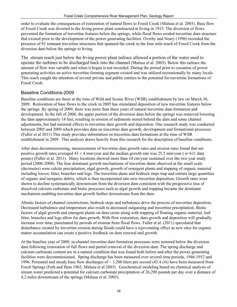
Baseline Conditions-2009 Baseline conditions are those at the time of Wild and Scenic River (WSR) establishment by law on March 30, 2009. Restoration of base flows to the creek in 2005 has stimulated deposition of new travertine features below the springs. By spring of 2009, there was more than three years of natural travertine dam formation and development. In the fall of 2008, the upper portion of the diversion dam below the springs was removed lowering the dam approximately 14 feet, resulting in erosion of sediments stored behind the dam and some channel adjustments, but had minimal effects to travertine dam growth and deposition. One research study was conducted between 2005 and 2009 which provides data on travertine dam growth, development and formational processes (Fuller et al 2011).This study provides information on travertine dam formations at the time of WSR establishment in 2009. This analysis draws heavily from this research for the description of baseline conditions.
After dam decommissioning, measurements of travertine dam growth rates and erosion rates found that net positive growth rates averaged 43 ± 4 mm/year and the median growth rate was 25.5 mm/year ( n=611 data points) (Fuller et al. 2011). Many locations showed more than 10 cm/year sustained over the two year study period (2006-2008). The four dominant growth mechanisms of travertine dams observed at the small scale (decimeter) were calcite precipitation, algal growth, growth of emergent plants and trapping of organic material including leaves, litter, branches and logs. The travertine dams and bedrock steps trap and entrain large quantities of organic and inorganic debris, which is then incorporated into new travertine deposition. Growth rates were shown to decline systematically downstream from the diversion dam consistent with the progressive loss of dissolved calcium carbonate and biotic processes such as algal growth and trapping became the dominant mechanism enabling travertine dam growth further downstream from the dam.
Abiotic factors of channel constrictions, bedrock steps and turbulence drive the process of travertine deposition. Decreased turbulence and temperature also result in decreased outgassing and travertine precipitation. Biotic factors of algal growth and emergent plants on dam crests along with trapping of floating organic material, leaf litter, branches and logs allow for dam growth. With flow restoration, dam growth and deposition will gradually increase over time, punctuated by periods of erosion from flood flows. Fuller et al. (2011) speculated that disturbance created by travertine erosion during floods could have a rejuvenating effect as new sites for organic matter accumulation can create a positive feedback on dam renewal and growth.
At the baseline year of 2009, in-channel travertine dam formation processes were restored below the diversion dam following restoration of full flows and partial removal of the diversion dam. The spring discharge and calcium carbonate content are in a natural condition that was found both before and after the power generating facilities were decommissioned. Spring discharge has been measured over several time periods, 1946-1952 and 1996. Perennial and steady base flow discharges of ~ 1,200 liters per second (42.4 cfs) have been measured from Fossil Springs (Feth and Hem 1962; Malusa et al 2003). Geochemical modeling based on chemical analysis of stream water predicted a potential for calcium carbonate precipitation of 26,290 pounds per day over a distance of 4.2 miles downstream of the springs (Malusa et al. 2003).

Fossil Creek Comprehensive River Management Plan, Geology Report
17
Existing Conditions After the diversion dam was lowered in the fall 2008, it was expected that channel adjustments would take place both upstream and downstream of the dam in response to flood flows and as sediment that was deposited above the dam became mobilized and was re-deposited through the channel downstream. Flood flows in fall and winter of 2009-2010 scoured the channel upstream of the lowered dam resulting in loss of riparian vegetation, channel bank erosion and deposition of sediment and bed load materials. The channel in this area rapidly recovered from this event. Another major destructive flood occurred again in February of 2017. A new field survey of the travertine deposition segment needs to be performed to determine rate of travertine deposition process and distance downstream of the new formations. Communications from field personnel imply that new dam formations are above the waterfall, with little to no dams reforming below the waterfall.
Figure 10. Fossil Creek channel above the diversion dam in 2009 and 2010 showing changes in the channel after a large flood flow. Channel in August of 2009 with willows and aquatic vegetation. Same channel after flood flows in 2010. Note loss of channel vegetation (Photograph courtesy of Haessig 2010)
Desired Conditions for Geology Formation of travertine dams and other natural travertine features occurs at varying rates, patterns, and locations consistent with Fossil Creek’s natural free flow, water quality, and water quantity.
In the travertine-dominated reaches of Fossil Creek, the deposition of travertine impounds sediments and forms terraces or dams that support a variety of submergent, floating, emergent, herbaceous, and shrubby habitat components. The presence of travertine increases the diversity of pools, riffles, glides, runs and backwaters, all of which provide an array of habitats for numerous plant, wildlife and fish species.
Travertine formations in areas with creek access recover during the lower visitor use periods during the fall and winter if impacts to these formations have occurred.
Summary of Alternatives
Programmatic Management Direction The CRMP provides “plan components” (plan decisions) and “other content” for the Fossil Creek Wild and Scenic River Management Area described by the land and resource management plans for the Coconino and Tonto national forests. Plan components include desired conditions, objectives, standards, and guidelines. Other content, in the form of management approaches, is meant to provide information and assist in understanding the larger management context, but is not mandatory direction. Incorporation of the plan components and other content into the Coconino and Tonto forest plans will be done through programmatic plan amendments (Chapter 3 CRMP).

Fossil Creek Comprehensive River Management Plan, Geology Report
18
Management Approach for Geology Develop collaborative relationships with recreational user groups, particularly boaters, for stewardship, protection, user community learning, and site design planning in order to protect travertine formations and deposition.
Determine interest in research, including long-term studies of travertine dam formation and recreation management, to provide a basis for determining whether human disturbances are influencing travertine deposition.
Summary of Alternatives This EIS analyzes five action alternatives in detail. These alternatives are compared to a “no action” alternative. The intent underlying each of these alternatives is summarized below. Additionally, adaptive management is critical to ensuring protection and enhancement of river values and providing flexibility to respond to changing conditions or uncertainty about the future effects of management actions. More detail about adaptive management, including associated monitoring, is provided in Chapter 6 of the CRMP.
This summary highlights the general purpose of each alternative considered in detail for the Fossil Creek CRMP and how implementation of the alternatives would occur. By considering different visitor capacities, recreation facilities, and transportation infrastructure, the alternatives would provide differing visitor experiences in Fossil Creek. The different scenarios reflected in each alternative are responsive to issues raised during the extensive scoping conducted throughout the planning process.
While each alternative would present a different visitor experience, many components would be common to all of the action alternatives. These common components result from requirements of the Wild and Scenic Rivers Act to protect and enhance river values and other Forest Service law, regulation and policy. Common components include management direction to define management goals and support progress toward those goals; monitoring and adaptive management; restoration of impacted areas to improve watershed and ecosystem function; interpretation and education to facilitate effective management and enhance visitor understanding and stewardship of wild and scenic rivers and the unique Fossil Creek environment, history, and culture; and opportunities for research. Additionally, in all alternatives, areas outside of recreation sites and away from trails and roads would serve as refugia for wildlife, fish, and plants.
Alternative A (No Action): As the “no action” alternative, Alternative A serves as the basis of comparison for analyzing the environmental impacts of implementing the action alternatives. Alternative A represents a continuation of current management of the Fossil Creek and the surrounding area. No CRMP would be developed; thus, management of Fossil Creek would not comply with the Wild and Scenic Rivers Act. Interim management such as capacity control and restoration activities would continue as needed, but would not be guided by plan direction specific to the Fossil Creek Wild and Scenic River.
Alternative B (Enhanced Protections): Alternative B would provide a more primitive visitor experience in Fossil Creek and emphasize protection of natural and cultural resources with minimal development of new facilities and infrastructure and a lower user capacity. Existing recreation sites, roads, and trails would be retained but not expanded, and a minimal amount of facility and infrastructure improvements would support the sustainability of the recreation sites and transportation infrastructure.
Alternative C (Non-Motorized Experience): Alternative C would emphasize non-motorized recreation in Middle Fossil2 by limiting motor vehicle use in portions of the river corridor during the busiest times and developing additional trails for hiking, bicycling, and equestrian use. A lower user capacity would support a quieter recreation experience. Trail access to the historic dam and Fossil Springs would be eliminated to minimize the effects of human presence in this area. Additional parking and visitor facilities would be developed at Cactus
2 “Middle Fossil” includes the segment of Fossil Creek between the Mazatzal recreation site upstream to ¼ mile above the waterfall at the end of the Lewis Trail.

Fossil Creek Comprehensive River Management Plan, Geology Report
19
Flat and Homestead to serve as the primary entry point into the river corridor; from there visitors would access the corridor by foot, bicycle, or horseback during the high-use season. During the low-use season, visitors would be able to drive past Homestead to park at a reduced number of parking spaces in existing parking lots. A moderate amount facility and infrastructure improvement would support the sustainability of recreation sites and transportation infrastructure in the corridor.
Alternative D (Motorized Use and Refugia): Alternative D would expand motorized access to Middle Fossil by increasing road connectivity and providing for scenic driving. Once hazard mitigations and repairs are completed to standards, the currently closed portion of Forest Road (FR) 708 would be reopened to all motor vehicles. Recreational use would be focused at fewer sites in the river corridor. Some recreation sites would be closed and trail access to Fossil Springs and the Waterfall would be eliminated in order to maximize relatively undisturbed habitat (refugia) areas. New facility and infrastructure development would be focused on facilitating motorized access and supporting increased use at and sustainability of recreation sites. Increases in user capacity could be phased in over time.
Alternative E, Proposed Action (Enhanced Recreation Opportunities with Phased Implementation): Alternative E would emphasize providing a variety of recreation opportunities throughout the Fossil Creek corridor. Phased development of additional parking and visitor facilities could occur at Cactus Flat, Heinrich, and Irving to support increased user capacity, and improvements at other recreation sites would be focused on supporting increased use at and sustainability of those sites. New trails for hiking, bicycling, and equestrian use would be constructed. Once hazard mitigations and repairs are completed, the currently closed portion of FR 708 would be reopened to motor vehicles less than 62 inches wide.
Alternative F (Demand-based Access): Alternative F would meet anticipated demand for recreational use in Fossil Creek through 2030 in order to prevent the need for a reservation system. This would be accomplished by establishing a large parking area at Cactus Flat, with additional parking at Homestead and several other recreation sites. New trails for hiking, bicycling, and equestrian use would be constructed. New facility and infrastructure development would support increased use at and sustainability of recreation sites. Cactus Flat and Homestead would serve as the primary entry point into the river corridor; private motor vehicle access to the remaining upstream recreation sites in Middle Fossil would be restricted during the high-use season. During the low-use season, visitors would be able to drive past Homestead to park in existing parking lots.
Monitoring Monitoring triggers adaptive management activities to reduce the physical impacts of visitor use to travertine structures. Monitoring would be accomplished using the reach from approximately 1/4-mile upstream of the waterfall to the historic dam. The monitored reach selected is based on Chamberlain’s historical description in his field notes from 1904 and the geochemical potential for travertine deposition modeled by Malusa et al. (2003). Chamberlain wrote “For the first half mile it is an ordinary rocky mountain brook. Below this the lime salts deposit and build dams forming a series of pools and falls from a few inches to several feet in height, the highest is said to be about 10 ft. This region is said to be about 2 miles long, after which it again becomes an ordinary stream”. The historic diversion dam approximates where Chamberlain notes the initial travertine dams forming and the extent downstream prior to alteration of stream flows for power generation correlates with the geochemical modeling of CaCO3 precipitation. There are also relicts of previous dams located at the waterfalls and below (Overby and Neary 1996), yet when these dams were formed and the channel morphology and conditions driving travertine deposition at the time of their formation is unknown.
Monitoring to detect new notching, trampling, or other visitor use impacts to travertine dams utilizing fixed photo points repeated semi-annually or annually is an effective and inexpensive method (Hall 2002). Notching, in particular, concentrates water flow at a certain point, and this new low point results in a lower water level behind a travertine dam and easily detected with repeat photography. When notched, water no long flows over the entire length of the dam, where it would otherwise be continuously laying down travertine. Baseline fixed photo point monitoring would identify dam(s) that span the creek and include streamside conditions. A permanently fixed object, such as a geologic feature, will be established as a reference for the location of the particular dam or

Fossil Creek Comprehensive River Management Plan, Geology Report
20
stream reach being monitored. Each photo point site will be memorialized (e.g. buried rebar), GPS location recorded, and site-specific identification documented. The GPS coordinates, along with rebar are used to precisely relocate the photo point. The type of camera, photo settings, height above the ground, ordination, and distance to nearest object being monitored will be detailed. Within the camera’s field of view, site identification and date information will be included for the permanent record with each photograph taken. A field notebook will be kept to assist in the relocation of photo points and camera settings. Repeat photographs will be compared for visitor use impacts. In order to factor in annual changes due to flooding, recorded flows using the nearby USGS stream gage 09507980 at Fossil Creek or other nearby gages on the Verde River will be utilized to assess flooding impacts. Travertine outcrops or formations outside the active channel would be visually monitored at the same time to track any changes due to natural disturbance or visitor use impacts.
Adaptive Management Actions
Physical Impact to travertine structures The soft threshold is designated as travertine dams in the reach of Fossil Creek from 1/4-mile upstream of the waterfall upstream to the historic diversion dam. Displaying new (as of implementation of the CRMP) evidence of impacts resulting from visitor use. Impacts include notching of travertine dams, which lower water levels in pools exposing recent travertine deposition. Adaptive management action for the soft threshold includes:
• Investigate factors contributing to visitor use impacting travertine dams to determine what adaptive management actions are most likely to be effective. Accordingly, one or more of the following adaptive management actions may be taken:
• Increase signage, education and outreach efforts, or ranger presence with the goal of reducing impacts to travertine resulting from boating or other visitor use.
• Pursue expanded partnerships with the boating community to promote boating practices that limit impacts to travertine.
• If not already done, improve road access at times of high flow to reduce boating impacts to travertine features by improving sections of road that are problematic in wet conditions, thus reducing the need for wet weather closure.
The hard threshold is designated as a series of spatially connected travertine features in the reach of Fossil Creek from approximately 1/4-mile upstream of the waterfall upstream to the historic diversion dam. Displaying measurable evidence of human impacts because such a pattern of impacts risks altering travertine deposition throughout the affected reach. Adaptive management actions for the soft threshold include:
• Change the locations, kinds, or amounts of visitor use in the Fossil Creek WSR corridor. Actions may include, but are not limited to,
o Reallocate the number of permits among recreation sites (if permits are used).
o If not already in place, establish permits for access to the WSR corridor, for access to specific locations within the corridor, or for specific kinds of use (such as boating).
o Reduce the overall corridor-wide user capacity.
o Implement seasonal boating restrictions during the base flow period, when travertine features would be most susceptible to impacts (generally October-January and April-June).
o Prohibit boating in the reach of Fossil Creek from the historic dam downstream to 1/4-mile upstream of the waterfall at the end of the Lewis Trail.
o Implement full closure to boating only if the geology ORV is at risk of long-term degradation.

Fossil Creek Comprehensive River Management Plan, Geology Report
21
Environmental Consequences Unplanned activities that threaten travertine dams and deposits both within and outside the active channel are mining, rock collection and removal of or damage to travertine formations. Development of social trails, walking up and down the creek, trampling sensitive formations, graffiti on rock outcrops, removing or damaging riparian vegetation and woody debris all can contribute to damage or loss of travertine formations. The quantity and quality of biotic inputs into the stream that contribute to travertine dam growth can be altered by decreases in vegetative cover and increased bare soil. Increased erosion and sedimentation from bare soil can lead to increased turbidity resulting in less algae productivity and higher sediment loads. This in turn results in decreased travertine growth and greater abrasion to existing travertine structures.
Kayaking and rafting are a small component of overall recreation activity in Fossil Creek (12% from survey Hancock et al. 2007). Kayaking/rafting during base flows can damage surface growth of travertine at dams, but is less likely at high flows when the kayaking and rafting recreation is highest.
Flood events are a natural process that erodes travertine formations and dams and could also change channel morphology, resulting in dam destruction or channel aggradation. During the study periods of 2006-2008 there were several winter storm flood events that eroded travertine in the measured sites. However, there was a net positive travertine accrual. Fuller et al. (2010) also noted the annual peak flood events that abraded dams on an annual basis, but also witnessed the much larger event that caused extensive destruction to travertine dams. This larger event was determined to have a frequency of approximately every 4 years. There is a need to quantitatively correlate flood flows with potential dam destruction.
Natural or human-caused fires along with insect epidemics and drought can alter watershed vegetative cover. The loss of vegetative cover can decrease slope stability and increase potential landslides or other mass wasting events (Chirico et al. 2013). Landslides and rockfall have the ability to alter channel morphology and negatively impact roads and trails.
Fossil Springs and other large springs of the area derive their water almost entirely from the deep regional aquifer up-gradient beneath the Mogollon Rim. In the Pine-Strawberry region this water table is at about 4,400 to 4,600 feet in elevation and is only about 50 to 200 feet above Fossil Springs in elevation. The water rights for Fossil Creek are discussed in detail in the Free Flow, Water Quality, Water Quantity, Riparian Function, Soil Condition and Air Quality Report.
Programmatic Analysis of the Effects of Management Direction on Geology Implementation of the CRMP under the action alternatives, including Management Direction and Monitoring, Adaptive Management will result in reduced effects to the Geology ORV compared to the no action alternative. As is the case throughout this analysis, Management Direction for river resources is articulated from the perspective of the Geology ORV. Below is a summary of the effects of management direction for other program areas on the Geology ORV. This analysis summarizes all aspects of Management Direction regardless of alternative.
Table 2: Summary of programmatic level effects of the CRMP on Geology ORV Program Area Anticipated Effects to the Geology ORV Free Flow, Water Quantity, and Water Quality
Free flow conditions, a federally reserved water right for stream flows, meeting water quality standards, protecting ecological processes and biodiversity of groundwater-dependent species, restoring springs to proper function, and rehabilitating denuded areas outside of recreation sites, all contribute to the protection of the Geology ORV.
Riparian Function Implementing management direction for proper functioning riparian areas will maintain the deposition and formation of travertine dams and protection of the Geology ORV.
Vegetation Intact terrestrial vegetation will reduce erosion and sediment inputs that can inhibit travertine deposition and dam formation, thereby protecting the Geology ORV.
Soil Condition Minimizing bare area impacts due to visitor use, particularly outside of recreation sites, and restoration to reduce erosion will result in greater channel stability, increased travertine dam strength, and protection of the Geology ORV.

Fossil Creek Comprehensive River Management Plan, Geology Report
22
Program Area Anticipated Effects to the Geology ORV Geology Protection of travertine dams, the unique structural and vegetative habitat they create, and the natural
processes of development and destruction ensure the protection of the Geology ORV. Wildlife, Fish and Aquatic Species
Maintaining Wildlife, Fish, and Aquatic species Habitat is essential to sustaining the seasonal dynamics of travertine formations and the Geology ORV.
Traditional Cultural Practices
Maintenance of a “natural and untrammeled feel’ will reduce disturbance to vegetation and minimize bare soil due to visitor use that protects the Geology ORV.
Recreation Impacts to the Geology ORV will be reduced when appropriate infrastructure is in place, visitor capacities are appropriately set to minimize or eliminate recreation use outside of recreation sites, entry is managed, developed camping is limited to outside the 100 year floodplain, and dispersed camping is limited. In addition, there will be no new trails across springs or paralleling Fossil Creek to connect recreation sites. Recreation fees and partnerships will ensure resources to implement the CRMP, monitoring, and adaptive management. Overall, recreation guidelines strive to ensure visitors are satisfied with their recreation experience, which will typically mean their behavior supports protection of river values including the Geology ORV. Most visitors will recreate responsibly, and the majority of visitors will stay within the designated areas. As a result, the refugia in between recreation sites will be largely free of human presence and maintains presence of travertine dams where biochemically possible, thereby protecting the Geology ORV. Appropriate design will ensure that roads, trails, recreation sites and infrastructure will not increase erosion and degrade water quality or result in adverse effects to the geology ORV.
Recreation/Lands Special Uses
Vegetation under powerlines is kept mainly free of tree canopy and this may include riparian vegetation, reducing stream bank cover which could impact the Geology ORV. Permit holders and filming permitees should provide an education component to their content and should have the primary objective of disseminating information about wild and scenic rivers and their values. In general, recreation special uses permits facilitate resource protection and protect or enhance river values, including the Geology ORV. While outfitter/guided activities have the potential to increase erosion and sedimentation, impacts will be less than unguided recreation because guides are limited in group size, have a responsibility to educate their customers, and their activities can be closely regulated through a tailored special use permit. Research activities are likewise screened, tailored to reduce impacts to the Geology ORV and Water Resources, and contribute data needed to make informed management changes.
Roads and Facilities
Proper construction and maintenance of roads and facilities, and decommissioning of unauthorized roads would avoid and mitigate adverse effects of erosion and sedimentation to the Geology ORV.
Scenery Resources There are no negative effects from scenery guidance on the Geology ORV. Using native vegetation buffers to soften views of infrastructure and rehabilitation of unplanned bare ground areas outside of recreation sites, trails and roads will reduce erosion and sedimentation that contribute to the stability of Riparian Resources and to the Geology ORV.
Special Areas Act-driven restrictions in special areas indirectly benefit the Geology ORV through minimizing the use of motorized equipment and mechanized travel thereby reducing erosion and sedimentation, as well as protecting and enhancing river values. Expansion of the Fossil Springs Botanical Area would increase the area in which the protection and maintenance of physical and biological processes unique to the Fossil Springs area is emphasized. This would benefit the Geology ORV by supporting protection of the area around the springs that are the source of super saturated water that creates travertine structures in the Fossil Creek channel.
Interpretation and Education
Interpretation and education will directly benefit the Geology ORV. These benefits can include reducing of trampling vegetation and physical destruction of travertine dams.
Effects of the Forest Plan amendments to correct the Fossil Creek Designated Wild and Scenic River Special Area boundary on the Coconino National Forest, incorporate the CRMP’s management direction into the Coconino and Tonto forest plans, establish a Fossil Creek Wild and Scenic River Designated Area on the Tonto National Forest, and recommend additions to the Fossil Springs Botanical Area are the same as those effects of the programmatic management direction discussed above.
Direct and Indirect Effects of Alternative A -No Action Under the No Action alternative, the river’s ORVs may not be adequately protected or enhanced, even with continued implementation of interim management measures. The Geology ORV and the travertine system of dams could be degraded by physical impacts from unplanned visitor use such as trampling of the dams and biotic communities associated with the dams. Adams et al. (2015) measured increased overall vegetation coverage by 18%-21% relative to reference conditions in the middle reaches of Fossil Creek, yet the results were driven by large increases at a few sites while some sites declined. An increase in trampling of vegetation was measured

Fossil Creek Comprehensive River Management Plan, Geology Report
23
(Adams et al. 2015), which correlated with a substantial increase in visitor use (Rotert 2013). Subjective evidence of surface erosion and/or notching by kayakers and rafters has been noted, yet no formal monitoring of disturbance to travertine dams has been performed to date. Under the No Action alternative existing interim management measures would not formally monitor the physical impacts from visitor use and no formal management direction to alter visitor use or timing that could allow the natural cycle of construction-destruction of the travertine formations is in place. Visitor demand and use have increased over the entire Fossil Creek area (Rotert 2013). With increased visitor use and a lack of comprehensive management provided by the CRMP, the potential to negatively impact the Geology ORV is likely to occur.
Direct and Indirect Effects Common to Action Alternatives Under all alternatives the ability of Fossil Creek to form travertine dams is secure as long as the quantity of water emanating from Fossil Springs remains unchanged. The Fossil Springs flow comes from the Limestone Aquifer underlying the C Aquifer. Surface flows sourced from these aquifers within FS-managed lands will be protected as directed by the regional supplement (2500-2001-1) to Forest Service Manual (FSM) 2500, Chapter 2540, Water Uses and Development. Both of these aquifers are part of the larger regional groundwater system, therefore portions of these aquifer fall under jurisdiction other than the FS that would allow development of groundwater withdrawals potentially diminishing flows emanating from Fossil Springs and ultimately negatively impacting travertine deposition in Fossil Creek.
Direct effects to travertine dams can occur when physical contact from recreational activities such as swimming, wading, and boating fractures and abrades the soft porous calcite of newly formed travertine. The action alternatives would support protection of travertine dams by providing environmental education and interpretive information on travertine structures and focusing recreational use in areas that are less susceptible to impacts. Recovery periods during the fall and winter when visitor use is lowest also allow time for travertine deposition to form a dense crystal structure that is much more durable. The reach within the recreational segment of Fossil Creek having the greatest potential for travertine dam formation, the historic diversion dam to ¼ mile above the waterfall, does not have designated recreation sites, which also limits the potential physical contact by visitors at travertine dams. Potential for travertine dam formation below the high travertine deposition reach is greatly diminished, yet there are relicts within this reach documenting that under certain conditions travertine dams can form. This reach within the recreational segment of the creek between the waterfall and the Mazatzal recreation site is where the majority of designated recreation sites are located. Each action alternative also provides infrastructure to support education and interpretative information focused on supporting management activities, wild and scenic rivers, the unique Fossil Creek environment, and promoting visitor stewardship to protect the geology ORV.
All action alternatives designate recreation sites and armored creek access points to be located that limit sediment inputs, while decommissioning and restoration of trails and roads will also reduce sediments inputs that can decrease travertine deposition rates and increase abrasion during flood events (Table 3).
The action alternatives also encourage research efforts to better understand the interaction among water chemistry, precipitation kinetics, channel morphology, turbulence, carbon dioxide degassing, biology, erosion and sedimentation that produces the dynamic spatial and temporal arrangement of travertine dams. This information would greatly assist in further development of adaptive management actions that protect and enhance the Geology ORV.
Direct and Indirect Effects Unique to Action Alternatives The recreational and scenic values of Fossil Creek and its proximity to the Phoenix metropolitan area result in high levels of recreation demand. Physical contact with travertine dams during recreational activities such as hiking, swimming, and boating have the potential to abrade, trample, and notch newly formed travertine deposits, especially at the crest of the dams. The action alternatives differ in the number of recreation visitors allowed at one time (PAOT) in the recreation segment of Fossil Creek, therefore the potential to come in contact with travertine dams. Alternative B would restrict PAOT by almost 21%, while alternative C restricts use by 11% when

Fossil Creek Comprehensive River Management Plan, Geology Report
24
compared to alternative A (Table 3). Alternatives D, E, and F all increase PAOT respectively (12%, 86%, 219%) compared to alternative A (Table3). Alternative B, C, and D eliminate trail access to Fossil Springs further reducing the potential of visitors coming in physical contact with travertine dams. Alternative B does not increase recreation sites, roads, or trails providing the greatest amount of protection. Alternative E and F allow access to Fossil Springs, with alternative E also allowing camping in designated sites at Fossil Springs, which raises the potential for contact with visitors at active travertine formations.
The indirect effect of sediment inputs from roads, trails, and recreational sites for all the action alternatives are comparable. Decreases in total acres disturbed and increases in acres restored are greater for all action alternatives compared to the no action alternative (A). With the proposed improvement to the infrastructure for all action alternatives sediment will be reduced compared to alternative A. Alternatives C, E, and F propose more trail mileage than alternatives A, B, and D, with Alternative E proposing the greatest extent of trails. Alternative D reduces recreation site area by more than 50%.
The creek reach with the greatest potential for travertine formation is from the historic diversion dam downstream to ¼ mile above the waterfall, yet this reach does not have any designated recreation sites under any of the action alternatives. With the improvement to infrastructure, providing education and interpretive information, and cooperative outreach to user groups there is very little difference in the potential negative impacts from any of the action alternatives to the geology ORV. If a flood event alters deposition conditions (turbulence), allowing for travertine dam formation below the waterfall, monitoring activities and adaptive management for each of the alternatives would be in place to protect the geology ORV.
Table 3. Summary of effects of implementing the alternatives Resource Element
Resource Indicator/ Measure
Alternative A
Alternative B
Alternative C
Alternative D
Alternative E
Alternative F
Geology Geology Resources
Recreation site capacity (PAOT) 810 640 720 905 1510 2580
Geology Resources
Total acres of disturbed area
126.3 94.1 97.2 95.9 114.4 108.7
Geology Resources
Total acres of restored bare areas, roads, and trails
0 41.2 43.7 46.4 40.6 42.0
Geology Resources
Roads in project area 16.4 mi 72.1 ac
15.6 mi 72.0 ac
15.4 mi 71.7 ac
15.4 mi 71.6 ac
15.6 mi 71.4 ac
15.6 mi 70.6 ac
Geology Resources
Decommissioned roads 0 ac 3.7 ac 3.8 ac 3.8 ac 3.7 ac 3.9 ac
Geology Resources
Acres of disturbed designated trails creek access Sites
7.1 5.7 7.2 2.8 7.8 6.7
Geology Resources
Acres of restored trails 0 1.9 2.7 4.5 2.1 3.4
Cumulative Effects Analysis In 1999 APS agreed to decommission the hydroelectric power generating system associated with Fossil Creek. This resulted in free flow down the natural channel beginning in June of 2005 and initiated travertine dam formations in the downstream reach historically known for these features. APS’s final withdrawal from the Fossil Creek channel occurred in April of 2009 when the diversion dam was lowered approximately 14 feet. This lowering of the diversion dam resulted in sediment previously impounded behind the dam to be released during flood events and channel incisement above the historic dam site back to approximately the channel bed prior to power generating facilities being constructed (Monroe 2002). The release of full flows back into the natural channel also altered the small reach below Irving that over several decades formed travertine dams. The potential

Fossil Creek Comprehensive River Management Plan, Geology Report
25
for dam formation in this reach either no longer exists or is greatly diminished as precipitation of travertine in the historic travertine reach lowers the saturation indices for CaCO3 and the potential for deposition. Visitor use in recreational segment of Fossil Creek will likely continue to impact travertine formations that developed below the Irving tailrace. However, because these travertine formations were the result of altered deposition dynamics, it is not anticipated that the Geology ORV will be adversely impacted by visitor use. A more natural pattern of deposition is occurring in the historic travertine reach of Fossil Creek that will receive little visitor use under the CRMP. Over time the travertine dams below Irving will be destroyed by flooding and only relicts left to memorialize the time when dams existed in this reach. The building and destruction of travertine dams in Fossil Creek is the process that creates the dynamic geologic system designated as an ORV. While abrupt flood events can decimate several years of travertine building it also destroys evidence of human impacts to travertine dams. Implementation of the CRMP will provide direction to minimize human impacts, and over time flood events will obscure past human impacts.
Beginning in January of 2011 a series of interim decisions by the Forest Service were made for visitor safety and protection of resources through defined parking area, trails and creek access, education information, and rehabilitation of overused areas. These interim measures were needed as the obvious unmanaged visitor use and lack of facilities was degrading this popular recreation area, including obvious physical impacts to travertine dams. Further measures beginning in February of 2016 instituted a seasonal reservation system throughout the river corridor with soil and water best management practices, cultural design features, and monitoring requirements, followed the next year with the installation of eight vault toilets within the Fossil Creek wild and scenic river corridor to minimize the impact of human waste on resources. These short-term measures were implemented until the CRMP could be developed and approved. Imbedded within these measures were management activities to help mitigate the abrasion, trampling, and notching caused by visitor use (e.g. swimming, hiking, and boating) of the fragile newly formed travertine typically found at the crests of these dams. The beneficial effect of the interim management measures are anticipated to continue when the CRMP is implemented and many of these measures will continue under guidance of the CRMP. As a result, these past actions in combination with those proposed under the CRMP will result in beneficial effects to the Geology ORV.
Designation of Fossil Creek as a Wild and Scenic River, implementation of the CRMP, and inclusion of management direction for Fossil creek into the Land and Resource Management Plan for both the Coconino and Tonto National Forests will protect the Geology ORV into the foreseeable future. Travertine systems are very resilient. The ability to reconstruct dams after devastating flood events is well known. During the Euro-American historical period, Fossil Creek has experienced what will be the greatest future threat to the Geology ORV. This threat is diminished or completely eliminated flows within the Fossil Creek channel. Water is a precious commodity within the Southwest region. If population growth continues, the need for this precious commodity may lead to water withdrawals from deep aquifers such as the one that feeds Fossil Springs. Currently, withdrawal plans from this aquifer are exploratory at best and limitations due to the very nature that creates the Geology ORV, the super saturation with respect to CaCO3 also creates limitations for municipal water use. Implementation of the CRMP will protect the formation of travertine dams in Fossil Creek that creates the extraordinary step-pool morphology and complex aquatic habitat punctuated by destructive floods, therefore the CRMP will protect the Geology ORV of Fossil Creek.
Acronyms CRMP – Comprehensive River Management Plan FC – Fossil Creek ORV – Outstandingly Remarkable Value PAOT- People at One Time WSR – Wild and Scenic River

Fossil Creek Comprehensive River Management Plan, Geology Report
26
References Cited Adams, Kenneth, Brenda Harrop, Michele James and Jane Marks. 2012. Riparian Vegetation and Water Quality
Monitoring: Middle Fossil Creek Riparian Habitat Protection and Restoration Project, 2011 Annual Report: Monitoring Data and Analysis. Arizona Water Protection Fund Grant No. 09-162WPF., Northern Arizona University, Marks Lab of Aquatic Ecology, Department of Biological Sciences. 40 p.
Blakey, R.C., 1990. Stratigraphy and geologic history of Pennsylvanian and Permian rocks, Mogollon Rim region, central Arizona and vicinity, Geol. Soc. Am. Bull. 102, 1189-1217.
Chamberlain, F.M., 1904. Notes on work in Arizona - 1904. Unpublished report on file with the Smithsonian Institution Archives, Washington, D.C.
Chirico, g. B., M. Borga, P. Tarolli, R. Rigon, and F. Preti. 2013. Role of vegetation on slope stability under transient unsaturated conditions. Procedia Environ. Sci. 19:932-941.
Cook J.P., Pearthree, P.A., Onken, J.A. and Bigio, E.R., 2010, Mapping of Holocene River Alluvium along Oak Creek, Wet Beaver Creek, West Clear Creek, Fossil Creek, and the East Verde River, Central Arizona: Arizona Geological Survey Digital Map - River Map 03 (DM-RM-03), map scale 1:24,000.
Dandurand, J.L., Gout R., Hoefs J., Menschel G., Schott J., Usdowski E., 1982. Kinetically controlled variation of major components and carbon and oxygen isotopes in a calcite precipitating spring. Chem. Geol. 36, 299 315.
DeSutter, S. 2015. Fossil Creek Wild & Scenic River – 2015 Visitor use data summary. Red Rock Ranger District, Coconino N.F. 8 pp.
Dickenson, W.R., Klute, M.A., Hayes, M.J., Janecke, S.U., Lundin, E.R., McKittrick, M.A., Olivares, M.D., 1988, Paleogeographic and paleotectonic setting of Laramide sedimentary basins in the central Rocky Mountain region: Geological Society of American Bulletin, vol. 100, no. 8, p. 1023-1089.
Feth, J.H., Hem J. D., 1962. Springs along the Mogollon Rim in Arizona. In: Guidebook of the Mogollon Rim region, east-central Arizona, New Mexico Geological Society, 13th Field Conference, Socorro, N. Mex., pp. 129-134.
Fuller, B.M., L.S. Sklar, Z.G. Compson, K.J. Adams, J.C. Marks, and A.C. Wilcox. 2011. Ecogeomorphic feedbacks in regrowth of travertine step-pool morphology after dam decommissioning, Fossil Creek, Arizona. Geomorphology 126: 314-332.
Gaeaorama Inc., 2006, Geology and Structural Controls of Groundwater, Mogollon RimWater Resources Management Study: Blanding, Utah, Gaeaorama Inc.
Gandin, A., and E. Capezzuoli. 2008. Travertine versus calcareous tufa: Distinctive petrologic features and stable isotopes signatures. Italian J.Quaternary Sci.21 (1B), 125-136.
Green, L. M. 2008. A conceptual hydrogeologic model for Fossil Spring, Western Mogollon Rim, Arizona: Implications for regional springs. MS Thesis, Northern Arizona University.
Jacobson, R.L., Langmuir D., 1970. The chemical history of some spring waters in carbonate rocks. Ground Water 8(3), 5-9.
Hall, F.C. 2002. Photo Point Monitoring Handbook: Part A-Field Procedures. USDA, Forest Service, PNW-GTR-526.
Hammer, O., D.K. Dysthe, and B. Jamtveit. 2010. Travertine terracing:pettern and mechanisms. Geo. Soc. London Special Pub. DOI: 10.1144/Sp336.18.

Fossil Creek Comprehensive River Management Plan, Geology Report
27
Hancock, P., M. Lee, K. McDaniels, and J. Hockersmith. 2007. 2004-2006 Fossil Creek Visitor Survey. Northern Arizona University School of Forestry. 34 pp.
Krautblatter, M., M. Moser. (2009). A nonlinear model coupling rockfall and rainfall intensity based on a four year measurement in a high Alpine rock wall. Nat. Hazards Earth Syst. Sci., 9, 1425-1432.
Langmuir, D., 1971. The geochemistry of some carbonate groundwater in central Pennsylvania. Geochim. Cosmochim. Acta 35, 1023 1045.
Leighty, R.S., 1998, Tertiary volcanism, sedimentation, and extensional tectonism across the Basin and Range-Colorado Plateau boundary in central Arizona, in Duebendorfer, E.M., ed., Geologic excursions in northern and central Arizona: Flagstaff, 59-95.
Loomis, Grant, 2010. Tonto National Forest, Fossil Creek Free Flow Assessment. 9 pg
Lu, G., Zheng, C., Donahoe, R.J., Berry Lyons, W., 2000. Controlling processes in a CaCO3 precipitating stream in Huanglong Natural Scenic District, Sichuan, China. J. Hydrol., 230, 34-54.
Lummis, C.F., 1891. The greatest natural bridge on earth. In some strange corners of our country: The wonderland of the Southwest, pp. 142-145. The Cadury Company, New York.
Malusa, John, Overby, Steven T., and Parnell, Roderic A. 2003 Potential for Travertine Formation: Fossil Creek, Arizona. In Applied Geochemistry 18 (2003) pf 1081-1093
Mayer, L., 1979, Evolution of the Mogollon Rim in central Arizona: Tectonophysics, v. 61, p. 49-62.
Monroe, S.A. 2001. A Wonderful Water Power: Hydroelectric Power at Fossil Creek-100 years. Pine-Strawberry Archeological & Historical Society, Inc. Pine, AZ. 46 p.
Monroe, S. A. 2002. Travertine and Concrete: A Geomorphological and Historical Study of a Damsite at Fossil Creek, Arizona (Unpublished master’s thesis). Northern Arizona University, Flagstaff, AZ.
Overby, S.T., Neary D.G., 1996. Travertine geomorphology of Fossil Creek. In: Vol. 16, Proceedings of the 1996 meetings of the Arizona section-American Water Resources Association, and the Hydrology Section, Arizona-Nevada Academy of Science. Tucson, Arizona, April 20, 1996, pp. 9-12.
Reynolds, S.J., Potochnik, A., and Leighty, R.S., 2001, Tectonic evolution of the Arizona transition zone; The geologic transition, high plateaus to Great Basin; a symposium and field guide; the Mackin volume: Guidebook - Pacific Section, American Association of Petroleum Geologists, v. 78, p. 427-428.
Rotert, A. 2013. Fossil Creek Wild & Scenic River visitor use monitoring and bare ground inventory project 2012. Red Rock Ranger District, Coconino N.F. 30 pp.
Spencer, J.E. and Reynolds, S.J., 1989, Middle Tertiary tectonics of Arizona and adjacent areas in Jenney, J.P and Reynolds, S.J., eds., Geologic evolution of Arizona: Tuscon, Arizona Geological Society Digest 17, p. 539-574.
Stumm, W., Morgan J.J., 1981. Aquatic chemistry. John Wiley & Sons, Inc., New York.
Twentner, F.R., 1962, The significance of the volcanic rocks in the Fossil Creek area, Arizona in Guidebook of the Mogollon Rim region east-central Arizona, New Mexico Geological Society, 13th Field Conference, October 18–20, 1962: New Mexico Geological Society, p.107–108.
USDA Forest Service. 2006. Changing the Debate on Managing National Forests and Grasslands. Available at www.fs.fed.us/news/2003/speeches/09/change-debate.shtml. Accessed 3 May 2006.

Fossil Creek Comprehensive River Management Plan, Geology Report
28
USDA Forest Service. 2014. FN708 Conceptual Remedies. Stephen Romero. USDA Forest Service.
USDI Bureau of Reclamation. 2008. Managing Water in the West, Mogollon rim Water Resources, Management Study report of Findings. USDI, Bureau of Reclamation, Phx Area office, 161 pages
Weir, G.W., and Beard, L.S., 1997, Preliminary geologic map of the Strawberry quadrangle, Yavapai, Gila, and Coconino counties, Arizona: U.S. Geological Survey Open-file Report 94-265, scale 1:24,000.
Weir G.W., Ulrich, G., Nealey, L.D., 1989, Geologic map of the Sedona 30’ by 60’Quadrangle, Yavapai and Coconino counties, Arizona: U.S. Geological Survey Miscellaneous Investigations Series, Report 1-1896, scale 1:100,000, 1 sheet.
Weir, G.W., Beard, S.L., 1984. Geologic Map of the Fossil Springs roadlesss area,Yavapai, Gila, and Coconino Counties, Arizona: U.S. Geological Survey,Miscellaneous Field Studies Map MF-1568-C, scale 1:24,000, 1 sheet.

Fossil Creek Comprehensive River Management Plan, Geology Report
29
Appendix I
Federal Law This listing of laws and regulations pertinent to geology, geologic resources (excluding paleontological resources and caves) and geologic hazards was obtained from FSM 2800, Chapter 2880 – Geologic Resources, Hazards and Services, 2880.11, pp. 5-8.
Multiple Use -- Sustained Yield Act of June 12, 1960 (MUSY) (74 Stat. 215; 16 U.S.C. 528-531). (FSM 2501.1.) This act requires due consideration for the relative values of all resources and implies that the administration of nonrenewable resources must be considered.
Watershed Protection and Flood Prevention Act of August 4, 1954, as Amended (68 Stat. 666; 16 U.S.C. 1001). (FSM 2501.1.) This act authorizes the Secretary of Agriculture to share costs with other agencies in recreational development, ground-water recharge, and water-quality management, as well as the conservation and proper use of land.
Federal Water Pollution Control Act of July 9, 1956, as Amended (33 U.S.C. 1151) (FSM 2501.1); Federal Water Pollution Control Act Amendments of 1972 (86 Stat. 816) (FSM 2501.1), and Clean Water Act of 1977 (91 Stat. 1566; 33 U.S.C. 1251). (FSM 2501.1, 7440.1) These acts are intended to enhance the quality and value of the water resource and to establish a national policy for the prevention, control, and abatement of water pollution. Ground water information, including that concerning recharge and discharge areas, and information on geologic conditions that affect ground water quality are needed to carry out purposes of these acts.
Wilderness Act of September 3, 1964 (78 Stat. 890; 16 U.S.C. 1131-1136). (FSM 2501.1) This act describes a wilderness as an area which may also contain ecological, geological, or other features of scientific, educational, scenic, or historical value. These geological features are generally identified for wilderness classification purposes.
National Forest Roads and Trails Systems Act of October 13, 1964 (78 Stat. 1089; 16 U.S.C. 532-538). (FSM 7701.1) This act provides for the construction and maintenance of an adequate system of roads and trails to meet the demands for timber, recreation, and other uses. It further provides that protection, development, and management of lands will be under the principles of multiple use and sustained yield of product and services (16 U.S.C. 532). Geologic conditions influence the final selection of route locations.
National Environmental Policy Act of January 1, 1970 (NEPA) (83 Stat. 852 as Amended; 42 U.S.C. 4321, 4331-4335, 4341-4347). (FSM 1950.2) This act directs all agencies of the Federal Government to utilize a systematic interdisciplinary approach which will ensure the integrated use of the natural and social sciences in planning and in decision making which may have an impact on man's environment. Geology is one of the applicable sciences.
Mining and Minerals Policy Act of December 31, 1970 (84 Stat. 1876; 30 U.S.C. 21a). This act provides for the study and development of methods for the disposal, control, and reclamation of mineral waste products and the reclamation of mined lands. This requires an evaluation of geology as it relates to ground water protection and geologic stability.
Disaster Relief Act of 1974 (88 Stat. 143; 42 U.S.C. 5121, 5132). Section 202(b) states that the President shall direct appropriate Federal agencies to ensure timely and effective disaster warnings for such hazards as earthquakes, volcanic eruptions, landslides, and mudslides. The Federal Register, Vol. 42, No. 70 of April 12, 1977, "Warnings and Preparedness for Geologic Related Hazards," implies coordination with the U.S. Geological Survey in such warnings.
Forest and Rangeland Renewable Resources Planning Act of August 17, 1974 (RPA) (88 Stat. 476; 16 U.S.C. 1600-1614) as Amended by National Forest Management Act of October 22, 1976 (90 Stat. 2949; 16 U.S.C.

Fossil Creek Comprehensive River Management Plan, Geology Report
30
1609). (FSM 1920 and FSM 2550) This act requires consideration of the geologic environment through the identification of hazardous conditions and the prevention of irreversible damages. The Secretary of Agriculture is required, in the development and maintenance of land management plans, to use a systematic interdisciplinary approach to achieve integrated consideration of physical, biological, economic, and other sciences.
The Wild and Scenic Rivers Act (WSRA) of 1968 (PL 90-542; 16 USC 1271-1278) establishes a system of rivers that “shall be preserved in free-flowing condition, and ... their immediate environments shall be protected for the benefit and enjoyment of present and future generations” (16 USC. 1271).
Section 7 directs federal agencies to protect the values of designated rivers from adverse effects of “water resources projects” within the bed and banks of the river. Section 7 requires a rigorous process to ensure that proposed water resources projects, implemented or assisted by federal agencies within the bed and banks of designated rivers, do not have a “direct and adverse effect” on the values for which the river was designated.
A Section 7 analysis will be completed for actions proposed in the CRMP alternatives occurring within the bed and banks of Fossil Creek, specifically repair and extension of the gabion on FR 502 between Sally May and Purple Mountain (all alternatives), construction of a new Fossil Creek bridge on FR 708 (all alternatives), and construction of a new bridge across Fossil Creek to access the Irving site (alternatives D and E only). Any future actions proposed within the bed and banks of Fossil Creek or on tributaries to Fossil creek would be subject to a separate Section 7 analysis process.
Section 9 Section 9 of the Act describes applicability of U.S. mining and mineral leasing laws. In summary, U.S. mining and mineral leasing laws are applicable in scenic and recreational segments, but on national forest, are subject to regulations prescribed by the Secretary of Agriculture to carry out the purposes of the Wild & Scenic Rivers Act or regulations of the Forest Service, for example land management plans. Subject to valid existing rights, the minerals within wild river segments are withdrawn from mineral entry for locatable and leasable minerals.
Section 10 Section 10 of WSRA sets forth the management direction for designated river segments and includes the following:
• WSRA shall be administered to protect and enhance a river’s ORVs. Insofar as possible, uses that are consistent with this and do not substantially interfere with public enjoyment and use of these values should not be limited (Section 10[a]; 16 USC 1281[a]).
• In administration of a Wild and Scenic River, “primary emphasis shall be given to protecting its aesthetic, scenic, historic, archeologic, and scientific features. Management plans may establish varying degrees of intensity for its protection and development, based on the special attributes of the area” (Section 10[a]; 16 USC 1281[a]).
• Wild and Scenic River segments inside congressionally designated wilderness are subject to both WSRA and the Wilderness Act. Where the two conflict, the more restrictive (i.e., protective of resources) regulation will apply (Section 10[b]; 16 USC 1281[b]).
• The Secretary of Agriculture, in his or her administration of any component of the national wild and scenic rivers system area, may utilize the general statutory authorities relating to the national forests in such a manner as he or she deems appropriate to carry out the purposes of WSRA (Section 10[d]; 16 USC 1281[d]).
• Section 10(e) enables administering federal agencies to enter into cooperative agreements with state and local governments to allow them to participate in the planning and administration of components of the Wild and Scenic Rivers System that include or adjoin state- or county-owned lands.

Fossil Creek Comprehensive River Management Plan, Geology Report
31
State and Local Law
Regional Water Quality Control Board Requirements The Arizona Department of Environmental Quality (ADEQ) is required by the federal Clean Water Act to conduct a comprehensive analysis of water quality data associated with Arizona’s surface waters to determine whether state water quality standards are being met and designated uses are being supported. ADEQ partners with several organizations to ensure these areas are swimmable and fishable.

Fossil Creek Comprehensive River Management Plan, Geology Report
32
Appendix II Geologic maps and GIS data sets that were used in this analysis are listed below.
1. Preliminary Geologic Map of the Strawberry quadrangle, Yavapai Gila and Coconino Counties, Arizona (Wier and Beard 1994). The mapping was published by the U.S. Geological Survey. This geologic map (scale 1:24,000) was reviewed for information on the bedrock and surficial geology of the project and analysis area. The map is a georeferenced TIFF image.
2. Mapping of Holocene River Alluvium along Oak Creek, Wet Beaver Creek, West Clear Creek, Fossil Creek and the East Verde River, Central Arizona (Cook et al. 2010). The report and mapping was published by the Arizona Geological Survey. The report and map was reviewed for information on surficial deposits, geomorphology of Fossil Creek.
3. LR2000 Mining Claim (MC) reports – identifies mineral claims and their status by forest. LR2000 database is available to the public and is produced by the Bureau of Land Management. LR2000 website search (http://www.blm.gov/lr2000/) was completed to determine past and current mining claims in the project and analysis area.
4. Mineral Resource Potential of the Fossil Springs Roadless Area, Yavapai, Gila and Coconino Counties, Arizona (Weir, Beard and Ellis, 1984). U.S. Geological Survey and U.S. Bureau of Mines. This report and the accompanying geologic map, MF-1568-A, (1:24,000) was reviewed for information on the mineral resource potential of the roadless area which overlaps much of the project and analysis area. The map (a georeferenced TIFF image) contains information on bedrock and surficial deposits, and mineral materials pits in the area.
5. Arizona Geological Survey, Database for Mineral Districts in the State of Arizona – identifies areas of mineral deposits which indicate areas of past, current and/or potential future mineral activity (Keith et al. 1983; and a GIS database layer compiled by Welty et al., 1989, Arizona Geological Survey Open File Report 89-9. ZGS OFR 89-9.
6. Mineral Resource Appraisal of the Coconino National Forest, Arizona (Lane, 1992). This was a study conducted by the U.S. Bureau of Mines of the mineral resources, mineral exploration probability and development potential of the Coconino National Forest. The data was used in the discussions of mineral potential in the affected environment section of this report.
7. Mineral Resource Potential of Mazatzal Wilderness and Contiguous Rare II Further Planning Area, Gila, Maricopa and Yavapai Counties, Arizona (Ellis 1982). This was a study conducted by the U.S. Bureau of Mines of the mineral resources and mineral potential of the planning area during the Second Roadless Area Review and Evaluation (RARE II). This are is outside of the Mazatzal Wilderness Area which was designated in 1940.
8. Minerals Availability System, Minerals Industry Location System (MAS/MILS) Arc Info point coverage for Western U.S. (Causey 1998; U.S. Department of Interior – Bureau of Mines 1993). This GIS data set consists of miners, mineshafts, and mine properties. The project area and analysis area was reviewed for any abandoned mine features.
9. Mineral Favorability database/GIS Layer (United States Department of the Interior, Bureau of Mines, 1993). This GIS data set includes known mineral deposit areas. The project area and analysis area was reviewed for mineral deposits.
The mapping of Holocene River Alluvium along Oak Creek, Wet Beaver Creek, West Clear Creek, Fossil Creek and the East Verde River, Central Arizona (#1) is produced by the Arizona Geological Survey to delineate channel and floodplain alluvial deposits and may be used Arizona Department of Water Resources to delineate subflow zones in the Verde River Watershed.

Fossil Creek Comprehensive River Management Plan, Geology Report
33
The Preliminary Map of the Strawberry Quadrangle (#2) is one map of a series of quadrangle maps produced by the U.S. Geological Survey.
The LR 2000 (#3) is a national database developed by the Bureau of Land Management and is used by agencies and the public. A user can run reports on BLM land and mineral use authorizations for oil, gas, and geothermal leasing, rights-of-ways, coal and other mineral development, land and mineral title, mining claims, withdrawals, classifications, and more on federal lands or on federal mineral estate.
The Mineral Resource Potential of the Fossil Springs Roadless Area, (#4) is one of a number of roadless area mineral potential reports produced by the U.S. Geological Survey and the U.S. Bureau of Mines and part of suitability studies for both roadless and wilderness areas.
The Database for Mineral Districts in the State of Arizona (#5) is produced by the Arizona Geological Survey and this GIS coverage and the book is widely used by specialists doing mineral reports. The data quality is good and for many mineral districts, there is a reference list, which provides further information a0bout the history and production of mineral districts.
The Mineral Resource Appraisal of the Coconino National Forest, Arizona (#6) (Lane, 1992) is a study conducted by the U.S. Department of Interior, Bureau of Mines. The Bureau of Mines (BOM) is charged with the collection, analysis, and dissemination of information about mining, mineral resources and mineral processing of the United States and the world. The BOM has conducted similar studies of mineral resource potential for many of the national forests in the western United States, and this data is commonly used in mineral reports.
The Mineral Resource Potential of Mazatzal Wilderness and Contiguous Rare II Further Planning Area (#7) is similar to #6 above but is in a different area on the Tonto NF.
The Minerals Availability System (MAS) was established by the U.S. Bureau of Mines in 1975 to ascertain the potential supply of selected mineral commodities. The MAS database describes over 5,000 significant mines, deposits, and minerals processing plants around the world with operation specific feasibility evaluations. The Mineral Industry Location System (#8) (MILS), provides location and identification information on about 22,000 (mostly U.S.) mineral sites. The MAS/MILS GIS database is the result of the inventorying process (#8, #9). The mineral sites have varying degrees of data quality and location accuracy. The information was compiled from state mineral survey publications and other literature sources going back into the 1800s and continuing to the 1970s. The MAS/MILS database and GIS coverage is commonly used by the Forest Service and Bureau of Land Management in their abandoned/inactive mine surveys and together with the voluminous literature about mines and mining make this a valuable database to survey the mineral potential of an area. The MAS/MILS database GIS coverages are commonly used in mineral reports. The Mineral Favorability database is derived from the MA/MILS database.